DEPARTMENT OF CITY PLANNING - Sign In - PrimeGov
106
Transmittal Rev 04/05/17 1 PLANNING DEPARTMENT TRANSMITTAL TO THE CITY CLERK’S OFFICE CITY PLANNING CASE: ENVIRONMENTAL DOCUMENT: COUNCIL DISTRICT: CPC-2018-7344-GPAJ-VZCJ-HD-SP-SPP- CDP-MEL-SPR ENV-2018-6667-SE 11 – Bonin PROJECT ADDRESS: 2102 – 2120 South Pacific Avenue; 116 – 302 East North Venice Boulevard; 2106 – 2116 South Canal Street; 319 East South Venice Boulevard APPLICANT TELEPHONE NUMBER: EMAIL ADDRESS: Sarah Letts, Hollywood Community Housing Corporation and Rebecca Dennison, Venice Community Housing Corporation 5020 Santa Monica Boulevard Los Angeles, CA, 90029 (323) 454-6210 [email protected] APPLICANT’S REPRESENTATIVE TELEPHONE NUMBER: EMAIL ADDRESS: Christopher Murray Rosenheim & Associates, Inc. 21600 Oxnard Street, Suite 630 Woodland Hills, CA, 91367 (818) 716-2782 [email protected] APPELLANT TELEPHONE NUMBER: EMAIL ADDRESS: TBD TBD TBD APPELLANT’S REPRESENTATIVE TELEPHONE NUMBER: EMAIL ADDRESS: TBD TBD TBD PLANNER CONTACT INFORMATION: TELEPHONE NUMBER: EMAIL ADDRESS: Ira Brown (213) 978-1453 i[email protected] ENTITLEMENTS FOR CITY COUNCIL CONSIDERATION General Plan Amendment (GPAJ); Zone Change (VZCJ); Height District Change (HD); Specific Plan Amendment (SP)
-
Upload
khangminh22 -
Category
Documents
-
view
0 -
download
0
Transcript of DEPARTMENT OF CITY PLANNING - Sign In - PrimeGov

Transmittal Rev 04/05/17 1
PLANNING DEPARTMENT TRANSMITTAL
TO THE CITY CLERK’S OFFICE
CITY PLANNING CASE: ENVIRONMENTAL DOCUMENT: COUNCIL DISTRICT:
CPC-2018-7344-GPAJ-VZCJ-HD-SP-SPP-CDP-MEL-SPR ENV-2018-6667-SE 11 – Bonin
PROJECT ADDRESS:
2102 – 2120 South Pacific Avenue; 116 – 302 East North Venice Boulevard; 2106 – 2116 South Canal Street; 319 East South Venice Boulevard
APPLICANT TELEPHONE NUMBER: EMAIL ADDRESS: Sarah Letts, Hollywood Community Housing Corporation and Rebecca Dennison, Venice Community Housing Corporation 5020 Santa Monica Boulevard Los Angeles, CA, 90029
(323) 454-6210 [email protected]
APPLICANT’S REPRESENTATIVE TELEPHONE NUMBER: EMAIL ADDRESS:
Christopher Murray Rosenheim & Associates, Inc. 21600 Oxnard Street, Suite 630 Woodland Hills, CA, 91367
(818) 716-2782 [email protected]
APPELLANT TELEPHONE NUMBER: EMAIL ADDRESS:
TBD TBD TBD
APPELLANT’S REPRESENTATIVE TELEPHONE NUMBER: EMAIL ADDRESS:
TBD TBD TBD
PLANNER CONTACT INFORMATION: TELEPHONE NUMBER: EMAIL ADDRESS:
Ira Brown (213) 978-1453 [email protected]
ENTITLEMENTS FOR CITY COUNCIL CONSIDERATION
General Plan Amendment (GPAJ); Zone Change (VZCJ); Height District Change (HD); Specific Plan Amendment (SP)

Transmittal Rev 04/05/17 2
FINAL ENTITLEMENTS NOT ADVANCING: TBD ITEMS APPEALED: TBD ATTACHMENTS: REVISED: ENVIRONMENTAL CLEARANCE: REVISED:
Letter of DeterminationFindings of FactStaff Recommendation ReportConditions of ApprovalOrdinanceZone Change MapGPA ResolutionLand Use MapExhibit A - Site PlanMailing List Land Use Other
Categorical ExemptionNegative DeclarationMitigated Negative DeclarationEnvironmental Impact ReportMitigation Monitoring ProgramOther
NOTES / INSTRUCTION(S): Related Case: VTT-82288-1A FISCAL IMPACT STATEMENT:
Yes No *If determination states administrative costs are recovered through fees, indicate “Yes”.
PLANNING COMMISSION:
City Planning Commission (CPC) North Valley Area Planning CommissionCultural Heritage Commission (CHC) South LA Area Planning CommissionCentral Area Planning Commission South Valley Area Planning CommissionEast LA Area Planning Commission West LA Area Planning Commission Harbor Area Planning Commission

Transmittal Rev 04/05/17 3
PLANNING COMMISSION HEARING DATE: COMMISSION VOTE:
May 27, 2021 8 – 0
LAST DAY TO APPEAL: APPEALED:
August 2, 2021 TBD
TRANSMITTED BY: TRANSMITTAL DATE:
Cecilia Lamas Commission Executive Assistant July 13, 2021


ORDINANCE NO. _________________
An ordinance amending Section 12.04 of the Los Angeles Municipal Code by amending the zoning map.
THE PEOPLE OF THE CITY OF LOS ANGELES DO ORDAIN AS FOLLOWS:
Section 1. Section 12.04 of the Los Angeles Municipal Code is hereby amended by changing the zone and zone boundaries shown upon a portion of the zone map attached thereto and made a part of Article 2, Chapter 1 of the Los Angeles Municipal Code, so that such portion of the zoning map shall be as follows:

166.65
95
50 40
NORTH VENICE BLVD
PACIFIC AVE
SOUTH VENICE BLVD
DELL AVE
GRAND CANAL CT
CANAL ST
GRAND CL
THE GRAND CL
COURT D
ALBERTA AVE
STRONG'S DR
COURT E
CARROLL CL(T)(Q)C2-1L-O
(T)(Q)C2-1L-O
Data Sources: Department of City Planning & Bureau of Engineering
City of Los Angeles
0 200100
FeetVeniceCPC-2018-7344-GPAJ-VZCJ-HD-SP-SPP-CDP-MEL-WDI-SPR-PHP
AA/ 010821
THE INTENT OF THIS ORDINANCEIS FOR THE BOUNDARIES OF THISZONE CHANGE TO COINCIDE WITHTHOSE OF RECORDED TR 82288.

CPC-2018-7344-GPAJ-VZCJ-HD-SP-SPP-CDP-MEL-SPR-PHP Q-1
(Q) QUALIFIED CONDITIONS OF APPROVAL
Pursuant to Section 12.32 G of the Municipal Code, the following limitations are hereby imposed upon the use of the subject property, subject to the “Q” Qualified classification. 1. Site Plan. Except as modified herein, the project shall be in substantial conformance with
the plans and materials submitted by the Applicant, stamped Exhibit “A,” and attached to the subject case file. No change to the plans will be made without prior review by the Department of City Planning, West/South Project Planning Division, and written approval by the Director of Planning. Each change shall be identified and justified in writing. Minor deviations may be allowed in order to comply with the provisions of the Los Angeles Municipal Code or the project conditions. The plans shall comply with provisions of the Municipal Code, the subject conditions, and the intent of the subject permit authorization.
2. Affordable Housing. Prior to the issuance of a building permit, projects of ten or more dwelling units shall submit proof of compliance with the Affordable Housing provisions of Los Angeles Municipal Code (“LAMC”) Section 11.5.11 to the satisfaction of the Department of City Planning.
3. Use. The project shall be limited to a maximum density of 140 Permanent Supportive Housing units, including four (4) manager’s units and supportive services, commercial uses comprised of art gallery, restaurant, and retail uses, and a public parking lot.
4. Labor Requirement. Pursuant to Los Angeles Municipal Code Section 11.5.11, certified by City Council on December 13, 2017 and codified as Section 5.522 of the Administrative Code, the applicant shall confer with Department of Public Works, Bureau of Contract Administration, Office of Contract Compliance, and shall provide the following to the Department of City Planning:
a) A signed Preconstruction Checklist Agreement between the Applicant and the Bureau of Contract Administration (maintained in the case file), prior to clearing any Building Permit, which covers the following:
i. Licenses. All building and construction work on the project will be performed
at all tiers by contractors that are licensed by the State of California and the City of Los Angeles. The project will employ only construction workers that possess all licenses and certifications required by the State of California and the City of Los Angeles.
ii. Local Hire. At least 30% of all respective workforces' construction workers' hours of Project Work will be performed by permanent residents of the City of Los Angeles. Of these, at least 10% of all their respective workforces' construction workers' hours of Project Work shall be performed by Transitional Workers whose primary place of residence is within a 5-mile radius of the covered project. If such minimums are not met, evidence of a good faith effort to solicit such local workers shall be evidenced.
iii. Wages. The project will pay construction workers performing Project Work
hourly wage rates for those classifications in compliance with the applicable prevailing wage rate determination established pursuant to the California Labor Code.
iv. Training. At least 60% of construction workforces employed on the project
will be:
CPC-2018-7344-GPAJ-VZCJ-HD-SP-SPP-CDP-MEL-SPR-PHP Q-2
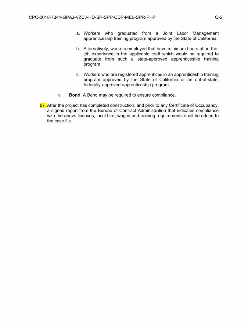
a. Workers who graduated from a Joint Labor Management apprenticeship training program approved by the State of California.
b. Alternatively, workers employed that have minimum hours of on-the-job experience in the applicable craft which would be required to graduate from such a state-approved apprenticeship training program.
c. Workers who are registered apprentices in an apprenticeship training
program approved by the State of California or an out-of-state, federally-approved apprenticeship program.
v. Bond. A Bond may be required to ensure compliance.
b) After the project has completed construction, and prior to any Certificate of Occupancy,
a signed report from the Bureau of Contract Administration that indicates compliance with the above licenses, local hire, wages and training requirements shall be added to the case file.
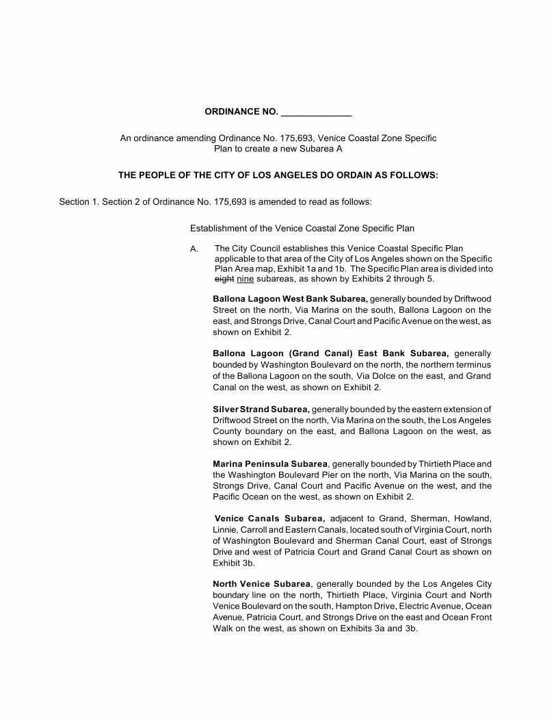
ORDINANCE NO. ______________
An ordinance amending Ordinance No. 175,693, Venice Coastal Zone Specific Plan to create a new Subarea A
THE PEOPLE OF THE CITY OF LOS ANGELES DO ORDAIN AS FOLLOWS:
Section 1. Section 2 of Ordinance No. 175,693 is amended to read as follows:
Establishment of the Venice Coastal Zone Specific Plan
A. The City Council establishes this Venice Coastal Specific Plan applicable to that area of the City of Los Angeles shown on the Specific Plan Area map, Exhibit 1a and 1b. The Specific Plan area is divided into eight nine subareas, as shown by Exhibits 2 through 5.
Ballona Lagoon West Bank Subarea, generally bounded by Driftwood Street on the north, Via Marina on the south, Ballona Lagoon on the east, and Strongs Drive, Canal Court and Pacific Avenue on the west, as shown on Exhibit 2.
Ballona Lagoon (Grand Canal) East Bank Subarea, generally bounded by Washington Boulevard on the north, the northern terminus of the Ballona Lagoon on the south, Via Dolce on the east, and Grand Canal on the west, as shown on Exhibit 2.
Silver Strand Subarea, generally bounded by the eastern extension of Driftwood Street on the north, Via Marina on the south, the Los Angeles County boundary on the east, and Ballona Lagoon on the west, as shown on Exhibit 2.
Marina Peninsula Subarea, generally bounded by Thirtieth Place and the Washington Boulevard Pier on the north, Via Marina on the south, Strongs Drive, Canal Court and Pacific Avenue on the west, and the Pacific Ocean on the west, as shown on Exhibit 2.
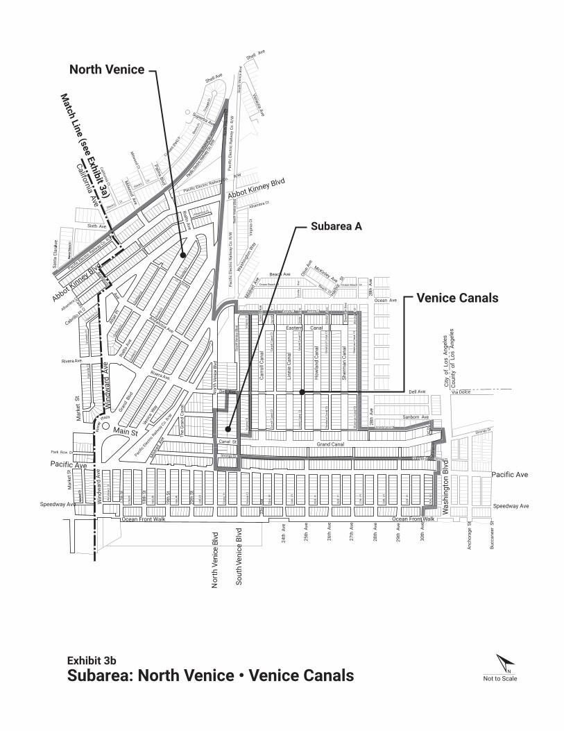
Venice Canals Subarea, adjacent to Grand, Sherman, Howland, Linnie, Carroll and Eastern Canals, located south of Virginia Court, north of Washington Boulevard and Sherman Canal Court, east of Strongs Drive and west of Patricia Court and Grand Canal Court as shown on Exhibit 3b.
North Venice Subarea, generally bounded by the Los Angeles City boundary line on the north, Thirtieth Place, Virginia Court and North Venice Boulevard on the south, Hampton Drive, Electric Avenue, Ocean Avenue, Patricia Court, and Strongs Drive on the east and Ocean Front Walk on the west, as shown on Exhibits 3a and 3b.

Oakwood-Milwood-Southeast Venice Subarea, generally bounded by the Los Angeles City boundary line on the north, Washington Boulevard on the south, Lincoln Boulevard on the east, and Hampton Drive, Electric Avenue, Patricia Court and Strongs Drive on the west, as shown on Exhibits 4a and 4b.
Oxford Triangle Subarea, generally bounded by Washington Boulevard on the north, the Los Angeles City boundary on the southwest, and Lincoln Boulevard on the east, as shown on Exhibit 5. Subarea A: generally bounded by Dell Avenue, North Venice Boulevard, South Venice Boulevard and Pacific Avenue, as shown on Exhibit 3b.
Section 2. Section 5 of Ordinance No. 175,693 is amended to read as follows:
DEFINITIONS. The following words, whenever used in this Specific Plan, shall be construed as defined in this section. Words and phrases not defined here shall be construed as defined in LAMC Section 12.03 or 12.20.2.1, if defined there:
a. Architectural Features. Features including, but not limited to,
sculpture, bas relief, mosaic, mural, vents, porch, balcony, chimney, window and doorway.
b. Blank Wall. A Street Wall or vehicle entry facing the street and having
no architectural detailing, windows, doors or similar features.
c. Building Frontage. The maximum length of a line or lines formed by connecting the points representing projections of the exterior building walls onto a public street or onto a courtyard that is directly accessible by pedestrians from a public street, whichever distance is greater.
d. Beach Impact Zone. All lots located in the Marina Peninsula, Ballona
Lagoon West Bank, Venice Canals and North Venice subareas described in Section 1, Exhibits 2, 3a and b, of this Specific Plan.
e. Change in Intensity of Use . A change in intensity of use includes but is
not limited to any addition, expansion or change in use on a site that involves: (a) a change in the total number of dwelling units; or (b) a change in the amount of Service Floor to a commercial or industrial use; or (c) a change in the number of trips as calculated in the Trip Table, Appendix C; or (d) a change in the number of provided or required parking spaces as calculated in Section 12 D and E of this Specific Plan.
f. Change of Use. A change from (1) an existing residential use to a
commercial or industrial use; or (2) an existing commercial use to a residential or industrial use; or (3) an existing industrial use to a residential or commercial use.
g. Encroachment. Any structure or building or portion of a structure or
building that projects into a right-of-way or required setback.
h. Environmentally Sensitive Habitat Area. Any area in which plant or animal life or their habitats are either rare or especially valuable because of their special nature or role in an ecosystem and which could be easily disturbed or degraded by human activities and developments.

i. Feasible. Capable of being accomplished in a successful manner within a
reasonable period of time, taking into account economic, environmental, social, and technological factors.
j. Fill. Earth or any other substance or material, including pilings placed
for the purposes of erecting a structure on it.
k. Flat Roof. Any roof form which has a slope of 2 vertical inches or fewer to 12 horizontal inches.
l. Grand Canal Lot. Any lot shown on Exhibit 2 of this Specific Plan that is immediately adjacent to Grand Canal.
m. Ground Floor. The lowest story within a building, which is accessible
to the street, the floor level of which is within three feet above or below curb level, which has frontage on or is primarily facing any pedestrian- oriented street, and which is at least 20 feet in depth or the total depth of the building, whichever is less.
n. Lagoon Buffer Strip. The strip of land immediately adjacent to the
Ballona Lagoon that separates the developable portion of a lot from the waters of Ballona Lagoon as approved in Coastal Commission Permit No. A-266-77 and Appeal No. A-266-77.
o. Lagoon Lot. Any lot that is immediately adjacent to the Ballona Lagoon
as shown on Exhibit 2 of this Specific Plan.
p. Local Coastal Program. A program that includes land use plans, zoning ordinances, zoning district maps, and within sensitive coastal resource areas, other implementing actions, which when taken together meet the requirements and provisions of the California Coastal Act.
q. Lot Consolidation. Lot consolidation occurs when: (1) one or more
structures are built over a lot line that divided two existing lots; or (2) a lot line is abandoned, a lot line is adjusted, lots are merged, or other action is taken by the City, for the purpose of allowing a structure to be built extending over what were previously two or more separate lots.
r. Permeable. A material that permits water penetration to a soil depth of
18 inches or more, including non-porous surface material poured or laid in sections not exceeding one square foot in area and collectively comprising less than two-thirds of the total surface area of loosely laid material such as crushed stone or gravel.
s. Premise. A building or portion of a building used as a location for a
single business or non-commercial use.
t. Replacement Affordable Unit. Any affordable housing unit to be provided as replacement for an existing unit on a Venice Coastal Development Project site. Affordable housing units are dwelling units or guest rooms for which rental or mortgage payments do not exceed the limits stated in Section 65915 of the California Government Code. Dwelling units or guest rooms designated for lower income households, as defined in Section 50079.5 of the California Health and Safety Code, shall have rents not exceeding 30 percent of 60 percent of the area median income as set forth

on a rent schedule prepared by the City's Housing Department or any successor agency. In order for a Venice Coastal Development Project to qualify as a project containing affordable housing units, the owner shall record a document with the Los Angeles County Recorder guaranteeing that these affordability criteria will be observed for at least 30 years from the issuance of the Certificate of Occupancy.
u. Roof Access Structure. An enclosed stairway or elevator housing that provides access to a roof, but contains no storage, habitable or living area.
v. Qualified Permanent Supportive Housing Project. The construction of, addition to, or remodeling of a building or buildings offering Supportive Housing; and where all of the total combined Dwelling Units or Guest Rooms, exclusive of any manager’s units, are affordable. For the purposes of this subdivision, affordable means that rents or housing costs to the occupying residents do not exceed 30 percent of the maximum gross income of Extremely Low, Very Low or Low Income households, as those income ranges are defined by the United States Department of Housing and Urban Development (HUD) or any successor agency, as verified by the Housing & Community Investment Department (HCIDLA). A minimum of 50 percent of the total combined Dwelling Units or Guest Rooms is occupied by the Target Population.
w. Service Floor. All areas where the customer can be served, except the
restroom, including the indoor and outdoor dining area, bar, waiting room and tavern.
x. Store Frontage. The horizontal length of a Premise abutting the
exterior public access level walkway that serves the Premise.
y. Street Wall. An exterior wall of a building that faces a street.
z. Supportive Housing. Housing with no limit on length of stay for persons with low incomes who have one or more disabilities and may include, among other populations, adults, emancipated minors, families with children, elderly persons, young adults aging out of the foster care system, individuals exiting from institutional settings, veterans, and homeless people. The housing is linked to onsite or offsite Supportive Services, and any Floor Area used for Supportive Services shall be considered accessory to the residential use.
aa. Supportive Services. Services that are provided on a voluntary basis to residents of Supportive Housing and Transitional Housing, including, but not limited to, a combination of subsidized, permanent housing, intensive case management, medical and mental health care, substance abuse treatment, employment services, benefits advocacy, and other services or service referrals necessary to obtain and maintain housing.
bb. Target Population. Persons with qualifying lower incomes who (i) have one or more disabilities, including mental illness, HIV or AIDS, substance abuse, or other chronic health condition, and are homeless as defined by any Los Angeles City, Los Angeles County, State of California, or Federal guidelines; or (ii) are chronically homeless, as defined by any Los Angeles City, Los Angeles County, State of California, or Federal guidelines.
cc. Trip. A single or one direction vehicle movement with either origin or
destination (exiting or entering) inside the Venice Coastal Development Project site.

dd. Varied Roofline. Any roof that has a slope in excess of 2 inches to 12inches, including but not limited to a sloped or curved roofline.
ee. Venice Coastal Development Project. Any of the following actions taken on any lot located in whole or in part within the area identified in Exhibit 1a and b of this Specific Plan. On land, in or under water, the placement or erection of any solid material or structure; the discharge or disposal of any dredged material or of any gaseous, liquid, solid or thermal waste; the grading, removing, dredging, mining or extraction of any materials; any change in the density or intensity of use of land, including, but not limited to, subdivisions pursuant to the Subdivision Map Act (commencing with Section 66410 of the Government Code), and any other division of land, including lot splits, except where the land division is brought about in connection with the purchase of the land by a public agency for public recreational use; any change in the intensity of use of water or of access to the water; construction, reconstruction, demolition or alteration of the size of any structure, including any facility of any private, public or municipal utility; and the removal or harvesting of major vegetation other than for agricultural purposes, kelp harvesting, and timber operations, which are in accordance with a timber harvesting plan submitted pursuant to the provisions of the Z'berg-Nejedly Forest Practice Act of 1973 (commencing with Section 4511 of the Public Resources Code). On-site and off-site parking areas that serve a Venice Coastal Development Project shall be considered a part of the project.
ff. Venice Coastal Zone. The area within the Venice Community Plan area west of Lincoln Boulevard, including those lots fronting on the west side of Lincoln Boulevard and shown on the Specific Plan Area map, Exhibit 1a and b.
gg. Walk Street. A public street in the Venice Coastal Zone that has been improved for public pedestrian use over part of its width and is landscaped (publicly or privately) over the remainder, but which has not been improved for public vehicular access, as identified in Appendix A of this Specific Plan and as shown on Exhibits 16 a and b.
Section 3. Section 9 of Ordinance No. 175,693 is amended to read as follows:
GENERAL LAND USE AND DEVELOPMENT REGULATIONS. In addition to the regulations contained in Chapter 1 of the LAMC and as shown on Exhibits 6-15, the following regulations shall apply. These provisions shall not applyto Qualified Permanent Supportive Housing Projects in Subarea A.
Section 4. A new Section 10.I is added to Ordinance No. 175,693 to read as follows: I. SUBAREA A
a. Use. The use and area regulations of the C2 zone shallapply to all lots in Subarea A, except that residentialuses are permitted provided the project meets thedefinition of Qualified Permanent Supportive HousingProject and comply with the following requirements:
i. Supportive Services. Applicants shall provide documentation
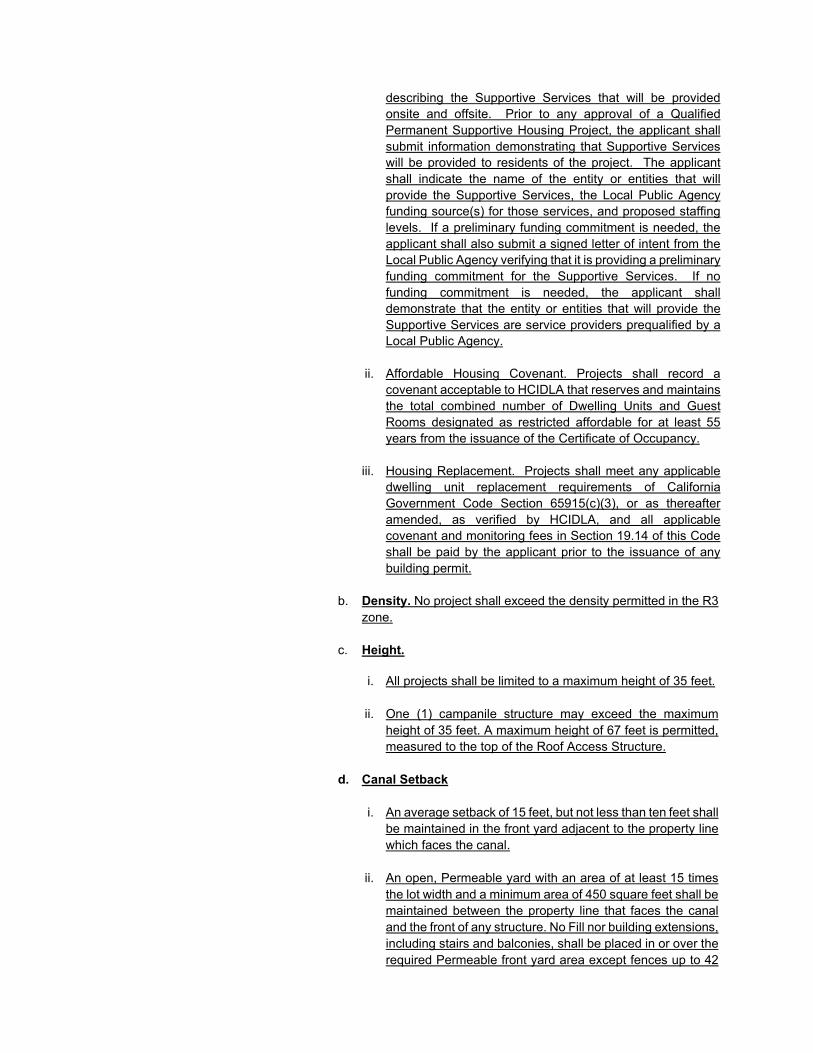
describing the Supportive Services that will be provided onsite and offsite. Prior to any approval of a Qualified Permanent Supportive Housing Project, the applicant shall submit information demonstrating that Supportive Services will be provided to residents of the project. The applicant shall indicate the name of the entity or entities that will provide the Supportive Services, the Local Public Agency funding source(s) for those services, and proposed staffing levels. If a preliminary funding commitment is needed, the applicant shall also submit a signed letter of intent from the Local Public Agency verifying that it is providing a preliminary funding commitment for the Supportive Services. If no funding commitment is needed, the applicant shall demonstrate that the entity or entities that will provide the Supportive Services are service providers prequalified by a Local Public Agency.
ii. Affordable Housing Covenant. Projects shall record acovenant acceptable to HCIDLA that reserves and maintainsthe total combined number of Dwelling Units and GuestRooms designated as restricted affordable for at least 55years from the issuance of the Certificate of Occupancy.
iii. Housing Replacement. Projects shall meet any applicabledwelling unit replacement requirements of CaliforniaGovernment Code Section 65915(c)(3), or as thereafteramended, as verified by HCIDLA, and all applicablecovenant and monitoring fees in Section 19.14 of this Codeshall be paid by the applicant prior to the issuance of anybuilding permit.
b. Density. No project shall exceed the density permitted in the R3zone.
c. Height.
i. All projects shall be limited to a maximum height of 35 feet.
ii. One (1) campanile structure may exceed the maximumheight of 35 feet. A maximum height of 67 feet is permitted,measured to the top of the Roof Access Structure.
d. Canal Setback
i. An average setback of 15 feet, but not less than ten feet shall be maintained in the front yard adjacent to the property linewhich faces the canal.
ii. An open, Permeable yard with an area of at least 15 timesthe lot width and a minimum area of 450 square feet shall bemaintained between the property line that faces the canaland the front of any structure. No Fill nor building extensions,including stairs and balconies, shall be placed in or over therequired Permeable front yard area except fences up to 42

inches in height or Permeable decks at grade level not more than 18 inches high.
e. Access.
i. Driveways and vehicular access to Venice CoastalDevelopment Projects shall be provided from North Veniceand South Venice Boulevards, unless the Department ofTransportation determines that it is not Feasible. New andexisting curb cuts shall be minimized in order to protectand maximize public on-street parking opportunities.
Section 5. Maps of Ordinance 175,693 is amended as follows:

California Ave
California Ave
Mar
ket S
t
Wes
tmin
ster
Ave
Clu
b H
ouse
Ave
Wav
e C
rest
Ave
Bree
ze A
ve
Broo
ks A
ve
Park
Ave
Thor
nton
Ave
Suns
et A
ve
Palo
ma
Ave
Dud
ley
Ave
Rose
Ave
Ozo
ne A
ve
Nav
y St
Sout
h Ven
i ce B
lvd
Nor
th V
enice
Blvd
Cent
er C
t
20th
Pl
19th
Pl
18th
Pl
17th
Pl
Sevil
le C
t
Sevil
le C
t
Sevil
le C
tCord
ova
Ct
Alhambra Ct
Electric Ct
Cres
cent
Ct
Elect
ricCtRialto Ct
Shell Ct
Shell Ct
Superba Ct
Marco Ct
Marco Ct
Pisani Ct
Nowita Ct
Amoroso Ct
Venezia Ct
Venezia Ct
Amoroso Ct
Marian Ct
Marco Ct
Superba Ct
Nowita Ct
Rialto Ct
Nowita Ct
Superba Ct
Rialto Ct
California Ct
California Ct
Milw
ood Ct
Milw
ood CtLincoln Ct
Lincoln Ct
Lincoln Ct
Linden Ct
Linden Ct
Rialto CtMilw
ood Ct
California Ct
Milw
ood Ct
California Ct
Electric Ct
tC aral
C atnaS
tC nauJ naS
Alhambra Ct
tC ya
wdaorB
tC nauJ naS
tC aral
C atnaS
tC ya
wdaorB
Irving Tabor C
t
Alhambra Ct
Cord
ova
Ct
tC ya
wdaorB Valencia Ct
Valencia CtG
rana
da C
t
Tole
do C
t
Gra
nada
Ct
Win
dwar
d C
t
Wav
e Cr
est
Ct
Club
Hou
se C
t tC r etsni
mseW H
oriz
on C
t tC t ekra
MPark
Ct
Broo
ks C
t
Bree
ze C
t
Thor
nton
Ct
Suns
et C
t
Dudl
ey C
t
tC notnrohT
tC skoorB
tC skoorBIn
dian
a Ct
Douglas Pl
Vern
on C
t
tC skoorB
tC skoorB
Indi
ana
Ct
Vernon Ct
Vernon Ct
Suns
et C
t
Vern
on C
t
Indi
ana
Ct
Sunset CtSunset Ct
Suns
et C
t
Indi
ana
Ct
Vern
on C
t
tC re
wolFRose
Ct
tC re
wolFRose
Ct
Rose
Ct
Palo
ma
Ct
Rose
Ct
Ozo
ne C
t
Nav
y C
t
Mar
ine
Ct
Prospect Ct
Seville Ct
Lincoln Blvd
20th
St
19th
St
18th
St
17th
St
Win
dwar
d Av
e
t S t ekraM
evA nozi r oH
evA r etsnimtse
WClub
Hou
se A
ve
Wav
e Cr
est A
ve
Bree
ze A
ve
Broo
ks A
ve
Park
Ave
Thor
nton
Ave
Suns
et A
veevA a
mol aPDudl
ey A
veevA esoROzo
ne A
ve
Nav
y St
tS eni raM
Brooks AveHampton Dr
Abbot Kinney B
lvd
San
Juan
Ave evA nozi r o
H Mar
ket
St
evA drawdni
WGr
and
Blvd
Veni
ce W
ayM
ildre
d A
ve
Rivera Ave
Main StCanal St
Alberta Ave
Strongs Dr
The
Gra
nd C
anal
Park Row Dr
Innes Pl
Andalusia Ave
Andalusia Ave
Sixth Ave
California Ave
Shell Ave
Milw
ood Ave
Palms Blvd
Shell Ave
Meade Pl
Linden Ave
Marian Pl
Seventh Ave
Oakwood Ave
Pleasant View Ave
Fifth Ave
Fourth Ave
evA ya
wdaorB
evA skoorB
evA anaidnIVern
on A
ve
Suns
et
Ave
evA esoR
Third Ave
Rennie Ave
Rennie Ave
Dimmick Ave
Ruth Ave
Bernard Ave
evA rewolF
Speedway Ave
Pacific Ave
Mar
ine
St
Second St
Third St
Fourth St
Fifth St
Sixth St
Highland Ave
Seventh St
Sixth Ave
Fifth Ave
tS enozO
Seventh AveLongfellow St
Ozo
ne S
t
Mac
hado
Dr
evA htlaewno
mmo
C
evA nerra
W
evA re
wolF
Rose
Ave
Suns
et A
ve
Vern
on A
ve
Indi
ana
Ave
Broo
ks A
ve
Sunset Ave
Vernon Ave
Indiana Ave
Lake St
California Ave
evA leugi
M naS
evA ya
wdaorB
California Ave
Milw
ood Ave
Palms Blvd
Palms Blvd
Stacy Ave
evA aralC atnaS
evA nauJ naS
evA retsni
mtseW
Broa
dway
Ave
lP nauJ naS
Oakwood Ave
Linden Ave
Norfolk Ave
Main St
Wes
tmin
ster
Ave
Pacific Ave
evA esuo
H bulC
evA tser
C evaW
lP kraP
lP atsiV
evA tser
C evaW
Superba Ave
Electr
icAve
Cresce
nt(Pa
rk) P
.
Nowita (Park) Pl
Marco (Park) Pl
Amorosoa (Park) Pl
Pisani Ave
Nowita (Park) Pl
Marco (Park) Pl
Amorosoa (Park) Pl
Nowita (Park) Pl
Marco (Park) Pl
Amorosoa (Park) Pl
Venezia Ave
Victoria Ave
Lucille Ave Brenta PlAm
oroso Pl
Marco Pl
Superba Ave
Nowita Pl
Fredricks St
Prospect AveSuperior Ave
Superba Ave
Superba Ave
dvlB ecineV htroN
Rivera Ave.
Wesm
inster Ave Rial
to A
ve
Alta
ir Pl
Cabrillo Pl
Aragon Ct
Cadiz Ct
Navarre Ct
Rialto Ave
dvlB eci neV htr oN
dvlB ecineV htuoSdvlB ecineV htro
N
Sout
h Ve
nice
Blv
d
Abbot Kinney Blvd
Sout
h Ven
ice
BlvddvlB ecineV htro
N
Dell Ave
City
of
Los
Ang
eles
City
of
Sant
a M
onic
a
W/R .oC yawliaR cirtcelE cificaP
W/R .oC yawliaR cirtcelE cificaP
Pacific Electric Railway Co. R/W
Paci
fic E
lect
ric R
ailw
ay C
o. R
/W
Pacific Electric
Railway Co. R
/W
Pacific
Electri
c Rail
way C
o. R/W
Railway Co. R
/W
Pacific Electric
Pacific Electric Railway Co. R/W
Pacifi
cElectr
icRa
ilway
Co. R
/W
Kinn
ey
Plaza
evA leugi
M naS
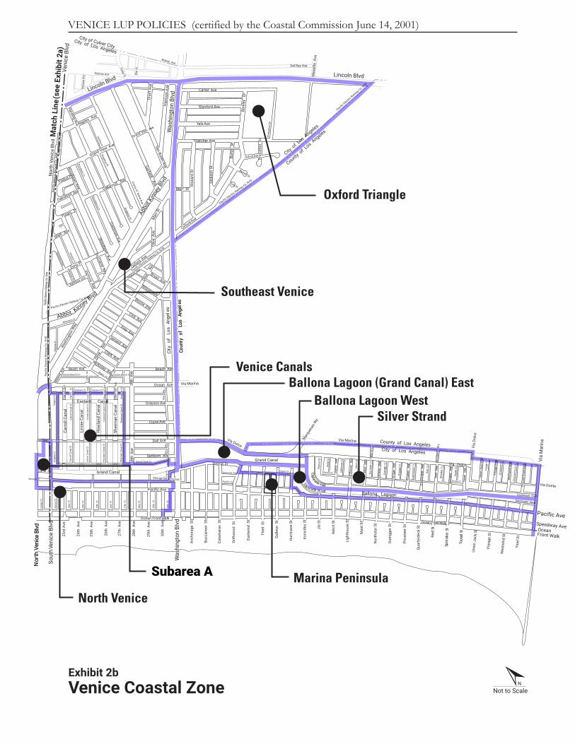
VENICE LUP POLICIES (certified by the Coastal Commission June 14, 2001)
Amoroso Ct
Amoroso Ct
Navarre Ct
Navarre Ct
Ocean Front Walk
Main St
Veni
ce B
lvd
Lincoln Blvd
Not to ScaleN
Exhibit 2aVenice Coastal ZoneNote: Map does not show area of Palms • Del Rey portion of coastal zone that is located inland of Lincoln Boulevard.
)b2 tibihxE ees( eniL hctaM
OakwoodMilwood
North Venice
Subarea A
Sout
h Ven
ice B
lvd
Nor
th V
enice
Blvd
Cent
er C
t
Veni
ce C
tVi
rgin
ia C
tVi
rgin
ia C
tVi
rgin
ia C
t
Sout
h Ven
ice
Blvd
Canal St
Strongs Dr
dvlB ecineV htuoS
Sout
h Ve
nice
Blv
dN
orth
Ven
ice
Blvd
Sout
h Ve
nice
Blv
d
Sout
h Ven
ice
BlvddvlB ecineV htro
N
Dell Ave
Paci
fic E
lect
ric R
ailw
ay C
o. R
/W
W/R .oC yawliaR cirtcelE cificaPPa
cific
Ele
ctric
Rai
lway
Co.
R/W
Lincoln Blvd
Not to ScaleN
Mat
ch L
ine (
see
Exhi
bit 2
a)
VENICE LUP POLICIES (certified by the Coastal Commission June 14, 2001)
Chan
nel P
oint
Ct
Eastern Ct
Roma CtRoma Ct
tC liaspoT
tC rekannipS
tC egayoV
tC dni
wtseW
tC feeRRoma CtRoma Ct
tC ratshtro
N
Mas
t Ctt
C esuohthgiL
tC hcteK
tC kcedretrau
Q
tC reetavirP
tC reggirtu
O
Bari
W
yBa
ri
Wy
30th
Pl
29th
Pl
Pacific Ct
23rd
Pl
27th
Pl
28th
Pl
26th
Pl
25th
Pl
24th
Pl
Sher
man
Can
al C
t
How
land
Can
al C
t
Linn
ie C
anal
Ct
Carr
oll C
anal
Ct
Grand Canal Ct
How
land
Ave
Linn
i e
Ave
S her
man
Ct
Car
rol l
Ct
How
land
Ave
Linn
ie
Ave
Sher
man
Ct
How
land
Can
al C
t
Linn
ie C
anal
Ct
Carr
oll C
anal
Ct
Eastern Ct
Carr
oll
Ct
Sher
man
Can
al C
t
Linn
i e A
ve
O cean Beach Ct
Linn
ie A
ve
Ocean Beach CtOcean Beach Ct
Alhambra Ct
Venezia Ct
Woodlaw
na CtHarding Ct
Canal Ct
Woodlaw
n Ct
Chan
nel P
oint
Mal
l
Was
hing
ton
Blvd
Coun
ty
of
Los
Ang
eles
Strongs Pl
tS liaspoT
tS rekannipS
tS feeR
Qua
rter
deck
St
Priv
atee
r St
Out
rigge
r St
Nor
thst
ar S
t
Mas
t St
Ligh
thou
se S
t
Ketc
h St
Jib
St
Irons
ides
St
Gal
leon
St
Flee
t St
East
win
d S
t
Hur
rican
e St
Drift
woo
d S
t
Cata
mar
an S
t
Bucc
anee
r St
Was
hing
ton
Blvd Ocean Front Walk
1
Esplanade West
Esplanade East
Ocean Front Walk
Oakwood Ave
Shell Ave
Pisani Pl
Padua Pl
Via Dolcella
M liaspoT
llaM rekannipS
llaM feeR
llaM kcedretrau
Q
llaM reetavirP
llaM reggirtu
ONor
thst
ar
Mal
l
Dell Ave
Sanborn Ave
Clune Ave
Grayson Ave
Ocean Ave
Beach Ave
evA ht82
Bryan Ave
Olive
A
ve
Abbo
t Kinn
ey B
lvd
Van Buren AveGarfield Ave
Coerur D ’Alene Ave
Oakwood Ave
Thatcher Ave
Yale Ave
Stanford Ave
Carter Ave
Berk
ley
Dr
Naples Ave
Zeno Pl
Victoria AveBoccacio Ave
Prin
ceto
n D
r
Oxford AveBurre
ll S
t
Dick
son
St
How
ard
St
Oliv
e A
ve
Woodlaw
n Ave
Harding Ave
Veni
ce B
lvd
30th
Ave
29th
Ave
27th
Ave
28th
Ave
26th
Ave
25th
Ave
24th
Ave
23rd
Ave
Pacific Ave
Strongs Dr
rD sgnortS Strongs Pl
Grand Canal
Sher
man
Can
al
How
land
Can
al
Linn
ie C
anal
Carr
oll C
anal
Eastern Canal
Sher
man
Ave
Carr
oll A
ve
Beach Ave
evA ht 82 Via MarinaMild
red
Ave
Was
hing
ton
Way
Kinney Blvd
McKinley Ave
Clark Ave
Clement Ave
Frey Ave
Cloy Ave
Boone Ave
Wilson Ave
Harb
or
StBeach Ct
Mildred AveOxford Ave
Narcisus Ave
Venezia Ave
Venezia Ave
Mar
r St
Woodlaw
n AveCrestm
ore Ave
Grand View Ave
Grand View Ave
Har
rison
Ave
Gra
nt A
ve
Zanja St Lincoln Blvd
Walnut Ave
Penmar Ave Elm
St
Nel
rose
Ave
Del Rey Ave
Max
ellla
Ave
Prin
ceto
n Dr
Burrell St
Viola Pl
Oxford Ave
Marr St
Olive
A
ve
Was
hing
ton
Blvd
Via Dolce
Grand Canal
Anch
orag
e S
t
Schooner Ave
Strongs Dr
Mar
ques
as W
y
Esplanade EastEsplanade W est Ballona Lagoon
Mas
t M
all
Ligh
thou
se
Mal
lllaM hcteK
Rom
a Ct
yW itihaT
Via
Dolc
eUn
ion
Jack
Mal
l
Unio
n Ja
ck S
t
Voya
ge S
t
Wes
twin
d St
Yaw
l St
Pacific AveSpeedway AveOceanFront Walk
Via Donte
Voya
ge M
all
Wes
twin
d M
all Vi
a M
arin
a
City of Los Angeles
County of Los Angeles
selegnA soL f o yti C
sel egnA soL f o yt nuoC
City o
f Los A
ngeles
County of L
os Angeles
Pacific Electric
Railway C
o. R/W
Pacific Electric
Railway Co. R/W
Pacific Electric
Railway Co. R/W
Pacific Electric Railway Co. R/W
City of Los Angeles
City of Culver City
Angelus Pl
Angelus Pl
yW aroB aroB
Via Marina
Abbot
Exhibit 2bVenice Coastal Zone
Subarea A
Match Line (see Exhibit 3a)
Exhibit 3bSubarea: North Venice • Venice Canals Not to Scale
N
Electr
icAv
e
Cres
cent
Ct
Elect
ricCt
Cres
cent
Ct
Elect
ricCt
Electr
icAv
e
Cresce
nt(P
ark)
P.
Pacifi
cElectr
icRa
ilway
Co. R
/W
Eastern CtEastern Ct Eastern CtEastern Ct
Mar
ket C
t
Grand Canal CtGrand Canal Ct
O cean Beach CtO cean Beach Ct Ocean Beach CtOcean Beach Ct
Sant
a C
lara
Ct
Sant
a Cl
ara
Ct
Cen
ter
Ct
23rd
Pl
Veni
ce C
t
Sher
man
Can
al C
t
Ho w
la nd
Can
al C
t
Linn
ie C
anal
Ct
Car
roll
Can
al C
t
Virg
inia
Ct
30th
Pl
29th
Pl
27th
Pl
28th
Pl
26th
Pl
25th
Pl
24th
Pl
20th
Pl
1 9th
Pl
18th
Pl
17t h
Pl
Navarre
Ct
Linn
ie
A
ve
Sevil
le Ct
Alhambra Ct
Sevil
le Ct
Electric Ct
Electric Ct
Sevil
le Ct
Cordo
va C
t
Cordo
va C
t
Win
dwar
d C
t
Sher
man
C
t
How
land
Can
al C
t
Linn
ie C
anal
Ct
Car
r ol l
Can
al C
t
Vir g
ini a
Ct
How
la nd
Ave
Linn
ie
A
ve
Car
r oll
C
t
Sher
man
Can
al C
t
Bar i
Wy
Cent
er C
t
23rd
Pl
Veni
ce C
t
Sher
man
Can
al C
t
How
land
Can
al C
t
Linn
ie C
anal
Ct
Carr
oll C
anal
Ct
Virg
inia
Ct
30th
Pl
29th
Pl
27th
Pl
28th
Pl
26th
Pl
25th
Pl
24th
Pl
20th
Pl
19th
Pl
18th
Pl
17th
Pl
Navarre Ct
Linn
ie
Av
e
Sevil
le C
t
Alhambra Ct
Sevil
le C
t
Milw
ood CtCalifornia Ct
Electric Ct
Electric Ct
Sevil
le C
t
Cord
ova
Ct
Cord
ova
Ct
Win
dwar
d C
t
Virg
inia
Ct
Sher
man
C
t
How
land
Can
al C
t
Linn
ie C
anal
Ct
Carr
oll C
anal
Ct
Virg
inia
Ct
Alhambra Ct
How
land
Ave
Linn
ie
Av
e
Carr
oll
C
t
Sher
man
Can
al C
t
Bari
Wy
Gra
nada
Ct
Valencia
Ct
Gra
nada
Ct
Gra
nada
Ct
Valencia Ct
Gra
nada
Ct
Alhambra Ct
Mar
ket C
t
Nor
th V
enice
Blvd
Sher
man
Ave
Car
rol l
Ave
Strongs Dr Strongs Pl
Stro
ngs D
r
Strongs Dr Stro
ngs
Dr
Strongs Pl
O cean Front Walk
Seville Ct
Bucc
anee
r St
Was
hing
ton
Blvd
Ocean Front Walk
Sout
h Ven
ice
Blvd
20th
St
19th
St
18th
St
17th
St
Win
dwar
d A
ve
Gran
d B
lvd
Veni
ce W
ayM
ildre
d A
ve
Rivera Ave.
Main StCanal St
Strongs Dr
The
Gra
nd C
anal
Andalusia Ave
Andalusia Ave
Sixth Ave
California Ave
Milw
ood Ave
Palms Blvd
Shell Ave
Shell Ave
Dell Ave
Sanborn Ave
Ocean Ave
evA ht82
Olive
Ave
Pacific Ave
Superba Ave
dvlB ecineV htuoS
Rial
to A
ve
Alta
ir Pl
Navarre Ct
Rialto Ave
dvlB ecineV htroN
Nor
th V
enic
e Bl
vd
Sout
h Ve
nice
Blv
d
Abbot Kinney Blvd
Sout
h Ven
ice
BlvddvlB ecineV htro
N
Dell Ave
30th
Ave
29th
Ave
27th
Ave
28th
Ave
26th
Ave
25th
Ave
24th
Ave
23rd
Ave
Pacific Ave
Grand Canal
Sher
man
Can
al
How
land
Can
al
Linn
ie C
anal
Carr
oll C
anal
Eastern Canal
Sher
man
Ave
Carr
oll A
ve
Beach Ave
evA ht82Mild
red
Ave
Was
hing
ton
Way
McKinley Ave
Harb
or
St
Beach Ct
Venezia Ave
Via Dolce
Anch
orag
e S
t
City
of
Los
Ang
eles
Coun
ty o
f Lo
s A
ngel
es
Paci
fic E
lect
ric R
ailw
ay C
o. R
/W
Pacific Electric Railway Co. R/W
Paci
fic E
lect
ric R
ailw
ay C
o. R
/W
Pacific Electric
Railway Co. R
/W
Pacific
Electri
c Rail
way C
o. R/W
Sant
a Cl
ara A
ve
Strongs Dr
Ocean Front Walk
Speedway Ave Speedway Ave
Abbot Kinney Blvd
Cadiz Ct
Kinn
ey
Plaza
Mar
ket S
t
Mar
ket
St
Rivera Ave.
Park Row Dr
Cabrillo Pl
Win
dwar
d Av
e
North Venice
Venice Canals
Subarea A

Match Line (see Exhibit 5a)
Not to ScaleN
Electr
icAv
e
Cres
cent
Ct
Elect
ricCt
Cres
cent
Ct
Elect
ricCt
Electr
icAv
e
Cresce
nt(Pa
rk) P
.
Pacifi
cElectr
icRa
ilway
Co. R
/W
VENICE LUP POLICIES (certified by the Coastal Commission June 14, 2001)
Eastern CtEastern Ct Eastern CtEastern Ct
Mar
ket C
t
Grand Canal CtGrand Canal Ct
O cean Beach CtO cean Beach Ct Ocean Beach CtOcean Beach Ct
Sant
a C
lara
Ctt
C aralC atnaS
Cen
ter
Ct
23r d
Pl
Veni
ce C
t
Sher
man
Can
al C
t
Ho w
land
Can
al C
t
Linn
ie C
ana l
Ct
Car
roll
Can
al C
t
Virg
i ni a
Ct
30t h
Pl
29th
Pl
27th
Pl
28th
Pl
26th
Pl
25th
Pl
24th
Pl
20t h
Pl
19th
Pl
18th
Pl
17th
Pl
Navarre
Ct
Linn
ie
A
ve
Sevil
le Ct
Alhambra Ct
Sevil
le Ct
Electric Ct
Electric Ct
Sevil
le Ct
Cordo
va C
t
Cordo
va C
t
Win
dwar
d C
t
Sher
man
C
t
How
land
Can
al C
t
Linn
ie C
anal
Ct
Car
rol l
Can
al C
t
Virg
ini a
Ct
How
land
Ave
Lin n
i e
A
v e
Car
r ol l
C
t
Sher
man
Can
al C
t
Bari
Wy
Cent
er C
t
23rd
Pl
Veni
ce C
t
Sher
man
Can
al C
t
How
land
Can
al C
t
Linn
ie C
anal
Ct
Carr
oll C
anal
Ct
Virg
inia
Ct
30th
Pl
29th
Pl
27th
Pl
28th
Pl
26th
Pl
25th
Pl
24th
Pl
20th
Pl
19th
Pl
18th
Pl
17th
Pl
Navarre Ct
Linn
ie
Av
e
Sevil
le C
t
Alhambra Ct
Sevil
le C
t
Milw
ood CtCalifornia Ct
Electric Ct
Electric Ct
Sevil
le C
t
Cord
ova
Ct
Cord
ova
Ct
Win
dwar
d C
t
Virg
inia
Ct
Sher
man
C
t
How
land
Can
al C
t
Linn
ie C
anal
Ct
Carr
oll C
anal
Ct
Virg
inia
Ct
Alhambra Ct
How
land
Ave
Linn
ie
Av
e
Carr
oll
C
t
Sher
man
Can
al C
t
Bari
Wy
Gra
nada
Ct
Valencia
Ct
Gra
nada
Ct
tC adanar
G
Valencia Ct
tC adanar
G
Alhambra Ct
tC tekra
M
Nor
th V
enice
Blvd
Sher
man
Ave
Car
roll
Av e
Strongs Dr Strongs Pl
Stro
ngs D
r
Strongs Dr
rD sgnortS
Strongs Pl
O cean Front Walk
Seville Ct
Bucc
anee
r St
Was
hing
ton
Blvd
Ocean Front Walk
Sout
h Ven
ice
Blvd
20th
St
19th
St
18th
St
17th
St
Win
dwar
d A
ve
Gran
d B
lvd
Veni
ce W
ayM
ildre
d A
ve
Rivera Ave.
Main StCanal St
Strongs Dr
The
Gra
nd C
anal
Andalusia Ave
Andalusia Ave
Sixth Ave
California Ave
Milw
ood Ave
Palms Blvd
Shell Ave
Shell Ave
Dell Ave
Sanborn Ave
Ocean Ave
evA ht82
Olive
Ave
Pacific Ave
Superba Ave
dvlB ecineV htuoS
Rial
to A
ve
Alta
ir Pl
Navarre Ct
Rialto Ave
dvlB ecineV htroN
dvlB ecineV htroN
Sout
h Ve
nice
Blv
d
Abbot Kinney Blvd
Sout
h Ven
ice
BlvddvlB ecineV htro
N
Dell Ave
30th
Ave
29th
Ave
27th
Ave
28th
Ave
26th
Ave
25th
Ave
24th
Ave
23rd
Ave
Pacific Ave
Grand Canal
Sher
man
Can
al
How
land
Can
al
Linn
ie C
anal
Carr
oll C
anal
Eastern Canal
Sher
man
Ave
Carr
oll A
ve
Beach Ave
evA ht82Mild
red
Ave
Was
hing
ton
Way
McKinley Ave
Harb
or
St
Beach Ct
Venezia Ave
Via Dolce
Anch
orag
e S
t
sel egnA soL f o yti Csel egnA soL f o yt nuoC
W/R .oC yawliaR cirtcelE cificaP
Pacific Electric Railway Co. R/W
Paci
fic E
lect
ric R
ailw
ay C
o. R
/W
Pacific Electric
Railway Co. R
/W
Pacific
Electri
c Rail
way C
o. R/W
aralC atnaS
evA
Strongs Dr
Ocean Front Walk
Speedway Ave Speedway Ave
Abbot Kinney Blvd
Cadiz Ct
Kinn
ey
Plaza
tS tekraM
Mar
ket
St
Rivera Ave.
Park Row Dr
Cabrillo Pl
Win
dwar
d Av
e
Subarea A

Exhibit 7bExisting ZoningSubarea: North Venice • Venice Canals
Not to Scale
Match Line (see Exhibit 7a)
Sout
h Ven
ice
Blvd
Cent
er C
t
23rd
Pl
Veni
ce C
t
29th
Pl
27th
Pl
28th
Pl
26th
Pl
25th
Pl
24th
Pl
20th
Pl
19th
Pl
18th
Pl
17th
Pl
Win
dwar
d C
t
Eastern CtEastern Ct
Sher
man
Can
al C
t
How
land
Can
al C
t
Linn
ie C
anal
Ct
Carr
oll C
anal
Ct
Virg
inia
Ct
Navarre Ct
Sevil
le C
t
Sevil
le C
t
Sevil
le C
t
Cord
ova
Ct
Cord
ova
Ct
How
land
Can
al C
t
Linn
ie C
anal
Ct
Carr
oll C
anal
Ct
Navarre Ct
Sher
man
Ave
Carr
oll A
ve
Alhambra Ct
Pacific
Electr
icRailw
ayCo
. R/W
N
Grand Canal Ct
30th
Pl
Sher
man
Ct
Virg
inia
Ct
How
land
Ave
Linn
ie A
ve
Carr
oll C
t
Sher
man
Can
al C
t
Bari
Wy
S
e
Strongs Pl
Stro
ngs
Dr
Sout
h Ven
ice
Blvd
20th
St
19th
St
18th
St
17th
St
Win
dwar
d A
ve
Gran
d B
lvd
Veni
ce W
ayM
ildre
d A
ve
Rivera Ave.
Main StCanal St
Strongs Dr
The
Gra
nd C
anal
Andalusia Ave
Andalusia Ave
California Ave
Milw
ood Ave
Palms Blvd
Pacific Ave
Rial
to A
ve
Alta
ir Pl
Rialto Ave
vlB ecineV htroN
Nor
th V
enic
e Bl
vd
Abbot Kinney Blvd
Dell Ave
30th
Ave
29th
Ave
27th
Ave
28th
Ave
26th
Ave
25th
Ave
24th
Ave
23rd
Ave
Pacific Ave
Pacific Electric Railway Co R/W
Pacific
Electri
c Rail
way C
o. R/W
Ocean Front Walk
Speedway AveSpeedway Ave
Kinn
ey
Plaza
Cabrillo Pl
Win
dwar
d Av
e
OS-
1-XL
Nor
th Ve
nice
Blv
d
Grand Canal
Sherm
an C
anal
How
land
Cana
l
Linn
ie Ca
nal
Carro
ll Ca
nal
Eastern Canal
RW1 RW1OS-1-XL
RW1RW1C2
RD1.5RD1.5RD1.5
RW1
RW1
Ocean Front WalkRD1.5RD1.5RD1.5RD1.5RD1.5RD1.5RD1.5
RD1.
5
RD1.
5
RD1.
5
RD1.
5
RD1.
5
RD1.
5
RD1.
5
RD1.
5
RD1.
5
RD1.
5
RD1.
5
RD1.
5
RD1.
5
RD1.
5
RD1.
5
RD1.5
RD1.
5
R3R3
[T][Q
]C1.
5-CA
R3R3R3
RD1.
5
RD1.
5 R3R3R3R3R3C2-C
A
C1-CAC2-CAC2-CA
C2-C
A [T][Q
]C1
.5-C
A
[T][Q
]C2
-CA
[T][Q
]C1.
5-CA
RD1.5
RW1RD1.5
RD1.5-CA
R3
R3
R3OS-1-XL
[T][Q
]C1
C2
C2
(Q)C1-CA
[Q]R3
[Q]R
3
RW1RW1
RW1
RW1
RW1
RW1
RW1
R3
RD1.
5 C1
R3
RD2
RD1.
5
RD1.
5
RD1.
5
C2
C2
P
R3
OS-
1-XL
OS-
1-XL
[Q]R3
C2
C2
RW1
RW1
R3
RD1.
5
R3
RD1.
5RD
1.5
RD1.
5R3
OS-
1-XL
OS-
1-XL
-O
RW1
RW1
RW1
RW1
RW1
RW1
RW1
RW1
RW1
RW1
OS-
1-XL
OS-
1-XL
OS-
1-XL
OS-
1-XL
RW1 RW1 RW1RW1 RD1.
5
RD3
RD1.
5RD1.
5RD1.
5RD1.
5
R3R3
RD1.
5RD1.
5
C2-CA
RD1.
5RD
1.5
RD1.
5
RD1.
5
RD1.
5
RD1.
5
RD1.
5
RD1.
5
RD1.
5
RD1.5
C2-CA
C2-CA
C2-CA
C2-CA
M1
R3
RD1.5
RD1.5
C2
OS
RD1.5
*

CPC-2018-7344-GPAJ-VZCJ-HD-SP-SPP-CDP-MEL-SPR-PHP T-1
CONDITIONS FOR EFFECTUATING (T) TENTATIVE CLASSIFICATION REMOVAL
Pursuant to Section 12.32-G of the Municipal Code, the (T) Tentative Classification shall be removed by the recordation of a final parcel or tract map or by posting of guarantees through the B-permit process of the City Engineer to secure the following without expense to the City of Los Angeles, with copies of any approval or guarantees provided to the Department of City Planning for attachment to the subject planning case file. 1. Dedications and Improvements. Prior to the issuance of any building permits, public
improvements and dedications for streets and other rights-of-way adjoining the subject property shall be guaranteed to the satisfaction of the Bureau of Engineering, Department of Transportation, Fire Department (and other responsible City, regional, and Federal government agencies as may be necessary).
A. Responsibilities/Guarantees:
1) As part of early consultation, plan review, and/or project permit review, the applicant/developer shall contact the responsible agencies to ensure that any necessary dedications and improvements are specifically acknowledged by the applicant/developer.
2) Prior to the issuance of sign-offs for final site plan approval and/or project
permits by the Department of City Planning, the applicant/developer shall provide written verification to the Department of City Planning from the responsible agency acknowledging the agency’s consultation with the applicant/developer. The required dedications and improvements may necessitate redesign of the project. Any changes to the project design required by a public agency shall be documented in writing and submitted for review by the Department of City Planning.
B. Dedications Required:
1) A 5-foot wide strip of land be dedicated along North Venice Boulevard
adjoining the tract in addition, dedicate a 20-foot radius property line return or 15-foot by 15-foot property line cut corner at intersection with Pacific Avenue. Above cut corner area dedication shall be limited to the height of 30-feet measured from the finished sidewalk surface. Additional public sidewalk easement areas shall be provided at the locations of the public utilities including street lights, fire hydrants and street trees satisfactory to the City Engineer.
2) A 19.5-foot wide strip of land be dedicated along Pacific Avenue adjoining the tract in addition, dedicate a 20-foot radius property line return or 15-foot by 15-foot property line cut corner at intersection with South Venice Boulevard.
3) A 20-foot wide strip of land be dedicated along South Venice Boulevard
adjoining the tract in addition, dedicate a 20-foot radius property line return or 15-foot by 15-foot property line cut corner at intersection with Dell Avenue.
4) A 5-foot width public sidewalk easement be provided along Dell Avenue. This
easement is necessary to include the existing sidewalk as a path of travel for the public. Additional public sidewalk easement areas shall be provided at the locations of the public utilities including street lights, fire hydrants and street trees to provide a 5-foot path of travel clear of obstructions to the satisfaction of the City Engineer.

CPC-2018-7344-GPAJ-VZCJ-HD-SP-SPP-CDP-MEL-SPR-PHP T-2
C. Improvement Required:
1) Improve Dell Avenue within area of the required easement and North Venice Boulevard being dedicated and adjoining the subdivision by the construction of additional concrete sidewalks at the locations of the public utilities and or obstructions including any necessary removal and reconstruction of existing improvements.
2) Improve all newly dedicated cut corners with additional concrete sidewalks.
2. Department of Transportation. Suitable arrangements shall be made with the Department of Transportation to assure that a parking area and driveway plan be submitted to the Citywide Planning Coordination Section of the Department of Transportation for approval prior to submittal of building permit plans for plan check by the Department of Building and Safety. Transportation approvals are conducted at 201 N. Figueroa Street Suite 400, Station 3. For an appointment, call (213) 482-7024.
3. Street Lighting. Prior to the recordation of the final map or issuance of the Certificate of
Occupancy (C of O), street lighting plans shall be submitted for review and the owner shall provide a good faith effort via a ballot process for the formation or annexation of the property within the boundary of the development into a Street Lighting Maintenance Assessment District.
4. Urban Forestry – Street Trees. Prior to the issuance of a grading permit, a plot plan prepared
by a reputable tree expert, indicating the location, size, type, and condition of all existing trees on the site shall be submitted for approval by the Department of City Planning. All trees in the public right-of-way shall be provided per the current Urban Forestry Division standards.
Replacement by a minimum of 24-inch box trees in the parkway and on the site of to be removed, shall be required for the unavoidable loss of desirable trees on the site, and to the satisfaction of the Advisory Agency. Note: Removal of all trees in the public right-of-way shall require approval of the Board of Public Works. Contact: Urban Forestry Division at: (213) 485-5675. Failure to comply with this condition as written shall require the filing of a modification to this tract map in order to clear the condition.
5. Department of Building and Safety, Grading Division. Comply with any requirements with the Department of Building and Safety, Grading Division for recordation of the final map and issuance of any permit.
6. Fire Department. Prior to the issuance of a building permit, a plot plan shall be submitted to
the Fire Department for approval. Notice: Certificates of Occupancy for the subject property will not be issued by the City until the construction of all the public improvements (streets, sewers, storm drains, etc.) as required herein, are completed to the satisfaction of the City Engineer.

CPC-2018-7344-GPAJ-VZCJ-HD-SP-SPP-CDP-MEL-SPR-PHP C-1
CONDITIONS OF APPROVAL
Pursuant to Sections 11.5.11(e), 11.5.7, 12.20.2, and 16.05 of the Los Angeles Municipal Code, the following conditions are hereby imposed upon the use of the subject property.
Entitlement Conditions
1. Site Development. Except as modified herein, the project shall be in substantial conformance with the plans and materials submitted by the applicant, stamped Exhibit “A” attached to the subject case file. No change to the plans will be made without prior review by the Department of City Planning and written approval by the Director of Planning. Each change shall be identified and justified in writing. Minor deviations may be allowed in order to comply with the provisions of the Los Angeles Municipal Code or the project conditions.
2. Dual Permit Jurisdiction Area. The project is located within the Dual Permit Jurisdiction area of the California Coastal Zone. The applicant shall file an application for a second (or “dual”) coastal development permit with the Coastal Commission and shall submit proof of a valid (“dual”) permit issued by the Coastal Commission.
3. Use. The project site shall be limited to a Qualified Permanent Supportive Housing Project with commercial uses (art gallery and studio, retail and restaurant), and a public parking lot.
4. Residential Density. The project shall be limited to a maximum density of 140 dwelling units
including 34 Joint Living and Work Quarters.
5. Restricted Affordable Units. A minimum of 136 units shall be designated as Restricted Affordable Units with 129 units reserved for Low-Income Households and seven (7) units reserved for Extremely Low Income Households, as defined by Government Code Section 65915(c)(2). Four (4) unrestricted manager’s units may be provided.
6. Housing Requirements. Prior to issuance of a building permit, the owner shall execute a
covenant to the satisfaction of the Los Angeles Housing and Community Investment Department (HCIDLA) to reserve 129 units for Low Income Households and seven (7) units for Very Low Income Households for rent, as determined to be affordable to such households by HCIDLA for a period of 55 years or sale or rental as determined to be affordable to such households by HCIDLA for a period of 55 years as determined by HCD. Enforcement of the terms of said covenant shall be the responsibility of HCIDLA. The Applicant will present a copy of the recorded covenant to the Department of City Planning for inclusion in this file. The project shall comply with the Guidelines for the Affordable Housing Incentives Program adopted by the City Planning Commission and with any monitoring requirements established by the HCIDLA.
7. Changes in Restricted Units. Deviations that change the composition of units shall be consistent with LAMC Section 11.5.11(a)(3).
8. Qualified Permanent Supportive Housing. A minimum of 68 units shall be occupied by the Target Population, as defined by Section 50675.14 of the Health and Safety Code.
9. Supportive Services Plan. The applicant shall submit a plan for providing supportive
services, to the satisfaction of the Department of City Planning, with documentation demonstrating that supportive services will be provided onsite to residents in the project. The description of those services shall include all of the following: a. The name of the proposed entity or entities that will provide supportive services. b. The funding sources or proposed funding sources for the onsite supportive services.

CPC-2018-7344-GPAJ-VZCJ-HD-SP-SPP-CDP-MEL-SPR-PHP C-2
c. Proposed staffing levels.
10. Onsite Supportive Services. At least 3 percent of the total nonresidential floor area shall be provided for onsite supportive services that are limited to tenant use, including, but not limited to, community rooms, case management offices, computer rooms, and community kitchens. The project will provide a minimum of 685 square feet of case management services, as provided in Exhibit "A".
11. Developer Incentives: a. Residential Parking. The project shall provide 57 residential parking spaces pursuant to
AB744.
b. Off-site Residential Parking. Residential parking for the building on the East Site may be located in the building on the West Site.
c. Side Yards. The project shall provide RAS3 side yard requirements per LAMC 12.10.5 in
lieu of the yard requirements in the underlying C2 zone .
12. Height. The proposed buildings shall be subject to the following height limits as shown in “Exhibit A.”: a. West Site. The structure west of Grand Canal (West Site) shall not exceed a maximum
height of 59 feet, measured to the highest point of the solid parapet wall. The Roof Access Structure is limited to 8 feet with a maximum height of 67 feet measured from the centerline of North Venice Boulevard.
b. East Site. The structure east of Grand Canal (East Site) shall not exceed a maximum height of 35 feet, measured to the highest point of the solid parapet wall.
13. Setbacks: An average setback of 15 feet, but not less than ten feet shall be maintained in
the front yard adjacent to the property line which faces the canal.
14. Roof Structures. Chimneys, exhaust ducts, ventilation shafts, and other similar devices essential for building function may exceed the height limit by a maximum of five feet. The Roof Access Structures and shade structures are limited to 12 feet above the parapet wall.
15. Parking and Access. As shown in “Exhibit A” and as approved by the Department of Building and Safety, the project shall provide 357 parking spaces; all vehicle access shall be from South Venice Boulevard and North Venice Boulevard. a. Residential Parking (Developer Incentive). Vehicle parking for the Affordable Housing
Units shall be provided consistent with AB 744 providing 57 parking spaces.
b. Commercial Parking.10 parking spaces are required for the 2,255 square-foot retail use (1/225 SF), 11 parking spaces are required for the 2,875 square-foot art studio (1/250 SF), and 21 parking spaces are required for the restaurant use. The restaurant shall be limited to 1,060 of Service Floor (1/50 SF).
c. Beach Impact Zone (BIZ). 27 BIZ parking spaces shall be provided, one space for each 640 square feet of Ground Floor Commercial area and one space for each 1,000 square feet of Ground Floor Residential area.
d. Public Parking. A minimum of 226 public parking spaces shall be provided. As shown in
“Exhibits A,” a minimum of 3 parking spaces shall be designated as loading spaces for the public boat launch.

CPC-2018-7344-GPAJ-VZCJ-HD-SP-SPP-CDP-MEL-SPR-PHP C-3 16. Electric Vehicle Parking. All electric vehicle charging spaces (EV Spaces) and electric
vehicle charging stations (EVCS) shall comply with the regulations outlined in Sections 99.04.106 and 99.05.106 of Article 9, Chapter IX of the LAMC.
17. Commercial Use. As shown in “Exhibit A,” the proposed development shall provide a mix of
commercial uses as follows:
a. Restaurant Uses (Service Floor Area). The 810 square-foot restaurant shall be limited to 1,060 square feet of combined indoor and outdoor Service Floor area.
b. Retail. The development shall be limited to a maximum of 2,255 square feet of retail use. c. Art Studio. The development shall be limited to a maximum of 2,875 square feet of art
studio use.
18. Floor Area Ratio (FAR). The proposed project shall be limited to a maximum FAR of 1.15:1.
19. Pedestrian Access Easement and Areas for Public Use. As shown on sheet A1.12 of Exhibit A, the applicant shall record a minimum 5-foot-wide pedestrian access easement from South Venice Boulevard and North Venice Boulevard to the Venice Canal and Short Line Bridge. To a minimum depth of 10 feet and a minimum of 4,530 square feet west of Canal Street and a minimum of 4,600 square feet east of Canal Street shall remain open and accessible to the public as a public recreation area, as shown in Exhibit A.
20. Wayfinding Signage. Prior to the issuance of the certificate of occupancy, the applicant shall submit a pedestrian wayfinding sign program for on-site signage providing directional and distance information to the Venice Beach, Venice Canals and other points of interests to the satisfaction of the Director of Planning.
21. Boat Launch Parking and Access. As shown on “Exhibit A,” the project shall provide on-site
and on-street (North Venice Boulevard) loading areas for the loading and unloading of watercrafts to the Venice Canal Public Boat Launch to the satisfaction of the Director of Planning. The on-street loading area shall be subject to the review and approval of the Department of Transportation. In the East Site parking garage, two parking spaces shall be designated as loading spaces for the loading and unloading of small watercrafts. Direct access shall be provided from the East Site parking garage to the boat launch, for the carrying of small watercrafts. In the West Site parking garage, one parking space shall be reserved to provide parking for vehicles with an attached trailer transporting small watercrafts. The dimensions of the parking space shall accommodate a vehicle with an attached small trailer. Access to the loading zone in East Site and the parking space in the West Site garages shall be consistent with the hours of operation for the Venice Canal Public Boat Launch.
22. Bicycle Parking. Bicycle parking shall be provided consistent with LAMC Section 12.21-
A.16.
23. Open Space. The project shall provide open space consistent with LAMC Section 12.21-G.
24. Street Trees. New street trees shall be planted within the public right-of-way, where feasible, at a ratio of at least one (1) tree for every 25 feet of lot length, to the satisfaction of the Bureau of Street Services, Urban Forestry Division, Department of Public Works.
25. Trees: The Board of Public Works approval shall be obtained prior to the issuance of the Certificate of Occupancy for the proposed project for the removal of any trees in the existing or proposed public right-of-way. The Bureau of Street Services, Urban Forestry Division is the lead agency for obtaining Board of Public Works approval for the removal of such trees.

CPC-2018-7344-GPAJ-VZCJ-HD-SP-SPP-CDP-MEL-SPR-PHP C-4 26. Landscaping. A final landscape plan shall be submitted that is substantial conformance with
the landscape plan in Exhibit “A”. Open areas not used for buildings, driveways, parking areas, recreational facilities, pedestrian amenities, or walkways shall be landscaped. The landscape plan shall include an irrigation plan. Landscaping shall be maintained in good health for the life of the project.
27. Permeable Yard. An open Permeable yard with an area of at least 15 times the lot width and a minimum area of 450 square feet shall be maintained between the property line that faces the canal and the front of any structure. No Fill nor building extensions, including stairs and balconies, shall be placed in or over the required Permeable front yard area.
28. Finished Floor. The lowest finished floor (FF) elevation (not garage floor) shall be 2 feet, or
more, above the street flow line until reaching elevation 11 feet NAVD88, and for street flow lines above + 11 feet NAVD88 the FF elevation should be a minimum of 1 foot above the flow line, unless other adaptive waterproofing alternatives are incorporated in the design.
29. Stormwater/irrigation. The project shall implement on-site stormwater infiltration as feasible
based on the site soils conditions, the geotechnical recommendations, and the City of Los Angeles Department of Building and Safety Guidelines for Storm Water Infiltration. If on-site infiltration is deemed infeasible, the project shall analyze the potential for stormwater capture and reuse for irrigation purposes based on the City Low Impact Development (LID) guidelines.
30. Solar Panels. The project shall dedicate a minimum of 15% of the available rooftop space,
for the installation of a solar power system as part of an operational photovoltaic system to be maintained for the life of the project, in substantial conformance with the plans stamped “Exhibit A”.
31. Solar and Electric Generator. Generators used during the construction process shall be
electric or solar powered. Solar generator and electric generator equipment shall be located as far away from sensitive uses as feasible.
32. Solar-ready Buildings. The Project shall comply with the Los Angeles Municipal Green
Building Code, Section 99.05.211, to the satisfaction of the Department of Building and Safety.
33. Lighting. Outdoor lighting shall be designed and installed with shielding, such that the light source cannot be seen from adjacent residential properties, the public right-of-way, nor from above.
34. Lighting Design. Areas where nighttime uses are located shall be maintained to provide sufficient illumination of the immediate environment so as to render objects or persons clearly visible for the safety of the public and emergency response personnel. All pedestrian walkways, storefront entrances, and vehicular access ways shall be illuminated with lighting fixtures. Lighting fixtures shall be harmonious with the building design. Wall mounted lighting fixtures to accent and complement architectural details at night shall be installed on the building to provide illumination to pedestrians and motorists.
35. Graffiti. All graffiti on the site shall be removed or painted over to match the color of the
surface to which it is applied within 24 hours of its occurrence.
36. Vesting Tentative Tract. The project shall comply with the Conditions of the Approval outlined in case no. VTT-82288, which are incorporated herein by reference.
37. A copy of the first page of this grant and all Conditions and/or any subsequent appeal of this grant and its resultant Conditions and/or letters of clarification shall be printed on the building plans submitted to the Department of City Planning and the Department of Building and Safety for purposes of having a building permit issued at any time during the term of this grant.

CPC-2018-7344-GPAJ-VZCJ-HD-SP-SPP-CDP-MEL-SPR-PHP C-5
38. Prior to the effectuation of this grant, a covenant acknowledging and agreeing to comply with
all the terms and conditions established herein shall be recorded in the County Recorder’s Office. The agreement (standard master covenant and agreement form CP-6770) shall run with the land and shall be binding on any subsequent owners, heirs or assigns. The agreement with the conditions attached must be submitted to the Department of City Planning for approval before being recorded. After recordation, a certified copy bearing the Recorder’s number and date shall be provided for inclusion in case file. Fees required per LAMC Section 19.01-E,3 for Monitoring of Conditional Use Permits and Inspection and Field Compliance Review of Operations shall be paid to the City prior to the final clearance of this condition.
Administrative Conditions
39. Final Plans. Prior to the issuance of any building permits for the project by the Department of Building & Safety, the applicant shall submit all final construction plans that are awaiting issuance of a building permit by the Department of Building & Safety for final review and approval by the Department of City Planning. All plans that are awaiting issuance of a building permit by the Department of Building & Safety shall be stamped by Department of City Planning staff “Final Plans”. A copy of the Final Plans, supplied by the applicant, shall be retained in the subject case file.
40. Notations on Plans. Plans submitted to the Department of Building & Safety, for the purpose
of processing a building permit application shall include all of the Conditions of Approval herein attached as a cover sheet, and shall include any modifications or notations required herein.
41. Approval, Verification and Submittals. Copies of any approvals, guarantees or verification
of consultations, review of approval, plans, etc., as may be required by the subject conditions, shall be provided to the Department of City Planning prior to clearance of any building permits, for placement in the subject file.
42. Code Compliance. Use, area, height, and yard regulations of the zone classification of the
subject property shall be complied with, except where granted conditions differ herein.
43. Covenant. Prior to the issuance of any permits relative to this matter, an agreement concerning all the information contained in these conditions shall be recorded in the County Recorder’s Office. The agreement shall run with the land and shall be binding on any subsequent property owners, heirs or assign. The agreement must be submitted to the Department of City Planning for approval before being recorded. After recordation, a copy bearing the Recorder’s number and date shall be provided to the Department of City Planning for attachment to the file.
44. Department of Building & Safety. The granting of this determination by the Director of
Planning does not in any way indicate full compliance with applicable provisions of the Los Angeles Municipal Code Chapter IX (Building Code). Any corrections and/or modifications to plans made subsequent to this determination by a Department of Building & Safety Plan Check Engineer that affect any part of the exterior design or appearance of the project as approved by the Director, and which are deemed necessary by the Department of Building & Safety for Building Code compliance, shall require a referral of the revised plans back to the Department of City Planning for additional review and sign-off prior to the issuance of any permit in connection with those plans.
45. Enforcement. Compliance with these conditions and the intent of these conditions shall be to
the satisfaction of the Department of City Planning.
46. Indemnification and Reimbursement of Litigation Costs.

CPC-2018-7344-GPAJ-VZCJ-HD-SP-SPP-CDP-MEL-SPR-PHP C-6
Applicant shall do all of the following:
(i) Defend, indemnify and hold harmless the City from any and all actions against the City
relating to or arising out of, in whole or in part, the City’s processing and approval of this entitlement, including but not limited to, an action to attack, challenge, set aside, void, or otherwise modify or annul the approval of the entitlement, the environmental review of the entitlement, or the approval of subsequent permit decisions, or to claim personal property damage, including from inverse condemnation or any other constitutional claim.
(ii) Reimburse the City for any and all costs incurred in defense of an action related to or
arising out of, in whole or in part, the City’s processing and approval of the entitlement, including but not limited to payment of all court costs and attorney’s fees, costs of any judgments or awards against the City (including an award of attorney’s fees), damages, and/or settlement costs.
(iii) Submit an initial deposit for the City’s litigation costs to the City within 10 days’ notice of
the City tendering defense to the Applicant and requesting a deposit. The initial deposit shall be in an amount set by the City Attorney’s Office, in its sole discretion, based on the nature and scope of action, but in no event shall the initial deposit be less than
$50,000. The City’s failure to notice or collect the deposit does not relieve the Applicant from responsibility to reimburse the City pursuant to the requirement in paragraph (ii).
(iv) Submit supplemental deposits upon notice by the City. Supplemental deposits may be
required in an increased amount from the initial deposit if found necessary by the City to protect the City’s interests. The City’s failure to notice or collect the deposit does not relieve the Applicant from responsibility to reimburse the City pursuant to the requirement in paragraph (ii).
(v) If the City determines it necessary to protect the City’s interest, execute an indemnity
and reimbursement agreement with the City under terms consistent with the requirements of this condition.
The City shall notify the applicant within a reasonable period of time of its receipt of any action
and the City shall cooperate in the defense. If the City fails to notify the applicant of any claim, action, or proceeding in a reasonable time, or if the City fails to reasonably cooperate in the defense, the applicant shall not thereafter be responsible to defend, indemnify or hold harmless the City.
The City shall have the sole right to choose its counsel, including the City Attorney’s office or outside counsel. At its sole discretion, the City may participate at its own expense in the defense of any action, but such participation shall not relieve the applicant of any obligation imposed by this condition. In the event the Applicant fails to comply with this condition, in whole or in part, the City may withdraw its defense of the action, void its approval of the entitlement, or take any other action. The City retains the right to make all decisions with respect to its representations in any legal proceeding, including its inherent right to abandon or settle litigation.
For purposes of this condition, the following definitions apply:
“City” shall be defined to include the City, its agents, officers, boards, commissions, committees, employees, and volunteers.
“Action” shall be defined to include suits, proceedings (including those held under alternative dispute resolution procedures), claims, or lawsuits. Actions includes actions,
CPC-2018-7344-GPAJ-VZCJ-HD-SP-SPP-CDP-MEL-SPR-PHP C-7
as defined herein, alleging failure to comply with any federal, state or local law.
Nothing in the definitions included in this paragraph are intended to limit the rights of the City or the obligations of the Applicant otherwise created by this condition.

CPC-2018-7344-GPAJ-VZCJ-HD-SP-SPP-CDP-MEL-SPR-PHP F-1
FINDINGS General Plan/Charter Findings 1. General Plan Land Use Designation.
The subject site is located within the Venice Community Plan, adopted by the City Council on September 29, 2000. The approximate 2.65-acre Project Site is bounded by North Venice Boulevard to the north, South Venice Boulevard to the south, Pacific Avenue to the west, and Dell Avenue to the east. The Community Plan designates the subject site as Open Space with a corresponding zone of OS. The subject site is also located within the area covered by the Venice Local Coastal Program Land Use Plan (LUP), certified by the California Coastal Commission on June 14, 2001. The Venice LUP designates the project site as Open Space and Low Medium II Multiple Family Residential.
The requested General Plan Amendment would designate the subject site as Neighborhood Commercial with a corresponding zone of (T)(Q)C2-1L-O. The proposed zone of C2 is a corresponding zone for the Neighborhood Commercial designation in the Venice Community Plan.
The recommended Zone Change to C2 and the Venice Coastal Zone Specific Plan amendment creating Subarea A (Permanent Supportive Housing) for the subject site would be consistent with the adoption of the recommended general plan amendment and would be in substantial conformance with the purpose, intent, and provisions of the General Plan as it is reflected within the Venice Community Plan and certified Venice Local Coastal Program Land Use Plan.
2. General Plan Text
The General Plan serves as a blueprint for the future, prescribing goals, policies and objectives to shape and guide the physical development of the City. Further, the General Plan is a vision for how the City will evolve, reflecting the values and priorities of its communities. As such, the General Plan is intended to inform land use decisions. The General Plan consists of the Framework Element, 35 Community Plans and ten specific-subject elements. Framework Element
The Framework Element of the General Plan was adopted by the City of Los Angeles in December 1996 and re-adopted in August 2001. The Framework Element is the organizing Element of the General Plan. Its policies address and connect all the Elements of the General Plan. The Framework Element is the strategy for long-term growth that sets a citywide context to guide amendments to the Community Plans, zoning ordinances, and other land use decisions. The Framework Element defines Citywide policies regarding seven topic areas including Land Use, Housing, Urban Form and Neighborhood Design, Open Space and Conservation, Economic Development, Transportation, and Infrastructure and Public Services. The subject site is located within the area covered by the Venice Community Plan, adopted by the City Council on September 29, 2000. The Community Plan designates the Project site as Open Space with a corresponding zone of OS. The subject site is also located within the area covered by the Venice Local Coastal Program Land Use Plan (LUP), certified by the California Coastal Commission on June 14, 2001. The Venice LUP designates the project site as Open Space and Low Medium II Multiple Family Residential.

CPC-2018-7344-GPAJ-VZCJ-HD-SP-SPP-CDP-MEL-SPR-PHP F-2
The requested General Plan Amendment would designate the subject site as Neighborhood Commercial with a corresponding zone of (T)(Q)C2-1L-O. The proposed zone of C2 is a corresponding zone for the Neighborhood Commercial designation in the Venice Community Plan. The recommended Zone Change to C2 and the Venice Coastal Zone Specific Plan amendment creating Subarea A (Permanent Supportive Housing) for the subject site would be consistent with the adoption of the recommended Plan Amendment and would be in substantial conformance with the purpose, intent, and provisions of the General Plan as it is reflected within the Venice Community Plan and certified Venice Local Coastal Program Land Use Plan. The project includes the demolition of an existing surface parking lot containing 196 vehicular parking spaces and a two-story, four-unit residential structure; and the construction of a 103,957-square foot, mixed-use, 100 percent affordable housing development consisting of 140 residential dwelling units of which 34 units are Joint Living and Work Quarters (136 restricted affordable dwelling units and 4 unrestricted Manager Units), 685 square feet of supporting (social service) office uses, 2,255 square feet of retail uses, 810 square feet of restaurant uses with 1,060 square feet of outdoor and indoor Service Floor area, and 2,875 square feet art studio uses. The Framework Element includes the following goals, objectives and policies relevant to the subject site and the requested General Plan Amendment and Zone Change. Land Use The Land Use chapter of the Framework Element provides objectives and supporting policies to support the viability of the City’s residential neighborhoods, commercial and industrial districts, and encourage sustainable growth in appropriate locations. The Land Use chapter establishes seven land use categories: Neighborhood Districts, Community Centers, Regional Centers, Downtown Center, Mixed- Use Boulevards, and Industrial Districts. Each land use categories recommends an appropriate range of density, height, and uses, and those land use categories are broadly assigned through-out the City. The subject site is located in the Neighborhood District land use category. The proposed project will comply with and supports the following goals, objectives, and policies of the Land Use chapter of the Framework Element.
Goal 3: Pedestrian-oriented, high activity, multi- and mixed-use centers that support and provide identity for Los Angeles' communities.
Objective 3.8: Reinforce existing and establish new neighborhood districts which accommodate a broad range of uses that serve the needs of adjacent residents, promote neighborhood activity, are compatible with adjacent neighborhoods, and are developed as desirable places to work and visit.
Policy 3.8.1: Accommodate the development of neighborhood-serving uses in areas designated as “Neighborhood District” in accordance with Tables 3-1 and 3-4. The range and densities/intensities of uses permitted in any area shall be identified in the community plans. Policy 3.8.2: Encourage the retention of existing and development of new commercial uses that primarily are oriented to the residents of adjacent neighborhoods and promote the inclusion of community services (e.g., childcare and community meeting rooms).

CPC-2018-7344-GPAJ-VZCJ-HD-SP-SPP-CDP-MEL-SPR-PHP F-3
Policy 3.8.4: Enhance pedestrian activity by the design and siting of structures in accordance Chapter 5 Urban Form and Neighborhood Design policies of this Element and Pedestrian-Oriented District Policies 3.16.1 through 3.16.3. Policy 3.8.6: Encourage outdoor areas within neighborhood districts to be lighted for night use, safety and comfort commensurate with their intended nighttime use.
The Project is located within walking distance of Venice beaches and canals, within close proximity to local and regional public transit opportunities, and a surrounding area that is characterized by a mix of commercial, retail, and residential uses. The Project enlivens the area by contributing to the identity of the area through the replacement of an underutilized site with the provision of new affordable and supportive housing and commercial/retail uses, amenities and employment opportunities within a high-quality development. Access to the Grand Canal is maintained and enhanced by the addition of a loading area and parking spaces specifically for vehicles carrying (or towing) non-motorized watercraft. The ground-level retail and art studio spaces will also enhance the community services available to adjacent neighborhoods. At night, low-level security lighting would provide illumination to the building, entrances, walkways and parking areas, and would be designed to be directed onsite and shielded to eliminate spillover onto adjacent properties. The Project also enhances the public realm by stepping back the Grand Canal frontages to create ground level plazas for residents and pedestrians interspersed with landscaping, seating and trees.
Housing The Housing chapter of the Framework Element provides an overview of the critical issues related to housing in Los Angeles and provides goals to guide future actions, and policies to address housing issues. The Housing chapter identifies insufficient vacant properties to accommodate the cumulative amount of population growth which has been forecasted. The supply of land zoned for residential development is the most constrained in the context of population growth forecasts. Thus, should growth and new development in the City occur, most likely it will require the recycling and/or intensification of existing developed properties or conversion of certain uses, where there is insufficient market demand, to an alternative use. Further the Housing chapter indicates that housing production has not kept pace with the demand for housing. Affordability is particularly a problem to families with very low- and low-incomes. Over 70 percent of very low-income families spend more than 30 percent of their income on housing. Some areas of the City have overconcentration of low-income housing and other areas have very little housing available even to moderate-income families. Lastly, the Housing chapter recommends a balance between the need to produce new housing units and the desire to conserve the livability and character of existing neighborhoods. In that regard, the Housing chapter provides policies to increase the capacity for new housing units, encouraging production of housing for households of all income levels, while at the same time preserving existing residential neighborhood stability and promoting livable neighborhoods. The proposed project will comply with and supports the following goals, objectives and policy of the Housing chapter of the Framework Element.

CPC-2018-7344-GPAJ-VZCJ-HD-SP-SPP-CDP-MEL-SPR-PHP F-4
Goal 4A: An equitable distribution of housing opportunities by type and cost accessible to all residents of the City.
Objective 4.1: Plan the capacity for and develop incentives to encourage production of an adequate supply of housing units of various types within each City subregion to meet the projected housing needs by income level of the future population to the year 2010.
Policy 4.1.1: Provide sufficient land use and density to accommodate an adequate supply of housing units by type and cost within each City subregion to meet the twenty-year projections of housing needs. Policy 4.1.2: Minimize the overconcentration of very low- and low-income housing developments in City subregions by providing incentives for scattered site development citywide. Policy 4.1.3: Minimize the over concentration of public housing projects in a City subregion. Policy 4.1.7: Establish incentives for the development of housing units appropriate for families with children and larger families.
Objective 4.2: Encourage the location of new multi-family housing development to occur in proximity to transit stations, along some transit corridors, and within some high activity areas with adequate transitions and buffers between higher-density developments and surrounding lower-density residential neighborhoods.
Objective 4.3: Conserve scale and character of residential neighborhoods.
The affordable housing crisis in California is driving a regional increase in homelessness. The County of Los Angeles is the least affordable County for housing in the state of California. In Los Angeles County, there are 721,000 families and individuals are severely overburdened with rental payments. Despite housing 21,631 people in 2018, homelessness in the County increased by 12 percent. According to the 2019 Los Angeles Homeless Service Authority (LAHSA) Homeless Count, there are 58,936 people experiencing homelessness in Los Angeles County, of which there are 16,528 people experiencing chronic homelessness. The subject site is located in the Service Planning Area (SPA) 5, which has a population of 5,223 individuals experiencing homelessness. Specifically in Venice, the 2018 Homeless Count revealed 975 persons experiencing homelessness in Venice. The next year, according to the Homeless Count that number was up 29 percent to 1,260 persons experiencing homelessness. The 2020 homeless count revealed 1,981 persons experiencing homelessness, a 57% increase from 2019. Further drawing attention to this trend, there has not been significant affordable housing production in Venice since the 1990s. There are approximately 6,000 Supportive Housing units available Citywide and only a small fraction of those is located in the Venice community. There are currently only 42 supportive housing units in Venice. As such, the proposed project would provide critically needed affordable housing units in the Venice Community Plan area. The proposed project includes 140 dwelling units, of which 68 units are designated for permanent supportive housing (PSH) for those experiencing homelessness, 34 Joint Living and Work Quarters for low-income households, 34 units are designated for low-income families/households and four units will be occupied

CPC-2018-7344-GPAJ-VZCJ-HD-SP-SPP-CDP-MEL-SPR-PHP F-5
by on-site property managers. The proposed project also includes on-site support services for the residents to improve their physical and mental health and ensure housing stability. Further, residents can receive referrals to off-site services such as health care, food assistance and job training. Urban Form and Neighborhood Design
The proposed project will comply with and supports the following goals, objectives and policy of the Urban Form and Neighborhood Design Chapter. Goal 5A: A livable City for existing and future residents and one that is attractive to future investment. A City of interconnected, diverse neighborhoods that builds on the strengths of those neighborhoods and functions at both the neighborhood and citywide scales. Open Space and Conservation The Open Space and Conservation Chapter provides an overview of the critical issues related to the preservation and production of new open space in Los Angeles. The proposed project will comply with and balance the following critical issues identified in the Open Space and Conservation Chapter.
1. Open space conservation and development are often competing goals. Conserving
ecologically and aesthetically important areas while meeting the needs of the developing community can create some difficult choices. Given that the City is largely built out, the pressure for development to intrude into these areas will likely continue.
2. There is a deficiency of open space in the City. As the City urbanizes, and the pressures of population growth and encroaching development activity increases, the amount of land available for open space continues to diminish. The difficulty in acquiring large, contiguous tracts of land reduces the likelihood of creating new regional parks the size of Griffith Park or smaller community and neighborhood parks. In addition, there are insufficient local funds to purchase open space land.
3. The Los Angeles River presents numerous opportunities for enhancing the City's open space network.
4. Park acquisition is limited due to existing patterns of development and lack of funding. Since the availability of open space acquisition funds is based in part on local development activity, areas of Los Angeles that experience little or no development have more limited resources to acquire open space. Not surprisingly, such communities are often also the areas with the greatest open space need. The City has traditionally acquired open space through Quimby fees, park dedication requirements, and a dwelling unit construction surcharge. Quimby fees differ from the construction tax in that they are collected from development projects and must be spent in the community in which they are collected. Some areas of the City are recipients of both the Quimby fees and the construction surcharge fee. Older areas of the City in which little new residential development occurs receive considerably lesser levels of funds and are characterized by the highest development densities. Discrepancies in the amount of open space that exists among communities results in the more densely populated areas having insufficient open space to meet the needs of their population.
CPC-2018-7344-GPAJ-VZCJ-HD-SP-SPP-CDP-MEL-SPR-PHP F-6
5. Park standards do not reflect current conditions and needs. Existing open space standards (and, more significantly, existing open space acquisition policies) do not sufficiently recognize the full range of potential open space resources at the neighborhood and community levels. As opportunities for traditional open space resources are diminished, it is important to identify areas of open space that have not traditionally been considered as resources. Thus, vacated railroad lines, drainage channels, planned transit routes and utility rights-or-way, or pedestrian-oriented streets and small parks, where feasible, might serve as important resources for serving the open space and recreation needs of City residents in communities where those resources are currently in short supply. Additionally, as resources diminish, the quality, intensity, and maintenance of existing open space (especially in more dense neighborhoods) becomes more important.
The requested General Plan Amendment from Open Space and Low Medium II Residential to Neighborhood Commercial and the corresponding Vesting Zone Change/Height District Change from OS-1XL-O to the (T)(Q)C2-1L-O will allow the development of a permanent supportive housing development and further allow the City to address the pressing need for affordable housing the City, specifically in the Coastal Zone. The Open Space land use designation and zoning district are applied to parcels that are planned for or developed with park land, open space or habitat conservation. The existing use on the subject site is a surface parking lot and a four-unit multi-family residential building. The site is intended to provide parking for the approximately 320 acres of designated Open Space within Venice Beach, but the existing use does not correspond to the Open Space land use designation. Changing the zoning and land use designation from Open Space to Neighborhood Commercial would result in the reduction in the acreage designated for open space. However, the current use is an underutilized site where there are no plans for park development or habitat conservation The approval of the requested legislative action would facilitate the replacement and expansion of the existing 196-space surface parking lot and contribute to the supply of affordable housing in the Venice Community Plan area. The project balances the competing policy priorities to provide housing for all income segments and to provide open space opportunities for residents and visitors. The proposed project increases the number of public parking spaces while providing for Permanent Supportive Housing and affordable housing.
Economic Development The economic development policies presented in the Economic Development chapter are designed to facilitate business retention and job growth in several important ways. These include providing appropriate sites and infrastructure to accommodate future commercial and industrial growth; streamlining the City's permitting and regulatory processes; focusing the City's economic development efforts to more effectively utilize available resources; and, where appropriate, providing financial incentives to attract development to targeted districts, centers, and boulevards. Transportation The Transportation Chapter of the Framework Element envisions a transportation system of the future that will be a fully integrated, multimodal system that offers multiple travel choices to Los Angeles travelers. Choices for person trips must include numerous forms of transit (rail, bus, Smart Shuttle, jitney, taxi, and other), highway (drive-alone, carpool, and vanpool), and non-vehicle options (telecommuting, electronic communication, and bicycling). New facilities and services will greatly enhance accessibility within communities, particularly in these communities with limited economic resources.

CPC-2018-7344-GPAJ-VZCJ-HD-SP-SPP-CDP-MEL-SPR-PHP F-7
Infrastructure and Public Services To support population growth, Los Angeles needs a strong, expanding economy, healthy neighborhoods, and a tax base that can support the basic public services necessary to maintain and improve its quality of life. In order for the City to provide services that the public expects, it must embrace the vision of becoming a sustainable city: one which manages its infrastructure and public services in a manner that avoids depletion or permanent damage of its natural resources. Infrastructure improvements will be required to support the needs of the City's growth and, at the same time, to replace existing facilities that have deteriorated due to age or have become obsolete. The costs for such improvements will be shared by new development and existing residents and businesses. New development's share of these costs will be in proportion to the demands that it generates. Venice Community Plan The Venice Community Plan was adopted by the City Council on September 29, 2000. The Venice Community Plan Area contains approximately 2,061 acres, representing 0.7 percent of the land in the City of Los Angeles. The Community Plan’s purpose is to promote an arrangement of land use, circulation, and services, which all encourage and contribute to the economic, social, health, and welfare of the Community. In that regard, the Venice Community Plan establishes land use designations and corresponding zones that can be applied to properties. The Project site is located within the Venice Community Plan, which designates the site for Open Space land uses with a corresponding zone of OS-1XL-O. The Venice Community Plan sets forth goals, objectives, policies, and programs that can assist decision makers to review new development proposals or to consider a proposed ordinance or policy. The proposed project will comply with and supports the following goals, objectives and policy of the Venice Community Plan:
Goal 1: A safe, secure, and high-quality residential environment for all community residents.
Objective 1-1 To provide for the preservation of the housing stock and its expansion to meet the diverse economic and physical needs of the existing residents and projected population of the Plan area to the year 2010.
Policy 1-1.1 Designate specific lands to provide for adequate multi-family residential development. Policy 1-1.3 Protect existing single-family residential neighborhoods from new out-of-scale development and other incompatible uses.
Objective 1-2 To reduce vehicular trips and congestion by developing new housing in proximity to services and facilities.
Policy 1-2.1 Locate higher residential densities near commercial centers and major bus routes where public service facilities and infrastructure will support this development. Policy 1-2.2 Encourage multiple-family residential development in commercial zones.
Objective 1-3 To preserve and enhance the varied and distinct residential character

CPC-2018-7344-GPAJ-VZCJ-HD-SP-SPP-CDP-MEL-SPR-PHP F-8
and integrity of existing residential neighborhoods.
Policy 1-3.1 Seek a higher degree of architectural compatibility and landscaping for new infill development to protect the character and scale of existing residential neighborhoods.
Objective 1-4: To promote the adequacy and affordability of multiple-family housing and increase its accessibility to more segments of the population.
Policy 1-4.1: Promote greater individual choice in type, quality, price and location of housing. Policy 1-4.2: Ensure that new housing opportunities minimize displacement of residents.
Goal 5: A community with sufficient open space in balance with new development to serve the recreational, environmental, health and safety needs of the community and to protect environmental and aesthetic resources.
Objective 5-1 To preserve existing open space resources and where possible develop new open space.
Policy 5-1.1 Encourage the retention of passive and visual open space which provides a balance to the urban development of the community. Policy5-1.4 Protect and maintain unique open space areas, including the Venice Canals, Grand Canal, Ballona Lagoon and beaches.
Goal 13: A sufficient system of well-designed and convenient on-street parking and off-street parking facilities throughout the plan area.
Objective 13-1: To provide an adequate supply of parking at appropriate locations in accordance with Citywide standards and community needs.
Policy 13-1.2 New parking lots and garages shall be developed in accordance with design standards. Policy 13-1.3 Increase parking opportunities for both visitors and residents of Venice.
The subject site is generally located on the block bounded by North Venice Boulevard, Pacific Boulevard, Dell Avenue and South Venice Boulevard and is separated into a West Site and East Site by the terminus of the Grand Canal (which becomes Canal Street north of North Venice Boulevard). The project site is currently developed with a surface parking lot containing 196 vehicular parking spaces, the Pacific Electric Venice Short Line Bridge, and a two-story, 1,970-square-foot, 4-unit apartment building, located on the northern portion of the project site. The West Site and East Site are connected by the Short Line Bridge, which provides vehicular access between the two bisected areas of the Project Site. The Short Line Bridge will remain and provide pedestrian access between the two bisected areas of the project site. The surface parking lot is operated by LADOT. Vehicular access to the Project Site is currently available at driveways along North Venice Boulevard, Dell Avenue, and South Venice Boulevard. The Project Site is relatively flat with limited ornamental landscaping that includes 24 non-protected trees onsite and 11 non-protected street trees.

CPC-2018-7344-GPAJ-VZCJ-HD-SP-SPP-CDP-MEL-SPR-PHP F-9
The proposed project would demolish the existing surface parking lot and the four-unit residential structure and construct a 103,957-square foot, mixed-use, 100 percent affordable housing development (a 36,157 square-foot structure west of Grand Canal and a 67,800 square-foot, structure east of Grand Canal) consisting of 140 residential dwelling units (136 restricted affordable dwelling units and 4 unrestricted Manager Units), 685 square feet of supporting (social service) office uses, 2,255 square feet of retail uses, 810 square feet of restaurant with 1,060 square feet of outdoor and indoor Service Floor area, and 2,875 square feet of art studio uses. The project will provide 357 automobile parking spaces as follows: 57 parking spaces for the dwelling units, 42 spaces for the commercial uses, 27 Beach Impact Zone (BIZ) spaces, 226 public parking spaces and 5 surplus parking spaces. The project provides 136 bicycle parking spaces (19 short-term and 117 long-term). The recommended amendment to redesignate the subject site to the Neighborhood Commercial land use designation and recommended zone change to C2-1 would allow the site to be developed with the proposed project. The Project offers new and much needed affordable and supportive housing dwelling units within a mixed-use development that has access to multiple forms of transportation. The residential component of the Project contains 140 residential dwelling units consisting of 68 dwelling units reserved for low-income, formerly homeless, households (with permanent supportive housing services); 34 affordable dwelling units for low-income artists (Joint Living and Work Quarters); 34 affordable dwelling units for lower-income households; and 4 non-restricted dwelling units for on-site property management staff. The dwelling units are comprised of studios, 1-bedroom and 2-bedroom units. On-site supportive services are offered to tenants. Case managers and community partners will provide a comprehensive approach to tenants to identify actions and services that can improve physical and mental health outcomes. Further tenants can receive referrals to off-site services, such as health care, food assistance, job training, and other similar support services. The Project expands commercial opportunities by providing ground floor, pedestrian-oriented, neighborhood-serving commercial uses along the Pacific Avenue and the Grand Canal frontages. Further the area fronting the Grand Canal provides for community open space for tenants and neighborhood residents alike. The Project also includes an arts studio, which provides a flexible arts space that can be used by both tenants and the broader Venice community. The public parking and beach access for the general public is maintained. There are approximately 196 automobile parking spaces provided in the existing surface parking lot. The Project will provide 357 automobile parking spaces, which include the required parking for residential uses, commercial / retail uses, and Beach Impact Parking, as well as 196 replacement public parking spaces, and nonrequired parking spaces within a public parking structure located on the East Site that is operated by LADOT. The General Plan and the Housing Element 2013-2021 identify the critical need for more affordable housing to be built in the City of Los Angeles. As discussed more fully in the findings for the Housing Element, the assessment is that the City of Los Angeles is “facing an unprecedented housing crisis,” and this crisis impacts all segments of the housing market. The housing crisis is most acute for the homeless population, as observed in the City’s Comprehensive Homeless Strategy which reports that a 9,049-bed deficit for permanent supportive housing for single individuals represents the highest need the City is facing relative to the housing gap for the homeless in Los Angeles. The lack of adequate housing supply has resulted in the increased need for affordable housing for lower income families. The Housing Element notes that housing production is likely insufficient to meet future demands, as the City has not kept pace with projected growth according to the Regional Housing Needs Assessment and that the City has been producing an average of 1,100 affordable units per year since 2006, which falls far below the provision of adequate housing for persons of Extremely Low to Low Income.

CPC-2018-7344-GPAJ-VZCJ-HD-SP-SPP-CDP-MEL-SPR-PHP F-10
As recommended, the General Plan Amendment to the land use designation from Open Space and Low Medium II Residential to Neighborhood Commercial, and the Zone Change from Open Space to C2-1 would be consistent with the above referenced objectives, policies, and programs of the Venice Community Plan.
Housing Element.
The 2013-2021 Housing Element was adopted by the City Council on December 3, 2013. The Housing Element is one of the nine state-mandated elements of the General Plan. The Housing Element of the General Plan identifies the City’s housing conditions and needs, establishes the goals, objectives, and policies that are the foundation of the City’s housing strategy, and provides an array of programs to create sustainable, mixed-income neighborhoods across the City. The proposed project will comply with and supports the following goals, objectives and policy of the Housing Element:
Goal 1: A City where housing production and preservation result in an adequate supply of ownership and rental housing that is safe, healthy and affordable to people of all income levels, races, ages, and suitable for their various needs.
Objective 1.1: Produce an adequate supply of rental and ownership housing in order to meet current and projected needs.
Policy 1.1.2: Expand affordable rental housing for all income groups that need assistance. Policy 1.1.3: Facilitate new construction and preservation of a range of different housing types that address the particular needs of the city’s households. Policy 1.1.7: Strengthen the capacity of the development community to develop affordable housing.
Goal 2: A City in which housing helps to create safe, livable and sustainable neighborhoods.
Objective 2.1: Promote safety and health within neighborhoods.
Policy 2.1.2: Establish development standards and other measures that promote and implement positive health outcomes. Policy 2.2.1: Provide incentives to encourage the integration of housing with other compatible land uses.
Objective 2.5: Promote a more equitable distribution of affordable housing opportunities throughout the City.
Policy 2.5.2: Foster the development of new affordable housing units citywide and within each Community Plan area.
Goal 4: A City committed to preventing and ending homelessness.
Objective 4.1: Provide an adequate supply of short-term and permanent housing and services throughout the City that are appropriate and meet the specific needs of all persons who are homeless or at risk for homelessness.

CPC-2018-7344-GPAJ-VZCJ-HD-SP-SPP-CDP-MEL-SPR-PHP F-11
Policy 4.1.3: Provide permanent supportive housing options with services for homeless persons and persons/families at risk of homelessness to ensure that they remain housed and get the individualized help they may need. Policy 4.1.4: Target chronically homeless individuals and prioritize the most vulnerable among them for services and Permanent Supportive Housing, including through the coordination of service provision and the efficient access to information so as to rapidly match available services to those in need of services. Policy 4.1.6: Provide housing facilities and supportive services for the homeless and special needs populations throughout the City and reduce zoning and other regulatory barriers to their placement and operation in appropriate locations.
The subject site is generally located on the block bounded by North Venice Boulevard, Pacific Boulevard, Dell Avenue and South Venice Boulevard and is separated into a West Site and East Site by the terminus of the Grand Canal (which becomes Canal Street north of North Venice Boulevard). The project site is currently developed with a surface parking lot containing 196 vehicular parking spaces, the Pacific Electric Venice Short Line Bridge, and a two-story,1,970-square-foot, 4-unit apartment building, located on the northern portion of the project site. The West Site and East Site are connected by the Short Line Bridge, which provides vehicular access between the two bisected areas of the Project Site. The Short Line Bridge will remain and provide pedestrian access between the two bisected areas of the project site. The surface parking lot is operated by LADOT. Vehicular access to the Project Site is currently available at driveways along North Venice Boulevard, Dell Avenue, and South Venice Boulevard. The Project Site is relatively flat with limited ornamental landscaping that includes 24 non-protected trees onsite and 11 non-protected street trees. The proposed project would demolish the existing surface parking lot and the four-unit residential structure and construct a 103,957-square foot, mixed-use, 100 percent affordable housing development (a 36,157 square-foot structure west of Grand Canal and a 67,800 square-foot, structure east of Grand Canal) consisting of 140 residential dwelling units (136 restricted affordable dwelling units and 4 unrestricted Manager Units), 685 square feet of supporting (social service) office uses, 2,255 square feet of retail uses, 810 square feet of restaurant uses with 1,060 square feet of outdoor and indoor Service Floor area, and 2,875 square feet of art studio uses. The project will provide 357 automobile parking spaces as follows: 57 parking spaces for the dwelling units, 42 spaces for the commercial uses, 27 Beach Impact Zone (BIZ) spaces, 226 public parking spaces and 5 surplus parking spaces. The project provides 136 bicycle parking spaces (19 short-term and 117 long-term). The Project offers new and much needed affordable and supportive housing dwelling units within a mixed-use development that has access to multiple forms of transportation. The residential component of the Project contains 140 residential dwelling units consisting of 68 dwelling units reserved for low-income, formerly homeless, households (with permanent supportive housing services); 34 affordable dwelling units for low-income artists (Joint Living and Work Quarters); 34 affordable dwelling units for lower-income households; and 4 non-restricted dwelling units for on-site property management staff. The dwelling units are comprised of studios, 1-bedroom and 2-bedroom units. On-site supportive services are offered to tenants. Case managers and community partners provide a comprehensive approach for tenant to identify actions and services that can improve physical and mental health outcomes. Further tenants can receive referrals to off-site services, such as health care, food assistance, job training, and other similar support services. The Project expands
CPC-2018-7344-GPAJ-VZCJ-HD-SP-SPP-CDP-MEL-SPR-PHP F-12
commercial opportunities by providing ground floor, pedestrian-oriented, neighborhood-serving commercial uses along the Pacific Avenue and the Grand Canal frontages. Further the area fronting the Grand Canal provides for community open space for tenants and neighborhood residents alike. The Project also includes an arts studio, which provides a flexible arts space that can be used by both tenants and the broader Venice community. The Housing Element 2013-2021 identifies the critical need for more affordable housing to be built in the City of Los Angeles. As discussed more fully in the Housing Element, the assessment is that the City of Los Angeles is “facing an unprecedented housing crisis,” and this crisis impacts all segments of the housing market. The housing crisis is most acute for the homeless population, as observed in the City’s Comprehensive Homeless Strategy which reports a 9,049-bed deficit for permanent supportive housing for single individuals represents the highest need the City is facing relative to the housing gap for the homeless in Los Angeles. The lack of adequate housing supply has resulted in the increased need for affordable housing for lower income families. The Housing Element notes that housing production is likely insufficient to meet future demands, as the City has not kept pace with projected growth according to the Regional Housing Needs Assessment and that the City has been producing an average of 1,100 affordable units per year since 2006, which falls far below the provision of adequate housing for persons of Extremely Low to Low Income. Consistent with Policy 1.1.2, the project expands the availability of affordable rental housing. The requested General Plan Amendment from Open Space and Low Medium II Residential to Neighborhood Commercial land use designation corresponding to the C2 Zone allows the development of 136 restricted affordable dwelling units for persons that need assistance in a location that is in close proximity to serval transit option and neighborhood-serving uses. As recommended, the General Plan Amendment to the land use designation from Open Space and Low Medium II Residential to Neighborhood Commercial would be consistent with the City’s Housing goals, objectives, and policies.
Mobility Element.
The Mobility Plan was adopted by the City Council on September 7, 2016. The Mobility Plan is a guide for the development of a citywide transportation system which provides for the efficient movement of people and goods. The Plan recognizes that primary emphasis must be placed on maximizing the efficiency of existing and proposed transportation infrastructure through advanced transportation technology, through reduction of vehicle trips, and through focusing growth in proximity to public transit. The Mobility Plan provides goals, objectives, policies and programs to continually meet the changing mobility, air quality and health challenges faced by the City. The proposed project will comply with and supports the following goals, objectives and policy of the Mobility Plan 2035:
Goal 3: Access for all Angelenos.
Objective: Ensure that 90% of households have access within one mile to the Transit Enhanced Network by 2035.
Objective: Ensure that 90% of all households have access within one-half mile to high quality bicycling facilities by 2035.
Objective: Provide access to bicycle sharing within a quarter mile of 50% of

CPC-2018-7344-GPAJ-VZCJ-HD-SP-SPP-CDP-MEL-SPR-PHP F-13
households by 2035.
Policy 3.3: (Land Use Access and Mix) Promote equitable land use decisions that result in fewer vehicle trips by providing greater proximity and access to jobs, destinations, and other neighborhood services. Policy 3.8: (Bicycle Parking) Provide bicyclists with convenient, secure and well-maintained bicycle parking facilities.
The project site is an approximately 115,674 square feet (approximately 2.65 acres) level, irregularly shaped parcel of land, consisting of 40 lots located within the Venice Community Plan area. The subject site is generally located on the block bounded by North Venice Boulevard, Pacific Boulevard, Dell Avenue and South Venice Boulevard and is separated into a West Site and East Site by the terminus of the Grand Canal (which becomes Canal Street north of North Venice Boulevard). North Venice Boulevard is designated by the Mobility Plan as a Boulevard II. Pacific Avenue is designated by the Mobility Plan as an Avenue II. South Venice Boulevard is designated by the Mobility Plan as a Boulevard II. Dell Avenue is designated by the Mobility Plan as a Local Street – Standard. Canal Street is designated by the Mobility Plan as a Local Street – Standard and is improved as a waterway. The subject site is well-served by multiple transit operators including Los Angeles Metro, Santa Monica Big Blue Bus and Culver City Bus transit systems. Culver City Bus Line 1 stops on Pacific Avenue at subject site and provides daily eastbound/westbound service from Washington Boulevard and Fairfax Avenue to Venice Beach with intersections with seven Metro bus lines (17, 35, 38, 108, 358, Commuter Express 437) and five Santa Monica Big Blue Bus bus lines, (R3, 12, 14, 16, and 18). The eastern terminus of the Culver City Bus Line 1, at the West Los Angeles Transit Center, provides connections to seven Metro buses (35, 37, 38, 105, 217, 705, and 780). Approximately 1,500 feet north of the subject site, near the intersection of Venice Way and Main Street, there are two bus stops served by Metro Local Bus Line 33, Metro Rapid Bus Line 733 and, Santa Monica Big Blue Bus Line 1. Metro Local Bus Line 33 and Metro Rapid Bus Line 733 provides eastbound/westbound service from Santa Monica to Downtown Los Angeles. Santa Monica Big Blue Bus Line 1 provides northbound /southbound service from Venice Beach to UCLA. In addition, there is a Metro Bike Share station, located adjacent to the Property, at the intersection of Pacific Avenue and North Venice Boulevard. This bicycle station currently has 12 bicycle “docks”. Further, the subject site is located approximately 750 feet from the Marvin Braude Bike Trail providing regional bicycle access. Primary regional access to the subject site is provided by the Marina Freeway (SR-90), Venice Boulevard (SR-187), and Lincoln Boulevard (SR-1), which are all accessible within 1.5 miles of the Project Site. Major arterials providing regional access to the Project Site include Pacific Avenue, West Washington Boulevard, and Abbot Kinney Boulevard. The Project site is less than 0.25 miles east of the Pacific Ocean. The project will provide new affordable housing opportunities on a site that is within a transit priority area and in close proximity to several mass transit options and as such, would be consistent with the purposes of the Mobility Plan. With data showing that residents of 100 percent restricted affordable housing developments would be less likely to own personal vehicles, thereby relying on alternative modes of travel, including pedestrian, bicycle and transit modes.

CPC-2018-7344-GPAJ-VZCJ-HD-SP-SPP-CDP-MEL-SPR-PHP F-14
Sewerage Facilities Element The Sewerage Facilities Element of the General Plan will not be affected by the recommended action. While the sewer system might be able to accommodate the total flows for the proposed project, further detailed gauging and evaluation may be needed as part of the permit process to identify a specific sewer connection point. If the public sewer has insufficient capacity, then the developer will be required to build sewer lines to a point in the sewer system with sufficient capacity. A final approval for sewer capacity and connection permit will be made at that time. Ultimately, this sewage flow will be conveyed to the Hyperion Treatment Plant, which has sufficient capacity for the project. Health and Wellness Element
The Health and Wellness Element was adopted by the City Council on March 25, 2015. The Plan for a Healthy Los Angeles provides high-level policy vision with measurable objectives and implementation programs to elevate health as a priority for the City’s future growth and development. Through a new focus on public health from the perspective of the built environment and City services, the City of Los Angeles strives to achieve better health and social equity through its programs, policies, plans, budgeting, and community engagement. The proposed project will comply with and supports the following goals, objectives and policy of the Health and Wellness Element:
Policy 2.1: (Access to goods and services) Enhance opportunities for improved health and well-being for all Angelenos by increasing the availability of and access to affordable goods and services that promote health and healthy environments, with a priority on low-income neighborhoods. Policy 2.2: (Healthy building design and construction) Promote a healthy built environment by encouraging the design and rehabilitation of buildings and sites for healthy living and working conditions, including promoting enhanced pedestrian-oriented circulation, lighting, attractive and open stairs, healthy building materials and universal accessibility using existing tools, practices, and programs. Policy 2.6: (Repurpose underutilized spaces for health) Work proactively with residents to identify and remove barriers to leverage and repurpose vacant and underutilized spaces as a strategy to improve community health. Policy 2.10: (Social connectedness) Acknowledge the mental and physical health benefits of social connectedness by promoting and valuing public spaces, social interaction, relationship building, and resilience in community and urban design. Policy 5.7 (Land Use Planning for Public Health and GHG Emission Reductions) Promote land use policies that reduce per capita greenhouse gas emissions, result in improved air quality and decrees air pollution especially for children, seniors, and others susceptible to respiratory disease. Policy 7.6: (Diversion) Proactively collaborate with public, private, and nonprofit partners to divert vulnerable populations such as homeless individuals, veterans, individuals with mental health issues, at-risk youth and young adults, and other non-violent offenders from conviction and incarceration to supportive services that promote access to economic, education, housing, and health resources within their communities.
The Project consists of a mixed-use affordable housing project with ground floor, neighborhood-serving retail and services, and a public parking structure operated by

CPC-2018-7344-GPAJ-VZCJ-HD-SP-SPP-CDP-MEL-SPR-PHP F-15
LADOT. The Project includes 68 residential dwelling units dedicated to serving formerly homeless, low-income households, 34 affordable dwelling units for low-income artists, including live/work studios, 34 affordable dwelling units for lower-income households, and 4 non-restricted onsite manager units. The housing for chronically homeless individuals meets a critical need for affordable housing within the Venice Community Plan area. The Property is currently improved with a City-owned and operated surface public parking lot and a four-unit multi-family residential building. The Project provides a much-needed affordable and supportive housing development and neighborhood-serving commercial uses on an underutilized site. The project would provide case managers who work with tenants to identify actions and services that can improve physical and mental health and address other needs and goals as well as ensure housing stability. Community partners also provide services on-site to deliver a comprehensive and accessible service approach for tenants. Additionally, tenants receive referrals to off-site services they may need such as health care, food assistance, and other similar services. The art gallery is flexible arts space, to be used by tenants and the broader community, providing space for workspace and exhibition space. The Project would be compatible and consistent with goals, objectives and policies of the Plan for a Healthy Los Angeles, a Health and Wellness Element of the General Plan. Venice Coastal Zone Land Use Plan The Venice Land Use Plan (LUP) was adopted by the City Council on October 29, 1999 and certified by the California Coastal Commission on June 14, 2001. The LUP is part of the Local Coastal Program intended for the Venice Coastal Zone. However, the necessary Implementation Plan was not adopted. The LUP was adopted by means of a plan amendment to the Community Plan and provides policies applicable to development in the Venice Coastal Zone. The subject site is located within the North Venice and Venice Canals Subareas with a land use designation of Open Space and Low Medium II Residential. Chapter II of the LUP outlines the land use policies for new development in the Venice Coastal Zone. The proposed project will comply with and supports the following goals, objectives, and policy of the certified Venice Coastal Zone Land Use:
Policy I. E. 2. Scale. New development within the Venice Coastal Zone shall respect the scale and character of community development. Buildings which are of a scale compatible with the community (with respect to bulk, height, buffer and setback) shall be encouraged. All new development and renovations should respect the scale, massing, and landscape of existing residential neighborhoods. Lot consolidations shall be restricted to protect the scale of existing neighborhoods. Roof access structures shall be limited to the minimum size necessary to reduce visual impacts while providing access for fire safety. In visually sensitive areas, roof access structures shall be set back from public recreation areas, public walkways, and all water areas so that the roof access structure does not result in a visible increase in bulk or height of the roof line as seen from a public recreation area, public walkway, or water area. No roof access structure shall exceed the height limit by more than ten (10’) feet. Roof deck enclosures (e.g. railings and parapet walls) shall not exceed the height limit by more than 42 inches and shall be constructed of railings or transparent materials. Notwithstanding other policies of this LUP, chimneys, exhaust ducts, ventilation shafts and other similar devices essential for building function may exceed the specified height limit in a residential zone by five feet. Policy I. E. 3. Architecture. Varied styles of architecture are encouraged with building

CPC-2018-7344-GPAJ-VZCJ-HD-SP-SPP-CDP-MEL-SPR-PHP F-16
facades which incorporate varied planes and textures while maintaining the neighborhood scale and massing. Policy I. B. 2. Mixed-Use Development. Mixed-use residential commercial development shall be encouraged in all areas designated on the Land Use Policy Map for commercial use. Residential density in commercial land use designations shall not exceed one unit per 800-1200 square feet of lot area and shall comply with the Floor Area Ratio (FAR) limits set forth in Policy I.B.7. The design of mixed-use development is intended to help mitigate the impact of the traffic generated by the development on coastal access roads and reduce parking demand by reducing the need for automobile use by residents and encouraging pedestrian activity. Such development shall comply with the density and development standards set forth in this LUP. Policy I. B. 5. Neighborhood Commercial Land Use. The Neighborhood Commercial designation is intended to accommodate local neighborhood commercial facilities and services which provide daily convenience goods and services to persons living in nearby residential areas. Small scale neighborhood stores and community services shall be preserved and encouraged. Neighborhood retail goods and services include, but are not limited to the following: art galleries; barber shops or beauty parlors; dry cleaners; laundry services; shoe repair; tailors; florists; hardware stores; drug stores; food/grocery stores; newsstands; medical facilities; and job service centers. Drive-thru facilities and billboards shall be prohibited on properties designated as neighborhood commercial. Community services include day-care, community-meeting rooms, recreational, religious or cultural facilities and similar uses. The clustering of uses minimizes multiple vehicle trips and encourages walking to and from adjacent residential neighborhoods. Areas designated for Neighborhood Commercial Land Use are shown in Exhibits 9 through 12. Physically, Neighborhood Commercial areas are generally characterized by one- and two-story low-rise structures. Pedestrian activities shall be encouraged by the emphasis on local serving uses, design of buildings, and the incorporation of streetscape amenities. Policy I. B. 12. Parking Structures. Multi-level parking structures may be permitted in all commercially designated areas provided that the use, design, scale and height of the structure is compatible with adjacent uses and the neighboring community. Policy II. A. 2. Expansion of Public Beach Parking Supply. The construction of new public parking facilities should be implemented, as well as maximizing the use of existing ones by restriping existing parking lots or converting them to multi-level structures where consistent with other Coastal Act policies. The parking lots located west of the Ocean Front Walk shall remain surface parking lots. In no case shall such structures obstruct ocean views or be inconsistent with other Coastal Act or LUP Policies. Policy III. D. 2. Boating Use of Canals and Lagoon. Recreational boating use of the Venice Canals shall be limited to non-commercial shallow-bottom, non-motorized boats such as canoes and rafts, in order to permit recreation while protecting the environmentally sensitive habitat area and maintain a quiet ambience within the neighborhoods of the plan area. A public boat launch facility was built as part of the Venice Canals Rehabilitation Project at the Grand Canal and North Venice Boulevard. The City shall protect the public’s ability to access the canals by boat by maintaining public access to the Grand Canal public boat launch. The facility shall provide adequate on-site public parking consistent with the sizes and types of boats to be launched and frequency of launching pursuant to the County Department of Small Craft Harbors standards.
CPC-2018-7344-GPAJ-VZCJ-HD-SP-SPP-CDP-MEL-SPR-PHP F-17
Policy I. D. 3. Views of Natural and Coastal Recreation Resources. The scale of development shall comply with height limits, setbacks and standards for building massing specified in Policy Groups I.A and I.B, Residential and Commercial Land Use and Development Standards of this LUP, in order to protect public views of highly scenic coastal areas and vista points, including, but not limited to, the canals, lagoon, jetty, pier, Ocean Front Walk, walk streets and pedestrian oriented special communities. Policy I. F. 3. Venice Canals. The historic integrity of the Venice Canals shall be preserved. The canals are deemed to be significant as an early example of community recreational planning in a coastal marshlands area. Included in the historic district are the six canals, their associated sidewalks and a number of pedestrian and vehicular bridges. The Venice Canals are listed on the National Register of Historic Places as an historic district (August 30, 1982). Additionally, the City of Los Angeles Cultural Heritage Commission declared the Venice Canal System a Los Angeles City Historic-Cultural Monument (HCM No. 270, August 2, 1983).
The Project Site is located in the Venice Community Plan area, less than 0.25 miles east of the Pacific Ocean. The approximate 2.65 acre, irregularly shaped, subject site is generally located on the block bounded by North Venice Boulevard, Pacific Boulevard, Dell Avenue and South Venice Boulevard and is separated into a West Site and East Site by the terminus of the Grand Canal (which becomes Canal Street north of North Venice Boulevard). Surrounding properties are within the [Q]C1-1-O, R3-1-O, RD1.5-1-O and RD1.5-1-O-CA, OS-1XL-O and [T][Q]C1.5-1-O-CA Zones and are characterized by level topography and fully improved streets. In general, the properties to the west and north are primarily developed with multi-family residential and commercial uses and zone R3, RD1.5 and C1.5. The properties to the south are developed with multi-family and single-family residential and zoned R3 and RW. The bulk and massing of the proposed project is divided into two structure separated by the Grand Canal such that the development is not a monolithic structure. The buildings fronting the Grand Canal are stepped back to provide variation in the massing and to reduce the shade and shadow impacts on the canal and adjacent landscaped open space area. Further, the campanile provides variation in height that further breaks up the massing of the building and provides visual interest. In addition, the mass of the building is broken up vertically with sloping features as well as material changes at commercial, retail and community spaces at the ground floor level, providing architectural variety. The building façades are clad with stucco intermixed with fixed and operable windows on the upper levels, and glazed roll-up doors on the ground level. Further, the components of the building will be differentiated not only by color, but by textures. The color palette is a combination of white, beige and gray – each with its own corresponding texture. The proposed project provides approximately 16,250 square feet of open space, including approximately 4,930 square feet of landscaped open space. Of this landscaped open space, approximately 1,645 square feet is located within the east banks of the Grand Canal, and approximately 3,285 square feet is located within the north side yard near Dell Avenue. Moreover, landscaping is also provided in the form of new trees and mounded grass planters that line the perimeter of the Project. In addition, ground floor retail and the art gallery space flank the west and east sides of the Grand Canal, respectively, to further promote pedestrian activity and access. The existing bridge across the Grand Canal remains in place to facilitate pedestrian access between the West Site and East Site. The provision for publicly accessible open space, and local serving retail, restaurant and commercial uses activates the public street.
CPC-2018-7344-GPAJ-VZCJ-HD-SP-SPP-CDP-MEL-SPR-PHP F-18
The parking structures are wrapped by the residential and commercial components and not visible from the street. As previously discussed, the proposed mixed-use structure is consistent with the existing neighborhood character. The proposed project will provide reduced residential parking in accordance with AB 744 for 100% affordable housing project and will provide code required parking for the commercial uses per the Los Angeles Municipal Code and Venice Coastal Zone Specific Plan. An Affordable Housing Referral Form, dated October 16, 2018, was prepared for the proposed project requesting Developer’s Incentives (Measure JJJ). As provided in the Referral Form, the project qualifies for reduced parking pursuant to AB 744. The project will replace all of the 196 existing public parking spaces contained at the subject site and provide an additional 27 new public parking spaces.
The Project preserves the historic integrity of the Venice Canals. The subject site straddles the east and west banks of the Grand Canal, between North and South Venice Boulevards. Landscape enhancements and improved public access to the Grand Canal is provided on the West Site and East Site. The proposed project provides averaged 15-foot setbacks on both the West Site and East Site facing the Grand Canal, incorporating public open space including terraced seating, landscaping and plaza areas. In addition, ground floor retail and the art gallery space flank the west and east sides of the Grand Canal, respectively, to further promote pedestrian activity and access. The existing bridge across the Grand Canal remains in place to facilitate pedestrian access between the West Site and East Site. The provision for publicly accessible open space and local serving commercial uses activates the public street and Grand Canal frontages and provides opportunities for local residents and businesses. As such, the proposed project is consistent with neighborhood character and neighborhood policies of the certified Venice LUP.
3. Charter Finding 555. The General Plan may be amended in its entirety, by subject
elements or parts of subject elements, or by geographic areas, provided that the part or area involved has significant social, economic, or physical identity.
The General Plan Amendment represents an Amendment in Part of the Venice Community Plan and certified Land Use Plan. The Project’s initiated General Plan Amendment from Open Space and Low Medium II Residential to Neighborhood Commercial, and recommended Vesting Zone Change and Height District Change from OS-1XL-O to (T)(Q)C2-1L-O would allow for the proposed mix of commercial and residential uses. The Project Site has a significant social, economic and physical identity in that it is comprised of approximately 2.65 acres and 40 contiguous lots improved with a surface parking lot in an area developed with residential and commercial uses, proximate to Venice Beach and adjacent to the Venice Canals. The Site would be developed with commercial uses, residential units, and public parking spaces, consistent with existing development in the area. The project site is generally bounded by North Venice Boulevard to the north, South Venice Boulevard to the south, Pacific Avenue to the west, and Dell Avenue to the east and is bisected into a West Site and East Site by the terminus of the Grand Canal (which becomes Canal Street north of South Venice Boulevard). This area has a physical identify as the previous right-of-way for the Venice Short Line railroad. The property is zoned OS and is developed with a surface parking containing 196 vehicular parking spaces, the Pacific Electric Venice Short Line Bridge (Short Line Bridge), and a two-story,1,970-square-foot residential building containing four dwelling units, located on the northern portion of the Project Site. The northernmost section of the Venice Canal system (also known as the

CPC-2018-7344-GPAJ-VZCJ-HD-SP-SPP-CDP-MEL-SPR-PHP F-19
Grand Canal), bisects the Project Site into two portions: the West Site and East Site. The West Site and East Site are connected by the Short Line Bridge, which provides vehicular access between the two bisected areas of the Project Site. The Short Line Bridge is considered a historical resource for purposes of CEQA as it was surveyed and identified as eligible for individual listing in the National Register of Historic Places, the California Register of Historical Resources, and as a City of Los Angeles Historic Cultural Monument (HCM) by SurveyLA, the City’s citywide historic resources survey. The Short Line Bridge will remain as part of the Project and provide pedestrian access between the two bisected areas of the Project Site. Surrounding properties are within the [Q]C1-1-O, R3-1-O, RD1.5-1-O and RD1.5-1-O-CA, OS-1XL-O and [T][Q]C1.5-1-O-CA Zones and are characterized by level topography and fully improved streets. Properties to the south of the subject site, across South Venice Boulevard, are in the R3-1-O Zone, and are developed primarily with three- to four-story multi-family residential buildings interspersed with single-story bungalows. Properties to the west of the Property, across Pacific Avenue, are in the [T][Q]C1.5-1-O-CA, RD1.5-1-O-CA and R3-1-O Zones and are developed primarily with two-story multi-family residential buildings. Properties to the north of the Property, across North Venice Boulevard, are in the [Q]C1-1-O and R3-1-O Zones and are developed with some commercial but primarily multi-family residential uses comprised of two- and three-story single- and multi-family homes. Properties to the east of the subject site, across Dell Avenue, are within the RD1.5-1-O and OS-1XL-O Zones, and are developed with single-story residential buildings and a surface parking lot. The Project Site maintains a surface parking lot and is underutilized. While the lots adjacent to the Site are zoned for multifamily and commercial development, the existing Open Space designation and zone limits future development of the site. Like much of the City and County, the Venice area has seen an increase in housing costs and people experiencing homelessness. While public parking is essential in facilitating access to the Venice Coastal Zone, the lack of housing for the homeless remains a persistent problem and individuals experiencing homelessness is a growing social identity for the immediate area due to insufficient Permanent Supportive Housing units in this area and throughout the City. The recent 2020 report from The Los Angeles Homeless Services Authority (LAHSA) stated that the homeless population in the City of Los Angeles has increased 16.1% since the 2019 homeless count. The Proposed Project would develop 136 permanent supportive housing units, create ground floor commercial and recreational spaces, improve and enhance public access to the Venice Canals, and replace and increase the number of parking spaces available for the public. Additionally, the request would not be eliminating or displacing an existing open space use since the site is currently developed with a surface parking lot, the Pacific Electric Venice Short Line Bridge (Short Line Bridge), which will remain in place, and a residential building. The Project Site has its own physical identity in that it is currently improved with a use similar to the adjacent properties and residential neighborhood, and consistent with the proposed zone. Redesignating the land use of the Project Site reinforces an area that has its own economic and physical identity in the form of: 1) contributing to the available housing stock within the City and towards alleviating the housing crisis in the City, 2) furthering the General Plan Land Use Element's policies to focus development in areas that are accessible to existing activity centers and transit, providing compatible residential and commercial uses in the immediate area around the Project Site, which supports the provisions of the Venice Community Plan. Therefore, the General Plan should be amended in part through the Venice Community Plan and Land Use Plan, as the Project would contribute to and strengthen an area which has

CPC-2018-7344-GPAJ-VZCJ-HD-SP-SPP-CDP-MEL-SPR-PHP F-20
significant social, economic or physical identity.
4. Charter Finding 556. When approving any matter listed in Section 558, the City Planning Commission and the Council shall make findings showing that the action is in substantial conformance with the purposes, intent and provisions of the General Plan. If the Council does not adopt the City Planning Commission’s findings and recommendations, the Council shall make its own findings.
The project site is located within the Venice Community Plan area, which is one of 35 community plans that collectively comprises the Land Use Element of the General Plan. The Community Plan designates the site with a land use designation of Open Space and Low Medium II Residential, which lists OS as the corresponding zone. The site is presently zoned OS, which is consistent with the existing land use designation, but is developed with a non-conforming use, including a surface parking lot since 1991, and a residential building built in 1965 As recommended, the amendment would re-designate the project site to the Neighborhood Commercial land use designation, which has the following corresponding zones: C1, C1.5, C2, C4, RAS3 and RAS4. The amendment of the land use designation for the subject site, in conjunction with the recommended zone change to C2 and Venice Specific Plan Amendment to create Subarea A (Permanent Supportive Housing), would maintain the consistency between the General Plan land use designation and the zoning. As discussed in Finding No. 2 above, the initiated General Plan Amendment complies with Los Angeles City Charter Section 556 in that it is in substantial conformance with the purposes, intent and provision of the General Plan and its elements, including the Framework Element, Housing Element, Mobility Element, Health and Wellness and Air Quality Elements and the Land Use Element – Venice Community Plan and certified Venice Land Use Plan. The development of the proposed project is an opportunity to achieve the goals of the Venice Community Plan including providing safe, secure and high-quality residential development for all economic segments of the housing market. As further elaborated in section for the Housing Element, the project would also contribute to the goals of expanding the rental housing stock, providing affordable housing, and contributing to a range of housing types by providing Qualified Permanent Supportive Housing. Furthermore, the granting of the General Plan Amendment request allows for the intensification of an underutilized site to provide new affordable housing and neighborhood-serving commercial uses near public transit.
5. Charter Finding 558.
The proposed Amendment to the Venice Community Plan will be in conformance with public necessity, convenience, general welfare and good zoning practice.
The subject site is located within the Venice Community Plan and certified Venice Land Use Plan (LUP), which designates the site for Open Space land uses with a corresponding zone of OS-1XL-O. The Open Space zone does not permit buildings or structures except those used for park and recreation facilities and does not have height of FAR limitations. The General Plan Amendment request from Open Space and Low Medium II Residential to the Neighborhood Commercial land use designation, and corresponding Vesting Zone Change / Height District Change from OS-1XL-O to (T)(Q)C2-1L-O, will redesignate the subject site to Neighborhood Commercial to allow for a mixed-use, 100 percent affordable housing development with supportive services and ground floor, neighborhood-serving commercial / retail uses within close proximity to public transportation. Public Necessity, Convenience and General Welfare.

CPC-2018-7344-GPAJ-VZCJ-HD-SP-SPP-CDP-MEL-SPR-PHP F-21
The Project Site is located within the Venice Community Plan area. The site is located within an area that is immediately improved with a variety of land uses including multi-family uses, commercial, and open space including the northernmost section of the Venice Canal system (also known as the Grand Canal), that bisects the Project Site into two portions. The surrounding area is improved with a mix of residential, commercial, and public serving uses that are compatible with the proposed use. The affordable housing crisis in California is driving a regional increase in homelessness. The County of Los Angeles is the least affordable County for housing in the state of California. In Los Angeles County, there are 721,000 families and individuals that are severely overburdened with rental payments. Despite housing 21,631 people in 2018, homelessness in the County increased by 12 percent. According to the 2020 Los Angeles Homeless Service Authority (LAHSA) Homeless Count, there are 41,290 people experiencing homelessness in the City of Los Angeles. The subject site is located in the Service Planning Area (SPA) 5, which has a population of 6,009 individuals experiencing homelessness. Specifically in Venice, the 2018 Homeless Count revealed 975 persons experiencing homelessness in Venice. The next year, according to the Homeless Count that number was up 29 percent to 1,260 persons experiencing homelessness. The 2020 homeless count revealed 1,981 persons experiencing homelessness, a 57% increase from 2019. Further drawing attention to this trend, there has not been significant affordable housing production in Venice since the 1990s. There are approximately 6,000 Supportive Housing units available Citywide and only a small fraction of those is located in the Venice Community Plan area. There are currently only 42 supportive housing units in Venice. In 2016 in response to these alarming trends, the City developed the Affordable Housing Opportunity Sites program, which identified city-owned sites for new affordable housing and permanent supportive housing. The subject site is identified as one such opportunity site. As such, the proposed project would provide critically needed affordable housing units in the Venice Community Plan area. The proposed project includes 140 dwelling units, of which 68 units are designated for permanent supportive housing (PSH) for those experiencing homelessness, 34 Joint Living and Work Quarters for low-income households, 34 units are designated for low-income families/households and four units will be occupied by on-site property managers. The proposed project also includes on-site support services for the residents to improve their physical and mental health and ensure housing stability. Further, residents can receive referrals to off-site services such as health care, food assistance and job training. In addition, the requested legislative action is beneficial to Public Convenience by providing permanent supportive housing within close proximity to public transit and increasing access to the Venice Canals. The subject site is well-served by multiple transit operators including the Los Angeles Metro, Santa Monica Big Blue Bus and Culver City Bus transit systems. The Culver City Bus Line 1 stops on Pacific Avenue adjacent to the subject site and provides daily eastbound/westbound service from Washington Boulevard and Fairfax Avenue to Venice Beach with intersections with seven Metro bus lines (17, 35, 38, 108, 358, Commuter Express 437) and five Santa Monica Big Blue Bus bus lines, (R3, 12, 14, 16, and 18). The eastern terminus of the Culver City Bus Line 1, at the West Los Angeles Transit Center, provides connections to seven Metro buses (35, 37, 38, 105, 217, 705, and 780). Approximately 1,500 feet north of the subject site, near the intersection of Venice Way and
CPC-2018-7344-GPAJ-VZCJ-HD-SP-SPP-CDP-MEL-SPR-PHP F-22
Main Street, there are two bus stops served by Metro Local Bus Line 33, Metro Rapid Bus Line 733 and, Santa Monica Big Blue Bus Line 1. Metro Local Bus Line 33 and Metro Rapid Bus Line 733 provides eastbound/westbound service from Santa Monica to Downtown Los Angeles. Santa Monica Big Blue Bus Line 1 provides northbound/southbound service from Venice Beach to UCLA. In addition, there is a Metro Bike Share station, located adjacent to the subject site, at the intersection of Pacific Avenue and North Venice Boulevard. This bicycle station currently has 12 bicycle “docks”. Further, the subject site is located approximately 750 feet from the Marvin Braude Bike Trail providing regional bicycle access. The proposed project provides gateway features to increase visibility of and access to the Grand Canal. The proposed project features new public amenity space abutting the canal including landscape enhancements and commercial activity to increase pedestrian circulation and enjoyment of the Grand Canal for the larger community. Further improved access to the boat launch is provided by on-site and off-site loading of small watercrafts and improved wayfinding signage. In short, the Land Use Designation amendment and Zone Change provides for the Public Necessity and Convenience and is beneficial to the General Welfare by 1) contributing to the availability of affordable and supportive housing within the Venice Community Plan area, 2) providing affordable and supportive housing near transit and employment centers and 3) increasing access to the Venice Canals. Therefore, the Project would be consistent with the public necessity, convenience, and general welfare of the surrounding area. Good Zoning Practice The requested General Plan Amendment from Open Space and Low Medium II Residential to Neighborhood Commercial and the corresponding Vesting Zone Change/Height District Change from OS-1XL-O to the (T)(Q)C2-1L-O will redesignate the subject site to allow the development of a permanent supportive housing development.. The Open Space land use designation and zoning district are applied to parcels that are planned for or developed with park land, open space or habitat conservation. The subject site is currently improved with non-conforming uses, including a surface parking lot and a four-unit multi-family residential building. The site is intended to provide parking for the approximately 320 acres of designated Open Space within Venice Beach, but the existing use does not correspond to the Open Space land use designation. Changing the zoning and land use designation from Open Space to Neighborhood Commercial would result in the reduction in the acreage designated for open space. However, the current use is an underutilized site where there are no plans for park development or habitat conservation The approval of the requested legislative action would facilitate the replacement and expansion of the existing 196-space surface parking lot and contribute to the supply of affordable housing in the Venice Community Plan area. As previously stated, the Venice Community Plan area, and the City as a whole, have been experiencing an acute supportive housing shortage, made worse by rapidly increasing housing prices. An increased Permanent Supportive Housing supply will help house the most vulnerable in the community, and provide much needed supportive service including job training and independent living skills, which will help to reduce the rate of return to homelessness. The proposed project is visually compatible with the character of surrounding areas and sited and designed to protect views to the Grand Canal.

CPC-2018-7344-GPAJ-VZCJ-HD-SP-SPP-CDP-MEL-SPR-PHP F-23
The last update to the Venice Community Plan, adopted on September 29, 2000 and the Venice Local Coastal Program Land Use Plan (LUP), certified by the California Coastal Commission on June 14, 2001, did not change or update the zoning for this site. Because the site has an existing use that is inconsistent with the current Open Space zone and land use designation, it is non-conforming. In short, the granting the Neighborhood Commercial Community Plan Map designation and corresponding C2 Zone permits the proposed mixed-use development on the Property. Following the principles of Good Zoning Practice, granting the subject request re-designates the underutilized site to permit a mixed-use development that is compatible with the surrounding land uses and expands the affordable and supportive housing supply, provides for an art gallery, enhances the public open space adjacent to the Grand Canal, and provides commercial retail opportunities in the Venice community.
Entitlement Findings 6. Vesting Zone Change, Height District Change, and “T” and “Q” Classification
Findings.
a. Pursuant to Section 12.32-F of the Municipal Code, and based on these findings, the recommended action is deemed consistent with public necessity, convenience, general welfare and good zoning practice.
Public Necessity and General Welfare
Granting the requested legislative action is a public necessity and is beneficial to the general welfare by expanding the available housing opportunities for lower income households within the Venice Community Plan area. In conjunction with the requested General Plan Amendment, the applicant has also requested a Zone Change to change the site’s zoning designation from OS to C2 and a change in Height District from 1XL to 1L. The existing OS zone would prohibit the residential development. The project involves the demolition of an existing surface parking lot containing 196 vehicular parking spaces (bisected by Grand Canal) and a two-story, four-unit residential structure; and the construction, use and maintenance of a 103,957-square foot, mixed-use, 100 percent affordable housing development (a 36,157 square-foot structure west of Grand Canal and a 67,800 square-foot, structure east of Grand Canal) consisting of 140 residential dwelling units (136 restricted affordable dwelling units and 4 unrestricted Manager Units), 685 square feet of supporting (social service) office uses, 2,255 square feet of retail uses, 810 square feet of restaurant uses with 1060 square feet of outdoor and indoor Service Floor area, and 2,875 square feet of art studio uses. The proposed Zone Change to the C2 Zone is consistent with the proposed land use designation of Neighborhood Commercial and would facilitate the much-needed housing for an underserved segment of the community, and as a result, the Zone Change would promote the public necessity, convenience and general welfare to accommodate a population that would benefit from housing and supportive services for those in the greatest need. The project is compatible with the goals, objectives and policies of the Venice Community Plan and certified Land Use Plan, as discussed in the findings for the Community Plan. The General Plan and the Housing Element 2013-2021 identify the critical need for more affordable housing to be built in the City of Los Angeles. As discussed more fully in the findings for the Housing Element, the assessment is that the City of Los Angeles is

CPC-2018-7344-GPAJ-VZCJ-HD-SP-SPP-CDP-MEL-SPR-PHP F-24
“facing an unprecedented housing crisis,” and this crisis impacts all segments of the housing market. The housing crisis is most acute for the homeless population, as observed in the City’s Comprehensive Homeless Strategy which reports that a 9,049-bed deficit for permanent supportive housing for single individuals represents the highest need the City is facing relative to the housing gap for the homeless in Los Angeles. The lack of adequate housing supply has resulted in the increased need for affordable housing for lower income families. The Housing Element notes that housing production is likely insufficient to meet future demands, as the City has not kept pace with projected growth according to the Regional Housing Needs Assessment and that the City has been producing an average of 1,100 affordable units per year since 2006, which falls far below the provision of adequate housing for persons of Extremely Low to Low Income. Specifically in Venice, the 2018 Homeless Count revealed 975 persons are experiencing homelessness in Venice. The next year, according to the Homeless Count that number was up 29% to 1,260 persons experiencing homelessness. The 2020 homeless count revealed 1,981 persons experiencing homelessness, a 57% increase from 2019. Further drawing attention to this trend, there has not been significant affordable housing production in Venice since the 1990s. There are approximately 6,000 Supportive Housing units available Citywide and only a small fraction of those is located in the Venice community. There are currently only 42 supportive housing units in Venice. As such, the proposed project would provide critically needed affordable housing units in the Venice Community Plan area. The proposed project includes 140 dwelling units, of which 68 units are designated for permanent supportive housing (PSH) for those experiencing homelessness, 34 Joint Living and Work Quarters for low-income households, 34 units are designated for low-income families/households and four units will be occupied by on-site property managers. The proposed project also includes on-site support services for the residents to improve their physical and mental health and ensure housing stability. Further, residents can receive referrals to off-site services such as health care, food assistance and job training. In short, the granting of the requested legislative action is a public necessity and is beneficial to the general welfare by expanding the available housing opportunities for lower income households within the Venice Community Plan area. Convenience In addition, the granting of the requested legislative action is beneficial to public convenience by providing supportive and affordable housing within close proximity to public transit and employment centers. The subject site is well-served by multiple transit operators including the Los Angeles Metro, Santa Monica Big Blue Bus and Culver City Bus transit systems. In addition, there is a Metro Bike Share station, located adjacent to the subject site at the intersection of Pacific Avenue and North Venice Boulevard. This bicycle station currently has 12 bicycle “docks”. Further, the subject site is located approximately 750 feet from the Marvin Braude Bike Trail providing regional bicycle access. The Marvin Braude Bike Trail is a 22-mile segment of the California Coastal Trail The Project includes landscape enhancements, enhanced pedestrian walkways through the site and to the Venice Canals, improved public access to the canal, new public amenity spaces, and 226 public parking spaces.

CPC-2018-7344-GPAJ-VZCJ-HD-SP-SPP-CDP-MEL-SPR-PHP F-25
Therefore, the Project would be consistent with the public necessity, convenience, and general welfare of the surrounding area.
Good Zoning Practice
Granting the requested legislative action is consistent with good zoning practice.
The requested General Plan Amendment from Open Space and Low Medium II Residential to Neighborhood Commercial and the corresponding Vesting Zone Change/Height District Change from OS-1XL-O to the (T)(Q)C2-1L-O will appropriately redesignate the subject site to a better and higher use. The General Plan Framework notes that the City of Los Angeles has "insufficient vacant properties to accommodate forecast population increases. Consequently, the City's growth will require the reuse and intensification of existing developed properties." The existing project site consists of a two-story, four-unit residential structure and a large amount of surface parking lot areas that should be utilized to accommodate an intensification of the land use in order to construct an affordable housing development.
The Open Space land use designation and zoning district are applied to parcels that are planned for or developed with park land, open space or habitat conservation. Per LAMC 12.04.05, the Open Space Zone purpose is “to provide regulations for publicly owned land in order to implement the City’s adopted General Plan, including the recreation, parks and open space designations in the City’s adopted district and community plans, and other relevant elements, including the Open Space, Conservation and Public Recreation Elements.” The project is on a site that has been identified as underutilized. The existing use on the subject site is a surface parking lot and a four-unit multi-family residential building. The site is currently utilized to provide parking for the approximately 320 acres of designated Open Space within Venice Beach, but the existing use does not correspond to the Open Space land use designation. Changing the zoning and land use designation from Open Space to Neighborhood Commercial would result in the reduction in the acreage designated for open space. However, the current use is an underutilized site where there are no plans for park development or habitat conservation. The requested General Plan Amendment to Neighborhood Commercial would create a development site compatible with the Venice Community Plan's recognition of a residential community issue that there is a need to accommodate more affordable housing. As previously stated, the Venice Community Plan area, and the City as a whole, have been experiencing an acute supportive housing shortage, made worst by rapidly increasing housing prices. An increased Permanent Supportive Housing supply will help house the most vulnerable in the community, and provide much needed supportive service including job training and independent living skills, which will help to reduce the rate of return to homelessness. The proposed project supports the objective in the Venice Community Plan to provide housing for all income levels in the Venice Community Plan area. In general, the properties to the west and north are primarily developed with multi-family residential and commercial uses and zone R3, RD1.5 and C1.5. The properties to the south are developed with multi-family and single-family residential and zoned R3 and RW. As recommended, granting the Neighborhood Commercial Community Plan Map designation and corresponding C2 Zone permits the proposed mixed-use permanent supportive housing development on the Property, a project identified as a high priority in addressing the city’s housing needs. Following the principles of Good Zoning Practice, granting the subject request re-designates the underutilized site to permit a permanent
CPC-2018-7344-GPAJ-VZCJ-HD-SP-SPP-CDP-MEL-SPR-PHP F-26
supportive housing mixed-use development that is compatible with the surrounding land uses and expands the affordable and supportive housing supply, and enhances the public open space adjacent to the Grand Canal in the Venice Community Plan area. As such, the zoning is compatible and consistent with the objectives and policies of the General Plan, Mobility Plan, Health and Wellness Elements, the Community Plan, and the certified Venice Land Use Plan (LUP). Thus, the project reflects good zoning practice.
b. Pursuant to Section 12.32-G and Q of the Municipal Code “T” and “Q”
Classification Findings. The current action, as recommended, has been made contingent upon compliance with new “T” and “Q” conditions of approval imposed herein for the proposed project. As recommended, the Zone Change has been placed in temporary “T” and temporary “Q” Classification in order to ensure consistency with the amendment to the land use designation from Open Space and Low Medium II Residential to Neighborhood Commercial. The “T” Conditions are necessary to ensure the identified dedications, improvements, and actions are undertaken to meet the public’s needs, convenience, and general welfare served by the actions required. These actions and improvements will provide the necessary infrastructure to serve the proposed community at this site. The “Q” conditions that limit the scale and scope of future development on the site are also necessary to protect the best interests of and to assure a development more compatible with surrounding properties and the overall pattern of development in the community, to secure an appropriate development in harmony with the General Plan, and to prevent or mitigate the potential adverse environmental effects by the recommended action.
7. Specific Plan Amendment Findings
Pursuant to Section 12.32 of the Municipal Code, and based on these findings, the recommended action to amend the Venice Coastal Zone Specific Plan is deemed consistent with public necessity, convenience, general welfare and good zoning practice. Public Necessary and General Welfare Granting the requested legislative action is a public necessity and is beneficial to the general welfare by expanding the available housing opportunities for lower income households within the Venice Community Plan area. In conjunction with the requested General Plan Amendment, the applicant has also requested a Zone Change to change the site’s zoning designation from OS to C2 and a change in Height District from 1XL to 1L. The existing OS zone would prohibit the residential development. The project involves the demolition of an existing surface parking lot containing 196 vehicular parking spaces (bisected by Grand Canal) and a two-story, four-unit residential structure; and the construction, use and maintenance of a 103,957-square foot, mixed-use, 100 percent affordable housing development (a 36,157 square-foot structure west of Grand Canal and a 67,800 square-foot, structure east of Grand Canal) consisting of 140 residential dwelling units (136 restricted affordable dwelling units and 4 unrestricted Manager Units), 685 square feet of supportive services, 2,255 square feet of retail uses, 810 square feet of restaurant uses with 1060 square feet of outdoor and indoor Service Floor area, and 2,875 square feet of art studio uses. The proposed Zone Change to the C2 Zone is consistent with the proposed land use designation of Neighborhood Commercial and would facilitate the much-needed housing for an underserved segment of the community, and as a result, the Zone Change would promote the public necessity, convenience and general welfare to accommodate a

CPC-2018-7344-GPAJ-VZCJ-HD-SP-SPP-CDP-MEL-SPR-PHP F-27
population that would benefit from housing and supportive services for those in the greatest need. The project is compatible with the goals, objectives and policies of the Venice Community Plan and certified Land Use Plan, as discussed in the findings for the Community Plan. The General Plan and the Housing Element 2013-2021 identify the critical need for more affordable housing to be built in the City of Los Angeles. As discussed more fully in the findings for the Housing Element, the assessment is that the City of Los Angeles is “facing an unprecedented housing crisis,” and this crisis impacts all segments of the housing market. The housing crisis is most acute for the homeless population, as observed in the City’s Comprehensive Homeless Strategy which reports that a 9,049-bed deficit for permanent supportive housing for single individuals represents the highest need the City is facing relative to the housing gap for the homeless in Los Angeles. The lack of adequate housing supply has resulted in the increased need for affordable housing for lower income families. The Housing Element notes that housing production is likely insufficient to meet future demands, as the City has not kept pace with projected growth according to the Regional Housing Needs Assessment and that the City has been producing an average of 1,100 affordable units per year since 2006, which falls far below the provision of adequate housing for persons of Extremely Low to Low Income. Specifically in Venice, the 2018 Homeless Count revealed 975 persons are experiencing homelessness in Venice. The next year, according to the Homeless Count that number was up 29% to 1,260 persons experiencing homelessness. The 2020 homeless count revealed 1,981 persons experiencing homelessness, a 57% increase from 2019. Further drawing attention to this trend, there has not been significant affordable housing production in Venice since the 1990s. There are approximately 6,000 Supportive Housing units available Citywide and only a small fraction of those is located in the Venice community. There are currently only 42 supportive housing units in Venice. As such, the proposed project would provide critically needed affordable housing units in the Venice Community Plan area. The proposed project includes 140 dwelling units, of which 68 units are designated for permanent supportive housing (PSH) for those experiencing homelessness, 34 Joint Living and Work Quarters for low-income households, 34 units are designated for low-income families/households and four units will be occupied by on-site property managers. The proposed project also includes on-site support services for the residents to improve their physical and mental health and ensure housing stability. Further, residents can receive referrals to off-site services such as health care, food assistance and job training. In short, the granting of the requested legislative action is a public necessity and is beneficial to the general welfare by expanding the available housing opportunities for lower income households within the Venice Community Plan area.
Convenience In addition, the granting of the requested legislative action is beneficial to public convenience by providing supportive and affordable housing within close proximity to public transit and employment centers. The subject site is well-served by multiple transit operators including the Los Angeles Metro, Santa Monica Big Blue Bus and Culver City Bus transit systems. In addition, there is a Metro Bike Share station, located adjacent to the subject site at the intersection of Pacific Avenue and North Venice Boulevard. This bicycle station currently has 12 bicycle “docks”. Further, the subject site is located approximately 750 feet from the

CPC-2018-7344-GPAJ-VZCJ-HD-SP-SPP-CDP-MEL-SPR-PHP F-28
Marvin Braude Bike Trail providing regional bicycle access. The Marvin Braude Bike Trail is a 22-mile segment of the California Coastal Trail The Project includes landscape enhancements, enhanced pedestrian walkways through the site and to the Venice Canals, improved public access to the canal, new public amenity spaces, and 226 public parking spaces. Therefore, the Project would be consistent with the public necessity, convenience, and general welfare of the surrounding area.
Good Zoning Practice Granting the requested legislative action is consistent with good zoning practice. The requested General Plan Amendment from Open Space and Low Medium II Residential to Neighborhood Commercial and the corresponding Vesting Zone Change/Height District Change from OS-1XL-O to the (T)(Q)C2-1L-O will appropriately redesignate the subject site to a better and higher use. The General Plan Framework notes that the City of Los Angeles has "insufficient vacant properties to accommodate forecast population increases. Consequently, the City's growth will require the reuse and intensification of existing developed properties." The existing project site consists of a two-story, four-unit residential structure and a large amount of surface parking lot areas that should be utilized to accommodate an intensification of the land use in order to construct an affordable housing development. The Open Space land use designation and zoning district are applied to parcels that are planned for or developed with park land, open space or habitat conservation. Per LAMC 12.04.05, the Open Space Zone purpose is “to provide regulations for publicly owned land in order to implement the City’s adopted General Plan, including the recreation, parks and open space designations in the City’s adopted district and community plans, and other relevant elements, including the Open Space, Conservation and Public Recreation Elements.” The project is on a site that has been identified as underutilized. The existing use on the subject site is a surface parking lot and a four-unit multi-family residential building. The site is currently utilized to provide parking for the approximately 320 acres of designated Open Space within Venice Beach, but the existing use does not correspond to the Open Space land use designation. Changing the zoning and land use designation from Open Space to Neighborhood Commercial would result in the reduction in the acreage designated for open space. However, the current use is an underutilized site where there are no plans for park development or habitat conservation. The requested General Plan Amendment to Neighborhood Commercial would create a development site compatible with the Venice Community Plan's recognition of a residential community issue that there is a need to accommodate more affordable housing. As previously stated, the Venice Community Plan area, and the City as a whole, have been experiencing an acute supportive housing shortage, made worst by rapidly increasing housing prices. An increased Permanent Supportive Housing supply will help house the most vulnerable in the community, and provide much needed supportive service including job training and independent living skills, which will help to reduce the rate of return to homelessness. The proposed project supports the objective in the Venice Community Plan to provide housing for all income levels in the Venice Community Plan area. In general, the properties to the west and north are primarily developed with multi-family residential and commercial uses and zone R3, RD1.5 and C1.5. The properties to the south are developed with multi-family and single-family residential and zoned R3 and RW. As recommended, granting the Neighborhood Commercial Community Plan Map

CPC-2018-7344-GPAJ-VZCJ-HD-SP-SPP-CDP-MEL-SPR-PHP F-29
designation and corresponding C2 Zone permits the proposed mixed-use permanent supportive housing development on the Property, a project identified as a high priority in addressing the city’s housing needs. Following the principles of Good Zoning Practice, granting the subject request re-designates the underutilized site to permit a permanent supportive housing mixed-use development that is compatible with the surrounding land uses and expands the affordable and supportive housing supply, and enhances the public open space adjacent to the Grand Canal in the Venice Community Plan area. As such, the zoning is compatible and consistent with the objectives and policies of the General Plan, Mobility Plan, Health and Wellness Elements, the Community Plan, and the certified Venice Land Use Plan (LUP). Thus, the project reflects good zoning practice.
As discussed in Finding No. 2, the recommended Specific Plan Amendment is consistent with the General Plan Framework, Venice Community Plan (Land Use), Mobility Plan, and Health and Wellness Elements. The project requests a Specific Plan Amendment to change the boundaries of two existing subareas, “North Venice” and “Venice Canals,” to create a new subarea, “Subarea A.” The Specific Plan Amendment would only apply to the subject site to permit the construction, maintenance, and use of a 140 unit affordable and permanent supportive housing development with commercial uses and a public parking facility. The site is located in an urbanized and developed area and as a City-owned site affords a unique opportunity to provide a Permanent Supportive Housing project with supportive services. With the approval of the Specific Plan Amendment, the project would be consistent with the following purposes outlined by the Specific Plan: Section 3.C. To protect, maintain, enhance and, where feasible, restore the overall quality of the Coastal Zone environment and its natural and man-made resources. The subject site is improved with a surface parking lot abutting the terminus of the Grand Canal at Canal Street. The Grand Canal at Canal Street differs in character from the rest of the canal system and does not feature a landscape buffer. Rather, Canal Street (Grand Canal) consists of concrete embankment directly adjacent to the concrete sidewalks that run along either side of the canal. The proposed project enhances the natural environment providing approximately 16,250 square feet of open space, including approximately 4,930 square feet of landscaped open space. Of this landscaped open space, approximately 1,645 square feet is located within the east banks of the Grand Canal, and approximately 3,285 square feet is located within the north side yard near Dell Avenue. Moreover, 1,500 square feet of the landscaped area on the east banks of the Grand Canal is Permeable, allowing adequate storm water drainage and facilitating groundwater recharge. Lastly, landscaping is provided in the form of new trees and mounded grass planters that line the perimeter of the Project. Section 3.D. To assure that public access to the coast and public recreation areas is provided as required by the Coastal Act and the LCP. The subject site is located 0.25 miles from the Venice Beach shoreline and abuts the terminus of the Grand Canal at Canal Street. The subject site improved with a surface parking lot providing public parking for visitors to Venice Beach. The proposed Specific Plan Amendment will facilitate the development of a Permanent Supportive Housing project and public parking garage. The proposed project will assure public access to the coast by replacing the existing 196 parking spaces within a new parking structure and providing an additional 27 parking spaces. Further, as explained in the Tierra West Parking Study Addendum, the City does not anticipate a significant increase in parking demand for the parking in Venice within the next 20 years. See Exhibit M. In addition, the proposed project includes increased access to the Venice Canal. The Grand Canal at Canal Street differs in character from the rest of the canal system, and does not feature a landscape buffer. Rather, Canal Street (Grand Canal) consists of concrete

CPC-2018-7344-GPAJ-VZCJ-HD-SP-SPP-CDP-MEL-SPR-PHP F-30
embankment directly adjacent to the concrete sidewalks that run along either side of the canal. The proposed project would provide a gateway to the canal by providing landscaping and terrace seating adjacent to the Canal Street. This improvement will increase the visibility from the street and usage of the Venice Canal. Section 3.E. To prepare specific provisions tailored to the particular conditions and circumstances of Venice Coastal Zone, consistent with the general policies of the adopted Los Angeles General Plan.
The Specific Plan Amendment will establish a new Subarea A “Permanent Supportive Housing” what with associated Development Standards and Guidelines and will change the Subarea designation for the subject site from North Venice and Venice Canals to Subarea A. Subarea A will contain development regulations tailored specifically for Permanent Supportive Housing. These regulations are intended to accommodate a Qualified Permanent Supportive Housing project while requiring the project to provide the necessary support services, affordability covenants, housing replacement requirements and overall performance standards including adherence to development regulations that ensure improved building design that is otherwise compatible with adjacent development. The Specific Plan Amendment creates regulations for allowable uses, density, open space, and parking. It also includes design guidelines that address landscaping, open space, streetscape elements, pedestrian and vehicular circulation, building design, roof appurtenances, and ground floor requirements. The Specific Plan Amendment would only apply to the subject site. Subarea A contains specific requirements for eligibility: project site must meet the definitions of a Qualified Permanent Supportive Housing Project, provide Support Services, and must serve the Target Population.
Further, the Specific Plan Amendment requires the project achieve almost the same design criteria as required for residential developments in other Subareas. A few design criteria would be modified in recognition of the unique development constraints for a Permanent Supportive Housing and affordable housing.
8. Project Permit Compliance Findings
a. The project substantially complies with the applicable regulations, findings, standards, and provisions of the Venice Coastal Zone Specific Plan. Section 8.C of the Specific Plan outlines the following required findings:
i. That the Venice Coastal Development Project is compatible in scale and
character with the existing neighborhood, and that the Venice Coastal Development Project would not be materially detrimental to adjoining lots or the immediate neighborhood.
The project involves the demolition of an existing surface parking lot (bisected by Grand Canal) and a four-unit apartment building and the construction of a 103,957-square foot, mixed-use, 100 percent affordable housing development (a 36,157 square-foot structure west of Grand Canal and a 67,800 square-foot, structure east of Grand Canal) consisting of 140 residential dwelling units (136 restricted affordable dwelling units and 4 unrestricted Manager Units), 685 square feet of supportive services, 2,255 square feet of retail uses, 810 square feet of restaurant uses with 1,060 square feet of outdoor and indoor Service Floor area, and 2,875 square feet of art studio uses. The structure west of Grand Canal (West Site) is three-stories and 35 feet in height

CPC-2018-7344-GPAJ-VZCJ-HD-SP-SPP-CDP-MEL-SPR-PHP F-31
with a 59-foot in height architectural campanile located at the northwest corner of the subject site with a roof access structure resulting in a structure with a maximum of 67 feet in height and five stories. The structure east of Grand Canal (East Site) is three-stories and 35 feet in height. The project will provide a total of 357 on-site automobile parking spaces comprising of 57 residential spaces, 42 commercial spaces, 196 public spaces (replacement), 27 Beach Impact Zone (BIZ) spaces three (3) boat launch parking spaces and 32 non-required spaces. The project site is located in a developed urban area, less than 0.25 miles east of the Pacific Ocean. The project site is generally bounded by North Venice Boulevard to the north, South Venice Boulevard to the south, Pacific Avenue to the west, and Dell Avenue to the east and is bisected into a West Site and East Site by the terminus of the Grand Canal (which becomes Canal Street north of North Venice Boulevard). Surrounding properties are within the [Q]C1-1-O, R3-1-O, RD1.5-1-O and RD1.5-1-O-CA, OS-1XL-O and (T)(Q)C1.5-1-O-CA Zones and are characterized by level topography and fully improved streets. Properties to the south of the Property, across South Venice Boulevard, are in the R3-1-O Zone, and are developed primarily with three- to four-story multi-family residential buildings interspersed with single-story bungalows. Properties to the west of the Property, across Pacific Avenue, are in the (T)(Q)C1.5-1-O-CA, RD1.5-1-O-CA and R3-1-O Zones and are developed primarily with two-story multi-family residential buildings. Properties to the north of the Property, across North Venice Boulevard, are in the [Q]C1-1-O and R3-1-O Zones and are developed with some commercial but primarily multi-family residential uses comprised of two- and three-story single- and multi-family homes. Properties to the east of the Property, across Dell Avenue, are within the RD1.5-1-O and OS-1XL-O Zones, and are developed with single-story residential buildings in addition to a surface automobile parking lot. There are 13 parcels to the north of the Project Site, across North Venice Boulevard that are developed with six (6) one-story structures, four (4) two-story structures and three (3) three-story structures. There are two parcels to the west of the Project Site, across Pacific Avenue that are developed with two (2) two-story structures. There are 15 parcels to the south of the Project Site, across South Venice Boulevard developed with two (2) one-story structures, seven (7) two-story structures and six (6) three-story structures. There are two parcels to the east of the Project Site, across Dell Avenue that developed with one (1) one-story structure. The proposed project is visually compatible with the character of surrounding areas and sited and designed to protect views to the Grand Canal. The West Site would be developed with a mixed-use structure that is three-stories and 35 feet in height with a 59-foot in height architectural campanile with a maximum height of 67 feet and five stories. The East Site would be developed with a mixed-use structure that is three-stories and 35 feet in height. Notwithstanding the campanile, the proposed three-story structures are consistent with the adjacent structures. The campanile does introduce a structure that is higher than the allowed height for the adjacent subarea; however, as shown in Exhibit D, the neighborhood is developed with structures that are 60 and 70 feet in height, on Venice Boulevard. The bulk and mass of the proposed project is divided into two structures separated by the Grand Canal such that the development is not a monolithic structure. The buildings fronting the Grand Canal are stepped back to provide variation in the massing and to reduce the shade and shadow impacts on the canal and adjacent landscaped open space area. Further, the campanile

CPC-2018-7344-GPAJ-VZCJ-HD-SP-SPP-CDP-MEL-SPR-PHP F-32
provides variation in height that further breaks up the massing of the building and provides visual interest. In addition, the mass of the building is broken up vertically with sloping features as well as material changes at commercial, retail and community spaces at the ground floor level, providing architectural variety. The building façades are clad with stucco intermixed with fixed and operable windows on the upper levels, and glazed roll-up doors on the ground level. Further, the components of the building will be differentiated not only by color, but by textures. The color palette is a combination of white, beige and gray – each with its own corresponding texture. The segment of the Grand Canal abutting the subject site is an artificially constructed waterway with minimal aquatic vegetation, and unlike the rest of the canal system, this segment of the Grand Canal does not feature a landscape buffer. Rather, the Grand Canal consists of concrete embankments directly adjacent to the concrete esplanades that run along both sides of the canal. The proposed project provides averaged 15-foot setbacks on both the West Site and East Site facing the Grand Canal, incorporating public open space including terraced seating, landscaping and plaza areas. Of this 15-foot setback area, approximately 1,645 square feet of this open space is landscaped. As conditioned, the landscaped and paved areas adjacent to the canal will be open and accessible to the public; a minimum five-foot-wide pedestrian access easement will be provided through the site. Further, ground floor retail and the art gallery space flank the west and east sides of the Grand Canal to promote pedestrian activity and access. The existing bridge across the Grand Canal remains in place to facilitate pedestrian access between the West Site and East Site. The provision for publicly accessible open space and local serving commercial uses activates the public street and Grand Canal frontages restores and enhances visual quality for the neglected segment of the Grand Canal. The massing of the residential buildings is articulated in a wide range of configurations. Portions of the ground level facades are recessed to provide landscaped pedestrian areas along the sidewalk. The corners of the buildings along Pacific Avenue are rounded and set back to increase pedestrian and automobile visibility and provide increased public space along the sidewalk. Additionally, Exterior stair landings at upper levels provide “look out” points for residents. In addition, ground floor retail and the art gallery space flank the west and east sides of the Grand Canal, respectively, to further promote pedestrian activity and access. The existing bridge across the Grand Canal remains in place to facilitate pedestrian access between the West Site and East Site. The provision for publicly accessible open space, and local serving retail, restaurant and commercial uses activates the public street and Grand Canal frontages and provides opportunities for local residents and businesses. The subject site straddles the Grand Canal between North and South Venice Boulevards. The Project includes landscape enhancements and improved public access to the Grand Canal at this location, thus promoting access to this public amenity space to the broader community. The scale of the proposed development is consistent with the existing scale and character of the single-family neighborhood to the south and the multi-family

CPC-2018-7344-GPAJ-VZCJ-HD-SP-SPP-CDP-MEL-SPR-PHP F-33
neighborhood to the east, west and north, and would not be materially detrimental to adjoining lots or the immediate neighborhood.
ii. That the Venice Coastal Development Project is in conformity with the certified Venice Local Coastal Program.
A Local Coastal Program is comprised of a Land Use Plan and Implementation Plan, certified by the California Coastal Commission. The Venice Local Coastal Land Use Plan (“LUP”) was certified by the Coastal Commission on June 14, 2001, however, the necessary Implementation Plan was not certified. As such, a certified Venice Local Coastal Program does not exist. The proposed project conforms to the applicable policies of the certified Venice LUP, as outlined in Finding Nos. 2 and 9.b.
iii. That the applicant has guaranteed to keep the rent levels of any Replacement Affordable Unit at an affordable level for the life of the proposed Venice Coastal Development Project and to register the Replacement Affordable Units with the Los Angeles Department of Housing.
The project includes the demolition of a four-unit apartment building and surface parking lot in the Venice Coastal Zone. A Determination issued by the Los Angeles Housing and Community Investment Department (HCIDLA) dated August 13, 2019 states that four (4) units are subject to replacement under AB 2556. HCIDLA reviewed data from August 2013 to August 2018. No tenant income documents were provided by the applicant for the four dwelling units. Pursuant to AB 2556 where incomes of the existing or former tenants are unknown, the required percentage of affordability is determined by the percentage of extremely low, very low- and low-income rents in the HUD Comprehensive Housing Affordability Strategy (CHAS) database. As such, pursuant to CHAS, three (3) units need to be replaced with one (1) unit restricted to Extremely Low-Income Household, one (1) restricted to Very Low-Income Household, one (1) restricted to Low Income Household. The one (1) remaining unit is presumed to have been occupied by an above-lower income household but nonetheless, this unit will be subject to the provisions of the Rent Stabilization Ordinance (RSO). This Affordable Replacement Units request is reflected in the Conditions of Approval.
iv. That the Venice Coastal Development Project is consistent with the special
requirements for low and moderate income housing units in the Venice Coastal Zone as mandated by California Government Code Section 65590 (Mello Act).
The project includes the construction of a 100 percent affordable housing development consisting of 140 residential dwelling units (136 restricted affordable dwelling units and 4 unrestricted Manager Units). Of the 136 low-income units, 68 units are designated for permanent supportive housing for those experiencing homelessness and 68 units are designated for low-income individuals or households, restricted by covenant for 55 years. The project is consistent with the requirements of the Mello Act and the City’s Interim Administrative Procedures for Complying with the Mello Act, as further discussed in Finding No. 10.
b. The project incorporates mitigation measures, monitoring measures when
necessary, or alternatives identified in the environmental review, which would mitigate the negative environmental effects of the project, to the extent physically

CPC-2018-7344-GPAJ-VZCJ-HD-SP-SPP-CDP-MEL-SPR-PHP F-34
feasible.
The proposed project is statutorily exempt from CEQA pursuant to Public Resources Code Section 21080.27(b)(1) and AB 1197. Pursuant to Public Resources Code Section 21080.27(a)(3), there is substantial evidence demonstrating that the proposed project 1) qualifies as supportive housing pursuant to Health and Safety Code Section 50675.14; 2) meets the eligibility requirements of Article 11 (commencing with Section 65650) of Chapter 3 of Division I of Title 7 of the Government Code; and 3) is funded, in part, by the Measure H sales tax proceeds approved by the voters in the March 17, 2017, special election in the County of Los Angeles. All actions to approve the proposed project were taken in furtherance of providing vitally needed Supportive Housing to house and serve the homeless in the City of Los Angeles. See Justification for Statutory Exemption Case No. ENV-2019-5597-SE in the case file for the narrative demonstrating that the project meets the eligibility requirements outlined in AB 1197.
9. Coastal Development Permit Findings
a. The development is in conformity with Chapter 3 of the California Coastal Act of 1976. The proposed development consists of the redevelopment of a city-owned site on two parcels adjacent to a canal waterway known as Canal Street and includes an amendment to the certified Venice Coastal Zone Land Use Plan. The proposed development is comprised of the following:
• Redesignation of the land use from Open Space and Low Medium II Residential to Neighborhood Commercial with a zone and height district change from OS to (T)(Q)C2-1L-O. An amendment to the certified Venice Coastal Zone Land Use Plan to amend the maps and policies to allow the development of a permanent supportive housing project on the site.
• A vesting tentative tract map for the merger and resubdivision of existing parcels to create two ground lots and seven airspace lots.
• The demolition of a four-unit residential structure and 196-space surface public parking lot.
• The construction of a 103,957 square-foot, mixed-use, 100 percent affordable permanent supportive housing project on two sites. The mixed-use structure on the West Site is three-stories and 35 feet in height with a 59-foot in height architectural campanile with a roof access structure resulting in a structure with a maximum of 67 feet in height and four stories with a mezzanine level. The mixed-use structure on the East Site is three-stories and 35 feet in height. The new development includes the following:
o 140 dwelling units, of which 136 units are restricted affordable units and 4 units are manager units,
o 685 square feet of supportive services,
o 2,255 square feet of retail uses,
o A 810 square-foot restaurant with 1,060 square feet of outdoor and indoor Service Floor area,
o A 2,875 square-foot art studio space,
o A public parking lot with 357 parking spaces, and
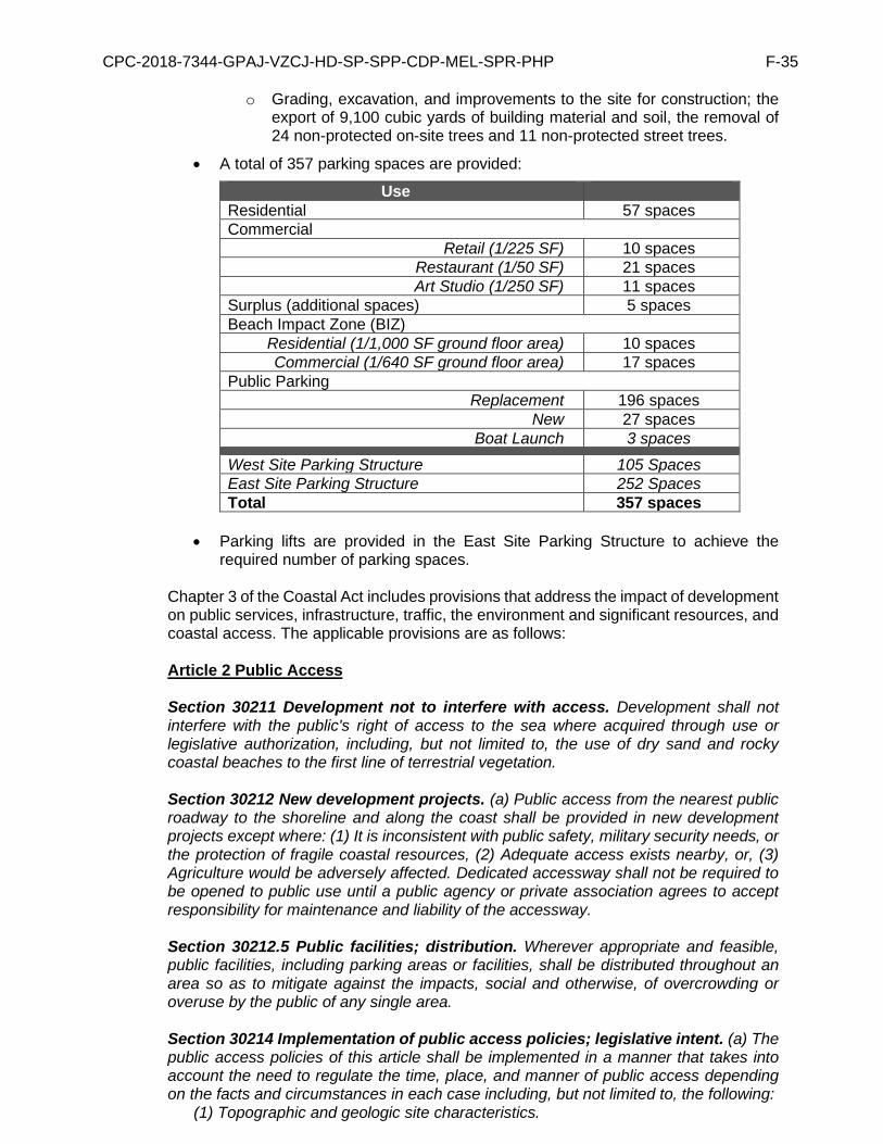
CPC-2018-7344-GPAJ-VZCJ-HD-SP-SPP-CDP-MEL-SPR-PHP F-35
o Grading, excavation, and improvements to the site for construction; the export of 9,100 cubic yards of building material and soil, the removal of 24 non-protected on-site trees and 11 non-protected street trees.
• A total of 357 parking spaces are provided:
Use Residential 57 spaces Commercial
Retail (1/225 SF) 10 spaces Restaurant (1/50 SF) 21 spaces Art Studio (1/250 SF) 11 spaces
Surplus (additional spaces) 5 spaces Beach Impact Zone (BIZ)
Residential (1/1,000 SF ground floor area) 10 spaces Commercial (1/640 SF ground floor area) 17 spaces
Public Parking Replacement 196 spaces
New 27 spaces Boat Launch 3 spaces
West Site Parking Structure 105 Spaces East Site Parking Structure 252 Spaces Total 357 spaces
• Parking lifts are provided in the East Site Parking Structure to achieve the
required number of parking spaces. Chapter 3 of the Coastal Act includes provisions that address the impact of development on public services, infrastructure, traffic, the environment and significant resources, and coastal access. The applicable provisions are as follows: Article 2 Public Access Section 30211 Development not to interfere with access. Development shall not interfere with the public's right of access to the sea where acquired through use or legislative authorization, including, but not limited to, the use of dry sand and rocky coastal beaches to the first line of terrestrial vegetation. Section 30212 New development projects. (a) Public access from the nearest public roadway to the shoreline and along the coast shall be provided in new development projects except where: (1) It is inconsistent with public safety, military security needs, or the protection of fragile coastal resources, (2) Adequate access exists nearby, or, (3) Agriculture would be adversely affected. Dedicated accessway shall not be required to be opened to public use until a public agency or private association agrees to accept responsibility for maintenance and liability of the accessway. Section 30212.5 Public facilities; distribution. Wherever appropriate and feasible, public facilities, including parking areas or facilities, shall be distributed throughout an area so as to mitigate against the impacts, social and otherwise, of overcrowding or overuse by the public of any single area. Section 30214 Implementation of public access policies; legislative intent. (a) The public access policies of this article shall be implemented in a manner that takes into account the need to regulate the time, place, and manner of public access depending on the facts and circumstances in each case including, but not limited to, the following:
(1) Topographic and geologic site characteristics.
CPC-2018-7344-GPAJ-VZCJ-HD-SP-SPP-CDP-MEL-SPR-PHP F-36
(2) The capacity of the site to sustain use and at what level of intensity. (3) The appropriateness of limiting public access to the right to pass and repass depending on such factors as the fragility of the natural resources in the area and the proximity of the access area to adjacent residential uses. (4) The need to provide for the management of access areas so as to protect the privacy of adjacent property owners and to protect the aesthetic values of the area by providing for the collection of litter.
(b) It is the intent of the Legislature that the public access policies of this article be carried out in a reasonable manner that considers the equities and that balances the rights of the individual property owner with the public's constitutional right of access pursuant to Section 4 of Article X of the California Constitution. Nothing in this section or any amendment thereto shall be construed as a limitation on the rights guaranteed to the public under Section 4 of Article X of the California Constitution. (c) In carrying out the public access policies of this article, the commission and any other responsible public agency shall consider and encourage the utilization of innovative access management techniques, including, but not limited to, agreements with private organizations which would minimize management costs and encourage the use of volunteer programs.
The project site is not located between the nearest public road and the sea or shoreline of any body of water located within the coastal zone. The project site would be redesignated from Open Space and Low Medium II Residential to Neighborhood Commercial land use to allow the development of a permanent supportive housing project. As discussed, the site maintains a public parking lot, owned by the City, which will be replaced and expanded in the proposed development. The certified Land Use Plan identifies the site as a public parking lot with potential for additional parking but does not include policies that require the development of a recreational use (consistent with the OS designation) on the subject site. The proposed development is limited to the subject property with the exception of required improvements to the right-of-way including new street trees. The subject site abuts the Grand Canal (Canal Street) and is located .25 miles from the Venice Beach Shoreline. The existing surface parking lot would be developed with a new mixed-use development and improvements to enhance access to coastal resources such as the canal, Short Line Bridge, and public boat launch. As discussed in Finding No. 2, the proposed project provides approximately 16,250 square feet of open space, including approximately 4,930 square feet of landscaped open space. Of this landscaped open space, approximately 1,645 square feet is located within the east banks of the Grand Canal, and approximately 3,285 square feet is located within the north side yard near Dell Avenue. Moreover, landscaping is also provided in the form of new trees and mounded grass planters that line the perimeter of the Project. As provided in Condition No. 18, the landscaped areas adjacent to Canal Street and the Esplanade will remain open and accessible to the public. The areas will provide paved pedestrian walkways through the site, to the bridge, and to the canal. The right of ways adjacent to the subject site will be improved and reconstructed to provide sidewalks that comply with ADA standards and unused driveways will be closed to provide more on-street parking opportunities. During construction of the site, visitors to the Venice Coastal Zone will be able to use the Parking Lot No. 701, which is currently only used when Lot 731 is full. The proposed public parking lot will replace the existing 196 parking spaces and provide 27 additional parking spaces. As discussed in the LADOT Venice Parking Study, prepared by Tierra West Advisors, dated June 2020 and Addendum dated March 2021 (Exhibit M), the projected demand for parking in the area from 2020 to 2040 is 1.041. The Addendum states that the proposed number of parking spaces would adequately meet the expected demand and further highlights the citywide multi-modal policies and planned infrastructure improvements that would further offset future parking demand in the area.

CPC-2018-7344-GPAJ-VZCJ-HD-SP-SPP-CDP-MEL-SPR-PHP F-37
The project will replace a surface parking lot with a supportive housing project that include physical improvements to increase access to the canal resources (walkway, public boat launch, and bridge), but will also provide affordable housing for formerly homeless individuals with access to necessary support services onsite. The project will increase the supply of affordable housing in the Venice Coastal Zone, expanding access to existing coastal resources to those formerly homeless residents while maintaining and improving existing access for the public. The new parking lot will increase the number of parking spaces for visitors to the area and will include new signage for drivers to the lot and pedestrians walking to the canal, public boat launch, and Venice Beach. As such, the proposed LUP amendment and development conforms to the applicable Public Access policies of Chapter 3. Article 3 Recreation Section 30222 Private lands; priority of development purposes. The use of private lands suitable for visitor-serving commercial recreational facilities designed to enhance public opportunities for coastal recreation shall have priority over private residential, general industrial, or general commercial development, but not over agriculture or coastal-dependent industry. Section 30223 Upland areas. Upland areas necessary to support coastal recreational uses shall be reserved for such uses, where feasible. Section 30224 Recreational boating use; encouragement; facilities. Increased recreational boating use of coastal waters shall be encouraged, in accordance with this division, by developing dry storage areas, increasing public launching facilities, providing additional berthing space in existing harbors, limiting nonwater-dependent land uses that congest access corridors and preclude boating support facilities, providing harbors of refuge, and by providing for new boating facilities in natural harbors, new protected water areas, and in areas dredged from dry land. The proposed development includes the redesignation of city-owned land from Open Space and Low Medium II Residential to Neighborhood Commercial land use. As discussed, the subject site is developed with a public parking lot and is identified in the certified LUP as an existing public parking lot (LUP, Exhibit 17a-b). Although the site is currently designated as Open Space, Policy II.A.2 of the LUP provides that existing surface parking lots in the Venice Coastal Zone will be maintained and expand parking capacity. As such, the site would not be developed with a recreational use. The existing recreational areas of the Venice Coastal Zone are identified in Exhibits 20a-21b of the LUP. Policy III.D.6 of the LUP provides the potential for a Venice Canals Park with both parking and recreational uses. Consistent with Policy II.A.2 and III.D.6, the proposed development includes landscaped recreational areas adjacent to Canal Street, open and accessible for public use. While Section 30222 of the Coastal Act prioritizes the development of visitor serving commercial recreational facilities, the LUP does not prioritize the development of recreational uses on the site. Policy III.D.6 states: “New parks, with parking to the rear, shall be considered on some of the City-owned lots on the canals, provided that such facilities are compatible with the existing residential use of the area.” As previously discussed, the Venice Coastal Zone and City of Los Angeles is in the midst of a housing crisis with great demand for affordable housing. The proposed supportive housing project would development affordable housing in a predominately residential neighborhood and create an open and accessible public recreational area adjacent to the existing canal waterway and Esplanade. Furthermore, the project would maintain and expand the current supply of public parking for visitors to Venice Beach and the

CPC-2018-7344-GPAJ-VZCJ-HD-SP-SPP-CDP-MEL-SPR-PHP F-38
Venice Coastal Zone. Consistent with Section 30224, the project proposes not change to an existing public boat launch. The boat launch is located within the Venice Canal, adjacent to the site, and is available for small non-motorized boats/watercraft. The project will increase public access to the canal boat launch by providing pedestrian access from the public parking garage and providing a new on-street loading area on North Venice Boulevard, adjacent to the Esplanade ramp/walkway. As such the proposed LUP amendment and development are consistent with the Recreation policies of Chapter 3.
Article 4 Marine Environment Section 30230 Marine resources; maintenance. Marine resources shall be maintained, enhanced, and where feasible, restored. Special protection shall be given to areas and species of special biological or economic significance. Uses of the marine environment shall be carried out in a manner that will sustain the biological productivity of coastal waters and that will maintain healthy populations of all species of marine organisms adequate for long-term commercial, recreational, scientific, and educational purposes. Section 30231 Biological productivity; water quality. The biological productivity and the quality of coastal waters, streams, wetlands, estuaries, and lakes appropriate to maintain optimum populations of marine organisms and for the protection of human health shall be maintained and, where feasible, restored through, among other means, minimizing adverse effects of waste water discharges and entrainment, controlling runoff, preventing depletion of ground water supplies and substantial interference with surface waterflow, encouraging waste water reclamation, maintaining natural vegetation buffer areas that protect riparian habitats, and minimizing alteration of natural streams. The project site is bisected by the Grand Canal and is improved with a surface parking lot containing 196 vehicular parking spaces, a two-story, four-unit residential structure and the Short Line Bridge connecting the West Site and East Site. The project site contains minimal vegetation of the non-native ornamental variety. The segment of the Grand Canal abutting the project site is an artificially constructed waterway with concrete embankments directly adjacent to concrete sidewalks that run along either side of the canal. This segment of the Grand Canal contains minimal aquatic vegetation. Although this segment of the Grand Canal is designated an Environmentally Sensitive Habitat Area (ESHA) in the Venice LUP, the project site is not suitable habitat and foraging for wildlife. A Biological Technical Report prepared by Glenn Lukos Associates, Inc, dated March 2021 (Exhibit L), concluded that the proposed project would not result in permanent impacts to the ESHA and no mitigation would be necessary. As noted in the Biological Technical Report, the Project Site is already “developed”, consisting of an asphalt parking lot with additional areas of hardscape and limited areas vegetated with ornamental trees and shrubs, as well as small areas of disturbed ground that support non-native weedy annual species adapted to human disturbance. The Project Site supports no native habitat. The report further notes the terminus of the Grand Canal abutting the project site differs in character from the rest of the canal system and does not feature a landscape buffer. Rather, the onsite segment consists of concrete embankments directly adjacent to concrete sidewalks that run along either side of the canal…This segment is the terminal segment of the Grand Canal and ranges in depth from one or two feet to over four feet during high tides. The segment exhibits limited biological values.
CPC-2018-7344-GPAJ-VZCJ-HD-SP-SPP-CDP-MEL-SPR-PHP F-39
In addition, the researchers conducted focused surveys for foraging California least tern within this segment of the Grand Canal that bisects the Project Site. The researchers found that foraging least terns were not detected using the Grand Canal abutting the subject site on the site or 500-feet south of this segment of the Grand Canal. As such, given the low value of the site for foraging least terns, the proposed project would not have significant indirect impacts on least terns. Further, the Project provides approximately 16,250 square feet of open space, including approximately 4,930 square feet of landscaped open space. Of this landscaped open space, approximately 1,645 square feet is located within the east banks of the Grand Canal, and approximately 3,285 square feet is located within the north side yard near Dell Avenue. Moreover, landscaping is also provided in the form of new trees and mounded grass planters that line the perimeter of the Project. As such, the proposed LUP amendment and development conforms to the applicable Marine Environment policies of Chapter 3. Article 5 Land Resources Section 30240 Environmentally sensitive habitat areas; adjacent developments. (a) Environmentally sensitive habitat areas shall be protected against any significant disruption of habitat values, and only uses dependent on those resources shall be allowed within those areas. (b) Development in areas adjacent to environmentally sensitive habitat areas and parks and recreation areas shall be sited and designed to prevent impacts which would significantly degrade those areas, and shall be compatible with the continuance of those habitat and recreation areas. Section 30244 Archaeological or paleontological resources. Where development would adversely impact archaeological or paleontological resources as identified by the State Historic Preservation Officer, reasonable mitigation measures shall be required. The project site is located within a developed urbanized area. The project site is bisected by the Grand Canal and is improved with a surface parking lot containing 196 vehicular parking spaces, a two-story, four-unit residential structure and the Short Line Bridge connecting the West Site and East Site. The project site contains minimal vegetation of the non-native ornamental variety. The segment of the Grand Canal abutting the project site is an artificially constructed waterway with concrete embankments directly adjacent to concrete sidewalks that run along either side of the canal. This segment of the Grand Canal contains minimal aquatic vegetation. Although this segment of the Grand Canal is designated an Environmentally Sensitive Habitat Area (ESHA) in the Venice LUP, the project site is not suitable habitat and foraging for wildlife. A Biological Technical Report prepared by Glenn Lukos Associates, Inc, dated March 2021 (Exhibit L), concluded that the proposed project would not result in permanent impacts to the ESHA and no mitigation would be necessary. As noted in the Biological Technical Report, the Project Site is already “developed”, consisting of an asphalt parking lot with additional areas of hardscape and limited areas vegetated with ornamental trees and shrubs, as well as small areas of disturbed ground that support non-native weedy annual species adapted to human disturbance. The Project Site supports no native habitat. The report further notes the terminus of the Grand Canal abutting the project site differs in character from the rest of the canal system and does not feature a landscape buffer. Rather, the onsite segment consists of concrete embankments directly adjacent to concrete sidewalks that run along either side

CPC-2018-7344-GPAJ-VZCJ-HD-SP-SPP-CDP-MEL-SPR-PHP F-40
of the canal…This segment is the terminal segment of the Grand Canal and ranges in depth from one or two feet to over four feet during high tides. The segment exhibits limited biological values. In addition, the researchers conducted focused surveys for foraging California least tern within this segment of the Grand Canal that bisects the Project Site. The researchers found that foraging least terns were not detected using the Grand Canal abutting the subject site on the site or 500-feet south of this segment of the Grand Canal. As such, given the low value of the site for foraging least terns, the proposed project would not have significant indirect impacts on least terns. Further, the Project provides approximately 16,250 square feet of open space, including approximately 4,930 square feet of landscaped open space. Of this landscaped open space, approximately 1,645 square feet is located within the east banks of the Grand Canal, and approximately 3,285 square feet is located within the north side yard near Dell Avenue. Moreover, landscaping is also provided in the form of new trees and mounded grass planters that line the perimeter of the Project. Further the Project site is not located in an area identified to contain paleontological or archaeological resources. The proposed excavation and grading are subject to review by the Los Angeles Department of Building and Safety (LADBS) and compliance with the Los Angeles Building Code. In the event archaeological or paleontological resources are discovered during excavation or grading activities, the project is subject to compliance with Federal, State and Local regulations already in place. As such, the proposed LUP amendment and development conforms to the applicable Land Resources policies of Chapter 3. Article 6 Development Section 30250 Location; existing developed area. (a) New residential, commercial, or industrial development, except as otherwise provided in this division, shall be located within, contiguous with, or in close proximity to, existing developed areas able to accommodate it or, where such areas are not able to accommodate it, in other areas with adequate public services and where it will not have significant adverse effects, either individually or cumulatively, on coastal resources. (b) Where feasible, new hazardous industrial development shall be located away from existing developed areas. (c) Visitor-serving facilities that cannot feasibly be located in existing developed areas shall be located in existing isolated developments or at selected points of attraction for visitors. The subject site is located within an existing developed area with the existing infrastructure and public services to accommodate the proposed project. The project site is generally located on the block bounded by North Venice Boulevard to the north, Pacific Avenue to the south, Dell Avenue to the east and South Venice Boulevard to the south and is bisected into a West Site and East Site by the terminus of the Grand Canal (which becomes Canal Street north of North Venice Boulevard). Surrounding properties are zoned [Q]C1-1-O, R3-1-O, RD1.5-1-O and RD1.5-1-O-CA, OS-1XL-O and [T][Q]C1.5-1-O-CA Zones with level topography and fully improved streets. The area is zoned for residential, commercial, and open space uses. Properties to the south of the Property, across South Venice Boulevard, are in the R3-1-O Zone, and are developed primarily with three- to four-story multi-family residential buildings interspersed with single-story bungalows. Properties to the west of the Property, across Pacific Avenue, are in the [T][Q]C1.5-1-O-CA, RD1.5-1-O-CA and R3-1-O Zones and

CPC-2018-7344-GPAJ-VZCJ-HD-SP-SPP-CDP-MEL-SPR-PHP F-41
are developed primarily with two-story multi-family residential buildings. Properties to the north of the Property, across North Venice Boulevard, are in the [Q]C1-1-O and R3-1-O Zones and are developed with some commercial but primarily multi-family residential uses comprised of two- and three-story single- and multi-family homes. Properties to the east of the Property, across Dell Avenue, are within the RD1.5-1-O and OS-1XL-O Zones, and are developed with single-story residential buildings in addition to a surface automobile parking lot. Primary regional access is provided by the Marina Freeway (SR-90), Venice Boulevard (SR-187), and Lincoln Boulevard (SR-1), which are all accessible within 1.5 miles of the Project Site. Major arterial roads providing regional access to the Project Site include Pacific Avenue, West Washington Boulevard, and Abbot Kinney Boulevard. The Project site is less than 0.25 miles east of the Pacific Ocean. In addition, the project area is within the service area of the Los Angeles Fire Department Station 63 and the Pacific Division of the Los Angeles Police Department. The proposed development will connect to all public services required for residential and commercial uses, including water and sewage, waste disposal, gas, and electricity. As such, the project will be located in an existing developed area contiguous with similar residential uses, in an area that is able to accommodate new development Section 30251 Scenic and Visual Qualities. The scenic and visual qualities of coastal areas shall be considered and protected as a resource of public importance. Permitted development shall be sited and designed to protect views to and along the ocean and scenic coastal areas, to minimize the alteration of natural land forms, to be visually compatible with the character of surrounding areas, and, where feasible, to restore and enhance visual quality in visually degraded areas. New development in highly scenic areas such as those designated in the California Coastline Preservation and Recreation Plan prepared by the Department of Parks and Recreation and by local government shall be subordinate to the character of its setting. The project site is located in a developed urban area, less than 0.25 miles east of the Pacific Ocean. The project site is generally bounded by North Venice Boulevard to the north, South Venice Boulevard to the south, Pacific Avenue to the west, and Dell Avenue to the east and is bisected into a West Site and East Site by the terminus of the Grand Canal (which becomes Canal Street north of North Venice Boulevard). The surrounding area does not contain natural landforms nor does it maintain views of the ocean. The proposed project is visually compatible with the character of surrounding areas and sited and designed to protect views to the Grand Canal. The proposed development would replace a surface parking lot and two-story multi-family structure with two mixed use structures on site adjacent to Canal Street. The proposed structure on the West Site is 36,157 square feet, three-stories and 35 feet in height with a 59-foot in height architectural campanile located at the northwest corner of the subject site with a roof access structure resulting in a structure with a maximum of 67 feet in height and four stories with a mezzanine. The structure on the East Site is 67,800 square feet, three-stories and 35 feet in height. The structures maintain 5-foot setbacks from the adjacent right of ways and a 10-foot setback from Canal Street. Both structures contain multi-level parking garages. However, the parking uses are wrapped with groundfloor commercial uses and residential uses to ensure the structures are visually compatible with existing commercial and residential uses. Further, the proposed parking lifts located on the roof level do not exceed the height of the parapet walls.
The properties to the west and north are primarily developed with multi-family residential and commercial uses and zone R3, RD1.5 and C1.5. The properties to the south are developed with multi-family and single-family residential and zoned R3 and RW. There are 13 parcels to the north of the Project Site, across North Venice Boulevard that are
CPC-2018-7344-GPAJ-VZCJ-HD-SP-SPP-CDP-MEL-SPR-PHP F-42
developed with six (6) one-story structures, four (4) two-story structures and three (3) three-story structures. There are two parcels to the west of the Project Site, across Pacific Avenue that are developed with two (2) two-story structurers. There are 15 parcels to the south of the Project Site, across South Venice Boulevard developed with two (2) one-story structures, seven (7) two-story structures and six (6) three-story structures. There are two parcels to the east of the Project Site, across Dell Avenue that developed with one (1) one-story structure. Notwithstanding the campanile, the proposed project provides three levels of residential dwelling units and is consistent with the height of adjacent structures. The campanile does introduce a structure that is higher than the allowed height for the adjacent subarea; however, as shown in Exhibit D, the neighborhood is comprised of structures that are 60 and 70 feet in height, on Venice Boulevard. The campanile provides variation in height that further breaks up the massing of the building and provides visual interest The bulk and massing of the proposed project is divided into two structure separated by the Grand Canal such that the development is not a monolithic structure. The buildings fronting the Grand Canal are stepped back to variation in the massing and to reduce the shade and shadow impacts on the canal and adjacent landscaped open space area. In addition, the mass of the building is broken up vertically with sloping features as well as material changes at commercial, retail and community spaces at the ground floor level, providing architectural variety. The building façades are clad with stucco intermixed with fixed and operable windows on the upper levels, and glazed roll-up doors on the ground level. Further, the components of the building will be differentiated not only by color, but by textures. The color palette is a combination of white, beige and gray – each with its own corresponding texture. The Project preserves the historic integrity of the Venice Canals. The subject site straddles the east and west banks of the Grand Canal between North Venice Boulevard and South Venice Boulevard. Landscape enhancements and improved public access to the Grand Canal is provided on the West Site and East Site. The segment of the Grand Canal abutting the subject site is an artificially constructed waterway with minimal aquatic vegetation, and unlike the rest of the canal system, this segment of the Grand Canal does not feature a landscape buffer. Rather, the Grand Canal consists of concrete embankments directly adjacent to the concrete esplanades that run along both sides of the canal. The Project provides approximately 16,250 square feet of open space, including approximately 4,930 square feet of landscaped open space. Of this landscaped open space, approximately 1,645 square feet is located within the east banks of Canal Street. The proposed project provides an averaged 15-foot setbacks on both the West Site and East Site facing the Grand Canal, incorporating public open space including terraced seating, landscaping and plaza areas. Approximately 3,285 square feet of landscaped open space area is located within the north side yard adjacent to Dell Avenue. Moreover, landscaping is also provided in the form of new trees and mounded grass planters that line the perimeter of the Project. The ground level of the project is designed to be compatible with the existing residential and commercial uses proximate to the area. Ground floor retail, restaurant, and art studio spaces flank the west and east sides of the Grand Canal to promote pedestrian activity and access. The existing bridge across the Grand Canal remains in place to facilitate pedestrian access between the West Site and East Site. The provision for publicly accessible open space and local serving commercial uses activates the public street and Grand Canal frontages restores and enhances visual quality for this neglected segment of the Grand Canal.

CPC-2018-7344-GPAJ-VZCJ-HD-SP-SPP-CDP-MEL-SPR-PHP F-43
Furthermore, redesignation of the site for Neighborhood Commercial uses and the proposed amendments to create a new “Subarea A” will result in development that is visually compatible with the existing area. The area adjacent to the site is designated for Medium Residential and Artcraft land uses and generally developed with structure between one and three stories. The new development standards for the “Subarea A” were crafted to be generally consistent with the height and density standards contained in the other subarea of the Venice Specific Plan with a new exception to facilitate the development of a 100 percent affordable project. The project is generally three stories and 35 feet in heigh, which is consistent with the adjacent structures and the height regulations in the Specific Plan.
The bulk and massing of the propose project is divided into two structure separated by the Grand Canal such that the development is not a monolithic structure. The buildings fronting the Grand Canal are stepped back to provide variation in the massing and to reduce the shade and shadow impacts on the canal and adjacent landscaped open space area. Further, the campanile provides variation in height that further breaks up the massing of the building and provides visual interest. Further the density of “Subarea A” is consistent with existing C2 density standards in the Specific Pan.
Section 30252 Maintenance and enhancement of public access. The location and amount of new development should maintain and enhance public access to the coast by (1) facilitating the provision or extension of transit service, (2) providing commercial facilities within or adjoining residential development or in other areas that will minimize the use of coastal access roads, (3) providing nonautomobile circulation within the development, (4) providing adequate parking facilities or providing substitute means of serving the development with public transportation, (5) assuring the potential for public transit for high intensity uses such as high-rise office buildings, and by (6) assuring that the recreational needs of new residents will not overload nearby coastal recreation areas by correlating the amount of development with local park acquisition and development plans with the provision of onsite recreational facilities to serve the new development. The subject site is well-served by multiple transit operators including Los Angeles Metro, Santa Monica Big Blue Bus and Culver City Bus transit systems. Culver City Bus Line 1 stops on Pacific Avenue at subject site and provides daily eastbound/westbound service from Washington Boulevard and Fairfax Avenue to Venice Beach with intersections with seven Metro bus lines (17, 35, 38, 108, 358, Commuter Express 437) and five Santa Monica Big Blue Bus bus lines, (R3, 12, 14, 16, and 18). The eastern terminus of the Culver City Bus Line 1, at the West Los Angeles Transit Center, provides connections to seven Metro buses (35, 37, 38, 105, 217, 705, and 780). Approximately 1,500 feet north of the subject site, near the intersection of Venice Way and Main Street, there are two bus stops served by Metro Local Bus Line 33, Metro Rapid Bus Line 733, and Santa Monica Big Blue Bus Line 1. Metro Local Bus Line 33 and Metro Rapid Bus Line 733 provides eastbound/westbound service from Santa Monica to Downtown Los Angeles. Santa Monica Big Blue Bus Line 1 provides northbound/southbound service from Venice Beach to UCLA. In addition, there is a Metro Bike Share station, located adjacent to the Property, at the intersection of Pacific Avenue and North Venice Boulevard. This bicycle station currently has 12 bicycle “docks”. Further, the subject site is located approximately 750 feet from the Marvin Braude Bike Trail providing regional bicycle access. The proposed residential development will maintain and enhance public access to the coast by creating affordable and permanent supportive housing in the coastal zone. Such affordable housing supports the provision of equitable access consistent with the Commission’s adopted Environmental Justice Policy.

CPC-2018-7344-GPAJ-VZCJ-HD-SP-SPP-CDP-MEL-SPR-PHP F-44
The proposed project provides a gateway features to increase access and visibility of the at the terminus of the Grand Canal. Project feature a new public amenity space abutting the canal including landscape enhancements and commercial activity to increase pedestrian activity and access to the Grand Canal for the larger community. Further improved access to the boat launch is provided on-site and thought improvement wayfinding signage. The subject site is bisected by the Grand Canal. This segment of the Grand Canal is an artificially constructed waterway with concrete embankments directly adjacent to concrete sidewalks that run along either side of the canal and public boat launch ramp. The subject site contains vehicular access to the public boat launch ramp, which is proposed to be relocated. Vehicle access for the loading and unloading of small watercrafts will be provided by three different methods. First, a new curbside loading zone will be provided at the entrance to the Grand Canal on North Venice Boulevard adjacent to the boat launch. Second, three parking spaces are reserved for vehicles to load and unload of small watercrafts within the West Site parking garage. Direct access to the public boat launch is provided from the garage. Third, reserved boat launch parking for vehicles with trailers is provided in the West Site parking garage. This method would require vehicles with trailers to first unload their small watercraft at the curbside loading zone. The Project preserves the historic integrity of the Venice Canals. The subject site straddles the east and west banks of the Grand Canal, between North and South Venice Boulevards. Landscape enhancements and improved public access to the Grand Canal is provided on the West Site and East Site. The proposed project provides averaged 15-foot setbacks on both the West Site and East Site facing the Grand Canal, incorporating public open space including terraced seating, landscaping and plaza areas. In addition, ground floor retail and the art gallery space flank the west and east sides of the Grand Canal, respectively, to further promote pedestrian activity and access. The existing bridge across the Grand Canal remains in place to facilitate pedestrian access between the West Site and East Site. The provision for publicly accessible open space and local serving commercial uses activates the public street and Grand Canal frontages and provides opportunities for local residents and businesses. The Project provides approximately 16,250 square feet of open space, including approximately 4,930 square feet of landscaped open space. Of this landscaped open space, approximately 1,645 square feet is located within the east banks of the Grand Canal, and approximately 3,285 square feet is located within the north side yard near Dell Avenue. Moreover, landscaping is also provided in the form of new trees and mounded grass planters that line the perimeter of the Project. The project involves the demolition of an existing surface parking lot (LADOT Lot 731) containing 196 vehicular parking spaces (bisected by Grand Canal) and a two-story, four-unit residential structure; and the construction of a 103,957-square foot, mixed-use, 100 percent affordable housing development (a 36,157 square-foot structure west of Grand Canal and a 67,800 square-foot, structure east of Grand Canal) consisting of 140 residential dwelling units (136 restricted affordable dwelling units and 4 unrestricted Manager Units), 685 square feet of supportive services, 2,255 square feet of retail uses, 810 square feet of restaurant uses with 1,060 square feet of outdoor and indoor Service Floor area, and 2,875 square feet of art studio uses. The development provides a total of 357 automobile parking spaces for the proposed residential and commercial uses, as well as the public parking lot. The proposed project

CPC-2018-7344-GPAJ-VZCJ-HD-SP-SPP-CDP-MEL-SPR-PHP F-45
will provide reduced residential parking in accordance with AB 744 for 100% affordable housing project, as shown in the Affordable Housing Referrable Form dated October 16, 2018. A report prepared by Fehr and Peers, Infill and Complete Streets Study Task 2.1 A Local Affordable Housing Trip Generation Study, dated April 20, 2017, analyzed vehicle trip generation and parking demand of affordable housing project in the City. Based on a review of 42 affordable housing sites, the study found that trip generation and parking demand were lower than standard apartments, that the parking demand for family affordable housing range from 0.82 to 0.85 spaces per unit and demand for senior and supportive affordable housing range from 0.20 to 0.48 spaces per unit. As such, the proposed 61 residential parking spaces is sufficient for the new supportive housing units. The project will provide 42 parking spaces for the new commercial uses and 27 Beach Impact Zone spaces, consistent with the requirements of the Venice Specific Plan and Land Use Plan. The new public parking garage will replace 196 existing parking spaces and provide 27 new parking spaces. Vehicle access is provided by two-way driveways on North Venice Boulevard and South Venice Boulevard. Unused driveways and curb cuts will be closed and improved with sidewalk and new on-street parking spaces. As such, the proposed development will maintain and enhance access public access. Section 30253 Minimization of Adverse Impacts. New development shall: (1) Minimize risks to life and property in areas of high geologic, flood, and fire hazard. (2) Assure stability and structural integrity, and neither create nor contribute significantly to erosion, geologic instability, or destruction of the site or surrounding area or in any way require the construction of protective devices that would substantially alter natural landforms along bluffs and cliffs. (3) Be consistent with requirements imposed by an air pollution control district or the State Air Resources Control Board as to each particular development. (4) Minimize energy consumption and vehicle miles traveled. (5) Where appropriate, protect special communities and neighborhoods which, because of their unique characteristics, are popular visitor destination points for recreational uses. The proposed development is located within a methane zone, liquefaction area, and tsunami inundation zone, and within 5.51 kilometers of the Santa Monica Fault. As such, the project is subject to compliance with Zoning and Building Code requirements that will minimize risks to life and property in such hazard areas. The development of the Property is in compliance with the Los Angeles Department of Building and Safety (“LADBS”) processes and procedures and is designed in accordance with the California Building Code, ensuring that risks to life and property are minimized. The project site is also located within an area that may be affected by Sea Level Rise. On August 12, 2015, the Coastal Commission adopted a Sea Level Rise Policy Guidance document, updated and adopted On November 7, 2018. This policy document provides a framework and directions for local jurisdictions to address sea level rise (SLR) in Local Coastal Programs (LCPs) and Coastal Development Permits (CDPs). In May 2018, the City completed an initial sea level rise vulnerability assessment for the Venice Coastal Zone. The report provides that: Existing wide beaches generally protect Venice from coastal hazards. Coastal assets along or near the beachfront are potentially vulnerable during a large storm event in combination with SLR greater than 3.3 feet. After 4.9 feet SLR, beachfront assets are more vulnerable to damage from flooding or potential erosion of the beach. A SLR of 6.6 feet is a tipping point for Venice’s exposure to extreme coastal wave events. Beachfront and coastal assets could flood annually, beaches could be greatly reduced in width, and high water levels could greatly increase potential for flooding of inland low-lying areas. As discussed in the analysis, there is considerable uncertainty around the timing of SLR, how coastal processes may be affected, and what adaptation approaches will be applied in the future (VSLRVA, pg. 45). Policies and development standards to address the potential impacts of SLR would

CPC-2018-7344-GPAJ-VZCJ-HD-SP-SPP-CDP-MEL-SPR-PHP F-46
be addressed in the City’s LCP for the Venice Coastal Zone. A Sea Level Rise Report was prepared by GeoSoils, Inc., dated December 28, 2020. The report analyzes current flood hazards, potential for future flooding due to sea level rise, and the risk of tsunami. Based on a study of the best available science and the latest SLR projections, the report estimates the maximum (0.5%) SLR over the next 75 years would be 5.6 to 6.15 feet. While the site is not currently vulnerable to flooding, sea level rise would increase the vulnerability of the site to flooding. The report estimates that SLR would need to be in excess of 6 feet before the buildings maybe subject to flooding. The Coastal Storm Modeling System (CoSMoS) was utilized to analyze the project’s vulnerability to flood hazards, considering a scenario of a minimum 6.6-foot sea level rise and a 100-year storm scenario. Based on this scenario, the proposed development could potentially be affected by flooding as a result of SLR, however, the potential for such flooding in severe storm events is likely to increase towards the end of the project life (based on a typical development life of 75 years). No subterranean levels are proposed, and the project is conditioned to require the lowest finished floor (FF) elevation (not garage floor) should be 2 feet, or more, above the street flow line until reaching elevation 11 feet NAVD88, and for street flow lines above +11 feet NAVD88 the FF elevation should be a minimum of 1 foot above the flow line or that the first floor and foundations be waterproofed. Furthermore, the Project is limited to the site, would not impact emergency access along North and South Venice Boulevard, and is subject to the regulations of the Flood Hazard Zone Specific Plan. While the subject site is not a popular visitor’s destination and does not have unique characteristics, the site is currently developed with a public parking lot and is adjacent to the Venice Canals and Short Line Bridge. In addition, the Venice LUP identifies the Venice Coastal Zone as a Special Coastal Community. The subject site is proximate to popular visitor destination points such as the Venice Canals, Venice Beach, and Ocean Front Walk. As discussed in Finding 9.b. of this report, the proposed amendment and development are consistent with LUP Policies I.E.1 to I.E.3 (Preservation of Venice as a Special Coastal Community). The proposed amendment includes new development standards for “Subarea A” to ensure new structures are compatible with existing development and that portions of the building with frontage on the canal provide an average 15-foot wide setback and permeable yard, consistent with the development standards of the adjacent Venice Canals Subarea. As further discussed in this section, the proposed amendment and development is consistent with the Article 2 and 3 policies regarding public access and recreation as well as Section 30251 of the Coastal Act. As such, the proposed amendment and development is consistent with Section 30253 of the Coastal Act.
The proposed LUP amendment and development will have no adverse impacts on public access, recreation, public views, or the marine environment. The project will neither interfere nor reduce access to the shoreline or beach. There will be no dredging, filling or diking of coastal waters or wetlands associated with the request, and there are no sensitive habitat areas, archaeological or paleontological resources identified on the site. The proposed development will not block any designated public access views. The LUP amendment allows for the redevelopment of an underutilized city-owned surface parking lot with a supportive housing project. The designation of Neighborhood Commercial allows the development of affordable housing and additional public parking, expanding housing opportunities for all income levels and increasing public access. As proposed and conditioned, the LUP amendment and development conforms with Chapter 3 of the California Coastal Act.
b. The development will not prejudice the ability of the City of Los Angeles to prepare a local coastal program that is in conformity with Chapter 3 of the California Coastal Act of 1976.

CPC-2018-7344-GPAJ-VZCJ-HD-SP-SPP-CDP-MEL-SPR-PHP F-47
Coastal Act Section 30604(a) states that prior to the certification of a Local Coastal Program (“LCP”), a coastal development permit may only be issued if a finding can be made that the proposed development is in conformance with Chapter 3 of the Coastal Act. The Venice Local Coastal Land Use Plan (“LUP”) was certified by the California Coastal Commission on June 14, 2001; however, the necessary implementation ordinances were not adopted. The City is in the initial stages of preparing the LCP; prior to its adoption the guidelines contained in the certified LUP are advisory. The subject site is located within the North Venice and Venice Canals Subareas with a land use designation of Open Space and Low Medium II Residential. The proposed project includes an amendment to the LUP to redesignate the site as Neighborhood Commercial and includes a new “Subarea A” for the proposed supportive housing project with development standards.
The following are applicable policies from the certified Venice LUP: Replacement of Affordable Housing Policy I. A. 13. Density Bonus Applications. Required replacement dwelling units shall be counted as reserved units in any related State mandated density bonus application for the same project. Policy I.A.14. Parking Requirements for Affordable Housing. Reduced parking is permitted for low-income units only if: a) the project is consistent with LUP policy I.A.13; and b) it is demonstrated that the prospective occupants of the project will have a reduced demand for parking. However, if a unit changes its status from low or low-moderate income to market rate unit, parking should be provided for market rate units according to the parking standards listed in LUP Policies II.A.3 and II.A.4.
The Project consists of a 100% affordable housing development comprised of permanent supportive housing units. Although the project is not subject to Policy I.A.13 (Density Bonus Applications), the proposed restricted affordable units are subject to the same requirements for 55-year affordability covenants for Density Bonus Applications. As such, the reduced parking provisions outline in Policy I.A.14 apply to the project. The applicant seeks a Developer’s Incentive to utilize the parking provisions of AB 744. AB 744 amended State Density Bonus Law to allow alternative parking ratios for 100% affordable developments within a half-mile of a major transit stop, allowing 0.5 parking spaces per affordable rental unit and 0.3 spaces per affordable rental special needs unit. As previously discussed, the project is within a half-mile of a major transit stop at the time the application was filed, the intersection of Venice Way and Main Street includes the Metro Rapid Bus Line 733 which have service intervals of 15 minutes or less. A report prepared by Fehr and Peers, Infill and Complete Streets Study Task 2.1 A Local Affordable Housing Trip Generation Study, dated April 20, 2017, analyzed vehicle trip generation and parking demand of affordable housing project in the City. Based on a review of 42 affordable housing sites, the study found that trip generation and parking demand were lower than standard apartments, that the parking demand for family affordable housing range from 0.82 to 0.85 spaces per unit and demand for senior and supportive affordable housing range from 0.20 to 0.48 spaces per unit. As such, the reduced parking ratios and proposed 57 residential parking spaces is sufficient for the new supportive housing units. As such, the proposed parking is consistent with the policies for affordable housing and reduced parking of the LUP.
Policy I. B. 2. Mixed-Use Development. Mixed-use residential commercial development shall be encouraged in all areas designated on the Land Use Policy Map for commercial

CPC-2018-7344-GPAJ-VZCJ-HD-SP-SPP-CDP-MEL-SPR-PHP F-48
use. Residential density in commercial land use designations shall not exceed one unit per 800-1200 square feet of lot area and shall comply with the Floor Area Ratio (FAR) limits set forth in Policy I.B.7. The design of mixed-use development is intended to help mitigate the impact of the traffic generated by the development on coastal access roads and reduce parking demand by reducing the need for automobile use by residents and encouraging pedestrian activity. Such development shall comply with the density and development standards set forth in this LUP.
Policy I. B. 5. Neighborhood Commercial Land Use. The Neighborhood Commercial designation is intended to accommodate local neighborhood commercial facilities and services which provide daily convenience goods and services to persons living in nearby residential areas. Small scale neighborhood stores and community services shall be preserved and encouraged. Neighborhood retail goods and services include, but are not limited to the following: art galleries; barber shops or beauty parlors; dry cleaners; laundry services; shoe repair; tailors; florists; hardware stores; drug stores; food/grocery stores; newsstands; medical facilities; and job service centers. Drive-thru facilities and billboards shall be prohibited on properties designated as neighborhood commercial. Community services include day-care, community-meeting rooms, recreational, religious or cultural facilities and similar uses. The clustering of uses minimizes multiple vehicle trips and encourages walking to and from adjacent residential neighborhoods. Areas designated for Neighborhood Commercial Land Use are shown in Exhibits 9 through 12. Physically, Neighborhood Commercial areas are generally characterized by one- and two-story low-rise structures. Pedestrian activities shall be encouraged by the emphasis on local serving uses, design of buildings, and the incorporation of streetscape amenities. The project proposes an LUP amendment to redesignate the site for Neighborhood Commercial land uses and the construction of a mixed-use permanent supportive housing development. The mixed-use project is comprised of residential dwelling units, retail spaces, a new restaurant, art studio space, community room (within the campanile), and public parking lot. The proposed commercial uses are consistent with those local-serving uses identified in Policy I.B.5. The proposed mixed use development is comprised of 140 dwelling units, consistent with the density of the R3 zone (1/800 square feet). Furthermore, the proposed FAR of 1.15:1 is less than the maximum FAR of 1.5:1 outlined in Policy I.B.7. As discussed below, the proposed LUP amendment includes new development standards for “Subarea A,” consistent with Chapter 3 of the Coastal Act and the existing policies of the LUP. Policy I. D. 3. Views of Natural and Coastal Recreation Resources. The scale of development shall comply with height limits, setbacks and standards for building massing specified in Policy Groups I.A and I.B, Residential and Commercial Land Use and Development Standards of this LUP, in order to protect public views of highly scenic coastal areas and vista points, including, but not limited to, the canals, lagoon, jetty, pier, Ocean Front Walk, walk streets and pedestrian oriented special communities. Preservation of Venice as a Special Coastal Community Policy I. E. 1. General. Venice's unique social and architectural diversity should be protected as a Special Coastal Community pursuant to Chapter 3 of the California Coastal Act of 1976. Policy I. E. 2. Scale. New development within the Venice Coastal Zone shall respect the scale and character of community development. Buildings which are of a scale compatible with the community (with respect to bulk, height, buffer and setback) shall

CPC-2018-7344-GPAJ-VZCJ-HD-SP-SPP-CDP-MEL-SPR-PHP F-49
be encouraged. All new development and renovations should respect the scale, massing, and landscape of existing residential neighborhoods. Lot consolidations shall be restricted to protect the scale of existing neighborhoods. Roof access structures shall be limited to the minimum size necessary to reduce visual impacts while providing access for fire safety. In visually sensitive areas, roof access structures shall be set back from public recreation areas, public walkways, and all water areas so that the roof access structure does not result in a visible increase in bulk or height of the roof line as seen from a public recreation area, public walkway, or water area. No roof access structure shall exceed the height limit by more than ten (10’) feet. Roof deck enclosures (e.g. railings and parapet walls) shall not exceed the height limit by more than 42 inches and shall be constructed of railings or transparent materials. Notwithstanding other policies of this LUP, chimneys, exhaust ducts, ventilation shafts and other similar devices essential for building function may exceed the specified height limit in a residential zone by five feet. Policy I. E. 3. Architecture. Varied styles of architecture are encouraged with building facades which incorporate varied planes and textures while maintaining the neighborhood scale and massing.
The proposed project is visually compatible with the character of surrounding areas and sited and designed to protect views to the Grand Canal. The proposed development would replace a surface parking lot and two-story multi-family structure with two mixed use structures on site adjacent to Canal Street. The proposed structure on the West Site is 36,157 square feet, three-stories and 35 feet in height with a 59-foot in height architectural campanile located at the northwest corner of the subject site with a roof access structure resulting in a structure with a maximum of 67 feet in height and four stories with a mezzanine. The structure on the East Site is 67,800 square feet, three-stories and 35 feet in height. The structures maintain 5-foot setbacks from the adjacent right of ways and a 10-foot setback from Canal Street. Both structures contain multi-level parking garages. However, the parking uses are wrapped with groundfloor commercial uses and residential uses to ensure the structures are visually compatible with existing commercial and residential uses.
The properties to the west and north are primarily developed with multi-family residential and commercial uses and zone R3, RD1.5 and C1.5. The properties to the south are developed with multi-family and single-family residential and zoned R3 and RW. There are 13 parcels to the north of the Project Site, across North Venice Boulevard that are developed with six (6) one-story structures, four (4) two-story structures and three (3) three-story structures. There are two parcels to the west of the Project Site, across Pacific Avenue that are developed with two (2) two-story structurers. There are 15 parcels to the south of the Project Site, across South Venice Boulevard developed with two (2) one-story structures, seven (7) two-story structures and six (6) three-story structures. There are two parcels to the east of the Project Site, across Dell Avenue that developed with one (1) one-story structure. Notwithstanding the campanile, the proposed project provides three levels of residential dwelling units and is consistent with the height of adjacent structures. The campanile does introduce a structure that is higher than the allowed height for the adjacent subarea; however, as shown in Exhibit D, the neighborhood is comprised of structures that are 60 and 70 feet in height, on Venice Boulevard. The campanile provides variation in height that further breaks up the massing of the building and provides visual interest. Two roof access structures are proposed, located at the opposite ends of the development, designed to reduce the massing near Street Canal (Grand Canal). Further, the project contains rooftop parking lift, which do not project beyond the parapet walls. The project also provides rooftop solar panels, which do expend 10 feet above the parapet wall; however, the solar panels would be setback between 20 and 30 from

CPC-2018-7344-GPAJ-VZCJ-HD-SP-SPP-CDP-MEL-SPR-PHP F-50
the building line and thus would not be visible from the street and minimal impact on visual resources. The bulk and massing of the proposed project is divided into two structures, on either side of Canal Street. The buildings fronting the Grand Canal maintain a setback of 15 feet to allow a variation in the massing and to reduce the shade and shadow impacts on the canal and adjacent landscaped open space area. In addition, the mass of the building is broken up vertically with sloping features and material changes at commercial, retail and community spaces at the ground floor level, providing architectural variety. The building façades are clad with stucco intermixed with fixed and operable windows on the upper levels, and glazed roll-up doors on the ground level. Further, the components of the building will be differentiated not only by color, but by textures. The color palette is a combination of white, beige and gray – each with its own corresponding texture. The ground floor retail and the art gallery space flank the west and east sides of the Grand Canal, to further break up the massing at the ground level and promote pedestrian activity and access. The existing bridge across the Grand Canal remains in place to facilitate pedestrian access between the West Site and East Site, while adding an interesting architectural feature and break in building massing. The provision of publicly accessible open space and commercial uses further activates the ground level and adds variety to the facades on North and South Venice Boulevard. Policy I. B. 12. Parking Structures. Multi-level parking structures may be permitted in all commercially designated areas provided that the use, design, scale and height of the structure is compatible with adjacent uses and the neighboring community. Policy II. A. 2. Expansion of Public Beach Parking Supply. The construction of new public parking facilities should be implemented, as well as maximizing the use of existing ones by restriping existing parking lots or converting them to multi-level structures where consistent with other Coastal Act policies. The parking lots located west of the Ocean Front Walk shall remain surface parking lots. In no case shall such structures obstruct ocean views or be inconsistent with other Coastal Act or LUP Policies.
The project involves the demolition of an existing surface parking lot (LADOT Lot 731) containing 196 vehicular parking spaces (bisected by Grand Canal) and a two-story, four-unit residential structure; and the construction of a 103,957-square foot, mixed-use, 100 percent affordable housing development. The project will provide a public parking lot with 357 parking spaces (196 replacement parking spaces and 27 new spaces), 57 parking spaces for the dwelling units, 42 parking spaces for the commercial uses, and 27 Beach Impact Zone spaces. The parking structures are wrapped by the residential and commercial components and not visible from the street. As previously discussed, the proposed mixed use structures are consistent with the existing neighborhood character. The proposed project will provide reduced residential parking in accordance with AB 744 for 100% affordable housing project and will provide code required parking for the commercial uses per the Los Angeles Municipal Code and Venice Coastal Zone Specific Plan. The project will replace all of this existing public parking space contained at the subject site and expand the public parking supply by providing 27 additional parking spaces.
Policy I. F. 3. Venice Canals. The historic integrity of the Venice Canals shall be preserved. The canals are deemed to be significant as an early example of community recreational planning in a coastal marshlands area. Included in the historic district are the six canals, their associated sidewalks and a number of pedestrian and vehicular bridges. The Venice Canals are listed on the National Register of Historic Places as an
CPC-2018-7344-GPAJ-VZCJ-HD-SP-SPP-CDP-MEL-SPR-PHP F-51
historic district (August 30, 1982). Additionally, the City of Los Angeles Cultural Heritage Commission declared the Venice Canal System a Los Angeles City Historic-Cultural Monument (HCM No. 270, August 2, 1983). The Project preserves the historic integrity of the Venice Canals. No work is proposed to alter or impact the Short Line Bridge. The subject site straddles the east and west banks of the Grand Canal, between North and South Venice Boulevards. Landscape enhancements and improved public access to the Grand Canal is provided on the West Site and East Site. The proposed project provides averaged 15-foot setbacks on both the West Site and East Site facing the Grand Canal, incorporating public open space including terraced seating, landscaping and plaza areas. Policy III. D. 2. Boating Use of Canals and Lagoon. Recreational boating use of the Venice Canals shall be limited to non-commercial shallow-bottom, non-motorized boats such as canoes and rafts, in order to permit recreation while protecting the environmentally sensitive habitat area and maintain a quiet ambience within the neighborhoods of the plan area. A public boat launch facility was built as part of the Venice Canals Rehabilitation Project at the Grand Canal and North Venice Boulevard. The City shall protect the public’s ability to access the canals by boat by maintaining public access to the Grand Canal public boat launch. The facility shall provide adequate on-site public parking consistent with the sizes and types of boats to be launched and frequency of launching pursuant to the County Department of Small Craft Harbors standards.
The subject site is bisected by the Grand Canal. This segment of the Grand Canal is an artificially constructed waterway with concrete embankments directly adjacent to concrete sidewalks that run along either side of the canal and public boat launch ramp. The subject site currently provides a surface parking lot with vehicle access to the public boat launch ramp. The proposed development would replace the existing surface parking lot with: (1) an on-street loading area on North Venice Boulevard, (2) on-site loading area with two parking spaces dedicated for loading within the new public parking lot on the East Site, and (3) boat launch parking for vehicles with small trailers in the West Site parking garage; vehicles with trailers would need to first unload their small watercraft in the on-street loading area. A total of three boat launch parking spaces are provided.
The following are the proposed Amendments to the Venice LUP: The proposed LUP Amendment includes the redesignation of the existing land uses from Open Space and Low Medium II Residential to Neighborhood Commercial and include new and modified text to the certified LUP, to allow the development of the proposed permanent supportive housing project within a new “Subarea A”. Exhibit G provides the proposed maps and text changes. Designation to Neighborhood Commercial Land Use The subject site is developed with a public parking lot and is identified in the certified LUP as an existing public parking lot (LUP, Exhibits 17a-b). Although the site is currently designated as Open Space land use, there are no proposed plans (at the local level) to develop the site with a public park or other recreational use. Policy II.A.2 of the LUP provides that existing surface parking lots in the Venice Coastal Zone will be maintained and expand parking capacity. As such, the site would not be developed with a recreational use. The existing recreational areas of the Venice Coastal Zone are identified in Exhibits 20a-21b of the LUP. Policy III.D.6 of the LUP provides the potential for a Venice Canals Park with both parking and recreational uses. Consistent with Policy

CPC-2018-7344-GPAJ-VZCJ-HD-SP-SPP-CDP-MEL-SPR-PHP F-52
II.A.2 and III.D.6, the proposed development includes landscaped recreational areas adjacent to Canal Street, open and accessible for public use. While Section 30222 of the Coastal Act prioritizes the development of visitor serving commercial recreational facilities, the LUP does not prioritize the development of recreational uses on the site. Policy III.D.6 states: “New parks, with parking to the rear, shall be considered on some of the City-owned lots on the canals, provided that such facilities are compatible with the existing residential use of the area.” The proposed redesignation would allow the City to maintain and expand the current supply of public parking for visitors to Venice Beach and the Venice Coastal Zone. The proposed public parking lot will replace the existing 196 parking spaces and provide 27 additional parking spaces. As discussed in the LADOT Venice Parking Study, prepared by Tierra West Advisors, dated June 2020 and Addendum dated March 2021 (Exhibit M), the projected demand for parking in the area from 2020 to 2040 is 1.041. The Addendum states that the proposed number of parking spaces would adequately meet the expected demand and further highlights the citywide multi-modal policies and planned infrastructure improvements that would further offset future parking demand in the area. As previously discussed, the Venice Coastal Zone and City of Los Angeles is in the midst of a housing crisis with great demand for affordable housing. In January 2016, a Comprehensive Homeless Strategy (CHS) report was issued jointly from the Office of the City Administrative Officer (CAO) and the Office of the Chief Legislative Analyst (CLA). The CHS analyzed various ways to solve homelessness and listed 64 specific short, medium and long-term strategies for achieving the goal of reducing the number of people in Los Angeles living without safe, decent housing. In the spring of 2016, City staff initiated a process of identifying City sites that may be appropriate for affordable housing, called Affordable Housing Opportunity Sites (AHOS). Through this coordinated effort, eight potential sites that include multiple parcels were identified. Each of the sites identified are either vacant or underutilized and recommended or approved by the Council office in which they are located. The subject site was identified as an AHOS and the City entered into an exclusive negotiating agreement with the project Applicant.
In recent decisions (see Finding 9.d.) the Coastal Commission emphasized the importance of preserving existing housing stock and encouraging more affordable housing in the Venice Coastal Zone, pursuant to Section 30604(f) of the Coastal Act. Section 30604 provides: Coastal development permit; issuance prior to certification of the local coastal program; finding that development in conformity with public access and public recreation policies; housing opportunities for low and moderate income persons… (f) The commission shall encourage housing opportunities for persons of low and moderate income. In reviewing residential development applications for low- and moderate-income housing, as defined in paragraph (3) of subdivision (h) of Section 65589.5 of the Government Code, the issuing agency or the commission, on appeal, may not require measures that reduce residential densities below the density sought by an applicant if the density sought is within the permitted density or range of density established by local zoning plus the additional density permitted under Section 65915 of the Government Code, unless the issuing agency or the commission on appeal makes a finding, based on substantial evidence in the record, that the density sought by the applicant cannot feasibly be accommodated on the site in a manner that is in conformity with Chapter 3 (commencing with Section 30200) or the certified local coastal program. (g) The Legislature finds and declares that it is important for the commission to encourage the protection of existing and the provision of new affordable housing opportunities for persons of low and moderate income in the coastal zone. Designating the site as Neighborhood Commercial land use would allow the

CPC-2018-7344-GPAJ-VZCJ-HD-SP-SPP-CDP-MEL-SPR-PHP F-53
development of affordable housing and expand an existing public parking lot on an underutilized surface parking lot. The proposed supportive housing project would development affordable housing in a predominately residential neighborhood and create an open and accessible public recreational area adjacent to the existing canal waterway and Esplanade. As discussed in Finding Nos. 2 and 9.a., the proposed Amendment to redesignate the land use would be compatible with the adjacent land uses and consistent with the policies of the Coastal Act, General Plan, and applicable provisions of the certified LUP.
Subarea A – Permanent Supportive Housing Project The proposed LUP Amendment includes modifications to the LUP text as follows:
• Add definitions for “Qualified Permanent Supportive Housing Project,” “Supportive Housing,” “Supportive Services,” and “Target Population.”
• Modify the Replacement Affordable Housing policy language to include a new policy for Permanent Supportive Housing Projects and reduced parking for Qualified Permanent Supportive Housing Projects and Supportive Housing.
• Create a new “Subarea A” within the Neighborhood Commercial land use designation for the project site with development standards that regulate density, height, setbacks along the canal, and vehicle access. The new subarea would not be subject to the Commercial Development Standards outlined in Policy I.B.7.
The proposed changes ensure the subject site would be developed with a Qualified Permanent Supportive Housing Project that meets the requirements and regulations for such development. As discussed in Finding Nos. 2 and 9.a., the proposed text changes reflect the proposed development and is consistent with the policies of the Coastal Act and General Plan. Furthermore, as discussed in this section, the proposed development is consistent with existing policies of the certified LUP. The proposed development standards for density are consistent with the density limitations for the adjacent Artcraft and Neighborhood Commercial areas, which allow a density of one unit per 800-1200 square feet. The proposed height limitations are consistent with the height provisions of the North Venice Subarea, allowing a maximum height of 35 feet. However, development in “Subarea A” is not required to provide a sloped roofline. The subject site does not maintain scenic views and is in an area developed with three-story structures that are 30 feet in height; existing nonconforming development along North Venice Boulevard and Venice Boulevard exceed 30 feet in height. As discussed in this report, the proposed 35-foot height limit is visually compatible with the existing area and would allow the development of the proposed supportive housing project. The proposed setbacks along Canal Street are consistent with the setback requirements for residential development in the Venice Canals Subarea, requiring an average setback of 15 feet to allow adequate open space areas and an open permeable yard along the canal frontage to allow adequate onsite drainage of surface runoff to storm drains. Lastly, the proposed standards for vehicle access limit the location of driveways to North and South Venice Boulevards to maintain existing access and circulation patterns, while reducing the number of driveways and closing unused/excess driveways to create addition on-street parking. The proposed LUP Amendment and development is consistent with the applicable policies of the certified LUP and Chapter 3 policies of the Coastal Act.
c. The Interpretive Guidelines for Coastal Planning and Permits as established by
the California Coastal Commission dated February 11, 1977 and any subsequent

CPC-2018-7344-GPAJ-VZCJ-HD-SP-SPP-CDP-MEL-SPR-PHP F-54
amendments thereto have been reviewed, analyzed and considered in light of the individual project in making this determination. The Los Angeles County Interpretative Guidelines were adopted by the California Coastal and statewide guidelines, pursuant to Section 30620 (b) of the Coastal Act, are designed to assist local governments, the regional commissions, the commission, and persons subject to the provisions of this chapter in determining how the policies of this division shall be applied to the coastal zone prior to the certification of a local coastal program. As stated in the Regional Interpretative Guidelines, the guidelines are intended to be used “in a flexible manner with consideration for local and regional conditions, individual project parameters and constraints, and individual and cumulative impacts on coastal resources.” On June 14, 2001, the Coastal Commission certified the Venice Coastal Zone Land Use Plan (LUP), which provides policies and development standards to guide development in the Venice Coastal Zone. As discussed in Finding 9.b., the proposed development is consistent with the applicable policies of the certified LUP.
d. The decision of the permit granting authority has been guided by any applicable
decision of the California Coastal Commission pursuant to Section 30625(c) of the Public Resources Code, which provides that prior decisions of the Coastal Commission, where applicable, shall guide local governments in their actions in carrying out their responsibility and authority under the Coastal Act of 1976.
The project consists of the redevelopment of a surface parking lot with a new permanent supportive housing project comprised of 140 dwelling units, supportive services, commercial uses and a public parking lot. The proposed development is within the dual permit jurisdiction area of the Coastal Zone, where the local jurisdiction (City of Los Angeles) issues Coastal Development Permits and the Coastal Commission will render a decision on a second Coastal Development Permit. The Coastal Commission took action on the following supportive housing projects in the Venice Coastal Zone: Application No. A-5-VEN-20-0060 (appeal) – On December 10, 2020, the Commission found No Substantial Issue with the City’s approval of a Coastal Development Permit for the demolition of a 2,056 square-foot auto repair shop and addition to and conversion of a 2,482 square-foot philanthropic use, in conjunction with the construction of a four-story, 30,463 square-foot, mixed-use development comprised of 39 permanent supportive housing units and one manager’s unit, with 4,441 square feet of supportive services and 3,085 square feet of ground floor commercial (office) use; a total of six parking spaces are provided onsite at 2467-2471 South Lincoln Boulevard, in the single permit jurisdiction. Application No. A-5-VEN-19-0020 (appeal) – On June 12, 2019, the Commission found No Substantial Issue with the City’s approval of a Coastal Development Permit for the development of a four-story, 44-foot tall, 35-unit affordable housing project (supportive housing) providing 17 vehicle and 48 bicycle parking spaces on two consolidated lots at 718-720 Rose Avenue, in the single permit jurisdiction. Application No. A-5-VEN-05-206 (appeal) – On August 9, 2005, the Commission approved a Coastal Development Permit (de novo hearing) for the development of a three-story, 37- foot tall (up to 50 feet for one clock tower), mixed use project comprised of 70 residential condominium units of which seven are restricted for Very Low Income Households, five live/work units, and one ground floor commercial use (bakery/restaurant), providing 247 parking spaces within a subterranean garage; the project is located on eight consolidated lots at 512 Rose Avenue, in the single permit jurisdiction. In these decisions, the Commission found that reduced parking was consistent with the

CPC-2018-7344-GPAJ-VZCJ-HD-SP-SPP-CDP-MEL-SPR-PHP F-55
Policy I.A.14 (Parking Requirements for Affordable Housing) of the certified LUP, which states “reduced parking is permitted for low-income units only if: a) the project is consistent with LUP policy I.A.13; and b) it is demonstrated that the prospective occupants of the project will have a reduced demand for parking.” The Commission further stated “In a recent study conducted by Fehr & Peers on April 20, 2017, 42 affordable housing sites within the City of Los Angeles were surveyed for vehicle trip generation and parking.1 The results indicate that parking utilization ratios are less than the ratios required in the certified LUP. The study indicated that permanent supportive affordable housing created a demand between 0.2 and 0.48 spaces per unit. Additionally, in March 2019, Crain and Associates produced a report on the effects of a 100% affordable housing project and transit availability on personal vehicle ownership and parking demand. That study concluded that substantial evidence and academic research support reduced car ownership and parking utilization by lower income households and housing in close proximity to public transit.” Furthermore, the Commission found that supportive housing project “supports the provision of equitable access consistent with the Commission’s adopted Environmental Justice Policy.” As such, this decision of the permit granting authority has been guided by applicable decisions of the California Coastal Commission pursuant to Section 30625(c) of the Public Resources Code, which provides that prior decisions of the Coastal Commission, where applicable, shall guide local governments in their actions in carrying out their responsibility and authority under the Coastal Act of 1976.
e. The development is located between the nearest public road and the sea or
shoreline of any body of water located within the coastal zone, and the development is in conformity with the public access and public recreation policies of Chapter 3 of the California Coastal Act of 1976.
The project site is located between the nearest public road and the sea or shoreline of any body of water located within the coastal zone. As discussed, the site is adjacent to and bisected by Canal Street, part of the Venice Canal waterway and the Grand Canal. Finding No. 9.a. provides a full discussion of the Chapter 3 policies for public access and recreation, Articles 2 and 3 of the Coastal Act. As discussed in Finding No. 9.a. the proposed LUP amendment and development conforms with the applicable public access and public recreation policies of the Coastal Act.
f. An appropriate environmental clearance under the California Environmental Quality Act has been granted. The proposed project is statutorily exempt from CEQA pursuant to Public Resources Code Section 21080.27(b)(1) and AB 1197. Pursuant to Public Resources Code Section 21080.27(a)(3), there is substantial evidence demonstrating that the proposed project 1) qualifies as supportive housing pursuant to Health and Safety Code Section 50675.14; 2) meets the eligibility requirements of Article 11 (commencing with Section 65650) of Chapter 3 of Division I of Title 7 of the Government Code; and 3) is funded, in part, by the Measure H sales tax proceeds approved by the voters in the March 17, 2017, special election in the County of Los Angeles. All actions to approve the proposed project were taken in furtherance of providing vitally needed Supportive Housing to house and serve the homeless in the City of Los Angeles. See Justification for Statutory Exemption Case No. ENV-2019-5597-SE in the case file for the narrative demonstrating that the project meets the eligibility requirements outlined in AB 1197.
10. Mello Act Compliance Review. Pursuant to the City of Los Angeles Interim Administrative
Procedures (IAP) for Complying with the Mello Act, all Conversions, Demolitions, and New

CPC-2018-7344-GPAJ-VZCJ-HD-SP-SPP-CDP-MEL-SPR-PHP F-56
Housing Developments must be identified in order to determine if any Affordable Residential Units are onsite and must be maintained, and if the project is subject to the Inclusionary Residential Units requirement. Accordingly, pursuant to the settlement agreement between the City of Los Angeles and the Venice Town Council, Inc., the Barton Hill Neighborhood Organization, and Carol Berman concerning implementation of the Mello Act in the Coastal Zone Portions of the City of Los Angeles, the findings are as follows: c. Demolitions and Conversions (Part 4.0)
The project includes the demolition of a multi-family structure containing four (4) Residential Units. The Applicant seeks a General Plan Amendment with a Vesting Zone and Height District change, proposing the development of 10 or more residential dwelling units and is subject to the affordable housing requirements of Measure JJJ. LAMC Section 11.5.11(a) provides that “All Projects qualifying for development bonuses pursuant to this Section shall be required to meet any applicable replacement requirements of California Government Code Section 65915(c)(3).”
The Los Angeles Housing and Community Investment Department (HCIDLA) reviewed the project for compliance with AB 2556 and the Mello Act (Exhibit J). The AB 2556 (TOC/JJJ) Determination, dated August 13, 2019 found that four (4) units are subject to replacement under AB 2556. HCIDLA reviewed data from August 2013 to August 2018. Three (3) Affordable Replacement Units need to be replaced with one (1) unit restricted to Extremely Low-Income Household, one (1) restricted to Very Low-Income Household, one (1) restricted to Low Income Household. One (1) market rate RSO unit is required. The Mello Act Determination, dated April 17, 2021, found that four (4) Replacement Affordable Units are required. HCIDLA review data from December 2015 to December 2018. Part 1.2.3 of the IAP provides “…In the case of conflict between these Interim Administrative Procedures, and geographically specific plan, Local Coastal Program, or any other regulation, the requirement which results in the provision of the largest number of Affordable Replacement Units or Inclusionary Units shall apply…” As such, the project is required to provide Replacement Units pursuant to the requirements of the AB 2556 Determination.
d. New Housing Developments (Part 5.0). The proposed project consists of the development of 140 Residential Units comprised of 136 affordable units and four (4) manager’s units. The Applicant seeks a General Plan Amendment with a Vesting Zone and Height District change, proposing the development of 10 or more residential dwelling units and is subject to the affordable housing requirements of Measure JJJ. In accordance with LAMC Section 11.5.11(a)(1)(iii), as a project involving a General Plan Amendment, Zone Change, or Height District Change for a rental project that allows a residential use where previously not allowed, the project shall provide no less than 5 percent of the total units at rents affordable to Extremely Low Income households, and either 11 percent of the total units at rents affordable to Very Low Income households or 20 percent of the total units at rents affordable to Lower Income households. LAMC Section 11.5.11(a)(3) states that for 100% affordable projects each residential unit in the Project, exclusive of a manager's unit or units, is affordable to, and occupied by, either a Lower or Very Low Income household.
CPC-2018-7344-GPAJ-VZCJ-HD-SP-SPP-CDP-MEL-SPR-PHP F-57
Part 5.0 of the IAP requires New Housing Developments of 10 or more Residential Units to provide Inclusionary Residential Units and provides two options. Option 1 requires 20% of all Residential Units, be reserved for occupancy by Very Low or Low Income Households. Option 2 requires 10% of all Residential units, be reserved for occupancy by Very Low Income Households. Under Option 1, the project would be required to set aside 28 Residential Units for Very Low or Low Income Households and under Option 2, the project would be required to set aside a total of 14 Residential Units for Very Low Income Households. The project proposes a 100% affordable housing project. Of the 136 affordable units, 129 units will be set aside for habitation by Low-Income Households and seven (7) units will be set aside for habitation by Extremely Low-Income Households, for a period of 55 years. The requirements of Measure JJJ and LAMC Section 11.5.11 would require the provision of 136 restricted affordable units. Part 1.2.3 of the IAP provides “…In the case of conflict between these Interim Administrative Procedures, and geographically specific plan, Local Coastal Program, or any other regulation, the requirement which results in the provision of the largest number of Affordable Replacement Units or Inclusionary Units shall apply…”
As such, the project is required to provide Affordable Housing Units pursuant to LAMC Section 11.5.11.
1. Site Plan Review Findings
a. The project is in substantial conformance with the purposes, intent and provisions of the General Plan, applicable community plan, and any applicable specific plan. The project site is located within the Venice Community Plan area, which is one of 35 Community Plans forming the Land Use Element of the General Plan. Properties within the Venice Coastal Zone are also subject to the provisions of the Venice Coastal Zone Land Use Plan (LUP), which was adopted by means of a plan amendment to the Community Plan. The Community Plan and Venice LUP designate the project site with an Open Space land use and Low Medium II residential designations, with a corresponding zone of OS.
As previous discussed in Finding Nos. 2, 8, and 9, the project is in substantial conformance with the purposes, intent, and provisions of the General Plan, Venice Community Plan, Venice Land Use Plan, and Venice Coastal Zone Specific Plan.
b. The project consists of an arrangement of buildings and structures (including
height, bulk and setbacks), off-street parking facilities, loading areas, lighting, landscaping, trash collection, and other such pertinent improvements, which is or will be compatible with existing and future development on adjacent properties and neighboring properties.
The proposed project is designed to be compatible with the existing and future development on adjacent and neighboring properties. The project would redevelop an existing surface parking lot with a 103,957-square foot, mixed-use, 100 percent affordable housing development. The project site is bisected by Canal Street and the Grand Canal. The West Site would be developed with a 36,157 square-foot mixed use structure that is three stories and 35 feet in height with a 59-foot in height architectural campanile with a roof access structure resulting in a structure with a maximum of 67 feet in height and four stories with mezzanine level. The East Site would be developed with

CPC-2018-7344-GPAJ-VZCJ-HD-SP-SPP-CDP-MEL-SPR-PHP F-58
a 67,800 square-foot mixed structure that is three-stories and 35 feet in height. The existing public parking lot would be replaced on the West Site with a multi-level parking garage, wrapped by the commercial and residential uses. The properties to the west and north are primarily developed with multi-family residential and commercial uses and zoned R3, RD1.5 and C1.5. The properties to the south are developed with multi-family and single-family residential and zoned R3 and RW. There are 13 parcels to the north of the Project Site, across North Venice Boulevard that are developed with six (6) one-story structures, four (4) two-story structures and three (3) three-story structures. There are two parcels to the west of the Project Site, across Pacific Avenue that are developed with two (2) two-story structurers. There are 15 parcels to the south of the Project Site, across South Venice Boulevard developed with two (2) one-story structures, seven (7) two-story structures and six (6) three-story structures. There are two parcels to the east of the Project Site, across Dell Avenue that developed with one (1) one-story structure. The proposed Project consists of an arrangement of buildings and structures, off-street parking, lighting, landscaping and trash collection that is or will be compatible with existing and future development on the neighboring properties: Height The height of the proposed project is generally consistent with the height of the surrounding structures. As previously stated, the structure on the West Site is three-stories and 35 feet in height with a 59-foot in height architectural campanile located at the northwest corner of the subject site with a roof access structure resulting in a structure with a maximum of 67 feet in height and four stories with a mezzanine level. The structure on the East Site is three-stories and 35 feet in height.
As shown on Exhibit D There are 35 structures immediately adjacent to the subject site, of which 25 structures have a height of 35 feet or less (71%). The ten structures that have a height greater than 35 feet range in height from 37 feet to 56 feet. The height limit for the adjacent properties in the North Venice Subarea of the Venice Coastal Zone Specific Plan is 30 feet for structures with flat roofs and 35 feet for structures with Varied Roofline (slop roofs). Notwithstanding the campanile, the proposed project is consistent with the adjacent structures and with the heights for future development. The campanile does introduce a structure that is higher than the allowed height for the adjacent subarea; however, as shown in Exhibit D, the neighborhood does contain precedent examples of structures with buildings heights of 60 and 70 feet. The campanile provides variation in height that further breaks up the massing of the building and provides visual interest. Bulk and Mass The project site is bisected by Canal Street, a 60-foot-wide waterway with pedestrian walkways. The project is comprised of two structures on either side of the canal. The buildings fronting the Grand Canal are stepped back to provide variation in building plane, break up the massing, and to reduce the shade and shadow impacts on the canal and adjacent landscaped open space area. Further, the campanile provides variation in height that further breaks up the massing of the building and provides visual interest. In addition, the bulk and mass of the building is broken up vertically with sloping features as well as material changes at commercial, retail and community spaces at the ground floor level, providing architectural variety. Further, lookout decks are provided at the upper level to provide breaks in the building façade. Lastly, the corners of the buildings along Pacific Avenue are rounded to increase pedestrian and automobile visibility and
CPC-2018-7344-GPAJ-VZCJ-HD-SP-SPP-CDP-MEL-SPR-PHP F-59
provide increased public space along the sidewalk. Building Materials The building façades are clad with stucco intermixed with fixed and operable windows on the upper levels, and glazed roll-up doors on the ground level. Further, the components of the building will be differentiated not only by color, but by textures. The color palette is a combination of white, beige and gray – each with its own corresponding texture. The ground-level retail and art gallery feature storefront glazing to provide maximum visibility and natural light. Setbacks The subject site is generally located on the block bounded by North Venice Boulevard, Pacific Boulevard, Dell Avenue and South Venice Boulevard and is separated into a West Site and East Site by the terminus of the Grand Canal (which becomes Canal Street north of North Venice Boulevard). The project site is an approximately 2.65 acres, irregularly shaped parcel of land. The project site has an approximately 174.75-foot frontage on the east side of Pacific Avenue, an approximately 550.75-foot frontage on the south side of North Venice Boulevard, an approximately 78.5-foot frontage on the west side of Dell Avenue, and an approximately 713.75-foot frontage on the north side of South Venice Boulevard. Due to the irregular shape and acreage, the subject site has two front yards on Pacific Avenue and Dell Avenue. In addition, the Property has frontage on both sides of Canal Street. Pursuant to the Venice Coastal Zone Specific Plan, North Venice Subarea, the proposed project requires a front yard of no less than 5 feet. In addition, the Specific Plan requires the frontage along the canal to be an average of 15 feet, but not less than 10 feet. The Project is requesting a Developer Incentive to utilize the setbacks requirements of the RAS3 Zone. RAS3 setback requirements allow a 5-foot side yard is required for all portions of buildings erected and used for residential purposes and a rear yard of no less than 15 feet is required when adjacent to a property in the RD Zone or more restrictive zone, otherwise a 5-foot rear yard is required. As such, the proposed project provides a 5-foot front yard setback on Pacific Avenue, Dell Avenue, North Venice Boulevard and South Venice Boulevard. Further, the proposed project provides a side and rear yard setback of 5 and 16 feet, respectively, where subject site is abuts properties located within the RD1.5 Zone. In addition, the proposed project provides averaged 15-foot setbacks on the portions of the East Site and West Site that are facing the Grand Canal, incorporating public open space areas with terraced seating, landscaping, and plaza areas. Parking/Loading The project will provide a total of 357 automobile parking spaces. Pursuant to the Developer’s Incentive (JJJ), the project will utilize the reduced parking ratios under AB 744 for 100% affordable housing, requiring 0.3 (special needs) and 0.5 spaces for each dwelling unit, and will also provide all required residential parking spaces in the West Site parking garage; 57 parking spaces will be provided for the 140 dwelling units. The project will provide 42 parking spaces for the retail and restaurant uses as well as 27 BIZ spaces, consistent with the requirements of the Venice Specific Plan. In addition to the required spaces for the residential and commercial uses, the project will replace 196 existing public parking spaces and provide 27 additional public parking spaces. A total

CPC-2018-7344-GPAJ-VZCJ-HD-SP-SPP-CDP-MEL-SPR-PHP F-60
of 136 bicycle parking spaces are provided, 19 short-term and 117 long-term spaces.
Lighting All open space areas and pedestrian walkways within the project site will be illuminated, designed with downward facing lights and shielded so the light source cannot be seen from adjacent residential properties. All lighting will comply with Building and Green Building Code requirements. Landscaping/Open Space The Project provides approximately 16,250 square feet of open space, including approximately 4,930 square feet of landscaped open space. Of this landscaped open space, approximately 1,645 square feet is located within the east banks of the Grand Canal, and approximately 3,285 square feet is located within the north side yard near Dell Avenue. Moreover, landscaping is also provided in the form of new trees and mounded grass planters that line the perimeter of the Project. Trash collection Trash and recyclable collection, enclosures for trash and recycling bins are located on the ground level, within the building footprint, and are accessible from the ground level parking area. Trash and recycling areas are fully enclosed and shielded from public view. As described above, the proposed project consists of an arrangement of buildings and structures (including height, bulk, and setbacks), off-street parking facilities and loading areas, lighting, landscaping, trash collection and other such pertinent improvements that will be compatible with existing and future development on adjacent and neighboring properties.
c. The residential project provides recreational and service amenities to improve
habitability for its residents and minimize impacts on neighboring properties.
The proposed project is a Permanent Supportive Housing project that provides supportive service programs designed to help serve the unique needs of those experiencing homelessness and to help them successfully maintain independent living. Each person living in the building will have individualized assistance in the coordination of his or her housing and service needs. The Intensive Care Management Services (ICMS) will be available to the individuals who previously experienced homelessness will be available to all who live in the building. Residents will have access to on-site and off-site programs that are flexible and responsive to their needs. The services are population-specific, and culturally and linguistically appropriate. Housing is the primary intervention for tenants, emphasizing a model that incorporates “wrap-around” service delivery. The Project provides approximately 16,250 square feet of open space, including approximately 4,930 square feet of landscaped open space. Of this landscaped open space, approximately 1,645 square feet is located within the east banks of the Grand Canal, and approximately 3,285 square feet is located within the north side yard near Dell Avenue. The areas adjacent to the Grand Canal are landscaped and include pedestrian pathways that provide access to the canal, Short Line Bridge, and public boat launch. The project includes a 2,875 square-foot art studio space at the ground level of the East Site and a 1,590 square-foot community room at fourth floor of the West Site structure. Both are available for use by residents and members of the public. The project's recreational and service amenities will improve the habitability for its residents.

CPC-2018-7344-GPAJ-VZCJ-HD-SP-SPP-CDP-MEL-SPR-PHP F-61
The publicly accessible open space recreational areas and indoor gathering spaces, activate the street and Grand Canal frontages and provides opportunities for residents and visitors, and further minimize impacts on neighboring properties.
2. Environmental Finding
The proposed project is statutorily exempt from CEQA pursuant to Public Resources Code Section 21080.27(b)(1) and AB 1197. Pursuant to Public Resources Code Section 21080.27(a)(3), there is substantial evidence demonstrating that the proposed project 1) qualifies as supportive housing pursuant to Health and Safety Code Section 50675.14; 2) meets the eligibility requirements of Article 11 (commencing with Section 65650) of Chapter 3 of Division I of Title 7 of the Government Code; and 3) is funded, in part, by the Measure H sales tax proceeds approved by the voters in the March 17, 2017, special election in the County of Los Angeles. All actions to approve the proposed project were taken in furtherance of providing vitally needed Supportive Housing to house and serve the homeless in the City of Los Angeles. See Justification for Statutory Exemption Case No. ENV-2019-5597-SE in the case file for the narrative demonstrating that the project meets the eligibility requirements outlined in AB 1197.
3. Flood Insurance. The National Flood Insurance Program rate maps, which are a part of
the Flood Hazard Management Specific Plan adopted by the City Council by Ordinance No. 172,081, have been reviewed and it has been determined that this project is located in Zone AE, base flood elevations determine.

RESOLUTION
WHEREAS, the California Coastal Act of 1976 has declared that the California Coastal Zone is a distinct and valuable resource of vital and enduring interest to all the people and exists as a delicately balanced ecosystem; and WHEREAS, one of the basic goals of the State is to protect; maintain, and where feasible, enhance and restore the overall quality of the Coastal Zone environment and its natural and manmade resources: and WHEREAS, the California Coastal Act of 1976 requires each local government lying, in· whole or in part, within the Coastal Zone to prepare a Local Coastal Program for that portion of the Coastal Zone within its jurisdiction to assure that maximum public access to the coast and public recreation areas is provided, consistent with Chapter 3 of the Act; and WHEREAS, portions of the Venice Community Plan lie within the Coastal Zone, as designated by the State Legislature; and WHEREAS, the portion of Venice west of Lincoln Boulevard lies within the Coastal Zone; and WHEREAS, Venice is identified as an area of special significance which required zoning regulations beyond that the traditional zoning code as determined after conducting several public meetings in coastal communities to identify coastal issues of major concern and after conducting several public workshops in coastal communities to develop a Specific Plan to address major issues; and WHEREAS, on October 29, 1999, and pursuant to California Public Resources Code Section 30510(a), the City Council of the City of Los Angeles adopted the Land Use Plan of the Venice Local Coastal Program; and WHEREAS, on November 29, 1999, the adopted Land Use Plan of the Venice Local Coastal Program was transmitted to the California Coastal Commission for consideration and certification, consistent with Section 30511(b) of the Coastal Act; and WHEREAS, on November 14, 2000, the California Coastal Commission approved the Land Use Plan of the Venice Local Coastal Program with suggested modifications; and WHEREAS, on March 28, 2001, the City Council of the City of Los Angeles adopted the suggested modifications to the Land Use Plan of the Venice Local Coastal Program; and WHEREAS, on June 14, 2001 the California Coastal Commission certified the Land Use Plan of the Venice Local Coastal Program; and WHEREAS, the subject project is located within the Venice Coastal Zone in the area covered by the Venice Community Plan; and WHEREAS, the City Planning Commission recommended approval of a General Plan Amendment from Open Space and Low Medium II Residential to Neighborhood Commercial for the subject property and recommended approval of a Zone Change from OS-1XL-O to (T)(Q)C2-1L-O; and

WHEREAS, the City Planning Commission recommended approval of a Specific Plan Amendment to create a new subarea for Qualified Permanent Supportive Housing and related Land Use Regulations and Development Standards in the Venice Coastal Zone Specific Plan; and related Map Exhibit changes to add the new subarea and change the zoning from OS-1XL and RD1.5 to C2-1LO for the new subarea; and WHEREAS, the City Planning Commission approved a project for the demolition of a surface parking lot and a four-unit apartment building and the construction of a three-story with a four-story campanile, 103,957-square foot, mixed-use,100 percent affordable housing development consisting of 140 dwelling units, providing a total of 357 parking spaces; and WHEREAS, the City Planning Commission at its meeting on May 27, 2021 approved the General Plan Amendment and recommended approval by the City Council of a General Plan Amendment for the subject property; and WHEREAS, pursuant to the provisions of the Los Angeles City Charter, the Mayor and City Planning Commission have transmitted their recommendations; and WHEREAS, the requested General Plan Amendment is consistent with the intent and purpose of the adopted Venice Community Plan to designate land use in an orderly and unified manner; and WHEREAS, the Zoning Change from OS-1XL-O to (T)(Q)C2-1L-O and Venice Coastal Zone Specific Plan amendment creating Subarea A will provide consistency between the General Plan Land Use Designation and the Zoning and Specific Plan; and WHEREAS, the subject proposal qualifies for a Statutory Exemption as provided in ENV-2018-6667-SE in furtherance of creating supportive housing in accordance with Assembly Bill 1197 for implementation of the California Environmental Quality Act (CEQA). NOW, THEREFORE, BE IT RESOLVED that the Venice Community Plan be amended as shown on the attached General Plan Amendment map and certified Venice Land Use Plan map and text amendments. NOW, THEREFORE, BE IT RESOLVED, that pursuant to California Public Resources Code Section 30510(b) and to Section 00071 of the Local Coastal Program Regulations of the California Coastal Commission, the City Council hereby directs the Director of City Planning to submit to the California Coastal Commission for its consideration and certification an amendment to the certified Land Use Plan of the Venice Local Coastal Program.

166.65
95
50 40
NORTH VENICE BLVD
PACIFIC AVE
SOUTH VENICE BLVD
DELL AVE
GRAND CANAL CT
CANAL ST
GRAND CL
THE GRAND CL
COURT D
ALBERTA AVE
STRONG'S DR
COURT E
CARROLL CL
NEIGHBORHOOD
COMMERCIAL
NEIGHBORHOOD
COMMERCIAL
Data Sources: Department of City Planning & Bureau of Engineering
City of Los Angeles
0 200100
FeetVeniceCPC-2018-7344-GPAJ-VZCJ-HD-SP-SPP-CDP-MEL-WDI-SPR-PHP
AA/ 010821
THE INTENT OF THIS ORDINANCEIS FOR THE BOUNDARIES OF THISGENERAL PLAN LAND USE CHANGE TO COINCIDE WITH THOSE OF RECORDED TR 82288.
VENICE
EXHIBIT A: Venice Land Use Plan Text Amendments
The City Council adopts the following amendments to the Venice Coastal Zone Land Use Plan. Additions shown in underline and deletions shown in strikeout. Add the following subarea to the Venice Coastal Zone and modify the number of subareas, page I-7 of the LUP
To facilitate discussion of issues, policies and development standards, the Venice Coastal Zone has been divided into eight (8) nine (9) subareas, as follows: Subarea A: generally bounded by Dell Avenue, North Venice Boulevard, South Venice Boulevard and Pacific Avenue, as shown on Exhibit 5b. These eight nine specific plan subareas roughly follow the boundaries of the older neighborhoods previously used by the City Council and neighborhood groups for public participation in neighborhood issues.
Add the following Definitions, pages I-13 to I-17 of the LUP
Qualified Permanent Supportive Housing Project. The construction of, addition to, or remodeling of a building or buildings offering Supportive Housing; and where all of the total combined Dwelling Units or Guest Rooms, exclusive of any manager’s units, are affordable. For the purposes of this subdivision, affordable means that rents or housing costs to the occupying residents do not exceed 30 percent of the maximum gross income of Extremely Low, Very Low or Low-Income households, as those income ranges are defined by the United States Department of Housing and Urban Development (HUD) or any successor agency, as verified by the Housing & Community Investment Department (HCIDLA). A minimum of 50 percent of the total combined Dwelling Units or Guest Rooms is occupied by the Target Population. Supportive Housing. Housing with no limit on length of stay for persons with low incomes who have one or more disabilities and may include, among other populations, adults, emancipated minors, families with children, elderly persons, young adults aging out of the foster care system, individuals exiting from institutional settings, veterans, and homeless people. The housing is linked to onsite or offsite Supportive Services, and any Floor Area used for Supportive Services shall be considered accessory to the residential use. Supportive Services. Services that are provided on a voluntary basis to residents of Supportive Housing and Transitional Housing, including, but not limited to, a combination of subsidized, permanent housing, intensive case management, medical and mental health care, substance abuse treatment, employment services, benefits advocacy, and other services or service referrals necessary to obtain and maintain housing. Target Population. Persons with qualifying lower incomes who (i) have one or more disabilities, including mental illness, HIV or AIDS, substance abuse, or other chronic health condition, and are homeless as defined by any Los Angeles City, Los Angeles County, State of California, or Federal guidelines; or (ii) are chronically homeless, as defined by any Los Angeles City, Los Angeles County, State of California, or Federal guidelines.
Modify section heading of page II-15 as follows:
Replacement of Affordable Housing Add new policies for Permanent Supportive Housing Projects to page II-18 of the LUP:

Policy I.A.18 Permanent Supportive Housing Projects that meet the definition of Qualified Permanent Supportive Housing Project and comply with the following requirements:
a. Supportive Services. Applicants shall provide documentation describing the Supportive Services that will be provided onsite and offsite. Prior to any approval of a Qualified Permanent Supportive Housing Project, the applicant shall submit information demonstrating that Supportive Services will be provided to residents of the project. The applicant shall indicate the name of the entity or entities that will provide the Supportive Services, the Local Public Agency funding source(s) for those services, and proposed staffing levels. If a preliminary funding commitment is needed, the applicant shall also submit a signed letter of intent from the Local Public Agency verifying that it is providing a preliminary funding commitment for the Supportive Services. If no funding commitment is needed, the applicant shall demonstrate that the entity or entities that will provide the Supportive Services are service providers prequalified by a Local Public Agency.
b. Affordable Housing Covenant. Projects shall record a covenant acceptable to HCIDLA that reserves and maintains the total combined number of Dwelling Units and Guest Rooms designated as restricted affordable for at least 55 years from the issuance of the Certificate of Occupancy.
c. Housing Replacement. Projects shall meet any applicable dwelling unit replacement
requirements of California Government Code Section 65915(c)(3), or as thereafter amended, as verified by HCIDLA, and all applicable covenant and monitoring fees in Section 19.14 of this Code shall be paid by the applicant prior to the issuance of any building permit.
Policy I.A.19 Parking Requirements for Qualified Permanent Supportive Housing Projects and Supportive Housing. Reduced parking is permitted, as follows:
a. Supportive Housing as defined in Health and Safety Code 50675.14(b)(2). Projects providing Supportive Housing may provide reduced parking consistent with Government Code Section 65915.
Modify page II-20 of the LUP to add Neighborhood Commercial Area of Special Interest as follows:
Neighborhood Commercial Areas Policy I. B. 5. Neighborhood Commercial Land Use. The Neighborhood Commercial designation is intended to accommodate local neighborhood commercial facilities and services which provide daily convenience goods and services to persons living in nearby residential areas. Small scale neighborhood stores and community services shall be preserved and encouraged. Neighborhood retail goods and services include, but are not limited to the following: art galleries; barber shops or beauty parlors; dry cleaners; laundry services; shoe repair; tailors; florists; hardware stores; drug stores; food/grocery stores; newsstands; medical facilities; and job service centers. Drive-thru facilities and billboards shall be prohibited on properties designated as neighborhood commercial. Community services include day-care, community-meeting rooms, recreational, religious or cultural facilities and similar uses. The clustering of uses minimizes multiple vehicle trips and encourages walking to and from adjacent residential neighborhoods. Areas designated for Neighborhood Commercial Land Use are shown in Exhibits 9 through 12. Physically, Neighborhood Commercial areas are generally characterized by one and two story low-rise structures. Pedestrian activities shall be encouraged by the emphasis on local serving uses, design of buildings, and the incorporation of streetscape amenities. Neighborhood Commercial Area of Special Interest

a. Subarea A (Exhibit 10b). The lots within Subarea A shall be developed with a Qualified Permanent Supportive Housing Project that meets the requirements of Policy I.A.18 and the following development standards. Qualified Permanent Supportive Housing Projects are not subject to the standards outlined in Policy I.B.7.
1. Density. No project shall exceed the density permitted in the R3 zone.
2. Use. Uses allowed in the C2 zone or as outlined in Policy I.B.5.
3. Height.
i. All projects shall be limited to a maximum height of 35 feet.
ii. One (1) campanile structure may exceed the maximum height of 35 feet. A maximum height of 67 feet is permitted, measured to the top of the Roof Access Structure.
4. Canal Setback
i. An average setback of 15 feet, but not less than ten feet shall be maintained
in the front yard adjacent to the property line which faces the canal.
ii. An open, permeable yard with an area of at least 15 times the lot width and a minimum area of 450 square feet shall be maintained between the property line that faces the canal and the front of any structure. No fill nor building extensions, including stairs and balconies, shall be placed in or over the required permeable front yard area except fences up to 42 inches in height or permeable decks at grade level not more than 18 inches high.
5. Access.
i. Driveways and vehicular access to Venice Coastal Development Projects
shall be provided from North Venice and South Venice Boulevards, unless the Department of Transportation determines that it is not Feasible. New and existing curb cuts shall be minimized to protect and maximize public on-street parking opportunities.

Single Family Residential
Multiple Family Residential
Commercial
Industrial
Open Space/Public Facilities
LowLow Medium I
Low Medium ILow Medium IIMedium
Limited Industry
Open SpacePublic Facility
ArtcraftGeneral CommercialNeighborhood CommercialCommunity Commercial
Sher
man
How
land
Can
al C
t
Linn
ie C
anal
Ct
Car
roll
Can
al C
t
How
lan
Linn
ie
Ca r
rol l
Sher
ma n
Can
a l C
tSh
erm
an C
anal
Ct
How
land
Can
al C
t
Linn
ie C
anal
Ct
Car
roll
Can
al C
t
30th
Pl
29th
Pl
23rd
Pl
27th
Pl
28th
Pl
26th
Pl
25th
Pl
24th
Pl
Navarre Ct
Sevil
le Ct
Sevil
le Ct
Sevil
le Ct
Cordo
va C
t
Cordo
va C
t
Gra
nada
Ct
Cen
ter
Ct
Gra
nada
Ct
Valencia
Ct
Veni
ce C
t
19th
Pl
18th
Pl
17th
Pl
Virg
i nia
Ct
20th
Pl
Mar
ket C
t
Match Line (see Exhibit 10a)
Exhibit 10bLand Use Plan (Map): North Venice • Venice Canals Not to Scale
N
Elect
ricAv
e
Elect
ricAv
e
Kinn
eyPla
za
VENICE LUP POLICIES (certified by the Coastal Commission June 14, 2001)
Virg
inia
Ct
Win
dwar
d C
tW
indw
ard
Ct
Cen
ter
Ct
Cent
er C
t
Alhambra Ct
Bari
Wy
23rd
Pl
30th
Pl
29th
Pl
27th
Pl
28th
Pl
26th
Pl
25th
Pl
24th
Pl
23rd
Pl
30th
Pl
29th
Pl
27th
Pl
28th
Pl
26th
Pl
25th
Pl
24th
Pl
Sher
man
How
land
Can
al C
t
Linn
ie C
anal
Ct
Car
roll
Can
al C
t
How
lan
Linn
ie
Ca r
rol l
Sher
ma n
Can
a l C
tSh
erm
an C
t
How
land
Can
al C
t
Linn
ie C
anal
Ct
Carr
oll C
anal
Ct
How
land
Ave
Linn
ie
Ave
Carr
oll
Ct
Sher
man
Can
al C
t
Virg
inia
Ct
S her
man
Can
al C
t
How
land
Can
al C
t
Linn
ie C
anal
Ct
Car
roll
Can
al C
t
Sher
man
Can
al C
t
How
land
Can
al C
t
Linn
ie C
anal
Ct
Carr
oll C
anal
Ct
V eni
ce C
tVi
rgi n
ia C
tVi
rgin
ia C
tVe
nice
Ct
2 0th
Pl
19th
Pl
18th
Pl
17th
Pl
20th
Pl
19th
Pl
18th
Pl
17th
Pl
Mar
ket C
ttC t ekra
M
Navarre Ct
Sevil
le Ct
Sevil
le Ct
Sevil
le Ct
Cordo
va C
t
Cordo
va C
t
Gra
nada
Ct
Valencia
Ct
Gra
nada
Ct
Navarre Ct
Sevil
le C
t
Sevil
le C
t
Sevil
le C
t
Cord
ova
Ct
Cord
ova
Ct
tC adanar
G
Valencia Ct
tC adanar
G
Grand Canal Ct
Eastern CtEastern Ct
Alhambra Ct
Pacifi
c Elec
tric Ra
ilway
Co. R
/W
Pacific Electric
Railway Co. R
/W
Pacific Electric Railway Co.Pac
ific Elec
tric R
ailway
Co. R
/W
Sout
h Ven
ice
BlvddvlB ecineV htro
N
Andalusia Ave
Navarre Ct
Nor
th V
enice
Blvd
Sher
man
Ave
Car
roll
Ave
Strongs Dr Stro
ngs D
r
Strongs Dr
rD sgnortS
Was
hing
ton
Blvd
Ocean Front Walk
Sout
h Ven
ice
Blvd
20th
St
19th
St
18th
St
17th
St
ev A drawdni
W
Gran
d B
lvd
Veni
ce W
ayM
ildre
d A
ve
Rivera Ave.
Main StCanal St
Strongs Dr
The
Gra
nd C
anal
Andalusia Ave
Andalusia Ave
California Ave
Milw
ood Ave
Palms Blvd
Dell Ave
Ocean Ave
Pacific Ave
Rial
to A
ve
Alta
ir Pl
Navarre Ct
Rialto Ave
dvlB ecineV htroN
dvlB ecineV htroN
Abbot Kinney Blvd
Dell Ave
30th
Ave
29th
Ave
27th
Ave
28th
Ave
26th
Ave
25th
Ave
24th
Ave
23rd
Ave
Pacific Ave
Grand Canal
Sher
man
Can
al
How
land
Can
al
Linn
ie C
anal
Carr
oll C
anal
Eastern Canal
Sher
man
Ave
Carr
oll A
ve
Ocean Front Walk
Speedway Ave Speedway Ave
Abbot Kinney Blvd
Cadiz Ct
tS tekraM
Mar
ket
St
Rivera Ave.
Park Row Dr
Cabrillo Pl
evA dra
wdniW
Pacifi
cElectr
icRa
ilway
Co. R
/W

Match Line (see Exhibit 11a)
Exhibit 11bHeightSubarea: North Venice • Venice Canals
Elect
ricAv
e
Cres
cent
Ct
Elect
ricCt
Cres
cent
Ct
Elect
ricCt
Elect
ricAv
e
Cresce
nt(Pa
rk) P
.
Pacific
Electr
icRailw
ayCo
. R/W
Not to ScaleN
Eastern CtEastern Ct Eastern CtEastern Ct
Mar
ket C
t
Grand Canal CtGrand Canal Ct
O cean Beach CtO cean Beach Ct Ocean Beach CtOcean Beach Ct
Sant
a C
lara
Ct
Sant
a Cl
ara
Ct
Cen
ter
Ct
23rd
Pl
Veni
ce C
t
Sher
man
Can
al C
t
Ho w
la nd
Can
al C
t
Linn
ie C
anal
Ct
Car
roll
Can
al C
t
Virg
inia
Ct
30th
Pl
29th
Pl
27th
Pl
28th
Pl
26th
Pl
25th
Pl
24th
Pl
20th
Pl
1 9th
Pl
18th
Pl
17t h
Pl
Navarre
Ct
Linn
ie
A
ve
Sevil
le Ct
Alhambra Ct
Sevil
le Ct
Electric Ct
Electric Ct
Sevil
le Ct
Cordo
va C
t
Cordo
va C
t
Win
dwar
d C
t
Sher
man
C
t
How
land
Can
al C
t
Linn
ie C
anal
Ct
Car
r ol l
Can
al C
t
Vir g
ini a
Ct
How
la nd
Ave
Linn
ie
A
ve
Car
r oll
C
t
Sher
man
Can
al C
t
Bar i
Wy
Cent
er C
t
23rd
Pl
Veni
ce C
t
Sher
man
Can
al C
t
How
land
Can
al C
t
Linn
ie C
anal
Ct
Carr
oll C
anal
Ct
Virg
inia
Ct
30th
Pl
29th
Pl
27th
Pl
28th
Pl
26th
Pl
25th
Pl
24th
Pl
20th
Pl
19th
Pl
18th
Pl
17th
Pl
Navarre Ct
Linn
ie
Av
e
Sevil
le C
t
Alhambra Ct
Sevil
le C
t
Milw
ood CtCalifornia Ct
Electric Ct
Electric Ct
Sevil
le C
t
Cord
ova
Ct
Cord
ova
Ct
Win
dwar
d C
t
Virg
inia
Ct
Sher
man
C
t
How
land
Can
al C
t
Linn
ie C
anal
Ct
Carr
oll C
anal
Ct
Virg
inia
Ct
Alhambra Ct
How
land
Ave
Linn
ie
Av
e
Carr
oll
C
t
Sher
man
Can
al C
t
Bari
Wy
Gra
nada
Ct
Valencia
Ct
Gra
nada
Ct
Gra
nada
Ct
Valencia Ct
Gra
nada
Ct
Alhambra Ct
Mar
ket C
t
Nor
th V
enice
Blvd
Sher
man
Ave
Car
rol l
Ave
Strongs Dr Strongs Pl
Stro
ngs D
r
Strongs Dr Stro
ngs
Dr
Strongs Pl
O cean Front Walk
Seville Ct
Bucc
anee
r St
Was
hing
ton
Blvd
Ocean Front Walk
Sout
h Ven
ice
Blvd
20th
St
19th
St
18th
St
17th
St
Win
dwar
d A
ve
Gran
d B
lvd
Veni
ce W
ayM
ildre
d A
ve
Rivera Ave.
Main StCanal St
Strongs Dr
The
Gra
nd C
anal
Andalusia Ave
Andalusia Ave
Sixth Ave
California Ave
Milw
ood Ave
Palms Blvd
Shell Ave
Shell Ave
Dell Ave
Sanborn Ave
Ocean Ave
evA ht82
Olive
Ave
Pacific Ave
Superba Ave
dvlB ecineV htuoS
Rial
to A
ve
Alta
ir Pl
Navarre Ct
Rialto Ave
dvlB ecineV htroN
Nor
th V
enic
e Bl
vd
Sout
h Ve
nice
Blv
d
Abbot Kinney Blvd
Sout
h Ven
ice
BlvddvlB ecineV htro
N
Dell Ave
30th
Ave
29th
Ave
27th
Ave
28th
Ave
26th
Ave
25th
Ave
24th
Ave
23rd
Ave
Pacific Ave
Grand Canal
Sher
man
Can
al
How
land
Can
al
Linn
ie C
anal
Carr
oll C
anal
Eastern Canal
Sher
man
Ave
Carr
oll A
ve
Beach Ave
evA ht82Mild
red
Ave
Was
hing
ton
Way
McKinley Ave
Harb
or
St
Beach Ct
Venezia Ave
Via Dolce
Anch
orag
e S
t
City
of
Los
Ang
eles
Coun
ty o
f Lo
s A
ngel
es
Paci
fic E
lect
ric R
ailw
ay C
o. R
/W
Pacific Electric Railway Co. R/W
Paci
fic E
lect
ric R
ailw
ay C
o. R
/W
Pacific Electric
Railway Co. R
/W
Pacific
Electri
c Rail
way C
o. R/W
Sant
a Cl
ara A
ve
Strongs Dr
Speedway Ave Speedway Ave
Abbot Kinney Blvd
Cadiz Ct
Kinn
ey
Plaza
Mar
ket S
t
Mar
ket
St
Rivera Ave.
Park Row Dr
Cabrillo Pl
Win
dwar
d Av
e
Maximum Building Height
E 22'–30'
F 30' with a flat roof35' with varied or stepped back roofline28' along walk streets
Notes:
*All building heights shall be measured from the elevationof the fronting right-of-way, except in the Venice Canal Subarea (E)where all building heights shall be measured from the elevationof the adjacent alley.
*Roof access structures shall be set back at least 60 horizontal feetfrom the mean high tide line of the fronting canal.
*Notwithstanding other provisions of the Venice Coastal Specific Plan, chimneys, exhaust ducts, ventilation shafts and other similar devices essential for building function may exceed the specifiedheight limit in a residential zone by five feet.
*See Section 8.C
FF
A

Match Line (see Exhibit 14a)
Electr
icAv
e
Cres
cent
Ct
Elect
ricCt
Cres
cent
Ct
Elect
ricCt
Electr
icAv
e
Cresce
nt(Pa
rk) P
.
Pacifi
cElectr
icRa
ilway
Co. R
/W
Not to ScaleN
VENICE LUP POLICIES (certified by the Coastal Commission June 14, 2001)
Eastern CtEastern Ct Eastern CtEastern Ct
Mar
ket C
t
Grand Canal CtGrand Canal Ct
O cean Beach CtO cean Beach Ct Ocean Beach CtOcean Beach Ct
Sant
a C
lara
Ctt
C aralC atnaS
Cen
ter
Ct
23r d
Pl
Veni
ce C
t
Sher
man
Can
al C
t
Ho w
land
Can
al C
t
Linn
ie C
ana l
Ct
Car
roll
Can
al C
t
Virg
i ni a
Ct
30t h
Pl
29th
Pl
27th
Pl
28th
Pl
26th
Pl
25th
Pl
24th
Pl
20t h
Pl
19th
Pl
18th
Pl
17th
Pl
Navarre
Ct
Linn
ie
A
ve
Sevil
le Ct
Alhambra Ct
Sevil
le Ct
Electric Ct
Electric Ct
Sevil
le Ct
Cordo
va C
t
Cordo
va C
t
Win
dwar
d C
t
Sher
man
C
t
How
land
Can
al C
t
Linn
ie C
anal
Ct
Car
rol l
Can
al C
t
Virg
ini a
Ct
How
land
Ave
Lin n
i e
A
v e
Car
r ol l
C
t
Sher
man
Can
al C
t
Bari
Wy
Cent
er C
t
23rd
Pl
Veni
ce C
t
Sher
man
Can
al C
t
How
land
Can
al C
t
Linn
ie C
anal
Ct
Carr
oll C
anal
Ct
Virg
inia
Ct
30th
Pl
29th
Pl
27th
Pl
28th
Pl
26th
Pl
25th
Pl
24th
Pl
20th
Pl
19th
Pl
18th
Pl
17th
Pl
Navarre Ct
Linn
ie
Av
e
Sevil
le C
t
Alhambra Ct
Sevil
le C
t
Milw
ood CtCalifornia Ct
Electric Ct
Electric Ct
Sevil
le C
t
Cord
ova
Ct
Cord
ova
Ct
Win
dwar
d C
t
Virg
inia
Ct
Sher
man
C
t
How
land
Can
al C
t
Linn
ie C
anal
Ct
Carr
oll C
anal
Ct
Virg
inia
Ct
Alhambra Ct
How
land
Ave
Linn
ie
Av
e
Carr
oll
C
t
Sher
man
Can
al C
t
Bari
Wy
Gra
nada
Ct
Valencia
Ct
Gra
nada
Ct
tC adanar
G
Valencia Ct
tC adanar
G
Alhambra Ct
tC tekra
M
Nor
th V
enice
Blvd
Sher
man
Ave
Car
roll
Av e
Strongs Dr Strongs Pl
Stro
ngs D
r
Strongs Dr
rD sgnortS
Strongs Pl
O cean Front Walk
Seville Ct
Bucc
anee
r St
Was
hing
ton
Blvd
Ocean Front Walk
Sout
h Ven
ice
Blvd
20th
St
19th
St
18th
St
17th
St
Win
dwar
d A
ve
Gran
d B
lvd
Veni
ce W
ayM
ildre
d A
ve
Rivera Ave.
Main StCanal St
Strongs Dr
The
Gra
nd C
anal
Andalusia Ave
Andalusia Ave
Sixth Ave
California Ave
Milw
ood Ave
Palms Blvd
Shell Ave
Shell Ave
Dell Ave
Sanborn Ave
Ocean Ave
evA ht82
Olive
Ave
Pacific Ave
Superba Ave
dvlB ecineV htuoS
Rial
to A
ve
Alta
ir Pl
Navarre Ct
Rialto Ave
dvlB ecineV htroN
dvlB ecineV htroN
Sout
h Ve
nice
Blv
d
Abbot Kinney Blvd
Sout
h Ven
ice
BlvddvlB ecineV htro
N
Dell Ave
30th
Ave
29th
Ave
27th
Ave
28th
Ave
26th
Ave
25th
Ave
24th
Ave
23rd
Ave
Pacific Ave
Grand Canal
Sher
man
Can
al
How
land
Can
al
Linn
ie C
anal
Carr
oll C
anal
Eastern Canal
Sher
man
Ave
Carr
oll A
ve
Beach Ave
evA ht82Mild
red
Ave
Was
hing
ton
Way
McKinley Ave
Harb
or
St
Beach Ct
Venezia Ave
Via Dolce
Anch
orag
e S
t
sel egnA soL f o yti Csel egnA soL f o yt nuoC
W/R .oC yawliaR cirtcelE cificaP
Pacific Electric Railway Co. R/W
Paci
fic E
lect
ric R
ailw
ay C
o. R
/W
Pacific Electric
Railway Co. R
/W
Pacific
Electri
c Rail
way C
o. R/W
aralC atnaS
evA
Strongs Dr
Speedway Ave Speedway Ave
Abbot Kinney Blvd
Cadiz Ct
Kinn
ey
Plaza
tS tekraM
Mar
ket
St
Rivera Ave.
Park Row Dr
Cabrillo Pl
Win
dwar
d Av
e
I
F
F
E
I : Subject to maximum regulationcontained in LAMC.

Setback: 15 ' average
Exhibit 15Buffer/SetbackSubarea: North Venice • Venice Canals
Match Line (see Exhibit 5a)
Elect
ricAv
e
Cres
cent
Ct
Elect
ricCt
Cres
cent
Ct
Elect
ricCt
Elect
ricAv
e
Cresce
nt(P
ark)
P.
Pacifi
cElectr
icRa
ilway
Co. R
/W
Not to ScaleN
Eastern CtEastern Ct Eastern CtEastern Ct
Mar
ket C
t
Grand Canal CtGrand Canal Ct
O cean Beach CtO cean Beach Ct Ocean Beach CtOcean Beach Ct
Sant
a C
lara
Ct
Sant
a Cl
ara
Ct
Cen
ter
Ct
23rd
Pl
Veni
ce C
t
Sher
man
Can
al C
t
Ho w
la nd
Can
al C
t
Linn
ie C
anal
Ct
Car
roll
Can
al C
t
Virg
inia
Ct
30th
Pl
29th
Pl
27th
Pl
28th
Pl
26th
Pl
25th
Pl
24th
Pl
20th
Pl
1 9th
Pl
18th
Pl
17t h
Pl
Navarre
Ct
Linn
ie
A
ve
Sevil
le Ct
Alhambra Ct
Sevil
le Ct
Electric Ct
Electric Ct
Sevil
le Ct
Cordo
va C
t
Cordo
va C
t
Win
dwar
d C
t
Sher
man
C
t
How
land
Can
al C
t
Linn
ie C
anal
Ct
Car
r ol l
Can
al C
t
Vir g
ini a
Ct
How
la nd
Ave
Linn
ie
A
ve
Car
r oll
C
t
Sher
man
Can
al C
t
Bar i
Wy
Cent
er C
t
23rd
Pl
Veni
ce C
t
Sher
man
Can
al C
t
How
land
Can
al C
t
Linn
ie C
anal
Ct
Carr
oll C
anal
Ct
Virg
inia
Ct
30th
Pl
29th
Pl
27th
Pl
28th
Pl
26th
Pl
25th
Pl
24th
Pl
20th
Pl
19th
Pl
18th
Pl
17th
Pl
Navarre Ct
Linn
ie
Av
e
Sevil
le C
t
Alhambra Ct
Sevil
le C
t
Milw
ood CtCalifornia Ct
Electric Ct
Electric Ct
Sevil
le C
t
Cord
ova
Ct
Cord
ova
Ct
Win
dwar
d C
t
Virg
inia
Ct
Sher
man
C
t
How
land
Can
al C
t
Linn
ie C
anal
Ct
Carr
oll C
anal
Ct
Virg
inia
Ct
Alhambra Ct
How
land
Ave
Linn
ie
Av
e
Carr
oll
C
t
Sher
man
Can
al C
t
Bari
Wy
Gra
nada
Ct
Valencia
Ct
Gra
nada
Ct
Gra
nada
Ct
Valencia Ct
Gra
nada
Ct
Alhambra Ct
Mar
ket C
t
Nor
th V
enice
Blvd
Sher
man
Ave
Car
rol l
Ave
Strongs Dr Strongs Pl
Stro
ngs D
r
Strongs Dr Stro
ngs
Dr
Strongs Pl
O cean Front Walk
Seville Ct
Bucc
anee
r St
Was
hing
ton
Blvd
Ocean Front Walk
Sout
h Ven
ice
Blvd
20th
St
19th
St
18th
St
17th
St
Win
dwar
d A
ve
Gran
d B
lvd
Veni
ce W
ayM
ildre
d A
ve
Rivera Ave.
Main StCanal St
Strongs Dr
The
Gra
nd C
anal
Andalusia Ave
Andalusia Ave
Sixth Ave
California Ave
Milw
ood Ave
Palms Blvd
Shell Ave
Shell Ave
Dell Ave
Sanborn Ave
Ocean Ave
evA ht82
Olive
Ave
Pacific Ave
Superba Ave
dvlB ecineV htuoS
Rial
to A
ve
Alta
ir Pl
Navarre Ct
Rialto Ave
dvlB ecineV htroN
Nor
th V
enic
e Bl
vd
Sout
h Ve
nice
Blv
d
Abbot Kinney Blvd
Sout
h Ven
ice
BlvddvlB ecineV htro
N
Dell Ave
30th
Ave
29th
Ave
27th
Ave
28th
Ave
26th
Ave
25th
Ave
24th
Ave
23rd
Ave
Pacific Ave
Grand Canal
Sher
man
Can
al
How
land
Can
al
Linn
ie C
anal
Carr
oll C
anal
Eastern Canal
Sher
man
Ave
Carr
oll A
ve
Beach Ave
evA ht82Mild
red
Ave
Was
hing
ton
Way
McKinley Ave
Harb
or
St
Beach Ct
Venezia Ave
Via Dolce
Anch
orag
e S
t
City
of
Los
Ang
eles
Coun
ty o
f Lo
s A
ngel
es
Paci
fic E
lect
ric R
ailw
ay C
o. R
/W
Pacific Electric Railway Co. R/W
Paci
fic E
lect
ric R
ailw
ay C
o. R
/W
Pacific Electric
Railway Co. R
/W
Pacific
Electri
c Rail
way C
o. R/W
Sant
a Cl
ara A
ve
Strongs Dr
Ocean Front Walk
Speedway Ave Speedway Ave
Abbot Kinney Blvd
Cadiz Ct
Kinn
ey
Plaza
Mar
ket S
t
Mar
ket
St
Rivera Ave.
Park Row Dr
Cabrillo Pl
Win
dwar
d Av
e

Beach Impact ZoneExpanded Beach Impact ZoneExisting Public ParkingPotential New or Expanded Surface Parking SitePotential Public Parking Structure SitePrivately Owned Public Parking
Not to ScaleN
Exhibit 17aCoastal Access MapParking and Beach Impact Zone
)b71 tibihxE ees( eniL hctaM
*
*Ce
nter
Ct
20th
Pl
19th
Pl
18th
Pl
17th
Pl
Sevil
le C
t
Sevil
le C
t
Sevil
le C
tCord
ova
Ct
Alhambra Ct
Electric Ct
Cres
cent
Ct
Elect
ricCtRialto Ct
Shell Ct
Shell Ct
Superba Ct
Marco Ct
Marco Ct
Pisani Ct
Nowita Ct
Amoroso Ct
Venezia Ct
Venezia Ct
Amoroso Ct
Marian Ct
Marco Ct
Superba Ct
Nowita Ct
Rialto Ct
Nowita Ct
Superba Ct
Rialto Ct
California Ct
California Ct
Milw
ood Ct
Milw
ood Ct
Lincoln Ct
Lincoln Ct
Lincoln Ct
Linden Ct
Linden Ct
Rialto CtMilw
ood Ct
California Ct
Milw
ood Ct
California Ct
Electric Ct
tC aral
C atnaS
tC nauJ naS
Alhambra Ct
tC ya
wdaorB
tC nauJ naS
tC aral
C atnaS
tC ya
wdaorB
Irving Tabor C
t
Alhambra Ct
Cord
ova
Ct
tC ya
wdaorB Valencia Ct
Valencia Ctt
C adanarG
tC odel oT
tC adanar
G
Win
dwar
d C
ttC tser
C evaW
tC esuo
H bulC
tC r etsni
mseW
tC nozi r o
H
tC t ekra
M
tC kraP
tC skoor B
tC ezeer B
tC not nr ohT
tC t esnuS
tC yel du
D
tC notnrohT
tC skoorB
tC skoorB
tC anaidnI
Douglas Pl
tC nonreV
tC skoorB
tC skoorB
tC anaidnIVernon Ct
Vernon Ct
tC tesnuS
tC nonreV
tC anaidnISunset CtSunset Ct
tC tesnuS
tC anaidnI
tC nonreV
tC re
wolF
tC esoR
tC re
wolF
tC esoR
tC esoR
tC a
mol aPRose
Ct
Ozo
ne C
ttC yva
N
tC eni ra
M
Prospect Ct
Lincoln Blvd
tS eni raM
Brooks AveHampton Dr
Canal St
Alberta Ave
Strongs Dr
The
Gra
nd C
anal
Park Row Dr
Innes Pl
Sixth Ave
California Ave
Shell Ave
Milw
ood Ave
Palms Blvd
Shell Ave
Meade Pl
Linden Ave
Marian Pl
Seventh Ave
Oakwood Ave
Pleasant View Ave
Fifth Ave
Fourth Ave
evA ya
wdaorB
evA skoorB
evA anaidnI
evA nonreV
evA tesnuS
evA esoR
Third Ave
Rennie Ave
Rennie Ave
Dimmick Ave
Ruth Ave
Bernard Ave
evA rewolF
Speedway Ave
Pacific Ave
tS eni raM
Second St
Third St
Fourth St
Fifth St
Sixth St
Highland Ave
Seventh St
Sixth Ave
Fifth Ave
tS enozO
Seventh AveLongfellow St
tS enozO
rD odahca
MevA htlae
wnom
moC
evA nerra
W
evA re
wolF
evA esoR
evA tesnuS
evA nonreV
evA anaidnI
evA skoorB
Sunset Ave
Vernon Ave
Indiana Ave
Lake St
California Ave
evA leugi
M naS
evA ya
wdaorB
California Ave
Milw
ood Ave
Palms Blvd
Palms Blvd
Stacy Ave
evA aralC atnaS
evA nauJ naS
evA retsni
mtseW
evA ya
wdaorB
lP nauJ naS
Oakwood Ave
Linden Ave
Norfolk Ave
evA retsni
mtseW
Pacific Ave
evA esuo
H bulC
evA tser
C evaW
lP kraP
lP atsiV
evA tser
C evaW
Superba Ave
Electr
icAv
e
Cresce
nt(Pa
rk) P
.
Nowita (Park) Pl
Marco (Park) Pl
Amorosoa (Park) Pl
Pisani Ave
Nowita (Park) Pl
Marco (Park) Pl
Amorosoa (Park) Pl
Nowita (Park) Pl
Marco (Park) Pl
Amorosoa (Park) Pl
Venezia Ave
Victoria Ave
Lucille Ave Brenta PlAm
oroso Pl
Marco Pl
Superba Ave
Nowita Pl
Fredricks St
Prospect AveSuperior Ave
Lincoln Blvd
Superba Ave
Superba Ave
dvlB ecineV htroN
Aragon Ct
Cadiz Ct
Navarre Ct
dvl B eci neV htr oN
dvlB ecineV htroN
dvlB ecineV htuoSdvlB ecineV htro
N
dvlB ecineV htuoS
Dell Ave
selegnA soL fo ytiCacino
M atnaS fo ytiC
W/R .oC yawliaR cirtcelE cificaP
W/R .oC yawliaR cirtcelE cificaP
Pacific Electric Railway Co. R/W
Paci
fic E
lect
ric R
ailw
ay C
o. R
/W
Pacific Electric
Railway Co. R
/W
Pacific
Electri
c Rail
way C
o. R/W
Railway Co. R
/W
Pacific Electric
Pacific Electric Railway Co. R/W
Pacifi
cElectr
icRailw
ayCo
. R/W
evA leugi
M naS
K inn
eyPlaza
VENICE LUP POLICIES (certified by the Coastal Commission June 14, 2001)
Navarre Ct
Navarre Ct
Amoroso Ct
Amoroso Ct
Ocean Front Walk
Main St Main St
Main St
Win
dwar
d A
ve
Rialto Ave
Andalusia Ave
Andalusia Ave
Altai
r Pl
Andalusia Ave
Andalusia Ave
Alta
ir Pl
Cabrillo Pl
Mild
red
Ave
Mild
red
Ave
20th
St
19th
St
18th
St
17th
St
ev A nauJ naS
evA nozi r oH
tS t ekraM
Gran
d B
lvdVe
nice
Way
Rivera Ave
Rivera Ave.
Wesm
inster Ave Rial
to A
ve
tS tekraM
evA nozi r oH
evA r etsnimtse
W
evA esuoH bul
C
evA tserC eva
W
evA ezeer B
evA skoor B
evA kraP
evA not nr ohT
evA t esnuS
evA a
mol aP
evA yel duD
evA enozO
tS yvaN
Rose
AveevA esoR W
indw
ard
Ave
Win
dwar
d Av
e
Abbot K
inney
Blvd
Abbot Kinney Blvd
Abbot Kinney B
lvd
Abbot Kinney Blvd
dvlB ecineV
evA drawdni
W
Main St
Main St
Sout
h Ven
ice
BlvddvlB ecineV htro
N

���������������������������������������������������������������������������������������� ���
��������������� ���������������
������� ��������������� �� � !�"#�$�%&'$(��)*"+,"-�$�."/��)$�++(*�."/��)$�++"+0��(-�*/1(+/��!% ��� ��*"/(#�.2+�+�+��3(+"&*���+�0(1(+/��+�$�#/�44�5&#��+0($(#�6&2#"+0��+7�.&112+"/��4+8(#/1(+/��(-�*/1(+/��39:;�.��������<=>>?�@AB�C=B=DEFGHBF?G�I?D�JKL�M�JKN�OP�Q?DBR�S=GFA=�T>UVPW�X?Y�@GZ=>=YW�[@�\KJ\]��������������������������>HGGFGZ�[HY=�_Y�[ [aJK]NabcLLad @eaSf[eagCahah a[C a<OXaiCjahkag �l��������������������������������SmmaNJJNN������������������������������������������������������������������������������������������������������������������������������:�#(7�&+�"+n&*1�/"&+�-*&8"7(7�'��3�*�o�5(//#��:(,p���(++"#&+��+7�.o*"#��2**���&+�'(o�$n�&n�6&$$�q&&7�.&112+"/��6&2#"+0�.&*-r��+7�s(+",(�.&112+"/��6&2#"+0�.&*-r�t�--$",�+/u��/o(�5&#��+0($(#�6&2#"+0�v�.&112+"/��4+8(#/1(+/��(-�*/1(+/�t6.4�5�u�o�#�7(/(*1"+(7�n&2*�twu��nn&*7�'$(�2+"/�(x"#/#��/���w�y���z��r�{&*/o�s(+",(�:$87r�t)*&-(*/�ur���o(�."/��&n�5&#��+0($(#�����2+","-�$�.&*-&*�/"&+�t q+(*u��,|2"*(7�/o(�-*&-(*/��$&,�/(7��/���w�y���z��r�{&*/o�s(+",(�:$87r�t�){�w�}z~��w~��}u�&+���*,o��������w�-(*��*�+/��((7r� q+(*�"#�-*&-&#"+0�/&�7(1&$"#o�/o(�(x"#/"+0�n&2*�twu�*(#"7(+/"�$�2+"/#��+7�,&+#/*2,/���+(q�&+(�o2+7*(7��+7�n&*/��t�w�u�2+"/��-�*/1(+/�'2"$7"+0r�� q+(*�o�#�+&/��--$"(7�n&*���:2"$7"+0�)(*1"/�&*����(1&$"/"&+�)(*1"/�q"/o�/o(��(-�*/1(+/�&n�:2"$7"+0��+7�3�n(/�r��3(,/"&+�wrwr}�&n�/o(�4+/(*"1��71"+"#/*�/"8(�)*&,(72*(#�n&*�.&1-$�"+0�q"/o�/o(��($$&��,/�*(|2"*(#�/o�/�6.4�5��,&$$(,/�/(+�+/�"+,&1(�8(*"n",�/"&+�7&,21(+/#�"n��8�"$�'$(��&*�1&+/o$��o&2#"+0�,&#/�7�/���#�#2'#/"/2/(��n&*��/�$(�#/�/o(�-*(8"&2#�/o*((�t}u��(�*#�-*"&*�/&�/o(�7�/(�&n��--$",�/"&+�q"/o�/o(��(-�*/1(+/�&n�."/��)$�++"+0�t�.)ur�� q+(*�n"$(7��+��--$",�/"&+�q"/o��.)�&+��(,(1'(*��������zr��6.4�5��12#/�,&$$(,/�7�/��n*&1���(,(1'(*������/o*&20o��(,(1'(*����zr�� +�����w��������6.4�5��1�"$(7���,(*/"n"(7�$(//(*�/&�/o(�)*&-(*/�r���#�&n������}��������6.4�5��o�#�+&/�*(,("8(7���*(#-&+#(r���2(�/&������������������������������#2nn","(+/�8(*"n"�'$(�7&,21(+/�/"&+��6.4�5��q�#�2+�'$(�/&�8(*"n��/o(��nn&*7�'"$"/��&n�/o(�n&2*�twu�*(#"7(+/"�$�2+"/#�&+�/o(�)*&-(*/�r���o(*(n&*(��q"/o�"+#2nn","(+/�8(*"n"�'$(�7&,21(+/#��+7�����������������������/&��+��nn&*7�'$(�7(/(*1"+�/"&+��"/�"#�7(/(*1"+(7�/o�/�n&2*�twu��nn&*7�'$(�2+"/�(x"#/#��/���w�y���z��r�{&*/o�s(+",(�:$87r��4n��&2�o�8(��+��|2(#/"&+#�*(0�*7"+0�/o"#�7(/(*1"+�/"&+��-$(�#(�,&+/�,/�{",o&$�#���q��&(��/�+",o&$�#rp�q��&(�$�,"/�r&*0r����

���������������� �����������������������������������������
���� !"��#$%$#&'((�)*+"��,#-&%'#,%.'-�
�������� � /�0�1�����0�2�30�������4�3��5�6���0�������7�������8���2���59����4�3��5�2�30���4��7������������4�3��5�2�30���4��7��:;9���<�� =������1��=���0����>�?�0�����4���������/�9�����������5>�6����� @30��������9��>�/�����1��8�3��������A�/�1��� B3����;�>���7��������A�4�5����������� �14 �C��
OPTION 2: Drop off at DSC
An appellant may continue to submit an appeal application and payment at any of the three Development Services Center (DSC) locations. City Planning established drop off areas at the DSCs with physical boxes where appellants can drop.
City Planning staff will follow up with the Appellant via email and/and or phone to: – Confirm that the appeal package is complete and meets the applicable LAMC provisions – Provide a receipt for payment
OPTION 1: Online Appeal Portal (planning.lacity.org/development-services/appeal-application-online)
Entitlement and CEQA appeals can be submitted online and payment can be made by credit card or e-check. The online appeal portal allows appellants to fill out and submit the appeal application directly to the Development Services Center (DSC). Once the appeal is accepted, the portal allows for appellants to submit a credit card payment, enabling the appeal and payment to be submitted entirely electronically. A 2.7% credit card processing service fee will be charged - there is no charge for paying online by e-check. Appeals should be filed early to ensure DSC staff has adequate time to review and accept the documents, and to allow Appellants time to submit payment. On the final day to file an appeal, the application must be submitted and paid for by 4:30PM (PT). Should the final day fall on a weekend or legal holiday, the time for filing an appeal shall be extended to 4:30PM (PT) on the next succeeding working day. Building and Safety appeals (LAMC Section 12.26K) can only be filed using Option 2 below.
Consistent with Mayor Eric Garcetti’s “Safer At Home” directives to help slow the spread of COVID-19, City Planning has implemented new procedures for the filing of appeals for non-applicants that eliminate or minimize in-person interaction.
COVID-19 UPDATEInterim Appeal Filing ProceduresFall 2020
Los Angeles City Planning | Planning4LA.org
Metro DSC (213) 482-7077 201 N. Figueroa StreetLos Angeles, CA 90012
Van Nuys DSC(818) 374-50506262 Van Nuys BoulevardVan Nuys, CA 91401
West Los Angeles DSC(310) 231-29011828 Sawtelle BoulevardWest Los Angeles, CA 90025