Defining a Digital Earth System
16
Transactions in GIS, 2008, 12(1): 145–160 © 2008 The Authors. Journal compilation © 2008 Blackwell Publishing Ltd Blackwell Publishing Ltd Oxford, UK TGIS Transactions in GIS 1361-1682 © 2008 The Authors. Journal compilation © 2008 Blackwell Publishing Ltd XXX Research Article Defining a Digital Earth System K E Grossner, M F Goodchild and K C Clarke Research Article Defining a Digital Earth System Karl E. Grossner Department of Geography University of California, Santa Barbara Keith C. Clarke Department of Geography, University of California, Santa Barbara Michael F. Goodchild Department of Geography University of California, Santa Barbara Abstract In a 1998 speech before the California Science Center in Los Angeles, then US Vice- President Al Gore called for a global undertaking to build a multi-faceted computing system for education and research, which he termed “Digital Earth.” The vision was that of a system providing access to what is known about the planet and its inhabitants’ activities – currently and for any time in history – via responses to queries and exploratory tools. Furthermore, it would accommodate modeling extensions for predicting future conditions. Organized efforts towards realizing that vision have diminished significantly since 2001, but progress on key requisites has been made. As the 10 year anniversary of that influential speech approaches, we re-examine it from the perspective of a systematic software design process and find the envisioned system to be in many respects inclusive of concepts of distributed geolibraries and digital atlases. A preliminary definition for a particular digital earth system as: “a comprehensive, distributed geographic information and knowledge organization system,” is offered and discussed. We suggest that resumption of earlier design and focused research efforts can and should be undertaken, and may prove a worthwhile “Grand Challenge” for the GIScience community. 1 Introduction The term Digital Earth, coined by former US Vice-President Al Gore in the 1990s, refers to a visionary information system of enormous scope and with significant potential Address for correspondence: Karl Grossner, Department of Geography, 4721 Ellison Hall University of California, Santa Barbara, Santa Barbara, CA 93106-4060, USA. E-mail: [email protected]
Transcript of Defining a Digital Earth System

Transactions in GIS
, 2008, 12(1): 145–160
© 2008 The Authors. Journal compilation © 2008 Blackwell Publishing Ltd
Blackwell Publishing LtdOxford, UKTGISTransactions in GIS1361-1682© 2008 The Authors. Journal compilation © 2008 Blackwell Publishing LtdXXX
Research Article
Defining a Digital Earth SystemK E Grossner, M F Goodchild and K C Clarke
Research Article
Defining a Digital Earth System
Karl E. Grossner
Department of GeographyUniversity of California, Santa Barbara
Keith C. Clarke
Department of Geography,University of California, Santa Barbara
Michael F. Goodchild
Department of GeographyUniversity of California, Santa Barbara
Abstract
In a 1998 speech before the California Science Center in Los Angeles, then US Vice-President Al Gore called for a global undertaking to build a multi-faceted computingsystem for education and research, which he termed “Digital Earth.” The visionwas that of a system providing access to what is known about the planet and itsinhabitants’ activities – currently and for any time in history – via responses to queriesand exploratory tools. Furthermore, it would accommodate modeling extensionsfor predicting future conditions. Organized efforts towards realizing that vision havediminished significantly since 2001, but progress on key requisites has been made.As the 10 year anniversary of that influential speech approaches, we re-examine itfrom the perspective of a systematic software design process and find the envisionedsystem to be in many respects inclusive of concepts of distributed geolibrariesand digital atlases. A preliminary definition for a particular
digital earth system
as:“a comprehensive, distributed geographic information and knowledge organizationsystem,” is offered and discussed. We suggest that resumption of earlier design andfocused research efforts can and should be undertaken, and may prove a worthwhile“Grand Challenge” for the GIScience community.
1 Introduction
The term Digital Earth, coined by former US Vice-President Al Gore in the 1990s, refersto a visionary information system of enormous scope and with significant potential
Address for correspondence:
Karl Grossner, Department of Geography, 4721 Ellison Hall Universityof California, Santa Barbara, Santa Barbara, CA 93106-4060, USA. E-mail: [email protected]

146
K E Grossner, M F Goodchild and K C Clarke
© 2008 The Authors. Journal compilation © 2008 Blackwell Publishing Ltd
Transactions in GIS
, 2008, 12(1)
value for education and collaborative research (Gore 1992, 1998). At its furthest exten-sion, Digital Earth is arguably a digital “mirror world,” storing and managing access toeverything that is known about the planet. The scope is such that it has not yet beencomprehensively described, a problem reminiscent of the “defining the elephant” alle-gory: what it is depends on where you stand. In a speech at the California Science Centerin 1998, Mr. Gore spoke of Digital Earth in broad strokes, but also offered a grab-bagof specific ideas (Gore 1998). If a particular
digital earth system
1
is to be defined, it isworth examining those ideas in some detail and to answer the first question, “is DigitalEarth one thing or many things?” Our aim is not to point out language discrepancies,but to aggregate the various suggestions – ultimately including the goals of existingrelated initiatives – to arrive at a brief, operational definition of a particular, buildablegeographic computing system. The results may seed further discussions in the geographicinformation science (GIScience) community as to whether a Digital Earth project repre-sents a suitable “Grand Challenge” for the near future, as has been suggested. The Gorespeech was a call to action that had immediate impact and remains motivational tomany people world-wide. A number of related projects were undertaken and some areongoing, but the system as described in the speech, one that “puts the full range of dataabout our planet and our history at our fingertips,” remains largely unrealized.
A frequently quoted passage from that speech begins, “Imagine, for example, ayoung child going to a Digital Earth exhibit at a local museum . . .” and goes on todescribe an extraordinary, publicly available software program with a distinctly educa-tional focus. There is also mention of a “collaboratory – a laboratory without walls”for use by research scientists, and multiple references to sophisticated modeling activitiesthey might perform. A third category of users included most current users of geographicinformation system (GIS) software in governmental agencies – and importantly, consumersof their output; for example, the technicians, analysts and policy-makers involved ineverything from land use, transportation and emergency services planning to globalgeopolitical strategizing and diplomacy. Presumably, the tasks and requirements of thesethree groups of users are not the same – are they to launch the same Digital Earthprogram on their computer desktops? The speech appears to have it several ways. As asingle software program, Digital Earth is “a multi-resolution, three-dimensional repre-sentation of the planet, into which we can embed vast quantities of geo-referenced data.”That program is “composed of the (browsable, 3-D) ‘user interface’ . . . , a rapidlygrowing universe of networked geospatial information, and the mechanisms for inte-grating and displaying information from multiple sources” comprising “both publiclyavailable information and commercial products and services from thousands of differentorganizations.” Understandably, much is made of the need for interoperability – stand-ard formats and protocols that ensure “geographical information generated by one kindof application software can be read by another.”
Some confusion stems from terms like
a representation
, and
the interface
. If werelax those into their plural forms,
representations
and
interfaces
, we turn what wassomething of a riddle into something that can be coherently defined. Although theconsensus definition that emerged from the NASA-led Interagency Digital Earth WorkingGroup (IDEW) in 1999 read, “Digital Earth will be
a
(italics added) virtual representa-tion of our planet that enables a person to explore and interact with the vast amountsof natural and cultural information gathered about the Earth” (IDEW n.d.), in fact,IDEW members began development of
Digital Earth Alpha Versions –
multiple appli-cations intended to “advance the Digital Earth (DE) in the near-term, while the DE
Defining a Digital Earth System
147
© 2008 The Authors. Journal compilation © 2008 Blackwell Publishing Ltd
Transactions in GIS
, 2008, 12(1)
community team works to establish a more formal strategy, process, and organizationfor the long-term program” (IDEW 2001b). Political exigencies interrupted that team’swork in late 2001.
In this article we offer first steps at resuming a systematic development effort likethat undertaken for the Alpha Versions. Section 2 is a brief review of the federallycoordinated work that followed the Gore speech. In Section 3 we distinguish the currentDigital Earth “movement” from the particular large-scale systems advocated herein. InSection 4, the text of the Gore speech is parsed to generate a list of preliminary require-ments, and Section 5 briefly surveys some of the progress on them to date. Sections 6through 8 initiate a renewed design process in these preliminary steps: enumeration ofthe actors involved in use cases, discussion of organizing metaphors and a restateddefinition of a
digital earth system
. Finally, in Section 9 we propose some high-levelrequisites, which point to the remaining research challenges.
2 Federal Follow-up
A US Vice-President can motivate action, and so between 1998 and 2001, a “DigitalEarth Initiative,” coordinated by the IDEW, and chaired by the National Aeronauticsand Space Administration (NASA), sought to realize the Gore vision according topriorities outlined in the speech: “In the first stage, we should focus on integrating thedata from multiple sources that we already have” (Gore 1998).
The federal Digital Earth Initiative was a collaborative grouping of entities andindividuals from government, industry, academia, and the public sectors with a statedmission to “accelerate key areas of technology and associated policy infrastructure thatare hampering full realization of the Digital Earth vision” (IDEW 2001c). Specifically,it would seek to “to improve the integration of and application of geospatial data forvisualization, decision support, and analysis” (IDEW 2001c). As such, IDEW activitiesfocused on interoperability, infrastructure and organizational issues far more than designof a system like the one described in the Gore speech. Government participants includedrepresentatives from NOAA, USGS, USACE, EPA, USDA and NSF.
2
Major standards asso-ciations involved included the Open Geospatial Consortium (OGC), the Global Spatial DataInfrastructure Association (GSDI) and the International Standards Organization (ISO).
Results of the three-year IDEW effort included: collaborative development of thecurrent widely accepted Web Mapping Service (WMS) standard, a Digital Earth AlphaVersion prototype demonstrating a unified interface for distributed WMS databases,and a Digital Earth Reference Model (DERM) intended to “define the standards andarchitecture guidelines of Digital Earth” (IDEW 2001a). Additionally, design anddevelopment of the aforementioned Alpha Version projects was undertaken, but notdirectly funded and had stalled by late 2001. These were climate and weather applicationsbased on “user context scenarios” for museums, classroom education, government andjournalism (IDEW 2001b). Some current work carries on in spirit; for example, theLinked Environments for Atmospheric Discovery (LEAD) project received five-yearNSF funding in 2003 to “make meteorological data, forecast models, and analysis andvisualization tools available to anyone who wants to interactively explore the weatheras it evolves” (Droegemeier et al. 2004).
The Digital Earth Initiative banner raised by the US Government after Gore’s speechflew over a spectrum of activities that had been under way for some years. Many of
148
K E Grossner, M F Goodchild and K C Clarke
© 2008 The Authors. Journal compilation © 2008 Blackwell Publishing Ltd
Transactions in GIS
, 2008, 12(1)
them continue to this day and will likely survive changes to working group names andbureaucratic structures. When that banner was lowered in late 2001, the coordinationof related activities was taken up by the Geospatial Applications and Interoperability(GAI) working group, a part of the US Federal Geographic Data Committee (FGDC),itself formed in 1990. The GAI charter (FGDC 2004) included language evocative ofDigital Earth without mentioning it explicitly:
“(responsibility to) develop and maintain the framework for digital representationsof the Earth that enable a person to explore and interact with the vast amountsof natural and cultural information gathered about the Earth. Developments tosupport this framework should facilitate the integration of multi-dimensional,multi-scale, multi-resolution, seamless data that is readily accessible andenhanced through distributed value-added services.”
GAI was described elsewhere as “an outgrowth of the Digital Earth Initiative,” andremained active until mid-2004 (Evans 2003). Over the next two years, that workinggroup produced a Geospatial Interoperability Reference Model (GIRM)
3
, described as atool rather than a set of prescriptive standards. Its authors meant to steer clear of “policiessuch as human interface guidelines, data content or portrayal requirements, or conven-tions for data storage or georeferencing,” which
were
the purview of the parent FGDC,but outside the scope of GIRM. The GAI group’s work and responsibilities have sincebeen distributed within the FGDC (FGDC 2004). To all appearances, the “interoperability”part of the GAI acronym remains a key focus; it is unclear whether “applications” are stillof interest. Certainly, mention of Digital Earth applications has vanished, at least fromgovernment material available on the Web.
We argue IDEW was on the right track in 2001, in terms of its strategy to fleshout requirements with the exemplar “Alpha Versions,” while taking next steps atdefinition and organization (IDEW 2001b). Several years of progress for interopera-bility standards in this intervening period mean that exemplars can now include –along with end-user software – a platform home, given some organizing body andproject leadership.
3 A Computing Movement
Although the term Digital Earth initially referred to a particular visionary computingsystem, it has come to represent a largely unorganized global technological initiative,and perhaps an intellectual, or social movement. In that sense, Digital Earth – capitalD, capital E – is so far the array, or union, of all networked applications representingsome aspect of Earth and its history, as well as an evolving enabling infrastructure ofstandards and hardware involved in delivering them. However, the underlying publicand private data stores belonging to myriad organizations are typically unconnected. Itis possible that by virtue of the seemingly organic process clearly under way, a complexof systems will emerge that together “put the full range of data about our planet andour history at our fingertips” (Gore 1998). We can presume Google will approach thisgoal in some fashion, given its stated mission to “organize the world’s information andmake it universally accessible and useful by referencing its location on earth” (Golden2006). Google Earth director John Hanke has said, “We believe Google Earth is anexcellent medium for organizing and sharing the world’s geographic information and
Defining a Digital Earth System
149
© 2008 The Authors. Journal compilation © 2008 Blackwell Publishing Ltd
Transactions in GIS
, 2008, 12(1)
we continue to explore opportunities to bring visually compelling and informativecontent into Google Earth” (Hanke 2006).
Two premises of this article are that: (1) GIScience research should inform bothcorporate and academic efforts; and (2) a concerted and coordinated design effort for
particular digital earth systems
could accelerate and mold a remarkable undertaking –one possibly deserving of the label, “Grand Challenge.”
4 Parsing the Speech: Software and a Computing Platform
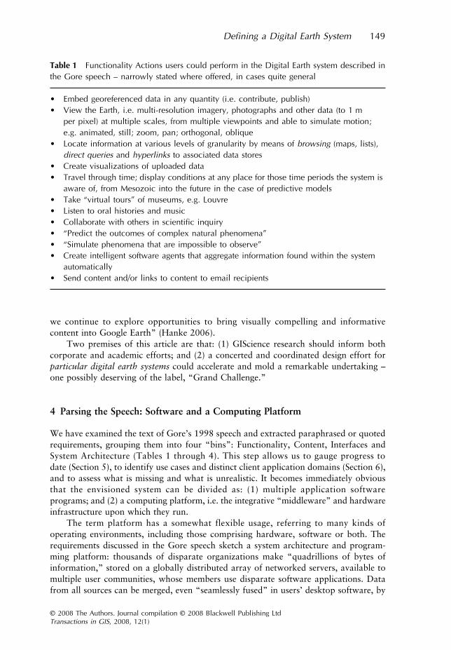
We have examined the text of Gore’s 1998 speech and extracted paraphrased or quotedrequirements, grouping them into four “bins”: Functionality, Content, Interfaces andSystem Architecture (Tables 1 through 4). This step allows us to gauge progress todate (Section 5), to identify use cases and distinct client application domains (Section 6),and to assess what is missing and what is unrealistic. It becomes immediately obviousthat the envisioned system can be divided as: (1) multiple application softwareprograms; and (2) a computing platform, i.e. the integrative “middleware” and hardwareinfrastructure upon which they run.
The term platform has a somewhat flexible usage, referring to many kinds ofoperating environments, including those comprising hardware, software or both. Therequirements discussed in the Gore speech sketch a system architecture and program-ming platform: thousands of disparate organizations make “quadrillions of bytes ofinformation,” stored on a globally distributed array of networked servers, available tomultiple user communities, whose members use disparate software applications. Datafrom all sources can be merged, even “seamlessly fused” in users’ desktop software, by
Table 1 Functionality Actions users could perform in the Digital Earth system described inthe Gore speech – narrowly stated where offered, in cases quite general
• Embed georeferenced data in any quantity (i.e. contribute, publish)• View the Earth, i.e. multi-resolution imagery, photographs and other data (to 1 m
per pixel) at multiple scales, from multiple viewpoints and able to simulate motion; e.g. animated, still; zoom, pan; orthogonal, oblique
• Locate information at various levels of granularity by means of browsing (maps, lists), direct queries and hyperlinks to associated data stores
• Create visualizations of uploaded data• Travel through time; display conditions at any place for those time periods the system is
aware of, from Mesozoic into the future in the case of predictive models• Take “virtual tours” of museums, e.g. Louvre• Listen to oral histories and music• Collaborate with others in scientific inquiry• “Predict the outcomes of complex natural phenomena”• “Simulate phenomena that are impossible to observe”• Create intelligent software agents that aggregate information found within the system
automatically• Send content and/or links to content to email recipients

150
K E Grossner, M F Goodchild and K C Clarke
© 2008 The Authors. Journal compilation © 2008 Blackwell Publishing Ltd
Transactions in GIS
, 2008, 12(1)
virtue of a suite of standard formats, protocols and requirements for communicationand metadata. For the authors of software intended to access and manipulate the dis-tributed content, this constitutes a development platform. A “Digital Earth-aware,” or“DE-capable,” program would have the built-in facilities required for either one-way(download) or two-way (upload/contribute as well) communication with one or severalclearinghouses, i.e. server hosts offering necessary middleware services. Most of thecommunications technology involved in this scenario is readily available. However, anumber of large issues remain open, including the content and structure of metadata anddata models for central databases, depending as they do on the actual and potentialrequirements of as yet unspecified client software applications. The preliminary require-ments from the speech are a starting point for such specification.
Table 2 Content discussed in the 1998 Gore speech
• Vast quantities of georeferenced information about environmental and cultural phenomena on and near the Earth’s surface
• Landsat photography• “A digital map of the world at 1 meter resolution.”• A global digital elevation model (DEM)• Data layers with global coverage for:
• land cover• distributions of plant and animal species• roads• political boundaries• population• real-time weather
• Directly sensed or observed environmental data with coverage of individual research projects, including “citizen science” efforts like GLOBE
• Hiking trails and other features in national parks• “Value-added information services,” e.g. geocoding, routing, processed compilations of
census statistics• Representations of museum collections• Historical data and media content with global coverage for political and cultural topics,
e.g. newsreel footage, oral histories, newspaper articles and ‘other primary sources.’• Pre-historical data, e.g. about dinosaurs• Modeled thunderstorms
Table 3 User interface elements from the 1998 Gore speech
• A “browsable 3D version of the planet”• In public exhibits, such as at a museum, head-mounted display and data glove to
provide immersive experiences• Hyperlink navigation• Speech recognition capability• Audio capability

Defining a Digital Earth System
151
© 2008 The Authors. Journal compilation © 2008 Blackwell Publishing Ltd
Transactions in GIS
, 2008, 12(1)
5 Notable Progress
In ten years, many advances have been made in key aspects of Functionality, Content,User Interfaces and System Architecture listed above. It is beyond the scope of this paperto review them all but we note a few to highlight what we believe is the immediacy andrelevance of the Digital Earth concept. The most visible of these involve virtual globes.Keyhole’s
Earthviewer
and the GeoFusion
GeoPlayer
appeared in 2001, and NASA’sown
World Wind
was first released in 2003. These received notice in a still fairly smallcommunity of interest. Then in October, 2004, Google acquired Keyhole Corporation,foreshadowing a major development – the June, 2005 release of
Google Earth
, whichhas captured an enormous interest for a few key reasons: (1) it is free; (2) it is fast; (3)it has its own markup language (KML), which allows anyone to display and easily sharetheir own data; and (4) it is by all accounts fun; this stems from its speed, an easy-to-use interface, high quality imagery and a growing array of interesting content. That
Google Earth
so far falls far short of the Digital Earth vision despite its obvious relationis argued in Grossner and Clarke (2007).
Alongside the meteoric popularity of virtual globes, a “Geospatial Web” hasemerged, enabled by newer format standards like KML and older ones that have solidified,e.g. WMS, WFS and the Geographic Markup Language (GML). Open-source softwarehas facilitated geospatial prototyping and development that complements traditionalGIS, with spatial databases like PostgreSQL and MySQL, and web mapping tools fromthe Open Source Geospatial Foundation
4
such as OpenLayers and MapServer.One major obstacle to integrating disparate geographic data systems is the difficulty of
resolving place name ambiguity. Hill (2006) describes a “unified georeferencing approach”and surveys the significant research efforts aimed at improving and extending digital gazetteers.
The collaboratory concept mentioned by Gore was introduced in 1989 by Bill Wulf,came into prominence in the early 1990s (National Research Council 1993) and is anintegral aspect of the current cyberinfrastructure focus of US federal funding agencies.Hundreds of such projects are listed in the NSF-funded “Science of Collaboratories”
Table 4 System architecture described or inferred in the 1998 Gore speech
• Databases, content stores, application software are all distributed, i.e. maintained by thousands of organizations worldwide; some are in the public domain, some part of a digital marketplace
• In aggregate, “quadrillions of bytes of information”• Participating servers and access points all on a “high-speed network” (given
presumptions of bandwidth limits in 1998)• Standard formats, protocols, software and metadata requirements that allow “information
generated by one kind of application software to be read by another”• Enables the display, integration, and fusion of data from multiple sources• Individuals are able to “publish” to the system• Two levels of functionality – a full level for users on Internet2, and “a more limited level”
for consumer-grade Internet access.

152
K E Grossner, M F Goodchild and K C Clarke
© 2008 The Authors. Journal compilation © 2008 Blackwell Publishing Ltd
Transactions in GIS
, 2008, 12(1)
survey results.
5
The discussion of geocollaboration for crisis management in MacEachrenet al. (2006) exemplifies a research area and methodology brought to greater focus byevents of 9/11 and Hurricane Katrina in 2005.
The Gore speech suggested the marketplace potential of Digital Earth might play apart in financing requisite technology. In the intervening years even very small transac-tions have become feasible (the Geocomm.com portal offers a 1:500,000 Oregon geologylayer for $2.76) but the real potential is more along the lines of value-added servicesapplied to TIGER and US Census datasets, offered for example in the “Marketplace”section of Geospatial One-Stop
6
, a US e-Government initiative.
6 A Renewed Design Process
Such developments suggest that enough components of a potential
digital earthcomputing platform
are available that it can be deemed feasible. The outstanding“middleware” issues referred to earlier must now be informed by the requirements ofparticular software applications to run on that platform. We take some preliminarysteps here at describing such potential client software. The
unified process
(UP) forsoftware design has been successfully applied to many large projects (Larman 2002,Ambler 2004), and aspects of it are adapted here as a framework for analysis. The UPmodel describes four project phases: inception, elaboration, construction and transition.We are concerned here with only one or two aspects of the inception phase – theprincipal goals for which are “to achieve stakeholder consensus regarding the objectivesfor the project and to obtain funding” (Ambler 2004). In fact, the aim of this articleis limited to delineating the project scope implied by the Gore speech with respect tohigh-level features and use cases, as a starting point for discussion leading to a truescoping exercise. Many aspects of functionality, content, interactivity and systemarchitecture were mentioned. We enumerate elements within those groupings, and presumethat at least some in each category are definitional – that is, essential characteristicsfor the system in question.
Use cases are integral to UP, and an effective method for eliciting requirements forsystem functionality, content and interactivity in all user-centered approaches to design.In an elaboration phase that follows (typically overlapping somewhat), they will beused to develop more precise functional specifications. From the preliminary high-levelrequirements listed in Section 4, we derived the following list of the users of Gore’sDigital Earth, alternately termed
actors
; all groups are users, some are potential designersas well. A more complete analysis must follow if evaluation in this inception stage establishesthat proceeding further is warranted.
6.1 Actors
Use cases are normally developed in scenarios, with the aim of thinking through therealistic contexts for all user interactions with a system (Larman 2002). Once aninstance of a user type has been given life in this way, subsequent questions aboutfunctionality can be answered given what is known about that user’s tasks, proclivities,aptitudes and abilities. Vice-President Gore made a wonderful start at one use scenariowith “Imagine, for example, a young child . . .” Looking at the entire speech, the usersmentioned can be grouped into the following categories:

Defining a Digital Earth System
153
© 2008 The Authors. Journal compilation © 2008 Blackwell Publishing Ltd
Transactions in GIS
, 2008, 12(1)
6.1.1 Students
A single “young child” is featured. She participates with other K-12 students in the GLOBEprogram, an international collaboration supported by several US government agencies.
6.1.2 Research scientists
The concept of a “collaboratory” is offered with little elaboration. Potential environmentaland biological modeling applications mentioned include those for “the impact on biodiversityof different regional growth plans,” and prediction of climate change based on patternsand rates of deforestation. Agricultural researchers and individual farm operators couldperform diagnostics on individual plots of land using more readily available satellite imagery.
6.1.3 Governmental agency analysts
Mention is made of applications for municipal land-use planning, “crisis management”(taken to refer to the range of disaster risk analysis and mitigation, preparedness, andresponse) and crime fighting. At the national and international scale, analysis of geo-political issues might be enhanced – at least in terms of visualizing geographic factors.
6.1.4 Governmental policymakers, diplomats and politicians
Presumably the products of analyses just mentioned could be better and more readilyvisualized by – and distributed to – the decision-making consumers of the analysesmentioned above. Each is a distinct use case, to be itemized in a subsequent phase.
6.1.5 Educators
Use by educators is implied in several respects. Some student users’ activities will be in theform of school assignments, so teachers will be designing curricula to make use of this newresource. Participants in the GLOBE program are being directed or guided in activitiesdesigned by educators. Educational requirements are a major consideration in the designof digital earth functionality.
6.1.6 Museum directors
In the speech, a schoolchild experiences Digital Earth in a museum, with a head-mounteddisplay and “data glove;” these remain an atypical computing configuration, but costlyimmersive installations will remain the purview of museums. The bandwidth limitationsGore mentions appear to be vanishing in an exponential descent, making home and schoolcomputers the more likely venue, and museum-like interpretive exhibits could prove tobe an appropriate interface metaphor for some digital earth systems.
6.1.7 Commercial marketers
The speech specifies that Digital Earth should incorporate a “digital marketplace for companiesselling a vast array of commercial imagery and value-added information services.” This indicatesthe involvement of marketing professionals in both the design and ultimate use of the system.

154
K E Grossner, M F Goodchild and K C Clarke
© 2008 The Authors. Journal compilation © 2008 Blackwell Publishing Ltd
Transactions in GIS
, 2008, 12(1)
7 Organizing Metaphors: The Geolibrary and the Atlas
A technological development with features and functionality reminiscent of Gore’s 1998vision is the
geolibrary
. The term was introduced coincidentally in the same year,defined as “a library filled with georeferenced information” (Goodchild 1998). Existinggeolibraries allow users to retrieve geographic data objects by matching requestedlocations and thematic attributes with the footprints and metadata of items in one ormore collections. Geolibraries are necessarily digital, because making that match entailsspatial mathematics essentially impossible in a physical library. A summary reportfrom a 1998 US National Research Council workshop panel on distributed geolibraries(Goodchild et al. 1999), self-described as “a vision and not a blueprint,” made thefollowing observation:
“Like distributed geolibraries, Digital Earth is about making use of the vastbut uncoordinated masses of geoinformation now becoming available viathe Internet and about presenting it in a form that is readily accessible tothe general user. Like distributed geolibraries, its central metaphor for theorganization of information is the surface of the Earth and place as a key toinformation access.”
Also, this seemingly prescient suggestion:
“While the prevailing metaphor for human-computer interaction is the officeor desktop, that metaphor may not be particularly helpful in organizinginformation about the Earth. Instead, access to a geolibrary could be throughthe visual metaphor of the Earth’s surface itself; a student interested inThailand would manipulate a globe on the screen until it centers on Thailandand then zoom in for more detail, as in the Digital Earth vision.”
The Alexandria Digital Library (ADL), developed in the 1990s and still operational atthe University of California, Santa Barbara
7
, was a pioneering effort at building a geolibrary.Its catalog contains over 15,000 entries for a variety of geographic information objects,including scanned maps, remotely sensed images, digital elevation models and air pho-tographs. Users can identify a place by name or spatial footprint and ask, either broadlyor with one or more narrowing filters, “What do you have about there?” The ElectronicCultural Atlas Initiative (ECAI) is an international consortium of humanities andinformation systems scholars with the goal, “to make virtual collections of scholarlydata from around the globe accessible through a common interface (by providing) ameans for making data interoperable across formats, disciplines, institutions, andtechnical paradigms” (ECAI n.d.). The ECAI clearinghouse
8
offers access to severalhundred datasets.
What ADL, ECAI and data portals like Geospatial One-Stop have in common isthat their response to queries about a place, or about a theme at a given place and/ortime, is effectively, “here are some digital objects with metadata matching your criteria– good luck.” Here we draw the distinction between geographic information, as “rep-resentation(s) of some part of the Earth’s surface” and the many kinds of georeferencedinformation
referring
to “specific places on the Earth’s surface, and yet . . . not normallyincluded in discussions of geographic databases” (Goodchild 1998, p. 59).
To make next-generation geolibraries more nearly like the educational system inAl Gore’s vision would require further inclusion of that larger body of georeferenced

Defining a Digital Earth System
155
© 2008 The Authors. Journal compilation © 2008 Blackwell Publishing Ltd
Transactions in GIS
, 2008, 12(1)
information, expanding the system’s role from simply enabling search and delivery ofinformation objects, to breaking open those objects in some degree, and processing whatthey contain (Goodchild 2004). The currently answerable query, “what
do you have
about that place?” can become another, vastly broader one, “what
is so
about that place?”and even, “what
has been so
there?” An advanced distributed geolibrary, and
digitalearth system
for that matter, will be able to field such questions both from informationin its local collection, and seamlessly, from a distributed web of collections worldwide.This would effectively and for all practical purposes marry the concept of digital librarieswith that of
knowledge organization systems
(cf. Section 8 below). ECAI is moving inthat direction by fostering the development of digital cultural atlases, which are GIS-drivengeo-historical reference works comprehensive within given knowledge domains.
The Perseus Digital Library at Tufts University
9
has for several years been at the fore-front of research efforts looking to ‘open and process’ historical materials. Founder anddirector Gregory Crane, in discussing the potential of enormous digital collections promisedby projects such as Google Print, noted that one of the core problems in making best useof such collections includes the two-fold task of first extracting references to people,places, dates and organizations, then automatically generating “atomic propositions” fromthem, e.g. “PERSON arrived at PLACE” (Crane 2006). Educational digital earth systemsable to answer questions from content stores including million-volume georeferencedcollections are within sight technologically as advances in natural language processing areincreasingly able to generate some very basic but nonetheless useful measures of meaning.
8 Defining a Digital Earth System: A Geographic View
As noted, the term Digital Earth has come to represent a global technological initiative– in a sense, an intellectual movement. We propose here a starting point for defining a(lower-case)
digital earth system
. The Digital Earth concept is inclusive of the next-generation geolibrary, the global digital atlas, and to some extent, geographic informa-tion system (GIS) software. A
digital earth system
is then a hybrid of these which doesnot yet exist, “a distributed digital geolibrary for which the principal user interface is aglobal atlas, having at least some of the typical functionality of a GIS.” Phrased anotherway, it is “a comprehensive, massively distributed geographic information and knowledgeorganization system.”
It is necessary to parse that definition and define some terms: it is
comprehensive
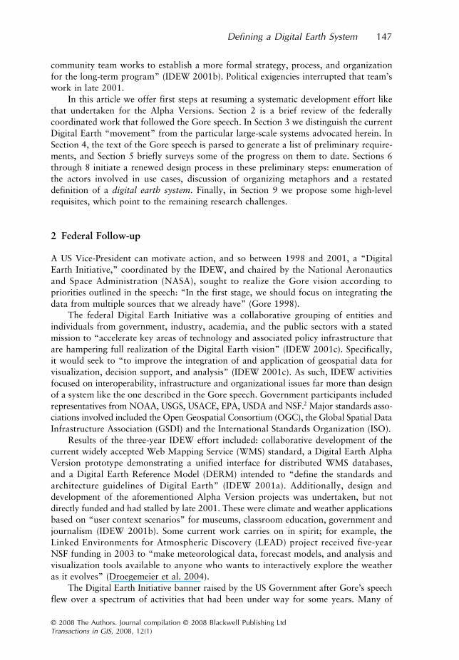
inthat it must contain complete, “blanket” or “Level I” spatial coverage of the globe fora set of base thematic layers at a uniform scale or set of scales (Figure 1). Further, it willcontain such additional thematic layers of georeferenced data at any scale, level of detail(LOD) or coverage extent as are made available and accepted for inclusion by expertreviewers (Level II). A third (Level III) tier of content will be un-reviewed materialsubmitted by the global public at large – either explicitly as a candidate for Level IIstatus or simply posted for others to view.
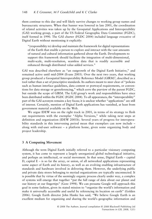
This digital earth system is distributed because: (1) there are necessarily multiple,geographically dispersed data stores providing content; and (2) the processing load ofserver-based query and analytical processes must be shared for performance reasons(Figure 2).
Geographic information refers in this definition to the more inclusive geo-referencedinformation, “very broadly . . . information about well-defined locations on the Earth’s

156 K E Grossner, M F Goodchild and K C Clarke
© 2008 The Authors. Journal compilation © 2008 Blackwell Publishing LtdTransactions in GIS, 2008, 12(1)
surface; in other words, information associated with a geographic footprint” (Goodchild2000). Since all entities and events have spatial (and temporal) extents, by implicationthe potential content of a digital earth system is almost infinite. The intent here is notto house all information with a geospatial element, but that any entity, event or processwith a particular geographical location may be represented in a comprehensive digitalearth system; obviously, not all could or should be.
The term knowledge organization is explicitly part of this definition for a fewreasons. First, distinguishing knowledge from information and data is one elementof a general (and admittedly optimistic) statement of epistemological viewpoint. The
Figure 1 Tiered data source structure. Data models must explicitly differentiate observa-tional data and derived information/knowledge objects at all levels
Figure 2 High-level schematic of the distributed, tiered data sources illustrated in Figure 1.Central server(s) differ from distributed DE-compatible collection servers only with respectto the hosting and coordinating of middleware services, broadly defined

Defining a Digital Earth System 157
© 2008 The Authors. Journal compilation © 2008 Blackwell Publishing LtdTransactions in GIS, 2008, 12(1)
formulation of a continuum offered in Longley et al. (2005, pp. 11–12) expresses this welland is widely echoed: data as “in some sense neutral and almost context-free . . . rawgeographic facts,” information as data organized for some purpose, and knowledge asinformation to which interpretation has been added, “based on a particular context,experience and purpose.” Secondly, the vast realm of conceptual knowledge, while notitself intrinsically geographic or spatial, may be entered via spatiotemporal index mark-ers of any geographically located entity or event. Organizing access to that larger realmmust therefore be undertaken in this system, at least to the extent of providing reason-able entry points. Finally, while knowledge organization system has become an umbrellaterm “encompass(ing) all types of schemes for organizing information and promotingknowledge management” (Hodge 2000, p. 1), it refers here to a particular neutral,extensible ontological framework, including classification schema informing data modeldesign and authority files, such as gazetteers and time period directories.
9 Essential Components
This “distributed geographic information and knowledge organization system” functionsin many respects as a unified entity, comprising participant systems that:
• Adhere to an agreed upon set of protocols and standards for data models, dataformats and metadata, allowing it to function as a contributing node in a single,virtual computing system;
• Deliver core imagery and datasets with global coverage extents to any “digital earth-compliant” client software;
• Are comprehensive for one or more additional thematic topics and/or spatiotemporalextents;
• Are universally available.
9.1 Requisites
The features required of a digital earth system, and not generally present in existingdistributed geospatial data systems, can be grouped as follows:
9.1.1 Extensibility
The initial structure of a core computing platform will be informed by a few exemplarapplications, but must allow for extension and adjustment as new requirements surface andthe number and type of knowledge domains it serves grows. A consortium of interestedparticipants on the model of successful open-source and standards development projectsmay be the best approach to coordinating such expansion.
9.1.2 Data model
An approach that is fundamentally different from a typical GIS is required. It must besemantic and ontology-based; that is, structured to allow feature and event attributes torepresent meaning in class rules and relationships. Attribute changes over time must betrackable, to permit visualizations of dynamic processes. Furthermore, the model must

158 K E Grossner, M F Goodchild and K C Clarke
© 2008 The Authors. Journal compilation © 2008 Blackwell Publishing LtdTransactions in GIS, 2008, 12(1)
enable integration of object and field data sources. The challenges involved are importantelements of the GIScience community’s research agenda as delineated in Yuan et al. (2005).
9.1.3 Object-level metadata
Since both observational data and derived knowledge (concepts which may have contestedor simply variant meanings) are to be managed, effective means of distinguishing thetwo and of representing provenance and quality are essential goals (Peuquet 2002, Gaheganand Pike 2006). Complete and highly granular metadata is required – more accessibleand visible than is currently the norm. Comber et al. (2005) show how metadata standardscan be expanded to capture ontologies operational at the time of data production.
9.1.4 Multi-tiered distributed database
The volume of information required means contributions must be facilitated, but a highstandard of authenticity is necessary for the system’s core data layers. It is also importantthat the distinction between observational data and derived knowledge be fundamen-tally clear. These requirements can be met with a 3-tiered database system, as discussedabove and illustrated schematically in Figures 1 and 2.
9.1.5 Integrated authority lists and middleware
Existing clearinghouse and portal systems can present unified listings of distributed GISdata layers, but the types of queries to be served by a digital earth system require acentral, integrated set of authority lists, including place name gazetteers, and directoriesof time periods and biographical information. Above all, a centralized and extensibleframework for domain ontologies is the key to data integration across collections.
10 Conclusions
We have reviewed the genesis and evolution of the Digital Earth vision, and enumeratedthe component parts of its initial expression in Al Gore’s 1998 speech. We find it presentlycomprises a nascent software development platform, multiple application software pro-grams and a loosely organized intellectual movement. We have begun adapting methodsof the inception phase of the Unified Process for software design towards defining anddesigning a particular realization of that vision, a digital earth system. The goals in thisphase should be: (1) achieving consensus by interested parties regarding the broad objectivesfor the project; (2) assessment of its feasibility; and (3) a preliminary plan for proceeding.
We have made the case that sufficient progress has been made on platform-specificissues and challenges (chiefly with respect to some interoperability standards) that aniterative rapid-prototype design process, such as the one interrupted in 2000–2001, mayprofitably resume. We propose that next steps include the identification of at least twospecific software applications and the initiation of their design; documentation for the2001 Digital Earth Alpha Versions (IDEW 2001b) might be a worthwhile starting pointfor that discussion. The important remaining challenges at the platform level can beidentified more precisely by gathering requirements derived from specific use-case scenariosfor prospective client application software.

Defining a Digital Earth System 159
© 2008 The Authors. Journal compilation © 2008 Blackwell Publishing LtdTransactions in GIS, 2008, 12(1)
10.1 A Grand Challenge?
For these next steps to occur, a key issue becomes “who will fund this?” One possibilityis that organizations like Google or Microsoft, who are racing towards their own con-ceptions of a Digital Earth (Jones 2005, Butler 2006), will find it useful to fund relatedresearch. What is missing from that scenario is a community voice helping them definetargets, and a research community focused on solving the issues. The breadth and depthof the remaining research challenges are considerable, but may ultimately be met givena broad-based global collaborative effort, requiring strong leadership. Depending onhow ambitiously the initial design criteria are framed, this effort can reasonably betermed a “Grand Challenge,” such as might be undertaken by the University Consor-tium for Geographic Information Science (UCGIS), in partnership with one or moreother organizations from academic, government and commercial domains. Certainly,seeking to “put the full range of data about our planet and our history at our fingertips”(Gore 1998) may qualify as grand and would require significant progress on manydifficult but surmountable challenges.
Acknowledgements
Karl Grossner’s doctoral studies are supported by the National Science Foundation’sIGERT in Interactive Digital Multimedia, Grant # DGE-0221713.
Notes
1 We capitalize Digital Earth in referring to the system discussed in the speech and the broadmovement exemplified by the biennial International Symposia on Digital Earth; the lower-casedigital earth system refers to a prospective particular computing system.
2 National Oceanographic and Atmospheric Administration (NOAA); US Geological Survey (USGS);US Army Corps of Engineers (USACE); Environmental Protection Agency (EPA); US Departmentof Agriculture (USDA); and National Science Foundation (NSF).
3 The most recent version (1.1) was released in December, 2003.4 OSGeo, a non-profit organization with the goal to “promote the collaborative development of
open geospatial technologies and data.” See http://www.osgeo.org/ for additional details.5 See http://www.scienceofcollaboratories.org/ for additional details.6 See http://www.gos2.geodata.gov/ for additional details.7 See http://www.alexandria.ucsb.edu/ for additional details.8 See http://ecaimaps.berkeley.edu/clearinghouse/ for additional details.9 See http://www.perseus.tufts.edu/ for additional details.
References
Ambler S W 2004 The Object Primer: Agile Modeling-driven Development with UML 2.0. NewYork, Cambridge University Press
Butler D 2006 Virtual globes: The web-wide world. Nature 439: 776–8Comber A, Fisher P, and Wadsworth R 2005 You know what land cover is but does anyone else?
. . . an investigation into semantic and ontological confusion. International Journal of RemoteSensing 26: 1143–61
Crane G 2006 What do you do with a million books? D-Lib Magazine 12(3): (available at http://www.dlib.org/dlib/march06/crane/03crane.html)

160 K E Grossner, M F Goodchild and K C Clarke
© 2008 The Authors. Journal compilation © 2008 Blackwell Publishing LtdTransactions in GIS, 2008, 12(1)
Droegemeier K K, Chandrasekar V, Clark R, Gannon D, Graves S, Joseph E, Ramamurthy M,Wilhelmson R, Brewster K, Domenico B, Leyton T, Morris V, Murray D, Plale B, Ramachandran R,Reed D, Rushing J, Weber D, Wilson A, Xue M, and Yalda S 2004 Linked environments foratmospheric discovery (LEAD): A cyberinfrastructure for mesoscale meteorology research andeducation. In Proceedings of the Twentieth Conference on Interactive Information ProcessingSystems for Meteorology, Oceanography, and Hydrology, Seattle, Washington
ECAI (Electronic Cultural Atlas Initiative) (2007) ECAI Research Goals. WWW document, http://ecai.org/tech/researchgoals.html
Evans J D (ed) 2003 Geospatial Interoperability Reference Model. WWW document, http://gai.fgdc.gov/girm/v1.1/girm1.1.pdf
FGDC (Federal Geospatial Data Committee) 2004 GAI Strategic Plan. WWW document, http://gai.fgdc.gov/library/StrategicPlan20040312.html
Gahegan M and Pike W 2006 A situated knowledge representation of geographic information.Transactions in GIS 10: 727–49
Golden K 2006 Google Earth: Organizing the world’s information geographically. WWW docu-ment, http://www.mbari.org/seminars/2006/winter2006/google_golden.htm
Goodchild M F 1998 The geolibrary. In Carver S (ed) Innovations in GIS. London, Taylor andFrancis: 59–68
Goodchild M F 2000 Cartographic futures on a Digital Earth. Cartographic Perspectives 36: 7–11Goodchild M F 2004 The Alexandria Digital Library Project: Review, assessment, and prospects.
D-Lib Magazine 10(4): (available at http://www.dlib.org/dlib/may04/goodchild/05goodchild.html)Goodchild M F, Adler P S, Buttenfield B P, Kahn R E, Krygiel A J, and Onsrud H J (Panel on Distributed
Geolibraries, Mapping Science Committee, National Research Council) 1999 DistributedGeolibraries: Spatial Information Resources Washington, D.C., National Academies Press
Gore A 1992 Earth in the Balance. Boston, MA, Houghton MifflinGore A 1998 The Digital Earth: Understanding our Planet in the 21st Century. WWW document,
http://www.isde5.org/al_gore_speech.htmGrossner K and Clarke K 2007 Is Google Earth, “Digital Earth?”: Defining a vision. In Proceed-
ings of the Fifth International Symposium on Digital Earth, Berkeley, CaliforniaHanke J 2006 Google press release, 9/13/2006. WWW document, http://www.google.com/intl/en/
press/pressrel/earth_featured_content.htmlHill L 2006 Georeferencing. Cambridge, MA, MIT PressHodge G 2000 Systems of Knowledge Organization for Digital Libraries: Beyond Traditional
Authority Files. Washington D.C., Council on Library and Information Resources Publica-tion No. 91 (available at http://www.clir.org/pubs/reports/pub91/pub91.pdf)
IDEW 2001a Digital Earth Prototypes. WWW document, http://www.digitalearth.gov/transition.htmlIDEW 2001b Digital Earth Alpha Versions. WWW document, http://www.digitalearth.gov/alpha/
alphaVersionDRAFT03.docIDEW 2001c The Big Picture: Digital Earth and the Power of Applied Geography in the 21st
Century. WWW document, http://www.digitalearth.gov/BigPicture.doc.IDEW (no date) What is Digital Earth? WWW document, http://www.digitalearth.gov/vision/
WhatIsDE.docJones M 2005 Speech at University of California San Diego November 16, 2005. WWW document,
http://ceoa.ucsd.edu/Improved-NTSC.mp4Larman C 2002 Applying UML and Patterns: An Introduction to Object-oriented Analysis and
Design and the Unified Process. Upper Saddle River, NJ, Prentice HallLongley P A, Goodchild M F, Maguire D J, and Rhind D W 2005 Geographic Information
Systems and Science. New York, John Wiley and SonsMacEachren A M, Cai G, McNeese M, Sharma R, and Fuhrmann S 2006 GeoCollaborative crisis
management: Designing technologies to meet real-world needs. In Proceedings of the SeventhNational Conference on Digital Government Research, San Diego, California
National Research Council 1993 National Collaboratories: Applying Information Technology forScientific Research. Washington, D.C., National Academy Press
Peuquet D J 2002 Representations of Space and Time. New York, The Guilford PressYuan M, Mark D M, Egenhofer M J, and Peuquet D J 2005 Extensions to geographic represen-
tation. In McMaster R B and Usery E I (eds) A Research Agenda for Geographic InformationScience. Boca Raton, FL, CRC Press: 129–56