Deep seismic structure and plate tectonic evolution of the Canadian Appalachians
18
TECICNICS,V0I-.9, N0.1, PAGES 45.62, FEBRUARY T99O DEEP SEISMIC STRUCTURE AND PLATE TECTONIC EVOLUTION OF THE CANADIAN APPALACHIANS Clen S. Siockmal,l Stephen P. Colman-Sadd,2 Chartotte E. Keen,l Francois Ma.illier,l Sean J. O'Brien,2 andGa.ry M. Quinlan3 A6shocr. Th.ee seismicallvdelined lower crustal blocks (LCBg) h3ve been fecogoized to underlie the fsmiliar tectonic-stratiglaphic zones of th€ Canadian Appala.hians Tectonrc development of ihe orogpni! inferred to have beenstrongly inlluenc€d by collision orthe iwo outboa.d LCB8 (Central and Avalo! LCBS) agaiNt the sharply irregular North Ane.ican crston (Grenvill€ LCB), as evidenced by an abrupt offset in the irend of the o.ogenl@alized at this i.r€gulsr edge The LCBS sle .esto.edtoa pr€coltisional confisuration by (1) .ehoving Carbonifsrous strike{lip motion on najor faults linking th.ough the M.Sdalen putt-apa.t basin; and (2) removing Devonhn(?) orset alotrg a hyr'oth€sized fault through the present-dsy Strait of Canso (Catre faulu to reaLig! the Cent.al and Avalon LCAg, presumed to have been continuous prior to acdetion to North Anerica. Th€ restoration leads to {1) aqualiktive explanation for dee! s€ismic renectioD observations eross lhe Magdalen basin which suSge5t I C€olosical Survey of Canade, Atlantic G€oscience Centre, Da.thoulh, NovaScotia, Canada. 2 Ceologi@l SurveyBranch, Nspfoundland Department of Minss endEn€rgy,8t.Johr's,Can da. 3 DeFrtm€nt of Earth Sciences ad Centre for Earth R€souic€s Research, Menorial Universityof Neefoundland, St.John's, Canada. Copyright 1990 by the Amedcan G€ophysical Union. Paper nunber 89TC0118? 027&?40?/90/89TC-01187$10.00 that lortions of the und€rlying duBl do not cor.espond t any of th€ th.ee principal LCBst snd (2) a plste tectonic hodel for the o.ogen which €uS8ests the backarchsin sopssting the Tsconian (Ordovician) arc f.om the east€rnharSin of the early Paleororc Iap€tusocean wa86t least as wide (>450 km) Bs lne ofiset in ihe iu€gular Gronville LCB, inhedted f.ollt rifting of Iapetus. The present-day Southwest Newfoundland Transform Margin may be a sesment of the Cansofault reactivsted duling Meso,oic opsnins of INTRODUCTION The subdivision of the Canadian Appalschians into fiv€ p.inci!€l tectonic{tratigraphic zones (Figure 1) lwiuiams, l9?8, l9?9i Williams et al., 19881 has provided 5 rema.kably durable f.am€work within which regional iectonic models hav€ been constlucreq ts.g.,Colnan-Sadd, 1980, r982i Stockmal et al., 198?1, snd oth€r,finer-scate suMivisionshav€beencastte.s., Wiuiams and Hakher, 1983; Zen, 19E3; Barr an.l Raeside, 1986;Fyffe and Fricke., r9E7l. Althoush they remain unceitai& relationshiF between rnes€ surlec€ zone€ and the subjacent low€r crust and upp€r mantl€ have bsome much bett€r constrained with the acquisitiotr of harine d€ep s€ishic refl€.tion qsla trorth of Nowfoundlsrd lKeen et al., 19861and in Lne Gulfof St. Lawrenc€ tMarillier et al.. l989bl. The d€€p s€ismic dats suDport a model where ihe Cansdian Appslechiaft ar€ underlain by three m.m loee! crultsl block. having relationships to rne overlyirg tectonic-stratigrlphic zones which are codsisi€nt over slonS-strike dist{nces of ar least 600 km. The te.m "lower cruslrl block" (LCB) describ€s a tat€rslly dis.ret€ portion of the oust deffn€d msinly on
-
Upload
independent -
Category
Documents
-
view
4 -
download
0
Transcript of Deep seismic structure and plate tectonic evolution of the Canadian Appalachians

TECICNICS, V0I-.9, N0.1, PAGES45.62, FEBRUARY T99O
D E E P S E I S M I C S T R U C T U R E A N D P L A T ETECTONIC EVOLUTION OF THE CANADIANAPPALACHIANS
Clen S. Siockmal , l Stephen P. Colman-Sadd,2Chartotte E. Keen,l Francois Ma.illier,l Sean J.O'Brien,2 and Ga.ry M. Quinlan3
A6shocr. Th.ee seismicallv delined lower crustalblocks (LCBg) h3ve been fecogoized to underlie thefsmiliar tectonic-stratiglaphic zones of th€ CanadianAppala.hians Tectonrc development of ihe orogpn i!inferred to have been strongly inlluenc€d by collisionorthe iwo outboa.d LCB8 (Central and Avalo! LCBS)agaiNt the sharply irregular North Ane.ican crston(Grenvill€ LCB), as evidenced by an abrupt offset inthe irend of the o.ogen l@alized at this i.r€gulsr edgeThe LCBS sle .esto.ed toa pr€coltisional confisurationby (1) .ehoving Carbonifsrous strike{lip motion onnajor faults linking th.ough the M.Sdalen putt-apa.tbasin; and (2) removing Devonhn(?) orset alotrg ahyr'oth€sized fault through the present-dsy Strait ofCanso (Catre faulu to reaLig! the Cent.al and AvalonLCAg, presumed to have been continuous prior toacdetion to North Anerica. Th€ restoration leads to{1) aqualiktive explanation for dee! s€ismic renectioDobservations eross lhe Magdalen basin which suSge5t
I C€olosical Survey of Canade, Atlantic G€oscienceCentre, Da.thoulh, Nova Scotia, Canada.
2 Ceologi@l Survey Branch, NspfoundlandDepartment of Minss end En€rgy,8t. Johr's, Can da.
3 DeFrtm€nt of Earth Sciences ad Centre for EarthR€souic€s Research, Menorial University ofNeefoundland, St. John's, Canada.
Copyright 1990by the Amedcan G€ophysical Union.
Paper nunber 89TC0118?027&?40?/90/89TC-01187$10.00
that lortions of the und€rlying duBl do not cor.espondt any of th€ th.ee principal LCBst snd (2) a plstetectonic hodel for the o.ogen which €uS8ests thebackarc hsin sopssting the Tsconian (Ordovician)arc f.om the east€rn harSin of the early PaleororcIap€tus ocean wa8 6t least as wide (>450 km) Bs lneofiset in ihe iu€gular Gronville LCB, inhedted f.olltr i f t ing of Iapetus. The present-day SouthwestNewfoundland Transform Margin may be a sesment ofthe Canso fault reactivsted duling Meso,oic opsnins of
INTRODUCTION
The subdivision of the Canadian Appalschians intofiv€ p.inci!€l tectonic{tratigraphic zones (Figure 1)lwiu iams, l9?8, l9?9i Wi l l iams et a l . , 19881 hasprovided 5 rema.kably durable f.am€work withinwhich regional iectonic models hav€ been constlucreqts.g., Colnan-Sadd, 1980, r982i Stockmal et al., 198?1,snd oth€r, finer-scate suMivisions hav€ beencastte.s.,Wiuiams and Hakher, 1983; Zen, 19E3; Barr an.lRaeside, 1986; Fyffe and Fricke., r9E7l. Althoushthey remain unceitai& relationshiF between rnes€surlec€ zone€ and the subjacent low€r crust and upp€rmantl€ have bsome much bett€r constrained with theacquisitiotr of harine d€ep s€ishic refl€.tion qslatrorth of Nowfoundlsrd lKeen et al., 19861and in LneGulfof St. Lawrenc€ tMarillier et al.. l989bl.
The d€€p s€ismic dats suDport a model where iheCansdian Appslechiaft ar€ underlain by three m.mloee! crultsl block. having relationships to rneoverlyirg tectonic-stratigrlphic zones which arecodsisi€nt over slonS-strike dist{nces of ar least 600km. The te.m "lower cruslrl block" (LCB) describ€s atat€rslly dis.ret€ portion of the oust deffn€d msinly on

46
the basis ol its deep seisnic reflection character,especiatty the chalacte! at or nee. the Moho (seeyarillier er al., [1989a, t989bl lor a deraited disrussionofLCB characteristics). The westemmost LCB ig th€Grenville daton, which is partly overridden by theo.os€n, vhereas the two easte.n LCBS are infered tohave b€€n accreted during development ofthe o.ogen.The LCBS a.e considered attached to their subjacenrl i t h o s p h e r e e x c e p t w h e r e d e t a c h e d t h . o u s hlithcDheric delamination. as detailed b€low.
Our approach is to heat th€ LCBS as rigid "plates,"
above which the surfsce zones and thei. protolithsw€re canied aDd deformed, thus allowins fo. bothallochthonous and autochthonous setiings of thesezones. Palinspastic LCB conligurations are lroducedby restorinS moveEent on idealized regionsl strike-slip feult zores This lirstolde. .ecodsfructron rrdesigned to .eslign LCB boundaries offset during andfollowing coltision of th€ easte.n LCBs witn heGrenville LCB. The philosophy unde.lying our modelis identical to that of Stockmal et al. t198?lr weattenpt Lo explain otrly the most salient featules of theoroSen and p.ovide a realistic fi.sfo.def tectonicfrahework into which second o.d€. nodels can beproF.ly placed. The sssumption of LCB '.igidity"wouldhave to be felaxed for a second-order restorationbecause it ignore the possibitity (snd the existen@) of
Stocknsletal.: Evolution of the Ca.adian AEDalachians
Iig. l. Tectonic stratigraphic @nes of the Canadian Appalachians Oounded by heavy lines), gen€ratlocation of foreland and successor basins, positions of narine deep seishic reflecrion lines no.rh ofNewfouddland and in the GulfofSt. Lawrence (nunberedj shown in Fisure 2), and locarion ofMERe-USGS de€p seismic line in Quebec and Maino. Abb.eviations used throughour tisures: BV-B, BaieVerte- B.ompton line; CBl, Cap€ Breton Island; CCF, Cobequid-Chedabuct faulrtCF, proposed Cansfaulti CLM, Chain Lakes Ma$if (hatched)j CRF, Cape Ray faultr DF, Dover fault; GNp, CrearNorthern Perinsula; GRUB, Cander River Ult.abasic Belt; HBF, Hermftage Bay faulr: L,BIF, Lubec-Bel le h le faul t ; LRF, Long Ranse faul t r N B. , New Brunswick; N.S, Nova Scot ia i NWHZ,Northwestern Hightands @ne (hslched)r PEl, Plince Edpard Islandi RIL. Red Indian line: SGB. St.Ceorge's Basini TH-FF, Turtle Head-F.ede!icton fautt.
significant p€net.ative strain withir the lower crustsssociated with accretion.
Resto.ed LCB conliguratiom, for times durirg andiFhediately prior to acc.etior, aid intery.etation ofsegments of the deep seisnic data which sre not easilycharacterized as belorgins to on€ of the three LCB!.They are a lso used to bound the p late tectonicenvi ronmcnr dur ing c losure of the ear ly Paleozoic
DEEP SEISMIC DATA AND LOWER CRUSTALBLOCKS
The exis t i rg deep sei rn ic .ef lect ion dsta ared6s.ribed in d€tail by Keen et al. [1986] and Marillieret al. tr989bl. We pres€nt only line d.a*ings anddi8cuss only relevant asF€cts of ihese data he.ei litrelocat ions are shown in F igure 1. Descr ibed.elatioDthips with the surface zones are based onofshore extrapolations ofthe zones using gravity and
The th.ee LCBS identiffed on the seishic data srenoted beneath the line dlawings in Figure 2. TheGrenvi i le LCB is t racesble easfward { rod theGrenviUian-sge Canadian Shield. It unde.lies theAnticosti fo.eland basir, the llumber zone, and thewestern portion of the Dunnsge zone Oigures r and 2,

Stocknaletal.: Dvolution of the Canddian Aplalachians
; r tq{ :i ; ! ; : +q F F 6 E = E. : ; i !F ; ;; : s i f i !$i Fi s i"Es* ;5 ;3 i . f ;e E i',it gI : X E-g e ;o i : ; - ; *
! i i E r g €g E s ; ; ; :i s i . : P i i
i : i ! i f i: i i * 3€_aE i i E:"t{": ] ; t = = ! 9; 3 ; e ; ! !
E : { g ! ; €: i f i e S ! Xi i E E i t FstEEi i?5E5 i ; ; : "g E S a - : : 3
: i i : ! * :: i i : : lEi E € : : : 3 ": ! s 6 . J . i !
i i : - . * i c6 . - > ; 3 i i! r : : g : ;r"; e€+iEiit:i€ l- 3 E t ! E Er+i EE=3
3
;
lri\,,l 'f
:
z
tt
j
I
li 1,l l i1\ tj r I
),
l , t
\,i'ilr i \
()'i)/,lr'\i$'
irz

48 Stekmaletal.: Evolution of the Canadian Appalachiads
lt
Nl{ -
i ; -
l 5
O N E
5
1 0
1 5
( i ) ( i i ) l ( i i i ) l ( i v )
t i s 2 . C o n t i n u c d
lines 84-1, 84-2, 86 3, 86 4, 86-5n.. add 86,2). TheHumber zone prFsf fve, remnanrs o l the Cambr ian-Ordovician weste.n lassive marsin of the Iapetuseean, which was destroyed during Middle Ordovrcranarc-continent collkion (Taconian o.osedy) IWilliamsand Stevens, 1974; Colman- Sadd, 1980, 19821 atrddeformed slso during Silurian-Devonisn (?) back arcbls in c losure and cont inent cont inent cotLs loq(Acadian o loseny) tco lman-Sadd, 1962i Waldron,1985i Cawo.d and Williams,19E8l. The Dunnage zonecontails vestiges of a.c, alc related, add back arc rockslwilliam€, 1979; Swinden and Thorpe, 19841, deformedduring the Taconi.n and Acadian o.ogenies [Neare eDal., 19?5i Colman-Sadd. r9821.
The Central LCB, b€lieved to be continental i!composition IKarlstrom, 1983; Colman-Sadd andSwinden, 1984; Keen et a l . , 19861. u lde. l ies ueesstern portion of the Dunnage zone and the Garderzone(Figu.es l and2,lines 84-2, 86-4, 86-6,4, 86-2, and88-1) . The Gander zone consists of var isb lymetamorphose.l sednnents interpreted to fep.esedt theclastic po.tion of the p&ssive margin develop€d on th€eaBtern side of Iapetus [Willians, 1964; Cu.rie et al.,l9?9; Colman'Sadd and Swinden, 19841. Thebourda.y betwee! the Grenville and Cedtral LCB8may coinc ide approximately on (he su. face inNewfoundlsnd with the recently defined Red IndianLine, {hich subdivides the Dunnage zone (Figure 1)lwi l l iams et a l . , 19881. Thus the c lass ic zor€boundaries exp.sed at the surface (Figule l) betweenthe Humber and Duhage zones (the Baie Verte-Bronpto! lire) [Williams and Sf Julien, 1978, 1982]and the Dunnase and Cander zones in northeaeternNewfoundland (the Gander Rivef Ult.abasic Belt orCRUB line) IBlackwood, 19821are not corelated with
underlying lower clustal bounda.ies (Figure 2,line 84-2) tKeen etal., 19861. The geonetries ofthe G.enville,Centrst LCB boundary observed on lines 86,6Aand86-2 indicate overthrust .elationships, as detaitedbetow.
The Avalon LCB und€rlies the Avalon zone andpossiblythe Meglma zone (Figur€s I end 2,lin€s 84-2,86'6A, and 86-58). Line86-58 did not image enough oflhe MeguEs zone crust to nak€ a c l€er LCBdistidction; deep seismic data gathered during the1988 program may lesolve this problem. The Avalonzone, which is gene.aily co.r€lat€d with Par-Africancfus! . wasa6table p lar lorm dur ing rheea. ly Paleozoic,in codtrast to zones to the west [O'Brien et al., 1983,l9E6l. The boundary between the Central and AvalonLCB3 is &bfupt, and north ofNewfoundland (Figure 2,l ine 84-2) d i rect ly unde. l i€s the geo!hysical lyextfapolated ofishore boundary betwe€n the Gsnderand Avalon zones tKeen et a l . , 19861. This zoneboundsry on land is ma.ked by mojor, subvertrcaLstrike-slip faulh (Fis!.e l): Dover and Hermitas€ Bayfaults in Newfoundland tKennedy et al., 19821 andTurtle He.d &nd F.edericton faults in New Brunswicklwitiians and Hatche., 1983; HutchiNon et al., 1988;Stewart and Lux. 19881. The vertical orrelation withthe deep seismic data sug8csts that rhe boundarr isindeed subvertical, cuttingthe entre crusi and, in ourmodel, the entire lithospherc (FiCrrre 2, lines 8+2 and86- 5A).
The Meguns zone has been interprefed as adeepwater clastic apron.leposit€d on the western flankofthe African crator tschenk, r9?rl. Its boundarywith the Avalon ,one is ma.ked by ihe Cobequid-Chedsbuclo fault on mainland Nova Scotia (Figure 1),a maior transcu.rent fsult active froh Devoni.n toearly Mesozoic timeB tKeppie, 19821.

Stockmaletal.: Evolution of the Canadian Appalacnuns
The observed and co$istent spgtial relationshipsb e t w e e n t h e L C B s e n d t h e o ! e r l r i n g t e c ! o n i c -shatig.aphic zones a.e used to conshain the positionsof the block boundaries between and beyond theseismic lires (Fisu.e 3). The boundary between lheGrenvill€andCentral LCBSonsistentlyunderliestheDunnage zone, whe.eas the boundary b€tween theCenfrs l and Avalon LCBs consist€nt ly co inc idesverticalty with ihe strike-slip bounda.y between theAvaton and Aander zones. Additional consi.aintsinc lude (Figufe 1) the in terpretat ion of theNolthveBiern Highlands zone of Cape Areton lsland asGr€nville crust [Ban and Raesid€, 1986]i and a joiniMinistare de I'Energi€ et des Ressources, Qu€bec(MERO and U.S. Geolosical Su.vey (USCS) deepseismic reflection lin€ in Quebe and Maine [St€wartet !1., 19861, which suggests ihe Grenville c.aionunderlies th€ Chain Lakes Massit
The trace of the Grenville-Cent.al LCB bourda.ybetween lines 84-2 and 86-4 is interlreted to underlietne Dunnage zone approximately beneath the RedItdian Line in Newfoundland south of the northeastcos6tend tocorrelate at the surface with the Cape Rayfault mne id southwestern Newfoundlsnd (Figu.es Iand 3), which may mark th€ boundary between theNotre Dame and Exploits subzones of the Dunnagelwiuiams et al., 19881. That this LCB boun&ry naybe exposed in souihe.nmost Newfoundland and inCape B.eton lsland is consistent with the ove.allnortheasterly structural plunge o{ the o.oge! ie.g.,Wi l l iams et a l . . 19881. The Grenvi l le-C€ntra lboundary cro$es Cabot St.ait b€tween lines 86-4 and86-5A (Figure 3) and is interpreted to conelate wrththe southeaste.n faulFbouoded edee of the
Northwestern Highlands zode (ihe Wilkie Br@k fault)[Bafr and Raeside, 19861 A6 discussed below. seismicl ine 86-5A sugsests that the Cenr.a l LCB isunde.thrust approximately 25 to 30 km beneath theCrenville LCB (Figu.e 2), complicating the sihplepicture ofa subvertical bouddary. The LCB boud.laryis inte.preted to swing abruptly to the northwest,following the southwest edse of the Northweste.nHishlands zone ( the Red Rive. faul t ) IBarr andRaeside, 19861, to cross the Culf of St. Lawrencobeneath the Magdalen bssin to line 86-2, whe.e it iswell constrained (Figure 2). This seshent of theboundafy is interp.eted to be .elatively st.aight(Figu.e 3), consistent with th€ inferred transforn faultorigin for this edg€ of th€ Orenvilte oatooic block(discuss€d below tct Thomas. 19?71). To the west theLCB boundary is interpreted to underlie the Dunnagezone of wiilians and St-Julien tl9?8, 19821 and !o ueeast of the Chah Lakes Massif in Maine lstewd( eLal., 19861(Fisures I and 3).
The posirion of he CenLral-Avalon LCB boundary ist ight ly constra i .€d on l ine 84-2 (F igLrre 2, aodunder l ies the Cande.-A\a lon zone boundarv inNewfoundland (Figure l ) . The Cander-Avalonboundary (and by implication, the LCB bounda.y) istraceable ac.oss the C.bot St.ait to CaDe Breton Island(Figures r and 3), using .eceni aeromagnetic dataIBar et al., 1987i Loncarevic et al., 19891, natchirythe LCB boulda.y interpreted on line 86- 5A (Figure2). The finer sale tectonic-st atig.aphic subdivsronsof Cap€ Breton Island proposed by Barr and Raeside[1986], whe! reint€lpreted in terms ol the coatserscale subdivisions of willisms [1978, 19791, imply thatthe Cander-Avalon boundary approximsiety bisects
Fig.3. lnt€rp.efed r€gional extent ofLCBS, interpolated beteeen the seismic li.es The ailiniry olrhelower crust beneath the central seghent oI line 86-r, underlying the Masdalen basin, is uncertai.(questiotr narks and dsshed line Sw boundaryi equivalert to.egions (ii), (iii), snd (iv) on line 86 l,Figure2). Patte.nsus€d throushout fisures: random dashes, Crenville LCBi'v'patteln, CentralLCBIplus p6ttern, Avalon LCB.

Cape B.eton Island (Fisures 1 and 3). This boundarye x t e n d s u n d e f c a r b o n i r e r o u s c o v c r r o c k s i neuih{este.n Cale B.eton Island, in the vicinity of theStfait ofcanso (!'igu!e 1). The zone boundary in NewBrunsw ick. a long the FredencLon faul l zonelWi l l iams.l9?9i Wiuiams and Hatche., 19831, exiends to thenortheast beneath Carboniferous cover and ihe GulfofSt. Lawrence (Figure 1) lKeppie etal.,1982]. Whetherihe boundary segments in Cape Bfeton Islsnd andsouthern New Brunswick are linked by an oilsettingfaull o. an o.oclinal {old is equivocal, but the apparentansular natufe of this linkage suggests the forme.(Figure 3). The afiiniiy of the lowe. crust imaged onthe centralsection ofline 86-l is shown as uncertain inFigures 2 and 3; the LCB.estorations discussed berowprovide insight into ihe nature of this lower crustal"hole" and the l iDkage of the Oander-Avalodboundary. Southwest ofNew Brunswick in Maine, theLCB boundary is interpleted to underlie the zoneboundaly alo.gtheTurtle Head Fredericton fault zone(Figures 1 and 3).
The southwesiward ext.apolation ol the Cander,Avalon, and Mesuma zones into New Fjngland and theGul tof N| ' inp, r r ic t lJ berond Ihe s.ope ofrhF p.per , isnot s t ra isht fo.wa.d. Stewart et a1. I r9861 andHutchiisooetal I 19881 discuss this genefal p.oblem.
The i.regulsredse olthe G.enville LCB (Figu.e 3) isn in icked by the Appalachidd Structura l F.ont(F igure l i St . Lawrence P.ohontory and QuebecReentrant of Williams [19?8, 19791) This edse wasformed by the opening of the early Paleozoic lapelusocean Bird and Dewny, l9?0. S ' .ong ind Wi l l iams.l9?2land has been inieryreted as cont.olled by a rifttransform rilt geometry [Thonas, 19?7] whe.e then o . t h w e s t t r e n d i n g " t r a d s f o r m " s e g n e n t i sapproximately 450 km in lensth (F igure 3) Thei.egular edse of the Grenville LCB appeaB to haveinnuenced ihe geomet.ies of the Central and AvaionLCBS, add hence the overlying tectonic-st.atigraphiczones, th .ough accret ion to the cratod. This isevidenced by the codfo.mance ofthe outboald LCBg tothe i.regula. edge of the Crenville oaton (Figure 3).To first orde., the surface zoles are considered to haveplayed a felatively passive mechanical role above theL C B s ' a n d r h e i r d s s o c i a t e d l i r h o s p h e r e ) d u r i n s
PALINSPASTIC RECO\STRUCTIONS
'Io better unde.srdnd the implications of the LcB.onfisurations (Figure 3) fof the tecto.ic developmentof ihe orogen we must renove or.estore as much first-order dFlormar ion dq poFsib lF wi 'h lhe min imumnumbe. of assunpiions. A principaL objeciive is to.eal ign the Cander-Avalon boundary throughNewfoundland and Cape Breto. Island with that insouthe.n New B.unswick (Figure 1). This.ealignheniis necessary b€cause the Avalon zone (Avalon LCB)wasjuxtaposed against the Gand€r mne (Central LcB)alons a major, and ihe.efore once continuous, shrke'
St@knal et al.: Evolution ofthe Camdian Appalachians
sli! fault zone (Turtle Head-Fredeficton, HermitageBay, and Dover faults; [e.9., Williads and Hatch€.,19831). The sur face zone bounda. ies, l ike thecoasilines, will be uF€d as passive ms.kers above therisid LCBs in ihe rcstorations This is for convenienceof.efelence otlyi the zones and their bo,rnda.ies wer€clearly mobile featuresdurins LCB assembly.
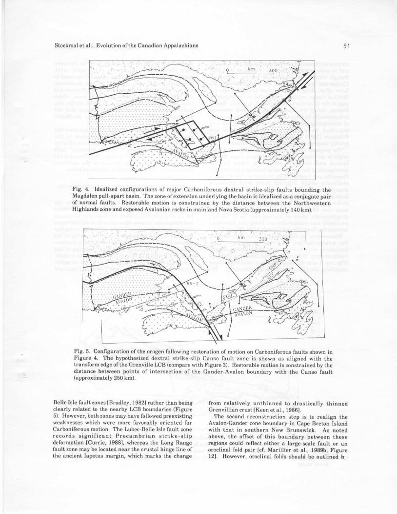
The ffrst step is to .emove major Carboniferousstr ike-6 i ip movemenL which contr ibuted to thedevelopment of the Magdalen basin. Btadley [19821interpreted the basin to be a pull apart, or fhombochasm, l ink ing dextra l faul t systems in westernNewfoundland (lnns Ra.ge fault) and southern NewBrunswick (Lubec'Belle Isle faulti Figure l). Thesefault systens are na..ow on a regionaL scale [B.adley,1982i Keppie et a l . , r9821i therefore as s f i .s tapproximation {e trestthem as single strike slip faultzones linked through two normal fault zones, one ofwhichcoincides with the idfe.red edseofthe G.envilleLCB (Fisure a). The exact leations of the idealizedno.mal la l l ts are noi cr i t ica l , but the sp. t is lcorrespondence between the depoc€nte. of the bsinlwade et al., 1974: Howie and Ba.ss, 19?61 and theidfened edge of the craton (Figure 3) strongly suggestsa genetic .elaiionship. In reality, extensiod of theoust underlyi.g the Magdalen basin was p.obabtyaccommodated by a combinat ion of p€net .at ive. l rerch,ng lBradley. 19821 and reacdval ion of mqiorAppalachian thfust faults in a norDal sense [Quinlane t a l . , 1 9 8 8 1 .
B a r r a n d R a e s i d e [ 1 9 8 5 1 c o n s i d e . e d t h eNorthwester . Highlands zone (Figure l ) io beautochthonous, which .onstrains the magnitude ofmot ion to be restored. The d is tance f rom iheNo*hwestern Hishlands zon€ to exposed Avalon rocksin mainland Nova S.otia, measured parallel to th€strikeofthe dextrdl fault system, isspp.oximately 140kn (Figures I and 4). Assuning these Avalon .ocksov€rlie the Avalon LCB, this distance .epresents anupper limiton resto.able motion, consbtent with post-Acadian estimates ofWebb I19691, Bradley [19821, andKnight [19831 of 120-200 kh.
Resto.ing this motion along the ideaLized faultsystem results id a pre-latest Devonia! .econst.uctioncof.eslondins to the e.d ofthe Acadian orogeny, prio.to dev€lopment of the Magdalen pull-apa.t basrn( I igure 5) . At ih is lestofat ion step the point ofin tersecl ion of the Avalon-Gander boundary insouthern Cspe Breton lsland with rhe Avalon zone ofmainland Nova Scotia lies dir€ctly along the trend ofthe transfo.m edge of the Orenville LCB (conpa.eFigu.es 5 and 3). The .esto.ation has also disllacedweste.n Ne{foundland, from the norrhern tip of theCreat Northern Peninsuls to the Si. George's Basin,relative to the remainder of ihe island such that ii isaligned with the norther. and southern coasts ofinsuls! N€wfoundland (Figures I and 5 {cf webb,1969, Figure 5l).
It is unce.tain why Csrboniferous etrike-slip motionwas conceni.aied along the Lons Range and Lubec-
Sloc lno le l a l . : Evo lu ( ion o l the Canad ian Appa lach ian . 5 1
Fig. 4. Id€alized configurations of mqior Cafboniferous dext.al shike-slip faults bounding theMagdalen pull-apart basi!. The lone olextedsion underlyiog the basin is idealized as a conjugate pai.of normal faults. R€storable motion is coDstrained by the distance beiwee! the Northwest€rnHighlands zone and eqosed Avalooian rmks in mainlandNova Scotia (approximately 140 km)-
Fig. 5. Configuration of the orogen following resto.ation of notion on Ca.boniferous faults shown inFigure 4. The hypothesized dextral strike-slip Canso fault zone is shown as aligned with thetranslofeedgeofthe Grenviue LCB (compa.e with Figure 3). Resto.able hotion is consrrained by hedistance b€twe€n points of inters€ction of the Cadder-Avalo! boundary with the Canso faulr(approximat€ly 260 km).
Belle Isl€ taulfzones [B.adley,1982] rsthe. than beingcler.l, relaled to rhe nea.by LCB b.unoarie. rFigure5). However, both zones may have followed preexistingweakneses which we.e more favorably oriented lorCaftoniferous motion- The Lubec'Belle Isle fault zonerecords s igni f icant Precamb. ia! s t ! ike s l ipdefornstion tCu.rie, 19881, wher€ls the Lons Ransefault rone mat be localed n€arthe fiustal hinge line ofthe ancient Iapetus maigin, which narks the change
from relatively unthinned to drasticslly thintreoCrenvillion clust [Keen et al., 19861.
Th€ second reconst.uction step is to realign heAlalon-Gand€. zone boundaly in Cap€ B.eton Islandwith that in southerd New Brunswick. As noleqabove, the olTset of this boundary betwe€n heseregions could reflect either a large-sasle fault or enorocliral fold psir lct Marillier et al., 1989b, Fi$rel2l. However, o.oclinal folds should be outlioed b,.

structures exposed in northern mainland Nova ftotia,and no such patiefn is observed [Keptie et al., 19821,though st .uctures subparal le l to the Cob€quid-Chedabucto fault complicate the intelp.etstioD. Wefavor ollset alons a hypothesized fault through theStrait ofCanso. orieDted subDarallel to the transformedge ofthe G.enville LCB (Figu.es r,3, end 5). Suchafeature, called the Canso fault, has been prolosedindependently by Bar! and Raeside tr986lon the basisof contrasting geology in Cape Breton Island andmain land Nova Scot ia and by Mccutcheon andRobinsoD t198?l otr the basis of aerohagnetic andgravity maps and regional geological retalions.
The proposed Canso fault, which sirikes at a highangle to structural trends in southe.n Cape BretonI s l a n d a o d n o r t h e r n m a i n l a n d N o v a S c o t i a ,@rre8ponds to the lowef cfustal boundary between theCrenvilte and Central LCBg inaged on lide 86-2 as ashal lov ly Fouth d ipping faul t wi ih probabretransp.essional offset (Fisures 2 and 5). The Cansofault 6ne may therefore change fron predominantlystrike-slip !€ar Cape Breton Island to translressionalnear l ine E6 2 (nor thwest vergent) and becomeprog.essively more compressionat as i t swingswestward and southwestwsrd alons the boundaryb€tween the G.enviile and CentraL LCBS(Figure 51.
, ' {oremenr on the Canso touh i , .cs lorcd by o l ign ingthe Avalon-G.nde. boudda.y in southern NewBrunswick with that throush Cape B.eto! Islard.App.oxinately 250 km of dext.al motion is rehoved(Figures 5 and 6) , resul t ing in a cont inuous andrelativ€ly straiSht Avalon-Gander bourdary. The
Stockmal et al.: Evolutionof the Canadian Appalachians
position and width of the crustsl "hole" in northernN e w B r u n s w i c k c o n f o r m s v e . y w e l l w i t hpaleogeoglaphic reconstructiols of Late O.doviciatr toMiddle D€vonian .ocks of northern New Brunswickand easte.n Quebec tBourque etal.,1988i Kirkwood etal., l9E8l. These "balanced" r€constructiods, whichtske into lccount la.ge-scale Acsdia! st.ike slipdotions and structural shortening, suggest that thefeconstruction of Figu.e 6 cor.esponds to p.e-Middle
This last teconstruction step impliciuy assumes thatLhe Canso faul t er tended uninterrupt€d to thesoutheast. Iislresent-day trace is appa.ently offset byihe Cobequid-Chedabuctojoollector Anomaly" faults y s t e m a n d n a y l i e a l o n s t h e S o u i h w e s tNeefoundland Transform Ma.gin of the southernCrand Banks. This possibility is considered b€low.
IMPLICATIONS FOR SEISMIC INTERPRETATION
The configuration of LCBS corresponding to theleconst.uction of Figure 6 is shown in Figure ?, wherelhe Central and Avalon blocks are laterally continuousand subparallel to each othe. p.ior to dismembermentduring and followilg collision pith the irregularO.enville block. An apparent .apid nai.owing of theCentral LCB from $uthern Newfoundland io southe.tCape Breton Island, and a very rspid widenidg of thisblock southward into New Brunswick, is also €vident.This .a!id change i. width, locslized at the irregllarCrenrille c.atodic nargitr, may reflect (l) nonligid
Fig. 6. Conffgu.afion of ihe orogen followins restoration ol motion on the Canso faulti the Gandef-Avaton boundary has been restored to a continuous featufe. A lower crustal "hole" results in northemNeq B.unswick, lepresenridg the portion oI the bsck arc bssin .emainins at this time step. Double,headed l8ows on Gander-Avalon boundary imply that th€ sense ofstrike,slip motion is noi relevant

Stockmletal.: Evolution ol the Canadian Alpalachians
Fig. 7. ConfiguratioN of LCBS corresponding to the restoration of lig!.e 6. Possible unde.th.us!edge of lhe Central LCB beneath the Crerville LCB is shown as a sho.t-dashed line.
53
':-.d
b€havio. ofthe Central LCB, resulting in pen€trativemr.owing a^d thickening on a resional scele (thi3 is aclear exceptio! to the rigid block assunption); (2)paftial underihrusting of one LCB beneath anothe.(s.s., Central beneath Grenville)i (3) ofisel of theno.thwestern edgeofthe Central LCB along the Caftof&ult p.ior to strike stip juxtaposition of the AvalonLCB against th€ C€ot .a l LCBi or (4) incorrectidentification oI the Gsnder Avalon bound.ry (andhence the C€nt.al Avalon LCBbounda.y).
The na.rowingofthe Contrat LCB th.ough option Iwouldsuggest sho.tening ac.oss Cape Br€ton Island atlesst of the o.de! of 50% (Figure 7), which in thesihplest terms should be reflected in ex?osure ofhighly strsined, high-grade mehoorphic rocks. Aregional oortheastward plunge along the orogetr ftomCape B.eton Island 6ishe. sade) to the north coast ofNewfoundland (lower eEade), exlressed p.imarily bym€tamorphic grade and levels of in t rus ion [e.8,Wiuilms, l9?9; Ban and Rseside, 1986; Williams e[al., 19881, supports a component ofoltion l�
Optiod 2 is euppolted by seismic line 86-5A, whelethe Cetrt.al LCB appears to undefthrust the GrenvilleLCB byalproximately 26 to 30 km. Figu.s 2 shows anapparenrly .oherent. bright- rsfle.r ing, we6l dippingslab, bo'rnded below by e stlong and relatively flatMoho signature, conside.ed characteristic of theCentral LCB lKeen et al., 1986; Marilli€r et al ,r989bl . Glet rv i l te crust of the NorthweslernHighlsn.b zone crops out approximstely 25 km south-southw€st of kilometer 25 on line 86-5A (ligure 2),where it nust overlie ihe interpreied Central LCBslab. As seen by rev€rsins the reconst.uciiod ststs,
discussed belop, this *enario of undeithrusting nayoffer a qualifative exptanatidn for atypical Mohor€flectivity along seisnic lines 66-l and E6-4. Thisinterpretation differs froh that of Mariltier et al.u989bl, who ientatively postulated a eubve.tical LCB
Option 3.annot be ruLed out at this time, but iL.loesrequire a two-step history for the Canso fault (rigu.e8) Tho fault would have io forft p.ior to enplaceme.tofthe Avalo! @tre sgainst the Gande.,on€ (Figur€ 6,caBe Al) , th€n be react ivated fo l lowing Avalonemplacehent (Fisure 8, case A2) to aftive at thepresentday confiSuration (Figlre 8, case 3). Such atwo-stepsoluiion is considered less likely than the ooe-
In o.der fof option 4 to account for most or alt of theapparert chanse in Central LCB width, the Gand€!Avalon boundary would hav€ to lie app.oximately 100km nofthwest of the Turtle Hea.l-Fre.lericton fault(Figu.e l). The only available options for such afeat ' r re are the Catarnaran and Rocky Blook-Millstream faulk fKeplie et al., 19821, neithe. ofwhich can be .onsidered cont€nde8 Ge€ arsuments byWi l l iams I l979l , Wi l l iams and Hatcher I l983l , XoppieI19861, and FylTe and F.icke. t19871).
A genelel position for the nolthwestern edge of theCentra l LCB pr io. to Carboni l€rous st r i te-s l ipdisplacement, which satisfies opiions r and2, i! shownin Fisur€ ? (short-dashed lin€) os und€rlyinS theGrenville LCB promontory. Indefail, this underth.ustedse was adjusted lo satisfy deep s€ishic observationsin borh the restored lFigxre 7) and present day rFigu.e9) stster, as discussed below.

A T
A2
Fig. 8. ScheMtic development of the Canso fault.Option A requires a two'step f6ult history, {ithinitiation, Ar, occur.ing prior to emplacenent ol theAvalon block. A2i it must then be .eactivated as in 3.ln option B, which is favored, the Central LCBunderthrusts the Grenville LCB, Bl; Avalon LCBemplacement, 82, must precede development of theC&nso lault,3.
Stockmaletal.: E volution of the Canadian Appalachiads
To €st imate the present-day posi t ion o l theuderthrust eds€ ol the Central LCB, we can r€veiseth€ LCB .estorstion steps $ing the edge poBition inFigure ?. First, howeve!, we must constrain thesubsurface confi$fation of the Carboniferous sidke-slip faults, which cut throush and bound the LCB!.The Long Ranse fault iB considered to cut through theCrenville LCB 6t depth (Fisure 5) and follow thetectonic boundary between the Grenville and CentralLCBgwhe.e they ove.lap (Figu.e 7). This is suppoltedby interpretalions of seismic lines 84'r and86-5A. Thenorthe.n extersion ol the Lodg Range lauli li€sparallel to th€ east coast of th€ Great North€.rPenimuta and crosses th€ east€rn edd of line 84-1(Figures 4 and ?. The fault is interpreted to be near-ve.tical here, as sugge€ted by reflection terminaiionsend e ab.upt change in Moho dip ne6r km 50 on thecomposite line 84- l,2 {Figure 2). Line 85-54 (Figures 2snd 7) suggests that the west dipping slab of theCent.al LCB is continuous ard not cut by the faultzotre which fo lms the easter ! boundaly of theNorthwestern Hishlands zore (witkie Brook fault).This implies that the Wilki€ Arook fault flattens atdepth sbove the Central LCB. The Lons Ranse fault iseticipated to cross line 86 4 n*r km 140 (Figure 2),but the dats sre not sufficient to resolve it in this area.
Reversing the resto.ation stels .esults in the LCBgeometry shown in Figure L As noted briefly above,th€ slightly sinuous n&tur€ of the underthrust edgereflects minor adustments made, such lhat thefoUowing relationships on lines 86-4, 86-54, and 86-1
Fig. 9. Hypothesized present-day distribuiion of LCBS, .le.ived by reve.sing the restoration steps andincluding the underth.ust edge of the Cent.at LCB, as shown in Figure ?. The p.esenr losftion of rhrsedgeisshownssa long dashed lineiits initial lGition is shown as a shorrdashed line. The Macdalenbasin is psltly uderlain by a lower crust l "hole" by v irtue of its pull apart netu re Overlap oftheG.€nviUe and Central LcBsjust northwest of the ed of line 86,1 adses from offs€t alons rhe Cansofsultofrhe hlTothesized edge of rhe Cenl ral LCB. as in Figure?

Stocknal et al.: Evolutionof the Canadian Appalachians
l. The unde.thrust edge c.$ses seismic line 86 4 inthe restored state (Figules 7 and 9, short-dashed line)w h e r e 1 4 o h o r e f l e c t i o n s a b r u p r l y d e c r e a s e i n.eflectiviLy and fise by up to 2 s iwo-way iine, f.ohnorthwesl to sutheagt (Figure 2, lelt end ofbracketedregionbeneath lide drawing). This region ofdecreasedr e f l e c t i v i t y a n d s h e l l o w e . M o h o c o n t i n u e 6southeastward to the preseni posi t ion of theinteryreted boundary betwee! the Grenvi l le andCentral LCBs (Figures 2 and 9). It cor.esponds to thatresion ofthe Grenville LCB fo.meriy underlain by theCent.sl LCB as in Figure ? but now occulied byG.enville c.ust only (Figure 0).
2. The unde.ihrust edg€ crossee li.€ E6'5A nea! itsnorthern te.minatioo (Figu.e 9), consistent with theinierpreted overlap relationship of the G.enville andCentral LCBs(Iigure2).
3. Th€ porliod oI the Certral LCB interpreted to lieo! the southeast end ofline 86 1 (Fisure 2, region (v))conesponds to the Cedtral LCB underthrust beneaththe G.etville LCB prior to Ca.boniferous opening ofthe Magdalen basin (Figure 9)
Th€ lower crustal "hole" beneath the Magdatenbssin (Fisure 2, .esions (ii), (iii), and (iv), and Fisure9) resulis fiom the pull-apa.i natu.e oflhe basin. Thisregron may b€ occupied by, l , overrh ic lened TdconiarAcadian th.ust sheets qhich slid down into the pullapaft "hole" along forme. thrust faults .eactivated in anormal sense [Quinlan et al., 19881r (2) underplatednaterial with inte.mediate density, thus accountilgfo! an sppa.ent offset in yoho with no associatedgravity anomaly [Marillier et al., 1988; Marillier andVe.hoel r9891;or(3) founde.ed or detached po.tionsofthe LCB'S not accounted for in the simple first order
The difficulty of interpreling any oI these deepseishic lines in te.ms ofan idealized two-dim€nsrona,or "p lane srra in" h iskry,s h,chl ig l " ted br .ompar ingFigu.es 7 and 9. The dismembered nature of theBeishic l ine posi t ions in ihe re.ors i .uct ionundeisco.es the pitfalls associated with interpreringisolated dee! crusta l l i ies, even i f o . ien iedperyendicul$ to shuctural hends.
IMPLICATIONS FOR PLATE TECTONIC SETTINC
As in the paF. by Stockmalet at. [987], we fouowearlier workers [e.g., Haworth, t975i Thonas, 197?linemphasizing the importa.ce of the offset in theOrenvill€ $aton, inherited f.om rifting ofrhe lap€tusoce.n, in inlluedcing the evolution o{ the CanadianAppaldchians. The plaie iectonic model p.oposed byStocknal er a l . l l987l mu3t bc modf ied, howe'er , inlight ofthe new GulfofSt. Lawrence deep seismic daiaset IMarillier et al., l989bl.
Fisure l0 *hemati.ally shows the acfetion of theCentral and Avalon LCB€ to the Grenville LCB, placed.nro a p late tecton,c f ramework. This ererc i .e isimportant because corstruction of such diagrams to
55
scale, which ploperly involve the entire lithosphe.e, cnecessary for a fuu understandirg of the implicationsof ptate tecfonics. Although the conv€rgen.e of iheCent.al LCB with North America is shown to beo. thosonal , th is is for i l lust fat ive pu.poses odlyOblique convergence, in either sense, ca! be easilyaccomnodated in ihe forea.c, i.t.sarc, o! back arc(e.9., Figu.e roa and lob; lBlewett and Pickering,1988; St@kmalet a l . , 198?, pp. 110r-r r02, r988j vuStaal and Wiltiams, 19881).
The Viddle Ordovic ian Taconian o.ogeny isgene.ally considered a consequence oI coUision of anarc wi th rhF Cambr i rn-Ordovic ian passive marginabove an east dippi.g subduction rone [Jacobi, 1981rRowleyand Kidd, r98ll. If the trench-a.c complex wasroughly linear in plad view, a geometry used bySto.kmal et al. [198?l because it is the simpl€st ofallcases. then arc-continent collision {ould have beendiachronous, occu.rins in western Newloundlandbelofe Quebec-New B.unswick lcf. Hiscoti et al., 19861.T h e s u b d u c t i o n ? o n e u n d e f l y i n g w e s t e . nNewfoundland would have been elTectively 'tlogged"
by the buoyadt O.enville LCB (Figu.e loc and l0d),requiring a change in the mode of subduction toaccommodate fu. ther p late convergence Thissituation may hrve been analogous to the presentcollision of the Aanda Arc with Lhe northresternAustralia ma.gin Le g , Audley Charles, 19811
Colnaa-Sadd I r982l and Sto.kmal et a l . [19871argued for delamination of ihe litbosphere and "blind
subduction" at ihis stage, in part to maintain thenechadcal contiruity of the down'going slab [clOxbu.gh, 1972i El l is , 19881. Cont inued p lateconve.gence is accomnodated by partial closure of aback arc baBin (of uncertsin but probably "b.oad"
widihi see diBcussion below), with blind subducrionoccur . ing at the la t i tude of Newfoundland andcontinued no.mal, east dipping subductioo at thelaiitude of Quebec-New Brunswick (Figu.e l0€ and10f1. The surfac€ prcjectiotr of the "tip" of the blindsubductio. zone is shown as a dash'dot line adGs theforeland in Figure loe.
The arc-continedt collision ir Quebec would havepostdated that in Nes'foundland by app.oximately 15to 20 m.y., gilen the ctatonic oilsot of 450 km and aconve.gence .ate oI 20 to 30 mm/yr tB.adley andKusky, 19861. This scenario requires "Taconian"(Ordovician) deformation somewhe.e in the back arcbasin at the latitude of Ne*.foundland [e.g., Cu..ie eta l . , 19?91, but dot necessar i ly at that of NewBrunswick (Figure r0e).
rollowing the a.c continent collision in Quebec, theea6t dirying subduction zone there would have been"clogged" with buoyant Grenville crust (Figure l0e).Continued plate convergence, culmimting in coUisionof th€ Grenvi l le and Cenira l LCBg ( the Acadianorogeny) thorefo.e required conpl€te closu.e of theback alc basi!. The polarity and mode of lithosphericsubduct ion dur ing back arc c losu.e are poor lyconst .a ined, wi th many opt iods postu lated Ie 9. ,

Stocknaletal.r Evolrrtion of the Csnadian AD$lachians
( a )
----- \ ----- '\
T_; r - -\ T
l?9 '"1" *-. = ",*
( l r )
{ l l
\ -
( . i J! " . l : - .-r . I _. l
Fig. 10. P.olosed plale tecfonic nodel fo. ihe development ofthe Canadian Appalachians. Horizontaland verticsl scales a.e equal. Th€ ligures are coupled pairs showing plan views and cross secrions, rhelatter at the htitudes of Newfoundladd and Queb€c New Arunswick. The volcanic arc is shownschematically as volcanic islandsisotid thrust symbols .ep.esenr msjof overrhrust horion active up bthe cur.eqt time step, open symbob rep.eseni ninor or previous motion. Dssh-dot line adoss forelandis surfac€ pmjeciion of "tip" of blind subduction zone. (a) rnd (b)Configu.arion prior io collision of rheTaconisn arc with the North American oatoni oblique convefgefte can be accohnodated in lnelorearc, int.aa.c, o! bsck arc regions (shown schematically as a back arc bansfo.o faulr) (c) and (d)Collisio! of the arc with the craton in western Newfoundland, eftectively "clogging', subduciiodar rhatlatitude. (e) and (0 Collision of the arc wirh rhe oaton id Quebec, accommodaied by lithoslhericdekmination add tectonic wedgidg at the latitude ofNewfoundland lct, Srockmal er al., l9g?, Figure41. Noie the development ofa oustal scale stfike,slip fault (possibty rradspressional), bound,nsshortening in th€ back arc basin in the north and exteading a.ross the developing orogen alodg theedge of the Crenville daton whe.e signilicani overthrusting also occllrs. (g) and (h) Collision of rheGr€nvitle and Cert.al LCBS in Newfouodland, a.commodated bycotrtinued lirhospheric delaminarionand conplete cl$u.e of ihe back a.c babin at this latitude. A portion of the back arc basin remains arthe latitude of Quebec-New Brunswick (cross section B-a) As d.awn. rhe msition of ihe '.tiD,, of rheblind subduction zone is dependedt on the width of the back a.c basin. clos'.e .f ' vide o. ptaletectoni$lly complex back arc hsin could have resulted in abandonmenr of rhe blind suMucrion zonep.ior to A.enville-Central LCB collisiod. (i) a.d C) Coltision of the crenvitte and Cenrral LCB3 inNew B.unswick, accommodated by closure ofthe back arc basin and a possibte, limited component ofwestsard suMuction in the back arc basin remnant (c.oss section B-B').

St@khal et 51.: Evoluiion of the Canadian Appalachians
Colrnan-$dd, 1982; van Staat, 1987; Van d€r Pluijm,198?i van Stlal &d Williams, l988l. We tentativ€lypropose a continuation of tithosphe.ic delaminationbeneath ths C.envitl€ craton of Queb€c-rorthern \ewBrulswick, wheie the "tip" of the blind subductionzon€ &dvances well out ben€eth the fo.eland (Figuresl0gand 10h). The most obvio$ alternative sotution, asest dipping subduction zone to ctos€ the back arcba8in, is not ea€ily reconciled with seisnic line 84-2and the known vol .anogenic h is tory of w€sternNewfoundland (Figu.e 2, see discussion by Stocknsl eta l . i r98?, p. r r03l ) . Note, howeve. , that su. facestructures associated with bsck arc closure as inFigures 109 and 10h coul.l be predominantly eastv e r g e n t a n d e a s i l y m i s r a k e n l o . w e s t d i p p i n g
Regatdles6 of the details of suMuction, contidentcontitrent collision between the Grenville and Cent.alLCBg .esul t ing f rom back a.c c losure would bediachronous because of the irregular edge of theGrenvitle c.aion (Figures 109 and 10h), ,inila! t thedia.hronow arc-continent collision. Crosscuitingretatiomhips obviously requir€ enplacement of theAvelon LCB asainsl th€ Cent.al LCB p.ior to olfs€t onthe Canso fault and subseouent continenlcontinentcollision in New Brunswick (Figures roe and 100.
Figures loi and roj r€present the confietrration olthe collided LCBS following offs€l on the Canso laultbut pr io ! to la test Devonian 'Carboni ferouBdevelopnedt of the Magdalen basin. Final closure ofthe back src basiD in New Brunswick at thb siage isshown as accommodated on a west dipping subduction.one. Howeve., the baaL arc remnanr remaining in
Figur€s l0g and loh nay have been too nalrowrelative to the thickness of the lithospherc for t.uesubduction to develop (as suggested by the questionnark in Figure r0j).
The initial width of the back arc basin is poorly.onstra ined, but som€ wo.ke.s b€l i€ve i t to besubstantial (e.s., vand€. Pluiim and van Staal tr988l,who refe. to ii a! 'Iapetus II"). Thb width, relative tothe orset in the Grenyill€ cratonic marsin, influencedthe relstive timing of arc continent ("Taconian") andcont inedt-cont in€nt ( "Acadian") co l l is ions rnNe$.foundland ard Quebec-N€w B.unswick. Threecases are possible (Figlre rl)r For csse r, if the backa.c basin was narrowe. than the fatonic offset, therboth arc-continent and contin.nrcontinent couisronsi ! Newfoundlard should p.edate complete arccontinent collision ir Quebec (FiSures rra and 11b).For case 2, ifthe back a.c bssin aDd the ofset were ofsimilsr width. then comDlete alc{ontiDent collisiod inQuebec and cor t inent 'cont inent co l l is ion rnNewfoundtand Bhould be coincident in time Oui bothpreceded by arc-continent collision in Ne$.foundland;Figur$ 11c and 11d). This is simila. lo the cas€implied by Stockmal et al. t198?l on the basis of the1984 deep seismic l ines only, located nor th ofNe*.foundland lKeen €t al., 1986]. Fo! case 3, if theback arc basin wa€ broad€r than lhe offset, then arc-contin€nt collisions in N€wfourdland and Qu€becshould both p.ecede cont inent cont inent co l l is ion(Figures 1le and 110. In thi6 case, however, Middl€Ordovician arc'coniinenr collilion in Quebec requiressimulianeous defornstion in the back alc bssin at thelatitude olNePfoundland.
( n ) ( , , )
it.l1t{',;rlari:--:i--...--_--r
. :'\.iia'{{{i.i],]i
' .a:-:-.-.-- ,-
( r ' ) ( d ) ( 1 )
Fig. I lI Consequenc€s ofback arc basin eidth, lelative to the ollsei in the C.envill€ Caton, on theiimingofdeformation. (a) and lbj Basin is narfower th6n ofts€t, l,CBs collid€ befole a.c collision in thesouth. (c) and {d) Basin is as *ide as offsei, LCBS and arc sesments collide simultatr€ou,ly. (e) alld (0Basi! iE wider than offset, arc segments couide before LCB collision.

58
Case 3 appears most likely on the basis of theinfened and known ases and senses of d€formationIs.g., Cu!.ie et al., l9?9i Colman-Sadd, 1982i Van derPluijm, 19871. This supporis the inier etation of Vander Pluijn and van Staal [tgEE] that the "back_arc
basi!" beiween the Tacodian arca and the easternmargin of Iap€tus was o{ substantial width. Our llatetectonic model suggests that this "basin" was at least460 km eid€. This conclus ion is not s t ronglydependedt upon an aBsuhption of constani back a.cbasin width a lotS st r ike i .athe. , i t is a g€neralsiatemeni conce.ning the .PProxinate width relstivelo the offset in th€ Grenville craion.
A possible, Iinal position of the 'tip" of the blindsubduct ion.one benearh the fore lsnd is shown inFigures 10gand loii the absotute Position is a lunctionofthe width ofthe back a.c basin. The extent andinfl uenc€ of po6sibl€ lithosph€ricdelsminatio. southolthe Can6dian Appala.hiais are beyond the scope ofthispaper, but it is inte.estingto nole that the widthofthe Appalachian foreland basin narrows na.kedly andabrupt ly immediate ly nor th of the New YorkPromontory - Penrsylvania Reentrant [Wi]liams,19?E; Quinlan and Beaumont, r984i Beaumont et al ,19881. To first orde.. foreland basin width is a functionof the f lexura l sr rength of the l i fhosPhere [e.g,Beaumont, 19El; Stocknal et al., 19861. Perhaps thelithosphere was weaketred by dehmination norlh ofthe New York Pronontory but not to the south
A teatule oI our plate tectonic model, which islaigely geometric, is its ability to explain the lirst_orde! diachroneitv of th€ Taconian strd Acadi!noroSenies yet denonstrat€ how structures simita. inage but r ide ly s€pa.ated geographical ly a.emechanically .elaied. For exampie, acceptidg case 36bove as real is t ic , i i demorstra les how Taconian(O.dovician) structuies in western \e*'foundland andQuebec-no.thern New B.unswick can and should beaccompanied by similqr-age features somewhe.e in th€back arc basin at the latitude ofNewfoundlald but not
Stockmal et al.: Evolutionof the Canadian Appalachians
necessarily 5t the latitud€ of New Brunswick (Figure10e) at rd how some Acadian (Si lur ian-Devonian)structures h Qu€bec and no.thern New B.unswick canand should be young€r than thos€ in N€wfoundland(Fisures r0gand 10i).
Our fiistorder approach to d€ciPhe.ing the t€ctonrcdevelopment ofihe Cansdian Appalachians, whe.e weconcentrat€ on the movementt of LCB5 above whichthe surtace zones sre carried and deformed, msv beapplicable to other orogens as well. The key ingedienti6 to identify those ciusi.l blocks, lossibly attached tol o w e r l i t h o s D h e r e , a b o v e e h i c h t h e v a n o u saltochthoDous ter.anes identified geologicalty we.ecafied or ehplac€d. Onc€ lhis fi.st-order structure ofthe orogen is understood, it can act as a Lamework iniowhich second-ord€rp.ocesses can be inse.t€d.
SOUTHEASTWARD EXTENSION OF THE CANSOFAULT
Colsideratio! of the southeastvald prolongatlon ofthe hypothesiz€d Canso fault leads to sdditionatsupport fo. iis existence. Its interaction with theCobequid-Chedabucto fault zone (Fisures I and 12)m s y a l s o n a v e i m p l i . a t i o n s f o r t h e M e s o z o i cdevelopmenl of the Atlantic Ocean.
The Southwest Newfoundtand Transfo.m Msrgin(SWNTMI. which fotms the southern boundary oI theGrard Banks, is the largest presedt_dav ocean_continent fractufe @ne id ihe worldlTodd€tal, 19881Ii lies directly adjscent to, and hss the same t.end as,the inierlreted transfo.m edge of ihe G.enville ctaton(Figure l2), {hich is the largest such ofset in theAppalachian orogen (Thomas [19??1and es implied bythe sizes of reentrants 6nd !.ohontories, WilLiamstr9?81). The spatial coincidence and the similaritv inor ienl ,at 'onstronglysuggesi a genet icre l6 l ionship
The *award ertension of the Cobequid Chedabuctofaull zone passes adjacent to the Orpheus grsbe. and isaligned with the Collecior masnetic anomaly (Figu.es
Fig. r2. Resionalsetting ofthe Canso fauit, lhe Southwest Ne*'foundland T'ansform Margin, and the
i...eJa" "ic" of tl'e cienville crato! (dotred line) Approrimatelv 400 km ol cumulative dextral
oflsei along the Cobequid Chedsbucto Collector faultzone (com!a'e with Figure l) is p'oPosed prior to
and during opening ol the Atlantic ocean

Stockmaletal.r Evolution of the Canadia! Appalachians
I and 12) [Haworth and Jambi, 19831. The Collectoranomaly is considered to mark the boundary betweenthe Avalon and Meguma zones, as doe€ the CobequidChedabucto fault [Haworth and Jacobi, 1983i Keen elal., 19891. Th€ SW\TM terdinates in the *est nearthe intersection of the Collector anomaly and the hingeline of the Scotian Marsin, *hich is the presentdaypassive malgin sediment redge (Figu.e 12) [Haworthand Keen, 19?91. We suggest that the Csnso fauit wasorset app.oxinately 400 km from the SWNTM alongthe Cobequid Chedabrcto-Collector fault @n€ (Figure12). Although large, this magnitude of offset can beaccounted fo. by Triassic Ju.assic opening of theFundy 8.ab€n (?5 km) [Keppie, 1982], displacenentalong the proposed Tob$tic fault zone in Nova Scotia(rl0 km) Iciles and Chattede€, l9E8l, transtensionatopening of ihe O.pheus g?aben (> 100 km, estimatedfrom Fisu.e r0 of Mar i l l ier et a l . I r989bl) , and. t rekhing of the craton benealh ihe S@liah hars in(> 100 km [e.9. , Beaumontet a l . ,19821)-
Plate .econstructions of the Atlsntic ocean show thatthe SWNTM was aligned with a fault zo& separstingIber ia and Afr ica pr ior to r i f t ing [K] i tgord andSchouten, 19861. Therefore differential motiod aoossthe Canso'"proto-SwNTM" fault du.ing linal ctosu.eofthe Iapetus ocean (compare Figure tos to 10i) mayhave bee. fa.sferred eastward into the Tethys oceanIcr, Badham, 19821. The Collecto. feult @ne, ,n lnesame reconstruct ions, ex 'ends Inro rhe lber ianpeninsuta in to a complex a ld p lesent ly poor lyunde.stood zone of st.ike-slip faulting [Capdevila andMougenot, 19891. The SWNTM nay the.efore be an"Acadian" age featu.e, .*ctivat€d during opening ofihe Atlantic ocean [cf. Klitgordand Schouten,1986l.
SUMMARY
Marine deep seismic reflection data gather€d no.thofNes'fou.dland and in the Gulfof St. Lawrence hsvedranat ica l ly inc.eased our understanding of therelationships between upF€roustal and lower $ustal-uppe. man e tectonic features in the CanadianAppalachiars. Delineation of LCB configurationsi.di@tes that outboard LCBS were defo.med againstthe sharply irregular Crenville LCB during accretion.A najo. strike slip fault zone, proposed to seps.afeCape Breton Island from the Nova Scotia mainland, isconsidered to be a consequence of these coliisiors. Asegment oftbiB fault zone may have been .eactrvaredduringopenins ofthe Ailsnfic ocea. as the SoutheestN€*.foundland Transfof n Margin.
Palinspastic .econstructions ol the LCBs leaq @qualitative geodetric eiplanations for arypical Mohoreflectiviiy observed on ihe deep seismic data set. Idparticulaf, the feconstructions suggest 0hat tult-aparto p e n i n g o f t h e M a g d a l e n b a s i n r e s u l t e d i ndevelopment of a lowet dustal "hole" and pa.tialunstacking of the Grenville and Centrai LCBs whichwefe ove.lapped during plate .oltision That thesinple first-o.der model involving .igid LCBS provides
5 9
an €xplanation for these observations reinfo.ces its
These recodsiructions also lead !o a simple platetectonic nodel which suggests that collision againstthe irregular Crenville craton can explain many lirstordef observations concerning timing and lftalizationof deformation. The tuodel argues ihat the back arcbasin, which separated the Taconian arc frod theCent.alLCB, was wide. than the obs€rvedoffset in theedge ofthe Grenville LCB (>450 kn).
Achaouledgnenb. We thank Bob Couridey, DaveStewart, Cees van Staal, Ha.k Willians, ard ananonymous reviewe. for carelul and const.uctive
Geological SuNey of Canada Contribution Nunb€r11889
REFERENCES
Audley-Cha.les, M.C., Geomet.ical p.oblems andinplications of la.ge scale overthrusting in theBanda Arc - Australian margin collision zone, inThrustdnd Nappe Tectoai.s, Spe.. Pu 6J. 9, edited byK R. Mcclay and N J Price, pp. 407 416, Geologi.alSocietyolLordon, 1981.
Badhan, J.P.N., Sirike'slip o.ogens - An explanationfor the Hercynides, ./ Geol. Soc. Loadot, 139,493504, 1982.
Ba!r , S.M., and R.P. Raeside, P.e-Cdrboni ferouste.tono-stratigraphi. subdivisions of Cape B.etonlsland, Nova Scotia, Mdrir. Sedimen^, 22, 252- 263,19E6.
a a r r , S . M , R P R a e s i d e , a n d B D . L o n c a r e v i c ,Geological conelations b€tween Cape Breton Islsndand Newfoundland, Ceal . Assoc. Can. , Abstr .Progrcn, 12,23, I9a1
Beaumont, C., Foreland basins, Geopirs. J. 4.,{slrou.Soc., 65, 291-329, 1981.
Beaumo.t, C., C E. Keen, 5nd R. Boutiliet, On the.volut ion of r i f i Fd conr inenral margins: Compar isonof nodels and obse.vations for [he Nova Scotiama.gin, Ceopiys. J . R. Astrca. Soc. ,70,667-775,1982.
Beaunont, C., G. Quinla!, and J. Hamilton, Orosenyand etrat igraphy: Numer ical modds o l the Poleozoicin the Fastprn in !pr ior o l \or th Amer cs, Lc lo, rcs,7,389 416,1988.
Bi .d, J .M., and J.F. Dewey, L i thosphere p late 'continental margin tectonics and ihe evolutiod oftheAppalachian o.ogen, Geol. S.c An. BuU.,8l,lO31-1060,1970.
Blsckwood, R.F., Geology ofthe Cander Lake (2Dl15)ard Gande. River (2El2) ea. Rep. 62-1, Goa. ofNe*.foundladd ahd Lab.ador, Dep of Mines andEnergy, Min. Dev. Div., St. Johnh, 1982.
Blewet t , R.S , and K T Pi rker ing, Sin is t ra l sheardur ing Acadian deto.mat ion in nor th-cent .a l
50
Newfoundland, based on transecting cleavage, ./.Sttuct. Geol., 10, 1,25-127 , lgaa
Bourque, P A. , C. Cosset in, and M. Malo, LateOrdovician to Mid Devonian paleogeography of theGaspe-TFmis.ouat0 8as;n, nof l hern Appals.h ians.Geol . Atsoc. Caa. Atut r PrcCran,73, Al2-413,1988.
Bradley, D.C., Subsidence in late Paleozoic bssrns hthe northern Appalachians, Tectonics, 1, lO7 123,1982.
Bradley, D.C , and T.H. Kusky, Oeologic evidence fo!rate ot plate convergence during the Taconic ar.-coniinent collision, J. C.oJ., 94, 66?-68r, 1986.
Capdevi la . R. and D MougFnol , The pre Mesozoicbasemenl ofthe weqtFrn Iberkn conrinental harginand its place in the Vadscan belt, Proc. ODP, S.i.Sesulrs, 103, College Station, TX, (Ocean DrillidgProgram), in p.ess, 1989.
Cawood, P.A., a.d H. Williams, Acadian basementthrust ing, crusta l delaminat ion, and st ructura lstyles in and around the Huftber Arm allochthon,wesi€rn \ewfoundland, Geolost, 16, 370 37 3, L98a
Colman Sadd, S.P , Geology of south-cent .a lNewfoundtand and evolufion of the easiern narginof laperts, An. J. Sc i., 280, 991 1017, 1980.
Colman-Sadd, S.P., Two stsse continental collision andplate d.iving forces, Te.totophlsics, 90, 263-282,r982.
Colnaa-Sadd, S.P. , and H.S. Swinden, A tectonicwindow in centra l Newfoundland?, Ceologicalevidence that the Appal8chian Dunnage Zone maybe allochthonons, Coa J. Eaih Sci.,2t,13491367,1984.
Currie, K L , Saint Geo.ge map area: The end of theAvdlonzone in south€.n New B.unswick, in CzrrezlR5earch, Pdrt B, Pap. 88 lB, pp. I 16, GeologicaiSurveyof Canada, Ottawa, 1988.
Curr ie , K.L. , O.D. Pajar i , Jr . , and R.K. Pickel i l l ,Tectono'stratigraphic p.oblems in the Ca.manvillearea, nor theastern Newfoundland, in CarreDlRese@rch, Par t A, Pap. 79-14, pp. 991 1017,Ceological Su.veyof Canada, Ottawa, l9?9.
E l l i s . M . . L i t h o s p h e r i . " r r € n g t h i n c o n p r e s s i o nInitiation of subduction, flake tectonics, fo.elandDigration of thrusting, and an origin of displacedte..anes, J. deol., 96, 91-r00, 1988.
Fyffe, L R., 8nd A. Fricke., Tectonostratigraphicter .a.e analys is of New Brunswick, Md" i l .Sed i n. nls, 23, 11,3'122, l9A7
Giles, P.S., and A.K Chatte.jee, The Tobeatic taultzone Post Visesn sinishal fault movehent ins o u t h e r n N o v a S c o t i a , p a p e r p r € s e n t € d a tCol loquium '88, At lant ic Geoscieoce Society,Antigonish, Nova Scotia, 1988.
Haworth, R.T., The developnent oI Atlantic Canada asa result of continental collision - Evidenc€ flomoffshore sravity and magnetic data, in Cdnddd'sContineltdl Maryins and Offsltote PetroleanE.ploratlod, Mem. 4, edited by C.J. Yoruth, 0.R.Park€r, and D.J. GlaBs, pp. 59 ??, Canadian Societyof Petroleum O€ologists, Catga.y, Albefta,, 19?5.
St@kul etal.: E volution of ihe Canadian Appalachians
Hawo.th, R.T. , and R.D. J6cobi , Geophysicalcor.elation between the geological zonation ofN e w f o u n d l a n d a n d r h e B r i t i e h l s l e s , i nConhibutions to the TectoLicc and Geophlsis olMouatairChaiB, Men. I5a, edited by R.D. Hakher,J.., H. Williams, and I. Ziek, pp. 25-32, Geologic8lSociety of America, Bouldet,Colo., r9$.
Haworth, R T, and C.E. Keen, The Caiadian Atlanticmargin a possive contmental margin encompassingan active past, Crustal Properties Across Passiv€Ma.gins, edit€d by C.E. Keen, Tecto@ph$ics, 59,83-126,1979.
Hiscot t , R.N. , K.T. Picker ing, and D.R. Beeden,Progressive Iilting of a confined Middte OrdovrcEnlofeland basin aslociated sith th€ Taconic Orogeny,Q'rebec, Canada, in rofeldnd B6iB, Spec. PubL 8,edited by P.A. Allen lnd P. Homewood, pp. 309-325,Internal ional Associat ion of Sediner to los is ts ,Liege, Belgium, 1986.
Howie, R.D., and M.S. Barss, Upper Paleozoic rocks ofthe Atlantic provin es, Gulf of St. Lawre.ce, andadjacenr conr.jnenLal shelt- G.oI Sutu. Cdn., Pdp.G.ol. S utu. Cdt-, 7 4 -30, 197 5.
Huichinson, D R., K.D. Klitgord, M.W. Lee, and A.M.Trehu, U.S. Geological Survey deep seismicrellection profileacross the CuUofMaine, Ceol. Soc.An. Bull-, IO0, 172 la4, 1988.
Jacobi . R.D. . Per ipheralbulse - A cauBal hechanismfor the l,owe./Middle Ordovician unconformity alongthe w€stern nargin of the northern Appslachians,Eafth Plaaet. Sci. Lett.,56,245 251, rcal.
Karlstrom, K.E., Reidte.pretation of Newfoundlsndgravity data and argumelts fof an allochthonousD!^\aee Zo^e, Geoloe!, I 1, 263'266, 1983.
KeeD, C.E., et al., A deep seishic reflection p.olileacro,. thc noflhern AppalachLans, C"olo€J, /4, l4l-r45,1986.
Keer, C.E. , W.A. Kay, and W.R. Roest , Crusta la n a t o m y o l a k a n s t o . m c o n l i n e n t a l m a r g i n ,?.crotuprrsics, in piess, 1989.
Xennedy, M.J., R.F. Blackwood, S.P. Colman'Sadd,C.F. O'DriFcoll, aod W.L. Dickson, The Dove. -He.mitace Bay fault: boundary between the cand€rand Avslon zones, eastern Newfoundland, in MqibfSt t l . tura l Zoaes a ld. fdul ts of the NortLernAppdlachid6, Spec. Pdp.24, edited by P. StJulienadJ. Beland, pp.23r'24?, Geological Association ofC6nada, St. John's, Ne".foundland, 1982.
Keppie, J D, The Minas Ceofracture, in MojofSt tuetuta l Zones and. FaLl ts of th . NorthernAppaldchiaB, Spe.. Pap.24, edited by P. St Julienand J. Beland, pD. 263-280, G€ological Association ofCanada, St. John's, Newfoundland, 1982.
Keppie, J .D. , The Appalachian col lage, in ?r ! .Cdledoride Otuse^, Scaadi@via add. ReLdted. ArM,edited by D.G. Gee and B. Sturt, John Wiley andSonB, NewYork,1985.
Keppie, J .D. , A.A. Rui teaberg, L.R. Fyf fe, S R.Mccutcheon, P. St Julien, B. Skidno.€, J. Beland,C. Hube.t, H. Williams, and J. Bursnall, Slrere.alMap ol th. Appdloettiaa Orcsea in Co@dd, Map 4,

Stockmaletal.: E vollfiod of th€ Canadian Appalachians
Menolial University ol Ne{.fouddla.d, St. Johnt,Newfoundland, r982.
Kirkwood, D., M. Malo, snd P. SUulien, Palinspasticreconstiuclio. of the Gaspe-Temiscouata Basinduring Silurian time, northern Appalachians, C?ol.tus@. Cdn. A&h Prcgrun, 13, A66, 1988.
Klitgord, K.D., and H. S.houten, Phte kin€matics ofthe centra l At lant ic , in ' Ihe Ceologr of Not thAnenca. uol. M.The westpth North Atlqattc R"Bion.edited by P.R. Vog[ a.d B.E. Tucholke, pp. 351-38?,Geological Society of America, Boulder, Colo., 1986.
Knlqht,1., G.oloqr of the Carboniferous Ba! St. Georg.Subb6in. u.stp,^ N"ufouadload. M.h. t.35a pp..Government of 1\ -ewfoundland and Lab.ado. ,Department of Mines and Enefgy, Mirera lDevelophent Division, St. Johnt, 1983.
Lo.carevic,8.D., S.M. Bar., R.P. Raeside, C.E. Keen,&Dd F.}I. Mqfillier, Northeastern extensior anddustal erpressior of t€r.anes from Cape ArebnIsland, Nova Scotis, using geophysical data, Ca4. J.,drtrS.i., in press, 1989.
Marillier, F., and J. Verhoel C.ustal thi.kness underthe Gul f o f St . La*rcncc. norrhcrn Appalachi6ns.from gravity and deep seismlc date, Can. J. EadhSci., 26, 1517-1532, 1989.
Ma.illier, F., J. Verhoef, and the Lithoprobe EastGroup, Crustal strucfure across the delo.mationfroni of the ror thern Appalachisns f ron deepseisnic .eflection aod sravitydata, Ceol. Assoc. Cdn.Atutr. P rosrun, 13, 479,lga3.
Mar i l l ier . F . C E Kcen, and O.S. StmLmal . L6rera l lyp€rsistent seismic characteristics in the lower crust:Examples trcIn the northern Appalachisns, Geopdls.Mologt. Ser., vol. 51, edited by R.F. Mereu, S.Muel le . , and D M. Founta in, pp. 45-52, AGU,Washington, D.C., 1989a
Ma.illier, F., C.E. Xeen, G. Stockmal, G. Quintan, H.Wi l l iams, S.P. Colman.Sadd, and S.J. O B. ien,Crustal sl.ucture and surface zon&tiod of theCanadian Appalachiars: Ihpl icat ions of deepseismic reflection data, Can J Edtth Sci.,26,305-321,1989b.
McCulcheon, S.R. , and P.T. Robinson, Geolos icalconstroints on the genesis of th€ Maririmcs basin,Atlantic Canada, in Sedrnefrtdtr B6ina anl Basia.Fortuing Mechaakns, Men. 12, edLted by C.Beaunodt, and A.J. Ta a!d, pp. 2E7 29?, CanadianSociety of Petroleum C€ologists, Calgary, Albe.ta,1987.
Neale, E.R.W., B.F Ke8n, and H.D. Upsdhyay, Post'ophiolite unco.formity, Tilt Cov€ Betts Cove area,Newfoundland, Cdn. "/ tdfrl'S.i., J2,880-886, r9?5.
O'Bri€n, S.J, RJ. Wardle, and A.F. King, The Avalonzonei A Pan-African t€rrane in the Appalachianoroge. in Canada, Ceol. J' , 18, la5-222, l9A3.
O'Br ien, S.J. , L .W. Dickson, and R.F Blackwood,C€ology of the central po.tion of lhe HermiiageFlexure a!ea, Newfoundland, in Current Resedr.h,Rep. 86-1, W. 189-202, N€{.foundland Departm€ntof Mines and Dnergy, l l ine.a l DevelopmentDivieion, St. John's, 1986
6 1
Oxbu.gh, E.R. , F lake tectonics and cont inenrar.ol lision, N a t u. e, 2 39, 202 -20 4, t97 2
Quinlan, G., and C. B€aunont, Appalachian th.usting,litholphelic flexure, and fhe Paleozoic st.atisraphyof the Eastern Interioi of No.th Americ!, Cdd. ./.Edrth Sci., 2l ,973-996, rg94.
Quinlsn, G., ard Lithoprobe Easl Transect Members,SIrucLu.e and evolut ion of rhe ! lsgdsleh basin:Cotrstraints from Liihop.obe seismic dats, Ceol.Assoc. Can. Ahtr. Ptogtdm, 13, A101, 1988.
Rowley, D.B , and W.S.F. Kidd, St .at ig taphicrelationshiF and detrital cohposition ofthe medialOrdovic ian f lysch of western New Dngl lnd:Implications for the tectonic evolution of the Taconicorogeny, ./, G€or., 89, 199-218, 198r.
Schenk, P.E. , Southeastern At lant ic Canada,northwetern Africa, and continental drift, Cdn. J.Edtth S.i , 8, L2lA-1261, 1971.
Stewart , D.8. , and D.R. Lux, L i thologies andmetamo.phic age of the Precahb.ian.@ks of SeveoHundred Aoe Is land and v i . in i iy , Is lesbo.o,Penobs.o i Bay, Maine, Geol So. . AD. ,46! l r .Prognn6,20,73, r98A.
Stewa.t, D.8., J.D. Unser, J D. Phillips, R Goldsmith,W.H. PMle, C.P. Spence., A.O. Green, M.C Loiselle,and P. Sr Julien, The Quebec - western vaineseisnic teflectio! p.ofile: Settins and first year.esults, in Reflection Seismologyr The ContinentalC.ust, Geod,tr. S.r, rol. 14, edited by M. Ba.azangi.nd L. Brown, pp. 189-199, AGU, Washington, D C.,1986.
Stockmal , G.S. , C. Beaumont, snd R. Bout i l ier ,Ceodynamic models of convergent Dargin leclon,csTransifion from.ilted drargin t overthrusl belt andcoGequences for for€land'basin development, An.Ass@. Pet. Geol. B uL|.,70, 181'r90, 1986.
Stockmal, G.S., S.P. Colman-Sadd, C.E. Keen, S J.O'Br ien, and C. Quin lan, Col l i8 ion a lons ani r .egular margin: A regional p late tec[onicinte.pretation of ihe Canadian Appalschians, Caa.J. Edtth S.i.,24, 1098-1107, 1987.
Stockmal, G.S., S.P. Coltnatr-Sadd, C.E. Keen, S.J.O'B.i€n, and G. Quinlan, Reply to Discussion of"Collision along an inegular margin: A .egionalp late tectonic in terp letat ion of the Can&dianAppalachians," by C.R. van Staal and P.F. Williams,Cdn. J. Earth 3ci.,25, r9r7 -1922, 1988.
Strons, D.F., and H. Williams, Early Paleozoic floodbasal ts of ro. thwestern Newfoundland: Th€irpetrotogy and tecionic significance, Proc. Geol.A$o.. Cato.,24, 43-54, 1972.
Swindeh, H.S., ald R.l. Thorp€, Va.iations in style ofvolcanisn ald nassivesulfrde deposition in Earty toMiddl€ Ordovician isl6nd arc sequences of theNevfoundland Central Moltile Belt, Econ. GeoI-,79,1596-1619,1984.
Thomas, W.A., Evotution of Appalachian - Ouachitasat i€nts and rec€sses f rom re€ntrar tB andp.omontories in thecontinental nargin, An. J. Sct.,2774, t233-t274, 1977 .
Todd, 8.J., I. Reid, and C.E. Kee& Clustal structule

6 2
ac.oss the Southwest Newfoundland Transfo.mMatgln, Cdn. J Edrth Sci., 25, 744-759, Lga8.
V.n der Pluijh, B A., Tining and spatial dist.ibuhonof deformation in the \ewfoundland Appalachians:A "muhi s tagc .o l l is ion ' n is tory, r4c lo iopf i ,s ics,135, L5 24, 1987 .
V a n d e r P l u i j n , 8 . A . , a n d C . R . v a n S t s a l ,Characteristics and evolurion ofrhe Cenhal Mobil€Belt, Caladian Appalachi an , J . ceol., 96, 535-547 ,r968.
vu Staal, C.R., Tectonic setting of th€ TetagoucheC.oup in nor thern New B.unswick anq r isimplications fo. plat€ t€ctonic nodels, CaL. aL EqrthS. i . ,24, 1329-1351, 198?.
van Staal, C.R., and P.F. Willisms, Discussion ot"Collision alons an ir.egular marsin: A .esionalp late tectonic in terp.etat ion of the Cana. l ianAppalachiars," by C.S. Siocknal er ^1. Cqa. J.tdr t lSc i . ,25, 1912-1916, 1988.
Wade, J.A., A.C. Cmnt, B.V. Sanford, and M.S. Barss,Basehent structur€, easteh Canada and adjacenra.ea6, Map 1400A, O€ologicsl Survey of Camd.,Ot tawa,19?4.
Waldron, J.W.F., St.uctural histoly of conrinentalmargin sedinents bo.eath the Bay of Is landsOphiolite, Newfoundland, Cdn. J. Earth 5.i.,22,1618- 1632, 1985.
Webb, O.w., Paleozoic wrench faults in CanadianAppalachians, i^ North Atlanti. - Geolog! drdCohtinentdl Drift, MeD. ,2, edited by M. Kay, pp.?54-786, Amef ican Associst ion of Petro leuhGeologists, Tul€a, Okle., 1969.
Wi l l ians, H. , The Appalachians in no.rheasiernN€wfoundland-A two{ided synDetrical systefr ,4m. J. Sci.,262, ll3'l -1158, 1964_
Wi l l iams, H. , Tectonic l i thofac ies lnap of rheAppslachian orogen, Map I , Memorial University ofNewfoundl.nd, St John's, Newfoundland, l9?8
Williams, H., Appalachiar orogen in Canada, Cdn ,/.Edrth Sci., 16,792-807 , 1979.
Willians, H., and R.D. Hatcher, J.., Appslachiansusp€ct terfanes, i^ ConkibuloB to th? Tectonicsatd Ceoph$ics of Mouatdift Chnins, Mem. 158,edited by R.D. Hatche!, Jr., H. Willians, and L Zietz,pp. 33-53, Geolosical Society of Ame.ica, Bould€r,Colo., r9$.
Stockmalet&1.: Evolutiotr of the Canadian Appalachians
W i l l i a m s , H , a n d R . K . S t e v e n s . T h e a n c i e ! tcontinental margh of eastern North Am€lica, inThe GeoloEr of Contiututol Mdryias, edited by A.C.Bu.k snd C.L. Drak€, pp. 781-?96, Springe.-Ve.lag,N€w York,19?4.
Willi.ms, H., aod P St Julien. The Baie Verte ,Brompton l ine in Newloundlend and r€giorstco.relations in the Canadian Appalachia.s, i.Cwrcnt Resedrch, pd.t A, Pdp.78-1A, pp.225.229,Oeological Survey of Canada, Ottawa, 19?8.
Wi l l isms, H. , and P. St-Jul ien, The Baie Verte -Bfohpto! liner Ea.ly Paleozoic continert - oceanintedace in the Canadian Appalachians, in MdjofSh'|u.t!rul Zones and. Fdultj in the NorthernAprytdchiaw, Spec. Pdp.24, edited by P. StJulienandJ. Beland, pp. u?-207, Geolosical Ass.ciation ofCanada, St. John's, Newloundland. 1982.
willisDs, H., S.P. Colman-Sadd, and H.S. Swinden,Tectonic-st rat igraphic aubdiv is ions of centra lNes.foundland, in Carfer, ne$earch. Pap. 68.lA, pp.9r-98, Geolosical Survey of Canada, Ottlwa, 1988.
Zen, E-an, Exot ic te fanes in the New Engla ldAppalachians limits, candidates, and as€s: Aspeculativ€ essay, in Coanibutio6 to the Tectoni.satd Aeophrsics of Mouatdin Chdins, Men. 158,editedby R.D. Hatche.,Jr., H Williams, and L Zietz,pp. 55-81, Geological Society of Ane.ica, Boulder,Colo. ,1963.
S.P. Colnsn-S5dd and S.J. O'B.ien, CeolosicalSu.v€y Branch, Newfouidland Department of MinesandEnergy, P.O. Box 4?80, St. John's, Newfoundland,Canada AlC5T7.
C.E. Keen, F. Marittier, and C.S. Stockmal,C€ological Sufteyof Csnada, Atlantic ceoscienceCent.e, Dartmouth, Nova Scotia, Canada B2Y4A2.
G.M. Quinlan, D€pa.tnent of Earth Sciences andCentre for Earth Reources Res€arch, MemorialUnivefsity of NeF.foundland, St. John's,Nevfoundland, Canada A1B 3X5.
(Received Decembe. 19, 1988jrevised May 1?,1989;accepted May r7,1989.)