Danish Journal of Geography - Stefano Orsini
13
This article was downloaded by: [79.2.178.137] On: 28 December 2013, At: 07:24 Publisher: Routledge Informa Ltd Registered in England and Wales Registered Number: 1072954 Registered office: Mortimer House, 37-41 Mortimer Street, London W1T 3JH, UK Geografisk Tidsskrift-Danish Journal of Geography Publication details, including instructions for authors and subscription information: http://www.tandfonline.com/loi/rdgs20 Landscape polarisation, hobby farmers and a valuable hill in Tuscany: understanding landscape dynamics in a peri-urban context Stefano Orsini a b a Italian National Institute of Agricultural Economics (INEA) , Via Nomentana 41, 00161, Rome , Italy b Department of Agriculture, Food and Environment , University of Pisa , Via del Borghetto, 80, 56124, Pisa , Italy Published online: 07 May 2013. To cite this article: Stefano Orsini (2013) Landscape polarisation, hobby farmers and a valuable hill in Tuscany: understanding landscape dynamics in a peri-urban context, Geografisk Tidsskrift-Danish Journal of Geography, 113:1, 53-64, DOI: 10.1080/00167223.2013.770633 To link to this article: http://dx.doi.org/10.1080/00167223.2013.770633 PLEASE SCROLL DOWN FOR ARTICLE Taylor & Francis makes every effort to ensure the accuracy of all the information (the “Content”) contained in the publications on our platform. However, Taylor & Francis, our agents, and our licensors make no representations or warranties whatsoever as to the accuracy, completeness, or suitability for any purpose of the Content. Any opinions and views expressed in this publication are the opinions and views of the authors, and are not the views of or endorsed by Taylor & Francis. The accuracy of the Content should not be relied upon and should be independently verified with primary sources of information. Taylor and Francis shall not be liable for any losses, actions, claims, proceedings, demands, costs, expenses, damages, and other liabilities whatsoever or howsoever caused arising directly or indirectly in connection with, in relation to or arising out of the use of the Content. This article may be used for research, teaching, and private study purposes. Any substantial or systematic reproduction, redistribution, reselling, loan, sub-licensing, systematic supply, or distribution in any form to anyone is expressly forbidden. Terms & Conditions of access and use can be found at http:// www.tandfonline.com/page/terms-and-conditions
Transcript of Danish Journal of Geography - Stefano Orsini

This article was downloaded by: [79.2.178.137]On: 28 December 2013, At: 07:24Publisher: RoutledgeInforma Ltd Registered in England and Wales Registered Number: 1072954 Registered office: Mortimer House,37-41 Mortimer Street, London W1T 3JH, UK
Geografisk Tidsskrift-Danish Journal of GeographyPublication details, including instructions for authors and subscription information:http://www.tandfonline.com/loi/rdgs20
Landscape polarisation, hobby farmers and a valuablehill in Tuscany: understanding landscape dynamics in aperi-urban contextStefano Orsini a ba Italian National Institute of Agricultural Economics (INEA) , Via Nomentana 41, 00161,Rome , Italyb Department of Agriculture, Food and Environment , University of Pisa , Via del Borghetto,80, 56124, Pisa , ItalyPublished online: 07 May 2013.
To cite this article: Stefano Orsini (2013) Landscape polarisation, hobby farmers and a valuable hill in Tuscany:understanding landscape dynamics in a peri-urban context, Geografisk Tidsskrift-Danish Journal of Geography, 113:1, 53-64,DOI: 10.1080/00167223.2013.770633
To link to this article: http://dx.doi.org/10.1080/00167223.2013.770633
PLEASE SCROLL DOWN FOR ARTICLE
Taylor & Francis makes every effort to ensure the accuracy of all the information (the “Content”) containedin the publications on our platform. However, Taylor & Francis, our agents, and our licensors make norepresentations or warranties whatsoever as to the accuracy, completeness, or suitability for any purpose of theContent. Any opinions and views expressed in this publication are the opinions and views of the authors, andare not the views of or endorsed by Taylor & Francis. The accuracy of the Content should not be relied upon andshould be independently verified with primary sources of information. Taylor and Francis shall not be liable forany losses, actions, claims, proceedings, demands, costs, expenses, damages, and other liabilities whatsoeveror howsoever caused arising directly or indirectly in connection with, in relation to or arising out of the use ofthe Content.
This article may be used for research, teaching, and private study purposes. Any substantial or systematicreproduction, redistribution, reselling, loan, sub-licensing, systematic supply, or distribution in anyform to anyone is expressly forbidden. Terms & Conditions of access and use can be found at http://www.tandfonline.com/page/terms-and-conditions
Landscape polarisation, hobby farmers and a valuable hill in Tuscany: understandinglandscape dynamics in a peri-urban context
Stefano Orsinia,b*
aItalian National Institute of Agricultural Economics (INEA), Via Nomentana 41, 00161, Rome, Italy; bDepartment of Agriculture,Food and Environment, University of Pisa, Via del Borghetto, 80, 56124, Pisa, Italy
(Received 5 January 2012; Accepted 19 November 2012)
After the Second World War, modern agriculture and urbanisation have contributed to the vanishing of many traditionallandscapes. Over the last years, agricultural restructuring, changes in farms’ structure and crisis in modern agriculturehave led to an increasingly diverse set of relationships between land management and land ownership. This is especiallytrue in peri-urban areas, where farmlands are often converted from commercially driven agriculture to various and highlydynamic land uses. This paper presents a micro-sociological study carried out in a municipality close to Pisa, where twotypes of landscape coexist: an urbanised lowland including areas of mechanised agriculture and a hilly area preservingtraditional Mediterranean elements – such as terraces and ancient wine caves – which was abandoned during the ruraloutmigration and is currently being restored and managed by hobby farmers. Unlike lowland landowners, hobby farmersframe their “dwelling” on moral discourses and see the upland as a cultural heritage rather than as a personal ownershipof productive units of land. Drawing on qualitative interviews and other sources of evidence, this paper analyses thelandowners’ motivations and practices in the two areas and explores some of the implications of this landscape polarisa-tion within the municipality borders for landscape management and planning.
Keywords: urban–rural discourse; traditional landscape; Tuscany; cultural heritage; hobby farmers; landscapepolarisation
Introduction
Peri-urban areas are complex landscapes impacted byseveral social and economic processes, where competinguses and functions – housing, agriculture, recreation andbusiness infrastructures – affect land use and socialsystems. A rich literature has documented the blurreddistinction between the interests usually considered as“urban” or “rural”. The traditional urban–rural discourse,based on the attempt to understand two different types ofsociety, the urban and the rural one, has been criticisedsince it does not reflect the nuances of real environment(Bonner, 1998; Dwyer & Childs, 2004; Pahl, 1968;Qviström, 2007; Williams, 1989).
The history of urban–rural dialectics based onurban–rural dichotomy begins with the opportunity ofcomparing two different societies and ends up with thefollowing conclusion: “any attempt to tie particularpatterns of social relationships to specific geographicalmilieux is a singularly fruitful exercise” (Pahl, 1968:quoted in Bonner, 1998). Bryant, Russwurm, andMcLellan (1982) have illustrated the emerging uses andfunctions of space by adopting a zonal model of theurban–rural continuum, where mixed and heterogeneous
locations exist: therefore, they have gone beyond theurban and rural spatial categories. It is important to high-light that changes in urban–rural relationships not onlydeal with land use and urbanisation but also involvesocio-economic dynamics.
Overbeek (2009) suggests that hybrid locationswithin the urban–rural continuum are characterised by avibrant heterogeneity of actors, composed of rural(natives and newcomers) and urban people (generallyfrom nearby towns) with diverse interests, who oftenwork in urban places. A relevant aspect for theurban–rural relationship and for agricultural changes isthat more and more peri-urban spaces are converted intoland managed by non-professional farmers, who starttheir activities in landscapes that were formerly managedby professional full-time farmers.
The link between urbanisation and agriculturalchanges has been addressed before, for instance, in studiescarried out in the peri-urban area of Brussels (Bomans,Steenberghen, Dewaelheyns, Leinfelder, & Gulink, 2010;Vandermeulen et al., 2006), in Australia (Gill, Klepeis, &Chisolm, 2010) and in the Scandinavian countries(Madsen, Kristensen, Fertner, Busck, & Jørgensen, 2010;
*Corresponding author. Email: [email protected]
Geografisk Tidsskrift-Danish Journal of Geography, 2013Vol. 113, No. 1, 53–64, http://dx.doi.org/10.1080/00167223.2013.770633
� 2013 Taylor & Francis
Dow
nloa
ded
by [
79.2
.178
.137
] at
07:
24 2
8 D
ecem
ber
2013

Præstholm & Kristensen, 2007; Primdahl & Kristensen,2011); similar studies on Mediterranean landscape man-agement have been conducted, for example, by Green andLemon (1996), O’ Rourke (1999a) and Kizos, Vasdeki,Chatzikiriakou, and Dimitriou (2011). What I try to do inthis paper is to explain how and why changes in land man-agement community can be related to urbanisation andhow they can affect traditional Mediterranean landscapes.I draw on a micro-sociological case study based onresearch I carried out in 2010 and 2011, which focused onin-depth analysis rather than on statistical generalisationand analysis. This research framed the land use dynamicsof a Tuscan peri-urban municipality on the dialecticsbetween concepts associated with traditional landscapes,changes in agriculture and landscape polarisation. Thestudy area is a peri-urban municipality, Pontedera, close tothe city of Pisa and characterised by the contrast betweentwo areas within the municipality borders: the lowland, anurbanised area with mechanised and specialised agricul-tural plots, and the upland, where traditional landscape hassurvived and is currently managed by a group of hobbyfarmers.
The main research question I address is: how and whydo landholders differ in their attitudes towards agriculture,traditional landscapes and landscape changes in a peri-urban context? One of the most relevant research prob-lems when trying to link land ownership to landscapedynamics is that there are many factors influencing landuse and land management. This research focuses on bothhuman and non-human agencies: on the one hand, thesocio-economic dimension is considered as an important
driving force for landscape transformations at the locallevel and on the other hand, as several authors claim (Clo-ke & Jones, 2001; Kizos, Dalaka, & Petanidou, 2010;Lee, 2007; O’Rourke, 1999a; Stenseke, 2006), landscapeneeds to be interpreted as experiential (as the result of theinteraction between physical environment and humanpractices over time) and attention needs to be paid to non-human agencies too (i.e. natural environment).
Therefore, my aim is to explain how local ownersinterrelate with their land, thus, shaping its relevance forthem: I will show the case of landscape polarisation asthe outcome of differently combined factors such asvalue systems, knowledge, social organisation, locationand history and topography. Providing a portrait ofthe interrelated “agriculture-nature-society agenda”(O’Rourke, 1999b, p. 142) has represented a crucial stepin order to approach the case study and understand boththe lowland and the upland areas.
Tuscany and traditional landscapes
Tuscany has been represented both in the scientificliterature (e.g. Pinto-Correia & Vos, 2004; Vos &Stortelder, 1992) and in the tourism marketing field as avaluable place, especially thanks to the famous landscapeof the triangle Pisa–Florence–Siena. Besides the popular-ity of its visual features, many studies have acknowl-edged the ecological value of the Tuscan landscape,since it is considered as the result of the sustainable landmanagement practices of the old mezzadria system – asharecropping arrangement creating a multi-cropping sys-tem – which has dominated the Tuscan countryside, bothin hilly and flat areas, until the 1970s. An importantcharacteristic of this system was the coltura promiscua,inherited from the Etruscans and extended by theRomans, which Pinto-Correia and Vos (2004, p. 143)have described as: “landscapes with mixed cultures ofolives and fruits and vines, in between either arablecrops, vegetables or grassland”.
While the Tuscan landscape continues to beappreciated all around the world, diverse and highlydynamic land uses have contributed to the vanishing ofthis valuable Submediterranean countryside (Vos & Stort-elder, 1992): polyculture has often been replaced bymonocultures and different socio-economic processeshave acted as a force of changes:
Related to the changing land use […] is the loss of tradi-tional styles in modern constructions […] the nearby cit-ies cause a strong urban pressure. People who work intown occupy many farmhouses. Except for the localfarmer’s initiatives and the engagement of urban peoplewith the historical identity of these landscapes, no spe-cific measures exist for the integrated conservation ofthese traditional production landscapes. (Pinto-Correia &Vos, 2004, p. 153, my emphasis)
Figure 1. Location of the case study area (Pontedera). The 39municipalities of the Province of Pisa are shown on the map.
54 S. Orsini
Dow
nloa
ded
by [
79.2
.178
.137
] at
07:
24 2
8 D
ecem
ber
2013

The dynamics of continuity and change make theissues of landscape research, landscape identity and landuse extremely complex. The changes in technology,culture and economy have been threatening traditionallandscapes, including environment and ecosystems, andmodified the structure of society. In the following sec-tions, I will illustrate the research methods as well as thesocio-economic and historical contexts of this case study.I will describe the land use dynamics and the landscapemanagement practices which characterise the study areaand discuss the findings.
Case study: emerging polarised landscape experiences
Materials and methods
The methodological approach follows the assumptionthat studies on current landscapes need to go beyond thelarge scale and general land-cover changes, as the land-scape includes complex interactions between the ruraland urban space and functions, as well as betweenhuman agency and natural environment at the micro-scale level (Bomans et al., 2010; Gill et al., 2010); it isalso assumed that a fine-grained study based on qualita-tive and ethnographic methods is crucial to understanddynamic landscapes, such as those placed at the urbanfringe. Various sources of evidence have been used togather information for the case study and the triangula-tion: interviews with landowners, direct observations,statistics, documents and published local literature.
The first contacts with landowners were given bytwo local extension officers of two national farmerassociations (Coldiretti and Confederazione Italiana Agri-coltori), who also provided me with general informationabout the local agricultural trends. In addition, a snow-ball technique (Berg, 2004) was used to decrease bias inthe sample and to increase the validity and reliability ofthe research, since the data were gathered from a diverse
group of actors (Kleinsasser, 2000). Landowners weresampled in order to cover a wide diversity of farm types(farm size, type of land use, business and legal organisa-tion, location) distributed throughout the municipality’sterritory. From autumn 2010 to autumn 2011, I carriedout face-to-face in-depth interviews with 30 landholders.The number of interviews was determined by the theoret-ical point of saturation (Glaser & Strauss, 1967): 30interviews (12 in the upland and 18 in the lowland)seemed to be enough, since no new items came up after23 interviews (9 in the upland and 14 in the lowland). Inthe in-depth interviews, the topics in focus dealt with theproperty’s history as well as with the owner’ back-ground, recent investments, land management decisionsand their perceptions of the institutional environment theproperty is placed in. I also encouraged a deeper explo-ration of the topics raised by the interviewees such asthe general trends of local agriculture.
I recorded, fully transcribed and qualitatively ana-lysed the interviews through a contextual reading (Kvale,1996).
In order to verify the presence of environmental andplanning restrictions and functional changes of zones andbuildings, I checked the Spatial Structural Plan.
I consulted the statistical data related to the agricul-tural structure (Table 1) gathered from the ItalianNational Census (ISTAT).
The most recent publicly available census records atthe municipal scale relate to the year 2000, but the agri-cultural sector has experienced a great decline throughoutthe Province of Pisa over the past 10 years (2000–2010):the unavailability of an updated cadastre database and ofupdated statistics at the municipal scale, thus, limited thestraightforwardness of my approach. Nevertheless, theuse of multiple methods – which involved, in addition tostatistics, discussions with extension officers, interviews,field observations – have proven helpful in making the
Figure 2. Aerial photo of Pontedera: the hills of Treggiaia are in the southeast as indicated by the arrow.
Geografisk Tidsskrift-Danish Journal of Geography 55
Dow
nloa
ded
by [
79.2
.178
.137
] at
07:
24 2
8 D
ecem
ber
2013

research as relevant as possible. While interviewing theextension officers, I had access to some official datacontained in the files of the local registered farms whichbenefit from the European Union Common AgriculturalPolicy (CAP) payments. Although these data are nottotally representative of the local agriculture – somefarmers might not apply for CAP subsidies or mayengage private consultants instead of relying onassociations – they are in line with the Figures ofTable 1: over the 10-year period 2000–2010, the numberof farms with utilised agricultural area (UAA) decreasedfrom 403 to 179 (�55.6%); the UAA decreased from1912.08 to 1531.57 ha (�19.9%); and the average sizeof farms increased from 6.68 to 11.74 ha (+75.6%). Thereduction of the agricultural surface at the municipallevel is rather small if compared to the great decrease ofsmall farms and the increase of average farms size.Indeed, according to the available statistics and to thefieldwork, many small farms have been incorporated intobigger ones: this is especially true for those under 3 and4 ha, whose owners or potential successors have optedfor other jobs since their farm was too small to providea decent income.
Even though my aim was not to extrapolate froman entirely representative sample, I have tried to covera broad variety of situations (farm size, type of landuse, business and legal organisation) within each of thetwo areas, in order to grasp the spectre of farm typesin the sample and provide a reliable characterisation ofthe two areas, i.e. the lowland and the upland (Table 2).The reports of the extension officers, the interviewswith the landowners and the direct observationsthroughout the study area have been crucial for thispurpose.
In the lowland, the main crops are cereals,sunflowers and other oleaginous crops, while the agricul-tural landscape of the hilly area is composed of olivegroves, chestnuts and vineyards. In the municipality, thevineyards represent 5.62% of the UAA (ISTAT, 2000),which is a modest percentage if compared to other Tus-can areas strongly characterised by “viticulture elites”.The agricultural surface covered by olive grovesrepresents 5.58% of the UAA (ISTAT, 2000), which isquite low compared to many other Tuscan areas.
Place and context
Pontedera, with its surface of 45 km2 and 28,000inhabitants, is a peri-urban municipality located 19 kmfrom the city of Pisa. It is located along the highwayconnecting Pisa to Florence, in a geographical area(Valdera) where the Era and the Arno rivers merge, andbordering the town to the North (Figure 1).
The municipality consists of an urbanised andindustrialised plain, which includes areas of mechanisedagriculture, and the small rural hamlet of Treggiaia inthe Southeast. Treggaia is a hilly area belonging to theColline Pisane (the hills of Pisa), which experienced aprocess of land abandonment and population decline inthe 1960s and 1970s due to the industrial developmentand started to be repopulated by urban dwellers in the1990s (Pieroni & Brunori, 2007) (Figure 2).
The history of Pontedera, which is now an importantindustrial centre (Martinelli, 2009), has been greatlyinfluenced by the presence of the car industryrepresented by the Piaggio plant which, especially sincethe Second World War, has become an integral part ofthe town: Pontedera is geographically and symbolicallyrelated to the Piaggio label and its international fameconnected to “the Vespa myth”. In the 1950s–1960s, theyears of the so-called “economic miracle”, the wholeItalian society was beginning to be dominated by a newindustrial world-view. The Piaggio plant in Pontederaattracted workers from all over the country, and large-lotresidential developments and multifamily housingcomplexes were built for the workers’ families.
However, Pontedera remained attached to theagricultural world for several decades, even after theSecond World War. Indeed, this town’s history has alsobeen characterised by the mezzadria, an agreement wherea landowner provided the mezzadro (i.e. the farmworker) with a plot of land, the podere (the old share-cropping farm), and a house to live in (casa colonica).The mezzadro had to manage the farm in order to ensurefood for his family and produce commercial goods forthe farm’s owner. The result was a multicropping systemwith vines, olives, wheat, vegetables, wood, etc. (colturapromiscua). Until the early 1980s, it was possible to findthe metalmezzadro (“farmer-metal worker”) in Pontedera:until 1982, when all the mezzadria contracts were
Table 1. Data on farms in the study area.
2000 2010Change %
Pisa⁄ Pontedera Pisa⁄ Pontedera Pisa
Farms with UAA 14,473 512 7174 n.a. �50.4UAA (ha) 108,611.44 2293.7 96,718.65 n.a. �11.4Average size of farms (ha) 7.50 4.48 13.48 n.a. +79.7
Source: Italian National Census (ISTAT).⁄The numbers in this table concern the farms in the 39 municipalities of the Province of Pisa.
56 S. Orsini
Dow
nloa
ded
by [
79.2
.178
.137
] at
07:
24 2
8 D
ecem
ber
2013

abolished, the metalmeccanico of Piaggio (“Piaggiometal-worker”) often went on farming the podere (Sab-batucci Severini, 1990).
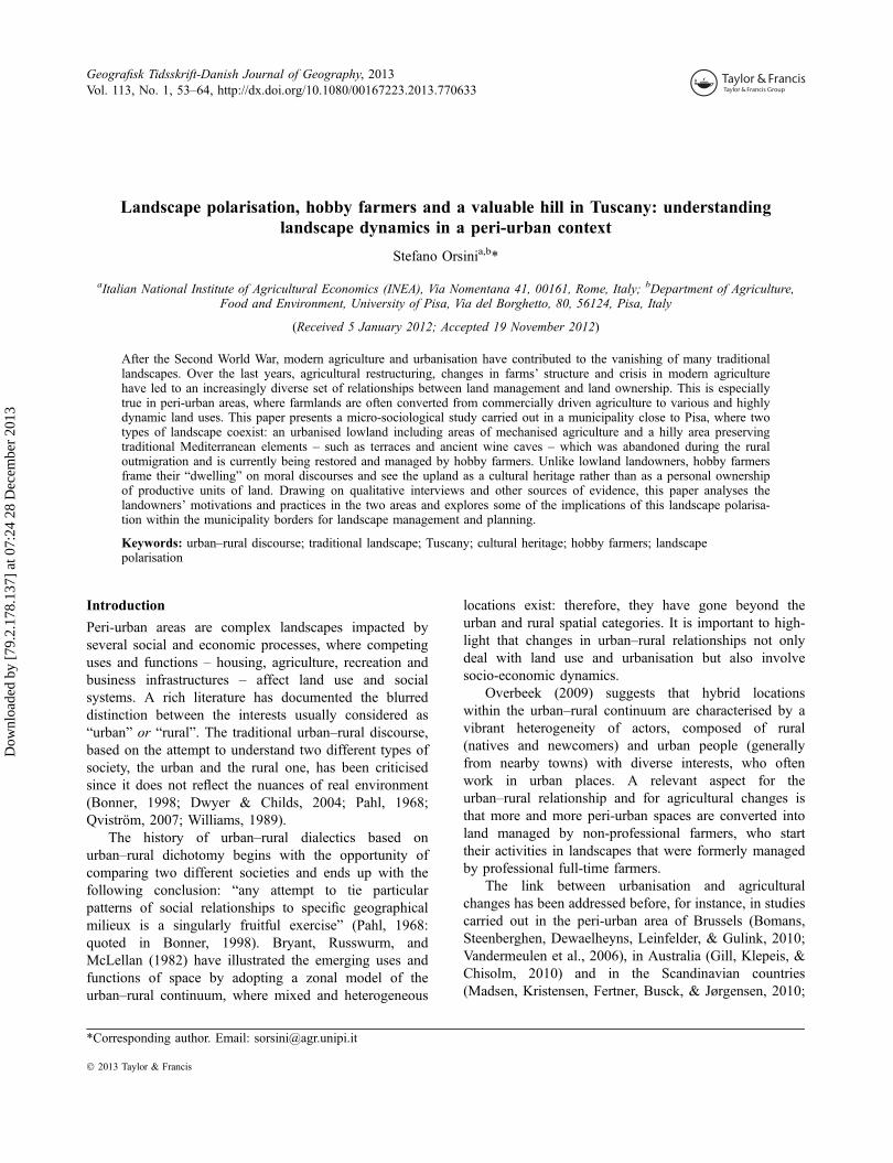
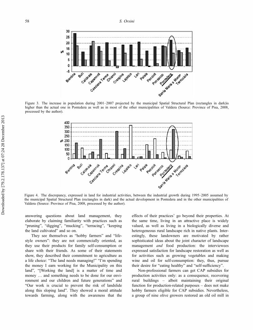
Along with the economic modernisation, themunicipality experienced a process of urbanisation andchanges in agriculture. The former resulted in newbuilt up areas and in the conversion of land andabandoned buildings that the rural outmigration hadleft behind; the latter resulted in the specialisation andmechanisation of agriculture. General outmigration inagriculture was reinforced by labour-saving technologi-cal change in farming. Today, the process ofurbanisation together with the conversion of land andrural buildings is still ongoing, despite the industrialcrisis and the weak demand for new houses. AsFigures 3 and 4 show, there is discrepancy betweenthe Municipality’s forecasts concerning the demand forhouses and the industrial development on the onehand, and the actual situation on the other.
In the Italian planning system, the definition ofbuilt-up and non-built areas, based on a zonation system,is provided by the municipal authority: after its approvalparcels zoned for exclusive farm use by the SpatialStructural Plan, which is elaborated at the municipallevel, can be converted to different uses. This planningsystem, where the relevance of local discretion in landuse policy is high, together with the “predict andprovide” approach (Murdoch & Lowe, 2003) to planningfor housing and industrial infrastructures, has led to arise in unused spaces and unfinished buildings, alongwith the loss of productive agricultural land, especiallyin the flat parts of the municipality as the followingsections will document.
The possibility of changing the zonal status of anarea from rural to urban follows some general criteria,such as the urgency “for the common good”, usuallyconcerning infrastructures and residential or industrialdevelopment, or the “marginality” of certain agriculturalland (Regional Law on Territorial Government 1/2005),which usually refers to the economic aspect of a specificfarm rather than to the soil quality and productivity ofthe land, as shown in the following sections. Moreover,
the “negotiative” nature of the Italian planning system(Khakee & Barbenente, 2003) as well as the lack oftransparency in the national and local public policy(Transparency International, 2010) have encouraged theintroduction of a number of special “changes” in theSpatial Structural Plan in order to enable the implemen-tation of development projects. This flexible planningapproach made it possible to carry out big publicprojects, e.g. the 1990 World Cup, as well as manysmall/medium-sized projects, usually consisting of spe-cial housing programmes. More attention is usually paidto immediate economic growth than on strategicorientation; moreover, the negotiations often involve onlylandowners, developers and elected administrators. Thisplanning system is based on agreements rather than oncontrol procedures and the only condition for getting thedevelopment permission is the availability of the primaryinfrastructure or the developers’ promise to build suchinfrastructure at their own expense (Khakee & Barbe-nente, 2003); this has fostered the “financialisation” ofsome land development investments, with the replace-ment of public money by financial capital. In somecases, especially during the last few years, the invest-ments into housing proved unsuccessful due to the crisisin the demand for houses (Province of Pisa, 2008).
Experiencing Treggiaia hill land and farming
Treggiaia, with its surface of 10 km2 and 1150inhabitants, is a hilly parish within the municipality ofPontedera. As mentioned previously, this rural hamletexperienced a process of land abandonment and popula-tion decline in the 1960s and 1970s due to the industrialdevelopment, and, since the 1990s, has been repopulatedby urban dwellers. Most of the current inhabitants, whorely on off-farm income, have inherited old houses withplots of land from their fathers.
Since they have chosen to live in the upland for its“scenery”, they showed enthusiasm for the restoration oftheir dwelling place during the interviews. They managethe land themselves and grow orchards fruit trees,vegetables, vines, chestnuts and olives on terraces. When
Table 2. Overview of the characteristics of the properties included in the sample.
Lowland Upland
Size (ha) From <1 ha to >100 ha From <1 ha to 22 haFarmer/landowner
typeLandholders consider themselves as commercial farmers orjust as landowners who contract or rent out their land’smanagement
Landholders consider themselves as hobbyfarmers and ‘lifestyle’ owners⁄⁄
Productionorientation anddominant land use⁄
Arable land, olives, vines. Specialised in cereals andoleaginous crops
Olives, vines, vegetables, orchards andchestnuts. More likely to be engaged inuncultivated elements
⁄Dominant land use is considered as the main way in which the respondents use their farm.⁄⁄In this paper, hobby farmers and lifestyle owners are used synonymously.
Geografisk Tidsskrift-Danish Journal of Geography 57
Dow
nloa
ded
by [
79.2
.178
.137
] at
07:
24 2
8 D
ecem
ber
2013
answering questions about land management, theyelaborate by claiming familiarity with practices such as“pruning”, “digging”, “mucking”, “terracing”, “keepingthe land cultivated” and so on.
They see themselves as “hobby farmers” and “life-style owners”: they are not commercially oriented, asthey use their products for family self-consumption orshare with their friends. As some of their statementsshow, they described their commitment to agriculture asa life choice: “The land needs managing!” “I’m spendingthe money I earn working for the Municipality on thisland”, “[Working the land] is a matter of time andmoney … and something needs to be done for our envi-ronment and our children and future generations” and“Our work is crucial to prevent the risk of landslidealong this sloping land”. They showed a moral attitudetowards farming, along with the awareness that the
effects of their practices’ go beyond their properties. Atthe same time, living in an attractive place is widelyvalued, as well as living in a biologically diverse andheterogeneous rural landscape rich in native plants. Inter-estingly, these landowners are motivated by rathersophisticated ideas about the joint character of landscapemanagement and food production: the intervieweesexpressed satisfaction for landscape restoration as well asfor activities such as growing vegetables and makingwine and oil for self-consumption: they, thus, pursuetheir desire for “eating healthy” and “self-sufficiency”.
Non-professional farmers can get CAP subsidies forproduction activities only: as a consequence, recoveringrural buildings – albeit maintaining their originalfunction for production-related purposes – does not makehobby farmers eligible for CAP subsidies. Nevertheless,a group of nine olive growers restored an old oil mill in
Figure 4. The discrepancy, expressed in land for industrial activities, between the industrial growth during 1995–2005 assumed bythe municipal Spatial Structural Plan (rectangles in dark) and the actual development in Pontedera and in the other municipalities ofValdera (Source: Province of Pisa, 2008, processed by the author).
Figure 3. The increase in population during 2001–2007 projected by the municipal Spatial Structural Plan (rectangles in dark)ishigher than the actual one in Pontedera as well as in most of the other municipalities of Valdera (Source: Province of Pisa, 2008,processed by the author).
58 S. Orsini
Dow
nloa
ded
by [
79.2
.178
.137
] at
07:
24 2
8 D
ecem
ber
2013

the hamlet and are now using it for pressing the olivesof most local olive growers. Other “initiatives” and “stra-tegic collaborations”, most of which are carried outthanks to “resource sharing throughout volunteergroups”, deal with dry stone wall restoration and estab-lishing hedgerows along mule tracks. A small landowner,thus, expressed his liking for experimental practices:
Here in Treggiaia small landowners voluntarily preservethe land, we are not real farmers but we manage thelandscape and take care of our olive trees, even thoughwe have never done it before and we all have other jobs.We try to help each other, we study together how tomaintain and improve this hill land. (my emphasis)
In addition to their sense of belonging to a group ofpeople, they expressed a deep connection to the naturalenvironment represented by the hill land. The followingstatements are just a few examples of their feelings:“Looking at this hill land says a lot about who we are”,“When I work the land, I feel like I am one with it”,“When I spend my time working this land, I feel totallyfree and satisfied”.
These people’s aptitude for taking care of the landconcerns both the natural and the built environment. Forexample, a landholder recovered a vernacular rural build-ing by restoring an independent wine cave dug into aslope-side:
I am recovering this cave first of all because it reallyneeded restoring – since its structure was unstable – andI am respecting its traditional shape and architectonicelements, although this makes the renovations moreexpensive and difficult. It fell into disuse through genera-tions, because this type of cave can be used for smallartisanal production only. I think it’s important to restoreit because it’s part of our family heritage […] I appliedfor the permission with a detailed project and I got it,but without any sort of financial aid […] I think thatusing this wine cellar in order to link wine productionwith tourism would be a great idea and perhaps I will doit when I retire.
For what concerns the perception of the institutionalenvironment, the interviewees underlined the adverseeffects of the policies of local institutions. In theiropinion, this upland has been neglected for decades sinceits depopulation and no management and preservationmeasures have been fostered: “We are bringing this landback to life … at least we are sure we will leave it inbetter conditions than we found it”. One of theinterviewees said: “The Municipality developed onlysome aspects of this territory, the industrial and theresidential ones […] The landscape on this hill is veryattractive, but lowland citizens and the bureaucrats_working for the Municipality are totally unaware ofthis”. Another respondent claimed:
None of the local administrators have taken care of theseterraces, so that some years ago they started to collapse.Nowadays, we care about this upland and we manage itat our expense, but we don’t complain. The thing wecomplain about is that our administrators are urbanisingthe whole valley, which damages the landscape structure.We are afraid that sooner or later the urban encroach-ment will get here too.
To sum up, most of the points expressed by Tre-ggiaia residents fall into two main aspects: on the onehand, the satisfaction they get from managing the land-scape and, on the other hand, the lack of trust in localinstitutions and local land use policies.
Landholders and agriculture in the lowland
While the nearby upland dwellers had a common way ofdescribing farming and the hill land, a more fragmentedcontext concerning landscape framing arose during theinterviews with lowland landowners. This area has beenand is still experiencing a combination of changes in thefarms’ structure, in the agricultural restructuring, and inthe urbanisation processes: on the one hand, large tractsof agricultural land are being converted for non-agricul-tural uses and, on the other, more and more farmed areasare managed by contractors or incorporated into biggerfarms. Companies or contractors are demanded both byfarmers who have found other non-agricultural jobs andowners who inherited their farms and have never workedin this sector before. These interviewees explained theirchoice of contracting out land management by claiming,for instance: “[I rent out my land management] justbecause farming is something I have never done before”,or:
A retired farmer manages some neighbours’ land. Weasked him to do the same for us... you know, it is notpossible to make a living out of agriculture. We justneed him to keep the field tidy, you know, and removethe olive trees since they require labour and cost toomuch.
The removal of uncultivated elements, such ashedgerows, and the simplification of agricultural opera-tions in order to save time and money are quite commonstrategies among the owners. When interviewees wereasked about their recent investments, they stated theirneed to focus just on “what is strictly needed, such asfertilisers, machineries, seeds” and acknowledged that“these are not real investments, but this is what we canafford … that’s the way it is: just simple crops … ornothing”, thus stressing the overall trend of simplificationof agricultural operations in this area.
Concerning the pressure of urbanisation and landdevelopment projects, the respondents showed two main
Geografisk Tidsskrift-Danish Journal of Geography 59
Dow
nloa
ded
by [
79.2
.178
.137
] at
07:
24 2
8 D
ecem
ber
2013
opposite feelings. First, they reckoned that the conflictsbetween urban and rural interests over land use exacer-bate the difficulties of the agricultural sector and those offarmers from the social, environmental and institutionalperspective. The following examples clearly show thispoint of view: “Protecting good and productive soils is aweak argument for preventing [land] speculation”. Afull-time farmer, who had his 100-ha propertyexpropriated some years ago because of an industrialdevelopment plan and still not achieved, said that
it is difficult to plan any sort of farm investments here[…] The planning for the next season needs to be donea year ahead... but the local authority might unexpect-edly start the construction works. Then I sow my fieldsat my own risk.
And here is the evidence of another farmer:
The highway connecting Pisa to Florence, which wasbuilt for the World Cup, split my farm in two. For townplanners this is just a matter of drawing a line! Theyseem to ignore the problems of pollution and flooding… so … being farmers in this area today is rather frus-trating.
Second, land development was portrayed by a group offarmers as a strategy they pursue for economic reasonsand/or “for local landscape improvement”. Developmentplans, which are usually depicted as successful invest-ments thanks to their proximity to Pisa, entail barn andland use conversion into accommodation and recreationfacilities such as bed and breakfast, golf course and a cartrack.
Contrary to my initial expectations and to the exten-sive literature on agriculture in rural–urban interface (e.g.Inwood & Sharp, 2012; Wilson, 2007), I did not findanything in the way of urban-oriented agriculture, suchas pick-your-own farms and farmers’ markets; indeed, inthe study area context, most farms are entangled inglobalised–industrialised agriculture. Some of therespondents regretted establishing their farm businessesaccording to the industrial and global farming patterns:“My farm is negatively influenced by the wrong choicesI made in the past, when I used to focus on industrialproduction. Then I realised how awful globalcompetition is”. Another farmer said: “In the past we feltobliged to join the technological treadmill and now it isvery difficult to adjust the farm structure to the newdemand for alternative chains”. Instead, these farmers areengaged in “passive forms of diversification” (Walford,2003, p. 56): in particular, they undertake contract work,change the buildings’ original use and rent them out.Through this diversification, farmers emancipatethemselves from an unstable agricultural market and an
agricultural policy system that many of them consider as“poor” and “uncertain”.
Relationships between landholders and landscape
Polarisation results in the contrast between an urbanisedlowland including areas of mechanised agriculture and ahilly area preserving Mediterranean traditional elementsmanaged by a group of hobby farmers living in thatupland. It also results in the different modes that farm-ing, landscape and land property are experienced andframed in. Despite the expected dominance of the“dwelling” and “managing” frames of non-commercialfarmers on the “producing” and “selling” frames ofcommercial farmers, both groups of landholders areheterogeneous in age, education, gender and economicstatus. Thus, the main differences between them dealwith the availability of off-farm income and the placetheir properties are located in. Previous extensive studies(Pannell et al., 2006; Tindall, Davies, & Mauboulès,2003; Wynn, Crabtree, & Potts, 2001) have found corre-lations between some ecological restoration attitudes –hedgerows planting, active land stewardship, etc. – anddemographic variables like age, gender, education, etc.The hobby farmers involved in hill land farming I sam-pled in Treggiaia are rather heterogeneous but sharecommon management practices, which suggests that landmanagement and farming involvement might not berelated to the above mentioned variables, however, thesmall number of interviews and data collected does notallow us to generalise and confidently draw such a con-clusion.
Figure 5 shows the relationship between owners andagricultural landscape. By analysing respondents’ ratio-nales for supporting their land management decisions,we can say that farmers in the lowland are moredependent on some external factors – especially the agri-cultural market – than non-commercial farmers are;instead, factors like biophysical processes, local institu-tions and the natural environment influence all landhold-ers.
Interestingly, although the upland dwellers emphasisethe production of landscape elements and values ratherthan agricultural commodity production, land productiv-ity also represents a significant goal related to theirviews on the nature of food production, as we can see inthe following quotes: “It is good to have a piece of landwhere you can grow the food you eat” or “I think wewill have to go back to farming”. When speaking abouttheir land management decisions, upland residents gavedetailed descriptions and explanations of each everydaypractice. The approach of most lowland owners wasquite different: they reported on the economic perspec-tive of farming – especially the costs of production and
60 S. Orsini
Dow
nloa
ded
by [
79.2
.178
.137
] at
07:
24 2
8 D
ecem
ber
2013

the sale prices – and primarily considered their farms asunits of production.`
Discussion and conclusion
This study has analysed the landscape dynamics at themunicipal scale and the role of landholders in landscapemanagement decisions. It shows how peri-urbanityincludes mixed and transitional locations wherefunctional and socio-economic transformations mayoccur, involving changes in land managementcommunity and regime. When interpreting landscapedynamics, it is crucial to understand the diversity ofmeanings land managers attach to land and landscape,how these meanings are elaborated and their context. Forthe lowland landholders, the land mostly represents theirunit of production and/or economic rent; Treggiaiahobby farmers see the upland as a cultural heritagerather than as a personal ownership of productive unitsof land.
In several areas close to urban centres, the presenceof hobby farmers is often associated with recreationalactivities such as hunting or horse keeping in NorthEuropean countries (e.g. Busck, Kristensen, Reenberg, &Primdahl, 2006; Elgåker, Pinzke, & Lindholm, 2010);instead, people who deal with the Treggiaia hill landframe their “dwelling” on moral and aesthetic discourses,where they emphasise cultural heritage and practicalengagement rather than recreation and leisure. In thisregard, my findings are consistent with the research ofGill et al. (2010) on lifestyle-oriented rural landownersin Australia, who became greatly engaged inenvironmental management and motivated to enhanceecological restoration and land stewardship.
Active environmental management and restorationare closely related to a set of values and contingencies,especially to the opportunity to set up informal networksand organise local initiatives where “no specific measureexists for the conservation of traditional production land-scapes” (Pinto-Correia & Vos, 2004, p. 153). The casepresented in this paper is also consistent with Selman’s(2004) overview, which shows how local initiatives inthe management of traditional and cultural landscapescan be very effective when they focus on small-scaleareas (like Treggiaia) and on specific landscape qualities(such as management of the traditional elements of aMediterranean agricultural landscape). Kizos et al.(2010) found that hobby farmers in Lesvos, Greece, areactively involved in landscape practices, thus contribut-ing to the maintenance of the traditional landscape oflocal terraced cultivations. In their study, however, hobbyfarmers were more inclined to land abandonment thanprofessional farmers; similarly, Bohnet, Potter, and Sim-mons (2003) found that the new groups of lifestyle ruralland occupiers do not have the same long term and inter-generational time perspective as most family farmers do,and that they often contract out their land to local fulltime farmers.
In the case study presented in this paper, the uplandlifestyle owners have framed a phenomenological dis-course of dwelling-in-the landscape (Cloke & Jones,2001; Ingold, 1993). This does not mean that the hobbyfarmers will “never” abandon the hill land and its man-agement, yet the dwelling perspective and the everydayinteraction with landscape through active farming fostera powerful place attachment, as the interviewees clearlystated. Indeed, the hilly landscape is a source of intrinsicvalue for the people who deal with it: in some cases, for
Figure 5. The relationship between landholders and agricultural landscape. Inspired by Bohnet (2001) and modified by the author.
Geografisk Tidsskrift-Danish Journal of Geography 61
Dow
nloa
ded
by [
79.2
.178
.137
] at
07:
24 2
8 D
ecem
ber
2013

instance, “it is part of the family heritage”. Thus, theupland can be experienced as an agency in itself: thecharacteristics of the upland – natural incompatibilitywith modern-mechanised agriculture, cultural heritageand history, beautiful scenery – are a source of“non-human charisma” (Lorimer, 2007, p. 911) includingecological, aesthetic and affective aspects, which can bea key factor in motivating people to get involved inlandscape conservation, environmental ethics and com-munity management.
The presentation of two sub-cases has required theuse of a holistic approach, and has provided a broadoverview of the interrelated agriculture–environment–society agenda, which is essential to study theperceptions and the objectives of different actors andexplain their practices. Farmers in the lowland areengaged in agriculture and land management in rather adifferent way than those in the upland. In general terms,understanding how the different actors, the socio-eco-nomic context and the physical environment are relatedto each other is crucial when designing and implement-ing public policies. In the past, farmers were asked toadapt farming and land management to modern stan-dards. Today, the dependence on external forces seemsto be no longer acceptable, neither economically fromthe farmers’ point of view (as shown in this case study)nor from a broader social and environmental perspective.On the one hand, upland dwellers frame land manage-ment as a nature-bonding experience, on the other com-mercial farmers and modern agriculture in the lowlandproduce an environment–technology dichotomy.
Though landscape outcomes have not been explicitlyaddressed, it is possible to state that the complex set ofincreasingly indirect relationships between land manage-ment and land ownership in the lowland is not very suit-able for the management of a mosaic agriculturallandscape. The increasing trend of contract farming maylead to the increase of large areas of countryside man-aged by one or few operators and, as a consequence, tothe homogenisation of the agricultural landscape. Fur-thermore, the decrease in the number of professionalfarms along with the increase in their size, which havebeen recorded in the plain of Pontedera, seem to berather common aspects of the structural change in agri-culture and this trend can be expected to continue(Lobley & Potter, 2004; Primdahl & Kristensen, 2011;Stenseke, 2006). Observing the continuity and changesin landscape practices after the transfer of ownershipwould be interesting in order to monitor the develop-ments in landscape structure in a long term perspective.Indeed, radical land management and landscape changesare often associated with changes in land holding(Marsden & Munton, 1991).
Finally, this case study shows how structural changesin agriculture and farm structure can be interpreted as an
integral part of the urbanisation process, as recent studieshave proved (e.g. Madsen et al., 2010; Primdahl & Kris-tensen, 2011). Pontedera is an administrative unit wherea mixture of urban and rural zones coexists; furthermore,rural zones are very diverse in nature and use, since theyconsist of hilly areas with traditional elements and flatareas of mechanised agriculture. In general terms,acknowledging this diversity when designing policieswould help meeting the contemporary ideas on localengagement (Madsen et al., 2010) that deal with thelandscape as well as with the land-unit level, where sev-eral interests (conservation, production and consumption)may compete and create governance challenges at anyscale. Such challenges arise from the hybrid nature andthe multiple meaning associated to land which entailsthat agricultural landscapes do not stop at the edge ofthe settlements.
A rich literature questions the effectiveness of zoningprocesses in physical planning, especially when it is notaccompanied by the involvement of local people, so thatdesignations can be easily transgressed by an unneeded orunsympathetic development (Harvey & Works, 2002;Khakee & Barbenente, 2003; Murdoch & Lowe, 2003;Selman, 2009). In my study area, landowners expect theurban–rural dichotomy between the urbanised lowlandand the upland to increase, with the loss of productivelands; and the upland dwellers are convinced that “sooneror later the urban encroachment will get here too”. Theexpectations and feelings of local actors may representinteresting criteria for measuring the quality of public poli-cies such as the effectiveness of spatial designations.
AcknowledgementsI wish to thank my supervisor Gianluca Brunori for hissupport. I feel very grateful to Matthias Qviström forcommenting the earlier draft of this paper, and to JørgenPrimdahl for spending his time discussing my research withme. Thanks to Carlotta Cini for her valuable linguisticassistance. Thanks to György Ängelkott Bocz for providing aninsightful feedback during the seminar in SLU, Alnarp. Thecomments of the two anonymous referees and editors greatlyimproved this paper.
ReferencesBerg, B.L. (2004). Qualitative research methods for the social
sciences (5th ed.). Boston, MA: Perason.Bohnet, I. (2001). Exploring landscape character: A socio-
ecological analysis in the High Weald, England. http://www.ruralfutures.une.edu.au/LF2/papers/bohnet.pdf
Bohnet, I., Potter, C., & Simmons, E. (2003). Landscapechange in the multi-functional countryside: A biographicalanalysis of farmer decision-making in the English HighWeald. Landscape Research, 28, 349–364.
Bomans, K., Steenberghen, T., Dewaelheyns, V., Leinfelder, H.,& Gulink, H. (2010). Underrated transformations in theopen space – the case of an urbanized and multifunctionalarea. Landscape and Urban Planning, 94, 196–205.
62 S. Orsini
Dow
nloa
ded
by [
79.2
.178
.137
] at
07:
24 2
8 D
ecem
ber
2013

Bonner, K. (1998). Reflexivity, sociology and the rural–urbandistinction in Marx, Tonnies and Weber. Canadian Reviewof Sociology, 35, 165–189.
Bryant, C.R., Russwurm, L.H., & McLellan, A.G. (1982). Thecity’s countryside – land and its management in the rural–urban fringe. London: Longman.
Busck, A.G., Kristensen, S.P., Reenberg, A., & Primdahl, J.(2006). Land system changes in the context of urbanisation:Examples from the peri-urban area of Greater Copenhagen.Geografisk Tidsskrift-Danish Journal of Geography, 106,21–34.
Cloke, P., & Jones, O. (2001). Dwelling, place, and landscape:An orchard in Somerset. Environment and Planning D, 33,649–666.
Dwyer, J.F., & Childs, G.M. (2004). Movement of peopleacross the landscape: A blurring of distinction betweenareas, interests and issues affecting natural resource man-agement. Landscape and Urban Planning, 69, 153–164.
Elgåker, H., Pinzke, S., Lindholm, G., & Nilsson, C. (2010).Horse keeping in urban and peri-urban areas: New condi-tions for physical planning in Sweden. Geografisk Tidssk-rift-Danish Journal of Geography, 110, 81–98.
Gill, N., Klepeis, P., & Chisolm, L. (2010). Stewardship amonglifestyle oriented rural landowners. Journal of Environmen-tal Planning and Management, 53, 317–334.
Glaser, B., & Strauss, A. (1967). The discovery of groundedtheory. Chicago, IL: Aldine.
Green, S., & Lemon, M. (1996). Perceptual landscapes inagrarian systems: Degradation processes in North-WesternEpirus and the Argolid Valley, Greece. Ecumene, 3, 181–1999.
Harvey, T., & Works, M.A. (2002). Urban sprawl and rurallandscapes: Perceptions of landscape as amenity in Port-land. Oregon. Local Environment, 7, 381–396.
Ingold, T. (1993). The temporality of the landscape. WorldArcheology, 25, 152–174.
Inwood, S.M., & Sharp, J.S. (2012). Farm persistence andadaptation at the rural-urban interface: Succession and farmadjustment. Journal of Rural Studies, 28, 107–117.
Italian National Census (ISTAT). (2012, April 21). http://www.census.istat.it/index_agricoltura.htm
Khakee, A., & Barbenente, A. (2003). Negotiative land use anddeliberative environmental planning in Italy and Sweden.International Planning Studies, 8, 181–2000.
Kizos, T., Dalaka, A., & Petanidou, T. (2010). Farmers’ atti-tudes and landscape change: Evidence from the abandon-ment of terraced cultivations on Lesvos, Greece.Agriculture and Human Values, 27, 199–212.
Kizos, T., Vasdeki, M., Chatzikiriakou, C., & Dimitriou, D.(2011). ‘For my children’: Different functions of the agri-cultural landscape and attitudes of farmers on differentareas of Greece towards small scale landscape change.Geografisk Tidsskrift-Danish Journal of Geography, 111,117–130.
Kleinsasser, A.M. (2000). Researchers reflexivity, and good data:Writing to unlearn. Theory into Practice, 39, 155–162.
Kvale, S. (1996). Interviews: An introduction to qualitativeresearch interviewing. Thousand Oaks, CA: Sage.
Lee, J. (2007). Experiencing landscape: Orkney hill land andfarming. Journal of Rural Studies, 23, 88–100.
Legge sul Governo del Territorio Regione Toscana LR 1/2005(Regional Law on Territorial Government LR 1/2005).
Lobley, M., & Potter, C. (2004). Agricultural change and restruc-turing: recent evidence from a survey of agricultural house-holds in England. Journal of Rural Studies, 20, 499–510.
Lorimer, J. (2007). Nonhuman charisma. Environment andPlanning D, 25, 911–932.
Madsen, M.F., Kristensen, S.B.P., Fertner, C., Busck, A.G., &Jørgensen, G. (2010). Urbanisation of rural areas: A casestudy from Jutland. Denmark. Geografisk Tidsskrift-DanishJournal of Geography, 110, 47–63.
Marsden, T., & Munton, R. (1991). The farmed landscape andthe occupancy change process. Environment and PlanningA, 23, 663–676.
Martinelli, A. (2009). Lo storico legame tra campi e industria [Thehistoric connection between the countryside and industry]. InCiuti et al. (Eds.), Pontedera. Pisa: Locus, Felici Editore.
Murdoch, J., & Lowe, P. (2003). The preservationist paradox:Modernism, environmentalism and the politics of spatialdivision. Transactions of the Institute of British Geogra-phers, 28, 318–332.
O’Rourke, E. (1999a). Changing identities, changing land-scapes: Human–land relations in transition in the Aspre,Roussillon. Ecumene, 6, 29–50.
O’Rourke, E. (1999b). The causse mejan: Changing relation-ships between agriculture, environment and society withina French national park. Landscape Research, 24, 141–165.
Overbeek, G. (2009). Opportunities for rural–urban relation-ships to enhance the rural landscape. Journal of Environ-mental Policy and Planning, 11, 61–68.
Pahl, R.E. (1968). The rural–urban continuum. In R.E. Pahl(Eds.), Readings in urban sociology (pp. 263–297).London: Pergamon Press.
Pannell, D.J., Marshall, G.R., Barr, N., Curtis, A., Vanclay, F.,& Wilkinson, R. (2006). Understanding and promotingadoption of conservation practices by rural landholders.Australian Journal of Experimental Agriculture, 46, 1407–1424.
Pieroni, P., & Brunori, G. (2007). The case of Monte Pisano: aperi-urban landscape between housing, tourism, and newforms of agriculture. In G. Brunori, F. Marangon, &M. Reho (Eds.), The rural landscape management betweengovernment and governance (pp. 164–176). Milano: FrancoAngeli.
Pinto-Correia, T., & Vos, W. (2004). Multifunctionality in Med-iterranean landscapes – past and future. In R. Jongman(Ed.), The new dimensions of the European landscape (pp.135–164). Wageningen: Frontis Series, Springer.
Præstholm, S., & Kristensen, S.P. (2007). Farmers as initiatorsand farms as attractors for non-agricultural economic activi-ties in peri-urban areas in Denmark. Geografisk Tidsskrift-Danish Journal of Geography, 107, 13–27.
Primdahl, J., & Kristensen, L. (2011). The farmer as a land-scape manager: Management roles and change patterns in aDanish region. Geografisk Tidsskrift-Danish Journal ofGeography, 111, 107–116.
Province of Pisa. (2008). Secondo Rapporto sulla situazionesociale nella provincia di Pisa. Osservatorio per le PoliticheSociali Provincia di Pisa.
Qviström, M. (2007). Landscapes out of order: studying theinner urban fringe beyond the rural–urban divide. Geograf-iska Annaler, 89 B, 269–282.
Sabbatucci-Severini, P. (1990). Il mezzadro pluriattivo dell’Italiacentrale. In P. Bevilacqua (Ed.), Storia dell’agricoltura itali-ana in età contemporanea (pp. 169–211). Venezia: Marsilio.
Selman, P. (2004). Community participation in the planningand management of cultural landscapes. Journal of Envi-ronmental Planning and Management, 47, 365–392.
Selman, P. (2009). Conservation designations: Are they fit forpurpose in the 21st century? Land Use Policy, 26, 142–153.
Geografisk Tidsskrift-Danish Journal of Geography 63
Dow
nloa
ded
by [
79.2
.178
.137
] at
07:
24 2
8 D
ecem
ber
2013

Stenseke, M. (2006). Biodiversity and the local context: Link-ing seminatural grasslands and their future use to socialaspects. Environmental Science & Policy, 9, 350–359.
Tindall, D.B., Davies, S., & Mauboulès, C. (2003). Activismand conservation behaviour in an environmental movement:The contradictory effects of gender. Society and NaturalResources, 16, 909–932.
Transparency International. (2010). Corruption PerceptionsIndex 2010. Berlin: Transparency International.
Vandermeulen, V., Verspecht, A., Van Huylenbroek, G., Meert,H., Boullanger, A., & Van Hecke, E. (2006). The impor-tance of the institutional environment on multifunctionalfarming system in the peri-urban area of Brussels. LandUse Policy, 23, 486–501.
Vos, W., & Stortelder, A. (1992). Vanishing Tuscan landscapes:Landscape ecology of a Submediterranean-Montane area(Solano Basin, Tuscany, Italy). Wageningen: Pudoc.
Walford, N. (2003). A past and a future for diversification onfarms? Some evidence from large-scale, commercial farmsin South East England. Geografiska Annaler, 85 B, 51–62.
Williams, R. (1989). Resources of hope: Culture, democracy,Socialism. London: Verso.
Wilson, G. (2007). Multifunctional agriculture: A transitiontheory perspective. Wallingford, CT: CABI International.
Wynn, G., Crabtree, B., & Potts, J. (2001). Modellingfarmer entry into the environmentally sensitive areaschemes in Scotland. Journal of Agricultural Economics,52, 65–82.
64 S. Orsini
Dow
nloa
ded
by [
79.2
.178
.137
] at
07:
24 2
8 D
ecem
ber
2013