DAKLIS: A COLLABORATIVE FISHING TECHNIQUE A Research Presented to the Unlad Dunong Center University...
77
0 DAKLIS: A COLLABORATIVE FISHING TECHNIQUE A Research Presented to the Unlad Dunong Center University Of Saint Louis, Tuguegarao City FERDINAND N. CORTEZ 2014
Transcript of DAKLIS: A COLLABORATIVE FISHING TECHNIQUE A Research Presented to the Unlad Dunong Center University...

0
DAKLIS: A COLLABORATIVE FISHING
TECHNIQUE
A Research Presented to the Unlad Dunong Center
University Of Saint Louis, Tuguegarao City
FERDINAND N. CORTEZ
2014
1
Chapter I
THE PROBLEM AND ITS BACKGROUND
Introduction
The Philippines, being an archipelagic country, is
rich in coastal resources. It is comprised of more than
7,000 islands with a total coastline, longer than that of
the United States, is over 18,000 km. Seventy per cent
(70%) of its 1,500 municipalities are located in coastal
areas. Coastal fishing activities account for 40-60% of
total fish catch with the fisheries sector accounting for
about 4% of Gross National Product (2003 stat) and
employing more than a million Filipinos. (AgriScope, 1997.)
Fish and other marine products supply 70% of total animal
protein intake and 30% of total protein intake (CRMP,
1999). Tourism is a growing industry in the coastal areas,
and together with fisheries and other economic activities
in coastal areas, contributes to a host of environmental,
socioeconomic and institutional problems.
Fish is a very important commodity in the Philippines.
It is the principal source of cheap animal protein in the
country. Declining fish yields have affected both the
nutrition and income of fishing communities. Scientific
2
results indicated the need for fishing effort to be reduced
by a factor of two for the fish populations to recover over
a decade ago but conservation and rehabilitation efforts
since then have not shown results that indicate significant
recovery of habitats and stocks. (Pauly et al, 1989)
As people cannot do otherwise but to fish for game or
income, safety measures were done by both government and
environmentalists.
The high demand for exotic tropical marine products
abroad which spurred a frenzy of unsustainable harvesting
practices in the Philippines in the 1990’s also contributed
to the degradation of coastal resources. Uncontrolled
harvesting of sharks, sea urchins, and sea horses used for
food and medicinal values contributed to almost local
extinction of these species in certain fishing grounds.
Aquarium fish and certain high-value species of snappers
and groupers that need to be exported live so that
restaurateurs can display them alive (fresh) before cooking
are harvested with the use of cyanide. Cyanide, when
squirted into the water to stun the fish, kills coral reef
organisms, and this practice has led to the surreptitious
destruction of extensive areas of coral reefs (Erdmann and
Pet-Soede 1996).

3
About 27,000 sq km of coral reef area occur within the
20 m depth contour, but 70% of these coral reefs are in
poor to fair condition and degradation is unabated (Gomez
et al. 1981). Dynamite fishing and trawling, plus the
destructive MURO AMI by subsistence as well as commercial
fishers largely contributed to the leveling of coral reefs.
MURO AMI is so prevalent in Visayas and Mindanao, while
inshore and driftnets are in Cagayan Province of Luzon.
MURO AMI is now prohibited in selected areas. The number of
subsistence fishers is continuing to rise because of rapid
population increases in coastal communities. Even if these
fishers use benign fishing practices (e.g., simple hook and
line), the sheer variation in techniques were seen to be
man’s example of being able to fish. (Malthusian
overfishing) (Pauly et al. 1989).
Political, as well as socioeconomic structure and
cultural values and characteristics, that is generally the
same throughout the country but different to some extent by
region, are also among the factors that have led to a
common pattern of fishing for a living. This pattern
involves a series of stages that include discovery of a
resource, exploitation, over-exploitation, decrease in
yield, depletion, then recognition of the need for
management. As such, to protect the endangered species and
4
the coral reefs, RA 8550, commonly known as Fisheries Code
of the Philippines was enacted. In section 2, it says, “it
shall be the primordial aim of any Local Chief Executive in
the coastal area LGU to protect at all cost about to be
extinct species and the coral reefs.”
Buguey, a coastal municipality, is a fishing
community. This is due to the fact that it is surrounded by
water, both brackish and sea, home for many varieties of
fishes and aqua marine resources. The lagoon is home for
prawns and crabs, shrimps and mollusks, while the sea is a
breeding ground for tuna, lapu-lapu, sea urchins and
anchovies. There are two types of fishing in Buguey: sea
fishing and river fishing. As mandated by RA 8550, the sea
fishermen have to follow the prescribed depth and distance
from the shoreline.
One of the least notable but culturally aligned to
bayanihan is the daklis (purse seine). It is a
collaborative effort that includes whole barangay folks
during summer, its peak season. Buguey’s shoreline is
different from other coastal areas. There are no coves or
inshore islets, and it spawns kilometers upon kilometers to
the Balintang Channel. Daklis is then very appropriate
including trawlers and anglers.

5
One of the most valued traditions of Filipinos is
bayanihan. However, due to the advancement of technology,
seldom we see this practice already. While such is still in
the books, seldom it is seen as the once extended
collaboration for a certain task. Daklis, its procedure and
the people involved would then be the core of this study.
Statement of the Problem
This study primarily was aimed at recording the
daklis, a collaborative fishing technique in Buguey.
Specifically, it answered and elaborated the following
questions:
1. What is the historical development of the daklis?
2. What is the is the demographic profile of those engaged
in the daklis in terms of
a. age
b. civil status
c. economic status
3. What are the practices of those engaged in the daklisan
in terms of
a. sharing scheme
b. fishing technique
6
c. organization
4. What is the perceived value of the daklisan among the
Bugueyanos?
Assumption
It is assumed that the daklis, its practices and its
ways, is still valued by the Bugueyanos.
Scope and Delimitation
This study attempted to put to writing the Daklis as
an example of bayanihan at the same time a collaborative
fishing enterprise. It related the organization,
procedures, practices and financial status of the members
of the daklis. The focus was the daklisan in Buguey. The
time frame of the study is school year 2004-2005.
Significance of the Study
The Academe. In its role as builder of knowledge will
be benefited by the results of the study.
Lovers of Culture. Scholars of anthropology will be
benefited similarly for they may use the material for other
salient studies.
The Bugueyanos: They will come to know about this way
7
of fishing, one thing they had been practicing but had not
known it through written account. It may not be remote, but
Buguey as a Tourist spot now may yet to include such a
fishing technique it its must-see catalogues.
Environmentalists may react, if and when it is found out
that daklis contributes to the depletion of the coral
reefs.
Chapter II
REVIEW OF RELATED LITERATURE AND STUDIES
This Chapter presents Literature and Studies

8
concerning fishing, environmental concerns, legal aspects
and historicity of fishing in countries to back up the
study at hand.
The World Overview on Offshore and Inshore Fishing
Implementation of the Global Moratorium on All Large-Scale
Pelagic Drift-Net Fishing On The High Seas Of The World's
Oceans And Seas, Including Enclosed Seas And
Semi-Enclosed Seas
United Nations General Assembly resolution 46/215, and
subsequent resolutions, inter alia, called upon members of
the international community to ensure that a global
moratorium on all large-scale pelagic drift-net fishing was
implemented fully on the high seas of the world's oceans
and seas, including enclosed seas and semi-enclosed seas,
by 31 December 1992. Consequently, members of the
international community, international organizations,
regional integration organizations and appropriate non-
governmental organizations were requested in General
Assembly resolution 52/29 of 26 November 1997, to submit
information to the Secretary-General concerning the
implementation of General Assembly resolution 46/215.
FAO (Food and Agriculture Organization) is mandated to
monitor fisheries on an international basis. It does this
9
principally through information obtained from FAO field and
regional and sub-regional offices, regular consultation
with regional (FAO and non-FAO) fishery bodies, the fishing
industry, inter-governmental organizations non-governmental
organizations, and ad hoc reports. In preparing this report
it is understood by FAO that regional and international
fishery bodies have been invited by the UN to report
independently to the Secretary-General on this issue.
In accordance with General Assembly resolution 44/225
and subsequent resolutions, FAO has reported annually on
global information available to the Organization on the use
of large-scale pelagic drift-nets.
Status of large-scale pelagic drift-net fleets
As far as FAO is aware, the Mediterranean Sea is the
only region in the world where large-scale pelagic drift-
net fishing gear (i.e., nets in excess of 2.5 km) is being
deployed. The vessels using this gear in the Mediterranean,
and which target swordfish, are primarily of Italian and
French flags. In its 1997 report to the General Assembly,
FAO outlined the policy of the Italian Government with
respect to its fleet retrenchment and compensation program
for the drift-net fleet.
In relation to the use of large-scale pelagic drift-

10
net gear by European Council Members, the Council on
Pelagic Fleet decided in June 1998 to eliminate drift nets
over a period of three and a half years. As of 1 January
2002, the use of drift nets to catch tuna and swordfish is
already banned, and their use in salmon fishing is
restricted to coastal waters. Driftnets are still
authorized in the Baltic Sea, however, where by-catches of
marine mammals are considered to pose much less of a
problem. For this year’s fishing season, the current
maximum drift-net length of 2.5 km remains in effect, but
the number of vessels, using drift nets must be reduced by
40 percent from the 1995/97 reference period. Moreover, the
Council and the Commission have pledged to approve flanking
measures, including some for the conversion of boats into
more selective types of vessels, before the end of 1998,
retraining and laying up. However, no new EU aid is
scheduled before the year 2000 to support such initiatives.
It was noted that this Council decision on this issue
is the first time that 15 EU Members States have taken a
decision to ban a particular fishing gear. According to the
EC during the period 1995/97, the number of vessels using
drift-nets was 640 in Italy, 77 in France, 11 in Ireland
and between five and eight in the UK. In addition, 100
Spanish vessels use nets with an average length of 1.2 km

11
in the Mediterranean Sea.
Action/reports by Regional Fishery Bodies
At its Twenty-second Session in October 1997, the
General Fisheries Commission for the Mediterranean (GFCM)
adopted binding resolution 97/1 concerning the use of
large-scale pelagic drift-net gear. The resolution, taking
into account United Nations Governing Assembly resolution
44/225 and considering that uncontrolled expansion and
growth of drift-netting may entail serious disadvantages in
terms of increased fishing effort and increased by-catches
of species other than target species, and that it was
therefore desirable to regulate fishing with drift-nets,
adopted the recommendation that:
1. No vessel flying the flag of a Contracting party of
GFCM may keep on board, or use for fishing, one or
more drift-nets whose individual or total length is
more than 2.5 km; and
2. Throughout the fishing referred to in paragraph 1,
the net must, if it is longer than one kilometer,
remain attached to the vessel. However, within the 12
mi. coastal band, a vessel may detach itself from the
net, provided it keeps it under constant observation.
GFCM has advised that the Italian Government is seeking

12
to comply with UN, EC and GFCM resolutions concerning the
authorized maximum length of drift-nets. The Government’s
plan has led to a substantial reduction in the number of
vessels operating with nets in excess of 2.5 km. However,
it is understood that the Italian coastguard is
experiencing logistical difficulties enforcing drift-net
gear provisions.
The Western Central Atlantic Fishery Commission
(WECAFC) has indicated that that there have been no reports
of large-scale pelagic drift-net fishing in the
Commission’s area during the 1997/98 period.
The Commission for the Conservation of Antarctic
Marine Living Resources (CCAMLR) has reported that the
matter of large-scale drift-net fishing was discussed at
the annual meeting of the Commission in 1990. This resulted
in the adoption of Resolution 7/IX, which declared that, in
accordance with UNGA resolution 44/225, there would be no
expansion of large-scale pelagic drift-net fishing into the
high seas of the Convention Area. Since the adoption of
this Resolution, no cases of activities or conduct
inconsistent with the terms of the CCAMLR Convention Area
have been reported to CCAMLR.
The Northwest Atlantic Fisheries Organization (NAFO)

13
has stated that there have been no reports of large scale
pelagic drift-net gear being used in the NAFO Convention
Area during 1997-98.
The North Atlantic Salmon Conservation Organization
(NASCO) has indicated that the Organization is not aware of
any fishing with large-scale pelagic drift-nets within the
area covered by the Convention.
The Commission for the Conservation of Southern
Bluefin Tuna (CCSBT) has advised that there have been no
reports of fishing with large-scale pelagic drift-nets in
its area of competence in the last year.
The International Baltic Sea Fishery Commission
(IBSFC) has stated that it is not formally subject to the
drift-net resolution since Baltic Sea has no high seas
area.
The Permanent Commission for the South Pacific
(CPPS) has reported that in the Southeast Pacific Ocean,
and specifically within areas of national jurisdiction,
there have been no reports in the last year concerning
fishing with large-scale pelagic drift-nets.
The Organización Latinoamericana de Desarrollo
Pesquero (OLDEPESCA) has advised that there have been no
reports of fishing with large-scale pelagic drift-net
14
vessels in the Organization’s Area of competence in the
last year.
UNAUTHORIZED FISHING IN ZONES OF NATIONAL JURISDICTION AND
ON THE HIGH SEAS
Unauthorized fishing in zones of national
jurisdiction and on the high seas has a number of
significant impacts, including the undermining of fisheries
conservation and management measures and, in the case of
unauthorized fishing in Exclusive Economic Zones (EEZ’s),
the denial of legitimate revenue to those States whose
resources are poached. It is principally for these reasons
that international concern has been expressed about
unauthorized fishing and steps taken within the United
Nations to curb, if not prevent, such fishing.
Action by FAO
The Fisheries Department of FAO does not maintain
specific records concerning the incidence of unauthorized
fishing in zones of national jurisdiction. However, at
fisheries meetings and consultations convened by FAO, this
matter is often raised and commented upon by FAO members in
their country statements. For example, at the FAO-sponsored
Regional Workshop on the Adaptation of the Code of Conduct
for Responsible Fisheries in West Africa, Benin, 1-5 June

15
1998, many participants referred to unauthorized incursions
by foreign-flag vessels into their respective EEZs, and
very often close to shore, and they commented on the impact
that these incursions were having on artisan fishers and
their production. To address this situation the need for
effective national and regional programs in monitoring,
control and surveillance (MCS) was stressed.
FAO maintains a program on MCS. Advice and
assistance are provided on a request basis. At the
invitation of the Government of Malaysia the FAO/Norway
Program has organized a regional workshop on fisheries MCS
in Kuala Lumpur and Kuala Terengganu, 29 June - 3 July
1998. Thirty five participants from India, Sri Lanka,
Bangladesh, Myanmar, Thailand, Malaysia, Cambodia, Vietnam,
Philippines, Brunei Darussalam, Singapore and Indonesia
attended. The workshop examined the technical measures
involved in MCS, including commonly accepted procedures and
recent experiences with vessel monitoring systems (VMS).
Participants exchanged information about the use of MCS in
support of fisheries management. A field visit has been
arranged to Kuala Terengganu where participants studied the
techniques used by the Malaysian Department of Fisheries in
conservation and management of resources through patrols at
sea as well as protection of marine parks and reserves. It

16
is anticipated that the FAO/Norway Program will become
further involved at a national and subregional level to
strengthen MCS in participating countries, which border the
Bay of Bengal and South China Sea.
The Agreement to Promote Compliance with International
Conservation and Management Measures by Fishing Vessels on
the High Seas (Compliance Agreement), approved on 23
November 1993 by resolution 15/93 of the Twenty-seventh
Session of the FAO Conference, is an integral part of the
Code. To date the Agreement has been accepted by ten FAO
Members: Canada, Saint Kitts and Nevis, Georgia, Myanmar,
Sweden, Madagascar, Norway, United States of America,
Argentina, and the European Community. The Agreement was
enforced from the date of receipt by the Director-General
of FAO of the twenty-fifth instrument of acceptance.
The Compliance Agreement seeks to ensure that there
is effective flag State control over fishing vessels
operating on the high seas. This requires, inter alia, that
Parties to the Agreement maintain a register of vessels to
fish on the high seas and that all vessels engaged in such
fishing operations are authorized to do so. Moreover, the
Agreement requires that certain records concerning the
physical characteristics of the vessels and their ownership
17
and operational details, be maintained by the Parties are
part of their flag State responsibilities. Furthermore,
Parties are obligated to exchange information maintained on
their respective registers through FAO and other
appropriate global, regional and subregional fisheries
organizations.
The Inter-regional Program has been submitted to the
international donor community for consideration and
possible funding. The Program involves assistance in the
following areas:
A. Implementation of the Compliance Agreement;
B. upgrading of capabilities for reporting on fishery
statistics;
C. upgrading of capabilities in monitoring, control
and surveillance;
D. promotion of responsible fishing operations;
E. upgrading marine resource survey capabilities;
F. improving the provision of scientific advice for
fisheries management;
G. fisheries policy, planning and management;
H. developing and implementing fleet restructuring
policies;
18
I. implementation of post-harvest practices and trade;
J. umbrella support to non-governmental organizations,
and
K. programme coordination and facilitation.
Asian Overview on Fishing
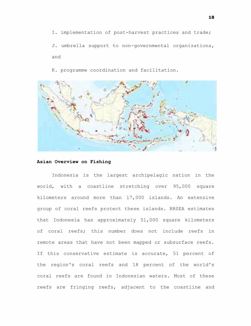
Indonesia is the largest archipelagic nation in the
world, with a coastline stretching over 95,000 square
kilometers around more than 17,000 islands. An extensive
group of coral reefs protect these islands. RRSEA estimates
that Indonesia has approximately 51,000 square kilometers
of coral reefs; this number does not include reefs in
remote areas that have not been mapped or subsurface reefs.
If this conservative estimate is accurate, 51 percent of
the region's coral reefs and 18 percent of the world's
coral reefs are found in Indonesian waters. Most of these
reefs are fringing reefs, adjacent to the coastline and

19
easily accessible to coastal communities. Twenty-five
percent of the nation's GDP comprises the coastal and
marine industries, oil and gas production, transportation,
fisheries, and tourism, which percent of Indonesia's
workforce. Although coastal communities have long extracted
marine resources sustainably, population growth has put
additional pressure on Indonesia's coral reefs.
Aside from their sheer magnitude, Indonesia's coral
reefs are also among the most biologically rich in the
world, containing an extraordinary array of plant and
animal diversity. Today, more than 480 species of hard
coral have been recorded in eastern Indonesia,
approximately 60 percent of the world's described hard
coral species. The greatest diversity of coral reef fish in
the world are found in Indonesia, with more than 1,650
species in eastern Indonesia alone. In fact, Indonesia's
coral reefs help to support one of the largest marine
fisheries in the world, generating 3.6 million tons of
total marine fish production in 1997. Because many reefs in
eastern Indonesia have yet to be surveyed, the actual
extent of Indonesia's biological endowment is still
unknown.
However, Indonesia's rich supplies of corals and reef

20
fish are endangered by destructive fishing practices.
Cyanide and blast fishing are widespread throughout the
archipelago even in protected areas. Around 65 percent of
surveys in the Maluku islands had evidence of bomb damage.
Despite the short-term profits, studies have shown that the
economic costs of blast and poison fishing are prodigious.
RRSEA estimates that the net economic loss in Indonesia
from blast fishing over the next 20 years will be at least
US$570 million. The economic loss from cyanide fishing is
estimated to be US$46 million annually.
Indonesian reefs are also subject to various pressures
from inland activities. The average annual deforestation
rate in Indonesia between 1985 and 1997 was 1.7 million
hectares. Reforestation and other land-use changes have
increased sediment discharge onto reefs, and pollution from
industrial effluents, sewage, and fertilizer compounds the
problem. Reefs affected by land-based pollution have shown
30-50 percent less diversity at depths of 3 m, and 40-160
percent less diversity at 10 m, in comparison to pristine
reefs.
The Philippine Setting Overview
The Philippines is located in the southeastern portion
of Asia. Her neighbor on the north is the Republic of China

21
(Taiwan or Formosa), while on the west is Communist
Vietnam. Further west is Thailand. Immediately to the south
of the Philippines is Indonesia and to the southwest are
Malaysia and Singapore. The Philippines is known because of
traditions like bayanihan and hospitality of the people as
unique traits.
The Philippines is separated from her nearby Asian
neighbors by several bodies of water. They are the Pacific
Ocean on the east, the South China Sea on the north and
west, and the Celebes Sea and the coastal waters of Borneo
on the south.
Land and Its People
The Philippines is an archipelago of 7,107 islands
and islets. The biggest islands are Luzon, with a land area
of 40,530 square miles (105,000 square kilometers);
Mindanao, 36,670 square miles (95,000 square kilometers);
Palawan, 5,749.86 square miles (14, 896 square kilometers);
Negros, 5,278.55 square miles (13,675 square kilometers);
and Samar, 5,183.59 square miles (13,429 square
kilometers). She has a rugged land mass and, similarly, she
has an irregular coastline, which is twice as long as that
of the continental U.S.A. This irregularity has resulted in
numerous fine harbors and landlocked straits that can

22
accommodate large ships. They can also be a refuge of ships
in distress during stormy weather.
The land surface is 115,800 square miles (300,000
square kilometers). Land forms include hills, plains,
valleys, and mountains. Her mountain ranges, which are
volcanic in origin, are drained by small river systems.
There are seven major mountain ranges. The largest and
longest is Sierra Madre, which faces the Pacific Ocean on
the eastern coast of Luzon.
Three Major Islands
The three major geographical groups in the country are
Luzon, Visayas, and Mindanao. Luzon comprises the northern
portion of the archipelago. The Visayan region has about
6,000 islands including Leyte, Cebu, Samar, and Bohol.
Mindanao is the second largest land and encompasses about
400 small islands.
These islands are divided into provinces, which are
run like states in the United States. Each province is
ruled by a governor, a vice governor, and members of the
provincial board. Each province is composed of cities,
towns, and barrios. There are five levels of government in
the Philippines, namely, national, regional, provincial,
municipal, and village-level. Shifts in leadership at any

23
level have a potential impact on the implementation of ICM
projects. However, changes in the municipal government
leadership pose the greatest risk because of the devolution
of coastal management authority to the municipalities in
1991. Devolution in this case meant the shifting of some,
but not all, managerial control over marine spaces from the
national government to the local government units (LGUs).
This involves a transfer of both rights and
responsibilities, so that a LGU may obtain new
opportunities to control exploitation, but must also assume
significant management obligations (Abregana et al. 1996).
Specific tasks and powers have been assigned to three local
levels of government, the provincial, city/municipal, and
the Barangay levels. Most of which have no capacity to
formulate coastal resources management programs.
The guarantee that Coastal Laws and the preservation
of Marine life and Aquatic Resources should be the
primordial responsibility of the coastal town executive.
However, there are instances that even the endangered se
turtle or Pawikan is caught and killed in the towns of
Sta.Ana and Gonzaga. There was an instance that small
sharks are also caught by inshore fishing in Buguey.
Driftnets are said to have tons of catch of dilis and
anchovies which are sold in neighboring cities. (Lara,

24
2004)
Oceans and Coastal Areas
The Philippines signed the United Nations Convention
on the Law of the Sea (UNCLOS) on December 10, 1982 and
ratified it on February 27, 1984.
To ensure a comprehensive and pragmatic approach to
addressing marine and ocean concerns within the context of
the Philippines' commitment to implement UNCLOS, the
existing Cabinet Committee on the Treaty of the Law of the
25
Sea created on October 3, 1981, has been reconstituted as
the Cabinet Committee on Marine and Ocean Affairs. The
Committee is mandated to formulate practical and viable
policies to address the various concerns of UNCLOS and
other marine related matters. As an initial output of the
Committee, a National Marine Policy has been formulated and
adopted to serve as the umbrella framework for addressing
ocean and marine concerns.
A comprehensive National Marine Program is currently
being formulated to achieve the goals of the National
Marine Policy. In addition, the Philippines participated in
the formulation of the Regional Action Plan for the East
Asian Seas. The country has become a partner of the
International Coral Reef Initiative (ICRI), established in
response to Agenda 21. In 1995, the Philippines hosted the
ICRI workshop which resulted in the formulation of the ICRI
Call for Action and a Framework for Action. The Call of
Action and Framework of Action serve as a guide in the
formulation of the regional action plan. As an ICRI
Partner, the Philippines has now established the Philippine
Reef Database (Philreef), and has formulated a National
program for the celebration of the International Year of
the Reef.

26
The need to conserve and manage marine resources,
particularly the straddling fish stocks (SFS) and the
highly migratory fish stocks (HMFS), prompted the
Philippines to sign an agreement in 1996 to prevent
conflict over fishing on high seas and to conserve stocks
of fish which migrate between international waters and
areas under national jurisdiction. In preparation for the
enforcement of the agreement, a draft Comprehensive Program
has been prepared.
Recognizing the impact of land-based resources of
pollution in marine and coastal productivity, the
Philippines actively participated in the series of meetings
that led to the formulation and adoption of the Global
Program on Land-based Sources of Pollution. A national
program on land-based sources of pollution is currently
being conceptualized to integrate Philippine initiatives
and commitments to both the Association of South East Asian
Nations (ASEAN) and the Coordinating Body on the Seas of
East Asia (COBSEA) Regional Programs, and NGO initiatives
under the auspices of the Advisory Committee on the
Protection of Seas (ACOPS).
A national data center on coastal zone environment and
resource management is currently being established under

27
the auspices of the ASEAN-Australia Environment and
Economic Program, Phase III. This project aims to create a
meta-database on coastal resource management which will be
implemented through a network approach, that is, a network
of networks, and the development of a decision support
system.
Tourism is considered to be a major source of
alternative or supplemental livelihood for these fishing
communities. How to develop tourism in the countryside with
revenue benefiting local populace and not just the external
capitalists is a challenge that requires infrastructure
development and competent planning and cooperation of
various sectors (i.e., tourism, environment, fisheries) and
stakeholders concerned. Keeping the integrity of marine
habitats, the basis of growing nature tourism in the
Philippines, is also a major concern.
Setbacks
The occurrence of red tides in the country that has
become more frequent in the past two decades (Corrales and
Gomez 1990) focused concern on water quality. Heavy rains
after a long dry spell that causes nutrient overloading and
sudden drops in salinity because of excessive freshwater
inundation tends the occurrence of red tides. Red tide
28
occurrences have affected shellfish and other fishery
industries and have raised public health concerns mainly
because of paralytic shellfish poisoning (PSP) resulting
from the ingestion of infected shellfish. Though most
people take PSP seriously, there are those whose economic
situation leads them to take a risk by either consuming or
selling the banned infected shellfish (green bay mussel,
Perna viridis). Moreover, the entire fishing industry is
affected because uninformed consumers would not eat fish
and other products from the sea when red tides occur for
fear of contamination or poisoning despite information
campaigns on the contrary.
The lack of point-source and non-point source
pollution controls is the main factors that contribute to
the degradation of water quality in the Philippines. Forest
denudation exacerbates the flow of silt and other
pollutants to coastal waters. Uncontrolled dumping of raw
sewage in coastal areas, particularly in areas that are
thickly populated or used heavily by tourists, contributes
to dangerous water levels of the bacteria Escherichia coli.
This problem, on a few occasions, has caused conflicts
between the Department of Environment and Natural Resources
and the Department of Tourism.

29
In summary, the following are the major issues that
gave rise to the need for ICM in the Philippines:
Serious resource depletion problems, particularly fishery
resources, decrease in catch per unit of fishing effort
particularly by subsistence fishers, loss of or damage to
productive coastal ecosystems (e.g., mangroves, seagrass
beds, and coral reefs), cases of local extinction of
economically important marine species, conflict among
uses/users of coastal resources, poverty and other social
problems of coastal communities, sectoral/fragmented
approach to coastal resources management ,lack of capacity
among local government to manage coastal resources.
Community-based coastal resources management
Slowly, through a series of projects and programs
beginning in the early 1980s, the Philippines have
developed the capacity for community-based coastal
resources management. Ferrer (1992) described CB-CRM in the
Philippines as follows:
1. CB-CRM strives for more active people's participation
in the planning and implementation of coastal
resources management.
2. It has greater potential for effectiveness and equity.
3. It involves self-management where the community takes
30
responsibility for monitoring and enforcement.
4. It provides a sense of ownership over the resource,
which makes the community far more responsible for
long-term sustainability of resources.
5. It allows each community to develop a management
strategy, which meets its own particular needs and
conditions.
6. It allows for greater degree of flexibility and can be
easily modified.
7. It provides for greater participation by the community
in resource management.
8. It strives to make the maximum use of indigenous
knowledge and expertise in developing management
strategies.
There is now a substantial body of experience in this
form of coastal resources management among various
institutions including national and local government units,
NGOs, and academic and research institutions. Nevertheless,
despite what have been accomplished by Coastal Resources
Management initiatives so far, there is unabated
destruction and depletion of coastal resources. The
struggle to conserve coastal resources in the country
continues in cooperation with international and regional
31
organizations, and the support of donor countries.
The empowerment of disadvantaged groups that comprise
the majority of coastal residents affected by multiple
management issues is among the main goals of community-
based coastal resources management (CB-CRM). The community-
based management approach uses education and community
organizing as a major tool in accomplishing its goals of
resource protection, habitat rehabilitation, and poverty
alleviation (Rivera and Newkirk 1997). These disadvantaged
groups, mostly small-scale fishers and other extractive
users, are directly affected by management initiatives such
as ìno takeî marine protected areas. Educational efforts
attempt to assist various stakeholders in negotiating the
imposition of restrictions on fishing and similar
extractive activities in marine protected areas. A recent
Haribon Foundation report estimated the number of MPAs
established in the Philippines to be about 460 of which
only around 6% are fully protected (Pajaro et al.1999).
Institutional mandates in and components of CRM
Various government agencies are involved in coastal
management. These agencies implement various mandates that
sometimes overlap. For example, both DA and DENR are
involved in the establishment of marine protected areas;

32
the former historically assuming such a function through
the issuance of Fisheries Administrative Orders, and the
latter through the more recent National Integrated
Protected Areas System (NIPAS) program (DENR 1992). CRMP
(1997) listed the following mandates of agencies involved
in coastal management in the Philippines: (Please see
Appendix 1 for a list of acronyms)
1. Policy formulation (LGU, FARMC, NGA, DENR) (see CRMP-
Philippines' web site for complete texts of Philippine
coastal laws)
2. Resource assessments: coastal (DA-BFAR, DENR, PCAMRD);
marine (DA-BFAR, DENR, PCAMRD)
3. Statistics gathering and compilation: fisheries (DA-
BAS); mangroves (DENR); fishponds (DA-BFAR)
4. Establishment of protected areas (LGU, DA-BFAR, DENR,
Congress)
5. Mangrove reforestation (LGU, DENR)
6. Fishery licensing: municipal waters (LGU); offshore
waters (DA-BFAR)
7. Fishery law enforcement (LGU-PNP, PCG, DA-BFAR,
deputies)
8. Pollution law enforcement (LGU, PCG, DENR)

33
9. Land use management (LGU, DENR)
10. Tourism management (LGU, DOT)
11. Reclamation (DENR (LMB and EMB), PEA)
12. Pollution monitoring, including marine waters (LGU,
DENR-EMB, PCG)
13. Establishment of municipal/fishing ports (PFDA, PPA,
and LGU)
14. Research (DA-BFAR, DA-BAR, and DOTC-PCAMRD) (CRMP
1997, 3-16).
The following components were identified from past
and ongoing CRM projects and programs in the
Philippines:
1. Socio-economic profiling
2. Physico-chemical-biological profiling
3. Stock assessment and population dynamics
4. Community organizing
5. Environmental scanning/rapid resources appraisal
6. Environmental assessment and monitoring using
standardized methodologies
7. Education and training and other capability-building
strategies

34
8. Policy development and advocacy (national and local)
9. Livelihood development/entrepreneurship
10. Strategic planning
11. Institutional development (government reorganizations
in structure and functions to accommodate CRM)
12. Infrastructure development (fish processing
plants/ice plants)
13. Aquaculture development (seaweed farming;
mariculture)
14. Research
15. Fisheries regulation and other regulatory activities
(Fisheries Code of 1998; local/municipal ordinances)
16. Tourism development (development of the National
Tourism Master Plan).
Particular Successes and Lessons Learned
A participatory approach to CRM (community-based) is
especially manifest in the establishment of artificial
reefs and marine protected areas. A recent evaluation of a
number of this type of coastal management projects
indicated the following lessons learned from this
experience:

35
Evaluations of project success by project staff and
beneficiaries vary probably because they use different
criteria.
Early and continuous participation of project
beneficiaries in project planning and implementation
is related to their positive evaluation of impacts.
Positive cultural attitudes toward the efficacy of
collective action were consistently related to
perceptions of positive change.
Mobilizing people for collective action is a time-
consuming process that requires the presence of
committed, competent, and people-oriented project
personnel, and a shared understanding of project
objectives by both the cooperators and the project
personnel.
Capability-building efforts enhance the perception of
empowerment and sense of confidence of project
cooperators to undertake new tasks and to meet current
and future challenges.
Project cooperators, as well as non-cooperators perceive
positive changes in the impact indicators.
User rights to material interventions must be specified
and enforced.
36
The data indicate that fishers like their occupation and
would not necessarily change to another job,
suggesting that supplemental, rather than alternative,
occupations may be the most effective (Pomeroy et al.
1996).
The attitude of fishers in the last lesson listed
above may also be further understood in the context of most
villages in the Philippines having a considerable number of
families with one or more members working in urban areas in
the country or overseas. These workers send home funds that
subsidize livelihood activities including fishing by other
members of the household.
There is now a substantial body of knowledge and
experience in coastal management in the country on which
can be based the formulation of a national policy in
coastal management for the Philippines. Based on
experiences elsewhere, national policies on ICM were
developed to provide broad goals and standards to guide the
widespread adoption of CRM in the country while leaving
room for flexibility in the choice of site-specific
activities and techniques. The national policy should
provide for budgetary allocations to support CRM
initiatives by local government units and the functioning

37
of various forms of advisory bodies (e.g., national multi-
sectoral, multi-disciplinary advisory body with a
secretariat or support staff based in an existing
government agency). This policy should also provide for the
establishment of mechanisms to avoid duplication of efforts
among agencies involved in CRM, to develop strategies on
how to improve the transferability of lessons learned and
techniques already developed, and to build on existing CRM
programs. It will also be desirable to provide for the
development of mechanisms that address global and regional
environmental trends and concerns such as climate change,
food security, biodiversity, and marine pollution.
The Department of Environment and Natural Resources
has started this process. However, it is important to
emphasize the need to involve all sectors and stakeholders
concerned in the development of this national law. The
ongoing USAID-funded CRMP has come up with an analysis of
the legal and jurisdictional aspects of coastal resources
management in the Philippines which has been useful in
guiding the development of a draft Executive Order
providing for a national policy in CRM. A careful
evaluation of past and ongoing CRM programs and projects
would be very useful to policy makers in determining which
goals need to be incorporated and prioritized in the policy

38
and which strategies could be realistically implemented in
the country.
Related Studies
This case describes the experiences of the
Establishment of Marine Reserves in Negros Oriental
(EMRINO) project, which took place in central Philippines,
from September 1994-December 1996 (Vogt and Schirm, 1994,
1995, 1996a, b, Vogt 1998).
The aims of the study were to protect selected parts
of the coral reefs in order to allow over-exploited
economically important food fish stocks to recover. This
measure was expected to reverse the decline in fish catches
for small-scale fisherfolk in areas near the new reserves.
The Philippines consists of more than 7,000 islands,
many of which are surrounded by coral reefs. The income of
an estimated 2 million Filipinos depends on reef fishing,
which supplies half of the protein to the average Filipino
diet (McAllister and Ansula, 1993). The rapidly growing
national population (36 million to 63 million between 1966
and 1992) has caused increasing demands for fish, whilst at
the same time coral reefs have been adversely affected by
destructive fishing methods, especially dynamite fishing.
The combined effects of over-exploitation and degradation
39
of the reefs have led to a situation where the catches from
the remaining fish stocks can no longer keep pace with the
increasing demand. The social consequences for the
traditional fisherfolk are not fully known. However,
McAllister (1988) estimates that 127,000 small-scale
fishermen are unable to fish because their reefs have been
destroyed, with a resultant loss of 160,000t of fish/year,
worth approximately US$ 80 million. Unless conservation
measures are enforced rapidly, many fishing families will
have to obtain their incomes from other sources.
Politicians and scientists are aware of the situation, and
laws have been passed to prevent further reef destruction,
however, law enforcement in many provinces is a major
problem.
Since World War II, coral reefs in Negros Oriental have
been subjected to the use of dynamite for fishing. This
method, despite its dangers, is viewed by artisanal
fishermen as more time and cost efficient than other
fishing techniques. Unfortunately, explosives or 'blast
fishing' also has devastating effects on the coral reefs,
as the shock waves caused by explosions can reduce reefs to
mere rubble zones. An estimated 5,000 km2 of coral reefs
have been destroyed by the use of explosives in the
Philippines, (McAllister and Ansula, 1993). Coral reefs
40
have very slow growth rates, and once a reef has been
damaged by explosives, it may take many decades to recover
to its previous state.
The consequences of this reef destruction with regard
to the total size of the fish stocks are unknown, but the
local fishermen are only too well aware of their declining
catches. The local reefs are already being heavily over-
fished using a wide range of fishing methods. Many of the
fish now caught are still juveniles, and for some important
target fish species, large adult specimens have become a
rare sight. Fish aggregating devices have been placed in
many offshore locations to attract fish, thus making
fishing more time efficient for some fisherfolk. However,
if the problems of habitat destruction and over-
exploitation continue, the livelihoods of many coastal
villagers will become even more uncertain. Already, large
numbers of Filipinos choose to work oversees to support
their families.
Changes
The changes which have led to the present levels of
ownership and environmental awareness in Negros Oriental
have developed around two themes, the delegation of legal
powers from central government to local councils, and the
41
willingness of local communities to grasp the opportunity
this allowed to save their threatened resources.
Coastal fisheries tend to be common property
resources. A major step towards limiting these open access
fisheries to Philippines coral reefs was the delegation of
central power to a municipal forum by the introduction of
the Local Government Code of the Philippines (1991). This
empowered municipal mayors with the right to issue permits
to all fishermen operating within municipal waters. This
enabled restriction of fishing by outsiders, thus
protecting the catches of fishermen living in the
municipality (Christie and White, 1997).
Environmental Awareness of Communities
Staff from Silliman University in Dumaguete City, the
provincial capital of Negros Oriental, was active in
preventing blast fishing on reefs near the city as early as
1969. The campaign against blast fishing was soon extended
to other areas of the province, and in 1972 such fishing
was effectively banned in the entire province. Then in the
early 1980s, the University actively involved the local
fishing community of Apo Island, in the south of the
province, in a marine reserve program. All destructive
fishing methods were banned around the island, and within
42
an agreed demarcated reserve area fishing was banned
completely. Local fishermen did not to fish within the
reserve, and were active in preventing fishermen from other
islands from so doing. The fishermen expected that fish
stocks within the reserve would recover, and that fish
catches in the adjacent areas would increase and be
available for capture by local fishermen. Since then, the
Apo Island marine reserve has received world wide
attention, and serves as a model for numerous other
programs in many areas of the world. Finally, in the
Central Visayas, the World Bank funded a coastal resource
management program as part of the Central Visayas Regional
Project I (CVRP-I). During the course of this program,
several communities managed coral reef reserves were
established in the project provinces.
After the termination of the CVRP-I phase in 1992, the
Provincial Government of Negros Oriental created the
Resource Management Division (RMD), which continued the
CVRP program using provincial resources. The strength of
the RMD lies in the close contact of its staff to the
fishing communities. This has been made possible by the
work of about 30 community organizers who regularly visit
the villages. Although the RMD received strong support from
the Governor and technical support from the German
43
Development Service (GDS), more scientific expertise was
needed.
This gap was filled by the project, the Establishment
of Marine Reserves in Negros Oriental, EMRINO (1994-96).
The project was funded by the Commission of the European
Union, DG 1B, External Economic Relations, and administered
by the University of Bremen, Germany. The main objective of
EMRINO was to establish small marine reserves, in order to
provide protection for sections of coral reefs where
recovery of the fish populations could take place. The
underlying principle was that successful reef conservation
could only be achieved if the local fishing communities, as
the main stakeholders, were in charge of selecting and
managing the reserves. The project created a non-
governmental organization (NGO) called the Center for the
Establishment of Marine Reserves in Negros Oriental or
CEMRINO, Inc. This NGO provided scientific, technical and
logistical support to the provincial government and in
particular to the RMD. A systematic survey of the entire
coastline of the province was conducted, to locate and
assess the status of the coral reefs. Once detailed
inventory studies had been completed, 14 sites were
recommended to become marine reserves. These
recommendations were made available to the RMD and the

44
community Fishermen's Associations. The information was
used to draft community ('Barangay') resolutions, which
were presented in public hearings at a municipal and
provincial level. The resolutions were converted into
municipal ordinances, and became legally binding, once
approved by the municipality and the provincial parliament.
The key institutional change which facilitated this
project was the introduction of the Local Government Code.
This code brought legal empowerment to the local
communities, and together with the pioneering activities of
Silliman University staff, the example of Apo Island, the
Governor's support, the environmental awareness-building of
CVRP and the RMD, and the scientific and logistical support
of the EMRINO project, enabled the villagers to make
informed choices regarding the future of their marine
environment.
Fishermen have stated that the marine reserves have
had a positive impact on their catches in areas near the
reserves. The fishermen are encouraged to weigh and record
their catches, as part of the fish catch monitoring
program. Indeed, villages now compete with each other to
produce the best quality data for RMD. These quantitative
data are essential for the assessment of the economic

45
benefits of the reserves. Another potential source of
income for local communities may be small scale tourism on
the protected reefs. While may make only a small
contribution initially, in Apo Island Reserve, tourism has
already contributed considerably to the income of the local
community (Vogt, 1996).
The sustainability of these activities depends, in
addition to the continued desires of the local coastal
communities, on the continued existence of the RMD and the
NGO CEMRINO. During the project, a media campaign was
initiated to raise environmental awareness and the profile
of the RMD. This has since become a well known organization
in the Central Philippines, with representatives from other
organizations visiting their offices to learn from their
experiences in Negros Oriental. As a result of its
excellence, the RMD received the Galing-Pook Award from the
Philippine President in 1995, for its outstanding
environmental program. The institutional arrangements
allowing its existence were made possible by the strong
support from the governor of the province of Negros
Oriental. The increased effectiveness of the RMD has, in
turn, led to improved management of the coral reefs. Prior
to the EMRINO Project only 10 reserves had been
established, some of which were poorly managed. As a result
46
of the EMRINO/RMD/GDS co-operation, numerous workshops were
held in the villages. Fishermen became more aware of the
benefits of reserves and supported their establishment. By
the end of 1996, the number of reserves had been increased
to 19, covering a total area of 177 ha. This means that
about 7 % of the total reef area in Negros Oriental is now
protected by law. The reserves are now clearly demarcated,
and guardhouses are provided for each local fishing
community, whose members enforce the reserves.
In the Philippines, coral reefs and their associated
fish stocks have been in a state of decline throughout most
of the archipelago. However, these processes can be
arrested, if local and regional authorities collaborate
effectively and involve the fishing communities in reef
protection. The EMRINO project has shown that if additional
catalytic support is provided at the right time, then
community-supported environmental protection can be put in
place, and fish stock regeneration can be achieved.
Fishermen told the project review mission that they wanted
their children to catch more fish than they were currently
doing, and that they viewed this project as an entirely
appropriate way to achieve this.
The success of the project in a number of villages in
47
Negros Oriental suggests the possibility for wider
dissemination of project activities to elsewhere in the
province. Village meetings within the province to discuss
legal resolutions to establish reef and fishing reserves
were frequently visited by representatives of adjacent
villages demanding similar project activities in their
villages too. However, the possibility of extrapolating
these methods elsewhere in the Philippines archipelago may
not be so feasible. The Governor of Negros Oriental may be
unique in his strong support for conservation issues, and
in his appreciation of the need for sustainable coastal
resource management. Unfortunately, some provinces are
notorious for their continued use of dynamite fishing.
Whether this is due to a lack of environmental awareness or
a fishery of desperation is uncertain. This would need to
be determined before further activities were undertaken.
The legal framework is certainly available to support other
provincial governors if they wished to initiate groups
similar to the RMD, to raise local environmental awareness.
Several other provinces have shown an interest in the
methods used as a result of its proven successes. Another
area of Replicability would be to consider environments
other than coral reefs which are at risk. Recruitment to
the adult stock of many economically important fish species

48
relies heavily on juvenile survival in mangrove swamps or
sea-grass beds. Awareness of these habitat requirements,
and the wishes of local communities to preserve small areas
of these as foci for breeding and juvenile sanctuaries, is
being considered as an extension of the present EMRINO
project.
With all these, considering the richness of aquamarine
resources of the Philippines, laws were made to protect the
coral reefs and other endangered species. However,
responsible fishing like inshore fishing in the
Northeastern Coast of Luzon is encouraged, notwithstanding
the Taiwanese poachers in Calayan, for the law will deal
with them. Further, cited literatures and study are related
to the study at hand.

49
Chapter III
RESEARCH METHODOLOGY
This Chapter presents the methods employed in the
conduct of the study, specifically discussing the research
design employed, where and when it was conducted, the
people involved and other sources of information needed in
the qualitative study.
Research Design
The study made use of the qualitative-expository
research method using key informants such as the members of
the daklisan, municipal officials and barangay folks of
Buguey.
Research Methodology
The standard participant observer method was employed
and unstructured interview technique was utilized to gather
the data for this study. These are necessary inasmuch as
the study is qualitative.
Locale of the Study
The study’s setting was Buguey, a fourth class

50
municipality situated between Sta. Teresita and Aparri in
the coastal area of Northeastern Luzon. Buguey is a coastal
municipality. Buguey is chosen as the venue of the study
since there are still many daklis operating there. The
members are also accessible. They come from Paddaya and
Minanga and are easily reached by the researcher.
Subjects of the Study
Subjects of the study are the members of the daklis,
barangay folks of Paddaya and Minanga and local officials
of Buguey. Personal experiences of the researcher (he is
familiar with the daklis) will also be presented in the
body of discussion.
Research Instrument
Interview was the primary tool and camera was used to
capture the events needed in the study.
Sampling Procedure
Since this study is qualitative in nature, convenience
sampling was utilized. Moreover, no sampling technique was
employed. Since it is quasi expository, the appropriate
term of whoever will give the data is stakeholders.
(Galuba, 2004)
51
Data Gathering Procedure
Employing participant observer technique, the
researcher sought information from key informants as to the
history of daklis in Buguey, the process, and its
relationship to bayanihan. As to the other specific
questions, the researcher floated personally the
questionnaire. Unstructured interview was also used. Field
notes, listening to the narratives of the barangay folks
and the use of camera was extensively used.
Method of Analysis
Upon writing down the facts gathered from the subjects
and key informants, the researcher compared their
statements with what he had in his field notes. Pictures
were developed to coincide with the explanation and
narrative in Chapter IV.
Finally, the researcher answered the specific
questions on hand.
52
Chapter IV
PRESENTATION OF RESULTS
Principal Fishing Techniques
There are three Principal Fishing Techniques.
Pots- this is a technique wherein the trap lies near
the seabed. The bait is placed inside to attract target
species. A line is left attached to a buoy at the surface
and a vessel with large winches pulls up the pots. This
type of fishing is commonly employed in the Mediterranean.
Similar to this in river fishing is the tallakeb. Only, the
water is shallower.
Hook and Line- it could either be stationary (long
line) or towed, (trolling) A long line reaches from the
surface to the seabed (up to 150 fathoms) Troll lines can
go down to ten fathoms.
Fishing Nets- there are four main types. A purse seine
encircles fish, from the surface to ten fathoms. A midwater
trawl is a towed net that can catch fish from the surface
to the bottom. The bottom trawl can either be towed or used
to encircle fish near the ocean floor. Gill nets are
stationary, from the surface to the bottom (up to fifty
fathoms).
The Daklis is a fishing net that encircles fish from the
surface end eventually to the bottom.
53
The Daklis
One of the most popular fishing techniques in Buguey
and in Gonzaga is the Daklis. The peak season starts early
in March, when the waters’ color becomes tropic blue, and
ends mid May, when rains and thunderstorm would make the
sea turbulent. It is also unique, because it involves a
whole barangay in its peak season. The spirit of bayanihan
is felt, as young and old participate in the pulling of the
ropes and nets before the purse (bubo). The bubo contains
the bulk of the catch. Sometimes it includes small sharks
and stingrays. Most often, tons of dilis and anchovies
trapped in the net or are contained in the purse become the
fruit of the days effort. These are sold to waiting
compradoras who would in turn sell it in Aparri or in
Tuguegarao. Either Barangay folks who participated in the
“pulling” could dry these anchovies in the sun (Daing), or
they make them as the flavored bagoong. (Caviar).One recipe
is cooked from an earthen jar, covering palmfuls of
anchovies with banana leaves. Another is by just mixing
salt, vinegar or calamansi and ginger. This is known as
kilawen (eaten raw). The daklis is a fragmented whole.
First, the officials are organized, then the boatmen and
the netmen. This is the start of an organizational set up,
starting from the amo to the bumbero (rope men).

54
The nets are formed in U shape, with the size of holes
as quarter inch. Anchovies (munamon) measure 2.5 in. long
and .75 cm. in width. The size of the net holes is ideal
for this fish. The net is then attached to a rope more than
100 meters long (except the purse) by a pakawan. The
pakawan is a sturdy, seasoned bamboo where the Y shaped
rope holds the net in place. The whole assembly is
deposited in a boat, supported by planks of wood fore and
aft. The keel is flat, so it could contain the net and the
men. In the early days, the boats were big. The boatmen
even used oars (lapag) or sails (layag) as they scout for
schools of fish. But as lumber and timber became scarce,
and the use of motorboats in pulling the boat containing
the net became prevalent, the gargantuan boats became
smaller. Still, the mast is not removed, for the person
good in scouting the pangen (school of fish) has to stand
elevated by this mast. The boats of the daklisan are
elaborately painted, with names of the boat or owners on
both sides. Barangay folks could then identify the owner by
the color it uses. If there is a very big catch, they raise
a flag, thus letting the people know either they could try
casting nets again or stop for the day off. The daklisan
can have at least three castings per day. The pull men
(agguyod) would walk the shore to where the boatmen cast

55
the net.
Origins of the Daklis
The use of boats had been natural to seafarers. The use
of nets however has its origins from the pensionados who
went to the Americas, observed the trawlers using long
nets, and catch tons of fishes. Buguey, a fishing
community, had been using gill nets, stationary nets used
to trap tilapia, porong and bangus. Bugueyanos also use the
tarik in the river.
The daklis was associated with the biray, as Samuel
Tapat tells it, these are big boats used by the Ilokanos to
reach the shores of Cagayan. The problem was there was no
motorized bancas yet before to pull the boats. It was not a
problem then. They used the oars and the sail. The problem
was how to pull the net from the water. Combining
enterprise and bayanihan, the daklis was formed, using
human effort to pull the net from out of the sea.
Why Collaborative
The net is heavy. Even though the amo has now
identified the officials of the daklis, and plenty had
already enlisted as part of it, they still need others to
pull the heavy nets. These people who are not part of the
56
daklis but who go there to help pull the net are called
makipagguyod or makidaklis. They are rewarded with a share
of the catch, but not money. They pull the rope up to the
time the purse comes to shore.
It is just like the carrying of a house in bayanihan,
where those who helped are rewarded by a sumptuous meal.
Those who are termed as makipagguyod are given at least
three or four kilos of anchovies after they (the officials)
have sorted out the catch in a saludan (woven rattan
container). One saludan could weight 50-100 kilos. Most of
the times, one casting could have 10-20 saludan. If the
catch is not bountiful, however, the sharing is lowered to
a kilo or less.
A neophyte may not readily identify the regular
members of the daklis, but a person who had been used to
the daklisan can. The regulars have with them sikote, an
instrument which is a combination of wood and rope used in
pulling the rope and the net. The wood is shaped like a
yoke (sangol) or patennged, only it is smaller and it is
worn around the waist. This is convenient for the daklisan
because the momentum to pull is greater when the force
comes from the waist. The sikote is placed around the waist
while the end rope is attached to the main rope or net of

57
the daklis. The pullmen then have to walk backwards,
pulling the rope first, then the net. From time to time
they have to stop momentarily, to wait for the current to
subside. Sometimes the prowador sings in sync with their
steps, thus filling the air with gay tune as everybody
joins in the singing. Sometimes, when the current is so
strong, the pullmen scramble towards the water, letting go
of the rope before it will be strained.
Hierarchy In The Daklis
The following is the hierarchical system in a daklis:
Amo: owner of the daklis. Meaning, he financed all that is
needed in the enterprise.
Sobreamo: the trusted one, very close to the amo.
Piloto: in charge of the boat. He sees to it that the nets
are arranged so it will be easier to drop it at the side of
the boat. Further, he is in charge of the timon (rudder)
Matador: this is the person who acts as a look out for
school of fish. He stands at the mast of the boat which is
normally elevated.
Prowador: in charge of the rope, and the platoon of
pullmen. He also sees to it that the catch is safely placed
in the buyer’s truck.
58
Cabesilla: the person in charge of selling the catch to the
compradoras.
Guardian: look out, monitors the purse and the selling of
the catch.
Tapwak: in charge of dropping the net to the water
Bumbero: he swims with the rope to the shore, especially if
it is low tide. The boat follows the direction of the fish,
and the bumbero swims to shore where he signals the pullmen
to come to him.
From a crude concept of fishing come an organizational
structure and sharing and the spirit of bayanihan therein.
The terms however, signify Hispanic origin. The people
listed above are not sufficient to pull the heavy net (plus
the catch). The amo and the sobreamo have to employ pullmen
and boatmen. Thus, a scheme of sharing was conceptualized.
The Sharing Scheme
The officials have the highest share in the
enterprise. The total income in one season is divided by
two. One half goes to the amo and the other half is divided
between the officials and the members. This sharing is
called ingguddua. In every season, the cabesilla sees to it
that the members are all present; so as to be assured that
59
everybody will be included in the sharing.
When asked how could they know the real amount of the
income per season, one member answered the cabesilla always
update them every after the pakat, when shares for those
who helped (Nakipagguyod) and the catch were already sold.
When asked if they are happy with their job, they
remarked: “Dayawen mi ti baybay ta adda ditoy ti sagot ti
Dios kadakami. Naragsak kami ngmin, nu agtrabaho kami,
kasla asideg kami kenkuana.” (We praise God for giving us
the sea with its gift, we are happy because when we work,
we are really near him)
They are not ashamed in telling that they receive
low income, though, and they even say “saan kami ngamin nga
nakpagadal.” (We have no education)
How it Starts
As early as January, when the sea becomes calmer, men
and women starts going to the amo or the sobreamo to be
listed as a daklisan. Meaning, if they are listed as
members of the enterprise, they will be included in the
sharing for the whole season. The sharing is accumulated
and is given to them after the end of the daklis season.

60
Some would get payment in advance (vale).
The amo now designates positions like cabesilla and
prowador, and a schedule is set for the netmen to fix the
purse seine. This is the stage where they fix the big holes
of the net. (agayuma). The netmen bring with them their
gittay and they also attach missing gamaw or patapaw
(buoys) to let the upper portion of the net to float, or
attach missing buli (weights) to let the lower part of the
seine submerge to the bottom of the water. The net is then
stretched along the shore, where they build temporary
shelters covered with coconut palms. The ayuma starts. The
netmen are paid by the amo per day.
The Basbas
One practice, which is being observed by the daklisan,
is the basbas. The net is raised on top of the mast of the
boat and they butcher pig, the blood of which is poured
into the bubo. According to Manolo Macutay, who had spent
his life with the daklis, this is a ritual asking the
anitos for a good catch. The meat of the pig is cooked, but
there are no spices. Members of the daklis and the visitors
bring salt. Plenty of wine is offered, while the
panglakayen offers wine during his incantation. Atang is
then served beneath the raised net. In the olden days, old
61
men would recite dallot while the celebration is going on.
The celebration usually lasts up to the wee hours of the
morning.
Most members of the daklis have an annual income of
6,000-8,000 pesos annually. The amo is the most moneyed,
having financed the whole enterprise. Most of them are
Ybanags who claim to have been born in Buguey. During lean
months, they endeavor in farming. Others venture into other
fishing techniques.
Most of the daklisan are from Paddaya in Buguey, near
the boundary in Aparri in the west. Some are from Minanga.
The shoreline from Centro West to Paddaya is the common
target fishing ground of the daklisan. As to date, there
are only three surviving daklisan in Buguey. The original
daklis, the REMEDIOS and the VIERNES had switched to
trawling and buli buli, other offshore fishing
characterized by big motorized boats and is operating
within the restricted zones near the Balintang Channel. The
daklis is an inshore fishing enterprise, which cast their
nets at 250 to 300 meters from the beach. The bigger ones
before go as far as 500 meters to 1 kilometer before
casting.
Butch Pagador, a key informant who works at the

62
Mayor’s Office said the daklisan today are already smaller.
This could be attributed to the fact that many of the
daklisan are now venturing on trawling, going as far as the
seas near Camiguin to hook blue marlin and Dorado. Engr.
Benjie Upano however said it is because of the irrigation
project that is now operating in Balza Creek, which
provides water to the rice fields in Paddaya, most sea
fishers are now in farming, which is more lucrative than
the seasonal daklis. There are some setbacks of the
irrigation, however. Because of the Magapit Irrigation
Pumping Station, the brackish water of the Cagayan River is
choked at the Balza Creek. (Mondejar, 2004) Buguey suffered
from Flash flood during the typhoon Igme.
The sizes of the daklis today are now smaller than
before. The boat they used before could contain around
forty men, working with the oars. The net is also inside
the boat. Today, though the net is still the same in shape,
the boats are smaller. It could only contain the officials,
around ten of them, and it is towed by a motorized banca.
The first amos to venture into this fishing enterprise
were the Macutays in Paddaya, the Talozas in Minanga and
the Viernes family in Centro. During those times, big game
offshore fishing in the seas was not yet known in Buguey.

63
Buli buli and muro ami were not yet introduced. Small
driftnets used by small boats and squid anglers were the
techniques used before, together with the daklis.
As to how many are involved in a daklis, the officials
those who have enlisted and those who are there to help
pull the nets are involved.
The net when dry weighs 300 kilos. It would weigh
triple when it is wet and the catch is big. The whole of
the officials, the enlisted pullmen and the barangay folks
are thus included in this venture. It is then viewed as a
bayanihan when culturally aligned.
The Daklisan
The daklisan are simple folks aspiring to earn honest
living. With the income that they earn during the daklis
season, they augment this when harvest time in the fields
come. They are also farm hands, carpenters and plowers.
During planting season, they are employed as tagasekka and
tagaraep. Though they prioritize daklis, they are jack-of-
all-trades. They are also friendly and jolly. In barrio
fiestas, they are very cooperative. They are thrifty and
they know to save for the rainy day. They have a stock of
daing and inasinan for the year round. They have also rice,
for they participate during harvest time. They are used to

64
the rough sea, for they live near the shoreline. They are
skilled swimmers and are adept with the use of cast net
(Tabukol). They also dig holes in the fields, which they
call rama, trapping catfish, mudfish (dalag) and eel. They
live with adequate money savings, though they are way below
the poverty line.
The Pakat
The pakat is the actual operation of the daklis. When
the sobreamo notices that the sea is already calm
(nalinak), he sends notice to the members of the daklis.
The day before, the net was already checked by the netmen.
The net is already stored in the boat. The officials,
boatmen and pullmen assemble as early as 5:00 in the
morning. They have to push the boat to the water. The trawl
that will pull the boat to where the net will be cast
stands by. With the help of two round logs placed below the
keel of the boat, they push it to the water’s edge. The
pullmen and other members start to walk eastward. The
officials and the matador board the mast of the boat, which
is to be towed to where they will scout for the pangen.
Daklis is a combination of pulling and walking. They have
with them their kalupi, where lunch is placed inside a tube
made of cleaned plastic containers of motor oil. They have
65
tomatoes and salt. They also bring containers of water.
They do not bother bringing viands. They can cook fish from
the catch.
When the matador or prowador shouts pointing at the
direction of the pangen, everybody goes to the assignment.
The tapwak gives the rope to the bumbero, who is
accompanied by another skilled swimmer. The boat then
traverses to the direction the fish had taken so the net
can trap them. The tapwak drops the net to the water.
Meantime, as the bumbero reaches the shore, they have
to hold the rope attached to the pakawan, while waiting for
the pullmen and other barangay folks to arrive. They follow
the direction of the current. If the current goes to the
west, they pull westside. If it goes eastside, they go that
direction. On the other side, as the boat drops anchor, the
second set of pullmen goes there, where the other set of
rope attached to the pakawan holding the net is waiting.
The pulling and bayanihan begins, for barangay folks soon
will join them.

66
BIBLIOGRAPHY
Abregana, B.P.G. Barber, M. Maxino, P. Sanders and D.
VanderZwaag: Legal Challenges for Local Management
of Marine Resources: A Philippine Study.
Environment and Resource Management Project (ERMP)
Philippines, Halifax, Nova Scotia, Canada and
College, Laguna, Philippines. 1996.
Alcala, A.C., M.S. Dy-Liaco and L.C. Alcala: Benthic
Lifeform Composition of Two Coral Reef Sites in the
Central Visayas, Philippines, p. 69-74. In A.C.
Alcala (ed.) Proceedings of the Regional Symposium
on Living Resources and Coastal Areas. Marine
Science Institute, University of the Philippines,
Manila, Philippines. 1991.
Corrales, R.A: Red Tide Outbreaks and Their Management in
67
the Philippines, p. 453-458. E. Graneli et al.
(Eds.) Toxic Marine Phytoplankton. Elsevier
Publishing Co. 1990.
Eleazar, F. and C. Castro: Community-based Resource
Management Program. Presentation given during a
Workshop on the Development of ICM Course for Local
Government Units. Philippine Council for Aquatic
and Marine Research and Development, Los Baños,
Philippines. December 14-15, 1999
Ferrer, E.M: Learning and Working Together Towards a
Community-based Coastal Resources Management.
Research and Extension for Development Office,
College of Social Work and Community Development,
University of the Philippines, Diliman, Quezon
City. 1992.
Gomez, E.D., A.C. Alcala and A.C. San Diego: Status of
Philippine Coral Reefs - 1981 Birkeland, R.W.
Buddemeier, R.E. Johannes, J.A. Marsh Jr. and R.T. Tsuda
(Eds.): The Reef and Man. Proceedings of the Fourth
International Coral Reef Symposium. Vol. 1. Marine
Sciences Center, University of the Philippines,
Manila, Philippines. 1981.

68
Licuanan, W.Y: Temporal Changes in the Cover of Life Forms
in Puerto Galera, Mindoro Island, and Western
Philippines: In A.C. Alcala (ed.) Proceedings of
the Regional Symposium on Living Resources and
Coastal Areas. Marine Science Institute, University
of the Philippines, Manila, Philippines. 1991.
Pajaro, M., F. Olano and B. San Juan: Documentation and
Review of Marine Protected Areas in the
Philippines: A Preliminary Report. Haribon
Foundation for the Conservation of Natural
Resources, Manila, Philippines. 1999.
Pauly, D., G. Silvestre and I.R. Smith: On Development,
Fisheries and Dynamite: a Brief Review of Tropical
Fisheries Management. Nat. Resource. Modeling,
1989.
Pomeroy, R.S., R.B. Pollnac, C.D. Predo and B.M. Katon:
Impact Evaluation of Community-based Coastal
Resource Management Projects in the Philippines.
Naga, the ICLARM Quarterly 19(4):9-12. 1996.
Rivera, R. and G.F. Newkirk. Power From the People: A
Documentation of Non-Governmental Organizations
Experience in Community-based Coastal Resource
Management in the Philippines. Ocean and Coastal

69
Management. 1997.
Vallejo, B. Jr: An Overview of the Philippine Marine
Aquarium Fish Industry. International Center for
Living Aquatic Resources Management, Makati City,
Philippines. 1999.
Notes
L. Burke et al.: Pilot Analysis of Global Ecosystems:
Coastal Ecosystems (Washington, DC: WRI, 2001), p.
14; T. Tomascik et al., the Ecology of the
Indonesian Seas Part 1 (Singapore: Periplus, 1997),
p. 1.
R. Dahuri and I.M. Dutton: "Integrated Coastal and Marine
Management Enters a New Era in Management(2000):
Indonesia,"Integrated Coastal Zone Suharsono and N.
Purnomohadi: "International Coral Reef Initiative
Country Report: Indonesia," paper presented at the
Regional ICRI Workshop for East Asia, Cebu,
Philippines, April 2, 2001, p.1.
D. Hopley and Suharsono :The Status of Coral Reefs in
Eastern Indonesia (Townsville, Australia: Global
Coral Reef Monitoring Network, 2000), p. 38.

70
Hopley and Suharsono: The Status of Coral Reefs in Eastern
Indonesia, pp. 10-11.
Hopley and Suharsono: The Status of Coral Reefs in Eastern
Indonesia, p. 35.
L. Pet-Soede, H. Cesar, and J. Pet: "Blasting Away: The
Economics of Blast Fishing on Indonesian Coral
Reefs," in H. Cesar, ed., Collected Essays on the
Economics of Coral Reefs, pp. 77-84;
H. Cesar: "Economic Analysis of Indonesian Coral Reefs,"
Working Paper Series 'Work in Progress'
(Washington, DC: World Bank,) 1996.
Hopley and Suharsono: The Status of Coral Reefs in Eastern
Indonesia, p. 42.1999
D. Holmes: Deforestation in Indonesia: A Review of the
Situation in 1999 (Jakarta, Indonesia: World
Bank,) 2000, p. 1.
Vogt R.F, E.N. Edinger et al: "Reef Degradation and Coral
Biodiversity in Indonesia: Effects of Land-based
Pollution, Destructive Fishing Practices and
Changes over Time," Marine Pollution Bulletin 36,
8 (1998): 627.

71
Suharsono: "Bleaching Event in Indonesia," unpublished data
(2000).
Hopley and Suharsono: The Status of Coral Reefs in Eastern
Indonesia, p. 3.1999
C.R. Wilkinson et al: "Status of Coral Reefs in Southeast
Asia: Threats and Responses," in R.N. Ginsburg,
ed., Global Aspects of Coral Reefs: Health,
Hazards, and History (Miami, Florida: University
of Miami, 1993), pp. 311-17; Suharsono and
Purnomohadi, "International Coral Reef Initiative
Country Report: Indonesia," p. 13.
Suharsono and Purnomohadi, "International Coral Reef
Initiative Country Report: Indonesia," p. 13.
BR Crawford, R.B. Pollnac, and A. Sukmara:"Community-based
Coastal Resources Management: An Interim
Assessment of Implementation Actions in Proyek
Pesisir Field Sites in North Sulawesi,
Indonesia," Technical Report TE-00/02-E
(Narragansett: University of Rhode Island,
Coastal Resources Center, 2000).
JOURNALS
72
Coastal Resources Management Program (CRMP). 1997. Legal
and jurisdictional guidebook for coastal resource
management in the Philippines. Department of
Environment and Natural Resources; Department of
Interior and Local Government; Department of
Agriculture-Bureau of Fisheries and Aquatic
Resources; and Coastal Resources Management
Project (CRMP), Philippines.
Coastal Resources Management Program (CRMP). 1999. An
endangered coastal environment [online].
Available:
www.oneocean.org/about_crmp/where_we_are.html
Department of Environment and Natural Resources (DENR).
1992. NIPAS Act implementing rules and
regulations. Protected Areas and Wildlife Bureau,
DENR, Quezon City, Philippines. 38 p.
INTERNET SOURCES
http://www.fao.org/fi/agreem/codecond/codecon.aspFPRIV
ATE "TYPE=PICT;ALT=Back to FAO Fisheries site"
http://www.fao.org/fi/agreem/codecond/codecon.asp
World Resources Institute | 10 G Street, NE (Suite 800) |
73
Washington, DC20002phone: +1 202 729-7600 | fax: +1 202
729-7610 | email: [email protected]
The Philippines: Then and Now
(Excerpted from The Filipino Americans (From 1763 to the
Present) Their History, Culture, and Traditions by
Veltisezar Bautista.)
Appendix 1. List of Acronyms
CB-CRM Community-based Coastal Resources Management
CEP Coastal Environment Program
CRM Coastal Resources Management
CRMP Coastal Resource Management Program
DA-BAR Department of Agriculture-Bureau of Agricultural
Research
DA-BAS Department of Agriculture-Bureau of Agricultural
Statistics
DA-BFAR Department of Agriculture-Bureau of Fisheries and
Aquatic Resources
74
DENR-EMB Department of Environment and Natural Resources-
Environmental Management Bureau
DENR-LMB Department of Environment and Natural Resources-
Lands Management Bureau
DOST-PCAMRD Department of Science and Technology-Philippine
Council for Aquatic and Marine Research and Development
DOT Department of Tourism
FARMC Fisheries and Aquatic Resources Management Council
FRMP Fisheries Resource Management Project
ICM Integrated Coastal Management
LGU Local Government Unit
LGU-PNP Local Government Unit-Philippine National Police
MPA Marine Protected Area
NGA Non-government Agency
PCG Philippine Coast Guard
PEA Philippine Estate Authority
PFDA Philippine Fisheries Development Authority
PPA Philippine Port Authority
USAID United States Agency for International Development
Other Links
Southeast Asian Fisheries Development Center Aquaculture
Department's (SEAFDEC-AQD) research
75
on community fishery resources management
The Philippine Council for Aquatic and Marine Research and
Development's (PCAMRD) Integrated Coastal
Resources Management Program
The Coastal Resources Management Project's (CRMP) web site.
CRMP is a 7-year (1996-2001) project funded by the USAID
which aims to provide technical assistance and training to
local governments and communities in coastal resources
management.
The Haribon Foundation for the Conservation of Natural
Resources' programs on Community-Based Resource
Management; Research; Capability-Building; Environmental
Law; and Advocacy
Tambuyog Development Center's Sustainable Coastal Area
Development Program
Silliman University's Center of Excellence in Coastal
Resources Management
University of the Philippines Marine Science Institute
The Coral Reef Information Network of the Philippines
(PhilReefs)
The Department of Environment and Natural Resources (DENR)

76
"Blue Environment" programs; includes information on DENR's
Coastal Environment Program