Curriculum Map 2021 onwards Subject: Geography Year 7 ...
20
Curriculum Map 2021 onwards Subject: Geography Year 7 Knowledge/Content Skills Assessments Comments Autumn Term 1 Passport to Geography: Introduce a sense of place- where do they live? Locational knowledge of the world-Lat/long/continents of the world Making connections with the wider world How do we use our planet as natural resource? National Curriculum: Presentation skills developed whilst producing report on the place they live. Global maps/Atlas work/lat/long. Continents/oceans Knowledge test /30 Village assessment Pupil self-assessment KPI Curriculum Enrichment: White Scar caves and quarry trip at the end of the year will enrich the geology/resource unit. Links to prior learning: Build on primary school knowledge of continents and oceans and the need to look after resources. Links to wider curriculum: British values- developing a sense of place and different cultural heritage; Science: use of resources Links to future learning: Atlas work will be spiralling throughout the Geography course. Geology- Y7 watery world, Y changing coastlines. Geology enrichment at the start of year 9. Natural resources will be revisited in GCSE Geography in the Resources and changing economic world unit taught in year 11. Autumn Term 2 Exploring the Yorkshire Dales Countries of the British Isles Counties of Yorkshire Physical and human geography of the Yorkshire Dales What is Skipton like? Fieldwork National curriculum: Atlas work, contents, index, OS maps, grid refs, scale, relief, height, distance, symbols, Sketch map from photos An introduction to GIS/aerial photos. Local fieldwork enquiry in Skipton, data collection, presentation and analysis. OS map skills scored test Fieldwork enquiry write up Pupil assessment KPI Curriculum Enrichment: National Park education workshop tbc. Links to prior learning: Spiralling building on place knowledge of British Isles & counties surrounding Yorkshire. What fieldwork did I do at primary school? Build on enquiry steps. Links to wider curriculum: Numeracy: scale, distance, graphs, Mean, Mode etc. Literacy: specialist vocabulary. Capital culture – sharing experiences/sense of place e.g boys living in the Dales Links to future learning: Pupils will learn the names and location the Rivers of the Yorkshire Dales- build on this knowledge/sense of place for next unit: Watery World. Develop OS map skills to identify and interpret river features. Spring Term 1 Watery World: Water cycle, River processes, Long profile, Eller Beck fieldwork How are populations changing? World population Population distribution (preparation for spring term 2) National curriculum: Atlas work, contents, index, OS maps, grid refs, scale, relief, height, distance, symbols; Sketch map from photos Draw a cross section (Eller Beck) Introduction to GIS/aerial photos. Local rivers fieldwork data collection, presentation and analysis (tbc) Describing and manipulating data and geographical patterns Rivers based scored test Pupil self-assessment KPI Self-assess fieldwork enquiry: WWW/EBI Pupil self-assessment KPI Links to prior learning: Build on their knowledge of the water cycle and rivers from primary school. Spiralling knowledge from Rivers of the Yorkshire Dales/Sketch of River Wharfe, Burnsall. Links to wider curriculum: Literacy: specialist vocabulary; Numeracy: data handling, drawing a cross section, Mean, Mode. Science: predictions, methods, conclusion, evaluation Links to future learning: JBA engineering visit(Y8): Flood risk modelling and coastal management; Processes of erosion and transportation: Glaciation Y8 (Amazing Places) Coasts year 8; GCSE Rivers and Glaciation; A level Coasts, Water & Carbon.
-
Upload
khangminh22 -
Category
Documents
-
view
0 -
download
0
Transcript of Curriculum Map 2021 onwards Subject: Geography Year 7 ...

Curriculum Map 2021 onwards
Subject: Geography
Year 7 Knowledge/Content Skills Assessments Comments
Autumn Term 1
Passport to Geography: Introduce a sense of place-where do they live? Locational knowledge of the world-Lat/long/continents of the world Making connections with the wider world How do we use our planet as natural resource?
National Curriculum: Presentation skills developed whilst producing report on the place they live. Global maps/Atlas work/lat/long.
Continents/oceans Knowledge test /30 Village assessment
Pupil self-assessment
KPI
Curriculum Enrichment: White Scar caves and quarry trip at the end of the year will enrich the geology/resource unit. Links to prior learning: Build on primary school knowledge of continents and oceans and the need to look after resources. Links to wider curriculum: British values- developing a sense of place and different cultural heritage; Science: use of resources Links to future learning: Atlas work will be spiralling throughout the Geography course. Geology- Y7 watery world, Y changing coastlines. Geology enrichment at the start of year 9. Natural resources will be revisited in GCSE Geography in the Resources and changing economic world unit taught in year 11.
Autumn Term 2
Exploring the Yorkshire Dales Countries of the British Isles Counties of Yorkshire Physical and human geography of the Yorkshire Dales What is Skipton like? Fieldwork
National curriculum: Atlas work, contents, index, OS maps, grid refs, scale, relief, height, distance, symbols, Sketch map from photos An introduction to GIS/aerial photos. Local fieldwork enquiry in Skipton, data collection, presentation and analysis.
OS map skills scored test Fieldwork enquiry write up Pupil assessment KPI
Curriculum Enrichment: National Park education workshop tbc. Links to prior learning: Spiralling building on place knowledge of British Isles & counties surrounding Yorkshire. What fieldwork did I do at primary school? Build on enquiry steps. Links to wider curriculum: Numeracy: scale, distance, graphs, Mean, Mode etc. Literacy: specialist vocabulary. Capital culture – sharing experiences/sense of place e.g boys living in the Dales Links to future learning: Pupils will learn the names and location the Rivers of the Yorkshire Dales- build on this knowledge/sense of place for next unit: Watery World. Develop OS map skills to identify and interpret river features.
Spring Term 1
Watery World: Water cycle, River processes, Long profile, Eller Beck fieldwork How are populations changing? World population Population distribution (preparation for spring term 2)
National curriculum: Atlas work, contents, index, OS maps, grid refs, scale, relief, height, distance, symbols; Sketch map from photos Draw a cross section (Eller Beck) Introduction to GIS/aerial photos. Local rivers fieldwork data collection, presentation and analysis (tbc) Describing and manipulating data and geographical patterns
Rivers based scored
test
Pupil self-assessment
KPI
Self-assess fieldwork enquiry: WWW/EBI Pupil self-assessment
KPI
Links to prior learning: Build on their knowledge of the water cycle and rivers from primary school. Spiralling knowledge from Rivers of the Yorkshire Dales/Sketch of River Wharfe, Burnsall. Links to wider curriculum: Literacy: specialist vocabulary; Numeracy: data handling, drawing a cross section, Mean, Mode. Science: predictions, methods, conclusion, evaluation Links to future learning: JBA engineering visit(Y8): Flood risk modelling and coastal management; Processes of erosion and transportation: Glaciation Y8 (Amazing Places) Coasts year 8; GCSE Rivers and Glaciation; A level Coasts, Water & Carbon.

Curriculum Map 2021 onwards
Year 7 Knowledge/Content Skills Assessments Comments
Spring Term 2
Finish: How are populations changing? Why do people migrate? What is urbanisation? How has urbanisation changed Leeds? Start: What is development? How is money spread around the world? Measuring development What is poverty? How countries or organisations support development
Learning about geographical models Atlas work/latitude and longitude Data handling Introduce the use of the Development compass rose Atlas work Describing and manipulating data Describing geographical patterns How to read and interpret a choropleth map – comparing maps
Pupil self-assessment
KPI
Scored test
Curriculum enrichment – whole school migration survey? Faculty prefects? Family country origins/connections? Links to prior learning: Build on their knowledge of Population topics from primary school and own experiences, communities, families; Spiralling knowledge of continents and countries to build on sense of place Links to wider curriculum: Numeracy: data manipulation Literacy: specialist vocabulary; British Values: respect, tolerance, harmony and different cultural traditions; RS: empathy, reflection, poverty; History -urbanisation Leeds Links to future learning: Awesome Asia Y8; Africa next Y7 Unit; GCSE challenges of urban environment; A level Population.
Summer Term 1
Africa: What are the challenges and opportunities facing Africa? Physical landscape: How has Africa’s past shaped it’s present? How developed are African countries? Population change Urbanisation in Africa/China
Continents and countries – Africa is not a country Atlas/contents/lat&long Comparing maps – physical landscapes/political maps/use of GIS How to construct a chronological timeline Interpreting graphs – scatter graphs/trends.
End of year 7 test/scored test (if year 7 tests in summer term 2) Pupil assessment KPI
Links to prior learning: Build on their knowledge of Africa from primary school. Spiralling knowledge of continents and countries to build on sense of place/skills lat & long. Links to wider curriculum: Numeracy – data manipulation Literacy – specialist vocabulary; British Values – encourage respect, tolerance and harmony and between different cultural traditions; Links to RS - empathy/reflection/poverty; Links to History - Colonialism/skills use of quotes/sources/chronological timeline Links to future learning: Awesome Asia - Year 8 (China) GCSE challenges of urban environment; A level Population.
Summer Term 2
What is weather and climate? How do we measure weather? How do we record the weather and present the data? What is the climate of the UK? School based weather enquiry
Interpret climate maps for the UK Describe and explain weather patterns and the climate of the UK. Interpret climate graphs of the UK Use new geographical terminology: weather and climate; Conduct a geographical enquiry to identify patterns of week’s weather for a locality
Weather enquiry:
Data collection &
analysis – pupil self-
assessment.
Curriculum enrichment: Fieldtrip to White Scar caves and Swindon quarry. Links to prior learning: Primary school work on weather-enquiry builds on kills learnt during Skipton fieldwork. Links to wider curriculum: Numeracy: data manipulation Literacy: specialist vocabulary; Science curriculum: air pressures, temperature Links to future learning: GCSE/A level Hazards extreme weather

Curriculum Map 2021 onwards
Subject: Geography
Year 8 Knowledge/Content Skills Assessments Comments
Autumn Term 1
Amazing Places – Iceland and New Zealand Earth’s structure Plate boundaries Distribution of volcanoes & earthquakes Types of volcanoes
National Curriculum: Atlas/globe -
latitude/longitude
Satellite & aerial photos
GIS – analysis and interpretation Diagrams/annotations
Location knowledge scored
test & Pupil self-assessment
KPI
Curriculum enrichment: Homework: Design and make an active volcano or write an internet blog about a volcanic eruption Links to prior learning: Spiralling knowledge – continents and oceans/latitude/longitude What do I already know about volcanoes and earthquakes? Iceland/New Zealand? (build on knowledge & understanding from primary school/sense of place) Links to wider curriculum: Science curriculum; Literacy – develop vocabulary/acrostic poem; PSHE – empathy people affect by natural hazards; Art Links to future learning: Spiralling building knowledge & understanding of climate change – Year 8 Threatened world unit; GCSE & A level natural hazards unit; Links to climate change responses and management.
Autumn Term 2
Amazing places continued- Finish off Earthquakes: Causes, effects and responses. Glaciation to complete: Formation of glaciers Process of erosion & transportation Glacial landforms. Taught within the context of Iceland and New Zealand.
National Curriculum: Atlas/globe -
latitude/longitude
Satellite & aerial photos
GIS – analysis and interpretation Diagrams/annotations
Glaciers
Extended piece of writing
Glaciers/climate change /9
mark(GCSE level marking)
Pupil self-assessment KPI
Curriculum enrichment: Careers – Visit and presentation from JBA engineering. Flood modelling and coastal management Links to prior learning: Spiralling knowledge – continents and oceans/latitude/longitude What do I already know about Glaciers? Iceland/New Zealand? (build on knowledge & understanding from primary school/sense of place) Links to wider curriculum: Science curriculum – Climate change; Literacy – develop vocabulary; Capital culture: Climate change debate/developing ideas/arguments Links to future learning: Climate change – Year 8 Tropical rainforest unit; GCSE Natural Hazards & Living world unit; A level Geography: Natural hazards and Coastal unit Glaciers – Link to Norber fieldwork and GCSE Glaciation unit

Curriculum Map 2021 onwards
Year 8 Knowledge/Content Skills Assessments Comments
Spring Term 1
Awesome Asia- Physical features of the continent of Asia. Human geography of the continent of Asia Human geography of the region of the Middle East: why is it important? Why is the Middle East a major economic region of the world? The importance of oil to the Middle East region. Explore major countries of Asia: China today: What is China like? The development of China and its links to globalisation: Is China helping to create an interdependent world?
Atlas maps and satellite images to investigate the physical and human geography of the continent of Asia. Interpret statistics, graphs and maps of the region of the Middle East. Graphical skills Maps in association with photographs Consider different points of view and decisions that people make to change; Interpret statistics, graphs and maps of the region of the Middle East.
End of unit assessment: location knowledge scored test.
Links to prior learning: Spiralling knowledge – continents and oceans/latitude/longitude. What do I already know about Asia? (build on knowledge & understanding from primary school/ sense of place) Links to wider curriculum: Maths curriculum- use of data and graphs; Literacy – develop vocabulary; Capital culture: developing ideas/arguments Links to future learning: GCSE Economic and Urban units; Year 11 economics enrichment; A level Geography: Global systems and governance unit; A level Economics: Macro-economics, international economy.
Spring Term 2
Awesome Asia Either: 1.Urbanisation in India How is urbanisation changing lives in Karnataka, India. Why do people move from rural areas to Bangalore and how is life changing? OR 2. Does the geography of Russia help or hinder its economy? Investigating Russia using GIS. OR: 3. Individual enquiry work: Pupils to choose either India or Russia.
Interpret statistics, graphs and maps of the region of Karnataka; Atlas maps; Graphical skills; Maps in association with photographs; Skills of enquiry based learning: question setting, research and referencing systems of the internet, including evaluation of own research. Presentation and analysis skills.
Enquiry of either India or
Russia is self-assessed using
a teacher produced
assessment sheet, as well as
teacher assessed.
Links to prior learning: Spiralling knowledge – continents and oceans/latitude/longitude; What do I already know about India/ Russia? (build on knowledge & understanding from primary school/sense of place); Urbanisation studied in the Africa unit in year 7; Use of GIS in Year 7 Yorkshire Dales unit is revisited when investigating Russia Links to wider curriculum: Maths curriculum- use of data and graphs; Literacy – develop vocabulary; Capital culture: developing ideas/arguments; IT- GIS Links to future learning: GIS is developed further in the coastal unit in the summer term; GCSE Economic and Urban units; A level Geography: Global systems and governance unit. Enquiry skills will be used when carrying out the NEA at A level.

Curriculum Map 2021 onwards
Year 8 Knowledge/Content Skills Assessments Comments
Summer Term 1
A threatened world Countries and capitals of South America Physical features of the Tropical rainforests of the Amazon. Soils & vegetation Deforestation How is climate change threatening this fragile ecosystem?
National curriculum: How GIS can be used to
manage both human &
physical env.
Globes/atlas
Aerial photos & Satellite images
Countries and Capitals location knowledge scored test Pupil self-assessment KPI Year 8 exam Extended writing – saving the Rainforest
Links to prior learning: Spiralling knowledge – continents and oceans/latitude/longitude What do I already know about TRF/climate change? Build on country knowledge – Countries and capitals of South America Links to wider curriculum: Science curriculum – Climate change Literacy – develop vocabulary Numeracy– Climate graphs/temp range Capital culture: Climate change debate/developing ideas/arguments PSHE: Values/empathy/reflection/politics Links to future learning: Human uses of the Malaysian rainforests at GCSE Links with the Carbon cycle in the carbon unit at A level. See above for column for other units
Summer Term 2
What happens when the land meets the sea? Coastal processes Landforms Management
National curriculum: How GIS can be used to
manage both human &
physical environment.
Globes/atlas
Aerial photos & Satellite images Coastal fieldwork – Holderness TBC
Decision making exercise: Extended writing – Coastal management
Curriculum Enrichment: Art – Make a model a headland. Links to prior learning: Spiralling knowledge to build on processes of erosion and transportation, Year 7 river & Year 8 glaciation Apply knowledge of coastal management from JBA visit (year 8 Autumn term). Spiralling knowledge of GIS previously taught in awesome Asia. Links to wider curriculum: IT – use of GIS Literacy – develop specialist vocabulary Numeracy – data handling Capital culture – reflection/empathy of people suffering from losing homes to build on understanding of other communities Art – Sketching Links to future learning: GCSE Glaciation & Rivers – processes & transportation A level Coasts

Curriculum Map 2021 onwards
Subject: Geography
Year 9 Knowledge/Content Skills Assessments/Checkpoints Comments *
Autumn Term 1
Paper 1: Living with the Physical environment Physical landscapes in UK Local and UK examples to distinguish between landscapes & landforms; Links between the relief & UK’s river systems Norber Fieldwork: to investigate Limestone landscapes and glacial landforms. Write up fieldwork enquiry Enrichment beyond core GCSE: The Rock cycle;The Geology of the Yorkshire Dales; Case study Yorkshire Dales National park: Types of industry. Conflicts of Quarrying.
Atlas map – A3,A4 OS maps (used during fieldwork) OS1-4 & 8 Sketch maps on fieldwork (MP2) Photographs - UK relief/geology/Use of GIS Annotate diagrams Fieldwork data - N3, QQ1-4 Literacy/E3 Compass & OS map skills in the field
Progress Knowledge test upland/low landscapes & rivers /10 marks Self-assessed extended writing - Conflicts of quarries End of unit scored test on Geology/limestone landscapes /25 marks
Curriculum Enrichment: Geology unit – beyond the GCSE core syllabus; Developing confidence, communication skills on fieldwork. Capital culture – sharing/new experiences or environments on fieldwork Links to prior learning: Build on KS3 - knowledge of river, glacial & coastal landforms, rock cycle from year 7. Building on pupil’s sense of place of the Yorkshire Dales from Year 8 fieldwork to White Scar caves and Swinden quarry. Spiralling knowledge & understanding of the limestone landscape/processes. Links to wider curriculum: Science curriculum - Norber fieldwork is a joint curriculum visit. Pupils conduct chemistry fieldwork to investigate rock types. English – literacy skills and extended writing Links to future learning: Build on their sense of place learnt at Norber to develop knowledge & understanding of glacial landscapes in the next unit. Year 11 – Enrichment lessons ‘Earth Sciences’
Autumn Term 2
Paper 1: Living with the Physical environment: Glacial landscapes in the UK Learn distribution of ice cover across the UK in the last Ice Age Glacial processes: weathering, erosion and transportation Glacial landforms: erosion, deposition; Glacial uplands, land use, conflict and management (Tourism - Lake District)
OS maps – OS1,2,3,4,8 &10 MP1,3,4&5 G6,N1. Literacy – develop specialist vocabulary
Glossary homework test /15 End of unit GCSE test on Glaciers /15
Links to prior learning: Spiralling/building on knowledge & understanding of Glacial/Coastal processes and landforms from the year 8 unit. Applying knowledge from fieldwork – glacial landforms. Building on sense of place. Links to wider curriculum: Science – Weathering processes Literacy – development of specialist vocabulary/spelling Links to future learning: Spiralling understanding to build on processes of weathering, erosion and transportation. GCSE Rivers unit/A level Coastal unit.

Curriculum Map 2021 onwards
Year 9 Knowledge/Content Skills Assessments/Checkpoints Comments *
Spring Term 1
Natural Hazards Enrichment – beyond core GCSE: Research & Present a movie/ppt on a natural hazard of choice Paper 1: Living with the Physical environment: Natural Hazards: Tectonic hazards -Distribution of earthquakes & volcanoes; Types of plate margins; Effects and responses to earthquakes; Living with the risk and management of earthquakes.
ICT skills/Power-point/movie maker Atlas maps A1-4; Maps MP1-5; Graphs G1,5 & 6; Numerical N1,N4; Quantitative &Qualitative data QQ1,3-7; Statistical S3-S4; Formulate and enquiry E1-4 Literacy specialist vocabulary
Peer assessed presentation using GCSE levels/WWW/EBI (ICT) Tectonic GCSE progress past paper question
Curriculum Enrichment: Class presentations – beyond the GCSE core syllabus. Developing confidence, communication & presentation skills. Links to prior learning: Spiralling/building on knowledge & understanding of Tectonics from the year 8 unit. Building on sense of place & knowledge, continents, countries/cities Links to wider curriculum: Maths – use of Quantitative & Qualitative data; Science – Predictions/hypothesis; Literacy – development of specialist vocabulary/spelling/designing a newspaper report; PSHE – Empathy/reflection Links to future learning: Spiralling to build on tectonic processes and case study knowledge. A level Natural hazards
Spring Term 2
Paper 1: Living with the Physical environment: Natural Hazards: Finish Tectonic hazards (as above) Introduction to Weather; Hazards; Global atmospheric circulation; Location and formation of Tropical Storms
Atlas maps A1-4; Maps MP1-5; Graphs G6 Numerical N4 Quantitative &Qualitative data QQ1,3-7 Formulate and enquiry E2-4 Literacy specialist vocabulary
Tectonic /weather hazards GCSE progress test
As above
Summer Term 1
Typhoon Haiyan; Reducing effects of Tropical storms; Weather Hazards in the UK The Somerset floods
As above and OS maps OS1,2,3,6-8,10-11
End of year 10 exam As above. Also links to future learning in terms of the GCSE rivers unit.
Summer Term 2
Extreme weather UK Climate Change Global and UK
As per spring term 2 Progress/end of unit test (dependent on class/enrichment/fieldwork)
Links to prior learning: Builds on Weather from Year and sense of place & knowledge, continents, countries/cities Links to wider curriculum: Maths: use of Quantitative & Qualitative data; Science: Predictions/hypothesis; Literacy: specialist vocabulary/spelling; PSHE:Empathy/reflection Links to future learning: Build on impacts of climate change – GCSE Hot deserts unit. A level Natural hazards: Weather hazard processes and case study knowledge.

Curriculum Map 2021 onwards
Subject: Geography
Year 10 Knowledge/Content Skills Assessments/Checkpoints Comments
Autumn Term 1
Unit 1: Living with the physical environment Section A: The challenge of natural hazards: weather and climate; Tropical storms and extreme weather events in the UK; Climate change, causes and mitigation and adaptation.
Research and presentation skills for reports; Drawing and annotating diagrams and sketches MP4; Describing and interpreting maps and graphs. MP1-5 G1-6; Finding evidence from photographs. MP4; Using OS maps OS 1
End of unit assessment on Hazards (if not completed in summer term)
Curriculum Enrichment: Research carried out by pupils on the Global climate change conference COP26 Nov 2021 Links to prior learning: Y7/8 weather and hazards created. Links to wider curriculum: Science; RS Links to future learning: with the Urban unit and development of sustainable cities to address climate change in the future.
Autumn Term 2
Section B The Living World: Ecosystems- interaction between living and non-living components Tropical rainforests: Management; Distinctive environmental characteristics; Deforestation-Economic and environmental impacts
Drawing climate graphs G6 Literacy-writing news reports; Personal research; Using numerical data N4; Describing patterns from maps and data N4 OS1-11; Drawing labelled maps and diagrams; Finding evidence from photos MP4
Progress assessment GCSE past paper Ecosystems & TRF
Curriculum Enrichment: Decision making exercise on the destruction of the tropical rainforest (Paper 3) Links with the ‘Ecology’ enrichment delivered to all year 9. Links to prior learning: Y 7/8 tropical rainforests and ecosystems; Climate change revisited - spread of deserts. Links to wider curriculum: Science curriculum Links to future learning: Desertification caused by climate change; links with sustainable cities in urban unit.
Spring Term 1
Living World to complete: Hot deserts: Have distinctive environmental characteristics Their development creates opportunities and challenges Areas on the edge of deserts are at risk from desertification.
Drawing climate graphs G6 Literacy-writing news reports Carrying out personal research Using numerical data N4; Describing patterns from maps and data N4 OS1-11; Drawing labelled maps and diagrams; Finding photo evidence MP4
End of unit assessment on Living World
Curriculum Enrichment: Research and presentation on Sahel Desert (optional dependent on progress of cohort) Links to prior learning: Y7/8 tropical rainforests and ecosystems; Climate change in previous unit is revisited in the context of the spread of deserts. Links to wider curriculum: Science curriculum Links to future learning: Desertification caused by climate change; links with sustainable cities in urban unit.
Spring Term 2
Section C Physical landscapes in the UK to be revisited: ‘River landscapes in the UK’: Shape of river valleys and changes downstream.
Drawing cross-sections from OS maps OS9; Using OS maps to identify river landforms OS10; Drawing labelled sketches and diagrams OS10; sketches from photos; Using information from photos MP4 Literacy- describing landforms and processes
OS map skills scored test 6 mark questions on River landforms
Links to prior learning: OS maps skills Y7 are reinforced Links to wider curriculum: Fieldwork skills used in Biology fi Links to future learning: A level water and carbon unit on catchment management

Curriculum Map 2021 onwards
Year 9 Knowledge/Content Skills Assessments/Checkpoints Comments
Summer Term 1
River landscapes in the UK to complete: River landforms and processes. Management strategies used to protect river landscapes from the effects of flooding. River fieldwork Recap UK physical landscapes with glacial landscapes in the UK. (The progress of this unit depends on the cohort/enrichment week and fieldwork)
Drawing cross-sections from OS maps OS9 Using OS maps to identify river landforms OS10 Drawing labelled sketches and diagrams OS10 Drawing sketched from photos Using and describing information from photos MP4 Literacy- describing landforms and processes Fieldwork skills: Planning of fieldwork ( question/hypothesis setting, organising equipment and carrying out the data collection, as well as wring a written report of the findings). E1-4
End of rivers test (incorporating paper 3) End of year exam Paper 3 fieldwork questions
Links to prior learning: OS maps skills learnt in year 7 are reinforced Links to wider curriculum: Maths – cross-sections Links to future learning: Skills learnt carrying out fieldwork will be invaluable for the NEA completed at A level. Required also for paper 3.
Summer Term 2
Unit 2: Challenges in the human environment: Urban issues and challenges The urban world: % of world’s population living in cities Urban growth creates opportunities and challenges for cities in lower income countries and newly emerging economies.
Using numerical data N1-4 Finding evidence from photos MP3 Describing population trends from graphs G6 Using a variety of graphic techniques to present data Literacy skills- describing information in photos and preparing a presentation.
Depends if the urban unit has started. Progress test GCSE questions.
Links to prior learning: Atlas map skills learnt in year 7 are reinforced Links to wider curriculum: Maths skills in manipulation of data Links to future learning: Links to Changing Places and Globalisation at A level Geography

Curriculum Map 2021 onwards
Subject: Geography
Year 11 Knowledge/Content Skills Assessments/Checkpoints Comments
Autumn Term 1
Unit 2 Challenges in the human environment: Urban fieldwork – Traffic management Urban issues and challenges Urban change in the UK leads to a variety of social, economic and environmental opportunities and challenges.
Fieldwork skills will be developed during visit to Skipton. E1-4; Using numerical dataN1-4; Finding evidence from photos MP4; Describing population trends from graphs G6; Using a variety of graphic techniques to present data G1; Literacy skills- describing information in photos and preparing a presentation.
Paper 3 GCSE skills and fieldwork question Urban issues progress test
Links to prior learning: Atlas map skills Y7 are reinforced; Fieldwork skills (KS3 and Y10) built upon: hypothesis setting, data collection, presentation and analysis. Links to wider curriculum: Maths skills in manipulation of data; Issues of sustainability covered in PSHCE and Science. Links to future learning: Skills learnt carrying out fieldwork will be invaluable for the NEA completed at A level. Water and carbon cycle studied at A level will build upon the issues of sustainability.
Autumn Term 2
Sustainable urban development requires management of resources and transport Section B: The changing economic world. The development gap: Global variations in economic development and quality of life. The strategies used to reduce the global development gap.
Comparing countries using a range of social and economic measures of development N1-4; Interpreting population pyramids G6; Using numerical data N1-4; Finding information from photos G3; Describing patterns of distribution G6 Presenting data using different graphical techniques. G1
End of urban issues GCSE past paper Economics progress test
Links to wider curriculum: Maths skills in manipulation of data; Issues of sustainability covered in PSHCE and Science. Links to future learning: Water and carbon cycle studied at A level will build upon the issues of sustainability.
Spring Term 1
Nigeria: a newly emerging economy: social, environmental and cultural change. The changing UK economy: Changes in the economy of the UK affect employment patterns and regional growth.
Using numerical data N1-4 Finding information from photos MP3; Describing patterns of distribution using maps OS11; Presenting data using different graphical techniques, including pie charts. G3
Year 11 mock exam End of unit Economic test
Links to prior learning: Atlas map skills learnt in year 7 are reinforced; Fieldwork skills developed during KS3 and year 10 will be built upon. These include hypothesis setting, data collection, presentation and analysis. Links to wider curriculum: Maths skills in manipulation of data; Issues of sustainability covered in PSHCE and Science; ‘Economics’ enrichment Y11 and A level macro and micro Links to future learning: NEA A level Fieldwork skills; A-level Water and carbon cycle links to sustainability. Some links with A level Politics

Curriculum Map 2021 onwards
Year 11 Knowledge/Content Skills Assessments/Checkpoints Comments
Spring Term 2
Section C: The challenge of resource management: Food, water and energy are fundamental to the human development.; The changing demand and provision of resources in the UK create opportunities and challenges. Energy topic chosen a resource to investigate in more detail: Demand for energy resources is rising globally but supply can be insecure. Which may lead to conflict; Strategies used to increase energy supply
Describing patterns of distribution in maps and graphs G6 OS8 Carrying out research Using numerical data N1-4 Presenting data using different graphical techniques, including flow diagrams, compound bars and choropleth maps. G3
Select a range of GCSE questions
Links to prior learning: Atlas map skills learnt in year 7 are reinforced; Use of resources of the Yorkshire Dales studied at KS3 linked back to Links to wider curriculum: Maths skills in manipulation of data; Issues of sustainable use of resources covered in PSHCE and Science. Links to future learning: Water and carbon cycle studied at A level will build upon the issues of sustainability.
Summer Term 1
Unit 3 Geographical applications and skills: 1. Issue evaluation: Techniques
of assessing the short and long term costs and benefits of a scheme. Developing a well reasoned argument.
2. Assessment of fieldwork carried out during the course
3. Geographical skills
1. Variety of geographical skills, including analysis of a wide range of data. Literacy skills developed whilst building an argument
2. All skills during the fieldwork revisited E1-4
3. Atlas skills A1-4 ;OS map skills OS1-11; Using and drawing sketch maps MP2 Using photographs MP4 Graph skills G1-6; Map skills A1-4, OS1-11; Statistical skills S1-4
DME mock
Curriculum Enrichment: Revision of rivers and transport fieldwork. Links to prior learning: Spiralling of all atlas/ OS maps skills learnt throughout the course are reinforced. Links to wider curriculum: Maths skills in manipulation of data Fieldwork skills link with those learnt in sciences Links to future learning: Analysis questions asked at A level Geography. NEA carried out at A level.
Summer Term 2
Exams

Curriculum Map 2021 onwards
Subject: Geography
Year 12 Knowledge/Content Skills Assessments/Checkpoints Comments
Autumn Term 1
Teacher 1. Hazards Concept of a hazard in a geographical context, this includes detailed investigation of: 1.Plate tectonics 2.Seismic hazards 3.Volcanic hazards Teacher 2: Changing Places The nature and importance of place Changing places-relationships connections, meaning and representation. Skipton Secondary data project
Drawing, labelling and annotating diagrams. CS1 Online research into plate tectonic theory. CS3 Construct and annotate a range of graphs and use statistical skills. GS1-4 Developing extended writing skills. CS3 Using atlas maps. CA1 Producing annotated maps. CA3-5 Engage with remotely sensed satellite data. IT1 Conducting independent and group research tasks.
1. Hazards September
Assessment: (1 mark, 9 marks
and 20 mark essay).
2. Hazards October assessment:
Essay on the Park Model (20
marks)
End of September progress test /30 Secondary data Skipton project Level marked /20
Curriculum Enrichment: Optional residential trip to Iceland - July 2023?? TBC Links to prior learning: Skills learnt throughout the course are reinforced. Hazards studied during GCSE are revisited and developed further. Plate tectonic theory is studied in much more depth and includes sea floor spreading and palaeomagnetism. Links to wider curriculum: Maths skills in manipulation of data.IT skills during research and analysis of data from the USGS. Literacy skills link with English. Tectonics, specifically volcanic hazards link with chemistry. Links to future learning: Research skills /referencing sources will be used when carrying out any independent work and in particularly the NEA. Links to prior learning: Build on knowledge from GCSE Human units. Pupils own experiences/sense of place Links to wider curriculum: Maths skills in manipulation of data.IT skills during research and analysis ONS census data Literacy skills. British values of respect, tolerance and understanding within and between communities. Links to future learning: Research skills /referencing sources will be used when carrying out any independent work and in particularly the NEA. Concepts from this unit will be developed in the Globalisation unit.
Curriculum Map 2021 onwards
Year 12 Knowledge/Content Skills Assessments/Checkpoints Comments
Autumn Term 2
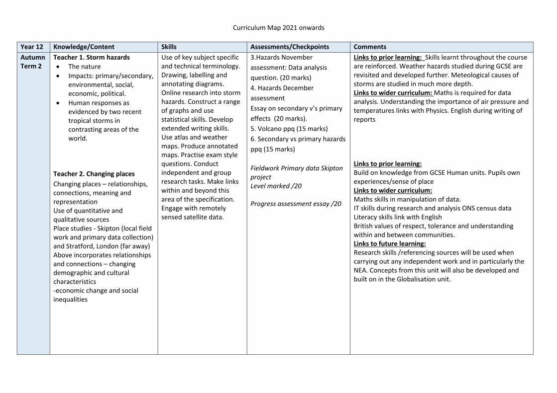
Teacher 1. Storm hazards
• The nature
• Impacts: primary/secondary, environmental, social, economic, political.
• Human responses as evidenced by two recent tropical storms in contrasting areas of the world.
Teacher 2. Changing places
Changing places – relationships, connections, meaning and representation Use of quantitative and qualitative sources Place studies - Skipton (local field work and primary data collection) and Stratford, London (far away) Above incorporates relationships and connections – changing demographic and cultural characteristics -economic change and social inequalities
Use of key subject specific and technical terminology. Drawing, labelling and annotating diagrams. Online research into storm hazards. Construct a range of graphs and use statistical skills. Develop extended writing skills. Use atlas and weather maps. Produce annotated maps. Practise exam style questions. Conduct independent and group research tasks. Make links within and beyond this area of the specification. Engage with remotely sensed satellite data.
3.Hazards November
assessment: Data analysis
question. (20 marks)
4. Hazards December
assessment
Essay on secondary v’s primary
effects (20 marks).
5. Volcano ppq (15 marks)
6. Secondary vs primary hazards
ppq (15 marks)
Fieldwork Primary data Skipton project Level marked /20 Progress assessment essay /20
Links to prior learning: Skills learnt throughout the course are reinforced. Weather hazards studied during GCSE are revisited and developed further. Meteological causes of storms are studied in much more depth. Links to wider curriculum: Maths is required for data analysis. Understanding the importance of air pressure and temperatures links with Physics. English during writing of reports Links to prior learning: Build on knowledge from GCSE Human units. Pupils own experiences/sense of place Links to wider curriculum: Maths skills in manipulation of data. IT skills during research and analysis ONS census data Literacy skills link with English British values of respect, tolerance and understanding within and between communities. Links to future learning: Research skills /referencing sources will be used when carrying out any independent work and in particularly the NEA. Concepts from this unit will also be developed and built on in the Globalisation unit.

Curriculum Map 2021 onwards
Year 12 Knowledge/Content Skills Assessments/Checkpoints Comments
Spring Term 1
Teacher 1. Fires in nature
• Nature of wildfires.
• Impacts: responses;
• risk management Impact and human responses as evidenced by a recent wildfire event. Case study 1: Haiti or Philippines Case study of a multi-hazardous environment beyond the UK Case study 2: Flooding in the Somerset Levels Case study at a local scale of a specified place in a hazardous setting Teacher 2. Changing places: The impact of relationships and connections on people and place with a particular focus on: Either changing demographic and cultural characteristics or economic change and social inequalities (Both topics covered to enable choice)
Use of key subject specific and technical terminology. Drawing, labelling and annotating diagrams. Online research into fire hazards. Construct a range of graphs and use statistical skills. Develop extended writing skills. Use atlas maps. Produce annotated maps. Practise exam style questions. Conduct independent and group research tasks. Make links within and beyond this area of the specification. Engage with remotely sensed satellite data. Collect, analyse and interpret a range of qualitative and quantitative data from a range of secondary sources. Report writing.
Case study of multi hazard environment assessed using exam levels /20 Rebranding presentation – level assessed End of unit Changing places assessment
Links to prior learning: Skills learnt throughout the course are reinforced. Weather hazards studied during GCSE are revisited and developed further. Meteological causes of fires are studied in much more depth. Links to wider curriculum: Report writing links with English Research on the internet with IT Links to future learning: Use of remotely sensed images used in the carbon unit. Research skills are developed for use during the NEA Links to prior learning: Build on knowledge from GCSE Human units. Pupils own experiences/sense of place Links to wider curriculum: Maths skills in manipulation of data. IT skills during research and analysis ONS census data Literacy/presentation skills linked with English British values of respect, tolerance and understanding within and between communities. Building confidence and communication – presentation skills Links to future learning: Research skills /referencing sources will be used when carrying out any independent work and in particularly the NEA. Concepts from this unit will also be developed and built on in the Globalisation unit.

Curriculum Map 2021 onwards
Year 12 Knowledge/Content Skills Assessments/Checkpoints Comments
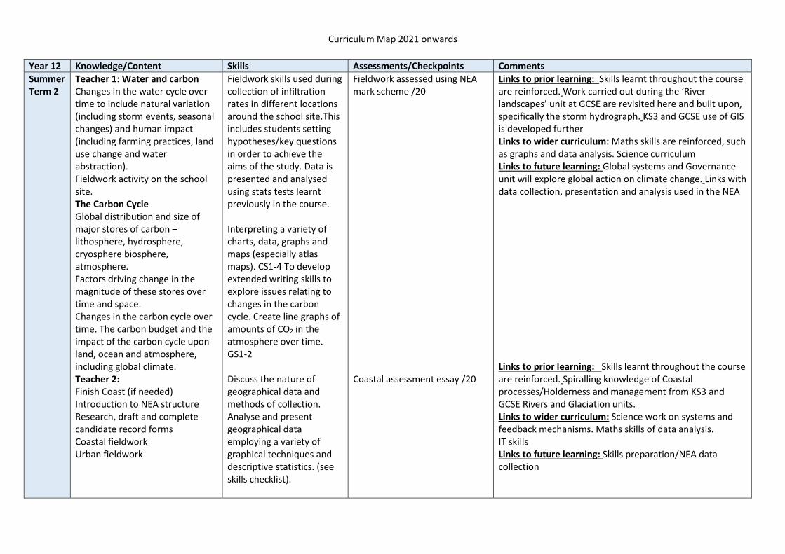
Spring Term 2
Teacher 1: Water and carbon Systems in physical geography: Systems concepts and their applications to the water and carbon cycles inputs-outputs, energy, stores/components, flows/transfers, positive/negative feedback, dynamic equilibrium. Global distribution and size of major stores of water – lithosphere, hydrosphere, cryosphere and atmosphere. Teacher 2: Coastal systems and landscapes Natural systems, sources of energy, sediment sources/cells & budgets. Geomorphological processes – weathering and mass movement. Coastal processes – marine & subaerial Coastal landscape development – focus on Holderness/ Isle of Purbeck/Morecambe Bay Landforms of erosion & deposition
Use of key subject specific and technical terminology. To identify connections and interrelationships between different aspects of geography. Constructing and using systems and models. Labelling and annotation of diagrams.
1. Exercise on vegetation and loss (20 marks) 2. Drainage basin hydrology ppq (15 marks) 3. Rainfall and runoff exercise (25 marks) Research presentation – Tides/oceans Level assessed Coastal progress assessment
Links to prior learning: Skills learnt throughout the course are reinforced. Year 7 and the GCSE unit on river catchments are revisited. Links to wider curriculum: Science work on systems and feedback mechanisms Maths skills of data analysis Links to future learning: Fieldwork investigation on a local school site will be used during NEA data collection Links to prior learning: Skills learnt throughout the course are reinforced. Spiralling knowledge of Coastal processes from KS3 and GCSE Rivers and Glaciation units. Links to wider curriculum: Science work on systems and feedback mechanisms Maths skills of data analysis Links to future learning: Coastal fieldwork - Walney Island, to investigate coastal processes and sand dunes. Skills preparation/NEA data collection

Curriculum Map 2021 onwards
Year 12 Knowledge/Content Skills Assessments/Checkpoints Comments
Summer Term 1
Teacher 1: Water and carbon Processes driving change in the magnitude of these stores over time and space. Drainage basins as open systems The water balance Runoff variation and the flood hydrograph. Case Study 2 Case study of a river catchment(s) at a local scale to illustrate and analyze the key themes above, engage with field data and consider the impact of precipitation upon drainage basin stores and transfers and implications for sustainable water supply and/or flooding. Teacher 2: Coastal systems and landscapes Estuarine development Sea level change/landforms Coastal flood and erosion Coastal management Holderness & Sunderbans SMP/ICZM
Use of key subject specific and technical terminology. Opportunities to develop skills such as drawing, labelling and annotating diagrams. Online research. Construct and interpret water balance graph and hydrographs. Measurement of dispersion SS2 Research skills Referencing of sources Presentation skills, both written and verbal.
4 River Wye /Cam stats exercise (20 marks) Report on a river catchment of their choice, assessed using AQA exam levels /20 End of year 12 exam Coastal progress essay
Links to prior learning: Skills learnt throughout the course are reinforced. Work carried out during the ‘River landscapes’ unit at GCSE are revisited here and built upon, specifically the storm hydrograph. Links to wider curriculum: Maths skills are reinforced, such as graphs and data analysis. Links to future learning: Systems work carried out in this section will be revisited during the carbon cycle unit. Referencing and research skills for the NEA Links to prior learning: Skills learnt throughout the course are reinforced. Spiralling knowledge of Coastal processes from KS3 and GCSE Rivers and Glaciation units. Links to wider curriculum: Science work on systems and feedback mechanisms Maths skills of data analysis Links to future learning: Coastal fieldwork - Walney Island, to investigate coastal processes and sand dunes. Skills preparation/NEA data collection
Curriculum Map 2021 onwards
Year 12 Knowledge/Content Skills Assessments/Checkpoints Comments
Summer Term 2
Teacher 1: Water and carbon Changes in the water cycle over time to include natural variation (including storm events, seasonal changes) and human impact (including farming practices, land use change and water abstraction). Fieldwork activity on the school site. The Carbon Cycle Global distribution and size of major stores of carbon – lithosphere, hydrosphere, cryosphere biosphere, atmosphere. Factors driving change in the magnitude of these stores over time and space. Changes in the carbon cycle over time. The carbon budget and the impact of the carbon cycle upon land, ocean and atmosphere, including global climate. Teacher 2: Finish Coast (if needed) Introduction to NEA structure Research, draft and complete candidate record forms Coastal fieldwork Urban fieldwork
Fieldwork skills used during collection of infiltration rates in different locations around the school site.This includes students setting hypotheses/key questions in order to achieve the aims of the study. Data is presented and analysed using stats tests learnt previously in the course. Interpreting a variety of charts, data, graphs and maps (especially atlas maps). CS1-4 To develop extended writing skills to explore issues relating to changes in the carbon cycle. Create line graphs of amounts of CO2 in the atmosphere over time. GS1-2 Discuss the nature of geographical data and methods of collection. Analyse and present geographical data employing a variety of graphical techniques and descriptive statistics. (see skills checklist).
Fieldwork assessed using NEA mark scheme /20 Coastal assessment essay /20
Links to prior learning: Skills learnt throughout the course are reinforced. Work carried out during the ‘River landscapes’ unit at GCSE are revisited here and built upon, specifically the storm hydrograph. KS3 and GCSE use of GIS is developed further Links to wider curriculum: Maths skills are reinforced, such as graphs and data analysis. Science curriculum Links to future learning: Global systems and Governance unit will explore global action on climate change. Links with data collection, presentation and analysis used in the NEA Links to prior learning: Skills learnt throughout the course are reinforced. Spiralling knowledge of Coastal processes/Holderness and management from KS3 and GCSE Rivers and Glaciation units. Links to wider curriculum: Science work on systems and feedback mechanisms. Maths skills of data analysis. IT skills Links to future learning: Skills preparation/NEA data collection

Curriculum Map 2021 onwards
Subject: Geography (See comments below* for current year 13 cohort)
Year 13 Knowledge/Content Skills Assessments/Checkpoints Comments *
Autumn Term 1
Teacher 2: (Year 13 Sept 2022) Write up of NEA Intro, Method, Data presentation & analysis Conclusion & evaluation Teacher 1: To finish: Water, Carbon, Climate and Life on Earth
• The key role of the carbon and water stores and cycles in supporting life on Earth and particular reference to climate.
• Human interventions in the carbon cycle designed to influence carbon transfers and mitigate the impacts of climate change.
Case Study 1 Case study of a tropical rainforest: Amazon. Teacher 1: Global systems and global governance Dimensions of globalisation Flows of globalisation
A level syllabus: Skills dependent on chosen NEA topic. Comparative graphing techniques. GS1-4 Extended writing to levels descriptors. CS3.Collect, analyze and interpret information from a range of secondary sources – including factual, numerical and spatial data. Critical questioning of information, and sources of information. Evaluating and presenting findings from research.CS3 Cartographic skills – annotating base map or production of flow map. CA 1. CA 4 Critical questioning of information, and sources of information. QL1 QL2 Core skills. CS1-4.Use of key subject specific and technical terminology. Cartographic skills – annotating base map or production of flow map. CS1 Critical questioning of information, and sources of information. Core and ICT skills. CS1-4 IT. Online research.
Past paper questions on year 12 units. Mentoring/self-assessment on NEA. YEAR 13 – 2021: Half term assessment plan to support UCAS: Week 1 – None set Week 2 – 4 & 6 mark questions Coast Week 3 – 9 mark question Hazards Week 4 – 20 mark Coast essay Week 5 – 20 mark Hazard essay Week 6 – 20 mark Population essay Week 7 – 20 mark Water & Carbon essay End of unit assessment of water and carbon cycles. 20-mark essay on the Amazon Data question of global flows /6 Data question on Russia and USA/6
PLEASE NOTE DUE TO COVID THE UNITS FOR THE YEAR 13 COHORT HAVE BEEN RE-ARRANGED AND THE FOLLOWING UNITS WILL BE TAUGHT IN THIS ORDER: Autumn term: Teacher 1 – Finish Water & Carbon and complete Global systems & Global governance Teacher 2 - Finish Population and complete Changing Places unit Spring term: Mock exam and NEA Summer term: Revision of all units. Links to prior learning: Research skills learnt throughout the course are reinforced. Work carried out during the ‘River landscapes’ unit at GCSE are revisited here and built upon, specifically the storm hydrograph. Links to wider curriculum: Maths skills are reinforced, such as graphs and data analysis. Science curriculum Links to future learning: Research skills, specifically referencing, developed for the NEA

Curriculum Map 2021 onwards
Year 13 Knowledge/Content Skills Assessments/Checkpoints Comments
Autumn Term 2
Teacher 1: Continue Global systems and global governance: Global systems Global Governance International trade Consequences of globalisation Teacher 2: Start Population and Environment unit Environmental context for human population characteristics and change: Key elements in the physical environment Key population parameters Environment and population Global and regional patterns of food production and consumption Characteristics and distribution of two major climatic types to exemplify relationships between climate and human activities and numbers Characteristics and distribution of two key zonal soils to exemplify relationship between soils and human activities especially agriculture.
Critical questioning of information and sources of information. Core and ICT skills Online research QL1-4 Presentation skills CS1 Core skills – literacy CS3 Cartographic skills – maps showing movement CA4 CA5. Lorenz curve line graph and GINI index. Spearman’s Rank statistical technique and application of significance test. SS3
Select a range of PPQ’s 4, 6 & 20 mark essays Select a range of PPQ’s 4, 6 & 20 mark essays
Links to prior learning: Build on skills and synoptic links developed from the Changing Places unit. Links to wider curriculum: Maths skills are reinforced, such as graphs and data analysis. Stats skills link with Maths. Links to future learning: Research skills, specifically referencing, developed from the NEA - University courses/Extended projects Links to prior learning: Build on skills and synoptic links developed from the Changing Places and Water & Carbon unit Links to wider curriculum: Maths skills are reinforced, such as graphs and data analysis. Stats skills link with Maths. Ideas to generate debate on population issues, link to RS, Philosophy & Ethics, Politics/Economics/Sciences - students other A level subjects/PSHE Links to future learning: To be able to apply the skills learnt to a range of university/apprenticeship courses.

Curriculum Map 2021 onwards
Year 13 Knowledge/Content Skills Assessments/Checkpoints Comments
Spring Term 1
Teacher 1&2: Mock preparation Teacher 1: Finish Global systems and Governance: Case study of Antarctica as a global common Critique of globalisation Teacher 2: Continue Population unit: Environment, health and well being. The global prevalence and distribution of one specified non-communicable disease (CHD) and a biologically transmitted disease (Malaria).Management and mitigation strategies. Start: Population change Factors in natural population change. International migration
Critical questioning of information and sources of information. Core and ICT skills Online research QL1-4 Presentation skills CS1 Core skills – literacy CS3 Cartographic skills – maps showing movement CA4 CA5
Year 13 mock examination Essay question on the use of Antarctica /20 Focus on essay skills – evaluation and conclusion. 20 mark essays. Select a range of PPQ’s 4, 6 & 20 mark essays
Links to prior learning (teacher 1 and 2): Build on skills and synoptic links developed from the Changing Places, Water and Carbon unit. Links to wider curriculum (teacher 1 and 2): Maths skills are reinforced, such as graphs and data analysis. Stats skills link with Maths. Teacher 2: Ideas to generate debate on population issues, link to RS, Philosophy & Ethics, Politics/Economics/Sciences - students other A level subjects/PSHE Links to future learning: (teacher 1) Research skills, specifically referencing, developed from the NEA - University courses/Extended projects (teacher 2) To be able to apply the skills learnt to a range of university/apprenticeship courses.
Spring Term 2
Teacher 1: Start revision of all units Teacher 2: Finish Population unit Principles of population ecology and their application to human populations. Global population futures. Case study 1: a country experiencing specific patterns of overall population change: Japan Case study 2: a specified local area to illustrate and analyse the relationship between place and health – Leeds/Skipton
A level syllabus: Specific skills: CA1-5 GS1-4&6 SS1-3 IT1-4 QL2-4 QN1-2
Focus on essay skills – evaluation and conclusion. 20 mark essays. Select a range of PPQ’s 4, 6 & 20 mark essays End of unit essay – Population /20 marks
Links to prior learning: Build on skills and synoptic links developed from the Changing Places unit and students' knowledge from Biology/Ecology/Global systems and governance Links to wider curriculum: Debating skills, impact of COVID 19 on communities. PSHE/Philosophy & Ethics. Knowledge of census data Links to future learning: Debating and communication skills. Ability to formulate an argument /opinion.
Summer Term 1
Teacher 1 & 2: Revision of all units External exams
Recap key skills for each unit
Select a range of PPQ’s 4, 6 & 20 mark essays
Summer Term 2
End of course