Cultural Heritage emergency: GIS based tools for assessing and deciding preservation and management
10
Cultural Heritage emergency: GIS- based tools for assessing and deciding preservation and management Paolo Salonia, Antonella Negri Abstract The analysis and understanding of processes of decay, in the case of historical buildings and monumental architecture, call for an interpretative overview encompassing data which stem from different areas of study but are globally interrelated and constitute essential elements for the purpose of assessing the state of preservation. ARKIS - Architecture Recovery Knowledge Information System - is an Information System configured in AVENUE programming language (by ESRI), set up as an auxiliary tool for the organisation, representation and utilisation of knowledge of data in the recovery of historical buildings. Based on GIS technology transposed to an architectonic scale, it regards the architectural item, its immediate context and its territorial location. ARKIS is user friendly and represents an operative tool for different Organisation, for example monuments offices or agencies. To this end, mainly important is to create transfer environments and use of knowledge, through a set up of multi-medial data base in remote access, for disseminating heterogeneous information into Internet (alpha-numerical data, geometrical data, images) which are based upon the needs of potential users (researchers, designers, architects, restorers, decision makers). ARKIS-NET, here presented, is based on the ArcIMS software package and provides the foundation for disseminating high-end heterogeneous data, organised and represented in GIS form, and mapping services via Internet. Clients may display, query, and analysis information in an easy-to-use Web browser, and also integrate local data sources with Internet data sources. Some case history will be presented. Introduction As part of architectonic restoration it is necessary to define the different knowledge paths and relative data bases, identify the reciprocal interactions in order to promote a complex interpretative action on the state of conservation of the historic building object. This is done by using different data acquisition and recording procedures consistent with their nature and referring to the geometric, structural and material configuration, to the study of the historical and architectonic features, as well as to the understanding of the formative processes and the analysis of the pathologies of degradation as a function of the typologies of the constituent materials. Likewise, as regards the successive phases of the definition of the intervention and its execution, it is necessary to guarantee a rigorous approach to the knowledge and the management of the data. A fundamental role is played by the dissemination and utilizability of information. The introduction of Information and Communication Technology (ICT) also in the sector of Cultural Heritage has led, in recent years, to a still limited and self-conscious
-
Upload
beniculturali -
Category
Documents
-
view
6 -
download
0
Transcript of Cultural Heritage emergency: GIS based tools for assessing and deciding preservation and management
Cultural Heritage emergency: GIS- based tools for assessing anddeciding preservation and management
Paolo Salonia, Antonella Negri
Abstract
The analysis and understanding of processes of decay, in the case of historical buildingsand monumental architecture, call for an interpretative overview encompassing datawhich stem from different areas of study but are globally interrelated and constituteessential elements for the purpose of assessing the state of preservation.ARKIS - Architecture Recovery Knowledge Information System - is an InformationSystem configured in AVENUE programming language (by ESRI), set up as anauxiliary tool for the organisation, representation and utilisation of knowledge of data inthe recovery of historical buildings.Based on GIS technology transposed to an architectonic scale, it regards thearchitectural item, its immediate context and its territorial location.ARKIS is user friendly and represents an operative tool for different Organisation, forexample monuments offices or agencies.To this end, mainly important is to create transfer environments and use of knowledge,through a set up of multi-medial data base in remote access, for disseminatingheterogeneous information into Internet (alpha-numerical data, geometrical data,images) which are based upon the needs of potential users (researchers, designers,architects, restorers, decision makers).ARKIS-NET, here presented, is based on the ArcIMS software package and providesthe foundation for disseminating high-end heterogeneous data, organised andrepresented in GIS form, and mapping services via Internet. Clients may display, query,and analysis information in an easy-to-use Web browser, and also integrate local datasources with Internet data sources.Some case history will be presented.
Introduction
As part of architectonic restoration it is necessary to define the different knowledgepaths and relative data bases, identify the reciprocal interactions in order to promote acomplex interpretative action on the state of conservation of the historic building object.This is done by using different data acquisition and recording procedures consistentwith their nature and referring to the geometric, structural and material configuration, tothe study of the historical and architectonic features, as well as to the understanding ofthe formative processes and the analysis of the pathologies of degradation as a functionof the typologies of the constituent materials. Likewise, as regards the successive phasesof the definition of the intervention and its execution, it is necessary to guarantee arigorous approach to the knowledge and the management of the data.A fundamental role is played by the dissemination and utilizability of information.The introduction of Information and Communication Technology (ICT) also in thesector of Cultural Heritage has led, in recent years, to a still limited and self-conscious
transformation of the methods of approach to specific issues in the field of both dataacquisition and in that of the subsequent data processing and management [1].In other words, there is still no consistent cultural growth in this direction, particularlyin those public and private bodies that play a major role in the process of safeguardingand enhancing these assets.Conversely a number of investigative and experimental initiatives carried on, in theresearch field are evidence of a fruitful activity aimed at providing the various stages ofthe process specific to conservation and protection, also at the operational level, withthe innovative tools that modern technology can now offer in a very wide range ofdisciplinary sectors.The work presented here in aims at studying the ways in which ICT can be used todisseminate the huge complex of information produced in the course of the process ofacquiring knowledge about the building heritage. The growth of the Internet has madeavailable huge quantities of data in all fields of human knowledge, encouraging thesharing of ideas, studies and information, and at the same time making it possible alsofor non experts to approach and discover fields of learning that would otherwise be verydifficult to access.
ARKIS environment
Over the past few years, the research undertaken has been focused on configuring asystem capable of merging complex and heterogeneous data produced by using differentacquisition methods specific to each particular phase of the fact-finding approach to thebuilding within a custom-designed ICT environment [2].The product carried out consists of a software package called ARKIS (ArchitectureRecovery Knowledge Information System) developed in AVENUE, the ESRIprogramming language, and based on the ArcView engine. Its innovative aspect residesin the transfer of functions specific to the Geographical Information System - GIS - [3][4] to the architectonic scale of individual buildings, which is interpreted in thecanonical forms of its graphical representation (plan views, elevations and sections), asa geographic area included inside a map.ARKIS represents a modular tool consisting of several sub-systems each of whichensures different levels of knowledge through different degrees of detail, aimed atguaranteeing the organization, representation and utilization of the knowledge itself.The basic structure underlying the entire methodological approach is represented by theextension of the georelational model applied to normal procedures typical of CAD andthe more commonly used relational data bases. Consequently each data base of CADobjects and graphical entities acquires the topological/vectorial features of the GIS.This option made it possible to interrelate the descriptive data with the graphic data,locating the information in a geometrically exact point (or area) using relational spatialpositioning functions for the geometric characterization of the information, whilerespecting the reciprocal topological relationships among the various parts of thebuilding.The functions developed on purpose in Avenue language, allow to realize consultationand analysis paths in simple and interactive way, not always possible with the basictools of the Arcview environment. All the alphanumeric information are in a relationalexternal database, projected in a punctual way and connected to ARKIS through anODBC channel (Object Date Base Connectivity). Criterions of integrity reference
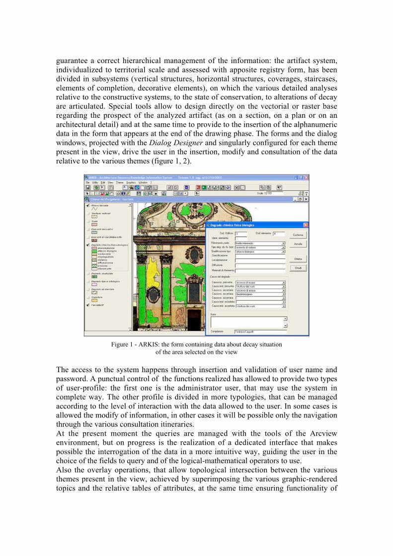
guarantee a correct hierarchical management of the information: the artifact system,individualized to territorial scale and assessed with apposite registry form, has beendivided in subsystems (vertical structures, horizontal structures, coverages, staircases,elements of completion, decorative elements), on which the various detailed analysesrelative to the constructive systems, to the state of conservation, to alterations of decayare articulated. Special tools allow to design directly on the vectorial or raster baseregarding the prospect of the analyzed artifact (as on a section, on a plan or on anarchitectural detail) and at the same time to provide to the insertion of the alphanumericdata in the form that appears at the end of the drawing phase. The forms and the dialogwindows, projected with the Dialog Designer and singularly configured for each themepresent in the view, drive the user in the insertion, modify and consultation of the datarelative to the various themes (figure 1, 2).
Figure 1 - ARKIS: the form containing data about decay situationof the area selected on the view
The access to the system happens through insertion and validation of user name andpassword. A punctual control of the functions realized has allowed to provide two typesof user-profile: the first one is the administrator user, that may use the system incomplete way. The other profile is divided in more typologies, that can be managedaccording to the level of interaction with the data allowed to the user. In some cases isallowed the modify of information, in other cases it will be possible only the navigationthrough the various consultation itineraries.At the present moment the queries are managed with the tools of the Arcviewenvironment, but on progress is the realization of a dedicated interface that makespossible the interrogation of the data in a more intuitive way, guiding the user in thechoice of the fields to query and of the logical-mathematical operators to use.Also the overlay operations, that allow topological intersection between the variousthemes present in the view, achieved by superimposing the various graphic-renderedtopics and the relative tables of attributes, at the same time ensuring functionality of

analysis among the different coverages (information layers) by combining togetherelements having different common attributes, will be managed in an apposite dialogwindow where is possible to use default overlay (material-degrade, material-state ofconservation, etc…), or to configure personalized overlay based on analyses that theuser wants to realize.
Figure 2 - ARKIS: a consultation data phase on decay situation
To mention only the more significant features [5],[6], the functions may be summed upas follows:- to guarantee on-screen outlining of areas with which to associate specific themes;
these are naturally linked to the records inside which the descriptive informationreferring to the themes are organized;
- to automatically open the records in which alphanumeric data referring to theacquired entity are to be input, guiding the user by means of drop down menus ofpre-established items;
- to automatically code each new entity, ensuring links between the various scales andthe automatic updating of the RDBMS;
- to activate one or more themes, with consequent overlay operations;- to open as many attribute/data tables as there are active themes and defined overlays
(this allows the description information referring to each single theme to be mergedand cross-referenced in a single display);
- to perform query operations and interactive queries with highlighting of thegeometric element in the graphic representation;
- to calculate areas, perimeters and percentages in zones affected by the variouspathologies discovered (figure 3);
- to call up the photographic image of the detail investigated and/or the rendering ofgeometric surveys with the relative lists of coordinate points;
- any other interactive analysis operation.

Figure 3 - ARKIS: a consultation data phase on a selected ashlar: information aboutmaterials are in the dialog window; in the small box are calculated area and perimeter.
For the purpose of testing the System developed, experiments were conducted usingseveral study cases considered to be sufficiently representative of the object analysedand to be essential examples for validating the theoretical and methodological approach.The System is user friendly and can be used as a support and guiding operating tool byvarious different bodies, in particular the Superintendencies. However, it is not enoughjust to be an operating tool, considering the huge potential possessed by the System.In this connection it may be said that ARKIS, insofar as it forms the central enginedriving a project for knowledge management and for this very reason resident on thedesktop of the individual user, must necessarily be addressed to a specific 'nomadic' use(to continue with the metaphor): in other words, it must be able to initiate a process ofknowledge navigation.This entails seeking the added value contained both in the transfer of informationorganized by the individual user and in its distribution insofar as it is accessible inremote mode, thereby triggering a multiplying effect regarding the intrinsic meaning ofthe single information items. It can thus be shared by several users in a network inwhich planning, comparison, discussion and knowledge are guaranteed.It was on these conceptual assumptions in the framework of an innovative view ofconservation in which the possibility of accessing relevant information plays afundamental role that the ARKIS - NET Project was based.
ARKIS – NET: methodological and technological aspects
A segment of the research is now focused on the ARKIS–NET Project, an evolution ofARKIS. It provides the foundation for disseminating high-end heterogeneous data,organised and represented in GIS form, and mapping services via Internet. This project

enables users to integrate local data sources with Internet data sources for display, query,and analysis in an easy-to-use Web browser.ARKIS-NET is based on the ArcIMS software package, the latest ESRI product aimedat the exploitation and distribution of GIS environments. It consists of a new generationof Internet Map Server (IMS), with functions orientated above all towards an openscalable architecture [7].There is a Client module and a Server module: the Client typically requests informationfrom the Server, which processes the query and then sends the information back to theClient. The Server technology used by this application is part of a multitaskingarchitecture, that is, the management of the flow of queries received from the variousClients and organized according to different, simultaneously active, services(MapServer) monitored in such a way as to route the queries to the appropriate SpatialServer (Image server, Feature server, Query server and/or Extract server).The Spatial Server interacts with the WEB Server through the Application Server and itsConnectors and sends the response to its Clients.Several queries may simultaneously be handled by the same Spatial Server, or elsemultiple queries of each Spatial Server or again one or more Spatial Servers and querieshandled simultaneously on more than one machine. This means that clients that are notonly powerful but also “intelligent”: the response will be elaborated by the appropriateServer (designed to handle this type of request) and sent back to the Client in real time.A MapService is a process that runs on the Spatial Server. It provides instructions to aSpatial Server on how to draw a map when a request is received. The input to aMapService is an ArcXML MapService Configuration File. There are two types ofMapServices: Image and Feature. An Image MapService uses the image renderingcapabilities of the Spatial Server. When a request is received, a map is generated on theserver, and the response is returned as a JPEG, PNG or GIF image. A new map isgenerated each time a clients requests more information.A Feature MapService uses the Spatial Server’s feature streaming capabilities to bundledata and sent the request to the client. Because more processing is performed in the JavaApplet, requests are sent only when additional data is needed.One of the most interesting functions of the Feature MapService is extracting or clippingdata to create a subset that can be sent back in shapefile format.The Client may have an HTML Viewer or a Java Viewer: the fundamental difference liesessentially in the fact that HTML technology is very slim, does not require thedownloading of addition plug-ins to display the data queries (Java Applet) and does notrequire computers with powerful CPUs; however, it only allows display and queryingoperations. A Java Viewer, although requiring a comparatively powerful machine forprocessing and additional plug-ins, nevertheless ensures a high degree of interactionwith and analysis of the maps.The communication between clients and servers uses ArcXML. All the ARKIS-NETweb pages have been customized with ArcXML, a GIS extension of standard eXtensibleMarkup Language (XML).The ArcXML files look similar to HTML pages. The difference is that HTML describesthe page structure for display while ArcXML provides the structure for describing thecontent.The access to the ARKIS-NET project happens through the pages of the underconstruction site www.arkis.it (figure 4): there is a special section where you can enterthe online consultation.
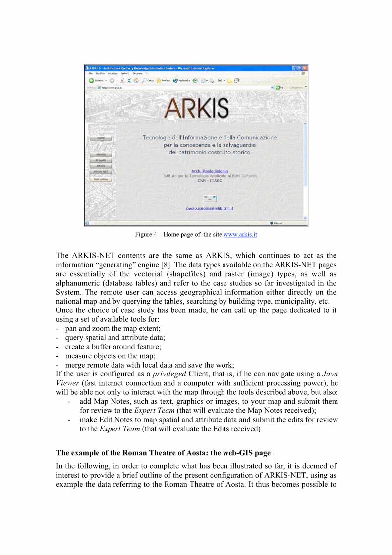
Figure 4 – Home page of the site www.arkis.it
The ARKIS-NET contents are the same as ARKIS, which continues to act as theinformation “generating” engine [8]. The data types available on the ARKIS-NET pagesare essentially of the vectorial (shapefiles) and raster (image) types, as well asalphanumeric (database tables) and refer to the case studies so far investigated in theSystem. The remote user can access geographical information either directly on thenational map and by querying the tables, searching by building type, municipality, etc.Once the choice of case study has been made, he can call up the page dedicated to itusing a set of available tools for:- pan and zoom the map extent;- query spatial and attribute data;- create a buffer around feature;- measure objects on the map;- merge remote data with local data and save the work;If the user is configured as a privileged Client, that is, if he can navigate using a JavaViewer (fast internet connection and a computer with sufficient processing power), hewill be able not only to interact with the map through the tools described above, but also:
- add Map Notes, such as text, graphics or images, to your map and submit themfor review to the Expert Team (that will evaluate the Map Notes received);
- make Edit Notes to map spatial and attribute data and submit the edits for reviewto the Expert Team (that will evaluate the Edits received).
The example of the Roman Theatre of Aosta: the web-GIS page
In the following, in order to complete what has been illustrated so far, it is deemed ofinterest to provide a brief outline of the present configuration of ARKIS-NET, using asexample the data referring to the Roman Theatre of Aosta. It thus becomes possible to

examine also the interface used by the client user, making the previously illustratedconcepts even more explicit.The page providing access to the consultation of the data referring to the south facade ofthe Roman Theatre of Aosta (figure 5), configured with a clientside Java, displays in thecentre the frame containing the view with the representation of the geometric model ofthe facade and the various layers containing the polygons relative to the informationlayers related to materials and degradation of the individual ashlars. In the top right ofthe frame there is the navigator (in this specific case, the representation of the entiresouth facade) that is updated dynamically according to the zoom of the central frame.Below the navigator the Table of Contents (TOC) is illustrated, with a legend for eachtopic (layers of graphic objects belonging to the same class: polygons, lines, points)present in the view. On the left side of the frame there are a series of navigation, queryand data analysis tools.
Figure 5 - ARKIS-NET: the access to the consultation of the data.Roman Theatre in Aosta, south facade
Multiple actions may be performed inside the page, from the various types of zoom andpan to reach the area of interest, to the activation of one or more themes in the TOC, thequerying and extraction of information concerning the table of attributes of the topics, afeature that is fundamental in a GIS environment, which contains the alphanumericinformation related to the graphic objects present in the theme (features).
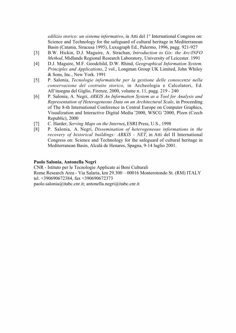
Figure 6 – ARKIS-NET: the Query Builder tool
In figure 6 it is shown how to use the Query Builder tool to seek graphic objects(Features) corresponding to certain selection criteria, inside the active theme. In thewindow a search string is constructed that is based on the fields in the table of attributesof the Physico-chemical degradation theme (active theme), requesting all the ashlarsdisplaying an Increase in material. By clicking on the Execute button in the window alist appears of the ashlars corresponding to the query criteria. It is also possible to saveone's search in a text file by clicking on the Save button in the Query Builder window.The polygons of the ashlars extracted are shown in the view.
Conclusions
In conclusion, ARKIS is user friendly. It represents an operative tool for differentorganisation, for example monuments offices or agencies. To this end, possibledevelopment could be to specialise some of the modules for the management ofutilisation of the topologic requirement on raster data and to extend the system in 3D.ARKIS-NET can be a valid tool for network information sharing, but not only for thispurpose. The system must become a vehicle for the dissemination of a culture of theapproach to the topic of the knowledge of historical and architectonic artefacts: theremust of course be a data flow from the Server towards the Clients, but also and aboveall, from the Clients towards the Server; the latter will elaborate and expand knowledge,disseminating it and thus acting as one of the exchange nodes.
References
[1] L. Moltedo, R. Picco, P. Salonia, La presenza delle Tecnologie dell'Informazionenella ricerca sui Beni Culturali: risultati di una indagine, Archeologia &Calcolatori, Vol. 11, Firenze, 2000
[2] P. Salonia, A. Negri, Strumenti e metodologie per la conoscenza del patrimonio
edilizio storico: un sistema informativo, in Atti del 1° International Congress on:Science and Technology for the safeguard of cultural heritage in MediterraneanBasin (Catania, Siracusa 1995), Luxugraph Ed., Palermo, 1996, pagg. 921-927
[3] B.W. Hickin, D.J. Maguire, A. Strachan, Introduction to Gis: the Arc/INFOMethod, Midlands Regional Research Laboratory, University of Leicester. 1991
[4] D.J. Maguire, M.F. Goodchild, D.W. Rhind, Geographical Information System.Principles and Applications, 2 vol., Longman Group UK Limited, John Whiley& Sons, Inc., New York. 1991
[5] P. Salonia, Tecnologie informatiche per la gestione delle conoscenze nellaconservazione del costruito storico, in Archeologia e Calcolatori, Ed.All’insegna del Giglio, Firenze, 2000, volume n. 11, pagg. 219 - 240
[6] P. Salonia, A. Negri, ARKIS An Information System as a Tool for Analysis andRepresentation of Heterogeneous Data on an Architectural Scale, in Proceedingof The 8-th International Conference in Central Europe on Computer Graphics,Visualization and Interactive Digital Media '2000, WSCG '2000, Plzen (CzechRepublic), 2000
[7] C. Harder, Serving Maps on the Internet, ESRI Press, U.S., 1998[8] P. Salonia, A. Negri, Dissemination of heterogeneous informations in the
recovery of historical buildings: ARKIS - NET, in Atti del II InternationalCongress on: Science and Technology for the safeguard of cultural heritage inMediterranean Basin, Alcalá de Henares, Spagna, 9-14 luglio 2001.
Paolo Salonia, Antonella NegriCNR - Istituto per le Tecnologie Applicate ai Beni CulturaliRome Research Area - Via Salaria, km 29.300 – 00016 Monterotondo St. (RM) ITALYtel. +390690672384, fax [email protected]; [email protected]