

CRA Distribution Inquiry Report: Combined Modules - Charles ...
Upload
khangminh22Category
view
0download
0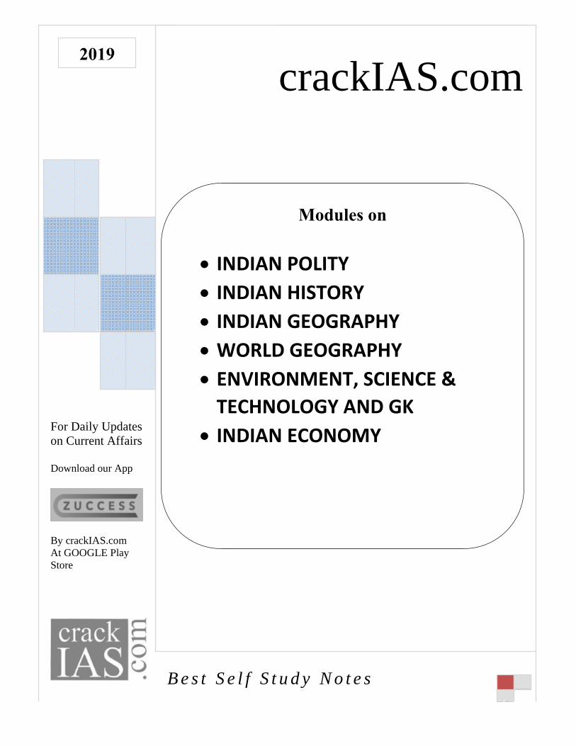
For Don Cu Down
By craAt GOStore
2019
Daily Updaurrent Affa
nload our Ap
ackIAS.comOOGLE Play
ates airs
pp
m y
BB e s t S
IN IN IN W ET
IN
e l f S t
NDIAN
NDIAN
NDIAN
WORLD
NVIRO
ECHNO
NDIAN
cra
u d y N
Mod
N POLIT
N HISTO
N GEOG
D GEOG
ONME
OLOGY
N ECON
ackI
N o t e s
dules on
TY
ORY
GRAPH
GRAPH
NT, SC
Y AND
NOMY
IAS
n
HY
HY
CIENCE
D GK
Y
S.co
E &
om

crack
IAS.com
Samples from
INDIAN POLITY
crack
IAS.com
crackIAS.com 76
THE PARLIAMENT
Overview
Every game has some rules, and these rules are set by the setters of the
game. Similarly, every society is run by some laws; and these laws are
set by Parliament in India. Parliament in India is the highest law making
institution in the country.
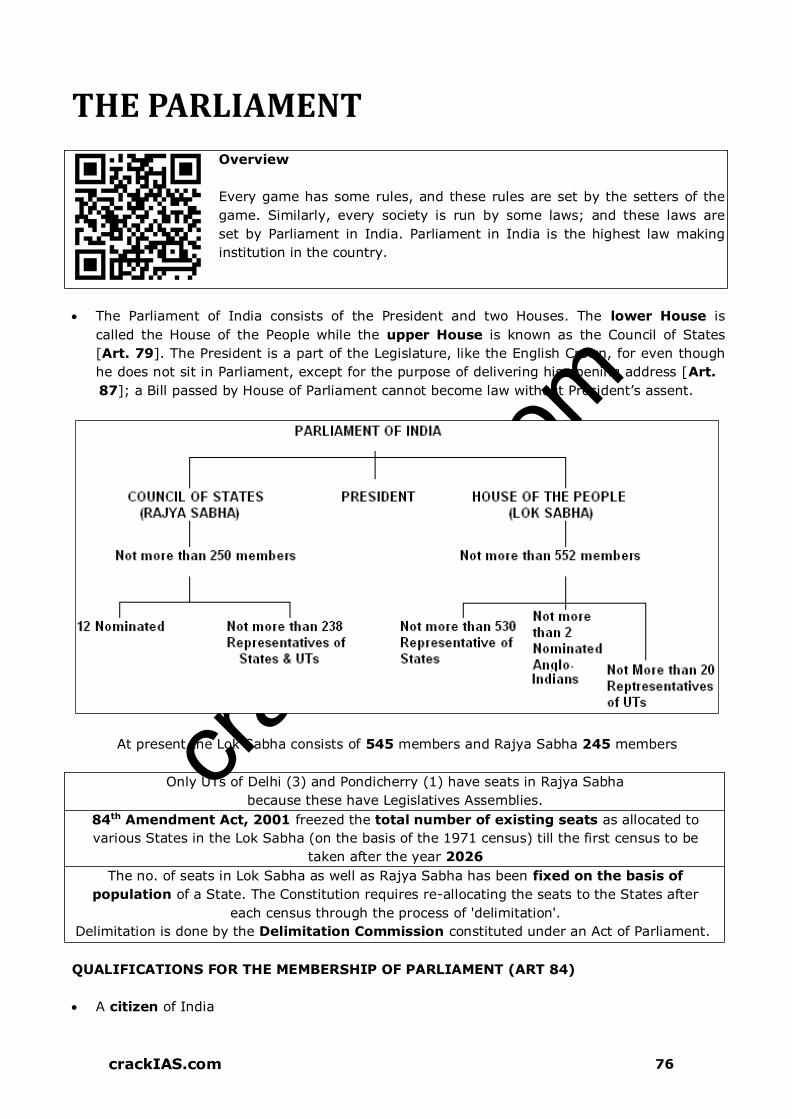
The Parliament of India consists of the President and two Houses. The lower House is
called the House of the People while the upper House is known as the Council of States
[Art. 79]. The President is a part of the Legislature, like the English Crown, for even though
he does not sit in Parliament, except for the purpose of delivering his opening address [Art.
87]; a Bill passed by House of Parliament cannot become law without President’s assent.
At present the Lok Sabha consists of 545 members and Rajya Sabha 245 members
Only UTs of Delhi (3) and Pondicherry (1) have seats in Rajya Sabha
because these have Legislatives Assemblies.
84th Amendment Act, 2001 freezed the total number of existing seats as allocated to
various States in the Lok Sabha (on the basis of the 1971 census) till the first census to be
taken after the year 2026
The no. of seats in Lok Sabha as well as Rajya Sabha has been fixed on the basis of
population of a State. The Constitution requires re-allocating the seats to the States after
each census through the process of 'delimitation'.
Delimitation is done by the Delimitation Commission constituted under an Act of Parliament.
QUALIFICATIONS FOR THE MEMBERSHIP OF PARLIAMENT (ART 84)
A citizen of India

crack
IAS.com
crackIAS.com 77
Age above 30 years for Rajya Sabha and 25 years for Lok Sabha
Other qualifications as prescribed by the Parliament under law
Person’s name should be registered as a voter in any Parliamentary constituency
(Representation of People’s Act ,1951)
No educational qualification has been prescribed
DISQUALIFICATION FROM MEMBERSHIP OF PARLIAMENT
If holds Office-of-Profit under Government of India or the Government of a State (certain
offices has been exempted by the Office-of-Profit Act)
If he is of unsound mind (declared by a competent court)
If he is an un-discharged insolvent
Not a citizen of India and has voluntarily acquired citizenship of a foreign country or has
allegiance to a foreign power.
If he is so disqualified by or under any law made by Parliament (Art 102)
President obtains the opinion of Election Commission while deciding about the
disqualification of members (Art 103)
Representation of People’s Act also provides grounds for disqualifications.
A member can also be disqualified on the grounds of defection (52nd Amendment has
amended articles 101, 102, 190, 191 and added 10th Schedule which specifies
disqualifications on ground of defection.
CONDITIONS WHEN A MEMBER OF PARLIAMENT VACATES SEAT (ART 101)
If he has obtained membership of both Houses of Parliament, he needs to vacate one.
If elected to both Parliament & state Legislature, he needs to resign from state
Legislature
If he is disqualified under the provisions of Art 102 (anti-defection)
If he resigns
If he remains absent from all meetings of the House for a period of 60 days without the
permission of the House.
SESSIONS OF THE PARLIAMENT
President has power to summon either house and has power to dissolve the Lok Sabha.
President must summon each house at such intervals that 6 months shall not intervene
between its last sitting in one session and the first sitting of next session [Art 85(1)].
Therefore, it is necessary that the Parliament must meet at least twice a year.
The Parliament generally meets in three sessions in a year:-
o Budget Session (longest session) - February - May
o Monsoon Session - July - August
o Winter Session (shortest session) - November - December
Adjournments: During a session, there are a number of daily sittings separated by
adjournments. These postpone the further consideration of business for a specified time,
which may extend not only for hours or days but can be for weeks. Another type of
adjournment is when the House is adjourned by the Presiding Officer without fixing any date
of time of the next meeting. This is called Adjournment sine die, i.e. without fixing any
time/ day.
Dissolution ends life of the house & general elections are held to elect a new Lok Sabha
crack
IAS.com
crackIAS.com 78
Prorogation merely ends a session. It does not end life of the House. The House meets
again after prorogation. Because of it, pending notices, motions and resolutions lapse, while
the Bills remain unaffected.
Recess is period between prorogation of Parliament and its re-assembly in a new session.
FEW CONTROLS USED BY PARLIAMENT OVER GOVERNMENT
Question (Interpellations) Hour
The first hour of every sitting in both Houses (11 am- 12 am) is devoted to asking and
answering of questions.
A question is a request made by a member for an oral explanation from the concerned
minister. A minister can also refuse to answer a question, but, this privilege is to be
used infrequently and with care.
A notice of 10 days has to be given to the concerned minister before a question can be
asked. But if a matter is urgent, then, a shorter notice is enough. Such a question is
called Short Notice Question.
The questions are classified into 2 categories-
Questions marked with a star are answered orally
Un-starred ones get a written answer
No supplementary can be asked thereon Un-starred Questions.
Resolutions
The resolution must raise some definite issue and should not deal with the conduct of
anyone except in his official capacity. A member can also move a resolution on a matter
of public interest.
These are of 2 kinds:
which recommend a particular course of action to government
which seek to censure an individual minister or whole ministry
15 days’ notice is required for moving a resolution.
Motions
When a member of the Parliament feels that a particular matter or report should be
discussed in the House, a motion for that has to be brought before the House.
When a member moves a motion, he may speak on it and so can the other members.
Then, the debate over it takes place.
Adjournment Motion
It’s an extraordinary device, which enables the House to discuss matters of urgent
importance, and, if passed, the ordinary business of the House is adjourned and the
matter, for which the adjournment motion has been moved, is taken up.
For passing it, 40 or more members need to support it. A debate on an adjournment
motion may last only 3 hours, but not for less than 21/2 hours.
When the debate on the motion comes to an end at the specified time, the Speaker
closes the debate and puts the motion to vote.
If such a motion is passed, it amounts to a censure against the government.
Rajya Sabha is not permitted to make use of this device.
Zero Hour
It is an informal device to raise matters without any prior notice.
Starts immediately after the Question Hour and lasts until the agenda or regular business
for the day is taken up.
It is an Indian innovation; used since 1962.

crack
IAS.com
crackIAS.com 79
Half-an-Hour Discussion
Meant for raising a discussion on a matter of sufficient public importance, which has
been subjected to a lot of debate and the answer to which needs elucidation on a
matter of fact.
The Speaker can allot 3 days in a week for such discussions.
There is no formal motion or voting before the House.
Short Duration Discussion/ 2-Hour Discussion
Discussions on a matter of urgent public importance
Speaker can allot 2 days in a week for such discussions
There is no formal motion or voting before the House
Used since 1953
Calling Attention Motion
Device innovated in the Indian Parliament in 1954; unlike Zero Hour, it is mentioned in
rules of procedure.
By this method, a member can ask for an explanation or a clarification from a minister
on matters of urgent public importance at short notice.
However, the Speaker is free to grant such a request or disallow it.
No Confidence Motion
Council of Ministers is collectively responsible to the Lok Sabha (Article 75).
Government stays in office so long as it enjoys confidence of the majority of the members
of the Lok Sabha.
Lok Sabha can remove the ministry from office by passing the No Confidence Motion. The
motion needs the support of 50 members to be admitted.
Short Duration Discussion - 1953 Calling Attention Motion - 1954 - Indian Innovation
Zero Hour - 1962 - Indian Innovation
No Confidence Motion vs. Censure Motion
No Confidence Motion Censure Motion
Need not state the reasons for its adoption in Lok
Sabha
Need to state the reasons
Can be moved only against entire Council of
Ministers
Can be moved against an individual
minister or a group of minister also
Moved to ascertain confidence of Lok Sabha in
the Council
Moved for censuring council of ministers
for specific policies & actions.
If passed in Lok Sabha, Council of Ministers must
resign from office.
If passed, the Council of Ministers need
not resign from the office.
BILLS OF PARLIAMENT
ORDINARY BILL
A bill other than Money Bill & Financial Bill
May originate in either house of Parliament
When passed by both the houses and signed by the President, it becomes a law
In passing a Bill, each House follows a procedure. The stages in passing the Bill are called
Readings i.e. First Reading, Second Reading and Third Reading

crack
IAS.com
crackIAS.com 80
MONEY BILL (ARTICLE 110)
Parliament is the sole power to authorize expenditure and specify purposes.
Whether a Bill is a Money Bill or not, is decided by Speaker. It shall not be open to
question either in a Court of Law or in either House or even by President.
Under Article 110 (3), it has been specified that, if any question arises whether a bill is a
money bill or not, the decision of the Speaker shall be final.
Whenever a money bill is transmitted to the Rajya Sabha and when it is presented to
President, a certificate of Speaker that it is a money bill is required to be given.
Money Bill has been defined under Article 110 as a bill that contains only provisions
dealing with all or any of the following matters:
1. The imposition, abolition, remission, alteration or regulation of any tax
2. The regulation of borrowing of money or giving of any guarantee by the Government or
amendment of law w.r.t. any government financial obligations
3. The custody & operation of Consolidated Fund or Contingency Fund of India
4. The appropriation of moneys out of the Consolidated Fund of India
5. The declaring of any expenditure charged on the Consolidated Fund of India or the
increasing of the amount of any such expenditure
6. The receipt of money on account of the Consolidated Fund of India or the public
accounts of India or the custody or issue of such money.
Art 109 says that Money Bill can only be introduced in Lok Sabha and not in Rajya
Sabha. It can only be introduced with prior recommendation of President.
When a money Bill is passed by Lok Sabha, it is sent to Rajya Sabha for
recommendations. It must return the Bill with or without recommendations, within 14
days from the date of receipt of Bill. It cannot amend the Bill. It is the discretion of the
Lok Sabha whether to accept or reject recommendations made by the Rajya Sabha. The Bill
now will deem to be passed by the Lok Sabha and will be sent to the President for his
assent. Thus, in matters of money bills, the primacy and supremacy of the Lok Sabha is
well established.
President cannot hold his assent on the Money Bill (Art 111) as it was introduced with
his recommendation only.
There is no provision for a joint sitting in the case of Money Bills in which the Lok Sabha
has final say.
FINANCIAL BILLS
They are of 3 kinds
1. Money bills
2. Other financial bills
3. Bills involving expenditure
A financial bill, apart from dealing with one or more matters mentioned in Art 110 (1)
regarding Money Bill, deals with other matters also. Therefore all money bills are financial
bills but all financial bills are not money bills.
Under Article 117, the Financial Bills which do not receive the Speaker's certificate to
the effect that they are money bills are of 2 kinds:
1. A bill, which contains any of the matters, specified in Article 110 but does not consist
solely of those matters, for example, a bill which contains a taxation clause, but does
not deal solely with taxation.
2. Any ordinary bill which contains provisions involving expenditure from the
Consolidated Fund

crack
IAS.com
crackIAS.com 81
All financial bills are introduced only in the Lok Sabha (and not in Rajya Sabha) after the
recommendations of the President. However, Rajya Sabha can reject or amend such a
Bill like non-financial Bills subject to the limitation that an amendment other than for
reduction or abolition of a tax cannot be moved in either House without prior
recommendation of the President.
A Financial Bill is passed according to procedure provided for passing an Ordinary Bill
Any ordinary Bill, which contains provisions involving expenditure from the Consolidated
Fund, is a Financial Bill of the second class [Art 117(3)].
A Financial Bill of the first class contains any of the matters specified in Art 110 but
does not exclusively deal with such matters; it has two features in common with a Money
Bill, viz. that it cannot be introduced in the Council of States and also cannot be introduced
except on the recommendation of the President.
A Bill, which merely involves expenditure and does not include any of the matters
specified in Article 110 is an ordinary Bill and may be initiated in either House. Rajya
Sabha has full powers to amend or reject it. There is one special provision that it must not
be passed unless the President has recommended its consideration (not for introduction
but only for consideration).
ANNUAL FINANCIAL STATEMENT:: BUDGET (ARTICLE 112)
Constitutional Provisions
Article 112: President shall lay before each house of Parliament, an annual financial
statement; estimates shall show separately the expenditure charged on and expenditure
made from Consolidated Fund; it shall distinguish expenditure on revenue account from
other expenditure
Article 113: No demand for a grant shall be made except on recommendation of
President; expenditure charged on the Consolidated Fund shall not be submitted to the
vote of Parliament.
Article 114: No money shall be withdrawn from Consolidated Fund of India except under
appropriation made by law-
Article 117: No Money Bill imposing tax shall be introduced in the Parliament except on
the recommendation of the President and Money Bill cannot be introduced in Rajya Sabha
Article 265: No tax can be levied except by authority of law
Rajya Sabha has no power to vote on demand for grants
Rajya Sabha should send Money Bill within 14 days to Lok Sabha
Parliament can reduce or abolish a tax but cannot increase it
Term ‘budget’ has nowhere been used in the Constitution
DEMANDS FOR GRANTS: On recommendation of the President, the estimates of expenditure
(other than those charged on the Consolidated Fund of India) are presented to the Lok Sabha in
the form of demands for grants. Under Article 113, the Lok Sabha has the power to assent
to or to reject, any demand, or to assent to any demand/ subject to a reduction of the amount
specified. These demands are not presented to the Rajya Sabha, though a general debate on
the budget takes place there too.
APPROPRIATION BILL: According to Article 114, when the demand for grants has been
voted for, the Appropriation Bill authorizes the withdrawal of the funds from the Consolidated
Fund of India as regards both votable & charged items. No amendments can be proposed
to this bill because that would amount to altering the once decided amount of a grant.
crack
IAS.com
crackIAS.com 82
VARIOUS CUT MOTIONS AS MOVED IN LOK SABHA
Disapproval of policy cut It states that amount of demand be reduced to Re 1.
Economy Cut Demand be reduced by a specified amount/ lump-sum
Token Cut Demand be reduced by a Rs 100. It aims to ventilate specific
grievance
Cut Motions have only symbolic value, for they have no chance of being carried unless the
government loses the support of the majority in the House. Cut Motions are generally
moved by members from the opposition, and if carried, amount to a vote of censure
against Government.
STAGES IN ENACTMENT OF BUDGET
Presentation of Budget
Presented by Finance Minister (with prior recommendation of President) in 2 parts-
Part A- a general economic survey of country; Part B- taxation proposals. Presented in
2 phases- Railway Budget (by Railway Minister in 3rd week of February) & General
Budget (by Finance Minister on last working day of February at 5 pm)
There is no discussion of Budget on the day on which it is presented.
At the end of the budget speech, budget is laid before Rajya Sabha
↓↓
General Discussion
Starts after few days of its presentation; spread over 3-4 days in both Houses. By
Convention, at this stage, members deal with only the general aspect of fiscal
& economic policy and not the details of taxation & expenditure. No cut
Motions or voting at this stage. FM has general right of reply at the end
↓↓
Budget in Department Related Standing Committees
These committees (17 in 1993; increased to 24 in 2004) work during recess of Parliament
(April 1-18) and discuss individual demands of each ministry, and submit reports to
Parliament within given time-limit; but cannot make suggestions amounting to cut motions
↓↓
Voting on demands for grants
Demands for grants are presented Ministry-wise; discussed in detail & put in form of a motion.
Members can disapprove a policy, suggest measures for economy, and focus attention to
specific grievances by moving subsidiary motions called 'Cut Motions'. While the General
Budget has totally 109 demands (103 for civil expenditure and 6 for defence expenditure),
the Railway Budget has 32 demands. The Lok Sabha votes each demand separately. Business
Advisory Committee fixes a time for voting a particular demand. As the time limit for a
demand is over, 'Closure' is applied & demand is put to vote. On last day, demands not
disposed of so far, are put to vote whether discussed or not. This process is known as
Guillotine. With this, the discussion on demands for grants is concluded.
↓↓
Passing of Appropriation Bill
Gives legal authority to government to appropriate expenditure from & out of Consolidated
Fund. Includes grants voted by Lok Sabha & expenditure charged on Consolidated Fund. It
is passed in the same manner as any other Bill except that the debate is restricted to those
matters only which were not covered during the debate on demands & that no amendment

crack
IAS.com
crackIAS.com 83
can be made to it. Once passed by Lok Sabha, it transmits to Rajya Sabha, which has no
power to amend or reject it, but has to give its concurrence. The Bill is then sent to President
for assent.
↓↓
Passing of Finance Bill
It includes all taxation proposals of Government. All taxes are not to be voted every year.
Some of them are permanent & their rates can be varied from time to time by Government.
While general criticism of the policy is permitted, discussion on the details of particular
estimates is not. Amendments can be moved to it. This Bill has to be passed by
Parliament & assented to by President within 75 days after it is introduced
OTHER GRANTS
Vote on
Account
Before the Appropriation Act is passed, no money is to be withdrawn from
the Consolidated Fund. But the Government needs money to spend before it
is passed. Accordingly, under Article 116 (a), Lok Sabha can grant a
limited sum to spend until the Appropriation Act is passed. Normally, it is
taken for 2 months for a sum equivalent to 1/6th of the estimated
expenditure for the entire year.
Supplementar
y Grant
It is granted when the amount authorized by the Parliament through the
Appropriation Act for a particular service for the current financial year is
found to be insufficient of that year.
Additional Gran It is granted when a need has arisen during the current financial year for
additional expenditure upon some new service not contemplated in the
budget for that year.
Excess Grant It is granted when money has been spent on any service during a financial
year in excess of the amount granted for that service in the budget for
that year. It is voted by the Lok Sabha after the financial year.
Vote of credit It is granted under Article 116 for meeting an unexpected demand for
the service/ national emergency, the demands cannot be stated with the
details in the budget. It is like a blank Cheque given to the executive by
the Lok Sabha.
Exceptional
Grant
It is granted for a special purpose and forms no part of the current
service of any financial year.
Token Grant It is granted when funds to meet the proposed expenditure on the new
service can be made available by re-appropriation. A demand for the
grant of token sum of Re 1 is submitted to the vote of Lok Sabha and if
assented, funds are made available.
Article 115 of the Constitution lays down that the statements showing the estimates of
expenditure for the supplementary, additional or excess grants have to be presented to
the Lok Sabha.
RELATED INFORMATION ON BUDGET
India follows a twin-budgetary system wherein Railway budget is presented
separately from the general budget. The railways budget was separated from the general
budged in 1921 on the recommendations of the Acworth committee. Finance Ministry, the
Administrative Ministries and their subordinate offices, Planning Commission and CAG are all
involved in the preparation of Budget in India. The estimates of budget consists of 2 types of

crack
IAS.com
crackIAS.com 84
expenditure- the expenditure ‘charged’ upon the Consolidated Fund of India and the
expenditure ‘made’ from the Consolidated Fund of India. The charged expenditure is not
votable by the Parliament, that is, it can only be discussed by the Parliament, while the
other type has to be voted by the Parliament. The list of the CHARGED EXPENDITURE is as
follows:
1. Emoluments & allowances of the President and expenditure relating to his office.
2. Salaries & allowances of Chairman & Deputy Chairman of Rajya Sabha and Speaker &
Deputy Speaker of Lok Sabha.
3. Salaries, allowances & pensions of the judges of Supreme Court, CAG, Chairman &
members of UPSC, and of persons serving in these offices.
4. The pensions of the judges of High Court
5. Debt charges for which the GoI is liable including interest, sinking fund charges and
redemption charges and other expenditure relating to raising of loans and the service and
redemption of debt.
6. Any sum required to satisfy and judgment, decree or award.
7. Any other expenditure declared by the Parliament to be so charged.
There are 3 kinds of funds provided under the Constitution for the custody of the funds:
Consolidated Fund of India (Article 266): fund to which all receipts are credited and
all payments are debited: (i) all revenues received by GoI; (ii) all loans raised by the
issue of treasury bills, loans or ways & means of advances; and (iii) all moneys received in
repayment of loans- form receipt side. No moneys out of it can be appropriated except in
accordance with a Parliamentary law.
Public Account of India (Article 266): All other public money (other than Consolidated
Fund) received by GoI shall be credited to it: provident fund deposits, judicial deposits,
savings bank deposits, departmental deposits, remittances etc. Operated by executive
action, that is, the payments from this account can be made without the parliamentary
appropriation. Such payments are mostly in the nature of banking transactions.
Contingency Fund of India (Article 267): The Constitution authorized Parliament to
establish a ‘Contingency Fund of India’, into which shall be paid from time to time such
sums as may be determined by law. Accordingly, Parliament enacted Contingency Fund
of India Act in 1950. This fund is placed at the disposal of the President, and he can
make advances out of it to meet unforeseen expenditure pending its authorization by
the Parliament.
TYPES OF BUDGET
Performance Budgeting: First Hoover Commission, USA. Introduced in India in 1968 on
recommendations of ARC. Emphasis on ‘purpose’ of expenditure
Zero-Based Budgeting: Given by Phyrr, USA. Every scheme critically reviewed & re-
justified totally from zero (or scratch)
Traditional/ line-item/ conventional: Developed in 18th century. Traditional system
prevailed in India. Emphasis on items of expenditure & not its purpose. Sole objective is
control over expenditure.
Management by objectives: Emphasis on budgetary decentralization
Target-base budgeting: Emphasizes Centralization in Budgeting
Planning-programming-budget: Economic planning orientation

crack
IAS.com
crackIAS.com 85
CONSTITUTIONAL AMENDMENTS
Provision of amendment (Article 368) incorporated in constitution of India to make it
possible to change according to the change in social conditions of the country.
3 categories of articles have been made for the purpose of amendments
1. Amendment by simple majority– Article 5 (Citizenship), Art 169 (Abolition or creation
of state Legislative Councils) and Article 239 A (Creation of Local Legislature of Council
of Ministers)
2. Amendments by special majority: All constitutional amendments (except mentioned
above) must be affected by a majority of total membership of each House of Parliament
as well as majority of not less than 2/3rd of members of that house present and voting
3. By special majority and ratification by half of the states: These amendments are
related to fundamental matters where states have important powers and interests
involved: Following provisions require such ratifications:
A) Election of the President
B) Extent of executive Powers of the Union and states
C) Articles related to Union and State judiciary
D) Distribution of legislative powers between the centre and the states
E) Lists of VII Schedule
F) Representation of states in Parliament (IV Schedule.)
G) Art 368 itself.
POWERS, PRIVILEGES & IMMUNITIES OF PARLIAMENT AND ITS MEMBERS
Both the Houses of Parliament and State Legislature have similar privileges under the
Constitution without which it would be impossible for either House to maintain its
independence of action or the dignity of its position.
Art 105 (1) & (2) and Art 194 (1) & (2) deal with the privileges to both the houses of
Parliament and State Legislature respectively. Constitution deals only with 2 matters:
freedom of speech and right of publication. Others have been added by 44th Amendment
which equates them to those of House of Commons.
Supreme Court has held that if there was any conflict between the privileges of
Parliament and Fundamental Rights of citizens, the former shall prevail. In a latter case,
SC held that though the existing privileges would not be fettered by Article 19 (1) (a), they
must be subject to Articles 20, 21, 22 & 32.
Privileges can be classified into two categories:
Individual
Collective Privileges of each house
Individual Privileges
Freedom from arrest: available only in civil cases and not in criminal cases or under the
law of preventive detention. CPC exempts a member from arrest during continuance of a
meeting of the chambers or committee (of which he is a member) and during a period of 40
days before and after such meeting or sitting.
Freedom from attendance as a witness & jurors: a member cannot be summoned by a
court to give evidence as a witness while Parliament is in session.
Freedom of speech: A Member of Parliament cannot be made liable in any court for
anything said in Parliament or any committee thereof. It is subject to rules framed by the
House. Constitution places another limitation that no discussion shall take place w.r.t.

crack
IAS.com
crackIAS.com 86
conduct of a judge of SC or a High Court in the discharge of his duties except upon a
motion for his removal.
Privileges of Each House Collectively
Right to publish debates and proceedings and the right to restrain publications by others -
Though by convention, the Parliament does not prohibit the press to publish its proceedings,
yet technically the House has every such right to forbid such publication. Again, while a
member has the privilege of freedom of speech in Parliament, he has no right to publish it
outside Parliament. Anyone violating this rule can be held responsible for any libelous matter
it may contain under the common law rules.
The right to exclude others (Speaker and the chairman have the right to order the
withdrawal of strangers from any part of the House) - Each House of Parliament enjoys the
right to exclude strangers (no-members or visitors) from the galleries at any time and to
resolve to debate with closed doors. The punishment may be in the form of admonition,
reprimand, or imprisonment.
The right to regulate the internal affairs of the House and to decide matters within its
walls- In Indian Union, each House is a High court of Parliament. Therefore, the House has
the right to regulate its internal affairs. A member of the House is free to say whatever he
likes subject only to the internal discipline of the House or the Committee concerned.
The right to punish the Parliamentary misbehavior.
The right to punish members and outsiders for breach of its privileges- In India, the
Parliament has been given punitive powers to punish those who are adjudged guilty of
contempt of the House. Such contempt can be committed by the members of any House or
any outsider. When a member of the House is involved for parliamentary misbehavior or
commits contempt, he can be expelled from the House.
ATTORNEY GENERAL OF INDIA (ARTICLE 76)
Art. 76 provides for the President to appoint a person who is qualified to be
appointed a Judge of the Supreme Court to be Attorney-General for India. He advises the
Government of India on any legal matter. He performs any legal duties assigned by the
President of India.
Provisions Related To AG
Appointed by the President and hold office during the pleasure of President.
He is the first Law officer of the Government of India.
He must be qualified to be appointed as a Judge of the Supreme Court
He is neither a whole time counsel for the Government nor a Government servant.
He is prohibited to take appointment as a director in any company. The Attorney General
represents the Union and the States before the courts but is also allowed to take up private
practice provided the other party is not the State. Because of this, he is not paid a salary
but a retainer that is determined by the President. President has determined his
monthly retainer equal to the salary of a judge of the Supreme Court.
He is entitled to all the privileges and immunities as a Member of Parliament.
He has right of audience in all courts in the territory of India, even in in-camera
proceedings, while performing his official duties.
He has representatives varying from 1 (Nagaland) to 34 (UP)

crack
IAS.com
crackIAS.com 87
He is the only person who is not a member of Parliament, yet can take part in its
proceedings (without a right to vote)
He is prohibited from advising against government; nor should he defend accused
persons for criminal prosecutions without the permission of the Government of India.
PARLIAMENTARY COMMITTEES
The time at the disposal of Parliament is limited. It cannot make very detailed scrutiny of all
legislative and other matters that come up before it. A good deal of Parliamentary business
is, therefore, transacted in the committees.
Both Houses of Parliament have a similar committee structure, with a few exceptions.
Regulated under Rules made by the two Houses under Article 118 (1).
Broadly, Parliamentary Committees are of two kinds– Standing Committees and ad hoc
Committees.
While the Standing Committees are elected or appointed every year or periodically and
their work goes on a continuous basis, the ad-hoc committees are appointed as need arises
and they cease to exist as soon as they complete task assigned to them.
PUBLIC ACCOUNTS COMMITTEE (PAC)
It was first created in 1921 based on recommendations of the Act of 1919. It is the oldest
financial committee.
It consisted of 22 members, elected every year by the MPs themselves, according to the
principle of proportional representation, by means of a single transferable vote; 15 from Lok
Sabha and 7 from the Rajya Sabha
A minister cannot become a member of the PAC. Term of members is 1 year, but most of
the members are re-elected for a second term.
The Speaker appoints chairperson of the committee; where the Deputy Speaker
himself is a member of the committee, he will act as its chairman. Since 1967; opposition
member is appointed chairperson as a convention. The chairman has a casting vote in case
of a tie.
The main function of the PAC is to examine the report of CAG, which is laid before the
Lok Sabha through the President.
Limitations of the PAC
There is no obligation to adopt the reports on the part of the government. Its
recommendations are only advisory.
The committee cannot interfere in the internal administration of departments. It
cannot disallow any item of expenditure; it can only call attention to an item.
Its investigation is of the nature of post-mortem.
THE ESTIMATES COMMITTEE
Its origin can be traced to the standing Finance Committee constituted in 1921 following
the Government of India Act, 1919. In the post-independence era, it was first elected in
1950 on recommendation of John Mathai, the then Finance Minister.
Members are elected from the Lok Sabha only, from amongst the members according to
the principle of proportional representation by means of a single transferable vote. A
minister cannot be a member of this committee. Tenure of a member is 1 year.
Chairman is appointed by the Speaker and if the Deputy Speaker happens to be a member
of the committee, he becomes the chairman. Generally, a senior member of the ruling

crack
IAS.com
crackIAS.com 88
party is nominated as the chairman of the committee.
EC is an instrument of Parliament set up with the primary aim of scrutinizing the estimates
included in the budget and to make positive suggestions to introduce economy in
government expenditure. Hence, it has been described as a ‘continuous economy
committee’.
Shortcomings of the committee
The nature of the functions of EC demands that it be an expert body. However, its
members are not experts.
The recommendations of the committee are advisory only.
It examines the budget estimates only after they have been voted by the Parliament. Its
work is in the nature of a post-mortem.
COMMITTEE ON PUBLIC UNDERTAKINGS (COPU)
It was created in 1964; having 22 members - 15 from the Lok Sabha and 7 from Rajya
Sabha. The tenure of its members is 1 year.
The members are elected by Parliament every year from amongst its members according
to the principle of proportional representation by means of a single transferable vote. A
minister cannot be member of the Committee.
The Chairman of the Committee is appointed by the Speaker form amongst its members
who are drawn from the Lok Sabha only.
Its main function is to examine the reports & accounts of the public undertakings and all
government companies and to examine the reports of the CAG on PSUs
Shortcomings of COPU
Several important public undertakings, including defence establishments, have been
kept outside the committee's jurisdiction.
There are no discussions on the reports of COPU.
Its work is in the nature of a post-mortem.
Its recommendations are advisory and not binding on the ministries.
DEPARTMENTALLY RELATED STANDING COMMITTEES
The idea behind setting up these committees is to make the government departments more
accountable. The most crucial function of these committees is to scrutinize the demand
for grants made by various ministries.
The standing committee system was created in 1993. 17 standing committees were created
(increased to 24 in 2004), with 45 members each, 30 drawn from Lok Sabha and 15 from
Rajya Sabha have been created.
Members of Lok Sabha are nominated by the Speaker, while that of Rajya Sabha are
nominated by the Chairman. A minister cannot be nominated as a member of the
committee. Their term of office is 1 year. The Chairmen of the 11 committees are
appointed by the Speaker, while the Chairmen of the remaining 6 committees are appointed
by the Chairman of the Rajya Sabha.
The procedure followed in case of demands for grants is that after general discussion on
the budget, the House is adjourned for a fixed period (around 3 weeks) during which the
committees consider the demands for grants of the concerned ministries. The demands for
grants are then considered by the house in the light of the reports of the committees.
There is a separate report on the demands for grants of each ministry.
Recommendations of these committees are advisory and hence, not binding on Parliament.
Their merit is that these strengthen Parliament control vis-à-vis the executive; providing
a detailed, close, continuous, in-depth and comprehensive control.

crack
IAS.com
crackIAS.com 89
OTHER IMPORTANT COMMITTEES OF PARLIAMENT
Committee on Subordinate Legislation: constituted in 1953; its function is to examine
and report to the Lok Sabha, whether the powers to make regulations, rules, sub-rules,
bye-laws and others, conferred by the Constitution or delegated by the Parliament, are
being properly exercised by it. It consists of 15 members including the Chairman, all
nominated by the Speaker. The term of office of the members is 1 year. A minister
cannot be a member of the Committee. The Chairman of the Committee is drawn from
the Opposition.
Committee on Government Assurances: constituted in 1953; its function is to examine
the assurances, promises, undertakings etc. given by ministers on the floor of the Lok
Sabha, and to report on: extent to which such assurances have been implemented; and
whether such implementation has taken place within the minimum time necessary. It
consists of 15 members including the chairman, all nominated by the Speaker. The term
of office of members is 1 year. A minister cannot be a member of the Committee. The
Committee on ‘Private Members’ Bills and Resolutions of the Lok Sabha allocates time
to Bills introduced by private members, recommends allocation of time for discussion on
private members’ resolutions and examines Constitution amendment bills before their
introduction by private members in the Lok Sabha. It consists of 15 Members and Deputy
Speaker is generally its Chairman. Rajya Sabha does not have such a committee.
Business Advisory Committee recommends allocation of time for discussion in
consultation with the leader of the House. In Lok Sabha, it consists of 15 members
including the Speaker who is the ex-officio Chairman and nominates other members. In
Rajya Sabha, it consists of 10 Members including the Chairman who is also the Chairman
of the Committee.
Committee on Absence of Members from the Sittings of the House of the Lok Sabha
considers applications for leaves and examines every case where a member has been absent
for a period of 60 days or more without permission. It consists of 15 members nominated
by the Speaker who hold office for 1 year. There is no such committee in the Rajya Sabha.
Rules Committee: in both the Houses consists of 15 members nominated by the
Speaker/Chairman. It considers matters of procedure & conduct of business in the House
and recommends amendments or additions to the Rules of Procedure and Conduct of
Business that are considered necessary.
Committee of Privileges: it consists of not more than 15 members in the Lok Sabha and
not more than 10 members in the Rajya Sabha. It examines questions of privileges
referred to it.
Committee on Petitions: is one of the oldest Parliamentary Committees. It consists of not
less than 15 members in the Lok Sabha and 10 members in the Rajya Sabha. It considers
the petitions received from various sections of people.
Committee on welfare of the SCs & STs: it consists of 30 members – 20 from Lok
Sabha and 10 from Rajya Sabha. It considers all matters relating to the welfare of the
Scheduled Castes and the Scheduled Tribes.
Joint Committee on the Office of Profit: it consists of 15 members, 10 members are
elected from the Lok Sabha and 5 from the Rajya Sabha according to principles of
proportional representation by means of single transferable vote.
In 1997, a Committee on Empowerment of women with members from both Houses
was constituted. Ethics Committee of Rajya Sabha was constituted in the same year.
Ethics Committee of the Lok Sabha was formed in 2000.

crack
IAS.com
crackIAS.com 90
POSITION OF BILLS AT THE TIME OF DISSOLUTION OF LOK SABHA
All bills pending in the Lok Sabha at the time of dissolution, whether originating in the
House or transmitted to it by the Rajya Sabha shall lapse.
Bills passed by Lok Sabha, but which have not been disposed of and are pending in the
Rajya Sabha on the date of dissolution shall lapse.
Bills originating in Rajya Sabha, which have not been passed by the Lok Sabha but are
still pending before the Rajya Sabha do not lapse.
Bills passed by both the Houses and sent to President for assent do not lapse.
Bills returned by the President for reconsideration do not lapse and can be reconsidered
by the succeeding House.
All other businesses pending in Lok Sabha viz. motions, resolutions, amendments,
supplementary demands for grants, etc. at whatever stage shall lapse.
QUORUM IN PARLIAMENT: The Quorum to constitute a meeting of either House of
Parliament shall be 1/10th of the total number of members of the House. If, at any time
during a meeting of a House, there is no quorum, it shall be the duty of the Chairman or
Speaker, or person acting as such, either to adjourn the House or to suspend the meeting
until there is a quorum.
PENALTY FOR SITTING AND VOTING WHEN NOT QUALIFIED: If a person sits or votes
as a member of either House of Parliament before he has complied with the requirements of
Art. 99 (Oath), or when he knows that he is not qualified or that he is disqualified for
membership thereof, he shall be liable in respect of each day on which he so sits or votes to
a penalty of 500 rupees to be recovered as a debt due to the Union.
LEADER OF THE OPPOSITION: There is no provision of the leader of opposition in the
original Constitution. This was created and given a Cabinet rank by an Act of the
Parliament. The party (other than from the ruling side) with the largest number of members
in the Parliament, having at least 1/10th of the strength of Lok Sabha is recognized as
Opposition Party.
STATES/ UTs
Number of seats in
the House of People
Reserved for SCs
Reserved for STs
Uttar Pradesh 80 18 -
Maharashtra 48 3 4
West Bengal 42 8 2
Andhra Pradesh 42 6 2
Bihar 40 7 -
Tamil Nadu 39 7 -
Madhya Pradesh 29 6 9
Karnataka 28 4 -
Gujarat 26 2 4
Rajasthan 25 4 3
Orissa 21 3 5
Kerala 20 2 -
Assam 14 1 2
Jharkhand 14 1 5
Punjab 13 3 -
Chhattisgarh 11 - -
Haryana 10 2 -
Delhi 7 2 -
Jammu and Kashmir 6 - -
Uttarakhand 5 - -
Himachal Pradesh 4 1 -
Pondicherry 3 - -

crack
IAS.com
crackIAS.com 91
Manipur 2 - 1
Tripura 2 - 1
Arunachal Pradesh 2 - -
Goa 2 - -
Meghalaya 2 - -
Lakshadweep 1 - 1
Mizoram 1 - 1
Dadra and Nagar Haveli 1 - 1
Daman and Diu 1 - -
Chandigarh 1 - -
Andaman & Nicobar 1 - -
Nagaland 1 - -
Sikkim 1 - -
LET’S PRACTICE :: UPSC LAST 10 YEARS QUESTIONS In the Parliament of India, the purpose of
an adjournment motion is
a. to allow is discussion on a definite
matter of urgent public importance b. to let opposition members collect
information from the ministers
c. to allow a reduction of specific amount in demand for grant
d. to postpone the proceedings to check
the inappropriate or violent behaviour on
the part of some members
Ans. A
Which of the following are the methods of
Parliamentary control over public finance in India ?
1. Placing Annual Financial Statement
before the Parliament
2. Withdrawal of moneys from Consolidated
Fund of India only after passing the
Appropriation Bill
3. Provisions of supplementary grants and
vote-on-account
4. A periodic or at least a mid-year review
of programme of the Government against macroeconomic forecasts and
expenditure by a Parliamentary Budget
Office
5. Introducing Finance Bill in the
Parliament Select the correct answer using the codes
given below: a. 1, 2, 3 and 5 only
b. 1, 2 and 4 only
c. 3, 4 and 5 only d. 1, 2, 3, 4 and 5
Ans. A
A deadlock between the Lok Sabha and the
Rajya Sabha calls for a joint sitting of the
Parliament during the passage of 1. Ordinary Legislation
2. Money Bill
3. Constitution Amendment Bill Select the correct answer using the codes
given below:
a. 1 only
b. 2 and 3 only c. 1 and 3 only
d. 1, 2 and 3 Ans. A
With reference to Union Government, consider the following statements :
1. The Consititution of India provides that
all Cabinet Ministers shall be compulsorily the sitting members of Lok
Sabha only.
2. The Union Cabinet Secreatariat operates
under the direction of the Ministry of
Parliamentary Affairs. Which of the statements given above is/are
correct? a. 1 only
b. 2 only
c. Both 1 & 2
d. Neither 1 nor 2
Ans. D Consider the following statements:
1. The Chairman of the Committee on
Public Accounts is appointed by the
Speaker of the Lok Sabha 2. The Committee on Public Accounts
comprises Members of Lok Sabha,

crack
IAS.com
crackIAS.com 92
Members of Rajya Sabha and a few
eminent persons of industry and trade Which of the statements given above is/are
correct ? a. 1 only
b. 2 only c. Both 1 and 2
d. Neither 1 nor 2 Ans. A
Conside the following statements : 1. Jawaharlal Nehru was in his fourth term
as the Prime Minister of India at the time
of his death 2. Jawaharlal Nehru represented Rae
Bareilly constituency as a Member of
Parliament
3. The first non-Congress Prime Minister of
India assumed the Office in the year
1977
Which of the statements given above is/are correct ?
a. 1 and 2
b. 3 only c. 1 only
d. 1 and 3 Ans. D
Which one of the following is responsible for
the reparation and presentation of Union
Budget to the Parliament?
a. Department of Revenue
b. Department of Economic Affairs c. Department of Financial Services
d. Department of Expenditure Ans. B
Conside the following statements in repect
of financial emergency under Article 360 of
the Constitution of India :
1. A Proclamation of financial emergency
issued shall cease to operate at the
expiration of two months, unless before
the expiration of that period it has been
approved by the esolutions of both
Houses of Parliament
2. If any Proclamation of financial
emergency is in operation, it is
competent for the President of India to
issue directions for the reduction of
salaries and allowances of all or any class of persons serving in connection
with the affairs of the Union but
excluding the Judges of the Supreme
Court and the High Courts Which of the statements given above is/are
correct ? a. 1 only
b. 2 only c. Both 1 and 2
d. Neither 1 nor 2 Ans. A Consider the following statements : 1. The Speaker of Lok Sabha has the power
to adjourn the House sine die but, on
prorogation, it is only the President who can summon the House
2. Unless sooner dissolved or there is an
extension of the term, there is an
automatic dissolution of the Lok Sabha
by efflux of time, at the end of the
period of five years, even if no formal
order of dissolution is issued by the
President 3. The Speaker of Lok Sabha continues in
office even after the dissolution of the
House and until'immediately before the first meeting of the House
Which of the statements given above are correct ?
a. 1 and 2
b. 2 and 3
c. 1 and 3
d. 1, 2 and 3 Ans. D With reference to Indian Parliament, which
one of the following is not correct ?
a. The Appropriation Bill must be passed by
both Houses of Parliament before it can
be enacted into law b. No money shall be withdrawn form the
Consolidated Fund of India except under
the appropriation made by the Appropriation Act
c. Finance Bill is required for proposing
new taxes but no another Bill/ Act is
required for making changes in the rates
of taxes which are already under
operation d. No Money Bill can be introduced except
on the recommendation of the President Ans. C

crack
IAS.com
crackIAS.com 93
With reference to Indian Public Finance,
consider the following statements:
1. Disbursements from Public Accounts of
India are subject to the Vote of
Parliament 2. The Indian Constitution provides for the
establishment of a Consolidated Fund, a
Public Account and a Contingency Fund for each State
3. Appropriations and disbursements under
the Railway Budget are subject to the
same form of parliamentary control as
other appropriations and disbursements Which of the statements given above are
correct ? a. 1 and 2
b. 2 and 3
c. 1 and 3
d. 1, 2 and 3
Ans. B
The consulatative Committee of Members of Parliament for Railway Zones is constituted
by the
a. President of India
b. Ministry of Railways
c. Ministry of Parliamentary Affairs
d. Ministry of Transport Ans. C
Consider the following statements :
1. The joint sitting of the two houses of the
Parliament in India is sanctioned under
Article 08 of the Constitution
2. The first joint sitting of Lok Sabha and
Rajya Sabha was held in the year 1961
3. The second joint sitting of the two
Houses of Indian Parliament was held to
pass the Banking Service Commission
(Repeal) Bill Which of these statements are correct?
a. 1 and 2 b. 2 and 3
c. 1 and 3
d. 1, 2 and 3 Ans. D
The powe to enlarge the jurisdiction of the
Supreme Court of India with respect to any
matter included in the Union List of
Legislative Powers rests with
a. The President of India
b. The Chief Justice of India
c. The Parliament d. The Union Ministry of law, Justice and
Company Affairs
Ans. C Consider the following statements : 1. While members of the Rajya Sabha are
associated with Committees on Public
Accounts and Public Undertakings, Members of Committee on Estimates are
drawn entirely from Lok abha
2. The Ministry of Parliamentary Affairs
works under the overall direction of
Cabinet Committee on Parliamentary
Affairs 3. The Minister of Parliamentary Affairs
nominates members of Parliament on Committees, Councils, Boards and
Commissions etc. set up by the Government of India in the various
ministries Which of these statements are correct? a. 1 and 2
b. 2 and 3
c. 1 and 3
d. 1, 2 and 3
Ans. D Which one of the following Bills must be
passed by each House of the Indian
Parliament separately, by special majority?
a. Ordinary Bill b. Money Bill
c. Finance Bill
d. Constitution Amendment Bill Ans. D Which one of the following statements about
a Money Bill is not correct ?
a. A Money Bill can be tabled in either
House of Parliament
b. The Speaker of Lok Sabha is the final authority to decide whether a Bill is a
Money Bill or not
c. The Rajya Sabha must return a Money
Bill passed by Lok Sabha and send it for
consideration within 14 days
d. The President cannot return a Money Bill
to Lok Sabha for reconsideration Ans. A
In what way does the Indian Parliament exercise control over the administration?

crack
IAS.com
crackIAS.com 94
a. Through Parliamentary Committees
b. Through Consultative Committees of
various ministries c. By making the administrators send
periodic reports d. By compelling the executive to issue
writs Ans. A
The parliament can make any law for the
whole or any part of India for implementing International treaties
a. With the consent of all the States
b. With consent of the majority of States
c. With the consent of the States
concerned
d. Without the consent of any State Ans. D
Consider the following statements about the
Attorney-General of India :
1. He is appointed by the President of India
2. He must have the same qualifications as
are required for a Judge of the Supreme
Court
3. He must be a member of either House of
Parliament
4. He can be removed by impeachment by
Parliament
Which of these statements are correct? a. 1 and 2
b. 1 and 3
c. 2, 3 and 4
d. 3 and 4 Ans. A
Which one of the following are/is stated in the Constitution of India?
1. The President shall not be a member of
either House of Parliament 2. The Parliament shall consist of the
President and two Houses Choose the correct answer from the codes
given below :
a. Neither 1 nor 2
b. Both 1 and 2
c. 1 alone d. 2 alone
Ans. B
Consider the following statements : The
Parliamentary Committee on Public
Accounts 1. Consists of not more than 25 Members
of the Lok Sabha 2. Scrutinizes appropriation and finance
accounts of the Government 3. Examines the report of the Comptroller
and Auditor General of India Which of the statements given above is/are
correct?
a. 1 only b. 2 and 3 only
c. 3 only
d. 1, 2 and 3 Ans. B In the context of India, which of the
following principles is/are implied
institutionally in the parliamentary
Government?
1. Members of the Cabinet are Members of the Parliament
2. Ministers hold the office till they enjoy
confidence in the Parliament 3. Cabinet is headed by the Head of the
State Select the correct answer using the codes
given below: a. 1 and 2 only
b. 3 only
c. 2 and 3 only
d. 1, 2 and 3 Ans. A Consider the following statements :
1. The Chairman and the Deputy Chairman of the Rajya Sabha are not the members
of that House 2. While the nominated members of the
two Houses of the Parliament have no
voting right in the presidential election, they have the right to vote in the
election of the Vice President Which of the statements given above is/are
correct?
a. 1 only
b. 2 only
c. Both 1 and 2
d. Neither 1 nor 2
Ans. B

crack
IAS.com
crackIAS.com 95
The authorization for the withdrawal of
funds from the Consolidated Fund of India
must come from a. The President of India
b. The Parliament of India c. The Prime Minister of India
d. The Union Finance Minister Ans. B
All revenues received by the Union
Government by way of taxes and other
receipts for the conduct of Government
business are credited to the a. Contingency Fund of India
b. Public Account c. Consolidated Fund of India
d. Deposits and Advances Fund Ans. C
What is the difference between "vote-on- account" and "interim budget"?
1. The provision of a vote-on-account is
used by a regular Government, while an interim budget is a provision used by a
caretaker Government. 2. A vote-on-account only deals with the
expenditure in Government's budget
while an interim budget includes both expenditure and receipts.
Which of the statements given above is/are correct?
a. 1 only
b. 2 only c. Both 1 and 2
d. Neither 1 nor 2 Ans. B
The Parliament can make any law for whole
or any part of India for implementing
international treaties
a. With the consent of all the States
b. With the consent of the majority of
States c. With the consent of the States
concerned
d. Without the consent of any State Ans. D
When a bill is referred to a joint sitting of
both the Houses of the Parliament, it has to
be passed by
a. A simple majority of members present
and voting
b. Three- fourths majority of members
present and voting c. Two - thirds majority of the Houses
d. Absolute majority of the Houses Ans. A With reference to the Union Government,
consider the following statements:
1. The Department of Revenue is
responsible for the preparation of Union
Budget that is presented to the
Parliament. 2. No amount can be withdrawn from the
Consolidated Fund of India without the
authorization from the Parliament of India.
3. All the disbursements made from Public
Account also need the authorization
from the Parliament of India. Which of the statements given above is/are
correct?
a. 1 and 2 only
b. 2 and 3 only c. 2 only
d. 1, 2 and 3 Ans. C Which one of the following is the largest
Committee of the Parliament? a. The Committee on Public Accounts
b. The Committee on Estimates
c. The Committee on Public Undertakings
d. The Committee on Petitions. Ans. B Which of the following is / are the function/functions of the Cabinet
Secretariat?
1. Preparation of agenda for Cabinet
Meetings
2. Secretarial assistance to Cabinet
Committees
3. Allocation of financial resources to the
Ministries Select the correct answer using the code
given below.
a. 1 only b. 2 and 3 only
c. 1 and 2 only d. 1, 2 and 3
Ans. C
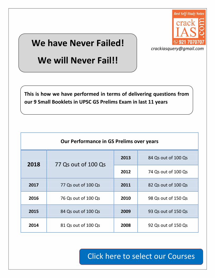
Our Performance in GS Prelims over years
2018 77 Qs out of 100 Qs 2013 84 Qs out of 100 Qs
2012 74 Qs out of 100 Qs
2017 77 Qs out of 100 Qs 2011 82 Qs out of 100 Qs
2016 76 Qs out of 100 Qs 2010 98 Qs out of 150 Qs
2015 84 Qs out of 100 Qs 2009 93 Qs out of 150 Qs
2014 81 Qs out of 100 Qs 2008 92 Qs out of 150 Qs
We have Never Failed!
We will Never Fail!!
This is how we have performed in terms of delivering questions from our 9 Small Booklets in UPSC GS Prelims Exam in last 11 years
Click here to select our Courses
crack
IAS.com
crackIAS.com 96
LOK SABHA (HOUSE OF PEOPLE)
Lok Sabha is a popular house. Its members are directly elected by the People.
States’ representatives are elected directly by the people of the state. UTs’ representatives
are elected in the manner prescribed by Parliament by law. For elections to Lok Sabha, each
state is divided into territorial constituencies. Art 81 (2) provides for the uniformity of
representation in two respects (as it stands after 7th Amendment Act 1956):
(1) As between different states
(2) As between different constituencies within the same state
Each state has been allotted a no. of seats in a way that the ratio between that
no. and the population remains almost the same for all the states. Further, each state has been
divided into a no. of territorial constituencies such that the ratio between the population of
the state and the no. of seats allotted to it remains almost the same.
DELIMITATION OF TERRITORIAL CONSTITUENCIES (ART 82)
As per the constitution, the delimitation process has to be undertaken after each census
every 10 years by such authority and in such a manner as Parliament by law determine (in
perspective of latest census report, which is prepared after taking into account the
demographic changes in the country). Such exercises were carried out till the 1970s and the
last one occurred on the basis of the 1971 census.
The Parliament has passed the Delimitation (Amendment) Bill, 2008. This was done
after Justice Kuldip Singh Committee report on delimitation. This calls for redrawing of
electoral seats on the basis of the 2001 census. The new delimitation will supersede the
existing Delimitation Order of 1976 and as a result to amend the Representation of the
People Act, 1950.
However, the 84th Amendment Act, 2001 freezed the total no. of existing seats as
allocated to various States in the Lok Sabha (on the basis of the 1971 census) till the first
census to be taken after the year 2026. This was done on the basis of concern expressed by
those States who have fared well on population control that their no. of seats in the
Parliament would decrease.
Constitution provides for proportional representation for Council of States and not for
House of People and legislative assemblies.
The no. of seats reserved for SCs and STs will enhance from 555 to 610 for SCs and from
527 to 545 for STs in state assemblies. In Lok Sabha, no. of seats reserved for SCs will go
up from the existing 79 to 85 and to 48 from 41 for STs.
DURATION OF LOK SABHA
Normally 5 years but can be dissolved earlier by the President.
Normal term of Lok Sabha can be extended beyond 5 years by the Parliament. This can
be done during the proclamation of emergency (under Art 352). But this extension
cannot be done for a period exceeding one year at a time and such extension cannot
continue beyond a period of 6 months after the proclamation of emergency ceases to
operate.
Dissolution ends the very life of the existing House of the People so that all matters
pending before the House lapse with the dissolution. If these matters have to be pursued,

crack
IAS.com
crackIAS.com 97
they must be re-introduced in the next House after fresh election. But a Bill pending in the
Council which has not yet been passed by the House shall not lapse on dissolution.
Dissolution would not, however, affect a joint sitting of the two Houses summoned by the
President to resolve a disagreement between the Houses if the President has notified his
intention to hold a joint sitting before the dissolution [Art. 108(5)].
OFFICERS OF LOK SABHA: SPEAKER & DEPUTY SPEAKER
Speaker presides over the House of the People. This office originated during the British
period. The first elected President of the Central Assembly was Vithalbhai Patel in 1925.
GoI Act, 1935 provided for the office of the Speaker & Deputy Speaker but the Act could
not be implemented. It was only in 1946 that G.V. Mavalankar was elected as the Speaker
of the Legislative Assembly and continued to hold this high office until 1956.
Speaker & Deputy speaker are elected by the Lok Sabha from among its own members in
accordance with Article 93. In the existing procedure, this election is to be held on the very
first sitting of the House. This meeting is to be presided over by a pro-tem Speaker and a
tradition, the senior-most member of House is so nominated for the purpose. His position
is similar to that of House of Commons in England. His functions include administering
oath to the Lok Sabha members and presiding over the election of a new Speaker. The
office of the Speaker Pro-term sinks as soon as the Speaker is elected.
A convention has gradually developed whereby a candidate sponsored by ruling party is
elected unopposed to the office of the Speaker and the candidate for the post of Deputy
Speaker is generally from the opposition & supported by the ruling party. His salary is
charged on the Consolidated Fund of India to ensure his independence.
He vacates his office as soon as he ceases to be the member of the House. However,
Speaker continues in his office even if Lok Sabha is dissolved & until new Lok Sabha
meets. However, both the Speaker & his Deputy can be removed by a resolution of the
Lok Sabha passed by a majority of all the then members (special majority) of the House.
Such a Resolution needs support of 50 members for consideration by the House. Before
moving such a resolution, a 14 days’ notice is necessary to exhibit the intention of
members.
When his removal resolution is under consideration, he shall not preside, but can take
part in proceedings of House, has right to speak and vote (except when there is equality of
votes).
If the Speaker intends to resign, the letter of his resignation has to be addressed to the
Deputy Speaker. Deputy Speaker performs the duties of the Speaker if the office of
Speaker is vacant. If the office of Deputy Speaker is also vacant, the duties of the Speaker
shall be performed by such member of House as President may appoint for the purpose.
Powers of the Speaker
His foremost duty is to see that there is decorum & discipline in the House. His authority in
the premises of the House and over the Galleries is final.
He decides who shall hold the floor & speak, time to be allotted to each item, what should
appear in the proceedings, which questions should or should not be admitted and
authenticates all the bills passed by the House
He exercises a casting vote in the case of equality of votes.
He has the final power to maintain order within the House of the People and to interpret
its Rules of Procedure. In the absence of a quorum, it will be the duty of the Speaker to
adjourn the House or to suspend the meeting until there is a quorum.
Speaker presides over joint sitting of both the Houses of Parliament [Art 118 (4)]

crack
IAS.com
crackIAS.com 98
When a Money Bill is transmitted from the Lower House to the Upper House, the Speaker
shall endorse on the Bill his certificate that it is a Money Bill [Art 110 (4)]. The decision of
the Speaker as to whether a Bill is Money Bill is final.
He is the custodian of the rights and privileges of members. No arrest or warrant can be
issued against any member of Lok Sabha within the four walls of the House without his prior
permission.
The committees of Parliament (e.g. Public Accounts Committee etc.) function essentially
under the Speaker and their chairpersons are also appointed or nominated by him. If the
Speaker is a member of any Committee, he is the ex-officio chairman of such a Committee.
A vote of no-confidence against the Government is also admitted by him.
He accepts all resignations sent to him by members of the House.
He is the head of the Lok Sabha Secretariat.
LOK SABHA SPEAKER NAME
First Lok Sabha Ganesh Vasudev Mavalankar
M. Ananthasayanam Ayyangar
Fifteenth Lok Sabha Meira Kumar
Bal Ram Jakhar was longest serving Speaker of Lok Sabha (1980-1989)
5 Persons served more than 1 Lok Sabha Term.

crack
IAS.com
crackIAS.com 99
RAJYA SABHA (COUNCIL OF STATES)
Government of India Act, 1919 established the second chamber– the Council of
States consisting of 60 members, nominated and elected. GoI Act of 1935 provided directly
elected Council of States as the second Chamber. Rajya Sabha enjoys a continuity of life.
Rajya Sabha is a Permanent House and is not subject to dissolution. The term of the rd
members of the Rajya Sabha is 6 years. At the end of every second year, 1/3 of the members
retire. Elections to the Rajya Sabha are indirect; members representing States are elected by
elected members of State Assemblies in accordance with the system of proportional
representation (partially adopted) by means of the single transferable vote, and those
representing UTs are chosen in such manner as Parliament may by law prescribe.
Only the UTs of Delhi (3) and Pondicherry (1) have seats in Rajya Sabha
because these have Legislatives Assemblies. This system of election was adopted to give some
representation to minority communities and parties. Lok Sabha adopted single-member
constituency as proportional representation is ill suited to Parliamentary form as it would not
permit stable government.
CHAIRMAN AND DEPUTY CHAIRMAN OF RAJYA SABHA
He must be a citizen of India, 35 years of age & eligible for election as a member of Rajya
Sabha.
Vice-President of India is the ex-officio chairman of the Council of states. He is elected
by members of an electoral college consisting of members of both Houses of Parliament
in accordance with the system of proportional representation by means of single
transferable vote. Salary of Chairman is same as that of Speaker.
The Rajya Sabha elects Deputy Chairman. He shall be a member of Rajya Sabha.
Office of Deputy Chairman terminates if he ceases to become the member of the Council.
He can also resign, submitting his resignation to the chairman in writing.
He can also be removed from his office by a resolution of the Rajya Sabha, passed by a
majority of all the then members of the Council. But such a resolution can only be moved by
giving at least 14 days’ notice in advance. Chairman may be removed from his office only
if he is removed from the office of Vice-President.
If the office of Chairman is vacant, Deputy Chairman discharges his functions. But if the
office of Deputy Chairman is also vacant, the duties of his office shall be discharged by such
a member of the Rajya Sabha as President may appoint.
The sitting of the House is presided over by the Chairman and in his absence, by the
Deputy Chairman. But if both of them are absent then such person as may be determined
by the rule of Procedure of the Council shall preside over the sitting of the House.
In 2003, amendments were made to the Representation of the People Act, dispensing with
the domicile requirement and introducing open ballot system for Rajya Sabha elections.
JOINT SESSION OF THE HOUSE
There are 2 occasions on which a joint sitting of Parliament is convened
1. Special address by President: first session after each general election and first session
of each year (generally a budget session)
2. For resolving any deadlock over the passage of a Bill.

crack
IAS.com
crackIAS.com 100
Art 108 provides that when a Bill is passed by one House is sent to the other. There may be
3 circumstances which can lead to a deadlock between two Houses if the other House:
o Reject the Bill altogether
o Disagrees on it and returns it with some amendments which are not ultimately
considered by the originating House
o Takes no action and more than 6 months’ time has passed
The President in such a case may summon a Joint Sitting of both the Houses
At a joint sitting of two Houses, the Speaker of the Lok Sabha and in his absence, the
Deputy Speaker of the House, or if he is also absent, Deputy Chairman of the Council
and if he is also absent, such person as may be determined by the members present in the
sitting presides. Lok Sabha by its numerical majority prevails over the joint sitting.
This provision does not apply to Money Bill. There cannot be a joint sitting for
Constitution Amendment Bills. Nor do such Bills require previous sanction of
President.
In addition, President cannot summon a joint sitting if the bill has lapsed by reason of
dissolution of Lok Sabha. However, if President has already summoned joint sitting on a
Bill and then the Lok Sabha is dissolved, the joint sitting will take place.
DIFFERENCE BETWEEN LOK SABHA AND RAJYA SABHA
Members of Lok Sabha are directly elected by the eligible voters. Members of Rajya Sabha
are elected by the elected members of State Assemblies in accordance with the system of
proportional representation by means of single transferable vote.
The normal life of Lok Sabha is 5 years only while Rajya Sabha is a permanent body.
Lok Sabha is the House to which the Council of Ministers is responsible under the
Constitution. A vote of no-confidence can be passed only in Lok Sabha.
Rajya Sabha has special powers to declare that it is necessary and expedient in the
national interest that Parliament may make laws with respect to a matter in the State List
(Article 249)
RS has special powers to pass resolutions to create by law one or more All India Services
(Art 312) common to Union & States. It passed such resolution on 2 occasions; one in 1961
for creation of (i) Indian Service of Engineers, (ii) Indian Forest Service & (iii) Indian Medical
& Health Service; and the other in 1965 for the creation of Indian Agricultural Service and
Indian Educational Service.
Rajya Sabha also has special powers under Art 67 by passing a resolution seeking the
removal of the Vice-President that can originate only in the Rajya Sabha. After the Rajya
Sabha passes such a resolution by a majority of the then members of the House, it goes for
approval of the Lok Sabha.
Legislative Powers:
a. Ordinary Bills: Rajya Sabha enjoys co-equal powers in the field of ordinary or a non-
money bill. It can be introduced in Rajya Sabha and it has to be approved in both the
Houses of Parliament before it becomes an Act. The Lok Sabha has no power to overrule
the Rajya Sabha.
b. Constitution Amendment Bill: both Rajya Sabha and Lok Sabha have been at par.
c. Removal of President: Article 61 requires the resolution be passed by each House by a
majority of not less than two-third of the total membership of each House separately.
d. Power of the Rajya Sabha is equal so far as the approval of emergency proclamations
under Articles 352, 356 and 360 is concerned.

crack
IAS.com
crackIAS.com 101
e. Money Bills can only be introduced in Lok Sabha. Rajya Sabha has no power to reject
or amend a Money Bill, but can only discuss. It has no power to vote money for the
public expenditure and demands for grants. Speaker of the Lok Sabha has got the sole
and final power of deciding whether a Bill is a Money Bill.
LET’S PRACTICE :: UPSC LAST 10 YEARS QUESTIONS
Regarding the office of the Lok Sabha
Speaker, consider the following statements: 1. He/ She holds the office during the
pleasure of the President.
2. He/ She need not be a member of the
House at the time of his/ her election
but has to become a member of the House within six months from the date
of his/ her election.
3. If he/ she intends to resign, the letter of
his/ her resignation has to be addressed
to the Deputy Speaker. Which of the statements given above is/ are
correct?
a. 1 and 2 only b. 3 only
c. 1, 2 and 3
d. None Ans. B
Which one of the following is the largest
(area-wise) Lok Sabha constituency? a. Kangra
b. Ladakh
c. Kachchh d. Bhilwara
Ans. B
Who was the Speaker of the First Lok
Sabha?
a. Hukam Singh
b. G.V.Mavalankar c. K.M.Munshi
d. U.N.Dhebar
Ans. B
Which one of the following statements is not correct?
a. In Lok Sabha, a no-confidence motion has to set out the grounds on which it is
based
b. In the case of a no-confidence motion in the Lok Sabha, no conditions of
admissibility have been laid down in the
Rules
c. A motion of no-confidence, once admitted, has to be taken up within ten
days of the leave being granted
d. Rajya Sabha is not empowered to
entertain a motion of no-confidence Ans. A Who among the following was never the Lok
Sabha Speaker? a. K.V.K. Sundaram
b. G.S. Dhillon
c. Baliram Bhagat
d. Hukam Singh Ans. A Which of the following Constitutional
Amendments are related to raising the
number of Members of Lok Sabha to be
elected from the States?
a. 6th and 22nd
b. 13th and 38th
c. 7th and 31st
d. 11th and 42nd
Ans. C The term of the Lok Sabha a. Cannot be extended under any
circumstances
b. Can be extended by six months at a
time
c. Can be extended by one year at a time
during the proclamation of emergency d. Can be extended-for two years at a time
during the proclamation of emergency Ans. C The Speaker can ask a member of the
House to stop speaking and let another
member speak. This phenomenon is known
as
a. Decorum
b. Crossing the floor
c. Interpolation
d. Yielding the floor

crack
IAS.com
crackIAS.com 102
Ans. D The State which has the largest number of
seats reserved for the Scheduled Tribes in Lok Sabha is
a. Bihar
b. Gujarat
c. Uttar Pradesh
d. Madhya Pradesh
Ans. D
In which of the following countries will the
no-confidence motion to bring down the
government passed by the legislature be
valid only when the legislature is able to
find simultaneously a majority to elect a successor government?
a. France b. Germany
c. Italy
d. Portugal Ans. B
When the annual Union Budget is not
passed by the Lok Sabha, a. The Budget is modified and presented
again
b. The Budget is referred to the Rajya
Sabha for suggestions
c. The union Finance Minister is asked to
resign d. The Prime Minister submits the
resignation of Council of Ministers Ans. D
Consider the following statements: Attorney
General of India can
1. Take part in the proceedings of the Lok
Sabha
2. Be a member of a committee of the Lok
Sabha
3. Speak in the Lok Sabha
4. Vote in the Lok Sabha Which of the statements given above is/are
correct? a. 1 only
b. 2 and 4
c. 1, 2 and 3
d. 1 and 3 only
Ans. C
What will follow if a Money Bill is
substantially amended by the Rajya Sabha?
a. The Lok Sabha may still proceed with
the Bill, accepting or not accepting the
recommendations of the Rajya Sabha b. The Lok Sabha cannot consider the Bill
further
c. The Lok Sabha may send the Bill to the
Rajya Sabha for reconsideration d. The President may call a joint sitting for
passing the Bill Ans. A
Consider the following statements regarding a No-Confidence Motion in India:
1. There is no mention of a No-Confidence
Motion in the Constitution of India. 2. A Motion of No-Confidence can be
introduced in the Lok Sabha only.
Which of the statements given above is /
are correct? a. 1 only
b. 2 only
c. Both 1 and 2
d. Neither 1 nor 2
Ans. C Which of the following special powers have
been conferred in the Rajya Sabha by the
Constitution of India?
a. To change the existing territory of a State and to change the name of a State
b. To pass a resolution empowering the
Parliament to make laws in the State List and to creat one or more All India
Services
c. To ament the elections procedure of the President and to determine the pension
of the President after his/ her retirement
d. To determine the functions of the
Election Commission and to determine
the number of Election Commissioners Ans. B Consider the following statements:
1. The Rajya Sabha alone has the power to
declare that it would be in national
interest for the Parliament to legislature
with respect to a matter in the State List
2. Resolutions approving the Proclamation
of Emergency are passed only by the
Lok Sabha Which of the statements given is/are
correct?
a. 1 only

crack
IAS.com
crackIAS.com 103
b. 2 only
c. Both 1 and 2
d. Neither 1 nor 2 Ans. A
Consider the following statements:
1. The Rajya Sabha has no power either to
reject or to amend a Money Bill.
2. The Rajya Sabha cannot vote on the
Demands for Grants.
3. The Rajya Sabha cannot discuss the
Annual Financial Statement. Which of the statements given above is/are
correct?
a. 1 only
b. 1 and 2 only
c. 2 and 3 only d. 1, 2 and 3
Ans. B
Who among the following have the right to
vote in the elections to both Lok Sabha and
Rajya Sabha?
a. Elected members of the Lower House of the Parliament
b. Elected members of the Upper House of
the Parliament c. Elected members of the Upper House of
the State Legislature
d. Elected members of the Lower House of
the State Legislature Ans. D
Consider the following statements : An
amendment to the Constitution of India can
be initiated by the
1. Lok Sabha
2. Rajya Sabha
3. State Legislatures
4. President
Which of the above statements is /are correct?
a. 1 alone
b. 1, 2 and 3
c. 2, 3 and 4
d. 1 and 2 Ans. D
Consider the following statements:
1. An amendment to the Constitution of
India can be initiated by an introduction
of a bill in the Lok Sabha only 2. If such an amendment seeks to make
changes in the federal character of the
Constitution, the amendment also requires to be ratified by the legislature
of all the States of India Which of the statements given above is /are
correct? a. 1 only
b. 2 only
c. Both 1 and 2
d. Neither 1 nor 2
Ans. D

crack
IAS.com
crackiAS.com 104
My PowerPoints

crack
IAS.com
Samples from
INDIAN HISTORY

crack
IAS.com
crackIAS.com 104
Decade of 1940-1950
Overview
If there was a time machine, 1940s was a decade when you would love to live a life; your Great
Grandfather or Grandfather lived it! This was the most charged decade of Indian History. This
was also a decade wherein we as Indians would like to erase some parts, if God allows us!
Look at this decade from this perspective-
- World War-II had started; Britain was at losing end; taking Indian help without their consent
was not an easy task.
- Internally, British had seen 2 mass movements; the 3rd much more charged movement –
the Quit India Movement – for throwing away British Rule had started.
- The army had started disobeying and questioning the government. Imagine that how a
single soldier Mangal Pandey generated a revolt 100 years ago; what if whole army does it!
- A strong leader of India – Subhash Chander Bose – shook hands with British enemies to
militarily overthrow British.
- Internally, the growing tensions between Hindus and Muslims was becoming a major law
and order issue.
What would anybody else have done in such a scenario? This is what British did – a number of
commissions and missions to appease and come on terms with Indian leaders. British had
understood that fooling, controlling and governing Indians was no more possible. Independence
of India was the natural outcome! The whole decade passed in negotiations at the political
levels – between British Government & Indian Leaders; between Hindu & Muslim Leaders;
between National Leaders & local kings (to bring them under the ambit of National
Government). We won independence; we lost many sons of India. The story of Freedom
Struggle ends with a New Beginning!

crack
IAS.com
crackIAS.com 105
2nd WORLD WAR & NATIONALIST RESPONSE
The WW-II started in Sept. 1939 and Britain declared war against Germany
along with India’s support for the war without consulting the Indian opinion. The Congress
greatly opposed India’s unilateral involvement in WW-II and was of the view, “the issue of
war and peace is to be decided by the people of India not the imperialist
government”. The onset of WW-II placed the Indian leaders in a difficult situation. They were
totally opposed to Fascist philosophy for it being ruthless totalitarianism and racial bigotry, but
were strongly opposed to imperialism too. Thus, their attitude depended on aims and objectives
of the war.
Viceroy Linlithgow declared India was at war without consulting Indian opinion.
Different perspectives were adopted by Congress leaders in relation to War.
Gandhiji strongly opposed to Nazism and was sympathetic to Allies.
Subhash Bose, Socialist, communists called it as imperialist war with both sides
motivated by Imperialism.
Nehru who has been warning the world against dangers of Nazi aggression and believed
that Justice is on the side of Allies but at the same time, he understood that Britain and
France were imperialists.
He emphasized that if Britain was fighting for Democracy and Freedom then she should
declare how her war aims would be applicable to India. Congress accepted his view.
Congress asked Britain to declare how war aims would be implemented in India after
war.
Viceroy Linlithgow in Oct 1939 refused to define Britain war aims beyond stating that British
were just resisting aggression.
Congress rejected the Viceroy’s statement and asked ministries to resign.
AUGUST OFFER (1940)
A change of government took place in Britain in May 1940 and Winston Churchill became
the prime minister (1940–45). The fall of France temporarily softened the attitude
ofCongress in India. Britain was in immediate danger of Nazi occupation. As the war
was taking a menacing turn from the allied point of view, congress offered to cooperate in
the war if transfer of authority in India is done to an interim government.
Viceroy Linlithgow offered a set of proposals to Congress for securing its cooperation in war
in August 1940 known as August proposals. These are -
o It turned down Congress demand for provisional National government.
o It envisaged representative Constitution making body after the war.
o For present there would be expansion of Viceroy’s Council to include Indians
o A war advisory Council would be set up.
However, Congress rejected it as Nehru said that idea of Dominion on which August offer
was based was dead as a doornail.
INDIVIDUAL SATYAGRAHA (Oct 1940)
In Oct 1940, Gandhiji launched Individual Satyagraha in which selected Satyagrahis in
every locality would undertake the individual Satyagraha.

crack
IAS.com
crackIAS.com 106
The demand of the Satyagrahi would be freedom of speech against participation in the
War. The Satyagraha was kept limited so as not to restrict British war efforts but at the
same time idea was to let everyone know that India condemned both Nazism and British
colonialism.
The individual satayagraha (1940) is also known as Delhi Chalo Movement.
Vinoba Bhave was selected as the first satyagrahi whereas Nehru was to be second.
Third was Brahma Datt, one of the inmates of the Gandhi's Ashram. Other prominent
Satyagrahis were Srikrishna Sinha, C. Rajagopalachari, N. V. Gadgil, Mian Iftikhar-ud-din
(President of Punjab Congress), Sarojini Naidu, G. V. Mavalankar, Aruna Asaf Ali and
Satyawati.
However, since it was not a mass movement, it attracted little enthusiasm and in
December 1940, Gandhi suspended the movement. The campaign started again in January
1941, this time, thousands of people joined and around 20 thousand people were arrested.
Meanwhile Japan had occupied Rangoon (1942) and was at India’s doorstep.
There was pressure on P.M Churchill by American President Roosevelt and Chiang Kai Shek
of China and Labour Party to seek active cooperation of India in War.
This led Churchill to send his Cabinet Minister Stafford Cripps, who was member of Labour
Party and had actively supported Indian national movement with a mission.
CRIPPS MISSION (1942)
In March 1942, a mission headed by Stafford Cripps was sent to India with
constitutional proposals to seek Indian support for the war. Stafford Cripps was a left wing
Labourite, the leader of the House of Commons and a member of the British War Cabinet who
had actively supported the Indian national movement. The Mission visited during the lordship of
Lord Linlithgow.
Main Proposals
The main proposals of the mission were as follows –
An Indian Union with a dominion status would be set up; it would be free to decide its
relations with the Commonwealth and free to participate in the United Nations and other
international bodies.
After the end of the war, a constituent assembly would be convened to frame a new
constitution. Members of this assembly would be partly elected by the provincial
assemblies and partly nominated by the princes.
The British Government would accept the new constitution subject to two conditions: (i)
any province not wiling to join the Union could have a separate constitution and form a
separate Union, and (ii) the new constitution-making body and the British Government
would negotiate a treaty to effect the transfer of power and to safeguard racial and
religious minorities.
In the meantime, Executive Council would be expanded to include Indians but defence
of India would remain in British Hands.
The making of the constitution was to be solely in Indian hands now (and not “mainly” in
Indian hands – as contained in the August Offer).
A concrete plan was provided for the constituent assembly.
Option was available to any province to have a separate constitution – a blueprint for India’s
partition.

crack
IAS.com
crackIAS.com 107
Cripps Mission failed to satisfy Indian nationalists and turned out to be merely a propaganda
device for US and Chinese consumption.
The Congress objected to
The offer of dominion status instead of complete independence.
Representatives of Princely States to be nominated by princes.
Right to secede as this went against the principle of national unity.
Above all no immediate plan for transfer of effective power, the governor general’s
supremacy had been retained.
The Muslim League objected to absence of any plan for separate state of Pakistan.
The incapacity of Cripps to go beyond the Draft Declaration and the adoption of a rigid
“take it or leave it” attitude along with efforts of Churchill (the British Prime Minister),
Amery (the secretary of state), Linlithgow (the viceroy) and Wavell (the commander-in-
chief) to prevent any real agreement was important reason for failure.
Talks broke down on the question of the viceroy’s veto.
Gandhi described the scheme as “a post-dated cheque” as all-important proposals were
to be implemented only after War was over.
Now frustrated and embittered Indian people, who, though still sympathizing with the
victims of Fascist aggression, that the time had come for a final struggle.
Gandhiji also wanted to launch new struggle to reinvigorate people in chance of Japanese
aggression so that they would be able to resist it.
In July 1942, Congress Working Committee met at Wardha and passed the famous
resolution for the new struggle.
All India Congress Committee met at Bombay at Gowalia Tank Maidan on 8 Aug 1942
and ratified the famous “Quit India” resolution.
Here Mahatma Gandhi asked British to Quit India & gave famous Mantra Do or Die.
On the wee hours of 9 August all the important leaders of Congress were arrested and thus
movement passed into hands of people. They followed the Resolution of August 8 – that
“Every man his own guide”.
Many young leaders went underground and continued the struggle- such as Aruna Asaf Ali,
Achyut Patwardhan, J. Prakash Narayan (he had escaped from prison), Ram Manohar
Lohia, Sucheta Kriplani, Biju Patnaik, R. P. Goenka.
Most of the underground leaders were Congress Socialists.
Sucheta Kriplani & Aruna Asaf Ali were important woman organizers of Underground
movement.
Congress radio was started by Ram Manohar Lohia and Usha Mehta at Bombay.
Most remarkable aspect of 1942 was rise of Parallel governments at Satara
(Maharashtra), Ballia (U.P), Tamluk (Bengal), Talcher (Orissa)
AREA NAME LEADER WORK
Satara (Maharashtra) Prati Sarkar Nana Patil Nyayadan Mandals (peoples
courts), Gandhi Marriages
Tamluk (Bengal) Jatiya Sarkar Satish Samanta Vidyut Vahini (armed wing)
Ballia (U.P) - Chittu Pandey -
The native state of Aundh in Maharashtra got its constitution drafted by Gandhiji.
In Tamluk, 73-year old Matangini Hazra and Kanaklata Barua (Bihar) became martyrs to
British repression.

crack
IAS.com
crackIAS.com 108
National Herald and Harijan (after Gandhijis arrest it was edited by K. G. Mashruwalla)
ceased to publish for entire duration of struggle, others for shorter period.
The Quit India movement is also described as Revolt of 1942 or August Revolt.
Gandhiji was jailed in Aga Khan Palace near Poona (Kasturba and Mahadev Desai,
Gandhiji’s Secretaty died here during their imprisonment)
Here he started the 21 day fast as Government pressurized him to condemn violence by
people
Erosion of loyality of government’s own officers was an important aspect of 1942.
INDIAN NATIONAL ARMY
The idea of I.N.A. was first conceived in Malaya by Mohan Singh, officer of British Indian
army. It was to be formed of Indian Prisoners of war in custody of Japan
In Sep. 1942, first division of INA formed with help from Japanese army.
But soon differences arose between Mohan Singh and Nirjan Singh Gill (senior officers of
INA) and Japanese as later only wanted a token force of Indians.
The veteran revolutionary leader Rash Behari Bose had already organized Indian
Independence League in Japan.
Meanwhile Subhash Chandra Bose had escaped from India in 1941 to go to USSR to seek
help against British but as USSR joined Britain and he went to Germany.
From there he reached Singapore in 1943 and on request of Rash Behari Bose assumed
leadership of Indian Independence League and rebuilt the INA.
He formed the Provisional government of Free India (Azad Hind) in Oct 1943 at
Singapore and declared war on Britain and U.S. He gave the call of Chalo Delhi and
Exhorted to “Give me Blood and I will give you Freedom”.
Bose established two INA HQs at Rangoon and Singapore.
Subhas C. Bose through his radio address sought blessing of Gandhiji and called
him the father of the Nation.
INA had women battalion Rani Lakshmi Regiment under Lakshmi Swaminathan.
INA joined Japanese army in its march on India and participated in the Imphal campaign.
Netaji Bose went to Andamans (occupied by Japanese) and hoisted the Flag of India there
and named the islands as Shaheed and Swaraj.
He is supposed to have died in Air crash in Formosa (modern Taiwan)
After World War ended the trial of 3 officers of INA Shah Nawaz Khan, G. S. Dhillon and P.
K. Sehgal was carried out at Red Fort, Delhi.
They were defended by Nehru, Bhulabahi Desai, Tej Bahadur Sapru, K. N. Katju
and Asaf Ali.
The INA trials were one of the great upsurges of Post-war struggles, which brought together
Hindus and Muslims.
SEARCH FOR NATIONAL UNITY: The decade of 1940s saw various efforts to solve the
problem of national unity such as CR formula and Desai-Liaquat Pact.
RAJAGOPALACHARI FORMULA (1944)
C. Rajagopalachari prepared a formula for Congress-League cooperation
based on a tacit acceptance of demand for Pakistan. The formula seemed to have support of
Gandhiji. The CR Plan had following proposals
Muslim League to endorse Congress demand for independence.
crack
IAS.com
crackIAS.com 109
League to cooperate with Congress in forming a provisional government at centre.
After the end of the war, the entire population of Muslim majority areas in the North-West
and North-East India to decide by a plebiscite, whether or not to form a separate
sovereign state.
In case acceptance of partition, agreement to be made jointly for safeguarding defence,
commerce, communications, etc.
The above terms to be operative only if England transferred full powers to India
Gandhi Jinnah talks were held in Bombay to discuss it. But Jinnah outrightly
rejected the plan.
DESAI-LIAQAT PACT (1944)
Bhulabhai Desai, leader of the Congress Party in the Central Legislative Assembly,
met Liaqat Ali Khan, deputy leader of the Muslim League in that Assembly and drafted the
proposal for an interim government at the centre
An equal number of persons were to be nominated by the Congress and the League in the
central legislature. 20% seats were reserved for minorities.
WAVELL PLAN OR SHIMLA CONFERENCE (1945)
As the war ended in Europe, Viceroy Lord Wavell was permitted to start
negotiations with Indian leaders. Congress leaders were released from jails in June 1945. The
idea was to reconstruct the Governor - General’s Executive Council pending the
preparation of a new constitution after the war.
For this purpose, a conference was convened by the viceroy, Lord Wavell, at Shimla in
June 1945.
The main proposals of the Wavell Plan were as follows:
With the exception of the Governor-General and the Commander-in-Chief, all members
of the executive council were to be Indians.
Caste Hindus and Muslims were to have equal representation. There will be
representation of minorities also.
Representatives of different parties were to submit a joint list to the viceroy for
nominations to the executive council. If a joint list was not possible, then separate lists
were to be submitted.
The League, asserting itself as sole representative of Indian Muslims, wanted all
Muslim members to be League nominees.
However, it was unacceptable to Congress as it would reduce the Congress to the status
of a purely caste Hindu Party and insisted on its right to include members of all communities
among its nominees.
On unbending attitude of Muslim League, Wavell declared failure of talks (as he wanted pro-
British Khizr Hyatt Khan of Unionist Party as the Muslim representative from Western
Punjab).
Thus, it is said that Wavell gave the League and Jinnah a virtual Veto to obstruct all
negotiations and strengthened the League’s position.

crack
IAS.com
crackIAS.com 110
TOWARDS INDEPENDENCE
The end of world war saw increasing militant activities by people all over India
including those of Princely States. Many struggles took place such as
POST – WAR STRUGGLE
STRUGGLE AREA NATURE
INA Trials All India Trial of INA officers united the nation; Calcutta mass
demonstrations for release of Abdur Rashid, INA prisoner
RIN
mutiny of
Feb.1946
(Most imp.)
Bombay
and Karchi
Naval ratings of HMIS TALWAR struck work at Bombay for
discriminatory treatment and for arresting B.C.Dutt for writing
Quit India on the ship. Soon spread to Karachi. Vallabhai Patel
and Jinnah negotiated the surrender of ratings.
Tebhaga Bengal Peasant struggle
Punnapra-
Vaylar
Travancore
(Kerala)
People of the princely state were protesting for democratic
reforms and to become part of independent India
Telengana Hyderabad Anti-Nizam and Anti-Zamindar movement inspired by Communist
In elections to provincial assembly, the Congress won overwhelmingly on general seats and
Muslim League won on Muslim seats.
Meanwhile in England Churchil’s Conservative party was defeated by Labour Party and
Clement Attlee became the P.M.
It was now clear that Britain weakened by the War would not be able to hold against the
rising tide of Indian nationalism.
The new government sent a Cabinet Mission to hold talks on issue of Indian
Independence. It consisted of 3 members- Lord Pathick Lawerence, Sir Stafford Cripps and
A.V. Alexander
The mission reached Delhi in March 1946 and had prolonged discussions with Indian leaders
of all parties and groups on the issues of –
1. Interim Government.
2. Principles and procedures for framing a new Constitution giving freedom to India.
As the Congress, the League could not come to any agreement on the fundamental issue of
the unity or partition of India, the mission put forward its own plan for the solution of the
constitutional problem in May 1946.
CABINET MISSION PLAN (1946)
It rejected the demand for a full-fledged Pakistan mainly because Pakistan
so formed would include a large non-Muslim population in the North-west and in Northeast; it
grouped existing provincial assemblies into 3 sections:
Section A – Madras, Bombay, Central Provinces, United Provinces, Bihar and Orissa (Hindu-
majority provinces).
Section B – Punjab, North-West Frontier Province and Sindh (Muslim-majority provinces) in
NW.
Section C – Bengal and Assam (Muslim-majority provinces) in NE.
Three-tier executive and legislature at provincial, section and union levels.
A constituent assembly to be elected by provincial assemblies by proportional
representation (voting in three groups – General, Muslims, Sikhs). This constituent

crack
IAS.com
crackIAS.com 111
Assembly to be a 389-member body with provincial assemblies sending 292, chief
commissioner’s provinces sending 4, and princely states sending 93 members.
In the constituent assembly, members from sections A, B and C were to sit separately to
decide the constitution for provinces and if possible, for the groups also then, the whole
constituent assembly (all three sections A, B and C combined) would sit together to
formulate the Union constitution.
A common centre would control defence, communication and external affairs.
Provinces were to have full autonomy and residual powers.
Princely states were no longer to be under paramountcy of British Government. They
would be free to enter into an arrangement with successor governments or the British
Government in U.K.
After the first general elections, a province was to be free to come out of a group and
after 10 years, a province was to be free to call for a reconsideration of the group or the
Union constitution.
Meanwhile, an interim government to be formed from the constituent assembly.
CHANGE IN BRITISH ATTITUDE
The rejection of Partition was important, as earlier British had helped Communalism.
It was due to the fact British wanted a united and friendly India and an active partner in
defence of the Commonwealth, and divided India would lack in defence and would be a blot
on Britain’s diplomacy.
This was reflected in declaration of March 1946, of the British Prime Minister Clement
Attleee said: “….though mindful of the rights of minorities we cannot allow a minority to
place their veto on advance of the majority.”
Both Congress and Muslim League agreed to the plan but could not agree on different
interpretations of grouping clause of the Cabinet Mission.
Congress -Provinces should not have to wait until the first general elections to come out
of a group. They should have the option of not joining a group in the first place.
Compulsory grouping contradicts the oft-repeated insistence on provincial autonomy.
Muslim League-Grouping should be compulsory with sections B and C developing into
solid entities with a view to future secession into Pakistan.
July 1946 Elections were held in provincial assemblies for the Constituent Assembly.
In September 1946, an interim government headed by Jawaharlal Nehru (called as
Vice President of Executive Council) was formed by Congress and included – Sarat Chandra
Bose, Jagjivan Ram, Rajendra Prasad, Vallabhai Patel, Asaf Ali and Syed Ali Zaheer, Baldev
Singh, John Mathai, C.Rajagopalachari.
Muslim League did not take part in interim Government at first and called August 16,
1946 to be observed as “Direct Action day” for realizing the demand of Pakistan. The
League ministry of Bengal headed by Suhrawardy encouraged violence and riots during
the Great Calcutta Killings.
However League soon joined the Interim Government but without giving up its policy of
Direct action and with view of obstructing the working of Interim government. Liaquat Ali
Khan (Finance minister) did not release funds for the departments of Congress ministers.
While the country was passing such anarchic phase the Famous Attlee declaration of
February 20 1947 where P.M. Attlee declared that Britain would transfer power in
responsible hands and leave India not later than June 1948.
He also announced appointment of Lord Mountbatten as Viceroy in place of Wavell.

crack
IAS.com
crackIAS.com 112
MOUNTBATTEN PLAN or 3rd JUNE PLAN/ DICKEY BIRD FORMULA
The freedom-with-partition formula was coming to be widely accepted. It was
suggested by V.P. Menon (Senior Civil Servant and political advisor to Viceroy) the immediate
transfer of power on the basis of grant of dominion status (with a right of secession), thus
obviating the need to wait for an agreement in the Constituent Assembly on a new political
structure. Based on these deliberations Mountbatten put forward on 3rd June his plan for
transfer of power
MAIN PROPOSALS
Punjab and Bengal Legislative Assemblies would meet in two groups, Hindus and
Muslims, to vote for partition. If a simple majority of either group voted for partition, then
these provinces would be partitioned.
In case of partition, two dominions and two constituent assemblies would be created.
Sindh would take its own decision.
Referendum in NWFP and Sylhet district of Bengal would decide the fate of these areas.
Independence for princely states ruled out, they would join either India or Pakistan.
Freedom would come on August 15, 1947.
The boundary commission would be set up if partition was to be effected. (it was set up
under Radcliffe)
Thus, League’s demand was conceded to the extent that Pakistan would be created and the
Congress’ position on unity was taken into account to make Pakistan as small as possible.
Mountbatten’s formula was to divide India but retain maximum unity.
Both Congress and Muslim League accepted this plan.
Many criticized the partition of India but the most moving was Khan Abdul Ghaffar Khan’s
anguish “Congress has thrown us to wolves”.
Punjab and Bengal were partitioned. NWFP and Sylhet dist. of Assam voted for joining
Pakistan.
In July, India Independence Act was passed in British Parliament in July 1947 provided for
setting up two dominions of India and Pakistan from 15 August 1947. It provided for
separate Governor-general for each dominion.
Thus, Pakistan came into existence on 14 August 1947 (with Jinnah as Governor-General)
and India on 15 August 1947 (Mountbatten as Governor-General).

crack
IAS.com
crackIAS.com 113
LETS PRACTICE :: UPSC LAST 10
YEARS QUESTIONS
Which party was founded by Subhash Chandra Bose in the year 1939 after he broke away from the Congress? a. Indian Freedom Party
b. Azad Hind Fauz
c. Revolutionary Front
d. Forward Block Ans. D
After Quit India Movement, C. Rajagopalachari issued a pamphlet entitled "The Way Out". Which one of the following was a proposal in this pamphlet? a. The establishment of a "War Advisory
Council" composed of representatives of
British India and the Indian States.
b. Reconstitution of the Central Executive Council in such a way that all its members, except the Governor General and the Commander - in - Chief should be Indian leaders
c. Fresh elections to the Central and Provincial
Legislatures to be held at the end of 1945
and the Constitution making body to be convened as soon as possible
d. A solution for the constitutional deadlock
Ans. D
Consider the following statements: On the eve of the launch of Quit India Movement, Mahatma Gandhi
1. Asked the government servants to resign.
2. Asked the soldiers to leave their posts. 3. Asked the Princes of the Princely States to
accept the sovereignty of their own people. Which of the statements given above is/ are
correct? a. 1 and 2 b. 2 and 3 c. 3 only
d. 1, 2 and 3 Ans. C
Which Indian nationalist leader looked upon a war between Germany and Britain as a god sent opportunity which would enable Indians to exploit the situation to their advantage?
a. C. Rajagopalachari b. M. A. Jinnah c. Subhash Chandra Bose d. Jawaharlal Nehru
Ans. C
Who among the following were official Congress negotiators with Cripps Mission? a. Mahatma Gandhi and Sardar Patel
b. Acharya J. B. Kripalani and C.
Rajagopalachari
c. Pandit Nehru and Maulana Azad
d. Dr Rajendra Prasad and Rafi Ahmed Kidwai
Ans. C Assertion (A): Lord Linlithgow described the August Movement of 1942 as the most serious rebellion since Sepoy Mutiny. Reason (R): There was massive upsurge of the peasantry in certain areas. Ans. A Assertion (A): Lord Linlithgow described the August Movement of 1942 as the most serious
revolt after the Sepoy mutiny.
Reason (R): Peasants joined the movement in
large number in some places. Ans. A Who of the following Prime Ministers sent Cripps
Mission to India? a. Names Ramsay MacDonald b. Stanley Baldwin c. Neville Chamberlain
d. Winston Churchill Ans. D During the freedom struggle, Aruna Asaf Ali was a major woman organizer of underground activity
in: a. Civil Disobedience Movement b. Non - Cooperation Movement c. Quit India Movement d. Swadeshi Ans. C Quit India Movement was launched in response to
a. Cabinet Mission Plan b. Cripps Proposals c. Simon Commission Report
d. Wavell Plan Ans. B With which one of the following movements is
the slogan "Do or Die" associated?
a. Swadeshi Movement
b. Non - Cooperation Movement
c. Civil Disobedience Movement d. Quit India Movement Ans. D

crack
IAS.com
crackIAS.com 114
Which one of the following observations is not true about the Quit India Movement of 1942?
a. It was a non-violent movement
b. It was led by Mahatma Gandhi
c. It was a spontaneous movement
d. It did not attract the labour class in general
Ans. A
In the "Individual Satyagraha", Vinoba Bhave
was chosen as the first Satyagrahi. Who was the
second?
a. Dr Rajendra Prasad
b. Pandit Jawaharlal Nehru c. C rajagopalachari
d. Sardar Vallabhbhai Patel
Ans. B
With reference to Indian freedom struggle, Usha
Mehta is well-known for a. Running the secret Congress Radio in the
wake of Quit India Movement b. Participating in the Second Round Table
Conference
c. Leading a contingent of Indian National Army d. Assisting in the formation of Interim
Government under Pandit Jawaharlal Nehru
Ans. A
Consider the following statements: (The Cripps Proposals include the provision for)
1. Full independence for India
2. Creation of Constitution making body. Which of the statements given above is / are
correct?
a. 1 only
b. 2 only
c. Both 1 and 2
d. Neither 1 nor 2 Ans. B
Which one of the following places was associated with Acharya Vinoba Bhave's Bhoodan Movement at the beginning of the movement?
a. Udaygiri b. Ranpur
c. Pochampalli
d. Venkatagiri Ans. C
Assertion (A): According to the Wavell Plan, the number of Hindu and Muslim Council were to be equal. Reason (R): Wavell thought that this arrangement would have avoided the partition of India.
Ans. C
During the Indian freedom Struggle, who of the following raised an army called 'Free Indian Legion’? a. Lala Hardayal
b. Rashbehari Bose
c. Subhas Chandra Bose d. V. D. Savarkar
Ans. C Which one of the following suggested the reconstitution of the Viceroy’s Executive Council in which all the portfolios including that of War Members were to be held by the Indian leaders? a. Simon Commission
b. Simla Conference c. Cripps Proposal
d. Cabinet Mission
Ans. C The Congress ministries resigned in the seven
provinces in 1939, because
a. the Congress could not form ministries in the
other four provinces b. emergence of a 'left wing' in the Congress
made the working of the ministries impossible
c. there were widespread communal
disturbances in their provinces d. None of the statements (a), (b) and (c) given
above is correct Ans. D With reference to the Cabinet Mission, which of
the following statements is / are correct?
1. It recommended a federal government.
2. It enlarged the powers of the Indian courts.
3. It provided for more Indians in the ICS.
Select the correct answer using the code given below: a. 1 only b. 2 and 3
c. 1 and 3 d. None
Ans. A Assertion A: The Congress rejected the Cripps proposals. Reason R: The Cripps Mission consisted solely of whites.
Ans. B An important aspect of the Cripps Mission of 1942 was
a. That all Indian States should join the Indian Union as a condition to consider any degree of autonomy for India
crack
IAS.com
crackIAS.com 115
b. The creation of an Indian Union with Dominion status very soon after the Second World War
c. The active participation and cooperation of the Indian people, communities and political parties in the British war effort as a condition for granting independence with full sovereign status to India after war
d. The framing of a constitution for the entire
Indian Union, with no separate constitution for any province, and a Union constitution to be accepted by all provinces
Ans. B
The plan of Sir Stafford Cripps envisaged that after the Second World War
a. India should be granted complete
independence b. India should be partitioned into two before
granting independence c. India should be made a republic with the
condition that she will join the Commonwealth
d. India should be given Dominion status Ans. D
Consider the following statements:
1. Lord Mountbatten was the Viceroy when
Simla Conference took place. 2. Indian Navy Revolt, 1946 took place when
the Indian sailors in the Royal Indian Navy at Bombay and Karachi rose against the
Government. Which of the statements given above is/ are
correct?
a. 1 only
b. 2 only
c. Both 1 and 2
d. Neither 1 nor 2 Ans. B The Radcliffe Committee was appointed to a. Solve the problem of minorities in India
b. Give effect to the Independence Bill
c. Delimit the boundaries between India and
Pakistan
d. Enquire into the riots in East Bengal
Ans. C
crack
IAS.com
crackIAS.com 116
UNIFICATION OF PRINCELY STATES
Under the June 3 Plan, more than 600 princely states were given the option of
joining either India or Pakistan, or choosing independence. There was a prevailing fear that if
these states did not accede, a vast majority of the people and territory would be fragmented
and there shall be Balkanization of India. Sardar Patel was chosen for the task of achieving
unification of the princely states with the Indian dominion. Some kings, such as the kings of
Bikaner and Jawhar, were motivated to join India out of ideological and patriotic
considerations.
Patel and Menon backed their diplomatic efforts by producing 2 types of treaties:
1. Standstill Agreement: confirmed that the agreements and administrative practices
that existed as between the princely state in question and the British would be continued
by India.
2. Instrument of Accession: by which the ruler of the princely state in question agreed to
the accession of his kingdom to independent India, and to granting India control over
specified subject matters. The nature of the subject matters varied depending on the
acceding state.
Instruments of Accession implemented a number of other safeguards. It provided that
the princes would not be bound to the Constitution of India as and when it was drafted.
Rulers who agreed to accede would receive guarantees that their Extra-territorial rights,
such as Immunity from prosecution in Indian courts and exemption from Customs duty, that
none of the 18 major states would be forced to merge, and that they would remain eligible
for British honours.
Between May 1947 and August 15 1947, the vast majority of states signed Instruments
of Accession. In addition, all but three of the states (Jammu and Kashmir, Junagadh, and
Hyderabad State) willingly merged into the Indian union.
Junagadh- Nawab under pressure from Shah Nawaz Bhutto acceded to Pakistan. It was
however, quite far from Pakistan and 80% of its population was Hindu. Patel sent the Army
to occupy three principalities of Junagadh. A plebiscite later organised produced a 99.5%
vote for merger with India.
Hyderabad- Its ruler, the Nizam Osman Ali Khan was a Muslim, although over 80% of its
people were Hindu. The Nizam sought independence or accession with Pakistan. In
September 1948, Patel emphasized military action and ordered the Indian Army to integrate
Hyderabad (in his capacity as Acting Prime Minister) when Nehru was touring Europe.
Hyderabad was comfortably secured into the Indian Union.
Kashmir- Kashmir was ruled by Maharaja Hari Singh, a Hindu, although the state itself had
a Muslim majority. Pakistan, attempting to force the issue of Kashmir's accession, cut off
supplies and transport links. Pathan tribesmen from the North-West Frontier Province of
Pakistan crossed the border and entered Kashmir. The Maharaja of Kashmir wrote to India,
asking for military assistance, offering an Instrument of Accession (Jammu and Kashmir),
and setting up an Interim government headed by Sheikh Abdullah. The accession was
accepted.
Indian troops secured Jammu, Srinagar and the valley itself during the Indo-Pakistani War
of 1947, but the intense fighting flagged with the onset of winter, which made much of the state
impassable. Nehru declared a ceasefire and sought UN Arbitration arguing that India would otherwise
have to invade Pakistan itself, in view of its failure to stop the tribal incursions. On January 26 1957,
the Constitution of India came into force in Kashmir, but with special provisions made for it in the
Constitution's Article 370.
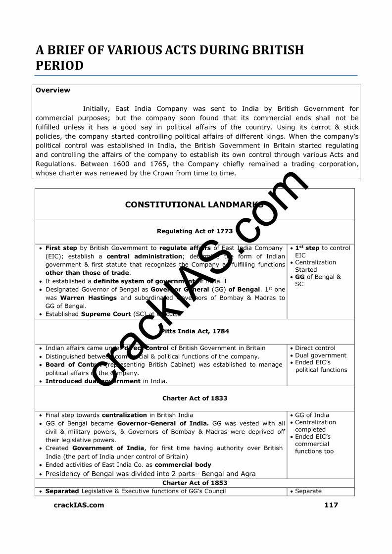
crack
IAS.com
crackIAS.com 117
A BRIEF OF VARIOUS ACTS DURING BRITISH PERIOD
Overview
Initially, East India Company was sent to India by British Government for
commercial purposes; but the company soon found that its commercial ends shall not be
fulfilled unless it has a good say in political affairs of the country. Using its carrot & stick
policies, the company started controlling political affairs of different kings. When the company’s
political control was established in India, the British Government in Britain started regulating
and controlling the affairs of the company to establish its own control through various Acts and
Regulations. Between 1600 and 1765, the Company chiefly remained a trading corporation,
whose charter was renewed by the Crown from time to time.
CONSTITUTIONAL LANDMARKS
Regulating Act of 1773
First step by British Government to regulate affairs of East India Company
(EIC); establish a central administration; determine the form of Indian
government & first statute that recognizes the Company as fulfilling functions
other than those of trade.
It established a definite system of government of India. l
Designated Governor of Bengal as Governor General (GG) of Bengal. 1st one
was Warren Hastings and subordinated Governors of Bombay & Madras to
GG of Bengal.
Established Supreme Court (SC) at Calcutta
1st step to control
EIC Centralization
Started GG of Bengal &
SC
Pitts India Act, 1784
Indian affairs came under direct control of British Government in Britain
Distinguished between commercial & political functions of the company.
Board of Control (representing British Cabinet) was established to manage
political affairs of the company.
Introduced dual government in India.
Direct control
Dual government Ended EIC’s
political functions
Charter Act of 1833
Final step towards centralization in British India
GG of Bengal became Governor-General of India. GG was vested with all
civil & military powers, & Governors of Bombay & Madras were deprived off
their legislative powers.
Created Government of India, for first time having authority over British
India (the part of India under control of Britain)
Ended activities of East India Co. as commercial body
Presidency of Bengal was divided into 2 parts– Bengal and Agra
GG of India Centralization
completed Ended EIC’s
commercial
functions too
Charter Act of 1853
Separated Legislative & Executive functions of GG’s Council Separate

crack
IAS.com
crackIAS.com 118
A separate Lieutenant-Governor was appointed for Bengal.
Created separate Legislative Councils for India, but with only officials as its
members
Also introduced open competition for civil services of the company &
deprived the Directors of the company their patronage powers
legislative body
created Open competition
Government of India, 1858
Rule of company was replaced by rule of crown
Secretary of State (SoS) for India was appointed to exercise the power of
the crown. He was member of British Cabinet, responsible to British
Parliament & assisted by Council of India having 15 members.
GG became the agent of the crown.
Rule of Crown started
Secretary of state created
Indian Councils Act of 1861
Introduced some Indians as non-official members in Legislature
Provision was also made for the inclusion of some Ilndians in the
Governor-General’s Council.
Thus seeds of Parliamentary system sown in India (representative
institutions)
Initiated process of decentralization by restoring Bombay & Madras’
legislative powers
Policy of legislative devolutions introduced which culminated into grant of
almost complete internal autonomy of Provinces in 1937
Empowered GG to frame rules of business (powers that Indian President has
today under Article 77)
Statutory recognition to portfolio system
Member in-charge of his department could issue final orders with regard to
matters which concerned his department
Introduced
Indians in
legislature; they
were nominated
Indian Councils Act of 1892
Introduced indirect elections. GG still had power to nominate members
Enlarged functions of Legislative Councils. They had power to discuss
budget and address questions to the executive, but they were not given the
power of voting.
Indirect elections Power to discuss
budget & ask questions
Indian Councils Act, 1909 :: Morley-Minto Reforms
Minto (Governor-General of India); Morley (Secretary of State)
Changed name of Central Legislative Council to Imperial Legislative
Council. Officials had majority in it
Attempted for the first time the introduction of representative and popular
element in the government
Provincial legislative Councils had non-official majority
Introduced separate electorate system. Introduced communal
representation for Muslims. Legalized communalism (Lord Minto called as
father of communal electorate)
Enlarged deliberative powers of
members of councils
Separate electorate
Communal
representation
Government of India Act, 1919 (Montagu -Chelmsford Reforms)
Chelmsford (Governor-General of India); Montagu (Secretary of State)
Separated central subjects from provincial
Created centre-
state relations

crack
IAS.com
crackIAS.com 119
Provincial subjects were of 2 types: 1. Transferred 2. Reserved
Transferred subjects administered by Governor with aid of ministers
responsible to Legislature
Reserved subjects administered by Governor & his executive Council without
any responsibility to Legislature
Diarchy (dual system of government) was introduced
Introduced Bicameral Legislature (upper & lower houses)
Introduced direct elections for the first time as majority members of both
houses were directly elected.
3 of 6 members of Governor-General’s Council were Indian
Demand for responsible government remains unfulfilled as Central Government
remain responsible to British Parliament.
Diarchy failed in Provinces because of dominance of Governor and Executive
Council over policy and ministers
Provided for establishing a Public Service Commission for recruitment to
higher civil services.
Local-self government became a provincial & transferred subject
under a responsible Indian minister.
Diarchy
2 Houses of
legislature (birth of Lok Sabha & Rajya Sabha)
Direct elections
Simon commission
The Indian Statutory Commission was a group of 7 British Members of
Parliament that had been dispatched to India in 1927 to study constitutional
reform in Britain's most important colonial dependency.
Commonly referred to as the Simon Commission after its chairman, Sir John
Simon.
One of its members, Clement Attlee, who subsequently became the British
Prime Minister, would oversee the granting of independence to India and
Pakistan in 1947.
The Commission’s recommendations were:
Future Advance:
The first principle was that the new constitution should, as far as
possible, contain within itself provision for its own development. It should
not lay down too rigid and uniform a plan, but should allow for natural
growth and diversity.
Constitutional progress should be the outcome of practical experience.
Where further legislation is required, it should result from the needs of the
time, not from the arbitrary demands of a fixed time-table.
The constitution, while contemplating and conforming to an ultimate
objective, should not attempt to lay down length or the number of the
stages of the journey.
Almost Responsible Government at the Provincial Level:
Diarchy should be scrapped and Ministers responsible to the
Legislature would be entrusted with all provincial areas of responsibility.
However, safeguards were considered necessary in areas such as the
maintenance of peace and tranquility and the protection of the legitimate
interest of the minorities. These safeguards would be provided, mainly, by
the grant of special powers to the Governor.
Federation
The Report considered that a formally federal union, including both
British India & Princely States, was the only long-term solution for a
united, autonomous India.
Immediate Recommendations at the Centre
New constitution
Diarchy should be
scrapped
Federal union
Franchise should
be extended

crack
IAS.com
crackIAS.com 120
To help the growth of political consciousness in the people, the franchise
should be extended; and the Legislature enlarged.
The Report strongly opposed the introduction of Diarchy at the
Centre.
Government of India Act, 1935
Provided for establishment of All-India Federation with its units consisting of
Provinces & Princely States (they didn’t join & so federation didn’t come into
existence)
3 lists of subjects – Federal, Provincial & Concurrent- introduced; Residuary
powers with GG.
Abolished Diarchy in provinces & introduced provincial autonomy
Introduced Diarchy at Centre & Bicameralism in Provinces (in Bombay,
Madras, Bengal, Assam, Bihar, United Provinces)
Introduced Responsible governments in Provinces (that is, Governor
responsible to Provincial legislature)
Established a federal court having original, appellate & advisory jurisdiction
Provided for the protection of the rights & privileges of members of civil
services.
Provided for establishment of not only a Federal Public Service Commission but
also a Provincial Public Service Commission and Joint Public Service
Commission for two or more provinces.
Federation of
India Concurrent list
added Provincial
autonomy
Indian Independence Act, 1947
Declared India as independent & sovereign state
Created 2 independent dominions, GG of each appointed by king
Established responsible government at both Center & Provinces
Designated GG of India & Provincial Governors as constitutional heads
(nominal heads)
It assigned dual functions (i.e. constituent and legislative) to the Constituent
Assembly formed in 1946. It declared this dominion legislature as a sovereign
body.
Till 1947, Government functioned under
the provisions of 1919 Act as the
provisions of 1935
Act relating to federation and Diarchy did not come into operation
LETS PRACTICE :: UPSC LAST 10 YEARS
QUESTIONS
Which of the following is/ are the principal feature(s) of the Government of India Act, 1919? 1. Introduction of diarchy in the executive
government of the provinces
2. Introduction of separate communal electorates for Muslims
3. Devolution of legislative authority by the
centre to the provinces Select the correct answer using the codes given
below:
a. 1 only
b. 2 and 3 only
c. 1 and 3 only d. 1, 2 and 3
Ans. C
The distribution of powers between the centre and the States in the Indian Constitution is based on the scheme provided in the a. Morley - Minto Reforms, 1909 b. Montagu - Chelmsford Act, 1919 c. Government of india Act, 1935 d. Indian Independence Act, 1947 Ans. C The Government of India Act of 1919 clearly defined a. The separation of power between the
judiciary and the legislature
b. The jurisdiction of the central and provincial governments
c. The powers of the Secretary of State for
India and the Viceroy d. None of the above Ans. B

0
crackIAS.com
Click here to BUY NOW
PT Topper’s Pack

crack
IAS.com
Samples from
INDIAN GEOGRAPHY

crack
IAS.com
crackIAS.com 9
PHYSIOGRAPHY OF INDIA
Overview
Imagine that you were born in Israel or Nepal. There are huge
number of countries in the world that are either completely a desert
or mountainous or simply plains. India is a blessed country. There
are only a very few countries in the world which are geographically
as blessed as India. You don’t need to go anywhere else; a travel
across India will give you an experience of almost all physiographic/
geographical features on earth. A journey thru Physiography of India
will show you the geographical features of India; and you must try
to relate every feature to its vegetation/ people/ their lifestyles and
the economy of that place.
Covering an area of more than 32 Lakhs Sq. km, India is the 7th largest country in the
world.
Area-wise (in Million Sq Km)
Russia
→ Canada
→ USA
→ China
→ Brazil
→ Australia
→ India
17 10 9.8 9.6 8.5 7.7 3.28
It has a land frontier of about 15,200 km. The total length of the coastline of the
mainland and Islands (Lakshdweep and Andaman & Nicobar Islands) is 7,516 km.
Tropic of cancer divides India in almost 2 equal parts. The southern half coinciding with
peninsular India lies in tropical zone, and the northern half, somewhat continental in nature,
belongs to sub-tropical zone.
Tropic of cancer passes through 8 states of India (Gujarat, Rajasthan, M.P., Chhattisgarh,
Jharkhand, W.B, Tripura and Mizoram)
Countries having a common border with India are Afghanistan, Pakistan, China,
Bhutan, Nepal, Myanmar, and Bangladesh. Sri Lanka is separated from India by a narrow
channel of sea formed by the Palk Strait and the Gulf of Mannar. Total 7 countries have
common border with India.
Longitudinal Extent (mainland) 8o4’N - 37o6’ N 3,214 km
Latitudinal Extent (mainland) 68o7’E - 97o25’ E 2,933 km
India lies entirely in the northern hemisphere. India belongs to Eastern Hemisphere as
it is situated to east of Prime Meridian. It occupies south cenral peninsula of Asian continent
It has 2 time zones: 82o30’ E forms standard Meridian
EXTREME POINTS OF INDIA
Northernmost Dafdar in Taghdumbash Pamir near Beyik Pass in J&K 37°05’N 74°40’E
Southernmost Indira point 6°45'N 93°49'E
Westernmost West of Ghuar Mota, Gujarat 68°34'E 23.67N 68.52E
Easternmost Kibithu, Arunachal Pradesh 96°30'E 28°01′N 97°24′E
Indira Point (N 6°45' E 93°49') - Southernmost point of Indian Territory. Located on
Great Nicobar. Indonesia lies few kilometers away from Indira Point. Great Channel

crack
IAS.com
crackIAS.com 10
separates India from Indonesia. Indira Point is also known as Parsons Point or Pygmalion
Point
Order of countries sharing border with India (in decreasing order of border length)
Bangladesh – China – Pakistan – Nepal – Myanmar – Bhutan – Afghanistan.
Its total land frontier is 15200 kms.
Maritime boundary – 6100 kms; it is 7516 km if we include Andaman and Nicobar and
Lakshadweep.
Kanyakumari – Southernmost point of Indian Mainland.
Where the Himalayan mountains stand today, the region was under marine conditions about
60 crore years ago. On the other hand, Peninsula dates back as far as 380 crore years.
With the opening of Suez canal (in year 1869), the distance of India and Europe has been
reduced by 7000 Km.
Indian Subcontinent was originally part of Gondwana continent.
MAJOR PHYSIOGRAPHIC REGIONS
Three Major Structural components –
(1) The Great Mountains of North.
(2) The Northern Plains Subdivisions:-
(a) Great Plains
(b) Thar Desert
(3) The great peninsular plateau – Having Subdivisions.
(a) Central Highlands
(b) Peninsular Plateaus
(c) Coastal Plains
Islands of Andaman & Nicobar and Lakshadweep form the fourth division of India.
Area wise these subdivisions can be arranged as – Peninsular Plateaus, Northern Mts.,
Great Plains, Central Highlands, Coastal Plains, Thar Desert and Islands.
GREAT MOUNTAIN WALL OF NORTH
Trans Himalyas
From Pamir Knot (The roof of the world) run several mountain ranges. Kunlun run into
Tibet, Karakorum enters Kashmir and runs S-E and includes the Plateau of Aksai Chin. It
extends further east, known as Kailas Range in Tibet. Pamir is the connecting link
between the Himalayas and the high ranges of Central Asia.
Karakoram contains K2 (Godwin Austin), second highest peak in the world. Karakoram
pass is situated in Karakoram Range.
Baltoro and Siachin are some of the glaciers in this area. Length wise glaciers of
Karakoram are – Siachen (in Nubra valley), Hispar, Biafo and Baltoro.
To the south of Karakoram lie two parallel ranges – Ladakh and Zaskar.
Indus originates beside Kailash. Flows between Ladakh and Zaskar ranges from south-east
to north-west. Indus forms deepest gorge of this region in Gilgit.
Nanga Parbat overlooks Indus in the North.
The Himalyas
Himalayas emerged out of the Tethys Sea in three different phases. The first phase
commenced about 120 million years ago, when the great Himalayas were formed. The
formation was completed about 70 million years ago. The second phase took place about 25

crack
IAS.com
crackIAS.com 11
to 30 million years ago when the Middle Himalayas were formed. The Shiwaliks were
formed about 2- 20 million years ago.
Himalayas run for a distance of 2500 km (over 22o longitudes) between Indus and
Brahmputra. Width of Himalayas varies from 400 km in the west to 150 km in the east.
Himalayas are wide in the west and narrow towards the east. The height of the eastern half
is greater than the western half.
Wider in west because of many parallel and oblique ranges.
Himalayas in J&K and H.P. are called us western Himalaya. In Uttarakhand and Nepal are
known as central Himalayas and in W.B., Sikkim, Bhutan and Arunachal Pradesh they are
known as Eastern Himalayas.
Mountains along the eastern boundary of India are called Purvanchal. These are less
spectacular them Himalaya. They are of medium height and comprise the Patkai Bum, and
Naga Hills in the north and Mizo hills in the south.
The Greater Himalyas
Greater Himalayas or Himadri are the northern most and loftiest of all.
Mt. Everest or Sagarmatha (8848 m) is the highest peak of the world, located in Nepal.
Tibetans call it Chomlungma
Kanchanjunga is the second highest peak of Himalaya and lies in Sikkim.
Namcha Bharwa (located in China) is an important peak in east overlooking the
Brahmputra where this range takes a sudden turn (like a hairpin) towards south to enter
India.
The area where Himalayas stand today together with the northern plains of India was
occupied by a Sea, called ‘Tethys’.
Tethys was elongated and shallow sea sandwiched between two giant masses ‘the
Angaraland’ in the north and ‘the Gondwanaland’ in the south.
Tethys stretched from the present Indo-Burmese border in the east and covered the vast
area including western Asia, North eastern and central parts of Africa before it joined the
South Atlantic Ocean in the Gulf of Guinea.
As the Himalaya began to gain in height, the rivers and the other agents of denudation
became increasingly active in eroding them, and carrying huge amounts of silt deposits in
the shrinking Tethys. Thus Northern plains or Indo-Gangetic Plains formed.
Himalayas are not an effective water divide as the rivers like Indus, Satluj and
Brahmputra cut gorges through it in order to turn towards south.

crack
IAS.com
crackIAS.com 12
MAJOR MOUNTAIN RANGES OF INDIA
Middle/ Lesser Himalyas
To the south of Great Himalayas, known as the Himachal. All the important hill stations
such as Dalhousie, Dharamshala, Shimla, Mussoorie, Nainital – Darjelling.
Southernmost ranges of Himalayas are called Shivaliks – made up of unconsolidated
deposits of rivers are prone to earthquakes and landslides.
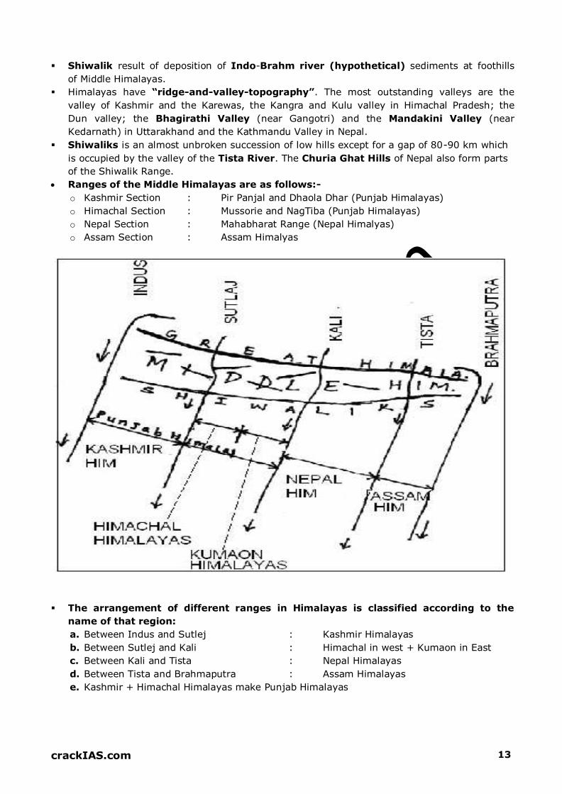
crack
IAS.com
crackIAS.com 13
Shiwalik result of deposition of Indo-Brahm river (hypothetical) sediments at foothills
of Middle Himalayas.
Himalayas have “ridge-and-valley-topography”. The most outstanding valleys are the
valley of Kashmir and the Karewas, the Kangra and Kulu valley in Himachal Pradesh; the
Dun valley; the Bhagirathi Valley (near Gangotri) and the Mandakini Valley (near
Kedarnath) in Uttarakhand and the Kathmandu Valley in Nepal.
Shiwaliks is an almost unbroken succession of low hills except for a gap of 80-90 km which
is occupied by the valley of the Tista River. The Churia Ghat Hills of Nepal also form parts
of the Shiwalik Range.
Ranges of the Middle Himalayas are as follows:-
o Kashmir Section : Pir Panjal and Dhaola Dhar (Punjab Himalayas)
o Himachal Section : Mussorie and NagTiba (Punjab Himalayas)
o Nepal Section : Mahabharat Range (Nepal Himalyas)
o Assam Section : Assam Himalyas
The arrangement of different ranges in Himalayas is classified according to the
name of that region:
a. Between Indus and Sutlej : Kashmir Himalayas
b. Between Sutlej and Kali : Himachal in west + Kumaon in East
c. Between Kali and Tista : Nepal Himalayas
d. Between Tista and Brahmaputra : Assam Himalayas
e. Kashmir + Himachal Himalayas make Punjab Himalayas

crack
IAS.com
crackIAS.com 14
NORTHERN PLAINS
Length is about 3000 km from Indus to Brahmaputra; width varies from 150 km (Assam) to
400 km (Allahabad).
It slopes south east, from Punjab towards W. Bengal.
There are primarily 5 divisions of Plains:-
Punjab Plains
Indus and its tributaries make these plains, with 5 Doabs (area between two rivers).
Punjab derives its name from 5 river waters. These are (from south to north):-
o BIST: Between Sutlaj & Beas
o BARI: Between Beas & Ravi
o RACHNA: Between Ravi & Chenab
o CHAJ: Between Chenab & Jhelum
o SIND SAGAR: Between Jhelum & Indus
Placed from South to North, these rivers are: Sutlej, Beas, Ravi, Chenab, Jhelum and Indus
Northern hilly region has enormous gullying, resulting into badlands called Chos
Less than one-third of the Indus basin is located in India (J&K, H.P & Punjab)
Haryana Plains
Act as a water divide of Indian Plains (Ambala distt.). These separate the Indus system
from the Ganga system. Drained by River Yamuna (tributary of Ganga).
The outcrops of Aravalli in the southern part have broken the monotony of these plains.
This region is called Bhavani Bangar
Ganga Plains
Ganga after rising from Gangotri enters Northern plains at Haridwar, Yamuna joins it at
Allahabad.
Plains are dominated by the confluence of cones of the tributaries of Ganga.
These consist of three sub-divisions, namely (from west to east): Rohailkhand Plains, Awadh
Plains and Bihar Plains.
West Bengal Delta
Delta formed by Ganga, Brahmaputra and Damodar.
Largest and fastest growing delta of the world and it is also the most fertile delta.
Important for Jute and Rice cultivation. Three crops of rice per year.
The marshes here are important for Sundari trees (Sunderbans)
Brahmaputra Plains
Lie in Assam, these plains are prone to floods, earthquakes and gullying

crack
IAS.com
crackIAS.com 15
LATITUDINAL DIVISIONS OF NORTHERN PLAINS
Bhabar
A Narrow, Continuous belt along the foothills of Shivaliks, from Indus to Tista
Consists of degraded materials- pebbles. It’s a porous zone.
Rivers are lost here after emerging from Himalayas
Consists of alluvial cones and inter-cones
Terai
Region (in Uttar Pradesh) where rivers re-emerge after being lost in Bhabar region
Consists of wetlands and marshes. Rice cultivation practiced here
Fertile soils, only soil having nitrates in India.
In Assam, this region is called Duars, useful for tea cultivation
Bhangar
Alluvial Terraces along the river floodplains; consists of calcareous Kankars.
Known by different names in different regions
Barind : West Bengal
Bhur : Aeolian deposits in upper Ganga-Yamuna doab
Dhaiya : Punjab (highly gullied)
Dharos & Dhands : Indus (long & narrow)
Khadar
New alluvium in floodplains of rivers.
Highly fertile soils consisting of ox-bow lakes and meanders

crack
IAS.com
crackIAS.com 16
THE DETAILED DESCRIPTION OF PHYSIOGRAPHIC REGIONS OF INDIA IS AS
FOLLOWS:
REGION 1: KASHMIR
Relief: mountainous, rugged topography with parallel and oblique ranges interspersed by
river valleys.
Rivers: Jhelum, Chenab and Ravi. Jhelum cuts through Pir Panjal and makes Baramula
Pass
Lakes: Wular (Ox-bow lake of R.Jhelum), Dal

crack
IAS.com
crackIAS.com 17
Ranges: Shiwalik, Dhaola Dhar and Pir Panjal of Middle Himalayas, and Inner Himalayas i.e.
Great himalyas.
Peaks:Nanga Parbat (8126 m)
Passes: Zozila, Banihal, Burzil, Bara Lacha La
Vegetation: Alpine in north to Montane sub Tropical and Temperate in South
Forested Area: J&K– 20% of total geographical area that falls within territory of india
National Parks: Dachigam, Kishtwar, Salim Ali
Tribes: Gujjars & Bakarwals – (They Experience Transhumanes)
Tourism Places: Amarnath, Gulmarg (Ski resort), Srinagar
HEPs: Salal, Dul Hasti, Uri
Tilted beds of Lake Deposits called KAREWAS are found on the flanks of Pir Panjal Range
REGION 2: KARAKORAM, LADAKH AND BALTISTAN
Result of Collision between Peninsula and Eurasian Plate. Outcome was Trans-Himalayas
Ranges (Ladakh & Zaskar Range) and Karakoram Range. Karakoram uplifted before the
rise of Himalayas.
Relief : General Elevation is more than 5000m (Ladakh Plateau – 5300 m)
Peaks : K2 (8611m), Godwin Austin, Gasherbrum
Rivers : Indus basin (tributaries Shyok & Gilgit join from north, Zaskar from
south)
Lakes : Pangong, Salt Lake, Tso Morari.
Plains : Aksai Chin, Deosai, Baltistan
Passes : Karakoram, Aghil
Siachen : World’s longest Glacier (72 km) and highest battlefield in the world Glacier
Forest : Devoid of any forest (Cold desert)
Single strategic road from Srinagar to Leh passes through Zojila Pass
Most of it occupied as CoK (China occupied Kashmir) & PoK (Pakistan occupied Kashmir)
REGION 3: KUMAON & HIMACHAL
Narrow Longitudinal Valleys called DUNES between Shiwaliks and Middle Himalayas, for
example Dehradun, Kothridun (Kumaon Himalayas), Patlidun (All in Uttranchal)
Covers the states of Himachal Pradesh and Uttarkhand
Highly Forested (HP-24%, Uttarakhand > 60%)
National Parks: Valley of Flowers, Jim Corbett, Nanda Devi (All in Uttranchal); Great
Himalayan & Pin Valley (in HP)
Tribes: Gaddis (H.P.), Bhotias (Garhwal & Kumaon)
Peaks: Nanda Devi, Kamet.
Pilgrimage: Gangotari, Yamunotari, Badrinath, Kedarnath
Tourism: Kullu, Manali, Shimla, Dehra Dun, Mussorie, Nainital

crack
IAS.com
crackIAS.com 18
HEPs: Naptha Jakri (Satluj in H.P.), Tehri (Bhagirathi in Uttarakhand), Thein (Ravi in H.P.)
REGION 4, 5, 16: EASTERN HIMALAYAS, PURVANCHAL, MEGHALAYA PLATEAU
Younger, bolder and steeper than Western Himalayas with abrupt rise
Protruding of hard peninsular rocks into Eurasian plate, therefore syntaxial (knee like)
bending. Himalayas turn to north-south direction over here
Distinction between parallel ranges is lost here, therefore Narrower than Western
Himalayas
Important Ranges/ hills:-
o Dafla, Miri, Abor and Mishmi in E.Himalayas
o Patkai Bum, Naga, Mizo, Barail, Rengma, Mikir in Purvanchal
o Garo, Khasi, Jaintia in Meghalya Plateau
Peaks – Kanchenjunga (8598m), Namcha Barwa (7756m)
Rivers: Dihang, Dibang, Lohit, Subansiri and Surma (All tributaries of Brahmputra)
Passes – Diphu Pass (Tri-junction of India, China and Myanmar), Bomdila, Nathu la,
Jelepla
Lakes – Loktak ( Manipur with floating island)
HEP – Loktak Lake HEP
Mynsynram receives more than 1000 cm rainfall annually.
Highly Forested (Arunachal Pradesh > 94%)
National Parks: Namdapha, Keibul Lamjao, Dampa, Nokrek.
Agriculture: Jhum (Shifting) Cultivation, Rice in Surma Valley
Population density of Tripura > 300 persons/ sq. km because deltaic plains of Bangladesh
extend here.
Tribes – Garo, Khasi & Jantia (Meghalaya); Kuki (Manipur), Nagas, Lushai (Mizoram);
Chakmas (Tripura), Abors (A.P.); Lepchas (Sikkim)
Literacy – Low in Arunachal. High in Tripura and Mizoram
REGION 12 – ARAVALLI REGION/ HILLS
Fold mountain- Highly dissected, denuded, a Relic mountain. Av. Elevation 800-900 m
Senile stage of landform development. Older than Himalayas
Broader in south as compared to north.
Elevation goes on decreasing from south to north, quite pronounced in Udaipur. Gurusikar
(in south): highest peak near Mt. Abu.
Extends from Delhi Ridge to Ahmedabad from N-E direction to S-W direction.
North of Ajmer, divide into several parallel ranges separated by longitudinal valleys: Delhi
ridge and Ambala ridge.
Acts as Gangetic water divide.
Nakki Lake: Mt. Abu – famous for tourism
Rivers: Luni and its small tributaries flow westward, and Banas and its feeders flow
eastward
Aravallis are parallel to SW monsoon and fall in the zone of subsidence; therefore, scanty
rainfall & low humidity. High seasonal variation in rainfall
Rain fall: Southern side faces more rainfall (broader)
Vegetation– southern side– moist and dry deciduous to dry deciduous and thorny in north.
Western face fairly rainy and forested. North of Ajmer– devoid of forest cover

crack
IAS.com
crackIAS.com 19
REGION 13: CENTRAL VINDHYAN UPLANDS
Location: Aravallis in west, Vindhayan Range in south & plains in north.
Vindhyan Range continues as Bhander and Kaimur hills in east. Forms watershed between
Ganga system & Southern rivers
Malwa plateau rolls down to north & finally merges with Gangetic Plains. Highly dissected
by river valleys of Tributaries of Chambal: Sind, Betwa & Ken, therefore forming Badlands
Majority of it lies in M.P.
Tribes: Bhils, Kol, Gond
REGION 14: KHANDESH & SATPURA – MAIKALA RANGE
Satpuras are Fold Mountains. Known by different names at different sections. From west
to east, it names as Rajpipla, Gawligarh and Mahadeo Hills
Mahadeo Hills forms the highest portion. Dhupgarh Peak (1350m) near Panchmarhi
(hill station) in M.P. is highest peak of Satpuras. Tapi rises from here.
Maikala Range/ Amarkantak Plateau: Wet Forested Region is the source of many rivers
like Narmada, Son, Mahanadi, and Wainganga.
Rivers:
o Narmada & Tapi – west flowing
o Son – biggest Tributary of Ganga from south
o Wainganga – major tributary of Godavari
Highly forested area with national parks: Pench, Kanha, and Satpura.
REGION 17, 18: KACHCHH & KATHIAWAR, GUJARAT PLAINS
Mineral oil & Natural Gas – commercial production along western Gujarat plains. Kalol,
Ankaleshwar, Gandhar are important ones

crack
IAS.com
crackIAS.com 20
KACHCHH KATHIAWAR GUJARAT PLAINS
Consists of Great Rann along north.
Little Rann on coast & south east.
Prone to earthquakes & floods
Rivers: Luni & Banas
Wild Ass Sanctuary
Central Tableland with Highest
point: Mt. Girnar. Radial drainage pattern
Gir National Park: Asiatic Lion
(only place in the world for
Asiatic lion)
Alluvial Plains
Drained by
Sabarmati, Mahi,
Narmada & Tapi
REGION 23, 24, 26: DECCAN LAVA PLATEAU INCLUDING KARNATAKA & TELENGANA-
RAYALSEEMA PLATEAUS
Extends from Vindhyas to the southern tip of Peninsula.
It is triangular in shape and is widest in the north.
Important Ranges in the northern part are Satmala, Ajanta, Balaghat & Harishchandra.
Western Ghats lies on the western side of plateau.
Deccan Plateau is highest along its western edge and gently slopes towards the Bay of
Bengal in the east.
Towards its south lies the Karnataka Plateau. The western part of this plateau is called
Malnad while the eastern is called Maidan. Western part is higher and more rugged.
Baba Budan Hills is an important Range along Karnataka Plateau.
It lies in the rain shadow zone of Western Ghats, therefore, severely prone to droughts
Important rivers of this region are – Krishna, Tungabhadra, Penneru and Cauvery
Tank irrigation is widely practiced here
Towards the South-East lies the Telengana-Rayalseema Plateau which is a low plateau,
highly dissected and denuded. River Krishna divides it into two parts- Telengana in north
and Rayalseema in south.
It is also a drought prone area, lying in the rain shadow of Karnataka Plateau.
Twin cities of Hyderabad and Secundrabad lie in the Telengana region.
REGION 25: WAINGANGA AND MAHANADI BASINS
Here lie the river valleys of Wainganga, Mahanadi and Indravati (a tributary of Godavari).
Chitrakoot Falls lie on Indravati.
It includes Dandkarnaya Plateau - Highly forested, denuded and undeveloped region
(Bastar, Kalahandi and Koraput districts) of India.
Chattisgarh Plains also lie here
National Parks: Tadoba, Nawegaon, Indravati
Important Mines: Dilli Rajhara, Bastar, Bailadila, Balaghat
REGION 28, 22 & 27: WESTERN & EASTERN GHATS & SOUTHERN HILL COMPLEX
Western Ghats
Form a continuous barrier from north to south, almost parallel to the Arabian Sea.
General altitude is 900-1100 m. These are higher in their southern part
Known as Sahyadri in Maharashtra and Karnataka, Nilgiris in T.N., Anaimalai and
Palni-Cardamom Hills in Kerala and Tamil Nadu.

crack
IAS.com
crackIAS.com 21
Collectively Nilgiris, Anamalai Hills & Palni-Cardamom Hills form Southern Hills Complex.
Nilgiris is the meeting point of Western Ghats, Eastern Ghats and Southern Hill Complex.
Doda Beta (2637m) is the highest peak of Nilgiris. Udagamandalam (ooty) is a hill station
located in Nilgiris (Tamil Nadu). Temperate forests called Sholas are found here.
Anai Mudi (2,695m) is the highest peak of Western Ghats. It is located in Anamalai Hills
and falls in Kerala.
Famous hill station of Kodaikanal (T.N) lies in Palni Hills. The source of Periyar River lies
in Cardamom Hills. Periyar Lake is also situated here.
Eastern Ghats
Form a discontinuous line of hills parallel to E.Coast
Known by different names at different places –
o Northern Circars in north of Godavari
o Palkonda & Nallamala between Godavari & Palar Rivers
o Shevaroy & Javadi as T.N hills
As opposed to Western Ghats, E. Ghats are higher in northern part. Mahendra Giri
(1501m) is the highest peak of E.Ghats, lying in Orissa.
Western Ghats Eastern Ghats
Higher average elevation than E. Ghats. Higher in
Southern part
Source of many rivers. Act as a water divide
High rainfall (>200cm). higher in south
Greater HEP potential. Many waterfalls
Water falls in Western Ghats
Higher in northern part Not a source of any river
Less rainfall (<200cm). higher in north
Lesser potential
Water falls in Eastern Ghats

crack
IAS.com
'>
-J 5
z
>
c
n
<ll-'-1\ - L {
BAGHELKHAND ?7 / RAJMAHAL HIIL1V\ !'
CHOTANAGPUR PL.\.\
f\ (,,.
"' " PACHPATMALI & GANDMARDHAN UILLS
' _.,,
SAH'YADRIS
\
BABABUDAN MOUNTAIN RANGES & PLATEAUS
NILGIRIS
IV IV
'V
m >c: U)
>z c
z c:')
m U)
0 "''I 'V m
.... z U) c: .., .... z .... >

crack
IAS.com
crackIAS.com 23
REGION 19, 20, 21, 29, 30 AND 31: COASTAL PLAINS
West Coastal Plain
Extend from Gujarat to Kerala.
Known as Konkan in the north (Daman to Goa), Kanara in Karnataka and Malabar in the
Kerala.
Plains are narrower in the north (Goa & Karnataka) and wider in south (Kerala)
Jog Falls/ Gersoppa Falls (on R. Sharavati) on Karnataka Coast are the Highest in India.
In Kerala, coast has salt water lakes called Lagoons or Backwaters or Kayals. Important
Lakes here are Ashtamudi and Vembanad
Lowlands during rains merge together to form Patlas; are used for cultivation
East Coastal Plains
Coastal strip along Bay of Bengal is broader as compared to the western coast.
Known as Utkal Plains (in Orissa); wide and deltaic (Mahanadi & Brahamani delta). Chilka
lagoon is located here
Andhra Plains: Deltaic (Godavari & Krishna delta) in middle. Kolleru lake lies here
Coromandal Coast (Tamil Nadu) in south; Deltaic (Cauvery delta); Pulicat lake lies here
Western Coastal Plains Eastern Coastal Plains
Formed by submergence of western side of
Western Ghats. Retrograded coastline Less in width due to subsisdence. Continental
Shelf is wide because of the same reason
Rivers are smaller, swift and more erosive.
Form estuaries.
Rainfall: 200-400 cm (SW Monsoon)
Less prone to cyclones
Not prone to floods except Narmada estuary
because of swiftness and small lengths of rivers
More contribution to marine food
Prospects of Wave Energy
More no. of Natural Harbours
Ports important for import purposes
Formed by alluvium brought by rivers like
Mahanadi, Godavari, Krishna & Cauvery.
Prograded coastline
Wider coast & narrower shelf due to
emergence
Rivers are longer, gradual and less erosive.
Form deltas.
Rainfall: 100-200 cm (SW & NE Monsoon)
More prone to cyclones
Prone to floods because of gradual lengths,
deltaic formations & long lengths of rivers
Less contribution
Prospects of OTEC (Ocean Thermal
Energy Conversion)
Lesser no.
Ports important for export purposes

crack
IAS.com
crackIAS.com 24
REGION 32, 33: ISLAND GROUPS
Lakshadweep Islands
Extend from 8ºN - 12ºN. Consists of 30 small islands, only 10 of which are populated.
Population consists of Moppilas (Muslims) from Kerala
Coral origin (made up by the organic activity of micro-organisms called coral polyps)
Among Lakshadweep islands, some islands are horse-shoe shaped called Atolls.
Lakshadweep Group consists of 2 sub-groups:
o Amandivi Islands - North of 11o N Channel
o Cannanore Islands - South of 11o N Channel
Minicoy Islands lie to the extreme south
Andaman and Nicobar Islands
Extend from 6º 39’N - 13º 34’N
Consist of two groups – Andaman Group (Great & Little Andaman) – 204 islands, and
Nicobar Group (Car, Little and Great) – 19 islands
Continent in origin. They are submerged parts of mountain range called Arkan Yoma
(Mayanmar).
Some of them are of volcanic origin and only active volcano of India is located on these
islands (Barren Island). Narcondam is the extinct volcanic island.
10º channel separates Andaman (Little) from Nicobar
Little Andaman is separated from Great Andaman by Duncan passage
Great Nicobar is the Largest Island in the group
Saddle Peak in North Andaman – highest peak
Car Nicobar encircled by a Fringing Reef
Prone to earthquakes and tsunamis
Main Tribes here are Great Andamanese, Onges, Senthelese, Jarawas and Shompens
High potential for wave power & OTEC
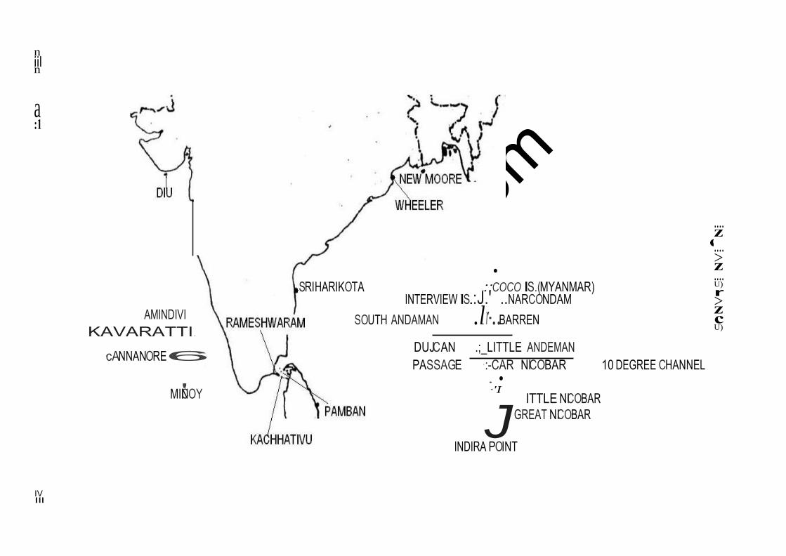
crack
IAS.com
c
n iil n
a :1
AMINDIVI
KAVARATTI.
·cANNANORE6
• SRIHARIKOTA .::COCO IS.(MYANMAR)
INTERVIEW IS.:J.' ..NARCONDAM SOUTH ANDAMAN .lr-..BARREN
DUJCAN .;_LITTLE ANDEMAN PASSAGE ·:-CAR NICOBAR 10 DEGREE CHANNEL
• •
.... z
.... >z .... U)
r >z c U)
MIN'ICOY ·'I
ITTLE NICOBAR
JGREAT NICOBAR
INDIRA POINT
IV Ill
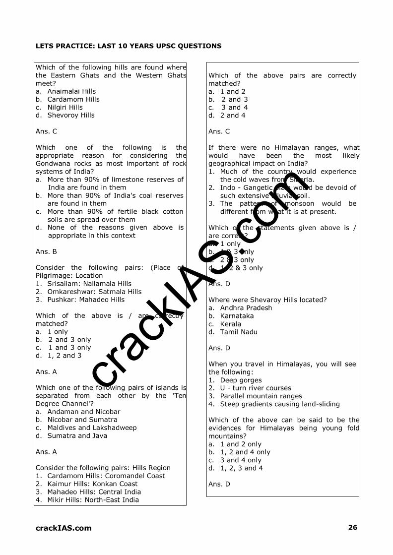
crack
IAS.com
crackIAS.com 26
LETS PRACTICE: LAST 10 YEARS UPSC QUESTIONS
Which of the following hills are found where
the Eastern Ghats and the Western Ghats
meet? a. Anaimalai Hills
b. Cardamom Hills
c. Nilgiri Hills d. Shevoroy Hills
Ans. C
Which one of the following is the
appropriate reason for considering the
Gondwana rocks as most important of rock
systems of India?
a. More than 90% of limestone reserves of
India are found in them
b. More than 90% of India's coal reserves are found in them
c. More than 90% of fertile black cotton
soils are spread over them d. None of the reasons given above is
appropriate in this context Ans. B
Consider the following pairs: (Place of
Pilgrimage: Location
1. Srisailam: Nallamala Hills
2. Omkareshwar: Satmala Hills
3. Pushkar: Mahadeo Hills Which of the above is / are correctly
matched?
a. 1 only
b. 2 and 3 only c. 1 and 3 only
d. 1, 2 and 3 Ans. A
Which one of the following pairs of islands is
separated from each other by the 'Ten
Degree Channel'?
a. Andaman and Nicobar b. Nicobar and Sumatra
c. Maldives and Lakshadweep
d. Sumatra and Java Ans. A
Consider the following pairs: Hills Region
1. Cardamom Hills: Coromandel Coast
2. Kaimur Hills: Konkan Coast
3. Mahadeo Hills: Central India
4. Mikir Hills: North-East India
Which of the above pairs are correctly
matched?
a. 1 and 2
b. 2 and 3
c. 3 and 4 d. 2 and 4 Ans. C If there were no Himalayan ranges, what
would have been the most likely geographical impact on India?
1. Much of the country would experience
the cold waves from Siberia.
2. Indo - Gangetic plain would be devoid of
such extensive alluvial soil. 3. The pattern of monsoon would be
different from what it is at present. Which of the statements given above is /
are correct?
a. 1 only
b. 1 & 3 only
c. 2 & 3 only
d. 1, 2 & 3 only
Ans. D Where were Shevaroy Hills located?
a. Andhra Pradesh
b. Karnataka
c. Kerala
d. Tamil Nadu
Ans. D When you travel in Himalayas, you will see
the following:
1. Deep gorges
2. U - turn river courses
3. Parallel mountain ranges
4. Steep gradients causing land-sliding Which of the above can be said to be the
evidences for Himalayas being young fold
mountains?
a. 1 and 2 only
b. 1, 2 and 4 only
c. 3 and 4 only
d. 1, 2, 3 and 4
Ans. D

crack
IAS.com
crackIAS.com 27
Which one of the following is the correct
sequence of the given hills starting from the
north and going towards the south?
a. Nallamalai Hills - Nilgiri Hills - Javadi
Hills - Anaimalai Hills
b. Anaimalai Hills - Javadi Hills - Nilgiri Hills
- Nallamalai Hills
c. Nallamalai Hills - Javadi Hills - Nilgiri
Hills - Anaimalai Hills
d. Anaimalai Hills - Nilgiri Hills - Javadi Hills
- Nallamalai Hills Ans. C
Consider the following:
1. Mahadeo Hills
2. Sahyadri Parvat
3. Satpura Range What is the correct sequence of the above
from the north to the south?
a. 1, 2, 3
b. 2, 1, 3
c. 1, 3, 2
d. 2, 3, 1 Ans. C
Match List I with List II and select the correct answer using the code given below
the lists: List I (Valley) List II (State)
A. Markha Valley
B. Dzukou Valley
C. Sangla Valley
D. Yumthang Valley
1. Sikkim
2. Himachal Pradesh
3. Jammu and Kashmir
4. Nagaland a. A-2, B-4, C-3, D-1
b. A-3, B-1, C-2, D-4
c. A-2, B-1, C-3, D-4
d. A-3, B-4, C-2, D-1 Ans. D
Consider the following statements:
1. Assam shares a border with Bhutan and
Bangladesh.
2. West Bengal shares a border with
Bhutan and Nepal.
3. Mizoram shares a border with
Bangladesh and Myanmar. Which of the statements given above is/are
correct?
a. 1, 2 and 3 b. 1 and 2, only
c. 2 and 3, only
d. 1 and 3, only Ans. A Between which of the following was the
ancient town of Takshaila located?
a. Indus and Jhelum
b. Jhelum and Chenab
c. Chenab and Ravi
d. Ravi and Beas
Ans. A Which one of the following pairs is not
correctly matched? Monastery: State a. Dhankar Monastery: Himachal Pradesh
b. Rumtek Monastery: Sikkim c. Tabo Monastery: Himachal Pradesh
d. Kye Monastery: Arunachal Pradesh Ans. D Which one of the following statements is
NOT correct?
a. The Western Ghats are relatively higher
in their northern region
b. The Anai Mudi is the highest peak in the
Western Ghats
c. Tapi river lies to the south of Satpura d. The Narmada and the Tapi river valleys
are said to be old rift valleys Ans. A In which State is the Guru Shikhar Peak
located?
a. Rajasthan
b. Gujarat
c. Madhya Pradesh
d. Maharashtra Ans. A

crack
IAS.com
crackIAS.com 36
INDIAN RIVER SYSTEM
Overview
Rivers are the most critical component of a geographical
ecosystem. After starting from mountainous regions, they flow
through the country influencing everyone’s life who come across
them. They are so important that they are equated with goddess in
Hindu religion. In earlier times, they were the cradle for civilisation
and the most prosperous kingdoms evolved around rivers. Today,
they play a very important role in people’s lives and economies.
India is a blessed country as far as rivers are concerned. Every part
of India has some of world’s most important rivers.
Himalayan Rivers are formed by melting snow & glaciers and flow throughout year.
Deccan Rivers are rain-fed and therefore fluctuate in volume. Many of these are non-
perennial. Coastal streams, especially on the west coast are short in length and most of
them are non-perennial.
The streams of inland drainage basin of western Rajasthan are few and far apart. Most of
them are of an ephemeral character.
About 77% of drainage is towards Bay of Bengal and rest is towards Arabian Sea.
Bhagirathi and Alaknanda join at Dev Prayag to form the River Ganga. Ganga traverses
through Uttarakhand, Uttar Pradesh, Bihar and West Bengal.
Indus rises near Mansarovar in Tibet and finally falls in the Arabian Sea near Karachi.
Indus is known as Shiquan in Tibet
Son is the largest tributary of Ganga from south. Gandhi Setu on Son River near Patna is
highest bridge in Asia.
Brahmaputra is known as Tsangpo in Tibet, Dihang in Arunachal & Jamuna in Bangladesh.
Near Passighat the Debang and Lohit join the river Brahmaputra crosses into Bangladesh
downstream of Dhubri.
It becomes Padma after meeting Ganga & finally discharges as Meghna in Bay of Bengal.
Principal tributaries of Brahmaputra are Subansiri, Jia Bhareli, Dhansiri, Puthimari, Pagladiya
and the Manas.
Barak River, the Head Stream of Meghna, rises in the hills in Manipur. It continues in
Bangladesh till the combined Ganga - Brahmputra join it near Bhairab Bazar.
Lohit makes delta in reverse when it joins Brahmaputra from south. Majuli (Assam) in
Brahamputra is the largest Riverine Island in the world. It has been declared world heritage
site by UNESCO.
Chambal is known for its Badland topography
Dhaunadar Falls or Marble Falls lie on River Narmada near Jabalpur
Godavari has the second largest river basin covering 10 per cent of the area of India.
A few rivers in Rajasthan do not drain into the sea. Few of them drain into the Salt lakes
while others like Luni, Machhu, Rupen, Saraswati, Banas and Ghaggar are lost in the desert.
Narmada forms traditional boundary between North and South India, and drains M.P.,
Gujarat and Maharashtra. Existing irrigation projects in the Narmada are Matiyari, Rani
Avantibai Sagar, Barna, Tawa and Sukta- all in Madhya Pradesh, and Karjan project in
Gujarat. Important Projects under implementation are Kolar, Man, Omkareshwar,
Maheshwar and Sardar Sarovar.
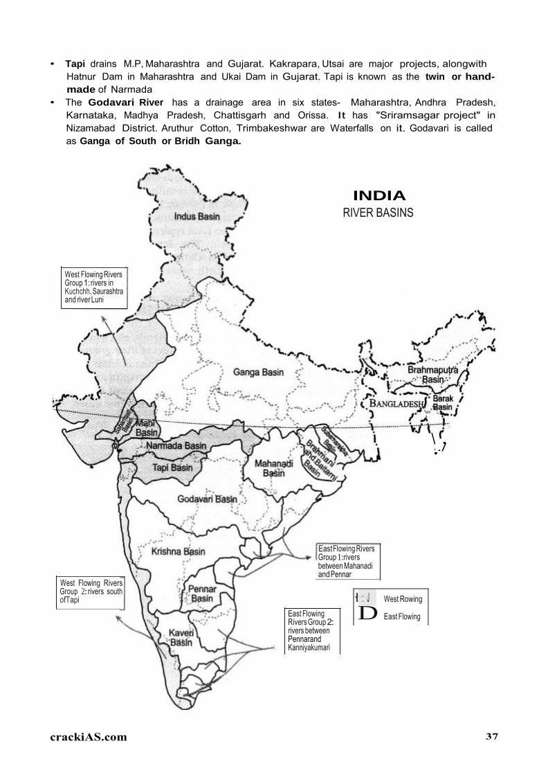
crack
IAS.com
crackiAS.com 37
·:I ··::·J West Rowing
D East Flowing
.
• Tapi drains M.P, Maharashtra and Gujarat. Kakrapara, Utsai are major projects, alongwith Hatnur Dam in Maharashtra and Ukai Dam in Gujarat. Tapi is known as the twin or hand
made of Narmada • The Godavari River has a drainage area in six states- Maharashtra, Andhra Pradesh,
Karnataka, Madhya Pradesh, Chattisgarh and Orissa. It has "Sriramsagar project" in Nizamabad District. Aruthur Cotton, Trimbakeshwar are Waterfalls on it. Godavari is called as Ganga of South or Bridh Ganga.
INDIA RIVER BASINS
West Flowing Rivers Group 1: rivers in Kuchchh, Saurashtra and river Luni
\ ../ •
West Flowing Rivers Group 2:rivers south ofTapi
EastFlowing Rivers Group 1:rivers between Mahanadi and Pennar
East Flowing Rivers Group 2: rivers between Pennarand Kanniyakumari

crack
IAS.com
crackIAS.com 38
IMPORTANT RIVERS OF INDIA
REMARKS SOURCES IMPORTANT TRIBUTARIES
INDUS SYSTEM
Indus
Snow ranges of Himalayas
at an attitude of 5000 m in
Tibet, near Mansarover
Lake.
The Zanskar is its left bank tributary in
Ladakh. In the plains, its left bank tributary
is the Chenab which itself has four major
tributaries, namely, the Jhelum, the Ravi, the
Beas and the Sutlej. Its principal right bank
tributaries are the Shyok, the Gilgit, the
Kabul, the Gomal and the Kurram.
The Indus River is a major river in Asia which flows through Pakistan, India and Tibet.
After flowing for >700 km in India, flows in Pakistan
Originating in the Tibetan Plateau in the vicinity of Lake Mansarovar, the river runs a
course through the Ladakh region of Jammu and Kashmir, towards Gilgit and Baltistan and
then flows in a southerly direction along the entire length of Pakistan to merge into the
Arabian Sea near the port city of Karachi in Sindh.
The total length of the river is 3,180 km (1,980 mi).
It is Pakistan's longest river.
The river is the 21st largest river in the world in terms of annual flow.
The Indus forms the delta of Pakistan and India mentioned in the Vedic Rigveda as Sapta
Sindhu and the Iranian Zend Avesta as Hapta Hindu (both terms meaning "seven rivers").
Jhelum
The river Jhelum rises from
Verinag Spring situated at
the foot of the Pir Panjal in
the south-eastern part of
the valley of Kashmir in
India.
The Neelum River, the largest tributary of
the Jhelum, joins it, at Domel Muzaffarabad,
as does the next largest, the Kunhar River
of the Kaghan valley.
It flows through Srinagar and the Wular Lake before entering Pakistan through a deep
narrow gorge.
It also connects with rest of Pakistan and Azad Kashmir on Kohala Bridge east of Circle
Bakote. It is then joined by the Poonch River, and flows into the Mangla Dam reservoir in
the district of Mirpur.
The Jhelum enters the Punjab in the Jhelum District. From there, it flows through the plains
of Pakistan's Punjab, forming the boundary between the Chaj and Sindh Sagar Doabs.
It ends in a confluence with the Chenab at Trimmu in District Jhang.
The Chenab merges with the Sutlej to form the Panjnad River which joins the Indus River
at Mithankot.
Chenab
Bara Lacha La Pass;
originating from H.P, it goes
towards north to enter J&K
& then turns towards south
Also called Chandrabhaga. The total
length of the Chenab is approximately 960
kilometres.
It flows from the Jammu region of Jammu and Kashmir into the plains of the Punjab,
forming the boundary between the Rechna and Jech interfluves (Doabs in Persian).
It is joined by the Jhelum River at Trimmu and then by the Ravi River Ahmedpur Sial.
It then merges with the Sutlej River near Uch Sharif, Pakistan to form the Panjnad or
the 'Five Rivers', the fifth being the Beas River which joins the Sutlej near Ferozepur,

crack
IAS.com
crackIAS.com 39
India.
The Chenab then joins the Indus at Mithankot.
Ravi Near Rohtang Pass (Bara
Bhangal)
Buddha Nala
It flows into the south-west, near Dalhousie, and then cuts a gorge in the Dhauladhar
Range, before entering the Punjab plain near Madhopur and Pathankot.
It then flows along the Indo–Pak border for 80 kilometres (50 mi) before entering Pakistan
and joining the Chenab River.
The total length of the river is about 725 kilometres.
Ujh River is another major tributary of the Ravi River.
Beas
Near Rohtang Pass
The chief tributaries are Parbati, Bain,
Banganga, Luni and Uhal. The Sutlej
continues into Pakistani Punjab and joins
the Chenab River at Uch near Bahawalpur
to form the Panjnad River; the latter in
turn joins the Indus River at Mithankot. The
waters of the Beas and Sutlej rivers are
allocated to India under the Indus Waters
Treaty between India and Pakistan.
The river rises on the southern face of Rohtang Pass in Kullu.
Near Reh in Kangra District it divides into three channels, which reunites after passing
Mirthal, 1,000 feet above sea-level.
After touching the Jullundur district for a few miles the river forms the boundary between
Amritsar and Kapurthala district.
Finally the Beas joins the river Satulej at the south-western boundary of Kapurthala
district of Punjab after a total course of 290 miles.
Satluj Mansarover – Rakas Lakes
The Sutlej is the longest of the five rivers that flow through the historic crossroad region of
Punjab in northern India and Pakistan.
It is the easternmost tributary of the Indus River.
The waters of the Sutlej are allocated to India under the Indus Waters Treaty between
India and Pakistan, and are mostly diverted to irrigation canals in India.
There are several major hydroelectric projects on the Sutlej, including the 1,000 MW
Bhakra Dam, the 1,000 MW Karcham Wangtoo Hydroelectric Plant, and the 1,530 MW
Nathpa Jhakri Dam.
From north to south, these are Indus, Jhelum, Chenab, Ravi, Beas and Satluj
GANGA SYSTEM
Ganga consists
of 2
headstreams
Alakananda & Bhagirathi. Yamuna, Ram Ganga, Ghaghara, Kosi,
Burhi Gandak, Damodar, Son.
Ganga after entering Bangladesh, the main branch of the Ganges is known as the Padma.
The Padma is joined by the Jamuna River, the largest distributary of the Brahmaputra.
Further downstream, the Padma joins the Meghna River, the second largest distributary of
the Brahmaputra, and takes on the Meghna's name as it enters the Meghna Estuary, which
empties into the Bay of Bengal.
The Ganges Delta, formed mainly by the large, sediment-laden flows of the Ganges and
crack
IAS.com
crackIAS.com 40
Brahmaputra rivers, is the world's largest delta, at about 59,000 km2 (23,000 sq mi).
Only the Amazon and Congo rivers have a greater average discharge than the combined
flow of the Ganges, the Brahmaputra, and the Surma-Meghna river system.
Yamuna Yamunotri Chambal, Sind, Betwa, Ken.
Starting catchment area of river lies in Himachal Pradesh, and an important tributary
draining the Upper Catchment Area is the Tons, Yamuna's largest and longest tributary.
Other tributaries in the region are the Giri, Rishi Ganga, Kunta, Hanuman Ganga and
Bata tributaries, which drain the Upper Catchment Area of the vast Yamuna basin.
After passing the Sikh pilgrimage town of Paonta Sahib, it reaches Tajewala in Yamuna
Nagar district, of Haryana, where a dam built in 1873, is the originating place of two
important canals, the Western Yamuna Canal and Eastern Yamuna Canal, which irrigate
the states of Haryana and Uttar Pradesh.
The Yamuna also creates natural state borders between the Himachal Pradesh and
Uttarakhand states, and further down between the state of Haryana and Uttar Pradesh.
Ramganga Near Nainital in Garhwal Distt.
The Ramganga River flows to south west from Kumaun Himalaya.
It is a tributary of the river Ganges, originates from the high altitude zone of 800m-
900m.
Ramganga flows by the Corbett National Park near Ramnagar of Nainital district from
where it descends upon the plains.
Bareilly and Badaun city of Uttar Pradesh is situated on its banks.
Ghaghra From Central Himalyas In Nepal it is known as Narayani.
Ghaghara is a perennial trans-boundary river originating on the Tibetan Plateau near Lake
Mansarovar.
It cuts through the Himalayas in Nepal and joins the Sarda River at Brahmaghat in
India.
Together they form the Ghaghra River, a major left bank tributary of the Ganges.
With a length of 507 kilometres it is the largest river in Nepal.
It is the largest tributary of the Ganges by volume and the second longest tributary of the
Ganges by length after Yamuna.
Kosi From Tibet Nepal Border Arun and Tamur.
The Kosi River drains the southern slopes of the Himalayas in Nepal and is formed by three
main streams: the Tamur Koshi originating from Mt. Kanchenjunga in the east, Arun
Koshi from Mt. Everest in Tibet, and Sun Koshi from Mt. Gosainthan farther west.
From their confluence north of the Chatra Gorge onwards, the Kosi River is also known as
Saptakoshi.
After flowing through the Chatra Gorge the Sapta Kosi is controlled by the Koshi Barrage
before it drains into the Gangetic plain.
Son Amarkantak Plateau Rihand, Gopat, North Koel
The Son parallels the Kaimur hills, flowing east-northeast through Uttar Pradesh,
Jharkhand and Bihar states to join the Ganges just above Patna.
Geologically, the lower valley of the Son is an extension of the Narmada Valley, and the
Kaimur Range an extension of the Vindhya Range.
Dehri on sone is the major town situated on Son River.
Chambal Near Mhow (M.P) in Janapao
Hills in Vindhayas
Banas (from Aravallis), Parbati and Kali
Sindh
The Chambal River is a tributary of the Yamuna River in central India, and forms part of
the greater Gangetic drainage system.
The river forms the boundary between Rajasthan and Madhya Pradesh before turning
southeast to join the Yamuna in Uttar Pradesh state.

crack
IAS.com
crackIAS.com 41
The Chambal and its tributaries drain the Malwa region of northwestern Madhya Pradesh,
while its tributary, the Banas, which rises in the Aravalli Range, drains southeastern
Rajasthan.
From west to east, Rivers are Ramganga, Gomti, Sarda, Ghaghra, Gandak and Kosi
From west to east, Rivers are Banas, Chambal, Kali Sindh, Parbati, sind, Betwa, Ken & Son
BRAHAMPUTRA SYSTEM
Brahmaputra Rises from Chema-Yungdung
glacier in Tibet
Dibang & Lohit from south; Subansiri,
Tista & Manas from north.
It flows southwest through the Assam Valley as Brahmaputra and south through
Bangladesh as the Jamuna (not to be mistaken with Yamuna of India).
In the vast Ganges Delta it merges with the Padma, the main distributary of the Ganges,
then the Meghna, before emptying into the Bay of Bengal.
The average depth of the river is 124 feet (38 m) and maximum depth is 380 feet (120 m).
The river is prone to catastrophic flooding in spring when the Himalayan snows melt.
It is a classic example of a braided river and is highly susceptible to channel migration and
avulsion.
This river is often called Tsangpo-Brahmaputra River.
PENINSULAR RIVERS (WEST FLOWING)
Narmada Amarkantaka Plateau, Shahdol
district (M.P.)
Burhner, Tawa (biggest), Sher, Dudhi,
Barna, Hiran, Lohar
The Narmada is 5th longest river in the Indian subcontinent.
It forms the traditional boundary between North India and South India.
It is the one of the rivers in India that flows in a rift valley, flowing west between the
Satpura and Vindhya ranges.
It flows through the states of Madhya Pradesh and Maharashtra, then along the border
between Madhya Pradesh and Maharashtra and the border between Madhya Pradesh and
Gujarat and in Gujarat.
Tapi
Multai in Betul (M.P.) Purna River (Major tributary), Girna
River, Panzara, Waghur, Bori, Aner,
Kolar. Amravati, Betul, Veghai
The Tapti River is one of the major rivers of peninsular India.
The river rises in the eastern Satpura Range of southern Madhya Pradesh state, and flows
westward, draining Madhya Pradesh's Nimar region, Maharashtra's Kandesh and east
Vidarbha regions in the northwest corner of the Deccan Plateau and south Gujarat, before
emptying into the Gulf of Cambay of the Arabian Sea, in the Surat District of Gujarat.
The river, along with the northern parallel Narmada River, forms the boundaries between
North and South India.
The Western Ghats or Sahyadri range starts south of the Tapti River near the border of
Gujarat and Maharashtra.
Luni
Emerges from Annasagar
(Ajmer). Only salty river in
India.
Patki, Jojri, Sukri.
The Luni is a river of western Rajasthan state, India.
It originates in the Pushkar valley of the Aravalli Range, near Ajmer and ends in the

crack
IAS.com
crackIAS.com 42
marshy lands of Rann of Kutch in Gujarat, after travelling a distance of 495 km.
It is first known as Sagarmati, then after passing Govindgarh, it meets its tributary Sarsuti,
which originates from Pushkar Lake, and from then on it gets its name Luni.
Sabarmati Rises from the Jai Samand lake
of Udaipur
Sabar, Hathmathi, Vakul.
The Sabarmati River is a river in western India and one of the biggest rivers of north
Gujarat.
River Sabarmati is one of the major West flowing river of Gujarat
It meets the Gulf of Cambay of Arabian Sea after travelling 371 km from the origin.
The Sabarmati basin has a maximum length of 300 km. and maximum width of 105 km.
The catchment area lies in Rajasthan and Gujarat State.
Mahi
Vindhayas Drains Gujarat Plains, parts of M.P &
Rajasthan. Empties into Gulf of
Khambhat
The Mahi is a river in western India.
It rises in Madhya Pradesh and, after flowing through the Vagad region of Rajasthan,
enters Gujarat and falls into the sea.
It has given its name to the Mahi Kantha agency of Bombay, and also to the mehwasis,
marauding highlanders often mentioned in Arabian chronicles.
PENINSULAR RIVERS (EAST FLOWING)
Mahanadi Dandkaranaya near Sihawa in
Raipur District (Chhatishgarh)
Sheonath, Hasdo, Mand.
Like many other seasonal Indian rivers, the Mahanadi too is a combination of many
mountain streams and thus its precise source is impossible to pinpoint.
However its farthest headwaters lie 6 km from Pharsiya village 442 m above sea level
south of Nagri town in Dhamtari district of Chhattisgarh.
The hills here are an extension of the Eastern Ghats and are a source of many other
streams which then go on to join the Mahanadi.
Brahmini Sorrow of Orissa
The Brahmani is a major seasonal river in the Odisha state of Eastern India.
The Brahmani is formed by the confluence of the Sankh and South Koel rivers, and flows
through the districts of Sundargarh, Kendujhar, Dhenkanal, Cuttack and Jajapur.
Together with the rivers Mahanadi and Baitarani, it forms a large delta before entering
into the Bay of Bengal at Dhamra.
Godavari
From Trambak plateau in Nasik
.
From north– Penganga, Wardha,
Wainganga, Indravati and Sabari
(arranged west to east). Parvara &
Manjra join from south. Others are
Pranahita, Kinnerasani, Sileru, Bindusar,
Moosi, Taliperu
The Godavari is a river in the south-central India.
It starts in the western state of Maharashtra and flows through the southern state
Andhra Pradesh before reaching the Bay of Bengal.
It forms one of the largest river basins in India.
With a length of 1465 km, it is the second longest river in India, after the The Ganges, and
the longest in southern India.
It flows east across the Deccan Plateau into the Bay of Bengal near Yanam and Antarvedi
in East Godavari district of Andhra Pradesh.
crack
IAS.com
crackIAS.com 43
Krishna
Rises near Mahabaleshwar Koyna, Yerla, Musi, Panchganga,
Dudhganga, Ghatprbha, Malprabha,
Bhima, Tungbhadra
The Krishna River is the third longest river in India after the Ganges and the Godavari.
It flows through the state of Karnataka before entering Andhra Pradesh.
The delta of this river is one of the most fertile regions in India and was the home to
ancient Satavahana and Ikshvaku Sun Dynasty kings. Vijayawada is the largest city on
the River Krishna.
Sangli is the biggest city on the river Krishna in Maharashtra state.
Tungbhadra Rises near Gomantak Peak Tunga, Bhadra, Hagari
The Tungabhadra River is formed by the confluence of the Tunga River and the Bhadra
River which flow down the eastern slope of the Western Ghats in the state of Karnataka.
The rivers originate in Chikmagalur District of Karnataka along with the Nethravathi
(west-flowing River, joining the Arabian Sea near Mangalore), the Tunga and the Bhadra
rise at Gangamoola, in Varaha Parvatha in the Western Ghats forming parts of the
Kuduremukh Iron Ore Project, at an elevation of 1198 metres.
The Bhadra River flows through the industrial city Bhadravathi.
Cauvery
Brahmagiri Hills. The river
thrice forks into 2 streams &
reunites a few miles farther on,
thus froming the islands of
Srirangapattanam,
Sivasamudram and Srirangam
in the eastern part of Tamil
Nadu.
Hemavati, Lokpavani, Suvarnavati and
Kabani.
The origin of the river is traditionally placed at Talakaveri, Kodagu in the Western Ghats in
Karnataka, flows generally south and east through Karnataka and Tamil Nadu and
across the southern Deccan plateau through the southeastern lowlands, emptying into the
Bay of Bengal through two principal mouths.
The river's basin covers 4 states and Union Territories - Karnataka (34,273 km2), Tamil
Nadu (43,856 km2), Kerala (2,866 km2) and Puducherry (160 km2).
Rising in southwestern Karnataka, it flows southeast some 800 km to enter the Bay of
Bengal.
East of Mysore it forms the island of Shivanasamudra, on either side of which are the
scenic Shivanasamudra Falls that descend about 320 ft (100 m).
CATCHMENT AREAS OF RIVER BASINS (IN DECREASING ORDER) →
Ganga > Godavari > Indus > Krishna > Brahmaputra > Mahanadi > Narmada > Cauvery
LENGTHS OF RIVERS (IN DECREASING ORDER) → Ganga > Godavari > Krishna > Yamuna > Mahanadi >
Narmada = Cauvery > Brahmaputra > Ghagra > Chambal
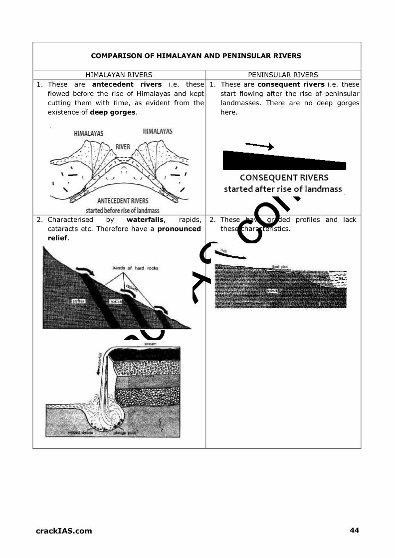
crack
IAS.com
crackIAS.com 44
COMPARISON OF HIMALAYAN AND PENINSULAR RIVERS
HIMALAYAN RIVERS PENINSULAR RIVERS
1. These are antecedent rivers i.e. these
flowed before the rise of Himalayas and kept
cutting them with time, as evident from the
existence of deep gorges.
1. These are consequent rivers i.e. these
start flowing after the rise of peninsular
landmasses. There are no deep gorges
here.
2. Characterised by waterfalls, rapids,
cataracts etc. Therefore have a pronounced
relief.
2. These have graded profiles and lack
these characteristics.
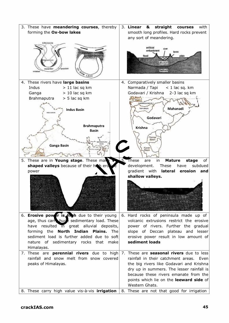
crack
IAS.com
crackIAS.com 45
3. These have meandering courses, thereby
forming the Ox-bow lakes
3. Linear & straight courses with
smooth long profiles. Hard rocks prevent
any sort of meandering.
4. These rivers have large basins
Indus > 11 lac sq km
Ganga > 10 lac sq km
Brahmaputra > 5 lac sq km
Indus Basin
Brahmaputra Basin
Ganga Basin
4. Comparatively smaller basins
Narmada / Tapi < 1 lac sq. km
Godavari / Krishna 2-3 lac sq km
Mahanadi
Godavari
Krishna
5. These are in Young stage. These make V-
shaped valleys because of their high erosive
power
5. These are in Mature stage of
development. These have subdued
gradient with lateral erosion and
shallow valleys.
6. Erosive power is high due to their young
age, thus carry huge sedimentary load. These
have resulted in great alluvial deposits,
forming the North Indian Plains. The
sediment load is further added due to soft
nature of sedimentary rocks that make
Himalayas.
6. Hard rocks of peninsula made up of
volcanic extrusions restrict the erosive
power of rivers. Further the gradual
slope of Deccan plateau and lesser
erosive power result in low amount of
sediment loads
7. These are perennial rivers due to high
rainfall and snow melt from snow covered
peaks of Himalayas.
7. These are seasonal rivers due to less
rainfall in their catchment areas. Even
the big rivers like Godavari and Krishna
dry up in summers. The lesser rainfall is
because these rivers emanate from the
points which lie on the leeward side of
Western Ghats.
8. These carry high value vis-à-vis irrigation 8. These are not that good for irrigation

crack
IAS.com
crackIAS.com 46
due to their perennial nature. A network of
canals has been laid in the northern plains of
Punjab, Haryana, UP and Bihar to fetch their
potential. This has led to the green revolution
in these areas making them the granary of
India.
purposes owing to their seasonal
nature.
9. More navigable owing to their flat
topography and perennial nature. This is true
in the middle and lower courses of these
rivers and not in the upper course where
these rivers have steep slopes. National
Waterway-1 links Allahabad – Haldia
covering a distance of 1620 km. national
Waterway-2 links Sadia–Dubri.
9. Less navigable due to their seasonal
nature and lesser quantity of water
in rivers to support big vessels. Also the
gradient of peninsula is steeper than
the northern plains that support the
navigational facilities.
10.These have high HEP potential- perennial
nature and steep slopes. Indian Himalayan
Region (IHR), also known as the water tower
of the world, hold potential of 1,48,700
MW
10.West flowing rivers have more potential
due to more water and steep slopes.
11.HEP development lesser compared to
peninsula; of huge potential, just around
22.4% has been utilized
11.More, because of greater economic
development & more demand.

crack
IAS.com
47 crackiAS.com
INDIA RIVERS
\
I I )
CkllT UIJ!iA "'ALP RA g"ft ---+ _...-.-"' :
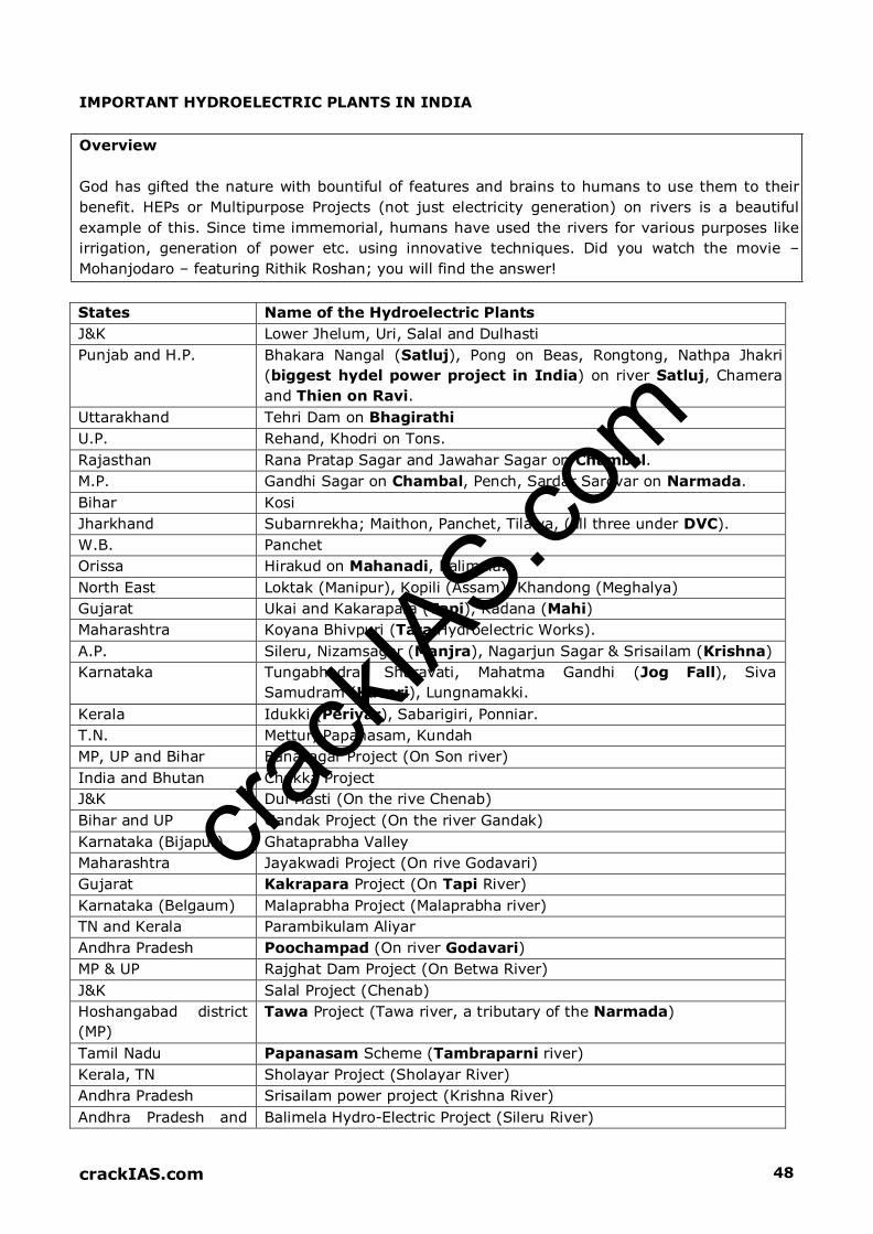
crack
IAS.com
crackIAS.com 48
IMPORTANT HYDROELECTRIC PLANTS IN INDIA
Overview
God has gifted the nature with bountiful of features and brains to humans to use them to their
benefit. HEPs or Multipurpose Projects (not just electricity generation) on rivers is a beautiful
example of this. Since time immemorial, humans have used the rivers for various purposes like
irrigation, generation of power etc. using innovative techniques. Did you watch the movie –
Mohanjodaro – featuring Rithik Roshan; you will find the answer!
States Name of the Hydroelectric Plants
J&K Lower Jhelum, Uri, Salal and Dulhasti
Punjab and H.P. Bhakara Nangal (Satluj), Pong on Beas, Rongtong, Nathpa Jhakri
(biggest hydel power project in India) on river Satluj, Chamera
and Thien on Ravi.
Uttarakhand Tehri Dam on Bhagirathi
U.P. Rehand, Khodri on Tons.
Rajasthan Rana Pratap Sagar and Jawahar Sagar on Chambal.
M.P. Gandhi Sagar on Chambal, Pench, Sardar Sarovar on Narmada.
Bihar Kosi
Jharkhand Subarnrekha; Maithon, Panchet, Tilaiya, (all three under DVC).
W.B. Panchet
Orissa Hirakud on Mahanadi, Balimela.
North East Loktak (Manipur), Kopili (Assam), Khandong (Meghalya)
Gujarat Ukai and Kakarapara (Tapi), Kadana (Mahi)
Maharashtra Koyana Bhivpuri (Tata Hydroelectric Works).
A.P. Sileru, Nizamsagar (Manjra), Nagarjun Sagar & Srisailam (Krishna)
Karnataka Tungabhadra, Sharavati, Mahatma Gandhi (Jog Fall), Siva
Samudram (Kaveri), Lungnamakki.
Kerala Idukki (Periyar), Sabarigiri, Ponniar.
T.N. Mettur, Papanasam, Kundah
MP, UP and Bihar Banasagar Project (On Son river)
India and Bhutan Chukka Project
J&K Dul Hasti (On the rive Chenab)
Bihar and UP Gandak Project (On the river Gandak)
Karnataka (Bijapur) Ghataprabha Valley
Maharashtra Jayakwadi Project (On rive Godavari)
Gujarat Kakrapara Project (On Tapi River)
Karnataka (Belgaum) Malaprabha Project (Malaprabha river)
TN and Kerala Parambikulam Aliyar
Andhra Pradesh Poochampad (On river Godavari)
MP & UP Rajghat Dam Project (On Betwa River)
J&K Salal Project (Chenab)
Hoshangabad district
(MP)
Tawa Project (Tawa river, a tributary of the Narmada)
Tamil Nadu Papanasam Scheme (Tambraparni river)
Kerala, TN Sholayar Project (Sholayar River)
Andhra Pradesh Srisailam power project (Krishna River)
Andhra Pradesh and Balimela Hydro-Electric Project (Sileru River)

crack
IAS.com
crackIAS.com 49
Orissa
Meghalaya Umiam Project (Umiam River)
MULTIPURPOSE PROJECTS OF INDIA
Location Of Dams
Special Features (Note The Purposes Served)
Bhakra Nangal (Satluj)
Bhakra
Nangal
Joint venture of Punjab, Haryana and Rajasthan. 2 dams – Bhakra
and Nangal. Power houses with combined installed capacity of
1204 MW.
Bhakra canal system of irrigation.
One of the highest Gravity Dams in the world (226m).
Huge reservoir (Gobind Sagar Lake in Bilaspur District of
Himachal Pradesh).
Damodar Valley Project (Damodar)
Tilaiya (R. Barakar)
Maithon (R. Barkar)
Konar (Konar
River)
Panchet Hill (R.
Damodar)
Damodar also called as River of sorrow, or sorrow of Bengal,
Tributary of Hugli; drains the Chotanagpur plateau.
This was the First multipurpose river project in India.
In 1948 – Project executed on the model of TVA (Tennessee Valley
River Project) of USA.
Durgapur Barrage – created for the storage of irrigation water.
Bakaro and Durgapur Thermal Power Stations are the important
link to DVC Power Station System, another purpose is Flood
control
Hirakund (Mahanadi)
Hirakund (in
Sambalpar Distt),
Orrisa
One of the longest dams in the world (4,801m long)
Two other dams on Mahanadi are at Tikrapara and Naraj.
3 canals have been taken out for irrigation.
It also provides for navigation facility besides power generation.
Rihand (Tributary Of Son)
Mirzapur Distt U.P Most important multipurpose project in U.P.
Gobind Ballabh Pant Sagar is largest man made reservoir in
India.
Chambal
Gandhinagar (M.P)
Rana Pratap Sagar
(Rajasthan)
Jawahar Sagar
(Rajasthan)
Gandhinagar – long masonry gravity dam.
Rana Pratap masonry dam at Rawat Bhata.
Jawahar Sagar is also called Kota Dam
Gandak
Balmikinagar
(Bihar)
Joint venture of U.P. and Bihar, though Nepal also get irrigation
and power facilities.
Tungbhadra (Tributary Of Krishna River)
Mallapur, Bellary
distt. (Karnataka).
Joint undertaking of Andhra Pradesh and Karnataka.
Masonry Dam.
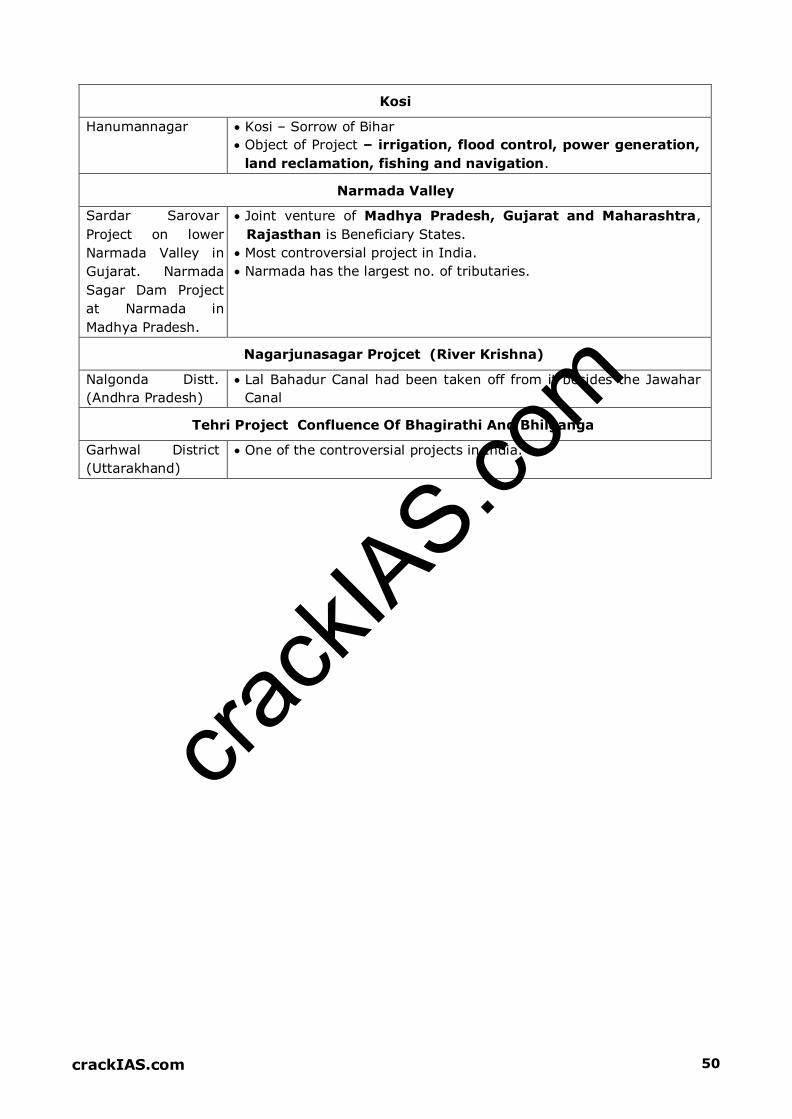
crack
IAS.com
crackIAS.com 50
Kosi
Hanumannagar Kosi – Sorrow of Bihar
Object of Project – irrigation, flood control, power generation,
land reclamation, fishing and navigation.
Narmada Valley
Sardar Sarovar
Project on lower
Narmada Valley in
Gujarat. Narmada
Sagar Dam Project
at Narmada in
Madhya Pradesh.
Joint venture of Madhya Pradesh, Gujarat and Maharashtra,
Rajasthan is Beneficiary States.
Most controversial project in India.
Narmada has the largest no. of tributaries.
Nagarjunasagar Projcet (River Krishna)
Nalgonda Distt.
(Andhra Pradesh)
Lal Bahadur Canal had been taken off from it besides the Jawahar
Canal
Tehri Project Confluence Of Bhagirathi And Bhilganga
Garhwal District
(Uttarakhand)
One of the controversial projects in India.

crack
IAS.com
crackiAS.com 51
( ·
IMPORTANT HEPs OF INDIA
'
..,/
..... /
SILERU /

crack
IAS.com
crackIAS.com 52
LETS PRACTICE: LAST 10 YEARS UPSC QUESTIONS
Which one of the following pairs is not
correctly matched? (Dam/ Lake River) a. Govind Sagar: Satluj
b. Kolleru Lake: Krishna
c. Ukai Reservoir: Tapi d. Wular Lake: Jhelum
Ans. D
Consider the following rivers:
1. Vamsadhara
2. Indravati
3. Pranahita
4. Pennar
Which of the above are tributaries of
Godavari?
a. 1, 2 and 3
b. 2, 3 and 4
c. 1, 2 and 4
d. 2 and 3 only Ans. D
Consider the following rivers:
1. Barak
2. Lohit
3. Subansiri
Which of the above flows / flow through
Arunachal Pradesh?
a. 1 only
b. 2 and 3 only
c. 1 and 3 only
d. 1, 2 and 3 Ans. B
The Narmada River flows to the west, while
most other large peninsular rivers flow to
the east. Why?
1. It occupies a linear rift valley
2. It flows between the Vindhyas and the
Satpuras
3. The land slopes to the west from Central
India Select the correct answer using the codes
given below: a. 1 only
b. 2 and 3
c. 1 and 3
d. None Ans. A
Consider the following pairs: (Tributary
River: Main River)
1. Chambal: Narmada
2. Sone: Yamuna
3. Manas: Brahmaputra Which of the pairs given above is/ are
correctly matched? a. 1, 2 & 3
b. 1 & 2
c. 2 & 3 only d. 3 only Ans. D On which one of the following rivers is the
Tehri Hydropower Complex located?
a. Alakananda
b. Bhagirathi c. Dhauliganga
d. Mandakini Ans. B Where the Tapovan and Vishnugarh
Hydroelectric Projects located?
a. Madhya Pradesh
b. Uttar Pradesh
c. Uttarakhand
d. Rajasthan Ans. C With which one of the following rivers is the
Omkareshwar Project associated? a. Chambal
b. Narmada
c. Tapi
d. Bhima
Ans. B Rivers that pass through Himachal Pradesh
are a. Beas and Chenab only
b. Beas and Ravi only
c. Chenab, Ravi and Sutluj only
d. Beas, Chenab, Ravi, Sutluj and Yamuna Ans. D
With reference to the River Luni, which one of the following statements is correct?
a. It flows into Gulf of Khambhat
b. It flows into Gulf of Kuchchh

crack
IAS.com
crackIAS.com 53
c. It flows into Pakistan and merges with a
tributary of Indus
d. It is lost in the marshy land of the Rann
of Kuchchh Ans. D
Consider the following statements:
1. There are no east flowing rivers in
Kerala
2. There are no west flowing rivers in
Madhya Pradesh
Which of the above statements is / are correct?
a. 1 only b. 2 only
c. Both 1 & 2
d. Neither 1 nor 2 Ans. D
Which one of the following rivers does not
originate in India?
a. Beas b. Chenab
c. Ravi d. Sutlej
Ans. D
At which one of the following places do two
important rivers of India originate; while
one of them flows towards north and
merges with another important river flowing
towards Bay of Bengal, the other one flows
towards Arabian Sea?
a. Amarkantak
b. Badrinath c. Mahabaleshwar
d. Nasik Ans. A
Which one of the following rivers originates
at Amarkantak?
a. Damodar
b. Mahanadi
c. Narmada
d. Tapti Ans. C
Assertion (A): River Kalinadi is an east-
flowing river in the southern part of India.
Reason (R): The Deccan Plateau is higher
along its western edge and gently slopes
towards the Bay of Bengal in the east.
Ans. D Which one of the following statements is
NOT correct? a. Mahanadi River rises in Chhattisgarh
b. Godavari River rises in Maharashtra
c. Cauvery River rises in Andhra Pradesh
d. Tapti River rises in Madhya Pradesh Ans. C From north towards south, which one of the
following is the correct sequence of the
given rivers in India?
a. Shyok - Spiti - Zaskar – Satluj
b. Shyok - Zaskar - Spiti - Satluj
c. Zaskar - Shyok - Satluj - Spiti
d. Zaskar - Satluj - Shyok - Spiti Ans. B Match List I with List II and select the
correct answer using the code given below
the lists: List I (Town), List II (River nearer
to it)
A. Betul B. Jagdalpur
C. Jabalpur
D. Ujjain 1. Indravati
2. Narmada
3. Shipra
4. Tapti
a. A-1, B-4, C-2, D-3
b. A-4, B-1, C-2, D-3
c. A-4, B-1, C-3, D-2
d. A-1, B-4, C-3, D-2 Ans. B Which of the following pairs are correctly
matched? (Waterfalls: River)
1. Kapildhara Falls: Godavari
2. Jog Falls: Sharavati
3. Sivasamudram Falls: Cauvery Select the correct answer using the code
given below: a. 1 & 2 only
b. 2 & 3 only c. 1 & 3 only
d. 1, 2 & 3 Ans. B
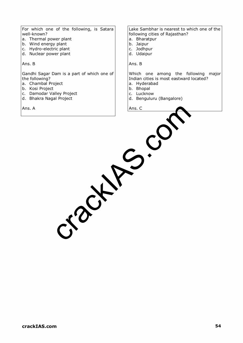
crack
IAS.com
crackIAS.com 54
For which one of the following, is Satara
well-known?
a. Thermal power plant
b. Wind energy plant
c. Hydro-electric plant d. Nuclear power plant
Ans. B
Gandhi Sagar Dam is a part of which one of
the following? a. Chambal Project
b. Kosi Project
c. Damodar Valley Project
d. Bhakra Nagal Project Ans. A
Lake Sambhar is nearest to which one of the
following cities of Rajasthan?
a. Bharatpur
b. Jaipur
c. Jodhpur d. Udaipur Ans. B Which one among the following major
Indian cities is most eastward located? a. Hyderabad
b. Bhopal
c. Lucknow
d. Benguluru (Bangalore) Ans. C

crack
IAS.com
crackIAS.com 55

crack
IAS.com
Samples from
WORLD GEOGRAPHY,
GEOGRAPHY THEORIES &
ENVIRONMENT

crack
IAS.com
crackIAS.com 8
REGIONAL GEOGRAPHY
OF THE WORLD
Overview
Have you ever gone to Shimla by train? No! You must go atleast once to have a lifetime
experience of Himalayas. If you would have more time, take a bike and make a group trip from
Chandigarh to upper reaches of Himalayas in J&K. You will find gigantic features - Indus
destroying the great mountains creating 1 km deep gorges, something similar to Death Valley
of California! Ask someone who visited Africa; just see his photos. The huge deserts in the
background would open your yaws. The dense jungles of River Congo will make you feel like a
night even during full sunlight. If someone known has gone to Europe for a honeymoon, just
ask him his experience. The beautiful beaches and lakes of Europe are the proof that if man
desires, he can maintain the endless beauty of our earth.
Life is too short. Nature has given us bountiful features; regional geography is all
about to live nature!

crack
IAS.com
crackIAS.com 9
ASIA
Asia accounts for one-third of world’s land area and about 60% of its population
Asia– Largest continent both in area and in population.
About 72.2% of people live in villages. Japan is the only exception where more than 75%
people are urban.
It has less than 20% land suitable for Agriculture
Tropic of Cancer in Middle East passes through Saudi Arabia, U.A.E. and Oman. Muscat
(Capital of Oman) is located on it. It also passes through India, Bangladesh & Myanmar
besides China and Taiwan.
Persian Gulf touches Saudi Arabia, U.A.E., Kuwait, Iraq & Iran, Oman & Bahrain
PHYSICAL FEATURES
NORTHERN LOWLANDS (SIBERIAN PLAINS)
Plains between Ural Mountains in the West and Lena River in the east are called as Siberian
Plains
Drained by Rivers Ob, Yenisei and Lena.
Lake Baikal – deepest lake of the world is located here
MOUNTAINS
Pamir Knot (Plateau) is the meeting place of several ranges of Asia
This Plateau is highest in the world and known as “Roof of the world”
Hindu Kush extends to the west, Tien Shan towards N. East, Kunlun to east and the
Karakoram and Himalayas to the S-E.
To the west of Hindu Kush, two ranges of Mountain ranges diverge. In North Elburz (extend
along south of Caspian Sea) and in South Zagros Mountains (extend along Arabian Sea and
Overlooks Persian Gulf).
Elburz and Zagros Mountains enclose the Plateau of Iran
These two ranges converge in the west at the knot of Mount Ararat
Again two groups of Mountain ranges diverge westward from Mount Ararat, Pontic in the
north and Taurus in the south.
Plateau of Anatolia is enclosed between Pontic and Taurus.
South Eastward of Pamir lies Karakoram Range and Himalayan range.
K2 (Godwin Austin in POK) is the highest Peak of Karakoram, whereas Mt. Everest is highest
peak in the Great Himalayas.
Between these two ranges in south and Kunlun in the north, is the Tibetan Plateau.
Further north, Tarim basin is located between Kunlun in south and Tien Shan in north.
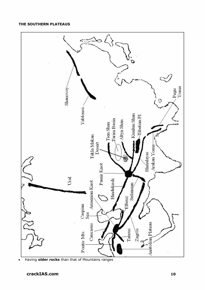
crack
IAS.com
crackIAS.com 10
THE SOUTHERN PLATEAUS
Having older rocks than that of Mountains ranges

crack
IAS.com
crackIAS.com 11
Plateau of Arabia, Deccan Plateau and Plateau of Yunnan are its parts
THE GREAT RIVER VALLEYS
Tigris & Euphrates (Iraq).
Baghdad is located on river Tigris. Both of these fall into Persian Gulf.
Ancient Mesopotamian culture flourished between these two rivers.
Indus (Pakistan)
Ganga-Brahmaputra (India and Bangladesh)
Ayeyarwaddy or Irrawaddy (Myanmar)
Mekong (South-East Asian countries)
Sikiang, Chang Jiang (Yang-Tse-Kiang) and Huang He (Hwang-Ho) in China
THE ISLAND GROUPS
Indonesia, Philippines and Japan.
Most of these islands have Mountains core surrounded by narrow coastal plains, have
extremely fertile soil (basically volcanic ash)
CLIMATE
WINTERS
Interior part of Asia becomes extremely cold, temperature decreases, air contracts forming
high pressure area over Mongolia. Dry winds blow outward. Therefore most of the parts of
Asia do not get rain though while blowing over the sea, winds pick up moisture and cause
rainfall in some areas.
Oymyakon in N-E Siberia is the coldest place in the Northern Hemisphere [Mean
January Temperature (- 45o)].
SUMMERS
Temperature rises in the interior parts of Asia, air expands, create low pressure areas. Now
High Pressure areas are located over oceans and winds starts blowing towards low pressure
areas, causing rainfall in most of the areas.
Mawsynram in Meghalaya (India) is the wettest place in the world; however Mt
Waialeale in Hawaii Island (USA) recorded highest annual average rainfall (11,680 mm)
in the world in 2007.
NATURAL VEGETATION & WILD LIFE
TUNDRA BELT
Lies along northern coast of Asia, covered with snow for major part of the year. Precipitation
is about 30 cm annually. Vegetation – Mosses and Lichens.
TAIGA
To the south of Tundra, belt of coniferous forests (softwood-used for paper industry)
Found in Russia, Japan (also in Himalayan region)
crack
IAS.com
crackIAS.com 12
Precipitation – Between 25 and 50 cm
Vegetation – Pine, Fir and Spruce. Used as timber and for making pulp and rayon
Animals – Fur bearing e.g. fore, sable, mink
STEPPES
Temperate grasslands, next to taiga. Winters cold, summers hot.
Rainfall – Between 20–40 cm
Animals – Grass eating e.g. antelopes
DESERTS
Large parts of South West and Central Asia
Hot desert– Arabia and Thar.
Cold desert – Gobi and Tibet.
MONSOON REGIONS
South, S-E and East Asia
Summers hot and humid
Rainfall – Between 60 and 250 cm, mostly in summers
Vegetation – Teak, sal and sandal wood
In N-E Asia, the climate is generally cooler and hence monsoon forests give way to
temperate woodlands.
Extreme Southern portions, closer to the equator have equatorial rainforests, dense and
contain variety of trees, plants and bushes.
MAJOR CROPS
Cultivation of rice is mainly confined to Monsoon Asia as it require warm and humid climate
Wheat is the main crop of sub-tropical and temperate parts of the continent. W-Siberia,
Kazakhstan, China, North India, Pakistan and countries of S-W Asia are the main producers
of the wheat.
Sugarcane requires hot and moist climate and well-drained fertile soils. Grown in Pakistan,
India, China, Thailand and Indonesia.
Tea is grown in India, Sri Lanka, China, Japan and Indonesia
Cotton is grown in dry areas. Major producers are China, countries of Central Asia, India
and Pakistan.
Jute is grown in fertile soil of the floodplains in Ganga-Brahmaputra delta
Rubber is grown mainly in Malaysia and Indonesia, Thailand, India, China and Sri Lanka.
DESERTS
Gobi: World’s greatest temperate desert lying in China and Mongolia. Inhabited by
Mongol nomads
Lopnor: Temperate desert lying in China, where China’s nuclear test centre is located.
Taklamakan: Temperate desert lying in Tarim basin, a center for Buddhist culture
Rub-Al-Khali: hot desert situated South of S. Arabia, rich in petroleum deposits
Dast-E-Lut: A hot desert in E. Iran, rich in petroleum deposits
Dast-E-Kabir: A hot and saline desert in N. Iran, rich in petroleum deposits.

crack
IAS.com
crackIAS.com 13
Kyzilkum: A temperate desert extended in Uzbekistan and Kazakhstan
Karakum: Temperate desert in Turkmenistan, transversed by Trans-Caspian railway
FEW IMPORTANT RIVERS OF ASIA RIVER DRAINS
INTO SIGNIFICANCE
Hwang He Gulf of Pohai
Sorrow of China (owing to frequent floods), Carries loess from Gobi desert
Yangtze Kiang
E. China Sea
World’s largest 3-gorges dam on it, also city of Wuhan & Shanghai on its banks
The Three Gorges Dam Project was completed in 2009.
Located in the middle section of Xiling Gorge, one of the three gorges (the other two are Wu Gorge and Qutang Gorge)
A Yangtze Cruise passes the Three Gorges Dam.
Tanzi Ridge is located in the surveying point for the Three Gorges Dam Project
The long-term ecological effects of the Three Gorges Dam have been described as 'possibly catastrophic'.
Mekong South China Sea
Passes through China, Myanmar, Thailand, Laos, Cambodia & Vietnam; Makes boundary between Myanmar & Laos, Thailand & Laos.
Amu Darya Aral Sea
Syr Darya Aral Sea Toshkent located on it
Tigris Persian Gulf Baghdad is located on it; Passes through Turkey & Iraq
Euphrates Persian Gulf
Mesopotamian located between Tigris & Euphrates. Passes through Turkey, Syria & Iraq

crack
IAS.com
crackIAS.com 14
SEAS & LAKES
Okhotsk Sea: An extension of Pacific Ocean, situated west of Kamchatka and frozen for
8 months
Sea of Japan: Separates Japan from Mainland with rich petroleum deposits, with
Vladivostok as ice-free port
Yellow Sea: Named for its colour, at the mouth of Hwang He, separating Korea from
China. Hwang He brings huge amount of sand to this sea.
PENINSULAS
Kamchatka: Part of Russia with inhospitable climate and earthquakes, famous for
petroleum deposits
Kola: Part of Russia with Murmansk as ice free port throughout the year (washed by
warm North Atlantic drift), rich in minerals
Kanin: Part of Russia with rich mineral deposits
Malaya: Part of Malaysia with rich tropical rainforest, and tin, rubber and oil deposits
Arabian: Largest peninsula in the world, mostly desert and famous for oil reserves
Sinai: Part of Egypt with rich petroleum deposits mostly covered by desert. Captured
by Israel in 1967 and returned in 1979
Crimean: Part of Ukraine with mineral resources and important port on Black Sea

crack
IAS.com
crackIAS.com 15
MAJOR INFRASTRUCTURE PROJECTS IN ASIA
TRANS-ASIAN RAILWAY (TAR)
It is a project to create an integrated freight railway network across Europe and Asia.
The Trans-Asian Railway Network Agreement is an agreement signed by seventeen Asian nations as part of a United Nations Economic and Social Commission for Asia and the Pacific (UNESCAP) effort to build a transcontinental railway network between Europe and Pacific ports in China.
The plan has sometimes been called the "Iron Silk Road" in reference to the historical Silk Road trade routes.
The Trans-Asian Railway network now comprises 117,500 km of railway lines serving 28 member countries.
ASIAN HIGHWAY (AH) PROJECT
It is also known as the Great Asian Highway It is a cooperative project among countries in Asia and Europe and
the United Nations Economic and Social Commission for Asia and the Pacific (ESCAP), to improve the highway systems in Asia.
Agreements have been signed by 32 countries to allow the highway to cross the continent and also reach to Europe.
SILK ROAD China has launched a massive $79.8 billion infrastructure project in the northwest province of Gansu, which will facilitate trade and people exchanges between China and central
Asia as part of its ambitious Silk Roadplan. The Silk Road projects involved a maze of roads and ports
connecting Asia, Europe and Africa. Also known as the “One Belt, One Road,” project
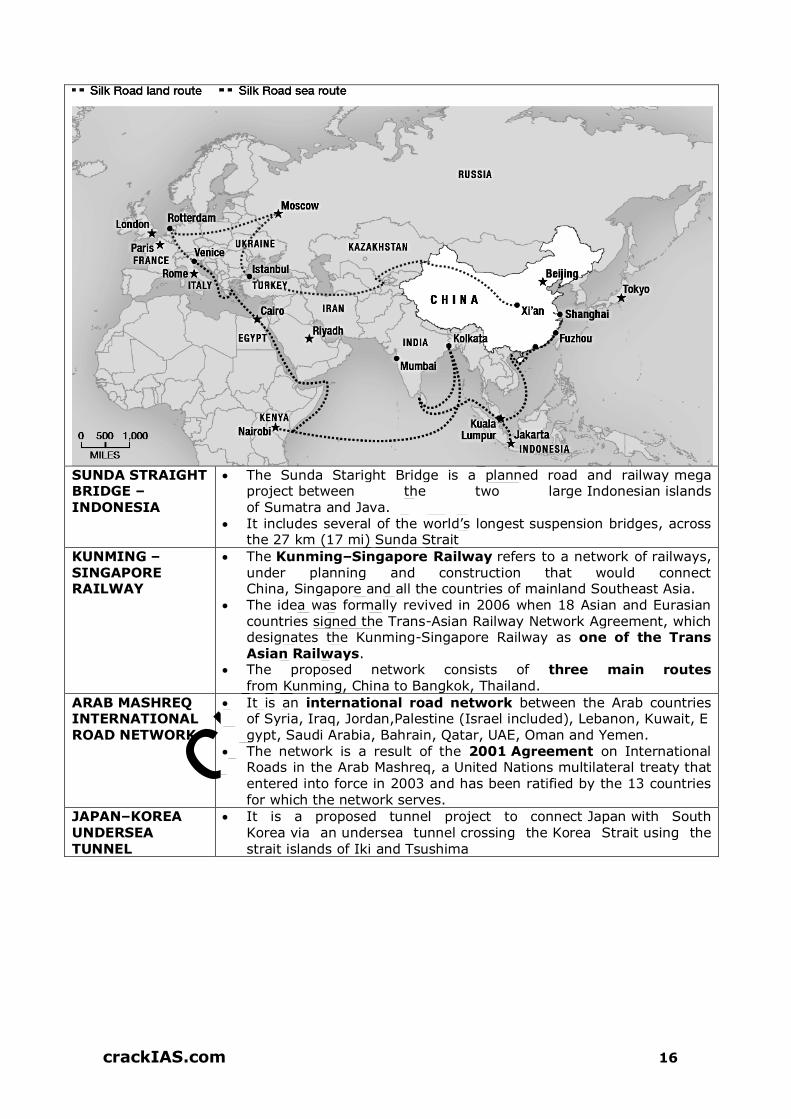
crack
IAS.com
crackIAS.com 16
SUNDA STRAIGHT BRIDGE –
INDONESIA
The Sunda Staright Bridge is a planned road and railway mega project between the two large Indonesian islands
of Sumatra and Java. It includes several of the world’s longest suspension bridges, across
the 27 km (17 mi) Sunda Strait
KUNMING – SINGAPORE RAILWAY
The Kunming–Singapore Railway refers to a network of railways, under planning and construction that would connect China, Singapore and all the countries of mainland Southeast Asia.
The idea was formally revived in 2006 when 18 Asian and Eurasian
countries signed the Trans-Asian Railway Network Agreement, which designates the Kunming-Singapore Railway as one of the Trans Asian Railways.
The proposed network consists of three main routes from Kunming, China to Bangkok, Thailand.
ARAB MASHREQ INTERNATIONAL
ROAD NETWORK
It is an international road network between the Arab countries of Syria, Iraq, Jordan,Palestine (Israel included), Lebanon, Kuwait, E
gypt, Saudi Arabia, Bahrain, Qatar, UAE, Oman and Yemen. The network is a result of the 2001 Agreement on International
Roads in the Arab Mashreq, a United Nations multilateral treaty that entered into force in 2003 and has been ratified by the 13 countries for which the network serves.
JAPAN–KOREA UNDERSEA
TUNNEL
It is a proposed tunnel project to connect Japan with South Korea via an undersea tunnel crossing the Korea Strait using the
strait islands of Iki and Tsushima

crack
IAS.com
crackIAS.com 17
CONFLICT ZONES IN ASIA SYRIA Syria borders Turkey, Iraq, Jordan, Israel and Lebanon. The highest point in Syria is Mount Hermon (9,232 ft; 2,814 m) on the Lebanese border. Lake Assad is the largest lake in Syria. Al Lādhiqīyah along with Tartus are Syria's main ports on the Mediterranean Sea. The longest and most important river is the Euphrates, which represents more than 80
percent of Syria's water resources. Syria's population is about 90 percent Muslim, mostly Sunni—but the Alawite minority (12
percent of Syrians) is politically dominant. The Syrian Civil War is an ongoing-armed conflict-taking place in Syria. The unrest began
in the early spring of 2011 within the context of Arab Spring protests, with nationwide protests against President Bashar al-Assad's government, whose forces responded with violent crackdowns. The conflict gradually morphed from prominent protests to an armed rebellion after months of military sieges.
There are four main factions of fighting groups throughout the country: Kurdish forces,
ISIS, other opposition and Assad regime. The majority of Syrian refugees are living in Jordan and Lebanon.
IRAQ Iraq borders Turkey to the north, Iran to the east, Kuwait to the southeast, Saudi Arabia to
the south, Jordan to the southwest, and Syriato the west. Population: Arab 75%-80%, Kurdish 15%-20%, Turkoman, Assyrian, or other 5% Two major rivers, the Tigris and Euphrates, run south through the center of Iraq and flow
into the Shatt al-Arab near the Persian Gulf. The fertile region between these rivers has had many names throughout history like Al-Jazirah.
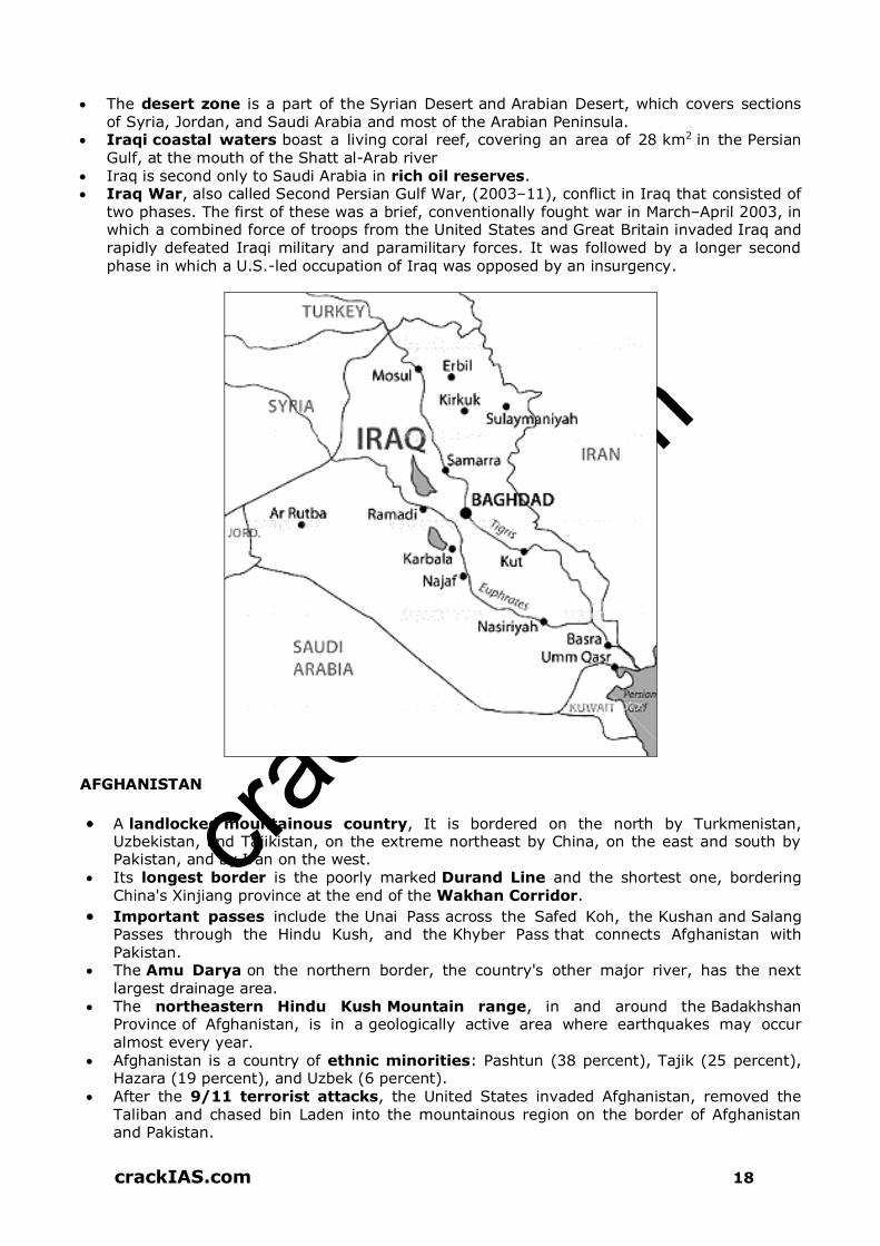
crack
IAS.com
crackIAS.com 18
The desert zone is a part of the Syrian Desert and Arabian Desert, which covers sections of Syria, Jordan, and Saudi Arabia and most of the Arabian Peninsula.
Iraqi coastal waters boast a living coral reef, covering an area of 28 km2 in the Persian Gulf, at the mouth of the Shatt al-Arab river
Iraq is second only to Saudi Arabia in rich oil reserves. Iraq War, also called Second Persian Gulf War, (2003–11), conflict in Iraq that consisted of
two phases. The first of these was a brief, conventionally fought war in March–April 2003, in which a combined force of troops from the United States and Great Britain invaded Iraq and rapidly defeated Iraqi military and paramilitary forces. It was followed by a longer second phase in which a U.S.-led occupation of Iraq was opposed by an insurgency.
AFGHANISTAN
A landlocked mountainous country, It is bordered on the north by Turkmenistan, Uzbekistan, and Tajikistan, on the extreme northeast by China, on the east and south by Pakistan, and by Iran on the west.
Its longest border is the poorly marked Durand Line and the shortest one, bordering China's Xinjiang province at the end of the Wakhan Corridor.
Important passes include the Unai Pass across the Safed Koh, the Kushan and Salang Passes through the Hindu Kush, and the Khyber Pass that connects Afghanistan with Pakistan.
The Amu Darya on the northern border, the country's other major river, has the next largest drainage area.
The northeastern Hindu Kush Mountain range, in and around the Badakhshan Province of Afghanistan, is in a geologically active area where earthquakes may occur almost every year.
Afghanistan is a country of ethnic minorities: Pashtun (38 percent), Tajik (25 percent), Hazara (19 percent), and Uzbek (6 percent).
After the 9/11 terrorist attacks, the United States invaded Afghanistan, removed the Taliban and chased bin Laden into the mountainous region on the border of Afghanistan and Pakistan.

crack
IAS.com
crackIAS.com 19
YEMEN Yemen is an Arab country in Southwest Asia, occupying the southwestern to southern
end of the Arabian Peninsula. It is bordered by Saudi Arabia to the north, the Red Sea to the west, the Gulf of Aden
and Arabian Sea to the south, and Oman to the east. Yemen's territory includes more than 200 islands; the largest of these is Socotra. A
number of Red Sea islands, including the Hanish Islands, Kamaran, and Perim belong to Yemen.
Following years of dispute between Yemen and Eritrea over ownership of the Hanish Islands and fishing rights in the Red Sea, in 1999 an international arbitration panel awarded sovereignty of the islands to Yemen.
Yemen is strategically important because it sits on the Bab al-Mandab strait, a narrow waterway linking the Red Sea with the Gulf of Aden, through which much of the world's oil shipments pass.
Yemen is one of the poorest countries in the Arab world, due to declining oil resources.
Ethnic Groups: Predominantly Arab, also Afro-Arab, South Asian, European Yemen has been in a state of political crisis since 2011. The Yemeni Civil War is an
ongoing conflict that began in 2015 between two factions claiming to constitute the Yemeni government, along with their supporters and allies.

crack
IAS.com
crackIAS.com 20
Some other list of territorial disputes over lands in Asia are as below:
Territory Claimants Notes
Several areas in the Fergana Valley
Kyrgyzstan Tajikistan Uzbekistan
Demchok, Chumar, Kaurik, Shipki Pass, Jadh, and Lapthal
India People's Republic of China Republic of China (Taiwan)
Disputed areas located between Aksai Chin and Nepal, all administered by the PRC.
Preah Vihear Temple area (Khao Phra Wihan)
Thailand Cambodia
Temple complex awarded to Cambodia by an International Court of Justice ruling in 1962; "promontory" measuring 0.3 km2 immediately adjacent to temple awarded to Cambodia by ICJ
ruling in 2013; both countries acknowledge continuing dispute over an additional 4.3 km2 immediately northwest of the 2013 ruling's area.
Paracel Islands People's Republic of China Republic of China (Taiwan) Vietnam
Entirely controlled by China but claimed by Vietnam and Taiwan
Pratly Islands
Republic of China (Taiwan) People's Republic of China Vietnam Philippines (part) Malaysia (part)
Each of the claimant countries except Brunei controls one or more of the individual islands.

crack
IAS.com
crackIAS.com 21
Brunei (part)
Taiwan, Penghu, Jinmen, Matsu Islands, Pratas Islands
Republic of China People's Republic of China
South Kuril Islands (Northern Territories)
Russia Japan
Golan Heights, Gaza Strip, and West Bank
Syria Israel
Jammu and Kashmir India Pakistan
India and Pakistan have fought three wars over the region - 1947, 1965 and 1999. There was militant insurgency in Kashmir backed by Pakistan since 1990 since when hundreds of thousands of Pro-India Hindu Kashmiri Pandits have
either been killed, converted to islam or forced to vacate their homes and take refuge in Jammu and other areas of rest of India. UN has removed Kashmir from their list of unresolved disputes in 2010.
REGIONAL GEOGRAPHY OF SOUTH-EAST ASIA
Southeast Asia extends for more than 4,830 km from Myanmar on the west to New
Guinea on the east.
Although this region lies near the Equator, it stretches to almost 30° N in northern Burma,
and a sizable part extends as far as 20° N.
There are 2 main divisions of Southeast Asia.
1. The mainland: Myanmar, Thailand and Indochina (comprising Laos, Kampuchea or
Cambodia and Vietnam).
2. Insular archipelago- Philippines, Malaysia, Singapore, Indonesia, and Brunei.
Between these two parts are shallow waters that lie over the Sunda Shelf.
For most of mainland Southeast Asia, the dominant physical features are the rugged
cordilleras that splay out from the Himalayas to the north and are to the south. These
mountains are underlain by an ancient crystalline mass of stable granite material.
The north-south Mountains of mainland Southeast Asia, although physically related to the
Himalayas in the north, have been heavily weathered and rounded in the tropical, rainy
climate. The ranges run parallel to one another and separate the major river basins that
form the core-lands of the 5 countries of mainland Southeast Asia.
From west to east, the main ranges are the Arakan Yoma of western Burma, the Shan
Highlands of eastern Myanmar and western Thailand, which extend to length of the Malay
Peninsula; and the Annamite Chain of Vietnam.
Archipelagic Southeast Asia: A string of volcanic islands stretches from Sumatra and java,
towards east to Sulawesi & the Moluccas & towards north to the Philippines. Not only is this
area one of the most geologically active regions on Earth, but it is also a highly diverse
land surface. A good reflection of the newer processes of landscape formation is found in the
circum-Pacific belt of volcanism known as the Pacific Ring of Fire.
crack
IAS.com
crackIAS.com 22
RIVERS OF SE-ASIA
1. Irrawaddy and its largest tributary, the Chindwin is a major river of Myanmar. Rangoon
and Mandalay, the largest cities in Myanmar, are located on the banks of the Irrawaddy.
2. Salween River originates on the Plateau of Tibet and flows for about 1200 km through
China before entering Myanmar. The delta and the flood plains of the Irrawaddy are much
more extensive than those for the Salween, leaving room for the core of the country to
develop.
3. The Mekong River flows in a valley to the east and parallel of the Salween. After leaving
China, the Mekong makes the boundary between Thailand and Laos and then continues
through the heart of Cambodia. It cuts across the southern tip of Vietnam, and finally
empties into the South China Sea. The capital cities of Vientiane (Laos) & Phnom Penh
(Cambodia) are located along bank of Mekong River.
4. Hanoi is on the banks of the Red River, and Bangkok (Thailand) is divided by the Chao
Phraya River. The political cores and cultural hearths of all the mainland countries have
developed along the rivers.
VOLCANIC MOUNTAINS
Volcanic action created most of the islands, and many individual peaks heights of many of
the volcanoes are active today. Southeast Asia is the most active volcanic region of the
“Ring of Fire” that surrounds the Pacific Ocean. Examples of some volcanic eruptions are
Enchanting Islands of Bali and Karakotoa. The Younger active belt of volcanism is
associated with the islands of Southeast.
The seas between the islands of Southeast Asia generally are quite shallow; most are
150 to 200 feet deep.
At the opposite extreme are the great ocean trenches to the outside of the island region.
The Philippine Trench, east of the Philippines, is a 965 km long canyon on the bottom of
the ocean.
The Java Trench borders the region on the south off the coasts of Sumatra and Java and
another ocean deep has been recorded on the east of the Banda Sea.
Active Volcanoes in this area are as below
Sakurajima, Japan - A major eruption could have deadly consequences for the 700,000
residents of Kagoshima, who live just miles from the Volcano.
Mt. Merapi, Indonesia - Mt. Merapi has erupted regularly since 1548 and has been
active for the last 10,000 years. Experts believe that its activity led to the demise of the
Hindu Kingdom of Mataram.
Ulawun, Papua New Guinea - Ulawun is one of the most active volcanoes in Papua
New Guinea. Eruptions from Ulawun originate from its central crater. There have been
22 eruptions recorded at Ulawun since the 1700s.
Taal Volcano, Philippines - The Taal Volcano is a cinder cone volcano. It is located on
the island of Luzon, Philippines where it lies at the middle of Lake Taal. It lies just 31
miles from Manila – the capital of the Philippines.
DEMOGRAPHY OF SE ASIA
Most of Southeast Asia’s people live, often in extremely dense clusters, in scattered areas of
permanent sedentary agriculture.
Such area form the core regions of the various countries and stand in striking contrast to
the relatively empty spaces of the adjoining districts

crack
IAS.com
crackIAS.com 23
A superior degree of soil fertility appears to have been the main locational factor in most
instances.
South East Asian countries in ascending order of population.
1 Brunei 2 Singapore 3 Laos 4 Kampuchean
South East Asian countries in descending order of population
1 Indonesia 2 Philippines 3 Vietnam 4 Thailand
SE Asian country with highest growth rate: 1. Philippines 2. Malaysia
SE Asian country with least growth rate: 1. Thialand 2. Vietnam
Country with highest population density: Singapore
Country with least population density: Laos
Ethnicity
The Malays are the most prominent ethnic group in Southeast Asia. Regional isolation and
racial mixing have created differences among the countries of the region, but the people are
basically Malay in origin.
The most conspicuous ethnic minority is the Chinese. The sizable minorities of “overseas
Chinese” are concentrated in the urban areas of nearly every country of Southeast Asia.
These are colonists from China who live in the region, and sometimes they do not even
become citizens of the countries where they settle.
Indigenous hill people: Most of the indigenous tribal people of Southeast Asia are
minorities within their own countries. These are the “hill people,” various tribes of which are
found in each country.
In Myanmar live the Karens, the Shans, the Kachins and the Chins.
MINERAL RESOURCES
Tin
It is found in Myanmar, Indonesia, Laos, Malaysia and Thailand.
China is the world’s leading producer of tin while Malaysia is second leadin producer of
world. All the tin fields are in Peninsular Malaysia and the Kinta valley alone accounts for
half the annual output. Tin is smelted in Penang and Singapore and ingots are exported.
Thailand’s tin is mined in the south, in the Kra Peninsula and on off shore islands such as
Phuket.
Indonesia’s tin comes from islands off the northern coast of Sumatra including Bangka,
Billiton and Singkep.
Petroleum
Vast supplies of petroleum also are found in Southeast Asia.
Foremerly, Indonesia was one of the world’s largest petroleum producers and about one
third of Indonesia’s exports were petroleum products.
Indonesia has greatly expanded oil production, most of which comes from Sumatra. The
chief fields are Palembang, Jambi, Minas (near Pekan Baru), and around Pengkalan. The oil
is refined at Lutong, Sarawak, or sent to Japan or Singapore.
Oil supplies nearly make the entire income of Brunei and provide the tiny country with very
high standards of living. Malaysia has oilfields off shore of Sarawak and off the East Coast
of Peninsular Malaysia.
Regardless of all the mineral wealth, very little heavy industry is carried on in Southeast
Asia – Partly because the colonial powers did not want industry to develop and partly

crack
IAS.com
crackIAS.com 24
because both coal and iron ore have not been found within the same country. The
European powers wanted to extract the resources for their own use and sell manufactured
goods back to the colonies.
Highways: Highways do cross between the countries on the mainland, but they are few and
poor. The Burma and Ledo roads, carved out of the jungle during World War II, are typical
of road construction in the region. The Burma Road winds for 1,126 km between Lashio in
Myanmar and Kunming in China’s Yunnan province. The Ledo Road covers less rugged
terrain but crosses many rivers and smaller streams as it winds between Myanmar and the
Assam region of India.
INDONESIA
Consists of more than 17,000 islands of various sizes, about 6000 are inhabited.
Main islands – Borneo (Kalimantan), Sumatra, Irian Java, Celebes (Sulawesi), Java,
Madura and Bali.
Jakarta is the capital city located on the Java Island.
Northern Borneo is a part of Malaysia
Indonesia’s only land frontiers are with Papua New Guinea (to the east of Irian Jaya),
and with the Malaysia (states of Sarawak and Sabah) which occupy the northern Borneo.
Physical Features
Islands generally have mountainous relief
Earthquakes associated tidal waves called ‘Tsunamis’ are quite common
Climate – Monsoon, heavy rainfall
Very dense forests are found in most of the parts of Indonesia
Agriculture – Most important Activity. Less than 50% of population is engaged in it.
Food Crops – Rice, Maize, Cassava and Sweet potato
Cash Crops – Rubber, oil palm, coffee, tea, cocoa, sugarcane and Tobacco. All cash crops
are export oriented.
Railways are limited to Java, Madura and Sumatra
River transport is important in several areas especially in Kalimantan & Eastern Sumatra

crack
IAS.com
crackIAS.com 25
People
Fourth in population after china, India and USA
Density of population is high in Java, Madura and Bali
Nearly 90% of Population is Muslim
Bahasa Indonesia is the official language
MALAYSIA
Located North of the Equator
Consist of two widely separated areas –
1. Malay Peninsula (part of Asian Mainland).
2. Northern part of Borneo Island.
Northern Borneo has two states, Sarawak and Sabah
Peninsular Malaysia separated from Sumatra Island by Strait of Malacca and from
Sarawak and Sabah by South China Sea.
At the tip of Malaya Peninsula, lies Singapore
Kuala Lumpur is the capital and the largest city of Malaysia
Physical Features
Central part of Malay Peninsula is mountainous & is surrounded by narrow coastal plains
The highest peak is Kinablu
Climate – Equatorial type, high temperature and rains throughout the year
Evergreen forests in Sarawak and Sabah are denser than that of peninsular Malaysia
Natural Resources
Tin, Copper & Uranium deposits are found in Central highlands of Malay Peninsula
Plantation agriculture is important activity and Malaysia has remained a leading producer
of Rubber for a long time
Road and Rail transport are better developed in Peninsular Malaysia than in Sabah and
Sarawak
Major Seaport of Peninsular Malaysia is Pinang (Georgetown).
REGIONAL GEOGRAPHY OF SOUTH ASIA
PAKISTAN
The country can be divided into two physical units –
1. Mountains and Plateaus in the west
2. Indus river basin in the east is the plain region
From South to North are located - Baluchistan Plateau and Mountain Ranges of Kirthar,
Sulaiman and Hindu-Kush in the same order
There are 2 important passes in these mountains – Khyber Pass in the Hindu Kush and
Bolan Pass in the Kirthar.
Potwar Plateau is located to Southeast of the Hindu Kush. Region is generally dry.

crack
IAS.com
crackIAS.com 26
Climate of Pakistan is hot & dry. Rainfall decreases from North to South. Average rainfall is
50 cm.
Northern Mountain area is forested with broadleaved evergreen oak and chestnut.
Southern part is steppe.
Coal, Iron ore, Gold and Mineral oil are found in Baluchistan
Mineral oil is also found in Potwar and Ghodak
Most of the industries are located in Punjab
Urdu is National language. Punjabi, Sindhi, Pushtu and Baluchi are other important
regional languages.
PoK
POK (Pak Occupied Kashmir) is the area, which was forcefully occupied by Pakistan in the
first Kashmir war in 1947.
The Pak government with its capital at Muzaffarabad rules this region. The region has its
own self-declared prime minister. This region is defined by LOC (Line of Control) which
came into effect when truce was decreed in Shimla Agreement of 1972.
The northern part of Azad Jammu and Kashmir encompasses the lower part of the
Himalayas, including Jamgarh Peak.
Sarwali peak in the Neelum Valley is the highest peak in the state.
Monsoon floods of the Jhelum and Leepa river are common.
CoK
Aksai Chin is one of the two main disputed border areas between China and India, the
other being a part of Arunachal Pradesh.

crack
IAS.com
crackIAS.com 27
It is administered by China, but is also claimed by India as a part of the Ladakh region
of the state of Jammu and Kashmir. In 1962, China and India fought a brief war over Aksai
Chin and Arunachal Pradesh, but in 1993 and 1996, the two countries signed agreements to
respect the Line of Actual Control.
The area is largely a vast high-altitude desert with a low point (on the Karakash River).
In the southwest, mountains up to 22,500 feet (6,900 m) extending southeast from the
Depsang Plains form the de facto border (Line of Actual Control) between Aksai Chin and
Indian-controlled Kashmir.
In the north, the Kunlun Range separates Aksai Chin from the Tarim Basin, where the rest
of Hotan County is situated.
Aksai Chin area has number of endorheic basins with many salt or soda lakes. The major
salt lakes are Surigh yil ganning kol, Tso tang, Aksai Chin Lake, Hongshan hu, etc.
NEPAL
A small landlocked country, also known as Himalayan Kingdom
Three Divisions:-
1. Northern part consists of Himalayan ranges– Great Himalayas (highest range of
Himalayas) run along northern border of Nepal. Mt. Everest (8848m) - world’s highest
peak is located here, known as Sagarmatha in Nepalese. To the south lies the
Mahabharata Range of Middle Himalayas
2. Central Part – Occupied by Valleys – Katmandu and Pokhra
3. Southernmost low lying plain called Terai, liable to flooding during Monsoon
Nepal has one of the greatest hydropower generation potentials of the world. But only
about 1.3% of this potential is being used.

crack
IAS.com
crackIAS.com 28
Traditional cottage industries constitute 60% of the industrial production.
Tourism is the most important industry of Nepal. It is major source of earning foreign
exchange.
It imports manufactured good and exports forest and agro based products.
Nepal Earthquake
The April 2015 Nepal earthquake was also known as the Gorkha earthquake, with a
magnitude of 7.8Mw or 8.1Ms and a maximum Mercalli Intensity of IX (Violent).
Its epicenter was east of the district of Lamjung, and its hypocenter was at a depth of
approximately 8.2 km (5.1 mi). It was the worst natural disaster to strike Nepal since the
1934 Nepal–Bihar earthquake.
The earthquake triggered an avalanche on Mount Everest and another huge avalanche in
the Langtang valley.
A major aftershock occurred on 12 May 2015 at 12:51 NST with a moment magnitude
(Mw) of 7.3. The epicenter was near the Chinese border between the capital of Kathmandu
and Mt. Everest.
The temblor was caused by a sudden thrust, or release of built-up stress, along the major
fault line where the Indian Plate, carrying India, is slowly diving underneath the
Eurasian Plate, carrying much of Europe and Asia. Kathmandu, situated on a block of crust
approximately 120 km (74 miles) wide and 60 km (37 miles) long, reportedly shifted 3 m
(10 ft) to the south in a matter of just 30 seconds.
Hydroelectric and Infrastructure Projects
With China
Under China's Three Gorges International Corp, a new hydropower project has been
approved to be built in Nepal.The dam is to be built on the West Seti River in northwest
Nepal.
China plans to build a 540-kilometre strategic high-speed rail link between Tibet and
Nepal passing through a tunnel under Mt Everest.The rail line is expected to be completed
by 2020.
Nepal has decided to join the New Silk Road, under which Nepal would be connected to a
Chinese rail line in Tibet. China recently extended its rail network from Lhasa to Xigaze
(Shigatse), a city just 253 km away from China’s border with Nepal and India.
With India
India and Nepal signed an agreement for the 900 MW Arun III dam, making India the
largest hydropower developer in Nepal. Also 900 MW Upper Karnali dam in western Nepal
has been signed off with India.
The 18.6 km long Jogbani-Biratnagar (17.65 km) rail link connecting Bihar and
Biratnagar in Nepal is underway. Another project connecting Jaynagar (Bihar) to Bardibas
(Nepal) and extension to Bardibas is in progress.
The Kathmandu-Tarai Fast Track Road aims to link Nijgarh and Bara with capital
Kathmandu. On completion, the road will be the shortest to link Kathmandu and India as
Bara shares the border with India.
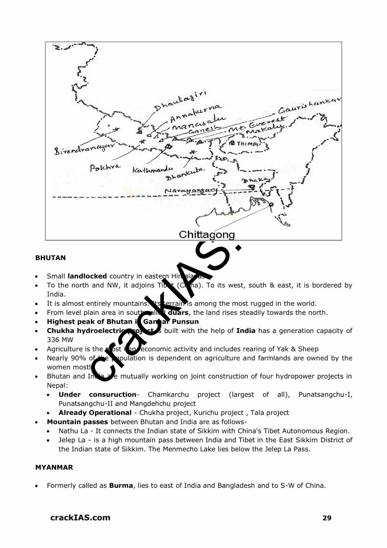
crack
IAS.com
crackIAS.com 29
BHUTAN
Small landlocked country in eastern Himalayas
To the north and NW, it adjoins Tibet (China). To its west, south & east, it is bordered by
India.
It is almost entirely mountains. Its terrain is among the most rugged in the world.
From level plain area in south called duars, the land rises steadily towards the north.
Highest peak of Bhutan is Gangar Punsun
Chukha hydroelectric project is built with the help of India has a generation capacity of
336 MW
Agriculture is the most imp. economic activity and includes rearing of Yak & Sheep
Nearly 90% of the population is dependent on agriculture and farmlands are owned by the
women mostly
Bhutan and India are mutually working on joint construction of four hydropower projects in
Nepal:
Under consuruction- Chamkarchu project (largest of all), Punatsangchu-I,
Punatsangchu-II and Mangdehchu project
Already Operational - Chukha project, Kurichu project , Tala project
Mountain passes between Bhutan and India are as follows-
Nathu La - It connects the Indian state of Sikkim with China's Tibet Autonomous Region.
Jelep La - is a high mountain pass between India and Tibet in the East Sikkim District of
the Indian state of Sikkim. The Menmecho Lake lies below the Jelep La Pass.
MYANMAR
Formerly called as Burma, lies to east of India and Bangladesh and to S-W of China.

crack
IAS.com
crackIAS.com 30
Myanmar has transferred its Capital from Yangon (Rangoon) to Pyinmana. Yangoon is
located on southern coast while Pyinmana is in central Myanmar.
Structurally – three units:-
1. Young fold mountains of the west and north are the southward continuation of the
Eastern Himalayas. From North to South, they are known successively as Patkai,
Naga, Chin and Arkan Yoma. Altitude of Mountain Ranges decreases towards the
south.
2. Eastern Part is of upland and low hill - extend through the Shan and Kayinni Plateaus
to the Southern Part.
3. Alluvial Lowlands – running North South between mountains of the west and the
upland regions of the east. Important rivers – Irrawaddy and Salween
Climate – Tropical Monsoon Type
Most of the people follow Buddhism; Urbanization is low
Mandalay is located in the interior on the bank of Ayeyarmaddy (Irrawaddy)
‘Sundari Trees are found in the delta regions
Rubber trees grow in hot and humid coastal regions
Teak– Most important species of Tree, alone constitute nearly 17% of country’s total
export
Precious stones e.g. Sapphires, emeralds, and rubies are found on the Shan Plateau.
Pearls are found in the Gulf of Martaban
Agriculture contributes about 60% of the GDP
Rice is the major crop and occupies about 50% of all land under cultivation

crack
IAS.com
crackIAS.com 31
Infrastructure Projects
With India Kaladan multi modal project: ensures sea connectivity to India’s Northeast and roads
connecting India to ASEAN and an alternate market for Myanmar’s gas supplies. The sea link
of the project is to connect Kolkata with Sittwe. The port of Sittwe is being developed by India.
Tamu-Kalewa-Kalemyo road: to be handed over to Myanmar; nearly 71 bridges on this stretch are to be upgraded under the Trilateral Highway project. Trilateral Highway Project: The highway is expected to connect Moreh in India to Mae Sot in Thailand via Myamar.
With China Sino-Burma Pipelines- A pipeline project that would allow transportation of oil and natural
gas from the deep-water port of Kyaukphyu (Sittwe) in the Bay of Bengal to Kunming in China’s Yunnan province.
Shwe Gas Project- The Shwe Gas Project one of the major parts of the Sino Burmese Pipeline Project. The gas field is located in the Andaman Sea. Discovered in 2004 it began production in 2013.
Myitsone Dam- The Myitsone Dam which literally translates Confluence Dam is a major hydroelectric power project which is located at the confluence of the Mali and N’Mai rivers and the source of the Irawaddy River.
BANGLADESH
Formerly called ‘East Pakistan’, became independent in 1971
Bordered by India from three sides – West, north and east. Myanmar lies to its southeast.
Bay of Bengal is to its south.
Physical Features
Almost all of it lies in the Ganga-Brahmaputra delta. These are alluvial plains.
Southeast part of Bangladesh is hilly. The Chittagong Hills, in fact, are continuation of the
hill ranges of Myanmar.
Cox’s bazaar – located on the eastern coast of Bangladesh is the largest Sandy-beach in
the world.
Brahmaputra is called ‘Jamuna’ in Bangladesh and after meeting Ganga, the joint
stream is called Padma.
Other rivers are the Meghna, Surma and Karnaphuli
Climate is of Tropical Monsoon Type
Deltaic coast has mangrove forests containing ‘Sundari’ trees. Wood is used for making
boats.
Natural gas is found in Comilla and Sylhet districts
Rice and Jute are the major crops
It has a small manufacturing sector. Most of the industries are small scale and cottage
industries.
Dhaka, Chandpur, Barisal and Khulna are inland ports
It has highest density of Population in South Asia
Indo – Bangaldesh Land Swapping The India–Bangladesh enclaves were the enclaves along the Bangladesh–India border,
in Bangladesh and the Indian states of West Bengal, Tripura, Assam and Meghalaya. The prime ministers of India and Bangladesh signed the Land Boundary Agreement in
1974 to exchange enclaves and simplify their international border. A revised version of the
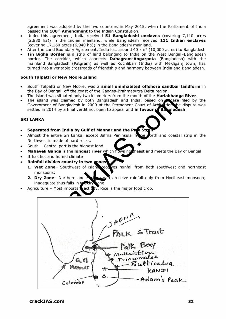
crack
IAS.com
crackIAS.com 32
agreement was adopted by the two countries in May 2015, when the Parliament of India passed the 100th Amendment to the Indian Constitution.
Under this agreement, India received 51 Bangladeshi enclaves (covering 7,110 acres (2,880 ha)) in the Indian mainland, while Bangladesh received 111 Indian enclaves (covering 17,160 acres (6,940 ha)) in the Bangladeshi mainland.
After the Land Boundary Agreement, India lost around 40 km² (10,000 acres) to Bangladesh Tin Bigha Border is a strip of land belonging to India on the West Bengal–Bangladesh
border. The corridor, which connects Dahagram-Angarpota (Bangladesh) with the mainland Bangladesh (Patgram) as well as Kuchlibari (India) with Mekliganj town, has turned into a veritable crossroads of friendship and harmony between India and Bangladesh.
South Talpatti or New Moore Island
South Talpatti or New Moore, was a small uninhabited offshore sandbar landform in
the Bay of Bengal, off the coast of the Ganges-Brahmaputra Delta region. The island was situated only two kilometers from the mouth of the Hariabhanga River. The island was claimed by both Bangladesh and India, based on a case filed by the
Government of Bangladesh in 2009 at the Permanent Court of Arbitration the dispute was settled in 2014 by a final verdit not open to appeal and in favour of Bangladesh.
SRI LANKA
Separated from India by Gulf of Mannar and the Palk Strait
Almost the entire Sri Lanka, except Jaffna Peninsula in the north and coastal strip in the
Northwest is made of hard rocks.
South – Central part is the highest land.
Mahaveli Ganga is the longest river which flows northeast and meets the Bay of Bengal
It has hot and humid climate
Rainfall divides country in two zones –
1. Wet Zone– Southwest of island receives rainfall from both southwest and northeast
monsoons.
2. Dry Zone– Northern and Eastern parts receive rainfall only from Northeast monsoon;
inadequate thus falls in the dry zone.
Agriculture – Most important activity. Rice is the major food crop.

crack
IAS.com
crackIAS.com 33
Tea, rubber and coconut are principal cash crops. Cocoa and Spices are grown for export.
Graphite and gemstones are Sri Lanka’s most valuable mineral products
Sea Ports – Trincomalee (Eastern Coast) and Colombo (Western Coast).
Kandy is a modern city and is famous Buddhist temple
Sinhalese and Buddhists are the major groups, they speak Sinhalese. Other major group is
of Tamils from India, settled in the northern and eastern parts of Sri Lanka.
Sethusamudram Shipping Canal Project is a proposed project to create a shipping route
in the shallow straits between India and Sri Lanka. This would provide a continuously
navigable sea route around the Indian Peninsula. The channel would be dredged in
the Sethusamudram Sea between Tamil Nadu and Sri Lanka, passing through the limestone
shoals of Adam’s Bridge. The proposed route through the shoals of Adam's Bridge is
opposed by some groups on religious, environmental and economical grounds.
REGIONAL GEOGRAPHY OF EAST ASIA
CHINA
World’s most populous country (one-fifth of the world population). In area, China is third
largest.
Large part of China is mountainous and arid, thus it has one of the smallest areas of
cultivable land per person in the world
Intensive agriculture and horticulture is practiced, yield per hectare is high.
Rice is the main crop, grown in southern and central China
Silk, cotton, tobacco and tea are important cash crops
Shanghai is the largest city of China. It is the largest port and a big textile centre.
Most provinces of North China have coalfields, and Iron ore deposits are abundant in the
anthracite fields of Hebei, Shanxi and Shandong.
Nearly 70% of the energy is produced from coal. China is 2nd largest consumer of energy
after USA.
Loess Plateau is made of fine yellow sand called loess.
Towards east lies the river valleys of Huang He, Chang Jiang and Xi Jiang interspersed with
hills.
Salween and Mekong originate from the eastern part of the plateau of Tibet, they flow into
Southeast Asia.
Valley of Chang Jiang is the largest.
Physiography and Relief
China consists in broad terms of 3 physiographical divisions:
1 The Western Highlands: The lofty mountains in the far west, bordering Szechaun and
Yunnan are known as the Szechuanese Alps or Great Snowy Mountains and towering up
to heights in excess of 4500 m culminate in Minya Gongkar, 7660 m; from these
mountains great plateau and mountain spurs project eastwards, the most important being
the separate northern from central China.
2 The Eastern Uplands: The uplands in the east margining the sea which though once
probably connected together now form a series of detached massifs, the Liaotung,
Shantung and Chekiang–Fukien Uplands, all of which are broken and much denuded.
crack
IAS.com
crackIAS.com 34
3 The Lowlands: In between the Western highlands and the Eastern Uplands lie a series of
depressions forming the lowlands. These lowlands comprise the Great Plain Of North
China and the Middle Yangtze Basin.
Drainage
China is a region of dense stream network
One of the contrasts that characterize China’s physical environment lies in the abundance
of water and the dense hydrographic network of the eastern regions as compared with
the great aridity of the western region, where surface flows generally toward the
exterior,
The desert regions of the Gobi, the Qaidam basin, part of Dzungaria and the Takla Makan
Region are devoid of any constantly flowing streams.
The great Chinese rivers, the Hwang Ho and the Chang Jiang, descend from Tibet.
Hwang Ho: Before the plains, the Hwang Ho passes through the Loess Plateau at the foot
of the Qilian Shan range in Ganshu and Shanxi provinces. Here the river has dug deep
ravines and carried downstream appreciable quantities of silt. Its irregular now, however,
gives rise to unexpected and disastrous silting, often causing the course of its bed to be
altered.
Yangtze Kiang River: The largest river of China flows in the middle part of eastern China
and drains into the East China Sea. Shanghai is located on the back of this river.
Si Kiang: Rises in the eastern part of Yunnan Plateau flows through the southernmost
part of China. It drains into South China Sea and its mouth is located near canton.
Major Rivers of China Drains into
Yangtze Kiange East China Sea
Hwang Ho or Yellow River Yellow Sea
Sikiang South China Sea
The Yun Ho (Grand) Canal connects the Hwang Ho and Chang Jiang (Yangtze Kiang)
rivers and runs northward to Beijing. It is the main inland waterway of China. Besides the
complex network of canals that connect with the rivers, eastern China also has a number of
lakes that are part of the inland waterway system.
Natural Lakes of China
Because of its morphology, China has a considerable number of natural lakes, remnants in
many cases of older, more extensive basins, such as those located in the alluvial
depressions traversed by the Yangtze Kiang (Chang Jiang).
They are also common in the interior areas of western China, where they frequently have
a seasonal or permanently brackish character owing to the intense evaporation (Lop Nor in
Xinijiang and Qinghai, or Koko Nor, amid the ranges of the Nan Shan).
Population
The result of the geographical contrast between east and west is that if a line is drawn from
Yunnan province in the south west to Heilungkiang province in the north east (in Manchuria)
it is found that about 96% of the population of China live on the 58% of the land to the
east of the line.

crack
IAS.com
crackIAS.com 35
The only areas of moderately dense population to the west are where irrigation and lines
of communication exist, as along the Kansu corridor or upper Hwang Ho.
In 1990, 23% of the world’s population lived in China over 90% of these belonged to the
dominant Han people the remainder comprise 56 small minority groups.
By 1979, the government, in order to control the population growth, started giving
inducements for restricting to one child per family.
In 1987 the government began to relax its rigid policy in response to intermittent outrage
about cases of coercion and brutality in implementing population goals. In urban areas,
there is still the minimum age for marriage and restricts families to one child. However, a
second child is allowed in rural areas if the firstborn is a girl and providing there is a 4 years
gap between births.
China’s family size had fallen from 5.8 to 2.4 in 20 years, the figure is 1.7 in urban areas
(better education, stronger state control), compared with 2.7 in rural areas.
One Child Policy is a population control policy of the People's Republic of China. The policy is enforced at the provincial level through fines that are imposed based on the income of
the family and other factors. The policy was introduced in 1978 to alleviate social, economic and environmental problems in China. Since implementation in 1979, the one-child policy had many impact on China’s demography: 1. It reduced China’s population by an estimated 400 million people. In addition to
creating a gender imbalance, numerically favoring men over women, the policy also skewed the age demographic.
2. Economists estimate that China’s elderly population will increase 60 percent by 2020,
even as the working-age population decreases by nearly 35 percent. This type of demographic shift is unprecedented and presents serious challenges to the economic health of the nation.
3. The one-child policy has had several unintended consequences, including a dearth of workers, a reduced female population due to gendercide, and fewer young people to take care of a quickly aging population.
4. Moreover, the policy has created conditions conducive to a severe regional human-
trafficking and human-smuggling epidemic to compensate for the lack of Chinese women. It has already facilitated the practice of mail-order brides and created a burgeoning illegal-adoption market.
Agriculture
There are 4 distinct production regions:
The Hwang Ho Plain: Essentially a large alluvial plain created by the Hwang Ho River. It is
the heartland of Chinese civilization. This lowland area has been under intense cultivation for
centuries. The major crops produced are wheat, barley, corn, millet, and cotton. The
region also produced most of China’s apples, and hogs are found nearly everywhere.
Loess hills of Northern China: To the west of the Hwang Ho Plain lie the loess hills of
Northern China. This region of wind-blown soil has been dissected by thousands of gullies,
but the flat areas between the miniature canyons are farmed intensively.
The Chang Jiang drainage basin: The third major farming region of China is the rice-
producing area. Rice is the major crop along the river from the Szechwan Basin to
Shanghai. The region has also been noted for the production of silk and tea. Mulberry trees
for feeding silk worms are still common, although the silk industry has declined.
South China: It is the poorest of the four major agricultural regions. The plain surrounding
Canton is not large, and the rolling hills give way quickly to non-arable mountains.

crack
IAS.com
crackIAS.com 36
JAPAN
It is called as ‘Nippon’ in Japanese which means ‘land of the rising sun’
It has 3,900 islands but 4 are large and important
In order of their size they are – Honshu, Hokkaido, Kyushu and Shikoku.
Archipelago forms an arc. Sea of Japan separates it from mainland Asia
Mountainous area. Mountains account for 72% of Japan’s total land area. Most of the
mountains are of volcanic origin. Mt. Fujiyama near Tokyo is a famous mountain; it has
not erupted since 1707. However it is still considered as an active volcano.
Recreational resorts have hot-springs
Japan lies at the margins of converging Pacific Plate and Eurasian Plate. Therefore
earthquakes are frequent here.
Lowland area – Kanto Plain, where lies the cities of Tokyo and Yokohama.
Nagoya is also known as ‘Detroit of Japan’ owing to its automobile industry
Climate
Mild and varies from place to place. Northern part is colder than the south.
Winds from Siberia dominate the winter weather and causes heavy snow and rain in the
northern and western parts of the country.
In summers, oceanic winds cause rainfall on eastern and southern parts of Japan
During September, violent tropical rain-storms originating in Philippines Sea or in the
neighborhood of Caroline Islands called Typhoons strike the Southern part of Japan
frequently.
Plentiful rainfall and temperate climate produces rich forests and luxurious vegetation that
cover the entire countryside.
Cold ocean current (Oya Shio) from north and the warm ocean current (Kuro Shio)
from the south meet on the eastern coasts of Japan. This causes thick fog and creates
ideal condition for fish to thrive. This area is therefore, one of the major fishing
grounds of the world (2nd largest). It contributes nearly 15% to the total fishing of the
world.
Natural Resources
Japan’s main mineral resource is coal, which is of low grade. Hence basic minerals such
as mineral oil, iron-ore, coking coal, and non-ferrous metal ores such as copper, nickel and
bauxite have to be imported.
It depends on overseas sources to meet roughly 85% of energy requirements
Japan is poorly endowed with other natural resources also.
Despite these limitations, Japan has emerged as a leading industrial nation of the world
owing to highly developed human resources.
Japan’s major exports are automobiles, steel, ships, various kinds of machines and
electronic goods.
Agriculture
Only 14% of total land of Japan is arable
Farms are small in size but are intensively cultivated
Only 7% of population is engaged in agriculture
Rice is the main crop. Wheat, barley and soyabeans are other important food crops.
Nearly two third of the total area of Japan is forested
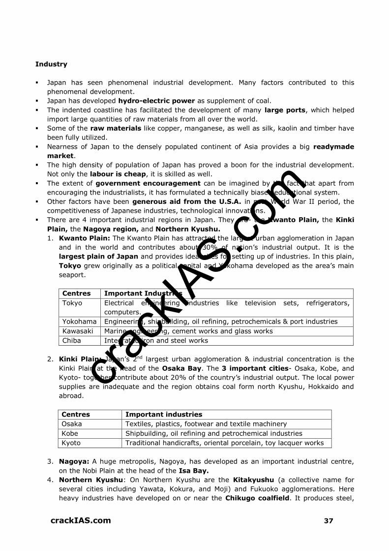
crack
IAS.com
crackIAS.com 37
Industry
Japan has seen phenomenal industrial development. Many factors contributed to this
phenomenal development.
Japan has developed hydro-electric power as supplement of coal.
The indented coastline has facilitated the development of many large ports, which helped
import large quantities of raw materials from all over the world.
Some of the raw materials like copper, manganese, as well as silk, kaolin and timber have
been fully utilized.
Nearness of Japan to the densely populated continent of Asia provides a big readymade
market.
The high density of population of Japan has proved a boon for the industrial development.
Not only the labour is cheap, it is skilled as well.
The extent of government encouragement can be imagined by the fact that apart from
encouraging the industrialists, it has formulated a technically biased educational system.
Other factors have been generous aid from the U.S.A. in post World War II period, the
competitiveness of Japanese industries, technological innovations.
There are 4 important industrial regions in Japan. They are- the Kwanto Plain, the Kinki
Plain, the Nagoya region, and Northern Kyushu.
1. Kwanto Plain: The Kwanto Plain has attracted the largest urban agglomeration in Japan
and in the world and contributes about 30% of nation’s industrial output. It is the
largest plain of Japan and provides ideal sites for setting up of industries. In this plain,
Tokyo grew originally as a political capital and Yokohama developed as the area’s main
seaport.
Centres Important Industries
Tokyo Electrical engineering industries like television sets, refrigerators,
computers.
Yokohama Engineering, shipbuilding, oil refining, petrochemicals & port industries
Kawasaki Marine engineering, cement works and glass works
Chiba Integrated iron and steel works
2. Kinki Plain: Japan’s 2nd largest urban agglomeration & industrial concentration is the
Kinki Plain at the head of the Osaka Bay. The 3 important cities- Osaka, Kobe, and
Kyoto- together contribute about 20% of the country’s industrial output. The local power
supplies are inadequate and the region obtains coal form north Kyushu, Hokkaido and
abroad.
Centres Important industries
Osaka Textiles, plastics, footwear and textile machinery
Kobe Shipbuilding, oil refining and petrochemical industries
Kyoto Traditional handicrafts, oriental porcelain, toy lacquer works
3. Nagoya: A huge metropolis, Nagoya, has developed as an important industrial centre,
on the Nobi Plain at the head of the Isa Bay.
4. Northern Kyushu: On Northern Kyushu are the Kitakyushu (a collective name for
several cities including Yawata, Kokura, and Moji) and Fukuoko agglomerations. Here
heavy industries have developed on or near the Chikugo coalfield. It produces steel,

crack
IAS.com
crackIAS.com 38
ships machine parts, chemicals and textiles. Nagasaki is also an important industrial
centre in the region. Other industrial towns are Hakodate and Sapporo in Hokkaido.
Centres Important Industries
Muroran Iron and steel industry
Akita Oil refinery
Niigata Oil refinery
Hiroshima Engineering industry
Kure Shipbuilding
Okayama Textiles industry
Other Facts about Japan
Japan has both national and private railroad systems. The national railroad is devoted
mostly to carrying freight, while the private railroads carry mostly passengers.
Tokyo is by far the largest Japanese city; the urban area of Tokyo merges into two other
millionaire cities of Japan. Kawasaki and its near neighbor, Yokohama, is Japan’s second
largest.
The Tokyo-Yokohama conurbation contains more than 10% of the people of the entire
country.
Disputed islands with China- The Senkaku Islands (Diaoyu Islands) are a group of
uninhabited islands controlled by Japan in the East China Sea. They are located roughly due
east of Mainland China, northeast of Taiwan, west of Okinawa Island, and north of the
southwestern end of the Ryukyu Islands. The islands are disputed between China and
Japan and between Japan and Taiwan
People
Ranks 10th in the world vis-à-vis its population size
It is one of the most densely populated country
One of the most urbanized nation of the world. More than 60% of the population is
concentrated in the major metropolitan areas of Tokyo, Yokohama, Osaka, Nagoya and
Kitakyushu.
Equal rights to women were granted in 1947 and women are the major participants in the
development of the nation
Forest Resources
COUNTRY LAND UNDER FOREST
S. Korea 64%
North Korea 63.25%
Japan 67%
China 18%
Mongolia 7%

crack
IAS.com
crackIAS.com 39
REGIONAL GEOGRAPHY OF SOUTH-WEST ASIA
MAIN PHYSIOGRAPHIC FEATURES
The South-West Asia consists of the countries of Iran, Iraq, Syria, Saudi Arabia, Oman,
Yemen, Jordan, Israel and Turkey.
The main physiographic features include the Armenian Plateau (between Caspian and
Black Sea), Taurus, Pontic Mountains, Zagros and Elburz Mountains.
Another major feature is the deserts of SW Asia. These include:
Arabian Desert, which is the continuation of the Sahara Desert covering an area of
about 2.6 million km2 of Arabian Peninsula. Its one-third area is covered with sand
dunes, highest in the world.
Iranian Desert: the second largest
DRAINAGE
The Tigris and Euphrates
The Tigris and Euphrates rivers flow through Mesopotamia and the lowland area in Iraq
that some consider being the birthplace of civilization.
Babylon, the world’s first large city, was located along the Euphrates in the centre of
Mesopotamia.
The two rivers begin in the mountains of Turkey and flow roughly parallel to each other
toward the southeast.
The Euphrates cuts through Syria, both rivers flow through Iraq and they eventually empty
into the Persian Gulf.
The Tigris is actually a tributary of the Euphrates.
The land of the Tigris and Euphrates has always been fertile and productive and with the
economic property this region is known as ‘Fertile Crescent’.
The lower part of the river has been used as the international boundary between Iraq
and Iran, the two countries. Baghdad, the capital and largest city of Iraq is located on the
banks of the Tigris River.
The Jordan River
The Jordan River, which is only 240 km, is one of the world’s best known rivers because of
its location in the Holy land and significance for Christianity.
Essentially, the river flows from the Sea of Galilee southward into the Dead Sea.
The surface of the Dead Sea lies 375 below mean sea level and the lowest place on earth.
IRAQ
Covered above with Map
IRAN
The country is bordered to the northwest by Armenia and Azerbaijan; with Kazakhstan and
Russia across the Caspian Sea; to the northeast by Turkmenistan; to the east by
Afghanistan and Pakistan; to the south by the Persian Gulf and the Gulf of Oman; and to the
west by Turkey and Iraq
It is the only country that has both a Caspian Sea and an Indian Ocean coastline
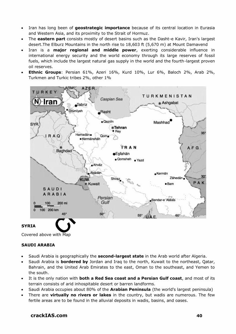
crack
IAS.com
crackIAS.com 40
Iran has long been of geostrategic importance because of its central location in Eurasia
and Western Asia, and its proximity to the Strait of Hormuz.
The eastern part consists mostly of desert basins such as the Dasht-e Kavir, Iran's largest
desert.The Elburz Mountains in the north rise to 18,603 ft (5,670 m) at Mount Damavend
Iran is a major regional and middle power, exerting considerable influence in
international energy security and the world economy through its large reserves of fossil
fuels, which include the largest natural gas supply in the world and the fourth-largest proven
oil reserves.
Ethnic Groups: Persian 61%, Azeri 16%, Kurd 10%, Lur 6%, Baloch 2%, Arab 2%,
Turkmen and Turkic tribes 2%, other 1%
SYRIA
Covered above with Map
SAUDI ARABIA
Saudi Arabia is geographically the second-largest state in the Arab world after Algeria.
Saudi Arabia is bordered by Jordan and Iraq to the north, Kuwait to the northeast, Qatar,
Bahrain, and the United Arab Emirates to the east, Oman to the southeast, and Yemen to
the south.
It is the only nation with both a Red Sea coast and a Persian Gulf coast, and most of its
terrain consists of arid inhospitable desert or barren landforms.
Saudi Arabia occupies about 80% of the Arabian Peninsula (the world's largest peninsula)
There are virtually no rivers or lakes in the country, but wadis are numerous. The few
fertile areas are to be found in the alluvial deposits in wadis, basins, and oases.

crack
IAS.com
crackIAS.com 41
Saudi Arabia is the world's largest oil producer and largest exporter, and controls the
world's second largest hydrocarbon reserves.
The ethnic composition of Saudi citizens is 90% Arab and 10% Afro-Asian. Most Saudis
live in Hejaz (35%), Najd (28%), and theEastern Province (15%).
YEMEN
Covered above with Map
OMAN
Holding a strategically important position at the mouth of the Persian Gulf, the nation is bordered by the United Arab Emirates to the northwest, Saudi Arabia to the west and Yemen to the southwest, and shares marine borders with Iran and Pakistan.
The coast is formed by the Arabian Sea on the southeast and the Gulf of Oman on the northeast.
The Madha and Musandam exclaves are surrounded by the UAE on their land borders, with the Strait of Hormuzand Gulf of Oman forming Musandam's coastal boundaries.
Tourism is the fastest-growing industry in Oman. Omani people are predominantly Arab, Baluchi, South Asian (Indian, Pakistani, Sri Lankan,
Bangladeshi), and African ethnic groups JORDAN
Jordan is bordered by Saudi Arabia to the south and east, Iraq to the north-east, Syria to
the north, and Israel and Palestine to the west.
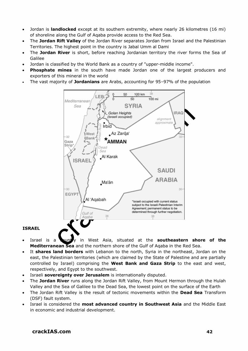
crack
IAS.com
crackIAS.com 42
Jordan is landlocked except at its southern extremity, where nearly 26 kilometres (16 mi)
of shoreline along the Gulf of Aqaba provide access to the Red Sea.
The Jordan Rift Valley of the Jordan River separates Jordan from Israel and the Palestinian
Territories. The highest point in the country is Jabal Umm al Dami
The Jordan River is short, before reaching Jordanian territory the river forms the Sea of
Galilee
Jordan is classified by the World Bank as a country of "upper-middle income".
Phosphate mines in the south have made Jordan one of the largest producers and
exporters of this mineral in the world
The vast majority of Jordanians are Arabs, accounting for 95–97% of the population
ISRAEL
Israel is a country in West Asia, situated at the southeastern shore of the
Mediterranean Sea and the northern shore of the Gulf of Aqaba in the Red Sea.
It shares land borders with Lebanon to the north, Syria in the northeast, Jordan on the
east, the Palestinian territories (which are claimed by the State of Palestine and are partially
controlled by Israel) comprising the West Bank and Gaza Strip to the east and west,
respectively, and Egypt to the southwest.
Israeli sovereignty over Jerusalem is internationally disputed.
The Jordan River runs along the Jordan Rift Valley, from Mount Hermon through the Hulah
Valley and the Sea of Galilee to the Dead Sea, the lowest point on the surface of the Earth
The Jordan Rift Valley is the result of tectonic movements within the Dead Sea Transform
(DSF) fault system.
Israel is considered the most advanced country in Southwest Asia and the Middle East
in economic and industrial development.

crack
IAS.com
crackIAS.com 43
Israel is a global leader in water conservation and geothermal energy, and its
development of cutting-edge technologies in software, communications.
74.9% population are Jews and 20.7% of the population comprised of Arabs.
TURKEY
Turkey is bordered by eight countries: Syria and Iraq to the south; Iran, Armenia, and
the Azerbaijani exclave of Nakhchivan to the east; Georgia to the northeast; Bulgaria to the
northwest; and Greece to the west.
The Black Sea is to the north, the Mediterranean Sea to the south, and the Aegean Sea to
the west.
The Bosphorus, the Sea of Marmara, and the Dardanelles demarcate the boundary
between Thrace and Anatolia; they also separate Europe and Asia.
Turkey's location at the crossroads of Europe and Asia makes it a country of significant
geostrategic importance.
Turkey has a sizeable automotive industry

crack
IAS.com
crackIAS.com 44
The majority of the Turkish population are of Turkish ethnicity. They are estimated at 70–
75 percent
The three "Non-Muslim" minority groups claimed to be officially recognized in the
Treaty of Lausanne are Armenians, Greeks and Jews.

Our Performance in GS Prelims over years
2018 77 Qs out of 100 Qs 2013 84 Qs out of 100 Qs
2012 74 Qs out of 100 Qs
2017 77 Qs out of 100 Qs 2011 82 Qs out of 100 Qs
2016 76 Qs out of 100 Qs 2010 98 Qs out of 150 Qs
2015 84 Qs out of 100 Qs 2009 93 Qs out of 150 Qs
2014 81 Qs out of 100 Qs 2008 92 Qs out of 150 Qs
We have Never Failed!
We will Never Fail!!
This is how we have performed in terms of delivering questions from our 9 Small Booklets in UPSC GS Prelims Exam in last 11 years
Click here to select our Courses

crack
IAS.com
crackIAS.com 233
GEOGRAPHY THEORY

crack
IAS.com
crackIAS.com 250
ATMOSPHERE AND ITS TEMPERATURE
LAYERS OF ATMOSPHERE
Troposphere
Layer immediately above the surface of earth & the most important.
Height varies from 8 Km at poles to 18 Km at equator and height is more in summer
Here temperature decreases with height at the rate of 1 degree for each 165 m rise. This
is called normal lapse rate. At poles, it is -45°C while at equator; it is -80°C. It is a
paradox that lowest temperature in the atmosphere lies above equator & not poles.
Densest part of Atmosphere. All dust particles and water vapours of Atmosphere are found
here, hence weather phenomenon.
Mountains, hot air balloon etc are limited to this layer.
Jet aeroplanes avoid this layer due to presence of bumpy air pockets & fly in
Stratosphere
Stratosphere
Layer immediately above Troposphere, separated from it by tropopause.

crack
IAS.com
crackIAS.com 251
Extends upto 50 Km, temperature rises with height here.
Ozone layer is concentrated over here.
Clouds, water vapour and dust are absent here.
Shooting Star, Weather balloon.
Mesosphere
Extends upto 80 Km wherein temperature decreases with height (-100°C)
Thermosphere
Contains electrically charged layer Ionosphere. Space Shuttle, Satellite Aurora lie
here.
Radio waves transmitted from earth are reflected back by this layer.
Temperature here increases with height due to radiation from sun.
Upper part of it is called exosphere, which is highly rarefied.
INSOLATION
It is the amount of Solar Radiation received by the earth.
The atmosphere is heated mainly from below by the heated surface of the earth. That is
why the temperature in lower parts of atmosphere is usually higher.
Atmosphere is heated more by terrestrial radiation than by incoming solar radiation.
Factors that influence insolation are the Angle of sun’s ray and the duration of a day.
At Noon, sunrays strike earth’s surface vertically, therefore, more heat. At morning and
evening, it strikes obliquely. Heating effect of vertical rays is more than that of oblique
ones.
The sun’s rays are almost vertical in lower latitudes. At poles, rays are more oblique.
The amount of Insolation during summer is more than it is in winters.

crack
IAS.com
crackIAS.com 252
Temperature of Air Decreases with-
1. Increase in latitudes. As we go away from equator, it is cooler.
2. Height or Altitudes.
3. Temperature is also influenced by distance of a place from sea. Maritime places having
equable temperature during winters and summer. While continental places have
extremes of temperature.
Temrature Contrasts On Land
Land heats more rapidly and to higher temperatures than water, and cools more
rapidly and to lower temperatures than water.
Reasons for the differential heating of land and water include the following:
water is a liquid and is mixed by waves and currents, while soil or rock are fixed;
hence, heat is distributed through a larger thickness (mass) of water than land;
land is opaque, so all radiant energy is absorbed in a shallow surface layer, while water
is more transparent, allowing solar radiation to penetrate to greater depths;
the specific heat of water is higher than the specific heat of land; and
Evaporation is greater from a water surface than that from a land surface.
The atmosphere is heated chiefly by radiation from Earth’s surface. Therefore, to understand
variations in air temperatures, we must understand the heating properties of various
surfaces.
The annual temperature range near the equator is very low. With an increase in
latitude, the annual temperature range increases.
Reasons for the low annual range in the tropics include the following:
this region always has a fairly high noon-Sun angle (lowest noon-Sun angle at 0° is 66
1/2°) and
The tropics have more uniform lengths of daylight throughout the year.
Places in the middle and high latitudes, however, have much greater seasonal
variations in Sun angle and length of daylight, causing these locations to have much
greater annual temperature ranges.
The city along the windward coast will experience a relatively small annual temperature
range because of strong marine influence.
The interior city will have the highest annual range among the three cities because of
its continental position.
Because the winds are directed from the land toward the ocean, the city located along the
leeward coast will not experience a strong marine influence and therefore will have an
annual temperature range that is more similar to that of the interior city.
ATMOSPHERIC PRESSURE AND WINDS
Equator Low
Temperature is high throughout year near equator. As a result lower layers get heated up
and air rises to create low pressure zone.
Extends between 10° N&S, characterized by extreme calm conditions called Doldrums.
Polar High
They are cold throughout year, subsidence of air takes place. Therefore Polar Highs.
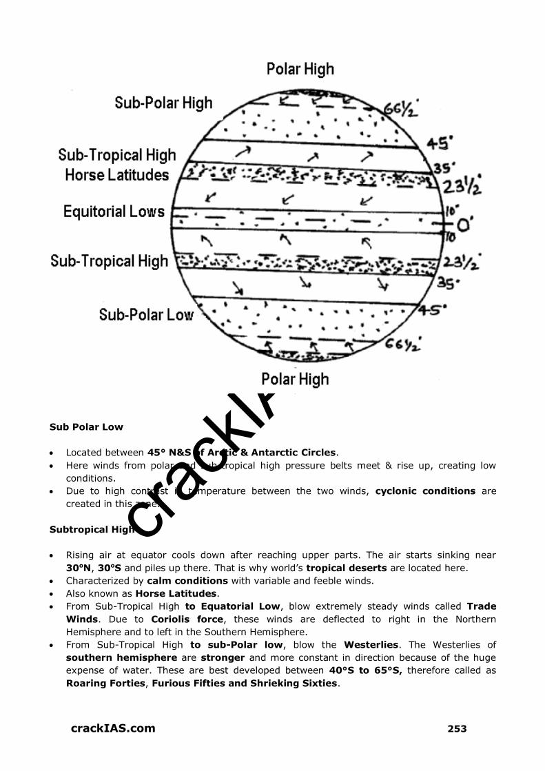
crack
IAS.com
crackIAS.com 253
Sub Polar Low
Located between 45° N&S of Arctic & Antarctic Circles.
Here winds from polar and sub-tropical high pressure belts meet & rise up, creating low
conditions.
Due to high contrast in temperature between the two winds, cyclonic conditions are
created in this zone.
Subtropical High
Rising air at equator cools down after reaching upper parts. The air starts sinking near
30oN, 30oS and piles up there. That is why world’s tropical deserts are located here.
Characterized by calm conditions with variable and feeble winds.
Also known as Horse Latitudes.
From Sub-Tropical High to Equatorial Low, blow extremely steady winds called Trade
Winds. Due to Coriolis force, these winds are deflected to right in the Northern
Hemisphere and to left in the Southern Hemisphere.
From Sub-Tropical High to sub-Polar low, blow the Westerlies. The Westerlies of
southern hemisphere are stronger and more constant in direction because of the huge
expense of water. These are best developed between 40°S to 65°S, therefore called as
Roaring Forties, Furious Fifties and Shrieking Sixties.

crack
IAS.com
crackIAS.com 254
Periodic and Local Winds
Monsoon Winds are those winds, which reverse their direction with the change in season.
Blow from Land to Sea in winter and Sea to Land in summer. Weak Monsoons exist over
South West USA, Australia, South America, China, Japan and Parts of Africa.
Katabatic Wind - During winters, areas adjacent to highland experience a local cold wind
called katabatic wind (moving down from snowcapped mountains to valley). Very cold and
dry e.g. Mistral over France from Alps flows through Rhone Valley towards Mediterranean
Sea. It brings temperature below freezing.
Foehn (in Alps) and Chinook (in USA & Canada in Rockies) are other local winds of
importance, which blow down the mountains and get warm up. In the process, these melt
the snow and hasten ripening of grapes (in Alps) and benefit ranchers in Rockies.
Chinook is also called snow-eater.
Local Wind in India – Loo (hot, dry and dusty wind)
WATER IN THE AIR
Water vapours are present in large amount in low latitudes and over oceans. These are less
over polar areas and land. Water vapour content varies with seasons & altitudes as well.
Evaporation – Highest during hot dry and windy conditions and lowest during cool, moist
and calm weathers.
Humidity is the amount of water vapour present in Air.
When the air holds the maximum amount of water vapours it can carry at a given
temperature, it is called saturated.
Unsaturated air may become saturated if cooled. The phenomenon of rain, snow etc.
happens due to same reason as it goes up.

crack
IAS.com
crackIAS.com 255
Dew Point is the temperature at which air gets saturated. At dew point, water vapour
changes into minute droplets of water or ice crystals. This is called condensation.
Dust in the atmosphere serves as surfaces for condensation, known as condensation
nuclear.
Forms of Condensation
Dew: In cold, clear nights when comparatively warm, moist air comes in contact with
cold objects, it cools down. The excess of moisture condenses into droplets of water called
Dew. Frozen dew is called Frost.
Clouds: The visible aggregates of minute droplets of water or ice crystals are known as
clouds. These are of major 10 types:
Low Clouds (<2000m height): Stratocumulus, Stratus, Nimbostratus, Cumulus and
Cumulonimbus.
Medium Clouds (2000-6000 m): Altocumulus and Altostratus
High Clouds (6000-12000 m): Cirrus, Cirrostratus and Cirrocumulus
Cirrus clouds are composed of ice crystals and give a fibrous & feathery appearance.
Cumulus clouds have a flat base & dome shaped/ cauliflower structure.
Stratus clouds are like sheets.
Fog: is the cloud very near to the surface of earth. Created because of the cooling of air
adjacent to the cold ground.
Falling of this solid and liquid water on earth’s surface is called Precipitation e.g. Rain,
Snow, Hail.
In calm air, the drops are very small called Drizzle.
When condensation in air takes places at a temperature below freezing point, the water
vapour changes into tiny ice crystals or flakes called snowfall.
Sometimes powerful air currents may lift raindrops to a greater height, where
temperature is below freezing point. Rain drops freezes. Currents may toss those frozen
drops up again. The coating of water is frozen in concentric layer. This process repeated so
many times and fall as Hailstones.
At Equators, when land is heated, air is also heated & rises up. If moist, increase in height
leads to cooling of air and its condensation, and therefore heavy rainfall.
At Mid Latitudes, when wind blows from all sides towards centre of Low Pressure, they have
spiral motion of air. If air has moisture, sudden uplifting of warm air may lead to rainfall.
Weather is the state of Atmosphere at any given place and time, while Climate is the
average weather of a place over a period of 30-35 years or more.
Mercury or Alcohol (at cold places like Russia) is used in Thermometers.
Six’s Max And Min Thermometer – Used to find out maximum and minimum temperature
of a place within 24 hr. Thermograph s the instrument that continuously records
temperature.
Barometer/ Aneroid Barometer (without liquid) is used to measure atmospheric pressure
(in milibars). Anemometer is used to find wind speed (km/hr). Anemograph records wind
speed automatically.
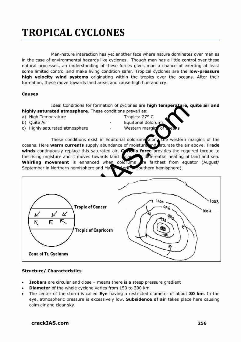
crack
IAS.com
crackIAS.com 256
TROPICAL CYCLONES
Man-nature interaction has yet another face where nature dominates over man as
in the case of environmental hazards like cyclones. Though man has a little control over these
natural processes, an understanding of these forces gives man a chance of exerting at least
some limited control and make living condition safer. Tropical cyclones are the low-pressure
high velocity wind systems originating within the tropics over the oceans. After their
formation, these move towards land areas and cause high hue and cry.
Causes
Ideal Conditions for formation of cyclones are high temperature, quite air and
highly saturated atmosphere. These conditions prevail as:
a) High Temperature - Tropics: 27º C
b) Quite Air - Equitorial doldrums
c) Highly saturated atmosphere - Western margins of oceans
These conditions exist in Equitorial doldrums along the western margins of the
oceans. Here warm currents supply abundance of moisture and saturate the air above. Trade
winds continuously replace this saturated air. Coriolis force provides the required torque to
the rising moisture and it moves towards land because of differential heating of land and sea.
Whirling movement is enhanced when doldrums are farthest from equator (August/
September in Northern hemisphere and March/ April in Southern hemisphere).
Structure/ Characteristics
Isobars are circular and close – means there is a steep pressure gradient
Diameter of the whole cyclone varies from 150 to 300 km
The center of the storm is called Eye having a restricted diameter of about 30 km. In the
eye, atmospheric pressure is excessively low. Subsidence of air takes place here causing
calm air and clear sky.

crack
IAS.com
crackIAS.com 257
Inner Ring: violent winds of speed 120 km/hr circulate around the eye. Wind is
upwelling here, forming a sort of Eye Wall. It is 30-50 km wide with torrential rainfall,
thunderstorm and lightening.
The outer ring i.e. area outside inner ring is characterized by reduced rainfall and wind
speeds.
The winds are anticlockwise in NH, reverse in SH. Winds move towards the core, and veer
to right.
Movement
Follow fairly well defined track, moving at a speed of 15-25 km/hr covering a
distance of 300-500 km a day. At about 20º latitude, these move westward, then pole-ward
between 20º-25º latitudes. Between 25º-30º latitude, these first move in north-easterly
direction and then finally turn eastwards.
Distribution on World Map
In the different region of tropical areas, these are known by different names
Cirrus Clouds Canopy

crack
IAS.com
crackIAS.com 258
Tropical Disturbance: Caribbean and Gulf of Mexico. Weak, sluggish, many times
stationary
Tropical Depression: India & North Australia. Close isobars, small size, Gale force
Tropical Storm: Bay of Bengal & Arabian Sea. Closed isobars, circular, strong cyclones
Hurricanes/ Typhoons/ Willy-Willy/ Taifu: China, Japan, USA, and Korea. Closed
isobars, circular, violent heavy rain, feeble eye.
INDIAN ASPECT: Tropical depression (or if intensified, tropical cyclones) form in Bay of
Bengal. Each monsoon month has 1-4 of tropical depressions. These travel along ITCZ
whose position keeps on changing because of changing pressure conditions. Much of rainfall
in North and North West India occurs because of these. Maximum rainfall takes place along
its path & goes on decreasing North & North West.
Associated Weather
Tropical Cyclones show a pattern of weather change with their consequent
movement. Each part of the cyclones is associated with a particular kind of weather
phenomenon.
When the cyclone arrives, Eye Wall weather conditions prevail with 100-250 mm
rainfall in one storm along with lightening. It prevails for few hours with cumulonimbus (Cu-
Ni) clouds.
When Eye arrives, the weather is calm, sky is clear and rain stops. It takes around ½ hr
for the eye to pass.
When Eye passes, same weather conditions as that of arrival prevail with winds in opposite
direction.
Heavy rain continues even after winds become weak.
The energy of cyclones dissipates as these moves landward because the source of
energy (i.e. ocean) is cut off. The latent heat of condensation of cumulonimbus clouds
provide them required energy. This is the reason that maximum damage caused by
cyclones is in coastal areas as they fail to move too inside the land, and move back
towards oceans in a curved trajectory.

crack
IAS.com
crackIAS.com 259
Impact
These are very severe and disastrous natural hazards inflicting heavy loss to human and
animal life alongwith crops, property and communication network. Trees are uprooted,
economy is shattered and the people are left forever in trauma. Cause havoc in coastal
areas. Approximately 80 Tropical Cyclones occur every year. Rainfall of 25cm/day is
common.
Orissa cyclone (1999) claimed 1 lakh precious lives while and similar cyclone in 1731
caused > 3 lakh deaths.
Sea waves rise to a height of 20 m and cause damage by landward movement
The storm surge is responsible for the greatest damage, 90% of the death are attributable
to the sudden deluge owing to the instantaneous onrush of water and rise in water level
with hurricane winds.
River mouth appears to be the preferred areas of landfall of most cyclones, that too at the
high tide epoch. The river mouths are usually flat alluvial plain devoid of trees, facilitating
rapid and easy inflow of water.
In June 2010, Cyclone Agatha struck the Mexico coast killing many hundred people.
Cyclone Phet struck the Pakistan’s Arabian Coast and adjoining countries in 2010 affecting
many thousand people.

crack
IAS.com
crackIAS.com 260
THUNDER AND LIGHTENING
Most thunderstorms occur from massively tall cumulonimbus clouds. The sun warms
moist air near the earth’s surface, and makes it rise. As this air moves upwards, it cools and
can condense to form cumulus clouds. The small, white fluffy cumulus clouds can group
together and form one larger cumulonimbus cloud if there is enough rising warm air.
If tall enough to reach the cooler air of the stratosphere, strong winds may widen the top of
the cumulonimbus cloud. This may have the appearance of a top-heavy, flattened, anvil
shape and is a good indicator that a thunderstorm is on its way.
The way thunderstorms form mean they are more common in the afternoons of tropical
regions where there is more moist, warm air and more heat to make it rise. Most parts of
the world have thunderstorms, especially mountainous areas, which help form
cumulonimbus clouds with increased uplift of air. Only hot, dry deserts and extremely
cold Polar Regions rarely see thunderstorms.
Thunder
Thunder is the rumbling or crack of sound that can usually be heard from the sky during a
storm. Thunder is caused because lightning heats up the air, to about 30 000ºC, causing it
to expand quickly. The rumbling occurs as the sound passes through atmospheric layers at
different temperatures.
Lightning
Lightning is thought to be due to the formation of ice crystals in the top layers of the
cumulonimbus cloud as it reaches a cooler part of the atmosphere called the
stratosphere.
As these crystals bump into each other a tiny bit of electrical energy, (charge) may be
created within a larger, storm-wide, electrical field. It works a bit like static electricity on
your hair from a jumper, or from a desk chair wheeled across a carpet.
Light, positive charged ice and water gathers at the top of the cloud and the heavier
negative particles gather at the base. The ground below is also positively charged. The
difference in electrical charges can become so great that energy is released as lightning.
A typical discharge is usually about 1.5 million volts and most of this is changed into
heat energy. Although these high temperatures only last a millonth of a second it is enough
to vapourise the fluid of a tree and cause it to explode.
Although lightning appears to move from clouds to the ground, the flash we see is actually
returning to the storm clouds. Lightning can be sheet lightning occurring within the cloud
or fork lightning between clouds. Lightning sensors have been used to track lightning since
the 1980s. Satellites have been used to collect long-term data on all lightning since the
1990s, and the global average has been calculated at 30 – 40 flashes per second.
90% of lightning never reaches the ground, but when it does it can strike twice.
The Empire State Building in New York has been hit 48 times in one day. Single trees on
high, exposed ground are likely to be hit by lightning. You are safe inside a car as lightning
is carried to the ground through the metal body of the car instead of through the person
inside.

crack
IAS.com
crackIAS.com 261
TEMPERATE CYCLONES (Extra-Tropical Cyclones/ Wave Cyclones/ Depressions/ Troughs/ Low Cyclones)
The low-pressure wind systems blowing inwards in the extra-tropical
regions are known as temperate cyclones. These influence the weather conditions of the areas
where these move and cause a significant impact on economics of these regions. These
originate both over land and ocean, and move anticlockwise in northern hemisphere and
clockwise in southern hemisphere. The causes of their origin could be-
1. Dynamic i.e. confluence of contrasting polar and tropical air masses and
2. Thermodynamic i.e. insolation of landmasses in summer
ORIGIN OF TEMPERATE CYCLONES
Thermodynamic Origin/ Insolation Cyclones
Brunt Theory/ Humphreys Theory provides an explanation to their origin. In
summer, the sunrays heat up the huge landmasses in temperate zones viz. North America,
and Russia. This creates low pressure over these areas and attracts winds from all direction,
thus developing cyclones. These are stationary over the areas of their formation. These
are formed over Iberian Peninsula, Alaska, SW USA and North-West Australia. Similar formation
takes place over oceans during winters as low pressure develop over them surrounded by
high-pressure cold airmasses over land. In winter, these are formed over Okhotsk Sea,
Norwegian Sea, and North Atlantic.
Dynamic Origin
Polar Front Theory (PFT) of Bjerknes provides fundamental explanation to the
origin of temperate cyclones. Convergence of two contrasting airmasses- One, cold and
dry polar airmass and other, warm, moist and maritime tropical airmass takes place. This leads
to formation of fronts. The cold airmass pushes the warm air upwards. The up-moving
warm air creates a low-pressure shaft, which attracts air from surroundings. The earth’s
rotation causes the winds to rotate and cyclonic formation takes place as shown in diagram.
Polar Front Theory is an explanation of Frontogenesis and Frontolysis. Frontogenesis is
coming together of air masses and formation of depression. Frontolysis is horizontal
divergence of air from frontal zone, together with subsidence and gradual dissipation of
frontal zone.
1. Two air masses with contrasting physical properties move parallel to each other and a
stationary front is created
2. Warm and cold air masses penetrate into the territories of each other and a wave like front
is formed. This is called incipient stage.
3. Cyclone becomes fully developed and isobars become almost circular. This is called mature
stage.
4. Low pressure accompanied by convergence and rising air at the center and along the front.
Cold front overtakes warm front.
5. Cold front finally overtakes the warm front and an occluded front is formed.
6. Warm sector completely disappears, occluded front is eliminated and ultimately cyclone dies
out.

crack
IAS.com
crackIAS.com 262
“Life Cycle of cyclone”
CHARACTERISTICS OF TEMPERATE CYCLONES
Size and Shape: Isobars are oval or elongated in shape. In exceptional cases, these are
circular. Their diameter varies from 150-3000 km.
Structure: Lowest pressure occurs near the center. Winds rotate in anticlockwise direction
in NH and clockwise in SH around the center.
As it is formed by convergence of two contrasting airmasses, therefore, there is variation
in nature and direction of winds in different parts. Tropical part is of westerly
direction, polar part of easterly direction.
Movement and Direction: These may be practically stationary or moving at 1000 km/
day. General direction of movement is west to east in mid-latitudes under the influence
of Westerlies. Speed greater in winter than in summer.
Warm front and warm sector characterized by warm southerly and southwesterly winds
which changes to west, north westerly and north at arrival of cold front and cold sector.

crack
IAS.com
crackIAS.com 263
ASSOCIATED WEATHER
As the cyclone advances, the passage of each front is associated with a distinctive
sequence of cloud, rain and temperature change. Because of convergence of two contrasting
airmasses, different temperatures in different parts prevail. There is dominance of warm air
in southern parts, while low temperatures occur in north, northeast and north-west. Western
parts have the lowest temperatures.
Before the arrival of cyclone, the high wispy cirrus clouds appear first on the western
horizon.
As the front approaches, clouds lower and thicken and the sky becomes overcast with
cirrostratus, altostratus and nimbostratus clouds. The warm front precipitation continues
for 2-3 days, moderate but spread over large areas. The wind direction changes from
southeast to south. The wind coming from south is relatively warmer.
Warm air rises at this place, thereby creating a vacuum, which is readily filled by
cold air, and so maximum wind speed. Further, since there are no cumulous clouds
formed, precipitation is not very heavy. Further, cold air has lesser moisture holding
capacity. Dew point is reached fast and thus condensation in cold air takes place in the form
of fogs. Raindrops freeze as these travel through cold air and fall in the form of ice pellets.
When the cold front approaches, marked drop in temperature takes place. Clouds become
cumulus. Rainfall becomes heavy and limited to smaller area. This is sometimes
accompanied by violent thunderstorms and hails. The winds blow from north and north-
westerly direction, a shift from southerly to south-westerly direction.
Gradually the final uplift of warm sector takes place and the occluded front is formed. After
the occlusion, the depression tends to ‘fill up’ and the cyclone dies away.

crack
IAS.com
crackIAS.com 264
DISTRIBUTION
Generally found between 30-50º N&S. Position shifts towards equator during
winter and towards poles during summer. Some of favorable regions include:-
1. East of Sierra Nevada
2. East of Colorado
3. East of Canadian Rockies in Alberta
4. Great lakes region
5. West of Appalachians
6. Iceland and Barren Sea
7. Around Baltic Sea in Europe etc.
Tornadoes: Intense storms formed in Mississippi valley. It is formed over the land. These are
narrow and funnel shaped.

crack
IAS.com
crackIAS.com 265
TEMPERATE CYCLONES

crack
IAS.com
Samples from
BIODIVERSITY
Overview
Earth is the only planet, among the nine around the sun which
supports life. Despite the vastness of earth, life exists only in a
very thin layer enveloping the earth called biosphere. Sun is
the only source of energy which enables continuous interaction
among various life forms. The variety of life on Earth, its biological
diversity is commonly referred to as biodiversity. The number of
species of plants, animals, and microorganisms, the enormous
diversity of genes in these species, the different ecosystems on
the planet, such as deserts, rainforests and coral reefs are all part
of a biologically diverse Earth.

crack
IAS.com
crackIAS.com 197
MAJOR SANCTUARIES/NATIONAL PARKS
Nagarjunasagar - Srisailam Sanctuary
Nagarjunasagar spreads over five districts - Nalgonda, Mahaboobnagar, Kurnool, Prakasam
and Guntur - in the state of Andhra Pradesh.
This sanctuary was established in the year 1982 under section 18 of the Wildlife Protection
Act, (1972) for the conservation of flora and fauna of Central Deccan Plateau and Peninsular
India. Subsequently it became one of the largest links in the Tiger Reserves designated
under the Project Tiger.
The area is an abode of endangered species like Tiger, Panther, Fishing cat, Indian Wolf,
Rattle, Pangolin, Smooth Indian Otter, Black buck, Mouse deer, Chinkara and four horned
antelope. The existing value of this Tiger Reserve is greatly enhanced by its
geomorphological features.
Extensive plateau areas, deep precipitous gorges with peculiar rock formations and
serpentine ghats, cool valleys, cut with perennial streams, springs, moist forest patches and
dry deciduous thorny shrub-lands presents diverse ecosystems for harbouring varied fauna
of the area.
Namdapha National Park
Namdapha, a Tiger Reserve and National Park, a true wilderness and enchanting beauty
of lush green vegetation, impenetrable pristine and virgin forests covered an area of
1985.23 square kilometers having diverse flora and fauna lies in the international border
between India and Myanmar (Burma) within Changlang District in the state of Arunachal
Pradesh in the northeast India.
Namdapha National Park is located at a few kilometers away from Miao amidst misty blue
hills along the turbulent Noa-Dihing river lies in the sprawling tropical rain forest. It was
declared as Tiger Reserve by the Government in 1983.
Among the bird species, most notable are the White winged Wood Ducks, a rare and
endangered species, the great Indian hornbills, jungle fowls and pheasants flop their noisy
way through the jungle, and which harbours other colourful bird and animal species. The
grandeur of the wet tropical rain forest is breeding ground for varieties of animals and birds
which is remarkable and worth seeing.
It is only park in the World to have the four Feline species of big cat namely the Tiger
(Panthera Tigris), Leopard (Panthera Pardus), Snow Leopard (Panthera Uncia) and Clouded
Leopard (Neofelis Nebulosa) and numbers of lesser cats.
A number of primate species are seen in the park, such as Assamese macaque, pig-tailed
macaque, stump-tailed macaque and number of the distinctive Hoolock Gibbons (Hylobates
Hoolock), highly endangered and only 'ape' species found in India dwells in this
impenetrable virgin forest.
Kaziranga National Park
The Kaziranga National Park is the only National Park in the State situated in central
Assam with an area of 430sq. km. It is the home of the great Indian one horned
Rhinoceros (Unicornis).

crack
IAS.com
crackIAS.com 198
The landscape of Kaziranga is of sheer forest, tall elephant grass, rugged reeds, mellow
marshes and shallow pools. One-horned rhinoceros, elephant, Indian bison, swamp deer,
sambar, hot deer, sloth bear, tiger, leopard, pig, leopard cat, jungle cat, hog badger, capped
langur, hoolock gibbon, jackal, porcupine, python, buffalo and birds like pelican, duck,
geese, hornbill, ibis, cormorant, egret, heron, black necked stork, lesser adjutants, ring-
tailed fishing eagles, etc are found in large numbers.
Lush coffee, enchanting tea gardens and rubber plantations are situated nearby Karbi
Anglong here.
Manas Tiger Reserve
Manas Tiger Reserve in Assam was created in 1973 at the time of launch of the Project
Tiger in India. The Reserve area falls in six districts, Kokrajhar, Bongaigaon, Barpetan,
Nalbari, Kamrup and Darrang.
Rich in biodiversity of both flora and fauna, Manas has 22 species of fauna that are globally
endangered. In 1985 it was declared a world heritage site.
The moist sal forests, East Himalaya lower Bhabar sal and Eastern Terai sal forests, riverine
successions, moist mixed deciduous forests and so many more include species like Tiger,
leopard, clouded leopard, Golden cat, leopard cat, pangolin, Indian Elephant and Rhinoceros,
Asian water buffalo, Gaur, Swamp deer and the Pygmy Hog.
There are at least two species of wild animals, endemic to this zone, Pygmy hogs and
the Golden langur. The pygmy hogs are found, now only in this Tiger reserve, into known
former range of distribution, while the Golden langur (Presbytis geei) have never been
recorded beyond the limits of this Tiger reserve.
There are 21 recorded endangered species of mammals. These are Capped Langur, golden
Langur, Slow Loris, Tiger, Black Panther, Leopard Cat, Clouded Leopard, Golden Cat, Fishing
Cat, Bear cat, Sloth Bear, Asian Elephant, Indian Pangolin, one-horned rhinoceros, Asiatic
Water Buffalo, Swamp Deer, Particoloured Flying Squirrel, Hispid Hare and Gangetic
Dolphin.
Valmiki National Park
Valmikinagar is located nearly 100 kms from Bettiah in the northernmost part of the West
Champaran district, (Bihar) bordering Nepal. It is a small town with scattered inhabitation,
mostly within the forest area and a railroad station in the district of West Champaran close
to the railhead of Narkatiyaganj.
The park is bounded by the Royal Chitwan National Park of Nepal in the north and the
river Gandak on the western side with the Himalayan Mountains as backdrop.
One can see Tiger, Sloth Bear, Wolf, Deer, Serow, Leopard, Python, Peafowl, Chitals,
Sambars, Nilgais, Leopards, Hyenas, Indian Civets, Jungle cats, Hog deer, Wild dogs One
horned rhinoceros and Indian bison often migrate from Chitwan to Valmikinagar.
Bhimbandh Sanctuary
Bhimbandh Wild Life Sanctuary is located in the south west of Munger District (Bihar). The
forest covers an area or 681.99 sq.km. It is situated at a distance of 56 km from Munger, 20
km from Jamui Railway Station and 200 km from Patna Airport.
This forest is located in the famous Kharagpur hill range, south of river Ganga and is
surrounded on all sides by non-forestry areas inhabited by dense population. The vegetation
of these forests is very rich where Sal, Kend, Semal and other trees grow side by side the

crack
IAS.com
crackIAS.com 199
hilly terrain, protecting from the suns rays the forms and humble creepers which grow
below.
A host of animals such as Tiger, Leopards, Sloth Bear, Nilgai, Sambhar, Barking deer, Wild
Beer, four horned Antelope use to abide by in these forests. In the valley portions and at the
foothills are several hot springs of which the finest are at Bhimbandh, Sita Kund and Rishi
Kund. All the hot springs maintain nearly same temperature round the year, and seasonal
fluctuation of discharge is also nominal.
Rajgir Sanctuary
The Rajgir Sanctuary is located at Patna (Bihar). The Sanctuary is stretched in an area of
35.84 sq. km.
The Sanctuary area is full of small hills an undulating land. There are number of hot
water springs in the area. Sulphur content in hot water is quite high.
Among the wildlife found in the Sanctuary the notable ones are Leopard, Hyena, Barking
Deer, and Nilgai etc. The birds, which have been identified, are peafowl, jungle fowl,
partridge, black and grey quails, hornbill, parrot, dove, myna etc. Wild bear is very common
to this area.
In addition to the Sanctuary there is a Bamboo Park (Venuvana). This was originally a
park of King Bimbisara.
The Forest Department constructed beautiful Deer Park with Cheetals, Nilgais and
Sambhars. To add to all other beautiful places of historical importance there is an Arial
Ropeway that provides the link with a hilltop Buddhist Stupa built by the Japanese.
Kaimur Sanctuary
The Kaimur Wild Life Sanctuary is located in the District of Kaimur (Bihar). Area of the
sanctuary is 1342 sq.km, which is mainly confined to hills and undulating ground.
Black bucks, Nilgai, Chinkara, Tiger, Leopard, Hyena, Wild boar, sloth bear etc are the
common species found in these forests.
Other important tourist places in the adjacent area are Mausoleum of Sher Shah at
Sasaram Dhuan Kund (a natural water fall), Karkat Gadh etc.
Gautam Buddha Sanctuary
The Sanctuary is located at a distance of 20 km from Gaya and 60 km from Bodh Gaya
(Bihar). The area of the Sanctuary is 259 sq.km situated on either side off the NH2.
The forest of the sanctuary is located on the hill and undulating tracts lying north of the hilly
terrain which is an extension of Chhotanagpur plateau.
Among the wild Life found here are Tigers, Leopards, Hyenas, Sloth Bear, Wolf, Wild Dog,
Wild Boar, Sambhar, Spotted Deer and Nilgai etc.
Udayapur Sanctuary
Udaipur Wild Life Sanctuary is located in the district of West Champaran (Bihar) about 15
km from Bettiah. It covers an area of 8.87 sq.km. Spotted Deer, Barking Deer, Wild Boar,
Nilgai, Wolf, Jungle Cat etc are found in the forest.

crack
IAS.com
crackIAS.com 200
Kabar Jheel Bird Sanctuary
The Kabar Jheel (Lake) Bird Sanctuary is located 22 km north west of Begusarai (Bihar).
Area of the sanctuary is 63.11 sq.km.
This Lake is formed through the meander of River Burhi Gandak that supports about 59
types of migratory birds and 106 residential species as well as 31 species of fishes.
Gogabil Bird Sanctuary
This Sanctuary is situated at a distance of 26 km from Katihar (Bihar) and is spread over
on an area of about 217.99 km. By virtue of its global, national and regional significance the
State Government has declared Gogabil Bird Sanctuary as a closed area.
This wetland is rich in aquatic flora and fauna and is a fascinating wintering ground for the
migratory birds.
Barnawapara Wildlife Sanctuary
Barnawapara Wildlife Sanctuary (Chattisgarh) is one of the finest and important wildlife
sanctuaries in the region. Established in 1976 under Wildlife Protection Act of 1972, the
sanctuary is relatively a small one covering an area of only 245 sq km.
The topography of the region comprises of flat and hilly terrain with altitudes ranging
between 265-400 meters. The Barnawapara Wildlife Sanctuary is known for its lush green
vegetations and unique wildlife.
The flora of Barnawapara Wildlife Sanctuary chiefly comprises of tropical dry deciduous
forest with Teak, Sal, Bamboo and Terminalia being the prominent trees. Other major
plants found in the sanctuary include Semal, Mahua, Ber and Tendu.
The major wildlife of the Barnawapara Sanctuary include Tigers, Sloth Bear, Flying
Squirrels, Jackals, Four-horned Antelopes, Leopards, Chinkara, Black Buck, Jungle Cat,
Barking Deer, Porcupine, Monkey, Bison, Striped Hyena, Wild Dogs, Chital, Sambar, Nilgai,
Gaur, Muntjac, Wild Boar, Cobra, Python to name a few.
The sanctuary also has a sizable bird population with prominent being the Parrots, Bulbul,
White-rumped Vultures, Green Avadavat, Lesser Kestrels, Peafowl, Wood Peckers, Racket-
tailed Drongos, Egrets, and Herons to name few.
Indravati National Park
Indravati National Park is the finest and most famous wildlife parks of Chhattisgarh. Also
the only Tiger Reserve in the state, Indravati National Park is located in Dantewada
district of Chhattisgarh.
The Park derives its name from the Indravati River, which flows from east to west and
forms the northern boundary of the reserve with the Indian state of Maharashtra.
With a total area of approximately 2799.08 sq km, Indravati attained the status of a
National Park in 1981 and a Tiger Reserve in 1983 under the famous Project Tiger of
India to become one of the most famous tiger reserves of India.
The flora in the Indravati National Park is mainly consists of tropical moist and dry
deciduous type with high proportion of Sal, S and Bamboo trees. There are also well-off
patches of excellent grasslands providing much required fodder to Wild buffalos, Chital,
Barking Deer, Nilgai, Gaurs and other herbivores of the park.
The most commonly found trees in the park are Teak, Lendia, Salai, Mahua, Tendu, Semal,
Haldu, Ber and Jamun. The major wildlife in Indravati National Park include the rare Wild
Buffalos, Barasinghas, Tigers, Leopards, Gaurs (Indian Bison), Nilgai, Sambar, Chausingha

crack
IAS.com
crackIAS.com 201
(four-horned Antelope), Sloth Bear, Dhole (Wild Dog), Striped Hyena, Muntjac, Wild Boar,
Flying Squirrel, Porcupine, Pangolins, Monkeys and Langurs among many others.
The commonly found reptiles in the park are Freshwater Crocodile, Monitor Lizard, Indian
Chameleon, Common Krait, Indian Rock Python, Cobra and Russell's Viper to name a few.
The Park also gives shelter to the large variety of birds of which Hill Maina is the most
important species here.
Sitanadi Sacntuary
Located in Dhamtari district of Chhattisgarh, Sitanadi Wildlife Sanctuary is one of the most
famous and important wildlife sanctuaries in central India. Established in 1974 under
Wildlife Protection Act of 1972, the sanctuary covers an area of approximately 556 sq km,
comprising of highly undulating and hilly terrain with altitudes ranging between 327-736
meters.
The beautiful sanctuary derives its name from the Sitanadi River that originates in the
middle of sanctuary and joins Mahanadi River near Deokhut.
Sitanadi Wildlife Sanctuary is known for its lush green flora and rich and unique and diverse
fauna and has great potential to emerge as one of the finest wildlife destinations in central
India.
The flora in Sitanadi Wildlife Sanctuary chiefly comprises of moist peninsular Sal, Teak and
Bamboo forests. Other major plants in the sanctuary include Semal, Mahua, Harra, Ber and
Tendu. The rich and lush vegetation cover supports a wide variety of wildlife in the
sanctuary.
The major wildlife found in Sitanadi Sanctuary include Tigers, Leopards, Flying Squirrels,
Jackals, Four-horned Antelopes, Chinkara, Black Buck, Jungle Cat, Barking Deer, Porcupine,
Monkey, Bison, Striped Hyena, Sloth Bear, Wild Dogs, Chital, Sambar, Nilgai, Gaur, Muntjac,
Wild Boar, Cobra, Python among many others.
The sanctuary also has a sizable bird population with prominent being the Parrots, Bulbul,
Peafowl, Pheasant, Crimson Breasted Barbet, Teetar, Tree Pie, Racket-tailed Drongos,
Egrets, and Herons to name few.
Udanti Sanctuary
Located in Raipur district of Chhattisgarh, Udanti Wildlife Sanctuary is a small but an
important wildlife sanctuary in the region.
Established in 1983 under Wildlife Protection Act of 1972, the sanctuary covers an area of
approximately 232 sq km. the topography of the sanctuary comprises of broken mass of
land traversed by innumerable hill ranges intercepted by stripes of plains.
The beautiful sanctuary derives its name from the Udanti River flowing from the west to
east covering major part of the sanctuary.
Udanti Wildlife Sanctuary is famous for its population of the endangered Wild Buffalos.
For their survival and growth many steps have been taken by the forest department
officials. A large number of man-made tanks have been constructed all across the width and
length of the sanctuary.
The flora in Udanti Wildlife Sanctuary chiefly comprises of Tropical Dry Peninsular Sal
forests and Southern Tropical Dry Deciduous Mixed Forests. Major flora in the
sanctuary comprises of Teak, Sal, Salai, Bamboo, Mahul, Semal, Mahua, Aonwla, Tendu,
Harra and Ber among others.
The wildlife found in Udanti Sanctuary include Wild Buffalos, Panthers, Tigers, Chital, Four-
horned Antelopes, Chinkara, Black Buck, Sambar, Nilgai, Jungle cat, Barking Deer, Sloth

crack
IAS.com
crackIAS.com 202
bear, Gaur, Wild dog, Porcupine, Monkey, Jackals, Bison, Striped Hyena, Fox, Cobras,
Pythons etc.
The sanctuary also has a sizable population of birds with prominent being the Parrots,
Bulbul, Peafowl, Racket-tailed Drongos, Egrets, Heron, Magpie robin, Lesser whistling Teal,
Pintail, Rollers and Herons to name few.
Kanger Ghati National Park
Located amidst the 34 km long and scenic Kanger Valley (Chattisgarh), a Biosphere
Reserve, Kanger Valley National Park is one of the most beautiful and picturesque national
parks of India. Known for its scenic beauty and the unique and rich biodiversity, Kanger
Valley attained the status of a National Park in 1982.
Besides wildlife and plants, there are many tourist attractions inside the park such as the
Kutamsar Caves, Kailash Caves, Dandak Caves and Tiratgarh Waterfalls. Kanger
Dhara and Bhaimsa Dhara (a Crocodile Park) are the two beautiful and exotic picnic resorts
in the Park.
The Park also has a sizable tribal population and can be an ideal destination for wildlife
enthusiasts, nature lovers, researchers, anthropologists and for anyone who wants to
discover the very best of Chhattisgarh wildlife and unique tribes of the region.
The flora in the park chiefly comprises of mixed moist deciduous type of forests with
predominance of Sal, Teak and Bamboo trees. In fact, the Kanger Valley is the only region
in the Peninsular India where one of the last pockets of virgin and untouched forests still
left.
Major Wildlife of the Kanger Valley National Park are the Tigers, Leopards, Mouse Deer, Wild
Cat, Chital, Sambar, Barking Deer, Jackals, Langurs, Rhesus Macaque, Sloth Bear, Flying
Squirrel, Wild Boar, Striped Hyena, Rabbits, Pythons, Cobra, Crocodiles, Monitor Lizards and
Snakes to name a few.
The avian fauna at the Park includes Hill Myna, Spotted Owlet, Red Jungle Fowls, Racket-
tailed Drongos, Peacocks, Parrots, Steppe Eagles, Red Spur Fall, Phakta, Bhura Teeter, Tree
Pie and Heron among many others.
Achanakmar Wildlife Sanctuary
Achanakmar Wildlife Sanctuary (Chattisgarh), was constituted in the year 1975 it
comprises of 557.55 Sq.km. Achanakmar Wildlife Sanctuary in India is the proud owner of a
rich fauna.
Achanakmar Wildlife Sanctuary has numerous species of wild animals like the Chital, Wild
Bear, Leopard, Tiger Panthera, striped Hyaena, Canis aureus jackal, sloth bear Melursus
ursinus, Indian wild dog Cuon alpinus, Chital Axis axis, four-horned antelope or Tetracerus
quadricornis, nilgai Boselaphus tragocamelus, Chinkara, Blackbuck, Wild Boar and many
more.
Bhoramdeo Sanctuary
Bhoramdeo wild life sanctuary is one of the eleven wild life sanctuaries of Chhattisgarh
state. It is located at kabirdham district. It is named after famous Bhoramdeo temples.
Bhoramdev Wildlife Sanctuary in Chhattisgarh is composed of Sal, Saja, Teinsa, Kara and
Haldu species. The fauna comprises mostly of wild animals like leopard, hyena, fox, bear,
cheetal, wild buffalo, nilgai etc.
The river Sakari flows through the sanctuary is the source of drinking water for wild
animals.

crack
IAS.com
crackIAS.com 203
Guru Ghasidas National Park
Guru Ghasidas National Park is actually a part of the former Sanjay National Park. This
separate park was formed when Chhattisgarh was bifurcated from Madhya Pradesh
and formed a state in itself.
60% of the park is located in the Koriya district of Chhattisgarh. It is named after the
reformist hero of the place Guru Ghasidas.
The vegetation of Guru Ghasidas National Park consists mainly of mixed deciduous forest
with teak, sal and bamboo trees. The diverse vegetation of the region consists of a wide
variety of mammal population.
Tigers, Leopards, Chital, Nilgai, Chinkara, Jackals, Sambar, Four-horned Antelopes, Jungle
Cat, Barking Deer, Porcupine, Monkey, Bison, Striped Hyena, Sloth Bear, and Wild Dogs are
some of the common species found in this region. It is also an ideal place to watch
migratory birds.
Badalkhol Wildlife Sanctuary
Chhattisgarh is one of the new members among the states of India. Out of the total area
of the place 44% is covered with forests. 12% of the total forest area of the country is in
Chhattisgarh. It is rich in various wildlife species.
The important species in the sanctuary are deer, chinkara, gazelle and the spotted dear.
There are other species as well like Nilgai, Sambar, Chausingha, sloth bear, wild boar, jackal
and hyena. Among the birds there are peacock, fowl, pigeon, quail, parrot and stork.
At times the migratory birds also visit this place Tigers and leopards are also there at the
Badalkhol Wildlife Sanctuary Madhya Pradesh. They are however in limited numbers.
A lot of rare birds can be seen in these sanctuaries and is considered to be a bird watchers
paradise. At times you also get the opportunity to meet a bison.
Pameda Wildlife Sanctuary
Pameda Wildlife Sanctuary in Chhattisgarh in India is located in Dantewada District of
Chhattisgarh. The total area is 260 sq km and there is mixed deciduous forest.
Pameda Wildlife Sanctuary has some precious trees like sal and teak. There are mixed
forests creating a different aura about the place.
Deers can be easily sighted. Here you find the chital or the spotted deer, Indian Gazelle and
the chinkara. Those who are interested in wildlife will never forget the images of the deer
running all around the sanctuary like carefree creatures of nature.
One can find sloth bear, wild boar, wild dog, jackal, wolf, hyena, bison, nilgai, and sambar.
All those who are interested in birds the sanctuary provides with a chance to see a lot of
them. There are beautiful peacocks, pigeons, quail, parrot, jungle fowl, and stork. Migratory
birds are also visible in different parts of the sanctuary.
Salim Ali Bird Sanctuary
One of the smallest bird sanctuaries in India it is named after the noted ornithologist of
India, Salim Ali. It is covered with mangrove swamps which offer an ideal habitat for
migratory as well as local birds.
There are a number of rare species of birds in this sanctuary. At the confluence of Mapusa
and Mandovi Rivers in Goa lies the Salim Ali Bird Sanctuary.

crack
IAS.com
crackIAS.com 204
Bhagwan Mahavir Wildlife Sanctuary
Lying on the eastern side of Goa, Bhagwan Mahavir Wildlife Sanctuary is the largest wildlife
sanctuary in the state. Covering massive area of 240 square kilometers, the sanctuary is an
ideal habitat for exotic species of wild animals such as Deers and Guars, Malayan Giant
Squirrels, Cobras and Pythons.
Habitat includes Sloth Beer, Flying Lizard, Leopard Cat, Elephants and Tigers.
Cotigao Wildlife Sanctuary
Spread within an area of 86.65 sq km and sixty kilometres from Panjim is Cotigao wildlife
sanctuary (Goa). The sanctuary has thick deciduous forest and trees as long as thirty
metres high.
The forest is not exactly as raw as other sanctuaries since there are dwellings around.
Sanctuary has Wild Boars, Langur, Deer, Bison, Pangolin and Black Panther.
The sanctuary has a lake also, Bela lake and a Nature Interpretation Centre which has
botanical and faunal exhibits.
Bondla Wildlife Sanctuary
The lush green and strikingly beautiful foothills shelter the Bondla Wildlife Sanctuary, which
is the smallest wildlife reserve in Goa.
The Bondla Wildlife Sanctuary is spread over an area of about 8 square kilometers.
The sanctuary is home to the sambar deer, Gaur (Indian Bison), the black-faced
Langur, jackals and wild boar amongst other animals.
Many times, elephants have also been spotted. The Bondla Wildlife Sanctuary provides
refuge to numerous species of deer as well.
Velavadar / Black Buck National Park
This small part of Bhal region (34.52 sq.km.), Gujarat which was declared as Blackbuck
National Park in July 1976, is open grassland. The sanctuary has been declared primarily
for Blackbucks.
The beauty of the grassland is enhanced by the movements of blackbucks and nilgais.
The majestic blackbucks are less shy of human being here and one has a sure chance of
watching them in their natural mood, leaping high in air, running, feeding drinking, rutting
and chasing.
The grassland lies between two rivers namely Parvalia and Alang, which drain into the
Gulf of Cambay. During the monsoon the area is often flooded.
The blackbuck herds are mostly to be found in the northern part of the sanctuary, while the
southern part has patches of thorn forest providing excellent opportunities for bird watching
(especially birds of prey).
The Alang River forms the southern border of the Park and is the favourite retreat for
wolves.
Nalsarovar Bird Sanctuary
Nalsarovar Bird Sanctuary located some 70 kilo meter away from Ahmedabad in Gujarat
covers an area of 116 square kilo meter.
Nalsarovar Bird Sanctuary is a spectacular natural lake with shallow waters and muddy
lagoons, dotted by 360 islets.
crack
IAS.com
crackIAS.com 205
It offers an ideal wintering ground for thousands of migratory birds. These birds travel tiring
lengths from Central Asia, Europe and Siberia to escape from severe cold of harsh winter
there.
In addition to migratory birds, many resident as well as local migratory birds also visit this
place. This lake and the wetlands around it were declared a bird sanctuary in April'
1969.
Migratory birds start arriving here in October and stay till April. Their population reaches its
peak in mid winter. There are 360 islets in the lake. Most of them lie exposed when the
water level is low.
The lake gets filled with water that drains from the adjoining Surendranagar and
Ahmedabad districts in the monsoon. With this fresh water inflow, brackishness in the lake
is reduced considerably.
The sheer number of birds that is encountered in this beautiful place leaves the bird-
watchers spellbound.
Both the flamingos i.e. lesser and Greater inhabit Nalsarovar. The former frequents the
sanctuary during monsoon and post monsoon periods whereas the latter becomes abundant
as the salinity increases after the monsoon.
Sasan Gir National Park
Located in the south west of the Saurashtra peninsula, the Gir National Park Gujarat is a
haven to about 300 Asiatic lions.
The 1,412.13 sq. km. Park has a rugged landscape and the sheer rocky hillsides are covered
in mixed deciduous forests.
The Gir National Park is the only known home of the famous Asiatic Lion. The park is
one of the best wildlife sanctuaries in India.
The Gir National Park is the only place where you can see the lion in its natural habitat.
It was established as a Forest Reserve in 1965, with the primary motive of conserving the
Asiatic lion, it sprawls over 2,450 hectares of land.
Gir also has nearly 210 leopards and numerous chital, nilgai, chinkara, the four homed
antelope and wild boar. Marsh crocodiles are often seen along its rivers.
Rann of Kutch (Wild Ass)
The Wild Ass Sanctuary is located in the Little Rann of Kutch of the Gujarat State in India.
It covers an area of 4954 km.
The Sanctuary is named after a sub species of wild ass (Equus hemionus khur), the last
population of which it harbours. The wild asses in the Little Rann of Kutch are active during
the night, to maximize resource intake in the natural vegetation-agriculture interface.
The vast cover of saline mudflats in the Sanctuary has no vegetation, except on the fringes
and bets. Vegetation is largely xerophytic with the ground cover predominated by
ephemerals. Their active growth is triggered by the advent of monsoon rains.
The Sanctuary is territory to about 93 species of invertebrates, including 25 species of
zooplanktons, 1 species of annelid, 4 crustaceans, 24 insects, 12 molluscs and 27 spiders.
Totally 4 species of amphibians (frogs and toads) and 29 species of reptiles (2 species of
turtles, 14 species of lizards, 12 snakes and 1 crocodile) occur.
The sanctuary provides an important feeding, breeding and roosting habitat for a large
number of birds due to its strategic location on bird migration route and its connection
with the dynamic Gulf of Kutch.
crack
IAS.com
crackIAS.com 206
Ratan Mahal Sloth Bear
Ratan Mahal Sloth Bear is spread in 56 sq km. It is situated on the Gujarat-Madhya Pradesh
border and only exclusive sloth bear sanctuary in Gujarat. Apart from the sloth bear, it is
also home to leopards, the blue bull (nilgai), wild boars and the Indian gazelle.
Sultanpur Bird Sanctuary
Sultanpur Bird Sanctuary Haryana is a haven to a variety of domestic and migratory birds.
Artificial mound, have turned into a green glade. The marsh has been converted into a
water body. And with the years, hundreds of species of migratory birds have winged in to
stay. Winter brings in birds from as far as Siberia. Flock of geese from Europe wing in too.
The bird population includes darters, egrets, shovellers, gadwell and geese dominate.
Teals, kingfishers, lapwings, sandpipers, demoiselle cranes and many more water birds
nestle in.
Local species include plovers, red-wattled lapwings, herons, cormorants, white ibises,
spoonbills and painted storks.
Other wildlife in the park include blackbuck, nilgai, hog deer, sambar, wild dog or dhole,
caracal, wild cat, hedgehog, mongoose, striped hyena, Indian porcupine, rattle/honey
badger, leopard, wild pig, and four horned antelope.
Great Himalayan National Park
The National Park with an area of Himalayan Brown Beer 620 sq. km. is located in Kullu
District and has the representative area of temperate and alpine forests of Himachal. It has
some the virgin coniferous forests of the State. Vast areas of alpine pastures and glaciers
cap this park.
This area has many important wildlife species of Western Himalayas, like Musk deer, Brown
bear, Goral, Thar, Leopard, Snow leopard, Bharal, Serow, Monal, Kalij, Koklas, Cheer,
Tragopan, Snow cock etc.
Trekking of Rakti-Sar, origin of Sainj River and camping in alpine pastures is
unforgettable. Similar is the trekking route to Tirath the origin of Tirthan River.
Dachigam National Park
Spread over an area of 141 sq. kms this picturesque Dachigam valley (JK) is bliss on
earth, full of natural beauty with its surrounding mountainside, contains the rare Kashmir
stag (Hangul).
The park is famous as the only home for the highly endangered Hangul or Kashmir
Stag. Rich and much unpolluted, Dachigam National park lies very close to Srinagar
town, nestled in the dazzling slopes of the Kashmir Himalayas.
The other wildlife at Dachigam National park consist of the Himalayan Black Bear, few
species of the Goat including Markhor and Ibex, Leopard and the rare snow Leopard, Musk
deer and the Himalayan Marmot.
There are over 150 species of birds like - koklas, bearded vulture, griffon vulture, monal,
golden eagle, grey heron, golden oriole, paradise flycatcher, starling, western yellow-billed
blue magpie, kestrel, peregrine falcon, black bulbul, etc.
The Dachigam Wildlife Sanctuary has over fifty species of trees, twenty of shrubs and five
hundred species of herbs.

crack
IAS.com
crackIAS.com 207
Kishtwar National Park
Kishtwar National Park, Jammu and Kashmir is located in the district of Doda at the high
altitude of 1,700 meters to 4,800 meters. Wide range of floras and faunas are available at
the Kishtwar National Park.
Some of the wild animals, which are available in this national park, are brown bear,
leopard, snow leopard, Himalayan musk deer, hangul, ibex, serow, brown bear and
others.
There are some 14 species of mammals present in this national park. There are 28 species
of avifauna that enliven the whole forested area. Some of them include pheasants,
Himalayan monal, koklass, Himalayan snowcock and western tragopan.
Hazaribagh National Park
Nestling in low hilly terrain, at an average altitude of 615 meters in the Indian state of
Jharkhand, the Hazaribagh National Park has an abundance of wild animals like the wild
boar, sambar, nilgai, chital, sloth bear, tiger and panther.
Sighting of wild boar, sambar, nilgai, cheetal, and kakar is assured especially near the
waterholes at dusk.
The sanctuary stretches over 184 square km of undulating country and steep hills with
dense tropical forests and grass meadows. The sanctuary is surrounded by tribal
habitation.
Bandipur National Park
Bandipur Tiger Reserve situated in Mysore District of Karnataka was among the first nine
Tiger Reserves created in India at the launch of Project Tiger in 1973.
It is contiguous to Madhumalai Wildlife Sanctuary in Tamil Nadu state to south and
Wynad Wildlife Sanctuary in Kerala state to the south-west.
To the north-west lies Nagarhole National Park. The highest peak is Gopalaswamy
hill.
A Sanctuary of 90 sq. km. area was created in Bandipur Reserve Forest in 1931.
Venugopala Wildlife Park was constituted in 1941, extending over 800 sq. km.
The Park was named after the deity, Venugopala of the shrine atop this hill. Bandipur Tiger
reserve was formed by including most of the forest area of the then Venugopala Wildlife
Park and its sanctum sanctorum at Bandipur, in the year 1973 and named Bandipur
National Park.
All the forests included in the Reserve are reserved forests notified prior to independence.
The area is an abode of endangered species like Tiger, Leopard, Elephant, Gaur,
Sambar, Spotted deer, Sloth bear, Mouse deer, Wild dog, four horned Antelope.
Nagarhole National Park
Covering an area of 644 sq km, the Nagarhole National Park Karnataka is situated between
the Kabini River and the Bandipur National Park.
The Nagarhole National Park derives its name from two words 'Naga' meaning snake and
'hole' meaning streams.
The Nagarhole National Park mainly consists of moist deciduous forest in the northern
and western parts and dry deciduous forest in the south-eastern part.
Nagarhole is among a few wildlife sanctuaries in India, which are considered to be safe
haven for elephants. Nagarhole National Park is primarily an elephant territory.

crack
IAS.com
crackIAS.com 208
The Nagarhole National Park is also home to tiger, sloth bear and hyena, leopard, wild dog,
spotted deer, sambar, barking deer, four-horned antelope, wild boar and gaur.
Among 250 bird species found in park, the most common are the common bulbul, babbler,
bee-eater, crested serpent, dove, hornbill, alexandrine, peacock, woodpecker, Malabar pied,
warbler, great Indian reed, crested hawk, eagle, golden-back parakeet, and the southern
tree pie.
Periyar National Park
The Periyar Tiger Reserve, named after the Periyar River, is one of our prestigious
possessions on the High Ranges of Western Ghats.
The Periyar Tiger Reserve Kerala spreads over 777 sq km of tropical evergreen, semi-
evergreen and moist deciduous forests. It was declared a Project Tiger Reserve in 1978
under the famous scheme, Project Tiger.
Numerous small islets in the large 50 year old artificial lake remind us of the intricate,
inherent interrelationship among the terrestrial aquatic and subterranean life forms.
The evergreen forests have lofty tree and the canopy is closed. The varied habitat
naturally supports a variety of species of mammals, birds, reptiles, amphibians and fishes.
Tiger, panther and wild dog, elephant, gaur, sambar, barking deer, wild boar, sloth bear,
Nilgiri tahr langur, lion tailed macaque, otter, Malabar giant squirrel, civets etc. are
generally sighted. There are several kinds of poisonous and non-poisonous snakes including
the king cobra.
Tortoise may often be seen asking on rocks and tree-trunks by the lake. The Masheer, the
most famous game fish of India exists in large numbers.
The common aquatic birds are the Indian darter, little cormorant kingfisher, and the black-
necked stork, the great Indian hornbill, peafowl, brahminy kite and black winged kite.
Eravikulam National Park
A sanctuary for the endangered mountain goat of South India, the Nilgiri Tahr
(Hemitragus hylocrious), the Eravikulam National Park Kerala stands out for the stark
beauty of its rolling grasslands and sholas, spread over 97 sq km in the Rajamalai hills.
Anamudi, the highest peak (2695 m) south of the Himalayas, towers over the sanctuary
in majestic pride.
The slopes of the hills abound in all kinds of rare flora and fauna. The Atlas moth, the
largest of its kind in the world, is a unique inhabitant of the park.
Other rare species of fauna found here are the Nilgiri Langur, the lion-tailed macaque,
leopards, tigers, etc.
Idukki National Park
Located in the southern state of India, Kerala, Idukki National Park is one of Kerala's finest
havens for wildlife and is home to vast herds of Elephants, bisons, bear, wild boars, sambar
wild dogs, jungle cats, tiger, wild boar and has a very large concentration of various species
of snakes including cobra, viper, kraits and numerous non-poisonous ones.
The bird life in the sanctuary is equally impressive. Important birds include myna, jungle
fowl, black bulbul, laughing thrush, woodpecker, peafowl, kingfisher etc.
crack
IAS.com
crackIAS.com 209
Wayanad Wildlife Sanctuary
Established in 1973, the Wayanad Wildlife Sanctuary Kerala is contiguous to the protected
area network of Nagarhole and Bandipur of Karnataka on the north-east and Mudimalai
of Tamilnadu on the south-east.
Rich in bio-diversity, the sanctuary is an integral part of the Nilgiri Biosphere Reserve,
which has been established with the specific objective to save the biological heritage of the
region.
The animal population of the sanctuary is varies. Elephant, tiger, Panther, jungle cat, civet
cat, monkeys, wild dog, bison, deer, bear, etc. inhabit the sanctuary.
Reptiles like monitor lizard and a variety of snakes are seen. Peacock, babblers, cuckoos,
owl, wood pecker and jungle fowl are only a few among the different types of birds seen in
the area.
Bandhavgarh National Park
This is a small National Park; compact, yet full of game. The density of the Tiger
population at Bandhavgarh is the highest known in India.
Considering the importance and potentiality of the National park, it was included in the
Project Tiger Network in 1993.
The reserve named after the highest hill Bandhavgarh (807 m) Madhya Pradesh in the
centre of it, falls between the Vindhyan hill range and the eastern flank of Satpura hill
range and is located in Shahdol and Jabalpur districts of Madhya Pradesh.
There are more than 22 species of mammals and 250 species of birds. Common Langurs
and Rhesus Macaque represent the primate group. Carnivores include the Asiatic Jackal,
Bengal Fox, Sloth Bear, Ratel, Gray Mongoose, Striped Hyena, Jungle Cat, Leopard and
Tiger.
The artiodactyls frequently sighted are Wild Pigs, Spotted Deer, Sambar, Chausingha, Nilgai,
Chinkara and Gaur. Mammals such as Dhole, the small Indian Civet, Palm Squirrel and
Lesser Bandicoot Rat are seen occasionally. Among the herbivores, Gaur is the only
coarse feeder.
The vegetation along streams and marshes is rich in bird life. The common ones are Little
Grebe, Egret, lesser Adjutant, Sarus Crane, Black Ibis, Lesser Whistling Teal, White-eyed
Buzzard, Black Kite, Crested Serpent Eagle, Black Vulture, Egyptian Vulture, Common
Peafowl, Red Jungle Fowl, Dove, Parakeets, Kingfishers and Indian Rollers.
Reptilian Fauna include Cobra, Krait, Viper, Rat-snake, Python, Turtle and a number of lizard
varieties, including Varanus.
Kanha National Park
Kanha Tiger Reserve, comprising parts of the Mandla & Balaghat districts of Madhya
Pradesh, and located in the "Maikal" hills of the Satpuras, is internationally renowned
for its rich floral and faunal attributes.
Kanha's sal and bamboo forests, rolling grasslands and meandering streams stretch over
940 sq km in dramatic natural splendour which form the core of the Kanha Tiger Reserve
created in 1974 under Project Tiger.
The park is the only habitat of the rare hardground Barasingha (Cervus Duvaceli
Branderi).
Kanha has some 22 species of mammals. Those most easily spotted are the Striped Palm
Squirrel, Common Langur, Jackal, Wild Pig, Chital or Spotted Deer, Barasingha or Swamp

crack
IAS.com
crackIAS.com 210
Deer, Sambar and Black Buck. Less common species are Tiger, Indian Hare, Dhole or Indian
Wild Dog, Barking Deer, Indian Bison or Gaur.
Patient watching should reward the visitor with a sight of: Indian Fox, Sloth Bear, Striped
Hyena, Jungle Cat, Leopard, Mouse Deer, Chausingha or four horned antelope, Nilgai, Ratel
and Porcupine.
The Reserve is a part of the Gondwana tract inhabited traditionally and chiefly by the
Gond and Baiga tribes, the latter confining themselves largely to the upper valleys and
dadars near the main Maikal range.
Madhav National Park
Madhav (Shivpuri) National Park Madhya Pradesh 156 sq km in area, the park is open
throughout the year. The park enforces the conservation which the area enjoyed when it
was the private shooting reserve of the Maharaja of Gwalior.
It was established as the Shivpuri National Park in 1958 simultaneously with the creation
of the State of Madhya Pradesh. It now enjoys further protection under the Wildlife
Protection Act of 1972.
Altitude ranges from 360-480m. With a varied terrain of wooded hills, the forest being dry,
mixed and deciduous with flat grasslands around the lake, offers abundant opportunities of
sighting a variety of wildlife.
The predominant species that inhabits the park is the deer, of which the most easily
sighted are the graceful little Chinkara, the Indian gazelle, and the Chital.
Other species that have their habitat in the park are Nilgai, Sambar, Chausingha or four-
horned Antelope, Blackbuck, Sloth Bear, Leopard and the ubiquitous common Langur.
Tiger Panthera tigris (occasional), leopard Panthera pardus, striped Hyaena, jackal Canis
aureus, jungle cat Felis chaus) chital Axis axis, sambar Cervus unicolor, nilgai Boselaphus
tragocamelus, four-horned antelope (chowsingha) Tetracerus quadricornis, wild boar Sus
scrofa, chinkara (mountain gazelle) Gazella, crocodile and others.
Panna National Park
Situated in the central Indian state of Madhya Pradesh at a distance of around 57 km from
Khajuraho is the Panna National Park. The region, which is famous for its diamonds, is
also home to some of the best wildlife species in India and is one of the better Tiger
Reserves in the country.
The park is known worldwide for its wild cats, including tigers as well as deer and
antelope.
Tiger (Panthera tigris), the king of the jungle, roams freely in this secure, though a bit small
habitat along with his fellow beings - leopard (Panthera pardus), wild dog (Cuon alpinus),
grey wolf (Canis lupus), hyaena, caracal (Felus caracal) and smaller cats.
The wooded areas are dotted with sambar the largest of Indian deer, chital and chowsingha.
One can easily see nilgai and chinkara in most open areas in the grasslands, especially on
the periphery. Varieties of snakes, including the python and other reptiles are found here.
The avifauna comprises more than 200 species, including a host of migratory birds. One can
see white necked stork, barheaded goose, honey Buuzzard, King vulture, Blossom headed
Parakeet, Paradise flycatcher, Slaty headed Scimitar babbler to name a few.

crack
IAS.com
crackIAS.com 211
Karera Bird Sanctuary
The Karera Bird Sanctuary is located in the central Indian state of Madhya Pradesh. The
vegetation is reverie and swamp with mixed deciduous forests. Ber bushes and other wild
plants are found in abundance.
There are no trees except acacia throughout this forest. The thorny open country of the
Karera Sanctuary houses the haughty Great Indian Bustard and the equally snooty
blackbuck. There are many other varieties of birds and animals that have made it their
habitat.
The blackbuck and Indian gazelle are the prominent habitants of this open country.
There are many migratory birds that settle here in the season. There are pintails, teals, and
gadwalls snoozing in the sun or squatting meditatively in the mud.
There are resident water birds too like the black-bellied river terns, egrets, and spoonbills.
Other birds found here are herons, Indian robins, as also insects like dragonflies,
damselflies, and butterflies.
Bori Wildlife Sanctuary
Bori Wildlife Sanctuary is located in Hoshangabad District of Madhya Pradesh. This wildlife
sanctuary is one of the oldest forest reserves, with an area of 518 sq kms. This wildlife
reserve is conveniently placed on the northern foothills of Satpura Range.
The sanctuary is mostly covered by mixed dry deciduous forest. Teak, dhaora, bamboo,
tendu are the main vegetation in this reserve forest. There are shrubs and other climbing
plants that have added to the wonderful flora of reserve.
Different floras and vegetation of the sanctuary is the homeland for various animals like the
tiger, leopard, hyena, jackal, wild dogs, and Indian fox, chital Axis, sambhar, nilgai,
chinkara, gazelle, jungle cat and four horned antelopes, all of which can be seen roaming in
their natural habitat.
Dajipur Bison Sanctuary
The Dajipur Bison Sanctuary Maharashtra is situated on the border of Kolhapur and
Sindhudurg districts, near the backwaters of the Radhanagari dam. Surrounded by
rugged mountains and dense forests, this secluded area is completely cut-off from human
habitation.
A home to bison, wild Deers, Chital, Gawa and many more spectacular wild animals and
birds, Dajipur is an exciting and beautiful holiday getaway. The forest is famous for "Gava"
buffalo.
Bison, wild deer, chital, gava etc. can be spotted here. Also one can find Gagangiri
Maharaja's Math in the forest area.
Dhakana - Kolkaz National Park
Chikhaldara Wildlife Sanctuary is located in Amravati district of Vidarbha region. The only
hill station in the Vidarbha region offers one an abundance of wildlife, viewpoints, lakes and
waterfalls.
This sanctuary is named after "Keechaka". This is the place where Bhima killed Keechaka
and threw him into the valley. It thus came to be known as "Keechakadara" and Chikhaldara
is its corruption. This is the only coffee growing area in Maharashtra.
Tourists can find Panthers, Sloth Bears, Sambar, and Wild Boar. One can even spot Wild
Dogs over here.

crack
IAS.com
crackIAS.com 212
Close by is the famous Melghat Tiger Project in Dhakana-Kolkaz National Park, a natural
habitat centre for about 82 tigers. Chikaldhara's cool breezy climate makes it an excellent
place to repose.
Sanjay Gandhi National Park
Sanjay Gandhi National Park, better known as "Borivali National Park" is set in hill ranges
around the suburb of Borivali in Mumbai Maharashtra.
Notified in 1974, it offers a pleasant change from the usual sights and attractions of the big
city.
One can have encounters with several species including Spotted Deer, Black Naped Hare,
Barking Deer, Porcupine, Palm Civet, Mouse Deer, Rhesus Macaque, Bonnet Macaque,
Hanuman Langur, Indian Flying Fox, and Sambhar. The reptilian world has 38 species to
show off. Tourists can see crocodiles in the Tulsi Lake, and Pythons, Cobras, Monitor Lizards,
Russell's Viper, Bamboo Pit Viper and Ceylonese Cat Snake here.
Nokrek National Park
Located in West Garo Hills District in Meghalaya, The Nokrek National Park and Biosphere
Reserve is about 45 kms from Tura.
Nokrek is the highest peak in Garo Hills and home to different species of wild animals
including Elephants and Hoolock Gibbons.
The Nokrek National Park has been established at Nokrek and it abounds in various wildlife
including herds of wild elephants, rare varieties of birds and pheasants, beside rare
orchids.
The park is also home to a very rare species of citrus-indica endemic to this place which the
locals call memang narang ('orange of the spirits').
Nokrek is also believed to be the home of Mande Burung (jungle man or ape man) and
reported cases of sightings abound in and around the villages of Nokrek.
Balpakram National Park
It is a national wild life park, about 167 kms from Tura Meghalaya. It is home to one of the
rarest animals in the world - the Lesser Panda or the Red Panda as it is commonly known.
Balpakram (a place of perpetual winds) covering an area of about 220 sq km with a variety
of wildlife including tigers, elephants, bison, black bear, leopards, sambar deer, situated
near Baghmara in south Garo Hills district of Meghalaya. The western part of the park
adjoins with Siju bird sanctuary along the banks of Simsang River.
Dampa Tiger Reserve
Dampa Tiger Reserve, the biggest Wildlife Sanctuary in Mizoram was notified in 1985. It is
situated in the western part of Mizoram state on the international border with Bangladesh
about 127 km. from Aizawl.
It covers an area of approximately 550 Sq. Km. The tropical Forests of Dampa is home to
rich Flora and Fauna.
Wildlife protected over here are Rhesus macaque, Leaf monkey (Dawr), Pigtail
macaque(Chengker Zawng), Stumptail macaque(Zawngmawt), Tiger(Keipui),
Leopard(Keite), Indian Elephant(Sai), Gaur(Sele), Serow(Saza), Barking deer(Sakhi), Wild
boar(Sanghal), Porcupine(Sakuh)), Sloth bear(Mangtir), Himalayan black bear(Savawm),
Great Indian hornbill(Vapual), Malbar pied hornbill(Vahai), Peacock pheasant(Varihaw), Red
crack
IAS.com
crackIAS.com 213
jungle fowl(Ramar), Crested serpent eagle(Muvanlai), Emerald dove(Ramparva, Hill
myna(Vaiva), Python(Saphai), King Cobra(Chawngkawr), Monitor lizard(Tangkawng), and
Hill Tortoise(Satel).
Murlen National Park
Murlen National Park is one of the best National Parks of Mizoram. It is situated about 245
km east of Aizawl.
This park lies close to the Indo-Myanmar and is significant because of its proximity to the
Chin Hills. It covers an area of approximately 100 sq. km.
The Tropical, Semi evergreeen and Sub montane Forests of Murlen are home to a rich
variety of Flora and Fauna.
About 15 species of mammals, 150 species of birds, 35 species of Medicinal plants, 2
species of bamboos & 4 species of orchids so far have been recorded in this Park.
The vegetation is admixture of Quercus, Schima wallichii, Betula specie, Michelia champaca,
Pinus Khasia, Prunus Myrica, Rhodendron, Arundinaria callosa, Canes and variety of orchids.
Animals like Tiger, Leopard, Sambar, Barking deer, Himalayan Black Bear, Serow,
Hoolock gibbon, Rhesus macaque, Malayan giant, squirrel, Hume's Pheasant, Kallej
Pheasant, Common partridges, Hill myna, dark rumped swift are found here.
Ngengpui Wildlife Sanctuary
Ngengpui Wildlife Sanctuary is situated in South-Western Mizoram. It is close to Indo-
Myanmar and Indo-Bangladesh border. The total area of the Sanctuary is 110 Sq. Km. and
ranges in altitude from 200meters to about 1200meters above sea level.
The wild animals found in this Sanctuary are Tiger, Clouded leopard, Elephant, Guar,
Barking deer, Sambar, Wild boar, Hoolock Gibbon, Rhesus macaque, Leaf monkey,
Common langur, etc.
Khawnglung Wildlife Sanctuary
Khawnglung Wildlife Sanctuary Mizoram is situated approximately 170 km from Aizawl. It
covers an area of about 35 Sq. Km. and ranges in altitude from 400m to 1300m. Animals
commonly found here are Wild boars etc.
Lengteng Wildlife Sanctuary
Lengteng Wildlife Sanctuary is situated in the Eastern part of Mizoram adjacent to Murlen
National Park. The approximate area of the Sanctuary is 60 Sq. Km. and ranges in altitude
from 400meters to about 2300meters above sea level.
Within this park is the second highest Peak in Mizoram. The important wild animals and
birds found in this Sanctuary are Tiger, Leopard, Sambar, Ghoral, Serrow, Hume's Bartailed
Pheasant, Kaleej Pheasant, Barking deer, Wild boar, Hoolock gibbon, Rhesus macaque, etc.
Thorangtlang Wildlife Sanctuary
Thorangtlang Wildlife Sanctuary is situated approximately 240 km from Aizawl via Thenzawl
village in the Western Part of Mizoram and is adjacent of Dampa.
The Sanctuary acts as a corridor for elephants which migrate from Bangladesh.

crack
IAS.com
crackIAS.com 214
The area of this Sanctuary is 50 Sq. Km. Important animals found in this Sanctuary are
Tiger, Leopard, Hoolock gibbon, Leaf Monkey, Sambar, Barking Deer, and variety of Birds,
etc.
Phawngpui National Park
Phawngpui National Park is situated in South Eastern Mizoram adjacent to Myanmar
border. The highest peak in Mizoram, the Phawngpui (2360m) is located within this
Park.
The total area of the Park is 50 Sq. Km. The important wild animals and birds found in this
Park are Ghoral, Serrow, Barking deer, Sambar, Leopard, Blyth's tragopan, Kaelej Pheasant,
Hoolock Gibbon, Common Langur, Rhesus macaque, Stump tail macaque and variety of
birds and orchids.
Simlipal National Park
Simlipal National Park, 320 km from Bhubaneswar (Odisha), is a 2,750 sq km sanctuary
and a Project Tiger Reserve.
Simlipal Tiger Reserve is located in Mayurbhanj district in the northern part of Odisha, close
to the Bengal-Bihar border. It is a thick hilly area of forests spread over 2,750 sq km. It
occupies an important position as the habitat of the Royal Bengal tiger.
There are 7 major rivers. There are approximately 1,076 plant species, 231 bird species
and 42 mammal species and 29 reptiles and 12 species of amphibians.
One can find tiger, leopard, elephant, sloth bear and spotted deer. Bird species are peafowl,
jungle fowl, hill hynah, eagle and parakeet. Reptiles like crocodile, lizards, turtles and cobras
are commonly found.
Nandankanan Sanctuary & National Park
Situated along the Kolkata-Chennai railway line near Barang railway station, the
Nandankanan Zoological Park Odisha was established on December 27, 1960.
Nandan Kanan means "garden of pleasure", and this combination of zoo, botanical garden
and sanctuary 20 km from Bhubaneswar, in the splendid environs of the Chandaka Forest,
along the rippling waters of the Kanjia Lake, fits the description.
Within its perimeters the Zoological Park covers 362 hectares of undulating forest areas,
natural wasteland and Kanjia Lake which itself covers 66 hectares.
It nurtures 46 species of mammals, 59 species of birds and 21 species of reptiles. In
addition to the white tigers, endangered species such as the Asiatic Lion, three Indian
crocodilians, sanghai, lion tailed macaque, Nilgiri langur, Indian pangolin, mouse
deer and countless birds, reptiles, and fish have been breeding successfully here.
The Nandankanan Zoological Park is one of the major tourist attractions of Odisha. It has
the distinction of being the host zoo in the world for captive breeding of white tigers
which originated in Rewa, Madhya Pradesh.
Internationally acclaimed for its large collection of white tigers, Nandanakanan is also the
first-ever captive breeding centre of endangered species for creating awareness
towards wildlife.
The unique natural ambience of Nandankanan with a wide variety of animals also serves as
a rehabilitation centre of problematic wild animals. It also acts as a rescue centre for
abandoned, injured and incapacitated animals.

crack
IAS.com
crackIAS.com 215
Bhitarkanika Wildlife Sanctuary
Bhitarkanika Wildlife Sanctuary Odisha is spread in an area of 672 square kilometers. The
Sanctuary comprising mangrove forests meandering rivers, innumerable criss-crossed tidal
inundated creeks provide last refuge to the already endangered salt water Crocodile
(Crocodile Porosus).
Besides estuarine Crocodile, the sanctuary is rich in avifauna, mammalian and reptilian
population.
Theses mangrove forests are good habitat for King Cobra, Indian Python and Water
Monitor Lizard.
A large number of water birds visit this area. Most of the Birds are asian openbill, egrets,
black Ibis, cormorants, darters and others.
Chilka Lake Bird Sanctuary
The Chilka Lake is situated in Puri, in Odisha. It is considered to be Asia's largest inland
salt-water lagoon. The pear-shaped lake spreads across 1,100 sq km, and has a unique
ecosystem with a range of aquatic flora and fauna found in and around its brackish waters.
Other than the birds, Chilka's shores are home to blackbuck, spotted deer, golden jackals,
hyenas.
The lake is rich in aquatic life - its waters harbour around 160 species of fish, crustaceans
and other marine creatures, including the famous Chilka dolphin, prawn, crab and
mackerel fishing are an important source of livelihood for the local people.
Keoladeo Ghana National Park
Keoladeo Ghana National Park Rajasthan, commonly known as Bharatpur Bird Sanctuary,
It is one of the smallest parks in the country and one of the finest bird parks in the
world.
This magnificent bird haven in actual came into being paradoxically as a duck shooting
preserve for Maharaja Suraj Mal of Bharatpur.
He transformed the shallow depression formed by the confluence of river Gambhir and
river Banganga into a reservoir by damming the rainwater in monsoons. Flooding of water
created shallow wetland ecosystem causing it to be a perfect habitat for an astounding
variety of birds.
Ranthambore National Park
Ranthambore National Park is in Sawai Madhopur District of Rajasthan state. Ranthambhor
Tiger Reserve is located at the junction of the Aravalli and Vindhya hill range, this is
one of the finest places to view animals, especially as they are used to being stared at here.
The park covers an area of Approximately 400 sq Km and if combined it with the area of
Sawai Man Singh sanctuary area, it is around 500 Sq km.
Ranthambore national park was declared a wildlife sanctuary in 1957 and in 1974 it gained
the protection of "Project Tiger". It got its status of a National Park in 1981.
The tiger is not the only attraction at Ranthambhor. A variety of birds including owlets, the
ubiquitous langur (monkey), leopard, caracal, hyena, jackal, jungle cat, marsh crocodiles,
wild boar, bears and various species of deer are the other attractions.
A significant geological feature within the park is the 'Great Boundary Fault' where the
Vindhaya plateau meets the Aravali range.

crack
IAS.com
crackIAS.com 216
The Rivers Chambal in the South and the Banas in the north bound the National Park.
The park is dotted with steep rocky hills and the dominating architecture of Ranthambhor
Fort (built in the 10th century), adds to its landscape.
Sariska Tiger Reserve
Sariska Tiger Reserve lies in the Alwar district of the Rajasthan state of India. It is prime
tiger country. The reserve was declared a wildlife sanctuary in 1958 and came under the
"Project Tiger" as a Sariska tiger reserve in 1979.
The forest is typical dry deciduous, dramatically changing with the change in season.
Dhok (Anogeissus pendula) is the dominant tree species covering over 90 per cent area of
the forest. Boswellia serreta and Lannea coromandelica grow at rocky patches. Kattha
(Acacia Catechu) and Bamboo are common in the valleys.
The Northern Aravali Hills dominate the skyline with their mixture of sharp cliffs and long
narrow valleys. The landscape of Sariska comprises of hills and narrow valleys of the Aravali
hill range.
Sariska Park is home to numerous carnivores including Leopard, Wild Dog, Jungle Cat,
Hyena, Jackal, and Tiger. These feed on an abundance of prey species such as Sambar,
Chitel, Nilgai, Chausingha, Wild Boar and Langur.
Sariska is also well known for its large population of Rhesus Monkeys, which are found in
large numbers around Talvriksh.
Desert National Park
The Desert National Park is situated in the West Indian state of Rajasthan near Jaisalmer.
This is one of the largest national parks, covering an area of 3100 sq. km. The desert
sanctuary being a fragile ecosystem has its own flora and fauna.
Birdlife in this sandy habitat is vivid & spectacular. The great Indian bustard is another
magnificent bird found in relatively fair numbers. It migrates locally in different seasons.
The region is a haven for migratory and resident birds of the desert. One can see many
eagles, harriers, falcons, buzzards, kestrel and vultures.
Short- toed eagles, tawny eagles, spotted eagles, lagger falcons and kestrels are the
commonest of these. Sandgrouses are spotted near small ponds or lakes. Sea shells and
massive fossilized tree trunks in this park record the geological history of the desert.
Khangchendzonga (High Altitude) National Park
Khangchendzonga (High Altitude) National Park Sikkim extends from the cold deserts of
Lhonak Valley and the ridges of Lachen in the North District to the historical place at
Yuksom. The Western Boundary of the park runs along the international boundary with
Tibet.
The park covers an area of 1,784 sq.kms and occupies as much as 25.14% of the land area
of Sikkim. This area lies within reserved forests and except for a mall Tibetan Village
community at Tsoka, there are no other village settlements inside the park.
The park is a reservoir of diverse habits - including some rare and endangered species like
the Snow Leopard, Red Panda, Musk Deer, Bharal or the Blue Sheep, Himalayan Tahr, the
Shapi of Sikkim, Leopard, Goral Serow, Barking Deer, Lesser Cats, Tibetan Wolf, Fox,
Tibetan Fox, Himalayan Black Bear and Monkeys.

crack
IAS.com
crackIAS.com 217
Himalayan Zoological Park
Himalayan Zoological Park Sikkim is spread over an area of 205 ha of mountainous land
encompassing steep terrain suitable for Musk Deer and Blue Sheep; gentle slopes for
Himalayan Black Bear, Barking Deer; a vision valley for Red Panda, Danphay-Munal (bird)
and many other endangered Himalayan fauna.
List of animals found protected here is: Himalayan Red Panda, Himalayan Black Bear, Snow
leopard, Clouded leopard, Leopard Cat, Himalayan Palm Civet, Large Indian Civet,
Marbled Cat, Musk Deer, Barking Deer, Blue Sheep, Serow, Himalayan That, Himalayan
Yellow-throated Marten, Himalayan Weasel, Tibetan Wolf, Red fox, Common Otter, Common
Langur, Wild Boar, Porcupine, Spotted Deer, Yak, Goral, Pheasants (8 species), Reptiles
(Pythons, Snakes, Lizards), Pangolin, and Aquatic habitat dwellers.
Kyongnosla Alpine Sanctuary
Kyongnosla Alpine Sanctuary Sikkim is located at a distance of 31 km east of Gangtok, the
capital of Sikkim, on the way to Natu La. This 'La or pass is on the old 'silk trade route from
Lhasa to Calcutta. Earlier just occupying 4 sq km, this sanctuary has now been extended.
The sanctuary is rich both in flora and fauna. Rare, endangered ground orchids and
rhododendrons interspersed among tall junipers and taller silver firs are among the
important plants present.
Rhododendron nevium the State Tree of Sikkim and Cypripedium tibeticum the ground
slipper orchid on the verge of extinction have been introduced here.
Ground flora includes different species of primulas, wild strawberries, irises, poppies and the
rarely seen Panax pseudo-ginseng.
Medicinal plants such as 'Kutki Picrorhiza scrophulariflora,jatamansi Nardostachys phylum
emodi and even the wild onion are not hard to see here. The lower levels of the sanctuary
are occupied by the soil binding bamboo Arundinaria sp.
Fambong Lho wildlife Sanctuary
Fambong Lho wildlife Sanctuary is located at a distance of 25 km from Gangtok town, the
capital of Sikkim. The famous Rumtek Monastery is located at the southeast boundary.
The main vegetation is Oak Quecus sp 'Katus Castanopsis sp., champ, Michelia sp. 'Kawlo
Machilus sp., 'Kimbu Morus sp., thicket bamboo forests, ferns and lone fir Tsuga dumosat at
Tinjurey.
The sanctuary is also home to large number of wild orchids, moses and Lycopodium sp.
Mammals found here are Serow, Goral, Barking Deer, Himalayan Black Bear, Red Panda,
Weasels, Martens, Leopard-cat, jungle Cat, Marbled Cat, Largen Indian Civet, Palm civer,
Binturong.
Arignar Anna Zoological Park
Arignar Anna Zoological Park is situated at Vandalur which is 32 Km away from the
metropolitan city of Chennai (TN). The Zoo maintains a viable population of threatened and
endangered species of the Western and the Eastern Ghats.
It has many threatened exotic species also. The Zoo plays the role of Species Bank and
Gene Bank for a wide variety of flora and fauna.
It is an Educational Centre and offers tremendous scope for Eco-awareness and
conservation education to the public. It serves as a site for basic and applied research on
crack
IAS.com
crackIAS.com 218
many aspects like animal behaviour, nutrition, ecology, biology, diseases and contributes
significantly in conservation of Bio-diversity.
The Zoo has the scientific and technical facilities for propagation and introduction of
endangered species to its original habitat.
Indira Gandhi Wildlife Sanctuary
Indira Gandhi Wildlife Sanctuary (TN) and National Park formerly called Anamalai
Wildlife Sanctuary is a protected area named after Prime Minister Indira Gandhi who
visited here on October 7, 1961.
An Ecological Paradise, this sanctuary encompasses a National Park with an area of 108
sq.km.
About 800 species of South Indian flora are distributed here. This sanctuary nurtures
arboreal animals like lion tailed macaque, bonnet macaque, common langur,
nilgiris langur, malabar giant squirrel and grizzled giant squirrel.
The ground animals listed are: Tiger, Panther, Elephant, Gaur, Pangolin, Sambar, Spotted
Deer, Barking Deer, Mouse Deer, Wild Boar, Dhole, Sloth Bear, Porcupine, Nilgiris Tahr,
Civet Cat and Toddy Cat.
The Avifauna includes Racket Tailed Drongo, Black Headed Oriole, Paradise Flycatcher,
Whistling Thrust, Emerald Dove, Green Pigeon, Tickell's Flower Pecker, Rufus Wood Pecker,
Rose Ringed Parakeet, Black Eagle, Great Indian Malabar pied Horn Bill, Fiary Blue Bird and
green Billed Malkoha etc.
Srivilliputhur Grizzled Squirrel Wildlife Sanctuary
The Grizzled Squirrel Wildlife Sanctuary at Sirvilliputhur in southern Tamil nadu, was
declared as a sanctuary in December 1989.
It spreads over 480 sq. KM. This sanctuary is contiguous to Periyar Tiger Reserve on the
South western side and the Megamalai Reserve Forest on the north western side and its
southern limit is contiguous with the Sivagiri Reserved Forest of Tirunelveli Forest Division.
The sanctuary has a wide range of habitats - from the higher elevation Upper Montane
forests and grasslands, mid elevation Wet Evergreen, Semi Evergreen, Moist Deciduous,
Open Deciduous, Closed Deciduous forests and grasslands with scrub jungles in the foot
hills.
There is a wide range of herbivores, carnivores and omnivores in the Grizzled Squirrel
Sanctuary. Resident and migrating elephants are common.
The other important animals are Tiger, Leopard, Gaur, Nilgiri tahr, Spotted deer,
Barking deer, Sambar, Wild-boar, Porcupine, Nilgiri langur, Lion-tailed macaque,
Common langur, Slender lorris, Bonnet macaque, Sloth bear, Indian Giant Squirrel and
Flying Squirrel. The Sanctuary has 18 species of snakes, 15 species of lizards, over 10
species of amphibians and over 56 species of butterflies now.
Guindy National Park
Guindy National Park is situated in the Mambalam, Guindy taluk in Chennai(TN). It is
spread over an area of 270 hectares of dry evergreen scrub and thorn forests and is the
smallest national park in the country.
Guindy National Park is home to 400 black bucks, 2000 spotted deer, 24 jackals, a
variety of snakes, geckos, a wide variety of snakes tortoises, geckos and over 100 species
of birds, over 60 species of butterflies and spiders each, a wealth of different invertebrates-
grasshoppers, ants, termites, crabs, snails, slugs, scorpions, mites, spiders, earthworms,

crack
IAS.com
crackIAS.com 219
millipedes, etc A snake park within this park supports a variety of snakes, crocodiles and
turtles.
About 22 acres of GNP has been carved out into a zoo for ex-situ conservation. This
entails keeping different species in captivity on view to public.
Children's park - the zoo was started with the idea of providing children a natural
environment, to educate them about animals and create awareness on conservation.
Gulf of Mannar Marine National Park
The Gulf of Mannar Marine National Park (TN) has the core area of about 560 sq KM from
Rameswaram to Tutucorin lying within the Gulf of Mannar Biosphere Reserve covering an
area of 10,500 Sq KM. on the south-east coast of India.
It covers the coast of Rameswaram, Tutucorin, Tirunelveli and Kanyakumari. It is one of the
world's richest regions from marine bio diversity perspective and the first marine Biosphere
Reserve in Southeast Asia.
The Biosphere Reserve comprises 21 islands with estuaries, mudflats, beaches, forests of
the near shore environment, including marine components like algal communities, sea
grasses, coral reefs, salt marshes and mangroves.
In each island, straight line-transect ranging from 500-1000 m depending upon the size and
shape of the island and a plots of 15 m radius were laid at equal intervals and visual
estimation of the vegetation types at species level and area covered were recorded in each
transect.
This was then extrapolated to find out the vegetation cover of each island. While introduced
Prosopis was found to be dominant tree species in all islands, Pemphis acidula was the only
endemic species in the island group of GOMMNP. A total of 10 true mangrove and 24
mangrove associated species were recorded from these islands.
A total of 92 wild and 9 introduced species of vegetations were recorded in the islands.
Peculiar animal like Balanoglosses living -fossil linking invertebrates and vertebrates is
endemic here.
Sandy shores of islands is feeding ground for five endangered marine turtles - Green
turtle, Olive ridley turtle, Hawksbill turtle, Leatherback turtle and Loggerhead
turtle and the first two breed here too.
Kalakkadu Wildlife Sanctuary
It is situated in an area of 223 sq kms in the Thirunelveli District(TN), at the foothills of
Western Ghats and the adjoining areas.
The flora ranges from forests of the tropical wet evergreen to the tropical dry deciduous and
thorn forests in the lower hills.
Kalakadu wildlife sanctuary is very popular with botanists and ornithologists as it has a
great variety of fauna and bird lives.
The Lion tailed Macaque, Nilgiri Langur, Bonnet Macaque, Common Langur, Nilgiri Tahr,
Sambhar, Sloth Bear, Gaur, Elephant, Tiger, Flying Squirrel, Panther, Wild Dog and Pangolin
are some of the wild life seen in this sanctuary.
Point Calimere Wildlife Sanctuary
Point Calimere Wildlife Sanctuary was created in 1967 for conservation of Blackbuck, an
endangered and endemic species of India. The sanctuary is located in Nagapattinam
district of Tamil Nadu.
crack
IAS.com
crackIAS.com 220
This vast swampy tract of Point Calimere is the scene of one of India's greatest avian
spectacles. Point Calimere encompasses 17.26 sq KM of sandy coast fringed by saline
swamps and thorny scrub around the backwaters.
Point Calimere is associated with Hindu religion and mythology. The forests of Point
Calimere, earlier known as Vedaranyam forests, mean forests (aranyam) of the Vedas
(sacred text of the Hindus).
The climate of the area is monsoonal, but it is not typical of monsoonal climates due to its
asymmetrical rainfall regimes. The main contribution to the rainfall is from the Northeast
Monsoon, and to a lesser degree, the Southwest Monsoon.
Blackbuck, locally called Velimann, is the key species of the sanctuary. They are mostly
seen grazing in the open grassland area.
Other important animals of the sanctuary include spotted deer, Jackal, Civet, Wild boar,
Jungle Cat, Bonnet Macaque, Black-naped Hare and the Common Indian Mongoose. A
notable feature of the sanctuary is the presence of feral horses.
Mudumalai Wildlife Sanctuary
Mudumalai Wildlife Sanctuary & National Park (TN) is situated at the tri-junction of Tamil
Nadu, Kerala and Karnataka on the North Eastern Slopes of the Nilgiris part of Western
Ghats descending to the Mysore Plateau.
With Bandipur Tiger Reserve (Karnataka) in the north and Wynad Wildlife Sanctuary
(Kerala) in the west the region forms a single, continuous viable habitat for a varied range
of wildlife and is a part of the Nilgiri Biosphere Reserve.
Dawn is the time of day when birds are most active and at their chirpiest best. River and
stream margins are good places to listen to bird choruses. Reptiles are also well
represented.
There are several species of poisonous and non-poisonous snakes, including python. Some
pythons are so large that they do not hesitate to throw their coils round medium sized deer
and bison calf.
The Flying lizard is a rare and interesting reptile that is found in the sanctuary.
Animals that are commonly seen by casual visitor are spotted deer, Elephants, Common
langur, an occasional Sambhur and Gaur.
Mukurthi National Park
Mukurthi National Park is another major attraction of the Nilgiris (TN). It is located on the
south eastern corner of the Nilgiris Plateau. The area contains a viable population of Nilgiri
Thar (Hemitragus hylocrius).
It is spread over an area of 78.46 km. A fascinating feature of the Mukurthi National Park is
its endemism and relationship with the Himalayan flora and fauna.
The natural vegetation consists of vast stretches of grasslands interspersed with numerous
isolated, compact sharply defined and small woodland "Shoals". Only two storeys of tree
layers are seen.
Lianas are quite common, Epiphytes are abundant and consists mostly of lichens, ferns,
bryophytes and various orchids. Several plants native to Nilgiris plateau have their nearest
relatives in the Himalayas. The Rhododendrons, Black berries, Raspberries etc. are not
found anywhere in peninsular India, between the Nilgiris and the Himalayas.
Mukurthi's wild animals are a fascinating mixture of plain and mountain animals. The close
encounters with wild animals, are rare in the open Mukurthi Country.
The common mammalian species met with here include Nilgiri Tahr Sambar, Barking
deer, Elephant, Blacknaped hare, Jungle cat, Wild dogs, Jackal, Stripe-necked
crack
IAS.com
crackIAS.com 221
mangoose, Nilgiri Martin, Otters, Giant squirrel etc., The Avifauna are mostly hill birds, such
as Kestrel, Black Eagles, Grey jungle fowls, wood cock and Thrushes.
Mundanthurai Wildlife Sanctuary
The Mundanthurai-Kalakad wildlife sanctuary in Tirunelveli district (TN) is developed as a
National Tiger Reserve from the year 1988 with a total area of 817 sq. km in the south
most western ghat ranges.
The nearest stations are Cheranmahadevi, and Ambasamudaram which are 20kms and 15
kms respectively from Tirunelveli. The mountainous undulating to topography is the
characteristic feature leading to tropical dry deciduous forest on the lower slopes and
tropical wet evergreen forests on the upper reaches.
The climate is dry, humid and hot at plains and pleasant cold in the higher elevations.
The reserve is the southernmost habitat of the tiger. Other predators like panthers, jungle
cats, civets, dholes, jackals, striped hyenas are also found here.
We can also come across reptiles and amphibians like king cobra, common krait, russels,
viper, darkpit viper, monitor lizard, garden lizard, tortoise, crocodiles and rare species of
frogs. Regarding avifauna there are more than 80 species of birds found in this region.
To mention a few spotted frequently here are egrets, herons, jungle fowl, spur fowl,
partridge, quails, emerald dove, minivets, bee caters, sparrows, owls, night jars, kites,
paradise flay catchers, and parakeets etc.
There are 24 identified nature trails which are spread over the reserve. It gives a thrilling
experience to trekkers.
Vedanthangal National Park
Vedanthangal bird sanctuary (TN) is one of the smallest and oldest in the country with a
unique history.
The local people have been protecting the sanctuary for centuries now because they have
realized that the bird droppings falling into the tank increases nitrogen content of the
water and when used to irrigate crop increases the yield greatly and saves the cost of
fertilizers.
As far back as 1798, the village folk convinced the authorities to give protection to the birds
of the 30 ha area of the Vedanthangal tank.
Around 30000 birds come every season even though the area is just 30 ha It then attracts
multitudes of herons, egrets, storks, ibises and spoon bills.
If the monsoon is heavy, these trees can be partially submerged. Despite its compact size,
Vedanthangal is worth a visit, especially between October and January, for the experience of
seeing nesting birds in the thousand within close range.
One of the first birds to arrive at Vedanthal are Open billed storks and breed twice during
the same season before leaving the sanctuary.
Egrets, Spot billed pelican, Painted stork, Great cormorant, Indian Cormorant, Darter,
Eurasian spoonbill, Asian open bill, Black-headed Ibis, Grey Heron, Purple Heron, Great
Egret are seen in large numbers.
Some of the other commonly seen waterfowl are the white ibis, night heron, darter, pond
heron and ducks like Comb duck, pintails, common teals, dabchick, shoveller, and black-
winged stilt.

crack
IAS.com
crackIAS.com 222
Sepahijala Wildlife Sanctuary
Sepahijala Wildlife Sanctuary Tripura was constituted on 2nd February 1987. The sanctuary
has 456 plant species of monocotyledon and dicotyledon. Trees of Sal, Chamal, Garjan and
Kanak exist predominantly.
The secondary species consist of Pichla, Kurcha, Awla, Bahera, Hargaja, Amlaki, Bamboos
and grasses.
Sanctuary has the 4489 cum per ha.of timber biomass. Sanctuary has abundant Rauwalfia
serpentina and home to other endangered and endemic species.
Agar (aggreria agglocha) (the state tree), Nageshwar (Mesua ferrea- state flower), Dukul
(the green Imperial pegion-state bird) and groups of Spectacled langur (Phary's leaf
monkey-State animal) Spectacle monkeycan easily be sighted inside the sanctuary area.
Tropical moist deciduous Forest of Sepahijala harbours five different species of primates
like Rhesus macaque, pigtailed macaque, Capped langur, spectacled langur, slow Lories and
a lot of many other wild animals.
More than 100 species of birds are found here. Wonderful habitat of Sepahijala attracts lot
of migratory birds of which lesser whistling teal, white ibis, open billed stork is of prime
importance.
Trishna Wildlife Sanctuary
Trishna wildlife Sanctuary Tripura was notified in the year November 1988. Total area of
the Sanctuary is 194.704 Sq. Km. Trishna Sanctuary has diversity in its floral and faunal
contents.
The Sanctuary is famous for Bison locally known as "Gaba" and home to several species of
"Primates".
Sanctuary has a numbers of perennial water rivulets, water bodies, and grass land. One
species of Bamboo (Oxtenanthera Nigrocilliate) locally known as Kaillai is plenty here, leaves
of which are liked by Bison.
Gumti Wildlife Sanctuary
Gumti Wildlife Sanctuary is the second sanctuary of the South Tripura district located in the
south-east corner of the state Tripura. Its area is 389.54 km. Close to the sanctuary, there
is a vast water reservoir covering almost 300 sq km of an area.
This water reservoir attracts several resident and migratory water birds. Gumti Wildlife
Sanctuary in Tripura has Elephants, Bison, Sambar, Barking deer, Wild goat or Sarow
apart from many other animals and reptiles.
This is a very ideal destination for the tourists interested in eco-tourism. The sanctuary
boasts of a rich flora and fauna. One can find numerous medical and therapeutical botanical
species in abundance in the surroundings of the sanctuary.
Rowa Wildlife Sanctuary
Rowa Wildlife Sanctuary, situated in the north of the district, can be approached from
Panisagar and is adjacent to the National Highway.
Rowa Wildlife Sanctuary in Tripura is a small wildlife sanctuary covering an area of 85'85
hectares and it is one of the few remains of the natural forests left. This sanctuary is easily
accessible to the tourists from all around.
Rowa Wildlife Sanctuary provides plenty of scope for study by the botanists, ecologists,
environmentalist and students of wildlife system.

crack
IAS.com
crackIAS.com 223
Rowa Wildlife sanctuary provides shelter to numerous species of birds, wild animals as well
as primates and reptiles. Ornithologists, etymologists, botanists as well as wildlife
enthusiasts have a merry time exploring the sanctuary and its offerings.
Assan Barrage Bird Sanctuary
The Asan Barrage Uttarakhand, popularly known as Dhalipur Lake, was created in the year
1967 as a result of the construction of Asan barrage at the confluence of the river Yamuna &
Asan through Dhalipur power house.
Asan Barrage is famous for bird watching.
The Asan reservoir attracts 53 species of water birds of which 19 are winter migrants from
Eurasia.
During winter months 90% of the water bird population comprises the following 11
migratory species, namely Brahminy Duck, Pintail, Red Crested Pochard, Gadwall, Common
Pochard, Mallard, Coot, Wigeon, Common Teal, Tufted Duck, and Shoveller.
Corbett National Park
Corbett has aptly been described as the land of the Roar, Trumpet and Song. It represents a
scene of remarkable beauty. Corbett National Park lies in two districts - Nainital and Pauri -
in the hill state of Uttarakhand in northern India.
It covers an area of 521 sq. km and together with the neighbouring Sonanadi Wildlife
Sanctuary and Reserve Forest areas, forms the Corbett Tiger Reserve over 1288 sq. km.
Corbett had the proud distinction of being chosen as the venue for the inauguration of
Project Tiger in India. The rich biodiversity of the Reserve is partly attributed to the variety
of habitat found here.
Due to the location of the Reserve in the foothills of the Central Himalayas both Himalayan
and peninsular flora and fauna is found in the Reserve.
Corbett is the site for three nationwide conservation projects aimed at saving prominent
endangered species from extinction and providing a safe habitat for them. These are:
Project Tiger, Crocodile Conservation Project, and Project Elephant.
There is a great diversity in the fauna of Corbett National Park, you can find more than 575
Species of birds, 25 Species of reptiles, 50 species of mammals and 7 species of amphibians
abundant food sources and shelter and protection from human disturbance for over half a
century.
Some of the major mammals that can found in Corbett National Park are Chital, Elephant,
Wild pig, Barking Deer, Sambar, Tiger, Common Langur, Rhesus Macaque, Jackal, and
Leopard Panther etc.
Govind National Park
The Govind Wildlife Sanctuary, situated in the Uttarkashi district of Uttarakhand, was
established on 1st March, 1955. It spreads over an area of 957.969 sq. kms. The entire
area of the national park is subjected to light to heavy snowfall.
The area is home for a lot of endangered animals and its large area along with the
contiguous forests of the neighbouring forest divisions helps in maintaining genetic diversity.
The area is very rich in medicinal plants, many of which form the basis for certain life saving
drugs.
Over 15 species of mammals and 150 species of birds exists in the sanctuary. The important
mammals are Snow leopard, Black bear, Brown bear, Musk deer, Bharal, Himalayan Thar,
Serow and Common leopard.

crack
IAS.com
crackIAS.com 224
Snow Leopard inhabits inner Himalayas above altitude of 3500 m. In the Eighth Plan, the
Govt. of India launched the Snow Leopard Project for the long term conservation of this
elusive cat.
The endangered birds found in the area are Monal pheasant, Koklas pheasant, Western
Tragopan, Himalayan Snow cock, Golden eagle, Steppe eagle, Black eagle and Bearded
vulture. Other important bird groups are pigeons, parakeets, cuckoos, owls, minivets,
bulbuls, tits, warblers, thrushes, finches, buntings, etc.
Nandadevi National Park
The Sanctuary has been converted to a National Park Uttarakhand and temporarily closed
for visitors on environmental considerations. It has an average altitude exceeding 4500 m.,
and is surrounded by as many as seventy lofty peaks, the Nandadevi (7817 m.) being
the highest.
It is in the form of cup with lush green meadows, white waterfalls, and rich wild flora and
fauna.
Sir Edmund Hillary described the Sanctuary as a god-gifted wilderness - India's training
ground for adventure - and truly so.
The wildlife to be found in the park include Snow Leopard, Brown and Himalayan Black
Bears, Bharal, Himalayan Tahr, Serow,Monal and Chir Pheasants.
Valley of Flowers National Park
Valley of Flowers National Park is nestled in the Himalayan ranges of Uttarakhand. The
park spreads over an area of 87.50 sq km and was declared as a national park in the year
1982.
In 1988, UNESCO declared Valley of Flowers National Park of India, together with Nanda
Devi National Park, as Nanda Devi and Valley of Flowers National Park World Heritage
Site. The altitude of the park ranges between 3,250 m and 6,750 m.
Over 300 species of wild flowers can be seen at the Valley of Flowers National Park. These
include Marsh Marigold, Lilium, Campanula, Pedicularis, Arisaema, Geranium, Bistorta,
Ligularia, Epilobium, Rhododendrons, Corydalis, Inula, Braham Kamal, Cypripedium, etc.
The wildlife found comprises of Snow Leopard, Himalayan Bear, Himalayan Mouse Hare,
Musk Deer, Blue Sheep, etc. A number of butterfly species also inhabit this park.
Dudhwa National Park
Dudhwa (UP) spreads over 811 sq. kms near the border of India and Nepal encompassing
Northern tropical semi evergreen forests, moist deciduous forests, moist Savannah forests
and tropical, seasonal swamp forests.
One of the rarest species of deer is found in this area. The Swamp deer are supposed to
number 1,500. There are at least 37 species of mammals, 16 species of reptiles and 400
species of avifauna.
Dudhwa is said to have 101 tigers and 4 leopards. Recently the Hispid Hare has been
sighted from this area.
In 1984, major rhino rehabilitation project was started here. Dudhwa came under Project
Tiger in 1988.
The Reserve has a range of fascinating wildlife. Included are sloth bear, rattle, civet, jackal,
the lesser cats like the leopard cat, fishing cat and jungle cats; varieties of deer - the
beautiful spotted deer or chital, hog deer and barking deer.

crack
IAS.com
crackIAS.com 225
A bird watchers' haven, Dudhwa is also noted for its wide variety-about 400 species. Its
swamps and several lakes attract varieties of waters fowl. Being close to the Himalayan
foothills, Dudhwa also gets its regular winter visitors - the migratory water birds.
National Chambal Sanctuary
The National Chambal Sanctuary, located in Etawah, near Agra is spread over an area of
635 sq. kms. Established in 1979, the park has a rare collection of exotic rarely found
species.
The unusual gangetic dolphin is the main attraction of National Chambal sanctuary.
The rare Gangetic dolphin is the main attraction of National Chambal Sanctuary. The other
inhabitants of this sanctuary are magar (crocodile) and gharial (alligator), chinkara, sambar,
nilgai, wolf and wild boar.
Founded in 1979 the sanctuary is a part of a large area co-administered by Rajasthan,
Madhya Pradesh and Uttar Pradesh.
Buxa Tiger Reserve
Buxa Tiger Reserve lies in Alipurduar sub-division of Jalpaiguri district of West Bengal.
Buxa nestled in the eastern Himalayan foothills with sprawling Terai landscapes and tea
gardens encompass 759.26 sq. kms.
In this mosaic of evergreen wet mixed, dry mixed, hill and riverine forests that border
Assam and Bhutan live a rich selection of flora and fauna. The core area is 315 sq. kms.
Project Tiger was launched in February 1983 but demarcation of the area took place in
1986 and only in 1992 did the Core and buffer come into the control of the field director.
In the Reserve 390 species of birds, 73 species of mammals, 76 species of snakes, 5 species
of amphibians have been identified so far.
The area is an abode of endangered species like Asian Elephant, Tiger, Gaur, Wild boar,
Sambar.
In the Reserve 390 species of birds, 73 species of mammals, 76 species of snakes, 5 species
of amphibians have been identified so far.
More than 300 species of trees, 250 species of shrubs, 400 species of herbs, 9 species of
cane, 10 species of bamboo, 150 species of orchids, 100 species of grass and 130 species of
aquatic flora including more than 70 sedges (Cyperaceous) have been identified so far.
There are more than 160 species of other monocotyledons and ferns.
Sunderbans National Park
The Sunderbans West Bengal covers 10,000 km2 of land and water (more than half of it in
India, the rest in Bangladesh) in the Ganges delta. It contains the world's largest area of
mangrove forests.
A number of rare or endangered species live in the park, including tigers, aquatic mammals,
birds and reptiles.
A UNESCO World Heritage Site, the Sunderbans is a vast area covering 4264 square km
in India alone. The Indian Sunderbans forms the largest Tiger Reserve and National Park in
India.
The Sunderbans forest is home to more than 250 tigers. The Bengal Tigers have adapted
themselves very well to the saline and aqua environs and are extremely good swimmers.
Also there are chital deer and rhesus monkey.

crack
IAS.com
crackIAS.com 226
The aqua fauna of Sunderbans include a variety of fishes; red fiddler crabs and hermit
crabs. There are crocodiles, which can be often seen along the mud banks. Sunderbans
National Park is also noted for its conservation of the Ridley Sea Turtle.
There is an incredible variety of reptiles also found in Sunderbans, which includes king
cobra, rock python and water monitor.
The endangered river Terrapin, Batagur baska is found on the Mechua Beach, while the
Barking Deer is found only in Holiday Island in Sunderbans.
Wandur National Park
Wandur National Park comprises of about 12 islands and is located about 30 km southwest
of Port Blair, the capital city of Andaman and Nicobar Islands and are also the home to
India's best marine parks.
Most of the islands in the park are densely forested; the open spaces are covered with scrub
and creepers.
A casual glance around and one can spot brilliant tropical flowers including orchids,
broken branches and fallen leaves spread over the jungle pathways. One can also hear the
bird calls, but unless in the open, it is difficult to spot the terns, gulls, ospreys, serpent
crested eagles, wood pigeons and of course the swifts.
The most striking feature of all these islands is the vegetation. Very dense, it comes
right down to the shore, seeming to merge into the sea. Branches and creepers overhang
and dip into the seawater.
NATIONAL PARKS OF INDIA
India's first national park (an IUCN category II protected area) was established in
1935 as Hailey National Park, now known as Jim Corbett National Park. By 1970, India only
had 5 national parks. In 1972, India enacted the Wildlife Protection Act and Project Tiger to
safeguard the habitats of conservation reliant species. Further federal legislation strengthening
protections for wildlife was introduced in the 1980s. All national park lands encompass a
combined 38,029.18 km², 1.16% of India's total surface area.
NAME
STATE
YEAR AREA (Km²)
Corbett National Park Uttarakhand 1936 520
Kanha National Park Madhya Pradesh 1955 940
Tadoba National Park Maharashtra 1955 116
Madhav National Park Madhya Pradesh 1959 375
Mount Abu Wildlife Sanctuary Rajasthan 1960 288
Panna National Park Madhya Pradesh 1973 542
Bandipur National Park Karnataka 1974 874
Bannerghatta National Park Karnataka 1974 104
Kaziranga National Park Assam 1974 471
Gir National Park Gujarat 1975 258
Navegaon National Park Maharashtra 1975 133
Pench National Park, Madhya Pradesh Madhya Pradesh 1975 292
Pench National Park Maharashtra 1975 257
Dalma Wildlife Sanctuary Jharkhand 1975 195
Blackbuck National Park, Velavadar Gujarat 1976 34
Guindy National Park Tamil Nadu 1976 2
Nandankanan National Park Orissa 1976 Dudhwa National Park Uttar Pradesh 1977 490

crack
IAS.com
crackIAS.com 227
Keibul Lamjao National Park Manipur 1977 40
Khangchendzonga National Park Sikkim 1977 1784
Eravikulam National Park Kerala 1978 97
Mollem National Park Goa 1978 107
Vansda National Park Gujarat 1979 23
Van Vihar National Park Madhya Pradesh 1979 4
Desert National Park Rajasthan 1980 3162
Gulf of Kachchh Marine National Park Gujarat 1980 162
Gulf of Mannar Marine National Park Tamil Nadu 1980 6
Ranthambore National Park Rajasthan 1980 392
Simlipal National Park Orissa 1980 845
Dachigam National Park J & K 1981 141
Hemis National Park J & K 1981 4100
Indravati National Park Chhattisgarh 1981 1258
Keoladeo National Park Rajasthan 1981 28
Kishtwar National Park J & K 1981 400
Sanjay National Park Chhattisgarh 1981 1471
Sanjay National Park Madhya Pradesh 1981 466
Satpura National Park Madhya Pradesh 1981 585
Bandhavgarh National Park Madhya Pradesh 1982 448
Kanger Ghati National Park (Kanger Valley) Chhattisgarh 1982 200
Nanda Devi National Park Uttarakhand 1982 630
Periyar National Park Kerala 1982 350
Sariska National Park Rajasthan 1982 273
Sirohi National Park Manipur 1982 0.41
Valley of Flowers National Park Uttarakhand 1982 87
Fossil National Park Madhya Pradesh 1983 0.27
Mahatma Gandhi Marine National Park (prev:
Wandur National Park)
Andaman & Nicobar
1983
281
Namdapha National Park Arunachal Pradesh 1983 1985
Rajaji National Park Uttarakhand 1983 820
Sanjay Gandhi/ Borivili National Park Mumbai, Maharashtra 1983 86
Great Himalayan National Park Himachal Pradesh 1984 754
Silent Valley National Park Kerala 1984 89
Sundarbans National Park West Bengal 1984 1330
Balphakram National Park Meghalaya 1986 220
Betla National Park Jharkhand 1986 231
Mouling National Park Arunachal Pradesh 1986 483
Neora Valley National Park West Bengal 1986 88
Nokrek National Park Meghalaya 1986 47
Anshi National Park Karnataka 1987 250
Gugamal National Park Maharashtra 1987 361
Kudremukh National Park Karnataka 1987 600
Middle Button Island National Park Andaman & Nicobar 1987 0.64
Mount Harriet National Park Andaman & Nicobar 1987 46
North Button Island National Park Andaman & Nicobar 1987 0.44
Pin Valley National Park Himachal Pradesh 1987 675
Saddle Peak National Park Andaman & Nicobar 1987 32
South Button Island National Park Andaman & Nicobar 1987 0.03
Kanwar Lake Bird Sanctuary Bihar 1987 67
Bhitarkanika National Park Orissa 1988 145
Rajiv Gandhi National Park (prev: Nagarhole) Karnataka 1988 643
Gangotri National Park Uttarakhand 1989 1552
Indira Gandhi National Park (prev: Annamalai) Tamil Nadu 1989 117
Sri Venkateswara National Park Andhra Pradesh 1989 353
Sultanpur National Park Haryana 1989 1.43

crack
IAS.com
crackIAS.com 228
Valmiki National Park Bihar 1989 335
Govind Pashu Vihar Uttarakhand 1990 472
Manas National Park Assam 1990 500
Mudumalai National Park Tamil Nadu 1990 103
Mukurthi National Park Tamil Nadu 1990 78
Murlen National Park Mizoram 1991 200
Buxa Tiger Reserve West Bengal 1992 117
Campbell Bay National Park Andaman & Nicobar 1992 426
Galathea National Park Andaman & Nicobar 1992 110
Salim Ali National Park J & K 1992 9
Singalila National Park West Bengal 1992 78
Intanki National Park Nagaland 1993 202
Gorumara National Park West Bengal 1994 79
Kasu Brahmananda Reddy National Park Andhra Pradesh 1994 1.42
Mahavir Harina Vanasthali National Park Andhra Pradesh 1994 14
Mrugavani National Park Andhra Pradesh 1994 3
Rani Jhansi Marine National Park Andaman & Nicobar 1996 256
Phawngpui Blue Mountain National Park Mizoram 1997 50
Nameri National Park Assam 1998 200
Dibru-Saikhowa National Park Assam 1999 340
Orang National Park Assam 1999 78
Kalesar National Park Haryana 2003 100
Mathikettan Shola National Park Kerala 2003 12
Chandoli National Park Maharashtra 2004 317
Darrah National Park Rajasthan 2004 250
Vikramshila Gangetic Dolphin Sanctuary Bihar 2009 250
Hazaribag National Park Jharkhand N/A 183
Palani Hills National Park Tamil Nadu Proposed 736
WILDLIFE SANCTUARIES OF INDIA
NAME
STATE
YEAR AREA
(KM²)
Manas Assam 1928 391
Sonai Rupai Assam 1934 175
Gamgul Siahbehi Himachal Pradesh 1949 105.46
Kalatop & Khajjiar Himachal Pradesh 1949 30.69
Periyar Kerala 1950 472
Pakhal Andhra Pradesh 1952 879.3
Pocharam Andhra Pradesh 1952 130
Eturnagaram Andhra Pradesh 1953 803
Govind Pashu Vihar Uttar Pradesh 1954 481.04
Kanawar Himachal Pradesh 1954 61.57
Manali sanctuary Himachal Pradesh 1954 31.27
Khokhan Himachal Pradesh 1954 17.6
Kais Himachal Pradesh 1954 12.2
Darah Rajasthan 1955 265.83
Kheoni Madhya Pradesh 1955 134.778
Van Vihar Rajasthan 1955 59.93
Jaisamand Rajasthan 1956 52
Chandra Prabha Uttar Pradesh 1957 78
Radhangiri Maharashtra 1958 371.88
Neyyar Kerala 1958 128
Peechi Vazhani Kerala 1958 125
Simbalbara Himachal Pradesh 1958 17.2

crack
IAS.com
crackIAS.com 229
Mountabu Rajasthan 1960 288.84
Sechu Tuan Nala Himachal Pradesh 1962 655.32
Tundah Himachal Pradesh 1962 419.48
Kugti Himachal Pradesh 1962 330
Nargu Himachal Pradesh 1962 243.13
Bandli Himachal Pradesh 1962 239.47
Gobind Sagar & Naina Devi Himachal Pradesh 1962 120.67
Darlaghat Himachal Pradesh 1962 98.71
Shikari Devi Himachal Pradesh 1962 71.19
Raksham Chitkul Himachal Pradesh 1962 38.27
Naina Devi Himachal Pradesh 1962 37.19
Talra Himachal Pradesh 1962 36.16
Majathal Himachal Pradesh 1962 31.64
Lippa Asrang Himachal Pradesh 1962 29.53
Daranghati Himachal Pradesh 1962 27.01
Kolleru Andhra Pradesh 1963 673
Gir Gujarat 1965 1153.42
Kawal Andhra Pradesh 1965 893
Bhagwan Mahavir Goa 1967 148.52
Bhagwan Mahavir Goa 1968 105
Yawal Maharashtra 1969 177.52
Nal Sarovar Gujarat 1969 120.82
Nagzira Maharashtra 1970 152.81
Bor Maharashtra 1970 61.1
Tansa Maharashtra 1970 30.41
Kumbhalgarh Rajasthan 1971 578.26
Nelapattu Andhra Pradesh 1972 404
Kedarnath Wild Life Sanctuary Uttar Pradesh 1972 975.24
Gomardah Madhya Pradesh 1972 277.82
Kishanpur Uttar Pradesh 1972 227.12
Bondla Wildlife Goa 1972 8
Wild Ass Gujarat 1973 4953.7
Waynad Kerala 1973 344.44
Parambikulam Kerala 1973 285
Sitanadi Madhya Pradesh 1974 553.36
Bhadra Karnataka 1974 492.46
Sharavathi Valley Karnataka 1974 413.23
Shettihally Karnataka 1974 395.6
Gandhi Sagar Madhya Pradesh 1974 368.62
Mukambika Karnataka 1974 247
Bramhagiri Karnataka 1974 181.29
Ranebennur Karnataka 1974 119
Someswara Karnataka 1974 88.4
Narsingarh Madhya Pradesh 1974 57.19
Melkote Temple Karnataka 1974 49.82
Nugu Karnataka 1974 30.32
Ghataprabha Karnataka 1974 29.78
Noradehi Madhya Pradesh 1975 1034.52
Achanakmar Madhya Pradesh 1975 551.55
Sanjay (Dubri) Madhya Pradesh 1975 364.69
Intanki Nagaland 1975 202.02
Abohar Punjab 1975 188.24
Badankhoh Madhya Pradesh 1975 104.35
Bhitarkanika Orissa 1975 70
Bir Shikargarh Haryana 1975 10.93
Satkosia Gorge Orissa 1976 795.52

crack
IAS.com
crackIAS.com 230
Palamau Jharkhand 1976 767
Ratapani Madhya Pradesh 1976 688.79
Bhimbandh Bihar 1976 681.9
Pulicat Andhra Pradesh 1976 500
Kateraniaghat Uttar Pradesh 1976 400.09
Singhalila West Bengal 1976 362.4
Singhori (Sindhari) Madhya Pradesh 1976 287.91
Gautam Buddha Bihar 1976 259.48
Barnawapra Madhya Pradesh 1976 244.66
Dalma Jharkhand 1976 193.22
Hazaribagh Jharkhand 1976 186.25
Murti Wildlife West Bengal 1976 127.22
Chail Himachal Pradesh 1976 110.04
Idukki Kerala 1976 77
Tirthan Himachal Pradesh 1976 68.25
Mahuadaur Bihar 1976 63.25
Senchal West Bengal 1976 38.88
Lothian Island West Bengal 1976 38
Halliday Island West Bengal 1976 5.95
Pakhui Arunachal Pradesh 1977 861.95
Kinnerasani Andhra Pradesh 1977 655.41
Bori Madhya Pradesh 1977 518.25
Pachmarhi Madhya Pradesh 1977 461.85
Ranipur Uttar Pradesh 1977 230.31
Barren Island Andaman & Nicobar Islands 1977 8.1
Narcondum Island Andaman & Nicobar Islands 1977 6.81
North Reef Island Andaman & Nicobar Islands 1977 3.48
South Sentinel Island Andaman & Nicobar Islands 1977 1.61
Nagarjunasagar Srisailam Andhra Pradesh 1978 3568
Kaimur Bihar 1978 1342.22
Tamor Pingla Madhya Pradesh 1978 608.52
Papikonda Andhra Pradesh 1978 590.68
Bagdogra Madhya Pradesh 1978 478.9
Valmikinagar Bihar 1978 461.6
Samarsot Madhya Pradesh 1978 340.35
National Chambal Madhya Pradesh 1978 320
Coringa Andhra Pradesh 1978 235.79
Lawalang Bihar 1978 211.03
Hadgarh Orissa 1978 191.06
D'ering Memorial Arunachal Pradesh 1978 190
Jessore Gujarat 1978 180.66
Itanagar Arunachal Pradesh 1978 140.3
Siwaram Andhra Pradesh 1978 36.29
Rajgir Bihar 1978 35.84
Manjira Andhra Pradesh 1978 20
Great Indian Bustard Maharashtra 1979 8496.44
Simlipal Orissa 1979 845.7
National Chambal Uttar Pradesh 1979 635
Sita Mata Rajasthan 1979 422.94
Barda Gujarat 1979 192.31
Laokhowa Assam 1979 70.14
Dr Salim Ali Bird Sanctuary Goa 1979 1.8
Marine (Gulf of Kutch) Gujarat 1980 293.03
Mehao Arunachal Pradesh 1980 281.5
Pranahita Andhra Pradesh 1980 136.02
Jawahar Sagar Rajasthan 1980 100

crack
IAS.com
crackIAS.com 231
Nahargarh Rajasthan 1980 50
Barnadi Assam 1980 26.22
Narayan Sarovar (Chinkara) Gujarat 1981 765.79
Ghatigaon Madhya Pradesh 1981 512
Kotgarh Orissa 1981 399.05
Palpur - Kuno Wildlife Sanctuary Madhya Pradesh 1981 344.68
Karera Madhya Pradesh 1981 202.21
Baisipalli Orissa 1981 168.35
Ken Gharial Madhya Pradesh 1981 45
Sone Gharial Madhya Pradesh 1981 41.8
Surinsar-Mansar Jammu & Kashmir 1981 39.58
Nandini Jammu & Kashmir 1981 33.72
Nongkhyllem Meghalaya 1981 29
Ramnagar Jammu & Kashmir 1981 12.9
Schoolpaneshwar Gujarat 1982 607.7
Kaimoor Uttar Pradesh 1982 500.75
Rupi Bhabha Himachal Pradesh 1982 354.14
Ramgarh Bundi Rajasthan 1982 307
Jamwa Ramgarh Rajasthan 1982 300
Chandaka Dampara Orissa 1982 175.79
Khalasuni Orissa 1982 116
Ratanmahal Gujarat 1982 55.65
Harike Lake Punjab 1982 43
Keladevi Rajasthan 1983 676
Phulwari Rajasthan 1983 511.41
Todgarh Raoli Rajasthan 1983 495.27
Sardarpur Florican Madhya Pradesh 1983 348.12
Pong Dam Sanctuary Himachal Pradesh 1983 322.7
National Chambal Rajasthan 1983 280
Pamed Wild Buffalo Madhya Pradesh 1983 262
Udanti Wild Buffalo Madhya Pradesh 1983 247.59
Panpatha Madhya Pradesh 1983 245.84
Bhensrodgarh Rajasthan 1983 229.14
Bhairamgarh Madhya Pradesh 1983 138.95
Fensatallite Madhya Pradesh 1983 110.24
Shergarh Rajasthan 1983 98.71
Peppara Kerala 1983 53
Thattekkad Bird Kerala 1983 25
Crocodile (Lohabrrack) Andaman & Nicobar Islands 1983 22.21
Sailana Florican Madhya Pradesh 1983 12.96
Kuldiha Orissa 1984 272.75
Chimony Kerala 1984 105
Sawai Mansingh Rajasthan 1984 103.25
Shenduruny Kerala 1984 100.32
Chinnar Kerala 1984 90.44
Balukhand Konark Orissa 1984 71.72
Aralam Kerala 1984 55
Barsey Rhododendron Sanctuary Sikkim 1984 51.76
Fambong Lho Sikkim 1984 51.76
Parasnath Bihar 1984 49.23
Shingba Rhododendron Sikkim 1984 32.5
Melghat Maharashtra 1985 597.23
Dampa Mizoram 1985 500
Koyna Maharashtra 1985 423.55
Debrigarh Orissa 1985 346.91
Chandoli Maharashtra 1985 308.97

crack
IAS.com
crackIAS.com 232
Nakti Dam Bihar 1985 206.4
Baretha Rajasthan 1985 192.76
Lakhari Valley Orissa 1985 185.87
Koderma Jharkhand 1985 177.95
Nameri Assam 1985 137.07
Interview Island Andaman & Nicobar Islands 1985 133
Bhimashankar Maharashtra 1985 130.78
Orang Assam 1985 72.6
Churdhar Himachal Pradesh 1985 56.59
Arabithittu Karnataka 1985 13.5
Sagershwar Maharashtra 1985 10.87
Tilanchang Island Andaman & Nicobar Islands 1985 6.83
Battimalve Island Andaman & Nicobar Islands 1985 2.23
Kutch Desert Gujarat 1986 7506.22
Askot Uttarakhand 1986 599.93
Andhari Maharashtra 1986 509.27
Kalsubai Harishchandra Maharashtra 1986 361.71
Jaikwadi Maharashtra 1986 341.05
Painganga Maharashtra 1986 324.62
Gautala Autramghat Maharashtra 1986 260.61
Buxa West Bengal 1986 251.89
Kabar Bihar 1986 204
Chaprala Maharashtra 1986 134.78
Nandpur Madmeshwar Maharashtra 1986 100.12
Aner Dam Maharashtra 1986 82.94
Phansad Maharashtra 1986 69.79
Hastinapur Uttar Pradesh 1986 20.73
Changthang Jammu & Kashmir 1987 4000
Lachipora Jammu & Kashmir 1987 800
Biligiri Rangswamy Temple Karnataka 1987 539.52
Cauvery Karnataka 1987 510.51
Sohagabarwa Uttar Pradesh 1987 428.2
Overa-Aru Jammu & Kashmir 1987 425
Sonanandi Uttar Pradesh 1987 301.18
Spike Island Andaman & Nicobar Islands 1987 211.7
Gulmarg Jammu & Kashmir 1987 186
Trishna Tripura 1987 170.56
Chautala Haryana 1987 113.96
Hirpora Jammu & Kashmir 1987 110
Talakaveri Wildlife Sanctuary Karnataka 1987 105
Pushpagiri Wildlife Sanctuary Karnataka 1987 102.59
Pobitora Wildlife Sanctuary Assam 1987 38.83
Maenam Sikkim 1987 35.34
Overa Jammu & Kashmir 1987 32.37
Landfall Island Andaman & Nicobar Islands 1987 29.48
Malvan Marine Maharashtra 1987 29.12
Limber Jammu & Kashmir 1987 26
Sepahijala Tripura 1987 18.53
Chilka Lake (Nalaban) Orissa 1987 15.53
Defence Island Andaman & Nicobar Islands 1987 10.49
Cinque Island Andaman & Nicobar Islands 1987 9.51
Flat Island Andaman & Nicobar Islands 1987 9.36
Buchaan Island Andaman & Nicobar Islands 1987 9.33
Kyd Island Andaman & Nicobar Islands 1987 8
Shearme Island Andaman & Nicobar Islands 1987 7.85
Paget Island Andaman & Nicobar Islands 1987 7.36

crack
IAS.com
crackIAS.com 233
West Island Andaman & Nicobar Islands 1987 6.4
East Island Andaman & Nicobar Islands 1987 6.11
Ranger Island Andaman & Nicobar Islands 1987 4.26
Swamp Island Andaman & Nicobar Islands 1987 4.09
East (Inglis) Island Andaman & Nicobar Islands 1987 3.55
Benett Island Andaman & Nicobar Islands 1987 3.46
Talabaicha Island Andaman & Nicobar Islands 1987 3.21
Point Island Andaman & Nicobar Islands 1987 3.07
Baltal Jammu & Kashmir 1987 3
Bondoville Island Andaman & Nicobar Islands 1987 2.55
Table (Delgarno) Island Andaman & Nicobar Islands 1987 2.29
James Island Andaman & Nicobar Islands 1987 2.1
Reef Island Andaman & Nicobar Islands 1987 1.74
Table (Excelsior) Island Andaman & Nicobar Islands 1987 1.69
Sandy Island Andaman & Nicobar Islands 1987 1.58
Roper Island Andaman & Nicobar Islands 1987 1.46
Pitman Island Andaman & Nicobar Islands 1987 1.37
South Brother Island Andaman & Nicobar Islands 1987 1.24
South Reef Island Andaman & Nicobar Islands 1987 1.17
Bluff Island Andaman & Nicobar Islands 1987 1.14
Sir Huge Rose Island Andaman & Nicobar Islands 1987 1.06
Temple Island Andaman & Nicobar Islands 1987 1.04
Ross Island Andaman & Nicobar Islands 1987 1.01
Sunabema Orissa 1988 600
Gumti Tripura 1988 389.54
Badrama Orissa 1988 304.03
Kanji Jammu & Kashmir 1988 250
Katepurna Maharashtra 1988 73.69
Binsar Uttarakhand 1988 45.59
Rampura Gujarat 1988 15.01
Kamlang Arunachal Pradesh 1989 783
Balaram-Ambaji Gujarat 1989 542.08
Eaglenest Arunachal Pradesh 1989 217
Yagoupokpi Lokchao Manipur 1989 184.8
Sessa Orchid Arunachal Pradesh 1989 100
Dipor Beel Assam 1989 40
Paniya Gujarat 1989 39.63
Jaldapara West Bengal 1990 216.51
Purna Gujarat 1990 160.84
Jambughoda Gujarat 1990 130.38
Dibang Valley Arunachal Pradesh 1991 4149
Ngengpui Mizoram 1991 150
Kane Arunachal Pradesh 1991 55
Khawnglung Mizoram 1991 41
Karlapat Orissa 1992 147.66
Karakoram Jammu & Kashmir ND 1800
Gundlabrahmeswaram Andhra Pradesh ND 1194
Dandeli Karnataka ND 834.16
Rollapadu Andhra Pradesh ND 614
Mundanthurai Tamil Nadu ND 567.38
Srivenkateshwara Andhra Pradesh ND 506.94
Srivilliputhur Tamil Nadu ND 485.2
Srilanka Malleswara Andhra Pradesh ND 464.42
Pulicat Tamil Nadu ND 461.02
Kaundinya Andhra Pradesh ND 357
Kuno - Palpur Madhya Pradesh ND 345

crack
IAS.com
crackIAS.com 234
Mudumalai Tamil Nadu ND 321.55
Kalakkadu Tamil Nadu ND 223.58
Krishna Andhra Pradesh ND 194.81
Sundha Mata Rajasthan ND 107
Mukkurthi Tamil Nadu ND 78.46
Pabha Assam ND 49
Tongri Jammu & Kashmir ND 20
Point Calimere Tamil Nadu ND 17.26
Indira Priyadarshini Delhi ND 13.2
Hokarsar Jammu & Kashmir ND 10
Ranganthittu Karnataka ND 0.67
Bir Motibagh Punjab ND ND
Bhagmara Meghalaya ND ND
Tal Chappar Rajasthan ND ND
Renuka Himachal Pradesh ND ND
Shilli Himachal Pradesh ND ND
Bir Bunnerheri Punjab ND ND
Bassi Rajasthan ND ND
National Garhial Rajasthan ND ND
Khijadiya Gujarat ND ND
Bir Gurdialpura Punjab ND ND
Asan Bradge Bird Watching Uttar Pradesh ND ND
Chilla Uttar Pradesh ND ND
Mahavir Swamy Uttar Pradesh ND ND
Nawabganj Uttar Pradesh ND ND
Samaspur Uttar Pradesh ND ND
Dhakna Kolkaz Maharashtra ND ND
Gandhari Maharashtra ND ND
Wainganga Maharashtra ND ND
Dhumkhal Gujarat ND ND
Ushakothi Orissa ND ND
Chandra Prabha Bihar ND ND
Topchanchi Bihar ND ND
Bibhutibhushan West Bengal ND ND
Bethudahari West Bengal ND ND
Ballabhpur West Bengal ND ND
Chapramari West Bengal ND ND
Gorumara West Bengal ND ND
Jore Pokhri West Bengal ND ND
Mahananda West Bengal ND ND
Parnadhan West Bengal ND ND
Ramnabagan West Bengal ND ND
Raiganj West Bengal ND ND
Kyongasia Alpine Sikkim ND ND
Garampani Assam ND ND
Siju Meghalaya ND ND
Pulebatze Nagaland ND ND
Fakim Nagaland ND ND
Charilam Tripura ND ND
Lanjamadugu Andhra Pradesh ND ND
Karikili Tamil Nadu ND ND
Vedantangal Tamil Nadu ND ND
Vettangudi Tamil Nadu ND ND
Vallanadu Tamil Nadu ND 16.41
Kumarakom Kerala ND ND
Sukhna Chandigarh 25.42

crack
IAS.com
crackIAS.com 235
BIOSPHERE RESERVES OF INDIA
BIOSPHERE RESERVES OF INDIA (AREA WISE)
Year
Name
Location
State
Type Area
(km²)
1
2008
Rann of
Kachchh/ gyan
bharati Reserve
Part of Kutchh, Rajkot
and Surendranagar
District
Gujarat
Desert
12454
2
1989
Gulf of Mannar
Indian part of Gulf of
Mannar between India
and Sri Lanka
Tamil Nadu
Coasts
10500
3
1989
Sunderbans
Part of delta of Ganges
and Brahmaputra river
system
West Bengal
Gangetic
Delta
9630
4
1988
Nanda Devi
Parts of Chamoli District,
Pithoragarh District &
Bageshwar District
Uttarakhand
West
Himalayas
5860
5
1986
Nilgiri Biosphere
Reserve
Part of Wynad, Nagarhole,
Bandipur and Mudumalai,
Nilambur, Silent Valley
and Siruvani Hills
Tamil Nadu, Kerala and
Karnataka
Western
Ghats
5520
6
1998
Dehong Deband Part of Siang and Debang valley
Arunachal
Pradesh East
Himalayas
5112
7
1999
Pachmarhi
Biosphere
Reserve
Parts of Betul District,
Hoshangabad District and
Chhindwara District
Madhya
Pradesh
Semi-Arid
4926
8
1994
Simlipal Part of Mayurbhanj
district
Orissa Deccan
Peninsula
4374
9
2005
Aruchanakamar - Amarkantak
Part of Annupur, Dindori and Bilaspur districts
Madhya Pradesh,
Chhattisgarh
Maikala
Range
3835
10
1989
Manas
Part of Kokrajhar, Bongaigaon, Barpeta,
Nalbari, Kamrup and Darrang District
Assam
East
Himalayas
2837
11
2000
Kanchanjunga Parts of Kanchanjunga
Hills
Sikkim East
Himalayas
2620
12
2001
Agasthyamalai
Biosphere
Reserve
Neyyar, Peppara and
Shenduruny Wildlife Sanctuary and their adjoining areas
Kerala
Western
ghats
1828
13
1989
Great Nicobar
Biosphere
Reserve
Southern most islands of
Andaman and Nicobar
Islands
Andaman and
Nicobar
Islands
Islands
885
14
1988
Nokrek
Part of Garo Hills
Meghalaya East
Himalayas
820
15
1997
Dibru-Saikhowa Part of Dibrugargh and
Tinsukia district
Assam East
Himalayas 765
16
2009
Cold Desert
Pin Valley National Park
and surroundings;
Chandratal and Sarchu &
Kibber Wildlife Sancturary
Himachal
Pradesh
Western
Himalayas
7770

crack
IAS.com
Samples from
SCIENCE & TECHNOLOGY

crack
IAS.com
crackIAS.com 24
BODY PARTS AND PROCESSES
BLOOD
The chief transport system of animals is blood vascular system. It includes blood, the
pumping organ – heart and blood vessels.
Blood transports following types of materials –
Wasteful and Poisonous by-products of metabolism transported to kidneys for
excretion.
Hormones, which regulate activities of metabolism, growth and development, are
carried from organs where they are produced to other places.
Oxygen from lungs to tissues &CO2from tissues to lungs
Digested food from ‘Small Intestine’ i.e. ileum get into blood plasma in the form of
various salts, amino acids etc. to liver and into circulatory system.
The substances carried by blood fight diseases, clotting of blood, healing of wounds.
Temperature is controlled to a constant value through distribution of heat by blood.
There is 5-6 litre blood in normal human body, which makes about 7% of total weight
PHofblood is 7.4 (alkaline)
Blood consists of following components:
1. Plasma – 60%
2. Corpuscles – 40% (RBCs & WBCs)
3. Platelets
Plasma
It is the liquidpart of blood. It consists of 90% Water and rest is protein (Albumin,
“GammaGlobulin”, Fibrogen), Glucose and Salts. Gamma Globulin – Rich in antibodies
and provide immunity to certain infectious diseases. Fibrogen helps in bloodclotting.
Corpuscles
RBC (Red Blood Corpuscles) are also called Erythrocytes. Produced in RedBoneMarrow
and worn out RBCs are destroyed by Liver and Spleen. Blood contains a ‘protein’ molecule
called hemoglobin; a carrier of O2 and CO2 in human system.
WBC (White Blood Corpuscles) or Leucocytes move through tissue spaces by a process
called ‘Diapedesis’. These work as a military– Destroy harmful bacteria and dead cells.
These are larger than RBCs. An overproduction of WBCs results into a disease called
leukemia.
Ratio of RBC: WBC in our body is 600: 1.
Hemoglobin (Hb) is red respiratory pigment present in RBC. Hemoglobin in Males is 14-
18 gm/ 100 ml of blood and in Females is 11-14 gm/ 100ml. Maximum Hemoglobin content
is found in New born baby. Its 24.4–34.4 gm/ 100 ml of blood
The organs, which produce blood corpuscles are called hemopoietic tissues and the process
of their formation is called hemopoiesis
People living in high attitudes have more RBCs. The count sharply falls in anaemia and
rises in polycythemia.

crack
IAS.com
crackIAS.com 25
RBCs WBCs BLOOD PLATELETS
Rounded or disc-like. Contain Hb, & thus transport oxygen
Colourless and amoeba like, much larger than RBCs. Provide immunity to body
Small, spherical; Clotting of blood
No nucleus One nucleus each Enucleated
50 lacs in no 9000 2 to 3 lacs
120 days life 1-2 weeks Few hours
Platelets
Also called Thrmbocytes, help in clotting of blood. Much smaller than RBCs
Blood Platelets occur only in mammals. They are also named as megakaryocytes and
having essential role in blood coagulation. They are derived in red bone marrow.
Serum: It is the residue blood from, which blood-clotting protein called fibrinogen has been
removed. Therefore, this plasma cannot clot and stored in blood banks. Thus, Serum (plasma)
lacks Fibrinogen (a protein).
ANTIBODIES
1. IgM – first to come 2. IgG – longest acting 3. IgE – work in allergic reactions
BLOOD VESSELS
Blood vessels are of three types connected to form one continuous ‘Closed’ system or a
‘Loop’. These are Arteries – Widest and carry blood from heart elsewhere. Arteries branch
out into thinner tubes called Arterioles and further into even thinner Capillaries.
The walls of Capillaries are just one cell thick, and so permeable to water, small molecules,
dissolved food, waste products, O2 and CO2, which are exchanged with tissues surrounding the
capillaries. Through this process, liver is in contact with blood and the substances
transported thereby. Also Alveoli of lungs picks up and expels air though these.
Capillaries join to form Venules and finally veins and return the blood to the heart.
BLOOD GROUPS
Concept given by Carl Landsteiner. It is divided into four groups A, B, AB & O, based on
formation of antigens and antibodies (Plasma) in the blood.
Blood compatibility depends upon chemicals called agglutinogen or antigens on the
surface of the red cells, and chemicals called agglutinin or antibodies in the plasma.
There are two types of antigen: A and B; and two types of antibody: anti-A and anti-B.
Antigens are the foreignsubstances that help production of antibodies.
Blood Group
Rbc Antigen
Plasma Antibody
Can Donate Blood To Can Receive Blood From
A A b A, AB A & O
B B a B, AB B & O
AB A & B – Only AB Universal acceptor (because no Antibody)
O – a & b Universal donor (no antigen) Only from O
O+ Most Common, AB- Rarest, O- Universal Donor, AB+ Universal recipient

crack
IAS.com
crackIAS.com 26
CLOTTING OF BLOOD
Heparin (antithrombin) prevents blood from clotting inside the body. It is produced
naturally inside the body.
Preservative added to blood in blood bank to prevent clotting is SodiumCitrate [Heparin
can also be added]. SodiumOxylate/ PotassiumOxylate (Chelating Agents) are also used.
Vitamin K helps in the production of Prothrombin –, which helps in blood clotting.
Optimum temperature for preserving blood in blood bank is 4°C.
Clottingtime of blood for a normal human is 3-4 min.
Donatedbloods are used within 15 days, otherwise RBC gets reduced.
Rh Factor– name taken from Rhesus monkey [experiment done on Rhesus monkey]
o In persons with Rh Factor, 3rd antigen besides A & B is also found.
o Person with this antigen are said to have Rh (+) ve. 90% male have Rh (+) ve.
o Person without this antigen are said to have Rh (-) ve. Most Female are Rh (-) ve.
Rh (–) patients can receive onetransfusion of Rh (+) blood without harm because their
plasma does not have an antibody to react with the incoming red cells. Subsequent
transfusion, however, may be dangerous because first Rh (+) transfusion stimulates the
body of the Rh (–) recipient to produce plasma antibody, which agglutinates Rh (+) blood.
Rh (–) blood can be transfused into Rh (–) people any number of times without harm
If it enters a pregnantwomen’s blood, perhaps through a fault in the placenta, it will
produce more antibodies and there is a danger that this will reach the embryo, destroy its
red cells, a condition known as erythroblastosis foetalis.
The danger can now be avoided. Rh (–) mother with a new born Rh (+) child can be injected
with chemicals, which stop her body producing the Rhesus antibody.
DIGESTION OF FOOD
Enzymes are the proteins and share common properties. Enzymes catalyze every
chemicalreaction that occurs in the living system.
Digestion mainly occurs in stomach and small intestine while absorption of food takes place
in small intestine. Egestion of food occurs through large intestine and anus.
Teeth crush food Enzymes in saliva decompose starch of food
↓
Passes through food pipe or Oesophagus to stomach
Enzymes of gastric juice breakdown proteins
↓
Passes to first part of small intestine called Duodenum Proteins,
Carbohydrates and fat of food are further digested by
enzymes of Juices from Pancreas and Bile from liver.
↓
Bile makes the emulsion of food, which is absorbed by other part of small intestine i.e.
ileum
↓
Now finally it is absorbed by intestinalvilli and
sent through blood to different parts of body
↓
The undigested food is sent to largeintestine and removed through rectum and anus
crack
IAS.com
crackIAS.com 27
HCl secreted in stomach leads to a lot of acidic character. To neutralize this, mucus is
continuously secreted on walls of stomach.
Stomach decomposes Protein, LightFat.
SmallIntestine has an alkaline Medium, it decomposes Carbohydrates, Protein and Fat
Pigments present in bile are Bilirubin and Biliverdin.
Yellow colour of bile is because of these pigments.
Excess deposition (or) no decomposition of Bilirubin causes Jaundice.
Yellowcolour of urine is because of urochrome.
LIVER
The liver is found only in vertebrates. Newly absorbed food materials pass through the
liver before being transported round the body. An exception is the emulsifiedfat in the
lacteals, which bypasses the liver. The liver stores carbohydrate as glycogen, lipids,
mineral salts, vitamins A, D and B12. The liver helps to keep the bloodsugar (glucose) level
constant, which in turn helps to keep the osmoticpressure of the blood constant.
DIGESTIVE ACTIONS
PLACE OF ACTION ENZYMES SUBSTANCE→PRODUCT
ATTACKEDFORMED
Saliva in Mouth (slightly Acidic)
Amylase Starch → Maltose (disaccharide)
Gastric Juice in Stomach (Acidic)
Pepsinogen (inactive)+ HCI – pepsin (active)
Protein → Peptones
Prorennin (inactive)+ H – rennin (active)
Milk protein (casein) →
Paracasein
Lipase Light fat → Fatty acid and glycerol
SMALL
INTESTINE
Juices from Pancreas (Alkaline medium)
Amylase Starch → Maltose
Maltase Maltose → Glucose
Lactase Lactose → Glucose + Galactose
Sucrase Sucrose → Glucose + Fructose
Lipase Fat → Fatty acids + Glycerol
Trypsinogen + enterokinase –
trypsin (inactive)
Protein → Polypeptides
Chymotrypsinogen + (inactive) Trypsin – chymotrypsin (active)
Protein → Polypeptides
Carboxipeptidase Polypeptide → Amino acid
Bile from liver (Alkaline medium)
It activates Lipase to emulsify fat. Makes Fat-Soluble substances water-soluble
Self Juices of the
intestine (Alkaline medium)
Erepsin Peptides → Amino acids
Maltase Maltose → Glucose
Lactase Lactose → Glucose + Galactose
Sucrase Sucrose → Glucose + Fructose
Lipase Fat → Fatty acids + Glycerol
Liver manufactures a wide variety of the products. These include most of the
plasmaproteins and bile. Bile is stored in the gallbladder and passed into the
duodenum to help in digestion. Bile contains salts, which help in emulsification of fats
and absorption of food. The liver converts toxinsintoharmless substances. Many of the
toxic by-products of the body’s own metabolism are made harmless in liver.

crack
IAS.com
crackIAS.com 28
The small intestine absorbs about 90% of digested food and 10% of water and
minerals. In order to enhance the absorption capacity of the small intestine its epithelial
lining is thrown into a number of the folds called villi.
The villi have a rich supply of blood capillaries. Simple sugars and amino acids are absorbed,
through the intestinal wall into the blood capillaries. These are then carried to the liver
before release into general circulation. The glycerides and fatty acids are transported
usually, via the lymph vessels (lacteals) and thoracic duct to the blood.
BIO-COMMUNICATION
For communication, two systems work in organisms- nervous and endocrine. Both of these
release chemicals. The chemicals released by nervoussystem act quickly and help body to
respondimmediately and are called neurotransmitters. Chemicals released by
endocrine act slowly and are called hormones.
Nervous System consists of-
1. Central nervous system – comprising brain and spinal cord
2. Peripheral nervous system – comprising cranial and spinal nerve
3. Autonomic nervous system– comprising parasympathetic and sympathetic nervous
system
Brain
Brain measures 1500 cm3 in volume and 1.36 kg in weight. It is covered with a soft
protective membrane called Menings and further by Cranium.Thus,Cranium is the Brian
Box.
Cerebrum is largestpart of brain and constitutes 2/3rd of it. It consists of two cerebral
hemispheres. Cerebrum is the seat of Consciousness, Intelligence, Memory, Imagination
and Reasoning. Receives impulses from various parts of body and initiates all
voluntaryactivities.
Cerebral Cortex or GreyMatter is the outer region of Cerebrum. It consists of Grayish
nerve cells, consists of furrowsandridges.
Corpus Callosum is a sheet of nervous tissues at the base of Cerebrum, joining its two
lateral lobs. Regulates and coordinates the groupmovementsofmuscles as in actions like
walking. Here, like Cerebrum, greymatter lie outside and white inside.
Hypothalamus contains many regulatory centres for many physiologicalactivities like
feeling-Hunger, Thirst, Sexual etc.
Thalamus is a group of nerve cells acting as a RelayStation for incoming and outgoing
impulses to Cerebrum.
Pons acts as a bridge that ensures the coordination of muscular movements on two sides
of the body.
Medulla is the posterior-mostpart of the brain where it mergeswithSpinalCord. Here
nerve fibers of left and right cerebral hemispheres cross each other. It controls the
workingofheartandrespiratorymovements.
Ventricle are the cavities that contain a nutritivefluid i.e. CerebrospinalFluid

crack
IAS.com
crackIAS.com 29
Each part of brain has a specific role to play:
o Frontal Lobe - Voluntary Activities
o Paretal Lobe - Sensory like Pain, Touch
o Temporal Lobe - Speech, Smell
o Occipital Lobe - Vision
o Hippocampus - Memory
o Amygdala - Anger
o Cerebellum - Coordinates group movements of Muscles (Walking)
o Medulla + Pons- Involuntary Activities (Breathing, Circulation, Respiration)
ARAS (Ascending Leticular Activating System) – Alertness, Wakefulness
If Anterior Damages – Polio, that is why, its called Asymmetrical Placid Paralysis.
If Posterior Damages – Sensory Capacity Lost
Spinal Cord
Like a tube in shape, it is the downward extension of brain with same Menings as that of
brain.
Outer region– white matter while the inner region is Grey Matter
Two functions:
1. Conduct impulses to and from brain.
2. Acts as a ReflexCentre
Two Enlargements:
1. Cervical – where nerves to upper limbs originate.
2. Lumbar – where nerves to lower limbs originate.
It is housed in NeuralCanal within Vertebral Column. Running along mid ventral line is
Anterior Median Fissure and running along mid-Dorsal line is Posterior Median

crack
IAS.com
crackIAS.com 30
Septum. Running along Centre of Spinal Cord is Central, which is continuation of Ventricles
of brain and contains same fluid.
Posterior Portion known as FilumTerminale
Peripheral Nervous System
Spinal Nerves are those nerves that emerge from the spinal cord. There are 31 pairs of
spinal nerves, all of, which are mixed nerves (nerve consisting of both sensory and motor
neurons)
Cranial Nerves are those nerves that emerge from the brain. There are 12 pairs of them,
some are sensory, some are motor and some are mixed nerves.
Automatic Nervous System
It controls the functions of the internal organs of the body automatically and unconsciously.
It mainly controls heartbeat, secretion of glands and size of pupils.
Sympathetic involved in Excitation and EmotionalStress, while the parasympathetic in
relaxation of organs particularly during sleep.
SensoryNeurons that carry impulse from senseorgantoCentralNervousSystem
MotorNeurons carry impulse from Central Nervous System to a muscle/ gland.
MixedNerves are the nerves, which consist of both Sensory and Motor Neurons.
NerveImpulse travels at the speed of 50-100 m/s. These are Electro-
ChemicalMessages. Neurons are specialized to conduct them at high speed. Brain and
Spinal Cord act as Central Clearing Houses for information furnished and Coordinate
Activities of Body.
ReflexAction: No deliberate effort on part of body is involved in any of these actions.

crack
IAS.com
crackIAS.com 31
Synapseis the junctionbetween two neurons where one transmits the signal to other.
There is no continuity between the two neurons at the synapse. These transmit the impulse
only in one direction i.e. from axon of one neuron to cell body of other and never reverse.
Basic Unit
o Nervous System - Neuron
o Kidney - Nephron
KIDNEYS
Renal Artery from Aorta feeds blood into the kidney (bean shaped) inside, which,
it branches up into millions of capillaries called glomeruli
which filter the impure blood through the walls.
↓
Filtered liquid waste or serum is collected in tiny cups called
Bowman’sCapsules and contains glucose, salts and nitrogen compounds
↓
Sent to bladder from where it is sent to Urethra for excretion
↓
But before it reaches urethra, it passes through tiny tubes
where much of the glucose and useful substances of it are reabsorbed
and sent back to the blood in the renal vein
↓
Renal Vein takes the filtered blood back to the heart for recirculation. This process of
filtering out small molecules while keepinglarger ones like proteins is called dialysis
The glomeruli of the kidneys act as dialysisbags. The dialysis principle is used in
construction of artificialkidneys.
Structural and functionalunit of Kidneys is nephron.
HORMONES
Mixed Glands contains both endocrine and exocrine Islands.
The special chemicals, which regulate physiologicalprocesses in humans, called
‘Hormones’ are produced in special Organs called endocrineglands. These do not have
ducts and secrete their Hormones directly to places where they are required.
Effects Of Over And Under Secretion Of Hormones
Hormone Over-Secretion Under-Secretion
Growth
hormone
Gigantism: persons
grow unusually tall.
Dwarfism: person remains unusually small.
Thyroxine
Increased metabolic
rate, leading to
lossofweight and
increased heart rate
Simplegoiter: In children, physical & mental
development is retarded, leading to cretinism. In
adults, metabolic rate slows down, leading to
mental and physical slowness & weight gain. This
condition is called Myxoedema.
Insulin Diabetesmellitus: blood sugar level becomes
abnormally high- hyperglycemia. Sugar is excreted
in the urine. This condition is also referred as
glycosuria
Gluco- Cushing’ssyndrome: Addison’sdisease: bronze like pigmentation of
crack
IAS.com
crackIAS.com 32
corticoid
& Mineralo-
corticoids
High blood sugar, sugar
in urine, obesity,
washing of limb muscles
skin, low blood sugar, low plasma sodium & high
plasma potassium, increased urinary sodium, nausea
& diarrhea
ENDOCRINE GLANDS AND THEIR HORMONES
PITUITARY GLAND – the ‘master gland’
Several of its Hormonesactivate other glands
However it depends on Hypothalamus for its own activity
Posterior
lobe
Antidiuretic or vasopressin- controls re-absorption of water from kidneys
Oxytocin causes uterine contractions and active expulsionofmilk during and
after birth
Middle
lobe
Melanophore stimulating hormone: controls growth and development of
melanocytes, which gives the skin its colour
Anterior
Lobe
ThyroidStimulating Hormone influence secreting activities of thyroid
Growthhormone stimulates growth of the body
Andreno-corticotrophic hormone influences adrenal cortex & defends body
against physiologicalstress
Folliclestimulating hormone: controls development and release of sperm,
production of female sex hormones, oestrogen and development of follicles in
the ovary.
Leutinizing hormone: stimulates production of male sex hormone
testosterone, release of ovum and oestrogen
Leutotrophic hormone or Prolactin: maintains pregnancy, helps in secretion
of female sex hormone progesterone and stimulates secretion of milk from
the mammary glands.
OTHER IMPORTANT GLANDS AND THEIR HORMONES
Thyroid Releases Thyroxin- controls general metabolic rate
Parathyroid Releases Parathormone that controls distribution of calcium and phosphates- important for bonedevelopment
Adrenal Cortex
Glucocorticoids: regulates the metabolism of carbohydrates, proteins and fats- helps to overcomestress
Mineralocorticoids: prevents passage of sodium and waterin the urine and increase potassium excretion
Adrenal Medulla
Releases Adrenaline (epinephrine)- help controlling emergencies
Releases Noradrenalin (norepinephrine)- help controlling emergencies
EXOCRINE GLANDS, THEIR HORMONES AND FUNCTIONS
GLANDS HORMONES SECRETED
Pancreas α-cells secrete glucagon that elevates blood glucose level
β-cells secrete insulin helps to lower blood glucose level
Testes Secrete testosterone that controls development and maintenance of male secondary sex characteristics
Ovaries Oestrogen controls female secondary sex characteristics like menstrual cycle
Progesterone controls changes in pregnancy.
Bulk of pancreas constitutes exocrine part called pancreatic acini. Patches of cells of islets of Langerhans is the endocrine part.
crack
IAS.com
crackIAS.com 33
EYE
Ciliary Muscles: These support the Iris & Suspensory Ligaments.
Iris: It is a circular sheet consisting of two sets of muscles. Colour of eye depends upon its
colour.
Pupil: It is a circular opening at the centre whose size increases or decreases depending
upon Iris. It may be of different colour in different people.
Conjunctiva: Lines the Inner Walls of eyelids and front of the eye
AqueousHumour: Small Chamber in front of lens filled with ‘Watery Fluid’. Large posterior
chamber behind lens filled with ‘Gelatinous Matter’ called Vitreous Humour.
Sclera: It is white portion of eye. It is tough, opaque & protective. Cornea is the extension
of this layer, which is visible to us.
Choroid: It is a thin & black membrane having a network of Capillaries. It not only
nourishes eye but also prevents reflection of extra light within the eye by absorbing it. This
layer ends up near Iris as Ciliary muscles. Iris is an extension of this layer.
Retina: It is the light sensitive portion of eye. It consists of Rods & Cones. Rods are more
numerous & found near the periphery of retina. These are sensitive to dim light but
insensitive to colour.
BlackSpot: Where the optic nerve leaves the eye, retina has no rods and cones. Images
falling in this area can’t be perceived.
SuspensoryLigaments: Keep the lens in position and attached to ciliary muscles.
Fovea/ YellowSpot: The cones are found at the back of retina especially in Fovea. Fovea is
a yellow spot. It is the region of most distinct vision responsible for (cones):
o Bright light vision
o Colour vision
o Perception of detail

crack
IAS.com
crackIAS.com 34
Important Facts about Eye
Selera: Movement of eyeball in various directions
Rods: 120 million (Rhodopsin); Cones: 6 million.
Eye: Most sensitive to Blue-Green light of 5500 A; Respond to lights 4000-7000 A
Astigmatism: person can’t distinguish horizontal & Vertical Lines.
Presbyomia: In Old age wherein lens losses elasticity.
Daltonism: Colour blindness. Ishiara Chart and Snellens Chart are used to detect it
Tear: produced by LacriminalGland
Hypercapnia-increase in concentration of CO2 in blood–Yawning, Asthma, Bronchitis
Hypoxia: Low O2 in blood – Anaemia (Blood’s Capacity reduces)
Eye and Camera
Similarities: Lens Transparent; Real and Inverted Image; Control of Light.
Differences
1. Focal Length of eye lens can be changed by Ciliary Muscles
2. Retina retains image only for 1/20 of a second after removal of object. While in camera,
it is permanent.
3. Retina can be used repeatedly for farming image while film cannot.
RESPIRATION
Food molecules have low energy packets (Glucose). Respiration is an Energy
Intensifying Process during, which ‘High Energy Packets’ (ATPs) are produced.
Tissue Respiration involves three steps –
GLYCOLYSIS
Breaking of Glucose molecule (6 carbon) into two PyruvicMolecules (3 carbon). Anaerobic
process (in absence of Oxygen). 2 ATP energy is released
↓
KREBSCYCLE
Breaking of Pyruvic Molecules into Acetyl group after entering Mitochondria.
Aerobic process (in presence of oxygen). 30 ATP energy released
↓
RESPIRATORYCHAIN
Series of Enzyme-Coenzyme reactions in the Mitochondria.
Aerobic process. 6 ATP released.
Net gain from Aerobic Phase = 30+6 = 36 ATP
Net gain from Anaerobic Phase = 2 ATP
Thus, oxidation of 1 mole of Glucose provides = 38 ATP of Energy
It simply shows that 95% of energy for our cells to work comes from Mitochondria i.e.
AerobicEnergy. Organisms that live by Anaerobic Respiration can obtain only about 5% of
the energy of food they consume.

crack
IAS.com
crackIAS.com 35
LUNGS
Pharynx: Digestive & respiratory tracts cross each other here.
Oesophgus: or Food Pipe– a Collapsible tube.
VisceralPleura: Thin, Smooth Epithelium.
ParietalPleura: Inner Lining of Chest.
Pleural Cavity: Containing pleural fluid to lubricate lungs
Epiglottis: A flap of tissue, which closes when food is swallowed.
Larynx: Also called Sound Box that decides voice, pitch etc. Males have large length & short
pitch – called Adonis Apple.
Bronchi: One of the two divisions of Trachea entering into a lung.
Bronchioles: Small tubes, part of Bronchi.
Right Lung contains three lobes, each lobe divided into millions of air sacs called alveoli. Left
Lung contains two lobes.
Alveoli are the structural and functional units of Lungs. Each alveoli has a rich network of
Capillaries. During breathing, only a part of air in lungs is renewed.
o The volume of air passing in and out at normal time is called as Tidal Volume, which is
about 500 ml each.
o The amount of air that remains in lungs after maximum expiration is Residual Volume,
which is about 1200ml.
o The volume that can be breathed out by a forceful expiration after a forceful inspiration
is called Vital Capacity, which is about 4800 ml in males and 3100 ml in females. Total
Capacity = 4800+1200 = 6000 ml.
o Thin moist membrane forming an inner lining of alveoli is Respiratory Surface.
crack
IAS.com
crackIAS.com 36
The exchange of O2 & CO2 between Blood and Lungs takes place through diffusion. O2 is at
higher concentration in lungs than blood, so diffuses in blood and CO2 is higher in blood than
lungs, so diffuses in lungs.
Blood carries most of CO2 from cells to lungs as Bicarbonate Ions.
1gm hb has 1.34 ml O2; 100 ml blood has 14-15 gm hb
Affinity of gases with Blood
CO> O2 >CO2
Hypercapnia: increase in concentration of CO2 in blood–Yawning, Asthma, Bronchitis
Hypoxia: Low O2 in blood – Anemia (Blood’s Capacity reduces).
Respiratory Organs in other animals –
Earthworms, Frog – Skin.
Insects – Trachea.
Spiders/ Scorpions– Book Lung.
Birds – Air Sacs.
Prawns, Fish – Gills.
HEART
Arterial blood carries oxygen and dissolved food while venousblood carries CO2and
waste materials. However, the Pulmonaryarteryandvein are exceptions to this.
All chambers of heart and all blood vessels are internally lined by a layer of smooth, thin
flattened cells called endothelium, which preventsclotting of blood
withinCirculatorySystem.
Dorsalaorta is the part of aorta that supplies blood to viscera and legs.
Artificialvalves are either tissue based (of pigs, cadaver) or Mechanical (Plastics,
Ceramics).
No communication between Left and Right compartments.
Pumping rate of heart is about 70/ minute. It may go upto 150/ minute during exercise or
excitement.
Pressure of blood varies from one part of the body to another.
The pressure produced in ventricle when it contracts and empties itself into aorta and
pulmonary artery is called SystolicPressure and equal to 120 mm of Hg. Opposite
situation, when it fills the blood, the pressure is called DiastolicPressure and equals 80
mm of Hg.
Lymph is another mediumofcirculation in body meant for proteins, which cannot re-
enter the blood capillaries becauseof their size. It is lightyellow and not red becauseit does
notcontain hemoglobin. Its composition is quite similar to blood plasma. Flows in one
direction i.e. tissues to heart. Contains special white cells, for fighting diseases, called
lymphocytes.
CO2of respiration in cells is transported both by hemoglobin of the blood and by water,
which dissolves it. Expulsion of CO2 occurs in the surface of lungs.
The same circulatory system transports both nutrients and water. So there needs to be a
special mechanism of separating the two, so that only waste is excreted and nutrients are
held back. This filtering work is done by kidneys. These are in two numbers.

crack
IAS.com
crackIAS.com 37
JOINTS
In hingejoints, movement occurs in one plane only e.g. knee and elbow joints. In ball-
and-socket joints, movement occurs in three planes e.g. hip, shoulder.
Other joints are freely movable called synovialjoints, example the limb joints
Muscles are made up of Muscle Fibre, which in turn is made up of Fibral and further of
Filaments.
Filament is composed of two parts – Actin (thin, light and active part) and Myocin (thick
and dark). These two are called contractile tissues.
Smallest bone of our body – Stapes (in ear); Largestbone– Femur (thigh)
Total no of muscles – 639; Total no of bones – 206
Physiologicallymoreactive organ – Liver.
Largestendocrine gland – Thyroid; Smallestendocrine gland – Pituitary
Organ having min. regeneration power – Brain.
Organ having max. regeneration power – Liver

crack
IAS.com
crackIAS.com 38

crack
IAS.com
crackIAS.com 39
TEETH
The first permanent tooth appears when a child is about 6 to 7 years old. The last
permanent tooth erupts when a person is 17 to 21 years old.
There are 32 permanent teeth, 16, in each jaw.
They are larger than the deciduous teeth and consist of four kinds of teeth.
The four kinds are (1) incisors, (2) canines (3) premolars, (4) molars.
Each jaw has 4 incisors, 2 canines, 4 premolars, and 6 molars.
Incisorsare the chief biting teeth. They have a sharp straight cutting edge. In most cases,
incisors have one root. The central incisors of the lower jaw are the smallest permanent
teeth.
Caninesare used with the incisors to bite into food. They are also used to tear off pieces of
food. The canine teeth resemble a dog’s fangs. They have a sharp, pointed edge and one
root. Canines are also called cupids or dogteeth. The upper canines are sometimes known as
eyeteeth.
Premolarsare sometimes called bicuspids because, in most cases, they have two cusps.
The premolars erupt in the place of the deciduous molars.
Molars, like premolars, are used to grind food. They are shaped much like premolars but
are larger. The various molars normally have 3-5 cusps and 2-3 roots.
The permanent molars do not form beneath any of the deciduous teeth. They develop as the
jaws grow, which makes space for them. Some adults lack one or more of the third molars,
which are commonly called wisdom teeth.
In many cases, jaws do not grow large enough to provide space for wisdom teeth.
A tooth consists of four kinds of tissues- (1) pulp (2) dentine (3) enamel and (4)
cementum.
Connective tissue surrounds the root of the tooth. This tissue, called the periodontal
ligament, holds the root in the socket in the jaw.

crack
IAS.com
crackIAS.com 66
HEAT AND TEMPERATURE
Heat: Heat is a form of energy arising from mechanical motion of the molecules composing a
body. This is known as the dynamically kinetic theory of heat.
Temperature: Temperature is an indication of an object’s internal energy level. A thermometer
is used to measure temperature. Thermometers have a numbered scale so that temperature
can be expressed in degrees. The two most common scales are the Celsius or centigrade and
the Fahrenheit scales .The temperature of an object determine weather that object will take
more on internal energy or lose some when its come into contact with another object.
All things are made up of atoms or molecules, which are always moving. The motion gives
every object internal energy that depends on how rapidly its atoms or molecules move.
Temperature and heat is not the same thing. Temperature is simply an indication of the
level of internal energy that an object has. Heat on the other hand, is the energy passed
from one object to another.
Temperature is measured by a thermometer. There are several types of the thermometers
but the most common is the mercury in glass type, which measures temperature by
means of the expansion and contraction of mercury.
To fix a scale for a thermometer, a number 0 (zero) is assigned to the temperature of pure
melting ice and the number 100 to the temperature of water boiling under standard
atmospheric pressure of 760 mm of mercury. The space between these two is divided into
100 equal parts, called degrees. This is called the Celsius (0°C).
On the Fahrenheit Scale of temperature, the number 32 corresponds to 0°C and the
number 212 to 100°C. To covert temperature from the Fahrenheit to the Celsius scale, the
following relation is
Temp in o C = 5 (F-32)
9
Using the formula, one can easily see that at –40o, both Celsius and Fahrenheit scales will
show identical readings.
Absolute Zero and Kelvin scale: In principle, there is no upper limit totemperature but
there is a definite lower limit- the ‘absolute Zero’. This limiting temperature is 273.16°
below zero on the Celsius scale of temperature.On the Kelvin scale absolute zero is 0
K (it is not written as 0°K). On Kelvin scale 0°C corresponds to 273.16 K and 100°C to
373.16 K. Degrees on the Kelvin scale are calibrated with the same sized division as on the
Celsius scale. Thus, a 10°C rise of temperature is equal to 283.16 K rise of temperature.
CLINICAL THERMOMETER
Mercury-in-glass type thermometer is used to measure the temperature of human body. Its
thermometer scale is marked from 95F to 110F or 35°C to 43°C. The normal temperature
of a healthy person is 98.4F or 36.9°C.
USE OF MERCURY IN THERMOMETER
It is opaque and shining; therefore temperature reading is convenient.

crack
IAS.com
crackIAS.com 67
It’s a good conductor of heat; thus recording of temperature is easy.
It neither sticks to glass, nor vaporizes.
Water is not used in thermometer because it freezes at 0°C and expands irregularly. In the
countries where the temperature falls below -40°C, alcohol thermometer is used since
alcohol freezes at -115°C but mercury freezes at -39°C.
SPECIFIC HEAT CAPACITY
The specific heat capacity of a substance is the amount of heat required to produce a I K (l
0°C) rise in the temperature in a mass of 1 kg.
Heat like a other forms of energy is measured in joules (J) and the unit of specific heat
capacity is the joules per kilogram Kelvin (J/ (kg K) or J (kg O°C). In physics the word
‘specific’ indicates that units mass is being considered.
The specific heat equation: heat taken in or given out = mass x specific heat capacity x
Temperature change.
Specific Heat capacity of various substances (Decreasing Order)
Water
Ice
Iron
Kerosene Oil
Mercury
Lead
HEAT CAPACITY
The heat capacity (symbol °C) of an object is the heat required for raising its temperatures
by 1 K and is measured in J/K. Therefore if an object requires 1000J to raise its temperature
by 2K, its heat capacity is 1000J/ 2K = 500 J/K.
A calorie is the quantity of heat required to raise temperature of 1 gm water by 1°C.
UNUSUAL BEHAVIOR OF WATER
When water is cooled to 4°C it contracts, but as it cools from 4°C to O°C it expends. Water
therefore has a maximum density at 4°C. At 0°C, where water freezes, a considerable
expansion occurs and every 100 cm³ of water becomes 109 cm³ of ice. This accounts for
bursting of water pipes in very cold weather. Further cooling of ice causes it to contract.
The expansion of water below 4°C is due to the fact that above 4°C water molecules form
into groups, which break up when the temperature drops below 4°C. The new arrangements
occupy a larger volume and this cancels out the contraction due to fall in temperature.
FREEZING OF PONDS
The behavior of water between 4°C to 0°C explains why fish survive in frozen ponds.
Water at the top of the ponds cools first, contracts and being denser sink to the bottom.
Warmer, less dense water rises to the surface to be cooled. When the whole water is at 4°C,
this circulation stops. If the temperature of the surface of the water falls below 4°C, it
becomes less dense and remains at the top (because it is less dense than the water at 4°C),
eventually forming a layer of ice at 0°C.

crack
IAS.com
crackIAS.com 68
TRANSMISSION OF HEAT
Modes of Transmission of Heat (i) Conduction (ii) Convection (iii) Radiation
Conduction: Conduction is the flow of heat through matter; from places of higher to places of
lower temperature without movement of the matter as a whole.
Convection: Convection is the flow of heat through a fluid from places of higher to places of
lower temperature by movement of fluid itself.
Radiation: Radiation is the flow of heat from one place to another by means of
electromagnetic waves. In conduction and convection, the motion of a particle transmits
heat. But in radiation, heat can travel even through vacuum. In any object, the moving atoms
or molecules creates waves of radiant energy. When the radiant energy strikes an object, it
speeds up the atoms and molecules in that object.
NEWTON’S LAWS OF COOLING
It states that rate at, which a hot body looses heat is directly proportional to the difference
between its temperature and the surrounding temperature. Thus a hot liquid will take less time
in cooling from 90°C to 80°C than in cooling from30°C to 20°C.
CHANGE OF STATE
Normally the temperature of an object rises when heat flows in it, but under certain
circumstances even if the heat is supplied there is no increase in temperature of that object.
For example if heat is added to block of Ice (say at -5°C) it is absorbed by ice without
changing its temp. till it fully converts from solid to liquid state 0°C.Similarly when water
boils at 100°C, its temp remains constant at 100°C until all of a it isconverted into steam.
SPECIFIC LATENT HEAT OF FUSION
It is defined as amount of heat required to change 1kg of substance from solid to liquid
without change of temperature. The heat required to convert 1kg of ice at 0°C into water at
the same temp. It amounts to 336000 J of heat. This is known as specific latent heat of fusion
of Ice.
SPECIFIC LATENT HEAT OF VAPOURISATION
It is defined as the heat required for changing a unit mass of substance from liquid to vapor
state without change in temperature. The specific latent heat of steam is 2260 J per gram.

crack
IAS.com
crackIAS.com 69
WAVES
Light and sound are both propagated in the form of waves.
Waves may be magnetic or electromagnetic. Mechanical waves are produced by a
disturbance (such as a vibrating body) in the material medium, which transmits them; for
example water waves, waves on springs and sound waves.
Electromagnetic waves consist of disturbances in form of varying electric and magnetic
forces. They travel more easily in vacuum than in matter; for example, radio signals and X-
rays.
FORMS OF WAVES
1. Transverse
2. longitudinal
Transverse: Inthese waves, the motion of particles is perpendicular to the motion of waves.
For example light waves. Highest and lowest parts of these waves are called crest and
trough respectively. And the height or depth (from the normal) of crest or trough is called
amplitude. The distance between adjacent crests or troughs is called wavelength.
Longitudinal: In, which the motion of vibrating particles is along the direction or parallel to the
motion of the wave. For example sound waves and the waves in a coiled spring. In a coiled
spring, compressions are the regions where the loops of the spring are pressed together and
rarefactions are where the loops are stretched apart. Therefore the region during one cycle in,
which density of vibrating particles is maximum, is called compression and where the density of
vibrating particles is minimum is called as rarefaction. The distance between the adjacent
compressions (or in rarefactions) is called wavelength.
FREQUENCY (ν)
Frequency is the number of waves that pass through a point per second. It is measured in Hertz
(Hz).

crack
IAS.com
crackIAS.com 70
SPEED OF WAVES
For all kind of waves, it is represented as V=νλ, where ν = frequency, λ = wavelength.
ELECTROMAGNETIC WAVES
These include an enormous range of frequencies from radio waves (frequencies<105 Hz) to
gamma rays (frequencies>1020 Hz)
INCREASING ORDER OF FREQUENCIES
Radio waves < Microwaves < Infrared < Visible Light < Ultraviolet Rays <X-Rays<
Gamma Rays
>1010 >1012 >1014>1015 >1016>3x10¹⁶to3x1019>1019
The waves with less frequency have more wavelengths whereas waves having higher
frequencies have lesser wavelengths. This is because all the waves have same speed i.e.
3x10⁸ m/sec in vacuum.
The RADAR (radio detection and ranging) region falls in microwave region and the
frequencies at, which the Radar systems operate grade into Television and Radio
frequencies.
Radio and Television waves are radiated from antennae and can bend (diffract) around
obstacles therefore can be received even if a hill or tower falls in their way. They are also
reflected by Ionosphere thus making long distance reception possible.
crack
IAS.com
crackIAS.com 71
LIGHT
The Bodies, which themselves are a source of light, i.e. they emit light, are called
luminous. For example the sun, a burning candle.
Any substance through, which light passes is called a medium. A medium is said to be
homogenous when it posses the same optical properties at all point and in all directions,
i.e. has uniform structure and composition throughout, example water, glass, gold etc.
A medium is said to be heterogeneous where the optical properties vary from point to
point e.g. calcite, quartz, etc.
A body through light passes freely and objects can be distinctly seen are called
transparent, e.g. glass, water, etc. and where objects are not distinctly seen are
translucent e.g. butter-paper, paraffin-wax, etc.
Bodies, which do not allow to pass any light through them and through, which vision is not
possible are opaque, e.g. stone, wood, etc.
RAY AND BEAM OF LIGHT
The direction of the path taken by the light is called a ray. A number of rays constitute a beam
of light. A beam of light may be converging, diverging or parallel.
SPEED OF LIGHT
The speed is known to within a couple of miles per second. At present best value is given by c
= 186,310 miles/sec = 299,776 km/sec ≈ 3x10⁸ m/sec, c being the standard symbol for
the speed of light in vacuum. The speed in a transparentmedium is found to be less than c.
In air the speed is only 0.03 per cent smaller, but in water it is about 25 per cent less and in
glass about 35 per cent less than c.
WAVE AND PARTICLE NATURE OF LIGHT
Newton proposed that light consists of small particles that travel in same lines through
space. He called these particles corpuscles and his theory is called corpuscular theory.
Huygens (Dutch physicist) proposed wave theory to explain the behavior of light. According
to him light consists ofwaves.
Thomas Young’s (English physicist) experiment regarding interference of light proved the
wave theory of light, he showed that due to the wave nature of light, two light beams
cancel each other just like (water waves) under certain conditions.
James clerk Maxwell (British physicist) propounded the mathematical theory of
electromagnetism, according to, which light gets affected by change in electric field and
magnetic field. This theory also supported wave theory of light.
Experiments conducted by Edward Morley and Albert Michelson, both American
physicists suggested that light travels through medium called ether.
Max Planck (German physicist) experimented in the field of emission of light by a hot
surface and predicted that the tiny emitters of light have certain values of energy, and when
this value is restricted it is called Quantized. Quantization of light was suggested by
Einstein in 1905. According to, which light comes in tiny packets of energy, called as
Quanta. This supported the particle nature of light and particles of light came to known as
photons.

crack
IAS.com
crackIAS.com 72
Neil’s Bohr (Danish physicist) proposed about the quantization energy of atoms.
According to him when energy is supplied to an atom, the atom accepts only certain value of
energy and gets excited. In order to de-excite it gives away the extra amount of energy by
emitting photons. Different types of atoms except different sets of energy therefore photons
emitted from one type of atom differ in energy from photons from other type of atoms.
Field of quantum mechanics explains how atoms and light are quantized.
REFLECTION
When an incident ray (emanating from a point source) falls on a mirror with angle i to normal
(perpendicular to the plane of mirror) gets reflected back at an angle r to the normal, then law
of reflection states that Angle i= Angle r .
When a bundle of rays after reflection enter the eye, it appears to emanate from
a point behind the mirror. The eye sees the image of source at this point. Since the light rays
do not actually come from this point the image is called the virtual image. A Real image on
the other hand is formed by actual intersection of rays and can be taken on a screen, which is
not so in case of virtual image. An image formed in a plane mirror has the following
characteristics:-
1. The image is of same size as that of object.
2. It is formed far behind the mirror.
3. It is virtual and laterally inverted (a person holding any object in his left hand, appears to
holding it in his right hand in the image).
When light is incident on a rough surface, the reflected rays are scattered in all directions by
the many surface irregularities. This is called diffuse reflection.
Inclined mirror: when an object is placed between two inclined mirrors, several images of
the object are formed. The number of images depends on the angle between the mirror and
can be determined by using the formula
No. of images =360- 1
Angle between the mirrors

crack
IAS.com
crackIAS.com 73
Thus if an object is placed between two mirrors inclined at 90°, there will be a total of three
images. In the case of parallel mirrors (angle = 0o), there will be an infinity number of images.
REFRACTION
When a light ray passes from one optical medium to other, it is deviated from its original path.
This is called refraction of light. When a ray passes from optically rarer medium to optically
denser medium, its bends towards the normal, on the other hand if a ray passes from denser to
rarer medium it deviates away from the normal.
This happens because of change in speed of light in medium having different densities. E.g.
speed of light in air is slightly less than that in vacuum and speed of light in water is nearly
0.75 c and in glass it is approx. 0.66 c.
REFRATIVE INDEX OF A MEDIUM (µ)
µ = speed of light in vacuum
Speed of light in a medium
Refraction explains the phenomenon as to why a stone lying at bottom of a pond
appears to be at higher point than it actually is. Also the bending of a stick, dipped in
water can be explained on the basis of the phenomenon of refraction.
It is due to the refraction caused by the atmosphere that sun or moon appears to be
elliptical near the horizon. This is observed because rays from the lower edge of the sun
are bent more than those from the upper edge.
Twinkling of the stars can be explained on the basis of the phenomenon of the refraction.
Mirage (phenomenon of hot desserts) is caused by refraction as the air in the dessert is hot
near the ground buts cools rapidly with the height. The hotter air is optically less dense.

crack
IAS.com
crackIAS.com 74
TOTAL INTERNAL REFLECTION
When the angle of incidence of light in the denser medium is greater than the critical
angle of the medium, the light do not get refracted into rarer medium but it is totally
reflected to the medium of the incidence. This is known as Total Internal Reflection.
This phenomenon finds application in optical fibers, which are used not only for
communication purposes but also for medical examination of patient’s internal body parts
(endoscopy).
DISPERSION
Splitting of light into spectrum of seven colors in accordance with their frequencies
when a light ray passes through a prism is called dispersion of light. Due to different speeds,
the colors of light are refracted through different angles when narrow beam of white light
passes through a glass prism.
When sun rays passes through the droplets in the atmosphere they get split into spectrum
of colors called as rainbow. Violet color has min. wavelength (max. frequency) and red
color has max. Wavelength (min. frequency). The order of the colors can be explained on
the basis of VIBGYOR.
WAVELENGTH ►►
VIOLET – INDIGO – BLUE – GREEN – YELLOW – ORANGE – RED
◄◄ FREQUENCY
COLOR OF OBJECTS
White light is a mixture of the basic colors, red, green and blue. All colors can be
produced by mixing these three colors suitably. These three colors are also called primary
colors. The color of an object is the color reflected by that object, out of seven colors of
spectrum. E.g. a leaf appears green because chlorophyll inside it absorbs other colors except
green. Colors produced by the mixing lights of primary colors can be obtained from the color
triangle

crack
IAS.com
crackIAS.com 75
Thus
Red + Green
= Yellow
Red + Blue
= Magenta
Green + Blue
= Cyan
Also,
Green + Magenta
= white
Red + Cyan
= white
Bluer + Yellow
= white
Two colors when combined together results into white light are called complimentary colors.
E.g. blue and yellow are complimentary colors.
MIRRORS AND LENSES
Thereare mainly two types of lenses and mirrors
1. concave
2. convex
CONCAVE AND CONVEX MIRRORS
Mirrors find uses of phenomenon of reflection.
When mirrors are made by depositing vaporized aluminum on a glass surface exposed
outside, this makes a concave (converging) mirror, whereas deposition on the inside
portion of glass makes it a convex (divergent) mirror.
When rays fall on a concave mirror, they are converged to a point called focus of mirror.
Because of this property they are used in solar cookers, shaving mirrors, car
headlights, torches, table lamp, and clinical usages. They form virtual and real image
depending on the position of the object.
When an object is placed closed to the concave mirror i.e. at the distance less than the focal
length of the mirror, the image is virtual, erect and larger than the object.
A convex mirror always produces the virtual images, which are erect and smaller than the
objects. These mirrors find use in vehicles as rear view mirrors because they cover wide
field of view and curing hyper-metropia of eyes.

crack
IAS.com
crackIAS.com 76
CONCAVE AND CONVEX LENSES

crack
IAS.com
crackIAS.com 77
Lenses use of the phenomenon of the refraction.
When a beam of light parallel to the principal axis of a convex lens passes through the lens,
it is refracted so as to converge to a point on the axis called the principal focus F.
A concave lens has a virtual principal focus behind the lens, from, which the refracted
beam seams to diverge. Since light can fall on the both faces of a lens it has two principal
foci, one on each side, equidistance from c. The distance CF is the focal length (f) of the lens
and is an important property of it.
IMAGES FORMED BY CONVEX (CONVERGING) LENS
1. When object is placed beyond 2F: image is formed between F and 2F, its nature is real,
inverted and smaller.
2. When object is placed at 2F: image is formed at 2F, which is real, inverted and is of same
size.
3. When object is placedbetween 2F and F: image formed is beyond 2F, which is real,
inverted and larger.
4. When object is placed between F and C: image is formed behind the object, which is
virtual, erect and larger.

crack
IAS.com
crackIAS.com 78
IMAGES FORMED BY CONCAVE LENS
This lens forms virtual, erect and smaller image for all object positions thus behave like a
convex mirror.
SCATTERING OF LIGHT
It takes place when light falls on atoms and molecules. Sunlight is scattered by atmospheric
molecules in, which the predominantly scattered colors are violet and blue. As our eyes
are not sensitive to violet light therefore sky appears blue to our eyes.
Red light is scattered the least and therefore travel more in atmosphere than any other
color. In the evening and the morning sun is lower in the sky because of, which sky appears
Red and Orange in color.
INTERFERENCE OF LIGHT
The superposition of two or more light ways of the same kind that pass the same
point in space at same time is called interference. If waves are in same phase,
constructive interference takes places, which results into production of a strong wave; on
the other hand, waves, which are out of phase, destructive interference takes place and
waves die out.
The phenomenon of beautiful colors in soap bubbles and oil films on water can be
explained on the basis of interference of white light reflected by these surfaces.

crack
IAS.com
crackIAS.com 79
OPTICAL ILLUSION
An optical illusion (also called a visual illusion) is characterized by visually
perceived images that differ from objective reality. The information gathered by the eye is
processed in the brain to give a perception that does not tally with a physical measurement
of the stimulus source. There are three main types: literal optical illusions that create images
that are different from the objects that make them, physiological ones that are the effects on
the eyes and brain of excessive stimulation of a specific type (brightness, colour, size, position,
tilt, movement), and cognitive illusions, the result of unconscious inferences.
As sunrise and sunset are calculated from the leading and trailing edges of the
Sun, and not the center, the duration of a day time is slightly longer than night time (by about
10 minutes, as seen from temperate latitudes). Further, because the light from the Sun is
refracted as it passes through the Earth's atmosphere, the Sun is still visible after it is
geometrically below the horizon. Refraction also affects the apparent shape of the Sun when it
is very close to the horizon. It makes things appear higher in the sky than they really are.
Light from the bottom edge of the Sun's disk is refracted more than light
from the top, since refraction increases as the angle of elevation decreases. This raises the
apparent position of the bottom edge more than the top, reducing the apparent height of
the solar disk. Its width is unaltered, so the disk appears wider than it is high. (In reality, the
Sun is almost exactly spherical.) The Sun also appears larger on the horizon, an optical
illusion, similar to the moon illusion.
SUNRISE
Sunrise is the instant at, which the upper edge of the Sun appears above the horizon
in the east. Sunrise should not be confused with dawn, which is the (variously defined)
point at, which the sky begins to lighten, some time before the sun itself appears, ending
twilight.
Because atmospheric refraction causes the sun to be seen while it is still below the horizon,
both sunrise and sunset are, from one point of view, optical illusions. The sun also exhibits
an optical illusion at sunrise similar to the moon illusion.
The apparent westward revolution of Sun around the earth after rising out of the horizon is
due to the Earth’s eastward rotation, a counter-clockwise revolution when viewed from
above the North Pole.
This illusion is so convincing that most cultures had mythologies and religions built
around the geocentric model. This same effect can be seen with near-polar satellites as well.
SUNSET
Sunset or sundown is the daily disappearance of the Sun below the horizon in the west
as a resultof Earth’s rotation.
The time of sunset is defined in astronomy as the moment the trailing edge of the Sun’s disk
disappears below the horizon in the west. The ray path of light from the setting Sun is highly
distorted near the horizon because of atmospheric refraction, making sunset appear to
occur when the Sun’s disk is already about one diameter below the horizon.
Sunset is distinct from dusk, which is the moment at, which darkness falls, which occurs
when the Sun is approximately eighteen degrees below the horizon. The period between
sunset and dusk is called twilight.
crack
IAS.com
crackIAS.com 80
Locations north of the Arctic Circle and south of the Antarctic Circle experience no
sunset or sunrise at least one day of the year, when the polar day or the polar night persist
continuously for 24 hours.
Sunset creates unique atmospheric conditions such as the often intense orange and red
colors of the Sun and the surrounding sky.
TWINKLING OF STARS
The fact is "starts do not twinkle". But it is just an optical illusion. Stars continuously
emit light. These light travels through various layers of earth atmosphere before they reach
our eyes.
Now refractive index decreases as we move from down through atmosphere. So light
keeps on getting bent towards normal at each point of incidence.
Further atmospheric conditions keeps on changing. Hence light flux reaching our eyes
keeps varying and so star appears bright at some time and it appears fade at other. So
starts apparently twinkles but practically they don't.
MOON ILLUSION
The moon illusion is one of the most famous of all illusions. Stated simply, the full moon,
when just above the horizon, appears much larger than when it is overhead. Yet the
moon, a quarter of a million miles away from the earth, always subtends the same angle
wherever it is in the sky, roughly 0.5 degrees.
The first problem is for photographers. A wonderful picture presents itself, with the full
moon just rising above a spectacular horizon. Click, the picture is taken. Yet the result is
disappointing.
The moon seems much smaller in the photograph than it did when viewed with the naked
eye. Even professional photographers fall for this one.
Yet on a normal lens, 50mm on a 35mm camera, the field of view is around 50 degrees, and
the width of the moon, subtending an angle of 0.5 degrees, will be 100th of the width of the
photo.
Many photographs that you see in magazines, containing both a moon and a landscape, will
be composites. The landscape will be taken with a normal lens, the moon taken with
a telephoto lens, to get a bigger image.

crack
IAS.com
Samples from
INDIAN ECONOMY
crack
IAS.com
crackIAS.com 8
Before we start
When the first man was born on earth, he didn’t have money in his pocket; in fact, he
didn’t have a pocket itself! The pocket came when money came and money came when
we started trading and transacting. At the start, man was self-sufficient living in caves,
eating in jungles and wearing leafs (fulfilled his needs of roti, kapda aur makaan). Then
we came out of jungles and started living in closed settlements. Even then, the lives were
simple, lifestyles were simpler; there was a barter system. Farmers used to exchange
grains for cloths; traders used to exchange for ornaments and so on.
Then came the complex trading structures; barters started failing as values of products
started becoming complicated and rejections of one’s products by the other started. For
example, trader rejected to give cloths to the farmer as he didn’t find the quality
appropriate for the asking price of farmer. Thus came the need for a common unit of
exchange which has same value for all and which cannot be rejected by anyone (legal
tender). This is how “money of today” has evolved. But sadly, the money today has over
casted everyone’s head, so much so, that we have forgotten the real purpose of life. We
are running so blindly after collecting these ‘papers’ that we forgot that they are not the
end, but just a means towards a happy life. People have relegated their ethics to the
lowest standard to accumulate these papers.
Henceforth, in this book, our whole story of economics will weave around the concept of
money in your pocket. We will try to understand together various concepts of economics
thru this.
Are you ready? Then check how much money you have in your pocket? Consider whatever
amount you have right now in your pocket as the fixed one and write it on a paper. Forget
that your parents will give you more money beyond this. Even if you don’t have anything,
it’s perfectly fine. But be with me and realize now that this is the only and only money
that you have!
crack
IAS.com
crackIAS.com 9
POVERTY
Overview
Ask your friend how much money he has in his pocket. If
he has more money in his pocket than you, he is rich and
you are poor (relative poverty). If you have so less money
in your pocket that you even can’t afford food, then it is
absolute poverty. Now the question is which ‘food’ we are
talking about – affording a kulcha channa on a nearby
rehriwala or eating in a 4-star hotel? Or if your friend has
10 lakhs in his pocket and you have 9 lakhs, are you poor?
Defining these parameters is the pain point for economists and governments
throughout the world. A cup of tea in India is for 5 Rs while in USA, it costs 3 US$ (200
Rs). No single standard or definition of poverty therefore could be universally accepted
because of this kind of subjectivities and dynamism. Therefore, various economists,
committees, organisations have come up with different definitions of poverty. Let’s try
to believe them. But whatever definition you agree with, close your eyes and think – if
you can’t afford a food today, why? Who’s responsible for that?
Different people think about poverty in different ways. Some people think
that poverty is about being able to buy and sell but other people think about getting a fair
share of education and health care or about being given respect, and having some
influence over what happens in their life. Because of these differences it is useful to think
about two main types of poverty - income poverty and non- income poverty.
Income poverty happens when a household takes in less than one US
dollar per day. This means that people will not have enough food or medicine and they
will have poor clothes and houses. Income poverty is due to people not having access to
money or other assets. The best way to reduce income poverty is to encourage and
support the development of effective businesses (small, medium and large) which make
good use of our natural resources and talents to create wealth & jobs.
Non income poverty happens when people may have a little bit of money
but otherwise the quality of their life is not good. They do not have access to affordable
social and physical services (schooling, health care, medicines, safe water, good
sanitation, and good transport). The best way to reduce non-income poverty it to make
sure that people have access to affordable and good quality social services and
infrastructure, that they feel secure in their homes, that they trust the authorities and, if
they are vulnerable, that there are safety net programmes to protect them. Poverty is the
deprivation of common necessities such as food, clothing, shelter and safe drinking
water, all of which determine our quality of life. It may also include the lack of access
to opportunities such as education and employment which aid the escape from poverty
and/or allow one to enjoy the respect of fellow citizens. This is the World Bank‘s
definition of poverty:

crack
IAS.com
crackIAS.com 10
Poverty is an income level below some minimum level necessary to
meet basic needs. This minimum level is usually called the “poverty line”. Definition
agreed by the World Summit on Social Development in Copenhagen in 1995:
Poverty is a condition characterized by severe deprivation of basic human needs,
including food, safe drinking water, sanitation facilities, health, shelter, education and
information. It depends not only on income but also on access to services.
It includes a lack of income and productive resources to ensure sustainable
livelihoods; hunger and malnutrition; ill health; limited or lack of access to education
and other basic services; increased morbidity and mortality from illness;
homelessness and inadequate housing; unsafe environments and social discrimination
and exclusion.
It is also characterized by lack of participation in decision making and in civil,
social and cultural life.
It occurs in all countries: as mass poverty in many developing countries, pockets
of poverty amid wealth in developed countries, loss of livelihoods as a result of
economic recession, sudden poverty as a result of disaster or conflict, the poverty of
low-wage workers, and the utter destitution of people who fall outside family support
systems, social institutions and safety nets.
Poverty has many dimensions
A material dimension (food, clothing etc.)
A psychological dimension (respect, self-esteem, trust, fear)
A political dimension (power, representation) and
A social dimension (education, health, work).
The latter 2 dimensions point to the fact that poverty, while often suffered
alone and in solitude, requires social cooperation if it is to be eliminated. The material,
political and social dimensions can, to some extent, be measured, which is
necessary if we want to have an idea of the importance of the problem, its evolution over
time, and the effectiveness and success of policy measures aimed to combat poverty.
One can measure nutrition, housing, income, access to certain services, standard of living,
quality of life etc.
The psychological dimension is much more difficult to measure, but no
less important. This dimension also shows us that poverty is not just a matter of the
current state one is in, and the resources one has or doesn’t have. It is also about
vulnerability, about the future, about trust and fear. Poverty means comparing yourself
to others, feeling like a failure, humiliated, shameful etc. The insufficiency of resources
to meet basic needs, such as nutrition, shelter, health and education can result in
following material symptoms of poverty:
Low income or consumption levels.
Low average calorie intake levels.
High infant mortality rates.
Low life expectancy rates.
High illiteracy rates.
High unemployment.
Widespread diseases, especially curable ones.
crack
IAS.com
crackIAS.com 11
Famine or high risk of famine.
High rates of economic migration.
Apart from these absolute monetary and non-monetary kinds of poverty,
there is also relative poverty: people compare themselves to others, mostly others who
are relatively close by and better off. This inequality of income or consumption can result
in the following psychological symptoms of poverty:
Feelings of loss of dignity
Low self-esteem
Feelings of relative powerlessness
Feelings of lack of participation in culture and politics
Feelings of discrimination and resentment
A third kind of poverty is vulnerability, actual or perceived risk of future
poverty. This vulnerability can result in following psychological symptoms of poverty:
Fear, stress
Feelings of insecurity
Irrational precaution measures
Family planning decisions
Migration
ANOTHER DIMENSION: ABSOLUTE POVERTY & RELATIVE POVERTY
Poverty is usually measured as either absolute or relative poverty (the
latter being actually an index of income inequality). Absolute poverty refers to a set
standard which is consistent over time and between countries. The World Bank defines
extreme poverty as living on less than US $1.25 (PPP) per day, and moderate
poverty as less than $2 a day (but note that a person or family with access to
subsistence resources, e.g. subsistence farmers, may have a low cash income without a
correspondingly low standard of living- they are not living "on" their cash income but
using it as a top up). It estimates that "in 2010, 1.2 billion people had consumption levels
below $1 a day and 2.7 billion lived on less than $2 a day". Although the decline was
slowed by the global financial crisis, the number of people living in extreme poverty is
expected to fall to around 900 million by 2015, even as the population living in developing
countries rises to 5.8 billion. Still, an additional 1.1 billion people will live on less than $2
a day.
Global poverty has declined significantly over the last few decades.
The number of people living on less than $1.25 a day (referred to as extreme poverty)
has halved since 1990, reaching around 1 billion people in 2011, representing 14.5
percent of the entire global population. Poverty has been more prevalent in Sub-
Saharan Africa and South Asia than in other developing regions, accounting for about
80 percent of the global poor. According to the 2011 estimates, almost three-fifths of the
world’s extreme poor are concentrated in just five countries: Bangladesh, China, the
Democratic Republic of Congo, India, and Nigeria. Adding another five countries (Ethiopia,
Indonesia, Pakistan, Madagascar, and Tanzania) would encompass just over 70 percent
of the extreme poor.
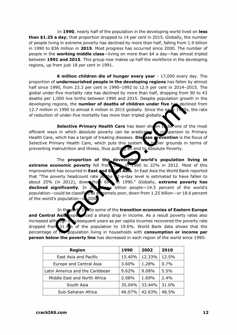
crack
IAS.com
crackIAS.com 12
In 1990, nearly half of the population in the developing world lived on less
than $1.25 a day; that proportion dropped to 14 per cent in 2015. Globally, the number
of people living in extreme poverty has declined by more than half, falling from 1.9 billion
in 1990 to 836 million in 2015. Most progress has occurred since 2000. The number of
people in the working middle class—living on more than $4 a day—has almost tripled
between 1991 and 2015. This group now makes up half the workforce in the developing
regions, up from just 18 per cent in 1991.
6 million children die of hunger every year - 17,000 every day. The
proportion of undernourished people in the developing regions has fallen by almost
half since 1990, from 23.3 per cent in 1990–1992 to 12.9 per cent in 2014–2015. The
global under-five mortality rate has declined by more than half, dropping from 90 to 43
deaths per 1,000 live births between 1990 and 2015. Despite population growth in the
developing regions, the number of deaths of children under five has declined from
12.7 million in 1990 to almost 6 million in 2015 globally. Since the early 1990s, the rate
of reduction of under-five mortality has more than tripled globally.
Selective Primary Health Care has been shown to be one of the most
efficient ways in which absolute poverty can be eradicated in comparison to Primary
Health Care, which has a target of treating diseases. Disease prevention is the focus of
Selective Primary Health Care, which puts this system on higher grounds in terms of
preventing malnutrition and illness, thus putting an end to Absolute Poverty.
The proportion of the developing world's population living in
extreme economic poverty fell from 28% in 1990 to 22% in 2012. Most of this
improvement has occurred in East and South Asia. In East Asia the World Bank reported
that "The poverty headcount rate at the $2-a-day level is estimated to have fallen to
about 25% (in 2012), down from 69% in 1990." Globally, extreme poverty has
declined significantly. In 2011, one billion people—14.5 percent of the world’s
population—could be classified as extremely poor, down from 1.25 billion—or 18.6 percent
of the world’s population—in 2008.
In the early 1990s some of the transition economies of Eastern Europe
and Central Asia experienced a sharp drop in income. As a result poverty rates also
increased although in subsequent years as per capita incomes recovered the poverty rate
dropped from 31.4% of the population to 19.6%. World Bank data shows that the
percentage of the population living in households with consumption or income per
person below the poverty line has decreased in each region of the world since 1990:
Region 1990 2002 2010
East Asia and Pacific 15.40% 12.33% 12.5%
Europe and Central Asia 3.60% 1.28% 0.7%
Latin America and the Caribbean 9.62% 9.08% 5.5%
Middle East and North Africa 2.08% 1.69% 2.4%
South Asia 35.04% 33.44% 31.0%
Sub-Saharan Africa 46.07% 42.63% 48.5%

crack
IAS.com
crackIAS.com 13
However, there are various criticisms of these measurements. Although
"a clear trend decline in the percentage of people who are absolutely poor is evident ...
with uneven progress across regions...the developing world outside China and India
has seen little or no sustained progress in reducing the number of poor”. The World
Bank report "Global Economic Prospects" predicts that in 2030 the number living on
less than the equivalent of $1 a day will fall by half, to about 550 million.
Much of Africa will have difficulty keeping pace with the rest of the
developing world and even if conditions there improve in absolute terms, the report
warns, Africa in 2030 will be home to a larger proportion of the world's poorest people
than it is today. The reason for the faster economic growth in East Asia and South Asia
is a result of their relative backwardness, in a phenomenon called the convergence
hypothesis or the conditional convergence hypothesis. Because these economies
began modernizing later than richer nations, they could benefit from simply adapting
technological advances, which enable higher levels of productivity that had been
invented over centuries in richer nations.
Relative Poverty
Relative poverty views poverty as socially defined and dependent on
social context, hence relative poverty is a measure of income inequality. Usually,
relative poverty is measured as the percentage of population with income less than
some fixed proportion of median income. There are several other different income
inequality metrics, for example the Gini coefficient or the Theil Index.
Relative poverty measures are used as official poverty rates in several
developed countries. As such these poverty statistics measure inequality rather
than material deprivation or hardship. The measurements are usually based on a
person's yearly income and frequently take no account of total wealth. The main poverty
line used in the OECD and the European Union is based on "economic distance", a level
of income set at 60% of the median household income.
Ultra-poverty, a term apparently coined by Michael Lipton, connotes
being amongst poorest of the poor in low-income countries. Lipton defined ultra-
poverty as receiving less than 80% of minimum caloric intake whilst spending more than
80% of income on food. Alternatively, a 2007 report issued by International Food
Policy Research Institute defined ultra-poverty as living on less than 54 cents per day.
The depth of poverty should be measured. This depth is the distance to the poverty
line. Just below the poverty line or way below makes a lot of difference.
MEASURES OF POVERTY
Not all of the kinds of poverty can be easily measured. Some perhaps
cannot be measured at all. Even the apparently easy ones, such as infant mortality rates
or income levels, can and do pose problems, such as the availability of data (poor
countries often do not have the institutional resources to generate high quality statistics),
international comparability of data, definitions of data etc. However, it is important to
measure the levels of poverty and their evolution as good as we can. Only if we have data

crack
IAS.com
crackIAS.com 14
can we judge the effectiveness of specific programs to alleviate specific symptoms
of poverty.
Poverty is not just a philosophical problem because depending on the
definition of poverty we use, our measurements will be radically different (even with an
identical definition, measurements will be different because of different measurement
methods). Roughly, 6 different parameters for measuring poverty are used:
insufficient income
insufficient consumption spending
insufficient caloric intake
food consumption spending above a certain share of total spending
certain health indicators such as stunting, malnutrition, infant mortality rates or life
expectancy
certain education indicators such as illiteracy
None of these parameters is ideal, although the first and second on the
list are the most widely used. A few words about the advantages and disadvantages of
each are as follows:
1 Income: e.g. “$1 a day” level, which is the World Bank definition of extreme
poverty level; moderate poverty is less than $2 a day; these levels are, of course,
expressed in purchasing power parity. In developed countries, income is a common
definition because it’s easy to measure. Most people in developed countries earn a
salary or get their income from sources that are easy to estimate (interest
payments, the value of houses, stock market returns etc.). They don’t depend for their
income on the climate, crop yields etc. Moreover, developed countries have good tax
data which can be used to calculate incomes.
In developing countries, however, income data tend to be
underestimated because it’s difficult to value the income of farmers and
shepherds. Farmers’ incomes fluctuate heavily with climate conditions, crop yields
etc. Another disadvantage is that people are generally reluctant to disclose their
full income. Some income may have been hidden from the tax administration or
may have been earned from illegal activity such as corruption, smuggling, drug
trade, prostitution, theft etc. For this reason, using income to estimate poverty means
overestimating it.
2 Gross Domestic Product (GDP, or total annual country income) per capita or per
citizen is another measure of poverty. However, the problem with this measure is that
it tells us about average and not how it is distributed over the spectrum. For example,
in India, the people below poverty line are much below the average GDP per capita.
3 Consumption: The main advantage of using consumption rather than income to
measure poverty is that consumption is much more stable over the year and over
a lifetime. This is even truer in the case of farmers who depend on the weather for
their income and hence have a more volatile income. As farmers are often relatively
poor, this issue is all the more salient for poverty measurement. This is called the
lifecycle hypothesis. Another advantage of using consumption is that people aren’t
as reticent to talk about it as they are about certain parts of their income.

crack
IAS.com
crackIAS.com 15
:: However, consumption of goods like durable goods and housing is difficult to
measure because it’s difficult to value them. For example, if a household owns a
house, it is difficult to estimate what it would cost to rent that particular house and
add this to the total consumption of that household. Then the same has to be done
for cars etc.
Lifecycle Hypothesis
:: Another difficulty in measuring consumption is that in developing countries
households consume a lot of what they themselves produce on the family farm.
This as well is often difficult to value correctly. And finally, different people have
different consumption needs, depending of their age, health, work etc. It’s not
clear how these different needs are taken into account when consumption is measured
and used as an indicator of poverty.
4 Calorie intake: the problem with this is that different people need different
amounts of calories (depending on their type of work, their age, health etc.), and
that it isn’t very easy to measure how many calories people actually consume. An
average adult male has to eat food representing approximately 2000-2500
calories per day in order to sustain the human body.
5 Food spending as a fraction of total spending: here the problem is that if we say
people who spend more than x% of their total spending on food are considered poor,
we still have to factor in relative food prices.
6 Stunting as an indicator of malnutrition and hence of poverty: stunting (height
for age) is a notoriously difficult thing to measure.
7 Another measure of poverty is work out the parameters related to education such
number of years in education, Literacy levels, drop-out rates etc.
Another issue with poverty measurement is that people may have
comparable incomes or even consumption patterns, but they may face very different
social or environmental conditions: an annual income of $500 may be adequate for
people living in a rural environment with a temperate climate where housing is cheap,
heating isn’t necessary and subsistence farming is relatively easy. However, the same
income can mean deep poverty for a family living in a crowded city on the edge of a
desert. The presence or absence of public goods such as quality schools, roads, running
water and electricity also makes a lot of difference, but poverty measurement usually
does not take these goods into account.

crack
IAS.com
crackIAS.com 16
For other types of poverty such as income differences, traditionally
used measure is the Gini coefficient although most symptoms of this kind of poverty,
as well as social, psychological poverty, are intangible. The difficulties of aggregating
the different available measures, together with the difficulties of measuring other
indicators, result in the impossibility to establish a single, binary poverty indicator,
“are you poor or not”, yes or no type of indicator. As a result, many scientists and
politicians use a simplified rule to establish poverty, for example the “1 $ a day” rule, of
some other kind of poverty level expressed quantitatively. It is also important to
measures the time frame of poverty, i.e. incidental or chronic poverty. This difference
should be taken into account when devising policies.
POVERTY ESTIMATES IN INDIA
Poverty in India is still rampant, with the nation estimated to have a third
of the world's poor, despite an impressive economic growth. In 2011, World Bank
stated, 23.7% of the total Indian people fall below the international poverty line of US$
1.25 per day (PPP) while 68.7% live on less than US$ 2 per day. According to 2010 data
from the United Nations Development Programme, an estimated 37.2% of Indians
live below the country's national poverty line. Rapid economic growth since 1991, has
led to sharp reductions in extreme poverty in India. According to United Nation's
Millennium Development Goal (MDG) programme 270 million or 21.9% people out of
1.2 billion of Indians lived below poverty line of $1.25 in 2011-2012.
According to the definition by Planning Commission, poverty line is drawn
with an intake of 2155 calories in rural areas and 2090 calories in urban areas. If
a person is unable to get that much minimum level of calories, then he/ she is considered
as being below poverty line. The Planning Commission in March 2014 released the latest
poverty estimates for the country showing a decline in the incidence of poverty from
38.2% to 29.5% and stating that anyone with a daily consumption expenditure of Rs. 47
and Rs. 32 in urban and rural areas respectively is above the poverty line. According to
Global Wealth Report 2016 compiled by Credit Suisse Research Institute, India is the
second most unequal country in the world with the top one per cent of the population
owning nearly 60% of the total wealth.
Poverty Estimation in India – C Rangarajan and Tendulkar Committee
To Measures Exact numbers of Poor People And Per capita expenditure various
methods had been adopted by Government of India.
The official measure of Indian government, before 2005, was based on food security
and it was defined from per capita expenditure for a person to consume enough calories
and be able to pay for associated essentials to survive.
Since 2005, Indian government adopted the Tendulkar methodology which moved
away from calorie anchor to a basket of goods and used rural, urban and regional
minimum expenditure per capita necessary to survive.
The Planning Commission has been estimating the number of people below the
poverty line (BPL) at both the state and national level based on consumer expenditure
information collected as part of the National Sample Survey Organization (NSSO) since

crack
IAS.com
crackIAS.com 17
the Sixth Five Year Plan. The latest available data from such surveys is from NSSO
conducted in 2004-05.
Government Of India Formed various Committees for Poverty Estimation In India
Alagh Committee (1977),
Lakdawala Committee (1989)
Tendulkar Committee (2005)
Saxena committee
Hashim Committee
C. Rangarajan Committee (2012)
Poverty Line Estimation in India. Comparison Given below read and understand
both Methods of Poverty Estimation in India
Committees Tendulkar C Rangarajana
Set Up By Planning Commission Planning Commission
Set Up In 2005 2012
Submitted Report 2009 2014
Poverty Estimation Method Per capita Expenditure
Monthly
Monthly Expenditure of
family of five.
Urban Poverty Line Per Day
per Person
33 47
Urban Poverty Line Per
Month per Person
1000 1407
Urban Poverty Line Per
Month, Family of Five
Members
5000 7035
Rural poverty line Per Day
Per Person
27 32
Rural poverty line (Rs) per
Month Per Person
816 972
Rural poverty line (Rs) Per
month Family Of 5 Members
4080 4860
BPL (Below Poverty Line) In
crore
27 crore 37 crore
Calorie Expenditure Only calorific value in
Expenditure
Calorie + Protein + fat
Calories In Rural Areas 2400 2155
Calories In Urban areas 2100 2090
Main Focus Areas Only counts Expenditure on
food, health, education,
and clothing.
1. Food
2. nonfood items such as
education,
3. healthcare,
4. clothing,
5. transport
6. rent
7. Non-food items that
meet nutritional
requirements.

crack
IAS.com
crackIAS.com 18
C Rangarajan Committee was set up by Planning Commission in 2012 and Submitted
Report In 2014. The Rangarajan committee estimation is based on an independent
large survey of households by Centre for Monitoring Indian Economy (CMIE).
It has also used different methodology wherein a household is considered poor if it is
unable to save. The methods also include on certain normative levels of adequate
nourishment, clothing, house rent, conveyance, education and also behavioural
determination of non-food expenses.
It also considered average requirements of calories, protein and fats based on ICMR
norms differentiated by age and gender.
Based on this methodology, Rangarajan committee estimated the number of poor were
19 per cent higher in rural areas and 41 per cent more in urban areas than
what was estimated using Tendulkar committee formula.
Tendulkar, an economist, had devised the formula to assess poverty line in 2005, which
the Planning Commission had used to estimate poverty in 2009-10 and 2011-12.
Global Hunger Index (GHI)
The report is released by the International Food Policy Research Institute (IFPRI).
The hunger index ranks countries based on undernourishment, child mortality, child
wasting (low weight for height) and child stunting (low height for age).
The GHI ranks countries on a 100-point scale. Zero is the best score (no hunger), and
100 is the worst, although neither of these extremes is reached in practice.
Global Hunger Index (GHI) is an index that places a third of weight on proportion of
the population that is estimated to be undernourished, a third on the estimated
prevalence of low body weight to height ratio in children younger than five, and
remaining third weight on the proportion of children dying before the age of five for
any reason.
According to 2011 GHI report, India has improved its performance by 22% in 20
years, from 30.4 to 23.7 over 1990 to 2011 period. However, its performance from
2001 to 2011 has shown little progress, with just 3% improvement. A sharp reduction
in the percentage of underweight children has helped India improve its hunger record
on the Global Hunger Index (GHI) 2014.
According to the latest Global Hunger Index data, hunger levels in developing
countries may have fallen 29% since 2000, but India is still rated as a country with
‘serious’ hunger levels in the 2016. It ranked India 97 among 118 countries, faring
worse than all its neighbours China (29), Nepal (72), Myanmar (75), Sri Lanka (84)
and Bangladesh (90), except for Pakistan (107) in measures of hunger.
The report found that one in three children in India has stunted growth, whereas
15% of the country’s population are undernourished. India’s score is 28.5.
At the current rate of decline, more than 45 countries – including India, Pakistan, Haiti,
Yemen, and Afghanistan – will have “moderate” to “alarming” hunger scores in the
year 2030.
Sub-Saharan Africa has the highest hunger levels, followed closely by South Asia
Other Poverty Estimates For India
Income inequality in India is increasing, with a Gini coefficient of 32.5 in
1999-2000. Although the Indian economy has grown steadily over the last two decades,
its growth has been uneven when comparing different social groups, economic groups,

crack
IAS.com
crackIAS.com 19
geographic regions, and rural and urban areas. Poverty rates in rural Orissa (43%) and
rural Bihar (41%) are among the world's most extreme.
A study by the Oxford Poverty and Human Development Initiative using a
Multi-dimensional Poverty Index (MPI) found that there were 645 million poor living
under the MPI in India, 421 million of whom are concentrated in eight North India and
East India states of Bihar, Chhattisgarh, Jharkhand, Madhya Pradesh, Orissa, Rajasthan,
Uttar Pradesh and West Bengal. This number is higher than the 410 million poor living in
the 26 poorest African nations. Multi-dimensional Poverty Index placed 33% weight on
number of years spent in school and education and 6.25% weight on financial condition
of a person, in order to determine if that person is poor.
A report by the state-run National Commission for Enterprises in the
Unorganized Sector (NCEUS) found that 77% of Indians, or 836 million people, lived
on less than 20 rupees (approximately US$ 0.50 nominal; US$ 2 PPP) per day. It is
relevant to view poverty in India on a PPP basis as food etc. are purchased in Rupees.
According to a recently released World Bank report, India is on track to meet its
poverty reduction goals. However by 2015, an estimated 53 million people will still
live in extreme poverty and 23.6% of the population will still live under US$ 1.25 per day.
This number is expected to reduce to 20.3% or 268 million people by 2020.
PROBLEMS WITH EXISTING OFFICIAL POVERTY LINES
The existing all-India rural and urban official poverty lines were originally
defined in terms of Per Capita Total Consumer Expenditure (PCTE) at 1973-74 market
prices and adjusted over time and across states for changes in prices keeping
unchanged the original 197374 rural and urban underlying all-India reference Poverty
Line Baskets (PLB) of goods and services. These all-India rural and urban PLBs were
derived for rural and urban areas separately, anchored in the per capita calorie norms of
2400 (rural) and 2100 (urban) per day.
However, they covered the consumption of all the goods and services
incorporated in the rural and urban reference poverty line baskets. Three major
criticisms of these poverty lines have been commonly aired. One, the consumption
patterns underlying the rural and urban PLBs remained tied down to those observed
more than three decades ago in 1973-74 and hence had become outdated. Two, crude
price adjustment for prices was leading to implausible results such as proportion of total
urban population below poverty line being higher than its rural counterpart in certain
major states. Three, the earlier poverty lines assumed that basic social services of
health and education would be supplied by the state and hence, although private
expenditure on education and health was covered in the base year 1973-74, no account
was taken of either the increase in the proportion of these in total expenditure over time
or of their proper representation in available price indices.
CAUSES OF POVERTY IN INDIA
Caste system: Dalits constitute the bulk of poor and unemployed. Casteism is still
widespread in rural areas, and continues to segregate Dalits despite the steady rise
and empowerment of the Dalits through social reforms and the implementation of

crack
IAS.com
crackIAS.com 20
reservations in employment and benefits. Caste explanations of poverty, however, fail
to account for the urban/rural divide. However, using the UN definition of poverty,
65% of rural forward castes are below the poverty line.
British era: Jawaharlal Nehru claimed "A significant fact which stands out is that
those parts of India which have been longest under British rule are the poorest today."
The Indian economy was purposely and severely de-industrialized, especially in the
areas of textiles and metalworking, through colonial privatizations, regulations, tariffs
on manufactured or refined Indian goods, taxes, and direct seizures.
India's economic policies: In 1947, the average annual income in India was US$
439, compared with US$ 619 for China. By 1999, the numbers were US$ 1,818 and
US$ 3,259 respectively and by 2014 the numbers were US$ 1581 and US$ 7,590
respectively. Thus India was left far behind due to its economic policies
especially the License Raj and the accompanying red tape that were required to set
up and run business in India. The License Raj was a result of India's decision to have
a planned economy, where all aspects of the economy are controlled by the state and
licenses were given to a select few. Corruption flourished under this system. Up to
80 agencies had to be satisfied before a firm could be granted a license to produce
and the state would decide what was produced, how much, at what price and what
sources of capital were used.
Over-reliance on agriculture: There is a surplus of labour in agriculture. While
services and industry have grown at double-digit figures, agriculture growth rate has
dropped from 4.8% to 2%. About 60% of the population depends on agriculture
whereas the contribution of agriculture to the GDP is about 18% as compared to
Industry (24.2%) and Services (57.9%).
High population growth rate, although demographers generally agree that this is
a symptom rather than cause of poverty. Its population growth rate is 1.2%, ranking
94th in the world.
High Illiteracy (about 25% of adult population) as per 2011 census.
Regional inequalities
Causes of Rural Poverty in India
Rapid Population Growth & Excessive Population Pressure on Agriculture
Lack of Capital
Lack of Alternate Employment Opportunities Other than Agriculture
Illiteracy & Child Marriage Tradition
Regional Disparities
Joint Family System
Lack of proper implementation of PDS
Causes of Urban Poverty in India
Migration of Rural Youth towards Cities Lack of Vocational Education / Training
Limited Job Opportunities of Employment in the Cities
Rapid increase in Population
Lack of Housing Facilities
No proper Implementation of Public Distribution System
crack
IAS.com
crackIAS.com 21
LIBERALIZATION POLICIES AND THEIR EFFECTS
75% of poor are in rural India. There is a viewpoint that holds that the
economic reforms initiated in the early 1990s are responsible for the collapse of
rural economies and the agrarian crisis currently underway. P Sainath describes that
the level of inequality has risen to extraordinary levels, when at the same time; hunger
in India has reached its highest level in decades. He also points out that rural economies
across India have collapsed, or on the verge of collapse due to the neo-liberal policies of
the government of India since the 1990s.
The human cost of the "liberalization" has been very high. The huge
wave of farm suicides in Indian rural population from 1997 to 2015, which exceeded
200,000, according to official statistics. Commentators have faulted the policies pursued
by the government, which, according to Sainath, resulted in a very high portion of rural
households getting into the debt cycle, resulting in a very high number of farm suicides.
Government policies encouraging farmers to switch to cash crops, in place of traditional
food crops, has resulted in an extraordinary increase in farm input costs, while market
forces determined the price of the cash crop. Sainath points out that a disproportionately
large number of affected farm suicides have occurred with cash crops, because with food
crops such as rice, even if the price falls, there is food left to survive on.
He also points out that inequality has reached one of the highest rates
India has ever seen. During the time when Public investment in agriculture shrank to
2% of the GDP, the nation suffered the worst agrarian crisis in decades, the same time,
as India became the nation of second highest number of dollar billionaires. Sainath
argues that Farm incomes have collapsed. Hunger has grown very fast. Non-farm
employment has stagnated. Only the National Rural Employment Guarantee Act has
brought some limited relief in recent times. Millions move towards towns and cities where,
too, there are few jobs to be found.
SUCCESS OF EFFORTS TO ALLEVIATE POVERTY
Since the early 1950s, government has initiated, sustained, and refined
various planning schemes to help the poor attain self-sufficiency in food production.
Probably the most important initiative has been the supply of basic commodities,
particularly food at controlled prices, available throughout the country as poor spend
about 80 percent of their income on food.
Eradication of poverty in India is generally only considered to be a long-
term goal. Poverty alleviation is expected to make better progress in the next 50 years
than in the past, as a trickle-down effect of the growing middle class. Increasing
stress on education, reservation of seats in government jobs and the increasing
empowerment of women and the economically weaker sections of society, are also
expected to contribute to the alleviation of poverty. It is incorrect to say that all poverty
reduction programmes have failed. The growth of the middle class (which was virtually
non-existent when India became a free nation in August 1947) indicates that economic
prosperity has indeed been very impressive in India, but the distribution of wealth is not
at all even.

crack
IAS.com
crackIAS.com 22
CONTROVERSY OVER EXTENT OF POVERTY REDUCTION
:: While total overall poverty in India has declined, the extent of poverty reduction
is often debated. With the rapid economic growth that India is experiencing, it is likely
that a significant fraction of the rural population will continue to migrate toward cities,
making the issue of urban poverty more significant in the long run.
:: While absolute poverty may not have increased India remains at an abysmal rank
in the UN Human Development Index. India in recent years remained at lowest position
in the index compared to last 10 years. It can even be argued that the situation has
become worse on critical indicators of overall well-being such as the number of
people who are undernourished (India has the highest number of malnourished people,
at 230 million), and the number of malnourished children (43% of India's children under
5 are underweight (BMI<18.5), the highest in the world) as of 2008.
Persistence of malnutrition among children
:: The World Bank, citing estimates made by the World Health Organization, states that
"About 49% of the world's underweight children, 34% of the world's stunted children and
46% of the world's wasted children, live in India." The World Bank also noted that "while
poverty is often the underlying cause of malnutrition in children, the superior economic
growth experienced by South Asian countries compared to those in Sub-Saharan Africa,
has not translated into superior nutritional status for the South Asian child". A special
commission to the Supreme Court has noted that the child malnutrition rate in India
is twice as great as sub-Saharan Africa.
TENDULKAR COMMITTEE REPORT
:: There has been a growing concern on the official estimates of poverty. In view of this,
Planning Commission set up an expert group under the chairmanship of Suresh
Tendulkar to examine the issue and suggest a new poverty line and estimates. Following
are the salient features of the proposed poverty lines:
1 The expert group has also taken a conscious decision to move away from anchoring
the poverty lines to a calorie intake norm in view of the fact that calorie consumption
calculated by converting the consumed quantities in the last 30 days as collected by
NSS has not been found to be well correlated with the nutritional outcomes
observed from other specialized surveys either over time or across space (i.e. between
states or rural and urban areas).
2 NSSO has decided to shift to Mixed Reference Period (MRP) for all its consumption
surveys in future, namely, 365-days for low frequency items (clothing, footwear,
durables, education and institutional health expenditure) and 30-days for all the
remaining items. This change captures the household consumption expenditure of the
poor households on low-frequency items of purchase more satisfactorily than the
earlier 30-day recall period. The Expert Group decided to adopt the MRP-based
estimates of consumption expenditure as the basis for future poverty lines as against
previous practice of using Uniform Reference Period estimates of consumption
expenditure.

crack
IAS.com
crackIAS.com 23
3 The new poverty lines have been arrived at after assessing the adequacy of private
household expenditure on education and health, while the earlier calorie-
anchored poverty lines did not explicitly account for these.
4 It may be noted that although those near the poverty line in urban areas continue to
afford the original calorie norm of 2100 per capita per day, their actual observed
calorie intake from 61st Round of NSS of is 1776 calories per capita. This actual intake
is very close to the revised calorie intake norm of 1770 per capita per day currently
recommended for India by the Food and Agriculture Organization (FAO). Actual
observed calorie intake of those near the new poverty line in rural areas (1999 calories
per capita) is higher than the FAO norm.
5 Separate allowance for private expenditure on transport and conveyance has been
made in the recommended poverty lines. For rent and conveyance, actual
expenditure share for these items were used to adjust the poverty line for each state.
ENTRENCHED FACTORS ASSOCIATED WITH POVERTY
Scarcity of basic needs: Rise in the costs of living makes poor people less able to
afford items. Poor people spend a greater portion of their budgets on food than
richer people. As a result, poor households and those near the poverty threshold can
be particularly vulnerable to increases in food prices.
Third World debt: Third World debt plays a large part in international inequality
and poverty. The World Bank and the IMF, as primary holders of Third World debt,
attach structural adjustment conditionalities to loans. These conditionalities
generally push for economic liberalization, including reducing barriers to trade,
elimination of state subsidies, Union busting, privatization of state assets and services
etc. As a result of such policies, developing countries need to spend a large proportion
of their budgets to repay foreign debt.
Barriers to opportunities: lack of economic freedom inhibits entrepreneurship
among the poor. New enterprises and foreign investment can be driven away by the
results of inefficient institutions, notably corruption, weak rule of law and excessive
bureaucratic burdens. Lack of financial services, as a result of restrictive regulations,
such as the requirements for banking licenses, makes it hard for even smaller micro-
savings programs to reach the poor. In India, businesses had to bribe government
officials even for routine activities, which were, in effect, a tax on business. Lack of
opportunities can further be caused by the failure of governments to provide
essential infrastructure.
Colonial Histories: One of the most important barriers to development in poor
countries is lack of uniform, basic infrastructure, such as roads and means of
communication. Some development scholars have identified colonial history as an
important contributor to the current situation. In most countries with a history of
colonization, the colonizers developed local economies to facilitate the expropriation
of resources for their own economic growth and development.
Centralization of Power: In many developing countries, political power is
disproportionately centralized. Instead of having a network of political representatives
distributed equally throughout society, in centralized systems of governance one
major party, politician, or region is responsible for decision-making throughout the
country. This often causes development problems. For example, in these situations
politicians make decisions about places that they are unfamiliar with, lacking sufficient
crack
IAS.com
crackIAS.com 24
knowledge about the context to design effective and appropriate policies and
programs.
Corruption: Corruption often accompanies centralization of power, when leaders are
not accountable to those they serve. Most directly, corruption inhibits development
when leaders help themselves to money that would otherwise be used for
development projects. In other cases, leaders reward political support by providing
services to their followers.
Warfare: Warfare contributes to more entrenched poverty by diverting scarce
resources from fighting poverty to maintaining a military. Take, for example, the cases
of Ethiopia and Eritrea. The most recent conflict over borders between the two
countries erupted into war when both countries faced severe food shortages due to
drought.
Environmental degradation: Awareness and concern about environmental
degradation have grown around the world over the last few decades, and are currently
shared by people of different nations, cultures, religions, and social classes. However,
the negative impacts of environmental degradation are disproportionately felt by the
poor. Throughout the developing world, the poor often rely on natural resources to
meet their basic needs through agricultural production and gathering resources
essential for household maintenance, such as water, firewood, and wild plants for
consumption and medicine. Thus, the depletion and contamination of water sources
directly threaten the livelihoods of those who depend on them.
Social Inequality: One of the more entrenched sources of poverty throughout the
world is social inequality that stems from cultural ideas about the relative worth of
different genders, races, ethnic groups, and social classes. Ascribed inequality works
by placing individuals in different social categories at birth, often based on religious,
ethnic, or 'racial' characteristics. In South African history, apartheid laws defined a
binary caste system that assigned different rights (or lack thereof) and social spaces
to Whites and Blacks, using skin colour to automatically determine the opportunities
available to individuals in each group.
EFFECTS OF POVERTY
:: The effects of poverty may also be causes, thus creating a "poverty cycle" operating
across multiple levels, individual, local, national and global.
Health
Hunger, disease, and less education describe a person in poverty. One third of
deaths - some 18 million people a year or 50,000 per day - are due to poverty-
related causes: in total 270 million people, most of them women and children, have
died as a result of poverty since 1990. Those living in poverty suffer disproportionately
from hunger or even starvation and disease. Those living in poverty suffer lower life
expectancy.
According to the World Health Organization, hunger and malnutrition are the
single gravest threats to the world's public health and malnutrition is by far the biggest
contributor to child mortality, present in half of all cases.
Women who have born children into poverty may not be able to nourish the
children efficiently and provide adequate care in infancy. The children may also suffer

crack
IAS.com
crackIAS.com 25
from disease that has been passed down to the child through birth. Asthma and rickets
are common problems children acquire when born into poverty.
Education
There is a high risk of educational underachievement for children who are from
low-income housing circumstances.
This often is a process that begins in primary school for some less fortunate children.
For children with low resources, the risk factors are similar to excuses such as
juvenile delinquency rates, higher levels of teenage pregnancy, and the economic
dependency upon their low income parent or parents.
Poverty often drastically affects children's success in school. A child's "home
activities, preferences, mannerisms" must align with the world and in the cases that
they do not these students are at a disadvantage in the school and most importantly
the classroom. Children who live at or below the poverty level will have far less
success educationally than children who live above the poverty line.
Poor children have a great deal less healthcare and this ultimately results in many
absences from the academic year. Additionally, poor children are much more likely to
suffer from hunger, fatigue, irritability, headaches, ear infections, flu, and colds.
These illnesses could potentially restrict a child or student's focus and concentration.
Housing
Slum-dwellers, who make up a third of the world's urban population, live in poverty
no better, if not worse, than rural people, who are the traditional focus of the poverty
in the developing world, according to a report by the United Nations.
Most of the children living in institutions around the world have a surviving parent or
close relative, and they most commonly entered orphanages because of poverty.
Violence
According to a UN report on modern slavery, the most common form of human
trafficking is for prostitution, which is largely fuelled by poverty.
In Zimbabwe, a number of girls are turning to prostitution for food to survive
because of the increasing poverty.
Also there are also many effects of poverty closer to home. For example after dropping
out of school children may turn to violence as a source of income i.e mugging people,
betting during street fights etc.
ADDRESSING THE UNDERLYING CAUSES OF POVERTY
:: Building a more widespread commitment to overcoming poverty is an essential first
step in overcoming poverty, and actions to address this are discussed below.
Share the benefits of economic growth through an emphasis on more widespread
employment: The phenomenon of jobless economic growth that increases income
inequalities and generates too few jobs for low income groups poses a serious threat
to the well-being of many nations, both North and South. Government policies

crack
IAS.com
crackIAS.com 26
should consider not only aggregate economic impact but also the distribution of
employment. Socially responsible venture capital and microcredit initiatives
can foster employment-generating businesses that complement the local culture and
environment.
Root out corruption, which harms society as a whole: Corruption, both in
government and business, places heavy cost on society. Businesses should enact,
publicize and follow codes of conduct banning corruption on the part of their staff and
directors. Citizens must demand greater transparency on the part of both
government and the corporate sector and create reform movements where needed.
Broaden access to education and technology among marginalized groups, and
especially among girls and women: The educational attainment of women has strong
bearing on the wellbeing of their families, and efforts to improve education for women
and girls must be strengthened. At the same time, steps should be taken to ensure
that the current revolution in information technology benefits marginalized
groups. This must begin in school.
Improve government capacity to provide universal access to essential goods and
services, including potable water, affordable food, primary health care, education,
housing and other social services: Governments around the world have made
commitments to this through the 20/20 Initiative, which calls for 20% of national
budgets and 20% of foreign aid to be spent on human services. But raising adequate
resources through effective taxation and other mechanisms is often politically difficult.
New mechanisms for public policy dialogue that enable citizens of all classes to
recognize the benefit of universal access to key services must be put in place. Non-
profit groups and even corporations can provide essential support here, helping
articulate a vision of a healthy society. These nongovernmental actors can also help
in the actual provision of services.
Investments in human capital in the form of health, is needed for economic growth.
Nations do not necessarily need wealth to gain health. Cheap water filters and
promoting hand washing are some of the most cost effective health interventions
and can cut deaths from diarrhoea and pneumonia. Knowledge on the cost
effectiveness of healthcare interventions can be elusive but educational measures to
disseminate what works are available, such as the disease control priorities project.
Human capital, in the form of education, is an even more important determinant of
economic growth than physical capital. De-worming children costs about 50 cents
per child per year and reduces non-attendance from anaemia, illness and malnutrition
and is only a twenty-fifth as expensive to increase school attendance as by
constructing schools.
Good Infrastructure, such as roads and information networks, helps market reforms
to work. It was the technology of the steam engine that originally began the dramatic
decreases in poverty levels. Cell phone technology brings the market to poor or
rural sections. With necessary information, remote farmers can produce specific crops
to sell to the buyers that bring the best price. Such technology also makes financial
services accessible to the poor. Those in poverty place overwhelming importance
on having a safe place to save money, much more so than receiving loans. Also, a
large part of microfinance loans are spent on products that would usually be paid by
a checking or savings account.

crack
IAS.com
crackIAS.com 27
Aid in its simplest form is a basic income grant, a form of social security
periodically providing citizens with money. Some aid, such as Conditional Cash
Transfers, can be rewarded based on desirable actions such as enrolling children in
school or receiving vaccinations. Another form of aid is microloans, made famous by
the Grameen Bank, where small amounts of money are loaned to farmers or villages,
mostly women, who can then obtain physical capital to increase their economic
rewards. Aid from non-governmental organizations may be more effective than
governmental aid; this may be because it is better at reaching the poor and better
controlled at the grassroots level.
Good Institutions: Efficient institutions that are not corrupt and obey the rule of law
make and enforce good laws that provide security to property and businesses. Efficient
and fair governments would work to invest in the long-term interests of the nation
rather than plunder resources through corruption. Examples of good governance
leading to economic development and poverty reduction include Thailand, Taiwan,
Malaysia, South Korea, and Vietnam, which tends to have a strong government,
called a hard state or development state.

crack
IAS.com
crackIAS.com 28
INCLUSION
Overview
With the little money that you have in your pocket today, you
cannot afford the basic education; forget about the vazirams
and cracks of the world. When the stomach is empty,
everything else goes for a toss. When you can’t afford
education or even basic health, you actually understand the
meaning of ‘money can buy everything!’ Without basic health
and education, you are excluded from the mainstream way of
life. Getting daily food becomes the utmost priority every
morning. And if you are married & have kids, what will be your
life? Big questions! No answers! You will then realize the
shallowness of various slogans of political parties, of policies &
programmes, of administrative implementation, and of the
corrupt system that we have evolved.
Inclusion is when all people have the freedom to do what anyone else
can do, access to anyplace that anyone else can go, where full participation is available
to everyone and all people embrace differences, and feel accepted, valued and respected
for who they are. When considering the concept of inclusion one needs to be aware of the
source of exclusion.
Inclusion is recognizing our universal "oneness" and interdependence.
Inclusion is recognizing that we are "one" even though we are not the "same". We were
all born "in". The act of inclusion means fighting against exclusion and all of the social
diseases exclusion gives birth to - i.e. racism, poverty, hunger, etc. The difference
between inclusion and exclusion lies not with the individual, but within the society
where the person lives. With this knowledge, the causes and strategies used to achieve
inclusion the onus must fall upon societies. The causes and challenges of exclusion
result from social barriers that exist within society as such; society is where the
problems must be addressed.
WHY BE CONCERNED WITH INCLUSION?
First, there are serious negative effects for people who experience exclusion. Exclusion
creates division within a community and separation of people causes vulnerability
among the excluded groups, whether it is because of disability, race or class. This
vulnerability puts people at risk of negative experiences in their lives.
Lack of inclusion also leads to and exacerbates social disparity, which, furthers the
devaluation of these groups and reduces their quality of life. A lack of inclusion within
a community creates an atmosphere of inequality, which prevents people from
having equal access to all things that should be available to them in their society.
This prevents those who are excluded from getting what they need to live effectively.
The areas often affected include access to employment and as a result, reduced
financial status which creates the risk of people not being capable of acquiring their
basic needs.

crack
IAS.com
crackIAS.com 29
Those who are excluded are at increased risk of participation in many types of
unhealthy behaviours and reduced overall health. Beyond the implications of
exclusion on the individual and groups in society, there are also effects, which touch
society as a whole in a negative way.
A reduced level of inclusion leads to the marginalization and segregation of
groups, which emphasize differences, and creates separation within a community. A
community divided in this way, is a weaker society in its humanity.
Separation also leads to power differentials, which create divisions, segregation and
inequality within a community. These concerns develop into power imbalances and
oppression of groups in communities.
WHAT ARE THE CONTRIBUTING FACTORS TO EXCLUSION?
There are a number of issues which contribute to exclusion. The biggest contributing
factor is attitudinal barriers held about a group of people because of difference such
as disability, race, or gender.
This type of barrier has been identified as leading to lack of acceptance perpetuation
of negative stereotypes and adherence to certain norms, habits and societal rules.
These rules are designed by and for the dominant group in society and the belief that
if people do not fit they should not be included. Finally, attitudinal barriers are the
root cause of a number of other factors which contribute to exclusion such as access
barriers, power imbalance, superficial service inclusion and policy barriers.
One of the barriers that are caused by the presence of attitudinal barriers is lack of
accommodation of differences.
This includes physical barriers that prevent access. Lack of accommodation and
accessibility contribute directly to the exclusion of people. Not only are these physical
barriers an issue as they exist, but they also affect efforts to remove them and stifle
willingness to prevent future barriers from being created.
Voluntary measures are limitedly successful. Project and policy directives need to be
put in place to assist with the elimination of barriers, so an environment of inclusion
can occur.
Power imbalances also result from attitudinal barriers and contribute to exclusion.
People within the dominant group make decisions, as they possess the power to do
so, for those outside the dominant group there is often a lack of support needed and
feelings of inequality develop.
When power is held by one dominant group those outside are more likely to be
excluded and their needs are left unheard and unmet. Attitudinal barriers about the
excluded contribute to superficially inclusive services and systems.
These types of systems may have the best intensions but a lack of belief in and
respect for people leads to the excluded being silent recipients of services. This
superficial type effort often leads to generic approaches which are ineffective for
everyone.
This also applies to segregated programs which do not provide an opportunity to
promote inclusion and perpetuates the separation of people and the belief that they
are different and should not be part of the mainstream of society.
Service language of benevolence and gifting sends very strong messages to the people
served and to the community. This perspective can lead to perpetuation of attitudinal
barriers, negative self-images, and negatively impacts on the service and
community environment.

crack
IAS.com
crackIAS.com 30
The final area where attitudinal barriers affect exclusion of people is around policy
barriers. Commonly held negative attitudes influence the political agendas that
support negative policy development for excluded groups. Outcome of this type of
policy development is patchwork ineffective programs that do not address the needs
of the people they were created to support.
It is these barriers which prevent adequate funds and resources from being directed
to the efforts of inclusion in service and accessibility supports. Negative attitudes and
beliefs have a major effect on the production of legislative disincentives in their
programs, which put up another barrier for the excluded to overcome.
INCLUSION IN “INDIAN CONTEXT”
In Indian context it implies, an equitable allocation of resources with
benefits accruing to every section of society- A growth process which yields broad-based
benefits and ensures equality of opportunity for all. It is concerned with the Pro-poor
growth, growth with equity. It is aimed at poverty reduction, human development,
health and provide opportunity to work and be creative. In order to achieve inclusion,
the allocation of resources must be focused on the indented short and long terms benefits
and economic linkages at large and not just equitable mathematically on some regional
and population criteria.
THE INCLUSION INVOLVES FOUR ATTRIBUTES
The Opportunity attribute focuses on generating more and more opportunities to the
people and focuses on increasing their income.
The Capability attribute concentrates on providing the means for people to create or
enhance their capabilities in order to exploit available opportunities.
The Access attributes focuses on providing the means to bring opportunities and
capabilities together.
The Security attribute provides the means for people to protect themselves against
a temporary or permanent loss of livelihood.
All together it is a process in which economic growth measured by a
sustained expansion in GDP contributes to an enlargement of the scale and scope of all
four dimensions.
NEED FOR INCLUSION IN INDIA
India is the 7th largest country by area and 2nd by population. The Economy of India
is the seventh-largest in the world by nominal GDP and the third-largest by purchasing
power parity (PPP). Yet, India is far away from the development of the
neighbourhood nation, i.e., China.
The exclusion in terms of low agriculture growth, low quality employment growth,
low human development, rural-urban divides, gender and social inequalities, and
regional disparities etc. are the problems for the nation.
Studies estimated that the cost of corruption in India amounts to over 10% GDP.
Corruption is one of the ills that prevent inclusive growth.
Although Child labour has been banned by the law in India and there are stringent
provisions to deter this inhuman practice. Still, many children in India are unaware of
education as they lives are spoiled to labour work.

crack
IAS.com
crackIAS.com 31
Literacy levels have to rise to provide the skilled workforce required for higher
growth.
Economic reforms in the country are overwhelmed by out dated philosophies and
allegations by the politicians and opposition parties in India.
Even at international level also, there is a concern about inequalities and
exclusion and now they are also taking about inclusive approach for development.
ELEMENTS OF INCLUSION-ORIENTED GROWTH
The key components of the inclusion oriented growth strategy included a
sharp increase in investment in rural areas, rural infrastructure and agriculture spurt
in credit for farmers, increase in rural employment through a unique social safety net and
a sharp increase in public spending on education and health care. The five interrelated
elements of inclusion oriented growth are:
1. Poverty Reduction and increase in quantity and quality of employment.
2. Agriculture Development
3. Social Sector Development
4. Reduction in regional disparities
5. Protecting the environment.
PROBLEMS BEFORE INCLUSION ORIENTED GROWTH STRATEGIES IN INDIA
For a developing country like India, the need of inclusion-oriented growth
is vital to achieve the overall progress of the country. Though it is positive for macro-
economic stability, 200809 resulted a relative growth slowdown, mostly from the spill
over effects of the weakening of the global economic momentum and volatile financial
markets. The following problems are the major concerns for developing countries
like India to achieve the inclusive growth. They are:
Poverty
Employment
Agriculture
Problems in Social Development
Regional Disparities
Poverty
Percent of population living under the poverty line, which is 356.35 rupees or around
$7 a month in rural areas.
A proportionally large share of poor is lower castes. Many see the caste
system as a system of exploitation of poor low-ranking groups by more prosperous high-
ranking groups. In many parts of India, land is largely held by high-ranking property
owners of the dominant castes that economically exploit low-ranking landless
labourers and poor artisans, all the while degrading them with ritual emphases on their
so-called God-given inferior status.
EMPLOYMENT
Employment considered as one of the big problems for inclusion-oriented growth in
India. Raising population at a great speed after independence showed its impact on
employment. The unemployment became the big worry to the development of the
country.

crack
IAS.com
crackIAS.com 32
Since poverty is much higher than unemployment, employment is the only source
to eradicate poverty. The quality and quantity of employment in India is very low
due to illiteracy and due to over dependency on agricultural employment. The quality
of employment is also a problem.
Unorganized employed people in India are around 85%. Workers in this sector do
not have social security. The generation of productive employment for labour force in
the economy, as employment is a key to inclusion-oriented growth is the toughest
task for the country.
The country is also facing in employment generation in all sectors, regions and for all
socio economic groups particularly for poorer sections of population, backward
regions, lagging sectors and SC/ST/OBC/women etc.
AGRICULTURE
Traditionally, India is considered as the agricultural based country. As the majority of
Indians are engaged in agriculture for employment, the recent developments in the
other sectors decreased this major sector’s growth. Some of the problems in Indian
agriculture are:
Long term factors like steeper decline in per capita land availability, shrinking of
farm size.
Slow reduction in share of employment.
Low labour productivity in agriculture and the gap between agriculture and non-
agriculture sector is widening.
Decline in yield growth due to land and water problems, vulnerability to world
commodity prices, farmer’s suicides.
Disparities in growth across regions & crops, i.e., growth rate declined more in
rainfed areas.
Thus these problems became the hurdles in the key area for the economic
development of the nation, i.e., agriculture.
PROBLEMS IN SOCIAL DEVELOPMENT
Social development is also one of the key concerns in inclusion oriented
growth. The social development became the hot criteria in the recent past in India. Social
development is also facing some problems making the path critical to inclusion-oriented
growth in the country. Some of the problems in social sector are:
Significant regional, social and gender disparities.
Low level and slow growth in public expenditures particularly on health.
Poor quality delivery systems.
Achievement of 127th rank among 170 countries on Human Development index.
Social indicators are much lower for scheduled castes and scheduled tribes.
Malnutrition among children is one major problem.
Since BPO brought the multi culture environment in India, this sector is facing under
saviour pressure due to global recession.
REGIONAL DISPARITIES
Regional disparities are also a major concern for India due to different
culture and Traditions. Traditional cultures, caste system and the rich & poor feelings
favoured some specific groups as a result, the regional disparities raised in India before
and after independence. And also, due to the development in agriculture and industrial

crack
IAS.com
crackIAS.com 33
sector some regions in India developed fast and some other places still are facing the
scarcity. The National Income (measured as Net National Income at market prices) and
Per Capita National Income (measured as Per Capita Net National Income at market
prices) of the country has been increasing during the last three years. The State/UT-wise
estimates of Per Capita Income (measured as Per Capita Net State Domestic Product) at
current prices are given as below:-
State/UT Per Capita Income
2012-13 2013-14 2014-15 2012-13 2013-14 2014-15
Andhra Pradesh 72301 81397 90517 Mizoram 63413 76120 NA
Arunachal Pradesh 76370 85468 96199 Nagaland 70274 77529 85544
Assam 38945 44263 49480 Odisha 49227 52559 59229
Bihar 26948 31199 36143 Punjab 84526 92638 NA
Chhattisgarh 53815 58547 64442 Rajasthan 60844 65974 NA
Goa 200514 224138 NA Sikkim 151395 176491 NA
Gujarat 93046 106831 NA Tamil Nadu 98628 112664 128366
Haryana 119833 133427 NA Telangana 85169 95361 NA
Himachal Pradesh 83899 92300 NA Tripura 57402 69705 NA
J&K 52250 58593 NA UP 33482 36250 40373
Jharkhand 40238 46131 NA Uttarakhand 92566 103716 115632
Karnataka 76578 84709 NA West Bengal 60318 70059 78903
Kerala 91567 103820 NA Andaman & Nicobar 97687 107418 NA
Madhya Pradesh 43426 51798 59770 Chandigarh 141926 156951 NA
Maharashtra 103991 114392 NA Delhi 192587 219979 NA
Manipur 37656 41573 NA Puducherry 114256 143677 175006
Meghalaya 54156 61548 69516
CHALLENGES BEFORE INCLUSION-ORIENTED GROWTH STRATEGIES IN INDIA
The key components of the inclusion-oriented growth strategy included a
sharp increase in investment in rural areas, rural infrastructure and agriculture spurt
in credit for farmers; increase in rural employment through a unique social safety net
and sharp increase in public spending on education and health care. The
government also should go for a variety of legislative interventions to empower the
disadvantaged. Some of the challenges and opportunities before inclusion-oriented
growth strategies in India are:
1. Poverty alleviation is one of the big challenges for India. Eradication of poverty in
India is generally only considered to be a long-term goal. Poverty alleviation is
expected to make better progress in the next 50 years than in the past, as a trickle-
down effect of the growing middle class. Increasing stress on education,
reservation of seats in government jobs and the increasing empowerment of women
and the economically weaker sections of society, are also expected to contribute to
the alleviation of poverty.
2. For agricultural growth, the private players can participate in to bridge the gap
including providing micro finance. Contract farming, setting up storage facilities
for agro-produce, and producing them from farmers. The private sector could also
develop heritage sites and tourist spots and encourage the promotion of traditional
arts and crafts in joint ventures with rural enterprises. The government of India

crack
IAS.com
crackIAS.com 34
should also increase its present moratorium on interest payments, lowering of farm
credit rates for increase in agricultural growth.
3. Government schemes should target eradication of both poverty and unemployment
(which in recent decades has sent millions of poor and unskilled people into urban
areas in search of livelihoods) attempt to solve the problem, by providing financial
assistance for setting up businesses, skill honing, setting up public sector
enterprises, reservations in governments, etc. The decreased role of the public sector
after liberalization has further underlined the need for focusing on better education
and has also put political pressure on further reforms.
4. Child labour is a complex problem that is basically rooted in poverty. The Indian
government is implementing the world's largest child labour elimination
program, with primary education targeted for around 250 million. Numerous non-
governmental and voluntary organizations are also involved.
5. Special investigation cells have been set up in states to enforce existing laws banning
employment of children (under 14) in hazardous industries. Failure to implement
the law and poor rehabilitation policies need urgent attention which is a big challenge
for India to achieve inclusive growth. Social development is possible through achieving
Women Empowerment and eradicating the regional disparities.
6. Though the Government is giving the women empowerment by giving special
reservations, the women’s advancement in India is still not matched the expectations
for inclusive growth. Presently, the women are dealing with the top posts in India
like President, Lok Sabha Speaker and Railway Minister.
7. To bring in inclusive growth, it is necessary to enhance the capabilities of women by
providing education, so that they get the opportunity of getting employed and be self-
sustainable. Government of India has stepped up for inclusion-oriented growth by
launching many initiatives with features that are innovative, flexible and reform
oriented such as:
Rural Infrastructure(Bharat Nirman)
Employment(National Rural Employment Guarantee Scheme)
Regional Development (backward District Development Program)
Education (Sarva Shiksha Abhiyan)
Rural Health (National Rural Health Mission)
Urban Infrastructure (National Urban Renewal Mission
CREDIT GUARANTEE FUND FOR MUDRA LOANS – A BOOST TO REFINANCE
OPERATIONS
Government has created the Credit Guarantee Fund for Micro Units Development
Refinance Agency (MUDRA) loans and to convert MUDRA Ltd. into MUDRA Small
Industries Development Bank of India (SIDBI) Bank as a wholly owned subsidiary of
SIDBI.
The objective is to reduce the credit risk to Banks / NBFCs / MFIs / other financial
intermediaries, who are Member Lending Institutions (MLIs).
The National Credit Guarantee Trustee Company Ltd. (NCGTC Ltd.), a wholly-owned
company of Government of India, constituted under the Companies Act, 1956 (2013)
to manage and operate various credit guarantee funds, shall be the Trustee of the
Fund.

crack
IAS.com
crackIAS.com 35
The Fund is expected to guarantee more than Rs 1,00,000 crore worth of loans to
micro and small units in the first instance.
The guarantee would be provided on portfolio basis to a maximum extent of 50% of
Amount in Default in the portfolio.
The MUDRA (SIDBI) Bank will undertake refinance operations and provide support
services with focus on portal management; data analysis etc. apart from any other
activity entrusted/ advised by Government of India.
WIDENING THE NET BEYOND THE INCOME NORM
In an effort to reduce unnecessary subsidy burden on the exchequer, the Union
Government has undertaken a series of LPG Subsidy reforms over the last one year.
PAHAL:
The centre launched the modified Direct Benefit Transfer for LPG (DBTL) scheme
(also known as PAHAL) in 2015, which allowed domestic LPG cylinders to be sold at
market price. The scheme aims to reduce diversion and eliminate duplicate or bogus
LPG connections.
The scheme was launched with the objective to prevent diversion of subsidized LPG,
by transferring the subsidy amount directly in the bank accounts of the
consumers.
It is also important to note here that, with more than 14.74 crore LPG consumers
enrolled under the scheme, this scheme has been recognized by Guinness Book of
World Records as the largest cash transfer programme in the world.
The scheme has significantly reduced subsidy leakage towards non-domestic uses.
‘Give It Up’ scheme:
Following the launch of DBTL, the government launched the ‘Give It Up’ scheme in
March 2015. The scheme was aimed at urging well-to-do households, who can
easily afford LPG at market price, to give up LPG subsidy, in order to extend the subsidy
benefits to poorer households, without increasing the fiscal burden.
As a result of an intensive awareness campaign, nearly 57 lakh beneficiaries have
voluntarily given up their LPG subsidy. This translates to an annual subsidy saving of
Rs. 940 crore for the government, at prevailing prices and consumption trends.
Even though this is a significant achievement, it represents a mere 3.6% of the active
consumer base.
Exclusion of high-income households:
The Ministry of Petroleum and Natural Gas announced the exclusion of high-income
households from the LPG subsidy cover. As per this decision, henceforth, subsidy would
not be available for domestic LPG consumers, if the consumer or his/ her spouse
had taxable income of more than Rs. 10 lakh for the previous financial year.
According to a study conducted by the Council on Energy, Environment and Water
(CEEW) in 2014, the richest 15% of Indian households can easily be weaned of the
subsidy, as the full market price (then Rs. 950 per cylinder) is well within their
affordability limits. At present, these households account for 25% of the active
consumer base.
The study also highlights that the richest 10% households in India corner 22% of LPG
subsidy, while the bottom 50% households together receive only 30% of LPG subsidy.

crack
IAS.com
crackIAS.com 36
Thus, the government’s move to target beneficiaries by excluding well-to-do
households from the subsidy net is well-founded and timely.
It is equally important to note here that less than 3% of India’s population pays
income tax and a significant proportion under-reports taxable income. Thus,
exclusion based on reported income alone would not be as expansive a criterion as is
needed indirectly benefiting the tax evaders.

Our Performance in GS Prelims over years
2018 77 Qs out of 100 Qs 2013 84 Qs out of 100 Qs
2012 74 Qs out of 100 Qs
2017 77 Qs out of 100 Qs 2011 82 Qs out of 100 Qs
2016 76 Qs out of 100 Qs 2010 98 Qs out of 150 Qs
2015 84 Qs out of 100 Qs 2009 93 Qs out of 150 Qs
2014 81 Qs out of 100 Qs 2008 92 Qs out of 150 Qs
We have Never Failed!
We will Never Fail!!
This is how we have performed in terms of delivering questions from our 9 Small Booklets in UPSC GS Prelims Exam in last 11 years
Click here to select our Courses

crack
IAS.com
CRACK IAS …… Driven by Quality, Powered by Professionals
PRELIMS
GENERAL STUDIES
MODULES
form
CURRENT AFFAIRS - I

crack
IAS.com
crackIAS.com 48
crack
IAS.com
crackIAS.com 49
Living will The debate on allowing euthanasia as a means to protect the dignity of patients in a
vegetative state has crystallised into a key question before a Constitution Bench of the Supreme Court. Should the law allow ‘living wills’?
The court is hearing a petition by an NGO, Common Cause, to legalise euthanasia and the concept of living will.
What was observed by SC? A person’s advance directive to withdraw medical care to allow him to die with dignity
should take effect only when a medical board affirms that his medical condition is beyond cure and irreversible.
A certificate from a statutory medical board that a patient’s condition was beyond cure and irreversible would take care of apprehensions of relatives and doctors about withdrawing life support. The decision of the board would be final and an advance directive should yield to the board’s decision.
Advance directives may be approved by a Magistrate. The Magistrate has to examine that the person executing the living will is of sound mind. That he has taken informed consent.
Justice Chandrachud suggested a two-fold test as to when living will would come into effect. One, when the medical condition of the patient has become irreversible. Two, when the prolongation of his life can be done only at the cost of pain and suffering which is at a level inconsistent with his advance directive.
The Bench said it would frame safeguards and procedures for forming medical boards. The Bench said it would lay down guidelines for drafting living wills and how it could be authenticated. It had reserved the case for judgment.
Government’s view: The government opposes the legalization of living will. The government presented by
Additional Solicitor-General P.S. Narasimha, said the legalisation of “advance directives” would amount to the waiving of the paramount fundamental right to life enshrined under Article 21 of the Constitution.
Mr. Narasimha said it was opposing the concept of living will as a principle of public policy. It said the State’s primary obligation was to sustain life and not legalise a person’s wish to die.
The government fears misuse by relations and heirs who may stand to benefit. The government has already said that passive euthanasia is the law of the land, with
thousands of cases in which doctors withdraw life support after getting the informed consent of the relatives.
The government pointed out that the Supreme Court itself, in 2011, had issued
comprehensive guidelines allowing passive euthanasia in the tragic case of the bed-ridden former Mumbai nurse Aruna Shanbaug. The government is now preparing to institutionalise the practice by moving a bill.
About living wills: These are advance directives that people can lay down while being sound of mind, on whether they should continue to get life-sustaining treatment after they reach a stage of total incapacitation, that is, a vegetative state. It is giving people the right, while they are well and of sound mind, to will the rejection of life support at a future date Dilemmas: The question of legalising live will is fraught with legal, moral and philosophical
implications. The various dilemmas are: The court will have to resolve the question whether the right to life under Article 21 of the
Constitution, which according to an earlier verdict does not include the right to die, is being voluntarily waived by a person giving such an advance directive.
A living will, at the same time, may relieve the close family members and caregivers of a terminally ill patient of the moral burden of making a life-ending decision.

crack
IAS.com
crackIAS.com 50
Does a living will imply that the state has come to accept a patient’s autonomy and self-determination to the point of legalising a wish to die? For doctors, does it mean an abandonment of their obligation to preserve life?
Under U.S. jurisdiction patient autonomy is paramount, and many States have laws allowing advance directives, even the nomination of a ‘health care proxy’ who can decide on behalf of the patient. Should India follow suit?
Paradox of solution: The solution that is emerging in the course of arguments in court is procedural — a
medical panel may decide if the patient is beyond cure, and if the will can be executed. However, this approach suffers from two deficiencies. First, the ethical priorities of medicine, combined with unhealthy commercialisation of
the trade, have spurred the medicalisation of old age and the prolongation of life beyond reason. Should the decision of executing the will be left entirely to hospitals and doctors, whose inclinations may be in intrinsic conflict?
Secondly, the patient’s family is excluded. The subject matter of living will concerns the disposal of the author’s life, and special sensitivities would naturally adhere to it. Families are perceived to have traditional rights and duties with respect to their members, and any procedure which excludes the family from decision-making may prove to be unworkable in practice and give rise to acrimony.
Analysis: While reserving its verdict, the court has indicated that it may lay down comprehensive
guidelines on operationalising the idea of living wills. The government has opposed the concept of an advance directive, arguing that it would
be against public policy and the right to life. The government is rightly concerned that the
idea may be misused and result in the neglect of the elderly. In the present case, the court may have to draw up stringent safeguards for certifying
living wills, preferably by a judicial officer, and lay down the exact stage at which the advance directive becomes applicable.
The court’s observation that it would kick in only after a medical board rules that a person’s condition is incurable ought to be sufficient reassurance for those concerned about its possible misuse.
The present law provides for advance directives regarding treatment of mental illness, so the concept is not new to Indian law. Living wills, if sanctified in law, should come with robust safeguards.
Conclusion: While the court and the government are diligently trying to manage risks and strike a balance among rights, it may be easier to recognise that the only problem standing in the
way of death with dignity is the possibility of misuse in a society where the veneration of elders is mandatory but their neglect commonplace, this is a very real fear. Exemplary prosecution of crimes against the aged will be required to prevent misuse of the living will.
WHO releases guidelines on responding to child sex abuse In a first, the World Health Organisation has formulated clinical guidelines on responding to children and adolescents who have been sexually abused. Guidelines: The guidelines put forward recommendations for the frontline health care providers —
general practitioners, gynaecologists, paediatricians, nurses and others — who may directly receive a victim of sexual abuse or may identify sexual abuse during the course of diagnosis and treatment.
The new WHO guidelines focus on the recommendations & good practice suggestions in terms of disclosure made by the child, obtaining medical history, conducting physical examinations and forensic investigations, documenting findings, offering preventive treatment for HIV post exposure, pregnancy prevention, and other sexually transmitted diseases, psychological and mental health interventions among others.

crack
IAS.com
crackIAS.com 51
The guidelines highlight that child sexual abuse has a short-term as well as long-term mental health impact like lifetime diagnosis of post-traumatic stress, anxiety, depression, externalising symptoms, eating disorders, problems with relationships, sleep disorders and suicidal and self-harm ideation and behaviours.
Health consequences of the abuse include the risk of pregnancy, gynaecological disorders such as chronic non-cyclical pelvic pain, menstrual irregularities, painful periods, genital infections and sexually transmitted infections, including HIV.
Analysis and Conclusion: While Indian doctors have welcomed the new guidelines, they feel that there is more
than just guidelines required in the country. Experts say that guidelines and training is not the end of the issue. The victims and their
families face the worse in terms of investigation and its outcome. It is not adequate to pass on the burden on the healthcare sector. The government needs
to adopt a policy that will streamline all the other aspects as well. One of the most commonly seen mistakes in handling child sexual abuse cases is re-
traumatising the child as well as his parents with questions. Such mistakes can be avoided if those dealing with such cases are well trained. Therefore,
the presence of guidelines and following them is extremely essential.
4th Global Conference on Sustained Eradication of Child Labour 4th Global Conference on Sustained Eradication of Child Labour at Buenos Aires,
Argentina. The conference has been organized jointly by Government of Argentina and International Labour Organization (ILO).
A reality check on efforts to eradicate child labour by 2025: Two years after governments set a 2025 target to end child labour, delegates from 100
nations at conference in Buenos Aires were told that they will miss the deadline. This means that realising the objective could take well over 20 years after the expiry of the 2030 Sustainable Development Goals (SDGs).
The International Labour Organisation (ILO) estimates that 8 years from now, around 121 million boys and girls would still be engaged in various occupations. The present figure is around 152 million children aged 5-17. That is to say, only 31 million children are expected to be rescued between now and 2025 from conditions that deprive them for life of the fundamental ingredients of basic survival.
Should countries resolve to reinvigorate their efforts to reach the target, they would be looking at a reduction each year of 19 million. That is close to five times the prevalent pace of decline. That would be a stupendous record of eradicating a practice inconsistent with modern democratic norms.
That goal seems elusive at the moment on a number of indicators. Overall, there was a slowdown in the reduction of child labour, just one percentage point, during the four years until 2016. In contrast was the fall of three percentage points in the corresponding period up to 2012.
More worrisome is that there was almost no progress with respect to the rescue of children under 12 years in the four years since 2012. Equally, the decline in child labour among girls was only half the proportion of that of boys during this period.
The ILO points to 4 systemic failures that underpin the lack of progress: Foremost is the absence of national legislation to give effect to global conventions on
the employment of children in hazardous industries, as well as on the minimum age of work. The fact that the two instruments have received the largest number of ratifications brings into sharp focus the lack of harmony between global commitments and domestic priorities.
The incoherency between laws that prescribe a minimum age for employment and those for completion of compulsory school education. It also means that the expansion of quality universal basic education has to extend beyond the fulfilment of statutory provisions.

crack
IAS.com
crackIAS.com 52
Lack of effective labour inspections in the informal economy. Around 71% of working children are concentrated in the agriculture sector, with 69% of them undertaking unpaid work in family units. A strong legal framework that mandates punitive action against errant firms and recruitment of youth and adults are important tools to guarantee the protection of children.
Above all, it is inconceivable that these policies could be entrenched in the absence of strong collective bargaining mechanisms and effective social protection policies from the cradle to the end of their lives.
India’s country statement on child rights and child labour WCD Minister, Smt Maneka Sanjay Gandhi’s presented country statement at the plenary
session.
Giving details, the Minister said that India in fully committed towards the prevention, reduction and eventual elimination of child labour through policy & legislation reforms, stable economic growth, respect for labour standards, universal education and social protection initiatives.
The most comprehensive step taken by the Government of India is the amendment in the Child Labour Act of 1986. This amendment prohibits employment of children below the age of 14 in any occupation whatsoever. It also prohibits the employment of children in the age group of 14 - 18 years in any hazards occupation.
Smt Maneka Gandhi further explained that the Juvenile Justice (Care and Protection of Children) Act, 2015 treats child labourers as “children in need of care and protection” and empowers the district level Child Welfare Committees to ensure their overall welfare.
The WCD Minister said that the National Food Security Act 2013 and Mahatama Gandhi National Rural Employment Guaranty Act 2005 are two other critical legislations which provide a safety network to vulnerable communities and play a pivotal role in the
prevention of child labour and are world’s biggest social protection measures ever taken by any nation.
The WCD Minister also highlighted the role played by Child helpline (Childline-1098) which is the world’s biggest facility for rescue of children in distressed situation.
The minister disclosed that to prevent commercial sexual exploitation of children, the government of India is in the process of bringing a new legislation on trafficking which focuses not only on the punitive measures but also on prevention, rehabilitation and reintegration of trafficked person.
India’s unease with a global child abduction law A significant piece of legislation was introduced in the US Congress. The Bindu Philips and
Devon Davenport International Child Abduction Return Act of 2017 seeks to punish countries that do not adhere to US court orders on the return of abducted children.
The Bill is named after two women - an Indian American and a Brazilian American - who allege their children were abducted and taken to India and Brazil by their husbands.
Indian Scenario: India has been struggling for years with legislation on the custody of children caught in
transnational marital discord. The central government decided in 2016 to not ratify The Hague Convention on the Civil Aspects of International Child Abduction (1980), which would force Indian women who return with their children after conflict with their husbands, to go back to the foreign country for settlement of custody.
A Committee headed by Punjab and Haryana High Court Justice Rajesh Bindal subsequently studied the issue in depth. In July, 2017, the committee released a concept note on its recommendations.
The Hague Convention on international child abduction and India’s stand:
It is an international treaty to ensure the prompt return of a child who has been "abducted" from the country of their "habitual residence". Ninety-seven countries are party to the Convention.
Despite pressure from the US and European countries, India is yet to ratify it. Under the Convention, contracting countries must establish a central authority to trace unlawfully

crack
IAS.com
crackIAS.com 53
removed children and secure their return to the country of habitual residence, irrespective of the country's own laws on the issue. The Convention applies to children under age 16.
In 2009, the Law Commission of India recommended signing The Hague Convention, because it will in turn bring the prospects of achieving the return to India of children who have their home in India. The Commission observed that in the absence of a law, Indian courts had not followed a pattern in such cases.
In February 2016, Punjab and Haryana High Court again referred the matter to the Law Commission and Ministry of Women and Child Development. In his interim order, the court noted that the removal or retention of a child in breach of custody rights is a wrong under The Hague Convention but for want of the Union of India acceding to The Hague Convention or enacting a domestic law, children will continue to be spirited away from and to India, with courts and authorities standing by in despair. The court asked the
Commission and the Ministry to consider whether recommendations should be made for enacting a suitable law and for signing The Hague Convention.
In June 2016, a draft Civil Aspects of International Child Abduction Bill, 2016, with provisions similar to The Hague Convention, was uploaded on the Ministry website for public comments. After examining the Bill and the issue, the Law Commission submitted a revised version of the Bill, called The International Child Removal and Retention Bill, 2016, in October, 2017, in line with The Hague Convention and legal precedents in the country.
The International Child Removal and Retention Bill, 2016 The Commission noted that women involved in cross-jurisdictional divorces, 'holiday
marriages' or 'limping marriages' have to face additional challenges in the custody battle, and that the woman must not be put in a situation where she has to make the impossible choice between her children and putting up with an abusive relationship in a
foreign country. In most cases of so-called "parental abduction", parents take away the child because of
the fear of losing his/her custody, the Commission said such an abductio is out of overwhelming love and affection and not to harm the child or achieve any other ulterior purpose. The Commission, thus, dropped the word 'abduction' from the title of the revised Bill.
The report did not, however, remove the previous Bill's provisions on sending the child back to her habitual residence, as envisaged by The Hague Convention.
It also retained the provision that gave the central authority the power to secure the voluntary return of any such child to the country of habitual residence, and to bring about an amicable resolution of the differences between the parties in the dispute.
Analysis of the Bill: Critics have argued that the legislation would affect the interests of Indian mothers
fleeing from abusive or difficult marriages. The law, the critics said, would compel these women to return to the foreign country where the child was born, to fight for custody in possibly unfavourable conditions.
The Ministry of Women and Child Development, wary of Indian women being charged or prosecuted in foreign countries, declined to back the law.
In February 2017, at a national consultation on signing the Convention chaired by WCD Minister Maneka Gandhi and attended by judges from the Delhi and Punjab and Haryana High Courts and a member of the Law Commission among others, it was again decided to constitute a committee to draft suitable legislation, and to advise on whether India should become a signatory. The committee was asked to submit its report in four months.
In July, 2017, the committee, comprising two Punjab and Haryana HC judges, a Delhi HC judge, the chairman of the Punjab NRI Commission, a family law expert, and six representatives of various Ministries released a concept note for public suggestions. The committee is learnt to have received a large number of representations, and its major
challenge is to reconcile contradictory views. The foremost legal question is which court will have jurisdiction to decide custody -
one in the country of habitual residence, or one where the child has been removed which, in most cases, is India. The committee has not met after the compilation of the feedback, and its report has been delayed.
crack
IAS.com
crackIAS.com 54
WCD Ministry celebrates Child Rights Week “Hausala 2017” The Ministry of Women and Child Development celebrated the Child Rights Week (Hausla
2017) from 16th to 20th November, 2017. The country celebrates the Children’s Day on
14thNovember and the International Child Rights Day is celebrated on 20th November every year.
The period between the two important events will be celebrated as Child Rights Week by WCD Ministry by hosting an Inter CCI Festival for the children who reside in Child Care Institutions (CCIs).
The commemoration of the festival “Hausala 2017” provides an occasion to showcase the talents of children from CCIs from various child care institutions across the country and
provide them with a space to express their dreams and aspiration.
Do infant deaths vary between States? Infant mortality, the number of babies that die before their first birthday for every 1,000 live births, is a powerful indicator of the quality of life in a community. High infant mortality has been linked to poor maternal health and inter-generational poverty in families.
Different theories on the reasons for high infant mortality in India and its variations: Some experts link government per-capita spending on health with infant mortality.
India suffers from high infant mortality rate due to low per capita spending on health despite its rapid GDP growth. To some extent, public spending also explains variations within the States. A study using data from 1983-84 to 2011-12 showed that per-capita spending on health in Indian States was the biggest predictor of infant mortality, followed by female literacy and urbanisation.
Other set of experts believe that public health expenditure plays a nominal role. While it does help in setting up healthcare infrastructure, but the willingness of people to access this infrastructure is crucial. On this count, southern States like Kerala and Tamil Nadu outperform, because of widespread literacy. Literacy and greater female autonomy in these States, also seen in Manipur, mean women give birth at a later age and wait longer
between births. This cuts infant mortality, but isn’t affected by public health spending. Even the transport infrastructure of a State can have a role in reducing infant mortality,
because the longer people take to reach hospitals when their child is sick, the higher the risk of death. According to the latest numbers from India’s Sample Registration System, Madhya Pradesh, Assam, Odisha and Uttar Pradesh saw the highest number of infant mortality despite of spending high amounts on healthcare.
Other factors like demographics also play a role. For example, tribal communities in Odisha
have high rates of malnutrition, a big cause of infant mortality. The various interventions by the government are not well distributed though out the
country leading to inter and intra state variations. For e.g. the hilly regions of districts like Kasargod have historically lagged behind because the settlements here are not very big for the government to provide healthcare infrastructure. Similarly, the Vidarbha region of Maharashtra has suffered, while there are differences in eastern and western Uttar Pradesh. Such intra-State variations can be as big as inter-State variations, but do not get
as much attention from policymakers What are the illnesses leading to infant mortality? Around two-thirds of infant deaths happen in babies less than four weeks old. A Lancet paper published as part of the Million Death Study in 2011 found the biggest
drivers of neo-natal deaths in India to be premature birth and low birth weight, neo-natal infections, and asphyxia and trauma.
After the first month, diarrhoea and pneumonia become the leading causes of death. While low birth weight can be prevented if the mother is well-nourished. Diarrhoea can be avoided by exclusively breast-feeding the child in the first six months.
Also, by using clean water in preparing infant formula, diarrhoea deaths can be reduced.

crack
IAS.com
crackIAS.com 55
Suggestions/remedies: Institutional deliveries to be promoted. Merely ensuring that women go to hospitals to
deliver their children can prevent asphyxia and trauma. The Janani Suraksha Yojana, an initiative under the National Rural Health Mission, which
gives women a cash incentive for delivery in hospital, has had a great impact on infant mortality since it began in 2005. There is also evidence that under the National Rural Health Mission, pregnant women received better care and newborn immunisations improved.
Need to have universal application of various government schemes. Need to put focus on education of women and on providing better transport
facilities so that hospital access can be increased. Efforts are needed to achieve inclusive growth which removes the handicap of poverty.
Modern Slavery The International Labour Organisation (ILO) defended its recent report on “modern slavery”
after the Indian government questioned the authenticity of its estimates. ILO said that it doesn’t focus on specific countries but provides a global picture and it
does not recommend using these estimates to generate national statistics; however the
ILO encourages member-states to implement their own national surveys for which the ILO can provide tested tools and technical support upon request.
Background: The ILO had released the report titled ‘Global Estimates of Modern Slavery: Forced
Labour and Forced Marriage 2017’ along with Australia-based Walk Free Foundation. Although country-wise figures were not mentioned in the 2017 ILO-WFF report, the study
showed that 40.3 million people were victims of ‘modern slavery’ in 2016. The report did not contain any India-specific findings, barring a mention that 17,000 people
were interviewed for the survey and India was placed in a cluster of 53 countries like Honduras, Belize, Iraq, Pakistan and China
The Indian government raised objection to the report. The Labour and Employment Ministry’s rebuttal came following a missive from the
Intelligence Bureau (IB) asking the government to counter multiple international
organisations on reports about slavery in India that can hurt India’s image and exports. The Report: An estimated 40.3 million people were victims of slavery worldwide. Women accounted for
71% (29 million), while children constituted 25% (10 million) of modern slaves. Of the 40.3 million trapped in slavery, 25 million were in forced labour and 15 million in
forced marriage. Of the 25 million, 16 million were exploited by the private sector, 4.8
million were in forced sexual exploitation, and 4.1 million were in forced labour imposed by state authorities.
Debt bondage was responsible for 50% of all forced labour in the private sector. More women (9.2 million, or 57.6%) than men (6.8 million, or 42.4%) were affected by privately imposed forced labour.
Women represented 99% of the victims of forced labour in the commercial sex industry, and 84% of the victims of forced marriages.
Modern slavery was most prevalent in Africa (7.6 per 1,000 people), followed by Asia and the Pacific (6.1 per 1,000) and then Europe and Central Asia (3.9 per 1,000).
About ILO: The International Labour Organization (ILO) is a United Nations agency dealing
with labour problems, particularly international labour standards, social protection, and work opportunities for all.
The ILO registers complaints against entities that are violating international rules; however, it does not impose sanctions on governments. ILO headquarters in Geneva. At present, the ILO has 187 members.
crack
IAS.com
crackIAS.com 56
Unlike other United Nations specialized agencies, the International Labour Organization has a tripartite governing structure – representing governments, employers, and workers (usually with a ratio of 2:1:1).The rationale behind the tripartite structure is the creation of free and open debate among governments and social partners.
The ILO organizes the International Labour Conference in Geneva every year in June, where conventions and recommendations are crafted and adopted. Also known as the "parliament of labour", the conference also makes decisions about the ILO's general policy, work programme and budget.
The principal means of action in the ILO is the setting up of International standards in the form of Conventions, Recommendations and Protocol.
What is modern slavery?
Modern slavery refers to situations where one person has taken away another person’s freedom – their freedom to control their body, their freedom to choose to refuse certain work or to stop working – so that they can be exploited. Freedom is taken away by threats, violence, coercion, abuse of power and deception.
Modern slavery is a plain English term. It is not a legal definition. Different countries use different legal terminologies, but “modern slavery” includes the
crimes of human trafficking, slavery and slavery like practices such as servitude, forced labour, forced or servile marriage, the sale and exploitation of children, and debt bondage.
About walk free foundation: It is a global organisation with a mission to end modern slavery in our generation by
mobilising a global activist movement, generating the highest quality research, enlisting business, and raising unprecedented levels of capital to drive change in those countries and the industries bearing the greatest responsibility for modern slavery today.
It was established in 2001. It was founded by Andrew & Grace Forrest. It is based in Australia.
About the Global Slavery Index. The Global Slavery Index, set up by Walk Free Foundation, provides a map, country by
country, of the estimated prevalence of modern slavery, together with information about the steps each government has taken to respond to this issue.
This information allows an objective comparison and assessment of both the problem and adequacy of the response in 167 countries.
India plans a riposte to slavery report After sending a rebuttal to the International Labour Organisation (ILO) challenging India’s
ranking in a global slavery report, India will build pressure on the global body to distance itself from the Australia-based NGO-Walk Free Foundation.
The Centre has tasked the V.V. Giri National Labour Institute, an autonomous body under the Labour and Employment Ministry, to prepare a point-wise rejoinder to the ‘modern slavery’ report.
Indian Government wanted to know why the ILO tied up with WFF to produce a report on ‘modern slavery’ – a term ILO hasn’t so far defined in its own conventions. The ILO had defined ‘forced labour’ and ‘bonded labour’ and the Indian laws were aligned with the ILO’s conventions.
Bonded labour still exists in India: Bonded and forced labour - where a person is made to work through the use of violence or
intimidation or more subtle means such as accumulated debt - are some of the oldest forms of slavery in the world.
According to the 2016 Global Slavery Index, India has the most slaves in the world.
There are an estimated 46 million people enslaved worldwide with more than 18 million of them in India. Unfortunately, the Indian government cannot verify these figures. But the labour ministry has drawn up plans to identify, rescue and help bonded labourers by 2030.
crack
IAS.com
crackIAS.com 57
GOI’s strategy and evaluation of the efforts: The Centre has adopted a three-pronged strategy for the abolition of the bonded labour
system: the Constitution prohibits forced labour. It enacted the Bonded Labour System (Abolition) Act, 1976, which empowers executive magistrates to exercise powers of judicial magistrate of first or second class for trial of offences.
Vigilance committees at the district and sub-divisional levels have been prescribed to identify and rehabilitate bonded labourers.
A centrally-sponsored plan --- Scheme for Rehabilitation of Bonded Labour --- is under implementation since 1978 under which the Centre and states contribute Rs 10,000 each for cases of rehabilitation.
Unfortunately, despite these measures, India has such large numbers of bonded labourers, thanks to poor enforcement of the four-decade-old bonded labour law, its
under-resourced police and judiciary, and deep societal and economic inequities that still exist.
The only way to reduce bonded labour is taking a preventive approach, by reducing the conditions that perpetuate bondage-like conditions by promoting decent work, and by removing possible elements of bondage and coercion in the worker-employer relationship.
This approach also involves inter-state coordination mechanisms for migrant workers, including workplace improvements and linking them to social security schemes.
Above all, efforts must be made to create a database of bonded labourers. It is not an easy task but would be first step towards their liberation and rehabilitation.
India’s performance on Global Hunger Index/ malnutrition The index is published by the International Food Policy Research Institute, Concern
Worldwide, an Irish aid agency, and Welthungerhilfe, a German private aid organisation,
the Global Hunger Index tracks hunger worldwide. The index was first published in 2006. India has consistently performed poorly on hunger index. The Global Hunger Index is calculated based on the proportion of the population that is
undernourished; prevalence of wasting and stunting among children below the age of five; and the under-five mortality rate.
The index is based on a combination of calorie undernourishment (percentage of population below the recommended nutritional intake) and child wasting, stunting and being underweight.
Analysis of India’s performance: 2017 report shows that the country has slipped three positions from 2016 — it ties with
Djibouti and war-ravaged Rwanda for the 100th rank among 119 nations. The report does mention that India has scaled up its Integrated Child Development
Services (ICDS) Scheme and the National Health Mission but also notes that they are yet to achieve adequate coverage.
With more than a fifth of the country’s children under five suffering from “wasting” — low weight for height —India is among the very few countries that have made no progress, over the past 20 years, in arresting the problem. Child wasting is one of the four indicators in the Global Hunger Index.
The report draws on India’s National Family Health Survey to show that the proportion of children in the country suffering the problem has increased from 17 per cent in 1998-2002 to 21 per cent in 2012-2016. This is way above the global prevalence — less than 10 per cent of under-five children suffer from wasting. Only three other countries— Djibouti, Sri Lanka, and South Sudan — have a child-wasting rate of over 20 per cent.
The report also carries an important message for the Swachh Bharat Mission (SBM): The project should not lose sight of the links between sanitation and nutrition. Water-borne diseases like diarrhoea, for example, are known to result in poor absorption of nutrients,
especially in children under five

crack
IAS.com
crackIAS.com 58
Issue areas in food security and nutrition in India: The Global Hunger Index (GHI) 2017 once again reminded that more than the level of
hunger and malnutrition, it is the slow progress in resolving them despite the rapid growth of the economy which is a cause of worry for India.
India not only is home to the most number of malnourished in the world, but its progress in combating malnutrition has been slower. Among the countries for which information is available in index, India has seen the lowest improvement among all countries taken together for which information is available.
Another important issue of worry is overzealous administration which is more bothered about identifying ghost beneficiaries through the forced implementation of Aadhaar-led biometric identification than providing ration to those who need it. Such an attitude has led to recent deaths in Jharkhand and Karnataka. Such deaths were not due to lack of
food or government schemes to tackle malnutrition. Such attitude has also been seen in other nutrition programmes such as mid-day meal
scheme where young children in school have been denied nutritious food in the absence of Aadhaar identification, and in the Integrated Child Development Scheme (ICDS) where pregnant women have been denied benefits legislated by Parliament in the absence of valid biometric identification.
The administrative machinery is not only violating the NFSA, but is also leading to a situation where needy households have been discouraged from accessing the basic services that is legitimately due to them.
Suggestions to tackle with the problems of hunger and malnutrition: Adequate provisions of public health measures like clean drinking water, sanitation,
toilets, sewerage, control of communicable and epidemic diseases and public health education, the prevalence of vaccination and availability of vitamin supplements, solid
waste disposal etc. play an important role in reducing mortality rates at every age and across gender.
Poverty needs to be addressed through economic growth, reform of welfare programmes, development of rural areas in general and agriculture in particular etc.
Focus on universal primary education and literacy to a global standard along with providing information on matters that will improve their lives (health, hygiene, nutrition) and equip them to find useful information.
Conclusion: The continued poor performance in the Global Hunger Index should make the government
introspect the shortcomings of this endeavour. The government would do well to take note of the implications of the Global Hunger Index
for its welfare schemes. Improvements in public health education and public health facilities clearly have positive
effects on nutrition outcomes. A comprehensive programme for improving public health to a defined standard is
necessary to remove visible symbols of the divide between rich and poor that slums and other neighbourhoods with poor drainage and sewage create.
Primary education, particularly of females, is important in helping spread information and knowledge about personal hygiene, sanitation and nutrition. Therefore, much more can be done through appropriate school curricula and media campaigns to promote public health education.
Malnutrition Reasons for malnutrition: Malnutrition among populations – particularly the children, is an interplay of multiple
factors like illiteracy, ignorance, poverty, large families, lack of resources including
food/nutrition insecurity and poor access to health care services etc. Events leading to malnutrition often predate child-birth; maternal under-nutrition,
teenage pregnancies, closely spaced child-births and high parity are the major contributors to pre-term/low birth weight deliveries.
crack
IAS.com
crackIAS.com 59
Escalating malnutrition among children aged below 2 years is indicative of poor infant feeding practices.
Importance of nutrition: Proper nutrition is essential for survival, health and development of the current as well as
the succeeding generations. Healthy children learn better and adequately nourished individuals are more productive. On the other hand, poor nutrition can result in lowered immunity, impaired physical
growth/mental development, increased morbidity and thereby, reduced productivity. WHO/UNICEF have designated the first 1000 days of life (270 days in-utero + 2 years
post-birth) as the critical window for infant/young child nutrition interventions. T This period being vital for brain growth/development, any malnutrition can cause stunting
and suboptimal mental development. Cycle of nutrition and malnutrition: When a child - particularly the girl child - is not provided enough nourishment, an inter-
generational cycle of malnutrition may set in. Both the individual level and intergenerational cycles of under-nutrition and ill health operate simultaneously posing grave consequences.
A low-birth-weight baby-girl borne by a malnourished mother becomes a stunted/ malnourished girl child à stunted/ malnourished adolescent à malnourished woman; and in turn, gives birth to a second-generation low-birth-weight baby.
This clearly illustrates how poor in-utero nutrition from an under-nourished mother (both during & prior to pregnancy/ lactation) extends through the life-course affecting nutrition/ health status of generation-by-generation.
This is further heightened by teenage pregnancies where the adolescent girls have to
bear the dual-burden of their own growth and that of the developing foetuses leading to still poorer pregnancy outcome.
Further, closely spaced high parity pregnancies often exacerbate nutritional deficits which get passed on to their offspring/s too. Micro-nutrient (iron, zinc, iodine & vitamin A) deficiencies in young girls too can catalyze the intergenerational malnutrition cycle. This can mar the nation’s development due to physically/mentally affected workforce with reduced work capacity.
National Nutrition Week Every year, National Nutrition Week is celebrated from 1st to 7th September for
intensifying nutrition/health related awareness among the masses. It was launched by the Food & Nutrition Board in 1982, it is envisaged that the nutrition education/training programmes carried out by the governmental/non-governmental organizations will have far reaching implications on productivity, economic growth and ultimately the nation’s
development. The theme of 2017 National Nutrition Week is “Optimal Infant & Young Child feeding
Practices (IYCF): Better Child Health.” During this period, a week-long campaign is also being carried out to create mass awareness about the importance of appropriate nutrition in protection and promotion of health and wellbeing of children.
For promotion of Optimum IYCF practices, MoHFW has launched “MAA- Mothers’ Absolute Affection” programme to improve breastfeeding coverage and appropriate breastfeeding practices in the country.
Significance of breastfeeding: Breastfeeding is an important, efficient and cost-effective intervention promoting child
survival and health. Breastfeeding within an hour of birth could prevent 20% of the newborn deaths.
Infants who are not breastfed are 15 times more likely to die from pnuemonia and 11
times more likely to die from diarrhoea than children who are exclusively breastfed, which are two leading causes of death in children under-five years of age.
Children who were not breastfed are at increased risk for diabetes, obesity, allergies, asthma, childhood leukaemia, sudden infant death syndrome etc.

crack
IAS.com
crackIAS.com 60
Apart from mortality and morbidity benefits, breastfeeding also has tremendous impact on improved IQ.
The trend of breastfeeding has shown an upward trend. As per recent data, initial breastfeeding has been nearly doubled in last decade i.e. from 23.4 per cent to 41.6 per cent (NFHs-3, 2005-06 and 4, 2015-16).
Significant improvement has also been reported for exclusive breastfeeding as proportion of children under age 6 months exclusively breastfed, has gone up to 54.9 (NFHS-4) per cent from 46.4 per cent (NFHS-3). However, there is further scope of improving initial breastfeeding rates considering the high proportion of institutional deliveries in the country.
National Conference on Mission Mode to address Under-Nutrition:
The Ministry of Women and Child Development held the first ever National Conference in New Delhi on Mission Mode to address Under-Nutrition in the country. The conference was organized by the Ministry of Women & Child Development in collaboration with Ministry of Drinking Water and Sanitation and Ministry of Health & Family Welfare, keeping in mind the goal of “Malnutrition Free India-2022”.
To lay focused attention on this issue and for this said purpose, Ministry of Women and Child Development has identified 113 districts across the States/UTs based on the composite index of NITI Ayong and prevelance of stunting from NFHS-4 data
The National Conference aims at bringing convergence at District/Block levels of the three key Departments (Health & Family Welfare, ICDS/Social Welfare and Drinking Water and Sanitation) wherein a roadmap would be drawn to evolve an appropriate strategy in tackling the problem of stunting, under-nutrition and wasting comprehensively and conclusively.
Chattisgarh, Arunachal Pradesh and Gujarat will be awarded at the conference for
showing good progress in the area of reduction in stunting as measured between NFHS-3 and NFHS-4
Steps taken to counter malnutrition: Nutrition has become an integral component of all the maternal and child health
programmes such as: Integrated Child Development Services (ICDS), Janani Shishu Suraksha Karyakaram (JSSK), Pradhan Mantri Matritva Vandana Yojana (PMMVY), Pradhan Mantri Surakshit Matritva Abhiyan, MAA (Mothers’ Absolute Affection)·
Recent amendment of the Maternity Benefit Act (April 2017) enshrines paid maternity leave for 26 weeks even in private sector; however, for the pregnant women already having 2 living children, it remains unchanged (12 weeks) and the same is for adoptive/commissioning mothers too.
Other programmes/schemes targeting adolescent girls include Kishori Shakti Yojana, Balika Samridhi Yojana, Scheme for Adolescent Girls (SABLA), Weekly Iron and
Folic Acid Supplementation (WIFS) programme, Menstural Hygiene Scheme and many more. These programmes aim at empowering the adolescents with improved nutrition/health related awareness as well as better nutritional status so that they enter matrimony and motherhood with better nutrient stores.
Under UIP, Mission Indradhanush is cost-free expanded immunization coverage for children against 7 vaccine preventable diseases by 2020. Further, Swachh Bharat, ‘Beti Bachao Beti Padao’ abhiyan, adolescent friendly clinics also address critical nutrition-sensitive issues.
In September 2017, the Government provided an additional Rs.12000 Crores to fight malnutrition over next three years in the country by revising cost norms for supplementary nutrition provided in anganwadis and in the scheme for adolescent girls (out of school 11-14 years) under the Umbrella ICDS Scheme.
In the recently held national conference on malnutrition, the district collectors and district magistrates have been asked to take responsibility for eliminating malnutrition in
their districts. They have been asked to review comprehensively the nutrition/helath status of children and women once in three months and also ensure 2% to 3% decline in malnutrition/stunting per year.

crack
IAS.com
crackIAS.com 61
Conclusion: It is thus, possible that through concerted efforts, the intergenerational cycle of
malnutrition can be turned virtuous and improvements in maternal nutritional status and pregnancy outcome can be achieved.
Better diet quantity/quality, micronutrient supplementation and improved health services can be the catalytic strategies for bringing about the desired change.
As per the continuum of care approach, focusing on girl child to women along the lifecycle is imperative for achieving the Sustainable Development Goals (SDGs) and overcoming poverty, malnutrition and ill-health.
The NFSA 2013
The issue of hunger and malnutrition is an old one and was aptly described as a national shame by the previous prime minister. Since then, there has been a vibrant debate leading to passing of the National Food Security Act (NFSA) which has been gravely neglected.
The NFSA declared ‘entitlements’ to food grains every month at subsidised prices. Every person in a ‘priority household’ will be entitled to 5 kg of food grain, every
‘Antyodaya’ household to 35 kg, every pregnant woman or lactating mother to a daily free meal during pregnancy and for six months after childbirth plus Rs 6,000, every child under
six years to a daily free meal, every child between 6 and 14 years to a free mid-day meal, and, in the case of non-supply of foodgrains or meals, to a food security allowance.
It was intended to cover, if necessary, up to 75 per cent of the rural population and up to 50 per cent of the urban population. A State Commission would oversee the implementation of the Act in each state.
The Act has been gravely neglected. It was to be implemented by July 2014 all over the country but is still in the process of getting implemented in many states. In most states,
either the identification of beneficiaries is not complete or even where it is complete, it is yet to be implemented fully. The maternity entitlement programme which is part of NFSA has been notified only recently, that too with lower entitlement than what was enacted.
Knitting a safety net: suicides in India Today, 800,000 persons die by suicide globally and over 1, 33,000 in India every year. Among
15-29 year olds, it’s the second leading cause of death. Reasons attributed range from family problems and ill health to mental illness, debt, unemployment, failure in exams and relationships. Why the distress? There are multiplicity material and existential problems which result in turmoil,
followed by confusion and apathy that invokes feelings of distance, unquietness and feeling
trapped. Inability to deal with the complexity of economic and social pressures of survival and
conformity seem to result in sense of hopelessness. Also, breakdown in safety nets augments social vulnerabilities and builds insurmountable distress.
History tells us that social policies are essential as they support those in distress through periods of economic lows.
For example, as accentuated levels of social suffering prevailed through the Great
Depression in the U.S., at the intersections of health and social domains, it was death by suicide that showed significant increase in incidence, in comparison to most other ill health conditions.
States that maintained social equilibrium safeguarded essential interests of the disadvantaged through investments in health, education and social sectors. In this context, it may be important to note that 70% of persons who died by suicide in India lived on an annual income of ₹1 lakh.

crack
IAS.com
crackIAS.com 62
The way forward Responsive health systems have to be pursued with a sense of commitment and urgency.
The injustice of relative poverty and poor health facilities increase distress and hopelessness.
The Bhore Committee had stated that every Indian should be able to access health care “without the humiliation of proving their financial status, or the bitterness of accepting charity”. Unfortunately, this doesn’t stand true even today.
In the case of the ultra-poor living with mental health issues, targeted social interventions such as the disability allowance, an entitlement, that helps mediate struggles of deprivation, and by extension, exclusion, mandated by the Mental Health Care Act and the Rights of Persons with Disability Act, must be better streamlined, adopting an integrated single window health and social care system that will minimise cumbersome
bureaucracy. At a societal level, within families and across social groups, a mutual sense of
responsibility and affiliation towards each other must be reinforced, through rituals and culture, social training or self-learning. Being kinder helps save lives and even as we celebrate diversity and agency, values of interdependence have to be strengthened.
It is necessary that one should focus on personal meaning that motivates that goads him forward. Such meaning must be ardently pursued. Caught in the quagmire of everyday struggle and social forces, personal aspirations built on the foundation of dominant social norms may stealthily appropriate our authentic core, as we realign our values and positions and conform. Maybe the liberty of expression, that is considerate of heterogeneous social circumstances and yet free, will give us a fillip to discover our truth and a vital strain of hope.
Bhore committee, 1946
This committee, known as the Health Survey & Development Committee, was appointed in 1943 with Sir Joseph Bhore as its Chairman. It laid emphasis on integration of curative and preventive medicine at all levels. It made comprehensive recommendations for remodelling of health services in India. The report, submitted in 1946.
‘Vayoshreshtha Samman’ to Eminent Senior Citizens and Institutions The President of India Shri Ram Nath Kovind conferred the “Vayoshreshtha Samman” to eminent senior citizens and institutions in recognition of their services towards the cause of elderly persons at a function organized by Ministry of Social Justice and Empowerment. Highlights from the function: President said that there is a healthy tradition of respecting and taking care of elders in our
country.
According to the last census, the population of senior citizens in our country was approximately 10.5 crore, which was about 8.5% of our total population. The average life expectancy has increased in recent decades due to improvement in health services and other reasons. It is estimated that by the year 2050, the number of senior citizens will be approximately 19% of our total population.
Government of India has taken several steps for the welfare of elderly persons. These include the National Programme for Healthcare of the Elderly wherein specialised services will be provided for their treatment. Under the National Health Insurance Scheme implemented with the help of State Governments, additional health insurance is being provided.
National Award ‘Vayoshreshtha Samman’ will help to motivate younger generations to understand the contribution of the elderly persons in building of the society and the nation.
About Vayoshreshtha Sammans:
Ministry of Social Justice and Empowerment as the nodal ministry for the cause of senior citizens, has been celebrating the International day of Older Persons since 2005 by conferring Vayoshreshtha Sammans to eminent senior citizens and institutions in recognition of their services towards the cause of elderly persons, especially indigent senior citizens.

crack
IAS.com
crackIAS.com 63
In 2013, the Vayoshreshtha Sammans have been upgraded as a “National Award”. The National Award ‘Vayoshreshtha Samman’ is given in thirteen categories. The applications had been invited from NGOs, institutions, individuals to apply for the
awards in different categories. In 2017, the Ministry of Social Justice and Empowerment honoured 22 awardees under
11 categories
Insights on pension system in India Melbourne Mercer Global Pension Index: Good news for India is, India’s pension system is more sustainable than that of
economic heavyweights such as Germany, Japan and China. And its index value rose from
43.4 last year to 44.9 this year. The bad news is, India’s pension system is still ranked 28 out of the 30 countries—
accounting for 60% of the global population—covered by the index. Poor coverage: As per the World Economic Forum, only 7.4% of the country’s working age population is
covered under a pension programme
According to the recent Committee on Household Finance report, 77% of Indian households have not planned for retirement or don’t plan to retire at all. That means either a large burden on the public exchequer or a social and health crisis among older age cohorts in a couple of decades.
From greater formalization of the economy to strengthening the pension sector and diversifying pension offerings, addressing this problem is important.
SC view on gratuity: Justice P.B. Gajendragadkar of the Supreme Court once aptly described the obligation of
the employer by saying that gratuity is not paid to the employee gratuitously or merely as a matter of boon. Similarly, Justice V.R. Krishna Iyer, held that “gratuity for a worker is no longer a gift but a right”. Thus, pension and gratuity are not bounty but the “property” of workmen and payment of gratuity does not make the employee indebted to the employer.
Legality of gratuity in India: The Payment of Gratuity Act, 1972 makes every establishment employing 10 or more
persons liable to pay gratuity. The Act includes an exhaustive, but by no means comprehensive, list of people who can
benefit from the welfare legislation, which includes factory employees, workmen in mines, oilfields, plantations, ports, railway companies and shops.
Given the ground it covers, the 1972 Act is viewed as an important social security legislation for the multitude of wage-earners in industries, factories and establishments.
The gratuity law provides social security to workmen after retirement, no matter whether this retirement was a result of the rules of superannuation, or physical disablement, or impairment of a vital part of the body. “It is a sort of financial assistance to tide over post-retiral hardships and inconveniences,” the Supreme Court described.
Payment of Gratuity (Amendment) Bill of 2017: The government also recognises the need for periodic upgradation of this legislation
considering factors like wage increase and inflation. The latest upgradation was in September 2017, when the Union Cabinet gave its approval for the introduction of the Payment of Gratuity (Amendment) Bill of 2017 in Parliament.
The Bill doubles the ceiling of tax-free gratuity to ₹20 lakh. The 2017 amendment proposes to increase the maximum limit of gratuity of
employees, in the private sector and in public sector undertakings/autonomous organisations under government not covered under Central Civil Services (Pension) Rules, at par with Central government employees.
The present upper ceiling of ₹10 lakh on the gratuity amount was introduced in a 2010 amendment. Before that, the maximum amount of gratuity was ₹3.5 lakh.
crack
IAS.com
crackIAS.com 64
Till recently, the ceiling had been ₹10 lakh even for Central government employees. But with implementation of the Seventh Central Pay Commission, the ceiling was doubled to ₹20 lakh with effect from January 1, 2016.
Recent initiatives by Ministry of Personnel In September, 2017, the government inaugurated the first ‘Pension Adalat’ at the Pre-
Retirement Counselling Workshop, and presented the ‘Anubhav’ awards 2017 to pensioners for their contribution towards creating institutional memory for departments.
The Pension Adalats are being convened with the objective of bringing on a common table the aggrieved pensioner, the concerned department, the bank or CGHS representative, wherever relevant, so that such cases can be settled across the table within the framework of extant rules and hence will help in on the spot redressal of
pensioners’ grievances. This will also inspire the states to implement the good governance measures taken by the
Government. In future, the Pension Adalats will be set up in other places outside Delhi also. Anubhav awards It had been instituted to encourage retiring/retired employees to submit their experiences while working in the government with the objective to create an institutional wealth for the government for future governance as well as to enthuse and inspire the future generations of government officials in their respective assignments. Analysis of Pension system in India: A large section of the society still does not have access to pensions and this is a cause of
concern for Pension Fund Regulatory and Development Authority PFRDA and Government. Though APY has made progress in covering the intended subscribers but since, on an
average, a little less than 2% of the eligible population is covered under APY, a lot has to be done to provide people a regular access to old age income.
There is a need to ensure that the contribution in the account has been regularly paid in order to achieve the objective of the scheme i.e. to provide pension.
The APY Service Providers i.e. Banks and Post Offices under Department of Post must work to achieve the targets allocated by government by putting in their best efforts and to educate the subscribers on the importance of the same.
While the government has a pension scheme for the BPL persons but the amount is meagre and is not sufficient for old age needs. 9% of the population of India, i.e. 110 million people are over 60 years and by 2030 this figure is expected to cross 180 million. The 60 plus age groups is the fastest growing demographic in the country.
With increase in longevity of the people, disintegration of the joint family system in India and inflation, there is greater need for old age pension than ever before. Currently pension benefits are available in India basically to the organised sector.
About Atal Pension Yojana: Atal Pension Yojana is flagship program of the Government of India under financial
inclusion and financial security. Atal Pension Yojana introduced in 2015 by Government of India provides a self-
contributory savings pension scheme with guaranteed pension of Rs. 1,000/- to Rs. 5,000/- with a very low contribution by the subscriber.
APY has option for increasing the pension amount from Rs. 1000/- to any other amount up to Rs. 5000/- as per the savings capacity of the subscriber, and further allows the spouse to continue the account in the event of the death of the subscriber before the age of sixty years.
PFRDA has also been engaging with various State Governments for providing co-contribution under the scheme.
With the introduction of e-APY through Aadhaar, the banks will be able to effectively utilise
the digital platform for greater coverage. Atal Pension Yojana currently has over 69 lacs subscribers with contribution of Rs.
2690.00 crores

crack
IAS.com
crackIAS.com 65
Alzheimer’s disease: A responsibility to care Alzheimer’s disease, which accounts for 60 to 80 per cent of dementia cases, is a
progressive, degenerative brain disease affecting a person’s memory, thinking, and the ability to interact socially.
Unfortunately, there is yet no cure for it and scientists are still searching for causes of this disease which affects about one in 10 people over the age of 65 and almost one in four over 85 years. People under the age of 65 years also are prone to the disease which is known as early onset of Alzheimer’s.
A reason to worry: Certain estimates indicate there are over four million affected by dementia in India and
as per the India Dementia Report 2010 about Rs 43,000 annually per family is spent to take care of a person affected by dementia. The cost is high for many.
As the ageing of the population is rapidly increasing, the economic and social burden of the disease is going to rise in the coming years. Ways to reduce the burden of the disease need urgent attention particularly in countries like India, which along with China, has the highest number of older people and where geriatric services are under-developed and talking of mental health issues carries stigma.
Only 29 out of 194 WHO member countries have a plan of action on dementia, with India not having taken the initiative yet. Critically, countries need to take immediate steps to fight the disease as the treatment gap in most countries is huge and particularly in developing nations where the WHO estimates that only about 10 per cent of individuals are diagnosed
Current treatments merely address the symptoms and not the underlying biological cause of the disease. In 2018, dementia is projected to become a trillion-dollar disease
and Alzheimer’s disease International (ADI) recommends spending at least 1 per cent of the global cost of dementia on public funding for dementia research. In India too, Alzheimer’s and Related Disorders Society of India (ARDSI) calls for the government to have its plan or policy on dementia which must be implemented in all states and funded and monitored by the health ministry.
ARDSI has been successful at in initiating a Kerala State Initiative on Dementia which is the first public-private partnership for dementia care and awareness. Kerala has the highest proportion of older persons in the country. It is also a state where many young people migrate leaving older parents behind to fend for themselves. Residential care centres for dementia-affected people are limited.
Analysis: There is an urgent need to include dementia as a national health and social priority
with provisions to identify dementia as early as possible and have adequate services for its
treatment with sensitivity towards the care-givers, who are mostly from the family and ageing themselves.
Garnering support from the corporate sector to fund programmes, especially training of care givers and initiatives for research on the disease, is the need of the hour.
Support from the Ministry of Social Justice and Empowerment becomes crucial in India as the disease has many social aspects which need awareness and service facilities at the community level.
Action on dealing with dementia calls for public health approach where social, health, legal and economic components for facing the various aspects of the disease need to be integrated.
Legal provisions to safeguard and protect the rights, dignity and respect of those affected and in minimising economic costs and the burden of the disease, building public campaigns and dementia-friendly initiatives are necessary in the next few years as the number of those affected by dementia will reach alarming proportions — from 50 million people
worldwide currently to three times the number by 2050.
Conclusion: An important aspect of action in dealing with dementia is to work towards risk reduction of
the disease. The non-communicable diseases plan of action should include building
crack
IAS.com
crackIAS.com 66
resources for strengthening brain health by associating it with physical and spiritual health. Above all, it is important that there be focus on supporting people with dementia to maintain their independence as much as they can and retain their inclusion in families, community and society. Living well with dementia is a health and social goal which should be maintained as part of the national response to the disease.
Prelims: The Global Plan of Action on the Public Health Response to Dementia 2017-2025: Adopted by 194 countries of the WHO, calls for a national dementia policy, recognition of human rights of people with dementia and the potential of dementia friendly-communities to give those rights practical effect.
Progress Made with Regard to Divyangjan Context: Constitution of India guarantees rights of freedom to all citizens including Divyangjan with
regard to freedom, equality and justice. But in reality, Divyangjan are facing stigma, discrimination and neglect due to socio-psychological and cultural reasons.
Disability when compounded with discrimination doubles the quantum of disability. There is
a widespread underestimation of the abilities and potential of persons with disabilities due to general public perception and prejudices, thereby creating a vicious cycle of under achievement. This in turn results in inferiority complex among them which further harms their growth.
It has taken a long period of time to educate ourselves to demystify the meaning of disability and fight myths and misconceptions of disability. We need to keep these new ideas alive everyday so that the old negative attitudes and perceptions do not assert
themselves. Initiatives taken: Since Independence there was not much focus on the issues of rights of Persons with
Disabilities till the Persons with Disabilities (Equal Opportunities, Protection of Rights and Full Participation) Act, 1995 was enacted. It was, therefore, a legal framework providing measures to continuously work for their welfare and rehabilitation. This Act
focused on accessibility, reservation in jobs, health, education and rehabilitation. In order to give focused attention to Policy issues and meaningful thrust to the activities,
aimed at welfare and empowerment of the Persons with Disabilities, a separate Department for Empowerment of Persons with Disabilities was carved out of the Ministry of Social Justice and Empowerment on May 12, 2012.
With the twin objectives of harmonising the provisions of the Persons with Disabilities (Equal Opportunities, Protection of Rights and Full Participation) Act, 1995 and
also to ensure better implementation, the Central Government enacted the Rights of Persons with Disabilities Act, 2016 which came into force w.e.f 19.04.2017. The Act provides the measures to ensure full and effective inclusion of Persons with Disability by way of promoting inclusive education, adequate social security, employment and rehabilitation.
Under educational empowerment, Government is implementing 5 Scholarship Schemes, namely, Pre-Matric Scholarship Scheme, Post-Matric Scholarship Scheme, Top
Class Scholarship Scheme, National Fellowship for PwDs and National Overseas Scholarship Schemes covering students from Class 9 to M.Phill/ Ph.D Level and studies abroad.
The Government has setup Indian Sign Language Research and Training Centre (ISLRTC), Okhla, Delhi to develop manpower for using, teaching and conducting research in Indian Sign Language for the benefit of persons with hearing disabilities.
In order to meet the requirements of specific disabilities, Govt. of India has established 7 National Institutes (NIs) in specific disabilities under the Department. Four new Composite Regional Centres at Rajnandgaon (Chattishgarh), Nellore (Andhra Pradesh), Davangere (Karnataka) and Nagpur (Maharashtra) have been set up. In Aizwal, a Disability Study Centre is being set up.

crack
IAS.com
crackIAS.com 67
Government has approved modernization of Artificial Limbs Manufacturing Corporation of India (ALIMCO), Kanpur, for production of modern assistive devices and to serve around six lakh beneficiaries across the country. The Govt. is focusing on facilitating establishment of the State Spinal Injury Centres to provide comprehensive management of Spinal Injuries at the state level.
The Govt. also proposes to establish 3 centres for disability sports viz. at Zirakpur (Punjab), Vishakhapatnam (A.P.) and Gwalior (M.P.).
SC judgement on cooling off period in divorce cases What has been held by the court? The Supreme Court held that Hindu couples who have mutually agreed to separate need
not wait anymore for the mandatory “cooling off” period of six months before divorce. The court held that the waiting period should be done away with in cases where there is
no way to save the marriage and all efforts at mediation and conciliation have run their course; where parties have genuinely settled their differences including alimony, custody of child, etc, between themselves; and already a year and a half has passed since their first motion for separation.
The application for waiver of waiting period can be filed in court within a week of their
first motion for separation. The proceedings can be done through video-conferencing. Divorce by Mutual consent Divorce by mutual consent was introduced as an amendment to the Hindu Marriage
Act in 1976. Once a couple moves a court of law for divorce under the Hindu Marriage Act, they have to
wait for a minimum period of six months.
The waiting period under Section 13B was mandated to prevent couples from taking any hasty decision to end their marriage as marriage is a sacrament in Hinduism.
The waiting period was for them to have enough time to think through their decision to separate.
Divorce was granted only after the ‘cooling off’ period and once the court found there was no further chance for reconciliation.
Copyright © 2022 FDOKUMEN