COUNCIL WORKSHOP Notice Declarations of Interest Items ...
232
COUNCIL WORKSHOP Monday, February 10, 2014 at 10:00 AM Council Chambers Agenda compiled on 06/02/2014 at 4:32 PM Town of Newmarket I Council Workshop Agenda – Monday, February 10, 2014 1 1 of 1 1A of 1A Notice In accordance with the Town's Procedure By-law, no decisions are to be made but rather this meeting is an opportunity for Council to have informal discussion regarding various matters. Declarations of Interest Items 1. PowerPoint Presentation by Mr. Jason Thorne of planningAlliance and Ms. Marion Plaunt, Senior Planner - Policy regarding the Newmarket Urban Centres Secondary Plan and Active Transportation Network. p. 1 Adjournment
-
Upload
khangminh22 -
Category
Documents
-
view
0 -
download
0
Transcript of COUNCIL WORKSHOP Notice Declarations of Interest Items ...

COUNCIL WORKSHOP
Monday, February 10, 2014 at 10:00 AM Council Chambers
Agenda compiled on 06/02/2014 at 4:32 PM
Town of Newmarket I Council Workshop Agenda – Monday, February 10, 2014
11 of
1
1A of
1A
Notice In accordance with the Town's Procedure By-law, no decisions are to be made
but rather this meeting is an opportunity for Council to have informal discussion regarding various matters.
Declarations of Interest
Items 1. PowerPoint Presentation by Mr. Jason Thorne of planningAlliance and Ms.
Marion Plaunt, Senior Planner - Policy regarding the Newmarket Urban Centres Secondary Plan and Active Transportation Network.
p. 1
Adjournment

COUNCIL WORKSHOP
Official Plan Amendment # 10
Draft Newmarket Urban Centres Secondary Plan and
Associated Amendments to the Official Plan
And
Official Plan Amendment # 11
Active Transportation Network
February 10, 2014
1

2
DEVELOPING THE SECONDARY PLAN
VISION FOR
URBAN
CENTRES
RECEIVED
BY COUNCIL
SECONDARY
PLAN
INITIATED:
TEST, VERIFY
AND ENABLE
THE VISION
TRANSPORTA-
TION STUDY
INITIATED
PUBLIC
ENGAGEMENT
REGARDING
VISION AND
HIGH/LOW
SCENARIOS
MARCH
2010
MAY
2010
SEPT.
2011
MAY-JUNE
2012
SEPT.- -OCT.
2012
MAY
2013
WE ARE
HERE
DEVELOP
DRAFT
SECONDARY
PLAN
CONCEPT
DRAFT
DIRECTIONS
REPORT
DRAFT
SECONDARY
PLAN
FALL
2013
CONSULTATION
# 1 CONSULTATION
# 2
CONSULTATION
# 3
CONSULTATION
# 4
COUNCIL
ADOPTION
AND SUBMIT
TO REGION
FOR
APPROVAL
SPRING 2014
• Council
Workshop
• COW for
Directions
for
Public
Notice
• Public
Meeting
• COW
2

1. Active Transportation Network
2. The Draft Secondary Plan
• Major Issues - Changes and Recommendations
• Other Issues - Changes and Recommendations
• Map Changes
• Editorial Changes
3. Next Steps
3
SECONDARY PLAN PRESENTATION OVERVIEW 3

OPA #11
• RECOMMENDED ACTIVE TRANSPORTATION NETWORK
4
4

5
OPA #11
DRAFT ACTIVE TRANSPORTATION
0-5 YEAR PRIORITIES
5

Summary of Comments Received
• General support for density policies by development industry
• Objections received from Shrink Slessor Square and private citizens at the Statutory Public
meeting
• Clarify the application of the Density and Height Policies
• Density should respect current zoning approvals
• Request for Transition Policies to allow interim development below density and heights required
by OP until market is ready for redevelopment
• Objection to changing private roads to public roads
• General concern and objections to Street network, e.g., Upper Canada Mall, Toth Farm,
Southlake Regional Health Care Centre and Provincial Court House
• Affordable housing 35 % within the Regional Centre and intensification areas and 25 % outside
the Regional Centre
6

Summary of Comments Received
• Boundary amendments to permit higher density or uses e.g., Metro plaza request
to be part of Yonge Davis Character Area
• Higher height and density e.g., Heights greater than 15 storeys and increased
density at the Yonge Davis Character Area within the “gold” density and higher
densities surrounding the Major Institutional designation at the Regional
Healthcare Centre
• Private roads should be able to be less than 16m
• Drive-throughs should not be prohibited
7

• Heights, Density and Bonusing Policies and Associated Map
Changes
Application of the Height and Density Policies
Interim Development Policies
Transition to Surrounding Neighbourhoods (Angular Plane Policy)
Height Density and Bonusing
• Underground Hydro Policies
• Public Roads vs. Private Roads
• Affordable Housing Policy
8
LIST OF MAJOR ISSUES
8

Provincial Urban
Growth Centre
• Clarified that the min.
2.5 FSI applies to the
three Development
Areas
• Mapping: Enlarged
the High Density
designation on the
N/E corner of Yonge
and Davis
9
Heights, Density and Bonusing Policies and
Associated Map Changes
1 2
3
9

General Building Height and Density
• Height and Density to be calculated at
the Density Designation level (High to
Low)
• Generally development must not be
higher or lower than the permitted
height and density
• May be lower to:
- allow for architectural articulation
- ensure compatibility with heritage
structures
- transition to lower heights and
address angular plane policies
(Policy 6.4.7)
10
Heights, Density and Bonusing Policies and
Associated Map Changes
10

Density Calculation
• Min and Max densities apply at the
density designation
• Density is calculated on site by site
basis and cannot exceed density of the
applicable designation
• (Policy 6.4.7)
11
Heights, Density and Bonusing Policies and
Associated Map Changes
11

Density Calculation
Density may be higher on a portion of the
density designation provided the density is
not exceed within that density designation
and it is demonstrated to the Town’s
satisfaction that:
Density be constrained on other
portions of the same density
designation (due to heritage, angular
plane constraints, etc.)
The max density of the subject
designation will not be exceeded
Urban design and built form policies are
met
Location and characteristics of the site
are appropriate for the transfer of the
density
• (Policy 6.4.7)
12
Heights, Density and Bonusing Policies and
Associated Map Changes
12

• Angular Plan policy added to ensure development is compatible with and
transitions to adjacent uses, particularly residential uses
• Angular plane to be measured from adjacent property, including where
there is an intervening street
• Maximum height adjacent to residential property is generally 2 storeys
(Policy 7.3.3.)
13
Transitional and Angular Plane Policy
13

14
Transitional and Angular Plane Policy
14

15
Transitional and Angular Plane Policy
15

16
Transitional and Angular Plane Policy
16

17
Transitional and Angular Plane Policy
17

• Draft Plan Designations
18
Heights, Density and Bonusing Policies
What we heard:
• Landowners and Development
Community supported density and
height
• Community Comment
Permissions too high
Bonusing too high
18

Bonusing is intended to be
the exception and not the
rule
Applied where clear public
benefit is achieved
Is at the discretion of
Council
19
Heights, Density and Bonusing Policies
Options for Consideration
19

• Responds to objections by existing landowners and Upper
Canada Mall to allow continued expansion of existing uses prior to
redevelopment
• Draft Plan Proposed 10% to a maximum of 1,000 m2 at Upper
Canada Mall
• 5 % and 10 % increases were evaluated
20
Interim Development Policies
20

21
Interim Development Policies
21

22
22

23
23

• maximum 5 % increase (from approval of the Plan) of Gross Ground Floor Area as
an interim use prior to redevelopment
• the maximum building height of two storeys - unless the development is designed as
the podium of the next development phase
• the development does not preclude the long-term re-development
• is compact, pedestrian-oriented and transit-supportive urban form
• does not compromise the street network and pedestrian mews connections
envisioned in Schedule 5
• does not include residential uses or underground structures
• Town to review the policy within 5 years. (Policy 6.4.9)
24
Interim Development Recommended Policies
24

Yonge Street and Davis Drive
• up to 5 m of Boulevard will be required to
be dedicated to the Town for future
underground hydro and related utilities
• Final width to be determined at time of
application
• dedication will occur at the time of
development or redevelopment by way of
plan of subdivision (Policy 14.2.4)
25
Underground Hydro Policy
25

Yonge Street and Davis Drive
• Development may have zero setback from
dedication subject to applicable standards
• Reduced parkland dedication in accordance with
Parkland Dedication By-law
• area dedicated is permitted to be counted as part
of the “land area” for the purpose of calculating
density (FSI)
• Encroachment agreements may be entered into
with the Town
(Policy 13.3.4)
26
Underground Hydro Policy
26

• Flexibility is provided to permit street identified on Schedule 5 as a
public street to be retained or developed as a private street,
provided:
• Acceptable to the Town and an agreement is entered into with the
Town that ensures:
Public access is guaranteed
The street is not required for ancillary underground services (sewer
water, etc.)
Design, maintenance and standards are to the satisfaction of the Town
and in conformity with the Secondary Plan
Parking structures may be permitted below private roads
(Policy 8.3.2.v and 8.3.4).
27
Public Roads vs. Private Roads
27

• Revised the Affordable
Housing Policy:
– 35 % within the Provincial
Urban Growth Centre and
Higher Density
Intensification Area
– 25 % elsewhere in the
Plan
(Policy 6.4.3)
28
Affordable Housing Policy
28

• Names for the Character Areas
• Combine the Prospect to Bayview Study Area with the
NS/EW Network Study Area
• New Servicing and Utility Urban Design Policies to encourage
screening /landscaping and integration of utilities into
streetscape features, buildings and landscaping
New
29
LIST OF OTHER ISSUES
29

30
Names for the Character Areas
• 6 Character Areas:
• Yonge North (Poplar Bank)
• Yonge and Davis (Bell’s Corner)
• Yonge Civic (York County Centre)
• Yonge South (Armitage Village)
• Davis Drive (Huron Way)
• Regional Healthcare Centre
(See Section 6.0 for more information)
30

• Add Hollingsworth Arena to the Secondary Plan Area
• Add existing residential development between Davis Drive and
Walter Avenue
• Include floodplain land between railway and Superior Street in
the Open Space designation
• Add Secondary Plan to Wellhead Protection Area Schedule
(Schedule G)
31
MAP CHANGES
31

• Update People and Job (Section 4.0, Policy 6.3.1 –Table 1 etc.)
• Modify OPA # 10 and parent OP to include only projected Population to
build-out
• Added and/or refined sustainability Policies to align with Regional Plan
and in response to NEDAC (e.g. , Townhomes and stacked Town houses
no longer exempt from sustainability policies related to heat island ,
energy, water conservation measures , three stream recycling) (Policy
7.3.7)
• Refined Communication Technology in response to industry comments
e.g., developers to provide a communication Plan (Policy 7.3.8)
32
EDITORIAL CHANGES 32

• Clarified Urban Design Policies (Policy 7.3)
• Include reference that the Town will undertake a Community
Energy Plan (Policy 13.3.4 (i))
33
EDITORIAL CHANGES 33

34
UPDATED PEOPLE AND JOBS
Plan Amendment Predominant
Land Use
People Jobs
Yonge North
(Poplar Bank)
Mixed Use 6,000
residents
2,400 jobs
Yonge and Davis
(Bell’s Corner)
Mixed Use 11,800
residents
12,000 jobs
Yonge Civic
(York County
Centre)
Mixed Use &
Major Office
1,500
residents
6,200 jobs
Yonge South
(Armitage Village)
Mixed Use 6,200
residents
2,700 jobs
Davis Drive
(Huron Way)
Mixed Use 4,000
residents
1,700 jobs
Regional
Healthcare Centre
Mixed Use &
Major
Institutional
1,500
residents
7,000 jobs
Total 31,000 32,000
34

• Encourage social housing in conjunction with the Region (Policy
6.4.3.v.)
• Moved the Rental Conversion policies to the parent Official Plan
(Item 3 of OPA # 10)
• Included policy that permits urban squares and plazas in Priority
Commercial Areas (Policy 6.4.1.iii)
35
EDITORIAL CHANGES
35

36
1. Consultation on Draft Secondary Plan
• Open Houses (2) October 10, 2013
• Statutory Public Meeting October 28, 2013
2. Refine Draft Secondary Plan and Active Transportation Network (Fall/Winter 2013)
3. Council Workshop (February 10, 2014)
4. Committee of the Whole (February 24, 2014)
5. Additional Public Meeting
6. Committee of the Whole and Council Adoption (Spring 2014)
7. Submit to York Region for Approval
NEXT STEPS 36

37
QUESTIONS?
37

38
BONUSING
(See policy 14.2.9 for more information)
• Potential for additional height and density through bonusing
• Town may allow increases in building heights and/or development block densities in
exchange for public benefits beyond what is required by this Plan such as:
• cultural facilities,
• special park or recreational facilities,
• public amenities
• public art,
• structured parking where transferred to a public authority
• streetscape, pedestrian mews and open space enhancements
• community facilities
• dedication of land for the undergrounding of hydro facilities
• inclusion of energy or water conservation measures
• affordable housing units
• provision of rental accommodation
• provision for social housing
38

39

1
(Page intentionally left blank)
40

2
Official Plan Amendment # 10 to the
Town of Newmarket Official Plan
DRAFT NEWMARKET URBAN CENTRES
SECONDARY PLAN
INDEX
PART A THE PREAMBLE
The Preamble provides an explanation of the amendment, including the location and purpose of the proposed amendment, summary of the planning context and supporting studies, an overview of the public participation process, and a summary of the changes to the Town of Newmarket Official Plan, but does not form part of this amendment.
PART B THE AMENDMENT
The Amendment describes the additions, deletions and/or modifications to the Town of Newmarket Official Plan, and constitutes Official Plan Amendment #10.
Format of the Amendment The Format of the Amendment explains how the amendment is structured.
Details of the Amendment
Item 1 The Newmarket Urban Centres Secondary Plan consists of the text as
well as schedules identified as Schedules 1 through 8 to be added to the Town of Newmarket Official Plan as Section II.
Item 2 Identifies the applicable revisions to Policy 4.0, Urban Centres. Policy 4.0
is predominantly replaced by the text and schedules of the Newmarket Urban
Centres Secondary Plan which is Section II to the Official Plan. Item 3 Applicable revisions to the remainder of the Official Plan text to ensure
consistency with the provisions of the Secondary Plan, including:
i. Policy 2.1, Managing Growth and Change - to modify population
figures to reflect the planned intensification.
ii. Policy 10.2, Floodplains - to modify the policies to reflect the current policies administered by the Lake Simcoe Region Conservation Authority.
41

3
iii. Policy 12.2, Urban Design Principles - to add provisions for public art
contributions.
iv. Policy 16.2.2, Bonusing By-law - to reference the bonusing provisions
of the Secondary Plan.
v. Various modifications to the text to ensure consistency with the
Secondary Plan.
Item 4 Modifications to the Schedules to the Official Plan.
1. Replace Schedule A with a revised Schedule A which:
Deletes Inset A Map, Regional Healthcare Centre Identifies the Yonge Street and Davis Drive Corridors (replacing titles
Yonge Street Regional Centre)
2. Replace Schedule G (Wellhead Protection Areas) with attached Schedule G which:
Identifies the boundary of the Newmarket Urban Centres Secondary Plan.
Associated Amendment
Official Plan Amendment # 11 Active Transportation (Not Part of Official Plan Amendment 10) Official Plan Amendment # 11 will be processed in conjunction with Official Plan Amendment
# 10 and proposes to replace Schedules D (On-Street Bike Lane Plan) with a new Schedule D which identifies the Active Transportation Network which includes the Primary and Secondary Active Transportation Network within both the Street Right of Way and Off Road.
Comment [PM1]: Recommendation of Region to ensure transparency regarding the applicability of the Wellhead Protection Area Policies within the Urban Centres.
42

4
PART A - THE PREAMBLE 1.0 Purpose and Location of the Newmarket
Urban Centres Secondary Plan and Associated Amendments
The purpose of this Amendment is to replace the current land use policies and
revise the schedule for the Urban Centres identified on Schedule A to the Town of Newmarket Official Plan, as the Yonge-Davis Provincial Urban Growth Centre, the Yonge Street Regional Centre (located on both Yonge Street and Davis Drive) and
the Regional Healthcare Centre. This Amendment does not include the Historic Downtown with the exception of that portion fronting on Davis Drive as identified in
this Amendment. The Urban Centres Secondary Plan will be incorporated into the Town of Newmarket
Official Plan along with the applicable changes to the policies and schedules. The Amendment implements the provisions of provincial policies and plans, the York Region Official Plan and the policy direction as contained in Part II, Policy 4.0 of the Town of Newmarket Official Plan.
43

5
The lands subject to this Amendment are identified below.
The Amendment provides a vision, objectives and policies to guide development
within the Urban Centres and addresses the long term intensification of the Secondary Plan area through to build-out.
44

6
2.0 Planning Context
The following provides an overview of the policy context with respect to the key provincial, regional and local policies that govern the Newmarket Urban Centres.
2.1 Provincial Policy Statement (2005) The Provincial Policy Statement (PPS) provides provincial policy direction on matters of provincial interest related to land use planning including efficient use of land resources and infrastructure, management of natural and cultural resources,
and protection of public health and safety.
2.2 Growth Plan for the Greater Golden Horseshoe (2006)
The Province of Ontario’s Growth Plan for the Greater Golden Horseshoe directs decision-making regarding growth management in the Greater Golden Horseshoe through guidance on a wide range of issues including transportation, infrastructure
planning, land-use planning, urban form, housing, natural heritage and resource protection. With a vision of building compact, vibrant and complete communities that provide convenient access to an appropriate mix of jobs, local services, housing and community infrastructure, the Plan identifies twenty-five Urban Growth Centres, one of which is contained within the Newmarket Urban Centres Secondary Plan
area. The Growth Plan loosely defines the Newmarket Urban Growth Centre as the area around the intersection of Yonge Street and Davis Drive. The Growth Plan mandates that Urban Growth Centres will account for a significant amount of the
municipality’s future population and employment growth. The Growth Plan also mandates that the Newmarket Urban Growth Centre be planned to achieve a
minimum density of 200 residents and jobs combined per gross hectare by 2031. The Growth Plan also recognizes Major Transit Station Areas as areas that will be
planned to achieve increased residential and employment densities that support and ensure the viability of existing and planned transit service levels. Major Transit Station Areas are defined in the Growth Plan as “the area including and around any existing or planned higher order transit station … or the area including and around a
major bus depot in an urban core”. Higher order transit is defined as transit that generally operates in its own dedicated right-of-way. Based on these definitions, the Newmarket GO Rail Station, the Newmarket Bus Terminal, and each of the
transit stations on the future Yonge and Davis Rapidways would be considered Major Transit Station Areas. The Growth Plan states that these locations will be
45

7
planned to achieve a mix of residential, office, institutional and commercial development as appropriate to support ridership along these routes.
2.3 Metrolinx Regional Transportation Plan (RTP) (November 2008) The Metrolinx RTP, known as The Big Move, is a non-statutory plan that provides a vision, goals, objectives and policy directions for the design and operation of the regional transportation system. As part of the 15-year plan for the Regional Rapid
Transit and Highway Network in the Metrolinx RTP, the GO Barrie Line, which serves Newmarket, has been identified to increase to full-day, two-way rail service. Additionally, the Metrolinx RTP has identified two Mobility Hubs within the Urban
Centres, including an Anchor Hub within the Urban Growth Centre at the intersection of Yonge Street and Davis Drive and a Gateway Hub at the existing GO
train station, both of which will be supported by the VIVANext Rapidways planned along Yonge Street and Davis Drive.
The Metrolinx RTP states that mobility hubs will be planned to achieve increased residential and employment densities that support and ensure the viability of existing and planned transit service levels. Density targets within mobility hubs should ideally exceed the policies in the Growth Plan pertaining to Urban Growth
Centres. The Mobility Hub Backgrounder prepared by Metrolinx in support of the RTP states that Gateway Hubs are generally forecasted to have the potential to achieve a minimum density target of approximately 10,000 people and jobs
combined within 800 metres of the station.
2.4 York Region Official Plan (January 20130)
The Yonge-Davis Provincial Urban Growth Centre is one of four Regional Centres identified in the York Region Official Plan (ROP). Regional Centres are intended to
be planned to accommodate the most intensive concentrations of development within the Region with the objective of achieving complete, diverse, compact, vibrant, integrated and well-designed areas that serve as focal points for housing, employment, cultural and community facilities and transit connections. The Regional Centre boundary is defined in the ROP and implements the Urban Growth
Centre identified in the Growth Plan, and the ROP recognizes the Growth Plan’s density target of a minimum of 200 people and jobs per gross hectare. The ROP additionally requires that Regional Centres achieve a minimum density of 2.5 floor
space indexfloor space index (FSIFSI) per development block. The ROP states that Regional Centres will be planned to include:
the greatest intensity of development within the Region; a diverse mix of uses and built form, to create vibrant and complete
communities including living, working, shopping and entertainment opportunities;
Comment [PM2]: In response to Regional Comment
46

8
mobility choices and associated facilities for all residents and employees for walking, cycling, transit, and carpooling, which shall be supported through
the preparation of a mobility plan; the construction of a fine grid -grained street network grid that facilitates the
flexible and efficient movement of people and goods; accessible human services and related facilities, identified by and delivered
through a community and human services plan to ensure integration with development;
sequencing of development that is coordinated with infrastructure
availability, including transportation, water and wastewater, and human services;
a long term resident-to-employee target ratio of 1:1;, and
a minimum density of 2.5 floor space index (FSIFSI) per development block within the Provincial Urban Growth Centre; and
an affordable housing target of 35% of new housing within the Provincial Urban Growth Centre and in intensification areas, and 25% throughout the remainder of the Town.
The York Region Official Plan also identifies both Yonge Street and Davis Drive as Regional Corridors. Regional Corridors are intended to be planned to function as urban main streets that have a compact, mixed use, well designed, pedestrian-
friendly and transit-oriented built form. The most intensive and widest range of uses within the Regional Corridors is to be
directed to intensification areas identified in local official plans/secondary plans. Intensification areas as identified by the local municipality may include lands
within a reasonable and direct walking distance from select rapid transit stations, immediately adjacent to transit stations and terminals, including GO transit, and large and or contiguous properties that are under-utilized, and are appropriate and
desirable locations for intensification.
The Regional Official Plan requires local municipalities to address intensification along Regional Corridors and to determine appropriate densities. Minimum densities are to be determined by local municipalities, taking into consideration the local context and character.
The ROP includes a number of other policies that are relevant to the planning of the Newmarket Urban Centres. These include policy direction with respect to the aesthetic and functional character Regional Corridors, including policy direction for
undergrounding of utilities to ensure an attractive streetscape is achieved. ROP policies in this regard include:
• requiring innovative approaches to infrastructure that support city building in
Centres and Corridors by working with utility providers to ensure appropriate
utility design and placement, including burying cables and structures, consistent with Transit-Oriented Design guidelines for Regional Centres and Corridors (policy 5.4.14 of the ROP);
Comment [PM3]: In response to Regional Comments
47

9
• requiring local official plans to identify and protect infrastructure corridors for long term servicing needs, including and in compliance with corridors
identified in Provincial Plans; and • requiring underground installation of utilities, where feasible, in new
community areas and Regional Centres and Corridors, and to encourage buried utilities in the balance of the Region (policies 7.5.5 and 7.5.6 of the ROP).
In accordance with the above provisions of the ROP, the Town is identifying a further increase to the boulevard rights-of-way on both sides of planned ROW’s of both Yonge Street and Davis Drive to accommodate the undergrounding of hydro
and associated utilities as addressed through the Town’s Feasibility Study-Undergrounding Overhead Wires (Lehman and Associates, DPM Energy and George
Todd - January 2013).
2.5 Newmarket Official Plan (May 2008) The Town of Newmarket Official Plan implements the Urban Centres and Regional Corridors policies of the Provincial Growth Plan and the York Region Official Plan
through the identification of four Centres:
1. Yonge-Davis Provincial Urban Growth Centre;
2. Yonge Street Regional Centre; 3. Historic Downtown Centre; and
4. Regional Healthcare Centre. The Historic Downtown Centre is located along Main Street and, with the exception
of the frontage on Davis Drive, it is not included within the Urban Centres Secondary Plan area. The Regional Healthcare Centre comprises the Southlake
Regional Health Centre and the surrounding lands that is intended to be the focus of medical-related facilities and other compatible and complimentary forms of development. The Official Plan supports this area as a major employment area while ensuring that impacts on the surrounding residential communities are managed appropriately.
In keeping with the Town’s Official Plan, the purpose of the Urban Centres is to accommodate the broadest diversity of uses, the greatest level of activity and
highest quality of design in the Town of Newmarket. In addition to the provisions of the York Region Official Plan, the Town’s Official Plan outlines a framework for the
preparation of a Secondary Plan for the Urban Centres that includes the following policies:
• identify the role and function of the secondary plan area(s); • promote public transit ridership through high quality urban design, human
scale, land use mix and compact development;
48

10
• orient buildings to the street to create a consistent setback and building form adjacent to the street right-of-way;
• establish a high standard of urban design; • achieve a mix of commercial, housing, employment and institutional uses in
the Regional Corridors; • address Regional Streetscape policies; • identify more defined nodes where densities of 2.5 FSIFSI or greater can be
realized; • encourage built form and land use that promotes public transit ridership
through sensitive design, scale, densities, land use mix and location; • ensure development sites are connected by a fine grid of streets, where
feasible, internal driveway connections, and sidewalks to provide direct and
safe access to major streets and public transit services; • establish higher density residential designations, compact residential forms
over those that are exclusively ground-related, like single and semi-detached dwellings;
• create focal points for community activity and civic pride;
• promote public gathering places, streetscaping and planting to enhance the pedestrian environment;
• strive for employment targets that contribute to an overall, long term target resident-to-employee ratio of 1:1; and
• require ground floor uses of buildings be provided in a manner that creates convenient, direct access for pedestrians, and contributes to the vibrancy of the public realm.
The Town’s Official Plan establishesd a two-phased approach to the development of
the Urban Centres, with development densities generally limited in Phase 1 to those that can be supported by existing infrastructure. Phase 2 is intended to be defined through the Secondary Plan.
2.6 The Lake Simcoe Protection Plan (2009) and the East Holland River Subwatershed Plan (2010)
The Lake Simcoe Protection Plan is a watershed based plan approved under the authority of the Lake Simcoe Protection Act. It establishes policies aimed at improving the water quality of Lake Simcoe, protecting the watershed’s natural
heritage services, and managing the effects of climate change and the impacts of invasive species. The Urban Centres are traversed by the Holland River and its
tributaries. The Lake Simcoe Protection Plan, coupled with the East Holland River Subwatershed Plan establishes policies, strategies and actions toward the protection and enhancement of the overall watershed health.
Decisions under the Planning Act and the Condominium Act are required to conform
to the designated policies in the Lake Simcoe Protection Plan.
49

11
2.7 The Clean Water Act and the South Georgian Bay Lake Simcoe Source Protection Plan
The Clean Water Act aims to ensure that every citizen of Ontario has access to safe
drinking water. Stopping contaminants from getting into sources of drinking water
is the first line of defense in the protection of drinking water. The Act requires that
risks to drinking water be identified and that Source Protection Plans be developed
to prevent overuse and contamination of municipal drinking water. The Source
Protection Plan requires final approval by the Minister of the Environment.
Once approved, dDevelopment within the Urban Centres will be subject to the South Georgian Bay Lake Simcoe Source Protection Plan, once it is approved.
2.8 Parks Policy Development Manual (November 2012)
The existing parks and open space system within the Town has been studied and documented in the Town’s Parks Policy Development Manual which was approved
by Council in November 2012 and envisions a parks, trails and open space system in Newmarket to serve a diverse range of residents and visitors year round. The Manual establishes a parkland classification system and proposes a Town-wide parkland and open space service level standard of 4.0 hectares per 1,000 residents for active parks and passive green spaces. It also establishes a Neighbourhood
Parks standard of 0.7 ha per 1,000 residents. The Manual also identifies current areas of park shortfalls relative to these standards based on the projected population growth to 2021 as identified in the York Region Official Plan. The new
growth projected through the Secondary Plan was not included in the analysis for the Manual but has been addressed in the parks and open space policies of the
Plan.
Comment [PM4]: Editorial
50

12
3.0 Supporting Studies
To support the development of the Secondary Plan, the Town of Newmarket
undertook a number of supporting studies.
3.1 Undergrounding Hydro Feasibility Study (January 2013) The Town of Newmarket, in conjunction with York Region and Newmarket Tay Power Distribution Ltd., conducted a detailed study to address the feasibility of undergrounding hydro in the Urban Centres. The report Feasibility Study - Undergrounding Overhead Wires Town of Newmarket Yonge and Davis Corridors (Lehman and Associates, DPM Energy and George Todd Consulting, January 2013)
conceptually identifies the additional land requirements, the estimated construction cost, the advantages and disadvantages, and the potential cost recovery mechanisms related to implementing undergrounding hydro within the Urban
Centre along Yonge Street and Davis Drive. The study concluded that up to five additional metres would be required on both sides of Yonge Street and Davis Drive
to accommodate hydro and associated utilities underground. Through the Undergrounding Hydro Study, the following advantages to
undergrounding hydro and associated utilities were identified:
• significantly improved aesthetic character; • unencumbered right-of-way providing opportunity for enhanced pedestrian
environment including street furniture, landscaping, public art, pedestrian-scale lighting, use of the boulevard for patios, retail, etc.;
• visually uncluttered streetscape due to lack of hydro lines and other
telecoms; • reduced exposure of hydro infrastructure to vehicle accidents and severe
storm conditions and therefore reduction in number of storm outages and
improvement in reliability of power supply; • increased property values and tax assessment;
• more room for attractive and active streetscape and other features such as off-road bicycle facilities;
• reduction in tree trimming costs and requirements; and
• increased ability to attract intensification and redevelopment. The primary disadvantage was the cost of the construction and the additional property required, particularly if properties were to be acquired as opposed to
dedicated or secured through easements. Since Yonge Street and Davis Drive are Regional Roads, policy direction to
accommodate the undergrounding of hydro in the future has been addressed in the Green Streets and servicing provisions of the Secondary Plan and will require the
Town to secure, through the development approval process, additional space as Comment [PM5]: Response to Region
51

13
part of the boulevard to accommodate underground hydro. including acknowledgement that an amendment to the Regional road allowance right-of-way
widths would be integral to successful long term implementation.
3.2 Urban Centres Transportation Study (May and September 2013) The Town of Newmarket Urban Centres Transportation Study Phase 1 Report (May 24, 2013) was undertaken by GHD Inc. to assist the Town in defining the level of
development and land use patterns that could be accommodated by the Urban Centres transportation system. This study was conducted in parallel with development of the Secondary Plan. Specifically, it tested future population and
employment levels and patterns developed by the Secondary Plan team. The Phase 1 transportation analysis findings were included in the Secondary Plan public
engagement events in May 2013. The key findings of the Phase 1 Study were that the proposed levels of
development can be accommodated through 2021; however, by 2031 the network is likely to be operating at or near capacity. Congestion in the Urban Centres is due to an insufficient fine grid street ain network to relieve the Yonge Street and Davis Drive corridors. Further, it is expected that additional automobile demand
associated with additional growth will result in temporal spreading of the peak period (i.e., longer peak hours). Since additional capacity on existing roads is not a practical solution, providing additional transportation options as the area grows are
important measures to take. For example, initiatives to support transit use, walking and cycling; provide a fine grid ain transportation gridnetwork and
improved continuity of arterial connections, such as north/south and east/west network improvements generally, and specifically in the area of the Regional Healthcare Centre; provide additional continuous local collectors between arterials;
and trip reduction measures are all needed.
Phase 2 of the Transportation Study addresses strategies for increasing transit share and improving mobility. Transit mode share in 2006 was in the order of 11% along the corridors. Transit mode shares are forecast to be in the range of 13% in 2021, increasing to 19% in 2031. These estimates fall short of the York Region Official Plan’s 2031 target of 50% within the Regional Centres and 30% for the
urban areas as a whole. This suggests that aggressive TDM, parking management, transit priority and other measures will be needed to encourage transit use.
The Phase 2 Report (September 2013January 2014 ) presents an operational analysis of the fine grid ainstreet road network, the phasing of the identified
improvements to the transportation network, recommended Transportation Demand Measures (TDM) and parking strategies that should be implemented to achieve vision of the Secondary Plan. These recommendations have been
incorporated were appropriate within the Secondary Plan policies.
52

14
3.3 Active Transportation Study (2012-20143)
In August 2012, the Town of Newmarket initiated an Active Transportation Study to define a comprehensive Active Transportation Network for the town. The intent of
the study was to refine the On-Street Bike Lane and Off-Street Trails plans in Schedules D and E of the Town of Newmarket Official Plan. The study identified key active transportation origins and destinations within the town, including schools, recreational facilities, transit stations and major
employment and shopping centres. Existing active transportation mode shares were also analyzed to determine existing locations of higher intensities of walking
and cycling. These findings were then considered against the emerging development concept for the Urban Centres which indicates where the planned higher densities of development would be located in the future as well as a future
fine grid-grained street network. A draft town-wide Active Transportation Network was incorporated into the Newmarket Urban Centres Directions Report and released for public comment in May 2013. Based on the comments received through this consultation process, the network was revised and a recommended Active Transportation Network has been prepared as an amendment to the Official Plan. The network identifies primary as
well as secondary active transportation corridors, including both cycling facilities within the road right of way and off-road linkages. These corridors are intended to function as the “spines” of the active transportation network, with dedicated
facilities for cycling and a well-defined pedestrian friendly environment. The focus of the network is to serve commuting trips – to school, to work, to shops – as
opposed to recreational or leisure trips. The primary and secondary corridors would be supported by a tertiary network of local streets and trails that would feed the network’s “spines”.
The Active Transportation Network Summary Report (2014) identifies priorities and
cost estimates for the first five years of implementation. The Active Transportation Network is addressed through a separate amendment to the Town’s Official Plan (Amendment #11).
53

15
4.0 Public Participation Process
The planning process for the Newmarket Urban Centres Secondary Plan commenced
in 2010 with the Town of Newmarket Visualization, Massing and Height Study. This study was received by Council in March 2010 and served as one of several inputs into the development of the initial development concepts for the Urban Centres.
Later in 2010 planningAlliance was retained to lead the preparation of the Secondary Plan. The first phase of work included the development of two long-range growth scenarios (“low growth” and “high growth”) and an analysis of the implications of these scenarios with respect to density and built form. Analysis of the traffic and transportation impacts of the scenarios was undertaken by GHD Inc. as part of the first phase of the Urban Centres Transportation Study (see Section
3.2). These scenarios were presented to the public at a series of public meetings and focus group workshops in May 2012.
The second phase of the Secondary Plan process was the development of a Draft Development Concept. This concept was created based on the input received
through the initial public consultations, feedback from stakeholders including York Region and various committees of the Town (the Newmarket Economic Development Advisory Committee, Newmarket Environmental Advisory Committee,
and Heritage Newmarket), as well as further technical analysis by the consultant team with respect to a number of items including the road network, traffic impacts, land use, height and density, floodplain restrictions, parkland, schools and servicing. The Draft Development Concept was presented to the public and stakeholders to review at a series of meetings and workshops in October 2012. In May 2013 the third phase commenced with the release of the Newmarket Urban
Centres Directions Report for review and comment. The purpose of this Directions Report was to present a roadmap for the development of the Newmarket Urban Centres Secondary Plan. The Directions Report outlined a draft vision and guiding
principles for future development, illustrated a Recommended Development Concept for the Urban Centres, and set out key policy directions that would be
further elaborated upon for inclusion in the Secondary Plan. Following the release of the Directions Report, the Town hosted a series of Public Information Centres and Stakeholder Focus Group meetings and engaged advisory committees to
receive feedback. Concurrently with the release of the Directions Report, the Town also held public consultations on a proposed town-wide Active Transportation Network aimed at
ensuring connectivity not only within the Urban Centres but also town-wide. The input from this last phase of public engagement has informed the development of the Secondary Plan.
A Draft Secondary Plan was released for public comment in October 2013 and the
Statutory Public Meeting was held on October 28, 2013.
54

16
5.0 Summary of the Changes to the Official
Plan
The changes to the Town of Newmarket Official Plan are: the inclusion of the Newmarket Urban Centres Secondary Plan as a
standalone document to be appended to the Official Plan as Section II, and
the necessary text and schedule changes to the parent Official Plan to
reflect the inclusion of the Secondary Plan and any associated policy modifications.
The Amendment is attached as Part B.
55

17
PART B THE AMENDMENT Format of the Amendment
Amendment #10 to the Town of Newmarket Official Plan consists of the following proposed modifications to the text and Schedules to the Official Plan.
Sections of the Official Plan proposed for modifications are identified as “Items”.
Item 1 is the Newmarket Urban Centres Secondary Plan and associated schedules and is intended to be added as a standalone document to be appended to the Official Plan as Attachment 2. Items 2, 3 and 4 consist of the modifications to the “parent” Town of Newmarket
Official Plan required to address the integration of the Secondary Plan into the Official Plan. The modifications include changes to both the text and schedules of
the Official Plan. Where additions to the existing text are proposed, they are identified in “bold”. Where the text is proposed to be deleted, it is shown in
“strikethrough”. Where appropriate, unchanged text has been included for context and does not constitute part of Amendment #10.
Details of the Amendment Item 1 The Newmarket Urban Centres Secondary Plan consists of the text as well as
schedules identified as Schedules 1 through 8 to be added to the Town of Newmarket Official Plan as Section 2.
Item 2 Revisions to Policy 4.0, Urban Centres, identifying the necessary modifications
to the Official Plan text to replace the current policies with the Newmarket
Urban Centres Secondary Plan as included in the Official Plan as Section II.
Item 3 Applicable revisions to the remainder of the Official Plan text to ensure consistency with the provisions of the Secondary Plan, including:
i. Policy 2.1, Managing Growth and Change - to modify population
figures to reflect the planned intensification. ii. Policy 10.2, Floodplains - to modify the policies to reflect the current
policies administered by the Lake Simcoe Region Conservation
Authority.
56

18
iii. Policy 12.2, Urban Design Principles - to add provisions for public art
contributions.
iv. Policy 16.2.2, Bonusing By-law - to reference the bonusing provisions
of the Secondary Plan.
v. Various modifications to the text to ensure consistency with the
Secondary Plan.
Item 4 Modifications to the Schedules to the Official Plan.
1. Replace Schedule A with a revised Schedule A which:
Deletes Inset Map A, Regional Healthcare Centre Identifies the Yonge Street and Davis Drive Corridors
2. Replace Schedule G (Wellhead Protection Areas) with attached Schedule G
which:
Identifies the boundary of the Newmarket Urban Centres Secondary Plan.
Comment [PM6]: Recommendation of Region to ensure transparency regarding the applicability of the Wellhead Protection Area Policies within the Urban Centres.
57

19
Item 1
DRAFT NEWMARKET URBAN CENTRES
SECONDARY PLAN (This is an operative part of Official Plan Amendment No. 10)
58

20
Draft Newmarket Urban Centres Secondary Plan Contents 1.0 Introduction .................................................................................................................23 2.0 Purpose of the Secondary Plan .......................................................................................23
3.0 Location and Description of the Secondary Plan Area .........................................................23 4.0 Vision ..........................................................................................................................24 5.0 Land Use .....................................................................................................................25 5.1 Introduction ................................................................................................................25 5.2 Objectives ...................................................................................................................25 5.3 Policies .......................................................................................................................26
5.3.1 Mixed Use Areas ...............................................................................................26
5.3.2 Priority Commercial Areas ..................................................................................26 5.3.3 Major Institutional Areas ....................................................................................26 5.3.4 Regional Shopping Centre Study Area .................................................................26 5.3.4.1 Regional Shopping Centre Study Area Interim Development Policies .....................28 5.3.5 Potential School Sites ........................................................................................28 5.3.6 Neighbourhood Parks and Open Space ................................................................28
5.3.7 Natural Heritage ...............................................................................................29 5.3.8 Floodplain and Hazard Lands ..............................................................................29
6.0 Character Areas, Permitted Uses, Density, Height and Built Form .......................................30 6.1 Introduction ................................................................................................................30 6.2 Objectives ...................................................................................................................30 6.3 General Policies ...........................................................................................................31
6.3.1 Character Area Boundaries .................................................................................31
6.3.2 Future Growth ..................................................................................................31 6.3.3 Character Areas and Permitted Uses ...................................................................32 6.3.4 Character Area - Yonge North (Poplar Bank) ........................................................32 6.3.5 Character Area - Yonge and Davis (Bell’s Corner) .................................................33 6.3.6 Character Area - Yonge Civic (York County Centre) ...............................................34 6.3.7 Character Area - Yonge South (Armitage Village) ..................................................35 6.3.8 Character Area - Davis Drive (Huron Way) ...........................................................35
6.3.9 Character Area - Regional Healthcare Centre ........................................................36 6.4 Development Policies....................................................................................................37
6.4.1 Priority Commercial Areas ........................................................................................37 6.4.2 Retail Policies .........................................................................................................38 6.4.3 Affordable Housing ............................................................................................39 6.4.4 Rental Housing .................................................................................................39
6.4.5 Floodplain and Hazard Lands ..............................................................................40 6.4.6 Provincial Urban Growth Centre ..........................................................................42 6.4.7 General Building Height and Density ...................................................................43 6.4.8 Interim Development Policies .............................................................................46 6.4.9 Phasing of Development ....................................................................................46
7.0 Urban Design and Sustainability .....................................................................................48 7.1 Introduction ................................................................................................................48
7.2 Objectives ...................................................................................................................48 7.3 Policies .......................................................................................................................49
7.3.1 General Urban Design .......................................................................................49 7.3.2 General Massing and Built Form ..........................................................................49 7.3.3 Transitional and Angular Plane Policies ................................................................51 7.3.4 Low-Rise Residential Buildings ............................................................................51 7.3.5 High and Mid-Rise Buildings ...............................................................................52
Comment [PM7]: Table of Contents updated
59

21
7.3.5.1 Podiums ........................................................................................................53 7.3.5.2 Towers ..........................................................................................................53 7.3.6 Streetscapes and Boulevards..............................................................................54 7.3.7 Sustainability ...................................................................................................56
7.3.8 Communication Technology ................................................................................58 7.3.9 Shadows and Sky Views ....................................................................................59 7.3.10 Landmarks and Public Views ..............................................................................59 7.3.11 Signage and Lighting .........................................................................................60 7.3.12 Parking Facility Design ......................................................................................60 7.3.13 Servicing and Utility Facilities .............................................................................62
8.0 Block Structure and Street Network ................................................................................62
8.1 Introduction ................................................................................................................62 8.2 Objectives ...................................................................................................................63 8.3 Policies .......................................................................................................................64
8.3.1 Block Structure .................................................................................................64 8.3.2 Street Network .................................................................................................64 8.3.3 Minor Collectors and Local Roads ........................................................................65
8.3.4 Private Roads/Lanes ..........................................................................................66 8.3.5 Pedestrian Mews ...............................................................................................66 8.3.6 Potential Future Signalized Intersections ..............................................................68 8.3.7 North/South and East/West Network Study ..........................................................68
9.0 Transportation and Mobility ............................................................................................70 9.1 Introduction ................................................................................................................70 9.2 Objectives ...................................................................................................................71
9.3 Policies .......................................................................................................................71 9.3.1 General ...........................................................................................................71 9.3.2 Transit ............................................................................................................71 9.3.2.1 Newmarket GO Rail Station ..............................................................................72 9.3.3 Active Transportation ........................................................................................72 9.3.4 Transportation Demand Management ..................................................................75 9.3.5 Parking ............................................................................................................76
9.3.5.1 Public Parking Strategy ....................................................................................76 10.0 Parks, Open Space and Natural Heritage ..........................................................................78 10.1 Introduction ................................................................................................................78 10.2 Objectives ...................................................................................................................80 10.3 Policies .......................................................................................................................81
10.3.1 General ...........................................................................................................81
10.3.1.1 Parkland Acquisition ........................................................................................82 10.3.2 Neighbourhood Parks ........................................................................................83 10.3.3 Urban Squares and Plazas ..................................................................................85 10.3.4 Open Spaces ....................................................................................................86 10.3.5 Green Streets ...................................................................................................88 10.3.6 Natural Heritage System ....................................................................................88
11.0 Community Facilities .....................................................................................................90
11.1 Introduction ................................................................................................................90 11.2 Objectives ...................................................................................................................90 11.3 Policies .......................................................................................................................91
11.3.1 General ...........................................................................................................91 11.3.2 Schools ..........................................................................................................91 11.3.3 Community Facilities ........................................................................................92
12.0 Culture, Heritage and Public Art ......................................................................................93
12.1 Introduction ................................................................................................................93 12.2 Objectives ...................................................................................................................93 12.3 Policies .......................................................................................................................93
12.3.1 Culture and Heritage .........................................................................................93 12.3.2 Gateways ........................................................................................................94 12.3.3 Public Art .........................................................................................................94
13.0 Servicing .....................................................................................................................96 13.1 Introduction ................................................................................................................96
60
22
13.2 Objectives ...................................................................................................................96 13.3 Policies .......................................................................................................................97
13.3.1 General ...........................................................................................................97 13.3.2 Water and Wastewater .....................................................................................97
13.3.3 Stormwater ......................................................................................................97 13.3.4 Energy and Underground Utilities ........................................................................98
14.0 Implementation ......................................................................................................... 101 14.1 Introduction .............................................................................................................. 101 14.2 Policies ..................................................................................................................... 101
14.2.1 Interpretation ................................................................................................. 101 14.2.2 Coordination and Phasing of Development ......................................................... 102
14.2.3 Existing Uses .................................................................................................. 103 14.2.4 Conveyance of Lands ...................................................................................... 103 14.2.5 Zoning .......................................................................................................... 104 14.2.6 Development Permit System ............................................................................ 104 14.2.7 Design Review ................................................................................................ 105 14.2.8 Concept Site Plan and Streetscape and Landscape Plan ....................................... 105
14.2.9 Bonusing ....................................................................................................... 106 14.2.10 Monitoring ..................................................................................................... 108
15.0 Glossary .................................................................................................................... 109 16.0 Acronyms .................................................................................................................. 114 TABLES
Table 1: Growth and Development Targets By Character Area ......................................................31
Table 2: Right-of-way Requirements for Streets in the Urban Centres ............................................69
Table 3: Projected Neighbourhood Parkland Required to Maintain the Neighbourhood Park Standard of
0.7 ha/1000 Persons ..................................................................................................79
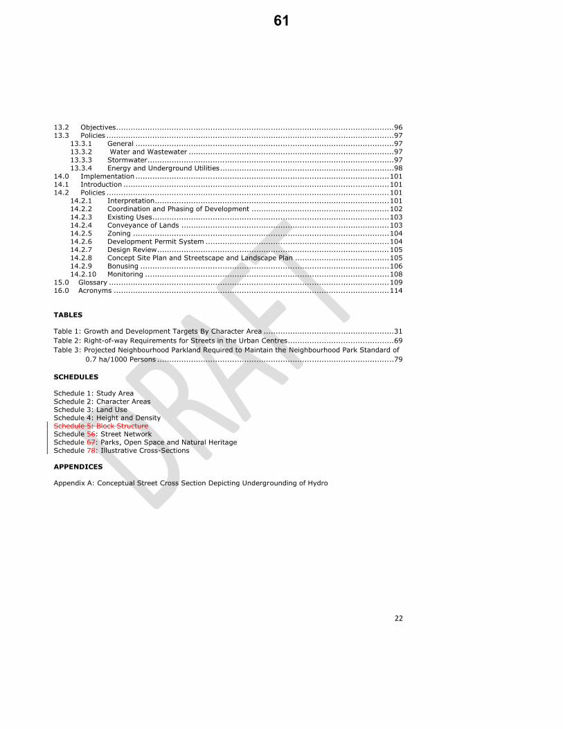
SCHEDULES Schedule 1: Study Area
Schedule 2: Character Areas Schedule 3: Land Use Schedule 4: Height and Density Schedule 5: Block Structure Schedule 56: Street Network Schedule 67: Parks, Open Space and Natural Heritage
Schedule 78: Illustrative Cross-Sections APPENDICES Appendix A: Conceptual Street Cross Section Depicting Undergrounding of Hydro
61

23
1.0 Introduction
The following text and Schedules identified as Schedules 1 through 78 constitute
the Secondary Plan for the Newmarket Urban Centres.
2.0 Purpose of the Secondary Plan
The purpose of this Secondary Plan is to provide a detailed land use plan and policies to guide land use and development in accordance with the provisions of
provincial plans and policies, the York Region Official Plan and the Town of Newmarket Official Plan. The Secondary Plan must be read in conjunction with the applicable policies within the Town of Newmarket Official Plan (May 29, 2008), as
amended.
3.0 Location and Description of the Secondary Plan Area
The area of this Secondary Plan is approximately 290 ha (716 ac.) in area, and generally located along the Davis Drive corridor between Upper Canada Mall and Huron Heights Drive and along the Yonge Street corridor between the Town’s
northerly boundary and Savage Road. The area is comprised of the following three sub-areas as identified on Schedule 1:
1. The Yonge-Davis Provincial Urban Growth Centre (UGC) defined in
accordance with the Province’s Growth Plan for the Greater Golden
Horseshoe, the York Region Official Plan and the Town of Newmarket Official Plan.
2. The Yonge Street and Davis Drive Regional Corridors, generally as
designated in the York Region Official Plan. 3. The Regional Healthcare Centre generally as identified in the Town of
Newmarket Official Plan.
62

24
4.0 Vision
The Town of Newmarket Urban Centres will be planned as an integrated, compact,
complete and vibrant community with a diverse mix of residential, commercial, employment and institutional uses. It will be sensitively integrated with adjacent neighbourhoods. Higher densities will be established within identified nodes and in
a manner that facilitates public transit ridership. Creating a pedestrian-first environment will be a key consideration at all levels of development and design, influencing how buildings are designed and located, how new streets are planned and connected, and how different land uses are mixed across the community. The Urban Centres are a collection of Character Areas as identified on Schedule 2 that will develop into neighbourhoods each with their own unique identity,
highlighted by exceptional architecture and design, and signature public spaces and public art that create welcoming and iconic places. A high standard of design will govern the built form within the Urban Centres, which will range from high density
to lower density forms, while remaining sensitive to adjacent land uses..
Development will be designed to be sustainable by incorporating a full range of sustainability measures that will serve to reduce energy consumption and heat island effects, implement innovative stormwater management and waste
management practices and reduce water use. The transportation network in the Urban Centres will support all modes of travel, with priority given to planning for active transportation and transit. The Urban Centres will be complemented by a green network of large and small parks, urban squares and open spaces. More intense nodes of development will be
balanced by parks and open spaces that provide areas of respite and amenity for the people that live, work, play and visit the Urban Centres.
This long-term vision for the Newmarket Urban Centres is to accommodate approximately 21,000 residents and 20,000 jobs by 2031. Looking beyond 2031,
the ultimate vision for the Urban Centres is for a vibrant urban community at build-out of more than 3231,000 residents and 3032,000 jobs.
Comment [PM8]: Response to Region
Comment [PM9]: Response to Region
Comment [JT10]: correction
63

25
5.0 Land Use
5.1 Introduction
The Secondary Plan comprisesaccommodates approximately 130 ha of developable area. There are approximately 30 ha of land identified as parks, open space, natural heritage and stormwater management. The land use designations identified on Schedule 3 implement the vision for the
Urban Centres as a diverse, mixed use area that will accommodate a broad range of land uses within each of the defined Character Areas. The following eight land use
designations and land use overlays apply within the Urban Centres:
1 Mixed Use
2 Priority Commercial Areas 3 Major Institutional
4 Regional Shopping Centre Study Area 5 Potential School Sites 6 Neighbourhood Parks and Open Space
7 Natural Heritage System 8 Floodplain and Hazard Lands
The Mixed Use designation is the predominant designation. It which provides for a range of uses as defined for each Character Area. The Priority Commercial Area designation along Yonge Street and Davis Drive ensures the commercial role of these corridors is maintained. The Major Institutional designation within the
Regional Healthcare Centre recognizes the unique role of this site as an employment area in the Town. The Regional Shopping Centre Study Area
recognizes the uniqueness of this site and the need for additional planning to guide its long-term redevelopment. Land uses within the Urban Centres also include potential school sites, a parks and open space system, and natural heritage areas.
The constraints posed by natural hazards are recognized through the Floodplain and Hazard Lands designation.
5.2 Objectives Land uses in the Urban Centres will be planned to:
a) achieve an appropriate mix of commercial, residential, employment and
institutional uses; b) support the future redevelopment and intensification of the Centres as a key
economic driver within the Town;
c) minimize the risks to human health, safety and property associated with natural hazards;
64

26
d) ensure that the recreational needs of the future residents are met by providing for strategic locations for parks and open space and opportunities
for public gathering spaces; e) ensure the identification and protection of the natural heritage features
within the Urban Centres; and f) achieve a 1:1 ratio between residents and jobs within the Urban Centres.
5.3 Policies 5.3.1 Mixed Use Areas
i. Lands designated as Mixed Use on Schedule 3 will provide for a mix of uses
including commercial, office, residential, employment, recreational and institutional and will contribute to the establishment of the Urban Centres as a complete community. The uses permitted within the Mixed Use area are identified in Section 6.3 for each of the Character Areas identified on Schedule 2.
5.3.2 Priority Commercial Areas
i. Priority Commercial Areas are identified on Schedule 3. Priority Commercial
Areas are intended to ensure that an at-grade retail presence is provided and retail goods and services remain available within close proximity to the people that live and work in the area. The Priority Commercial Areas are also
intended to contribute to an active street and boulevard condition.
ii. Within Priority Commercial Areas, the permitted uses of the Mixed Use area for the applicable Character Area apply, in addition to the Development Policies defined in Policy 6.4.1.
5.3.3 Major Institutional Areas
i. Lands designated as Major Institutional on Schedule 3 will provide for
development that supports the role of the Regional Healthcare Centre as not only a major employment node in Newmarket, but also as a key centre for
community care, research, education and associated development, and the desire of the Town to see these roles further enhanced in the future. The uses permitted within the Major Institutional area are identified in
PolicySection 6.3.9(iv). 5.3.4 Regional Shopping Centre Study Area
i. The Regional Shopping Centre Study Area identified on Schedule 3
recognizes this area as a key economic driver within the Town and as a
Comment [PM11]: Response to Region
65

27
major potential redevelopment site. The Town’s vision for this area is for it to redevelop over the long term into a mixed use area while maintaining its
function as a significant retail area.
ii. Prior to permitting significant development or redevelopment of the Regional Shopping Centre Study Area, the Town will require the preparation of a detailed Master Plan for the area. The detailed Master Plan will address, as a minimum, the following:
a) the manner in which the redevelopment will achieve the policies of this
Secondary Plan, including the urban design policies; b) minimum and maximum building heights and block densities, and how
these are in keeping with the objectives of this Plan and the various
policies and targets for the Yonge and Davis Character Area;. c) the detailed design for an iconic park space in conjunction with the
private stormwater management ponds at the south-east corner of the area;
d) the incorporation of a gateway feature(s);
e) integration of transit into the site and between the site and the Yonge-Davis Rapidway Station;
f) a Traffic Impact Report including a detailed Transportation Demand Management strategy consistent with Policy 9.3.4;
g) how development will minimize the need for parking on the site, and maximize the integration of required parking into above or below-ground parking structures;
h) the phased integration of non-commercial uses into the site; i) the phasing of development, including the location and design of any
single storey and/or single use buildings, and how these would be redeveloped over time to achieve the Town’s vision for the area;
j) the final location and design of both public and private roads and how
these will achieve the circulation and connectivity of the Street Network identified on Schedule 56; and
k) the required elements of a Concept Site Plan and Streetscape and Landscape Plan in accordance with Policy 14.2.8(i).
iii. Upon completion of a detailed Master Plan in accordance with Policy 5.3.4(ii),
the Town may amend the Secondary Plan to incorporate the applicable
elements of the Master Plan.
iv. Until such time as a Master Plan has been completed, and implementing
amendments have been made to this Plan, the policies of this Plan shall apply, including the interim development provisions of Policy
5.3.4.1.permitted uses of the Mixed Use area for the Yonge and Davis Character Area shall apply, along with the minimum and maximum heights and densities identified on Schedule 4.
66

28
5.3.4.1 Regional Shopping Centre Study Area Interim Development Policies Transitional Policies
i. Notwithstanding the height and density policies of this Secondary Plan, prior to the approval of a detailed Master Plan and incorporation of the applicable elements of the Master Plan into this Secondary Plan, one and two storey building(s) may be permitted in the Regional Shopping Centre Study Area either as additions to the existing building or as stand-alone building(s) on an
interim basis in accordance with Policy 6.4.9.(ii).provided: a. the total gross ground floor area of all new one storey
building(s) or one storey additions to existing buildings shall not
exceed 1,000 square metres; and the development does not increase the total ground floor area present
on the site at the time of the approval of this Plan by more than 10 %; the new one storey building(s) or additions to existing buildings do not
preclude or compromise the future road network identified on
Schedule 6 or other applicable policies of this Plan a. he provisions of Policy 6.4.9ii are met. .
ii. One storey buildings may only be considered above the 1,000 square metre
provision of Policy 5.3.4.1(i) if it is demonstrated to the Town’s satisfaction that the proposed building is the first phase of a multi-storey building and that the building is designed to accommodate additional storeys in the future
in conformity with the Secondary Plan.
5.3.5 Potential School Sites i. Three potential elementary school sites have been conceptually identified on
Schedule 3, in consultation with the York Region District School Board and York Catholic District School Board. These schools sites may be required to
serve the projected residential intensification of Newmarket and are subject to the Community Facilities policies contained in Section 11.3.
5.3.6 Neighbourhood Parks and Open Space
i. A system of Parks and Open Space for the Urban Centres has been identified on Schedule 67. In addition to these Parks and Open Spaces, additional
parks will be required as part of the development approval process. Future parks will be subject to the policies contained in Section 10.3.
Comment [PM12]: Response to Upper Canada Mall
Comment [PM13]: No longer necessary addressed by Policy 6.4.9. ii.
67

29
5.3.7 Natural Heritage
i. The Natural Heritage designation on Schedule 3 reflects the natural heritage features identified in the Town of Newmarket Official Plan and is subject to
the applicable policies of the Town of Newmarket Official Plan.
5.3.8 Floodplain and Hazard Lands
i. The Floodplain and Hazard Lands designation identified on Schedule 3 includes the floodplain and hazard lands as identified by Lake Simcoe Region
Conservation Authority. Development and site alteration shall be directed away from flood and erosion prone areas in order to protect people and property and to minimize social disruption and costs in accordance with Policy 6.4.5 (Floodplain and Hazard Lands) and the general policies of Section 10 of the Town of Newmarket Official Plan.
68

30
6.0 Character Areas, Permitted Uses, Density, Height and Built Form
6.1 Introduction This section addresses the specific Character Areas as identified on Schedule 2 and the height and density provisions identified on Schedule 4. The permitted uses
within each Character Area reflect the unique role that each area plays now, and will play in the future within the Urban Centres. The greatest heights and densities
are proposed at the Yonge Street and Davis Drive intersection due to the redevelopment opportunity provided by the convergence of the two Rapidway lines and the existing context of larger blocks. Secondary nodes of intensification include the intersection of Yonge Street and Mulock Drive and at the Regional Healthcare Centre. Each Character Area contains a mix of permitted uses as well as policies that
address general land uses and built form requirements to guide the function and identity of the area. Each of the six areas is described below.
6.2 Objectives Character Areas, permitted uses, densities, heights and built form in the Urban Centres will be planned to:
a) ensure that each Character Area is distinctive, while at the same time ensuring cohesiveness across the Urban Centres and where appropriate respect and identify with the history of Newmarket;
b) generally focus higher density uses around transit stations and in areas where traffic impacts can be minimized;
c) provide a transition in height from the arterial road frontages down to the
lower density residential areas surrounding the Urban Centres; d) provide variety across the Urban Centres rather than a sameness of built
form; e) include a variety of housing forms for households of all types, income levels
and needs;
f) support a mix of jobs to residents of 1:1; g) implement the density requirements of the Growth Plan for the Greater
Golden Horseshoe and the York Region Official Plan; and h) ensure that the phasing of development is supported by the necessary
community, social and physical infrastructure infrastructureto support the development.
Comment [PM14]: Heritage Newmarket
Comment [PM15]: Heritage Newmarket
69

31
6.3 General Policies 6.3.1 Character Area Boundaries
i. The individual Character Areas are identified on Schedule 2. Where the boundary of a Character Area abuts a planned street, modifications to the
boundary shall be permitted to align with the final location of the street without an amendment to this Plan.
6.3.2 Future Growth
i. The Urban Centres will be planned to a targeted build-out of 31,000 people.
i.ii. The Urban Centres will be planned to accommodate 20,000 jobs by 2031with a targeted build-out of 3032,000 jobs.
ii.iii. The Urban Centres will be planned to accommodate 21,000 people by 2031, with a targeted build-out of 3231,000 peopThe Urban Centres will be planned
as a complete community and to achieve a balance of one job for every resident.
iii.iv. Development of each Character Area will be planned to achieve the growth and development targets contained in Table 1 at build-out.
Table 1: Growth and Development Targets By Character Area
Character Area Predominant Land Use
Residential (approx. %
of total GFA)
Employment (approx. % of
total GFA)
People Jobs FSIFSI Range (FSIFSI)
Yonge North (Poplar Bank)
Mixed Use 80% 20% 6,000 residents
2,4300 jobs 1.5 – 2.5
Yonge and Davis (Bell’s Corner)
Mixed Use 60% 40% 112,0800 residents
112,000 jobs 1.5 – 3.5
Yonge Civic (York County Centre)
Mixed Use & Major Office
40% 60% 1,6500 residents
56,8200 jobs 1.5 – 2.5
Yonge South (Armitage Village)
Mixed Use 80% 20% 6,3200 residents
2,4700 jobs 1.5 – 3.5
Davis Drive (Huron Way)
Mixed Use 70% 30% 4,0500 residents
1,6700 jobs 1.5 – 2.5
Regional Healthcare Centre
Mixed Use & Major Institutional
20% 80% 1,5600 residents
76,0900 jobs 1.5 – 3.5
Total 3132,000 3230,000
Comment [PM16]: Reordered
Comment [PM17]: Correction and Regional Comments
Comment [PM18]: Corrections
70

32
6.3.3 Character Areas and Permitted Uses
i. Within all Character Areas identified on Schedule 2, the following uses may be permitted within the Mixed Use designation as identified on Schedule 3, subject to the applicable provisions of this Secondary Plan and those of the Official Plan:
a) multiple unit residential buildings, including apartments and
townhouse dwellings, and special needs housing; b) a mix and range of residential unit sizes and tenures; c) home-based businesses and live/work uses;
d) institutional uses, including schools, day care and group homes and places of worship;
e) community uses such as libraries, community centres, or similar uses designed to serve the community at large;
f) parks, open space, and urban squares and plazas;
g) commercial uses including retail stores, restaurants, service commercial and office uses;
h) private and public parking in above- and below-ground parking structures;
i) hotels and associated facilities; and j) arts and cultural establishments.
ii. All development will be subject to the Development Policies contained in Section 6.4, the Urban Design and Sustainability Policies of Section 7.0 as
well asand the other applicable policies of this Secondary Plan and the provisions of the Town of Newmarket Official Plan.
iii. Within Wellhead Protection Areas identified on Schedule G of the Official Plan, proposed uses and activities will be subject to the South Georgian Bay Lake Simcoe Source Protection Plan and the prohibited activities as identified in that Plan.
6.3.4 Character Area - Yonge North (Poplar Bank)
i. This Character Area will be a predominantly residential area planned for an
ultimate build-out of approximately 6,000 people and 2,400 jobs and a land
use mix of approximately 80% of total Gross Floor Area as residential uses and 20% of total Gross Floor Area as commercial and employment uses.
ii. Residential development will be characterized primarily by mid-rise
development with opportunities for some high-rise along the Yonge Street
frontage and low-rise (ground-related) transitional forms (e.g. stacked townhouses) adjacent to the existing residential neighbourhoods to the east and west of the Urban Centres. A Priority Commercial Area has been identified at the planned Rapidway transit stop at Yonge Street and Bonshaw
Comment [PM19]: PPS Provision
Comment [PM20]: Captured under commercial uses
Comment [PM21]: Moved from Policy 6.4.2.v where it was inappropriately located.
71

33
Avenue. Additionally, Yonge North will provide for a recommended Neighbourhood Park located adjacent to two potential future school sites as
shown in Schedules 3 and 7.
iii. The uses identified in Policy 6.3.3(i) may be permitted.
iv. This Character Area is the preferred location for up to two elementary school sites.
v. Minimum and maximum densities and heights for the Yonge North Character Area are identified on Schedule 4.
vi. Development in this Character Area will contribute to the achievement of a density range of 1.5 to 2.5 FSIFSI for the overall Character Area at ultimate
build-out.
6.3.5 Character Area - Yonge and Davis (Bell’s Corner)
i. This Character Area will be planned for an ultimate build-out of
approximately 11,800 people and 12,000 jobs and a land use mix of approximately 60% of total Gross Floor Area as residential uses and 40% of
total Gross Floor Area as commercial and employment uses
ii. This Character Area will be the highest density area in the Urban Centres,
and will continue to function as the primary retail node both for the Urban Centres as well as for the surrounding Town.
iii. This Character Area forms the core of the Provincial Urban Growth Centre
(UGC) and therefore must be planned to contribute to the achievement of the
Growth Plan’s UGC density target of 200 people and jobs combined per gross hectare.
iv. Priority Commercial Areas have been identified along the majority of the
Yonge Street and Davis Street frontages.
v. The site of the Upper Canada Mall is anticipated to redevelop over the long term into a mixed use area, while still maintaining its predominantly retail
function and is subject to the Regional Shopping Centre Study Area provisions of this Plan. The proposed Yonge Davis Neighbourhood Park
shown in Schedule 67 is the main focal point for the Character Area, as well as for the overall Urban Centres.
vi. In addition to the permitted uses identified under Policy 6.3.3(i), the following additional uses may be permitted within the Mixed Use area in this
Character Area: a) major office uses; b) post-secondary educational facilities;
c) major retail centre;
72

34
d) places of entertainment; and e) long-term care facilities.
vii. Places of entertainment may only be permitted where it is demonstrated that
impacts on residential uses would be minimized. Separation distances may be defined in the implementing zoning by-law.
viii. Prominent heights of land exist on the north-west and on the southern periphery of this Character Area. In these locations, higher standards of
urban design will be applied with a goal of providing for an iconic skyline that distinguishes Newmarket from other urban centres in the Region.
ix. Minimum and maximum densities and heights for the Yonge and Davis Character Area are identified on Schedule 4.
x. Development in this Character Area will contribute to the achievement of a
density range of 1.5 to 3.5 4.0 FSIFSI for the overall Character Area at ultimate build-out.
6.3.6 Character Area - Yonge Civic (York County Centre)
i. This Character Area will be a predominantly employment focused area and
will be planned for an ultimate build-out of approximately 1,500 people and 6,200 jobs and a land use mix of approximately 40% of total Gross Floor
Area as residential uses and 60% of total Gross Floor Area as commercial and employment uses.
ii. The majority of future employment will be government-related office uses, building on the existing civic nature of the area. Opportunities for residential
and retail uses exist, primarily along Yonge Street where Priority Commercial Areas have been defined, and specifically at the intersection of Yonge Street and Eagle Street where there is a planned Rapidway transit stop. A portion of this Character Area includes the Provincial Urban Growth Centre, and therefore that portion must also be planned to contribute to the achievement
of the Growth Plan density target of 200 people and jobs combined per gross hectare.
iii. In addition to the permitted uses identified under Policy 6.3.3(i), the following additional uses may be permitted within the Mixed Use area in this
Character Area: a) major office uses; b) civic facilities; and
c) post-secondary educational facilities. iv. Minimum and maximum densities and heights for this Character Area are
identified on Schedule 4.
73

35
v. Development in this Character Area will contribute to the achievement of a
density range of 1.5 to 2.5 FSIFSI for the overall Character Area at ultimate build-out.
6.3.7 Character Area - Yonge South (Armitage Village)
i. This Character Area will be planned for an ultimate build-out of
approximately 6,200 people and 2,700 jobs and a land use mix of approximately 80% of total Gross Floor Area as residential uses and 20% of total Gross Floor Area as commercial and employment uses.
ii. This Character Area will be characterized by higher density development with
opportunities for office and retail uses, and Priority Commercial Areas have been identified along the main intersection of Yonge Street and Mulock Drive. Two proposed Neighbourhood Parks are located within this Character Area.
iii. In addition to the permitted uses identified under Policy 6.3.3(i), the
following additional uses may be permitted within the Mixed Use area in the Yonge South Character Area:
a) major office uses; and b) post-secondary educational facilities.
iv. Minimum and maximum densities and heights for this Character Area are identified on Schedule 4.
v. Development in this Character Area will contribute to the achievement of a
density range of 1.5 to 3.5 FSIFSI for the overall Character Area at ultimate
build-out.
6.3.8 Character Area - Davis Drive (Huron Way)
i. This Character Area will be planned for an ultimate build-out of approximately 4,000 people and 1,700 jobs and a land use mix of
approximately 70% of total Gross Floor Area as residential uses and 30% of total Gross Floor Area as commercial and employment uses.
ii. This Character Area is envisioned as a primarily low to mid-rise residential area with opportunities for limited retail and small scale office use, including
live-work opportunities. Where parcel sizes and depths allow, taller buildings may be permitted.
iii. In addition to the permitted uses identified under Policy 6.3.3(i), the following additional uses may be permitted within the Mixed Use area in this Character Area:
a) places of entertainment; and
74

36
b) post-secondary educational facilities.
iv. Places of entertainment may only be permitted in proximity to the Newmarket GO Rail Station where it is demonstrated to the satisfaction of
the Town that impacts on residential uses would be minimized. Separation distances may be defined in the implementing zoning by-law.
v. The highest densities within this Character Area will generally be located east of the intersection of Davis Drive and Parkside Drive, due to the planned
Rapidway Station and the depth of the Urban Centre at this location.
vi. Development between Niagara Street easterly to the easterly end of the
Keith Bridge will respect the heritage character of this area as the gateway to the historic downtown. Specifically, development at the southeast and
southwest corners of Davis Drive and Main Street will recognize this location as the gateway to the historic downtown, including massing, height and design that appropriately transitions to the planned built form and design for
Main Street. vii. Minimum and maximum densities and heights for this Character Area are
identified on Schedule 4.
viii. Development in this Character Area will contribute to the achievement of a
density range of 1.5 to 2.5 FSIFSI for the overall Character Area at ultimate
build-out.
6.3.9 Character Area - Regional Healthcare Centre
i. The Regional Healthcare Centre Character Area will be a predominantly institutional area and will be planned for an ultimate build-out of
approximately 1,500 people and 7,000 jobs and a land use mix of approximately 20% of total Gross Floor Area as residential uses and 80% of total Gross Floor Area as commercial and employment uses.
ii. The Southlake Regional Healthcare Centre is located in the core of this
Character Area and serves as a catalyst for medically related uses. The Character Area is expected to provide a focus for medically related offices and services.
iii. In addition to the permitted uses identified under Policy 6.3.3(i), the
following additional uses may be permitted within the Mixed Use area in the Regional Healthcare Centre Character Area:
a) major office uses;
b) post-secondary educational facilities; and c) long-term and palliative care facilities and similar uses.
75

37
iv. Within the Major Institutional area, the Mixed Use permitted uses identified in Policy 6.3.9(iii) do not apply. Instead, the permitted uses are generally
limited to institutional and related uses. The following uses may be permitted:
a) major office uses; a)b) medical and medically related institutional uses including
hospital, palliative or long term care facilities and similar uses; b)c) medical research and development uses; c)d) post-secondary education facilities;
d)e) commercial uses including retail stores, restaurants, service commercial and office uses;
e)f) private and public parking in above- and below-ground parking
structures; and f)g) parks, open space, urban squares and plazas.
v. Residential uses, other than long term care and palliative care facilities, are
not permitted within the Major Institutional designation.
vi. The highest densities in this Character Area will generally be located on Davis
Drive in proximity to the planned Rapidway Station.
vii. Minimum and maximum densities and heights for the Regional Healthcare Centre Character Area are identified on Schedule 4.
viii. Development in the Regional Healthcare Centre Character Area will contribute to the achievement of a density range of 1.5 to 3.5 FSIFSI for the
overall Character Area at ultimate build-out.
6.4 Development Policies 6.4.1 Priority Commercial Areas
i. Priority Commercial Areas are identified to ensure that retail and service uses are provided to support the people who live, work and recreate in the Urban Centres. Priority Commercial Areas are also intended to ensure an active
street and a balance of residential and commercial uses within each of the Character Areas.
ii. Within Priority Commercial Areas, street-related commercial uses, including
retail stores, restaurants, personal and business services, professional offices
or public institutional uses shall be required on the ground floors levels of all buildings fronting on the public streets. Where residential uses are proposed above the ground floor level, formal entrances, including concierge and lobbies for the residential uses will also be permitted on ground floors.
iii. Within Priority Commercial Areas, floor-to-floor heights of the ground floor
should be 5.5 metres, and will not be less than 4.5 metres.
Comment [PM22]: Captured under commercial uses
Comment [PM23]: Editorial (Weston)
76

38
iv. Outside of Priority Commercial Areas, street-related commercial uses,
including retail stores, restaurants, personal and business services, or professional offices or public institutional uses are strongly encouraged at the
ground floor level fronting on Yonge Street or Davis Drive.
v. Outside of Priority Commercial Areas, any development fronting onto Yonge Street or Davis Drive containing residential development will be required to undertake a retail market assessment. If the retail market assessment
demonstrates, to the satisfaction of the Town, that retail uses are not required at ground floor level, then uses other than street related commercial uses may be permitted at the ground floor, provided the requirements of
Policy 6.4.2(i) and 6.4.2(ii) are met.
6.4.2 Retail Policies
i. Development in each Character Area will seek to achieve an overall target of at least 5 square metres of retail/commercial space per person within the Character Area at all stages of development. The Town will monitor the projected persons and jobs with the implementation of the Plan to determine
if this target is being achieved.
ii. The design of ground floors of buildings fronting on Yonge Street or Davis
Drive should allow for flexible uses at-grade and allow for future conversion to commercial uses. Floor-to-floor heights outside Priority Commercial Areas
should be 5.5 metres, and will not be less than 4.5 metres, to allow flexibility for future conversion to commercial uses.
iii. The following uses shall not be permitted within the Urban Centres: a) gas stations;
b) car wash facilities, unless completely contained within a parking structure;
c) motor vehicle sales; d) motor vehicle repair facilities; and e) new land extensive retail warehouse or “big box” stores, except within
the Yonge and Davis Character Area in accordance with Policy 6.3.5(vi).
iv. New drive-through facilities will not be permitted within Priority Commercial Areas or in areas fronting on Yonge Street or Davis Drive. New drive-
through facilities will be discouraged throughout the rest of the Urban Centres, and may only be permitted where supported by an air quality study and a stacking and queuing study report that has demonstrates,d to the
satisfaction of the Town, that the stacking and queuing can be entirely accommodated on the subject property, that the use will not result in negative traffic impacts on Yonge Street or Davis Drive, pedestrian flow is
Comment [PM24]: Labreche
77

39
not impeded, and that there will be no negative air quality or noise impacts to surrounding uses or activities.
v. Within Wellhead Protection Areas, proposed uses and activities will be subject
to the South Georgian Bay Lake Simcoe Source Protection Plan and the prohibited activities as identified in that Plan.
6.4.3 Affordable Housing
i. A minimum of 35% of new housing units in the Provincial Urban Growth
Centre and Higher Density Intensification Areas , and 25% of new housing units elsewhere in the Urban Centres shall be affordable to low and moderate income households.
ii. Affordable housing benchmark prices for ownership and rental housing will be
determined by the Regional Municipality of York on an annual basis.
iii. Affordable housing shall comprise a range and mix of housing forms, range of unit sizes and tenure are encouraged in the Urban Centres, and includeing a significant number of dwelling units which may accommodate households
with children, larger families, people with special needs, and rental households.
iv. Where re-development involves the removal of existing affordable housing unitsstock, the new housing unitsit shall replace the number of units
displaced in addition to achieving the affordable housing target (e.g. 25% or 35% plus the number of displaced affordable units).
iii.v. The Town will work with the Region to identify locations where social housing will be encouraged.
6.4.4 Rental Housing
i. New rental accommodation will be promoted and the retention of existing medium and high density rental housing stock will be encouraged in accordance with Policy 3.10.2 of the Official Plan.in order to provide choices
for residents, including affordable rental housing. ii.i. iii. The Town, in conjunction with York Region, may establish a rental
accommodation target.
iv. Conversion of rental apartment buildings to ownership housing, or demolition of rental housing containing six or more dwelling units, will be prohibited if the rental vacancy rate is below 3%.
Comment [PM25]: Moved to 6.3.3. - Regional Comment
Comment [PM26]: New policy to address Policy 3.5.15 of the Regional Plan
Comment [PM27]: Moved to Item 3 of Amendment 10 as part of the amendment to the parent Official Plan
78

40
v. Conversion of rental apartments to ownership or demolition of rental apartments shall require the approval of Council. When considering such
applications, Council will consider the following: a) the rental vacancy rate at the time of application;
b) the number of units proposed in the conversion application;
c) the number of rental units under construction at the time of the
application; and
d) the impact of the loss on the rental vacancy rate.
vi. The Town may enter into agreements with the proponents of rental conversions, setting out the specific standards and conditions.
6.4.5 Floodplain and Hazard Lands
i. In order to reduce risks to public safety and property damage, development
shall generally be directed away from flood and erosion prone areas in
accordance with the general policies of Section 10 of the Town of Newmarket Official Plan.
ii. The Floodplain and Hazard Lands designation is an overlay designation and
therefore the permitted land uses, density and height provisions of this Secondary Plan identified on Schedules 3 and 4 do not apply within the Floodplain and Hazard Lands designation unless written approval for specific
development applications has been received from the Lake Simcoe Region Conservation Authority.
iii. The development potential for any site within the Floodplain and Hazard
Lands will be assessed on a site by site basis by the Town in consultation
with the Lake Simcoe Region Conservation Authority (LSRCA). Where a new building or the expansion of an existing building may be permitted by the Lake Simcoe Region Conservation Authority, the use and scale of such buildings may not conflict with the permitted uses, density and height will be guided by the permitted heights and density on the abutting lands.
iv. Development, redevelopment and site alteration within the Floodplain and
Hazard Lands shall be subject to the Natural Hazards provisions of the Provincial Policy Statement, in accordance with the guidelines established in the Natural Heritage Technical Guide prepared by the Ministry of Natural
Resources, and shall not be permitted unless prior written approval is received from the Lake Simcoe Region Conservation Authority.
v. Existing non-conforming uses within the Floodplain and Hazard Land
designation are recognized and are encouraged to be brought into closer
conformity with the applicable Floodplain and Hazard Lands policies of the Provincial Policy Statement and provincial regulations and guidelines. Any replacement, expansion, addition or alteration to existing uses shall not be
79

41
permitted unless prior written approval is received from the Lake Simcoe Region Conservation Authority.
vi. Where new buildings or the expansion of an existing building is permitted by
LSRCA, such buildings shall be designed in a manner that does not obstruct flood flows and/or contribute to upstream or downstream flooding.
vii. Existing residential uses within the floodplain are encouraged to convert to
non-residential uses in order to reduce safety risks.
viii. Subject to the prohibited uses identified in Section 6.4.5. ix, permitted uses
shall be within the range of uses permitted within the applicable Character
Area.
ix. In accordance with the Provincial Policy Statement, the following uses shall not be permitted within the Floodplain and Hazard Lands as identified on Schedule 3:
a) new residential development within the floodway; b) institutional uses associated with hospitals, nursing homes, pre-
schools, school nurseries, daycares and schools; c) essential emergency services as provided by fire, police and
ambulance stations and electrical substations; and
c) new overnight parking; and
d) uses associated with the disposal, manufacture, treatment or storage of hazardous substances.
x. Any proposed new road within the Floodplain and Hazard Lands shall be
designed in such a manner to ensure safe access is provided outside the
floodplain and demonstrate to the satisfaction of the Lake Simcoe Region Conservation Authority that flood flows are not obstructed and/or the design
will not contribute to upstream or downstream flooding.
xi. New or expanded parking, including overnight parking, within the Floodplain and Hazard Lands is generally prohibited, unless discouraged. approved by the Lake Simcoe Region Conservation Authority.
xi.xii. Non-residential daytime parking may be permitted in low risk flooding areas subject to the approval of the Lake Simcoe Region Conservation Authority
and provided appropriate zoning is applied and the property is posted with warning signs articulating no overnight parking due to flood risk.
xii.xiii. Floodplain and Hazard lands are not eligible for parkland dedication under the Parkland Dedication By-law.
Comment [PM28]: Refined to more accurately reflect the PPS
Comment [PM29]: To address LSRCA policies
80

42
6.4.6 Provincial Urban Growth Centre
i. The Provincial Urban Growth Centre will be planned: a) as a focal area for investment in institutional and region-wide public
services, as well as commercial, office, civic, recreational, cultural and entertainment uses;
b) to accommodate and support major transit infrastructure; c) to serve as a high density employment centre that will attract
provincially, nationally or internationally significant employment uses;
and d) to accommodate a significant share of Newmarket’s and the Urban
Centres’ overall population and employment growth.
i.ii. The area shown as the Provincial Urban Growth Centre on Schedules 3 and 4
is identified in accordance with the Urban Growth Centre policies of the Growth Plan for the Greater Golden Horseshoe and it also comprises the Regional Centre in accordance with the York Region Official Plan.
ii.iii. Development in the Provincial Urban Growth Centre will achieve a density of
at least 200 people and jobs combined per gross hectare by 2031.
iii.iv. Notwithstanding any other policy of this Plan, development in the Provincial Urban Growth Centre will achieve a minimum density of 2.5 FSIFSI at the time of ultimate build-out within each of the following Ddevelopment Aareas:
a) all development blocks within the Urban Growth Centre located west of Yonge Street and south of Davis Drive;
b) all development blocks within the Urban Growth Centre located east of Yonge Street and south of Davis Drive; and
c) all development blocks within the Urban Growth Centre locatedeast of
Yonge Street and north of Davis Drive.
iv.v. For the purpose of this policy, the FSI shall be calculated by dividing the
gross floor area of all development at build-out within each of the
development areas by the total land area within each of the development
areas.
v.vi. The calculation of floor area shall not include the floor area of underground
parking, bicycle parking, or public transit uses such as stations or waiting
areas.
vii. The Town will monitor development within the Provincial Urban Growth Centre to ensure the minimum density will be achieved in accordance with Policies 6.4.6 (iii) and (iv).
Comment [PM30]: Relocated
Comment [O31]: Editorial
Comment [PM32]: Reference to
development block no longer necessary due to restructuring of the Policy to apply density to the designations.
81

43
vi. The Provincial Urban Growth Centre will be planned: a) as a focal area for investment in institutional and region-wide public
services, as well as commercial, office, civic, recreational, cultural and entertainment uses;
b) to accommodate and support major transit infrastructure; c) to serve as a high density major employment centre that will attract
provincially, nationally or internationally significant employment uses; and
d) to accommodate a significant share of Newmarket’s and the Urban
Centres’ overall population and employment growth. 6.4.7 General Building Height and Density
i. Schedule 4 establishes the minimum and maximum heights and densities for
each of the density designations within the Urban Centres and will be applied at the time of the development applications.
ii. The boundaries of the density designations shall be determined at the time of development by the Town, and shall approximate the areas shown on Schedule 4.
iii. Development proposals shall not be evaluated based on height and density targets alone, but in combination with all other policies of this Secondary Plan, including but not limited to, the Urban Design and
Floodplain and Hazard Lands policies.
Height
iv. The minimum and maximum heights shall apply on the basis of the density designations identified on Schedule 4.
v. As the height of storeys may vary, where there is a discrepancy between the
height in metres and the number of storeys, as identified on Schedule 4, the height in metres shall prevail.
vi. No development shall have a height lower than the minimum height identified on Schedule 4, except as provided for in Policy 6.4.7(vii).
vii. Minor reductions to the minimum building heights identified on Schedule 4 may be considered as part of development applications to allow flexibility in building and site design, such as, reduced height to articulate a portion of a façade, for development involving heritage structures, or to transition to adjacent parkland. Such consideration shall require demonstration, to the
satisfaction of the Town, that the minimum density of the density designation will be achieved.
Comment [O33]: Moved to Policy 6.4.6 i Editorial
Comment [PM34]: Building Density and Height policies replace former policies to address revised approach which applies the density and height at the designation level and not at the block level and to clarify implementation (Weston,MHBC)
Comment [O35]: Editorial
Comment [O36]: Weston
82

44
iii.viii. No development shall have a height higher than the maximum height identified on Schedule 4, except where the bonusing provisions of Policy
14.2.9 have been implemented by the Town.
Density
iv.ix. The minimum and maximum densities shall apply on the basis of the density
designations identified on Schedule 4.
v.x. The intent of the minimum and maximum densities on Schedule 4 is to
appropriately distribute densities. The FSI shall generally be calculated on a
site-by-site basis, such that each development application achieves an FSI of
not less than the minimum FSI and not more than the maximum FSI for the
applicable density designation as identified on Schedule 4.
vi.xi.
The density of a development is calculated by dividing the gross floor area of
that development by the land area of that development.
xii. The calculation of gross floor area shall not include the floor area of
underground parking, bicycle parking, or public transit uses, such as stations
or waiting areas.
xiii. The Town may consider an FSI that is higher than the maximum FSI for an
individual application only where it can be demonstrated, to the satisfaction
of the Town, that:
a) other properties within the same density designation are constrained
e.g., by heritage features, proximity to low-rise residential areas and
the transitional and angular plane policies;
b) the maximum FSI for the individual density designation within which
the application applies will not be exceeded;
c) the applicable urban design and built form policies are met; and
d) the location and characteristics of the site make it appropriate to
accommodate more of the density relative to other properties within
the same density designation.
Comment [O37]: Clarified density calculation (Weston and MHBC)
83

45
6.4.7 General Building Height and Density
i. Schedule 4 establishes the minimum and maximum heights and densities for the Urban Centres.
ii. Development proposals shall not be evaluated based on density targets alone, but in combination with all other policies of this Secondary Plan,
including but not limited to the Urban Design and Floodplain and Hazard Lands policies.
iii. No development shall have a height lower than the minimum height or higher than the maximum height identified in Schedule 4, except as provided for in
Policies 6.4.7(v), 5.3.4.1(i) or 5.3.4.1(ii).
iv. As the height of storeys may vary, where there is a discrepancy between the
height in metres and the number of storeys, as identified on Schedule 4, the height in metres shall prevail.
v. Minor reductions to the minimum building heights required by Schedule 4 may be considered as part of development applications to allow flexibility in building
and site design, for example in transition areas between new and existing development or for development involving heritage structures. Such consideration shall only be given where it can be demonstrated that the
planned intensification for the site(s) can be achieved.
vi. The minimum and maximum FSI’s identified in Schedule 4 shall be applied at the level of the development block as defined on Schedule 5. Development blocks are generally defined as the area enclosed within a block of public
streets. Where the development blocks shown in Schedule 5 are not defined by an existing public street, then the precise boundaries of the development
block will be determined by the Town at the time of application for development.
vii. Where a development block includes the Floodplain and Hazard Lands
identified on Schedule 5, the density calculation shall generally not include the Floodplain and Hazard Land for the purpose of calculating density unless
development exists or has been permitted by the Lake Simcoe Region Conservation Authority.
viii. The FSI of a development block is calculated by dividing the gross floor area of all development in the development block by the land area of the entire
development block. The land area to be used for the FSI calculation shall include the land used for buildings, off-street parking and servicing areas,
private streets and driveways, and private landscaped open space and shall exclude land for public streets, parks and open space that are dedicated to the Town, natural heritage, schools and public infrastructure such as hydro
facilities and pumping stations. The calculation of gross floor area shall not
Comment [O38]: Former Policy 6.4.7 is replaced with the above revised policy to address comments regarding clarification of how the density and height calculation would apply at the time of development applications and in the longer term. (Weston, MHBC)
84

46
include the floor area of underground or structured above-ground parking, bicycle parking, or public transit uses such as stations or waiting areas.
6.4.8 Interim Development Policies
i. Although the intent of this Plan is that development and re-development
occur to achieve the planned height and densities identified on Schedule 4, limited interim development that is lower in height or density may be permitted without amendment to this Plan subject to Policy 6.4.9(ii).
ii. This Interim Development policy is intended to apply in the short term in
order to provide the existing commercial uses in the Urban Centres with the
flexibility to remain economically viable until they are ultimately redeveloped in accordance with this Plan. The Town may permit development that is
lower than the minimum heights and/or densities of this Plan without amendment to this Plan, subject to the following:
a) the development does not increase the total gross ground floor area
present on the site at the time of the approval of this Plan by more than 5%;
b) development is not intended to be long-term and is considered appropriate over the short- to medium-term;.
c) the maximum building height does not exceed two storeys unless the development is designed to be the podium of the next phase of development.;
d) the development does not preclude the long-term re-development of the site as envisioned by this Plan;
e) the development does not preclude the achievement of a compact, pedestrian-oriented and transit-supportive urban form;
f) the street network and pedestrian mews connections envisioned in
Schedules 5 are not compromised or precluded; and g) the development does not include residential uses or underground
structures.
i.iii. It is the intent of the Town to review the Interim Development Policies within approximately five (5) years of approval of this Plan to determine their continued applicability in view of the intent to achieve the densities identified
on Schedule 4.
6.4.8 6.4.9 Phasing of Development
i. Prior to approval of development, it must be demonstrated to the satisfaction of the Town that the necessary infrastructure to support the planned development is being provided or is sufficient in place to accommodate the
planned development in accordance with Policy 14.2.2..
Comment [O39]: New Interim Development al Policies in response to comments that some limited interim development should be permitted (Richards, Weston, Upper Canada Mall)
Comment [O40]: Schedule 5 deleted and Schedules thereafter renumbered. Former Schedule 5 (Block Structure) no longer necessary and has been deleted as density is to be calculated based on the density designations of Schedule 4.
85

47
86

48
7.0 Urban Design and Sustainability
7.1 Introduction
The Secondary Plan anticipates significant renewal and redevelopment across the Urban Centres. This includes the introduction of a number of built forms, including taller buildings, new mixed use areas and a finer grained transportation grid
network. Each of these new urban elements will need to be carefully designed to ensure that they fit into the broader context of the evolving Urban Centres, are sensitive to the surrounding land uses, and create the distinct, livable and vibrant urban place that the Town of Newmarket is seeking to achieve. In addition to the Urban Design and Compatibility policies of Section 12 of the Town of Newmarket Official Plan, the following additional Urban Design and sustainability
objectives and policies apply within the Urban Centres.
7.2 Objectives
Urban design within the Urban Centres will:
a) maintain the role of the Urban Centres as a sought after destination within
the Town and the Region for living, working, shopping and playing; b) create a unique sense of place within each Character Area and ,
particularly at Yonge Street and Davis Drive where creating both an iconic space and skyline will be a priority;
c) create a livable and vibrant urban place; d) achieveing the walkability objectives of this Plan; e) incorporate new gateway features to create a sense of arrival in the Urban
Centres, distinguishing it as the focal point for intensification while creating a unique and memorable identity;
f) ensure high quality urban design is implemented including enduring buildings, and resilient buildings and associated infrastructure that are resilient to external factors, such as climate change;
g) ensure that development is sensitive to adjacent stable residential neighbourhoods and is compatible with adjacent development within the Centres;
h) incorporate ensure new buildings implement sustainable water and wastewater technologies, are and energy efficientefficient, and implement leading edge waste management and stormwater management techniques;
i) ensure new development respects cultural assets and natural heritage services where they exist within and adjacent to the Urban Centres; and
j) ensure that new development provides for the capability to implement leading edge communication technologies, including broadband services,
Comment [PM41]: Heritage Newmarket(HN)
Comment [PM42]: Region of York
Comment [PM43]: NEAC
Comment [O44]: HN
Comment [PM45]: Clarified wording (Tridel)
87

49
in order to attract and maintain investment, facilitate research and development and knowledge based initiatives, and support health services.
i) provide capacity to implement leading edge communication technologies,
including broadband services within future developments in order to attract and maintain investment and to facilitate research and development technologies, knowledge based initiatives, health services, etc.
7.3 Policies 7.3.1 General Urban Design
i. Urban design will incorporate the applicable requirements of the other
provisions of this Plan including: Section 8.0 Block Structure and Street Network, Section 9.0 Transportation and Mobility, Section 10.0 Parks, Open Space and Natural Heritage, etc.
ii. All development shall be designed to be accessible to people with disabilities
in accordance with the Ontarians with Disabilities Act (AODA) and the Ontario Building Code.
iii. All development will be required to exhibit high quality urban design, utilize
and durable materials such as stone, brick, glass, etc., and contribute to the unique identity and prominence of the Urban Centres. Exterior materials such as stucco, vinyl and other less durable material will generally not be
permitted.
i.iv. In order to accommodate the future undergrounding of the overhead hydro
and other utilities on Yonge Street and Davis Drive lands are required to be dedicated to the Town in accordance with Policy 13.3.4.
ii.v. Urban design guidelines may be developed to assist in the interpretation of
this Plan.
7.3.2 General Massing and Built Form
i. The general massing and exterior façades of new development will be
designed to fit harmoniously into the planned context, while respecting the existing development outside the Urban Centres while and achieving the
intensification and density policies of this Plan.
ii. New development will be designed to limit shadow and adverse wind impacts
on adjacent properties and public spaces including neighbouring streets, parks and open space and , including urban squares.
Comment [PM46]: Response to Region comments and Included to address ongoing changes to the Building Code to meet the AODA, e.g., Jan 1, 2015 provisions for residential buildings 3 or more storeys or over 600 m2 to require barrier free access to all floors
Comment [O47]: New policy to provide link to Policy 13.3.4 Re. Underground Hydro and associated facilities
Comment [O48]: Editorial
88

50
ii. an adjacent properties. iii.
New buildings shall address the street. Buildings shall have front façades with
active entrances and windows that face the street. Where buildings face
public squares and parks, these facades are intended to be designed to
provide physical and visual access to these public spaces.
iv.iii.
iv. The principal entrances of commercial and mixed-use buildings shall be oriented toward the street and provide direct user entrances from adjacent streets and walkways.
Blank walls facing a street, uUrban Ssquare or park shall not be permitted.
v. Buildings should be designed to completely screen roof-top mechanical equipment from public view. Mechanical penthouses should be designed and clad with materials to complement the building façades.
vi.v. Building façades generally greater than 25 30 metres in length should be
articulated or “broken up” through the use of architectural features such as recesses, projections, awnings, or colonnades along at least 20% of the length.
vii.vi. Buildings will be designed to support the public and commercial function of
Yonge Street and Davis Drive through means such as well-articulated façades, with architectural articulation, well-demarcated entrances, prominent display windows, and protective canopies.
vii. Buildings with non-residential uses on the ground floor should have be
designed to be articulated and highly transparent ground floors, with a minimum of 60 percent of the ground floor frontage to be glazed.
viii. Where at-grade residential uses front on a public or private street, setbacks of a minimum of 3 metres and a maximum of 5 metres from the property line will be required to provide for a front yard transition between the front
doors of private residences and the public sidewalk. The setback area should contain low fencing and/or landscaped space.buffers. The ground floor of
residential uses may have individual entrances and may can be level with the sidewalk . Parking and vehicular access will be required to locate at the rear and generally designed as below grade parking.
ix.viii. On a corner site, the development should address both street frontages and
give prominence to the corner. Both façades should have comparable levels of architectural detail and character.
x.ix. Direct vehicular access is generally discouraged along Yonge Street and Davis Drive in order to minimize disruptions to the pedestrian environment
and reduce turning movements onto Yonge Street and Davis Drive. Access
Comment [PM49]: Editorial
Comment [O50]: New policy to encourage physical and visual access to public spaces from new buildings
Comment [O51]: Moved to xiii below
Comment [O52]: Weston
Comment [PM53]: Planning dept.
Comment [PM54]: Moved to 7.3.4 Low Rise Residential Buildings
Comment [O55]: Editorial to address intent of original policy.
89

51
from side streets, back lanes and Sshared driveways are encouraged. to reduce access points and pedestrian conflicts. on Yonge Street and Davis
Drive. xi. Loading bays, garbage services and building mechanical and utility
equipment should be located within buildings.
x. Loading bays, garbage and other servicing, and vehicular related functions should not detract from the use or attractiveness of the pedestrian realm. Garbage, loading, servicing and utility functions should be integrated within
the interior of a building, or at the rear, whenever possible, with access from a rear lane or side street.
xi. The first 10 to 12 metres of a building’s height should be designed in accordance with bird friendly practices.
xii. Buildings should be designed to completely screen roof-top mechanical and telecommunication equipment from public view. Mechanical penthouses
should be designed and clad with materials to complement the building façades.
7.3.3 Transitional and Angular Plane Policies
i. Development immediately adjacent to an existing low-rise residential area or
planned low-rise residential area shall generally not exceed the height of the adjacent buildings within the low-rise residential area.
ii. To ensure new development is compatible with the existing or planned context and provides an appropriate transition in scale to lower scale adjacent buildings or Parks and Open Spaces, the maximum height of any
building, including mechanical units, should fall below an angular plane of 45 degrees measured from the neighbouring property line, applied to the front
of the site and the rear of the site and, where the side of the site is along a public road, to the side of the site. The angular plane will generally not be applied across Yonge Street or David Drive. Balconies, railings, overhangs
and other projections should be contained within the angular plane.
7.3.43 Low- Rise Residential Buildings
i. The primary entrance of low rise residential buildings should be located on
the public street. Entrances should be well defined and clearly visible from the street and distinguished by their architectural design.
ii. Entrances to all low- rise residential units should open directly to the street with the main entrance and living level generally located not more than 1.5
metres above adjacent grade.
Comment [O56]: Incorporated into policy x below
Comment [JT57]: Moved from streetscaping section
Comment [O58]: NEAC
Comment [O59]: New Angular Plane Policy
90

52
iii. Façades of low- rise residential buildings should be articulated and no
building should have a continuous unarticulated plane facing the street of
more than 25 30metres. Articulation may include entrances, recesses,
projections or other architectural designs that add interest to the façade.
iv. Where at-grade residential uses front on a public or private street, setbacks of a minimum of 3 metres and a maximum of 5 metres from the property line will be required to provide for a front yard transition between the front doors of private residences and the public sidewalk, except along Yonge Street and Davis Drive where lands have been dedicated to the Town for the
future undergrounding hydro.. Where lands are required to be dedicated to the Town for the future undergrounding hydro, the setback may be reduced in accordance with Policy 13.3.4. The setback area should be designed
contain low decorative fencing and/or landscaping to distinguish the private space.
iv.v. Parking and vehicular access shall not be located fronting on the public
street. Parking shall be located at the rear and generally designed as below
grade parkingunderground or to the back of the property, preserving the frontage yard for a diversity of soft and hard landscaping. Shared accessdriveways or private lanes to access rear parking is encouraged.
7.3.54HighTall and Mid-Rise Buildings
i. Where tallhigh or mid-rise buildings are permitted, significant new public or publicly accessible privateprivate/public open spaces such as parks, urban
squares and plazas or forecourts will be required to be provided as part of the development.
ii. Private, shared indoor and outdoor amenity space shall be required for all residential buildings with greater than 20 residential units that do not have
access to individual ground-related private amenity space.access.
iii. Blank side walls will not be permitted along or facing a public street, park, open space or pedestrian mews. Elsewhere, bBlank side wall conditions may be permitted on walls up to a height of 6 storeys if designed as an
architecturally finished surface that complements the architectural character of the main building façade(s).
iv. Balconies on the front façade should generally not project beyond the building wall and should not be located within the first 3 storeys. Balconies
on the upper floors should be inset behind the building wall and integrated into the design of the building facade.
Comment [O60]: Editorial
91

53
v. High and mid-rise buildings should be oriented to maximize building energy performance, minimize adverse shadow and wind impacts and maintain sky
views.
v.vi. Roofs of hightall and mid-rise buildings are encouraged to implement energy
provisions in accordance with Policy 7.3.7 or be used for outdoor amenity space.
7.3.54.1 Podiums
i. All buildings taller than 6 storeys shall be required to have a podium.
ii. High-rise buildings should have a building base, or podium, that is at least 3
storeys or 10.5 metres in height at the street to a maximum of 6 storeys or
18 metres in height at the street, and a minimum of 75% of its frontage shall consist of the podiumbuilt to the required setback. The portion of a high-rise
buildings above the podium must be stepped back a minimum of 3 metres for a minimum of two-thirds the length of the tower facing the public street.
iii. The podium of mid-rise buildings should not exceed 65 storeys and should provide for a minimum step back of 1.5-3 metres to 3 metres above the
podium for a minimum of two-thirds the length of the tower facing the public street.
iv. The roof tops of podiums are encouraged to be developed as private amenity space and contribute to the greening of the Urban Centres through roof top
landscaping.
v. When high-rise buildings or mid-rise buildings are sited next to low-rise
residential areas, podiums will be required to be massed and designed to allow for a transition between the residential area and the high or mid-rise
building. Notwithstanding Policy 7.3.45.1(ii) and (iii), the portion of the podium immediately adjacent to an existing or planned low-rise residential area shall be subject to Policy 7.3.3.not exceed the height of the adjacent
buildings within the low rise development.
vi. Where new development fronts onto a public street that is developed fronted on the opposite side by low-rise residential buildings, such as on the south
sides of Queen Street and Simcoe Street, the development shall be subject to Policy 7.3.3 (urban design tTransitional and Angular Plane consideraPolicies).y 7.3.4.1(iv) shall apply.
7.3.45.2 Towers
Comment [PM61]: Clarification
Comment [O62]: Reduced maximum podium height to be in scale with the maximum height of mid-rise buildings (11 storeys)
Comment [O63]: Cross reference to new transitional and angular plane policy
92

54
i. The tower portion of high-rise buildings will be designed to create a memorable and iconic skyline, particularly at Yonge Street and Davis Drive.
ii. The maximum gross floor areagross floor area of the floor plate of the tower
portion of a high-rise building proposed for residential purposes shall generally not exceed 750 square metres, excluding balconies. Larger floor plates may only be permitted where the urban design and other policies of this Plan can be met to the Town’s satisfaction.
iii. If a development includes more than one high-rise building, the tower portion of the high-rise buildings shall have a minimum separation distance of 30 metres, measured from the exterior wall or exterior edge of balconies,
whichever is greater. This same separation distance standard shall apply to towers on adjacent properties.
iv. The maximum floor plate of the tower portion of major office and non-residential high-rise buildings will be evaluated in accordance with the
applicable policies of this Plan to ensure impacts with respect to shadow, transition to adjacent uses, and the general scale are addressed.
7.3.56Streetscapes and Boulevards
i. Street furnishings, which include benches, bike racks, bollards, bus shelters/
kiosks, trash/recycling bins, banners way-finding signage and pedestrian
lighting, should be used as unifying landscape elements. Because of their prevalence, their style, image and colour will be important to the overall
visual environment of the Urban Centres. A low maintenance, vandal resistant, easily replaceable and recognizable family of furnishings with common themes and colour palettes will be identified for the Character Areas
within the Urban Centres. Such themes may reflect the cultural heritage or other identifiable focus for the area.
ii. Loading bays, garbage and other servicing, and vehicular related functions
should not detract from the use or attractiveness of the pedestrian realm.
Garbage, loading, servicing and utility functions should be integrated within the interior of a building, or at the rear, whenever possible, with access from
a rear lane or side street.
iii.ii. All public streets, and generally all private streets in the Urban Centres shall have sidewalks and street trees on both sides and lighting appropriate for pedestrians, cyclists and drivers to increase the overall comfort, aesthetic and safety of the street.
iv.iii. Development fronting on Yonge Street or Davis Drive will be designed to support a pedestrian friendly environment by:
Comment [PM64]: Heritage Newmarket
Comment [JT65]: Moved to general design section
93

55
a) providing for features such as pedestrian plazas and courtyards which are publicly accessible in accordance with Policy 10.3.3 Urban Squares
and Plazas; b) providing amenities such as public art, benches, bicycle racks,parking,
landscaped features and resting places; c) creating a comfortable, yet highly animated, pedestrian environment
through a rhythm of multiple retail frontages, architectural articulation, numerous entrances, display windows, canopies and signage;
d) promoting a strong street orientation by having building entrances
oriented to the public street; e) providing for weather protection and shade by incorporating features
such as arcades, or architectural canopies, trees and shade structures;
f) avoiding utilities, vents and other unsightly elements on the lower
levels of façades adjacent to Yonge Street and Davis Drive; and
g) locating uses at-grade that create visual interest and support street
activity. and
iv. An approximate 10 metre boulevard will be maintained along both sides of
Yonge Street and Davis Drive. This boulevard will accommodate a pedestrian
path, cycling facilities and landscaping as well as the planned undergrounding of the hydro lines, as conceptually illustrated in Appendix A. The design of the Yonge Street and Davis Drive boulevards will:
a) promote consistent design themes, materials and landscaping within
the Character Areas throughout the Urban Centres; a)b) provide for raised cycling facilities within the boulevard, where
feasible;
b)c) be designed as active public spaces that integrate and link development;
d) facilitate pedestrian access between walkways and building entrances; c)e) incorporate pedestrian amenities including pedestrian-scale
lighting and rest areas; d)f) promote enclosure and definition of the street space; g) provide places to meet, sit and socialize;
e) f)h) promote pedestrian comfort, weather protection, and safety,
including street trees and bicycle parkingracks, particularly at transit
stops; and g)i) provide sufficient area to accommodate the undergrounding of
the hydro lines and other utilities.
v. The design of minor collector roads and local roads will: a) promote pedestrian amenity, comfort, convenience and safety; b) ensure accessibility;
94

56
c)a) incorporate design features that minimize visual width and scale of the street;
d)b) incorporate design and functional elements which reduce traffic speed where appropriate;
e)c) permit encourage on-street parking where operationally feasible, particularly in proximity to outside the Priority Commercial Areas identified on Schedule 3; and
f)d) provide coordinated traffic signage and way-finding signage which is designed in scale and character with the streetscape
elements.;
vi. Private roads and internal driveways required for site circulation will be
designed as active streets, including provision for pedestrians and cyclists. Use of surface material, landscaping and pavers should be used to distinguish
uses and facilitate pedestrian safety and way finding.
vii. Streets that are identified as Green Streets in Schedule 67 will be designed
to include the features identified in Policy 10.3.5(i). 7.3.67Sustainability
i. All development shall be encouraged to strive for a LEED™ Gold or higher
rating, or an equivalent standard.
ii. To mitigate the urban heat island effect, increase the energy efficiency of
buildings and reduce stormwater run-off, green roofs and/or cool roofing materials as well as soft landscaping will be encouraged on the flat portion of rooftops, excluding the area required for mechanical equipment. All
commercial, institutional, mixed use and multi-unit residential buildings, excluding townhouses and stacked townhouses, will be encouraged to:
a) have a green roof with a minimum 50% coverage; b) provide solar capture equipment over a minimum of 60% of the roof; c) use cool roofing materials for a minimum of 80% of the roof; or d) use a combination of the above for a minimum of 70% of the roof.
iii. All commercial, institutional, mixed use and multi-unit residential buildings, excluding townhouses and stacked townhouses, will be encouraged to:
a) provide for a minimum of 40% of the building’s total energy
requirements through alternative energy sources, including solar hot water, photovoltaic, geothermal, or purchase of off-site renewable
energy, etc.; b) utilize low demand or low flow fixtures, such as high efficiency toilets,
low-flow showerheads, and/or water efficient clothes washers to
achieve 20% greater water conservation than the Ontario Building Code; in accordance with the York Region Official Plan; and
c) provide for a minimum of 50% of the projected water demand for toilets/urinals through greywater recycling. anprovide for 80% or more
Comment [PM66]: Editorial
Comment [PM67]: Regional comment
95

57
of the outdoor water irrigation needs through a combination of rainwater harvesting and through the use of drought tolerant
landscaping.
The use of potable water for outdoor watering will be restricted. iv.
A rain water harvesting system will be required for all new development for
outdoor irrigation and water use such that .
The use of potable water for outdoor watering will be restricted.
iv. eighty percent or more of outdoor water irrigation needs can be met through a combination of rainwater harvesting and the use of drought tolerant
landscaping. The use of potable water for outdoor watering will be restricted.
v. All commercial, institutional, mixed use and residential buildings are
encouraged to reduce local heat island effects through mitigation measures including:
a) green or cool roofing and hard surface landscape materials that have a reflective index of at least 29; and
b) planting trees and other vegetation to provide shading on sidewalks,
patios, roof tops and at strategic locations adjacent to buildings.
v.vi. All commercial, institutional, mixed use and residential buildings, shall include a solar design strategy which identifies the approaches that maximize solar gain and facilitates future solar installations, e.g., solar ready.
vii. All commercial, institutional, mixed use and multi-unit residential buildings,
excluding townhouses and stacked townhouses, shall be designed to maximize waste reduction and diversion with a convenient three stream waste collection system (recycling, organics and residual waste) and
provision of space for new programs (e.g., electronics, textiles, batteries). accommodate three stream waste collection (organic waste, recycling, and
waste).
viii. All commercial, institutional, mixed use and residential buildings, are
encouraged to include a construction waste diversion plan with strategies to meet an overall diversion target of 75%. The Plan may include advanced on-site waste diversion and recycling programs during project construction. The
Plan shall also identify markets/ haulers for major waste streams, on-site storage/sorting area(s) and instructions for contractor staff.
ix. For commercial, institutional, mixed use and residential buildings, an indoor air quality enhancement strategy is encouraged. Such a strategy may
commit to using low or no volatile organic compound products and/or define approaches that minimize the leakage of combustion gases, reduce exposure to indoor and outdoor pollutants through ventilation, and provide indoor
moisture control, etc.
Comment [PM68]: Conformity with Regional Plan
Comment [PM69]: Conformity with Regional Plan
Comment [PM70]: Conformity with Regional Plan
Comment [PM71]: Conformity with Regional Plan
Comment [PM72]: Correction – currently required and Regional Plan Conformity Section 7.3.6 v
Comment [PM73]: Regional Plan Conformity Section 7.4.14
96

58
x. All commercial, institutional, mixed use and residential buildings, are required to include low impact development stormwater management
measures that improve conditions with respect to stormwater volumes and contaminant loadings and that maximize infiltration. Innovative stormwater
management measures may include but not be limited to rainwater harvesting, roof top or sub-grade storage, green roofs, rain gardens, bio-retention swales or areas, infiltration galleries beneath hard and soft surfaces, permeable surfaces, and so on.
vi.xi. All commercial, institutional, mixed use and multi-unit residential buildings are encouraged to consider options for district energy, and design features that would enable the future implementation of district energy.
vii.xii. Applications for development in the Urban Centres will be required to include
a Sustainable Development Report that describes how the proposed development supports environmental sustainability. Sustainable Development Reports shall address at a minimum the following:
a) energy efficiency measures; b) water conservation measures; c) alternative energy use and solar design strategy; d) heat island mitigation;
d)e) air quality enhancement; e)f) Low Impact Development (LID) stormwater management; and f)g) solid and construction waste reduction and management.
viii.xiii. Development that incorporates certain sustainability measures may qualify
for deferral of Development Charges in accordance with the Policy for Deferral of Payment of Development Charges and Planning Application Fees in the Yonge/Davis and Regional Healthcare Urban Centres as may be
amended from time to time. 7.3.7 Communication Techno
i. All commercial, office, institutional, mixed use, and mid and high-rise
residential buildings shall be designed to provide for leading edge communication technologies, including but not limited to broadband fibre optic conduit to and within each building.
In addition, all townhouse and stacked townhouse developments shall be required to provide a separate conduit to each townhouse block within the
development and provide internal wiring within the buildings to facilitate access to the advanced communication technology, including broadband networks.
7.3.78 Communication Technology
i. All commercial, office, institutional, mixed use, and multiple unit residential
buildings willshould be designed to: a) facilitate advanced telecommunication, such as building automation
systems, for a broad range of applications from health services to
Comment [PM74]: Conformity with 2.3.37 of Regional Plan
Comment [JT75]: Regional comment
Comment [PM76]: Regional Comment and NEAC
Comment [PM77]: Revised (Tridel)
97
59
heating and lighting, leading edge national and international connectivity capability, etc.; and
b) provide the infrastructure for the delivery of leading edge communication technologies, including broadband fiber optics to and
throughout the building(s) in order to facilitate future advanced telecommunication capabilities.
i.ii. A dedicated broadband fibre optic conduit, including appropriately sized
wiring, shall be installed from the municipal right of way to each
development block or building(s) as well as distributed internally to each unit within the building(s) in order to ensure access to advanced communication technology, when it becomes available.
ii.iii. Applications for development will be required to provide a Communication
Implementation Plan that demonstrates how communication technology will be designed and implemented and demonstrate that the conduit and wiring meets or exceeds the minimum industry standard.
iii.iv. The planning and design of communication technology shall be subject to
Policy 13.3.4 (Energy and Underground Utilities).
7.3.89Shadows and Sky Views
i. The scale and massing of buildings should allow for significant sunlight penetration onto public streets, parks, public and private squares and plazas
that are accessible to the public, and other shadow sensitive areas such as school yards and outdoor amenity areas associated with seniors residences and long term care facilities and protect for sky views for pedestrians.
ii. Buildings are to be sited and designed to mitigate wind and skyview impacts
on surrounding neighbourhoods. iii. Applications for development in the Urban Centres will require a shadow
impact study in accordance with Official Plan Policy 4.4.3 that demonstrates that the proposed development allows for a minimum of 50% of daily
sunlight (measured from 1.5 hours after sunrise and 1.5 hours before sunset) onto public spaces identified above, including public sidewalks, during the summer solstice (June 21).
7.3.910 Landmarks and Public Views
i. The Town will may identify significant views and landmark buildings,
including views to heritage buildings that will be considered in the review of any development proposal, to ensure that the view corridors leading to them remain legible.
Comment [PM78]: Heritage Newmarket
98

60
ii. Development proposed for the heights of land to the north and to the south
of the Yonge Street and Davis Drive intersection shall be sensitively designed in keeping with the prominence of these locations and with a view to the
opportunity for creating an iconic sky line.
7.3.110 Signage and Lighting
i. Signage should be incorporated into the design of the building façade or landscaping.
ii. Signage should be displayed at consistent heights on building façades.
iii. All building signage and site lighting shall be designed and oriented to
minimize general light pollution and minimize the infringement of light and
glare onto adjacent properties in keeping with dark sky principles.
iv. New, stand-alone permanent pole-mounted signs, ground signs and pylon signs and mural signs shall generally be discouraged.
v. New billboards and third party signs shall be strongly discouraged generally be and strictly prohibited regulated by the Sign By-law.
vi. The following types of signs shall be prohibited:
a) roof top signs or signs that project beyond the roof of a building or similar structure; and
b) signs that may cause a distraction, such as animated, flashing, or
noise emitting signs. and c) mobile signs.
vii. New mobile signs shall be discouraged throughout the Urban Centres and where permitted, shall be limited in their duration.
vii.viii. Street and pedestrian lighting will be designed to be energy efficient and
dark skies compliant, including the use of LED or other low energy
consumption lighting systems.
7.3.121 Parking Facility Design
i. New sSurface parking is discouraged throughout the Urban Centres and shall not be permitted in areas fronting onto Yonge Street or Davis Drive. Where
surface parking is permitted, it shall be in the side or rear of the parcel and it shall be designed as an interim use and to facilitate the long-term redevelopment of the parking area in accordance with the vision and
objectives of this Plan.
Comment [PM79]: To align with signage By-law
99

61
ii. Entrances to above and below-ground parking structures generally shall be from a private street or lane as the first priority, and may be permitted from
a rear or side public street where it can be demonstrated to the Town’s satisfaction that access from a a private street or lane is not feasible or
necessary.
iii. Parking structures may be permitted beneath private streets and pedestrian mews and under private squares designed for public access and public parks, provided the surface function and character is not materially or qualitatively
compromised. Where permitted, agreements with the Town may be entered into to establish terms, including such matters as applicable easements, to ensure public access to the surface uses are maintained.
iv. The design of parking facilities should take the following design policies into
account: a) integration of walkways, traffic islands and pedestrian refuges as
integral components;
b) minimizing driveway access points to the public street as well as driveway crossings of the sidewalk, including sharing driveway access between adjacent sites where feasible;
c) provision of visual screening for parking areas or structures that are
adjacent to the street; d) integration of secure bicycle parking; e) priority parking for accessibility (vehicular and scooters), car share and
electric or hybrid vehicles, and including electrical charging stations; f) providing at least one pedestrian route between the main building
entrance and the public sidewalk that is uninterrupted by parking and driveways;
g) in larger parking facilities or where parking facilities serve more than
one building or destination, providing logical, well-marked pedestrian routes for safe travel through the parking facility;
h) where parking facilities are located at the rear of buildings, rear entrances and pedestrian walk-throughs in order to facilitate pedestrian access to the street; and
i) other elements that may be identified by the Town.
v. Parking structures fronting on a public street or parkland shall generally contain street related active commercial, residential or institutional uses on the ground floor subject to technical considerations and the entire façade
shall be designed to appear as fenestrated buildings, with a regular articulation of openings and materials that are generally consistent in type
and quality with those of surrounding buildings.
vi. Vehicular entrances to above or below-ground parking structures on public
streets shall be integrated into the design of the building and located to reduce conflict with pedestrians. Pedestrian entrances to parking structures shall be clearly identified and well lit.
Comment [PM80]: Editorial
100

62
vii. All development proposing underground parking structures will be required to demonstrate through geotechnical and dewatering studies that the site is
suitable and that there will be no interference with municipal wells, both during and after construction.
7.3.13 Servicing and Utility Facilities
i. Utility and servicing equipment will be integrated into the design of the urban landscape and where possible will be located underground.
ii. The access to servicing and utility facilities shall generally be from a local
street or private lane.
iii. Utility facilities may be permitted within a public right of way subject to an agreement with the Town, as well as on private property.
iv. Utility facilities are encouraged to be designed to be within buildings or parking structures where direct access by the utility is provided generally
from the exterior of the building/structure.
v. Servicing and utility equipment will be encouraged to be clustered or
consolidated where possible to minimize the physical space requirements and visual impact. Innovative methods are encouraged to integrate utility
structures within streetscape features, including gateways, lamp posts, and transit shelters.
vi. Utility facilities will be required to be part of a landscaped area and visually screened through landscaping and/or decorative fencing and may be
designed to facilitate or contribute to public art.
8.0 Block Structure and Street Network
8.1 Introduction The existing block structure within the Urban Centres is characterized by a number of large, deep parcels, as well as some very shallow and constrained parcels. The
deepest parcels are primarily concentrated at Yonge Street and Davis Drive and, to a lesser extent, at Yonge Street and Eagle Street and Yonge Street and Mulock
Drive. Blocks fronting on Davis Drive are typically much shallower. The majority of blocks have long frontages, with little porosity, relying on Yonge Street or Davis
Drive for site access. Additionally, the blocks are not well-connected to the adjacent neighbourhoods, resulting in long, indirect travel distances for residents of
Comment [PM81]: New Policy -Bell Comments and Urban Design Manual Telecommunications Infrastructure MMM Group April 2009
101

63
the surrounding neighbourhoods to access the stores and services fronting onto Yonge and Davis. The Secondary Plan seeks to create a highly walkable block
structure, and introduces a fine gridain street network that creates more options for moving in the Urban Centres without relying upon Yonge Street or Davis Drive. It
also aims to provide direct access to the VIVANext Rapidway stations via all transportation modes, including active transportation. The Urban Centres Transportation Study has evaluated this Plan’s recommended fine gridain street network with respect to the impacts on traffic and concludes that
the network coupled with Transportation Demand Management strategies, a phased parking strategy, and other initiatives, is sufficient to keep pace with future development. Further studies will be required to address area-specific
transportation issues that are outside the scope of the Secondary Plan.
8.2 Objectives
The street network and block structure in the Urban Centres will be planned to:
a) minimize walking distances, particularly between the stores, services and jobs on Yonge Street and Davis Drive and the surrounding residential
neighbourhoods; b) introduce a fine gridain street network that creates more options for
moving in the Urban Centres without relying upon Yonge Street or Davis
Drive; c) provide direct access to the Rapidway stations and the GO Train station
via all transportation modes, including active transportation; d) provide logical and direct connections between the Urban Centres and the
surrounding residential neighbourhoods through the provision of new
minor collector and local roads and pedestrian mews; and e) introduce new private streets, laneways and pedestrian linkages that
facilitate and enhance walking and other forms of active transportation.
102

64
8.3 Policies 8.3.1 Block Structure
i. Development in the Urban Centres will be designed to create contribute to thea block structure as defined below.in Schedule 5.
ii. Blocks will be of a scale and size appropriate to a pedestrian area.
iii. Blocks created by new development should be no less than 60 metres in depth for blocks fronting onto Yonge Street or Davis Drive, and 40 metres for
all other blocks, to allow for below-ground parking, accommodate minimum building heights and provide for sufficient traffic queuing distances.
iv. Blocks should be generally no greater than 100 metres in length in order to ensure convenient walking distances. If blocks are longer than 100 metres, breaks such as pedestrian mews should be provided for pedestrian access and connections to adjacent development.
8.3.2 Street Network
i. Development in the Urban Centres will contribute to the completion of the
street network defined on Schedule 65.
ii. The fine grid street network defined in Schedule 65 shall be integrated into
the existing street and block network to facilitate a balanced movement system for pedestrians, cyclists, transit riders and motorists.
iii. The street network in the Urban Centres will be planned to: a) create short, walkable blocks that provide direct pedestrian and
vehicular access to Yonge Street and Davis Drive; b) provide a fine grid street network that ensures connectivity and
permeability within the Urban Centres and to the adjacent existing and planned neighbourhoods outside the Urban Centres;
c) realign or connect streets to remove off-set intersections;
d) provide alternatives to Yonge Street and Davis Drive; e) create a ring road around the major intersections at Yonge Street and
Davis Drive and Yonge Street and Mulock Drive; and f) ensure safe access in areas of the floodplain.
iv. New public streets identified on Schedule 65 shall generally be conveyed to the Town by way of plan of subdivision in accordance with Policy 14.2.4 of Newmarket as a condition of the applicable Planning Act application or, in some cases, may be acquired by the Town, and the cost of acquisition
recovered through cost sharing agreements with benefitting landowners.
Comment [O82]: Delete Schedule 5 as block structure is no longer used to apply the density calculations
Comment [PM83]: Cross reference
103

65
iv.v. Where existing private streets have been identified as public streets or where an identified public street is not required for ancillary underground
infrastructure (e.g., sewers and water), the Town may permit these streets to remain private, without an amendment to the Secondary Plan, provided an
agreement is entered into with the Town and the owner that guarantees public access and that design and maintenance is in conformity with this plan and applicable Town’s standards for public roads.
v.vi. Where possible, the alignment of new streets should align with existing
property boundaries to optimize development potential and to distribute the costs of local streets between landowners.
vi.vii. New public and private streets should be located to align with existing intersections to minimize the occurrence of off-set or “T” intersections.
vii.viii. Direct vehicular access to properties from Yonge Street and Davis Drive is
discouraged. Access to development should be directed to public side streets
and/or private streets or lanes.
viii.ix. The final location, configuration, width or alignment of public and private streets shall be determined by the Town at the time of application for
development subject to a Traffic Impact Report, prepared by the applicant to the satisfaction of the Town and, where applicable, York Region. Changes to the location, configuration, width or alignment of new streets identified in
Schedule 65 will not require an amendment to this Plan provided that the general intent and purpose of this Plan are maintained.
ix.x. Generally, all public streets will have a consistent right of way width throughout the length of the street to maintain visual and physical continuity, and legibility of the street.
8.3.3 Minor Collectors and Local Roads
i. New or upgraded streets identified as Minor Collectors on Schedule 56 will be
designed with a mid-block right-of-way of a minimum of not less than 20 metres and not more than20-27.56 metres, with potential for increased ROW
at intersections.
ii. New streets identified as Local Roads in Schedule 65 will be designed with a
mid-block right-of-way of a minimum of not less than 18 metres and not
more than 18-22.56 metres, with potential for increased ROW at
intersections.
iii. The maximum right of way width identified on Table 2 will be required unless demonstrated to the Town’s satisfaction that a narrower right of way can accommodate the necessary sidewalks, cycling facilities, utilities, snow
Comment [O84]: Addresses comment from Upper Canada Mall.
Comment [O85]: Modified to be consistent with Table 2
Comment [O86]: Modified to be consistent with Table 2
Comment [O87]: Flexibility required to address site specific situations such as on street parking
Comment [O88]: Added to ensure pedestrian and cycling facilities are incorporated into the ROW in accordance with the conceptual cross-sections and to ensure active transportation is facilitated
104

66
storage, street and pedestrian lighting, street furniture and amenities, etc. Precise right-of-way requirements will be determined by the Town at the
time of development, and will be generally within the right of way widths presented in Table 2 and generally reflect the conceptual cross sections
presented on Schedule 78. iv. Minor Collector and Local Roads that intersect with Yonge Street or Davis
Drive at a Priority Commercial Area may be designed to provide on-street parking, where feasible, provided it is adequately setback from the
intersections with Yonge Street and Davis Drive that pedestrian and vehicular movement is not impacted.
8.3.4 Private Roads/Lanes
i. In addition to the public street network illustrated on Schedule 56, new
private streets, laneways and pedestrian linkages may be required to support
development and facilitate traffic circulation in the Urban Centres. Private streets, laneways and pedestrian linkages associated with new development will be designed to provide additional connectivity within the Urban Centres and to reduce vehicular movements on Yonge Street and Davis Drive. This
may require coordination across adjacent parcels as well as public easements to ensure continued access.
ii. Surface easements in favour of the Town may be required over private streets, lanes and pedestrian linkages to ensure that both pedestrian and
vehicular connectivity will be maintained. iii. Private roads/lanes will be designed with minimum mid-block rights-of-way
of approximately 16 metres.
iv. Parking structures may be permitted below private roads and lanes.
iii.v. Where an identified public street is permitted by the Town to become or
remain a private street, underground parking may be permitted below the
private street.
8.3.5 Pedestrian Mews
i. Pedestrian mews shall be required where adequate direct pedestrian
connections cannot be provided by the public street network. Examples of where pedestrian mews may be required include the creation of linkages between:
a) neighbourhoods surrounding the Urban Centres and the commercial uses and jobs within the Urban Centres;
b) parking areas and building entrances;
c) transit stations and adjacent development;
Comment [O89]: Delete Public as the street network identified on Schedule 5 includes both public and private streets.(South Lake Regional Healthcare and Upper Canada Mall )
Comment [O90]: Clarification that parking structures can use the space below private roads and lanes.
Comment [O91]: Relocated from 9.3.4 to be consistent in defining the network addressed on Schedule 5
105

67
d) building entrances and the public street; and e) the Urban Centres and the parks and open space system.
ii. A number of priority locations for pedestrian mews are conceptually identified
on Schedule 5 and include: a) between Lancaster Avenue and Yonge Street north of Kingston Road; b) between Walter Avenue and Yonge Street between Kingston Road and
Davis Drive; c) between Herbcain Avenue and Yonge Street between Davis Drive and
Millard Avenue West; d) between Peevers Crescent and Yonge Street south of Millard Avenue; e) between Terry Drive and Yonge Street between Eagle Street and
William Roe Boulevard; and f) between Davis Drive and Queen Street between Wilstead Drive and
Parkside Drive.
iii. Additional locations for pedestrian mews beyond those identified above may
be identified at the time of applications for development, particularly in areas where the walking distance between the surrounding neighbourhoods and building frontages facing onto Yonge Street or Davis Drive would otherwise by 400 metres or more.
iv. Pedestrian mews when incorporated into a development will generally be
retained as private lands and be privately managed. In some cases an
access easement may be required by the Town to ensure it remains open to public access.
v. Securement and establishment of pedestrian mews linking adjacent
neighbourhoods to the Urban Centres may be required through the
development application process, and where required shall be conveyed to the Town in accordance with Policy 14.2.4.
vi. Where a pedestrian mews can incorporate a park function outside of the
walking surface, the area outside of the walking surface may be counted towards parkland dedication requirements.
vii. Pedestrian mews should have a width of at least 3 to 5 metres, including the walking surface as well as a landscaped area between the walking surface and adjacent buildings or structures.
viii. Pedestrian mews should be designed to:
a) create the shortest possible walking distances between major origins and destinations;
b) have identifiable access and egress points and way-finding elements;
c) be well-lit, landscaped and where appropriate, include public art to provide a safe, comfortable and inviting amenity space;
d) be appropriately setback or screened from neighbouring buildings, where appropriate; and
Comment [PM92]: Clarification
106

68
e) include where appropriate, visually appealing fencing and/or landscaping to physically separate them from adjacent properties.
8.3.65Potential Future Signalized Intersections
i. All development that will result in increased vehicular movements will be required to include an assessment of the need for new traffic signals as part
of the Traffic Impact Report, and particularly at intersections identified in Schedule 56 as the locations for assessment for potential future signalsof a Potential Signal.
8.3.6 Prospect Street to Bayview Parkway Study Area
i. The Prospect Street to Bayview Parkway Study Area will be the subject of
further detailed analysis to identify a preferred option for a direct connection between Prospect Street and Bayview Parkway and address among other things, any necessary modifications to signalized intersections.
8.3.7 North/ South and East/ West Network Study
i. The general area to the north and south of the Regional Healthcare Centre
and east of Main Street is constrained in terms of network capacity. This area will be the subject of further analysis undertaken jointly by the Town
and York Region to address broader north/south and east/west capacity and collector network improvement opportunities both within and outside the Urban Centres. The study will include a detailed analysis to identify a
preferred option for a direct connection between Prospect Street and Bayview Parkway and any necessary modifications to signalized intersections. The
study may be conducted in parallel with the Mobility Hub Station Area Plan referred to in Policy 9.3.2.1(ii).
This analysis is beyond the scope of the Secondary Plan and will be initiated separately at Council’s discretion in conjunction with York Region.
Comment [O93]: This study area is combined with the North South East West Network Study as the two study areas are inextricably connected. Two sparate studies are not efficient use of resources.
107

69
Table 2: Right-of-way Requirements for Streets in the Urban Centres
Road Classification Minimum ROW (mid-block section)
Minor Collector - Double Loaded with no on-street parking and with bike facility on the boulevard
22-24.6 metres
Minor Collector – Double Loaded with on-street parking on one side and with bike facility on the boulevard
24.6–27.6 metres
Minor Collector - Single Loaded with no on-street parking and bike facility on the boulevard
20-24 metres
Local Street with no on-street parking and bike sharrow 18-20 metres Local Street with on-street parking on one side and bike sharrow 20.6–22.6 metres
Private Street or Laneway Approx. 16 metres
108

70
9.0 Transportation and Mobility
9.1 Introduction The transportation and mobility policies are designed to encourage modal shifts away from single occupant vehicles in favour of more sustainable modes through
measures such as providing walking and cycling trailsfacilities , improving transit facilities and services, and supporting land use changes around transit stations.
Given the limited roadway capacity in the Urban Centres, future growth will depend on changes in established travel behavior in the short to medium term. The policies in this section focus on maximizing the potential of transit, building a robust
active transportation network, managing parking supply, and transportation demand management as the key means for achieving these travel behavior
changes. The planned transit network which include the VIVANext Rapidway, York Region
Transit routes and GO train and bus routes, are a central component of the Urban Centres transportation system. Providing convenient and direct connections to the
stations on these transit systems is a key goal of this Plan. The Secondary Plan also incorporates and links to an extensive active
transportation network. The network includes a number of key components within the Urban Centres itself. In addition, for the Urban Centres to truly function as the
heart of the Town’s mobility network, it is important to consider how the “heart” connects to the rest of the system. This is particularly true of the active transportation network. The network of pedestrian and cycling connections planned
within the Urban Centres therefore connects into a broader, Town-wide active transportation network that is conceptually illustrated in Schedule D in the Town of Newmarket Official Plan. TDM policies and programs are critical to ensuring maximum benefit from transit and active transportation investments, encouraging modal shift to modes other than the private automobile, and reducing vehicle emissions, thereby improving air
quality. The initial focus for TDM will be on the major trip generators within the Urban Centres including the Newmarket GO Rail Station, Regional Healthcare Centre, Yonge Civic Centre, the Yonge and Davis Character Area where the highest
densities are planned, and particularly the northwest corner of Yonge and Davis. The latter area includes the Upper Canada Mall which includes approximately 4,000
free parking spaces and generates substantial traffic during weekdays, including during the afternoon peak period, and during weekend mid-day peaks.
109

71
9.2 Objectives Transportation and mobility in the Urban Centres will be planned to:
a) support a transportation hierarchy in which walking, cycling and transit
are given highest priority;
b) achieve a target of 50% mode share for transportation modes other than single occupant vehicles during peak periods by 2031;
c) optimize investment in rapid transit by directing higher densities and
transit-oriented urban forms to existing and planned transit stations and stops;
d) provide seamless linkages between transit stations and the homes, businesses and places of work and play within the Urban Centres as well as those within the neighbourhoods adjacent to the Urban Centres;
e) reduce the number of automobile trips through Transportation Demand Management measures and the strategic location and supply of parking; and
f) include an active transportation network that connects the Urban Centres
internally and that links the Urban Centres to the surrounding community.
9.3 Policies
9.3.1 General
i. The transportation system in the Urban Centres will be planned and designed for accessibility.
ii. The transportation system in the Urban Centres will be planned, designed and implemented in a manner that supports a transportation hierarchy in
which priority is given to active transportation and public transit.
9.3.2 Transit
i. Development in the Urban Centres will be planned and designed to meet a target of 50% mode share for transportation modes other than single occupant vehicles during peak periods by 2031.
ii. The Town will continue to cooperate with York Region and transit agencies to
expedite the planning, design and construction of the Yonge Street and Davis Drive Rapidways and other regional transit improvements.
iii. Development that occurs along the Yonge Street and Davis Drive transit
corridors within 150 metres of a rapid transit station should, where possible,
provide for clear, unobstructed walkways from transit stops to principal building entrance(s).
110

72
9.3.2.1 Newmarket GO Rail Station
i. The Newmarket GO Rail Station will be planned should evolve as an urban
station that is primarily accessed by pedestrians, cyclists and transit riders, with limited park-and-ride capacity. Park-and-ride service should be focused at the East Gwillimbury GO Rail station and the proposed Mulock Road GO Rail station.
ii. The Town of Newmarket will encourage Metrolinx to partner with the Town,
the Region and other relevant partners to prepare a Mobility Hub Station Area Plan for the area around the Newmarket GO Rail Station, as conceptually illustrated in Schedule 56. The Mobility Hub Station Area Plan
should address the following: a) the long-term role and function of the Newmarket GO Rail Station
within the broader GO Rail network, taking into account Policy 9.3.2.1(i);
b) potential for grade separation of the rail line at Davis Drive;
c) potential re-location of the Newmarlket GO Rail Station access to Main Street to improve access and reduce traffic impacts on Davis Drive;
d) integration between the GO Rail Station, the Rapidway, the future GO bus services and the GO bus terminal;
e) pedestrian connections between the Rapidway Station at Davis Drive and Main Street and the GO Rail platform;
f) pedestrian connections between the active transportation network and
the GO Rail platform; g) opportunities and constraints to development in the vicinity of the
station, including floodplain restrictions; and h) accessibility and bicycle parking considerations.
iii. The Town of Newmarket may initiate an amendment to this Plan in order to
incorporate relevant findings or directions from the Mobility Hub Station Area Plan.
9.3.3 Active Transportation
i. Development in the Urban Centres will contribute to the completion of the
Active Transportation network defined in Schedule D of the Town of
Newmarket Official Plan (Amendment #11).
ii. The Active Transportation Network includes both cycling and pedestrian facilities within the road ROW’s and Off-Road and is integral to linking the surrounding community to the Urban Centres.
ii.iii. Developments will be required to facilitate and promote connectivity to the Town-wide Active Transportation Network identified on Schedule D of the
Official Plan through urban design and Transportation Demand Measures.
111

73
iii. The Primary Active Transportation Network is designed to complement the regional cycling network and assist residents and employees of Newmarket to
quickly and efficiently access local neighbourhood and community attractors and generators as well as transit stations. The Primary Active Transportation
Network will be the highest priority for completion. Corridors identified as comprising part of the Primary Active Transportation Network within the road ROW within the Urban Centres identified on Schedule D will incorporate dedicated bike facilities that are separated from mixed traffic, preferably by grade separation or physical barriers, for the majority of their length.
iv. The Secondary Active Transportation Network is designed to further increase
accessibility to all Newmarket neighbourhoods and provide direct connections to the Primary Network. The Secondary Active Transportation Network will
be the second highest priority for completion. Corridors identified as comprising part of the Secondary Active Transportation Network within the road ROW within the Urban Centres identified on Schedule D will incorporate,
at minimum, on-street bike facilities.
v. Changes to the requirements, location or alignment of active transportation elements identified in Schedule D will not require an amendment to the
Secondary Plan provided that the general intent and purpose of this Plan is maintained.
For properties within the Urban Centres, rights-of-way required for the completion of the active transportation network identified on Schedule D shall be conveyed to
the Town of Newmarket as a condition of the applicable Planning Act application in accordance with Policy 14.2.4, or, in some cases, may be acquired by the Town and the cost of acquisition recovered through cost sharing agreements with benefitting
lan9.3.4 Pedestrian Mews
Pedestrian mews shall be required where adequate direct pedestrian connections
cannot be provided by the public street network. Examples of where pedestrian
mews may be required include the creation of linkages between:
neighbourhoods surrounding the Urban Centres and the commercial uses and jobs
within the Urban Centres;
parking areas and building entrances;
transit stations and adjacent development;
building entrances and the public street; and
the Urban Centres and the parks and open space system.
Comment [O94]: Moved to OPA # 11
Comment [O95]: Moved to Policy 8.3.5 as part of the Block Structure and Street Network.
112

74
A number of priority locations for pedestrian mews are conceptually identified on
Schedule 6 and include:
between Lancaster Avenue and Yonge Street north of Kingston Road;
between Walter Avenue and Yonge Street between Kingston Road and Davis Drive;
between Herbcain Avenue and Yonge Street between Davis Drive and Millard
Avenue West;
between Brammar Street and Yonge Street south of Millard Avenue West;
between Peevers Crescent and Yonge Street south of Millard Avenue;
between Terry Drive and Yonge Street between Eagle Street and William Roe
Boulevard; and
between Davis Drive and Queen Street between Wilstead Drive and Parkside Drive.
Additional locations for pedestrian mews beyond those identified above may be
identified at the time of applications for development, particularly in areas where
the walking distance between the surrounding neighbourhoods and building
frontages facing onto Yonge Street or Davis Drive would otherwise by 400 metres
or more.
Pedestrian mews when incorporated into a development will generally be retained
as private lands and be privately managed. In some cases an access easement
may be required by the Town to ensure it remains open to public access.
Securement and establishment of pedestrian mews linking adjacent
neighbourhoods to the Urban Centres, and their conveyance to the Town, may be
required through the development application process, and where required shall be
conveyed to the Town in accordance with Policy 14.2.4.
Where a pedestrian mews can incorporate a park function outside of the walking
surface, the area outside of the walking surface may be counted towards parkland
dedication requirements.
Comment [PM96]: Clarification
113

75
Pedestrian mews should have a width of at least 3 to 5 metres, including the
walking surface as well as a landscaped area between the walking surface and
adjacent buildings or structures.
Pedestrian mews should be designed to:
create the shortest possible walking distances between major origins and
destinations;
have identifiable access and egress points and way-finding elements;
be well-lit, landscaped and where appropriate, include public art to provide a safe,
comfortable and inviting amenity space;
be appropriately setback or screened from neighbouring buildings, where
appropriate; and
include where appropriate, visually appealing fencing and/or landscaping to
physically separate them from adjacent properties.
9.3.54Transportation Demand Management
i. Transportation Demand Management aims to encourage modal shift away
from the private automobile, thereby reducing emissions, improving air
quality, and promoting physical activity and healthier lifestyles. In addition to all studies that may be required in accordance with Newmarket Official Plan, all non-residential development in the Urban Centres and all residential development in the Urban Centres proposing 10 or more residential units shall be required to prepare a Transportation Demand Management strategy
as part of its Traffic Impact Report. The TDM strategy will describe actions intended to discourage single-occupancy vehicle trips , minimize parking, and
promote transit use, cycling, car and bike sharing, car pooling, and other measures.
ii. TDM strategies should be designed primarily to decrease single occupancy vehicle use, reduce peak period demands, especially discretionary trips in the
afternoon peak period, promote active transportation and transit use, and to increase vehicle occupancy during peak periods and should include, but not limited to:
a) provision for car share in major residential developments; b) secure indoor bicycle parking and showers in conjunction with major
office and commercial uses, institutional and civic uses;
Comment [O97]:
Comment [O98]: Response to Regional comment.
114

76
c) car pool parking associated with major office, institutional and civic uses;
d) provide for on street and off street bicycle parking; and e) transit fare incentive programs with major development to incentify
use of the transit system.
9.3.5 Parking
i. The Town will establish minimum and maximum parking requirements for the Urban Centres in the Zoning By-law. Parking requirements will seek to encourage a shift toward non-auto modes of transportation.
ii. The design of off-street pParking facilities shall be designed encouraged to
accommodate spaces for bicycles parking as well as reserved spaces for drivers of car-share vehicles and electric cars.
iii. Shared parking is encouraged between adjacent developments, where feasible.
iv. Surface parking is discouraged in accordance with Policy 7.3.12(0.i). Parking
in the form of above or below-ground parking structures is preferred.
v. All non-residential parking, particularly at major employment areas, is
encouraged to implement charged parking.
vi. All commercial, office, institutional, mixed use and multi-unit residential buildings, excluding townhouses and stacked townhouses, shall include secure bicycle parking and storage facilities, preferably indoors..
vii. The Zoning implementing Bby-law shall establish minimum requirements for
bicycle parking. Major office developments and major institutional employers shall be encouraged to include change rooms, showers and lockers for bicycle commuters.
viii. On-street parking will not be permitted along Yonge Street or Davis Drive.
9.3.5.1 Public Parking Strategy
i. The Town shall monitor the need for public parking in the Urban Centres and
may prepare a public parking strategy that considers: a) the amount of parking required to support planned commercial,
entertainment and institutional uses;
b) the amount of on-street parking that can be provided to support planned commercial, entertainment and institutional uses;
Comment [O99]: Editorial and strengthen policy
115

77
c) the amount of office parking that could be made available through shared parking arrangements to the public in the evenings and on
weekends; d) appropriate locations and sizes for off-street public parking facilities;
e) the potential role for a municipal parking authority; and f) appropriate cash-in-lieu of parking amounts for development in the
Urban Centres, in accordance with Policy 4.2.7 of the Newmarket Official Plan, including any special conditions wherein reductions in cash-in-lieu requirements would be considered.
116

78
10.0 Parks, Open Space and Natural Heritage
10.1 Introduction
The existing parks and open space system within the Town has been studied and documented in the Town’s Parks Policy Development Manual which envisions parks, trails and open space in Newmarket to serve a diverse range of residents and
visitors year round. The Manual establishes a parkland classification system and proposes a Town-wide parkland service level standard of 4.0 hectares per 1,000
residents for active parks and passive green spaces, distributed among the following typologies:
• Town Parks – 1.0 ha per 1,000 residents • Community Parks – 0.5 ha per 1,000 residents
• Neighbourhood Parks – 0.7 ha per 1,000 residents • Urban Squares and Plazas – combined with Neighbourhood Parks
• Passive Green Space – by opportunity (not at the expense of active parkland) The Urban Centres do not contain sufficient land arealand area to include larger Community Parks and Town Parks that facilitate active parkland uses; however, the Urban Centres will be planned to accommodate Neighbourhood Parks as well as
Urban Squares and Plazas. Neighbourhood Parks are primarily walk/bike-to parks, catering to the recreational needs of residents living within their general vicinity. Neighbourhood Parks are intended for unorganized, spontaneous leisure activities,
along with a limited number of organized facilities. Urban Squares and Plazas are smaller specialized parks that are intended to serve as interesting public spaces for
unorganized and passive social, cultural and leisure activities, and should emphasize opportunities for provision of public art and cultural expression. They may include formal and informal playgrounds, seating areas and unstructured green
space. Table 3 identifies the projected Neighbourhood Park requirements based on the new growth anticipated in the Urban Centres for each of the quadrants identified in the Parks Manual, based on a standard of 0.7 ha per 1,000 persons. The table does not address growth outside the Urban Centres but aims to identify future park needs based only on the Urban Centres’ intensification.
117

79
Table 3: Projected Neighbourhood Parkland Required to Maintain the Neighbourhood Park Standard of 0.7 ha/1000 Persons
Northwest Quadrant
(includes Yonge North/Yonge and
Davis/Yonge Civic Character Areas)
Northeast Quadrant (includes Regional Healthcare Centre
and Floodplain
portion of Davis Drive Character
Areas)
Southwest Quadrant (includes the Yonge Civic Character Area south of Eagle Street
and Yonge South Character Area)
Existing - Neighbourhood Parkland in 2011
15.6 ha 6.3 ha 15.3 ha
2021 - Additional people / Additional required Neighbourhood Parkland
3,855 / 2.7 ha* 125 / 0.1 ha 540 / 0.4 ha
2031 - Additional people / Additional required
Neighbourhood Park land
10,210 / 7 ha 535 / 0.4 ha 49,270 / 3.5 ha
Build-out - Additional people / Additional required Neighbourhood Parkland
9,300/ 6.5 ha 900 / 0.63 ha 1,125 / 0.8 ha
Total Additional Neighbourhood Parkland required at ultimate build-out
16 ha 1 ha 4.7 ha
Total Additional
Neighbourhood Parkland required at ultimate build-out for entire Urban Centres
+/-22 ha
*(hectares required is based on # of residents multiplied by 0.7 = ha)
The parks and open space strategy for the Urban Centres supports connectivity with the existing parks and open space system, protection of existing natural heritage features, the maintenance of existing parkland, and the recognition of the potential for stormwater management ponds and Floodplain and Hazard Lands as contributing to open space opportunities. The Secondary Plan identifies a number of opportunities for signature public spaces as well as a network of smaller parks,
urban squares and plazas that are stitched together with pedestrian mews and green streetscapes to accommodate the needs of the future population within and adjacent to the Urban Centres. The existing environmental features will also be a
significant and dynamic part of the open space system for the Urban Centres. They will be protected so that residents may enjoy these areas for passive recreational
use through a network of multi-use pathways, trails and other connections that link the Urban Centres to the broader community.
The Parks and Open Space System provides for the protection and enhancement of the tree canopy which in turn provides a number of ecosystem services including improved air quality, enhanced water quality and quantity, and removes air pollutants.
Comment [O100]: Regional Comment
118

80
While the Neighbourhood Parks, the Open Spaces, Urban Squares and Plazas will comprise the core of the Urban Centres parks and open space system, the streets
themselves should also play a role as public spaces. The Secondary Plan identifies a number of Green Streets throughout the Urban Centres. These streets provide
important “green” corridors within the Urban Centres as well as connections between the Urban Centres, the adjacent neighbourhoods and the parks and open space system. They are critical to stitching together the Urban Centres parks and open space system.
In total, the Secondary Plan identifies on Schedule 67, approximately: 2.1 hectares of existing parks; 7.2 hectares of new Neighbourhood Parks (excluding Natural Heritage Areas,
floodplain and stormwater management ponds); and seven kilometres of Green Streets.
Although additional Neighbourhood Parks and Urban Squares may be added through future development applications, it is anticipated that there will remain a
significant shortfall of parkland within the Urban Centres to serve future residents. Therefore, improvement of existing parks and/or acquisition of new parks both within and in proximity to but outside the Urban Centres will be critical to achieving the vision for the Urban Centres. Opportunities need to be identified early in the
planning process in order to ensure these spaces are secured for the future.
10.2 Objectives The Urban Centres Parks and Open Space System will be planned to:
a) provide sufficient parkland within the Urban Centres or in the immediate
vicinity of the Urban Centres to meet the needs of residents; a)b) contribute to a net increase in the Town’s tree canopy and contributes
to other ecosystem functions including, improving air quality, enhancing water quality and quantity, moderates micro-climate, sequesters carbon, and removes pollutants:
b)c) incorporate a parks system that provides for a variety of recreational and passive recreational opportunities to serve the existing and future residents;
c)d) provide for strategic larger scale Neighbourhood Parks at locations that serve the greatest number of residents;
e) provide connectivity between the existing parks and open space system and the surrounding community, and to capitalize on the integration of natural heritage features and systems;
d)f) address Crime Prevention though Environmental Design (CPTED) techniques to ensure public spaces are safe;.
e)g) provide opportunities to showcase public art; f)h) ensure that private and private/public amenity space is provided as
part of future development; and g)i) protect and enhance existing natural heritage features and areas, their
ecological functions and recognize the linkages between these features
Comment [O101]: Regional comment
119

81
and areas and surface and groundwater features and associated hydrologic functions.
10.3 Policies 10.3.1 General
i. Development in the Urban Centres will provide for a parks and open space
system that contributes to, enhances and connects to the broader parks and
open space system.
ii. It is a goal of this Plan to provide for 0.7 ha of Neighbourhood Parks for every 1,000 residents within the Urban Centres, either within the Urban Centres or in the immediate vicinity of the Urban Centres. For the purpose of meeting this goal Neighourhood Parks include public Urban Squares and Plazas
iii. It is a goal of the Town to develop a minimum of 22 ha of Neighbourhood Parks and Urban Squares and Plazas within or immediately adjacent to the
Urban Centres but outside the floodplain, natural heritage features and existing and future stormwater management facilities. These park spaces are intended to generally vary in size from 0.2 ha to 5.0 hectares.
iv. In conjunction with development, the Town will protect and secure for public
purposes the parks and open space system identified in Schedule 67. The location size and configuration of the future parks identified on Schedule 67 are conceptual and may be modified without an amendment to this Plan
provided the general intent of the Plan is met.
v. In addition to the Parks and Urban Squares identified on Schedule 67,
additional Neighborhood Parks and Urban Squares or enlargements to those identified on Schedule 67 will be achieved through parkland dedication in
conjunction with development applications, in accordance with the Town’s Parkland Dedication By-law.
vi. Where the dedication of the parkland involves more than one landowner,
landowners are expected to enter into agreements to co-ordinate development and cost sharing in order to ensure the equitable distribution of
the cost for parkland.
vii. It is recognized that the ability to accommodate the parkland required to
meet the targets in Policy 10.3.1(ii) may not be possible within the boundaries of the Urban Centres. The Town will therefore seek to improve
120

82
and expand existing parks and/or secure and protect for new parks in the immediate vicinity of the Urban Centres.
viii. The Town shall monitor the use and demand for parkland as the Urban
Centres develop and may adjust the target identified in Policy 10.3.1(ii) by amendment to this Plan.
ix. Public Recreational uses, features and activities within the Urban Centres will be guided by the Town’s Recreational Master Plan.
x. Public art will be encouraged in all Neighbourhood Parks, including Urban Squares and Plazas.
10.3.1.1 Parkland Acquisition
i. The Town intends to bring the Neighbourhood Parks and Open Space system
identified in Schedule 67 into the public parks and open space system during the planning horizon of this Plan. In the interim, legally existing uses on these lands are recognized and may continue.
ii. Parks and Open Spaces identified in Schedule 67 will be brought into public
ownership and developed as park or open space generally in conjunction with development or redevelopment within the associated development block(s).
vi.iii. In cases where development proposals generate a requirement for substantial parkland dedication but the development site cannot sufficiently
provide the required parkland, the Town shall receive cash-in-lieu of parkland and such revenues shall be applied to the acquisition of parkland and/or used for other public recreational purposes within the Town. The priority for cash-
in-lieu of parkland revenues generated by development in the Urban Centres will be the securement of the Urban Centres parks and open space system
defined in Schedule 67.
i.iv. Parkland will be conveyed to the Town in accordance with Policy 14.2.4, or,
in some cases, may be acquired by the Town and the cost of acquisition recovered through cost sharing agreements with benefitting landowners.
iii.v. Parkland dedication or cash-in-lieu will be conveyed to the Town in
accordance with the provisions of the Planning Act as implemented through the Town's Parkland Dedication By-law.
iv.vi. In addition to parkland dedication in accordance with Town’s Parkland Dedication By-law, the Town may implement a number of other conveyance
strategies in order to meet or exceed the parkland target in Policy 10.3.1(ii) including, but not limited to:
a) land exchanges;
b) securement of first right of refusal on strategic properties;
121

83
c) purchase or lease of land; d) reuse of municipal land or surplus land of public agencies; and
e) land donations.
v.vii. Lands within the Floodplain and Hazard Lands, lands identified as natural heritage, and lands utilized for stormwater management facilities (above- or below-ground) will not be accepted as part of parkland dedication or counted towards the achievement of the parkland targets in Policy 10.3.1(ii).
vi.viii. Outdoor private amenity spaces may only contribute to parkland dedication as permitted by the Parkland Dedication By-law, and shall be maintained at the expense of the landowner.
10.3.2 Neighbourhood Parks
i. All residents of the Urban Centres should be within a minimum of 800 metres
of an existing or planned Neighbourhood Park.
ii. The Urban Centres parks system will include, but not be limited to, the following Neighbourhood Parks:
a) Neighbourhood Park 1 (north Yonge Street, approx. 1.8 ha) - The
Neighbourhood Park on north Yonge Street will centre around a
reconfigured stormwater management pond with an additional area of approximately 0.74 ha that will transform the site from a purely
functional space to a unique, identifiable public gathering space that encourages activity and interaction. This park will be located strategically with adequate street frontage for visibility and safety to
invite users into the Urban Centres, and will complement the potential future schools that may locate to the west of the park. The park may
accommodate a mix of low to intermediate-level sports facilities, informal playgrounds and unstructured green space.
b) Neighbourhood Park 2 (Yonge and Davis, currently identified at a minimum of approximately 1.4 ha) - The Neighbourhood Park at Yonge
Street and Davis Drive will be a major focal point within the Urban Centres and may be enlarged as development proceeds in this area. It will function as a dynamic outdoor space, evoking a sense of
community pride and identity that serves the planned major intensification of the surrounding area. The existing stormwater
management pond, which is currently privately owned, will be reconfigured through innovative stormwater management techniques so that it may allow for an enhanced green space and landmark civic
feature. This park will accommodate a greater degree of hardscaped elements, dynamic public art pieces, informal play, seating areas and spaces for cultural gatherings. The development of this open space feature will require a detailed landscape plan and it is intended to be
122

84
one of the signature and iconic spaces within the Urban Centres when completed.
c) Neighbourhood Park 3 (Mulock Farm, approx. 4.2 ha) - This
Neighbourhood Park, located at the north-west intersection of Yonge Street and Mulock Drive will be another iconic public space. It consists of a unique combination of existing environmental protection areas adjacent to the Hydro corridor and cultural heritage features. The park will promote the protection and conservation of existing cultural
heritage and natural heritage features. The location provides park space in close proximity to the 6,200 residents forecast for the Yonge South Character Area. It will provide a well-placed pause within the
Urban Centres by providing a passive gathering space. This park is a priority for the Town given the heritage designation of the historic
Mulock home under the Ontario Heritage Act.
d) Neighbourhood Park 4 (Savage Road, approx. 1.4 ha) - The
Neighbourhood Park at Savage Road is adjacent to a potential school site and has direct access to the active transportation network on Savage Road and the Hydro corridor which connects southern Newmarket with the northwest part of the Town.
e) Neighbourhood Park 5 (Davis Drive approx. 0.9 ha) - This park links
Haskett Park to Davis Drive mid-block between Lorne Avenue and
Parkside Drive. This mid-block connection provides an important link with the existing community and provides strategic parkland within the
planned high density area along Davis Drive.
f) Neighbourhood Park 6 (Holland River, approx. 1.2 ha) – This Neighborhood Park is owned by the Town and contains the Newmarket
Senior’s Meeting Place and the Recreational Youth Centre. It provides a large linear open space at the transition between the Davis Drive and
Regional Healthcare Centre Character Areas. This open space connects the neighbourhoods to the north and south of Davis Drive. The Tom Taylor Trail, which is part of the Regional Nokiidaa Trail System, is a
multi-use pathway and is an integral part of the Parks System as well as the active transportation network. This Neighbourhood Park
provides a spectacular entrance to both the Davis Drive and Regional Healthcare Centre Character Areas and enhances the connection
between these two neighbourhoods to the historic downtown. This Neighbourhood Park is a key staging area for both the east west and north south arms of the active transportation system.
iii. Neighbourhood Parks should be designed to:
a) front onto a street or pedestrian mews or trail connection; a)b) generally locate in proximity to Rapidway or transit stations; b)c) meet accessibility standards;
123

85
c)d) provide convenient, safe, visible and inviting pedestrian access points and well signed way-finding;
d)e) connect residents within and outside the Urban Centres to key destinations such as offices, stores and community facilities;
e)f) meet environmental sustainability standards including drought tolerant vegetation, permeable surfaces, low impact stormwater management, and use of native species; and
f)g) incorporate public art and cultural heritage features and landscapes.
iv. Permitted uses and activities within the Neighbourhood Parks identified on
Schedule 67 will depend on the size and theme of each park and will be
subject to a detailed park master plan that may include: a) a playground;
b) a splash pad; c) open, grassed areas for casual recreation; d) shade trees and other plantings;
e) a pavilion or shade structure where appropriate; f) public washrooms, where appropriate, particularly at larger gathering
spots and key trail heads; g) lighted walking and cycling paths;
h) site furnishings including benches and bike racks; i) public art and cultural features; j) trash and recycling receptacles;
k) intimate hard surface areas for gathering; l) limited commercial uses, in keeping with the scale of the park space
and surrounding uses; m) community gardens; n) in the larger Neighbourhood Parks, outdoor recreation facilities that
meet the needs of local residents, such as a mini soccer pitch, basketball court, skateboarding facility, tennis court, small scale
pavilion, and outdoor skating rink; and o) where associated with stormwater management ponds or floodplain
areas, Low impact Development stormwater management, erosion or flood control facilities.
10.3.3 Urban Squares and Plazas
i. All development in the Urban Centres shall be required to include public or
private outdoor amenity space in the form of Urban Squares or Plazas that is accessible by the public. Outdoor amenity spaces generally shall be located
and designed to complement the public parks and open space system.
ii. Where public and private space is designed as an Urban Square or Plaza it
will contribute to the required parkland dedication in accordance with the Town’s Parkland Dedication By-law.
124

86
iii. The Town will ensure that an Urban Square or Plaza is created at minimum intervals of 250 metres along Yonge Street and Davis Drive. Urban Squares
and Plazas will generally be identified through the development review process and may be developed as public space or, in partnership with
developers, as private space with a public function.
iv. Urban Squares and Plazas should be a minimum of 0.1 ha and have at least 50% of their frontage on a public street or publicly accessible pedestrian trail or mews.
v. Civic uses fronting on Yonge Street or Davis Drive will be encouraged to
provide public space in the form of an Urban Square or Plaza, generally at
the frontage of their properties, which will provide public amenity space and contribute to the Parks and Open Space System.
vi. Urban Squares and Plazas shall be designed to:
a) promote a sense of identity and place;
b) provide a place to rest and seek shelter; b)c) provide shade through trees or shade structures; c)d) create an opportunity for introducing green space into the Urban
Centres;
d)e) provide pedestrian connections between the public sidewalk and the parks and open space system;
e)f) ensure connection and linkage between the active face of
abutting development and the public street; f)g) provide opportunities for passive recreation where appropriate;
g)h) ensure continuity with the design elements of the public boulevard;
h)i) integrate public art or cultural features;
i)j) reduce heat island effect; and j)k) contribute to the Town’s target of a minimum of 12% tree
canopy coverage by 2026 with a variety of trees species that maintain “green space” year round.
10.3.4 Open Spaces
i. In addition to the Neighbourhood Parks and Urban Squares and Plazas, the
Urban Centres will include a number of Open Spaces. Open Spaces are
intended to be passive in nature, respecting their natural heritage function
and/or their location within the floodplain and/or stormwater or natural
heritage function. The Urban Centres will include, but not be limited to, the
following Open Spaces:
a) Yonge Street Open Space - The redesign and enhancement of the
small stormwater management pond south of Dawson Manor Boulevard
125

87
on the west side of Yonge Street will create this Open Space and provide outdoor amenity space on Yonge Street.
b) Eagle Street Open Space - This Open Space is located north of Eagle
Street generally between Yonge Street and the Ray Twinney Recreation Complex. It is centred on the floodplain of the Western Creek. It provides connectivity between the Ray Twinney Recreational Complex and Haskett Park. It is also a key connection to the active transportation network spine and primary trail connecting Yonge Street
and historic Downtown Newmarket. A northerly trail connection is also achieved to Gladman Avenue along the rear of the proposed development fronting on the east side of Yonge Street. This Open
Space will focus on natural heritage restoration and enhancement which will provide important natural space in proximity to a significant
portion of the Town’s emerging population.
c) Mulock South Woodland Open Space - This Open Space consists of a
small enclave of mature woodland on the southwest corner of Yonge Street and Mulock Drive. This small woodlot will be protected and will contribute to the tree canopy and provide for opportunity for trail connectivity between Yonge Street and the community to the west.
c)d) Niagara Street West Open Space – This Open Space fronts on
the south side of Davis Drive west of Niagara Street. It is also within
the floodplain and forms an important connection between the Niagara Street and Lorne Avenue Open Spaces and enhances the connectivity
along the Eastern Creek through to Haskett Park. This Open Space is also part of the active transportation network. Opportunities for enhancing the natural heritage system will be a priority within this
park.
d)e) North Davis Open Space – This Open Space includes the floodplain on the north side of Davis Drive between Main Street and Vincent Street, providing for an enhanced natural heritage linkage opportunity along the Eastern Creek.
f) Regional Healthcare Centre Open Space - The floodplain along Eastern
Creek, a tributary of the Holland River north and south of Davis Drive,
provides important connectivity between Sunnyhill Park, Davis Drive
and the George Richardson Park and the Tom Taylor Trail north of
Davis Drive. This Open Space will be an important feature within the
Regional Healthcare Centre providing “green” respite for not only
visitors, patients, and employees, but also the new residents within
this neighbourhood. This Open Space provides the opportunity for
parkland in the form of urban squares to be added to it to create a
quiet gateway and sense of arrival to the core of the Healthcare
126

88
Centre. A trail along this linear space will also serve to connect the
neighbourhoods to the north and to the south and forms part of the
active transportation network.
e)g) Superior Street Open Space – This space is within the Floodplain
of the Holland River and is located west of the railway. It provides for
open space in proximity to the northern end of historic Downtown
Newmarket.
ii. Open Spaces will be managed to ensure the natural heritage features and
functions are maintained and enhanced and generally uses such as trails and passive open space uses may be permitted.
10.3.5 Green Streets
i. The streets identified as Green Streets on Schedule 67 shall be designed to
function as part of the Parks and Open Space system by: a) providing green connections between elements of the parks and open
space system;
b) providing shade and resting areas for pedestrians; c) integrating the lawns and Open Spaces associated with public
facilities; and d) incorporating street trees at approximately 6 to 8 metre intervals in
order to contribute to the Town’s target of a minimum of 12% tree
canopy coverage by 2026 with a variety of trees species that maintain “green space” year round.
10.3.6 Natural Heritage System
i. Development and site alteration shall be required to demonstrate consistency
with the applicable policies of the Provincial Policy Statement, conformity with the Lake Simcoe Protection Plan, in particular Policies 6.32-6.34 for Settlement Areas, and conformity with the Natural Heritage System policies
of the Newmarket Official Plan. In the event of a conflict between this Secondary Plan and any of the plans described above, the policy that
provides the greater protection to the natural heritage feature shall prevail.
ii. Existing wildlife habitat and linkages for wildlife movement will be maintained and enhanced.
iii. Opportunities for enhancing and restoring natural heritage features as part of
the Urban Centres parks and open system will be implemented were appropriate.
127

89
iv. Existing watercourses will be protected, improved, and where they have been channelized underground, should be restored as part of redevelopment
applications, where practical. The East Holland tributary north of Davis Drive is a priority for restoration in order to reduce the flood risk in this area.
v. The Town will establish a tree canopy target for the number of trees to be
planted in the Urban Centres by 2031, and each year leading up to 2031, and through the development review process shall seek to ensure that trees proposed in public and private spaces and streetscapes support achieving the
target.
128

90
11.0 Community Facilities
11.1 Introduction
Community facilities include libraries, schools, institutional health care facilities, recreational facilities, cultural centres and other facilities which are open to and provided for the benefit of the public. The Urban Centres include several such facilities including the Newmarket Seniors Meeting Place and the Quaker Meeting House. Other major recreational facilities in the vicinity of the Urban Centres
include the Ray Twinney Recreational Complex, Newmarket Youth and Recreation Centre and the Hollingsworth Arena.
Schools are an integral resource for the community, both as places for education as well as for the provision of shared facilities such as libraries, pools and
gymnasiums. Accordingly, the timely provision of adequate school facilities to meet the demand of new residential development in the Urban Centres is a critical goal of
the Secondary Plan. With a significant increase in the residential population within the Urban Centres, particularly in the Yonge North and Yonge South Character Areas, the York District School Board has estimated a requirement for two
additional elementary school sites and the York Catholic District School Board has estimated a requirement for one additional elementary school site within these Character Areas. Planning for the Urban Centres will also need to ensure that the recreational needs of future residents and the community-at-large are met. The Town is currently undertaking a Recreational Master Plan to address the future recreational needs in
Newmarket for the next ten years. Presently, there are several larger facilities in proximity to the Urban Centres which are providing adequate levels of service and
amenities to the community. These include the Ray Twinney Recreational Complex and the Magna Centre.
11.2 Objectives The Urban Centres will be planned to:
a) incorporate compact, integrated and multi-use community facilities that
are consistent with the urban character of the Urban Centres;
b) encourage cultural facilities throughout the urban centres as a means of fostering community identity and creating rich experiences; and
c) ensure the passive and active recreational needs of the future residents are met; and
d) ensure community facilities are served by transit.
129

91
11.3 Policies 11.3.1 General
i. The appropriate timing for most community services will be dependent on the pace and nature of development within the Urban Centres. The Town shall
regularly monitor development trends and social conditions in the Urban Centres. As population thresholds for major community facilities, including schools, community recreation centres and emergency services, are
approached, the Town shall work with York Region, the School Boards and other public agencies to assess the need for community facilities and
determine or confirm the appropriate location(s), general configuration and program for required facilities. In the case of Town services, at the appropriate time, the Town shall secure the land or space for required facilities through dedication, purchase, lease, expropriation or other arrangements.
ii. An agreement among landowners in the Urban Centres, the Town and public
agencies regarding community services, including schools, may be required to ensure the land costs for community facilities are equitably distributed.
iii. Public washrooms are encouraged to be located within or in association with community facilities, including parks and open space areas.
iv. Community facilities will be designed and located in proximity to transit stations and, where feasible, provide for transit facilities such as bus bays or
shelters.
11.3.2 Schools
i. The York Region District School Board and the York Catholic District School Board have identified the need for as many as three elementary schools in the Urban Centres by build-out. The ultimate number of schools required and when they will be needed will depend on the size and makeup of the residential population. However, it is important at the outset of planning for
the Urban Centres that the School Boards have the ability to acquire school sites as they are required. Schedule 3 identifies three potential school sites. The need for, as well as the precise location, size and phasing of each school
shall be determined in consultation with the School Boards prior to any planning approvals for development within the blocks surrounding an
identified school site.
ii. Subject to the approval of the School Boards, the school sites identified in
Schedule 3 may be relocated or deleted without amendment to the Secondary Plan provided it is demonstrated that the long term needs of the
School Boards will be met.
130

92
iii. At the appropriate time, the School Boards shall pursue acquisition of the land required to accommodate future schools and coordinate the design and
construction of the school with the surrounding development. Should the School Boards not pursue the acquisition of lands, the lands may be
developed in accordance with the underlying land use designation without amendment to the Secondary Plan.
iv. The site size, site layout and built form of schools shall be compatible with
the planned form of development in the Urban Centres. The School Boards
shall be encouraged to develop urban standards for new schools that optimize the use of land by promoting multi-storey school buildings, minimizing parking and pick-up/drop-off areas, and providing for shared
facilities and programming (e.g., day care, recreational facilities, library).
v. When considering applications for proposed residential development, the York District School Board and the York Catholic District School Board will be consulted to assess the anticipated impact of development on the adequacy
of existing and proposed school facilities and to determine if any additional school facilities beyond what has been identified may be required.
11.3.3 Community Facilities
i. Recreation facilities required to address new growth within the Urban Centres
will be addressed through the Town’s Recreation Master Plan.
ii. Community facilities will be encouraged to provide multi-functional and shared-use facilities and services in order to achieve capital and operating cost efficiencies.
iii. Where appropriate, community facilities encouraged to be incorporated
within both public and private development, and where incorporated into private development, will be considered for bonusing provisions in accordance with Policy 14.2.9.
iv. The Town will work with the Library Board, the School Boards and private
developers to ensure that the long term library needs are met for the forecasted residents.
131

93
12.0 Culture, Heritage and Public Art
12.1 Introduction The Town of Newmarket has a rich cultural history and a number of the town’s
most prominent cultural heritage assets are found in the Urban Centres. Designated heritage sites in the Urban Centres include the George Dawson and Jacob Amelia Buildings, Crossland House, the Quaker Meeting House, Mulock House
and Hick’s Burial Ground. The Urban Centres also has a long Aboriginal history prior to European settlement and the watershed of the Holland River is part of an
historic Aboriginal trade route. Careful attention to culture and heritage will be important throughout the Urban Centres. Integrating cultural heritage into the urban fabric of the Urban Centres is key to their preservation and longevity in the community.
12.2 Objectives The Urban Centres will be planned to:
a) conserve and, where appropriate, enhance cultural heritage features,
elements and landscapes;
a)b) ensure visual access to designated heritage assets from public streets and walkways;
b)c) integrate cultural heritage features with future development; and c)d) enhance cultural identity and opportunities for expression through
public art and other initiatives.
12.3 Policies
12.3.1 Culture and Heritage
i. New development shall be designed to conserve and protect designated heritage buildings, structures and landscapes.
ii. Development, redevelopment and/or alteration of designated properties or other protected heritage properties shall integrate the property’s heritage
attributes into the proposed design and ensure compatibility with the heritage attributes and values through measures such as:
a) maintaining the original location and orientation to the street;
b) conserving the cultural heritage landscape or setting; c) ensuring the height, bulk, massing, materials, fenestration, and façade
treatment do not detract from the heritage attributes or cultural heritage landscape; and/or
Comment [JT102]: Regional comment and HN
Comment [O103]: Heritage Newmarket
132

94
d) integrating the cultural heritage resources with new development, through the use of design features, building materials, and landscape
elements.
iii. The Mulock Farm property, located on the northwest corner of Yonge Street and Mulock Drive represents a unique cultural heritage asset within the Town and will be a priority for protection as a park so that its cultural significance can be celebrated and enhanced.
iv. The Town will work with cultural and community organizations to establish new cultural facilities and programs for the Urban Centres. The Town shall also work with the business community and cultural groups to increase the
number of festivals and other events intended to attract visitors to the Urban Centres.
v. Development, redevelopment and/or alteration of properties designated
under Section IV, V or VI of the Ontario Heritage Act shall be required to
demonstrate to the satisfaction of the Town, in consultation with Heritage Newmarket, through a Cultural Heritage Impact Assessment how the heritage attributes will be conserved, protected and integrated, where appropriate into the proposed development.
v.vi. Should previously undocumented archeological resources be encountered,
work shall cease in a reasonable area surrounding the discovery, as
determined in consultation with a provincially licensed archaeologist, and the necessary archaeological assessment be undertaken.
12.3.2 Gateways
i. New gateway features will be created at the eastern boundary of the Urban Centres on Davis Drive, on the northern and southern boundaries of the
Urban Centres on Yonge Street, at the intersection of Yonge Street and Davis Drive and at the entrance to Main Street on Davis Drive, in order to create a sense of arrival in the Urban Centres, distinguish it as the urban core and
commercial centre of the Town, and create a unique and memorable identity. Gateway features may include distinctive landscape and streetscape
treatments, entry signage, public art, distinctive character areas and/or skyline elements.
12.3.3 Public Art
i. The inclusion of public art or contribution to the Public Art Reserve Fund will be encouraged for all private development applications, other than non-profit and social housing projects.
Comment [JT104]: As per Regional comment
133

95
ii. For private development applications, the contribution to public art will be calculated on the basis of 0.5% of the value of construction1 as determined
through the Toronto Area Chief Building Officials Committee Construction Value Standard in effect at the time of the declaration of a Complete
Application by the Town.
iii. All major regional and local municipal buildings or other public facilities in the Urban Centres shall dedicate 1% of the capital budget to public art.
iv. Public art provision will be further subject to the Town’s Public Art Policy and Plan which may identify, among other things, priority sites and site selection criteria for public art installations.
v. Development in the Urban Centres will consider all options for the integration
of public art including as part of buildings, amenity spaces, signage and streetscape elements.
1The gross floor area for the purpose of this calculation will be determined in
accordance with the provisions of the Town’s Development Charges By-law.
134

96
13.0 Servicing
13.1 Introduction Development in the Urban Centres will need to be supported by upgraded
infrastructure. This section deals specifically with water, wastewater, stormwater, waste and energy infrastructure.
Treated water is supplied by York Region to Newmarket through the Yonge Street Aquifer System, an integrated groundwater system that also serves Aurora,
Queensville, Sharon and Holland Landing in East Gwillimbury. Six production wells in Newmarket and four production wells in Queensville supply the Newmarket groundwater distribution system. There are three wellheads (with three wells) within the Urban Centres. Wastewater from the Urban Centres is currently conveyed by the York Durham Sewage System (YDSS) to Lake Ontario. The YDSS and Local Sewage Collection Systems are based on a two-tiered sanitary sewer system: the Region is responsible for conveyance via major trunk sewers and
treatment and each municipality is responsible for local conveyance from residences and business to the Regional system. To service planned growth in the Urban Centres, increased water and wastewater capacity will be required. The need for
additional land use/servicing strategies and programs to support the Secondary Plan will be assessed in the Region’s Water and Wastewater Servicing Master Plan.
An update of that Master Plan commenced , which is scheduled to be updated in 2013.
The Urban Centres are provided electrical power from a 44 kV system. Several properties along Yonge Street utilize this service including large format retail stores,
the York Region offices and Upper Canada Mall. The current rights-of-way on both Yonge Street and Davis Drive include above-ground hydro lines. The Town, in co-operation with York Region and Newmarket Tay Power Distribution Ltd., has undertaken a study to determine the space required, the advantages and disadvantages, and the cost and cost recovery mechanisms to implement
underground hydro on Yonge Street and Davis Drive. Through the Underground Hydro Feasibility Study it was determined that up to five additional metres would be required to be added to the right-of-way on both sides of Yonge Street and Davis
Drive as part of the boulevard in order to underground hydro and associated utilities. A conceptual cross section indicating the approximate requirements for
undergrounding hydro and other utilities is illustrated in Appendix A.
13.2 Objectives The Urban Centres will be planned to:
a) ensure that sufficient servicing and infrastructure is provided in a manner that keeps pace with growth;
b) minimize unnecessary use of resources; and
135

97
c) provide for the burying of hydro and associated overhead utilities along Yonge Street and Davis Drive.
13.3 Policies
13.3.1 General
i. Servicing infrastructure shall be planned on a comprehensive basis, having regard for the long-term development potential for the Urban Centres.
ii. The phasing of development shall be coordinated with the phasing of municipal services. The processing and approval of development applications
shall be contingent on the availability of water and wastewater capacity, as identified by York Region and allocated by the Town.
13.3.2 Water and Wastewater
i. Applications for development within the Urban Centres shall be given priority for the allocation of servicing capacity in accordance with the Town’s
Servicing Allocation Policy. Where there are multiple applications within the Urban Centres that together exceed the available allocation, an analysis shall be undertaken by the Town to determine which application will be given
priority. Priority will be based on an assessment of which application(s) best support the policies of the Official Plan, this Plan, and other Town goals.
ii. The Town encourages development applications within the Urban Centres to seek qualification under York Region’s Servicing Allocation Incentive program as may be amended from time to time.
iii. Development within the Urban Centres shall be subject to the Wellhead Protection Area policies of Section 10.6 of the Town of Newmarket Official Plan and the provisions of the York Region Official Plan and applicable
guidelines.
13.3.3 Stormwater
i. Water quality and quantity control will be addressed on a site-by-site basis in
accordance with the Lake Simcoe Protection Plan policies, the Lake Simcoe Region Conservation Authority Technical Guidelines for Stormwater Management, the Ministry of Environment Stormwater Management and
Design Manual, and the Town’s Engineering Design Standards and Criteria, as amended from time to time.
136

98
ii. All major development applications shall be accompanied by a stormwater management plan that demonstrates conformity with designated policies of
the Lake Simcoe Protection Plan, including the preparation of a Water Balance and Phosphorous Budget.
iii. Stormwater management in the Urban Centres should be planned and
designed to contribute to the parks and open space system and the natural heritage system where feasible, with a particular emphasis on the stormwater management ponds identified in association with the
Neighbourhood Parks and Open Spaces on Schedule 67. iv. Generally, the area around stormwater ponds should be planted with native
and flood-tolerant plants to stabilize banks, improve water quality, create wildlife habitats and add visual interest. Storm ponds should not be fenced.
Barrier planting should be used where public access is discouraged. Trails and public access should be planned in conjunction with the ponds, and bridges, boardwalks and overlooks will be considered.
v. Innovative design and landscaping shall be required in conjunction with the
stormwater management ponds contained within Neighbourhood Parks and Open Spaces identified on Schedule 67 to integrate park uses with the
stormwater function.
vi. On-site Low Impact Development (LID) measures and streetscape elements
intended to enhance infiltration and minimize and treat stormwater run-off will be required. Examples of such measures may include rainwater
harvesting and reuse systems, bio-swales or water features, permeable paving materials and green roofs. All new commercial, institutional, mixed use and multi-unit residential buildings, excluding townhouses, and stacked
townhouses shall install rainwater harvesting for outdoor irrigation and outdoor water uses.
13.3.4 13.3.4 Energy and Underground Utilities
Energy
i. The Town will develop a Community Energy Plan that will include the Urban
Centres.
Underground Utilities
ii. The Town will work with utility providers in the coordination and planning of
utility services, including common or joint trenches/structures , where
feasible, in order to minimize disruption and the land requirements for
underground and above ground utilities.
137

99
iii. Appropriate locations for utility equipment may be determined and consideration shall be given to the locational requirements within the right of
way as well as on private property where access by the utility is provided from the exterior of buildings/structures.
iv. Utility equipment will be encouraged to be clustered where possible to minimize the physical space requirements and visual impact. Innovative
methods are encouraged to integrate utility structures within streetscape features, including gateways, lamp posts, and transit shelters.
v.iii. The Town will work with the Region, the utilities and proponents to plan for implement requirewhere feathe future burying of the existing overhead hydro
lines and associated utilities, where feasible, along Yonge Street and Davis Drive, consistent with the direction set forth in Section 7.5.5 of the York
RegionRegion of York Official Plan.
vi.iv. In order to accommodate the future undergrounding of the overhead hydro lines and associated utilities on both sides of Yonge Street and Davis Drive, the Town will require up to an additional five metres of boulevard width as a
parallel right of way adjacent to the Regional right-of-way. Such lands will be dedicated to the Town at the time of development or redevelopment, in accordance with Policy 14.2.4. Where development is phased, the dedication
shall occur at the first phase of development.
vii.v. The final determination of the width of the dedication will be subject to a
detailed analysis conducted by the proponent, in consultation with the Town,
Newmarket Tay Hydro Distribution Ltd. and York Region. The dedication may be less than five metres if the detailed analysis demonstrates that less dedication is sufficient to accommodate the future undergrounding of hydro and associated utilities across the frontage of the property (e.g. the access chamber is not required to be located on the subject property).
vi. Where land is dedicated to the Town for the future undergrounding of hydro, above and below ground development may be subject to zero setback, subject to meeting applicable setbacks standards required by the applicable
utilities, the Town or the Region, such as required setbacks from gas and allowances for shoring structures.
viii.vii. Encroachment agreements may be entered into at the Town’s discretion to
allow uses on the lands dedicated in accordance with Policy 13.3.4.
Encroachments may include below-ground parking provided such parking structures do not impact underground utilities, or surface uses associated with the primary use of the adjacent development such as outdoor patios or the display or sale of goods.
Comment [PM105]: Moved to Urban Design Policies
Comment [O106]: Moved to Urban Design Policies
Comment [O107]: Revised in response to Regional comment.
Comment [O108]: Revised per Regional Comment
138

100
viii. Where the lands have been dedicated to the Town and phased development or redevelopment is delayed, existing above-ground parking may be
permitted to continue until such time as development or redevelopment occurs.
ix. The Town may provide incentives where land has been dedicated to the Town
to accommodate the future undergrounding of the hydro lines, including but not limited to reduced parkland dedication in accordance with the Parkland Dedication By-law.
v. The Town will encourage York Region to amend its Official Plan to include up to an additional five metres of boulevard width on each side of both Yonge Street and Davis Drive in order to accommodate the undergrounding of the
overhead hydro lines and associated utilities.
vi. Prior to York Region amending its Official Plan to incorporate an expanded
right-of-way for Yonge Street and Davis Drive to accommodate the
undergrounding of the hydro lines and associated utilities, the following policies will apply in the Urban Centres:
a) With new development or redevelopment, all new buildings and above-
and below-ground structures, including underground parking
structures, fronting on Yonge Street or Davis Drive will be required to be setback a minimum of four metres from the Regional right-of-way
existing as of October 31, 2013 to ensure space is available to underground overhead hydro and associated utilities in the future. The final determination of the setback will be subject to a detailed
analysis conducted by the proponent, in consultation with the Town, Newmarket Tay Hydro Distribution Ltd. and York Region. The actual
setback may be greater or less than four metres if the detailed analysis demonstrates that an alternative setback is sufficient to accommodate the undergrounding of hydro and associated utilities
across the frontage of the property.
b) Encroachment agreements may be entered into at the Region's discretion to allow uses on the lands dedicated and/or subject to
easements in accordance with Policy 13.3.4(iii)(b). Encroachments may include below-ground parking or surface uses associated with the primary use of the adjacent development such as outdoor patios or the display or sale of goods.
c) Where phased development or redevelopment is delayed and the lands have been conveyed to the Region, existing above-ground parking may be permitted to continue until such time as development or
redevelopment occurs.
Comment [O109]: Following Policies have been deleted in response to the Regional comment and replaced with the above policies
139

101
d) The Town may provide incentives where land has been dedicated to
the Region to accommodate the undergrounding of the hydro lines, including but not limited to provision for zero setbacks for
development from the expanded right-of-way, or reduced parkland dedication in accordance with the Parkland Dedication By-law.
vii. The following policies will apply in the Urban Centres following the adoption
of an amendment to the York Region Official Plan incorporating an expanded right-of-way for Yonge Street and Davis Drive to accommodate the undergrounding of the hydro lines:
a) At the time of development or redevelopment the land required to
accommodate the undergrounding of hydro and associated utilities along Yonge Street and Davis Drive not already conveyed through Policy 13.3.4(iii) and as defined through the right-of-way widths in the
York Region Official Plan shall be conveyed to the Region.
14.0 Implementation
14.1 Introduction This section sets out policies that are intended to guide and facilitate the implementation of the Secondary Plan.
14.2 Policies 14.2.1 Interpretation
i. The Secondary Plan is a statement of policy intended to guide the development of the Urban Centres. The Town may permit some flexibility in
the interpretation of general policies, provided the intent of the Plan is maintained and its objectives and targets are achieved.
ii. The Secondary Plan must be read in conjunction with the Town of Newmarket Official Plan.
iii. The schedules included in the Secondary Plan are general. Minor adjustments
to the boundaries of designations are permitted without amendment to the
Plan, except where the designations are established by fixed boundaries,
140

102
such as existing street rights-of-way, or where they are specifically stated as fixed in the policies of this Plan.
iv. Minor variations from numerical requirements in this Plan, with the exception
of maximum and minimum heights and maximum and minimum densities, may be permitted without amendment to the Secondary Plan where it is demonstrated through a site planning process to be appropriate, and provided that the general intent of the Plan is maintained.
14.2.2 Coordination and Phasing of Development
i. The pace of development will be coordinated to ensure that development will only be permitted where it is supported by the appropriate level of
infrastructure with the provision of infrastructure, including: a) transit (conventional and rapid transit); b) road network improvements;
c) transportation demand management measures; d) pedestrian and cycling facilities; e) parks; f) water and wastewater services;
g) stormwater management facilities; h) community facilities; i) streetscape improvements; and
j) utilities.
ii. The following criteria shall be addressed in the review of all development applications to ensure that new development pays for and implements the necessary infrastructure:
a) the development contributes to, or can be appropriately integrated within the logical sequencing of all required sewer, water, stormwater
and transportation facilities, including the Rapidway stations; b) the development satisfies all requirements regarding the provision of
parkland, schools and community facilities; and c) the development implements the infrastructure necessary to support
the planned development, including but not limited to the construction
of the planned road network, and upgrades to sewer, water and stormwater infrastructure.
iii. Where development of smaller parcels is proposed, landowners shall be encouraged to amalgamate parcels or enter into agreements with
neighbouring landowners in order to ensure that development is able to achieve the intent of this Plan in a logical and comprehensive manner.
iv. Prior to approving development applications in the Urban Centres, the Town may require that landowners enter into an agreement or agreements to coordinate development and equitably distribute the costs of shared infrastructure, including but not limited to streets and street improvements,
Comment [O110]: Response to Region
141

103
water and wastewater services, parkland, stormwater management facilities, and land for schools and other community services. Alternatively, the Town
may implement other arrangements to address cost sharing.
v. Plans of subdivision shall encompass an appropriate planning unit as agreed upon between the applicant and the Town. The Town shall approve only plans of subdivision/condominium that:
a) conform with the policies and designations of this Secondary Plan; b) can be provided with adequate services and facilities as required by
this Plan; and c) are not premature and are in the best interest of the municipality.
14.2.3 Existing Uses
i. The uses and buildings that legally existed prior to the adoption of this Plan
shall be permitted to continue; however, they are ultimately intended to be
redeveloped in conformity with this Plan. Where previously approved uses or existing uses are not consistent with the objectives and policies of this Plan, such uses will be encouraged to redevelop over time in a manner that is consistent with this Plan.
Expansions of existing uses including building additions and/or alterations
may be permitted without amendment to the Plan in accordance with the Transitional Policies contained in Policy 6.4.9.
ii. Replacements of previously approved uses may be permitted in the event of
damage that was outside of the control of the landowner without amendment
to the Plan.
14.2.4 Conveyance of Lands
i. Where lands have been identified as required for the public purposesconstruction of the street network or for parkland, and where such
lands are the subject of a development application, the dedication of such lands shall be required as a condition of development approval, in accordance with the Planning Act.
ii. To secure the related public infrastructure improvements and community
facilities required, all new development in the Urban Centres that requires the conveyance of land for public purposes such as: streets, boulevards, parks, boulevard space for the future undergrounding of hydro, pedestrian
mews and/or other public facilities, as part of its initial development application process,generally shall proceed by way of a plan of subdivision. If the development involves more than one phase, the Plan of subdivision will be required at the first phase of the development. the subdivision approval
Comment [O111]: Editorial. The types of public purposes are outlined in 14.2.4.ii
142

104
procAlternatively, the Town may agree to not require a plan of subdivision where the Town and the applicant agree to the conveyance of the land
through an agreement entered into at the time of the zoning and/or site plan approval process. Where the Town and an applicant agree that a plan of
subdivision is not required for an initial phase of development, the Town may permit a street to be conveyed through the rezoning and/or site plan approval process. Further, the conveyance of pedestrian mews to the Town, for the purpose of public walkways, may proceed through the rezoning or site plan process, if determined appropriate by the Town.
14.2.5 Zoning
i. To permit development in accordance with this Plan and prevent development not in accordance with this Plan, Council shall enact
amendments to the Town’s Zoning By-law and, in accordance with Policy 14.2.6, may enact a Development Permit By-law.
ii. In addition to Policy 16.2.1 of the Town of Newmarket Official Plan, the Town may, when enacting implementing zoning by-laws, apply the Holding Symbol “H” and specify the future uses of lands that, at the present time, are considered premature or inappropriate for development for any one or more
of the following reasons: a) a Concept Site Plan and/or Streetscaping and Landscape Plan has not
been submitted and finalized to the Town’s satisfaction;
b) public infrastructure and community facilities, such as sanitary sewers, water supply, stormwater management facilities, parks, recreation
facilities and schools, are insufficient to serve the proposed development;
c) the existing street network does not have the capacity or is
inadequately designed for the anticipated traffic from development and/or the access it requires;
d) development relies upon other matters occurring first, such as the consolidation of land ownership and/or the finalization of an agreement amongst landowners regarding the development and funding of community infrastructure and services; and/or
e) technical studies are required on matters that Council considers
necessary.
14.2.6 Development Permit System
i. The Development Permit System is an implementation tool that may be used to ensure the goals, objectives and policies of this Plan are realized. The Development Permit System is intended to be a flexible planning tool which
combines zoning, site plan control, and minor variance processes into a single process. The Town may investigate the development of a Development Permit System for use throughout the Urban Centres or in portions of the Urban Centres in accordance with the Planning Act.
143

105
ii. If the Town elects to establish a Development Permit System for use in the
Urban Centres, it will be established through amendment to this Plan and address matters such as the area to which the Development Permit System
applies, any delegation of Council authority, specific goals, objectives, and policies of the Development Permit area, the type of criteria and conditions that may be included in a Development Permit By-law, classes of development that may be exempt, specific height and density bonusing provisions, and/or specific complete application requirements.
14.2.7 Design Review
i. The Town may establish a design review process, which may include a Design Review Panel, to ensure that the urban design and other policies of
this Plan are met. If a Design Review Panel is established, development in the Urban Centres, including private and public buildings, may be subject to review by the Design Review Panel at the proponent’s expense at the pre-
consultation stage prior to the submission of formal development applications, or at another stage of the development application process as Council may deem appropriate.
14.2.8 Concept Site Plan and Streetscape and Landscape Plan
i. Policy 16.1.6 of the Newmarket Official Plan requires a Concept Site Plan and
Streetscape and Landscape Plan as part of a complete application. Within the Urban Centres, these plans shall include:
a) a context plan that demonstrates the compatibility of the development
with the surrounding context; b) lotting plan that delineates and dimensions the lots proposed on each
block; c) a description and illustrations of the long-term build-out for every
phase of the development, and how the development contributes to achieving the ultimate build-out targets of this Secondary Plan;
d) proposed density and massing of buildings for individual buildings as
well as for each development block including shadow, views and microclimatic (e.g., wind studies);
e) access and circulation plan for pedestrians, vehicles, and cyclists,
including plans for structured parking above- and/or below-ground, and the location of on-street parking and bicycling facilities;
f) proposed streetscape improvements, including how the Green Streets policies of this Plan will be implemented;
g) locations and conceptual design of any parks and open space,
including Urban Squares and Plazas; h) Sustainable Development Report in accordance with Policy 7.3.7(xii); i) a phasing plan that describes:
144

106
how development is proposed to proceed in a logical and orderly progression;
how existing and proposed development can be incorporated into the site to achieve the full development potential of the
site; existing neighbouring uses and the potential need to buffer or
stage uses; and the public infrastructure and facilities required to serve each
phase of development, including water, sewer, stormwater
management, streets, transit, utilities, parks, cycling facilities, streetscaping and other community facilities and services, and their proposed phased construction.
j) other matters that may be deemed appropriate by the Town.
14.2.9 Bonusing
i. The Town may implement bonusing provisions under Section 37 of the Planning Act to secure a range of public benefits in the Urban Centres. The Town, at its sole discretion, may allow increases in building height and/or densities in the Urban Centres without amendment to this Plan in
exchange for the following public benefits: a) cultural facilities, such as a performing arts centre, amphitheatre or
museum;
b) special park or recreational facilities and improvements identified by the Town as desirable for the area but which are beyond those
required by this Plan, the Planning Act, or the Town’s standard levels of service;
c) public amenities within identified environmental open spaces, including
but not limited to permanent pathways, recreational trails and bridges that are beyond the Town’s standard levels of service;
d) public art, where the contribution to public art is greater than the contribution requirements of this Plan;
e) structured parking for vehicles where a significant portion of the parking is to be transferred to a public authority for use as public parking;
f) streetscape, pedestrian mews and open space design enhancements that are beyond those required by this Plan, the Planning Act, or the Town’s standard levels of service;
g) upgrades to and/or provision of community facilities such as community centres, including seniors and youth facilities and other
social services; h) other community facilities identified by the Town as desirable for the
Urban Centres;
i) dedication of land to the Region for the undergrounding of hydro facilities prior to the approval of expanded right-of-way requirements in the ROP in accordance with Policy 13.3.4(iv) and 13.3.4(v);
Comment [O112]: Response to Region
Comment [O113]: No longer applicable in response to Regional comment. Dedication to the Town required. See Policy 13.3.4
145

107
j)i) inclusion of energy or water conservation measures beyond those required by this Plan or by any other applicable plan;
k)j) affordable housing units beyond those required by this Plan or by the York Region Official Plan;
l)k) provision of rental accommodation which is guaranteed to remain as rental for a period of not less than 15 years; and
m)l) provision for social housing that is affordable to those below the 40th percentile in household income.
i. Bonusing shall only be permitted if supported by a transportation impact analysis which confirms that the additional development will not adversely impact the transportation network or, where cumulative impacts are
identified, such impacts are accommodated through road and transit improvements which are to be provided prior to the time of development.
ii. Applications requesting bonusing shall be supported by a Bonusing
Justification Report that sets out the public benefits proposed, the increase
in density and/or height requested, the planning rationale for the requested bonusing and demonstrates to the satisfaction of the Town that the following provisions are met:
a) it represents good planning;
b) it is consistent with the objectives of this Plan; c) it meets the applicable urban design and built form policies of this
Plan;
d) it represents appropriate development in the context of the surrounding character, and
e) it provides community benefits beyond those that would otherwise be required by this Plan, the Planning Act, the Development Charges Act or any other statute.
iii. Bonusing permissions shall not exceed those identified on Schedule 4. the
following: iv. 30 storeys in height where Schedule 4 provides for a maximum height of 20
storeys; v. 25 storeys in height where Schedule 4 provides for a maximum height of 15
storeys;
vi. 18 storeys in height where Schedule 4 provides for a maximum of 10 storeys; and
vii. 8 storeys in height where Schedule 4 provides for a maximum of 6 storeys.
viii. ix. Bonusing permissions shall not exceed the following:
x. 4.5 FSI per development block where Schedule 4 provides for a maximum density of 4.0 FSI;
xi. 4.0 FSI per development block where Schedule 4 provides for a maximum
density of 3.5 FSI; xii. 3.0 FSI per development block where Schedule 4 provides for a maximum
density of 2.5 FSI; and
Comment [O114]: Deleted and cross-referenced to Schedule 4.
146

108
iii. 2.5 FSI per development block where Schedule 4 provides for a maximum density of 2
xiii.iv. The Town may develop guidelines to support the implementation of the
bonusing provisions to ensure a transparent and equitable implementation of bonusing.
14.2.10 Monitoring
i. In partnership with York Region, the Town shall monitor and report on the
level of development in the Urban Centres every five years as part of the Town’s regular review of its Official Plan, including an evaluation of:
a) population and employment generated by both existing and proposed development with a view to ensuring that the 1:1 ratio of population to employment will be achieved by build-out;
b) the density of development being achieved to ensure that development will achieve the minimum density targets of this Plan;
c) affordable housing to ensure that the affordable housing targets of this Plan will be met;
d) retail space per population to ensure that the minimum 5 sq.m of retail
space per person is being met within each Character Area at all stages of development;
e) pace of development against projections and servicing capacities; f) traffic volumes on key streets and intersections; and a)g) metrics on modal split and movement patterns and how these
may shift as infrastructure is implemented.
Comment [O115]: Added additional monitoring to reflect policies of the Secondary Plan (MHBC)
147

109
15.0 Glossary Active Transportation – Non-motorized travel, including walking, cycling, roller-blading and movements with mobility devices. The active transportation network includes sidewalks, crosswalks, pedestrian mews, designated bicycle facilities, off-road trails, and other facilities designed to accommodate active transportation.
Alternative Energy – Sources of energy or energy conversion processes that significantly reduce the amount of harmful emissions to the environment (air, earth
and water) when compared to conventional energy systems and includes co-generation facilities.
Anchor Hub – Mobility hubs that have strategic importance due to their relationship with urban growth centres. Anchor Hubs have the potential to
transform the regional urban structure and act as anchors of the regional transportation system. Articulation – The layout or pattern, expression and material character of buildings elements, including walls, doors, windows, and decorative elements such
as cornices and belt courses.
Build-out – The time in the future when the subject area of land is fully developed in accordance with the vision, objectives and policies of this Plan.the estimated
population and jobs planned for are achieved. An estimate of the amount and location of potential development (in terms of GFA, population and employment, etc.) for an area taking into consideration existing conditions including physical
constraints (e.g. natural heritage system, other sensitive environmental features, topography, floodplain restrictions, existing infrastructure), proposed infrastructure (e.g. streets, public open space, stormwater management ponds), existing buildings (e.g. heritage buildings) and design considerations (e.g. densities, heights, lot layout, setbacks, massing). Character Area – Areas Aas identified on defined Schedule 2 area which are
planned to containing a mix of land uses as well as built forms requirements that reflect the intended form, function and identity of the area.
Community Facilities – Facilities which are open to and provided for the benefit of the public including libraries, schools, recreational facilities and cultural centres.
Complete Community – Complete communities meet people's needs for daily living throughout an entire lifetime by providing convenient access to an
appropriate mix of jobs, local services, a full range of housing, and community infrastructure including affordable housing, schools, recreation and open space for their residents. Convenient access to public transportation and options for safe, non-motorized travel is also provided.
Comment [JT116]: No longer referenced in policy
Comment [PM117]: Revised
148

110
Density Designation – A contiguous area within a single development block that
is designated in Schedule 4 as either high density, medium-high density, medium density, or low density.
Designated Policies – Policies within the Lake Simcoe Protection Plan that must be conformed to, in accordance with the provisions of the Lake Simcoe Protection Act.
Development Areas – Within the Provincial Urban Growth Centre, the agglomeration of development blocks, which are intended to achieve the desired urban form and density of the Provincial Urban Growth Centre and meet Policy
5.4.23(a) of the Regional Official Plan.Subareas within the Provincial Growth Centre to which the density provisions of Policy 6.4.6(iv) shall apply.
Development Block – Development blocks are defined in Schedule 5. Development blocks are generally defined as the area enclosed within a block of
existing or proposed public streets. Floodway – For rivers and streams, means the portion of the floodplain where
development and site alteration would cause a danger to public health and safety or property damage as determined by the Lake Simcoe Region Conservation Authority.
Floor Space Index (FSI) – A measure of the ratio of a building’s floor area to the areasize of the piece of land upon which it is built.
Gross Floor Area – The gross floor area is the area of a building, as defined by the Town of Newmarket Development Charges By-law.
Gateway Hub – All mobility hubs that are not Anchor Hubs.
Hazardous Substances – Substances which, individually, or in combination with other substances, are normally considered to pose a danger to public health, safety and the environment. These substances generally include a wide array of material that are toxic, ignitable, corrosive, reactive, radioactive or pathological.
High-Rise – Any building that is 12 storeys or more in height.
Higher Density Intensification Areas – Areas outside the Provincial Urban Growth Centre that have a density designation of high density or medium-high
density on Schedule 4.
Land Area - The land area to be used for calculating the FSI shall calculation which
include alls the land used for:
buildings;,
Comment [O118]: New Definition
Comment [PM119]: New Definition to address policy approach under Policy 6.4.6
Comment [PM120]: Deleted no longer referenced in Plan
Comment [O121]: Included to address the Regional OP Conformity re. affordable Housing at 35%.
149

111
off-street parking and servicing areas;,
private streets and driveways;,
lands conveyed to the Town for underground hydro in accordance with
Policy 7.3.6 and Policy 13.3.4;, and
private landscaped areas, including private squares that are designed to
be used by the public.;
but shall exclude all land used for:
public streets;,
parks and open space that isare dedicated to the Town;,
natural heritage areas;,
Floodplain and Hazard Lands, unless development exists or has been
permitted by the Lake Simcoe Region Conservation Authority,
schools;, and
public infrastructure such as hydro facilities and pumping stations.
Leadership in Energy and Environmental Design (LEED) – A suite of rating systems for the design, construction and operation of high performance green
buildings, homes and neighborhoods. Low-rise – Any building that is 2 to 4 storeys in height.
Major Office - Major Office is generally defined as freestanding office buildings of
10,000 m2 or greater, or with 500 jobs or more. Major Retail – Major retail includes retail big box stores, retail warehouses and
shopping centres. For the purposes of this definition a shopping centre is not a collection of ancillary uses that primarily serve the business functions on employment lands. Major Transit Station Areas – The area including and around any existing or planned higher-order transit station within a settlement area, or the area including and around a major bus depot in a urban core. Station areas generally are defined
as the area within an approximate 500 metre radius of a transit station, representing about a 10-minute walk.
Mid-Rise – Any building that is 5 to 11 storeys in height.
Mobility Hub – Major transit station areas, as defined in the Growth Plan for the Greater Golden Horseshoe, that are particularly significant given the level of transit service that is planned for them and the development potential around them. They are places of connectivity between regional rapid transit services, and also places where different modes of transportation, from walking to high-speed rail, come
together seamlessly. They have, or are planned to have an attractive, intensive
Comment [O122]: New Policy
150

112
concentration of employment, living, shopping and enjoyment around a major transit station.
Multi-use Schools – A school facility that incorporates other community uses,
such as libraries or recreational facilities that may be accessible to the public during school hours or after school hours. Pedestrian Mews – A short, pedestrian-only laneway.
Places of Entertainment – Places offering leisure activities offered for gain or profit including cinemas, adult entertainment and night clubs, arcades and indoor games.
Priority Commercial Area – Defined areas where priority shall be given to
incorporating street–related commercial uses or public institutional uses on the ground floors of all building frontages on the public street.
Retirement Residence – means a residential building containing suites, not dwelling units, providing residence for mostly senior citizens and persons with special needs who do not generally require assistance with daily living and who may be provided with ancillary health, personal service, dining and recreational services
exclusive to e the residents of the residence. Solar Design Strategy – A report that considers possible solar design measures
and identifies those measures that will be employed to minimize overall energy consumption.
Solar Ready – Design considerations that facilitate the installation of roof-mounted solar domestic hot water and/or photovoltaic systems, such as:
• a roof location of suitable size, pitch and orientation; • labeled conduits from the mechanical room to the proposed location for a
solar system, e.g. roof, necessary to accommodate additional electrical or hot water plumbing;
• extra plumbing valves and fittings on the hot water heater; • an electrical outlet for the planned solar tank and wall space for PV controls;
and,
• identification of locations for future components on construction plans. Special Needs Housing – Any housing, including dedicated facilities, in whole or
in part, that is used by people who have specific needs beyond economic needs, including but not limited to, needs such as mobility requirements or support
functions required for daily living. Examples of special needs housing may include, but are not limited to, housing for persons with disabilities such as physical, sensory or mental health disabilities, and housing for the elderly.
Tall Buildings – Any building that is 12 storeys or more in height.
Comment [JT123]: No longer used in policy
Comment [JT124]: Not referenced in policy
151

113
Tower - The slender portion of a high-rise building where the height becomes greater than its width and depth and often employs a regular floor plate.
Transportation Demand Management (TDM) – Policies and actions designed to
change travel behaviour. TDM includes any policy or regulation that facilitates or encourages multi-occupant vehicle use and/or reduces total vehicle trip making, particularly, but not exclusively, during congested peak periods. Utility (ies) – all public and or private works including but not limited to Cable
Television Services, communication/telecommunication, gas, Canada Post or similar works or systems necessary to serve the broader public interest.
152

114
16.0 Acronyms
CA – Conservation Authority
FSI – Floor Space Index
GFA – Gross Floor Area LEED – Leadership in Energy and Environmental Design LID – Low Impact Development ROP – Regional Official Plan
ROW – Right-of-Way
RTP – Regional Transportation Plan
TDM – Transportation Demand Management UGC – Urban Growth Centre
YDSS – York Durham Sewage System
153

115
Items 2 to 4 Items 2 to 4 consist of the modifications to the “parent” Town of Newmarket Official Plan required to address the integration of the Newmarket Urban Centres Secondary Plan into the Official Plan. (This is an operative part of Official Plan Amendment No. 10)
154

116
Item 2 Identifies the applicable revisions to Policy 4.0, Urban Centres.
Policy 4.0 is predominantly replaced by the text and schedules
of the Newmarket Urban Centres Secondary Planas contained in Section II to the Official Plan.
1. 4.0 Urban Centres
a) Delete Policy 4.0, Urban Centres and replace it with the following, as modified below. The text below as amended, includes the strikeouts
and additions in bold for context.
The following policies have been deleted in their entirety:
4.3.1 Yonge-Davis Provincial Urban Growth Centre
4.3.2 Yonge Street Regional Centre
4.3.2.1 Yonge Street Regional Centre Secondary Plan
4.3.2.2 Yonge Street Regional Corridor
4.3.3 Regional Healthcare Centre
4.3.3.1 Core Hospital Area
4.3.3.2 Complementary Use Area
4.3.3.3 South Transition Area
4.3.3.4 North Transition Area
4.0 Urban Centres
The Provincial Growth Plan, Places to Grow, informs decision-making regarding growth management in
the Greater Golden Horseshoe (GGH) of Ontario. Newmarket is the location of one of twenty-five urban
growth centres identified by the Growth Plan. Urban growth centres are the areas where future growth
and intensification will be directed. The Growth Plan’s vision focuses on ensuring that the GGH is a
great place to live and work in 2031. This vision is guided by a series of principles and policies. The
Growth Plan and the York Region Official Plan contains specific density targets for each of the urban
growth centres along with other policies on how they are to be planned and designated in Official Plans.
155

117
The Yonge-Davis Provincial Urban Growth Centre designation as shown on Schedule A and on Schedule
1 of the Newmarket Urban Centre Secondary Plan attached as Section II represents the Places to Grow
Urban Growth Centre within Newmarket.
Newmarket Urban Centres Secondary Plan
The Town has prepared a detailed Secondary Plan to guide development within the Newmarket Urban
Centres Secondary Plan area. The Newmarket Urban Centres Secondary Plan is appended to this
Official Plan as Section II and includes the first three subareas identified on Newmarket has a
concentration of retail and service commercial uses, government, medical and health facilities and social
services in four Urban Centres shown on Schedule A, Land Use Plan:
Yonge Davis Provincial Urban Growth Centre;
Yonge Street and Davis Drive Regional Corridors Centres;
Regional Healthcare Centre;
Historic Downtown Centre.
The Yonge-Davis Provincial Urban Growth Centre is intended to be a focal area for investment in
institutional and region-wide services. The remainder of the Newmarket Urban Growth Centres The
Yonge Street Regional Centre and Regional Healthcare Centre serve a large the general regional market,
while the Historic Downtown Centre serves a more local area.
The purpose of the Urban Centres is in this Plan are to accommodate the broadest diversity of use,
greatest level of activity and highest quality of design in the Town of Newmarket.
Use
A broad range of commercial, office, institutional, residential and open space uses are permitted in the
Urban Centres. Achieving the desired mix of uses will occur through the intensification of all uses in
Urban Centres.
Activity
Not all of the Urban Centres will experience the same scale or intensity of development. This Plan
anticipates the majority of the integration and intensification occurring in the Yonge Street Regional
Centre. The other Urban Centres will develop at differing scales and at densities as set out in the Zoning
By-law and the appropriate Secondary Plans, District Plans, or other appropriate studies.
Design
156

118
Given the high visibility of the Urban Centres, special attention to sound urban design principles will be
essential. Siting buildings to create a sense of street enclosure, locating parking lots in the rear of
buildings, screening service and storage areas and effective landscaping are all means to enhance the
experience and appearance of the Town’s Urban Centres. In order to attract viable, high quality
residential development, emphasis will be placed on creating a safe and attractive pedestrian
environment, with an amenity characterized by attractive vistas and sunlight. Convenient access to
public transit and open space are important locational and site design objectives.
4.1 Objectives
It is the objective of the Urban Centres policies to:
a. promote and maintain the Town as a major government, administrative, health commercial and
regional service centre in York Region;
b. provide for a wide range of commercial uses and employment opportunities to meet the needs of
Town residents;
c. plan for the Yonge-Davis Provincial Urban Growth Centre in conformity with the Provincial Growth
Plan, Places to Grow;
d. provide support for the further development and intensification of the Yonge Street Regional
Centre as a major retail and service commercial, office, institutional, entertainment, cultural and higher
density residential area for the Town;
e. achieve a balance between persons and jobs of 1:1 in the area of the Newmarket Urban
Centres Secondary Plan Yonge-Davis Provincial Urban Growth Centre and the Yonge Street Regional
Centre and 2:1 on a Town-wide basis;
f. ensure that the Regional Healthcare Centre provides the opportunity for adequate health and
medical facilities to meet the evolving needs of residents of all ages and physical capabilities;
g. provide support for the Historic Downtown Centre as the cultural and community focus of historic
Newmarket; and,
h. contribute to the range of housing options.
4.2 General Urban Centres Policies
Policies
A broad mix of retail and service commercial uses are permitted in the Urban Centres subject to their
specific designations. Permitted uses may include major and local institutional uses, entertainment,
educational and accommodation facilities, business and professional offices and residential uses. In
addition, Group Homes and Special Needs Facilities are also permitted in the Urban Centres subject to
the policies found in Section 3.4.
157

119
2. The densities for Newmarket Urban Centres Secondary Plan Area are established in Section II,
while the densities for the Historic Downtown Centre are established in Table 1.
23. Permitted uses in Urban Centres will:
a. encourage a balance of high quality commercial, office, institutional and residential uses to
maximize the opportunities for the use of public transit;
b. provide a transition between uses and buildings of different intensity and scale, particularly
providing setbacks from and a stepping down of heights towards Stable Residential Areas;
c. provide an attractive, comfortable and safe pedestrian environment; and,
d. provide good site access and circulation and a supply of parking adequate for the area.
34. A high standard of building design and landscaping will be encouraged in all Urban Centres,
particularly where those developments are adjacent to residential development, through the
requirements of the Zoning By-law, and site plan approval in accordance with the provisions in
Section 12, Urban Design and Compatibility of this Plan and within the area of the Newmarket Urban
Centres Secondary Plan, the provisions of the Secondary Plan.
45. Developments in Urban Centres shall provide maximum pedestrian, bicycle, vehicular
connectivity and route choices, and facilitate access to existing and proposed transit services.
56. The main access to Urban Centre properties will generally be from Arterial and Collector roads.
Local roads may act as secondary access points where appropriate.
67. Council may accept cash-in-lieu of parking in the Urban Centres where residential and non-
residential development is in close proximity to and can be accommodated by municipal parking
facilities.
78. Minimum and maximum parking requirements may be implemented through the Zoning By-
Law to achieve the objectives of the Plan.
10. 9. The Town of Newmarket will work with the Region of York to develop implementation strategies
for the Yonge Street Regional Centre Secondary Plan, which may include:
Providing opportunities for joint development between the transit agency and land developers to
encourage and facilitate transit-supportive development and/or transit infrastructure ;
Promoting transit ridership through controlled parking standards within the Yonge Street and Davis
Drive Corridors Regional Centre including the implementation of minimum and maximum parking
standards, parking authorities and cash-in-lieu of parking under the Planning Act; and,
158

120
Developing Transportation Demand Management measures, including the further establishment of
Transportation Management Associations.
(Moved from 4.3.2.10)
4.3 Specific Urban Centres Policies
4.3.1 Newmarket Urban Centres Secondary Plan
The Newmarket Urban Centres Secondary Plan Area as identified on Schedule A is subject to the
detailed policies of the Newmarket Urban Centres Secondary Plan appended as Section II to this Plan.
The Secondary Plan must be read in conjunction with the policies of this Plan.
The following policies have been deleted in their entirety:
4.3.1 Yonge-Davis Provincial Urban Growth Centre
4.3.2 Yonge Street Regional Centre
4.3.2.1 Yonge Street Regional Centre Secondary Plan
4.3.2.2 Yonge Street Regional Corridor
4.3.3 Regional Healthcare Centre
4.3.3.1 Core Hospital Area
4.3.3.2 Complementary Use Area
4.3.3.3 South Transition Area
4.3.3.4 North Transition Area
4.3.2 District Plans
Detailed District Plans may be prepared for each of the Character Areas as identified on Schedule 2 of the
Newmarket Urban Centres Secondary Plan to further guide the redevelopment of these area. The District
Plans may address, among other matters, the following:
4.3.3.5 4 Regional Healthcare Centre District Plan
The process of guiding and managing change in the Regional Healthcare Centre may be based on a
Healthcare District Plan. This Plan is intended to be a fluid document to facilitate the discussion and co-
ordination of expanding medical facilities in the area.
159

121
Policies
1. Council may prepare a Healthcare District Plan for the Regional Healthcare Centre in
consultation with the Southlake Regional Health Centre and all affected stakeholders in the area. The
Healthcare District Plan will address the following in greater detail than found in the Official Plan:
a. availability of infrastructure;
b. parking availability and traffic access;
c. compatibility with the surrounding Stable Residential Areas;
d. urban design and landscaping;
e. phasing and timing of the fine graingrided street network in conjunction with development or
redevelopment; and,
d. any environmental constraints in the area.
2. The final Healthcare District Plan may be adopted by a Council resolution in order to guide
future development and redevelopment in the Regional Healthcare Centre.
4.3.34 Historic Downtown Centre, is renumbered 4.3.3 and remains unchangedhereafter. (The Text
remains the same other than the sub-sections renumbered)
4.4 Intensification
The Provincial Policy Statement (PPS) requires that planning authorities establish and implement
minimum targets for intensification and redevelopment. However, the PPS also states that where
intensification targets are set in provincial plans, such as the Growth Plan, that target shall apply. This
Plan will be amended, from time to time asif necessary, when the Growth Plan and Regional Plan
establish updated intensification targets for Newmarket.
Urban Centres have a high potential for redevelopment and will be the focus for the intensification of
residential and employment uses. Higher density housing and employment uses in Urban Centres are
encouraged as a means of enhancing the feasibility of transit services, increasing ridership, alleviating
traffic congestion and reducing reliance on the automobile. Intensification will occur predominantly in
the Urban Centres as they are able to provide the broadest mix of uses at different densities.
Redevelopment, infill and intensification in the Urban Centres can result in reduced infrastructure costs,
more efficient land use, the preservation of natural areas, revitalization of central urban areas and the
160

122
creation of more transportation choices through easier access to daily destinations. Intensification
policies specific to the Newmarket Urban Centres Secondary Plan are contained in Section II of this
Plan Yonge-Davis Provincial Urban Growth Centre, Yonge Street Regional Centre, the Regional
Healthcare Centre and for the Historic Downtown Centre are contained are found in sections 4.3.1,
4.3.2, 4.3.3,. and 4.3.4 respectively.
The Newmarket Urban Centres Secondary Plan Area Yonge-Davis Provincial Urban Growth Centre and
the Yonge Street Regional Centre will be the focus of intensification, providing the highest concentration
and intensity of residential and employment uses in the Town. Intensification in the Regional
Healthcare Centre will generally be focused on employment uses directly related to or complementary
to the Southlake Regional Health Centre. Council will support appropriate Provincial infrastructure in
conjunction with the expansion of health care facilities that is expected to result from the intensification
policies of the Province and this Plan. The Historic Downtown Centre will provide for intensification of
both residential and employment uses at a scale appropriate to the area.
The commitment to intensification will be realized through a focus on community design and the
primary objective of ensuring that development complements the qualities that make Newmarket's
neighbourhoods unique and contribute to their identity.
Policies
1. New residential development within the Historic Downtown Centre with a density generally
between 30 to 125 uph is encouraged to locate within the Urban Centres is subject to the specific
density policies found in Table 1. UPH or units per hectare is the number of residential dwelling units
divided by the lot area measured in hectares.
2. New office and commercial development up to 1.5 FSIFSI is encouraged to locate within the
Urban Centres subject to the specific density policies found in Table 1. FSIFSI or floor space indexfloor
space index is the amount of floor space in a building divided by the area of the lot the building is
located on.
Comment [PM125]: The Secondary Plan introduces more opportunity for residential and mixed use.
161

123
Table 4: Urban Centres Densities
Urban Centres Subcategory Net Residential Density
(units per hectare)
Maximum Floor Space Index (FSIFSI)
Approximate Persons and
Employees per Hectare Target
Newmarket Urban Centres Secondary Plan Area
Development shall be Iin accordance with the provisions of the Newmarket Urban Centres Secondary Plan included as Section II of the Official Plan
Yonge-Davis Provincial Urban Growth Centre
100-125 Phase 1: Between and including 1.0 to 1.25 FSIFSI (greater than 1.25 FSIFSI may also be permitted with appropriate studies)
Phase 2: 1.25 to 2.5+ FSIFSI
Phase 1: 200 – 250
Phase 2: To Be Determined
Yonge Street Regional Centre 30-125 Phase 1: Up to and including 1.0 FSIFSI
(greater than 1.0 FSIFSI may also be permitted with appropriate studies)
Phase 2: 1.0 FSIFSI to 2.5+ FSIFSI
Phase 1: 60 – 250
Phase 2: To Be Determined
Regional Healthcare Centre – Core Hospital Area
Residential development is not located in the Core Hospital Area.
Up to and including 1.5 FSIFSI 250
Regional Healthcare Centre – Complimentary Use Area
Residential development is not located in the Complementary Use Area.
Up to and including 1.0 FSIFSI 200
Regional Healthcare Centre – Transition Area
Maximum - 24 Determined by site-specific zoning
80
Historic Downtown Centre Maximum - 80 Up to and including 1.0 FSIFSI 60 - 200 (OPA #7,
By-law 2012-42)
2. Development applications for development beyond the above noted density provisions for the Historic Downtown Centre may be permitted without an amendment to the Official Plan proposing a F.S.I. greater than those found in Table 1 are required to provided ethe supporting background studies demonstrateing, to the satisfaction of the Town, that the proposed development will not create an unacceptable level of
Comment [PM126]: Editorial
Comment [PM127]: Clarification of policy wording to
162

124
traffic, and will be compatible with the existing surrounding development. Required studies are outlined in Policy 16.1.6, Complete Applications and may include:
Transportation Impact Study;
Shadow Study;
Urban Design and Landscaping Plan
Built Form Compatibility Study;
Noise Study;
Energy Efficiency Plan; and
Servicing and Infrastructure Capacity Analysis.
3. Council shall also examine the applicability of the Density Bonusing provisions within Section 16.2.2. and those contained in the Bonusing provisions of the Newmarket Urban Centres Secondary Plan for development applications proposing a F.S.I. greater than those permitted found in Table 1, within the Historic Downtown Centre.
4. Density Bonusing within the area of the Newmarket Urban Centres Secondary Plan shall be subject to the bonusing provisions as set out of the Secondary Plan.
5. In order to ensure provide compatibility between of land use, and appropriate intensity and scale, a basic set of principles and urban design policies will be used by Council in assessing any applications for redevelopment, infill and intensification in the Urban Centres. General Detailed urban design policies on the use of buffering, setbacks, complementary building orientations, innovative design, and circulation systems are found established in Section 12, Urban Design and Compatibility. Detailed urban design and built form policies for the Newmarket Urban Centre Secondary Plan Area are contained the Secondary Plan. The guiding principles are:
a. Different scales of intensification and intensities of development are permitted by this Plan, with the overall intent of achieving compatible physical relationships between uses. Therefore, to reduce conflicts between activities and to promote a compatible relationship between different scales of development, a transition will be provided where possible between areas where significantly different intensities of development are allowed; and,
b. Densities and building heights will balance the opportunity to support and build the desired urban structure while ensuring that
163

125
a compatible scale and intensity of development can be maintained with adjacent uses.
164

126
Item 3 Revisions to the remainder of the Official Plan Text to
ensure integration of the Secondary Plan:
1. Preamble to the Official Plan as follows:
Revise the last paragraph to include reference to the Newmarket Urban
Centre Secondary Plan:
This Plan identifies the areas of the Newmarket Urban Centres Secondary Plan and the Historic Downtown Centre as the two areas where intensification will be directed. designates four contiguous areas as "Centres" and It is the Town's intent that they will collectively serve as the focal areas for employment and population growth over the next several decades. 20 years.
2. 1.1 Purpose of the Official Plan
Revise Section 1.1.1 to remove reference to the time horizon of the Official
Plan as it does not reflect the integration of the Secondary Plan.
1.1.1. Establishing the basic land use pattern and permitted uses for all land in the municipality through a 20-year (2006 to 2026) high level vision of the desired urban structure;
3. 1.3 Goals and Strategic Directions
Revise Policy 1.3, Goals and Strategic Directions, to recognize the future role of intensification within the Urban Centres.
i. Policy 1.3, 3rd and 4th paragraphs:
The Official Plan is structured around six seven core goals that build on the Community Strategic Plan. These goals respond to the anticipated economic, social and demographic context of Newmarket in translating the broader values and vision of the Strategic Plan into principles that can be implemented through land use policies. These principles are interrelated and should be considered as a collective expression of the future to be achieved.
This section provides the fundamental basis for the policies in the Plan. The goals and objectives are not intended to be direct statements of planning policy but rather the basis for the policy framework. More specific objectives are established in each section of the Official Plan.
165

127
The six seven core goals that provide the basis from which effective planning decisions can be made are:
1. Maintain and Promote a Healthy Community;
2. Protect and Enhance the Natural and Cultural Heritage;
3. Encourage Growth in Support of a Sustainable Community;
4. Develop Sustainable Transportation Improvements;
5. Achieve Economic Wellbeing; and,
6. Revitalize the Historic Downtown; and
7. Intensify within the Urban Centres.
b) Policy 1.3.4, Sustainable Transportation Improvements Revise Policy 1.3.4 to include Davis Drive as part of the planned rapid
transit system:
1.3.4 The overwhelming majority of residents of Newmarket rely on the automobile as their primary means of transportation. In order to provide choice in transportation, the Town will undertake every effort to provide walking and cycling trails and transit facilities. The development of the rapid transit system on Yonge Street and Davis Drive in Newmarket and York Region is strongly supported by this Plan.
c) Add the following new Policy:
1.3.7 Intensification within the Newmarket Urban Centres
The Newmarket Urban Centres, located along Yonge Street and Davis Drive is identified as the focus for intensification. The Town of Newmarket Urban Centres will be planned as integrated, compact, complete and vibrant communities, with a diverse mix of residential, commercial, employment and institutional uses. It will be sensitively integrated with existing adjacent neighbourhoods.
166

128
4. 2.0 Urban Structure
Revise 2.0 Urban Structure to reflect the inclusion of the Secondary Plan within the Official Plan:
a) 2.0 Urban Structure
Urban Centres
Urban Centres are areas where a mix of jobs, housing and services will be focused. Four Two Urban Centres are established in this Plan - the Yonge-Davis Provincial Urban Growth Centre, Yonge Street Regional Centre, Regional Healthcare the area of the Newmarket Urban Centres Secondary Plan and the Historic Downtown Centre.
Urban
b) Section 2.1, Managing Growth and Change
Revisions to the 3rd paragraph Section 2.1, Managing Growth and
Change to update population figures to reflect the planned
intensification:
The policies of this Plan provide a framework for the Town to grow to a target population of 107,500 98,000 persons by 2031 2026, directing the majority of the new growth to the Urban Centres.
5. 3.10 Housing
Revise Policy 3.10, Housing by adding two new policies to address affordable
and rental housing in accordance with the York Region Official Plan.
3.10.1 Affordable Housing
1. A minimum of 25 % of new housing development outside the Urban Centres Secondary Plan will be affordable to low and
moderate income households.
2. A portion of these units should be accessible to people with disabilities and include a range of types, unit size, tenures to
provide opportunities for all household types, including larger families, seniors and persons with special needs.
3.10.2 Rental Housing
1. New rental accommodation will be promoted and the
retention of existing medium and high density rental
Comment [PM128]: In Response to Regional Comment
Comment [PM129]: Policy 3.5.20 and 21 of the Regional OP
Comment [PM130]: Policy 3.5.6 of the Regional OP
Comment [PM131]: Moved from the Secondary Plan to be a Parent Official Plan Amendment
167

129
housing stock will be encouraged in order to provide choices for residents, including affordable rental housing.
2. The Town, in conjunction with York Region, may establish
a rental accommodation target.
3. Conversion of rental apartment buildings to ownership housing, or demolition of rental housing containing six or more dwelling units, will be prohibited if the rental
vacancy rate is below 3%.
4. Conversion of rental apartments to ownership or
demolition of rental apartments shall require the approval of Council. When considering such applications, Council will consider the following:
a) the rental vacancy rate at the time of application;
b) the number of units proposed in the conversion
application;
c) the number of rental units under construction at the
time of the application; and
d) the impact of the loss on the rental vacancy rate.
5. The Town may enter into agreements with the proponents of rental conversions, setting out the specific standards and conditions to be met.
3.10.3 Accessibility
1. New Housing shall be designed to meet accessibility standards in accordance with Accessibility for Ontarians with Disabilities Act.
1.6. 10.2 Floodplains
Revise Policy 10.2, Floodplains to more accurately reflect the policies and role of the Lake Simcoe Region Conservation Authority.
a) Revise existing Policy 10.2.3 as follows:
10.2. Limited No development, site alteration, and other than those
essential infrastructure and structures that are necessary for
flood or erosion control, conservation purposes and uses of a
passive non-structural nature as approved by Council in
consultation with, may be permitted on a site specific basis
within the floodplain where the proposed use or alteration
conforms to the applicable provincial plans and policies and the
Comment [O132]: Added Based on Regional Plan and the highlight pending changes under the Building Code with respect to accessibility..
168

130
regulations of the Lake Simcoe Region Conservation Authority,
and where prior written approval is received from the Lake
Simcoe Region Conservation Authority. shall be permitted at
elevations below the Regulatory Floodline.
b) Revise existing policy 10.2.8 as follows:
10.2.8 Council shall recognize existing non-conforming uses within the
Floodplain of the Holland River and its tributaries. Council shall
discourage the expansion of any existing non-conforming uses
within the Floodplain. All proposals for an expansion or addition
to an existing non-conforming use shall require prior written
approval from the Lake Simcoe Region Conservation Authority.
6. 8.0 Parks and Open Space System
a) Revise the preamble to Policy 8.0 Parks and Open Space System, to
include a reference to the Newmarket Urban Centres Secondary Plan
as follows:
The Parks and Open Space system within the Newmarket Urban Centres
Secondary Plan Area is identified in Section II - Newmarket Urban
Centres Secondary Plan.
7. 9.0 Natural Heritage System
a) Revise the preamble to Policy 9.0 Natural Heritage System to include
a reference to the Newmarket Urban Centres Secondary Plan:
The Natural Heritage System within the Newmarket Urban Centres
Secondary Plan Area is identified in Section II - Newmarket Urban
Centres Secondary Plan.
b) Revise policy 9.3.2 by deleting the reference to “full build-out” as
follows:
9.3.2 Woodlots are an important natural heritage feature in Newmarket. As the existing
forest cover is relatively low, and with the Town planning for intensification approaching full
build-out, it is important to protect the existing Woodlots.
169

131
8. 12.0 Urban Design
a) Revise the preamble to 12.0 Urban Design, to include a reference to
the Newmarket Urban Centres Secondary Plan as follows:
Additional Urban Design policies for the Newmarket Urban Centres
Secondary Plan Area are included in Section II - Newmarket Urban
Centres Secondary Plan.
b) Amend Policy 12.2, Urban Design Principles, by adding a new
provision for public art as follows:
12.2.7 Public Art
All development applications outside the Newmarket Urban
Centres Secondary Plan will be subject to Public Art contributions
in the form of public art installations or contribution to the Public
Art Reserve Fund in accordance with the Public Art policy as
contained in the Newmarket Urban Centres Secondary Plan.
c) Amend Policy 12.8, Urban Centre Character, 3rd paragraph of the
preamble, to make reference to the Newmarket Urban Centres
Secondary Plan; and delete the policy direction for both the Yonge
Davis Urban Growth Centre / Yonge Street Regional Centres and the
Regional Healthcare Centre as follows:
The urban design standards and policies for the Newmarket Urban
Centres Secondary Plan Area Yonge-Davis Provincial Urban Growth
Centre, the Yonge Street Regional Centre and the Health Centre will
be have been expanded upon within the Newmarket Urban Centres
Secondary Plan contained in Section II. and detailed when district or
secondary plans are prepared for these areas.
12.8.1 Yonge-Davis Provincial Urban Growth Centre / Yonge
Street Regional Centre
Policies
1. Taller buildings will be encouraged to locate at the Yonge Street and Davis Drive intersection.
170

132
2. The first floor of buildings should be designed to encourage pedestrian interaction and safety.
3. Colonnades, covered walkways and other forms of weather protection are encouraged in the Yonge-Davis Provincial Urban Growth Centre and the Yonge Street Regional Centre.
4. To improve its visual appeal, Council will request Regional Council to consider establishing a treed median along various portions of Yonge Street, to be implemented in conjunction with engineering improvements to the road right-of-way.
5. Where and when portions of Yonge Street are reconstructed, the road cross-section will be constructed with sidewalks that encourage pedestrian use, run continuously parallel to the roadway, and have a grass boulevard separating the sidewalks from the pavement curb.
12.8.2 Regional Healthcare Centre
Detailed urban design policies may be established through the
preparation of a Health Centre District Plan as per Section 4.3.2.4.
9. 14.0 Servicing
a) Revise 14.1, Objectives, by adding the following new objective:
e. Implement leading edge communication technologies as a
means of enhancing the Town’s capacity to attract and maintain
a vibrant economy.
b) Revise Policy 14.2.1 General Requirements for all Development, to
reflect the increase in population projected within the Newmarket
Urban Centres Secondary Plan Area as follows:
14.2.1 As of September 2005, the population of Newmarket was
approximately 77,000 people. Intensification within the
Newmarket Urban Centres Secondary Plan Area forecasts an
increase in population of 31,000 20,000 people, for a total
estimated population Town-wide of 107,500 by 2031 and
approximately 120,000 by full build-out. Land use and
infrastructure policies assume a population of approximately
98,000 people when the Town is fully built-out. Of that 98,000,
171

133
120,000 it is intended that approximately 32,000 8,000 will be
accommodated through intensification within the area of the
Newmarket Urban Centres Secondary Plan area.
c) Revise Policy 14.5, Energy and Communication, to include the
following modifications to policy 14.5.2 and the addition of a policy 14.5.6 to provide policy direction for the implement leading edge communication technology:
2. Construction of hydro, telephone, and other cable
communication services shall be encouraged to locate in the road right-of-way.
6. All development will be designed to provide for the implementation of leading edge communication technologies, including but not limited to broadband fibre optics.
10. 15.3 Public Transit
a) Revise Policy 15.3.2 it include a reference to Transportation Demand Management as follows:
2. Council will encourage increased public transit usage and shall support measures designed to increase ridership within the context of providing an efficient public transit service, including requiring Transportation Demand Management measures in conjunction with new development applications.
11. 16.1.6 Complete Applications
a) Revise the Complete Applications Table to include the following studies
required by the Newmarket Urban Centres Secondary:
Transportation Demand Management Strategy (in conjunction with Traffic Impact and Parking Study and vehicular and pedestrian connectivity)
Bonusing Justification Report
Sustainable Development Report
Solar Design Strategy
Communication Implementation Plan
Drive-through Air Quality and Stacking and Queuing Report
172

134
12. 16.2.2 Bonus By-law
a) Revise Policy 16.2.2 1a. to be consistent with the requirements for affordable housing in the Region of York Official Plan as generally reflected in the bonusing provisions of the Newmarket Urban Centres Secondary Plan, as follows:
Policies
1. Development standards may be incorporated into the Zoning By-
law to permit increases in the height and/or density of
development, where such development provides community
benefits above and beyond what would otherwise be provided
required under the Provisions of the Planning Act or Development
Charges Act, including:
a. housing for low and moderate income groups, senior
citizens, handicapped or other special needs groups,
beyond that required by the York Region Official Plan.
173

135
Item 4 Modifications to Official Plan Schedules
1. Replace Schedule A with attached Schedule A which:
Delete the Inset A Map, Regional Healthcare Centre Identify the “Yonge Street and Davis Drive Corridors”(replacing titles
“Yonge Street Regional Centre”)
2. Replace Schedule G (Wellhead Protection Areas) with attached Schedule G
which: Identifies the boundary of the Newmarket Urban Centres
Secondary Plan.
Comment [PM133]: Recommendation of Region to ensure transparency regarding the applicability of the Wellhead Protection Area Policies within the Urban Centres.
174

February 5, 2014
planningAlliance
DRAFT
PART CSchedulesSchedule 1 Secondary Plan Area
Schedule 2 Character Areas
Schedule 3 Land Use
Schedule 4 Height and Density
Schedule 5 Street Network
Schedule 6 Parks, Open Space and Natural Heritage
Schedule 7 Illustrative Cross-Sections
175

DRAFT NEWMARKET URBAN CENTRES SECONDARY PLAN
PROVINCIAL URBAN GROWTH CENTRE AND REGIONAL CENTRE
REGIONALHEALTHCARECENTRE
SECONDARY PLAN BOUNDARY
REGIONAL CORRIDOR
REGIONAL CORRIDOR
CROSSLAND GATE
SAN
DFO
RD
STR
EET
GREEN LANE
PAR
KSI
DE
DR
IVE
SAWMILL VALLEY DRIVE
SAVAGE ROAD
JOE
PER
SECH
INI D
RIV
E
GO
TR
ANSI
T B
ARR
IE L
INE
MULOCK DRIVE
CLEARMEADOW BOULEVARD
GLADMAN AVENUE
BONSHAW AVENUE
WO
OD
SPR
ING
AVEN
UE
ASPENWOOD DRIVE
SIMCOE STREET
GEO
RG
E ST
REE
T
CALGAIN STREET
QUEEN STREET
SRIGLEY STREET
MAI
N ST
REET
PRO
SPEC
T ST
REE
T
LUN
DY`
S LA
NE
PATT
ERSO
N S
TREE
T
PENN AVENUE
HIL
LVIE
W D
RIVE
LOR
NE
AVEN
UE
MILLARD AVENUE
BRISTOL ROAD
LONDON ROAD
MAI
N S
TREE
T N
ORTH
BAYVI
EW PA
RKWAY
HURO
N HE
IGHT
S DR
IVE
CHUR
CH S
TREE
T
EAGLE STREET
WILLIAM ROE
BOULEVARDMcCAFFREY ROAD
QUEEN STREET
GORHAM STREET
ALEX
AND
ER R
OAD
WIL
STEA
D
DRI
VE
KINGSTON ROADLANCASTER AVE
ELGIN STREET
ASA STREET
LON
GFO
RD D
RIVE
DAWSON MANOR BOULEVARD
0 50 250 500m
SCHEDULE 1: STUDY AREA
176

DRAFT NEWMARKET URBAN CENTRES SECONDARY PLAN
DAVIS DRIVE
YON
GE
STR
EET
CROSSLAND GATE
SAN
DFO
RD
STR
EET
GREEN LANE
PAR
KSI
DE
DR
IVE
SAWMILL VALLEY DRIVE
SAVAGE ROAD
JOE
PER
SECH
INI D
RIV
E
GO
TR
ANSI
T B
ARR
IE L
INE
MULOCK DRIVE
CLEARMEADOW BOULEVARD
GLADMAN AVENUE
BONSHAW AVENUE
WO
OD
SPR
ING
AVEN
UE
ASPENWOOD DRIVE
SIMCOE STREET
GEO
RG
E ST
REE
T
CALGAIN STREET
QUEEN STREET
SRIGLEY STREET
MAI
N ST
REET
PRO
SPEC
T ST
REE
T
LUN
DY`
S LA
NE
PATT
ERSO
N S
TREE
T
PENN AVENUE
HIL
LVIE
W D
RIVE
LOR
NE
AVEN
UE
MILLARD AVENUE
BRISTOL ROAD
LONDON ROAD
MAI
N S
TREE
T N
ORTH
BAYVI
EW PA
RKWAY
HURO
N HE
IGHT
S DR
IVE
CHUR
CH S
TREE
T
EAGLE STREET
WILLIAM ROE
BOULEVARDMcCAFFREY ROAD
QUEEN STREET
GORHAM STREET
ALEX
AND
ER R
OAD
WIL
STEA
D
DRI
VE
KINGSTON ROADLANCASTER AVE
ELGIN STREET
ASA STREET
LON
GFO
RD D
RIVE
DAWSON MANOR BOULEVARD
0 50 250 500m
SCHEDULE 2: CHARACTER AREAS
Yonge North (Poplar Bank)
Yonge and Davis (Bell’s Corner)
Yonge Civic (York County Centre)
Yonge South (Armitage Village)
Davis Drive (Huron Way)
Regional Healthcare Centre
Provincial Urban Growth Centre
Railway
177

DRAFT NEWMARKET URBAN CENTRES SECONDARY PLAN
S1
S3
S2
CROSSLAND GATE
SAN
DFO
RD
STR
EET
GREEN LANE
PAR
KSI
DE
DR
IVE
SAWMILL VALLEY DRIVE
SAVAGE ROAD
JOE
PER
SECH
INI D
RIV
E
GO
TR
ANSI
T B
ARR
IE L
INE
MULOCK DRIVE
CLEARMEADOW BOULEVARD
GLADMAN AVENUE
BONSHAW AVENUE
WO
OD
SPR
ING
AVEN
UE
ASPENWOOD DRIVE
SIMCOE STREET
GEO
RG
E ST
REE
T
CALGAIN STREET
QUEEN STREET
SRIGLEY STREET
MAI
N ST
REET
PRO
SPEC
T ST
REE
T
LUN
DY`
S LA
NE
PATT
ERSO
N S
TREE
T
PENN AVENUE
HIL
LVIE
W D
RIVE
LOR
NE
AVEN
UE
MILLARD AVENUE
BRISTOL ROAD
LONDON ROAD
MAI
N S
TREE
T N
ORTH
BAYVI
EW PA
RKWAY
HURO
N HE
IGHT
S DR
IVE
CHUR
CH S
TREE
T
EAGLE STREET
WILLIAM ROE
BOULEVARDMcCAFFREY ROAD
QUEEN STREET
GORHAM STREET
ALEX
AND
ER R
OAD
WIL
STEA
D
DRI
VE
KINGSTON ROADLANCASTER AVE
ELGIN STREET
ASA STREET
LON
GFO
RD D
RIVE
DAWSON MANOR BOULEVARD
0 50 250 500m
SCHEDULE 3: LAND USE
Mixed Use
Major Institutional
Parks and Open Space
Natural Heritage System
Potential School Site
Floodplain and Hazard Lands
Provincial Urban Growth Centre
Priority Commercial Area
Regional Shopping Centre Study Area
Mobility Hub Station Area Plan Study Area
(Conceptual)
Planned VIVA Rapidway Station
GO Transit Station
Future GO Transit Station
Mobility Hub
Future Gateway
Railway
S1
178

DRAFT NEWMARKET URBAN CENTRES SECONDARY PLAN
CROSSLAND GATE
SAN
DFO
RD
STR
EET
GREEN LANE
PAR
KSI
DE
DR
IVE
SAWMILL VALLEY DRIVE
SAVAGE ROAD
JOE
PER
SECH
INI D
RIV
E
GO
TR
ANSI
T B
ARR
IE L
INE
MULOCK DRIVE
CLEARMEADOW BOULEVARD
GLADMAN AVENUE
BONSHAW AVENUE
WO
OD
SPR
ING
AVEN
UE
ASPENWOOD DRIVE
SIMCOE STREET
GEO
RG
E ST
REE
T
CALGAIN STREET
QUEEN STREET
SRIGLEY STREET
MAI
N ST
REET
PRO
SPEC
T ST
REE
T
LUN
DY`
S LA
NE
PATT
ERSO
N S
TREE
T
PENN AVENUE
HIL
LVIE
W D
RIVE
LOR
NE
AVEN
UE
MILLARD AVENUE
BRISTOL ROAD
LONDON ROAD
MAI
N S
TREE
T N
ORTH
BAYVI
EW PA
RKWAY
HURO
N HE
IGHT
S DR
IVE
CHUR
CH S
TREE
T
EAGLE STREET
WILLIAM ROE
BOULEVARDMcCAFFREY ROAD
QUEEN STREET
GORHAM STREET
ALEX
AND
ER R
OAD
WIL
STEA
D
DRI
VE
KINGSTON ROADLANCASTER AVE
ELGIN STREET
ASA STREET
LON
GFO
RD D
RIVE
DAWSON MANOR BOULEVARD
0 50 250 500m
SCHEDULE 4: HEIGHT AND DENSITY
Floodplain and Hazard Lands
Provincial Urban Growth Centre
Parks and Open Space
Natural Heritage System
Yonge North Character Area
Yonge and Davis Character Area
Yonge Civic Character Area
Yonge South Character Area
Davis Drive Character Area
Regional Healthcare Centre Character Area
Planned VIVA Rapidway Station
Mobility Hub Station Area Plan Study Area
(Conceptual)
GO Transit Station
Future GO Rail Station
Mobility Hub
Railway
6 storeys (20m) 20 storeys (62m) 2.5 4.0 30 storeys (92m) 4.5
4 storeys (14m) 15 storeys (47m) 2.0 3.5 25 storeys (77m) 4.0
3 storeys (11m) 10 storeys (32m) 1.5 2.5 18 storeys (56m) 3.0
2 storeys (8m) 6 storeys (20m) 1.5 2.0 8 storeys (26m) 2.5
min. height
max.height
min.FSI
max.FSI
max. height with bonusing
max. FSI with bonusing
high density
medium-high density
medium density
low density
Minimum and maximum heights and density are meant to be applied in conjunction with the other applicable policies of this Plan and in particular, the Density and Height Policies of Section 6, the Urban Design policies of Section 7 and the Bonusing provisions of Section 14.
Note:
179

DRAFT NEWMARKET URBAN CENTRES SECONDARY PLAN
CROSSLAND GATE
SAN
DFO
RD
STR
EET
GREEN LANE
PAR
KSI
DE
DR
IVE
SAWMILL VALLEY DRIVE
SAVAGE ROAD
JOE
PER
SECH
INI D
RIV
E
GO
TR
ANSI
T B
ARR
IE L
INE
MULOCK DRIVE
CLEARMEADOW BOULEVARD
GLADMAN AVENUE
BONSHAW AVENUE
WO
OD
SPR
ING
AVEN
UE
ASPENWOOD DRIVE
SIMCOE STREET
GEO
RG
E ST
REE
T
CALGAIN STREET
QUEEN STREET
SRIGLEY STREET
MAI
N ST
REET
PRO
SPEC
T ST
REE
T
LUN
DY`
S LA
NE
PATT
ERSO
N S
TREE
T
PENN AVENUE
HIL
LVIE
W D
RIVE
LOR
NE
AVEN
UE
MILLARD AVENUE
BRISTOL ROAD
LONDON ROAD
MAI
N S
TREE
T N
ORTH
BAYVI
EW PA
RKWAY
HURO
N HE
IGHT
S DR
IVE
CHUR
CH S
TREE
T
EAGLE STREET
WILLIAM ROE
BOULEVARDMcCAFFREY ROAD
QUEEN STREET
GORHAM STREET
ALEX
AND
ER R
OAD
WIL
STEA
D
DRI
VE
KINGSTON ROADLANCASTER AVE
ELGIN STREET
ASA STREET
LON
GFO
RD D
RIVE
DAWSON MANOR BOULEVARD
0 50 250 500m
SCHEDULE 5: STREET NETWORK
Existing Arterial
Existing Primary Collector
Proposed/Upgraded Primary Collector
Existing Minor Collector
Proposed/Upgraded Minor Collector (22 - 27.6m)
Proposed Local Road (18 - 22.6m)
Existing Private Road/Lane
Proposed Private Road/Lane (Conceptual) (~16m)
Pedestrian Mews Connection (Conceptual)
Existing Signal
Potential Future Assessment for Signal
Mobility Hub Station Area Plan Study Area
(Conceptual)
Planned VIVA Rapidway Station
GO Transit Station
Future GO Transit Station
Mobility Hub
Railway
Existing Bridge
Potential Future Bridge
180

DRAFT NEWMARKET URBAN CENTRES SECONDARY PLAN
NP 1
NP 2
OS b)
NP 3
NP4
NP 6
NP 6
OS f)OS a)
NP5
OS d)
OS e)
OS c)
OS f)
OS g)
CROSSLAND GATE
SAN
DFO
RD
STR
EET
GREEN LANE
PAR
KSI
DE
DR
IVE
SAWMILL VALLEY DRIVE
SAVAGE ROAD
JOE
PER
SECH
INI D
RIV
E
GO
TR
ANSI
T B
ARR
IE L
INE
MULOCK DRIVE
CLEARMEADOW BOULEVARD
GLADMAN AVENUE
BONSHAW AVENUE
WO
OD
SPR
ING
AVEN
UE
ASPENWOOD DRIVE
SIMCOE STREET
GEO
RG
E ST
REE
T
CALGAIN STREET
QUEEN STREET
SRIGLEY STREET
MAI
N ST
REET
PRO
SPEC
T ST
REE
T
LUN
DY`
S LA
NE
PATT
ERSO
N S
TREE
T
PENN AVENUE
HIL
LVIE
W D
RIVE
LOR
NE
AVEN
UE
MILLARD AVENUE
BRISTOL ROAD
LONDON ROAD
MAI
N S
TREE
T N
ORTH
BAYVI
EW PA
RKWAY
HURO
N HE
IGHT
S DR
IVE
CHUR
CH S
TREE
T
EAGLE STREET
WILLIAM ROE
BOULEVARDMcCAFFREY ROAD
QUEEN STREET
GORHAM STREET
ALEX
AND
ER R
OAD
WIL
STEA
D
DRI
VE
KINGSTON ROADLANCASTER AVE
ELGIN STREET
ASA STREET
LON
GFO
RD D
RIVE
DAWSON MANOR BOULEVARD
0 50 250 500m
SCHEDULE 6: PARKS, OPEN SPACE & NATURAL HERITAGE
Neighbourhood Park/Open Space Parl
Parks and Open Space
Natural Heritage System
Natural Heritage, Parks and Open Space
(Outside of Secondary Plan Area
Green Street
Floodplain and Hazard Lands
Planned VIVA Rapidway Station
Mobility Hub Station Area Plan Study Area
(Conceptual)
GO Transit Station
Future GO Transit Station
Mobility Hub
Railway
NP/OS
181

DRAFT NEWMARKET URBAN CENTRES SECONDARY PLAN
2.00pedestrianclearway
setback(varies)
setback(varies)
2.00pedestrianclearway
2.4tree/ furniture zone
2.4tree/ furniture zone
1.80bike lane
3.30through lane
3.30throughlane
1.80bikelane
05.005.0
edge zone
edge zone
6.6mroadway
6.7mboulevard
20.0 - 24.0m
6.7mboulevard
PR
OP
ERTY
LIN
E
PR
OP
ERTY
LIN
E4.00setback(varies)
4.00setback(varies)
2.00pedestrianclearway
2.00pedestrianclearway
3.00tree/furniturezone
2.00tree/furniturezone
4.00through lane w/sharrow
4.00throughlane w/sharrow
05.005.0
edge zone
edge zone
8.0mroadway
4.5mboulevard
18.0 - 20.0 m
5.5mboulevard
PR
OP
ERTY
LIN
E
PR
OP
ERTY
LIN
E
SCHEDULE 7: ILLUSTRATIVE CROSS SECTIONSLOCAL STREET CONCEPTUAL CROSS SECTIONMin 18m ROW with Sharrows
MINOR COLLECTOR CONCEPTUAL CROSS SECTION - SINGLE LOADED STREETMin 20m ROW with Bike Lane on Boulevard
182

DRAFT NEWMARKET URBAN CENTRES SECONDARY PLAN
2.50pedestrianclearway
3.00setback(varies)
3.00setback(varies)
2.50pedestrianclearway
2.40tree/ furniture zone
2.40tree/ furniture zone
1.80bike lane
3.50through lane
3.50throughlane
1.80bikelane
0.80 0.80
edge zone
edge zone
7.0mroadway
7.5mboulevard
22.0m
7.5mboulevard
PRO
PERT
Y LI
NE
PRO
PERT
Y LI
NE
MINOR COLLECTOR CONCEPTUAL CROSS SECTION - DOUBLE LOADED STREETMin 22m ROW with Bike Lane on Boulevard
183

DRAFT NEWMARKET URBAN CENTRES SECONDARY PLAN
February 5, 2014
planningAlliance
DRAFT
APPENDIX AConceptual Street Cross Section Depicting Undergrounding of Hydro
184

DRAFT NEWMARKET URBAN CENTRES SECONDARY PLAN
2.4pedestrianway
2.0line +pole
1.4tree
3.0setback
1.8bike lane onboulevard
3.50through lane
3.50transitway
4.00raisedmedian
3.50throughlane
1.8treeplantingzone
1.8tree/furniturezone
2.2pedestrianway
3.0amenityarea
3.50transitway
1.8bikelane on boulevard
3.50throughlane
3.50throughlane
0.30 0.30
rumble strip
rumble strip
1.8 mconductorswing
3.0 msetback
1.5 mwork-space
2.0 mline + pole
1.75roadclearance
10 m building to curb edge
above ground utilities below ground utilities
10 m building to curb edge
10 m underground utility zone
25.6 mroadway
46.0m - 50.0mincluding setbacks
7.6 mboulevard
10.6 mboulevard
PRO
PERT
Y LI
NE
PRO
PERT
Y LI
NE
YONGE STREET CONCEPTUAL CROSS SECTION - MID BLOCK~ 46-50 m ROW
Corss Section #1
ge
185

Prepared for the Town of Newmarket by:
planningAlliance
With assistance from: Poulos & Chung
DRAFTACTIVE TRANSPORTATION NETWORK SUMMARY REPORT
February 5, 2014
186

1.0 Purpose 1
2.0 Methodology 3
3.0 Active Transportation Network 11
4.0 Phasing and Costing 13
5.0 Recommended Studies 15
6.0 Amendment to the Offi cial Plan 16
Appendix A: Conceptual On- and Off- Street Cross Sections 17
Appendix B: Priorities for Within the Road ROW and Off-Road Active Transportation Network (0 - 5 Years) 23
Appendix C: Estimated Cost of the Priorities for the Active Transportation Network within Regional and Town ROW (0 - 5 Years) 27
Appendix D: Excerpts from the Parks Policy Manual 31
Appendix E: Estimated Cost of the Priorities for the Off-Road Active Transportation Network (0 - 5 Years) 35
TABLE OF CONTENTS
187

LIST OF TABLES AND FIGURES
Table 1: Active Transportation Trip Patterns based on Trip Purpose 4Figure 1: Town of Newmarket - Active Transportation Existing Conditions and Plans 5Figure 2: Key Origins and Destinations 6Figure 3: Walking Travel Patterns in the Town of Newmarket 7Figure 4: Cycling Travel Patterns in the Town of Newmarket 8Figure 5: Draft Street Network for the Urban Centres 9Figure 6: Recommended Active Transportation Network 12
188

1FEBRUARY 2014
The Provincial Growth Plan for the Greater Golden Horseshoe, the York Region Offi cial Plan and the Newmarket Offi cial Plan are committed to promoting active transportation as a means of shifting to more sustainable modes of transportation, providing transportation choices and reducing traffi c congestion. Active transportation also promotes a more active lifestyle and includes benefi ts to health and air quality.
A strong emphasis on active transportation is a key component of the Urban Centres Secondary Plan. The Plan places the Urban Centres at the “heart” of the Town’s mobility network, and that includes the active transportation network. To truly function as the heart of the Town’s mobility network, it is important to consider how the “heart” connects to the rest of the system.
In August 2012, the Town of Newmarket initiated an Active Transportation Study in conjunction with the Urban Centres Secondary Plan to defi ne a comprehensive Active Transportation Network for the town that will inform the Secondary Plan process and also the future active transportation planning and investment within and outside of the Secondary Plan area that will help further the success of the Urban Centres Secondary Plan.
The intent of the study was to refi ne the On-Street Bike Lane and Off-Street Trails plans in Schedules D and E of the Town of Newmarket Offi cial Plan.
1 PURPOSE
The scope of work for the study was comprised of the following components:
1. Existing Conditions Analysis
2. Opportunities and Constraints Analysis
3. Active Transportation Concept Development
4. Recommendations
189

ACTIVE TRANSPORTATION STUDY SUMMARY REPORT 2
Active Transportation in this study is defi ned as:
“A cohesive system of active transportation infrastructure permitting people to accomplish all daily primary trip making purposes in a safe and effi cient manner.”
It is important to note that the focus of the network is to serve commuting trips – to school, to work, to shops, and so on – as opposed to focusing recreational or leisure trips, although this does not preclude the network from being used for all types of uses including recreational uses. The Town is undertaking the development of an Alternative parkland Dedication By-law and the cost of upgrading the active transportation network which can be used for recreational purposes will be a cost consideration in the development of the By-law.
As outlined in the draft Urban Centres Secondary Plan, Active Transportation includes non-motorized travel, including walking, cycling, roller blading and movements with mobility devices. The physical network itself includes sidewalks, pedestrian mews, designated bicycle facilities, off-road trails, and other facilities designed to accommodate active transportation.
TOM TAYLOR TRAIL, NEWMARKET
TRAIL DURING WINTER, NEWMARKET
TOM TAYLOR TRAIL AT FAIRY LAKE, NEWMARKET
190

3FEBRUARY 2014
The following provides an overview of the methodology for the development of the draft Active Transportation Network.
2.1 Existing Conditions Analysis
The study was initiated with an analysis of existing conditions within the study area using Town data. This included reviewing existing right-of-way widths, mapping existing and planned on- and off-street bike lanes, trails and sidewalks. Figure 1 provides a composite Existing Conditions and Plans Map. The map identifi es the existing and proposed on and off road facilities derived from existing Plans and Studies. This draws from a number of sources and is informative to the background for our recommendation going forwards in OPA #11.
2.2 Origins and Destinations
An Opportunities Analysis was conducted in conjunction with the Existing Conditions Analysis and in collaboration with the Town and Region staff to identify major origins and destinations within the Town that could function as the anchors of the Active Transportation Network.
The study identifi ed key origins and destinations within the town, including schools, recreational facilities, transit stations and major employment and shopping centres (Figure 2). These origins and destinations function as attractors and generators for travel within the Town and Region. Regionally, these include: GO Transit Stations along Davis Drive, Upper Canada Mall, the York Region Administration Centre and Southlake Regional Health Centre. Locally, these include: the Ray Twinney Recreation Complex, the Magna
2 METHODOLOGY
Centre, Main Street Heritage District, Newmarket Public Library, etc.
Existing active transportation mode shares were also analyzed to determine existing locations of higher intensities of walking and cycling. In order to analyze the current conditions of the Town of Newmarket, Poulos & Chung Ltd derived information from the Transportation Tomorrow Surveys (TTS) conducted in 2006 by the Data Management Group of the Department of Civil Engineering at the University of Toronto1. Figure 3
and Figure 4 illustrate 2006 Active Transportation (Walking and Cycling) travel patterns in the Town of Newmarket. The maps illustrate the number of trips that originated from each traffi c zones based on a colour gradient scale. The darker the traffi c zone indicates a higher number of origin trips and vice versa. It should be noted that cycling and walking activities only occurred within the Town of Newmarket. Beside each map are fi gures that illustrate a more detailed active transportation trip distribution of traffi c zones with high trip productions.
Table 1 summarizes active transportation travel pattern of Newmarket’s residents based on trip purposes which include: Home-based Work; Home-based School; Home-based Discretionary; and Non-home based.
Based on the fi gures and table, the following conclusions can be made:
• Majority of the walking trips generated by the residents of Newmarket are students (72%). Walking trips are mostly found in traffi c zones with prominent number of
1. The methodology for the survey is described in detail in the TTS (2006) reports. The methodology involved conducting a random selection sample survey.
191
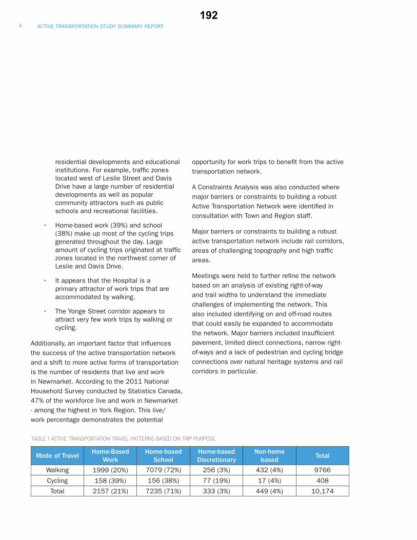
ACTIVE TRANSPORTATION STUDY SUMMARY REPORT 4
residential developments and educational institutions. For example, traffi c zones located west of Leslie Street and Davis Drive have a large number of residential developments as well as popular community attractors such as public schools and recreational facilities.
• Home-based work (39%) and school (38%) make up most of the cycling trips generated throughout the day. Large amount of cycling trips originated at traffi c zones located in the northwest corner of Leslie and Davis Drive.
• It appears that the Hospital is a primary attractor of work trips that are accommodated by walking.
• The Yonge Street corridor appears to attract very few work trips by walking or cycling.
Additionally, an important factor that infl uences the success of the active transportation network and a shift to more active forms of transportation is the number of residents that live and work in Newmarket. According to the 2011 National Household Survey conducted by Statistics Canada, 47% of the workforce live and work in Newmarket - among the highest in York Region. This live/work percentage demonstrates the potential
opportunity for work trips to benefi t from the active transportation network.
A Constraints Analysis was also conducted where major barriers or constraints to building a robust Active Transportation Network were identifi ed in consultation with Town and Region staff.
Major barriers or constraints to building a robust active transportation network include rail corridors, areas of challenging topography and high traffi c areas.
Meetings were held to further refi ne the network based on an analysis of existing right-of-way and trail widths to understand the immediate challenges of implementing the network. This also included identifying on and off-road routes that could easily be expanded to accommodate the network. Major barriers included insuffi cient pavement, limited direct connections, narrow right-of-ways and a lack of pedestrian and cycling bridge connections over natural heritage systems and rail corridors in particular.
Mode of TravelHome-Based
WorkHome-based
SchoolHome-based Discretionary
Non-home based
Total
Walking 1999 (20%) 7079 (72%) 256 (3%) 432 (4%) 9766
Cycling 158 (39%) 156 (38%) 77 (19%) 17 (4%) 408
Total 2157 (21%) 7235 (71%) 333 (3%) 449 (4%) 10,174
TABLE 1 ACTIVE TRANSPORTATION TRAVEL PATTERNS BASED ON TRIP PURPOSE
192

_̂
_̂
_̂
_̂
_̂̂_
_̂
_̂
Æc
_̂
®v
Æa
_̂
åÙ
åÙ
åÙ
åÙ
å
åÙ
åÙ
åÙ
åÙ
åÙ
åÙ
åÙ
åÙ
åÙ
åÙ
å
å
åÙ
å
åÙ
åÙ
åÙ
åÙ
åÙ
åÙ
åÙ
åÙ
å
åÙ
å
åÙ
åÙ
åÙ
!!!!!
!
!
! !! ! !! ! !
!
!!!!!!!!!!!
!! !!!!!
!!!!!!!
!!
!!!!!!!
!!!!!
!!!!!!!
!!!
!!! !!! !!!!!!!!!!!!!!
!!!!!!
!!!!!!
!!
!!!!
!!!!!
!!
! !!
!! !!!
!!!!!!
!!!!! !
!!!!!!
!!!
!
!!!
!
!!!!!!!!
4
4444444444444
4
44
44 4
444 4
44
44444
44
444
44444
4
44
44
444
4 44 4
444
444444444444
444444
44 4
4
44444
4444444
4444
444444444
4444
4444
4 4 4444
4444
4
44
4 4
444 4444 4 4
44
44444
444
44444
4 444
444
4
444444444444
44 444
4
4444444
4
44
4
4
44
!!!!!!!!
!!!!
!!!!!!!!!!
!!!!!
!!!!!!!!
!!!!
!!!!!!
!!!
!!!!!!!!
!!!!
!! !!!!! !
!!!!!!!!!!
!! ! !!!!!!!!!!!!!
!!!!!!!!!!!!!!!!!!!!!
!!!!!!
!!!!!
!!!!!!!
!!!!
!!!!!!!
!!!!!!!!!
!!!!!!!!!!!!!!!!!!!!!!!!
!!!!!!!!!!
!!!!!
!!!!!!
!!!!!!
!!
!!!!!!!!!!!
!!!!!!!!!
!!!
!!!!!!!!!!!
!!!!!!
!! !!
!
!!!!!!!!!!!
!!!!
!!!!!!!!!!!!!!!!!!
! ! !!!
!!!!!!!!!!!!!!!
!!!!!!
!!!!!!!!!!!!!!!
!!! ! !!!!!
! !
!!!!!!
!!!!!!!
!!!!!!!!
!!!!
!!!!!!!!!!!!
!!!!!!
! !!!!!
!!!!!!!
!!!!!!!!!!!!!!!!
!!!!!!!
!!!!!!!!!!!!
!!!!
!!
!
!!!!!!!!
!!!!!
!!!
!!!!!!!!!
!!!
!!
!!!!!!!!!!!!!!!!!!!!!
!!!!!!!!!!!!
!!!!!!!!
!!!!!
!!!!!! !
!!!!!!!!!!!!
!!!!!!!!!!!!!!!
!!
!!
!
!!!!!!!!!!!
! !! !!!
!!!!!!!!
!!!!!!!!!!!!!!!!!!
!!!!!!
!!!!
!!!!
!!!!!!
!!
!!!!!
!!!
!
!!!
!!!!
!!!!!!!!!!!!!!!!
!!!!
!!!!!!!
!!!!!!!!!!!!!!!!
!!!!!!!
!!!!!!
!!!!
!!!!!!!!!!!!!!!!!
!!!!!!
!!!!
!
!!!!!!!!!!!!!!!!!!!!!!!
!!!!!!!!!
! !! !!!!!
!!!!!!
!!!!!!!
!!!!
! !!!!
!!!!!!!!!!
!!
!!
!
!!!!!!
!!!
!!!!!!!
!!!!!!!!!!!!!!!!!!!!!!!!!!!!
!!!!!!!!!
!! !!!!!!! !!!!!!!!!!!!!!
!!!!!!!!!!!!!!!!!
!!!!!
!!!!!
!!!!!!!!
!
!!!!!!!!!
!!
!!!!!
!!!!!!!!!!!!
!!!!!!!!
!!
!!!
!!!!!!
!!
!!!!!!!!!!!!!!
!!!!!!
!!!!!!!
!!!!
!!!!!!!
!!
!!!
!!!!!!!!!!!!!!!!!!
!!!!!!!
!
!!
!!!!!
!!!!!!!!!!!!!!!!!!!!!!!!!!!!!!!!!!!!!!!!
!!!
!!!
!!!!!!!!!!!!
!!!!!!!
!!!!!!!!!!
!!!!!!!
!!!!!!!
!!!!!
!!!!!
!!!!!!!!!!!!!!!!!!!!!!
!!!!!!!!!!!!!!!!!!!!!!!
!!!!
!!!!!!!!
!!!!!!!!!! !!
!!!!
!!!
!!!!!
!!!!!!!!!!!!!!!!!!!
!!
!!!!!!
!!!!!!
!!!!!!!
!!!!!!!!!!
!!!!!!!
!!!!!
!!!
!!!!
!!!!!!
!!!!!!
! !
!!
!!!!!!!!!!!!
!!!!
!!!!!!!!!
!!!!
!!!!!!!
!!!!
!!!!!!!
!!!
!!!
!!!!!!!!!!
!!!
!!!!!!!
!!!!!!!!!!!!
!!!!!!!!
!!!!!!!!!!!!!!!!!!!!!!!!!!!!!
!!!!!!!!!!!
!!!!!!
!!!!!!!
!!!!!!!!!!!!!!
!!!!!!!!!!!
!!!!!!!!
!!!!!!!!
!!!
!!!!!!!!!!!!!!!!!!!!!!!!!!!!!!!!!
!!!!!!!!!
!!!!!
!!!!!!
!!
!!!!!!!!!!!!!
!!
!!!!
!!!!!
!!
!
!!!!!!!!! ! ! !!!!!!
!!!
!!!!!!
!!!!!!!!!!!!!!!!!!!!!!!!
!!!!!!
!!!!!
!!!!!!!!!!!!!!!
!!!!!!!
!!!!
!!!!!!!!!!!!! !! !!!!!!!!!!
!!!!
!!!!!!!!!!!!!
!!!!!!
!!!
!!!!!
!!!!!!
!!!!
!!!!!!!!!!!!!!
!!
!!!!!!!
!!!!!!!!!!!
!!!!!
!!!!!!!!!!!! !!!!!!!!!!!!!!!!!!!!!
!!!!
!!!!!!!!!!!!!!!!!!!!!!!!!!!
!!!!!!!!!!!!
!!!
!!!!!!!!!
!!!!!!
!!!!!!!!
!!!!!!
!!!!!!!!!!!!!!!
!! !! !!!
!!!!!
!!!!!!!
!!!!!!!!!!
!!! ! !!!!!!!!!!!!!!!!!!!!
!!!!!
!!!!!!!!!!
!!!!!!!!!!!!
!!
!!!!!
!!!!!!
!!!!!!!
!
!!!!!!
!!!!!!!!!!!!!
!!!
!!!!!!!!!
!!!!!
!!!
!!!!
!!!!!!!!!!!!!!!!!!!!!!!!!!!!!!!!
!!!!!!
!!
!!!!!
!!!!!!!!!!
!!!
!!!! ! !
!
!!!!!!!!!!!!!!!!!
!!!!!!!!!!
!!!!!!!!!
!!!!!!!!!!
!!!!!!!!
!!!!!!!!
!!! !!
!! !!!!!
!!!!!
!!
!!!!!!
!!!!
!!!!! !! !!
!
!!!!!!!!!!!!!!!!!!!!!!
!!!
!!!!!
!!!!!!
!!!!!!!!!
!!!!!
!!!!!
!
!!!! ! !! !!!!
!!!!
!!! !!!
!!!!!!!!!!!
!!!!!!
!!!!!!!!
!!
!!!
!!!!
!!!!!!
!!!!!!!!!!
!!!!
! ! !!!!! ! !
!
!!!!!!!!!!!
!!!
!!!!!!!!!
!!!!!
!!!!
!!!!!!
!!!!
!!!!!!
!!!!!!!!!!
!!!!!!!!!!!!!
!!!
!!!!!!! ! !!!!
!!!
!
!!!!!!!
!!!!!
!!!!!!!
!!!!!
!!!!!!!
!!!!!!!!!!!!!!!!!!!!!
!!!!
!!!!!!!!!
!!!!!!!!!!!!!!!!
!!!
!!!
!!!!!
!!!!!!
!!
!!!!!!!!!!!!!!!
!!!!!!!!!!!!!!!!!!!!!!!!!!
!!!!!
!
!!!!!!!!!!
!!!
!!!!!!!!!!
!!!!
!
!
!!!
!
!!
!!!!!!!!!!!!!!!!!!!!!!!!!
!!!!!!!!!!
!!!!!!!!
!!!!!!!!!!!!!!!!!!
! !!!
!!!
!!!
!!!!!!!!!!
!!!!!!!!! !!!!!!
!!!!!!!
!!
!!
!!!!!!!!!!!!!!!!!!!
!!!
!
!!!!!!!!!!!!!!!!!!!!!!!!!!!!!!!!!!!!!!!!!!!
!!!!!!!!
!!!!!!!!!!!!!!!!!!!!!!
!!!!!!
!!!!!
!!!!!
!!!
!!!!!!!!!!!!!
!!!!!!!!!!!!
!!!!!!!!!
!!!!!
!!!!
!!
!!!!!!!!!!!!!!!!!!!!!!!!!!!!!!
!
!!! !!
!!!!!!!!
!!!!!!!!!!!!!!!
!!!!
!!!!!!!!
!!!
!!!!!!!!!!!
!!!!!!!!!!!!
!!!!!
!!!
!!!
!!!!
!!!!!!!!
!!!
!!!!!!!!!!!!!!!!!
!!!!!!!!!!!!!!
!!!!!!!!!!!
!!!!!!!!!!!!!!!!!!!!!!!!!!!!!!!!!
!!!!!!!!
!!!!!!!!
!!!!!!!!
!!!!!
!!!!!!!!!!
!
!
!!!!!!!!!!!
!!!!!!!!
!
!!!
!!!!!
!
!
!!!!!!
!
!!!!!!!!!!!!!!!!!!!!
!!!!!!!
!!!!
!
!!!!!!
!
!!!!!
!!!!!!!!!
!!!!!!!
!!!!
!!!!!!!
!!!!!!!!!!!!!!!!!!!!!!!!!!!!!!!
!!!!!!!!!!!!!!!!!!!! !!!!!!!
!!!!
!!!!!!
!
!
!!!!!!!!!!!!!
!!!!!!!
!!!!!!
!
!
!!!!!!!!!!!!
!!!
!!!!
!
!
!!!!!!!!!
!!!!!
!!!
!!
!
!!!
!!!
!!!!!
!!!!!!!!!!
!!!!!
!!!!!!!!!!!!!
!!!!
!!!!!
!!!!!!!!!!!!!!!!!
!!! !
!!!!!
!!!!!!!!!!!
!
!
!!!!!!!
!!!!!!!!!!!!!!
! !
!
!!!!
!!
!!!!
!!!!!
!!
!
!!!
!
!
!!
!
!!
! !!
!
!!!
!!
!!!!!
!!!!!!!
!!!!!!!!!!!
!!!!!!
!!!!!!!!!!!
!!
!!!!!
!!
!
!!!!!!!!!!!!!!!!!!
!!
!!
!!!!!!!
!!!!!!!!!!!!!!!!!!!!!!!!!!!!!!!!!!!!!!
!!!!!
!!!!!!!!!!!!!
!!!!
!!!!!!!!!!!!!!!!!!!!!!
!!!!!!!!!!!!!!
!!!!!!!!!!!!!!!!
!!!!!!!!!!!!!!!!!!!
!
!
!!!!!
!!!!!!
!!!!!!!!
!!
!!!
!!!!
!
!
!!
!!!
!!!!!!!!!!!!!
!!!!!!!
!!!
!!!
! !
!!
!!!
!!!!!!!!
!!!!
!!!!!!
!
!
!!!!!!!!
!
!!!!!!!!!!
!!
!!!!!!!!!
!!!!!!!!!!!
!!!
!!
!!!!!!!!!
!!
!!!!!
!! !!
!!!!!!!
!!!
!!!!!!!!!!!
!!!!
!!!!!!!!!!
!!!!!
!!!!!!!!!!!!!!
!!!!!!!!!!!!!!!!!!!!
!!!!
!!!
!!!!!!!!!!!!!!!!!!!!!!!
!!!
!!!!!!!
!!!
!
!
!
!!!!!!!!!
!!!!!!!!!!
!!
!!!!!!!!!!
!!!!!!!!!!!!!!!!!!!!
!!!!!!!!!!!!!
!! !!
!!
!!!!!!!
!! !
!!
!!!!!!!!!!
! !!
!
#
#
#
#
##
#
#
#
#
#
#
#
#
#
#
#
#
#
#
#
#
#
#
#
#
#
#
ALLAN AVE
CH
UR
CH
ST WATER ST
PAR
KSID
E D
R
LOR
NE
AVE
MA
IN ST S
WAYNE DR
SYKES RD
BRIM
SON
DR
MEMORIAL CIR
SYDO
R CR
T
WARATAH AVE
SAN
DFO
RD
ST
KEITH AVE
PARK AVE
PATT
ERSON ST
KINGSM
ERE AVE
LONDON RD
PRO
SPEC
T ST
MILLARD AVE W
EAGLE ST
CAR
RU
THE
RS
AVE
FOXC
ROFT
BLV
D
ALEXAN
DE
R R
D
BRISTOL RD
IVSBRIDGE BLVD
LESLIE VALLEY DR
QUEEN ST
BONSHAW AVE
ASPENWOOD DR
SAVAGE RD
CLEARMEADOW BLVD
LOCKWOOD CIR
STELLAR DR
FER
NBA
NK
RD
DAWSON MANOR BLVD
EAGLE ST W
LONG
FORD DR
VETERANS WAY
ELGIN ST
HAR
RY
WAL
KER
PKW
Y S
SILKEN LAUMANN DR
HU
RO
NH
E IG
HTS
DR
BAYV
IEW
AV
E
POPPYLANE
MCCAFFREY RD
WOODSPRING AVE
CROSSLAND GATE
RINGWELL DR
MAIN ST N
GORHAM ST
ART
WES
T AV
E
MILLARD AVE
FOR
DW
ILSON
BLVD
LESL
IE S
T
STONEHAVEN AVE
YON
GE
ST
HAR
RIS
ON
DR
MULOCK DR
CANE PKWY
ALEX DONERDR
HAR
RY
WAL
KER
PK
WY
BAYV
IEW
PKW
Y
DAVIS DR
CAR
LSO
N D
R
SRIGLEY ST
HIG
HW
AY 4
04
BATH
UR
ST S
T
Town of Aurora
Town of East Gwillimbury
Tow
n of
Whi
tchu
rch-
Stou
ffvill
e
_̂
_̂
_̂_̂ _̂
_̂
_̂
_̂
_̂
o
Æa
0 1 20.5Km
Designed & Produced by Information Technology – GIS Printed: December 2013. Sources: Roads - Geomatics Division, Planning and Development Services Department © The Regional Municipality of York, 2013. All other layers - Town of Newmarket. DISCLAIMER: This document is provided by the Town of Newmarket for your personal, non-commercial use. The information depicted on this map has been compiled from various sources. While every effort has been made to accurately depict the information, data/mapping errors may exist. This map has been produced for illustrative purposes only. It is not a substitute for a legal survey.
Town of Newmarket - Active Transportation Existing Conditions & Plans
Tow
nshi
p of
Kin
g
23
71
63
24
62
24
6
16
28
60
920
59
22
21
81
74
53
1119
42
44
3135
46
48
83
50
56
68
2
1070
40
49
45
7
1
61
7757
79
51
27
34
33 29
36
32 3830
13
8
22
25
17
14
75
78
73
5
15
3
72
76
52
41
43
18
82
69
65 37
55
54
6426
58
62
39
80
47
67
12
LegendExisting Network
Existing Trails
Esisting On-Street Bike Lanes
Town of Newmarket Official Plan!!!!!!
Future On-Street Biking
Future Regional Road Bike Lanes!!!!!! Conceptual Trail System
Multi-Use Trails
Primary Trails
Secondary Trails
Proposed Bike Lanes
Proposed Multi-Use Trail
York Region Cycling Network
!!! Proposed Greenbelt Cycling Route
!!! Proposed Lake to Lake Cycling Route
Railway
Waterbody
Highway
Roads
Parks
Intensification Corridor
Regional Cycling Network
Æc
®v
nm
_̂
n
Æa GO Station
Newmarket Public Library
Southlake Regional Health Centre
Arenas, Pools, and Community Centres
Elementary School
Secondary School
_̂ Major Shopping Centre
Potential connection to other Municipalities
Peggy's Wood and Bathurst Area Forest Master Plan
Parks Policy Development Manual
Greenbelt Cycling Route
Lake to Lake Cycling Route
Passive Green Space
1 Bailey Ecological Park2 Bayview Avenue Open Space3 Bayview Parkway Open Space4 Coventry Hill Trail Open Space5 Denne Bush6 Elgin Street Open Space7 Foxtail Ridge Rear8 Gorham Street Open Space9 Irwin Crescent Walkway
10 Kinara Court Open Space11 Lawton Bros Parkette12 Leslie Valley Drive Open Space13 Lewis Drive Open Space14 Lorne Avenue Open Space15 Mabel Davis Conservation Area16 Magnolia Open Space17 Niagara Street Open Space18 Northwest Quadrant Woodlot19 Premier Place Open Space20 Red Deer Street Open Space21 Roxborough Road Open Space22 Srigley Street Open Space23 St Elizabeth Seton School Open Space24 Waratah Open Space25 Wellington Street Open Space26 William Thomas Mulock Park
Town Park
27 Fairy Lake (Wesley Brooks Conservation Area)28 George Richardson Park29 Gorman Outdoor Pool30 Haskett Park31 Heritage Farm & Community Garden32 Keith Davis Tennis Centre33 Lawn Bowling Club34 Lions Park35 Magna Centre36 Newmarket Riverwalk Commons37 Ray Twinney Recreation Complex
Community Park
38 All Our Kids Playpark39 Armstrong Park40 Art Ferguson Park41 Bonshaw Avenue Park42 College Manor Park43 Environmental Park44 Fairgrounds Park45 Paul Semple Park46 Rene Bray Park47 Whipper Billy Watson Park
Neighbourhood Park
48 Arnhem Park (Legresley Park)49 Audrie Sanderson Park50 Best Family Parkette51 Beswick Park52 Cardinal Parkette53 Charles Boyd Park54 Clare Salisbury Park55 Clearmeadow Park56 Comfort Lane Park57 Dennis Park58 Dr Margaret Arkinstall Park59 Drew Doak Park60 Evanslea Park61 Foxtail Ridge Parkette62 Howard Park (Philmore Hamilton Park)63 Jacarandah Park64 Jim Bond Park65 Joe Persechini Park66 John Georgas Park (Allan Avenue Park)67 Keffer Parkette68 Ken Sturgeon Park69 Kirby Crescent Park70 Laurelwood Parkette71 Leslie Valley Park72 M H Stiles Park73 Marilyn Powell Park74 Marsh Park (Found Park)75 Newmarket Heights Community Parkette76 Proctor Park77 Quaker Hill Park78 Rogers Park79 Sanford Parkette80 Seneca Cook Parkette81 Sunnyhill Park82 Toth Park83 Willowick Park
Woodland Hills Labyrinth Park
v
n
n
a
c
^
^
FIGURE 1:
Town of Newmarket - Active Transportation Existing Conditions and Plans
Existing Network
Existing Trails
Existing On-Street Bike Lanes
Town of Newmarket Official Plan
Future On-Street Biking
Future Regional Road Bike Lanes
Conceptual Trail System
Parks Policy Development Manual
Multi-Use Trails
Primary Trails
Secondary Trails
Proposed Bike Lanes
Peggy’s Wood and Bathurst Area Forest Master Plan
Proposed Multi-Use Trail
Regional Cycling Network
York Region Cycling Network
Greenbelt Cycling Route
Proposed Greenbelt Cycling Route
Lake to Lake Cycling Route
Proposed Lake to Lake Cycling Route
Potential Connections to other Municipalities
Railway
Waterway
Highway
Roads
Parks
Urban Centres Secondary Plan Area
GO Station
Newmarket Public Library
Southlake Regional Healthcare Centre
Arenas, Pools and Community Centres
Major Shopping Centre
Elementary School
Secondary School
Passive Green Space
1 Bailey Ecological Park
2 Bayview Avenue Open Space
3 Bayview Parkway Open Space
4 Coventry Hill Trail Open Space
5 Denne Bush
6 Elgin Street Open Space
7 Foxtail Ridge Rear
8 Gorham Street Open Space
9 Irwin Crescent Walkway
10 Kinara Court Open Space
11 Lawton Bros Parkette
12 Leslie Valley Drive Open Space
13 Lewis Drive Open Space
14 Lorne Avenue Open Space
15 Mabel Davis Conservation Area
16 Magnolia Open Space
17 Niagara Street Open Space
18 Northwest Quadrant Woodlot
19 Premier Place Open Space
20 Red Deer Street Open Space
21 Roxborough Road Open Space
22 Srigley Street Open Space
23 St Elizabeth Seton School Open Space
24 Waratah Open Space
25 Wellington Street Open Space
26 William Thomas Mulock Park
Town Park
27 Fairy Lake (Wesley Brooks Conservation Area)
28 George Richardson Park
29 Gorman Outdoor Pool
30 Haskett Park
31 Heritage Farm & Community Garden
32 Keith Davis Tennis Centre
33 Lawn Bowling Club
34 Lions Park
35 Magna Centre
36 Newmarket Riverwalk Commons
37 Ray Twinney Recreation Complex
Community Park
38 All Our Kids Playpark
39 Armstrong Park
40 Art Ferguson Park
41 Bonshaw Avenue Park
42 College Manor Park
43 Environmental Park
44 Fairgrounds Park
45 Paul Semple Park
46 Rene Bray Park
47 Whipper Billy Watson Park
Neighbourhood Park
48 Arnhem Park (Legresley Park)
49 Audrie Sanderson Park
50 Best Family Parkette
51 Beswick Park
52 Cardinal Parkette
53 Charles Boyd Park
54 Clare Salisbury Park
55 Clearmeadow Park
56 Comfort Lane Park
57 Dennis Park
58 Dr Margaret Arkinstall Park
59 Drew Doak Park
60 Evanslea Park
61 Foxtail Ridge Parkette
62 Howard Park (Philmore Hamilton Park)
63 Jacarandah Park
64 Jim Bond Park
65 Joe Persechini Park
66 John Georgas Park (Allan Avenue Park)
67 Keffer Parkette
68 Ken Sturgeon Park
69 Kirby Crescent Park
70 Laurelwood Parkette
71 Leslie Valley Park
72 M H Stiles Park
73 Marilyn Powell Park
74 Marsh Park (Found Park)
75 Newmarket Heights Community Parkette
76 Proctor Park
77 Quaker Hill Park
78 Rogers Park
79 Sanford Parkette
80 Seneca Cook Parkette
81 Sunnyhill Park
82 Woodland Hills Labyrinth Park
83 Willowick Park
5FEBRUARY 2014193

FIGURE 2:
Key Origins and Destinations
6FEBRUARY 2014
Mulock DriveMuMM iulockk DriMu
Davis DriveDav evis DrriveD
slie
Stre
etLe
slet
e St
ree
Lesl
L
Hig
hway
40404
ay40
wa
Hig
hwa
Yong
e St
reetetee
Stre
eng
eS
nge
SYo
nYo
nYoooYoYYY
Bath
urst
Stre
etBa
thur
sSSt
reet
Stre
etSt
reet
m S etreeettrSmahrhorGoGG
Bristol RoadBr aoRRool Rol RristristBr
Davis Drive WestDDaDD
Bayv
iew
Ave
nue
view
Ave
Baeen
uen
uie
w A
vAvw
AAAvi
ewBa
yB
ue
Eagle Streetgle etree SEa
London RoaL ddaRoan RoaondondonL
Srigley StreetteettreSteygleSr
Elgin Streetn tetreeStrSginElgE
ard A eeeund A eAvd AillaMiM
AvenueeeueuvenA enk Aveark vePaP
oneha en Avenu
StStonSaveha
Aven Aue
haveeha
Avenn Av ue
e Av
enue
ene
nuvevAv
nernorLoL
Bayview P
Bayview Parkw
ay
Parkway
w Pa
Bayview P
B
Woo
dspr
ing
Aven
ueg
ueng
eeununenveAvAvAinriprsp
odooW
oWWW
San
dfor
d S
treett
See
tee
tS
trS
trdrdd
dfo
dfo
dfo
and
and
and
SS
Peee
tetre
Stre
Stt St
tctecpespsposp
ros
Pro
PrSt
reet
Exit 49
Leslie Valley DriveevrivDrDy DyeylealVaVe VesleslLe
G eteetreSte S tceacGra
Patte
rson
Stre
nSt
reteteeetretre
n S
nS
Patte
rson
mothy SShy ttS eteereeStr etS emoT hyTiTT mothmothTi
d Gand
te
osssslaslaslanndGaGatGate
ate
Cros
arD
reveriv
Dnon
rlso
Ca
C
McCaffrey Roadc ddaoaRoRy ReyyaffreaffreCMMcM
learmeadow Boulevardevardlele ulem arduouoBoBBwwwowododadaeaeemmraraeaCCC
euenuneveAvAnnnenePP
eAv adaoaRoRueenuveA
ain
tS
tS
ainin
MMa
Nor
thhhrth orN
oNt N et ee tre
St
SStr
Wayne Driveayne DWWa DrivDyn veD i
Cane Parkwayayyaywaw
Cane Parkwa
Ringwell DriveDrivwellRingwR
Vivian RoadVivian Road
xand
er RR
oR
oer
and
and
exexAlA
oad
Eagl
e St
reet
Wes
tes
tSt
reEa
gle
Ea
Wes
tW
eSt
reSt
agle
agl
Ere
et W
mill Valley Drivell Va eD iDDDDlll rivl DrDDyyeyellalVamill VSawmwSSaSawmmmill
w Sw S teteereA d trStA ewrew SdrAndAAA
Old
Bat
hurs
t Stre
etth
urs
Fox
BoF
rdard
var
uleev
ale
vouB
ft B
oft
rocrox
c
Dix
on B
drd ava ev le ul ouoB
on B
onB
Dix
Dix
Di
D
War
atah
Ave
nue
Ave
eeen
uen
uAv
eah
ata
raarW
aW
a
Bonshaw Avenueawshan awshonsB awshonsBo shonsBoBo
Sava
ge R
oaddadoa
Ro
Re
Rag
eagvaavSS
inS
n SMM
aM
aith
Streeeet SSoouoututhh
Mar
ble
Plac
ee
PeceacalaPlP
leeblrb
tetreeStre SteettneanJaJ
IvsbridgedrdardvaevleulouBoe BidgsbriI idgsbriIv
m Roe Bo drdraB vaB vB eleulouoBoBBeRoeoRom RoaiallilWWW
Geo
rge
Stre
etetre
eeo
rge
StG
et H
arris
on D
vevevriiD
rD
n D
nDD
sososorr
isrr
isrr
isH
aHHHHH
s La
neeneneanLaLs's
Mynden Way
Mn W
ynday
M
yayWaayWa
MyWayWWaWWa
nen Wdndnde
ynyndMynMMyMyMMyMyMM
Longford Driverf id veD id vivDrf DdrdL orL ofogfgngnonoLoLL
Sparrow Roadapa dadoaoRoRwwowrorrSpSS
Keith A nueueAvevenenuue
Aspenwood DriveriveDsp riveDrDrdodooowowwnnepepAsAA
NewewNewwpark BoulevardBoulevardw
Alex Doner DrivevevrivDrDenonDoDx DxexAleAA
Ontaat eetrio StreeeetratntnO
eteereSt
rS
kS
kakaO
aO
Ro
rdad
owR
oad
Rar
wa
owH
oH
d
dadoaRoRramaemLeL
arandah everivDrDDhdahcaac aharanJac ndaJ araCoa
chw
hip
Trai
lhihii
pililail
Tra
Tra
TrTTTpp
Tpp
wwhhh
wh
hwwchh
Belfr
y D
rive
fryverive
Dr
y D
elfr
BeB
StreetS eettreeetdrd reford StrtsfotBoBB
Burfo
rd S
treeetetet
reSt
rS
d S
for
for
fBu
rf
Kingdale Roadoadale RoKingdaK
Austinpaul Driveapa eevevivrDrDDuluaupnntitssuAuAAA
Carlissa Runununsa RRa Rsa Rusa R
lisrlissCarliss
arliarliCCCCa
Hur
on H
eigh
ts D
rive
on H
eigh
ts D
rive
Hur
oHH
u
Gagnon Placeno acePlaaceon PlangagGaGG
enttd C ttece tscesreCrCdolnonArnAA
Niagara Street
gaag
Nia
StNNN
iagaN
iagaraS
ra SStrtretrreetet
Cotte
r Stre
et
Cotte
r Stre
etet
Cotte
r Stre
et
Cot e
r Sre
et
Kingsmere Avenu
KKi gsme
Kingingsngsmme
Avenue
smerre A
Col
lege
Man
or D
rivee
Driv
Drivri
r Dr Dr Dan
oan
oan
Ma
Ma
Meg
eeg
eeg
eol
leol
leol
leg
CCC
eeeettree
ch StreC
hurcC
hhh
StStretreeth Str
Streett
dadadoaoaR
oR
oRRRR
nto
nto
nht
Ash
Ash
AA
Roxxx
bR
oR
oR
roug
h R
oad
bor
adadR
oh
Ro
ghugoubo
rxbbbxb
a'ss AvenueRita's'a
Rushbroo eevevrivrDrDDkkokooo
Brooker Ridgeero gedgRiRrekeokooBrBB
rry D
riveeeveivriv
Dr
DDyryrry
Ter
ercc
lecC
irCCtsteseBeB
ene anW
LaLwwowlo il
WW
Coventry Hill Trail
ov tryailTrall THilly Hentroven
n Bo
ulev
ard
leS
rdraraavaveveveul
euuouooBoB
ahan
naSh
nananahahahShSS
Kingston RoadKK adaoaRonontostngKin
TercwerweowTowTorcrest
veiveriveDrivDr
st Dst Drcrecresrc
n Seteet
eet
reeStre
Main
d Mai
Old M
OO
How
lett
AvH
eueunu en ve AvAvle
t etw
low
HH
r eveivriDDerveivtiSS
Devanjan C
irclvavan
DDe
anjaanjanja
Cn
Cn CC
ircC
ircleleee
eveivrivD
rD
sssisviavraTrT
meve
Driv
Donto
milt
Ham
H
arvest Hills HaH ardevaouleBoHillsst HvesH
eveeue nu en
Av AA
irchwood DriveriveDrDrriveodoodwohwoodhwoc wohwchchrcBirBB
Liverpool R
oad
viver
L
ddadoad
Roadl R
oRoa
poolpool
erpooerpo
verp
LL
etu
tur
iel S
tree
Mu
Simcoe StreetStreeSSimcoe S t
nDr
veiveDr
iveDr
ivonson
mso
mso
ims
Brim
Bri
Br
aumann Drivenn
ve
a
Driann
manmann Dmaaumaua
DrivDrivnn Driveeveve
auma
Silken Laa
BB eeeueununneneevevevAvAvAAAAididdnddnnonooBoBoBB ndi Ave
ockw
ood
clee
rcC
irC
woo
dw
ood
ckw
ock
wLoLoL
AveAv euenuen
ead
Driv
eveW
ilste
add D
McBean AvenA enn en eeueuenAvAnanaaeaeBeBBcBccMM
chrac
DrDriv
achdrac
hadrach Dh DrDriveriveivee
Shad
esD
oet eere
St
Sr S er est
he ch rc or oD
o
Glo
ver L
aneee
aLaLr eve ov loG
l
Beman Drivei evevDrivDDnnanama
Dou
blet
ree
Lane
blLa
ne
neneLa
nree
eetreteebubuouoo
Alfred Smith WayWWWW yh yth aWait WWS WS hS thd itdd mmSmSfAlf SdA dA edrefrAlfAA
rdLLo
ddarvaevlelulouBoBBB
e B
ew
eowowLL
Rannie Road
RanRanRanannannianninniennienienie R
Walter Avenue
Wer Ar AvAve
W
Av
WWWalt
Wa teer
Walter AAAalte
Ater Avter Aver A
eAveAvenvenenuenuenueeue
Comfort LaneLant LLaneortfo nef Lat LrtorfomfomoCo
Hodgson DrH eevevriDrDDnonososgsgdgdoHoHH
Don Mor DriveevriDMn Moron MoDoD
Amelia Streeteetrea Strelia SeliaAmeliaAAAm
Sidero
19th Sadd
Sideroad
th Sth Sidero d
Colum
bus Way
Way
WWWWWWummm
bbuusWW
sW
sW
sW W
dod rivDrD ve D veoowowdwldWilWW
Foxtail RidgeeegdgdRidRRilaitaxtxoxFoFFFF
Otton Roadonon
adaddn Ron Roa
on RoRn RttoOttOO
Trl
airaTninriEEEEEEE
Knapton DriveK aptaptKnKKKn
rtrtt
h Courtourhh C rtourrth CrtrFi h CFF
d W
ilson
Fo
BBBBn
lso
lso
lW
iW
iW
iddddrdorrFooFoFF
ardddd
vaveleluuooon
Bo
d Deer Street
Red Dereeteet
Strer St eetreStrer Str SeereerDeerd Deded DeedRRRe
BtntencescesesreCrCdrdarlaallaBaB
Gl euenueenved Avd AGlG namadmadlaG
Royw
ood Crescenes
CRRR
oR
ooyywwwo
dCC
rrescceenntnt
Rut
ledg
e Av
enueueeeuenuenveAvAv
eA
egedgededtleutR
uRRRR
lpin
Deveverivri
Dr
DDnn
pin
ilpG
iG
ilpin
DG
ilp
Forsyth RoadRh RoR ddadaohytysyrsroFoFF
iveivSociety CrescentttntCC nC enC ecsct st esrerCCCytyetciociSSSS eieoSoSS
Lloyd Avenueoy nuneo vevAvAd AdydloLL
rcircCierfeff Cr C ecleefKeK
CCar
ruth
ers
Aven
uee
rsruu
teeue
envevAvAAs
Arserehehthurr
RRRerBeBeB dddi daoaRoRningirg
etteer StreeWaterateraterWaterWWW rr eeor
deuenuenveAv
eAvA
n A
enderde
BoBB
Salisbury LaneLa eneLyryurbusbslisalSaS
Crescenttra C
ttra C
ntC
cennsceCressceCres
ntraantQuuanQQuaQQuQ
Lyman Boulevardn Bm drdana arvaveuleouoBymLyLL
Traile TTTTrTrBe TeereB areaBeBBeB
veeveLewis DrivDrivis DrivwiewLeL vvv
Fern
bank
Roa
dFe
rnba
nkR
oad
Jordanray Boulevardddardddardllevarlevuouo levBoBBy ByayayraraanranrordanrJ rdorJooJoJ
eld A euenuneveAveldeeieeldfifiddddddWiWWWWWW
Ch
odes Circle
deoddedesdesess CCC
irC
ircrcle
oadoadad
Bexexhihil
BBeBexhill RoadRoaRoaR
areteteere
Str
StSar
ma
mm
mmamraBrB
mar
Stre
et
cle
ell
cee
rcl
Circ
erC
ir C
llexcExE
Norsan CourtttouCoC tnansarsorNo
Kirby Crescent
KiKirbKirbirby
rby Cby Cy Cry Cre
Cresresescescescencententnt
ttrturouoCoCCnnriuruSuSS
veeivD
rivD
k D
ckicw
iswesBeB
Luesby Lanean
LLuLueuesesbesbysby
Lanany
Laneee
Sykes RoadSyke dadoaRoaes Res R
Flan
aga
Fur
ttrtn
Fla
uouoC
oCCC
nanagagaganaFl
nanaF
Hedd ncsese ttnenecererCCCeeledlddddH ddHHH
Hollander RoaddRe RRoH Rol RHo r RerndHollanlla
LaW
DDeeneneanLa
nakk
LLLckkcckucuc
Du
Du
d DD
ddododooooooW
oW
oWWWWW
Poppy Laneoppyoppy Lanee
reStSadiaLydLyd eteee
Pearson StreetaP ton reetreetS reetn SarsoPea soarsPPe
Ro
NNNeesbsbbbibittittt R
tt Rtt R
oadoadddd
os eenanLaLeseromrmrimPrP
Millard Avenue AM d ArdarllaMilM Weste WAvenue
Malton
Roa
d
alto
dadoRoaRon Roon
Rlto
nalt
oMMaM
ad
SSSet ett ee re
Str
rt arw
aewte
SS
tC ntencecsesreCrelettlitL LelieelleNeN
Sunnypoint DriveriDrDSunnn veverivrivDtntninoiopopypynynunununS
Dover CrescentDo tcencentscres nCresrerD veDo
Jelley AvenJ
nueueeyy A nuley
eenJell Avy AelleJelele
B
Elman Cn C tntencecscesreCrn CElmEElmaE
Currey Crescentur tntenCuCuCu
Tega
l Pla
cecegaeg
eac
ePl
acPl
aal
Teg
TeT
Willo
wic
k D
rive
Wri
wvriv
Dr
wi
DDDDkkkckcic
wwowooloW
illlW
illW
illW
illW
Ma
Driv
ststereeveiverive
r Drierer Dteer D
hessteheest
chehesnchhe
anchchMancncnManMaMa
Pind
er A
venn
eeeeeeueuuuunun
Woo
dfer
n W
ayo
Woo
yyayayW
aW
aWWW
n W
nW
nnrnrnererfefedfdfododoooooW
oW
oWWWWWWW
Crowder Boulevardevwder BououlevBoBo
CBB
CBBBB
CBB
Crow rrow erowowwwwddewdddC
Glenway CircleC eeclrcirCyaywawnweneGleGG
dadoaRoR RsesneinaiHaH
MacIver Br Boule
ulevevard
ghla
nd B
lade
Ro
dad
ela
dadoa
e RR
oR
ode
Bla
Bdndan
hla
Hig
Hig
Hig
Hig
Burli
ng P
lace
BBceace
acPl
aPlPP
gngilinliur
lBuBB
D eueunenveAvAs AesealeDa
enen eeueunueveAvAAdadaeaeehhlaiaraTrTT ilh d A
ie A
ven
enu
enu
eAv
eAv
eA
e A
eAA
nni
nni
Den
aanEa
mtntencecescesre
Cr
Cn
Cm
atmstm
at
asasEE
Barth
olom
ew D
rive
mveveve
Dri
Dri
ear
tar
ttD
wwewm
emomolooohoth
art
art
BBBB
nuueueveAvenAn AnallaAA
te Circlee elercirC CategalgolHoH
lcleC clleC rcn Cirosols CN n CN nonsolselNeNN
illings CrescenttntnececseserCC CsgsgnginliilBiBB
cleray CircleBrray Circle
Malvern CrescenttnecescesreCrCnrnevealvaMM
New
bury
Driv
eN
wb
wb
wbb
wN
ewewNN
wi
eH
eHHH
Kwap
is B
oule
vard
Bdd
vavaevleuleluouBoBoBB
s BB
sisipiiapapw
awKwKwKKKKK
rteererlle uruouoCoCCCietieteeePePPP
Broughton Laneeu neanaLaLnontohtghgouroBrB
arks
ide
Driv
eP
aP
arks
ide
Driv
e
eth StA t tSt etSS eereuh StrthurA huArtA
Hilt B ddrdaravaveveleuluouoBoBnnonoHilttoHiltHilt
veverivD
rD
wweweevivlvllil
HHH
York
shire
Driv
eYo
rive
rive
Dr
Dereirihihishksk
hrkkorYo
Walpole CrescentnenceceCr escesccesessreCrere
centttcecenscsesreCrCCtotoblbalTaT
ayayWaayVeterans WayWaVete ns ayWannsanraer Way
ntencecscesreCrCr CersewswowoBBnhnohoJoJ
ate
GH
iteate
Gat
Ga
GGll
Gill
H
Fadine RoadFaF oRoadR dadoaReenenindidadFa
Pcee
nt
wsewsMeMrerlleuCuC s
Kensit Avenuenunsitens
eueenAvenKen AveAveitnsitKenKK
D'Arcy StreetD'Arc Street
Seet
Sttrre
teet
Pine S
Sheldon AvenueeAve ue
hheSSheheldeldeldoldo
vdon
venenn AvAvAveAvenue
vennuenen
rescentC eneceC scC sCrww CnnwinIrwIr
dRoe R addoateatiaartaetrececSeSe
Revell RRooaRlRe ellRR ellReRR oad
Stellick Avenuee
SSteSte
Ave
ellicellickick A
ick AAveenuAvenvenueenuee
Londry Court
ondry
LLonLondr
seph Streetse
Jep
JJoJoososephphhS
phSSSStrtreeet
eet
deline Heights
ne H
MMaMadMade
adeladelidelinelinelinene He HeHeig
Heigheighights
ghtshts
Heig
tence tscesre entCCaianionoroBorBoB
Gre
ig C
ircle
eig
Celecle
clrcircC
irC
g C
gigeig
rereG
reG
rG
rGGGG
reig
Ci
Buckingham Roaddha doaRoRm RmamaghnginBu kickBucuc
ickering CrescenPP ntntenececscsesereCrCCggngnrireekekcicPiP
Wes
ley
Stre
ettre
yet
eyre
etS
yS
yS
ley
lslel
esW
eWWWW
Her
ridge
Celelecle
clrcC
irciC
iC
egedgdrriier
He
HH
scentreCreT tCC enC teC cecscsh Ch CT CT sT msmmomohohTT t
Rou
rkkP
eekekrkrrurour
Rou
rR
ouR
ouR
oR
Pla
ceP
eeeeacaala
Pl
rke
P
Bob Scott CourtScottSS CoCott CoottococbobBoBo ourt
EE out rtCClhilthE urtoCCllhithstEasEa
Valley Green TrailTraTra lTrV
enenen
Pinnacle TraTrailTTe Tr
e T
PinnPin
cleT
aclennacle
PinPPinna
WW esns euenunenvevAvAt AotocoscinaiWa
riveronSSShSh nihonoonShoniker Driv
Fa h eleclrcCiCrthorNoNrar
Pam CrescenCrC tnenececscsesereCCmmmmaaPPP
ulmer Crescent
lmmmemererer Cr CCreCreCresresescscecentt
BulmBBBB
adk
RRo
Ndd
Roa
ckicw
icrwor
No
fer OOutl
ScSchSchachaehaeffaeffeeffer
fer Oer OOuutlotlooook
ookk
er Outloo
Ply
mou
th T
raillail
raTrThthutouo
mo
myP
lyPP
Ors
i Driv
eO
rsriv
eriv
eD
rD
siO
rs
CEnza Courtza Court
Robinson DriveDRo
eDosos rivns Drivein ve
bi Dob DRo nonoR sonsnbinR bobR
McIntyre CourtInt C rturouoCoereyrtyIntMM
Rose TrailRos
KTrT
Kile T
Kail
ar searl
Traose
rl RRRosil
Ro Te TRo eseseos Tra
ntview Plalaceviewewtvientv w Pw P
MouuunouMo ntMoMMount
Skin
ner A
venu
enuunn
ilv vrcr eeverivDrD DhchbibrbereveSiSS
Plea
sant
view
Ave
nue
enu
viw
APl
enAv
eAv
ew
Aewewievie
tvntv
ntanansaaassaaPl
eaellPPPe
Sup
erio
r Stre
etup
riorio erio
er epe uuSSS
Stre
Stre
rSr S
Dawson Manor Boulevardaw Boulevawson Manor
eth PPmmaraehethetPePe Place
Corcoran CourttCorcoran CouC
arden
ay Ga
FFaFairwFairwaFairway
wayway Gy GaGard
Gardeardedenenss
Fairway Gardens
Kelly
Cre
scen
ttttce
ncescesre
Cr
CCy
CylleKeK
yEmerson Way
Gi
Gibney C
rerescent
tree
Mar
y S
tree
treettteteeeet
tree
y
College StreetStg StreSege StreCollegeColle etCCCC
y Snow Boulevardd
y Sdevard
y SSnoward
owvaevleuleulou ard
Rayee
RaRayRRRR
Wildrush PlacelaPlaP cehsudrild cWWW
our
andBorBorland CoCo
d Cd Cndrlan
orlaBorlaBoB
urt
rruruouCoCs CsesveEvE rt
Courtrt
EllEllaa
CCCo
Co
Couurturt
McBride CrescenttntneeentneececsesereCCCdd rCCCeeded
Ard
en A
venu
eA
euenuneAv
eAvAAA
nenrd
erd
edAAA
Astor Drive
AstoAAssttoorr DD
iD
ivD
ririveiveve
Paxton CrescenttntcentscsesreCrCCnnonoxtx
Woodland Hills BoulevaardHill ulev
nd HoBou
odla Hillsnd Hodlaul ard
WoB
Sta
nley
Stre
et et ety
retrS
tS
ey leanan
SSS
Clancey CresceenteereCrCl cssseCCC
Man
ning
Cre
scen
tC
antnt
cein
scesreC
rC
gngnn
inn
iM
aM
aM
Chambers Crescent
bers
Chaaambambembebers
ers Crs Cs CrCre
Cresrescesceescescentntt
scsM lM ce ntenntecererCCCelM eM zezczcncneneMeMM
Hig
hlan
d Av
enuueue
enveAve
AvAdndanlahl
agh
Hi
Hi
Arm
itage
Driv
eiv
eiv
evee
DDDgegag
mita
mitait
Ar
Arm
Arm
e
Ballymore DrivvevealBaBaBBa D iDrivvD
Han
dley
Cre
scle
scen
tntnttencen
scesreC
reC
rC
y C
yeydl
edndan
Ha
Ha
H
Quake raTTrkerQuakQuuakQu ailail
elm
er A
venu
eueueve
ne
en ve AvArlm
elm
eH
eH
e
hern Prospect Cresctec tesceentessceentCreCt CpesposroPr PrnerheorthNoorthNo
ardinal Crescentessceesl Call CnadiCa d
Boothbay CrescentBBoBo ttenttsces entCreCy CaybabthotBB
On Bogart Circle
On BBogart Circlee
entntcescesreCrCCsrisDorDDo
Ren
zius
Couu
enRRR
urt
algain RoadddRoaain RalgaCaalgain Ro
Cou
rtou
rtJe
ff Sm
ith C
Smith
Cou
rt
tGreenfield Crescendee dldel CC enCCdld ensceCreen eiefienfenfGGGGrGrre nt
StreetStren S ton eteetS SonWellinllingtootogtnllinellinnWeWW ton
ush RoadRRuRRuRRu
Gra
nt B
light
Cre
scC
rnt
BG
race
ntre
sC
res
CCht
Cht hhglig
Blig
Bl
Bnt
BtBG
raGGGG
Weddel Court
We
We
Wed
Wedddddee
Weeddedde
Cddeldel Cel CCl CoCoCououourt
urtu
t
Laneeee
Tape
stry
La
T
am Dunn CrescentnWilliam Dunn CrescentW
PlPlononn
Pn PPPlaacacc
GastGGGG
oGast
Place
astasto
aceto
BrBBrurununntoonnPPlaacee
Col
erid
ge D
rivee
De
Did
ive
ive
DDDDDeeeeggdgddrirere
Co
Co
Co
CCC
W efi cePl cePP eececeacacPlaPlaPPddeldfiekefakeWaWWWak
Ho
Hop
e C
ircle
HHop
e C
ircle
ope
Circ
leWoodmWo
eaccePlaacP cntoun
dmoudmooododm
Wo
Hop
per
LaLaeeee
ane
ane
aLLLrrrererpeer
peppe
ppe
ppoH
opH
opH
oH
oH
Oaktree CrescentO Cee Cee C esererCCCCreeO k eeeeOak reOakO
evar
daw
ard
oule
Ca
oBB
ara hr thw
t
Sir Ivor Couurt
Sir Ivoour
SirCo
vor Cor CS
rt
Lum
sden
Driv
eeveveve
L
iD
riv
LuLuLuLu
accecece
Pla
PPelealaeaVeV
eman Streetman SS etnn Strean Strma StrHeeHe
otany Hill CrescCrotaBo cecenscesreCl CillHiHnnyt nyotaota ntentnn
rtford Crescente tcececscsesHart
Woodhaven CourCn ourCouCoCene urrt
ceVerno
eceacPlan Pon Planonrno la
ernVeV
DDo
Dann
eD
oak
LD
oD
o
urgeoner CrescentSu CresCrn nt
urgtntcenntcenCCC e cenCre ceer Cresene Cono r Ceo rerenenonogeourgurg
Robertso
RRRRob
Rob
Robbe
tsoertsoertsoon Placce
Raglan Street
Raglan
StrStr
Ra
Ragglaglaannn
Strn S
eeett
len
Stre
Ell
eet
eet
Stre
Stre
Sn
Sen
Sen
Ell
in S
treeeeet
Stre
Fran
kli
ereeetrettr
araC
eC
edar Strtre
itchard Placceacechard Plac
Prit
alla
ntin
e P
lac
aalTal
ace
Pla
cP
ein
ean
tian
tTa
lT
tR
Terry Carter Crescentce
ry Carter Cresceennntt
TerrTer
Bosw
orth
Cou
rtrturt
ourt
Cour
tC
hCo
h Co
hrthC
orth
wort
wor
swo
osw
Bos
BoBBBB
Per
rin A
ven
Peeuenue
Aven
Anrin
err
Pe
Pe
PPP
Ralston CrescentR nn Cr ceCCton ceresR Creton C ceresCnntonR sto
Vice Regent P celacePlact PntengeegReReVicViVVice
Pat
ti M
cCul
loch
Way
atti
atti
atti
Pa
Pa
Pa
L rt TTrt TerraceLimper ceceee
Exeter Courtou tr C rtourtr CEx tereteteExe r CterEx
wick CrescentCCCCkkkiwi ererCrCCCkkkccicwiarwWWWWWaaS
elby
Cre
sce
ttce
nntent
cent
cees
Cre
Cre
CS
Cy
Cy
Sel
bS
elb
S
uck's PlaceaceeacePP acePkk'k sc 'sc scuPu
Brandyyayaya
BB ndy Lndy Lane Way
FFFFbe
rto P
laceeeace
ace
oP
rtoerbelibFi
lib
hhrw
ood
Pla
cceceP
lac
Pla
cP
lodod
woo
woo
herw
herw
Shhh
Park C
ou
Pa
rtrturt
Court
Couk Coukk Cork
CParPaPPP
Gibsonn trtourCourtCourrtCCononGibsonGibsGibsGG
DDruery Coueryy Coururt
DrueD
der Couououer Cdeer CedoedRoeRRR rtrttt
Hig
hway
404
Exit 49
Exit 49
04ay
40w
Hig
hH
arry
Wa
Wal
Har
ry W
Hal
ker P
arkw
ayal
ker P
way
Park
wr
alk
Pony
Driv
eeD
rive
Pony
PH
arry
Wal
ker P
arkw
ay S
outh
way
Sou
ther
Par
kwar
ry W
alk
Ha
lSte la veDrivar Dll
arrdoulevaBoaleisdaKerrK
holsoNicNicho son Roaoad
Roadhouse RStackh
y DriveTwinney D
eeen
uean
Ave
haor
hF
eveve
Bogartown Curv
townve
arto
Bogarwn Curveve
rddd
aple Hill CourtHill Courtple HMap
QueueeueueQueen Street
Lund
y's
y's
y'dyndunLuLuL
oltoo
nnnol
tool
toB
oBB
Stre
eteC
harle
s S
Peev
ers
Cre
sce
esscsesere
Cre
Cr
Cs
Crsers
erveveeev
eePePPe
Roa
dth
Ser
vice
S
ou
e
ourt
venn
Co
Stev
S
ive
Kent
Driv
ee
O
ee
K
n
n
n
n
kj
n
n
n
kjkj n
n
kj
n
n
kj
n
kj
kj
kj
n
n
kj
kj
n
kj
n
kj
kj
n
n
kj
kj
kj
n
n
n
n
n
n
n
kj
kj
kj
"v
n
n
!(
!(
kj
kj
kj
n
kj
kj
S
S
S
S
S
n
0 200 500 750 1,000100Meters
v
kj
kj
n
n
!(
n
S
Attractor/Generator*
Employment Area
Southlake Regional Healthcare Centre
Cultural Facility
Recreation Centre
Public School
Separate School
Private School (Pickering College)
Future School
GO Transit Station
Planned VIVA Rapidway Stations
*Not based on a scale
194

FIGURE 3:
Walking Travel Patterns in the Town of Newmarket
7FEBRUARY 2014
0 - 325 Walking Trips
326 - 650 Walking Trips
650 - 975 Walking Trips
975+ Walking Trips
195

FIGURE 4:
Cycling Travel Patterns in the Town of Newmarket
8FEBRUARY 2014
0 - 25 Cycling Trips
26 - 50 Cycling Trips
51 - 75 Cycling Trips
76+ Cycling Trips
196

9FEBRUARY 2014
2.3 Preferred Development Concept for the Urban Centres
The fi ndings outlined in Section 2.1 and 2.2 were also considered against the emerging development concept for the Urban Centres which indicates where the planned higher densities of development would be located in the future as well as a future fi ne-grained street network. The transportation network in the Urban Centres will support all modes of travel, with priority given to planning for active transportation and transit.
The draft Secondary Plan seeks to create a highly walkable block structure, and introduces a fi ne grain street network that creates more options for moving in the Urban Centres. It also aims to provide direct access to the VIVANext Rapidway stations via all transportation modes, including active transportation.
The Active Transportation network includes a number of key components within the Urban Centres itself. The network of pedestrian and cycling connections planned within the Urban Centres connects seamlessly into the broader, Town-wide active transportation network. Some of the key components within the Urban Centres include (Figure 5):
• Proposed north-south road west of Yonge Street; and,
• Proposed east-west road south of Davis Drive.
CROSSLAND GATE
SAN
DFO
RD
STR
EET
GREEN LANE
PAR
KSI
DE
DR
IVE
SAWMILL VALLEY DRIVE
SAVAGE ROAD
JOE
PER
SECH
INI D
RIV
E
GO
TR
ANSI
T B
ARR
IE L
INE
MULOCK DRIVE
CLEARMEADOW BOULEVARD
GLADMAN AVENUE
BONSHAW AVENUE
WO
OD
SPR
ING
AVEN
UE
ASPENWOOD DRIVE
SIMCOE STREET
GEO
RG
E ST
REE
T
CALGAIN STREET
QUEEN STREET
SRIGLEY STREET
MAI
N ST
REET
PRO
SPEC
T ST
REE
T
LUN
DY`
S LA
NE
PATT
ERSO
N S
TREE
T
PENN AVENUE
HIL
LVIE
W D
RIVE
LOR
NE
AVEN
UE
MILLARD AVENUE
BRISTOL ROAD
LONDON ROAD
MAI
N S
TREE
T N
ORTH
BAYVI
EW PA
RKWAY
HURO
N HE
IGHT
S DR
IVE
CHUR
CH S
TREE
T
EAGLE STREET
WILLIAM ROE
BOULEVARDMcCAFFREY ROAD
QUEEN STREET
GORHAM STREET
ALEX
AND
ER R
OAD
WIL
STEA
D
DRI
VE
KINGSTON ROADLANCASTER AVE
ELGIN STREET
ASA STREETLO
NG
FORD
DRI
VE
DAWSON MANOR BOULEVARD
0 50 250 500m
Existing Arterial
Existing Primary Collector
Proposed/Upgraded Primary Collector
Existing Minor Collector
Proposed/Upgraded Minor Collector
Proposed Local Road
Proposed Private Road/Lane (Conceptual)
Pedestrian Mews Connection (Conceptual)
Existing Signal
Potential Signal
Mobility Hub Station Area Plan Study Area
(Conceptual)
Planned VIVA Rapidway Station
GO Transit Station
Future GO Transit Station
Mobility Hub
Railway
Existing Bridge
Potential Future Bridge
Proposed north-south road
Proposed east-west road
FIGURE 5: Draft Street Network for the Urban Centres
197

ACTIVE TRANSPORTATION STUDY SUMMARY REPORT 10
2.4 Summary of Consultation with Stakeholder and User Groups
Concurrently with the release of the Newmarket Urban Centres Directions Report, the Town also held public consultations on the proposed town-wide Active Transportation Network aimed at ensuring connectivity not only within the Urban Centres but also town-wide.
In May 2013, two public information meetings, a stakeholder meeting and two focus group meetings were conducted. The focus group meeting invited participates from the cycling community in Newmarket. An additional dedicated meeting with the cycling community representatives was also subsequently conducted prior to the development of the Draft Secondary Plan.
Major themes coming out of these public consultations include ensuring connectivity with neighbouring municipalities and issues with safety and connectivity/permeability, specifi cally for young riders. Eagle Street was identifi ed as a heavily used east-west route and should be a priority to be made safer. Davis Drive was also identifi ed as a route that is unsafe for cyclists. Generally, many of the existing roads, trails and paths were identifi ed as candidates for enhanced signage and pavement markings. A need was identifi ed to prioritize pedestrian crossings through pavement treatment and pedestrian signalization.
Participants also identifi ed existing routes to maintain and additional connections including: Bathurst Street, Mulock Drive towards the
STAKEHOLDER AND USER GROUP FOCUS GROUP SESSION
404, Queen Street, Millard Avenue and Srigley Street. Additional east-west connections were also identifi ed to include outer neighbourhoods and provide for greater connectivity to the major destinations within the Town. In addition, bike lanes were proposed to be a priority around schools.
Other proposed connections included providing more bridges over railways and other physical barriers for off-road connectivity (e.g. Silken Laumann).
Based on the comments received through this consultation process, the network was revised and a recommended Active Transportation Network has been prepared for amendment into the Offi cial Plan and is included as Figure 6.
198

11FEBRUARY 2014
the road ROW within the Urban Centres will incorporate, at minimum, on-street bike facilities.
For properties within the Urban Centres, rights-of-way required for the completion of the active transportation network shall be conveyed to the Town of Newmarket as a condition of the applicable Planning Act application or, in some cases, may be acquired by the Town and the cost of acquisition recovered through cost sharing agreements with benefi tting landowners.
The network identifi es primary as well as secondary active transportation corridors, including both on-road and off-road linkages (Figure 6). These corridors are intended to function as the “spines” of the active transportation network, with dedicated lanes for cycling and a well-defi ned pedestrian friendly environment. The primary and secondary corridors would be supported by a tertiary network of local streets and trails that would feed the network’s “spines”. The Active Transportation Network includes both cycling and pedestrian facilities within the road ROW’s and Off-Road (See Appendix A for detailed cross-sections).
The Primary Active Transportation Network is designed to complement the regional cycling network and assist residents and employees of Newmarket to quickly and effi ciently access local neighbourhood and community attractors and generators as well as transit stations. The Primary Active Transportation Network will be the highest priority for completion. Corridors identifi ed as comprising part of the Primary Active Transportation Network within the road ROW within the Urban Centres will incorporate dedicated bike facilities that are separated from mixed traffi c, preferably by grade separation or physical barriers, for the majority of their length.
The Secondary Active Transportation Network is designed to further increase accessibility to all Newmarket neighbourhoods and provide direct connections to the Primary Network. The Secondary Active Transportation Network will be the second highest priority for completion. Corridors identifi ed as comprising part of the Secondary Active Transportation Network within
3 ACTIVE TRANSPORTATION NETWORK
199

Mulock DriveMuMM iulockk DriMu
Davis DriveDav evis DrriveD
slLe
slL
eet
e St
ree
llieLe
slie
Stre
et
Hig
hway
40404
ay40
wa
Hig
hwa
Yong
e St
reeeee
Stre
eng
eS
nge
SYo
nYo
nYoooYoYYY
nge
Stre
eetetet
Bath
urst
Stre
etBa
thur
sSSt
reet
Stre
etSt
reet
QQueueeueueueen StreetuQu
m S etreeettrSmahrhorGoGG
Bristol RoadBr aoRRool Rol RristristBr
Davis Drive WeDDaDD estesWes
Bayv
iew
Ave
nue
view
Ave
Baeen
uen
uie
w A
vAvw
AAAvi
ewBa
yB
ue
Eagle Streetgle etree SEagagag
London RoaL ddaRoan RoaondondonL
Srigley StreetteettreSteygleSr g yiggrig
Elgin Streetn tetreeStrSginElgE
ard A eeeund A eAvd AillaMiM
AvenueeeueuvenA enk Aveark vePaP
oneen Avenu
StStonSaveha
Aven Aue
haveeha
Avenn Av ue
neeene
e Av
enue
envevAvnernorLoL
Bayvie
Bayview Pew Parkw
ay
Parkway
w Pa
Bayview P
BBayvBayvvi
eview
vie
Woo
dspr
ing
Aven
ueg
ueng
eeununenveAvAvAinriprsp
odooW
oWWW
San
dfor
d S
treett
See
tee
tS
trS
trdrdd
dfo
dfo
dfo
and
and
and
SS
Pere
Stre
Stt St
tctecpespsposp
ros
Pro
Pretetet
Streeee
e
Har
ry W
aW
alH
arry
WH
alke
r Par
kway
alke
r Pw
ayPa
rkw
ral
k
Exit 49
Pony
Driv
eeD
rive
Pony
P
Leslie Valley DriveevrivDrDy DyeylealVaVe VesleslLe
G eteetreSte S tceacGra
Patte
rson
Stre
nSt
reteteeetretre
n S
nS
Patte
rson
mothy SShy ttS eteereeStr etS emoT hyTiTT mothmothTi
d Gand
te
osssslaslaslanndGaGatGate
ate
Cros
arD
reveriv
Dnon
rlso
Ca
C
Har
ry W
alke
r Par
kway
Sou
thw
ay S
outh
er P
arkw
arry
Wal
kH
a
McCaffrey Roadc ddaoaRoRy ReyyaffreaffreCMMcM
devardardlelele ulem uouoBoBBwwwowododadaeaeemmraraeaCCC evlev
euenuneveAvAnnnenePP
adaoaRoReAv ueenuveA ee
ain
tS
tS
ainin
MMa
Nor
thhhrth orN
oNt N et ee tre
St
SStr
Wayne Driveayne DWWa DrivDyn veD i
Cane Parkwayayyaywaw
Cane Parkwa
Ringwell DriveDrivwellRingwR e
Vivian RoadVivian Road
xand
er RR
oR
oer
and
and
exexAlA
oad
xxxa
Eagl
e St
reet
Wes
tes
tSt
reEa
gle
Ea
Wes
tW
eSt
reSt
agle
agl
Ere
et W
agle
W
mill Valley Drivell Va eD iDDDDlll rivl DrDDyyeyellalVamill VSawmwSSaSawmmmill veve
wA dA ewredrAndAAA S teteeretrStSw
lSte la veDrivar Dll
Old
Bat
hurs
t Stre
etth
urs
FoFox
Bordard
var
uleev
ale
vouB
ft B
oft
rocrox
cFoFo
xon
Bdrd ava ev le ul ouo
Bon
Bon
BD
ixD
ixD
iD
xoxxxo
War
atah
Ave
nue
Ave
eeen
uen
uAv
eah
ata
raarW
aW
ahh
Bonshaw Avenueawshan awshonsB awshonsBo shonsBoBo
Sava
ge R
oaddadoa
Ro
Re
Rag
eagvaavSS
va
inS
n SMM
aM
aih
Streeeet SSoouoututhhhhth
Mar
ble
Plac
ee
PeceacalaPlP
leeblrb
tetreeStre SteettneanJaJ
IvsbridgedrdardvaevleulouBoe BidgsbriI idgsbriIv
m Roe Bo drdraB vaB vB eleulouoBoBBeRoeoRom RoaiallilWWW mm
Geo
rge
Stre
etetre
eeo
rge
StG
et
rge
Stre
e
Har
rison
Dvevevrii
Dr
Dn
Dn
DDsososo
rris
rris
rris
Ha
HHHHH
Lund
y's
LaneeneneanLaL
sy'
sy'dyndunLuLuL
MyndeMyndMMy dndnde
ynyndMynMMyMyMMyMyMM
en Wayn Wayy
WaayWaWayWWaWWa
nen Wdeden
Longford Driverf id veD id vivDrf DdrdL orL ofogfgngnonoLoLL
Sparrow Roadapa dadoaoRoRwwowrorrSpSS
Keith A nueueAvevenenuue
Aspenwood DriveriveDsp riveDrDrdodooowowwnnepepAsAA
NewewNewwpark BoulevardBoulevardw
Alex Doner DrivevevrivDrDenonDoDx DxexAleAA
Ontaat eetrio StreeeetratntnO
eteereSt
rS
kS
kakaO
aOO
Ro
rdad
owR
oad
Rar
wa
owH
oH
d
dadoaRoRramaemLeL
arandah everivDrDDhdahcaac aharanJac ndaJ araCoa
chw
hip
Trai
lhihii
pililail
Tra
Tra
TrTTTpp
Tpp
wwhhh
wh
hwwchh
Belfr
y D
rive
fryverive
Dr
y D
elfr
BeB
StreetS eettreeetdrd reford StrtsfotBoBB
Burfo
rd S
treeetetet
reSt
rS
d S
for
for
fBu
rf
Kingdale Roadoadale RoKingdaK
Austinpaul Driveapa eevevivrDrDDuluaupnntitssuAuAAA
Carlissa Runununsa RRa Rsa Rusa R
lisrlissCarliss
arliarliCCCCa
Hur
on H
eigh
ts D
rive
on H
eigh
ts D
rive
Hur
oH
ggHH
u
aoulevaBoaleisdaKerrK rrdaar
Gagnon Placeno acePlaaceon PlangagGaGG
enttd C ttecescesreCrCdolnonArnAA tttnt
Niagara Street
gaag
Nia
StNNN
iagaN
iagaraS
ra SStrtretrreetet
Cotte
r Stre
et
Cotte
r Stre
etet
Cotte
r Stre
et
Cot e
r Sre
et
holsoNicNicho son Roaoad
Kingsmere Avenu
KKi gsme
Kingingsngsmme
Avenue
smerre Are Avene
ere Aveneeer
Col
lege
Man
or D
rivee
Driv
Drivri
r Dr Dr Dan
oan
oan
Ma
Ma
Meeeet
treehurch Str
Churc
Ch
treeth Str
Streettchhch
dadadoaoaR
oR
oRRRR
nto
nto
nht
Ash
Ash
AA
Ro
Ro
Ro
Roxxx
bro
ugh
Roa
dbo
radad
Ro
hR
oghugou
bor
xbbbxbR
oox
a'ss AvenueRita's'a
Rushbroo eevevrivrDrDDkkokooo
Brooker Ridgeero gedgRiRrekeokooBrBB
rry D
riveeeveivriv
Dr
DDyryrry
Ter
ercc
lecC
irCCtsteseBeB
Roadhouse RStackh
eneanW
LaLwwowloil
WW
Coventry Hill Trail
ov tryailTrall THilly HentrovenCCoCo
n Bo
ulev
ard
leS
rdraraavaveveveul
euuouooBoB
ahan
naSh
nananahahahShSS
Kingston RoadKK adaoaRonontostngKin
rcrestve
T
iveriveDrivDr
st Dst Drcrecres
ercwerweowTowTorc
n Seteet
eet
reeStre
Main
d Mai
Old M
OO
How
lett
AvH
eueunu en ve AvAvle
t etw
low
HH
r eveivriDDerveivtiSS
Devanjan C
irclvavan
DDe
anjaanjanja
Cn
Cn CC
ircC
ircleleeeevev
eveivrivD
rD
sssisviavraTrT
meve
Driv
Donto
milt
Ham
H
arvest Hills HaH ardevaouleBoHillsst HvesH
olto
eveon
eue nu enAv
n A
nA
olto
olto
Bo
BB
y DriveTwinney Dirchwood DriveriveDrDrrive
odoodwohwoodhwoc wohwchchrcBirBB
Liverpool R
oad
viver
L
ddadoad
Roadl R
oRoa
poolpool
erpooerpo
verp
LL
euur
iel S
tree
Mu
eet
Simcoe StreeStreeSSimcoe S teet
nDr
veiveDr
iveDr
ivonson
mso
mso
ims
Brim
Bri
Br
aumann Drivenn
ve
a
Driann
manmann Dmaaumaua
DrivDrivnn Driveeveve
auma
Silken Laa
SS
BB eeeueununneneevevevAvAvAAAAididdnddnnonooBoBoBB ndi Ave
ockw
ood
clee
rcC
irC
woo
dw
ood
ckw
ock
wLoLoL
AveAv euenuen
ead
Dr
Wils
teadd
Dveverriv
ead
Driv
eea
d
McBean AvenA enn en eeueuenAvAnanaaeaeBeBBcBccMM
chrac
DrDriv
achdrac
hadrach Dh DrDriveriveivee
Shad
esD
oet eere
St
Sr S er est
he ch rc or oD
o
Glo
ver L
aneee
aLaLr eve ov loG
l
Beman Drivei evevDrivDDnnanama
Dou
blet
ree
Lane
Lannene
Lan
ooDD
Alfred Smith WayWWWW yh yth aWait WWS WS hS thd itdd mmSmSfAlf SdA dA edrefrAlfAA
rdLLo
ddarvaevlelulouBoBBB
e B
ew
eowowLL
Rannie Road
RanRanRanannannianninniennienienie R
Walter Avenue
Wer Ar AvAve
W
Av
WWWalt
Wa teer
Walter AAAalte
Ater Avter Aver A
eAveAvenvenenuenuenueeue
Comfort LaneLant LLaneortfo nef Lat LrtorfomfomoCo
eeen
uean
Ave
haor
hF
Hodgson DrH eevevriDrDDnonososgsgdgdoHoHH
Don Mor DriveevriDMn Moron MoDoD
Amelia Streeteetrea Strelia SeliaAmeliaAAAm
Sidero
19th Sadd
Sideroad
th Sth Sidero d
Colum
bus Way
Way
WWWWWWummm
bbuusWW
sW
sW
sW W
yayC
olumbus W
y
dod rivDrD ve D veoowowdwldWilWW
Foxtail RidgeeegdgdRidRRilaitaxtxoxFoFFFF
Otton Roaononn Ron Roaon RoRn RttoOttOO
adadaddoadaRoaRoad
Trl
airaTninriEEEEEEE
apton DriveaptaptKnKKnKKKnaa
rtrtou
rtve
nn C
oSt
evS
h Courtourhh C rtourrth CrtrFi h CFF
d W
ilson
Bou
leva
Fls
ols
ol
Wi
Wi
Wi
ddddrdorrFooFoFFrddddaar
d Deer Street
Red Dereeteet
Strer St eetreStrer Str SeereerDeerd Deded Deed
BtntencescesesreCrCdrdarlaallaBaB
Gl euenueenved Avd AGlG namadmadlaG
od Crescenes
Cd
CCrrescceenntnt
Royw
ooRRR
oR
ooyywwwooo
Rut
ledg
e Av
enueueeeuenuenveAvAv
eA
egedgededtleutR
uRRRR
lpin
Deveverivri
Dr
DDnn
pin
ilpG
iG
ilpin
DGGG
iG
ilpi
Forsyth RoadRh RoR ddadaohytysyrsroFoFF
ive
Kent
Driv
ee
KSociety CrescentttntCC nC enC ecsct st esrerCCCytyetciociSSSS eieoSoSS
Lloyd Avenueoy nuneo vevAvAd AdydloLL
rcircCierfeff Cr C ecleefKeK
CCar
ruth
ers
Aven
uee
rsruu
teeue
envevAvAAs
Arserehehthurr
CC
RRRerBeBeB dddi daoaRoRningirg
tettWater Streer Streeeeetreeeor
deuenuenveAv
eAvA
n A
enderde
BoBB
Salisbury LaneLa eneLyryurbusbslisalSaS
Crescenttra C
ttra C
ntC
cennsceCressceCres
ntraantQuuanQQuaQQuQ
Lyman Boulevardn Bm drdana arvaveuleouoBymLyLL
veeveLewis DrivDrivis DrivwiewLeL vvv
Fern
bank
Roa
dFe
rnba
nkR
oad
Jordanray Boulevardddardddardllevarlevuouo levBoBBy ByayayraraanranrordanrJ rdorJooJoJ
eld A euenuneveAveldeeieeldfifiddddddWiWWWWWW
Stre
eteC
harle
s S
odes Circle
deoddedesdesess CCC
irC
ircrcle
oadoadad
Bexexhihil
BBeBexhill RoadRoaRoaR
areteteere
Str
StSar
ma
mm
mmamraBrB
mar
Stre
et
cle
ell
cee
rcl
Circ
erC
ir C
llexcExE
Norsan CourtttouCoC tnansarsorNo tttrt
Kirby Crescent
KiKirbKirbirby
rby Cby Cy Cry Cre
Cresresescescescencententnt
urin CourtSuSS
veeivD
rivD
k D
ckicw
iswesBeB
eee
Luesby Lanan
LLuLueuesesbesbysby
Lanany
Laneane
Sykes RoadSyke dadoaRoaes Res R
Flan
aga
Fur
ttrtn
Fla
uouoC
oCCC
nanagagaganaFl
nanaF
Hedd ncsese ttnenecererCCCeeledlddddH ddHHH
Hollander RoaddRe RRoH Rol RHo r RerndHollanlla dad
LaW
DDeeneneanLa
nakk
LLLckkcckucuc
Du
Du
d DD
ddododooooooW
oW
oWWWWW
oppy Laneppyoppy LaneePooooPo
reStSadiaLydLyd eteee
PPeaPPe treetton reetreetS reetn Srsosoarsaa
Ro
NNNeesbsbbbibittittt R
tt Rtt R
oadoadddd
os eenanLaLeseromrmrimPrP
Millard Avenue AM d ArdarllaMilM Weste WAvenueeee
Malton
Roa
alto
oRoaRon Roon
Rlto
nalt
oMMaM
oaddadad
RoaRoad
SSSet ett ee re
Str
rt arw
aewte
SS
tC ntencecsesreCrelettlitL LelieelleNeN
Sunnypoint DriveriDrDSunnn veverivrivDtntninoiopopypynynunununS
Dover CrescentDo tcencentscres nCresrerD veDo
Jelley AvenJ
nueueeyy A nuley
eenJell Avy AelleJelele
eveve
Bogartown Curv
townarto
Bogarwn Curveveverve
Elman Cn C tntencecscesreCrn CElmEElmaE
Currey Crescentur tntenCuCuCu
Tega
l Pla
cecegaeg
eac
ePl
acPl
aal
Teg
TeT
Willo
wic
k D
rive
Wri
wvriv
Dr
wi
DDDDkkkckcic
wwowooloW
illlW
illW
illW
illWW
Ma
Driv
ststereeveiverive
r Drierer Dteer D
hessteheest
chehesnchhe
anchchMancncnManMaMa
Pind
er A
venn
eeeeeeueuuuunun
Woo
dfer
n W
ayo
Woo
yyayayW
aW
aWWW
n W
nW
nnrnrnererfefedfdfododoooooW
oW
oWWWWWWW
ardddCrowder Boulevev
wder BououlevBoBoC
BBC
BBBBC
BBCrow rrow erowowwwwddewdddC
ava
Glenway CircleC eeclrcirCyaywawnweneGleGG
dadoaRoR RsesneinaiHaH
MacIver Br Boule
ulevevard
gH
igH
igH
igH
ighl
and
Blad
e R
od
ade
lad
adoae
RRo
Ro
deBl
aB
dndanhl
aggh
Burli
ng P
lace
BBceace
acPl
aPlPP
gngilinliur
lBuBB
D eueunenveAvAs AesealeDa
enen eeueunueveAvAAdadaeaeehhlaiaraTrTT ilh d A
ie A
ven
enu
enu
eAv
eAv
eA
e A
eAA
nni
nni
Den
taan
Eam
ntencecescesreC
rC
n C
ma
tmstm
at
asasEE
Barth
olom
ew D
rive
mveveve
Dri
Dri
ear
tar
ttD
wwewm
emomolooohoth
art
art
BBBB
nuueueveAvenAn AnallaAA
te Circlee elercirC CategalgolHoH
lcleC clleC rcn Cirosols CN n CN nonsolselNeNN
illings CrescenttntnececseserCC CsgsgnginliilBiBB
ray CircleBrray Circlee
Malvern CrescenttnecescesreCrCnrnevealvaMM
New
bury
Driv
eN
wb
wb
wbb
wN
ewewNN
wi
eH
eHHH
Kwap
is B
oule
vard
Bdd
vavaevleuleluouBoBoBB
s BB
sisipiiapapw
awKwKwKKKKK
rteererlle uruouoCoCCCietieteeePePPP t
Broughton Laneeu neanaLaLnontohtghgouroBrB
arks
ide
Driv
eP
aP
arks
ide
Driv
eaa
eth StA t tSt etSS eereuh StrthurA huArtA
Hilt B ddrdaravaveveleuluouoBoBnnonoHilttoHiltHilt
veverivD
rD
wweweevivlvllil
HHH
York
shire
Driv
eYo
rive
rive
Dr
Dereirihihishksk
hrkkorYo
Walpole CrescentnenceceCr escesccesessreCrere
rescentCrCCtotoblbalTaT ntt
ayayWaayVeterans WayWaVete ns ayWannsanraer WayVVVeV
ntencecscesreCrCr CersewswowoBBnhnohoJoJ
ate
GH
iteate
Gat
Ga
GGll
Gill
H
Fadine RoadFaF oRoadR dadoaReenenindidadFa
Peev
ers
Cre
sce
esscsesere
Cre
Cr
Cs
Crsers
erveveeev
eePPPen
tPPPPPe
wsewsMeMrerlleuCuC s
KKKKensit Avenuenunsitens
eueenAvenKen AveAveitnsitKenKeKeKeKe
D'Arcy StreetD'ArcDDDD Street
Seet
Sttrre
teet
Pine S
Sheldon AvenueeAve ue
hheSSheheldeldeldoldo
vdon
venenn AvAvAveAvenue
vennuenen
rescentC eneceC scC sCrww CnnwinIrwIr
dRoe R addoateatiaartaetrececSeSe
RevReRRReRR v RRooaRlellell oadveev
Stellick Avenuee
SSteSte
Ave
ellicellickick A
ick AAveenuAvenvenueenuee
Londry Court
ondry
LLonLondr
ourtCourt
seph Streetse
Jep
JJoJoososephphhS
phSSSStrtreeet
eet
deline Heights
ne H
MMaMadMade
adeladelidelinelinelinene He HeHeig
Heigheighights
ghtshts
Heig
tence tscesre entCCaianionoroBorBoB t
Gre
ig C
ircle
Celecle
clrcircC
irC
g C
gigG
reG
rG
rGGGG
reig
Ci
Buckingham Roaddha doaRoRm RmamaghnginBu kickBucuc
ickering CrescenPP ntntenececscsesereCrCCggngnrireekekcicPiP
Wes
ley
Stre
ettre
yet
eyre
etS
yS
yS
ley
lslel
esW
eWWWWW
Her
ridge
Celelecle
clrcC
irciC
iC
egedgdrriier
He
HH
scentreCreT tCC enC teC cecscsh Ch CT CT sT msmmomohohTT t
Rou
rke
Pla
ceP
kacaala
Pl
Peekekrkrrurou
rR
our
Rou
Rou
Ro
Rrk
e P
Bob Scott CourtScottSS CoCott CoottococbobBoBo ourt
EE out rtCClhilthE urtoCCllhithstEasEa
Valley Green TrailTraTra lTrV
enenen
Pinnacle TraTrailTTe Tr
e T
PinnPin
cleT
aclennacle
PinPPinna
WWW esns euenunenvevAvAt AotocoscinaiWaWW
oniker DriverSSShSh nihonoonShoniker Drivoniker Drivniker Driveve
Fa h eleclrcCiCrthorNoNrar
Pam CrescenCrC tnenececscsesereCCmmmmaaPPP
Crescen
lmmmemeererr CCrCrereesssccett
lmer Crescent
esscc
BulmBBBB
lmer Crescent
eessccce
BulBBulmer Crescent
ak
RRo
NR
oackic
wic
rworN
odddaad
fer OOutl
ScSchSchachaehaeffaeffeeffer
fer Oer OOuutlotlooook
ookk
er Outloo
Ply
mou
th T
raillail
raTrThthutouo
mo
myP
lyPP
Ors
i Driv
eO
rsriv
eriv
eD
rD
siO
rsO
CEnza Courtza Court
Robinson DriveDRo
eDosos rivns Drivein ve
bi Dob DRo nonoR sonsnbinR bobR
McIntyre CourtInt C rturouoCoereyrtyIntMM
Rose TrailRos
KTrT
Kile T
Kail
ar searl
Traose
rl RRRosil
Ro Te TRo eseseos Tra
Mountview PlalaceviewewtvientvuunouMo nt
Mow Pw P
MMount
Skin
ner A
venu
enuunn
eS
ilv vrcr eeverivDrD DhchbibrbereveSiSS
PPPPlea
sant
view
Ave
nuenu
viw
APl
enAv
eAv
ew
Aewewievie
tvntv
ntanansaaassaaPl
eaellPPueeuuueue
Sup
erio
r Stre
eup
riorio erio
er epe uuSSS
Stre
Stre
rSr St eet
Dawson Manor awwson Manor BoulevaBoulevardrdardBr B
eth PPmmaraehethetPePe Place
Corcoran CourttCorcoran CouC
arden
ay Ga
FFaFairwFairwaFairway
wayway Gy GaGard
Gardeardedenenss
Fairway Gardens
Kelly
Cre
scen
ttttce
ncescesre
Cr
CCy
CylleKeK
yEmerson Wayyy
Gi
Gibney C
rerescent
Mar
y S
tree
treeeettteteet
tree
yee
eetCollege StreetStg StreSege StreCollegeColle eeeCCCC
y Snow Boulevardd
y Sdevard
y SSnoward
owvaevleuleulou ard
ayee
RaRRR yayaRay
Wildrush PlacelaPlaP cehsudrild cWWW
ouand
BorBorland CoCod Cd Cnd
rlanorlaBorlaBoB
rtourturt
rruruouCoCs CsesveEvE rt
Courtrt
EllEllaa
CCCo
Co
Couurturt
ride CrescenttntneeentneececsesereCCCdd rCCCeededM
Ard
en A
venu
eA
euenuneAv
eAvAAA
nenrd
erd
edAAA
Astor Drive
AstoAAssttoorr DD
iD
ivD
ririveiveve
AAAA
Paxton CrescenttntcentscsesreCrCCnnonoxtx
Woodland Hills BoulevaardHill ulev
nd HoBou
odla Hillsnd Hodlaul ard
WoB
oo
SSSSan
ley
Stre
et et ety
retrS
tS
ey leanan
SSta
eee
Clancey CresceenteereCrCl cssseCCC
Man
ning
Cre
scen
tC
antnt
cein
scesreC
rC
gngnn
inn
iM
aM
aM
Chambers Crescent
bers
Chaaambambembebers
ers Crs Cs CrCre
Cresrescesceescescentntt
hamCham
scsM lM ce ntenntecererCCCelM eM zezczcncneneMeMM
Hig
hlan
d Av
enuueue
enveAve
AvAdndanlahl
agh
Hi
Hi
Arm
itage
Driv
eiv
eiv
evee
DDDgegag
mita
mitait
Ar
Arm
Arm
e
Ballymore DrivvevealBaBaBBa D iDrivvD
Han
dley
Cre
scle
scen
tntnttencen
scesreC
reC
rC
y C
yeydl
edndan
Ha
Ha
H
Quaker TrailraTTrkerQuakQuuakQu ail
He
Hel
mer
Ave
nueueue
ven
een ve AvAr
lme
lme
eennu
hern Prospect Cresctec tesceentessceentCreCt CpesposroPr PrnerheorthNoorthNo
ardinal Crescentessceesl Call CnadiCa darar
Boothbay CrescentBBoBo ttenttsces entCreCy CaybabthotBB
On Bogart Circle
On BBogart Circleeclele
entntcescesreCrCCsrisDorDDo
Ren
zius
Couu
enRRR
urt
ouou
algain RoaRoaain RalgaCaalgain Ro ddddad
Jeff
Cou
rtou
rtJe
ff Sm
ith C
Smith
Cou
rtJe
ffS
Jeff
Smith
Co
Co
tGreenfield Crescendee dldel CC enCCdld ensceCreen eiefienfenfGGGGrGrre nt
eetteteetStreStren Son S SonWellinllingtootogtnllinellinnWeWW tonWW ere
ush RoadRRuRRuRRu
Gra
nt B
light
Cre
scC
rnt
BG
race
ntre
sC
res
CCht
Cht hhglig
Blig
Bl
Bnt
BtBG
raGGGG
Weddel Court
We
We
Wed
Wedddddee
Weeddedde
Cddeldel Cel CCl CoCoCououourt
urtu
ttt
LaTa
pest
ry L
aT
neeeeaan
TT
am Dunn CrescentnWilliam Dunn CrescentW
aple Hill CourtHill Courtple HMap t
G
PlPl
GGGastG
ononnP
n PPPlaacacco
GastPlace
astasto
aceto
BrBBrurununntoonnPPlaacee
Col
erid
ge D
rivee
De
Did
ive
ive
DDDDDeeeeggdgddrirere
Co
Co
Co
CCC
W efi cePl cePP eececeacacPlaPlaPPddeldfiekefakeWaWWWak
HHHHo
Hop
e C
ircle
ope
Circ
leop
e C
ircle
HHo
WoodmWo
eaccePlaacP cntoun
dmoudmooododm
Wo
Hop
per
LaLaeeee
ane
ane
aLLLrrrererpeer
peppe
ppe
ppoH
opH
opH
oH
oH
Oaktree CrescentO Cee Cee C esererCCCCreeO k eeeeOak reOakO
eaw
oule
Ca
oBB
ara hr thw
tva
rd ard
ev
Sir Ivor Couurt
Sir Ivoour
SirCo
vor Cor CS
rt
IIIr Iv
Lum
sden
Driv
eeveveve
L
iD
riv
LuLuLuLuLum
sden
Driv
Lum
sden
Driv
eee
accecece
Pla
PPelealaeaVeV
eman Streetman SSnn Strean Strma StrHeeHe eeee
otany Hill CrescCrotaBo cecenscesreCl CillHiHnnyt nyotaota ntentnn
nttrtford CrescenecececscsesHart nn
Woodhaven CourCn ourCouCoCene urrt
ceVerno
eceacPlan Pon Planonrno la
ernVeVe
DDo
Da
Doa
k L
Do
Do
nneanan
urgeoner CrescentSu CresCrn nt
urgtntcenntcenCCC e cenCre ceer Cresene Cono r Ceo rerenenonogeourgurg sccsc
Robertso
RRRRob
Rob
Robbe
tsoertsoertsoon Placceeebe
Raglan Street
Raglan
StrStr
Ra
Ragglaglaannn
Strn S
eeett
leE
llS
trS
trS
n S
enS
enE
llee
tee
trre
in S
treeeeet
Stre
Fran
kli
reeeetre
arar StC
eC
tredar Strtre
itchard Placceacechard Plac
Prit
alalTal
Tal
Tan
tine
Pla
ca
ace
Pla
cP
ein
ean
tian
tllla
Rt
Roa
dth
Ser
vice
S
ou
ry Carter Crescentce
ry Carter Cresceennntt
TerryTerrTerryrry
Bosw
orth
Cou
rtrturt
ourt
Cour
tC
hCo
h Co
hrthC
orth
wort
wor
swo
osw
Bos
BoBBBBB
Per
rin A
ven
Peeuenue
Aven
Anrin
err
Pe
Pe
PPP
ston Crescentnn Cr ceCCton ceresCreton C ceresCnntonstoRalRRR stsls
Vice Regent P celacePlact PntengeegReReVicViVVice
Pat
ti M
cCul
loch
at
tiat
tiat
tiP
aP
aP
aW
ayhh
W
L rt TTrt TerraceLimper ceceeeLLiLi
Exeter Courtou tr C rtourtr CEx tereteteExe r CterEx
wick CrescentCCCCkkkiwi ererCrCCCkkkccicwiarwWWWWWaa cscS
elby
Cre
sesC
reC
reC
SC
yC
yS
elb
Sel
bS
sce
ttce
nntent
cent
cessc
uck's PlaceaceeacePP acePkk'k sc 'sc scuPu
randyyayaya
ndy Lndy Lane Way
BrBBraBra
FFFbe
rto P
laceeeace
ace
oP
rtoerbelibilib
FFFFFFi
hhrw
ood
Pla
cceceP
lac
Pla
cP
lodod
woo
woo
herw
herw
Shhh
Park C
ou
Pa
rtrturt
Court
Couk Coukk Cork
CParPaPPP
GGibsonn trtourCourtCourrtCCononGibsonGibsGibsGGGGGG
DDruery Coueryy Coururt
DrueD
der Couououer Cdeer CedoedRoeRRR rtrttt
Hig
hway
404
Exit 49
Exit 49
800m 80
0m
0 200 500 750 1,000100Meters
FIGURE 6:
Recommended Active Transportation Network
Primary Active Transportation Network
(Within the Road ROW)
Secondary Active Transportation Network
(Within the Road ROW)
Primary Active Transportation Network
(Off-Road)
Secondary Active Transportation Network
(Off-Road)
Planned VIVA Rapidway Station
Mobility Hub
Future GO Transit Station
Railway
Potential Future Pedestrian Bridge/Underpass
Waterbodies/Watercourses
12FEBRUARY 2014200

13FEBRUARY 2014
4.1 Active Transportation within the ROW (0 - 5 Years)
The Town has identifi ed 15 priorities for cycling facilities within the Town’s road ROW’s (Appendix B). These are generally based on the priorities for capital projects on these roads. The estimated costs for the 0 - 5 year priorities associated with the implementation of the active transportation Network on the Town roads is summarized in Appendix C and total approximately $1.5 - 1.6 million.
Regional Pedestrian and Cycling Master Plan
The Regional Active Transportation Priorities are derived from the Region’s Pedestrian and Cycling Master Plan (April 2008).
The undeveloped priorities include:
• Mulock Drive between Bathurst and Yonge Street
• Leslie Street between Mulock and St. John’s Sideroad
• Davis Drive (between Bathurst Street and Go Bus Station)
The recommended bike lanes from the Pedestrian and Cycling Master Plan are identifi ed in the Future Regional Road Bike Lanes under the Existing Conditions and Plans Map (Figure 1).
The Priority Active Transportation Network within the Regional ROW is identifi ed in Appendix B.
The Region has prepared costing for infrastructure which is contained in Appendix B of the Pedestrian
4 PHASING AND COSTING
and Cycling Master Plan. The costs there are based on 2007 costing therefore the table indicates that the costs are to be determined (TBD).
4.2 Off-Road Active Transportation Network (0 - 5 Years)
The recommended priorities for the Off-Road Active Transportation Network (0 - 5 years) are identifi ed in Appendix B.
The 0 - 5 year Off-Road Priorities are derived from the Parks Policy Development Manual (November 2012) (Appendix D) and the other priorities identifi ed on Figure 1, with input from the community engagement process.
NEWMARKET TRAIL
201

ACTIVE TRANSPORTATION STUDY SUMMARY REPORT 14
The cost of these priorities are contained in Appendix E and summarized below:
Hydro Corridor west of Silken Laumann Drive
$5.25 million
Bathurst Forest $812,000
Yonge Street to Ray Twinney
(To be implemented with redevelopment)
West of Toth Farm trail connection
(To be implemented with redevelopment)
Millard to Davis Drive through Haskett Park
$670,000
Lake to Lake Multi-use trail at Fairy Lake
Funds already committed
Manor Park to Gorham Street
$413,000
The overall cost of the 0 - 5 year Off-Road part of the network is to be funded by the Town and would be approximately $7.15 million.
BRIDGE ALONG TRAIL DURING WINTER, NEWMARKET
TRAILS ALONG A HYDRO CORRIDOR
BRIDGE ALONG TOM TAYLOR TRAIL, NEWMARKET
202

15FEBRUARY 2014
Further to this study, the following are recommended studies for further investigation into the details of the Active Transportation Network. These include a Detailed Trail Implementation Plan and a Detailed Active Transportation Plan within the Right of Way.
The Detailed Trail Implementation Plan would identify, as a minimum:
• The priorities of the network beyond the 10 year plan.
• The nature of the work to be carried out (which will depend on the trail and include detailed cross-sections and crossings).
• Identifi cation of Tertiary trails and connections.
• A recommended update to Schedule E (Off Street Trails Plan).
The Detailed Active Transportation Plan within the Right of Way would address:
• The priorities of the network beyond the 5 year priorities.
• The nature of the work to be carried out (which will depend on the road and the width of the ROW) including detailed cross-sections.
5 RECOMMENDED STUDIES
203

ACTIVE TRANSPORTATION STUDY SUMMARY REPORT 16
The draft Active Transportation Network described in Section 3.0 will be included in Amendment # 11 to the Town of Newmarket Offi cial Plan. The amendments include text amendments to include appropriate references to the Active Transportation Network in the Offi cial Plan as well as changes to the Offi cial Plan Schedules. The draft Active Transportation Network will replace Schedule D (On-Street Bike Lane Plan) with a new Schedule D – Active Transportation Network, which identifi es the Primary and Secondary Active Transportation Network for facilities both within the street right-of-way and off-road.
For further information regarding the text amendments please refer to Offi cial Plan Amendment #11 which can be found on the Town’s website.
6 AMENDMENT TO THE OFFICIAL PLAN
204

17FEBRUARY 2014
Conceptual On- and Off- Street Cross Sections
APPENDIX A
205

ACTIVE TRANSPORTATION STUDY SUMMARY REPORT 18
206

19FEBRUARY 2014
4.00setback(varies)
4.00setback(varies)
2.00pedestrianclearway
2.00pedestrianclearway
3.00tree/furniturezone
2.00tree/furniturezone
4.00through lane w/sharrow
4.00throughlane w/sharrow
05.005.0
edge zone
edge zone
8.0mroadway
4.5mboulevard
18.0 - 20.0 m
5.5mboulevard
PR
OP
ER
TY L
INE
PR
OP
ER
TY L
INE
LOCAL STREET CONCEPTUAL CROSS SECTIONMin 18m ROW with Sharrows
2.00pedestrianclearway
setback(varies)
setback(varies)
2.00pedestrianclearway
2.4tree/ furniture zone
2.4tree/ furniture zone
1.80bike lane
3.30through lane
3.30throughlane
1.80bikelane
05.005.0
edge zone
edge zone
6.6mroadway
6.7mboulevard
20.0 - 24.0m
6.7mboulevard
PR
OP
ER
TY L
INE
PR
OP
ER
TY L
INE
MINOR COLLECTOR CONCEPTUAL CROSS SECTION - SINGLE LOADED STREETMin 20m ROW with Bike Lane on Boulevard
Cross section #4
207

ACTIVE TRANSPORTATION STUDY SUMMARY REPORT 20
2.50pedestrianclearway
3.00setback(varies)
3.00setback(varies)
2.50pedestrianclearway
2.40tree/ furniture zone
2.40tree/ furniture zone
1.80bike lane
3.50through lane
3.50throughlane
1.80bikelane
0.80 0.80
edge zone
edge zone
7.0m 7.5m 7.5m
PRO
PERT
Y LI
NE
PRO
PERT
Y LI
NE
MINOR COLLECTOR CONCEPTUAL CROSS SECTION - DOUBLE LOADED STREET
Min 22m ROW with Bike Lane on Boulevard
setback(varies)
setback(varies)
2.0 min.(varies)
2.0 min.(varies)
3.0 min.through lane
1.50 min.bikelane
1.50 min.bikelane
3.0 min.throughlane
0.50 0.50
edge zone
edge zone
9- 9.7mroadway(varies)
boulevard(varies)
boulevard(varies)
PR
OP
ERTY
LIN
E
PR
OP
ERTY
LIN
E
UPGRADE TO EXISTING MINOR COLLECTOR/ ACTIVE TRANSPORATION OUTSIDE OF SECONDARY PLAN AREA
TYPICAL CROSS SECTION
18-26 m ROW (VARIES); 9-9.7 m ROADWAY
DRAFT
208

21FEBRUARY 2014
setback(varies)
setback(varies)
2.0 min.(varies)
2.0 min.(varies)
4.0 min.sharrow
4.0 min.sharrow
0.50 0.50
edge zone
edge zone
8- <9 mroadway(varies)
boulevard(varies)
boulevard(varies)
PR
OP
ERTY
LIN
E
PR
OP
ERTY
LIN
E
UPGRADE TO EXISTING MINOR COLLECTOR/ ACTIVE TRANSPORATION OUTSIDE OF SECONDARY PLAN AREA
TYPICAL CROSS SECTION
18-26 m ROW (VARIES); 8- <9 m ROADWAY
2.55pedestrianclearway
setback(varies)
setback(varies)
2.55pedestrianclearway
2.5tree/ furniture zone
2.5tree/ furniture zone
1.80bike lane
3.30through lane
3.30throughlane
2.50on-streetparking
1.80bikelane
0.9 0.9
edge zone
edge zone
9.1mroadway
7.75mboulevard
24.6m
7.75mboulevard
PR
OP
ERTY
LIN
E
PR
OP
ERTY
LIN
E
MINOR COLLECTOR CONCEPTUAL CROSS SECTION – DOUBLE LOADED STREET
Min 24.6m ROW with On-Street Parking and Bike Lane on Boulevard
DRAFT
209

ACTIVE TRANSPORTATION STUDY SUMMARY REPORT 22
210

23FEBRUARY 2014
Priorities for Within the Road ROW and Off-Road Active Transportation Network (0 - 5 Years)
APPENDIX B
211

ACTIVE TRANSPORTATION STUDY SUMMARY REPORT 24
212

1
16
17
14
18
12
13
19
5
6
9
11
108
7
2
3
4
1
1
1
1
1
67
5
3
15
2
20
Mulock DriveMuMM iulockk DriMu
Davis DriveDav evis DrriveD
LeLet
Stre
ees
lieS
llieLe
slie
Stre
et
Hig
hway
40404
ay40
wa
Hig
hwa
Yong
e St
reeeee
Stre
eng
eS
nge
SYo
nYo
nYoooYoYYY
nge
Stre
eetetet
stBa
thS
eet
Stre
eteet
Stre
etSt
reBa
thur
st
QQueueeueueueen StreetuQu
m S etreeettrSmahrhorGoGG
Bristol RoadBr aoRRool Rol RristristBr
Davis Drive WestesWes
Bayv
iew
Ave
nue
view
Ave
Baeen
uen
uie
w A
vAvw
AAAvi
ewBa
yB
ue
Eagle Streetgle etree SEagagag
L d R ddRddLLondon Road
Srigley Streg yigrig reetreet9
Elgin Streetn tetreeStrSginElgE
d nd A eAd AillMiMMillard Avenuelard Allard A
AvenueeeueuvenA enk Aveark vePaPP
en Avenaveh
Aven Aue
oSttoSStonehaven Avenue
nene
eAv
enue
envevAvnernorLoLLo
rne
Aven
ue
Bayvie
Bayview Pew Parkw
ay
Parkway
w Pa
Bayview P
BBayvBayvvi
eview
vie
Woo
dsu
nn
vAAAi
sodoo
Wo
WWWds
prin
g Av
enue
San
dfor
d S
treett
See
tee
tS
trS
trdrdd
dfo
dfo
dfo
and
and
and
SS
Pre
Stre
Stt St
tctecpespsposp
ros
Pro
Prtet
Strtre
eteeeee
Wal
Har
ryW
Hlk
erP
way
Park
wr
lkH
arry
Wal
ker P
arkw
ay
Exit 49
Pony
Driv
eeD
rive
Pony
P
Leslie Valley DriveevrivDrDy DyeylealVaVe VesleslLe
G eteetreSte S tceacGra
Patte
rson
Stre
nSt
reteteeetretre
n S
nS
Patte
rson
mothy SShy ttS eteereeStr etS emoT hyTiTT mothmothTi
d Gand
te
osssslaslaslanndGaGatGate
ate
Cros
arD
reveriv
Dnon
rlso
Ca
C
kerP
arkw
ayS
outh
way
Sou
ther
Par
kwar
ryW
alk
Ha
Har
ry W
alke
r Par
kway
Sou
th
C ddRRRffCMMMMcCaffrey Road
dardlelele m ouoBoBBwwwowododadaeaeemmraraeaCCC oulevardevlev
euenuneveAvAnnnenePP
adaoaRoReAv ueenuveA ee
ain
tS
tS
ainin
MMa
Nor
thhhrth orN
oNt N et ee tre
St
SStr
Wayne Driveayne DWWa DrivDyn veD i
Cane Parkw yaywaw
Cane ParkwParkway
Ringwell DriDriwellRingwR ivee
Vivian RoadVivian Road
xand
erRR
oer
and
eAlA
oad
Alex
ande
r Roa
dxxa
Eagl
e St
reet
Wes
tes
tSt
reEa
gle
Ea
Wes
tW
eSt
reSt
agle
agl
Ere
et W
agle
W
mill Valley Drivell Va eD iDDDDlll rivl DrDDyyeyellalVamill VSawmwSSaSawmmmill veve
A dA redrAndAAA teteeretrtew Stw
lSt l D iDlStellar Drive
Old
Bat
hurs
t Stre
etth
urs
FoBo
rdard
var
uleev
ale
vouB
ft B
oft
rocrox
cFoFo
xon
Bdrd ava ev le ul ouo
Bon
Bon
BD
ixD
ixD
iD
xoxxxo
War
atah
Ave
nue
Ave
eeen
uen
uAv
eah
ata
raarW
aW
ahh
Bonshaw Avenueawshan awshonsB awshonsBo shonsBoBo
Sava
ge R
oaddadoa
Ro
Re
Rag
eagvaavSS
va
inS
n SMM
aM
aih
Streeeet SSoouoututhhhhth
Mar
ble
Plac
ee
PeceacalaPlP
leeblrb
tetreeStre SteettneanJaJ
IvsbridgedrdardvaevleulouBoe BidgsbriI idgsbriIv
m Roe Bo drdraB vaB vB eleulouoBoBBeRoeoRom RoaiallilWWW mm
Geo
rge
Stre
etetre
eeo
rge
StG
et
rge
Stre
e
Har
rison
Dvevevrii
Dr
Dn
Dn
DDsososo
rris
rris
rris
Ha
HHHHH
Lund
y's
LaneeneneanLaL
sy'
sy'dyndunLuLuL
MyndeMyndMMy dndnde
ynyndMynMMyMyMMyMyMM
en Wayn Wayy
WaayWaWayWWaWWa
nen Wdeden
Longford Driverf id veD id vivDrf DdrdL orL ofogfgngnonoLoLL
Sparrow Roadapa dadoaoRoRwwowrorrSpSS
h nueueA eennuKeith Avenue
Aspenwood DriveriveDsp riveDrDrdodooowowwnnepepAsAA
NewewNewwpark BoulevardBoulevardw
Alex Doner DrivevevrivDrDenonDoDx DxexAleAA
Ontaat eetrio StreeeetratntnO
eteereSt
rS
kS
kakaO
aOO
Ro
rdad
owR
oad
Rar
wa
owH
oH
d
dadoaRoRramaemLeL
arandah everivDrDDhdahcaac aharanJac ndaJ araCoa
chw
hip
Trai
lhihii
pililail
Tra
Tra
TrTTTpp
Tpp
wwhhh
wh
hwwchh
Belfr
y D
rive
fryverive
Dr
y D
elfr
BeB
StreetS eettreeetdrd reford StrtsfotBoBB
Burfo
rd S
treeetetet
reSt
rS
d S
for
for
fBu
rf
Kingdale Roadoadale RoKingdaK
Austinpaul Driveapa eevevivrDrDDuluaupnntitssuAuAAA
Carlissa Runununsa RRa Rsa Rusa R
lisrlissCarliss
arliarliCCCCa
Hur
on H
eigh
ts D
rive
on H
eigh
ts D
rive
Hur
oH
uH
ggHH
u
oulevBoaleisdaKerrK vardaar
Gagnon Placeno acePlaaceon PlangagGaGG
enttd C ttecescesreCrCdolnonArnAA tttnt
Niagara Street
gaag
Nia
StNNN
iagaN
iagaraS
ra SStrtretrreetet
Cotte
r Stre
et
Cotte
r Stre
etet
Cotte
r Stre
et
Cot e
r Sre
et
holsoNicNicho son Roaoad
Kingsmere Avenu
KKi gsme
Kingingsngsmme
Avenue
smerre Are Avene
ere Aveneeer
Col
lege
Man
or D
rivee
Driv
Drivri
r Dr Dr Dan
oan
oan
Ma
Ma
Meeeet
treehurch Str
Churc
Ch
treeth Str
Streettchhch
dadadoaoaR
oR
oRRRR
nto
nto
nht
Ash
Ash
AA
roug
h R
oad
bor
adadR
oh
Ro
ghugoubo
rb
Rox
bR
oox
a'ss AvenueRita's'a
Rushbroo eevevrivrDrDDkkokooo
Brooker Ridgeero gedgRiRrekeokooBrBB
rry D
riveeeveivriv
Dr
DDyryrry
Ter
rcclc
Cir
CCtsteseBeBcl
e
Roadhouse RStackh
eneanW
LaLwwowlo il
WW
Coventry Hill Trail
ov tryailTrall THilly HentrovenCCoCo
n Bo
ulev
ard
leS
rdraraavaveveveul
euuouooBoB
ahan
naSh
nananahahahShSS
Kingston RoadKK adaoaRonontostngKin
rcrestve
T
iveriveDrivDr
st Dst Drcrecres
ercwerweowTowTorc
n Seteet
eet
reeStre
Main
d Mai
Old M
OO
How
lett
AvH
eueunu en ve AvAvle
t etw
low
HH
r eveivriDDerveivtiSS
Devanjan C
irclvavan
DDe
anjaanjanja
Cn
Cn CC
ircC
ircleleeeevev
eveivrivD
rD
sssisviavraTrT
meve
Driv
Donto
milt
Ham
H
arvest Hills HaH ardevaouleBoHillsst HvesH
olto
eveon
eue nu enAv
n A
nA
olto
olto
Bo
BB
y DriveTwinney Dirchwood DriveriveDrDrrive
odoodwohwoodhwoc wohwchchrcBirBB
Liverpool R
oad
viver
L
ddadoad
Roadl R
oRoa
poolpool
erpooerpo
verp
LL
uurie
l Stre
Mu
eeeet
Simcoe StreeStreeSSimcoe S teet
nDr
veiveDr
iveDr
ivonson
mso
mso
ims
Brim
Bri
Br
aumann Dri enn
veDri
anamann DDririviveeeve
aum
Silken La
Silken Laumann Drive
SS
BB eeeueununneneevevevAvAvAAAAididdnddnnonooBoBoBB ndi Ave
ockw
ood
clee
rcC
irC
woo
dw
ood
ckw
ock
wLoLoL
AveAv euenuen
ead
Dr
Wils
teadd
Dveverriv
ead
Driv
eea
d
McBean AvenA enn en eeueuenAvAnanaaeaeBeBBcBccMM
chrac
DrDriv
achdrac
hadrach Dh DrDriveriveivee
Shad
esD
oet eere
St
Sr S er est
he ch rc or oD
oD
Glo
ver L
aneee
aLaLr eve ov loG
l
Beman Drivei evevDrivDDnnanama
uble
tree
Lane
Lannene
Lan
Dou
DD
Alfred Smith WayWWWW yh yth aWait WWS WS hS thd itdd mmSmSfAlf SdA dA edrefrAlfAA
rdLLo
ddarvaevlelulouBoBBB
e B
ew
eowowLL
Rannie Road
RanRanRanannannianninniennienienie R
Walter Avenue
Wer Ar AvAve
W
Av
WWWalt
Wa teer
Walter AAAalte
Ater Avter Aver A
eAveAvenvenenuenuenueeue
Comfort LaneLant LLaneortfo nef Lat LrtorfomfomoCo
eeen
uean
Ave
haor
hF
Hodgson DrH eevevriDrDDnonososgsgdgdoHoHH
Don Mor DriveevriDMn Moron MoDoD
Amelia Streeteetrea Strelia SeliaAmeliaAAAm
Sidero
19th Sadd
Sideroad
th Sth Sidero d
Colum
bus Way
Way
WWWWWWummm
bbuusWW
sW
sW
sW W
Cyay
Colum
bus Wy
dod rivDrD ve D veoowowdwldWilWW
Foxtail RidgeeegdgdRidRRilaitaxtxoxFoFFFF
Otton Roaononn Ron Roaon RoRn RttoOttOO
adadaddoadaRoaRoad
Trl
airaTninriEEEEEEE
apton DriveaptaptKnKKnKKKnaa
rtrtou
rtve
nn C
oSt
evS
h Courtourhh C rtourrth CrtrFi h CFF
d W
ilson
Bou
leva
Fls
ols
ol
Wi
Wi
Wi
ddddrdorrFooFoFFrddddaar
d Deer Street
Red Dereeteet
Strer St eetreStrer Str SeereerDeerd Deded Deed
BtntencescesesreCrCdrdarlaallaBaB
Gl euenueenved Avd AGlG namadmadlaG
Crescenes
CCCrrescceenntnt
Royw
RRRo
Rooyywww
oodnt
oo
Rut
ledg
e Av
enueueeeuenuenveAvAv
eA
egedgededtleutR
uRRRR
lpin
Deveverivri
Dr
DDnn
pin
ilpG
iG
ilpin
DGGG
iG
ilpi
Forsyth RoadRh RoR ddadaohytysyrsroFoFF
ive
Kent
Driv
ee
KSociety CrescentttntCC nC enC ecsct st esrerCCCytyetciociSSSS eieoSoSS
Lloyd Avenueoy nuneo vevAvAd AdydloLL
rcircCierfeff Cr C ecleefKeK
CCar
ruth
ers
Aven
uee
rsruu
teeue
envevAvAAs
Arserehehthurr
CC
RRRerBeBeB dddi daoaRoRningirg
tettWater Streer Strer S eeeetreeeor
deuenuenveAv
eAvA
n A
enderde
BoBB
Salisbury LaneLa eneLyryurbusbslisalSaS
Crescenttra C
ttra C
ntC
cennsceCressceCres
ntraantQuuanQQuaQQuQ
Lyman Boulevardn Bm drdana arvaveuleouoBymLyLL
veeveLewis DrivDrivis DrivwiewLeL vvv
Fern
bank
Roa
dFe
rnba
nkR
oad
Jordanray Boulevardddardddardllevarlevuouo levBoBBy ByayayraraanranrordanrJ rdorJooJoJ
eld A euenuneveAveldeeieeldfifiddddddWiWWWWWW
Stre
eteC
harle
s S
odes Circle
deoddedesdesess CCC
irC
ircrcle
oadoadad
Bexexhihil
BBeBexhill RoadRoaRoaR
areteteere
Str
StSar
ma
mm
mmamraBrB
mar
Stre
et
cle
ell
cee
rcl
Circ
erC
ir C
llexcExE
Norsan CourtttouCoC tnansarsorNo tttrt
Kirby Crescent
KiKirbKirbirby
rby Cby Cy Cry Cre
Cresresescescescencententnt
urin CourtSuSS
veeivD
rivD
k D
ckicw
iswesBeB
eee
Luesby Lanan
LLuLueuesesbesbysby
Lanany
Laneane
Sykes RoadSyke dadoaRoaes Res R
Flan
aga
Fur
ttrtn
Fla
uouoC
oCCC
nanagagaganaFl
nanaF
Hedd ncsese ttnenecererCCCeeledlddddH ddHHH
Hollander RoaddRe RRoH Rol RHo r RerndHollanlla dad
LaW
DDeeneneanLa
nakk
LLLckkcckucuc
Du
Du
d DD
ddododooooooW
oW
oWWWWW
py Lanepypy LaneePoppoPo
reStSadiaLydLyd eteee
PPeaPPe treetton reetreetS reetn Srsosoarsaa
Ro
NNNeesbsbbbibittittt R
tt Rtt R
oadoadddd
os eenanLaLeseromrmrimPrP
Millard Avenue AM d ArdarllaMilM Weste WAvenue teee
Maltalto
Ron Roon
Rlto
nalt
oMMaM
Road
RoaRoad
SSSet ett ee re
Str
rt arw
aewte
SS
tC ntencecsesreCrelettlitL LelieelleNeN
Sunnypoint DriveriDrDSunnn veverivrivDtntninoiopopypynynunununS
Dover CrescentDo tcencentscres nCresrerD veDo
Jelley AvenJ
nueueeyy A nuley
eenJell Avy AelleJelele
eveve
Bogartown Curv
townarto
Bogarwn Curveveverve
Elman Cn C tntencecscesreCrn CElmEElmaE
Currey Crescentur tntenCuCuCu
Tega
l Pla
cecegaeg
eac
ePl
acPl
aal
Teg
TeTTeg
Willo
wic
k D
rive
Wri
wvriv
Dr
wi
DDDDkkkckcic
wwowooloW
illlW
illW
illW
illWW
Ma
Driv
ststereeveiverive
r Drierer Dteer D
hessteheest
chehesnchhe
anchchMancncnManMaMa
Pind
er A
venn
eeeeeeueuuuunun
Woo
dfer
n W
ayo
Woo
yyayayW
aW
aWWW
n W
nW
nnrnrnererfefedfdfododoooooW
oW
oWWWWWWWW
oodf
ern
Way
ardddCrowder Boulevev
wder BououlevBoBoC
BBC
BBBBC
BBCrow rrow erowowwwwddewdddC
ava
Glenway CircleC eeclrcirCyaywawnweneGleGG
dadoaRoR RsesneinaiHaH
MacIver Br Boule
ulevevard
HHHHig
and
Blad
e R
od
ade
lad
adoae
RRo
Ro
deBl
aB
dndanhl
aggh
Burli
ng P
lace
BBceace
acPl
aPlPP
gngilinliur
lBuBB
D eueunenveAvAs AesealeDa
enen eeueunueveAvAAdadaeaeehhlaiaraTrTT ilh d A
ie A
ven
enu
enu
eAv
eAv
eA
e A
eAA
nni
nni
Den
taan
Eam
ntencecescesreC
rC
n C
ma
tmstm
at
asasEE
Barth
olom
ew D
rive
mveveve
Dri
Dri
ear
tar
ttD
wwewm
emomolooohoth
art
art
BBBB
nuueueveAvenAn AnallaAA
te Circlee elercirC CategalgolHoH
lcleC clleC rcn Cirosols CN n CN nonsolselNeNN
illings CrescenttntnececseserCC CsgsgnginliilBiBB
ray CircleBrray Circlee
Malvern CrescenttnecescesreCrCnrnevealvaMM
New
bury
Driv
eN
wb
wb
wbb
wN
ewewNN
wi
eH
eHHH
Kwap
is B
oule
vard
Bdd
vavaevleuleluouBoBoBB
s BB
sisipiiapapw
awKwKwKKKKK
rteererlle uruouoCoCCCietieteeePePPP t
Broughton Laneeu neanaLaLnontohtghgouroBrB e
arks
ide
Driv
eP
aP
arks
ide
Driv
eaa
eth StA t tSt etSS eereuh StrthurA huArtA
Hilt B ddrdaravaveveleuluouoBoBnnonoHilttoHiltHilt
veverivD
rD
wweweevivlvllil
HHH
York
shire
Driv
eYo
rive
rive
Dr
Dereirihihishksk
hrkkorYo
ve
Walpole CrescentnenceceCr escesccesessreCrere
rescentCrCCtotoblbalTaT ntt
ayayWaayterans WayWate ns ayWannsanraer WayVetVeV
ntencecscesreCrCr CersewswowoBBnhnohoJoJ
ate
GH
iteate
Gat
Ga
GGll
Gill
H
Fadine RoadFaF oRoadR dadoaReenenindidadFa
ceess
csesereC
reC
rC
s C
rsers
erveveeven
tPe
evPPePe
ePe
e
wsewsMeMrerlleuCuC sws
KKKKensit Avenuenunsitens
eueenAvenKen AveAveitnsitKenKeKeKeKe
Arcy StreetArcD'ADDDD Street
Seet
Sttrre
teet
Pine S
Sheldon AvenueeAve ue
hheSSheheldeldeldoldo
vdon
venenn AvAvAveAvenue
vennuenen
rescentC eneceC scC sCrww CnnwinIrwIr
dRoe R addoateatiaartaetrececSeSe
RevReRRReRR v RRooaRlellell oadveev
Stellick Avenuee
SSteSte
Ave
ellicellickick A
ick AAveenuAvenvenueenuee
Londry Court
ondry
LLonLondr
ourtCourt
seph Streetse
Jep
JJoJoososephphhS
phSSSStrtreeet
eet
deline Heights
ne H
MMaMadMade
adeladelidelinelinelinene He HeHeig
Heigheighights
ghtshts
Heig
tence tscesre entCCaianionoroBorBoB t
Gre
ig C
ircle
Celecle
clrcircC
irC
g C
gigG
reG
rG
rGGGG
reig
Ci
Buckingham Roaddha doaRoRm RmamaghnginkickBucucBuc
ickering CrescenPP ntntenececscsesereCrCCggngnrireekekcicPiP
Wes
ley
Stre
ettre
yet
eyre
etS
yS
yS
ley
lslel
esW
eWW
eW
Her
ridge
Celelecle
clrcC
irciC
iC
egedgdrriier
He
HH
scentreCreT tCC enC teC cecscsh Ch CT CT sT msmmomohohTT t
Rou
rke
Pla
ceP
kacaala
Pl
Peekekrkrrurou
rR
our
Rou
Rou
Ro
Rrk
e P
Bob Scott CourtScottSS CoCott CoottococbobBoBo ourt
EE out rtCClhilthE urtoCCllhithstEasEa
Valley Green TrailTraTra lTrV
enenen
Pinnacle TraTrailTTe Tr
e T
PinnPin
cleT
aclennacle
PinPPinna
esns euenunenvevAvAt AotocosciniWaWW
oniker DriverSSShSh nihonoonShoniker Drivoniker Drivniker Driveve
Fa h eleclrcCiCrthorNoNrar
Pam CrescenCrC tnenececscsesereCCmmmmaaPPP
Bulmer Crescent
Bulmer Crescent
BBulmer Crescent
k RR
Nckic
wic
rworN
oR
oadaad
fer OOutl
ScSchSchachaehaeffaeffeeffer
fer Oer OOuutlotlooook
ookk
er Outloo
Sch
Ply
mou
th T
raillail
raTrThthutouo
mo
myP
lyPP
es
rive
rive
Dr
Dsi s
Ors
O
CEnza CourC urtourtourt
Robinson DriveDRo
eDosos rivns Drivein ve
bi Dob DRo nonoR sonsnbinR bobR
McIntyre CourtInt C rturouoCoereyrtyIntMM
Rose TrailRos
KTrT
Kile T
Kail
ar searl
Traose
rl RRRosil
Ro Te TRo eseseos Tra
Mountview PlalaceviewewtvientvuunouMo nt
Mow Pw P
MMount
Skin
ner A
venu
enuunn
eS
ilv vrcr eeverivDrD DhchbibrbereveSiSS
w A
venuenu
viw
Aen
Ave
Ave
w A
ewewievie
tvntv
ntanansaaassaaPl
eaPP
ueeuuueue
Sup
erio
r Stre
eup
riorio erio
er epe uuSSS
Stre
Stre
rSr St eet
Dawson Manor awwson Manor BoulevaBoulevardrdardBr B
eth PPmmaraehethetPePe Place
Corcoran CourttCorcoran CouC
arden
ay Ga
FFaFairwFairwaFairway
wayway Gy GaGard
Gardeardedenenss
Fairway Gardens
Kelly
Cre
scen
ttttce
ncescesre
Cr
CCy
CylleKeK
yEmerson Wayyy
Gi
Gibney C
rerescent
Mar
y S
trtry
reetee
eetCollege StreetStg StreSege StreCollegeColle eeeCCCC
Snow BoulevardddevardSnow
ardow
vaevleuleulou ardeeRay SRayRay
Wildrush PlacelaPlaP cehsudrild cWWW
ouand
BorBorland CoCod Cd Cnd
rlanorlaBorlaBoB
rtourturt
rruruouCoCs CsesveEvE rt
Courtrt
EllEllaa
CCCo
Co
Couurturt
ride CrescenttntneeentneececsesereCCCdd rCCCeededM
Ard
en A
venu
eA
euenuneAv
eAvAAA
nenrd
erd
edAAA
Astor Drive
AstoAAssttoorr DD
iD
ivD
ririveiveve
AAAA
Paxton CrescenttntcentscsesreCrCCnnonoxtx
Woodland Hills BoulevaardHill ulev
nd HoBou
odla Hillsnd Hodlaul ard
WoB
oo
SSSSan
ley
Stre
et et ety
retrS
tS
ey leanan
SSta
eeeClancey CresceenteereCrCl cssseCCC
Man
ning
Cre
scen
tC
antnt
cein
scesreC
rC
gngnn
inn
iM
aM
aM
Chambers Crescent
bers
Chaaambambembebers
ers Crs Cs CrCre
Cresrescesceescescentntt
hamCham
scsM lM ce ntenntecererCCCelM eM zezczcncneneMeMM
Hig
hlan
d Av
enuueue
enveAve
AvAdndanlahl
agh
Hi
Hi
Arm
itage
Driv
eiv
eiv
evee
DDDgegag
mita
mitait
Ar
Arm
Arm
e
Ballymore DrivvevealBaBaBBa D iDrivvD
Han
dley
Cre
scle
scen
tntnttencen
scesreC
reC
rC
y C
yeydl
edndan
Ha
Ha
H
Quaker TrailraTTrkerQuakQuuakQu ailQQ
He
Hel
mer
Ave
nueueue
ven
een ve AvAr
lme
lme
eennu
hern Prospect Cresctec tesceentessceentCreCt CpesposroPr PrnerheorthNoorthNo
ardinal Crescentessceesl Call CnadiCa darar
Boothbay CrescentBBoBo enttsces entCreCy CaybabthotBB ent
On Bogart Circle
On BBogart Circleeclele
entntcescesreCrCCsrisDorDDo
Ren
zius
Couu
enRRR
urt
ouou
algain RoRoain RalgaCaalgain RoRoaddad
Jeff
Jeff
Smith
Sm
ithrtrt
Cou
rC
ourt
Jeff
SJe
ffSm
ithC
oCC
o
tGreenfield Crescendee dldel CC enCCdld ensceCreen eiefienfenfGGGGrGrre nt
eetteteetStreStren Son S SonWellinllingtootogtnllinellinnWeWW tonWW ere
ush RoadRRuRRuRRu
Gra
nt B
light
Cre
scC
rnt
BG
race
ntre
sC
res
CCht
Cht hhglig
Blig
Bl
Bnt
BtBG
raGGGG
Weddel Court
We
We
Wed
Wedddddee
Weeddedde
Cddeldel Cel CCl CoCoCououourt
urtu
ttt
LaTa
pest
ry L
aT
neeeeaan
TT
am Dunn CrescentnWilliam Dunn CrescentW
aple Hill CHill Couple HMap ourtt
G
PlPl
GGGastG
ononnP
n PPPlaacacco
GastPlace
astasto
aceto
BrBBrurununntoonnPPlaacee
Col
erid
ge D
rivee
De
Did
ive
ive
DDDDDeeeeggdgddrirere
Co
Co
Co
CCC
W efi cePl cePP eececeacacPlaPlaPPddeldfiekefakeWaWWWak
HHHHo
Hop
e C
ircle
ope
Circ
leop
e C
irclee
HHo
WoodmWo
eaccePlaacP cntoun
dmoudmooododm
Wo
Hop
per
LaLaeeee
ane
ane
aLLLrrrererpeer
peppe
ppe
ppoH
opH
opH
oH
oHH
Oaktree CrescentO Cee Cee C esererCCCCreeO k eeeeOak reOakO
eaw
oule
Ca
oBB
ara hr thw
tva
rd ard
ev
Sir Ivor Couurt
Sir Ivoour
SirCo
vor Cor CS
rt
IIIr Iv
Lum
sden
Driv
eeveveve
L
iD
riv
LuLuLuLuLum
sden
Driv
Lum
sden
Driv
eee
accecece
Pla
PPelealaeaVeV
eman Streetman SSnn Strean Strma StrHeeHe eeee
otany Hill CrescCrotaBo cecenscesreCl CillHiHnnyt nyotaota ntentnn
nttrtford CrescenecececscsesHart nn
Woodhaven CourCn ourCouCoCene urrt
ceVerno
eceacPlan Pon Planonrno la
ernVeVe
DDo
DDoa
kD
oD
oLa
eneanan
urgeoner CrescentSu CresCrn nt
urgtntcenntcenCCC e cenCre ceer Cresene Cono r Ceo rerenenonogeourgurg sccsc
Robertso
RRRRob
Rob
Robbe
tsoertsoertsoon Placceeebe
Raglan Street
Raglan
StrStr
Ra
Ragglaglaannn
Strn S
eeett
leE
llS
trS
trS
n S
enS
enE
llee
tee
trre
in S
treeeeet
Stre
Fran
kli
reeeetre
arar StC
eC
tredar Strtre
itchard Placceacechard Plac
Prit
TTTTal
lacace
Pla
cP
ein
ent
itan
tllla
Rt
Roa
dth
Ser
vice
S
ou
ry Carter Crescentce
ry Carter Cresceennntt
TerryTerrTerryrry
Bosw
orth
Cou
rtrturt
ourt
Cour
tC
hCo
h Co
hrthC
orth
wort
wor
swo
osw
Bos
BoBBBBB
Per
rin A
ven
Peeuenue
Aven
Anrin
err
Pe
Pe
PPP
rescentnn Cr ceCCon ceresCreon C ceresCnnonstoRRRalstls
Vice Regent P celacePlact PntengeegReReVicViVVice
Pat
ti M
cCul
loch
at
tiat
tiat
tiP
aP
aP
aW
ayhh
W
L rt TTrt TerraceLimper ceceeeLLiLi
Exeter Courtou tr C rtourtr CEx tereteteExe r CterEx
wick CrescentCCCCkkkiwi ererCrCCCkkkccicwiarwWWWWWaa cscS
elby
CCr
Cr
CS
Cy
Cy
Sel
bS
elb
Stt
enntntent
resc
enssc
uck's PlaceaceeacePP acePkk'k sc 'sc scuPu
ndyyayaya
ndy Lndy Lane Way
BranraBra
Fbe
rto P
laceeeace
ace
oP
rtoerbeili
bFFi
hhrw
ood
Pla
ccceP
lac
Pla
cP
lodod
woo
woo
herw
herw
Shhh
cece
Park C
ou
Pa
rtrturt
Court
Couk Coukk Cork
CParPaPPP
GGibsonn trtourCourtCourrtCCononGibsonGibsGibsGGGGGG
DDruery Coueryy Coururt
DrueD
der Couououer Cdeer CedoedRoeRRR rtrttt
Hig
hway
404
Exit 49
Exit 49
800m 80
0m
0 200 500 750 1,000100Meters
APPENDIX B:
Priorities for Within the Road ROW and Off-Road Active Transportation Network (0 - 5 Years)
Primary Active Transportation Network
(Within the Road ROW)
Secondary Active Transportation Network
(Within the Road ROW)
Primary Active Transportation Network
(Off-Road)
Secondary Active Transportation Network
(Off-Road)
Region of York Priorities within the Road ROW
(0 - 5 Years)
Town of Newmarket Priorities within the Road ROW
(0 - 5 Years)
Town of Newmarket Off-Road Priorities (0 - 5 Years)
Planned VIVA Rapidway Station
Mobility Hub
Future GO Transit Station
Railway
Potential Future Pedestrian Bridge/Underpass
Waterbodies/Watercourses
25FEBRUARY 2014213

ACTIVE TRANSPORTATION STUDY SUMMARY REPORT 26
214

27FEBRUARY 2014
Estimated Cost of the Priorities for the Active Transportation within Regional and Town ROW (0 - 5 Years)
APPENDIX C
215

ACTIVE TRANSPORTATION STUDY SUMMARY REPORT 28Pr
iorit
ies f
or A
ctiv
e Tr
ansp
orta
tion
Faci
litie
s with
in th
e Ro
ad R
ight
of W
ay (0
-5 y
ears
)
Prio
ritie
s on
New
mar
ket R
oads
Prio
rity
Loca
tion
Desc
riptio
n Ra
tiona
le
Leng
th (m
) Ti
min
g Es
timat
ed C
ost -
sig
ns a
nd li
nes
Estim
ated
Cos
t -
pave
men
t and
ca
tchb
asin
Estim
ated
Co
st T
otal
1.
1 W
oods
prin
g
Bath
urst
Str
eet t
o Ra
y Sn
ow -
1.5m
bic
ycle
lane
s bot
h sid
es
com
plet
ion
of W
oods
prin
g bi
ke la
ne to
Bat
hurs
t 50
0 0
to 5
$1
4,31
8 $2
0,18
3 $3
4,50
0 #
2.
1
W
oods
prin
g
Bons
haw
Ave
nue
to E
G - 1
.5 m
bi
cycl
e la
ne b
oth
sides
and
lane
re
duct
ion
com
plet
ion
of W
oods
prin
g bi
ke la
ne to
Gre
en L
ane
630
0 to
5
$18,
040
$25,
430
$43,
470
#
3.
1 Lo
ndon
Yo
nge
to M
ain
- 1.5
, bic
ycle
lane
bo
th si
des
conn
ectio
n of
Bon
shaw
bik
e la
ne to
Tom
Tay
lor T
rail
2150
0
to 5
$6
2,00
0 $8
6,00
0 $1
48,0
00
4.
2 M
ain
Nor
th
Lond
on to
EG
- 1.5
m+
bicy
cle
lane
bot
h sid
es
conn
ectio
n to
2nd
Co
nces
sion
proj
ect
600
0 to
5
$17,
181
$24,
219
$41,
400
#
5.
3 Ha
rry
Wal
ker
Mul
ock
to R
ingw
ell -
1.5
m+
bicy
cle
lane
s bot
h sid
es
core
em
ploy
men
t rou
te
4180
0
to 5
$1
19,0
00
$167
,200
$2
86,2
00
6.
3 St
ella
r Le
slie
to H
arry
Wal
ker -
1.5
m+
bicy
cle
lane
s bot
h sid
es
empl
oym
ent a
rea
conn
ectio
n 95
0 0
to 5
$2
7,20
3 $3
8,34
7 $6
5,55
0 #
7.
4 M
illar
d/Pa
rk
Yong
e to
Mai
n - 1
.5, b
icyc
le la
ne
both
side
s co
re re
siden
tial r
oute
to
Dow
ntow
n an
d TT
T 19
10
0 to
5
$54,
000
$76,
400
$130
,400
8.
4 Lo
rne
Davi
s to
Cane
Par
kway
- 1.
5m
bicy
cle
rout
e bo
th si
des a
nd
nort
h to
Dav
is Dr
ive
to c
onne
ct
to H
illvi
ew
para
llel n
/s c
onne
ctio
n 22
00
0 to
5
$62,
997
$88,
803
$151
,800
#
9.
5
Srig
ley
Prop
sect
to L
eslie
- 1.
5m b
icyc
le
lane
s bot
h sid
es
core
resid
entia
l rou
te
2600
0
to 5
$7
4,45
1 $1
04,9
49
$179
,400
#
10.
5
Al
exan
der
Davi
s to
Gorh
am -
1.5m
bic
ycle
la
nes b
oth
sides
co
re n
/s c
onne
ctio
n ro
ute
1008
0
to 5
$2
9,00
0 $4
0,32
0 $6
9,32
0
11.
5
Go
rham
Al
exan
der t
o Ha
rry
Wal
ker -
1.
5m+
bicy
cle
lane
s bot
h sid
es
empl
oym
ent a
rea
conn
ectio
n 13
64
0 to
5
$39,
000
$54,
560
$93,
560
12.
6
St
oneh
aven
Le
slie
to B
ayvi
ew -
1.5m
bic
ycle
la
nes b
oth
sides
co
re re
siden
tial r
oute
20
80
0 to
5
$59,
561
$83,
959
$143
,520
#
13.
6
Fe
rnba
nk/K
ings
mer
e M
uloc
k to
Sto
neha
ven
1.5m
bi
cycl
e la
ne b
oth
sides
core
n/s
resid
entia
l 10
77
0 to
5
$31,
600
$43,
080
$74,
680
216

29FEBRUARY 2014
14
. M
cCaf
frey
Ea
gle
St. t
o St
. Nic
hola
s Se
para
te S
choo
l - 1
.5m
bi
cycl
e la
nes b
oth
sides
Conn
ects
Sch
ool a
nd
resid
entia
l to
Yong
e an
d
Eagl
e
1500
0 to
5
$44
,000
$60
,000
$104
,000
15.
Toth
Far
m
Pede
stria
n an
d Cy
clin
g Fa
cilit
ies i
n fu
ture
Roa
d RO
W
Upp
er C
anad
a M
all
conn
ectio
n to
co
mm
unity
to th
e w
est
640
0
to 5
N
/A1
$652
.351
$
896,
898
$1
,565
,800
Pr
iorit
ies i
n Re
gion
al R
oad
Righ
t of W
ay
16.
Davi
s Dr.
Ba
thus
t to
Go B
us T
erm
inal
1500
0 to
5
TB
D2
bi
cycl
e fa
cilit
y an
d c
onne
ctin
g re
siden
tial
sid
ewal
ks b
oth
sides
to G
o bu
s and
Yon
ge S
t.
17.
Yong
e St
.
Davi
s Driv
e so
uth
the
Mul
ock
Driv
e.
Part
of t
he V
ivaN
ext
20
60
0 to
5
N
A3 Ra
ised
bicy
cle
trac
k an
d Yo
nge
Stre
et P
roje
ct
sidew
alk
plan
ned
for b
oth
sides
18.
Mul
ock
Dr.
Bath
urst
to Y
onge
St.
con
nect
s res
iden
tial
17
50
0
to 5
TB
D4
to
Tra
nsit
Stat
ion
and
cycl
ing
faci
lity
at Y
onge
Str
eet
and
the
Gree
nbel
t Cyc
ling
Rout
e 19
. Le
slie
Mul
ock
to A
uror
a bo
unda
ry c
onne
cts r
esid
entia
l
1050
0 to
5
TB
D1
an
d em
ploy
men
t are
a 20
. Ba
thur
st
Ba
thur
st n
orth
of D
avis
to C
onne
ctio
n to
Woo
dspr
ing
60
0
0 to
5
N
A5
1 Dev
elop
men
t of t
he A
ctiv
e Tr
ansp
orta
tion
faci
litie
s are
inte
nded
to b
e in
corp
orat
ed in
to fu
ture
stre
et R
OW
at t
he e
xpen
se o
f the
dev
elop
er
2 Cos
t bas
ed o
n 1.
5 m
cyc
le tr
ack
on b
oth
sides
of t
he ro
ad @
$90
.00
per l
inea
r met
re, c
ost d
oes n
ot in
clud
e de
sign.
If c
yclin
g fa
cilit
y is
desig
ned
to b
e pa
rt o
f the
bou
leva
rd, t
he c
ost m
ay b
e bo
rne
by th
e ad
jace
nt d
evel
oper
s or t
he T
own.
3 C
ost o
f cyc
ling
faci
lity
is pa
rt o
f the
viv
aNex
t pro
ject
4 C
ost b
ased
on
1.5
met
re c
ycle
trac
k on
bot
h sid
es @
$90
per
met
re o
r alte
rnat
ivel
y, if
the
cycl
ing
faci
lity
is lo
cate
d in
par
t in
the
Blvd
. cos
t wou
ld b
e hi
gher
and
bor
ne b
y th
e To
wn.
5 T
own
has a
lread
y co
mm
itted
fund
ing
for t
his p
roje
ct.
217

ACTIVE TRANSPORTATION STUDY SUMMARY REPORT 30
218

31FEBRUARY 2014
Excerpts from the Parks Policy Manual:
• Figure 5 Conceptual Trails System• Page 23 - Costing/Timeline Table
APPENDIX D
219

ACTIVE TRANSPORTATION STUDY SUMMARY REPORT 32Par
ks P
olic
y D
evel
opm
ent
Man
ual E
xcer
pt:
Figu
re 5
Con
cept
ual T
rails
Sys
tem
220

33FEBRUARY 2014
TrailLink #
Trail Location SuggestedTiming
SurfaceMaterial
Approx.Length
Approx.Cost
Multi Use Pathway – Hydro Corridor1 Davis Drive mid block connection to link to Ray Twinney
Complex via Alex Donner Dr. and golf course.0 5 years Asphalt 320 metres $ 188,800
2 Kirby Crescent Park to Multi Use Pathway 0 5 years Asphalt 670 metres $ 395,3007 Mid block connection at the intersection of Yonge St. and
Mulock Dr. to link Ray Twinney Complex and Paul SemplePark. Proposed route utilizes existing arterial sidewalks orboulevard path.
0 5 years Asphalt (blvd.path)
440 metres $ 222,200
12 Large linkage between Paul Semple Park and Best FamilyParkette, generally following riparian corridor via BayviewAve. Open Space.
0 5 years CompactedGranular
583 metres $ 265,265
n/a Northwest Quadrant Woodlot trails 0 5 years TBD TBD TBDSubtotal Cost $1,071,565
Primary Trail Central6 Mid block connection on Yonge St., north of Eagle St.
connecting Ray Twinney Complex to Lions Park via YorkRegion Administrative Centre and Avenue Road.
0 5 years Asphalt (excl.Avenue Rd.sidewalk)
870 metres $ 222,950
10 Linkage between College Manor Park and Gorham Street,following a riparian corridor.
0 5 years CompactedGranular
250 metres $ 108,750
13 Gap in the Copper Hills subdivision, west of Hwy. 404 0 5 years Asphalt 140 metres $ 68,600Subtotal Cost $400,300
Secondary Trails3 Boulevard path along Davis Dr. linking Upper Canada Mall
and Ford Wilson Blvd.0 5 years Asphalt 660 metres $ 237,600
4 Path within future development connecting Toth Park toUpper Canada Mall
5 10 years Asphalt 450 metres $ 202,500
5 Represents potential connection(s) to Oak Ridges Trail 5 10 years CompactedGranular
2,500 metres $ 1,037,500
8 Potential grade separated crossing at George RichardsonPark
5 10 years TBD throughfuture study
TBD throughfuture study
TBD throughfuture study
9 Connections between Srigley St. Open Space and DrewDoak Park, as well as between Fairgrounds Park andSparrow Rd.
0 5 years Asphalt 380 metres $ 171,000
11 Linkage between Laurelwood Parkette/Kinara Crt. OpenSpace and planned connection in Aurora, via ripariancorridor
5 10 years CompactedGranular
1,200 metres $ 498,000
Subtotal Cost $2,146,600
Total Cost – 0 5 years $ 1,880,465
Total Cost – 5 10 years $1,738,000
Total Development Cost $ 3,618,465
Note: does not include pedestrian bridge crossings or cost of land (the latter of which is important, particularly for the hydro corridorwhere significant rents are currently being charged for trails; assumes road works for mid block crossings are by others; total estimatedcosts are quoted in 2012 Canadian dollars based upon per linear metre assumptions appended to this Manual.
Parks Policy Development Manual Excerpt:
Page 23 - Costing/Timeline Table
221

ACTIVE TRANSPORTATION STUDY SUMMARY REPORT 34
222

35FEBRUARY 2014
Estimated Cost of the Priorities for the Off-Road Active Transportation Network (0 - 5 Years)
APPENDIX E
223

ACTIVE TRANSPORTATION STUDY SUMMARY REPORT 36
Trai
lLin
kPa
rksM
anua
lPrio
rity
Trai
lLoc
atio
nSu
gges
ted
Tim
ing
Ratio
nale
Appr
oxim
ate
Leng
thAp
prox
imat
eCo
stN
otes
/Com
men
ts1
Trai
lLin
k#
1,7,
12(0
5Ye
ars)
Mul
tius
epa
thin
Hydr
oRO
WBa
thur
stto
Silk
enLa
uman
nDr
ive
and
Bayv
iew
toLo
ckw
ood
Circ
le.
This
Trai
lwou
ldal
sore
quire
ane
wbr
idge
/und
erpa
ssat
the
Holla
ndRi
ver
and
CNRa
il.
05
year
s(pr
iorit
yse
ctio
nsto
bede
term
ined
)
Key
offr
oad
E/W
offr
oad
linka
geth
roug
hth
eTo
wn
5,77
5m
$5,2
53,2
96.4
0
Item
Qua
ntity
Uni
tsU
nitc
ost
Tota
lCos
tCo
nsul
ting
Fees
(Des
ign
and
Cont
ract
Adm
in)
5775
Line
arM
eter
$105
.00
$606
,375
.00
Surv
eyan
dGe
otec
hnic
al(B
asic
Surv
eyan
dSo
ilRe
port
)57
75Li
near
Met
er$2
5.00
$144
,375
.00
Land
scap
ing
5775
Line
arM
eter
$120
.00
$693
,000
.00
LED
Ligh
ting
5775
Line
arM
eter
200
$1,1
55,0
00.0
03
met
erAs
phal
tTra
il57
75Li
near
Met
er15
9$9
18,2
25.0
0
2m
eter
Desig
nate
dAs
phal
tBik
eTr
ail
4500
Line
arM
eter
106
$477
,000
.00
Tops
oila
ndSo
d20
550
Squa
reM
eter
8$1
64,4
00.0
0Ea
rth
Exca
vatio
nan
dGr
adin
g57
75Li
near
Met
er30
$173
,250
.00
Tree
Rem
oval
sand
Grub
bing
1Lu
mp
Sum
1600
0$1
6,00
0.00
Benc
hesw
ithco
ncre
tepa
d28
Each
2000
$56,
000.
00
Was
teTr
icep
tacl
esw
ithCo
ncre
tePa
d22
Each
3500
$77,
000.
00Se
tsof
PGa
tes
27Ea
ch25
00$6
7,50
0.00
Pede
stria
nBr
idge
with
foun
datio
nsan
dab
uttm
ents
over
Holla
ndRi
ver
1Ea
ch90
000
$90,
000.
00
pede
stria
nBr
idge
with
foun
datio
nsan
dAb
uttm
ents
over
smal
lriv
er/s
trea
m.
1Ea
ch40
000
$40,
000.
00Al
lanc
efo
rRet
entio
nW
alls
1Lu
mp
Sum
1500
0$1
5,00
0.00
Railw
ayCr
ossi
ng1
Each
ToBe
Dete
rmin
edTo
BeDe
term
ined
Land
and/
orLe
ase
Cost
5775
Line
arM
eter
ToBe
Dete
rmin
edTo
BeDe
term
ined
Subt
otal
$4,6
93,1
25.0
010
%Co
ntig
ency
$469
,312
.50
1.76
%Ta
x$9
0,85
8.90
Tota
lPro
ject
Budg
et$5
,253
,296
.40
Prio
ritie
sfor
Off
Road
Activ
eTr
ansp
orta
tion
Faci
litie
s(0
5ye
ars)
224

37FEBRUARY 20142
Not
Iden
tifie
dPe
ggy'
sWoo
dsan
dBa
thur
stAr
eaFo
rest
Man
agem
entP
lan
Mul
tius
etr
ail(
poss
ible
brid
ge)
05
year
sKe
yLi
nkag
ebe
twee
nre
siden
tial
area
woo
dspr
ing
Ave
and
Davi
sDr
ive
1200
m$8
11,5
36.0
0
Item
Qua
ntity
Uni
tsU
nitc
ost
Tota
lCos
tCo
nsul
ting
Fees
(Des
ign
and
Cont
ract
Adm
in)
1200
Line
arM
eter
$105
.00
$126
,000
.00
Surv
eyan
dGe
otec
hnic
al(B
asic
Surv
eyan
dSo
ilRe
port
)12
00Li
near
Met
er$2
5.00
$30,
000.
00La
ndsc
apin
g1
Lum
pSu
m$8
0,00
0.00
$80,
000.
00LE
DLi
ghtin
gN
AN
AN
AN
A3
met
erAs
phal
tTra
il12
00Li
near
Met
er15
9$1
90,8
00.0
0
2m
eter
Desig
nate
dAs
phal
tBik
eTr
ail
NA
NA
NA
NA
Tops
oila
ndSo
d24
00Sq
uare
Met
er8
$19,
200.
00Ea
rth
Exca
vatio
nan
dGr
adin
g12
00Li
near
Met
er30
$36,
000.
00Tr
eeRe
mov
alsa
ndGr
ubbi
ng1
Lum
pSu
m40
000
$40,
000.
00Be
nche
swith
conc
rete
pad
6Ea
ch20
00$1
2,00
0.00
Was
teTr
icep
tacl
esw
ithCo
ncre
tePa
d6
Each
3500
$21,
000.
00Se
tsof
PGa
tes
6Ea
ch25
00$1
5,00
0.00
Pede
stria
nBr
idge
with
foun
datio
nsan
dab
uttm
ents
over
Holla
ndRi
ver
NA
NA
NA
NA
pede
stria
nBr
idge
with
foun
datio
nsan
dAb
uttm
ents
over
smal
lriv
er/s
trea
m.
1Ea
ch80
000
$80,
000.
00Al
low
ance
forR
eten
tions
Wal
ls1
Lum
pSu
m75
000
$75,
000.
00
Subt
otal
$725
,000
.00
10%
Cont
igen
cy$7
2,50
0.00
1.76
%Ta
x$1
4,03
6.00
Tota
lPro
ject
Budg
et$8
11,5
36.0
0
225

ACTIVE TRANSPORTATION STUDY SUMMARY REPORT 383
Trai
lLin
k#
6(0
5Ye
ars)
toLi
on's
Park
Mul
tius
etr
ailc
onne
ctin
gRa
yTw
inne
yRe
crea
tiona
lCom
plex
toYo
nge
Stre
et.
05
Year
sKe
yea
stw
estA
TCo
nnec
tion
500
m$4
13,6
03.5
2To
bede
velo
ped
inco
njun
ctio
nw
ithth
ede
velo
pmen
ton
the
York
Regi
onLa
nds.
Item
Qua
ntity
Uni
tsU
nitc
ost
Tota
lCos
tCo
nsul
ting
Fees
(Des
ign
and
Cont
ract
Adm
in)
500
Line
arM
eter
$105
.00
$52,
500.
00Su
rvey
and
Geot
echn
ical
(Bas
icSu
rvey
and
Soil
Repo
rt)
500
Line
arM
eter
$25.
00$1
2,50
0.00
Land
scap
ing
500
Line
arM
eter
$120
.00
$60,
000.
00LE
DLi
ghtin
gN
AN
AN
AN
A3
met
erAs
phal
tTra
il50
0Li
near
Met
er15
9$7
9,50
0.00
2m
eter
Desig
nate
dAs
phal
tBik
eTr
ail
NA
NA
NA
NA
Tops
oila
ndSo
d10
00Sq
uare
Met
er8
$8,0
00.0
0Ea
rth
Exca
vatio
nan
dGr
adin
g50
0Li
near
Met
er30
$15,
000.
00Tr
eeRe
mov
alsa
ndGr
ubbi
ng1
Lum
pSu
m20
000
$20,
000.
00Be
nche
swith
conc
rete
pad
5Ea
ch20
00$1
0,00
0.00
Was
teTr
icep
tacl
esw
ithCo
ncre
tePa
d2
Each
3500
$7,0
00.0
0Se
tsof
PGa
tes
2Ea
ch25
00$5
,000
.00
Pede
stria
nBr
idge
with
foun
datio
nsan
dab
uttm
ents
over
Holla
ndRi
ver
1Ea
ch60
000
$60,
000.
00
pede
stria
nBr
idge
with
foun
datio
nsan
dAb
uttm
ents
over
smal
lriv
er/s
trea
m.
NA
NA
NA
NA
Allo
wan
cefo
rRet
entio
nW
alls
1Lu
mp
Sum
4000
0$4
0,00
0.00
Subt
otal
$369
,500
.00
10%
Cont
igen
cy$3
6,95
0.00
1.76
%Ta
x$7
,153
.52
Tota
lPro
ject
Budg
et$4
13,6
03.5
2
226

39FEBRUARY 20144
Trai
lLin
k#
4(0
5ye
ars)
Conn
ectio
nth
roug
hth
eTo
thFa
rmto
Upp
erCa
nada
Mal
land
Yong
eSt
reet
05
year
sEa
st/w
estc
onne
ctio
nto
bepr
ovid
edin
conj
unct
ion
with
the
deve
lopm
ento
fthe
Toth
Farm
.
650
m$3
44,6
22.9
6To
bede
velo
ped
inco
njun
ctio
nw
ithth
eTo
thFa
rmde
velo
pmen
tapp
licat
ion
Item
Qua
ntity
Uni
tsU
nitc
ost
Tota
lCos
tCo
nsul
ting
Fees
(Des
ign
and
Cont
ract
Adm
in)
1Lu
mp
Sum
$40,
000.
00$4
0,00
0.00
Surv
eyan
dGe
otec
hnic
al(B
asic
Surv
eyan
dSo
ilRe
port
)1
Lum
pSu
m$5
,000
.00
$5,0
00.0
0La
ndsc
apin
g1
Lum
pSu
m$4
5,00
0.00
$45,
000.
00LE
DLi
ghtin
gN
AN
AN
AN
A3
met
erAs
phal
tTra
il85
Line
arM
eter
159
$13,
515.
00
2m
eter
Desig
nate
dAs
phal
tBik
eTr
ail
NA
NA
NA
NA
Tops
oila
ndSo
d17
0Sq
uare
Met
er8
$1,3
60.0
0Ea
rth
Exca
vatio
nan
dGr
adin
g1
Lum
pSu
m10
000
$10,
000.
00Tr
eeRe
mov
alsa
ndGr
ubbi
ng1
Lum
pSu
m20
00$2
,000
.00
Benc
hesw
ithco
ncre
tepa
d2
Each
2000
$4,0
00.0
0
Was
teTr
icep
tacl
esw
ithCo
ncre
tePa
d2
Each
3500
$7,0
00.0
0Se
tsof
PGa
tes
2Ea
ch25
00$5
,000
.00
Pede
stria
nBr
idge
with
foun
datio
nsan
dab
uttm
ents
over
Holla
ndRi
ver
NA
NA
NA
NA
pede
stria
nBr
idge
with
foun
datio
nsan
dAb
uttm
ents
over
wid
edr
aina
gech
anne
l25
30m
wid
e.1
Lum
pSu
m12
5000
$125
,000
.00
Allo
wan
cefo
rRet
entio
nW
alls
1Lu
mp
Sum
5000
0$5
0,00
0.00
Subt
otal
$307
,875
.00
10%
Cont
igen
cy$3
0,78
7.50
1.76
%Ta
x$5
,960
.46
Tota
lPro
ject
Budg
et$3
44,6
22.9
6
227

ACTIVE TRANSPORTATION STUDY SUMMARY REPORT 405
Not
iden
tifie
dM
illar
dto
Davi
sDriv
eth
roug
hHa
sket
tPar
k(o
nene
wbr
idge
and/
orbr
idge
upgr
ades
may
bere
quire
d)
05
year
sM
idBl
ock
offr
oad
conn
ectio
nbe
twee
nM
illar
dan
dDa
visD
rive
850
m$6
69,0
97.4
4
Item
Qua
ntity
Uni
tsU
nitc
ost
Tota
lCos
tCo
nsul
ting
Fees
(Des
ign
and
Cont
ract
Adm
in)
850
Line
arM
eter
$105
.00
$89,
250.
00Su
rvey
and
Geot
echn
ical
(Bas
icSu
rvey
and
Soil
Repo
rt)
850
Line
arM
eter
$25.
00$2
1,25
0.00
Land
scap
ing
850
Line
arM
eter
$120
.00
$102
,000
.00
LED
Ligh
ting
NA
NA
NA
NA
3m
eter
Asph
altT
rail
850
Line
arM
eter
159
$135
,150
.00
2m
eter
Desig
nate
dAs
phal
tBik
eTr
ail
NA
NA
NA
NA
Tops
oila
ndSo
d17
00Sq
uare
Met
er8
$13,
600.
00Ea
rth
Exca
vatio
nan
dGr
adin
g85
0Li
near
Met
er30
$25,
500.
00Tr
eeRe
mov
alsa
ndGr
ubbi
ng1
Lum
pSu
m35
000
$35,
000.
00Be
nche
swith
conc
rete
pad
10Ea
ch20
00$2
0,00
0.00
Was
teTr
icep
tacl
esw
ithCo
ncre
tePa
d6
Each
3500
$21,
000.
00Se
tsof
PGa
tes
6Ea
ch25
00$1
5,00
0.00
Pede
stria
nBr
idge
with
foun
datio
nsan
dab
uttm
ents
over
Holla
ndRi
ver
NA
NA
NA
NA
pede
stria
nBr
idge
with
foun
datio
nsan
dAb
uttm
ents
over
smal
lriv
er/s
trea
m.
1Lu
mp
Sum
6000
0$6
0,00
0.00
Allo
wan
cefo
rRet
entio
nW
alls
1Lu
mp
Sum
6000
0$6
0,00
0.00
Subt
otal
$597
,750
.00
10%
Cont
igen
cy$5
9,77
5.00
1.76
%Ta
x$1
1,57
2.44
Tota
lPro
ject
Budg
et$6
69,0
97.4
4
228

41FEBRUARY 20146
Lake
toLa
keM
ulti
Use
Trai
lCon
nect
ion
atFa
iryLa
keYo
rkRe
gion
Lake
toLa
keCy
clin
gan
dW
alki
ngTr
aila
roun
dFa
iryLa
keBe
twee
nW
ater
Stre
etto
conn
ectt
oth
eTo
mTa
ylor
Trai
ladj
acen
tto
Cane
Park
way
.A
grad
ese
para
ted
cros
sing
ofw
ater
stre
etso
uth
ofRi
verW
alk
Com
mon
sw
ould
also
bene
cess
ary
inth
elo
nger
term
.
05
year
sKe
yCo
nnec
ting
link
arou
ndFa
iryLa
kesu
bjec
tto
Deve
lopm
ent&
Infr
astr
uctu
reSe
rvic
esRe
port
Engi
neer
ing
Serv
ices
2013
05
1200
m$7
42,7
45.7
3Fi
nalC
ostt
obe
dete
rmin
edan
dsu
bjec
tto
cost
shar
ing
with
the
Regi
on.
Pote
ntia
lbr
dige
/und
erpa
ssto
bede
term
ined
forc
ross
ing
Wat
erSt
reet
.
Item
Qua
ntity
Uni
tsU
nitc
ost
Tota
lCos
tCo
nsul
ting
Fees
(Des
ign
and
Cont
ract
Adm
in)
1Lu
mp
Sum
$56,
800.
00$5
6,80
0.00
Surv
eyan
dGe
otec
hnic
al(B
asic
Surv
eyan
dSo
ilRe
port
)1
Lum
pSu
m$1
0,00
0.00
$10,
000.
00La
ndsc
apin
g1
Lum
pSu
m$3
5,39
5.00
$35,
395.
00La
ndsc
ape
Site
Elem
ents
1Lu
mp
Sum
1953
00$1
95,3
00.0
03
met
erAs
phal
tTra
il1
Lum
pSu
m22
0000
$220
,000
.00
2m
eter
Desig
nate
dAs
phal
tBik
eTr
ail
NA
NA
NA
NA
Tops
oila
ndSo
d1
Lum
pSu
m12
200
$12,
200.
00Ea
rth
Exca
vatio
n,Gr
adin
g,an
dSi
tePr
epar
atio
in1
Lum
pSu
m61
250
$61,
250.
00Gr
ade
Sepa
rate
dCr
ossin
g1
Lum
pSu
mTo
BeDe
term
ined
ToBe
Dete
rmin
ed
pede
stria
nBr
idge
with
foun
datio
nsan
dAb
uttm
ents
over
smal
lriv
er/s
trea
m.
1Lu
mp
Sum
7200
0$7
2,00
0.00
Perm
its1
Lum
pSu
m60
0$6
00.0
0
Subt
otal
$663
,545
.00
10%
Cont
igen
cy$6
6,35
4.50
1.76
%Ta
x$1
2,84
6.23
Tota
lPro
ject
Budg
et$7
42,7
45.7
3
229

ACTIVE TRANSPORTATION STUDY SUMMARY REPORT 427
Trai
lLin
k#1
0(0
5ye
ars)
Link
betw
een
Man
orPa
rkan
dGo
rham
Stre
et0
5ye
ars
Key
east
/wes
tcon
nect
ion
toM
ain
Stre
etan
dHi
stor
icDo
wnt
own
400
m$4
13,0
43.8
4
Item
Qua
ntity
Uni
tsU
nitc
ost
Tota
lCos
tCo
nsul
ting
Fees
(Des
ign
and
Cont
ract
Adm
in)
400
Line
arM
eter
$105
.00
$42,
000.
00Su
rvey
and
Geot
echn
ical
(Bas
icSu
rvey
and
Soil
Repo
rt)
400
Line
arM
eter
$25.
00$1
0,00
0.00
Land
scap
ing
1Lu
mp
Sum
$65,
000.
00$6
5,00
0.00
LED
Ligh
ting
NA
NA
NA
NA
3m
eter
Asph
altT
rail
400
Line
arM
eter
159
$63,
600.
00
2m
eter
Desig
nate
dAs
phal
tBik
eTr
ail
NA
NA
NA
NA
Tops
oila
ndSo
d80
0Sq
uare
Met
er8
$6,4
00.0
0Ea
rth
Exca
vatio
nan
dGr
adin
g40
0Li
near
Met
er30
$12,
000.
00Tr
eeRe
mov
alsa
ndGr
ubbi
ng1
Lum
pSu
m45
000
$45,
000.
00Be
nche
swith
conc
rete
pad
4Ea
ch20
00$8
,000
.00
Was
teTr
icep
tacl
esw
ithCo
ncre
tePa
d2
Each
3500
$7,0
00.0
0Se
tsof
PGa
tes
2Ea
ch25
00$5
,000
.00
Pede
stria
nBr
idge
with
foun
datio
nsan
dab
uttm
ents
over
Holla
ndRi
ver
NA
NA
NA
NA
pede
stria
nBr
idge
with
foun
datio
nsan
dAb
uttm
ents
over
smal
lriv
er/s
trea
m.
1Lu
mp
Sum
6500
0$6
5,00
0.00
Allo
wan
cefo
rRet
entio
nW
alls
1Lu
mp
Sum
4000
0$4
0,00
0.00
Subt
otal
$369
,000
.00
10%
Cont
igen
cy$3
6,90
0.00
1.76
%Ta
x$7
,143
.84
Tota
lPro
ject
Budg
et$4
13,0
43.8
4
230

43FEBRUARY 2014
231