Constitution-Solar-Petition-for-Declaratory ... - CT.gov
602
82605327v.1 Kathryn E. Boucher Associate Direct Telephone: 860-541-7714 Direct Fax: 860-955-1145 [email protected] March 27, 2020 Via Electronic Mail Melanie A. Bachman, Esq. Executive Director Connecticut Siting Council 10 Franklin Square New Britain, CT 06051 Re: Constitution Solar, LLC petition for a declaratory ruling that no Certificate of Environmental Compatibility and Public Need is required for the proposed construction, maintenance and operation of a 20 megawatt AC solar photovoltaic electric generating facility in Plainfield, Connecticut Dear Ms. Bachman: Enclosed please find an electronic copy of a Petition for Declaratory Ruling (“Petition”) submitted on behalf of Constitution Solar, LLC for the construction, operation and maintenance of a solar photovoltaic project in Plainfield, Connecticut. As a result of the COVID-19 pandemic, the Council has waived all hard copy filing requirements. Because of their size, three (3) full size paper copies of the Site Plans (Exhibit F) will be provided to the Council if requested as a bulk file. Enclosed please also find electronic copies of a Motion for Protective Order, Protective Order, and Affidavit in connection with Phase IB/Phase II Cultural Resources Report (part of Petition Exhibit P). An electronic copy of the Phase IB/Phase II Cultural Resources Report has been separately provided to the Council. Please do not hesitate to contact the undersigned or David Bogan of this office (860-541-7711) should you have any questions regarding this submission. Very truly yours, Kathryn E. Boucher
-
Upload
khangminh22 -
Category
Documents
-
view
3 -
download
0
Transcript of Constitution-Solar-Petition-for-Declaratory ... - CT.gov

82605327v.1
Kathryn E. Boucher Associate
Direct Telephone: 860-541-7714 Direct Fax: 860-955-1145
March 27, 2020
Via Electronic Mail
Melanie A. Bachman, Esq.
Executive Director
Connecticut Siting Council
10 Franklin Square
New Britain, CT 06051
Re: Constitution Solar, LLC petition for a declaratory ruling that no Certificate of
Environmental Compatibility and Public Need is required for the proposed construction,
maintenance and operation of a 20 megawatt AC solar photovoltaic electric generating
facility in Plainfield, Connecticut
Dear Ms. Bachman:
Enclosed please find an electronic copy of a Petition for Declaratory Ruling (“Petition”) submitted on behalf
of Constitution Solar, LLC for the construction, operation and maintenance of a solar photovoltaic project
in Plainfield, Connecticut. As a result of the COVID-19 pandemic, the Council has waived all hard copy
filing requirements. Because of their size, three (3) full size paper copies of the Site Plans (Exhibit F) will
be provided to the Council if requested as a bulk file.
Enclosed please also find electronic copies of a Motion for Protective Order, Protective Order, and Affidavit
in connection with Phase IB/Phase II Cultural Resources Report (part of Petition Exhibit P). An electronic
copy of the Phase IB/Phase II Cultural Resources Report has been separately provided to the Council.
Please do not hesitate to contact the undersigned or David Bogan of this office (860-541-7711) should you
have any questions regarding this submission.
Very truly yours,
Kathryn E. Boucher

PETITION OF CONSTITUTION SOLAR, LLC
FOR A DECLARATORY RULING THAT A CERTIFICATE OF ENVIRONMENTAL COMPATIBILITY AND PUBLIC NEED IS NOT
REQUIRED FOR THE CONSTRUCTION, OPERATION AND MAINTENANCE OF AN APPROXIMATELY 20 MW (AC) SOLAR PHOTOVOLTAIC PROJECT IN PLAINFIELD, CONNECTICUT
MARCH 2020

Tighe&Bond
Constitution Solar Project – Plainfield i
Section 1 Introduction
Section 2 Petitioner
Section 3 Proposed Project
3.1 Project History ...............................................................................3-1
3.2 Site Selection ................................................................................3-2
3.3 Property and Site Description ..........................................................3-2
3.4 Project Description .........................................................................3-4
3.5 Construction Schedule and Stormwater Phasing .................................3-6
3.6 Operation & Maintenance ................................................................3-9
3.7 Decommissioning ......................................................................... 3-10
3.8 Electrical Interconnection .............................................................. 3-10
Section 4 Project Benefits
Section 5 Regulatory and Community Outreach
Section 6 Environmental, Health and Safety Considerations
6.1 Public Health and Safety .................................................................6-1
6.2 Noise ............................................................................................6-2
6.3 Air Quality .....................................................................................6-2
6.4 Scenic Values ................................................................................6-3
6.5 Federal Aviation Administration Determination ...................................6-4
6.6 Historic and Archeological Resources ................................................6-4
6.7 Recreation .....................................................................................6-5
6.8 Lighting ........................................................................................6-5
6.9 Coastal Zone Management Areas .....................................................6-5
6.10 Other Surrounding Features ............................................................6-6
6.11 Wildlife and Habitat ........................................................................6-8
6.12 Threatened, Endangered and Special Concern Plants and Wildlife .........6-8
6.13 Water Supply .................................................................................6-9
6.14 Water Quality ................................................................................6-9
6.15 Soils and Surficial Geology ............................................................ 6-11
6.16 Avoidance, Minimization and Mitigation Measures ............................. 6-11
Section 7 Conclusion
34
4
6
8
11
12
12
16
17
17
1819
19
20
20
2021
23
23
24
24
26
26

Tighe&Bond
Constitution Solar Project – Plainfield ii
Exhibits
Exhibit A: Figures
Exhibit B: Company Background/Project Team Exhibit C: Environmental Reports
Exhibit D: Farmland Soil Mitigation Plan Exhibit E: Equipment Specifications
Exhibit F: Site Plans
Exhibit G: Operations & Maintenance Plan
Exhibit H: Photo Simulations
Exhibit I: Construction Schedule/Duration Exhibit J: Decommissioning Plan
Exhibit K: Greenhouse Gas Assessment
Exhibit L: Project Outreach Information
Exhibit M: Legal Notice and Notice Lists
Exhibit N: Acoustic Analysis
Exhibit O: FAA Correspondence
Exhibit P: SHPO Correspondence

Tighe&Bond
Constitution Solar Project – Plainfield iii
List of Acronyms and Abbreviations
AC Alternating Current
CES Comprehensive Energy Strategy
CGS Connecticut General Statutes
CO2e Carbon Dioxide Equivalent
CTH Critical Terrestrial Habitat
dBA Units of Decibel (A-weighted scale)
DEEP Connecticut Department of Energy and Environmental Protection
DEEP RFP DEEP’s Small-Scale Clean Energy Request for Proposals (May 2016)
DOA Connecticut Department of Agriculture
DOT Connecticut Department of Transportation
FAA Federal Aviation Administration
FPDC Fleet Performance Diagnostics Center
GHG Greenhouse Gas
GSU Generator step-up
ISO-NE ISO New England
kV Kilovolt
MW Megawatts
NDDB Natural Diversity Data Base
NEER NextEra Energy Resources, LLC
NextEra NextEra Energy, Inc.
NLEB Northern Long-Eared Bat
O&M Operations and Maintenance
Petitioner Constitution Solar, LLC
PM Particulate Matter
PPA Power Purchase Agreement
Project Constitution Solar, a 20 megawatt (MW) alternating current (AC), ground-mounted solar photovoltaic facility located in the Town of Plainfield
PV Photovoltaic
RCSA Regulations of Connecticut State Agencies
Siting Council Connecticut Siting Council
SHPO Connecticut State Historic Preservation Office
SPCC Spill Prevention Control and Countermeasure Plan

Tighe&Bond
Constitution Solar Project – Plainfield iv
SWPCP Stormwater Pollution Control Plan
USDA NRCS United States Department of Agriculture Natural Resources Conservation Service

Tighe&Bond
Constitution Solar Project – Plainfield v
Definitions
Project Site: Parcels of land under lease or purchase option agreements that comprise
the total area of proposed development described in this petition. The Project Site consists of approximately 149 acres located west of Interstate 395, east of Route 169 (North Canterbury Road), and northwest of Route 14 (Black Hill Road) in Plainfield.
Development Area: Locations within the Project Site that will be disturbed or altered during the construction and operation of the Project. The Development Area is approximately 80 acres and includes areas of vegetation clearing, site roads and Project infrastructure.
Study Area: Approximately 149 acres within which development was considered and natural resource surveys were conducted. This Study Area was evaluated to identify the most suitable location to accommodate the required footprint of the Project. Upon completion of the natural resource surveys, the design was initiated utilizing the field
survey data collected to avoid and minimize potential impacts. The Project Site and Study Area are coincident.

Tighe&Bond
Constitution Solar Project – Plainfield 1-1
Section 1
Introduction
Pursuant to the Connecticut General Statutes (CGS)1 and the Regulations of Connecticut State Agencies (RCSA)2, Constitution Solar hereby petitions the Connecticut Siting
Council (Council) for a declaratory ruling that a Certificate of Environmental Compatibility and Public Need is not required for the construction, operation, and maintenance of a ground-mounted solar photovoltaic (PV) facility with a nameplate capacity of approximately 20 megawatts (MW) alternating current (AC) to be constructed in the Town
of Plainfield (the Project).
CGS § 16-50k(a) provides, in relevant part:
Notwithstanding the provisions of this chapter or title 16A, the council shall, in the
exercise of its jurisdiction over the siting of generating facilities, approve by
declaratory ruling … the construction or location of any grid-side distributed
resources project or facility with a capacity of not more than sixty-five megawatts,
as long as such project meets air and water quality standards of the Department
of Environmental Protection…
Throughout its planning and development, Constitution Solar has evaluated Project design, conducted multiple years of field studies, and engaged the local community. As described in this Petition, the construction, operation, and maintenance of the proposed
Project satisfies the criteria in CGS § 16-50k(a), and will not have a substantially adverse environmental effect. The result described herein is a design that adapts to the local
landscape and uses an efficient footprint with the least amount of disturbance practicable
to meet the Project purpose and need. The Project will deliver clean, renewable energy to Connecticut ratepayers and help the region meet mandated renewable energy targets while fitting harmoniously into the existing landscape. The Project has been evaluated and designed by a team of experts to produce substantial environmental benefits with minimal
environmental impact, while supporting the goals set forth in the Comprehensive Energy Strategy (CES) developed by the Connecticut Department of Energy and Environmental Protection (DEEP).
The Project Site is comprised of 4 privately-owned parcels controlled by the Petitioner
located in the western portion of the Town of Plainfield in Windham County, Connecticut. Combined, the Project Site parcels total approximately 149 acres, with the Development Area occupying approximately 80 acres. Figure 1 in Exhibit A depicts the Development
Area within the limits of the larger Project Site.
1 Connecticut General Statutes Section 16-50k(a)and Section 4-176(a). 2 Regulations of Connecticut State Agencies Section 16-50j-38 et seq.
1

Tighe&Bond
Constitution Solar Project – Plainfield 2-1
Section 2
Petitioner
Constitution Solar is an indirect, wholly-owned subsidiary of NextEra Energy Resources, LLC (NEER), which in turn is an indirect, wholly-owned subsidiary of NextEra Energy, Inc.
(NextEra), headquartered at 700 Universe Boulevard, Juno Beach, Florida, 33408.
Constitution Solar is an independent electrical generation entity that will participate in the ISO-New England (ISO-NE) market and has executed contracts to sell the Project’s energy output to Connecticut’s electric distribution companies (EDCs). NextEra is a leading clean
energy company and one of the largest wholesale electricity generators in the United States, with consolidated revenues of approximately $19.2 billion in 2019 and over 14,000 employees in 36 states and Canada as of year-end 2019. As of February 14, 2020, NextEra has a market capitalization of approximately $136 billion. NextEra's principal subsidiaries
are:
NEER, which together with its affiliated entities, is the world's largest generator of renewable energy from the wind and sun, with 14,000 MW of wind and 2,035 MW
of solar net generating capacity;
Florida Power & Light Company, which serves more than five million customer accounts in Florida and is one of the largest rate-regulated electric utilities in the United States; and
Gulf Power Company, which serves more than 460,000 customers in eight counties throughout Northwest Florida.
NextEra is a Fortune 200 company included in the Standard & Poor’s 100 Index and has
often been recognized by third parties for its leadership in sustainability, corporate responsibility, ethics, compliance, and diversity. NextEra Energy is ranked No. 1 in the electric and gas utilities industry on Fortune’s 2019 list of “World’s Most Admired Companies” as well as being featured as the number one company on Fortune’s electric
and gas utilities industry ranking for the 12th time in the past 13 years.
NEER currently operates approximately 2,300 MW of solar in the United States, Canada, and Spain. NEER’s strategy is based on generating and delivering clean, renewable energy that is reliable and affordable. NEER has an extensive track record of bringing large and
complex solar projects through permitting and construction. See Exhibit B for Company Background and Resumes.
Correspondence and/or communications regarding this Petition should be addressed to
the following individuals:
Junior Aguaze Constitution Solar, LLC c/o NextEra Energy Resources, LLC 700 Universe Boulevard, E5E/JB Juno Beach, FL 33408 [email protected] (561) 694-3314
David W. Bogan Kathryn E. Boucher Locke Lord LLP 20 Church Street Hartford, CT 06103 [email protected] [email protected] (860) 541-7711
(860) 541-7714
2
Tighe&Bond
Constitution Solar Project – Plainfield 3-1
Section 3
Proposed Project
3.1 Project History Development of Constitution Solar began in 2015, with initial development tasks being performed by Ranger Solar, LLC. Subsequent to the Project’s acquisition in early 2017, NEER assumed control and management of all development activities. On May 3, 2016,
the proposed Project was submitted to DEEP’s Small-Scale Clean Energy RFP (DEEP RFP) soliciting proposals for Class I renewable energy projects between 2-20 MW. This RFP was issued pursuant to Sections 6 and 7 of Connecticut Public Act 13-303, and Section 1(c) of Public Act 15-107, as well as the DEEP Commissioner’s authority under CGS § 16a-14.
The Project was selected in the DEEP RFP and subsequently entered into long-term power purchase agreements (PPAs) with Connecticut’s EDCs, namely The Connecticut Light and Power Company (d/b/a Eversource Energy) and The United Illuminating Company. DEEP
issued a Final Determination letter on June 27, 2017 providing notice of its selections. Because the Project was selected by DEEP in a solicitation before July 1, 2017, the Project is expressly exempted from the requirements set forth in Public Act 17-218. On September 7, 2017, the Connecticut Public Utilities Regulatory Authority issued regulatory approval
of the Project’s PPAs in Docket No. 17-01-11, PURA Review of Public Act 15-107(b) Small-
Scale Energy Resource Agreements.
Following selection of the Project, more detailed environmental and cultural resource assessments were completed to assure the feasibility of constructing and operating the
Project. Studies and assessments conducted for the Project include, but are not limited to:
Wetland and watercourse delineations (2017 and 2018) (Exhibit C)
General herpetological inventory (June, July and September 2018) (Exhibit C)
Eastern spadefoot toad surveys (June and July 2018) (Exhibit C)
Vernal pool surveys (April and May 2017, April 2018, and May 2019) (Exhibit C)
Bat presence/absence survey (Exhibit C)
Topographic and boundary survey (Exhibit F)
Visual impact assessment (Exhibit H)
Greenhouse gas assessment (Exhibit K)
Acoustic analysis (Exhibit N)
Phase IA and Phase IB cultural surveys and Phase II testing (Exhibit P)
An Avoidance and Mitigation Plan (Exhibit C) has been developed for the Project to be implemented during the construction period. The plan outlines the steps and procedures
to be implemented during construction that will avoid potential impacts to amphibians and reptiles and other wildlife and natural resources that may be present within the Project Site.
3

Section 3 Proposed Project Tighe&Bond
Constitution Solar Project – Plainfield 3-2
The Petitioner has consulted regularly with the Town of Plainfield throughout the
development process. Plainfield has been welcoming of the proposed Project and has worked with the Petitioner on community outreach efforts. The Petitioner has also consulted with the Town of Canterbury due to its proximity to the Project. The Petitioner continues to coordinate closely with the Towns, neighbors, and other stakeholders on the
proposed Project.
To assist with the development, design, and permitting of the Project, the Petitioner has retained:
Tighe and Bond, Inc. (Tighe & Bond), an engineering and environmental consulting firm to develop the Petition and provide civil engineering and stormwater design;
Tetra Tech, Inc. (Tetra Tech), an engineering and environmental consulting firm to provide ecological services including field work for wetlands and biological surveys,
soils assessment, and support Petition development;
FB Environmental Associates to conduct vernal pool, eastern spadefoot toad and targeted herpetological surveys, and prepare a herpetofauna avoidance and
mitigation plan;
Cornerstone Energy Services to produce property boundary and topographic surveys;
Heritage Consultants, LLC to conduct cultural resource surveys and assessments;
Tech Environmental to conduct an acoustic analysis;
EVS Inc. to design the AC electrical components;
Gaffney Bennett Public Relations and Statehouse Associates, LLC to assist with community outreach efforts; and
Locke Lord LLP to provide counsel and legal assistance during the Petition filing and hearing process.
3.2 Site Selection The Petitioner’s development team screened potential candidate sites in Connecticut that could support solar installations with a nameplate capacity of approximately 20 MW AC.
The final Project Site was selected based on an evaluation of the following site suitability criteria: accessible and quality of solar energy resource, existing land use, environmental constraints (and ability to avoid or mitigate any impacts to them), topography, land availability (i.e., ability to lease or purchase land), and interconnection feasibility. As will
be detailed in later sections, the Project Site meets each of the criterion provided above: adequate solar resource, compatible existing land uses, few environmental constraints, available land, and close proximity to existing electrical infrastructure (i.e., Eversource’s
existing distribution line corridor).
3.3 Property and Site Description
Property Description
The Project Site consists of four parcels located in the Town of Plainfield, Windham County, Connecticut, located west of Interstate 395, east of Route 169 (North Canterbury Road), and northwest of Route 14 (Black Hill Road). The Project is located directly west and north
4
Section 3 Proposed Project Tighe&Bond
Constitution Solar Project – Plainfield 3-3
of Cornell Road and a roadside distribution power line. The Quinebaug River flows
generally south on the west side of the Project Site. Exhibit A, Figure 1 provides an overview of the Project Site, which is comprised of two areas separated by an approximately 300-foot wide forested area. The northern portion of the Study Area is approximately 101 acres and the southern portion is approximately 48 acres. The parcels
are located within the RA-60 (residential) District.
The topography throughout the Project Site is generally gently sloping and ranges in elevation from approximately 130 to 280 feet above mean sea level according to the
National Geodetic Vertical Datum. An overview, topographical map of the Project Site is provided in Exhibit A, Figure 2.
The Petitioner has worked with the landowners on the Project since 2015 and has secured the Project Site parcels through an option to purchase agreement. The Project Site parcels
under agreement with Constitution Solar are listed in Table 3-1 below.
Current Land Use
Current land use at the Project Site consists of second growth forest (approximately 80 acres), and agricultural fields (approximately 58 acres), with the remainder of the land comprised of wetland and watercourse habitats (approximately 11 acres). Fields in the
north and southernmost portion of the Project Site were recently used to grow feed corn while remaining fields in the central portion were recently used for hay. Forests and agricultural lands are the primary land uses in the surrounding area, with a small
residential neighborhood located adjacent to the southeast corner of the Project Site.
Existing Environmental Conditions
Subsequent to initiating consultation with NDDB, comprehensive environmental field investigations were completed within the Study Area. Natural resource surveys identified
12 wetlands, 10 watercourses and 2 vernal pools that are regulated by DEEP and the Town of Plainfield. Many of the natural resources at the site show signs of historic disturbance from agricultural use. Several intermittent and ephemeral watercourses/drainages were
identified in the Study area (Exhibit A, Figure 3).
Table 3-1. Project Site Parcels
Parcel ID Current Owner Project Lease or
Purchase
001-0078-0102 Alton C. & Marie H. Exley Purchase
001-0079-0008 Alton C. & Marie H. Exley Purchase
001-0079-0006 Alton C. & Marie H. Exley Purchase
001-0079-0009 Alton C & Marie H. Exley Purchase
5

Section 3 Proposed Project Tighe&Bond
Constitution Solar Project – Plainfield 3-4
As a requirement of the NDDB Program review of the Project, an Environmental Site
Conditions Report was prepared and submitted to NDDB with a request for final determination on September 3, 2019 (Exhibit C). This report includes the cumulative results of all field studies completed for the Project and the avoidance and mitigation strategies to be employed to protect natural resources and sensitive species that are
known or have the potential to occur in the Study Area. The Petitioner continues to work with DEEP NDDB to secure a final determination. The NDDB final determination will be provided to the Council upon receipt.
Prime Farmland Soils and Soils of Statewide Importance occur within the Project Site. Exhibit A, Figure 8 identifies these areas. The Petitioner has developed a Farmland Soil Mitigation Plan (Exhibit D) to minimize and mitigate impacts to agricultural soils. Under this plan, eligible farmland soils will be baseline tested prior to excavation; then, the soils
will be redistributed in a broadcast manner to suitable locations on site and stabilized within the limit of work.
3.4 Project Description The Project is a fixed-tilt solar PV energy system that will consist of solar modules, inverters, a switchyard, site roads, fencing, and stormwater management features, along
with related infrastructure. Although final equipment selection is subject to change, the size of the Project Development Area will not increase.
The Plainfield properties are zoned RA-60 (residential). Constitution Solar has designed the Project to adhere to the applicable property line setbacks for the RA-60 District to the
extent practicable, as follows:
Front yard: 50 feet
Side yard: 40 feet
Rear yard: 40 feet
A portion of the proposed switchyard and northern access road entrance are located within the front yard setback.
Modules and Racking
The Project will include 68,296 solar PV modules installed in linear arrays oriented generally east-west across the Development Area. Approximately 67,316 modules will be 415 watts, and approximately 980 modules will be 400 watts. Arrays will face south and be tilted at approximately 13 degrees. Each array will consist of modules mounted on fixed
vertical posts that will be installed using a pile driver, drill, or vibratory hammer. The total length of the posts will average 10-16 feet with an embedment of approximately 6-12 feet. Horizontal inter-row spacing (i.e., from panel edge to panel edge) will be
approximately 8-10 feet. This inter-row spacing minimizes row-to-row shading and allows for necessary maintenance access. The solar modules will be dark blue or black with an anti-reflective coating.
Specification sheets for the proposed PV modules and racking are provided in Exhibit E.
The modules and racking system will be designed to meet local design and building code wind speed standards and to accommodate the maximum snow load expected in Connecticut. Cleaning and clearing snow from modules is not anticipated to be necessary
6

Section 3 Proposed Project Tighe&Bond
Constitution Solar Project – Plainfield 3-5
during the operation of the Project.
Electrical Equipment
The Project will include centralized inverters paired with medium-voltage transformers sited at various locations within the Development Area. The centralized inverters will convert direct current (DC) electricity produced by the modules to alternating current (AC)
electricity suitable for grid injection. Each inverter will take in DC power at 1.5 kV and be paired with a medium-voltage transformer, which will normalize voltage to 23 kV AC and aggregate output into a feeder cable used for collection.
The inverters and transformers are pre-manufactured, skid-mounted and will be located on gravel pads. There are 10 skids proposed throughout the Development Area. Specification sheets for the proposed inverters and transformers are provided in Exhibit E. If required, a detailed Spill Prevention Control and Countermeasure Plan (SPCC
Plan) will be prepared by a registered Professional Engineer and will meet all federal regulatory requirements.
Depending on the location in the collection system, cables from modules to inverters will
be installed on racking, direct buried or in a proprietary above ground solar hanger system. The cable management system uses a carrier wire to support hangars that will provide support for the collection cables. As direct buried cable transitions from below ground to aboveground, they will be encased in conduit. These various types of cable support
methods have been used successfully in solar facilities with weather, vegetation and animal conditions similar to Constitution.
Switchyard
The Constitution Solar switchyard will be located east of the project access road entrance
and adjacent to Cornell Road in the southeast portion of the main solar PV array. The medium voltage wires from ABB transformers will be connected to 23kV pad mount metalclad switchgear and then to the Point of Interconnection (POI). The pad mount
metalclad switchgear will also have disconnect switches on both side of the switchgear. The metalclad switchgear will incorporate protective relays and revenue grade metering.
Site Road and Laydown Areas
Access to the Project Site during construction and operations will be from Cornell Road.
It is anticipated that construction vehicles will utilize Interstate 395, Route 14 and/or Route 14A, depending on their point of origin.
The site roads for the Project will utilize existing roads and paths currently present
throughout the Project Site to the greatest extent practicable. In addition, a series of gravel site roads will be constructed to provide access to the solar arrays, substation, and centralized inverter/transformer stations.
The proposed gravel access roads will be 16 feet wide and approximately 1 mile in length.
Grading will be required along the proposed site road in select locations to address minor variations in site topography.
Vegetation Management
Approximately 23 acres of the Project Site will be cleared and grubbed to allow for the
construction and operation of the Project and to minimize shading impacts. The ground
7

Section 3 Proposed Project Tighe&Bond
Constitution Solar Project – Plainfield 3-6
within the Development Area will be planted with native seed mix to establish a meadow
habitat that will be maintained for the life of the Project. Operations and maintenance (O&M) activities are further described in Exhibit G.
Fencing
Two types of fencing are proposed for the Project: 1) perimeter fence and 2) switchyard
fence. The Project’s proposed fencing will be approximately 16,447 linear feet in total length. All Project fencing will comply with the National Electric Safety Code, National Electric Code, and any Council requirements.
1) Perimeter fence – The Development Area will be enclosed by a 7-foot tall perimeter chain link fence.
2) Switchyard fence – The Switchyard will be enclosed by a 7-foot tall chain link fence with 1 foot of barbed wire along the top.
Visual Screening
The Petitioner proposes to install approximately 1,062 total linear feet of vegetative screening to mitigate potential visual impacts along Cornell Road. Planting arrangements
will replicate natural vegetation and blend with the natural character of the landscape. Screening will be installed as indicated on the Project Site Plans in Exhibit F. Refer to Exhibit A, Figure 6 for an overview of screening locations, and refer to Section 6.4 below and Exhibit H for additional information regarding visual screening and photo-simulated
renderings.
3.5 Construction Schedule and Stormwater Phasing Construction of the Project is expected to begin in the 1st quarter of 2021 with mobilization of equipment and land clearing efforts. Further site work and land preparation is expected to be complete by the end of the 3rd quarter of 2021. Final site stabilization, testing, and
commissioning is expected to be complete in the 4th quarter of 2021. Construction hours are expected to occur on weekdays during daylight hours. Some weekend work may be needed due to unforeseen circumstances. Final construction hours will be included in the Development and Management Plan, if required. See Exhibit I for the proposed
Construction Schedule.
The Project is proposed to be constructed in phases to minimize disturbance and manage stormwater: 4 major phases with approximately 17 sub-phases. Within each major phase, sub-phases will be designed to be less than 10 acres and each will have a temporary
sediment basin or trap as required. The major phases include the following:
Phase 1: Major Access Road and Switchyard Construction
Phase 2: Grubbing of Wooded Areas
Phase 3: Auxiliary Road and Open Area Array Construction
Phase 4: Wooded Area Array Construction
Note that Phase 2 and Phase 4 will occur in the same location, with differing construction activities. Phase 4 is the installation of solar infrastructure in the area that was grubbed
and stabilized in Phase 2.
8

Section 3 Proposed Project Tighe&Bond
Constitution Solar Project – Plainfield 3-7
The construction sequence described below has been developed in consultation with DEEP
staff in support of the application for Registration in accordance with the DEEP General Permit for the Discharge of Stormwater and Dewatering Wastewaters from Construction Activities (Construction General Permit). Detailed drawings depicting stormwater controls for each sub-phase will be provided to DEEP as part of the Construction General Permit
registration.
During construction, Constitution Solar will employ a full-time environmental monitor present on site to document conditions and ensure compliance with the terms of the DEEP
Construction General Permit. As required by DEEP, a third-party certified inspector will also provide oversight and compliance monitoring for the construction process.
Pre-Construction
1. Demarcation of clearing limits, selective cutting zones, and buffer areas.
2. Cut trees above ground (retain stumps) in frozen conditions.
3. Environmental restriction and safety training for all site personnel.
Phase 1 – Major Access Road and Switchyard Construction
1. Preconstruction meeting.
2. Flag the limits of construction.
3. Environmental restriction and safety training for all site personnel.
4. Install construction entrance.
5. Install perimeter controls to establish phase work area in accordance with site plan and Stormwater Pollution Control Plan (SWPCP).
6. Prior to installing stormwater controls, such as temporary diversions and stone check dams, inspect existing conditions to ensure discharge locations are stable.
If not stable, review discharge conditions with the design engineer and implement additional stabilized measures prior to installing surface water controls.
7. Construct temporary sediment traps and/or basins, diversion swales and berms
with check dams.
8. Once temporary stormwater controls are established, clear and grub existing stumps.
9. Where applicable, strip, re-distribute, and stabilize all topsoil that is within the
footprint of the major site road, site road appurtenances and the switchyard (pursuant to 2002 Connecticut Guidelines for Soil Erosion and Sediment Control, Chapter 4, Part ii and the Farmland Soil Mitigation Plan in Exhibit E).
10. Construct major site road, appurtenances and switchyard.
11. Stabilize site by hydroseeding or installing erosion control blanket in all disturbed areas. Monitor seeded area and augment with additional seeding as needed.
12. Upon stabilization, temporary controls may be removed or relocated as necessary
to construct subsequent sub-phases.
Phase 2 – Grubbing of Wooded Areas
1. Flag the limits of construction.
9

Section 3 Proposed Project Tighe&Bond
Constitution Solar Project – Plainfield 3-8
2. Install perimeter controls to establish phase work area in accordance with site
plan and SWPCP plans.
3. Prior to installing surface water controls, such as temporary diversions and stone check dams, inspect existing conditions to ensure discharge locations are stable. If not stable, review discharge conditions with the design engineer and implement
additional stabilized measures prior to installing surface water controls.
4. Construct temporary sediment traps and/or basins, diversion swales and berms with check dams.
5. Once temporary stormwater controls are established, grub existing stumps from previously cleared trees.
6. Stabilize site by hydroseeding or installing erosion control blanket in all disturbed areas. Monitor seeded area and augment with additional seeding as needed.
7. Check and repair temporary controls as needed. Temporary controls to remain in place through Phase 4 construction.
Phase 3 - Auxiliary Roads and Open Grassed Area Array Construction
1. Flag the limits of construction.
2. Install perimeter controls to establish phase work area in accordance with site plan and SWPCP plans.
3. Prior to installing surface water controls, such as temporary diversions and
stone check dams, inspect existing conditions to ensure discharge locations are stable. If not stable, review discharge conditions with the design engineer and
implement additional stabilized measures prior to installing surface water controls.
4. Construct temporary sediment traps and/or basins, diversion swales and berms with check dams.
5. Clear and grub existing stumps as needed.
6. Where applicable, strip, re-distribute, and stabilize all topsoil that is within the
footprint of the auxiliary road and road appurtenances (pursuant to 2002
Connecticut Guidelines for Soil Erosion and Sediment Control, Chapter 4, Part ii and the Farmland Soil Mitigation Plan in Exhibit E).
7. Construct auxiliary road and appurtenances. Install solar infrastructure,
including racking, solar modules, utility connections, and equipment pads. Solar array construction will begin with posts or ground screws being driven into the ground; racking will then be affixed to the posts; and modules will be mounted and installed on the racks.
8. Stabilize site by hydroseeding or installing erosion control blanket in all disturbed areas. Monitor seeded area and augment with additional seeding as needed.
9. After site is fully stabilized, remove temporary stormwater controls.
10

Section 3 Proposed Project Tighe&Bond
Constitution Solar Project – Plainfield 3-9
Phase 4 - Wooded Area Array Construction
1. Inspect and install perimeter controls established in Phase 2 to ensure phase work area is in accordance with site plan and SWPCP plans.
2. Inspect and construct temporary sediment traps and/or basins, diversion swales and berms with check dams installed in Phase 2.
3. Install solar infrastructure, including racking, solar modules, utility connections, and equipment pads. Solar array construction will begin with posts or ground screws being driven into the ground; racking will then be affixed to the posts; and
modules will be mounted and installed on the racks.
4. Stabilize site by hydroseeding or installing erosion control blanket in all disturbed areas. Monitor seeded area and augment with additional seeding as needed.
5. After site is fully stabilized, remove temporary stormwater controls.
3.6 Operation & Maintenance
Constitution Solar will ensure site safety and optimal performance throughout the life of
the Project through an O&M plan that utilizes NextEra’s 24/7 remote monitoring capability and on-site technicians for maintenance and repairs. A detailed O&M Plan is provided in Exhibit G.
Remote Monitoring
The 24/7 remote monitoring and diagnostic analysis of the Project will be conducted from the Fleet Performance Diagnostics Center (FPDC) located at NextEra headquarters in Juno Beach, FL. The FPDC is responsible for remote monitoring of the entire fleet of NextEra
solar facilities, totaling approximately 2,800 MW as of April 2019. The FPDC provides performance and reliability optimization through remote operation and fault reset capability, the use of advanced real-time equipment performance statistical modeling for
advanced diagnostics, benchmarking among similar components, and replication of best practices across the fleet. This approach is based on prevention as opposed to a reactive event response approach. FPDC personnel provide root cause analysis, fleet risk analysis, and mitigation planning to assure countermeasures are done on a scheduled basis to
minimize downtime and ensure safe operations.
The Renewable Operations and Control Center (ROCC), co-located with the FPDC, not only monitors but remotely operates all of NextEra’s renewable energy facilities. The ROCC is a secured North American Electric Reliability Corporation Critical Infrastructure Protection
(NERC-CIP) facility responsible for starting up, curtailing, and shutting down the generating facilities it manages.
On-Site Maintenance
Constitution Solar will perform on-site maintenance to ensure safety and prevent shading impacts over the life of the Project. Grass between panel rows will be mowed as needed, which is estimated to be at least twice per year. Herbicides may be used as a secondary means of control where necessary. All applications will be targeted at specific species in
discrete locations; broadcast aerial application of herbicides is not proposed. All chemical use will comply with the regulations and requirements of DEEP’s Pesticide Management Program.
11

Section 3 Proposed Project Tighe&Bond
Constitution Solar Project – Plainfield 3-10
3.7 Decommissioning The expected useful life of the Project is 30 years. At the end of the Project life, all equipment will be removed in accordance with the Decommissioning Plan in Exhibit J. If a
third party acquires the Project, or any portion of the Project, any decommissioning obligations and associated costs will be transferred to that entity.
3.8 Electrical Interconnection Constitution Solar will connect to the POI at Eversource’s 23 kV Bus 2 at the Fry Brook Substation in Plainfield. Fry Brook Substation has two 23 kV/115 kV transformers and
connects to the Killingly to Tunnel line via a 1.7-mile tap transmission line. Constitution Solar will secure Local Transmission Service from Eversource between the Point of Receipt at the POI in Fry Brook 23 kV and the Delivery Point at the “Fry Brook tap” line 1607S on ISO-NE Power Pool Transmission Facility (PTF) Killingly to Tunnel 115 kV line.
The Project holds ISO-NE Generation Interconnection Queue Position #712. The Project’s ISO-NE System Impact Steady State Study report (November 2018) and System Impact Stability Study Report (November 2018) concluded that the implementation of the Project
will not have a significant adverse effect on the stability, reliability or operating characteristics of Eversource’s transmission facilities, the transmission facilities of another transmission owner or the ISO-NE transmission system. Section I.3.9 approval was received from ISO-NE on January 28, 2019.
A two-party Small Generator Interconnection Agreement between Constitution Solar and Eversource is in negotiation. In addition, a three-party Interconnection Agreement between ISO-NE, Constitution Solar and Eversource will ensure delivery over the ISO-NE PTF facilities.
12

Tighe&Bond
Constitution Solar Project – Plainfield 4-1
Section 4
Project Benefits
Pursuant to CGS § 16-50p(c)(1), a public benefit exists if a project “is necessary for the reliability of the electric power supply of the state or for a competitive market for
electricity.” The Project will provide much of its generation during peak load hours, particularly during the summer, thereby providing a valuable resource to the New England grid to enhance reliability. As discussed in Section 3.1, Constitution Solar was selected in the Tri-State RFP by the States of Connecticut and Rhode Island and the Commonwealth
of Massachusetts. Special Session Public Act 05-1, An Act Concerning Energy
Independence, portions of which were codified in CGS § 16-50k, established a rebuttable presumption that there is a public benefit for electric generating facilities selected in RFPs.
Moreover, the Project will help foster the state’s goal of developing “renewable energy
resources, such as solar and wind energy, to the maximum practicable extent” pursuant to CGS § 16a-35k. The Project will provide substantial additional benefits to the State of Connecticut and the Town of Plainfield, including:
Clean, reliable energy generation requiring no water or fuel consumption, and resulting in no air pollutant emissions;
A Class I renewable energy source helping Connecticut electric providers meet their Renewable Portfolio Standard (RPS) requirements;
Diversification of Connecticut and New England’s electricity generation mix and potential displacement of aging, inefficient fossil fuel-based generators;
Preservation of existing farmland soils through use of long-term, grass cover crops
that sequester atmospheric carbon in the soil and improve soil health; and
Economic benefits to the Town of Plainfield and the State of Connecticut during the construction and operational life of the Project, including incremental economic activity and significant tax revenue to the Town of Plainfield.3
Environmental and Energy Benefits
Constitution Solar will be a Class I renewable energy source aiding Connecticut in pursuit of its ambitious greenhouse gas reduction goals and RPS requirements. Connecticut’s 2018 CES states that “over the next thirty years, Connecticut will need to procure more
carbon-free power to meet the Global Warming Solutions Act goals of reducing emissions by 80 percent from 2001 levels by 2050.”4 In addition, this the Connecticut General Assembly increased the state’s RPS to require electric providers to obtain 40% of their
electricity supply from Class I renewable energy sources by 2030.5
3 While economic issues are not relevant to the Siting Council’s jurisdiction and decision-making criteria, economic benefits associated with the Project are included for informational purposes. 4 2018 CES, available at https://www.ct.gov/deep/lib/deep/energy/ces/2018_comprehensive_energy_strategy.pdf , Page 28. 5 See, Public Act 18-50, An Act Concerning Connecticut's Energy Future, Section 1, which amended CGS § 16-245a.
13

Section 4 Project Benefits Tighe&Bond
Constitution Solar Project – Plainfield 4-2
A greenhouse gas (GHG) analysis of the Project, using the US Environmental Protection
Agency (EPA) calculator, is provided in Exhibit K. The analysis concludes that compared to conventional energy generation sources, the energy generated during the 30-year life of the Project will prevent 816,016 metric tons of carbon dioxide from being emitted into the atmosphere. This is equivalent to removing 173,252 vehicles from the road for one
year, or the amount of energy consumed by 94,163 homes in one year.6
Economic Benefits
The Project will benefit the local economy in eastern Connecticut through job creation,
goods and services purchased, and recurring, dependable tax revenue. The Project is estimated to create approximately 100 jobs during construction that will be locally-sourced to the greatest extent possible. Constitution Solar will also provide millions of dollars in property tax revenue to the Town of Plainfield over the course of the Project life. These
tax dollars will support local schools, roads, and other essential services in Plainfield.
6 Calculations made with the EPA Greenhouse Gas Equivalencies Calculator, available at https://www.epa.gov/energy/greenhouse-gas-equivalencies-calculator.
14

Tighe&Bond
Constitution Solar Project – Plainfield 5-1
Section 5
Regulatory and Community Outreach
Throughout the development process, the Petitioner has worked with state regulators, Town officials, abutting property owners, and other stakeholders to keep them apprised
of the Project’s progress, maintain an ongoing dialogue, and receive constructive feedback that can then be incorporated into the Project design. This section of the Petition provides an overview of public outreach to date.
The Petitioner has held several meetings with Project abutters and Town officials, and
hosted multiple public presentations, beginning in 2017. The Petitioner continues to work with Town officials, state agencies, and the local community throughout the construction and operation phases of the Project. A complete summary of outreach activities is provided in Exhibit L.
Community and Municipal Outreach
The Petitioner has met with Project neighbors to identify concerns related to the Project. An open house was held for direct abutters of the Project at Plainfield Town Hall on
September 27, 2017. Abutters were notified prior to the open house and the event was coordinated with the owner.
In November 2019, Constitution Solar presented to Town officials at Plainfield Town Hall. A community open house was held on December 12, 2019. The Petitioner continues to
have ongoing communications with Town officials and Project neighbors.
In February 2019, the Petitioner met with the Northeastern Connecticut Chamber of Commerce and joined the organization shortly thereafter, sponsoring its legislative
breakfast in April 2019. Constitution Solar will continue to work closely with the community and Chamber of Commerce to utilize local resources as the Project is developed.
State Legislator and State Agency Outreach
The Petitioner has met with and discussed the Project with various state legislators and
consulted with a number of state agencies throughout the four-year Project development. A complete summary of outreach activities from consultation with state agencies including DEEP and the Department of Agriculture is provided in Exhibit L.
Petition Filing Notice
As required by RCSA § 16-50j-40(a), the Petitioner provided notice of its intent to file this petition to: (a) adjacent property owners (b) Project Site parcel owners, and (c) certain municipal officials and government agencies (Exhibit N). As an adjoining municipality
within 2,500 feet of the Project Site, Town of Canterbury municipal officials received Notice of the Petition filing.
15

Tighe&Bond
Constitution Solar Project – Plainfield 6-1
Section 6
Environmental, Health and Safety Considerations
The Petitioner and its consultants have conducted comprehensive environmental
assessments during the development and in advance of the design of the Project. As part of this process, relevant agencies were consulted, potential environmental impacts were evaluated, and avoidance and mitigation measures have been developed. The Project as designed will achieve the desired energy output while avoiding, minimizing, and mitigating
potential environmental impacts to the greatest extent practicable.
6.1 Public Health and Safety To the extent feasible, the Project has been designed to meet the intent of local land use regulations and plans, including the Town of Plainfield’s Plan of Conservation & Development (2018-2028). This Project will support the goals of Connecticut’s energy
policy that identifies the use of renewables, including solar, as an important strategy for lowering the state’s carbon footprint.
The Project will meet or exceed applicable industry, state, and local codes and standards, including those published by the National Fire Protection Association, and will not pose a
safety concern or create undue hazard to the general public. The Project’s generation of electricity will produce zero emissions and will not otherwise produce harmful byproducts. Project operations will be monitored remotely at all times and will be maintained by on-site technicians as detailed in Section 3.6.
Each employee working on the Project Site will:
Receive required general and Project Site specific health and safety training;
Comply with all health and safety controls as directed by local and state
requirements;
Understand and employ the Project Site Health and Safety Plan while on the Project Site;
Know the location of local emergency care facilities, travel times, ingress and
egress routes;
Report all unsafe conditions to the construction or O&M manager.
The Project is expected to have a short-term impact on traffic flow during construction. Prior to Project construction, a traffic control plan will be developed in consultation with the Town of Plainfield Department of Public Works. Once constructed, the Project will
generally not require vehicle activity other than for minimal system maintenance purposes.
Prior to operation, the Petitioner will meet with Town first responders to provide an
orientation to the Project and information regarding response to emergencies. All
16

Section 6 Environmental, Health and Safety Considerations Tighe&Bond
Constitution Solar Project – Plainfield 6-2
disconnect switches will be clearly marked for use in an emergency. The Project will be
remotely monitored and will feature remote shutdown capabilities. Adequate access for fire and emergency service equipment will be provided to the Project via the proposed access roads.
6.2 Noise The Project will not produce significant noise during operation. Per Section 12.32.7.N of
the Town of Plainfield Zoning Regulations, at all times the best efforts will be employed to minimize noise emitted by operations carried out on any site, and no operations will emit any noise beyond the boundaries of the subject property in excess of permissible levels allowed in the State.
The Project Site contains parcels that are located within a residential district in the Town of Plainfield. This would fall under Class A under the DEEP Noise Regulations. An acoustic analysis, performed by Tech Environmental, is currently being completed for the Project and will be provided to the Siting Council once complete (to be inserted in Exhibit N).
Recent acoustic analyses for larger utility-scale ground-mounted solar projects have determined that, after the Project is constructed and in service, maximum sound levels at nearby residences are well below the most conservative criteria of 45 dBA for nighttime
and 55 dBA for daytime, as established by Connecticut Noise Control regulations (RCSA 22a-69-1).
During the construction of the Project, temporary higher levels of noise may occur. However, all work will be conducted during normal working hours and the levels of
noise are not anticipated to exceed State or local noise standards or limits.
6.3 Air Quality The Project will not cause adverse air quality impacts, and no air permit will be required. As required by the Council, the Project will meet the National Ambient Air Quality Standards (NAAQS). The Federal Clean Air Act (CAA) establishes the NAAQS designed to
protect public health and welfare with respect to the following criteria pollutants: carbon monoxide (CO), sulfur dioxide (SO2), Nitrogen Oxide (NO2), ozone (O3), particulate matter with aerodynamic diameter less than 10 microns (PM10), particulate matter with aerodynamic diameter less than 2.5 microns(PM2.5) and lead (Pb).
A statewide monitoring network measures ambient air concentrations of criteria pollutants. If ambient criteria pollutant concentrations do not exceed the NAAQS, an area is designated as an attainment area. In contrast, an area with pollutant concentrations
that exceed NAAQS for one or more pollutants is designated as a nonattainment area for those pollutants. Windham County is designated as an attainment area for CO, SO2, NO2, PM10 and PM2.5, but is designated nonattainment for the O3 NAAQS.
During operation, the Project will not produce air emissions of criteria air pollutants, HAPs,
or GHGs. During construction, the Project construction equipment may generate fugitive dust and will emit engine exhaust. Any air emission effects during construction will be temporary and will be controlled by enacting appropriate mitigation measures (e.g., water spraying as needed for fugitive dust abatement, minimizing engine idling times, and
sequencing early morning vehicle startups). Per DEEP recommendations, Constitution Solar will additionally make reasonable efforts to use off-road construction equipment that
17

Section 6 Environmental, Health and Safety Considerations Tighe&Bond
Constitution Solar Project – Plainfield 6-3
meets USEPA or California Air Resources Board standards for diesel engine emissions. The
Project will also comply with regulations that mandate the use of ultra-low sulfur diesel (ULSD) fuel.
The above mitigation efforts will allow Constitution Solar to be in compliance with the Connecticut standards outlined in RCSA § 22a-174-18(b)(3)(C). This regulation applies to
most vehicles, such as trucks and other diesel engine-powered mobile equipment commonly used on construction sites. Adhering to the regulation will reduce unnecessary idling at truck staging zones, delivery or truck dumping areas, and will further reduce on-
road and construction equipment emissions. The Project will not require an air permit, as no stationary sources of air emissions will be needed during operation. A Greenhouse Gas analysis of the Project, using the EPA Calculator, is provided in Exhibit
K.
6.4 Scenic Values The Petitioner conducted a viewshed analysis during Project Site visits and by using aerial and topographic mapping collected in Fall 2018. This analysis identified a substantial amount of existing natural screening present in the area. There is existing forest cover
between the Project Site and potential observation points to the northeast, north and west of the Project Area. Section 6.7 further explains recreational resources in the vicinity of the Project.
To verify the potential visibility of the Project, visual renderings were produced using existing Project Site photos with AutoDesk 3D Studio and Adobe Photoshop, from various locations in the vicinity of the Project. These visual renderings are provided in Exhibit H. In preparing the renderings, existing site photographs were imported into the model and
matched to AutoDesk 3D Studio’s camera by loading a digital picture and calibrating the AutoDesk camera to the position and focal length of the camera used to take the actual photograph. Solar arrays and landscape buffering depicted in the Project Site Plans
(Exhibit F) were modeled to represent actual dimensions and scales. Once modeling was complete, images were created and enhanced with Adobe Photoshop to create the final renderings.
As the visual renderings demonstrate, the proposed Project will not have a substantial
adverse visual effect on residences or passersby in the foreground viewing threshold because the immediate foreground threshold views into the Project Site are limited due to existing or proposed vegetative screening as well as Project Site topography. The use of low-profile Project components (e.g., racking system, panels, inverters, etc.) also
significantly reduces the potential visual impact of the Project. Although the electrical interconnection poles will be visible, they are similar in character to existing distribution lines already located along the same stretch of Cornell Road. As described in Section 3.4
above and show on the Site Plan (Exhibit F) and Figure 6 in Exhibit A, the Petitioner is also proposing to install vegetative screening to further mitigate potential visual impacts. The proposed mitigation renderings depict a vegetation height of approximately 10 feet for the evergreen plantings, which represents the height of the proposed vegetation
screening after approximately three years of growth.
Solar modules are designed to absorb incoming sunlight and minimize reflectivity to maximize electricity generation. A minimal percentage of incidental light will be reflected
18

Section 6 Environmental, Health and Safety Considerations Tighe&Bond
Constitution Solar Project – Plainfield 6-4
off the modules. This incidental light is significantly less reflective than common building
materials, such as steel, glass, or the surface of smooth water. In addition, a majority of the Project will be shielded from view by existing vegetation, proposed screening vegetation and topographical conditions.
6.5 Federal Aviation Administration Determination Windham Airport is located approximately 11.5 miles west of the Project Site. Danielson
Airport is located approximately 8 miles northeast of the Project Site. The Petitioner filed a “Notice of Proposed Construction or Alteration” with the Federal Aviation Administration (FAA) in January 2020. The FAA issued Determination of No Hazard to Air Navigation letters on January 27, 2020 provided in Exhibit O. One letter was issued for each of the
fifteen latitude/longitude locations selected along the boundary of the Project Site.
No direct or sky-reflected glare is anticipated as part of this Project. Per previous correspondence with an FAA Obstruction Evaluation Specialist, it was confirmed that if not explicitly stated, as is the case here, a glint/glare analysis is not required.
6.6 Historic and Archeological Resources A Phase IA Cultural Resources Assessment Survey was conducted within the Study Area in compliance with the State Historic Preservation Office (SHPO) Environmental Review Primer for Connecticut’s Archaeological Resources. This survey identified archaeological sensitivity areas, historic districts, and historic structures that could be potentially
impacted by development of the Project.
The Phase IA Cultural Resources Assessment Survey Reconnaissance Report (Exhibit P) identified approximately 82 acres within the Study Area that possess a moderate/high archaeological sensitivity. The Phase IA survey recommended that areas that possess a
moderate/high archaeological sensitivity (either for prehistoric or historic archaeological resources) that are located within the Development Area be examined using subsurface testing techniques as part of a comprehensive Phase IB Cultural Resources
Reconnaissance Survey.
In March 2018, the SHPO issued a concurrence letter confirming the Phase IA findings and requested consultation regarding the proposed Phase IB scope of work. The field methods for the recommended Phase IB survey/ Phase II National Register of Historic
Places (NRHP) testing for Area 4 (located in the northwestern portion of the Project Site) were developed in consultation with the SHPO. The SHPO issued a concurrence letter for the Phase IB scope of work in April 2018.
A Phase IB Cultural Resources Reconnaissance Survey was conducted between August 2018 and May 2019. The Phase IB survey consisted of subsurface testing within survey areas deemed to have moderate/high archaeological sensitivity during the Phase IA assessment, and that would be subject to ground disturbance as part of the proposed
project. The survey resulted in the identification of 11 archaeological loci. Of these, ten were examined and found to contain archaeological deposits that were not eligible for listing on the NRHP and no additional examination of these loci was recommended.
In contrast, Heritage identified one archaeological site (Locus 4-1) during the Phase IB
survey that was assessed as potentially eligible for listing to the NRHP. Heritage
19

Section 6 Environmental, Health and Safety Considerations Tighe&Bond
Constitution Solar Project – Plainfield 6-5
recommended that this locus either be avoided during construction or be subjected to
Phase II NRHP testing and evaluation. Constitution Solar requested that Phase II testing of Locus 4-1 be completed since it could not be avoided during construction and because it contained intact archaeological deposits. SHPO approved the Phase II testing methodology by phone. Phase II testing of Locus 4-1 was completed in 2019. Based on
the Phase II testing, Heritage recommended that the site be subjected to Phase III data recovery prior to construction. Heritage and Constitution Solar are currently addressing the details of the proposed Phase III data recovery, which is anticipated to occur in Fall
2020.
In addition to the archaeological resources discussed above, Heritage identified a single stone wall segment within the northeastern portion of the Development Area that is unusual and worthy of preservation in place. Constitution Solar has agreed to preserve
this landscape feature and the project design avoids impacts to this feature.
The Phase IB Cultural Resources Reconnaissance Survey/ Phase II National Register of Historic Places Testing and Evaluation report was submitted to SHPO in January 2020.
Copies of the Phase IA and SHPO concurrence letter are provided in Exhibit P. A copy of the Phase 1B/Phase II report has been submitted to the Council under Protective Order concurrent with submittal of this Petition.
6.7 Recreation Recreational resources surrounding the Project Site include both public and privately-owned open space and recreational areas in Plainfield, as well as the neighboring
community of Canterbury.
The nearest public recreational area is the Quinebaug River Wildlife Management Area (WMA) that borders the western and northern sides of the Project Site. The Quinebaug
River WMA totals more than 1,400 acres and is inclusive of the Sugar Brook Field Trial Area, the Sugar Brook Snowshoe Loop Trail and the Quinebaug Valley State Trout Hatchery.
It is anticipated that site topography and existing vegetation located outside and within
the Project situated between the Project Site and recreational resources within the Quinebaug River WMA will prevent viewshed impacts.
Additional parks, recreational areas, and open space within two miles of the Project are listed in Table 6-1, and shown on Exhibit A, Figure 5.
6.8 Lighting Site lighting and overhead lighting are not proposed for the Project or switchyard. Temporary lighting will be used at the staging area during construction.
6.9 Coastal Zone Management Areas The Town of Plainfield is not located within the Coastal Area or Coastal Boundary, as defined by the Coastal Management Act, CGS Section 22a-94(a). No Coastal Zone Management Areas would be affected by the Project.
20

Section 6 Environmental, Health and Safety Considerations Tighe&Bond
Constitution Solar Project – Plainfield 6-6
6.10 Other Surrounding Features The locations of non-residential development and other resources within 2 miles of the Project Site are listed in Table 6-1 below. Figure 5 in Exhibit A (Surrounding Features
Map) depicts these locations relative to the Project Site. No adverse effects are anticipated to the facilities or places identified in Figure 5, due to the distance from the Project. Potential impacts to the closest non-residential developments (i.e., public and private
recreational areas) are described in Section 6.7 above.
21

TABLE 6-1
Non-Residential Features within 2 Miles of the Project Site
Resource/
Structure
Type
Name Address Town
Approximate
Distance to
Project Site
Quinebaug Valley State Trout Hatchery 141 Trout Hatchery Road Plainfield 1.2 miles
Quinebaug River Wildlife Management Area Sugar Brook Road Plainfield Abut
Oates Cedar Swamp Preserve Cemetary Road Plainfield 1.2 miles
Rams Athletic Field Black Hill Road Plainfield 1.9 miles
Sugar Brook Field Trial and Wildlife Management Area Sugar Brook Road Plainfield 0.01 mile
Canterbury Green Canterbury Street Canterbury 0.9 mile
Calvary Chapel 175 Westminster Road Canterbury 1.9 miles
First Congregational Church Canterbury Road Canterbury 0.9 mile
Saint Augustines Church 144 Westminster Road Canterbury 1.7 miles
Youth Camp
Hospital
Airport
Child Day
Care
Community
Center
Senior Center
Canterbury Elementary School 67 Kitt Road Canterbury 1.4 miles
Doctor Helen Baldwin Middle School 45 Westminster Road Canterbury 1.1 miles
Center Cemetery North Canterbury Road Canterbury 0.5 mile
Hyde Cemetary Kerr Road Canterbury 1.5 miles
Plains Cemetery 175 Westminster Road Canterbury 1.9 miles
March Route of Rochambeau's Army: Old Canterbury Road Old Canterbury Road Plainfield 1.2 miles
Central Village Historic District Black Hill Road Plainfield 1.8 miles
Quinebaug River Prehistoric Archeological District North Canterbury Road Canterbury 0.02 mile
Canterbury Center Historic District North Canterbury Road Canterbury 0.4 mile
Crandall, Prudence, House Jct. of CT 14 and 169 Canterbury 0.9 mile
Museum Prudence Crandall Museum 1 South Canterbury Road Canterbury 0.9 mile
Central Village Fire Department 53 Black Hill Road Plainfield 1.5 miles
Canterbury Volunteer Fire Department 151 Westminster Road Canterbury 1.0 mile
Post Office Canterbury Post Office 168 Westminster Road Canterbury 0.9 mile
Park / Open
Space
None within 2 miles of the site.
Church
Public School
Cemetery
Fire
Department
Historic
None within 2 miles of the site.
None within 2 miles of the site.
None within 2 miles of the site.
None within 2 miles of the site.
None within 2 miles of the site.
22

Section 6 Environmental, Health and Safety Considerations Tighe&Bond
Constitution Solar Project – Plainfield 6-8
6.11 Wildlife and Habitat The Project Site consists predominantly of second growth forest and agricultural land, with the remaining areas consisting of wetland and stream habitats. Forested areas show some
evidence of disturbance and alteration. Agricultural areas have been used most recently for growing crops of corn and hay. Field surveys conducted within the Project site include northern long-eared bat (NLEB) (Myotis septentrionalis) presence/absence survey (2017),
vernal pool surveys (2017-2019), wetland delineation (2017-2018), eastern spadefoot toad (Scaphiopus holbrookii) surveys (2018), and general herpetological inventory (2018).
During the bat acoustic data analysis conducted for the 2017 NLEB presence/absence
survey, NLEB was not detected, however four listed bat species were detected at the site. Further details on survey methods and results are provided in Exhibit C. As discussed in Section 6.12, the Petitioner has tailored tree clearing for the Project to avoid bat roosting periods.
Amphibian breeding activity was observed in two areas during the multiple years of vernal pool surveys that were completed for the Project. Vernal pool VP01 is a cryptic vernal pool located within a larger wetland system, and vernal pool VP02 occurs in a historic oxbow
of the Quinebaug River (Exhibit A, Figure 3). Based on vernal pool fauna observations and an assessment of level of development within the vernal pool envelope (100 feet) and the Critical Terrestrial Habitat (CTH) (100–750 feet), both of the vernal pools located within the Study Area meet the Calhoun and Klemens (2002) criteria for a Tier I vernal pool. A
description of the vernal pool survey methodology and analysis of the habitat is provided in Exhibit C.
In consideration of the results of the environmental surveys, the Project has been
designed to avoid and minimize impacts to wildlife habitat, including the identified vernal pools. The vernal pools and their 100-foot envelopes will not be impacted or altered by the proposed Project. No clearing is proposed within the CTH of VP02 and minimal clearing of forest edge is proposed in the CTH of VP01, totaling 0.7 acres.
An Avoidance and Mitigation Plan (Exhibit C) has been developed for the Project to be implemented during the construction period. The plan outlines the steps and procedures to be implemented during construction to avoid potential impacts to herpetiles and other wildlife and natural resources that may occur within the Project Site.
6.12 Threatened, Endangered and Special Concern Plants and Wildlife Field surveys for threatened, endangered and special concern species were conducted
within the Study Area in 2017 and 2018. These surveys included NLEB presence/absence surveys, a general herpetological inventory, and an eastern spadefoot toad survey. Results of these surveys were submitted to NDDB as part of the Environmental Site Conditions Report and request for final determination (Exhibit C).
As mentioned in Section 6.11, the data analysis of the acoustic surveys did not confirm the presence of NLEB. A Connecticut endangered species, tri-colored bat (Perimyotis
subflavus), was confirmed at the Project Site. In addition, three species of special concern
were also detected including silver-haired bat (Lasionycteris noctivagans), eastern red bat
23

Section 6 Environmental, Health and Safety Considerations Tighe&Bond
Constitution Solar Project – Plainfield 6-9
(Lasiurus borealis), hoary bat (L. cinereus). Tree clearing will occur during the winter
months (November to March) to avoid risk to tree roosting bat species.
No protected amphibian or reptile species were observed within the Project Site. Additionally, no eastern spadefoot toads or suitable breeding pools were encountered during focused surveys completed within the Project Site. Further details regarding the
results of RTE species field studies are included in Exhibit C.
Sandplain agalinis (Agalinis acuta) is a federally endangered species and a Connecticut endangered species and was identified by NDDB as having the potential to occur at the
Project Site. Although soils that are suitable for sandplain agalinis are present (i.e. sandy loams and loamy sands), the Environmental Site Conditions Report determined this species is not expected to occur within the Project Site. Sandplain agalinis requires exposed mineral soil in proximity to little bluestem (Schizachyrium scoparium) and other
native grassland species. non-forested areas within the Project Site are active agricultural fields that are maintained as row crops (corn) or as hayfields with dense cover of grasses and forbs and lack the open areas preferred by this species.
6.13 Water Supply The Project will not require a dedicated water supply during operation. Drinking water and
water to be used for dust abatement or module cleaning, if necessary, will be brought in to the site.
As shown on the Existing Conditions figure (Figure 3) and Water Quality Classification and Public Water Supply Well figure (Figure 4) provided in Exhibit A, the Project is not located
within a DEEP-designated Aquifer Protection Area, as there are no Aquifer Protection Areas mapped in the vicinity of the Project Site. Further, the Project Site is not located in proximity to the Area of Contribution to a Public Water Supply Well. The closest Aquifer
Protection Area is located to approximately 1.6 miles south of the Project Site, in the Town of Plainfield.
Portions of the Town of Plainfield are served by Connecticut Water Company. Other residences in proximity to the Project have private wells. No impacts to private wells or
groundwater in the area are anticipated.
6.14 Water Quality
Wetlands and Watercourses
The results of the wetland and watercourse delineation were used to inform the Project design. To protect the water quality of these resources, a 100-foot buffer is applied to a
majority of the resources within the Development Area. Exceptions to this rule are in areas that have already been cleared for agricultural use. To capitalize on the use of previously cleared areas, 50-foot setbacks are applied to resources within or directly adjacent to agricultural fields. No clearing will occur within 100 feet of any resource.
An existing farm road will be used to access the northern array area. This road crosses between two separate sections of an intermittent watercourse. This existing road will be minimally upgraded as needed for construction access. This will require road upgrades in close proximity to the watercourse. Best management practices will be employed in this
24

Section 6 Environmental, Health and Safety Considerations Tighe&Bond
Constitution Solar Project – Plainfield 6-10
sensitive area during construction to prevent erosion and sedimentation in or adjacent to
the watercourse.
No portion of the Development Area is located within a flood zone. A small portion of the Project Site is located within a 100-year flood zone (FEMA Zone A), as indicated on the Federal Emergency Management Agency Flood Insurance Rate Map, Community Panel
Number 0901160005B (effective date June 17, 1991). Refer to Exhibit A, Figure 6.
Stormwater
The Project has been designed to comply with the 2004 Connecticut Stormwater Quality
Manual for both Water Quality and Recharge and the 2002 Connecticut Guidelines for Soil Erosion and Sediment Control. In addition, construction-period stormwater design has been developed in conformance with the DEEP September 2017 Stormwater Management at Solar Farm Construction Projects guidance. The Petitioner met with DEEP in February
2018 and August 2018 to discuss specific expectations for construction-period stormwater design and the phased approach described in Section 3.5.
Based on these consultations with DEEP, the Project will be constructed in sub-phases to
control stormwater flows during construction. A combination of sub-phase sizes will be implemented, utilizing conveyance swales and diversion berms to direct construction-period runoff to a combination of sediment basins and sediment traps. Multiple sub-phases will be active concurrently and are designed to discharge to separate undisturbed, upland
locations in accordance with DEEP guidance. The Petitioner is planning to submit an application for a Construction General Permit for the Discharge of Stormwater and Dewatering Wastewater for Construction Activities following submission of this Petition.
The Petitioner has given consideration to time of year restrictions to be protective of tree
roosting bat species maternity windows, as well as feasibility of implementing the phasing design. As such, tree clearing will occur during the winter months. If necessary, stormwater controls will be implemented if non-frozen conditions are encountered during
winter months. During non-winter months, construction period erosion controls will be installed prior to grubbing and other earthwork activities. Sediment basins and traps will remain in place until the Project Site is stabilized. The Project Site will be stabilized through hydroseeding and/or the installation of erosion control blankets.
The Project will convert portions of the existing agricultural and forested areas to solar arrays that will be stabilized with native seed mix to allow for the establishment of a meadow habitat within the Development Area. This vegetation will provide stormwater
treatment and control to reduce the potential for sheet flow and sediment detachment and transportation during storm events. While the proposed installation requires grading and some existing vegetation be removed, the existing topography shall remain generally unchanged.
During rain events, water will fall onto solar modules and flow off the module edge onto the vegetated surface or stabilized areas and flow along existing natural flow paths. Therefore, the only solar modules that are considered impervious will be the most up-
25

Section 6 Environmental, Health and Safety Considerations Tighe&Bond
Constitution Solar Project – Plainfield 6-11
gradient modules in each subcatchment and the remainder of the solar modules within
the limit of work will be considered meadow, non-grazed.7
6.15 Soils and Surficial Geology The Project Site is located on gentle to moderate slopes with steeper slopes occurring on the western edge of the site adjacent to the Quinebaug River. Soils at the site are generally formed in outwash plains and terraces, glaciofluvial landforms, and lodgment till. Areas of
hydric soils occur within the wetland boundaries mapped during the wetland and watercourse delineation.
As defined by the USDA NRCS, farmland soils are based on soil type and include land that is defined as 1) Prime Farmland, 2) Unique, or Farmland of Statewide Importance, or 3)
Locally Important Farmland. USDA NRCS defines Prime Farmland Soils as those having the best combination of physical and chemical characteristics for producing food, feed, forage, fiber, and oil seed crops, and that also are available for these uses. A soils map is provided in Exhibit A, Figure 8.
Much of the central portion of the site is mapped as Prime Farmland, while the northern and southern ends are mapped as Farmland Soil of Statewide Importance. The exceptions are limited to isolated poorly drained areas and the Hinckley soils that occur on the steep
slope down to the Quinebaug River along the northwest boundary. No Locally Important Farmland soils are mapped on the Project Site.
The Development Area will utilize existing grades to minimize earthwork. Some soil disturbance and limited grading will be required for installation of site roads and equipment
pads. Racking will follow existing grade in nearly all cases, with little to no grading required before installation, and only minor surface-finish grading as needed post-installation. In portions of the Project Site where excavation is proposed within the limits of designated
farmland soils, soils will be removed and re-distributed in discrete areas in accordance with the Farmland Soil Mitigation Plan in Exhibit D.
At the end of the Project life, the Development Area will be able to return to previous use and conditions for agricultural production or forest regrowth. These farmland soils will not
be permanently impacted and will be available to support agricultural production after Project decommissioning.
6.16 Avoidance, Minimization and Mitigation Measures
As presented throughout this petition, a series of avoidance, minimization and mitigation measures will be taken throughout every step of Project development, construction and
operation. The cumulative results of environmental surveys have informed the Project design and the avoidance, minimization and mitigation measures planned for the Project. Additionally, a construction sequencing plan, and operational practices will be implemented to avoid and minimize adverse impacts to wildlife, including sensitive
herpetofauna, water quality, vernal pools, wetlands and watercourses that occur or have the potential to occur within and adjacent to the Project Site.
7 Cook, L.M. & McCuen, R. H., (2013). Hydrologic Response of Solar Farms. Journal of Hydrologic Engineering, 18(5).
pp.536-541.
26

Section 6 Environmental, Health and Safety Considerations Tighe&Bond
Constitution Solar Project – Plainfield 6-12
Design
Based on the results of the environmental surveys, the Petitioner has developed a layout that utilizes the previously disturbed areas for development and avoids impacts to wetlands and other sensitive natural resources. With respect to the two vernal pools observed, measures are being taken to avoid the pool basins and envelopes, and to
minimize disturbance to the remaining forested area within the CTH by maximizing the field areas that are already cleared and keeping the tree clearing to a minimum at the edge of the forested area. More details on this are provided in the Avoidance and Mitigation
Plan provided in Appendix F of Exhibit C.
No direct impacts are proposed to wetlands or watercourses. Through designing a condensed site layout, a portion of the Study Area containing a large forested wetland and several watercourses is being completely avoided by the Project. Additionally, the Project
is proposed to be located outside of the 100-year flood zone of the Quinebaug River.
To mitigate any visual impact to the community, the Petitioner also proposes to install vegetative screening. See Exhibit H for photo simulations of the proposed visual mitigation
for the Project.
Construction
The implementation of a robust sediment and erosion control plan, along with careful design, avoids direct impacts to natural resources. Other measures include following
seasonal clearing restrictions for tree-roosting bat species and other migratory birds, and installation of exclusion fencing during the construction phase of the Project. Mitigation strategies to be employed include construction-phasing, environmental monitoring, farmland soil management, on-site environmental training for contractors, and minimizing
soil disturbance.
A carefully designed Development Area, along with construction and operational best management practices, including post-construction restoration of disturbed soils, will
minimize impacts from potential erosion and sedimentation. Short-term, temporary impacts to soils during construction will be managed with sedimentation and erosion controls that are designed, installed, and maintained in accordance with the 2002 Connecticut Guidelines for Soil Erosion and Sediment Control. Disturbed soils will be
revegetated to ensure potential soil erosion is minimized. The Project’s stormwater management plan details construction sequencing that will be synchronized with stormwater control phasing, to minimize movement of soil to avoid impacts to water
quality. Setbacks to water resources will be identified prior to construction and maintained throughout the life of the Project.
A Farmland Soil Mitigation Plan is proposed to protect mapped farmland soils within the Development Area. Under the supervision of a Certified Soil Scientist, baseline soil
conditions will be recorded during Project construction. Soils meeting the criteria to be designated as farmland soils that intersect with roads and inverter pads will be relocated and stabilized on site for future use following Project decommissioning. Further details regarding farmland soil mitigation are provided in Exhibit D.
An important component of mitigation proposed for protection of wildlife is the Project’s Avoidance and Mitigation Plan, which identifies specific measures for protection of wildlife and sensitive natural resources (Exhibit C). This plan includes the use of silt fence as a
double use for stormwater controls and to keep smaller mammals and herpetofauna from
27

Section 6 Environmental, Health and Safety Considerations Tighe&Bond
Constitution Solar Project – Plainfield 6-13
entering the site during construction. Establishing native meadow habitat within the arrays
is another measure that will be implemented to stabilize soils and promote native plant growth following construction.
Monitoring
Environmental training of Project personnel and contractors, along with internal
environmental audits, will ensure compliance with site permit conditions intended to conserve wildlife species and their natural habitat. All impact avoidance and minimization strategies and siting considerations for the protection of wildlife will be reviewed and
approved by DEEP prior to implementation of the Project. Regular sweeps along exclusion fencing during the construction period will allow monitors to locate wildlife species for relocation during the construction period and can best inform the construction team to make appropriate changes to these strategies in real time.
A summary of the avoidance, minimization, and mitigation measures that address scenic values, water resources, wildlife resources, and soils is presented in Table 6-2 below.
28

Table 6-2. Avoidance, Minimization and Mitigation Measures - Constitution Solar Project
Resource Avoidance, Minimization and Mitigation Measures
Timing Design Construction Post-Construction Monitoring
Air Quality No time of year restrictions None Recommended
Minimize air emission effects with dust control, avoiding idling trucks, use ultra -low sulfur fuel Endeavour to use off-road
construction equipment that meets USEPA or California Air Resources Board standards
None recommended
Scenic Values No time of year restrictions
Visual screening and landscape plantings
Designated construction hours and truck routes
Post-construction monitoring of vegetation screening and landscape plantings to ensure successful growth
Cultural/Historic Resources
No time of year restrictions
Protect stone walls as noted on the site plans
Flag or otherwise mark protected stone walls prior to clearing and construction
None recommended
Water Resources
No time of year restrictions
Use of existing roads and focus development on land already impacted by human disturbance
Avoid direct and indirect impacts to water resources by incorporating no disturbance buffers, vernal pool buffers, and best management practices into Project design Stormwater, sediment
and erosion control plan
Construction monitoring and contractor training
Construction phasing to minimize total area of soil disturbance, synchronized with stormwater control phasing
Revegetation of disturbed soils throughout the construction period
Implementation of a robust sediment and erosion control and stormwater management plan
Best management practices for sedimentation and erosion control installation Inspections and monitoring
Post-construction monitoring of long-term erosion and sediment control measures to ensure they are functioning properly, and re-vegetated areas are successful
29
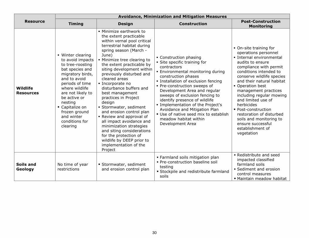
Resource Avoidance, Minimization and Mitigation Measures
Timing Design Construction Post-Construction Monitoring
Wildlife Resources
Winter clearing to avoid impacts to tree-roosting bat species and migratory birds, and to avoid periods of time where wildlife are not likely to be active or nesting Capitalize on
frozen ground and winter conditions for clearing
Minimize earthwork to the extent practicable within vernal pool critical terrestrial habitat during spring season (March - June)
Minimize tree clearing to the extent practicable by siting development within previously disturbed and cleared areas
Incorporate no disturbance buffers and best management practices in Project design
Stormwater, sediment and erosion control plan
Review and approval of all impact avoidance and minimization strategies and siting considerations for the protection of wildlife by DEEP prior to implementation of the Project
Construction phasing Site specific training for
contractors Environmental monitoring during
construction phases Installation of exclusion fencing Pre-construction sweeps of
Development Area and regular sweeps of exclusion fencing to identify presence of wildlife
Implementation of the Project's Avoidance and Mitigation Plan Use of native seed mix to establish
meadow habitat within Development Area
On-site training for operations personnel
Internal environmental audits to ensure compliance with permit conditions intended to conserve wildlife species and their natural habitat
Operation best management practices including regular mowing and limited use of herbicides Post-construction
restoration of disturbed soils and monitoring to ensure successful establishment of vegetation
Soils and Geology
No time of year restrictions
Stormwater, sediment and erosion control plan
Farmland soils mitigation plan Pre-construction baseline soil
testing Stockpile and redistribute farmland
soils
Redistribute and seed impacted classified farmland soils Sediment and erosion
control measures Maintain meadow habitat
30

Tighe&Bond
Constitution Solar Project – Plainfield 7-1
Section 7
Conclusion
The approximately 20 MW (AC) Constitution Solar Project proposed by the Petitioner is a "grid-side distributed resources" facility, as defined in CGS § 16-1(a)(37), because it
involves "the generation of electricity from a unit with a rating of not more than sixty-five megawatts that is connected to the transmission or distribution system..." and, as amply demonstrated herein, the Project will meet DEEP air and water quality standards. Further, the Project:
Will not produce air emissions during operations (PM10, PM2.5, volatile organic carbons, ozone, or GHGs);
Will not utilize water to produce electricity or be in conflict with any federal, state, or local requirements related to water quality and quantity;
Will not produce significant noise;
Will not result in impacts to wetlands or watercourses, and potential impacts to other biological or natural resources will be avoided to the greatest extent
practicable;
Will not have substantial adverse visual, land use, stormwater, recreational, cultural, or community impacts; and
Will further the state's energy policy by developing and utilizing renewable
energy resources.
For all the foregoing reasons, the Petitioner requests that the Council issue a declaratory ruling that the proposed Project will comply with DEEP air and water quality standards, will not have a substantial adverse environmental effect and, therefore, that a Certificate of Environmental Compatibility and Public Need is not required for the construction and
operation of the Project.
31

Constitution Solar Project
Plainfield, Connecticut
EXHIBIT A:
Figures

Exhibit A
Figures
The figures listed below are included in Exhibit A.
1 Project Overview
2 Site Location
3 Existing Conditions
4 Water Quality Classification/ Public Water Supply
5 Surrounding Features
6 Proposed Conditions
7 NDDB Areas
8 Soil Map

Canterbury
Plainfield
Cornell Rd
Canterbury Rd
Glebas Rd
Terry Ln
George St
Sugar Brook RdBedard
Rd
Constitution SolarPlainfield, Connecticut
March 2020
¹
_̂
1 in = 500 ft
NOTE S
LOC US MAP
1. Based on 2019 StatewideOrthophotography, Courtesty of CTECO.
0 250 500
Feet
V:\Projects\R\R0317\ConstitutionCT_Solar\Maps\PermitFigures\ProjectOverview_ConstitutionCT.mxd R-0317
Tighe&BondEngineers | Environmental Specialists
Limit of Work/Development Area
Study Area/Project Site
CT Municipal Boundary
FIGURE 1PROJECT OVERVIEW
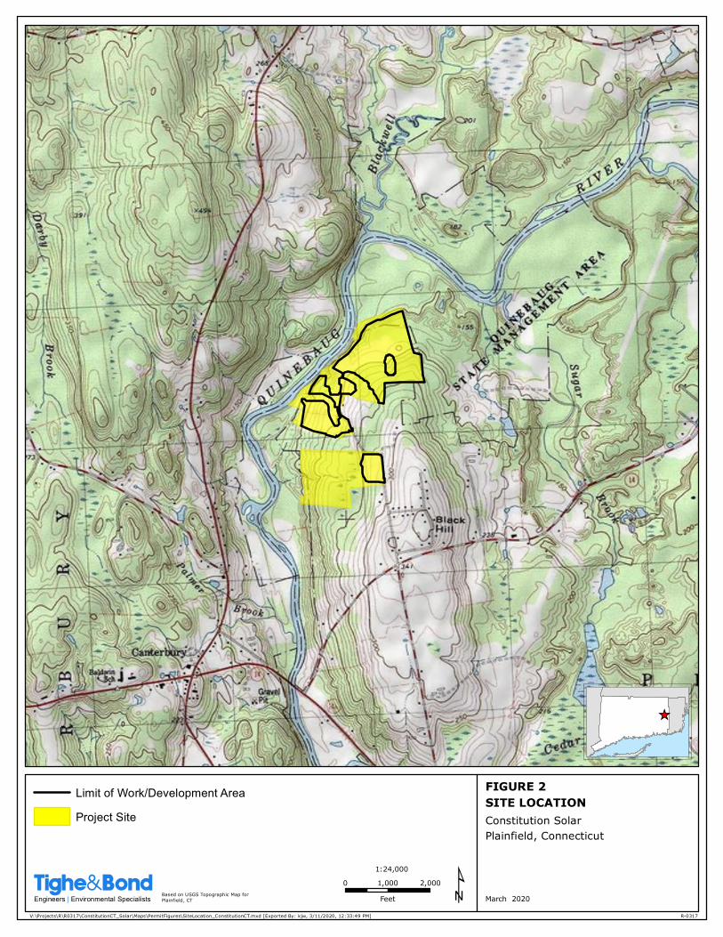
FIGURE 2SITE LOCATIONConstitution SolarPlainfield, Connecticut
0 1,000 2,000
Feet
1:24,000
V:\Projects\R\R0317\ConstitutionCT_Solar\Maps\PermitFigures\SiteLocation_ConstitutionCT.mxd [Exported By: kjw, 3/11/2020, 12:33:49 PM]
Based on USGS Topographic Map forPlainfield, CT
R-0317
March 2020
_̂
¹Tighe&BondEngineers | Environmental Specialists
Limit of Work/Development Area
Project Site

Canterbury Rd
Glebas Rd
Terry Ln
George St
Sugar Brook RdBedard Rd
Cornell Rd
Canterbury
Plainfield
FIGURE 3EXISTING
CONDITIONS
March 2020
¹
_̂
1 in = 500 ft
NOTE S
LOC US MAP
1. Based on 2019 StatewideOrthophotography, Courtesty of CTECO.
0 250 500
Feet
V:\Projects\R\R0317\ConstitutionCT_Solar\Maps\PermitFigures\ExistingConditions_ConstitutionCT.mxd R-0317
Tighe&BondEngineers | Environmental Specialists
Limit of Work/Development Area
Project Site
2-foot Contour
100-Year Floodplain
Vernal Pool
Wetland Boundary
Wetland Area
Watercourse
Railroad
Protected Open Space
Critical Habitat [Not Present]
Town Boundary
Constitution SolarPlainfield, Connecticut

AB
A
A
A
B
B
B
B
Terry Ln
Cross Rd
Forest St
PineSt
Pa rk Rd
Karin Dr
OakSt
Texas Hts
Finn R
d
Lovell Ln
Kive
la Rd
Cady
Ln
Love
rsLn
Buntz Ln
Charlotte Dr
Lisbon Rd
Pickett Rd
KinneRd
Kerr Rd
Bedard Rd
Hansen Rd
Lori Dr
Wauregan Rd
Sugar Brook Rd
Norw
ichRd
Cornell Rd
Westminster Rd
Tracy Rd
Marie St
Jackson Rd
Exley Rd
Black
HillRd
Kitt R
d
Elmda
le Rd
Graff Rd
Shep
ardHil
l Rd
BarstowRd
Cante
rbury
Rd
Buck Hill Rd
Society Rd
BrooklynCanterbury
Canter
bury
Plainfi
eld
FIGURE 4WATER QUALITY
CLASSIFICATION/PUBLIC WATER SUPPLY
March 2020
¹
_̂
1 in = 2,000 ft
NOTE S
LOC US MAP
1. Based on 2019 StatewideOrthophotography, Courtesty of CTECO.2. Water Quality data provided by CT DEEP.
0 1,000 2,000
Feet
V:\Projects\R\R0317\ConstitutionCT_Solar\Maps\PermitFigures\WaterQuality_ConstitutionCT.mxd R-0317
Tighe&BondEngineers | Environmental Specialists
Limit of Work/Development Area
Final Adopted Aquifer Protection
Final Aquifer Protection [Not Present]
Preliminary Aquifer Protection [Not Present]
Area of Contribution to Public Supply Well
Surface Water QualityA
B, B*
A
B, B*
Ground Water QualityGA
GAA, GAAs
GB
GA, GAA May be impaired
Town Boundary
!
!
Constitution SolarPlainfield, Connecticut

_̂
_̂
_̂ ")
_̂ ")
_̂
_̂
")
")#
4
"? ½¼
¼
N NNN NN!®
_̂
"?
4 _̂
_̂
_̂
_̂_̂
_̂
44
"?½¼
¼
N NNN NN
_̂ "?"?
½¼
¼
N NNN NN
_̂_̂
_̂
_̂_̂
½¼
¼
N NNN NN!®
"?
_̂
"?"?
"?
"?
"j
"j
BrooklynCanterbury
BrooklynPlainfield
Canterbury
Plainfield
Pickett RdPickett Roa dNO
1
Cante
rbury
Rd
Cemetery Rd
Sugar Brook Rd
Bennett Pond Rd
Westminster Rd
Railroad Ave
Cady Ln
Black Hill Rd
Lovell Ln
Norw
i chRd
Canterbury Rd
Crea
syRd
Buck Hill Rd
Wright Rd
Walnu
t St
Wauregan Rd
Ches
tnut S
t
PackervilleRd
Cornell Rd
Maynard Rd
BarstowRd
Tripp
Hol lo
wRd
Charl
otte Dr
Society Rd
Par adi se Dr
Kitt R
d
Gr aff Rd
Barstow Rd
4W D Road
Weston Rd
Gleb asRd
PineSt
Hend
ri ck s
o nRd
Christian Hill Rd
Cross Rd
Grov
e St
Tracy Rd
Elmda
le Rd
Exle y Rd
Er in Dr
Wauregan Rd
Ca dyLn
1st S
t
Jackson Rd
Kinne Rd
Love
rsLn
Hope
Rd
Marie St
Te x as Hts
Shep
ard H
illRd
OakS t
FinnR
d
Rukstella Rd
M arie St
Lisbo
n Rd
Kive
laRd
Lori Dr
Gallup St
Kerr Rd
Alma daDr
Beda
r dRd
Buck Hill Rd
UV205
UV12UV14A
UV169
UV14
FIGURE 5SURROUNDING FEATURESConstitution SolarPlainfield, Connecticut
0 1,650 3,300
Feet
1:39,600
V:\Projects\R\R0317\ConstitutionCT_Solar\Maps\PermitFigures\SurroundingFeatures_ConstitutionCT.mxd
Basemap: Courtesty of ESRI USA Topo Map.Data downloaded from CT DEEP, and National Park Service:National Register of Historic Places.
R-0317
March 2020
_̂
¹Tighe&BondEngineers | Environmental Specialists
Limit of Work/Development Area
"j National Register of Historic Places Site
"Z Airport
"? Building
_̂ Cemetery
_̂ Church
# Dam
"K Hospital
# Military
½¼
¼
N NNN NN Park
") Populated Place
!® Post Office
# Reserve
4 School
!A Tower
Æ_ Trail
CT Municipal Boundary
Waterbody
National Register of Historic Places Area
Protected Open Space
Project Site
2 MileProject Site Buffer
1 MileProject Site Buffer
1/2 MileProject Site Buffer

66
66
66
66
66
66666666
66
66
66
66
66
66
6 6 6 6 6 6 6
66
66
66
66
66
66
66666666
66
66
66
66
66
6 6 6 6 6 6 6
66
66
66
6 6 6 6 66
6
66
6
66
66
6
66
66
66
6 6 6 6 6 66
66
6
66
66
6
6
66
66
66
66
66
66
66
66
66
666666666
66
66
66
66
66
6
66
66
66 6 6 6 6 6 6 6 6 6 6
66 6 6 6
66
66
666
66
66
6
666
66
66
66
66
66
666666666
66
66
66
66
66
6
66
66
66 6 6 6 6 6 6 6 6 6 6
66
6 6 6
66
66
66
66
6
6 6
6
6 6
6
66
666
66
6
66
66
6
66
66
66
6
66
66
66
6
66
66
66 6
66
66
66
66
6 66
66
66
66
66
66
66
66
6
6 6
66
6
66
66
66
66
66
6
66666666666666666
66
66
66
6
6
6666
66
66
66
66
66
66
6
66
66666
6
66
666
66
6
66
66
6
66
66
66
6
66
66
66
6
66
66
66 6 6
66
66
66
66
66
66
66
66
66
66
66
66
6
6 6
66
6 66
66
66
66
66
6
66666666666666666
66
66
66
6
6
6666
66
66
66
66
66
66
6
66
66666
66
66
6
66
66
66
66
66
666666
66
66
66
66
6 6 666
66
66
66
6
6 6 6 666
66
6
66
66
66
66
66
666666
66
66
66
66
6 6 666
66
66
66
6
6 6 6 6
POI Switchyard
ProposedConstructionAccess
ProposedConstructionAccess
Canterbury
Plainfield
Cornell Rd
Canterbury Rd
Glebas Rd
Terry Ln
George St
Sugar Brook RdBedard
Rd
FIGURE 6PROPOSED
CONDITIONS
Constitution SolarPlainfield, Connecticut
March 2020
¹
_̂
1 in = 500 ft
NOTE S
LOC US MAP
1. Based on 2019 StatewideOrthophotography, Courtesty of CTECO.
0 250 500
Feet
V:\Projects\R\R0317\ConstitutionCT_Solar\Maps\PermitFigures\ProposedConditions_ConstitutionCT.mxd R-0317
Tighe&BondEngineers | Environmental Specialists
Limit of Work/Development Area
Project Site
6 66 6 Chain Link Fence
Vegetative Screening
Watercourse Buffer
Wetland Buffer
100' Vernal Pool Envelope
2-foot Contour
Watercourse
Wetland Boundary
100-Year Floodplain
Panels
Wetland Area
Equipment Pad
Vernal Pool
Switchyard
Road
CT Municipal Boundary

Canterbury
Plainfield
Cornell Rd
Canterbury Rd
Glebas Rd
Terry Ln
George St
Sugar Brook RdBedard
Rd
FIGURE 7NDDB AREAS
March 2020
¹
_̂
1 in = 500 ft
NOTE S
LOC US MAP
1. Based on 2019 StatewideOrthophotography, Courtesty of CTECO.2. NDDB Area provided by CT DEEP
0 250 500
Feet
V:\Projects\R\R0317\ConstitutionCT_Solar\Maps\PermitFigures\NDDB_ConstitutionCT.mxd R-0317
Tighe&BondEngineers | Environmental Specialists
Limit of Work/Development Area
Project Site
Natural Diversity Database Area (December 2019)
CT Municipal Boundary
Constitution SolarPlainfield, Connecticut
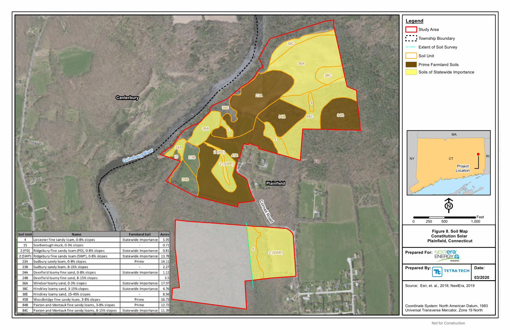
CTNY
MA
RI
Cornell Road
Plainfield
Canterbury
2 (SWP)
2 (SWP)
2 (PD)
4
45B
436A
84B 84B
4
84C
23A
38C
36A
38C
38E
15
24B
4
23B
24A
0 500 1,000250Feet
Coordinate System: North American Datum, 1983Universal Transverse Mercator, Zone 19 North
LegendStudy Area
Township Boundary
Extent of Soil Survey
Soil Unit
Prime Farmland Soils
Soils of Statewide Importance
Source: Esri, et. al., 2018; NextEra, 2019
Doc
umen
t Pat
h: Z
:\pro
ject
s\19
4_P
RO
JEC
TS\N
EX
TER
A\1
94_5
997_
CO
NS
TITU
TIO
N_S
OLA
R\G
IS\M
XD
\FIG
UR
ES
\V10
7\N
EE
R_T
TP20
2003
13G
4_C
ON
ST_
FIG
8_S
OIL
S_V
2.m
xd
E
ProjectLocation
Prepared For:
Prepared By: Date:03/2020
Figure 8. Soil MapConstitution Solar
Plainfield, Connecticut
Quinebaug River
Not for Construction

Constitution Solar Project
Plainfield, Connecticut
EXHIBIT B:
Company Background/Project Team

NEXTERA’S INFORMATION
NextEra Energy, Inc. (NextEra) (NYSE: NEE) is a leading clean energy company headquartered in Juno Beach, Florida. NextEra Energy owns two electric companies in Florida: Florida Power & Light Company, which serves more than five million customer accounts in Florida and is the largest rate-regulated electric utility in the United States as measured by retail electricity produced and sold; and Gulf Power Company, which serves more than 460,000 customers in eight counties throughout Northwest Florida. NextEra is one of the largest electric power companies in North America and employs over 14,000 in 36 states and Canada as of year-end 2018. NextEra also owns a competitive energy business, NextEra Energy Resources, LLC, which, together with its affiliated entities, is the world’s largest generator of renewable energy from the wind and sun and a world leader in battery storage. Through its subsidiaries, NextEra Energy generates clean, emissions-free electricity from eight commercial nuclear power units in Florida, New Hampshire, Iowa and Wisconsin.
A Fortune 200 company and included in the S&P 100 index, NextEra Energy has been recognized often by third parties for its efforts in sustainability, corporate responsibility, ethics and compliance, and diversity. NextEra Energy is ranked No. 1 in the electric and gas utilities industry on Fortune’s 2019 list of “World’s Most Admired Companies” and ranked among the top 25 on Fortune’s 2018 list of companies that “Change the World.”
NextEra was incorporated in 1984 under the laws of Florida and conducts its operations principally through two wholly-owned subsidiaries, Florida Power & Light Company (FPL) and NextEra Energy Resources, LLC (NEER). NextEra Energy Capital Holdings, Inc. (NEECH), another wholly-owned subsidiary of NextEra, owns and provides funding for NextEra's operating subsidiaries, other than FPL and its subsidiaries. In 2014, NextEra formed NextEra Energy Partners (NEP) to acquire, manage and own contracted clean energy projects with stable, long-term cash flows.
NextEra Energy Resources, LLC (NEER)
NEER is a nationally recognized clean energy provider with a portfolio of facilities totaling approximately 21,000 megawatts of net generating capacity at December 31, 2018 in the United States and Canada; this portfolio includes more than 15,000 MW of wind and 2,300 MW of solar. Approximately 99 percent of NEER’s electricity is derived from clean or renewable sources. NEER, together with its affiliated entities, is the world's largest generator of renewable energy from the wind and sun.
NEER Approximate Net Generation by Fuel Type (as of Dec. 31, 2018):
SOURCE PERCENTWind 59 percent
Nuclear 33 percentSolar 7 percent
Net Generation (MWh)
Natural Gas 1 percent

NextEra Energy Resources, LLC
700 Universe Boulevard, Juno Beach, FL 33408
NEER has a long-standing presence in New England with extensive development and operational experience in the region. NEER owns and operates the following generation facilities in New England NEER owns and operates the following generation facilities in New England, including the recent construction of Coolidge Solar, the largest solar project to be permitted and constructed in Vermont and began commercial operation in December 2018. In additional, Sanford Airport Solar, the largest solar project to be permitted and constructed in Maine will begin commercial operation in the Fall 2020.
NEER Facilities in New England
Project Name Fuel Location Gross MW
Net Ownership
MW
Seabrook Nuclear Seabrook, NH 1,250 1,103
Wyman 4 Oil Yarmouth, ME 613 516
Wyman 1-3 and Cape Oil Yarmouth, ME
South Portland, ME 250 250
Bellingham Natural Gas Bellingham, MA 311 155
Casco Bay Energy Storage Yarmouth, ME 16 16
Minuteman Energy Storage North Reading, MA 5 5
Connecticut, Maine,
Massachusetts
Small Scale Solar CT, ME, and MA 15 15
Coolidge Solar Solar Ludlow, VT 20 20
Total 2,480 2,080
NEXTERA’S FINANCIAL STRENGTH
NextEra Energy Capital Holdings, Inc. (NEECH), the anticipated provider of initial funding for the proposed projects, is a wholly-owned subsidiary of NextEra Energy, Inc. and holds ownership interests in and provides funding for NextEra’s operating subsidiaries other than Florida Power & Light Company, its rate-regulated electric utility. NEECH’s unsecured long-term credit/ debenture ratings are Baa1 (Stable) and BBB+ (Stable) by Moody’s and S&P, respectively.
Through its subsidiaries, NEER, a wholly-owned subsidiary of NEECH, owns, develops, constructs, manages and operates electric-generating facilities in wholesale energy markets primarily in the U.S., as well as in Canada and Spain. Neither NEECH nor NEER publish its own financial statements; however, select financial information for NEECH is provided in the Notes to Consolidated Financial Statements of NextEra’s annual report or the Notes to Condensed Consolidated Financial Statements of NextEra’s quarterly report.
General financial information
o http://www.investor.nexteraenergy.com/phoenix.zhtml?c=88486&p=irol-irhome

NextEra Energy Resources, LLC
700 Universe Boulevard, Juno Beach, FL 33408
Current bond ratings – see attached sheet for latest credit rating info in company website under Fixed Income
o http://www.investor.nexteraenergy.com/fixed-income-investors/financial-policy Annual reports for the last three years
o http://www.investor.nexteraenergy.com/reports-and-filings/annual-reports Audited financial statements – see financial statements included in the annual reports
referenced above, or in the annual 10-K SEC filings
o http://www.investor.nexteraenergy.com/reports-and-filings/sec-filings Common Shareholder Equity Summary
o December 31, 2018: NEECH’s common shareholders’ equity is equal to $7,917,000,000 (USD).
o December 31, 2017: NEECH’s common shareholders’ equity is equal to $10,773,000,000 (USD).
o December 31, 2016: NEECH’s common shareholders’ equity is equal to $7,699,000,000 (USD).
Credit and Financing Summary
o As of December 31, 2018, NEECH had approximately $4.2 billion of net available liquidity consisting of bank revolving line of credit facilities, letter of credit facilities, cash and cash equivalents, net of credit issued under the credit facilities. Moreover, as of December 31, 2018, 66 banks participate in FPL’s and NEECH’s revolving credit facilities.

NextEra Energy Resources, LLC
700 Universe Boulevard, Juno Beach, FL 33408
KEY PERSONNEL
Mike O’Sullivan
Senior Vice President, Development
Mr. O’Sullivan is Senior Vice President of Development at NEER. Mr. O’Sullivan has spent 35 years working in the energy sector in the U.S. and Canada, including 16 years with NEER and its affiliates.
In his current role, Mr. O’Sullivan is responsible for overseeing the Company’s generation project development efforts, including for wind and solar in North America. Under Mr. O’Sullivan’s leadership, NEER has developed approximately 13,000 MW of wind and 2,000 MW of solar generating facilities.
Education
Mr. O’Sullivan received his Bachelor of Science in Civil Engineering from the University of Notre Dame and earned a Master of Business Administration from the University of Chicago.
-------------------------------------------------------------------------------------------------------
John DiDonato
Vice President, Development & Origination
John DiDonato is Vice President of Development and Origination for NextEra Energy Resources, LLC. Since 2000, Mr. DiDonato has developed and acquired over 3,300 MW of generation projects for NextEra Energy. He has led development and negotiated the power purchase agreements for wind projects in the central US totaling over 2,700 MW and the 680 MW Calhoun Energy Center, a gas fired simple cycle facility located in Oxford, Alabama. These projects represent a total investment of over $4 billion in electric generation assets utilizing wind and clean natural gas technologies.
Mr. DiDonato joined NextEra Energy in 1996 as International Tax Manager. In 2000, he joined NextEra Energy’s Business Development Team, and since then he has been involved with myriad energy development projects throughout the United States. He and his team are currently responsible for the development and acquisition of wind energy facilities in the Central United States. Previously, he was with Sensormatic Electronics Corporation; a security company based in Boca Raton, Florida. While at Sensormatic, he worked in their London office on international tax matters.
Education
Mr. DiDonato has a Bachelor’s degree in Accounting from Kent State University and a Master’s degree in Accounting and Tax from Florida Atlantic University.
-------------------------------------------------------------------------------------------------------
Ross D. Groffman, Vice President, Development
Ross Groffman is an Executive Director at NextEra Energy Resources, LLC. Mr. Groffman is responsible for NEER’s Northeast generation development, including utility scale solar, wind, and energy storage projects. His activities include the management of generation development projects, acquisitions and joint venture activities. Previously at NextEra he was a Director in the Canadian wind development group, and was a Project Director in the Midwest wind development group.

NextEra Energy Resources, LLC
700 Universe Boulevard, Juno Beach, FL 33408
Education
Mr. Groffman graduated with a concentration in Management from The Wharton School at the University of Pennsylvania.
-------------------------------------------------------------------------------------------------------Ron Reagan
Executive Vice President, Construction and Integrated Supply Chain
Mr. Reagan is executive vice president of engineering & construction and integrated supply chain. He is responsible for enterprise-wide power plant engineering and construction activities and enterprise-wide sourcing activities. Mr. Reagan was named to this position in January 2020.Mr. Reagan has also served as NextEra Energy’s vice president of engineering & construction, vice president of integrated supply chain and vice president of procurement and materials management. In 2006, he joined the Power Marketing unit of NextEra Energy Resources, the company’s competitive generation subsidiary, serving as vice president of asset operations and trading. Earlier, he served in the business management organization with responsibility for several wind, solar, hydroelectric and natural gas assets. He joined the company’s rate-regulated electric utility subsidiary, Florida Power & Light Company, in 1990 and held operational and management positions in the power generation division.
Education
Mr. Reagan holds a Bachelor of Science degree in electrical engineering from Clarkson University.
-------------------------------------------------------------------------------------------------------
Miguel Arechabala
Executive Vice President, Power Generation Division
Mr. Arechabala joined Florida Power & Light in 1981. Throughout the years he has held various positions within NextEra Energy companies and has experience with all types of generation including natural gas, nuclear, hydro, wind, and solar facilities. Mr. Archebala has held his current position, Executive Vice President, Power Generation Division since January 2014 and has managerial responsibility for operating all types of generation projects. Mr. Arechabala has 35 years of power generation operating experience.
Education
Mr. Arechabala received his Bachelor of Science degree in mechanical engineering from the University of Miami and his Master of Science degree in engineering management from the University of South Florida. He is also a certified Six Sigma Black Belt.
-------------------------------------------------------------------------------------------------------
Junior Aguaze
Project Director, Development
Mr. Aguaze is a Project Director of Development with NextEra Energy Resources. NextEra is the nation’s leader in producing electricity from clean and renewable fuels, as well as the world leader in generating electricity from wind and solar. He currently leads the development and permitting efforts for multiple renewable energy and energy storage projects in the northeastern US.
Prior to NextEra, Mr. Aguaze was a Senior Investment Associate with Goldman Sachs’ Debt Capital Markets group performing syndicate execution across multi industries. Mr. Aguaze was also an equities analyst for various investment and consulting firms performing analyses for

NextEra Energy Resources, LLC
700 Universe Boulevard, Juno Beach, FL 33408
“bulge-bracket” and boutique private equity firms and hedge funds. Before his time on Wall Street, Mr. Aguaze was a design engineer with Boeing’s flight controls group where he designed and developed wide-body aircraft such as the 747, 777 and 767.
Education
Mr. Aguaze holds a Master of Business Administration from Duke University’s Fuqua School of Business as well as both a Master of Science and a Bachelor of Science in Mechanical Engineering from Tufts University.
-------------------------------------------------------------------------------------------------------
Mitchell Thiem
Project Manager, Engineering & Construction
Mitchell is currently responsible for early stage Engineering and Construction Division’s (E&C) project support and coordination of resources for pre-construction and engineering activities in the development phase. Mr. Thiem is currently supporting PV solar and battery storage technologies. Mr. Thiem has five years of experience in renewable energy industry.
Education
Mr. Thiem holds a Bachelor of Arts degree in Entrepreneurial Management with a focus on Energy Management and Technology from Texas Christian University.
-------------------------------------------------------------------------------------------------------Patricia Vallejo
Senior Transmission Business Manager, Transmission Business Management
Mrs. Vallejo is Senior Transmission Business Manager in the Transmission Business Management organization within NEER. In this role, Patricia coordinates all aspects of the interconnection process to ensure successful integration of the NEER wind, solar and battery storage generation assets in New England ISO, New York ISO, PJM and Eastern Canada. Mrs Vallejo is responsible for project prospecting, interconnection studies and approvals, negotiation of Interconnection Agreements, market registration, and coordination with ISOs during project operation. Patricia also provides technical support on merger and acquisitions, divestiture, Request for Proposal (RFPs), financing, etc.
Prior to joining NEER, Patricia administered the ISONE’s Interconnection process and New York Power Authority Power for Jobs program.
Mrs. Vallejo has over 37 in the years’ experience in power system planning, generation planning, renewable energy development and power contracts negotiation.
Education
Mrs. Vallejo has a Bachelor degree on Electrical Engineering, and a Master of Science degree in Power Engineering
-------------------------------------------------------------------------------------------------------
Kaleigh Crissman
Associate Project Manager, Development
Ms. Crissman, is an Associate Project Manager for NextEra Energy Resources, LLC, and supports the Community Development and Permitting efforts for the Northeast region. Ms. Crissman has 5 years of community development experience in both the public and private sectors and works to interface with elected officials, municipal staff, and community stakeholders to support project development.

NextEra Energy Resources, LLC
700 Universe Boulevard, Juno Beach, FL 33408
Education
Ms. Crissman holds a Bachelor of Arts degree from The University of Alabama and a Masters of Business Administration from Nova Southeastern University.
-------------------------------------------------------------------------------------------------------
Jonathan Gravel
Environmental Services Project Manager
Jonathan Gravel is a Project Manager in the Environmental Licensing and Permitting team within NextEra’s Environmental Services Department. Mr. Gravel is responsible for environmental support and permitting of energy projects including transmission, solar and wind technologies in Maine, Massachusetts, Connecticut, New Hampshire, Vermont, and Eastern Canada. As Project Manager, he assists NextEra’s development teams with project siting, permitting, and agency/public interaction. Mr. Gravel has also worked in the environmental consulting field for over thirteen years as a field biologist and project manager on a number of utility projects located in northeastern United States.
Education
Mr. Gravel holds a Bachelor of Science degree in Natural Resources with a concentration in wetland ecology from the University of New Hampshire. Mr. Gravel continues to pursue educational courses in ecology and environmental sciences.
-------------------------------------------------------------------------------------------------------

Constitution Solar Project
Plainfield, Connecticut
EXHIBIT C:
Environmental Reports

Exhibit C
Environmental Reports
The items listed below are included in Exhibit C.
1 Environmental Site Conditions Report (September 3, 2019), including:
o Natural Resources Survey Reports (Appendix C)
o Avoidance & Mitigation Plan (Appendix F)

Tetra Tech, Inc. 451 Presumpscot Street, Portland, ME 04103
Tel 207-358-2407 Fax 207-879-9481 www.tetratech.com
September 3, 2019
Ms. Dawn McKay Department of Energy and Environmental Protection 79 Elm Street Hartford, Connecticut 06106-5127
Sent via email: [email protected]
Subject: Request for a Natural Diversity Database Final Determination for Constitution Solar Project, NDDB Determination No. 201905175
Dear Ms. McKay,
On behalf of Constitution Solar, LLC and NextEra Energy Resources (NextEra), Tetra Tech, Inc. (Tetra Tech) is requesting that the Department of Energy and Environmental Protection Natural Diversity Data Base (DEEP NDDB) Program review and subsequently issue a Final Determination for the proposed Constitution Solar Project (Project) located in Plainfield, Connecticut. Tetra Tech is assisting NextEra with permitting of the Project including filing of the Connecticut Siting Council petition.
This request is for a Final Determination from NDDB. Based on our recent correspondence, we are using the preliminary assessment species list from the initial request in 2017. The only additional species having the potential to occur in the Study Area is wood turtle (Glyptemys insculpta), and correspondingly an analysis has been provided for this species. The enclosed Environmental Site Conditions Report includes a description of the existing conditions within the Study Area, reports for the technical field studies conducted, and an Avoidance and Mitigation Plan to be used to guide Project construction and operation activities.
Constitution Solar, LLC requests that NDDB issue a Final Determination as soon as is practicable.
If you have any questions or require additional information, please do not hesitate to call me at (207) 358-2396 or email me at [email protected].
Respectfully Submitted,
Katelin Nickerson, Project Manager Tetra Tech, Inc. Enclosures: NDDB State Listed Species Review Form, Environmental Site Conditions Report

DEEP-REQ-APP-007 Page 1 of 6 Rev. 06/07/16
Request for Natural Diversity Data Base (NDDB) State Listed Species Review Please complete this form in accordance with the instructions (DEEP-INST-007) to ensure proper handling of your request. There are no fees associated with NDDB Reviews. Part I: Preliminary Screening & Request Type
Before submitting this request, you must review the most current Natural Diversity Data Base “State and Federal Listed Species and Significant Natural Communities Maps” found on the DEEP website. These maps are updated twice a year, usually in June and December. Does your site, including all affected areas, fall in an NDDB Area according to the map instructions:
Yes No Enter the date of the map reviewed for pre-screening: December 2018
This form is being submitted for a :
New NDDB request
Renewal/Extension of a NDDB Request, without modifications and within two years of issued NDDB determination (no attachments required)
[CPPU Use Only - NDDB-Listed Species Determination # 1736]
New Safe Harbor Determination (optional) must be associated with an application for a GP for the Discharge of Stormwater and Dewatering Wastewaters from Construction Activities
Renewal/Extension of an existing Safe Harbor Determination
With modifications
Without modifications (no attachments required) [CPPU Use Only - NDDB-Safe Harbor Determination # 1736]
Enter NDDB Determination Number for Renewal/Extension:
Enter Safe Harbor Determination Number for Renewal/Extension:
CPPU USE ONLY
App #:____________________________ Doc #:____________________________ Check #: No fee required Program: Natural Diversity Database Endangered Species Hardcopy _____ Electronic _____

DEEP-REQ-APP-007 Page 2 of 6 Rev. 06/07/16
Part II: Requester Information*If the requester is a corporation, limited liability company, limited partnership, limited liability partnership, or a statutory trust,it must be registered with the Secretary of State. If applicable, the name shall be stated exactly as it is registered with the Secretary of State. Please note, for those entities registered with the Secretary of State, the registered name will be thename used by DEEP. This information can be accessed at the Secretary of the State’s database CONCORD.(www.concord-sots.ct.gov/CONCORD/index.jsp)
If the requester is an individual, provide the legal name (include suffix) in the following format: First Name; Middle Initial; Last Name; Suffix (Jr, Sr., II, III, etc.).
If there are any changes or corrections to your company/facility or individual mailing or billing address or contact information,please complete and submit the Request to Change company/Individual Information to the address indicated on the form.
1. Requester*
Company Name: Constitution Solar, LLC
Contact Name: Junior Aguaze
Address: 700 Universe Blvd
City/Town: Juno Beach State: FL Zip Code: 33409
Business Phone: 561- ext.
**E-mail: [email protected]**By providing this email address you are agreeing to receive official correspondence from the department, atthis electronic address, concerning this request. Please remember to check your security settings to be sure youcan receive emails from “ct.gov” addresses. Also, please notify the department if your e-mail address changes
a) Requester can best be described as:
Individual Federal Agency State agency Municipality Tribal
*business entity (* if a business entity complete i through iii):
i) Check type corporation limited liability company limited partnership
limited liability partnership statutory trust Other:
ii) Provide Secretary of the State Business ID #: 1205361 This information can be accessed at the
Secretary of the State’s database (CONCORD). (www.concord-sots.ct.gov/CONCORD/index.jsp)
iii) Check here if your business is NOT registered with the Secretary of State’s office.
b) Acting as (Affiliation), pick one:
Property owner Consultant Engineer Facility owner Applicant
Biologist Pesticide Applicator Other representative:
2. List Primary Contact to receive Natural Diversity Data Base correspondence and inquiries, ifdifferent from requester.
Company Name: Tetra Tech, Inc.
Contact Person: Katelin Nickerson Title: Project Manager
Mailing Address: 451 Presumpscot St.
City/Town: Portland State: ME Zip Code: 04103
Business Phone: 207-358-2396 ext.
**E-mail: [email protected]
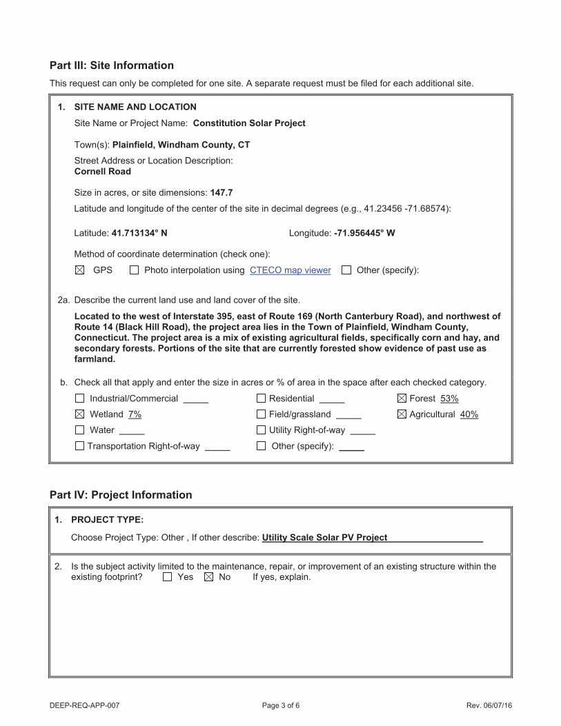
DEEP-REQ-APP-007 Page 3 of 6 Rev. 06/07/16
Part III: Site Information This request can only be completed for one site. A separate request must be filed for each additional site.
1. SITE NAME AND LOCATION
Site Name or Project Name: Constitution Solar Project
Town(s): Plainfield, Windham County, CT Street Address or Location Description: Cornell Road Size in acres, or site dimensions: 147.7
Latitude and longitude of the center of the site in decimal degrees (e.g., 41.23456 -71.68574): Latitude: 41.713134° N Longitude: -71.956445° W Method of coordinate determination (check one):
GPS Photo interpolation using CTECO map viewer Other (specify): 2a. Describe the current land use and land cover of the site.
Located to the west of Interstate 395, east of Route 169 (North Canterbury Road), and northwest of Route 14 (Black Hill Road), the project area lies in the Town of Plainfield, Windham County, Connecticut. The project area is a mix of existing agricultural fields, specifically corn and hay, and secondary forests. Portions of the site that are currently forested show evidence of past use as farmland.
b. Check all that apply and enter the size in acres or % of area in the space after each checked category.
Industrial/Commercial Residential Forest 53%
Wetland 7% Field/grassland Agricultural 40%
Water Utility Right-of-way
Transportation Right-of-way Other (specify):
Part IV: Project Information
1. PROJECT TYPE:
Choose Project Type: Other , If other describe: Utility Scale Solar PV Project
2. Is the subject activity limited to the maintenance, repair, or improvement of an existing structure within the existing footprint? Yes No If yes, explain.

DEEP-REQ-APP-007 Page 4 of 6 Rev. 06/07/16
Part IV: Project Information (continued)
3. Give a detailed description of the activity which is the subject of this request and describe the methods andequipment that will be used. Include a description of steps that will be taken to minimize impacts to anyknown listed species.
This NDDB review request is associated with an approximately 20 MW utility-scale solar project proposed byNextEra Energy Resources, Inc. on approximately 148 acres of land in the Town of Plainfield, WindhamCounty, Connecticut. The project will consist of ground-mounted solar panels, gravel access roads, inverters,and associated electrical lines. Panels will be mounted on racks supported by posts, posts will be pile driven intothe ground to minimize the use of concrete foundations. Inverters will be skid mounted and the majoirty ofcollector lines will be buried. The project will connect to the grid offsite. NextEra Energy Resources, Inc. hasdesigned the project to avoid all impacts to wetland, vernal pools, and other sensitive natural resources. Theenclosed Avoidance and Mitigation Plan describes details to minimize impacts to local species.
4. If this is a renewal or extension of an existing Safe Harbor request with modifications, explain what aboutthe project has changed.
N/A
5. Provide a contact for questions about the project details if different from Part II primary contact.
Name:
Phone:
E-mail:

DEEP-REQ-APP-007 Page 5 of 6 Rev. 06/07/16
Part V: Request Requirements and Associated Application TypesCheck one box from either Group 1, Group 2 or Group 3, indicating the appropriate category for this request.
Group 1. If you check one of these boxes, complete Parts I – VII of this form and submit the required attachments A and B.
Preliminary screening was negative but an NDDB review is still requested
Request regards a municipally regulated or unregulated activity (no state permit/certificate needed)
Request regards a preliminary site assessment or project feasibility study
Request relates to land acquisition or protection
Request is associated with a renewal of an existing permit, with no modifications
Group 2. If you check one of these boxes, complete Parts I – VII of this form and submit required attachments A, B, and C.
Request is associated with a new state or federal permit application
Request is associated with modification of an existing permit
Request is associated with a permit enforcement action
Request regards site management or planning, requiring detailed species recommendations
Request regards a state funded project, state agency activity, or CEPA request
Group 3. If you are requesting a Safe Harbor Determination, complete Parts I-VII and submit required attachments A, B, and D. Safe Harbor determinations can only be requested if you are applying for a GP forthe Discharge of Stormwater and Dewatering Wastewaters from Construction Activities
If you are filing this request as part of a state or federal permit application(s) enter the application information below.
Permitting Agency and Application Name(s):Connecticut Siting CouncilState DEEP Application Number(s), if known:
State DEEP Enforcement Action Number, if known:
State DEEP Permit Analyst(s)/Engineer(s), if known:
Is this request related to a previously submitted NDDB request? Yes NoIf yes, provide the previous NDDB Determination Number(s), if known: NDDB Number 201905175

DEEP-REQ-APP-007 Page 6 of 6 Rev. 06/07/16
Part VI: Supporting DocumentsCheck each attachment submitted as verification that all applicable attachments have been supplied with thisrequest form. Label each attachment as indicated in this part (e.g., Attachment A, etc.) and be sure to include the requester’s name, site name and the date. Please note that Attachments A and B are required for all new requests and Safe Harbor renewals/extensions with modifications. Renewals/Extensions with no modifications do not need to submit any attachments. Attachments C and D are supplied at the end of this form.
Attachment A: Overview Map: an 8 1/2” X 11” print/copy of the relevant portion of a USGS Topographic Quadrangle Map clearly indicating the exact location of the site.
Attachment B: Detailed Site Map: fine scaled map showing site boundary and area of work details on aerial imagery with relevant landmarks labeled. (Site and work boundaries in GIS [ESRI ArcView shapefile, in NAD83, State Plane, feet] format can be substituted for detailed maps, see instruction document)
Attachment C: Supplemental Information, Group 2 requirement (attached, DEEP-APP-007C)Section i: Supplemental Site Information and supporting documents
Section ii: Supplemental Project Information and supporting documents
Attachment D: Safe Harbor Report Requirements, Group 3 (attached, DEEP-APP-007D)
Part VII: Requester CertificationThe requester and the individual(s) responsible for actually preparing the request must sign this part. A request willbe considered incomplete unless all required signatures are provided.
“I have personally examined and am familiar with the information submitted in this document and all attachments thereto, and I certify that based on reasonable investigation, including my inquiry of the individuals responsible for obtaining the information, the submitted information is true, accurate and complete to the best of my knowledge and belief.”
September 3, 2019Signature of Requester (a typed name will substitute for a handwritten signature)
Date
Junior Aguaze Project DirectorName of Requester (print or type) Title (if applicable)
September 3, 2019Signature of Preparer (if different than above) Date
Katelin Nickerson Project ManagerName of Preparer (print or type) Title (if applicable)
Note: Please submit the completed Request Form and all Supporting Documents to:
CENTRAL PERMIT PROCESSING UNITDEPARTMENT OF ENERGY & ENVIRONMENTAL PROTECTION79 ELM STREETHARTFORD, CT 06106-5127
Or email request to: [email protected]
Junior Aguaze
Signature of Preparer (if differen

DEEP-APP-007C 1 of 1 Rev. 04/08/14
Attachment C: Supplemental Information, Group 2 requirement
Section i: Supplemental Site Information
1. Existing Conditions Describe all natural and man-made features including wetlands, watercourses, fish and wildlife habitat, floodplains and any existing structures potentially affected by the subject activity. Such features should be depicted and labeled on the site plan that must be submitted. Photographs of current site conditions may be helpful to reviewers. SSee enclosed report
Site Photographs (optional) attached
Site Plan/sketch of existing conditions attached
2. Biological Surveys Has a biologist visited the site and conducted a biological survey to determine the presence of any endangered, threatened or special concern species Yes No
If yes, complete the following questions and submit any reports of biological surveys, documentation of the biologist’s qualifications, and any NDDB survey forms.
Biologist(s) name: Dr. Kevin Ryan and Katelin Nickerson
Habitat and/or species targeted by survey: Herpetofauna and General HHabitat Surveys
Dates when surveys were conducted: Summer 20177 aand 2018
Reports of biological surveys attached
Documentation of biologist’s qualifications attached
NDDB Survey forms for any listed species observations attached
Section ii: Supplemental Project Information
1. Provide a schedule for all phases of the project including the year, the month and/or season that the proposed activity will be initiated and the duration of the activity.
Construction is proposed to begin in the winter of 2020 with tree clearing. Earthwork and construction will take place during the Summer of 2021. Attached Avoidance and Mitigation Plan include details regarding construction.
2. Describe and quantify the proposed changes to existing conditions and describe any on-site or off-site impacts. In addition, provide an annotated site plan detailing the areas of impact and proposed changes to existing conditions.
Enclosed Environmental Site Conditions Report and Avoidance and Mitigation plan explain the proosed changes and areas of impact.
Annotated Site Plan attached
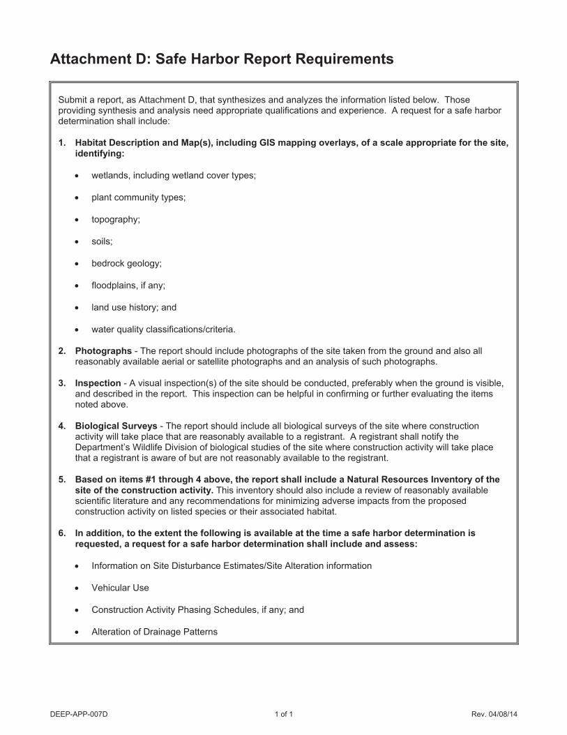
DEEP-APP-007D 1 of 1 Rev. 04/08/14
Attachment D: Safe Harbor Report Requirements
Submit a report, as Attachment D, that synthesizes and analyzes the information listed below. Those providing synthesis and analysis need appropriate qualifications and experience. A request for a safe harbor determination shall include: 1. Habitat Description and Map(s), including GIS mapping overlays, of a scale appropriate for the site,
identifying:
wetlands, including wetland cover types;
plant community types;
topography;
soils;
bedrock geology;
floodplains, if any;
land use history; and
water quality classifications/criteria. 2. Photographs - The report should include photographs of the site taken from the ground and also all
reasonably available aerial or satellite photographs and an analysis of such photographs. 3. Inspection - A visual inspection(s) of the site should be conducted, preferably when the ground is visible,
and described in the report. This inspection can be helpful in confirming or further evaluating the items noted above.
4. Biological Surveys - The report should include all biological surveys of the site where construction
activity will take place that are reasonably available to a registrant. A registrant shall notify the Department’s Wildlife Division of biological studies of the site where construction activity will take place that a registrant is aware of but are not reasonably available to the registrant.
5. Based on items #1 through 4 above, the report shall include a Natural Resources Inventory of the
site of the construction activity. This inventory should also include a review of reasonably available scientific literature and any recommendations for minimizing adverse impacts from the proposed construction activity on listed species or their associated habitat.
6. In addition, to the extent the following is available at the time a safe harbor determination is
requested, a request for a safe harbor determination shall include and assess:
Information on Site Disturbance Estimates/Site Alteration information
Vehicular Use
Construction Activity Phasing Schedules, if any; and
Alteration of Drainage Patterns

Environmental Site Conditions Report
Constitution Solar Project Plainfield, Connecticut
Prepared for:
Constitution Solar, LLC 700 Universe Blvd
Juno Beach, FL 33408
August 30, 2019

Constitution Solar, LLC Environmental Site Conditions Report
This page intentionally left blank.

Constitution Solar, LLC Environmental Site Conditions Report
i August 2019
EXECUTIVE SUMMARY
Constitution Solar, LLC (Constitution Solar), an affiliate of NextEra Energy Resources, LLC, is proposing to
construct the approximately 20-megawatt Constitution Solar Project (Project) in Plainfield, Connecticut;
with electrical grid interconnection off-site. The Project has been under development since 2016 and the
site has been evaluated over multiple years. This report includes the results of the natural resource field
investigations conducted for the Project and avoidance and mitigation measures to be employed during
Project construction and operation. Following the Connecticut Department of Energy & Environmental
Protection (DEEP) Natural Diversity Database (NDDB) Program review of this report, Constitution Solar
requests a final determination that the Project is taking appropriate measures to protect the local wildlife
and the environment to the greatest extent practicable.
This report outlines the baseline environmental conditions at the Project Study Area and addresses
known, or potential occurrences of particular species or critical habitats identified in early database
requests submitted to NDDB Program. The assessments summarized in this report were conducted to
meet the standards of expected environmental due diligence and to address permitting requirements of
the DEEP and the Connecticut Siting Council.
The Study Area is approximately 149 acres; this boundary is inclusive of all of the environmental survey
work completed for the Project to date. The Study Area is comprised of two separate areas separated by
an approximately 300-foot wide strip of forested habitat. Environmental field studies and reviews
completed for this Project include:
• vernal pool surveys (April and May 2017, April 2018, and May 2019);
• eastern spadefoot toad (Scaphiopus holbrookii) surveys (June and July 2018);
• wetland and watercourse delineations (June 2017 and 2018);
• general herpetological inventory (June, July, and September 2018);
• request for NDDB State-Listed Species Review (August 2017, NDDB Preliminary Assessment No.:
201706152); and
• northern long-eared bat (NLEB) (Myotis septentrionalis) presence/absence survey (July 2017).
Desktop investigations and agency database reviews have included, but are not limited to, review of DEEP
and NDDB Program reviews, United States Fish and Wildlife Service National Wetlands Inventory and
Information for Planning and Consultation databases, and United States Department of Agriculture
National Resources Conservation Service and United States Geological Survey soils, geology, and
hydrology information.
The focused species surveys did not document presence of NLEB or eastern spadefoot toad. The general
herpetological survey was focused on determining presence of state-listed amphibians and reptiles,
specifically the spotted turtle (Clemmys guttata), wood turtle (Glyptemys insculpta), eastern hognose
snake (Heterodon platirhinos) and eastern ribbon snake (Thamnophis sauritus). This survey identified 10
amphibian and one reptile species within the Study Area; however, no state-listed herpetofauna species
were observed. The general herpetofauna inventory also surveyed for presence of pool-breeding
amphibians, to determining presence of pure-diploid blue-spotted salamander (Ambystoma laterale). This
species was not detected within the Study Area during vernal pool surveys or the general herpetofauna
inventory. Complete results of all field studies and database searches are summarized in this report, along
with an analysis of the potential impacts and avoidance measures that can be employed to avoid risks to
species and natural resources from Project development.

Constitution Solar, LLC Environmental Site Conditions Report
ii August 2019
Results of the completed wildlife and natural resource surveys are being used to inform the Project design
to avoid and minimize natural resource impacts to the greatest extent practicable. The implementation
of a robust sediment and erosion control plan, along with careful design, will avoid direct impacts to
natural resources. Other measures include following seasonal clearing restrictions for NLEB and other
migratory species, and installation of exclusion fencing during the construction phase of the Project.
Strategies to be employed include construction-phase environmental monitoring and on-site
environmental training for contractors. An important component for protection of wildlife is avoidance of
sensitive habitats; these protective measures are described in the Project’s Avoidance and Mitigation Plan
in Appendix F.

Constitution Solar, LLC Environmental Site Conditions Report
iii August 2019
TABLE OF CONTENTS
EXECUTIVE SUMMARY ............................................................................................................................................ I
1 INTRODUCTION ............................................................................................................................................. 1
1.1 PROJECT SETTING .............................................................................................................................................. 1
2 ENVIRONMENTAL CONDITIONS ..................................................................................................................... 2
2.1 ECOREGION...................................................................................................................................................... 2
Northeastern Coastal Zone Ecoregion .................................................................................................................. 2
Southern New England Coastal Plains and Hills Ecoregion IV ............................................................................... 2
2.2 LAND USE ........................................................................................................................................................ 3
2.3 BOTANICAL RESOURCES ...................................................................................................................................... 3
3 WATER RESOURCES ....................................................................................................................................... 5
3.1 WETLANDS AND WATERCOURSES ......................................................................................................................... 6
3.2 VERNAL POOLS ................................................................................................................................................. 6
4 WILDLIFE RESOURCES .................................................................................................................................... 7
4.1 PLANT AND WILDLIFE SPECIES THAT ARE STATE AND FEDERALLY LISTED AND SPECIES OF SPECIAL CONCERN ........................ 7
4.2 FEDERALLY LISTED THREATENED AND ENDANGERED SPECIES ...................................................................................... 9
4.3 STATE-LISTED THREATENED AND, ENDANGERED SPECIES, AND STATE SPECIES OF SPECIAL CONCERN ............................... 10
State Threatened Species .................................................................................................................................... 11
Invertebrate Animals........................................................................................................................................... 11
Vascular Plants .................................................................................................................................................... 12
Vertebrate Animals ............................................................................................................................................. 13
State-Listed Bat Species ...................................................................................................................................... 18
4.4 MIGRATORY BIRDS .......................................................................................................................................... 19
5 BEDROCK, SURFICIAL GEOLOGY AND SOILS ................................................................................................. 21
6 CONCLUSION AND IMPLICATIONS FROM PROJECT DEVELOPMENT ............................................................. 21
6.1 LAND USE ...................................................................................................................................................... 22
6.2 WATER RESOURCES ......................................................................................................................................... 22
6.3 WILDLIFE RESOURCES ...................................................................................................................................... 23
6.4 PLANT AND WILDLIFE SPECIES THAT ARE STATE AND FEDERALLY LISTED AND STATE SPECIES OF SPECIAL CONCERN ............. 23
6.5 BEDROCK, SURFICIAL GEOLOGY, AND SOILS .......................................................................................................... 24
7 LITERATURE CITED ....................................................................................................................................... 25
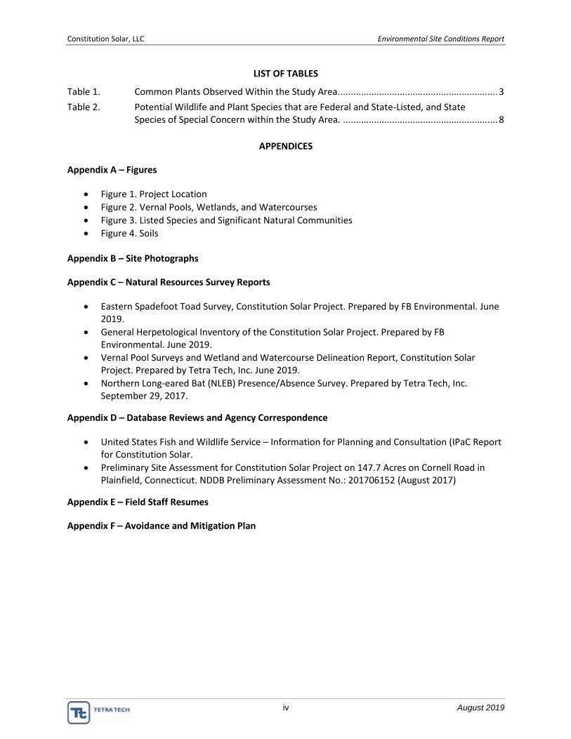
Constitution Solar, LLC Environmental Site Conditions Report
iv August 2019
LIST OF TABLES
Table 1. Common Plants Observed Within the Study Area. ............................................................. 3
Table 2. Potential Wildlife and Plant Species that are Federal and State-Listed, and State Species of Special Concern within the Study Area. ............................................................ 8
APPENDICES
Appendix A – Figures
• Figure 1. Project Location
• Figure 2. Vernal Pools, Wetlands, and Watercourses
• Figure 3. Listed Species and Significant Natural Communities
• Figure 4. Soils
Appendix B – Site Photographs
Appendix C – Natural Resources Survey Reports
• Eastern Spadefoot Toad Survey, Constitution Solar Project. Prepared by FB Environmental. June 2019.
• General Herpetological Inventory of the Constitution Solar Project. Prepared by FB Environmental. June 2019.
• Vernal Pool Surveys and Wetland and Watercourse Delineation Report, Constitution Solar Project. Prepared by Tetra Tech, Inc. June 2019.
• Northern Long-eared Bat (NLEB) Presence/Absence Survey. Prepared by Tetra Tech, Inc. September 29, 2017.
Appendix D – Database Reviews and Agency Correspondence
• United States Fish and Wildlife Service – Information for Planning and Consultation (IPaC Report for Constitution Solar.
• Preliminary Site Assessment for Constitution Solar Project on 147.7 Acres on Cornell Road in Plainfield, Connecticut. NDDB Preliminary Assessment No.: 201706152 (August 2017)
Appendix E – Field Staff Resumes
Appendix F – Avoidance and Mitigation Plan

Constitution Solar, LLC Environmental Site Conditions Report
v August 2019
ACRONYMS AND ABBREVIATIONS
BCC Birds of Conservation Concern
Constitution Solar Constitution Solar, LLC
DEEP Connecticut Department of Energy & Environmental Protection
Development Area Potential location of Project facilities and limits of construction and operation
area (approximately 85 acres)
ESA Endangered Species Act
IPaC Information for Planning and Consultation database
NDDB Natural Diversity Database
NLEB northern long-eared bat (Myotis septentrionalis)
PEM palustrine emergent
PFO palustrine forested
PSS palustrine scrub-shrub
Project the Constitution Solar Energy Project in Plainfield, Connecticut
Study Area the approximately 149-acre area where natural resource survey work was
performed
USACE United States Army Corps of Engineers
USDA NRCS United States Department of Agriculture Natural Resources Conservation
Service
USFWS United States Fish and Wildlife Service

Constitution Solar, LLC Environmental Site Conditions Report
vi August 2019
This page intentionally left blank.

Constitution Solar, LLC Environmental Site Conditions Report
1 August 2019
1 INTRODUCTION
Constitution Solar, LLC (Constitution Solar), an affiliate of NextEra Energy Resources, LLC, is proposing to
construct the Constitution Solar energy project in Plainfield, Connecticut (Project). This Environmental
Site Conditions report outlines the baseline environmental conditions at the Project site (Study Area) and
addresses potential occurrence of particular species or critical habitats identified in database requests
submitted to Connecticut Department of Energy & Environmental Protection (DEEP) Natural Diversity
Database (NDDB) Program early in project development. It includes a comprehensive summary of the
overall condition of the Project site and provides cumulative results of all field studies and database
reviews conducted for the Project to date. The assessments summarized in this report were conducted to
meet the standards of expected environmental due diligence and to address permitting requirements of
the DEEP and the Connecticut Siting Council.
The approximately 149-acre area Study Area reflects the boundary that is inclusive of all environmental
survey work completed for the Project. Data collected within the Study Area is being used to optimize the
Project layout and to avoid sensitive resources and listed species. The Study Area is identified in the figures
included in Appendix A.
This Environmental Site Conditions Report is intended to provide the NDDB Program with the information
required to issue a final determination concurring with the methods and results of field surveys completed
for the Project, and a determination that adequate efforts have been made for the protection of the
environment. The results of natural resource surveys completed between 2017 and 2019 are included
herein, along with an analysis of the NDDB Preliminary Assessments (No. 201706152) completed for the
Project.
1.1 Project Setting
The Study Area is in the Town of Plainfield, Windham County, Connecticut, located west of Interstate 395,
east of Route 169 (North Canterbury Road), and northwest of Route 14 (Black Hill Road). The Project is
located directly west and north of Cornell Road and a roadside distribution power line. The Quinebaug
River flows south on the west side of the Study Area. The figures provided in Appendix A provide an
overview of the Study Area, which is comprised of two areas separated by an approximately 300-foot wide
strip of forested habitat. The northern portion of the Study Area is approximately 101 acres and the
southern portion is approximately 48 acres.
The Study Area is located within agriculture lands, specifically corn and hay, and also includes portions of
second growth forest areas. The forested areas show evidence of past use as farmland, as evidenced by
the presence of old stone walls and historical aerial photographs, and more recent selective timber
harvests. The Study Area encompasses approximately 58 acres of agricultural fields, approximately 80
acres of second growth forest habitats, and approximately 11 acres of wetland habitat.
The proposed Project facilities and limits of construction activity (Development Area) are located entirely
within the Study Area. Development Area activities proposed include, but are not limited to, vegetation
clearing, grubbing, and minor excavation for installation of roads and electrical infrastructure, perimeter
fencing, and solar panels. The environmental field studies described in this report have been used to
inform the siting and design of the Project to avoid and minimize undue negative environmental impacts
(see Section 6 and Appendix F).

Constitution Solar, LLC Environmental Site Conditions Report
2 August 2019
2 ENVIRONMENTAL CONDITIONS
Prior to conducting field surveys, biologists reviewed publicly available data, including United States
Geological Survey current and historical aerials; United States Department of Agriculture Natural
Resources Conservation Service (USDA NRCS) soils information; United States Fish and Wildlife Service
(USFWS) National Wetlands Inventory and Information for Planning and Consultation (IPaC) Tool; United
States Geological Survey National Hydrography Dataset; and the DEEP NDDB. A copy of the USFWS IPaC
database review report and the results of the NDDB Preliminary Assessments are provided in Appendix D.
Following initial desktop research, targeted field surveys were conducted to identify any regulated natural
resources or habitats on the site that are not identified in the available public literature and databases.
Results from these field surveys have been used to inform the design and development of the Project, to
identify sensitive resources within the Study Area, and to fulfill the anticipated regulatory requirements
of the Project. The following studies have been completed for the Project:
• vernal pool surveys (April and May 2017, April 2018, and May 2019);
• eastern spadefoot toad (Scaphiopus holbrookii) surveys (June and July 2018);
• wetland and watercourse delineations (June 2017 and 2018);
• general herpetological inventory (June, July, and September 2018); and
• northern long-eared bat (NLEB) (Myotis septentrionalis) presence/absence survey (July 2017).
Environmental surveys were conducted by qualified field biologists, in accordance with local, state, and
federal regulatory guidelines. Resumes for key field staff that have been involved in the Project are
included in Appendix E. Results of these surveys are described below, and full technical reports are
included in Appendix C.
2.1 Ecoregion
An understanding of the regional ecology of the Study Area provides a framework to evaluate natural
resources on the Project site. The Study Area is located within the Northern Coastal Zone Ecoregion III and
Southern New England Coastal Plains and Hills Ecoregion IV (Griffith et al. 2009).
Northeastern Coastal Zone Ecoregion
The Northeastern Coastal Zone Ecoregion is one of five level III ecoregions in New England and includes
most of southern New England. This ecoregion is characterized by irregular topography with plains and
hills. Appalachian oak forest and northeastern oak-pine forest communities are typical in this ecoregion.
Soils are mostly mesic Inceptisols and are generally nutrient-poor. Land use within this ecoregion is
comprised of forests, woodlands, and urban and suburban development, and a small amount of pasture
and farmland (Griffith et al. 2009).
Southern New England Coastal Plains and Hills Ecoregion IV
The Study Area is located within the Southern New England Coastal Plains and Hills Ecoregion (Level IV),
which is a subset of the Northern Coastal Zone Ecoregion. Landforms are irregular plains with low hills
and some open high hills with elevations of 100–400 feet (Griffith et al. 2009). Bedrock is primarily granite,
schist, and gneiss. Surface material is mostly glacial till, with some stratified deposits in valleys (Griffith et
al. 2009). Common soil types include coarse-loamy and sandy, mesic Inceptisols and some Entisols. Forests
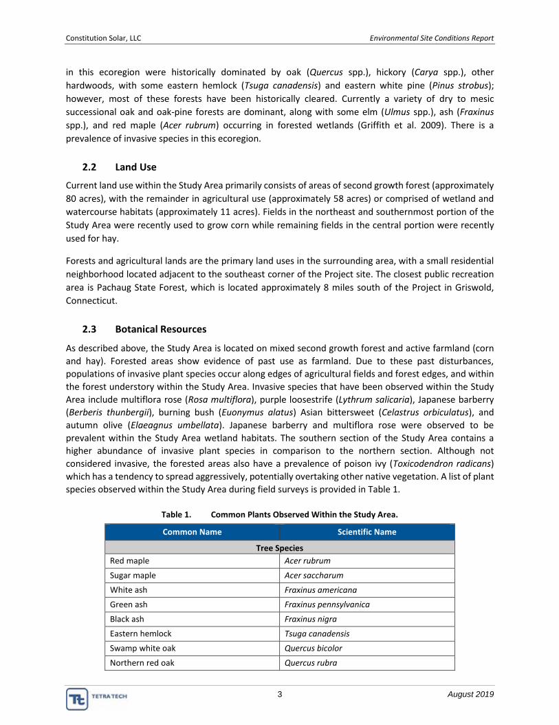
Constitution Solar, LLC Environmental Site Conditions Report
3 August 2019
in this ecoregion were historically dominated by oak (Quercus spp.), hickory (Carya spp.), other
hardwoods, with some eastern hemlock (Tsuga canadensis) and eastern white pine (Pinus strobus);
however, most of these forests have been historically cleared. Currently a variety of dry to mesic
successional oak and oak-pine forests are dominant, along with some elm (Ulmus spp.), ash (Fraxinus
spp.), and red maple (Acer rubrum) occurring in forested wetlands (Griffith et al. 2009). There is a
prevalence of invasive species in this ecoregion.
2.2 Land Use
Current land use within the Study Area primarily consists of areas of second growth forest (approximately
80 acres), with the remainder in agricultural use (approximately 58 acres) or comprised of wetland and
watercourse habitats (approximately 11 acres). Fields in the northeast and southernmost portion of the
Study Area were recently used to grow corn while remaining fields in the central portion were recently
used for hay.
Forests and agricultural lands are the primary land uses in the surrounding area, with a small residential
neighborhood located adjacent to the southeast corner of the Project site. The closest public recreation
area is Pachaug State Forest, which is located approximately 8 miles south of the Project in Griswold,
Connecticut.
2.3 Botanical Resources
As described above, the Study Area is located on mixed second growth forest and active farmland (corn
and hay). Forested areas show evidence of past use as farmland. Due to these past disturbances,
populations of invasive plant species occur along edges of agricultural fields and forest edges, and within
the forest understory within the Study Area. Invasive species that have been observed within the Study
Area include multiflora rose (Rosa multiflora), purple loosestrife (Lythrum salicaria), Japanese barberry
(Berberis thunbergii), burning bush (Euonymus alatus) Asian bittersweet (Celastrus orbiculatus), and
autumn olive (Elaeagnus umbellata). Japanese barberry and multiflora rose were observed to be
prevalent within the Study Area wetland habitats. The southern section of the Study Area contains a
higher abundance of invasive plant species in comparison to the northern section. Although not
considered invasive, the forested areas also have a prevalence of poison ivy (Toxicodendron radicans)
which has a tendency to spread aggressively, potentially overtaking other native vegetation. A list of plant
species observed within the Study Area during field surveys is provided in Table 1.
Table 1. Common Plants Observed Within the Study Area.
Common Name Scientific Name
Tree Species
Red maple Acer rubrum
Sugar maple Acer saccharum
White ash Fraxinus americana
Green ash Fraxinus pennsylvanica
Black ash Fraxinus nigra
Eastern hemlock Tsuga canadensis
Swamp white oak Quercus bicolor
Northern red oak Quercus rubra

Constitution Solar, LLC Environmental Site Conditions Report
4 August 2019
Common Name Scientific Name
Yellow birch Betula alleghaniensis
Black birch Betula lenta
Paper birch Betula papyrifera
Gray birch Betula populifolia
American hornbeam Carpinus caroliniana
Balsam fir Abies balsamea
Black walnut Juglans nigra
Shagbark hickory Carya ovata
Pignut hickory Carya glabra
Bitternut hickory Carya cordiformis
American elm Ulmus americana
American beech Fagus grandifolia
Eastern white pine Pinus strobus
Shrub and Sapling Species
White ash Fraxinus americana
Northern spicebush Lindera benzoin
Japanese barberry* Berberis thunbergii
Multiflora rose* Rosa multiflora
Burning bush* Euonymus alatus
Swamp holly Ilex mucronata
Virginia creeper Parthenocissus quinquefolia
American hornbeam Carpinus caroliniana
Yellow birch Betula alleghaniensis
Pignut Hickory Carya glabra
Coastal sweet pepperbush Clethra alnifolia
Mountain laurel Kalmia latifolia
Maple-leaf arrowwood Viburnum acerifolium
Highbush blueberry Vaccinium corymbosum
Bristly dewberry Rubus hispidus
Autumn olive* Elaeagnus umbellata
Asian bittersweet* Celastrus orbiculatus
Herbaceous Plant Species
Skunk cabbage Symplocarpus foetidus
Cinnamon fern Osmundastrum cinnamomeum
Jewelweed Impatiens capensis
Canada mayflower Maianthemum canadense
Marginal wood fern Dryopteris marginalis
Interrupted fern Osmunda claytoniana
Northern water horehound Lycopus uniflorus
Jack-in-the-pulpit Arisaema triphyllum

Constitution Solar, LLC Environmental Site Conditions Report
5 August 2019
Common Name Scientific Name
Poison ivy Toxicodendron radicans
Christmas fern Polystichum acrostichoides
Smallspike false nettle Boehmeria cylindrica
Sensitive fern Onoclea sensibilis
New York fern Parathelypteris noveboracensis
Sand violet Viola affinis
Wrinkleleaf goldenrod Solidago rugosa
Stalk-grain sedge Carex stipata
Upright sedge Carex stricta
Sweet joe-pye weed Eutrochium purpureum
Rattlesnake manna grass Glyceria canadensis
Bluejoint Calamagrostis canadensis
Purplestem aster Symphyotrichum puniceum
Harlequin blue flag Iris versicolor
Purple loosestrife* Lythrum salicaria
King-of-the-meadow Thalictrum pubescens
Mountain wood fern Dryopteris campyloptera
Common wild oat Avena fatua
Heartleaf foamflower Tiarella cordifolia
Fowl manna grass Glyceria striata
Partridgeberry Mitchella repens
Evergreen wood fern Dryopteris intermedia
Bigleaf aster Eurybia macrophylla
Northern lady fern Athyrium angustum
Hayscented fern Dennstaedtia punctilobula
Virginia creeper Parthenocissus quinquefolia
Meadow grass Poa spp.
Bedstraw Galium spp.
Fescue Festuca spp.
Reed canary grass Phalaris arundinacea
Clover Trifolium spp.
*Connecticut Invasive Species (University of Connecticut, Connecticut Invasive Plant Working Group no date)
3 WATER RESOURCES
The Study Area is located within the Cory Brook-Quinebaug River Watershed, with the Quinebaug River
located west of the Study Area boundary. Approximately 2 acres within the northern portion of the Study
Area located adjacent to the Quinebaug River is located within Flood Zone AE, which is subject to
inundation by the 1 percent-annual-chance flood (Federal Emergency Management Agency no date).
Otherwise there are no additional floodplain features mapped within in the Study Area.

Constitution Solar, LLC Environmental Site Conditions Report
6 August 2019
Formal wetland and watercourse delineation and vernal pool surveys have been completed within the
Study Area (see Appendix C). These field surveys were overseen by a current Certified Soil Scientist and
registered professional member of the Soil Science Society of Southern New England (see resumes
provided in Appendix E).
3.1 Wetlands and Watercourses
Wetland and watercourse delineations were completed for the Project in June 2017 in accordance with
the definitions described in the Inland Wetlands and Watercourses Regulations of the Town of Plainfield
(Town of Plainfield 2012) and Section 22a-38 of Connecticut General Statues. Additionally, wetlands and
watercourses under federal jurisdiction were surveyed according to the technical criteria described in the
United States Army Corps of Engineers (USACE) 1987 Wetland Delineation Manual (USACE 1987), and the
Regional Supplement to the Corps of Engineers Wetland Delineation Manual: Northcentral and Northeast
Region V2.0 (USACE 2012).
Results of the wetlands and watercourse surveys identified 12 wetlands and 10 watercourses that are
regulated by the USACE, DEEP, and Town of Plainfield (Appendix A, Figure 2). Wetland types identified
within the Study Area were classified in accordance with guidance provided in the Classification of
Wetlands and Deepwater Habitats of the United States (Cowardin et al. 1979), and include palustrine
forested (PFO), palustrine emergent (PEM), and wetlands that also contain a mix of PFO and palustrine
scrub-shrub (PSS) or PEM wetlands. PFO wetlands are the most common wetland type occurring
throughout the Study Area. Several intermittent and ephemeral watercourses/drainages were identified
in the Study Area. A more detailed account of these resources is provided in the Vernal Pool Survey and
Wetland and Watercourse Delineation report in Appendix C.
3.2 Vernal Pools
Vernal pool surveys were completed by Tetra Tech in 2017, 2018, and 2019. The 2017 surveys consisted
of two site visits completed April 12 and May 2, 2017; the 2018 surveys consisted of two site visits on April
12 and April 26, 2018; and 2019 surveys consisted of a single site visit completed on May 1, 2019.
Vernal pools within the Study Area were assessed using the tiered methodology described in Best
development practices: Conserving pool-breeding amphibians in residential and commercial
developments in the northeastern United States (Best Development Practices) (Calhoun and Klemens
2002) and the Connecticut Association of Wetland Scientists Vernal Pool Monitoring Program Protocol
(Connecticut Association of Wetland Scientists, no date). Additional guidance was taken from the Maine
Association of Wetland Scientists Vernal Pool Technical Committee, Vernal Pool Survey Protocol (Maine
Association of Wetland Scientists 2014).
The Best Development Practices methodology (Calhoun and Klemens 2002) ranks vernal pool biological
and physical characteristics, including: indicator species diversity and abundance; presence of state-listed
endangered and threatened species, and state species of special concern; and level of
disturbance/development within terrestrial environments located within a 750-foot radius of the vernal
pool. Tiering categories include Tier I, Tier II, and Tier III, with Tier I reflecting vernal pools having the
highest ecological value. Both of the pools identified in the Study Area meet the criteria to be classified as
Tier I pools.

Constitution Solar, LLC Environmental Site Conditions Report
7 August 2019
Two Tier I vernal pools, VP01 and VP02, have been identified within the Study Area (Appendix A, Figure
2). Vernal pool VP01 is a cryptic vernal pool located within a larger wetland system, and vernal pool VP02
occurs in an old oxbow of the Quinebaug River. None of the vernal pool or pool-breeding amphibian
surveys detected presence of pure-diploid blue-spotted salamander (Ambystoma laterale) breeding
activity or individuals. Results of the vernal pools surveys are provided in Appendix C.
Results of the vernal pool survey are discussed further in the Vernal Pool Surveys and Wetland and
Watercourse Delineation Report provided in Appendix C and the Avoidance and Mitigation measures
summarized in Appendix F.
4 WILDLIFE RESOURCES
Habitats available for wildlife in the Study Area include open agricultural fields, second growth forests,
wetlands, watercourses, and vernal pools. Forested areas show some evidence of disturbance and
alteration, and there is a high density and colonization of invasive plant species within successional forest
areas. Agricultural areas have been used most recently for growing crops of corn and hay.
The forested habitat is interspersed with clearings and edge habitats that could be used for foraging by
bats, including the forested riparian area that borders the Quinebaug River. The Study Area also includes
some second growth and early successional, mixed and deciduous forests that may support a variety of
birds and mammals. Grassy clearings and agricultural areas likely provide habitat for small rodents and
other small mammals and could provide foraging areas for raptors and predatory mammals.
Wildlife surveys completed for the Project in 2017 include a bat acoustic survey, and vernal pool survey;
surveys completed in 2018 include vernal pool surveys, a general herpetofauna survey, and focused
surveys for eastern spadefoot toad; and surveys completed in 2019 included additional vernal pool
surveys. Additionally, incidental wildlife observations were recorded during the wetland and watercourse
survey.
Correspondence received from DEEP for the Project did not identify any significant natural community
types within the Study Area (Appendix D), which was confirmed through field survey observations.
4.1 Plant and Wildlife Species that are State and Federally Listed and Species of Special Concern
State and federally listed endangered and threatened species and state species of special concern
discussions are based on review of the USFWS online IPaC tool (Appendix D), consultation with DEEP
regarding species that could potentially occur within the Study Area (Appendix D), and results of several
years of wildlife surveys (Appendix C). Additional background information included review of the
Connecticut NDDB map for the Town of Plainfield; the DEEP County Report of Connecticut’s Endangered,
Threatened and Special Concern Species list for Windham County.
Appendix A, Figure 3 identifies DEEP NDDB polygons mapped on and in the vicinity of the Study Area. The
NDDB review requests for the Study Area identified one state and federally listed endangered species
(sandplain agalinis [Agalinis acuta]), as having the potential to occur. Additionally, the NDDB response
identified two additional state endangered, one state threatened, and eight state species of special
concern as having the potential to occur.

Constitution Solar, LLC Environmental Site Conditions Report
8 August 2019
The IPaC resource lists for the Study Area identified the federally threatened NLEB as having the potential
to occur. The 2019 USFWS database review also identified one state-listed bird species and six additional
bird species that are USFWS Birds of Conservation Concern (BCC) that have the potential to occur in the
Study Area.
Table 2 lists all state and federally listed endangered and threatened species and state species of special
concern that could potentially occur in the Study Area based on field assessments, resource reviews, IPaC
database review, and NDDB correspondence (Appendix D). A discussion of each of these species, their
potential for occurrence, and the potential for the Project to impact each species is provided in this
section. An analysis of each species’ preferred habitat, and their potential for occurrence in the Study Area
has been considered.
Table 2. Potential Wildlife and Plant Species that are Federal and State-Listed, and State
Species of Special Concern within the Study Area.
Common Name Scientific Name Status1
Source Federal State
Mammals
Eastern red bat Lasiurus borealis - SC Survey
Hoary bat Lasiurus cinereus - SC Survey
Northern long-eared bat Myotis septentrionalis T E IPaC
Silver-haired bat Lasionycteris noctivagans - SC Survey
Tri-colored bat Perimyotis subflavus UR E Survey
Birds2
American kestrel Falco sparverius SC NDDB
Bald eagle Haliaeetus leucocephalus BGEPA T IPaC
Black-billed cuckoo Coccyzus erythropthalmus BCC - IPaC
Bobolink Dolichonyx oryzivorus BCC SC IPaC
Brown thrasher Toxostoma rufum - SC NDDB
Eastern whip-poor-will Antrostomus vociferus BCC SC3 IPAC
Prairie warbler Setophaga discolor BCC - IPaC
Rusty blackbird Euphagus carolinus BCC (nb) - IPaC
Wood thrush Hylocichla mustelina BCC - IPaC
Reptiles
Wood turtle Glyptemys insculpta - SC NDDB4
Eastern hognose snake Heterodon platirhinos - SC NDDB
Eastern ribbon snake Thamnophis sauritus - SC NDDB
Amphibians
Blue-spotted salamander (pure-diploid) Ambystoma laterale - E NDDB
Eastern spadefoot toad Scaphiopus holbrookii - E NDDB
Fish
Banded sunfish Enneacanthus obesus - SC NDDB
Invertebrates
Eastern pearlshell Margaritifera margaritifera - SC NDDB

Constitution Solar, LLC Environmental Site Conditions Report
9 August 2019
Common Name Scientific Name Status1
Source Federal State
Sparkling jewelwing Calopteryx dimidiate T NDDB
Vascular Plants
Alleghany plum Prunus alleghaniensis - SC* NDDB
Low frostweed Crocanthemum propinquum - SC NDDB
Sandplain agalinis Agalinis acuta E E NDDB
1 – BCC – USFWS Bird of Conservation Concern (for Bird Conservation Region New England/Mid-Atlantic Coast); BCC (nb) – BCC non-breeding
population; BGEPA – protected by the Bird and Golden Eagle Protection Act; E – endangered; SC – state species of special concern; T –
threatened; UR – under review for federal listing
2 – All bird species listed in table also are protected by the federal Migratory Bird Treaty Act
3 – Listed in the Connecticut Endangered, Threatened, and Special Concern Species list under the synonym Caprimulgus vociferus (DEEP 2015a).
4 – NDDB email communication received July 24, 2019
* – Believed extirpated
Sources: DEEP 2016, 2017a, USFWS 2019
4.2 Federally Listed Threatened and Endangered Species
Based on the USFWS IPaC and NDDB reviews for the Project, three federally listed or protected species
have been identified as having the potential to occur in the Study Area. The USFWS IPaC tool is an
inventory that can be generated to identify federally listed species and significant natural communities
that may be present at a particular site. According to the IPaC report generated for the Study Area, one
federally listed mammal species (NLEB) and one federally protected bird species (bald eagle [Haliaeetus
leucocephalus]), was identified as having the potential to occur (USFWS 2019). Although bald eagle is no
longer listed under the federal Endangered Species Act (ESA), it is discussed in this section due to its
federal protection afforded by the Bald and Golden Eagle Protection Act. One federally endangered plant
species, sandplain agalinis, was identified during the NDDB Project review as having the potential to occur
at the Project site. These three species are discussed in this section.
Northern Long-Eared Bat
NLEB is a federally threatened species, and a Connecticut endangered species. NLEB was listed as
threatened under the federal ESA due to the overwhelming threat of white nose syndrome to the species.
In February 2016, a final 4(d) rule for NLEB was published under the ESA (Federal Register 2016, USFWS
2017a). The final 4(d) rule identifies specific protections for NLEB, which focus on protecting individuals
where they are most vulnerable: maternity roost trees (during the pup-rearing months of June and July)
and hibernation sites.
DEEP has not identified any known NLEB hibernacula in the Town of Plainfield, Connecticut (DEEP 2016).
Additionally, no known NLEB maternity roost trees have been identified in Connecticut. Due to the
presence of potential roosting and foraging habitat within the Study Area that could support NLEB, a bat
acoustic survey was completed in July 2017 to determine presence/absence of NLEB within the Study
Area. Results of the survey did not confirm presence of NLEB. A detailed report summarizing the full
results of the NLEB survey is provided in Appendix C. Construction and operation of solar facilities, such
as the proposed Project, performed under the guidance contained within the 4(d) rule, is not considered
a threat to NLEB.
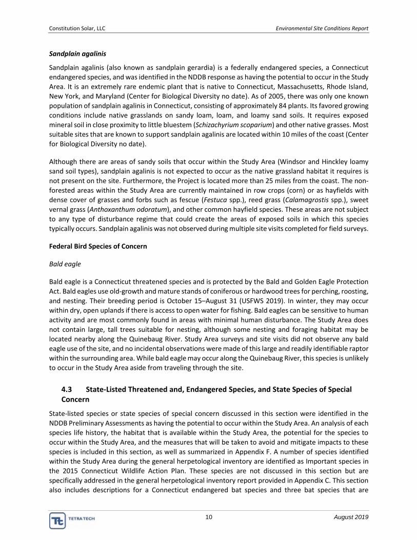
Constitution Solar, LLC Environmental Site Conditions Report
10 August 2019
Sandplain agalinis
Sandplain agalinis (also known as sandplain gerardia) is a federally endangered species, a Connecticut
endangered species, and was identified in the NDDB response as having the potential to occur in the Study
Area. It is an extremely rare endemic plant that is native to Connecticut, Massachusetts, Rhode Island,
New York, and Maryland (Center for Biological Diversity no date). As of 2005, there was only one known
population of sandplain agalinis in Connecticut, consisting of approximately 84 plants. Its favored growing
conditions include native grasslands on sandy loam, loam, and loamy sand soils. It requires exposed
mineral soil in close proximity to little bluestem (Schizachyrium scoparium) and other native grasses. Most
suitable sites that are known to support sandplain agalinis are located within 10 miles of the coast (Center
for Biological Diversity no date).
Although there are areas of sandy soils that occur within the Study Area (Windsor and Hinckley loamy
sand soil types), sandplain agalinis is not expected to occur as the native grassland habitat it requires is
not present on the site. Furthermore, the Project is located more than 25 miles from the coast. The non-
forested areas within the Study Area are currently maintained in row crops (corn) or as hayfields with
dense cover of grasses and forbs such as fescue (Festuca spp.), reed grass (Calamagrostis spp.), sweet
vernal grass (Anthoxanthum odoratum), and other common hayfield species. These areas are not subject
to any type of disturbance regime that could create the areas of exposed soils in which this species
typically occurs. Sandplain agalinis was not observed during multiple site visits completed for field surveys.
Federal Bird Species of Concern
Bald eagle
Bald eagle is a Connecticut threatened species and is protected by the Bald and Golden Eagle Protection
Act. Bald eagles use old-growth and mature stands of coniferous or hardwood trees for perching, roosting,
and nesting. Their breeding period is October 15–August 31 (USFWS 2019). In winter, they may occur
within dry, open uplands if there is access to open water for fishing. Bald eagles can be sensitive to human
activity and are most commonly found in areas with minimal human disturbance. The Study Area does
not contain large, tall trees suitable for nesting, although some nesting and foraging habitat may be
located nearby along the Quinebaug River. Study Area surveys and site visits did not observe any bald
eagle use of the site, and no incidental observations were made of this large and readily identifiable raptor
within the surrounding area. While bald eagle may occur along the Quinebaug River, this species is unlikely
to occur in the Study Area aside from traveling through the site.
4.3 State-Listed Threatened and, Endangered Species, and State Species of Special Concern
State-listed species or state species of special concern discussed in this section were identified in the
NDDB Preliminary Assessments as having the potential to occur within the Study Area. An analysis of each
species life history, the habitat that is available within the Study Area, the potential for the species to
occur within the Study Area, and the measures that will be taken to avoid and mitigate impacts to these
species is included in this section, as well as summarized in Appendix F. A number of species identified
within the Study Area during the general herpetological inventory are identified as Important species in
the 2015 Connecticut Wildlife Action Plan. These species are not discussed in this section but are
specifically addressed in the general herpetological inventory report provided in Appendix C. This section
also includes descriptions for a Connecticut endangered bat species and three bat species that are

Constitution Solar, LLC Environmental Site Conditions Report
11 August 2019
Connecticut species of special concern which were identified as occurring in the Study Area during the bat
acoustic survey. These bat species are not listed in the NDDB Preliminary Assessments.
State Threatened Species
Consultation with DEEP identified one state threatened species that could potentially occur within the
Study Area: sparkling jewelwing (Calopteryx dimidiata). Six additional state threatened bird species were
identified in the USFWS IPaC review that could potentially occur in the Study Area.
Invertebrate Animals
Eastern pearlshell
Life History – Eastern pearlshell (Margaritifera margaritifera) is a Connecticut species of special concern
that was identified in the NDDB response as having the potential to occur in the Study Area. Eastern
pearlshell can live to be up to 200 years old. Millions of glochidia are ejected into the water from an adult
over one or two days in June and July. Larvae use fish from the salmonid family as a host for about one
year before dropping off and attaching to a substrate of sand or gravel. Adults are sessile, with only
limited, passive, downstream movement.
Habitat – This mussel is generally found in cold, nutrient-poor, unpolluted trout streams and smaller rivers
with moderate flow rates. Clean substrates and low silt environments are important for juvenile eastern
pearlshell. In Connecticut, it is found in many major watersheds but is most common in the northern and
northwestern parts of the state (Nedeau and Victoria 2003).
Potential to occur – Although the Quinebaug River located west of the Study Area could provide suitable
habitat for eastern pearlshell, the Study Area does not contain suitable habitat to support this species. No
trout streams or riverine habitat occurs within the Study Area. All of the streams present within the Study
Area are intermittent or ephemeral drainages that do not support year-round water flows. No mussels
were observed within watercourses during field surveys and eastern pearlshell is not expected to occur
within the Study Area.
Avoidance – The proposed Development Area avoids direct impacts to wetlands and watercourses. The
potential impact to freshwater mussels from Project construction is erosion and sedimentation that could
runoff from the site and affect the water quality of adjacent water resources. Implementation of
stormwater controls and site stabilization best management practices will be used to protect the water
quality of watercourse within the study area as well as the Quinebaug River, adjacent to the project site.
Areas identified as having an increased susceptibility to erosion and sedimentation, such as areas
containing steep slopes, will be closely monitored during construction to ensure the proper stormwater
controls are in place. Regular monitoring and increased controls may be necessary in certain areas.
Following installation of the solar array in the agricultural fields, the grasses established below the panels
will help stabilize soils that are currently exposed and subject to erosion. Resource setbacks and
establishing meadow habitat are two ways water quality will be protected throughout the life of the
Project. Regular inspections of stormwater controls, biological monitoring, training of construction and
operations personnel, and documentation and reporting of observations will ensure water quality both
on and off the Project site are maintained.
Constitution Solar, LLC Environmental Site Conditions Report
12 August 2019
Sparkling jewelwing
Life History – Sparkling jewelwing (Calopteryx dimidiata) is a Connecticut threatened species that was
identified in the NDDB response as having the potential to occur in the Study Area. This species of
damselfly is endemic to eastern and southeastern United States, occurring along the Atlantic coastal plain
from New Hampshire south to Florida and west to Texas and Kentucky (Odonata Central no date). Larvae
live in water, and adults are usually found on snags in streams, but may occur in open areas. Adults tend
to stay near the streams from which they emerged (Ly 2014).
Habitat – This species of damselfly belongs to the group of damselflies that breed within riverine habitat
(Paulson et al. 2012). It inhabits woodland and open areas adjacent to forest rivers and streams, including
sandy bottom streams, and rivers with little canopy cover. It prefers sandy forest streams that are acidic,
contain fast-flowing water and abundant riverside vegetation.
Potential to occur – Habitats associated with the Quinebaug River located west of the Study Area could
provide suitable habitat for this species. This species has the potential to occur within the Study Area.
Avoidance – The proposed Development Area avoids impacts to wetlands and watercourses and
maintains a 100-foot buffer from the Quinebaug River. Potential sedimentation and erosion impacts to
waters off-site will be addressed in the stormwater general permit and the Project design plans.
Vascular Plants
Alleghany Plum
Life History – Alleghany plum (Prunus alleghaniensis) is a Connecticut species of special concern and was
identified in the NDDB response as having the potential to occur in the Study Area. It is thought to be
extirpated in Connecticut. Alleghany plum is a small tree or shrub that grows up to 15 feet tall, and can
form thickets, particularly on moist soil (New England Wild Flower Society 2018a).
Habitat – Alleghany plum occurs in anthropogenic (man-made or disturbed) habitats, river or stream
habitats and floodplains and meadow and fields (New England Wild Flower Society 2018a).
Potential to occur – While there is presence of suitable habitat within the Study Area, due to its status as
being extirpated from Connecticut, Alleghany plum is unlikely to occur within the Study Area. It has not
been documented as occurring within Windham County (New England Wild Flower Society 2018a) and
was not observed during field surveys.
Avoidance – Alleghany plum is not expected to occur due to the absence of documentation of this species
in Windham County, its expected extirpation within Connecticut, and lack of observations for the presence
of this species in the Study Area during field surveys. No further avoidance and mitigation measures are
recommended.
Low Frostweed
Life History – Low frostweed (Crocanthemum propinquum) is a Connecticut species of special concern and
was identified in the NDDB response as having the potential to occur in the Study Area. Low frostweed is
perennial herb native to southern New England.

Constitution Solar, LLC Environmental Site Conditions Report
13 August 2019
Habitat – Low frostweed inhabits dry, sandy woodlands, sandplains, and fields; but also occurs in
anthropogenic (man-made or disturbed habitats) areas, grasslands, meadows, and barrens (New England
Wild Flower Society 2018b).
Potential to occur – While this species has been documented in Connecticut, it has not been documented
within Windham County (New England Wild Flower Society 2018b). In Connecticut it is considered rare to
uncommon. This species was not observed during on-site wetland delineation surveys or other natural
resources surveys. Although focused surveys for the presence of this species have not been completed, it
is not expected to occur due to lack of documented occurrence within Windham County.
Avoidance – Low frostweed is not expected to occur in the Study Area due to the absence of
documentation of this species in Windham County, and lack of observations for the presence of this
species in the Study Area during field surveys. No further avoidance and mitigation measures are
recommended.
Vertebrate Animals
Banded sunfish
Life History – Banded sunfish (Enneacanthus obesus) is a Connecticut species of special concern and was
identified in the NDDB response as having the potential to occur in the Study Area. This species feeds on
insects, insect larvae, crustaceans, and some plant material. They are adapted to survive in poor water
conditions.
Habitat – Banded sunfish prefer stands of submerged aquatic vegetation along the margins of lakes,
ponds, and slow flowing rivers (New Hampshire Fish and Game, no date). They also can be found far
upstream of beaver ponds and small wetlands in the headwater streams of a watershed. This species can
tolerate highly acidic water and are able to survive waters that have a pH below 4.5. It is fairly widespread
in New England and is known to occur in Connecticut (North American Native Fishes Association 2005).
Its range in Massachusetts and Connecticut extends from the east westward to the vicinity of the
Connecticut River, with only one known population documented west of the Connecticut River.
Potential to occur – The proposed Study Area does not have any lake, pond, or slow-moving river habitat
that would support banded sunfish. Due to the lack of suitable habitat to support banded sunfish in the
Study Area, this species is unlikely to occur.
Avoidance –The potential impact to fish from Project construction is erosion and sedimentation that could
runoff from the site and affect the water quality of adjacent water resources. Potential sedimentation and
erosion impacts to waters off-site will be addressed in the stormwater general permit and the Project
design plans. Furthermore, the Project has been designed to avoid impacts to watercourses.
Areas identified as having an increased susceptibility to erosion and sedimentation, such as areas
containing steep slopes, will be closely monitored during construction to ensure the proper stormwater
controls are in place. Regular monitoring and increased controls may be necessary in certain areas.
Following installation of the solar array in the agricultural fields, the grasses established below the panels
will help stabilize soils that are currently exposed and subject to erosion. Resource setbacks and
establishing meadow habitat are two ways water quality will be protected throughout the life of the
Project. Regular inspections of stormwater controls, biological monitoring, training of construction and

Constitution Solar, LLC Environmental Site Conditions Report
14 August 2019
operations personnel, and documentation and reporting of observations will ensure water quality both
on and off the Project site are maintained.
Eastern hognose snake
Life History – Eastern hognose snake (Heterodon platirhinos) is a Connecticut species of special concern
and was identified in the NDDB response as having the potential to occur in the Study Area. This solitary
species can occur up to 1,200 feet in elevation and are active strictly during the day. They are often seen
crossing roads in the spring and fall. They prey on frogs, salamanders, small mammals, birds, and
invertebrates. This species is susceptible to habitat disturbance and fluctuations in prey population can
affect their density (DEEP 2019a).
Habitat – Eastern hognose snakes prefer woodlands with loose, sandy, gravely soils that are well drained.
They utilize underground passages created by small mammals within fields, open grassy areas adjacent to
woods, and open forests (DEEP 2019a). They are typically not associated with dense wooded areas and
are more adapted to inhabiting edge habitats. In Connecticut the eastern hognose snake may occur
throughout the state, although they are more common in inland areas with moderate elevations.
Potential to occur – Although eastern hognose snake occurs throughout Connecticut their population
numbers are not always abundant, and it is one of the rarer snakes encountered due to population
declines related to human disturbance and habitat loss. Eastern hognose snake has the potential to occur
within the Study Area, as some suitable habitats consisting of sandy and gravely soil are present in small
areas; however, this was not observed during the 2018 herpetological surveys completed for the Project
(Appendix C). Additionally, no incidental observations were recorded during other field surveys. Eastern
hognose snakes do not make large seasonal migratory movements and based on the results of this survey
and rarity of this species, eastern hognose snake is not expected to occur.
Avoidance – During the construction phase of the Project, exclusion fencing will be used to prevent
eastern hognose snakes from accessing construction areas. Exclusion fencing for the Project will be
coordinated with the prescribed stormwater phasing and installed to enclose the work areas at the limit
of work, thereby preventing reptiles and amphibians from entering active construction zones. Following
initial installation of silt fencing, searches will be completed within the enclosed areas to detect and
remove any entrapped reptiles and amphibians. Any temporary barriers and exclusion fencing that is
installed will be regularly monitored and maintained throughout the construction phase. Additional
avoidance and mitigation measures planned for herpetofauna are described in Section 6 and Appendix F.
Wood Turtle
Life History – Wood turtle (Glyptemys insculpta) is a Connecticut species of special concern. They are
omnivorous and opportunistic foragers, feeding on slugs, worms, tadpoles, insects, algae, wild fruit,
leaves, grass, moss, and carrion (DEEP 2019b).
Habitat – Wood turtles require riparian habitats bordered by floodplain, woodland, or meadows (Klemens
1993, Compton et al., 2002, Arvisais et al., 2002 and 2004, cited in Gibbs et al., 2007). They are typically
associated with open sites close to water with a low canopy cover (Compton et al., 2002) and also are
known to use agricultural land (Parham and Feldman, 2000, cited in Gibbs et al., 2007). In the winter they
hibernate in streams, in either deep pools or lodged below undercut banks (Klemens 1993). In Connecticut
they emerge during the spring in late March and early April.

Constitution Solar, LLC Environmental Site Conditions Report
15 August 2019
Potential to occur – Wood turtles are found throughout Connecticut, although they are less common in
the eastern portion of Windham County (where the Project is located). Populations have declined and
become isolated due to habitat loss (Klemens 1993) and habitat fragmentation, overcollection,
and mortality associated with vehicles on roadways (Klemens 1993 and Gibbs et al., 2007). Wood turtles
were not observed within the Study Area during focused surveys for this species; however, they are
known to occur in the Quinebaug River (see Appendix C, General Herpetological Inventory report). The
section of the Quinebaug River located adjacent to the western boundary of the Project appears to
provide suitable habitat for this species; however, the Study Area itself lacks the bordering open-
canopy floodplain or meadows that the species is associated with. This section of the river sits within a
very steep ravine with forest dominated by hemlock, the canopy of which blocks out sunlight. The edges
of the agricultural fields nearest the river also have an abrupt transition to forest and lack the strip of
old field habitat that wood turtles tend to inhabit.
Avoidance – During the construction phase of the Project, exclusion fencing will be used to prevent wood
turtle from accessing construction areas. Exclusion fencing for the Project will be coordinated with the
prescribed stormwater phasing and installed to enclose the work areas at the limit of work, thereby
preventing reptiles and amphibians from entering active construction zones. Following initial installation
of silt fencing, searches will be completed within the enclosed areas to detect and remove any entrapped
reptiles and amphibians. Any temporary barriers and exclusion fencing that is installed will be regularly
monitored and maintained throughout the construction phase. Additional avoidance and mitigation
measures planned for herpetofauna are described in Section 6 and Appendix F.
Eastern ribbon snake
Life History – Eastern ribbon snake (Thamnophis sauritus) is a Connecticut species of special concern and
was identified in the NDDB response as having the potential to occur in the Study Area. They eat small
fish and amphibians and may be seen swimming in water along shorelines.
Habitat – Eastern ribbon snake is usually found near a body of water such as a pond or bog, but prefers
open-canopy, wet sedge meadows.
Potential to occur – Ribbon snakes are found throughout Connecticut, although their distribution is spotty
(DEEP 2019c). The species has been undergoing long-term declines throughout the state, which may be
related to a reduction in their preferred habitat, such as draining of wet meadow habitat and
impoundment of marshy areas to create ponds and reservoirs. The Study Area contains some emergent
wetland habitat; however, suitable habitat for this species does not occur within the Development Area
as the Project has been sited to avoid all direct impacts to water resources. This species was not observed
during 2018 herpetological surveys (Appendix C) completed for the Study Area. Additionally, no incidental
observations were recorded during other field surveys.
Avoidance – During the construction phase of the Project, exclusion fencing will be used to prevent
eastern ribbon snake from accessing construction areas. Exclusion fencing for the Project will be
coordinated with the prescribed stormwater phasing and installed to enclose the work areas at the limit
of work, thereby preventing reptiles and amphibians from entering active construction zones. Following
initial installation of silt fencing, searches will be completed within the enclosed areas to detect and
remove any entrapped reptiles and amphibians. Any temporary barriers and exclusion fencing that is
installed will be regularly monitored and maintained throughout the construction phase. Additional
avoidance and mitigation measures planned for herpetofauna are described in Section 6 and Appendix F.

Constitution Solar, LLC Environmental Site Conditions Report
16 August 2019
Blue-spotted salamander (pure-diploid)
Life History – Blue-spotted salamander is a Connecticut endangered species and was identified in the
NDDB response as having the potential to occur in the Study Area. Two variations of these species are
found in Connecticut: the pure diploid blue-spotted salamander and the hybridized complex blue-spotted
salamander. The pure diploid variation of this species is endangered in Connecticut.
Habitat – Blue-spotted salamander is typically found in red maple swamps near woodlands with water-
saturated loam or damp sands.
Potential to occur – Vernal pool surveys completed in 2017 during the seasonally appropriate period did
not identify any evidence of blue-spotted salamander breeding activity (specimens or egg masses) in the
Study Area. Additional pool-breeding amphibian surveys completed in 2018 and vernal pool surveys
completed for the Study Area in 2019, also did not identify the occurrence of this species, and it is unlikely
to occur.
Avoidance – All vernal pools located within the Study Area will include a no disturbance buffer. These
buffers will be avoided during construction and operation of the Project and will provide for conservation
of potential habitat for this species. No alteration of terrain within these buffers is being proposed for the
construction and operation of this Project.
During the construction phase of the Project, exclusion fencing will be used to prevent salamanders from
accessing construction areas. Exclusion fencing for the Project will be coordinated with the prescribed
stormwater phasing and installed to enclose the work areas at the limit of work, thereby preventing
reptiles and amphibians from entering active construction zones. Following initial installation of silt
fencing, searches will be completed within the enclosed areas to detect and remove any entrapped
reptiles and amphibians. Any temporary barriers and exclusion fencing that is installed will be regularly
monitored and maintained throughout the construction phase. Additional avoidance and mitigation
measures planned for herpetofauna are described in Section 6 and Appendix F.
Eastern spadefoot toad
Life History – Eastern spadefoot toad is a Connecticut endangered species and was identified in the NDDB
response as having the potential to occur in the Study Area. This species is nocturnal and usually
subterranean, lying dormant for weeks during dry periods. They emerge after a period of heavy rains and
breed in temporary waterbodies. Breeding periods occur any time between April to July in Connecticut.
Breeding includes laying strings of egg masses that typically hatch within 1–7 days. Tadpoles grow quickly
and metamorphose anywhere between 16 and 63 days, depending on the time of year (DEEP 2019d).
Habitat – Eastern spadefoot toad lives underground and prefers dry habitats with sandy soil. Calhoun and
Klemens (2002) has found occurrences correlate strongly with Hinckley soils. Sandy soils mapped in the
Study Area include Windsor and Hinckley loamy sand soil types and are primarily mapped along the
northern and western boundaries (Appendix A, Figure 4). Approximately 10% of Study Area soils are
mapped as Hinckley soils and approximately 12% of Study Area soils are mapped as Windsor soils.
Potential to occur –Despite the presence of suitable sandy soils and predicted habitat based on modelling,
the Study Area appears to lack the requisite combination of bare soil and clumps of vegetation
characteristic of spadefoot toad habitat in eastern Connecticut (Appendix C). Focused eastern spadefoot
toad surveys completed for the Study Area in 2018 did not identify presence of this species. Additionally,

Constitution Solar, LLC Environmental Site Conditions Report
17 August 2019
no suitable breeding pools for spadefoot toad were identified in the Study Area. Two vernal pools are
located within forested wetlands within the Study Area; however, pools used by spadefoot toads in
Connecticut typically have an open canopy, which these pools do not. Based on the presence of marginal
habitat and the negative results of the focused surveys for this species, eastern spadefoot toad is unlikely
to occur in the Study Area.
Avoidance – During the construction phase of the Project, exclusion fencing will be used to prevent toads
from accessing construction areas. Exclusion fencing for the Project will be coordinated with the
prescribed stormwater phasing and installed to enclose the work areas at the limit of work, thereby
preventing reptiles and amphibians from entering active construction zones. Following initial installation
of silt fencing, searches will be completed within the enclosed areas to detect and remove any entrapped
reptiles and amphibians. Any temporary barriers and exclusion fencing that is installed will be regularly
monitored and maintained throughout the construction phase. Additional avoidance and mitigation
measures planned for herpetofauna are described in Section 6 and Appendix F.
American kestrel
Life History – American kestrel (Falco sparverius) is a Connecticut species of special concern and was
identified in the NDDB response as having the potential to occur in the Study Area. They have the potential
to occur in Connecticut year-round, although their occurrence during the winter months is rare. They most
commonly occur during spring and fall migration.
Habitat – American kestrel inhabits open habitats and that contain plenty of nesting cavities and hunting
perches (DEEP 2015b). They prefer grassy or shrubby areas with short vegetation, in which they hunt prey.
In Connecticut they are associated with agricultural areas (hay fields, orchards, and pastures), airports,
large parks, and powerline rights-of-way, as well as meadows and grassy fields, including old fields (DEEP
2015b).
Potential to occur – Due to the presence of suitable nesting and foraging habitat within the Study Area,
American kestrel has the potential to occur.
Avoidance –Avoidance measures that will be employed during construction include following seasonal
clearing restrictions for NLEB and other migratory species such as American kestrel. Mitigation strategies
to be employed include construction-phase environmental monitoring, on-site environmental training for
contractors, and minimizing soil disturbance. It is likely that if present, American kestrel will avoid the
Project area during construction, and return to the site to hunt or forage following the completion of
construction. Installation of exclusion fencing around active work areas during construction and
performing sweeps of enclosed areas to remove any wildlife that may become entrapped also should limit
the presence of potential prey items that could attract kestrels to the construction areas.
Brown thrasher
Life History – Brown thrasher (Toxostoma rufum) is a Connecticut species of special concern and was
identified in the NDDB response as having the potential to occur in the Study Area. This fairly large, slender
songbird forages on the ground, below dense cover. They prey on insects and forage for seeds and berries.
Habitat – Brown thrasher typically nests in scrubby fields, dense revegetating woods, and forest edges.

Constitution Solar, LLC Environmental Site Conditions Report
18 August 2019
Potential to occur – The Study Area is comprised of mixed-growth forest, could potentially support this
species; however, field surveys did not document presence of brown thrasher.
Avoidance – Conducting forest clearing activities during the winter will avoid potential direct impacts to
brown thrasher.
State-Listed Bat Species
During the bat acoustic data analysis conducted for the 2017 NLEB presence/absence survey tri-colored
bat (Perimyotis subflavus), a Connecticut endangered species; and silver-haired bat (Lasionycteris
noctivagans) bat, eastern red bat (Lasiurus borealis), and hoary bat (L. cinereus), all Connecticut species
of special concern, were documented as occurring within the Study Area. Big brown bat (Eptesicus fuscus)
also was confirmed in the Study Area during the 2017 survey; however, this bat species does not have any
state listing or special concern status in Connecticut and is not discussed further in this report.
Eastern red bat
Eastern red bat is a Connecticut species of special concern. This medium-sized, tree-roosting bat is found
across eastern North America. Eastern red bats forage for insects along stream corridors and are typically
found amongst dead leaves on the branches of hardwood trees, and sometimes evergreens. It is a solitary
species. Eastern red bat was documented as occurring in the Study Area during bat acoustic surveys
completed in 2017. The acoustic software used to analyze all the bat passes recorded auto-classified 881
bat passes as eastern red bat, and they were positively identified at all four of the detector stations
established for the survey (Appendix C).
Hoary bat
Hoary bat is a Connecticut species of special concern. This dark brown, tree-roosting bat normally roosts
alone in coniferous and mixed hardwood-conifer forest. They forage along the edge of clearings, but also
may use heavy forests, open wooded glades, and shade trees along urban streets and city parks. Hoary
bat was documented as occurring in the Study Area during bat acoustic surveys completed in 2017. The
acoustic software used to analyze all the bat passes recorded auto-classified 1,356 bat passes as hoary
bat, and they were positively identified at all four of the detector stations established for the survey
(Appendix C).
Silver-haired bat
Silver-haired bat is a Connecticut species of special concern. Unlike many bat species, this tree-roosting
bat hibernates mainly in forested areas, although they may make long migrations from their summer
habitats to a winter forest site. Typical hibernation roosts include small tree hollows, beneath exfoliating
bark, in wood piles, and in cliff faces; most often roosting within old growth, mixed coniferous and
deciduous forests. Occasionally silver-haired bats hibernate in cave entrances, especially in northern
regions of their range. It forages primarily on small, soft-bodied insects. Silver-haired bat was documented
as occurring in the Study Area during bat acoustic surveys completed in in 2017. The acoustic software
used to analyze all the bat passes recorded auto-classified 631 bat passes as silver-haired bat, and they
were positively identified at all four of the detector stations established for the survey (Appendix C).

Constitution Solar, LLC Environmental Site Conditions Report
19 August 2019
Tri-colored bat
Tri-colored bat is a Connecticut endangered species. This species also is currently under review by USFWS
for listing under the federal ESA (USFWS 2017b). Tri-colored bat is one of the smallest bats in eastern
North America and is named for the distinctive coloration of each hair. Tri-colored bat are typically found
in caves or mines and hunt at the edges of forests, near streams or over open water. Although suitable
roosting habitat is not present, this species was documented in the Study Area in 2017, likely during
foraging. The acoustic software used to analyze all the bat passes recorded auto-classified 113 bat passes
as tri-colored bat, and they were positively identified at all four of the detector stations established for
the survey (Appendix C).
Avoidance – Avoidance measures identified for protection of tree-roosting bat species during Project
development includes tree clearing restrictions, which are discussed further in Section 6 and Appendix F
(Avoidance and Mitigation Plan), and includes limiting forest clearing activities to the winter months to
avoid any potential for incidental take of tree-roosting bat species that are known or have the potential
to occur.
4.4 Migratory Birds
As identified in Table 2, DEEP and USFWS have identified nine migratory bird species protected by the
Migratory Bird Treaty Act that could potentially occur within the Study Area. Six of these bird species also
are identified by USFWS as BCC species (USFWS 2019). None of these bird species are listed under the
federal ESA. Four of the nine migratory birds that have the potential to occur are Connecticut species of
special concern. Birds having a state listing designation (endangered, threatened, or species of special
concern) that were identified in the NDDB Project review (American kestrel and brown thrasher) have
been previously described in the Vertebrate Animals discussion in Section 4.3. The following section
describes the remaining six migratory bird species that have been identified as USFWS BCC species or are
of other concern to USFWS.
Black-billed cuckoo
Black-billed cuckoo (Coccyzus erythropthalmus) is a USFWS BCC for the Study Area, and their breeding
period is May 15–October 10 (USFWS 2019). Black-billed cuckoo is most commonly found around the
edges of mature deciduous or mixed forests; however, it also can be found in younger growth forests with
shrubs and thickets. Nests are built in trees and consist of a flimsy cup made of twigs and grasses, lined
with dead or green leaves, pine needles, stalks, rootlets, moss, and spider webs. Due to the presence of
suitable habitat to support this species, black-billed cuckoo has the potential to occur within Study Area.
Bobolink
Bobolink (Dolichonyx oryzivorus) is a USFWS BCC and a Connecticut species of special concern for the
Study Area. Bobolink occur in hayfields and meadows, and during migration are associated with marsh
habitat. Most bobolink in the eastern United States nest in hayfields (Audubon no date), having a breeding
period of May 20–July 31 (USFWS 2019). Nests are shallow open cups placed on the ground, or rarely just
above it, and are well hidden within dense vegetation. It feeds mostly on insects and seeds (Audubon no
date). Due to the presence of suitable nesting habitat to support this species, bobolink has the potential
to occur within Study Area.

Constitution Solar, LLC Environmental Site Conditions Report
20 August 2019
Eastern whip-poor-will
Eastern whip-poor-will (Antrostomus vociferus) is a USFWS BCC and a Connecticut species of special
concern for the Study Area. Eastern whip-poor-will occur in open woodlands, breeding in dry deciduous
or evergreen-deciduous forests having little to no underbrush (Cornell Lab of Ornithology 2017a). Their
breeding period is May 1–August 20 (USFWS 2019). No nests are created, rather eggs are laid directly on
the ground in leaf litter, and occasionally on bare ground, sand, or decayed wood (Cornell Lab of
Ornithology 2017a). It feeds exclusively on insects, foraging in the early evening and at dawn, or when
prey is visible during a full moon. Due to the presence of suitable nesting habitat to support this species,
eastern whip-poor-will has the potential to occur within Study Area.
Prairie warbler
Prairie warbler (Setophaga discolor) is a USFWS BCC for the Study Area. This small yellow songbird is
commonly found in scrubby fields and regenerating forests throughout the eastern and south-central
United States. Nests consist of a cup of long plant fibers and other material, lined with grass, moss, and
feathers placed in trees or shrubs, usually less than 10 feet from the ground (Cornell Lab of Ornithology
2017b). Their breeding period occurs from May 1–July 31. Due to the presence of suitable habitat to
support this species, prairie warbler has the potential to occur within the Study Area.
Rusty blackbird
The non-breeding population of rusty blackbird (Euphagus carolinus) is a USFWS BCC for the Study Area.
This medium-sized blackbird prefers wet forested areas, and usually nests at the edge of ponds and
wetlands. Although rusty blackbird has the potential to occur within the forested and emergent wetlands
the Study Area, it is unlikely to occur in the Development Area, as the Project has been sited to avoid all
direct impacts to wetlands. Wetland buffers, as described in Section 6 and Appendix F, will be avoided
during construction and operation of the Project and will provide for conservation of potential habitat for
this species. No alteration of terrain within these buffers is being proposed for the construction and
operation of this Project.
Wood thrush
Wood thrush (Hylocichla mustelina) is a USFWS BCC for the Study Area. Wood thrush is a reddish-brown
bird that breeds in deciduous and mixed pine and hardwood forests where there are large trees, moderate
understory, shade, and abundant leaf litter for foraging. It’s breeding period is May 10–August 31. Wood
thrush was heard vocalizing within the southern forested portion of the Study Area during a June 2017
field survey. This forested area is not currently proposed for clearing or development.
Avoidance – Impact avoidance and mitigation strategies for migratory birds includes construction timing,
which includes timing tree removal to occur during the winter months when most migratory birds are not
expected to be present. Limit of work restrictions also include avoidance of all water resources and
inclusion of buffers around these resources, which will reduce potential impacts to bobolink and rusty
blackbird and other migratory bird species that inhabit wetland or waterbody habitats.
The construction period is expected to take approximately 1 year. As a result of the ongoing activity and
ground disturbance, it is assumed that ground nesting birds such as the bobolink, as well as other mobile
species that utilize open field habitat, will avoid the area. Limiting tree clearing to the period between
October 1 and March 31 will minimize impacts to nesting bird species that are known to occur in the Study

Constitution Solar, LLC Environmental Site Conditions Report
21 August 2019
Area during the summer season, as well as avoid potential disturbance during periods of high bird activity.
In addition, limiting tree clearing to the winter months also will reduce potential impacts to forest-
dwelling nesting bird species that could occur.
Operations personnel will be trained in the identification of sensitive species that may be encountered
during Project operations, such as wood thrush. An operations plan will be developed to facilitate the
appropriate response if particular species are encountered and need to be relocated for their safety or
for operational safety purposes. Additional details on the avoidance and mitigation measures that will be
implemented to protect migratory birds is detailed in Appendix F.
5 BEDROCK, SURFICIAL GEOLOGY AND SOILS
As noted in the Section 2 Ecoregion discussion, bedrock geology within the Study Area is primarily granite,
schist, and gneiss. Glacial till is the dominant surface material, with some stratified deposits in valleys.
Open hills with low elevations form in irregular plains (Griffith et al. 2009). Typical soil orders include
coarse-loamy and sandy, mesic Inceptisols and some Entisols. Soils are generally comprised of sandy loam,
loamy sand, and stony soils types. Soils data suggests depth to bedrock is very deep across the Study Area,
with a majority of the soils moderately to excessively drained (USDA NRCS 2008). This is supported by the
geotechnical survey results for the Project (provided under separate cover), which suggests that shallow
driven piling for the panels is potentially feasible, although special considerations, such as the potential
for refusal to occur in areas containing cobbles, boulders, and/or dense gravel, also were provided (Barr
2019).
Appendix A, Figure 4 provides a map of USDA NRCS soils mapped within the Study Area. General soils
observations also were made as part of the 2017 and 2018 wetland and watercourse delineation survey
efforts, and to determine if unique soil conditions occur on site. The wetland and watercourse delineation
surveys confirmed the presence of hydric soils as described in the Vernal Pool Surveys and Wetland and
Watercourse Delineation Report provided in Appendix C.
Approximately 40 percent (%) of the Study Area soils have been regularly tilled for agricultural use. The
primary soil type present is Woodbridge fine sandy loam, 3–8% slopes, which comprises approximately
20% of all soil types in the Study Area (Appendix A, Figure 4). Ridgebury, Leicester, and Whitman soils, 0–
8% slopes, extremely stony comprise approximately 16% of Study Area soils; followed by Sudbury sandy
loam, 0–5% slopes (approximately 11% of all soil types); Woodbridge fine sandy loam, 0–8% slopes
(approximately 11% of all soil types); and Windsor loamy sand, 0–3% slopes (approximately 10% of all soil
types) (USDA NRCS 2019). Approximately 37% of Study Area soils are Woodbridge soils types, and
approximately 20% of all Study Area soils are considered hydric.
6 CONCLUSION AND IMPLICATIONS FROM PROJECT DEVELOPMENT
Results of the completed wildlife and natural resource surveys are being used to inform the Project design
as to avoid and minimize natural resource impacts to the greatest extent practicable. As such, the Project
design utilizes existing cleared and disturbed areas wherever possible.

Constitution Solar, LLC Environmental Site Conditions Report
22 August 2019
6.1 Land Use
A maximum of approximately 29 acres of tree clearing in forested areas may be required for Project
construction and operation. While the Project will convert agricultural and forested lands for solar
development, this land will be suitable for resumed agricultural use or have the ability to revert back to
forest habitat at the end of the Project’s operational life. Maintaining a majority of the Project as meadow
during operations and refraining from the current agricultural practices may increase soil quality and
promote healthy soil development that will support agricultural production and forest regeneration
following the decommission of the Project. Taking existing cultivated areas out of crop rotation will allow
the soil to recover from past agricultural uses by following guidelines based on decades of study (Derpsch
2008, Barrow 1991, and Eriksson et al. 1974). In addition, development of the site as a passive energy
facility will prevent potential conversion of land to other hardscape or residential/commercial
development.
6.2 Water Resources
The Project will avoid direct impacts to water resources. Additionally, the implementation of impact
avoidance and minimization strategies, including erosion and sedimentation controls, time-of-year
restrictions and no-disturbance buffers for tree clearing, and environmental protection training for on-
site contractors will further reduce the potential for impacts to natural resources that occur within and
adjacent to the Study Area. Construction and operational best management practices, including post-
construction restoration of disturbed soils, will be implemented to minimize impacts from potential
erosion and sedimentation.
The Project’s stormwater management plan, involving construction sequencing synchronized with
stormwater control phasing, will minimize the movement of soil on site and will avoid impacts to water
quality. Short-term, temporary impacts from construction activities will be avoided or minimized with
specific sedimentation and erosion controls designed, installed, and maintained in accordance with the
2002 Connecticut Guidelines for Soil Erosion and Sediment Control (DEEP 2019e) and DEEP’s September
8, 2017 Guidance Document on “Stormwater Management for Solar Farm Construction Projects” (DEEP
2017c). Potential erosion and sedimentation impacts to watercourses from Project construction activities,
will be avoided through implementation of stormwater controls and site stabilization best management
practices. All water shall be treated before leaving the Project site to maintain water quality of adjacent
watercourses. Areas identified as having an increased susceptibility to erosion and sedimentation, such
as areas containing steep slopes, will be closely monitored during construction to ensure the proper
stormwater controls are in place. Regular monitoring and increased stormwater controls may be
necessary in these areas that are predisposed to erosion and sedimentation.
Following installation of the solar array in the agricultural fields, the grasses established below the panels
will help stabilize soils that are currently exposed and subject to erosion. This will be a net improvement
for several areas within the Study Area. Resource setbacks and establishing meadow habitat are two ways
water quality will be protected throughout the life of the Project. Regular inspections of stormwater
controls, biological monitoring, training of construction and operations personnel, and documentation
and reporting of observations will ensure water quality both on and off the Project site are maintained.
Water resource buffers will be avoided during construction and operation of the Project. A collection line
is proposed within the right-of-way of Cornell Road, which is located within 50-feet of watercourse S10.
All work for the collection line will occur within the existing roadway. Figure B-1 of Appendix F shows the
proposed Development Area, resource setbacks and exclusion areas.

Constitution Solar, LLC Environmental Site Conditions Report
23 August 2019
6.3 Wildlife Resources
Construction and operation of the Project will result in habitat alterations, primarily within the forested
portions of the Development Area. However, much of the Development Area has been disturbed from
previous and ongoing agricultural uses where Project development is proposed. Locations of higher value
habitat, including water resources within the Study Area, have been purposefully excluded from the
Development Area. The conversion of forested and agricultural lands has the potential to impact bat,
breeding bird, reptile, and amphibian species that are known to occur. Impact avoidance and mitigation
strategies proposed include timing tree removal (winter clearing), a carefully designed Development Area
as described above, and minimized soil disturbance. Limiting tree clearing to the period between October
1 and March 31 will minimize impacts to nesting birds and tree-roosting bat species that are known to
occur in the Study Area during the summer season, as well as avoid potential disturbance during periods
of high bird activity. In addition, tree clearing during the winter months also will reduce potential impacts
to forest-dwelling nesting bird species that could occur.
Promoting the growth of native grassland vegetation following construction could provide more suitable
habitat for grassland birds and reduce the amount of mowing necessary for regular site maintenance.
Once construction activities are completed, all temporary wildlife exclusion fencing will be removed.
During the construction phase of the Project, exclusion fencing will be used to keep wildlife from accessing
construction areas. Exclusion fencing for the Project will be coordinated with the prescribed stormwater
phasing and installed to enclose the work areas at the limit of work, thereby preventing wildlife from
entering active construction zones. Following initial installation of silt fencing, searches will be completed
within the enclosed areas to detect and remove any entrapped wildlife. Any temporary barriers and
exclusion fencing that is installed will be regularly monitored and maintained throughout the construction
phase. The construction sequencing that is being developed as part of the stormwater phasing plan will
take into consideration exclusion barriers required for snakes and other herpetofauna.
Environmental training of Project personnel and contractors, along with internal environmental audits,
will ensure compliance with site permit conditions intended to conserve wildlife species and their natural
habitat. All impact avoidance and minimization strategies and siting considerations for the protection of
wildlife will be reviewed and approved by DEEP prior to implementation of the Project, as required by the
permitting process. Regular sweeps along exclusion fencing during the construction period will allow
monitors to identify species that may be present during the construction period and can best inform the
construction team to make appropriate changes to these strategies in real time. Additional avoidance and
mitigation measures that have been identified for protection of wildlife is detailed in Appendix F.
6.4 Plant and Wildlife Species that are State and Federally Listed and State Species of Special Concern
One state endangered bat species and three bat species that are state species of special concern have
been documented in the Study Area. Presence/absence surveys completed for NLEB within the Study Area
did not identify presence of this species. It is unlikely that the Project will have an adverse impact to NLEB.
As described above, winter clearing will avoid and minimize impacts to all tree-roosting bat species that
may occur at the site. Agency review and approval of any proposed impact avoidance and minimization
strategies will be required prior to implementation of the Project.

Constitution Solar, LLC Environmental Site Conditions Report
24 August 2019
Measures that avoid impacts to other sensitive amphibians and reptiles documented within the Study
Area includes use of exclusion fencing or temporary exclusion barriers, pre-construction sweeps of the
Development Area, and on-site monitoring.
Exclusion fencing will be routinely inspected and maintained throughout construction to ensure proper
function. The construction sequencing identified for the stormwater phasing plan will take into
consideration exclusion barriers required for wildlife that are state-listed or state species of special
concern. All temporary barrier and fencing will be removed in a timely manner following construction.
Project-specific avoidance and mitigation for protection of sensitive wildlife species documented within
the Study Area is described in Appendix F.
To provide additional protection to state and federally listed or state species of special concern that could
potentially occur, formal training will be conducted by environmental staff for Project personnel and
construction contractors. Information sheets about protected species will be distributed to onsite staff,
and a Wildlife Resource Recovery System program will be implemented to document any species impacts
and mortalities. Constitution Solar will ensure compliance with site permit conditions, including staff
awareness of the environmental compliance requirements and natural resource protection issues.
6.5 Bedrock, Surficial Geology, and Soils
Although some alteration of on-site soils may occur, these changes will be minor and limited to the
installation of the solar panels, site roads and electrical infrastructure. A net benefit to farmland soils that
are present is expected, as taking the existing cultivated areas out of crop rotation will allow the soil to
recover from past agricultural uses by following guidelines based on decades of study (Derpsch 2008,
Barrow 1991, and Eriksson et al. 1974).
Based on the results of the geotechnical investigation completed for the Project, potential geological
hazards identified for the Project are likely limited to shallow groundwater and some localized slope
stability hazards (Barr 2019). Overall the risk of slope instability of existing natural slopes was considered
low. Due to the presence of the Quinebaug River in proximity to the site, the groundwater elevation may
be near or grading down to the phreatic surface of river. With moderately shallow groundwater present
during the geotechnical investigation and the majority of surface soils being classified as well draining
(sands and silts), significant flooding or ponding of water is not likely to occur, at least for long periods of
time.
Constitution Solar, LLC Environmental Site Conditions Report
25 August 2019
7 LITERATURE CITED
Arvisais, M., J-C. Bourgeois, E. Levesque, C. Daigle, D. Masse, and J. Jutras. 2002. Home range and
movements of a wood turtle (Clemmys insculpta) population at the northern limit of its range.
Canadian Journal of Zoology 80:402-408.
Arvisais, M., J-C. Bourgeois, E. Levesque, C. Daigle, D. Masse, and J. Jutras. 2004. Habitat selection by the
wood turtle (Clemmys insculpta) at the northern limit of its range. Canadian Journal of Zoology
82:391-398.
Audubon. No date. Bobolink Dolichonyx oryzivorus. Available online at: https://www.audubon.org/field-
guide/bird/bobolink?site=ct&nid=9281&site=ct&nid=9281. Accessed April 23, 2019.
Barr. 2019. Geotechnical Engineering Report. Constitution Solar Project. Windham County, Connecticut.
Final March 2019. 117 pp.
Barrow, C.J. 1991. Land Degradation: Development and Breakdown of Terrestrial Environments.
Calhoun, A.J.K. and M.W. Klemens. 2002. Best development practices: Conserving pool-breeding
amphibians in residential and commercial developments in the northeastern United States. MCA
Technical Paper No. 5, Metropolitan Conservation Alliance, Wildlife Conservation Society, Bronx,
New York. Available online at:
http://www.nae.usace.army.mil/Portals/74/docs/regulatory/VernalPools/BestDevelopmentPrac
tices20Oct2014.pdf. Accessed October 26, 2018.
Center for Biological Diversity. No date. Sandplain gerardia. Available online at:
http://www.biologicaldiversity.org/campaigns/esa_works/profile_pages/SandplainGerardia.htm
l. Accessed October 16, 2017.
Compton, B.W., J.M. Rhymer, and M. McCollough. 2002. Habitat selection by wood turtles (Clemmys
insculpta): An application of paired logistic regression. Ecology 83:833-843.
Connecticut Association of Wetland Scientists. No date. CAWS Vernal Pool Monitoring Program Protocol.
Available online at:
http://www.ctwetlands.org/forms/CAWS_VernalPoolMonitoring_Protocols.pdf. Accessed
September 19, 2017.
Connecticut Department of Energy & Environmental Protection (DEEP). 2015a.Connecticut’s Endangered,
Threatened, and Special Concern Species. Available online at:
https://www.ct.gov/deep/lib/deep/wildlife/pdf_files/nongame/ETS15.pdf. Accessed October 28,
2018.
______. 2015b. American kestrel Falco sparverius. State Threatened Species. Available online at:
http://www.ct.gov/deep/cwp/view.asp?a=2723&q=470372. Accessed October 24, 2017.
______. 2016. Northern long-eared bat areas of concern in Connecticut to assist with Federal Endangered
Species Act Compliance. February 1, 2016. Available online at:

Constitution Solar, LLC Environmental Site Conditions Report
26 August 2019
http://www.ct.gov/deep/lib/deep/endangered_species/images/nleb_approved2_16.pdf.
Accessed September 19, 2017.
______. 2017a. Preliminary Site Assessment for Constitution Solar Project on 147.7 Acres on Cornell Road
in Plainfield, Connecticut. NDDB Preliminary Assessment No.: 201706152. August 23, 2017.
______. 2017b. Township Boundary.
______. 2017c. Stormwater Management at Solar Farm Construction Projects. September 8, 2017.
______. 2018. Natural Diversity Database Areas. Available at:
https://www.ct.gov/deep/cwp/view.asp?a=2698&q=322898&deepNav_GID=1707. Accessed
May 2019.
______. 2019a. Eastern hognose snake Heterodon platirhinos. Available online at:
http://www.ct.gov/deep/cwp/view.asp?a=2723&q=583434&deepNav_GID=1655. Accessed
April 23, 2019.
______. 2019b. Wood turtle (Glyptemys insculpta). Available online at:
https://www.ct.gov/deep/cwp/view.asp?a=2723&q=475304&deepNav_GID=1655. Accessed
August 20, 2019.
______. 2019c. Eastern ribbon snake (Thamnophis s. sauritus). Available online at:
https://www.ct.gov/deep/cwp/view.asp?A=2723&Q=325836. Accessed April 23, 2019.
______. 2019d. Eastern Spadefoot Toad (Scaphiopus holbrookii) Fact Sheet. Available online at:
http://www.ct.gov/deep/cwp/view.asp?a=2723&q=326002. Accessed April 23, 2019.
______. 2019e. 2002 Connecticut Guidelines for Soil Erosion and Sediment Control. Available online at:
http://www.ct.gov/deep/cwp/view.asp?a=2720&q=325660&deepNav_GID=1654%20. Accessed
September 19, 2017.
Cornell Lab of Ornithology. 2017a. All About Birds. Eastern whip-poor-will. Available online at:
https://www.allaboutbirds.org/guide/Eastern_Whip-poor-will. Accessed April 23, 2019.
______. 2017b. All About Birds. Prairie Warbler. Available online at:
https://www.allaboutbirds.org/guide/Prairie_Warbler/lifehistory. Accessed September 13, 2017.
Cowardin, L. M., V. Carter, F. C. Golet, and E. T. LaRoe. 1979. Classification of wetlands and deepwater
habitats of the United States. U.S. Department of the Interior, Fish and Wildlife Service. FWS/OBS-
79/31. Washington, DC. Available online at:
https://www.fws.gov/wetlands/documents/classwet/index.html. Accessed March 6, 2019.
Eriksson, J., I. Hakansson, and B. Danfors. 1974. The Effect of Soil Compaction on Soil Structure and Crop
Yields.
Federal Emergency Management Agency. No date. FEMA Flood Map Service Center: Welcome! Flood Map
data available at: https://msc.fema.gov/portal/home. Accessed May 2019.

Constitution Solar, LLC Environmental Site Conditions Report
27 August 2019
ESRI. 2016. Topographic Imagery. Available online at:
https://www.arcgis.com/home/item.html?id=99cd5fbd98934028802b4f797c4b1732. Accessed
March 2019.
Derpsch, R. 2008. No-tillage and Conservation Agriculture: A Progress Report.
Gibbs, J.P., A.R. Breisch, P.K. Ducey, G. Johnson, J L. Behler, and R.C. Bothner. 2007. The Amphibians and
Reptiles of New York State: Identification, Natural History, and Conservation. Oxford University
Press, New York.
Griffith, G.E., J.M. Omernik, S.A. Bryce, J. Royte, W.D. Hoar, J.W. Homer, D. Keirstead, K.J. Metzler, and G.
Hellyer. 2009. Ecoregions of New England (color poster with map, descriptive text, summary
tables, and photographs): Reston, Virginia, U.S. Geological Survey (map scale 1:1,325,000).
Klemens, M. W. 1993. Amphibians and reptiles of Connecticut and adjacent regions. State Geological and
Natural History Survey of Connecticut, Bulletin No. 112. Connecticut Department of
Environmental Protection, Hartford.
Ly, M. 2014. “Calopteryx dimidiate” (On-line), Animal Diversity Web. Available online at:
https://animaldiversity.org/accounts/Calopteryx_dimidiata/. Accessed April 18, 2019.
Maine Association of Wetland Scientists. 2014. Maine Association of Wetland Scientists Vernal Pool
Technical Committee Vernal Pool Survey Protocol – April 2014. Available online at:
http://mainewetlands.org/s/Complete-MAWS-2014-VP-Survey-Protocol_v3_05142014-6zs7.pdf.
Accessed September 19, 2017.
NDDB (Natural Diversity Database). 2019. Email correspondence received from Robin Blum (NDDB) to
Katelin Nickerson (Tetra Tech, Inc.) on July 24, 2019.
Nedeau, E.J., and J. Victoria. 2003. A Field Guide to the Freshwater Mussels of Connecticut. Connecticut
Department of Environmental Protection
New England Wild Flower Society. 2018a. Go Botany. Prunus alleghaniensis Porter. Alleghany plum.
Available online at: https://gobotany.newenglandwild.org/species/prunus/alleghaniensis/.
Accessed October 16, 2018.
______. 2018b. Go Botany. Crocanthemum propinquum (Bickn.) Bickn. low frostweed. Available online
at: https://gobotany.newenglandwild.org/species/crocanthemum/propinquum/. Accessed
October 16, 2018.
New Hampshire Fish and Game. No date. Banded Sunfish. Available online at:
https://wildlife.state.nh.us/fishing/profiles/banded-sunfish.html. Accessed October 16, 2018.
NextEra Energy Resources, LLC. 2019. Constitution Solar site boundary (shapefile). Received January 9,
2017, revised May 21, 2019.
North American Native Fishes Association. 2005. An Introduction to Enneacanthus obesus (Girard), the
Banded Sunfish (With Special Reference to Rhode Island Distribution). By Lee Finley, reprinted

Constitution Solar, LLC Environmental Site Conditions Report
28 August 2019
from American Currents, May 1983. Available online at:
http://www.nanfa.org/articles/acobesus.shtml. Accessed October 16, 2018.
Odonata Central. No date. Sparkling Jewelwing Calopteryx dimidiata (Burmeister, 1839). Available online
at: http://www.odonatacentral.org/index.php/FieldGuideAction.get/id/42245. Accessed
October 24, 2017.
Parham, J.F. and C.R. Feldman. 2000. Generic revisions of Emydine turtles. Turtle and Tortoise Newsletter
6:28-30.
Paulson, D.R. and S.W. Dunkle. 2012. A Checklist of North American Odonata. Including English Name,
Etymology, Type Locality, and Distribution. 92 pp. Available online at:
http://www.odonatacentral.org/docs/NA_Odonata_Checklist_2012.pdf. Accessed October 24,
2017.
Town of Plainfield. 2012. Inland Wetlands and Watercourses Regulations. Amended through November
13, 2012. Available online at: http://www.plainfieldct.org/docs/zoning/wetlandsregulations.pdf.
Accessed October 24, 2017.
United States Army Corps of Engineers (USACE). 1987. Corps of Engineers Wetlands Delineation Manual.
Published by the Environmental Laboratory. January 1987 – Final Report. 143 pp. Available online
at: http://www.cpe.rutgers.edu/Wetlands/1987-Army-Corps-Wetlands-Delineation-Manual.pdf.
Accessed September 19, 2017.
______. 2012. Regional Supplement to the Corps of Engineers Wetland Delineation Manual: Northcentral
and Northeast Region (Version 2.0), ed. J. S. Wakeley, R. W. Lichvar, C. V. Noble, and J. F.
Berkowitz. ERDC/EL TR-12-1. Vicksburg, MS: U.S. Army Engineer Research and Development
Center.
United States Department of Agriculture, Natural Resources Conservation Service (USDA NRCS). 2008. Soil
Survey of the State of Connecticut. 1,727 pp. Available online at:
https://www.nrcs.usda.gov/Internet/FSE_MANUSCRIPTS/connecticut/CT600/0/connecticut.pdf.
Accessed August 21, 2019.
______. 2019. Web Soil Survey, State of Connecticut. Available online at:
https://websoilsurvey.sc.egov.usda.gov/App/HomePage.htm. Accessed May 2019.
United States Fish and Wildlife Service (USFWS). 2017a. Endangered Species. Northern Long-Eared Bat
Final 4(d) Rule - Questions and Answers. Available online at:
https://www.fws.gov/midwest/endangered/mammals/nleb/FAQsFinal4dRuleNLEB.html.
Accessed September 19, 2017.
______. 2017b. Petitions to Federally Protect Five Wildlife Species Move Forward to Next Review Phase.
December 19, 2017. Available online at:
https://www.fws.gov/news/ShowNews.cfm?ref=petitions-to-federally-protect-five-wildlife-
species--move-forward-to-n&_ID=36201. Accessed October 15, 2018.

Constitution Solar, LLC Environmental Site Conditions Report
29 August 2019
______. 2019. Information for Planning and Consultation online tool. Available online at:
https://ecos.fws.gov/ipac/project/IPZWU46JD5ADLMCAA4CSIKBX5A/review. Accessed April 23,
2019.
University of Connecticut, Connecticut Invasive Plant Working Group. No date. Invasive Plant List.
Available online at: https://cipwg.uconn.edu/invasive_plant_list/. Accessed January 16, 2019.

Constitution Solar, LLC Environmental Site Conditions Report
xxx August 2019
This page intentionally left blank.

Constitution Solar, LLC Environmental Site Conditions Report
APPENDIX A – FIGURES
• Figure 1. Project Location
• Figure 2. Vernal Pools, Wetlands, and Watercourses
• Figure 3. Listed Species and Significant Natural Communities
• Figure 4. Soils

Constitution Solar, LLC Environmental Site Conditions Report

Constitution Solar, LLC Environmental Site Conditions Report
Figure 1. Project Location.

Constitution Solar, LLC Environmental Site Conditions Report
Figure 2. Vernal Pools, Wetlands, and Watercourses.

Constitution Solar, LLC Environmental Site Conditions Report
Figure 3. Listed Species and Significant Natural Communities.

Constitution Solar, LLC Environmental Site Conditions Report
Figure 4. Soils.

Constitution Solar, LLC Environmental Site Conditions Report
APPENDIX B – SITE PHOTOGRAPHS

Constitution Solar, LLC Environmental Site Conditions Report

Appendix B
Constitution Solar Site Photographs
Plainfield, Connecticut
1
Photo: 1 Description: Forested wetland W01. Date: June 13, 2017 Source: Tetra Tech, Inc.
Photo: 2 Description: Forested upland area in southern Project parcel. Date: June 14, 2017 Source: Tetra Tech, Inc.
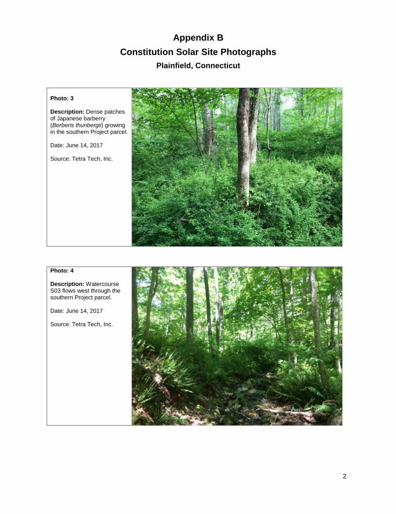
Appendix B
Constitution Solar Site Photographs
Plainfield, Connecticut
2
Photo: 3 Description: Dense patches of Japanese barberry (Berberis thunbergii) growing in the southern Project parcel. Date: June 14, 2017 Source: Tetra Tech, Inc.
Photo: 4 Description: Watercourse S03 flows west through the southern Project parcel. Date: June 14, 2017 Source: Tetra Tech, Inc.
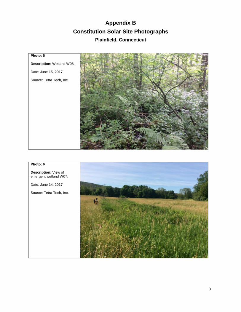
Appendix B
Constitution Solar Site Photographs
Plainfield, Connecticut
3
Photo: 5 Description: Wetland W08. Date: June 15, 2017 Source: Tetra Tech, Inc.
Photo: 6 Description: View of emergent wetland W07. Date: June 14, 2017 Source: Tetra Tech, Inc.
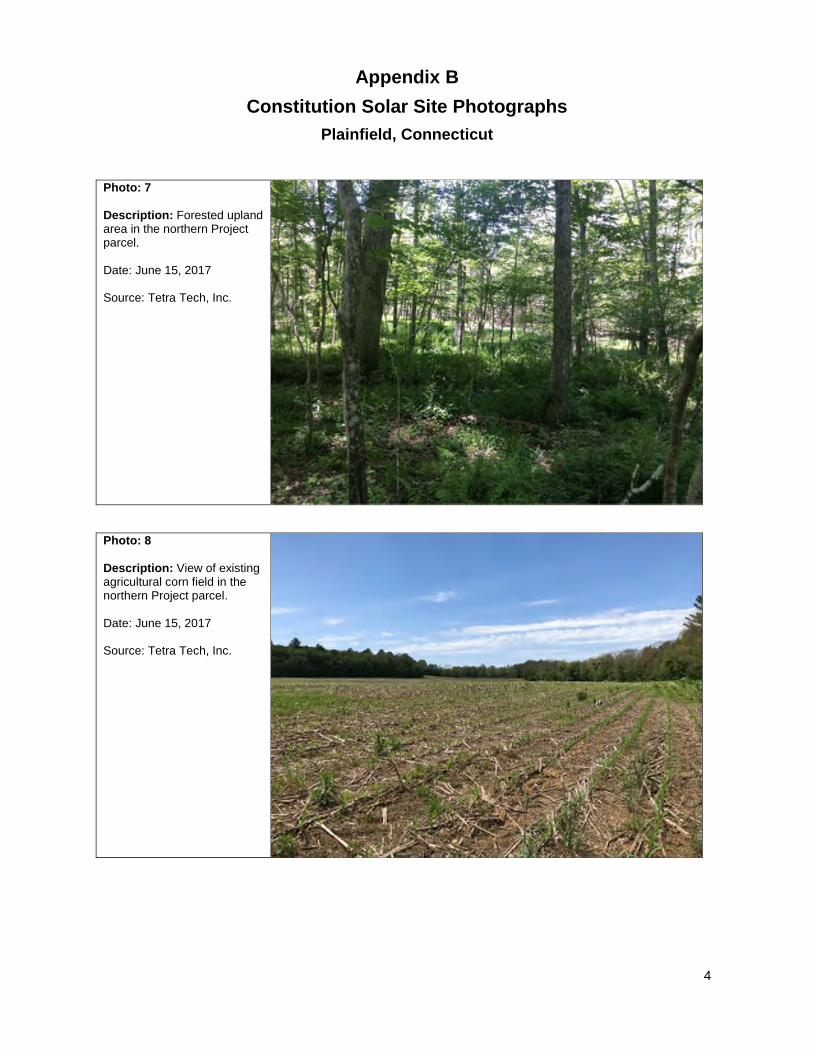
Appendix B
Constitution Solar Site Photographs
Plainfield, Connecticut
4
Photo: 7 Description: Forested upland area in the northern Project parcel. Date: June 15, 2017 Source: Tetra Tech, Inc.
Photo: 8 Description: View of existing agricultural corn field in the northern Project parcel. Date: June 15, 2017 Source: Tetra Tech, Inc.

Appendix B
Constitution Solar Site Photographs
Plainfield, Connecticut
5
Photo: 9 Description: Upland field in the northern Project parcel. Date: June 14, 2017 Source: Tetra Tech, Inc.
Photo: 10 Description: View of Watercourse S01 that flows from a culvert on Cornell Road through the forested edge of an agricultural field into wetland W01. Date: June 13, 2017 Source: Tetra Tech, Inc.

Appendix B
Constitution Solar Site Photographs
Plainfield, Connecticut
6
Photo: 11 Description: View of where existing farm road bisects watercourse S06. No culvert was observed. Water likely flows across the road following storm events. Date: June 15, 2017 Source: Tetra Tech, Inc.
Photo: 13 Description: View of farm road connecting agricultural fields. Date: March 7, 2017 Source: Tetra Tech, Inc.

Appendix B
Constitution Solar Site Photographs
Plainfield, Connecticut
7
Photo: 14 Description: View from the southeast corner of the southern Project parcel. Date: June 8, 2018 Source: Tetra Tech, Inc.
Photo: 15 Description: Wetland W09 occurring in the forested portion of the northern Project parcel. Date: June 8, 2018 Source: Tetra Tech, Inc.

Appendix B
Constitution Solar Site Photographs
Plainfield, Connecticut
8
Photo: 16
Description: View of Cornell Road, adjacent to the southern Project parcel. The Project collection line is proposed along the roadway.
Date: November 28, 2018
Source: Tetra Tech, Inc.

Constitution Solar, LLC Environmental Site Conditions Report
APPENDIX C – NATURAL RESOURCES SURVEY
REPORTS
• Eastern Spadefoot Toad Survey, Constitution Solar Project.
Prepared by FB Environmental. June 2019.
• General Herpetological Inventory of the Constitution Solar
Project. Prepared by FB Environmental. June 2019.
• Vernal Pool Surveys, and Wetland and Watercourse Delineation,
Constitution Solar Project. Prepared by Tetra Tech, Inc. June 2019.
• Northern Long-eared Bat (NLEB) Presence/Absence Survey.
Prepared by Tetra Tech, Inc. September 29, 2017.

Constitution Solar, LLC Environmental Site Conditions Report

Constitution Solar, LLC Environmental Site Conditions Report
Eastern Spadefoot Toad Survey, Constitution Solar Project.
Prepared by FB Environmental. June 2019.

Constitution Solar, LLC Environmental Site Conditions Report
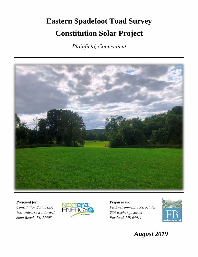
Eastern Spadefoot Toad Survey
Constitution Solar Project
Plainfield, Connecticut
Prepared for: Prepared by: Constitution Solar, LLC FB Environmental Associates 700 Universe Boulevard 97A Exchange Street Juno Beach, FL 33408 Portland, ME 04011
August 2019

FBE – Constitution Solar Eastern Spadefoot Toad Survey
Page i
Table of Contents
Executive Summary ..................................................................................................................................... 1
1. Introduction .............................................................................................................................................. 1
1.1 Eastern spadefoot toad ......................................................................................................................... 1
2. Study Area ................................................................................................................................................ 2
2.1 Overall site configuration ..................................................................................................................... 2
2.2 Soils ...................................................................................................................................................... 2
2.3 Wetlands and Watercourses ................................................................................................................. 4
2.3 Southern portion ................................................................................................................................... 4
2.4 Northern portion ................................................................................................................................... 4
3. Methods ..................................................................................................................................................... 5
3.1 Desktop analysis .................................................................................................................................. 5
3.2 Species detection techniques ................................................................................................................ 5
3.4 Weather data......................................................................................................................................... 6
4. Results and Discussion ............................................................................................................................. 6
4.1 Desktop analysis .................................................................................................................................. 6
4.2 Survey effort and captures ................................................................................................................... 6
4.3 Potential breeding pools ....................................................................................................................... 6
4.4 Spadefoot habitat .................................................................................................................................. 6
References ................................................................................................................................................... 8
Appendix A. NRCS Web Soil Survey Map of the Constitution Solar Site ......................................... 10
Appendix B. Photographs ....................................................................................................................... 13
Table
Table 1. Summary of eastern spadefoot toad survey effort and meteorological conditions at the proposed Constitution Solar site, Plainfield, Connecticut. ............................................................................................ 7
Figure
Figure 1. Constitution Solar site map, Plainfield, Connecticut. .................................................................... 3

FBE – Constitution Solar Eastern Spadefoot Toad Survey
Page 1
Executive Summary
Constitution Solar, LLC, a wholly owned subsidiary of NextEra Energy Resources, LLC (NextEra), is proposing to construct a solar power facility on an approximately 149-acre site (Study Area) in Plainfield, Connecticut. FB Environmental Associates (FBE) conducted nocturnal field surveys to determine if eastern spadefoot toads (Scaphiopus holbrookii) are present or likely absent within the Study Area. A total of five (5) nights of surveys were conducted during suitable weather conditions. The presence of the eastern spadefoot within the Study Area site was not confirmed, and FBE deems that the species is likely absent within it.
1. Introduction
At the request of Tetra Tech, Inc. (Tetra Tech) (the lead project consultant for NextEra), FBE conducted nocturnal field surveys to determine if eastern spadefoot toads are present within the Study Area in Plainfield, Connecticut which is proposed to be developed into a solar facility. This report presents the results of FBE’s eastern spadefoot toad survey efforts completed in 2018. In addition to the eastern spadefoot toad survey, FBE conducted a herpetological assessment of the entire Study Area with an emphasis on detection of state-listed species that are known to occur within the vicinity of the project area, specifically spotted turtle (Clemmys guttata), wood turtle (Glyptemys insculpta), eastern hognose snake (Heterodon platirhinos) and eastern ribbon snake (Thamnophis sauritus). Results of the general herpetological inventory are provided under separate cover.
1.1 Eastern spadefoot toad
Eastern spadefoot toads are the only member of the spadefoot family (Scaphiopodidae) present east of the Mississippi River. While eastern spadefoot toads are common from Tennessee west to the Mississippi Valley, New England populations are scattered and disjunct, and typically found in river valleys with sandy, well-drained soils, which also tend to be prized for residential and commercial development (Klemens, 1993). Some of these already localized populations have been extirpated, presumably due to habitat loss accompanying urban/suburban development (Klemens, 1993).
Eastern spadefoot toads spend the vast majority of their lives alone in self-dug underground burrows in the uplands surrounding breeding pools. Unlike most North American pool-breeding amphibian species, they do not breed on a rhythmic, annual cycle and can forgo breeding for numerous, consecutive years (Ball, 1936; Klemens, 1993). The known breeding sites in eastern Connecticut are temporary pools with an open canopy that are created by heavy rainfall; some likely do not meet the regulatory definition to be considered wetlands (personal observations; D. Quinn pers. comm.). In years when breeding does occur, the activity is explosive, typically lasting only one or two nights, and can occur anytime from late March through October in southern New England (Klemens, 1993). Because of this irregular and contracted
Adult female (top) and male (bottom) eastern
spadefoot toads. Photo courtesy of Kevin
Ryan, taken in 2011 in Canterbury,
Connecticut.
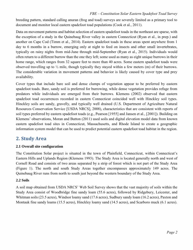
FBE – Constitution Solar Eastern Spadefoot Toad Survey
Page 2
breeding pattern, standard calling anuran (frog and toad) surveys are severely limited as a primary tool to document and monitor local eastern spadefoot toad populations (Cook et al., 2011).
Data on movement patterns and habitat selection of eastern spadefoot toads in the northeast are sparse, with the exception of a study in the Quinebaug River valley in eastern Connecticut (Ryan et al., in prep.) and another on Cape Cod (Timm et al., 2014). Eastern spadefoot toads in these areas spent anywhere from 1 day to 6 months in a burrow, emerging only at night to feed on insects and other small invertebrates, typically on rainy nights from mid-June through mid-September (Ryan et al., 2015). Individuals would often return to a different burrow than the one they left; some used as many as eight unique burrows in their home range, which ranges from 32 square feet to more than 40 acres. Some eastern spadefoot toads were observed travelling up to ½ mile, though typically they stayed within a few meters (m) of their burrows. The considerable variation in movement patterns and behavior is likely caused by cover type and prey availability.
Cover types that include bare soil and dense clumps of vegetation appear to be preferred by eastern spadefoot toads. Bare, sandy soil is preferred for burrowing, while dense vegetation provides refuge from predators while individuals are emerged from their burrows. Klemens (2002) observed that eastern spadefoot toad occurrences recorded in eastern Connecticut coincided well with Hinckley soil types. Hinckley soils are sandy, gravelly, and typically well drained (U.S. Department of Agriculture Natural Resources Conservation Service [USDA NRCS], 2008), characteristics that are consistent with reports of soil types preferred by eastern spadefoot toads (e.g., Pearson [1955] and Jansen et al., [2001]). Building on Klemens’ observations, Moran and Button (2011) used soils and digital elevation model data from known eastern spadefoot toad sites in Connecticut, Massachusetts, and Rhode Island to create a geographic information system model that can be used to predict potential eastern spadefoot toad habitat in the region.
2. Study Area
2.1 Overall site configuration
The Constitution Solar project is situated in the town of Plainfield, Connecticut, within Connecticut’s Eastern Hills and Uplands Region (Klemens 1993). The Study Area is located generally north and west of Cornell Road and consists of two areas separated by a strip of forest which is not part of the Study Area (Figure 1). The north and south Study Areas together encompasses approximately 149 acres. The Quinebaug River runs from north to south just beyond the western boundary of the Study Area.
2.2 Soils
A soil map obtained from USDA NRCS’ Web Soil Survey shows that the vast majority of soils within the Study Area consist of Woodbridge fine sandy loam (55.6 acres), followed by Ridgebury, Leicester, and Whitman soils (23.5 acres), Windsor loamy sand (17.6 acres), Sudbury sandy loam (16.2 acres), Paxton and Montauk fine sandy loams (15.5 acres), Hinckley loamy sand (14.5 acres), and Scarboro muck (6.1 acres).

FBE – Constitution Solar Eastern Spadefoot Toad Survey
Page 3
Figure 1. Constitution Solar site map, Plainfield, Connecticut.

FBE – Constitution Solar Eastern Spadefoot Toad Survey
Page 4
2.3 Wetlands and Watercourses
A wetland and watercourse delineation was conducted by Tetra Tech in 2017 and 2018 (Tetra Tech, 2019). Based on standards set forth by the U.S. Army Corps of Engineers and the Town of Plainfield approximately 11 acres of wetlands and 10 intermittent and ephemeral watercourses (two watercourses, S06 and S10, are comprised of two separate segments, for a total of 12 watercourse segments) are present within the Study Area.
2.3 Southern portion
The southern portion of the Study Area encompasses approximately 48 acres and is mainly forested, with the exception of an approximately 6-acre agricultural field adjacent to Cornell Road. The forest in this section is primarily deciduous and includes red maple (Acer rubrum), red oak (Quercus rubra), ash (Fraxinus sp.), hickory (Carya ovata and C. cordiformis), American beech (Fagus grandifolia), and sugar maple (Acer saccharum). This portion of the site shows evidence of past agricultural use (e.g., pasture). Owing to this land use history, a high density of non-native invasive plant species (invasives) occurs within this area. Observed invasive species include Japanese barberry (Berberis thunbergii) and burning bush (Euonymus alatus) in the forest understory and Oriental bittersweet (Celastrus orbiculatus), multiflora rose (Rosa multiflora) and autumn olive (Elaeagnus umbellata) along the forest edges. This portion of forest also has an apparently high abundance of (presumably non-native) earthworms.
The southern portion of the site contains approximately 8.2 acres of forested wetland. In general, the canopies of wetlands within the Study Area are dominated by red maple. Common shrubs within wetlands include spicebush (Lindera benzoin) and winterberry (Ilex verticillata); herbaceous layers within these wetlands are composed primarily of skunk cabbage (Symplocarpus foetidus) and cinnamon fern (Osmundastrum cinnamomeum). Invasives are highly prevalent within these areas and consist primarily of Japanese barberry and multiflora rose.
A cryptic vernal pool (VP01) is present within the southernmost forested wetland complex. This area (delineated by Tetra Tech) is approximately 0.14 acres in size. The pool’s envelope (0–100 feet from the edge of the pool) is completely forested and its Critical Terrestrial Habitat (100–750 feet from the edge of the pool) is 83% forested.
Six watercourses are located within the southern portion of the site. Two small outlet watercourses (watercourses S03 and S05) emanate from forested wetlands (W02 and W04) and flow directly to the Quinebaug River. These watercourses have a rock-cobble-gravel substrate and were observed to have moderate flow with water attaining depths of several inches during the field investigations. Four additional watercourses (S01, S02, S04, and S10) also flow in to and out of wetland W01.
2.4 Northern portion
The northern portion of the Study Area consists of approximately 52 acres of agricultural field (corn and hay) with the remaining 49 acres being forested. The forest in this area contains a mix of deciduous species including red maple, hickory, and black birch (Betula lenta) mixed with hemlock (Tsuga canadensis) and white pine (Pinus strobus). Mountain laurel (Kalmia latifolia) is present within the understory. This portion of forest does not appear to have the same abundance of earthworms as the southern area and hence has a well-developed duff layer. This area also shows evidence of past agricultural use (e.g., stone walls). While

FBE – Constitution Solar Eastern Spadefoot Toad Survey
Page 5
present, non-native invasive plants are not as abundant in this area as they are in the southern section of the site.
Of the approximately 2.4 acres of wetlands located in the northern portion of the Study Area, the majority are forested or partially forested wetlands. The lone exception is a linear marsh in a hayfield (W07), the result of ditching in what was likely previously a more extensive wetland. The forested wetlands are similar in composition to the ones in the southern portion, although invasive plants are not as prevalent. Several small sections of watercourses emanating from sloped wetlands are also present. These watercourses have a rock-cobble-gravel substrate and were observed to have moderate flow with water attaining depths of several inches during field investigations.
A large, linear vernal pool, VP02, straddles the southwest corner of the northern portion of the Study Area. The Critical Terrestrial Habitat of VP02 is 64% forested, the majority of which lies outside of the Study Area. The portion of the pool’s envelope (0–100 feet from the edge of the pool) and Critical Terrestrial Habitat (100–750 feet from the edge of the pool) within the Study Area consists primarily of hayfield at present.
3. Methods
3.1 Desktop analysis
FBE examined USDA NRCS Web Soil Survey maps for the presence of Hinckley soils in the vicinity of the Study Area. In addition, FBE examined the Connecticut Department of Energy & Environmental Protection’s (DEEP’s) Predicted Spadefoot Toad Habitat map (Moran and Button, 2011) for the presence of predicted spadefoot habitat within the vicinity of the Study Area.
3.2 Species detection techniques
Visual encounter surveys involved field personnel searching a focal area systematically for a known period of time. Visual encounter surveys are an effective technique to rapidly detect species in a given area (Crump and Scott, 1994; Rodda et al., 2007 cited in Vonesh et al., 2010). The technique requires minimal equipment and can be employed in a variety of habitat types (Vonesh et al., 2010).
To conduct a visual encounter survey, an experienced herpetologist (sometimes accompanied by field assistants) typically selectively searches small areas of habitat deemed most likely to yield target species. The approach potentially yields more species and individuals per unit effort than randomized sampling approaches. Alternatively, an area may be searched via visual encounter surveys using transects where a researcher walks along a specified compass bearing.
At the Constitution Solar site, visual encounter surveys for eastern spadefoot toads occurred at night during suitable weather conditions. Teams of one to three individuals surveyed with the aid of high-output LED headlamps. While surveys were primarily focused in areas deemed optimal for detecting eastern spadefoot toad (e.g., areas of open canopy having dense clumps of vegetation), searches also were conducted in forested and other areas for comprehensiveness. Individuals conducting surveys also searched for potential eastern spadefoot toad breeding pools during nocturnal bouts as well as during the general herpetological inventory.
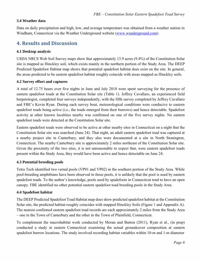
FBE – Constitution Solar Eastern Spadefoot Toad Survey
Page 6
3.4 Weather data
Data on daily precipitation and high, low, and average temperature was obtained from a weather station in Windham, Connecticut via the Weather Underground website (www.wunderground.com).
4. Results and Discussion
4.1 Desktop analysis
USDA NRCS Web Soil Survey maps show that approximately 13.9 acres (9.4%) of the Constitution Solar site is mapped as Hinckley soil, which exists mainly in the northern portion of the Study Area. The DEEP Predicted Spadefoot Habitat map shows that potential spadefoot habitat does exist on the site. In general, the areas predicted to be eastern spadefoot habitat roughly coincide with areas mapped as Hinckley soils.
4.2 Survey effort and captures
A total of 12.75 hours over five nights in June and July 2018 were spent surveying for the presence of eastern spadefoot toads at the Constitution Solar site (Table 1). Jeffrey Cavallaro, an experienced field herpetologist, completed four surveys independently, with the fifth survey completed by Jeffrey Cavallaro and FBE’s Kevin Ryan. During each survey bout, meteorological conditions were conducive to eastern spadefoot toads being active (i.e., the toads emerged from their burrows) and hence detectable. Spadefoot activity at other known localities nearby was confirmed on one of the five survey nights. No eastern spadefoot toads were detected at the Constitution Solar site.
Eastern spadefoot toads were observed to be active at other nearby sites in Connecticut on a night that the Constitution Solar site was searched (June 24). That night, an adult eastern spadefoot toad was captured at a nearby project site in Canterbury, and they also were documented at a site in North Stonington, Connecticut. The nearby Canterbury site is approximately 2 miles northeast of the Constitution Solar site. Given the proximity of the two sites, it is not unreasonable to expect that, were eastern spadefoot toads present within the Study Area, they would have been active and hence detectable on June 24.
4.3 Potential breeding pools
Tetra Tech identified two vernal pools (VP01 and VP02) in the southern portion of the Study Area. While pool-breeding amphibians have been observed in these pools, it is unlikely that the pool is used by eastern spadefoot toads. To the author’s knowledge, pools used by spadefoots in Connecticut tend to have an open canopy. FBE identified no other potential eastern spadefoot toad breeding pools in the Study Area.
4.4 Spadefoot habitat
The DEEP Predicted Spadefoot Toad Habitat map does show predicted spadefoot habitat at the Constitution Solar site; the predicted habitat roughly coincides with mapped Hinckley Soils (Figure 1 and Appendix A). The nearest confirmed eastern spadefoot toad records are each approximately 2 miles from the Study Area – one in the Town of Canterbury and the other in the Town of Plainfield, Connecticut.
To complement the macrohabitat work conducted by Moran and Button (2011), Ryan et al., (in prep) conducted a study in eastern Connecticut examining the actual groundcover composition at eastern spadefoot burrow locations. The study involved recording habitat variables within 10-m and 1-m diameter

FBE – Constitution Solar Eastern Spadefoot Toad Survey
Page 7
circular plots centered on known animal locations. Eastern spadefoot presence was positively correlated with percent cover of bare soil at the 10-m and 1-m scales, positively correlated with percent cover of gravel at the 10-m scale, and negatively correlated with percent cover of grass at both scales. Throughout the study, Ryan et al., (in prep) opportunistically located S. holbrookii at night, and these individuals were typically found underneath dense cover (e.g., clumps of shrubs).
Bare areas within the Study Area are limited to the agricultural fields, which also provide areas of open canopy. The nearest densely vegetated zones are the edges of the fields themselves. While eastern spadefoot toads will burrow in active agricultural fields, they seldom remain in the fields for extended periods of time, making agricultural areas very unlikely to provide suitable habitat (personal observations).
Despite the presence of Hinckley soils and predicted habitat in the DEEP model, the Constitution Solar site apparently lacks the requisite combination of bare soil and clumps of vegetation characteristic of eastern spadefoot toad habitat in eastern Connecticut. The Study Area therefore appears to provide marginal habitat at best for eastern spadefoot toads. Furthermore, FBE’s surveys did not detect eastern spadefoots, even on a night when activity was confirmed at two nearby sites. Taken together, these findings make it unlikely that the eastern spadefoot occurs at the Constitution Solar site.
Date
Field
personnel
Hours
on-
site
Total
person-
hours
High
Temp.
(ºF)
Low
Temp.
(ºF)
Average
Temp.
(ºF)
Precip.
(Inches) Remarks
1-Jun-18 Jeffrey Cavallaro 3.25 3.25 80 64 72 0.05 Ground moist from earlier rain.
18-Jun-18 Jeffrey Cavallaro 2.75 2.75 89 60 74 0.10 Light rain during survey. Ground
moist at surface.
24-Jun-18 Jeffrey
Cavallaro 1.00 1.00 78 60 68 0.10
Light rain during survey.
Eastern spadefoot toad
captured at Quinebaug Solar
site.
17-Jul-18 Jeffrey Cavallaro 1.75 1.75 90 71 80 2.14
Heavy thunderstorms before dark, rain continued after sunset. Site saturated, however overall level of amphibian activity apparently low.
22-Jul-18 Kevin Ryan, Jeffrey Cavallaro
2.00 4.00 81 64 72 1.18 Heavy rain during morning. Intermittent rain during survey. Site saturated during survey.
Total 10.75 12.75
Table 1. Summary of eastern spadefoot toad survey effort and meteorological conditions at the proposed Constitution Solar site, Plainfield, Connecticut. Weather data was obtained from a weather station in Windham, Connecticut via wunderground.com. Entries in bold indicate an eastern spadefoot activity confirmed at other sites.

FBE – Constitution Solar Eastern Spadefoot Toad Survey
Page 8
References
Ball, S. C. 1936. The distribution and behavior of the Spadefoot Toad in Connecticut. Transactions of the Connecticut Academy of Arts and Sciences 32:351–379.
Cook, R. P., T. A. Tupper, P. W. C. Paton, and B. C. Timm. 2011. Effects of temperature and temporal factors on anuran detection probabilities at Cape Cod National Seashore, Massachusetts, USA: Implications for long-term monitoring. Herpetological Conservation and Biology 6:25–39.
Crump, M. L. and Scott, Jr, N. J. 1994. Visual encounter surveys. In W. R. Heyer, M. A. Donnelly, R. W. McDiarmid, L. A. C. Hayek, and M. S. Foster (eds), Measuring and Monitoring Biological Diversity, Standard Methods for Amphibians, pp. 84-92. Smithsonian Institution Press, Washington DC.
Jansen, K. P., A. P. Summers, and P. R. Delis. 2001. Spadefoot toads (Scaphiopus holbrookii holbrookii) in an urban landscape: Effects of nonnatural substrates on burrowing in adults and juveniles. Journal of Herpetology 35:141-145.
Klemens, M. W. 1993. Amphibians and reptiles of Connecticut and adjacent regions. State Geological and Natural History Survey of Connecticut, Bulletin No. 112. Connecticut Department of Environmental Protection, Hartford.
Klemens, M. W. 2002. Report on Biodiversity with Emphasis on Endangered and Threatened Species to accompany Federal and State Permit Applications.
Moran, K. and C. E. Button. 2011. A GIS model for identifying eastern spadefoot toad (Scaphiopus holbrookii) habitat in eastern Connecticut. Applied Geography 31:980–989.
Pearson, P. G. 1955. Population ecology of the spadefoot toad, Scaphiopus h. holbrookii (Harlan). Ecological Monographs 25:233-267.
Rodda, G. H., E. W. Campbell, T. H. Fritts, and C. S. Clark. 2007. The predictive power of visual searching. Herpetological Review. 36:259-264.
Ryan, K. J., D. P. Quinn, and A. J. K. Calhoun. (In Prep.) Movement Patterns and Terrestrial Habitat Selection of Eastern Spadefoots (Scaphiopus holbrookii) at Northern Limit of Their Range.
Ryan, K. J., A. J. K. Calhoun, J. D. Zydlewski, and B. C. Timm. 2015. Monitoring Eastern Spadefoot (Scaphiopus holbrookii) response to weather using a passive integrated transponder (PIT) system. Journal of Herpetology 49:257-263.

FBE – Constitution Solar Eastern Spadefoot Toad Survey
Page 9
Tetra Tech (Tetra Tech, Inc.). 2019. Vernal Pool Surveys and Wetland and Watercourse Delineation Report – Constitution Solar Project. Prepared for NextEra Energy Resources, LLC.
Timm, B. C., K. McGarigal, and R. P. Cook. 2014. Upland movement patterns and habitat selection of adult Eastern Spadefoots (Scaphiopus holbrookii) at Cape Cod National Seashore. Journal of Herpetology 48:84–97
USDA NRCS (U.S. Department of Agriculture Natural Resources Conservation Service). 2008. Soil survey of the State of Connecticut. Available at: http://www.nrcs.usda.gov/Internet/FSE_MANUSCRIPTS/connecticut/CT600/0/connecticut.pdf.
Vonesh, J. R., J. C. Mitchell, K. Howell, and A. J. Crawford. 2010. Rapid assessments of amphibian diversity. Pp. 263-280 in Dodd, C., (ed.) Amphibian Ecology and Conservation: A handbook of techniques. Oxford University Press.

FBE – Constitution Solar Eastern Spadefoot Toad Survey
Page 10
Appendix A. NRCS Web Soil Survey Map of the Constitution Solar Site

FBE – Constitution Solar Eastern Spadefoot Toad Survey
Page 11
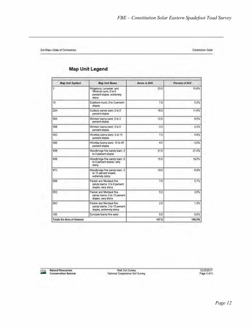
FBE – Constitution Solar Eastern Spadefoot Toad Survey
Page 12
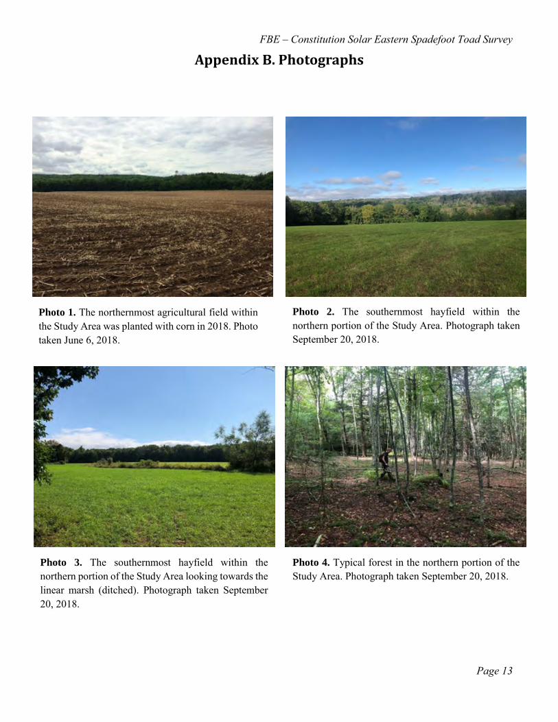
FBE – Constitution Solar Eastern Spadefoot Toad Survey
Page 13
Appendix B. Photographs
Photo 1. The northernmost agricultural field within the Study Area was planted with corn in 2018. Photo taken June 6, 2018.
Photo 2. The southernmost hayfield within the northern portion of the Study Area. Photograph taken September 20, 2018.
Photo 3. The southernmost hayfield within the northern portion of the Study Area looking towards the linear marsh (ditched). Photograph taken September 20, 2018.
Photo 4. Typical forest in the northern portion of the Study Area. Photograph taken September 20, 2018.
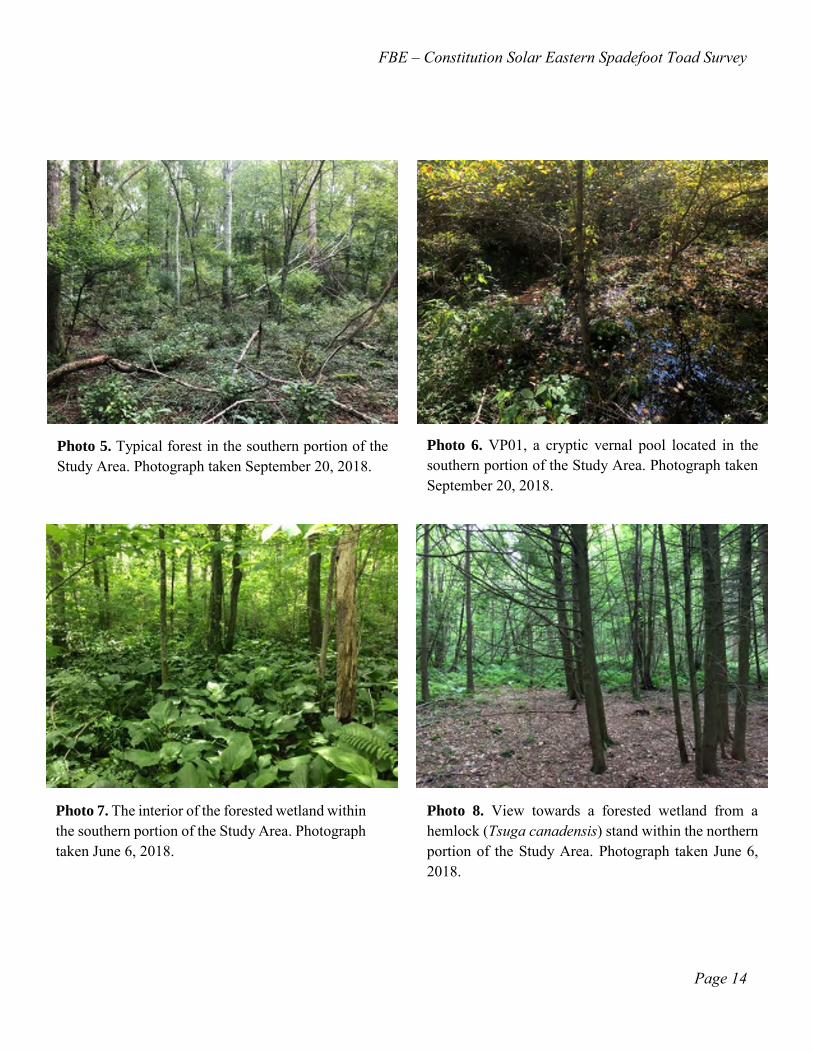
FBE – Constitution Solar Eastern Spadefoot Toad Survey
Page 14
Photo 5. Typical forest in the southern portion of the Study Area. Photograph taken September 20, 2018.
Photo 6. VP01, a cryptic vernal pool located in the southern portion of the Study Area. Photograph taken September 20, 2018.
Photo 7. The interior of the forested wetland within the southern portion of the Study Area. Photograph taken June 6, 2018.
Photo 8. View towards a forested wetland from a hemlock (Tsuga canadensis) stand within the northern portion of the Study Area. Photograph taken June 6, 2018.

Constitution Solar, LLC Environmental Site Conditions Report
General Herpetological Inventory of the Constitution Solar
Project. Prepared by FB Environmental. June 2019.

Constitution Solar, LLC Environmental Site Conditions Report
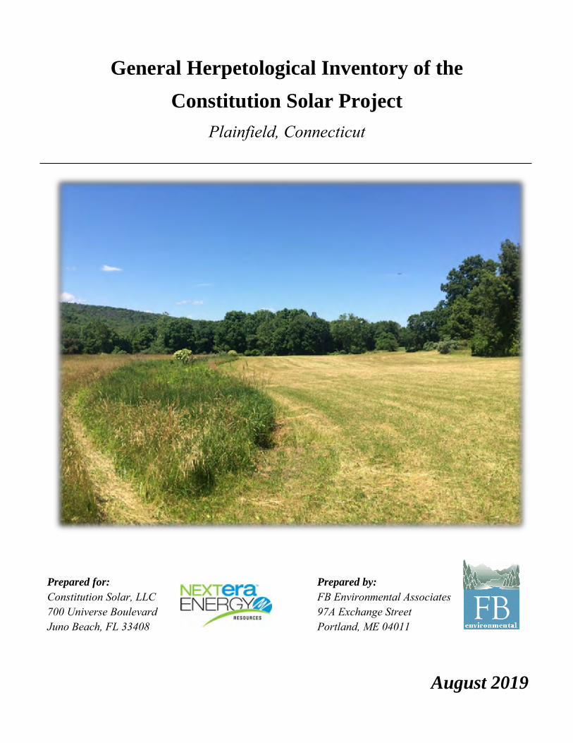
General Herpetological Inventory of the
Constitution Solar Project
Plainfield, Connecticut
Prepared for: Prepared by: Constitution Solar, LLC FB Environmental Associates 700 Universe Boulevard 97A Exchange Street Juno Beach, FL 33408 Portland, ME 04011
August 2019

FBE– Constitution Solar Herpetological Inventory
Page i
Table of Contents
Executive Summary ..................................................................................................................................... 1
1. Introduction .............................................................................................................................................. 1
1.1 Spotted turtle ........................................................................................................................................ 1
1.2 Wood turtle ........................................................................................................................................... 3
1.3 Eastern hognose snake .......................................................................................................................... 3
1.4 Eastern ribbon snake ............................................................................................................................. 4
1.5 Pool-breeding amphibians .................................................................................................................... 5
2. Study Area ................................................................................................................................................ 6
2.1 Overall site configuration ..................................................................................................................... 6
2.2 Soils ...................................................................................................................................................... 6
2.3 Wetlands and Watercourses ................................................................................................................. 6
2.4 Southern portion ................................................................................................................................... 6
2.5 Northern portion ................................................................................................................................... 7
3. Methods ..................................................................................................................................................... 7
3.1 Species detection techniques ................................................................................................................ 7
Cover object searches ............................................................................................................................. 7
Visual encounter surveys ........................................................................................................................ 8
Nocturnal vehicular surveys ................................................................................................................... 8
4. Results and Discussion ............................................................................................................................. 8
4.2. Focal species ...................................................................................................................................... 11
Spotted turtle ......................................................................................................................................... 11
Wood turtle ........................................................................................................................................... 11
Eastern hognose snake .......................................................................................................................... 11
Eastern ribbon snake ............................................................................................................................. 11
4.3. Other amphibian and reptile species .................................................................................................. 12
Salamanders .......................................................................................................................................... 12
Frogs and toads ..................................................................................................................................... 12
Snakes ................................................................................................................................................... 13
5. Conservation implications ..................................................................................................................... 14
References ................................................................................................................................................... 16
Appendix A. Site Photographs .................................................................................................................. 18

FBE– Constitution Solar Herpetological Inventory
Page ii
List of Tables Table 1. Survey effort and associated meteorological conditions at the proposed Constitution Solar site, Plainfield, CT. ................................................................................................................................................ 9
Table 2. Amphibian and reptile species observed within the Study Area of the proposed Constitution Solar site, Plainfield, CT. ...................................................................................................................................... 10
List of Figures
Figure 1. Constitution Solar Study Area, Plainfield, Connecticut. ................................................................ 2

FBE– Constitution Solar Herpetological Inventory
Page 1
Executive Summary
Constitution Solar, LLC, a wholly-owned subsidiary of NextEra Energy Resources, LLC, is proposing to construct a solar power facility on an approximately 149-acre site in Plainfield, Connecticut (Study Area). FB Environmental Associates (FBE) conducted a herpetological assessment of the entire Study Area with an emphasis on detection of state-listed species that are known to occur within the vicinity of the project area, specifically the spotted turtle (Clemmys guttata), wood turtle (Glyptemys insculpta), eastern hognose snake (Heterodon platirhinos) and eastern ribbon snake (Thamnophis sauritus). A total of three diurnal and five nocturnal surveys were completed within the Study Area to accomplish the aforementioned task.
Results of the herpetological inventory indicate the Study Area exhibits moderate herptile diversity, as only 10 amphibian and one reptile species were detected, none of which are state-listed. Field survey efforts did not detect the presence of the spotted or wood turtle, eastern hognose snake or eastern ribbon snake.
1. Introduction
Constitution Solar, LLC, a wholly-owned subsidiary of NextEra Energy Resources, LLC (NextEra), is proposing to construct a solar power facility on an approximately 149-acre site in Plainfield, Connecticut (Study Area) (Figure 1). At the request of Tetra Tech, Inc. (Tetra Tech) (the lead project consultant for NextEra), FBE conducted a general herpetological inventory with emphasis on detection of the spotted turtle, wood turtle, eastern hognose snake, and eastern ribbon snake. In addition, nocturnal species detection surveys for eastern spadefoot toad (Scaphiopus holbrookii) were performed in 2018. Results of the eastern spadefoot toad surveys are provided under separate cover. Vernal pool surveys of the Study Area were conducted by Tetra Tech for the Study Area in the spring of 2017, 2018, and 2019. (FBE participated in the 2019 vernal pool survey effort.)
1.1 Spotted turtle
Spotted turtles may be found in a wide variety of permanent and temporary shallow water habitats. In southern New England, they inhabit muddy-bottomed slow-moving streams, marshy areas associated with lakes, river floodplains, fens, drainage ditches, red maple swamps, vernal pools, quarry pools, bogs, small ponds, and tidal creeks. Female turtles nest on well-drained embankments and pastures, and in the tops of tussocks in fens and bogs (Klemens 1993). Terrestrial habitat is used extensively while searching for mates or suitable nesting sites, traveling among wetland habitats, and when moving to terrestrial aestivation sites during periods of high temperatures (Klemens, 1993; Gibbs et al., 2007).
An adult spotted turtle (Clemmys guttata). Photo courtesy of Kevin
Ryan.

FBE– Constitution Solar Herpetological Inventory
Page 2
Figure 1. Constitution Solar Study Area, Plainfield, Connecticut.
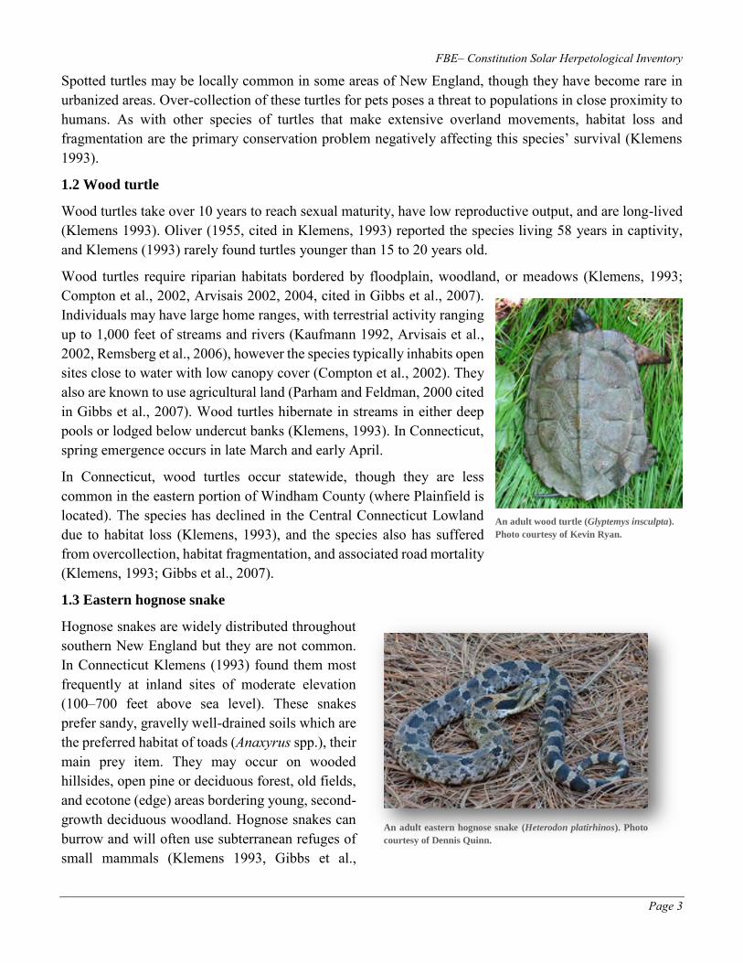
FBE– Constitution Solar Herpetological Inventory
Page 3
Spotted turtles may be locally common in some areas of New England, though they have become rare in urbanized areas. Over-collection of these turtles for pets poses a threat to populations in close proximity to humans. As with other species of turtles that make extensive overland movements, habitat loss and fragmentation are the primary conservation problem negatively affecting this species’ survival (Klemens 1993).
1.2 Wood turtle
Wood turtles take over 10 years to reach sexual maturity, have low reproductive output, and are long-lived (Klemens 1993). Oliver (1955, cited in Klemens, 1993) reported the species living 58 years in captivity, and Klemens (1993) rarely found turtles younger than 15 to 20 years old.
Wood turtles require riparian habitats bordered by floodplain, woodland, or meadows (Klemens, 1993; Compton et al., 2002, Arvisais 2002, 2004, cited in Gibbs et al., 2007). Individuals may have large home ranges, with terrestrial activity ranging up to 1,000 feet of streams and rivers (Kaufmann 1992, Arvisais et al., 2002, Remsberg et al., 2006), however the species typically inhabits open sites close to water with low canopy cover (Compton et al., 2002). They also are known to use agricultural land (Parham and Feldman, 2000 cited in Gibbs et al., 2007). Wood turtles hibernate in streams in either deep pools or lodged below undercut banks (Klemens, 1993). In Connecticut, spring emergence occurs in late March and early April.
In Connecticut, wood turtles occur statewide, though they are less common in the eastern portion of Windham County (where Plainfield is located). The species has declined in the Central Connecticut Lowland due to habitat loss (Klemens, 1993), and the species also has suffered from overcollection, habitat fragmentation, and associated road mortality (Klemens, 1993; Gibbs et al., 2007).
1.3 Eastern hognose snake
Hognose snakes are widely distributed throughout southern New England but they are not common. In Connecticut Klemens (1993) found them most frequently at inland sites of moderate elevation (100–700 feet above sea level). These snakes prefer sandy, gravelly well-drained soils which are the preferred habitat of toads (Anaxyrus spp.), their main prey item. They may occur on wooded hillsides, open pine or deciduous forest, old fields, and ecotone (edge) areas bordering young, second-growth deciduous woodland. Hognose snakes can burrow and will often use subterranean refuges of small mammals (Klemens 1993, Gibbs et al.,
An adult eastern hognose snake (Heterodon platirhinos). Photo
courtesy of Dennis Quinn.
An adult wood turtle (Glyptemys insculpta).
Photo courtesy of Kevin Ryan.

FBE– Constitution Solar Herpetological Inventory
Page 4
2007). Throughout their range in New England, these snakes are typically not found in high numbers. In 17 years of research, the maximum number of hognose snakes Klemens (1993) found at a single site was two.
Hognose snakes in New England need further study. Platt (1969, cited in Klemens [1993]) stated that hognose snakes seem to be able to survive in proximity to humans at the southern portion of their range;
however their numbers have declined in many parts of the north since 1900. This suggests that hognose snakes may be more sensitive to human disturbance near the limits of their range.
The non-venomous eastern hognose snake is perhaps the most unusual snake in New England. When encountered, these snakes may emulate cobras by lifting the front part of their bodies off the ground and inflating a flattened “hood” along their neck, followed by loud hissing and closed-mouth strikes. This behavior often leads people to kill the snakes, erroneously believing that they are dangerous. Hognose snakes may also feign death, which includes rolling on their backs, and
regurgitating food and drooling (Klemens 1993).
1.4 Eastern ribbon snake
Eastern ribbon snakes are nearly always found in wet areas without a tree canopy, favoring open, grassy, or shrubby areas bordering streams and wooded swamps (Conant 1975, Klemens 1993, Gibbs et al., 2007). Klemens (1993) collected the species in fens, sphagnum bogs, wooded swamps, and along the edges of streams, vernal pools, small ponds, as well as wet areas within powerline corridors. They can be found within both undisturbed and severely disturbed and scarified sites (Klemens 1993).
The eastern ribbon snake is a close relative of, and easily confused with, the ubiquitous common garter snake (Thamnophis sirtalis). The ribbon snake is a slender, agile snake with three well-defined yellow lateral stripes on scale rows three and four. The tail is roughly one third of the total body length. Garter snakes are not as slender or agile, have proportionately shorter tails, and have (not always well defined) lateral stripes on scale rows two and three (Klemens 1993, Harding 1997, Gibbs et al., 2007).
The conservation status of eastern ribbon snakes in southern New England is enigmatical. The species can be abundant at some sites, and rare at others despite the presence of apparently suitable habitat (Klemens 1993). Klemens (1993) mentions that the species may be declining but that his data are for the most part circumstantial; the apparent decline of the species may be correlated to the reforestation of open-canopy, grassy areas in southern New England.
The black color morph of the eastern hognose snake.
Photo courtesy of Dennis Quinn.
An eastern ribbon snake (Thamnophis sauritus). Photo
courtesy of Kevin Ryan.

FBE– Constitution Solar Herpetological Inventory
Page 5
Eastern ribbon snakes may be indicators of high-quality wetland habitats. Wetlands inhabited by this species often support development-sensitive species including the spotted turtle, bog turtle (Clemmys muhlenbergii), leopard frogs (Lithobates pipiens and L. kauffeldi), blue-spotted salamander (Ambystoma laterale), and marbled salamander (Ambystoma opacum).
1.5 Pool-breeding amphibians
The general herpetological inventory was not focused on the detection of pool breeding amphibians. Nonetheless, discussion of pool-breeding amphibians is included in the general herpetological inventory.
Pool-breeding amphibians in Connecticut consist of spotted salamanders, marbled salamanders, Jefferson salamander complex (Ambystoma jeffersonianum complex) (a state species of special concern), blue-spotted salamander complex (Ambystoma laterale complex) (a state species of special concern), pure-diploid blue-spotted salamanders (a state endangered species), and wood frogs (Lithobates sylvaticus). These pool-breeding amphibians spend the majority of their lives in terrestrial habitat adjacent to breeding pools, and thus require both aquatic and terrestrial areas for survival. After spring emergence, most adult pool-breeding amphibians in Connecticut spend less than one month of their life-cycle in breeding pools; for the remainder of their lives they inhabit adjacent terrestrial or wetland areas (Semlitsch 1981, 2000 cited in Calhoun and Klemens 2002). In their terrestrial habitats, both juvenile and adult amphibians require areas of deep, uncompacted organic material (leaf litter), coarse woody material (e.g., logs, sticks, branches), and shade, all typical characteristics of mature forest.
In a summary of studies examining how far pool-breeding amphibians move from their breeding pools, Semlitsch (1998) found that a “Critical Terrestrial Habitat” zone surrounding a breeding pool should extend approximately 540 feet from the pool’s edge to encompass the distance moved from a breeding pool of 95 percent of the individuals within a breeding amphibian population. Conservation of pool-breeding amphibians has since employed circular “life zones” surrounding a wetland to meet the terrestrial habitat requirements of the amphibian species breeding within it (e.g., Faccio, 2003; McDonough and Paton, 2007). Conservation strategies that only focus on protecting breeding pools (and not the associated Critical Terrestrial Habitat) will most likely fail to maintain a viable amphibian population. Protection of Critical Terrestrial Habitat therefore must also be a priority (Marsh and Trenham 2001 cited in Calhoun and Klemens 2002).
From top to bottom: a spotted salamander (Ambystoma maculatum),
marbled salamander (A. opacum), and blue-spotted salamander (A.
laterale). Photo courtesy of Kevin Ryan, taken in 2011 in Canterbury,
Connecticut.
An adult wood frog (Lithobates sylvaticus). Photo
courtesy of Kevin Ryan, taken in 2009 in Canterbury,
Connecticut.

FBE– Constitution Solar Herpetological Inventory
Page 6
2. Study Area
2.1 Overall site configuration
The Study Area is situated in the Town of Plainfield, within Connecticut’s Eastern Hills and Uplands Region (Klemens 1993) (Figure 1) and consists of numerous privately-owned parcels located generally north and west of Cornell Road. The entire Study Area encompasses approximately 149 acres, and the Quinebaug River is located just outside the western boundary. The overall Study Area consists of a northern portion and a southern portion, separated by a strip of forest which is not part of the Study Area.
2.2 Soils
A soil map obtained from USDA NRCS’ Web Soil Survey shows that the vast majority of soils within the Study Area consist of Woodbridge fine sandy loam (55.6 acres), followed by Ridgebury, Leicester, and Whitman soils (23.5 acres), Windsor loamy sand (17.6 acres), Sudbury sandy loam (16.2 acres), Paxton and Montauk fine sandy loams (15.5 acres), Hinckley loamy sand (14.5 acres), and Scarboro muck (6.1 acres).
2.3 Wetlands and Watercourses
A wetland and watercourse delineation was conducted by Tetra Tech in 2017 and 2018 (Tetra Tech, 2019). Based on standards set forth by the U.S. Army Corps of Engineers and the Town of Plainfield approximately 11 acres of wetlands and 10 intermittent and ephemeral watercourses (two watercourses, S06 and S10, are comprised of two separate segments, for a total of 12 watercourse segments) are present within the entire Study Area (Figure 1). Additional detail regarding delineated features is included in the following sections.
2.4 Southern portion
The southern portion of the Study Area encompasses 48 acres and is mainly forested, with the exception of an approximately 6-acre agricultural field adjacent to Cornell Road. The forest in this section is primarily deciduous and includes red maple (Acer rubrum), red oak (Quercus rubra), ash (Fraxinus sp.), hickory (Carya ovata and C. cordiformis), American beech (Fagus grandifolia), and sugar maple (Acer saccharum). This portion of the site shows evidence of past agricultural use (e.g., pasture). Owing to this land use history, a high density of non-native invasive plant species (invasives) occurs within this area. Observed invasive species include Japanese barberry (Berberis thunbergii) and burning bush (Euonymus alatus) in the forest understory and Oriental bittersweet (Celastrus orbiculatus), multiflora rose (Rosa multiflora) and autumn olive (Elaeagnus umbellata) along the forest edges. This portion of forest also has an apparently high abundance of (presumably non-native) earthworms.
The southern portion of the site contains approximately 8.2 acres of forested wetland. In general, the canopies of wetlands within the Study Area are dominated by red maple. Common shrubs within wetlands include spicebush (Lindera benzoin) and winterberry (Ilex verticillata); herbaceous layers within these wetlands are composed primarily of skunk cabbage (Symplocarpus foetidus) and cinnamon fern (Osmundastrum cinnamomeum). Invasives are highly prevalent within these areas and consist primarily of Japanese barberry and multiflora rose.
A cryptic vernal pool (VP01) is present within the southernmost forested wetland complex. This area (delineated by Tetra Tech) is approximately 0.14 acres in size. The pool’s envelope (0–100 feet from the

FBE– Constitution Solar Herpetological Inventory
Page 7
edge of the pool) is completely forested and its Critical Terrestrial Habitat (100–750 feet from the edge of the pool) is 83% forested.
Six watercourses are located within the southern portion of the site. Two small outlet watercourses (watercourses S03 and S05) emanate from forested wetlands (W02 and W04) and flow directly to the Quinebaug River. These watercourses have a rock-cobble-gravel substrate and were observed to have moderate flow with water attaining depths of several inches during the field investigations. Four additional watercourses (S01, S02, S04, and S10) also flow in to and out of wetland W01.
2.5 Northern portion
The northern portion of the Study Area consists of approximately 52 acres of agricultural field (corn and hay) with the remaining 49 acres being forested. The forest in this area contains a mix of deciduous species including red maple, hickory, and black birch (Betula lenta) mixed with hemlock (Tsuga canadensis) and white pine (Pinus strobus). Mountain laurel (Kalmia latifolia) is present within the understory. This portion of forest does not appear to have the same abundance of earthworms as the southern area and hence has a well-developed duff layer. This area also shows evidence of past agricultural use (e.g., stone walls). While present, non-native invasive plants are not as abundant in this area as they are in the southern section of the site.
Of the approximately 2.4 acres of wetlands located in the northern portion of the Study Area, the majority are forested or partially forested wetlands. The lone exception is a linear marsh in a hayfield (W07), the result of ditching in what was likely previously a more extensive wetland. The forested wetlands are similar in composition to the ones in the southern portion, although invasive plants are not as prevalent. Several small sections of watercourses emanating from sloped wetlands are also present. These watercourses have a rock-cobble-gravel substrate and were observed to have moderate flow with water attaining depths of several inches during field investigations.
A large, linear vernal pool, VP02, straddles the southwest corner of the northern portion of the Study Area. The Critical Terrestrial Habitat of VP02 is 64% forested, the majority of which lies outside of the Study Area. The portion of the pool’s envelope (0–100 feet from the edge of the pool) and Critical Terrestrial Habitat (100–750 feet from the edge of the pool) within the Study Area consists primarily of hayfield at present.
3. Methods
3.1 Species detection techniques
Cover object searches
Terrestrial and semi-terrestrial salamanders and other herptile species (e.g., snakes) are often found underneath natural cover objects (e.g. rocks and logs) on the forest floor, although amphibian and reptiles can be found in anthropogenic debris as well. Cover object surveys were conducted by examining underneath accessible rocks, logs, and anthropogenic debris for the presence of amphibian and reptiles underneath them.
FBE– Constitution Solar Herpetological Inventory
Page 8
Visual encounter surveys
Visual encounter surveys involve field personnel searching a focal area systematically for a known period of time. Visual encounter surveys are an effective technique to rapidly detect species in a given area (Crump and Scott, 1994; Rodda et al., 2007 cited in Vonesh et al., 2010). The technique requires minimal equipment and can be utilized in a variety of habitat types (Vonesh et al., 2010).
To conduct a visual encounter survey, an experienced herpetologist (typically accompanied by field assistants) selectively searches small areas of habitat determined most likely to yield amphibians and reptiles. The approach potentially yields more species and individuals per unit effort than randomized sampling approaches. Alternatively, an area may be searched via visual encounter surveys using transects where a researcher walks along a specified compass bearing.
Within the Study Area, visual encounter surveys consisted of searching areas deemed most likely to yield amphibians and reptiles. This method was supplemented by loosely conducting transect surveys by using a handheld Global Positioning System to traverse the site to specific locations.
Nocturnal vehicular surveys
Conducting a nocturnal visual encounter survey involves searching with the aid of flashlights and listening for amphibian calls at night during and after precipitation events when amphibians are typically most active. Any amphibians encountered are subsequently captured, identified, and released.
4. Results and Discussion
Diurnal field survey efforts occurred on June 6, June 19, and September 20, 2018, during the middle and late portion of reptiles’ activity season in Connecticut. Weather was conducive to conducting searches for reptiles on all three days. VP02 was visited on 1 May 2019. Nocturnal searches (as part of the eastern spadefoot survey) occurred on June 1, 18, and 24 and July 17 and 22, 2018. A total of 55.75 person-hours were spent on site in the field (Table 1). FBE’s Kevin Ryan led field diurnal investigations while accompanied by a herpetological field assistant (either FBE’s Margaret Burns, Rich Brereton, or Amanda Gavin). Jeffrey Cavallaro was present during all nocturnal surveys.
Data on the presence and distribution of amphibians and reptiles was collected throughout the entire field investigation. A total of 10 amphibian and one reptile species were detected (Table 2). Only one snake species was recorded and it is possible that several species avoided detection. Additional information regarding each species searched for and detected is provided below. Greater detail is given to state-listed species and species falling under the category of Greatest Conservation Need as identified in the 2015 Connecticut Wildlife Action Plan.
FBE– Constitution Solar Herpetological Inventory
Page 9
Date Field
personnel
Survey
type
Hours
on site
Total
person-
hours
High
Temp.
(ºF)
Low
Temp.
(ºF)
Average
Temp. (ºF)
Precip.
(Inches)
6-Jun-18 Kevin Ryan, Margaret Burns
Diurnal 5.50 11.00 71 46 59 0.00
19-Jun-18 Kevin Ryan, Rich Brereton
Diurnal 6.00 12.00 85 61 73 0.00
20-Sep-18 Kevin Ryan, Amanda Gavin
Diurnal 8.00 16.00 73 60 67 0.00
1-May-19 Kevin Ryan, Katelin Nickerson
Diurnal 2.00 4.00 57 43 50 0.01
1-Jun-18 Jeffrey Cavallaro
Nocturnal 3.25 3.25 80 64 72 0.05
18-Jun-18 Jeffrey Cavallaro
Nocturnal 2.75 2.75 89 60 74 0.1
24-Jun-18 Jeffrey Cavallaro
Nocturnal 1.00 1.00 78 60 68 0.10
17-Jul-18 Jeffrey Cavallaro
Nocturnal 1.75 1.75 90 71 80 2.14
22-Jul-18 Kevin Ryan, Jeffrey Cavallaro
Nocturnal 2.00 4.00 81 64 72 1.18
Total 32.25 55.75 - - - -
Table 1. Survey effort and associated meteorological conditions at the proposed Constitution Solar site, Plainfield, CT. Weather information was obtained from Weather Underground at: www.wunderground.com.
Table 2. Amphibian and reptile species observed within the Study Area of the proposed Constitution Solar site, Plainfield, CT.Table 3. Survey effort and associated meteorological conditions at the proposed Constitution Solar site, Plainfield, CT. Weather information was obtained from Weather Underground at: www.wunderground.com.

FBE– Constitution Solar Herpetological Inventory
Page 10
Scientific Name Common Name Age class State Listing
Wildlife
Action Plan
Listing
Salamanders
Ambystoma maculatum Spotted salamander Juvenile - Important
Desmognathus fuscus Northern dusky salamander Juvenile, adult - Important
Eurycea bislineata Northern two-lined salamander Egg, adult - -
Plethodon cinereus Redback salamander Adult - -
Frogs & Toads
Anaxyrus americanus American toad Juvenile, adult - -
Anaxyrus fowleri Fowler’s toad Juvenile, adult - Important
Hyla versicolor Gray treefrog Adult - Important
Lithobates clamitans melanota Green frog Juvenile, adult - -
Lithobates palustris Pickerel frog Juvenile, adult - -
Lithobates sylvaticus Wood frog Juvenile, adult - Important
Snakes
Thamnophis sirtalis Common garter snake Adult - -
Table 4. Amphibian and reptile species observed within the Study Area of the proposed Constitution Solar site, Plainfield, CT.

FBE– Constitution Solar Herpetological Inventory
Page 11
4.2. Focal species
Spotted turtle
Overall, the Study Area appears to contain marginal spotted turtle habitat. Even though the species can use a variety of aquatic habitats, the ones present within the Study Area are not those typically preferred by spotted turtles. The streams present are shallow and rocky, as opposed to muddy-bottomed and slow moving and the forested areas contain little standing water, with the exception of the cryptic vernal pool (VP01). The most suitable area of spotted turtle habitat is the vernal pool that straddles the Study Area (VP02). It is possible that spotted turtles utilize the pool to feed on amphibian larvae in the spring and summer but no turtles were detected in the pool during any field visit.
Wood turtle
No wood turtles were observed on site, though the Quinebaug River, which runs for 2,500+ feet along the western boundary of the Study Area is known to be inhabited by the species. The author observed one individual along the Quinebaug River in the Town of Killingly, Connecticut in 2010, approximately 6 miles upriver from the Study Area. An additional individual was located by the author in 2019 in the Moosup River near its confluence with the Quinebaug River.
The section of river located west of the Study Area appears suitable for wood turtles, but the Study Area itself lacks the bordering open-canopy floodplain or meadows associated with the species. This section of the river sits within a very steep ravine with forest dominated by hemlock, the canopy of which blocks out sunlight. The edges of the agricultural fields nearest the river also have an abrupt transition to forest and lack the strip of old field habitat that wood turtles tend to inhabit.
Eastern hognose snake
Though no eastern hognose snakes were encountered, both American and Fowler’s toads (Anaxyrus americanus and A. fowleri) (the hognose snake’s most common prey) occur within it. However, the Study Area appears to contain marginal habitat for eastern hognose snakes. As mentioned previously, Klemens (1993) states the snakes may be found in wooded hillsides, open pine or deciduous forest, old fields, and ecotone (edge) areas bordering young, second-growth deciduous woodland. The southern portion of the Study Area contains deciduous forest, but the understory is mostly dense with both native and non-native, invasive vegetation. The Study Area does not contain any habitat that would be considered old or fallow fields, and the ecotones between forest and agricultural fields are abrupt. Wherever present, these snakes appear to exist at low population densities and furthermore are very cryptic due to their fossorial habits. It is therefore possible, though unlikely, that the eastern hognose occurs within the Study Area.
Eastern ribbon snake
No ribbon snakes were observed on site but they undoubtedly occur within the surrounding area. The linear marsh (ditch) within the agricultural field appeared to be the most suitable habitat for this species at the site, though none were detected.

FBE– Constitution Solar Herpetological Inventory
Page 12
4.3. Other amphibian and reptile species
Salamanders
Spotted salamander
The spotted salamander is identified as an Important species in the Connecticut Wildlife Action Plan. This is the only species of mole salamander that was observed within the Study Area.
FBE observed a juvenile under a log in the northern forested portion of the Study Area. During their vernal pool surveys, Tetra Tech observed seven spotted salamander egg masses within the cryptic vernal pool (VP01) in 2017, 17 in 2018. In 2019, Tetra Tech and FBE observed six spotted salamander egg masses in the pool that straddles the southwest corner of the northern portion of the Study Area (VP02).
Northern dusky salamander
Northern dusky salamander is identified as an Important species in the Connecticut Wildlife Action Plan. A total of 11 northern dusky salamanders (Desmognathus fuscus) (six adults and five larvae) were observed under rocks in streams with flowing water within both the northern and southern portions of the Study Area.
Northern two-lined salamander
A total of seven northern two-lined salamander (Eurycea bislineata) adults and one (1) egg mass were observed under rocks in Study Area streams with flowing water.
Redback salamander
Redback salamanders (Plethodon cinereus) were the most commonly encountered salamander in the Study Area, being found throughout the forested habitat. Areas with a well-developed duff layer and numerous rotten logs yielded the greatest number of individuals. The highest density of these salamanders appears to be in the northern forested portion of the Study Area where 36 individuals were found on September 20, 2018. Eight individuals were observed within the southern forested area on the same day.
Frogs and toads
American toad
The American toad was documented throughout the Study Area. Numerous adult and juvenile individuals were encountered during nocturnal searches.
Fowler’s toad
The Fowler’s toad is identified as an Important species in the Connecticut Wildlife Action Plan. This species is sympatric with American toads but are typically found in in drier areas. A single adult Fowler’s toad was observed in the northeastern-most agricultural field during the evening of June 24.
The Fowler’s toad has an uneven distribution in southern New England, typically being present in localized areas. In Connecticut, Fowler’s toads are typically found in in well-drained sand and gravel areas (Klemens, 1993). Within these areas the toads are found in a variety of cover types but Klemens (1993) notes that the sites are characteristically well-drained and often very dry. Like American toads, Fowler’s toads can be

FBE– Constitution Solar Herpetological Inventory
Page 13
found in disturbed areas, and can be common in suburban areas. Fowler’s toads breed in shallow pools, including marshes, borrow pits, and ditches with semi-permanent water (Gibbs et al., 2007).
Klemens (1993) states that Fowler’s toad appears to be secure in eastern New England, but the spotty distribution of the species in western New England increases the species’ vulnerability to local extirpations due to human activity.
Gray treefrog
Gray treefrog is identified as an Important species in the Connecticut Wildlife Action Plan. Gray treefrogs (Hyla versicolor) were heard calling just outside the Study Area during a nocturnal search on June 1, 2018. An individual was observed on Cornell Road on the same evening.
Although present in many suburban areas, gray treefrogs are most commonly encountered in rural areas (Klemens, 1993). Klemens (1993) reports that gray treefrogs have greatly declined or have been locally extirpated in developed and/or severely polluted areas. Gibbs et al., (2007) mentions that the species is rare in some portions of New York due to the loss of both wetlands and forests. Gray treefrogs use a variety of wetland types for breeding with red maple and shrub swamps in particular being apparently preferred (Klemens, 1993). The drainage and degradation of, or conversion of forested or shrubby wetlands into open-canopy manicured ponds (as frequently occurs with residential development) has resulted in the destruction of breeding sites for this species (Klemens 1993).
Green frog
Adult and juvenile green frogs (Lithobates clamitans melanota) were encountered throughout wetlands and streams within the Study Area. The highest density was observed in the linear marsh (ditch) within the agricultural field.
Pickerel frog
Several pickerel frogs (Lithobates palustris) were observed active in the fields within the Study Area during diurnal and nocturnal surveys.
Wood frog
The wood frog is identified as an Important species in the Connecticut Wildlife Action Plan. Adult and juvenile wood frogs were observed throughout the Study Area, with the greatest number of individuals being encountered in the northern-most agricultural field during nocturnal surveys. Tetra Tech confirmed breeding in the cryptic vernal pool (VP01) in 2017 with the observation of four egg masses and several adults; no egg masses observed in 2018. In 2019, many wood frog tadpoles were observed in the pool that straddles the southwest corner of the northern portion of the Study Area (VP02).
Snakes
Common garter snake
One juvenile common garter snake was found under a log near the pool that straddles the southwest corner of the northern portion of the Study Area (VP02).This species undoubtedly occurs within the Study Area.

FBE– Constitution Solar Herpetological Inventory
Page 14
5. Conservation implications
Overall, the Study Area exhibits moderate herpetological diversity for a site of this size in Connecticut, with a total of 10 amphibian and one reptile species being detected (Table 2). Five of the 10 amphibian species detected (spotted salamander, wood frog, dusky salamander, Fowler’s toad, and gray treefrog) are listed as Important in Connecticut’s Wildlife Action Plan.
Conservation of the pool-breeding amphibians (i.e. spotted salamanders and wood frogs) using both vernal pools identified within the Study Area (VP01 and VP02) can be accomplished by following the recommendations set forth in Calhoun and Klemens (2002) Best Development Practices Conserving Pool-Breeding Species in residential and commercial developments in the northeastern United States. The vernal pool survey and wetland and watercourse delineation report (Tetra Tech 2019) classifies the cryptic pool (VP01) as Tier 1. Regardless of the standards set forth in Calhoun and Klemens (2002), much of the forest surrounding this pool at present will remain intact following construction of the proposed solar arrays due to wetland setbacks (much of the forest surrounding the pool consists of forested wetland and hence will not be built upon) and other site layout and design considerations.
The pool that is located on the site boundary (VP02) is significantly more productive than the cryptic vernal pool (VP01) within the Study Area. The large, linear vernal pool (VP02) present was observed briefly on June 6, 2018 and was resurveyed on May 1, 2019. FBE observed numerous spotted salamander egg masses and many wood frog tadpoles during 2018 surveys, and the 2019 survey identified seven spotted salamander egg masses and many wood frog tadpoles. Given these species observations and the fact that the pool’s Critical Terrestrial Habitat is almost entirely forested, the pool is considered a Tier I according to Calhoun and Klemens (2002).
The portion of the envelope and Critical Terrestrial Habitat of the pool located within the Study Area is comprised almost entirely of hayfield, and likely does not provide suitable diurnal refuge for amphibians due to full exposure to sunlight and lack of leaf litter and cover objects. While amphibians likely do not use the agricultural fields for shelter or food, it is possible that they could travel across them during precipitation events or otherwise wet conditions at night to reach suitable habitat. Cline and Hunter (2014) quantified the relative permeability of different types of open-canopy vegetation to juvenile wood frogs. The authors found that permeability varied between open-canopy cover types in the following order, beginning with the least permeable: row crop < hayfield < clear-cut < open lawn < moderate-cover lawn. The current condition of the field would be considered the least permeable based on Cline and Hunter (2014). The ground under the panels to be installed within what is currently agricultural field will be maintained as meadow, which according to the findings of Cline and Hunter (2014) should increase the permeability of the area for amphibians.
This pool’s hydroperiod also is an important consideration in the development process. When devising a stormwater plan, care should be taken not to alter the current hydroperiod of the pool. That is, hydrologic input to the pool post-construction should be identical to pre-construction conditions.
Dusky salamanders typically occur in brooks, seeps, and springs rich in organic debris in relatively undisturbed settings. In developed areas, the increased flashiness (due to increased impermeable surface within a watershed) of these areas flushes out the organic material necessary for the survival of the

FBE– Constitution Solar Herpetological Inventory
Page 15
salamanders. Thus, dusky salamanders have declined or been extirpated in urbanized areas (Klemens 1993). However, northern two-lined salamanders appear to be much more tolerant of these conditions [Klemens 1993].
Protection of spring, seeps, streams and their associated upland areas from excessive impervious surface helps reduce stream flashiness and hence will aid in the conservation of dusky salamanders, in addition to other riparian plants and animals (Klemens 1993). Developing the Study Area in a fashion that does not increase water flow to the streams within the Study Area will be paramount to conserving dusky salamanders. The production of appropriate stormwater plans by the design team will result in no alterations to the hydrology of the watercourses present within the Study Area
The proposed solar array will likely not have a deleterious effect on resident Fowler’s toad or gray treefrog populations. This is principally because the project does not propose to fill, alter, or otherwise destroy any wetlands where either species could potentially breed within the Study Area. Furthermore, it is possible that either species will be able to utilize the site for foraging following construction of the solar array.

FBE– Constitution Solar Herpetological Inventory
Page 16
References
Arvisais, M., J-C. Bourgeois, E. Levesque, C. Daigle, D. Masse, and J. Jutras. 2002. Home range and movements of a wood turtle (Clemmys insculpta) population at the northern limit of its range. Canadian Journal of Zoology 80:402-408.
Arvisais, M., J-C. Bourgeois, E. Levesque, C. Daigle, D. Masse, and J. Jutras. 2004. Habitat selection by the wood turtle (Clemmys insculpta) at the northern limit of its range. Canadian Journal of Zoology 82:391-398.
Calhoun, A. J. K. and M. W. Klemens. 2002. Best development practices: conserving pool-breeding amphibians in residential and commercial developments in the northeastern United States. MCA Technical Paper No. 5, Metropolitan Conservation Alliance, Wildlife Conservation Society, Bronx, New York.
Cline, B. B. and M. L. Hunter, Jr. 2014. Different open-canopy vegetation types affect matrix permeability for a dispersing forest amphibian. Journal of Applied Ecology 51:319-329.
Compton, B. W., J. M. Rhymer, and M. McCollough. 2002. Habitat selection by wood turtles (Clemmys insculpta): An application of paired logistic regression. Ecology 83:833-843.
Conant, R. 1975. Reptiles and Amphibians: Eastern Central North America. Peterson Field Guides. Haughton Mifflin Company, Boston, MA.
Crump, M. L. and Scott, Jr, N. J. 1994. Visual encounter surveys. In W. R. Heyer, M. A. Donnelly, R. W. McDiarmid, L. A. C. Hayek, and M. S. Foster (eds), Measuring and Monitoring Biological Diversity, Standard Methods for Amphibians, pp.84-92. Smithsonian Institution Press, Washington DC.
Faccio, S. D. 2003. Postbreeding emigration and habitat use by Jefferson and spotted salamanders in Vermont. Journal of Herpetology 37:479-489.
Gibbs, J. P., A. R. Breisch, P. K. Ducey, G. Johnson, J. L. Behler, and R. C. Bothner. 2007. The Amphibians and Reptiles of New York State: Identification, Natural History, and Conservation. Oxford University Press, New York.
Harding, J. H. 1997. Amphibians and reptiles of the Great Lakes region. The University of Michigan Press, Ann Arbor.
Kaufmann, J. H. 1992. Habitat use by wood turtles in central Pennsylvania. Journal of Herpetology
26:315‐3210
Klemens, M. W. 1993. Amphibians and reptiles of Connecticut and adjacent regions. State Geological and Natural History Survey of Connecticut, Bulletin No. 112. Connecticut Department of Environmental Protection, Hartford.

FBE– Constitution Solar Herpetological Inventory
Page 17
Marsh, D. M. and P. C. Trenham. 2001. Metapopulation Dynamics and Amphibian Conservation. Conservation Biology 15:40-49.
McDonough, C. and P. W. C. Paton. 2007. Salamander dispersal across a forested landscape fragmented by a golf course. Journal of Wildlife Management 71:1163-1169.
Oliver, J. A. 1955. The natural history of North American amphibians and reptiles. New York: D. Van Nostrand Co.
Parham, J. F. and C. R. Feldman. 2000. Generic revisions of Emydine turtles. Turtle and Tortoise Newsletter 6:28-30.
Platt, D. R. 1969. Natural history of the hognose snakes Heterodon platyrhinos and Heterodon nasicus. University of Kansas Publication of the Museum of Natural History. 18(4):253-420.
Remsberg, A. J., T. L. Lewis, P. W. Huber, K. A. Asmus. 2006. Home ranges of wood turtles (Glyptemys insculpta) in northern Michigan. Chelonian Conservation and Biology 5(1): 42‐47.
Rodda, G. H., E. W. Campbell, T. H. Fritts, and C. S. Clark. 2007. The predictive power of visual searching. Herpetological Review. 36:259-264.
Semlitsch, R. D. 1981. Terrestrial activity and summer home range of the mole salamander, Ambystoma talpoideum. Canadian Journal of Zoology 59:315-322.
Semlitsch, R. D. 1998. Biological delineation of terrestrial buffer zones for pond-breeding salamanders. Conservation Biology 12:1113-1119.
Semlitsch, R. D. 2000. Principles for management of aquatic-breeding amphibians. Journal of Wildlife Management 64: 615-631.
Vonesh, J. R., J. C. Mitchell, K. Howell, and A. J. Crawford. 2010. Rapid assessments of amphibian diversity. Pp 263-280 in Dodd, C., (ed.) Amphibian Ecology and Conservation: A handbook of techniques. Oxford University Press.

FBE– Constitution Solar Herpetological Inventory
Page 18
Appendix A. Site Photographs
Photo 1. Forest in the southern portion of the Study Area. Photograph taken on September 20, 2018.
Photo 2. A patch of Japanese barberry (Berberis thunbergii) in the understory of the southern portion of the Study Area. Photograph taken on September 20, 2018.
Photo 3. An area of forested wetland in the southern portion of the Study Area. Photograph taken June 6, 2018.
Photo 4. The cryptic vernal pool in the southern portion of the Study Area. Photograph taken on September 20, 2018.

FBE– Constitution Solar Herpetological Inventory
Page 19
Photo 5. A small stream in the southern portion of the Study Area characteristic of those throughout the site. Photograph taken June 6, 2018.
Photo 6. An area of Japanese barberry infestation within forested wetland in the southern portion of the Study Area. Photograph taken June 19, 2018.
Photo 7. A dusky salamander (Desmognathus fuscus) located in small stream in the southern portion of the Study Area. Photograph taken June 19, 2018.
Photo 8. The southernmost hayfield in the northern portion of the Study Area. Photograph taken September 20, 2018.
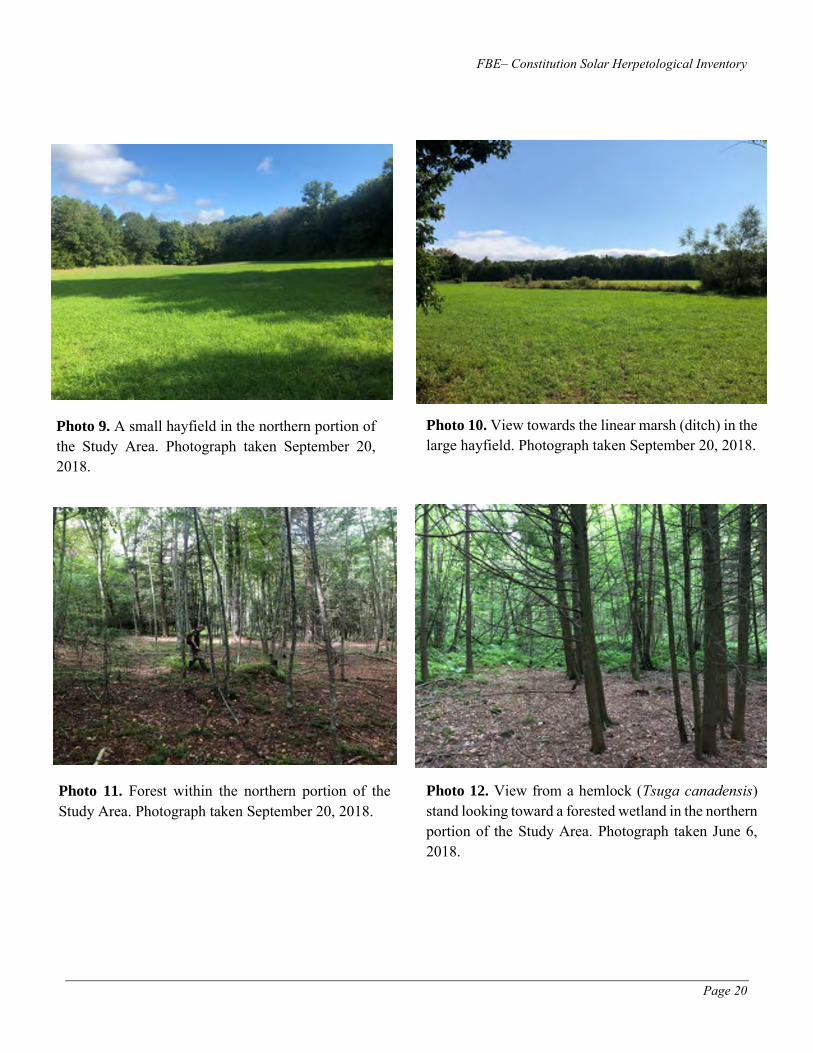
FBE– Constitution Solar Herpetological Inventory
Page 20
Photo 9. A small hayfield in the northern portion of the Study Area. Photograph taken September 20, 2018.
Photo 10. View towards the linear marsh (ditch) in the large hayfield. Photograph taken September 20, 2018.
Photo 11. Forest within the northern portion of the Study Area. Photograph taken September 20, 2018.
Photo 12. View from a hemlock (Tsuga canadensis) stand looking toward a forested wetland in the northern portion of the Study Area. Photograph taken June 6, 2018.

FBE– Constitution Solar Herpetological Inventory
Page 21
Photo 13. A forested wetland in the northern portion of the Study Area. Photograph taken June 19, 2018.
Photo 14. A small tributary to the Quinebaug River emanating from the linear marsh (ditch). Photograph taken June 19, 2018.
Photo 15. Northern two-lined salamander (Eurycea bislineata) eggs in one of the small streams in the Study Area. Photograph taken June 6, 2018.
Photo 16. A steep slope leading to the Quinebaug River. Photograph taken September 20, 2018.
Constitution Solar, LLC Environmental Site Conditions Report
Vernal Pool Surveys and Wetland and Watercourse Delineation,
Constitution Solar Project (June 2019). Prepared by Tetra Tech,
Inc.

Constitution Solar, LLC Environmental Site Conditions Report
Vernal Pool Surveys and Wetland and Watercourse
Delineation Report
Constitution Solar Project
Plainfield, Connecticut
Prepared For:
Constitution Solar, LLC
700 Universe Blvd Juno Beach, FL 33408
August 2019

Vernal Pool Surveys and Wetland and Watercourse Delineation Report i Constitution Solar
TABLE OF CONTENTS
1.0 Introduction .......................................................................................................................... 1
1.1 Project Description .............................................................................................................................. 1
2.0 Survey Methods ................................................................................................................... 1
2.1 Vernal Pools .................................................................................................................................. 1
2.2 Wetland and Watercourse Delineation ......................................................................................... 1
3.0 Survey Results ..................................................................................................................... 2
3.1 Vernal Pools .................................................................................................................................. 2
3.2 Wetland Delineation Results ......................................................................................................... 4
3.2 Watercourse Delineation Results .................................................................................................. 4
4.0 Conclusion ......................................................................................................................... 10
LIST OF FIGURES
Figure 1: Vernal Pools, Wetlands, and Watercourses, Constitution Solar, Plainfield, Connecticut. ....... 11
LIST OF TABLES
Table 1. Vernal Pool Tiered Rankings. ......................................................................................................... 4 Table 2. Wetland Delineation Results for Constitution Solar, Plainfield, Connecticut. ............................. 5 Table 3. Watercourse Delineation Results for Constitution Solar, Plainfield, Connecticut....................... 9
LIST OF APPENDICES
Appendix A. Vernal Pool Data Forms Appendix B. Representative Photograph Log

Vernal Pool Surveys and Wetland and Watercourse Delineation Report 1 Constitution Solar
1.0 Introduction
During the spring and summer of 2017 and 2018, Tetra Tech Inc. (Tetra Tech) conducted vernal pool surveys, and a wetland and watercourse delineation at the location of the proposed Constitution Solar Project (Project) in the Town of Plainfield, Windham County, Connecticut. An additional vernal pool survey was conducted on May 1, 2019. This letter report outlines the results of these natural resources surveys and describes the existing conditions observed at the Project site.
1.1 Project Description
Constitution Solar, LLC (Constitution Solar), a wholly-owned subsidiary of NextEra Energy Resources (NEER), is proposing to construct the approximately 20-megawatt solar Project. Surveys were completed on approximately 149 acres of land located at the northern end of Cornell Road in Plainfield, Connecticut (Study Area). The Study Area is primarily comprised of agricultural fields that are currently being used for growing corn and hay, with other portions of the Study Area consisting of mixed second-growth forest. These forested areas contain old stone walls that suggest its historic use as farmland. Generally, the site can be described as gently sloping with a mixture of agricultural lands and forest habitats, containing approximately 58 acres cleared for agricultural operations, and approximately 80 acres consisting of forest habitats. The Quinebaug River flows south along the western boundary.
2.0 Survey Methods
2.1 Vernal Pools
Vernal pool surveys were completed by Tetra Tech in April and May 2017 following the Connecticut Association of Wetland Scientists Vernal Pool Monitoring Program Protocol1. Additional guidance was taken from the Maine Association of Wetland Scientists Vernal Pool Technical Committee Vernal Pool Survey Protocol2. To account for the different breeding periods of vernal pool species, two site visits were completed for this survey on April 12 and May 2, 2017.
Tetra Tech conducted site visits on April 12 and 26, 2018 and May 1, 2019. These site visits were conducted to evaluate the natural resources and to confirm the observations made in 2017.
2.2 Wetland and Watercourse Delineation
A wetland and watercourse delineation was completed for the Study Area during the June 2017 and 2018 growing-seasons. The June 2017 delineation served to delineate all wetlands and watercourses within the Study Area, and the June 2018 delineation served to review delineated wetland and watercourse data, and to collect additional data on the resources located within the Study Area. Wetlands and watercourses under federal jurisdiction were delineated according to the technical criteria described in the U.S. Army
1 Connecticut Association of Wetland Scientists. No date. Vernal Pool Monitoring Program Protocol. Available
online at: http://www.ctwetlands.org/forms/CAWS_VernalPoolMonitoring_Protocols.pdf. Accessed July 11, 2018.
2 Maine Association of Wetland Scientists. 2014. Vernal Pool Survey Protocol. Vernal Pool Technical Committee. April 2014. 84 pp. Available online at: https://static1.squarespace.com/static/5113deede4b0a785ada17b27/t/537415c4e4b003ad4653fb5a/1400116676556/Complete+MAWS+2014+VP+Survey+Protocol_v3_05.14.2014.pdf. Accessed October 29, 2018.
Vernal Pool Surveys and Wetland and Watercourse Delineation Report 2 Constitution Solar
Corps of Engineers (USACE) 1987 Wetland Delineation Manual3, and the Regional Supplement to the Corps of Engineers Wetland Delineation Manual: Northcentral and Northeast Regional Supplement Version 24. USACE wetland determination data forms were completed for representative wetlands within the Study Area and are available upon request. Additionally, delineations were conducted in accordance with the definitions of wetlands and watercourses as described in the Inland Wetlands and Watercourses Regulations of the Town of Plainfield5. Wetland and watercourse boundaries were delineated in the field using pink and blue flagging marked with alphanumeric codes and recorded using iPads equipped with Collector for Arc GIS connected via Bluetooth to EOS Positioning Systems, Arrow 100 Sub-meter Global Navigation Satellite System.
3.0 Survey Results
3.1 Vernal Pools
Two vernal pools, VP01 and VP02, have been identified within the Study Area. Vernal pool forms are provided in Appendix A. Vernal pool naming convention has been revised from the vernal pool codes used on the forms, whereas VPN is now VP01 and VPB is now VP02.
VP01 VP01 is a cryptic pool comprised of multiple clusters of small natural depressions between tussocks within a forested wetland in the southern parcel of the Study Area. This pool occurs within a larger forested wetland complex, W01. The dominant vegetation in the wetland surrounding VP01 includes red maple (Acer rubrum) and skunk cabbage (Symplocarpus foetidus). The pool is approximately 100 by 50 feet in size and 10 to 16 inches deep in the deepest portion.
During the 2017 surveys four wood frog (Lithobates sylvaticus) egg masses were observed in this pool during the first site visit on April 12 and these were restricted to an approximately 10-foot square area. During the second visit on May 2, seven spotted salamander (Ambystoma maculatum) egg masses were present, but no wood frog egg masses were observed.
During the spring 2018 survey nine spotted salamander egg masses were observed during the first site visit on April 12. A total of 17 spotted salamander egg masses were observed in the pool on the second visit conducted on April 26. Adult wood frogs and green frogs (Lithobates clamitans) were observed in the pool on the second site visit, and the pool contained similar water levels during both site visits; however, wood frog egg masses were not observed in the pool during either of the 2018 site visits. During the wetland and watercourse delineation of the Study Area completed in the summer of 2018, a spotted salamander metamorph was observed in the pool on June 8. The pool at this time had an approximate water depth of 4 inches but was observed to be dry during a June 20, 2018 site visit of the Study Area. A
3 U.S. Army Corps of Engineers (USACE) Environmental Laboratory. 1987. Corps of Engineers Wetlands Delineation
Manual. January 1987 – Final Report. 143 pp. Available online at: http://www.cpe.rutgers.edu/Wetlands/1987-Army-Corps-Wetlands-Delineation-Manual.pdf. Accessed October 29, 2018.
4 USACE. 2011. Regional Supplement to the Corps of Engineers Wetland Delineation Manual: Northcentral and Northeast Region (Version 2.0), ed. J.S. Wakeley, R.W. Lichvar, C.V. Noble, and J.F. Berkowitz. ERDC/EL TR-12-1. Vicksburg, MS: U.S. Army Engineer Research and Development Center. Available online at: https://usace.contentdm.oclc.org/utils/getfile/collection/p266001coll1/id/7640. Accessed October 29, 2018.
5 Town of Plainfield. 2012. Inland Wetlands and Watercourses Regulations. Amended through 13 November 2012. Available online at: http://www.plainfieldct.org/docs/zoning/wetlandsregulations.pdf. Accessed October 29, 2018.

Vernal Pool Surveys and Wetland and Watercourse Delineation Report 3 Constitution Solar
site visit conducted on September 20, 2018 as part of a separate herpetological survey noted several inches of water were present in the pool.
VP02 VP02 is a large natural pool occurring in an old oxbow of the Quinebaug River. This pool is surrounded by upland and historic floodplain, and a narrow constriction on the south end of the pool creates a small connection to another pool that occurs outside of the Study Area. VP02 is located along the southwestern boundary of the northern parcel, within the larger forested/emergent wetland complex of W12. Fairy shrimp (Eubranchipus vernalis) were observed within the pool during both the April and May 2017 surveys. In addition, the April 2017 survey identified 334 wood frog egg masses, which consisted of a combination of mature and advanced embryos; and 109 mature spotted salamander egg masses. The May 2017 survey of this pool observed hatched and advanced stages of wood frog egg masses and 76 advanced embryo, spotted salamander egg masses present within this pool. In 2017 this vernal pool was approximately 4 feet deep at its deepest point; however, the presence of fairy shrimp indicates the pool completely dries out during the summer, as this is a critical requirement of their life history.
This pool was not formally surveyed in 2018 during the seasonal vernal pool window because preliminary parcel boundary survey results indicated the pool was located entirely outside of the Study Area. Following the field-based survey and location of parcel lines, this pool is partially located within the Project’s Study Area. Based on the revised parcel line, an additional vernal pool survey was completed for the northern end of this pool in the spring of 2019. Additional observations of the pool were collected in the summer of 2018 as part of a separate herpetological survey.
Observations made in 2018 determined several feet of water were still present in the pool in early June 2018, and many spotted salamander egg masses were still present along with 100s of wood frog larvae. By mid-September 2018 water levels in the pool had reduced greatly, although the pool was not completely dry. During the May 1, 2019 survey this pool contained several feet of water, and many wood frog larvae and six spotted salamander egg masses were observed in the pool.
Vernal Pool Assessment Vernal pool survey results were assessed using the tiering methodology identified in Best development practices for conserving pool-breeding amphibians in residential and commercial developments in the northeastern United States (Calhoun and Klemens 20026). This methodology ranks vernal pool biological and physical characteristics, including indicator species diversity and abundance; presence of rare, threatened, or endangered species; and level of disturbance/development within terrestrial environments located within a 750-foot radius of the vernal pool (Calhoun and Klemens 2002). Forest habitat surrounding vernal pools provide Critical Terrestrial Habitat for adults and newly emerged juvenile phases of pool-breeding amphibians, and should consist of uncompacted, deep organic litter; woody debris; and shade. As such, protection of vernal pools and the species that are dependent upon them for breeding, also must include a terrestrial buffer surrounding the pools that is free of disturbance and development. Populations and dispersal into nearby areas for breeding, foraging, and refuge also can be enhanced through connectivity of vernal pool habitats within the upland landscape. Tiering categories include Tier I, Tier II, and Tier III, with Tier I reflecting vernal pools having the highest ecological value.
6 Calhoun, A.J.K. and M.W. Klemens. 2002. Best development practices: Conserving pool-breeding amphibians in
residential and commercial developments in the northeastern United States. MCA Technical Paper No. 5, Metropolitan Conservation Alliance, Wildlife Conservation Society, Bronx, New York. Available online at: http://www.maineaudubon.org/wp-content/uploads/2017/03/Best-Development-Practices-Conserving-Pool-breeding-Amph.pdf. Accessed May 3, 2019.

Vernal Pool Surveys and Wetland and Watercourse Delineation Report 4 Constitution Solar
Vernal pool tiered ranking results for the two vernal pools identified within the Study Area are provided in Table 1.
Table 1. Vernal Pool Tiered Rankings.
Vernal Pool ID Category A
Biological Value Score1
Category B
Condition of the
Critical Terrestrial
Habitat Score2
Tier Rating3
VP01 2 2 Tier I VP02 2 2 Tier I
Assessment based on Vernal Pool Assessment Sheet included in Step 2. Ecological Assessment: Prioritizing Conservation Targets in
Calhoun and Klemens 2002.
1 – 1 point each for presence or breeding of rare, threatened or endangered species in pool; two or more vernal pool indicator
species (egg masses, spermatophores, mating, larvae); and 25 or more egg masses (regardless of species by conclusion of
breeding season; maximum of 3 points).
2 – 1 point each if at least 75% of vernal pool envelope (100 feet from pool) is undeveloped, and if at least 50% of the critical
terrestrial habitat (100–750 feet) is undeveloped (maximum of 2 points). For this purpose, undeveloped means open land free
of roads, structures, and other infrastructure. It can be forested, partly forested or open agricultural land.
3 – Tier I Scoring Criteria – Category A of Vernal Pool Assessment Sheet (Biological Value of the Vernal Pool) = score of 1–3 and
Category B of Vernal Pool Assessment Sheet (Condition of the Critical Terrestrial Habitat)= 2.
Based on the vernal pool tiered rankings, both vernal pools (VP01 and VP02) located within the Study Area would meet the Calhoun and Klemens (2002) criteria for a Tier I vernal pool. Critical Terrestrial Habitat maps for these two vernal pools are provided in the Project’s Avoidance and Mitigation Plan (available under separate cover).
3.2 Wetland Delineation Results
Twelve wetlands totaling approximately 10.63 acres were identified in the Study Area (Table 2). The wetland types7 identified include palustrine forested, palustrine emergent, palustrine forested/palustrine emergent, and palustrine forested/palustrine scrub-shrub. Six of the 12 wetlands are hydrologically connected to watercourse channels, which all flow west, eventually discharging into the Quinebaug River. Wetland plots were completed in accordance with USACE standards to determine vegetation, soils, and hydrology of the wetlands observed. A detailed description of each wetland is provided in Table 2.
3.2 Watercourse Delineation Results Twelve watercourse segments were identified within the Study Area (Table 3). Watercourse types present include eight intermittent watercourses and two ephemeral watercourses/drainages8. As noted in Section 3.2, several of the delineated watercourses are associated with wetland complexes. Generally, the watercourse within the Study Area were observed to be impacted by past agricultural practices as evidenced by the channelization of sheet flow runoff or originating from culverts located along Cornell Road. A detailed description of each watercourse documented within the Study Area is provided in Table 3.
7 Cowardin, L.M, V. Carter, F.C. Golet, and E.T. Roe. 1979. Classification of Wetlands and Deepwater Habitats of the United
States. December 1979. 142 pp. Available online at: https://www.fws.gov/wetlands/documents/Classification-of-
Wetlands-and-Deepwater-Habitats-of-the-United-States.pdf. Accessed October 29, 2018. 8 Intermittent watercourse S06 and ephemeral watercourse S10 each consist of two separate segments within the Study Area but are hydrologically connected as part of the same watercourse.

Vernal Pool Surveys and Wetland and Watercourse Delineation Report 5 Constitution Solar
Table 2. Wetland Delineation Results for Constitution Solar, Plainfield, Connecticut.
Wetland ID Cowardin
Classification1
Area
Delineated
(Acres)
Area
Delineated
(Square
Feet)
Resource Summary
W01 PFO 5.34 232,610
This forested wetland is located west of an open agricultural field and expands the length of the eastern side of the southern portion of the Study Area from north to south. Several intermittent and ephemeral watercourses (S01, S02, S03, S04, and S10) are hydrologically connected to this wetland. Vernal pool VP01 is located in this wetland. Vegetation includes red maple (Acer rubrum), green ash (Fraxinus pennsylvanica), American hornbeam (Carpinus caroliniana), northern spicebush (Lindera benzoin) multiflora rose (Rosa multiflora), Japanese barberry (Berberis thunbergii), skunk cabbage (Symplocarpus foetidus), cinnamon fern (Osmundastrum cinnamomeum), jewelweed (Impatiens capensis), northern water-horehound (Lycopus uniflorus), jack-in-the-pulpit (Arisaema triphyllum), and poison ivy (Toxicodendron radicans). Hydrology indicators include surface water, soil saturation to the surface and water stained leaves. The soil consisted of dark mucky loam to 10-inches.
W02 PFO 2.22 96,703
This forested wetland is hydrologically connected to intermittent watercourses S03 and S04 in the southern portion of the Study Area. Vegetation includes red maple, green ash, pignut hickory (Carya glabra), American elm (Ulmus americana), swamp holly (Ilex mucronata), multiflora rose, highbush blueberry (Vaccinium corymbosum), smallspike false nettle (Boehmeria cylindrica), sensitive fern (Onoclea sensibilis), sand violet (Viola affinis), wrinkle-leaf goldenrod (Solidago rugosa), jewelweed, and poison ivy. The hydrology indicators for this wetland include sparsely vegetated areas, soil saturation to the surface, and signs of inundation. The soil consists of dark mucky loam to 6-inches, underlain by depleted fine sandy loam with 2 percent redox concentrations.
W03 PFO 0.22 9,583
This forested wetland is located along the western boundary of the southern portion of the Study Area and extends west outside the boundary. Vegetation includes red maple, green ash, and black ash (Fraxinus nigra), northern spicebush, multiflora rose, skunk cabbage, stalk-grain sedge (Carex stipata), northern water-horehound, and jewelweed. Hydrology indicators present in this wetland are surface water and soil saturation to the surface. The soil consists of a thick dark surface.
W04 PFO 0.26 11,326 This forested wetland is hydrologically connected to intermittent watercourse S05 in the southern portion of the Study Area. Vegetation

Vernal Pool Surveys and Wetland and Watercourse Delineation Report 6 Constitution Solar
Wetland ID Cowardin
Classification1
Area
Delineated
(Acres)
Area
Delineated
(Square
Feet)
Resource Summary
includes red maple, northern spicebush, multiflora rose, skunk cabbage, jewelweed, northern water-horehound, and sand violet. The hydrology indicators present in this wetland are surface water with visible flow, 4-inches of pooled water where there is a groundwater seep, and soils saturated to the surface. The soil in this wetland consist of a thick dark surface.
W05 PFO 0.16 6,970
This forested wetland is located in the center of the southern portion of the Study Area. Vegetation includes red maple, northern spicebush, American hornbeam (saplings), skunk cabbage, jack-in-the-pulpit, and sand violet. The hydrology indicators include surface water flow in and out of the wetland. The soils consist of dark mucky loam, with approximately 20 percent sand to 10-inches, underlain by a layer from 10 to 14 inches with the same matrix color and texture with redox depletions of 20 to 40 percent.
W06 PFO 0.01 436
Wetland W06 is a small forested wetland located along the southern border of the northern portion of the Study Area. Vegetation includes red maple, hickory (Carya sp.), northern spicebush, Japanese barberry, multiflora rose, poison ivy, cinnamon fern, jack-in-the-pulpit, and sensitive fern. The hydrology indicators include signs of flow and water inundation, and water stained leaves. The soils consist of dark mucky loam to 6-inches, underlain by a layer with the same matrix color and texture, with 20 percent redox depletions.
W07 PEM 0.53 23,087
This long, linear emergent wetland is located within an open agricultural field within the northern portion of the Study Area. Watercourse S09 is hydrologically connected to this wetland, functioning as an outlet that drains the wetland to the west and off-site. Vegetation observed includes sweet-scented joe-pye weed (Eutrochium purpureum), sensitive fern, upright sedge (Carex stricta), rattlesnake manna grass (Glyceria canadensis), bluejoint (Calamagrostis canadensis), purplestem aster (Symphyotrichum puniceum), harlequin blueflag (Iris versicolor), purple loosestrife (Lythrum salicaria), and jack-in-the-pulpit. The hydrology indicators include flowing water in the wetland and soils saturated to the surface. The soils consist of dark mucky loam underlain by depleted fine sandy loam with 20-percent redox concentrations of 10YR 5/6 fine sandy loam to 8-inches. a buried layer of dark mucky sand from 8 to 12-inches, indicates past disturbance likely from agricultural activities.
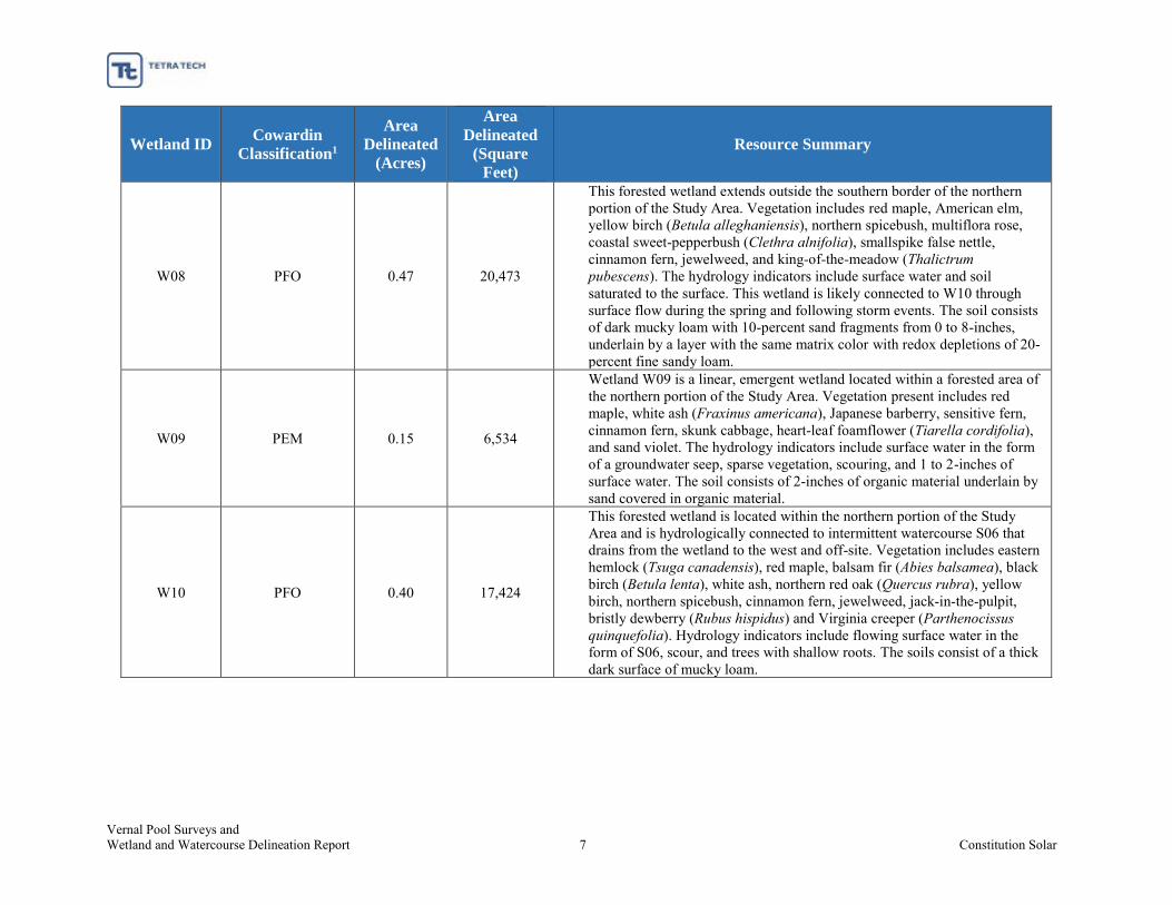
Vernal Pool Surveys and Wetland and Watercourse Delineation Report 7 Constitution Solar
Wetland ID Cowardin
Classification1
Area
Delineated
(Acres)
Area
Delineated
(Square
Feet)
Resource Summary
W08 PFO 0.47 20,473
This forested wetland extends outside the southern border of the northern portion of the Study Area. Vegetation includes red maple, American elm, yellow birch (Betula alleghaniensis), northern spicebush, multiflora rose, coastal sweet-pepperbush (Clethra alnifolia), smallspike false nettle, cinnamon fern, jewelweed, and king-of-the-meadow (Thalictrum pubescens). The hydrology indicators include surface water and soil saturated to the surface. This wetland is likely connected to W10 through surface flow during the spring and following storm events. The soil consists of dark mucky loam with 10-percent sand fragments from 0 to 8-inches, underlain by a layer with the same matrix color with redox depletions of 20-percent fine sandy loam.
W09 PEM 0.15 6,534
Wetland W09 is a linear, emergent wetland located within a forested area of the northern portion of the Study Area. Vegetation present includes red maple, white ash (Fraxinus americana), Japanese barberry, sensitive fern, cinnamon fern, skunk cabbage, heart-leaf foamflower (Tiarella cordifolia), and sand violet. The hydrology indicators include surface water in the form of a groundwater seep, sparse vegetation, scouring, and 1 to 2-inches of surface water. The soil consists of 2-inches of organic material underlain by sand covered in organic material.
W10 PFO 0.40 17,424
This forested wetland is located within the northern portion of the Study Area and is hydrologically connected to intermittent watercourse S06 that drains from the wetland to the west and off-site. Vegetation includes eastern hemlock (Tsuga canadensis), red maple, balsam fir (Abies balsamea), black birch (Betula lenta), white ash, northern red oak (Quercus rubra), yellow birch, northern spicebush, cinnamon fern, jewelweed, jack-in-the-pulpit, bristly dewberry (Rubus hispidus) and Virginia creeper (Parthenocissus quinquefolia). Hydrology indicators include flowing surface water in the form of S06, scour, and trees with shallow roots. The soils consist of a thick dark surface of mucky loam.

Vernal Pool Surveys and Wetland and Watercourse Delineation Report 8 Constitution Solar
Wetland ID Cowardin
Classification1
Area
Delineated
(Acres)
Area
Delineated
(Square
Feet)
Resource Summary
W11 PFO/PSS 0.23 10,019
This linear, forested/scrub-shrub wetland is located between two open agricultural fields within the northern portion of the Study Area, and is associated with intermittent watercourse S08, which drains from the wetland to the northwest and off-site. Vegetation includes red maple, pignut hickory, northern spicebush, multiflora rose, skunk cabbage, jewelweed, and fowl manna grass (Glyceria striata). The hydrology indicators include soil saturated to the surface, surface water with a depth of 1/2 -inch and ground water observed at 3-inches below the surface. The soil consists of organic sandy muck to 10-inches.
W12 PFO/PEM 0.62 27,007
This forested/emergent wetland is located along the western border of the northern portion of the Study Area and extends off-site. Vernal pool VP02 is associated with this wetland. Vegetation includes American elm, red maple, green ash, northern spicebush, skunk cabbage, jewelweed, jack-in-the-pulpit, cinnamon fern, and poison ivy. The hydrology indicators include buttressed roots, surface water less than 1-inche deep, ground water table at 2-inches below the surface, and soils saturated to the surface. The soils in the forested portion of the wetland consist of dark muck from 0 to 10-inches with approximately 2-percent sand fragments, underlain by a layer with the same color and texture with 10-percent sand fragments from 10 to 15-inches. The following soils layer consisted of organic muck with no sand fragments from 15 to 20-inches.
1 – PFO = palustrine forested; PEM = palustrine emergent; PFO/PSS = palustrine forested/palustrine scrub-shrub; PFO/PEM = palustrine forested/palustrine emergent

Vernal Pool Surveys and Wetland and Watercourse Delineation Report 9 Constitution Solar
Table 3. Watercourse Delineation Results for Constitution Solar, Plainfield, Connecticut.
Watercourse
ID
Watercourse
Type Summary
S01 Intermittent
Flows west adjacent to a field from an 18-inch concrete pipe culvert on Cornell Road and into W01. Watercourse appears to have formed from agricultural practices such as ditching and the culvert flow from Cornell Road. Defined channel ends upon entering W01. Top of bank width is approximately 4 feet (ft) with a high-water mark of 3 ft. Substrate was approximately 80 percent (%) sand with 20% cobble. At time of survey water flow was approximately 4 inches (in) deep.
S02 Ephemeral
Flows west from W01 and loses its defined channel quickly. Top of bank width varies between 3–6 ft with a high-water mark of 2–3 ft and a bank depth of 3–6 in. Substrate is approximately 80% sand with 20% cobble. At time of survey there was no water flow.
S03 Intermittent
Flows to the west from W01 and along northern boundary of W02 and continues to western boundary of southern parcel. Top of bank width is approximately 5–8 ft with a high-water mark of 3–6 ft and a bank depth of 6–10 in. Substrate is approximately 30% sand, 30% cobble, 30% muck, and 10 % boulders. Downstream the watercourse widens to a top of bank width of 10–12 ft, with a bank depth of 2–6 ft and a high-water mark width of 4–8 ft. Watercourse substrate for this section was 20% boulder, 20% sand, 30% cobble, and 30% gravel. Canopy cover is approximately 70%.
S04 Intermittent
Flows west from W01 into W02. Watercourse ends as a surface drainage that is connected to S03. Top of bank width is approximately 4–5 ft with a high-water mark of 2–3 ft and a bank depth of 6–12 in. Substrate is approximately 20% cobble, 10% gravel,40% sand, and 30% muck.
S05 Intermittent Flows west from W04. Top of bank width is approximately 4–5 ft with a high-water mark of 2–3 ft and a bank depth of 6–12 in. Watercourse likely has flow after storm events.
S06 Intermittent
This watercourse is bisected by an existing farm road and consists of two separated segments. The eastern segment flows to the west from W10. The western segment flows west and merges with watercourse S08, eventually discharging into the Quinebaug River. A farm road separates the two segments. No culvert is visible, and water likely flows over this road during high flow events. Along the eastern segment, the top of bank width is 4–6 ft with a high-water mark of 2–3 ft and a bank depth of 10–12 in. The substrate is approximately 40% cobble, 25% muck, 25% sand, and 10% gravel. Water pools along a farm road, likely because the road has no culvert, and is diverted as sheet flow before channelizing again downslope. Along the western segment, the gradient becomes steeper, top of bank width is 6–8 ft with a high-water mark of 2–4 ft and a bank depth of 2–4 ft. Substrate is 50% sand, 30% cobble, and 20% muck.
S07 Intermittent Flows to the west into S08. This is a small channel formed on a steeper slope in a forested area of the Project.
S08 Intermittent Flows to the northwest from W11 and eventually discharges into the Quinebaug River. Hydrologically connected to watercourses S06 and S07 that flow into it from the east.
S09 Intermittent
Flows west from W07, eventually discharging into the Quinebaug River. It flows through a 24-inch concrete pipe in the farm road. The top of bank width is 6–8 ft with a high-water mark of 1–2 ft and a bank depth of 2–4 ft. Water flow at time of survey was 1–2 in. Substrate consists of 10% boulder, 40% cobble, 30% gravel, and 20% sand.
S10 Ephemeral Watercourse consists of two separated segments within the southern portion of the Study Area. The eastern segment flows to the west from a culvert in

Vernal Pool Surveys and Wetland and Watercourse Delineation Report 10 Constitution Solar
Watercourse
ID
Watercourse
Type Summary
Cornell Road and along the northern edge of an existing field. The western segment flows into wetland W01 eventually losing the channel in the wetland. This watercourse appears to have formed from agricultural practices such as ditching and the culvert flow from Cornell Road. Top of bank width is approximately 2–4 ft with a high-water mark of 2 ft and a bank depth of 12 in. Substrate is approximately 95% muck/mineral/sand with 5% cobble. Some vegetation was observed within the channel. At time of survey there was no water flow.
4.0 Conclusion
The results of the vernal pool surveys and wetland and watercourse delineation are shown in Figure 1. In summary, two vernal pools totaling approximately 0.20 acres, 12 wetlands totaling approximately 10.63 acres, and 12 watercourse segments (10 watercourses) are located within the Study Area. Based on vernal pool fauna observations and an assessment of level of development within the venal pool envelope (100 feet) and the Critical Terrestrial Habitat envelope (100–750 feet) both of the vernal pools located within the Study Area meet the Calhoun and Klemens (2002) criteria for a Tier I vernal pool.
The wetlands and watercourses generally show signs of disturbance from past or ongoing agricultural activities and nearby development, several of which currently do not have any, or very narrow existing upland buffer separating wetlands from agricultural activities. Invasive plant species also were documented within wetland and upland areas. Wetland complexes are associated with many of the watercourse segments within the Study Area, and the hydrology of the wetlands and watercourses generally have a westerly flow, ultimately discharging into the Quinebaug River located to the west.
Avoidance of direct impacts to water resources is recommended. The mapped water resources should be avoided to the extent practicable for both construction and operational activities. Additionally, the implementation of impact avoidance and minimization strategies, such as erosion and sedimentation controls, and environmental protection training for on-site staff will further reduce potential impacts to these natural resources. Construction and operational best management practices, including post-construction restoration of disturbed soils is recommended to minimize impacts to water resources and water quality from potential erosion and sedimentation.

Vernal Pool Surveys and Wetland and Watercourse Delineation Report 11 Constitution Solar
Figure 1: Vernal Pools, Wetlands, and Watercourses, Constitution Solar, Plainfield, Connecticut.

Vernal Pool Surveys and Wetland and Watercourse Delineation Report 12 Constitution Solar
This page intentionally left blank.

Vernal Pool Surveys and Wetland and Watercourse Delineation Report Constitution Solar
Appendix A Vernal Pool Data Forms

Vernal Pool Surveys and Wetland and Watercourse Delineation Report Constitution Solar
This page intentionally left blank.


Vernal Pool Surveys and Wetland and Watercourse Delineation Report Constitution Solar
Appendix B Representative Photograph Log

Vernal Pool Surveys and Wetland and Watercourse Delineation Report Constitution Solar
This page intentionally left blank.
Vernal Pool Surveys and Wetland and Watercourse Delineation Report Constitution Solar
Photo: 1 Description: Vernal pool VP01 with wood frog (Lithobates sylvaticus) egg masses indicating amphibian breeding activity. Date: April 12, 2017 Source: Tetra Tech, Inc.
Photo: 2 Description: Vernal pool VP02 located along the western edge of the northern portion of the Study Area. Date: April 12, 2017 Source: Tetra Tech, Inc.

Vernal Pool Surveys and Wetland and Watercourse Delineation Report Constitution Solar
Photo: 3 Description: Wetland W01, a forested wetland located in the southern portion of the Study Area, which also contains VP01. Date: June 19, 2017 Source: Tetra Tech, Inc.
Photo: 4 Description: Forested wetland (W02) located in the southern portion of the Study Area. Date: June 19, 2017 Source: Tetra Tech, Inc.

Vernal Pool Surveys and Wetland and Watercourse Delineation Report Constitution Solar
Photo: 5 Description: Forested wetland (W03) located near northwestern edge of southern portion of the Study Area and adjacent to watercourse S05. Date: June 19, 2017 Source: Tetra Tech, Inc.
Photo: 6 Description: Wetland W05 located in the southern portion of the Study Area. Tree species includes red maple (Acer rubrum), American hornbeam (Carpinus caroliniana), northern spicebush (Lindera benzoin). Date: June 19, 2017 Source: Tetra Tech, Inc.

Vernal Pool Surveys and Wetland and Watercourse Delineation Report Constitution Solar
Photo: 7 Description: Wetland W06 located along southern boundary of the northern portion of the Study Area. Tree species includes red maple and hickory (Carya sp.). Date: June 19, 2017 Source: Tetra Tech, Inc.
Photo: 8 Description: Wetland W07 that stretches across the centrally located field within the northern portion of the Study Area. Watercourse S09 is associated with this wetland, and flows out of this wetland, west to the Quinebaug River. Date: June 19, 2017 Source: Tetra Tech, Inc.

Vernal Pool Surveys and Wetland and Watercourse Delineation Report Constitution Solar
Photo: 9 Description: Wetland W08 located within the northern portion of the Study Area near a residence located off-site. Date: June 19, 2017 Source: Tetra Tech, Inc.
Photo: 10
Description: Wetland W12 located along the western boundary of the northern portion of the Study Area. Vernal pool VP02 is associated with this wetland. Date: June 19, 2017 Source: Tetra Tech, Inc.

Vernal Pool Surveys and Wetland and Watercourse Delineation Report Constitution Solar
Photo: 11 Description: Watercourse S01 located near the southern boundary of the southern portion of the Study Area. This intermittent watercourse flows west along the Study Area boundary adjacent to a field, from a concrete pipe culvert within Cornell Road and into wetland W01. Date: June 19, 2017 Source: Tetra Tech, Inc.
Photo: 12
Description: Watercourse S03 that stretches across the southern portion of the Study Area, passing through several old stone walls. Wetlands W01 and W02 are associated with this intermittent watercourse, which flows west and out of the Study Area towards the Quinebaug River. Bank erosion was observed within the Study Area Date: June 19, 2017 Source: Tetra Tech, Inc.

Vernal Pool Surveys and Wetland and Watercourse Delineation Report Constitution Solar
Photo: 13 Description: Watercourse S05 located in the southern portion of the Study Area. This watercourse flows west out of wetland W04 and off site to the west towards the Quinebaug River . Date: June 17, 2017 Source: Tetra Tech, Inc.
Photo: 14 Description: Watercourse S06 located in the northern portion of the Study Area. This intermittent watercourse flows out of wetland W10 and along the edge of an agricultural field. The watercourse is segmented by an existing farm road. Date: June 19, 2017 Source: Tetra Tech, Inc.

Constitution Solar, LLC Environmental Site Conditions Report

Constitution Solar, LLC Environmental Site Conditions Report
Northern Long-eared Bat (NLEB) Presence/Absence Survey
(September 29, 2017). Prepared by Tetra Tech, Inc. for NextEra Energy
Resources, LLC.

Constitution Solar, LLC Environmental Site Conditions Report

Date: September 29, 2017
TTCES-PTLD-2017-5997
Mr. Coke Coakley
700 Universe Blvd
Juno Beach, FL 33408
Project Northern Long-eared Bat (NLEB) Presence/Absence Survey
Location Plainfield, CT (Whindham County)
Area of Forest for Clearing Yet to be determined
Surveyor Name/Firm Clinton Parrish and Derek Hengstenberg/Tetra Tech, Inc.
Nights of Detector Operation July 6–11, 2017
# of Detectors/Total Detector-nights 4 Detectors / 24 Detector-nights
Survey Results NLEB NOT DETECTED
Dear Mr. Coakley,
This report contains summary results of the northern long-eared bat (hereafter NLEB) summer presence/absence survey performed for the Constitution Solar project (Project) located in Plainfield, Connecticut. Acoustic detectors deployed by Tetra Tech did not detect the presence of NLEB. The presence of five species were confirmed in the Project area during the survey including big brown bat (Eptesicus fuscus), eastern red bat (Lasiurus borealis), hoary bat (Lasiurus cinereus), silver- haired bat (Lasionycteris noctivagans), and the State Endangered tri-colored bat (Perimyotis subflavus) tri-colored bat.
The following memo provides a summary of the survey. Appendix A includes Project station conditions and photographs illustrating detector orientation. Appendix B includes copies of the completed Phase 1 Summer Habitat Assessment forms for the Project. Appendix C includes a summary of Maximum Likelihood Estimates (MLE), and Appendix D includes resumes for relevant staff members involved with the Project.
Project Description
The proposed Project consists of a solar power generation facility to be located in Plainfield, Connecticut. The total project area is 138 acres and consists of two parcels. The western project boundary is bound the Quinebaug River and the site is currently a mix of agricultural and forested

Coke Coakley Constitution Solar Project NLEB Presence/Absence Survey Page 2
lands. The field in the northeast corner of the Project area is currently planted in corn while the remainder of open areas are used as hayfields. Forest habitat within the Project area is comprised of woodlands, wooded fence rows, and a forested riparian area bordering the Quinebaug River.
Methods
The summer presence/absence survey was conducted in accordance with the 2017 U.S. Fish and Wildlife Service (USFWS) Range-wide Indiana Bat Summer Survey Guidelines for Indiana Bat and Northern Long-eared Bat (Guidelines) (USFWS 2017). This survey utilized a two-phased approach: Phase 1, desktop and field-based habitat assessments, and Phase 2, acoustic surveys. Tetra Tech deployed full spectrum acoustic detectors during Phase 2, and the resulting data was processed using Kaleidoscope Pro version 4.2.0 (Wildlife Acoustics, Inc.). Qualified Tetra Tech personnel carried out all phases of the survey. Specific roles are summarized in Table 1; resumes for relevant staff are provided in Appendix D.
Table 1. Personnel involved in NLEB Acoustic Presence/Absence Surveys and analyses for Constitution Solar Project, Plainfield, Connecticut (July 2017).
Personnel Desktop Analysis
Field Assessment
Detector Deployment
Acoustic Analysis
Qualitative Analysis
Clinton Parrish Wildlife Biologist
X X X X X
Derek Hengstenberg Wildlife Biologist
X
2.1 Habitat Assessment
2.1.1 Desktop Assessment
Prior to conducting field work, Tetra Tech performed a desktop land cover analysis to identify suitable NLEB habitat within the proposed Project area (Figure 1). Tetra Tech reviewed aerial photography and Google Earth imagery to identify areas that may be used by NLEB for foraging and roosting during the maternity and migration seasons. This determination was based on forest patch size, proximity to closed-canopy forests, and landscape features that may be used by bats commuting between roosting and foraging habitats (e.g., forested tracts, wetlands, and streams). All relatively contiguous forested lands that were not highly fragmented by residential or commercial developments were considered suitable NLEB habitat, and all densely populated or developed stretches were determined to be unsuitable (USFWS 2017). Although there are several large fields within the Project area, all are bound by forest or water sources and were considered suitable habitat. The Guidelines indicate that for non-linear projects, a sample “site” requires two locations and comprises 123 acres. Therefore this 138 acre non-linear project exceeds 123 acres and would require two sample sites (four locations).

Coke Coakley Constitution Solar Project NLEB Presence/Absence Survey Page 3
Figure 1. Locations of acoustic detectors deployed at Constitution Solar Project, Plainfield Connecticut (July 6–11, 2017).

Coke Coakley Constitution Solar Project NLEB Presence/Absence Survey Page 4
2.1.2 Field-based Assessment
On July 6, Tetra Tech conducted site visits to describe and verify the presence of the NLEB habitat identified during the desktop analysis, and to deploy full spectrum acoustic detectors. General habitat descriptions are provided in Table 2. The completed Phase 1 Summer Habitat Assessment is included in Appendix B.
Table 2. Detector station descriptions and survey data for the Constitution Solar Project, Plainfield, Connecticut (July 2017).
Detector Station
Suitable NLEB
Habitat Description GPS
Coordinates Survey Nights
CTCN-1 Yes Woodland Edge- Edge of large forested area and corn field. Mic oriented along edge.
41.71867675 -71.95422629
7/06-7/11/2017
CTCN-2 Yes Road Corridor-On an old forest road that runs next to hayfields. Old road creates an open canopy and potential flyway.
41.71678875 -71.95853060
7/06-7/11/2017
CTCN-3 Yes
Near Water Sources/Woodland Edge- Located in a corner of a hayfield with the microphone oriented along the forest edge. An old oxbow is located ~40 south of station and the Quinebaug river is located only 30m to the west.
41.71575308 -71.96254612
7/06-7/11/2017
CTCN-4 Yes
Forest-Canopy Openings- Mature hardwood forest with high upper canopy and fairly open mid-canopy layer. Mic elevated and oriented within open mid canopy level.
41.71259432 -71.95686604
7/06-7/11/2017
2.2 Acoustic Surveys
2.2.1 Detector Type
Wildlife Acoustics Song Meter-4 BAT ultrasonic bat detectors (Wildlife Acoustics, Inc., Massachusetts, USA) equipped with SMM-U1 microphones with windscreens were used for the duration of the survey effort. Detectors were set to record from a half hour before sunset to a half hour after sunrise (approximately 7:25 PM – 6:20 AM) in full-spectrum mode, and files were saved in .WAV format on internal SD cards.
The detectors were fully waterproof and were powered by internal D cell batteries. Each detector and microphone was tested prior to deployment with a Wildlife Acoustics Ultrasonic Calibrator to ensure equipment was functioning properly and device sensitivity was within the manufacturer’s suggested thresholds. A “chirp test” with the Ultrasonic Calibrator was used to confirm all connections were sound and that the microphones registered high frequency noise once the detectors were set. Tetra Tech performed this test again at demobilization to ensure microphones

Coke Coakley Constitution Solar Project NLEB Presence/Absence Survey Page 5
were still functioning. Log files were reviewed when units were pulled to verify proper functioning for the duration of the survey.
2.2.2 Detector Deployment
Four detectors were microsited in suitable habitat within the Project area to ensure potential habitats were sampled in accordance with the Guidelines. Detectors were deployed on July 6, 2017 and retrieved on July 11, 2017.
The four detectors were deployed in the following habitat types:
• Road corridor;
• Forest-canopy openings;
• Near water sources; and
• Woodland edge.
Microphones were mounted at a minimum height of 9 feet to avoid ground vegetation and to elevate the cone of detection. Microphones were oriented in line with suspected flight paths to increase the number of call pulses and quality of recordings. Therefore, specific orientation was determined by microsite conditions (arrows in Figure 1 indicate microphone direction at each station). Appendix A includes station conditions and photographs illustrating detector orientation.
2.2.3 Weather Requirements
Weather requirements outlined in the Guidelines (temperatures remain above 50 degrees Fahrenheit, no precipitation that exceeds 30 minutes, and sustained wind speed less than 9 miles/hour) must be met during the first 5 hours of the survey period for each detector-night for valid survey results. Weather history in 5-minute increments was reviewed from the closest weather station to the Project that had data on temperature, wind speed, wind gusts, precipitation rate, and precipitation accumulation. This ensured that the Guidelines were met for a valid survey night (Weather Underground 2017).
2.2.4 Acoustic Analysis
Tetra Tech analyzed the recorded data according to the Guidelines. Data was filtered and analyzed using Kaleidoscope Pro version 4.2.0, using the classifier “Bats of North America 4.3” for species of bats in Maine at the 0 Balanced “Neutral” sensitivity level. Signals of interest ranged from 16–120 kilohertz, lasting 2–500 milliseconds, with a minimum of two call pulses. Full spectrum .WAV files were converted to zero-crossing using a division ratio of eight. All files auto classified as NLEB, Eastern small-footed bat, little brown bat, and tri-colored bat were subsequently manually reviewed using SonoBat v 4.2.0. Eastern small-footed bat, little brown bat, and tri-colored bat were included in qualitative analysis as well because they are listed as endangered in the State of Connecticut. Results were summarized by station and by night.

Coke Coakley Constitution Solar Project NLEB Presence/Absence Survey Page 6
Results
The desktop and field-based habitat assessments revealed approximately 138 acres of suitable NLEB habitat. Agricultural fields are not suitable habitat but wooded fence lines and edges within agricultural areas are and added to the approximately 111 acre forested ridge on the eastern portion of the Project area. Based on the results of the habitat assessment, Tetra Tech deployed two detectors for 6 nights (July 6–11, 2017) for a total of 24 detector-nights. Weather conditions were met on all 5 nights of the survey. Rain was observed on the night of 7/11, but it began after the first five hours of the survey (Table 3).
Table 3. Summary of Weather Information from sunset to sunrise from Windham Airport, Willimantic, CT.
Survey Night
Temperature Range
(Fahrenheit)
Wind Range (mph) Precipitation Qualifying
Night
7/6 58-61 0-5.8 None Yes 7/7 64-67 0-3.5 None Yes 7/8 57-63 0-5.8 None Yes 7/9 56-60 0-3.5 None Yes
7/10 63-70 0-6.9 None Yes 7/11 68-71 0-6.1 AM Rain Yes
Source: Weather Underground 2017.
Interpreting results solely on the number of species calls by software auto-classification can be misleading, as there are varying levels of confidence associated each classification. MLEs are used as a secondary measure to determine likelihood of species presence by incorporating known error rates for each species classifier within the software. In most cases, manual review of bat passes by experienced biologists serves as the most accurate method for species identification. MLEs indicate that six (big brown bat, eastern red bat, hoary bat, silver-haired bat, eastern small-footed bat, and tri-colored bat) of the nine bat species occurring in Connecticut are likely present within the Project area (Appendix C). Qualitative analysis corroborated MLE predictions for all except eastern small-footed bat and these those five species were confirmed present within the Project area during the survey period (Table 4).
Tetra Tech recorded 6,113 total bat passes at the four stations, on the nights of July 6–11, 2017 (Table 5). All detectors were functional for the entire survey period. No NLEB bat passes were auto classified by the software. Single bat passes were auto classified as NLEB and eastern small-footed bat, but upon qualitative analysis they were determined to be a big brown bat feeding buzz and an unidentified high frequency bat species, respectively. One hundred and eighteen bat passes were auto classified as the State Endangered tri-colored bat and presence was confirmed at each station despite identifying several passes that were actually eastern red bat. Overall, bat activity was fairly even among stations with highest at Station 3 along the Quinebaug with 40% of all bat passes

Coke Coakley Constitution Solar Project NLEB Presence/Absence Survey Page 7
followed by Station 1 and 2 with 33% and 26%, respectively(see Appendix A for more information on Station habitats).
Table 4. Summary of Species Presence by Kaleidoscope Pro at Constitution Solar Project, Plainfield, Connecticut (July 2017).
Species MLE Prediction1 Qualitative Analysis Overall Evaluation
Big brown bat Present Present Present Eastern red bat Present Present Present Hoary bat Present Present Present Silver-haired bat Present Present Present Eastern Small-footed bat Present Absent Absent Little brown bat Absent Absent Absent Northern long-eared bat Absent Absent Absent Tri-colored bat Present Present Present 1. Based on probability of presence for any site on any night. See Appendix C for complete listing of MLEs by site/night.
Table 5. Summary of Bat Passes Recorded at Constitution Solar Project, Plainfield, Connecticut (nights of July 2017).
Detector Station
Survey Night
Big Brown
bat
Eastern Red Bat
Hoary Bat
Silver-Haired
bat
Tri-colored
Bat
Unidentified High
Frequency bat
Total
CTCN-1
7/6 159 84 130 32 9 5 419 7/7 47 62 61 49 20 6 245 7/8 156 29 39 20 2 - 246 7/9 169 120 95 12 12 1 409
7/10 236 87 33 29 5 3 393 7/11 103 100 92 28 8 - 331
CTCN-2
7/6 50 42 148 31 8 - 279 7/7 80 26 64 21 3 - 194 7/8 110 28 42 21 4 1 206 7/9 39 29 82 9 2 1 162
7/10 328 12 48 17 1 - 406 7/11 152 34 107 33 6 2 334
CTCN-3
7/6 231 75 89 85 3 - 483 7/7 242 28 60 47 6 - 383 7/8 302 24 38 73 10 - 447 7/9 157 37 43 49 6 - 292
7/10 334 32 64 25 5 - 460 7/11 172 29 112 44 2 - 359
CTCN-4
7/6 - - - - - - - 7/7 - - 2 2 - - 4 7/8 - 1 1 2 1 - 5 7/9 - 1 3 2 - - 6
7/10 46 1 1 - - - 48 7/11 - - 2 - - - 2
Overall 3113 881 1,356 631 113 19 6,113

Coke Coakley Constitution Solar Project NLEB Presence/Absence Survey Page 8
Conclusion
A single bat pass was auto-classified as the NLEB by Kaleidoscope Pro software but was determined to be a false positive during qualitative assessment. Additionally, the MLE values generated by the software indicate that presence of NLEB was unlikely during any of the site/nights over the duration of the survey period. This corroborates qualitative analysis results. Given that no NLEBs were detected while following the summer survey protocol, it is unlikely that the Project will negatively impact the NLEB. Avoiding tree removal activities when possible may also improve foraging and roosting opportunities for this species if populations recover.
In Connecticut, the little brown bat, eastern small-footed bat, and tri-colored bat are all listed as Endangered (CTDEEP 2015). Only the tri-colored bat was detected, although it represented less than 2% of the total bat passes recorded. Eastern red bat, hoary bat, and silver-haired bat were also detected are all listed as Species of Special Concern.
Acoustic surveys in 2011 and 2012 found that species composition in the state was now heavily skewed towards big brown bat with nearly 70% of bats identified in surveys with tree roosting bats (red bat, silver-haired bats, and hoary bats) comprising 20 to 30% (CTDEEP 2015). Findings from this survey reflect those trends with big brown bats representing 51% of the bat passes recorded and tree bats the remainder. Big brown bats commonly forage in agricultural areas are have been identified as a valuable control of insect pests (Agosta 2002).
Few bat passes were recorded at Station 4, located within a mature, deciduous forest. The primary foraging habitat for NLEB occurs above the understory and beneath the canopy within a relatively cluttered environment compared to other bats (USFWS 2016), which were conditions at Station 4. Most activity within the Project area was recorded along woodland edges and the mature forests within the area likely provide ample roosting opportunities. Maintaining the forested riparian area along the Quinebaug River may improve foraging and roosting opportunities, particularly for the State Endangered little brown bat which prefers to forage near water sources (Krusic et al. 1996, Nelson and Gillam 2016).

Coke Coakley Constitution Solar Project NLEB Presence/Absence Survey Page 9
References
Agosta, S. J. (2002). Habitat use, diet and roost selection by the big brown bat (Eptesicus fuscus) in North America: a case for conserving an abundant species. Mammal Review, 32(3), 179-198.
Connecticut Department of Energy and Environmental Protection. 2015. 2015 Connecticut Wildlife Action Plan. Small Mammals: Bats. Available online at: http://www.ct.gov/deep/lib/deep/wildlife/pdf_files/nongame/ctwap/CTWAP-Chapter1.pdf. Accessed August 2017.
Krusic, R.A., M. Yamasaki, C.D. Neefus, and P.J. Pekins. 1996. Bat habitat use in White Mountain National Forest. The Journal of Wildlife Management, 625-631.
Nelson, J.J., and E.H. Gillam. 2016. Selection of foraging habitat by female little brown bats (Myotis lucifugus). Journal of Mammalogy, 98(1), 222-231.United States Fish and Wildlife Service. 2017. Range-wide Indiana Bat Summer Survey Guidelines. May 2017. 48 pp. Available online at: https://www.fws.gov/midwest/endangered/mammals/inba/surveys/pdf/2017INBASummerSurveyGuidelines9May2017.pdf. Accessed August 3, 2017.
USFWS. 2016. Endangered and Threatened Wildlife and Plants; Threatened Species Status for the Northern Long-Eared Bat with 4(d) Rule. Federal Register 81(9): 1900-1922. Available online at: https://www.fws.gov/Midwest/endangered/mammals/nleb/pdf/FRnlebFinal4dRule14Jan2016.pdf
Weather Underground. 2017. PWS data for Plainfeild, CT. Available online at: (https://www.wunderground.com/history/airport/KIJD/2017/7/12/DailyHistory.html?req_city=Canterbury&req_state=CT&req_statename=&reqdb.zip=06331&reqdb.magic=1&reqdb.wmo=99999)

Coke Coakley Constitution Solar Project NLEB Presence/Absence Survey Page 10
This page intentionally left blank

Coke Coakley Constitution Solar Project NLEB Presence/Absence Survey
APPENDIX A. STATION CONDITIONS AND DETECTOR ORIENTATION PHOTOGRAPHS

Coke Coakley Constitution Solar Project NLEB Presence/Absence Survey
This page intentionally left blank

Coke Coakley Constitution Solar Project NLEB Presence/Absence Survey
PHOTOGRAPHIC RECORD
Company: NextEra
Project: Constitution Solar, Plainfield, Connecticut
Photo No.: 01
Station: CTCN-1
Date: July 6, 2017
Comments: Station was located on a forest edge adjacent to a corn field. The microphone was oriented west (240 degrees) along an edge that leads to the horizon and the Quinebaug River approximately 400m away. Tree species include balsam fir (Betula papyrifera) and alder (Acer rubrum).

Coke Coakley Constitution Solar Project NLEB Presence/Absence Survey
PHOTOGRAPHIC RECORD
Company: NextEra
Project: Constitution Solar, Plainfield, Connecticut
Photo No.: 02
Station: CTCN-2
Date: July 6, 2017
Comments: Old, overgrown road corridor at Station 2 with microphone oriented north (20 degrees) along roadway (left photo). Hayfield and large hickory with exfoliating bark located 40m to the south of station (right photo).

Coke Coakley Constitution Solar Project NLEB Presence/Absence Survey
PHOTOGRAPHIC RECORD
Company: NextEra
Project: Constitution Solar, Plainfield, Connecticut
Photo No.: 03
Station: CTCN-3
Date: July 6, 2017
Comments: Corner of hayfield with microphone oriented northeast (50 degrees) towards open field (left photo). Quinebaug River is located 30m to the west and station is backed by mature forest with old oxbow to the south (right photo).

Coke Coakley Constitution Solar Project NLEB Presence/Absence Survey
PHOTOGRAPHIC RECORD
Company: NextEra
Project: Constitution Solar, Plainfield, Connecticut
Photo No.: 04
Station: CTCN-4
Date: July 6, 2017
Comments: Mature, deciduous forest with high canopy and open sub-canopy. Detector is oriented to the west (240 degrees).

Coke Coakley Constitution Solar Project NLEB Presence/Absence Survey
PHOTOGRAPHIC RECORD
Company: NextEra
Project: Constitution Solar, Plainfield, Connecticut
Photo No.: 05
Station: CTCN-4
Date: July 6, 2017
Comments: Snags adjacent to Station 4 (potential roosting habitat).

Coke Coakley Constitution Solar Project NLEB Presence/Absence Survey
This page intentionally left blank

Coke Coakley Constitution Solar Project NLEB Presence/Absence Survey
APPENDIX B. COMPLETED PHASE 1 SUMMER HABITAT ASSESSMENT


Coke Coakley Constitution Solar Project NLEB Presence/Absence Survey
This page intentionally left blank

Coke Coakley Constitution Solar Project NLEB Presence/Absence Survey
APPENDIX C. MAXIMUM LIKELIHOOD ESTIMATES (MLE) SUMMARY

Coke Coakley Constitution Solar Project NLEB Presence/Absence Survey
This page intentionally left blank

Coke Coakley Constitution Solar Project NLEB Presence/Absence Survey
Summary of Maximum Likelihood Estimates (MLEs) for species presence by Kaleidoscope Pro at Constitution Solar Project, Plainfield, Connecticut (July2017).
Detector Station Survey Night
Big Brown
Bat
Eastern Red Bat
Hoary Bat
Silver-Haired
Bat
Eastern-small
footed Bat
Little Brown
bat
Northern long- eared
Bat
Tri-colored
Bat
CTCN-1
7/6 0.00 0.00 0.00 1.00 1.00 1.00 1.00 0.04 7/7 0.00 0.00 0.00 0.00 1.00 1.00 1.00 0.00 7/8 0.00 0.00 0.00 1.00 1.00 1.00 1.00 0.75 7/9 0.00 0.00 0.00 1.00 1.00 1.00 1.00 0.00
7/10 0.00 0.00 0.00 1.00 1.00 1.00 1.00 0.72 7/11 0.00 0.00 0.00 0.78 1.00 1.00 0.06 0.12
CTCN-2
7/6 0.00 0.00 0.00 0.76 1.00 1.00 1.00 0.00 7/7 0.00 0.00 0.00 0.92 1.00 1.00 1.00 0.28 7/8 0.00 0.00 0.00 0.97 0.00 1.00 1.00 0.11 7/9 0.00 0.00 0.00 1.00 1.00 1.00 1.00 0.78
7/10 0.00 0.00 0.00 1.00 1.00 1.00 1.00 0.80 7/11 0.00 0.00 0.00 1.00 1.00 1.00 1.00 0.02
CTCN-3
7/6 0.00 0.00 0.00 0.00 1.00 1.00 1.00 1.00 7/7 0.00 0.00 0.00 0.54 1.00 1.00 1.00 0.01 7/8 0.00 0.00 0.00 0.00 1.00 1.00 1.00 0.00 7/9 0.00 0.00 0.00 0.00 1.00 1.00 1.00 0.02
7/10 0.00 0.00 0.00 1.00 1.00 1.00 1.00 0.05 7/11 0.00 0.00 0.00 0.63 1.00 1.00 1.00 0.75
CTCN-4
7/6 1.00 1.00 1.00 1.00 1.00 1.00 1.00 1.00 7/7 1.00 1.00 0.02 0.24 1.00 1.00 1.00 1.00 7/8 1.00 0.05 0.23 0.12 1.00 1.00 1.00 0.14 7/9 1.00 0.04 0.00 0.37 1.00 1.00 1.00 1.00
7/10 0.00 0.17 1.00 1.00 1.00 1.00 1.00 1.00 7/11 1.00 1.00 0.00 1.00 1.00 1.00 1.00 1.00
Note: Maximum Likelihood Estimates (MLEs) interpretation – values <0.05 indicates there is 95% confidence that the species is present. Bold values indicate significance, and species presence is likely.

Coke Coakley Constitution Solar Project NLEB Presence/Absence Survey
This page intentionally left blank

Coke Coakley Constitution Solar Project NLEB Presence/Absence Survey
APPENDIX D. RELEVANT STAFF RESUMES

Coke Coakley Constitution Solar Project NLEB Presence/Absence Survey
This page intentionally left blank

Clinton Parrish Biologist
Use or Disclosure of data contained on this sheet is subject Parrish-1 to the restriction on the title page of this proposal.
Experience Summary Mr. Parrish has more than eight years of experience conducting wildlife and habitat projects in the Northeast, California, and Idaho. His responsibilities have been distributed over a wide variety of terrestrial and aquatic projects with a particular emphasis on bat acoustic monitoring, avian ecology, habitat assessment, and avian response to wind development, where Mr. Parrish lead a multiyear investigation in northern New Hampshire on the impacts of wind development on high-elevation avian species with a focus on Bicknell’s thrush (Catharus bicknelli). Most recently, Mr. Parrish has been involved with acoustic bat monitoring and has participated on more than 30 projects throughout the country and serves as equipment manager and one of the lead analysist for Tetra Tech’s bat program. Mr. Parrish is involved in all stages of acoustic bat surveys including: habitat assessment, deployment, analysis, manual vetting, and report preparation. Mr. Parrish regularly participates in bat acoustic workshops to remain current with changing protocols, survey techniques and advances in hardware and software. Mr. Parrish is an experienced field biologist who has served as project lead as a consultant for New Hampshire Department of Fish and Game and as an employee for state and federal agencies. Mr. Parrish is proficient with data management and analysis using MS Access, GIS, BCID, Kaleidoscope Pro, SonoBat, and the program R. Education MS, Biology, Plymouth State University BS, Environmental Biology, Magna Cum Laude, Plymouth State University Additional Training and Certifications
Bat Acoustic Data Management Workshop, Bat Conservation and Management 2nd International Bat Echolocation Symposium, Bat Survey Solutions Geographic Information Systems, University of Idaho Aquatic Invasive Species Detection and Prevention National Environmental Policy Act CPR and First Aid Certification
Relevant Project Experience NLEB Presence/Absence Surveys, ME, CT and NH 2017 – Nextera Energy.
Deployed 32 SM4 Bat detectors for five independent projects and conducted habitat assessments at each location according to USFWS 2017 Indiana Bat Summer Survey Guidelines. Analyzed bat acoustic data, manually vetted recordings to confirm species presence and summarized data for reports.
Data Analyst and Reviewer, Multiple National Wildlife Refuge Acoustic Bat Monitoring Projects, 2013 - Present – USFWS. One of two Tetra Tech employees responsible for manually vetting acoustic bat recordings in an effort to determine the occupancy of Threatened or Endangered bat species on National Wildlife Refuge (NWR) lands. Automated classifications were summarized and qualitatively vetted (i.e., manually reviewed on a spectrogram) to determine accuracy of automated classification. Mr. Parrish worked closely with the client on a vetting protocol to meet the shifting goals of the client, which is now to determine presence of Threatened or Endangered species, allowing for more statistically robust measures of occupancy. Review and summaries of results of 2015 data from 18 NWRs is currently in progress.
Bat Acoustic Monitoring, North Dakota 2014-Present – NextEra Energy. Mr. Parrish served as a task lead on five pre-construction bat acoustic surveys at proposed large-scale wind power projects in North Dakota. Deployed multiple acoustic detectors, both on ground based and with elevated microphones affixed to meteorological towers, to determine the presence/absence of northern long-eared bat (Myotis septentrionalis) (NLEB). In addition, acoustic data was used to determine overall species composition and level of temporal activity of bats during the entire season (April- November). Mr. Parrish analyzed data, prepared results, and final reports for these projects.
NLEB Presence/Absence Survey, Maine 2016 – Nextera Energy. This particular project was linear and required the deployment of acoustic detectors at over 20 locations. Surveys strictly followed the 2016 Range-Wide Indiana Bat Summer Survey Guidelines and the Phase 2 Acoustic Survey protocol. Because the project area was within potential NLEB habitat, a desktop assessment was completed to determine the required level of effort (number of survey nights required within the project area). A field-based habitat assessment was
Clinton Parrish Biologist
Use or Disclosure of data contained on this sheet is subject Parrish-2 to the restriction on the title page of this proposal.
then conducted in conjunction with deploying acoustic detectors in Phase II. Following initial project screening, a complete Phase II presence/absence survey was conducted by an acoustic survey. SM3BAT detectors were placed in suitable locations with microphones elevated above 3m, and oriented adjacent to a likely flyway. Once detector set up was complete, the unit was tested using a Wildlife Acoustic Calibrator to ensure connections were sound and the microphone was detecting ultrasonic frequencies (units were likewise tested upon retrieval). Weather was closely monitoring during deployment to ensure weather conditions were met and nights were qualifying. If low, temperatures, precipitation, or high winds were reported in the area, detectors where left in the field until conditions were met. Data was processed using an approved version of Kaleidoscope Pro and recordings were manually reviewed using SonoBat v. 3.2 at sites where high frequency or Myotid calls were auto classified. Results were and complete reports were then prepared according to protocol. NLEB Presence/Absence Survey, ME, NH, VT, CT 2016 – Ranger Solar. Five independent projects that required deployment of 30 detectors. (see description above) NLEB Presence/Absence Survey, MI 2016– US Marine Corp. A single linear project with 17 total detectors deployed (see description above) NLEB Presence/Absence Survey, Maine 2015– Patriot Renewables. A single non- linear project with 4 detectors deployed (see description above) NLEB Presence/Absence Survey, Maine 2015– CES. Two independent projects with seven total detectors. (see description above) Bat Acoustic Monitoring, Maine 2016 – Patriot Renewables. Four detectors were deployed in the project area to determine the species composition, activity levels, and potential presence of threatened or endangered species. Deployment scenarios adhered to the 2016 Range-Wide Indiana Bat Summer Survey Guidelines and the Phase 2 Acoustic Survey protocol. Detector setups were equipped with solar panels and external batteries for the long-term deployment from June- November. All data was processed using an approved version of Kaleidoscope Pro and recordings were manually reviewed using SonoBat v. 3.2 at sites where high frequency or Myotid calls were auto classified. Results of activity levels by species and time of year were presented in a report. Bat Acoustic Monitoring, Multiple locations throughout the country 2016. Commercial Wind Projects Mr. Parrish provide support for 8 different commercial wind projects in 2016 by providing technical support for hardware related issues, by deploying long-term detector set ups, training personnel on detector operation and protocols, selecting sampling locations, managing and analyzing acoustic data, and preparation of reports. Bat Acoustic Monitoring, New Jersey 2015, Bearfort. Eight detectors were deployed in the project area to determine the species composition, activity levels, and potential presence of threatened or endangered species. Deployment scenarios adhered to the 2015 Range-Wide Indiana Bat Summer Survey Guidelines and the Phase 2 Acoustic Survey protocol. Detector setups were equipped with solar panels and external batteries for the long-term deployment from June- November. All data was processed using an approved version of Kaleidoscope Pro and recordings were manually reviewed using SonoBat v. 3.2 at sites where high frequency or Myotid calls were auto classified. Results of activity levels by species and time of year were presented in a report. NLEB Presence/Absence Survey, Maine 2015 – Maine Department of Transportation, Multiple Road and Bridge Improvement Projects. Equipment manager, field team support, and analyst for completion of presence/absence surveys for NLEB (Myotis septentrionalis) for eight projects in Maine. Field surveys include conducting habitat and bat acoustic surveys in accordance with federal protocols established by the United States Fish and Wildlife Service (USFWS) and detailed in USFWS’ 2015 Northern Long-Eared Bat Interim Conference and Planning Guidance and USFWS’ 2015 Range-Wide Indiana Bat Summer Survey Guidelines. Tetra Tech has teamed with Biodiversity Research Institute to qualitatively vet auto-classifications by software analysis.
NLEB Presence/Absence Survey, Massachusetts, 2015– Massachusetts Department of Transportation, Multiple Road and Bridge Improvement Projects. Equipment manager, field team support, and analyst for

Clinton Parrish Biologist
Use or Disclosure of data contained on this sheet is subject Parrish-3 to the restriction on the title page of this proposal.
completion of presence/absence surveys for NLEB (Myotis septentrionalis) for 22 projects in Massachusetts. Field surveys include conducting habitat and bat acoustic surveys in accordance with federal protocols established by the United States Fish and Wildlife Service (USFWS) and detailed in USFWS’ 2015 Northern Long-Eared Bat Interim Conference and Planning Guidance and USFWS’ 2015 Range-Wide Indiana Bat Summer Survey Guidelines. Tetra Tech has teamed with Biodiversity Research Institute to qualitatively vet auto-classifications by software analysis.
Baseline Bat Survey, – U.S. Department of the Navy, Naval Facilities Engineering Command (NAVFAC) Mid-Atlantic, Virginia and New Jersey 2014- Deployed 16 acoustic bat detectors at three naval stations in the Norfolk, Virginia area, and at a Navy installation in New Jersey. Detector set ups were operated through the fall to collect information on species composition, and activity levels across an entire warm season. Responsible for managing all incoming acoustic recordings and acting as the lead data analyst for generating results for survey reports.
Baseline Bat Survey, Camp Edwards, Massachusetts 2014-2015 – Massachusetts Army National Guard- Documented decline of bats from white-nosed syndrome, in response to the growing concern regarding negative impacts on this increasingly vulnerable species, and the recent federal listing of NLEB as threatened by the U.S. Fish and Wildlife Service. Collected information on the species richness, activity levels, and spatio-temporal use patterns of bats (Microchiroptera) during the late-summer and fall periods. Passive acoustic bat monitors were used to record calls, which were analyzed using two software programs. Conducted statistical analysis examining spatial and temporal relationships and presented results in a final report.
Wildlife Biologist, NextEra Energy, Acoustic Bat Monitoring, South Dakota 2015 - Conducted a pre-construction bat acoustic surveys at a proposed large-scale wind power project in South Dakota to determine the presence/absence of NLEB, a federally threatened species. Deployed acoustic monitors throughout project area within suitable habitats and preformed a habitat assessment for potential occurrence of bat species using 2013 USFWS Indiana Bat survey guidelines. Prepared reports on habitat suitability for bat species within project area, analyzed all acoustic data, and presented acoustic monitoring for the fall 2014 migration period in a summary report.
Wildlife Biologist, U.S. Department of the Navy, Confidential Project, Bat and Avian Acoustic Monitoring Project, Maine 2014 - Compiled avian vocalizations within a company directory and constructed song recognizers using the program “Song Scope” by Wildlife Acoustics to facilitate analysis of acoustic avian data. Species specific recognizers aided in processing large quantities of avian acoustic data, and responsibilities also included evaluation of acoustic recordings using developed recognizers to identify the presence of species of concern and collection and analysis of bat acoustic data to determine the species composition and activity levels within the project area.
Wildlife Biologist, Patriot Renewables, Spruce Mountain Wind Project, Mortality Searcher Efficiency and Bat Acoustic Monitoring, Maine 2014 - Participated in a study testing the efficacy of carcass searcher efficiency at a wind project in western Maine. These “searcher efficiency trials” are important in determining human bias associated with conducting carcass searches. Results are included in a model to generate predicted estimates of actual fatalities. Collected and analyzed bat acoustic data to determine species composition and relative levels of activity to assess potential collision risk at the wind facility.

The contents of this page are proprietary to Tetra Tech. Page 1 of 2
Derek Hengstenberg
Project Manager/ Wildlife Biologist
Experience Summary
Mr. Hengstenberg is a Certified Wildlife Biologist with 18 years of experience in wildlife biology, wind energy ecology, natural resource assessment, aero-ecology studies, tropical field studies, and project management. Mr. Hengstenberg has extensive knowledge of wildlife studies and is well versed in scientific techniques and equipment including bat acoustic surveys, raptor migration studies, breeding bird surveys, avian radar ornithology, threatened & endangered species surveys, seabird & shorebird surveys, grassland bird surveys, tropical flora and fauna, and mist-netting of birds and bats. Mr. Hengstenberg has worked on natural resources projects across the country and throughout Latin America. Mr. Hengstenberg has extensive range of field experience throughout New England, the Mid-Atlantic, the Northwest, the Southwest, Puerto Rico, and Mexico. Mr. Hengstenberg is a proficient technical writer and has extensive knowledge of various word processing, presentation, and statistical analysis applications. Mr. Hengstenberg is also experienced with endangered species and has worked closely with both state and federal agencies during the permitting process of wind energy and natural resource projects.
Education
MS, Wildlife & Fisheries Science, Mississippi State University, 2003 BS, Interdisciplinary Studies/Wilderness Research Administration, Plymouth State University, 1998
Registrations/Certifications
Certified Wildlife Biologist- The Wildlife Society; 2011
Training
Bat Acoustic Data Management; 2015 CPR and First Aid Certification; 2015 Airport Wildlife Hazard Management Workshop; 2010 OSHA HAZWOPER Certification and Refresher; 2008 Basic and Advanced Erosion & Sediment Control Course; 2008 Red Card Certification (Wildland Firefighter); 1997
Corporation Project Experience
Lead Project Biologist- March 2016 to January 2017 Northern Long-Eared Bat Planning Level Surveys- Camp Curtis Guild and Camp Edwards Managing and providing field support of planning level surveys for the northern long-eared bat (Myotis septentrionalis) at Camp Curtis Guild and Camp Edwards, Massachusetts. Field surveys mist netting surveys, emergence surveys, and radio telemetry in accordance with federal protocols established by the United States Fish and Wildlife Service. Information collected will be used by natural resources managers to make informed decisions.
Lead Project Biologist- July 2014 to Present Northern Long-Eared Bat Surveys at multiple United States Department of the Navy Installations – Naval Facilities Engineering Command, Mid-Atlantic Managing and providing field support for completion of presence/absence surveys for northern long-eared bat (Myotis septentrionalis) at multiple Naval installations located along the east coast of the United States. Field surveys include bat acoustic and mist netting surveys in accordance with federal protocols established by the United States Fish and Wildlife Service (USFWS). Information collected will be used by

The contents of this page are proprietary to Tetra Tech. Page 2 of 2
Derek Hengstenberg
Project Manager/ Wildlife Biologist
natural resources managers to make informed decisions at the eight Installations where these surveys are being conducted to avoid negative impacts to this vulnerable species from Naval activities. Tetra Tech has teamed with Biodiversity Research Institute to complete the field work and data analysis.
Lead Project Biologist – May 2015 – Present State of Maine Department of Transportation (MaineDOT), Two Stand-Alone State-Wide Multi-PIN Project Contracts: Natural Resources and Underwater Sound Monitoring, Maine Wildlife biologist for Endangered Species Act (ESA) Biological Assessments, consultation, and conferencing support for northern long-eared bat and bat habitat assessment and presence/absence acoustic monitoring. Recent listing of northern long-eared bat has increased the focus on evaluating potential impacts of MaineDOT projects on the species through habitat assessments and presence/absence surveys in accordance with recommended guidance from USFWS: the Northern Long-Eared Bat Interim Conference and Planning Guidance: USFWS Regions 2, 3, 4, 5 & 6 (NLEB Guidance) and the 2015 Range-Wide Indiana Bat Summer Survey Guidelines (Indiana Bat Guidelines).
Lead Project Biologist, May 2015 – Present Northern Long-Eared Bat Support Services for the State of Massachusetts Department of Transportation (MassDOT), Massachusetts Wildlife biologist for all northern long-eared bat support services for MassDOT, performing a variety of tasks related to the understanding the potential impacts to the species following its listing under the ESA. Projects are expected to include habitat assessments and presence/absence surveys in accordance with recommended guidance from USFWS: NLEB Guidance and the Indiana Bat Guidelines.
Lead Project Biologist- January 2009 to Present Spruce Mountain Wind Project, Maine – Patriot Renewables. Managed and conducted pre-construction and post-construction survey including a bird and bat mortality surveys, avian radar survey, bat acoustic survey, raptor migration survey, migrant stopover survey, RTE species survey, and breeding bird survey as part of the permitting process. Developed and negotiated pre and post-construction monitoring plans with state and federal agencies, authored proposals, designed field studies, and prepared reports and memos. Provided the client advice on erosion and sediment control measures at the newly constructed site so that they comply with permit conditions.
Lead Project Biologist- January 2009 to Present Saddleback Ridge Wind Project, Maine – Patriot Renewables. Managed and conducted pre-construction avian surveys including a spring and fall avian radar survey, bat acoustic survey, raptor migration survey, migrant stopover survey, RTE species survey, and breeding bird survey as part of the permitting process. Developed and negotiated pre and post-construction monitoring plans, bird and bat conservation strategy plans with state and federal agencies, authored proposals, designed field studies, and prepared reports and memos.
Lead Project Biologist- January 2010 to Present Canton Mountain Wind Project, Maine – Patriot Renewables. Managed and conducted pre-construction avian surveys including a spring and fall avian radar survey, bat acoustic survey, raptor migration survey, eagle aerial survey, migrant stopover survey, RTE species survey, and breeding bird survey as part of the permitting process. Developed and negotiated pre and post-construction monitoring plans with state and federal agencies, authored proposals, designed field studies, and prepared reports and memos.

Constitution Solar, LLC Environmental Site Conditions Report
APPENDIX D – DATABASE REVIEWS AND
AGENCY CORRESPONDENCE
• United States Fish and Wildlife Service – Information for Planning and Consultation (IPaC) Report for Constitution Solar.
• Preliminary Site Assessment for Constitution Solar Project on 147.7 Acres on Cornell Road in Plainfield, Connecticut. NDDB Preliminary Assessment No.: 201706152 (August 2017).

Constitution Solar, LLC Environmental Site Conditions Report

Constitution Solar, LLC Environmental Site Conditions Report
United States Fish and Wildlife Service – Information for Planning and
Consultation (IPaC) Report for Constitution Solar.

Constitution Solar, LLC Environmental Site Conditions Report

IPaC resource listThis report is an automatically generated list of species and other resources such as critical habitat
(collectively referred to as trust resources) under the U.S. Fish and Wildlife Service's (USFWS)
jurisdiction that are known or expected to be on or near the project area referenced below. The list
may also include trust resources that occur outside of the project area, but that could potentially be
directly or indirectly affected by activities in the project area. However, determining the likelihood and
extent of effects a project may have on trust resources typically requires gathering additional site-
specific (e.g., vegetation/species surveys) and project-specific (e.g., magnitude and timing of proposed
activities) information.
Below is a summary of the project information you provided and contact information for the USFWS
office(s) with jurisdiction in the defined project area. Please read the introduction to each section that
follows (Endangered Species, Migratory Birds, USFWS Facilities, and NWI Wetlands) for additional
information applicable to the trust resources addressed in that section.
LocationWindham County, Connecticut
Local office
New England Ecological Services Field Office
(603) 223-2541
(603) 223-0104
70 Commercial Street, Suite 300
Concord, NH 03301-5094
http://www.fws.gov/newengland
U.S. Fish & Wildlife ServiceIPaC Information for Planning and Consultation
Page 1 of 10IPaC: Explore Location
4/23/2019https://ecos.fws.gov/ipac/location/HVQRKL4DPJCDNA5JBFG4DZHXYU/resources

Endangered speciesThis resource list is for informational purposes only and does not constitute an analysis of project
level impacts.
The primary information used to generate this list is the known or expected range of each species.
Additional areas of influence (AOI) for species are also considered. An AOI includes areas outside of the
species range if the species could be indirectly affected by activities in that area (e.g., placing a dam
upstream of a fish population, even if that fish does not occur at the dam site, may indirectly impact
the species by reducing or eliminating water flow downstream). Because species can move, and site
conditions can change, the species on this list are not guaranteed to be found on or near the project
area. To fully determine any potential effects to species, additional site-specific and project-specific
information is often required.
Section 7 of the Endangered Species Act requires Federal agencies to "request of the Secretary
information whether any species which is listed or proposed to be listed may be present in the area of
such proposed action" for any project that is conducted, permitted, funded, or licensed by any Federal
agency. A letter from the local office and a species list which fulfills this requirement can only be
obtained by requesting an official species list from either the Regulatory Review section in IPaC (see
directions below) or from the local field office directly.
For project evaluations that require USFWS concurrence/review, please return to the IPaC website and
request an official species list by doing the following:
1. Draw the project location and click CONTINUE.
2. Click DEFINE PROJECT.
3. Log in (if directed to do so).
4. Provide a name and description for your project.
5. Click REQUEST SPECIES LIST.
Listed species
and their critical habitats are managed by the Ecological Services Program of the U.S. Fish and Wildlife
Service (USFWS) and the fisheries division of the National Oceanic and Atmospheric Administration
(NOAA Fisheries ).
Species and critical habitats under the sole responsibility of NOAA Fisheries are not shown on this list.
Please contact NOAA Fisheries for species under their jurisdiction.
1. Species listed under the Endangered Species Act are threatened or endangered; IPaC also shows
species that are candidates, or proposed, for listing. See the listing status page for more
information.
2. NOAA Fisheries, also known as the National Marine Fisheries Service (NMFS), is an office of the
National Oceanic and Atmospheric Administration within the Department of Commerce.
The following species are potentially affected by activities in this location:
1
2
Page 2 of 10IPaC: Explore Location
4/23/2019https://ecos.fws.gov/ipac/location/HVQRKL4DPJCDNA5JBFG4DZHXYU/resources

Mammals
Critical habitats
Potential effects to critical habitat(s) in this location must be analyzed along with the endangered
species themselves.
THERE ARE NO CRITICAL HABITATS AT THIS LOCATION.
Migratory birds
The birds listed below are birds of particular concern either because they occur on the USFWS Birds of
Conservation Concern (BCC) list or warrant special attention in your project location. To learn more
about the levels of concern for birds on your list and how this list is generated, see the FAQ below. This
is not a list of every bird you may find in this location, nor a guarantee that every bird on this list will be
found in your project area. To see exact locations of where birders and the general public have sighted
birds in and around your project area, visit the E-bird data mapping tool (Tip: enter your location,
desired date range and a species on your list). For projects that occur off the Atlantic Coast, additional
maps and models detailing the relative occurrence and abundance of bird species on your list are
NAME STATUS
Northern Long-eared Bat Myotis septentrionalis
No critical habitat has been designated for this species.
https://ecos.fws.gov/ecp/species/9045
Threatened
Certain birds are protected under the Migratory Bird Treaty Act
and the Bald and Golden Eagle Protection Act .
Any person or organization who plans or conducts activities that may result in impacts to migratory
birds, eagles, and their habitats should follow appropriate regulations and consider implementing
appropriate conservation measures, as described below.
1. The Migratory Birds Treaty Act of 1918.
2. The Bald and Golden Eagle Protection Act of 1940.
Additional information can be found using the following links:
• Birds of Conservation Concern http://www.fws.gov/birds/management/managed-species/
birds-of-conservation-concern.php
• Measures for avoiding and minimizing impacts to birds
http://www.fws.gov/birds/management/project-assessment-tools-and-guidance/
conservation-measures.php
• Nationwide conservation measures for birds
http://www.fws.gov/migratorybirds/pdf/management/nationwidestandardconservationmeasures.pdf
1 2
Page 3 of 10IPaC: Explore Location
4/23/2019https://ecos.fws.gov/ipac/location/HVQRKL4DPJCDNA5JBFG4DZHXYU/resources

available. Links to additional information about Atlantic Coast birds, and other important information
about your migratory bird list, including how to properly interpret and use your migratory bird report,
can be found below.
For guidance on when to schedule activities or implement avoidance and minimization measures to
reduce impacts to migratory birds on your list, click on the PROBABILITY OF PRESENCE SUMMARY at
the top of your list to see when these birds are most likely to be present and breeding in your project
area.
NAME BREEDING SEASON (IF A BREEDING
SEASON IS INDICATED FOR A BIRD
ON YOUR LIST, THE BIRD MAY
BREED IN YOUR PROJECT AREA
SOMETIME WITHIN THE
TIMEFRAME SPECIFIED, WHICH IS A
VERY LIBERAL ESTIMATE OF THE
DATES INSIDE WHICH THE BIRD
BREEDS ACROSS ITS ENTIRE
RANGE. "BREEDS ELSEWHERE"
INDICATES THAT THE BIRD DOES
NOT LIKELY BREED IN YOUR
PROJECT AREA.)
Bald Eagle Haliaeetus leucocephalus
This is not a Bird of Conservation Concern (BCC) in this area, but
warrants attention because of the Eagle Act or for potential
susceptibilities in offshore areas from certain types of development or
activities.
https://ecos.fws.gov/ecp/species/1626
Breeds Oct 15 to Aug 31
Black-billed Cuckoo Coccyzus erythropthalmus
This is a Bird of Conservation Concern (BCC) throughout its range in the
continental USA and Alaska.
https://ecos.fws.gov/ecp/species/9399
Breeds May 15 to Oct 10
Bobolink Dolichonyx oryzivorus
This is a Bird of Conservation Concern (BCC) throughout its range in the
continental USA and Alaska.
Breeds May 20 to Jul 31
Eastern Whip-poor-will Antrostomus vociferus
This is a Bird of Conservation Concern (BCC) throughout its range in the
continental USA and Alaska.
Breeds May 1 to Aug 20
Prairie Warbler Dendroica discolor
This is a Bird of Conservation Concern (BCC) throughout its range in the
continental USA and Alaska.
Breeds May 1 to Jul 31
Page 4 of 10IPaC: Explore Location
4/23/2019https://ecos.fws.gov/ipac/location/HVQRKL4DPJCDNA5JBFG4DZHXYU/resources

Probability of Presence Summary
The graphs below provide our best understanding of when birds of concern are most likely to be
present in your project area. This information can be used to tailor and schedule your project activities
to avoid or minimize impacts to birds. Please make sure you read and understand the FAQ “Proper
Interpretation and Use of Your Migratory Bird Report” before using or attempting to interpret this
report.
Probability of Presence ( )
Each green bar represents the bird's relative probability of presence in the 10km grid cell(s) your
project overlaps during a particular week of the year. (A year is represented as 12 4-week months.) A
taller bar indicates a higher probability of species presence. The survey effort (see below) can be used
to establish a level of confidence in the presence score. One can have higher confidence in the
presence score if the corresponding survey effort is also high.
How is the probability of presence score calculated? The calculation is done in three steps:
1. The probability of presence for each week is calculated as the number of survey events in the week
where the species was detected divided by the total number of survey events for that week. For
example, if in week 12 there were 20 survey events and the Spotted Towhee was found in 5 of
them, the probability of presence of the Spotted Towhee in week 12 is 0.25.
2. To properly present the pattern of presence across the year, the relative probability of presence is
calculated. This is the probability of presence divided by the maximum probability of presence
across all weeks. For example, imagine the probability of presence in week 20 for the Spotted
Towhee is 0.05, and that the probability of presence at week 12 (0.25) is the maximum of any week
of the year. The relative probability of presence on week 12 is 0.25/0.25 = 1; at week 20 it is
0.05/0.25 = 0.2.
3. The relative probability of presence calculated in the previous step undergoes a statistical
conversion so that all possible values fall between 0 and 10, inclusive. This is the probability of
presence score.
To see a bar's probability of presence score, simply hover your mouse cursor over the bar.
Breeding Season ( )
Yellow bars denote a very liberal estimate of the time-frame inside which the bird breeds across its
entire range. If there are no yellow bars shown for a bird, it does not breed in your project area.
Survey Effort ( )
Vertical black lines superimposed on probability of presence bars indicate the number of surveys
performed for that species in the 10km grid cell(s) your project area overlaps. The number of surveys is
expressed as a range, for example, 33 to 64 surveys.
Rusty Blackbird Euphagus carolinus
This is a Bird of Conservation Concern (BCC) throughout its range in the
continental USA and Alaska.
Breeds elsewhere
Wood Thrush Hylocichla mustelina
This is a Bird of Conservation Concern (BCC) throughout its range in the
continental USA and Alaska.
Breeds May 10 to Aug 31
Page 5 of 10IPaC: Explore Location
4/23/2019https://ecos.fws.gov/ipac/location/HVQRKL4DPJCDNA5JBFG4DZHXYU/resources

no data survey effort breeding season probability of presence
To see a bar's survey effort range, simply hover your mouse cursor over the bar.
No Data ( )
A week is marked as having no data if there were no survey events for that week.
Survey Timeframe
Surveys from only the last 10 years are used in order to ensure delivery of currently relevant
information. The exception to this is areas off the Atlantic coast, where bird returns are based on all
years of available data, since data in these areas is currently much more sparse.
SPECIES JAN FEB MAR APR MAY JUN JUL AUG SEP OCT NOV DEC
Bald Eagle
Non-BCC Vulnerable
(This is not a Bird of
Conservation Concern
(BCC) in this area, but
warrants attention
because of the Eagle
Act or for potential
susceptibilities in
offshore areas from
certain types of
development or
activities.)
Black-billed Cuckoo
BCC Rangewide (CON)
(This is a Bird of
Conservation Concern
(BCC) throughout its
range in the
continental USA and
Alaska.)
Bobolink
BCC Rangewide (CON)
(This is a Bird of
Conservation Concern
(BCC) throughout its
range in the
continental USA and
Alaska.)
Eastern Whip-poor-
will
BCC Rangewide (CON)
(This is a Bird of
Conservation Concern
(BCC) throughout its
range in the
continental USA and
Alaska.)
Prairie Warbler
BCC Rangewide (CON)
(This is a Bird of
Conservation Concern
(BCC) throughout its
range in the
continental USA and
Alaska.)
Page 6 of 10IPaC: Explore Location
4/23/2019https://ecos.fws.gov/ipac/location/HVQRKL4DPJCDNA5JBFG4DZHXYU/resources

Rusty Blackbird
BCC Rangewide (CON)
(This is a Bird of
Conservation Concern
(BCC) throughout its
range in the
continental USA and
Alaska.)
Wood Thrush
BCC Rangewide (CON)
(This is a Bird of
Conservation Concern
(BCC) throughout its
range in the
continental USA and
Alaska.)
Tell me more about conservation measures I can implement to avoid or minimize impacts to migratory birds.
Nationwide Conservation Measures describes measures that can help avoid and minimize impacts to all birds at any
location year round. Implementation of these measures is particularly important when birds are most likely to occur in
the project area. When birds may be breeding in the area, identifying the locations of any active nests and avoiding
their destruction is a very helpful impact minimization measure. To see when birds are most likely to occur and be
breeding in your project area, view the Probability of Presence Summary. Additional measures and/or permits may be
advisable depending on the type of activity you are conducting and the type of infrastructure or bird species present
on your project site.
What does IPaC use to generate the migratory birds potentially occurring in my specified location?
The Migratory Bird Resource List is comprised of USFWS Birds of Conservation Concern (BCC) and other species that
may warrant special attention in your project location.
The migratory bird list generated for your project is derived from data provided by the Avian Knowledge Network
(AKN). The AKN data is based on a growing collection of survey, banding, and citizen science datasets and is queried
and filtered to return a list of those birds reported as occurring in the 10km grid cell(s) which your project intersects,
and that have been identified as warranting special attention because they are a BCC species in that area, an eagle
(Eagle Act requirements may apply), or a species that has a particular vulnerability to offshore activities or
development.
Again, the Migratory Bird Resource list includes only a subset of birds that may occur in your project area. It is not
representative of all birds that may occur in your project area. To get a list of all birds potentially present in your
project area, please visit the E-bird Explore Data Tool.
What does IPaC use to generate the probability of presence graphs for the migratory birds potentially occurring in
my specified location?
The probability of presence graphs associated with your migratory bird list are based on data provided by the Avian
Knowledge Network (AKN). This data is derived from a growing collection of survey, banding, and citizen science
datasets .
Probability of presence data is continuously being updated as new and better information becomes available. To learn
more about how the probability of presence graphs are produced and how to interpret them, go the Probability of
Presence Summary and then click on the "Tell me about these graphs" link.
How do I know if a bird is breeding, wintering, migrating or present year-round in my project area?
Page 7 of 10IPaC: Explore Location
4/23/2019https://ecos.fws.gov/ipac/location/HVQRKL4DPJCDNA5JBFG4DZHXYU/resources

To see what part of a particular bird's range your project area falls within (i.e. breeding, wintering, migrating or year-
round), you may refer to the following resources: The Cornell Lab of Ornithology All About Birds Bird Guide, or (if you
are unsuccessful in locating the bird of interest there), the Cornell Lab of Ornithology Neotropical Birds guide. If a bird
on your migratory bird species list has a breeding season associated with it, if that bird does occur in your project area,
there may be nests present at some point within the timeframe specified. If "Breeds elsewhere" is indicated, then the
bird likely does not breed in your project area.
What are the levels of concern for migratory birds?
Migratory birds delivered through IPaC fall into the following distinct categories of concern:
1. "BCC Rangewide" birds are Birds of Conservation Concern (BCC) that are of concern throughout their range
anywhere within the USA (including Hawaii, the Pacific Islands, Puerto Rico, and the Virgin Islands);
2. "BCC - BCR" birds are BCCs that are of concern only in particular Bird Conservation Regions (BCRs) in the
continental USA; and
3. "Non-BCC - Vulnerable" birds are not BCC species in your project area, but appear on your list either because of
the Eagle Act requirements (for eagles) or (for non-eagles) potential susceptibilities in offshore areas from certain
types of development or activities (e.g. offshore energy development or longline fishing).
Although it is important to try to avoid and minimize impacts to all birds, efforts should be made, in particular, to avoid
and minimize impacts to the birds on this list, especially eagles and BCC species of rangewide concern. For more
information on conservation measures you can implement to help avoid and minimize migratory bird impacts and
requirements for eagles, please see the FAQs for these topics.
Details about birds that are potentially affected by offshore projects
For additional details about the relative occurrence and abundance of both individual bird species and groups of bird
species within your project area off the Atlantic Coast, please visit the Northeast Ocean Data Portal. The Portal also
offers data and information about other taxa besides birds that may be helpful to you in your project review.
Alternately, you may download the bird model results files underlying the portal maps through the NOAA NCCOS
Integrative Statistical Modeling and Predictive Mapping of Marine Bird Distributions and Abundance on the Atlantic
Outer Continental Shelf project webpage.
Bird tracking data can also provide additional details about occurrence and habitat use throughout the year, including
migration. Models relying on survey data may not include this information. For additional information on marine bird
tracking data, see the Diving Bird Study and the nanotag studies or contact Caleb Spiegel or Pam Loring.
What if I have eagles on my list?
If your project has the potential to disturb or kill eagles, you may need to obtain a permit to avoid violating the Eagle
Act should such impacts occur.
Proper Interpretation and Use of Your Migratory Bird Report
The migratory bird list generated is not a list of all birds in your project area, only a subset of birds of priority concern.
To learn more about how your list is generated, and see options for identifying what other birds may be in your project
area, please see the FAQ “What does IPaC use to generate the migratory birds potentially occurring in my specified
location”. Please be aware this report provides the “probability of presence” of birds within the 10 km grid cell(s) that
overlap your project; not your exact project footprint. On the graphs provided, please also look carefully at the survey
effort (indicated by the black vertical bar) and for the existence of the “no data” indicator (a red horizontal bar). A high
survey effort is the key component. If the survey effort is high, then the probability of presence score can be viewed as
more dependable. In contrast, a low survey effort bar or no data bar means a lack of data and, therefore, a lack of
certainty about presence of the species. This list is not perfect; it is simply a starting point for identifying what birds of
concern have the potential to be in your project area, when they might be there, and if they might be breeding (which
means nests might be present). The list helps you know what to look for to confirm presence, and helps guide you in
Page 8 of 10IPaC: Explore Location
4/23/2019https://ecos.fws.gov/ipac/location/HVQRKL4DPJCDNA5JBFG4DZHXYU/resources

knowing when to implement conservation measures to avoid or minimize potential impacts from your project
activities, should presence be confirmed. To learn more about conservation measures, visit the FAQ “Tell me about
conservation measures I can implement to avoid or minimize impacts to migratory birds” at the bottom of your
migratory bird trust resources page.
Facilities
National Wildlife Refuge lands
Any activity proposed on lands managed by the National Wildlife Refuge system must undergo a
'Compatibility Determination' conducted by the Refuge. Please contact the individual Refuges to
discuss any questions or concerns.
THERE ARE NO REFUGE LANDS AT THIS LOCATION.
Fish hatcheries
THERE ARE NO FISH HATCHERIES AT THIS LOCATION.
Wetlands in the National Wetlands InventoryImpacts to NWI wetlands and other aquatic habitats may be subject to regulation under Section 404 of
the Clean Water Act, or other State/Federal statutes.
For more information please contact the Regulatory Program of the local U.S. Army Corps of Engineers
District.
Please note that the NWI data being shown may be out of date. We are currently working to update our
NWI data set. We recommend you verify these results with a site visit to determine the actual extent of
wetlands on site.
This location overlaps the following wetlands:
Data limitations
FRESHWATER FORESTED/SHRUB WETLAND
PFO1E
RIVERINE
R4SBC
A full description for each wetland code can be found at the National Wetlands Inventory website
Page 9 of 10IPaC: Explore Location
4/23/2019https://ecos.fws.gov/ipac/location/HVQRKL4DPJCDNA5JBFG4DZHXYU/resources

The Service's objective of mapping wetlands and deepwater habitats is to produce reconnaissance level information
on the location, type and size of these resources. The maps are prepared from the analysis of high altitude imagery.
Wetlands are identified based on vegetation, visible hydrology and geography. A margin of error is inherent in the use
of imagery; thus, detailed on-the-ground inspection of any particular site may result in revision of the wetland
boundaries or classification established through image analysis.
The accuracy of image interpretation depends on the quality of the imagery, the experience of the image analysts, the
amount and quality of the collateral data and the amount of ground truth verification work conducted. Metadata
should be consulted to determine the date of the source imagery used and any mapping problems.
Wetlands or other mapped features may have changed since the date of the imagery or field work. There may be
occasional differences in polygon boundaries or classifications between the information depicted on the map and the
actual conditions on site.
Data exclusions
Certain wetland habitats are excluded from the National mapping program because of the limitations of aerial imagery
as the primary data source used to detect wetlands. These habitats include seagrasses or submerged aquatic
vegetation that are found in the intertidal and subtidal zones of estuaries and nearshore coastal waters. Some
deepwater reef communities (coral or tuberficid worm reefs) have also been excluded from the inventory. These
habitats, because of their depth, go undetected by aerial imagery.
Data precautions
Federal, state, and local regulatory agencies with jurisdiction over wetlands may define and describe wetlands in a
different manner than that used in this inventory. There is no attempt, in either the design or products of this
inventory, to define the limits of proprietary jurisdiction of any Federal, state, or local government or to establish the
geographical scope of the regulatory programs of government agencies. Persons intending to engage in activities
involving modifications within or adjacent to wetland areas should seek the advice of appropriate federal, state, or
local agencies concerning specified agency regulatory programs and proprietary jurisdictions that may affect such
activities.
Page 10 of 10IPaC: Explore Location
4/23/2019https://ecos.fws.gov/ipac/location/HVQRKL4DPJCDNA5JBFG4DZHXYU/resources

Constitution Solar, LLC Environmental Site Conditions Report
Preliminary Site Assessment for Constitution Solar Project on 147.7
Acres on Cornell Road in Plainfield, Connecticut. NDDB Preliminary
Assessment No.: 201706152 (August 2017).

Constitution Solar, LLC Environmental Site Conditions Report

79 Elm Street, Hartford, CT 06106-5127 www.ct.gov/deep
Affirmative Action/Equal Opportunity Employer
Connecticut Department of
ENERGY & ENVIRONMENTAL P R O T E C T I O N
August 23, 2017 Mr. Dale Knapp Tetra Tech, Inc. 451 Presumpscot Street Portland, ME 04103 [email protected] Project: Preliminary Site Assessment for Constitution Solar Project on 147.7 Acres on Cornell Road in Plainfield, Connecticut NDDB Preliminary Assessment No.: 201706152 Dear Dale, I have reviewed Natural Diversity Data Base maps and files regarding the Preliminary Site Assessment for Constitution Solar Project on 147.7 Acres on Cornell Road in Plainfield, Connecticut. According to our information there are known extant populations of State Listed Species that occur within or close to the boundaries of this property. I have attached a list of these species to this letter. Please be advised that this is a preliminary review and not a final determination. A more detailed review will be necessary to move forward with any subsequent environmental permit applications submitted to DEEP for the proposed project. This preliminary assessment letter cannot be used or submitted with your permit applications at DEEP. This letter is valid for one year. To prevent impacts to State-listed species, field surveys of the site should be performed by a qualified biologist when these target species are identifiable. A report summarizing the results of such surveys should include: 1. Survey date(s) and duration 2. Site descriptions and photographs 3. List of component vascular plant species within the survey area (including scientific binomials) 4. Data regarding population numbers and/or area occupied by State-listed species 5. Detailed maps of the area surveyed including the survey route and locations of State-listed species

6. Statement/résumé indicating the biologist’s qualifications 7. Conservation strategies or protection plans that indicate how impacts may be avoided for all state-listed species present on the site. 8. Please be sure when you hire a consulting qualified biologist to help conduct this site survey that they have the proper experience with target taxon and have a CT scientific collectors permit to work with state listed species for this specific project. The site surveys report should be sent to our CT DEEP-NDDB Program ([email protected]) for further review by our program biologists along with an updated request for another NDDB review. Natural Diversity Data Base information includes all information regarding critical biological resources available to us at the time of the request. This information is a compilation of data collected over the years by the Department of Energy and Environmental Protection’s Natural History Survey and cooperating units of DEEP, private conservation groups and the scientific community. This information is not necessarily the result of comprehensive or site-specific field investigations. Consultations with the Data Base should not be substitutes for on-site surveys required for environmental assessments. Current research projects and new contributors continue to identify additional populations of species and locations of habitats of concern, as well as, enhance existing data. Such new information is incorporated into the Data Base as it becomes available. The result of this review does not preclude the possibility that listed species may be encountered on site and that additional action may be necessary to remain in compliance with certain state permits. Please contact me if you have further questions at (860) 424-3592, or [email protected] . Thank you for consulting the Natural Diversity Data Base. Sincerely,
Dawn M. McKay Environmental Analyst 3

Species List for NDDB Request
Invertebrate Animal
Calopteryx dimidiata Sparkling jewelwing T
Margaritifera margaritifera Eastern pearlshell SC
Vascular Plant
Agalinis acuta Sandplain agalinis Federal and State Endangered
Crocanthemum propinquum Low frostweed SC
Prunus alleghaniensis Alleghany plum SC*
Vertebrate Animal
Ambystoma laterale Blue-spotted salamander E
Enneacanthus obesus Banded sunfish SC
Falco sparverius American kestrel SC
Heterodon platirhinos Eastern hognose snake SC
Scaphiopus holbrookii Eastern spadefoot E
Thamnophis sauritus Eastern ribbon snake SC
Toxostoma rufum Brown thrasher SC
Scientific Name State StatusCommon Name
Page 1 of 1E = Endangered, T = Threatened, SC = Special Concern, * Extirpated

Constitution Solar, LLC Environmental Site Conditions Report

Constitution Solar, LLC Environmental Site Conditions Report
APPENDIX E – FIELD STAFF RESUMES

Constitution Solar, LLC Environmental Site Conditions Report

Brad Agius, Project Manager/Senior Wetland Scientist, GISP, PWS
Page 1 of 2
PROFESSIONAL SUMMARY
Mr. Agius is a Project Manager and Senior Wetland Scientist with 19 years of experience in natural resource project design, implementation and management. He is a certified Geographic Information Systems Professional (GISP) and Professional Wetland Scientist (PWS). He had delineated more than 46,000 acres of wetlands in New England, mapped tens of miles of streams and waterbodies, conducted wetland functional and coastal assessments leading to state and federal permit approval. He has conducted vernal pool surveys on hundreds of vernal pools across New England, and has served on the Maine Association of Wetland Scientists (MAWS) – Vernal Pool Technical Committee since its inception in 2008. Mr. Agius is the past the President of MAWS (2015-2017). He has mapped wetlands, waterbodies, vegetation communities and threatened and endangered species on millions of acres across the country, and beyond. He provides senior advisement and QA/QC review on wetland and waterbody delineation projects across the country.
His experience extends over a broad range of scientific disciplines around the world including: geographic information system (GIS) analysis and mapping (with ESRI ArcGIS-Spatial/3D Analyst, ENVI); rare, threatened and endangered (RTE) species assessment; flora and fauna surveys; coastal habitat assessments using SCUBA; biodiversity studies in marine and estuarine ecosystems; invasive species surveys; fire ecology and mapping; climate change analysis; fish surveys; wetland delineations and functional assessments; vernal pool assessments; soil surveys; site suitability assessments; dredge spoils permitting; stream restoration; iPad/Garmin/Trimble GPS and real-time online mapping; photo-interpretation (PI); aerial surveys; air and water quality assessments; and turbidity monitoring.
He has designed and managed large databases, including field data and equipment, data deliverables, as well as worked on projects from the preliminary siting stage through post construction monitoring ensuring QA/QC consistency and implementation across projects. He has extensive experience leading and managing field teams, as well as reporting and review, and permitting with local, state, and federal agencies.
EDUCATION
MS, Biology, Northeastern University, 2003
BS, Marine & Freshwater Biology, University of
New Hampshire, 1998
SELECTED PROJECT EXPERIENCE
Technical Project Manager, Confidential Client, Solar Portfolio, CT, ME, and NH Responsible for a full suite of permitting activities (local, federal and state) for a portfolio of 10 solar projects in CT, ME, and NH, including critical issues analysis, environmental due diligence studies, agency outreach and development and submittal of CT Siting Board and MDEP/SLODA/USACE permit applications. Supported response to the Tri-State and Massachusetts Clean Energy solicitation in 2017. Lead field teams for wetland delineations and vernal pool mapping. Managed the geospatial analysis and mapping for all phase of the projects. Provided senior review and QA/QC of project deliverables.
Technical Project Manager, Statoil North America, Inc., Hywind Maine Project, ME Responsible for natural resource surveys on several proposed transmission routes in Boothbay Harbor, ME. Conducted vernal pool surveys, wetland delineation, and stream inventorying. Delineated wetlands using the 1987 Corps of Engineers Wetlands Delineation Manual and Northcentral/Northeast Regional Supplement methods to assess the hydrology, soil type, and vegetation. Vernal pools were surveyed for the presence of vernal pool faunal species to determine if the pools met the criteria of significant habitat based on Chapter 335 Significant Wildlife Habitat of the State of Maine’s Natural Resources Protection Act and the USACE State Programmatic General Permit. Additional geospatial oversight and QA/QC for the work plans with state and federal agencies, authored proposals, designed and lead field studies, and prepared reports and memos. Additional project responsibilities include geospatial support of the offshore avian and bat studies, including Trimble GPS data dictionary creation, GPS data processing, geospatial analysis and mapping. Technical Project Manager, Eolian Renewable Energy LLC, Regulatory Compliance for Orland Wind Project, Vernal Pool Amphibian Breeding Season Surveys, Orland, ME Responsible for leading vernal pool surveys for a
proposed wind farm. Vernal pools were surveyed for
the presence of vernal pool faunal species to determine
if the pools met the criteria of significant habitat based
on Chapter 335 Significant Wildlife Habitat of the State
of Maine’s Natural Resources Protection Act and the
USACE State Programmatic General Permit. Provided
the QA/QC of GIS data creation, from GPS, mapping and
GIS deliverables.
Task Manager, U.S. Navy, NAVFAC Midlant, Wetland Delineation, Cutler and Great Pond, ME

Brad Agius, Project Manager/Senior Wetland Scientist, GISP, PWS
Page 2 of 2
Responsible for 3,400 acres of wetland delineation for jurisdictional determination by the US Army Corps of Engineers. Oversight of wetland delineation, habitat and stream mapping by multiple crews (including multiple subcontractors) to determine the presence and extent of wetlands and waterbodies in accordance with the guidelines set forth in the Corps of Engineers Wetlands Delineation Manual (USACE 1987) and Regional Supplement to the Corps of Engineers Wetland Delineation Manual: Northcentral and Northeast Region (USACE 2012), criteria of significant habitat based on Chapter 335 Significant Wildlife Habitat of the State of Maine’s Natural Resources Protection Act, and Wetlands of Special Significance in Chapter 310 of the State of Maine’s Wetlands and Waterbodies protection rules. Tasks included coordinating with NAVFAC and Navy personnel and USACE New England District regulatory division, subcontractor oversight, field survey logistics, field survey completion, post survey Trimble GPS data processing, GIS mapping and reporting.
Wetland Scientist, US Army Corps of Engineers – New York District, Mamaroneck and Sheldrake Rivers Flood Risk Management Project, NY Responsible for conducting wetland and water resource delineations for the Project in order to meet NEPA requirements. Wetland delineation, habitat and stream assessment to determine the presence and extent of freshwater and coastal wetlands and waterbodies in accordance with the guidelines set forth in the Interim Regional Supplement to the Corps of Engineers Wetland Delineation Manual: Northcentral and Northeast Region (USACE 2009), and the New York State Freshwater Wetlands Delineation Manual (NYSDEC 1995) in Village of Mamaroneck and Town of Harrison, Westchester County, New York.
Task Order Manager, State of Maine, Department of Transportation, Statewide Natural Resource Identification and Assessments, ME Responsible for leading teams to identify and locate wetland boundaries using the Routine Onsite Determination method as described in the 1987 Corps of Engineers Wetlands Delineation Manual (1987 Manual) statewide. Used the Regional Supplement to the Corps of Engineers Wetland Delineation Manual: Northcentral and Northeast Region (Regional Supplement) to supplement the field delineation. Identified wetlands were classified by wetland type in accordance with Classification of Wetlands and Deepwater Habitats of the United States (Cowardin et al. 1979). GPS points were spaced to ensure accurate representation of the wetland boundary and to permit relocation by MaineDOT staff or other regulatory agency personnel. MaineDOT information sheets that include Functional assessment and data required by USACE, with a narrative of the functions of the
wetlands within the delineated area to allow an assessment of functions lost. Technical Project Manager, Plum Creek Land
Company, Moosehead Lake Concept Plan, ME
Responsible for natural resource surveys on 25,000 acres proposed for development. Conducted vernal pool surveys, wetland delineation, and stream inventorying. Delineated wetlands using the 1987 Corps of Engineers Wetlands Delineation Manual methods to assess the hydrology, soil type, and vegetation. Vernal pools were surveyed for the presence of vernal pool faunal species to determine if the pools met the criteria of significant habitat based on Chapter 335 Significant Wildlife Habitat of the State of Maine’s Natural Resources Protection Act and the USACE State Programmatic General Permit. Project Manager, Plum Creek Land Company,
Photo-Interpretation of Vernal Pool Habitat,
Moosehead Lake Region, ME
Responsible for inventory of a 400,000 acres conservation easement with photo-interpretation and GIS image analysis using 3D DAT/EM Systems Summit Evolution software to delineate potential vernal pool habitat. Assisted in database design and schema classification. Provided QA/QC of GIS data, photo-interpretation and ground truthing of vernal pool habitat. GIS Manager, Patriot Renewables LLC, Wind Energy
Project Portfolio, ME
Responsible for conducting spatial analysis and mapping in support of a spring and fall avian radar survey, bat acoustic survey, raptor migration survey, migrant stopover survey, RTE species survey, Bicknell’s thrush survey, and breeding bird survey as part of the permitting process for a suite of wind projects. Additional geospatial support for the work plans with state and federal agencies, authored proposals, designed field studies, and prepared reports and memos. Director of GIS, Burns and McDonnell Engineering,
Central Maine Power – Maine Power Reliability
Program, ME
Responsible for GIS analysis of flooding potential for the Maine Power Reliability Project using FEMA flood maps and GPS field data points. Flooding potentials were incorporated into resistivity models for a 440 mile transmission line.

Katelin Craven, Wildlife Biologist
Page 1 of 2
PROFESSIONAL SUMMARY
Ms. Craven has over four years of experience as a
wildlife biologist conducting projects from Colorado to
Maine. She has a broad background in environmental
science and wildlife biology. Her responsibilities have
been distributed over a wide variety of wildlife species
including endangered species and invasive species. She
has particular emphasis in mammals and more
specifically in bat biology. She has been especially
involved with bat acoustic data monitoring and data
analysis. Ms. Craven has conducted over 35 northern
long-eared bat presence absence studies in Maine,
Massachusetts, North Carolina, and Virginia. She has provided data analysis, according to U.S. Fish and Wildlife Service policy and protocols, for Navy facilities across the East and commercial energy facilities in the Midwest, Northeast, and Canada and incorporated the data into summary reports.
EDUCATION
MS, Biology, University of Northern Colorado, 2013
BS, Environmental Science, The Colorado College,
2007
SELECTED PROJECT EXPERIENCE
Wildlife Biologist, MassDOT, NLEB Presence/Absence Habitat Assessment and Detector Deployment, Various Road and Bridge Improvement Projects, Massachusetts
Deployed 40 detectors in 2016 and 67 detectors in 2017 and conducted habitat assessments at each location according to USFWS 2016 and 2017 Indiana Bat Summer Survey Guidelines. Analyzed bat acoustic data with Kaleidoscope Pro and manually vetted calls with Sonobat software. Summarized data for report.
Wildlife Biologist, NextEra, NLEB Presence/Absence Habitat Assessment and Detector Deployment, Various Solar Projects, Maine
Deployed 22 detectors in 2016 and 46 detectors in 2017 and conducted habitat assessments at each location according to USFWS 2016 and 2017 Indiana Bat Summer Survey Guidelines. Analyzed bat acoustic data and manually vetted Myotis spp. Summarized data for report.
Wildlife Biologist, United States Navy Facilities, Bat Acoustic Detector Deployment, Data Survey Analysis and Reporting, Various Installations, Eastern U.S.
Deployed Wildlife Acoustic SM3 acoustic detectors and acoustically surveyed Installations according to USFWS 2016 Indiana Bat Summer Survey Analysis Guidelines. Analyzed data for both baseline surveys and presence absence surveys for the federally threatened northern long-eared bat. Analyzed bat calls using Kaleidoscope Pro and manually vetted species of interest and spot checked for accuracy. Summarized mist-netting survey data, emergence counts, and interpreted northern long-eared bat radio-tracking results. Compiled data into summary reports.
Wildlife Biologist, United States Navy Facilities, Bat Mist-netting, Radio Tracking, and Roost Emergence Surveys, Various Installations, Virginia
Mist-netted, radio tracked, and conducted roost emergence counts according to USFWS 2016 Indiana Bat Summer Survey Analysis Guidelines. Experience handling the federally threatened northern long-eared bat and various northeastern bat species.
Data Analyst and Reviewer, United States Fish and
Wildlife Service, Wildlife Refuge System, Bat
Acoustic Monitoring Analysis, Various refuges,
Eastern U.S.
Was one of two biologists responsible for managing
and processing up to 32 National Wildlife Refuges
(NWR) on the east coast from 2013 and 2014. File
formats and level of organization have varied
depending on refuge, and were arranged in
standardized directories prior to processing using full
spectrum (Sonobat) classification software. Automated
classifications were then summarized and qualitatively
vetted (i.e., manually reviewed on a spectrogram) to
determine accuracy of automated classification.
Wildlife Biologist, United States Navy Facilities, Fatality Surveys, Searcher Efficiency Trials, Bat Detector Deployment, and Mist-netting, Cutler, Maine
Conducted fatality survey sweeps of plots preparing for fatality surveys. Conducted five searcher efficiency trials during fatality surveys. Conducted fatality surveys for three weeks. Deployed five Wildlife Acoustic SM3 bat acoustic detectors, checked detectors bi-weekly, downloaded and managed data, and repaired any detector system issues. Conducted mist-net surveys to assess bat assemblage and aimed to attach transmitters to track the federally threatened northern long-eared bat to roost sites with the subcontractor Biodiversity Research Institute.

Katelin Craven, Wildlife Biologist
Page 2 of 2
Wildlife Biologist, NextEra and Capital Power, Bat Detector Deployment, Acoustic Analysis, and Reporting, Various Commercial Wind Energy Projects, North Dakota
Deployed Wildlife Acoustics SM3 detectors at three commercial wind energy projects. Conducted acoustic analysis and incorporated results into summary reports.
Wildlife Biologist, TtEBA, Bat Data Analysis, Various Projects, Alberta, Canada
Analyzed bat acoustic data with Kaleidoscope Pro and manually vetted species in both zero-crossing and full-spectrum formats for seven projects.
Wildlife Biologist, Infinity, Bat Acoustic Analysis and Reporting, Armadillo Flats Commercial Wind Energy Project, Oklahoma
Conducted acoustic analysis and incorporated results into summary reports.
Wildlife Biologist, NextEra, Bat Acoustic Analysis and Reporting, Kingman Commercial Wind Energy Project, Kansas
Conducted acoustic analysis and incorporated results into summary reports.
Wildlife Biologist, Ranger Solar, Bat Acoustic P/A Survey and Reporting, Various Solar Projects, Maine
Deployed SM3 detectors for northern long-eared bat presence absence survey, conducted acoustic analysis, and incorporated results into summary reports.
Wildlife Biologist, Sempra, Bat Data Analysis and Interim Reports, Broken Bow II, Nebraska
Analyzed bat acoustic data with Kaleidoscope Pro and manually vetted Myotis spp. calls. Summarized data for report. Determined species from photos of bat fatalities.
Wildlife Biologist, U.S. Navy Facilities, Lynx Camera Traps and Track Survey, SERE School and Cutler, Maine
Deployed camera traps and conducted track survey transects throughout the winter. Deployed and checked camera traps.
Wildlife Biologist, Kinder Morgan, Ecological Assessment of Bats, Birds, and Small Mammals, Bearfort Mountain Natural Area, New Jersey
Analyzed bat calls from four detectors recording from May – Oct using Kaleidoscope Pro and manually vetting species of interest and spot checking for accuracy with Sonobat 3.3.2. Wrote report on findings. Conducted fall small mammal surveys with Sherman traps and edited
small mammal report. Co-wrote report on avian surveys including point counts, raptor migration, and nocturnal predator surveys.
Wildlife Biologist, Bat Acoustic Data Analysis, Na Pua Makani Wind Project, Hawaii
Analyzed data using Kaleidoscope Pro and manually vetted unclassified calls in Sonobat 4.0.6 for presence of the federally endangered species, Hawaiian hoary bat. Summarized results and created figures for report.
Wildlife Biologist, NextEra, Northern Long-eared Bat Habitat Assessment Reporting, Crowned Ridge, South Dakota
Wrote report assessing the likelihood of northern long-eared bat presence in the area chosen for a pipeline and the suitability of habitat to be removed for the federally threatened northern long-eared bat.
Wildlife Biologist, NextEra, Pre-construction Nest Clearance Surveys, Dickinson, North Dakota
Conducted grid searches using the iPad Collector App and Trimble for ground nesting birds. Identified nests with eggs or chicks to species, estimated age of chicks, and marked nest for construction avoidance.
RELEVANT PREVIOUS EXPERIENCE
Master’s Student, University of Northern Colorado, Research and Thesis, Colorado
Designed and implemented research over three field seasons on habitat use by bats in forested, edge, and masticated Ponderosa pine forest in Boulder County, Colorado. Used mist nets to capture bats for determination of species, weight, sex, age, and reproductive status. Used Pettersson D240x for acoustic recording and determined call to species with Sonobat 3.0 and manual vetting. Insect sampling with black light traps and keying to order.
Contracted Wildlife Biologist, Maine Inland
Fisheries and Wildlife, Bangor Research Office, NA
Bat Project, ME
Provided planning assistance for NA Bat monitoring
program for the state of Maine. Planned driving
transects, assisted volunteers with stationary detector
placement, and acquiring land owner permission.
Processed, analyzed, and managed incoming data using
Kaleidoscope Pro software. Used Anabat, EM3+, and
SM2+ detectors.

Katelin Nickerson, Senior Wetland Scientist, PWS, CWS
Page 1 of 2
PROFESSIONAL SUMMARY
Katelin has nine years of experience in environmental consulting in Maine, the Northeast, and North America. An experienced field biologist, conducting field wetland delineations and natural resource surveys for permitting, feasibility studies and natural resource damage assessments. A Professional Wetland Scientist, Katelin is responsible for creating and implementing study plans, and collecting field data for permitting and natural resource assessment. Katelin contributes to the permitting process and works to balance client needs with regulatory requirements for small and large scale developments. She is experienced with construction oversight, permit compliance, and best management practices for sediment and erosion control.
EDUCATION
BS, Environmental Studies Minor: Biology William
Smith College, 2007
SELECTED PROJECT EXPERIENCE
Wetland and Natural Resource Services, 2017,
Hinckley Solar Project, Fairfield, Maine
Conducted field surveys for vernal pools, and wetland
and waterbody delineation. Worked with the
developer and the project team to attend public
meetings and site visits with regulators. Katelin helped
lead the effort to submit a Maine Site Location of
Development Act (SLODA) permit application for the
proposed 20MW solar project. The application is
currently under review by the Maine Department of
Environmental Protection (MDEP).
Wetland and Natural Resource Services, 2017,
Winslow Solar Project, Clinton, Maine
Conducted field surveys for vernal pools, and wetland
and waterbody delineation. Worked with the
developer and the project team to attend public
meetings and site visits with regulators. Katelin helped
lead the effort to submit a joint Maine SLODA and
Natural Resources Protection Act permit application
for the proposed 20MW solar project. Additionally,
Katelin helped develop a Category II permit review
with the United States Army Corps of Engineers
(USACE). The application is currently under review by
the MDEP.
Wetland and Natural Resource Services, 2017,
National Grid, Granite State Power Link, multiple
locations Vermont and New Hampshire
Conducted field reconnaissance for proposed
substation locations in western New Hampshire and
Vermont. Lead the field effort for wetland and
waterbody delineation at a proposed substation
location in Northeast Kingdom, Vermont. Developed a
brief report summarizing the survey results.
Wetland and Natural Resource Services, 2017,
Dawn Land Solar, Washington County, Maine
Lead field reconnaissance for a proposed solar
development in Downeast, Maine. Worked to develop
an in-depth review of the proposed project area and
the potential permitting needs and environmental
restrictions. This critical issues analysis was part of a
package submittal by NextEra as part of the New
England Clean Energy Request for Proposals.
Wetland and Natural Resource Services, 2017, U.S.
Department of the Navy, Great Pond Outdoor
Adventure Center, Great Pond, Maine
Lead the field effort for wetland delineations for a
jurisdictional determination (JD) at the Great Pond
Outdoor Adventure Center in Hancock County, Maine.
Katelin developed a report submitted to the USACE for
the JD. This report will be used by the Navy for future
developments and as an inventory for jurisdictional
resources within their property.
Previous Experience
Project Scientist, 2008–2017, Stantec Consulting,
Topsham, Maine
Katelin worked for Stantec as a natural resource scientist leading field wetland delineations and natural resource surveys for a variety of projects. She lead the field effort for large and small scale projects, contributed to technical reporting and permit applications, and coordinated with project managers, clients, and stakeholders on complex projects. Contributed to natural community mapping and analysis for energy and transportation projects, and utility corridors throughout New England and various locations in the U.S. and Canada. Contributed to a number of fisheries and wildlife surveys including habitat identification, species identification and stream surveys.
Proposed Oil Pipeline Wetland and Stream
Delineation, 2012, Northern Minnesota
Conducted wetland delineations and Global Positioning
System surveys over 83 miles of proposed pipeline in
Northern Minnesota. Determined wetland boundaries
characterized wetland and waterbody resources and

Katelin Nickerson, Senior Wetland Scientist, PWS, CWS
Page 2 of 2
contributed to the data organization and Quality
Assurance/Quality Control.
Gas Pipeline Wetland Delineation and Monitoring,
2011–2016, West Virginia, Pennsylvania, and Ohio
Conducted wetland delineation and monitoring work
along existing and proposed natural gas pipelines in
West Virginia, Ohio, and Pennsylvania. Wetland
monitoring work included invasive species surveys.
Stream Characterization and Baseline Survey,
2012, Placerville, Idaho
Worked to collect baseline stream data near
Placerville, Idaho to support an Environmental
Assessment for the development of a mine in the area.
Collected benthic macroinvertebrates and evaluated
fish habitat and water quality, and channel and
riparian conditions of four stream reaches.
Bingham Wind Project, 2010-2016, Central Maine
Conducted wetland delineations, vernal pool surveys
over an area totaling approximately 6,800 acres for a
56-turbine wind project in central Maine. Identified
streams and Wetlands of Special Significance
Conducted surveys to determine the presence of deer
wintering areas, a regulated natural resource.
Contributed to a Class D soil survey of a 17-mile
transmission line associated with the project.
Hancock Wind Project, 2014, Hancock County,
Maine
Project Scientist and field leader responsible for
organization, progress, and safety of field staff through
the field work phase of the 17-turbine wind project.
Conducted wetland delineations, vernal pool surveys,
and Global Positioning System surveys. Assisted with
field surveys for a Class L soil survey and contributed
to the report and mapping of soils identified within the
project boundaries. Responsible for data management
and associated reporting of findings to accompany
permit applications.
Northern Maine Interconnect Transmission Line
Project, 2015, Aroostook County, Maine
Project scientist and field lead responsible for
organization, progress, and safety of a 4-person field
crew for vernal pool surveys and wetland delineations
along 30 miles of proposed interconnect transmission
line project. Coordinated with the project manager to
complete field tasks and meet client needs. Contributed
the reporting and permit application.
Bingham Wind Project, 2016, Central Maine
Working as an Environmental monitor on clearing, and
earthwork of a 56-turbine wind power project, Duties
include construction environmental monitoring,
permit compliance, communication with contractors,
third party inspectors and the client, and developing
daily reports on the conditions of the site.
Meadow Brook Pipeline Exposure, 2016, Casco,
Maine
Working as an environmental monitor on a pipeline
exposure project for the Portland Montreal Pipeline.
Assisted contractors with conducting best
management practices during dewatering, pipe repair
and construction of a riffle in a perennial stream in
Western Maine. While the work was exempt from a
permit, the client wanted to make sure that impacts to
resources were minimized during the project.

Linda Rivard, Environmental Scientist and Planner
Page 1 of 2
PROFESSIONAL SUMMARY
Ms. Rivard is an aquatic biologist with over 18 years of experience in biological research, environmental permitting, and preparing various environmental compliance documents. She is a National Environmental Policy Act Team Leader, with over 15 years of experience preparing Environmental Assessments and Environmental Impact Statements (EISs). She also has prepared numerous Integrated Natural Resources Management Plans for Department of Defense installations located along the Atlantic coast and in Texas. She is a veteran of the United States Air Force, with four years of military experience in the Pacific in support of the 18th Fighter Wing in Okinawa, Japan, and serving during the Gulf War. She has experience working with public and private clients, governmental agencies, and non-profit organizations. Her specialized training includes implementation of surveys using different bioassessment protocols, including the U.S. Environmental Protection Agency Rapid Bioassessment Protocols for freshwater streams, Maine Department of Inland Fisheries and Wildlife (MDIFW) Mayfly Survey Protocol, and Maine Department of Environmental Protection Conservation Methods for Biological Sampling and Analysis of Maine’s Rivers and Streams. She has been the field team leader for several projects involving collection of water quality and benthic macroinvertebrate samples, documentation of physical habitat data, and collection of terrestrial invertebrates. The application and interpretation of data analysis methods for aquatic invertebrates, and comprehensive reporting have been part of her responsibilities in support of biological projects. Ms. Rivard has strong writing and data analysis skills, which allow her to participate in preparing many different types of biological, natural resources, and environmental compliance reports and planning documentation. Ms. Rivard has managed a variety of projects, from small-scale to large, multi-year projects.
EDUCATION
▪ B.S., 2000 (Honors), University of New Hampshire,
Durham, NH; Major: Marine and Freshwater
Biology
SELECTED PROJECT EXPERIENCE
Confidential Client, Solar Projects, Connecticut and Maine (April 2017–present)
Assisting with permitting support, reporting, and administrative tasks associated with four solar projects planned for development in eastern and central Connecticut and two solar projects planned for development in central Maine. Deputy Project Manager
support is being provided to ensure the fast-paced schedule for securing the federal, state, and local permits is met, including oversight and management of subcontractors that are providing civil engineering, cultural resources, acoustic study, visual impact assessment, stormwater planning, public outreach, and transmission interconnection design services. Technical services being provided by Tetra Tech include wetland and water resource delineation, vernal pool, and bat acoustic surveys, as well preparation of additional environmental reports.
Natural Resources Conservation Service (NRCS), Arm Brook Dam Rehabilitation Project (January 2019–present)
Tetra Tech is a subconsultant to Pare Corporation to complete hydrology, hydraulics, economics and environmental analyses in support of a Supplemental Watershed Plan/Environmental Evaluation for the Natural Resources Conservation Service Massachusetts State Office. Responsible for completion of a field evaluation to collect baseline natural resources information and planning-level wetland data for the area immediately surrounding the dam and reservoir. Compiled the collected field data and researched additional information for completion of Physical Features and Environmental sections of the existing conditions report. Also responsible for coordinating with the Massachusetts Department of Environmental Protection Natural Heritage Endangered Species Program to obtain state-listed and state species of special concern plant and wildlife information for the project area. Future work on the project work includes assisting with the environmental evaluation of the suite of alternatives identified for the proposed project and assisting with development of the cumulative impacts section of the Environmental Evaluation.
Invenergy, Hardin Wind Project Biological Surveys, Hardin County, Ohio.
U.S. Department of the Navy Maine Installations Biological Survey Work and Plans, Maine (May 2015–present)
Project Manager for overseeing various biological survey work and plan development for three Navy installations located in Maine, including Naval Computer and Telecommunications Station Atlantic, Detachment Cutler (NCTAMSLANT DET Cutler) in Cutler, Maine; Great Pond Outdoor Adventure Center in Great Pond, Maine; and the Survival, Evasion, Resistance, and Escape School in Redington, Maine. Biological survey work and reporting includes completion of fish surveys, forest inventories, invertebrate surveys, deer population and habitat surveys, invasive species surveys, erosion control

Linda Rivard, Environmental Scientist and Planner
Page 2 of 2
surveys, and high elevation bird surveys. This project also included establishment of a long-term Monitoring Avian Productivity and Survivorship station at NCTAMSLANT DET Cutler, and completion of 5 years of summer surveys. Development of a fire management plan also was prepared for NCTAMSLANT DET Cutler. Responsible for coordinating survey schedules and access requirements, project tracking and budgets, and assisting with the survey and reporting work.
Maine Department of Transportation, Biological Assessments and Surveys, various projects, Maine (2014–present)
Project Manager and assistant scientist for preparing biological assessments and completion of biological surveys for various Maine Department of Transportation projects, including bridge work and road improvement projects. Surveys include habitat assessments for northern long-eared bat and Atlantic salmon, and vernal pool, stream, and wetland surveys. Culvert assessments also have been conducted.
U.S. Army Corps of Engineers, Philadelphia District, Manasquan Inlet to Barnegat Inlet and Absecon Island Beach Nourishment Projects, Benthic Assessment, Expansion of Borrow Area D and Proposed Offshore Borrow Area G1, NJ (2014–2015)
Project Manager responsible for field survey coordination, subcontractor coordination, and reporting for an offshore borrow area study located off the coast of New Jersey between Manasquan Inlet and Barnegat Inlet, and Absecon Island. Field surveys included collection of benthic samples using a Young grab sampler, surf clam dredging, grain size sampling, and laboratory analysis of collected samples. Data collected and provided by the analytical laboratories were used to characterize the existing benthic macrofauna and community structure and sediment characterization; identify potential ecological impacts from dredging activities in these offshore borrow areas; determine the presence, viability and recovery of commercially important benthic species, such as the surf clam; establish baseline data for potential post-dredging benthic evaluations to identify community structural changes that may have occurred; and provide a comparative analysis with previously collected benthic data from other sand source areas in the vicinity to assess recovery potential. Comprehensive summary reports were prepared for both borrow areas.
United States Army Corps of Engineers, New York District, EIS for the Mamaroneck and Sheldrake Rivers Flood Risk Management Project (2011–2014)
Responsible for preparing several sections of the Mamaroneck and Sheldrake Flood Risk Management EIS, including assisting with development of the Description of Proposed Action and Alternatives and administrative record, and writing the existing conditions and analysis sections for water resources, fish and wildlife, and coastal zone management resources. The project, located in the Village of Mamaroneck, Westchester County, New York, intended to implement various flood damage reduction measures to improve flood and storm protection for the Village, and reduce the hazard caused by repetitive flooding in this highly developed area. This EIS evaluated the potential environmental impacts associated with the project in accordance with National Environmental Policy Act requirements.
U.S. Army Corps of Engineers, New York District, Port Jersey Water Quality and Post-Construction Biological Monitoring Project (2007–2013)
Project Manager for a 5-year construction and post-construction monitoring project conducted for the Port Jersey Habitat Enhancement Project located in Bayonne, New Jersey, New York-New Jersey Harbor. Lead the field teams and oversaw all reporting activities for the project. Field activities during the construction phases of the project involved collection of several hundred water samples during dredge disposal activities for turbidity analysis. Close coordination with dredging operators, laboratory contacts, and field crews were necessary during the construction phases to complete the time sensitive water quality sampling in accordance with the schedule. Post-construction biological monitoring was conducted over a four-year period, and included collection of benthic sediment samples, benthic invertebrates, ichthyoplankton, and fish to determine the change in physical characteristics of the habitat enhancement area over time, and the use of the enhancement area by benthic invertebrates and fish, with a focus on the presence of winter flounder (Pseudopleuronectes americanus). A sediment profile imagery component also was included in the post-construction monitoring plan to assess changes in benthic structure over time. A comprehensive summary report was prepared to analyze the data collected throughout the four-year post-construction survey period.

Niccolas Johnson, GIS Analyst/Biologist
Page 1 of 2
PROFESSIONAL SUMMARY
Mr. Johnson has more than six years of experience and a strong educational background in applied environmental science and geographic information systems (GIS). Mr. Johnson has experience in managing multiple aspects of small and large wetland delineations, and incorporating GIS and global positioning system (GPS) data into a wide range of environmental consulting projects. His comprehensive experiences include water quality analysis, wetland habitat assessments, wetland delineations, and vegetation surveys. Additionally, he has experience in soil and groundwater investigation and remediation activities, as well as conducting storm water pollution prevention plan (SWPPP) surveys. His geospatial experiences include field GPS data collection and processing, spatial analysis with ESRI ArcGIS 9.3 - 10.2, and map production for reporting. He has been responsible for collecting and incorporating geographic data from multiple sources and for data quality management.
EDUCATION
BS, Environmental Science and Management
Minor: Soil Science, University of Rhode Island,
2009
SELECTED PROJECT EXPERIENCE
Maine Department of Transportation, Biological Assessments and Surveys, various projects, Maine –Provided GIS and biological survey support for multiple linear and bridge structure transportation projects throughout Maine. Survey work includes completion of wetland delineations in accordance with U.S. Army Corps of Engineers manuals and supplements, vernal pool assessments pursuant to Maine Department of Environmental Protection protocols, and Maine Department of Transportation guidance and instruction. Assists as needed in completion of habitat assessments for northern long-eared bat (Myotis septentrionalis) (NLEB), a federally threatened species.
Biologist, Maine Department of Environmental Protection, National Coastal Conditions Assessment, Maine – Tetra Tech performed the NCCA survey for the State of Maine, as part of a nationwide U.S. Environmental Protection Agency (EPA) biological and water-quality sampling program to determine the overall condition of coastal marine waters. Rigorous sampling protocols included a full suite of water quality, benthic characteristics, fish tissue contaminants, and ecosystem health parameters. During 2015, we sampled a total of 40 sites in coastal Maine waters from Wells to
Eastport between June and August – completing the sampling effort a full 30 days ahead of schedule.
Biologist, National Grid Transmission Line Wetland Delineation, New York – Delineated and mapped wetlands for over 20 miles of an existing and proposed powerline corridor located in Duchess and Columbia counties, New York, using Trimble GPS units and in accordance with established U.S. Army Corps of Engineers manuals and regional supplement requirements and forms.
GIS Analyst, Marine Corps Base Camp Pendleton, Rare Plant Survey for Thread-leaved Brodiaea, California – Organized field data collected at Camp Pendleton for the federally threatened thread-leaved brodiaea into pre-approved formats. Recent plant community survey data was analyzed using the 7-meter mapping rule to determine true populations of plant species on the base. Submitted all datasets to Camp Pendleton with FGDC-Compliant Metadata.
Biologist and GIS Analyst, U.S. Department of the Navy, Naval Station Newport Bat Survey, Middleton, Rhode Island – Completed an active acoustic monitoring project, including conducting bi-weekly surveys to document abundance of bat species within the project area. Performed a site-wide wetland assessment to determine abundance and extent of wetland habitat on the base. Created figures and site plans for the survey report.
GIS Analyst, U.S. Department of the Navy, Naval Facilities Engineering Command (NAVFAC) Pacific, Marianas Operating Area Marine Resources Assessment Update, and Japan and Okinawa Complexes Operation Area Marine Resources Assessment – GIS analyst responsible for locating data sources and mapping in support of marine resources assessment projects located in the Pacific. Located and mapped data for sea turtles, marine invertebrates, and essential fish habitat within the Pacific Ocean and the Japan and Okinawa study areas. Submitted all GIS data, including map documents, to NAVFAC Pacific, which included organizing data into Navy-approved geodatabases and writing corresponding metadata.
GIS Analyst, U.S. Department of the Navy, NAVFAC, Marine Corps Air Station Miramar Non-Vernal Pool Endangered Plan Species Census and/or Monitoring Surveys, California – GIS analyst responsible for importing and updating GPS data for a biological survey

Niccolas Johnson, GIS Analyst/Biologist
Page 2 of 2
of willowy monardella (Monardella linoides ssp. viminea), a federally threatened perennial herbaceous species, conducted at the U.S. Department of the Navy’s Marine Corps Air Station Miramar facility, located in San Diego, California.
Biologist, U.S. Army Corps of Engineers New York District, East Rockaway Borrow Area Benthic and Fish Study, New York - Conducted benthic surveys at 50 sites located offshore of Long Island, New York using a Smith-Macintyre grab sampler in support of a proposed beach nourishment project. Benthic samples were sieved and preserved on site and shipped to a subcontracted laboratory for analysis to include benthic infauna taxonomic identification, biomass, grain size, and total organic carbon. Monthly fish trawl surveys also were completed along 12 transects established within the borrow area. Fishes were identified to species, measured, and weighed prior to release. Responsible for setting up and coordinating GPS needs, and preparing all relevant report figures.
Previous Experience
Environmental Scientist, P.W. Grosser Consulting, Various Projects, New York – Worked with clients, subcontractors, and regulatory agencies to ensure prompt and accurate field data collection/ dissemination. Primary tasks included field collection of GPS data, and post-processing to create working GIS databases for clients. Other areas of work included freshwater and saltwater wetland delineations, Phase I Environmental Site Assessments (ESAs), ecological assessments, soil and groundwater investigations and sampling, and supervision of field personnel.
Environmental Scientist, Brookhaven National Laboratory (BNL), Groundwater Contamination Delineation, New York – Environmental scientist responsible for field oversight and groundwater sampling as part of an on-site plume evaluation. Responsibilities included the collection of groundwater sampling and field parameters during sampling events. Was also responsible for construction observation and documentation of 8 monitoring well installations as well as the development of the wells. All field activities were documented and verified in accordance with BNL’s Standard Operating Procedures and Project Work Plans. Was also responsible for conducting daily tailgate safety meetings, completing BNL’s daily field reports and reporting to a BNL Project Manager and the completion of each day.
Environmental Scientist, Suffolk County Department of Economic Planning and Development, New York – Responsible for performing Phase I Environmental Site Assessments (ESA) on assorted properties within Suffolk County, NY. All Phase I’s were performed in accordance with ASTM E1527 – 05 Standard Practice for Environmental Site Assessments: Phase I Environmental Site Assessment Process.

Dale Knapp, Senior Environmental Consultant, MSc, CSS, LSE, CEP, PWS
Page 1 of 2
PROFESSIONAL SUMMARY
Dale is a Senior Environmental Consultant based in the Portland, ME office. Dale has more than 15 years of professional experience in both natural sciences and management. He is a certified soil and wetland scientist and a licensed site evaluator. His responsibilities include client management, business development, project administration and management, proposal response coordination and work scope development, ecological field surveys, strategic planning for permitting, and report preparation. In addition to managing and implementing large-scale permitting and restoration projects, he has led a variety of field biological sampling efforts to determine risk to ecological receptors and water quality determinations. He has provided expert witness testimony regarding the findings of numerous ecological field surveys. He has regionally recognized experience in soil mapping, morphology, and subsurface wastewater design. Dale performs oversight of wetland delineations, vernal pool surveys, threatened and endangered species surveys, ecological community characterizations, permitting, biological assessments, environmental planning, fish and wildlife surveys, wetland mitigation and compensation, project management and document preparation in accordance with the state and federal regulatory agencies. Strategic project planning, creative problem solving, and agency negotiation also are core components of Dale’s skill set.
EDUCATION
BA, Liberal Arts & Sciences (concentrations in
Soil Science and Geology), University of Maine,
2003
MS, Organizational Leadership, Southern New
Hampshire University, 2012
SELECTED PROJECT EXPERIENCE
Chinook Solar Project, New Hampshire – Ranger Solar Senior Consultant and Client Liaison leading team performing wildlife consulting services for presence/absences surveys for federally listed bats. Surveys involved the deployment of full spectrum acoustic detectors and associated reporting and data analysis for the 50-MW Chinook Solar Project in Fitzwilliam, New Hampshire.
Chariot Solar Project, New Hampshire – Ranger SolarSenior Consultant and Client Liaison leading team performing wildlife consulting services for presence/absences surveys for federally listed bats.
Surveys involved the deployment of full spectrum acoustic detectors and associated reporting and data analysis for the 50-MW Chariot Solar Project in Hinsdale, New Hampshire.
Farmington Solar Project, Maine – Ranger Solar Senior Consultant and Client Liaison leading team performing wildlife consulting services for presence/absences surveys for federally listed bats. Surveys involved the deployment of full spectrum acoustic detectors and associated reporting and data analysis for the 80-MW Farmington Solar Project in Farmington, Maine. In addition, providing strategic guidance and support with agency negotiation and permitting strategy.
Sanford Airport Solar, Maine – Ranger Solar Senior Consultant and Client Liaison leading team performing wildlife consulting services for presence/absences surveys for federally listed bats. Surveys involved the deployment of full spectrum acoustic detectors and associated reporting and data analysis for the 50-MW Sanford Airport Solar Project in Sanford, Maine. In addition, also providing strategic guidance and support with agency negotiation and permitting strategy.
Quinebaug Solar, Connecticut – Ranger Solar Senior Consultant and Client Liaison leading team performing wetland delineation, environmental permitting support, wildlife surveys, and soil assessments for the 50-MW Quinebaug Solar Project in Canterbury, Connecticut. In addition, Tetra Tech’s senior environmental staff have been providing strategic guidance and support with agency negotiation and permitting strategy.
Wintergreen Solar Project, Maine – NextEra Energy Resources Senior Consultant managing the initial development phase for State and Federal permitting. Providing wetland delineation, environmental permitting support, wildlife surveys, cultural surveys and soil assessments for the 150-MW Wintergreen Solar Project in Moscow, Maine. In addition Tetra Tech’s senior environmental staff have been providing strategic guidance and have been conducting agency negotiation and developing permitting strategy. Dale was a lead author of the project bid that was submitted to the 2016 Tri-State Clean Energy RFP.
Evergreen Express Project, Maine – NextEra Energy Resources Senior Consultant managing the initial development phase for State and Federal permitting. Providing wetland delineation, environmental permitting support, wildlife surveys, cultural surveys and soil assessments for the New Hampshire Transmission’s proposal to build over 100-mile, above ground electric

Dale Knapp, Senior Environmental Consultant, MSc, CSS, LSE, CEP, PWS
Page 2 of 2
transmission line known as Evergreen Express. The line will be capable of delivering more than 800 megawatts of power generated from clean and renewable sources. The preferred route connects power generation in western Maine and Quebec to the ISO New England grid in Auburn, Maine. In addition, also providing strategic guidance and support with agency negotiation and permitting strategy. Dale was a lead author of the project bid that was submitted to the 2016 Tri-State Clean Energy RFP.
Wind, Solar, Storage and Transmission Project, ME, Confidential Client Providing project leadership and routing study/design support for ongoing strategic vision, agency coordination support, land acquisition, and survey plan development for a planned wind/solar/energy storage and transmission project in Maine, bringing power into New England power grid. Leading negotiations with the agencies and stakeholders to develop a permittable project. Evaluated preliminary impacts of the project and completed detailed critical issues analyses. Also providing strategic planning support, agency support, and consultation advice.
Route 2 and Route 17 Project, ME Senior Project Manager responsible for organization and oversight of natural resource surveys and assessments along two corridors in western Maine; managed wetland delineations, function and value assessments, and reporting along Route 2 and Route 17 in preparation for road upgrades and expansion.
Sara Mildred Long Memorial Bridge Project, NH Senior Project Manager responsible for overseeing natural resource surveys and assessments in association with the replacement of the Sara Mildred Long Memorial Bridge which runs between Kittery, Maine and Portsmouth, New Hampshire; managed wetland delineations, function and value assessments, and reporting for the Maine Department of Transportation along the New Hampshire side of the bridge.
Route 302 Project, ME Senior Project Manager responsible for oversight of natural resource surveys and assessments in preparation for road expansion and upgrades western Maine; managed wetland delineations, function and value assessments, and reporting for the Maine Department of Transportation along three sections of Route 302.
Bingham Wind Project, Somerset and Penobscot Counties, ME Senior Project Manager on a 62-turbine, 191-MW wind project, responsible for managing, organizing, and overseeing all natural resource evaluations, including, wetland delineations, wildlife, vernal pool, soils, rare
and threatened species, and archaeological surveys, as well as shadow flicker analysis. Facilitated design preparation minimizing environmental impacts, federal, state, and local regulatory agency coordination and meeting facilitations, and permit application preparation for state and federal jurisdictions.

Kevin joined FB Environmental in March 2013, shortly before finishing his Ph.D. in Wildlife Ecology at the University of Maine. His research dealt with the ecology and conservation of New England's two rarest amphibians: the blue spotted salamander (Ambystoma laterale) and the eastern spadefoot toad (Scaphiopus holbrookii). Kevin earned an Associate's Degree in Fisheries and Wildlife Technology in 1999 and a Bachelor's Degree in Wildlife Management in 2001, both from SUNY Cobleskill. His experience includes monitoring loggerhead sea turtle nesting for the Georgia DNR, and serving as field herpetologist, budget manager, and general office manager for the Wildlife Conservation Society's Metropolitan Conservation Alliance. At FB Environmental, Kevin leads the Ecological Services Division and conducts natural resources inventories, wetland delineations, reptile and amphibian surveys, municipal build-out analyses, and permitting. He also provides expert testimony regarding reptiles and amphibians and assists with water quality monitoring projects, watershed/open space planning, technical writing, and GIS mapping.
TECHNICAL EXPERTISE Biostatistical Analyses Build-out Analyses Expert Testimony GIS Spatial Analyses Habitat Characterization and
Assessment Permitting Reptile & Amphibian Surveys Scientific/Technical Report Writing Vernal Pool Surveys Wetland Delineation & Functional
Assessment Wildlife-Habitat Relationship
Analysis EDUCATION Ph.D. Wildlife Ecology, University of Maine, Orono, ME (2014) B.T. Wildlife Management, State University of New York at Cobleskill, Cobleskill, NY (2001) A.A.S. Fisheries & Wildlife Technology, State Univ. of New York at Cobleskill, Cobleskill, NY (1999) MEMBERSHIPS Maine Association of Wetland Scientists (2013-Present); Chair, Ethics Committee (2015-Present) Society for Conservation Biology, Member (2013-Present) Society for the Study of Reptiles and Amphibians (2011-Present)
RELEVANT EXPERIENCE
DISSERTATION
Movement patterns, terrestrial habitat use, and conservation of New England’s rarest amphibians: the eastern spadefoot toad (Scaphiopus holbrookii) and pure-diploid blue-spotted salamander (Ambystoma laterale). Kevin’s research focused on the ecology and conservation of two of New England’s rarest and most poorly-understood vernal pool-breeding amphibians, the eastern spadefoot toad and the pure-diploid blue-spotted salamander. The project utilized both observational and experimental approaches to assess habitat selection, movement ecology, and behavior of both species. Information was collected using mark-recapture techniques via extensive pitfall trap arrays, radio telemetry, PIT tag telemetry using a backpack tag reader with a modified antenna, PIT tag telemetry using a stationary device, and larval habitat mesocosms. The results of Kevin’s research can be used to help determine best management practices for mitigation of land development affecting habitat for these and other pool-breeding species in New England and elsewhere.
FBE HERPETOLOGICAL CONSULTING
Topsham, ME Vernal Pool Survey (2018).
Conducted a vernal pool survey for residential development project in Topsham, Maine.
Freeport, ME Vernal Pool Surveys (2017).
Conducted vernal pool surveys for a residential development project in Freeport, Maine.
Number Nine Wind Farm, Aroostook Co., ME (2014)
Assisted Stantec Consulting with vernal pool surveys within proposed transmission line rights-of way.
Bingham, ME Wind Project (2013)
Conducted spring salamander (Gyrinophilus porphyriticus) surveys at selected streams within a proposed transmission line right-of-way.
PREVIOUS POSITION
Field Herpetologist/Program Officer, Wildlife Conservation Society’s Metropolitan Conservation Alliance (2003-2007).
Worked under the supervision of Dr. Michael W. Klemens, Senior Conservationist at the Wildlife Conservation Society (WCS). Held the position of Program Officer at WCS’s Metropolitan Conservation Alliance and was responsible for conducting herpetological surveys in the New York metropolitan area and managing the associated data, while concurrently serving as accountant, budget manager, and general office manager.
KEVIN RYAN | PROJECT MANAGER, ECOLOGICAL SERVICES LEAD

RELEVANT EXPERIENCE CONTINUED
INDEPENDENT HERPETOLOGICAL CONSULTING
Maine Vernal Pool Mapping and Assessment Program (September 2011). Conducted assessments of several vernal pools in Cumberland, Maine. Conducted assessments of several vernal pools in Cumberland, Maine.
Michael W. Klemens, LLC (March 2003 – August 2007). Conducted herpetological surveys at numerous development project sites in Connecticut, Massachusetts, and New York.
Ridgefield, CT Conservation Commission (April 2007). Conducted ecological assessment of a vernal pool in Ridgefield, Connecticut. Long Creek Water Quality Monitoring (2013, 2015).
Served as lead field technician and was responsible for maintenance, calibration, and deployment of field equipment including YSI Sondes and Onset® Corporation HOBO® loggers. Also conducted grab sampling and biological monitoring (macroinvertebrate sampling using rock bags).
ADDITIONAL FBE PROJECTS
Forest Hills Farm Natural Resources Inventory (2017). Assisted the North Hampton, NH Conservation Commission with the development of a natural resources inventory for Forest Hills Farm in the town of North Hampton. The inventory included desktop analysis and GIS mapping of natural resource features, including wetlands, geology/soils, land use/land cover, and significant plant and animal habitat. Also conducted field assessments to identify and document natural resource features, identify wetlands, classify natural community types, and assess potential wildlife habitat.
Moultonborough, NH Town-Wide Natural Resources Inventory (2016). Updated the Town of Moultonborough’s 2007 Natural Resources Inventory. Project tasks included mapping and describing newly-identified natural resource information and modeling the co-occurrence of important natural resource features to identify resource-rich areas within the town.
Pleasant Hill Preserve Natural Resources Inventory, Scarborough, ME (2015). Assisted the Scarborough Land Trust with the development of a natural resources inventory for the Pleasant Hill Preserve, a 135-acre property in the Town of Scarborough. The inventory included a review of relevant historical information in addition to desktop analysis and GIS mapping of natural resource features, including wetlands, geology/soils, land use/land cover, and significant plant and animal habitat. Also conducted field assessments to identify and document natural resource features, delineate wetlands, classify natural community types, and assess potential wildlife habitat.
Brox Property Natural Resources Inventory, Milford, NH (2014). Conducted a natural resources inventory of a 270-acre property for the Town of Milford, New Hampshire Conservation Commission. The property includes a rich mosaic of wetlands, including vernal pools, and is inhabited by several state-listed endangered and threatened fish and reptile species. The site is slated for extensive sand and gravel mining, industrial development, and construction of public facilities. Project tasks included meeting with project representatives, synthesizing existing information regarding the property, conducting a de novo field assessment, and report development.
Payson Property Natural Resources Inventory, Cumberland, ME (2014). Assisted the Chebeague Cumberland Land Trust with the development of a Natural Resources Inventory for a 104-acre property located on the shores of Casco Bay. Tasks included meeting with land trust representatives, reviewing relevant historical information, map development, field classification of natural resources and vegetative communities, and report development.
PUBLICATIONS
Ryan, K. J., D. P. Quinn, and A. J. K. Calhoun. In prep. Movement Patterns and Terrestrial Habitat Selection of Eastern Spadefoots (Scaphiopus
holbrookii) at the Northern Limit of Their Range. Ryan, K. J., A. J. K. Calhoun, J. D. Zydlewski, and B. C. Timm. 2015. Monitoring Eastern Spadefoot (Scaphiopus holbrookii) response to weather
using a passive integrated transponder (PIT) system. Journal of Herpetology 49:257-263. Ryan, K. J., A. J. K. Calhoun, and J. D. Zydlewski. 2014. Using Passive Integrated Transponder (PIT) Systems for Terrestrial Detection of Blue-
Spotted Salamanders (Ambystoma laterale) in situ. Herpetological Conservation and Biology 9:97-105. Ryan, K. J., and A. J. K. Calhoun. 2014. Post-breeding Habitat Use of the Rare Pure-Diploid Blue-spotted Salamander (Ambystoma laterale). Journal
of Herpetology 48:556-566. Ryan, K. J., 2010. Blue Spots and Spade Feet: DEP study is focused on two of New England’s rarest amphibians. Connecticut Wildlife Magazine
November/December 2010. LaBruna, D. T., M. W. Klemens, J. D. Avery and K. J. Ryan. 2006. Pocantico Hills Biodiversity Plan, Rockefeller State Park Preserve and
Associated Private Lands: A public-Private Initiative. MCA Technical Paper No. 12, Metropolitan Conservation Alliance, Wildlife Conservation Society, Bronx, NY.
KEVIN RYAN | PROJECT MANAGER, ECOLOGICAL SERVICES LEAD

EDUCATION
University of Massachusetts, Amherst, MA. New England Regional Soil Science Certificate Program. (2014)
Central Connecticut State University (CCSU), New Britain, CT.
Masters in Ecology and Environmental Science. Thesis research: Radio-telemetry of eastern box turtles to determine home-range, habitat use and hibernacula selection in CT. (2008)
Bachelors in Biology with a concentration in Ecology, Biodiversity and Evolutionary Biology. (2002) Recognized Qualified Bog Turtle Surveyor - Housatonic/Hudson Recovery Unit - United States Fish & Wildlife Service PADI Certified Scuba Diver. (1999) EMPLOYMENT Owner – CTHerpConsultant, LLC. Plantsville, CT. (2007 – present) CTHerpConsultant, LLC was founded in 2007 to facilitate the pursuit and passion I have for amphibian and reptile research, conservation and preservation. A wide variety of ecological services are offered by my company, ranging from general wildlife and habitat characterization surveys, to detailed environmental impact assessments complete with land use planning, mitigation design and monitoring. I have worked directly with a variety of State and Federally threatened and endangered species, ranging from the diploid blue-spotted salamander and spadefoot toad, to the bog turtle. I currently serve as the consulting herpetologist for the Connecticut Department of Energy and Environmental Protection where I coordinate state and northeast regional amphibian and reptile research and conservation projects associated with both the Regional Conservation Needs and State Wildlife Grant programs. Clients: CT Department of Energy and Environmental Protection CT Department of Transportation Farmington River Watershed Association Fitzgerald & Halliday, Inc. Michael W. Klemens, LLC O & G Industries, Inc.
Regional Water Authority Simsbury Land Trust Wildlife Management Institute Steep Rock Association MA Division of Fisheries & Wildlife, NHESP Parsons Corporation
Creator and maintainer of www.ctherpetolgy.com: A photographic atlas to the amphibians and reptiles of Connecticut. Wildlife Photographer – photographs can be viewed at www.dennisquinnphotography.com Associate Scientist, Parsons Corporation East Berlin, CT. (2005 - 2007)
Radio-telemetric study of eastern box turtles and eastern hog-nosed snakes for ConnDOT CT Route 7 Bypass. Responsible for data collection, terrestrial mitigation design, assist with culvert design and placement, data analysis, and report preparation.
Northern slimy salamander presence/absence survey for ConnDOT CT Route 7 Bypass. Responsibilities included field surveys and assist in report preparation.
Environmental Scientist, Maguire Group Inc. New Britain, CT. (2005) Field surveys for proposed Route 11 corridor and assisted in preparation of the environmental impact statement. Impact Assessment for emergency by-pass pipeline, data analysis, technical writing and mitigation planning.
Herpetological Field Surveyor, Farmington River Watershed and Wildlife Conservation Society (2002)
Surveyed local reptile and amphibian populations throughout the Farmington River Valley. Identification, data collection, photography.
EMPLOYMENT IN EDUCATION Adjunct Instructor, Naugatuck Valley Community College Waterbury, CT. (2004 - present) Courses Taught: Bio 105 Introductory Biology - Lec/Lab Bio 171 Field Biology - Lec/Lab
Dennis P. Quinn 40 Pine Street Plantsville, CT 06479 Phone: (203) 430-7830 E-mail: [email protected] www.ctherpconsultant.com

Bio 145 General Zoology - Lec/Lab Technical Advisor, CCSU New Britain, CT. (2011 - present)
Serve as a technical research advisor to undergraduate and graduate students working on research in the field of herpetology.
Graduate Thesis Committee – serve as an expert external committee member for herpetological theses. Environmental Science Instructor, Post University Waterbury, CT. (2006)Courses Taught: Bio 134 General Biology - Lab Bio 200 Ecology - Lec
Env 200 Sustainable Development - Lec Env 230 Environmental Policy - Lec
Received honors for outstanding service to students in environmental science instruction. Graduate Teaching Assistant, CCSU New Britain, CT. (2003) Courses Taught: Bio 121 General Biology I - Lab Bio 202 Principles of Ecology and Evolution - Lab
PUBLICATIONS
Daniel Licitra, Dennis P. Quinn, Jani E. Reeder, Tyler Gavitt, Jenny Dickson, Brian Hess, Barbara J. Mangold, Allison D. Tuttle, Arely Rosas-Rosas, Salvatore Frasca Jr.,Steven M. Szczepanek (2019) Snake Fungal Disease in Colubridae Snakes in Connecticut, USA in 2015 and 2017. Journal of Wildlife Diseases In-Press.
Schlesinger MD, Feinberg JA, Nazdrowicz NH, Kleopfer J, Beane JC, Bunnell JF, et al. (2018) Follow-up ecological studies for cryptic species discoveries: Decrypting the leopard frogs of the eastern U.S. PLoS ONE 13(11): e0205805. https://doi.org/10.1371/journal.pone.0205805
Schlesinger, M.D., J.A. Feinberg, N.H. Nazdrowicz, J.D. Kleopfer, J. Beane, J.F. Bunnell, J. Burger, E. Corey, K. Gipe, J.W. Jaycox, E. Kiviat, J. Kubel, D. Quinn, C. Raithel, S. Wenner, E.L. White, B. Zarate, and H.B. Shaffer. 2017. Distribution, identification, landscape setting, and conservation of Rana kauffeldi in the northeastern U.S. Report to the Wildlife Management Institute for Regional Conservation Needs grant RCN 2013-03. Available from New York Natural Heritage Program, Albany, NY.
Quinn, D., H. Gruner, and S. Cronkite. 2017. Eastern box turtle and eastern hog-nosed snake final monitoring report 2011. Parsons Transportation Group. Project 18-113/129. U.S. Route 7 Bypass, Brookfield, Connecticut. Connecticut Department of Transportation
Quinn, D. 2016. Macrophotography: Capture Larger-Than-Life Photographs of Nature's Smallest Subjects. Amherst Media, Inc. Buffalo, NY.
Gruner, H. and Quinn, D. 2012. Project 18-113/129 U.S. Route 7 Bypass Brookfield, Connecticut, Slimy Salamander (Plethodon glutinosus) Ridge-wide Habitat Study, Kent to Bethel, Connecticut. Connecticut Department of Transportation, Newington, CT.
Quinn, D. 2011. The Timber Rattlesnake: A Modern Day Legend. Connecticut Wildlife. Volume 31, No. 1, Jan/Feb 2011.
Quinn, D., H. Gruner, and S. Cronkite. 2010. Eastern box turtle and eastern hog-nosed snake final monitoring report 2011. Parsons Transportation Group. Project 18-113/129. U.S. Route 7 Bypass, Brookfield, Connecticut. Connecticut Department of Transportation
Quinn, D. 2009. Project 131-190 Removal of Bridge No. 00518 and Intersection Improvements Route 10 and Route 322 Southington, Connecticut: Eastern Box Turtle and Wood Turtle Presence/Absence Surveys and Report. Connecticut Department of Transportation, Newington, CT.
Quinn, D. 2008. A radio-telemetric study of the Eastern Box Turtle (Terrapene carolina carolina) home range, habitat use, and hibernacula selection in Connecticut. M. Sc Thesis. Central Connecticut State University, New Britain, CT. 84 pp.
PRESENTATIONS, RADIO and VOLUNTEER WORK Seminars:
Mystic Aquarium. CT Amphibians and Reptiles and their Conservation Challenges. (2015) WNPR Where We Live hosted by John Dankosky Everything You Want to Know About Turtles. (2014) WNPR An Atlas to Track Connecticut Critters that Slither, Hop and Crawl. (2014) UCONN Department of Pathobiology and Veterinary Science Seminar Series. CT Amphibians and Reptiles and their
Conservation Challenges. (2014) CT Department of Energy and Environmental Protection. CT Salamanders and their Conservation Challenges. (2014) CT Department of Energy and Environmental Protection. Natural History of the Northern Copperhead. (2013)

CT Department of Energy and Environmental Protection. Natural History of the Hog-nosed Snake. (2013) Simsbury Land Trust 25th Anniversary Celebration. Connecticut Reptiles and Amphibians. (2006) Biological Sciences Seminar Series. CCSU. Land Management and Conservation Strategies for the Reptiles and
Amphibians of the Farmington River Valley (2002)
Volunteer: Nutmeg Big Brothers Big Sisters. Big Brother Mentor. (2007 – 2010) Regional Water Authority. A Walk with Connecticut’s Reptiles and Amphibians. Pine Hill Recreational Area. (2010) Connecticut Bio Blitz.
Keney Park and Goodwin College. Hartford, CT. (2009) Wilbert Snow School. Middletown, CT. (2007) Two Rivers Magnet School. East Hartford, CT. (2005)
Wethersfield Nature Center. Reptile Day. Gave interactive talk with school children on reptiles and amphibians. (2005) Simsbury Land Trust. Educational walk on vernal pools and the fauna that depend on them for survival. (2003, 2004 & 2005) COMPUTER EXPERIENCE Microsoft Office: Word, Excel, Access, Power Point; PC-ORD, ArcGIS, Graphical Analysis, Sigma Plot, Adobe Photoshop. AWARDS and HONORS Leeds M. Carluccio Award: For outstanding student service and leadership in Biological Sciences (2002) Member Tri-beta National Honor Society (2002) REFERENCES Dr. Michael Klemens. Research Associate in Herpetology. American Museum of Natural History. [email protected]. (203) 448-8068. Mr. Hank Gruner, Vice President of Programs (Retired). Connecticut Science Center, Hartford, CT. [email protected] (860) 712-1308. Ms. Jenny Dickson, Supervising Wildlife Biologist. Connecticut Department of Energy and Environmental Protection Burlington, CT. [email protected] (860) 424-3114

JEFFREY M. CAVALLARO
13 Pine View Drive East Haven, CT 06512 | C: (203) 7100166 | [email protected]
Professional Summary
Although my Bachelor's degree is in Business Management, I am currently refocusing my career aspirations to work in the field of Environmental Science. To facilitate these new career aspirations, I am currently enrolled in a Natural Sciences program with a concentration in Biology at Excelsior College in Albany NY. I am a knowledgeable and dedicated amateur herpetologist with a lifetime of herpetological surveying experience. Over the past 6 years, I have worked as a Herpetological Intern assisting Dennis Quinn of CTHerpConsultant, LLC. My focus is on amphibian and reptile research and conservation. I have experience with wildlife identification, various field survey and sampling techniques, data collection and management, radio-telemetry, DNA collections and GIS mapping software.
Field Work
Steep Rock Preserve CT Present
• Visual Encounter Surveys for Eastern Box Turtles
• Conduct radio-telemetry and data collection to develop an Eastern Box Turtle management plan for the Steep
Rock Association
Durham CT 2018-present
• Day and night-time visual encounter, cover-object and minnow trapping surveys for Diploid Blue-spotted
Salamanders and Atlantic Coast Leopard Frogs
• Night-time road surveying for Blue-spotted Salamanders
North Stonington & Quinebaug CT 2017-present
• Conduct night-time eye shine surveys for Eastern Spadefoots
• Collect individuals for PIT-tag and radio-transmitter implantation
• Radio-tracking of implanted Spadefoots
• Monitoring for spadefoot breeding activity in eastern Connecticut
• Night-time road surveying for Blue-spotted Salamanders
Various Statewide Locations CT 2013-present
• Day-time visual encounter surveys (100 + sites across CT) looking for snakes with Snake Fungal Disease (SFD)
• Collected field samples to document the distribution and prevalence of SFD in CT
Avon CT 2019
• Conduct general herpetological inventories and night-time eye-shine and call surveys for Northern Leopard Frogs
Washington CT 2019
• Night-time visual encounter and dip-net surveys for the collection of Jefferson Salamander DNA
• Vernal pool monitoring
• Cover-object surveys
Plainfield CT 2019
• Set and checked non-baited minnow traps for Diploid Blue-spotted Salamanders
• Night-time visual encounter and dip-net surveys of vernal pools

• Toe clipping for DNA analysis
Southington CT 2018
• Conducted standardized sampling surveys for Wood Turtles
Kent CT 2018
• General herpetological surveys including visual encounter and cover object surveys
New Milford CT 2017
• Reconfirmation surveys for the presence of Northern Slimy Salamander populations
• Cover object surveys on steep, treacherous rocky ledges
Tyler Mill CT 2017
• Conducted general herpetological inventory surveys
• Targeted visual encounter surveys for both Eastern Box and Wood Turtles
• Set and checked non-baited minnow traps for vernal pool salamanders
Massachusetts 2017
• Set and checked minnow traps for Blue-spotted Complex Salamanders
• Cover object surveys for Mole salamanders
Farmington River CT 2014
• Kayaked the river to reconfirm Wood Turtle and Northern Leopard Frog records through
visual encounter surveys
Meshomasic State Forest 2013
• Captured Timber Rattlesnakes for transmitter implantation at Roger Williams Zoo
Education Excelsior College, Albany, New York
Currently enrolled in Bachelor’s program for Natural Sciences with a concentration in Biology, expected completion
2020
Southern Connecticut State University, New Haven, Connecticut
Bachelor's Degree, Business Management
Summary of Skills
• Day and night-time general herpetological field surveys
• Vernal pool egg-mass and non-baited minnow trapping surveys and monitoring
• Standardized wood turtle surveys
• Cover-object, visual encounter and call surveys
• Baited hoop trap surveys
• DNA collection through toe-clip methodologies
• Radio-telemetry
• Radio-transmitter and PIT-tag implantation in Eastern Spadefoots
• Radio-transmitter attachment on Eastern Box Turtles
• Sampling for Snake Fungal Disease
• Knowledge of anatomy and physiology of animals, specifically reptiles and amphibians

• Understand complex conservation challenges of CT amphibians and reptiles
• Plant identification
• Strong communication skills
• Data collection, entry and management
• Proficient in Microsoft Word, PowerPoint and Excel

Constitution Solar, LLC Environmental Site Conditions Report
APPENDIX F – AVOIDANCE AND MITIGATION
PLAN

Constitution Solar, LLC Environmental Site Conditions Report

Avoidance and Mitigation Plan
Constitution Solar Project Plainfield, Connecticut
Prepared for:
Constitution Solar, LLC 700 Universe Blvd
Juno Beach, FL 33408
August 2019

ii August 2019
This page intentionally left blank.

Constitution Solar, LLC Avoidance and Mitigation Plan
Constitution Solar Project
iii August 2019
TABLE OF CONTENTS
1 INTRODUCTION ............................................................................................................................................. 1
2 NATURAL RESOURCE SURVEYS ...................................................................................................................... 1
3 GENERAL AVOIDANCE AND MITIGATION MEASURES .................................................................................... 3
LIMIT OF WORK RESTRICTIONS ......................................................................................................................................... 7
CONSTRUCTION TIMING .................................................................................................................................................. 7
CONSTRUCTION PERSONNEL TRAINING ............................................................................................................................... 7
EXCLUSION FENCING AND PERIMETER STORMWATER CONTROLS ............................................................................................. 8
INSPECTIONS AND MONITORING ..................................................................................................................................... 10
DOCUMENTATION AND REPORTING ................................................................................................................................. 10
OPERATIONS AVOIDANCE PRACTICES ............................................................................................................................... 10
4 SPECIES-SPECIFIC AVOIDANCE AND MITIGATION MEASURES ...................................................................... 10
TRI-COLORED BAT, EASTERN RED BAT, HOARY BAT, AND SILVER-HAIRED BAT ......................................................................... 11
SPOTTED SALAMANDER AND WOOD FROG ........................................................................................................................ 11
FOWLER’S TOAD .......................................................................................................................................................... 12
GRAY TREEFROG .......................................................................................................................................................... 12
NORTHERN DUSKY SALAMANDER ..................................................................................................................................... 13
WOOD THRUSH ........................................................................................................................................................... 13
5 CONCLUSION ............................................................................................................................................... 14
6 LITERATURE CITED ....................................................................................................................................... 15
LIST OF FIGURES
Figure 1. Vernal Pools, Wetlands, and Watercourses, Constitution Solar, Plainfield, Connecticut..........4
LIST OF TABLES
Table 1. Potential and Confirmed Wildlife Species that are Federally-Listed, State-Listed, State Species of Special Concern, and Species of Greatest Conservation Need within the Study Area. ...........2
Table 2. Avoidance and Mitigation Measures for Potential and Confirmed Wildlife Species that are Federally-Listed, State-Listed, State Species of Special Concern, or Species of Greatest Conservation Need within the Study Area. .........................................................................................5
ATTACHMENTS
Attachment A – Avoidance and Mitigation Summary Tables
Attachment B – Wetland and Watercourse Buffers and Limit of Work Figure
Attachment C – Post-Construction Vernal Pool Analysis Map

Constitution Solar, LLC Avoidance and Mitigation Plan
Constitution Solar Project
iv August 2019
DEFINITIONS, ACRONYMS AND ABBREVIATIONS
BMP Best Management Practices
DEEP Connecticut Department of Energy & Environmental Protection
Development Area The portion of the ‘Study Area’ that contains the proposed project’s maximum
potential footprint/limit of work
CTH Critical Terrestrial Habitat
Constitution Solar Constitution Solar, LLC
Plan Constitution Solar Herpetofauna Avoidance and Mitigation Plan
Project The Constitution Solar Energy Project located in Plainfield, Connecticut
SCGN Species of Greatest Conservation Need
Study Area Approximately 149 acres proposed for development where natural resource
survey work was performed

Constitution Solar, LLC Avoidance and Mitigation Plan
Constitution Solar Project
1 August 2019
1 INTRODUCTION
Constitution Solar, LLC (Constitution Solar), an affiliate of NextEra Energy Resources, LLC, is proposing to
construct the Constitution Solar Project in Plainfield, Connecticut (Project). This Avoidance and Mitigation
Plan (Plan) was developed based on specific environmental review and field surveys and provides a
proactive approach to avoid and prevent impacts to both resident and transient wildlife species that are
known to occur or have a reasonable potential of occurring at the Project site. This Plan will be
implemented during the construction and operation phases of the Project.
The use of construction Best Management Practices (BMPs) is key to the effective implementation of this
Plan. Training of contractors and regular consultation with a specialist or environmental monitor will
ensure that the Plan is being strictly adhered to. Additionally, to ensure effective implementation of the
Plan, an environmental monitor will be employed to work alongside contractors throughout the
construction phase. The monitor also will be able to make real-time changes and adjustments (i.e.,
adaptive management) to accommodate for changing site conditions and observations made in the field.
Table A-1 (Attachment A) summarizes the general approach to avoiding and minimizing impacts to species
during Project construction. While this Plan specifically addresses protections for federal (and state) listed
threatened and endangered species, state species of special concern, and species of greatest conservation
need (SCGN), many of the practices described herein also support general best practices for avoiding and
minimizing impacts to common species and other natural resources known to occur at the Project site.
2 NATURAL RESOURCE SURVEYS
Multiple environmental reviews and field surveys were conducted on approximately 149 acres (Study
Area) within the proposed Projects’ maximum potential footprint/limit of work (Development Area).
These assessments were designed to identify and evaluate the presence of unique habitat types and
protected species.
Field surveys that were conducted at the Study Area include northern long-eared bat (NLEB) (Myotis
septentrionalis) presence/absence survey (July 2017), vernal pool surveys (April–May 2017), a general
herpetological survey (June–September 2018), and eastern spadefoot toad (Scaphiopus holbrookii) survey
(June–July 2018). Furthermore, wetland and watercourse delineations were completed in June 2017 and
June 2018, and additional vernal pool observations were made in April 2018 and May 2019. All surveys
were completed by qualified biologists in accordance with local, state and federal regulatory guidelines.
A full set of findings for each survey are provided in Appendix C of the Environmental Site Conditions
report prepared for the Project (Tetra Tech, Inc. 2019).
Due to the presence of potential roosting and foraging habitat within the Study Area that could support
NLEB, a bat acoustic survey was completed to determine presence/absence of NLEB within the Study Area.
Results of the survey did not confirm presence of NLEB. However, bat acoustic data analysis results from
the NLEB survey indicated that tri-colored bat (Perimyotis subflavus), a Connecticut endangered species;
and silver-haired bat (Lasionycteris noctivagans) bat, eastern red bat (Lasiurus borealis), and hoary bat (L.
cinereus), all Connecticut species of special concern, occur within the Study Area (Table 1).

Constitution Solar, LLC Avoidance and Mitigation Plan
Constitution Solar Project
2 August 2019
Table 1. Potential and Confirmed Wildlife Species that are Federally-Listed, State-Listed,
State Species of Special Concern, and Species of Greatest Conservation Need within the
Study Area.
Common Name Scientific Name
Status1
Source2 Potential to occur3
Federal State
Mammals
Eastern red bat Lasiurus borealis - SC Survey C
Hoary bat Lasiurus cinereus - SC Survey C
Northern long-eared bat Myotis septentrionalis T E IPaC P
Silver-haired bat Lasionycteris noctivagans - SC Survey C
Tri-colored bat Perimyotis subflavus UR E Survey C
Birds4
American kestrel Falco sparverius - SC NDDB P
Black-billed cuckoo Coccyzus erythropthalmus BCC SGCN IPaC P
Bobolink Dolichonyx oryzivorus BCC SC IPaC P
Brown thrasher Toxostoma rufum - SC NDDB P
Eastern whip-poor-will Antrostomus vociferus5 BCC SC5 IPAC P
Prairie warbler Setophaga discolor BCC SGCN IPaC P
Rusty blackbird Euphagus carolinus BCC (nb) - IPaC P
Wood thrush Hylocichla mustelina BCC SGCN IPaC C
Reptiles
Eastern hognose snake Heterodon platirhinos - SC NDDB P
Eastern ribbon snake Thamnophis sauritus - SC NDDB P
Amphibians
Fowler's toad Anaxyrus fowleri - SGCN Survey C
Gray treefrog Hyla versicolor - SGCN Survey C
Northern dusky
salamander Desmognathus fuscus
- SGCN Survey C
Spotted salamander Ambystoma maculatum - SGCN Survey C
Wood frog Lithobates sylvaticus - SGCN Survey C
Invertebrates
Sparkling jewelwing Calopteryx dimidiate - T NDDB P
1 – BCC – USFWS Bird of Conservation Concern (for Bird Conservation Region New England/Mid-Atlantic Coast); BCC (nb) – BCC non-
breeding population; E – endangered; SC – state species of special concern; SGCN – species of greatest conservation need; T – threatened;
UR – under review for federal listing
2 – NDDB – Connecticut Natural Diversity Database; IPAC – United States Fish and Wildlife Service’s Information for Planning and
Consultation database; Survey – positively identified during survey of Study Area
3 – C – confirmed in Study Area; P – potential to occur in Study Area
4 – All bird species listed in table also are protected by the federal Migratory Bird Treaty Act
5 – Listed in Connecticut Endangered, Threatened, and Special Concern Species list under the synonym Caprimulgus vociferus (DEEP 2015).
Sources: DEEP 2015, 2017a; USFWS 2019

Constitution Solar, LLC Avoidance and Mitigation Plan
Constitution Solar Project
3 August 2019
Results of the herpetological surveys indicate that the Study Area exhibits moderate herptile diversity, as
a total of 10 amphibian and 1 reptile species were detected, none of which are state-listed (Table 1). Five
of the 10 amphibian species detected; (spotted salamander [Ambystoma maculatum], wood frog
[Lithobates sylvaticus], northern dusky salamander [Desmognathus fuscus], Fowler’s toad [Anaxyrus
americana], and gray treefrog [Hyla versicolor]) are identified as SGCN in Connecticut’s Wildlife Action
Plan (DEEP 2015). Field survey efforts did not detect the presence of the spotted turtle (Clemmys guttata),
wood turtle (Glyptemys insculpta), eastern hognose snake (Heterodon platirhinos) or eastern ribbon snake
(Thamnophis sauritus sauritus).
Wetland and watercourse survey results identified 12 wetlands totaling approximately 10.63 acres and
10 watercourses within the Study Area. The wetlands and watercourses generally show signs of
disturbance from past or ongoing agricultural activities and nearby development, several of which
currently do not have any, or very little upland buffer separating the wetlands from agricultural activities.
Invasive plant species also were documented within the wetland and upland areas. Wetland complexes
are associated with many of the watercourse segments within the Study Area, and the hydrology of the
wetlands and watercourses generally have a westerly flow, ultimately discharging into the Quinebaug
River located to the west.
Two vernal pools are present within the Study Area (Figure 1). Vernal pool VP01 is a small, cryptic vernal
pool located in the southern portion of the Study Area and is present within the eastern-most forested
wetland complex (wetland W01). Vernal pool VP02 is located in the northern section of the Study Area,
and is a large, linear, vernal pool associated with wetland W12. This pool lies on the southwest boundary
and extends well beyond the Study Area to the south. VP02 is a large, natural pool occurring in an old
oxbow of the Quinebaug River, surrounded by upland and historic floodplain.
3 GENERAL AVOIDANCE AND MITIGATION MEASURES
The measures described in this section will be implemented during Project construction and operation to
help avoid incidental take of sensitive wildlife that may be present within the Study Area (Table 2). The
following measures are recommended for the Project and will be applied to all disturbance areas,
including temporary work spaces:
• Limit of work restrictions
• Construction timing
• Construction and operations personnel training
• Exclusion fencing
• Regular inspections and monitoring
• Documentation and reporting of observations
• Operational avoidance practices
These measures are described in detail below and summarized in Table A-1 (Attachment A).

Constitution Solar, LLC Avoidance and Mitigation Plan
Constitution Solar Project
4 August 2019
Figure 1. Vernal Pools, Wetlands, and Watercourses, Constitution Solar, Plainfield, Connecticut.
Constitution Solar, LLC Avoidance and Mitigation Plan
Constitution Solar Project
5 August 2019
Table 2. Avoidance and Mitigation Measures for Potential and Confirmed Wildlife Species that are Federally-Listed, State-
Listed, State Species of Special Concern, or Species of Greatest Conservation Need within the Study Area.
Common Name Scientific Name Associated Habitat in Study Area
Lim
it o
f W
ork
Co
nst
ruct
ion
Tim
ing
Trai
nin
g
Excl
usi
on
Mo
nit
ori
ng
Re
po
rtin
g
Op
era
tio
nal
Avo
idan
ce
Mammals
Eastern red bat Lasiurus borealis Forage along stream corridors and roost amongst dead leaves on the branches of hardwood trees, and sometimes evergreens
- √ - - - - √
Hoary bat Lasiurus cinereus Coniferous and mixed hardwood-conifer forest - √ - - - - √
Northern long-eared
bat
Myotis
septentrionalis Coniferous and mixed hardwood-conifer forest - √ - - - - √
Silver-haired bat Lasionycteris
noctivagans Mixed coniferous and deciduous forests - √ - - - - √
Tri-colored bat Perimyotis subflavus Forages along edges of forests, near streams or over open water
- √ - - - - √
Birds
American kestrel Falco sparverius Agricultural areas (hay fields and pastures) as well as meadows and grassy fields, including old fields
- √ - - - - -
Black-billed cuckoo Coccyzus
erythropthalmus Edges of mature deciduous or mixed forests but also can use younger growth forests with shrubs and thickets; nests in trees
- √ - - - - -
Bobolink Dolichonyx oryzivorus Hayfields and meadows, and during migration are associated with marsh habitat
√ √ - - - - -
Brown thrasher Toxostoma rufum Scrubby fields, dense revegetating woods, and forest edges - √ - - - - -
Eastern whip-poor-
will
Antrostomus
vociferus Open woodlands, breeding in dry deciduous or evergreen-deciduous forests having little to no underbrush
- √ - - - - -
Prairie warbler Setophaga discolor Scrubby fields and regenerating forests - √ - - - - -
Rusty blackbird Euphagus carolinus Wet forested areas; usually nests at the edge of ponds and wetlands
√ √ - - - - -

Constitution Solar, LLC Avoidance and Mitigation Plan
Constitution Solar Project
6 August 2019
Common Name Scientific Name Associated Habitat in Study Area
Lim
it o
f W
ork
Co
nst
ruct
ion
Tim
ing
Trai
nin
g
Excl
usi
on
Mo
nit
ori
ng
Re
po
rtin
g
Op
era
tio
nal
Avo
idan
ce
Wood thrush Hylocichla mustelina Deciduous and mixed pine and hardwood forests with large trees, moderate understory, shade, and abundant leaf litter
- √ - - - - √
Reptiles
Eastern hognose
snake
Heterodon
platirhinos
Utilize underground passages created by small mammals within fields, open grassy areas adjacent to woods, and open forests with loose, sandy, gravely soils that are well drained
- √ √ √ √ √ √
Eastern ribbon snake Thamnophis sauritus Usually found near a body of water such as a pond or bog, but prefers open-canopy, wet sedge meadows
√ √ √ √ √ √ √
Amphibians
Fowler's toad Anaxyrus fowleri Well-drained sand and gravel areas - √ √ √ √ √ √
Gray treefrog Hyla versicolor Variety of wetland types, red maple and shrub swamps in
particular √ √ √ √ √ √ √
Northern dusky
salamander
Desmognathus
fuscus Freshwater habitats such as streams, springs, and/or areas with seepage in closed canopy deciduous or coniferous forest
√ - √ √ √ -
Spotted salamander Ambystoma
maculatum
Forested areas adjacent to swamps, ponds, and creeks; breed in temporary pools and use surrounding terrestrial habitats outside of breeding period.
√ √ √ √ √ √ √
Wood frog Lithobates sylvaticus Forested areas adjacent to swamps, ponds, and creeks; breed in temporary pools and use surrounding terrestrial habitats outside of breeding period
√ √ √ √ √ √ √
Invertebrates
Sparkling jewelwing Calopteryx dimidiate
Woodland and open areas adjacent to forest rivers and streams (preferably fast-flowing and acidic) with abundant riverside vegetation, including sandy bottom streams and rivers with little canopy cover
√ - - - - - -

Constitution Solar, LLC Avoidance and Mitigation Plan
Constitution Solar Project
7 August 2019
Limit of Work Restrictions
The proposed Project will have no direct impacts on water resources within the Study Area and setbacks
have been applied to all such resources. No impacts will occur within the 100-foot envelope surrounding
either of the two vernal pools located within the Study Area. A 100-foot setback has been applied to a
majority of mapped water resources, with some exceptions. In areas where wetlands and watercourses
occur in a forested setting, a 100-foot buffer has been applied. In some locations where development is
planned within areas that are already cleared (e.g., agricultural fields), smaller, 50-foot buffers have been
applied. Table A-2 (Attachment A) summarizes the exceptions to the standard 100-foot buffer. For
resources that have a 50-foot buffer (as noted in Table A-2), no tree clearing will occur within 100 feet of
the resource.
A collection line is proposed within the right-of-way of Cornell Road, which is located within 50-feet of
watercourse S10. All work for the collection line will occur within the existing roadway. Figure B-1
(Attachment B) shows the proposed Development Area, resource setbacks and exclusion areas.
Figure C-1 (Attachment C) provides the post-construction analyses of the Critical Terrestrial Habitats
(CTHs) surrounding the two vernal pools that occur within the Study Area. The vernal pool envelope is
defined as the area within 100 feet surrounding the pool. CTH defines the area between 100 and 750 feet
surrounding a vernal pool (Calhoun and Klemens 2002).
Construction Timing
Avoiding seasonally sensitive time periods by timing construction to coincide with limited or absent bat,
herpetological, and avian activity (e.g., tree clearing in winter) will help avoid or minimize direct impacts
to sensitive species occupying the Development Area. Tree clearing will be restricted to winter
(November–March), which will serve to minimize adverse impacts to reptile and amphibian species, and
migratory wildlife such as birds and bats.
Restricting tree clearing to the winter also will reduce ground disturbance by working under frozen/winter
conditions, as much as practicable. If earthwork (other than tree clearing) activities must take place during
the spring amphibian breeding season within the vernal pool CTHs, an increased level of monitoring will
be implemented to ensure that exclusion fencing is intact and frequent inspections of work areas
conducted with particular attention to the areas adjacent to vernal pools.
The construction period is expected to last approximately 1 year. As a result of the ongoing activity and
ground disturbance expected to begin in early spring, it is assumed that ground nesting birds such as the
bobolink (Dolichonyx oryzivorus), as well as other mobile species that utilize open field habitat, will avoid
the area during this time.
Construction Personnel Training
An environmental training curriculum will be developed for the construction of the Project. During the
initial site safety orientation and contractor on-boarding, new personnel will undergo environmental
training on the identification and habits of sensitive wildlife (including all amphibians and reptiles) and
habitats (wetland and vernal pools) known to occur within the Study Area. The training will inform
construction personnel that avoiding impacts to these species and habitats is of utmost importance to the
Project.

Constitution Solar, LLC Avoidance and Mitigation Plan
Constitution Solar Project
8 August 2019
Flyers to aid staff in species identification will be posted in the general areas (e.g., construction trailers)
and will describe known habitats, refugia, and identify the necessary procedures to follow if one is
observed. The environmental monitor will be the point of contact for personnel to report sightings and
determine what action(s) should be taken. Additional training sessions will be provided if personnel
change, or changes in site conditions warrant the need.
In addition, construction personnel will be required to follow the DEEP Stormwater Management at Solar
Farm Construction Projects guidance, issued on September 8, 2017 (DEEP 2017b), and the Connecticut
Guidelines for Soil Erosion and Sediment Control (DEEP 2007).
Exclusion Fencing and Perimeter Stormwater Controls
Exclusion Fencing
Exclusionary practices are commonly accepted measures that are used widely for construction projects in
various regions across the U.S., particularly for amphibians and reptiles. Exclusion fencing practices are
recommended by the United States Fish and Wildlife Service for protecting the desert tortoise (Gopherus
agassizii) in the Southwestern U.S. (United States Fish and Wildlife Service 2005) and have been used for
box turtles (Terrapene carolina carolina) in New York and bog turtles (Glyptemys muhlenbergii) in
Pennsylvania (Tetra Tech, Inc. 2016). In addition to being used as a reptile and amphibian exclusion BMP,
exclusion fencing (i.e., silt fence) also is recommended by the Connecticut Department of Transportation
as a BMP for water pollution control (Section 1.10, Article 1.10.03).
Exclusion fencing for the Project will be coordinated with the prescribed stormwater phasing and installed
to enclose the work areas within the Development Area, thereby preventing reptiles and amphibians from
entering active construction zones. Fencing will consist of Department of Transportation-grade silt fence
(typically a minimum of 2 feet above grade with greater than 4 inches buried into the soil). Silt fencing will
be installed prior to any ground-disturbing activities (e.g., stump removal or grading).
Short-term, temporary impacts from construction activities will be avoided or minimized with specific
sedimentation and erosion controls designed, installed and maintained in accordance with the 2002
Connecticut Guidelines for Soil Erosion and Sediment Control (DEEP 2007). Following initial installation of
silt fencing, searches (via cover object searches and visual encounter surveys) will be completed within
the enclosed areas to detect and remove any enclosed reptiles and amphibians. These searches will be
conducted on at least three separate occasions by the environmental monitor.
Once Project construction is underway, the environmental monitor, or his/her qualified designee, will
conduct regular sweeps of the exclusion fencing to ensure it is functioning properly, make repairs if
necessary, and identify any reptiles or amphibians that are near the fencing. (It is common to find reptiles
and amphibians along the fence who are likely trying to move past it.)
Any reptiles or amphibians that are found within the work area will be carefully collected and relocated
to an appropriate nearby habitat outside the active construction site. Exclusion fencing will be maintained
while construction is underway throughout the active season for amphibians and reptiles (generally
March through November).

Constitution Solar, LLC Avoidance and Mitigation Plan
Constitution Solar Project
9 August 2019
Frequency of exclusion fencing sweeps and inspections may be determined by the environmental monitor
to allow for adjustments in the conditions of the Project site and make observations. An increased
frequency may be required at times (at the onset of construction and during periods of high amphibian
and reptile activity), while less frequent inspections may be more appropriate at other times during
construction.
Stormwater Controls
Protecting water quality of resources that occur within and adjacent to the Study Area is an important
component of this Plan. Potential impacts to wetland and watercourse habitat by erosion and
sedimentation runoff could affect water quality. While stormwater controls double as exclusion fencing,
these protective measures serve to control the flow of water off site, and along with additional
stormwater controls, like sediment traps, help prevent turbid water from flowing into important
resources.
The construction period stormwater design for the Project will be designed in accordance with the
Connecticut General Permit (General Permit), the Soil Erosion and Sediment Control (SESC) Manual, and
DEEP’s September 8, 2017 Guidance Document on “Stormwater Management for Solar Farm Construction
Projects”. The stormwater design will be developed with the intention of protecting natural resources and
adjacent watercourses from adverse impacts of construction period and post construction stormwater
runoff.
The SESC Manual indicates that construction phases should occur in 5-acre phases, with sediment traps
designed to hold a volume of water. Particulates then settle out of suspension, with a secondary volume
to retain runoff during larger storm events. The trap includes a spillway through which water is allowed
to flow onto undisturbed or stable ground. Accordant with Project team discussions with DEEP, larger
development phases are allowed up to 10-acres; however, temporary sediment basins will be required in
lieu of sediment traps.
Perimeter stormwater controls will be established prior to the start of any earth-disturbing activities. In
addition, runoff from the construction area will be diverted through the use of earthen diversion berms
and swales equipped with check dams to reduce the velocity of stormwater flow. The swales will direct
stormwater to the sediment trap. Perimeter erosion control barriers also will be installed along the
downgradient edges of the phase, with other phase demarcation to be determined by construction
contractors and installed for each phase. The Project will follow best practices and endeavor to take all
measures necessary to protect the water quality of adjacent wetlands and watercourses.
Sampling for turbidity monitoring shall be conducted in accordance with the requirements of the General
Permit at least once every month when there is a discernable discharge of stormwater from the site.
Sampling shall continue while construction activity is ongoing, until final stabilization of the drainage area
associated with each outfall is achieved. Areas that are identified to be susceptible to increased levels of
runoff will be monitored regularly and, if required, additional controls will be implemented in these areas
as needed to control the volume and quality of water running off the site.
Once earth disturbing activities are complete, the ground surface will be considered stabilized once it has
reached 80% vegetative coverage per the SESC Manual. Hydroseeded areas will be monitored daily and

Constitution Solar, LLC Avoidance and Mitigation Plan
Constitution Solar Project
10 August 2019
augmented with additional seeding as needed. Temporary stormwater controls will only be removed once
the contributing area is considered stable.
Long-term stormwater controls will be designed to mitigate peak flow rates off-site. The panels and
concrete equipment pads will not be subject to vehicular access, and therefore do not produce any
pollutants to stormwater runoff. All other impervious surfaces, specifically gravel access roads, will not be
curbed in order to promote a “country drainage” scenario. The lack of curb and gutter will allow
stormwater runoff from the roadways to flow through adjacent grasses. This will remove any sediment
from the runoff prior to discharge off site or to a resource area.
Inspections and Monitoring
As mentioned above, a designated on-site environmental monitor will be employed during construction.
In addition to stormwater management inspectors who are responsible for maintaining the erosion and
sedimentation controls (e.g. detention basins and traps), the environmental monitor, or his/her qualified
designee, will be responsible for conducting inspections of the exclusion fencing and other avoidance and
mitigation tactics that may be employed during the construction. Regular communication with the
construction personnel on site will be essential to a successful avoidance and mitigation outcome. The
environmental monitor will be the point of contact between construction personnel and other Project
inspectors, as well as state agencies. The monitor will be responsible for regular reporting of site
conditions and contacting the appropriate state agencies if state endangered, threatened, or special
concern species are observed within, or removed from, the work areas.
Documentation and Reporting
A regular schedule for reporting and monitoring efforts will be established prior to the commencement
of construction. These regular reports from the environmental monitor will be used to evaluate the
effectiveness of the Plan and determine whether adjustments need to be made during the construction
process to protect certain species.
Monitoring reports will be submitted by the environmental monitor to the Project leadership team and
will be available to DEEP upon request. Changes to avoidance and mitigation and stormwater plans will
be made in consultation with DEEP and/or third-party inspectors.
Operations Avoidance Practices
Operations personnel will be trained in the identification of sensitive species that may be encountered
during operation and maintenance phases of the Project. An operations plan will be developed to facilitate
the appropriate response if particular species are encountered and need to be relocated for their safety
or for operational safety purposes.
4 SPECIES-SPECIFIC AVOIDANCE AND MITIGATION MEASURES
Recommended species-specific measures are described below for the following five herpetofauna
species; four bat species, and one bird species that were observed within the Study Area during field
surveys. These species are state-listed, state species of special concern, or identified as SCGN in the state’s
Wildlife Action Plan (DEEP 2015), and include:

Constitution Solar, LLC Avoidance and Mitigation Plan
Constitution Solar Project
11 August 2019
• Tri-colored bat
• Eastern red bat
• Hoary bat
• Silver-haired bat
• Spotted salamander
• Wood frog
• Fowler’s toad
• Gray tree frog
• Northern dusky salamander
• Wood thrush (Hylocichla mustelina)
These measures are described in detail below and summarized in Table A-3 (Attachment A). For all species
discussed below, general minimization measures such as contractor training, documentation and
reporting, and operational practices apply.
Tri-colored Bat, Eastern Red Bat, Hoary Bat, and Silver-haired Bat
Background
Tri-colored bat, eastern red bat, hoary bat, and silver-haired bat were all documented within the Study
Area during bat acoustic surveys completed in 2017. The acoustic software used to analyze all bat passes
recorded, auto-classified 113 bat passes as tri-colored bat, 881 bat passes as eastern red bat, 1,356 bat
passes as hoary bat, and 631 bat passes as silver-haired bat. All four bat species were positively identified
at all four of the detector stations located across the Study Area.
Mitigation Actions
Winter tree clearing will avoid and minimize direct impacts to all tree-roosting bat species that may occur
at the Project site.
Spotted Salamander and Wood Frog
Background
Pool-breeding amphibian species, including wood frog and spotted salamander, were documented
breeding in both Study Area vernal pools.
Mitigation Actions
To avoid deleterious effects to the population(s) of pool-breeding amphibians present within the Study
Area, site development will be based on the standards set forth in Calhoun and Klemens (2002) Best
Development Practices Conserving Pool-Breeding Amphibians in Residential and Commercial
Developments in the Northeastern United States.

Constitution Solar, LLC Avoidance and Mitigation Plan
Constitution Solar Project
12 August 2019
The vernal pool envelope for both pools will be avoided completely. Furthermore, the forested areas
within the CTH of both vernal pools will be left intact as the Development Area within the CTHs is limited
to the existing agricultural fields. Therefore, there will be only minor changes in cover type within the
CTHs of the two vernal pools, associated with changing active agricultural fields to meadow habitat.
As part of the stormwater management plan to protect water resources, silt fence will be installed prior
to construction activities to prevent fine materials from being transported off site. Most of amphibians
using these pools likely reside in the forested terrestrial areas adjacent to the pools. Some may traverse
the adjacent agricultural fields as part of their breeding migration. Silt fence installed around forested
areas will prevent amphibians from accessing the active construction area and regular inspections by the
environmental monitor will allow for the identification and relocation of amphibians that end up within
the fence. An increased level of monitoring will be conducted during the spring amphibian breeding
season to further minimize impacts to these species (March–June).
Fowler’s Toad
Background
A single adult Fowler’s toad was observed in the northeastern-most agricultural field within the Study
Area on the evening of June 24, 2018. It is possible that the toad breeds in wetlands or other pools within
the Study Area (although no breeding activity was observed during surveys). Fowler’s toads typically
emerge from hibernation later in the season than American toad (Anaxyrus americanus) and breed from
May–July in shallow pools, including marshes, borrow pits and ditches with semi-permanent water (Gibbs
et. al. 2007).
Mitigation Actions
No potential breeding pools are being impacted and existing wetlands will be protected via a 50- to 100-
foot, no disturbance, buffer during construction of the solar facility, as well as the implementation of
exclusionary fencing during construction. Silt fence installed prior to construction activities around the
perimeter of the construction areas will prevent amphibians from accessing the active construction area,
and regular inspections by the environmental monitor will allow for the identification and relocation of
amphibians that end up within the fence. Implementation of stormwater BMPs, in accordance with
stormwater general permit, will further protect the Fowler’s toad and their habitat. No additional
mitigation measures are recommended for this species.
Gray Treefrog
Background
A single adult gray treefrog was observed on the eastern boundary of the Study Area, and it is likely that
these frogs breed in wetlands within the Study Area. This species is associated with red maple (Acer
rubrum) forest and scrub-shrub wetland habitats. Declines in Gray treefrog populations have been
documented across its range and have been attributed to development and habitat destruction, which
can reduce the extent and quality of suitable breeding habitat (Yale Peabody Museum of Natural History
2018a).

Constitution Solar, LLC Avoidance and Mitigation Plan
Constitution Solar Project
13 August 2019
Mitigation Actions
No wetlands are being filled or otherwise altered and will be protected by a 50-100 foot, no disturbance buffer, during construction. Furthermore, restricting tree clearing to winter months (November–March) will minimize direct mortality to this arboreal species. Silt fence installed around forested areas will prevent amphibians from accessing the active construction area and regular inspections by the environmental monitor will allow for the identification and relocation of amphibians that end up within the fence. Implementation of stormwater BMPs in accordance with stormwater general permit will further protect gray treefrog and their habitat. No additional mitigation measures are recommended for this species.
Northern dusky salamander
Background
A total of 11 northern dusky salamanders (six adults and five larvae) were observed under rocks within
watercourses in the north and south areas of the Study Area. This salamander is typically associated with
clear streams or shallow rivers, and often is found under flat rocks located along the edges of these
waterbodies (Yale Peabody Museum of Natural History 2018b). They prefer watercourses with a high
content of organic detritus, mud and fallen logs. Observed population declines of this species, particularly
in more developed areas, are attributed to changes in stream hydrology linked to increases in impervious
surfaces that result in increased runoff to streams and scouring that removes organic material (DEEP
2019).
Mitigation Actions
All of the Study Area streams in which dusky salamander were observed will maintain a 100-foot buffer.
The Project’s stormwater management plan, which includes construction sequencing synchronized with
stormwater control phasing, will minimize the movement of soil and avoid negative impacts to water
quality. Disturbed soils will be revegetated upon completion of work to ensure site stabilization. No
additional mitigation measures are recommended for this species.
Wood Thrush
Background
Wood thrush was heard vocalizing within the southern forested portion of the Study Area during a June
2017 field survey.
Mitigation Actions
This forested area is not currently proposed for clearing or development. Should the proposed
Development Area change and the forested area in which the wood thrush was observed needs to be
cleared, winter tree clearing will avoid and minimize impacts to this species and other migratory birds.

Constitution Solar, LLC Avoidance and Mitigation Plan
Constitution Solar Project
14 August 2019
5 CONCLUSION
The conservation measures proposed in this Plan are designed to avoid and minimize adverse impacts to
sensitive wildlife, including federally-listed, state-listed, state species of special concern, or SGCN, that
may occur at Constitution Solar site. These avoidance and mitigation measures are based on 3 years of
accumulated natural resource and wildlife surveys completed within the Study Area. The results of these
surveys and the actions described in this document have been used to inform a minimally impactful
Project design, with the goal of protecting sensitive species throughout the construction and operation of
the Project. Constitution Solar will continue to work with DEEP and other agencies to be transparent on
issues concerning protected species throughout all phases of Project development.

Constitution Solar, LLC Avoidance and Mitigation Plan
Constitution Solar Project
15 August 2019
6 LITERATURE CITED
Calhoun, A. J. K. and M. W. Klemens. 2002. Best development practices: conserving pool-breeding
amphibians in residential and commercial developments in the northeastern United States. MCA
Technical Paper No. 5, Metropolitan Conservation Alliance, Wildlife Conservation Society, Bronx,
New York.
Connecticut Department of Energy & Environmental Protection (DEEP). 2007. 2002 Connecticut
Guidelines for Soil Erosion and Sediment Control. Available online at:
http://www.ct.gov/deep/cwp/view.asp?a=2720&q=325660&deepNav_GID=1654%20. Accessed
September 19, 2017.
______. 2015. Connecticut Wildlife Action Plan. Prepared by Terwilliger Consulting Inc. Available online
at:
https://www.ct.gov/deep/cwp/view.asp?a=2723&q=329520&deepNav_GID=1719#Review.
Accessed June 5, 2019.
______. 2016. Northern long-eared bat areas of concern in Connecticut to assist with Federal Endangered
Species Act Compliance. February 1, 2016. Available online at:
http://www.ct.gov/deep/lib/deep/endangered_species/images/nleb_approved2_16.pdf.
Accessed September 19, 2017.
______. 2017a. Preliminary Site Assessment for Constitution Solar Project on 147.7 Acres on Cornell Road
in Plainfield, Connecticut. NDDB Preliminary Assessment No.: 201706152. August 2017.
______. 2017b. Stormwater Management at Solar Farm Construction Projects. 8 September 2017.
Connecticut Department of Energy & Environmental Protection.
_____. 2019. Dusky salamander Desmognathus fuscus. Available online at:
https://www.ct.gov/deep/cwp/view.asp?a=2723&q=568036&deepNav_GID=1655. Accessed
July 17, 2019.
Gibbs, J. P., A. R. Breisch, P. K. Ducey, G. Johnson, J. L. Behler, and R. C. Bothner. 2007. The Amphibians
and Reptiles of New York State: Identification, Natural History, and Conservation. Oxford
University Press, New York.
Tetra Tech, Inc. 2016. Bog Turtle (Glyptemys muhlenbergii) Conservation Plan, Pennsylvania Pipeline
Project. Prepared for Sunoco Logistics L.P. April 2016.
______. 2019. Environmental Site Conditions Report. Constitution Solar Project, Plainfield Connecticut.
August 2019.
United States Fish and Wildlife Service. 2005. Recommended Specifications for Desert Tortoise Exclusion
Fencing. September 2005. Available online at:
https://www.fws.gov/southwest/es/arizona/Documents/SpeciesDocs/DesertTortoise/Tortoise%
20Fencing.pdf. Accessed June 5, 2019.

Constitution Solar, LLC Avoidance and Mitigation Plan
Constitution Solar Project
16 August 2019
______. 2019. Information for Planning and Consultation online tool. Available online at:
https://ecos.fws.gov/ipac/project/IPZWU46JD5ADLMCAA4CSIKBX5A/review. Accessed April 23,
2019.
Yale Peabody Museum of Natural History. 2018a. Online Guide to Amphibians and Reptiles of Connecticut.
Gray Treefrog – Hyla versicolor. Available online at:
http://peabody.yale.edu/collections/vertebrate-zoology/herpetology/gray-treefrog. Accessed
July 17, 2019.
Yale Peabody Museum of Natural History. 2018b. Online Guide to Amphibians and Reptiles of Connecticut.
Gray Treefrog – Hyla versicolor. Available online at:
http://peabody.yale.edu/collections/vertebrate-zoology/herpetology/northern-dusky-
salamander. Accessed July 17, 2019.

Constitution Solar, LLC General Avoidance and Mitigation Plan
Constitution Solar Project
August 2019
ATTACHMENT A – AVOIDANCE AND
MITIGATION SUMMARY TABLES

Constitution Solar, LLC General Avoidance and Mitigation Plan
Constitution Solar Project
August 2019

Constitution Solar, LLC General Avoidance and Mitigation Plan
Constitution Solar Project
August 2019
Table A-1. Summary of General Avoidance and Mitigation Measures.
Pre-Construction Site Prep (Tree Clearing &
Earthwork) Construction Post Construction
➢ Field Surveys (Completed) o Bat acoustic surveys (2017), o Vernal pool surveys (2017,
2018, and 2019) o Eastern spadefoot toad
surveys (2018) o General herpetological
inventory (2018) ➢ Contractor Training: develop a
program for herpetofauna identification/reporting
➢ Winter clearing (November–March)
➢ Avoid earthwork during vernal pool season (March–June), as practicable
➢ No clearing within vernal pool or 100-foot vernal pool envelope
➢ Limited tree clearing within Critical Terrestrial Habitat
➢ Limit of work restrictions (sensitive habitat avoidance)
➢ Contractor training ➢ Exclusion fencing (April–
October) ➢ Regular monitoring ➢ Real-time adjustments during
construction ➢ Documentation/reporting
➢ Training of operations personnel
➢ Vegetation/meadow habitat maintenance

Constitution Solar, LLC General Avoidance and Mitigation Plan
Constitution Solar Project
August 2019
Table A-2. Summary of Wetland and Watercourse Setback Exclusions for the Project,
Constitution Solar, Plainfield, Connecticut.
Resource ID1 Setback Minimum2 Explanation
W07 50 feet
➢ Wetland occurs entirely within active hayfield; no vernal pools located within the wetland.
➢ 50-foot setback will provide adequate protection for this resource.
W12 50/100 feet
➢ 50-foot setback is associated with portion of the wetland located within active agricultural area/hayfield.
➢ No tree clearing will occur within 100-feet of wetland.
S01 50 feet
➢ Stream is located adjacent to an active agricultural field.
➢ No tree clearing will occur within 100 feet of stream.
S10 50 feet3
➢ Stream is located between an active agricultural field and an existing road.
➢ No tree clearing will occur within 100 feet of stream.
➢ Stream is located along the portion of Cornell Road proposed for the collection line.
➢ Work will be limited within the existing road and no new alterations to the roadway are proposed, other than routine maintenance activities.
1 – Standard setback for all wetland and watercourses is 100 feet. Explanations are provided for each resource (3) where
exception to the standard setback apply.
2 – Measures for setback minimum are approximate.
3 – Work within Cornell Road for the proposed collection line may occur within 50 feet of watercourse S10.

Constitution Solar, LLC General Avoidance and Mitigation Plan
Constitution Solar Project
August 2019
Table A-3. Summary of Species-Specific Avoidance and Mitigation Measures.
Species Avoidance and Mitigation Measure
Tri-colored bat, eastern red bat, hoary bat, and silver-haired bat
➢ Winter tree clearing
Spotted salamander and wood frog
➢ Follow Calhoun and Klemens (2002) best development practices ➢ Avoid known breeding areas ➢ Silt fence/exclusion fencing ➢ Increased construction monitoring during breeding season
Fowler’s toad
➢ Avoid alteration of potential breeding habitat ➢ Silt fence/exclusion fencing ➢ Construction monitoring during active season
Gray treefrog
➢ Construction timing ➢ Silt fence/exclusion fencing ➢ Construction monitoring during active season
Northern dusky salamander
➢ Implement soil and erosion control measures ➢ Avoid/protect aquatic habitat ➢ Construction monitoring of erosion control measures
Wood thrush ➢ Avoidance ➢ Winter tree clearing

Constitution Solar, LLC General Avoidance and Mitigation Plan
Constitution Solar Project
August 2019

Constitution Solar, LLC General Avoidance and Mitigation Plan
Constitution Solar Project
August 2019
ATTACHMENT B – WETLAND AND
WATERCOURSE BUFFERS AND LIMIT OF
WORK FIGURE

Constitution Solar, LLC General Avoidance and Mitigation Plan
Constitution Solar Project
August 2019

Constitution Solar, LLC General Avoidance and Mitigation Plan
Constitution Solar Project
August 2019
Figure B-1: Wetland and Watercourse Buffers and Limit of Work, Constitution Solar.

Constitution Solar, LLC General Avoidance and Mitigation Plan
Constitution Solar Project
August 2019

Constitution Solar, LLC General Avoidance and Mitigation Plan
Constitution Solar Project
August 2019
ATTACHMENT C – POST-CONSTRUCTION
VERNAL POOL ANALYSIS MAP

Constitution Solar, LLC General Avoidance and Mitigation Plan
Constitution Solar Project
August 2019

Constitution Solar, LLC General Avoidance and Mitigation Plan
Constitution Solar Project
August 2019
Figure C-1. Post-Construction Vernal Pool Analysis Map for Vernal Pools VP01 and VP02, Constitution Solar, Plainfield,
Connecticut. Analysis for VP02 covers only the portion of the pool that occurs within the Study Area.

Constitution Solar Project
Plainfield, Connecticut
EXHIBIT D:
Farmland Soil Mitigation Plan
FARMLAND SOIL MITIGATION PLAN
Constitution Solar Project Plainfield, Connecticut
March 2020
Prepared by: Tetra Tech, Inc.
Prepared for:
Constitution Solar, LLC

Constitution Solar Farmland Soil Mitigation Plan 1
1.0 Introduction
This Farmland Soil Mitigation Plan (Plan) has been prepared on behalf of Constitution Solar, LLC (Petitioner) for the proposed installation of an approximately 20 megawatt alternating current, ground-mounted solar photovoltaic system in the Town of Plainfield, Windham County, Connecticut (Project).
The Project site contains soils classified by the United States Department of Agriculture (USDA) Natural Resources Conservation Service (NRCS) as Prime Farmland and Farmland of Statewide ImportanceThese soils series have been determined to have the potential to support agricultural practices by federal, state, and local organizations. The Project was selected for the New England Clean Energy Request for Proposals in 2016 and is considered exempt from Public Act No. 17-218; issued in July 1, 2017. Regardless of the Project being exempt, the Petitioner has developed this Plan with consideration of the protection of mapped farmland soils.
To reduce the potential for impacts to these important soils and assure that their agricultural value is preserved during the construction, operation, and decommissioning of the Project, the Petitioner has prepared the following Plan as a measure to mitigate potential impacts to Prime Farmland Soils and Soils of Statewide Importance, within portions of the Project that will be disturbed or altered during the construction and operation of the Project (Development Area) (Figure 1). The Project Development Area is approximately 80 acres.
This Plan identifies construction-period and post-construction measures to protect these soils, with the goal of providing the Project construction and operations teams with training for onsite evaluation and management of areas containing NRCS-classified farmland soils. The construction and operations teams can then ensure that these soils are being managed in accordance with this Plan, which has been developed and will be implemented under the oversight of a Soil Science Society of America Certified Professional Soil Scientist and/or a Professional Member of the Society of Soil Scientists of Southern New England.
2.0 Existing Soil Conditions within the Project Development Area
NRCS soil data were obtained through the Web Soil Survey portal on the USDA NRCS website1. The Development Area was queried for soil types mapped and maintained by NRCS. In addition to the use of existing maps, field efforts were undertaken to confirm the general accuracy of the NRCS mapping, during an assessment conducted in December 2019. This site assessment identified moderate differences in mapped soils versus observed ground conditions (Figure 1).
Prime Farmland Soils are defined by the USDA NRCS as having the ideal combination of chemical and physical characteristics to support crop production, such as for food, feed, forage, fiber and oil seed crops (USDA NRCS no date2). These soils also are considered important for pasture land, range land, and forest land. Three soil series classified as Prime Farmland by NRCS are mapped in the Development Area. These soils cover approximately 43% (34 acres) of the Development Area and include:
• Sudbury sandy loam 0–8%
• Woodbridge Fine Sandy Loam 3–8%
• Paxton and Montauk fine sandy loams 3–8%
1 USDA NRCS website: https://websoilsurvey.sc.egov.usda.gov/App/HomePage.htm 2 United States Department of Agriculture, Natural Resources Conservation Service (USDA NRCS). No date. NSSH
Part 622. Interpretative Groups. Available from: https://www.nrcs.usda.gov/wps/portal/nrcs/detail/soils/ref/?cid=nrcs142p2_054226.

Constitution Solar Farmland Soil Mitigation Plan 2
Figure 1. Farmland Soils within Development Area, Constitution Solar Project, Plainfield, Connecticut.

Constitution Solar Farmland Soil Mitigation Plan 3
Statewide Important Farmland Soils are soils which do not meet the requirements to be considered Prime Farmland Soils; however, they are equally as important in the production of food, feed, forage or fiber crops (USDA NRCS 20003). Six soil series classified as Statewide Important Farmland Soils by NRCS are mapped in the Development Area. These soils cover approximately 49% (39 acres) of the Development Area, and include:
• Ridgebury fine sandy loam (0–8% slopes);
• Deerfield loamy fine sand 0–8%
• Windsor loamy sand 0–3%
• Hinckley loamy sand 3–15%
• Paxton and Montauk fine sandy loams 8–15%
Locally Important Farmland Soils are soils that are not Prime Farmland or Statewide Important Farmland Soils but are used for the production of high value food, fiber or horticultural crops (USDA NRCS 2000). No soils classified as Locally Important Farmland Soils by NRCS are mapped in the Development Area.
Based on aerial imagery and recent field surveys, current active agricultural areas comprise approximately 54 acres of the Development Area, of which approximately 20 acres are mapped as Prime Farmland Soils, and 29 acres are mapped as Statewide Important Farmland Soils.
3.0 Proposed Impacts
Proposed impacts to mapped farmland soils are limited to construction of Project roads and inverter (equipment) pads, and construction of the substation and switchyard. Approximately 2.4 acres of impacts are proposed to mapped farmland soil types present within the Development Area that have not been previously disturbed.
Total proposed impacts from construction of roads and equipment pads include the following:
• 1.22 acres of Prime Farmland Soils
• 1.19 Statewide Important Farmland Soils
4.0 Construction-Period Soils Management
During construction, mineral soils occurring within areas mapped as Prime Farmland Soils and Farmland of Statewide Importance shall be managed to avoid degradation through the following proper management techniques and construction practices.
4.1 Topsoil Removal Requirements
Removal of topsoil is required in portions of the Development Area where excavation will occur within the footprint of proposed Project roads, equipment pads, switchyard and utility trench construction activities. Removal of topsoil within the mapped boundaries of all farmland soils, to a depth greater than 8 inches, will be evaluated based on the following criteria to be observed in the field:
• Availability of 12-inches of mineral material soils; and
• Absence of stones, cobble and boulders.
3 United States Department of Agriculture, Natural Resources Conservation Service (USDA NRCS). 2000. Chapter VI, Part
657 – Prime and Unique Farmlands. Title 7 – Agriculture. Part 657 – Prime and Unique Farmlands. Available from: https://www.nrcs.usda.gov/wps/portal/nrcs/detail/soils/ref/?cid=nrcs142p2_054226

Constitution Solar Farmland Soil Mitigation Plan 4
If the above criteria are met, including that the proposed disturbance will be in excess of 8 inches, and the area is mapped as Prime Farmland Soil or Statewide Importance Farmland Soil, topsoil shall be redistributed as described in Section 4.2 below.
4.2 Topsoil Redistribution, Stabilization, and Baseline Testing
Prime Farmland Soils or Statewide Important Farmland Soils that meet the criteria above will be redistributed in a broadcast manner on the Project site and stabilized within the Development Area. Prior to construction, suitable areas will be identified and staked on site. These areas will be selected based on their underlying soil types and existing topography. Areas suitable for redistribution will generally be level and will not be subject to disturbance or compaction during Project operation. Any temporary stockpiles will be surrounded by appropriate sediment controls (sediment fence, compost filter sock, etc.) during construction and prior to redistribution. Temporary stabilization of farmland soils during construction shall be achieved through seeding and mulching, or appropriate best management practices to limit erosion. Farmland soils that would be disturbed or altered during the construction of temporary stormwater treatment and control structures will be temporarily stockpiled and stabilized during Project construction. During removal of temporary stormwater structures, the temporary soil stockpiles will be replaced and permanently stabilized under the oversight of qualified personnel.
Soils that would be removed and redistributed will be evaluated prior to excavation to establish baseline soil health and quality criteria. Soil samples will be selected under the direction of a Certified Professional Soil Scientist and submitted to the Connecticut Agricultural Experiment Station, State Laboratory, to gain a better understanding of pre-construction soil health and physical properties. Soil samples would be subject to a thorough comprehensive fertility analysis, referred to by the State Laboratory as the Morgan Soil Test. This test is an evaluation that includes texture, organic matter, pH, nitrate nitrogen, ammonium nitrogen, phosphorus, potassium, calcium, and magnesium. Testing also could be performed for salts, micronutrients and contaminants.
Once earth disturbing activities are complete, redistributed farmland soils will be permanently stabilized through use of native seed mix. Following decommissioning of the Project these soils can be regraded for agricultural use.
4.3 Soil Compaction and Minimization
Compaction of designated areas of farmland soils will be limited during construction. Compaction of the subbase materials will be required in areas of Project roads, equipment pads, collector substation and utility trenches to insure proper construction. Long-term compaction outside of those areas identified is not anticipated.
Construction of the solar array will require regular delivery of Project components and infrastructure. Deliveries will be made to a designated area within each sub-array. This area will be located outside of the limits of important soils to the maximum extent practicable.
4.4 Restoration
Restoration of disturbed farmland soils will be initiated at the time of decommissioning. These farmland soils will be restored back to pre-determined baseline conditions to the greatest extent practicable. This restoration will be performed under the supervision and guidance of a Soil Science Society of America Certified Professional Soil Scientist and/or a Professional Member of the Society of Soil Scientists of Southern New England.

Constitution Solar Project
Plainfield, Connecticut
EXHIBIT E:
Equipment Specifications

Exhibit E
Equipment Specifications
The items listed below are included in Exhibit E.
1 JinKO Eagle HC 72M G2 390-415 Watt solar module specifications.
2 TerraSmart solar racking specifications.
3 TMEIC Solar Ware Ninja Inverter specifications.
4 ABB Solar-ready Distribution Transformers specifications.

JinKO EAGLE HC 72M G2 390-415 WATT SOLAR MODULE
SPECIFICATIONS

jinkosolar.us
KEY FEATURES
390-415 WattMONO PERC HALF CELL MODULE
10 Year Product Warranty 25 Year Linear Power Warranty
80.2%
90%
97%100%
1 5 12 25yearsG
uara
ntee
d P
ower
Per
form
ance
Linear performance warranty
Standard performance warrantyAdditional value from Jinko Solar’s linear warranty
LINEAR PERFORMANCE WARRANTY
Eagle HC 72M G2
Nomenclature:
JKM415M-72HL-VCode Cell
null FullH Half
Code Cell
null NormalL Diamond
Positive power tolerance of 0~10W
Code Certification
null 1000VV 1500V
Certified for salt mist and ammonia resistanceWeather Resistance
Certified for high snow (5400Pa) and wind (2400Pa) loadsStrength and Durability
High Voltage
Advanced glass technology improves light absorption and retentionLow-Light Performance
UL and IEC 1500V certified; lowers BOS costs and yields better LCOE
PID Free
1500V
Diamond Cell TechnologyUniquely designed high performance 5 busbar mono PERC half cell
IEC61215 IEC61730 certified productsUL1703 certified products
ISO9001:2008 Quality StandardsISO14001:2004 Environmental StandardsOHSAS18001 Occupational Health & Safety Standards
World’s 1st PID-free module
(Draft)

-40 ~+85
1500VDC(UL)/1500VDC(IEC)
SPECIFICATIONS
CAUTION: READ SAFETY AND INSTALLATION INSTRUCTIONS BEFORE USING THE PRODUCT.
© Jinko Solar Co., Ltd. All rights reserved. Specifications included in this datasheet are subject to change without notice.
JKM390-415M-72HL-V-D1C1-US-ForNextEra
20A
-0.37%/
-0.29%/
0.048%/
45±2
-50 -25 0 25 50 75 100
20
40
60
80
100
120
140
160
180
Temperature Dependence
of Isc,Voc,Pmax
EsgniwarD gnireenign ecnednepeD erutarepmeT & ecnamrofreP lacirtcelE
Mechanical Characteristics
H 0.5mm+2008
2m
m+
Installing Holes
Grounding
A A
2-Ø
4
952±2mm
952±2mm
86
0±1
mm
40
0±1
mm
40
0±1
mm
13
60
±1
mm
1002 2mm+
JKM405M-72HL-V JKM410M-72HL-V
0~10W
R4.5
14
7
10
R3.5
10.5
55
55
95.5
1.5
1.51.8
40
35
7.7
4.9
+0.2
0
0
+0.3
Packaging ConfigurationPackaging Configuration
Current-Voltage & Power-Voltage
Curves (410W)
JKM390M-72HL-V
19.38%
390Wp
41.1V
9.49A
49.3V
10.12A
294Wp
7.54A
39.1V
48.0V
8.02A
20.38%
410Wp
42.3V
9.69A
50.4V
10.60A
310Wp
7.76A
40.0V
48.9V
8.26A
JKM415M-72HL-V
20.63%
415Wp
42.6V
9.74A
50.7V
10.72A
314Wp
7.81A
40.2V
49.1V
8.31A
20.13%
405Wp
42.0V
9.65A
50.1V
10.48A
306Wp
7.72A
39.8V
48.7V
8.22A
JKM400M-72HL-V
19.88%
400Wp
41.7V
9.60A
49.8V
10.36A
302Wp
7.66A
39.6V
48.5V
8.16A
JKM395M-72HL-V
19.63%
395Wp
41.4V
9.55A
49.5V
10.23A
298Wp
7.60A
39.3V
48.2V
8.09A
5 10 15 20 25 30 35 40 45 50 550
0
2
4
6
8
10
12
0
50
150
100
200
250
300
350
400
450

TERRASMART SOLAR RACKING
SPECIFICATION

www.terrasmart.com © Copyright 2017, TerraSmart, LLC. All rights reserved. | TerraGlide Landscape Installation Manual | Page 1 of 34 271167
Proprietary and confidential. The information contained in this document is the sole property of Terrasmart. Any reproduction in part or as a whole without written permission of Terrasmart is prohibited.
This system conforms to UL Standard 2703 Edition One.
TerraGlide Landscape Installation Manual
REV DATE: 2019 – 7– 1

www.terrasmart.com © Copyright 2017, TerraSmart, LLC. All rights reserved. | TerraGlide Landscape Installation Manual | Page 6 of 34 271167
Proprietary and confidential. The information contained in this document is the sole property of Terrasmart. Any reproduction in part or as a whole without written permission of Terrasmart is prohibited.
This system conforms to UL Standard 2703 Edition One.
2 TerraGlide Landscape Details Pre-Installation
2.1 Steel Members and Bracket Components Overview
DESCRIPTION LOCATION USED
Ground Screw
FOUNDATION
Leg Post
FRAME ASSEMBLY
Internal Lateral Brace
FRAME ASSEMBLY
External Lateral Brace
FRAME ASSEMBLY
North South Rafter
FRAME ASSEMBLY
Cee Purlin
EAST-WEST BEAM
AND
MODULE MOUNTING RAIL

www.terrasmart.com © Copyright 2017, TerraSmart, LLC. All rights reserved. | TerraGlide Landscape Installation Manual | Page 7 of 34 271167
Proprietary and confidential. The information contained in this document is the sole property of Terrasmart. Any reproduction in part or as a whole without written permission of Terrasmart is prohibited.
This system conforms to UL Standard 2703 Edition One.
2.2 TerraGlide Landscape Hardware Components Overview
DESCRIPTION LOCATION USED
M16 x2x25 Hex Bolt
GROUND SCREW SET BOLTS
1/2”-13 x 1-1/2” Serrated Flange Hex Bolt
SLOPE BRACKET FASTENER
FASTENS CEE PURLIN AND RAFTER TO SLOPE BRACKET
1/2”-13 x 3-1/2” Serrated Flange Hex Bolt
FRAME ASSEMBLY FASTENER
FASTENS RAFTER TO POSTS
1/2”-13 Serrated Flange Hex Nut
FRAME ASSEMBLY FASTENER
FOR USE WITH
1/2”-13 X 1-1/2” SERRATED FLANGE HEXBOLT AND
1/2” -13 x 3-1/2” SERRATED FLANGE HEX BOLT
3/8”-16 x 3” Carriage Bolt
FRAME ASSEMBLY FASTENER
FASTENS LATERAL BRACE INTERNAL TO
LATERAL BRACE EXTERNAL
Slope Bracket
FRAME ASSEMBLY TO
CEE PURLIN CONNECTION

www.terrasmart.com © Copyright 2017, TerraSmart, LLC. All rights reserved. | TerraGlide Landscape Installation Manual | Page 8 of 34 271167
Proprietary and confidential. The information contained in this document is the sole property of Terrasmart. Any reproduction in part or as a whole without written permission of Terrasmart is prohibited.
This system conforms to UL Standard 2703 Edition One.
3/8”-16 x 1-1/2” Carriage Bolt
FRAME ASSEMBLY FASTENER
FASTENS BRACE CLAMPS
3/8”- 16 Serrated Flange Nut
FRAME ASSEMBLY FASTENER
FOR USE WITH
3/8”-16 X 3” HEX BOLT AND
3/8”-16 X 1-1/2" CARRIAGE BOLT
M6-1.00 x 20mm OR M8-1.25 x 20mm SEMS Hex Bolt
UNDERMOUNT MODULE FASTENER
DIAMETER VARIES PER MODULE SPECIFICATION
M6-1.00 OR M8-1.25 Serrated Flange Nut
UNDERMOUNT MODULE FASTENER
DIAMETER VARIES PER MODULE SPECIFICATION
Gripple Dynamic
SEISMIC BRACING LOCK
Wire Rope
SEISMIC BRACING CONNECTOR
LENGTH VARIES BY TABLE SIZE

www.terrasmart.com © Copyright 2017, TerraSmart, LLC. All rights reserved. | TerraGlide Landscape Installation Manual | Page 9 of 34 271167
Proprietary and confidential. The information contained in this document is the sole property of Terrasmart. Any reproduction in part or as a whole without written permission of Terrasmart is prohibited.
This system conforms to UL Standard 2703 Edition One.
Brace Clamp Half
FRAME ASSEMBLY
2.3 TerraGlide Landscape Minimum Torque Values
Hardware Nominal Diameter & Thread Pitch Material/Grade Initial Torque Value (ft-lbs)*
M6-1.00 Stainless Steel (304/316) 7
M8- 1.25 Stainless Steel (304/316) 11
3/8”-16 Carbon Steel SAE Grade 5 26
1/2"-13 Carbon Steel SAE Grade 5 64
M16-2.00 Set Bolt Carbon Steel Class 45H Bottomed out – bolt head touching
ground screw weld nut.
Table 2.3.1. Torque values for listed hardware
NOTICE
Due to variations in tools, environmental conditions, and plastic deformation over time; quality
control checks performed after 48 hours may observe a reduction in torque, up to a 30% reduction
is allowable. Should the torque be reduced by more than 30%, tighten to initial torque.
NOTICE Reference the project construction drawings for a complete part list for each specific project site.
Specific projects may have additional or alternate component requirements.

www.terrasmart.com © Copyright 2017, TerraSmart, LLC. All rights reserved. | TerraGlide Landscape Installation Manual | Page 14 of 34 271167
Proprietary and confidential. The information contained in this document is the sole property of Terrasmart. Any reproduction in part or as a whole without written permission of Terrasmart is prohibited.
This system conforms to UL Standard 2703 Edition One.
3.2 Workflow Overview for TerraGlide Landscape Assembly
The sequence below provides a suggested workflow guide for assembly of the TerraGlide Landscape Mounting System.
This is one option and other sequences may exist.
Figure 3.2.1 Suggested workflow for the TerraGlide Landscape Mounting System installation.
17. QUALITY CONTROL
16. TORQUE ALL FASTNERS
15. VERIFY TOLERANCES AND ALIGNMENTS
14. INSTALL CROSS BRACES
13. INSTALL PV MODULES
12. INSTALL LATERAL BRACES
11. ALIGN ADJACENT RACKS
10. ADJUST AND TORQUE SLOPE BRACKETS
9. SQUARE PURLINS
8. FEATHER PURLINS
7. INSTALL CEE PURLINS
6. INSTALL RAFTER
5. SET POST HEIGHT
4. DISTRIBUTE NORTH AND SOUTH POSTS
3. PREASSEMBLE/DISTRIBUTE MATERIALS
2. CHECK GROUND SCREWS
1. RECEIVE MATERIALS/STAGING

www.terrasmart.com © Copyright 2017, TerraSmart, LLC. All rights reserved. | TerraGlide Landscape Installation Manual | Page 31 of 34 271167
Proprietary and confidential. The information contained in this document is the sole property of Terrasmart. Any reproduction in part or as a whole without written permission of Terrasmart is prohibited.
This system conforms to UL Standard 2703 Edition One.
Figure 3.4.2 Front View of Grounding Diagram
Figure 3.4.3 View of Grounding Clamp on Table Post
Path Through Cee
Purlin
To NEC Compliant Direct to
Earth Ground or to
Adjacent Rack
Integrated Bonding and
Module Mounting
Hardware
Lay in lug (On any Cee Purlin)
Burndy GAR184CW connector
6AWG Copper EGC
Leg
Ground Screw

www.terrasmart.com © Copyright 2017, TerraSmart, LLC. All rights reserved. | TerraGlide Landscape Installation Manual | Page 32 of 34 271167
Proprietary and confidential. The information contained in this document is the sole property of Terrasmart. Any reproduction in part or as a whole without written permission of Terrasmart is prohibited.
This system conforms to UL Standard 2703 Edition One.
WIRE MANAGEMENT TGL has integrated wire management provided by the east-west Cee purlins. Wire bundles can be supported within any Cee purlin on the rack. Wire bundle location is to be determined by others. Bundle tie down locations are provided at every module bolt hole location.
Figure 3.4.4 Integrated Wire Management
Possible Wire Bundle Location

TMEIC SOLAR WARE NINJA INVERTER SPECIFICATIONS

Multiple Configurations for Maximum FlexibilityTMEIC’s Solar Ware Ninja is the latest evolution of the highly successful Solar Ware family of inverters, joining over 14GW of TMEIC’s globally installed photovoltaic inverters. Continuing the legacy of high effi ciency, cutting-edge features, and unmatched reliability, the new Ninja modular inverter system is the culmination of input from utilities, developers, and technicians.
The Ninja is a global product, performing the duties of both generation and energy storage. The modular system introduces multiple layers of fl exibility to allow designers an almost unlimited number of options for every project. The advanced controls system is packed with features to meet not only today’s smart inverter requirements, but also new requirements as they are introduced. Like the award-winning Samurai series of inverters, the Ninja utilizes the same highly reliable IGBT based power conversion system.
• Fully Modular design means:• Completely independent inverters for
increased availability• Individual MPPT for greater energy yield• Latest generation of Smart Inverter controls platform • Multiple output options with various MPPT ranges
• DC Zone monitoring is standard • UL or IEC certifi ed global design• PV or Energy Storage (bi-directional)• Outdoor rated enclosure
TMEIC is Bankable
• Stable, with multi billion $USD revenue
• Diversifi ed, with decades of power electronics
experience in a variety of heavy industries,
including metals, oil & gas, mining, and container
cranes industries
• Manufacturing in the US and several other locations
TMEIC is Reliable
• Over 14GW of PV and ESS inverters globally
• Own exclusive use of Mitsubishi Electric’s 3 level
NPS technology
• Industry leading fl eet availability
TMEIC is Support
• Award winning service
• 24/7 US based hot line
• Over 30 years PV inverter manufacturing and
R&D experience
• Comprehensive customer training programs
• Authorized Service Provider program available
Customizable BlockUp to 6 Ninja units on the same skid. Able to combine PV and ESS inverters in the same lineup. A skid controller will manage output of the Ninja power station.
Solar Ware Ninja™
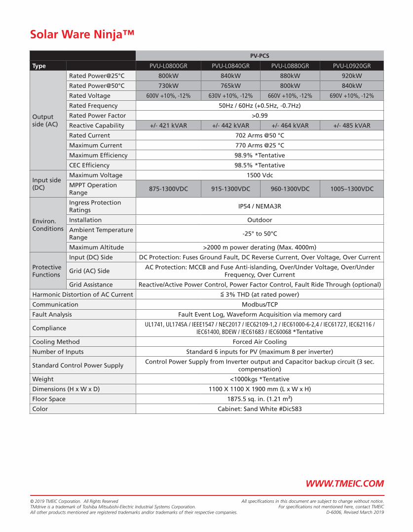
PV-PCS
Type PVU-L0800GR PVU-L0840GR PVU-L0880GR PVU-L0920GR
Output side (AC)
Rated Power@25°C 800kW 840kW 880kW 920kW
Rated Power@50°C 730kW 765kW 800kW 840kW
Rated Voltage 600V +10%, -12% 630V +10%, -12% 660V +10%, -12% 690V +10%, -12%
Rated Frequency 50Hz / 60Hz (+0.5Hz, -0.7Hz)
Rated Power Factor >0.99
Reactive Capability +/- 421 kVAR +/- 442 kVAR +/- 464 kVAR +/- 485 kVAR
Rated Current 702 Arms @50 °C
Maximum Current 770 Arms @25 °C
Maximum Effi ciency 98.9% *Tentative
CEC Effi ciency 98.5% *Tentative
Input side (DC)
Maximum Voltage 1500 Vdc
MPPT Operation Range
875-1300VDC 915-1300VDC 960-1300VDC 1005–1300VDC
Environ. Conditions
Ingress Protection Ratings
IP54 / NEMA3R
Installation Outdoor
Ambient Temperature Range
-25° to 50°C
Maximum Altitude >2000 m power derating (Max. 4000m)
Protective Functions
Input (DC) Side DC Protection: Fuses Ground Fault, DC Reverse Current, Over Voltage, Over Current
Grid (AC) SideAC Protection: MCCB and Fuse Anti-islanding, Over/Under Voltage, Over/Under
Frequency, Over Current
Grid Assistance Reactive/Active Power Control, Power Factor Control, Fault Ride Through (optional)
Harmonic Distortion of AC Current ≦ 3% THD (at rated power)
Communication Modbus/TCP
Fault Analysis Fault Event Log, Waveform Acquisition via memory card
ComplianceUL1741, UL174SA / IEEE1547 / NEC2017 / IEC62109-1,2 / IEC61000-6-2,4 / IEC61727, IEC62116 /
IEC61400, BDEW / IEC61683 / IEC60068 *Tentative
Cooling Method Forced Air Cooling
Number of Inputs Standard 6 inputs for PV (maximum 8 per inverter)
Standard Control Power SupplyControl Power Supply from Inverter output and Capacitor backup circuit (3 sec.
compensation)
Weight <1000kgs *Tentative
Dimensions (H x W x D) 1100 X 1100 X 1900 mm (L x W x H)
Floor Space 1875.5 sq. in. (1.21 m²)
Color Cabinet: Sand White #Dic583
© 2019 TMEIC Corporation. All Rights ReservedTMdrive is a trademark of Toshiba Mitsubishi-Electric Industrial Systems Corporation.All other products mentioned are registered trademarks and/or trademarks of their respective companies.
All specifications in this document are subject to change without notice.For specifications not mentioned here, contact TMEIC
D-6006, Revised March 2019
Solar Ware Ninja™
WWW.TMEIC.COM

ABB SOLAR - READY DISTRIBUTION
TRANSFORMER SPECIFICATIONS

— D IS TR I B UTI O N TR A NS FO R M ER S
Solar-ready distribution transformersTransformers designed to match solar inverters
—ABB offers pre-designed distribution transformers to meet leading inverter manufacturers’ requirements resulting in significantly reduced lead times and extended transformer life.
An improved approachWith market constraints in mind, ABB has developed distribution transformers for the solar industry that pair with ABB’s PVS980 solar inverter sizes. These ‘fit for purpose’ transformers are designed to opti-mize the performance, reliability and return on in-vestment of any solar installation. From residential rooftops to commercial and industrial applications and utility-grade power plants, ABB’s solar-ready transformers decrease lead times and increase reliability in all environmental conditions.
Solar-ready distribution transformers from ABB are specifically matched to solar inverter sizes and their application. Streamlined quotation and manufactur-ing processes meet the aggressive time lines for your solar project. With 48 available options to choose from, ABB solutions save weeks that are typically required to design new transformers.
Energy efficient designs based on the ABB PVS980 power and voltage ratings meet all current regula-tions and standards. Liquid-filled transformers can be manufactured and tested with mineral oil or ester fluids (natural or synthetic) based on your requirements.
Situation analysis/background:Today‘s solar developers, contractors, and EPCs are facing long approval times for funding and shorter timeframes to execute projects.
Industry challenges:• Longer approval time for funding• Solar market operates at faster pace than stan-
dard industrial markets• Contractors have less time to purchase materials
for solar farms • Pressure to reduce system/project costs
Pre-designed distribution solar transformers can help reduce overall operating costs and offset the continued cost pressure on solar generation, provid-ing a faster solar farm implementation and a greater return on investment.

3AU
A0
00
00
80
94
2 R
EV
A 1
8.5
.20
10 #
149
95
—We reserve the right to make technical changes or modify the contents of this document without prior notice. With re-gard to purchase orders, the agreed par-ticulars shall prevail. ABB AG does not ac-cept any responsibility whatsoever for potential errors or possible lack of infor-mation in this document.
We reserve all rights in this document and in the subject matter and illustrations con-tained therein. Any reproduction, disclo-sure to third parties or utilization of its contents – in whole or in parts – is forbidden without prior written consent of ABB AG. Copyright© 2017 ABBAll rights reserved
new.abb.com/products/transformers/distribution
—For more information contact:ABB lnc.Affolternstrasse, 44P. O, Box 81318050 Zurich, Switzerland
Benefits of ABB‘s solar-ready transformers• Fit for purpose• Standard designs in your hands quickly• Short lead times to provide quick planning
and execution of projects• Faster return on investment (ROI)• Quick pricing to reduce the project planning cycle
Product features• Solar transformer matched to ABB PVS980
inverter• HV (kV): 20, 22, 33, 34.5• LV (V): 600, 630, 660• Mineral oil or ester fluids (natural or synthetic)
available• 48 design options with low loss/high loss
combinations for IEC and ANSI markets• Expedited delivery
ABB as your competitive edgePre-designed and optimized transformers from ABB are available to match the solar industry’s needs. Standardized designs provide a proven solu-tion with lower risks. Each transformer is matched for your inverter and the unique solar environment. The time required from order to delivery of these specialized units is significantly reduced using ABB’s technology and extensive transformer experience.
Questions for consideration:• Do you have less time to plan your solar project?• Are you experiencing performance issues with
distribution transformers in solar applications?• Are you under a time crunch to get your farms
built and projects executed?• Do you custom design the transformers
for each project?• What type of inverters are you using?• How could you benefit from deliveries in half
the time of traditional transformer solutions?


Constitution Solar Project
Plainfield, Connecticut
EXHIBIT F:
Site Plans


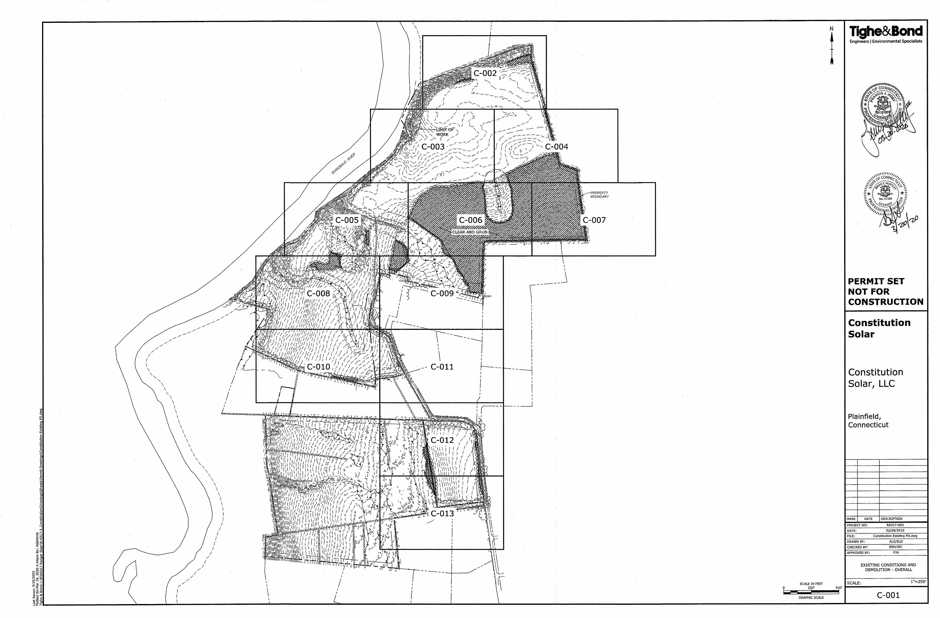


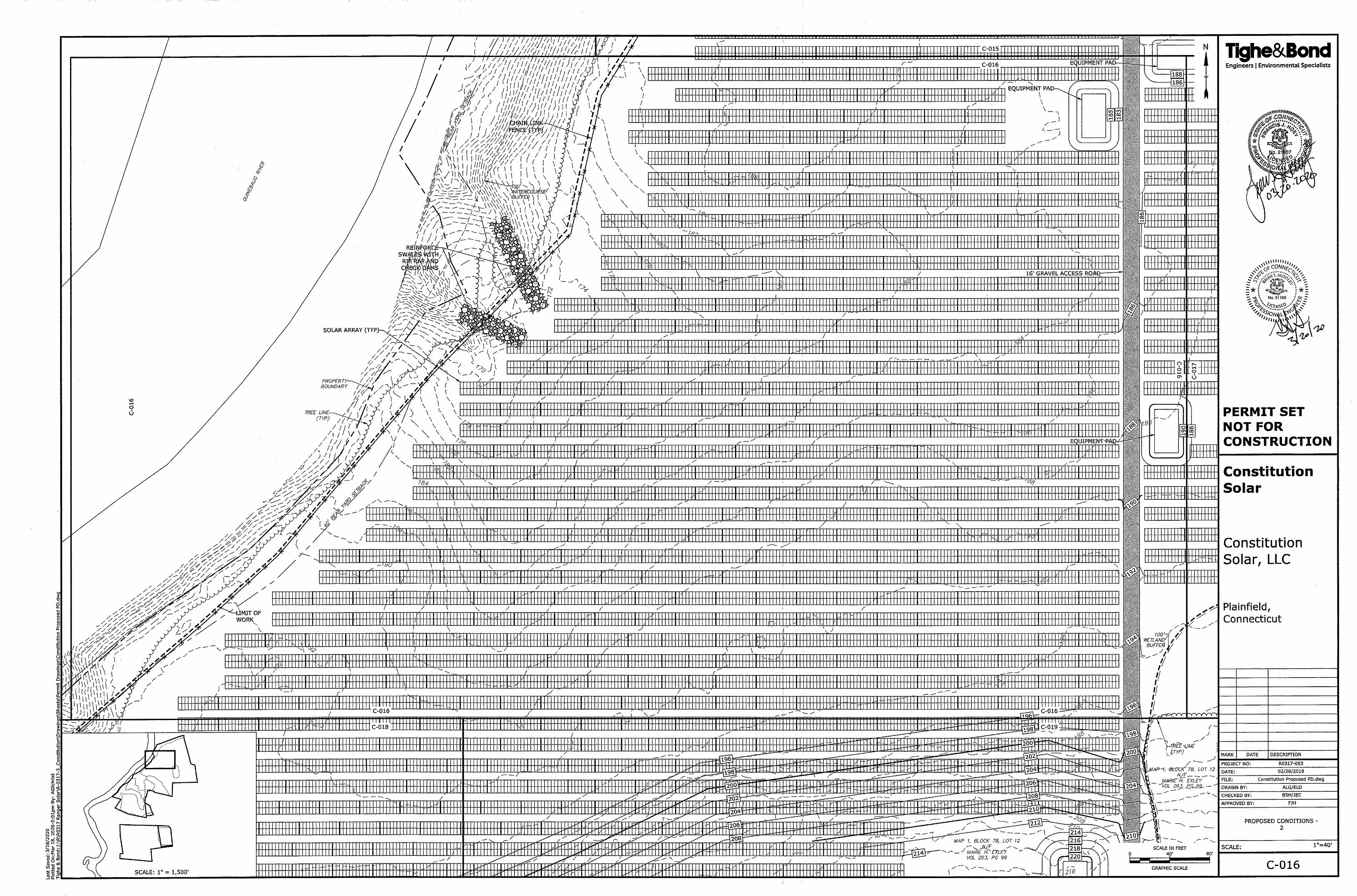


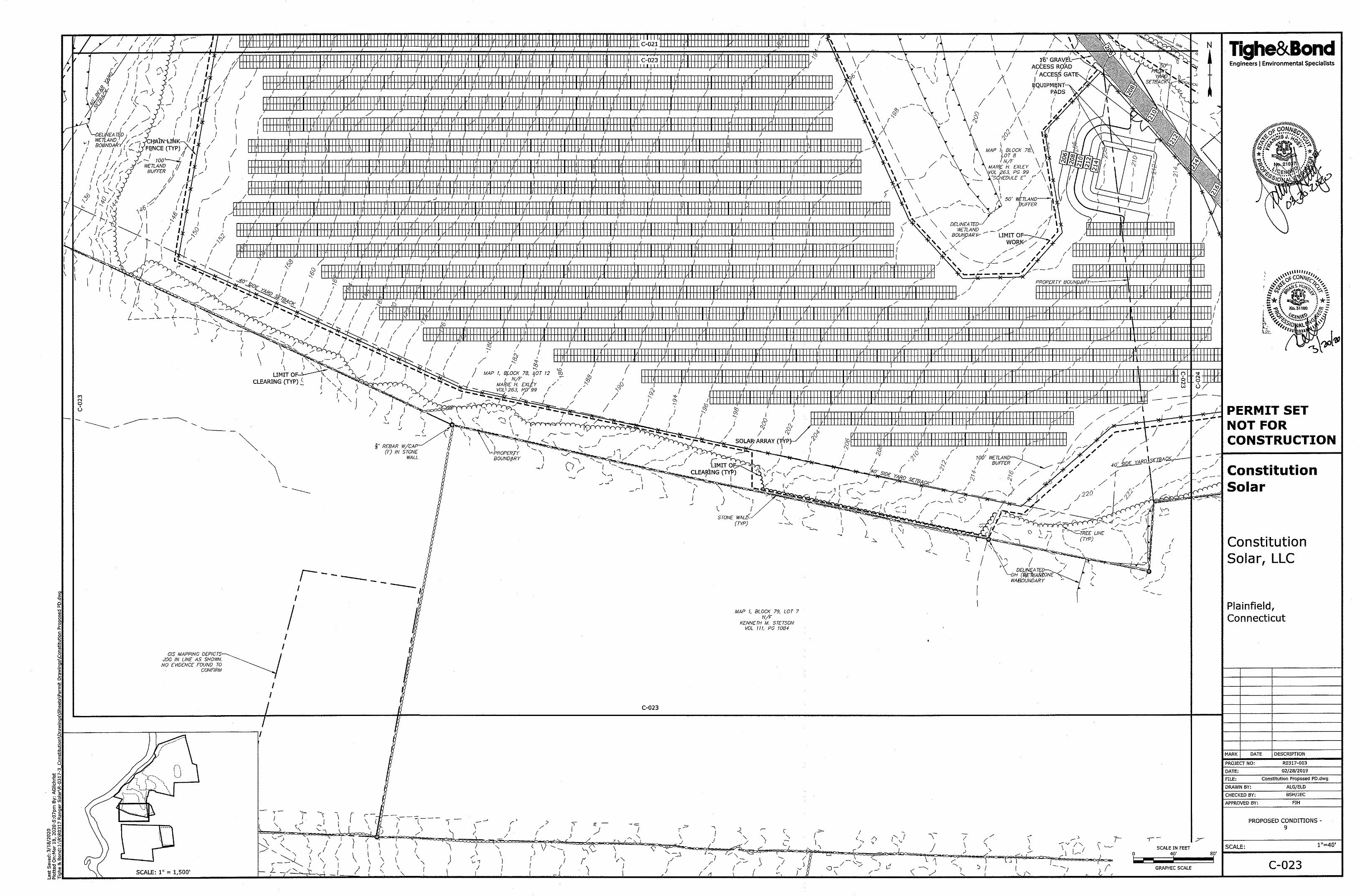


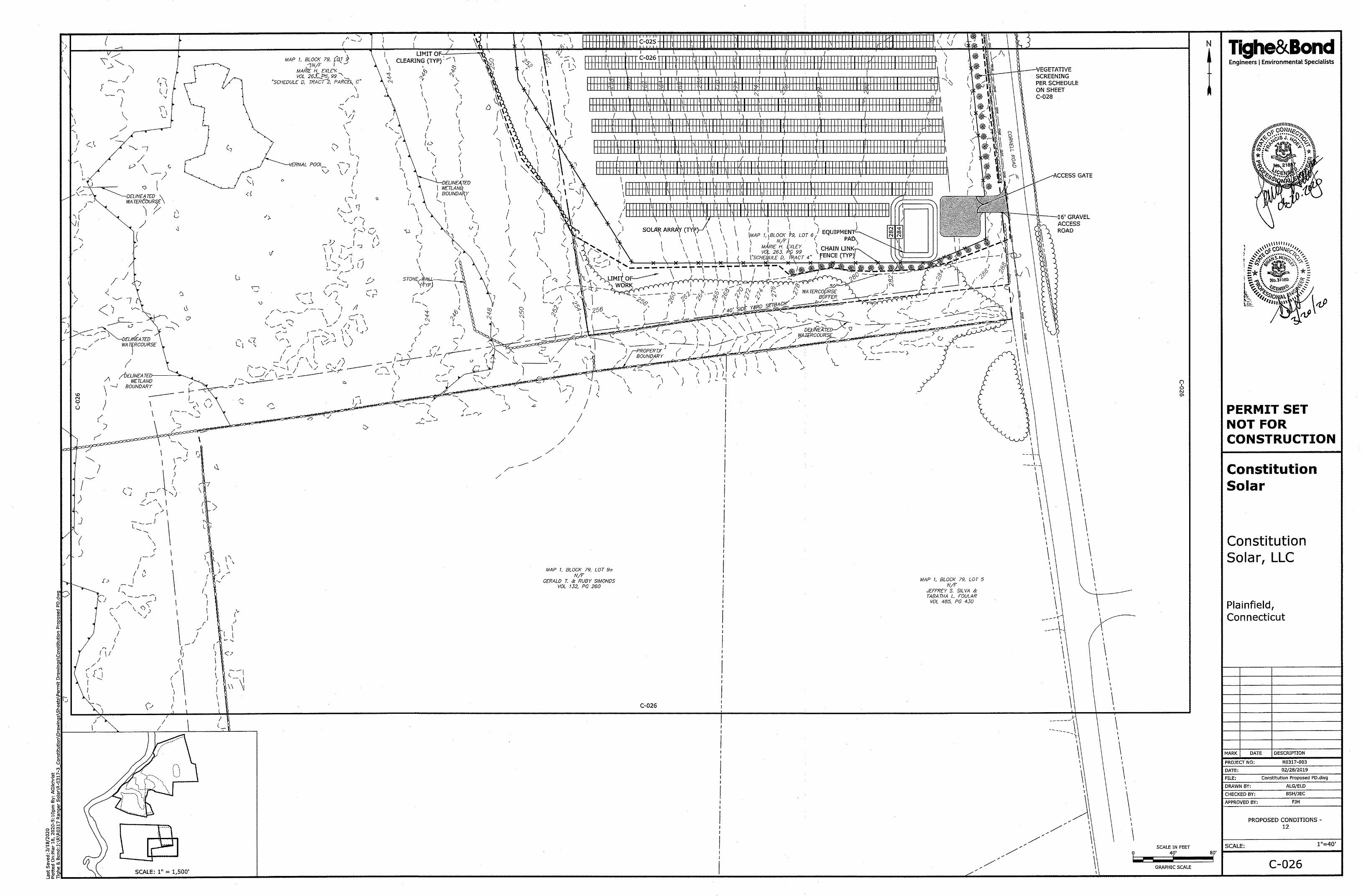
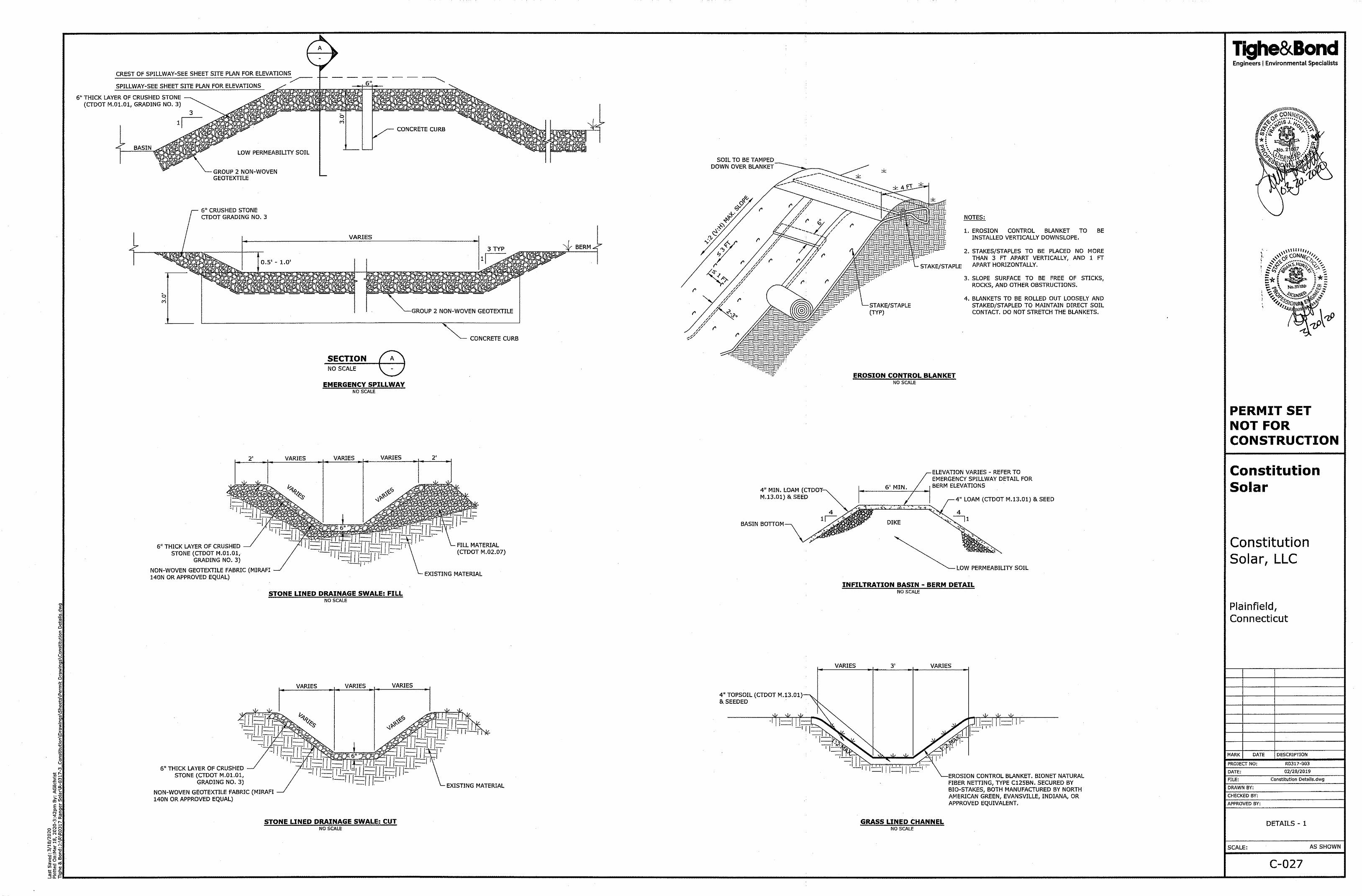


Constitution Solar Project
Plainfield, Connecticut
EXHIBIT G:
Operations and Maintenance Plan

CONSTITUTION SOLAR PROJECT
SOLAR PV OPERATIONS & MAINTENANCE PLAN Tighe&Bond
Operations & Maintenance Plan The Operation & Maintenance (O&M) plan for the solar facility is explained below.
Constitution Solar, LLC (Constitution Solar) is responsible for maintaining and servicing the solar electric system post construction. This work will be performed through a combination of Constitution Solar personnel, approved subcontractors, or authorized vendor (manufacturer of components used in the solar PV system) representatives. The area where the solar facility is located and the immediate proximity of the electrical equipment shall be treated as a Secure Facility, accessible only by authorized personnel. Local and State Emergency Response Personnel (Fire and EMS) will have access to the site via their own security credentials in case of emergency. Otherwise, access to these locations should be arranged by contacting the Constitution Solar or the Operator.
Operations at the site will be minimal. The panels are static and are monitored remotely on a
continuous basis over the internet. On a daily basis, Constitution Solar will be responsible for
responding to alerts from system’s automated alert system regarding potential system
malfunction.
Additional maintenance at the site will typically consist of the following.
Equipment Maintenance Constitution Solar and/or its authorized sub-contractors will conduct the following tasks as
required by manufacturers’ specifications to ensure maintenance and proper operation of the
solar PV system equipment and limit traffic to and from the site.
Perform a visual inspection of the equipment including subassemblies, wiring
harnesses, contacts and major components and record ambient operating
temperature.
Check inverter modules for the following:
- IGBTs and inverter boards for discoloration
- Power capacitors for signs of damage
- Record all voltage and current readings via the front display panel
- Check appearance/cleanliness of the cabinet, ventilation system and insulated surfaces
- Check for corrosion on terminals and cables
- Torque terminals, connectors and bolts as needed
- Check all fuses for open or signs of heating (Inverter & Combiner)
- Check the condition of both the AC & DC Surge Suppressors
- Check the operation of all safety devices (E-Stop, Door Switches, GFDI)
- Correct all deficiencies detected
Inspect (clean or replace) air filter elements
Complete Maintenance Schedule Card and issue a written inspection report
Install and perform any recommended Engineering Field Modifications, including software upgrades.

OPERATIONS & MAINTENANCE PLAN Tighe&Bond
Site Maintenance Constitution Solar and/or its authorized subcontractors will perform site maintenance
activities as follow, to ensure safety and to maintain site aesthetics.
Mowing the detention basins and grass between the rows of racks a minimum of twice a year, possibly more if the growth of grass requires it. The height of the grass will be maintained at a level to reduce the risk of grass fires.
Personnel in a pickup-type truck will visit the site monthly to inspect the inverters for proper performance and perform maintenance as needed. The condition of signage and proper functioning of access gates will be inspected as well.
Landscaping:
o Initial Post-Construction Inspection: During the initial period of vegetation establishment, plantings will be inspected twice during the first year by Constitution Solar or contractor. Any dead vegetation/ plantings found after the first year will be replaced. Proper mulching and regular water and fertilization may be required initially to ensure proper establishment of vegetation.
o Long-Term Maintenance: The planted areas will be inspected on a semi-annual basis. Weeds will be removed by hand. Maintain planted areas adjacent to pavement to prevent soil washout. Clean any soil deposits on pavement. Leaf litter and other detritus will be maintained.
o Pesticide/ Herbicide Usage: Pesticides and herbicides may be used as a secondary means of control where necessary. All applications will be targeted at specific species in discrete locations; broadcast aerial application of herbicides is not proposed.
Dust Control Constitution Solar and/or its authorized subcontractors will identify potential dust emission
sources and provide guidance to construction and field personnel on measures to control the
generation of dust during construction activities.
The following construction related activities have been identified as having the potential for
generating dust:
Vehicle and motorized equipment movement on unpaved access roads;
Clearing and grading;
Topsoil removal;
Cutting, filling, and backfilling;
Bulk material loading, hauling, and unloading;
Use of material storage piles; and
Use of parking, staging, and storage areas.
Constitution Solar and/or its authorized subcontractors will perform site construction and maintenance activities as follow, to ensure that sources of dust generation are identified and minimized.
The main vehicular access roads to the project site will be stabilized with gravel sufficient to eliminate visible dust from vehicular travel and wind erosion;

OPERATIONS & MAINTENANCE PLAN Tighe&Bond
Traffic speeds on unpaved roads will be limited to 10 miles per hour with the exception that vehicles may travel up to 25 miles per hour on stabilized unpaved roads as long as such speeds do not create visible dust emissions. Traffic speed signs shall be displayed prominently at all site entrances and at entrances from temporary staging and parking areas;
For non-road or parking area earthen surfaces, stabilize surfaces by compaction, gravel or other means sufficient to prohibit visible dust from wind erosion;
When necessary, a water truck will be used to maintain moist disturbed surfaces and actively spread water during visible dusting episodes to minimize dust emissions;
When wind speeds exceed 20 miles per hour (mph), construction contractors will minimize new disturbance to the extent possible and/or mobilize water trucks to minimize dust from exposed surfaces.
Array Cleaning Procedure Constitution Solar and/or its authorized subcontractors may clean the PV panels if the system
is outputting a noticeably lower wattage AC or there is an accumulation of dirt on the modules.
Maintaining module cleanliness is crucial to maximizing system performance. No chemicals
shall be used in the cleaning of the modules. Cleaning of the panels will be done with water
and a soft-bristled broom if needed. Note that the PV system does not need to be turned off
during cleaning.
Snow Maintenance Following a snow event, Constitution Solar and/or its authorized subcontractors will plow the
access roads in order to maintain access to the electrical equipment pads. Snow will be plowed
in a manner such that access to the turnaround areas is not impeded. If necessary, excess
snow will be moved to a different location on site to ensure the access roads are clear.
Constitution Solar does not propose provisions for removal of snow from panels.

Constitution Solar ProjectPlainfield, Connecticut
EXHIBIT H: Photo Simulations

E
E
E
Inset Map
Canterbury
Plainfield
Cornell Rd
Canterbury Rd
Glebas Rd
Terry Ln
George St
Sugar Brook RdBedard
Rd
3
1
2
PHOTORENDERINGLOCATIONS
Constitution SolarPlainfield, Connecticut
March 2020
¹
_̂
1 in = 500 ft
NOTES
LOCUS MAP
1. Based on 2019 StatewideOrthophotography, Courtesty of CTECO.
0 250 500
Feet
V:\Projects\R\R0317\ConstitutionCT_Solar\Maps\PermitFigures\PhotoRendering_ConstitutionCT.mxd R-0317
Tighe&BondEngineers | Environmental Specialists
Limit of Work/Development Area
Project Site
Vegetative Screening
Equipment Pad
Switchyard
Road
CT Municipal Boundary
EPhoto Location & Direction1E
E
Cornell Rd
3
2
Inset Map
0 75Feet

1: From Cornell Road, facing northwest. (Photo 1) Tighe&Bond
Constitution Solar – Photo Renderings
EXISTINGEXISTING

2: From Cornell Road, facing northwest. (Photo 1) Tighe&Bond
Constitution Solar – Photo Renderings
PROPOSED

3: From Cornell Road, facing northwest. (Photo 1) Tighe&Bond
Constitution Solar – Photo Renderings
PROPOSED WITH MITIGATION

4: From Cornell Road, facing northwest. (Photo 2).Tighe&Bond
Constitution Solar – Photo Renderings
EXISTING

Tighe&Bond5: From Cornell Road, facing northwest. (Photo 2).
Constitution Solar – Photo Renderings
PROPOSED

6: From Cornell Road, facing west. (Photo 3).Tighe&Bond
Constitution Solar – Photo Renderings
EXISTING

7: From Cornell Road, facing west. (Photo 3).Tighe&Bond
Constitution Solar – Photo Renderings
PROPOSED

Constitution Solar Project
Plainfield, Connecticut
EXHIBIT I:
Construction Schedule/Duration

EXHIBIT I
Construction Schedule/Duration
Constitution Solar Schedule
Development / Construction Activity Start Date End Date
Obtain 100% site control for land comprising Project Site Complete
Complete Interconnection Studies Complete
Execute Interconnection Agreement Complete
Obtain all Major Permits January 2020 December 2020
Start of Construction January 1, 2021
Eversource Interconnection Upgrades January 2021 August 2021
Facility Start-up Testing September 2021
October 2021
Begin Commercial Operation November 2021

Constitution Solar Project
Plainfield, Connecticut
EXHIBIT J:
Decommissioning Plan

SUMMARY OF WORK
Solar Photovoltaic Decommissioning
For Constitution Solar LLC’s
Constitution Solar Project
Plainfield, Connecticut
This document (Report) has been prepared by NextEra Energy (NextEra). NextEra shall not be deemed to make any representation regarding the accuracy, completeness, methodology, reliability or current status of any material contained in this Report, nor does NextEra assume any liability with respect to any matter or information referred to or contained in the Report. Any person relying on the Report (“Recipient”) does so at their own risk, and neither the Recipient nor any party to whom the Recipient provides the Report or any
matter or information derived from it shall have any right or claim against NextEra or any of its affiliated companies in respect thereof.
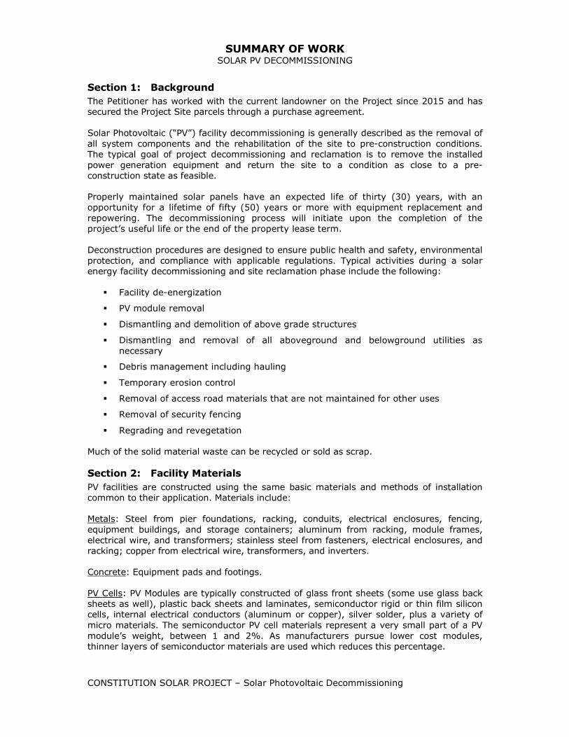
SUMMARY OF WORK SOLAR PV DECOMMISSIONING
CONSTITUTION SOLAR PROJECT – Solar Photovoltaic Decommissioning
Section 1: Background
The Petitioner has worked with the current landowner on the Project since 2015 and has
secured the Project Site parcels through a purchase agreement.
Solar Photovoltaic (“PV”) facility decommissioning is generally described as the removal of
all system components and the rehabilitation of the site to pre-construction conditions.
The typical goal of project decommissioning and reclamation is to remove the installed
power generation equipment and return the site to a condition as close to a pre-
construction state as feasible.
Properly maintained solar panels have an expected life of thirty (30) years, with an
opportunity for a lifetime of fifty (50) years or more with equipment replacement and
repowering. The decommissioning process will initiate upon the completion of the
project’s useful life or the end of the property lease term.
Deconstruction procedures are designed to ensure public health and safety, environmental
protection, and compliance with applicable regulations. Typical activities during a solar
energy facility decommissioning and site reclamation phase include the following:
Facility de-energization
PV module removal
Dismantling and demolition of above grade structures
Dismantling and removal of all aboveground and belowground utilities as
necessary
Debris management including hauling
Temporary erosion control
Removal of access road materials that are not maintained for other uses
Removal of security fencing
Regrading and revegetation
Much of the solid material waste can be recycled or sold as scrap.
Section 2: Facility Materials
PV facilities are constructed using the same basic materials and methods of installation
common to their application. Materials include:
Metals: Steel from pier foundations, racking, conduits, electrical enclosures, fencing,
equipment buildings, and storage containers; aluminum from racking, module frames,
electrical wire, and transformers; stainless steel from fasteners, electrical enclosures, and
racking; copper from electrical wire, transformers, and inverters.
Concrete: Equipment pads and footings.
PV Cells: PV Modules are typically constructed of glass front sheets (some use glass back
sheets as well), plastic back sheets and laminates, semiconductor rigid or thin film silicon
cells, internal electrical conductors (aluminum or copper), silver solder, plus a variety of
micro materials. The semiconductor PV cell materials represent a very small part of a PV
module’s weight, between 1 and 2%. As manufacturers pursue lower cost modules,
thinner layers of semiconductor materials are used which reduces this percentage.

SUMMARY OF WORK SOLAR PV DECOMMISSIONING
CONSTITUTION SOLAR PROJECT – Solar Photovoltaic Decommissioning
The most commonly used semiconductor material for the construction of PV modules is
silicon. Please note however, that poly/mono crystaline silicate panels and thin films
panels may contain other metals and materials. Glass, aluminum, and copper are easily
recyclable materials, and silicon can be recycled by specialty electronics recyclers.
Glass: Most PV modules are approximately 80% glass by weight. There are certain
modules, which use plastic and/or metal sheets for their foundations, however these are
very specialized in their application and are generally not used for ground mounted
projects.
Plastics: A limited amount of plastic materials are used in PV systems due to a system’s
continuous exposure to the elements and long operational lifetime. Plastics typically are
found in PV facilities as wire insulation, electrical enclosures, control and monitoring
equipment, and inverter components. Additionally plastic laminate films are used in most
PV module assemblies.
It is generally agreed that the metals in PV Facilities will be highly valued as recycled
materials when these facilities are deconstructed. In the limited number of facility
deconstruction projects performed to date, the revenue from the recycling of these
materials was found to cover the removal and transportation costs of these materials. If a
facility is operational at the time of decommissioning and the PV modules are producing
within specifications, there is a likely outlet for the used PV modules into a secondary
market. It is generally accepted that the existing global market for used solar PV panels
will be even more robust in the future.
Section 3: Project Decommissioning Plan
Constitution Solar shall:
Be responsible for all decommissioning costs;
Obtain any additional permits required for the decommissioning, removal and
legal disposal of Project components prior to commencement of decommissioning
activities;
Complete decommissioning, including component removal and disposal, grading
and re-vegetation in accordance with permits and in compliance with all
applicable rules and regulations then in effect governing the disposal thereof; and
Remove all hazardous materials and transport them to be disposed of by licensed
contractors at an appropriate facility in accordance with rules and regulations
governing the disposal of such materials.
The following sequence for the removal of the components will be used:
PV Site
Disconnect PV facility from the utility power grid
Disconnect all aboveground wirings, cables and electrical interconnections and
recycle offsite by an approved recycling facility
Remove concrete foundations (if required). Electric rooms and their foundations
will be removed and recycled off‐site by a concrete recycler
Remove PV modules and ship to recycling facilities for recycling and material
reuse.
Remove all waste
Remove the perimeter fence and recycle off‐site by an approved metal recycler

SUMMARY OF WORK SOLAR PV DECOMMISSIONING
CONSTITUTION SOLAR PROJECT – Solar Photovoltaic Decommissioning
Inverters/Transformer
Disconnect all electrical equipment
Remove all on site inverters, transformers, meters, fans, lighting fixture and
other electrical components and recycle off‐site by an approved recycler
Remove all waste
Switchyard
Disconnect switchgear equipment
Remove all waste
Access Roads
Consult with landowners to determine if access roads should be left in place for
their continued use
If access roads are deemed unnecessary, remove access road surface materials
and restore access road locations as near as practical to their original condition.
Below‐Ground Structure Decommissioning
Remove all steel rack foundations.
Section 4: Site Restoration
Once the on‐site equipment is removed, it is expected that the site will be returned to its
existing condition. Some minor site grading may be required. Site restoration activities
will be undertaken with the input of the landowners.
The access roads will be left at landowners’ requests or graded to restore terrain profiles
(as much as possible). If removed, filter fabric will need to be bundled and disposed of in
accordance with all applicable regulations. The former road areas may need to be
backfilled and restored to meet existing grade. This material may come from existing
long-term berm, stockpile, or nearby soils.
At the request of the landowner, landscaping/ visual screening will be removed at the
end of the project’s useful life or the end of the property lease term.
Please refer to the Farmland Soils Mitigation Plan (Exhibit E) which will be appended to
this Solar PV Decommissioning Summary of Work.
Section 5: Decommissioning Conditions and Timeframe
The solar facility and all components described above shall be physically removed from the
site no later than 2 years following the discontinuation of operations.
This decommissioning plan is based on current procedures and experience. These
procedures may be subject to revision based on new experiences and requirements over
time.

Constitution Solar Project
Plainfield, Connecticut
EXHIBIT K:
Greenhouse Gas Assessment

3/2/2020 Greenhouse Gas Equivalencies Calculator | US EPA
https://www.epa.gov/energy/greenhouse-gas-equivalencies-calculator 1/3
The sum of the greenhouse gas emissions youentered above is of Carbon Dioxide Equivalent.This is equivalent to:
Metric Tons
Equivalency Results How are they calculated?
Greenhouse gas emissions from
CO2 emissions from
816,016
173,252
Passengervehicles drivenfor one year -or-
2,024,853,785
Miles drivenby an averagepassengervehicle
91,821,320
gallons ofgasolineconsumed -or-
80,158,750
gallons ofdieselconsumed -or-
899,137,765
Pounds of coalburned
-or-
10,803
tanker trucks'worth ofgasoline -or-
94,163
homes' energyuse for oneyear -or-
138,156
homes'electricity usefor one year -or-

3/2/2020 Greenhouse Gas Equivalencies Calculator | US EPA
https://www.epa.gov/energy/greenhouse-gas-equivalencies-calculator 2/3
Greenhouse gas emissions avoided by
4,487
railcars' worthof coal burned
-or-
1,889,250
barrels of oilconsumed
-or-
33,358,501
propanecylinders usedfor homebarbeques
-or-
0.21
coal-firedpower plantsin one year -or-
104,068,343,374
number ofsmartphonescharged
277,556
Tons of wasterecycledinstead oflandfilled
-or-
39,651
Garbagetrucks ofwaste recycledinstead oflandfilled
-or-
34,721,133 176

3/2/2020 Greenhouse Gas Equivalencies Calculator | US EPA
https://www.epa.gov/energy/greenhouse-gas-equivalencies-calculator 3/3
Carbon sequestered by
trash bags ofwaste recycledinstead oflandfilled
-or-
Wind turbinesrunning for ayear
-or-
31,000,117
Incandescentlamps switchedto LEDs
13,492,999
tree seedlingsgrown for 10years -or-
1,065,679
acres of U.S.forests in oneyear -or-
5,520
acres of U.S.forestspreserved fromconversion tocropland in oneyear

Constitution Solar Project
Plainfield, Connecticut
EXHIBIT L:
Project Outreach Information

Exhibit L
Project Outreach
The items listed below are included in Exhibit L.
1 September 2017 Constitution Solar Project Information Session
Advertisement for Abutters
2 December 2019 Constitution Solar Open House Advertisement
3 December 2019 Constitution Solar Open House Invitation
4 December 2019 Constitution Solar Open House Sign-In Sheet
5 Constitution Solar Project Outreach Information Log

Project Information Session for Constitution Solar Energy Center

Date: Sept. 27, 2017
Time: 4:00 to 6:00 p.m.
Place: Plainfield Town Hall Multi-purpose Room 8 Community Ave. Plainfield, CT
By invitation only
NextEra Energy Resources is developing a 20-megawatt solar photovoltaic facility in Plainfield.
The meeting will offer a project overview and an opportunity to collect input from our neighbors living adjacent to the project to better inform our permitting efforts. There will be no formal presentation and you are welcome to attend any time during the hours listed below. Refreshments will be served.
Project Information Session for Constitution Solar Energy Center
Questions? Email: [email protected]

Location: Plainfield Town Hall - Auditorium8 Community Ave Plainfield, CT 06374 Light refreshments will be served.
Thursday, December 12 from 5-7 p.m.
An affiliate of NextEra Energy Resources is proposing to build a solar energy generating facility
in the Towns of Plainfield. Residents are invited to stop in, meet our staff and discuss the
proposed project with us. For additional information visit: NextEraEnergyResources.com
Open House for Constitution Solar Energy Center

We invite you to join us for an open house regarding the proposed Constitution Solar Energy Center. Come by any time between 5-7 p.m. to meet with our team, learn more about our company and the project and have your
questions answered by our subject matter experts. Light refreshments will be served.
Constitution Solar Open House Thursday, Dec. 12 from 5 - 7 p.m.
For more information contact: [email protected]
Location: Plainfield Town Hall- Auditorium, 8 Community Ave, Plainfield, CT 06374


CONSTITUTION SOLARProject Outreach Information
Date Participants Summary / Notes Location NEER/Consultant Attendees
10/13/2016Department of Agriculture: Commissioner Reviczky andstaff
Introduction to Ranger Solar and Ranger Solar’sproposed Connecticut Solar Projects
Connecticut StateOffice Building,Hartford, CT
CJ Walsh, Aaron Svedlow, PaulHarris, Dale Knapp, Justin May
11/9/2016Northeastern Connecticut Council of Governments(NECCOG) Introduction to Ranger Solar and CT projects NECCOG office CJ Walsh, Justin May
11/28/2016 Northeastern Connecticut Chamber of Commerce (NCCC) Introduction to Ranger Solar and CT projects NCCC office CJ Walsh, Justin May
2/8/2017 Catherine Labadia SHPO/ David George Introduction to Ranger Solar and CT projects1 Constitution Plaza,Hartford, CT 06103
4/11/2017 State Senator Heather Somers Introduction to Ranger Solar and CT projecs
Connecticut LegislativeOffice Building,Hartford, CT Andy Markowski
43005Town of Plainfield officials and State Representative AnneDauphinais Open house for project abutters Plainfield, CT Full NEER team and consultants
8/8/2018CT Department of Agriculture meeting with Chief of StaffJason Bowsza and Steve Anderson Introduction to NEER team; discussion on CT projects
450 ColumbusBoulevard, Hartford
Neil Watlington, Matt Singer,Dale Knapp, Brian Huntley,Justin May
2/1/2019Northeastern Connecticut Chamber of CommerceExecutive Director Betti Kuszaj
Introduction to the NEER team, projects overview andmembership discussion Conference call
Matt Singer, Des Estabrook,Justin May
3/25/2019 Plainfield First Selectman Cathy Tendrich Introduction to the NEER team and project update Conference callHagen Lee, Matt Singer, DesEstabrook, Justin May
4/11/2019 State Senator Heather Somers Project overview and update
Connecticut LegislativeOffice Building,Hartford, CT Andy Markowski
4/12/2019Northeastern Connecticut Chamber of Commercelegislative brekafast
NEER sponsored and delivered remarks on companyand area projects;met with First Selectman CathyTendrich and Rep. Anne Dauphinais Hampton, CT
Matt Singer, Andy Markowski,Justin May
10/7/2019
Plainfield First Selectman Cathy Tendrich; Planning andZoning Supervisor Mary Ann Chinatti; Building OfficialPeter Zvingilas Project update Plainfield, CT
Jon Gravel, Junior Aguaze,Michael Lienhard, KatelinNickerson, Justin May
11/21/2019Town official presentation: Selectboard, Planning andZoning, Inland Wetlands, Economic Development, etc. Project overview presentation for relevant boards Plainfield, CT Full NEER team and consultants
11/25/2019 Project abuttersCalls to project abutters to provide project updatesand inform them of the community open house Calls
Junior Aguaze and KaleighCrissman
12/4/2019 Project abuttersCalls to project abutters to provide project updatesand inform them of the community open house Calls
Junior Aguaze and KaleighCrissman

CONSTITUTION SOLARProject Outreach Information
12/5/2019
Plainfield First Selectman Kevin Cunningham, Planningand Zoning Supervisor Mary Ann Chinatti, Tax AssessorMaryEllen Hall
Project discussion with First Selectman and otherofficials Plainfield, CT
Junior Aguaze, KaleighCrissman and Justin May
12/5/2019 Project abuttersVisit residences to provide updates on project andproject collateral materials Plainfield, CT
Junior Aguaze, KaleighCrissman
12/10/2019Plainfield First Selectman Kevin Cunningham, Planningand Zoning Supervisor Mary Ann Chinatti Call to discuss Host Community Agreement Plainfield, CT
Junior Aguaze and KaleighCrissman
12/12/2019 Community Open House Open house for community members Plainfield, CT Full NEER team and consultants
1/23/2020 Project abuttersCalls to provide project update and to confirm nofurther questions or concerns Calls
Junior Aguaze and KaleighCrissman
2/5/2020Plainfield First Selectman Kevin Cunningham, Planningand Zoning Supervisor Mary Ann Chinatti, Tax AssesorMaryEllen Hall
Project update and Host Community Agreementdiscussion Plainfield, CT
Junior Aguaze, KaleighCrissman and Justin May
Date Participants Summary / Notes Location NEER/Consultant Attendees

Constitution Solar Project
Plainfield, Connecticut
EXHIBIT M:
Legal Notice and Notice List

Exhibit M
Legal Notice and Notice List
The items listed below are included in Exhibit M.
1 Municipal Officials and Government Agencies List
2 Site Owners List
3 Legal Notice, Figure Attachment, and Certificate of Mailing

MUNICIPAL OFFICIALS AND GOVERNMENT
AGENCIES LIST

82610611v.1
The Honorable William Tong
Attorney General
Office of the Attorney General
55 Elm Street
Hartford, CT 06106
Elizabeth Shapiro, Interim Director
State Historic Preservation Officer
450 Columbus Boulevard
Hartford, CT 06103
Representative Doug Dubitsky
Legislative Office Building, Room 4200
300 Capitol Avenue
Hartford, CT 06106
James Rovella, Commissioner
Department of Emergency Services and
Public Protection
1111 Country Club Road
Middletown, CT 06457
Brian Hurlburt, Commissioner
Department of Agriculture
450 Columbus Boulevard, Suite 701
Hartford, CT 06106
Representative Anne Dauphinais
Legislative Office Building, Room 4200
300 Capitol Avenue
Hartford, CT 06106
Katie Dykes, Commissioner
Department of Energy and Environmental
Protection
79 Elm Street
Hartford, CT 06106
Michelle H. Seagull, Commissioner
Department of Consumer Protection
450 Columbus Boulevard
Hartford, CT 06103
Kevin Cunningham, First Selectman
Town of Plainfield
8 Community Avenue
Plainfield, CT 0637
Renée Coleman-Mitchell, Commissioner
Department of Public Health
410 Capitol Avenue
P.O. Box 340308
Hartford, CT 06134-0308
Josh Geballe, Commissioner
Department of Administrative Services
450 Columbus Boulevard
Hartford, CT 06103
Louisa Trakas, Town Clerk
Town of Plainfield
8 Community Avenue
Plainfield, CT 06374
Peter Hearn, Executive Director
Council on Environmental Quality
79 Elm Street
P.O. Box 5066
Hartford, CT 06106
Kurt Westby, Commissioner
Department of Labor
200 Folly Brook Boulevard
Wethersfield, CT 06109
Mary Ann Chinatti
Plainfield Planning & Zoning Supervisor
8 Community Avenue
Plainfield, CT 06374
Marissa Gillett, Chairman
Public Utilities Regulatory Authority
Ten Franklin Square
New Britain, CT 06051
Federal Energy Regulatory Commission
888 First Street, NE
Washington, DC 20426
Christopher Lipke, First Selectman
Town of Canterbury
1 Municipal Drive
Canterbury, CT 06331
Melissa McCaw, Secretary
Office of Policy and Management
450 Capitol Avenue
Hartford, CT 06106
Northeastern Connecticut Council of
Governments
125 Putnam Pike, P.O. Box 759
Dayville, CT 06241-0759
Natalie Ellston, Town Clerk
Town of Canterbury
P.O. Box 27
Canterbury, CT 06331
David Lehman, Commissioner
Department of Economic and Community
Development
450 Columbus Boulevard, Suite 5
Hartford, CT 06103
Senator Heather Somers
Legislative Office Building, Room 3400
300 Capitol Avenue
Hartford, CT 06106
Melissa Gil
Canterbury Zoning/Wetland Officer
1 Municipal Drive
Canterbury, CT 06331
Joseph Giulietti, Commissioner
Department of Transportation
2800 Berlin Turnpike
P.O. Box 317546
Newington, CT 06131-7546
Senator Mae Flexer
Legislative Office Building, Room 3300
300 Capitol Avenue
Hartford, CT 06106
Ronald Desjardins, Chairman
Plainfield IWWC
8 Community Avenue
Plainfield, CT 06374

SITE OWNERS LIST
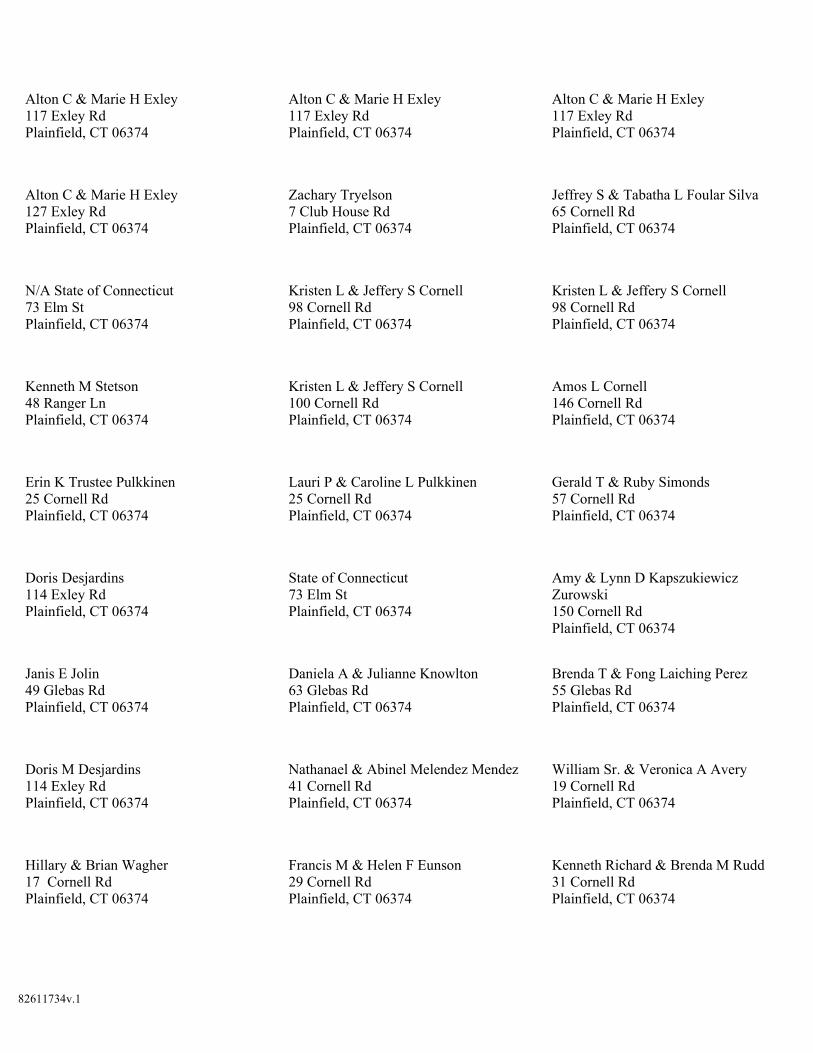
82611734v.1
Alton C & Marie H Exley
117 Exley Rd
Plainfield, CT 06374
Alton C & Marie H Exley
117 Exley Rd
Plainfield, CT 06374
Alton C & Marie H Exley
117 Exley Rd
Plainfield, CT 06374
Alton C & Marie H Exley
127 Exley Rd
Plainfield, CT 06374
Zachary Tryelson
7 Club House Rd
Plainfield, CT 06374
Jeffrey S & Tabatha L Foular Silva
65 Cornell Rd
Plainfield, CT 06374
N/A State of Connecticut
73 Elm St
Plainfield, CT 06374
Kristen L & Jeffery S Cornell
98 Cornell Rd
Plainfield, CT 06374
Kristen L & Jeffery S Cornell
98 Cornell Rd
Plainfield, CT 06374
Kenneth M Stetson
48 Ranger Ln
Plainfield, CT 06374
Kristen L & Jeffery S Cornell
100 Cornell Rd
Plainfield, CT 06374
Amos L Cornell
146 Cornell Rd
Plainfield, CT 06374
Erin K Trustee Pulkkinen
25 Cornell Rd
Plainfield, CT 06374
Lauri P & Caroline L Pulkkinen
25 Cornell Rd
Plainfield, CT 06374
Gerald T & Ruby Simonds
57 Cornell Rd
Plainfield, CT 06374
Doris Desjardins
114 Exley Rd
Plainfield, CT 06374
State of Connecticut
73 Elm St
Plainfield, CT 06374
Amy & Lynn D Kapszukiewicz
Zurowski
150 Cornell Rd
Plainfield, CT 06374
Janis E Jolin
49 Glebas Rd
Plainfield, CT 06374
Daniela A & Julianne Knowlton
63 Glebas Rd
Plainfield, CT 06374
Brenda T & Fong Laiching Perez
55 Glebas Rd
Plainfield, CT 06374
Doris M Desjardins
114 Exley Rd
Plainfield, CT 06374
Nathanael & Abinel Melendez Mendez
41 Cornell Rd
Plainfield, CT 06374
William Sr. & Veronica A Avery
19 Cornell Rd
Plainfield, CT 06374
Hillary & Brian Wagher
17 Cornell Rd
Plainfield, CT 06374
Francis M & Helen F Eunson
29 Cornell Rd
Plainfield, CT 06374
Kenneth Richard & Brenda M Rudd
31 Cornell Rd
Plainfield, CT 06374

82611734v.1
Brian Jr. & Kristen Caisse
37 Cornell Rd
Plainfield, CT 06374
Jill Trustee Marquardt
189 Watch Hill Rd
Plainfield, CT 06374
William B & Kimberly K Duerr
11 Cornell Road
Plainfield, CT 06374
Gerald T & Ruby Simonds
57 Cornell Rd
Plainfield, CT 06374
David B Belanger
76 Glebas Rd
Plainfield, CT 06374
Michael H & Charlotte Ann Koozmitch
67 Glebas Rd
Plainfield, CT 06374
Gerard W & Karen E Jodoin
24 Terry Lane
Plainfield, CT 06374
Dorothy Tracey
18 Terry Lane
Plainfield, CT 06374
Craig J & Jennifer L Fitch
12 Terry Ln
Plainfield, CT 06374
Joshua Whitman Rutledge
4 Terry Ln
Plainfield, CT 06374
Mirta Rizzo
46 Glebas Rd
Plainfield, CT 06374
Eugene & Barbara Ciccarelli
23 George St
Plainfield, CT 06374
Jacob G & Adele T Ciccarelli
17 George St
Plainfield, CT 06374
Andrew & Bethany Fernandes
91 Glebas Rd
Plainfield, CT 06374
Bruce W & Jeanna E Prink
179 Mack Rd
Plainfield, CT 06374
Robert J Sr. & Diana Smith
24 George St
Plainfield, CT 06374
Nicholas & Emily Trahan
109 Glebas Rd
Plainfield, CT 06374
Benjamin & Emily Petrik
70 Glebas Rd
Plainfield, CT 06374
Todd R Bibeault
23 Terry Lane
Plainfield, CT 06374
Karen L Desjardins
99 Glebas Rd
Plainfield, CT 06374
James R Jr. & Deborah A West
94 Glebas Rd
Plainfield, CT 06374
William D III Griffen
18 George Street
Plainfield, CT 06374
Seth Michael Lavallee
12 George St
Plainfield, CT 06374
Gregory P & Teresa A Smith
83 Glebas Rd
Plainfield, CT 06374
Matthew Taylor
80 Glebas Rd
Plainfield, CT 06374
William P L Jr Maynard
11 George St
Plainfield, CT 06374
Edgar R & Raquele Muniz
3 George Street
Plainfield, CT 06374

82611734v.1
Anthony P Sr. & Deborah A LeBlanc
17 Terry Ln
Plainfield, CT 06374
Lawrence & Christine Duart-Cote Cote
12 Pleasant View Cove
Plainfield, CT 06374
Earl R & Debra L Collelo
42 Cornell Road
Plainfield, CT 06374
Diane L & Larry F Geer
4 George Street
Plainfield, CT 06374
The Barbara N King Revocable Trust
60 Glebas Rd
Plainfield, CT 06374
Edward A Wiezbicki
38 Glebas Rd
Plainfield, CT 06374
Paul J & Robin A Carpenter
2 Glebas Rd
Plainfield, CT 06374
Jarrod M & Cheryl-Ann Lincoln
28 Glebas Rd
Plainfield, CT 06374
Jo-Ann Grace
234 Black Hill Rd
Plainfield, CT 06374
Janis E Jolin
49 Glebas Rd
Plainfield, CT 06374

LEGAL NOTICE, FIGURE ATTACHMENT, AND
CERTIFICATE OF MAILING

NEX TA'ENER
RESOURCES
Constitution Solar, LLC
Víø Ceftiftcøte of Møilíng
March 23,2020
RE Constitution Solar, LLC - Petition for Declaratory Ruling for Solar Energy Project inPlainfield, CT
Dear Neighbor:
Constitution Solar, LLC intends to file a Petition for Declaratory Ruling ("Petition") with the ConnecticutSiting Council ("Council") in March 2020. The Petition will seek approval of the location, construction,operation and maintenance of the Quinebaug Solar Project, an approximately 20 megawatt solar photovoltaic("PV") development, including all associated equipment and related site improvements (the "Project"), to belocated in Plainfield. The Project Site consists of four parcels located in the western portion of Plainfieldlocated west of úrterstate 395, east of Route 169 (North Canterbury Road), and northwest of Route 14 (BlackHill Road) (the "Property").
The proposed Project will consist of ground-mounted solar PV panels, centralized inverters and transforrners,electrical lines, a step-up transformer and fence, a station controller, a perimeter fence and an access road andswitchyard. For additional detail about the proposed Project layout, please see the enclosed site plan.
Pursuant to Connecticut General Statutes $ 16-509 et seq., the location and/or certain features of the Projectmay change through the Council's regulatory approval process. Electricity generated by the Project will beexported to the electric grid and will supply 100% renewable energy in furtherance of Connecticut'srenewable energy goals.
This notice is being sent to you because you are listed as an owner of land that abuts the Property or, in thealternative, as a courtesy.
If you have any questions, please feel free to contact me using the contact information below. You may alsocontact the Council directly at (860) 827-2935.
Sincerely,
AgaazeSolar, LLC
(s6t) 6e4-33r4
Enclosure
82564961v.1
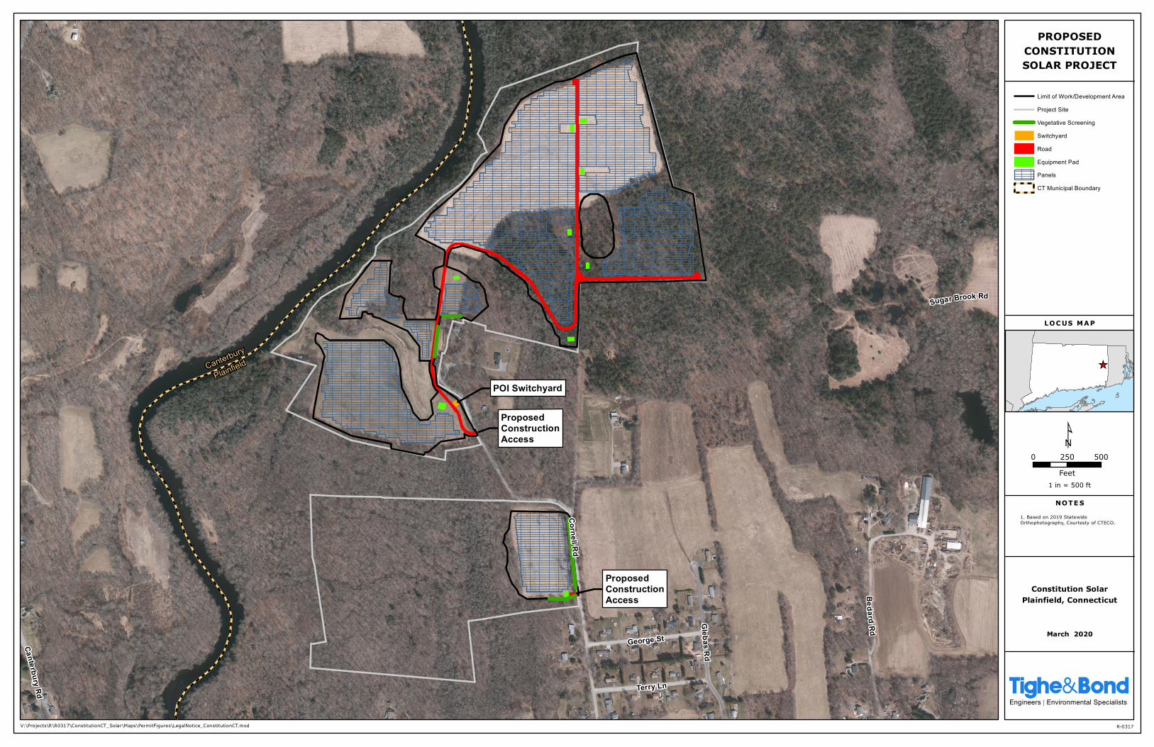
POI Switchyard
ProposedConstructionAccess
ProposedConstructionAccess
Canterbury
Plainfield
Cornell Rd
Canterbury Rd
Glebas Rd
Terry Ln
George St
Sugar Brook RdBedard
Rd March 2020
¹
_̂
1 in = 500 ft
NOTE S
LOC US MAP
1. Based on 2019 StatewideOrthophotography, Courtesty of CTECO.
0 250 500
Feet
V:\Projects\R\R0317\ConstitutionCT_Solar\Maps\PermitFigures\LegalNotice_ConstitutionCT.mxd R-0317
Tighe&BondEngineers | Environmental Specialists
Limit of Work/Development Area
Project Site
Vegetative Screening
Switchyard
Road
Equipment Pad
Panels
CT Municipal Boundary
PROPOSEDCONSTITUTIONSOLAR PROJECT
Constitution SolarPlainfield, Connecticut

ÈUNITEDSTATES
POSTALSËRVICEo Gertificate of Mailing - Firm
Kathryn E. Boucher, EsqLocke Lord LLP20 Church StreetHartford, CT 06103
USPS@
Firm-specific lC
N'
6
/À,ã'.ð qr.ôõ+.â9tlt:"."^ 7rÞ .^dÂtu \
The Honorable William TongAttomey GeneralOffice of the Attorney Generali Elm Street
Hartford, CT 06106
Elizabeth Shapiro, lnterim DirectorState Historic Preservation Officer450 Columbus BoulevardHartford, CT 06103
Representative Doug DubitsþLegislative Office Building, Room 4200300 Capitol AvenueHartford, CT 06106
James Rovella, CommissionerDepartment of Emergency Services andPublic Protection1111 Country Club RoadMiddletown, CT 06457
Brian Hurlburt, CommissionerDepartment of Agriculture450 Colurnbus Boulevard, Suite 701Hartford, CT 06106
Representative Anne DauphinaisLegislative Office Building, Room 4200300 Capitol AvenueHartford, CT 06106
""-
3
4ìÉ'r
Parcel AirliftSpecial HandlingFee
r0
í0
,{0
ôo
oo)
2020
-- z::l¡'{lj-t:!-,"
¿*H*
NIAR
ES
?0
Affix Stamp HerePostmark with Date of
Postage
fô
d
TOTAL NO.of P¡eces Received at Post Off¡ceilof Pieces Listed by Sender
qtTOTAL NO
Postmaster, pet (name of receiving employee)
PSForm 3665,January2017(Page I otlb¡ esruzsso- See Reverse for lnstructions

ÈUNITEDSTATESPOSTALSERVICEø
Gertificate of Mailing - Firm
Affix Stamp HerePostmark with Date of Receipt,
Parcel AirliftSpecial HandlingFeePostage
lo
lo
,60
,50
,60
.lo
TOTAL NO.of Pieces Received at Post Officeil
Postmaster, per (name of receiv¡ng employee)
TOTAL NO.of Pieces L¡sted by Sender
ql
Name and Address of Sender
Kathryn E. Boucher, Esq.Locke Lord LLP20 Church StreetHartford, CT 06103
usPs@ Number
Firm-specific ldentifier
5
rÀrãñÀ qrrâôr iltli""", 7rÞ.^dÀrM\
Katie Dykes, CommissionerDepartment of Energy and EnvironmentalProtection79 Elm StreetHartford. CT 06106Michelle H. Seagull, CommissionerDepartment of Consumer Protection450 Columbus BoulevardHartford, CT 06103
Kevin Cunningham, Fint SelectmanTown of Plainfield8 Community AvenuePlainfield. CT 0637
Renée Coleman-Mitchell, Commissioner
Department of Public Health410 Capitol AvenueP.O. Box 340308Hartford, CT 06 I 34-0308
Josh Geballe, CommissionerDepartment of Administrative Services
450 Columbus BoulevardHartford, CT 06103
Louisa Trakas, Town ClerkTown of Plainfield8 Community AvenuePlainfield, CT 06374
_QqY
3
4M
4þ.'
PS Form 3665,.tanuary 2017 (Page À ot l,þ¡ esr.r zsao- See Reverse for lnstructions

ÈUNITEDSTATESPOSTALSERVICEø Certificate of Mailing - Firm
Affix Stamp HerePostmark with Date of Receipt.
a(,
Qtr
'í¡Éí Ì:-=:Ø
20?ß0T
';:.t+.1- .
UAR
ôJo
Parcel AirliftSpecial HandlingFeePostage
tp
to
¡ 5
,lo
ro0
! ro
TOTAL NO. TOTAL NO.of Pieces Received at Post Off¡ceilof Pieces Listed by Sender
qIPostmaster, pet (name of rece¡v¡ng employee)
Name and Address of Sender
Kathryn E. Boucher, Esq.Locke Lord LLP20 Church StreetHartford, Cï 06103
USPSO Number
'.lentifier i91l^"_:"^^, 7'Þ .^dôil \
Peter Hearn, Executive DirectorCouncil on Environmental Quality79 Elm SteetP.O. Box 5066Hartford. CT 06106
Kurt V/estby, CommissionerDepartment of Labor200 Folly Brook BoulevardWethersfield, CT 06109
Mary Ann ChinattiPlainfield Planning & Zonrng Supervisor8 Community AvenuePlainfreld, C't 06374
Marissa Gillett, ChairrranPublic Utilities Regulatory AuthorityTen Franklin SquareNewBritain, CT 06051
Federal Energy Regulatory Commission888 First Steet, NEWashington, DC20426
Christopher Lipke, First Selectrnan
Town of CanterburyI Municipal DriveCanterbury, CT 06331
oqÍ
-M4lø'
PS Form 3665, Lanuary 2017 (Page Z ot þ) psN 7s30- See Reverse for lnstructions
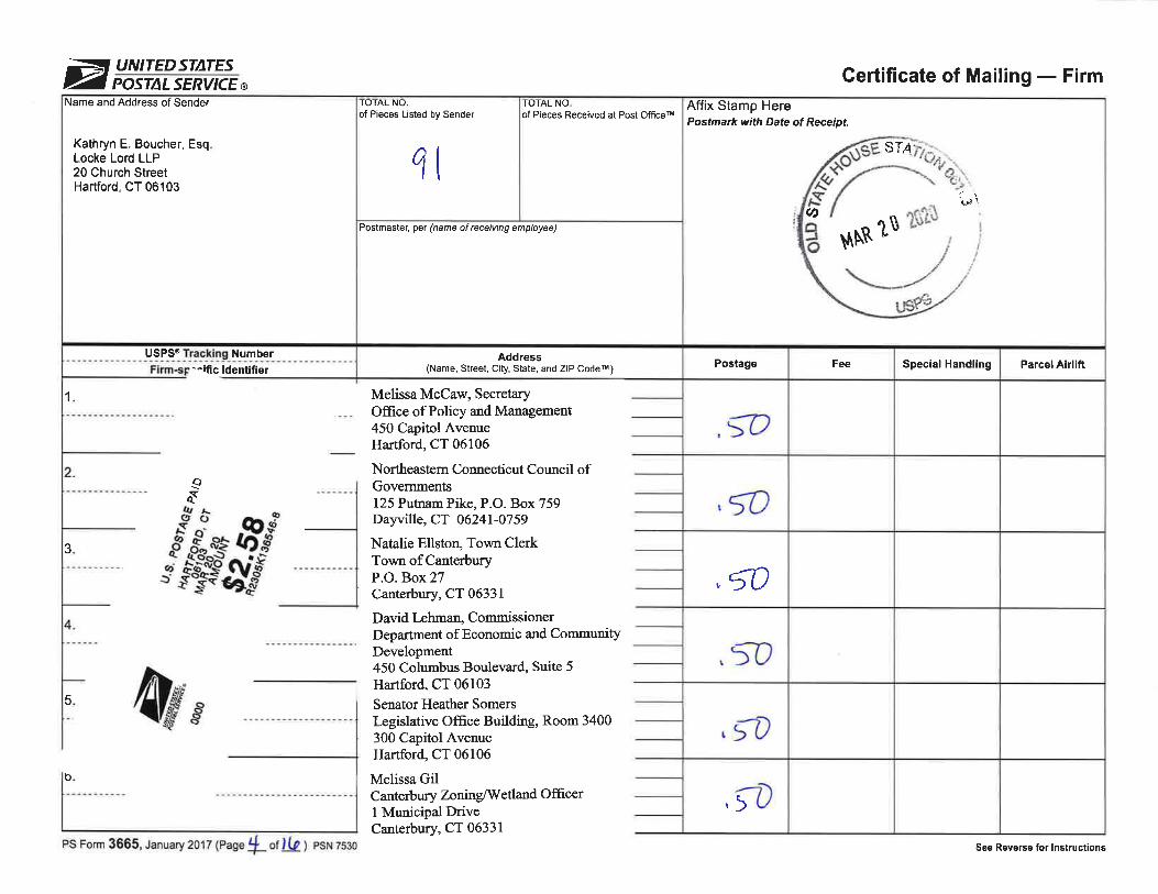
ÈUNITEDST|ITESPOSTALSERVICEø Certificate of Mailing - Firm
Affix Stamp HerePostmark with Date of Receipt.
sT4
?t ?ffiði"\(/,
$Þ,R
Parcel AirliftSpecial HandlingFeePostage
,Q
.lo
! 50
.t?
,;D
TOTAL NOof Pieces Received at Post OfficerM
Postmaster, per (name of receiving employee)
Address(Name, Street, C¡ty, State, and ZIP Codeil)
ro rAL No.of Pieces Listed by Sender
ql
Name and Address of Sender
Kathryn E. Boucher, EsqLocke Lord LLP20 Church StreetHartford, CT 06103
USPSÔ Number--ific ldentifier
1
þ
3
5
oqq
Melissa McCaw, SecretaryOffice of Policy and Management450 Capitol AvenueHartford, CT 06106
Northeastern Connecticut Council ofGovernments125 Putnam Pike, P.O. Box 759Dayville, CT 06241-0759
Natalie Ellston, Town ClerkTown of CanterburyP.O. Box 27Canterbury, CT 06331
David Lehman, CommissionerDepartment of Economic and CommunityDevelopment450 Columbus Boulevard, Suite 5Hartford, CT 06103
Senator Heather SomersLægislative Ofñce Building, Room 3400300 Capitol AvenueHartford, CT 06106
Melissa GilCanterbury ZoninglIVetland OfñcerI Municipal DriveCanterbury, CT 06331
W4r.u
PS Form 3665, January 2017 (Page Ll of!-k ) psN 7530 See Reverse for lnstructions

ÈUNITEDSTATESPOSTALSERVICEø Gertificate of Mailing - Firm
Affix Stamp HerePostmark with Date of
A
'",5"
'È \5.t
$[B
Parcel AirliftSpecial HandlingFeePostage
,5D
,lo
f tt)
? 50
t 50
( "f,
TOTAL NO.of Pieces Received at Post Officeil
Postmaster, pel (name of rece¡v¡ng employee)
TOTAL NO.of Pieces Listed by Sender
q\
Name and Address of Sender
Kathryn E. Boucher, EsqLocke Lord LLP20 Church StreetHartford, CT 06103
1
US Tr 'tnq Numbe¡,ñ,aõ^ c+-^^¡ i91l^t:=--.
Joseph Giulietti, CommissionerDeparbnent of Transportation2800 Berlin TurnpikeP.O. Box 317546Newinston, CT 06131-'7 546
Senator Mae FlexerLegislative Office Building, Room 3300300 Capitol AvenueHartford, CT 06106
Ronald Desjardins, ChairmanPlainfieldIWÌWC8 Community AvenuePlainfield, CT 06374
AltonC&MarieHExley117 Exley RdPlainfield, CT 06374
AltonC&MarieHExley117 Exley RdPlainfield, CT 06374
AltonC&MarieHExley117 Exley RdPlainfield, CT 06374
_Qqq
3 WE 4Þ--t
PS Form 3665,.tanuary 2017 (Page 5 of Jh) psN 7s30-17-000-5s4e See Reverse for lnstructions

øUNITEDSTATESPOSTALSERVICEø Certificate of Mailing - Firm
Name and Address
Kathryn E. Boucher, Esq.Locke Lord LLP20 Church StreetHartford, CT 06103
99ls'Firr
2
3
\umber
_Qqt
W4þ.u
Pa¡cel AirliftSpecial HandlingFee
MAR 2O 2O2O E
SE
o
Affix Stamp HerePostmark with Date of Receipt.
Postage
,tb
,<0
¡
5A¡
ro
,:2
of P¡eces Rece¡ved at Post Offceilto tAL No.TOTAL NO.
of P¡eces Listed by Sender
1tPostmaster, per (name of rece¡ving employee)
Address(Name, Street, City, State, and ZIP Codeil)
AltonC&MarieHExleY127 ExleyRdPlainfield, CT 06374
Jeffrey S & Tabatha L Foular Silva65 Comell RdPlainfield, CT 06374
N/A State of Connecticut73 Elm StPlainfield. CT 06374
Kristen L & Jeffery S Comell98 Cornell RdPlainfield, CT 06374
- Kristen L & Jeffery S Cornell- 98 Cornell Rd- Plainfield,CT 06374
Zachary Tryelson7 Club House RdPlainfield, CT 06374
PS Form 3665, Lanuary 2017 (Page h of ) PSN 7530-17-000-5549 See Reverse for lnstructions

ÈUNITEDSTATESPOSTALSERVICEø Gertificate of Mailing - Firm
Affix Stamp HerePostmark with Date of Receipt.
Parcel AirliftSpecial HandlingFeePostage
¡ *
tt
,b
t>
,q
TOTAL NO.of Pieces Received at Post Officet
Postmaster, per (name of rece¡ving employee)
Address(Name, Street, City, State, and ZIP Codeil)
TOTAL NOof Pieces L¡sted by Sender
qI
Name and Address of Sender
Kathryn E. Boucher, EsqLocke Lord LLP20 Church StreetHartford, CT 06103
USPS@ Ir?cki!g NumberFirm-specific ldentifier
.""ó
Kenneth M Stetson48 Ranger LnPlainfield. CT 06374
<¡isten L & Jeffery S Comell.00 Cornell RdPlainfield, CT 06374
Amos L Cornell146 Cornell RdPlainfield, CT 06374
ErinK Trustee Pullftinen25 Cornell RdPlainfield. CT 06374
Lauri P & Caroline L Pulkkinen25 Comell RdPlainfreld, CT 06374
GeraldT&RubySimonds57 Comell Rd
øù' ¡)
4kr
1
PS Form 3665, Lanuary 2017 (page 7 o¡ l_hl psN 7530-rz-000-5s4e
cr 06374
See Reverse for lnstructions

ÈUNITEDSTATESPOSTALSERVICEø Certificate of Mailing - Firm
Affix Stamp HerePostmark with Date
Parcel AirliftSpecial HandlingFeePostage
,rc
,';o
,t
t
t
I
'D
TOTAL NOof Pieces Received at Post Off¡cem
Postmaster, per (name of receiving employee)
Address(Name, Street, City, State, and ZIP Codeil)
Amy & Lynn D KapszukiewiczZurowski150 Comell RdPlainfield, CT 06374
Janis E Jolin49 Glebas RdPlainfield. CT 06374
- Daniela A & Juliarure Knowlton
- 63 Glebas RdPlainfield. CT 06374
Brenda T & Fong Laiching perez. 55 Glebas Rd. Plainfield,CT 06374
TOTAL NO.of P¡eces Listed by Sender
4t
Name and Address of Sender
Kathryn E. Boucher, EsqLocke Lord LLP20 Church StreetHartford, CT 06103
USPS@ Number
Firm-s f ".ntifier
2
3
Doris Desjardins114 Exley RdPlainfield. CT 06374
State of Connecticut73 Elm StPlainfield, CT 06374
r<)
Qt
".f^up-
4ìÊr
b
PS Form 3665, .tanuary 2017 (page 8 o1 lto ) psN 7s3o-17-000-ss4s See Reverse for lnstructions

ÈUNITEDSTATESPOSTALSERVICEø Certificate of Mailing - Firm
Affix Stamp HerePostnark with Date of
\[NR 1$ ?$?$
STn
Parcel AirliftSpecial HandlingFeePostage
,lo
2
t ro
tcÇ0
IO IAL NO.l,oJåf}on"."t"d at Post ornceilof Pieces Listed by Sender
qr
Postmastel per (name ot receiv¡ng employee)
Address(Name, Street, City, State, and ZIP Codeil)
Doris M Desjardins114 ExleyRdPlainfield. CT 06374
Nathanael & Abinel Melendez Mendez4l Cornell RdPlainfield, CT 06374
_ William Sr. & Veronica A Averyl9 Cornell RdPlainfield,CT 06374
_ Hillary & Brian Wagher17 Cornell Rd- Plainfield. CT 06374
Francis M & Helen F Eunson- 29 Comell Rd- Plainfreld,CT 06374
- Kenneth Richard & Brenda M Rudd- 31 Cornell Rd- Plainfield,CT 06374
Name and Address of Sender
Kathryn E. Boucher, Esq.Locke Lord LLP20 Church StreetHartford, CT 06103
USPS@ Number
c ldentifier
1
{)aY
4l#'r
PS Form 3665, Lanuary 2017 (page 1 otlþ¡ esr.r 7s30-,17-000-5s4e See Reverse for lnstruct¡ons
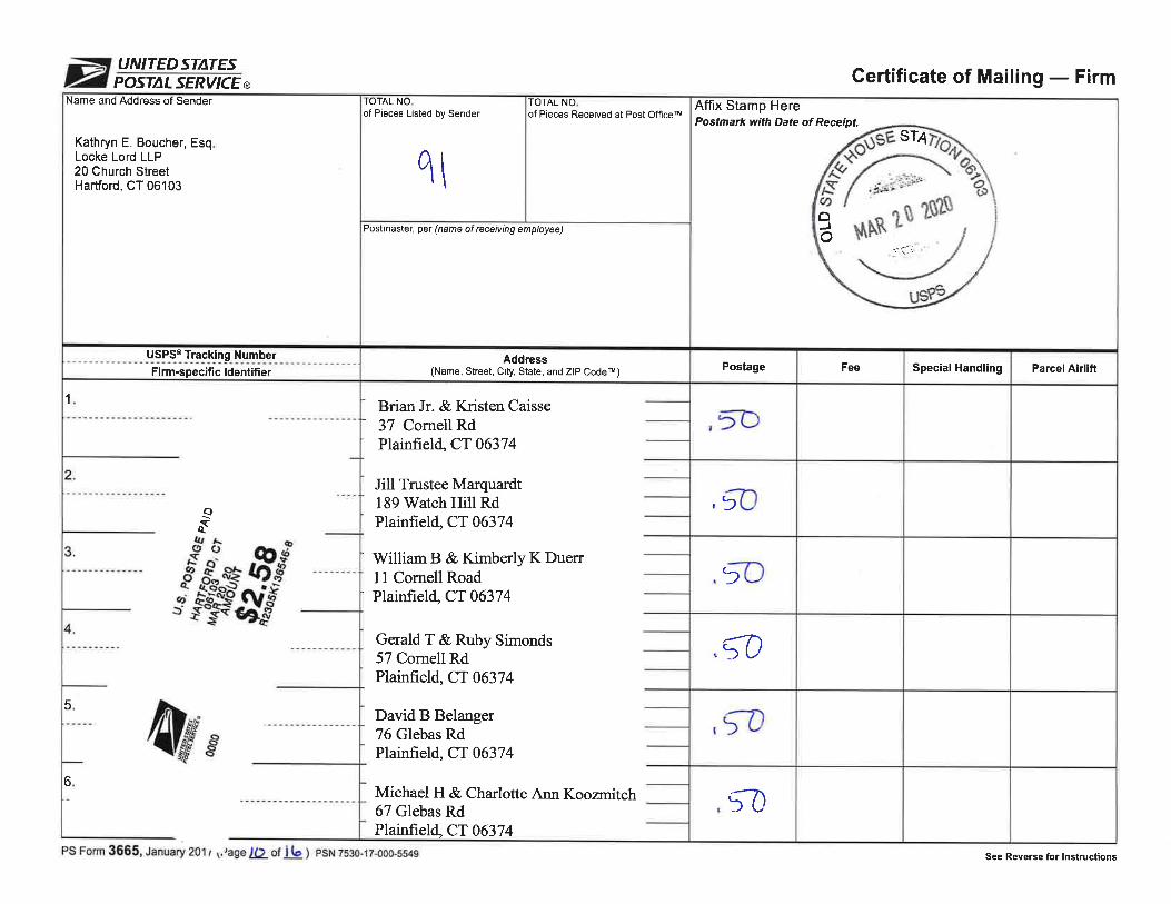
ÈUNITEDSTATESPOSTALSERVICEø Certificate of Mailing - Firm
Affix Stamp HerePostmark with Date of Receipt.
ST4
-:.lr'.:.oc)J
Parcel AirliftSpecial HandlingFeePostage
,æ
,3
5
Ç0
,tD
l0
TOTAL NO.of Pieces Rece¡ved at Post Officeil
Postmaster, per (name of rece¡v¡ng employee)
Address(Name, Street, City, State, and ZIP Codetu)
- Brian Jr. & Kristen Caisse- 37 Cornell RdPlainfield,CT 06374
Jill Trustee Marquardt189'Watch Hill RdPlainfield, CT 06374
' William B & Kimberþ K Duerr' 11 Cornell RoadPlainfield,CT 06374
GeraldT&RubySimonds57 Cornell RdPlainfield, CT 06374
David B Belanger76 Glebas RdPlainfield, CT 06374
Michael H & Charlotte Arur Koozrnitch67 Glebas RdPlainfield, CT 06374
TOTAL NOof Pieces Listed by Sender
q\
Name and Address of Sender
Kathryn E. Boucher, EsqLocke Lord LLP20 Church StreetHartford, CT 06103
USPS@ I-rg_"!^jl'g_ NumberFirm-specific ldent¡f¡er
1
_aq{
_w5
4/r"-*t6
PS Form 3665, .tanuary 201 r ¡,tage )() of ib ¡ esr.r 7530-17-000-5549 See Reverse for lnstructions
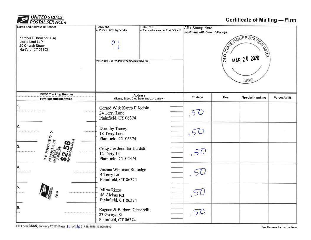
ÈUNITEDSTATESPOSTALSERVICEø Certificate of Mailing - Firm
Affix Stamp HerePostmark with Date of Receipt.
ARl,l
SE
ö202Û
cÐoJo
Ø
4
20
Parcel AirliftSpecial HandlingFeePostage
lo1>
Ço
,50
57)
TOTAL NO.of Pieces Received at Post OfficerM
Postmaster, pet (name of rece¡ving employee)
Address(Name, Street, City, State, and ZIP Codeil)
GerardW&KarenEJodoin24TerryLanePlainfield, CT 06374
Dorotþ Tracey. 18 Terry Lane. Plainfield,CT 06374
- Craig J & Jennifer L Fitch- l2TerryLn- Plainfield,CT 06374
Joshua Whitman Rutledge4 TerryLnPlainfield, CT 06374
Mirta Rizzo46 Glebas RdPlainfield, CT 06374
Eugene & Barbara Ciccarelli' 23 George St' Plainfield,CT 06374
TOTAL NO.of Pieces Listed by Sender
q(
Name and Address of Sender
Kathryn E. Boucher, Esq.Locke Lord LLP20 Church StreetHartford, CT 06103
.u-9i-!'_ I'gg!.gg- NumberFirm-specific ldentifier
_oq<
2
3
4
g* q o.$'
----Ë=-*#
5ÕoõaAl#
6
PS Form 3665, Lanuary 2017 (Page ll ot k) psN zs30-17-o0o-s54e See Reverse for lnstruct¡ons

ÈUNITEDSTATESPOSTALSERVICEø Gertificate of Mailing - Firm
Affix Stamp HerePostmark with Date of Receipt.
\¡ i
uC)d¡
MAR 20 202Û I
I/SP3
Parcel AirliftSpecial HandlingFeePostage
t>
.)
,tl
¡
,çl)
TOTAL NO.of Pieces Received at Post Officetu
Postmaster, pet (name of rece¡v¡ng employee)
Address(Name, Street, City, State, and ZIP Codeil)
- Jacob G & AdeleT Ciccarelli- 17 George St
Plainfield.CT 06374
Andrew & Bethany Fernandes91 Glebas RdPlainfield,CT 06374
- BruceW&JeannaEPrink- 179 Mack Rd- Plainfield,CT 06374
Robert J Sr. & Diana Smith24 George StPlainfield, CT 06374
Nicholas & Emily Trahan109 Glebas RdPlainfield, CT 06374
_ Benjamin & Emily Petrik70 Glebas Rd- Plainfield,CT 06374
TOTAL NOof Pieces Listed by Sender
qt
Name and Address of Sender
Kathryn E. Boucher, EsqLocke Lord LLP20 Church StreetHartford, CT 06103
USPS@ Tracking NumberFirm-specific ldentifier
aqtr
2
3
4 W4?ø"--u
PS Form 3665,.ianr,.ry 2017 (pagelLrf Lht psN 2530-12-000-554s See Reverse for lnstructions

ÈUNITEDSTATESPOSTALSERVICEø Certificate of Mailing - Firm
Affix Stamp HerePostmark with Date of Receipt.
Parcel AirliftSpecial HandlingFeePostage
I 50
I a
t2
so
t>
TOTAL NO.of Pieces Received at Post Off¡ceil
Postmaster, pel (name ol receiv¡ng employee)
Address(Name, Street, City, State, and ZIP Codeil)
Todd R Bibeault23TerryLanePlainfield, CT 06374
Ka¡en L Desjardins99 Glebas RdPlainflreld, CT 06374
James R Jr. & Deborah A West94 Glebas RdPlainfield, CT 06374
WilliamD Itr Griffen18 George StreetPlainfield, CT 06374
Seth Michael Lavallee12 George StPlainfield, CT 06374
GregoryP&TeresaASmith83 Glebas RdPlainfield, CT 06374
TOTAL NO.of Pieces Listed by Sender
ql
Name and Address of Sender
Kathryn E. Boucher, EsqLocke Lord LLP20 Church StreetHartford, CT 06103
usPs@ NumberFirm-specific ldentifier
_oqr
1
2
3
4
5
-.M
4ø't6
PS Form 3665, January 2017 (Page I 3 of I (p ¡ esru 7s30-i 7-000-5s4e See Reverse tor lnstructlons

øUNITEDSTATESPOSTALSERVICEø Certificate of Mailing - Firm
Affix Stamp HerePostmark with Date of Receipt.
Parcel AirliftSpecial HandlingFeePostage
,5D
,t
5C
ço
/'t\>U
TOTAL NO.of Pieces Received at Post OfficerM
Postmaster, pel (name of receiving employee)
Address(Name, Streel, City, State, and ZIP CoderM)
- Matthew Taylor80 Glebas Rd
- Plainfield,CT 06374
_ V/illiam P L Jr Maynard
_ 11 George StPlainfield, CT 06374
- Edgar R & Raquele Muniz- 3 George Street- Plainfield,CT 06374
- Anthony P Sr. & Deborah A LeBlanc- 17 Terry Ln- Plainfield,CT 06374
Lawrence & Christine Duart-Cote Cote12 Pleasant View CovePlainfield, CT 06374
- EarlR&DebraLCollelo- 42Comell Road- Plainfield,CT 06374
TOTAL NO.of Pieces Listed by Sender
1\
Name and Address of Sender
Kathryn E. Boucher, EsqLocke Lord LLP20 Church StreetHartford, CT 06103
USPS@ Number
Firm-specific ldentifier
2
3
_oq{
-M
4ÌÉ.(5cia
PS Form 3665, Lanuary zutt (pagellf of lþ ¡ esr.r 7s30-17-000-ss4s See Reverse for lnstructions

ÈUNITEDSTATES
POSTIILSERVICEø Gertificate of Mailing - FirmAffix Stamp HerePost¡nark with Date of Receipt.
Þr ÅT¡
$Þ.tX\Ñ ¡
Parcel AirliftSpecial HandlingFeePostage
,ÇÒ
ÇÒ
,ÇC
çD
;D
5D
TOTAL NO.of Pieces Received at Post Officen
Postmaster, per (name of receiving employee)
Address(Name, Street, City, State, and ZIP Codeil)
- Diane L &,Larry F Geer- 4 George Street
Plainfield, CT 06374
The BarbaraN King Revocable Trust60 Glebas RdPlainfield, CT 06374
Edward A Wiezbicki38 Glebas RdPlainfield, CT 06374
Paul J & Robin A Carpenter2 Glebas RdPlainfield, CT 06374
- Janod M & Cheryl-Ann Lincoln- 28 Glebas Rd- Plainfield,CT 06374
- Jo-Ann Grace- 234BlackHill Rd- Plainfield,CT 06374
TOTAL NO.of P¡eces Listed by Sender
q
Name and Address of Sender
Kathryn E. Boucher, EsqLocke Lord LLP20 Church StreetHartford, CT 06103
USPS@ NumberFirm-specific ldentifier
1
2ôìdt¡¡(tt-C"ot_at>j
?õoËo -¡ lfl8
.ægggÈ
3
4
Nff*5
þ
PS Form 3665, Lanuary zo17 (Pagei5 or Jþ ¡ esr 7530-17-000-5b4e See Reverse for lnstruct¡ons

ÈUNITEDSTATESPOSTALSERVICEø Certificate of Mailing - Firm
Affix Stamp HerePostmark with Date of
sT4
(J) tt tt$ ,
I
$Þ.R
Parcel AirliftSpecial HandlingFeePostage
,çl)
TOTAL NO.of Pieces Received at Post Off¡ceru
Postmaster, per (name of receiving employee)
Address(Name, Street, City, State, and ZIP Codetu)
Janis E Jolin- 49 Glebas Rd- Plainfield,CT 06374
\
TOTAL NO.of Pieces Listed by Sender
qI
Name and Address of Sender
Kathryn E. Boucher, EsqLocke Lord LLP20 Church StreetHartford, CT 06103
USPS@ NumberFirm-specific ldentifier
1
\QqY
otJ
4þ?
PS Form 3665, ¡a',- y 2017 (page lle ot þ) psN 7s30-17-000-554e See Reverse for lnstructions

Constitution Solar ProjectPlainfield, Connecticut
EXHIBIT N: Acoustic Analysis

Constitution Solar Project
Plainfield, Connecticut
EXHIBIT O:
FAA Correspondence

Exhibit O
FAA Correspondence
The items listed below are included in Exhibit O.
1 Project Extent Corner Locations Figure, submitted to FAA in January 2020 as part of the Notice of Proposed Construction or Alteration.
2 Determinations of No Hazard to Air Navigation, Solar Panel Constitution Solar Project, Points #1 - 15.

PROJECT EXTENT CORNER LOCATIONS FIGURE
SUBMITTED TO FAA IN JANUARY 2020 AS PART OF THE NOTICE
OF PROPOSED CONSTRUCTION OR ALTERATION

N
1" = 200'
FAA.dwg
CHECKED:
DRAWN BY:
FILE:
ELD
--
--
SCALE:
APPROVED:
Plainfield,
Connecticut
Constitution
Solar Facility
Constitution
Solar, LLC
DATE:2020/01/27
PROJECT NO:R-0317
1 INCH0
VERIFY SCALE
IF NOT ONE INCH ON
THIS SHEET, ADJUST
SCALES ACCORDINGLY
BAR IS 1 INCH ON
ORIGINAL DRAWING
Plotted O
n:Jan 27, 2020-10:53am
By: ELD
Last Saved:
1/27/2020
Tighe &
Bond:J:\R\R0317 Ranger Solar\R-0317-3_Constitution\D
raw
ings\Sheets\FAA\FAA.dw
g
MARK DATE
DESCRIPTION
- -
-
Engineers | Environmental Specialists
00 200' 400'
SCALE IN FEET
GRAPHIC SCALE
FIGURE 1
PROPERTY LINE
Q
U
I
N
E
B
A
U
G
R
I
V
E
R
Limit of
Work Corner
PROJECT EXTENT
CORNER LOCATIONS
Latitude: 41° 43' 18.64'' N
Longitude: 71° 57' 10.27'' W
Elevation: 174 feet
APPROXIMATE LIMIT OF WORK
Latitude: 41° 43' 8.11'' N
Longitude: 71° 57' 4.96'' W
Elevation: 218 feet
Latitude: 41° 43' 1.80'' N
Longitude: 71° 57' 3.84'' W
Elevation: 241 feet
Latitude: 41° 42' 57.66'' N
Longitude: 71° 57' 16.33'' W
Elevation: 260 feet
Latitude: 41° 42' 56.70'' N
Longitude: 71° 57' 29.29'' W
Elevation: 205 feet
Latitude: 41° 42' 50.08'' N
Longitude: 71° 57' 25.80'' W
Elevation: 238 feet
Latitude: 41° 42' 44.98'' N
Longitude: 71° 57' 17.35'' W
Elevation: 280 feet
Latitude: 41° 42' 38.85'' N
Longitude: 71° 57' 16.53'' W
Elevation: 289 feet
Latitude: 41° 42' 42.96'' N
Longitude: 71° 57' 23.79'' W
Elevation: 248 feet
Latitude: 41° 42' 49.17'' N
Longitude: 71° 57' 30.79'' W
Elevation: 221 feet
Latitude: 41° 42' 38.96'' N
Longitude: 71° 57' 23.32'' W
Elevation: 249 feet
Latitude: 41° 42' 50.4'' N
Longitude: 71° 57' 38.51'' W
Elevation: 180 feet
Latitude: 41° 42' 51.96'' N
Longitude: 71° 57' 42.80'' W
Elevation: 145 feet
Latitude: 41° 43' 0.54'' N
Longitude: 71° 57' 39.67'' W
Elevation: 145 feet
Latitude: 41° 43' 15.23'' N
Longitude: 71° 57' 22.08'' W
Elevation: 170 feet
CORNELL ROAD
Approximate
Limit of Work

DETERMINATIONS OF NO HAZARD TO AIR NAVIGATION,
SOLAR PANEL CONSTITUTION SOLAR PROJECT, POINTS #1 - 15

Mail Processing CenterFederal Aviation AdministrationSouthwest Regional OfficeObstruction Evaluation Group10101 Hillwood ParkwayFort Worth, TX 76177
Aeronautical Study No.2020-ANE-599-OE
Page 1 of 4
Issued Date: 02/27/2020
Jean ChristyTighe & Bond, Inc.53 Southampton RoadWestfield, MA 01085
** DETERMINATION OF NO HAZARD TO AIR NAVIGATION **
The Federal Aviation Administration has conducted an aeronautical study under the provisions of 49 U.S.C.,Section 44718 and if applicable Title 14 of the Code of Federal Regulations, part 77, concerning:
Structure: Solar Panel Constitution Solar Project #1Location: Plainfield, CTLatitude: 41-43-18.64N NAD 83Longitude: 71-57-10.27WHeights: 170 feet site elevation (SE)
8 feet above ground level (AGL)178 feet above mean sea level (AMSL)
This aeronautical study revealed that the structure does not exceed obstruction standards and would not be ahazard to air navigation provided the following condition(s), if any, is(are) met:
Based on this evaluation, marking and lighting are not necessary for aviation safety. However, if marking/lighting are accomplished on a voluntary basis, we recommend it be installed in accordance with FAA Advisorycircular 70/7460-1 L Change 2.
This determination expires on 08/27/2021 unless:
(a) the construction is started (not necessarily completed) and FAA Form 7460-2, Notice of ActualConstruction or Alteration, is received by this office.
(b) extended, revised, or terminated by the issuing office.(c) the construction is subject to the licensing authority of the Federal Communications Commission
(FCC) and an application for a construction permit has been filed, as required by the FCC, within6 months of the date of this determination. In such case, the determination expires on the dateprescribed by the FCC for completion of construction, or the date the FCC denies the application.
NOTE: REQUEST FOR EXTENSION OF THE EFFECTIVE PERIOD OF THIS DETERMINATION MUSTBE E-FILED AT LEAST 15 DAYS PRIOR TO THE EXPIRATION DATE. AFTER RE-EVALUATIONOF CURRENT OPERATIONS IN THE AREA OF THE STRUCTURE TO DETERMINE THAT NOSIGNIFICANT AERONAUTICAL CHANGES HAVE OCCURRED, YOUR DETERMINATION MAY BEELIGIBLE FOR ONE EXTENSION OF THE EFFECTIVE PERIOD.

Page 2 of 4
This determination is based, in part, on the foregoing description which includes specific coordinates, heights,frequency(ies) and power. Any changes in coordinates, heights, and frequencies or use of greater power, exceptthose frequencies specified in the Colo Void Clause Coalition; Antenna System Co-Location; Voluntary BestPractices, effective 21 Nov 2007, will void this determination. Any future construction or alteration, includingincrease to heights, power, or the addition of other transmitters, requires separate notice to the FAA.Thisdetermination includes all previously filed frequencies and power for this structure.
If construction or alteration is dismantled or destroyed, you must submit notice to the FAA within 5 days afterthe construction or alteration is dismantled or destroyed.
This determination does include temporary construction equipment such as cranes, derricks, etc., which may beused during actual construction of the structure. However, this equipment shall not exceed the overall heights asindicated above. Equipment which has a height greater than the studied structure requires separate notice to theFAA.
This determination concerns the effect of this structure on the safe and efficient use of navigable airspaceby aircraft and does not relieve the sponsor of compliance responsibilities relating to any law, ordinance, orregulation of any Federal, State, or local government body.
If we can be of further assistance, please contact our office at (202) 267-4525, or [email protected]. Onany future correspondence concerning this matter, please refer to Aeronautical Study Number 2020-ANE-599-OE.
Signature Control No: 428918173-431961124 ( DNE )David MaddoxSpecialist
Attachment(s)Case DescriptionMap(s)

Page 3 of 4
Case Description for ASN 2020-ANE-599-OE
The project proposes to construct a 20 megawatt (AC) solar energy generation facility.

Page 4 of 4
Sectional Map for ASN 2020-ANE-599-OE

Mail Processing CenterFederal Aviation AdministrationSouthwest Regional OfficeObstruction Evaluation Group10101 Hillwood ParkwayFort Worth, TX 76177
Aeronautical Study No.2020-ANE-600-OE
Page 1 of 4
Issued Date: 02/27/2020
Jean ChristyTighe & Bond, Inc.53 Southampton RoadWestfield, MA 01085
** DETERMINATION OF NO HAZARD TO AIR NAVIGATION **
The Federal Aviation Administration has conducted an aeronautical study under the provisions of 49 U.S.C.,Section 44718 and if applicable Title 14 of the Code of Federal Regulations, part 77, concerning:
Structure: Solar Panel Constitution Solar Project #2Location: Plainfield, CTLatitude: 41-43-08.11N NAD 83Longitude: 71-57-04.96WHeights: 218 feet site elevation (SE)
8 feet above ground level (AGL)226 feet above mean sea level (AMSL)
This aeronautical study revealed that the structure does not exceed obstruction standards and would not be ahazard to air navigation provided the following condition(s), if any, is(are) met:
Based on this evaluation, marking and lighting are not necessary for aviation safety. However, if marking/lighting are accomplished on a voluntary basis, we recommend it be installed in accordance with FAA Advisorycircular 70/7460-1 L Change 2.
This determination expires on 08/27/2021 unless:
(a) the construction is started (not necessarily completed) and FAA Form 7460-2, Notice of ActualConstruction or Alteration, is received by this office.
(b) extended, revised, or terminated by the issuing office.(c) the construction is subject to the licensing authority of the Federal Communications Commission
(FCC) and an application for a construction permit has been filed, as required by the FCC, within6 months of the date of this determination. In such case, the determination expires on the dateprescribed by the FCC for completion of construction, or the date the FCC denies the application.
NOTE: REQUEST FOR EXTENSION OF THE EFFECTIVE PERIOD OF THIS DETERMINATION MUSTBE E-FILED AT LEAST 15 DAYS PRIOR TO THE EXPIRATION DATE. AFTER RE-EVALUATIONOF CURRENT OPERATIONS IN THE AREA OF THE STRUCTURE TO DETERMINE THAT NOSIGNIFICANT AERONAUTICAL CHANGES HAVE OCCURRED, YOUR DETERMINATION MAY BEELIGIBLE FOR ONE EXTENSION OF THE EFFECTIVE PERIOD.

Page 2 of 4
This determination is based, in part, on the foregoing description which includes specific coordinates, heights,frequency(ies) and power. Any changes in coordinates, heights, and frequencies or use of greater power, exceptthose frequencies specified in the Colo Void Clause Coalition; Antenna System Co-Location; Voluntary BestPractices, effective 21 Nov 2007, will void this determination. Any future construction or alteration, includingincrease to heights, power, or the addition of other transmitters, requires separate notice to the FAA.Thisdetermination includes all previously filed frequencies and power for this structure.
If construction or alteration is dismantled or destroyed, you must submit notice to the FAA within 5 days afterthe construction or alteration is dismantled or destroyed.
This determination does include temporary construction equipment such as cranes, derricks, etc., which may beused during actual construction of the structure. However, this equipment shall not exceed the overall heights asindicated above. Equipment which has a height greater than the studied structure requires separate notice to theFAA.
This determination concerns the effect of this structure on the safe and efficient use of navigable airspaceby aircraft and does not relieve the sponsor of compliance responsibilities relating to any law, ordinance, orregulation of any Federal, State, or local government body.
If we can be of further assistance, please contact our office at (202) 267-4525, or [email protected]. Onany future correspondence concerning this matter, please refer to Aeronautical Study Number 2020-ANE-600-OE.
Signature Control No: 428918174-431961119 ( DNE )David MaddoxSpecialist
Attachment(s)Case DescriptionMap(s)

Page 3 of 4
Case Description for ASN 2020-ANE-600-OE
The project proposes to construct a 20 megawatt (AC) solar energy generation facility.

Page 4 of 4
Sectional Map for ASN 2020-ANE-600-OE

Mail Processing CenterFederal Aviation AdministrationSouthwest Regional OfficeObstruction Evaluation Group10101 Hillwood ParkwayFort Worth, TX 76177
Aeronautical Study No.2020-ANE-601-OE
Page 1 of 4
Issued Date: 02/27/2020
Jean ChristyTighe & Bond, Inc.53 Southampton RoadWestfield, MA 01085
** DETERMINATION OF NO HAZARD TO AIR NAVIGATION **
The Federal Aviation Administration has conducted an aeronautical study under the provisions of 49 U.S.C.,Section 44718 and if applicable Title 14 of the Code of Federal Regulations, part 77, concerning:
Structure: Solar Panel Constitution Solar Project #3Location: Plainfield, CTLatitude: 41-43-01.80N NAD 83Longitude: 71-57-03.84WHeights: 241 feet site elevation (SE)
8 feet above ground level (AGL)249 feet above mean sea level (AMSL)
This aeronautical study revealed that the structure does not exceed obstruction standards and would not be ahazard to air navigation provided the following condition(s), if any, is(are) met:
Based on this evaluation, marking and lighting are not necessary for aviation safety. However, if marking/lighting are accomplished on a voluntary basis, we recommend it be installed in accordance with FAA Advisorycircular 70/7460-1 L Change 2.
This determination expires on 08/27/2021 unless:
(a) the construction is started (not necessarily completed) and FAA Form 7460-2, Notice of ActualConstruction or Alteration, is received by this office.
(b) extended, revised, or terminated by the issuing office.(c) the construction is subject to the licensing authority of the Federal Communications Commission
(FCC) and an application for a construction permit has been filed, as required by the FCC, within6 months of the date of this determination. In such case, the determination expires on the dateprescribed by the FCC for completion of construction, or the date the FCC denies the application.
NOTE: REQUEST FOR EXTENSION OF THE EFFECTIVE PERIOD OF THIS DETERMINATION MUSTBE E-FILED AT LEAST 15 DAYS PRIOR TO THE EXPIRATION DATE. AFTER RE-EVALUATIONOF CURRENT OPERATIONS IN THE AREA OF THE STRUCTURE TO DETERMINE THAT NOSIGNIFICANT AERONAUTICAL CHANGES HAVE OCCURRED, YOUR DETERMINATION MAY BEELIGIBLE FOR ONE EXTENSION OF THE EFFECTIVE PERIOD.

Page 2 of 4
This determination is based, in part, on the foregoing description which includes specific coordinates, heights,frequency(ies) and power. Any changes in coordinates, heights, and frequencies or use of greater power, exceptthose frequencies specified in the Colo Void Clause Coalition; Antenna System Co-Location; Voluntary BestPractices, effective 21 Nov 2007, will void this determination. Any future construction or alteration, includingincrease to heights, power, or the addition of other transmitters, requires separate notice to the FAA.Thisdetermination includes all previously filed frequencies and power for this structure.
If construction or alteration is dismantled or destroyed, you must submit notice to the FAA within 5 days afterthe construction or alteration is dismantled or destroyed.
This determination does include temporary construction equipment such as cranes, derricks, etc., which may beused during actual construction of the structure. However, this equipment shall not exceed the overall heights asindicated above. Equipment which has a height greater than the studied structure requires separate notice to theFAA.
This determination concerns the effect of this structure on the safe and efficient use of navigable airspaceby aircraft and does not relieve the sponsor of compliance responsibilities relating to any law, ordinance, orregulation of any Federal, State, or local government body.
If we can be of further assistance, please contact our office at (202) 267-4525, or [email protected]. Onany future correspondence concerning this matter, please refer to Aeronautical Study Number 2020-ANE-601-OE.
Signature Control No: 428918175-431961127 ( DNE )David MaddoxSpecialist
Attachment(s)Case DescriptionMap(s)

Page 3 of 4
Case Description for ASN 2020-ANE-601-OE
The project proposes to construct a 20 megawatt (AC) solar energy generation facility.

Page 4 of 4
Sectional Map for ASN 2020-ANE-601-OE

Mail Processing CenterFederal Aviation AdministrationSouthwest Regional OfficeObstruction Evaluation Group10101 Hillwood ParkwayFort Worth, TX 76177
Aeronautical Study No.2020-ANE-602-OE
Page 1 of 4
Issued Date: 02/27/2020
Jean ChristyTighe & Bond, Inc.53 Southampton RoadWestfield, MA 01085
** DETERMINATION OF NO HAZARD TO AIR NAVIGATION **
The Federal Aviation Administration has conducted an aeronautical study under the provisions of 49 U.S.C.,Section 44718 and if applicable Title 14 of the Code of Federal Regulations, part 77, concerning:
Structure: Solar Panel Constitution Solar Project #4Location: Plainfield, CTLatitude: 41-42-57.66N NAD 83Longitude: 71-57-16.33WHeights: 260 feet site elevation (SE)
8 feet above ground level (AGL)268 feet above mean sea level (AMSL)
This aeronautical study revealed that the structure does not exceed obstruction standards and would not be ahazard to air navigation provided the following condition(s), if any, is(are) met:
Based on this evaluation, marking and lighting are not necessary for aviation safety. However, if marking/lighting are accomplished on a voluntary basis, we recommend it be installed in accordance with FAA Advisorycircular 70/7460-1 L Change 2.
This determination expires on 08/27/2021 unless:
(a) the construction is started (not necessarily completed) and FAA Form 7460-2, Notice of ActualConstruction or Alteration, is received by this office.
(b) extended, revised, or terminated by the issuing office.(c) the construction is subject to the licensing authority of the Federal Communications Commission
(FCC) and an application for a construction permit has been filed, as required by the FCC, within6 months of the date of this determination. In such case, the determination expires on the dateprescribed by the FCC for completion of construction, or the date the FCC denies the application.
NOTE: REQUEST FOR EXTENSION OF THE EFFECTIVE PERIOD OF THIS DETERMINATION MUSTBE E-FILED AT LEAST 15 DAYS PRIOR TO THE EXPIRATION DATE. AFTER RE-EVALUATIONOF CURRENT OPERATIONS IN THE AREA OF THE STRUCTURE TO DETERMINE THAT NOSIGNIFICANT AERONAUTICAL CHANGES HAVE OCCURRED, YOUR DETERMINATION MAY BEELIGIBLE FOR ONE EXTENSION OF THE EFFECTIVE PERIOD.

Page 2 of 4
This determination is based, in part, on the foregoing description which includes specific coordinates, heights,frequency(ies) and power. Any changes in coordinates, heights, and frequencies or use of greater power, exceptthose frequencies specified in the Colo Void Clause Coalition; Antenna System Co-Location; Voluntary BestPractices, effective 21 Nov 2007, will void this determination. Any future construction or alteration, includingincrease to heights, power, or the addition of other transmitters, requires separate notice to the FAA.Thisdetermination includes all previously filed frequencies and power for this structure.
If construction or alteration is dismantled or destroyed, you must submit notice to the FAA within 5 days afterthe construction or alteration is dismantled or destroyed.
This determination does include temporary construction equipment such as cranes, derricks, etc., which may beused during actual construction of the structure. However, this equipment shall not exceed the overall heights asindicated above. Equipment which has a height greater than the studied structure requires separate notice to theFAA.
This determination concerns the effect of this structure on the safe and efficient use of navigable airspaceby aircraft and does not relieve the sponsor of compliance responsibilities relating to any law, ordinance, orregulation of any Federal, State, or local government body.
If we can be of further assistance, please contact our office at (202) 267-4525, or [email protected]. Onany future correspondence concerning this matter, please refer to Aeronautical Study Number 2020-ANE-602-OE.
Signature Control No: 428918176-431961130 ( DNE )David MaddoxSpecialist
Attachment(s)Case DescriptionMap(s)

Page 3 of 4
Case Description for ASN 2020-ANE-602-OE
The project proposes to construct a 20 megawatt (AC) solar energy generation facility.

Page 4 of 4
Sectional Map for ASN 2020-ANE-602-OE

Mail Processing CenterFederal Aviation AdministrationSouthwest Regional OfficeObstruction Evaluation Group10101 Hillwood ParkwayFort Worth, TX 76177
Aeronautical Study No.2020-ANE-603-OE
Page 1 of 4
Issued Date: 02/27/2020
Jean ChristyTighe & Bond, Inc.53 Southampton RoadWestfield, MA 01085
** DETERMINATION OF NO HAZARD TO AIR NAVIGATION **
The Federal Aviation Administration has conducted an aeronautical study under the provisions of 49 U.S.C.,Section 44718 and if applicable Title 14 of the Code of Federal Regulations, part 77, concerning:
Structure: Solar Panel Constitution Solar Project #5Location: Plainfield, CTLatitude: 41-42-56.70N NAD 83Longitude: 71-57-29.29WHeights: 205 feet site elevation (SE)
8 feet above ground level (AGL)213 feet above mean sea level (AMSL)
This aeronautical study revealed that the structure does not exceed obstruction standards and would not be ahazard to air navigation provided the following condition(s), if any, is(are) met:
Based on this evaluation, marking and lighting are not necessary for aviation safety. However, if marking/lighting are accomplished on a voluntary basis, we recommend it be installed in accordance with FAA Advisorycircular 70/7460-1 L Change 2.
This determination expires on 08/27/2021 unless:
(a) the construction is started (not necessarily completed) and FAA Form 7460-2, Notice of ActualConstruction or Alteration, is received by this office.
(b) extended, revised, or terminated by the issuing office.(c) the construction is subject to the licensing authority of the Federal Communications Commission
(FCC) and an application for a construction permit has been filed, as required by the FCC, within6 months of the date of this determination. In such case, the determination expires on the dateprescribed by the FCC for completion of construction, or the date the FCC denies the application.
NOTE: REQUEST FOR EXTENSION OF THE EFFECTIVE PERIOD OF THIS DETERMINATION MUSTBE E-FILED AT LEAST 15 DAYS PRIOR TO THE EXPIRATION DATE. AFTER RE-EVALUATIONOF CURRENT OPERATIONS IN THE AREA OF THE STRUCTURE TO DETERMINE THAT NOSIGNIFICANT AERONAUTICAL CHANGES HAVE OCCURRED, YOUR DETERMINATION MAY BEELIGIBLE FOR ONE EXTENSION OF THE EFFECTIVE PERIOD.

Page 2 of 4
This determination is based, in part, on the foregoing description which includes specific coordinates, heights,frequency(ies) and power. Any changes in coordinates, heights, and frequencies or use of greater power, exceptthose frequencies specified in the Colo Void Clause Coalition; Antenna System Co-Location; Voluntary BestPractices, effective 21 Nov 2007, will void this determination. Any future construction or alteration, includingincrease to heights, power, or the addition of other transmitters, requires separate notice to the FAA.Thisdetermination includes all previously filed frequencies and power for this structure.
If construction or alteration is dismantled or destroyed, you must submit notice to the FAA within 5 days afterthe construction or alteration is dismantled or destroyed.
This determination does include temporary construction equipment such as cranes, derricks, etc., which may beused during actual construction of the structure. However, this equipment shall not exceed the overall heights asindicated above. Equipment which has a height greater than the studied structure requires separate notice to theFAA.
This determination concerns the effect of this structure on the safe and efficient use of navigable airspaceby aircraft and does not relieve the sponsor of compliance responsibilities relating to any law, ordinance, orregulation of any Federal, State, or local government body.
If we can be of further assistance, please contact our office at (202) 267-4525, or [email protected]. Onany future correspondence concerning this matter, please refer to Aeronautical Study Number 2020-ANE-603-OE.
Signature Control No: 428918177-431961120 ( DNE )David MaddoxSpecialist
Attachment(s)Case DescriptionMap(s)

Page 3 of 4
Case Description for ASN 2020-ANE-603-OE
The project proposes to construct a 20 megawatt (AC) solar energy generation facility.

Page 4 of 4
Sectional Map for ASN 2020-ANE-603-OE
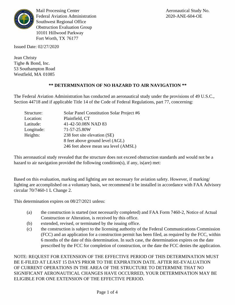
Mail Processing CenterFederal Aviation AdministrationSouthwest Regional OfficeObstruction Evaluation Group10101 Hillwood ParkwayFort Worth, TX 76177
Aeronautical Study No.2020-ANE-604-OE
Page 1 of 4
Issued Date: 02/27/2020
Jean ChristyTighe & Bond, Inc.53 Southampton RoadWestfield, MA 01085
** DETERMINATION OF NO HAZARD TO AIR NAVIGATION **
The Federal Aviation Administration has conducted an aeronautical study under the provisions of 49 U.S.C.,Section 44718 and if applicable Title 14 of the Code of Federal Regulations, part 77, concerning:
Structure: Solar Panel Constitution Solar Project #6Location: Plainfield, CTLatitude: 41-42-50.08N NAD 83Longitude: 71-57-25.80WHeights: 238 feet site elevation (SE)
8 feet above ground level (AGL)246 feet above mean sea level (AMSL)
This aeronautical study revealed that the structure does not exceed obstruction standards and would not be ahazard to air navigation provided the following condition(s), if any, is(are) met:
Based on this evaluation, marking and lighting are not necessary for aviation safety. However, if marking/lighting are accomplished on a voluntary basis, we recommend it be installed in accordance with FAA Advisorycircular 70/7460-1 L Change 2.
This determination expires on 08/27/2021 unless:
(a) the construction is started (not necessarily completed) and FAA Form 7460-2, Notice of ActualConstruction or Alteration, is received by this office.
(b) extended, revised, or terminated by the issuing office.(c) the construction is subject to the licensing authority of the Federal Communications Commission
(FCC) and an application for a construction permit has been filed, as required by the FCC, within6 months of the date of this determination. In such case, the determination expires on the dateprescribed by the FCC for completion of construction, or the date the FCC denies the application.
NOTE: REQUEST FOR EXTENSION OF THE EFFECTIVE PERIOD OF THIS DETERMINATION MUSTBE E-FILED AT LEAST 15 DAYS PRIOR TO THE EXPIRATION DATE. AFTER RE-EVALUATIONOF CURRENT OPERATIONS IN THE AREA OF THE STRUCTURE TO DETERMINE THAT NOSIGNIFICANT AERONAUTICAL CHANGES HAVE OCCURRED, YOUR DETERMINATION MAY BEELIGIBLE FOR ONE EXTENSION OF THE EFFECTIVE PERIOD.

Page 2 of 4
This determination is based, in part, on the foregoing description which includes specific coordinates, heights,frequency(ies) and power. Any changes in coordinates, heights, and frequencies or use of greater power, exceptthose frequencies specified in the Colo Void Clause Coalition; Antenna System Co-Location; Voluntary BestPractices, effective 21 Nov 2007, will void this determination. Any future construction or alteration, includingincrease to heights, power, or the addition of other transmitters, requires separate notice to the FAA.Thisdetermination includes all previously filed frequencies and power for this structure.
If construction or alteration is dismantled or destroyed, you must submit notice to the FAA within 5 days afterthe construction or alteration is dismantled or destroyed.
This determination does include temporary construction equipment such as cranes, derricks, etc., which may beused during actual construction of the structure. However, this equipment shall not exceed the overall heights asindicated above. Equipment which has a height greater than the studied structure requires separate notice to theFAA.
This determination concerns the effect of this structure on the safe and efficient use of navigable airspaceby aircraft and does not relieve the sponsor of compliance responsibilities relating to any law, ordinance, orregulation of any Federal, State, or local government body.
If we can be of further assistance, please contact our office at (202) 267-4525, or [email protected]. Onany future correspondence concerning this matter, please refer to Aeronautical Study Number 2020-ANE-604-OE.
Signature Control No: 428918178-431961125 ( DNE )David MaddoxSpecialist
Attachment(s)Case DescriptionMap(s)

Page 3 of 4
Case Description for ASN 2020-ANE-604-OE
The project proposes to construct a 20 megawatt (AC) solar energy generation facility.

Page 4 of 4
Sectional Map for ASN 2020-ANE-604-OE

Mail Processing CenterFederal Aviation AdministrationSouthwest Regional OfficeObstruction Evaluation Group10101 Hillwood ParkwayFort Worth, TX 76177
Aeronautical Study No.2020-ANE-605-OE
Page 1 of 4
Issued Date: 02/27/2020
Jean ChristyTighe & Bond, Inc.53 Southampton RoadWestfield, MA 01085
** DETERMINATION OF NO HAZARD TO AIR NAVIGATION **
The Federal Aviation Administration has conducted an aeronautical study under the provisions of 49 U.S.C.,Section 44718 and if applicable Title 14 of the Code of Federal Regulations, part 77, concerning:
Structure: Solar Panel Constitution Solar Project #7Location: Plainfield, CTLatitude: 41-42-44.98N NAD 83Longitude: 71-57-17.35WHeights: 280 feet site elevation (SE)
8 feet above ground level (AGL)288 feet above mean sea level (AMSL)
This aeronautical study revealed that the structure does not exceed obstruction standards and would not be ahazard to air navigation provided the following condition(s), if any, is(are) met:
Based on this evaluation, marking and lighting are not necessary for aviation safety. However, if marking/lighting are accomplished on a voluntary basis, we recommend it be installed in accordance with FAA Advisorycircular 70/7460-1 L Change 2.
This determination expires on 08/27/2021 unless:
(a) the construction is started (not necessarily completed) and FAA Form 7460-2, Notice of ActualConstruction or Alteration, is received by this office.
(b) extended, revised, or terminated by the issuing office.(c) the construction is subject to the licensing authority of the Federal Communications Commission
(FCC) and an application for a construction permit has been filed, as required by the FCC, within6 months of the date of this determination. In such case, the determination expires on the dateprescribed by the FCC for completion of construction, or the date the FCC denies the application.
NOTE: REQUEST FOR EXTENSION OF THE EFFECTIVE PERIOD OF THIS DETERMINATION MUSTBE E-FILED AT LEAST 15 DAYS PRIOR TO THE EXPIRATION DATE. AFTER RE-EVALUATIONOF CURRENT OPERATIONS IN THE AREA OF THE STRUCTURE TO DETERMINE THAT NOSIGNIFICANT AERONAUTICAL CHANGES HAVE OCCURRED, YOUR DETERMINATION MAY BEELIGIBLE FOR ONE EXTENSION OF THE EFFECTIVE PERIOD.

Page 2 of 4
This determination is based, in part, on the foregoing description which includes specific coordinates, heights,frequency(ies) and power. Any changes in coordinates, heights, and frequencies or use of greater power, exceptthose frequencies specified in the Colo Void Clause Coalition; Antenna System Co-Location; Voluntary BestPractices, effective 21 Nov 2007, will void this determination. Any future construction or alteration, includingincrease to heights, power, or the addition of other transmitters, requires separate notice to the FAA.Thisdetermination includes all previously filed frequencies and power for this structure.
If construction or alteration is dismantled or destroyed, you must submit notice to the FAA within 5 days afterthe construction or alteration is dismantled or destroyed.
This determination does include temporary construction equipment such as cranes, derricks, etc., which may beused during actual construction of the structure. However, this equipment shall not exceed the overall heights asindicated above. Equipment which has a height greater than the studied structure requires separate notice to theFAA.
This determination concerns the effect of this structure on the safe and efficient use of navigable airspaceby aircraft and does not relieve the sponsor of compliance responsibilities relating to any law, ordinance, orregulation of any Federal, State, or local government body.
If we can be of further assistance, please contact our office at (202) 267-4525, or [email protected]. Onany future correspondence concerning this matter, please refer to Aeronautical Study Number 2020-ANE-605-OE.
Signature Control No: 428918179-431961117 ( DNE )David MaddoxSpecialist
Attachment(s)Case DescriptionMap(s)

Page 3 of 4
Case Description for ASN 2020-ANE-605-OE
The project proposes to construct a 20 megawatt (AC) solar energy generation facility.

Page 4 of 4
Sectional Map for ASN 2020-ANE-605-OE

Mail Processing CenterFederal Aviation AdministrationSouthwest Regional OfficeObstruction Evaluation Group10101 Hillwood ParkwayFort Worth, TX 76177
Aeronautical Study No.2020-ANE-606-OE
Page 1 of 4
Issued Date: 02/27/2020
Jean ChristyTighe & Bond, Inc.53 Southampton RoadWestfield, MA 01085
** DETERMINATION OF NO HAZARD TO AIR NAVIGATION **
The Federal Aviation Administration has conducted an aeronautical study under the provisions of 49 U.S.C.,Section 44718 and if applicable Title 14 of the Code of Federal Regulations, part 77, concerning:
Structure: Solar Panel Constitution Solar Project #8Location: Plainfield, CTLatitude: 41-42-38.85N NAD 83Longitude: 71-57-16.53WHeights: 289 feet site elevation (SE)
8 feet above ground level (AGL)297 feet above mean sea level (AMSL)
This aeronautical study revealed that the structure does not exceed obstruction standards and would not be ahazard to air navigation provided the following condition(s), if any, is(are) met:
Based on this evaluation, marking and lighting are not necessary for aviation safety. However, if marking/lighting are accomplished on a voluntary basis, we recommend it be installed in accordance with FAA Advisorycircular 70/7460-1 L Change 2.
This determination expires on 08/27/2021 unless:
(a) the construction is started (not necessarily completed) and FAA Form 7460-2, Notice of ActualConstruction or Alteration, is received by this office.
(b) extended, revised, or terminated by the issuing office.(c) the construction is subject to the licensing authority of the Federal Communications Commission
(FCC) and an application for a construction permit has been filed, as required by the FCC, within6 months of the date of this determination. In such case, the determination expires on the dateprescribed by the FCC for completion of construction, or the date the FCC denies the application.
NOTE: REQUEST FOR EXTENSION OF THE EFFECTIVE PERIOD OF THIS DETERMINATION MUSTBE E-FILED AT LEAST 15 DAYS PRIOR TO THE EXPIRATION DATE. AFTER RE-EVALUATIONOF CURRENT OPERATIONS IN THE AREA OF THE STRUCTURE TO DETERMINE THAT NOSIGNIFICANT AERONAUTICAL CHANGES HAVE OCCURRED, YOUR DETERMINATION MAY BEELIGIBLE FOR ONE EXTENSION OF THE EFFECTIVE PERIOD.

Page 2 of 4
This determination is based, in part, on the foregoing description which includes specific coordinates, heights,frequency(ies) and power. Any changes in coordinates, heights, and frequencies or use of greater power, exceptthose frequencies specified in the Colo Void Clause Coalition; Antenna System Co-Location; Voluntary BestPractices, effective 21 Nov 2007, will void this determination. Any future construction or alteration, includingincrease to heights, power, or the addition of other transmitters, requires separate notice to the FAA.Thisdetermination includes all previously filed frequencies and power for this structure.
If construction or alteration is dismantled or destroyed, you must submit notice to the FAA within 5 days afterthe construction or alteration is dismantled or destroyed.
This determination does include temporary construction equipment such as cranes, derricks, etc., which may beused during actual construction of the structure. However, this equipment shall not exceed the overall heights asindicated above. Equipment which has a height greater than the studied structure requires separate notice to theFAA.
This determination concerns the effect of this structure on the safe and efficient use of navigable airspaceby aircraft and does not relieve the sponsor of compliance responsibilities relating to any law, ordinance, orregulation of any Federal, State, or local government body.
If we can be of further assistance, please contact our office at (202) 267-4525, or [email protected]. Onany future correspondence concerning this matter, please refer to Aeronautical Study Number 2020-ANE-606-OE.
Signature Control No: 428918180-431961118 ( DNE )David MaddoxSpecialist
Attachment(s)Case DescriptionMap(s)

Page 3 of 4
Case Description for ASN 2020-ANE-606-OE
The project proposes to construct a 20 megawatt (AC) solar energy generation facility.

Page 4 of 4
Sectional Map for ASN 2020-ANE-606-OE

Mail Processing CenterFederal Aviation AdministrationSouthwest Regional OfficeObstruction Evaluation Group10101 Hillwood ParkwayFort Worth, TX 76177
Aeronautical Study No.2020-ANE-607-OE
Page 1 of 4
Issued Date: 02/27/2020
Jean ChristyTighe & Bond, Inc.53 Southampton RoadWestfield, MA 01085
** DETERMINATION OF NO HAZARD TO AIR NAVIGATION **
The Federal Aviation Administration has conducted an aeronautical study under the provisions of 49 U.S.C.,Section 44718 and if applicable Title 14 of the Code of Federal Regulations, part 77, concerning:
Structure: Solar Panel Constitution Solar Project #9Location: Plainfield, CTLatitude: 41-42-38.96N NAD 83Longitude: 71-57-23.32WHeights: 249 feet site elevation (SE)
8 feet above ground level (AGL)257 feet above mean sea level (AMSL)
This aeronautical study revealed that the structure does not exceed obstruction standards and would not be ahazard to air navigation provided the following condition(s), if any, is(are) met:
Based on this evaluation, marking and lighting are not necessary for aviation safety. However, if marking/lighting are accomplished on a voluntary basis, we recommend it be installed in accordance with FAA Advisorycircular 70/7460-1 L Change 2.
This determination expires on 08/27/2021 unless:
(a) the construction is started (not necessarily completed) and FAA Form 7460-2, Notice of ActualConstruction or Alteration, is received by this office.
(b) extended, revised, or terminated by the issuing office.(c) the construction is subject to the licensing authority of the Federal Communications Commission
(FCC) and an application for a construction permit has been filed, as required by the FCC, within6 months of the date of this determination. In such case, the determination expires on the dateprescribed by the FCC for completion of construction, or the date the FCC denies the application.
NOTE: REQUEST FOR EXTENSION OF THE EFFECTIVE PERIOD OF THIS DETERMINATION MUSTBE E-FILED AT LEAST 15 DAYS PRIOR TO THE EXPIRATION DATE. AFTER RE-EVALUATIONOF CURRENT OPERATIONS IN THE AREA OF THE STRUCTURE TO DETERMINE THAT NOSIGNIFICANT AERONAUTICAL CHANGES HAVE OCCURRED, YOUR DETERMINATION MAY BEELIGIBLE FOR ONE EXTENSION OF THE EFFECTIVE PERIOD.

Page 2 of 4
This determination is based, in part, on the foregoing description which includes specific coordinates, heights,frequency(ies) and power. Any changes in coordinates, heights, and frequencies or use of greater power, exceptthose frequencies specified in the Colo Void Clause Coalition; Antenna System Co-Location; Voluntary BestPractices, effective 21 Nov 2007, will void this determination. Any future construction or alteration, includingincrease to heights, power, or the addition of other transmitters, requires separate notice to the FAA.Thisdetermination includes all previously filed frequencies and power for this structure.
If construction or alteration is dismantled or destroyed, you must submit notice to the FAA within 5 days afterthe construction or alteration is dismantled or destroyed.
This determination does include temporary construction equipment such as cranes, derricks, etc., which may beused during actual construction of the structure. However, this equipment shall not exceed the overall heights asindicated above. Equipment which has a height greater than the studied structure requires separate notice to theFAA.
This determination concerns the effect of this structure on the safe and efficient use of navigable airspaceby aircraft and does not relieve the sponsor of compliance responsibilities relating to any law, ordinance, orregulation of any Federal, State, or local government body.
If we can be of further assistance, please contact our office at (202) 267-4525, or [email protected]. Onany future correspondence concerning this matter, please refer to Aeronautical Study Number 2020-ANE-607-OE.
Signature Control No: 428918181-431961116 ( DNE )David MaddoxSpecialist
Attachment(s)Case DescriptionMap(s)

Page 3 of 4
Case Description for ASN 2020-ANE-607-OE
The project proposes to construct a 20 megawatt (AC) solar energy generation facility.

Page 4 of 4
Sectional Map for ASN 2020-ANE-607-OE
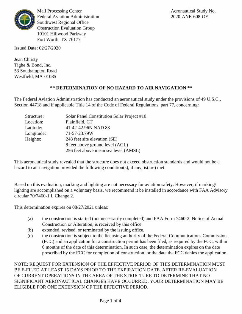
Mail Processing CenterFederal Aviation AdministrationSouthwest Regional OfficeObstruction Evaluation Group10101 Hillwood ParkwayFort Worth, TX 76177
Aeronautical Study No.2020-ANE-608-OE
Page 1 of 4
Issued Date: 02/27/2020
Jean ChristyTighe & Bond, Inc.53 Southampton RoadWestfield, MA 01085
** DETERMINATION OF NO HAZARD TO AIR NAVIGATION **
The Federal Aviation Administration has conducted an aeronautical study under the provisions of 49 U.S.C.,Section 44718 and if applicable Title 14 of the Code of Federal Regulations, part 77, concerning:
Structure: Solar Panel Constitution Solar Project #10Location: Plainfield, CTLatitude: 41-42-42.96N NAD 83Longitude: 71-57-23.79WHeights: 248 feet site elevation (SE)
8 feet above ground level (AGL)256 feet above mean sea level (AMSL)
This aeronautical study revealed that the structure does not exceed obstruction standards and would not be ahazard to air navigation provided the following condition(s), if any, is(are) met:
Based on this evaluation, marking and lighting are not necessary for aviation safety. However, if marking/lighting are accomplished on a voluntary basis, we recommend it be installed in accordance with FAA Advisorycircular 70/7460-1 L Change 2.
This determination expires on 08/27/2021 unless:
(a) the construction is started (not necessarily completed) and FAA Form 7460-2, Notice of ActualConstruction or Alteration, is received by this office.
(b) extended, revised, or terminated by the issuing office.(c) the construction is subject to the licensing authority of the Federal Communications Commission
(FCC) and an application for a construction permit has been filed, as required by the FCC, within6 months of the date of this determination. In such case, the determination expires on the dateprescribed by the FCC for completion of construction, or the date the FCC denies the application.
NOTE: REQUEST FOR EXTENSION OF THE EFFECTIVE PERIOD OF THIS DETERMINATION MUSTBE E-FILED AT LEAST 15 DAYS PRIOR TO THE EXPIRATION DATE. AFTER RE-EVALUATIONOF CURRENT OPERATIONS IN THE AREA OF THE STRUCTURE TO DETERMINE THAT NOSIGNIFICANT AERONAUTICAL CHANGES HAVE OCCURRED, YOUR DETERMINATION MAY BEELIGIBLE FOR ONE EXTENSION OF THE EFFECTIVE PERIOD.

Page 2 of 4
This determination is based, in part, on the foregoing description which includes specific coordinates, heights,frequency(ies) and power. Any changes in coordinates, heights, and frequencies or use of greater power, exceptthose frequencies specified in the Colo Void Clause Coalition; Antenna System Co-Location; Voluntary BestPractices, effective 21 Nov 2007, will void this determination. Any future construction or alteration, includingincrease to heights, power, or the addition of other transmitters, requires separate notice to the FAA.Thisdetermination includes all previously filed frequencies and power for this structure.
If construction or alteration is dismantled or destroyed, you must submit notice to the FAA within 5 days afterthe construction or alteration is dismantled or destroyed.
This determination does include temporary construction equipment such as cranes, derricks, etc., which may beused during actual construction of the structure. However, this equipment shall not exceed the overall heights asindicated above. Equipment which has a height greater than the studied structure requires separate notice to theFAA.
This determination concerns the effect of this structure on the safe and efficient use of navigable airspaceby aircraft and does not relieve the sponsor of compliance responsibilities relating to any law, ordinance, orregulation of any Federal, State, or local government body.
If we can be of further assistance, please contact our office at (202) 267-4525, or [email protected]. Onany future correspondence concerning this matter, please refer to Aeronautical Study Number 2020-ANE-608-OE.
Signature Control No: 428918182-431961129 ( DNE )David MaddoxSpecialist
Attachment(s)Case DescriptionMap(s)

Page 3 of 4
Case Description for ASN 2020-ANE-608-OE
The project proposes to construct a 20 megawatt (AC) solar energy generation facility.

Page 4 of 4
Sectional Map for ASN 2020-ANE-608-OE

Mail Processing CenterFederal Aviation AdministrationSouthwest Regional OfficeObstruction Evaluation Group10101 Hillwood ParkwayFort Worth, TX 76177
Aeronautical Study No.2020-ANE-609-OE
Page 1 of 4
Issued Date: 02/27/2020
Jean ChristyTighe & Bond, Inc.53 Southampton RoadWestfield, MA 01085
** DETERMINATION OF NO HAZARD TO AIR NAVIGATION **
The Federal Aviation Administration has conducted an aeronautical study under the provisions of 49 U.S.C.,Section 44718 and if applicable Title 14 of the Code of Federal Regulations, part 77, concerning:
Structure: Solar Panel Constitution Solar Project #11Location: Plainfield, CTLatitude: 41-42-49.17N NAD 83Longitude: 71-57-30.79WHeights: 221 feet site elevation (SE)
8 feet above ground level (AGL)229 feet above mean sea level (AMSL)
This aeronautical study revealed that the structure does not exceed obstruction standards and would not be ahazard to air navigation provided the following condition(s), if any, is(are) met:
Based on this evaluation, marking and lighting are not necessary for aviation safety. However, if marking/lighting are accomplished on a voluntary basis, we recommend it be installed in accordance with FAA Advisorycircular 70/7460-1 L Change 2.
This determination expires on 08/27/2021 unless:
(a) the construction is started (not necessarily completed) and FAA Form 7460-2, Notice of ActualConstruction or Alteration, is received by this office.
(b) extended, revised, or terminated by the issuing office.(c) the construction is subject to the licensing authority of the Federal Communications Commission
(FCC) and an application for a construction permit has been filed, as required by the FCC, within6 months of the date of this determination. In such case, the determination expires on the dateprescribed by the FCC for completion of construction, or the date the FCC denies the application.
NOTE: REQUEST FOR EXTENSION OF THE EFFECTIVE PERIOD OF THIS DETERMINATION MUSTBE E-FILED AT LEAST 15 DAYS PRIOR TO THE EXPIRATION DATE. AFTER RE-EVALUATIONOF CURRENT OPERATIONS IN THE AREA OF THE STRUCTURE TO DETERMINE THAT NOSIGNIFICANT AERONAUTICAL CHANGES HAVE OCCURRED, YOUR DETERMINATION MAY BEELIGIBLE FOR ONE EXTENSION OF THE EFFECTIVE PERIOD.
Page 2 of 4
This determination is based, in part, on the foregoing description which includes specific coordinates, heights,frequency(ies) and power. Any changes in coordinates, heights, and frequencies or use of greater power, exceptthose frequencies specified in the Colo Void Clause Coalition; Antenna System Co-Location; Voluntary BestPractices, effective 21 Nov 2007, will void this determination. Any future construction or alteration, includingincrease to heights, power, or the addition of other transmitters, requires separate notice to the FAA.Thisdetermination includes all previously filed frequencies and power for this structure.
If construction or alteration is dismantled or destroyed, you must submit notice to the FAA within 5 days afterthe construction or alteration is dismantled or destroyed.
This determination does include temporary construction equipment such as cranes, derricks, etc., which may beused during actual construction of the structure. However, this equipment shall not exceed the overall heights asindicated above. Equipment which has a height greater than the studied structure requires separate notice to theFAA.
This determination concerns the effect of this structure on the safe and efficient use of navigable airspaceby aircraft and does not relieve the sponsor of compliance responsibilities relating to any law, ordinance, orregulation of any Federal, State, or local government body.
If we can be of further assistance, please contact our office at (202) 267-4525, or [email protected]. Onany future correspondence concerning this matter, please refer to Aeronautical Study Number 2020-ANE-609-OE.
Signature Control No: 428918183-431961122 ( DNE )David MaddoxSpecialist
Attachment(s)Case DescriptionMap(s)

Page 3 of 4
Case Description for ASN 2020-ANE-609-OE
The project proposes to construct a 20 megawatt (AC) solar energy generation facility.

Page 4 of 4
Sectional Map for ASN 2020-ANE-609-OE

Mail Processing CenterFederal Aviation AdministrationSouthwest Regional OfficeObstruction Evaluation Group10101 Hillwood ParkwayFort Worth, TX 76177
Aeronautical Study No.2020-ANE-610-OE
Page 1 of 4
Issued Date: 02/27/2020
Jean ChristyTighe & Bond, Inc.53 Southampton RoadWestfield, MA 01085
** DETERMINATION OF NO HAZARD TO AIR NAVIGATION **
The Federal Aviation Administration has conducted an aeronautical study under the provisions of 49 U.S.C.,Section 44718 and if applicable Title 14 of the Code of Federal Regulations, part 77, concerning:
Structure: Solar Panel Constitution Solar Project #12Location: Plainfield, CTLatitude: 41-42-50.40N NAD 83Longitude: 71-57-38.51WHeights: 180 feet site elevation (SE)
8 feet above ground level (AGL)188 feet above mean sea level (AMSL)
This aeronautical study revealed that the structure does not exceed obstruction standards and would not be ahazard to air navigation provided the following condition(s), if any, is(are) met:
Based on this evaluation, marking and lighting are not necessary for aviation safety. However, if marking/lighting are accomplished on a voluntary basis, we recommend it be installed in accordance with FAA Advisorycircular 70/7460-1 L Change 2.
This determination expires on 08/27/2021 unless:
(a) the construction is started (not necessarily completed) and FAA Form 7460-2, Notice of ActualConstruction or Alteration, is received by this office.
(b) extended, revised, or terminated by the issuing office.(c) the construction is subject to the licensing authority of the Federal Communications Commission
(FCC) and an application for a construction permit has been filed, as required by the FCC, within6 months of the date of this determination. In such case, the determination expires on the dateprescribed by the FCC for completion of construction, or the date the FCC denies the application.
NOTE: REQUEST FOR EXTENSION OF THE EFFECTIVE PERIOD OF THIS DETERMINATION MUSTBE E-FILED AT LEAST 15 DAYS PRIOR TO THE EXPIRATION DATE. AFTER RE-EVALUATIONOF CURRENT OPERATIONS IN THE AREA OF THE STRUCTURE TO DETERMINE THAT NOSIGNIFICANT AERONAUTICAL CHANGES HAVE OCCURRED, YOUR DETERMINATION MAY BEELIGIBLE FOR ONE EXTENSION OF THE EFFECTIVE PERIOD.

Page 2 of 4
This determination is based, in part, on the foregoing description which includes specific coordinates, heights,frequency(ies) and power. Any changes in coordinates, heights, and frequencies or use of greater power, exceptthose frequencies specified in the Colo Void Clause Coalition; Antenna System Co-Location; Voluntary BestPractices, effective 21 Nov 2007, will void this determination. Any future construction or alteration, includingincrease to heights, power, or the addition of other transmitters, requires separate notice to the FAA.Thisdetermination includes all previously filed frequencies and power for this structure.
If construction or alteration is dismantled or destroyed, you must submit notice to the FAA within 5 days afterthe construction or alteration is dismantled or destroyed.
This determination does include temporary construction equipment such as cranes, derricks, etc., which may beused during actual construction of the structure. However, this equipment shall not exceed the overall heights asindicated above. Equipment which has a height greater than the studied structure requires separate notice to theFAA.
This determination concerns the effect of this structure on the safe and efficient use of navigable airspaceby aircraft and does not relieve the sponsor of compliance responsibilities relating to any law, ordinance, orregulation of any Federal, State, or local government body.
If we can be of further assistance, please contact our office at (202) 267-4525, or [email protected]. Onany future correspondence concerning this matter, please refer to Aeronautical Study Number 2020-ANE-610-OE.
Signature Control No: 428918184-431961128 ( DNE )David MaddoxSpecialist
Attachment(s)Case DescriptionMap(s)

Page 3 of 4
Case Description for ASN 2020-ANE-610-OE
The project proposes to construct a 20 megawatt (AC) solar energy generation facility.
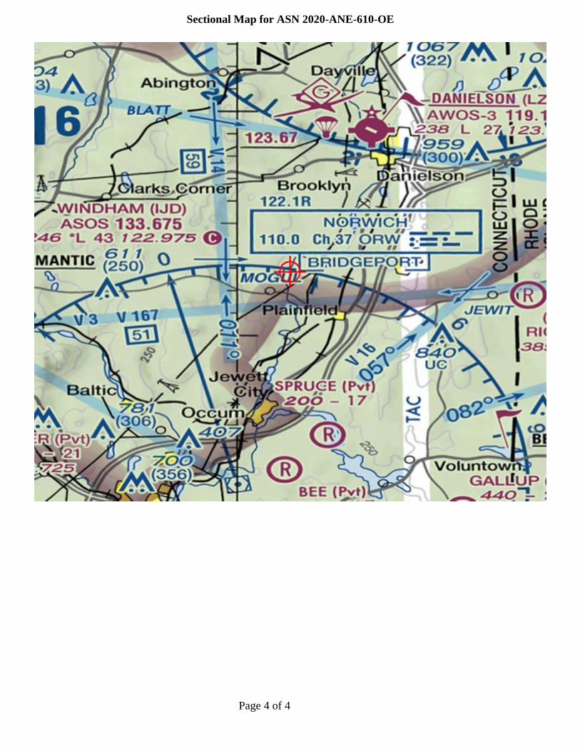
Page 4 of 4
Sectional Map for ASN 2020-ANE-610-OE

Mail Processing CenterFederal Aviation AdministrationSouthwest Regional OfficeObstruction Evaluation Group10101 Hillwood ParkwayFort Worth, TX 76177
Aeronautical Study No.2020-ANE-611-OE
Page 1 of 4
Issued Date: 02/27/2020
Jean ChristyTighe & Bond, Inc.53 Southampton RoadWestfield, MA 01085
** DETERMINATION OF NO HAZARD TO AIR NAVIGATION **
The Federal Aviation Administration has conducted an aeronautical study under the provisions of 49 U.S.C.,Section 44718 and if applicable Title 14 of the Code of Federal Regulations, part 77, concerning:
Structure: Solar Panel Constitution Solar Project #13Location: Plainfield, CTLatitude: 41-42-51.96N NAD 83Longitude: 71-57-42.80WHeights: 145 feet site elevation (SE)
8 feet above ground level (AGL)153 feet above mean sea level (AMSL)
This aeronautical study revealed that the structure does not exceed obstruction standards and would not be ahazard to air navigation provided the following condition(s), if any, is(are) met:
Based on this evaluation, marking and lighting are not necessary for aviation safety. However, if marking/lighting are accomplished on a voluntary basis, we recommend it be installed in accordance with FAA Advisorycircular 70/7460-1 L Change 2.
This determination expires on 08/27/2021 unless:
(a) the construction is started (not necessarily completed) and FAA Form 7460-2, Notice of ActualConstruction or Alteration, is received by this office.
(b) extended, revised, or terminated by the issuing office.(c) the construction is subject to the licensing authority of the Federal Communications Commission
(FCC) and an application for a construction permit has been filed, as required by the FCC, within6 months of the date of this determination. In such case, the determination expires on the dateprescribed by the FCC for completion of construction, or the date the FCC denies the application.
NOTE: REQUEST FOR EXTENSION OF THE EFFECTIVE PERIOD OF THIS DETERMINATION MUSTBE E-FILED AT LEAST 15 DAYS PRIOR TO THE EXPIRATION DATE. AFTER RE-EVALUATIONOF CURRENT OPERATIONS IN THE AREA OF THE STRUCTURE TO DETERMINE THAT NOSIGNIFICANT AERONAUTICAL CHANGES HAVE OCCURRED, YOUR DETERMINATION MAY BEELIGIBLE FOR ONE EXTENSION OF THE EFFECTIVE PERIOD.

Page 2 of 4
This determination is based, in part, on the foregoing description which includes specific coordinates, heights,frequency(ies) and power. Any changes in coordinates, heights, and frequencies or use of greater power, exceptthose frequencies specified in the Colo Void Clause Coalition; Antenna System Co-Location; Voluntary BestPractices, effective 21 Nov 2007, will void this determination. Any future construction or alteration, includingincrease to heights, power, or the addition of other transmitters, requires separate notice to the FAA.Thisdetermination includes all previously filed frequencies and power for this structure.
If construction or alteration is dismantled or destroyed, you must submit notice to the FAA within 5 days afterthe construction or alteration is dismantled or destroyed.
This determination does include temporary construction equipment such as cranes, derricks, etc., which may beused during actual construction of the structure. However, this equipment shall not exceed the overall heights asindicated above. Equipment which has a height greater than the studied structure requires separate notice to theFAA.
This determination concerns the effect of this structure on the safe and efficient use of navigable airspaceby aircraft and does not relieve the sponsor of compliance responsibilities relating to any law, ordinance, orregulation of any Federal, State, or local government body.
If we can be of further assistance, please contact our office at (202) 267-4525, or [email protected]. Onany future correspondence concerning this matter, please refer to Aeronautical Study Number 2020-ANE-611-OE.
Signature Control No: 428918185-431961121 ( DNE )David MaddoxSpecialist
Attachment(s)Case DescriptionMap(s)

Page 3 of 4
Case Description for ASN 2020-ANE-611-OE
The project proposes to construct a 20 megawatt (AC) solar energy generation facility.

Page 4 of 4
Sectional Map for ASN 2020-ANE-611-OE

Mail Processing CenterFederal Aviation AdministrationSouthwest Regional OfficeObstruction Evaluation Group10101 Hillwood ParkwayFort Worth, TX 76177
Aeronautical Study No.2020-ANE-612-OE
Page 1 of 4
Issued Date: 02/27/2020
Jean ChristyTighe & Bond, Inc.53 Southampton RoadWestfield, MA 01085
** DETERMINATION OF NO HAZARD TO AIR NAVIGATION **
The Federal Aviation Administration has conducted an aeronautical study under the provisions of 49 U.S.C.,Section 44718 and if applicable Title 14 of the Code of Federal Regulations, part 77, concerning:
Structure: Solar Panel Constitution Solar Project #14Location: Plainfield, CTLatitude: 41-43-00.54N NAD 83Longitude: 71-57-39.67WHeights: 145 feet site elevation (SE)
8 feet above ground level (AGL)153 feet above mean sea level (AMSL)
This aeronautical study revealed that the structure does not exceed obstruction standards and would not be ahazard to air navigation provided the following condition(s), if any, is(are) met:
Based on this evaluation, marking and lighting are not necessary for aviation safety. However, if marking/lighting are accomplished on a voluntary basis, we recommend it be installed in accordance with FAA Advisorycircular 70/7460-1 L Change 2.
This determination expires on 08/27/2021 unless:
(a) the construction is started (not necessarily completed) and FAA Form 7460-2, Notice of ActualConstruction or Alteration, is received by this office.
(b) extended, revised, or terminated by the issuing office.(c) the construction is subject to the licensing authority of the Federal Communications Commission
(FCC) and an application for a construction permit has been filed, as required by the FCC, within6 months of the date of this determination. In such case, the determination expires on the dateprescribed by the FCC for completion of construction, or the date the FCC denies the application.
NOTE: REQUEST FOR EXTENSION OF THE EFFECTIVE PERIOD OF THIS DETERMINATION MUSTBE E-FILED AT LEAST 15 DAYS PRIOR TO THE EXPIRATION DATE. AFTER RE-EVALUATIONOF CURRENT OPERATIONS IN THE AREA OF THE STRUCTURE TO DETERMINE THAT NOSIGNIFICANT AERONAUTICAL CHANGES HAVE OCCURRED, YOUR DETERMINATION MAY BEELIGIBLE FOR ONE EXTENSION OF THE EFFECTIVE PERIOD.

Page 2 of 4
This determination is based, in part, on the foregoing description which includes specific coordinates, heights,frequency(ies) and power. Any changes in coordinates, heights, and frequencies or use of greater power, exceptthose frequencies specified in the Colo Void Clause Coalition; Antenna System Co-Location; Voluntary BestPractices, effective 21 Nov 2007, will void this determination. Any future construction or alteration, includingincrease to heights, power, or the addition of other transmitters, requires separate notice to the FAA.Thisdetermination includes all previously filed frequencies and power for this structure.
If construction or alteration is dismantled or destroyed, you must submit notice to the FAA within 5 days afterthe construction or alteration is dismantled or destroyed.
This determination does include temporary construction equipment such as cranes, derricks, etc., which may beused during actual construction of the structure. However, this equipment shall not exceed the overall heights asindicated above. Equipment which has a height greater than the studied structure requires separate notice to theFAA.
This determination concerns the effect of this structure on the safe and efficient use of navigable airspaceby aircraft and does not relieve the sponsor of compliance responsibilities relating to any law, ordinance, orregulation of any Federal, State, or local government body.
If we can be of further assistance, please contact our office at (202) 267-4525, or [email protected]. Onany future correspondence concerning this matter, please refer to Aeronautical Study Number 2020-ANE-612-OE.
Signature Control No: 428918186-431961126 ( DNE )David MaddoxSpecialist
Attachment(s)Case DescriptionMap(s)

Page 3 of 4
Case Description for ASN 2020-ANE-612-OE
The project proposes to construct a 20 megawatt (AC) solar energy generation facility.

Page 4 of 4
Sectional Map for ASN 2020-ANE-612-OE

Mail Processing CenterFederal Aviation AdministrationSouthwest Regional OfficeObstruction Evaluation Group10101 Hillwood ParkwayFort Worth, TX 76177
Aeronautical Study No.2020-ANE-613-OE
Page 1 of 4
Issued Date: 02/27/2020
Jean ChristyTighe & Bond, Inc.53 Southampton RoadWestfield, MA 01085
** DETERMINATION OF NO HAZARD TO AIR NAVIGATION **
The Federal Aviation Administration has conducted an aeronautical study under the provisions of 49 U.S.C.,Section 44718 and if applicable Title 14 of the Code of Federal Regulations, part 77, concerning:
Structure: Solar Panel Constitution Solar Project #15Location: Plainfield, CTLatitude: 41-43-15.23N NAD 83Longitude: 71-57-22.08WHeights: 170 feet site elevation (SE)
8 feet above ground level (AGL)178 feet above mean sea level (AMSL)
This aeronautical study revealed that the structure does not exceed obstruction standards and would not be ahazard to air navigation provided the following condition(s), if any, is(are) met:
Based on this evaluation, marking and lighting are not necessary for aviation safety. However, if marking/lighting are accomplished on a voluntary basis, we recommend it be installed in accordance with FAA Advisorycircular 70/7460-1 L Change 2.
This determination expires on 08/27/2021 unless:
(a) the construction is started (not necessarily completed) and FAA Form 7460-2, Notice of ActualConstruction or Alteration, is received by this office.
(b) extended, revised, or terminated by the issuing office.(c) the construction is subject to the licensing authority of the Federal Communications Commission
(FCC) and an application for a construction permit has been filed, as required by the FCC, within6 months of the date of this determination. In such case, the determination expires on the dateprescribed by the FCC for completion of construction, or the date the FCC denies the application.
NOTE: REQUEST FOR EXTENSION OF THE EFFECTIVE PERIOD OF THIS DETERMINATION MUSTBE E-FILED AT LEAST 15 DAYS PRIOR TO THE EXPIRATION DATE. AFTER RE-EVALUATIONOF CURRENT OPERATIONS IN THE AREA OF THE STRUCTURE TO DETERMINE THAT NOSIGNIFICANT AERONAUTICAL CHANGES HAVE OCCURRED, YOUR DETERMINATION MAY BEELIGIBLE FOR ONE EXTENSION OF THE EFFECTIVE PERIOD.

Page 2 of 4
This determination is based, in part, on the foregoing description which includes specific coordinates, heights,frequency(ies) and power. Any changes in coordinates, heights, and frequencies or use of greater power, exceptthose frequencies specified in the Colo Void Clause Coalition; Antenna System Co-Location; Voluntary BestPractices, effective 21 Nov 2007, will void this determination. Any future construction or alteration, includingincrease to heights, power, or the addition of other transmitters, requires separate notice to the FAA.Thisdetermination includes all previously filed frequencies and power for this structure.
If construction or alteration is dismantled or destroyed, you must submit notice to the FAA within 5 days afterthe construction or alteration is dismantled or destroyed.
This determination does include temporary construction equipment such as cranes, derricks, etc., which may beused during actual construction of the structure. However, this equipment shall not exceed the overall heights asindicated above. Equipment which has a height greater than the studied structure requires separate notice to theFAA.
This determination concerns the effect of this structure on the safe and efficient use of navigable airspaceby aircraft and does not relieve the sponsor of compliance responsibilities relating to any law, ordinance, orregulation of any Federal, State, or local government body.
If we can be of further assistance, please contact our office at (202) 267-4525, or [email protected]. Onany future correspondence concerning this matter, please refer to Aeronautical Study Number 2020-ANE-613-OE.
Signature Control No: 428918187-431961123 ( DNE )David MaddoxSpecialist
Attachment(s)Case DescriptionMap(s)

Page 3 of 4
Case Description for ASN 2020-ANE-613-OE
The project proposes to construct a 20 megawatt (AC) solar energy generation facility.

Page 4 of 4
Sectional Map for ASN 2020-ANE-613-OE

Constitution Solar Project
Plainfield, Connecticut
EXHIBIT P:
SHPO Correspondence

Exhibit P
SHPO Correspondence
The items listed below are included in Exhibit P.
1 Heritage Phase IA Cultural Resource Assessment Survey Report
2 SHPO Concurrence Letter for Phase IA Survey
3 Heritage Scope of Work – Phase II Testing
4 SHPO Concurrence Letter for Phase IB Cultural Resources Survey
5 Heritage Phase 1B Cultural Resources Reconnaissance Survey and Phase II National Register of Historic Places Testing and Evaluation [Filed
under Protective Order]

HERITAGE PHASE 1A CULTURAL RESOURCE
ASSESSMENT SURVEY REPORT

PREPARED FOR:
NEXTERA ENERGY RESOURCES 677 COUSINS STREET
YARMOUTH, MAINE 04096
PREPARED BY:
PREPARED BY:
PHASE IA CULTURAL RESOURCES ASSESSMENT SURVEY OF THE PROPOSED CONSTITUTION SOLAR
FACILITY IN PLAINFIELD, CONNECTICUT
HERITAGE CONSULTANTS, LLC P.O. BOX 310249
NEWINGTON, CONNECTICUT 06131
OCTOBER 2017

ABSTRACT This report presents the results of a Phase IA cultural resources assessment survey for the proposed Constitution Solar Project in Plainfield, Connecticut. Nextera Energy Resources, through its contractor Tighe and Bond, requested that Heritage Consultants, LLC complete a Phase IA cultural resources assessment survey as part of the planning process for the proposed solar energy facility. Heritage conducted a Phase IA cultural resources assessment survey of 156.8 acres of land referred in this report as the study area. The study area is roughly bordered to the south by Black Hill Road and private residences, to the east by Cornell Road, and to the north and west by the Quinebaug River. The proposed solar facility will be connected to an existing Eversource Energy electrical transmission line using a 23 m (75 ft) wide right-of-way (ROW) that leads to Black Hill Road in the south. Heritage completed this investigation on behalf of Nextera in August and September of 2017
Heritage Consultants, LLC combined the data garnered from historic map and aerial image investigations, chain of title research, and pedestrian survey to stratify the study area into zones of no/low archaeological sensitivity, moderate/high prehistoric archaeological sensitivity, and moderate/high historic period archaeological sensitivity. It was determined that of the 156.8 acres of land under consideration for the proposed solar facility, 75 acres has been determined to be of no/low archaeological potential, while 81.8 acres possess a moderate/high sensitivity for producing prehistoric period archaeological resources. Since the no/low potential areas consist of previously disturbed, paved, mucky, sloping, and/or wet conditions, no additional archaeological investigation of these areas is recommended. In contrast, those portions of the acreage assessed as possessing moderate/high archaeological sensitivity and will be impacted by the proposed solar project should be examined using subsurface testing techniques as part of a comprehensive Phase IB cultural resources reconnaissance survey. The field methods for the recommend Phase IB cultural resources reconnaissance survey should be developed in consultation with the Connecticut State Historic Preservation Office.

TABLE OF CONTENTS CHAPTER I: INTRODUCTION .......................................................................................................................... 1
Project Description and Methods Overview ........................................................................................... 1
Project Results and Management Recommendations Overview ............................................................ 1
Project Personnel .................................................................................................................................... 2
Organization of the Report ..................................................................................................................... 2
CHAPTER II: NATURAL SETTING ................................................................................................................... 3
Introduction ............................................................................................................................................ 3
Ecoregions of Connecticut ..................................................................................................................... 3
Northeast Hills Ecoregion ................................................................................................................ 3
Hydrology of the Study Region .............................................................................................................. 4
Soils Comprising the Study Area ........................................................................................................... 4
Hinckley Soils: ................................................................................................................................. 4
Paxton and Montauk Soils: .............................................................................................................. 4
Windsor Soils: .................................................................................................................................. 5
Woodbridge Soils: ........................................................................................................................... 5
Scarboro Soils: ................................................................................................................................. 6
Ridgebury, Leicester, and Whitman Soils: ...................................................................................... 6
CHAPTER III: PREHISTORIC SETTING ............................................................................................................ 7
Introduction ............................................................................................................................................ 7
Paleo-Indian Period (12,000-10,000 B.P.) ............................................................................................. 7
Archaic Period (10,000 to 2,700 B.P.) ................................................................................................... 8
Early Archaic Period (10,000 to 8,000 B.P.) ................................................................................... 8
Middle Archaic Period (8,000 to 6,000 B.P.) .................................................................................. 8
Late Archaic Period (6,000 to 3,700 B.P.) ....................................................................................... 9
The Terminal Archaic Period (3,700 to 2,700 B.P.) ........................................................................ 9
Woodland Period (2,700 to 350 B.P.) .................................................................................................. 10
Early Woodland Period (ca., 2,700 to 2,000 B.P.) ......................................................................... 10
Middle Woodland Period (2,000 to 1,200 B.P.) ............................................................................ 11
Late Woodland Period (ca., 1,200 to 350 B.P.) ............................................................................. 11
Summary of Connecticut Prehistory .................................................................................................... 11
CHAPTER IV: HISTORIC OVERVIEW ............................................................................................................ 13
Introduction .......................................................................................................................................... 13
Native American History ...................................................................................................................... 13
Seventeenth and Eighteenth Centuries ................................................................................................. 13
Nineteenth and Twentieth Centuries .................................................................................................... 15

Property Ownership History ................................................................................................................. 16
Parcel A .......................................................................................................................................... 16
Parcel B. ......................................................................................................................................... 19
Conclusion ............................................................................................................................................ 19
CHAPTER V: PREVIOUS INVESTIGATIONS................................................................................................... 21
Introduction .......................................................................................................................................... 21
Previously Conducted Cultural Resources Survey Located Within the Vicinity of the Study Area .... 21
Previously Recorded Archaeological Sites in the Vicinity of the Study Area ..................................... 21
Site 22-27 ....................................................................................................................................... 21
Site 22-28 ....................................................................................................................................... 22
Site 22-29 ....................................................................................................................................... 22
Site 22-30 ....................................................................................................................................... 22
Site 22-31 ....................................................................................................................................... 22
Site 22-32 ....................................................................................................................................... 23
Site 22-33 ....................................................................................................................................... 23
Site 22-34 ....................................................................................................................................... 23
Previously Recorded National and State Register of Historic Places Properties in the Vicinity of the Study Area ............................................................................................................................................ 23
Canterbury Center Historic District ............................................................................................... 24
Quinebaug River Prehistoric Archaeological District.................................................................... 24
State Register Property: Finnish Hall ............................................................................................ 24
Previously Recorded Historic Standing Structures/Places in the Vicinity of the Study Area .............. 25
22-1992-16 ..................................................................................................................................... 25
22-1992-17 ..................................................................................................................................... 25
22-1992-18 ..................................................................................................................................... 25
22-1192-19 ..................................................................................................................................... 25
22-1992-20 ..................................................................................................................................... 26
22-1992-21 ..................................................................................................................................... 26
22-1992-22 ..................................................................................................................................... 26
22-1992-23 ..................................................................................................................................... 26
22-1992-24 ..................................................................................................................................... 26
Summary and Interpretations ............................................................................................................... 27
CHAPTER VI: METHODS .............................................................................................................................. 28
Introduction .......................................................................................................................................... 28
Research Framework ............................................................................................................................ 28
Archival Research & Literature Review .............................................................................................. 28
Field Methodology and Data Synthesis ................................................................................................ 29
CHAPTER VII: RESULTS OF THE INVESTIGATION ........................................................................................ 30

Introduction .......................................................................................................................................... 30
Study Area Conditions ......................................................................................................................... 30
Northern Parcel .............................................................................................................................. 30
Southern Parcel .............................................................................................................................. 31
Interconnection .............................................................................................................................. 31
Overall Sensitivity of the Proposed Study area and Project Recommendations .................................. 31
CHAPTER VIII: SUMMARY AND MANAGEMENT RECOMMENDATIONS ....................................................... 33
BIBLIOGRAPHY ............................................................................................................................................ 34

LIST OF FIGURES
Figure 1. Excerpt from a USGS 7.5’ series topographic quadrangle image showing the location of the
Constitution Solar parcels in Plainfield, Connecticut. Figure 2. Excerpt from a 2016 aerial image depicting the parcels and interconnection associated with
the Constitution Solar Project in Plainfield, Connecticut. Figure 3. Excerpt from an 1813 aerial image depicting the parcels associated with the Constitution
Solar Project in Plainfield, Connecticut. Figure 4. Excerpt from an 1833 aerial image depicting the parcels associated with the Constitution
Solar Project in Plainfield, Connecticut. Figure 5. Excerpt from an 1856 aerial image depicting the parcels associated with the Constitution
Solar Project in Plainfield, Connecticut. Figure 6. Excerpt from a 2004 aerial image depicting the parcels associated with the Constitution Solar
Project in Plainfield, Connecticut. Figure 7. Excerpt from a 2016 aerial image depicting the parcels associated with the Constitution Solar
Project in Plainfield, Connecticut. Figure 8. Excerpt from a 1970 aerial image depicting the parcels associated with the Constitution Solar
Project in Plainfield, Connecticut. Figure 9. Excerpt from a 1934 map depicting the parcels associated with the Constitution Solar Project
in Plainfield, Connecticut. Figure 10. Excerpt from a 1951 map depicting the parcels associated with the Constitution Solar Project
in Plainfield, Connecticut. Figure 11. Excerpt from an 1893 aerial image depicting the parcels associated with the Constitution
Solar Project in Plainfield, Connecticut. Figure 12. Excerpt from an 1869 map depicting the parcels associated with the Constitution Solar
Project in Plainfield, Connecticut. Figure 13. Digital map showing the locations of previously completed cultural resource surveys in the
vicinity of the Constitution Solar Project in Plainfield, Connecticut. Figure 14. Digital map showing the locations of previously identified archaeological sites in the vicinity
of the Constitution Solar Project in Plainfield, Connecticut. Figure 15. Digital map showing the locations of previously recorded National Register of Historic
Places properties in the vicinity of the Constitution Solar Project in Plainfield, Connecticut.

Figure 16. Digital map showing the locations of previously identified State Register of Historic Places properties in the vicinity of the Constitution Solar Project in Plainfield, Connecticut.
Figure 17. Digital map showing the locations of previously identified historic standing structures in the
vicinity of the Constitution Solar Project in Plainfield, Connecticut. Figure 18. Overview photo of 44 North Canterbury Road in Canterbury, Connecticut. Figure 19. Overview photo of the Cleaveland Cemetery along North Canterbury Road in Canterbury,
Connecticut. Figure 20. Overview photo of “The Pillars” at 65 North Canterbury Road in Canterbury, Connecticut. Figure 21. Overview photo of 71 North Canterbury Road in Canterbury, Connecticut. Figure 22. Overview photo of 74 North Canterbury Road in Canterbury, Connecticut. Figure 23. Overview photo of the Finnish Hall at 76 North Canterbury Road in Canterbury, Connecticut. Figure 24. Overview photo of 138 North Canterbury Road in Canterbury, Connecticut. Figure 25. Overview photo of 169 North Canterbury Road in Canterbury, Connecticut. Figure 26. Overview photo of 183 North Canterbury Road in Canterbury, Connecticut. Figure 27. Digital map showing the various soil types associated with the Constitution Solar Project in
Plainfield, Connecticut. Figure 28. Digital map showing the locations of no/low and moderate/high archaeologically sensitive
areas associated with the Constitution Solar Project in Plainfield, Connecticut.

LIST OF PHOTOS Photo 1. Overview photo of the northern portion of the Northern Parcel facing west. Photo 2. Overview photo of the north-central portion of the Northern Parcel facing northeast. Photo 3. Overview photo of the central portion of the Northern Parcel facing southeast (note slopes in
this area). Photo 4. Overview photo of the southern portion of the Northern Parcel facing southwest. Photo 5. Overview photo of the southwestern portion of the Northern Parcel facing northwest. Photo 6. Overview photo of unusual stonewall in the eastern portion of the Northern Parcel facing east
(note late upright stone with “U” shape hand carved on the tops). Photo 7. Overview photo of unusual stonewall in the eastern portion of the Northern Parcel facing east
(note late upright stone with “U” shape hand carved on the tops). Photo 8. Overview photo of the northern portion of the Southern Parcel facing south (note this parcel
was wet and stony). Photo 9. Overview photo of the central portion of the Southern Parcel facing south (note this parcel was
wet and stony). Photo 10. Overview photo of the southern portion of the Southern Parcel facing east (note there is a large
wetland in the background of the photo behind the stonewall pictures). Photo 11. Overview photo of the southeastern portion of the Southern Parcel facing south (note slopes in
this area). Photo 12. Overview photo of the easternmost portion of the Southern Parcel facing west. Photo 13. Overview photo of the easternmost portion of the Southern Parcel facing north. Photo 14. Overview photo of the southern end of the proposed Interconnection facing southwest (note
this area has been disturbed and paved). Photo 15. Overview photo of the central portion of the proposed Interconnection facing southwest (note
this area has been disturbed and paved). Photo 16. Overview photo of the central portion of the proposed Interconnection facing southwest (note
this area has been disturbed and paved).

1
CHAPTER I
INTRODUCTION This report presents the results of a Phase IA cultural resources assessment survey for the proposed Constitution Solar Project in Plainfield, Connecticut (Figure 1). Nextera Energy Resource (Nextera), through its contractor Tighe and Bond, has requested that Heritage Consultants, LLC (Heritage) complete a Phase IA cultural resources assessment survey as part of the planning process for a proposed solar energy facility (Figures 1 and 2). Heritage conducted an assessment survey of 158.6 acres of land referred to herein as the study area. The study area is roughly bordered to the south by Black Hill Road and private residences, to the east by Cornell Road, and to the north and west by the Quinebaug River (Figure 2). The proposed solar facility will be interconnected using a 23 m (75 ft) wide right-of-way (ROW) that leads to Black Hill Road in the south. Heritage completed this investigation on behalf of Nextera in August and September of 2017. All work associated with this project was performed in accordance with National Historic Preservation Act of 1966, as amended and the Environmental Review Primer for Connecticut’s Archaeological Resources (Poirier 1987) promulgated by the Connecticut Historic Commission, State Historic Preservation Office. Project Description and Methods Overview
As mentioned above, the proposed study area is in Plainfield, Connecticut. It will be the site of a utility-scale solar power generating facility, consisting of: photovoltaic (PV) solar panels, racking, access roads, DC/AC inverters, transformers, and collector lines. The study area consists of a flat to steeply sloping area that currently contains a combination of agricultural fields, forested areas, and wetlands. The topography throughout the area ranges in elevation from approximately 36.5 to 94.4 m (120 to 310 ft) NGVD. In addition, soils situated throughout the study area can be characterized primarily as sandy to gravelly loams with some minor areas of mucks intermixed, especially near water courses and within upland wetlands. The nearest freshwater sources are Sugar Brook, Palmer Brook, Derby Brook, and the Quinebaug River. This Phase IA cultural resources assessment survey consisted of the completion of the following tasks: 1) a contextual overview of the area’s prehistory, history, and natural setting (e.g., soils, ecology, hydrology, etc.); 2) a literature search to identify and discuss previously completed cultural resources surveys, previously recorded archaeological sites, National and State Register of Historic Places properties/districts, and historic standing structures more than 50 years in age within the region encompassing the study area; 3) a review of readily available historic maps and aerial imagery depicting the study area in order to identify potential historic resources and/or areas of past disturbance; 4) pedestrian survey and photo-documentation of the study area in order to determine its archaeological sensitivity; and 5) preparation of the current archaeological assessment report.
Project Results and Management Recommendations Overview
During the current Phase IA cultural resources assessment survey, Heritage reviewed historic maps and aerial images of the study area, examined files maintained by the Connecticut State Historic Preservation Office, and completed a pedestrian survey of the study area. The results of this effort indicated that the northern portion of the proposed project, designated as the Northern Parcel, contains areas, primarily along the Quinebaug River, that retain a moderate/high potential for containing archaeological deposits. The northeastern part of the Northern Parcel, in contrast, possesses moderate/steep slopes and areas of wet soils This portion of the Northern Parcel possesses a no/low potential for producing archeological

2
deposits. In addition, background research on pedestrian survey revealed the southern part of the study area contain what was designated as Parcel B and the Interconnect contained moderate/steep slopes, wetland soils, and some areas of previous disturbance and paving. Heritage combined the data garnered from the historic map and aerial image investigations, the chain of title research, and the pedestrian survey to stratify the study area into zones of no/low archaeological sensitivity, moderate/high prehistoric archaeological sensitivity, and moderate/high historic period archaeological sensitivity. It was determined that of the 158.6 acres of land under consideration for the proposed solar facility, 75 acres have been determined to be of no/low archaeological potential, while 81.8 acres possess a moderate/high sensitivity for producing prehistoric period archaeological resources. Since the no/low potential areas consist of previously disturbed, paved, mucky, sloping, and/or wet conditions, no additional archaeological investigation of these areas is recommended. In contrast, those portions of the acreage that has been assessed as possessing moderate/high archaeological sensitivity and will be impacted by the proposed solar project should be examined using subsurface testing techniques as part of a comprehensive Phase IB cultural resources reconnaissance survey. The field methods for the recommend Phase IB cultural resources reconnaissance survey should be developed in consultation with the Connecticut State Historic Preservation Office.
Project Personnel
Key personnel for this project included Mr. David R. George, M.A., R.P.A, who supervised the field review portion of the project and compiled this report. He was assisted by Mr. William Keegan, B.A., who provided GIS support services and project mapping. Finally, Ms. Kristen Keegan completed the historic background research of the project and contributed to the final report. The key personnel were assisted by Heritage support staff, both in the field and while compiling the report. Organization of the Report
The natural setting of the region encompassing the study area is presented in Chapter II; it includes a brief overview of the geology, hydrology, and soils, of the project region. The prehistory of the project region is outlined briefly in Chapter III. The history of the region encompassing the project region and study area is chronicled in Chapter IV, while a discussion of previous archaeological investigations near the study area is presented in Chapter V. The methods used to complete this investigation are discussed in Chapter VI. Finally, the results of this investigation are presented in Chapter VII, and management recommendations are contained in Chapter VIII.

3
CHAPTER II
NATURAL SETTING Introduction
This chapter provides a brief overview of the natural setting of the region containing the study area. Previous archaeological research has documented that a few specific environmental factors can be associated with both prehistoric and historic period site selection. These include general ecological conditions, as well as types of fresh water sources and soils present. The remainder of this section provides a brief overview of the ecology, hydrological resources, and soils present within the study area and the larger region in general. Ecoregions of Connecticut
Throughout the Pleistocene and Holocene Periods, Connecticut has undergone numerous environmental changes. Variations in climate, geology, and physiography have led to the “regionalization” of Connecticut’s modern environment. It is clear, for example, that the northwestern portion of the state has very different natural characteristics than the coastline. Recognizing this fact, Dowhan and Craig (1976), as part of their study of the distribution of rare and endangered species in Connecticut, subdivided the state into various ecoregions. Dowhan and Craig (1976:27) defined an ecoregion as:
“an area characterized by a distinctive pattern of landscapes and regional climate as expressed by the vegetation composition and pattern, and the presence or absence of certain indicator species and species groups. Each ecoregion has a similar interrelationship between landforms, local climate, soil profiles, and plant and animal communities. Furthermore, the pattern of development of plant communities (chronosequences and toposequences) and of soil profile is similar in similar physiographic sites. Ecoregions are thus natural divisions of land, climate, and biota” (Dowhan and Craig 1976)
Dowhan and Craig defined nine major ecoregions for the State of Connecticut. They are based on regional diversity in plant and animal indicator species. Only one of the ecoregions is germane to the current investigation: Northeast Hills. A brief summary of this ecoregion is presented below. It is followed by a discussion of the hydrology and soils found in and adjacent to the study area. Northeast Hills Ecoregion The Northeast Hills ecoregion region consists of a hilly upland terrain located between approximately 40.2 and 88.5 km (25 and 55 mi) to the north of Long Island Sound (Dowhan and Craig 1976). It is characterized by streamlined hills bordered on either side by local ridge systems, as well as broad lowland areas situated near large rivers and tributaries. Physiography in this region is composed of a series of north-trending ridge systems, the western-most of which is referred to as the Bolton Range and the eastern-most as the Mohegan Range (Bell 1985:45). Elevations in the Northeast Hills range from 60.9 to 243.8 m (200 to 800 ft) above sea level, reaching a maximum of nearly 304.8 m (1,000 ft) above sea level near the Massachusetts border (Bell 1985). The bedrock of the region is composed of Schist and gneiss created during the Paleozoic and well as gneiss and granite created during the Precambrian period (Bell 1985). Soils uplands areas have been deposited on top of glacial till and in the in the valley they consist of stratified deposits of sand, gravel, and silt (Dowhan and Craig 1976).

4
Hydrology of the Study Region
The proposed study area is situated within proximity to several sources of freshwater, including Sugar Brook, Palmer Brook, Derby Brook, and the Quinebaug River, as well as numerous unnamed wetlands. The brooks, ponds, rivers, and wetlands may have served as resource extraction areas for Native American and historic populations alike. Previously completed archaeological investigations in Connecticut have demonstrated that streams, rivers, and wetlands were focal points for prehistoric occupations because they provided access to transportation routes, sources of freshwater, and abundant faunal and floral resources. Soils Comprising the Study Area
Soil formation is the direct result of the interaction of a number of variables, including climate, vegetation, parent material, time, and organisms present (Gerrard 1981). Once archaeological deposits are buried within the soil, they are subject to a number of diagenetic processes. Different classes of artifacts may be preferentially protected, or unaffected by these processes, whereas others may deteriorate rapidly. Cyclical wetting and drying, freezing and thawing, and compression can accelerate chemically and mechanically the decay processes for animal bones, shells, lithics, ceramics, and plant remains. Lithic and ceramic artifacts are largely unaffected by soil pH, whereas animal bones and shells decay more quickly in acidic soils such as those that are present within the current study area. In contrast, acidic soils enhance the preservation of charred plant remains. A review of the soils within the study area is presented below. The study area is characterized by the presence of seven major soil types. Soil types present in the study area include Hinckley; Paxton and Montauk; Sudbury; Windsor; Woodbridge; Scarboro; and Ridgebury, Leicester, and Whitman soils. The first five of these soil types, when found on low slopes in proximity to fresh water and in an undisturbed state are well correlated with both historic and prehistoric archaeological site locations. The last two soils series named above are found in low lying wet areas and are generally not correlated with either prehistoric or historic period occupation. Descriptive profiles for each, which were accessed via the National Resources Conservation Service, are presented below. Hinckley Soils: Oe -- 0 to 3 cm; moderately decomposed plant material derived from red pine needles and twigs. Ap -- 3 to 20 cm; very dark grayish brown (10YR 3/2) loamy sand; weak fine and medium granular structure; very friable; many fine and medium roots; 5 percent fine gravel; very strongly acid; abrupt smooth boundary. Bw1 -- 20 to 28 cm; strong brown (7.5YR 5/6) gravelly loamy sand; weak fine and medium granular structure; very friable; common fine and medium roots; 20 percent gravel; very strongly acid; clear smooth boundary. Bw2 -- 28 to 41 cm; yellowish brown (10YR 5/4) gravelly loamy sand; weak fine and medium granular structure; very friable; common fine and medium roots; 25 percent gravel; very strongly acid; clear irregular boundary. BC -- 41 to 48 cm; yellowish brown (10YR 5/4) very gravelly sand; single grain; loose; common fine and medium roots; 40 percent gravel; strongly acid; clear smooth boundary. C -- 48 to 165 cm; light olive brown (2.5Y 5/4) extremely gravelly sand consisting of stratified sand, gravel and cobbles; single grain; loose; common fine and medium roots in the upper 20 cm and very few below; 60 percent gravel and cobbles; moderately acid. Paxton and Montauk Soils: Ap -- 0 to 20 cm; dark brown (10YR 3/3) fine sandy loam, pale brown (10YR 6/3) dry; moderate medium granular structure; friable; many fine roots; 5 percent gravel; strongly acid; abrupt smooth boundary. Bw1 -- 20 to 38 cm; dark yellowish brown (10YR 4/4) fine sandy loam; weak medium subangular blocky structure; friable; common fine roots; 5 percent gravel; few earthworm casts; strongly acid; gradual wavy boundary. Bw2 -- 38 to 66 cm; olive brown (2.5Y 4/4) fine sandy loam; weak medium subangular blocky structure; friable; few fine roots; 10 percent gravel; strongly acid; clear wavy boundary. Cd -- 66 to 165 cm; olive (5Y 5/3) gravelly fine sandy loam; medium plate-like divisions; massive; very firm, brittle; 25 percent gravel; many dark coatings on plates; strongly acid.

5
Sudbury Soils: Ap -- 0 to 13 inches (0 to 33 centimeters); very dark grayish brown (10YR 3/2) fine sandy loam; light brownish gray (10YR 6/2) dry; moderate fine granular structure; very friable; many fine roots; 5 percent gravel; moderately acid; abrupt smooth boundary. Bw -- 13 to 19 inches (33 to 48 centimeters); yellowish brown (10YR 5/6) sandy loam; weak medium granular structure; very friable; common grass roots; 10 percent fine gravel; few fine and medium prominent dark reddish gray (5YR 4/2) areas of iron depletion in the lower 3 inches (8 centimeters); moderately acid; abrupt wavy boundary. 2CB -- 19 to 26 inches (48 to 66 centimeters); yellowish brown (10YR 5/4) gravelly coarse sand; single grain; loose; few fine roots; yellowish red (5YR 4/8) coatings on some sand grains; 20 percent gravel; many fine prominent dark reddish brown (2.5YR 3/4) and common coarse prominent reddish yellow (5YR 6/8) masses of iron accumulations; moderately acid; abrupt wavy boundary. 2C -- 26 to 65 inches (66 to 165 centimeters); light olive brown (2.5Y 5/4) very gravelly coarse sand; single grain; loose; many sand grains coated with strong brown (7.5YR 5/6) and some sand grains slightly cemented, and many pebbles and cobbles coated with black (5YR 2/1); few fine roots; strata of sand and gravel consisting of about 50 percent gravel and some cobbles; common medium prominent strong brown (7.5YR 5/6) masses of iron accumulation; moderately acid. Windsor Soils: Oe -- 0 to 3 cm; black (10YR 2/1) moderately decomposed forest plant material; many very fine and fine roots; very strongly acid; abrupt smooth boundary. A -- 3 to 8 cm; very dark grayish brown (10YR 3/2) loamy sand; weak medium granular structure; very friable; many very fine and fine roots; strongly acid; abrupt wavy boundary. Bw1 -- 8 to 23 cm; strong brown (7.5YR 5/6) loamy sand; very weak fine granular structure; very friable; many fine and medium roots; strongly acid; gradual wavy boundary. Bw2
-- 23 to 53 cm; yellowish brown (10YR 5/6) loamy sand; very weak fine granular structure; very friable; common fine and medium roots; strongly acid; gradual wavy boundary. Bw3 -- 53 to 64 cm; light yellowish brown (10YR 6/4) sand; single grain; loose; few coarse roots; strongly acid; clear wavy boundary. C -- 64 to 165 cm; pale brown (10YR 6/3) and light brownish gray (10YR 6/2) sand; single grain; loose; few coarse roots; strongly acid. Woodbridge Soils: Ap -- 0 to 18 cm; very dark grayish brown (10YR 3/2) fine sandy loam, light brownish gray (10YR 6/2) dry; moderate medium granular structure; friable; many fine and medium roots; few very dark brown (10YR 2/2) earthworm casts; 5 percent gravel; moderately acid; abrupt wavy boundary. Bw1 -- 18 to 46 cm; dark yellowish brown (10YR 4/4) fine sandy loam; weak medium subangular blocky structure; friable; common fine roots; few very dark brown (10YR 2/2) earthworm casts; 10 percent gravel; moderately acid; gradual wavy boundary. Bw2 -- 46 to 66 cm; dark yellowish brown (10YR 4/4) fine sandy loam; weak medium subangular blocky structure; friable; common fine roots; few very dark brown (10YR 2/2) earthworm casts; 10 percent gravel; few medium prominent strong brown (7.5YR 5/6) masses of iron accumulation and light brownish gray (10YR 6/2) areas of iron depletion; moderately acid; gradual wavy boundary. Bw3 -- 66 to 76 cm; light olive brown (2.5Y 5/4) fine sandy loam; weak medium subangular blocky structure; friable; few fine roots; 10 percent gravel; common medium prominent strong brown (7.5YR 5/6) masses of iron accumulation and light brownish gray (10YR 6/2) areas of iron depletion; moderately acid; clear wavy boundary. Cd1 -- 76 to 109 cm; light olive brown (2.5Y 5/4) gravelly fine sandy loam; weak thick plates of geogenic origin; very firm, brittle; 20 percent gravel; many medium prominent strong brown (7.5YR 5/8) masses of iron accumulation and light brownish gray (10YR 6/2) areas of iron depletion; moderately acid; gradual wavy boundary. Cd2 -- 109 to 165 cm; light olive brown (2.5Y 5/4) gravelly fine sandy loam; weak thick plates of geogenic origin; very firm, brittle; few fine prominent very dark brown (10YR 2/2) coatings on plates; 25 percent gravel; common fine prominent strong brown (7.5YR 5/8) masses of iron accumulation; moderately acid.

6
Scarboro Soils: Oi -- 0 to 1 inch (0 to 3 centimeters); slightly decomposed maple leaves and other plant material. Oa -- 1 to 8 inches (3 to 20 centimeters); dark brown (10YR3/3) mucky peat; thin platy structure; friable; common fine roots; very strongly acid; abrupt wavy boundary. A -- 8 to 14 inches (20 to 36 centimeters); black (N 2/0) mucky fine sandy loam; weak medium granular structure; friable; common fine roots; very strongly acid; abrupt smooth boundary. Cg1 -- 14 to 19 inches (36 to 48 centimeters); grayish brown (2.5Y 5/2) loamy sand; massive; friable; many fine roots; very strongly acid; abrupt irregular boundary. Cg2 -- 19 to 22 inches (48 to 56 centimeters); grayish brown (2.5Y 5/2) sand; massive; friable; few fine roots; 10 percent rock fragments; common medium prominent dark brown (7.5YR 3/2) areas of iron depletion and common medium prominent yellowish red (5YR 4/6) masses of iron; very strongly acid; clear wavy boundary. Cg3 -- 22 to 65 inches (56 to 165 centimeters); grayish brown (2.5Y 5/2) gravelly sand; single grain; loose; 15 percent rock fragments; strongly acid. Ridgebury, Leicester, and Whitman Soils: A -- 0 to 13 cm; black (N 2/0) fine sandy loam; weak medium and coarse granular structure; friable; many very fine, fine and medium tree roots; 5 percent gravel and 5 percent cobbles; very strongly acid; abrupt smooth boundary. Bw -- 13 to 23 cm; brown (10YR 4/3) sandy loam; weak medium subangular blocky structure; friable; few fine tree roots; 5 percent gravel and 5 percent cobbles; very strongly acid; abrupt wavy boundary. Bg -- 23 to 46 cm; dark gray (10YR 4/1) gravelly sandy loam; massive; friable; 10 percent gravel and 5 percent cobbles; common fine prominent yellowish brown (10YR 5/6) and common medium distinct reddish brown (5YR 4/4) masses of iron accumulation; very strongly acid; gradual wavy boundary. Cd -- 46 to 165 cm; gray (5Y 5/1) gravelly sandy loam; massive; firm; 10 percent gravel and 5 percent cobbles; common fine prominent reddish yellow (7.5YR 6/8) masses of iron accumulation; very strongly acid.

7
CHAPTER III
PREHISTORIC SETTING
Introduction
Prior to the late 1970s and early 1980s, very few systematic archaeological surveys of large portions of the state of Connecticut had been undertaken. Rather, the prehistory of the region was studied at the site level. Sites chosen for excavation were highly visible and they were located in such areas as the coastal zone, e.g., shell middens, and Connecticut River Valley. As a result, a skewed interpretation of the prehistory of Connecticut was developed. It was suggested that the upland portions of the state, i.e., the northeastern and northwestern hills ecoregions, were little used and rarely occupied by prehistoric Native Americans, while the coastal zone, i.e., the eastern and western coastal and the southeastern and southwestern hills ecoregions, were the focus of settlements and exploitation in the prehistoric era. This interpretation remained unchallenged until the 1970s and 1980s when several town-wide and regional archaeological studies were completed. These investigations led to the creation of several archaeological phases that subsequently were applied to understand the prehistory of Connecticut. The remainder of this chapter provides an overview of the prehistoric setting of the region encompassing the study area. Paleo-Indian Period (12,000-10,000 B.P.)
The earliest inhabitants of the area encompassing the State of Connecticut, who have been referred to as Paleo-Indians, arrived in the area by ca., 12,000 B.P. (Gramly and Funk 1990; Snow 1980). Due to the presence of large Pleistocene mammals at that time and the ubiquity of large fluted projectile points in archaeological deposits of this age, Paleo-Indians often have been described as big-game hunters (Ritchie and Funk 1973; Snow 1980); however, as discussed below, it is more likely that they hunted a broad spectrum of animals. While there have been numerous surface finds of Paleo-Indian projectile points throughout the State of Connecticut, only two sites, the Templeton Site (6-LF-21) in Washington, Connecticut and the Hidden Creek Site (72-163) in Ledyard, Connecticut, have been studied in detail and dated using the radiocarbon method (Jones 1997; Moeller 1980). The Templeton Site (6-LF-21) is located in Washington, Connecticut and was occupied between 10,490 and 9,890 years ago (Moeller 1980). In addition to a single large and two small fluted points, the Templeton Site produced a stone tool assemblage consisting of gravers, drills, core fragments, scrapers, and channel flakes, which indicates that the full range of stone tool production and maintenance took place at the site (Moeller 1980). Moreover, the use of both local and non-local raw materials was documented in the recovered tool assemblage, suggesting that not only did the site’s occupants spend some time in the area, but they also had access to distant stone sources, the use of which likely occurred during movement from region to region. The only other Paleo-Indian site studied in detail in Connecticut is the Hidden Creek Site (72-163) (Jones 1997). The Hidden Creek Site is situated on the southeastern margin of the Great Cedar Swamp on the Mashantucket Pequot Reservation in Ledyard, Connecticut. While excavation of the Hidden Creek Site produced evidence of Terminal Archaic and Woodland Period components (see below) in the upper soil horizons, the lower levels of the site yielded artifacts dating from the Paleo-Indian era. Recovered Paleo-Indian artifacts included broken bifaces, side-scrapers, a fluted preform, gravers, and end-scrapers. Based on the types and number of tools present, Jones (1997:77) has hypothesized that the Hidden Creek Site

8
represented a short-term occupation, and that separate stone tool reduction and rejuvenation areas were present. While archaeological evidence for Paleo-Indian occupation is scarce in Connecticut, it, combined with data from the West Athens Road and King’s Road Site in the Hudson drainage and the Davis and Potts Sites in northern New York, supports the hypothesis that there was human occupation of the area not long after ca. 12,000 B.P. (Snow 1980). Further, site types currently known suggest that the Paleo-Indian settlement pattern was characterized by a high degree of mobility, with groups moving from region to region in search of seasonally abundant food resources, as well as for the procurement of high quality raw materials from which to fashion stone tools. Archaic Period (10,000 to 2,700 B.P.)
The Archaic Period, which succeeded the Paleo-Indian Period, began by ca. 10,000 B.P. (Ritchie and Funk 1973; Snow 1980), and it has been divided into three subperiods: Early Archaic (10,000 to 8,000 B.P.), Middle Archaic (8,000 to 6,000 B.P.), and Late Archaic (6,000 to 3,400 B.P.). These periods were devised to describe all non-farming, non-ceramic producing populations in the area. Regional archeologists recently have recognized a final “transitional” Archaic Period, the Terminal Archaic Period (3,400-2,700 B.P.), which was meant to describe those groups that existed just prior to the onset of the Woodland Period and the widespread adoption of ceramics into the toolkit (Snow 1980; McBride 1984; Pfeiffer 1984, 1990; Witthoft 1949, 1953). Early Archaic Period (10,000 to 8,000 B.P.) To date, very few Early Archaic sites have been identified in southern New England. As a result, researchers such as Fitting (1968) and Ritchie (1969), have suggested a lack of these sites is likely tied to cultural discontinuity between the Early Archaic and preceding Paleo-Indian Period, as well as a population decrease from earlier times. However, with continued identification of Early Archaic sites in the region, and the recognition of the problems of preservation, it is difficult to maintain the discontinuity hypothesis (Curran and Dincauze 1977; Snow 1980). Like their Paleo-Indian predecessors, Early Archaic sites tend to be very small and produce few artifacts, most of which are not temporally diagnostic. While Early Archaic sites in other portions the United States are represented by projectile points of the Kirk series (Ritchie and Funk 1973) and by Kanawha types (Coe 1964), sites of this age in southern New England are identified recognized on the basis of a series of ill-defined bifurcate-based projectile points. These projectile points are identified by the presence of their characteristic bifurcated base, and they generally are made from high quality raw materials. Moreover, finds of these projectile points have rarely been in stratified contexts. Rather, they occur commonly either as surface expressions or intermixed with artifacts representative of later periods. Early Archaic occupations, such as the Dill Farm Site and Sites 6LF64 and 6LF70 in Litchfield County, are represented by camps that were relocated periodically to take advantage of seasonally available resources (McBride 1984; Pfeiffer 1986). In this sense, a foraging type of settlement pattern was employed during the Early Archaic Period. Middle Archaic Period (8,000 to 6,000 B.P.) By the onset of the Middle Archaic Period, essentially modern deciduous forests had developed in the region (Davis 1969). It is at this time that increased numbers and types of sites are noted in Connecticut (McBride 1984). The most well-known Middle Archaic site in New England is the Neville Site, which is located in Manchester, New Hampshire and studied by Dincauze (1976). Careful analysis of the Neville Site indicated that the Middle Archaic occupation dated from between ca., 7,700 and 6,000 years ago. In fact, Dincauze (1976) obtained several radiocarbon dates from the Middle Archaic component of the Neville Site. The dates, associated with the then-newly named Neville type projectile point, ranged from 7,740+280 and 7,015+160 B.P. (Dincauze 1976).

9
In addition to Neville points, Dincauze (1976) described two other projectile points styles that are attributed to the Middle Archaic Period: Stark and Merrimac projectile points. While no absolute dates were recovered from deposits that yielded Stark points, the Merrimac type dated from 5,910+180 B.P. Dincauze argued that both the Neville and later Merrimac and Stark occupations were established to take advantage of the excellent fishing that the falls situated adjacent to the site area would have afforded Native American groups. Thus, based on the available archaeological evidence, the Middle Archaic Period is characterized by continued increases in diversification of tool types and resources exploited, as well as by sophisticated changes in the settlement pattern to include different site types, including both base camps and task-specific sites (McBride 1984:96) Late Archaic Period (6,000 to 3,700 B.P.) The Late Archaic Period in southern New England is divided into two major cultural traditions that appear to have coexisted. They include the Laurentian and Narrow-Stemmed Traditions (Funk 1976; McBride 1984; Ritchie 1969a and b). Artifacts assigned to the Laurentian Tradition include ground stone axes, adzes, gouges, ulus (semi-lunar knives), pestles, atlatl weights, and scrapers. The diagnostic projectile point forms of this time period in southern New England include the Brewerton Eared-Notched, Brewerton Eared and Brewerton Side-Notched varieties (McBride 1984; Ritchie 1969a; Thompson 1969). In general, the stone tool assemblage of the Laurentian Tradition is characterized by flint, felsite, rhyolite and quartzite, while quartz was largely avoided for stone tool production. In terms of settlement and subsistence patterns, archaeological evidence in southern New England suggests that Laurentian Tradition populations consisted of groups of mobile hunter-gatherers. While a few large Laurentian Tradition occupations have been studied, sites of this age generally encompass less than 500 m2 (5,383 ft2). These base camps reflect frequent movements by small groups of people in search of seasonally abundant resources. The overall settlement pattern of the Laurentian Tradition was dispersed in nature, with base camps located in a wide range of microenvironments, including riverine as well as upland zones (McBride 1978, 1984:252). Finally, subsistence strategies of Laurentian Tradition focused on hunting and gathering of wild plants and animals from multiple ecozones. The second Late Archaic tradition, known as the Narrow-Stemmed Tradition, is unlike the Laurentian Tradition, and it likely represents a different cultural adaptation. The Narrow-Stemmed tradition is recognized by the presence of quartz and quartzite narrow stemmed projectile points, triangular quartz Squibnocket projectile points, and a bipolar lithic reduction strategy (McBride 1984). Other tools found in Narrow-Stemmed Tradition artifact assemblages include choppers, adzes, pestles, antler and bone projectile points, harpoons, awls, and notched atlatl weights. Many of these tools, notably the projectile points and pestles, indicate a subsistence pattern dominated by hunting and fishing, as well the collection of a wide range of plant foods (McBride 1984; Snow 1980:228; Wiegand 1978, 1980). The Terminal Archaic Period (3,700 to 2,700 B.P.) The Terminal Archaic, which lasted from ca., 3,700 to 2,700 BP, is perhaps the most interesting, yet confusing of the Archaic Periods in southern New England prehistory. Originally termed the “Transitional Archaic” by Witthoft (1953) and recognized by the introduction of technological innovations, e.g., broadspear projectile points and soapstone bowls, the Terminal Archaic has long posed problems for regional archeologists. While the Narrow-Stemmed Tradition persisted through the Terminal Archaic and into the Early Woodland Period, the Terminal Archaic is coeval with what appears to be a different technological adaptation, the Susquehanna Tradition (McBride 1984; Ritchie 1969b). The Susquehanna Tradition is recognized in southern New England by the presence of a new stone tool industry that was based on the use of high quality raw materials for stone tool production and a settlement pattern different from the “coeval” Narrow-Stemmed Tradition.

10
The Susquehanna Tradition is based on the classification of several Broadspear projectile point types and associated artifacts. There are several local sequences within the tradition, and they are based on projectile point type chronology. Temporally diagnostic projectile points of these sequences include the Snook Kill, Susquehanna Broadspear, Mansion Inn, and Orient Fishtail types (Lavin 1984; McBride 1984; Pfeiffer 1984). The initial portion of the Terminal Archaic Period (ca., 3,700-3,200 BP) is characterized by the presence of Snook Kill and Susquehanna Broadspear projectile points, while the latter Terminal Archaic (3,200-2,700 BP) is distinguished by the use of Orient Fishtail projectile points (McBride 1984:119; Ritchie 1971). In addition, it was during the late Terminal Archaic that interior cord marked, grit tempered, thick walled ceramics with conoidal (pointed) bases made their initial appearance in the Native American toolkit. These are the first ceramics in the region and they are named Vinette I (Ritchie 1969a; Snow 1980:242); this type of ceramic vessel appears with much more frequency during the ensuing Early Woodland Period. In addition, the adoption and widespread use of soapstone bowls, as well as the implementation subterranean storage, suggests that Terminal Archaic groups were characterized by reduced mobility and longer-term use of established occupation sites (Snow 1980:250). Finally, while settlement patterns appeared to have changed, Terminal Archaic subsistence patterns were analogous to earlier patterns. The subsistence pattern still was diffuse in nature, and it was scheduled carefully. Typical food remains recovered from sites of this period consist of fragments of white-tailed deer, beaver, turtle, fish and various small mammals. Botanical remains recovered from the site area consisted of Chenopodium sp., hickory, butternut and walnut (Pagoulatos 1988:81). Such diversity in food remains suggests at least minimal use of a wide range of microenvironments for subsistence purposes. Woodland Period (2,700 to 350 B.P.)
Traditionally, the advent of the Woodland Period in southern New England has been associated with the introduction of pottery; however, as mentioned above, early dates associated with pottery now suggest the presence of Vinette I ceramics appeared toward the end of the preceding Terminal Archaic Period (Ritchie 1969a; McBride 1984). Like the Archaic Period, the Woodland Period has been divided into three subperiods: Early, Middle, and Late Woodland. The various subperiods are discussed below. Early Woodland Period (ca., 2,700 to 2,000 B.P.) The Early Woodland Period of the northeastern United States dates from ca., 2,700 to 2,000 B.P., and it has thought to have been characterized by the advent of farming, the initial use of ceramic vessels, and increasingly complex burial ceremonialism (Griffin 1967; Ritchie 1969a and 1969b; Snow 1980). In the Northeast, the earliest ceramics of the Early Woodland Period are thick walled, cord marked on both the interior and exterior, and possess grit temper. Careful archaeological investigations of Early Woodland sites in southern New England have resulted in the recovery of narrow stemmed projectile points in association with ceramic sherds and subsistence remains, including specimens of White-tailed deer, soft and hard-shell clams, and oyster shells (Lavin and Salwen: 1983; McBride 1984:296-297; Pope 1952). McBride (1984) has argued that the combination of the subsistence remains and the recognition of multiple superimposed cultural features at various sites indicates that Early Woodland Period settlement patterns were characterized by multiple re-use of the same sites on a seasonal basis by small co-residential groups.

11
Middle Woodland Period (2,000 to 1,200 B.P.) The Middle Woodland Period is marked by an increase in the number of ceramic types and forms utilized (Lizee 1994a), as well as an increase in the amount of exotic lithic raw material used in stone tool manufacture (McBride 1984). The latter suggests that regional exchange networks were established, and that they were used to supply local populations with necessary raw materials (McBride 1984; Snow 1980). The Middle Woodland Period is represented archaeologically by narrow stemmed and Jack’s Reef projectile points; increased amounts of exotic raw materials in recovered lithic assemblages, including chert, argillite, jasper, and hornfels; and conoidal ceramic vessels decorated with dentate stamping. Ceramic types indicative of the Middle Woodland Period includes Linear Dentate, Rocker Dentate, Windsor Cord Marked, Windsor Brushed, Windsor Plain, and Hollister Stamped (Lizee 1994a:200). In terms of settlement patterns, the Middle Woodland Period is characterized by the occupation of village sites by large co-residential groups that utilized native plant and animal species for food and raw materials in tool making (George 1997). These sites were the principal place of occupation, and they were positioned close to major river valleys, tidal marshes, estuaries, and the coastline, all of which would have supplied an abundance of plant and animal resources (McBride 1984:309). In addition to villages, numerous temporary and task-specific sites were utilized in the surrounding upland areas, as well as in closer ecozones such as wetlands, estuaries, and floodplains. The use of temporary and task-specific sites to support large village populations indicates that the Middle Woodland Period was characterized by a resource acquisition strategy that can best be termed as logistical collection (McBride 1984:310). Late Woodland Period (ca., 1,200 to 350 B.P.) The Late Woodland Period in southern New England dates from ca., 1,200 to 350 B.P., and it is characterized by the earliest evidence for the use of corn in the lower Connecticut River Valley (Bendremer 1993; Bendremer and Dewar 1993; Bendremer et al. 1991; George 1997; McBride 1984); an increase in the frequency of exchange of non-local lithics (Feder 1984; George and Tryon 1996; McBride 1984; Lavin 1984); increased variability in ceramic form, function, surface treatment, and decoration (Lavin 1980, 1986, 1987; Lizee 1994a, 1994b); and a continuation of a trend towards larger, more permanent settlements in riverine, estuarine, and coastal ecozones (Dincauze 1974; McBride 1984; Snow 1980; Wiegand 1983). Stone tool assemblages associated with Late Woodland occupations, especially village-sized sites, are functionally variable and they reflect plant and animal resource processing and consumption on a large scale. Finished stone tools recovered from Late Woodland sites include Levanna and Madison projectile points; drills; side-, end-, and thumbnail scrapers; mortars and pestles; nutting stones; netsinkers; and celts, adzes, axes, and digging tools. These tools were used in activities ranging from hide preparation to plant processing to the manufacture of canoes, bowls, and utensils, as well as other settlement and subsistence-related items (McBride 1984; Snow 1980). Finally, ceramic assemblages recovered from Late Woodland sites are as variable as the lithic assemblages. Ceramic types identified include Windsor Fabric Impressed, Windsor Brushed, Windsor Cord Marked, Windsor Plain, Clearview Stamped, Sebonac Stamped, Selden Island, Hollister Plain, Hollister Stamped, and Shantok Cove Incised (Lavin 1980, 1988a, 1988b; Lizee 1994a; Pope 1953; Rouse 1947; Salwen and Ottesen 1972; Smith 1947). These types are more diverse stylistically than their predecessors, with incision, shell stamping, punctation, single point, linear dentate, rocker dentate stamping, and stamp and drag impressions common (Lizee 1994a:216). Summary of Connecticut Prehistory
In sum, the prehistory of Connecticut spans from ca., 12,000 to 350 B.P., and it is characterized by numerous changes in tool types, subsistence patterns, and land use strategies. For most of the prehistoric era, local Native American groups practiced a subsistence pattern based on a mixed economy of hunting and gathering wild plant and animal resources. It is not until the Late Woodland Period that

12
incontrovertible evidence for the use of domesticated species is available. Further, settlement patterns throughout the prehistoric era shifted from seasonal occupations of small co-residential groups to large aggregations of people in riverine, estuarine, and coastal ecozones. In terms of the region containing the proposed study area, a variety of prehistoric site types may be expected. These range from seasonal camps utilized by Archaic populations to temporary and task-specific sites of the Woodland era.

13
CHAPTER IV
HISTORIC OVERVIEW Introduction
The study area is located at the eastern edge of the Town of Plainfield, close to the Quinebaug River and north of Black Hill. It is bordered on the west by the Quinebaug River, and is surrounded by agricultural fields, residential areas, and forested zone. This chapter provides both an overview history of the region containing the study areas and a detailed land history of the study area. Native American History
Plainfield was at one time known as the Quinebaug Country. The Quinebaug Indians occupied the present-day areas of Canterbury and Plainfield. According to one historian, they “caught fish in the river, grew corn along the banks, and hunted animals in the forests” (Bickford 1999:3). Prominent locations in Quinebaug Country had particular place names, which were recorded by the colonists. Some names survived, such as Quinebaug, Moosup and Egunk, while most others were transformed into English names like Cedar Swamp and Snake Meadow. In November of 1653, the Quinebaug sachem Hyems sold all his land at Pauteuxett on both sides of the Quinebaug to John Winthrop, Jr. Euro-American colonization would come much later, but this was a very political move because both Hyems and Winthrop distrusted Uncas, leader of the Mohegan tribe, and at the time also a major power in eastern Connecticut (Bickford 1999). Other sales from the local tribes did not occur because after King Philip’s War in 1675-1676, the Mohegan tribe – allies of the colonial governments – successfully used the foreign English legal system to claim ownership of most of northeastern Connecticut, either by inheritance or by virtue of the 1636 conquest of the Pequots. The portion that would become Plainfield was part of the eastern end of the supposedly inherited section. Upon Uncas’s death, his son Owaneco received the eastern half of the inherited lands and all of the conquered part. In 1680 and 1684, however, he deeded all his property to his friend Captain James Fitch. His claim conflicted with Winthrop’s earlier purchase, and legal disputes over this and other claims of Fitch and others lasted for years (Bushman 1967). All of this took place without regard for the rights of the Native Americans who lived in the territory. There were 400 or 500 Indians living in the town when it was first colonized ca., 1700, and they continued to live alongside the English for many years. According to Barber (1837:434-435), they “ever lived peaceably with the English, and about the year 1745, in the time of the great awakening and reformation in New England, they became greatly affected with the truths of the Gospel, professed Christianity, and gave the strongest evidence of a real conversion to God.” As of 1774, however, there were only 25 Indians counted in Plainfield; by the early 1850s one authority stated that none resided in the area of Windham and Tolland counties (De Forest 1852). Over this time, the English population of the region expanded greatly, ignoring Native Americans’ rights and making their traditional lifeways difficult or impossible, so most of them moved away to less contested regions. Seventeenth and Eighteenth Centuries
While there were a few English families living in the area of Quinebaug Country at the time of the purchase from Owaneco, official colonization did not actually begin until 1689. This is when a number of people, chiefly from Massachusetts, made a purchase from John Winthrop and began to settle the northern portion of the region (Barber 1836). The new settlers came from many different towns in

14
Connecticut and Massachusetts (Bickford 1999). The town was named Plainfield in 1700; it was one of the last towns created in Connecticut in the seventeenth century. Only a few years later, in 1703, the western side of Plainfield was split off to form Canterbury (Crofut 1937). The first division of the town’s land among its inhabitants was undertaken in 1704, with a total of eight divisions, assigning most of the land, being made by 1710. The section in which the study area lies was divided in 1705 and was known as the “Egunk Hundreds.” The Congregational meetinghouse located there, already built on Black Hill beside the Quinebaug River (not far from the study area), was improved in 1703, and then in 1717 the town agreed to build a new, more central meetinghouse, which was completed in 1720. In 1706, the town received a formal patent from the colony government, confirming its existence and its boundaries. In 1712, the General Assembly ordered the town to build a highway across the town, and when it was finished in 1714 it greatly improved the journey from Providence to Hartford (Bickford 1999). The religious controversies of the 1740s resulted in the formation of a “Separate” Congregationalist church in Plainfield in 1746. Disputes between the members of the churches continued until 1760, when the voters agreed to divide the town into two ecclesiastical societies, the governing and taxing authority of the colony’s official Congregational church. The General Assembly agreed to the plan, which led to the unusual situation of Plainfield having two societies based on church membership rather than geography. It was after this, however, that the new Baptist church in town began to grow in membership. The town’s population reached 1,338 in 1762, according to a census of that year; fifty African-Americans were reported, and no Indians. This represented a decline from the 1756 population of 1,800, representing a 23 percent drop, which resulted from the migration of westward of many young families (Bickford 1999). In 1774, the total population was 1,562, thus showing some recovery (see population chart below; Keegan 2012). A stagecoach route opened between Norwich and Providence in 1768, running weekly. During the American Revolution, the town of Plainfield offered substantial moral, financial, and military support to the cause of independence. In January 1775, the town voted to boycott East India tea, and sent flocks of sheep to relieve the blockaded city of Boston. The Lexington alarm in April 1775 sent 55 men from Plainfield on the march to Boston. General Rochambeau’s army, marching from Providence to the battle of Yorktown, camped in Plainfield in June 1781 and again on their return. The Plainfield Academy, a secondary school, was established in 1770, and continued in operation into the nineteenth century (Bickford 1999).
15
Transportation in Plainfield was improved further after 1795 when the New London and Windham County Society was incorporated for the purpose of building a turnpike from Norwich to the state line in Sterling. This road followed the Quinebaug River northward to Plainfield village; it then turned eastward to cross Sterling, extending well to the south of the study area. It remained a private road until at least 1849 (Wood 1919). According to the Federal tax lists of 1797 and 1798, Plainfield had “two attorneys, three doctors, three tavern keepers, four blacksmiths, three tanners, two carpenters, one cabinet maker, one saddler, and six operators of various corn, saw, and fulling mills” (Bickford 1999:59). Still, two-thirds of the total grand list value in 1798 was related to agricultural activity, reflecting the townspeople’s continuing dependence on farming. Luxury goods were rare in the town. Only six chaises were owned by townspeople, no carriages, and only 124 ounces of silver plate could be found for taxing. Although the town did have a clockmaker (somehow omitted from the grand list), there were only 33 tall clocks and 20 silver watches, so that less than one in six families owned one, assuming only one per family (Bickford 1999). Nineteenth and Twentieth Centuries
Industry sprang up in Plainfield during the early nineteenth century, and in other Connecticut towns. Textile mills grew and imported cotton from the South. Similar to other small mill villages in southern New England, families from Plainfield typically lived in mill housing and worked together in the same mill. The town enjoyed the prosperity of the mills; even the farmers, who did not share in the wealth and barely made a living, fishing in the rivers on which the mills were located. Between 1810 and 1860, industry grew to the point that factory workers outnumbered farmers and multiple industrial villages appeared (Bickford 1999). An 1813 map of the state identified two cotton mills on the Moosup River in Plainfield, as well as a third in the southwest corner of town and others in the town of Sterling (Figure 3). According to Figure 4, the bends of the Quinebaug River supported four different spinning mills: White, Union, and Gladding cotton factories and, almost due north of the study area, Lawton’s woolen factory, and the area near the Union mill (2,823 spindles) was called Unionville. This was also the first cotton spinning mill in Plainfield, built in 1809 (Bickford 1999:62). By the 1830s, cloth production had switched from the piecework system to mechanical looms in the factory. Numerous other factories followed, as the maps show (Bickford 1999). In 1856, this same area contained three clusters of factories and associated houses, identified as Almyville, Gladdinville, and Uniondale, which as a group were also labeled “Moosup.” To the east, in Sterling, a number of factories had also been built along the Moosup River (Figure 5). The population figures in the chart above demonstrate the effect of these developments on Plainfield’s population. While the total had hovered under 2,000 from 1774 to 1810, it reached 2,097 in 1820 and more than doubled over the next 50 years to 4,521 in 1870 (Keegan 2012). The Almyville section had 300 residents in 1848, half of them working for the woolen and cotton mills. A further important development was the construction of the railroad, one of which can be seen paralleling the course of the Moosup River in Figure 5. First was the Norwich & Worcester railroad, which followed the Quinebaug River north to Massachusetts, and opened in 1839. The second, the Hartford, Providence & Fishkill Railroad, was formed as a company in 1849 and completed to Providence in 1854, and is the one that passed north of the study area (Bickford 1999). By 1890, Plainfield’s population had mostly recovered from a substantial drop between 1870 and 1880, and after 1900 began a quick rise to nearly 8,000 in 1920 – almost doubling again (see the population chart above; Keegan 2012). The financial Panic of 1873 and a series of strikes, as well as abusive employment conditions, were behind the population drop, but new factories and appeared in the 1880s, apparently with improved working conditions, and revitalized the town’s industrial economy (Bickford 1999). There were other, deeper reasons for the success of manufacturing in the northeast corner of Connecticut. During the mid to late nineteenth century, farming became an increasingly uneconomical proposition in Connecticut. Most farmers switched from meat and grains, which could be purchased more cheaply from

16
the Midwest, to butter and cheese, which did not travel well. In the 1880s, refrigerated railroad cars were developed, which allowed the production of fresh milk to become important as well. Overall, however, the farming population fell and marginal lands were abandoned. Towns with industrial activity managed to keep their populations stable, while wholly agricultural places lost population through the 1930s. The number of farms continued to fall through the twentieth century, but because of suburbanization, a result of the rise of the automobile, the population of many towns began to grow again (Rossano 1997). As of the early 1930s, the town’s economy still rested on agriculture, the manufacture of cotton and woolen textiles, and also of wooden goods and carriages (Connecticut 1932). The population had grown, and then stabilized between 1920 and 1930, despite the problems with agriculture, indicating that Plainfield’s industries remained reasonably successful (Keegan 2012). The Great Depression, combined with general economic trends of moving factories southward, led to a drop in the town’s population between 1930 and 1940 (Bickford 1999). The American trend of suburbanization is the best explanation for Plainfield’s post-1940 growth. The town’s population reached 12,000 by 1970, almost three times its size in 1870, and continued growing at varying rates through 2010, when it was recorded as 15,555 (see the population chart above; Keegan 2012). According to commuting statistics from 2000, Plainfield was not a typical bedroom community, because most of its employees worked inside the town, with sizable numbers coming into town from nearby places. The economic structure of the town in 2005 suggests a partial reason: while agricultural activity had fallen to 3.8 percent of establishments and 1.5 percent of employment, manufacturing activity was a relatively substantial 8 percent and 16.7 percent -- the remainder of the activity being in the tertiary sector, especially in trade (22.6 percent of employment) and services (40.4 percent of employment) (CERC 2008). It is possible that Plainfield will see more suburban or business growth in coming years, but not certain. Property Ownership History
As of 1999, the study area (and a great deal of other land as well) was owned by the trustees of the estate of Maurice T. Desjardins, who passed away in 1996 (Plainfield Land Records, Vol. 257, Pg. 913). Both the 2016 and the 2004 aerial photography show that the land in question was still partly cleared for agriculture, while other sections were heavily forested; it can also be seen that in what might be called the elbow of the property, outside the study area proper, a large new house, set back from the road, had been built in 2004. These photographs also show a small building that is located outside the elbow, within the study area (Figures 6 and 7). As will be seen below, this record indicates that the historic Bennett farmstead, which has been most closely associated with the study area, was located primarily outside it and has also been destroyed. For ease of discussion, the study area has been divided into two areas called Parcel A and Parcel B. The history of these parcels is discussed below. Parcel A As far as can be determined from Plainfield’s vague land records (Plainfield Land Records, Vol. 132, Pg. 1080), the larger and more northerly piece of the study area, Parcel A, was sold to Maurice T. Desjardins and Alton C. Exley by Amos L. Cornell Jr. in 1979. The deed description unfortunately does not state an acreage, but describes the abutters as:
N formerly Elisha A. Packer & Co., E formerly Stephen N. Bennett, John Bennett, and John C. Edwards; S formerly John E. Edwards; and W formerly Elisha A. Packer & Co.
The deed also excepts a 9.5-acre piece sold to Desjardins in 1976, and its description matches the boundaries of the parcel containing the old Bennett household as shown in the 1970 aerial photographs of the area (Figure 8; Plainfield 1970). This description is not entirely satisfactory, as the western boundary

17
of the study area parcel appears to be the Quinebaug River, which the deed does not mention, but the other abutters and the excluded piece are consistent with this lot. The above-referenced deed cites the prior transaction, from Amos L. Cornell to Amos L. Cornell Jr. in 1973, which uses the same description (Plainfield Land Records, Vol. 113, Pg. 976). It also cites Amos Sr.’s receipt of a half-interest in this and other property from the estate of his brother Leonard W. Cornell in 1972; in addition to Amos Sr., this document lists as grantees three other siblings (Levi H. Cornell of Mansfield, Julia H. Perkins of Foster, RI., and Miriam C. Angel of Brooklyn, CT) and the nine children of a deceased sibling (Esther L. Moore) (Plainfield Land Records, Vol. 109, Pg. 324). The 1970 aerial photograph of the area is of poor quality, but does indicate that the study area contained 95.5 acres (close to the 95.4 acres currently claimed by the town’s tax assessor) (Figure 8). The photograph’s quality makes it difficult to say that the Bennett farmstead was still standing in 1970, though there appear to be buildings in the right place. What Figure 8 does show clearly is that at this time, the study area’s cleared fields were subdivided into numerous smaller fields, separated by fences or stone walls, which are absent in the later photograph (Figure 8; Plainfield 1970). The 1972 deed cites a prior deed from 1931, in which Amos and Leonard jointly received four tracts of land and associated buildings from the estate of Willard (aka William) W. Cornell via a certificate of devise (Plainfield Land Records, Vol. 48, Pg. 266). During their ownership, the study area underwent some minor and some significant changes. The 1934 aerial photography shows it as partly cleared fields, much as in the 1970 picture, and partly forested. It also shows the Bennett homestead intact and, more significantly, what is interpreted as a large barn and silo to the north of the farmstead and arguably in the study area (Figure 9). In the 1951 aerial photography, however, this barn/silo arrangement seems to have been replaced by two or three smaller buildings (Figure 10). According to the 1930 census, Willard W. Cornell was a widowed 53-year-old dairy farmer in the Black Hill District, who had been born in Rhode Island and whose household consisted of his unmarried sons Leonard W. (age 36) and Amos L. (age 24) both of whom worked for him. Two of their neighboring families, the Browns and the Kinnes, were also a combination of Rhode Island and Connecticut-born people, but of the other four neighbors, three were headed by Lithuanians and one by Austrians (U.S. Census 1930). In the 1940 census, Amos Cornell (age 33) had married Cora (age 32), and they had five children aged 5 and under (Julia, Joyce, twins Amos and Alfred, and Persilla). Amos worked as a laborer at a building company, and Leonard was listed as still single, aged 45 and the “Partner” of Amos and working as a farmer. The neighborhood remained ethnically mixed, with adults from Connecticut, New England, Canada, Lithuania, Poland, Russia, and Ireland (U.S. Census 1940). Members of the Cornell family, possibly ancestors of these Cornells, had lived in Plainfield since at least the early nineteenth century (Bayles 1889). William (or Willard) Cornell appears to have acquired this farm in 1899, when he purchased it and another small lot for $1,100 from Addie M. Lillibridge (Plainfield Land Records, Vol. 29, Pg. 10). The 1920 census listed him as William (age 53 and a farmer on a general farm) and his wife as Maria (50), also born in Rhode Island. They had five children between the ages of 11 and 25 living with them, and also Addie’s widowed mother Lydia Brand. The two older sons, Leonard and Levi, worked on the farm. Their neighbors included other New Englanders and multiple French Canadians, as well as at least one Lithuanian family (U.S. Census 1920). According to the 1910 census, Maria Cornell had borne seven children, of whom six were still living, and their neighbors included an Italian family and two African-American servants working for another family (U.S. Census 1910). The 1900 census return reported that only four of the couple’s three children were still living; the household, with three children aged five and under, also included a farm laborer. The neighbors were mostly born in Connecticut and Rhode Island, but there were also two families from Sweden and at least one from French Canada (U.S. Census 1900). We can see, then, that while the Cornells and other long-time Connecticut residents did stay in place in
18
this section of Plainfield, by 1900 and after they were joined by immigrants from Canada and many different places in Europe, most of whom, it seems, did not stay there long. Before 1930, as well, many of the people on these census pages reported working in the cotton mills of Plainfield, but from 1930 the neighborhood reverted to mainly farmers again. Addie M. Lillibridge, identified in the 1899 deed as a married woman, was one of three people who traded the property back and forth in the 1890s, the other two being Louis N. Malo and Emily Sherward. Several of the deeds refer to the property as the former Andrew Bennett farm (Plainfield Land Records, Vol. 28, Pg. 170; Vol. 24, Pg. 490). Sherward was the first to get it from a member of the Bennett family, when Lulu M. Bennett quit-claimed it to her in 1894 (Plainfield Land Records, Vol. 24, Pg. 489). The estate of Andrew Bennett, who died in about 1887, reported that the widow’s name was Martha W. Bennett, and the heirs at law were his son Albert and daughter Dula M.; but Martha’s administration account from 1896 includes funeral expenses for Albert. The estate’s inventory valued the farm at $1,600 and the house at $30, and noted small numbers of livestock, four hives of bees, and various tools and implements for agriculture (Plainfield Probate Records, Vol. 26, Pg. 316, 333; Vol. 28, Pg. 195). It has not proved possible to trace Andrew Bennett’s acquisition of the property, suggesting that he inherited it. The records (Plainfield Land Records, Vol. 26, Pg. 191). do not indicate, however, that the estate (acting by Martha) leased the farm in 1889 to one Stephen Hogan for two years, and the abutters’ description included in the lease is the only different description of the study area in the record:
N Quinebaug River, Packer Land, Stephen Bennett; E Stephen & John Bennett, John Edmonds; S John Edmonds; and W Quinebaug River
A map of Plainfield from 1893 shows Martha Bennett as the most northerly homeowner on the road, with John C. Edmonds to the south, and a C. Richmond and Stephen Bennett to the east. The map also indicates that the top of Black Hill, with a schoolhouse at the road intersection, was south of the houses and study area (Figure 11). The 1900 census listed Martha Bennett, a 64-year-old widow, as running a boarding house on Chapel Street in Putnam, Connecticut. Living with her were here widowed daughter-in-law Jennie M. Bennett (age 42), daughter Lulu M. Bennett (age 27 and working as a schoolteacher), and three working-class boarders (U.S. Census 1900). In 1880, she lived in Plainfield with her husband Andrew, their two children, and her four children from a previous marriage. At that time, the only occupations on the census page were farer and “Keeping house,” and the only foreign-born presence was an Irish couple (U.S. Census 1880). In the 1870 census, the Andrew Bennett’s property was valued at $3,000 in real estate and $3,000 in personal estate, and Martha M. Bennett also had another $1,000 in personal property. Oddly, they reported having been married within the past year, but their son Albert was already three years old (they themselves were aged 35 and 34). On this census page, the most foreign-born person was from Maine, and the list of farmers and homemakers was broken only by a seaman, a schoolteacher, and a physician (U.S. Census 1870). The 1869 map of the town shows A. Bennett and J. Edmond as expected, with a T. H. and S. Bennett to the east as well as a school and a Quaker meetinghouse at the crossroads (Figure 12). The 1860 census listed Andrew Bennet as a 25-year-old farmer, owning $5,000 in real estate and $2,000; his wife was Maria (age 26) and the census recorded two sons aged 8 and 1. The household also included a 12-year-old boy surnamed Craft, and an Irish farm laborer – one of four Irish laborers and servants on the page. The 1856 map of the county shows only S. Bennett (twice) on Black Hill, along with the school and Quaker meetinghouse (Figure 5). Andrew Bennett, of course, would have been only about 15 years old, and such a person is listed in the household of Grafton Bennett of Plainfield, a 61-year-old farmer who

19
owned $6,000 in real estate. The household included a twin sister for Andrew and two older siblings, and also an apparent charity case named Solomon Gorton, who was listed as being insane. All the adults listed on the page were farmers born in southern New England (U.S. Census 1850). It is not clear where this household was located, though if (as we have speculated) Andrew inherited the study area (which was by far his largest property), it may have been somewhere nearby. The Bennett family, like the Cornells, had been living in Plainfield since before 1800, and it is not impossible (but entirely unproven) that the family’s ownership of the study area goes back that far. Parcel B. The smaller, more southerly, piece of land was sold to Maurice T. Desjardins and Alton C. Exley by Amos L. Cornell Sr.’s estate in 1979. It was one of four pieces, two of which were described as on Black Hill and forming part of the former John C. Edmonds farm (Plainfield Land Records, Vol. 132, Pg. 1083). The descriptions of the two Black Hill pieces indicate that one included buildings, and the other included 50 acres of land; however, the deed also excluded six parcels that had previously been sold. Which of the two parcels included Parcel B is not clear, but the deed states that it is part of the 1931 transfer from the estate of Willard/William Cornell that also included Parcel A (Plainfield Land Records, Vol. 48, Pg. 266). In the 1934 aerial photograph, it is clear that Parcel B was in the process of being reforested, but in light of the clear field outlines still visible, had been part of an active farm relatively recently (Figure 6). In all the later aerial photographs, the reforestation process had been allowed to proceed. One Charles E. Hicks sold the two Black Hill parcels to William W. Cornell for $400 in 1906 (Plainfield Land Records, Vol. 31, Pg. 86). Hicks had purchased the John C. Edmonds farm on Black Hill from Frank H. Tillinghast for $160 in 1894 (Plainfield Land Records, Vol. 28, Pg. 25). Hicks was a farmer who, according to the 1900 census, was 46 years old and lived next door to William Cornell with his Virginia-born wife Frances (age 46) and their only child, Ethel B. (age 10) (U.S. Census 1900). Tillinghast had purchased the land earlier in 1894 from Edwin A. Edmonds and David C. Kinne for $600 (Plainfield Land Records, Vol. 27, Pg. 263). According to the 1892 will of John C. Edmonds, his wife Eliza E. Edmonds had life use of the estate during her widowhood, and after her decease the property was to go equally to his adopted son Edwin A. Edmunds and his nephew David C. Kinne. The inventory valued the farm at $1,000 and a wood lot at $200; it listed the agricultural products of a typical New England farm, including potatoes, apples, vinegar, pork, soap, grains, feed corn, and dairying equipment, along with sheep and a mowing machine (Plainfield Probate Records, Vol. 27, Pg. 233, 235). The maps referenced above indicate that Edmonds lived in a house just south of the Bennetts’ house as early as 1869, but exactly when or from whom he acquired the farm is not known. In the 1880 census, he was listed next door to Andrew Bennett, a farmer aged 67 living with his wife Eliza (age 61) and adopted son David C. Kinne (age 25 and also a farmer) (U.S. Census 1880). The family was also next door to the Bennetts in the 1870 census, when the parents were aged 58 and 52, and John’s property was estimated at $3,000 in real estate and $800 in personal estate. The household included Edwin A. Edmond (age 23), who had $300 in personal property and David C. Kinne (age 15), both of whom worked on the farm; there was also Eliza Kinne, age 75, presumably his mother-in-law (U.S. Census 1870). According to the 1860 census, however, the Edmonds and multiple Kinne relatives were living in the Town of Lisbon, Connecticut, where John owned no real estate (U.S. Census 1860). Given the absence, in the 1856 historic map, of a second house near the Bennett house, it is possible that the Edmonds house (which is not within the study area) was newer than the Bennett house. Exactly who Edmonds acquired the farm from is unknown.
Conclusion
The documentary evidence suggests that most of the study area has a history of use as agricultural fields, and that in Parcel A some of the historic stone walls and fences have already been removed. There are strong indications that an early twentieth century barn once stood within the study area, just to the north of the former location of the Bennett house. This building is visible in the 1934 aerial photograph but

20
apparently replaced by 1951. Subsequent photographs indicate that over time, multiple different buildings were built in this area and then demolished, perhaps obscuring the earlier structural history of the site. Still, subsurface remains of early twentieth-century farm buildings and farm activities – and perhaps of older structures, though there is no documentary evidence of that – could potentially be found here.

21
CHAPTER V
PREVIOUS INVESTIGATIONS
Introduction
This chapter presents an overview of previous cultural resources research completed within the vicinity of the study area in Plainfield, Connecticut. This discussion provides the comparative data necessary for assessing the results of the current Phase IA cultural resources assessment survey, and it ensures that the potential impacts to all previously recorded cultural resources located within and adjacent to the study area are taken into consideration. Specifically, this chapter reviews all previously completed cultural resources surveys conducted within the vicinity of the study area, as well as those previously identified archaeological sites, National and State Register of Historic Places properties, and historic standing structures more 50 years in age situated in the project region The discussions presented below are based on information currently on file at the Connecticut State Historic Preservation Office in Hartford, Connecticut. In addition, the electronic site files maintained by Heritage also were examined during this investigation. Both the quantity and quality of the information contained in the original cultural resources survey reports and State of Connecticut archaeological site forms are reflected below. Previously Conducted Cultural Resources Survey Located Within the Vicinity of the Study Area
A review of files maintained by the Connecticut State Historic Preservation Office revealed that only a single professional cultural resources survey has been completed within 1.6 km (1 mi) of the study area (CHPC 1579; Figure 13). This investigation was completed in 2007 by Public Archaeology Survey Team, Inc. The project was undertaken on behalf of the Connecticut Department of Transportation and it was related to wetlands mitigation. Phase I cultural resources survey and Phase II National Register testing and evaluation of the project area resulted in the identification of nine archaeological sites. These included four prehistoric occupations (22-28, 22-29, 22-34, and 22-35), a single historic period site (22-27) and four sites yielding both prehistoric and historic period cultural materials (22-30, 22-31, 22-32, and 22-33). Each of these sites is discussed below. Previously Recorded Archaeological Sites in the Vicinity of the Study Area
A review of data currently on file at the Connecticut State Historic Preservation Office, as well as the electronic site files maintained by Heritage resulted in the identification of nine previously recorded archaeological sites (22-27 through 22-35) in the project region (Figure 14). These sites were all identified on the along the opposite bank of the Quinebaug River from the proposed Constitution Solar Project as part of the above reference Connecticut Department of Transportation Wetland Mitigation Project completed by Public Archaeology Survey Team, Inc., in 2007 Site 22-27 Site 22-27 was identified in 2007 by Public Archaeology Survey Team, Inc., (Figure 14). According to the submitted site form, Site 22-27 consists of unknown type of occupation from an unspecified prehistoric period. Unfortunately, the types and amounts of artifacts recovered from the site are were not listed in the submitted site form. According to the site form, this site was listed as in good condition at the time of identification. Nevertheless, it was assessed as not significant applying the National Register of

22
Historic Places criteria for evaluation (36 CFR 60.4 [a-d]). Due to its distance from the study area, this site will not be impacted during construction of the Constitution Solar Project. Site 22-28 Site 22-28 also was recorded in 2007 by Public Archaeology Survey Team, Inc., (Figure 14). According to the submitted site form, this site was identified during shovel testing of an access road to the above-referenced wetland mitigation area by the Connecticut Department of Transportation. Phase I survey of the site area resulted in the identification of “relatively high densities of debitage from a variety of lithic materials.” The site was described as in fair to good condition, and it was thought to possibly date from the Early Woodland period. Site 22-28 was described as eligible for listing to the National Register of Historic Places applying the criteria for evaluation (36 CFR 60.4 [a-d]). In order to avoid impacts to Site 22-28, it was recommended that the Connecticut Department of Transportation cover the site area in geotextile fabric prior to gravelling the then-proposed access road. Due to its distance from the study area, this site will not be impacted during construction of the Constitution Solar Project. Site 22-29 Site 22-29 was identified in 2007 by Public Archaeology Survey Team, Inc., (Figure 14). According to the submitted site form, this site contained repeated occupations dating from the Late Archaic and Late Woodland periods. Artifacts recovered from the site area included unspecified amounts of rhyolite and chert debitage, as well as a “bannerstone blank.” The site was described as in fair to good condition. Like Site 22-28, this prehistoric locus was listed as eligible for listing to the National Register of Historic Places applying the criteria for evaluation (36 CFR 60.4 [a-d]). In order to avoid impacts to Site 22-29, it was recommended that the Connecticut Department of Transportation cover the site area in geotextile fabric prior to gravelling the then-proposed access road. Due to its distance from the study area, this site will not be impacted during construction of the Constitution Solar Project. Site 22-30 Site 22-30 also was recorded in 2007 by Public Archaeology Survey Team, Inc., (Figure 14). According to the submitted site form, this site was also identified during shovel testing of an access road to the above-referenced wetland mitigation area by the Connecticut Department of Transportation. Phase I survey of the site area resulted in the identification of “a moderate quantity of debitage and simple flake tools,” some of which was made from jasper. The identification of the jasper debitage led Public Archaeology Survey Team, Inc., to surmise that the site may date from the Middle Woodland period. The site was described as in good condition at the time of identification. Site 22-28 was described as eligible for listing to the National Register of Historic Places applying the criteria for evaluation (36 CFR 60.4 [a-d]). In order to avoid impacts to Site 22-30, it was recommended that the Connecticut Department of Transportation cover the site area in geotextile fabric prior to gravelling the then-proposed access road. Due to its distance from the study area, this site will not be impacted during construction of the Constitution Solar Project. Site 22-31 Site 22-31 was identified in 2007 by Public Archaeology Survey Team, Inc., (Figure 14). According to the submitted site form, this site yielded cultural material from the Middle Archaic, Late Archaic, Early Woodland, and Late Woodland periods. The site yielded large numbers of scrapers, drills, bifaces, and projectile points that reflected a wide variety of site uses throughout much of the prehistoric period. Site 22-31 also produced a single radiocarbon date of 850+40 BP, indicating that at least one cultural feature was present within the site area. The site was described as in good condition at the time of identification, and it was described as eligible for listing to the National Register of Historic Places applying the criteria for evaluation (36 CFR 60.4 [a-d]). Due to its distance from the study area, this site will not be impacted during construction of the Constitution Solar Project.

23
Site 22-32 Site 22-32 also was recorded in 2007 by Public Archaeology Survey Team, Inc., (Figure 14). According to the submitted site form, this site was identified during shovel testing of an agricultural field that the Connecticut Department of Transportation planned to convert to a wetland habitat. Phase I survey of the site area resulted in the identification of “a small assemblage of lithic debitage and one Onondaga chert Meadowood scraper.” The identification of the scraper led Public Archaeology Survey Team, Inc., to surmise that the site may date from the Early Woodland period. The site was described as in good condition at the time of identification. Site 22-32 was described as eligible for listing to the National Register of Historic Places applying the criteria for evaluation (36 CFR 60.4 [a-d]). Due to its distance from the study area, this site will not be impacted during construction of the Constitution Solar Project. Site 22-33 Site 22-31 was identified in 2007 by Public Archaeology Survey Team, Inc., (Figure 14). According to the submitted site form, this prehistoric camp contains archaeological deposits dating from the Late Archaic, Middle Woodland, and Late Woodland periods. this site was identified during shovel testing of an agricultural field that the Connecticut Department of Transportation planned to convert to a wetland habitat. Phase I survey of the site area resulted in the identification of “a small assemblage of lithic debitage and a jasper Jack’s Reef Pentagonal point, and two pottery sherds.” The site was described as in fair to good condition at the time of identification. Site 22-33 was described as eligible for listing to the National Register of Historic Places applying the criteria for evaluation (36 CFR 60.4 [a-d]). Due to its distance from the study area, this site will not be impacted during construction of the Constitution Solar Project. Site 22-34 Site 22-34 also was recorded in 2007 by Public Archaeology Survey Team, Inc., (Figure 14). According to the submitted site form, this site was identified during examination of a hay field that the Connecticut Department of Transportation planned to convert to a wetland habitat. Phase I survey of the site area resulted in the identification of a “Brewerton point, an untyped stemmed point, and large quartzite bifaces.” Aside from being described as in good condition, no other information about Site 22-34 was listed in the submitted site form. Site 22-34 was not assessed applying the National Register of Historic Places applying the criteria for evaluation (36 CFR 60.4 [a-d]). Due to its distance from the study area, this site will not be impacted during construction of the Constitution Solar Project. Site 22-35 Site 22-35 also recorded in 2007 by Public Archaeology Survey Team, Inc., (Figure 14). According to the submitted site form, this site was originally identified by a local artifact collector named Steve Horakaly, who surface collected the area at an unknown time. According to the site form, this site yielded “broadspears and large blades.” Aside from being described as in good condition, no other information about Site 22-35 was listed in the submitted site form. Site 22-35 was not assessed applying the National Register of Historic Places applying the criteria for evaluation (36 CFR 60.4 [a-d]). Due to its distance from the study area, this site will not be impacted during construction of the Constitution Solar Project. Previously Recorded National and State Register of Historic Places Properties in the Vicinity of the
Study Area
A review of data currently on file at the Connecticut State Historic Preservation Office, as well as the electronic site files maintained by Heritage resulted in the identification of two National Register of Historic Places properties and a single previously recorded State Register of Historic Places property located within the vicinity of the study area (Figure 15 and 16; Table 1). These cultural resources are reviewed briefly below.

24
Canterbury Center Historic District Listed on the National Register of Historic Places in 1998, the Canterbury Center Historic District consists of a small area that extends for approximately three quarters of a mile along North and South Canterbury Roads and for another three-quarters of a mile to the west along Westminster Road in Canterbury, Connecticut (Figure 15). It is described as a collection of residential properties interspersed amongst a few commercial and public buildings. The residential buildings found within the Canterbury Center Historic District are generally of wooden post-and-beam constructions. They include one-and-one-half and two-and-one-half story buildings that are built in the vernacular, Georgian, Federal, and Greek Revival styles of the early 19th century. This historic district also includes Canterbury's First Congregational Church, which was constructed in 1965 and replaced a previous church that burned down in 1963. This building is constructed in the Federal style and is situated on the town’s green, which encompasses approximately 1.5 acres of land. The buildings surrounding the Green date from late-18th century and early-19th century, and they include the well-known Prudence Crandall House. The Canterbury Center Historic District is significant for its historical associations with institutions and people important in the development of Canterbury's town center, as well as the architectural styles and qualities of its buildings, many of which represent well-preserved examples of particular periods and styles of architecture. Due to its distance from the study area, this site will not be impacted during construction of the Constitution Solar Project. Quinebaug River Prehistoric Archaeological District The Quinebaug River Prehistoric Archaeological District encompasses 22 acres of land on a terrace overlooking the west bank of the Quinebaug River in Canterbury, Connecticut (Figure 15). The district boundary was delineated to include the publicly-owned portions of five prehistoric sites identified during archaeological surveys undertaken in connection with a wetlands mitigation project sponsored by the Connecticut Department of Transportation. The survey results indicated that the archaeological sites identified in the area are eligible for the National Register, both individually and collectively as an archaeological district. The identified archaeological sites date primarily from the Woodland Period (2,700 B.P. to 450 B.P.; however, some components of the identified sites originated from Late Archaic Period (6,000 to 2,700 B.P.). Cultural material recovered from the sites during subsurface testing included projectile points, lithic debitage from tool manufacture, and prehistoric pottery sherds, along with small amounts of charcoal, shell, and calcined bone. The sites appear to have been associated with repeated seasonal camps at which hunting and fishing activities occurred. According to the National Register of Historic Places nomination form, “the Quinebaug River Prehistoric Archaeological District is significant because of the potential of its component sites to yield important information about Native American lifeways over a broad period of time (Criterion D).” Due to its distance from the study area, this site will not be impacted during construction of the Constitution Solar Project. State Register Property: Finnish Hall This Finnish Hall is located at 76 North Canterbury Road in Canterbury, Connecticut. This building is a vernacular style social hall that was built in 1924 (Figure 16). According to the State Register of Historic Places form, this property was recorded in 1992, and is described as a one-and-a-half story, three bay wide building that contains a simple gabled roof. The roof is listed as of a low pitch appears to not be original to the home. The building also contains its original double paneled wooden doors. According to the submitted State Register of Historic Places form, the building was in a good state of state of repair at the time of recordation. According to the State Register of Historic Places, the building “is significant because it demonstrates and important, and often overlooked, chapter in the history of eastern Connecticut: the role of European immigrants in giving new life to the area’s agricultural economy.” The Finnish Hall will not be directly impacted by the proposed solar project, and its viewshed also will not be impacted due its distance from the study area and the intervening tree cover between the two locations.

25
Previously Recorded Historic Standing Structures/Places in the Vicinity of the Study Area
A review of data currently on file at the Connecticut State Historic Preservation Office, as well as the electronic site files maintained by Heritage resulted in the identification of eight historic standing structures and a single historic cemetery located within 1.6 km (1 mi) of the study area (Figure 17). These cultural resources 22-1992-16 through 22-1992-24; they are reviewed briefly below. 22-1992-16 This previously recorded historic resource is known locally as the Robert Buswell House, which is located at 44 North Canterbury Road in Canterbury, Connecticut (Figure 17). This building was recorded in 1992 by Historic Resources Group, Inc. The building, which was constructed in 1728, in a Colonial style residence. This building has a five-bay façade with a simple entryway. The windows contain six-over-nine sashes and the building is sided in graduated clapboards. The interior of the house was reported as in good condition at the time of recordation. The Robert Buswell House is considered to be an excellent example of early eighteenth century architecture. It was not assessed individually applying the National Register of Historic Places criteria for evaluation (36 CFR 60.4 [a-d]), and it will not be impacted by construction of the proposed Constitution Solar Project. 22-1992-17 This previously recorded historic resource is known locally as the Cleveland Cemetery; it is situated along North Canterbury Road in Canterbury, Connecticut but has no street address (Figure 17). The cemetery is set back from the road and it is the final resting place for approximately 200 local residents from the early eighteenth century (ca., 1720) to the early nineteenth century. It will not be impacted as a result of the proposed Constitution Solar Project. The cemetery is significant for its artistic headstones, many of which depict urns and winged cherubs. The cemetery also contains headstone attributed to the well-known Manning family of stone carvers, as well as John Hartshorne who brought his style of carving from Essex County, Massachusetts to eastern Connecticut. In addition, the cemetery is historically significant as the first burial ground in Canterbury. It contains the graves of Major James Fitch, the founder of Canterbury, and his wife, as well as the first minister in town, Mr. John Estabrook. The cemetery has not been assessed individually applying the National Register of Historic Places criteria for evaluation (36 CFR 60.4 [a-d]), and it will not be impacted by construction of the proposed Constitution Solar Project. 22-1992-18 This previously recorded historic resource is known locally as The Pillars, which is located at 62 North Canterbury Road in Canterbury, Connecticut (Figure 17). This building was recorded in 1992 by Historic Resources Group, Inc. The building, which was constructed in 1780, in a Colonial-Revival style residence. This building has a five-bay façade, granite foundation, and full width front porch. The latter has a wide frieze with triglyphs, a dentilated cornice, and Tuscan columns. The Pillars was designed and built by Mr. Frank Edwin Miller and his wife, Hattie Jenks Miller. The Millers were very socially active in the community, and Mr. Miller served in the Connecticut State Legislature in 1917. It will not be impacted by construction of the proposed Constitution Solar Project. The Pillars has not been assessed individually applying the National Register of Historic Places criteria for evaluation (36 CFR 60.4 [a-d]), and it will not be impacted by construction of the proposed Constitution Solar Project. 22-1192-19 This previously recorded historic resource is located at 71 North Canterbury Road in Canterbury, Connecticut (Figure 17). This building was recorded in 1992 by Historic Resources Group, Inc. The building, which was constructed in ca., 1800 in a vernacular style residence. This building has a four-bay façade with a gabled roof that faces the street. According to the historic resource inventory form, this residence “although sided, added on to, and otherwise modernized…makes some contribution to the Canterbury Center.” This building has not been assessed individually applying the National Register of

26
Historic Places criteria for evaluation (36 CFR 60.4 [a-d]), and it will not be impacted by construction of the proposed Constitution Solar Project. 22-1992-20 This previously recorded historic resource is located at 74 North Canterbury Road in Canterbury, Connecticut (Figure 17). This building was recorded in 1992 by Historic Resources Group, Inc. It was constructed in ca., 1820 in a vernacular style residence. This building has a three-bay façade with a central entryway. According to the historic resource inventory form, this residence “is notable as a rare example of the once common small houses that were the homes of ordinary people cal., 1800.” This building has not been assessed individually applying the National Register of Historic Places criteria for evaluation (36 CFR 60.4 [a-d]), and it will not be impacted by construction of the proposed Constitution Solar Project. 22-1992-21 This previously recorded historic standing structure is the Finnish Hall described above (Figure 17). It was eventually listed to the National Register of Historic Places. The reader is referred to the text above for a description of this resource. 22-1992-22 This previously recorded historic resource is located at 138 North Canterbury Road in Canterbury, Connecticut (Figure 17). This building was recorded in 1992 by Historic Resources Group, Inc. It was constructed in ca., 1840 in a Greek Revival style residence. This building has a five-bay façade with a central entryway surrounded by sidelights, plain pilasters, and a frieze with molded cornice. It also contains the original six-over-six sash windows. According to the historic resource inventory form, this residence “is a simple yet well preserved example of country Greek Revival style architecture.” This building has not been assessed individually applying the National Register of Historic Places criteria for evaluation (36 CFR 60.4 [a-d]), and it will not be impacted by construction of the proposed Constitution Solar Project. 22-1992-23 This previously recorded historic resource is located at 162 North Canterbury Road in Canterbury, Connecticut (Figure 17). This building was recorded in 1992 by Historic Resources Group, Inc. It was constructed in ca., 1800 in a Colonial style residence. This building has a five-bay façade with a central entryway with sidelights over wood panels. It also contains the original six-over-six sash windows. According to the historic resource inventory form, this residence “in the 19th century was the property of James N. Bacon, a farmer of modest means.” This building has not been assessed individually applying the National Register of Historic Places criteria for evaluation (36 CFR 60.4 [a-d]), and it will not be impacted by construction of the proposed Constitution Solar Project. 22-1992-24 This previously recorded historic resource is located at 184 North Canterbury Road in Canterbury, Connecticut (Figure 17). This building was recorded in 1992 by Historic Resources Group, Inc. It was constructed in ca., 1820 in a vernacular style residence. This building has a five-bay façade with a central entryway flanked by sidelights over wooden panels. It also contains the original 12-over-12 sash windows. According to the historic resource inventory form, this residence “is plain but an exceptional example of the vernacular architecture of the early nineteenth century.” This building was originally owned by Mr. William Dwyer, and later his brother, Harvey Dwyer, both of whom were prominent local residents. This historic residence has not been assessed individually applying the National Register of Historic Places criteria for evaluation (36 CFR 60.4 [a-d]), and it will not be impacted by construction of the proposed Constitution Solar Project.

27
Summary and Interpretations
The review of previously completed research in the vicinity of the proposed study area and the analysis of National and State Register of Historic Places properties, historic standing structures, and archaeological sites recorded nearby indicates that both the larger project region and the study area contains a long history of both prehistoric Native American and historic period occupation and use of the area. Prehistoric archaeological sites recorded in the project region appear to date from the Late Archaic period (ca. 6,000 years ago) onward. Moreover, the data noted in the previously identified prehistoric sites indicate that the area was used for a variety of tasks and for variable amounts of time, ranging from task specific and temporary occupations to seasonal camps. This suggests that prehistoric sites may be expected in those undisturbed portions of the project area that are in relatively close proximity to nearby freshwater sources, have level slopes, and that have not been heavily disturbed in the past. In addition, the historic resources listed on the National and State Registers of Historic Places, as well as the number and variety of historic standing structures in the region, also suggest that the area was settled by Euroamericans as early as the eighteenth century and both farming and municipal activities were important to the local economy.

28
CHAPTER VI
METHODS Introduction
This chapter describes the research design and field methodology used to complete the Phase IA cultural resources assessment survey of the study area in Plainfield, Connecticut. The following tasks were completed during this investigation: 1) study of the region’s prehistory, history, and natural setting, as presented in Chapters II through IV; 2) a literature search to identify and discuss previously completed cultural resources surveys and all previously recorded cultural resources in the area encompassing the study area; 3) a review of historic maps, topographic quadrangles, and aerial imagery depicting the study area in order to identify potential historic resources and/or areas of past disturbance; and 4) pedestrian survey and photo-documentation of the study area in order to determine its archaeological sensitivity. These methods are in keeping with those required by the Connecticut State Historic Preservation Office in the document entitled: Environmental Review Primer for Connecticut’s Archaeological Resources (Poirier 1987) Research Framework
The current Phase IA cultural resources assessment survey was designed to assess the archaeological sensitivity of the proposed study area, as well as to visually examine the study area and record any historic resources noted during pedestrian survey. The undertaking was comprehensive in nature, and project planning considered the results of each previously completed archaeological survey within the project vicinity, the distribution of previously recorded cultural resources located near study area, and a visual assessment of the study area. The methods used to complete this investigation were designed to provide coverage of all portions of the study area. The fieldwork portion of this undertaking entailed pedestrian survey, photo-documentation, and study area mapping (see below).
Archival Research & Literature Review
Background research for this project included a review of a variety of historic maps depicting the proposed study area; an examination of USGS 7.5’ series topographic quadrangles; an examination of aerial images dating from 1934 through 2016; and a review of all National and State Register of Historic Places properties, previously identified archaeological sites, and historic standing structures in excess of 50 years in age data on file with the Connecticut State Historic Preservation Office, as well as electronic cultural resources data maintained by Heritage. The intent of this review was to identify all previously recorded cultural resources situated within and adjacent to the study area and to provide a natural and cultural context for the proposed study area. This information then was used to develop the archaeological context of the study area, and to assess its sensitivity with respect to producing intact cultural resources. Background research materials, including historic maps, aerial imagery, and information related to previous archaeological investigations, were gathered from the Plainfield Public Library, Plainfield Town Hall, the Connecticut State Library, the Homer Babbidge Library on the Storrs Campus of the University of Connecticut, and the Connecticut State Historic Preservation Office. Finally, electronic databases and Geographic Information System files maintained by Heritage were employed during this project, and they provided valuable data related to the study area, as well as data concerning previously identified archaeological sites within the general vicinity of the study area.
29
Field Methodology and Data Synthesis
Heritage also performed fieldwork for the Phase IA cultural resources assessment survey of the study area associated with the proposed Constitution Solar Project in Plainfield, Connecticut. This included pedestrian survey, photo-documentation, and mapping of the study area. During the completion of the pedestrian survey, representatives from Heritage photo-documented the study area using digital media. Heritage also obtained a PDF file depicting the proposed solar development from Nextera, the project sponsor (Figure 2). The digital file was imported into ESRI’s ArcGIS 10.2, the geographic information system (GIS) employed by Heritage. The inclusion of the PDF file in the project GIS streamlined the research process and it ensured that all portions of the study area that may be impacted by the proposed solar project were examined during the investigation and mapped accurately. Finally, the GIS files were employed to output the maps and drawings included in this report.

30
CHAPTER VII
RESULTS OF THE INVESTIGATION Introduction
This chapter presents the results of the Phase IA cultural resources assessment survey of the study area in Plainfield, Connecticut. This investigation consisted of a pedestrian survey of the entire project area and an archaeological assessment of the land contained therein with respect to such attributes as slope, soil type, aspect, access to freshwater, and prior level of disturbance. The results of the Phase IA cultural resources survey are outline below.
Study Area Conditions
Pedestrian survey of the proposed study area was divided into three distinct areas to facilitate the control process. These areas were designated as the Northern Parcel, the Southern Parcel, and the Interconnection. Each of these areas is discussed below. Northern Parcel The Northern Parcel is situated at elevations ranging from ca. 45.7 to 76.2 m (150 to 250 ft) NGVD, and it slopes downwards from southeast to northwest (Figure 1). This area is bounded on the north, east, and south by wooded areas, as well as by the Quinebaug River on the west. At the time of the pedestrian survey, much of this parcel was cultivated in corn. Soils found within the Northern Parcel consist of the following types: Windsor loamy sand, Sudbury sandy loam, Woodbridge fine sandy loam, Paxton and Montauk soils, and Scarboro mucky loamy sand. The latter exists in low lying and wet areas, while the remainder typify higher, well drained areas. Pedestrian survey revealed that the forested portions of this parcel were stony, contained moderate to steep slopes, and or wet soils (see Figure 27). Field personnel representing Heritage interpreted these locations as possessing a no/low archeological potential. The remainder of the parcel where corn was being cultivated and that possessed sandy well drained soils on low slopes was assessed as retaining a moderate/high probability to contain archaeological deposits (Photos 1 through 8). The only historic landscape features noted during the pedestrian survey were stone wall segments. While most of them were typical of past rural land use practices, one was quite different and unusual. This stonewall was constructed of a few courses of moderately sized stones that was punctuated at approximately 6 to 7.6 m (20 to 25 ft) intervals by large upright flat stones that had a “U” shape hand carved into the upper portions (Figures 6 and 7). These “U” shaped “sockets” were interpreted as places where logs were rested upon the top of the stonewall to increase its height, perhaps to keep large farm animals penned in. An examination of data related to stonewalls in Connecticut failed to identify this type. Thus, it is highly likely that this stonewall segment is unique and therefore worthy of preservation. It is recommended that this historic resource be avoid during construction of the proposed Constitution Solar Project.

31
Southern Parcel The Southern Parcel is also situated at elevations ranging from ca., 45.7 to 88.4 m (150 to 290 ft) NGVD, and it slopes downwards from east to west. This parcel is bounded on the north, west, and south by wooded areas, as well as by a Cornell Road on the east. At the time of the pedestrian survey, with the exception of an agricultural field in the east, entirety of this parcel was covered in mixed deciduous forest. Soils found within the Southern Parcel consist of the following types: Woodbridge fine sandy loam and Leicester, Ridgebury, and Whitman soils. While Woodbridge soils tend to be well drained, Leicester, Ridgebury, and Whitman soils are typical of low-lying and wet areas. The latter exists in low lying and wet areas, while the remainder typify higher, well drained areas. Pedestrian survey of the Southern Parcel revealed that the northern, western, and southern area containing Woodbridge soils contained moderate/steep slopes, while the areas containing Leicester, Ridgebury, and Whitman soils were, as expected, characterized by wetlands (see Figure 27). The agricultural field in the east, in contrast, was characterized by well drained Woodbridge soils and low slopes. Further, pedestrian survey of the Southern Parcel failed to identify any surficial evidence of cultural resources (Photos 9 through 13). Based on the lack of historic resources in the northern, western, and southern portions of the Southern Parcel, as well as the presence of steep moderate/steep slopes and wetlands, field personnel representing Heritage interpreted these areas as possessing a no/low archeological potential. No additional archaeological examination of these areas is. In contrast, the agricultural field in the eastern portion of the Southern parcel is situated on well drained soils and low slopes, and it is located close to a wetlands area. Thus, it is considered a moderate/high probability area for archaeological resources. It is recommended that the field be subjected to Phase IB cultural resources survey prior to construction of the proposed Constitution Solar Project. Interconnection The interconnect situated at elevations ranging from ca. 36.6 to 76.2 m (120 to 94.5 ft) NGVD, and it slopes downwards from southeast to northwest. It will extend from Black Hill Road in the southeast to the southwestern former of the Southern Parcel. This narrow corridor, which will measure approximately 23 feet (75 ft) in width, will extend for an approximate distance of 381 m (1,250 ft). The interconnect is bounded on the north, west, and east by wooded areas, as well as on the south by Black Hill Road. Soils found within the Southern Parcel consist of the following types: Woodbridge fine sandy loam, Canton/Charlton, and Ridgebury fine sandy loam. While Woodbridge and Canton/Charlton soils tend to be well drained, Ridgebury soils are typical of low-lying and wet areas. The latter exists in low lying and wet areas, while the remainder typify higher, well drained areas. Pedestrian survey of the Interconnect indicated that it contained both wet areas and moderate/steep slopes, as well as some previously paved sections (Photos 14 through 16). Pedestrian survey of this part of the study area failed to identify any surficial evidence of cultural resources. Based on the results of the pedestrian survey, as well the presence of steep moderate/steep slopes, wetlands and previously paved surfaces, field personnel representing Heritage interpreted the Interconnect as possessing a no/low archeological potential (Figure 28). No additional archaeological examination of this part of the study area is recommended prior to construction of the proposed Constitution Solar Project. Overall Sensitivity of the Proposed Study area and Project Recommendations
In addition to the above referenced research into the historic maps, aerial images, and land transfers, Heritage used field data collected during the pedestrian survey in conjunction with the analysis of topographic and soils mapping to stratify the study area into zones of no/low and moderate/high archaeological sensitivity (see Figure 28). As previously described, historic sites are generally easy to find on the landscape because the features associated with them tend to be relatively permanent constructions (in this case buildings). Prehistoric sites, on the other hand, are less often identified during pedestrian survey, and predicting their locations relies more on environmental factors that would have informed Native American site choices.

32
With respect to the potential for identifying prehistoric archaeological sites, the study area divided into areas of no/low or moderate/high archaeological potential by analyzing landform types, slope, aspect, soils, and distance to water. In general, areas located less than 300 m (1,000 ft) and no more than 600 m (2,000 ft) from a freshwater source and that contain slopes of less than 8 percent and well-drained soils possess a moderate/high potential for producing prehistoric archaeological deposits. This is in keeping with broadly based interpretations of prehistoric settlement and subsistence models that are supported by decades of previous archaeological research throughout the region. It is also expected that there may be variability of prehistoric site types found in the moderate/high sensitivity zones. For example, large Woodland period village sites and Archaic period seasonal camps may be expected along large river floodplains and near stream/river confluences. Smaller temporary or task specific sites may be expected on level areas with well-drained soils that are situated more than 300 m (1,000 ft) but less than 600 m (2,000 ft) from a water source. Finally, steeply sloping areas, poorly drained soils, or areas of previous disturbance are deemed to retain a no/low archaeological sensitivity. The combined review of historic maps, aerial images, land deeds, and pedestrian survey indicates that 73.5 acres of the study area retain little, if any, archaeological sensitivity; these areas are highlighted in yellow in Figure 28. The attributes that support this designation is the presence of modern alteration to the landscape disturbances, including mechanical long-term manipulation of wetlands, soils not amenable to prehistoric or historic period occupation, moderate/steep slopes, ad/or paved surfaces. Overview photos of the study area are included at the end of this report. Figure 28 also shows the portions of the study area that have been assessed as moderate/high sensitivity for historic cultural deposits and moderate/high sensitivity for prehistoric deposits; they are highlighted in red. These areas appear retain the characteristics of the locations where archaeological sites typically are found. The total land area assessed as retaining a moderate/high archaeological sensitivity for historic cultural deposits is 81.8 acres. These areas contain low slopes, well-drained soils, and are generally found within 600 m (2,000 ft) of a water source (wetland or stream) and/or near a previously identified prehistoric site or above ground historic feature identified during the current survey. Based on the results of the background research for this project and the pedestrian survey, it is possible that historic and prehistoric sites dating from as early as the Archaic (ca., 6,000 to 3,700 B.P) and as late as the Late Woodland (ca. 1,500 to 450 B.P) could remain on the property. Thus, Phase IB cultural resources reconnaissance survey of the moderate/high prehistoric and historic sensitivity areas, using subsurface testing techniques, is recommended for those areas that will be impacted as a result of construction. The field methods for the recommend Phase IB cultural resources reconnaissance survey should be developed in consultation with the Connecticut State Historic Preservation Office. No additional archaeological examination of the no/low sensitivity areas is recommended.

33
CHAPTER VIII
SUMMARY AND MANAGEMENT
RECOMMENDATIONS During the current Phase IA cultural resources assessment survey, Heritage reviewed historic maps and aerial images of the study area, examined files maintained by the Connecticut State Historic Preservation Office, and completed a pedestrian survey of the study area. The results of this effort indicated that the northern proposed project parcel, designated as the Northern Parcel, contains areas, primarily along the Quinebaug River, the retain a moderate/high potential for containing archaeological deposits. The northeastern part of the Northern Parcel, in contrast, possesses moderate/steep slopes and areas of wet soils This portion of the Northern Parcel possesses a no/low potential for producing archeological deposits. There is also a single above-ground historic feature that should be avoided during construction if possible. This is a stonewall that is unusual in its form and construction. It contains a series of large evenly spaced upright flat stones that have a “U” shape hand carved into the upper portions. These “U” shaped “sockets” were interpreted as places where logs were rested upon the top of the stonewall to increase its height, perhaps to keep large farm animals penned in. Due to is uniqueness, it is recommended that this landscape feature be preserved in place. In addition, background research on pedestrian survey revealed the southern part of the study area that was designated as Parcel B and the Interconnect contained moderate/steep slopes, wetland soils, and some areas of previous disturbance and paving. Heritage combined the data garnered from the historic map and aerial image investigations, the chain of title research, and the pedestrian survey to stratify the study area into zones of no/low archaeological sensitivity, moderate/high prehistoric archaeological sensitivity, and moderate/high historic period archaeological sensitivity. It was determined that of the 156.8 acres of land under consideration for the proposed solar facility, 75 acres retain no/low archaeological potential, while 81.8 acres possess a moderate/high sensitivity for producing prehistoric period archaeological resources. Since the no/low potential areas consist of previously disturbed, paved, mucky, sloping, and/or wet conditions, no additional archaeological investigation of these areas is recommended. In contrast, those portions of the acreage that have been assessed as possessing moderate/high archaeological sensitivity and will be impacted by the proposed solar project should be examined using subsurface testing techniques as part of a comprehensive Phase IB cultural resources reconnaissance survey. The field methods for the recommend Phase IB cultural resources reconnaissance survey should be developed in consultation with the Connecticut State Historic Preservation Office.

34
BIBLIOGRAPHY Asch, D.L., and N. B. Asch 1985 Prehistoric Plant Cultivation in West-Central Illinois. In Prehistoric Food Production in
North America, edited by R.I. Ford, pp. 149-203. Museum of Anthropology Anthropological Papers No. 75. University of Michigan, Ann Arbor.
Banks, R.C., R.W. McDiarmid, A.L. Gardner 1987 Checklist of vertebrates of the Unites States: The U.S. Territories and Canada. U.S.
Department of the Interior, Fish and Wildlife Service, Washington, D.C. Barber, J. W.
1837 Connecticut Historical Collections. Hanover, N.H., Bibliopola Press; Distributed by the University Press of New England, Storrs, Connecticut.
Bayles, Richard M.
1889 History of Windham County, Connecticut. NY: W. W. Preston. Bell, Michael 1985 The Face of Connecticut: People, Geology, and the Land. State Geological Natural
History Survey of Connecticut Department of Environmental Protection. Bendremer, J. 1993 Late Woodland Settlement and Subsistence in Eastern Connecticut. Ph.D. Dissertation,
Department of Anthropology, University of Connecticut, Storrs, Connecticut. Bendremer, J. and R. Dewar 1993 The Advent of Maize Horticulture in New England. In Corn and Culture in the
Prehistoric New World. Ed. by S. Johannessen and C. Hastorf. Westview Press, Boulder. Bendremer, J., E. Kellogg and T. Largy 1991 A Grass-Lined Storage Pit and Early Maize Horticulture in Central Connecticut. North
American Archaeologist 12(4):325-349.
Bickford, Christopher P. 1999 Plainfield Transformed: Three Centuries of Life in a Connecticut Town, 1699-1999. Plainfield,
CT: Plainfield Historical Society.
Braun, E.L. 1950 Deciduous Forests of Eastern North America. The Free Press. Brown, Clair A. 1965 Louisiana Trees and Shrubs. Louisiana Forestry Commission Bulletin No. 1. Claitor’s
Publishing Division, Baton Rouge, Louisiana.

35
Bushman, Richard L. 1967 From Puritan to Yankee: Character and the Social Order in Connecticut, 1690-1765.
Cambridge, MA: Harvard University Press. CERC
2008 “Plainfield, Connecticut, CERC Town Profile 2008.” Accessed January 18, 2008. http://products.cerc.com/pdf/tp/plainfield.pdf
Chapman, J., and A.B. Shea 1981 The Archaeobotanical Record: Early Archaic Period to Contact in the Lower Little
Tennessee River Valley. Tennessee Anthropologist 6(1):61-84. Coe, Joffre Lanning 1964 The Formative Cultures of the Carolina Piedmont. Transactions of the American
Philosophical Society, Vol. 54, Part 5. Philadelphia, Pennsylvania.
Connecticut, State of 1932 State Register and Manual. Hartford, CT: The State.
Curren, M.L., and D.F. Dincauze 1977 Paleo-Indians and Paleo-Lakes: New Data from the Connecticut Drainage. In Amerinds
and their Paleoenvironments in Northeastern North America. Annals of the New York Academy of Sciences 288:333-348.
Davis, M. 1969 Climatic changes in southern Connecticut recorded by Pollen deposition at Rogers Lake.
Ecology 50: 409-422. De Forest, J. W. 1852 History of the Indians of Connecticut from the Earliest Known Period to 1850. Wm. Jas.
Hamersley, Hartford, Connecticut. Dincauze, Dena F. 1974 An Introduction to Archaeology in the Greater Boston Area. Archaeology of Eastern
North America 2(1):39-67. 1976 The Neville Site: 8000 Years at Amoskeag. Peabody Museum Monograph No. 4.
Cambridge, Massachusetts. Dowhan, J.J. and R.J. Craig 1976 Rare and endangered species of Connecticut and Their Habitats. State Geological
Natural History Survey of Connecticut Department of Environmental Protection, Report of Investigations No. 6.
Feder, Kenneth 1984 Pots, Plants, and People: The Late Woodland Period of Connecticut. Bulletin of the
Archaeological Society of Connecticut 47:99-112. Fitting, J.E.

36
1968 The Spring Creek Site. In Contributions to Michigan Archaeology, pp. 1-78. Anthropological Papers No. 32. Museum of Anthropology, University of Michigan, Ann Arbor.
Ford, R.I. 1985 Patterns of Prehistoric Food Production in North America. In Prehistoric Food Production
in North America, edited by R.I. Ford, pp. 341-364. Museum of Anthropology Anthropological Papers No. 75. University of Michigan, Ann Arbor.
Fritz, Gayle J. 1990 Multiple Pathways to Farming in Pre-Contact Eastern North America. Journal of World
Prehistory 4(4):387-435.
Funk, R.E. 1976 Recent Contributions to Hudson Valley Prehistory. New York State Museum Memoir 22.
Albany. George, D. 1997 A Long Row to Hoe: The Cultivation of Archaeobotany in Southern New England.
Archaeology of Eastern North America 25:175 - 190. George, D. and C. Tryon 1996 Lithic and Raw Material Procurement and Use at the Late Woodland Period Cooper Site,
Lyme, Connecticut. Paper presented at the joint meeting of the Archaeological Society of Connecticut and the Massachusetts Archaeological Society, Storrs Connecticut
George, D.R., and R. Dewar 1999 Prehistoric Chenopodium in Connecticut: Wild, Weedy, Cultivated, or Domesticated?
Current Northeast Paleoethnobotany, edited by J. Hart, New York State Museum, Albany, New York.
Gerrard, A.J. 1981 Soils and Landforms, An Integration of Geomorphology and Pedology. George Allen &
Unwin: London. Gramly, R. Michael, and Robert E. Funk 1990 What is Known and Not Known About the Human Occupation of the Northeastern
United States Until 10,000 B. P. Archaeology of Eastern North America 18: 5-32. Griffin, J.B. 1967 Eastern North America Archaeology: A Summary. Science 156(3772):175-191. Johannessen, Sissel 1984 Paleoethnobotany. In American Bottom Archaeology: A Summary of the FAI-270 Project
Contribution to the Culture History of the Mississippi River Valley, edited by Charles J. Bareis and James W. Porter, pp. 197-214. University of Illinois Press, Urbana.
Jones, B. 1997 The Late Paleo-Indian Hidden Creek Site in Southeastern Connecticut. Archaeology of
Eastern North America 25:45-80.

37
Keegan, Kristen Noble, comp. 2012 Historical Population Data of Connecticut. Unpublished Excel spreadsheet.
Lavin, L. 1980 Analysis of Ceramic Vessels from the Ben Hollister Site, Glastonbury, Connecticut.
Bulletin of the Archaeological Society of Connecticut 43:3-46. 1984 Connecticut Prehistory: A Synthesis of Current Archaeological Investigations.
Archaeological Society of Connecticut Bulletin 47:5-40. 1986 Pottery Classification and Cultural Models in Southern New England Prehistory. North
American Archaeologist 7(1):1-12. 1987 The Windsor Ceramic Tradition in Southern New England. North American
Archaeologist 8(1):23-40. 1988a Coastal Adaptations in Southern New England and Southern New York. Archaeology of
Eastern North America, Vol.16:101-120. 1988b The Morgan Site, Ricky Hill, Connecticut: A Late Woodland Farming Community in the
Connecticut River Valley. Bulletin of the Archaeological Society of Connecticut 51:7-20. Lizee, J. 1994a Prehistoric Ceramic Sequences and Patterning in southern New England: The Windsor
Tradition. Unpublished Ph.D. dissertation, Department of Anthropology, University of Connecticut, Storrs.
1994b Cross-Mending Northeastern Ceramic Typologies. Paper presented at the 1994 Annual
Meeting of the Northeastern Anthropological Association, Geneseo, New York.
McBride, K. 1978 Archaic Subsistence in the Lower Connecticut River Valley: Evidence from Woodchuck
Knoll. Man in the Northeast 15 & 16:124-131. 1983 Prehistory of the Lower Connecticut River Valley. Ph.D. Dissertation, Department of
Anthropology, University of Connecticut, Storrs, Connecticut. Moeller, R.
1980 6-LF-21: A Paleo-Indian Site in Western Connecticut. American Indian Archaeological Institute, Occasional Papers No. 2.
Niering, W.A., and N.C. Olmstead 1995 National Audubon Society Field Guide to North American Wildflowers: Eastern Region.
Chanticleer Press, New York.
Oglesby, Scott 2014 “I-91.” Connecticut Roads. Accessed August 2, 2017.
http://www.kurumi.com/roads/ct/i91.html Pagoulatos, P.

38
1988 Terminal Archaic Settlement and Subsistence in the Connecticut River Valley. Man in the Northeast 35:71-93.
Peterson, T. R., and M. McKenny
1968 Wildflowers of Northeastern and North-Central America. Houghton Mifflin Company, Boston, Massachusetts.
Pfeiffer, J. 1984 The Late and Terminal Archaic Periods in Connecticut Prehistory. Bulletin of the Bulletin
of the Archaeological Society of Connecticut 47:73-88. 1986 Dill Farm Locus I: Early and Middle Archaic Components in Southern Connecticut.
Bulletin of the Archaeological Society of Connecticut 49:19-36. 1990 The Late and Terminal Archaic Periods in Connecticut Prehistory: A Model of
Continuity. In Experiments and Observations on the Archaic of the Middle Atlantic Region. R. Moeller, ed.
Poirier, D. 1987 Environmental Review Primer for Connecticut’s Archaeological Resources. Connecticut
Historical Commission, State Historic Preservation Office, Hartford, Connecticut. Pope, G. 1952 Excavation at the Charles Tyler Site. Bulletin of the Archaeological Society of
Connecticut 26:3-29. 1953 The Pottery Types of Connecticut. Bulletin of the Archaeological Society of New Haven
27:3-10. Ritchie, W.A. 1969a The Archaeology of New York State. Garden City: Natural History Press. 1969b The Archaeology of Martha’s Vineyard: A Framework for the Prehistory of Southern
New England; A study in Coastal Ecology and Adaptation. Garden City: Natural History Press
1971 A Typology and Nomenclature for New York State Projectile Points. New York State
Museum Bulletin Number 384, State Education Department. University of the State of New York, Albany, New York.
Ritchie, W.A., and R.E. Funk 1973 Aboriginal Settlement Patterns in the Northeast. New York State Museum Memoir 20.
The State Education Department, Albany. Robinson, P., and Hall, L. M. 1980 Tectonic synthesis of southern New England. In International Geological Correlation
Project, Proceedings, Project 27: The Caledonides in the U.S.A.: Blacksburg, Virginia, Virginia Polytechnic Institute and State University Department of Geological Sciences Memoir 2, edited by Wones, D.R.
Rossano, G. L.

39
1997 Northwest Highlands: Historical and Architectural Overview and Management Guide. Hartford, CT: Connecticut Historical Commission, State Historic Preservation Office.
Rouse, I. 1947 Ceramic Traditions and sequences in Connecticut. Bulletin of the Archaeological Society
of Connecticut 21:10-25. Salwen, B., and A. Ottesen 1972 Radiocarbon Dates for a Windsor Occupation at the Shantok Cove Site. Man in the
Northeast 3:8-19. Shelford, V.E. 1963 The Ecology of North America. University of Illinois Press. Smith, B.D. 1992 Rivers of Change: Essays on Early Agriculture in Eastern North America. Smithsonian
Institution Press, Washington and London. Smith, C. 1947 An Outline of the Archaeology of Coastal New York. Bulletin of the Archaeological
Society of Connecticut 21:2-9. Snow, D. 1980 The Archaeology of New England. Academic Press, New York. Swanton, J.R. 1946 The Indians of the United States. Smithsonian Institution Bureau of American Ethnology
Bulletin 137. Reprinted 1979. Washington, D.C. Tuck, J.A.
1978 Regional Cultural Development, 3,000 B.C., to A.D. 1,000. In Handbook of North American Indians, Volume 15. Edited by B. G. Trigger, Smithsonian Institution Press, Washington, D.C.
Watson, P.J. 1989 Early Plant Cultivation in the Eastern Woodlands of North America. In Foraging and
Farming, edited by D. R. Harris and G. C. Hillman, pp. 555-571. Unwin Hyman, London. Witthoft, J. 1949 An Outline of Pennsylvania Indian History. Pennsylvania History 16(3):3-15. 1953 Broad Spearpoints and the Transitional Period Cultures. Pennsylvania Archaeologist,
23(1):4-31. Wood, F. J.
1919 The Turnpikes of New England. Pepperell, MA: Branch Line Press.

Figure 1. Excerpt from a USGS 7.5’ series topographic quadrangle image showing the location of the Constitution Solar parcels in Plainfield, Connecticut.
Northern Parcel
Southern Parcel
Interconnection

Northern Parcel
Southern Parcel
Interconnection
Figure 2. Excerpt from a 2016 aerial image depicting the parcels and interconnection associated with the Constitution Solar Project in Plainfield, Connecticut.

Figure 3. Excerpt from an 1813 aerial image depicting the parcels associated with the Constitution Solar Project in Plainfield, Connecticut.

Figure 4. Excerpt from an 1833 aerial image depicting the parcels associated with the Constitution Solar Project in Plainfield, Connecticut.

Figure 5. Excerpt from an 1856 aerial image depicting the parcels associated with the Constitution Solar Project in Plainfield, Connecticut.

Figure 6. Excerpt from a 2004 aerial image depicting the parcels associated with the Constitution Solar Project in Plainfield, Connecticut.

Figure 7. Excerpt from a 2016 aerial image depicting the parcels associated with the Constitution Solar Project in Plainfield, Connecticut.

Figure 8. Excerpt from a 1970 aerial image depicting the parcels associated with the Constitution Solar Project in Plainfield, Connecticut.

Figure 9. Excerpt from a 1934 map depicting the parcels associated with the Constitution Solar Project in Plainfield, Connecticut.

Figure 10. Excerpt from a 1951 map depicting the parcels associated with the Constitution Solar Project in Plainfield, Connecticut.

Figure 11. Excerpt from an 1893 aerial image depicting the parcels associated with the Constitution Solar Project in Plainfield, Connecticut.

Figure 12. Excerpt from an 1869 map depicting the parcels associated with the Constitution Solar Project in Plainfield, Connecticut.

Figure 13. Digital map showing the locations of previously completed cultural resource surveys in the vicinity of the Constitution Solar Project in Plainfield, Connecticut.
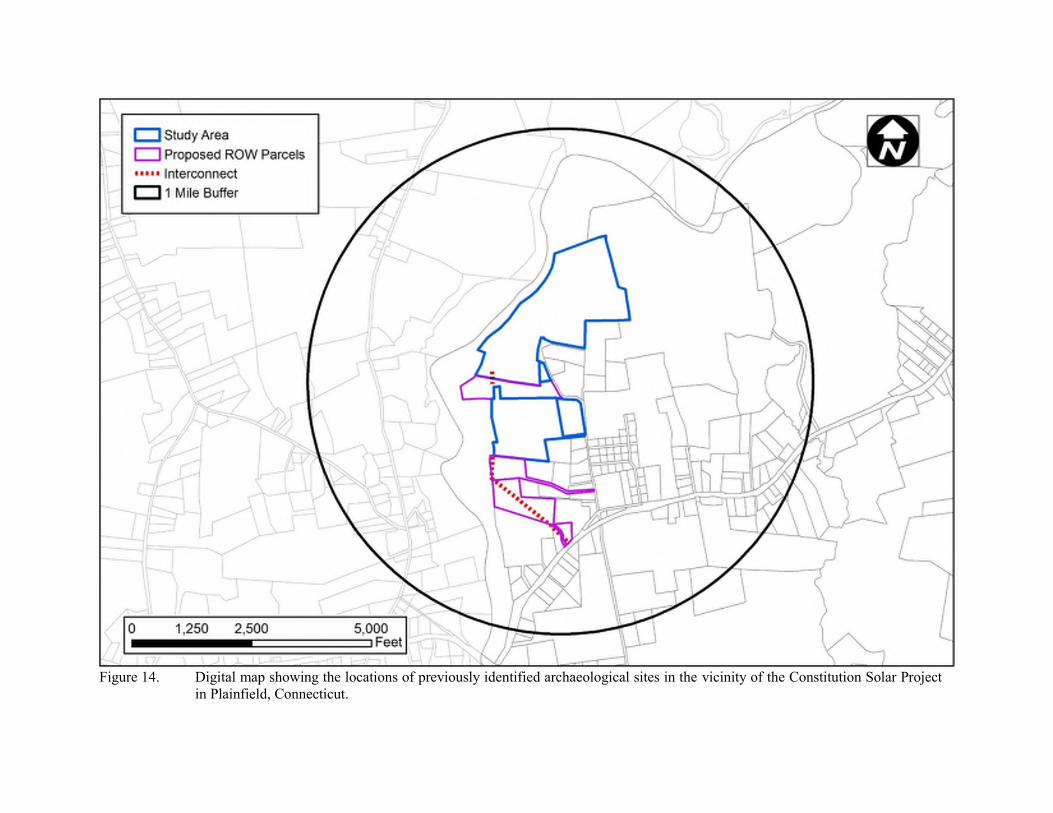
Figure 14. Digital map showing the locations of previously identified archaeological sites in the vicinity of the Constitution Solar Project
in Plainfield, Connecticut.

Figure 15. Digital map showing the locations of previously recorded National Register of Historic Places properties in the vicinity of the
Constitution Solar Project in Plainfield, Connecticut.

Figure 16. Digital map showing the locations of previously identified State Register of Historic Places properties in the vicinity of the
Constitution Solar Project in Plainfield, Connecticut.

Figure 17. Digital map showing the locations of previously identified historic standing structures in the vicinity of the Constitution Solar Project in Plainfield, Connecticut.

Figure 18. Overview photo of 44 North Canterbury Road in Canterbury, Connecticut.
Figure 19. Overview photo of the Cleaveland Cemetery along North Canterbury Road in Canterbury, Connecticut.

Figure 20. Overview photo of “The Pillars” at 65 North Canterbury Road in Canterbury, Connecticut.
Figure 21. Overview photo of 71 North Canterbury Road in Canterbury, Connecticut.

Figure 22. Overview photo of 74 North Canterbury Road in Canterbury, Connecticut.
Figure 23. Overview photo of the Finnish Hall at 76 North Canterbury Road in Canterbury, Connecticut.

Figure 24. Overview photo of 138 North Canterbury Road in Canterbury, Connecticut.
Figure 25. Overview photo of 169 North Canterbury Road in Canterbury, Connecticut.

Figure 26. Overview photo of 183 North Canterbury Road in Canterbury, Connecticut.

Figure 27. Digital map showing the various soil types associated with the Constitution Solar Project in Plainfield, Connecticut.

Figure 28. Digital map showing the locations of no/low and moderate/high archaeologically sensitive areas associated with the Constitution Solar Project in Plainfield, Connecticut.

Photo 1. Overview photo of the northern portion of the Northern Parcel facing west.
Photo 2. Overview photo of the north-central portion of the Northern Parcel facing northeast.

Photo 3. Overview photo of the central portion of the Northern Parcel facing southeast (note slopes in this area).
Photo 4. Overview photo of the southern portion of the Northern Parcel facing southwest.

Photo 5. Overview photo of the southwestern portion of the Northern Parcel facing northwest.
Photo 6. Overview photo of unusual stonewall in the eastern portion of the Northern Parcel facing east (note late upright stone with “U” shape hand carved on the tops).

Photo 7. Overview photo of unusual stonewall in the eastern portion of the Northern Parcel facing east (note late upright stone with “U” shape hand carved on the tops).
Photo 8. Overview photo of the northern portion of the Southern Parcel facing south (note this parcel was wet and stony).

Photo 9. Overview photo of the central portion of the Southern Parcel facing south (note this parcel was wet and stony).
Photo 10. Overview photo of the southern portion of the Southern Parcel facing east (note there is a large wetland in the background of the photo behind the stonewall pictures).

Photo 11. Overview photo of the southeastern portion of the Southern Parcel facing south (note slopes in this area).
Photo 12. Overview photo of the easternmost portion of the Southern Parcel facing west.

Photo 14. Overview photo of the southern end of the proposed Interconnection facing southwest (note this area has been disturbed and paved).
Photo 13. Overview photo of the easternmost portion of the Southern Parcel facing north.

Photo 15. Overview photo of the central portion of the proposed Interconnection facing southwest (note this area has been disturbed and paved).
Photo 16. Overview photo of the central portion of the proposed Interconnection facing southwest (note this area has been disturbed and paved).

SHPO CONCURRENCE LETTER FOR PHASE 1A
SURVEY


HERITAGE SCOPE OF WORK - PHASE II
TESTING

55 East Cedar Street, Newington, Connecticut
Phone (860) 299-6328
Email: [email protected]
SCOPE OF WORK FOR PHASE II NATIONAL REGISTER OF HISTORIC PLACES TESTING AND EVALUATION OF
ARCHAEOLOGICAL DEPOSITS WITHIN AREA 4 OF THE PROPOSED CONSTITUTION SOLAR PROJECT IN PLAINFIELD, CONNECTICUT
Heritage Consultants, LLC, (Heritage) is pleased to submit this Scope of Work for Phase II National Register of Historic Places testing and evaluation of Area 4 of the proposed Constitution Solar Project in Plainfield, Connecticut. This area was surveyed as part of the larger solar project and it was found to contain several areas where prehistoric artifacts were located, as well as 11 shovel test locations that provided either cultural features or soil anomalies that may be cultural in origin. As a result, Area 4 was determined to contain areas of archaeological deposits that may eligible for listing to the National Register of Historic Places criteria for evaluation (36 CFR 60.4 [a-d]). Since these areas likely will be impacted by the proposed solar center construction, Phase II National Register testing and evaluation area is recommended. This Scope of Work provides a review of the field and laboratory methodologies that will be utilized to complete the proposed Phase II testing and evaluation effort. Phase II National Register Testing and Evaluation of Area 4 Phase II testing and evaluation of the archaeological deposits situated within Area 4 will be designed to determine whether they possess the qualities of significance as defined by the National Register criteria (36 CFR 60.4 [a-d]). More specifically, these investigations will be designed to: 1) define more clearly the boundaries of the archaeological deposits within Area 4; 2) document whether intact subsurface cultural deposits and features exist in the area; 3) identify and describe the horizontal and vertical distribution of artifacts and cultural components within Area 4; 4) recover a sample of temporally diagnostic artifacts to permit an accurate characterization of the cultural components contained within Area 4; 5) characterize and define the nature of the cultural deposits identified and incorporate this information into existing regional chronologies; 6) examine the formation processes responsible for the development of the archaeological deposits; and 7) assess the overall research potential of the archaeological deposits applying the above-referenced criteria for evaluation. The following sections described the field and laboratory methods, as well as reporting procedures, that will be employed during the proposed undertaking. Site Mapping Prior to initiating Phase II National Register of Historic Places testing and evaluation of the archaeological deposits within Area 4, a permanent project datum, labeled with the coordinates N0 E0, will be positioned within the area. All subsequent coordinates, i.e., shovel tests and units will be provided with north and east prefixes relative to those datum locations. This control grid also will provide the x and y coordinates for all specific measurements, e.g., point proveniences for temporally diagnostic artifacts collected from the area and elevations taken during the mapping phase of the investigation. Finally, all shovel tests excavated during the previously completed Phase IB survey also will be tied to the control grid.

55 East Cedar Street, Newington, Connecticut
Phone (860) 299-6328 Email: [email protected]
Shovel Testing Heritage employed a rigorous subsurface testing regime during the previous Phase IB survey of Area 4, with shovel tests spaced at 15 m (49.2 ft) intervals along survey transects spaced 15 m (49.2 ft) apart. In order to better delineate both the horizontal and vertical boundaries of archaeological deposits that may exist in this area, additional shovel testing will be conducted at 7.5 m (25 ft) intervals in the cardinal directions around each previously excavated Phase IB shovel test that provided cultural material and/or evidence of cultural features or soil anomalies that may represent cultural features. Each Phase II shovel test will measure approximately 50 x 50 cm (20 x 20 in) in size, and each will be excavated until glacially derived C-Horizon soils or immovable objects (e.g., large rocks, tree roots) are encountered. Each shovel test will be excavated in 10 cm (4 in) artificial levels within natural strata, and the fill from each level will be screened separately. All shovel test fill will be passed through 0.64 cm (0.25 in) hardware cloth. Munsell Soil Color Charts will be used to record soil color; texture and other identifiable characteristics also will be recorded using existing standard soils nomenclature. All shovel tests will be backfilled immediately upon completion of the archaeological recordation process. After completion of the shovel testing effort, artifact density maps will be generated using the Golden Software SurferTM program. These maps will be used to guide the placement of subsequent unit excavations. Unit Excavation Phase II testing and evaluation of Area 4 also will include the excavation up to 25 test units; this may encompass 25 single 1 x 1 m (3.3 x 3.3 ft) units or a combination of 1 x 1 m (3.3 x 3.3 ft), 1 x 2 m (3.3 x 6.6 ft), or 2 x 2 m (6.6 x 6.6 ft) units. The types of units excavated will be commensurate with the nature of the archaeological deposits contained in Area 4 and the need for aerial exposures of various sizes to determine the horizontal limits of cultural features identified during excavation. The unit excavations also will be designed to sample either previously identified or newly perceived artifact concentrations within the area. The locations of the unit will be based on the results of the previously completed Phase IB survey, the analysis resulting from the use of the SurferTM program referenced above, and the results of the Phase II excavations as they unfold in real time. All unit excavation will be conducted by hand and each unit will be excavated in 10 cm (4 in) arbitrary levels within natural strata, and the fill from each level will be screened separately. The unit excavations will be tied to the control grid and labeled with the appropriate provenience information (e.g., N50, E50). Excavations will extend to until the glacially derived C-Horizon is encountered. All generally excavated soils will be screened through 0.64 cm (0.25 in) hardware cloth, while feature matrix that is not saved for flotation analysis (see below) will be screened through 0.32 cm (0.13 in) mesh for the recovery of small artifacts, charcoal, and faunal/archaeobotanical remains. Munsell Soil Color Charts will be used to record soil color; soil texture and other identifiable characteristics also will be recorded using standard soils nomenclature. Finally, stratigraphic profiles for at least two walls of each excavation unit will be prepared and photographed. In addition, standard volumetric soil samples will be taken from all exposed cultural features for flotation analysis. For large cultural features (e.g., large pits, hearths, middens), 5 liters of soil will be collected per feature; when smaller than 5 liters in volume (e.g., postmolds, small pits, caches), the contents of entire feature will be collected. Handling of the soils samples in the laboratory will involve flotation of the collected matrices in an attempt to collect archaeological remains that otherwise might not be seen during hand excavation of during screening of soils in the field (see below).

55 East Cedar Street, Newington, Connecticut
Phone (860) 299-6328 Email: [email protected]
Laboratory Analysis The laboratory analysis of recovered cultural material collected during the Phase II National Register of Historic Places testing and evaluation of archeological deposits in Area 4 will follow established archaeological protocols. All field specimen bag proveniences first will be crosschecked against the field notes and the specimen inventories for accuracy and completeness. Following this quality-control process, all recovered material will be washed by hand, air-dried, and sorted into basic material categories. The nature and structure of the laboratory analysis will be determined by the goals of the project as enumerated above. In general, the artifact analysis will consist of making and recording a series of observations for each specimen. The observations will be chosen to provide the most significant and temporally/functionally diagnostic information about each specimen. Separate databases may be employed to store, organize, and manipulate the data generated by the analytical process. Separate databases will be used for the analysis of the recovered historic cultural material, prehistoric lithic objects, prehistoric ceramic artifacts, faunal specimens and/or archaeobotanical remains. The different databases will reflect the differences in the analytical protocols used to study the types of materials. Prehistoric Lithic Analysis The lithic analysis protocol used in this project will be a “technological” or “functional” one designed to identify prehistoric reduction trajectories, lithic industries, and tool functions. The protocol therefore will focus on recording technological characteristics of the recovered lithic artifacts. The lithic artifact database will be organized by lithic material group, type, and subtype. The first level will describe the raw material type of the artifact. Lithic materials will be identified utilizing recognized geological descriptions and terminology, and with the use of type specimens of known source. Lithic raw materials will be divided into distinct categories based on three factors: texture, color, and translucence. The second analysis level, type, will be used to define the general class, e.g., unmodified flake, core, or preform, of lithic artifact, while the last level, subtype, will be employed to specify morphological attributes, e.g., primary cortex, extensively reduced, or corner-notched. Typological identifications for temporally and regionally diagnostic tools also will be included in the analysis. Such identifications will be made by reference to established lithic artifact typologies. Prehistoric Ceramic Analysis The prehistoric ceramic taxonomy will be organized by type, surface decoration, aplastic inclusions, and vessel portion. The database will be designed to allow the analyst to record established ceramic types, as well as ceramic modes and attributes. The first level, type, will represent the established named ceramic types according to published sources. Decoration will be used to describe the basic type of surface decoration present on the sherd, e.g., plain, brushed, engraved, ridged, or incised. The aplastic inclusion category will list the principal temper types observed in the paste of each sherd. Aplastic inclusion combinations, e.g., sand/grit, will be used to denote only the presence of those inclusions, not the numerical predominance of one over the other. The vessel portion column will list the portion of the ceramic vessel from which the sherd was derived. Possible values in this field will include body, rim, base, neck/collar, and so forth. The “additional description” column of the database will be used to record other observations. Flotation Techniques Each soil sample first will be weighed and then recorded in a Feature Log, which will include Sample Number, Locus Designation, Feature Number, Provenience, Weight, Collection Procedures, Collector, and Date Collected, as well as any other pertinent information. Once that basic data is collected, the sample will be subjected to flotation, using the following technique. The soil sample will be placed in a

55 East Cedar Street, Newington, Connecticut
Phone (860) 299-6328 Email: [email protected]
large water basin filled with clean water. It will be then be carefully agitated to release all small items that may float, including charcoal fragments, pieces of bone, charred seeds, etc. This material will be skimmed from the top of the water, placed on a tray to dry at room temperate and labeled as “light fraction.” Once the light fraction is removed from the sample, the basin will be emptied of water and the contents of the soil sample that settled on the bottom of the basin. The basin contents will be drained through a series of fine geological sieves and the material caught in the sieves will be collected, placed on a tray to dry at room temperature, and labeled as “heavy fraction.” Both the light and heavy fractions then will be examined for small artifacts, bone fragments, and plant remains, which will be collected for further analysis. Once the light and heavy fractions have been “picked” and it is determined that no additional archaeological materials remain in them, they will be discarded. The procedures for analysis of the archaeological materials recovered from flotation of the soils samples is discussed below. Faunal Specimens All faunal specimens recovered from secure cultural feature contexts will be identified to the lowest taxon possible following standard zoological classification and nomenclature. The same will be true of faunal specimens recovered during flotation of soils samples collected from cultural features. For each identified specimen, a record will be made of the element represented, portion of element recovered (e.g., proximal, distal, and/or shaft), its symmetry (right or left), any evidence of modification (burning, gnawing, cutting, and/or polishing), and its weight. Quantification of the faunal materials will include counts of the total numbers of identified specimens of each taxon (NISP), as well as the weights of the identified specimens. Archaeobotanical Specimens As mentioned above, 5-liter volumetric samples will be taken from identified cultural features and they will be subjected to flotation and then sorted into light and heavy fractions from which plant remains will be collected and analyzed. During analysis, carbonized plant remains will be size-sorted using a 2 mm geological sieve. Uncarbonized, modern plant debris will be removed after sieving, set aside, and not analyzed further since they will likely represent modern intrusions in to the samples. In contrast, the carbonized plant material measuring 2 mm in size or larger will be sorted, counted, and weighed by material class. Archaeobotanical specimens that pass through the 2 mm sieve (the residual fraction) will be scanned for seeds and other plant parts lacking in the large sized fraction. Detailed taxonomic analyses will be conducted of all nutshell and shell fragments, as well as all carbonized seeds and seed fragments. Taxonomic identification and analysis of archaeobotanical specimens will be conducted using standard seed and nut identification manuals, and, where available, voucher specimens maintained at the archaeological laboratory of Heritage Consultants, LLC. Radiocarbon Dating It is anticipated that radiocarbon samples collected during the Phase II National Register of Historic Places testing and evaluation effort conducted within the confines of Area 4 will be assayed. Samples will be selected that are associated with prehistoric features or buried occupational surfaces. Heritage Consultant, LLC sends all recovered radiocarbon samples for processing to Beta Analytic Inc. 4985 SW 74th Court, Miami, Florida 33155. Curation Upon completion of the undertaking, all project materials, including notes, maps, artifacts, drawings, and photographs will be curated with:

55 East Cedar Street, Newington, Connecticut
Phone (860) 299-6328 Email: [email protected]
Dr. Brian Jones State Archaeologist Office of Connecticut State Archaeology
Box U-1023 University of Connecticut Storrs, Connecticut 06269
Report Writing and Production Once the laboratory analysis has been completed, a report that summarizes the results of the Phase II National Register of Historic Places testing and evaluation of archeological deposits in Area 4 will be prepared. The report of Investigations will include a description of the proposed project; a discussion of the local geology and the environment within the vicinity of the locus area; an overview of the regional prehistory and previous archaeological investigations completed in the vicinity; descriptions of the field and laboratory methods utilized to complete the investigation; a discussion of the results of the fieldwork; artifact descriptions and analyses; a determination of the significance of archeological deposits in Area 4 applying the National Register of Historic Places criteria for evaluation (36 CFR 60.4 [a-d]); a discussion of project impacts; and recommendations for future treatment, if appropriate. Heritage will provide Tighe & Bond with a PDF copy of the Report of Investigations and, after review and comment, will supply two hard copies submission to the Connecticut State Historic Preservation Office for review.

SHPO CONCURRENCE LETTER FOR PHASE 1B
CULTURAL RESOURCES SURVEY


HERITAGE PHASE 1B CULTURAL RESOURCES
RECONNAISSANCE SURVEY AND PHASE II
NATIONAL REGISTER OF HISTORIC PLACES
TESTING AND EVALUATION
(FILED UNDER PROTECTIVE ORDER)