CONSERVATION OF SAN JOAQUIN KIT FOXES IN WESTERN MERCED COUNTY, CALIFORNIA
60
CONSERVATION OF SAN JOAQUIN KIT FOXES IN WESTERN MERCED COUNTY, CALIFORNIA PREPARED FOR THE U.S. BUREAU OF RECLAMATION SOUTH-CENTRAL CALIFORNIA AREA OFFICE 1243 N STREET, FRESNO, CA 93721 Prepared by: Julie L. Constable, Brian L. Cypher, Scott E. Phillips, Patrick A. Kelly California State University, Stanislaus Endangered Species Recovery Program 1900 N. Gateway #101 Fresno, CA 93727 May 13, 2009 esrp_2009_wmercedkitfox.doc
-
Upload
independent -
Category
Documents
-
view
0 -
download
0
Transcript of CONSERVATION OF SAN JOAQUIN KIT FOXES IN WESTERN MERCED COUNTY, CALIFORNIA

CONSERVATION OF SAN JOAQUIN KIT FOXES IN WESTERN MERCED COUNTY, CALIFORNIA
PREPARED FOR THE U.S. BUREAU OF RECLAMATION SOUTH-CENTRAL CALIFORNIA AREA OFFICE 1243 N STREET, FRESNO, CA 93721
Prepared by: Julie L. Constable, Brian L. Cypher, Scott E. Phillips, Patrick A. Kelly
California State University, Stanislaus
Endangered Species Recovery Program 1900 N. Gateway #101
Fresno, CA 93727
May 13, 2009
esrp_2009_wmercedkitfox.doc

CONSERVATION OF SAN JOAQUIN KIT FOXES IN WESTERN MERCED COUNTY, CALIFORNIA
TABLE OF CONTENTS
Table of Contents ............................................................................................................... i
Introduction....................................................................................................................... 1 Study Area ................................................................................................................................................. 3
Methods.............................................................................................................................. 5 Kit Fox Population Assessments ............................................................................................................... 5
Camera Stations .................................................................................................................................... 5 Track Stations ....................................................................................................................................... 6 Spotlight Surveys .................................................................................................................................. 8 Opportunistic Observations................................................................................................................... 9
Explanatory Variables ............................................................................................................................... 9 Competitors........................................................................................................................................... 9 Prey Abundance .................................................................................................................................... 9 Habitat Suitability ............................................................................................................................... 12
Corridor Analysis .................................................................................................................................... 13 Results .............................................................................................................................. 15
Kit Fox Population Assessments ............................................................................................................. 15 Camera Stations .................................................................................................................................. 15 Track Stations ..................................................................................................................................... 16 Spotlight Surveys ................................................................................................................................ 17 Opportunistic Observations................................................................................................................. 18
Explanatory Variables ............................................................................................................................. 20 Competitors......................................................................................................................................... 20 Prey Abundance .................................................................................................................................. 21 Habitat Suitability ............................................................................................................................... 23
Corridor Analysis .................................................................................................................................... 23 Comparative Corridor Quality ............................................................................................................ 31
Discussion......................................................................................................................... 33 Regional Kit Fox Distribution and Abundance ....................................................................................... 33 Explanatory Variables ............................................................................................................................. 36
Competitors......................................................................................................................................... 36 Prey Abundance .................................................................................................................................. 37 Habitat suitability................................................................................................................................ 38
Regional Corridors .................................................................................................................................. 38 Conclusions and Recommendations.............................................................................. 39
Regional Kit Fox Conservation ............................................................................................................... 41 Northward Connectivity .......................................................................................................................... 43
Literature Cited .............................................................................................................. 45
Appendix A. Camera Station Locations for Detection of San Joaquin Kit Foxes and Competitors ..................................................................................................................... 49
Appendix B. Camera Station Photographs ................................................................... 1
i

TABLE OF TABLES Table 1. Number of images of each taxonomic group collected at camera stations in the Santa Nella area,
California during April 2005-August 2007. ........................................................................................ 16 Table 2. Number of occurrences of tracks by taxonomic group at track stations in the Santa Nella area,
California during April 2005-August 2007. ........................................................................................ 18 Table 3. Detections of coyotes during surveys conducted in 4 areas of the western San Joaquin Valley,
California during April 2005-August 2007. ........................................................................................ 20 Table 4. Detections of red foxes during surveys conducted in 4 areas of the western San Joaquin Valley,
California during April 2005-August 2007. ........................................................................................ 21 Table 5. Total detections (non-standardized) of potential kit fox competitors other than coyotes or red
foxes during camera station, track station, and spotlight surveys conducted in 4 areas of the western San Joaquin Valley, California during April 2005-August 2007. ....................................................... 21
Table 6. Small rodents captured on 5 areas in the western San Joaquin Valley, California during March-April 2007. Trapping effort consisted of 150 trap-nights on each area.............................................. 22
Table 7. Counts of ground squirrels on 5 areas in the western San Joaquin Valley, California during March-April 2007. .............................................................................................................................. 22
Table 8. Least-cost path routes for kit foxes through the Santa Nella area (between different origin locations and the Simon-Newman Ranch area) and though part of western Kern County. ................ 31
Table 9. Summary of kit fox detections during surveys conducted in 4 areas of the western San Joaquin Valley, California during April 2005-August 2007. ........................................................................... 34
Table 10. Kit fox occurrences in the northern range (from Santa Nella in Merced County northward) verified with physical evidence (e.g., carcass, live-capture, genetically-verified scat)....................... 35
LIST OF FIGURES Figure 1. Region of interest for kit fox population assessment and conservation in western Merced County,
California. ............................................................................................................................................. 4 Figure 2. Locations of camera stations, track stations, and prey trapping in the Santa Nella area, California.
.............................................................................................................................................................. 7 Figure 3. Routes used for spotlighting surveys in the Santa Nella area, California..................................... 10 Figure 4. Aerial survey of the Santa Nella area, western Merced County, California................................. 11 Figure 5. Habitat suitability model implemented in ArcGIS ModelBuilder................................................ 12 Figure 6. Least cost path and corridor model implemented in ArcGIS ModelBuilder. ............................... 14 Figure 7. Tracks of kit fox, coyote, raccoon, and striped skunk observed on track stations........................ 17 Figure 8. Locations of kit foxes observed during spotlight surveys and locations of road-killed kit foxes in
the Santa Nella area, California during April 2005-August 2007. ...................................................... 19 Figure 9. Photo of kit fox defecating on track station, Lokern area, Kern County, CA. ............................. 20 Figure 10. Areas of high and medium habitat suitability between the Panoche Valley area and the Simon-
Newman Ranch area. .......................................................................................................................... 24 Figure 11. Least-cost path and corridor from the Little Panoche Creek area to the Simon-Newman Ranch
area...................................................................................................................................................... 25 Figure 12. Least-cost path and corridor from the Los Banos Valley area to the Simon-Newman Ranch area.
............................................................................................................................................................ 26 Figure 13. Least-cost path and corridor from the Salt Creek area south of Los Banos Reservoir to the
Simon-Newman Ranch area................................................................................................................ 27 Figure 14. Least-cost path and corridor from the Aqua Fria area to the Simon-Newman Ranch area. ....... 28 Figure 15. Least-cost path route west of Santa Nella crossing at Highway 152 bridge............................... 29 Figure 16. Undercrossing (under label “Hwy. 152”) of Highway 152 bridge at O’Neil Forebay, Santa
Nella, California.................................................................................................................................. 29 Figure 17. Least-cost path route east of Santa Nella crossing freeways and canals. ................................... 30 Figure 18. California Aqueduct right of way east of Highway 33, Santa Nella, California. ....................... 30 Figure 19. Highway 33 bridge over the California Aqueduct, Santa Nella, California. .............................. 31 Figure 20. Least-cost path and corridor between two locations in the Buena Vista Valley and Lokern areas
of western Kern County, California. ................................................................................................... 32
ii

EXECUTIVE SUMMARY
San Joaquin kit foxes (Vulpes macrotis mutica) are endemic to the San Joaquin Valley in central California where they are threatened by continuing loss, degradation, and fragmentation of their habitat. North of Kern County, kit foxes primarily persist in a narrow band of habitat extending northward along the west side of the San Joaquin Valley. This linkage is vulnerable due to its relatively narrow width, and any obstructions would impede connectivity and further fragment the kit fox metapopulation.
In western Merced County, connectivity is already impeded by various water bodies, canals, major roads, and urban development. Extensive new urban development has been proposed in the vicinity of the town of Santa Nella. From April 2005 to August 2007, we conducted an investigation in this area to gather information for the development of a regional conservation strategies for kit foxes. Our specific objectives were to (1) assess the status of kit foxes in the area, (2) identify potential movement corridors, (3) identify opportunities for habitat enhancement, and (4) draft a strategic framework to guide kit fox conservation efforts. These objectives later were expanded to include assessments over a larger region, the verification of survey methodologies, and the collection of information to help explain observed patterns of kit fox distribution and abundance.
Kit fox distribution and abundance were assessed using automated camera stations, track stations, spotlight surveys, and opportunistic observations. We also collected information on competitor abundance, prey availability, and habitat suitability. Furthermore, we used least cost path modeling to identify potential movement corridors based on existing landscape features. The primary area of interest extended from the Panoche Valley just outside the southwestern boundary of Merced County northward to the Simon-Newman Ranch in northwestern Merced County. Additional surveys for kit foxes were conducted in the Lokern Natural Area in Kern County, which is within a core area for kit foxes, to verify the efficacy of survey methodologies.
Our results indicated that a persistent but low density kit fox population appears to be present on lands just south of Santa Nella from about the Agua Fria conservation lands south to Little Panoche Road. This population may receive augmentation from the Panoche Valley kit fox population just to the south. North of Santa Nella, evidence indicates that kit foxes may only be intermittently present and may largely consist of dispersing individuals from further south. No evidence indicated that competitors significantly influence kit fox distribution and abundance, although the competitor community is diverse in the Santa Nella area. Prey availability may be influencing kit fox distribution and abundance, particularly the availability of kangaroo rats, a preferred food for kit foxes. Kangaroo rat abundance exhibited a declining trend from south to north in this region. Furthermore, habitat suitability (based on land use, vegetation cover, and terrain ruggedness) also exhibited a declining trend from south to north in this region. Finally, three potential movement corridors through the Santa Nella area were identified through modeling. However, a number of significant impediments to kit fox movements already exist in this area and all three corridors primarily traversed habitat of low suitability. Therefore, the identified corridors may be suboptimal at best.
Based on the results above in conjunction with historical data, the viability and even the presence of kit fox populations north of Santa Nella appears questionable. Indeed, given
iii

current habitat conditions, the possibility that this region may function as a population sink for kit foxes warrants consideration. Although the kit fox population south of Santa Nella appears persistent, its long-term viability is tenuous due to apparent low density, suboptimal habitat conditions, rodenticide use, and potential for habitat loss to future urban developments. Conserving this population likely is critical to maintaining kit foxes in the region. Based on these conclusions, the following recommendations are offered:
1. Assign high priority to the conservation of habitat south of Santa Nella.
2. Maintain corridors between this habitat and the Panoche Valley region.
3. Manage and enhance this habitat to increase suitability for kit foxes.
4. Vigorously enforce restrictions on rodenticide use in this habitat.
5. Implement outreach programs to facilitate kit fox conservation.
6. Conduct kit fox population monitoring in this area.
7. Conduct demographic and ecological studies on kit foxes in this area.
8. Monitor competitor abundance.
Based on our results and conclusions, the maintenance and/or establishment of corridors north through Santa Nella may not warrant high priority for regional kit fox conservation. However, we recognize the limitations of our data and the fact that non-biological considerations (e.g., regulatory, socio-political, economic) may argue for such corridors. Thus, recommendations are also provided for corridor establishment and maintenance through this region.
ACKNOWLEDGMENTS
Funding for this project was provided by the U.S. Bureau of Reclamation, South-Central California Area Office. We particularly appreciate support provided over the years by Rosalie Faubion and Michael Kinsey at Reclamation. Field assistance was provided by Foung Vang, Krista Tomlinson, Colin Wilkinson, Patrick Morrison, and Craig Fiehler. The Conservation Genetics Laboratory at the Smithsonian Institution assisted with genetic analysis of fecal samples. We also greatly appreciate assistance provided by Ellen Berryman (Berryman Ecological), Scott Larson (ESR Inc.), Tony Whitehurst (Independent Consultant) and Joanne Karlton (California Department of Parks and Recreation). Many thanks to landowners and ranchers that allowed us access to their properties, including Donn Campion of Agua Fria, John Souza at Quinto Farms, Troy Hulsey and Ralph Bennett at the San Joaquin Valley National Cemetery, Walt Whitacker at Simon-Newman Ranch, Larry Serpa of the Nature Conservancy, Brian Vail of Bonturi Ranch, and Charlie and Jimmy McCullough of the Panoche Valley. Also thanks to the employees of DWR for access to locked gates and the Reservoir, including Pam Borba, James Ainslie, Mandeep Bling, Karen Dulik, Dennis Gruly, Jim Thomas, and Tom Young.
iv

Conservation of San Joaquin Kit Foxes in Western Merced County, California
INTRODUCTION
The San Joaquin kit fox (Vulpes macrotis mutica), endemic to the San Joaquin Valley of California, was once abundant in semi-arid alkali scrub habitat and low foothill grasslands from Tracy (San Joaquin County) and La Grange (Stanislaus County) in the northern end of the valley to Kern County at the southern end of the valley (U.S. Fish and Wildlife Service 1998). Occasional sightings have even been reported as far north as the Black Diamond Mines Regional Preserve in Contra Costa County (Bell 1994). The former range of the San Joaquin kit fox has been significantly impacted as almost 95% of its original habitat has been converted to irrigated agriculture, industrial, or urban land uses. As a result, San Joaquin kit fox population numbers have declined. Indeed, over 70 years ago, Grinnell et al. (1937) concluded that the fox’s range had already been reduced to remaining suitable habitat in the southern and western portions of the San Joaquin Valley. Consequently, in 1967, the San Joaquin kit fox was listed as Endangered under the federal Endangered Species Act. In 1971, it was listed as Rare under the California Endangered Species Act, with the status changing to Threatened in 1982 (U.S. Fish and Wildlife Service 1998).
Currently, north of Kern County, San Joaquin kit foxes primarily occur in a narrow, north-south band of habitat bounded by Interstate 5 on the east and the Coast Ranges on the West. Habitat losses from developments within this band threaten to block kit fox movements, fragment the population, and restrict gene flow. These impacts would markedly elevate the risk of local extinctions. Any kit fox populations in the extreme northern portion of the range would be at particular risk as these populations likely rely on dispersers from further south to augment numbers and maintain genetic viability (U.S. Fish and Wildlife Service 1998).
Particular concern has arisen over the Santa Nella area in western Merced County. Existing and planned developments in this area already impede and threaten to completely block kit fox movements. Obstacles to kit fox movement include major roads, canals, water bodies, and numerous current and planned urban developments. Conservation of adequate movement corridors will be important for maintaining connectivity for kit foxes through this region. In some instances, existing corridors might be enhanced to encourage and facilitate kit fox movements.
In 2005, a project was initiated to identify important movement corridors for kit foxes in Western Merced County, and to draft a conservation strategy for kit foxes. The original goals of this project were to:
1. Assess the status of kit foxes in the western Merced County region. 2. Identify actual as well as potential movement corridors for kit foxes. 3. Identify public and private properties where the implementation of
enhancement strategies might encourage or facilitate use by kit foxes. 4. Draft a strategic framework to guide kit fox conservation efforts in the Santa
Nella region.
1

Conservation of San Joaquin Kit Foxes in Western Merced County, California
After approximately 1 year of extensive monitoring, no kit foxes had been detected in the target area. Thus, the project was modified by adding several tasks designed to learn more about the regional kit fox population and to provide information to help explain patterns of observed kit fox abundance. These tasks included:
1. Expanded study area Survey efforts were expanded further north and south from the Santa Nella area. To the south, efforts were extended down to the Panoche Valley. A persistent kit fox population occurs in the Panoche Valley area and potentially is the source of animals moving northward through the Santa Nella area (Bell et al. 1996). To the north, efforts were extended to the Simon-Newman Ranch near Gustine. This ranch is an extensive conservation area managed by The Nature Conservancy.
2. Method verification and area comparison To ensure that survey methods employed in the Santa Nella area were indeed effective in detecting kit foxes, identical methodologies were conducted in the Lokern Natural Area in Kern County. The Lokern Natural Area is within one of three core habitat areas for kit foxes (U.S. Fish and Wildlife Service 1998), and kit fox abundance was known to be high based on concurrent research activities in this area. Results from the Lokern area were used to verify the efficacy of techniques and to provide a comparison for results from the Santa Nella area.
3. Explanatory variables In an effort to explain observed results, particularly the dearth of kit foxes in the Santa Nella area, information was gathered on other variables that might affect kit fox abundance. These variables included competitor abundance, prey abundance, and habitat suitability.
This project was initiated and funded by the U.S. Bureau of Reclamation (Reclamation) in partial fulfillment of obligations incurred by Reclamation under the Endangered Species Act. Thus, Reclamation sponsored this effort to gather information on kit foxes and to develop regional conservation strategies.
This project contributes to at least 5 recovery tasks identified in the Recovery Plan for Upland Species in the San Joaquin Valley, California (U.S. Fish and Wildlife Service 1998):
2.1.19 – Conserve large blocks of habitat for kit foxes in the northwestern portion of the range.
3.2.27 – Conduct surveys and population censuses for kit foxes in the northwestern portion of the range and the northwestern Valley edge.
4.44 – Conduct censuses and population monitoring for kit foxes in the northwestern portion of the range, Valley fringes on the eastern and northwestern sides (Contra Costa, alameda, San Joaquin, Stanislaus, Merced, Fresno, Kings, Kern, and Tulare Counties).
2

Conservation of San Joaquin Kit Foxes in Western Merced County, California
5.3.2 – Conserve linkage areas along the northwest Valley edge down to Santa Nella (San Joaquin, Stanislaus, and Merced Counties).
5.3.4 – Conserve linkage areas along the western Valley edge from Santa Nella to Panoche Creek (Merced and Fresno Counties).
STUDY AREA The area of interest for this project initially encompassed a broad region in western Merced County that was centered on the town of Santa Nella, California and generally delineated by the Los Banos Reservoir on the south, the San Joaquin National Cemetery on the north, the San Luis Reservoir on the west, and Interstate 5 on the east (Figure 1). The area of interest was expanded significantly mid-project to include lands north to the Simon-Newman Ranch (ca. 15 km north of Santa Nella) and lands south to the Panoche Valley (ca. 50 km south of Santa Nella).
Primary habitat types within this broad region include alkali desert scrub habitat dominated by desert saltbush (Atriplex polycarpa) and red brome (Bromus madritensis), annual grassland dominated by wild oats (Avena spp.), and oak woodland-savannah dominated by blue oak (Quercus douglasii) and non-native grasses. Annual precipitation within this region generally averages less than 25 cm and falls primarily as rain between November and March.
Within the area of interest, lands are primarily privately owned. Public lands include: U.S. Bureau of Land Management lands in the Panoche Valley area and Ciervo-Panoche Hills; lands administered by the California Department of Fish and Game including the Cottonwood Creek Wildlife Area, O’Neill Forebay Wildlife Area, Little Panoche Reservoir Wildlife Area, and Panoche Hills Ecological Reserve; San Luis Reservoir State Recreation Area administered by the California Department of Parks and Recreation; the California Aqueduct-San Luis Canal jointly administered by the California Department of Water Resources and the U.S. Bureau of Reclamation; and the Delta-Mendota Canal administered by the U.S. Bureau of Reclamation. Conservation of kit foxes and other species is an objective of varying priority on all of these public lands.
Other lands on which conservation is a primary objective include the Romero and Simon-Newman Ranches administered by The Nature Conservancy and the Jasper-Sears Mitigation Area administered by the California Department of Fish and Game. There also are a number of private lands in the region on which conservation easements have been established or are proposed.
Land uses within this region are extremely varied and include grazing, dry-land and irrigated agriculture, sand and gravel mining, water storage and conveyance, light industry, commercial and residential areas, and outdoor recreation. Major highways in the area of interest include Interstate 5, State Route 152, and State Route 33. Major water bodies include the San Luis Reservoir, O’Neill Forebay, Los Banos Reservoir, and Little Panoche Reservoir. Major canals located in this area include the California Aqueduct-San Luis Canal, Delta -Mendota Canal, and San Luis Wasteway.
3

Conservation of San Joaquin Kit Foxes in Western Merced County, California
Figure 1. Region of interest for kit fox population assessment and conservation in
western Merced County, California.
The unincorporated community of Santa Nella (population ca. 2000; Merced County 2008) consists primarily of businesses and residences at the State Route 33 interchange for Interstate 5. A number of large residential developments have been proposed for this area because of the accessibility to Interstate 5 and State Route 152 and due to its relative
4

Conservation of San Joaquin Kit Foxes in Western Merced County, California
proximity to the San Jose area. Construction has been initiated for some developments while most are still in the planning or project approval stages.
In an effort to verify the efficacy of field techniques and provide a baseline to facilitate the interpretation of results from western Merced County, comparative work was conducted in the Lokern Natural Area in Kern County, which is considered to be a “core” habitat area for San Joaquin kit foxes (U.S. Fish and Wildlife Service 1998). Kit fox abundance is high in this area (Nelson et al. 2007) with densities estimated at 1.2/km2 (Spiegel and Small 1996). This area is located ca. 250 km (160 mi) south of Santa Nella and about 10 km (6 mi) west of Buttonwillow. The habitat is primarily alkali desert scrub and comprises a mosaic of private (mostly oil companies) and public (U.S. Bureau of Land Management, California Department of Fish and Game) lands. Some multiple use (e.g., cattle and sheep grazing, oil and gas production) occurs in the area, but the primary land use is conservation of rare species, including San Joaquin kit foxes.
METHODS
KIT FOX POPULATION ASSESSMENTS Kit fox presence and abundance were assessed using digital camera stations, track stations, spotlight surveys, and opportunistic observations.
Camera Stations During the course of the study, several different models of automated digital cameras were used. These included StealthCam cameras model DIGRC-XV (1.3 megapixels), STC-AD2 (2.1 megapixels), STC-ADX (2.1 megapixels), STC-AD3 (3 megapixels), and STC-AD3X (3 megapixels), and a Cuddeback camera model Excite (2.0 megapixels). All cameras had an infrared motion sensor that was triggered by movement within a particular distance in front of the camera (up to 10 m for Steathcam cameras and up to 30 m for Cuddeback cameras). These cameras also had a flash that was activated when the camera was triggered and illuminated an area up to 10 m (Stealthcam DIGRC model), 12 m (Cuddeback), or 27 m (Stealthcam STC models) from the camera. Images of animals very close to the cameras (<3 m) frequently were washed out by the bright flash. Taping a single or double sheet of tissue over the flash reduced the intensity while still permitting adequate illumination to capture images. Images taken by the cameras were stored on Compact Flash memory cards (128 or 256 MB) that held 512 or 980 pictures. Pictures were downloaded from the cards in the field using a Flashtrax digital card reader. Cards were then cleared and reinserted into the cameras.
Cameras were chained and locked to fences or fence posts at a height of 0.5-1.0 m above the ground. Cameras were adjusted at a downward tilt of about 45 degrees, which was achieved by loosening the chain and letting the weight of the camera pull the top front forward. A rock or a wood wedge inserted behind the top of the camera maintained this camera angle.
5

Conservation of San Joaquin Kit Foxes in Western Merced County, California
To attract canids, a scented predator survey disk (tablet impregnated with a synthetic fatty acid attractant; Pocatello Supply Depot, Pocatello, ID) was placed 1-3 m in front of the camera. The disk was placed within the center of the field of view of the camera. Additional attractants used on occasion included liquid fishing lures of sweet corn and sardine scents, and open cans of cat food.
Cameras were checked and cards downloaded on a regular basis. The frequency of downloading depended upon the battery life for each camera. DIGRC cameras had a 2-week maximum battery life (6 AA Lithium batteries), so were checked every 1 to 2 weeks. STC and Cuddeback cameras had up to 6 months of battery life (8 D batteries), depending on the heat, number of pictures taken, and flash frequency. These cameras were checked once or twice a month. The last 4 months of the study, cans of cat food were utilized as an attractant, and these were replaced on a weekly basis resulting in more frequent camera checks.
To the extent possible, camera stations were established in locations that would optimize the detection of kit foxes, both residents as well as non-residents moving through the area. Thus, cameras were placed in potential kit fox habitat and also were placed along potential movement corridors. In the Santa Nella area in particular, we tried to position camera stations across the narrow north-south band of habitat in a manner that would maximize the probability of detecting any foxes moving through the area along this band. Limitations on camera placement included access to lands and risk of theft. Access was granted to all public lands and some private lands. To minimize theft or vandalism, we tried to choose sites that were discreet and tried to avoid areas with frequent human traffic. Cameras stations were established throughout the Santa Nella vicinity as well as on private lands south of Santa Nella, the Panoche Valley, and the Lokern Natural Area in Kern County. Camera station locations are depicted in Figure 2, and are described in more detail in Appendix A.
Track Stations Tracking stations were constructed by clearing rocks and vegetation from an approximately 1-m2 circular area. An approximately 1-cm layer of diatomaceous earth was spread over the site. This layer was smoothed and compressed using a paint roller with an extended handle and a 30-cm section of PVC pipe placed over the roller pad. This provided greater clarity of animal tracks. A scented predator survey disk was placed at the center of the tracking station. Additional scent lures, including sweet corn and sardine scented gels and sprays, were placed both in the center of the tracking stations, and on rocks and plants near the perimeter. At the Lokern study site, and during the last 5 months of survey efforts in the Santa Nella area, cans of cat food also were placed in the center of the tracking station as an additional attractant.
Stations were checked every 2 to 7 days. Longer periods of time between checks often resulted in overlapping footprints, which made tracks difficult to read. Longer periods also increased the chances for wind or rain damage to the tracking stations. Tracking stations were not maintained as frequently during January-March each year when rain frequently damaged stations.
6

Conservation of San Joaquin Kit Foxes in Western Merced County, California
Figure 2. Locations of camera stations, track stations, and prey trapping in the Santa
Nella area, California.
Animal tracks and other sign detected at the tracking stations were photographed with a small ruler to provide scale, and were later examined on a computer, where shading and magnification could be varied to assist with track identification. Notes were taken in the field as to the probable animal responsible for the prints in question, and identifications were confirmed following inspection of the electronic track photographs. A variety of
7

Conservation of San Joaquin Kit Foxes in Western Merced County, California
tracking guides were used to assist in identifications, particularly Lowry (2006). Other animal sign at tracking stations, such as feces, also was measured and photographed to assist in identifications.
After stations were checked, they were rolled flat and additional diatomaceous earth was added as needed. Liquid scent lures were applied at every visit to the track station, and scented predator survey disks were replaced every month, to maximize attractant effects. The scented disks were sometimes removed by a visiting animal, and were then replaced as needed. Cat food cans were replaced on a weekly basis at those stations where this technique was implemented.
Tracking stations were located in many of the same general locations as the camera stations (Figure 2). Tracking stations were especially important in areas where cameras were impractical because of high probability of theft. Most locations in Santa Nella north of State Route 152 were located along the California Aqueduct and the Delta-Mendota Canal, but there were also 5 locations on Quinto Farms property, and one at the San Luis Creek Recreation Area. South of State Route 152, 8 tracking stations were located along the California Aqueduct, 4 were placed on the Delta-Mendota Canal, and the remainder were scattered throughout Agua Fria and the Bonturi Ranch. Tracking stations also were placed in the Panoche Valley area along Little Panoche Road from the Little Panoche Reservoir south to the McCullough property, and along Panoche Road to the New Idria Road intersection (Figure 2). Finally, tracking stations also were established in the Lokern Natural Area in association with camera stations.
Spotlight Surveys Spotlight surveys were performed by 2 or more researchers in a vehicle using at least 2 hand-held spotlights of at least 1 million-candlepower run off the vehicle’s lighter or battery. The vehicle was driven at speeds of approximately 5-10 kph while the area on either side of the vehicle was slowly scanned with the spotlight. If eye-shine was detected, the vehicle was stopped, and both spotlights would be trained on the animal. Shape, color, size, movement and eye shine color (kit fox eye shine is blue-green in color) were used to determine the species present, although animals very distant to the vehicle were not identifiable. Those at a moderate distance from the vehicle were occasionally viewed with 7 X 35mm binoculars to aid in species identification. Some animals occasionally were observed directly in front of the vehicle, and were illuminated and identified using the vehicle headlights.
Spotlight surveys began at sunset, and usually lasted approximately 3 hours. Spotlighting was performed from July to September of 2005, February to March of 2006, and September to November of 2006. Data recorded included species observed, time of observation, starting mileage, and mileage at each observation.
Spotlighting was conducted along several different routes (Figure 3). General locations included:
• Along the Delta-Mendota Canal and California Aqueduct from Butts Road in Santa Nella south to the O’Neill Forebay, southeast to State Route 152, and then south to Blah Road.
8

Conservation of San Joaquin Kit Foxes in Western Merced County, California
• Throughout the Quinto Farms property in Santa Nella, both north and south of McCabe Road.
• Throughout the Agua Fria property south of State Route 152. • Throughout the Bonturi Ranch south and east of Agua Fria. • Throughout Urrutia Ranch. • From Interstate 5, south and west along Little Panoche Road, through the
Panoche Valley, and south and east along Panoche Road, terminating further south along Interstate 5.
Opportunistic Observations Additional observations were collected opportunistically during the course of the project. On occasion while conducting reconnaissance activities to inspect areas for potential establishment of camera or track stations, we took opportunities to conduct area searches for kit fox sign (e.g., dens, scats). Any potential kit fox scats were collected and eventually submitted to the Conservation Genetics Laboratory at the Smithsonian Institution for species identification. We also occasionally found animals killed on roads. These specimens were collected for genetic analysis. Finally, one aerial survey was conducted on June 8, 2005 to search for kit fox natal dens, other potential sign of kit foxes, and suitable habitat. This survey was primarily conducted over the Santa Nella vicinity (Figure 4).
EXPLANATORY VARIABLES In addition to conducting surveys for San Joaquin kit foxes, we collected information on potential competitors as well as potential prey in an effort to help explain observed patterns of kit fox abundance. We also conducted a geographic information system (GIS)-based analysis of habitat suitability in the region for kit foxes.
Competitors Potential kit fox competitors include coyotes (Canis latrans), red foxes (Vulpes vulpes), gray foxes (Urocyon cinereoargenteus), feral dogs (Canis familiaris), bobcats (Lynx rufus), feral cats (Felis catus), badgers (Taxidea taxus), and striped skunks (Mephitis mephitis). The presence of these species in a given area potentially could discourage use of that area by kit foxes.
Surveys for these species were concurrent with surveys for kit foxes. Thus, competitors were recorded using camera stations, track stations, spotlight surveys, and opportunistic observations.
Prey Abundance Prey abundance was assessed in 5 areas during March and April 2007 (Figure 2). These areas were selected based on kit fox survey results in an effort to examine relationships between the abundance of prey and the presence/abundance of kit foxes. The 5 areas were: Quinto Farms and Agua Fria (no kit foxes detected), Bonturi Ranch (occasional kit fox
9

Conservation of San Joaquin Kit Foxes in Western Merced County, California
detections), Panoche Valley (consistent kit fox detections), and Lokern Natural Area (frequent kit fox detections).
Figure 3. Routes used for spotlighting surveys in the Santa Nella area, California.
10

Conservation of San Joaquin Kit Foxes in Western Merced County, California
Figure 4. Aerial survey of the Santa Nella area, western Merced County, California.
In each area, live-traps were set at 2 locations separated by 1-5 km. At each location, 25 traps were set, sometimes along a straight transect with 10-m spacing and sometimes in clusters at locations with active rodent sign (e.g., fresh scat, digging, dust baths). We used Sherman box traps (7.6 x 9.5 x 30.5 cm; H.B. Sherman Traps Inc., Tallahassee, FL). Each trap was baited with millet and an unbleached brown paper towel was added to provide
11

Conservation of San Joaquin Kit Foxes in Western Merced County, California
material for bedding. Each trap site was marked with a pin flag to facilitate relocation in the dark. Traps were opened around sunset and then checked ≥ 2 hr later.
During each trap checking session, the lunar phase, wind speed, and air temperature were recorded. All captured animals were identified to species, sex and reproductive status were recorded, and animals were marked ventrally with an indelible ink marker to identify recaptures. Animals then were released at the capture site. Traps were set and checked for 3 consecutive nights.
In addition to assessing the abundance of small nocturnal rodents, we also assessed the abundance of ground squirrels consisting of the San Joaquin antelope squirrel (Ammospermophilus nelsoni) in the Lokern Natural Area and the California ground squirrel (Spermophilus beecheyi) in the other 4 areas. Ground squirrel counts were conducted during daylight hours, at least one hour prior to sunset. Counts were conducted in the vicinity of the 2 nocturnal rodent trapping locations within each area. Counts were obtained by periodically scanning the surrounding landscape for squirrels. The maximum number of squirrels observed at one time was used as the index of squirrel abundance for a given site.
Habitat Suitability
Habitat suitability for kit foxes in the region was assessed using a GIS-based simple additive weighting model (Malczewski 1999, Figure 5). The Model was developed using a combination of ArcGIS Spatial Analyst and ArcGIS ModelBuilder (Environmental Systems Research Institute 2007a) using a combination of spatial datasets of land use/land cover, terrain ruggedness and vegetation density. Habitat suitability was represented as a raster grid with a 30-m cell size.
Figure 5. Habitat suitability model implemented in ArcGIS ModelBuilder.
Land use and land cover values were derived from multiple available sources (e.g., California Department of Water Resources Land Use Survey data [DWR], California Gap Analysis Program [GAP], and National Wetlands Inventory [NWI]), aerial photography, and limited field observations. We used a GIS model to extract agricultural and urban land
12

Conservation of San Joaquin Kit Foxes in Western Merced County, California
use classes from the DWR data and combine it with vegetation classes from the GAP and NWI sources (California Department of Water Resources 1996, U.C. Santa Barbara Biogeography Lab 1998, U.S. Fish and Wildlife Service 2006).
We assigned habitat suitability weights based on previous studies of kit fox use of urban, agricultural, and undeveloped landscapes. Land use and physical landscape features were assigned values of 1-100, with 100 being most suitable. Categories for high, medium, and low suitability were assigned to the results based on the suitability scores of location of lands generally characterized as highly suitable, somewhat suitable, and unsuitable. Land use or land cover types consistently used or occupied by kit fox in previous studies were weighted as highly suitable. Other use or cover types were weighted according to their likelihood of use or occupation by kit fox relative to the most suitable land use/land cover types.
In addition to land use, measures of topographic ruggedness (Valentine et. al. 2004) and vegetation density were incorporated into the model. Topographic ruggedness was classified using a 30-m digital elevation interval and classifying areas as rugged according to the differences between each grid cell of elevation and its neighboring cells. The result was classified into four classes with values of 1-100 with high values being the most suitable.
Vegetation density was estimated using a 16-day vegetation index (Normalized Difference Vegetation Index, NDVI) product derived from remotely sensed Moderate Resolution Imaging Spectroradiometer (MODIS) imagery and produced by the Global Land Cover Facility (Carroll et. al. 2007). The mean values of all 16-day MODIS NDVI products for two years (2005-2006) were used to characterize vegetation density.
Non-developed or natural lands with dense vegetation were assigned lower suitability values. Vegetation density values for developed (agricultural and urban) lands were not used to avoid overestimating suitability based on temporary land management practices (e.g., temporary fallowing of fields or urban land being cleared for development). Instead, the weight value assigned to the land use class included an assumption of the typical vegetation density for that class.
CORRIDOR ANALYSIS We attempted to identify movement corridors using two approaches. First, we attempted to detect kit foxes using apparent corridors including canals and other relatively narrow habitat strips that connected larger habitat areas. Camera stations, track stations, and spotlight surveys all were employed to monitor kit fox use of these corridors.
Second, we attempted to identify potential movement corridors using a GIS-based cost-distance model (Environmental Systems Research Institute 2007b). A cost-distance model uses an estimate of the cost, or difficulty of movement, through a landscape for each unit of distance traveled. In general, cost values are often the inverse of habitat suitability values (i.e., there is less cost, or risk, of moving though suitable habitat than through unsuitable). However, because cost (as opposed to suitability) measures the potential for movement through landscape features (rather than the potential for inhabitation), cost weights can differ from the inverse of suitability. For example, a bridge across a canal
13

Conservation of San Joaquin Kit Foxes in Western Merced County, California
may not provide suitable habitat but could be relatively important when looking at connectivity though a landscape.
Cost was measured with the same factors as habitat suitability (land use/land cover, topographic ruggedness, and vegetation density) but with weights adapted to reflect the differences between cost and suitability, particularly for land use and cover. Costs were weighted as either from 100-1 (with 100 being relatively high cost of travel, and lower values being closer to optimal conditions), or a value representing an absolute barrier for particularly high cost features (e.g., lakes, reservoirs, highways, canals, rivers). Cost (and data resulting from analysis of cost) was represented as a raster grid with a 10-m cell size. This is somewhat smaller than the cell size used for habitat suitability and was necessary to represent small or narrow linear features such as canal rights of ways, canal crossings, and bridges.
We used the cost raster grid to measure cost-weighted distance from a given location. We measured cost-weighted distance from patches of suitable habitat south of the Santa Nella (source sites) and from the Simon Newman Ranch area north of Santa Nella (destination site, Figure 1). For each source or destination site, cost-weighted distance was represented as a raster grid where each cell represented the accumulated cost per distance unit from that site. We used the cost-weighted distance raster grids to generate a raster grid of the sum of the cost-weighted distances between a source and destination sites (least cost corridor, Environmental Systems Research Institute 2007c). In a least cost corridor, lowest values represent the best available corridor (i.e., where travel over the landscape accumulates the lowest cost). To allow comparisons between potential corridors and corridors one would find under better conditions (e.g., highly suitable habitat in western Kern County), we also standardized corridor cost values by dividing them by the length of the single best route, or least-cost path (Environmental Systems Research Institute 2007c; Figure 6). This provided a measure of the mean cost values encountered over the landscape along the least-cost path.
Figure 6. Least cost path and corridor model implemented in ArcGIS ModelBuilder.
14

Conservation of San Joaquin Kit Foxes in Western Merced County, California
RESULTS
KIT FOX POPULATION ASSESSMENTS
Camera Stations
Camera stations were established at 61 sites during the course of the study (Fig. 2, Appendix A). The duration of operation for individual camera stations ranged from 4 to 688 days (mean = 152 days). In some cases, the deployment at a specific location was discontinuous as cameras occasionally were brought in for maintenance. A total of 9,286 camera-nights were logged during the study and 59,336 images were recorded by the cameras. Undoubtedly, many of the images recorded were of the same individuals. This is particularly true for species like squirrels and rabbits for which individuals residing in the vicinity of cameras likely were recorded on multiple occasions.
Carnivores recorded at camera stations included kit foxes, red foxes, coyotes, domestic dogs, domestic cats, bobcats, badgers (Taxidea taxus), striped skunks, and raccoons (Procyon lotor). Coyotes were by far the carnivore most often recorded by the cameras (Table 1). Other mammal species recorded included jackrabbits (Lepus californicus), desert cottontails (Sylvilagus audubonii), California ground squirrels, kangaroo rats (Dipodomys spp.), elk (Cervus elaphus), black-tailed deer (Odocoileus hemionus), wild pigs (Sus scrofa), horses, sheep, and cows. Many of the lands monitored were grazed by cattle. As a result, over 10,000 images of cows were recorded by the cameras. Images of ground squirrels, jackrabbits and deer also were commonly recorded on cameras (Table 1). Identifiable bird species recorded included cormorant (Phalacrocorax auritus), turkey vulture (Cathartes aura), white-tailed kite (Elanus leucurus), northern harrier (Circus cyaneus), red-tailed hawk (Buteo jamaicensis), golden eagle (Aquila chrysaetos), California quail (Lophortyx californicus), ring-necked pheasant (Phasianus colchicus), common egret (Casmerodius albus), great blue heron (Ardea herodias), rock dove (Columba livia), mourning dove (Zenaidura macroura), horned lark (Eremophila alpestris), scrub jay (Aphelocoma coerulescens), yellow-billed magpie (Pica nuttalli), raven (Corvus corax), common crow (Corvus brachyrhynchos), American pipet (Anthus spinoletta), loggerhead shrike (Lanius ludovicianus), starling (Sturnus vulgaris), western meadowlark (Sturnella neglecta), red-winged blackbird (Agelaius phoeniceus), Brewer’s blackbird (Euphagus cyanocephalus), brown-headed cowbird (Molothrus ater), Bullock’s oriole (Icterus bullockii), and house finch (Carpodacus mexicanus). Selected images collected by the cameras are presented in Appendix B.
15

Conservation of San Joaquin Kit Foxes in Western Merced County, California
Table 1. Number of images of each taxonomic group collected at camera stations in the Santa Nella area, California during April 2005-August 2007.
Taxonomic group Number of imagesCarnivores Kit fox 64 Coyote 533 Red Fox 14 Unknown canid 56 Bobcat 6 Domestic dog 80 Domestic cat 18 Badger 11 Skunk 120 Raccoon 130Other mammals Jackrabbit 760 Cottontail 368 California ground squirrel 1,753 Black-tailed deer 507 Elk 264 Pigs 12 Horse 74 Sheep 43 Cow 10,322Birds 1,288Insects 64
Observations of some species were quite localized while observations of other species were more widely distributed. For example, horses were only recorded on the Simon-Newman Ranch, sheep were only recorded at Lokern, and elk and bobcats were only recorded at the San Luis Reservoir area. Conversely, cows, coyotes, and ground squirrels were recorded in numerous locations.
Most kit fox observations (58; 7.5 per 100 camera-nights) were recorded in the Lokern Natural Area. A few kit fox observations were recorded in the Panoche Valley (6; 0.4 per 100 camera-nights), and no kit fox observations were recorded on lands in the vicinity of Santa Nella.
Track Stations Track stations were established at 76 locations and maintained for 1,041 nights. Species detected at track stations included kit fox, red fox, coyote, domestic dog, bobcat, domestic cat, striped skunk, spotted skunk (Spilogale gracilis), raccoon, badger, opossum, jackrabbit, cottontail, ground squirrel, small rodents, deer, birds, snakes, frog or toad, and birds (Figure 7). Small rodents, coyotes, striped skunks, and ground squirrels were the species most commonly recorded at track stations (Table 2).
16

Conservation of San Joaquin Kit Foxes in Western Merced County, California
A. Kit fox B. Coyote
C. Raccoon D. Stripped skunk
Figure 7. Tracks of kit fox, coyote, raccoon, and striped skunk observed on track stations.
Kit foxes were detected at track stations in all areas. In the Lokern area, kit fox tracks were detected 8 times (17.4 per 100 station-nights). Detections elsewhere included 3 (2.0 per 100 station-nights) in areas south of State Route 152, 1 in the Panoche Valley (1.5 per 100 station-nights, and 1(0.1 per 100 station-nights) in areas north of State Route 152.
Spotlight Surveys Twelve spotlight surveys were conducted between 5 July 2005 and 3 March 2007. On average, surveys were conducted for approximately 3 hours and routes were approximately 40 km in length. Species observed during spotlight surveys included kit fox, red fox, coyote, domestic dog, unidentified canid, domestic cat, badger, striped skunk, raccoon, jackrabbit, cottontail, kangaroo rat, deer mouse (Peromyscus maniculatus), burrowing owl (Athene cunicularia), and barn owl (Tyto alba).
Kit foxes were observed on 8 occasions in the Panoche Valley, 3 occasions on the Bonturi Ranch, and 2 occasions along Billie Wright Road south of Agua Fria (Figure 8). No spotlight surveys were conducted in the Lokern Natural Area.
17

Conservation of San Joaquin Kit Foxes in Western Merced County, California
Table 2. Number of occurrences of tracks by taxonomic group at track stations in the Santa Nella area, California during April 2005-August 2007.
Taxonomic group Number of tracks Mammals Kit fox 13 Coyote 59 Red Fox 29 Unknown canid 29 Bobcat 2 Domestic dog 6 Domestic cat 7 Badger 7 Striped skunk 54 Spotted skunk 5 Raccoon 24 Opossum 2 Jackrabbit 29 Cottontail 24 California ground squirrel 54 Deer 1 Unknown rodent 78 Birds 18 Amphibians Bullfrog 4 Reptiles Snake 4 Insects 9
Opportunistic Observations Two kit fox carcasses were found in the Panoche Valley: one was found along Little Panoche Road and the other was found along Panoche Road (Fig. 10). Both foxes had been struck and killed by vehicles. Additionally, a kit fox was observed in the Panoche Valley during small mammal trapping efforts.
During a tour of a private ranch south of the Los Banos Reservoir, two kit fox burrows with scats present were observed. Small canid scats also were routinely observed at track stations. Probably as a function of scent-marking behavior, canids commonly defecated on or near track stations (Figure 9). In all areas except Lokern, scats found at track stations were collected and submitted to the Conservation Genetics Laboratory at the Smithsonian Institution. Of the 9 scats submitted, only one was identified as kit fox. This scat was collected in November 2005 from a track station located along the west side of the Delta-Mendota Canal to the north of McCabe Road. Five other scats were identified as red fox, and sufficient DNA could not be recovered from the remaining 3 scats. No kit fox dens were observed during the aerial survey conducted over the Santa Nella region on 8 June 2005.
18

Conservation of San Joaquin Kit Foxes in Western Merced County, California
Figure 8. Locations of kit foxes observed during spotlight surveys and locations of
road-killed kit foxes in the Santa Nella area, California during April 2005-August 2007.
19

Conservation of San Joaquin Kit Foxes in Western Merced County, California
Figure 9. Photo of kit fox defecating on track station, Lokern area, Kern County, CA.
EXPLANATORY VARIABLES
Competitors
Among canid competitors of kit foxes, coyotes were ubiquitous across the various areas surveyed. Coyotes were commonly detected in all areas, although abundance seemed lower in the Panoche Valley (Table 3). Red foxes only were detected in the immediate vicinity of Santa Nella, both to the north and south (Table 4). No red foxes were detected in either the Panoche Valley or Lokern Natural Area.
Table 3. Detections of coyotes during surveys conducted in 4 areas of the western San Joaquin Valley, California during April 2005-August 2007.
Survey areas Santa Nella –
North1Santa Nella –
South2Panoche
Valley Lokern Natural
Area Cameras3 1.5 13.7 1.7 6.0 Tracks4 6.9 4.6 1.5 13.0 Spotlighting5 3 1 2 -6
1 North of State Route 152 2 South of State Route 152 3 Detections per 100 camera station-nights 4 Detections per 100 track station-nights 5 Total number observed during spotlight surveys 6 No spotlight surveys were conducted in Lokern
20

Conservation of San Joaquin Kit Foxes in Western Merced County, California
Table 4. Detections of red foxes during surveys conducted in 4 areas of the western San Joaquin Valley, California during April 2005-August 2007.
Survey areas Santa Nella –
North1Santa Nella –
South2Panoche Valley Lokern Natural
Area Cameras3 0.7 0.03 0 0 Tracks4 3.9 3.3 0 0 Spotlighting5 1 0 0 -6
1 North of State Route 152 2 South of State Route 152 3 Detections per 100 camera station-nights 4 Detections per 100 track station-nights 5 Total number observed during spotlight surveys 6 No spotlight surveys were conducted in Lokern
Other potential competitors with kit foxes that were detected included bobcats, badgers, striped skunks, raccoons, and domestic dogs and cats (Table 5). Bobcats, badgers, and striped skunks were detected both north and south of Santa Nella. Skunks were particularly abundant. Raccoons and feral cats were commonly detected north of Santa Nella, occasionally detected south of Santa Nella, and detected once each in the Panoche Valley. Domestic dogs were frequently detected north and south of Santa Nella and in the Panoche Valley. None of these species was detected in the Lokern area, although survey effort was considerably less in this area compared to the other areas.
Table 5. Total detections (non-standardized) of potential kit fox competitors other than coyotes or red foxes during camera station, track station, and spotlight surveys conducted in 4 areas of the western San Joaquin Valley, California during April 2005-August 2007.
Survey areas Santa Nella –
North1Santa Nella –
South2Panoche Valley Lokern Natural
Area3
Bobcat 2 18 0 0 Badger 12 6 0 0 Striped skunk 65 111 0 0 Raccoon 173 17 1 0 Domestic dog 45 37 52 0 Feral cat 25 5 1 0
1 North of State Route 152 2 South of State Route 152 3 No spotlight surveys were conducted in Lokern
Prey Abundance
Small rodents captured during live-trapping sessions included giant kangaroo rat (Dipodomys ingens), Heermann’s kangaroo rat (D. heermanni), short-nosed kangaroo rat (D. nitratoides), California pocket mouse (Chaetodipus californicus), grasshopper mouse (Onychomys torridus), deer mouse, and western harvest mouse (Reithrodontomys
21

Conservation of San Joaquin Kit Foxes in Western Merced County, California
megalotis). Among the 5 areas surveyed, small rodents were most abundant in the Lokern Natural Area and least abundant in the Agua Fria and Bonturi Ranch areas (Table 6). Four species were captured in Lokern, 3 in Bonturi Ranch, and 2 in the each of the other 3 locations.
Table 6. Small rodents captured on 5 areas in the western San Joaquin Valley, California during March-April 2007. Trapping effort consisted of 150 trap-nights on each area.
Area Species Quinto Farms Agua Fria Bonturi Ranch Panoche Valley Lokern Giant kangaroo rat 3 5 Heermann’s kangaroo rat 2 4 1 Short-nosed kangaroo rat 25 California pocket mouse 4 5 Grasshopper mouse 2 Deer mouse 8 2 2 Western harvest mouse 5 Total kangaroo rats 0 0 2 7 31 Total rodents 13 6 9 7 33
Of particular significance, kangaroo rat abundance varied widely among sites (Table 4). At Lokern, 33 individual kangaroo rats comprising 3 species were captured. At Panoche Valley, 7 individuals comprising 2 species were captured. At Bonturi Ranch, 2 individuals of 1 species were captured. No kangaroo rats were captured at the 2 most northern sites. These results were further supported by the spotlight surveys in which 18 kangaroo rats were observed in the Panoche Valley, 1 was observed south of Santa Nella, and none were observed north of Santa Nella.
Ground squirrels were observed in all areas (Table 7). Only San Joaquin antelope squirrels were observed in Lokern while only California ground squirrels were observed in the other areas. The highest numbers of squirrels were observed at Agua Fria and Bonturi Ranch while the lowest number was observed at Lokern. Ground squirrels were present at Quinto Farms, but just at the southern-most of the 2 sites sampled in that area.
Table 7. Counts of ground squirrels on 5 areas in the western San Joaquin Valley, California during March-April 2007.
Area California ground squirrels San Joaquin antelope squirrels Quinto Farms 10 0 Agua Fria 27 0 Bonturi Ranch 22 0 Panoche Valley 12 0 Lokern 0 1
22

Conservation of San Joaquin Kit Foxes in Western Merced County, California
Habitat Suitability Habitat suitability modeling was conducted for the area that extended from the Panoche Valley region on the southern end northward to the Simon-Newman Ranch (Figure 10). Modeling results indicated that highly suitable habitat for kit foxes is relatively limited in the Santa Nella region. Areas of highly suitable habitat occur on the floor of the Panoche Valley, the Silver Creek Ranch area immediately to the east of the Panoche Valley, the west side of the Little Panoche Reservoir, the Salt Creek area just south of the Los Banos Reservoir, and the Los Banos Valley area. These highly suitable areas are about 2,000 ha (5,000 ac) in size or smaller. No areas of highly suitable habitat larger than 600 ha (2,000 ac) were identified in the area north of Santa Nella.
Larger areas of habitat of medium suitability occur throughout the region between the Coast Ranges and Interstate 5 (Figure 10). However, this habitat tends to be highly fragmented by both natural (e.g., steep terrain) and anthropogenic (e.g., reservoirs, roads, canals) landscape features. Based on modeling results, over half of the habitat in this region appears to be either low in suitability for kit foxes or is unsuitable.
CORRIDOR ANALYSIS The cost-distance corridor analysis identified two general paths though the Santa Nella area, a western route (west of O’Neil Forebay) and an eastern route (east of O’Neil Forebay). The route identified as having the least cost depended on the origin location. When origin locations were south and east of Santa Nella (Little Panoche Creek, Salt Creek area, Figure 11, Figure 13, Table 8), an eastern route was identified that relied on bridges and undercrossings to bypass barriers such as Interstate 5, the California Aqueduct, and Highway 152. When origin locations were south and southwest of Santa Nella (Los Banos Valley, Aqua Fria area, Figure 12, Figure 14, Table 8), a western route was identified that relied on a ledge crossing under Highway 152 bride at the O’Neil Forebay.
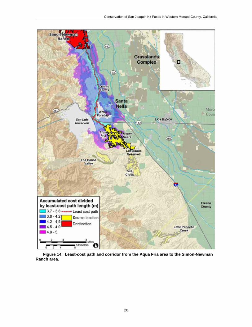
Significant obstacles to movement though the Santa Nella area include two large reservoirs (San Luis Reservoir, O’Neil Forebay), a number of connecting canals (California Aqueduct, Delta-Mendota Canal, San Luis Wasteway), and two divided freeways (Interstate 5, State Route 152). Both the eastern and western routes relied on one or more narrow crossing points to bypass these obstacles. When freeways and waterways were considered an absolute barrier in the model, connectivity west of O’Neil Forebay depended on a single, narrow undercrossing of the Highway 152 bridge over the O’Neil Forebay (Figure 15, Figure 16). On the east side of the forebay, connectivity depended on a number of narrow bridges or undercrossings of Interstate 5, Highway 152, the California Aqueduct, and the Delta Mendota Canal (Figure 17, Figure 18, Figure 19). Unlike the western route, connectivity did not depend on a single connection point, but could be achieved with a number of different (albeit difficult) routes.
23

Conservation of San Joaquin Kit Foxes in Western Merced County, California
Figure 10. Areas of high and medium habitat suitability between the Panoche Valley area and the Simon-Newman Ranch area.
24

Conservation of San Joaquin Kit Foxes in Western Merced County, California
Figure 11. Least-cost path and corridor from the Little Panoche Creek area to the
Simon-Newman Ranch area.
25

Conservation of San Joaquin Kit Foxes in Western Merced County, California
Figure 12. Least-cost path and corridor from the Los Banos Valley area to the Simon-
Newman Ranch area.
26

Conservation of San Joaquin Kit Foxes in Western Merced County, California
Figure 13. Least-cost path and corridor from the Salt Creek area south of Los Banos
Reservoir to the Simon-Newman Ranch area.
27
Conservation of San Joaquin Kit Foxes in Western Merced County, California
Figure 14. Least-cost path and corridor from the Aqua Fria area to the Simon-Newman
Ranch area.
28

Conservation of San Joaquin Kit Foxes in Western Merced County, California
Figure 15. Least-cost path route west of Santa Nella crossing at Highway 152 bridge.
Figure 16. Undercrossing (under label “Hwy. 152”) of Highway 152 bridge at O’Neil
Forebay, Santa Nella, California.
29
Conservation of San Joaquin Kit Foxes in Western Merced County, California
Figure 17. Least-cost path route east of Santa Nella crossing freeways and canals.
Figure 18. California Aqueduct right of way east of Highway 33, Santa Nella, California.
30

Conservation of San Joaquin Kit Foxes in Western Merced County, California
Figure 19. Highway 33 bridge over the California Aqueduct, Santa Nella, California.
Comparative Corridor Quality While the least-cost path is estimated to be the best route given the parameters of a model, it is not necessarily a good route. To provide a basis of comparison, we ran the same least-cost path model in an area of western Kern County containing larger and better-connected blocks of suitable kit fox habitat (Table 8, Figure 20). In the Kern County model, we found less than half of the mean cost along the route of the least cost path. Less resistance is to be expected in an area of comparatively better habitat, but another key difference is in the pattern of resistance. Without the same sorts of barriers as Santa Nella, the Kern County model shows a consistently wide route (Figure 20) with values gradually decreasing with distance. In the cases of the Santa Nella model, the potential routes were restricted at narrow crossing points (Figure 11-Figure 19).
Table 8. Least-cost path routes for kit foxes through the Santa Nella area (between different origin locations and the Simon-Newman Ranch area) and though part of western Kern County.
Destination Origin Description Euclidean distance
LCP1 distance Mean cost along LCP2
Little Panoche Creek East of O'Neil Forebay 56.4 km 67.9 km 3.6 Los Banos Valley West of O'Neil Forebay 28.8 km 33.8 km 3.9 Salt Creek area East of O'Neil Forebay 32.8 km 42.2 km 3.8
Simon-Newman Ranch
Aqua Fria area West of O'Neil Forebay 22.2 km 27.3 km 3.7 Lokern area Buena Vista Valley area Less impeded route 56.0 km 59.9 km 1.6 1. Distance of the least cost path, or path of least resistance. 2. This is the mean cost values encountered along the route of the least cost path, or minimum value of the accumulated
cost corridor divided by the length of the least cost path.
31

Conservation of San Joaquin Kit Foxes in Western Merced County, California
Figure 20. Least-cost path and corridor between two locations in the Buena Vista Valley
and Lokern areas of western Kern County, California.
32

Conservation of San Joaquin Kit Foxes in Western Merced County, California
DISCUSSION
REGIONAL KIT FOX DISTRIBUTION AND ABUNDANCE The survey methodologies used in this project were appropriate to achieve study objectives. Camera stations, track stations, and spotlight surveys are all standard techniques used range-wide to detect the presence of kit foxes. Survey efforts were extended to the Lokern Natural Area and the Panoche Valley in part to verify the efficacy of the detection techniques, as well as to provide detection rates from areas known to be inhabited by kit foxes. Indeed, kit foxes were routinely detected in Lokern and the Panoche Valley indicating that the survey methods would detect kit foxes if they were present. Furthermore, survey efforts were conducted continuously for 29 months, and therefore results regarding the presence of kit foxes in particular areas can not be attributed to any seasonal variations in abundance or distribution.
The presence of kit foxes in western Merced County is well documented (e.g., U.S. Fish and Wildlife Service 1998). However, the actual population status of kit foxes in the region is less well understood. On the south end of this region, just outside of Merced County, is the Panoche Valley. Due to the consistent presence of kit foxes and the presence of large tracts of public land (most owned by the U.S. Bureau of Land Management), the Panoche region was identified as a “core area” for kit foxes in the recovery plan for San Joaquin Valley upland species (U.S. Fish and Wildlife Service 1998). Whether this region indeed constitutes a core versus a smaller satellite population may be debatable. However, the presence of a persistent population of kit foxes in the Panoche region is indisputable.
During this study, kit foxes were detected on lands in western Merced County south of State Route 152. These detections included 3 track observations and 3 spotlight observations on the Bonturi Ranch, 2 spotlight observations along Billie Wright Road, and 2 dens on another private ranch south of the Los Banos Reservoir. These observations suggest that a kit fox population is present in this area, but the detection rates were rather low indicating that population density in this area also may be relatively low, particularly compared to locations like Lokern (Table 9).
During the 29 months of survey effort, kit fox sign only was detected on lands north of State Route 152 on 2 occasions. A track and a scat were found along the Delta-Mendota Canal just north of Santa Nella. Although kit foxes are occasionally found inhabiting canal right-of-ways (Clark et al. 2005, Warrick et al. 2007), canals may primarily function as movement corridors for kit foxes. The occurrence of only 2 detections in 29 months and lack of other sign (e.g., dens) suggests that the scat and track may have been a result of one or more kit foxes moving through the area versus the presence of resident foxes.
The results of this investigation clearly indicate that foxes are not homogeneously distributed throughout western Merced County. Instead, there appears to be a pronounced ecological continuum with kit foxes being consistently present in the south and intermittently present in the north. The consistent detections in the south suggest that a resident population may be present whereas the infrequent detections in the north suggest
33

Conservation of San Joaquin Kit Foxes in Western Merced County, California
that foxes in this area may be transients. The boundary between these 2 situations appears to roughly coincide with State Route 152.
Table 9. Summary of kit fox detections during surveys conducted in 4 areas of the western San Joaquin Valley, California during April 2005-August 2007.
Survey areas
Santa Nella – North1
Santa Nella – South2 Panoche Valley Lokern Natural
Area Cameras3 0 0 0.4 7.5 Tracks4 0.1 2.0 1.5 17.4 Spotlighting5 0 5 8 -- 6
Opportunistic 1 scat 2 dens w/ scat 2 road kills, 1 observation
-- 7
1 North of State Route 152 2 South of State Route 152 3 Detections per 100 camera station-nights 4 Detections per 100 track station-nights 5 Total number observed during spotlight surveys 6 No spotlight surveys were conducted in Lokern 7 Kit fox sign was abundant in Lokern and included dens, scats, and tracks.
The results above are consistent with findings from previous studies and survey efforts. For example, Bell et al. (1996) trapped 18 kit foxes and routinely observed kit foxes via spotlight in the Panoche Valley region during 1995-1996. Also, during 1985-1987, 33 kit foxes were live-trapped in the proposed area for the Los Banos Grandes Reservoir just west of the Los Banos Reservoir (Archon 1992, Briden et al. 1992). Numbers such as these are consistent with the presence of a persistent, breeding population. Indeed, juveniles were captured in both the Panoche Valley and Los Banos Grandes studies (Archon 1992, Bell et al. 1996). Kit foxes also have been routinely detected along Billie Wright Road just south of State Route 152 (Smith et al. 2006; Endangered Species Recovery Program, unpublished data).
The status of kit foxes from Santa Nella northward is unclear. This region is commonly referred to as the “northern range”, and even the historical distribution and abundance of kit foxes in this region is uncertain. Grinnell et al. (1937) found little evidence of kit foxes north of Merced County (see Figure 154, p. 403). They speculated that the historic range may have extended further to the north along the west side of the San Joaquin Valley, but offered no information to support this other than the location for the type specimen near Tracy in San Joaquin County (Merriam 1902).
In the past few decades, a number of kit fox occurrences have been reported from this region. The vast majority of these occurrences have been sightings (some diurnal but most via spotlighting), potential tracks, and potential dens (Sproul and Flett 1993, Clark et al. 2007a). Such occurrences can be equivocal due to potential identification errors (see McKelvey et al. 2008). For example, kit foxes can be easily confused with coyote pups and gray foxes (Clark et al. 2007b), kit fox tracks are easily confused with those of gray foxes and red foxes (Orloff et al. 1993), and kit fox dens in the northern range are easily confused with burrows of California ground squirrels (Orloff et al. 1986).
34

Conservation of San Joaquin Kit Foxes in Western Merced County, California
There has been a paucity of unequivocal physical evidence of kit foxes in the northern range, such as carcasses (e.g., vehicle kills), live-captured animals, clear photographs from camera stations, or genetically verified scat samples. Such evidence that we are aware of is presented in Table 10. In summary, from 1967 to present (ca. 41 years), indisputable physical evidence of kit foxes from Santa Nella northward consists of 6 opportunistically discovered carcasses, 5 road-killed animals, 10 live-captured animals of which 8 apparently were from a single social group, 2 or 3 unmarked pups observed with a radiocollared adult, and 1 genetically verified kit fox scat. Thus, only about 2 dozen unequivocal occurrences have been recorded in 4 decades. Furthermore, only 2 occurrences of reproduction by kit foxes in the northern range have been documented and verified. A family group with 5 pups was observed at the Bethany Reservoir in Alameda County in 1982 (Hall 1983). A radio-collared fox from this family group was observed with 2-3 pups at the same location in 1987 (California Department of Fish and Game 2007). In the past decade, the only kit fox occurrences verified with physical evidence were a vehicle-killed female found in August 2004 along Interstate 5 about 5 km south of Patterson in Stanislaus County (M. Root, U.S. Fish and Wildlife Service, personal communication), and the kit fox scat found during this study.
Table 10. Kit fox occurrences in the northern range (from Santa Nella in Merced County northward) verified with physical evidence (e.g., carcass, live-capture, genetically-verified scat).
Date Source Description 1967 Swick 1973 1 kit fox trapped in Contra Costa County 1971 Jensen 1972 Roadkill near Corral Hollow interchange on I-580, San Joaquin
County 1972 Swick 1973 3 carcasses found on private lands, Contra Costa County 1972 Swick 1973 3 carcasses found near Bethany Reservoir, Alameda County 1973 Swick 1973 Roadkill collected in Alameda County 1982-
83 Hall 1983, Orloff et al. 1986
8 kit foxes (3 adults, 5 pups) live-captured and radio-collared near the Bethany Reservoir, Alameda County
1987 CA Natural Diversity Database report by R. Eng
Observation of 2 adults (1 radio-collared) and 2-3 pups near the Bethany Reservoir, Alameda County. May be same family group as previous entry, but with new pups
1990 CA Natural Diversity Database report by L. Briden
Roadkill on I-5 just north of Patterson, Stanislaus County
1998 Uptain et al. 2000 1 kit fox live-captured and radio-collared near Santa Nella, Merced County
1999 ESRP, unpublished data Roadkill on I-5 just north of California Route 140, Merced County 2004 CA Natural Diversity
Database report by M. Root
Roadkill on I-5 just south of Patterson, Stanislaus County
2006 This study Scat found along Delta-Mendota Canal just north of Santa Nella, Merced County
An extensive survey was conducted throughout the northern range during May 2001-February 2003. This effort likely constitutes the most comprehensive survey conducted to date in the northern range. Trained scat-detection dogs were used to survey 213 km of
35

Conservation of San Joaquin Kit Foxes in Western Merced County, California
transects on 24 different properties. Of 17 fox scats found and genetically identified to species, all were from red foxes (Smith et al. 2006). No kit fox scats were located.
Available data offers little support for the presence of resident kit fox populations in the northern range. Currently, kit fox presence in the northern range may consist primarily of occasional dispersing animals from populations to the south of Santa Nella. It is conceivable that such animals might even persist for multiple years resulting in reports of sightings. However, there have been no recent and indeed only two historical records of documented reproduction by kit foxes in the northern range. If self-supporting kit fox populations are not present in the northern range, then this region could be functioning as a dispersal sink, as suggested by Smith et al. (2006).
EXPLANATORY VARIABLES
Competitors Potential competitors with kit foxes were observed in all areas surveyed. These species potentially could adversely affect kit foxes through interference competition (e.g., predation, harassment), exploitative competition (e.g., use of common resources such as dens and food), or disease transmission (e.g., Ralls and White 1995, Cypher and Spencer 1998, Cypher et al. 2001, Clark et al. 2005).
Throughout the range of the San Joaquin kit fox, coyotes are a primary source of mortality (Briden et al. 1992, Standley et al. 1992, Ralls and White 1995, Spiegel and Disney 1996, Cypher et al. 2000, Nelson et al. 2007), and may also compete with kit foxes for food resources (White et al. 1995, Cypher and Spencer 1998). Although predation rates by coyotes can be substantial, there is no evidence that competition by coyotes actually results in the exclusion of kit foxes from an area. Indeed, coyote detection rates at track stations were highest in the Lokern Natural Area, which had the highest kit fox abundance among the areas surveyed.
Other species detected during our study also are known to kill kit foxes and possibly compete for food including red foxes, bobcats, badgers, and domestic dogs (Standley et al. 1992, Ralls and White 1995, Spiegel and Disney 1996, Cypher et al. 2000, Clark et al. 2005). As with coyotes, there is no evidence that competition by any of these species actually results in the exclusion of kit foxes from an area. Red foxes are a species that has caused particular concern. Red foxes are not native within the range of the San Joaquin kit fox, and yet appear to be increasing in abundance within the San Joaquin Valley. As mentioned above, red foxes occasionally kill kit foxes (Ralls and White 1995, Clark et al. 2005), likely overlap in use of foods (Clark et al. 2005, CSUS Endangered Species Recovery Program unpublished data), and usurp kit fox dens (Clark et al. 2005; CSUS Endangered Species Recovery Program, unpublished data). However, the precise impact that red foxes have on the abundance and distribution of kit foxes has not been quantified. Interestingly, red foxes were only detected in the areas just north and south of Santa Nella, and red fox detections were highest in the area (Santa Nella – North) where there was only 1 kit fox detection.
36

Conservation of San Joaquin Kit Foxes in Western Merced County, California
Raccoons and skunks constitute significant epidemiological threats to kit foxes. These species are significant agents for transmission of rabies and have been associated with a number of rabies epidemics in North America (e.g., Blanton et al. 2006). Indeed, a marked decline in kit fox abundance at a site in San Luis Obispo County was concurrent with a rabies epidemic among striped skunks in the region (White et al. 2000). Fortunately, both skunks and raccoons tend to prefer habitat conditions more mesic than the arid conditions preferred by kit foxes. Thus, spatial sympatry between these species and kit foxes is minimal in the San Joaquin Valley, and these species are unlikely to significantly influence kit fox presence and abundance.
Competitors were commonly observed in all areas studied, suggesting that they probably are not the primary causal factor for differences in kit fox presence and abundance among areas. One important caveat is that interactions between kit foxes and non-native red foxes still are not well understood, and thus, it is uncertain whether red foxes could potentially exclude kit foxes.
Prey Abundance The type and abundance of prey available to kit foxes varied markedly between areas studied. In particular, kangaroo rat presence and abundance exhibited a pronounced increasing trend from north to south. Although kit foxes can be opportunistic foragers (Cypher 2003), kangaroo rats appear to constitute preferred prey (Laughrin 1970, Morrell 1972, Fisher 1981, Koopman 1995, Cypher et al. 2000). Indeed, kit fox distribution and abundance appears to be closely associated with that of kangaroo rats (Grinnell et al. 1937, Benson 1938, Laughrin 1970). Results from this project were consistent with this in that kit fox detections were highest in the Lokern area, where kangaroo rats were most abundant, and lowest in the areas near Santa Nella, where no kangaroo rats were captured.
California ground squirrels were present in all areas surveyed except Lokern. Kit foxes will prey on ground squirrels, but do not appear to achieve high densities nor have high population persistence in areas where ground squirrels are the primary food source. For example, ground squirrels were the primary prey of kit foxes at both the Bethany Reservoir in Alameda County (Orloff et al. 1986) and the Camp Roberts Army National Guard Training Center in San Luis Obispo and Monterey Counties (Logan et al. 1992), but kit foxes did not persist at either of these locations and appear to be only intermittently present.
Unfortunately, California ground squirrels may even present an element of risk for kit foxes in some locations. Ground squirrels are species commonly targeted for poisoning campaigns. During this project, we found direct evidence of ground squirrel poisoning on lands near the San Joaquin National Cemetery. Also, landowners in the Panoche Valley stated that they occasionally poisoned ground squirrels. Kit fox mortalities attributable to secondary poisoning from the consumption of poisoned rodents have been documented at California State University-Bakersfield (Bell et al. 1994) and the Camp Roberts Army National Guard Training Center (Standley et al. 1992).
Prey availability, particularly the presence and abundance of kangaroo rats, appeared to be a potential factor in the patterns of kit fox distribution and abundance observed during this project. Kit fox detection rates were extremely low in areas where kangaroo rats were not
37

Conservation of San Joaquin Kit Foxes in Western Merced County, California
captured. Ground squirrel poisoning was documented in some of the areas studied, but the extent of any adverse effects on kit foxes from squirrel poisoning is unknown.
Habitat suitability Habitat suitability appears to be another significant factor in observed patterns of kit fox abundance and distribution in the western Merced County region. Based on survey results, a low-density but persistent kit fox population apparently occurs in the region south of Santa Nella whereas kit foxes appear to be mostly intermittently present north of Santa Nella. In this northern area, the habitat is primarily of medium or low quality and is highly fragmented. This landscape pattern appears to extend northward into and throughout the northern range of the kit fox. Throughout this northern region, steep terrain is common and in some locations this unsuitable terrain extends eastward and abuts Interstate 5 or agricultural lands (CSUS Endangered Species Recovery Program, unpublished data). This not only inhibits occupation by kit foxes, but also severely impedes movement through these areas. Furthermore, the herbaceous ground cover is dominated by relatively tall, dense stands of wild oats (Avena spp.). Steep terrain and dense cover increase predation risk for kit foxes (Warrick and Cypher 1999), and also constitute poor habitat conditions for kangaroo rats, the preferred prey of kit foxes. The heavy clay soils common to this region also are an impediment to kangaroo rats. These factors collectively result in suboptimal conditions for kit foxes and probably are responsible for the intermittent presence of kit foxes in this northern region and the apparent lack of evidence for resident kit fox populations.
The blocks of highly suitable habitat south of Santa Nella in combination with the more abundant medium suitability lands apparently are sufficient to maintain a persistent kit fox population, albeit one that is of relatively low density. As reported earlier, the blocks of highly suitable habitat are 2,000 ha or less in size. Den ranges (roughly equivalent to home ranges) of kit foxes in the Los Banos Valley averaged 473 ha and ranged from 86 to 1,256 ha (Archon 1992). Thus, even assuming that each range was occupied by a resident pair of foxes, the highly suitable habitat blocks would not support a large number of foxes. However, compared to areas north of Santa Nella, this area has a greater abundance of more gentle terrain, a less dense herbaceous cover, and a greater abundance of kangaroo rats. This area also has good connectivity with the Panoche Valley area, and therefore it is possible that fox populations in the area south of Santa Nella are occasionally supplemented by foxes dispersing from the Panoche Valley.
REGIONAL CORRIDORS Three alternative corridor routes were identified using least path corridor modeling. However, several critical points warrant emphasis. Little is known about movement corridors for kit foxes. Optimal characteristics of effective corridors for kit foxes have not been identified. Thus, both the model and input parameters used for this analysis essentially are representations of our best guess regarding how kit foxes perceive the landscape and which features within that landscape most influence fox movements. Of particular note, certain features were identified as significant barriers to kit fox movements. These include water bodies, large canals, and multi-lane roads. However, the true extent to
38

Conservation of San Joaquin Kit Foxes in Western Merced County, California
which these features obstruct movements is unknown. It is possible that these features are more permeable than predicted in the model, or conversely, some of these features might constitute absolute barriers to movements. Therefore, considerable uncertainty is associated with the identified corridor routes.
The general quality of the identified corridor routes probably is poor. This assessment is based on several factors. First, the routes primarily traverse habitat of low suitability. This is particularly true of the eastern and central corridor routes. Of the three routes, the western route traverses the best quality habitat with much of the habitat along the route ranked as medium suitability. Second, portions of the corridor routes, particularly the eastern and central, follow anthropogenic features such as canals and roads. These features, particularly the roads, likely present considerable risk for kit foxes. Third, the routes are quite narrow in places, particularly where routes follow canals through developed areas. Finally, the number and difficulty of the apparent barriers that kit foxes would need to negotiate are considerable. For features like roads and canals, there are only a limited number of potential crossing structures that would facilitate passage. All of these factors reduce the probability of a kit fox successfully negotiating the identified corridor routes.
One final note is that the predicted corridor routes are based on landscape attributes at the time the modeling was conducted. Any alterations to the landscape likely will alter the predicted least cost paths. Such potential landscape alterations include urban developments, road widening, changes in land use, and canal modifications.
CONCLUSIONS AND RECOMMENDATIONS
Patterns of presence and abundance of San Joaquin kit foxes in western Merced County are characterized by considerable spatial heterogeneity. In particular, these patterns exhibit a very pronounced north-south trend. From Santa Nella northward, kit foxes either occur at extremely low densities, or more likely, are only intermittently present. South of Santa Nella, there appears to be a consistently detectable population that persists at low to moderate density. These patterns likely are the result of a complexity of factors. In particular, the suitability of the habitat from Santa Nella northward generally is low due to considerable fragmentation, dense vegetation, inhospitable terrain, and a paucity of preferred prey. South of Santa Nella, vegetation density is lower, gentle terrain is more common, and kangaroo rats are more abundant resulting in habitat suitability that generally is sufficient to support a persistent kit fox population. However, habitat conditions in this southern area are not completely ideal. Intrusions of inhospitable terrain are present, and vegetation density is higher and kangaroo rat abundance is lower compared to areas with high kit fox densities, such as the Lokern Natural Area. Consequently, any deterioration in current suitability could erode the ability of this area to support a persistent kit fox population.
Based on available data, this area south of Santa Nella (south of State Route 152 and west of Interstate 5) supports the most northerly known self-sustaining kit fox population. No tangible evidence currently is available to support the presence of kit fox populations north of this area. Thus, conserving this population is critical to maintaining kit foxes in the
39

Conservation of San Joaquin Kit Foxes in Western Merced County, California
western Merced County region and northward. Indeed, this population likely is the source for kit foxes occasionally observed in counties to the north. Protecting and appropriately managing habitat in southwestern Merced County should be among the highest priority tasks for any regional kit fox conservation strategy.
The issue of maintaining or establishing kit fox movement corridors through the Santa Nella area is complex and warrants careful consideration. Significant factors in the corridor debate include kit fox biology and conservation issues, regulatory concerns and obligations, socio-political concerns, economic considerations, and practicality. From a purely biological and conservation perspective, the value and desirability of movement corridors is equivocal. As discussed previously, the availability of suitable habitat north of Santa Nella is low and may not be sufficient to sustain viable kit fox populations. Indeed, as mentioned above, there is no current evidence of self-sustaining kit fox populations north of Santa Nella. Thus, these northern areas could be functioning as a population sink, as suggested by Smith et al. (2006) and Clark et al. (2007a). If this is indeed the case, then corridors might adversely impact source populations by facilitating emigration from those populations. Another biological issue is that the attributes (e.g., width, cover requirements, management) of viable movement corridors for kit foxes are unknown.
Certain non-biological considerations provide support for the establishment of movement corridors. For example, the current recovery plan (U.S. Fish and Wildlife Service 1998) calls for maintaining connectivity to northern range areas, and therefore there may be political pressure to comply. However,one caveat is that the plan also advocates “adaptive management” and recent data (e.g., Smith et al. 2006, this study) should be considered in the development of conservation strategies. Another significant factor to consider might be the cost of movement corridors relative to the contributions of such corridors to kit fox meta-population viability and recovery. Establishing and maintaining corridors through the Santa Nella area may involve considerable expense. Given the questionable status of kit fox populations north of Santa Nella, the uncertainty regarding the ability of northern areas to support viable kit fox populations, and the uncertainty regarding corridor attributes for kit foxes, consideration should be given to whether resources might be used in an alternative strategy to more effectively advance kit fox conservation and recovery.
Given the conclusions and considerations above, a number of recommendations are offered below. These recommendations are offered in two sets. The first set consists of recommendations that we feel are the most appropriate given the available data. This set does not include recommendations regarding maintaining connectivity for kit foxes through the Santa Nella Area. However, we recognize that there may be a desire on the part of many stakeholders to maintain such connectivity. Thus, recommendations regarding the establishment and maintenance of connectivity for kit foxes through the Santa Nella area are offered in the second set of recommendations.
40

Conservation of San Joaquin Kit Foxes in Western Merced County, California
REGIONAL KIT FOX CONSERVATION
1. Conserve habitat in the region bounded by State Route 152 on the north, Little Panoche Reservoir on the south, Interstate 5 on the east, and rugged terrain (>15% average slope) of the Coast Ranges on the west. Conserving habitat in this region will be critical to maintaining the existing self-sustaining kit fox population that is present. Such habitat conservation will be even more critical if movement corridors are maintained northward through the Santa Nella area. Habitat quality is not optimal in this region, and any deterioration in suitability could destabilize the existing population and jeopardize its viability. Although not under immediate threat, development pressure in this region will likely increase as urbanization expands in the Santa Nella area and infrastructure improvements progress. As development pressure increases, land values also will increase thus making habitat conservation efforts more difficult. Habitat conservation efforts could include strategies such as fee title acquisitions, conservation easements, Safe Harbor agreements, and other conservation agreements. During the course of this project, we encountered several landowners who were keenly interested in opportunities to conserve habitat on their properties. Habitat protection would be significantly facilitated by a regional habitat conservation plan. Such a plan would provide benefits such as stream-lining regulatory processes, prioritizing areas for conservation, targeting critical areas with high habitat values for kit foxes, reducing habitat fragmentation, and pooling resources to facilitate larger land acquisitions.
2. Maintain corridors between the southwestern Merced County region and the Panoche Valley region. In order to enhance the long-term viability of the kit fox population present south of Santa Nella, connectivity should be maintained between this population and other extant populations. The nearest population appears to be the one occurring in the Panoche Valley region. One potential movement corridor generally parallels Little Panoche Road and encompasses a high proportion of suitable habitat for kit foxes. Other potential corridors exist as well.
3. Manage and enhance habitat to increase suitability for kit foxes. As discussed previously, habitat suitability in the southwestern Merced County region is sufficient to support a kit fox population, but is not optimal, which could be limiting kit fox abundance. Habitat management and enhancements potentially could increase habitat suitability in the region, which could result in increased numbers of kit foxes. Managing vegetation to maintain a low structure and reduced thatch accumulation could be highly beneficial. Reduced structure and thatch would improve suitability for kangaroo rats, thereby increasing prey availability for kit foxes. Also, a shorter vegetation structure would improve visibility for kit foxes thereby facilitating predator avoidance. The most plausible and economical strategy for achieving such management objectives on a landscape scale is through cattle grazing. Grazing should be conducted in a manner that maintains a low structure and thatch accumulation, but also ensures rangeland health. Grazing standards and guidelines for this region established by the U.S. Bureau of Land
41

Conservation of San Joaquin Kit Foxes in Western Merced County, California
Management (1999) recommend residual dry matter (RDM) levels no lower than 200 lbs/ac to maintain rangeland health. Based on observations in the southern portion of the kit fox range, RDM levels lower than 1,000 lbs/ac and probably closer to 500 lbs/ac would result in favorable habitat conditions for kangaroo rats (S. Saslaw, U.S. Bureau of Land Management, personal communication), and likely kit foxes as well.
Habitat suitability potentially could be enhanced for kit foxes by installing artificial dens throughout the region. Kit foxes will readily use such dens (Bjurlin et al. 2005, Endangered Species Recovery Program unpublished data). Kit foxes use dens for a variety of purposes including escape from predators (Grinnell et al. 1937). Survival of closely related swift foxes (Vulpes velox) increased significantly in areas where artificial dens were installed to provide additional escape cover (McGee et al. 2006).
4. Rigorously enforce regulations and restrictions regarding use of rodenticides in areas inhabited by kit foxes. Based on discussions with landowners and others during the course of this project, use of rodenticides to control ground squirrel populations appears to be a common practice in this region, including in areas definitely or potentially inhabited by kit foxes. These rodenticides generally consist of an anti-coagulant distributed in grain. Exposure by kit foxes to anti-coagulants can by primary (i.e., consumption of poisoned bait) or secondary (i.e., consumption of poisoned rodents). Doses lethal to rodents also are lethal to kit foxes (Schitoskey 1975). Kit fox deaths attributable to rodenticide poisoning have been documented (Standley et al. 1992, Bjurlin et al. 2005). During this project, poisoned ground squirrels were documented in the vicinity of the San Joaquin National Cemetery, and a colleague reported observing grain bait being distributed on a property south of State Route 152 via an all-terrain vehicle. Thus, rodenticide use constitutes a potential threat to kit foxes in this region. Accordingly, use of rodenticides in this region is limited to methods that minimize or eliminate risk to kit foxes (U.S. Environmental Protection Agency 2000), and such regulations should be strictly enforced.
5. Implement outreach programs to facilitate kit fox conservation. Outreach programs should be implemented to provide information and to build support for conservation efforts. Such programs should target landowners, members of the public, local officials, developers, and others. Outreach programs can encompass a variety of activities including educational programs, information dissemination, and landowner assistance.
6. Conduct kit fox population monitoring in the region from State Route 152 south to the Little Panoche Reservoir. As discussed previously, the kit fox population in this region has been persistent, but densities likely are relatively low thereby increasing the vulnerability of this population. The status of this population should be assessed annually through the establishment of a monitoring program. Preferably, a rigorous monitoring strategy should be implemented that involves a count of unique individuals (e.g., live-capture and marking, scat surveys including genetic identification of individuals), although such strategies likely will be
42

Conservation of San Joaquin Kit Foxes in Western Merced County, California
expensive. Minimally, an annual index of abundance should be obtained using methods such as spotlight surveys, track station surveys, camera station surveys, or den surveys. A significant challenge regardless of survey methodology will be accessing private lands.
7. Conduct demographic and ecological studies. Currently, little is known about the ecology and demography of kit foxes in this region. Only one study has been conducted, and that was a short-term investigation (May 1985-August 1987) conducted over 2 decades ago (Archon 1992). A better understanding of kit fox ecological and demographic patterns would facilitate management and conservation efforts in this region. Investigations minimally should address sources and rates of mortality, reproductive success and productivity, dispersal rates, den characteristics and patterns of use, space use patterns, and food habits. As with population monitoring, a significant challenge in conducting any field investigations will be gaining access to private lands.
8. Monitor competitor abundance. The effects of competitors, particularly coyotes and red foxes, on kit foxes in the region are unclear. Kit foxes appear to be persisting under current levels of competitive pressure. However, an increase in this pressure could adversely affect the kit fox population, particularly at the relatively low densities currently observed in this region. Competitor populations should be monitored so that any significant increases in competitor abundance can be rapidly detected. Then, if so warranted, actions such as predator reduction programs could be implemented to relieve competitive pressures on kit foxes. Competitor monitoring could be conducted in conjunction with kit fox population monitoring, depending upon the strategy selected for monitoring kit foxes.
NORTHWARD CONNECTIVITY
1. Promote corridor establishment and maintenance along optimal routes. Little is known about kit fox movements through the Santa Nella area. Thus, potential corridor routes were identified (Fig. 12 and 13) using spatial models encompassing numerous assumptions. The resulting corridor routes obviously include considerable uncertainty. These routes represent what may be the paths of least resistance for kit foxes moving through this landscape. As such, they are a “best guess”. Nevertheless, if resources and effort will be invested in establishing and maintaining corridors, these routes should be considered first. A more in-depth modeling effort recently has been initiated and likely will reveal modifications to these preferred routes or even the identification of additional routes. Also, it should be duly noted that the currently identified corridor routes may become less optimal or even impossible depending upon patterns of urban development, political pressures, or unpredicted landscape changes.
2. Design corridors with favorable attributes for kit foxes. As mentioned previously, optimal attributes of kit fox movement corridors are unknown. Thus, the following general guidelines are offered.
43

Conservation of San Joaquin Kit Foxes in Western Merced County, California
• Corridors should be as wide as possible. • Vegetation structure should be kept low, possibly through mowing or grazing. • Ground squirrel poisoning in and adjacent to corridors should be strictly
prohibited. • Any other activities within corridors should be compatible with kit fox presence
(e.g., grazing, daytime recreational use).
• Escape cover in the form of artificial dens should be provided. As a general rule, dens should be installed approximately every 0.25 km within the corridor. Artificial dens could include chambered subterranean designs or simple non-chambered surface designs (see Bjurlin et al. 2005).
• To the extent possible, potential refugia areas should be linked by corridors. Such refugia could include storm-water drainage basins, golf courses, parks, and undeveloped open space. Such refugia might be particularly important if corridors are relatively narrow.
One additional note, corridors dedicated entirely to use by kit foxes and other wildlife are preferable. However, given that land is expensive, it may be possible to combine such corridors with compatible uses. As mentioned above, grazing is one such compatible use. Another is potentially human recreation. For example, bike paths or fitness trails could be incorporated into corridors.
3. Span barriers to kit fox movements. Landscape features such as large roads (4-lane or larger, and particularly those with median barriers) and canals constitute barriers to kit fox movements. To enhance movement potential, such crossing structures should be constructed to facilitate kit fox movements. Such structures could include bridges and underpasses. As with corridors, the optimal attributes of such crossing structures are poorly known. Research is in progress to determine what structures foxes will use to cross roads. Research also should be conducted to determine what structures foxes will use to cross canals.
4. Enhance other potential movement corridors Existing features in the landscape potentially could facilitate kit fox movements, particularly if such features were enhanced. Such existing features could include canal rights-of-way, powerline corridors, and railroad corridors. Enhancements for such features could include vegetation management (to maintain a low structure), installation of artificial dens, and installation of passages through adjacent walls or fences to provide access to nearby refugia areas. As mentioned previously, vegetation management could be accomplished with grazing or mowing. Artificial dens could consist of either surface or subterranean designs. Walls and fences are easily made permeable to kit foxes by installing passage-ways along the base that are at least 20 cm in diameter (Bjurlin et al. 2005).
44

Conservation of San Joaquin Kit Foxes in Western Merced County, California
LITERATURE CITED Archon, M. 1992. Ecology of the San Joaquin kit fox in western Merced County, California. MS
Thesis, California State University, Fresno. 62 pp.
Bell, Heather M. 1994. Analysis of habitat characteristics of San Joaquin kit fox in its northern range. Master’s Thesis, California State University, Hayward. 90 pp.
Bell, H.M., J.A. Alvarez, L.L. Eberhardt and K. Ralls. 1994. Distribution and abundance of San Joaquin kit fox. Draft final report, California Department of Fish and Game, Sacramento. 71pp.
Bell, Heather, Lee O’Brien, Patrick A. Kelly, and Daniel F. Williams. 1996. Memorandum to the U.S. Fish and Wildlife Service and California Department of Fish and Game: Report on activities under CDFG MOU and USFWS Subpermit WILLDF-12. Report Number 4. 7 pp.
Benson, S. B. 1938. Notes on kit foxes (Vulpes macrotis) from Mexico. Proceedings of the Biological Society of Washington 51:17-24.
Bjurlin, C.D., B.L. Cypher, C.M. Wingert, and C.L. Van Horn Job. 2005. Urban roads and the endangered San Joaquin kit fox. California State University-Stanislaus, Endangered Species Recovery Program, Fresno, California.
Blanton, J. D., J. W. Krebs, C. A. Hanlon, and C. E. Rupprecht. 2006. Rabies surveillance in the United States during 2005. Journal of the American Veterinary Medical Association 229:1897-1911.
Briden, Laura E., Mark Archon and David L. Chesemore. 1992. Ecology of the San Joaquin kit fox (Vulpes macrotis mutica) in western Merced County, California. Pages 81-87 in D. F. Williams, S. Byrne, and T. A. Rado, editors. Endangered and Sensitive Species of the San Joaquin Valley, California. California Energy Commission, Sacramento.
California Department of Fish and Game. 2007. California Natural Diversity Database. Sacramento, Electronic form.
California Department of Water Resources (DWR). 2006. Land Use Survey Data. 1:24,000. California Department of Water Resources Division of Planning and Local Assistance, Sacramento, CA. URL: http://landwateruse.water.ca.gov/basicdata/landuse/landusesurvey.cfm
Carroll, M.L., C.M. DiMiceli, R.A. Sohlberg, and J.R.G. Townshend. 2007. 250m MODIS Normalized Difference Vegetation Index (all composites for 2005). University of Maryland, College Park, Maryland. URL: http://glcf.umiacs.umd.edu/data/ndvi/
Clark, H.O., Jr., R.R. Duke, M.C. Orland, R.T. Golightly, and S.I. Hagen. 2007. The San Joaquin kit fox in north-central California: a review. Transactions of the Western Section of The Wildlife Society 43:27-36.
Clark, H.O., Jr., R.R. D.P. Newman, and S.I. Hagen. 2007. Analysis of San Joaquin kit fox element data with the California Diversity Database: a case for data reliability. Transactions of the Western Section of The Wildlife Society 43:37-42.
Clark, H.O., Jr., G.D. Warrick, B.L. Cypher, P.A. Kelly, D.F. Williams, and D.E. Grubbs. 2005. Competitive interactions between endangered kit foxes and nonnative red foxes. Western North American Naturalist 65:153-163.
45

Conservation of San Joaquin Kit Foxes in Western Merced County, California
Cypher, B.L. 2003. Foxes. Pages 511-546 in G. A. Feldhamer, B. C. Thompson, and J. A. Chapman, editors. Wild Mammals of North America: Biology, Management, and Conservation. Second edition. The Johns Hopkins University Press, Baltimore, Maryland.
Cypher, B.L., H.O. Clark, Jr., P.A. Kelly, C. Van Horn Job, G.W. Warrick, and D.F. Williams. 2001. Interspecific interactions among mammalian predators: implications for the conservation of endangered San Joaquin kit foxes. Endangered Species UPDATE 18:171-174.
Cypher, B.L., and K.A. Spencer. 1998. Competitive interactions between San Joaquin kit foxes and coyotes. Journal of Mammalogy 79:204-214.
Cypher, B.L., G.D. Warrick, M.R.M. Otten, T.P. O'Farrell, W. . Berry, C.E. Harris, T.T. Kato, P.M. McCue, J.H. Scrivner, and B.W. Zoellick. 2000. Population dynamics of San Joaquin kit foxes at the Naval Petroleum Reserves in California. Wildlife Monographs 45. 43 pp.
Environmental Systems Research Institute. 2007a. An overview of ModelBuilder. URL: http://webhelp.esri.com/arcgisdesktop/9.2/index.cfm?TopicName=An_overview_of_ModelBuilder
Environmental Systems Research Institute. 2007b. Understanding cost distance analysis. URL: http://webhelp.esri.com/arcgisdesktop/9.2/index.cfm?topicname=Understanding_cost_distance_analysis
Environmental Systems Research Institute. 2007c. Least cost path and least cost corridor. URL: http://webhelp.esri.com/arcgisdesktop/9.2/index.cfm?topicname=Least_cost_path_and_least_cost_corridor
Fisher, J.L. 1981. Kit fox diet in south-central Arizona. MS Thesis, University of Arizona, Tucson.
Grinnell, J., J. Dixon, and J. Linsdale. 1937. Fur-bearing Mammals of California. 2 Vols. University of California Press, Berkeley. 777 pp.
Hall, F.A., Jr. 1983. Status of the San Joaquin kit fox, Vulpes macrotis mutica, at the Bethany Wind Turbine Generating (WTG) project site, Alameda County, California. Project Report, California Department of Fish and Game, Sacramento. 36 pp.
Jensen, C.C. 1972. San Joaquin kit fox distribution. Project Report, U.S. Fish and Wildlife Service, Bureau of Sport Fisheries and Wildlife, Sacramento, CA. 18 pp.
Koopman, M.E. 1995. Food habits, space use, and movements of the San Joaquin kit fox on the Elk Hills Naval Petroleum Reserves in California. MS Thesis, University of California, Berkeley. 41 pp.
Laughrin, L. 1970. San Joaquin kit fox: its distribution and abundance. California Department of Fish and Game, Wildlife Management Branch Administrative Report No. 70-2.
Lowery, J.C. 2006. The tracker’s field guide. Falconguide, Guilford, CT.
Malczewski, J. 1999. GIS and Multicriteria Decision Analysis. John Wiley and Sons, New York, NY.
McGee, B. K., W. B. Ballard, K. L. Nicholson, B. L. Cypher, P. R. Lemons, and J. F. Kamler. 2006. Effects of artificial escape dens on swift fox populations in northwest Texas. Wildlife Society Bulletin 34:821-827.
McKelvey, K.S., K.B. Aubry, and M.K. Schwartz. 2008. Using anecdotal occurrence data for rare or elusive species: the illusion of reality and a call for evidentiary standards. BioScience 58:549-555.
Merced County. 1989. Merced County Year 2000 General Plan. Merced County Planning Department. URL: http://www.co.merced.ca.us/planning/genplan.html
46

Conservation of San Joaquin Kit Foxes in Western Merced County, California
Merced County. 2008. Santa Nella Chamber of Commerce. URL: http://www.mercedcounty.com/mccocsan.htm
Merriam, C.H. 1902. Three new foxes of the kit fox and desert fox groups. Proceedings of the. Biological Society of Washington 15:73-74.
Morrell, S. 1972. Life history of the San Joaquin kit fox. California Fish and Game 8:162-174.
Nelson, J.L., B.L. Cypher, C.D. Bjurlin, and S. Creel. 2007. Effects of Habitat on Competition Between Kit Foxes and Coyotes. Journal of Wildlife Management 71:1467–1475.
Orloff, S.G., A.W. Flannery, and K.C. Belt. 1993. Identification of San Joaquin kit fox tracks on aluminum track plates. California Fish and Game 79:45-53.
Orloff, S.G., F. Hall, and L. Spiegel. 1986. Distribution and habitat requirements of the San Joaquin kit fox in the northern extreme of their range. Transactions of the Western Section of the Wildlife Society 22:60-70.
Ralls, K., and P.J. White. 1995. Predation on San Joaquin kit foxes by larger canids. Journal of Mammalogy 76:723-729.
Schtoskey, F., Jr. 1975. Primary and secondary hazards of three rodenticides to kit fox. Journal of Wildlife Management 39:416-418.
Smith D.A, K. Ralls, B.L. Cypher, H.O. Clark, P.A. Kelly, D.F. Williams, and J.E. Maldonado. 2006. Relative Abundance of Endangered San Joaquin Kit Foxes (Vulpes Macrotis Mutica) Based on Scat–Detection Dog Surveys. The Southwestern Naturalist 5:210–219.
Spiegel, L.K., and M. Small. 1996. Estimation of relative abundance of San Joaquin kit foxes between an undeveloped site and an oil-developed site in Kern County, California. Pages 115-124. L.K. Spiegel, editor. Studies of the San Joaquin kit fox in undeveloped and oil-developed areas. California Energy Commission, Sacramento, CA.
Sproul, M.J., and M.A Flett. 1993. Status of the San Joaquin kit fox in the northwest margin of its range. Transactions of the Western Section of The Wildlife Society 29:61-69.
Standley, W.G., W.H. Berry, T.P. O’Farrell, and T.T. Kato. 1992. Mortality of San Joaquin kit fox at Camp Roberts Army National Guard Training Site, California. U.S. Department of Energy Topical Report No. EGG 10627-2157.
Swick, C.D. 1973. Determination of San Joaquin kit fox range in Contra Costa, Alameda, San Joaquin, and Tulare Counties, 1973. California Dept. Fish and Game, Sacramento, Special Wildlife Investigations. URL: http://www.nrm.dfg.ca.gov/FileHandler.ashx?DocumentID=2946
U.C. Santa Barbara Biogeography Lab. 1998. California Gap Analysis Vegetation Layer (Statewide). 1:100,000-1:250,000. University of California, Santa Barbara, CA. URL: http://www.biogeog.ucsb.edu/projects/gap/gap_home.html
Uptain, C., D. P. Newman, P. Kelly, D. Williams, and B. Cypher. 2000. Analysis of San Joaquin kit fox movements and their use of crossing structures near the State Route 152/33 interchange, Merced County, California. California State University – Stanislaus, Endangered Species Recovery Program, Fresno, California. 35pp.
U.S. Bureau of Land Management. 1999. Central California standards for rangeland health and guidelines for livestock grazing management. California State Office, Sacramento.
47

Conservation of San Joaquin Kit Foxes in Western Merced County, California
U.S. Environmental Protection Agency. 2000. Protecting endangered species: interim measures for use of pesticides in Merced County. Pesticides and Toxic Substances Bulletin H-7506C. URL: http://www.cdpr.ca.gov/docs/endspec/espdfs/24pe1299.pdf
U.S. Fish and Wildlife Service. 1998. Recovery Plan for Upland Species of the San Joaquin Valley, California. Region 1, Portland, Oregon.
U.S. Fish and Wildlife Service. 2006. NWIDBA.CONUS_wet_poly: Classification of Wetlands and Deepwater Habitats of the United States. U.S. Department of the Interior, Fish and Wildlife Service, Washington, DC. FWS/OBS-79/31. U.S. Fish and Wildlife Service, Branch of Habitat Assessment, Washington, D.C.
Valentine, P.C., S.J. Fuller, and L.A. Scully. 2004. Terrain ruggedness analysis and distribution of boulder ridges and bedrock outcrops in the Stellwagen Bank National Marine Sanctuary region—seabed ruggedness: U.S. Geological Survey poster. URL: http://woodshole.er.usgs.gov/project-pages/stellwagen/posters/rugged.html
Warrick, G. D., H. O. Clark, Jr., P. A. Kelly, and D. F. Williams, and B. L. Cypher. 2007. Use of agricultural lands by San Joaquin kit foxes. Western North American Naturalist 67:270-277.
Warrick, G. D., and B. L. Cypher. 1998. Factors affecting the spatial distribution of a kit fox population. Journal of Wildlife Management 62:707-717.
White, P.J., W.H. Berry, J.T. Eliason, and M.T. Hanson. 2000. Catastrophic decrease in an isolated population of kit foxes. Southwestern Naturalist 45:204-211.
48

Conservation of San Joaquin Kit Foxes in Western Merced County, California
APPENDIX A. CAMERA STATION LOCATIONS FOR DETECTION OF SAN JOAQUIN KIT FOXES AND COMPETITORS
North of Santa Nella: Five cameras were placed on the Simon-Newman Ranch. These cameras were in place for approximately 7 months.
Santa Nella area: Cameras were placed in 11 locations in Santa Nella. The northernmost point was located near the California Aqueduct and Butts Road on a fenceline bordering Quinto Farms property. This camera was in place for 2 years until stolen in June 2007. The southernmost point was located at the San Luis Reservoir Recreation Area, west of the Forebay and south of Cottonwood Creek Wildlife Area, on a fence surrounding a dry sewage pond. This camera was in place for 8 months.
The remaining 9 cameras were placed in an east-to-west pattern throughout the central portion of Santa Nella. The 3 westernmost cameras were located at the National Cemetery, and were in place for 5 months, at which time they were removed at the request of the Cemetery. The next series of 3 cameras were located to the east of the Cemetery in Quinto Farms pastures south of McCabe Road. The westernmost of these was located just southeast of the Cemetery and west of the Forebay (in place 27 months); the next was located just west of the Aqueduct at the northwestern edge of the Forebay (in place 22 months); and the easternmost was located west of the DMC at the northeastern edge of the Forebay (in place 23 months). The next camera to the east was located at the Forebay Dam Pumping Station, southeast of the Quinto Farms cameras, and northeast of the Forebay. This camera was in place for 9 months, and then was relocated downhill, to the northeast of the pump station, for an additional 6 months. The 2 easternmost cameras were located on the DMC at vehicle crossing points. One was placed 0.5 km north of McCabe Road, but was only in place for 1 month before it was stolen. The other was located 0.5 km south of McCabe Road, behind a locked DWR gate, due east of the Forebay Dam Pumping Station. This camera was in place for 25 months.
South of Santa Nella: Cameras were placed in 21 locations, all south of State Route 152. Six cameras were located in the vicinity of the San Luis Reservoir. One camera was located near the top of the dam, at a potential animal crossing point at the top of the spillway conduit, where the rip-rap rocks meet grass. This camera was in place for 25 months. A second camera was located south of the Reservoir on a raised grassy ledge near the old gravel-loading tunnel, and was in place for 18 months. The third camera was located southeast of the Reservoir on a hill near a sewage pond area, and was in place for 18 months. A fourth camera was placed east of the reservoir near the practice shooting range for about a month. Two additional cameras were placed at two locations south of the reservoir on a border fenceline. These cameras were only in place for less than a week. Although the fence was actually the property of California Department of Parks and Recreation Parks and Recreation, they were removed after threats of vandalism from an individual grazing cattle on the adjacent property.
Twelve camera stations were established on the Agua Fria lands that are owned by Don Campion and being considered for a conservation easement. Three cameras were placed along Jasper Spears Road on the fence line along the western property border. These
49

Conservation of San Joaquin Kit Foxes in Western Merced County, California
cameras were in place, cumulatively, for 10 months. Two cameras were placed along Billy Wright Road, near the central portion of Agua Fria. One was operational for 13 months and the other for 7 months. Four cameras were placed in the southern section of Agua Fria and scattered from east to west. Three of these cameras were in place for 6 months while the fourth camera operated for 10 months. Two of these four cameras were on or near the border fence with the Bonturi Ranch. Three additional cameras were located in northeastern Agua Fria. One was placed on a cow pen fence for 2 months, and two were placed in the area of a power transformer station located about 0.5 km south of the Petrol 2 gas station. These last 3 cameras were in place cumulatively for 8.5 months.
Three cameras were located on the Bonturi Ranch located just south of Agua Fria. Two were placed along the western border and were in place for 5 months cumulatively. The third was placed along the eastern border and operated for 3.5 months.
Locations south of the Santa Nella vicinity: Urrutia Ranch, located south of the Los Banos Creek, was made available to us with the help of Scott Larsen, a consultant with ESR, Inc. Mr. Larsen had 3 cameras in the area, which were in position for 3.5 months, cumulatively. ESRP placed 2 cameras in Urrutia, one of which was operational for 3 months and the other for 3.25 months. Mr. Larsen shared all of his camera data with ESRP.
Two cameras were located on either side of a PG&E gate across the street from the Little Panoche Reservoir. These were in place for 1 month each, and then removed at the request of the property manager of the adjacent ranch land.
Six cameras were placed on ranch property in the Panoche Valley owned by the McCullough brothers. The northernmost camera was in place for 8.5 months. Another camera, 0.75 km due south of the first camera, was also in place for 8.5 months. A Cuddeback camera was tested concurrently in this location for 0.5 months. The remaining 3 cameras were placed in an east-west line along the southern edge of the property, and were operational for 4, 4, and 5.5 months, respectively.
Lokern: Cameras were placed in the Lokern Natural Area in western Kern County in an effort to verify the efficacy of our camera station methodology in detecting kit foxes. Four cameras were initially set up throughout the area, both north and south of State Route 58. They were operational for 19 days each in the first test, and 12 days each in the second test. Ten additional sites were monitored one year later. These included 2 sites south and 8 sites north of State Route 58. Cameras were placed on fences and low shrubs. One of the southern sites was in place for one month before being stolen. The second southern site was operational for 4.5 months. Four of the northern sites were monitored an average of 4 months each, and then cameras were moved to nearby locations on fences for an additional 1.25 months. At these sites, both cans of cat food and scent tabs were used as attractants. Kit foxes were found to carry off the cans of cat food. Subsequently, the cans were nailed to the ground to prevent removal by foxes
50

Conservation of San Joaquin Kit Foxes in Western Merced County, California
APPENDIX B. CAMERA STATION PHOTOGRAPHS
SAN JOAQUIN KIT FOX (VULPES MACROTIS MUTICA)
Plate 1. Vulpes macrotis Panoche Valley Plate 2. Vulpes macrotis Panoche Valley
Plate 3. Vulpes macrotis Lokern Plate 4. Vulpes macrotis Lokern
1
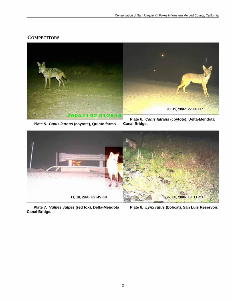
Conservation of San Joaquin Kit Foxes in Western Merced County, California
COMPETITORS
Plate 5. Canis latrans (coytote), Quinto farms. Plate 6. Canis latrans (coytote), Delta-Mendota
Canal Bridge.
Plate 7. Vulpes vulpes (red fox), Delta-Mendota Canal Bridge.
Plate 8. Lynx rufus (bobcat), San Luis Reservoir.
2

Conservation of San Joaquin Kit Foxes in Western Merced County, California
OTHER CARNIVORES AND ADDITIONAL WILDLIFE
Plate 9. Taxidea taxus (badger), San Luis Reservoir. Plate 10. Procyon lotor (ractoon), Delta-Mendota
Canal bridge.
Plate 11. Mephitis mephitis (striped skunk), San Luis Reservoir.
Plate 12. Spilogale gracilis (spotted skunk), San Luis Reservoir.
3
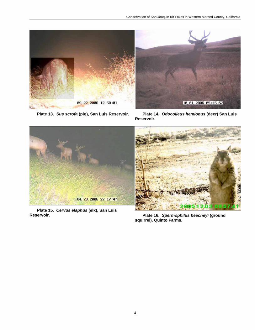
Conservation of San Joaquin Kit Foxes in Western Merced County, California
Plate 13. Sus scrofa (pig), San Luis Reservoir. Plate 14. Odocoileus hemionus (deer) San Luis Reservoir.
Plate 15. Cervus elaphus (elk), San Luis Reservoir. Plate 16. Spermophilus beecheyi (ground
squirrel), Quinto Farms.
4

Conservation of San Joaquin Kit Foxes in Western Merced County, California
Plate 17. Ardea herodias (great blue heron), Delta-Mendota Canal bridge. Plate 18. Sturnus vulgaris (starling) Urrutia
Ranch.
Plate 19. Bos taurus (cow) San Joaquin Valley National Cemetery.
Plate 20. Lepus californicus (black-tailed jackrabbit) San Joaquin Valley National Cemetery.
5