Conservation of Biodiversity in Nagaur District, Rajasthan 0.0 Introduction
142
CONSERVATION OF BIODIVERSITY IN NAGAUR DISTRICT, RAJASTHAN 0.0 Introduction Biodiversity is the term applied to the variety of the genes. Species and ecosystems found in respect to their geographical condition on planet. It embraces all the life forms from plant and animal life to micro organism and the water. Land and air in which they live and interact this richness – the earth’s living wealth provides an abundant and essential supply of indispensable goods and services. Farmers fields and gardens are also of great importance as repositories, while gene band, botanical gardens. Zoos and other germplasm repositories make small but significant contribution. The current decline in the regional biodiversity is largely the result of human activities, resulting in habitat destruction, over-harvesting, pollution and the inappropriate introduction of foreign plants and animals. Although the full consequences of this loss of biodiversity are unknown. There are nevertheless compelling scientific and ethical as well as economic reasons for conserving the many life forms an earth. Urgent and decisive action is needed to conserve and maintain genes, species and ecosystems, with a view to the sustainable management and use of biological resources. The participation and support of local communities are essential to the success of such an approach. The aim of the research for the conservation of biological diversity include pressing for the early entry into forces of
Transcript of Conservation of Biodiversity in Nagaur District, Rajasthan 0.0 Introduction

CONSERVATION OF BIODIVERSITY IN NAGAUR DISTRICT,RAJASTHAN
0.0 Introduction
Biodiversity is the term applied to the variety of thegenes. Species and ecosystems found in respect to theirgeographical condition on planet. It embraces all the lifeforms from plant and animal life to micro organism and thewater. Land and air in which they live and interact thisrichness – the earth’s living wealth provides an abundant andessential supply of indispensable goods and services.
Farmers fields and gardens are also of great importance asrepositories, while gene band, botanical gardens. Zoos andother germplasm repositories make small but significantcontribution.The current decline in the regional biodiversity is largely theresult of human activities, resulting in habitat destruction,over-harvesting, pollution and the inappropriate introductionof foreign plants and animals. Although the full consequencesof this loss of biodiversity are unknown. There arenevertheless compelling scientific and ethical as well aseconomic reasons for conserving the many life forms an earth.
Urgent and decisive action is needed to conserve andmaintain genes, species and ecosystems, with a view to thesustainable management and use of biological resources. Theparticipation and support of local communities are essential tothe success of such an approach.
The aim of the research for the conservation of biologicaldiversity include pressing for the early entry into forces of

the convention on biological diversity with the widest possibleparticipation the development of national regional strategiesfor the conservation of biological diversity and thesustainable use of biological resources and the integration ofsuch strategies into national development strategies and / orplant. The implementation of measures for sharing the benefitsderived from the research and development and use of biologicaland genetic resources, the carrying out of country or regionalstudies, and the production of regular world reports onbiodiversity based upon national assessment are also important.
1. The first programme area focuses upon the need forincreasing the availability of food, feed and renewableraw materials depend on the region.
2. The second programme area focuses upon improving humanhealth. Increasing environmental degradation, along withpoor and inadequate development continue to take a heavytoll on human health. New and local plantsspecies, animal base improves medicines anotherpharmaceutical products have an increasingly importantcontribution to make in tackling the causes of poorhealth.
3. The third programme area is aimed at enhancing theprotection of the environment poor land and wastemanagement and increasing use of chemicals and otherresources by an expanding global population have all ledto major environmental problem.
4. Integral to the application of conservation biodiversityis a programme area for enhancing safety and developmentinter regional mechanism for cooperation.
5. The final programme area is aimed at Institutionalcapabilities need to be strengthened at the national andregional levels to accelerate the development. There need

to be coupled with efforts to enhance enabling factor suchas training capacity, know how, research and developmentfacilities and funds industrial building capacity,protection of intellectual property rights and expertisein area such as richest area of biodiversity.
This research aims to enhance existing efforts atnational, regional levels to provide the necessary support forresearch and product development, raise public awareness of thebenefits and risk of future, help create a favourable climatefor investment marketing encourage and faster the traditionalmethods and knowledge of indigenous people and their localcommunities and enable them to participate in any benefitarising for development.
Today the scale of human impacts on the global biosphereis increasing dramatically due to activities that arise fromthe rapid growth in human population and increasing rates ofconsumption systems are being altered and destroyed, whilespecies in same groups of plants and animals are going extinctat rates some fifty to a hundred times higher than theyotherwise would and others are having their populationsdepleted.
The genetic resources essential for agriculture forestryand other continue to be last.This tragic loss and degradation of biodiversity holds seriouseconomic, ethical and cultural consequences for humanity andthe evaluation of life on earth. Indeed the very foundation ofsustainable development is being threatened.

Research should consider carefully how they interact withbiodiversity. If responsible measure are taken now, losses oralteration can be showed or in same instance halted byintegrating biodiversity concerns into national decision makingprocess using a combination of social and economic policies andincentives, by utilizing traditional and technical knowledgemore effectively.
Biodiversity is dynamic the genetic composition of specieschanges over time in response to natural and human inducedselection pressures the occurrence and relative abundance ofspecies in ecological communities change as a result ofecological and physical factory.The research is developing a data base on biological diversitycomprising data on
Plant and animal species of conservation value, includingthreatened species, and species with medicinal andeconomic value.
The status and distribution of habitats under threat andsites of high biological diversity within these habitants.
The national or regional protected areas the main speciesand habitats they contain and the effectiveness of theprotection they provide.
Conservation bibliography to provide rare speciesreferences to the data base information.
Geographical Biodiversity
Much of our understanding about the relationship betweenbiodiversity and environment has come from studies is land bio-geography. These studies have revealed the power influence oftwo geographic factor area and distance, on species diversity.The larger area of an island, the larger number of species it

can support and the greater the distance separating neighboringinlands, the lower the genetic miring and the lower theresultant biodiversity.
If we look at a map of a vast tract of semi arid region ofRajasthan undergoing destruction you will see that the patternis usually very patchy. As clearing progresses many of theseforest patches disappear, but some survive because they areprotected by rough terrain, land ownership, or culturalreligion factor or some factor.
In the rain forest the lass of species may actually exceed50 per cent with 90 per cent habitat reduction. The reason is that the ranges of many rainforest species are endemic, often not more than a few acres as a few square miles. 1.0 Geographical Introduction of the area
The district takes its name form its principal townNagaur, which is also its headquarters. The origin of the nameis uncertain, but an old reference is available which showsthat this place was formerly known as Nagapura. It was one ofthe chief towns of Ananta-gochar which included the regions ofHarsa and Shakambhari.
LocationThe district is located between latitude 26
0 25’ and 27
0
40’ N and longitude 730 10’ and 75
0 15’ E. The maximum length of
the district from north to south is about 146 km. Beingsituated in the centre of Rajasthan, it shares its border with
several other districts of the State. On the north it isbounded by Bikaner and Churu districts, on the east by Sikarand Jaipur on the south by Ajmer and Pali and on the west byJodhpur. The district is irregular in shape. Four of its eighttehsils, i.e. Nagaur, Jayal, Ladnun and Didwana, lie in theupper half of the north-west segment while the remaining four(Merta, Degana, Parvatsar and Nawa) occupy the lower half orits south-east portion. Nagaur tehsil is situated in thewestern most fringe of the district whereas its eastern-mostportion is enclaved by Nawa ; and northern and southern spursare represented by Ladnun and Merta tehsils respectively. Thedistrict also has a sub-tehsil named Makrana, which is a partof Parvatsar tehsil.
Its area, according to the Central StatisticalOrganisation of the Government of India (1966) is 17,828 sq.km. and in this respect, the district ranks sixth in the State.It is eighth according to population (1961 Census) which is9,34,948 with a density of 137 persons per square mile.
Topography1.1 (a) Configuration
The district resembles a deformed parallelogram, on theeastern and western sides of which stand two strangulatedtriangles with their vertices protruding in the neighbouringdistricts.

The topography is fairly even but for some scatteredhills, generally wooded, in the north and in the east, nearMakrana. Only a part of the district falls in the category ofdesert although the north-western region is bespattered withlarge sand-dunes, extending sometimes in a continuous series.They are locally known as tiba and dhora.
1.1 (b) ElevationThe general slope of the district is towards the west. Its
genera elevation is about 300 metres, varying from 250 metresin the south to 640 metres in the north.
1.1 (c) Hills There are no high hills in the district. Dots of hillocks,
however, are sporadically scattered, more so in the south-eastern sector. Near Jayal, Khatu, Mundwa and Khajwana, theyattain some height but are devoid of any vegetation. Those atJayal and Khatu are quarried for building stones. Tikli hillsare situated near the village of Raisinghpur (Didwana tahsil).Another group of Kolia and Pathava hills in Didwana tahsil donot attain any appreciable height. In Merta, Nawa and Parvatsartahsils, off-shoots of Aravalli range are projected, speciallyalong the common border with Ajmer district. Those nearKuchaman and Nawa attain some height. The general vegetationfound on them consists of Khair, dhav and thor. These hills arequarried for masonry stones especially the long pattis or slabswhich are used as beams in the buildings.

When compared with other areas of the district, Parvatsartahsil is found to abound in numerous clusters of hillocks. TheKabra hills spread for nearly 8 km. from village of Peelwa toBaser, Sirias and Kundri. Darmal range, nearly of the sameheight, runs from the village of Banwal to the border of Ajmerdistrict, nearly a distance of 8 km. Another range from Banwal,known as Dulliawalla, runs to Chachiyas and Narwaro. Amongother hillocks of the tahsil, the names of Karmakudi, Arath,Kinsariya, Lamtha and Mahagaon may be mentioned. All thesehillocks are covered with vegetation and trees such as Kakora,dhokra, dassuja, gangaren and khair. These are a number ofghats and ghatis or passes through these hills, sometimesrunning for a distance of five kilometres.
In Merta tehsil, the off-shoots of Aravalli, near Thanwalavillage, run for about five kilometres. Other clusters arethose of Tunkaliya, Riyan and Jogi Magra hills.
1.1 (d) DesertThe north, north-west and north-east portions of the
district form part of the great Indian desert.
1.2 River System and Water Resources1.2 (a) Rivers

No river originates from the district. However, the riverLuni, which rises near Pushkar in Ajmer district, afterdraining the western slopes of the Aravalli, crosses thedistrict of Nagaur in the south and flows through it towardsthe west for nearly 37 km. before it enters the Pali district.The important villages situated on its banks in the districtare Alaniyawas, Lungiya, Rohisa, Roisi, Jasnagar and Surpura.It is a non-perennial river and has intermittent flow dependingupon the rains. Its bed is sandy and percolation is fairlyheavy feeding the neighbouring wells and raising their waterlevel.
There are only a few seasonal streams and nullahs whichrise and disappear in the district itself. Their flow dependson the volume of the rainfall. Harsor stream originating fromthe off-shoots of the Aravalli, flows north-west and meetsanother streamlet past Harsor village and the combined streamloses its identity by discharging into the Pundlotasar. TheHarsor, having a sandy bed, has a total run of nearly 48 km.During the monsoon, rivulets and nullahs appear near thevillages of Khatu, Barnel, Jayal and Jani, but vanish into thesandy plains after a short run. The output of salt in thedepressions at Nawa and Baliya Kharda (in Didwana tahsil),depends on the numerous seasonal nullahs which discharge theirwater here.
1.3 Lakes and tanks

There is a big salt lake about 3 km. to teh south-west tothe south-west of Didwana having an area of 777 hectares (1920acres). The Nawa tahsil also shares a part of the well-knownSambhar lake (Kuchaman) in Jaipur district.
The district possess very few tanks. The details regardinglocation, area and volume of water during the rainy season ofthose tanks which are maintained by the Irrigation departmentof the State Government are :
1.3 (a) Pirji-Ka-Naka - It is situated about 2.5 km. fromParvatsar on the Parvatsar-Kishangarh road and has an area of1.8 sq. km. Its capacity during the rainy season is 1.262m.c.m.
1.3 (b) Harsor - Situated near village Harsor in Degana tahsil,the tank has an area of 2.5 sq. km. and capacity of 2.492m.c.m.
1.3 (c) Bherunda - The tank is situated near village Gole, 5km. north of Bherunda village and has an area of 2.3 sq. km.Its capacity during the rainy season is 2.044 m.c.m.
1.3 (d) Harsolao - The tank has an aea of 1.00 sq. km. with acapacity of 0.498 m.c.m. It is situated near village Harsolao.
1.3 (e) Mangalana - Situated near village Mangalana onParvatsar-Makrana road, the tank has an area of 0.7 sq. km. anda capacity of 0.790 m.c.m.
1.3 (f) Piplia (Govindgarh) - The tank has an area of 0.2 sq.km. and a capacity of 0.224 m.c.m. The tank is situated nearvillage Piplia on Merta city-Pushkar road.
1.3 (g) Dodiyana - It is situated near village Dodiyana onMerta city - Pushkar road and has an area of 0.7 sq. km. and acapacity of 0.644 m.c.m.
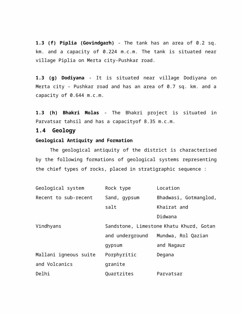
1.3 (h) Bhakri Molas - The Bhakri project is situated inParvatsar tahsil and has a capacityof 8.35 m.c.m.1.4 GeologyGeological Antiquity and Formation
The geological antiquity of the district is characterisedby the following formations of geological systems representingthe chief types of rocks, placed in stratigraphic sequence :
Geological system Rock type LocationRecent to sub-recent Sand, gypsum Bhadwasi, Gotmanglod,
salt Khairat and Didwana
Vindhyans Sandstone, Limestone Khatu Khurd, Gotanand underground Mundwa, Rol Qaziangypsum and Nagaur
Mallani igneous suite Porphyritic Deganaand Volcanics graniteDelhi Quartzites Parvatsar

Raialo Marble MakranaAravalli Phyllites DeganaPre-Aravalli rocks Granite Harsor
The granite exposed around Harsor, although not of mucheconomic significance are the oldest rocks found in thedistrict overlain by the phyllites and biotite schists of theAravalli system. The Raialo formations succeeding over theAravallis, are mainly composed of good quality marble ofvarious shades occurring around Makrana. This building stonehas been a source of attraction from olden times and is said tohave been used in the construction of the Taj Mahal at Agra.
The Delhi formations stretch along the eastern border ofthe district in a north-north-east and south-south-westdirection, from Pushkar to Kuchaman through Parvatsar andcomprise quartzites, clae gneiss, schists and impure limestone.The granites of Mallani system intrude the Aravalli phyllitesat Degana and are responsible for the occurrence of a goodwolfram deposit. The Vindhyan flagstone (sandstone) quarriednear Khatu are used for carving window screens with geometricalpatterns. The limestone of this age occurs at Gotan and Mundwawhere a large lime burning industry thrives on these deposits.The Vindhyan formations around Nagaur town emit extensivedeposits of gypsum.
All grades of gypsum deposits of the sub-recent to recentage of geological antiquity, are located at a number of placesin district.
At the close of Carboniferous period the Aravalli rangewas occupied by an ice sheet which streched as far north as thesalt range via Bap. Boulderbeds are found in the salt rangewith boulders whose source was undoubtedly Rajputana in part.During Permo-carboniferous times a large sea covered theHimalayan area, Salt range, Baluchistan and Sind and an arm ofthe sea stretched from Punjab area through Kutch into theNarbada valley. It is difficult however to know the exactboundaries and shape of the Permo-carboniferous sea.
The early Mesozoic period in Rajasthan is marked byearth movements which created the great boundary fault andrejuvinated the Aravalli mountains. Information about theTriassic period in W. Rajasthan is very scanty and in Kutch theerruption of the Deccan lavas has covered much of the geology.It is not known whether there are Triassic rocks under therecently developed Jurassics. In the Jurassic period, W.Rajasthan was peneplained and was invaded by the sea. Thepresence of marine Jurassic rocks in Kutch and Kathiawar, W.Rajasthan and Baluchistan give a clear indication that inJurassic times most of the present arid zone was under the sea.The esturine faces of Urnia plant beds of Kutch, Idar andBarmer indicates that the sea regressed from W. Rajasthan inearly Cretaceous times but that Baluchistan was still undermarine water. The Urnia plant beds were overlaid by sediments
from which it may be inferred that the sea transgressed againin middle Cretaceious times. A sea connection was establishedbetween the arm of the Tethys and the Narbada valley acrossnorth of Kathiawar via Baluchistan during the upper Cretaceioustimes. Cretaceous marine transgression was followed by a hugeoutpouring of Deccan lava which continued into the earlyTertiary.
The Eocene period in the arid zone of the Indiansubcontinent is marked by an active marine transgression whichcovered Sindh, Baluchistan, Southwest Punjab and W. Rajasthan.The widespread Eocene transgression was apparently connectedwith the final large-scale foundering of Gondwanaland.
During the Oligocene and Miocene period a continuousdownrap took place infront of the Himalaya and the Suleman andKirthar ranges owing to the compression, while the sea from W.Rajasthan into the foredeep. An arm of the sea may haveextended into the Indus and the Luni valleys. Oligocene-Miocenecalcareous rocks developed in Sindh and Baluchistan and arefound on teh eastern side of the Eocene beds. It may beinferred that the sea regressed towards the east of Suleman andKirthar ranges.
In the Pliocene period the sea withdrew into a narrowchannel occupying the Indus and Luni valleys. The Mancher andMekran series deposited in the estuarine to submarineconditions indicate that the sea was becoming shallow inBaluchistan. In Pleistocene times the sea extended through theRann of Kutch into the Indus, Saraswati and Luni valleys.Sedimentatin has continued to the present day but it is notknown when the foredeep actually became the dryland.
As a result of this geological history Archaean rocksoccur mostly in Rajasthan. Mesozoic rocks are exposed in a fewplaces in W. Rajasthan and in the central axis of Suleman andKirthar ranges. Tertiary rocks are well exhibited in tehmountain ranges of Baluchistan, as well as exposed in a fewplaces in patches near Jaisalmer. All the Indus valley and aconsiderable art of W. Rajasthan are covered with recentdeposits.
There is an intimate causal relationship between reliefand geological structure, the landforms are in extremeconstrast. The youthful relief of the folded Baluchistan hillsdiscloses a complete picture of anticlines and synclines. TheIndus plain with flat and featureless aggradational surfacescontrasts sharply with the Baluchistan hills and W. Rajasthanwith its peneplained surfaces.
Origion of Some Landform
Playas or Ranns. Different theories have been putforward to explain the origin of these salt lakes or depressionin W. Rajasthan, Hume (1924) proposed that the brine of thesalt lakes was a surface deposit, the result of the dessicationof the sea in teh late Tertiary period. However, the absence ofcalcium and magnesium salts rules out this theory. It is alsosuggested that under the silt of the lakes or sand there areold rock salt beds of marine formation. However, no evidence ofsalt deposits or marine sediments has been brought to light.Noetling (cf. Sarin 1952) is of the view that the salt ofSambhar lake is obtained from a subterranean saline spring.Subterranean percolation from the extensively irrigated Punjabor the Salt lake region of Pakistan is yet another explanationoffered. However, the Sambhar, Didwana and other lakes arewithin an impervious area of the Aravalli schist and at
relatively higher level to be influenced by the undergroundpercolation from the salt range.
Holland and Christie (1909) advanced the view that thesalts are carried by wind from the Rann of Kutch either asparticles or sprays of sea water and deposited over the land.They are subsequently washed by the rains and deposited in thelakes. This would mean that about 1,50,000 tonnes of salt aretransported every year into the Sambhar lake. Hora (1952)remarks that this could be possible if cyclones occured attimes for they are known to cause even rains of fish.
The difference between the composition of the lake saltand the sea salt is a major objection to this windborne salttheory. Besides, the composition varies from one lake toanother.
The generally accepted theory is that salts have beenformed by the atmospheric decomposition of (felspathic rocks ofthe region) granite and gneiss of the Aravallis and leached outby rainwater and carried to depression without outlets. Localsalinity may also be due to the hillocks buried under the sanddamming the underground waterflow. The heavier salts or calciumand magnesium are the first to be deposited, potassium andsodium later, being more mobile. The sodium and potassiumsalts, the last to be deposited, evaporate where thesubterranean flow is blocked causing a local saline depression.
Quaternary Records
Lake Deposits of Sambhar, Lunkaransar, Didwana and Pushkar
Pollen-analytical, biostratigraphical and C-14 studiesof Holocene lake deposits have recently been carried out atSambhar, Lunkaransar, Didwana and Pushkar in Western and

eastern Rajasthan by Singh and his associates (Singh, 1967,1970). They have revealed that major part of the present dayflora of Rajasthan was already well established at thebeginning of the Holocene period, about 10,000 years ago, andthat barring a few instances, the subsequent changes observedin the Post-glacial vegetation were more ecological thanfloristic.
Singh (1970), has brought forth stratigraphical andgeomorphological evidence to show that the period immediatelypreceding the Holocene in western Rajasthan was marked bysevere aridity and that strong dry winds caused the building ofsane-hills which, in some cases led to the choking of valleysforming inland basins. The silt and clay deposits, nowoccupying these basins and containing salt, gypsum etc. aresuggested to have been laid during the Holocene period. Basedlargely on pollen analysis and C-14 dating of the lakesediments at Sambhar, Lunkaransar and Didwana, thesedimenmtation in the above basins seems to have started with asudden change in climate towards higher rainfall at about thebeginning of the Holocene period dated at ca, 10,000 B.P. It isrevealed that sedges, Typha angustata, Mimosa rubicaulis,Oldenlandia and Artemisia, which are plants of comparativelyhigher rainfall than that of western Rajasthan today, enjoyed aluxuriant growth in this area.
Singh (loc. cit.) divides the Post-glacialvegetational-cum-climatic history into five pollen zonesA,B,C,D and E, and six climatic phases I, II, III, IV, V andVI. Zones B,C, and E, and phases III, IV and VI are furthersubdivided into subzones and subphases.
The vegetational history starts with Zone A 9ca.10,000-9, 500 B.P.), with the change in stratigraphy from loose

sand to lacustrine clay. The zone begins with highrepresentation of sedges, Artemisia and grasses, and low Cheno-Ams. The vegetation is comprised of an open steppe in whichboth grasses and Artemisia appear to have grown in greatprofusion. The sedges and Typha angustata, perhaps occupied thelake margins. Mimosa rubicaulis and oldenlandia now growingmostly in Punjab and the Himalayan foothills, appear to havegrown well in thepresent-day Semi-Arid Belt (25-30 cm.rainfall; Singh, loc. cit.) of Western Rajasthan. They,however, do not seem to have encroached into the Arid Belt (0-25 cm. rainfall; Singh loc. cit.). It is suggested thatfreshwater conditions prevailed in the present salt take basinsat Sambhar, Didwana and Lunkaransar. The tree and shrubs suchas Acacia, palms, Maytenus and Ephedra, might have grown insmall numbers in the Semi-Arid Belt, and Calligonum, Maytenus,Ephedra, Capparis, Zizyphus and Tamarix in the Arid Belt. Thelow development of both trees and shrubs in this zone isascribed to teh slow migration of these elements following thephase of extreme desiceation preceding Zone A.
The vegetation of Zone B (ca. 9,500-5,000 B.P.), as awhole, is suggested to have been more or less uniform in theSemi-Arid Belt. Hence it is infrered to have been comprisedmost probably of a steppe-cum-Savannah type of vegetation.There is an increase in teh diversity of tree and shrubvegetation and the pollen of such elements as Maytenus,Capparis and Prosopis cineraria begins to occur more frequentlythan in Zone A. While grasslands continue to preponderate allover western Rajasthan, Artemisia is comparatively moreabundant in the east than in the west. Sedges decline, andthere is a rise in the frequencies of Cheno-Ams., indicatingthe creation of comparatively more halophytic situations. In

Subzone B2, there is a small but progressive rise in thefrequencies of sedges, and Cheno-Ams. decline. Mimosarubicaulis and Oldenlandia are suggested to have been wellestablished in the Semi-Arid Belt but their representation isconsidered to have remained poor under the Arid and Semi-AridBelts, indicating the continuation of fresh water conditions inthe lakes. Cerealia type of pollen grains (grass pollen above40 in size) start appearing in subzone B1 at all the lakesites investigated and their first occurrence in the lakeprofiles is C-14 dated between 9,500 and 8,300 B.P. As theabove pollen type starts occurring at more or less the samelevels in the profiles as the sudden rise in the frequencies ofburnt wood remains in the sediment at all the sites, it isinferred that some primitive form of cereal agriculture,through burning of scrub vegetation, was introduced inRajasthan around 8,000 B.P. (6,000 B.C.). This evidence,however, runs counter to the opinion held by archaeologists,according to whom, the cereal cultivation is so far known toextend back only to the Harappan times (2,500 B.C.).
In Zone C (ca. 5,000-3,000 B.P.), the tree and shrubvegetation is suggested to have increased all over Rajasthan.Besides, the sedges show an abundant rise in frequencies,indicating the creation of swampy conditions. Both theGramineae and Cheno-Ams. decline. There is an increase in thepollen frequencies of Capparis, Prosopis cineraria and Acacia.Moreover, both Syzygium and Mimosa rubicaulis, representingplants of comparatively higher rainfall than that of thepresent-day western Rajasthan, attain their maximum pollenfrequencies in this zone, in the Semi-Arid Belt. Syzygium whichnow grows in areas above 50 cm. rainfall, is suggested to haveextended westward up to the Thar area. The representation of

Syzygium, Mimosa rubicaulis and Oldenlandia is seen at itsmaximum in the east, becoming less and less towards the west.
The vegetational record in the form of sub-fossilpollen in the lake sediments of western Rajasthan is seen up toZone C only, a period which is inferred to have experiencedmarkedly higher rainfall than at present. The picture ofvegetation of western Rajasthan following Zone C, that is afterabout 1,000 B.C. (3,000 B.P.), is rather obscure. From theevidence gathered from the Pushkar lake in the Aravallis, it issuggested (Singh, loc. cit.) that the xerophytic desert floraconsisting of Calligonum, Maytenus, Aerva, Capparis andEphedra, encroached into areas now occupied by mesophyticvegetation near Pushkar in Zone D (ca. 1,000 B.C. - 300 A.D.).According to Singh (loc. cit.), the lakes started drying out inthe Thar area around 1,900 B.C., and in the east, at Didwanaand Sambhar, around 1,000 B.C. The onset of desiccation inRajasthan in general, is suggested to date back to about 1,800B.C., after which, but for a small oscillation towards slightlywetter conditions between 1,500 and 1,000 B.C., the climatecontinued to deteriorate until about 300 A.D. A sight increasein rainfall is inferred for the period 300 A.D. - present fromthe continued increase in the frequencies of mesophyticelements such as Ficus, Anogeisssus pendula, Aegle marmelos,Syzygium and Mimosa rubicaulis and general fall in values ofall the desert elements in Zone E at Pushkar.
Gypsum Deposits
Jacob et al (1952) recovered well preserved nucules ofChara along with some fresh water Ostracoda from a bed ofimpure gypsum of Jamsar near Bikaner. Similar nucules of Charaassociated with shells of Vivipara bengalensis were alsorecovered by these authors (loc. cit.) from Siasar, a locality

lying about 112 km. west of Jamsar. The genus Vivipara isalmost entirely found in fresh water habitats. The species V.bengalensis is known only from Recent and Sub-Recent deposits.Jacob et al. concluded that most probably the Siasar gypsum hadbeen precipitated in Sub-Recent times in land-locked basinsinto which shells of Vivipara and ‘fruits’ of Chara had beenbrought in by fresh water affluents. The same conclusion mightalso hold true for Jamsar.
1.5 Minerals
The district has large deposits of the following mineralsof economic importance.1.5 (a) Gypsum - Nagaur district is very rich in the gypsumdeposits. The areas bearing gypsum in the district are :Nagaur, Bhadwasi, Got Manglod, Khairat, Dhakoria, Bhadana andMalgu. As estimated by the Geological Survey of India, throughdrilling, the reserves amount to 952 million tonnes containing81 per cent and above CaSO4. 2H
2O. The underground deposit has
not been worked so far. Most of the gypsum produced here, issupplied to the Sindri Fertiliser Corporation.
1.5 (b) Wolfram - The wolframite deposit is found in the Rewathill near Degana. The mineral, a tungstate of iron andmanganese, occurs in the veins or lodes in granites andphyllites. Tungsten is chiefly used in the production of alloysteels and high speed cutting steels which retain hardness evenwhen red hot.

1.5 (c) Marble - This is found at Makrana in the Parvatsartahsil, in six different bands extending for about 10 km.Makrana marble, which occurs in various beautiful shades-white,pink and spotted, is one of the best marbles in the world. Itretains high grade polish which is amply proved by some of theold monuments built of this stone. Marble blocks of any sizecan be quarried out but due to constant working, the quarrieshave gone deep and it is difficult to haul up huge blocks now.
1.5 (d) Lime Stone - Best grade lime stone occurs at Gotan,Mundwa, Katholi and Ambali in the district.
1.5 (e) Sand Stone - It is found almost everywhere in thedistrict but the best grade is available only at Khatu inDidwana tahsil, where some 150 quarries aer being worked.
1.5 (f) Salt - The district is one of the important saltproducing centres which is manufactured at Nawa and Didwana.
1.5 (g) Sodium Sulphate - It is produced from the salt lakebelow the salt concentrates at Didwana.
1.5 (h) Clay - Fairly good deposits of white clay are foundnear the villages of Saradhana, Khajwana, Mundwa, Dharia Khurd,and at a number of places in Merta Tahsil. It is chiefly usedin making toys.1.6 Earthquakes
The district rests on a stable mass where no earthquake ofany significance has been located in the past. According to theRecommendations for Earthquake Resistant Design of Structures

published by the Indian Standard Institution, the district issituaetd in Seismic Zone II and is liable to experience slightto moderate intensities. However the earthquakes originating inthe great Himalayan Boundary Fault Zone, the Rann of Kutch andthe Suleman Mountain Range have caused fringe effects withvarying intensities in the district in the past. A fewearthquakes of small magnitude occurring in the Sambhat lakearea have been occasionally felt in the eastern part of thedistrict. The following table shows the intensities of theshocks experienced in the district or which were likely to havebeen felt in the area as judged from the reports of theadjacent regions.
Year and date of shock Location Intensityexperienced
as per modifiedMercalli Scale 1931
1819, June 16 Kutch Felt1905, April 4 Kungra IV-V M.M.1931, August 27 Baluchistan Felt1934, January 15 North Bihar IV M.M.1936, May 27 Kumaon region Felt1939, January 17 -- Felt1955, January 27 -- Felt1967, May 11 Sambhar Felt1969, August 20 Sambhar Felt1969, November 18 Sambhar Felt

1.7 Climate
The climate of this district, in common with the adjoiningdistricts of Rajasthan is characterised by highly variablerainfall, extreme dryness and large variations of temperature.The winter season from November to March is folowed by thesummer from April to June. The period from about the beginningof July to the middle of September constitutes the main rainyseason. The latter hald of September and October forms thetransition period.
1.7 (a) RainfallRecords of rainfall in the district are available for
seven raingauge stations namely, Nagaur Didwana, Merta,Parvatsar, Nawa, Merta Road and Maroth for periods from 32 to82 years. Tables I and II give the rainfall at these stationsand for the district as a whole. The average annual rainfall inthe district is 383.4 mm. (15.09”). The rainfall generallyincreases from teh north-west towards the south-east, in thedistrict. The period from June to September is the rainyseason, July and August being the rainiest months. The rainfallduring the period June to September constitutes about 89 percent of the annual rainfall. The variation in the rainfall fromyear to year is very large. In the fifty-year period, from 1901to 1950, the highest annual rainfall in the district amountingto 251 per cent of the normal occurred in 1917. The very nextyear, 1918, was the year with the lowest annual rainfall whichamounted to only 19 per cent of the normal. In the same fifty-year period, the annual rainfall was less than 80 per cent ofthe normal in 16 years. In the district as a whole, during this50 years’ period, two consecutive years of rainfall less than80 per cent of the normal occurred five times. Considering therainfall at the individual stations, even 3 and 4 consecutiveyears of such low rainfall occurred once or twice at the mostof the stations. Parvatsar recorded four consecutive years of

such low rainfall twice during the 50 year period. It will beseen from table II that the annual rainfall in the district wasbetween 200 and 500 mm. (7.87” and 19.69”) in 34 years out offifty.
On an average there are 22 rainy days (i.e. days withrainfall of 2.5 mm. 10 cents or more) in a year in thedistrict. Except at Nawa which has about 27 rainy days in theyear, the number of rainy days is more or less uniform over thedistrict and is about 20 to 22 days.
The heaviest rainfall in 24 hours recorded at any stationin the district was 306.8 mm. (12.08”) at Parvatsar on 1929,July 24.
1.7 (b) Temperature There is a meteorological observatory at Nagaur started on
May 13, 1958. The description of the climate that follows isbased on the record of observatory for the period 1958 to 1965and also the records of the observations of neighbouringdistricts. Temperatures rise rapidly from March. May and Juneare the mean hottest months with mean daily maximum temperatureexceeding 40.0
0C. Maximum temperatures rise upto 28
0C in June.
The summer months are intensely hot and dust laden winds blow.The maximum temperature may sometimes exceed 48
0C. With advance
of the south-west monsoon into the district by about thebeginning of July, day temperatures drop appreciably but withthe withdrawal of the monsoon after about the first week ofSeptember while the night temperatures continue to fall daytemperatures show a rise and the secondary maximum in day
temperatures is attained in October. Thereafter both day andnight temperatures decrease rapidly. January is the coldestmonth with the mean daily maximum and minimum temperature at22.5
0 C and 6.7
0C respectively. During the winter season, in the
wake of passing western disturbances, spells of colder weatherare experienced in the district. The minimum temperature onsuch occasion may drop down to below the freezing point ofwater and frosts may occur. The diurnal variation oftemperature during winter months is of the order of 16
0C and
the drop in temperature after sunset is appreciable.
The highest maximum temperature recorded at Nagaur was48.4
0C on 1965 May 31 and lowest minimum temperature was 2.0
0C
on 1964, January 23.
1.7 (c) HumidityExcept during the short south-west monsoon season, the
relative humidities are very low. Even during the monsoon lowhumidities prevail in between the rains. The summer months arethe driest, when relative humidities are on the average between20 and 35 per cent in the afternoons.
1.7 (d) CloudinessDuring the monsoon season the skies are heavily clouded or
overcast on some days. In the rest of the year the skies areclear or lightly clouded. In the winter season, in associationwith passing western disturbances, cloudy skies prevail forshort spells of a day or two.1.7 (e) Winds
Except for moderate to strong winds during the period fromMay to August, winds are generally light to moderate. Duringthe period from November to February the winds are mainly fromdirection between north west and north. Westerly to south-westerly winds begin in March and these become more common withthe advance of summer. In the south-west monsoon season, windsare mostly from directions between west and south. DuringOctober, winds are light and variable in direction.1.7 (f) Special weather phenomena
Some of the depressins which originate in the Bay ofBengal during the south-west monsoon season move in a westerlyto north-westerly direction, and occasionally reach thedistrict or its neighbourhood causing widerspread rain andstrong winds, before dissipating. Dust-storms and thunder-storms occur in the hot season and are sometimes accompanied bysqualls. Thunder-storms occur in the monsoon season also.
Tables III, IV and V give the temperature and humidity,mean wind speed and frequency of special weather phenomenarespectively for Nagaur.
1.8 Objectives of the research studyThe study has focus upon the following objectives –
1. to prepare thematic maps of various resources andbiodiversity.
2. Identify potential areas for conservation by integratingseveral map themes, ranging from vegetation type, land-
use, land-cover to endemic plants, birds and larger animaldistribution.
3. Investigate the relationship between forest fragmentationand density of animals over the particular area.
4. Location of resources and their conservation according toavailability.
5. An evaluation of status of habitats across all forestdivision of the area.
6. Assessment the changes in the habitats over the last threeor four decades.
7. A geographical analysis of selected (endemic) plantspecies distribution.
8. Examination of distribution of animals and plants speciesrelating to landscape variables.
9. Assessing the concordance of (endemic) bird species(abundance) with the animals.
10. The diversity of existing organisms.a. The (resources scare city and) biodiversity in Nagaur
district due to geomorphology, physiography anddrainage pattern.
b. Semi-arid medical plants and their use in chronicdisease.
c. Areal differentiation in the area.d. Differentiation between migrated bird and local bird
habitated.e. Local species of flora and fauna.

The research will cover the detailed study of the majorbiodiversity (and resources conservation) planning, the naturalregion of the district which have commercial value like marble,tungsten, gypsum, Nagaur ox, sheep, goat camel, birds, plantsand salt lakes etc.
The study will cover a deep analysis of main geographicaland human influences which have assisted the conservation ofplanning of this area.
1.9 Land use and Land DegradationLand use – Along with the increasing trend in the growth ofhuman population there has been a parallel expansion ofagriculture. From the late twenties to theearly fifties of thepresent century the trend was to bring under plough more of thehitherto uncultivated land. The predominant farming systemstill used to maintain nearly half of area as follow during anyparticular year.Land degradation – Problems of man induced land degradation arecommon amongst the various farms of land degradation, winderosion in most extensive in Nagaur and is attributable to thehigh credibility of the sandy soils, strong wind regime andsparseness of vegetation cover.The increasing agriculture and decreasing follow have broughtdown biodiversity quantities in Nagaur leading to disseminationof whipping out of several useful native species which providesurvival support to the people.
1.10 Research Result and AchievementsA primary objective for a geographer is to look into the
main influence which have led to the origin of animals, birdsand plants. Thus on the above ground a hypothesis can be in theforms of following statements.
1. geographical information system is a right approach toconservation planning and spatial distribution of thearea.
2. Nagaur district in Rajasthan is richer district inresources and biodiversity. It is also transitional zone.
3. Geo-economic, physical, political, historical and culturalfactors are responsible for affecting the spatialdistribution of biodiversity.
4. geomorphology and climate and the other biotic factors arethe major factors behind the degradation of biodiversity(requiring conservation).
5. spatial distribution of biodiversity is affected by theheredity, tolerance limit and migration of animal andplants.
Some linked statements in the given hypothesis needspecification.
a. How traditions and culture are linked withbiodiversity and conservation?
b. Conservation can not be taught but it comes throughthe necessities arising out of areal differentiation.

c. The basic conservation is obtained through localresources.
d. Conservation planning has significant role in theeconomy of the region as those are employment-oriented and can provide alternative sources ofincome in the village.
1.11 The Problem to be InvestigatedConservation planning is best understood as a process of
change in which the use of resources, the direction ofinvestments, the orientation of technological development andinstitutional change all enhance the potential to meet humanneeds both today and tomorrow.Stress will be laid on the mutual relationship betweenenvironment and development for the past few years. These twoare in fact looked as complementary to each other Environmentchiefly includes water, trees, animals and birds, other livingcreatures, air and land etc.As such efforts will also be made to find ways to control waterpollution, air pollution, soil erosion, increasing alienate,and salinity in soil desertification, deforestation, noisepollution etc.However, the basic idea behind this concept is that the presentgeneration while enjoying the fruits of development should keepin mind that the future generation may not be made to sufferdue to environmental degradation.
Nagaur has sufficient potential for conservation ofresources and bio-diversity of the area. Availability of waterresources in less and conservation of water resource and bio-diversity is necessary of the area and local people ofsurvival.
All this may lead to the bright future of the bio-diversity in Rajasthan if little more care and attention isprovided to them by the government, capitalists and localpeople in right manner. What is needed, is the properprotection of these resources in the world and conservation ofmuch needed information to the bio-diversity and people dealingevery day life and its importance, fauna and flora.
If the present condition of the area is not improved, thefuture generation will bear the blunt of controlled andillogical use of resources.
The study of resources has been made largely by nature andapplied scientists, including geographers. Resource geography,however, is one of the neglected areas and geographers in Indiahave not made any significant contribution in this field.
Not much work has been done by Indian geographer’s on suchan important resource as forest and there is hardly anysignificant research contribution in the systematic study ofstate fauna and flora.

Present research will contribute a lot to resource andbio-geography, Humanists and, Naturalists take care of theearth by processing raw material and make them more valuableand utilizable for next generation of our nation. It willencourage to take care of our “Dharti Ma” which fulfills allthe needs of human being.
The conservation of resources does not mean non-use, butit means their scientific and rational utilization for thegreatest good of the largest number for the longest time. Italso means that the rate of increment and not the capital basicresource, be consumed for utilizations and wherever possible,in scarce materials substitute may be made use of as forpossible.
1.12 Research Design and MethodologyThe present study will be micro level area study of Nagaurdistrict. It will be based on GIS, field work, field survey andIRS and secondary data.1.12 (a)Primary Data
1) The primary source of data to be used in the presentinvestigation will be based on GIS, Field work, Fieldsurvey, Observation, Questionnaire etc.
2) The ground truth verification will conducted for land use,land cover map in limited area to check the identifiedunits.

3) Distribution data of selected endemic plant species forherbarium record to conduct a gap analysis of protectedarea.
4) Distribution and abundance of animal species to obtain acomprehensive picture of status of their localities.
5) Distribution of selected endemic plants and birds andthreat to these categories in check concordance betweenbirds and animals.
1.12 (b) Secondary DataSecondary data will be collected from remote sensing data
department. These will be properly tabulated and computed oncomputer in order to find out final result.1.12 (c) CartographyMaps, Chart, Physiography, Geographical information
1) Maps of vegetation, 2) Land use, 3) Land cover, etc., 4)Resources, 5) Plants
6) Birds, 7) Animal etc.
1.12 (d) Tools to be used in Collection of DataFor the field survey work, GIS, Remote sensing data will
be prepared to have an intensive knowledge about the area.Typed questionnaire will be served for measuring the sense ofconservation among the people.
Primary and secondary data related to birds and animalswill also collected from concerned department and they will be
properly tabulated and computer in order to find out finalresult.
It is, therefore, paramount to understand the dynamics ofbiodiversity, human and livestock population which areintimately linked. The present scenario suggest a alarmingsituation in That.
The Nagaur District of Rajasthan is important withpopulation. The National Census for 1981 indicated a totalpopulation of 18.48 million – an increase of 37%. The figurefor 1991 is 24.4 million! The present density of population is69 persons per square kilometer, making the arid one of themost densely populated deserts in the world. Alongwith thehuman population increase, there is a steady increase in thelivestock population as well. With about 25 million livestock(1997-98), the density works out to be 120 per sq. km.
Concomitant decline in pasture land and fallow lands alongwith good biodiversity are also expected to take place(Venkateswarlu et. At. 1990). As the pressure on the marginalland is increasing, there is more of over grazing anddeforestation. The net effect of such ecological stress hasbeen an increase in the aeolin and fluvial erosions in theregion. Curiously enough, such ecological stresses over thecenturies have also resulted in ingenuities in land and watermanagement systems, such as the Khadins and nadis, thecounterparts of the cisterns of the Negev. By census opinion

the permanent pasture (or the Orans, Gaucher) around thevillages are generally kept out of cultivation, especially asan insurance against droughts.
Kuchaman, Deedwana and Nagaur Tehsils were selectedprimarily because little biotic interventions were seen inthese villages besides the major landforms of a Thar desertecosystem available here in natural setting. These villages, byand large, represent all important village institutions whichfrom the basis of this study.
1.12 (e) Interviews : The field surveys were supplementedby developing simple questionnaire to elicit informationthrough peoples knowledge of the area, like land cover,institutional forms, biodiversity niches, subsistencepractices, land use practices, grazing and browsing pressures,soil types, agriculture practices, and so on.These randominterviews numbering 3600 were confined to 60 villages and wereconducted during April 2002 to Oct., 2003. These interviewsprovided basic biodiversity related issues of the Thar and withmore insight of past, present and future scenario of thebiodiversity.
Over 3552 hours were spent on this study from April 2002to October 2003. The detailed list of surveyed tehsils andvillages are shown in Table No. I.
1.12 (f) The Village Subhabitats (Village Institutions) :Surveys and interviews helped considerably to demarcate varietyof sub habitats or institutional areas each representing a subecosystem in itself. Studies were attempted in thesesubhabitats or village institutions to understand thebiodiversity and variations thereof. These village institutionsare :
1. Gaucher : Defined as gram panchayat controlled grazinglands.
2. Oran : Defined as areas where tree-cutting is barred bycommunity consent and divine control and where suchrestraint is actively observed.
3. Fallow Lands : Defined as Khatedari (privateagricultural) lands with usually ‘Kharip’ crops. Atleast2-3 years in fallow, managed as closed fodder fieldsduring the growing season and thereafter as community-wide open grazing.
4. Plough Fields : These are of two types (i) Traditional –Those in which ploughing is done by animals to avoiddesruction of useful species in the fields duringtilling. (ii) Disc – In which mechanized methods areused wherein massacre of species takes place.
5. Sanddunes : Defined as natural sand masses eitherstationery or stabilized or shifting. Usually with goodmoisture.
6. Forest Enclosures : Defined as land under the presentcontrol of the Forest Department for plantation.
7. Gravel Lands : Defined as low productive area withlittle soil cover and moisture.
8. Wastelands : Defined as areas provided with mixture ofcharacteristics with low productivity.
9. Water (Salt) Lakes : Defined as a conservation area ofsaline water orgn.These village institutions or subecosystems encompasses
all kinds of major landforms of the study area.1.12 (g) Plant and Animal Sampling : Sampling were done
in September and early October in the high growth periodfollowing the rains. 34 sampling sites in villagesMolasar, Kolia and Dolatpura were selected for plantcover. For animals presence, 8 sites in Kuchaman and 8 inKolia were selected. For plants, they were stratified ineach village to include atleast one of the fourinstitutional types, I, II, III and VI. The other typeswere not tested as the sample sizes were too small andvariation in local management rules was considered toohigh. For animals all the institutional types werecovered.
At each site, a central point was selected. Where theinstitutional area was larger than 4 hectares (40,000square meters), a point was selected at random. In thecase of extremely large institutional areas (for example,the Kolia Oram), sample points were spatially stratifiedacross a loose grid. From the sample point, a compass

direction was selected at random and a 100 meter transactwas laid form the point. A line transact method wasemployed to a measure coverage by species intercept and 10quadrates were laid alternately on either side of thetransact line to measure frequency as shown in figure. Thebasal intercepts of each species was recorded along thetransact to derive.Plant Community Study : Some 18 distinct plant communities
are found in this area which represent association betweenspecies and the positions of various ecological communities insuccession. Four of these communities were dominated by treespecies. These were used as indicator species of plants as wellas animal species in the surrounding areas. In interviews withpeople, especially pastoral caste members of women, many treeswere described as supporting particular kinds and quantity ofunder story
To examine these interrelationships in the field, samplestrees were tested for the character and quantity of theirunderstory coverage and other associations particularly theanimals.
Tree Test Method (Pl. 8): A sample of 44 trees wasselected in a single quadrant of a large oran (sacredforest/grassland) in the village of Kolia in Nagaur district.The total area of the study was approximately one km2. Thesample trees were selected from an alternating court in fourcompass directions from a central point. 20 bordi trees, 14 kertrees and 10 khumbat trees were selected. At each tree, acompass point direction was chosen at random and five, 2500 cm2
quadrates were laid extending to 2.5 meters from the base ofthe tree. The procedure was repeated on the opposite side ofthe tree, giving a total of 2.5m2 of sample coverage.
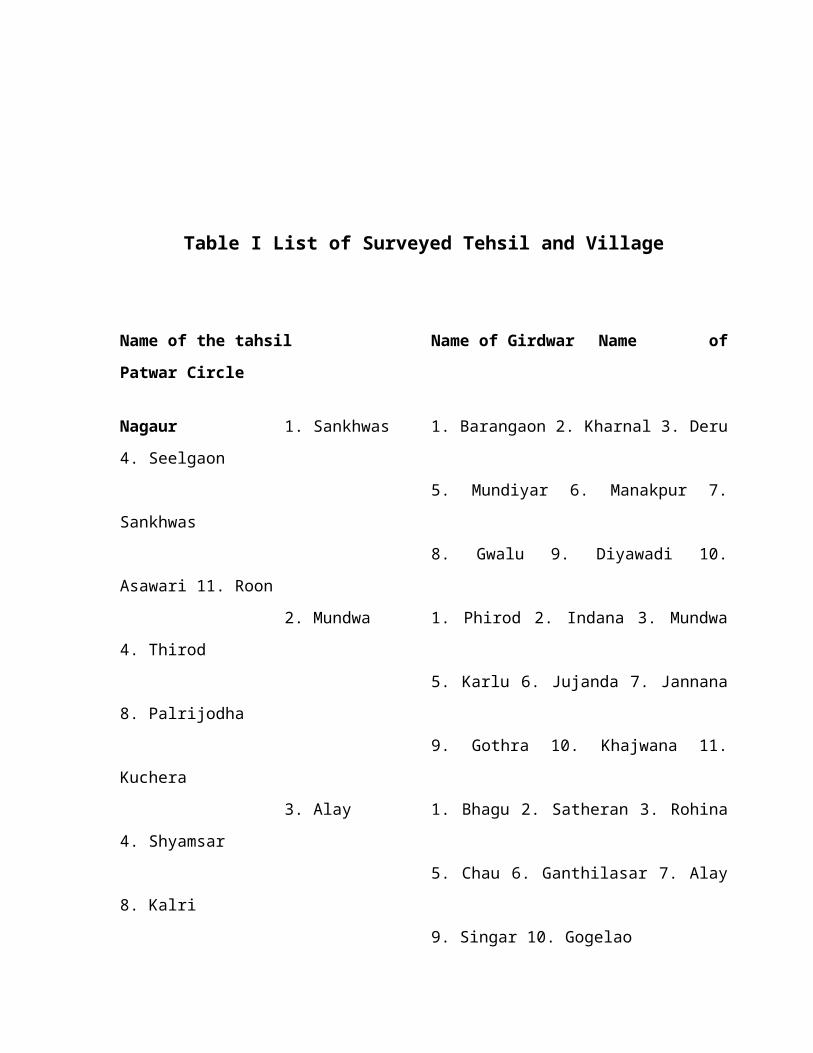
Table I List of Surveyed Tehsil and Village
Name of the tahsil Name of Girdwar Name ofPatwar Circle
Nagaur 1. Sankhwas 1. Barangaon 2. Kharnal 3. Deru4. Seelgaon
5. Mundiyar 6. Manakpur 7.Sankhwas
8. Gwalu 9. Diyawadi 10.Asawari 11. Roon
2. Mundwa 1. Phirod 2. Indana 3. Mundwa4. Thirod
5. Karlu 6. Jujanda 7. Jannana8. Palrijodha
9. Gothra 10. Khajwana 11.Kuchera
3. Alay 1. Bhagu 2. Satheran 3. Rohina4. Shyamsar
5. Chau 6. Ganthilasar 7. Alay8. Kalri
9. Singar 10. Gogelao
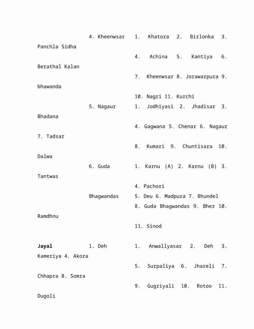
4. Kheenwsar 1. Khatora 2. Birlonka 3.Panchla Sidha
4. Achina 5. Kantiya 6.Berathal Kalan
7. Kheenwsar 8. Jorawarpura 9.bhawanda
10. Nagri 11. Kurchi5. Nagaur 1. Jodhiyasi 2. Jhadisar 3.
Bhadana4. Gagwana 5. Chenar 6. Nagaur
7. Tadsar8. Kumari 9. Chuntisara 10.
Dalwa6. Guda 1. Karnu (A) 2. Karnu (B) 3.
Tantwas 4. Pachori
Bhagwandas 5. Deu 6. Madpura 7. Bhundel 8. Guda Bhagwandas 9. Bher 10.
Ramdhnu 11. Sinod
Jayal 1. Deh 1. Anwallyasar 2. Deh 3.Kameriya 4. Akora
5. Surpaliya 6. Jhareli 7.Chhapra 8. Somra
9. Gugriyali 10. Rotoo 11.Dugoli

2. Rol 1. Rol 2. Deedya Kalan 3. Borwa4. Lunsara
5. Geloli 6. Matasukh 7.Phardod 8. Bugarda
9. Dugastau 10. Manglod 11.Rajod
3. Jayal 1. Jayal 2. Khinyala 3. NokhaJodha 4. Kathoti
5. Barnel 6. Khatu Kalan 7.Chhajoli 8. Tarnau
9. Rohina 10. Dotina
Merta 1. Merta 1. Merta 2. Ren 3. Sogawas 4.Khelul
5. Datani6. Jaroda Kalan 7.Dangawas 8.
Netreya 9. Lampolai 10. Arniyala 11.
Bagar 12. Morra13. Dhadhelas
2. Jasnagar 1. Jasnagar 2. Indawar 3.Gagrana 4. Poondlu
5. Kurdayan 6. Bargaon 7.Jaswantabad
8. Khakarki 9. Katiyasani 10.Liliyan
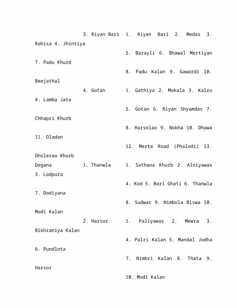
3. Riyan Bari 1. Riyan Bari 2. Medas 3.Rohisa 4. Jhintiya
5. Barayli 6. Bhawal Mertiyan7. Padu Khurd
8. Padu Kalan 9. Gawardi 10.Beejathal
4. Gotan 1. Gathiya 2. Mokala 3. Kalru4. Lamba Jata
5. Gotan 6. Riyan Shyamdas 7.Chhapri Khurb
8. Harsolao 9. Nokha 10. Dhawa11. Oladan
12. Merta Road (Phalodi) 13.Dholerao KhurbDegana 1. Thanwla 1. Sathana Khurb 2. Alniyawas3. Ladpura
4. Kod 5. Bari Ghati 6. Thanwla7. Dodiyana
8. Sudwar 9. Nimbola Biswa 10.Modi Kalan
2. Harsor 1. Paliyawas 2. Mewra 3.Bikhraniya Kalan
4. Palri Kalan 5. Mandal Jodha6. Pundlota
7. Nimbri Kalan 8. Thata 9.Harsor
10. Modi Kalan

3. Khuri Kalan 1. Nimbri Chandawatan 2. Butati3. Rajod
4. Akeli 5. Choliyas 6. NimbolaKalan
7. Antroli 8. Barna 9. Khekha10.
Khuri Kalan4. Degana 1. Sirasna 2. Idwa 3. Bawarla
4. Degana5. Kitalsar 6. Chandarun 7.
Langod 8. Jalsu9. Jalsu Nanak 10. Sanju 11.
Chiu 12. Sanju13. Chosli
Parvatsar 1. Parvatsar 1. Khurada 2. Jawla 3. Gular 4.Chitai
5. Janjilia 6. Badoo 7. Bhadwa8. Rohandi
9. Peeplad 10. Parvatsar 11.Gangwa
12. Manglana 13. Bidiyad2. Makrana 1. Menana 2. Kalwa 3. Sabalpur
4. Biloo5. Borawad 6. Makrana 7. Jakhi
8. Joosri9. Boodsu 10. Kacholiya 11.
Nandoli
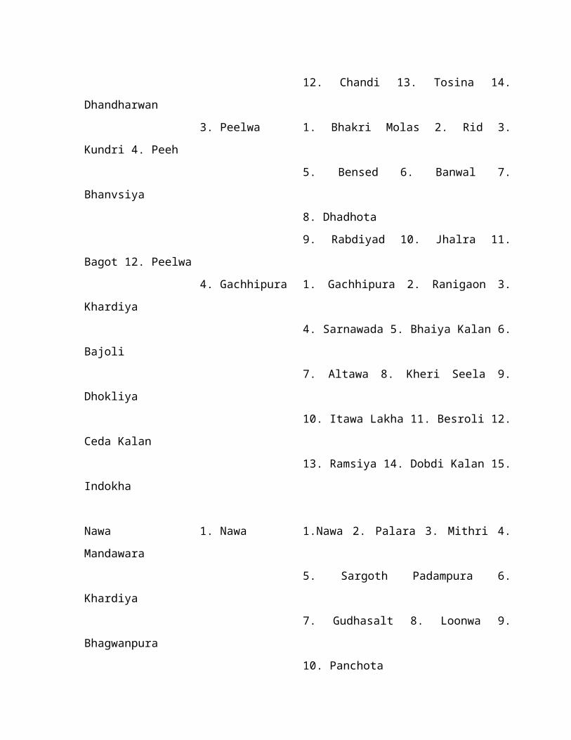
12. Chandi 13. Tosina 14.Dhandharwan
3. Peelwa 1. Bhakri Molas 2. Rid 3.Kundri 4. Peeh
5. Bensed 6. Banwal 7.Bhanvsiya
8. Dhadhota9. Rabdiyad 10. Jhalra 11.
Bagot 12. Peelwa4. Gachhipura 1. Gachhipura 2. Ranigaon 3.
Khardiya4. Sarnawada 5. Bhaiya Kalan 6.
Bajoli7. Altawa 8. Kheri Seela 9.
Dhokliya10. Itawa Lakha 11. Besroli 12.
Ceda Kalan 13. Ramsiya 14. Dobdi Kalan 15.
Indokha
Nawa 1. Nawa 1.Nawa 2. Palara 3. Mithri 4.Mandawara
5. Sargoth Padampura 6.Khardiya
7. Gudhasalt 8. Loonwa 9.Bhagwanpura
10. Panchota

2. Maroth 1. Panchwa 2. Kukanwali 3.Shambhoopura
4. Shyamgarh 5. Muwana 6.Rajliya
7. Nagwara 8. Bhanwata withKerpura
9. Indokha 10. Maroth 11. Deoli12. Minda
3. Kuchaman 1. Rasal 2. Kuchaman 3. Chitawa4. Rooppura
Torda 5. Sabalpra withMangalpura 6. Todas
7. Lalas 8. Ghatwa 9. JiliyaDidwana 1. Didwana 1. Didwana 2. Baliya Bas 3.Supka 4. Lalasari
5. Mawa 6. Cholun Khan 7.Daulatpura
8. Singhana 9. Kanwai 10.Kaprod 11. Palot
2. Molasar 1. Molasar 2. Barangna 3.Begsar 4. Akoda
5. Alakpura 6. Nimbod 7.Dhankoli 8. Nawa
9. Dabra 10. Khakholi 11.Dindarpura

Ladnun 1. Ladnun 1. Ladnun 2. Jaswantgarh 3.Sardi 4. Girdoda
Meetha 5. Dhyawa 6. Radoo 7.Mithri 8. Reengan
9. Lachhri 10. Ledy 11. Tanwara12. Bankliya
2. Nimbi Jodha 1. Nimbi Jodha 2. Hudas 3.Silanwad
4. Khamiyad 5. Ratau 6. Baldu7. Odit
8. Sunari 9. Sanwrad 10.Malgaon 11. Dheengsari
Table II : Selected Natural Vegetation of NagaurDistrict
Scrub Anogeissus pendula MainfloraWoodland and Acacia catechuThorny scrub Acacia sengal
Prosopis cineraria Associatedshrub
Capparis deciduasAcacia niloticaZizyphus nummulariaBalanites aegyptica Other floraSalvadora persica

Salvadora oleoidesAcacia niloticaEphedra foliata
Arid Sandy Calligonum proceraVegetation (on dune)
Haloxylon salicornicum(Interdune)
(Source : Ghosh, 1996)Besides the general profile of vegetation of arid zone,
CAZRI has studied the plants of economic importance and thenumber of species is stated to be surprisingly high, allcontributing to a variety of products for human use. Theseuseful plants are :-
Table III : Important Economic plants of NagaurDistrict
Product Plant Species
Fibre, Mats, Baskets Acacia jacquemontii (Bacoli)Leptadenia pyrotechnica (Khimp)Saccharum bengalensis
Gum Acacia Senegal (Kumta)Acacia nilotica (Deshi Babul)
Dyes Betea monosperma (Dhak)Lawsonia alba (Mahendi)
Non-edible oil Salvadora oleoides (Jal)Citrullous colocynthis (Tumba)

Medicinal Nagauri MethiPlantago ovata (Isubgol)Commiphora wightii (GugalAswagandhaGokhru (small & large)AmlaKaithBhrangrajKer
(Source : Ghosh, 1996)1.12 (h) The Animal Profile : Like plants, the animal life
in the Thar is extraordinary from faunal resource oint of view.It is estimated that more than 50 mammalian species inhabitNagaur. The mammalian fauna includes such endangered specieslike Caracal, Panther, Indian Gazelle, Nagauri Ox, Sheep,Camel, Goat, Wild Cat and such beautiful species like Black-buck besides 17 species of rodents. The Cheetal and AsiaticLion were once present in Rajasthan. The avian species includeGreat Indian Bustard, Partridges and Sand Grouse and Peacock.The reptilian fauna include 18 species of lizards and similarnumber of species of snakes besides freshwater turtles,tortoises and crocodile in the lakes within the arid zone.Amphibian fauna includes 8 species. About 38 species of fisheshave been recorded from perennial lakes of the desert region.Invertebrates also present an assemblage of species which arefairly large. Major species and groups are :
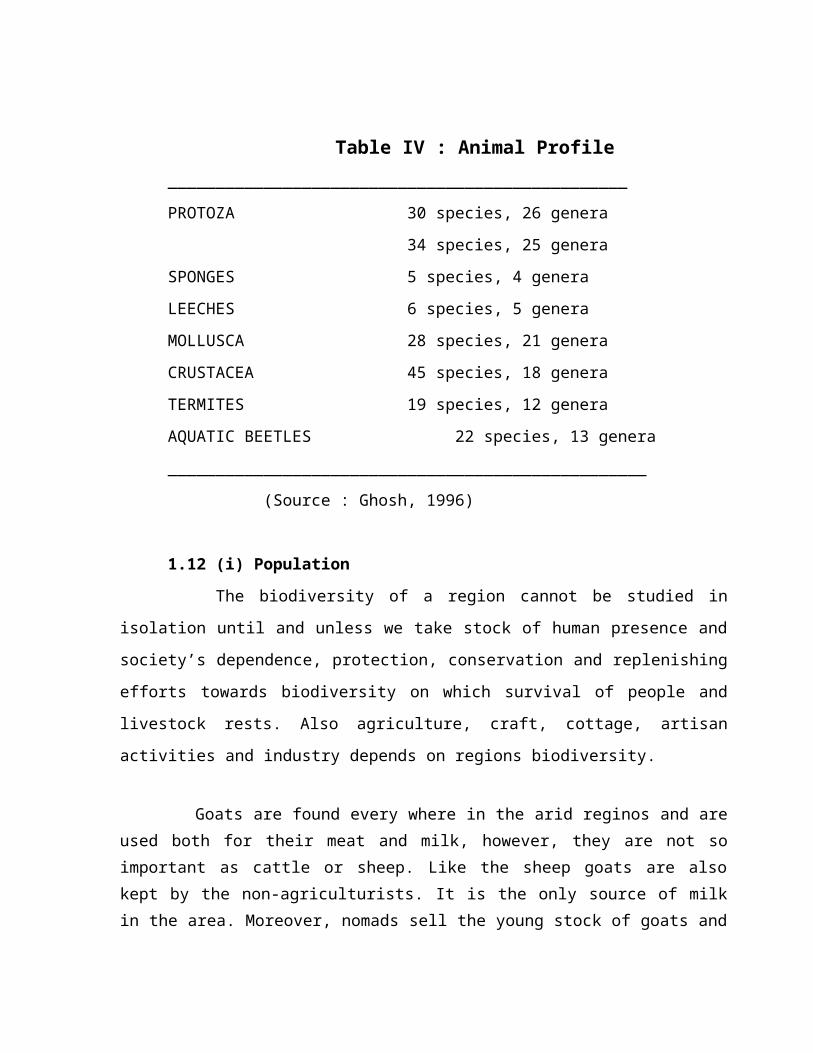
Table IV : Animal Profile________________________________________________PROTOZA 30 species, 26 genera
34 species, 25 generaSPONGES 5 species, 4 generaLEECHES 6 species, 5 generaMOLLUSCA 28 species, 21 generaCRUSTACEA 45 species, 18 generaTERMITES 19 species, 12 generaAQUATIC BEETLES 22 species, 13 genera__________________________________________________
(Source : Ghosh, 1996)
1.12 (i) PopulationThe biodiversity of a region cannot be studied in
isolation until and unless we take stock of human presence andsociety’s dependence, protection, conservation and replenishingefforts towards biodiversity on which survival of people andlivestock rests. Also agriculture, craft, cottage, artisanactivities and industry depends on regions biodiversity.
Goats are found every where in the arid reginos and areused both for their meat and milk, however, they are not soimportant as cattle or sheep. Like the sheep goats are alsokept by the non-agriculturists. It is the only source of milkin the area. Moreover, nomads sell the young stock of goats and

the people prefer goats’ meat to mutton. The goats act asfoster mother to the herds of sheep kept by the nomads.
Camels are found throughout the desert, mainly fordraught purposes.
That desert seems to be a very significant area for theoriginal domestication of herd animals. These animals havecontinued to be part and parcel of the arid zone agriculturefrom times immemorial. The extent of ownership of differentlivestock in someparts of Rajasthan has shown (Bose et al 1964)that bullocks and cows are kept by the largest percentage ofhouseholds. The former are necessary because of the agrarianeconomy which is still based on the use of draught cattle,while cows prove useful for their milk and for raising youngstock. Camels are sometimes used as draught animal. its chiefimportance is as a pack animal or as a means of communication.The raising of goats and sheep in large numbers is thetraditional occupation of certain castes like Raikas, Jats andRajputs.
For livestock breeding most villages have their ownarrangements. A bull of local breed is selected from within thevillage, but here too efforts to improve the breed are impededby the large number of scrub bulls which roam about thevillage. However, under new schemes for cattle improvementbulls are provided by the Government also. In some villagespedigree bulls have been provided by Panchayat Samities but thenumber is too small. No definite feeding arrangements exist inthe village where pedigree bulls have been provided. Theservices of a bull are not utilised in a particular village formore than 4 years to prevent imbreeding with its offshrings. Inthe case of well-fed cows calving takes place at the age ofabout 4 years, while in case of well fed bullocks it takes
place at about 5 years age. Underfed cows and buffaloes calveabout one year later. Similarly sheep owners keep rams forbreeding purposes. These are neither selected on woolperformance or on breed confirmation basis. However, sheepbreeding farms recently started by the state department atdifferent places in the desert will go a long way.
Many households consider it irreligious to castratetheir male stock. This attitude has both a caste and aterritorial basis. They have however, no objection to gettingtheir uncastrated young stock exchanged with a castrated onceeither in the cattle fairs or from Sansi or Sattia nomads whovisit their villages.
The animal feed. The feed given to the livestock dependupon the utility of the animal, the economic status of theowner and the available supplies. Cows are given ‘Cheepta’(green jowar), ‘pala’ (dried leaves of Zizyphus nummularia),‘doka’ (bajra stalks) and grass as roughage. Gaur, bajra,wheat, cotton seeds and til are given as concentrates.Promosing cow calves, both male and female, are allowed to takeabout a quarter of kg of concentrates besides sucking theirmothers. Males buffaloe calves are of little use as draughtanimals. They are usually underfed and ill cared with theresult that they de very young or are sold off at nominalprice. Bullocks are given Cheepta, pala, doka, grass, oilcakes, cottod seeds, til oil, haldi and ghee. Cultivators ofirrigated holding give bhusa, lucerne etc., to their livestock.
The chief source of animal feed is the forage availableon common grazing lands called Gocharlands, cultivators’ ownland and his crop residue. The density is not however constantand show wide fluctuations from year to year depending upon thelivestock mortality and in case of drought years migration of

cattle to nearby states. There seems to be heavier pressure inthe higher rainfall areas with facilities of irrigation than inthe less rainfall tracts.
Watering facilities. Livestock in most cases in tehvillage drink water from the same source as human beings. Solong as water is available in the nadis (tanks) this isutilised. When the water dries up (usually by the middle ofwinter season) well water is provided to the stock. Paymentshave however to be made to the men working at the well.Separate rates are levied for large and small animals.
Sale of livestock and livestock produce. The nature andtype of livestock kept is in most cases determined by the needsof cultivation. Except in the case of certain specific casteslike Raikas whose traditional occupation is the raising ofsheep and goats, most of the household keep livestock justenough to meet their needs. The sale of livestock, particularlycattle and camels, is transacted usually at the cattle fairs.Sometimes the Mahajan also accepts these animals in settlementof the debt from teh cultivator. The male stock in sheep andgoats are sold to the visiting traders which go aboutcollection them for slaughter in the cities. The average salevalue of stock per household in 1963 was Rs. 45 only.
Other sources of livelihood are agricultural and casuallabour and the caste occupations like carpentry, black-smithy,dyeing, shop keeping, money lending and gold smithy. The latterare the monopolies of the castes concerned and are governed byconventions as regards the nature and type of services renderedand dues received. They are usually followed as subsidiaryoccupations and generally cater to the needs of the village.The annual earnings of a household from most of these rarelyexceeds Rs. 150 o
2.0 Biodiversity Status of Surveyed Area
2.1 Dynamics of Study AreaIt is evident from the description presented in the
Introduction that zoo geographically the great Indiandesert is exceptionally large in its extent. Consideringthe vastness of this area and also its geology, climate,geography and history, the Nagaur district of Semi Aridand Arid belt were identified to carry out biodiversitystudies in some selected villages. These villagesrepresent typical semi-arid and arid habitats. The area isrich in the native flora and fauna and its germplasm isintact in this part. By and large, the whole area isnatural and have not metamorphosed to any appreciableextent in absence of biotic interferences. The villagesMolasar, Methdi in Nagaur and Ladnun were selected forbiodiversity studies. This study was also extended to Nawain Nagaur for better understanding and compatibility.Villages Molasar and Methdi are located 45 and 62 kmsrespectively.
2.1 (a) Deewana and Sambhar Lake - Which is in theprocess of receiving the status of a wetland Biosphere bythe State Government.
2.1 (b) Degana village is situated in Barmer Basin ofCretaceous – Tertiary period composed of Fluviatile
sediments which merges with Lathi Basin. At places it issuperimposed by outcrops of fullers earth andpalygorskite-attapulgite as major mineral clay. Thedominance of calcium carbonate attapulgite, and xerophyticflora in fullers’ earth is indicative of the aridity in asearly as Eocine times. During the Quaternary, there was achange in climate and Shumar Grits were laid down in freshwater environment, making a change from arid to deserticconditions leading to the evolution of Thar Desert.
2.1 (c) Merta village in Nagaur district is part ofLathi Basin directly overlying the Lathi sandstone whichare comprised of Ferrugenous sandstone, conglomerate,Caguinoidal phosphatic sandstone and phosphatic mudstone.Here, dicot fossil wood is abundant. At places lignite andgypsum have been recorded. (Pareek, 1981).
Table V : Climatic Features
The major climatic components which influence thebiodiversity of the area like, temperature, diurnalvariation, rainfall, rainy days and relative humidity wereconsidered for study villages, Degana and Merta for thestudy period 2000-2001. These data fall within the normalpattern of Semi arid and arid climatic profile. Theclimate features are :

Degana (Nagaur) : Major Climatic Components RecordedDuring Study Period.
Climate 2001 2002 2003
Components Min. Max. Min. Max. Min. Max.
1. Temperature (“C) 10 45.00C 8.3 46.00C 9.8 48.70C
2. Rainfall 324 238 345
3. Rainy Days 23 21 38
4. Mean Relative48 69 43 67 47 70
Humidity
Climate 2000 2001 2002
Components Min. Max. Min. Max. Min. Max.
1. Temperature (“C) 9.0 42.90C 8.4 47.00C 9.5 48.70C
2. Rainfall 287.5 234.2 331
3. Rainy Days 16 10
13
4. Mean Relative45 69 44 73 49 77
Humidity
Merta (Nagaur) : Major Climatic Components Recorded DuringStudy Period, 2000-02.
(ii) Village Status Degana (Nagaur)

Area Human Livestock Common Property Area
of village Population Pupulatin Resources (ha.)
8,493.29 2476 Cattle 1039 Oran 341.73
ha. Sheep 5964 Gauchar 1061.23
Goat 4686 Wastelands 6396.4
Camel 225 Waterbodies
Table 5
Merta (Nagaur)
Area Human Livestock Common Property Area
of village Population Pupulatin Resources (ha.)
6,994.02 9,680 Cattle 1119 Oran 6,433.11
ha. Sheep 6739 Wastelands 490.90
Goat 4966 Waterbodies 5
Camel 305 Tables 3 large
2 small
2.2 Landforms, Agriculture, Traditional Practices, Soil and Bioresource2.2 (a) Landforms : Includes alluvial plains, fossil dunes, dunes of recent origin and hill areas.Soil texture, moisture, and organic contents vary but generallyrepresent a small range of sandy aridsoils. In some areas thesurface is dune free and marked by stony outcroppings. Thisgeneral distribution includes three, fairly distinctlandforms : dunes, hills and plains.

Sand dunes take differing forms in the study area withlongitudinal, barchen and transverse dunes distributed ingroups and chairs (Misra, 1968). The dunes range from 6 m to 60m in height and very in vegetation cover (Bhalla, 1992). Thebarchen dunes mostly represent non-vegetated and wind-blownfeatures of recent origin (Kumar and Bhandari, 1992, 1993).These can appear during a single dry season and often chokeroads or agriculture fields.
Where underlying rock formations are found on the surface,they are generally of a similar type. Most of the limestone andsandstone belongs to the Jurassic and Eocene ages. Most of theregion is dominated by flat, sandy, alluvial plains fed byshort seasonal waterways. The plain has an average elevation of200 m and is largely composed of sandy, alkaline soils.
2.2 (b) Agriculture – Much of the agricultural and pastoralactivity takes place on open and arid plans. The wild anddomesticated species of the region are well adapted to thewind-swept conditions of this landscape and make good use ofthe seasonal moisture. The farmers raise well adapted cropslike pearl millet, green gram, moth bean, cluster, bean andseasamum in the system of mixed cropping which helpsustainability and productivity of soil besides withstandingthe weather aberrations. People also follow off seasonploughing which adds to the problem of wind erosion. Farm-yard
manure is considered as a valued input. In the irrigatedfields, high value crops like rayara (mustard), chillies,tomatoes, onion and a variety of condiments are raised. (iv) Traditional Water Harvesting and Land Management (P1.9)
The region also has well-developed traditional waterharvesting system, both for agriculture and drinking purpose.Most notable amongst there is the Khadin system prevalent inthe area in which run off from a large rocky / gravelycatchment is collected within a small basin. The system has abuilt-in mechanism of flushing out salts. Moreover, it ensuresa crop during the ‘kharif’ season if the monsoon rains aremeager. If, on the other hand, the monsoon rains are heavy andlate, winter crops (Rabi) are grown on the conserved moisture(Kolarkar et. At. 1983, Venkateshwarlu et. Al. 1990). Fordrinking purpose the rain water is trapped in tanks. (P1.9).
Through generations, the people in the study area havebeen practicing definite norms for resource management. Here,agriculture is essentially a mixed farming, with mosthouseholds maintaining a sizeable herd of livestock that couldbe sustained on crop residues and associated naturalvegetation. The farmers conscientiously maintain and encourageProsopis cineraria and shrubs like Zizyphus and Capparis as aninsurance to survival during famine. This is also coupled withthe survival of small to large animals. Such biocommunity
interlinkages have been established for the survival of man,animals and plants.
The natural grasslands, which are considered to benature’s gift are becoming fever with me. The optimum cover isnow confined only to some inaccessible areas. The dominatesituation is that of degradation, either due to impoverishmentof the useful species or indiscriminate grazing. Worst andnearly irreversible damages have taken place in the case of therocky/gravely surfaces. Here, the removal of woody species,overgrazing and resultant stripping of the thin soil cover hasturned the lands into low biodiversity turnover. Nevertheless,the study area does represent a typical desert specter ofanimals and plants, a seed bank of desert germplasm.
2.2 (c) SoilsIn general, the soils show a high pH, medium conductivity,
medium available phosphorous, and low organic carbon andnitrogen. By and large, the soils of the area fall under aridsoils, being dry, low in organic matter, and having subsurfacehorizons of carbonate minerals and soluble salts. The region isdominated by soils of the calcic group Calciorthid acid arehighly alkaline. The presence of organic carbon and nitrogenvary in microclimates with the presence of leguminousvegetation and cover types (Sharma, et. at. 1985). Generally,these sandy soils have a low moisture content since as much as60 per cent of seasonal rainfall is reported lost to deep
percolation. However, some soils which have a finer grain orare occasionally mulched experience lower infiltration (Singhet. al. 1974).
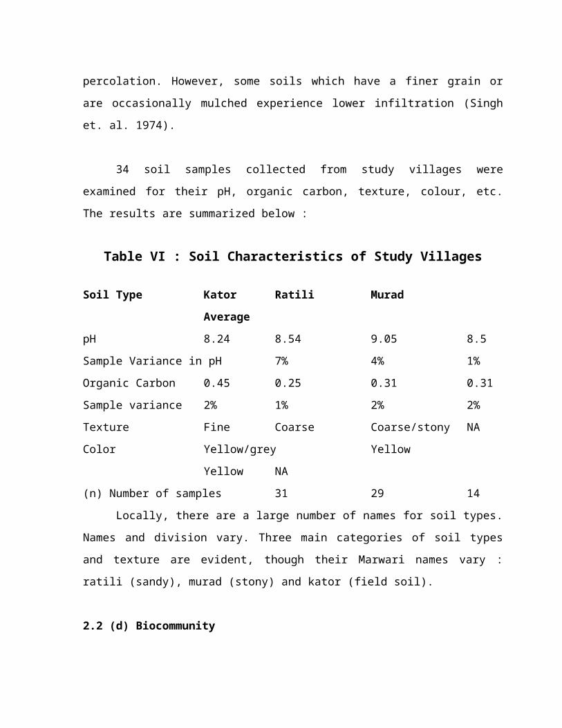
34 soil samples collected from study villages wereexamined for their pH, organic carbon, texture, colour, etc.The results are summarized below :
Table VI : Soil Characteristics of Study Villages
Soil Type Kator Ratili MuradAverage
pH 8.24 8.54 9.05 8.5Sample Variance in pH 7% 4% 1%Organic Carbon 0.45 0.25 0.31 0.31Sample variance 2% 1% 2% 2%Texture Fine Coarse Coarse/stony NAColor Yellow/grey Yellow
Yellow NA(n) Number of samples 31 29 14
Locally, there are a large number of names for soil types.Names and division vary. Three main categories of soil typesand texture are evident, though their Marwari names vary :ratili (sandy), murad (stony) and kator (field soil).
2.2 (d) Biocommunity

The dominant species encountered in the study villagesreflect typical desert flora and fauna. Limited for the mostpart by moisture availability, the predominate adaptationsfollow the “pulse-response” (Noy – Meir, 1973) pattern of aridvegetation : perennials retreat or withstand long dry seasonsand drought years, while annuals have short, productive growingperiods. On the other hand, the wild animal taxa and thedomesticated breeds have over the ages nature selected, havingphysical, physiological and thermoregulatory properties makingthem successful in this habitat. All these animals, from smallrodents who live in tunnels and burrows to large mammalssurviving in the open have had great deal of adaptiveradiation.
The community dynamics and relationship between plants andanimals and between trees and understory is an importantfeature of village ecology, especially the ‘orans’ or villageforests. The ecological dynamics of human planting and followpatterns also effect the large areas under long-fallowcultivation. Likewise, foraging by wild animals and grazing andbrowsing patterns of dominant domesticated fauna also sculptthe ecology in a definite way.
2.3 Biological Diversity of the Study Area
There is a strong relationship between the presence ofcertain tree species and animals, between tree species withunderstory, herbs and grasses. This relationship is important
for village biodiversity. Along with village forests, fallowfields, are an important ecological regime.
By and large, the flora and fauna, biocommunities andtheir interrelationships are the same in the study area asfound in the semi arid desert countryside, which has also beendescribed in the introduction. However, faunisties of the studyarea has been probed in greater detail.
Ecologically, the vegetation of the study area fall underthe category of ‘thorn forest type’. Some changes are seen dueto cultivation and changes in the soil-climate condition.Nevertheless, the natural vegetation has a substantialcontribution to the productivity of the trees like, Khejri,khimp, Prosopis cineraria, Rahedra, Neem, Kar which are highlyvalued and conscientiously maintained. Besides this a lot ofshrubs and grasses are found growing in fallow as well as croplands and of course in grazing lands. These are deep rooted,tenacious enough to survive expanded droughts and yet efficientin putting up a good biomass.
A variety of animals are found in the study area. The areaexhibits a spectacular biodiversity because of its evolutionaryhistory and geographical location. Some biota possessesSaharian affinities (Haloxylon, Gazella dorcas); while othersare Malayan (Ficus, Mangifers, Pteropus gigantcus) whilecertain elements are Deccanean (Rattus cutchicus, Golunda

Ellioti). In addition, quite a few are macro endemic(Stenodactylus orientalis, Gerbillus geadowi) and micro endemictaxa (Bangarus caeruleus sindanus, Felis silvertris ornate).2.3 (a) Flora
The vegetation of this tract is quite sparse with limitednumber of species. Its vegetation can be described intofollowing types based on landforms or habitats. The plantcommunities growing on rocky habitats varies from dwarfsemiscrub desert to mixed xerophytic thorn forest types inwhich the principal plant communities are Euphorbia caducifolia– Acacia Senegal ; Euphorbia caducifolia – Grewia tenax ;Euphorbia caducifolia – Capparis deciduas, etc.
The associated trees and shrubs which are widely scatteredand sparse predominates with Salvadera oleoides, AcaciaSenegal, Maytenus emarginta, Grewia tenax, Zizyphus nummularia,Lycium barbarum, Capparis deciduas and Euphorbia caducifolia.The last named species, in particular, supports large number ofclimber such as Coculus peridulus, Asparagus racemosus,saxcostemma acidum, Ephedra folita, Rivea hypocrateri formis,Rhynchosia minima and Coccina grandis. The plants of the groundfloor vary at different places but the most common plants areOropetium thomeum, Tephrosia uniflora sub sp. Petrosa,Encapogon brachystachya, Pupalia lappaca, Lepidagathisbandrachsis, Barleria acanthoides and Diptera canthus patulus.

The gravely plain, consists of semi-shrub desertvegetation. Capparis deciduas and Zizyphus nummularia are thecommon plants of this ecosystem. These are found in associationwith Lycium barbarum and Leptadenia pyrotechnica. Theundergrowth in this habitat consists of Boerhavia diffusa,Blepharis sindica, Heliotropium strigosum, Molluge cerviana andM. nudicaulis, Salvia aegyptiaca, Indigofera triogonelloides,Anticharis senegalensis, Elcusine compressa, Dactylocteniumsindicum and Aristida mutabibis.
Alluvial plain which forms considerable part of thesestudy villages represent mixed xeromorphic wooded desert. Thedominant tree species of this habitat are Prosopis cineraria,Salvadora oleoides and Tecomella undulata.
The common associates of these trees are calotropisprocera, Leptadenia pyrotechnica, Mimosa hamata, Acaciajacquemontii, Concolvulus microphyllus, Crotalaria burhia,Cenchrus biflorus, C. princurio, Eragrostis pilosa, Cyperusrotundus, Indigofera cordifolia, Tribullus terrestris, Aevrapersica. A. pscudotomentosa, Scricostemma pauciflorum and atplaces Clerodendrum phlomides.
Sanddumes in these villages are either parabolic orbarchens. The parabolic dunes which dominate the study areamostly supply Calligonum polygonoides, Panicum turgidum,Lasiures sindicus, and Crotalaria burhia. Amongst them
Indigofera cordifolia, Cyperus arenarius and Cenchrus biflorusare fairly common, while Dipterygium glaucum and Forsetiahamiltonii are some time abundant. Burchain dunes which arealso found in the study villages near settlements, are mostlydevoid of vegetation.
2.3 (b) Salt Lakes –
The study area is also provided with obstacle dunes whichprovide obstruction to the moving sand, are of large size,retaining a large amount of water and are able to stabilize,supporting a ‘mixed xeromorphic thorn forest’ type ofvegetation. Acacia Senegal along with Salvadora olcoides,Acacia jacquemontii and rarely Prosopis cincraria from thedominant vegetation of this type. These plants are associatedwith Panicum turgidum, Lasiurus sindicus, Heliotropiumpaniculatum and Sericostemma pauciflorum, Ephedra foliata andCacculus pendulus are the main climbers on the tree.
The Interdunal areas bear more or less similar vegetationas is found on flat alluvial plains. Here and there are foundsaline flats and depressions which have heavy clay and salinesoil. Haloxylon salicornicum, Sporobolus helvolus, Suaedafruticosa, Salsola baryosoma, Trianthema portulacastrum,Fagonia cretica and Sesuvium scsuyioides from the main bulk ofspecies here. Their associates are Cressa cretica, Acluropuslagopoides and a few other grasses.
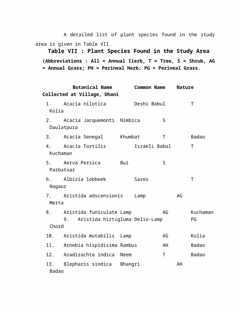
A detailed list of plant species found in the studyarea is given in Table VII.
Table VII : Plant Species Found in the Study Area(Abbreviations : All = Annual Iierb, T = Tree, S = Shrub, AG= Annual Grass; PH = Perineal Herb; PG = Perineal Grass.
Botanical Name Common Name NatureCollected at Village, Dhani1. Acacia nilotica Deshi Babul TKolia
2. Acacia Jacquemonti Nimbica SDaulatpura
3. Acacia Senegal Khumbat T Badao4. Acacia Tortilis Israeli Babul TKuchaman
5. Aerva Persica Bui SParbatsar
6. Albizia lebbeek Sares TNagaur
7. Aristida adscensionis Lamp AGMerta
8. Aristida funiculate Lamp AG Kuchaman9. Aristida hirtigluma Delio-Lamp PG
Chord10. Aristida mutabilis Lamp AG Kolia11. Arnebia hispidisima Rambus AH Badao12. Azadirachta indica Neem T Badao13. Blepharis sindica Bhangri AHBadao

14. Bocrhavia diffusa Chinavari AG Rasulr15. Calligonum polygonoides Phog SKuchaman
16. Calotropis procera Aak S Nagaur17. Capparis deciduas Ker T Common18. Celosia argentea Imarti AHNevara
19. Cenchrus biflorus Bhurat AGCommon
20. Cenchrus cilianis Dhaman PG Kolia21. Cenchrus pricurii Labio Bhurat AGMerta
22. Cenchrus setigerus Dhamanio AG Ladnun23. Citrullus Ianatus Matira AHCommon
24. Citrullus colocynthis Tumba PHCommon
25. Cleome Viscosa Bagara S Degana26. Clerdendrum phlomidis Arna S Common27. Coccinia grandis Shivlingi (Golan) PSBadao
28. Cocculus pendulus Pilwan SNagaur
29. Commiphora wightii Gugal SBidasar
30. Convolvulus micrrophyllus Sinter PHCommon
31. Corchorus depressue Chom-gas PH Kolia32. Cordia gharaf Goondi TParbatsar
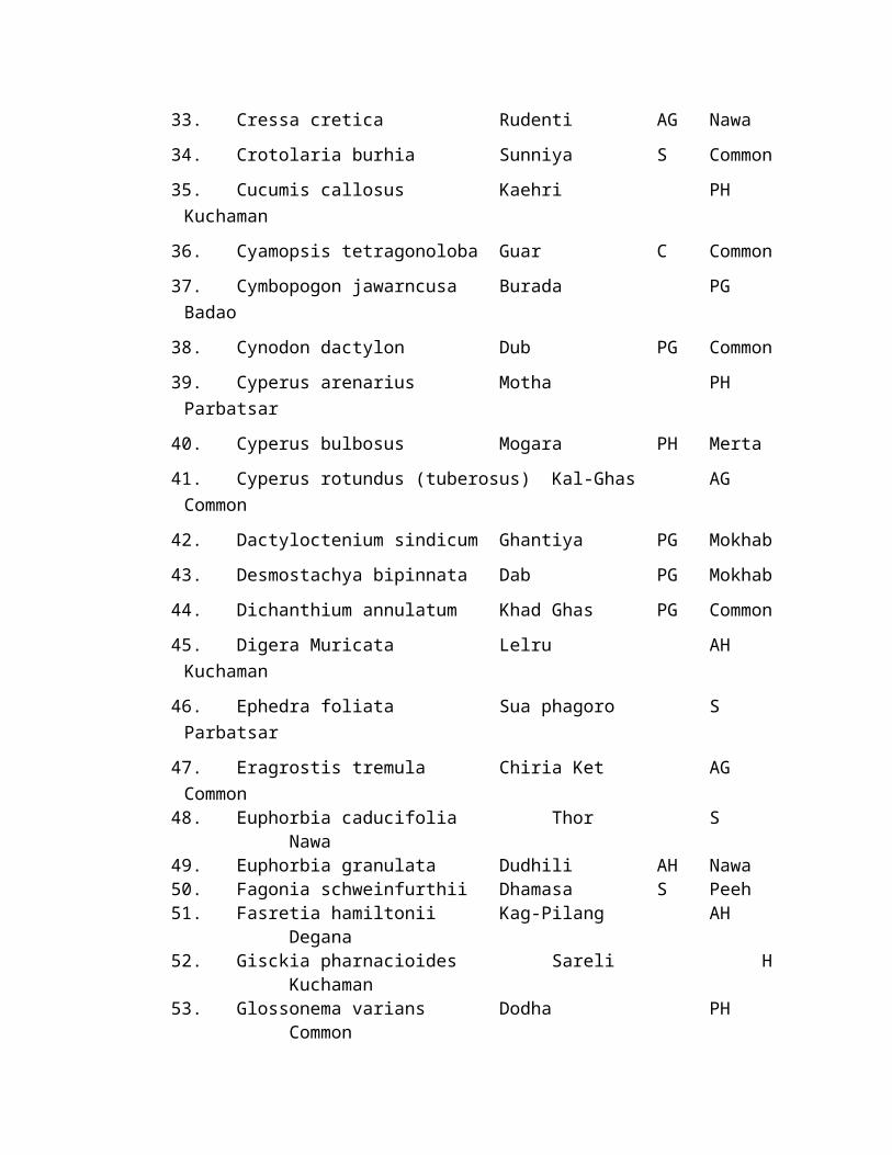
33. Cressa cretica Rudenti AG Nawa34. Crotolaria burhia Sunniya S Common35. Cucumis callosus Kaehri PHKuchaman
36. Cyamopsis tetragonoloba Guar C Common37. Cymbopogon jawarncusa Burada PGBadao
38. Cynodon dactylon Dub PG Common39. Cyperus arenarius Motha PHParbatsar
40. Cyperus bulbosus Mogara PH Merta41. Cyperus rotundus (tuberosus) Kal-Ghas AGCommon
42. Dactyloctenium sindicum Ghantiya PG Mokhab43. Desmostachya bipinnata Dab PG Mokhab44. Dichanthium annulatum Khad Ghas PG Common45. Digera Muricata Lelru AHKuchaman
46. Ephedra foliata Sua phagoro SParbatsar
47. Eragrostis tremula Chiria Ket AGCommon
48. Euphorbia caducifolia Thor SNawa
49. Euphorbia granulata Dudhili AH Nawa50. Fagonia schweinfurthii Dhamasa S Peeh51. Fasretia hamiltonii Kag-Pilang AH
Degana52. Gisckia pharnacioides Sareli H
Kuchaman53. Glossonema varians Dodha PH
Common

54. Grewia tenax Gangani S Merta55. Heliotropium marifolium Rawa PH Salasar56. Heliotropium rariflorum Karsunniya PH
Merta57. Heliotropium subulatum Kala-Bui AH Badao58. Indigofera cordifolia Bhekar AH
Common59. Indigofera hochstetteri Adio-Bekario AH
Nevera60. Indigofera linifolia Lutya-Bhekar AH
Nawa61. Indigofera oblongifolia Jhil S Ladnun62. Indigofera sessiliflora Phaliwala Bekar AH
Nawa63. Iomoca darmea Kuti AH Merta64. Justicia implex Makhnia AH Nagaur65. Lasiurus sindicus Sevan PG
Common66. Leptadenia pyrotechnica Khemp S
Bidasar67. Lycium barbarum Morali S
Badao68. Maytenus emarginatas Kankero T
Nagaur69. Mimosa hamata Jhinjani S Merta70. Mollugo cerviana Adeka Ket AH Common71. Panicum turgidum Murat PG
Badao72. Phylianthus maderaspatensis Khejaria-Khad AH
Parbatsar73. Protulaca oleracea Mamamoli AH Kuchaman74. Prosopis cineraria Khajari T
Common75. Prosopis juliflora Angrezi Babul T
Merta76. Pulicaria angustifolia Sonila S
Common77. Rivea hypocrateriformis Rata bell S Nagaur

78. Rhynchosia minima Chiri-Motio AGLadnun
79. Salvadora olcoides Mitha Jal T Degana80. Salvodora persica Khari Jal T Kuchaman81. Seetzenia lanata Dakdi AH
Merta82. Sesamum indicum Til C Common83. Tamarindus indica Imli T Ladnun84. Tecomella undulata Rohida T
Kuchaman85. Tephrosia pupurea Bioni PH
Common86. Tephrosia strigosa Jhino-Biyono AH
Parbatsar87. Trianthema portulacastrum Sata AH
Common88. Trianthema triquetra Lakryo AH
Common89. Tribulus terrestris Kanti AH
Badao90. Urochloa panicoides Kuri-Ghas AG Ladnun91. Zaleya redimita Sunavri AH Common92. Ziziphus jujuba Vad-Ber AH Merta93. Ziziphus nummularia Bordia T
Common
2.4 Flora2.4 (a) Botanical Divisions
The flora of the district is not rich owing to itsgeographical situation and scanty rainfall. Its western portionpresents a dreary look as it is devoid of any naturalvegetation cover except the low shrubs or grasses grown on thelow sand-dunes, which too turn pale due to intense heat duringthe summer. The south-eastern areas including a part of the
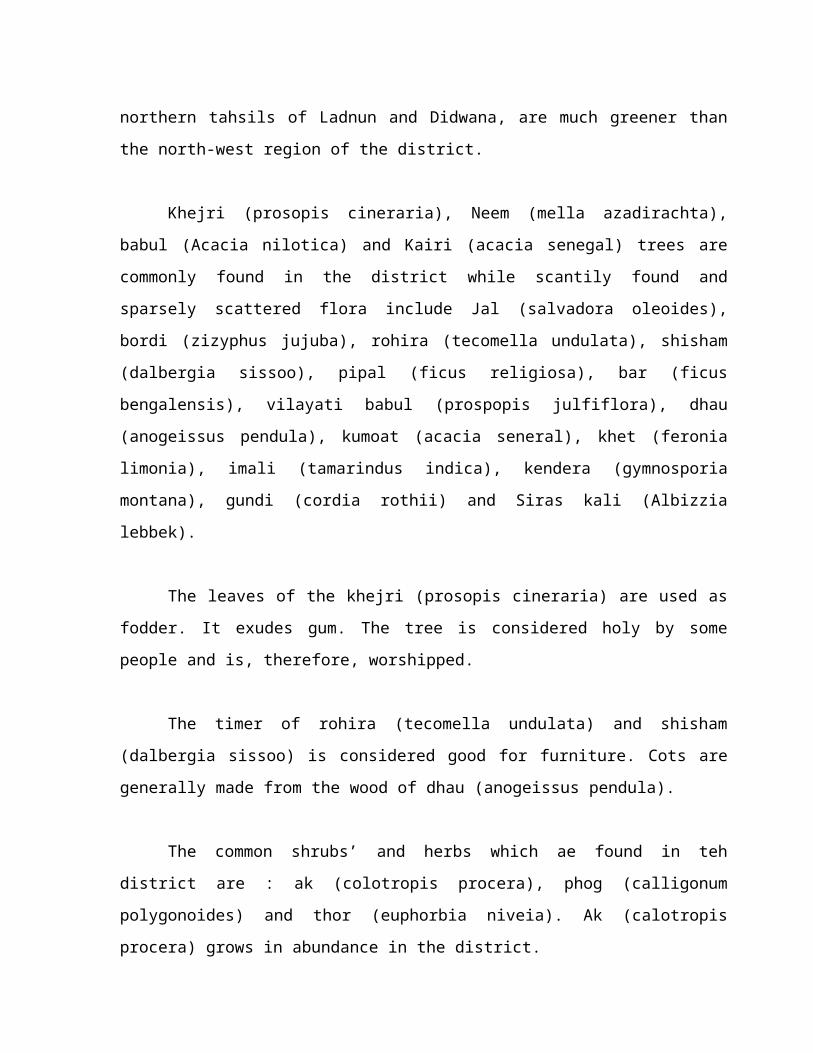
northern tahsils of Ladnun and Didwana, are much greener thanthe north-west region of the district.
Khejri (prosopis cineraria), Neem (mella azadirachta),babul (Acacia nilotica) and Kairi (acacia senegal) trees arecommonly found in the district while scantily found andsparsely scattered flora include Jal (salvadora oleoides),bordi (zizyphus jujuba), rohira (tecomella undulata), shisham(dalbergia sissoo), pipal (ficus religiosa), bar (ficusbengalensis), vilayati babul (prospopis julfiflora), dhau(anogeissus pendula), kumoat (acacia seneral), khet (feronialimonia), imali (tamarindus indica), kendera (gymnosporiamontana), gundi (cordia rothii) and Siras kali (Albizzialebbek).
The leaves of the khejri (prosopis cineraria) are used asfodder. It exudes gum. The tree is considered holy by somepeople and is, therefore, worshipped.
The timer of rohira (tecomella undulata) and shisham(dalbergia sissoo) is considered good for furniture. Cots aregenerally made from the wood of dhau (anogeissus pendula).
The common shrubs’ and herbs which ae found in tehdistrict are : ak (colotropis procera), phog (calligonumpolygonoides) and thor (euphorbia niveia). Ak (calotropisprocera) grows in abundance in the district.

Phog (calligonum polygonoides) too is a common bush in thedistrict and is used in many ways. Its roots and twigs serve asmaterial for building huts.
The study area represent fairly large number of animalsfrom insects to mammals. For clarity the commonly met taxa inthe study area have been included. Where necessary, animals notobserved in the study area during field studies, but have beenreported by local people or available in published literaturehave also been included for clarity and comprehensiveness ofthe taxa. Here, most animals are exposed only occasionally tothe extremes of desert climate. They may dwell in caves,crevices, beneath stones, in burrous, under the shade of aplant, on the underside of leaves, and thus live in relativecomfort and safety in their own microclimate which has littlerelationship with the standard meteorological setup. Themicroclimate of desert is therefore essential to understand theactual physical conditions in which a desert animal lives.
It was neither possible to study the entire fauna of thestudy area nor was the content of this research. Studies wereconfined to macrotaxa encountered during field survey andinformation supplemented by local people. These macrotaxa andmicrotaxa were found in two principal habitats viz. terrestrialand aquatic. The overwhelming majority of vertebrates occupythe terrestrial habitat, while the aquatic habitat is confimedto most of the amphibians, all fishes, and several invertebrate
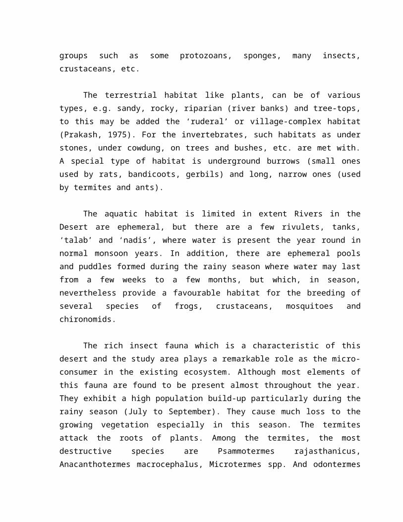
groups such as some protozoans, sponges, many insects,crustaceans, etc.
The terrestrial habitat like plants, can be of varioustypes, e.g. sandy, rocky, riparian (river banks) and tree-tops,to this may be added the ‘ruderal’ or village-complex habitat(Prakash, 1975). For the invertebrates, such habitats as understones, under cowdung, on trees and bushes, etc. are met with.A special type of habitat is underground burrows (small onesused by rats, bandicoots, gerbils) and long, narrow ones (usedby termites and ants).
The aquatic habitat is limited in extent Rivers in theDesert are ephemeral, but there are a few rivulets, tanks,‘talab’ and ‘nadis’, where water is present the year round innormal monsoon years. In addition, there are ephemeral poolsand puddles formed during the rainy season where water may lastfrom a few weeks to a few months, but which, in season,nevertheless provide a favourable habitat for the breeding ofseveral species of frogs, crustaceans, mosquitoes andchironomids.
The rich insect fauna which is a characteristic of thisdesert and the study area plays a remarkable role as the micro-consumer in the existing ecosystem. Although most elements ofthis fauna are found to be present almost throughout the year.They exhibit a high population build-up particularly during therainy season (July to September). They cause much loss to thegrowing vegetation especially in this season. The termitesattack the roots of plants. Among the termites, the mostdestructive species are Psammotermes rajasthanicus,Anacanthotermes macrocephalus, Microtermes spp. And odontermes
spp. A community relationship of termites was found withseveral plant species which need special attention and study tounderstand their dynamics. In certain pockets, heavy losses ofkharif crops due to the white grub (Holotrichia spp.) has alsobeen observed.
Locusts and grasshoppers breed in the region, especiallyin the rainy season when sufficient moisture is available inthe soft, sandy soil. These pests do much loss to the growingvegetation. Swarms of the desert locust, Schistocera gregariavisit occasionally, whenever suitable environmental conditionsare formed. The most noxious species of grasshoppers areOchrilidia affris, Pockiloccrus pictus, Pyrgomorpha bispinosadeserti, Acrotylus humbertianus and Cyrtacanthracis tetarica.Some Coleopteran (Myllocerus sp. Crytozemia sp.) are alsoactive in the rainy season.
2.5 Fauna2.5 (a) Wild Animals
There is no big game in the district. Chinkaras and blackbucks which are rarely seen in this area, are protected speciesunder the Rajasthan Wild Animals and Birds Protection Act(1951). Among the small game only titars (partridges) arefound. Other fauna of the district consists of deer, hare,jackal, pig and wild cat, Nagaur Ox, Cow, Marwari Horse andSheep goat.
2.5 (b) Birds
The common birds fluttering in the district includepeencha (white cheeked bulbul), bulbul (red vented bulbul),

sugan chiri (great grey shikri), bad kagla (jungle crow), baya(tailor bird), nilkanth (blud jay), kochar (spotted owlet),ullu (owl), khatichida (hoop), kam (common surfi), raj gidh(king vulture), god (white billed vulture), saras (stork),kagla (common crow), cheel (kite), falcon, chiri (housesparrow), kabutar (rock pigeons), kameri (doves), tota(parakeet) and mor (peacocks).
2.5 (c) ReptilesAmong the reptiles Chhipakali (house geckoes), Kirkantia
(common garden lizard), sand lizards, common snakes viper,common cobra (kalindra), common kriat, bandi snake, padam sapraand kadia snake are common. During the year 1969, 115 cases ofsnake-bite were treated in the various hospitals anddispensaries in the district, of which only one proved fatal.
TABLE VIII : COMMON TAXA : LIZARDS, BIRDS AND MAMMALS FOUND IN THE STUDY AREA
Zoological Name
Lizards1. Stenodactylus orientalis2. Cyrtodactylus scaber3. Spotted Indian House gecko, Hemidactylus brooki

4. H. triendrus5. Bark gecko, Hemidactylus leschenaulti6. Yellow Bellied house gecko, Hemidactylus flaviviridis7. Calotes versicolor8. Brilliant Agama, Agama agilis and Agama minor9. Phrynocephalus laung walensis10. Indian spiny-tailed lizard, Uromastix hardwicki11. Indian Sand Skink, Ophiomorus tridactylus12. Indian fringe-toed sand lizard, Acanthodactylus
cantoris cantoris13. Cobra Snake-eyed lizard, Ophisops microlepis14. Golden Striped lizad, Ophisops Jerdoni15. Monitor lizard, Varanus bengalensis
Snakes1. Blind Snake, Ramphotyphlops bramina2. Beaked Thread Snake, Leptotyphlops macrorhynchus3. Indian Sand Boa, Eryx johni johni4. Dhaman, Ptyas mucosus5. Glossy-bellied racev, Argyrogena Ventromaculatus6. Rajat bansi, Sphalerosophis diadema diadema7. Indian Krait, Bungarus Cacrulcus8. Cobra, Naja naja naja9. Russell’s viper, Vipera russelli russelli10. Viper, Echis carinatus
Birds1. Cattle Egret, Bubulus ibis2. Little Egret, Egretta gazetta3. White-eyed Pochard, Aythya nyroca4. Tufted Duck, Aythya fuligula5. Demoiselle Crane, Anthropoides virgo

6. Common Crane, Grus grus7. Black-shouldered Kite, Elanus caeruleus8. Black Kite, Molvus migrans govinda9. Kind Vulture, Sarcogyps calvus10. Cinereous Vulture, Aegypius monachus11. Indian Longbilled Vulture, Gyps indicus12. White backed Vulture, Gyps bengalensis13. Egyptian Vulture, Neophron percnopterus14. Pale Harrier, Circus macrourus15. Mohtagu’s Harrier, Circus pygargus16. Marsh Harrier, Circus acruginosus17. Short-toed Eagle, Circactus gallicus18. Longlegged Buzzard, Buteo rufinus19. Desert Buzzard Buteo, Buteo buteo vulpinus20. Tawny Eagle, Aquila rapax vindhiana21. Steppe Eagle, Aquila rapax nipalensis22. Lesser Spotted Eagle, Aquila pomarina23. White-eyed Buzzard-eagle, Auila pomarina24. Laggar Falcon, Falco biarmicus jugger25. Redheaded Merlin, Falco chicquera26. Kestrel, Falco tinnunculus27. Grey Partridge, Francolinus pondicerianus28. Grey Quail, Coturnix coturnix29. Rain Quail, Coturnix coromandelica30. Great Indian Bustard, Choriotis nigriceps31. Houbara, Chalmydotis undulata32. Redwatted Lapwing., Vancllus indicus33. Creamcolourred Courser, Cursorius cursor34. Indian Courser, Cursorius coromandelicus35. Collared Pratincole, Glarcola Pratincola36. Stone Curlew, Burhinus oedicnemus37. Temminck’s Stint, Calidris temminckii

38. Little Ringed Plover, Charadrius dubius39. Kentish Plover, Charadrius alexandrinus40. Lesser Sand Plover, Charadrius mongolus41. Indian Sandgrouse, Pterocles exustus42. Spotted Sandgrouse, Pterocles senegallus43. Imperial Sandgrouse, Pterocles orientalis44. Blue Rock Pigeon, Columba livia45. Indian Ring Dove, Streptopelia decaocto46. Little Brown Dove, Streptopelia senegalensis47. Pled Crested Cuckoo, Clamator jacobinus48. Shorteared Owi, Asio flammeus49. Spotted Owlet, Athene brama50. Green Bee Eater, Merops orientalis51. Blue-Cheeked Bec-eater, Merops supercoliosus52. European Roller, Coracias garrulous53. Indian Roller, Coracias benghalensis54. Hoopoe, Upupa epops55. Wryneck, Jynx torquilla56. Yellow fronted Pied Woodpecker, Picoides
maharattensis57. Redwinged Bush Lark, Mirafra crythroptera58. Ashycrowned Finch Lark, Eremopterix grisea59. Blackcrowned Finch Lark, Cremopterix nigriceps60. Rufoustailed Finck Lark, Ammomanes phoenicurus61. Hoopoe Lark, Alaemon alaudipes62. Short-toed Lark, Calandrella brachydactyla (Leisler)63. Eastern Calandra Lark, Melanocorypha bimaculata64. Crested Lark, Galerida cristata65. Swallow, Hirundo rustica66. Whitecheeked Bulbul, Pycnonotus leucogenys leucotis67. Redvented Bulbul, Pycnonotus cafer68. King Crow, Dicrurus leucophacus

69. House Crow, Corvus splendens70. Raven, Corvus corax71. Common Babbler, Turdoides caudatus72. Large Grey Babbler, Turdoides malcolmi73. Bluethroat, Erithacus svccicus74. Rufous Chat, Erythrophygia galactotes75. Black Redstart, Phoenicurus ochruros76. Stoliczka’s Bush Chat, Saxicola macrorhyncha77. Collared Bush-Chat, Saxicola torquata78. Pied Bush Chat, Saxicola caprata79. Isabelline Chat, Oenanthe isabellina80. Desert Wheatear, Oenanthe deserti81. Pied Chat, Oenanthe picata82. Red-tailed Wheatear, Oenanthe xanthopyrmna83. Plain Wren-watbler, Prinia gracilis84. Steaked Wren-warbler, Prinja gracilis85. Orphean Warbler, Sylvia hortensis jerdoni86. Desert Lesser Whitethroat, Sylvia curruca minula87. Desert Warbler, Sylvia nana88. Streaked Fantail Warbler, Cicticola juncidis89. Booted Warbler, Hippolais caligata90. Chiffehaff Phylloscopus, Collybita tristis91. Grey Shrike, Lanius excubitor92. Baybacked Shrike, Lanius vittatus93. Pale Brown Shrike, Lanius collurio or Isabelline
Shrike Lanjus isabellinus94. Tawny Pipit, Anthus campestris95. Brown Rock Pipit, Anthus similes96. Yellow Wagtail, Motacilla flava97. Rosy Pastor, Sturnus roseus98. Starling, Sturnus vulgaris99. Bank Myna, Acridotheres ginginjanus

100.Common Myna, Acridotheres tristis101.Purple Sunbird, Nectarinia asiatica102.Whitetroated Munia, Lonchura malabarica103.Green Munia, Amandava Formosa104.House Sparrow, Passer domesticus105.Spanish Sparrow, Passer hispaniolensis106.Yellowthroated Sparrow, Petronia xanthocollisMammals1. Hemiechinus auritus callaris2. Paracchinus micropus micropus3. Suncus murinus sindesis4. Suncus stoliczkanus5. Pteropus giganteus giganteus6. Cynopterus Sphinx Sphinx7. Rhinopoma microphyllum kinneari8. Rhinopoma hardwickei hardwickei9. Taphozous perforatus perforatus10. Taphozous melanopogon melanopogon11. Taphozous nudiventris kachhensis12. Megaderma lyra lyra13. Rhinolophus lepidus lepidus14. Hippsideros fulvous pallidus15. Tadarida aegyptica thomasi16. Pippistrellus mimus17. P. ccylonics indicus18. Scotozous dormeri19. Manis crassicaudata20. Canis aurcus aurcus21. Canis lupus pallipes22. Vulpes Vulpes pussilla23. Lutrogale perspicillata24. Viverricula indica deserti

25. Herpestes auropunctatus = H. javnicus26. H. edwardsi (nyula)27. H. smithi28. Hyaena hyaena hyaena29. Felis silvestris ornate30. Felis caracal31. Sus scrofa cristatus32. Boselaphus tragocamelus33. Antilope cervieapra raiputani34. Gazella bennetti35. Lepus nigricollis36. Hystrix indica indica37. Gerbillus nanus38. G. gleadouri39. Tatera indica indica40. Meriones hurrianac41. Mus musculus42. Mus booduga43. Mus saxicola44. M. Platythrix45. Rattus rattus46. Millardia meltada palliditior47. Millardia gleadowi48. Cremnmus cutchicus49. Golunda ellioti gujerati50. Vandeleuria oleracca51. Bandicota bengalensis52. Nesokia indica53. Funambulus pennanti

3.0 Phytodiversity Shaping Pasture, Fallow and Scrub Forests in Nagaur
Three important aspects related to biodiversity andregional ecology were studied in the study villages. First, thecommunity dynamics of plant species, interrelationship betweenplant species and the relationship between trees and understory. Second, the ecological dynamics of human planting andfallow patterns which effect large areas of the desert underlong-fallow cultivation. Third, the grazing and browsingpatterns of dominant domesticated fauna which sculpt thevillage ecology in a definitive way.
3.1 The Dominant Plant SpeciesThe annual division of yearly climate divides the periods
of plant production into three general seasons : cool, hot, andrainy. The rainy season monsoons are brief and allow only asmall window of input moisture into yearly growth. In thisregime of high inter and intra-annual moisture variation, theadaptations of plant life follow the ecological types andpulse-reserve patterns of xerophytes species. These includepoikilohydries, ephemerals, and drought persistent as describedby Noy-Meir (1973). The poikilohydries, such as algae andlichens, maintain structures under wide moisture variations andundergo large biochemical changes on contact with moisture.Ephemeral, “drought evading” adaptations are quite common inthe region. These include annual grasses and herbs, which growfrom seeds, and many perennials, which remain in rhizomaticstorage during dry seasons and years.
Other species take drought persistent forms by storingmoisture and nutrients in woody parts or below ground. Many ofthe hardiest perennial herbs and some trees are “fluctuatingpersistents”, which shed leaves or replace them with smaller-surfaced leaves that allow lower moisture and gas exchangeduring dry seasons and years. Some of the tree species in theregion are “stationery persistents”, which lack leavesaltogether and retain water consistently throughout dry and wetseasons, and dry as well as wet years.
Over 93 species which includes common and uncommon oneswere encountered. The common species are found in nearly allthe survey villages and most play an important role in thehuman ecology of the region. The most common of these aredivided into 4 groups : 1) trees and shrubs, 2) annual herbsand grasses, 3) perennial herbs and grasses, and 4)domesticates / cultivars.
The common names given here are the ones used dominantlyin the study villages. The brief description discusses theplants adaptations and significance in human ecology. Theinformation is derived from field observations, conservationswith local people and published literature.
3.2 Trees and Shrubs
Aak (Asclepiadacaeae: Calatropis procera) : A tall,succulent shrub, aak survives year-round, even underdrought conditions. It may shed its leaves in a droughtyear. The flowers makes a fair graze. The plant is locallyimportant; the body of the plant is used in constructionand rope fabrication, and the leaves are used medicinally.(P1. 10)
Angrezi Babul (Mimosaceae) : Prosopis juliflora) : This isan exogenous tree/shrub species. It is green, year-round,productive and aggressive. Its pods are used as fodder,but leaves are unpalatable to animals. The leaves alsocontain an germination-inhibitor which reduces understorygrass and herb cover.
Bordi (Rhamnaceae : Zizyphus nummularia) : Bordi is athorny, leafy tree / shrub. It is green throughout theyear. Its fruits are collected and marketed in largevolume. The leaves (called palla) make excellent fodderand are collected and marketed in cities. Thorns are usedfor fencing and the dried woven twings are used as damproom-collers.
Bui (Amaranthaceae : Aerva persica) : A short wooly shrub,bui (or buari) grows in patches on dunes with long roots.It is occasionally browsed. (P1. 10)
Deshi babul (Mimosaceae : Acacia nilotica) : This “local”is a large indigenous tree species. It is green year-roundand its leaves are excellent fodder. The wood is strongconstruction material and the gum is medicinal. (P1.0 11)

Ker (Capparaceae : Capparis deciduas) : Ker is a many-branched, tall, woody, leafless species. Lowevapotranspiration from the smooth, round branches resultsin remarkable drought resistance. Its fruit are pickledand marketed and the branches make excellent browse. Thewood is strong and the trunk and branches are importantconstruction materials (P1. 11).
Khejri (Mimosaceae : Prosopis cineraria) : Medium sized tolarge tree, khejri is green throughout the year. The podsare an important vegetable. The leaves (called long) arean excellent fodder. It survives more than two or threeloppings (coppicing) in a year. The bark is medicinal andthe wood is some of the strongest and sturdiest forconstruction. Used for agriculture implements. (P1. 11).
Khumbat (Mimosaceae : Acacia Senegal) : This small treeprefers well-drained and rocky ground. Its gum is marketedand its seed pods make an excellent vegetable.
Phog (Polygonaceae : Calligonum polygonoides) : This is arigid, branched, almost leafless tree/shrub. It is waterretaining and prefers dune environments. Its wood isimportant in construction and as a high temperature, iron-working wood fuel.
Sunniya or Chug (Fabaceae : Crotalaria burhia) : Sunniyais a stiff-branched shrub. It is an important source ofrope-fiber and has some medicinal uses. It is browsed bycamels.
Nagauri Methi, Kaith
3.3 Perennial Herbs and Grasses Chom gas (Tilliaceae : Corchorus depressus) : This is a
woody, flat, perennial herb that grows with a lateralsprawl and a thick tap root (It is therefore sometimescalled chapri or umbrella). Chom gas grows in compactedand stony soils and is important in succession as it holdsdrifting sand and breaks compacted soil. It is poor grazebut is occasionally browsed.
Dhaman (Poaceae : Cenchrus ciliaris) : This dhaman (not tobe confused with Cenchrus setigerous) is a dense tuftedperennial. It is an important and highly nutritious graze.
Dhamasa (Zygophyllaceae : Fagonia schweinfurthii orcretica) : This is a small, dense, thorny, perennial herb.It is often found on stony and barren land. It is a fairor poor graze.
Ghantiya (Poaceae : Dactylotenium sindicum) : Ghantiya(which translates to knotty or knotted) is a long,creeping, perennial grass which sprawls from a centralnode through the spreading of woody stalks (called muradslocally). These form nodes which feed from the motherplant until they root. For this reason, it is an importantsuccessional species which colonizes the most forbidding,stony, ground. The dead murads form a dense net which mayhold down soil. Additionally it is considered a good grazefor all species.
Moth (Cyperaceae : Cyperus arenarius) : A short, wirysedge growing above ground briefly after the rain. Mothsurvives in underground rhizomes during the dry season
Murat (Poaceae : Panicum turgidum) : This is a tallperennial grass with smooth, woody branches and sheaths.It is green year-round, unlike most other regionalperennial grasses, as it resists drought through waterretention. It makes a fair graze.
Sevan (Poaceae : Lasiurus sindicus) : Sevan is a tall,dense, tufted, perennial grass. It grows in extensivebunches, with a bulk of its growth below-ground, tappingmoisture in the interior of dunes. It is probably the bestnon-domesticated grazing species in terms of nutrientvalue and is “cultivated” in fields alongsidedomesticates. (P1. 12).
Sinter (Convolvulaceae :Concoclculus microphyllus) : Aprostrate perennial herb, sinter grows in long stems alongthe surface and withstands trampling, retreats to deeproots during the dry season. An excellent graze for allanimals.
Lavani - Near salt lake area Aswagandha - Gothan
3.4 Annual Herbs and Grasses Bhekar or Gulya-Bhekar (Fabaceae : Indigofera codifolia) :
Bhakar is a ubiquitous annual herb; it was the most commonin the study transects and quadrants in village lands. It
tolerates poor rainfall but is highly productive in a goodmonsoon, often choking out perennial species nearby. It isan important annual graze.
Bhurat (Poaceae : Cenchrus biflourus) : A tufted annualgrass, bhurat’s prickly husks transport the seeds overlong distances attached to animal hair or clothing. It isa fair graze and is sometimes used as a human famine-food.
Dhaman : (Poaceae : Cenchrus setigerous) : Dhaman is astout-rooted annual grass. It is a very good graze for allstock.
Dhundili (Euphorbiceae : Euphorbia granulata) : This is asmall, succulent, sprawling, annual herb with a deep taproot. It is fair graze and has some medicinal uses.
Kal Gas, Lagsi, or Chria-Ket (Poaceae : Eragrostis tremulaand ciliaris) : This is a fine stemmed, tufted annualgrass. It grows solitary or in small bounches in compactedand stony soils. It makes a fair graze.
Kanti (Zygopyllaceae : Tribulus terrestris) : A prostrateannual herb, Khanti is a frequently appearing, wild herbwhich fixes nitrogen where it is found. It is an importantcomponent of healthy pasture and makes a fair browse forsome stock.
Lamp (Poaceae : Aristida adscensionis and funiculate) :These species are find stemmed annual grasses. They areoften found on dry, sandy, and stony soils. They are heatand drought tolerant and are a fair, dry-season graze.

Makhani (Acanthaceae : Justicia procumbens and simplex) :Makhani is a find, slender, annual herb with a tufted seedspike (like a grass). It tolerates a wide range of soiland water conditions during its brief growing season. Itis a fair graze.
Sato (Aizoaceae : Trianthema porulacastrum) : This wide,woody, tap-rooted annual herb is a fair graze for smallstock. It stores for one or two years as reserve fodder.When fed to cattle while still green, it is said toimprove milk production.
3.5 Domesticates Bajra (Poaceae : Pennisetum typoideum) : Bajra (or pearl
millet) is the staple grain of the Marwari diet. It is ahardy, drought resistant species. Its post-harvest stalksmake nutritional graze/fodder.
Gaur (fabaceae : Cyamopsis tetragonoloba) : Gaur is ashort domesticated herb with vegetables pods. It is animportant legume and is grown for its nitrogen-fixingproperties in combination with other crops (Yadava andVyas, 1994).
Moth (Fabaceae : Vigna acontifolia) : Moth (not to beconfused with the wild Cyperus arenarius) is anotherimportant food legume. It is very drought resistant and issewn with bajra and other crops for nutritionalsupplement, drought insurance, and nitrogent fixation(Yadava and Vyas, 1994).
Til (Pedaliaceae : Sesamum indicum) : Til (sesame) iscultivated herb. It yields a valuable oil which is pressedlocally and sold in urban markets.
- Onion - Molasar, Methi -, Jeera -, Wheat -, Oil-, Sarso-
4.0 Phyto-ecology of Village Institutions
It is well known that good or bad economy of the villageis dependent on the ecology of a village and the villageecology depends on the phyto-ecology of village institutionswhich shape the life of a village in Semi Arid and Deedwana,the focal study villages are no exception to this generalphenomenon in the desert. Each of the institutional types whichgovern the behaviors of extraction and resource use, give riseto a distinct ecology. Restrictions against tree-cutting in‘orans’ and elsewhere and seasonal grazing or absence of suchrestrictions results in different levels of ground cover,different of tree distribution, and different kinds ofherbaceous species and consequently the animals. When examinedthrough a regression analysis against other potentiallysignificant factors, institutional types may significantlyexplain the ecological characteristics of village lands.
In their survey of the Thar desert region, Kumar andBhandari (1993) identified eighteen distinct plant communities,nothing the associations between species and the positions of

various ecological communities in succession. Four of thesecommunities were dominated by tree species.
A small literature on this relationship developed in thestudy of silvapasture conducted on test farms during the 1960sand 70s. Ahuja (1980), and Kaul and Gangule (1963), recordedlevels of forage production under Thar Desert trees. Inparticular, bordi (Zizyphus nummularia) and ‘khejri’ (Prosopiscineraria) cover were found to be associated with increasedforage production and increased biodiversity. Similarly, somestudies revealed a negative association between cover of theexogenous ‘angrezi babul’ (Prosopis juliflora) and foragecover, especially valuable perennials grasses (Agarwal et. al.1976) which suppress the biodiversity.
In studies of soil, khejri (Prosopis cineraria) and deshibabul (Acacia nilotica) were found to increase organic matter,nitrogen, phosphorus, and calcium, to lower pH levels (Singhand Lal, 1969) and increase soil moisture (Gupta and Saxena,1978). A strong relationship between some species and theirunderstory has been established under test-farm conditions.
Faunal variables may explain some of the variation aswell. Browsing species, especially goats and sheep, wereobserved spending longer periods of time beneath these treesthan out in the open, especially beneath ‘bordi’ and ‘ker’trees, for which there was a browsing preference. It ispossible that the resulting heavy deposition of ‘mingni’
(faecal matter as manure) in these areas, contributes to thepattern of understory productivity. Despite heavier browsingbeneath these species, the deposition of dung laden withpreferred perennial graze and browse species may contribute tohigher cover near the tree base. In this case, browsers mayplan a maintaining role in the grazing system, rather thansimply a destructive one. It was not possible to test thishypothesis during the study period.
The nutrient inputs, disturbances in the soil, and cuttingof perennial grass tops, encourage fast nutrient cycling, arhizomatic underground growth, which results in highproductivity and stable soils (Clark et. al., 1980; Collins,1987; Kanodia and Patil 1982; Savory, 1988).
Much of the regional desertification literature models theforce of grazing and browsing by calculating grazing pressureand constructing successional charts that show trends towardsdesertification (Chouhan, 1988; Kumar and Bhandari, 1992,1993). In this literature, grazing pressure is calculated byadding the number of animal units. In the region and dividingby the amount of gazeable lands succession is defined as asingle path towards climax which a given area will achieve ifleft entirely undisturbed. Movement in the reverse direction,away from higher levels of succession is described as theresult of high AU/land pressure.

This common-sense model draws attention to a few importanttrends in the area. The first is that animal numbers aregenerally increasing in the region. The second is that manyspecies are under increasing pressure. The model, however,intuitive, ignores several important features of animal/plantecology in the region. First, animals are not sedentary, buthighly mobile, rarely remaining in large numbers in the sameplace. Second, both the grazing and browsing behaviour ofanimals and their effects upon plants are species specific.Different animal species prefer different plants and differentplants survive and adapt to gazing pressure differently. Somegrazing and browsing increases available forage by “opening up”thatch and cover for other species and encouraging growth.Third, grazing and browsing have differing impacts and effectson plant structure and reproductive capacity. Finally, thequantity (in terms of coverage) and quality (in terms ofavailable nutrients) of different species varies throughout theyear perennials and annuals are valuable at varying times andconditions. The complexity of grazing/browsing impact on thebiotic landscape calls for a more sophisticated discussion.
Leaving aside the question of mobility which need separatediscussion, it is possible to build a richer model of grazingand browsing behaviour of outlining the various preferences andvalues of plant species in the region and suggesting somealternate effects of grazing and browsing pressure on localecology. A review of the forage research literature (GOI,

1969); More and Sahni, 1980; Whyte, 1957; Gangule et. al.,1964) along with conversations with herders and directobservation of animals in the field provides a good measure ofspecies preferences amongst grazing and browsing animals andthe seasonal variation in the value of these species.
It is evident from table 4 however, that there are a largenumber of species consumed by small stock that are not consumedby cattle. These include browse species such as the thorn/brushtrees ‘bordi’ (Zizyphus nummularia) and ‘ker’ (Capparisdeciduas), but also include a large number of “nuisance”species like dhamasa (Fagonia cretica), sinniya (Crotolariaburhia), and biyoni (Tephrosia purpurea) that are common on“degraded” pastures. Different species are feeding fromdifferent levels of the pasture/scrub. Therefore, an increasein the overall number of animals may not cause immediate anduniform degradation if there is little overlap in diet. It hasbeen suggested that this stratification in grazing/browsingpatterns may actually work in the reverse of the succession /degradation model by helping to maintain the “cover/canopy”balance, decreasing over-growth of shrub species and somaintaining high undergrowth graze production of perennialsgrasses and ephemerals for other, non-browsing species (Huss,1972).
Browsing action is also different in effect than grazing,small stock, especially goats, eat off of the top of plant
structures, encouraging growth on the lower portions andcreating a short, thick, “pillow-like” growth pattern in plants(Nathawat, 1993). Simultaneously, browsing species exertpressure on tree samplings which grazers do not. This mayresult in a decline in young tree stock under high relativebrowsing pressure.
The seasonality of available nutrition in desert pasturespecies is also an important factor in determining grazing andbrowsing pressure patterns. Chakravarty et. al. (1970) reportedin their study of crude protein content in pasture species thatwhile perennial species like “sevan” (Lasiurus sindicus) anddhaman (Cenchrus ciliaris) maintained nutrient value throughoutthe year, they were surpassed in available protein by marginalannual species like bekar (Indigofera cordifolia), sinter(Concolvulus microphyllus), and lamp (Aristida spp.) during themonths just following the monsoon. This means that the absenceof particular perennial species from a landscape may notrepresent a loss of productivity from that landscape and that“degraded” pastures, low on the succesional track, may providea wealth of nutrition during part of the year. Perhaps mostimportantly, the presence of these annually available speciesin one area may draw the pressure of browsers and grazes awayfrom another with valuable perennials. This requires thestrategic movement of animals from place to place at key timesof year : a herding strategy.

Taken in sum, several factors determine the kinds of
faunal pressure exerted on community lands. The types of
animals present will determine the range of affected flora. The
ration of grazes to browsers will determine the balance of
pressures on differing species. The yearly strategy of
producers managing animals in the region will determine where
and when pressure on the ecology is greatest. Grasses commonly
found in the district are : bagers, bhambar, bhurut (Cenchrus
cathartious sehum), dabra (Desmostachya bipinnota), dachar
(diperus arenarius), dhawan (cenchrus ciliaris), danalia,
ganthia (dacty loctenium scindicum), gurgaria, Kanti, Khard,
Lampla (Aristida spp.), sewan (Lasiurus sindicus Munro), siniya
(crotalaria burhii) and someeli.
FAUNAWild Animals
There is no big game in the district. Chinkaras and black
bucks which are rarely seen in this area, are protected species
under the Rajasthan Wild Animals and Birds Protection Act
(1951). Among the small game only titars (partridges) are
found. Other fauna of the district consists of deer, hare,
jackal, pig and wild cat.

Birds
The common birds fluttering in the district include
peencha (white cheeked bulbul), bulbul (red vented bulbul),
sugan chiri (great grey shikri), bad kagla (jungle crow), baya
(tailor bird), nilkanth (blud jay), kochar (spotted owlet),
ullu (owl), khatichida (hoop), kam (common surfi), raj gidh
(king vulture), god (white billed vulture), saras (stork),
kagla (common crow), cheel (kite), falcon, chiri (house
sparrow), kabutar (rock pigeons), kameri (doves), tota
(parakeet) and mor (peacocks).
Reptiles
Among the reptiles Chhipakali (house geckoes), Kirkantia
(common garden lizard), sand lizards, common snakes viper,
common cobra (kalindra), common kriat, bandi snake, padam sapra
and kadia snake are common. During the year 1969, 115 cases of
snake-bite were treated in the various hospitals and
dispensaries in the district, of which only one proved fatal.
CLIMATEThe climate of this district, in common with the adjoining
districts of Rajasthan is characterised by highly variable
rainfall, extreme dryness and large variations of temperature.
The winter season from November to March is folowed by the
summer from April to June. The period from about the beginning

of July to the middle of September constitutes the main rainy
season. The latter hald of September and October forms the
transition period.
ACHAPTER XIX
PLACES OF INTEREST
Degana

It lies in latitude 260 50’ N and longitude 74
0 20’ E and
is the headquarters of the tahsil as well as of PanchayatSamiti of the same name. It is 42 km. north-east of Meta, thesub-divisional headquarters and 80 km. south-east of Nagaur. Itis connected with the district headquarters by rail and roadthough the route by road is rather circuitous. It is animportant junction on the Northern Railways connecting Jodhpurwith Delhi and Jaipur. Degana has acquired importance recentlydue to the discovery of solframite deposits in the Rewat hillnear this place.
The place has a population of 1477 (1961 Cencus) andan area of 26.87 sq. km. The modern faciliteis such as post andtelegraph, telephone, a rest house, higher secondary school,hospital and dispensary, a public park, club and twodharmashalas are available here. The general mode of conveyanceis tonga. Water supply is made through tube-well installed atKitalsar.
About 11 km. to the south of Degana and approachable byroad, is a tank known as Poondlotasar into which Harsor streamdischarges its water.
DidwanaSituated in 27
0 24’ N and 74
0 35’ E, 96 km. north-east of
Nagaur, the town of Didwana is the headquarters of the sub-division, and the tahsil and Panchayat Samiti of the same name.
It is connected with the district headquarters by a metalledroad and has a railway station on the Jodhpur-Delhi track ofthe Northern railways.
The town, when it was a part of the Jodhpur State prior tothe formation of Rajasthan, was the headquarters of the hukumator the district of the same name. Its population was 9410 in1901 and 13,547 in 1961. The town covers an area of 65.81 sq.km. (25.41 sq. km. miles). It is an ancient place and is saidto have been in existence for about two thousand years.Formerly it was named Drudwanak, and was held, first by theChauhan kings of Shakambhari, then by the Mughal emperors, nextby the Jodhpur and Jaipur States jointly and thereafter for ashort while, by the nawab of Jhunjhunu (now a separate districtof the Rajasthan State) till it was acquired by Maharaja BakhtSingh of Jodhpur during the middle of the eighteenth century.
The old town, surrounded by a strong stone wall in formerdays but now in a dilapidated condition, has entrances, theNagauri gate, the Delhi gate (almost demolished), Deen Darwaza,Ajmeri gate, Chhapri gate, Fatehpuri Darwaza and Khirki Darwaza(now almost demolished). In old days, when the town was theheadquarters of the hukumat, these gates were closed at sunsetand opened at dawn. All the vehicular traffic and import andexport trade of the town were regulated at these gates andcustoms duties relaised. At present, however, with theexpansion of the town outside the old periphery, these gates

have outlived their utility and simply ersonify the remnants ofthe olden days.
The old mansions of the town are mostly double storeyedand illventilated but those which are coming up now areequipped with modern amenities and have better sanitaryconveniences. The narrow lanes in the old bazar, paved withuneven stone-slabs, cumbersome to the vehicular traffic, arebeing replaced, wherever possible by tarred roads. The commonmode of conveyance in the town is still the tonga though a fewmotor taxis are also seen plying. The buses ply regularlybetween this town and Sikar, Nagaur, Sujangarh and Kuchaman.
The town has been electrified and boasts of amunicipality, a college, schools for primary, middle andsecondary standards, a hospital, a post and telegraph ofice, atelephone exchange, two banks (New Bank of India and State Bankof Bikaner & Jaipur), a public library, two cinema houses, aclub, office of the Circle Officer (Police), rest house of thePublic Works Department, hotels and charitable dharmashalas.The courts of the Munsif Magistrate, Sub-divisional Magistrate,Sub-Divisional Officer and the Tansildar, separate offices ofthe Assistant Engineers for Water Works and Rajasthan StateElectricity Board, Public Works Department, the Office of theManager of Salts are located here. The water supply is mostlydrawn from the wells and ponds (talao) but in some parts of the
town it is also supplied through pipe line laid down by thePublic Health Department.
Among the buildings of the archaeological importance, thetown has four old mosques, namely Jama Masjid, Daud ShahiMasjid, Lahoriyon Ki Masjid and Sayyidon ki Masjid, six oldtemples-Jhalriyon ka Mandir, Nagauriyon ka Mandir, Pada Mata kaMandir, Kalyani ka Mandir, Mataji ka Mandir and Shyamji kaMandir and some humble looking cenotaphs containinginscriptions dating from the ninth century. About a kolimetreand half distant is a place known as Guda, where we come acrosssome old fine temples and buildings belonging to the Sadhus ofthe Niranjani sect. About 10 km. to the south-east of the townis a village, Daulatpura, where a copper-plate dated VikramaSamvat 953 or A.D. 896 bearing an inscription has beendiscovered. About one and a half kolometres from the town is aplace which is a stronghold of the Nath Seet of BhratrihariSampradaya. Immediately to the south and south west of the townis a salt lake. It is likely that the place was an importanttrade centre for salt, in the past.
JayalJayal lies at a distance of 53 km. east of Nagaur and is
located in 270 13’ N and 74
0 11’ E. The headquarters of the
tahsil and Panchayat Samiti of the same name are situated here.The tahsil was created in November 1954 and forms a part ofNagaur sub-division. The place is connected by metalled roadswith Nagaur in the west and Didwana in the north-east.

The area of the village is about 7,978 hectares. Itspopulation during the 1961 Censul was 4,320. The place has abank (State Bank of Bikaner and Jaipur), post and telegraphoffice, a secondary school, a primary school, and threedispensaries (one ayurvedic, one allopathic and oneveterinary). The offices of the Supervisor Sheep & Wool,Overseer Public Works Department, Overseer Water Works andInspector Co-operative Societies are located here.
The common mode of conveyance is camel and bullock cart.
Not for from it, at a distance of about 18 km. in thesouth-east, is the village of Badi Khatu where archaeologicalexcavations bespeak of the antiquity of the place as revealedfrom an inscription of the 14th century A.D. The village isalso hallowed due to the existence of the dargah of Sah SamadDiwan.Kuchaman
Earlier spelt as Kuchawan and also known as Kuchaman City,to distinguish it from Kuchaman Road, the place (27
009’ N and
74052’ E) was an estate in the erstwhile Jodhpur State and was
held by one of the first class nobles of Mertia sect of RathorRajputs. It consisted of nineteen complete villages and a one-third share in the twentieth. They were situated in differenthukumats. The annual income of the estate was about Rs. 50,000

and the estate holder (jagirdar) aid a tribute of Rs. 3,416 tothe Jodhpur ruler.
The town is connected by both rail and road. The railwaystation (Northern Railways), which was formerly known asNarayanpura and now Kuchaman City, is 11 km. from the town andregular buses ply between the two places as also between thisplace and Sujangarh, Kuchaman Road, Sikar and Parvatsar. Thistown is under Nawa tahsil and lies to the north-east ofParvatsar, the sub-divisional headquarters at a distance of 28km.
The town was, in the olden days, noted for the manufactureof muskets, swords and padlocks but their production and tradeboth have dwindled now. It has a population of 15,458 (1961)and covers an area of 31.00 sq. km. No longer does the citywall, now in a dilapidated state, restrict the populationwithin its fold as new residential houses, commercial marketsand government offices, all have now sprung up outsides itslimits. The town has no protected water supply but now the pipelines have been laid down.
Kuchaman which is the headquarters of the Panchayat Samitiof the same name is an electrified municipal town and has suchmodern facilities as post and telegraph, telephone, hospitaland dispensaries, public park, public library, cinema house,club, schools of primary, middle and secondary, municipal rest
house and several dharmashalas. The place is known for dyeingwork and is also a mandi for moong, bajra and gwar.
The fort of Kuchaman, standing on an eminence, and thefortresses of nearby Mithri and Shyamgarh villages were wellknown in the past. The town also contains some Jain andVaishanava temples. A temple, that of Natwar (Krishna) ishoused in the fort too.
To the south of the town are two saline depressions,miniatures of Sambhar lake, from which salt is produced.
LadnunThe headquarters of the tahsil and Panchayat Samiti of the
same name, Ladnun lies in latitude 270 39’ N and longitude 74
0
24’ E, 35 km. to the north-west of Didwana (by road). It is thenorthern most town of the district and is connected by rail onthe Jodhpur-Delhi section of the Northern Railways as well asby road. The town has a population of 23,825 (1961) and an areaof 61.28 sq. km. and has a municipality. It is connecteddirectly with Kuchaman City, Nagaur and Sujangarh by road andregular buses ply between these places.
Before the formation of /Rajasthan, it was under a jagirgrant having an annual income of Rs. 20,000 and paying atribute of Rs. 1,600 to the Jodhpur ruler and was held by oneof the second class nobles who belonged to the Jodha sept ofthe Rathors.

The place has been and still is the home of wealthymerchants who carry on their trade and business at Calcutta,Bombay and other big cities of the country. It was once famousfor the manufacture of gold ornaments but now the profession isalmost extinct. The retreading of tyres is a thriving businessof the town. A Sheep and Wool centre is located about 6 km.from here at Bakauliya while a spinning and worsted woollenmill is also located at Ladnun.
Ladnun possesses post and telegraph, telephone, agovernment hospital and child and maternity welfare centre, afamily planning centre, a police station, a college, threehigher secondary schools for boys (two of which aremultipurposes) and secondary school for girls, a vaterinarydispensary, an Ayurvedic Aushadhalaya, a homeopathic hospital,a public park, two libraries, a cinema house and a fewdharmashalas. It also enjoys the benefits of electricity andfiltered water supply. Water is also supplied to Jaswantgarhand Sujangarh from here through tube-wells. The offices of theSheep and Wool Extension Officer, the Junior Engineer ofRajasthan State Electricity Board and the Assistant EngineerWater Works Department are also located here. The general modesof conveyance are tonga, chhakara and chhakari, although a fewmotor-taxis are also available.
The town has a number of temples. Those well known are :new and old Parasnath Digamber Jain temples, Shantinath
Swetamber Jain temple, Charbhuja Mandir and the Hanuman Mandir.At a distance of 4 km. at Pabolar is another well-known templeof Lord Hanuman. There exist several mosques in the town. Thereis also a dargah of Umarshah Pir where Urs are held. Among theantiquities of the town may be counted the old Baori near Rahuwell and old cenotaphs having architectural workmanship.
MakranaSituated in 27
0 3’ N and 74
0 44’ E, the municipal town of
Makrana is known for its world famous marble quarries and theancillary industries, employing a large number of traditionalcrafsmen of Silawat caste of Musalmans who manufacure marbletoys, idols and other useful articles like paper weights, ink-stands and other decorative pieces in marble. The stoneobtained from these quarries is of various beautiful shades andfine grains.
The town is the headquarters of the sub-tahsil and thePanchayat Samiti of the same name. It is a railway junction onthe Jodhpur-Phulera track of Northern Railways and is situatedat a distance of 22 km. (by rail) in the north of Parvatsar,the headquarters of the tahsil. It is connected with Parvatsarby both, rail and road. The town has a population of 17,270(1961) and covers an area of 33.18 sq. km.
Besides the offices of the post and telegraph department,there are also telephonic facilities. A branch of the State

Bank of Bikaner and Jaipur and another that of Nagaur CentralCo-operative Bank, operate here. It is the headquarters of theoffice of the Deputy Superintendent of Police. The offices ofthe Assistant Engineers of Mining Department and that ofRajasthan State Electricity Board are also located here. Otheroffices in the town are those of Supervisor Sheep and WoolDepartment and a check post of Commercial Taxes department.
The place has a hospital, an ayurvedic dispensary and fiveprivate Unani dispensaries, a Family Planning Centre, aveterinary dispensary, three libraries including a mobilelibrary, two cinema houses, a secondary, school for boys, amiddle school for girls and three primary schools. There are anumber of Hindu temples and mosques, a few of them quite old.One of the mosques is said to have built by emperor Shahjahanin A.H. 1041 which has been renovated later on. There areseveral mable cutting and dressing factories, the place beingknown for marble mines. Buses ply from here to Parvatsar,Kishangarh, Kuchaman, Didwana, Degana, Ajmer, Molasar andSikar.
There is a rest house in the town maintained by the PublicWorks Department. Four dharmashalas and Musafirkhana are alsoavailable to the passengers for their stay.
Merta

Prior to the formation of Rajasthan, when Merta was a partof the Jodhpur State, it was the headquarters of the districtof the same name. It was founded in c. 1488 A.D. byDuda, thefourth son of Rao Jodha and was added to the Rathor kingdom byRao Maldeo, who build the wall and the fort, both in adilapidated state now. The fort is known Malkot after itsbuilder Maldeo. Akbar, the Mughal emperor, captured the placeagainst a determined and sanguinary defence, but about twentyyears later, restored it to the Jodhpur chief, Raja Udai Singh.Another well known battle was fought near Merta town in 1790A.D. between the Rathors and the Marathas.
At present, this town is the headquarters of the sub-division, the tahsil and Panchayat Samiti, of the same name.Courts of District and Sessions Judge, Civil Judge and ofMunsif Magistrates are also located here. Other officesstationed here are those of Assistant Engineers of RajasthanState Electricity Board, Public Works Department, IrrigationDepartment, Executive Engineer Water Works, AssistantCommercial Taxes Officer and Supervisor Sheep and Wool.
The town, which is situated 82 km. to the south of thedistrict headquarters and lies in latitude 26
0 39’ N and
longitude 740 02’ E, is connected with it both by rail (71 km.)
and a gravelled road (80 km.). A branch railway line runsbetween Merta and Merta Road, the latter place being a railwayjunction.

In this municipal town, post and telegraph, telephone,protected water supply, electric facility, schools of primary,middle and secondary standards and dispensaries and veterinaryhospital are available. Branches of the Central Bank of India,State Bank of Bikaner and Jaipur and the Nagaur Central Co-operative Bank also operate in the town. The town has an icefactory and a factory for manufacture of tin cans, it has alsotwo libraries, a public park, a club, a cinema house, a resthouse of the Public Works Department and two dharmashalas. Thetown has a population of 13,083 (1961) and the civicadministration is run by a municipality. It covers an area of72.23 sq. km.
The important handicrafts of the town consist of articlesmade of ivory. In the rural areas of this tahsil, clay toys,handloom cloth, blankets, kheslas, wooden articles, khas khasfans and purses are also manufactured. Motili, (sugar coatedtil) and peda (a preparation from khoya) are well known sweetsof the town.
There are several Hindu and Jain temples in the town. ShriCharbhuja’s temple and the Jama Masjid are of historicalimportance. The former is said to have been constructed in 1458A.D. (V.S. 1515) by Rao Duda, the founder of the town, who wasa great devotee of Lord Charbhuja (the four armed deity). It issaid that the well-known devotee Mira, born at village Kurki in
Merta tahsil, first took inspitation here in this temple todedicate her life to the bhakti (devotion) of Lord Krishna. Afair is held here annually on Shrawan Sudi 11 and continues forseven days. There is another temple of much later date, alsoknown as Loda Charbhuja temple near this old monument.
There are several mosques in teh town. The Jama Masjid isa massive structure, not far from the Charbhuja’s temple, andis said to have been constructed by emperor Aurangzeb. Itrepresents the Mughal architecture in its exquisite detail. Thestone used in it, of red colour and the four towers and thetomb, appear to have been built of Makrana marble.
The place has 14 Jain temples of Swetamber Order and onethat of Digamber. About 10 km. from the town, at villageJasnagar, there are two temples, that of Lord Mahadeo andanother of Parasnath. According to local tradition, the formeris said to have been constructed 5,000 years back. It containsan idol of Nilkanth Mahadeo and a fair is held here every year.The latter is a Swetamber Jain temple built about 400 yearsback and contains the idol of Parasnath, made of panch-dhatu orfive metals, The profuse glass work inside the temple, enhancesthe beauty of this construction. There is yet another Jaintemple of Parasnath at Merta Road which is said to have beenconstructed in 1147 A./D. (V.S. 1204) and which attractspilgrims from all over the country. Near this temple, there is

another Jain temple, tht of Shantinath, built by the Jatis orthe Jain ascetics.
About 22 km. from the town is another well-known from thetown is another well-known temple in the village of Bhanwal andnamed after it as Bhanwal Mata’s temple. This is said to havebeen constructed about 2000 years back and two statues ofJogmayas (Chawanda Mata and Bhawani Devi) have been installedin it.
The country around the town has been the scene of many ahard fought battles and is covered with stone pillars erectedto perpetuate the memory of the martyrs. It was about 3 km. tothe east of the town that the Marathas under de Boigneinflicted a crushing defeat on the Rathors in 1790.
The town has a population of 13,083 (1961 Census) andcovers an area of 77.23 sq. km. (29.82 sq. miles).
Mundwa (Marwar Mundwa)Situated in 27
0 4’ N and 73
0 50’E, the place is on the
Jodhpur-Bikaner track of the Northern Railways, herdly 18 km.south of the Nagaur town. Before the formation of Rajasthan,when Mundwa was a part of Jodhpur State, it was a commercialmart and was noted for its wooden toys and other fancyarticles. It was and still is the home of sealthy marwaritraders who have their business in various parts of India.

Mundwa is the headquarters of the Panchayat Samiti of thesame name. It has the benefit of electricity, post andtelegraph, telephone, a hospital, an ayurvedic dispensary and aveterinary dispensary. There are schools catering upto highersecondary standard. The branches of the Central Bank of Indiaand the State Bank of India operate here. The place is notedfor lime stone production. There are three industries of somesignificance, viz., those of hosiery, plastic articles andmanufacture of stationery flaps. It occupies an area of 1.45sq.km. (1951), and according to the census of 1961, has apopulation of 6706 as against 5121 in 1901.
NagaurNagaur lies in the latitude 27
0 12’ N and longitude 73
0
44’E and is the headquarters of the district, sub-division,Zila Parishad and Panchayat Samiti of the same name and isconveniently connected by road and rail with the neighbouringdistricts. The courts of the District Magistrate and Collector,Additional District Magistrate, Sub-Divisional Officer andMagistrate, Civil Judge, Assistant Collector and Magistrate andthe Tahsildar are located here. Other offices are those of theSuperintendent of Policies, Commercial Taxes Officer, AssistantEngineers of Public Works Department, Water Works and RajasthanState Electricity Board; Employment Officer, District SupplyOfficer, Deputy District Development Officer, assistantRegistrar of Co-operatives, Deputy Collector Jagirs, Assistant
Excise Officer, Project Officer Industries, District FamilyPlanning Officer, Inspector of Schools, District Sheep and WoodOfficer, District Ayurved Officer, Executive Engineers ofRajasthan State Electricity Board, Water Works, DistrictStatistician, Social Welfare Officer, Agriculture Officer,Public Relations Officer, Treasury Officer, Animal HusbandryOfficer, Medical and Health Officer etc. The Central Governmentoffices located in the town are those of the Income TaxOfficer, Inspector of Central Excise, Commandant of BorderSecurity Force, Inspector of Post Offices etc.
The old town, as distinguished from its extension outsideis surrounded by a strong and massive wall (now giving way atseveral places), quite wide and high. In olden days, theentryto the town was regulated through six gates, three on thesouthern side, and one each on the north, west and east. Thecity may boast of multi-storeyed buildings with somearchitectural beauty, but the lanes are quite narrow which robthem of their grandeur.
The town possesses a municipality, a post and telegraphoffice, a telephone exchange, P.W.D. dak bungalow, a number ofdharmashalas, a college, an Industrial Training Institute andprimary, middle and higher secondary schools, hospitals anddispensaries, two public parks, a district library, two cinemahouses and a club. Branches of the Central Co-operative Bank,Land Mortgage Bank, United Commercial Bank, State Bank of
Bikaner and Jaipur and the Central Bank of India operate here.The town is electrified and has protected water supply. Theusual mode of conveyance is tonga, although a few taxies arealso available. There are a few hotels and restaurants too.
The town is a good marketing and trade centre for theadjoining rural populace. The principal manufactures of theplace are brassware and hardware. Multani luhars (iron-smiths)prepare the hand tools, specially those which are needed by thegoldsmiths. Mohammadan families of the town are also known fortheir expert knowledge of dyeing and printing of chundaries andsaris. Some parts used in the sewing machines are alsomanufactured here.
The town has several temples, but only two, known asMurlidhar temple and the Bansiwalon ka Mandir, are reputedones. There is also an old mosque in ruinous condition, whichis said to have constructed by Shams Khan, the local governor,in the beginning of the fifteenth century. There is another oldmosque, known as the Tarkin-ka-dargah.
The old fort, situated in the town, but rising above it,has a double wall. Inside the fort, there are residentialpalaces, three temples and an old mosque, the latter is said tohave been erected by emperor Shahjahan.
On the outskirts of the town, there are cenotaphs built inthe memory of Amar Singh Rathor. A village, Tausar, 4 km. from
the town, contains the chhatri or cenotaphs of Appaji, theMaratha General. A mosque at village Rol Qazian, 19 km. fromNagaur is said to be in possession of some holy relic broughtby Qazi Hamiddudin Nagauri from Baghdad in 561 A.H. The placeattracts devotees in considerable number during Urs. At RolQazian, there is also a Hindu temple, that of Jagannath, whichseems to be quite old.
According to the Census of 1961, the town has a populationof 24,296 as against 13,377 in 1901. The town occupies an areaof 31.94 sq. km.
NawaThe town (27
001’ N and 75
001’E) is the headquarters of the
tahsil of the same name. The nearest railway station isKuchaman Road, about 1.5 km. to the south falling on theJodhpur Phulera track of the Northern Railways.
It is known for the production of salt which is of goodquality. In old days, another industry, manufacturing quilts(soozanis) embroidered with elaborate designs also throve butit has now dwindled away. The emery stone chakkies (stone-mills), manufactured in the town are still in large demand.
The town has a municipality and common amenities like postand telegraph, telephone (Kuchaman Road), electricity, primaryand secondary schools for boys and girls, four childrens’
parks, water-works, dispensaries and dharmashalas areavailable. Its population in 1901 was 5,640 which fluctuated inteh succeeding decades thus : 5,657 (1911), 4,824 (1921), 5,997(1931), 5,738 (1941), 6,521 (1951), and 8,097 (1961).
ParvatsarSituated in 26
0 53’ N and 74
0 46’ E, the town was, prior to
the formation of Rajasthan, the headquarters of the districtParvatsar in Jodhpur State. At present it is the headquartersof the sub-division, Panchayat Samiti and Tahsil of the samename. The courts of the Munsif Magistrate, the Sub-divisionalMagistrate and the tahsildar are also located here. The placeis connected by train, through a branch line from Makrana onthe Northern Railways; and is also approachable by a tarredroad. It has a municipality, a post and telegraph office,public call office, a P.W.D. rest house (looked after by anoverseer), two dharmashalas, a secondary and two primaryschools, two dispensaries, a public park, public library and aclub. The place is electrified and has protected water supply.
The common conveyances used in the town are camel andbullock-cart although a few motor taxies are also available.The place is conveniently connected with Kishangarh (Ajmerdistrict), Ajmer, Kuchaman and Pushkar (Ajmer district) andMakrana by metalled road. With the district headquarters, 167km. to the north-west, it is connected through a circuitousroute via Koliya, Kuchaman City, Didwana and Jayal.
It has an area of 40.61 sq. km. and its population in 1901was 3,069 which increased to 5,801 in 1961.
An important cattle fair known as Tejaji - ka - mela isheld here annually in the month of Bhadon (August-September)and attracts a large number of traders from the neighbouringStates. The fair lasts for a fortnight and thousands of cattle,of different breeds, change hands. About the origin of thefair, it is said that during the reign of Maharaja Bijai Singhof Marwar, the shrewd Hakim of Parvatsar, found that the peopleof his district, especially the Jats attended in great numbersthe fair at Sursara, the shrine of Tejaji, in Kishangarh State,and thereby raised the revenues of that State. He wanted todivert that revenue to Parvatsar and realising that the Jatswould throng to Sursara to worship Tejaji’s shrine, heconcocted a stody that Tejaji had visited him in a dream andexpressed that in future he should be worshipped at Parvatsaronly. A statue of Tejaji was installed here and the Jats wereordered to attend the Parvatsar fair and give up the one atSursara on ain of punishment in case of disobedience.
About 6 klm. to the north-west of the town, is the villageof Kinsariya and perched on the top of a steep hill is a templeof Kainasa Mata. The Kinsariya inscription throws light on theearly Chauhan dynasties which held their sway over this area.To the north-east of the town, about 3 km. is the battle fieldof Gingoli, where the Jaipur and Jodhpur forces had once foughta fierce battle.
Riyan
Situated in 260 32’ N and 74
0 14’ E in the south of Nagaur,
Riyan is the headquarters of the Panchayat Samiti of the samename. In the Jodhpur State, it was the headquarters of theestate of the same name and was held by a first class noble ofthe State, who was head of the Mertia sept of the RathorRajputs. It can be approached by road only, 34 km. from Merta,the sub-divisional headquarters and 114 km. from the districtheadquarters. The place is electrified and has a post andtelegraph office, telephone, an allopathic dispensary and anayurvedic aushadhalaya. Schools of primary and secondarystandards are also availabe here.
The place had a population of 5,031 during the 1961census.
LIST OF COMMON PLANTS OF ARAVALLIS
S.No. Local Name Latin NameFamily
(a) TREES
1. Aam Mangifera Indica, LinnAnacardiaceae
2. Aankol Alangium Salvifolium, Linn Cornaceae
( = A lamarkii, Thw)
3. Adakchandan Putranjiva roxburghii, WallEuphorbiaceae
4. Amaltas, Kadiala Cassia fistula, LinnLeguminosae
5. Apta Bauhinia malabarica, Roxb.Leguminosae
6. Anola Emblica Officinalis, Gaertn.Euphorbiaceae
( = Phyllanthus emblica, Linn.)
7. Ardu Ailanthus excelsa, Roxb.Simarubiaceae
8. Arni Clerodendron phlomoides, LinnVerbenaceae
9. Arunj, Reonj Acacia leucophloea, Willd.Leguminosae
10. Babul Acacia nilotica var, tomentosaLeguminosae
(=A. arabica, Willd).
11. Bahera Terminalia belerica, Roxb.Combretaceae
12. Baincha, Tambolia, Ehretia laevis, Roxb. Boraginaceae
Chamror
13. Badgad, Bad Ficus bengalensis, Linn. Urticaceae
14. Bakain Melia azederach, Linn. Meliaceae
15. Barna, Pilas varna Crataeva adinsoni, Jacob, D.C.Capparidaceae
(= C. religiosa, Forst).
16. Bel Aegle marmelos, Correa. Ruteaceae
17. Ber, Bor Zizyphus mauratiana, Lamk. Rhamnaceae
(Z. jujuba, Lamk-non-Mull)
18. Bhoti Dhaman Eriolaena hookeriana, W & A.Sterculaceae
19. Binnas, Naupatti Hesperethusa crenulata (Roxb) RoemRutaceae

(= Limonia acidissima, Linn.)
20. Birbira, Goyakhair Dichrostachys cinerea, Wight.Leguminosae
21. Bishtendu, Kada Tendu Diospyros cordifolia, Roxb. Ebenaceae
22. Bukhan Parkinsonia aculeata, Linn.Leguminosae
23. Chheela, Chhola, Dhok, Butea monosperma ‘Lamk’ Taub Leguminosae
Khankra (B. frondosa, Kenig ex-Roxb.)
24. Chilla, Munjalio Casearia elliptica. Willd., Samydaceae
(= C. tomentosa, Roxb.)
25. Chikon Diospyros montana, Roxb. Ebenaceae
26. Churel, Papdi Holoptelia integrifolia, Planch.Urtiacaceae
27. Dhaman Grewia tiliaefolia, vahl. Tiliaceae
28. Dhoara, Safed Dhok Anogeissus latifolia, Wall.Combretaceae
29. Dhok, Kala Dhokra, Anogeissus pendula, Edgew.Combretaceae
Kaldhai
30. Farash Tamarix aphylla (Linn) Karst.Tamaricaceae
(=T. articulata, Vahl).
31. Gadhapalas Erythrina suberosa, Roxb.Leguminosae
32. Gajendra, Kathphadi Ficus tomentosa, Roxb. Urticaceae
33. Gamhar, Gameri Gmelina arborea, Roxb.Verbenaceae

34. Ghatber, Guter Zizyphus xylopyra, Willd. Rhamnaceae
35. Gonda, Lasoda Cordia dichotoma, Forst. f.Boraginaceae
(=C. myxz, auct plur; non Linn).
36. Gondi/Gundi Cordia rothii, R.&S.Boraginaceae
37. Gular Ficus glomerata, Roxb. Urticaceae
38. Gulmohar Delonix regia (Boj) Raf. (=PincianaLeguminosae
regia, Boj. ex-Hook)
39. Gurjan Lannea coromandelica (Houtt) Merr.Anacardiaceae
(=L. grandis Dennst) Engler.
40. Haldu Adina cordifolia, Hook f. Rubiaceae
41. Hingot Balanites aegyptica (Linn) Delile.Simarubiaceae
42. Imli Tamarindus indica, Linn.Leguminasae
43. Indok Anogeissus acuminata, Wall.Combretaceae
44. Indrajo, Safed Kuda Holarrhenaantidysenterica, Wall. Apocynaceae
45. Jamun Syzygium cumini (Linn) Skects Myrtaceae
(= Eugenia jambolana, Lamk)
46. Jangal Jalebi Inga dulce, Willed.Leguminosae
47. Jhinjha, Saintha Bauhinia racemosa, Linn.Leguminosae
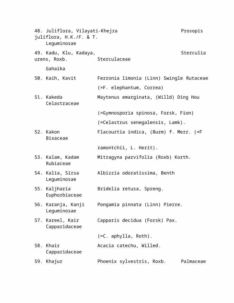
48. Juliflora, Vilayati-Khejra Prosopis juliflora, H.K./F. & T.
Leguminosae
49. Kadu, Klu, Kadaya, Sterculia urens, Roxb. Sterculaceae
Gahaika
50. Kaih, Kavit Ferronia limonia (Linn) Swingle Rutaceae
(=F. elephantum, Correa)
51. Kakeda Maytenus emarginata, (Willd) Ding HouCelastraceae
(=Gymnosporia spinosa, Forsk, Fion)
(=Celastrus senegalensis, Lamk).
52. Kakon Flacourtia indica, (Burm) f. Merr. (=FBixaceae
ramontchii, L. Herit).
53. Kalam, Kadam Mitragyna parvifolia (Roxb) Korth.Rubiaceae
54. Kalia, Sirsa Albizzia odoratissima, BenthLeguminosae
55. Kaljharia Bridelia retusa, Spreng.Euphorbiaceae
56. Karanja, Kanji Pongamia pinnata (Linn) Pierre.Leguminosae
57. Kareel, Kair Capparis decidua (Forsk) Pax.Capparidaceae
(=C. aphylla, Roth).
58. Khair Acacia catechu, Willed.Capparidaceae
59. Khajur Phoenix sylvestris, Roxb. Palmaceae

60. Kharjal Salvadora persica, Linn.Salvadoraceae
61. Kharni Manikara hexandra (Roxb) Dub. Sapotaceae
(=Mimusops hexandra, Roxb).
62. Khejra, Chonkda Prosopis cinerea (=P. spicigera, Willd).Leguminosae
63. Kumta, Safed Khair, Acacia senegal, Willd. Leguminosae
Khairi
64. Khirna, Dudhi Wrightia tinctoria, Br.Apocynaceae
65. Khirni, Dudhi Wrightia tomentosa, (Roem) Sch.Apocynaceae
66. Lasoda, Gonda Cordia dichotoma, Forst f.Boraginaceae
67. Lobhan Boswellia serrata RaxbBurseraceae
68. Lodhsayali, Har Singar Nyctanthesarbortrists, Linn. Oliaceae
69. Loon Khara Hymenodictylon excelsum, Wall. Rubiaceae
70. Mahuwa Madhuca indica, Gamel. Sapotacee
(= M. Latifolia, Roxb.) Machride)
71. Maida Lakdi Litsea glutionsa (Lour) C.B. RobensonLauraceae
(= Litsea chinensias Lamk)
72. Mendla, Chhoti padalDolichandrone falcate, Seem.Bignoniaceae
73. Mokha Schrebera swieteniodes, Roxb. Oleaceae
74. Molsiri Mimosups elengii, Linn. Sapotaceae

75. Naopatti, Binnas Hesperethusa crenulata (Roxb.) Roern.Rutaceae
(= Limonia crenulata, Roxb.)
76. Neem Azadirachta indica, A Juss. Meliaceae
77. Neem chameli, Millingtonia hortensis, Linn. f.Bignoniaceae
Akash neem
78. Padal, Padar Stereospermum suaveolens, D.C.Bignoniaceae
79. Pai, Barbet, Dhoben Dalbergia paniculata. Roxb. Leguminosae
80. Pakar Ficus lacor (Buch) Ham. Urticaceae
(=F. infectoria, Roxb.)
81. Paraas Pipal Ficus cordifolia, Roxb. Urticaceae
82. Phalsa Grewia damine, Gaertn. (=G.salvifolia,Tiliaceae
heyn ex. Roth. non Linn f. nec Roxb.)
83. Pipal Ficus religiosa, Linn Urticaceae
84. Pilu, Pilua, Khadiyar Salvadora oleoides, Dene. Salvadoraceae
85. Pula Kydia calycina, Roxb. Malvaceae
86. Rohan Soymida febrifuga, Jus. Meliaceae
87. Rohini, Rolli Mallotus philippinensis, Muell, Art.Euphorbiaceae
88. Rohindra, Rohda Teemella undulata, (Suith) Seem.Verbenaceae
89. Ronj, Arunj, Cheonkar Acacia leucophloea, Willd. Leguminosae

90. Salar Boswellia serrata, Roxb.Burseraceae
91. Sahtoot Morus alba, Linn. Urticaceae
92. Sainjana Moringa oleifera, Lamk (=M.Moringaceae
pterygosperma, Gaerth)
93. Sainjana, Sargora Moringa concanensis, NummaoMoringaceae
94. Semal Salmalia malabarica, D.C. Schott & Endl.Bombacaceae
(=Bombax malabaricum D.C.)
95. Shisham Dalbergia sissoo, Roxb.Leguminosae
96. Siris (Kala) Albizzia lebbek, Benth.Leguminosae
97. Siris (Safed) Alibizzia procera, Benth.Leguminosae
98. Sitaphal Anona squamosa, Linn Anonaceae
99. Tad Borassus flabellifer, Linn. Palmaceae
100.Tal, Arjuna, Kohada Terminaliaarjuna, Bedd. Combretaceae
101.Tendu Diospyros melanoxylon, Roxb. Ebenaceae
102.thor Euphorbia neriifolia, Linn.euphorbiaceae
103.Um Umb, Miliusa tomentosa (Roxb.), Sinclair.Anonaceae
(= Saccopetalum tomentosum) (Roxb)
H.K. f & Th.
104.Vilayati Khejra, Prosopis juliflira, H.K., F&T.Leguminosae
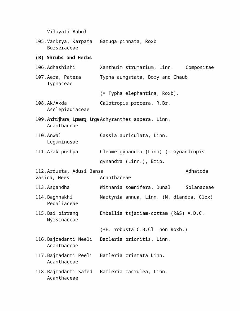
Vilayati Babul
105.Vankrya, Karpata Garuga pinnata, RoxbBurseraceae
(B) Shrubs and Herbs
106.Adhashishi Xanthuim strumarium, Linn. Compositae
107.Aera, Patera Typha aungstata, Bory and ChaubTyphaceae
(= Typha elephantina, Roxb).
108.Ak/Akda Calotropis procera, R.Br.Asclepiadiaceae
109.Andhijhara, Upmarg, UngaAchyranthes aspera, Linn.Acanthaceae
110.Anwal Cassia auriculata, Linn.Leguminosae
111.Arak pushpa Cleome gynandra (Linn) (= Gynandropis
gynandra (Linn.), Brip.
112.Ardusta, Adusi Bansa Adhatoda vasica, Nees Acanthaceae
113.Asgandha Withania somnifera, Dunal Solanaceae
114.Baghnakhi Martynia annua, Linn. (M. diandra. Glox)Pedaliaceae
115.Bai birrang Embellia tsjariam-cottam (R&S) A.D.C.Myrsinaceae
(+E. robusta C.B.Cl. non Roxb.)
116.Bajradanti Neeli Barleria prionitis, Linn.Acanthaceae
117.Bajradanti Peeli Barleria cristata Linn.Acanthaceae
118.Bajradanti Safed Barleria cacrulea, Linn.Acanthaceae

119.Baisuri Pluchea lanceolata, Clarke. Compositae
120.Bankapas Thespesia lampas, Delzo Bibs Malvaceae
121.Banphalsa Grewia villosa, Willd Tiliaceae
122.Bansi Crotolaria medicaginea, LamkLeguminosae
123.Baonli Acacia jacquemontii, BenthLeguminosae
124.Bapchi, Bantulsi Ocimum americanum, Linn. Labiatae
Nagad Bapchi
125.Basuni Tephrosia hookeriana, W.&A.Leguminosae
126.Bekar Indigofera cordifolia, HeyneLeguminosae
127.Bekario Indogofera hochstetteri, Bakerleguminosae
(= Indigofera anabaptista, Steud)
128.Bekari Indigofera linifolia, RetzLeguminosae
129.Besharma Ipomoea fistulosa, Mart. ex. ChoisyConvolvulaceae
[ = Ipomoea crassicaulis, (Benth) B.L.
Robinson]
( = I. Carnea, auct, non-Jacq.)
130.Brahmibuti, Brahmi Centella asiatica, Linn. Urban.Umbelliferae
(=Hydrocoty aisatica, Linn)
131.Bhurangini/Pasar Kateri Solanum suratlense, Burm. f. [ = Solanum Solanaceae
xanthocarpum, (Schard & Wendl].

132.Bokna/Kanabokna Commelina benghalensis, Linn.Commelinaceae
133.Bui Aerva javanica (Burm). f. SprengAmarantaceae
134.Chach Kamdi Pavonia indica. Linn. Malvaceae
135.Chapren, Kalisiyali, Firangan, Grewia flavescens, Juss. Tiliaceae
Jadkhair = (G. pilosa, W&A. non Lamk)
136.Chirchita Pupalia lappacea. Moq. (= P. tomentosa)Amarantaceae
137.Chirion-ka-Dhania Mollugo cerviana, Linn. Ficoidae
138.Chitawaldholi Chitrak Dyrophytonindica (=Vogelia indica,
Plumbaginaceae
(Gibs.)
139.Chitral Plumbago Zeylanica, Linn.Plumbaginaceae
140.Damasa Fagonia cretica, Linn.Zygophyllaceae
141.Dhamasa Tephrosia purpurea, Pers.Leguminosae
142.Dhatura Datura metal, Linn. (=D. fastuosa,Solanaceae
Clarka)
143.Dhrai, Chhaprand, Dhavri Woodfordiafruticosa (Linn.) Kuz. (=W. Lythraceae
floribunda, Salisb).
144.Dudhi Euphorbia hirta, Linn.Euphorbiaceae

145.Dudhi Euphorbia granulata, Forsk.Euphorbiaceae
146.Dudhi Euphorbia hypericifolia, Linn.Euphorbiaceae
147.Dudhi Euphorbia pilulifera, Linn.Euphorbiaceae
148.Dudhi Euphorbia prostrata, Grah.Euphorbiaceae
149.Gangren, Gangan, Grewia tenax (Forst) Feori f. (=G.Tiliaceae
Chabeni populifolia, Vahl).
150.Gokhru Tribulus terristris, Linn.Zygophyllaceae
151.Gugal Commiphora wightii (Arn) BhandariBurseraceae
(=Balsamodendron mukul, Hook
exstock)
152.Gwarpatha Aloe barbadensis, Mill (=A. vera, Linn).Liliaceae
153.Haranpadi Convolvulus arvenis, Linn.Convolvulaceae
154.Hins, Jal, Kanter Capparis sepiaria, Linn.Capparidaceae
155.Jangali Chaulai Amaranthus spinosus, Linn.Amarantaceae
156.Jangali Karonda Carrisa spinarum A.D.C.Apocynaceae
157.Jangali Til Seasamum indicum, Linn.Scrophularaceae
158.Jawasa Alhagi maurarum, Bakerleguminosae

(= A. camelorum, Fisch).
159.Jharber Zizyphus nummularia (Burm.f.) W.&ARhamnaceae
(= Z. rotundifolia Lamk).
160.Jharberi Zizyphus fruticosa, Haines Rhamnaceae
161.Jhau Tamarix dioica, Roxb.Tamaricaceae
162.Jhanjhani Mimosa rubicaulis, Lamk.Leguminosae
163.Jhil Indigofera oblongifolia, Forst (=I.Leguminosae
paucifolia, Delz.)
164.Jhojru Tephrosia purpurea, Pers.Leguminosae
165.Kagler Peristrophe bicalyculata, Nees.Acanthaceae
166.Kamboi Kirganelia reticulata (Poir) Baill.Euphorbiaceae
(= Phyllanthus reticulatus, Poir)
167.Kanti Acanthospermum hispidum Compositae
168.kanwal Nelumbo nucifera, Gaertn. Nymphaceae
( = Nelumbium specioum, Willd).
169.Kasondi Cassia occidentalis, Linn.Leguminosae
170.Kewra pandanus tectorius, Soland (= P.Pandanceae
odoratissimus, Linn. f.)
171.Khareti Sida ovata, Forsk (=S. grewioides Guill & Malvaceae

Pierr).
172.Kharsana, Khimpada, Crotolariaburhia, Bucham. Leguminosae
Senia
173.Khaton, Dason Rhus mysorensis, Heyne.Anacardiacae
174.Khimp Leptadenia pyrotechnica (Forst) Decne.Asclepiadiaceae
175.Khubasi Malva rotundifolia, Linn. Malvaceae
176.Kiryat, Kalmegh Andrographis paniculata, Nees.Acanthaceae
177.Kolikanda, Jangali piaz. Urginea indica, Kunthy Liliaceae
178.Kolikanda, Jangali piaz. Scilla hyacinthia (Roth) Macbr. (=S. Liliaceae
indica, Baker)
179.Koshta Corchorus trilocularis, Linn. Tiliaceae
180.Lagru, Kharsara Sericostoma pauciflorum, StecksBoraginaceae
181.Lalkaner Nerium indicum, Mill.Apocynaceae
(= N. odorum, Soland).
182.Lentana Lantana camara, Var. aculeata.Verbenaceae
Mold. (=L. camara, auct. non-Linn.)
183.Makoy Solanum nigrum, Linn. Solanaceae
184.Maror phali Helictres isora, Linn.Sterculaceae
185.Mehandi Lawsonia inermis, Linn. (= L. alba,Lythraceae
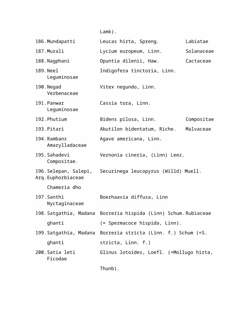
Lamk).
186.Mundapatti Leucas hirta, Spreng. Labiatae
187.Murali Lycium europeum, Linn. Solanaceae
188.Nagphani Opuntia dilenii, Haw. Cactaceae
189.Neel Indigofera tinctoria, Linn.Leguminosae
190.Negad Vitex negundo, Linn.Verbenaceae
191.Panwar Cassia tora, Linn.Leguminosae
192.Phutium Bidens pilosa, Linn. Compositae
193.Pitari Abutilon bidentatum, Riche. Malvaceae
194.Rambans Agave americana, Linn.Amarylladaceae
195.Sahadevi Vernonia cineria, (Linn) Leez.Compositae.
196.Selepan, Salepi, Securinega leucopyrus (Willd) Muell. Arq.Euphorbiaceae
Chameria dho
197.Santhi Boerhaavia diffusa, LinnNyctaginaceae
198.Satgathia, Madana Borreria hispida (Linn) Schum. Rubiaceae
ghanti (= Spermacoce hispida, Linn).
199.Satgathia, Madana Borreria stricta (Linn. f.) Schum (=S.
ghanti stricta, Linn. f.)
200.Satia leti Glinus lotoides, Loefl. (=Mollugo hirta,Ficodae
Thunb).

201.Shalparni Desmodium gangeticum, D.C.Leguminosae
202.Shankh pushpi Evolvulus alsinioides, Linn.Convolvulaceae
203.Satyanashi, Pili Kateri Argemone mexicana, Linn. Papaveraceae
204.Sialbethana Lepidagathis trinervis, Nees.Acanthaceae
205.Singhada Trapa bispinosa, Roxb. Onagraceae
206.Sitabani Artemesia scoparia, Waldst. Compositae
207.Swet barela Sida rhombifolia, Linn. malvaceae
208.Thuhar Danda Euphorbia nivulia, (Duch) Ham.Euphorbiaceae
209.Tripatti, Khatti buti Oxalis corniculata, Linn. Gerainaceae
210.Tulsi Ocimum sanctum, Linn. Labiatae
211.Untkatlo Echinops echinatus, Roxb. Compositae
212.Unt Kateri Lepidagathis cuspidata, Nees.Acanthaceae
213.Van Rasbhari Physalis minima, Linn. Solanaceae
214.N.A. Acalypha Ciliata, Forsk.Euphorbiaceae
215.N.A. Aeschynomene indica, Linn.Leguminosae
216.N.A. Alternanthera sessilis, R.Br.Amarantaceae
217.N.A. Amaranthus polygamous, Linn.Amarantaceae
218.N.A. Alysicarpus vaginalis Dc. varLeguminosae
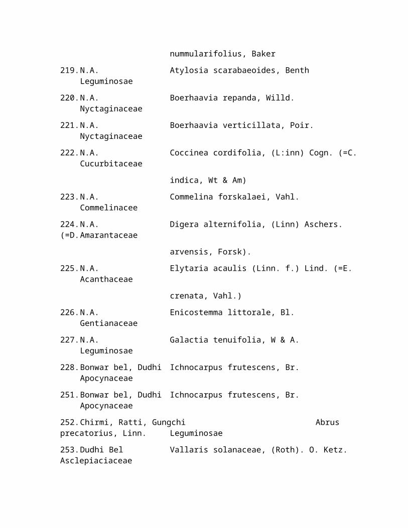
nummularifolius, Baker
219.N.A. Atylosia scarabaeoides, BenthLeguminosae
220.N.A. Boerhaavia repanda, Willd.Nyctaginaceae
221.N.A. Boerhaavia verticillata, Poir.Nyctaginaceae
222.N.A. Coccinea cordifolia, (L:inn) Cogn. (=C.Cucurbitaceae
indica, Wt & Am)
223.N.A. Commelina forskalaei, Vahl.Commelinacee
224.N.A. Digera alternifolia, (Linn) Aschers. (=D.Amarantaceae
arvensis, Forsk).
225.N.A. Elytaria acaulis (Linn. f.) Lind. (=E.Acanthaceae
crenata, Vahl.)
226.N.A. Enicostemma littorale, Bl.Gentianaceae
227.N.A. Galactia tenuifolia, W & A.Leguminosae
228.Bonwar bel, Dudhi Ichnocarpus frutescens, Br.Apocynaceae
251.Bonwar bel, Dudhi Ichnocarpus frutescens, Br.Apocynaceae
252.Chirmi, Ratti, Gungchi Abrus precatorius, Linn. Leguminosae
253.Dudhi Bel Vallaris solanaceae, (Roth). O. Ketz. Asclepiaciaceae
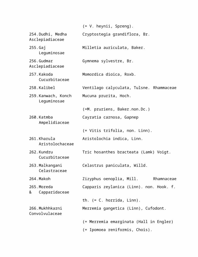
(= V. heynii, Spreng).
254.Dudhi, Medha Cryptostegia grandiflora, Br. Asclepiadiaceae
255.Gaj Milletia auriculata, Baker.Leguminosae
256.Gudmar Gymnema sylvestre, Br. Asclepiadiaceae
257.Kakoda Momordica dioica, Roxb.Cucurbitaceae
258.Kalibel Ventilago calyculata, Tulsne. Rhammaceae
259.Kanwach, Konch Mucuna prurita, Hoch.Leguminosae
(=M. pruriens, Baker.non.Dc.)
260.Katmba Cayratia carnosa, GapnepAmpelidiaceae
(= Vitis trifolia, non. Linn).
261.Kharula Aristolochia indica, Linn.Aristolochaceae
262.Kundru Tric hosanthes bracteata (Lamk) Voigt.Cucurbitaceae
263.Malkangani Celastrus paniculata, Willd.Celastraceae
264.Makoh Zizyphus oenoplia, Mill. Rhamnaceae
265.Moreda Capparis zeylanica (Linn). non. Hook. f.& Capparidaceae
th. (= C. horrida, Linn).
266.Mukhhkarni Merremia gangetica (Linn), Cufodont. Convolvulaceae
(= Merremia emarginata (Hall in Engler)
(= Ipomoea reniformis, Chois).

267.Nag Bel, Dudhi, Dryptolepis buchannani, Reon & Sech. Asclepaiadiaceae Chabukchadi
268.Naharkanta, Satavar A. dumosus, Baker. (= A. racemosus, Liliaceae
Willd).
269.Neem giloy Tinospora cordifolia, Miers. Meinspermaceae
270.Pahadbel, Pahadmul Cissampelos pereira, Linn. Menispermaceae
271.Phang Rivea hypocrateriformis, Chois. Convolvulaceae
272.Pilwani Cocculus hirsutus, (Linn) Diels. Menispermaceae
273.Turai Kadwi Luffa acutangula, Var. amara, Clark.Cucurbitaceae
(F) SEDGES
294.N.A. Cyperus spp. Cyperaceae
295.N.A. C. platystylis. Cyperaceae
296.N.A. C. triceps. Cyperaceae
(G) GRASSES
297.Badi jarga, Badi karadDichanthium caricosum, (Linn) A. Camus. Gramineae
298.Bamna, Sendar Chloris dolichostachya, Lag. (=C.Gramineae
incompleta, Roth)
299.Baru, Barwadi Sorghum halepense, (Linn) Pers.Gramineae
300.Bhanjura, Polarda Apluda mutica (Linn) Var. aristata, Pilger Gramineae
(=A. aristata, (Linn)

301.Bharut, Kaladhaman Cenchrus setigerus, Vahl. (=C. biflorus,Gramineae
Roxb.)
302.Bharut Cenchrus barbatus, schum (=C. Gramineae
Catharticus Del.).
303.Bindar Setaria glauca, Beanv. Gramineae
304.Buhari Eremopogon foveolatus, (Del) stapf.Gramineae
305.Chinkali Kewai Chloris roxburghiana, Schult. Gramineae
306.Chinkarda Digitaria adscendens, (HBK) Henr.Gramineae
307.Dab, Kush Desmostachya bipinnata, (Linn) stapf.Gramineae
308.Dab, Hariyali Cynodon dactylon, Pers. Gramineae
309.Dhaman, Anjan Cenchrus ciliaris, Linn. Gramineae
310.Gandhel Isleima laxum, Hack. Gramineae
311.Ganthia Dactyloctenium scindicum, Boiss.Gramineae
312.Garalu Coix gigantea, Koen, ex. Roxb. (=C.Gramineae
lachrymajobi, Stafp. ex. Hook. f.)
313.Goonder Cymbopogon jwarancusas (Jones) Schult.Gramineae
314.Goria, Sedua, SeranChrysopogon fulvus (Spr.) Chiov. (=C. Gramineae
Montanus, Trin)
315.Gunera, Bluepanic Panicum antidotale, Retz. Gramineae
316.Jharnia Eleusine indica, Gertn. Gramineae
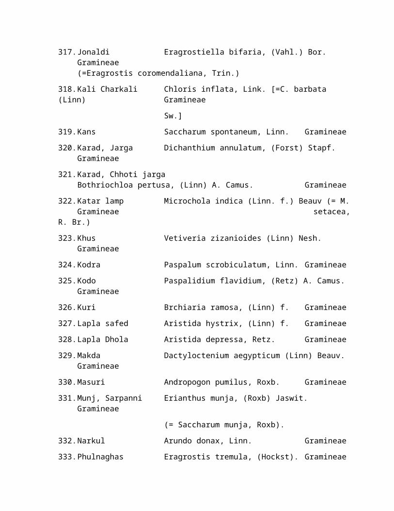
317.Jonaldi Eragrostiella bifaria, (Vahl.) Bor.Gramineae(=Eragrostis coromendaliana, Trin.)
318.Kali Charkali Chloris inflata, Link. [=C. barbata (Linn) Gramineae
Sw.]
319.Kans Saccharum spontaneum, Linn. Gramineae
320.Karad, Jarga Dichanthium annulatum, (Forst) Stapf.Gramineae
321.Karad, Chhoti jargaBothriochloa pertusa, (Linn) A. Camus. Gramineae
322.Katar lamp Microchola indica (Linn. f.) Beauv (= M.Gramineae setacea,
R. Br.)
323.Khus Vetiveria zizanioides (Linn) Nesh.Gramineae
324.Kodra Paspalum scrobiculatum, Linn. Gramineae
325.Kodo Paspalidium flavidium, (Retz) A. Camus.Gramineae
326.Kuri Brchiaria ramosa, (Linn) f. Gramineae
327.Lapla safed Aristida hystrix, (Linn) f. Gramineae
328.Lapla Dhola Aristida depressa, Retz. Gramineae
329.Makda Dactyloctenium aegypticum (Linn) Beauv.Gramineae
330.Masuri Andropogon pumilus, Roxb. Gramineae
331.Munj, Sarpanni Erianthus munja, (Roxb) Jaswit.Gramineae
(= Saccharum munja, Roxb).
332.Narkul Arundo donax, Linn. Gramineae
333.Phulnaghas Eragrostis tremula, (Hockst). Gramineae

334.Raichha, Rosha Cymbopogon martinii, (Roxb) Wal.Gramineae
335.Ratedi Themeda quadrivalvis, O. Ktze. Gramineae
336.Sawan Echinochloa colonum, (Linn) Link.Gramineae
337.Siran, Sheen Sehima nervosum, (Rohl.) Stapf.Gramineae
338.Siru Imperata Cylindrica, (Linn) Beauv.Gramineae
339.Sitaghas Tragus biflorus, (Roxb), Schult. (=T.Gramineae
racemosus. Hook. f. (non. all.)
340.Siyalpoonchi Perotis indica, (Linn) O. Ktze.Gramineae
341.Surwala, Kali lamp Heteropogon contortus, (Linn) f.Gramineae
342.Susa chunti Oropetium thomaeum, Linn. f. Gramineae
343.Underpuncha-choti Eragrostis ciliaris, (Linn) R. Br.Gramineae
344.Undri Arthraxon quartinianus, (Arich) Nash.Gramineae
345.Usari Sporobolus marginatus, Hochst ex. A.Gramineae
Rich.
346.N.A. Alloteropsis cimicina, (Linn) Stapf.Gramineae
347.N.A. Arachne recemosa Gramineae
348.N.A. Digitaria bicornis, (Limk) Roem.Gramineae
ex. Schult. (=D. barbata, Willd).
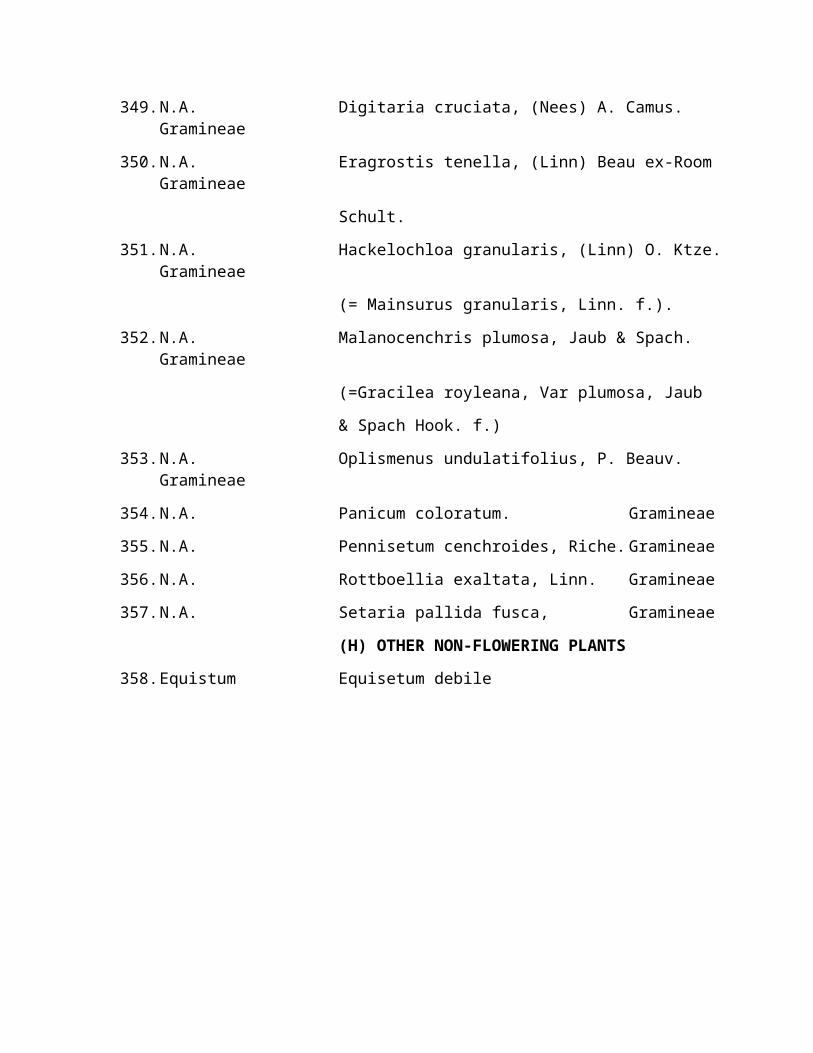
349.N.A. Digitaria cruciata, (Nees) A. Camus.Gramineae
350.N.A. Eragrostis tenella, (Linn) Beau ex-RoomGramineae
Schult.
351.N.A. Hackelochloa granularis, (Linn) O. Ktze.Gramineae
(= Mainsurus granularis, Linn. f.).
352.N.A. Malanocenchris plumosa, Jaub & Spach.Gramineae
(=Gracilea royleana, Var plumosa, Jaub
& Spach Hook. f.)
353.N.A. Oplismenus undulatifolius, P. Beauv.Gramineae
354.N.A. Panicum coloratum. Gramineae
355.N.A. Pennisetum cenchroides, Riche. Gramineae
356.N.A. Rottboellia exaltata, Linn. Gramineae
357.N.A. Setaria pallida fusca, Gramineae
(H) OTHER NON-FLOWERING PLANTS
358.Equistum Equisetum debile


![[HOFO-2016] - rsmssb@rajasthan](https://static.fdokumen.com/doc/165x107/6327c299051fac18490e6764/hofo-2016-rsmssbrajasthan.jpg)