COMPOSIZIONE DELLE ROCCE E QUALITA' DELLE ACQUE NELL'AREA DI SAN PEDRO SULA (HONDURAS) ROCK...
14
RIASSUNTO E' stato realizzato uno studio a carattere multidisciplinare, "Estudio Para La Proteccion Ambiental Del Acuifero Del Valle De Sula Y De Las Fuentes De Agua De La Reserva Forestal Del Merendon'', focalizzato alla valutazione e gestione delle risorse idri- che nell'area di San Pedro Sula (Honduras). Nel presente lavoro viene messa in luce la relazione tra la composi- zione delle rocce del bacino di alimentazione e la qualità delle acque e dei terreni alluvionali sede dell'acquifero. L'acquifero è contenuto entro i sedimenti alluvionali della Piana di San Pedro Sula; tali sedimenti, nelle zone di contatto con la catena montuosa del Merendon, sono costi- tuiti principalmente da conoidi di deiezione generate dal trasporto di materiale da parte dei fiumi; la zona apicale di tali conoidi è caratteriz- zata da elevata permeabilità ed è sede di un acquifero monostrato libe- ro. Spostandosi verso le zone più distali delle conoidi, compaiono zone depresse a sedimentazione molto fine (limi e argille); la permeabilità dei sedimenti è molto bassa e l'acquifero si sdoppia in uno più superficiale ed un più profondo; quest'ultimo è risultato essere in debole pressione. Per quanto riguarda il bacino di alimentazione, rappresentato dalla cate- na montuosa del Merendon, esso comprende rocce a diverso grado di metamorfismo, rocce intrusive, prodotti d'anatessi e prodotti di idroter- malismo caratterizzate da permeabilità per fratturazione. Il dilavamento delle rocce e della coltre pedogenetica dei bacini d'alimentazione ha determinato la qualità dell'acqua, dei suoli e dei paleosuoli delle successive deposizioni dei sedimenti alluvionali. Acque di tipo bicarbonato alcalino con conducibilità elettrica speci- fica inferiore ai 100 µS cm -1 sono legate a rocce intrusive ed a pro- dotti d'anatessi del Rio Zapotal con breve percorso idrico sotterraneo. Acque di tipo bicarbonato-calcico con conducibilita' elettrica specifi- ca superiore a 1000 µS cm -1 osservate ad Aldea El Carmen sono da collegarsi alla calcite secondaria derivata dagli scisti carbonatici inseriti tra i plutoni granitici. Le acque di circolazione profonda, talo- ra calde, sono di tipo bicarbonato-alcalino con pH elevati fino a 10. Acque a pH acido, intorno a 4, di tipo solfato-clorurato-alcalino si osservano nel bacino del Rio Manchaguala e sono da collegarsi a ione SO 4 = generatosi per ossidazione di Solfuri metalli formatisi al bordo del plutone, con la roccia incassante, per idrotermalismo. In pianura le acque superficiali subiscono un pesante inquina- ABSTRACT A multidisciplinary study was carried out, within the "Estudio Para La Proteccion Ambiental Del Acuifero Del Valle De Sula Y De Las Fuentes De Agua De La Reserva Forestal Del Merendon'' plan, focused on the appraisal and management of the water resources in San Pedro Sula area (Honduras). This paper deals with the hydrochemical study which is of great significance for the comprehension of the hydrogeological system. The aim is to highlight the relationship between the rock composition of the ground water recharge basin and the quality of the alluvial ter- rain aquifer. The aquifer is contained between alluvial sediments of the San Pedro Sula plain; these sediments, in the areas in contact with the Merendon mountain chain, comprise mainly alluvial fans generated by material transported by the rivers; the apical area of these fans is characterised by high permeability and is the site of a free monostrate aquifer. Moving towards the more distal fan areas, depressed areas of fine sedimentation (silt and clay) appear; the permeability of the sed- iments is very low and the aquifer divides into a more superficial one and a deeper one; the latter was found to be under slight pressure. Regarding the ground water recharge basin, represented by the Merendon mountain chain, this includes rocks in various degrees of metamorphism, intrusive rocks, anatectic products and hydrothermal products characterised by permeability through fracturing. The rocks of the ground water recharge basin and the scour of the pedogenetic layer have determined the present water quality and the soils and palaeosoils composition of the later alluvial sediment dep- osition. Bicarbonate-alkaline waters characterised by a specific elec- tric conductivity <100 µS cm -1 are linked to intrusive rocks and ana- tectic products of the Zapot al river. These waters have a short under- ground watercourse. Calcium bicarbonate waters with specific elec- tric conductivity >1000 µS cm -1 , observed in Aldea El Carmen area, are connected to the dissolution of secondary calcite. This calcite is considered being the product of precipitation from carbonatic schists involved in granitic pluton intrusions. Deep alkaline-bicarbonate waters, warm in some cases, have a pH of 10. Sulphate-chlorine- alkaline waters with pH around 4, occurs in the Manchaguala river basin, and are linked to sulphates produced by oxidation of metallic RAFFAELE MADONNA (*) ,P ATRIZIO TORRESE (*) ,GIANCARLO CREMA (**) , P ATRIZIO SIGNANINI (*) &VINCENZO COSTANTINO (***) (*) Università "G. D'Annunzio" di Chieti-Pescara - DiGAT- Dipartimento di Geotecnologie per l'Ambiente e il Territorio - Via dei Vestini 30 - 66013 Chieti Scalo, Italia (**) Università "G. D'Annunzio" di Chieti, Facoltà di Scienze MM.FF.NN. - Via dei Vestini 30 - 66013 Chieti Scalo, Italia (***) C. Lotti & Associati - Consulting Engineering, - Via del Fiume, 14 - 00186 Roma, Italia COMPOSIZIONE DELLE ROCCE E QUALITA’ DELLE ACQUE NELL’AREA DI SAN PEDRO SULA (HONDURAS) ROCK COMPOSITION AND WATER QUALITY OF SAN PEDRO SULAAREA (HONDURAS) Italian Journal of Engineering Geology and Environment, 1 (2007) © Casa Editrice Università La Sapienza 19
Transcript of COMPOSIZIONE DELLE ROCCE E QUALITA' DELLE ACQUE NELL'AREA DI SAN PEDRO SULA (HONDURAS) ROCK...
RIASSUNTO
E' stato realizzato uno studio a carattere multidisciplinare,"Estudio Para La Proteccion Ambiental Del Acuifero Del Valle DeSula Y De Las Fuentes De Agua De La Reserva Forestal DelMerendon'', focalizzato alla valutazione e gestione delle risorse idri-che nell'area di San Pedro Sula (Honduras).
Nel presente lavoro viene messa in luce la relazione tra la composi-zione delle rocce del bacino di alimentazione e la qualità delle acque edei terreni alluvionali sede dell'acquifero. L'acquifero è contenuto entroi sedimenti alluvionali della Piana di San Pedro Sula; tali sedimenti,nelle zone di contatto con la catena montuosa del Merendon, sono costi-tuiti principalmente da conoidi di deiezione generate dal trasporto dimateriale da parte dei fiumi; la zona apicale di tali conoidi è caratteriz-zata da elevata permeabilità ed è sede di un acquifero monostrato libe-ro. Spostandosi verso le zone più distali delle conoidi, compaiono zonedepresse a sedimentazione molto fine (limi e argille); la permeabilità deisedimenti è molto bassa e l'acquifero si sdoppia in uno più superficialeed un più profondo; quest'ultimo è risultato essere in debole pressione.Per quanto riguarda il bacino di alimentazione, rappresentato dalla cate-na montuosa del Merendon, esso comprende rocce a diverso grado dimetamorfismo, rocce intrusive, prodotti d'anatessi e prodotti di idroter-malismo caratterizzate da permeabilità per fratturazione.
Il dilavamento delle rocce e della coltre pedogenetica dei bacinid'alimentazione ha determinato la qualità dell'acqua, dei suoli e deipaleosuoli delle successive deposizioni dei sedimenti alluvionali.Acque di tipo bicarbonato alcalino con conducibilità elettrica speci-fica inferiore ai 100 µS cm-1 sono legate a rocce intrusive ed a pro-dotti d'anatessi del Rio Zapotal con breve percorso idrico sotterraneo.Acque di tipo bicarbonato-calcico con conducibilita' elettrica specifi-ca superiore a 1000 µS cm-1 osservate ad Aldea El Carmen sono dacollegarsi alla calcite secondaria derivata dagli scisti carbonaticiinseriti tra i plutoni granitici. Le acque di circolazione profonda, talo-ra calde, sono di tipo bicarbonato-alcalino con pH elevati fino a 10.Acque a pH acido, intorno a 4, di tipo solfato-clorurato-alcalino siosservano nel bacino del Rio Manchaguala e sono da collegarsi aione SO4
= generatosi per ossidazione di Solfuri metalli formatisi albordo del plutone, con la roccia incassante, per idrotermalismo.
In pianura le acque superficiali subiscono un pesante inquina-
ABSTRACT
A multidisciplinary study was carried out, within the "EstudioPara La Proteccion Ambiental Del Acuifero Del Valle De Sula Y DeLas Fuentes De Agua De La Reserva Forestal Del Merendon'' plan,focused on the appraisal and management of the water resources inSan Pedro Sula area (Honduras).
This paper deals with the hydrochemical study which is of greatsignificance for the comprehension of the hydrogeological system.The aim is to highlight the relationship between the rock compositionof the ground water recharge basin and the quality of the alluvial ter-rain aquifer.
The aquifer is contained between alluvial sediments of the SanPedro Sula plain; these sediments, in the areas in contact with theMerendon mountain chain, comprise mainly alluvial fans generatedby material transported by the rivers; the apical area of these fans ischaracterised by high permeability and is the site of a free monostrateaquifer. Moving towards the more distal fan areas, depressed areas offine sedimentation (silt and clay) appear; the permeability of the sed-iments is very low and the aquifer divides into a more superficial oneand a deeper one; the latter was found to be under slight pressure.Regarding the ground water recharge basin, represented by theMerendon mountain chain, this includes rocks in various degrees ofmetamorphism, intrusive rocks, anatectic products and hydrothermalproducts characterised by permeability through fracturing.
The rocks of the ground water recharge basin and the scour of thepedogenetic layer have determined the present water quality and thesoils and palaeosoils composition of the later alluvial sediment dep-osition. Bicarbonate-alkaline waters characterised by a specific elec-tric conductivity <100 µS cm-1 are linked to intrusive rocks and ana-tectic products of the Zapot al river. These waters have a short under-ground watercourse. Calcium bicarbonate waters with specific elec-tric conductivity >1000 µS cm-1, observed in Aldea El Carmen area,are connected to the dissolution of secondary calcite. This calcite isconsidered being the product of precipitation from carbonatic schistsinvolved in granitic pluton intrusions. Deep alkaline-bicarbonatewaters, warm in some cases, have a pH of 10. Sulphate-chlorine-alkaline waters with pH around 4, occurs in the Manchaguala riverbasin, and are linked to sulphates produced by oxidation of metallic
RAFFAELE MADONNA(*), PATRIZIO TORRESE(*), GIANCARLO CREMA(**),PATRIZIO SIGNANINI(*) & VINCENZO COSTANTINO(***)
(*) Università "G. D'Annunzio" di Chieti-Pescara - DiGAT - Dipartimento di Geotecnologie per l'Ambiente e il Territorio - Via dei Vestini 30 - 66013 Chieti Scalo, Italia(**) Università "G. D'Annunzio" di Chieti, Facoltà di Scienze MM.FF.NN. - Via dei Vestini 30 - 66013 Chieti Scalo, Italia
(***) C. Lotti & Associati - Consulting Engineering, - Via del Fiume, 14 - 00186 Roma, Italia
COMPOSIZIONE DELLE ROCCE E QUALITA’ DELLE ACQUENELL’AREA DI SAN PEDRO SULA (HONDURAS)
ROCK COMPOSITION AND WATER QUALITY OF SAN PEDRO SULA AREA (HONDURAS)
Italian Journal of Engineering Geology and Environment, 1 (2007) © Casa Editrice Università La Sapienza 19
pc345
Casella di testo
DOI: 10.4408/IJEGE.2007-01.O-02
mento soprattutto organico, legato agli scarichi civili ed industrialidell'agroindustria.
PAROLE CHIAVE: Geochimica, idrogeologia, composizione delle rocce, acquifero
INTRODUZIONE
Tra le varie metodologie utilizzate nella prospezione idrogeologica,lo studio del chimismo delle acque sotterranee e superficiali rappresen-ta un metodo molto rapido che consente di caratterizzare il bacino diricarica delle acque sotterranee, di individuarne le zone di alimentazio-ne e di drenaggio preferenziali, di risalire alle temperature profonde e diparagonare o correlare tra loro le varie tipologie di acque (CELICO,1993). La litologia, l'intensa pedogenesi, l'assetto strutturale dei bacinidi ricarica delle acque sotterranee e del substrato, l'evoluzione paleo-geografica e sedimentologica, i circuiti sotterranei condizionano inmaniera determinante la qualità delle acque di falda. Tali acque, sianoesse superficiali che profonde, possono successivamente subire unpesante inquinamento da parte di centri di pericolo come scarichi indu-striali, civili e pastorizia. Diventa quindi importante valutare la vulnera-bilità delle singole aree ed eventualmente, nota la distribuzione arealedei centri di pericolo, il rischio potenziale di inquinamento della falda.
Il presente lavoro, che si colloca all'interno di uno studio idrogeo-logico multidisciplinare che ha interessato l'acquifero alluvionale diSan Pedro Sula (Honduras), intende portare un contributo alla pianifi-cazione territoriale e alla gestione delle risorse idriche della regione.
INQUADRAMENTO GEOLOGICO, GEOMORFOLO-
GICO E STRUTTURALE DELL'AREA
L'area oggetto del presente studio, circoscritta in Fig. 1, è situatanella parte NW dell'Honduras e comprende la catena Montuosa delMerendon ad W e la pianura alluvionale di San Pedro Sula ad E carat-terizzata dalla presenza di numerosi sorgenti e corsi d'acqua.
Come si può osservare dalla Fig.2, la geologia dell'area è moltocomplessa ed articolata. In particolare la litologia del bacino di rica-rica delle acque sotterranee, rappresentato dalla Montagna delMerendon, comprende rocce metamorfiche e rocce intrusive. Lerocce metamorfiche paleozoiche affiorano, con il nome di "Scisti diCorogua", nella zona del Merendon ed in alcuni affioramenti nellavalle del Chamalecon (FOYE, 1918; WILLIAMS & MCBIRNEY, 1969;ELVIR, 1974, 1976; HORNE et alii, 1976; FINCH, 1981, 1986;DONNELLY et alii, 1991; MILLS RICHARD, 1991; PIERCE HERBERT &RIVERA MONTES, 1991). Si distinguono rocce ascrivibili a tre gradi dimetamorfismo:- metamorfismo basso: scisti verdi e scisti clorito-sericitici;- metamorfismo medio: micascisti quarzosi talora con feldspato ad
Epidoto, con livelli di anfiboliti ad Orneblenda, Andesina,Tremolite;
- metamorfismo alto: ortogeiss.Le formazioni metamorfiche paleozoiche sono interessate da
intrusioni di graniti, granodioriti, dioriti di varia età. Le rocce intru-
sulphurs formed at the margin of the pluton by hydrothermal process-es.
KEYWORDS: Geochemistry, hydrogeology, rock composition, aquifer
INTRODUCTION
Of the various methodologies used in hydrogeological prospect-ing, the most rapid is the chemical study of groundwater and surfacewater. It allows characterisation of the ground water recharge basin,pinpointing of preferential recharge and drainage areas, arriving atdeep temperatures and comparison or correlation between the variouswater types (CELICO, 1993). Lithology, intense pedogenetic process-es, ground water recharge basin and subsurface structure, palaeo-graphic and sedimentological evolution and underground circuitshave been determining factors affecting water table quality. Thesewaters, whether superficial or deep, may subsequently undergoheavy pollution from highly dangerous areas such as industrial, urbanand stock-rearing wastes. Therefore, it is important to evaluate thevulnerability of individual areas and if necessary, given the knownarea distribution of the centres of the risk areas, the potential risk ofpollution of the aquifer.
This work is carried out in the context of a multi-disciplinaryhydrogeological study concerning the San Pedro Sula (Honduras)alluvial quifer and and intends o give a contribution to territorialplanification and management of hydric resourses of the region.
THE GEOLOGICAL, GEOMORPHOLOGIC AND
STRUCTURAL CHARACTERISTICS OF THE AREA
The area concerned in this study, outlined in Fig. 1, is located inthe north-west part of Honduras and includes the Merendon moun-tain to the W chain and the San Pedro Sula alluvial plain to the E, thelater being characterised by the presence of numerous water courses.
As seen in Fig. 2, the area is characterised by a very complex andvaried geology. In particular, the lithology of the ground waterrecharge basin, represented by the Merendon Mountain, includesmetamorphic and intrusive rocks. Palaeozoic metamorphic rocksappear, under the name of "Schists of Corogua", in the Merendonarea and in some outcrops in the Chamalecon valley (FOYE, 1918;WILLIAMS & MCBIRNEY, 1969; ELVIR, 1974, 1976; HORNE et alii,1976; FINCH, 1981, 1986; DONNELLY et alii, 1991; MILLS RICHARD,1991; PIERCE HERBERT & RIVERA MONTES, 1991). Three degrees ofmetamorphism can be identified:- low grade metamorphism: green schists and chlorite-sericitic
schists;- medium grade metamorphism: quartzose mica-schists often with
Epidote feldspar, with hornblende, andesine, tremolite amphibolitelevels;
- high grade metamorphism: orthogneiss.Palaeozoic metamorphic formations are affected by granite,
granodiorite and diorite intrusions of various ages. The oldest
R. MADONNA,, P. TORRESE, G. CREMA, P. SIGNANINI & V. COSTANTINO20
COMPOSIZIONE DELLE ROCCE E QUALITA’ DELLE ACQUE NELL’AREA DI SAN PEDRO SULA (HONDURAS)

Italian Journal of Engineering Geology and Environment, 1 (2007) © Casa Editrice Università La Sapienza 21
ROCK COMPOSITION AND WATER QUALITY OF SAN PEDRO SULA AREA (HONDURAS)
Fig. 1 - Ubicazione dell'area di studio- Localization of the studied area
Fig. 2 - Schema geologico-geomorfologico. 1) Rocce intrusive; 2) Rocce metamorfiche (basso grado); 3) Rocce metamorfiche (medio grado); 4) Rocce meta-morfiche (alto grado); 5) Alluvioni; 6) Depositi di conoide; 7) Conoidi di flusso; 8) Depositi di talus; 9) Fratture circolari; 10) Faglie; 11) Meandri; 12)Tracce delle sezioni idrogeologiche
- Geological and geomorphological scheme. 1) Intrusive rocks; 2) Metamorphics rocks (low grade); 3) Metamorphics rocks (medium grade); 4) meta-morphics rocks (high grade); 5) Alluvium; 6) Conoid deposits; 7) Flow conoid deposits; 8) Talus deposits; 9) Circular fractures; 10) Faults; 11) Buriedriverbeds; 12) Traces of hydrogeological sections

sive più antiche affiorano circa 15 chilometri più a W di San PedroSula, e presentano composizione adamellitica. Rocce intrusive menoantiche sono costituite da granodioriti passanti a tonaliti, affioranti adE di Cofradia. L'intrusione plutonica più grande è rappresentata dalbatolite di San Pedro Sula (nell'area occidentale di San Pedro Sula),affiorante nelle aree di Agua Caliente, Aldea Zapotal, Fesitranh, ElCarmen, Yucutuma, Rivera Hernandez, costituito da granodioriti connumerosi filoni acidi e basici orientati W-E. Nella zona compresa trala Laguna El Carmen e la Laguna Yucutuma, si sono osservate nume-rose fratture riempite da calcite secondaria da connettere a lembi resi-duali di facies metamorfiche carbonatiche rimasti inglobati tra i variplutoni.
Nell'area occidentale, zona di alimentazione dell'acquifero, albordo dei plutoni, compaiono aureole di contatto dove l'intenso idro-termalismo ha permesso la formazione di diverse facies mineralogi-che, tra cui frequenti sono i solfuri metallici.
L'erosione, lo smantellamento di tali rocce ed il loro trasportoda parte dei fiumi ha prodotto numerose conoidi alluvionali che sitrovano ubicate al contatto tra la catena montuosa del Merendon ela pianura alluvionale; quest'ultima si presenta depressa nella zonaorientale e centrale dove compaiono estese lagune. I fiumi, a regi-me torrentizio nella parte montana, assumono l'andamento mean-driforme nella piana e scorrono all'interno di estesi depositi terraz-zati. I sedimenti alluvionali sono stati infine sottoposti ad una pedo-genesi che si è estesa su tutta l'area e in modo variabile in funzionedella quota.
Dal punto di vista dell'evoluzione geologica, in epoca cretacical'area di San Pedro Sula era sommersa; testimonianza di ciò sono leformazioni marine mesozoiche affioranti immediatamente a S di SanPedro Sula. Alla fine del Cretacico Superiore la parte più a N dellafaglia Pueblo Nuevo si è sollevata assieme alla zona di San PedroSula. Sull'area, prossima al mare, si impostava una paleomorfologiacon lo smantellamento del complesso mesozoico che ricopriva ilmetamorfico paleozoico. Nello stesso tempo, od in epoca immedia-tamente successiva, si cominciava a formare la catena dell'Omoa;contemporaneamente o subito dopo questi eventi, forse in relazionealla trascorrenza E-W Montagua-Chamalecon-Aguan (HORNE et alii,1976; LOTTI & ASSOCIATI, 2002; SIGNANINI et alii, 2002), si formavaper pull-apart una depressione che comprenderebbe l'attuale depres-sione dell'Ulua e quella di San Pedro Sula che, a scala locale, risultaessere un graben orientato NNE-SSW. Nel terziario, all'incrocio deilineamenti tettonici orientati NE-SW con gli W-E ed altri ad anda-mento NW-SE, si sono estrusi i paleoalti granodioritici-dioritici chehanno sollevato la parte orientale dell'area di studio. Un'ulterioreintrusione si è prodotta in tempi più recenti nell'area dello Zapotalcon messa in posto di un batolite granitico-granodioritico (FOYE,1918; WILLIAMS & MCBIRNEY, 1969; ELVIR, 1974, 1976; HORNE etalii, 1976; FINCH, 1981, 1986; DONNELLY et alii, 1991; MILLS
RICHARD, 1991; PIERCE HERBERT & RIVERA MONTES, 1991; C. LOTTI
& ASSOCIATI, 2002; SIGNANINI & GASPARRI, 2002).
intrusive rocks emerge around 15 kilometres west of San PedroSula and are adamellitic in composition; the more recent ones arecomposed of granodiorites passing to tonalites, appearing east ofCofradia. The largest plutonic intrusion is the batholite at SanPedro Sula (in the westerne zone of San Pedro Sula), outcroppingin the Agua Caliente, Aldea Zapotal, Fesitranh, El Carmen,Yucutuma and Rivera Hernandez areas, comprising granodioriteswith numerous W-E oriented acid and basic seams. In the areabetween El Carmen lagoon and Yucutuma lagoon, numerous frac-tures, filled with secondary calcite, were observed, to be connect-ed to residual limbs of carbonate metamorphic facies that havebeen incorporated between the various plutons. To the west, whichis the recharge area of the aquifer, near at the edge of the plutons,contact aureoles are observed where intense hydrothermalism hascaused the formation of several mineralogical facies, the most fre-quent being metallic sulphurs.
Erosion, dismantling of these rocks and their transportation byrivers has produced numerous alluvial fans located at the contact-point between the Merendon mountain chain and the alluvial plain;the latter is depressed to the east and central areas where widelagoons appear. The rivers, torrential in the mountain area, tend to bemeandering in the plain and run inside wide terraced deposits.Finally, in the entire area the alluvial sediments have been subjectedto a pedogenetic process to varying degrees, according to the altitude.
With regard to geological-structural evolution, the San PedroSula area was submerged during the Cretaceous period; evidence ofthis can be seen in the outcrops of Mesozoic marine formationsimmediately south of San Pedro Sula. At the end of the UpperCretaceous period, the furthest northern part of the Pueblo Nuevofault was raised up together with the San Pedro Sula area. The dis-mantling of the Mesozoic complex, which covered the Palaeozoicmetamorphic formations, superimposed a palaeomorphology on thearea, near the sea. At the same time, or in the immediate followingperiod, the formation of the Omoa chain began; simultaneously withor immediately after these events, possibly related to the Montagua-Chamalecon-Aguan EW strike slip (HORNE et alii, 1976; LOTTI &ASSOCIATI, 2002; SIGNANINI et alii, 2002), pull-apart forces wereresponsible of the formation of a depression, which probablyincludes the present Ulua depression and the San Pedro Sula depres-sion; on a local scale, it is a NNE-SSW oriented graben. In theTertiary period, at the intersection of NE-SW oriented tectonic lineswith the W-E ones and others with a NW-SE orientation, granodi-oritic-dioritic horsts were extruded, raising the eastern part of thearea under investigation. A further intrusion came about morerecently in the Zapotal area with the settlement of a granitic-gran-odioritic batholite (FOYE, 1918; WILLIAMS & MCBIRNEY, 1969;ELVIR, 1974, 1976; HORNE et alii, 1976; FINCH, 1981, 1986;DONNELLY et alii, 1991; MILLS RICHARD, 1991; PIERCE HERBERT &RIVERA MONTES, 1991; C. LOTTI & ASSOCIATI, 2002; SIGNANINI &GASPARRI, 2002).
R. MADONNA,, P. TORRESE, G. CREMA, P. SIGNANINI & V. COSTANTINO22
COMPOSIZIONE DELLE ROCCE E QUALITA’ DELLE ACQUE NELL’AREA DI SAN PEDRO SULA (HONDURAS)
IL SISTEMA ACQUIFERO
La tettonica attiva, il regime torrentizio, le forti ed immediatevariazioni di portata dei fiumi, le frequenti divagazioni del talwege l'intensa pedogenesi hanno contribuito a creare, in periodi suc-cessivi e quindi a diverse quote, un sistema acquifero fortementeanisotropo; significative sono infatti le variazioni laterali e verti-cali di facies, con presenza di paleosuoli a diverse profondità. Talesistema acquifero è caratterizzato da due tipi di circolazione, unaprofonda con risposta dilazionata rispetto alle precipitazioni e l'al-tra meno profonda con risposta immediata (SIGNANINI &GASPARRI, 2002; TORRESE et alii, 2006).
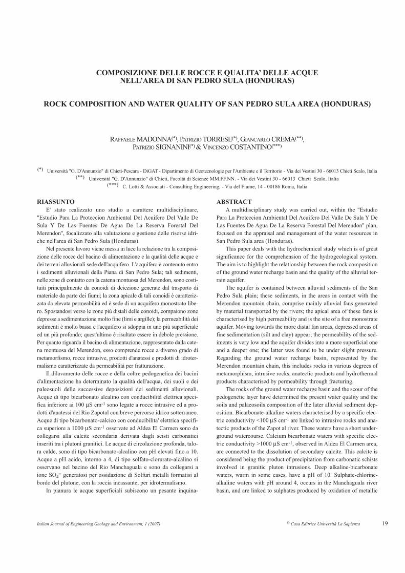
Nella Fig. 3 sono riportati le direzioni di circolazione delle acquesotterranee (3b) e la sezione idrogeologica schematica dell'acquifero(Fig. 3c). (NORPLAN, 1986a; 1986b; 1987; 1990; HAASE et alii,1993a, 1993b; HAASE et alii, 1994; PACIFIC CONSULTANTS, 1994a;1994b; 1994c; MCKENZIE, 1995).
THE AQUIFER SYSTEM
The active tectonics, the torrential regimen, strong and immedi-ate variations in river flow rates, frequent digressions of the talwegand intense pedogenetic processes have contributed to creating insubsequent periods and therefore at various altitudes, a stronglyanisotropic aquifer system; the lateral and vertical variations offacies, with palaeosoils at various depths, are significant. This aquifersystem has two types of circulation, a deeper circulation that hasdeferred response with respect to the precipitations and a shallowercirculation, characterised by a more immediate response (SIGNANINI
& GASPARRI, 2002; TORRESE et alii, 2006).Figure 3 shows the circulation directions of grounwaters (Fig.
3b) and the schematic hydrogeological section of the aquifer (Fig. 3c)(NORPLAN, 1986a; 1986b; 1987; 1990; HAASE et alii, 1993a, 1993b;HAASE et alii, 1994; PACIFIC CONSULTANTS, 1994a; 1994b; 1994c;MCKENZIE, 1995).
Italian Journal of Engineering Geology and Environment, 1 (2007) © Casa Editrice Università La Sapienza 23
ROCK COMPOSITION AND WATER QUALITY OF SAN PEDRO SULA AREA (HONDURAS)
Fig. 3 - a) Piezometria di gennaio 2002 (5 m); b) Ricostruzione schematica dei flussi idrici sotterranei; c) Acque superficiali e sotterranee, sezione idrogeologi-ca schematica. 1) Rocce intrusive; 2) Rocce metamorfiche; 3) Paleosuoli; 4) Alluvioni; 5) Depositi di conoide; 6) Acque superficiali; 7) Acque sotterra-nee; 8) Punti di monitoraggio della piezometria (m s.l.m.); 9) Fiumi
- a) Observed piezometric heads of January 2002 (5 m); 3b) Groundwater flows schematic map; 3c) Superficial water and groundwater, schematic hydro-geological section. 1) Intrusive rocks; 2) Metamorphic rocks; 3) Paleosoils; 4) Alluvium; 5) Fan deposits; 6) Superficial water; 7) Groundwater; 8) Watertable observations (m a.s.l.), 9) Rivers

R. MADONNA,, P. TORRESE, G. CREMA, P. SIGNANINI & V. COSTANTINO
COMPOSIZIONE DELLE ROCCE E QUALITA’ DELLE ACQUE NELL’AREA DI SAN PEDRO SULA (HONDURAS)
Il sistema acquifero è stato assimilato ad un monostrato freaticoanche se presenta tali caratteristiche solo nella zona di alimentazioneidentificabile nella parte apicale e mediana delle conoidi; in zona distale,per la presenza di un livello argilloso di separazione, l'acquifero si sdop-pia in uno meno profondo freatico ed uno più profondo in pressione (Fig.3c). Per quanto riguarda la piezometria, sulla rete di pozzi scelti, perquanto possibile, privi d'interferenze di pompaggi nelle prossimità, sonostate effettuate 10 misure piezometriche nel periodo compreso tra gen-naio 2002 e giugno 2004. Come è possibile osservare nella carta dellapiezometria di gennaio 2002 (Fig. 3a), le direzioni di flusso sono moltoarticolate ed inoltre vengono evidenziate due zone di alimentazione delsistema acquifero, una posta a NW e l'altra ad W dell'area in studio(TORRESE et alii, 2006).
Nella Fig. 3b viene proposta una ricostruzione schematica dei flus-si idrici sotterranei. Il bacino di ricarica delle acque sotterranee, rap-presentato dalla montagna del Merendon, sembra alimentare in partel'area del Rio Blanco-Laguna El Carmen con flussi idrici provenientiprincipalmente da NW, in parte l'area di Sunceri con flussi idrici pro-venienti da W; tale flusso vira verso Rio Chotepe differenziandosi piùa S in due flussi uno verso il Chamalecon e l'altro verso l'Aeroporto; daqui vira verso NE, verso la Laguna Yucutuma che potrebbe rappresen-tare, assieme alla Laguna El Carmen, una zona di soglia ed un ulterio-re recapito del sistema acquifero (Fig. 4). Le indagini geofisiche effet-tuate in queste ultime due aree infatti hanno evidenziato una netta risa-lita del bedrock. (CHARRUTHERS, 1983; SIGNANINI & GASPARRI, 2002).
The aquifer system has been assimilated to a phreatic monostrateeven though it has these characteristics only in the recharge area iden-tified in the apical and median part of the fans. In the distal area, thepresence of an argillaceous separation level causes the aquifer to splitinto two different aquifers, a shallower, phreatic one and a deeper onewhich is under pressure. (Fig. 3c). With regard to the piezometry, onthe network of wells chosen, as far as possible without pumping intheir vicinity, 10 piezometric measurements were carried out in theperiod between January 2002 and June 2004. As we can see from thepiezometric map of January 2002 (Fig. 3a), there are several direc-tions of flow and two recharge areas for the water system are shown,one to the NW and the other W of the area under investigation(TORRESE et alii, 2006).
In Fig. 3b, a schematic reconstruction of the groundwater flowsis shown. The ground water recharge basin located to the west, rep-resented by the Merendon mountain, seems to be partly feeding theRio Blanco-Laguna El Carmen area, with water flowing mainly fromthe NW, and partly the Sunceri area with water flowing from the W;this flow turns towards Chotepe river separating further sud into twoflows, one towards the Chamalecon zone and the other towards theAirport area; from here it turns north-west towards the Yucutumalagoon, which might be, along with the El Carmen lagoon, a furtherdischarge for the aquifer system (Fig. 4); geophysical studies carriedout by us have shown a clear bedrock horsts (CHARRUTHERS, 1983;SIGNANINI & GASPARRI, 2002).
24
Fig. 4 - Carta della profondità del substrato- Map of the aquifer bedrock elevation
Italian Journal of Engineering Geology and Environment, 1 (2007) © Casa Editrice Università La Sapienza
ROCK COMPOSITION AND WATER QUALITY OF SAN PEDRO SULA AREA (HONDURAS)
IDROCHIMICA DELLE ACQUE
Lo scopo dell'analisi chimica delle acque sotterranee e superfi-ciali è stato quello di definirne le caratteristiche, dovute a cause natu-rali, e quindi collegare il chimismo con la geologia (litologia, assettostrutturale, ecc.) e l'idrologia. Successivamente l'ubicazione e lacaratterizzazione delle sorgenti inquinanti, correlate con le caratteri-stiche di permeabilità della zona non satura e con la soggiacenzadella falda, ha permesso di fornire indicazioni sulla vulnerabilità del-l'acquifero.
ACQUE SOTTERRANEE
Il tipo chimico dell'acqua sotterranea dipende da:- litologia dei bacini di alimentazione dell'acquifero;- processi di intensa pedogenesi delle rocce con formazione di poten-
ti suoli in cui si ha mobilizzazione degli elementi chimici con pro-cessi redox, solubilizzazione e precipitazione;
- evoluzione sedimentologica dei terreni che costituiscono l'acquife-ro della pianura con relative mutazioni ambientali e quindi diversecondizioni fisico-chimiche;
- circuiti idrici sotterranei più o meno profondi con variazione deltempo e della superficie di contatto tra il fluido ed il mezzo poro-so e/o fratturato e variazione della capacità di solubilizzazionestrettamente legata alle variazioni di temperatura con la profonditàe alle concentrazioni di saturazione.
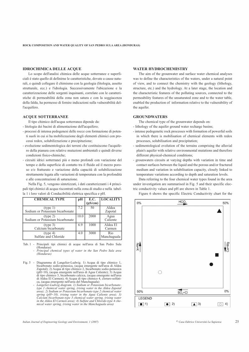
Nella Fig. 5, vengono sintetizzati, i dati caratterizzanti i 4 princi-pali tipi chimici di acqua riscontrati nella zona di studio e nella tabel-la 1 i loro valori di Conducibilità elettrica specifica e pH.
WATER HYDROCHEMISTRY
The aim of the grounwater and surface water chemical analyseswas to define the characteristics of the waters, under a natural pointof view, and to connect the chemistry with the geology (lithology,structure, etc.) and the hydrology. At a later stage, the location andthe characteristic features of the polluting sources, connected to thepermeability features of the unsaturated zone and to the water table,enabled the production of information relative to the vulnerability ofthe aquifer.
GROUNDWATERS
The chemical type of the grounwater depends on:- lithology of the aquifer ground water recharge basins;- intense pedogenetic rock processes with formation of powerful soils
in which there is mobilisation of chemical elements with redoxprocesses, solubilisation and precipitation;
- sedimentological evolution of the terrains comprising the alluvialplain's aquifer with relative environmental mutations and thereforedifferent physical-chemical conditions;
- grounwaters circuits at varying depths with variation in time andcontact surfaces between the liquid and the porous and/or fracturedmedium and variation in solubilisation capacity, closely linked totemperature variations according to depth and saturation levels.
Data referring to the four chemical water types found in the areaunder investigation are summarised in Fig. 5 and their specific elec-tric conductivity values and pH are shown in Table 1.
Figure 6 shows the specific Electric Conductivity chart for the
25
CHEMICAL TYPE pH E.C.(µµS/cm)
LOCALITY
(type 1)Sodium or Potassium bicarbonate
7.2 50 AldeaZapotal
(type 2)Sodium or Potassium bicarbonate
10.0 2000 AguaCaliente
(type 3)Calcium bicarbonate
6.9 1000 Aldea ElCarmen
(type 4)Sulfate and Chloride
4.0 3000 RioManchaguala
Fig. 5 - Diagramma di Langelier-Ludwig. 1) Acqua di tipo chimico 1,bicarbonato sodio-potassica, (acqua emergente nell'area di AldeaZapotal); 2) Acqua di tipo chimico 2, bicarbonato sodio-potassica(pH=10), (acqua emergente nell'area di Agua Caliente); 3) Acquadi tipo chimico 3, bicarbonato calcica, (acqua emergente nell'areadi Aldea El Carmen); 4) Acqua di tipo chimico 4, cloruro-solfati-ca, (acqua emergente nell'area del Manchaguala)
- Langelier-Ludwig diagram. 1) Sodium or Potassium bicarbonate-type 1 chemical water spring, (rising water in the Aldea Zapotalarea); 2) Sodium or Potassium bicarbonate-type 2 chemical waterspring (pH=10), (rising water in the Agua Caliente area); 3)Calcium bicarbonate-type 3 chemical water spring, (rising waterin the Aldea El Carmen area); 4) Sulfate and Chloride-type 4 che-mical water spring, (rising water in the Manchaguala area)
Tab. 1 - Principali tipi chimici di acque nell'area di San Pedro Sula(Honduras)
- Principal chemical types of water in the San Pedro Sula area(Honduras)

water, in which we observe an increase in conductivity, moving fromthe recharge area (NW and W) towards SE and E; we also observehigh E.C. values both between the El Carmen lagoon and theYucutuma lagoon and at Chamalecon area; the former are linked tothe solution of calcite in the fractures, and the later, to the presenceof Mesozoic carbonatic facies to the S.
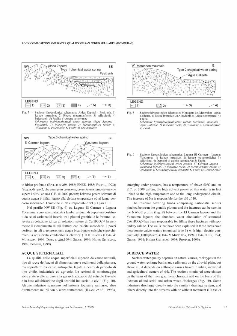
In the Aldea Zapotal-Fesitranh profile, oriented NW-SE (Fig. 7)the emergence of type 1 water are shown; this alkaline bicarbonatewater circulates inside granodioritic rocks characterised by intensefracturing; the water-rock contact time is short and solubility is low,justifying the low values found for specific electric conductivity (50µS/cm).
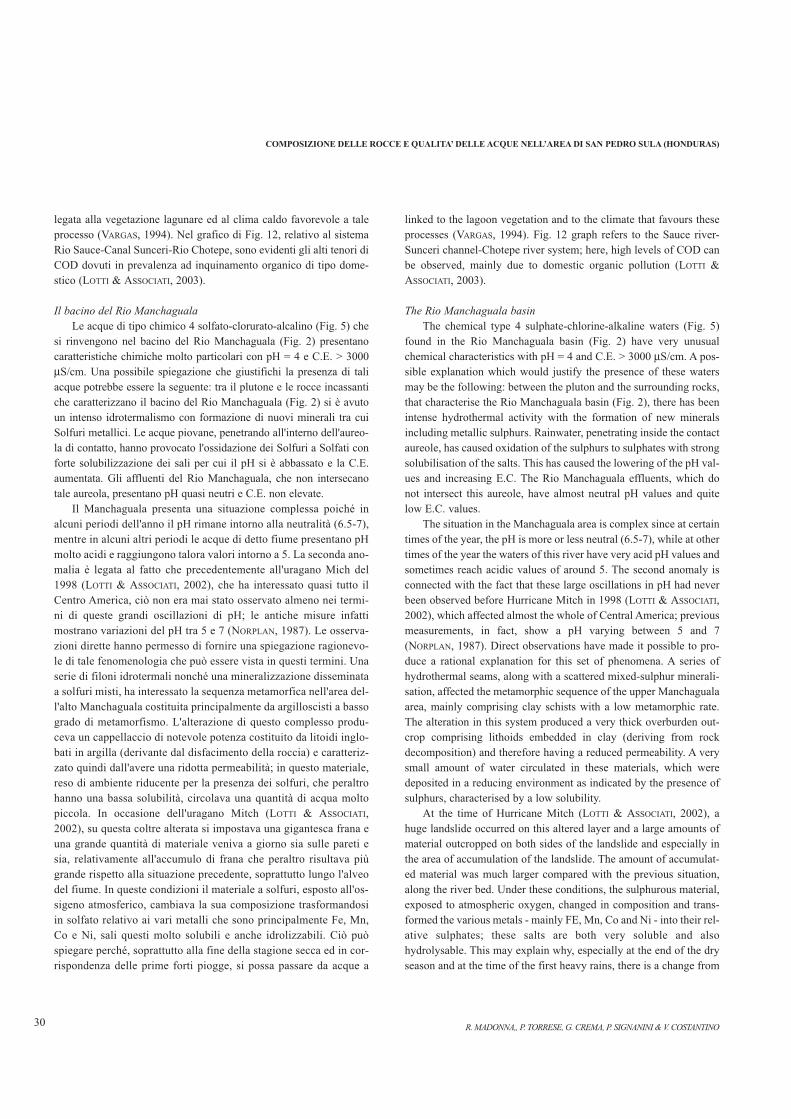
In the Fig. 8 profile, oriented W-E, transverse to the edge of thegraben and located at "Agua Caliente", situated north-west of SanPedro Sula, the deep hydraulic circuit can be observed (EPPLER etalii, 1986; ENEE, 1988; PATINO, 1993); l'acqua, the type 2 water,
R. MADONNA,, P. TORRESE, G. CREMA, P. SIGNANINI & V. COSTANTINO26
COMPOSIZIONE DELLE ROCCE E QUALITA’ DELLE ACQUE NELL’AREA DI SAN PEDRO SULA (HONDURAS)
Nella Fig. 6 è riportata la carta della Conducibilità Elettrica spe-cifica dell'acqua in cui è evidente l'aumento di conducibilità passan-do dalla zona di alimentazione (NW e W) verso SE ed E; sono inol-tre evidenti i valori elevati di C.E. sia tra Laguna El Carmen eLaguna Yucutuma, sia a Chamalecon; i primi legati alla dissoluzio-ne della calcite presente nelle fratture, i secondi alla presenza difacies carbonatiche.
Nel profilo Aldea Zapotal-Fesitranh, orientato NW-SE (Fig. 7)viene schematizzata l'emergenza dell'acqua di tipo 1; tale acqua,bicarbonato alcalino, circola all'interno di rocce a composizione gra-nodioritica caratterizzate da intensa fratturazione; il tempo di contat-to acqua-roccia è breve, la solubilità è scarsa e ciò giustifica i bassivalori di conducibilità elettrica specifica riscontrati (50 µS/cm).
Nel profilo di Fig. 8, orientato W-E, trasversale al bordo del grabened ubicato in corrispondenza di "Agua Caliente", sita a NW di SanPedro Sula, viene schematizzata la ricostruzione di un possibile circui-
Fig. 6 - Carta della Conducibilità Elettrica specifica.1) Punti di monitoraggio della ConducibilitàElettrica specifica (µS/cm)
- Specific Electric Conductivity map. 1) E.C.observations points (µS/cm)
Italian Journal of Engineering Geology and Environment, 1 (2007) © Casa Editrice Università La Sapienza
ROCK COMPOSITION AND WATER QUALITY OF SAN PEDRO SULA AREA (HONDURAS)
to idrico profondo (EPPLER et alii, 1986; ENEE, 1988; PATINO, 1993);l'acqua, di tipo 2, che emerge in pressione, presenta una temperatura chesupera i 50°C ed una C.E. di 2000 µS/cm; l'elevato potere solvente diquesta acqua è infatti legato alla elevata temperatura ed al lungo per-corso sotterraneo. L'aumento in Na è responsabile del pH pari a 10.
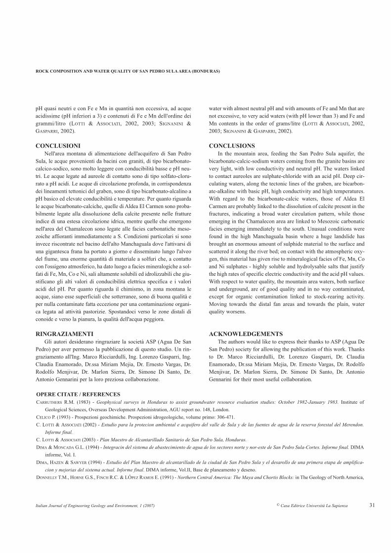
Nel profilo NW-SE (Fig. 9) tra Laguna El Carmen e LagunaYucutuma, sono schematizzati i lembi residuali di copertura costitui-ti da scisti carbonatici inseriti tra i plutoni granitici e le fratture; l'e-levata circolazione idrica di soluzioni sature di Ca(HCO3)2 ha per-messo il riempimento di tali fratture con calcite secondaria. I pozziperforati in tali aree presentano acque bicarbonato-calciche (tipo chi-mico 3) ad elevata conducibilità elettrica (1000 µS/cm) (DIMA &MONCADA, 1994; DIMA et alii,1994; GROSS, 1994; HIDRO SISTEMAS,1998; POMPER, 1999).
ACQUE SUPERFICIALI
La qualità delle acque superficiali dipende da cause naturali,tipo di rocce dei bacini di alimentazione e sedimenti della pianura,ma soprattutto da cause antropiche legate a centri di pericolo ditipo civile, industriale ed agricolo. Le sezioni di monitoraggiosono state scelte in base alla gerarchizzazione del reticolo fluvialee in base all'ubicazione degli scarichi industriali e civili (Fig. 10).Alcune industrie scaricano nel sistema fognante sanitario, altredirettamente nei rii con o senza trattamenti. (HAASE et alii, 1993a,
emerging under pressure, has a temperature of above 50°C and anE.C. of 2000 µS/cm; the high solvent power of this water is in factlinked to the high temperature and to the long underground circuit.The increase of Na is responsible for the pH of 10.
The residual covering limbs comprising carbonatic schistspinched between the granitic plutons and the fractures can be seen inthe NW-SE profile (Fig. 9) between the El Carmen lagoon and theYucutuma lagoon; the abundant water circulation of saturatedCA(HCO3)2 has been responsable for filling these fractures with sec-ondary calcite. The wells that have been exploited in these areas havebicarbonate-calcic waters (chemical type 3) with high electric con-ductivity (1000 µS/cm) (DIMA & MONCADA, 1994; DIMA et alii,1994;GROSS, 1994; HIDRO SISTEMAS, 1998; POMPER, 1999).
SURFACE WATER
Surface water quality depends on natural causes, rock types in theground water recharge basins and sediments on the alluvial plain, butabove all, it depends on anthropic causes linked to urban, industrialand agricultural centers of risk. The sections monitored were chosenon the basis of the river grid hierarchization and on the basis of thelocation of industrial and urban waste discharges (Fig. 10). Someindustries discharge directly into the sanitary drainage system, andothers directly into the streams with or without treatment (HAASE et
27
Fig. 9 - Sezione idrogeologica schematica Laguna El Carmen - LagunaYucutuma. 1) Rocce intrusive; 2) Rocce metamorfiche; 3)Alluvioni; 4) Depositi di calcite secondaria; 5) Faglia
- Schematic hydrogeological cross section El Carmen lagoon -Yucutuma lagoon. 1) Intrusive rocks; 2) Metamorphics rocks; 3)Alluvium; 4) Secondary calcite deposits; 5) Fault; 6) Groundwater
Fig. 7 - Sezione idrogeologica schematica Aldea Zapotal - Fesitranh. 1)Rocce intrusive; 2) Rocce metamorfiche; 3) Alluvioni; 4)Paleosuoli; 5) Faglia; 6) Acque sotterranee
- Schematic hydrogeological cross section Aldea Zapotal -Fesitranh. 1) Intrusive rocks; 2) Metamorphics rocks; 3)Alluvium; 4) Paleosoils; 5) Fault; 6) Groundwater
Fig. 8 - Sezione idrogeologica schematica Montagna del Merendon - AguaCaliente. 1) Rocce intrusive; 2) Alluvioni; 3) Acque sotterranee: 4)Faglia
- Schematic hydrogeological cross section Merendon mountain -Agua Caliente. 1) Intrusive rocks; 2) Alluvium; 3) Groundwater:4) Fault

1993b; HAZEN & SAWYER, 1994; ESA, 1994; VARGAS, 1994;EXPERCO IINTERNATIONAL, 1994; FONDO ARGENTINO DE
COOPERACION, 2000; SIGNANINI & GASPARRI, 2002). Sono stateeseguite due campagne di misure, una in periodo di magra ed unain periodo di morbida. La portata è stata misurata in campo con-temporaneamente al prelievo del campione chimico e alla misuradi parametri chimico-fisici. I parametri presi in considerazione edanalizzati in laboratorio sono stati:- Temperatura, pH, Conducibilità Elettrica specifica, Torbidità;- Na+, K+, Ca++, Mg++, SO4
=, Cl-, HCO3-;
- Fe, Mn, Cr, Cu, Cd, Pb, Zn;- Norganico, N-NH4
+, N-NO2-, N-NO3
-;- Ptotale, P-PO4
3-;- Solidi Disciolti Totali, Solidi totali, Solidi Sospesi, Solidi
Sedimentabili;- DBO5. DCO, O2 disciolto;- Coliformi fecali, Coliformi totali
Il parametro conducibilità elettrica specifica, correlato con laportata, è stato da noi scelto come parametro indicativo per la quali-tà delle acque in quanto da un'idea del carico salino generale. Nellatab. 2 pertanto vengono sinteticamente presentati i dati di conducibi-lità elettrica e di portata relativi alle acque in zona montana di ali-mentazione.
La qualità delle acque superficiali nella zona montana di alimen-tazione è buona con tendenza ad un netto peggioramento man manoche ci si avvicina alla zona più densamente urbanizzata a causa di unforte inquinamento dovuto soprattutto a scarichi civili ed industrialiche, molto spesso, si riversano nei fiumi senza alcun tipo di proces-so depurativo.
Nei grafici di Fig. 11 e Fig. 12 vengono messi, in relazione conla portata, i tre parametri significativi per l'inquinamento in periododi morbida e di magra.
In particolare nella Fig. 11 si è preso in considerazione il sistemaRio S.ta Ana-Rio Pedras-Rio Bermejo; si osserva, già a monte dellacittà e appena a valle della zona industriale Bermejo (dove vi sonoalcune industrie casearie, di produzione di birra, di concia dellepelli), una notevole impennata del COD con aumento della portata etotale assenza dell'ossigeno disciolto. Più a valle, dove il Bermejosfocia in acquitrini e lagune con numerose piante acquatiche, appenaa monte della laguna Yucutuma, il COD diminuisce e ricompare l'os-sigeno disciolto; ciò è spiegabile con processi di fitodepurazione
alii, 1993a, 1993b; HAZEN & SAWYER, 1994; ESA, 1994; VARGAS,1994; EXPERCO IINTERNATIONAL, 1994; FONDO ARGENTINO DE
COOPERACION, 2000; SIGNANINI & GASPARRI, 2002). Measurementswere carried out in two phases: one in a low water period and one ina moderate water period. Flow rates were measured in the field and,at the same time, water samples were taken for chemical analysis andchemical-physical parameters. The chemical-physical parametersconsidered and the chemical parameters analysed in the laboratorywere as follows:- temperature, pH, specific electric conductivity, turbidity;- Na+, K+, Ca++, Mg++, SO4
=, Cl-, HCO3;- Fe, Mn, Cr, Cu, Cd, Pb, Zn;- Norganico, N-NH4
+, N-NO2-, N-NO3
-;- Ptotale, P-PO4
3-;- Total dissolved solids, total suspended solids, suspended solids,
sedimentable solids;- BOD5. COD, DO2;- Fecal coliforms, total coliforms.
The specific electric conductivity parameter, correlated withthe flow rate, was chosen by us as an indicative parameter for thewater quality, since it gives us an idea of the general saline content.Table 2 shows, in synthesis, Specific Electric Conductivity andFlow rate data that characterise the water quality in the mountain
recharge area.The superficial water quality in the mountain feeding area, is
good, tending towards a distinct worsening as one approaches themore densely urbanised area, because of high pollution due above allto civil and industrial waste that is often discharged into the riverswithout any type of purification process.
The graphs in Fig. 11 and Fig. 12 show the three significant pol-lution parameters, in relation to the flow rate, in low and moderatewater periods.
The S.Ana river-Piedras river-Bermejo river system is consideredin particular in Fig. 11; we see a notable upturn in COD with anincrease in flow rate and the total absence of dissolved oxygenupstream from the town and downstream from the Bermejo industri-al area (where there are some cheese-factories, breweries and leathertanneries). Further downstream, where the Bermejo river flows intomarshland and lagoons with numerous aquatic plants, just upstreamfrom the Yucutuma lagoon, the COD decreases and dissolved oxygenreappears; this can be explained by the phyto-purification processes
R. MADONNA,, P. TORRESE, G. CREMA, P. SIGNANINI & V. COSTANTINO28
COMPOSIZIONE DELLE ROCCE E QUALITA’ DELLE ACQUE NELL’AREA DI SAN PEDRO SULA (HONDURAS)
Area February May February May
Zapotal river 676 320 50 60Aldea Zapotal 466 60 55 65S.Ana river 599 124 61 67Piedras river 405 152 126 150
Tab. 2 - Portate e Conducibilità Elettrica Specifica delle acque superficiali
Mountain Area February May February May
Zapotal river 676 320 50 60Aldea Zapotal 466 60 55 65S.Ana river 599 124 61 67Piedras river 405 152 126 150
Tab. 2 - Flow rate and specific Electric Conductivity of surface waters
FLOW RATE (l/s) E.C. (µµS/cm)PORTATA (l/s) C.E. (µµS/cm)

Italian Journal of Engineering Geology and Environment, 1 (2007) © Casa Editrice Università La Sapienza 29
ROCK COMPOSITION AND WATER QUALITY OF SAN PEDRO SULA AREA (HONDURAS)
Fig. 10 - Carta dei punti di monitoraggio della qualità delleacque. 1) punti di monitoraggio
- Map of the quality water observation points. 1) obser-vation points
Fig. 11 - Sistema fluviale Rio Piedras - Rio S. Ana - Rio Bermelo. 1)Portata di morbida; 2) BOD5 in periodo di morbida; 3) OD inperiodo di morbida; 4) COD in periodo di morbida; 5) Portatadi magra; 6) BOD5 in periodo di magra; 7) OD in periodo dimagra; 8) COD in periodo di magra
- Piedras river - S. Ana river - Bermejo river fluvial system. 1)Moderate flow; 2) BOD5 in the moderate flow; 3) OD in themoderate flow; 4) COD in the moderate flow; 5) Low flow; 6)BOD5 in the low flow; 7) OD in the low flow; 8) COD in the lowflow
Fig. 12 - Sistema fluviale Canal Sunceri - Rio Sauce - Rio Chotepe. 1)Portata di morbida; 2) BOD5 in periodo di morbida; 3) OD inperiodo di morbida; 4) COD in periodo di morbida; 5) Portata dimagra; 6) BOD5 in periodo di magra; 7) OD in periodo dimagra; 8) COD in periodo di magra
- Sunceri channel - Sauce river - Chotepe river fluvial system. 1)Moderate flow; 2) BOD5 in the moderate flow; 3) OD in themoderate flow; 4) COD in the moderate flow; 5) Low flow; 6)BOD5 in the low flow; 7) OD in the low flow; 8) COD in the lowflow
legata alla vegetazione lagunare ed al clima caldo favorevole a taleprocesso (VARGAS, 1994). Nel grafico di Fig. 12, relativo al sistemaRio Sauce-Canal Sunceri-Rio Chotepe, sono evidenti gli alti tenori diCOD dovuti in prevalenza ad inquinamento organico di tipo dome-stico (LOTTI & ASSOCIATI, 2003).
Il bacino del Rio ManchagualaLe acque di tipo chimico 4 solfato-clorurato-alcalino (Fig. 5) che
si rinvengono nel bacino del Rio Manchaguala (Fig. 2) presentanocaratteristiche chimiche molto particolari con pH = 4 e C.E. > 3000µS/cm. Una possibile spiegazione che giustifichi la presenza di taliacque potrebbe essere la seguente: tra il plutone e le rocce incassantiche caratterizzano il bacino del Rio Manchaguala (Fig. 2) si è avutoun intenso idrotermalismo con formazione di nuovi minerali tra cuiSolfuri metallici. Le acque piovane, penetrando all'interno dell'aureo-la di contatto, hanno provocato l'ossidazione dei Solfuri a Solfati conforte solubilizzazione dei sali per cui il pH si è abbassato e la C.E.aumentata. Gli affluenti del Rio Manchaguala, che non intersecanotale aureola, presentano pH quasi neutri e C.E. non elevate.
Il Manchaguala presenta una situazione complessa poiché inalcuni periodi dell'anno il pH rimane intorno alla neutralità (6.5-7),mentre in alcuni altri periodi le acque di detto fiume presentano pHmolto acidi e raggiungono talora valori intorno a 5. La seconda ano-malia è legata al fatto che precedentemente all'uragano Mich del1998 (LOTTI & ASSOCIATI, 2002), che ha interessato quasi tutto ilCentro America, ciò non era mai stato osservato almeno nei termi-ni di queste grandi oscillazioni di pH; le antiche misure infattimostrano variazioni del pH tra 5 e 7 (NORPLAN, 1987). Le osserva-zioni dirette hanno permesso di fornire una spiegazione ragionevo-le di tale fenomenologia che può essere vista in questi termini. Unaserie di filoni idrotermali nonché una mineralizzazione disseminataa solfuri misti, ha interessato la sequenza metamorfica nell'area del-l'alto Manchaguala costituita principalmente da argilloscisti a bassogrado di metamorfismo. L'alterazione di questo complesso produ-ceva un cappellaccio di notevole potenza costituito da litoidi inglo-bati in argilla (derivante dal disfacimento della roccia) e caratteriz-zato quindi dall'avere una ridotta permeabilità; in questo materiale,reso di ambiente riducente per la presenza dei solfuri, che peraltrohanno una bassa solubilità, circolava una quantità di acqua moltopiccola. In occasione dell'uragano Mitch (LOTTI & ASSOCIATI,2002), su questa coltre alterata si impostava una gigantesca frana euna grande quantità di materiale veniva a giorno sia sulle pareti esia, relativamente all'accumulo di frana che peraltro risultava piùgrande rispetto alla situazione precedente, soprattutto lungo l'alveodel fiume. In queste condizioni il materiale a solfuri, esposto all'os-sigeno atmosferico, cambiava la sua composizione trasformandosiin solfato relativo ai vari metalli che sono principalmente Fe, Mn,Co e Ni, sali questi molto solubili e anche idrolizzabili. Ciò puòspiegare perché, soprattutto alla fine della stagione secca ed in cor-rispondenza delle prime forti piogge, si possa passare da acque a
linked to the lagoon vegetation and to the climate that favours theseprocesses (VARGAS, 1994). Fig. 12 graph refers to the Sauce river-Sunceri channel-Chotepe river system; here, high levels of COD canbe observed, mainly due to domestic organic pollution (LOTTI &ASSOCIATI, 2003).
The Rio Manchaguala basinThe chemical type 4 sulphate-chlorine-alkaline waters (Fig. 5)
found in the Rio Manchaguala basin (Fig. 2) have very unusualchemical characteristics with pH = 4 and C.E. > 3000 µS/cm. A pos-sible explanation which would justify the presence of these watersmay be the following: between the pluton and the surrounding rocks,that characterise the Rio Manchaguala basin (Fig. 2), there has beenintense hydrothermal activity with the formation of new mineralsincluding metallic sulphurs. Rainwater, penetrating inside the contactaureole, has caused oxidation of the sulphurs to sulphates with strongsolubilisation of the salts. This has caused the lowering of the pH val-ues and increasing E.C. The Rio Manchaguala effluents, which donot intersect this aureole, have almost neutral pH values and quitelow E.C. values.
The situation in the Manchaguala area is complex since at certaintimes of the year, the pH is more or less neutral (6.5-7), while at othertimes of the year the waters of this river have very acid pH values andsometimes reach acidic values of around 5. The second anomaly isconnected with the fact that these large oscillations in pH had neverbeen observed before Hurricane Mitch in 1998 (LOTTI & ASSOCIATI,2002), which affected almost the whole of Central America; previousmeasurements, in fact, show a pH varying between 5 and 7(NORPLAN, 1987). Direct observations have made it possible to pro-duce a rational explanation for this set of phenomena. A series ofhydrothermal seams, along with a scattered mixed-sulphur minerali-sation, affected the metamorphic sequence of the upper Manchagualaarea, mainly comprising clay schists with a low metamorphic rate.The alteration in this system produced a very thick overburden out-crop comprising lithoids embedded in clay (deriving from rockdecomposition) and therefore having a reduced permeability. A verysmall amount of water circulated in these materials, which weredeposited in a reducing environment as indicated by the presence ofsulphurs, characterised by a low solubility.
At the time of Hurricane Mitch (LOTTI & ASSOCIATI, 2002), ahuge landslide occurred on this altered layer and a large amounts ofmaterial outcropped on both sides of the landslide and especially inthe area of accumulation of the landslide. The amount of accumulat-ed material was much larger compared with the previous situation,along the river bed. Under these conditions, the sulphurous material,exposed to atmospheric oxygen, changed in composition and trans-formed the various metals - mainly FE, Mn, Co and Ni - into their rel-ative sulphates; these salts are both very soluble and alsohydrolysable. This may explain why, especially at the end of the dryseason and at the time of the first heavy rains, there is a change from
R. MADONNA,, P. TORRESE, G. CREMA, P. SIGNANINI & V. COSTANTINO30
COMPOSIZIONE DELLE ROCCE E QUALITA’ DELLE ACQUE NELL’AREA DI SAN PEDRO SULA (HONDURAS)
pH quasi neutri e con Fe e Mn in quantità non eccessiva, ad acqueacidissime (pH inferiori a 3) e contenuti di Fe e Mn dell'ordine deigrammi/litro (LOTTI & ASSOCIATI, 2002, 2003; SIGNANINI &GASPARRI, 2002).
CONCLUSIONI
Nell'area montana di alimentazione dell'acquifero di San PedroSula, le acque provenienti da bacini con graniti, di tipo bicarbonato-calcico-sodico, sono molto leggere con conducibilità basse e pH neu-tri. Le acque legate ad aureole di contatto sono di tipo solfato-cloru-rato a pH acidi. Le acque di circolazione profonda, in corrispondenzadei lineamenti tettonici del graben, sono di tipo bicarbonato-alcalino apH basico ed elevate conducibilità e temperature. Per quanto riguardale acque bicarbonato-calciche, quelle di Aldea El Carmen sono proba-bilmente legate alla dissoluzione della calcite presente nelle frattureindice di una estesa circolazione idrica, mentre quelle che emergononell'area del Chamalecon sono legate alle facies carbonatiche meso-zoiche affioranti immediatamente a S. Condizioni particolari si sonoinvece riscontrate nel bacino dell'alto Manchaguala dove l'attivarsi diuna gigantesca frana ha portato a giorno e disseminato lungo l'alveodel fiume, una enorme quantità di materiale a solfuri che, a contattocon l'ossigeno atmosferico, ha dato luogo a facies mineralogiche a sol-fati di Fe, Mn, Co e Ni, sali altamente solubili ed idrolizzabili che giu-stificano gli alti valori di conducibilità elettrica specifica e i valoriacidi del pH. Per quanto riguarda il chimismo, in zona montana leacque, siano esse superficiali che sotterranee, sono di buona qualità eper nulla contaminate fatta eccezione per una contaminazione organi-ca legata ad attività pastorizie. Spostandoci verso le zone distali diconoide e verso la pianura, la qualità dell'acqua peggiora.
RINGRAZIAMENTI
Gli autori desiderano ringraziare la società ASP (Agua De SanPedro) per aver permesso la pubblicazione di questo studio. Un rin-graziamento all'Ing. Marco Ricciardulli, Ing. Lorenzo Gasparri, Ing.Claudia Enamorado, Dr.ssa Miriam Mejia, Dr. Ernesto Vargas, Dr.Rodolfo Menjivar, Dr. Marlon Sierra, Dr. Simone Di Santo, Dr.Antonio Gennarini per la loro preziosa collaborazione.
water with almost neutral pH and with amounts of Fe and Mn that arenot excessive, to very acid waters (with pH lower than 3) and Fe andMn contents in the order of grams/litre (LOTTI & ASSOCIATI, 2002,2003; SIGNANINI & GASPARRI, 2002).
CONCLUSIONS
In the mountain area, feeding the San Pedro Sula aquifer, thebicarbonate-calcic-sodium waters coming from the granite basins arevery light, with low conductivity and neutral pH. The waters linkedto contact aureoles are sulphate-chloride with an acid pH. Deep cir-culating waters, along the tectonic lines of the graben, are bicarbon-ate-alkaline with basic pH, high conductivity and high temperatures.With regard to the bicarbonate-calcic waters, those of Aldea ElCarmen are probably linked to the dissolution of calcite present in thefractures, indicating a broad water circulation pattern, while thoseemerging in the Chamalecon area are linked to Mesozoic carbonaticfacies emerging immediately to the south. Unusual conditions werefound in the high Manchaguala basin where a huge landslide hasbrought an enormous amount of sulphide material to the surface andscattered it along the river bed; on contact with the atmospheric oxy-gen, this material has given rise to mineralogical facies of Fe, Mn, Coand Ni sulphates - highly soluble and hydrolysable salts that justifythe high rates of specific electric conductivity and the acid pH values.With respect to water quality, the mountain area waters, both surfaceand underground, are of good quality and in no way contaminated,except for organic contamination linked to stock-rearing activity.Moving towards the distal fan areas and towards the plain, waterquality worsens.
ACKNOWLEDGEMENTS
The authors would like to express their thanks to ASP (Agua DeSan Pedro) society for allowing the publication of this work. Thanksto Dr. Marco Ricciardulli, Dr. Lorenzo Gasparri, Dr. ClaudiaEnamorado, Dr.ssa Miriam Mejia, Dr. Ernesto Vargas, Dr. RodolfoMenjivar, Dr. Marlon Sierra, Dr. Simone Di Santo, Dr. AntonioGennarini for their most useful collaboration.
Italian Journal of Engineering Geology and Environment, 1 (2007) © Casa Editrice Università La Sapienza 31
ROCK COMPOSITION AND WATER QUALITY OF SAN PEDRO SULA AREA (HONDURAS)
OPERE CITATE / REFERENCES
CARRUTHERS R.M. (1983) - Geophysical surveys in Honduras to assist groundwater resource evaluation studies: October 1982-January 1983. Institute of
Geological Sciences, Overseas Development Administration, AGU report no. 148, London.
CELICO P. (1993) - Prospezioni geochimiche. Prospezioni idrogeologiche, volume primo: 306-471.
C. LOTTI & ASSOCIATI (2002) - Estudio para la protecion ambiental e acquifero del valle de Sula y de las fuentes de agua de la reserva forestal del Merendon.Informe final.
C. LOTTI & ASSOCIATI (2003) - Plan Maestro de Alcantarillado Sanitario de San Pedro Sula, Honduras.DIMA & MONCADA G.L. (1994) - Integracin del sistema de abastecimiento de agua de los sectores norte y nor-este de San Pedro Sula-Cortes. Informe final. DIMA
informe, Vol. I.
DIMA, HAZEN & SAWYER (1994) - Estudio del Plan Maestro de alcantarillado de la ciudad de San Pedro Sula y el desarollo de una primera etapa de amplifica-cion y mejorias del sistema actual. Informe final. DIMA informe, Vol.II, Base de planeamento y deseno.
DONNELLY T.M., HORNE G.S., FINCH R.C. & LÓPEZ RAMOS E. (1991) - Northern Central America: The Maya and Chortis Blocks: in The Geology of North America,

R. MADONNA,, P. TORRESE, G. CREMA, P. SIGNANINI & V. COSTANTINO32
COMPOSIZIONE DELLE ROCCE E QUALITA’ DELLE ACQUE NELL’AREA DI SAN PEDRO SULA (HONDURAS)
H: The Caribbean Region. Geol. Soc. Am., Boulder, Co. USA (Dengo, G. and J.E. Case, eds.) pp. 37-76.
ELVIR A.R. (1974) - Mapa Geológico de la República de Honduras. Instituto Geográfico Nacional.
ELVIR A.R. (1976) - Sintesis de la geología de Honduras. Informe y trabajos técnicos presentados en la IV Reunión de Geólogos de América Central. Publicaciones
Geológicas del ICAITI, pp. 1-4.
ENEE (EMPRESA NACIONAL DE ENERGIA ELECTRICA) (1988) - Estudio de pre-factibilidad geotermica en la region central de Honduras. Informe Final. V. 2, 2a.
Tegucigalpa, Honduras.
EPPLER D., FAKUNDINY R. & RITCHIE A. (1986) - Reconnaissance evaluation of Honduran geothermal sites. Los Alamos National Laboratory, p. 15.
ESA (1994) - La caracterisacion y la medicion de los desechos industriales.EXPERCO INTERNATIONAL (1994) - Inventario de Industrie de San Pedro Sula.FINCH R. C. (1981) - Mesozoic stratigraphy of central Honduras. American Association of Petroleum Geologists Bulletin, 65: 1320-1333.
FINCH R. C. (1986) - Catalog of known hot springs and thermal place names for Honduras. Los Alamos National Laboratory, 13 pp.
FONDO ARGENTINO DE COOPERACION (2000) - Residuos toxicos y peligrosos.FOYE W. G. (1918) - Notes on a collection of rocks from Honduras, Central America. Journal of Geology, 26: 524-531.
GIORGETTI F. & SIGNANINI P. (1976) - Nuovi contributi al problema delle relazioni tra parametri geofisici ed idraulici nello studio degli acquiferi alluvionali. Boll.
Geof. Teor. Appl., XIX, 69: 24-30.
GROSS L.M. (1994) - Integracion del sistema de abastecimiento de agua de los sectores norte y norte-este de San Pedro Sula.HAASE P., SAGASTUME M. & ENAMORADO C.B. (1993a) - Plan de protection y manejo de los recursus hidricos en el Municipio de San Pedro Sula, Cortes.HAASE P., SAGASTUME M. & ENAMORADO C.B. (1993b) - Controle sobre el uso del suelo para proteger las aguas subterranea San Pedro Sula, Cortes.HAZEN & SAWYER (1994) - Estudio del Plan Maestro de alcantarillado de la ciudad de San Pedro Sula y el desarollo de una primera etapa de amplificacion y
mejorias del sistema actual, descripcion ambiental del sito del proyecto.HIDRO SISTEMAS (1998) - Proyecto de urbanizacion Los Prados de Cordoba, San Pedro Sula, Departamento de Cortes, Seccion V, Sumministro de agua potable.HORNE G.S., CLARK G.S. & PUSHKAR P. (1976) - Pre-Cretaceous Rock of North-Western Honduras, Basement terrains in Sierra de Omoa. The American
Associacion of Petroleum Geophisics Bullettin, 60, 4: 566-583.
MCKENZIE A.A. (1995) - A hydrogeological database for Honduras. Geological Society Special Publications, 97: 157-162., Geological Society of London. London,
United Kingdom.
MILLS RICHARD A. (1991) - Honduras. Bulletin, Houston Geological Society, 34, 2: 16-17, 19, 21, 23.
NORPLAN (1986a) - Estudio Hidrogeologico, San Pedro Sula, Cortes. Reporte Final.NORPLAN (1986b) - Informe de estudio hidrogeologico, pruebas cortas de bombeo en 17 pozos existentes.NORPLAN (1987) - San Pedro Sula, Estudio hidrogeologico, Reporte final.NORPLAN (1990) - Informe de estudio hidrogeologico, investigacion de agua subterraneas y resultados de 15 perforaciones exploratorias en el area de San Pedro
Sula.PACIFIC CONSULTANTS (1994a) - The Master Plan study on the erosion and sediment control in the pilot river basin, Choloma, San Pedro Sula, Cortes in the Republic
of Honduras, Final report, Supporting report. Pacific consultants International in association with Kosusai Kogyo CO., LTD., Tokyo.
PACIFIC CONSULTANTS(1994b) - The Master Plan study on the erosion and sediment control in the pilot river basin, Choloma, San Pedro Sula, Cortes in the Republicof Honduras, Final report, Main report. Pacific consultants International in association with Kosusai Kogyo CO., LTD., Tokyo.
PACIFIC CONSULTANTS (1994c) - The Master Plan study on the erosion and sediment control in the pilot river basin, Choloma, San Pedro Sula, Cortes in the Republicof Honduras, Final report, Preliminary Environmental Assessment report. Pacific consultants International in association with Kosusai Kogyo CO., LTD.,
Tokyo.
PATINO L.C. (1993) - Geochemical traverse across Honduras. Tesis de Masters inedita, Rutgers, The State University of New Jersey, 71 pp.
PIERCE HERBERT A. & RIVERA-MONTES J.C. (1991) - Preliminary bibliography of the geology and mineral deposits of Honduras. Open-File Report - U. S.
Geological Survey. OF 91-0102 47 pp.
POMPER (1999) - The ground water situation in and around San Pedro Sula.ROMANO A. & SIGNANINI P. (1981) - Alcune tecniche di elaborazione dei dati ricavati da sondaggi elettrici applicati a ricerche idrogeologiche in aree particolar-
mente complesse. Studi Geologici Camerti, VII: 115-121.
SIGNANINI P. & GASPARRI L. (2002) - Studio di un acquifero alluvionale in area tropicale, S. Pedro Sula, Honduras. Studi Geologici Camerti.
VARGAS E. (1994) - Estudio sobre Lagua El Carme y Laguna Yucutuma.
WILLIAMS H. & MCBIRNEY A.R. (1969) - Volcanic History of Honduras. University of California, Publications in Geological Sciences, 85: 101 pp.
Received October 2005 - Accepted February 2006