COMPLIANCE TERMS OF REFERENCE IN THE EIA REPORT
252
COMPLIANCE TERMS OF REFERENCE IN THE EIA REPORT S. No. Condition Specifications Reference 1. Year-wise production details since 1994 should be given, clearly stating the highest production achieved in any one year prior to 1994. It may also be categorically informed whether there had been any increase in production after EIA Notification 1994 came into force, w.r.t. the highest production achieved prior to 1994. New Quarry project Chapter 1, Section 1.3 2. A copy of the document in support of the fact that the Proponent is the rightful lessee of the mine should be given. Private land. Documents attached in approved mining plan Chapter 1, Section 1.3 3. All documents including approved mine plan, EIA and Public Hearing should be compatible with one another in terms of the mine lease area, production levels, waste generation and its management, mining technology etc. and should be in the name of the lessee Mining technology, Survey number, production capacity, topsoil generation, life of mine, geological reserve, mineable reserve, mined out quantity, water requirement are detailed. Table 1-1 & Table 2-2. Chapter 1, Section 1.5 & Chapter 2. Section 2.1 4. All corner coordinates of the mine lease area, superimposed on a High- Resolution Imagery/ toposheet, topographic sheet, geomorphology and geology of the area should be provided. Such an Imagery of the proposed area should clearly show the land use and other ecological features of the study area (core and buffer zone). Google image of cluster condition, index map of mining area, satellite image of 10km radius, vicinity map, regional and local geology, land use land cover map is provided. Figure 1.1, Figure 1.3, Figure 1.5 and Figure 2.4, Figure 3.1, 3.2 Chapter 1, Section 1.4, 1.5, Chapter 2, Section 2.2, 2.7 & Chapter 3, Section 3.3 5. Information should be provided in Survey of India Toposheet in 1:50,000 scale indicating geological map of the area, geomorphology of The topo-sheet map within 10 km radius is provided as Annexure 7 Chapter 1, Section 1.9
-
Upload
khangminh22 -
Category
Documents
-
view
1 -
download
0
Transcript of COMPLIANCE TERMS OF REFERENCE IN THE EIA REPORT

COMPLIANCE TERMS OF REFERENCE IN THE EIA REPORT
S.
No. Condition Specifications Reference
1.
Year-wise production details since
1994 should be given, clearly stating
the highest production achieved in
any one year prior to 1994. It may
also be categorically informed
whether there had been any increase
in production after EIA Notification
1994 came into force, w.r.t. the
highest production achieved prior to
1994.
New Quarry project
Chapter 1,
Section 1.3
2.
A copy of the document in support of
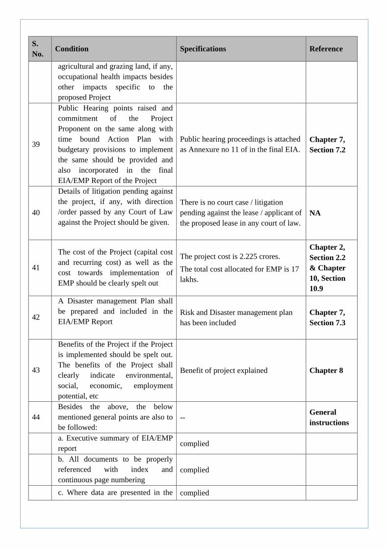
the fact that the Proponent is the
rightful lessee of the mine should be
given.
Private land. Documents attached in
approved mining plan
Chapter 1,
Section 1.3
3.
All documents including approved
mine plan, EIA and Public Hearing
should be compatible with one
another in terms of the mine lease
area, production levels, waste
generation and its management,
mining technology etc. and should be
in the name of the lessee
Mining technology, Survey number,
production capacity, topsoil
generation, life of mine, geological
reserve, mineable reserve, mined out
quantity, water requirement are
detailed. Table 1-1 & Table 2-2.
Chapter 1,
Section 1.5
& Chapter 2.
Section 2.1
4.
All corner coordinates of the mine
lease area, superimposed on a High-
Resolution Imagery/ toposheet,
topographic sheet, geomorphology
and geology of the area should be
provided. Such an Imagery of the
proposed area should clearly show
the land use and other ecological
features of the study area (core and
buffer zone).
Google image of cluster condition,
index map of mining area, satellite
image of 10km radius, vicinity map,
regional and local geology, land use
land cover map is provided. Figure
1.1, Figure 1.3, Figure 1.5 and Figure
2.4, Figure 3.1, 3.2
Chapter 1,
Section 1.4,
1.5, Chapter
2, Section
2.2, 2.7 &
Chapter 3,
Section 3.3
5.
Information should be provided in
Survey of India Toposheet in
1:50,000 scale indicating geological
map of the area, geomorphology of
The topo-sheet map within 10 km
radius is provided as Annexure 7
Chapter 1,
Section 1.9

S.
No. Condition Specifications Reference
land forms of the area, existing
minerals and mining history of the
area, important water bodies, streams
and rivers and soil characteristics.
6.
Details about the land proposed for
mining activities should be given
with information as to whether
mining conforms to the land use
policy of the State; land diversion
for mining should have approval
from State land use board or the
concerned authority.
Private land Chapter 1,
Section 1.3
7.
It should be clearly stated whether
the proponent company has well
laid down environment Policy
approved by its board of directors?
If so, it may be spelt out in the EIA
report with description of the
prescribed operating
process/procedures to bring into
focus any
infringement/deviation/violation of
the environmental or forest
norm/conditions? The hierarchical
system or administrative order of
the company to deal with the
environmental issues and for
ensuring compliance with the EC
conditions may also be given. The
system of reporting of
noncompliance / violations of
environmental norms to the Board
of Di rectors of the Company and /
or shareholders or stakeholders at
large, may also be detailed in the
proposed safeguard measures in
each case should also be provided.
Environment policies, Responsibility,
Environment management cell are
detailed in environment management
plan.
Chapter 10,
Section 10.3,
10.4 & 10.5
8.
Issues relating to Mine Safety,
including subsidence study in case
of underground mining and slope
study in case of open cast mining,
All safety measures are considered for
mining activities in the Environment
management Plan. Section 10.6
Chapter 10,
Section 10.6

S.
No. Condition Specifications Reference
blasting study etc. should be
detailed. The proposed safeguard
measures in each case should also
be provided.
9.
The study area will comprise of 10
km zone around the mine lease from
lease periphery and the data
contained in the EIA such as waste
generation etc. should be for the life
of the mine / lease period.
Study area includes the 10km
surrounding of project area.
Liquid waste and solid waste
considered for management for the
mining period.
Chapter 2,
Section 2.7.9
10
Land use of the study area
delineating forest area, agricultural
land, grazing land, wildlife
sanctuary, national park, migratory
routes of fauna, water bodies,
human settlements and other
ecological features should be
indicated. Land use plan of the mine
lease area should be prepared to
encompass preoperational,
operational and post operational
phases and submitted. Impact, if
any, of change of land use should be
given
Land use map is provided and break-
up of land use is also provided. Figure
3.2
There are no sensitive or ecological
sensitive areas within 10 km radius.
Chapter 3
Section 3.2
11
Details of the land for any Over
Burden Dumps outside the mine
lease, such as extent of land area,
distance from mine lease, its land
use, R&R issues, if any, should be
given.
Topsoil/overburden management is
provided in the waste management
plan.
There are no displacement of people
from mine area hence R&R issues not
applicable
Chapter 2,
Section 2.7.9
& chapter 7,
Section 7.5
12
A Certificate from the Competent
Authority in the State Forest
Department should be provided,
confirming the involvement of
forest land, if any, in the project
area. In the event of any contrary
claim by the Project Proponent
regarding the status of forests, the
No forest land involved Chapter 2

S.
No. Condition Specifications Reference
site may be inspected by the State
Forest Department along with the
Regional Office of the Ministry to
ascertain the status of forests, based
on which, the Certificate in this
regard as mentioned above be
issued. In all such cases, it would be
desirable for representative of the
State Forest Department to assist the
Expert
Appraisal Committee.
13
Status of forestry clearance for the
broken up area and virgin forest
land involved in the Project
including deposit ion of net present
value (NPV) and compensatory
afforestation (CA) should be
indicated. A copy of the forestry
clearance should also be furnished.
The lease Area does not involve any
forest, agriculture or grazing land. NA
14
Implementation status of
recognition of forest rights under
the Scheduled Tribes and other
Traditional Forest Dwellers
(Recognition of Forest Rights) Act,
2006 should be indicated.
The lease Area does not involve any
forest, agriculture or grazing land. NA
15
The vegetation in the RF / PF areas
in the study area, with necessary
details, should be given
The nearest forest is Periyar National
Park at 10.5km (table 2-2)
Chapter 2,
Section 2.2
16
A study shall be got done to
ascertain the impact of the Mining
Project on wildlife of the study area
and details furnished. Impact of the
project on the wildlife in the
surrounding and any other protected
area and accordingly, detailed
mitigative measures required,
should be worked out with cost
implications and submitted.
Impact of mining on ecological
environment is provided.
There is no Ecologically Sensitive or
Protected Area located within 10 km.
radius from the mine lease area.
Chapter 2,
Section 2.2
& chapter 4,
Section 4.7
17
Location of National Parks,
Sanctuaries, Biosphere Reserves,
Wildlife Corridors, Ramsar site
Tiger/ Elephant Reserves/(existing
There is no National Parks,
Sanctuaries, Biosphere Reserves,
Wildlife Corridors, Ramsar site
Tiger/Elephant Reserves are located
Chapter 2,
section 2.2

S.
No. Condition Specifications Reference
as well as proposed), if any, within
10 km of the mine lease should be
clearly indicated, supported by a
location map duly authenticated by
Chief Wildlife Warden. Necessary
clearance, as may be applicable to
such projects due to proximity of
the ecologically sensitive areas as
mentioned above, should be
obtained from the Standing
Committee of National Board of
Wildlife and copy furnished.
within 10 km radius of the mine lease
area.
18
A detailed biological study of the
study area [core zone and buffer
zone (10 km radius of the periphery
of the mine lease)] shall be carried
out. Details of flora and fauna,
endangered, endemic and RET
Species duly authenticated,
separately for core and buffer zone
should be furnished based on such
primary field survey, clearly
indicating the Schedule of the fauna
present. In case of any scheduled I
fauna found in the study area, the
necessary plan along with budgetary
provisions for their conservation
should be prepared in consultation
with State Forest and Wildlife
Department and details furnished.
Necessary allocation of funds for
implementing the same should be
made as part of the project cost.
Detailed biodiversity study conducted
in the study area and listed the species
found.
There is no any RET species within
the study area
Chapter 3,
Section 3.9
19
Proximity to Areas declared as
'Critically Polluted' or the Project
areas likely to come under the
'Aravali Range', (attracting court
restrictions for mining operations),
should also be indicated and where
so required, clearance certifications
from the prescribed Authorities,
such as the SPCB or State Mining
There are no 'Critically Polluted' areas
in the proximity of the project site.
The project area is not under the
'Aravali Range'.
Chapter 2.
Section 2.2

S.
No. Condition Specifications Reference
Department should be secured and
furnished to the effect that the
proposed mining activities could be
considered.
20
Similarly, for coastal projects, A
CRZ map duly authenticated by one
of the authorized agencies
demarcating LTL, HTL, CRZ area,
location of the mine lease w. r. t .
CRZ, coastal features such as
mangroves, if any, should be
furnished. (Note: The Mining
Projects falling under CRZ would
also need to obtain approval
of the concerned Coastal Zone
Management Authority).
Not applicable NA
21
R&R Plan/compensation details for
the Project Affected People (PAP)
should be furnished. While
preparing the R&R Plan, the
relevant State/National
Rehabilitation & Resettlement
Policy should be kept in view. In
respect of SCs /STs and other
weaker sections of the society in the
study area, a need based sample
survey, family-wise, should be
undertaken to assess their
requirements, and action programs
prepared and submitted accordingly,
integrating the sectoral programs of
line departments of the State
Government. It may be clearly
brought out whether the village(s)
located in the mine lease area will
be shifted or not. The issues relating
to shifting of village(s) including
their R&R and socio-economic
aspects should be discussed in the
Report
There is no displacement of people
from mine area hence R&R issues not
applicable.
The nearest Habitation is at 208 m
towards N side of proposed quarry
Chapter 7,
Section 7.2
22 Primary baseline data on ambient
air quality as per CPCB Notification
One season January to March 2020
study were conducted for four air
Chapter 3,
Section 3.4,

S.
No. Condition Specifications Reference
of 2009, water quality, noise level,
soil and flora and fauna shall be
collected and the AAQ and other
data so compiled presented date-
wise in the EIA and EMP Report.
Site-specific meteorological data
should also be collected. The
location of the monitoring stations
should be such as to represent whole
of the study area and justified
keeping in view the pre-dominant
downwind direction and location of
sensitive receptors. There should be
at least one monitoring station
within 500 m of the mine lease in
the pre-dominant downwind
direction. The mineralogical
composition of PM10, particularly
for free silica, should be given.
quality sampling stations and water
quality stations, four noise sampling
stations and soil sampling stations.
3.5, 3.6 &
3.7, 3.8
23
Air quality modelling should be
carried out for predict ion of impact
of the project on the air quality of
the area. It should also take into
account the impact of movement of
vehicles for transportation of
mineral. The details of the model
used and input parameters used for
modelling should be provided. The
air quality contours may be shown
on a location map clearly indicating
the location of the site, location of
sensitive receptors, if any, and the
habitation. The wind roses showing
predominant wind directions may
also be indicated on the map.
Modelling studies were carried out
using AERMOD, a steady-state plume
model. It uses, processed
meteorological observations such as
wind speed, wind direction, humidity,
rainfall, temperature which is first pre-
processed by AERMET and along
with the emission characteristics it
estimates the concentration of the
particulate matter released by different
Sources.
Chapter 4,
Section 4.5
24
The water requirement for the
Project, its availability and source
should be furnished. A detailed
water balance should also be
provided. Fresh water requirement
for the Project should be indicated.
Water balance chart has been included
in the report
Chapter 2,
Section 2.7.8

S.
No. Condition Specifications Reference
25
Necessary clearance from the
Competent Authority for drawl of
requisite quantity of water for the
Project should be provided.
Water source is tanker supply Chapter 2,
Section 2.7.8
26
Description of water conservation
measures proposed to be adopted in
the Project should be given. Details
of rainwater harvesting proposed in
the Project, if any, should be
provided
Drainage management included
Chapter 2,
Section 2.7.9
& Chapter 4,
Section 4.4
27
Impact of the Project on the water
quality, both surface and
groundwater, should be assessed
and necessary safeguard measures,
if any required, should be provided
All Impacts of the mining on water
environment is provided (both surface
and ground water). Mitigation
measures.
Chapter 4,
Section 4.4,
Section 4.9.3
& 4.9.4
28
Based on actual monitored data, it
may clearly be shown whether
working will intersect groundwater.
Necessary data and documentation
in this regard may be provided. In
case the working will intersect
groundwater table, a detailed Hydro
Geological Study should be
undertaken and Report furnished.
The Report inter-alia, shall include
details of the aquifers present and
impact of mining activities on these
aquifers. Necessary permission from
Central Ground Water Authority for
working below ground water and
for pumping of ground water should
also be obtained and copy furnished.
Hydro geological study is carried out
for area 1 km from the mine lease area
Chapter 4,
Section 4.4
29
Details of any stream, seasonal or
otherwise, passing through the lease
area and modification / diversion
proposed, if any, and the impact of
the same on the hydrology should
be brought out
No stream or perennial passing
through mine lease area.
Chapter 2,
Section 2.2
30
Information on site elevation,
working depth, groundwater table
etc. Should be provided both in
AMSL and bgl. A schematic
Highest and lowest elevation is 355m
& 270 m lowest bench for production
is 275m msl water level is more than
Chapter 2,
Section 2.2

S.
No. Condition Specifications Reference
diagram may also be provided for
the same
6-8m below the general ground level
31
A time bound Progressive Greenbelt
Development Plan shall be prepared
in a tabular form (indicating the
linear and quantitative coverage,
plant species and time frame) and
submitted, keeping in mind, the
same will have to be executed up
front on commencement of the
Project. Phase-wise plan of
plantation and compensatory
afforestation should be charted
clearly indicating the area to be
covered under plantation and the
species to be planted. The details of
plantation already done should be
given. The plant species selected for
green belt should have greater
ecological value and should be of
good utility value to the local
population with emphasis on local
and native species and the species
which are tolerant to pollution
Greenbelt development plan with
native Plant Species is provided.
Chapter 3,
Section 3.9.7
& Chapter 4,
Section 4.7
& 4.9
32
Impact on local transport
infrastructure due to the Project
should be indicated. Projected
increase in truck traffic as a result of
the Project in the present road
network (including those outside the
Project area) should be worked out,
indicating whether it is capable of
handling the incremental load.
Arrangement for improving the
infrastructure, if contemplated
(including action to be taken by
other agencies such as State
Government) should be covered.
Project Proponent shall conduct
Impact of Transportation study as
per Indian Road Congress
Guidelines
Detailed traffic studies were
conducted and future traffic
anticipated. Mitigation measures
provided in the report.
Chapter 7,
Section 7.7
S.
No. Condition Specifications Reference
33
Details of the onsite shelter and
facilities to be provided to the mine
workers should be included in the
EIA Report
Onsite shelter and facilities for 20
mine workers will be provided.
Chapter 7,
Section 7.3
34
Conceptual post mining land use
and Reclamation and Restoration of
mined out areas (with plans and
with adequate number of sections)
should be given in the EIA report
Reclamation details are provided and
Environment plan & sections are
provided in approved mining plan
Chapter 2,
Section 2.8
35
Occupational Health impacts of the
Project should be anticipated and
the proposed preventive measures
spelt out in detail. Details of pre-
placement medical examination and
periodical medical examination
schedules should be incorporated in
the EMP. The project specific
occupational health mitigation
measures with required facilities
proposed in the mining area may be
detailed
Occupational health and safety
measures provided
Chapter 4,
Section 4.9.8
36
Public health implications of the
Project and related activities for the
population in the impact zone
should be systematically evaluated
and the proposed remedial measures
should be detailed along with
budgetary allocations
Impact on socio-economic
environment is provided
Chapter 4 &
Chapter 10
37
Measures of socio economic
significance and influence to the
local community proposed to be
provided by the Project Proponent
should be indicated. As far as
possible, quantitative dimensions
may be given with time frames for
implementation
Impact on socio-economic
environment is provided
Chapter 4,
Section 4.9.8
& Chapter
10, Section
10.6.7
38
Detailed environmental
management plan (EMP) to mitigate
the environmental impacts which,
should inter-alia include the impacts
of change of land use, loss of
The Environment Management Plan
and the measures to mitigate the
impacts for each facet of Environment
are provided.
Chapter 10,
Section 10.6
S.
No. Condition Specifications Reference
agricultural and grazing land, if any,
occupational health impacts besides
other impacts specific to the
proposed Project
39
Public Hearing points raised and
commitment of the Project
Proponent on the same along with
time bound Action Plan with
budgetary provisions to implement
the same should be provided and
also incorporated in the final
EIA/EMP Report of the Project
Public hearing proceedings is attached
as Annexure no 11 of in the final EIA.
Chapter 7,
Section 7.2
40
Details of litigation pending against
the project, if any, with direction
/order passed by any Court of Law
against the Project should be given.
There is no court case / litigation
pending against the lease / applicant of
the proposed lease in any court of law.
NA
41
The cost of the Project (capital cost
and recurring cost) as well as the
cost towards implementation of
EMP should be clearly spelt out
The project cost is 2.225 crores.
The total cost allocated for EMP is 17
lakhs.
Chapter 2,
Section 2.2
& Chapter
10, Section
10.9
42
A Disaster management Plan shall
be prepared and included in the
EIA/EMP Report
Risk and Disaster management plan
has been included
Chapter 7,
Section 7.3
43
Benefits of the Project if the Project
is implemented should be spelt out.
The benefits of the Project shall
clearly indicate environmental,
social, economic, employment
potential, etc
Benefit of project explained Chapter 8
44
Besides the above, the below
mentioned general points are also to
be followed:
-- General
instructions
a. Executive summary of EIA/EMP
report complied
b. All documents to be properly
referenced with index and
continuous page numbering
complied
c. Where data are presented in the complied

S.
No. Condition Specifications Reference
Report especially in Tables, the
period in which the data
were collected and the sources
should be indicated
d. Project Proponent shall enclose
all the analysis/testing reports of
water, air, soil, noise etc. using the
MoEF&CC/NABL accredited
laboratories. All the original
analysis/testing reports should be
available during appraisal of the
Project
complied Annexure
No. 9
e. Where the documents provided
are in a language other than English,
an English translation should be
provided
- NA
f. The Questionnaire for
environmental appraisal of mining
projects as devised earlier by the
Ministry shall also be filled and
submitted
-- NA
g. While preparing the EIA report,
the instructions for the Proponents
and instructions for the Consultants
issued by MoEF&CC vide O.M.
No. J-11013/41/2006-IA.II(I) dated
4th August, 2009, which are
available on the website of this
Ministry, should be followed
complied
h. Changes, if any made in the basic
scope and project parameters (as
submitted in Form-I and the PFR for
securing the TOR) should be
brought to the attention of
MoEF&CC with reasons for such
changes and permission should be
sought, as the TOR may also have
to be altered. Post Public Hearing
changes in structure and content of
the draft EIA/EMP (other than
modifications arising out of the P.H.
process) will entail conducting the
Noted for compliance

S.
No. Condition Specifications Reference
PH again with the
revised documentation
i. As per the circular no. J-
11011/618/2010-IA.II(I) dated
30.5.2012, certified report of the
status of compliance of the
conditions stipulated in the
environment clearance for the
existing operations of the project,
should be obtained from the
Regional Office of Ministry of
Environment, Forest and Climate
Change, as may be applicable
Noted for compliance
j. The EIA report should also
include (i) surface plan of the area
indicating contours of main
topographic features, drainage and
mining area, (ii) geological maps
and sections and (iii) sections of the
mine pit and external dumps, if any,
clearly showing the land features of
the adjoining area
complied
Chapter 2,
Figure 2.1,
2.2, 2.3, and
2.6, 2.7
*************

Executive Summary of
Environmental Impact Assessment Report
M/s Kavumkal Granites
Granite Building Stone Quarry
SITUATED AT
ATHIKKAYAM VILLAGE,
NARANAMOOZHY PANCHAYATH, RANNI TALUK,
PATHANAMTHITTA DISTRICT,
KERALA STATE
Area: 4.0262 Ha
MAXIMUM ANNUAL PRODUCTION – 185637.8 MT
TOTAL PRODUCTION CAPACITY – 1856378 MT
LIFE OF THE MINE – 10 YEARS
Project Proponent Mr. Kuriakose Sabu
(Managing Partner)
M/s Kavumkal Granites
Chempanoli, Vechoochira P.O
Pathanamthitta-686511
Prepared by
SBA ENVIRO SYSTEMS PRIVATE LIMITED
A QCI-NABET Accredited Environmental Consulting Organization 201, DDA Local Shopping Centre, E-Block,
Vikaspuri, New Delhi- 110018, INDIA. +91-11-45118929, 28542059,Mob: 8089085335
Email: [email protected] Website: www.sbaenviro.in
December 2020

Granite Building Stone Quarry Project of M/s Kavumkal Granites Executive Summary
Prepared by SBA Enviro System Pvt Ltd P a g e | 2
EXECUTIVE SUMMARY
1. INTRODUCTION
The project proponent has identified the project site considering the mineral deposit (deposit of
granite building stone) in the area. The project is for a mine lease area of 4.0262Ha in Survey No.
781/1/28-17-1 (Re-Sy.32), 781/1/28/-17-2 (Re-Sy.32) at Athikkayam Village, Naranamoozhy
Panchayath, Ranny Taluk, Pathanamthitta District, Kerala.
The proposed lease area is a private consented land and no mining activities were carried out at
this area. The mined-out mineral will be used for construction works of nearby regions. Mining
Plan is prepared under the provisions of Kerala Minor Minerals Concession Rules, 2015 for
quarrying building stone with due consideration of environmental parameters, with the proposal of
total production capacity of 1856378 MT, in which the annual production is 185637.8 MT. The
expected life of mine is about 10 years. The average estimated cost of the project is Rs. 2.225
Crores. The project is expected to employ about 20 persons.
The project proponent has engaged M/s. SBA Enviro Systems Pvt ltd (NABET Accredited EIA
Consulting Organization (ACO)) to assess the environmental impacts due to the mining activities,
to suggest the mitigation measures, to assess the ecological damage due to the mining and to
prepare Environmental Impact Assessment & the Environmental Management Plan as per the
approved ToR granted by SEIAA, Kerala (No. 1259(A)/EC2/2019/SEIAA dated 12/11/2020). The
area of proposed quarry is 4.0292 ha, and around the proposed site there are three other quarries in
working. So, under the cluster condition, the effective area is greater than 5ha hence considered as
B1 category project. EIA Study has been carried out within 10 km radius of proposed mine lease
area including one season baseline monitoring from January 2020 to March 2020 (winter season).
2. PROJECT DESCRIPTION
The proposal is for mining through open cast mechanized method, to sustainably extract Granite
Building Stones for the construction of projects. With an average annual production of 185637.8
MT, this quarry project will become one of the major sources of Granite Building Stone for
construction projects of region. The life of this quarry is estimated to be 10 years and is expected
to employ around 20 persons. The slope of the land at different sections is between 23o to 27o. The
highest and lowest elevation is 355m and 270m. The quarry operations will be semi-mechanized.
There will be single shift working of the mine with 3 Nos. excavators and 1 rock breaker. There is
other miscellaneous machinery attached to the mine. The NONEL blasting method will be
adopted for mining. This will reduce the impacts of the issues such as ground vibration, air over
pressure and fly rock nuisance.
The access road to the proposed site is 7.5 m wide. The nearest habitation is at 208 m from the
proposed lease boundary.

Granite Building Stone Quarry Project of M/s Kavumkal Granites Executive Summary
Prepared by SBA Enviro System Pvt Ltd P a g e | 3
The total water requirement for the proposed quarry operations will be about 7 kLD in which (A)
3 kLD will be used for dust suppression, (B) 2 kLD for greenery development and (C) 1 kLD for
domestic purposes. Topsoil of 90585 tonnes & overburden of 92819 tonnes will be removed for
10 years for the quarry operations and this will be stored in the pre-designated plot for the same.
The topsoil will be used for refilling over the mined-out benches during the time of mine closure.
The runoff water will be managed with garland drains, delay pond, silt traps and checks dams
from which it overflows to natural drains.
There is no ecologically sensitive zone (National Park, Sanctuary, Habitat for Migratory Birds,
Tiger Reserve) within the 10 km radius of the project site.
3. DESCRIPTION OF ENVIRONMENT
Study Area: As per the EIA Notification 2006 and the "Environmental Impact Assessment
Guidance Manual for Mining of Minerals" published by Ministry of Environment & Forests,
February, 2010, for carrying out an EIA study of a mining project, the mine lease area is called as
"core zone" and 10 km radius from the boundary limits of the mine lease area is called as "buffer
zone". The study area includes the "core zone" and "buffer zone". Under cluster condition the core
zone having 24.1906Ha area.
Study period: The study period for the EIA was from January 2020 to March 2020 (winter
season). The samples were collected and analyzed for various parameters through a National
Accreditation Board for Laboratories (NABL), accredited laboratory.
Meteorological parameters:
• Temperature – As per annual temperature variation, temperature is more during the
months of April and is less during January. The temperature for the study period (Jan-
Mar), the mean minimum & maximum temperature ranges from 22.78oC to 33.89oC during
the study period.
• Rainfall - The district receives an average annual rainfall of 3133.9mm.
• Wind rose - As per the wind rose diagram, the pre-dominant wind direction is from West
and north-west direction during the period of January 2020 to March 2020.
Air Quality
To establish the baseline status of the ambient air quality in the study area, the air quality was
monitored at sampling locations selected on the basis of the wind direction, sensitive population etc.,
during the study period. The results of the monitored data indicate that the ambient air quality of the

Granite Building Stone Quarry Project of M/s Kavumkal Granites Executive Summary
Prepared by SBA Enviro System Pvt Ltd P a g e | 4
region in general is in conformity with respect to norms of the National Ambient Air Quality
(NAAQ) Standards of Central Pollution Control Board (CPCB), with present level of activities. All
mitigation measure should be adopted for the adverse impacts as detailed in chapter 6.
Water Quality
The baseline groundwater quality status in the region is established by analysing of 2 ground water
and 1 surface water sample. All the parameters of ground water (open well) are within the standards
as per IS:10500. All the parameters for surface water are within the standards as per IS: 2296, 1982.
Noise Levels
The noise monitoring has been conducted for determination of noise levels at 4 locations in the study
area. The noise levels ranged between 50.6 to 53.1 dB (A) during day time and noise levels ranged
between 40.4 to 42.3 dB (A) during night time.
Ecology and Biodiversity
The area around the proposed site within 2 km is basically rubber plantation, so that Hevea brasiliens
(Rubber Plantation) is showing dominance. The proposed quarry mining might not create much
impact on both floral and faunal diversity of the proposed site. A very large area is already excavated
from the existing quarry near the proposed site. Vegetation exists only near to the adjoining areas of
the existing quarry. Both rubber plantation and natural vegetation exists near the excavating quarry.
Water body can be seen near the excavating quarry. There is a proper road facility to the proposed
site which can support all the transportation needs, as already a working quarry exists near the site.
The area is already disturbed due to the ongoing mining activity. Safety measure should be taken
maintain the natural balance around the areas which is likely to get changed due to the proposed
quarry mining.
Socio Economics
The proposed project extending over 4.0262 Hectares, the project site is located in Athikkayam
Village, Ranni Taluk, Pathanamthitta District, Kerala State. The total Population of Athikkayam
Village 9548 and number of households’ village wise are 2477 as per 2011 census records.
4. ANTICIPATED IMPACTS & MITIGATION MEASURES
i. Impacts & Mitigation on Land and Soil
The original topography of the lease area shall be affected mainly due to mining operations,
dumping of waste, roads etc. A total quantity of 90585 tonnes of topsoil is proposed to be
removed during the mining operations. The topsoil excavated from the quarry will be

Granite Building Stone Quarry Project of M/s Kavumkal Granites Executive Summary
Prepared by SBA Enviro System Pvt Ltd P a g e | 5
dumped / stacked separately at pre-determined place and subsequently will be utilized in
spreading over reclaimed areas for plantation as part of eco-restoration. Over burden and
Intercalated waste is to be handled during the quarrying operations is less as the entire area is
almost a rocky terrain. An estimated quantity of around 92819 tonnes of OB is required to be
handled during the proposed plan period to temporarily accommodate this waste material,
same will be utilized for formation of safety bunds all along the 7.5m safety zone, internal
road maintenance & green belt works.
ii. Impacts & Mitigation on Water Environment
There are no seasonal streams within the leasehold area. The rainwater flow, within the
mine area will collect and direct towards collection tanks by using garland drains. And the
overflow from the collection tanks will connect to public drains. The proposed silt traps
and check dams at the outlet will ensure drain out of clear from the mine.
The water table in this region is at an average depth of 4-5m from general surface level.
During the mining plan period, mining will be carried out from 355m RL to 270m RL above
MSL depth from the surface on the hillock, therefore the mining is not likely to encounter
groundwater at any time during the scheme period. There is no chemical having toxic
elements will be used for carrying out mining activity. Also, neither granite nor over burden
contains any kind of toxic element which can contaminate the water. To check the erosion
and prevent silt being carried during monsoon period, a series of silt traps would be
constructed at regular intervals.
iii. Impacts and Mitigation on Air Environment
The major reason for air pollution problem is fugitive dust emission, which prominently
depends on various factors like production capacity, machinery involved, drilling, blasting,
excavation, crushing operations and maintenance of various equipment and vehicle. Apart
from these, there will be other activities associated viz. transportation of Granite building
stone and waste, stocking facilities and dump management within the mine lease area that
may contribute to pollution.
Following measures shall be adopted to mitigate air pollution generated due to the mining
activities:
• Sharp drill bits will be used for drilling to reduce generation of dust.
• Drilling machines will be equipped with water spraying system to prevent dust to
get air borne.
Granite Building Stone Quarry Project of M/s Kavumkal Granites Executive Summary
Prepared by SBA Enviro System Pvt Ltd P a g e | 6
• All the haul roads will be kept properly tarred/paved with sufficient width and
regular water spraying is done on the haul roads.
• Proper maintenance of vehicles will be carried out regularly for minimization of
generation of gaseous pollutants.
• Personal Protective Equipment like dust mask, ear plug/earmuff, goggles, safety
shoe, hand gloves will be provided to all employees
• Development of green belt/plantation will be done around lease boundary and other
places to arrest dust.
• Air and Dust monitoring shall be conducted at regular intervals as detailed in the
Environmental Monitoring Plan. Sampling shall be done 25m away from site
boundary during drilling, excavation, stockpiling activities and at post occupancy
stage with the help of MoEF/NABL approved laboratory.
• Tarpaulin covers shall be provided on trucks used for transportation of materials to
avoid fugitive dust emissions.
• Watering the areas exposed to wind erosion, avoiding material transportation on
dry haul roads, increasing moisture content of excavated material and Waste, etc.
• Total area exposed to wind action, minimizing route lengths and reducing
uncovered areas and pits through re-forestation.
• Emission control efficiency by water spraying program (intensity of the
applications and average time between spray applications).
iv. Impacts and Mitigation on Noise & Vibration Environment
With the mining operations for mine development like drilling, blasting, excavation,
loading, unloading, and transportation of material, it is imperative that noise levels would
increase unless appropriate abatement measures are planned and effectively carried out.
The noise and vibrations mainly generated by mining machineries; background noise
levels shall be kept in the range of 74 to 85 dB (A).
The noise generated from blasting will be for a very short duration and will be conducted
during such time such as at the end of shift or when most of the workers have been
withdrawn to safe places.
The blasting cause ground vibration. Vibration levels at the nearest habitation (at 208 m) is
estimated to be 3.7 mm/sec which is within the permissible Peak Particle Velocity (PPV)

Granite Building Stone Quarry Project of M/s Kavumkal Granites Executive Summary
Prepared by SBA Enviro System Pvt Ltd P a g e | 7
value of 15 mm/sec for buildings /structures not belonging to the lease owner as per
DGMS circular no.7.2 of 1997.
v. Impacts and Mitigation on Biological Environment
No wildlife sanctuary or national park or biosphere reserves are located within the study
area. Due to hard exposed granite/Charnokite, comparatively there are fewer plantations
within the lease area and most of the plantation within lease area to be removed for
implementation of mining operation within 4.0262Ha lease area. The trees within the mine
area have to be cut for mining activities. The trees within the greenbelt, which will be
maintained undisturbed and additional plantation of about 1500 trees also proposed here.
No plantation outside the lease area shall be removed for mining or any mining related
activities. Plantation will be carried out in the lease area with a view to provide greenbelt
and to give an aesthetic look, for eliminating fugitive emissions and controlling impact of
noise etc. Species proposed for Greenbelt/ Plantation are, Mulluvenga, Puvam, Anjili,
Nilapaala, Maruth, Irul, Irippa, Karinochi, Unnam, Eeti, Njaval, Plavu, and Mavu.
vi. Impacts and Mitigation on Socio-economic Environment
As there are no habitations or settlements in the core zone area, no rehabilitation or
resettlement are involved. The existing environmental scenario in respect of ambient air
quality, water quality, noise levels, etc. show that all these environmental parameters are
within the permissible limits set by PCB. The most problematic environmental impact
experienced by residents living adjacent to quarries are those produced by blasting.
However, the adoption of NONEL method of blasting will minimize this impact. The
impact due to the project will be positive on socio-economic aspects. It will be ensured that
the buffer zone of the mine lease will be properly preserved environmentally in all respects
within sustainable limits through necessary monitoring.
Mitigation measures for any possible negative impacts on social economic environment,
• Regular water sprinkling will be carried on haulage roads and all dust prone areas.
• Sharp drill bits will be used to reduce the emission of air borne dust.
• Coir mating will be planned on waste dumps.
• Install appropriate dust control measurements to check air pollution.
• Organize quarterly health camps in the area to check the incidence of any respiratory
and other related health disorders.

Granite Building Stone Quarry Project of M/s Kavumkal Granites Executive Summary
Prepared by SBA Enviro System Pvt Ltd P a g e | 8
5. ENVIRONMENTAL MONITORING PROGRAM
Monitoring will be carried out at the site as per the norms of Central Pollution Control Board.
Environmental Monitoring Program will be conducted for various environmental components as
per conditions stipulated in Environmental Clearance Letter issued by SEIAA and consent to
operate issued by Kerala State Pollution Control Board. The overall responsibility of monitoring
the above parameters lies with the environmental management cell. The Environmental Officer
shall be responsible for monitoring and compliance reporting. The monitoring shall be conducted
by NABL accredited laboratory. Also, the Environmental Officer would be monitoring of the
performance of pollution control measures proposed and appropriate steps needs to get the
performance of the pollution control methods.
6. ADDITIONAL STUDIES
Public Consultation - The project proponent is required to conduct public consultation as per as
per the NGT order dated 04/09/2018, F No L-11011/175/2018-I A- II (M) dated 12th December
2018 issued by MoEF&CC and the provisions of EIA Notification, 2006 and its subsequent
amendments. Draft EIA report and application for the conduction of public hearing was submitted
before KSPCB on 16/12/2020. The authority considered the application and the public hearing
was scheduled on 03/03/2021, and the notice for the hearing was published in the same newspaper
on 28.01.2020. Public hearing was conducted at Manimalethu Auditorium, Vehcoochira,
Pathanaththitta. The proceedings/minutes of public hearing and reply for the concerns raised is
attached as Annexure No.10.
Risk & Disaster Management - Risk analysis has been carried out to identify the activities and
materials considered hazardous and to prepare the emergency and disaster management plan for
the hazards and risks anticipated from opencast mechanized mining activity for building stone
mining activity. The risk assessment involves hazard identification, hazard analysis followed by
disaster management plan for the identified hazards. During mining activities, proper measures
will be taken to ensure safety at site. In order to handle disaster / emergency situations, an
organizational chart entrusting responsibility to various project personnel will be prepared with
their specific roles during emergency.
Social Impact Assessment - Community need assessments seek to gather accurate information
representative of the needs of a community. Assessments are performed prior to taking act ion and
are used to determine current situations and identify issues for action, establishing the essential
foundation for vital planning. Because of such employment prospects and enhancement of income
levels of local community, their lifestyle, conditions of living, educational and health status, etc.
will considerably improve. Besides, there are also benefits to the State and the Central
Granite Building Stone Quarry Project of M/s Kavumkal Granites Executive Summary
Prepared by SBA Enviro System Pvt Ltd P a g e | 9
governments through financial revenues by way of royalty, tax, duties, etc. from this project
directly and also indirectly. From the above details, it is clear that the project operations will have
highly beneficial CER Activities project lessee will implement CER activities to the local
community around the project site. The CER schemes are identified to meet the specific needs and
requirement of the concerned group / person of any organization / Institutions. The lessee has
planned to spend around Rs.7 lakh as for various activities like providing fund to local needy poor
persons for Educational aid, Medical aid, etc.
Traffic Study: The vehicular traffic density survey was carried 8m wide Edamuri-Kothattukulam
road and Athikkayam-Vechoochira road. Proposed project will cause increase in commercial
vehicles as well as heavy trucks as a result traffic load will also increase on both roads. From the
traffic study results the current maximum hourly traffic volume in Edamuri-Kothattukulam road is
77.7 PCU and that in Athikkayam-Vechoochira road is 154.5PCU. Due to the implementation of
proposed project, the total number of trucks for transport of the building stone will be 50 trips /
day (maximum) for the proposed quarry. Considering the proposed quarry and quarry of Johnson
Rack, the traffic volume may increase by 39 PCU/hour on both roads. And also, for the anticipated
traffic volume, the Level of Service is excellent for both roads. Hence the road is safe for the
additional traffic.
Slope Stability: The proposed area is having hard rock terrain. The eastern higher elevation of site
having exposed rock and there is no topsoil above this portion. The site is having gradual slope
towards the western side. The most of the area having vegetation cover. However, the soil
thickness is minimum, and the rock strata is visible in between the region. The rock strata in the
site having a single hard rock formation. So, the terrain is stable and safe from any kind of slope
failure. The provision of 7.5m wide greenbelt zone also help as a barrier of further disturbance to
surroundings.
7. PROJECT BENEFITS
It is proposed that the socio-economic development work in the nearby area will be carried out by
the mine management to strengthen the social infrastructural needs of the villagers like education,
medical, drinking water for human beings and animals, road network, plantation, rain water
harvesting etc. The project would generate direct and indirect employment and preference will be
given to the locals. About 20 persons will get direct employment in the mine and also this project
would generate equal or a greater number of indirect employments. The operation of the project
also results in additional GST and State by way of royalty, taxes and duties.
Granite Building Stone Quarry Project of M/s Kavumkal Granites Executive Summary
Prepared by SBA Enviro System Pvt Ltd P a g e | 10
8. ENVIRONMENTAL MANAGEMENT PLAN
The lessee will adopt Environmental Management System (EMS) which will assist mine
management to meet both current and future environmental requirements and challenges. EMS
will provide a structural view and control of the organization's environmental performance that
will be applied from planning and exploration to the mine closure. A Cell for Environment
Management within the mine, will take overall responsibility for co-ordination of the actions
required for environmental management and mitigation, and to monitor progress of the mitigative
measures and actions to be taken by the lessee.
The overall investment on the environmental safeguards and measures for successful monitoring
and implementation of pollution control measures as well as the eco-restoration and green area
development is prepared. The capital cost for Environmental Management Plan is Rs. 17 Lakhs.
9. CONCLUSION:
The proposed Granite Building Stone Quarry of M/s Kavumkal Granites, over an extent of 4.0262
Ha situated in Sy. Nos 781/1/28-17-1 (Re-Sy.32), 781/1/28/-17-2 (Re-Sy.32) at Athikkayam
Village, Naranamoozhy Panchayath, Ranny Taluk, Pathanamthitta District, Kerala State.
The Environment Management Plan for the proposed quarry is formulated to reduce any possible
negative impacts on the environment and the local residents. Accordingly, the operation of the
quarry with the due implementation of the EMP is not likely to create any significant negative
impacts on the existing environmental set up of the area. This project will generate direct and
indirect employment in local region which will improve the economic status of the people in the
local area. While generating employment potential in local region and improving financial status of
local people, it would defiantly improve the living conditions including better education, medical
and health facility, water facility, transport, skill development etc. The development of
Infrastructures, Educational, Health facilities, skill development and other CER project works in the
local area in consultation with local Self- Government (LSG’s) will have positive impact on the
welfare of the local community.
It can be summarized that the development of proposed mining project of M/s Kavumkal Granites,
with a well designed and implemented EMP, shall have a positive impact on the development of our
state, socio-economic development of the local area and lead to overall Sustainable Development of
the region.
xxxxxxxxxxxxxxxxxxxxxxxxxxxxxxxxxxxxxxxxxxxxxx

Final Environmental Impact Assessment Report for
GRANITE BUILDING STONE QUARRY of
M/s KAVUMKAL GRANITES
Area: 4.0262 Ha
Situated at
Sy. No:781/1/28-17-1 (Re-Sy.32),781/1/28/-17-2 (Re-Sy.32)
Athikkayam Village, Naranamoozhi Panchayath, Ranny Taluk,
Pathanamthitta District, Kerala State
MAXIMUM ANNUAL PRODUCTION – 185637.8 MT
TOTAL PRODUCTION CAPACITY – 1856378 MT
LIFE OF THE MINE – 10 years
Project Proponent Mr. Kuriakose Sabu
(Managing Partner)
M/s Kavumkal Granites
Chempanoli, Vechoochira P.O
Pathanamthitta-686511
Prepared by
SBA ENVIRO SYSTEMS PRIVATE LIMITED
A QCI-NABET Accredited Environmental Consulting Organization 201, DDA Local Shopping Centre, E-Block,
Vikaspuri, New Delhi- 110018, INDIA. +91-11-45118929, 28542059, Mob: 8089085335
Email: [email protected] Website: www.sbaenviro.in
December 2020

Granite Building Stone Quarry of M/s Kavumkal Granites Final EIA Report
Prepared by SBA ENVIRO Pvt Ltd P a g e | i
Table of Contents
Preface 13
Undertaking by the Project Proponent ................................................................................ 14
Declaration by the EIA Co-ordinator .................................................................................. 15
List of Abbreviations ............................................................................................................. 17
Chapter 1. INTRODUCTION ........................................................................................ 19
1. 1. Preamble .............................................................................................................................. 19
1. 2. Project Proponent ............................................................................................................... 19
1. 3. Identification of the Project ............................................................................................... 19
1. 4. Terms of Reference ............................................................................................................. 20
1. 5. Brief description of the Nature, Size and Location of the Project .................................. 21
1. 6. Importance of the Project................................................................................................... 25
1. 7. Scope of the EIA Study ....................................................................................................... 25
1. 8. Applicable Environmental Regulations ............................................................................ 25
1. 9. Details of the Study Area .................................................................................................... 28
1. 10. Methodology of the EIA Study ...................................................................................... 28
1. 11. Data Collection Methodology ......................................................................................... 29
1. 12. Structure of the EIA report ............................................................................................ 32
Chapter 2. PROJECT DESCRIPTION ........................................................................ 33
2.1 Description of the project ................................................................................................... 33
2.2 Location & Layout .............................................................................................................. 37
2.3 Size of the proposed lease ................................................................................................... 41
2.3.1 Proposed Mining Method ............................................................................................ 41
2.3.2 Project Cost .................................................................................................................. 44
2.4 Type of Mining – Open Cast Mining ................................................................................. 44
2.5 Description of Process ......................................................................................................... 45
2.6 Extent of Mechanization ..................................................................................................... 48
2.7 Salient features of Proposed Lease Area ........................................................................... 48
2.7.1 Topography ................................................................................................................... 48
2.7.2 Regional Geology ......................................................................................................... 49
2.7.3 Local Geology ............................................................................................................... 51
2.7.4 Geological & Mineable Reserves ................................................................................. 51
2.7.5 Use of Minerals ............................................................................................................ 54
2.7.6 Land use and Land Ownership .................................................................................... 54
2.7.7 Man power requirement ............................................................................................... 55

Granite Building Stone Quarry of M/s Kavumkal Granites Final EIA Report
Prepared by SBA ENVIRO Pvt Ltd P a g e | ii
2.7.8 Water requirement ....................................................................................................... 55
2.7.9 Waste management ...................................................................................................... 56
2. 8. Mine Closure ....................................................................................................................... 57
Chapter 3. DESCRIPTION OF THE ENVIRONMENT ............................................ 60
3.1 General ................................................................................................................................. 60
3.2 Study Area for EIA ............................................................................................................. 60
3.3 Land Use - Land Cover Study ........................................................................................... 60
3.3.1 Introduction .................................................................................................................. 60
3.3.2 Objectives ...................................................................................................................... 60
3.3.3 Satellite Image Analysis ............................................................................................... 60
3.3.4 Land Use Land Cover Details ...................................................................................... 62
3.3.5 Contour Pattern of the Study Area .............................................................................. 63
3.3.6 Drainage Map of the Study Area ................................................................................. 64
3.3.7 Landslide Hazard study in the Area ............................................................................ 65
3.3.8 Soil Characteristics ...................................................................................................... 66
3.4 Geology and Hydrogeology ................................................................................................ 68
3.4.1 Geomorphology ............................................................................................................ 68
3.4.2 Geology ......................................................................................................................... 69
3.4.3 Hydrogeology ............................................................................................................... 69
3.4.4 Groundwater Resources ............................................................................................... 74
3.5 Meteorology ......................................................................................................................... 76
3.5.1 Methodology ................................................................................................................. 76
3.6 Ambient Air Quality ........................................................................................................... 80
3.6.1 Methodology Adopted for Air Quality Survey ............................................................. 80
3.6.2 Presentation of AAQ Data ........................................................................................... 84
3.7 Water Quality ...................................................................................................................... 87
3.7.1 Methodology ................................................................................................................. 87
3.7.2 Water Sampling Locations ........................................................................................... 89
3.7.3 Presentation of Results .................................................................................................... 90
3.7.4 Observations ................................................................................................................. 92
3.8 Noise Level Survey .............................................................................................................. 93
3.8.1 Identification of Sampling Locations .......................................................................... 93
3.8.2 Method of Monitoring .................................................................................................. 94
3.8.3 Methodology of Data Generation ................................................................................ 94
3.8.4 Presentation of Results ................................................................................................ 96
3.9 Ecology and Biodiversity .................................................................................................... 97
Granite Building Stone Quarry of M/s Kavumkal Granites Final EIA Report
Prepared by SBA ENVIRO Pvt Ltd P a g e | iii
3.9.1 Introduction .................................................................................................................. 97
3.9.2 Objectives of the study .................................................................................................. 97
3.9.3 Brief Description of the Project Area .......................................................................... 97
3.9.4 Biodiversity Survey Methods ........................................................................................ 98
3.9.6 Faunal Aspects ........................................................................................................... 111
3.9.7 Green Belt Development ............................................................................................ 117
3.10 Biodiversity Assessment in 10km Radius (Buffer Zone) ............................................... 118
3.10.1 Objectives of the Analysis .......................................................................................... 118
3.10.2 Methodology ............................................................................................................... 119
3.10.3 Floral Diversity Estimation ........................................................................................ 119
3.10.4 Faunal Diversity Estimation ...................................................................................... 121
3.10.5 Land Use and Land Cover Analysis .......................................................................... 123
3.10.6 Floral Diversity........................................................................................................... 124
3.10.7 Trees, Shrubs and Herbs Observed ........................................................................... 125
3.10.8 Faunal Diversity ......................................................................................................... 139
3.10.9 Anticipated Environment Impact and Mitigation Measures .................................... 144
3.10.10 Summary ................................................................................................................. 145
3.11 Demography and Socio-Economics ................................................................................. 146
3.11.1 Methodology Adopted for the Study .......................................................................... 146
3.11.2 Objectives of study ...................................................................................................... 146
3.11.3 Scope of study ............................................................................................................. 146
3.11.4 Demography ............................................................................................................... 147
3.12 Public Utilities ................................................................................................................... 149
Chapter 4. ANTICIPATED ENVIRONMENTAL IMPACTS & MITIGATION
MEASURES 151
4.1. Introduction ....................................................................................................................... 151
4.2. Environmental Impact Assessment Parameters ............................................................ 151
4.3. Impact on Land Environment ......................................................................................... 151
4.4. Impacts on Water Environment ...................................................................................... 152
4.5. Impacts on Air Environment ........................................................................................... 153
4.5.1 Air Emission and Dispersion Model .......................................................................... 153
4.6. Impacts on Noise & Vibration Environment .................................................................. 159
4.7. Impacts on Biological Environment ................................................................................ 159
4.8. Impacts on Socio economic Environment ....................................................................... 160
4.9. Impact Mitigation Measures ............................................................................................ 161
4.9.1 Mitigation Measure on Soil Environment................................................................. 161

Granite Building Stone Quarry of M/s Kavumkal Granites Final EIA Report
Prepared by SBA ENVIRO Pvt Ltd P a g e | iv
4.9.2 Mitigation Measures on Land Environment ............................................................. 161
4.9.3 Mitigation measures on Surface water ...................................................................... 162
4.9.4 Mitigation Measures on Ground Water .................................................................... 162
4.9.5 Mitigation Measures on Air Environment ................................................................ 163
4.9.6 Mitigation measures on Noise Environment............................................................. 164
4.9.7 Mitigation Measures on Biological Environment ..................................................... 165
4.9.8 Mitigation measures on Socio-Economic environment ............................................ 165
4.10. Conclusion on the Characterisation of Impacts ......................................................... 167
Chapter 5. ANALYSIS OF ALTERNATIVES .......................................................... 168
5.1. Alternative Technology..................................................................................................... 168
5.2. Alternative Site .................................................................................................................. 168
Chapter 6. ENVIRONMENT MONITORING PROGRAMME .............................. 169
6.1 Introduction ....................................................................................................................... 169
6.2 Activities............................................................................................................................. 169
6.3 Ambient Air Quality (AAQ) Monitoring ........................................................................ 170
6.4 Noise Level Monitoring .................................................................................................... 170
6.5 Soil Monitoring .................................................................................................................. 171
6.6 Water Quality Monitoring ............................................................................................... 171
6.7 Ecological Environment Monitoring ............................................................................... 171
6.8 Socio- Economic Environment Monitoring .................................................................... 171
6.9 Environmental Monitoring Plan ...................................................................................... 172
Chapter 7. ADDITIONAL STUDIES .......................................................................... 175
7.1 General ............................................................................................................................... 175
7.2 Public Consultation ........................................................................................................... 175
7.3 Risk Assessment and Hazard Management .................................................................... 175
7.3.1 Objectives and Scope .................................................................................................. 175
7.3.2 Mining Activity ........................................................................................................... 175
7.3.3 Risk Assessment and Disaster Management Plan .................................................... 177
7.3.4 Disaster Management Plan ........................................................................................ 178
7.3.5 Safety Plan .................................................................................................................. 179
7.4 Social Impact Assessment ................................................................................................. 181
7.4.1 Introduction - Corporate Environment Responsibility ............................................. 181
7.4.2 Suggested Sectors to Perform Activities under CER ................................................ 182
7.4.3 Approach adopted for assessment ............................................................................. 182
7.4.4 Proposed CER activities: ............................................................................................ 182
7.5 Rehabilitation & Resettlement (R & R) Action Plan ..................................................... 183

Granite Building Stone Quarry of M/s Kavumkal Granites Final EIA Report
Prepared by SBA ENVIRO Pvt Ltd P a g e | v
7.6 Slope Stability .................................................................................................................... 183
7.6.1 Geotechnical Stability ................................................................................................ 183
7.6.2 Soil Thickness and slope stability .............................................................................. 185
7.6.3 Stability Rating Parameters in Mine Area Before the Mining Operations .............. 186
7.6.4 Stability of Slope above (east) the Mine Prospect ..................................................... 187
7.6.5 Stability Rating parameters during Mining Phase ................................................... 189
7.6.6 Rockfall Potential and Other Failure Potentials at Site ........................................... 190
7.7. Traffic Movement and Transportation plan .................................................................. 191
7.7.1 Vehicular Traffic Density ............................................................................................... 192
7.7.2 Impacts on Traffic Density ............................................................................................ 195
7.7.3 Mitigation on Traffic Density .................................................................................... 196
7.8 Drainage Management ..................................................................................................... 196
7.8 Mine Waste Management ................................................................................................. 198
Chapter 8. PROJECT BENEFITS .............................................................................. 200
8.1 Improvement in Social Infrastructure ............................................................................ 200
8.2 Employment Potential ...................................................................................................... 200
8.3 Corporate Environment Responsibility .......................................................................... 201
8.4 Tax Income ........................................................................................................................ 201
Chapter 9. ENVIRONMENTAL COST BENEFIT ANALYSIS .............................. 202
9.1. Introduction ....................................................................................................................... 202
Chapter 10. ENVIRONMENT MANAGEMENT PLAN ............................................ 203
10.1 Introduction ....................................................................................................................... 203
10.2 Environment Management System ................................................................................. 203
10.3 Environment Policy .......................................................................................................... 203
10.4 Environment Management Measures ............................................................................. 204
10.4.1 Air Pollution Control Measures ................................................................................ 204
10.4.2 Noise Control Measure .............................................................................................. 205
10.4.3 Vibration and Fly rock Control Measures ................................................................ 205
10.4.4 Water Management & Water Pollution Control Measures ...................................... 206
10.4.5 Land Planning ............................................................................................................ 207
10.4.6 Biological Measures ................................................................................................... 207
10.4.7 Socio-economic Management .................................................................................... 208
10.5 Environmental Management Cell (EMC) ....................................................................... 208
10.6 Structure of the EMC ....................................................................................................... 208
10.7 Budget for EMP ................................................................................................................ 210
10.8 Proposed Corporate Environmental Responsibilities .................................................... 210

Granite Building Stone Quarry of M/s Kavumkal Granites Final EIA Report
Prepared by SBA ENVIRO Pvt Ltd P a g e | vi
Chapter 11. Summary and Conclusion ......................................................................... 214
11.1 Introduction ....................................................................................................................... 214
11.2 Project Description ........................................................................................................... 214
11.3 Baseline Environmental Studies ...................................................................................... 216
11.4 Anticipated Environment Impacts and Management ................................................... 217
11.4.1 Air Environment......................................................................................................... 217
11.4.2 Noise Environment..................................................................................................... 218
11.4.3 Water Environment .................................................................................................... 219
11.4.4 Land Environment ..................................................................................................... 219
11.4.5 Socio-economic Environment .................................................................................... 220
11.5 Analysis of Alternatives .................................................................................................... 221
11.6 Environmental Monitoring Program .............................................................................. 221
11.7 Project Benefits ................................................................................................................. 222
11.8 Environment Management Plan ...................................................................................... 223
11.9 Schedule and Cost of the proposed project .................................................................... 223
Chapter 12. Disclosure of Consultants Engaged .......................................................... 225
12.1. Environmental Consultant ........................................................................................... 225
12.2. Credentials of SBA ENVIRO ....................................................................................... 225
12.3. Environmental Impact Assessment Team .................................................................. 226
12.4. Details of the Laboratory ............................................................................................. 228
Granite Building Stone Quarry of M/s Kavumkal Granites Final EIA Report
Prepared by SBA ENVIRO Pvt Ltd P a g e | vii
List of Tables
Table 1-1: Details of the Project .............................................................................................. 22
Table 1-2 Environmental Attributes and Frequency of Monitoring Adopted ......................... 30
Table 2-1 Features of Project ................................................................................................... 33
Table 2-2 Environmental Setting of Mine Lease area ............................................................. 37
Table 2-3 Google coordinates of Boundary Pillars.................................................................. 38
Table 2-4 Size or Magnitude of operation ............................................................................... 41
Table 2-5 Year wise production of building stone for next 10 Years ...................................... 41
Table 2-6 Project Cost ............................................................................................................. 44
Table 2-7 Details of Explosives ............................................................................................... 46
Table 2-8 Details of Hydraulic Excavators .............................................................................. 48
Table 2-9 Details of Transportation ......................................................................................... 48
Table 2-10 Stratigraphic Succession of Geographic Formation .............................................. 49
Table 2-11 Section wise Geological Reserve Estimation ........................................................ 51
Table 2-12 Section wise Mineable Reserve Estimation .......................................................... 51
Table 2-13 Reserve Estimation Section Wise .......................................................................... 52
Table 2-14 Summary of Estimated Reserves ........................................................................... 54
Table 2-15 Existing land use pattern of proposed area ............................................................ 54
Table 2-16 Employment Details .............................................................................................. 55
Table 2-17 Water Consumption ............................................................................................... 56
Table 3-1 Land use/ Land cover Statistics of Area within 10 km Radius ............................... 62
Table 3-2 Details of Soil Sampling Locations ......................................................................... 66
Table 3-3 Soil Characteristics .................................................................................................. 67
Table 3-4 Groundwater Resources of Pathanamthitta District ................................................ 74
Table 3-5 Details of Wells Inventoried in and Around Quarry ............................................... 74
Table 3-6 Meteorology Parameters Monitoring Frequency ..................................................... 77
Table 3-7 Meteorological Data during the study period .......................................................... 77
Table 3-8 Details of AAQ Monitoring Locations ..................................................................... 81
Table 3-9 Techniques used For AAQ Analyses ...................................................................... 82
Table 3-10 Parameters and Frequency of Sampling ................................................................. 83
Table 3-11 Summary of Ambient Air Quality Results – Winter Season (2020) ....................... 85
Table 3-12 Summary of Ambient Air Quality Results – Winter Season (2020) ....................... 86
Table 3-13 SOP for Water and Wastewater Sampling and Analysis ....................................... 88

Granite Building Stone Quarry of M/s Kavumkal Granites Final EIA Report
Prepared by SBA ENVIRO Pvt Ltd P a g e | viii
Table 3-14 Analytical Techniques for Water and Wastewater analysis .................................. 88
Table 3-15 Water Sampling Locations .................................................................................... 89
Table 3-16 Ground Water Quality ........................................................................................... 90
Table 3-17 Surface water Quality ............................................................................................ 92
Table 3-18 Details of Noise Monitoring Locations ................................................................. 94
Table 3-19 National Ambient Noise Level Standard ............................................................... 95
Table 3-20 Noise Levels [dB (A)] in the Study Area ............................................................... 96
Table 3-21 Plot wise details of Tree species ............................................................................ 99
Table 3-22 Biodiversity Indices estimated for the study area ................................................ 100
Table 3-23 List of Trees within the Core Zone..................................................................... 101
Table 3-24 List of Saplings within the Core Zone ................................................................. 103
Table 3-25 List of Shrubs within the Core Zone ................................................................... 105
Table 3-26 List of Herbs within the Core Zone ..................................................................... 107
Table 3-27 List of Climbers within the Core Zone ................................................................ 109
Table 3-28 List of Ferns ......................................................................................................... 111
Table 3-29 List of Birds within the study Area ..................................................................... 112
Table 3-30 List of Butterflies within the study Area ............................................................. 113
Table 3-31 List of Odonates within the study Area ............................................................... 114
Table 3-32 List of Amphibians .............................................................................................. 114
Table 3-33 List of Reptiles within the study Area ................................................................. 114
Table 3-34 List of Mammals within the study Area .............................................................. 115
Table 3-35 List of Millipedes and Centipedes ....................................................................... 116
Table 3-36 List of Ants .......................................................................................................... 116
Table 3-37 List of Spiders...................................................................................................... 116
Table 3-38 List of species recommended for greenbelt and afforestation ............................. 117
Table 3-39 List of shrubs recommends for Greenbelt ........................................................... 118
Table 3-40 Plot wise details of Tree species .......................................................................... 124
Table 3-41 Checklist of trees ................................................................................................. 125
Table 3-42 Checklist of Shrubs.............................................................................................. 126
Table 3-43 Checklist of Herbs ............................................................................................... 132
Table 3-44 Checklist of Climbers .......................................................................................... 136
Table 3-45 Checklist of mammals ......................................................................................... 139
Table 3-46 Checklist of Birds ................................................................................................ 139
Table 3-47 Checklist of Reptiles............................................................................................ 141

Granite Building Stone Quarry of M/s Kavumkal Granites Final EIA Report
Prepared by SBA ENVIRO Pvt Ltd P a g e | ix
Table 3-48 Checklist of Amphibians ..................................................................................... 142
Table 3-49 Checklist of butterflies ........................................................................................ 142
Table 3-50 Checklist of Odonates.......................................................................................... 143
Table 3-51 List of Insects ...................................................................................................... 144
Table 3-52 Distribution of Population within the Study Area ............................................... 147
Table 3-53 Demography of Four Villages within the 10km Study area ................................ 147
Table 3-54 Public Utilities in the Project Location ............................................................... 149
Table 4-1 Parameters of Impact ............................................................................................. 151
Table 4-2 Land use Pattern of proposed area during different period ................................... 151
Table 4-3 Final Output Data- Dispersion Modelling ............................................................. 158
Table 4-4 Conclusion on Characterisation of Impacts ........................................................... 167
Table 6-1 Environmental Monitoring During Project Planning Stage .................................. 172
Table 7-1 Summary of CER Activities Proposed .................................................................. 182
Table 7-2 Average slope in three sections ............................................................................. 184
Table 7-3 Soil thickness across the sections .......................................................................... 185
Table 7-4 Route of Transportation of Granite Building Stone .............................................. 191
Table 7-5 Standard PCU for Vehicles ................................................................................... 193
Table 7-6 Vehicular Traffic Density Survey Results of Edamuri-Koothattukulam Road ..... 193
Table 7-7 Vehicular Traffic Density Survey Results of Athikkayam Vechuchira Road ....... 194
Table 7-8 Estimation of Tippers for Transport for the proposed Quarry .............................. 195
Table 7-9 Impact in Traffic Density ...................................................................................... 195
Table 10-1 Land Use pattern of proposed area in Pre operational, Operational & Post
Operational Stages ................................................................................................................. 207
Table 10-2 Proposed Environmental Management Cell ........................................................ 209
Table 10-3: Budget for EMP.................................................................................................. 210
Table 10-4 Summary Of Cer Activities Proposed For Next 2 Years .................................... 213
Table 11-1 Salient features of the proposed expansion ......................................................... 214
Table 11-2 Summary of the Meteorological Data generated at Site ....................................... 216
Table 11-3 Likely date of start of production and likely date of completion ........................ 223
Table 12-1: NABET Accreditation Details of the Environmental Consultant ...................... 226
Table 12-2: EIA Team ........................................................................................................... 227
Table 12-3: Details of the Laboratory engaged for baseline monitoring .............................. 228
Granite Building Stone Quarry of M/s Kavumkal Granites Final EIA Report
Prepared by SBA ENVIRO Pvt Ltd P a g e | x
List of Figures
Figure 1.1 Cluster condition .................................................................................................... 21
Figure 1.2 Google Image showing 10 km radius from the project site.................................... 24
Figure 1.3 Connectivity Map of Proposed Lease Area ............................................................ 24
Figure 2.1 Contour Map ........................................................................................................... 34
Figure 2.2 Surface cum Geological Plan ................................................................................. 35
Figure 2.3 Surface cum Geological Section ............................................................................ 36
Figure 2.4 Google Image of Lease Area .................................................................................. 39
Figure 2.5 A view of proposed mining lease area ................................................................... 40
Figure 2.6 Year Wise development Plan ................................................................................. 42
Figure 2.7 Year Wise development Section ............................................................................ 43
Figure 2.8 Process Flow Chart ................................................................................................. 47
Figure 2.9 Geology and mineral resources of Pathanamthitta ................................................. 50
Figure 2.10 Water Usage Diagram .......................................................................................... 56
Figure 3.1 Satellite Map of Study area .................................................................................... 61
Figure 3.2 Land use/Land cover of 10 km Study Area ............................................................ 62
Figure 3.3 Digital Elevation model of 10 km study area ......................................................... 63
Figure 3.4 Contour map of 10 km radius around project site .................................................. 64
Figure 3.5 Drainage Pattern of 10 km Study Area................................................................... 65
Figure 3.6: Landslide Map ....................................................................................................... 66
Figure 3.7 Soil Sampling Locations......................................................................................... 67
Figure 3.8 Hydrogeology Map of Pathanamthitta District ...................................................... 71
Figure 3.9 Depth to water level - Pre monsoon ....................................................................... 72
Figure 3.10: Depth to water level- Post monsoon.................................................................... 73
Figure 3.11 Wells Inventoried Locations................................................................................. 76
Figure 3.12 Temperature at Proposed Quarry during Study Period ........................................ 77
Figure 3.13 Relative Humidity at Proposed Quarry during study Period ................................ 78
Figure 3.14 Wind speed at the proposed quarry during study period ...................................... 78
Figure 3.15 Windrose Diagram during Study Period .............................................................. 79
Figure 3.16: Ambient Air Quality Sampling locations ............................................................. 82
Figure 3.17 Photographs of Air Sampling Stations ................................................................. 83
Figure 3.18: Water Sampling Locations ................................................................................... 90
Figure 3.19 Water Sampling Photographs ................................................................................ 93

Granite Building Stone Quarry of M/s Kavumkal Granites Final EIA Report
Prepared by SBA ENVIRO Pvt Ltd P a g e | xi
Figure 3.20: Noise Monitoring Locations ................................................................................ 95
Figure 3.21 Photographs of Noise Monitoring ........................................................................ 96
Figure 3.22 Bray Curtis Cluster diagram to show the similarity of trees at different sampling
locations ................................................................................................................................. 100
Figure 3.23 Google Earth Image showing the 10KM boundary of the proposed site Study
Period ..................................................................................................................................... 119
Figure 3.24 Quadrate locations overlaid in Google Earth Image .......................................... 121
Figure 3.25 Transect locations overlaid in Google Earth Image Sampling strategy for various
classes .................................................................................................................................... 122
Figure 3.26 Land use/ land cover pattern of the 10km buffer zone of proposed granite quarry
site .......................................................................................................................................... 123
Figure 3.27 Photographs of Social Interaction ...................................................................... 149
Figure 4.1 Isopleth of PM10 ................................................................................................... 155
Figure 4.2 Isopleth of PM2.5 ................................................................................................... 156
Figure 4.3 Isopleth of SO2 ..................................................................................................... 156
Figure 4.4 Isopleth of NOx ..................................................................................................... 157
Figure 4.5 Isopleth of CO ...................................................................................................... 157
Figure 7.1 Sections Profiles of Site for Micro-slope Study ................................................... 185
Figure 7.2 The terrain view of proposed site ......................................................................... 187
Figure 7.3 Section view of site .............................................................................................. 188
Figure 7.4 Plan and Sectional view of production plan ......................................................... 189
Figure 7.5 Google image showing Transportation route within 10km radius ....................... 192
Figure 7.6 Traffic Density Study Locations .......................................................................... 193
Figure 7.7 Drainage management at the site .......................................................................... 196
Figure 7.8 Drainage Management Plan of Quarry ................................................................. 197
Figure 7.9 Location of Soil dumping area in Quarry ............................................................. 198
Figure 11.1: Process Flow Chart ............................................................................................ 216

Granite Building Stone Quarry of M/s Kavumkal Granites Final EIA Report
Prepared by SBA ENVIRO Pvt Ltd P a g e | xii
LIST OF ANNEXURES
Sl.No.
Annexure No.
1 Certificate of Plagiarism check 1
2 LOI from the Department of Mining and Geology 2
3 Lease Sketch 3
4 Approval Letter of Mining Plan 4
5 Cluster Certificate 5
6 Letter of Terms of Reference 6
7 Topo map of Study Area 7
8 Baseline Environmental Monitoring Report and NABL
Certificate of the Laboratory 8
9 NABET/NABL Certificate of Consultancy 9
10 Public Hearing Proceedings and Reply 10
11 Letter from Stakeholders regarding CER proposal 11

Granite Building Stone Quarry of M/s Kavumkal Granites Final EIA Report
Prepared by SBA ENVIRO Systems Pvt Ltd P a g e | 13
Preface
This EIA report is prepared for the proposed Granite Building Stone Quarry of M/s Kavumkal
Granites which is situated in Sy. Nos 781/1/28-17-1 (Re-Sy.32), 781/1/28/-17-2 (Re-Sy.32) at
Athikkayam Village, Naranamoozhy Panchayath, Ranny Taluk, Pathanamthitta District,
Kerala for an area of 4.0262 hectares as per the approved Terms of Reference issued by SEIAA,
Kerala (1259(A)/EC2/2019/SEIAA dated 12/11/2020). The mine lease area attracts cluster
condition with total quarrying area more than 5 hectares (Proposed Quarry – 4.0262 Ha +
Existing Quarry of Kavumkal Granites - 6.075Ha + Manimalethu Quarry - 4.3564 + Johnson
Rocks - 9.7330 (not yet started) Total area = 24.1906 Ha) and hence requires Environmental
Impact Assessment study for obtaining Environmental Clearance as per the NGT order dated
04/09/2018, F No L-11011/175/2018-I A-II (M) dated 12th December 2018 and MoEF&CC
and the provisions of EIA Notification, 2006 and its subsequent amendments.
Disclaimer:
This EIA report has been prepared with all reasonable skills, knowledge, care and diligence by M/s SBA Enviro
Systems Pvt Ltd, the QCI-NABET accredited and national level leading Environmental Consultancy
Organization within the terms of the contract with the Project Proponent, M/s Kavumkal Granites,
incorporating their General Terms and Conditions of Contract and taking in to account of the resources
devoted to it by the contract. The report was discussed with the project proponent in detail before releasing.
This EIA report has been prepared using information received from M/s Kavumkal Granites, collecting
primary data and compilation of secondary data from available resources. SBA Enviro is not responsible for
the origin and authenticity of the information, drawings or design details provided by M/s Kavumkal Granites.

Granite Building Stone Quarry of M/s Kavumkal Granites Final EIA Report
Prepared by SBA ENVIRO Systems Pvt Ltd P a g e | 14
Undertaking by the Project Proponent
I, Mr. Kuriakose Sabu, Managing Partner and authorized signatory of M/s Kavumkal Granites,
hereby confirm that, M/s SBA ENVIRO SYSTEMS PVT LTD has prepared the EIA report for
the proposed “Granite Building Stone Quarry of M/s Kavumkal Granites which is situated in
Sy. Nos 781/1/28-17-1 (Re-Sy.32), 781/1/28/-17-2 (Re-Sy.32) at Athikkayam Village,
Naranamoozhy Panchayath, Ranny Taluk, Pathanamthitta District, Kerala State.
I hereby undertake the ownership of the EIA report on behalf of M/s Kavumkal Granites.
I confirm that M/s Kavumkal Granites, shall be fully accountable for any misleading
information mentioned in this report.
Name: Mr. Kuriakose Sabu
Designation: Managing Partner and authorized signatory
M/s Kavumkal Granites
Chempanoli, Vechoochira P.O
Pathanamthitta-686511
Date: 16 December 2020
Granite Building Stone Quarry of M/s Kavumkal Granites Final EIA Report
Prepared by SBA ENVIRO Systems Pvt Ltd P a g e | 15
Declaration by the EIA Co-ordinator
Name of the project: Granite Building Stone Quarry of M/s Kavumkal Granites which is
situated in Sy. Nos 781/1/28-17-1 (Re-Sy.32), 781/1/28/-17-2 (Re-Sy.32) at Athikkayam
Village, Naranamoozhy Panchayath, Ranny Taluk, Pathanamthitta District, Kerala State.
I, Mr. Yamesh Sharma, the empanelled EIA Coordinator of M/s SBA ENVIRO SYSTEMS
PVT LTD hereby certify that, the EIA for the above-mentioned project is prepared by me and
the details furnished in this report are correct and complete to the best of my knowledge.
Name: Mr. Yamesh Sharma
EIA Coordinator
Period of Involvement: January 2020– Till date
Contact Information:
Date: 16/12/2020

Granite Building Stone Quarry of M/s Kavumkal Granites Final EIA Report
Prepared by SBA ENVIRO Systems Pvt Ltd P a g e | 16
Declaration by the EIA Co-ordinator
Functional Area Experts Involved
S No Functional Area Name and Signature of the Expert
1.
Air pollution monitoring,
prevention and control
(AP)
Sajjathe Sulthan
2.
Water pollution
monitoring, prevention
and control (WP)
Sajjathe Sulthan
3. Land Use and Land
Cover (LU) Vikrant Kumar
4. Geology Nazar Ahammed
5. Ecology and Biodiversity
(EB) Parikshit Gautham
6. Socio economics (SE) S C Barghava
7. Solid and hazardous
(SHW) wastes Sajjathe Sulthan

Granite Building Stone Quarry of M/s Kavumkal Granites Final EIA Report
Prepared by SBA ENVIRO Systems Pvt Ltd P a g e | 17
List of Abbreviations
Abbreviation Description
AAQ : Ambient Air Quality
AP : Air Pollution
CER : Corporate Environment Responsibility
CPCB : Central Pollution Control Board
CRZ : Coastal Regulation Zone
CSR : Corporate Social Responsibility
CTE : Consent to Establish
CTO : Consent to Operate
DG : Diesel Generator
DO : Dissolved Oxygen
EIA : Environmental Impact Assessment
EMC : Environment Management Cell
EMP : Environmental Management Plan
EPA : Environment Protection Agency
FAE : Functional Area Experts
GIS : Geographic Information System
GLC : Ground Level Concentration
GPS : Global Positioning System
GW : Ground Water
Ha : Hectare
INR : Indian Rupee
ISO : International Standards Organization
kLD : kilolitres per Day
KSEB : Kerala State Electricity Board
KSPCB : Kerala State Pollution Control Board
kVA : kilo Volt Ampere
kWH : kilo Watt Hour
LSG : Local Self Government
LULC : Land Use & Land Cover
MoEF& CC : Ministry of Environment, Forest and Climate Change
MT : Metric Tonne
NAAQ : National Ambient Air Quality
NABET : National Accreditation Board for Education and Training
NDIR : Non-Dispersive Infra-Red
NH : National Highway
NIHL
NONEL
:
:
Noise Induced Hearing Loss
Non – electrical detonators
NW : North West

Granite Building Stone Quarry of M/s Kavumkal Granites Final EIA Report
Prepared by SBA ENVIRO Systems Pvt Ltd P a g e | 18
OSHAS : Occupational Health and Safety Assessment Series
PM
PCU
:
:
Particulate Matter
Passenger Car Unit
PPE : Personal Protection Equipments
RET : Rare Endangered and Threatened
RWH : Rain Water Harvesting
SC : Scheduled Caste
SE : Socio Economic
SEAC : State Expert Appraisal Committee
SEIAA : State Environmental Impact Assessment Authority
SEZ : Special Economic Zone
SHW : Solid and Hazardous Wastes
SOP : Standard Operating Procedure
SPCB : State Pollution Control Board
SPL : Sound Pressure Level
SSE : South-South East
ST : Scheduled Tribe
STP : Sewage Treatment Plant
SW : Surface Water
ToR : Terms of Reference
TPA : Tonnes Per Annum
WP : Water Pollution
Granite Building Stone Quarry of M/s Kavumkal Granites Final EIA Report
Prepared by SBA ENVIRO Systems Pvt Ltd P a g e | 19
Chapter 1. INTRODUCTION
1. 1. Preamble
The purpose of this Environmental Impact Assessment (EIA) is to study the environment
impact and to assess the technical feasibility, economic viability and sustainable development
of the “Granite Building Stone Quarry of M/s Kavumkal Granites”, which is situated in
Sy. Nos 781/1/28-17-1 (Re-Sy.32), 781/1/28/-17-2 (Re-Sy.32) at Athikkayam Village,
Naranamoozhy Panchayath, Ranny Taluk, Pathanamthitta District, Kerala for an area of 4.0262
hectares (Ha). Granite Building Stone mining is one of the important economic activities for
the setting up of the basic infrastructure facilities such as roads, housing projects, ports,
railways, irrigation projects, power infrastructure, etc. Such projects have a potential for
employment and the overall development while contributing to the state and central exchequer.
The proponent plans to develop the quarry project by adopting systematic and scientific
quarrying methods for the sustainable development of this project, giving due importance to
safety, environment and the local society.
The project proponent has engaged M/s SBA ENVIRO SYSTEMS PVT LTD (NABET
accredited EIA consultant) to assess the environmental impacts due to the mining activities, to
suggest the mitigation measures, to prepare the Environment Management Plan (EMP) as per
the approved Terms of Reference (ToR) granted by State Environmental Impact Assessment
Authority (SEIAA), Kerala. EIA has been carried out within 10 km radius of proposed mine
lease area including one season baseline monitoring from January 2020 to March 2020 (Winter
Season). The plagiarism of the report has been analysed with software Dupli Checker (online
method) on 16/12/2020 at 2.00pm, and the self-declaration of the same is enclosed as
Annexure No.1.
1. 2. Project Proponent
Name of Authorized Signatory : Mr. Kuriakose Sabu,
Designation : Managing Partner
Correspondence Address : M/s Kavumkal Granites
Chempanoli, Vechoochira P.O
Pathanamthitta-686511
Contact No : +91 9447045949,+91 9495945949, +91 8089085335
E-mail ID : [email protected]
1. 3. Identification of the Project
The project proponent has identified the project site considering the mineral deposit (deposit
of granite building stone) in the area. The project is for a mine lease area of 4.0262 Ha in Sy.

Granite Building Stone Quarry of M/s Kavumkal Granites Final EIA Report
Prepared by SBA ENVIRO Systems Pvt Ltd P a g e | 20
Nos 781/1/28-17-1 (Re-Sy.32), 781/1/28/-17-2 (Re-Sy.32) at Athikkayam Village,
Naranamoozhy Panchayath, Ranny Taluk, Pathanamthitta District, Kerala. The proposed lease
area is a private own land and no mining activities were carried out at this area.
The proponent has applied for the mining lease for an extent of 4.0262 ha, for project. The
Letter of Intent (LoI) for mining of granite building stone has been received from the
Directorate of Mining and Geology, Thiruvananthapuram, Kerala, vide Letter of Intent
No.5281/M3/2018 dated 23/06/2018. The copy of the Letter of Intent is enclosed as Annexure
No. 2. A Survey maps showing the said lease (lease sketch) is enclosed as Annexure No. 3.
The Mining plan has been prepared by Mr. Jayachandra Panicker P.S, Recognized Qualified
Person (RQP – DMG/KERALA/RQP/12/2017) and the same was approved by the Senior
Geologist, Pathanamthitta District, GoK, vide letter No. 1852/DOPTA/M/18 dated
24/09/2018. The Mining plan is approved for the total production of 1856378MT. The
proposed annual production` is estimated as 185637.8 MT. The copy of the approval letter of
mining plan is enclosed as Annexure No. 4.
1. 4. Terms of Reference
As per the EIA notification issued by Ministry of Environment Forests and Climate Change,
Government of India (MoEF &CC), dated 14th September, 2006, as amended from time to
time, this project falls under category ‘B2’ project activity as the area of the mining project is
less than 5 Ha. The EIA studies were not required for the project. However as per the NGT
order dated 13.09.2018 and the subsequent Office Memorandum of MoEF & CC, Government
of India dated 12/12/2018, if the area of the proposal as individual or as cluster condition is
>5ha it is required to take up the EIA studies including public hearing. There are three other
quarries adjacent to the proposed quarry. The first one is an existing quarry of Kavumkal
Granites for an area of 6.075Ha, second one is the Quarry of Manimalethu Crusher Industries
over an area of 4.3564 Ha and Johnson Rocks for an area of 9.733Ha (Not yet started,
application under consideration of SEIAA). Hence, considering the four quarries i.e., including
proposed quarry area of 4.0262ha, the total cluster area becomes 24.1906 Ha, the project falls
under cluster condition. The cluster certificate is enclosed with this report as Annexure 5.
Hence it falls under Cluster Condition and the proposed project is considered under Category
“B1”. Thus, Environmental Impact Assessment (EIA) and Environmental Management Plan
(EMP) is required for obtaining Environmental clearance based on Terms of Reference (ToR)
as approved by State Environment Impact Assessment Authority (SEIAA).
The location of the adjacent quarries is as shown in the cluster image in Figure 1.1.
The study is conducted for the combined impact of the proposed quarry and the existing quarry.
The air/water/noise quality assessment, Traffic impacts, Drainage management, socio-
economic impact and Ecological impact were studied for the study period from January 2020
to March 2020 (Winter season).

Granite Building Stone Quarry of M/s Kavumkal Granites Final EIA Report
Prepared by SBA ENVIRO Systems Pvt Ltd P a g e | 21
Figure 1.1 Cluster condition
An application for obtaining ToR was submitted to SEIAA, Kerala vide File. No.
1668/EC6/2020/SEIAA on 12/05/2020. The proposal was considered in the 114th meeting of
State Experts Appraisal Committee (SEAC) held on 6th to 8th October 2020. The committee
recommended the project for grant of “ToR” for undertaking EIA study and preparation of
EMP. SEIAA, Kerala accepted the recommendations of Committee and the Standard ToR was
approved vide letter No. 1259(A)/EC2/2019/SEIAA dated 12/11/2020, copy of the same is
enclosed as Annexure No. 6.
1. 5. Brief description of the Nature, Size and Location of the Project
The proposal is for mining of minor mineral (granite building Stone) through open cast
mechanized method. The Eco-friendly Mining Plan which describes the nature, size, location
of the project is prepared by an Indian Bureau of Mine (IBM) approved RQP. Mining Plan is
prepared under the provisions of Kerala Minor Minerals Concession Rules, 2015 for quarrying
building stone with due consideration of environmental parameters. The mine lease area is for
4.0262 Ha with the proposal of maximum production capacity of 1856378 MT, in which the
maximum annual production is 185637.8 MT. The expected life of mine is about 10 years. The
average estimated cost of the project is Rs. 2,22,50,000. The project is expected to employ
about 20 persons. The details of the project such as nature, size and location are depicted in
Table 1-1.
Granite Building Stone Quarry of M/s Kavumkal Granites Final EIA Report
Prepared by SBA ENVIRO Systems Pvt Ltd P a g e | 22
Table 1-1: Details of the Project
Sl
No Item Details
1 Production Capacity & Life of
Quarry
Maximum annual production -185637.8 MT
Mineable reserves : 1856378 MT
Life of Mine About : 10 years
2 GPS Co-ordinate Latitude (N): 9°24'54.46"N 9°25'3.39"N
Longitude (E): 76°50'21.19"E to 76°50'28.83"E
3 Project site & Topo Sheet No Athikkayam Village, 58C/15
4 Topography of land and
elevation
The highest elevation of the lease area is 355 m MSL
and lowest is 270 m MSL. The proposed area is
hillock and the drainage of the lease area is towards
SW.
5 New / Expansion /
Modernization New- non coal mining proposal
6 Project Cost Rs. 2,22,50,000

Granite Building Stone Quarry of M/s Kavumkal Granites Final EIA Report
Prepared by SBA ENVIRO Systems Pvt Ltd P a g e | 23
Figure 1.2: Index Map of Proposed Lease Area
The site is easily accessible by 7.5m wide road. The State Highway-44 is passing around
4.7km NE of the proposed project site.
Route:
17.3 Km 9.4 Km 5.45 Km
PATHANAMTHITTA RANNY ATHIKKAYAM SITE
The Google image of 10 km radius shown in Figure 1.3. The connectivity map of proposed
lease area is shown in Figure 1.4.

Granite Building Stone Quarry of M/s Kavumkal Granites Final EIA Report
Prepared by SBA ENVIRO Systems Pvt Ltd P a g e | 24
Figure 1.2 Google Image showing 10 km radius from the project site
Figure 1.3 Connectivity Map of Proposed Lease Area
Proposed site

Granite Building Stone Quarry of M/s Kavumkal Granites Final EIA Report
Prepared by SBA ENVIRO Systems Pvt Ltd P a g e | 25
1. 6. Importance of the Project
The major demand of building stone is due to its high compressive strength and durability
(among the hardest, dimensional & structural stones), it can effectively withstand the vagaries
of nature. The mining project will fulfil its end uses in construction of buildings and
construction of roads etc. The mining and associated activities bring about gains in Gross
Domestic Product (GDP). The project will create direct and indirect employment opportunities.
The project proponent needs to pay royalty to the DMG, GoK for every unit of the mineral
produced from the mine. Direct and indirect taxes will also be paid by the project proponent to
the Local Self Government, State Government and to the Central Government. These are the
sources of revenue for the Government. The public revenue will be utilized by Government for
development of various infrastructural facilities for the public in the field of health, education
and social welfare, etc.
1. 7. Scope of the EIA Study
The scope and objective of the study is to foresee the potential environmental problems that
may arise out of the mining activities and suggest the methods to mitigate the impact on the
Environment. The EIA study includes detail characterization of various environmental
components like Air, Noise, Water, Soil, Land and socio-economics within an area of 10 km
radius around the Mining Lease area. The EIA is done based on collection of one season data
January 2020 to March 2020 (Winter season).
• Comply with the entire ToR by SEAC.
• Environmental monitoring so as to establish the baseline environmental status of the
study area.
• Collection of available secondary data from concerned department.
• Identification of Environmental Aspects and its associated impacts on the environment.
• Prediction of impacts on environmental attributes.
• Evaluate the predicted impacts on the various environmental attributes in the study area
by using scientifically developed and widely accepted EIA Methodologies.
• Preparation of Environmental Management Plan (EMP) outlining the measures for
improving the environmental quality.
• Identification of critical environmental attributes, which require monitoring.
• To check the compliance of operations as per the statutory Consent/Legal requirements
1. 8. Applicable Environmental Regulations
With respect to prevention and control of environmental pollution, the following Acts and
Rules of MoEF&CC, GoI govern the proposed project:
➢ The Environment Protection Act, 1986
An Act to provide for the protection and improvement of environment and for matters
connected there with. Introduction of this statute was due to a decision taken at United
Nation Conference on the Human Environment held at Stockholm in June, 1972. This
is an umbrella Act and project proponent is required to comply with the provisions of
the Act. A few of these are summarized below: -

Granite Building Stone Quarry of M/s Kavumkal Granites Final EIA Report
Prepared by SBA ENVIRO Systems Pvt Ltd P a g e | 26
➢ The EIA Notification, 2006 & the subsequent amendments
EIA Notification, 2006 was issued under Section 3 of the Environment Protection Act,
in supersession of EIA Notification, 1994. Through this Notification, the Central
Governments directs that before the commencement of any activity or modernization
of existing activity listed in the "Schedule" to the Notification, prior EC is mandatory.
Prior EC is required for expansion, modernization, change in lease area, product mix
etc.
➢ The Water Pollution (Prevention & Control) Act, 1974
An Act to provide the prevention and control of water pollution and the maintaining or
restoring of wholesomeness of water, for the establishment, with a view to carrying out
the purposes of aforesaid, of Boards for the prevention and control of water pollution,
for conferring on and assigning to such Boards powers and functions relating thereto
and for matters connected therewith. Any activity before its establishment needs to take
Consent to Establish (CTE) and Consent to Operate (CTO) from the concerned
Pollution Control Board.
➢ The Air Pollution (Prevention & Control) Act, 1981
An Act to provide for the prevention, control and abatement of air pollution for the
establishment, with a view to carrying out the aforesaid purposes, of Boards, for confer
ring on and assigning to such Boards powers and functions relating thereto and for
matters connected there with. Any activity before its establishment needs to take
Consent to Establish and Consent to operate from the concerned Pollution Control
Board.
➢ The Noise Pollution (Regulation and Control) Rules, 2000.
This Rule is issued under Sect ion 3 of Environment Protect ion Act. Through this Rule,
four categories areas / zone as per the Schedule is provided in respect of "Ambient Air
Quality Standards in respect of Noise" if sensitive receptors in the project area are
affected by the noise created by the project, necessary mitigation measures are to be
proposed in EIA report.
➢ The Mines Act, 1952
An Act to amend and consolidate the law relating to the Regulation of labour and safety
in mines.
➢ The Mines and Minerals (Development and Regulation) Act, 1957
An Act to provide for the development and regulation of mines and minerals under the
control of the Union. This Act empowers the State Governments to make rules in
respect of minor minerals. These rules are to be followed and got inspected by IBM/
DGMS.
➢ The Minor Minerals Conservation and Development Amendment Rules 2018
These rules aim to ensure that mineral production is not affected by the expiry of
existing mining leases. The rules require general exploration (G2) to be carried out by

Granite Building Stone Quarry of M/s Kavumkal Granites Final EIA Report
Prepared by SBA ENVIRO Systems Pvt Ltd P a g e | 27
1 April 2019 for all mining leases (other than coal, lignite and atomic minerals) used
for non-captive purposes expiring in March 2020. The amendment also lays down
timelines for the implementation of exploration plans to ensure seamless transition on
the expiry of existing mining leases.
➢ The Kerala Minor Mineral Concession Rules, 2015
This Rule is issued under Mine and Mineral (Development and Regulation) Act, 1957.
Through this Rule, the concept of Eco-friendly mining plan was introduced for all
categories of Minor Mineral mining activities.
➢ The Explosive Act, 1884
An Act to regulate the manufacture, possession, use, sale, transport, import export of
explosive.
➢ The Explosive Rules, 2008
For the purposes of these rules, the explosives shall be classified in the manner specified
in Schedule I. Approvals are required to be taken by the person who is involved in the
handling and usage of explosives.
➢ The Kerala Promotion of Tree Growth in Non-Forest Areas (Amendment) Act,
2007.
An Act expedient to amend the Kerala Promotion of Tree Growth in Non- Forest Areas
Act, 2005. As per the said Act, no permission is necessary for cutting and removal of
trees provided in the Schedule.
➢ The Hazardous and Other Wastes (Management and Transboundary Movement)
Rules, 2016.
Rules have been made for management of Hazardous Waste and other waste, occupier
shall be responsible for safe and environmentally sound management of hazardous and
other wastes. The hazardous and other wastes generated in the establishment of an
occupier shall be sent or sold to an authorised actual user or shall be disposed of in an
authorised disposal facility.
➢ Batteries (Management and Handling) Rules 2010
The Batteries (Management & Handling) Rules, 2001 apply to every manufacturer,
importer, re-conditioner, assembler, dealer, recycler, auctioneer, consumer and bulk
consumer involved in manufacture, processing, sale, purchase and use of batteries or
components thereof.
➢ Solid Waste Management Rule 2016
For the purpose of segregation, store and handover to authorised collectors of waste at
source itself. Shall not throw burn or bury the solid waste generated on streets, public
spaces or in drains or waste bodies.
.
Granite Building Stone Quarry of M/s Kavumkal Granites Final EIA Report
Prepared by SBA ENVIRO Systems Pvt Ltd P a g e | 28
1. 9. Details of the Study Area
The study area for the present EIA study is the area covered within the 10 km radius from the
boundary of the facility. The topographical map of the study area is attached as Annexure No.
7.
1. 10. Methodology of the EIA Study
Environmental Impact Assessment (EIA) study has been conducted within an area of 10 km
radius around the quarry lease area. The EIA/EMP has been prepared based on EIA
Notification 2006, as amended from time to time and the approved ToR.
The various steps involved in the study include:
• Identification of significant environmental parameters and assessing the status within
the impact zone.
• Prediction of Impacts envisaged due to proposed scheme on various environmental
parameters.
• Evaluation of impacts after superimposing the predicted scenario developed by using
AERMOD model over the baseline scenario.
• Collection of site-specific meteorological data at the mine site.
• Carrying out a site-specific ecological study.
• Carrying out a site-specific study for the Core and Buffer Zone for Ambient air, Water,
Soil, Land use, socio economic status etc.
• Literature review that includes identification of relevant data from various government
agencies and other sources for socio-economy, demography, meteorology, land use,
ecology, etc.
• Identify various existing pollution loads due to mining and domestic activities in the
buffer zone.
• Evaluate the predicted impacts on the various environmental attributes in the study area
by using scientifically developed and widely accepted EIA Methodologies.
• Preparation of EMP outlining the measures for improving the environmental quality.
Reconnaissance survey was conducted by the SBA Enviro team along with the concerned
officials of proposed lease area and sampling locations were identified on the basis of:
• Predominant wind directions in the study area as recorded from the site
• Existing topography, drainage pattern and location of surface water bodies like ponds,
canals, and rivers;
• Location of villages/towns/sensitive areas;
• Areas which represent baseline conditions; and
• Collection, collation and analysis of baseline data for various environmental attributes.
• The field observations are used to:
o To observe the baseline environmental status of study area;

Granite Building Stone Quarry of M/s Kavumkal Granites Final EIA Report
Prepared by SBA ENVIRO Systems Pvt Ltd P a g e | 29
o Identify extent of negative impacts on community/natural resources
1. 11. Data Collection Methodology
Identify mitigation measures and monitoring requirements. The baseline information on micro-
meteorology, ambient air quality, water quality, noise levels, soil quality and floristic
descriptions are largely drawn from the data generated by NABL Accredited consultancy. The
Functional Area Experts (FAE) were involved in selection of monitoring locations and data
collection. Long term meteorological data recorded from the site. Apart from these, secondary
data have been collected from Census Handbook, Revenue Records, Statistical Department,
Soil Survey and Land use Organization, District Industries Centre, Forest Department, Central
Ground Water Authority, etc.
The study also provides framework and institutional strengthening for implementing the
mitigation measures. Field studies have been conducted to determine existing conditions of
various environmental attributes as outlined in Table 1-2.

Granite Building Stone Quarry of M/s Kavumkal Granites Final EIA Report
Prepared by SBA ENVIRO Systems Pvt Ltd P a g e | 30
Table 1-2 Environmental Attributes and Frequency of Monitoring Adopted
Sr.
No.
Environmental
Component
Sampling
Locations
Sampling
Parameters
Sampling
Period
Sampling
Frequency
Methodology
1
Meteorology Quarry
Site
Temperature, Wind
Speed, Wind
Direction
3 months Hourly
The parameters during the study period ( January 2020
– March 2020) were obtained from the site. Rainfall, Average
rainy days 3 months Daily
Relative Humidity 3 months Hourly
2
Ambient Air
Quality 4 locations
As per NAAQS
2009- PM10, PM2.5,
SO2, NOX, and CO
Two days
per week for
12 weeks
24 hourly
Gravimetric method for PM2.5 and PM10. Modified
West & Geake method for SO2 (IS-5182 part-II 1969)
using Tetrachloromercurate 0.01 N absorbing solution.
Jacob-Hochheiser method (IS-5182 part-IV 1975) for
NOX using Sodium Arsenate absorbing solution of
0.01 N absorbing solutions. CO was measured by Non-
Dispersive Infra-Red (NDIR) Spectroscopy as per IS-
5182 (Part-XXI)
3
Water Quality
3 locations
(1-Surface
water
2-Ground
water)
As per IS:10500-
2012
Grab
sampling
Once in
study period
As per APHA methods. The conductivity, temperature
was analyzed at site laboratory and rest of the
parameters were analyzed at the laboratory of M/s
Envirodesigns Eco Labs (NABL accredited
laboratory).
4
Noise 4 locations Leq, Lday, Lnight, LD/N
Hourly
readings for
24 hours
Once during
study period Integrated on hourly basis

Granite Building Stone Quarry of M/s Kavumkal Granites Final EIA Report
Prepared by SBA ENVIRO Systems Pvt Ltd P a g e | 31
Sr.
No.
Environmental
Component
Sampling
Locations
Sampling
Parameters
Sampling
Period
Sampling
Frequency
Methodology
5
Terrestrial
Ecology
Total
study area Flora and fauna
Field
observations
Once during
study period
Through field visits and secondary source
1. Flora, fauna (terrestrial & aquatic) including zoo
plankton, phytoplankton and benthos.
2. Survival rate of saplings
6 Demography and
Socio-economic
aspects
Total
study area Demographic profile - -
Through field visits and secondary information sources
such as the Census data etc.
Per capita income, Health index
7
Soil
Characteristics Lease area - Grab
sampling
Once during
study period
Parameters related to agricultural and plantation
potential
o
8
Land Use Total
study area
Trend of land use
change for different
categories - - Field visit, GIS application
9 Geology
Total
study area Geological studies - - Resource map and approved mining plan
10
Hydrology Total
study area
Drainage area and
pattern, nature of
streams,
hydrogeology etc.
- -
As per resource map, available central ground water
board report for Pathanamthitta District. Field studies of
core and buffer zone

Granite Building Stone Quarry of M/s Kavumkal Granites Final EIA Report
Prepared by SBA ENVIRO Systems Pvt Ltd P a g e | 32
1. 12. Structure of the EIA report
This EIA report contains baseline data, project description and assessment of impacts and
preparation of EMP. This report is prepared, based on the approved ToR by SEIAA for the
Granite Building Stone Quarry of M/s Kavumkal Granites.
The report is organized in following twelve chapters:
Chapter 1: Introduction
Chapter 2: Project Description
Chapter 3: Description of the Environment
Chapter 4: Anticipated Environmental Impact and Mitigation Measures
Chapter 5: Analysis of Alternatives
Chapter 6: Environmental Monitoring Program
Chapter 7: Additional Studies
Chapter 8: Project Benefits
Chapter 9: Environmental Cost Benefit Analysis
Chapter 10: Environmental Management Plan
Chapter 11: Summary and Conclusion
Chapter 12: Disclosure of Consultants

Granite Building Stone Quarry of M/s Kavumkal Granites Final EIA Report
Prepared by SBA ENVIRO Systems Pvt Ltd P a g e | 33
Chapter 2. PROJECT DESCRIPTION
2.1 Description of the project
The proposed minor mineral (building Stone) quarry project will have total production capacity
of 1856378 MT with maximum annual production of 185637.8 TPA. The rubble from the mine
will be sent to the stone crusher unit located at about 200m from the mine lease area to produce
various sizes of coarse and fine aggregates and M-sand which are used for building construction.
The mining operation will be carried out by opencast mechanized method as per the approved
Mining Plan. Proposed maximum Production as per approved Mining Plan is 185637.8
Tonnes/annum.
Table 2-1 Features of Project
Sl no Particulars Details
1 Method of Quarrying Semi mechanized method of open cast quarrying
2 Nearest habitation Nearest habitation-208m-N
3 Accessibility 7.5m quarry approach road connecting with the
Edamuri-Koothattukulam Road.
4 Geological mineral reserves 3764168 MT
5 Mineable reserve 1856378 MT
6 Blocked mineral reserves 1907790 MT
7 Life of mine 10 years
8 Targeted annual production Maximum – 185637.8 Tonnes/annum
9 Highest and lowest elevation 355 m AMSL -270 m AMSL
10 Slope
Section AA’- 24o
Section BB’- 26o
Section CC’– 27o
11 Hazard zone status Safe (land slide) – In medium hazard Zone

Granite Building Stone Quarry of M/s Kavumkal Granites Final EIA Report
Prepared by SBA ENVIRO Systems Pvt Ltd P a g e | 34
Figure 2.1 Contour Map

Granite Building Stone Quarry of M/s Kavumkal Granites Final EIA Report
Prepared by SBA ENVIRO Systems Pvt Ltd P a g e | 35
Figure 2.2 Surface cum Geological Plan

Granite Building Stone Quarry of M/s Kavumkal Granites Final EIA Report
Prepared by SBA ENVIRO Systems Pvt Ltd P a g e | 36
Figure 2.3 Surface cum Geological Section

Granite Building Stone Quarry of M/s Kavumkal Granites Final EIA Report
Prepared by SBA ENVIRO Systems Pvt Ltd P a g e | 37
2.2 Location & Layout
The proposed mining area has a total lease area of 4.0262 Ha. The proposed greenbelt area is
0.6034 Ha. The Environmental Setting of proposed lease area is given in Table 2-2.
Table 2-2 Environmental Setting of Mine Lease area
S.
No. Particulars Details
1 Geographical Location Latitude (N): 9°24'54.46"N to 9°25'3.39"N
Longitude (E): 76°50'21.19"E to 76°50'28.83"E
2 Elevation of lease area 355-270 m MSL
3 Nearest habitation Nearest habitation-208m N
4 Accessibility 7.5m quarry approach road connecting with the
Edamuri-Koothattukulam Road.
5 Nearest town Koothattukulam -1.4km-NE
6 Nearest Airport Cochin International Airport -94.7km-NW
7 Nearest Highway / Roads SH 44 - 4.7km - NE
NH 183A- 5.6km - S
8 Nearest Railway Station Chengannur railway station -27.5 km -SW
9 Power supply KSEB Overseer Office, Athikkayam -3.1 km-S
10 Water Source Open Well
11 Nearest Hospital / dispensary Government Hospital, Vechoochira-1.5km-NE
12 Education facility Government LP School, Edamuri-1.1km-SW
13 Police Station Vechoochira Police Station-1.37 km-NE
14 Fire Station Fire and Rescue Station, Kanjirappally-16.4 km-
N
15 Ambulance Government Hospital, Vechoochira-1.5km-NE
16 Church / temple / mosque
St. Joseph’s Catholic Church, Vechoochira -
2.13km-NE
Nusarathul Islam Juma Masjid vechoochira -
2.74km -NE
Edamury mahakshethra samuchayam – 1.1 km -
SW
17
Ecological sensitive zone
(National Park, Sanctuary,
Habitat for Migratory Birds,
Tiger Reserve)
Periyar National Park-10.5km-NE
18 Interstate Boundary None within the study area
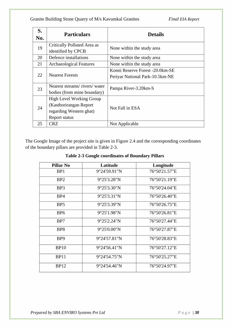
Granite Building Stone Quarry of M/s Kavumkal Granites Final EIA Report
Prepared by SBA ENVIRO Systems Pvt Ltd P a g e | 38
S.
No. Particulars Details
19 Critically Polluted Area as
identified by CPCB None within the study area
20 Defence installations None within the study area
21 Archaeological Features None within the study area
22 Nearest Forests Konni Reserve Forest -20.0km-SE
Periyar National Park-10.5km-NE
23 Nearest streams/ rivers/ water
bodies (from mine boundary) Pampa River-3.20km-S
24
High Level Working Group
(Kasthorirangan Report
regarding Western ghat)
Report status
Not Fall in ESA
25 CRZ Not Applicable
The Google Image of the project site is given in Figure 2.4 and the corresponding coordinates
of the boundary pillars are provided in Table 2-3.
Table 2-3 Google coordinates of Boundary Pillars
Pillar No Latitude Longitude
BP1 9°24'59.91"N 76°50'21.57"E
BP2 9°25'3.28"N 76°50'21.19"E
BP3 9°25'3.30"N 76°50'24.04"E
BP4 9°25'3.31"N 76°50'26.40"E
BP5 9°25'3.39"N 76°50'26.75"E
BP6 9°25'1.98"N 76°50'26.81"E
BP7 9°25'2.24"N 76°50'27.44"E
BP8 9°25'0.00"N 76°50'27.87"E
BP9 9°24'57.81"N 76°50'28.83"E
BP10 9°24'56.41"N 76°50'27.12"E
BP11 9°24'54.75"N 76°50'25.27"E
BP12 9°24'54.46"N 76°50'24.97"E

Granite Building Stone Quarry of M/s Kavumkal Granites Final EIA Report
Prepared by SBA ENVIRO Systems Pvt Ltd P a g e | 39
Figure 2.4 Google Image of Lease Area

Granite Building Stone Quarry of M/s Kavumkal Granites Final EIA Report
Prepared by SBA ENVIRO Systems Pvt Ltd P a g e | 40
Figure 2.5 A view of proposed mining lease area

Granite Building Stone Quarry of M/s Kavumkal Granites Final EIA Report
Prepared by SBA ENVIRO Systems Pvt Ltd P a g e | 41
2.3 Size of the proposed lease
The size and magnitude of the lease area is as given Table 2-4.
Table 2-4 Size or Magnitude of operation
Sr. No. Particulars Details
1 Lease Area 4.0262 Ha
2 Mineable Reserve 1856378 MT
3 Maximum Annual
Production 185637.8 MTA
4 Mine Waste 90,585MT (Top soil) and 92,819MT (Overburden)
5 Life of Mine About 10 years
6 Total Man Power (Nos.) About 20 Persons
2.3.1 Proposed Mining Method
Open cast semi-mechanized mining will be adopted to extract building stone of required size.
Machineries like tractor mounted compressor attached with jack hammers is proposed for
drilling and blasting. Excavators are proposed for lifting and loading of rock. Tippers are
proposed for the transportation to the destination.
Mode of working is semi mechanized quarrying operation using shot hole drilling with the help
of compressor and jack hammers and NONEL blasting. Waste and raw materials is removed
using Hydraulic excavator and loaded directly to the tippers. The bench height and width are
designed as 5m. The targeted maximum production of Stone is about 185637.8 MTA.
Table 2-5 Year wise production of building stone for next 10 Years
Sl. No. Year ROM (in MT)
1 I Year 185637.8
2 II Year 185637.8
3 III Year 185637.8
4 IV Year 185637.8
5 V Year 185637.8
6 VI Year 185637.8
7 VII Year 185637.8
8 VIII Year 185637.8
9 IX Year 185637.8
10 X Year 185637.8

Granite Building Stone Quarry of M/s Kavumkal Granites Final EIA Report
Prepared by SBA ENVIRO Systems Pvt Ltd P a g e | 42
Figure 2.6 Year Wise development Plan

Granite Building Stone Quarry of M/s Kavumkal Granites Final EIA Report
Prepared by SBA ENVIRO Systems Pvt Ltd P a g e | 43
Figure 2.7 Year Wise development Section

Granite Building Stone Quarry of M/s Kavumkal Granites Final EIA Report
Prepared by SBA ENVIRO Systems Pvt Ltd P a g e | 44
2.3.2 Project Cost
The estimated total cost of the project is Rs. 2,22,50,000/-, and break up of project cost is given
below Table 2-6.
Table 2-6 Project Cost
S.No Particular Amount
1
Excavator, Rock Breaker 70,00,000
Water Tanker 3,00,000
Tippers, Jack hammers, Air compressor 30,00,000
2 Strengthening of Roads 4,00,000
3 Cost for Infrastructure like site office,
Temporary shed, Rest shelter, etc 5,00,000
4 Cost of Environmental Protection 4,00,000
5 Cost for construction of Garland drains, SST,
RWHP, Gully checks, etc 2,00,000
6 Land cost (359.5 Ares x 27955.49RS /Are )
+Misc. 1,00,50,000
7 Pre-operational expense 2,00,000
8 Miscellaneous 2,00,000
Total 2,22,50,000/-
2.4 Type of Mining – Open Cast Mining
Salient Features of Mode of working
The mining will be done by open cast semi mechanized. The working will be done by forming
benches of 5m height. The Stone production will be started from the first year the systematic
working of open cast mines, the main development work will be the forming of systematic
benching. The height of bench will not be kept more than 5m at a time and the width of the
benches will be always kept safe according to provisions. The Mining will be done with the
help of tools such as drills, jack-hammer, compressors, hand shovel, picks, excavators etc.
Loading of Stone will be done with the help of shovel and excavators at face and at stock yard.
The truck / tipper will be used for transportation of Stone from mine site to destination.
The cost of the Stone is directly dependent on the size of the material mined. First Stone bench
will be opened by removal of Soil. Stone will be mined out either by labour or with the help of
JCB / Hitachi.

Granite Building Stone Quarry of M/s Kavumkal Granites Final EIA Report
Prepared by SBA ENVIRO Systems Pvt Ltd P a g e | 45
The Geological and Mineable Reserves are estimated by cross-sectional Methods up to a depth
of 345-265m from the hill top. Highest and lowest elevation is 355m & 270m respectively
above mean sea level. Geological cross sections are drawn across the exposed rock. The
volume between the cross section is arrived on the basis of the average area of the parallel cross
section method using CAD software and multiplying bi-sectional interval. Tonnage is arrived
by multiplying with bulk density (B.D), which is 2.5MT/cum for building stone.
Mining Methods:
Open cast semi-mechanized mining will be adopted to extract Building stone of required size.
Machineries like tractor mounted compressor attached with jack hammers is proposed for
drilling and blasting. Excavators are proposed for lifting and loading of rock. Tippers are
proposed for the transportation to the destination.
Mode of working:
Mode of working is semi mechanized quarrying operation using shot hole drilling with the help
of compressor and jack hammers and smooth blasting. Waste and raw materials is removed
using Hydraulic excavator and loaded directly to the tippers. The bench height and width are
designed as 5m.
Details of Top Soil / Mineral Production proposed for the five years
The development involves only removal of 1m top soil to be generated out of production. Here,
the recovery is taken as 100% of total excavation since the area is covered with a thin layer of
weathered gneiss. The rubble from the mine will be sent to the stone crusher unit located at
about 0.20 km from the mine lease area to produce various sizes of coarse and fine aggregates
and M-sand which are used for building construction.
Disposal of Top Soil/ Waste
A total quantity of 90585 tonne of topsoil is proposed to be removed during mining operations.
The topsoil excavated from the quarry will be dumped separately at pre-determined place and
subsequently utilized for spreading over reclaimed areas for plantation. About 92819 tonnes of
overburden (OB) will be generated throughout the mine life. This waste will be utilized within
the pit for lying of haul roads. At the end use, OB can be reutilized as soil base for plantation.
2.5 Description of Process
The proposed mining operations will be carried out by open cast semi-mechanized method.
Method of Quarrying
Geological parameters of the ore body and the geo- technical field, observations made opted to
work by mechanical mode and the method is of by opencast with a bench system is adopted to
work the deposit. The top of the bench having thin cap of soil cover and weathered genesis on
slope. Topsoil cover will be removed ahead of rock is by using excavators/JCB. The excavated
topsoil is stacked separately and same will be used for avenue plantation purpose. The
quarrying is being done by mechanization mode of operation by using excavators; jack

Granite Building Stone Quarry of M/s Kavumkal Granites Final EIA Report
Prepared by SBA ENVIRO Systems Pvt Ltd P a g e | 46
hammers drills and tippers etc. It is proposed jack hammers drill is using for drilling purpose
hence initially it is proposed sub level bench method keeping a sub bench height of 2.50m and
the final stage all the sub benches will merged. The maximum bench height is kept 5.0 meters
width at ultimate stage by maintaining 45 degree (since granite is hard rock).
Drilling & Blasting
Since the bench height needs to be maintained 5.0 m, blast hole will be by jack hammer where
the diameter is normally 32 mm and the depth of the hole is 2.5 to 2.6 m. Blasting pattern is
generally square or staggered with burden ranging from 0.75 to 1.00 meters and spacing of 1.0
to1.2 meters. Usually single / double row of holes is blasted along free face to achieve optimum
power factor, best fragmentation and minimized adverse impacts on account of blasting.
Maximum holes blasted per day are 30 to 40 with normal delay detonators to mitigate adverse
impacts such as air blast, throw and the ground vibration.
Holes are electrically detonated using electric detonators. Nitrate Mixture types of explosives
are used for blasting with 20 to 25 percent, proportion of primer/booster cartridges and rest as
column charge. About 2 to 3 kgs of explosives are loaded in 32 mm diameter holes and power
factor ranging between 7 to 8 tons per kgs of explosives is achieved. Lessee is having the
Explosive license.
➢ Type of explosive to be used
Only class 2 and class 6 explosive are proposed for use as given below:
Table 2-7 Details of Explosives
Booster (20%) Slurry explosive
Explosive
(Column charge) (80%)
Nitrate Fuel oil (NFO).
The NFO mixture can be readily produced at a site by
mixing nitrate (94.5 %) with diesel oil (5.5 %).
Initiator Non-Electric detonators
➢ Storage of Explosive
Considering low consumption, a 250 kg magazine is exists for storing the explosive. The
controlled blasting is proposed by adopting all the safety measures as per “MMR 1961” and
with the permission of DGMS.
Blasting will be performed as per requirement on the face. The explosive by authorized blasting
party himself and the blasting will be carried out by registered blasting contractor as per present
practices.
➢ Loading and Hauling:
Loading of the building stone blocks will be done mechanically to tippers of 10 tons capacity
and transported from the quarry to the stockyard and mineral rejection/waste will also be

Granite Building Stone Quarry of M/s Kavumkal Granites Final EIA Report
Prepared by SBA ENVIRO Systems Pvt Ltd P a g e | 47
handled mechanically. In the quarry the road will be maintained with 1 in 16 gradients.
Sufficient number of bunds and parapet walls will be made all along the quarry haulage roads
wherever necessary in order to maintain safe working conditions by using the waste generated
during the course of quarry operations.
Raw material required along with estimated quantity, likely source, marketing area of final
product/s, mode of transport of raw material and finished product
No raw material will be required for mining of Masonry / building stone. The final product will
be sent to consumer based on their demand. The mode of transportation of raw material and
finished product will be by road only. Tippers/ trucks will be used for transportation to the end
users.
The following points have been considered while calculating the reserves of stone.
1. The reserves of minerals have been estimated by using the method of preparation of
sections and applying the influence of such sections to limited distance and multiplying
it by width.
2. Based on the actual geological mapping and cross section preparation, the proved
reserve has been taken.
The specific gravity of minerals has been taken as 2.5 i.e., 1 m3 of mineral in situ = 2.5 tonne.
The overall process involved in mining is described as a flow chart as shown below
Figure 2.8 Process Flow Chart
This section outlines current mining method, estimated production on yearly basis, methods
of current production and proposed changes if any and list of mining equipment.
Removal of Top soil
Excavation by Drilling and Blasting
Rock Breaking & Transportaion
Stacking
Dispatch

Granite Building Stone Quarry of M/s Kavumkal Granites Final EIA Report
Prepared by SBA ENVIRO Systems Pvt Ltd P a g e | 48
2.6 Extent of Mechanization
The machineries are proposed to be purchased or hired for use in mines for systematic operation
and development.
a) Drilling:
Drilling of shot-holes will be carried out using compressor and Jack Hammer combination.
Depth of holes shall be 1-2m and the spacing shall be 0.75m and burden shall be 0.50m. To
estimate a correct blasting geometry and to affect a perfect pre-determined fragmentation and
fly rock control, certain amount of trial blast is a prerequisite.
b) Loading Equipment:
Loading shall be done by Excavator into tippers from the working place. Topsoil and Building
stones shall be dumped in the site. The applicant is proposed to engage three Hydraulic
excavators and one hydraulic rock breakers and tippers of 15-20 Tonnes capacity for
transportation of rock and internal transport of topsoil.
Table 2-8 Details of Hydraulic Excavators
Sl. No Equipment/ Machinery No. of units Size/ Capacity
1. Excavator with Breaker 3 185 HP, 132(kw)
2. Jack Hammer 2 75 HP
3. Box Compressor 2 45 HP
c) Transportation:
Transport of rocks and soil shall be done by Tippers of 15 – 20 tonnes capacity.
Table 2-9 Details of Transportation
Type Nos. Size/ Capacity Make Motive H.P
Tipper 15 15-20 M.T Ashok Leyland /
Bharath Benz Diesel 110
Water
Tanker 1 10 KL Ashok Leyland Diesel 130
2.7 Salient features of Proposed Lease Area
2.7.1 Topography
Topography of the lease area is hilly terrain with some of the proposed land is covered with
native trees, shrubs, herbs bushes etc. Highest elevation of the lease area is 355 M above MSL

Granite Building Stone Quarry of M/s Kavumkal Granites Final EIA Report
Prepared by SBA ENVIRO Systems Pvt Ltd P a g e | 49
and lowest is 270 M above MSL. The drainage of the area is controlled by seasonal channels
towards south side which joins to seasonal streams.
2.7.2 Regional Geology
Geologically, Pathanamthitta district forms part of the Precambrian metamorphic shield
comprising (i) Charnockite Group, Khondalite Group and Megmatite Complex of Archaean
age, (ii) Acid intrusive of Proterozoic age and (iii) rocks of Cenozoic age (basic intrusive,
Neogene and Quaternary). Charnockite group is the dominant formation of the area within
which occur concordant, linear and lensoidal bodies of calc granulite and quartzite of
Khondalite Group. The Charnockite Group comprises Charnockite (hypersthenes granite),
pyroxene-granulite and cordierite gneiss. Charnockite is the dominant rock and its variants are
charnockite gneiss, massive charnockite and hypersthenes-diopside gneiss. The rock is
generally dark grey and crudely foliated. Cordierite gneiss occurs as impersistent bands within
charnockite, while pyroxene granulite is seen as restites, mostly in the west. At places,
charnockite is migmatised resulting in the formation of biotite gneiss, and garnet-biotite gneiss
(Migmatite Complex). These rocks are predominant towards south. The area witnessed a period
of igneous activity during the Proterozoic as evidenced from the granite and syeno-granite (acid
intrusive) bodies. Pegmaite and quartz veins traverse the older rocks parallel to the regional
foliation. Basic igneous activity, probably of Late Mesozoic age, is evidenced from the dolerite
and gabbro dykes cutting across the older rocks. These dykes have a general NW-SE trend.
Warkalli sediment of Neogene age is exposed near Thiruvalla. Along the western margin, the
basement and sedimentary rocks have been lateritised. The generalized stratigraphic succession
of the geologic formations met within this district is as follows:
Table 2-10 Stratigraphic Succession of Geographic Formation
Rock formation Age
Top soil –Red, Laterite soil Recent Age
Charnockite
(Granite building stone)
Archaean formation
Peninsular gneiss & Migmatite Complex Archaean formation

Granite Building Stone Quarry of M/s Kavumkal Granites Final EIA Report
Prepared by SBA ENVIRO Systems Pvt Ltd P a g e | 50
Figure 2.9 Geology and mineral resources of Pathanamthitta
Project Site

Granite Building Stone Quarry of M/s Kavumkal Granites Final EIA Report
Prepared by SBA ENVIRO Systems Pvt Ltd P a g e | 51
2.7.3 Local Geology
The area is mainly composed of crystalline metamorphic complex. The area of mining lease
contains light pink colour Building Stone. Charnockite which mainly composed Hypersthene,
Quartz, and Feldspar, with some ferromagnesian minerals. The grain size is medium to course.
Almost the formations in the lease area are having the strike parallel to the Western Ghats
which is trending deeply and there are no other structural features like fault, folding and joints.
2.7.4 Geological & Mineable Reserves
In this area the building stone exposures are bordering to the lease boundary. The mineable
reserves are arrived after deducting the reserves locked in mines safety slope along with
boundary in compliance with mineral concession rules. The quantity of such kind of reserves
is arrived as following: -
Method of Estimation of Reserves
Considering the above parameters and exposures observed in the existing pit in the allotted
area, the surface geological plan and geological cross-sections are prepared on a scale 1:1000,
the reserves for Stone and associated minor minerals have been estimated on cross- sectional
area method.
Table 2-11 Section wise Geological Reserve Estimation
GEOLOGICAL RESERVES
Section
Section
Area
(Sq.m)
Influence (m) Volume
(cu.m)
Bulk
Density
Quantity
(Tonnes)
A-A' 7002 82 574164 2.5 1435410
B-B' 7361 53 390133 2.5 975333
C-C' 6295 86 541370 2.5 1353425
Total 3764168 MT
Mineable Reserves: -
To estimate the mineable reserves, the reserves blocked under 7.5 statutory barriers and due
to formation of systematic benches up to Ultimate Pit Limit have been considered.
Table 2-12 Section wise Mineable Reserve Estimation

Granite Building Stone Quarry of M/s Kavumkal Granites Final EIA Report
Prepared by SBA ENVIRO Systems Pvt Ltd P a g e | 52
MINEABLE RESERVES
Section Section
Area
(Sq.m)
Influence
(m)
Volume
(cu.m)
Bulk
Density
Quantity
(Tonnes)
A-A' 3971 71 281941 2.5 704853
B-B' 3940 53 208820 2.5 522050
C-C' 3270 77 251790 2.5 629475
Total 1856378 MT
Total Geological Reserve =3764168MT
Total Mineable Reserve = 1856378MT
Table 2-13 Reserve Estimation Section Wise
MINEABLE RESERVES
SECTION A-A'
REDUCE
LEVEL OF
BENCH
AREA
(Sq.m)
INFLUENCE
(m) DENSITY
QUANTITY
(TON)
340 16 71 2.5 2840
335 44 71 2.5 7810
330 68 71 2.5 12070
325 95 71 2.5 16862.5
320 129 71 2.5 22897.5
315 169 71 2.5 29997.5
310 207 71 2.5 36742.5
305 241 71 2.5 42777.5
300 277 71 2.5 49167.5
295 316 71 2.5 56090
290 348 71 2.5 61770
285 373 71 2.5 66207.5
280 401 71 2.5 71177.5
275 427 71 2.5 75792.5
270 450 71 2.5 79875
265 410 71 2.5 72775
TOTAL 704853 MT SECTION B-B'
DENSITY

Granite Building Stone Quarry of M/s Kavumkal Granites Final EIA Report
Prepared by SBA ENVIRO Systems Pvt Ltd P a g e | 53
REDUCE
LEVEL OF
BENCH
AREA
(Sq.m)
INFLUENCE
(m)
QUANTITY
(TON)
345 20 53 2.5 2650
340 37 53 2.5 4902.5
335 74 53 2.5 9805
330 99 53 2.5 13117.5
325 128 53 2.5 16960
320 152 53 2.5 20140
315 181 53 2.5 23982.5
310 209 53 2.5 27692.5
305 239 53 2.5 31667.5
300 268 53 2.5 35510
295 288 53 2.5 38160
290 317 53 2.5 42002.5
285 348 53 2.5 46110
280 375 53 2.5 49687.5
275 400 53 2.5 53000
270 421 53 2.5 55782.5
265 384 53 2.5 50880
TOTAL 522050MT
SECTION C-C'
REDUCE
LEVEL OF
BENCH
AREA
(Sq.m)
INFLUENCE
(m) DENSITY
QUANTITY
(TON)
340 14 77 2.5 2695
335 36 77 2.5 6930
330 70 77 2.5 13475
325 93 77 2.5 17903
320 117 77 2.5 22523
315 146 77 2.5 28105
310 172 77 2.5 33110
305 199 77 2.5 38308
300 227 77 2.5 43698
295 254 77 2.5 48895
290 274 77 2.5 52745
285 297 77 2.5 57173
280 317 77 2.5 61023
275 350 77 2.5 67375
270 370 77 2.5 71225
265 334 77 2.5 64295
TOTAL 629475MT

Granite Building Stone Quarry of M/s Kavumkal Granites Final EIA Report
Prepared by SBA ENVIRO Systems Pvt Ltd P a g e | 54
In this area the building stone exposures are bordering to the lease boundary. The mineable
reserves are arrived after deducting the reserves locked in mines barrier along the boundary in
compliance with Metalliferous Mines Regulations Act. Summary of Geological and mineable
reserve is given below.
Table 2-14 Summary of Estimated Reserves
RESERVES IN MT
Category R O M (MT)
Mineable reserves 1856378 MT
Blocked reserves 1907790 MT
Geological reserves 3764168 MT
Note: Geological Reserves =Mineable Reserves + Blocked Reserves
Of the above Geological reserves of 3764168MT, only 1856378MTof reserves can be exploited
/ mined, while the balance of 1907790MT of reserves is getting blocked which cannot be
mined, due to the boundary and practical constraints. Hence for all practical purpose (for
production and future planning) only Mineable reserves are considered.
2.7.5 Use of Minerals
The rock produced from the quarry is sent to the Crusher unit near by the location for the final
product generation. The aggregate produced is sold to the contractors and to the consumers
which is finally consumed locally for road (State Highway & National Highway) & building
construction works
2.7.6 Land use and Land Ownership
The land in the lease area is private own land. The proposed land is mostly covered with native
trees, shrubs, herbs, grass, climbers, bushes etc. Land, in core zone i.e., 500 m around the lease
area is generally hillock and is used for mining. The other areas are covered with native plants.
In addition to above, there are several houses within 500 m. radius from the proposed quarry
and the nearest house is located at outside the 208 m. of the mine boundary
The lease Area does not involve any forest, agriculture or grazing land. The land is private own
land, the land is not viable for agricultural purpose.
Table 2-15 Existing land use pattern of proposed area
No. Land Use Pre-Operational (Ha)
1 Old Mined out area -
2 Road -
3 Green belt area -

Granite Building Stone Quarry of M/s Kavumkal Granites Final EIA Report
Prepared by SBA ENVIRO Systems Pvt Ltd P a g e | 55
No. Land Use Pre-Operational (Ha)
4 Virgin Area 4.0262
Total 4.0262
2.7.7 Man power requirement
As per Mines safety under the provisions of MMR, 1961 under the Mines Act, 1952, whenever
the number of workers employed is more than 10, it is preferred to have a qualified Mines Mate
to keep all the production workers directly under his control and supervision. A mines clerk
shall also be appointed to keep the registers and record of the mine and make necessary entries
for the persons employed in the mines. The following man power is proposed for quarrying
Building Stone during the five-year period to achieve the proposed production and to comply
with the provisions of the Government norms.
Table 2-16 Employment Details
Sy. No. Name of the post Nos.
1 Mechanical Engineer 2
2 Quarry Supervisor 2
3 Mine Mate 2
4 Blasting Helpers 4
5 Blast man 2
6 Mine Labours 8
Total 20
It will be ensured that child labourers will not be engaged for quarrying operation.
The medical facility and other benefits will be provided for the miner’s health in accordance
with the law. As per Mines Rule-1955, periodical medical examination thereafter of every
person employed in the mine at intervals of not more than five years will be arranged. The said
examination shall be so arranged over a period of five years that one fifth of the persons
employed at the mine undergo the examination every year.
2.7.8 Water requirement
Mining & its associated activities requires 7 kLD. The baseline information on ground and
surface water regime is very important. Water availability and water quality are the two major
aspects to be considered for baseline status of water environment.
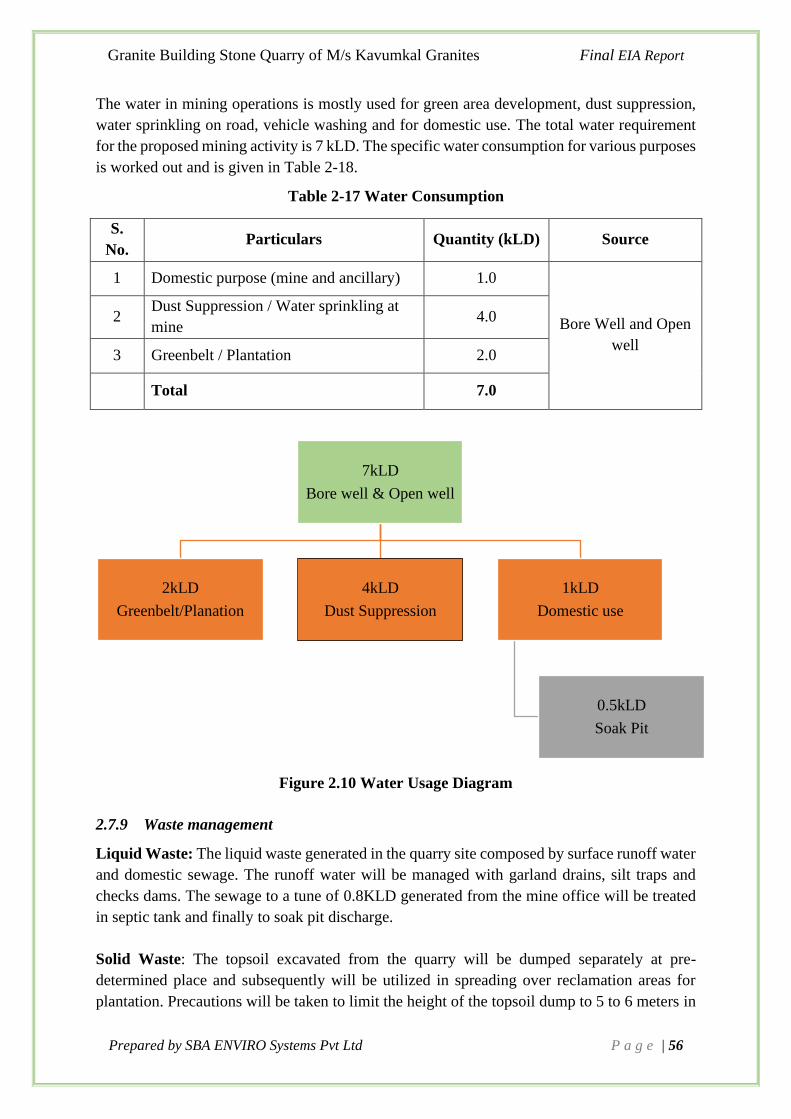
Granite Building Stone Quarry of M/s Kavumkal Granites Final EIA Report
Prepared by SBA ENVIRO Systems Pvt Ltd P a g e | 56
The water in mining operations is mostly used for green area development, dust suppression,
water sprinkling on road, vehicle washing and for domestic use. The total water requirement
for the proposed mining activity is 7 kLD. The specific water consumption for various purposes
is worked out and is given in Table 2-18.
Table 2-17 Water Consumption
S.
No. Particulars Quantity (kLD) Source
1 Domestic purpose (mine and ancillary) 1.0
Bore Well and Open
well
2 Dust Suppression / Water sprinkling at
mine 4.0
3 Greenbelt / Plantation 2.0
Total 7.0
Figure 2.10 Water Usage Diagram
2.7.9 Waste management
Liquid Waste: The liquid waste generated in the quarry site composed by surface runoff water
and domestic sewage. The runoff water will be managed with garland drains, silt traps and
checks dams. The sewage to a tune of 0.8KLD generated from the mine office will be treated
in septic tank and finally to soak pit discharge.
Solid Waste: The topsoil excavated from the quarry will be dumped separately at pre-
determined place and subsequently will be utilized in spreading over reclamation areas for
plantation. Precautions will be taken to limit the height of the topsoil dump to 5 to 6 meters in
7kLD
Bore well & Open well
2kLD
Greenbelt/Planation
4kLD
Dust Suppression
1kLD
Domestic use
0.5kLD
Soak Pit

Granite Building Stone Quarry of M/s Kavumkal Granites Final EIA Report
Prepared by SBA ENVIRO Systems Pvt Ltd P a g e | 57
order to preserve its fertility and shelf life. Also, we shall provide a retaining wall surround the
dumping area having height of 2-3 m, which help to avoid the soil erosion. It will be suitably
protected from soil erosion and infertility by planting fodder grass and leguminous plants
during temporary storage. A good mining practice is to store the topsoil for reuse. The topsoil
is the most valuable resource for re-vegetation after mining, as it contains the majority of the
seeds, roots and microorganisms. Simultaneously replanting (which begins during mining
operations- after first year onwards) is very important because if topsoil is stockpiled for a long
period of time, its quality deteriorates.
General Dumping Practices
• During the planning stage identification of waste storage yard and topsoil should be
done based on slope and runoff characteristics. The individual dump will have
maximum slope of 37o and an overall slope not exceed 28o.
• The completed dumps and the back-filled areas will be afforested in a planned way to
increase their stability.
• The topsoil prior to drilling and blasting will be stacked at designated area surrounded
by embankment to prevent erosion. The topsoil dumps will be stabilized by plantation
and retaining wall.
• The external dump will have stretches of retaining wall at suitable locations and the
wall will be constructed with suitable height (2.5m) and top surface.
• The wall will have weep holes to drain out water to the garland drain.
• Runoff from the mine and waste dumps should be regulated by constructing check dams
and garland drains. Garland drains should be constructed on all side of quarries and
dumping yards. All the garland drains should be routed through adequately sized catch
pits or settling pits to remove suspended solids from flowing into storm water.
• Plantation on the topsoil dumps can only be taken up after dumping activity is stopped
and the site is proposed for plantation. A layer of topsoil should be spread over the area
and roughly levelled. Coir net / blanket should be spread, and native grass seed mix
should be broadcasted uniformly on prepared slope.
Reclamation Practices
The topsoil stabilisation is important from the environmental and aesthetic point of view. The
most common method of stabilisation is reusing by plantation. Back filled topsoil are generally
reclaimed by tree species as plantation improves the moisture contents, bulk density, pH and
overall nutrient contents of soils. Maintain a reverse slope in all benches during the operational
phase to avoid the erosion of back filled Soil and maintain a small channel in the bottom terrain
of the benches.
2. 8. Mine Closure
This mine is having life of 10 years and as per norms the progressive mine closure plan is
applicable instead of Mine closure plan. The mine closure plan shall be prepared 5 years before

Granite Building Stone Quarry of M/s Kavumkal Granites Final EIA Report
Prepared by SBA ENVIRO Systems Pvt Ltd P a g e | 58
expiry of the mine which covers technical, environmental, social, legal and financial aspects
dealing with progressive and post closure activities.
While formulating the closure objectives for the site, it is important to consider the pre-mining
land use of the site and how the operation will affect this activity. The primary aim is to ensure
that the following broad objectives along with the abandonment of the mine can be successfully
achieved:
• To create a productive and sustainable after-use for the site, acceptable to mine owners,
regulatory agencies, and the public.
• To protect public health and safety of the surrounding habitation.
• To minimize environmental damage.
• To conserve valuable attributes and aesthetics.
• To overcome adverse socio-economic impacts.
The criteria involved in mine closure are discussed below:
Physical Stability:
All anthropogenic structures, which include mine workings, dumping, buildings, will be well
stabilised during the mining activities, so that it will be physically stable even after the
decommissioning of mine. This will not have any hazard to public health and safety. Mine
benches shall be designed in such way to have good stability and good factor of safety, the
proposed design and factors of safety will take full account of extreme events such as floods,
hurricane, winds or earthquakes, and other natural perpetual forces like erosion, etc.
Chemical Stability
During the mining operations no hazardous chemicals are used for any activity in mine and
also granite building stone is chemically inert, so this mining project will not have any
Chemical impact on the topsoil and waste generated.
The solid wastes (topsoil) from this mine stacked separately so as to maintain chemically stable.
This means that the consequences of chemical changes or conditions will not lead to leaching
of metals, salts or organic compounds and will neither endanger public health and safety nor
result in the deterioration of environmental attributes.
Biological Stability:
The biological stability of the mine site itself is closely related to rehabilitation and final land
use. Nevertheless, biological stability can significantly influence physical or chemical stability
by stabilizing soil cover, Erosion/wash off are prevented by developing vegetation cover on
waste dumps and in green belt area.
A vegetation cover over the disturbed site is usually one of the main objectives of the
rehabilitation program, as vegetation cover is the best long-term method of stabilizing the site
and it will be carried during mining period itself and also before the closure of mine.

Granite Building Stone Quarry of M/s Kavumkal Granites Final EIA Report
Prepared by SBA ENVIRO Systems Pvt Ltd P a g e | 59
Valuable attributes, Aesthetics and Socio-Economics at end of the mine:
More important is given to for re-vegetation, management of soil nutrient levels. Additions of
nutrients are carried out under necessary situations to the topsoil. The progressive mine closure
plan is a part of approved mine plan. Stage wise progressive mine closure plan with budget
available financial / manpower is prepared will be implemented stage wise. The progressive
mine closure plan which is a part of the approved mining plan of the proposed mining lease.

Granite Building Stone Quarry of M/s Kavumkal Granites Final EIA Report
Prepared by SBA ENVIRO Systems Pvt Ltd P a g e | 60
Chapter 3. DESCRIPTION OF THE ENVIRONMENT
3.1 General
This chapter provides the description of the existing environmental status of the study area with
reference to the environmental attributes like air, water, noise, soil, land use, ecology and
biodiversity, socio economics, etc. The existing environmental setting is considered to adjudge
the baseline conditions which are described with respect to climate, atmospheric conditions,
water quality, soil quality, ecology, socio economic profile, land use and places of
archaeological importance. This report incorporates the baseline data monitored for one season
months from January 2020 to March 2020, representing winter season. Secondary data was
collected from various Government and Semi-Government organizations.
3.2 Study Area for EIA
The study area is the area within a radius of 10 km of proposed lease area, as per the ToR. The
study area includes the "core zone" and "buffer zone". As specifically mentioned in EIA
Notification and as well as on the basis of "Environmental Impact Assessment Guidance
Manual for Mining of Minerals projects" published by Ministry of Environment & Forests,
February, 2010, for carrying out an EIA study of a mining project, the mine lease area is called
as "core zone" and 10 km radius from the boundary limits of the mine lease area is called as
"buffer zone".
3.3 Land Use - Land Cover Study
3.3.1 Introduction
Remote sensing is the science of acquiring information about the Earth's surface without
actually being in contact with it. This is done by sensing and recording reflected or emitted
energy and processing, analysing, and applying that information. Satellite remote sensing
technology has found its acceptance worldwide for rapid resource assessment and monitoring.
Satellite images have been utilized for land use and land cover mapping.
Land use/land cover data refers to data that is a result of classifying raw satellite data into "land
use and land cover" (LULC) categories based on the return value of the satellite image. The
term “land use” (LU) relates to the human activity or economic function associated with a
specific piece of land, whereas the term “land cover” (LC) relates to the type of feature present
on the surface of the earth. In this study, the study area is considered as 10 km from the project
site in Athikkayam village, Pathanamthitta district in Kerala.
3.3.2 Objectives
➢ Delineation of Land use/ Land cover categories for the whole study area.
➢ Generation of digital cartographic database using secondary data sources
3.3.3 Satellite Image Analysis
Landsat 8 cloud free data has been used for Land use/ land cover analysis and SRTM data for
analyzing topographic features, the details of satellite image are as follows:

Granite Building Stone Quarry of M/s Kavumkal Granites Final EIA Report
Prepared by SBA ENVIRO Systems Pvt Ltd P a g e | 61
Satellite Data: Sentinel -2A cloud free data and CartoDEM data has been used for Land use/
Land cover analysis and drainage studies respectively. The details are given below:
1) Platform: Sentinel-2A
Satellite Sensor: Multi-Spectral Imager, Level-1C
Tile Number: T43PFL & T43PGL
Orbit Number: 19
Spatial Resolution: 10 m
Date of Pass: 28th February 2020
2) Platform: Cartosat-1
Satellite Sensor: PAN (2.5m) Stereo Data
Tile Number: C43Q
Spatial Resolution: 30 m (1 arc sec)
Ancillary Data: ArcGIS and ERDAS Image-processing software are used to classify the
image and for delineating drainage and other features in the study area.
Figure 3.1 shows the False Colour Composite (FCC) map of satellite data for the 10 km radius
area from the proposed project boundary site. Band combination (B8, B4, B3) was done from
the collected satellite data to create the standard FCC of the study area.
Figure 3.1 Satellite Map of Study area
Project Site
area

Granite Building Stone Quarry of M/s Kavumkal Granites Final EIA Report
Prepared by SBA ENVIRO Systems Pvt Ltd P a g e | 62
3.3.4 Land Use Land Cover Details
Satellite data was classified (Level II Classification) using supervised classification technique.
Maximum likelihood algorithm classifier was used for the analysis. Seven land use/ land cover
classes were identified in ten sq. km area around the project site as Table 3-1.
Figure 3.2 shows the information about the extent of land use/ land cover classes in the study
area.
Table 3-1 Land use/ Land cover Statistics of Area within 10 km Radius
LULC Classes Area (Ha) Percentage of total area (%)
Agricultural Land 10358.75 32.16
Fallow Land 3663.53 11.37
Mixed Vegetation 11278.92 35.02
Settlements 1198.34 3.72
Open Scrub/Open Area 1876.85 5.83
Barren Land 3519.39 10.93
Waterbody 313.17 0.97
Total 32208.95 100.00
Figure 3.2 Land use/Land cover of 10 km Study Area
Project Site
area

Granite Building Stone Quarry of M/s Kavumkal Granites Final EIA Report
Prepared by SBA ENVIRO Systems Pvt Ltd P a g e | 63
Generally, mixed land use/land cover visible in and around study area in which vegetation
(35.02%) was dominates in the present study followed by agricultural land (32.16%) covering
10 km surrounding the project site. Other land use land cover identified in the study were fallow
land (11.37%), barren land (10.93%), open scrub/open area (5.83%), settlements (3.72%) and
waterbody (0.97%). Due to the proposed mining, there were no variations in the existing land
use or land cover within the study area. But within in proposed project site there may be some
minor change in land use to mining area.
3.3.5 Contour Pattern of the Study Area
Contouring is the standard method of representing relief on topographic maps. Contour lines
are lines joining points of equal elevation on the surface of the ground. For a given map the
vertical distance between adjacent contour lines or the contour interval is fixed i.e., 30 m Figure
3.3. Topographic contour map of 10 km radius around project site shows an undulating terrain.
The Digital elevation model of study are is given in the Figure 3.4. The highest elevation in the
study area is 486 m.
Figure 3.3 Digital Elevation model of 10 km study area
Project Site
area

Granite Building Stone Quarry of M/s Kavumkal Granites Final EIA Report
Prepared by SBA ENVIRO Systems Pvt Ltd P a g e | 64
Figure 3.4 Contour map of 10 km radius around project site
3.3.6 Drainage Map of the Study Area
A drainage system is the pattern formed by the streams, rivers, and lakes in a particular drainage
basin. Drainage basins can be described by the order of streams within them. Streams that have
no tributaries (or streams flowing into it) are termed first order streams. When the first order
streams join together, they become second order steam. Two second order streams join to form
third order stream and so on for forth and further orders. However, a stream may have a
tributary with a lower order without becoming a higher order stream. Strahler method of
ordering was used for giving order to drainage. Highest order drainage in the study area is 5th
order. Drainage map of a study area shows in Figure 3.5. Drainage pattern within 10 km radius
around project site shows dendritic type of drainage pattern. The Pampa river passes through
the study area.
Project Site
area

Granite Building Stone Quarry of M/s Kavumkal Granites Final EIA Report
Prepared by SBA ENVIRO Systems Pvt Ltd P a g e | 65
Figure 3.5 Drainage Pattern of 10 km Study Area
3.3.7 Landslide Hazard study in the Area
Due to steep slopes, the north-east part of the district is prone to landslides, especially during
the rainy season. However, the proposed site does not belong in the landslide prone area. The
Pathanamthitta district falls under seismic zone III of ISI Classification. The Map for Hazards
like Landslide, Flood, Drought and earthquake is shown below as per the Landslide
Susceptibility Zones of Pathanamthitta Districts of Kerala (NCESS, 2010). From the below
maps it is evident that the portion of proposed land area is coming under medium hazard zone
as shown in the Figure 3.6.
Project Site
area

Granite Building Stone Quarry of M/s Kavumkal Granites Final EIA Report
Prepared by SBA ENVIRO Systems Pvt Ltd P a g e | 66
Figure 3.6: Landslide Map
3.3.8 Soil Characteristics
The soil sample is collected from the core zone and buffer zone since the project is not likely
to affect the land use outside core zone. Samples are collected through hand auger boring up to
a depth of 15 to 30 cm. The location coordinates of sampling were given in Table 3-2 and
Figure 3.7.
Table 3-2 Details of Soil Sampling Locations
Sl
No: Location
Location
Code
Location
coordinates
Distance and
Direction from
Mine Lease
area
Zone
(Core/
Buffer)
1 Within core zone S1 9°24'56.28"N
76°50'24.65"E -- CORE
2
Near to residence
of Joseph,
Vellolimala
S2 9°24'46.33"N
76°50'17.15"E 352 m – South BUFFER

Granite Building Stone Quarry of M/s Kavumkal Granites Final EIA Report
Prepared by SBA ENVIRO Systems Pvt Ltd P a g e | 67
Figure 3.7 Soil Sampling Locations
Soil sampling results
The soil sample was collected in presence of the functional area experts and analysed by NABL
accredited laboratory, during February 2020 the results are given in Table 3-3.
Table 3-3 Soil Characteristics
Sl.No. Parameter Unit Method Result
S1 S2
1. Soil Type - - Sandy clay Sandy clay
2. Colour - - Brownish
Red
Brownish
Red
3. Moisture
content %
IS 2720(Pt 2)-
1973 3.63 3.24
4. Conductivity µS/cm IS 14767:2000 84 67
5. pH at 25oC - IS 2720(Pt 26)-
1987 6.73 6.48
6. Organic Carbon mg/100gm IS 2720(Pt 22)-
1972 528.86 509.77

Granite Building Stone Quarry of M/s Kavumkal Granites Final EIA Report
Prepared by SBA ENVIRO Systems Pvt Ltd P a g e | 68
Sl.No. Parameter Unit Method Result
S1 S2
7. Total nitrogen mg/100gm IS 14684-1999 318.35 309.23
8. Phosphorus mg/100gm IS 10158-1982 4.19 4.50
9. Chlorides mg/100gm USEPA 9212 41.63 37.10
10. Sodium
Absorption ratio - USEPA 3050B 3.46 3.16
11.
Cation
Exchange
Capacity
meq/100g IS 2720(Pt 24)-
1976 3.40 3.22
The soil analysis data indicate that the pH values ranges from 6.48 to 6.73. Soil pH plays an
important role in the availability of nutrients. Soil microbial activity as well as solubility of
metal ions is also dependent on pH. Electrical Conductivity value ranges from 67 µS/cm
to 84 µS/cm. The proposed mining area is mostly exposed rock area and the thickness of top
soil is only 1-1.5 m and poor in nutrients values and not productive from the agriculture view
point.
3.4 Geology and Hydrogeology
3.4.1 Geomorphology
Physiographically, the district can be divided into three distinct units viz. the coastal plains in
the northwest, the midland region and the high hills to the east. The coastal plain is
characterised by fluvial landforms, which extend further west to Alappuzha district. The coastal
plain in the western part of the area is restricted to Pulikeezh block of the district with an area
of 82 sq km. The mid land region in the western part of the district is of undulating terrain of
low and broad valleys with some valleys becoming narrow close to the foothills. The major
part of the area in this region is characterized by thick laterite cover. The midland region has
elevations ranging from 30m to 300m. It is characterised by undulating topography with
numerous small ridges, spurs and laterite interfluves, with moderate to gentle slope, intervened
by narrow valleys. The hilly region to the east is relatively wide and occupies a major part of
the district. The foothills of Western Ghats form the hill ranges in the eastern part of the district.
The area is characterised by steep hills, narrow gorges and precipitous escarpments and is
thickly forested. The hills that are either structural or denudational in origin are very steep with
narrow summits. Some of the peaks in the east area are more than 150m high and form part of
the Western Ghats

Granite Building Stone Quarry of M/s Kavumkal Granites Final EIA Report
Prepared by SBA ENVIRO Systems Pvt Ltd P a g e | 69
3.4.2 Geology
Geologically, the district forms part of the Precambrian metamorphic shield comprising (i)
Charnockite Group, Khondalite Group and Megmatite Complex of Archaean age, (ii) Acid
intrusive of Proterozoic age and (iii) rocks of Cenozoic age (basic intrusive, Neogene and
Quaternary). Charnockite group is the dominant formation of the area within which occur
concordant, linear and lensoidal bodies of calc granulite and quartzite of Khondalite Group.
The Charnockite Group comprises Charnockite (hypersthenes granite), pyroxene-granulite and
cordierite gneiss. Charnockite is the dominant rock and its variants are charnockite gneiss,
massive charnockite and hypersthenes-diopside gneiss. The rock is generally dark grey and
crudely foliated. Cordierite gneiss occurs as impersistent bands within charnockite, while
pyroxene granulite is seen as restites, mostly in the west. At places, charnockite is migmatised
resulting in the formation of biotite gneiss, and garnet-biotite gneiss (Migmatite Complex).
These rocks are predominant towards south. The area witnessed a period of igneous activity
during the Proterozoic as evidenced from the granite and syeno-granite (acid intrusive) bodies.
Pegmaite and quartz veins traverse the older rocks parallel to the regional foliation. Basic
igneous activity, probably of Late Mesozoic age, is evidenced from the dolerite and gabbro
dykes cutting across the older rocks. These dykes have a general NW-SE trend. Warkalli
sediment of Neogene age are exposed near Thiruvalla. Along the western margin, the basement
and sedimentary rocks have been lateritised. The Quaternary sediment mostly of fluvial origin,
are the flood plain deposits and the valley fills
Based on the morphology, physical and chemical properties, the soils of the district are
classified as Forest Loam, Lateritic, Brown hydromorphic, Riverine alluvium and Greyish
Onattukara soils.
The diversity of the parental rock, the climatic conditions and differential weathering has led
to the formation of these different soil types. Forest loam is the product of weathering of the
country rock under forest cover. Forest loamy soil is encountered in the eastern parts of the
district, in major parts of Ranni and Ranny blocks. Lateritic soil is the most widely occurring
soil type in the district. This soil is the product of lateralization of the crystallines and
sedimentaries under humid tropical conditions. Brown hydromorphic soil occurs mostly in
valley portions in the midland area of the district. The soil is formed as a result of transportation
and deposition of material from the adjoining hill slopes under impeded drainage conditions.
Riverine alluvium occurs mostly along the banks of rivers and their tributaries. Greyish
Onattukara soil is having very limited occurrence in the district and is restricted to the western
parts of Pulikeezh block. (Source: District Survey Report, Department of Mining & Geology,
Pathanamthitta).
3.4.3 Hydrogeology
Pathanamthitta district is underlain by geological formations ranging in age from Archaean to
Recent. About 96% of the area of the district is underlain by crystalline rocks of Archaean age,
which have undergone weathering and lateralization. The Archaean group of rocks comprises
charnockites and gneisses along with minor occurrence of pyroxene granulites and are
traversed by pegmatite and quartz veins. There are several basic dykes of doleritic and gabbroic
Granite Building Stone Quarry of M/s Kavumkal Granites Final EIA Report
Prepared by SBA ENVIRO Systems Pvt Ltd P a g e | 70
composition cutting across the crystalline rocks. The crystalline rocks have undergone several
phases of deformation and have suffered intensive fracturing and dislocations. The regional
strike of foliation in charnockites and gneisses is generally NW – SE with variation from NNW
– SSE to WNW – ESE with steep southerly dips ranging between 60o and 80o. There is one
major shear zone – the Achenkovil Shear trending in NW – SE direction along which the
Achenkovil River flows. The rest of the area in the north-western parts of the district is
underlain by Tertiary sediments equivalent to the Cuddalore and Rajahmundry sandstones of
east coast with a capping of Recent Alluvium. Lithologically these rocks are composed of
carbonaceous clay with lignite, sandstone and grit with alternate lenses and beds of variegated
clays.

Granite Building Stone Quarry of M/s Kavumkal Granites Final EIA Report
Prepared by SBA ENVIRO Systems Pvt Ltd P a g e | 71
(Source: Ground water information booklet of Pathanamthitta district prepared by Central Ground Water Board)
Figure 3.8 Hydrogeology Map of Pathanamthitta District
Project Site
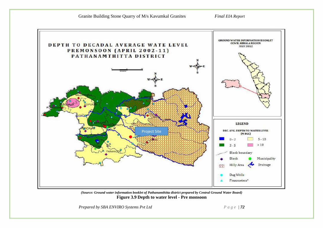
Granite Building Stone Quarry of M/s Kavumkal Granites Final EIA Report
Prepared by SBA ENVIRO Systems Pvt Ltd P a g e | 72
(Source: Ground water information booklet of Pathanamthitta district prepared by Central Ground Water Board)
Figure 3.9 Depth to water level - Pre monsoon
Project Site

Granite Building Stone Quarry of M/s Kavumkal Granites Final EIA Report
Prepared by SBA ENVIRO Systems Pvt Ltd P a g e | 73
(Source: Ground water information booklet of Pathanamthitta district prepared by Central Ground Water Board)
Figure 3.10: Depth to water level- Post monsoon
Project Site

Granite Building Stone Quarry of M/s Kavumkal Granites Final EIA Report
Prepared by SBA ENVIRO Systems Pvt Ltd P a g e | 74
3.4.4 Groundwater Resources
Groundwater in Pathanamthitta district occurs under phreatic condition in the alluvium,
laterites and weathered crystallines. It occurs under semi-confined to confined conditions in
Tertiary sediments and deep-seated fractured aquifers in crystalline rocks.
The important aquifer systems in the district are: The weathered, fissured and fractured
crystalline formations, semi-consolidated Tertiary formations, laterites and the alluvial
formation. The summary of the ground water resource of the Pathanamthitta district is given
Table 3-4.
Table 3-4 Groundwater Resources of Pathanamthitta District
Sr.No Particulars Quantity
1 Net annual groundwater availability 284.11 MCM
2 Annual Groundwater Draft 94.24MCM
3 Projected Demand for Domestic and industrial Uses up to
2025
63.04 MCM
4 Stage of Groundwater Development (%) 33.13% (SAFE)
Source: Groundwater information booklet of Pathanamthitta District
3.4.5 Ground Water Condition
Ground water is a prime natural resource essential for the subsistence of life and is a basic human
need. It is the water present beneath Earth’s surface in soil pore spaces and in the fractures of
rock formations. The occurrence and movement of Ground water is controlled by several factors
such as climate, hydrology, geology, topography, and ecology and soil distribution.
A detailed study has been done to evaluate how the mining will affect the groundwater level of
Athikkayam Village, around 1km radius from the proposed project site. The well census was
carried out in 18 wells around 1km radius in Athikayam village from project site. Data were
collected from the wells is provided in Table 3-5.
Table 3-5 Details of Wells Inventoried in and Around Quarry
Station Code Location Distance
from Mine
Total
Water
Depth
m
Water level
M amsl
Premonsoon Monsoon
GW1 9° 24'40.9"N
76°50'21.08"E 430 m 6.95 6.95 m 1 m
GW2 9° 24'37.40"N
76°50'21.10"E 540 m 6.40 5.7 m 1 m
GW3 9° 24'37.76"N
76°50'30.03"E 560 m 7.40 4.9 1.2

Granite Building Stone Quarry of M/s Kavumkal Granites Final EIA Report
Prepared by SBA ENVIRO Systems Pvt Ltd P a g e | 75
Station Code Location Distance
from Mine
Total
Water
Depth
m
Water level
M amsl
Premonsoon Monsoon
GW4 9° 24'38.93"N
76°50'9.77"E 680 m 7 m 4.7 m 1 m
GW5 9° 24'46.10"N
76°50'17.70"E 340 m 9.15 m 8.8 m 0.50 m
GW6 9° 25'19.50"N
76°50'5.60"E 680 m 8.8 m 8.6 m 1 m
GW7 9° 25'15.25"N
76°50'5.32"E 600 m 6.25 m 5.8 m 1.2 m
GW8 9° 25'5.04"N
76°49'53.00"E 870 m 5.9 m 4.52 m 1 m
GW9 9° 25'6.50"N
76°50'8.40"E 400 m 8.3 m 7.6 m 3 m
GW10 9° 25'22.56"N
76°50'7.72"E 720 m 8.8 m 8.35 m 3.0 m
GW11 9° 25'22.70"N
76°50'21.30"E 610 m 7.15 m 6.15 m 2 m
GW12 9° 25'12.20"N
76°50'26.20"E 330 m 6.5 m 6.3 m 0.7 m
GW13 9° 25'13.10"N
76°50'24.10"E 310 m 6.8 m 6.4 m 1.2 m
GW14 9° 25'26.67"N
76°50'41.22"E 860 m 7.55 m 6.6 m 3 m
GW15 9° 25'23.62"N
76°50'43.72"E 830 m 5.5 m 4.8 m 1.8 m
GW16 9° 24'56.41"N
76°50'56.27"E 920 m 6.25 m 5.8 m 1.2 m
GW17 9° 24'51.49"N
76°50'51.59"E 910 m 5.85 m 4.1 m 1.5 m
GW18 9° 24'44.36"N
76°50'51.59"E 940 m 9.7 m 8.7 m 1 m

Granite Building Stone Quarry of M/s Kavumkal Granites Final EIA Report
Prepared by SBA ENVIRO Systems Pvt Ltd P a g e | 76
Figure 3.11 Wells Inventoried Locations
A total of 18 wells were surveyed and documented for the study. The depth to water level is
found that varying form 4.1m-8.8m below ground level (bgl) during pre-monsoon and varies
from 0.5m-3m bgl during monsoon season. The proposed site is situated in almost top of a
small hillock. As per the scheme of mining, approved by the concerned district geologist, the
excavation for extraction of granite building stone is not going to cross the local ground water
level. Since proper drainage plan has been envisaged, the operation of granite building stone
quarry is not going to affect the local ground water conditions.
3.5 Meteorology
The meteorological data helps for appropriate interpretation of the baseline status of the study
area as well as for input into prediction models to evaluate air quality dispersion. Chronological
data on meteorological parameters also plays an important role in identifying the general
meteorological regime of the region. The year may broadly be divided into four seasons:
• Winter season : December to February
• Pre-monsoon season : March to May
• Monsoon season : June to September
• Post-monsoon season : October to November
3.5.1 Methodology
The methodology adopted for monitoring surface observations is as per the standard norms laid
down by Bureau of Indian Standards (IS: 8829) and India Meteorological Department (IMD).

Granite Building Stone Quarry of M/s Kavumkal Granites Final EIA Report
Prepared by SBA ENVIRO Systems Pvt Ltd P a g e | 77
Automatic Meteorological station has been installed near to the proposed quarry. The
parameters recorded along with frequency of recording are given in Table 3-6.
Table 3-6 Meteorology Parameters Monitoring Frequency
S.N. Parameter Instrument Frequency
1 Wind Speed Automatic Weather Station
Continuous Automatic
hourly average 2 Wind Direction
4 Max. & Min Temperature Wet & Dry Bulb Thermometer Hourly Average
5 Relative Humidity Hygrometer Hourly Average
6 Rainfall Rain Gauge Daily
Table 3-7 Meteorological Data during the study period
Month Temperature (0C) Avg.Relative
Humidity (%)
Wind Speed(m/s)
Max Min Avg Max Min Avg Max Min Avg.
JAN 32.2 22.78 27.7 100 62 78.11 5.4 0 1.96
FEB 32.22 23.89 28.8 100 48 74.26 5.36 0 2.25
MAR 33.89 25 29.67 94 46 70.65 6.26 0 2.40
Figure 3.12 Temperature at Proposed Quarry during Study Period
From the Figure 3.12, it can be observed that highest temperature was observed in the month
of march (i.e., 33.890C) and lowest temperature in January (22.780C). Slightly a gradual
increase in temperature was observed during the study period.
0
5
10
15
20
25
30
35
JAN FEB MAR
Tem
per
atu
re i
n o
C
Study period
Temperature (0C) Max
Temperature (0C) Min
Temperature (0C) Avg

Granite Building Stone Quarry of M/s Kavumkal Granites Final EIA Report
Prepared by SBA ENVIRO Systems Pvt Ltd P a g e | 78
Figure 3.13 Relative Humidity at Proposed Quarry during study Period
Variations in the relative humidity are shown in Figure 3.13. From the figure it is understood
that maximum hourly relative Humidity was observed is 100%. Whereas minimum relative
humidity was observed in march (46%).
Figure 3.14 Wind speed at the proposed quarry during study period
From the figure 3.14, the maximum hourly wind speed reported at the site is 6.26 m/s during
March, and minimum is zero. The predominant wind directions during the study period were
from West & North-West as shown in Figure 3.15. The frequency of 3-4m/s wind is dominating
for the study period. The Highest wind speed is 6.26m/s from the direction North-West.
0
20
40
60
80
100
JAN FEB MAR
Hu
mid
ity i
n %
Study period
Avg.Relative Humidity
(%) Max
Avg.Relative Humidity
(%) Min
Avg.Relative Humidity
(%) Avg
0
1
2
3
4
5
6
7
JAN FEB MAR
Win
d s
pee
d i
n m
/s
Study period
Wind Speed(m/s) Max
Wind Speed(m/s) Min
Wind Speed(m/s) Avg.

Granite Building Stone Quarry of M/s Kavumkal Granites Final EIA Report
Prepared by SBA ENVIRO Systems Pvt Ltd P a g e | 79
Figure 3.15 Windrose Diagram during Study Period
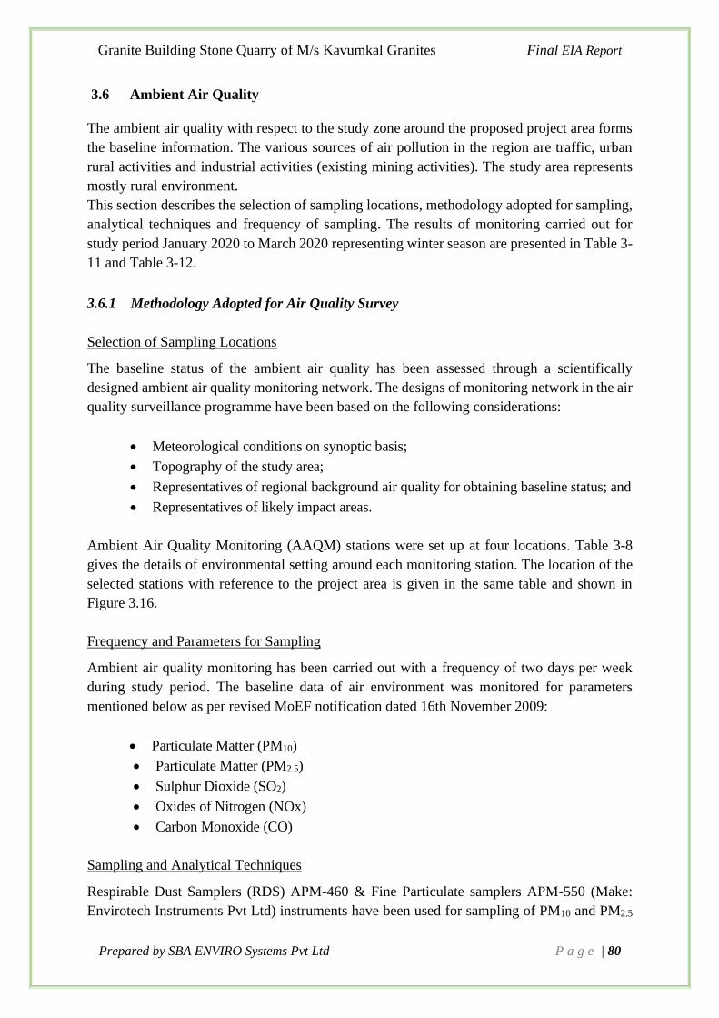
Granite Building Stone Quarry of M/s Kavumkal Granites Final EIA Report
Prepared by SBA ENVIRO Systems Pvt Ltd P a g e | 80
3.6 Ambient Air Quality
The ambient air quality with respect to the study zone around the proposed project area forms
the baseline information. The various sources of air pollution in the region are traffic, urban
rural activities and industrial activities (existing mining activities). The study area represents
mostly rural environment.
This section describes the selection of sampling locations, methodology adopted for sampling,
analytical techniques and frequency of sampling. The results of monitoring carried out for
study period January 2020 to March 2020 representing winter season are presented in Table 3-
11 and Table 3-12.
3.6.1 Methodology Adopted for Air Quality Survey
Selection of Sampling Locations
The baseline status of the ambient air quality has been assessed through a scientifically
designed ambient air quality monitoring network. The designs of monitoring network in the air
quality surveillance programme have been based on the following considerations:
• Meteorological conditions on synoptic basis;
• Topography of the study area;
• Representatives of regional background air quality for obtaining baseline status; and
• Representatives of likely impact areas.
Ambient Air Quality Monitoring (AAQM) stations were set up at four locations. Table 3-8
gives the details of environmental setting around each monitoring station. The location of the
selected stations with reference to the project area is given in the same table and shown in
Figure 3.16.
Frequency and Parameters for Sampling
Ambient air quality monitoring has been carried out with a frequency of two days per week
during study period. The baseline data of air environment was monitored for parameters
mentioned below as per revised MoEF notification dated 16th November 2009:
• Particulate Matter (PM10)
• Particulate Matter (PM2.5)
• Sulphur Dioxide (SO2)
• Oxides of Nitrogen (NOx)
• Carbon Monoxide (CO)
Sampling and Analytical Techniques
Respirable Dust Samplers (RDS) APM-460 & Fine Particulate samplers APM-550 (Make:
Envirotech Instruments Pvt Ltd) instruments have been used for sampling of PM10 and PM2.5

Granite Building Stone Quarry of M/s Kavumkal Granites Final EIA Report
Prepared by SBA ENVIRO Systems Pvt Ltd P a g e | 81
respectively. Gaseous attachments along with APM 460 have been used for gaseous pollutants
like SO2 and NOx.
PM10 (<10m) present in ambient air is drawn through the cyclone of RDS. Coarse and non-
respirable dust (>10m) is separated from the air stream by centrifugal forces acting on the
solid particles. These separated particulates fall through the cyclone’s conical hopper and
collect in the sampling cup placed at the bottom of the cyclone. The dust (<10 microns) forming
the respirable fraction passes through the cyclone and is retained by the filter paper.
PM2.5 (<2.5m) present in ambient air is drawn through the cyclone separator and WINS
Impactor of FPS. Coarse and non-respirable dust (>10m) is separated from the air stream by
centrifugal forces acting on the solid particles at cyclone separator. These separated air pass
through the WINS Impactor and collect particles size between 10m – 2.5m. The dust
(<2.5m) passes through the PTFE filter papers and is retained by the filter paper.
A tapping is provided on the suction side of the blower of RDS to provide suction for sampling
air through a set of impingers. Samples of gases SO2 and NOx are drawn at a flow rate of 1
lpm. The air samples were analysed as per standard methods specified in IS: 5182 and Central
Pollution Control Board (CPCB) guidelines.
Non-Dispersive Infra-Red (NDIR) techniques have been used for the monitoring of Carbon
Monoxide (CO).
The techniques used for ambient air quality monitoring and minimum detectable levels are
given in Table 3-9.
Table 3-8 Details of AAQ Monitoring Locations
Sl
No:
Location Locat
ion
Code
Location
coordinates
Distance
and
Direction
from Mine
Lease area
Zone
(Core/Buf
fer)
Remarks
1
Main Entrance of
proposed quarry
site
A1N1 9°25'07"N
76°50'21"E - Core Zone -
2
Residence of
Joseph, south to the
proposed quarry,
Vellolimala
A2N2 9°24'46.33"N
76°50'17.15"E 330m - SSW
Buffer
Zone
Residential
Area
3
Residential of Anil
Kumar area near to
Valyelimala
A3N3 9°25'32.23"N
76°50'27.55"E 940m - N Buffer Residential
4
Residential area
near to the nearby
quarry M/s
Manimaleth
Crusher Industries
A4N4 9°24'51.00"N
76°51'3.00"E 1.05km E Buffer Residential

Granite Building Stone Quarry of M/s Kavumkal Granites Final EIA Report
Prepared by SBA ENVIRO Systems Pvt Ltd P a g e | 82
Table 3-9 Techniques used For AAQ Analyses
Duration of Sampling
The duration of sampling of PM10, PM2.5, SO2, and NOx was each twenty four hourly continuous
sampling per day and CO was sampled for 8 hours continuous. The monitoring was conducted
for two days in a week for three months. The ambient air quality parameters along with their
frequency of sampling are given in Table 3-10.
Figure 3.16: Ambient Air Quality Sampling locations
Parameters Technique
Technical
protocol
Minimum
detection
Limit
Particulate Matter of size
less than 10 μm (PM10)
Gravimetric Method IS 5182 Part 23 5.0 μg/m3
Particulate Matter of size
less than 2.5 μm (PM2.5)
Gravimetric Method CPCB Guideline 3.0 μg/m3
Sulphur Dioxide Improved West and Gaeke IS 5182 Part 2 5.0 μg/m3
Nitrogen Dioxide Modified Jacob and
Hochheiser
IS 5182 Part 6 5.0 μg/m3
Carbon Monoxide (8hrs) Non Dispersive Infra-Red
Spectroscopy(NDIR)
IS 5182 Part 10 0.1 mg/m3

Granite Building Stone Quarry of M/s Kavumkal Granites Final EIA Report
Prepared by SBA ENVIRO Systems Pvt Ltd P a g e | 83
Figure 3.17 Photographs of Air Sampling Stations
Table 3-10 Parameters and Frequency of Sampling
Parameters Sampling Frequency
Particulate Matter (PM10) 24 hourly sample twice a week for three months
Particulate Matter (PM2.5) 24 hourly sample twice a week for three months
Sulphur dioxide (SO2) 24 hourly samples twice a week for three months
Oxides of Nitrogen (NOx) 24 hourly samples twice a week for three months
Carbon Monoxide (CO) 8 hourly samples twice a week for three months

Granite Building Stone Quarry of M/s Kavumkal Granites Final EIA Report
Prepared by SBA ENVIRO Systems Pvt Ltd P a g e | 84
3.6.2 Presentation of AAQ Data
Various statistical parameters like 98th percentile, average, maximum and minimum values have
been computed from the observed raw data for all the AAQ monitoring stations. The summary
of these results for each location are presented in Table 3-11and Table 3-12. These are compared
with the standards prescribed by Central Pollution Control Board (CPCB) for industrial and rural
/residential zone.

Granite Building Stone Quarry of M/s Kavumkal Granites Final EIA Report
Prepared by SBA ENVIRO Systems Pvt Ltd P a g e | 85
Table 3-11 Summary of Ambient Air Quality Results – Winter Season (2020)
Station
Code
Name of the
Location
PM10 (g/m3) PM2.5 (g/m3) SO2 (g/m3)
Min Max Avg 98th
%le
Min Max Avg 98th
%le
Min Max Avg 98th
%le
A1N1 Main Entrance of
proposed quarry
site
50.68 64.60 58.38 63.91 13.63 19.72 16.78 19.71 6.42 8.74 7.35 8.68
A2N2 Residence of
Joseph, south to
the proposed
quarry,
Vellolimala
50.63 63.82 57.98 63.35 13.42 19.82 16.57 19.20 5.40 9.21 7.05 8.90
A3N3 Residential of
Anil Kumar area
near to
Valyelimala
53.60 62.31 58.92 61.89 13.30 19.72 16.93 19.71 5.90 9.10 7.41 8.97
A4N4 Residential area
near to the
nearby quarry
M/s Manimaleth
Crusher
Industries
50.43 63.80 58.21 62.93 12.30 19.70 16.13 19.49 5.29 8.80 7.27 8.80
NAAQ standards 100 60 80

Granite Building Stone Quarry of M/s Kavumkal Granites Final EIA Report
Prepared by SBA ENVIRO Systems Pvt Ltd P a g e | 86
Table 3-12 Summary of Ambient Air Quality Results – Winter Season (2020)
Station Code Name of the
Location
NOx (g/m3) CO (mg/m3)
Min Max Avg 98th
%le
Min Max Avg 98th
%le
A1N1 Main Entrance of
proposed quarry
site
7.20 9.65 8.43 9.48 0.60 0.90 0.70 0.85
A2N2 Residence of
Joseph, south to
the proposed
quarry, Vellolimala
6.50 9.62 8.01 9.58 0.50 0.90 0.70 0.85
A3N3 Residential of Anil
Kumar area near to
Valyelimala
6.60 10.40 8.27 10.02 0.60 0.90 0.74 0.90
A4N4 Residential area
near to the nearby
quarry M/s
Manimaleth
Crusher Industries
6.59 9.82 8.08 9.69 0.50 0.90 0.75 0.90
NAAQ standards 80 2

Granite Building Stone Quarry of M/s Kavumkal Granites Final EIA Report
Prepared by SBA Enviro Systems Pvt Ltd P a g e | 87
Observations of Primary Data
The observations for winter season 2020 are summarized below:
Particulate Matter (PM10):
A maximum value of 63.82 g/m3 was observed at the A2 and minimum value of 50.43 g/m3
was observed at A4.
Respirable Particulate Matter (PM2.5):
A maximum value of 19.82 g/m3 was observed at A2 and minimum value of 12.30 g/m3 was
observed at A4.
Sulphur Dioxide (SO2):
Maximum concentration of SO2 is observed to be 9.21 g/m3 at A2 and minimum value of 5.29
g/m3 observed at A3.
Oxides of Nitrogen (NOX):
Maximum concentration of NOx is observed to be 10.4 g/m3 at A2 and minimum value of 6.59
g/m3 observed at A2.
Carbon Monoxide (CO):
Maximum concentrations in the region are observed to be 0.9 mg/m3 at all stations and
minimum value of 0.5 mg/m3 observed at A2 & A4 stations.
The overall air quality around the proposed quarry is within the limits of NAAQ standards.
3.7 Water Quality
Selected water quality parameters of surface and ground water resources in the study area have
been studied for assessing the water environment and evaluate anticipated impact of the quarry.
Understanding the water quality is essential in preparation of EIA and to identify critical issues
with a view to suggest appropriate mitigation measures for implementation.
The purpose of this study is to:
• Assess the water quality characteristics for critical parameters;
• Evaluate the impacts on agricultural productivity, habitat conditions, recreational
resources and aesthetics in the vicinity; and
• Predict impact on water quality by this project and related activities.
The information required has been collected through primary surveys and secondary sources.
3.7.1 Methodology
Reconnaissance survey was undertaken, and monitoring locations were finalized based on:
• Drainage pattern
• Location of residential areas representing different activities/likely impact areas;

Granite Building Stone Quarry of M/s Kavumkal Granites Final EIA Report
Prepared by SBA Enviro Systems Pvt Ltd P a g e | 88
• Likely areas, which can represent baseline conditions.
One surface water and two ground water sources in the study area were examined for physico-
chemical and bacteriological parameters in order to assess the effect of quarry and other activities
on surface and ground water. The samples were analyzed essential parameters as per the Drinking
water specification IS 10500: 2012.
Samples for chemical analysis were collected in polyethylene carboys. Samples for
bacteriological analysis were collected in sterilized glass bottles. Selected physico-chemical and
bacteriological parameters have been analysed for projecting the existing water quality status in
the study area. Parameters like temperature, Dissolved Oxygen (DO) and pH were analysed at
the time of sample collection.
The methodology for sample collection and preservation techniques was followed as per the
Standard Operating Procedures (SOP) mentioned in Table 3-13.
Table 3-13 SOP for Water and Wastewater Sampling and Analysis
Parameter Sample Collection Storage/ Preservation
pH at 250C Grab sampling Plastic /glass
container
On site analysis
Odour As above On site parameter
Colour As above Refrigeration,
can be stored for 7 days
Turbidity As above Refrigeration,
can be stored for 7 days
Total Dissolved
Solids
As above Refrigeration, 48 hrs
Total Hardness as
CaCO3
As above Add HNO3 to pH<2, refrigeration;
6 months
Chloride as Cl As above Not required; 28 days
Sulphate as SO4 As above Refrigeration; 28 days
Alkalinity as CaCO3 Plastic container Not required; 6 months
Iron as Fe Plastic containers Refrigeration; 48 hrs
Calcium as Ca Plastic containers only Not required; 28 days
Magnesium as Mg Plastic/ glass containers Refrigeration; 14 days
Analytical Techniques
The sampling and analytical techniques are given in Table 3-14.
Table 3-14 Analytical Techniques for Water and Wastewater analysis
Parameter Method
pH at 250C Cl.2 of IS 3025 (Pt 11):1983, Reaff. 2017
Odour IS 3025 (Pt 5):1983, Reaff. 2012
Colour Cl. 2 of IS 3025 (Pt 4):1983, Reaff. 2017
Turbidity IS 3025 (Pt 10):1984, Reaff. 2017

Granite Building Stone Quarry of M/s Kavumkal Granites Final EIA Report
Prepared by SBA Enviro Systems Pvt Ltd P a g e | 89
Parameter Method
Total Dissolved Solids IS 3025(Pt 16):1984, Reaff. 2017
Total Hardness as CaCO3 Cl. 5 of IS 3025(Pt 21):2009, Reaff. 2014
Chloride as Cl Cl. 2 of IS 3025(Pt 32):1988, Reaff. 2014
Sulphate as SO4 Cl. 4 of IS 3025(Pt 24):1986, Reaff. 2014
Alkalinity as CaCO3 Cl. 8.1 of IS 3025(Pt 23):1986,Reaff. 2014
Iron as Fe Cl. 6 of IS 3025 (Pt 53):2003,Reaff. 2014
Calcium as Ca Cl. 5of IS 3025(Pt 40):1991, Reaff. 2014
Magnesium as Mg Cl. 6 of IS 3025(Pt 46):1994, Reaff. 2014
3.7.2 Water Sampling Locations
Water samples were collected from one surface and two ground water locations. These samples
were taken as grab samples and were analysed for various parameters to compare with the
standards for drinking water as per IS: 10500 for ground and surface water sources. The water
sampling location details are given in Table 3-15 and shown in Figure 3.16.
Table 3-15 Water Sampling Locations
Sl
No
Location Location
Code
Location
coordinates
Distance and
Direction from
Mine Lease
area
Depth of
water Table
1
Open well near to
St. George
Marthoma Church,
Athikkayam
GW 1 9°25'13"N
76°50'24"E 7 Open well
2
Bore well at
Residential of
joseph, Vellolimala
GW 2 9°24'46.33"N
76°50'17.15"E 30 Bore well
3 Pond near to
Madanthamon SW1
9°24'15.88"N
76°50'33.17"E - Pond

Granite Building Stone Quarry of M/s Kavumkal Granites Final EIA Report
Prepared by SBA Enviro Systems Pvt Ltd P a g e | 90
Figure 3.18: Water Sampling Locations
3.7.3 Presentation of Results
The analytical results of surface water and ground water samples are given in Table 3-16 and
Table 3-17. The quality of surface water samples was compared with surface water specification
IS 2296:1982 Class C and ground water samples were compared with drinking water
specification IS 10500:2012 standards.
Table 3-16 Ground Water Quality
Sl
No Parameters Unit Method
Result Require-
ment
(Acceptable
Limit as per
IS
10500:2012)
GW 1 GW 2
1 pH at 250C -
Cl.2 of IS 3025
(Pt 11):1983,
Reaff. 2012
6.52 6.71 6.5-8.5
2 Odour -
IS 3025 (Pt
5):1983, Reaff.
2012
Agreeable Agreeable Agreeable
3 Colour
Hazen
Units,
max
Cl. 2 of IS 3025
(Pt 4):1983,
Reaff. 2012
4.0 4.0 5.0

Granite Building Stone Quarry of M/s Kavumkal Granites Final EIA Report
Prepared by SBA Enviro Systems Pvt Ltd P a g e | 91
Sl
No Parameters Unit Method
Result Require-
ment
(Acceptable
Limit as per
IS
10500:2012)
GW 1 GW 2
4 Turbidity NTU,
max
IS 3025 (Pt
10):1984, Reaff.
2012
0.60 0.60 1.0
5
Total
Dissolved
Solids
mg/l,
max
IS 3025(Pt
16):1984, Reaff.
2006
58 54 500
6
Total
Hardness as
CaCO3
mg/l,
max
Cl. 5 of IS
3025(Pt 21):2009,
Reaff. 2012
15.52 13.58 200
7 Chloride as
Cl
mg/l,
max
Cl. 2 of IS
3025(Pt 32):1988,
Reaff. 2009
26.01 23.22 250
8 Sulphate as
SO4
mg/l,
max
Cl. 4 of IS
3025(Pt 24):1986,
Reaff. 2009
2.74 3.04 200
9 Alkalinity as
CaCO3
mg/l,
max
Cl. 8.1 of IS
3025(Pt 23):1986,
Reaff. 2009
6.24 8.32 200
10 Iron as Fe mg/l,max
Cl. 6 of IS 3025
(Pt 53):2003,
Reaff. 2009
0.04 0.05 0.3
11 Calcium as
Ca mg/l,max
Cl. 5of IS
3025(Pt 40):1991,
Reaff. 2009
3.89 3.11 75
12 Magnesium
as Mg mg/l,max
Cl. 6 of IS
3025(Pt 46):1994,
Reaff. 2009
1.41 1.41 30
13
E.coli or
thermotolera
nt coliform
bacteria
IS 1622 : 1981, Reaff.2009 Absent Absent
Shall not be
detectable in
any 100 ml
sample

Granite Building Stone Quarry of M/s Kavumkal Granites Final EIA Report
Prepared by SBA Enviro Systems Pvt Ltd P a g e | 92
Table 3-17 Surface water Quality
Sl
No Parameters Unit Method
Result Requirement
(Acceptable
limit as per IS
2296:1982
Class E)
SW 1
1. pH at 250C ---
Cl.2 of IS 3025 (Pt
11):1983, Reaff.
2017
6.83 6.0-8.5
2. Chloride as Cl mg/l
Cl. 2 of IS 3025(Pt
32):1988, Reaff.
2014
11.15 600
3. Sulphate as SO4 mg/l
Cl. 4 of IS 3025(Pt
24):1986, Reaff.
2014
17.74 1000
4.
Conductivity μS/cm
IS 3025 (Pt
14):2013 144 2250
5. Free CO2 mg/l IS 3025 (Pt 61):
2008 6.30 --
6. Total Dissolved
Solids mg/l
IS 3025(Pt
16):1984, Reaff.
2017
86 2100
7. Silica as SiO2 mg/l
Cl. 3 of IS 3025 (Pt
35):1988, Reaff.
2014
1.32 --
8. Dissolved
Oxygen mg/l,min
Cl. 4.1 & 4.2 of IS
3025 (Pt 38):1989,
Reaff. 2014
5.10 --
9.
Biochemical
Oxygen Demand
@ 20°C for 5
days
mg/l,max
APHA 5210 B
4.30 --
10. Free Ammonia
mg/l
Cl. 2.3 of IS
3025(Pt 34):1988,
Reaff. 2014
0.18 --
11.
Total coliform
bacteria
(MPN/100ml)
nos IS: 1622:1981,
Reaff. 2014 60 --
3.7.4 Observations
Surface water quality station
All parameters are within desirable limits for all stations
Ground water quality 2 stations

Granite Building Stone Quarry of M/s Kavumkal Granites Final EIA Report
Prepared by SBA Enviro Systems Pvt Ltd P a g e | 93
All parameters are within desirable limits for all stations.
Figure 3.19 Water Sampling Photographs
3.8 Noise Level Survey
The environmental assessment of noise from the proposed quarrying activity and vehicular
traffic can be undertaken by taking into consideration various factors like potential damage to
hearing, physiological responses, and annoyance and general community responses.
The impact of noise sources on surrounding community depends on:
• Characteristics of noise sources (instantaneous, intermittent or continuous in nature).
It can be observed that steady noise is not as annoying as one which is continuously
varying in loudness;
• The time of day at which noise occurs, for example high noise levels at night in
residential areas are not acceptable because of sleep disturbance; and
• The location of the noise source, with respect to noise sensitive land use, which
determines the loudness and period of exposure.
The environmental impact of noise can have several effects varying from Noise Induced Hearing
Loss (NIHL) to annoyance depending on loudness of noise.
The main objective of noise monitoring in the study area is to establish the baseline noise levels
and assess the impact of the total noise expected to be generated by blasting and other quarrying
activities.
3.8.1 Identification of Sampling Locations
A preliminary reconnaissance survey has been undertaken to identify the major noise generating
sources in and around the quarry site area. Noise at different noise generating sources has been
identified based on the activities in the village area and ambient noise due to traffic.
The noise monitoring has been conducted for determination of ambient noise levels at four
locations in the study area for Winter season 2020. The noise levels at each location were
recorded for 24 hours. The environment setting of noise monitoring locations in four areas is
given in Table 3-18 and shown in Figure 3.20.

Granite Building Stone Quarry of M/s Kavumkal Granites Final EIA Report
Prepared by SBA Enviro Systems Pvt Ltd P a g e | 94
3.8.2 Method of Monitoring
Sound Pressure Level (SPL) measurements were measured at all locations. The readings were
taken for every hour for 24 hours. The day noise levels have been monitored during 6 am to 10
pm and night levels during 10 pm to 6 am at all the locations covered in 10 km radius of the study
area.
Table 3-18 Details of Noise Monitoring Locations
Sl
No
Location Locati
on
Code
Location
coordinates
Distance and
Direction from
Mine Lease
area
Zone
(Core/
Buffer)
1 Main Entrance of
proposed quarry site N1
9°25'07"N
76°50'21"E - Core Zone
2
Residence of Joseph,
south to the proposed
quarry, Vellolimala
N2 9°24'46.33"N
76°50'17.15"E 330m - SSW
Buffer
Zone
3
Residential of Anil
Kumar area near to
Valyelimala
N3 9°25'32.23"N
76°50'27.55"E 940m - N Buffer
4
Residential area near to
the nearby quarry M/s
Manimaleth Crusher
Industries
N4 9°24'51.00"N
76°51'3.00"E 1.05km E Buffer
3.8.3 Methodology of Data Generation
Instrument Used for Monitoring
Noise levels were measured using integrated sound level meter manufactured by Cygnet
(Baseline Technology). The integrating sound level meter is an integrating/logging type with
Octave filter attachment (model OB-100) with frequency range of 31.5 to 16000 Hz. This
instrument is capable of measuring the Sound Pressure Level (SPL), Leq and octave band
frequency analysis.
Method of Monitoring
Noise level monitoring was carried out continuously for 24 hours with one hour interval starting
at 06:00 hrs to 06:00 hrs next day. The noise levels were monitored on working days only and
not on Saturdays, Sundays and public holidays. During each hour, Leq were directly computed
by the instrument based on the sound pressure levels. Lday (Ld) and Lnight (Ln) values were
computed using corresponding hourly Leq of day and night respectively. Monitoring was carried
out at ‘A’ response and fast mode.
Equivalent Sound Pressure Level (Leq):
The Leq is the equivalent continuous sound level, which is equivalent to the same sound energy
as the actual fluctuating sound measured in the same period. This is necessary because sound
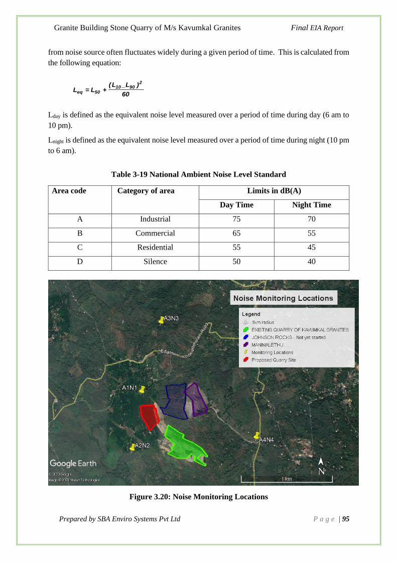
Granite Building Stone Quarry of M/s Kavumkal Granites Final EIA Report
Prepared by SBA Enviro Systems Pvt Ltd P a g e | 95
from noise source often fluctuates widely during a given period of time. This is calculated from
the following equation:
60
)_LL(LL
29010
50eq +=
Lday is defined as the equivalent noise level measured over a period of time during day (6 am to
10 pm).
Lnight is defined as the equivalent noise level measured over a period of time during night (10 pm
to 6 am).
Table 3-19 National Ambient Noise Level Standard
Area code Category of area Limits in dB(A)
Day Time Night Time
A Industrial 75 70
B Commercial 65 55
C Residential 55 45
D Silence 50 40
Figure 3.20: Noise Monitoring Locations

Granite Building Stone Quarry of M/s Kavumkal Granites Final EIA Report
Prepared by SBA Enviro Systems Pvt Ltd P a g e | 96
Figure 3.21 Photographs of Noise Monitoring
3.8.4 Presentation of Results
The statistical analysis is done for measured noise levels at four locations. The parameters are
analysed for Leq. The statistical analysis results are given in Table 3-20.
Table 3-20 Noise Levels [dB (A)] in the Study Area
Ambient Noise Level at Location (Leq dB(A)) Category of
Area
CPCB
Standard (Leq
dB(A)) Location N1 N2 N3 N4
Day Time 52.5 50.6 51.8 53.1 Residential
Area
55
Night Time 40.4 41.8 42.3 40.8 45
• Noise level-Day time & Night time
Noise levels were monitored in the project site and villages within the study area. The noise
levels ranged between 50.6 to 53.1 dB (A) during day time and noise levels ranged between
40.4 to 42.3 dB (A) during night time.

Granite Building Stone Quarry of M/s Kavumkal Granites Final EIA Report
Prepared by SBA Enviro Systems Pvt Ltd P a g e | 97
3.9 Ecology and Biodiversity
3.9.1 Introduction
Ecological evaluation aims at developing and applying methodologies to assess the relevance
of an area for nature conservation. As such, it is to support the assessment of the impact of a
proposed development by providing guidance on how to describe the ecological features within
the area affected, how to value them, and how to predict the value losses caused by the
development. The evaluation of the ecological significance of an area can be undertaken from
different perspectives and consequently with different objectives. One of such perspectives
focuses on the conservation of the biological diversity or biodiversity. Among the human
activities that pose the highest threat to the conservation of biodiversity are the developmental
projects in particular. Such projects represent artificial elements that cut through the landscape
and interfere with the natural habitat and its conditions by emissions that may be solid, liquid
and or gaseous. This in turn influences the abundance and distribution of plant and animal
species, i.e., the biodiversity of the areas impacted.
Most of the background data needs to be acquired from the governmental agencies or the
scientific literature. This information is typically complemented by field visit, site surveys and
sample collection. The description of the actual ecological assessment provided by the
ecological baseline study serves to set a reference for the subsequent impact analysis. The study
is carried out for both core zone and buffer zone.
3.9.2 Objectives of the study
The present study was undertaken with the following objectives:
• To assess the nature and distribution of vegetation in and around the project site
• To evaluate the distribution of animal life spectra, including avifauna and butterflies,
available in this area
• To ascertain whether the proposed project will have any adverse impact on the ecology in
and around project areas, and suggest mitigation measures, if needed.
3.9.3 Brief Description of the Project Area
Biodiversity assessment was done for both the project core zone and buffer zone. The core
zone is divided into two as mining area and 7.5m Greenbelt barrier zone. A major portion of
the proposed site is visible for exposed rocks. The vegetation can be mainly seen in the green
belt barrier zone. The area is surrounded by Hevea brasiliensis cultivation and is having higher
growth of Holarrhena pubescens and Terminalia paniculata. Advanced regeneration of
Terminalia paniculata is observed in the site.

Granite Building Stone Quarry of M/s Kavumkal Granites Final EIA Report
Prepared by SBA Enviro Systems Pvt Ltd P a g e | 98
A view from Site
3.9.4 Biodiversity Survey Methods
Plants
Within the proposed project site, sample plots of 10 m X 10 m were laid along
altitudinal gradient. Within each sample plot all woody species (trees, shrubs) were recorded.
Herbaceous and graminoid species were recorded in a 1 m X 1 m subplot laid within the larger
plot.
Mammals
For Mammals assessment, both direct and indirect faunal survey methodologies were
employed. By direct observation, rapid survey of the wildlife resource of the area has been
assessed by selecting representative vantage points in five observations zones. Walking along
transects lines was also applied. In case of indirect observation, main emphasis has been given
for identifying mammals’ sign, like analyzing the animals foot print, burrows, skeleton, fecal
materials, hairs, horn etc. and visiting the dens, caves. Since most mammals are secretive or
nocturnal, they are seldom seen by the casual observer. But their presence is often revealed by
tracks, burrows, nests, evidence of feeding and its residues, footprints, tail markings, fecal
material or scats. In addition to the field survey, discussions were conducted with the local
people.
Birds
Birds were recorded along six line transects measuring 500m–1 km, systematically selected.
All bird species seen or heard were recorded as present, irrespective of their distance from

Granite Building Stone Quarry of M/s Kavumkal Granites Final EIA Report
Prepared by SBA Enviro Systems Pvt Ltd P a g e | 99
transects. As the primary objective of the study was to record the species present in the area,
quantitative data, such as the number of individuals or the frequency of occurrence along each
transect, were not collected. Birds were identified using binoculars and a field guide (Redman
et al. 2011).
Butterflies
The transect method suggested by Ishii (1993) and Pollard (1977) were followed for the survey
and counted while walking along the selected transect route in the habitat.
Herpeto fauna (Reptiles and Amphibians)
The survey on the herpeto fauna was conducted at different micro-habitats during the day and
in the evening. GPS records were taken to outline the area covered during the field survey and
to show specific points where specimens were encountered. Photos were taken using digital
camera.
Equipment/Sources Used
➢ IUCN Red data Book (https://www.iucnredlist.org/)
➢ Canon Digital Camera EOS 760 D
➢ Binocular: Olympus 8-16 * 40 Zoom
➢ Handbook of Butterflies, Odonates, Reptiles, Vertebrates, Mammals etc.
Baseline data were collected for flora and fauna during the field visit and presented in the
report. Each plot selected randomly for sampling. The assessment was done in both greenbelt
barrier zone (7.5m wide) and mining area of the proposed mining area. The data is not
extrapolated to get the number of trees to be cut. Summary of the survey has given below.
Table 3-21 Plot wise details of Tree species
Botanical Name P1 P2 P3 P4 P5 P6
Hevea brasiliensis (Willd. ex Juss.) Muell.-Arg. 12 8 14 10 9 14
Strychnos nux-vomica L. 0 1 0 0 0 0
Alstonia scholaris (L.) R. Br. 1 0 0 1 2 1
Ficus exasperata Vahl. 0 0 1 0 0 0
Cassia fistula L. 0 1 0 0 0 0
Ficus hispida L.f. 0 0 0 0 1 0
Tectona grandis L.f. 0 1 0 2 0 0
Gliricidia sepium (Jacq.) Walp. 1 0 1 0 0 0
Terminalia paniculata Roth 2 1 0 0 1 0
Artocarpus hirsutus Lam. 0 0 0 0 0 1
Macaranga peltata (Roxb.) Müll.Arg. 2 4 2 3 2 2
Caryota urens L. 1 0 1 0 1 0
The biodiversity indices estimated for the purpose of understanding richness,
evenness and abundance of the flora are given below (Table 4).

Granite Building Stone Quarry of M/s Kavumkal Granites Final EIA Report
Prepared by SBA Enviro Systems Pvt Ltd P a g e | 100
Table 3-22 Biodiversity Indices estimated for the study area
SI No: Biodiversity Index Valu
e
1 Shannon- Weiner Index 1.231
2 Simpson Index 0.051
The Shannon- Weiner index calculated for the study is 1.231, evidently it is small value when
compared to other natural ecosystems such as Tropical wet evergreen forest (2.38 - 3.16), Moist
deciduous forest (2.15- 2.89), Dry deciduous forest (2.01- 2.45), Shola forest (2.75- 3.16) etc.
Similarly, in the case of Simpson index also, the value is 0.051 only. While we compare with
other tropical natural woody ecosystems, it is a very small value. The value of Simpson’s index
observed for various forest types are Tropical wet evergreen region (0.897- 0.912), Moist
deciduous forest (0.589- 0.868), Dry deciduous forest (0.675- 0.847) and Shola forests (0.879-
0.948). The values of indices indicated that the diversity, richness and dominance of floral
community in the study are very low on comparing with other natural woody ecosystems.
Bray Curtis Cluster analysis was also performed to grouping quadrates based on the similarity
of their plant composition. The dendrogram that illustrated the relationships between all the
samples based on a defined measure of similarity is given below.
Figure 3.22 Bray Curtis Cluster diagram to show the similarity of trees at different
sampling locations
The interpretation of dendrogram revealed that the Quadrates (Q) 1 and Q 4 (Clade 1), Q 6 and
10 (Clade 2), Q 2 and 9 (Clade 3), Q 5, 8 and 11 (Clade 4) showed high similarity in floral
community structure. The vertical analysis of the dendrogram revealed that the clades didn’t

Granite Building Stone Quarry of M/s Kavumkal Granites Final EIA Report
Prepared by SBA Enviro Systems Pvt Ltd P a g e | 101
have much similarity in the floral community structure. Especially the Clade 3 showed very
high difference in floral community structure than other Clades. Hence the dissimilarity value
of 0.75 revealed that the floral community structures among the quadrates are highly dissimilar.
The high dissimilarity among floral community further revealed high disturbance status of the
ecosystem and anthropogenic influence on changing floral community structure.
3.9.5 Floral Aspects
Table 3-23 List of Trees within the Core Zone
Sl.
No
.
Botanical
Name
Comm
on
Name
Family
Habitat Distributio
n
Numb
er
Status
1
Hevea
brasiliensi
s (Willd.
ex Juss.)
Muell.-Arg.
Rubbe
r
Euphorbiac
eae
Cultivated
Native of
Tropical
America
1750
Aprox
.
Exotic
2 Strychnos
nux-vomica
Kanjira
m
Loganiaceae Moist and
dry
deciduous
forests, also
in the
plains
Indo-
Malesia 1
3
Alstonia
scholaris
(L.) R. Br.
Ezhila
mpala
/Devil
Tree
Apocynacea
e
Moist
deciduous
forests and
sacred
groves, also
in the
plains
South and
South East
Asia to
Australia
5
4
Ficus
exasperata
Vahl.
Parakam
Moraceae
Moist
deciduous
forests, also
in the
plains
East Africa,
Arabia, India
and Sri Lanka
1
5
Cassia
fistula L.
Kanikko
nna
Caesalpiniac
eae
Found in
deciduous
forests from
plains to
1400m.
often
planted
along the
roadsides.
Indo- Malesia
1
Eruma
nakku/
Paraka
Moist
deciduous
and semi-
Indo- Malesia

Granite Building Stone Quarry of M/s Kavumkal Granites Final EIA Report
Prepared by SBA Enviro Systems Pvt Ltd P a g e | 102
6 Ficus
hispida L.f.
m/Tho
ndither
akam
Moraceae evergreen
forests, also
in the plains
to Australia 1
7
Tectona
grandis L.f.
Thekku
Verbenacea
e
Moist
deciduous
forests, also
raised in
plantations
South and
South East
Asia
3
Exotic
8
Gliricidia
sepium
(Jacq.)
Walp.
Seemak
onna
Leguminosa
e
Cultivated in
fields and
along fences
Native of
South
America;
introduced
and widely
grown in India
2
9
Terminalia
paniculata
Roth
Maruth
Combretace
ae
Moist and
dry
deciduous
forests, also
in the
plains
Peninsular
India
4
Ende mic to
Peninsular
India
10
Artocarpus
hirsutus
Lam.
Anjili
Moraceae
Semi-
evergreen
and moist
deciduous
forests, also
in the
plains
Southern
Western Ghats
1
Endemic
to
Southern
Western
Ghats
11
Macaranga
peltata
(Roxb.)
Müll.Arg.
Vatta
Euphorbiace
ae
Moist
deciduous
and
secondary
forests, also
in the
plains
India, Sri
Lanka and
Andamans
15
12
Caryota
urens L.
Choo
nda/C
hoon
dappa
na
Arecaceae
Evergreen
forests, also
in the plains
Indo-
Malaysia
3

Granite Building Stone Quarry of M/s Kavumkal Granites Final EIA Report
Prepared by SBA Enviro Systems Pvt Ltd P a g e | 103
Table 3-24 List of Saplings within the Core Zone
Sl.
N
o.
Botanical
Name
Common
Name
Family
Habitat Distributio
n
Status
1
Ficus
hispida L.f.
Erumanakku/
Parakam/
Thonditherakam
Moraceae
Moist
deciduous
and semi-
evergreen
forests,
also in the
plains
Indo-
Malesia to
Australia
2
Macaranga
peltata
(Roxb.)
Müll.Arg.
Vatta
Euphorbiaceae
Moist
deciduous
and
secondar y
forests,
also in the
plains
India, Sri
Lanka and
Andaman s
3
Xylia
xylocarpa
(Roxb.)Taub.
Irul
Mimosaceae
Moist
deciduous
forests,
also in the
plains
Indo- Malesia
4
Gliricidia
sepium (Jacq.)
Walp.
Seemakonna
Leguminosae
Cultivated
in fields
and along
fences
Native of
South
America;
introduce d
and widely
grown in
India
5
Tectona
grandis L.f.
Thekku
Verbenaceae
Moist
deciduous
forests,
also raised
in
plantation
South and
South East
Asia
6
Caryota urens
L.
Choonda/
Choondappana
Arecaceae
Evergree
n forests,
also in
the
plains
Indo-
Malaysia
7
Artocarpus
heterophyllus
Plavu
Moraceae
Evergreen
and semi-
evergreen
forests,
also
Widely
cultivated in
the tropics,
origin is
probably

Granite Building Stone Quarry of M/s Kavumkal Granites Final EIA Report
Prepared by SBA Enviro Systems Pvt Ltd P a g e | 104
Lam. widely
cultivated
South India
8
Alstonia
scholaris (L.)
R. Br.
Ezhilampala/Devil
Tree
Apocynaceae
Moist
deciduous
forests and
sacred
groves,
also in the
plains
South and
South East
Asia to
Australia
9
Olea dioica
Roxb.
Irippa
Oleaceae
Semi-
evergreen
and moist
deciduous
forests,
also in the
plains
India
10
Trema
orientalis (L.)
Bl.
Pottaama
Ulmaceae
Dry and
moist
deciduou
s forests,
also in
the plains
Tropical
Africa, Asia
and Australia
11
Terminalia
paniculata
Roth
Maruth
Combretaceae
Moist and
dry
deciduous
forests,
also in the
plains
Peninsular
India
Endemic to
Peninsular
India
12
Cassia fistula
L.
Kanikkonna
Caesalpiniaceae
Found in
deciduous
forests
from
plains to
1400m.
often
planted
along the
roadsides.
Indo- Malesia
13 Artocarpus
hirsutus Anjili Moraceae Semi-
evergreen
and moist
deciduous
forests,
also in the
plains
Southern
Western
Ghats
Endemic to
Southern
Western
Ghats
Evergreen
and semi-
evergreen
forests

Granite Building Stone Quarry of M/s Kavumkal Granites Final EIA Report
Prepared by SBA Enviro Systems Pvt Ltd P a g e | 105
14 Mangifera
indica L.
Mavu Anacardiaceae and also
widely
cultivated
Indo-
Malaysia
15
Terminalia
catappa L.
Badam
Combretaceae
Plains,
Cultivated
Malesia to
North
Australia
and
Polynesia,
commonly
planted in
the tropics
Table 3-25 List of Shrubs within the Core Zone
Sl.
No
.
Botanical
Name
Common
Name
Family
Habitat
Distributio
n
Status
1
Brineya
retusa
Aattacherukol
a,
Phyllanthacea
e
Dry
Evergreen to
Dry
Deciduous
Forests
Sri Lanka
to Indo-
China
2
Acacia
pennata (L.)
Willd
Karincha
Leguminosae Moist
deciduous
forest
Paleotropics
3
Grewia
nervosa
(Lour.)
Panigrahi.
Cherikkotta
Malvaceae
Semi-
evergreen
forests,
sacred
groves and
scrub
jungles
Tropical
Asia
4 Helicteres
isora
Edampiri-
Valampiri
Malvaceae Deciduous
forests,
also in
plantation
s and
plains
Indo-
Malesia,
China and
Australia
5
Chassalia
curviflora
(Wall.)
Thwaites
Rubiaceae
Degraded
forests
Indo-
Malesia
6
Lantana
camara L.
Kongini
Verbenaceae Most
aggressive
weed of
disturbed
ground
from
plains to
Native of
tropical
America,
Widely
naturalised
in
tropics
Exotic/Invasiv
e Species
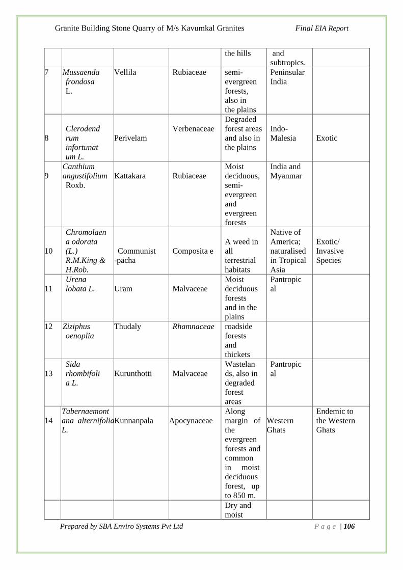
Granite Building Stone Quarry of M/s Kavumkal Granites Final EIA Report
Prepared by SBA Enviro Systems Pvt Ltd P a g e | 106
the hills and
subtropics.
7 Mussaenda
frondosa
L.
Vellila Rubiaceae semi-
evergreen
forests,
also in
the plains
Peninsular
India
8
Clerodend
rum
infortunat
um L.
Perivelam
Verbenaceae
Degraded
forest areas
and also in
the plains
Indo-
Malesia
Exotic
9
Canthium
angustifolium
Roxb.
Kattakara
Rubiaceae
Moist
deciduous,
semi-
evergreen
and
evergreen
forests
India and
Myanmar
10
Chromolaen
a odorata
(L.)
R.M.King &
H.Rob.
Communist
-pacha
Composita e
A weed in
all
terrestrial
habitats
Native of
America;
naturalised
in Tropical
Asia
Exotic/
Invasive
Species
11
Urena
lobata L.
Uram
Malvaceae
Moist
deciduous
forests
and in the
plains
Pantropic
al
12 Ziziphus
oenoplia
Thudaly Rhamnaceae roadside
forests
and
thickets
13
Sida
rhombifoli
a L.
Kurunthotti
Malvaceae
Wastelan
ds, also in
degraded
forest
areas
Pantropic
al
14
Tabernaemont
ana alternifolia
L.
Kunnanpala
Apocynaceae
Along
margin of
the
evergreen
forests and
common
in moist
deciduous
forest, up
to 850 m.
Western
Ghats
Endemic to
the Western
Ghats
Dry and
moist

Granite Building Stone Quarry of M/s Kavumkal Granites Final EIA Report
Prepared by SBA Enviro Systems Pvt Ltd P a g e | 107
15 Hibiscus
hispidissimus
Griff.
Matthippuli Malvaceae deciduous
forests, also
in the
plains
Paleotropics
16
Ficus
heterophylla
Vallitheraka m
Moraceae
Deciduous
forests
along river
banks.
Indo-
Malesia
and
China
Table 3-26 List of Herbs within the Core Zone
Sl.
No.
Botanical
Name
Common
Name
Family
Habitat
Distributi
on
Status
1
Spermacoce
latifolia
Aubl.
Vellatharavu
/
Tharavu/Pac
hhapalla
Rubiaceae
Moist and dry
deciduous
forests and
waste places
Native of
Tropical
America;
now
established
in Tropical
Africa
and Asia
Exotic
2
Mimosa
pudica L.
Thottavadi
Leguminosae
Common on
moist and
ungrazed
places. Near
riverbanks,
bunds of
arable lands,
fallow lands
and water
courses.
Native of
South
America,
now
pantropic
al.
Exotic
3
Pennisetum
orientale
Rich.
Poaceae
Cultivated as
fodder grass,
often found
running wild
Central
Asia and
North
Africa
4
Stachytarph
eta
jamaicensis
(L.) Vahl
Verbenaceae
Dry and moist
deciduous
forests, also in
the plains
Pantropical
5
Cleome
rutidosperm
a DC.
Neelavela
Cleomaceae
In coastal areas Pantropical
6
Ageratum
conyzoides
Appa
Compositae
Most abundant
weed of
disturbed ground
and fallows,
damp places and
Pantropical
Invasiv
e
Species

Granite Building Stone Quarry of M/s Kavumkal Granites Final EIA Report
Prepared by SBA Enviro Systems Pvt Ltd P a g e | 108
L. forest
undergrowth.
7
Peperomia
pellucida (L.)
Kunth.
Mashitandu
Chedi
Piperaceae
Degraded forest
areas and
wastelands
Native of
Tropical
America;
now
Pantropic
al
Exotic
8
Acmella
paniculata
(Wall. ex
DC.)
R.K.Jansen
Compositae
Frequently found
in boggy ground,
margins of
ponds, marshes,
along water
courses and in
rice
fields.
Indo-
Malesia,
America and
New Guinea
9
Naregamia
alata Wight &
Arn.
Nilanaragam
Meliaceae
Moist deciduous
forests, also in
the plains
Peninsula r
India
10
Euphorbia
thymifolia L.
Chitrapala,
Nilappala
Euphorbiaceae
Riverbeds in
moist deciduous
forests, also in
plains
Tropical Asia
11
Desmodium
triflorum
Cherupalladi
Fabaceae
Grasslands and
moist deciduous
forests, also in
plains
Indo- Malesia
and Australia
12
Emilia
sonchifolia
(L.) DC.
Muyalchevian
compositae
Dry and moist
deciduous
forests, also in
the plains
Tropical and
Subtropical
Africa and
Asia
Exotic
13
Scoparia
dulcis L.
Kallurukki
Plantaginaceae
Wasteplaces
Native of
Tropical
America;
now
Pantropical
Exotic
14
Vernonia
cinerea (L.)
Less. Puvankurunal
Compositae
Deciduous
forests, also in
the plains
Pantropics Exotic
15
Axonopus
compressus
(Sw.)
P.Beauv.
Kaalappullu/
Carpet Grass
Poaceae
Dry and moist
deciduous
forests, waste
lands and
paddy fields
Tropics and
subtropics
16
Laportea
interrupta
Anachorian
Urticaceae
Degraded
deciduous
forests, also in
the plains
Paleotropics

Granite Building Stone Quarry of M/s Kavumkal Granites Final EIA Report
Prepared by SBA Enviro Systems Pvt Ltd P a g e | 109
17
Synedrella
nodiflora (L.)
Gaertn.
Mudianpacha
Compositae
Deciduous
forests, also in
the plains
Native of
West Indies;
naturalised in
India, China,
Malesia and
Polynesia
Invasive
Species
18
Phyllanthus
amarus
Schum. &
Thonn.
Keezharnelli/P
hyllanthus
Phyllanthaceae
Degraded moist
deciduous, forest
plantations and
also in plains
Tropics
Medicina
l
19
Tragia
involucrata Choriyanam Euphorbiaceae Wastelands
India and Sri
Lanka
20
Elephantopus
scaber L.
Aanachuvadi
Compositae
Moist deciduous
forests, also in
the plains
Pantropical
21
Sida acuta
Burm.f.
Kurunthotti
Malvaceae
Dry and moist
deciduous
forests, also
in the plains
Pantropical
22
Pilea
microphylla
(L.) Liebm.
Gunpowder
Plant/Rock
weed
Urticaceae
Grown as garden
plant, often
found as an
escape
South
America;
now
introduced
into other
tropical
regions
Exotic
Table 3-27 List of Climbers within the Core Zone
Sl.
No
.
Botanical
Name
Common
Name
Family
Habitat
Distributi
on
Status
1
Calycopteris
floribunda
(Roxb.) Lam. ex
Poir.
Pullani
Combretaceae
Moist deciduous
forest, also in
the plains
Indo-
Malesia
2
Pueraria
phaseoloides
(Roxb.) Benth.
Thotta-payar
Leguminosae
Along margins
of cultivate
d lands
Tropical
Asia
Exotic
/
Invasi-
ve
species
Mikania
Common along
foothills, lower
slopes, scrub
jungles even in
poor soils, on
Tropical
and

Granite Building Stone Quarry of M/s Kavumkal Granites Final EIA Report
Prepared by SBA Enviro Systems Pvt Ltd P a g e | 110
3
micrantha
Kunth Vayara
Compositae
bare exposed
slopes.
subtropical
regions of
the world.
Invasiv
e
4
Cyclea peltata
(Lam.) Hook.
f. & Thoms.
Padathali
Menispermacea
e
Semi- evergreen
and evergreen
forests, also in
the plains
India and Sri
Lanka
5 Merremia vitifolia
(Burm. f.) Hallier f.
Manja kolambi
valli
Convolvulacea
e
Degraded forest
areas and also in
the plains
Indo- China
and China
Invasive
species
6
Pothos scandens L.
Paruvakodi
Araceae
Evergreen
forests, waste
places and sacred
groves
India to
Malesia and
Madagascar
7
Centrosema
pubescens
Benth.
Kattupayar/
Butterfly Pea Leguminosae
Cultivated
Native of
Tropical
America
Exotic
8
Dendrophthoe
falcata (L.f.)
Ettingsh.
Ittikkanni
Loranthaceae
Found in foothill
scrub jungles and
deciduous forests from plains to 1000m.
India, Sri
Lanka,
Thailand,
Indo- China
and Australia.
9
Ichnocarpus frutescens (L.) R.Br.
Palvalli
Apocynaceae
Moist and dry
deciduous
forests, also in
the plains
Indo- Malesia and Australia
10
Smilax zeylanica
L.
Valiyakanni/Ar
ik anni
Smilacaceae
Moist deciduous
and semi-
evergreen
forests, also in
the plains
Indo- Malesia
11
Piper nigrum
L. var.nigrum
Kurumulaku
Piperaceae
Evergreen and
semi- evergreen
forests, also
cultivated
Peninsular
India and Sri
Lanka,
cultivated
elsewhere
12
Mukia maderaspata
na (L.) M.Roem.
Kasappuchedi
Cucurbitaceae
Deciduous
forests, also in
the plains
Paleotropics
Semi-evergreen,
moist deciduous
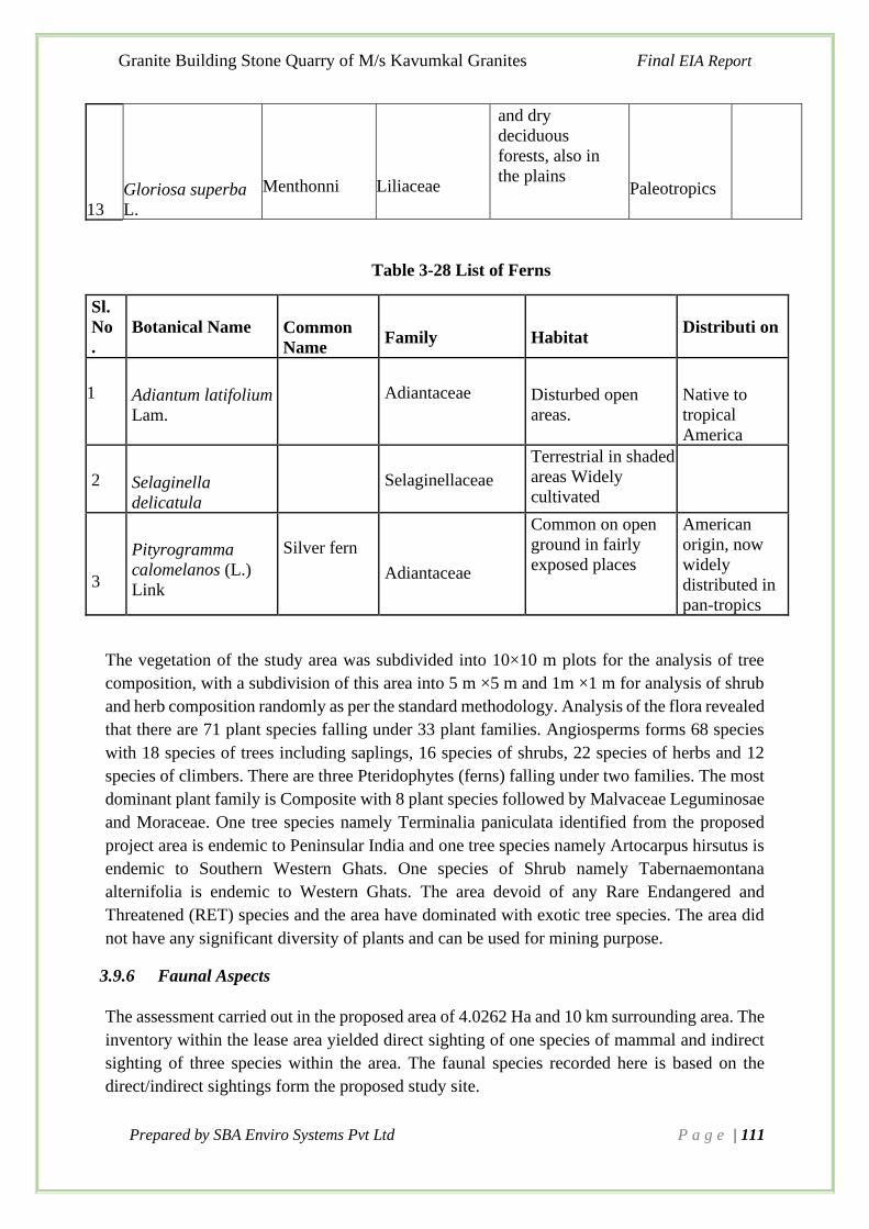
Granite Building Stone Quarry of M/s Kavumkal Granites Final EIA Report
Prepared by SBA Enviro Systems Pvt Ltd P a g e | 111
13
Gloriosa superba
L.
Menthonni
Liliaceae
and dry
deciduous
forests, also in
the plains
Paleotropics
Table 3-28 List of Ferns
Sl.
No
.
Botanical Name
Common
Name
Family
Habitat
Distributi on
1
Adiantum latifolium
Lam.
Adiantaceae
Disturbed open
areas.
Native to
tropical
America
2
Selaginella
delicatula
Selaginellaceae
Terrestrial in shaded
areas Widely
cultivated
3
Pityrogramma
calomelanos (L.)
Link
Silver fern
Adiantaceae
Common on open
ground in fairly
exposed places
American
origin, now
widely
distributed in
pan-tropics
The vegetation of the study area was subdivided into 10×10 m plots for the analysis of tree
composition, with a subdivision of this area into 5 m ×5 m and 1m ×1 m for analysis of shrub
and herb composition randomly as per the standard methodology. Analysis of the flora revealed
that there are 71 plant species falling under 33 plant families. Angiosperms forms 68 species
with 18 species of trees including saplings, 16 species of shrubs, 22 species of herbs and 12
species of climbers. There are three Pteridophytes (ferns) falling under two families. The most
dominant plant family is Composite with 8 plant species followed by Malvaceae Leguminosae
and Moraceae. One tree species namely Terminalia paniculata identified from the proposed
project area is endemic to Peninsular India and one tree species namely Artocarpus hirsutus is
endemic to Southern Western Ghats. One species of Shrub namely Tabernaemontana
alternifolia is endemic to Western Ghats. The area devoid of any Rare Endangered and
Threatened (RET) species and the area have dominated with exotic tree species. The area did
not have any significant diversity of plants and can be used for mining purpose.
3.9.6 Faunal Aspects
The assessment carried out in the proposed area of 4.0262 Ha and 10 km surrounding area. The
inventory within the lease area yielded direct sighting of one species of mammal and indirect
sighting of three species within the area. The faunal species recorded here is based on the
direct/indirect sightings form the proposed study site.

Granite Building Stone Quarry of M/s Kavumkal Granites Final EIA Report
Prepared by SBA Enviro Systems Pvt Ltd P a g e | 112
Methodology
Birds, Butterflies, Dragon Flies: Line Transect & Point count method
Mammals: Line Transect method, Consultation with local people
Amphibians: Transect and Patch Sampling
Spiders: Searching and Direct Observations
Regarding the conservation status of the fauna, none of the animal species identified from the
site belonged to the threatened categories identified by the International Union for
Conservation of the Nature and Natural Resources (IUCN). Most of them are common and
widely distributed and the range of occurrence extended to wide geographical area. The
following lists of faunal elements were observed from the site:
Birds : 21 species
Mammals : 10 species
Butterflies : 25 species
Odonates : 9 species
Amphibians : 7 species
Reptiles : 12 species
Spiders : 16 species
Ants : 9 species
Table 3-29 List of Birds within the study Area
Sl.
No.
Scientific Name Common Name Family IUCN
Status
1 Centropus sinensis Greater coucal Cuculidae Least concern
2 Dendrocitta vagabunda Indian Treepie Corvidae Least Concern
3 Columba livia Blue Rock Pigeon Pteroclididae Least Concern
4 Corvus splendens House Crow Corvidae Least Concern
5 Acridotheres tristis Common Myna Sturnidae Least Concern
6 Bubulcus ibis Cattle Egret Ardeidae Least Concern
7 Accipiter badius Shikra Accipitridae Least Concern
8 Nectarinia zeylonica Purple-rumped
Sunbird
Nectariniidae Least Concern
9 Dicrurus paradiseus Racket tailed drongo Dicruridae Least Concern
10 Dicrurus macrocercus Black Drongo Dicruridae Least Concern
11 Hierococcyx varius Common Hawk
Cuckoo
Cuculidae Least Concern
12 Saxicoloides fulicata Indian Robin Musciccapidae Least Concern

Granite Building Stone Quarry of M/s Kavumkal Granites Final EIA Report
Prepared by SBA Enviro Systems Pvt Ltd P a g e | 113
13 Loriculus vernalis Indian Hanging Parrot Psittacidae Least Concern
14 Pycnonotus jocosus Red Whiskered
Bulbul
Pycnonotidae Least Concern
15 Megalaima viridis White cheeked barbet Capitonidae Least Concern
16 Psittacula krameri Rose ringed parakeet Psittacidae Least Concern
17 Dicaeum agile Pale billed
Flowerpecker.
Dicaeidae Least Concern
18 Tyto alba Barn Owl Strigidae Least Concern
19 Copsychus saularis Oriental magpie robin Musciccapidae Least Concern
20 Turdoides striatus Jungle Babbler Musciccapidae Least Concern
21 Eudynamys scolopacea Asian Koel Cuculidae Least Concern
Table 3-30 List of Butterflies within the study Area
Sl.
No.
Common Name Scientific Name Status
Papilionidae
1 Common Mormon Papilio polytes Linnaeus
2 Southern Birdwing Troides minos Cramer Endemic to
W.Ghats
3 Blue Mormon Papilio polymnestor
4 Common Rose Pachliopta aristolochiae
Fabricius
5 Tailed Jay Graphium agamemnon Linnaeus
6 Common Bluebottle Graphium sarpedon Linnaeus
Pieridae
7 Common Jezebel Delias eucharis Drury
8 Common Emigrant. Catopsilia pomona Fabricius
9 Common Grass Yellow Eurema hecabe Linnaeus
Nymphalidae
10 Common Four-ring Ypthima huebneri Kirby
11 Nigger Orsotriaena medus Fabricius
12 Common Nawab Po1yura athamas
13 Common Crow Euploea core Stoll
14 Common Sailer Neptis hylas Linnaeus
15 Common Palmfly Elymnias hypermnestra
Linnaeus
16 Clipper Parthenos sylvia Cramer
17 Chocolate Pansy Junonia iphita Cramer
18 Blue Tiger Tirumala limniace Cramer
19 Lemon Pansy Junonia lemonias Linnaeus
Lycanidae
20 Common Cerulean Jamides ce1eno Cramer
21 Common Pierrot Castalius rosimon Fabricius
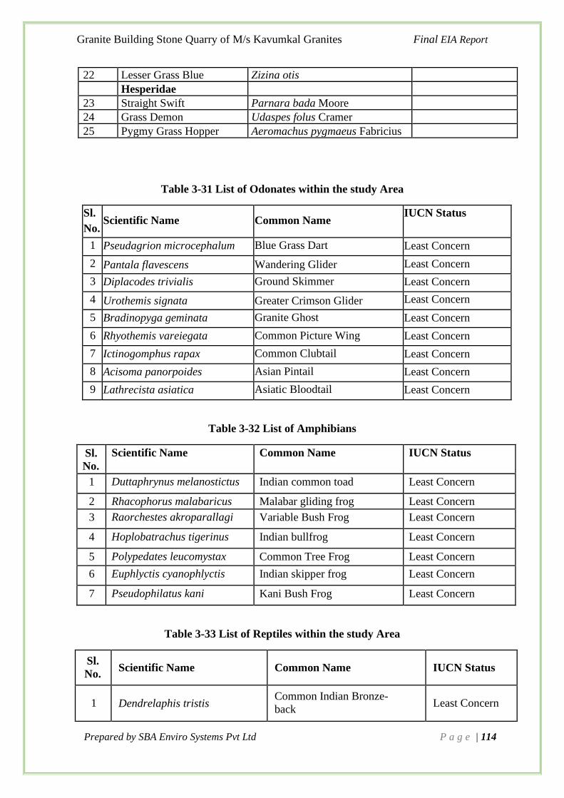
Granite Building Stone Quarry of M/s Kavumkal Granites Final EIA Report
Prepared by SBA Enviro Systems Pvt Ltd P a g e | 114
22 Lesser Grass Blue Zizina otis
Hesperidae
23 Straight Swift Parnara bada Moore
24 Grass Demon Udaspes folus Cramer
25 Pygmy Grass Hopper Aeromachus pygmaeus Fabricius
Table 3-31 List of Odonates within the study Area
Sl.
No. Scientific Name Common Name
IUCN Status
1 Pseudagrion microcephalum Blue Grass Dart Least Concern
2 Pantala flavescens Wandering Glider Least Concern
3 Diplacodes trivialis Ground Skimmer Least Concern
4 Urothemis signata Greater Crimson Glider Least Concern
5 Bradinopyga geminata Granite Ghost Least Concern
6 Rhyothemis vareiegata Common Picture Wing Least Concern
7 Ictinogomphus rapax Common Clubtail Least Concern
8 Acisoma panorpoides Asian Pintail Least Concern
9 Lathrecista asiatica Asiatic Bloodtail Least Concern
Table 3-32 List of Amphibians
Sl.
No.
Scientific Name Common Name IUCN Status
1 Duttaphrynus melanostictus Indian common toad Least Concern
2 Rhacophorus malabaricus Malabar gliding frog Least Concern
3 Raorchestes akroparallagi Variable Bush Frog Least Concern
4 Hoplobatrachus tigerinus Indian bullfrog Least Concern
5 Polypedates leucomystax Common Tree Frog Least Concern
6 Euphlyctis cyanophlyctis Indian skipper frog Least Concern
7 Pseudophilatus kani Kani Bush Frog Least Concern
Table 3-33 List of Reptiles within the study Area
Sl.
No. Scientific Name Common Name IUCN Status
1 Dendrelaphis tristis Common Indian Bronze-
back Least Concern

Granite Building Stone Quarry of M/s Kavumkal Granites Final EIA Report
Prepared by SBA Enviro Systems Pvt Ltd P a g e | 115
2 Hemidactylus frenatus Asian House Gecko Least Concern
3 Hemidactylus maculatus Spotted House Gecko Least Concern
4 Hemidactylus leschenaultii Bark Gecko Least Concern
5 Eutropis carinata Common Keeled Skink Least Concern
6 Calotes versicolor Oriental Garden Lizard Least Concern
7 Ahaetulla nasuta Common Vine Snake Not evaluated
8 Naja Asian cobra Least Concern
9 Vipera russelli Russell's viper Not evaluated
10 Lycodon aulicus Common Wolf Snake Not evaluated
11 Bungarus caeruleus Common krait Not evaluated
12 Ptyas mucosa Oriental Rat Snake Least Concern
Table 3-34 List of Mammals within the study Area
Sl.
No. Common Name Scientific Name IUCN Status
IW(P)A
(Schedule)
1 Three Striped Palm
Squirrel Funambulus palmarum
Least
Concern V
2 Greater Short-nosed
Fruit Bat Cynopterus sphinx
Least
Concern V
3 Pig Rat Bandicota indica Least
Concern V
4 Palm Civet/Toddy Cat Paradoxurus
hermaphroditus
Least
Concern II
5 Common Indian Field
Mouse
Mus booduga Least
Concern V
6 Common House Rat Rattus rattus Least
Concern V
7 House Mouse Mus musculus Least
Concern V
8 Black-Naped Hare Lepus
nigricollis
Least
Concern IV
9 Lesser Bandicoot Rat Bandico,ta
,bengalensis
Least
Concern V
10 Indian Flying Fox Pteropus
giganteus
Least
Concern V

Granite Building Stone Quarry of M/s Kavumkal Granites Final EIA Report
Prepared by SBA Enviro Systems Pvt Ltd P a g e | 116
Table 3-35 List of Millipedes and Centipedes
Sl. No. Scientific Name Common Name IUCN Status
1 Anoplodesmus saussurii
2 Scolopendra morsitans
3 Leptogoniulus sorornus
4 Trigoniulus corallinus Rusty millipede
Table 3-36 List of Ants
Sl. No. Common Name Scientific Name
1 Giant Honey Ant Camponotus irritans
2 Weaver Ant Oecophylla smaragdina
3 Common Red Fire Ant Solenopsis geminata
4 Yellow Crazy Ant Anoplolepis gracilipes
5 Black Crazy Ant Paratrechina longicornis
6 Golden Backed Ant Camponotus sericeus
7 Greater Trap-Jaw Ant Ondontomachus haematodus
8 Miniscule House Ant Tetramorium smithi
9 Common Godzilla Ant Camponotus compressus
Table 3-37 List of Spiders
Sl. No. Family Species Name
1 Sparassidae Hetropoda venatoria
2 Hersilidae Hersilla savigngi
3 Araneidae Eriovixia laglaisei
4 Salticidae Plexippus paykulli
5 Oxyopidae Peucetia viridana
6 Theridiidae Theridula angula
7 Thomisidae Oxytate virens
8 Lycosidae Hippasa agelenoides
9 Pholcidae Crossopriza lyoni
10 Oxyopidae Oxyopes biramanicus
11 Araneidae Gasteragnatha germinate
12 Pisauridae Pardosa psedoannulata

Granite Building Stone Quarry of M/s Kavumkal Granites Final EIA Report
Prepared by SBA Enviro Systems Pvt Ltd P a g e | 117
13 Thomisidae Camaricus formosus
14 Araneidae Argiope pulchella
15 Salticidae Plexippus petersi
16 Araneidae Argiope anasuja
3.9.7 Green Belt Development
Greenbelt shall be developed along the boundary of stone quarry area with the native tree
species. The green belt plantation programme will be continued till the end of the mining
operation in the area. In framing out this activity on a sustainable and scientific base due
consultation and coordination with the forest department will be sought. Plants are chosen to
provide aesthetic, ecological and economical value. Trees will help to arrest propagation of
noise and help to lessen dust pollution due to dust arresting action.
Table 3-38 List of species recommended for greenbelt and afforestation
Sl.
No.
Trees
Sl. No
Trees
Scientific Name Common Name
Scientific Name Common Name
1 Briedelia retusa Mulluvenga 18 Pterocarpus marsupium Venga
2 Schleichera oleosa Puvam 19 Hopea parviflora Kambakam
3 Artocarpus hirsutus Anjili
20 Mimusops elengi Elenji
4 Wrightia tinctoria Nilapaala 21 Oleadioica Edana
5 Terminalia paniculata Maruth 22 Careyaarborea Pezhu
6 Xylia xylocarpa Irul 23 Grewia tiliifolia Unnam
7 Olea dioica Irippa 24 Polyalthia longifolia Aranamaram
8 Vitex altissima Karinochi 25 Tectona grandis Teak
9 Grewia tiliifolia Unnam 26 Wrightia tinctoria Danthapala
10 Dalbergia latifolia Eeti 27 Chrysophyllum roxburghii Pulichakka
11 Syzygium cumini Njaval 28 Psidium guajava Pera
12 Artocarpus
heterophyllus
Plavu 29 Alstonia scholaris Ezhilam Pala
13 Artocarpus hirsutus Anjili 30 Tamarindus indica Puli
14 Mangifera indica Mavu 31 Terminalia arjuna Neermaruthu

Granite Building Stone Quarry of M/s Kavumkal Granites Final EIA Report
Prepared by SBA Enviro Systems Pvt Ltd P a g e | 118
15 Ficus benghalensis Aal 32 Terminalia catappa Indian Almond
16 Ficus callosa Aal
17 Syzygium cumini Njaval
Table 3-39 List of shrubs recommends for Greenbelt
Sl.
No Scientific Name Common Name
1 Dendrocalamus strictus Mula
2 Bambusa bambos Mula
3 Helicteres isora Edampiri- Valampiri
4 Sida rhombifolia Kurunthotti
5 Pseudarthria viscida Muvvila
6 Justicia adhatoda Aadalodakam
7 Mussaenda frondosa Vellila
8 Capparis rheedii Chavruka
9 Ixora coccinea Thechi
3.10 Biodiversity Assessment in 10km Radius (Buffer Zone)
The Biodiversity Assessment (BA) provides detailed information about the flora and fauna
species in the projects implementing area, geographical importance, and threatening factors to
the ecosystem and communities. Identification of the species level of flora and fauna and
comparison of the same with the existing data and literatures provides an excellent management
plan for the sustainable development.
As per the request from the project proponent, we have conducted the Environmental Impact
Assessment (EIA) of the proposed region. This EIA aims to reveal the presence of flora and
fauna in the project implementation area along with the 10 km buffer zone and this lead to
assess the ecological impact of the area due to the proposed mining project. The proposed
project comes under the Survey Nos. 781/1/28–17-1, 781/1/28/-17-2 (Re Sy. No. 32) at
Athikkayam village, Ranni taluk, Pathanamthitta, Kerala, with quarry/mining area of 4.0262
Ha.
3.10.1 Objectives of the Analysis
The main objective of the biodiversity assessment in the proposed mining site is to;
• To perform detailed primary and secondary data collection on biodiversity in the core
and buffer zone (10 km) of project site.
• To identify flora and fauna that can be affected by mining activities through detailed
field study.

Granite Building Stone Quarry of M/s Kavumkal Granites Final EIA Report
Prepared by SBA Enviro Systems Pvt Ltd P a g e | 119
• To promote development that is sustainable and optimizes resources use as well as
management opportunities.
• To ensure environmental considerations are explicitly addressed and
incorporated into the development decision-making process.
• To anticipate and avoid, minimize or offset the adverse significant
biophysical, social and other relevant effects of the above project proposal.
3.10.2 Methodology
Study Area
The area is physio-graphically a hilly terrain having rubber plantation. Different types of
ecosystem in the 10km boundary of the proposed project site include rubber plantation, forest
area, paddy fields, built up areas etc. Only the banks of Pampa river are included in the natural
zonation map of lightning and the village is not susceptible for the earth quake.
Figure 3.23 Google Earth Image showing the 10KM boundary of the proposed site Study
Period
The field study for the biodiversity assessment was performed during the period from May,
2020 to August 2020.
3.10.3 Floral Diversity Estimation
Sampling Strategy
Stratified random sampling with probability proportion to the size (PPS) was adopted for
analyzing vegetation composition of all the types encountered. The ultimate aim was to sample

Granite Building Stone Quarry of M/s Kavumkal Granites Final EIA Report
Prepared by SBA Enviro Systems Pvt Ltd P a g e | 120
nearly 0.01 per cent of the total area. However, keeping the time frame this seemed rather a
huge task. Therefore, the achieved sampling ranged from 0.001 percent to 0.0005 percent of
the total area. In view of the time and availability of other resources, optimum and
representative number of sample plots have been taken up covering all vegetation categories
and various topographic regions, in both core and buffer zones of quarry site.
In order to assure the representative sampling from various vegetation as well as topographic
regions, a Geoinformatics based land use/ land cover analysis and Topography analysis by
developing Digital Elevation Model (DEM) were performed prior to the field study. Help form
the local Biodiversity management Committee were also encountered to choose the study plots.
Quadrate method
Ten quadrates of 10m x 10m were laid down in each locality (Figure). The 10m x 10m quadrate
size was found to be representative in vegetation sampling of Western Ghats region of Kerala
(plot size was determined by species area curve method) (KFRI, 1997). Maximum care was
given to lay quadrates purely random and to assure representation of difference in elevation
and land cover categories of the locality.
At each sample plot all the tree species were identified and their number was counted. At each
sample point the circumference at breast height (CBH) of all tree species were also recorded.
The individuals with CBH> 30 cm are considered as tree and with > 17 cm and < 30 cm CBH
as saplings. From the same plot the shrubs species were also noticed. For herbaceous layer or
ground flora, the nested quadrate method with 1m × 1m plot size was taken in two opposite
corners.
Species Identification
Each plant was identified in the field itself (either botanical name or local name). Photo field
manuals of plant taxonomy were used for the identification of flora in the field itself (Easa,
2003; Sasidaran, 2004 & 2010). Photographs and specimens of unidentified plants were
collected with proper field notes (plot number, locality, habitat, flower color etc.) and the
expertise of experienced taxonomists was utilized to identify the same.
Marking Location of Sample Sites
Each sample site was located on Google Earth Imagery. Exact longitude and latitude and
location height (msl) were noted down using GPS. The quadrate location map of 10km buffer
zone of proposed quarry location is given below

Granite Building Stone Quarry of M/s Kavumkal Granites Final EIA Report
Prepared by SBA Enviro Systems Pvt Ltd P a g e | 121
Figure 3.24 Quadrate locations overlaid in Google Earth Image
3.10.4 Faunal Diversity Estimation
A qualitative assessment of faunal communities including vertebrate classes such as
Mammalia, Aves, Reptlia and Amphibians and non- vertebrate class of Insects (Butterflies and
Odonates) were also assessed though scientific sampling method. The species listed was
checked with IUCN Red Data book to understand their conservation strategy.
Continuous Sampling
Transects method was adopted for the qualitative assessment of faunal community in the study
area, where a sampling line is set up across areas where there are clear environmental
gradients. We selected locations to lay down a transect where a change of land use/ land cover
and elevations was observed.
Belt Transect Method
The belt transect was laydown by setting a line and numbered at 1m intervals, all the way along
its length. The position of the transect line was depends on the direction of the environmental
gradient of the study.
The species touching the line may be recorded along the whole length of the line (continuous
sampling) and also a width of 10 m was also observed in both sides of the transect line set in
the field. Hence an area of 100 x 10 m was observed at each habitat and elevation gradient in
the study area.

Granite Building Stone Quarry of M/s Kavumkal Granites Final EIA Report
Prepared by SBA Enviro Systems Pvt Ltd P a g e | 122
Marking of transects
Each transect locations was located on Google Earth Imagery. The path of the transect was
recorded using tracking option in the GPS. The transect location map of 10km buffer zone of
proposed quarry is given below.
Figure 3.25 Transect locations overlaid in Google Earth Image Sampling strategy for various
classes
Mammalia
The mammals were assessed by direct and indirect sighting. More preference was given to
indirect observation, such as foot print, burrows, skeleton, fecal materials, hairs, horn etc. and
also through the presence of dens and caves. Since most mammals are secretive or nocturnal,
they were seldom seen by the casual observer. But their presence was often revealed by tracks,
burrows, nests, evidence of feeding and its residues, foot prints, tail markings, fecal material
or scats. In addition to the field survey, discussions were conducted with the local people. The
indirect sightings of fauna were photographed and identified though the field guides (Nameer,
2015) and consultation with experts.
Aves (Birds)
Birds were also recorded along all the transects. All bird species were identified either through
direct sighted or by voices heard were recorded (irrespective of their distance from transects).
Birds were observed through binoculars and identified using field guide.

Granite Building Stone Quarry of M/s Kavumkal Granites Final EIA Report
Prepared by SBA Enviro Systems Pvt Ltd P a g e | 123
Herpeto fauna (Reptiles and Amphibians)
The survey on the herpeto fauna was also conducted at different micro-habitats during the day
and in the evening. GPS records were taken to outline the area covered during the field survey
and to show specific points where specimens were encountered. Photos were taken using digital
camera.
Insects (Butterflies and Odonates)
Insects especially butterflies and odonates were also recorded from various habitats through
transect method. The species of butterflies and odonates were identified through field guides.
Species sitings were recorded in the field and possibly photographed using digital camera.
3.10.5 Land Use and Land Cover Analysis
The analysis provided the basic landscape of the study area. Generally, mixed land use/land
cover visible in and around study area in which vegetation (35.02%) was dominates in the
present study followed by agricultural land (32.16%) covering 10 km surrounding the project
site. Other land use land cover identified in the study were fallow land (11.37%), barren land
(10.93%), open scrub/open area (5.83%), settlements (3.72%) and waterbody (0.97%). Due to
the proposed mining, there were no variations in the existing land use or land cover within the
study area. But within in proposed project site there may be some minor change in land use to
mining area. The forest covering about 14%of the area.
Figure 3.26 Land use/ land cover pattern of the 10km buffer zone of proposed granite
quarry site
/Forest Area Proposed Quarry
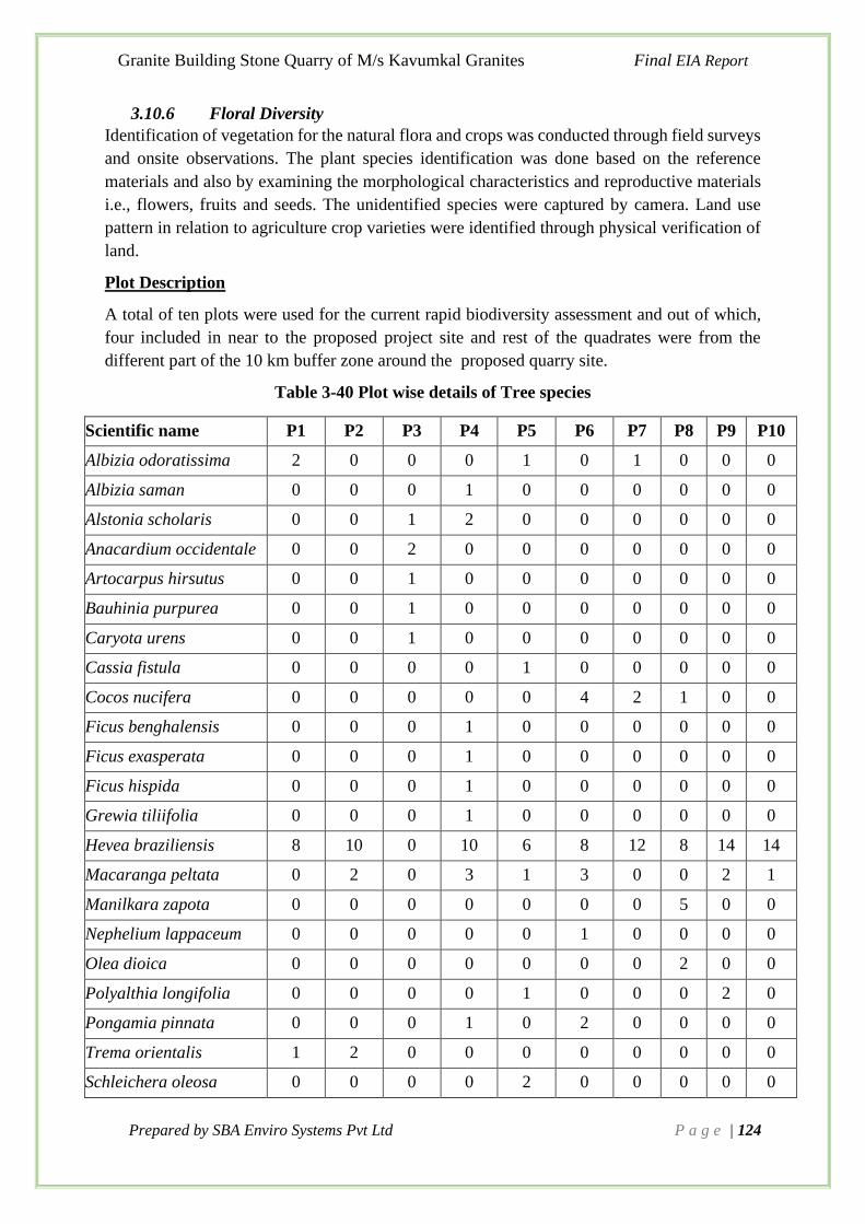
Granite Building Stone Quarry of M/s Kavumkal Granites Final EIA Report
Prepared by SBA Enviro Systems Pvt Ltd P a g e | 124
3.10.6 Floral Diversity
Identification of vegetation for the natural flora and crops was conducted through field surveys
and onsite observations. The plant species identification was done based on the reference
materials and also by examining the morphological characteristics and reproductive materials
i.e., flowers, fruits and seeds. The unidentified species were captured by camera. Land use
pattern in relation to agriculture crop varieties were identified through physical verification of
land.
Plot Description
A total of ten plots were used for the current rapid biodiversity assessment and out of which,
four included in near to the proposed project site and rest of the quadrates were from the
different part of the 10 km buffer zone around the proposed quarry site.
Table 3-40 Plot wise details of Tree species
Scientific name P1 P2 P3 P4 P5 P6 P7 P8 P9 P10
Albizia odoratissima 2 0 0 0 1 0 1 0 0 0
Albizia saman 0 0 0 1 0 0 0 0 0 0
Alstonia scholaris 0 0 1 2 0 0 0 0 0 0
Anacardium occidentale 0 0 2 0 0 0 0 0 0 0
Artocarpus hirsutus 0 0 1 0 0 0 0 0 0 0
Bauhinia purpurea 0 0 1 0 0 0 0 0 0 0
Caryota urens 0 0 1 0 0 0 0 0 0 0
Cassia fistula 0 0 0 0 1 0 0 0 0 0
Cocos nucifera 0 0 0 0 0 4 2 1 0 0
Ficus benghalensis 0 0 0 1 0 0 0 0 0 0
Ficus exasperata 0 0 0 1 0 0 0 0 0 0
Ficus hispida 0 0 0 1 0 0 0 0 0 0
Grewia tiliifolia 0 0 0 1 0 0 0 0 0 0
Hevea braziliensis 8 10 0 10 6 8 12 8 14 14
Macaranga peltata 0 2 0 3 1 3 0 0 2 1
Manilkara zapota 0 0 0 0 0 0 0 5 0 0
Nephelium lappaceum 0 0 0 0 0 1 0 0 0 0
Olea dioica 0 0 0 0 0 0 0 2 0 0
Polyalthia longifolia 0 0 0 0 1 0 0 0 2 0
Pongamia pinnata 0 0 0 1 0 2 0 0 0 0
Trema orientalis 1 2 0 0 0 0 0 0 0 0
Schleichera oleosa 0 0 0 0 2 0 0 0 0 0

Granite Building Stone Quarry of M/s Kavumkal Granites Final EIA Report
Prepared by SBA Enviro Systems Pvt Ltd P a g e | 125
Simarouba glauca 0 0 1 0 0 0 0 1 0 0
Strychnos nux-vomica 0 0 0 0 0 1 0 0 0 0
Swietenia mahagoni 2 0 0 3 0 0 2 3 0 1
Tectona grandis 2 2 0 0 0 3 0 0 0 2
Terminalia paniculata 0 0 2 4 0 0 1 0 0 0
3.10.7 Trees, Shrubs and Herbs Observed
A total of 41 tree species are observed from the study period and included in tables below. The
shrubs, herbs and climbers observed from the quadrates studied are listed below.
Table 3-41 Checklist of trees
Sl.
No.
Scientific name
Common Name
Family
IUCN
status
1. Adenanthera pavonina Manchadai Fabaceae LC
2. Albizia odoratissima Vaka Fabaceae/leguminosae LC
3. Albizia saman Mazhamaram Fabaceae/leguminosae LC
4. Alstonia scholaris Ezhilamppala Apocynaceae LC
5. Anacardium occidentale Kasumavu Anacardiaceae LC
6. Annona reticulata Aatha Annonaceae LC
7. Artocarpus heterophyllus Jack fruit tree Moraceae LC
8. Artocarpus hirsutus Anjili Moraceae LC
9. Azadirachta indica Ariyaveppu Meliaceae LC
10.
Bauhinia purpurea
Chuvanna
mandaram
Fabaceae/leguminosae
LC
11. Caryota urens Aanapana Arecaceae/palmae LC
12.
Cassia fistula
Kanikkonna
Fabaceae
(caesalpinioideae)
LC
13. Cocos nucifera Coconut Palmae LC
14.
Erythrina stricta
Mullumurikk
Fabaceae
(Papilionoideae)
LC
15. Ficus benghalensis Peraal Moraceae LC
16. Ficus exasperata Therakam Moraceae LC
17. Ficus hispida Thondi Moraceae LC

Granite Building Stone Quarry of M/s Kavumkal Granites Final EIA Report
Prepared by SBA Enviro Systems Pvt Ltd P a g e | 126
18. Gliricidia sepium Cheema konna Fabaceae/leguminosae LC
19. Grewia tiliifolia Unnam Tiliaceae LC
20. Hevea braziliensis Rubber tree Euphorbiacaeae LC
21. Macaranga peltata Vatta Euphorbiaceae LC
22. Mangifera indica Mango Anacardiaceae LC
23. Manilkara zapota Chikku Sapotaceae LC
24. Melia azedarach Kattuveppu Meliaceae LC
25. Memecylon umbellatum Kayampoomaram Melastomataceae LC
26. Moringa sps. Muringa Moringaceae LC
27. Nephelium lappaceum Rambutan Sapindaceae LC
28. Olea dioica Irippa Oleaceae LC
29. Polyalthia longifolia Aranamaram Annonaceae LC
30.
Pongamia pinnata
Ungu
Fabaceae/
leguminosae
LC
31. Pterocarpus marsupium Karavenga Fabaceae LC
32. Trema orientalis Pottama Ulmaceae LC
33. Schleichera oleosa Poovam Sapindaceae LC
34. Simarouba glauca Lakshmitharu Simaroubaceae LC
35. Strychnos nux-vomica Kanjiram Loganiaceae LC
36. Swietenia mahagoni Mahogany Meliaceae LC
37. Tamarindus indica Puli Fabaceae LC
38. Tectona grandis Teak Lamiaceae LC
39. Terminalia catappa Badam Combretaceae LC
40. Terminalia paniculata Maruthu Combretaceae LC
41. Xylia xylocarpa Irul Fabaceae/leguminosae LC
Table 3-42 Checklist of Shrubs
Sl. No. Species Name Common Name Family
42. Abutilon indicum Ooram Malvaceae
43. Abutilon persicum Thutthi Malvaceae
44. Acacia farnesiana Sweet acacia Fabaceae

Granite Building Stone Quarry of M/s Kavumkal Granites Final EIA Report
Prepared by SBA Enviro Systems Pvt Ltd P a g e | 127
45. Acalypha hispida Poochavalan Euphorbiaceae
46. Acalypha wilkesiana Dragon plant Euphorbiaceae
47. Allamanda blanchetti Allamanda Apocynaceae
48. Allamanda cathartica Manjakolambi Apocynaceae
49. Alternanthera brasiliana Chumalacheera Amaranthaceae
50. Aniopteris evecta Giant fern Marattiaceae
51. Antidesma acidum Shirupuli Phyllanthaceae
52. Ardisia elliptica Kaaknjara Primulaceae
53. Asclepias curassavica Kammalchedi Apocynaceae
54. Bambusa bambos Bamboo Poaceae
55. Barleria cristata Neelakanakambaram Acanthaceae
56. Barleria grandiflora Vellakanakambaram Acanthaceae
57. Barleria lupulina Hophead Acanthaceae
58. Barleria prionitis Manjakanakambaram Acanthaceae
59. Bauhinia acuminata Vellamandharam Fabaceae
60. Breynia retusa Cup saucer plant Phyllanthaceae
61. Breynia vitis-idaea Chuvannaniruri Euphorbiaceae
62. Bridelia stipularis Euphorbiaceae
63. Brieddelia stipularis Cheruka Euphorbiaceae
64. Briedelia stipularis Kotta Euphorbiaceae
65. Brugmansia suaveolens Angel trumpet Solanaceae
66. Brunfelsia grandiflora Royal Purple Brunfelsia, Solanaceae
67. Callicarpa tomentosa Cherutheck Verbenaceae
68. Callicarpa tomentosa Kattuthekku Verbenaceae
69. Calotropis gigantea Erukku Asclepidaceae
70. Canthium angustifolium Kattakara Rubiaceae
71. Canthium rheedii Kara Rubiaceae
72. Capsicum frutescences Kantharimulaku Solanaceae
73. Capsicum frutescens Kanthari Solanaceae
74. Carissa carandas Karakka Apocynaceae
75. Cascabela thevetia Manjappoo Apocynaceae

Granite Building Stone Quarry of M/s Kavumkal Granites Final EIA Report
Prepared by SBA Enviro Systems Pvt Ltd P a g e | 128
76. Catharanthus roseus Shavakottapacha Apocynaceae
77. Chassalia curviflora Amalpori Rubiaceae
78. Chassalia curviflora Kattukkappi Rubiaceae
79.
Chassaliacurviflora var.
ohioxyloides
Karutha- amalppori
Rubiaceae
80. Chromolaena odorata Communist pacha Asteraceae
81. Clausena anisata Kattukariveppila Rutaceae
82. Clerodendron heterophyllum Tree of liitle statrs Lamiaceae
83. Clerodendron incisum Musical note Lamiaceae
84. Clerodendron infortunatum Peringalam Lamiaceae
85. Clerodendron thomsoniae Krishnakireedam Lamiaceae
86. Clerodendrum serratum Cheruthekke Verbenaceae
87. Clidemia hirta Kosters Curse Melastomataceae
88. Clinacanthus nutans Vishamooli Acanthaceae
89. Codiaeum variegatum Variegated laurel Euphorbiaceae
90. Coffea arabica Coffee Rubiaceae
91. Cordyline fruticosa Cabbage Tree Asparagaceae
92. Crossandra infundibuliformis Kanakambaram Acanthaceae
93. Crotalaria pallida Kilukkichedi Fabaceae
94. Crotalaria retusa Wedge leaf Rattlepod Fabaceae
95. Cuphea llavea Cuphea Lythraceae
96. Datura metel Ummam Solanaceae
97. Dendrophthoe falcata Ithilkkani Loranthaceae
98. Desmodium gangeticum Orila Fabaceae
99. Dracaena marginata Dragon Tree Asparagaceae
100. Dracaena reflexa Song of India Asparagaceae
101. Dracaena surculosa Spotted Dracaena Asparagaceae
102. Duranta erecta Goldspot Verbenaceae
103. Ehretia microphylla Kuranguvettila Boraginaceae
104. Embelia tsjeriam- cottam Cheriyannattam Myrsinaceae
105. Euphorbia cotinifolia Red spurge Euphorbiaceae

Granite Building Stone Quarry of M/s Kavumkal Granites Final EIA Report
Prepared by SBA Enviro Systems Pvt Ltd P a g e | 129
106. Euphorbia nivulia Ilakkalli Euphorbiaceae
107. Euphorbia pulcherima Poinsettia Euphorbiaceae
108. Euphorbia tithymaloides Thathammachedi Euphorbiaceae
109. Euphorbia X lomi Giant crown Euphorbiaceae
110. Excoecaria cochinchinensis Chinese croton Euphorbiaceae
111. Ficus hispida Parakam Moraceae
112. Ficushispida Therakam Moraceae
113. Flacourtia indica Karimulli Salicaceae
114.
Flemingia macrophylla
Korkkatachedi
Fabaceae
(Papilionoideae)
115. Flemingia strobilifera Kanala Fabaceae
116. Galphaimia gracilis Gold shower Malphighiaceae
117. Gardenia jasminioides Gandharajan Rubiaceae
118. Glycosmis pentaphylla Panal Rutaceae
119. Gomphia serrata Chavetti Ochnaceae
120. Gradenia gummifera Sugandharajan Rubiaceae
121. Graptophyllum pictum Graptophyllum Acanthaceae
122. Grewia hirsute chadachi Tiliaceae
123. Grewia nervosa Pottanga Tiliaceae
124. Grewia serrulata Pottanga Tiliaceae
125. Hamelia patens Pavizhamulla Rubiaceae
126. Helicteres isora Idampiri valampiri Malvaceae
127. Heterotis rotundifolia Pink lady Melastomataceae
128. Hibiscus hispidissimus Panchakam Malvaceae
129. Hibiscus rosa sinensis Chembarathi Malvaceae
130. Hibiscus schizopetalus Chembarathi Malvaceae
131. Hibiscus surattensis Panichakam Malvaceae
132. Holarrhena pubescens Kudakapala Apocynaceae
133. Holmskioldia sanguinea Chinese Hat Plant Lamiaceae
134. Hydrangea macrophylla Hydrangia Hydrangeaceae
135. Hyptis suaveolens Narippalla Lamiaceae

Granite Building Stone Quarry of M/s Kavumkal Granites Final EIA Report
Prepared by SBA Enviro Systems Pvt Ltd P a g e | 130
136. Ixora coccinea Chethi Rubiaceae
137. Ixora finlaysoniana Vellthechi Rubiaceae
138. Jatropha curcas Kadalavanak Euphorbiaceae
139. Justicia adhatoda Adalodakam Acanthaceae
140. Justicia candicans Justicia Acanthaceae
141. Justicia carnea Flamingo plant Acanthaceae
142. Justicia gendarussa Vathamkolli Acanthaceae
143. Justicia plumbaginifolia Vizhapacha Acanthaceae
144. Lantana camara Arippochedi Verbenaceae
145. Lantana montevidensis Arippoo Verbenaceae
146. Lawsonia inermis Milanchi Lythraceae
147. Leea indica Choriyamthali Vitaceae
148. Maesa indica Kireethi, Kattuvizhal Myrsinaceae
149. Malvaviscus arboreus Mulakuchembaruthi Malvaceae
150. Manihot esculenta Kappa Euphorbiaceae
151. Melastoma malabathricum Kalambatta Melastomataceae
152. Memecylon umbellatum Kashav Melastomataceae
153. Morus alba Mulberry Moraceae
154. Murraya koenigii Kariveppila Rutaceae
155. Mussaenda frondosa Vellila Rubiaceae
156. Naringi crenulata Nari narakam Rutaceae
157. Nerium oleander Arali Apocynaceae
158. Ochalandra travancorica Eera Poaceae
159. Ophiorrhiza eriantha Amalpori Rubiaceae
160. Osbeckia aspera Kattukadali Melastomataceae
161. Osbeckia octandra Cherukadali Melastomataceae
162. Pachystachys lutea Lolipop plant Acanthaceae
163. Pereskia aculeata Rose cactus Cactaceae
164. Pereskia bleo Rose cactus Cornaceae
165. Phoenix loureirii Chittanthal Arecaceae
166. Physalis minima Njottanjodiyan Phyllanthaceae

Granite Building Stone Quarry of M/s Kavumkal Granites Final EIA Report
Prepared by SBA Enviro Systems Pvt Ltd P a g e | 131
167. Piper longum Thippali Piperaceae
168. Pogostemon cablin Pacholi Lamiaceae
169. Polyscias fruticosa Snow flake Araliaceae
170. Premna serratifolia Munja Lamiaceae
171. Pseuderanthemum carruthersii Eranthemum Acanthaceae
172. Rauvolfia serpentina Amalpori Apocynaceae
173. Rhinacanthus nasutus Nagamulla
174. Ricinus communis Avanakk Euphorbiaceae
175. Rosa cymosa Rose Fabaceae
176. Rotheca serrata Cheruthekku Lamiaceae
177. Salvia coccinea Salvia Salviniaceae
178. Sauropus androgynus Velicheera Euphorbiaceae
179. Schaueria flavicoma Yellow Fuz Flower Acanthaceae
180. Schefflera arboricola Dwarf ubrella tree Araliaceae
181. Senna occidentalis Kattuthakara Fabaceae
182. Senna polyphylla Desert cassia Fabaceae
183. Senna tora Thakara Fabaceae
184. Sida cordifolia L. Kurunthotti Malvaceae
185. Sida rhombifolia Kurunthotti Malvaceae
186. Solanum anguivi Anachunda Solanaceae
187. Solanum rudepannum Putharichunda Solanaceae
188. Solanum torvum Chunda Solanaceae
189. Stachytarpheta cayennensis Narivalan Verbenaceae
190. Sterculia guttata Pottakkavalam Malvaceae
191. Strobilanthes ciliatus Kurunji Acanthaceae
192. Tabernaemontana alternifolia Palamaram Apocyaceae
193. Tabernaemontana divaricata Nanthyarvattam Apocynaceae
194. Thespesia lampas Kattuparathi Malvaceae
195. Thottea siliquosa Alpam Aristolochiaceae
196. Thuja occidentalis Thuja Cuppresaceae
197. Thunbergia erecta Kings Mantle Acanthaceae

Granite Building Stone Quarry of M/s Kavumkal Granites Final EIA Report
Prepared by SBA Enviro Systems Pvt Ltd P a g e | 132
198. Triumfetta rhomboidea Ottukayal Malvaceae
199. Urena lobata Oorppam Malvaceae
200. Vitex negundo Karinochi Verbenaceae
201. Wrightia tinctoria Dhantha pala Apocynaceae
202. Ziziphus mouritiana Ilantha Rhamnaceae
203. Ziziphus oenoplia Thodali Rhamnaceae
Table 3-43 Checklist of Herbs
Sl. No. Scientific Name Common Name Family
1. Acalypha indica Kuppameni Euphorbiaceae
2. Acampe praemorsa Maravazha Orchidaceae
3. Achyranthes aspera Kadaladi Amaranthaceae
4. Achyranthes bidentata Vankadaladi Amaranthaceae
5. Acmella paniculata Palluvedanachedi Asteraceae
6. Acrostichum heterophyllum Seethathali Pteridaceae
7. Acrotrema arnottianum Nilapunna Dilleniacea
8. Adiantum latifolium Adiantum Pteridaceae
9. Adiantum raddianum Adiantum Pteridaceae
10. Aerva lanata Cherula Amaranthaceae
11. Agave vivipara Dwarf Aloe Asparagaceae
12. Ageratum conyzoides Appa Asteraceae
13. Alocasia macrorrhizos Giant Taro Araceae
14. Alocasia X mortfontanensis Taro Araceae
15. Aloe vera Kattarvazha Xanthorrhoeace
16. Alpinia galanga Aratha Zingiberaceae
17. Alpinia malaccensis Alpinia Zingiberaceae
18. Alternanthera brasiliana Braziliyan joyweed Amaranthaceae
19. Alternanthera sessilis Kozhuppa Amaranthaceae
20. Alysicarpus vaginalis Nilaorila Fabaceae
21. Amaranthus cruentus Chuvannacheera Amaranthaceae
22. Amaranthus spinosus Mullancheera Amaranthaceae

Granite Building Stone Quarry of M/s Kavumkal Granites Final EIA Report
Prepared by SBA Enviro Systems Pvt Ltd P a g e | 133
23. Amarathus viridis Cheera Amaranthaceae
24. Amorphophallus campanulatus Kattuchena Araceae
25. Amorphophallus paeoniifolius Chena Araceae
26. Amorphophallus sps. Kattuchena Araceae
27. Ananas comosus Kathachakka Bromeliaceae
28. Anaphyllum wighti Araceae
29. Andrographis paniculata Kiriyath Acanthaceae
30. Anisomeles indica Chadayan Lamiaceae
31. Anthurium andraeanum Anthurium Araceae
32. Anthurium crystallinum Anthurium Araceae
33. Anthurium radicans Anthurium Araceae
34. Asystasia gangetica Creeping Foxyglove Acanthaceae
35. Axonopus compressus Buffalo grass Poaceae
36. Bergonia coccinea Kayyalapuli Begoniaceae
37. Bidens pilosa Cobblers Pegs Asteraceae
38. Bigonia magnifica Bigonia Begoniaceae
39. Biophytum sensitivum Mukkutti Oxalidaceae
40. Blechnum orientale Centipede Fern Blechnaceae
41. Blepharis maderaspatensis Blepharis Acanthaceae
42. Boerhavia repens Thazhuthama Nyctaginaceae
43. Brassica juncea Kaduk Brassicaceae
44. Bryophyllum pinnatum Ilamulachi Crassulaceae
45. Buddleja indica Buddleja Scrophulariaceae
46. Bulbophyllum sterile Mukkittakaya Orchidaceae
47. Caesalpinia mimosoides Kooramullu Fabaceae
48. Caladium bicolor Angel wings Araceae
49. Calathea rufibarba Calathea Marantaceae
50. Callisia repens Creeping Inchplant Commelinaceae
51. Canna indiaca Kanavazha Cannaceae
52. Canthium angustifolium Karamullu
53. Canthium coromandelicum Kattakkara
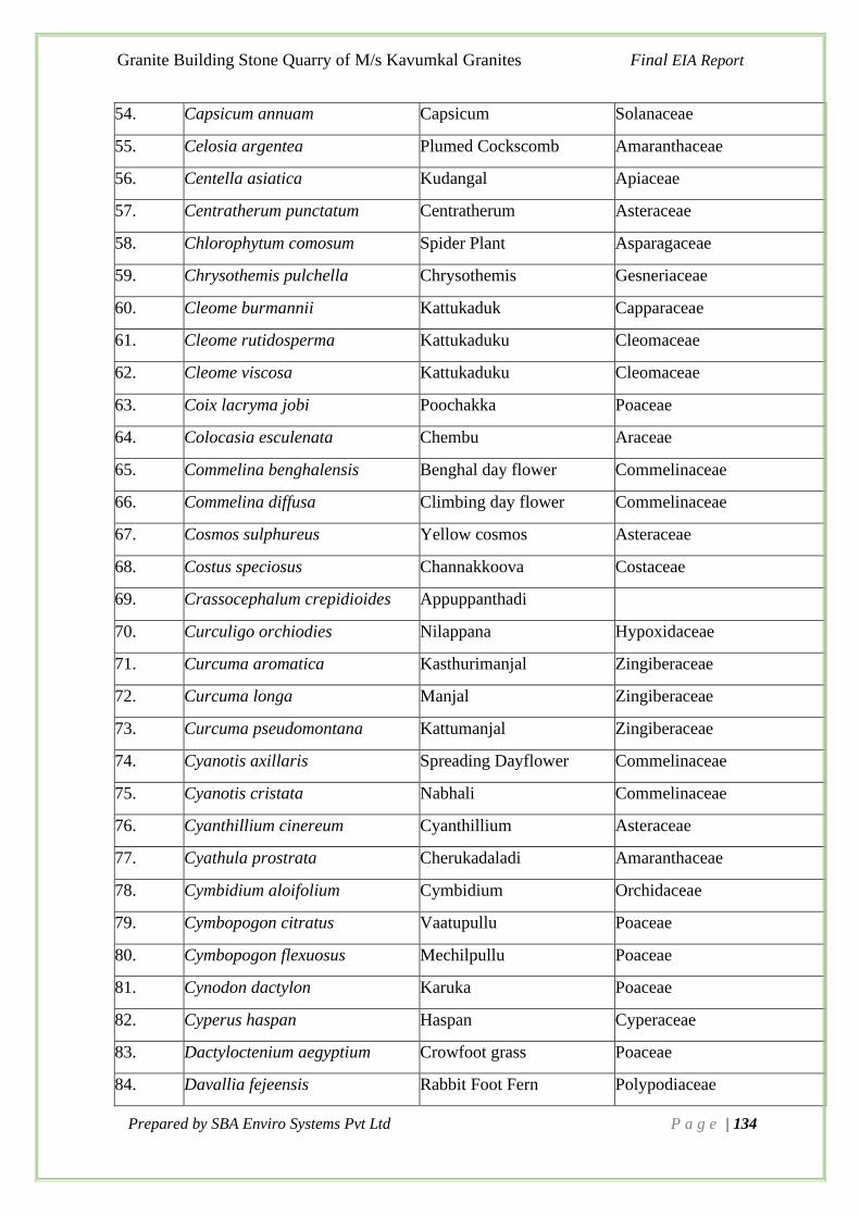
Granite Building Stone Quarry of M/s Kavumkal Granites Final EIA Report
Prepared by SBA Enviro Systems Pvt Ltd P a g e | 134
54. Capsicum annuam Capsicum Solanaceae
55. Celosia argentea Plumed Cockscomb Amaranthaceae
56. Centella asiatica Kudangal Apiaceae
57. Centratherum punctatum Centratherum Asteraceae
58. Chlorophytum comosum Spider Plant Asparagaceae
59. Chrysothemis pulchella Chrysothemis Gesneriaceae
60. Cleome burmannii Kattukaduk Capparaceae
61. Cleome rutidosperma Kattukaduku Cleomaceae
62. Cleome viscosa Kattukaduku Cleomaceae
63. Coix lacryma jobi Poochakka Poaceae
64. Colocasia esculenata Chembu Araceae
65. Commelina benghalensis Benghal day flower Commelinaceae
66. Commelina diffusa Climbing day flower Commelinaceae
67. Cosmos sulphureus Yellow cosmos Asteraceae
68. Costus speciosus Channakkoova Costaceae
69. Crassocephalum crepidioides Appuppanthadi
70. Curculigo orchiodies Nilappana Hypoxidaceae
71. Curcuma aromatica Kasthurimanjal Zingiberaceae
72. Curcuma longa Manjal Zingiberaceae
73. Curcuma pseudomontana Kattumanjal Zingiberaceae
74. Cyanotis axillaris Spreading Dayflower Commelinaceae
75. Cyanotis cristata Nabhali Commelinaceae
76. Cyanthillium cinereum Cyanthillium Asteraceae
77. Cyathula prostrata Cherukadaladi Amaranthaceae
78. Cymbidium aloifolium Cymbidium Orchidaceae
79. Cymbopogon citratus Vaatupullu Poaceae
80. Cymbopogon flexuosus Mechilpullu Poaceae
81. Cynodon dactylon Karuka Poaceae
82. Cyperus haspan Haspan Cyperaceae
83. Dactyloctenium aegyptium Crowfoot grass Poaceae
84. Davallia fejeensis Rabbit Foot Fern Polypodiaceae

Granite Building Stone Quarry of M/s Kavumkal Granites Final EIA Report
Prepared by SBA Enviro Systems Pvt Ltd P a g e | 135
85. Dendrobium aphyllum Dendrobium Orchidaceae
86. Desmodium triflorum Nilamparanda Fabaceae
87. Dicranopteris linearis Froken Fern Gleichenaceae
88. Diplazium esculentum Churali Athyriaceae
89. Drosera peltata Azhukanni Droseraceae
90. Drynaria quercifolia Oak leaf fern Polypodiaceae
91. Eclipta prostrata Kayyoni Asteraceae
92. Eichhornia crassipes Water Hyacinth Pontederiaceae
93. Elephantopus scaber Anachuvadi Asteraceae
94. Eleusine indica Goose grass Poaceae
95. Eleutheranthera ruderalis Venappacha Asteraceae
96. Embelia ribes Vizhal Myrsinaceae
97. Emilia sonachifolia Muyalchevian Asteraceae
98. Ensete superbum Malavazha Musaceae
99. Epidendrum radicans Holy cross Orchidaceae
100. Epiphyllum oxypetalum Nishagandhi Cactaceae
101. Equisetum giganteum Horsetail Equisetaceae
102. Eragrostis unioloides Chinese love grass Poaceae
103. Euphorbia heterophylla Painted euphorbia Euphorbiaceae
104. Euphorbia hirta Nilappana Euphorbiaceae
105. Euphorbia thymifolia Nilappala Euphorbiaceae
106. Evolvulas alsinoides Vishunukranthi Convolvulaceae
107. Evolvulas nummularius Bindweed Convolvulaceae
108. Geophila repens Karimunjil Rubiaceae
109. Gomprena globosa Vadamalli Amaranthaceae
110. Hedychium coronarium Kalyanasougandhikam Zingiberaceae
111. Heliconia aurantiaca Aurantic Heliconia Heloconiaceae
112. Heliconia latispatha Lobsterclaw Heloconiaceae
113. Heliotropium indicum Thekkada Boraginaceae
114. Hemigraphis alternata Murikoodi Acanthaceae
115. Hemionitis arifolia Heart fern Pteridaceae

Granite Building Stone Quarry of M/s Kavumkal Granites Final EIA Report
Prepared by SBA Enviro Systems Pvt Ltd P a g e | 136
116. Hybanthus enneaspermus Orithalthamara Violaceae
117. Hydrocotyle· javanica Vella vaite Apiaceae
118. Hydrocotyle· sibthorpioides Kudangal Apiaceae
119. Hyptis capitata Knob weed Lamiaceae
120. Hyptis suaveolens Mint weed Lamiaceae
121. Impatiens balsamina Bolsam Balsaminaceae
122. Imperata cylindrica Darbha
Table 3-44 Checklist of Climbers
Sl.
No.
Scientific Name
Common Name
Family
1. Abrus precatorius Kunni Fabaceae
2. Acacia caesia Incha Fabaceae
3. Acacia pennata Karincha Fabaceae
4. Acacia sinuata Shikkakai Fabaceae
5. Acacia torta Karincha Fabaceae
6. Ampelocissus latifolia Karantavalli Vitaceae
7. Anamarita coculus Pollakkaya Menispermaceae
8. Antigonon leptopus Mexican creeper Polygonaceae
9. Argyeria osyrensis Silverweed Convolvulaceae
10. Argyreia nervosa Samudrapacha Convolvulaceae
11. Aristolochia indica Garudakkodi Aristolochiaceae
12. Asparagus racemosus Shathawari Asparagaceae
13. Asparagus setaceus Asparagus Fern Asparagaceae
14. Bougainvillea glabra Bouganvilla Nyctaginaceae
15. Calamus rotang Chooral Araceae
16. Calopogonium mucunoides Kattupayar Fabaceae
17. Calycopteris floribunda Pullanji Combretaceae
18. Canavalia gladiata Kathipayar Fabaceae
19. Cardiospermum halicacabum Vallizhuninja Sapindaceae
20. Cayratia japonica Chunnambuvalli Vitaceae
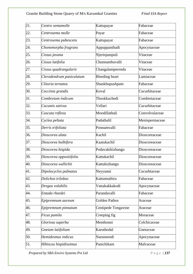
Granite Building Stone Quarry of M/s Kavumkal Granites Final EIA Report
Prepared by SBA Enviro Systems Pvt Ltd P a g e | 137
21. Centro semamolle Kattupayar Fabaceae
22. Centrosema molle Payar Fabaceae
23. Centrosema pubescens Kattupayar Fabaceae
24. Chonemorpha fragrans Appuppanthadi Apocynaceae
25. Cissus javana Njerinjampuli Vitaceae
26. Cissus latifolia Chunnambuvalli Vitaceae
27. Cissus quadrangularis Changalamperenda Vitaceae
28. Clerodendrum paniculatum Bleeding heart Lamiaceae
29. Clitoria ternatea Shankhupushpam Fabaceae
30. Coccinia grandis Koval Cucurbitaceae
31. Combretum indicum Thookkuchedi Combretaceae
32. Cucumis sativus Vellari Cucurbitaceae
33. Cuscuta reflexa Moodillathali Convolvulaceae
34. Cyclea peltata Padathalil Menispermaceae
35. Derris trifoliata Ponnamvalli Fabaceae
36. Dioscorea alata Kachil Dioscoreaceae
37. Dioscorea bulbifera Kaatukachil Dioscoreaceae
38. Dioscorea hispida Podavakikizhangu Dioscoreaceae
39. Dioscorea oppositifolia Kattukachil Dioscoreaceae
40. Dioscorea wallichii Kattukizhangu Dioscoreaceae
41. Dipolocyclos palmatus Neyyunni Cucurbtaceae
42. Dolichos trilobus Kattumuthira Fabaceae
43. Dregea volubilis Vattakakkakodi Apocynaceae
44. Entada rheedei Parandavalli Fabaceae
45. Epipremnum aureum Golden Pathos Araceae
46. Epipremnum pinnatum Centipede Tongavine Araceae
47. Ficus pumila Creeping fig Moraceae
48. Gloriosa superba Menthonni Colchicaceae
49. Gnetum latifolium Karuthodal Gnetaceae
50. Hemidesmus indicus Naruneendi Apocynaceae
51. Hibiscus hispidissimus Panichikam Malvaceae

Granite Building Stone Quarry of M/s Kavumkal Granites Final EIA Report
Prepared by SBA Enviro Systems Pvt Ltd P a g e | 138
52. Ichnocarpus frutescens Palvalli Apocynaceae
53. Ipomea hederifolia Scarlet creeper Convolvulaceae
55. Ipomea quamoclit Cypress vine Convolvulaceae
56. Ipomoea deccana Ipomea Convolvulaceae
57. Jacquemontia penta Skyblue Convolvulaceae
58. Jasminum malabaricum Kadambuvalli Convolvulaceae
59. Jasminum sambac Mulla Oleaceae
60. Lygodium flexuosum Climbing fern Schizaeaceae
61. Marsdenia sylvestris Chakkarakkoli Apocynaceae
62. Merremia tridentata Cheruvayara Convolvulaceae
63. Merremia vitifolia Manjakolambi Convolvulaceae
64. Mikania micrantha Dhridharashtrappacha Asteraceae
65. Mimosa diplotricha Anathottawadi Fabaceae
66. Momordica charantia Paval Cucurbitaceae
67. Mucuna pruriens Naykkurana Fabaceae
68. Mukia maderaspatana Mukkaapeeram Cucurbitaceae
69. Myxopyrum smilacifolium Chathyramulla Oleaceae
70. Naravelia zeylanica Vathamkolli Ranunculaceae
71. Passiflora edulis Passoin fruit Passifloraceae
72. Passiflora foetida Chadayan Passifloraceae
73. Petrees volubilis Sandpaper Vine Verbenaceae
74. Piper mullesua Kattukurumulaku Piperaceae
75. Piper nigrum Kurumulaku Piperaceae
76. Pothos scandens Parvazhu Araceae
77. Pueraria phaseoloides Kattupayar Fabaceae
78. Pueraria phaseoloides Thottappayar Fabaceae
79. Quisqualis indica Thookuchethi Combretaceae
80. Smilax zeylanica Kareelanchi Smilacaceae
81. Thunbergia alata Black eyed susan vine Acanthaceae
82. Thunbergia laurifolia Thunbergia Acanthaceae
83. Tiliacora acuminata Vallikkanjiram Menispermaceae

Granite Building Stone Quarry of M/s Kavumkal Granites Final EIA Report
Prepared by SBA Enviro Systems Pvt Ltd P a g e | 139
84. Tinospora cordifolia Amruth Menispermaceae
85. Toxocarpus kleinii Toxocarpus Asclepidaceae
86. Vignaum bellata Kattupayar Fabaceae
87. Wattakaka volubilis Vattakkakottai Apocynaceae
88. Xenostegiatridentata Prasarani Convolvulaceae
89. Ziziphus oenopolia Cheruthudali Fabaceae
3.10.8 Faunal Diversity
The faunal elements were identified by direct sightings or indirect evidences. The direct and
indirect sightings of the various faunal classes were reported from belt transects set in the field.
The species were mostly identified from the field itself using photo field guides and the status
of each species was determined and wildlife schedule category was ascertained as per the
IUCN-Red Data Book and Indian wildlife (Protection) Act, 1972.
Mammals
The list of mammals observed in the transects and possible species around the site are listed
(Table 3-45), a total 6 species were identified. Mammals traced from the site are common.
There was no threatened species identified.
Table 3-45 Checklist of mammals
Sl. No. Scientific Name Common Name IUCN Status
1. Rattus Common House Rat LC
2. Funambulus tristriatus Jungle palm Squirrel LC
3. Canis aureus Indian Jackal LC
4. Pteropus giganteus Indian Flying Fox LC
5. Herpestes edwardsii Indian Grey Mongoose LC
Birds
A total of 44 species of birds were identified by direct observations and voice-calls from the
study area. Also the expert opinion was sought to list the number of birds probably occurred in
the area (Table 3-46). There was no threatened species identified from the proposed site as per
the IUCN status.
Table 3-46 Checklist of Birds
Sl
No.
Scientific Name Common name IUCN Status
1. Eudynamys scolopaceus Asian Koel LC

Granite Building Stone Quarry of M/s Kavumkal Granites Final EIA Report
Prepared by SBA Enviro Systems Pvt Ltd P a g e | 140
2. Cypsiurus balasiensis Asian Palm-Swift LC
3. Artamus fuscus Ashy Wood swallow
4. Hirundo rustica Barn Swallow LC
5. Dicrurus macrocercus Black drongo LC
6. Oriolus xanthornus Black hooded Oriole LC
7. Dinopium benghalense Black-rumped Flameback LC
8. Columba livia Blue Rock Pigeon LC
9. Acrocephalus dumetorum Blyth‟s Reed Warbler LC
10. Haliastur indus Brahminy Kite LC
11. Parus cinereus Cinereous Tit LC
12. Aegithina tiphia Common Iora LC
13. Alcedo atthis Small Blue Kingfisher LC
14. Acridotheres tristis Common Myna LC
15. Hierococcyx varius Common Hawk-Cuckoo LC
16. Orthotomus sutorius Common Tailorbird LC
17. Centropus sinensis Greater Coucal LC
18. Dicrurus paradiseus Greater Racket-tailed
Drongo
LC
19. Merops orientalis Green Bee-eater LC
20. Gallus sonneratii Grey Junglefowl LC
21. Prinia hodgsonii Grey-breasted Prinia LC
22. Corvus splendens House Crow LC
23. Ardeola grayii Indian Pond-Heron LC
24. Aerodramus unicolor Indian Swiftlet LC
25. Argya striata Jungle Babbler LC
26. Acridotheres fuscus Jungle Myna LC
27. Glaucidium radiatum Jungle Owlet LC
28. Corvus macrorhynchos Large-billed crow LC
29. Apus affinis Little Swift LC
30. Cinnyris lotenius Loten‟s Sunbird LC
31. Sturnia blythi Malabar Starling LC

Granite Building Stone Quarry of M/s Kavumkal Granites Final EIA Report
Prepared by SBA Enviro Systems Pvt Ltd P a g e | 141
32. Dicaeum concolor Nilgiri Flowerpecker LC
33. Copsychus saularis Oriental magpie robin LC
34. Zosterops palpebrosus Oriental white eye LC
35. Dicaeum agile Pale billed Flowerpecker. LC
36. Leptocoma zeylonica Purple-rumped Sunbird LC
37. Pycnonotus cafer Red-vented Bulbul LC
38. Pycnonotus jocosus Red whiskered bulbul LC
39. Psittacula krameri Rose ringed parakeet LC
40. Dendrocitta vagabunda Rufous tree pie LC
41. Streptopelia chinensis Spotted Dove LC
42. Megalaima viridis White-cheeked Barbet LC
43. Halcyon smyrnensis White-throated Kingfisher LC
44. Lonchura striata White-rumped Munia LC
Reptiles
9 reptiles were identified from the field (Table 3-47) and all the identified species were listed
under least concerned category also.
Table 3-47 Checklist of Reptiles
Sl. No. Scientific Name Common Name IUCN Status
1. Naja Asian cobra LC
2. Calotes versicolor Common Garden Lizard LC
3. Varanus bengalensis Common Indian monitor LC
4. Bungarus caeruleus Common krait Not evaluated
5. Lycodon aulicus Common Wolf Snake Not evaluated
6. Mabuya carinata Keeled Grass Skink LC
7. Ptyas mucosa Oriental Rat Snake LC
8. Ptyas mucosus Rat snake LC
9. Vipera russelli Russell's viper Not evaluated
Amphibians
2 amphibian species were identified from the field (Table 3-48) and none of the identified
species were in the risky category also.

Granite Building Stone Quarry of M/s Kavumkal Granites Final EIA Report
Prepared by SBA Enviro Systems Pvt Ltd P a g e | 142
Table 3-48 Checklist of Amphibians
Sl. No. Scientific Name Common Name IUCN Status
1. Duttaphrynus melanostictus Asian Common Toad LC
2. Hoplobatrachus tigerinus Indian bullfrog LC
Butterflies
Among invertebrate, Butterflies were the most dominant category identified from the field
(Table 3-49). A total of 32 species were identified from the field and all the species were in the
least concerned category.
Table 3-49 Checklist of butterflies
Sl. No: Scientific Name Common Name IUCN Status
1. Acraea terpsicore Tawny Coaster LC
2. Ariadne Angled Castor LC
3. Captopsilia pomona Common emigrant LC
4. Castalius rosimon Common Pierrot LC
5. Catopsilia pyranthe Mottled Emigrant LC
6. Ypthima baldus Common Five ring LC
7. Udaspes folus Grass Demon LC
8. Ampittiadios corides Bush Hopper LC
9. Coladenia indrani Tricoloured Pied Flat LC
10. Danaus genutia Common Tiger LC
11. Danaus chrysippus Plain Tiger LC
12. Elymnias hypermnestra Common Palmfly LC
13. Euploe core Common Indian Crow LC
14. Eurema hecabe Common Grass Yellow LC
15. Graphium doson Common Jay LC
16. Hesperiidae Sp Skipper LC
17. Hypolimnas misippus Danaid eggfly LC
18. Jamides celeno Common cerulean LC
19. Junonia iphita Chocolate Pansy LC
20. Junonia lemonias Lemon Pansy LC

Granite Building Stone Quarry of M/s Kavumkal Granites Final EIA Report
Prepared by SBA Enviro Systems Pvt Ltd P a g e | 143
21. Leptosia nina Psyche LC
22. Melanitis leda Common Evening Brown LC
23. Mycalesis perseus Common Bushbrown LC
24. Micronia aculeata Asian Spotted Swallow Tail LC
25. Neptis hylas Common Sailor LC
26. Orsotriaena medus Nigger LC
27. Pachliopta aristolochiae Common Rose LC
28. Papilio helenus Red Helen LC
29. Papilio polymnestor Blue Mormon LC
30. Papilio polytes Common Mormon LC
31. Tirumala limniace Blue Tiger LC
32. Ypthima huebneri Common Four-ring LC
Odonates
A total of 8 species odonates were also identified from the field (Table 3-50) and all the species
were in the least concerned category.
Table 3-50 Checklist of Odonates
Sl. No. Scientific name Common Name IUCN Status
1. Orthetrum glaucum Blue Marsh Hawk LC
2. Rhyothemis vareiegata Common Picture Wing LC
3. Ictinogomphus rapax Common Clubtail LC
4. Pseudagrion microcephalum Blue Grass Dartlet LC
5. Neurothemis fulvia Fulvous Forest Skimmer LC
6. Bradinopyga geminata Granite Ghost LC
7. Ceriagrion cerinorubellum Orange-tailed Marsh Dart LC
8. Neurothemis tullia Pied Paddy Skimmer LC
Insects
A total of 7 insects were identified from the study area and listed in Table 3-51.

Granite Building Stone Quarry of M/s Kavumkal Granites Final EIA Report
Prepared by SBA Enviro Systems Pvt Ltd P a g e | 144
Table 3-51 List of Insects
Sl. No. Scientific name Common Name
1. Camponotus sp Carpenter ant
2. Oecophylla smaragdina Weaver ant
3. Oxytate virens Grass crab spiders
4. Nephila maculata Giant golden orb weaver
5. Ondontomachus haematodus Greater Trap-Jaw Ant
6. Polyarchis halidayi Arched Two-spined Ant
7. Crossopriza lyoni Tailed cellar spiders
3.10.9 Anticipated Environment Impact and Mitigation Measures
The quarrying operations cause environmental problems such as degradation of land,
deteriorating air, water and soil quality, affecting the biological and socio- economic setting of
the area. If adequate control measures are not taken to prevent/mitigate the adverse
environmental impacts, these operations may cause irreversible damage to the eco-system. The
environmental parameters most commonly affected by quarrying activities are
➢ Air quality
➢ Water quality
➢ Noise levels and ground vibrations
➢ Land Use pattern
➢ Biological environment
➢ Occupational Health Due to Project Operations
➢ Socio-Economic conditions
Impacts on Land Use Pattern
The mine is located in an area of 4.0260 ha. The quarrying lease area is not a part of any type
of forest. Lease area is barren and far away from agricultural lands, hence all the impact on
land use is positive because of afforestation activities will be carried out by mine proponent.
Due to opencast quarrying activities, the landscape may not change. There may not be much
effect on the aesthetic environment of the lease area due to mining. There will be minimal
impact on land use of the 10 km buffer area of the proposed project activity.
The aesthetic beauty can be developed by proper reclamation activities. Since this is an
opencast mining proposal, the land use on surface will not be affected in any way.

Granite Building Stone Quarry of M/s Kavumkal Granites Final EIA Report
Prepared by SBA Enviro Systems Pvt Ltd P a g e | 145
Impacts on Biological Environment
Flora and Fauna
The proposed site is having minimal vegetation diversity. Even though, topsoil will be removed
for the quarrying activity and the vegetation will be cleared. It is also observed that the floral
and faunal species found in the study area are commonly found species. Forests and Rubber
Plantation of Rubber Research Institute, Harrison Estate and Laha Estates are the major
plantation areas are the major portion of land use in the 10km buffer area. No rare, endemic &
endangered species are reported from the area. The mining activity will not affect the wildlife
as the forests are away from the proposed project site.
Wildlife
There is no National Park, Wildlife Sanctuary, Biosphere Reserve, Tiger/Elephant Reserve,
Wildlife corridor etc. within 10 km radius of the project site. Therefore, mining will not cause
problem to the existing wildlife.
However, during mining activities the mine management will practice scientific method of
mining with proper Environmental Management Plan including pollution control measures
especially for air and noise, which will not cause any adverse impact on the surrounding
wildlife. The following impacts are identified on the biological environment due to the
proposed mining activities.
The proposed quarrying activity will not come under forest area. Hence, there will not be any
adverse impact on the biological environment.
Proposed Biological Environment Protection Measures
A detailed study on ecology and wildlife of the core zone and buffer zone of the proposed
quarry was carried out and a detailed plan was prepared to minimize the impacts of the
quarrying on ecology and wildlife of the area.
Flora and Fauna
Activities of Mine development and operations & transportation to end users will cause the
impact of displacement of existing fauna and loss of vegetation. The proposed area is vegetated
with thicket and rubber cultivation.
The buffer area of the proposed mining area can be utilized for green belt development. This
will enrich the floral and faunal diversity in the future. The Environment Management Plan
will design thus to develop to accommodate and flourish the faunal diversity.
3.10.10 Summary
The biodiversity assessment done for the Quarrying and Mining Activity proposed at
Athikkayam has shown that the proposed quarry projects will have only minimal impact on the
10km buffer area. The location where quarrying activities are proposed is having a working
quarry and an abandoned quarry around the proposed site. There are few quarries working in
the 10km buffer area. No occupational accidents / hazards were reported from the site or from
the surrounding quarries.

Granite Building Stone Quarry of M/s Kavumkal Granites Final EIA Report
Prepared by SBA Enviro Systems Pvt Ltd P a g e | 146
3.11 Demography and Socio-Economics
Socio-economic environment, an essential part of environmental study incorporating various
facts related to socio-economic conditions in the study area, which deals with the total
environment. Socioeconomic survey tools are designed to collect information as a means of
understanding of local resource management systems, resource use and the relative importance
of resources for households and villages. Survey also provides information on interaction with
the government decision-making systems and community perceptions of trends and priority
issues.
Knowledge about community-based institutions, which is also obtained, and their roles in the
sustainable use and conservation of natural resources, helps to facilitate or reinforce a
consensus on land tenure and rights for the region, now and in the future.
Socio economic study includes demographic structure of the area, provision of basic amenities
viz., housing, education, health and medical services, occupation, water supply, sanitation,
communication, transportation, prevailing diseases pattern as well as features of aesthetic
significance such as temples, historical monuments, etc. at the baseline level. This would help
in visualizing and predicting the possible impact depending upon the nature and magnitude of
the project. The project proponent is committed to take up the socio-economic development
initiatives not only to minimize the negative impact on the population and also improve the
socio-economic status of population living in 10 km radius of the plant as its sustained effort
as part of Corporate Environmental Responsibility-CER.
3.11.1 Methodology Adopted for the Study
The methodology adopted for the study mainly includes primary survey, review of published
secondary data (District Census Statistical Handbooks- 2011 and Primary Census Abstract of
Census-2011) with respect to population, density, household size, sex ratio, Child sex ratio,
social stratification, literacy rate and occupational structure, for the village and 10 km radius
study area.
3.11.2 Objectives of study
The objectives of this socio-economic report consist of:
• To conduct socio-economic assessment study in Project Area.
• To understand the current socio-economic situation in the region to cover the sub
sectors of education, health, sanitation, and water and food security.
• To recommend practical strategic interventions in the sector.
• To assist in providing suggestions for better living standards.
• To get an idea on possible employment opportunities in the area.
•
3.11.3 Scope of study
• To study the Socio-economic status of the project affected villages.
• Prediction of possible project impact on the communities
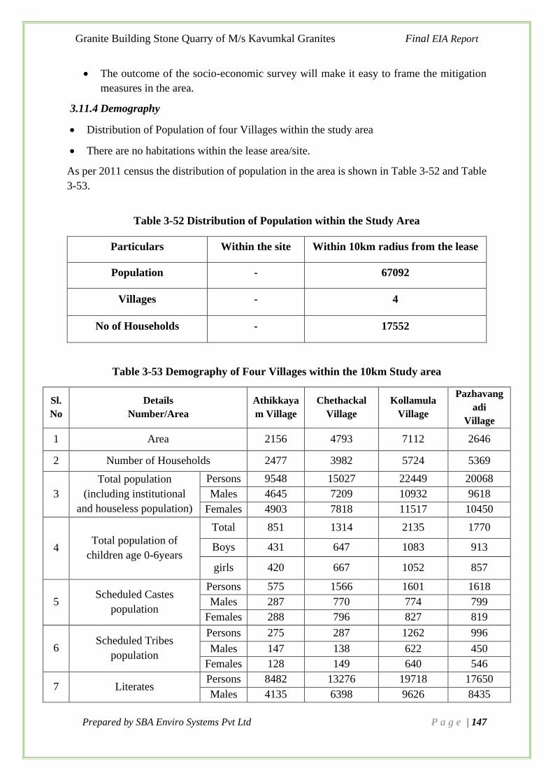
Granite Building Stone Quarry of M/s Kavumkal Granites Final EIA Report
Prepared by SBA Enviro Systems Pvt Ltd P a g e | 147
• The outcome of the socio-economic survey will make it easy to frame the mitigation
measures in the area.
3.11.4 Demography
• Distribution of Population of four Villages within the study area
• There are no habitations within the lease area/site.
As per 2011 census the distribution of population in the area is shown in Table 3-52 and Table
3-53.
Table 3-52 Distribution of Population within the Study Area
Particulars Within the site Within 10km radius from the lease
Population - 67092
Villages - 4
No of Households - 17552
Table 3-53 Demography of Four Villages within the 10km Study area
Sl.
No
Details
Number/Area
Athikkaya
m Village
Chethackal
Village
Kollamula
Village
Pazhavang
adi
Village
1 Area 2156 4793 7112 2646
2 Number of Households 2477 3982 5724 5369
3
Total population
(including institutional
and houseless population)
Persons 9548 15027 22449 20068
Males 4645 7209 10932 9618
Females 4903 7818 11517 10450
4 Total population of
children age 0-6years
Total 851 1314 2135 1770
Boys 431 647 1083 913
girls 420 667 1052 857
5 Scheduled Castes
population
Persons 575 1566 1601 1618
Males 287 770 774 799
Females 288 796 827 819
6 Scheduled Tribes
population
Persons 275 287 1262 996
Males 147 138 622 450
Females 128 149 640 546
7 Literates Persons 8482 13276 19718 17650
Males 4135 6398 9626 8435

Granite Building Stone Quarry of M/s Kavumkal Granites Final EIA Report
Prepared by SBA Enviro Systems Pvt Ltd P a g e | 148
Sl.
No
Details
Number/Area
Athikkaya
m Village
Chethackal
Village
Kollamula
Village
Pazhavang
adi
Village
Females 4347 6878 10092 9215
8 Total workers
Persons 3268 5132 7464 6543
Males 2568 3803 5889 4893
Females 700 1329 1575 1645
9 Main workers
Persons 2635 3639 6015 5180
Males 2205 2987 4985 4151
Females 430 652 1030 1029
10
Industrial
category of
main
workers
Cultivators
Persons 447 346 1658 388
Males 423 335 1450 362
Females 24 11 208 26
Agricultural
labourers
Persons 330 434 838 650
Males 310 378 747 574
Females 20 56 91 76
Household
industry
workers
Persons 124 84 180 119
Males 104 73 121 95
Females 20 11 59 24
Other
workers
Persons 1734 2778 3339 4023
Males 1368 2201 3667 3120
Females 366 574 672 903
Source: Census of India 2011
Population
Total population of four villages within 10 Km radius of the project area collected from 2011
census hand book and it was found total population of 67092.
Household Size
The term ‘Household’ is defined in census as a group of persons who commonly live together
and would take their meals from common kitchen. There are 17552 households in the study
area as per 2011 census. Average person per household in the study area is 4 (3.882) indicating
nuclear families.
Occupation structure
The main occupation of the local villagers is agriculture, animal husbandry like goat raring,
cattle farming for milk etc, and many of them are dependent on the quarry and associated work
in the surrounding area.
The lockdown due to Covid-19 has contributed to job loss of many daily wage workers and
also resulted in negative growth of the development at both state and Centre. The financial loss
and job loss thus created can be revitalized by approving the proposed mining and quarrying

Granite Building Stone Quarry of M/s Kavumkal Granites Final EIA Report
Prepared by SBA Enviro Systems Pvt Ltd P a g e | 149
activities. The materials mined out from the proposed quarry will be available in the local
market for construction and developments.
Figure 3.27 Photographs of Social Interaction
3.12 Public Utilities
Bank, schools and post office are available at Athikkayam. Whereas Hospital, market facilities,
higher educational and transportation facilities are available at Ranny Taluk which are at a
distance of 7.6 km from the lease area. The mode of transportation for local people is bus,
railways, auto rickshaw and two wheelers.
Table 3-54 Public Utilities in the Project Location
Sl no Particulars Details
1 Taluk & District Ranny, Pathanamthitta
2 Nearest habitation Nearest habitation- 208m N
3 Accessibility 7.5m quarry approach road connecting with the
Edamuri-Koothattukulam Road.
4 Nearest town Koothattukulam -1.4km-NE
5 Nearest Airport Cochin International Airport -94.7km-NW

Granite Building Stone Quarry of M/s Kavumkal Granites Final EIA Report
Prepared by SBA Enviro Systems Pvt Ltd P a g e | 150
Sl no Particulars Details
6 Nearest Highway / Roads SH 44 - 4.7km - NE
NH 183A- 5.6km - S
7 Nearest Railway Station Chengannur railway station -27.5 km -SW
8 Power supply KSEB Overseer Office, Athikkayam -3.1 km-S
9 Water Source Open Well
10 Nearest Hospital / dispensary Government Hospital, Vechoochira-1.5km-NE
11 Education facility Government LP School, Edamuri-1.1km-SW
12 Police Station Vechoochira Police Station-1.37 km-NE
13 Fire Station Fire and Rescue Station, Kanjirappally-16.4 km-N
14 Ambulance Government Hospital, Vechoochira-1.5km-NE
15 Church / temple / mosque
St. Joseph’s Catholic Church, Vechoochira -2.13km-
NE
Nusarathul Islam Juma Masjid vechoochira -2.74km -
NE
Edamury mahakshethra samuchayam – 1.1 km -SW
16
Ecological sensitive zone
(National Park, Sanctuary,
Habitat for Migratory Birds,
Tiger Reserve)
Periyar National Park-10.5km-NE
17 Nearest Forests Konni Reserve Forest -20.0km-SE
Periyar National Park-10.5km-NE
18 Nearest streams/ rivers/ water
bodies (from mine boundary) Pampa River-3.20km-S

Granite Building Stone Quarry of M/s Kavumkal Granites Final EIA Report
Prepared by SBA Enviro Systems Pvt Ltd P a g e | 151
Chapter 4. ANTICIPATED ENVIRONMENTAL IMPACTS &
MITIGATION MEASURES
4.1. Introduction
Before starting the mining operations, it is essential to assess the impacts of mining on various
features of environment such as land, air, water, noise, ecology, socio-economic etc, so that
abatement measures could be planned in advance for eco-friendly mining. Opencast, Semi
Mechanized Mining activity causes some adverse impacts on the surrounding environment
unless proper Environmental Management Plan (EMP) is adopted. Selecting suitable sites for
mining and also adopting all the guidelines prescribed by the Ministry of Environment Forests
and Climate change (MoEF&CC) and Department of Mines and Geology (DMG) can minimize
the major possible impacts.
4.2. Environmental Impact Assessment Parameters
The mining activities may affect environment in various ways such as degradation of land, dust
generation, deterioration of water and soil quality, affecting the biological and socio-economic
environment of the area. The impacts of mining on various environmental parameters were
assessed and are given below.
Table 4-1 Parameters of Impact
Sl No Parameter Description
1 Type Positive & Negative
2 Nature Direct, Indirect
3 Magnitude Low, Moderate, High
4 Timing Short time, Long time, Intermittent
5 Duration Temporary, permanent
6 Reversibility Revisable /Irreversible
7 Significance Local, regional & global
4.3. Impact on Land Environment
The mining activity will affect the present landscape of the lease area. The original topography
of the lease area might be affected mainly due to mining operations. The proposed mine land
area is 4.0262Ha, which is private owned land. The details of land area indicating the area
likely to be degraded due to mining will be as given in Table 4-2.
Table 4-2 Land use Pattern of proposed area during different period
No. Land Use Pre-Operational (Ha) Operational (Ha)
1 Mining area 0.00 3.4048
2 Road 0.00 0.0180

Granite Building Stone Quarry of M/s Kavumkal Granites Final EIA Report
Prepared by SBA Enviro Systems Pvt Ltd P a g e | 152
No. Land Use Pre-Operational (Ha) Operational (Ha)
3 7.5m width greenbelt barrier
zone 0.6034 0.6034
4 Virgin Area 2.6409 -
Total 4.0262 4.0262
About 90585 tonnes of topsoil and 92819 tonnes of overburden will be generated during the
mining operations. This topsoil and OB will be utilized for greenbelt development in the 7.5m
barrier. Topsoil and OB will be placed in the area specifically assigned for the purpose. The
development in the 7.5m greenbelt area will create a green barrier and maintain the aesthetic
of the surrounding area.
Land Degradation
The mining activities would result in land degradation due to following activities:
• Excavation of mining lease area
• Storage of topsoil.
Necessary control measures like simultaneous plantation, silt arresting measures and dump
stabilization etc., shall be implemented to minimize the land degradation. The quantity of
expected topsoil generation is very minimum and generated topsoil will be dumped in
predetermined dump location. The stored topsoil will be reused for the reclamation process.
4.4. Impacts on Water Environment
Impacts on Surface Water
There are no seasonal streams within the leasehold area. The seasonal streams could be seen
outside the leasehold area towards south, southwest and northwest side of the lease. The
rainwater draining from the hill slopes and the slopes in the study area carries the silt and
pebbles, which ultimately settles at the connecting streams/river. The rainwater flow, which
enters in the waste dump area may cause waste dump erosion. The proposed garland drains at
the higher elevation will divert the entry of water flow away from the mine.
Impacts on Ground Water
The water table in this region is at a depth of 4-5 m from general surface level. During the 1st
Five-year mining plan period, mining will be carried out from 355 m RL to 270 m RL above
MSL depth from the surface on the hillock, therefore the mining is not likely encounter
groundwater at any time during the scheme period. No chemical having toxic elements will be
used for carrying out mining activity. Also, neither granite nor topsoil contains any kind of
toxic element which can contaminate the water. To check the erosion and prevent silt being
carried during monsoon period, a series of gully checks would be constructed at regular
intervals.

Granite Building Stone Quarry of M/s Kavumkal Granites Final EIA Report
Prepared by SBA Enviro Systems Pvt Ltd P a g e | 153
4.5. Impacts on Air Environment
The opencast mining and associated activities are potentially air polluting. The major air
pollutant is the suspended particulate matter. The major reason for air pollution problem is
fugitive dust emission, which prominently depends on various factors like production capacity,
machinery involved, drilling, blasting, excavation, and maintenance of various equipment and
vehicle. Apart from these, there will be other activities associated viz. transportation of Granite
building stone and waste, stocking facilities and dump management within the mine lease area
that may contribute to pollution.
SPM levels will be higher within the active operational areas (mine area) due to drilling,
blasting, excavation, loading/unloading and transportation.
Vehicles travelling over paved or unpaved surfaces tend to crush surface particles and other
debris. Particles are lifted and dropped from the rolling wheels, and the road surface is exposed
to strong air currents due to turbulent shear between the wheels and the surface. Dust particles
are also sucked into the turbulent wave created behind the moving vehicles. The loads carried
by trucks are also potential source of dust, either through wind entrainment or spillages. Mud
and dust carry out from unpaved surfaces is another potential problem.
Gaseous Pollution:
• The gaseous pollutants (SO2 and NO2) are anticipated from Heavy Earth Moving Machineries
like excavator, dumpers, dozer and other transport vehicles.
Particulate Matter
The generation of dust is anticipated from various mining activities i.e. drilling, blasting,
loading, haulage, unloading other activities related to mining. The ambient air quality
monitored during winter season shows that the PM concentrations in the surrounding villages
are within the Ambient Air Quality Standards of CPCB.
4.5.1 Air Emission and Dispersion Model
Air quality modelling is a numerical tool used to describe the causal relationship between
emissions, meteorology, atmospheric concentration, deposition and other factors. In general air
pollution measurement gives important quantitative information about ambient concentration
and deposition at a certain location at specific times. Whereas air quality modelling can give a
more complete deterministic description of air quality problem including an analysis of factors
and causes. In simple words modelling is the mathematical prediction of ambient concentration
of air pollution based on measured inputs.
The modelling is the prediction of the particulate matter concentrations in and around the
mining areas based on the emission, meteorology, topography, deposition and other factors.
Though the dispersion pattern and emission through the dispersion models are difficult to
predict, since there are multiple number of sources of particulate matter generation, and the
meteorology and topography varies widely, but by selecting the partial empirical equations for
each activity at a time this could be possible. The characterization of the particulate matter is

Granite Building Stone Quarry of M/s Kavumkal Granites Final EIA Report
Prepared by SBA Enviro Systems Pvt Ltd P a g e | 154
to find the constituent of it such as silica, mineral matter, and diesel exhausts etc. which
determine its harmfulness towards human health.
A. AERMOD CLOUD
The term AERMOD is an abbreviation of American Meteorological Society-Environmental
Protection Agency Regulatory Model (AERMOD). AERMOD View is a complete and
powerful air dispersion modelling package that seamlessly incorporates the popular U.S. EPA
models, AERMOD, ISCST3, and ISC-PRIME into one interface without any modifications to
the models. These models are used extensively to assess pollution concentration and deposition
from a wide variety of sources.
An air dispersion model is a computational way of predicting the concentration based on the
knowledge of emission characteristics, topography and meteorology. AERMOD was
developed by the AERMIC (American Meteorological Society (AMS)/United States
Environmental Protection Agency (EPA) Regulatory Model Improvement Committee).
AERMOD model is applicable to both rural and urban areas, surface and elevated releases flat,
complex terrain, and multiple sources such as point, area and volume sources
Basically, AERMOD is a steady-state plume model. It uses, processed meteorological
observations such as wind speed, wind direction, humidity, rainfall, temperature which is first
pre-processed by AERMET and along with the emission characteristics (as mentioned in the
emission rates) it estimates the concentration of the particulate matter released by different
sources. The data flow diagram briefly explains how the model works.
There are some of the required inputs to the AERMOD as listed below:
• Latitude and longitude of the place under consideration
• Base map of the area where modelling is to be performed.
• The pollutants to be modelled
• Hourly met data.
• Receptors
• Terrain data
• The emission factors of the generating sources
• Source locations etc.
B. Area Source Selection
Selecting the source pathway from the options
• Area source is selected by manually entering the data in the table (coordinates, release
heights, etc.) or can be drawn by selecting the drawing tool and moving it on the haul
road direction, Blasting Area, Drilling area, Dumping Area, etc. Other related data such
as emission rate, vehicle height and width (for calculating plume characteristics) etc.

Granite Building Stone Quarry of M/s Kavumkal Granites Final EIA Report
Prepared by SBA Enviro Systems Pvt Ltd P a g e | 155
• Emission rate which is established either through field measurement in working mines
& extrapolating the information to required capacity in expansion or using empirical
equations and putting the value of variables from site conditions (Secondary Data
Adopted). Also, the predicted source concentration was calculated with principles EPA
AP 42 for vehicular movement, drilling and blasting, cumulatively in unit of g/s.
• Receptors were arranged in the manner as per CPCB guideline (probes/70/1997-98) to
specify distances for the polar network.
C. Predicted Air Pollution Impacts
Figure 4.1 Isopleth of PM10

Granite Building Stone Quarry of M/s Kavumkal Granites Final EIA Report
Prepared by SBA Enviro Systems Pvt Ltd P a g e | 156
Figure 4.2 Isopleth of PM2.5
Figure 4.3 Isopleth of SO2

Granite Building Stone Quarry of M/s Kavumkal Granites Final EIA Report
Prepared by SBA Enviro Systems Pvt Ltd P a g e | 157
Figure 4.4 Isopleth of NOx
Figure 4.5 Isopleth of CO

Granite Building Stone Quarry of M/s Kavumkal Granites Final EIA Report
Prepared by SBA Enviro Systems Pvt Ltd P a g e | 158
D. Result Representation and Recommendations
First rank values were (Highest Value) selected as the incremental value and added to the
existing background values, which defines the predicted concentration as GLC corresponding
to the source of pollutants.
Table 4-3 Final Output Data- Dispersion Modelling
Sl
No
Parameter Units Baseline
Conc.
Incremental
Conc.
Total
GLC
NAAQ
Standard
Distance
(meter)
&
direction
1 Particulate
Mater (PM10) µg/m3 63.82 6 69.82 100 75m - NE
2 Particulate
Mater (PM2.5) µg/m3 19.82 7 26.82 60
200m -
NW
3 Sulphur
Dioxide (SO2) µg/m3 9.21 3 12.21 80 75m -N
4 Nitrogen
Dioxide(NO2) µg/m3 10.4 4 14.4 80
74m -
NNE
5 Carbon Monoxide
(CO) Mg/m3 0.9 0.313 1.213 2
75m
- NE
Observations
i. None of the predicted concentration (GLC) exceeds the NAAQ Standards.
ii. Parcel flow majorly directed towards N directions
iii. At worst generation sources also, highest concentrations found at 75 m (from Center of
the plot) which is at boundary of the buffer land adjacent to the proposed area in North
and North-East direction.
iv. Impacts can be reduced to the very well extent by attaining a good EMP as
• Should maintain a vehicular Traffic control in operational phase
• Should maintain the existing greenbelt around the site
• Dust suppression procedures should be implemented
• Operation phase activities like drilling and blasting in controlled manner

Granite Building Stone Quarry of M/s Kavumkal Granites Final EIA Report
Prepared by SBA Enviro Systems Pvt Ltd P a g e | 159
• Removal and dumping of TS should be in standard practice.
4.6. Impacts on Noise & Vibration Environment
With the mining operations for mine development like drilling, blasting, excavation, loading,
unloading, and transportation of material, it is imperative that noise levels would increase
unless appropriate abatement measures are planned and effectively carried out. The noise and
vibrations mainly generated by mining machineries; background noise levels shall be kept in
the range of 74 to 85 dB (A).
The noise generated from blasting will be for a very short duration and will be conducted during
such time such as at the end of shift or when most of the workers have been withdrawn to safe
places.
Vibration
The blasting cause ground vibration. For assessment of peak particular velocity, the following
formula is followed:
V = 417.8{D/Q0.5} - 1.265
= 417.8 {208/16.880. 5}- 1.265
Where
V = Peak particle velocity in mm/s
D = Distance between location of blast and nearest habitation (gauge point) (208 m).
Q = Quantity of explosive per blasting (Maximum of 16.88 kg).
Vibration levels at the nearest habitation (at 208 m) is observed (calculated through the above
mathematic formula) is 3.7 mm/sec which is within the permissible Peak Particle Velocity
(PPV) value of 15 mm/sec for buildings /structures not belonging to the lease owner as per
DGMS circular no.7.2 of 1997.
➢ Adverse impact on human health like fatigue and behavioural changes and also on fauna
due to increased ambient noise level due to rock excavation, transportation, processing
equipments and ancillaries. Further, the increased ambient noise level causes fear
among faunal species and hence loss of habitat near the mine lease area
➢ Adverse impact of vibrations including damage to structures due to blasting.
4.7. Impacts on Biological Environment
No wildlife sanctuary or national park or biosphere reserves are located within the study area.
Due to hard exposed granite/Charnokite, comparatively there are fewer plantations within the
lease area and most of the plantation within lease area to be removed for implementation of
mining operation within 4.0262 Ha lease area. No plantation outside the lease area shall be
removed for mining or any mining related activities.

Granite Building Stone Quarry of M/s Kavumkal Granites Final EIA Report
Prepared by SBA Enviro Systems Pvt Ltd P a g e | 160
Impact on Wildlife:
There is no National Park, Wildlife Sanctuary, Biosphere Reserve, Wildlife corridors and
Tiger/Elephant Reserve found within 10 km radius of the project site.
Impact on Flora:
No much adverse impact is envisaged on the existing flora, as there will be no deforestation
outside the lease area due to mining and mining related activities. The removal of plants from
the mining area is inevitable and to balance the impacts, plantation will be developed in the
mining lease area as per reclamation proposal of mining plan. These activities help to improve
the floral cover of the area. The greenery and plantation development will eventually attract
micro fauna, birds etc., in the area. Assistance will be taken from local forest department in
selection of species of plants so that green coverage could improve very fast.
Impact on Fauna:
No endangered species of fauna is found in and around lease area. As such there will be no
adverse impact of the mining activity on fauna around the mining lease area.
4.8. Impacts on Socio economic Environment
The socio-economic impacts of the proposed project could be assessed in terms of demand
supply aspects for goods and services in the area, pressure on natural resources and
infrastructure, growth of industry, sustainability of livelihoods and employment. Some indirect
impacts can also be understood in terms of public health and safety, preserving local culture
and aesthetics of the archaeological monuments and heritage precincts. Based on a close
understanding and assessment, the socio-economic impacts of the proposed project predicted
as follows
Positive Impacts:
i. There is no loss of land and consequential livelihoods, as no land acquisition is
contemplated.
ii. Creation of employment opportunities for about 20 local skilled and semiskilled workers
during project construction and Operation phases.
iii. Development of Infrastructures, Educational, Health facilities and other CER project works
in the local area in consultation with Local Self- Government (LSG’s).
iv. Providing periodical free health check-up facilities to local villagers in nearby villages and
equipment, rooms, etc., Provision of support facilities and Annual health camps at Primary
Health Centre, Pathanamthitta District.
v. Emergence of local entrepreneur in complementary activities such as small business
transportation, equipment repairs and maintenance etc.

Granite Building Stone Quarry of M/s Kavumkal Granites Final EIA Report
Prepared by SBA Enviro Systems Pvt Ltd P a g e | 161
Adverse Impacts:
• Air pollution through release of fugitive dust during mining process leading to possible
incidence of respiratory diseases, irrigation of eyes and nose etc., for people living in
the impact zone.
• Possible adverse impact on crop productivity as a result of fugitive dust setting on plants
in the vicinity. And thereby economic problems for farmers.
• Noise pollution may cause hearing problems for people living in the impact zone.
• Crack formations in the nearest building due to vibrations
4.9. Impact Mitigation Measures
4.9.1 Mitigation Measure on Soil Environment
Totally 90585 tonnes of topsoil and 92819 tonnes of OB are expected to be recovered during
the mining period. The generated topsoil during mining operations will not be allowed to be
mixed with other material. The topsoil/OB shall be utilized for plantation in the 0.6034 Ha
Safety barrier/greenbelt area. The excess topsoil will be placed in the dumping area specifically
proposed for the purpose.
• Garland drains shall be made all along the mine for diverting storm water and also for
the regulating the water flow away from the dumps. The water from garland drain shall
be released in the silt settling tank (SST) and the overflow from the SST to the rainwater
harvesting pond (RWHP). The overflow from the RWHP shall be diverted to the natural
course.
• The non-mineralized zone and open areas shall be planted with suitable local trees.
• Plantation will be carried on waste dumps to prevent soil erosion.
4.9.2 Mitigation Measures on Land Environment
The mining activity will affect the present landscape of the lease area. The original topography
of the lease area shall be affected mainly due to mining operations, dumping of waste, roads
etc.
• Plan for restoration of mined-out area by appropriate eco-restoration as per the
progressive mine closure plan.
• The runoff from the mine to be regulated by construction of appropriate drainage
channels through garland drains as per the drainage plan of the mine lease area (which
is part of mining plan) within the core zone and to be channelized to common drainage.
• These measures will ensure final sedimentation of silt and the overflow from the check
dam will be channelized to the natural drain available near the project site.

Granite Building Stone Quarry of M/s Kavumkal Granites Final EIA Report
Prepared by SBA Enviro Systems Pvt Ltd P a g e | 162
• Conservation of topsoil for future eco-restoration work. The dump shall be provided at
the lower contour with retaining walls with weep holes and with a garland drain around
the dump.
• Construction of drainage with intermittent silt traps.
4.9.3 Mitigation measures on Surface water
Adequate control measures are being adopted to check not only the wash-off from soil erosion
but also uncontrolled flow of rainwater through mine. The measures to be adopted are:
• Sufficient drains are proposed within mining lease area and also all along the lease
boundary to channelize all the surface water to the proposed silt settling tanks (SST).
• The overflow water from the SST would be directed to RWHP
• The overflow water from the RWHP would be released to the natural water course.
Thus, the only clarified water is released from the mine.
• During rains, water will flow within the mine and in the vicinity, to reduce the velocity
of rainwater flow, sufficient gully checks shall be provided.
• Construction of catch drains and settling tanks around dumps for channelization of
rainwater away from the dumps and to prevent siltation/sedimentation.
• Construction, maintenance and regular cleaning of garland drains, Check dams and
gully plugs.
• Granite Building Stone is chemically stable and non-toxic. There is no toxic element in
the mined-out material, which may contaminate ground/surface water. It is, therefore,
apparent that there will not be any impact of mining on the surface water regime.
Strom Water Management:
Garland drains shall be constructed to divert water away from mining area. The water from the
garland drains shall be directed to the SST and the overflow is diverted to the RWHP. Series
of gully plugs shall be constructed to reduce the flow of running water and for settling of silt
in the running water. The afforestation with good root bearing species minimizes the impacts
due to storm water flow.
Danger of Mine Inundation:
The mine is on a hill slope and no water course, water body or river is on the higher elevation
of the mine. Sufficient Garland drains and the other drainages are planned and maintained
during mining and at the end of the mining, the rainwater and the surface run-off will be
diverted away from the mine to join the natural water downstream course.
4.9.4 Mitigation Measures on Ground Water
• The ground water table is much below the general ground level at the hill bottom. The
proposed mining operations are much above the ground water table. Therefore, the
mining operations on hilltop will not have any adverse impact on either yield movement
or quality of ground water.
• No ground water is going to be encountered during five years mining plan operation;

Granite Building Stone Quarry of M/s Kavumkal Granites Final EIA Report
Prepared by SBA Enviro Systems Pvt Ltd P a g e | 163
• Moreover, granite building stone is chemically inert and will not affect the water
quality.
4.9.5 Mitigation Measures on Air Environment
Following measures shall be adopted to mitigate air pollution generated due to the mining
activities:
• Sharp drill bits will be used for drilling to reduce generation of dust.
• Drilling machines will be equipped with water spraying system to prevent dust to get
air borne.
• All the haul roads will be kept properly graded with sufficient width and regular water
spraying is done on the haul roads.
• Proper maintenance of vehicles will be carried out regularly for minimization of
generation of gaseous pollutants.
• Personal Protective Equipment (PPE) like dust mask, ear plug/earmuff, goggles, safety
shoe, hand gloves will be provided to all employees
• Development of greenbelt will be done around lease boundary and other places to arrest
dust.
• Air and Dust monitoring shall be conducted at regular interval. Monitors shall be
stationed 25m away from site boundary during drilling, excavation, stockpiling
activities and at post occupancy stage with the help of MoEF/NABL approved
laboratory.
• Tarpaulin covers shall be provided on trucks used for transportation of materials prone
to fugitive dust emissions.
• Watering the areas exposed to wind erosion, avoiding material transportation on un-
watered haul roads, increasing moisture content of excavate material and Waste, etc.
• Total area exposed to wind action, minimizing route lengths and reducing uncovered
areas and pits through re-forestation.
• Emission control efficiency by water spraying program (intensity of the applications
and average time between spray applications).
Water availability being a measure concern, innovative technologies based on water additives
which reduce water evaporation and particulate matter agglomerated over unpaved roads shall
be implemented.
i. Mitigation measures on paved surfaces:
• Prevent spillages of materials on the paved surfaces during material transportation.
• Speed controls on vehicle movements.
• Wind reduction control by plantation.
• Regular cleaning of paved surfaces.
ii. Mitigative measures on Unpaved Surfaces:

Granite Building Stone Quarry of M/s Kavumkal Granites Final EIA Report
Prepared by SBA Enviro Systems Pvt Ltd P a g e | 164
• Dust emissions from unpaved surfaces shall be controlled by using water sprinkling
on unpaved areas during dry wind periods, using a water tanker/or fixed sprinklers.
• Chemical stabilization shall be used in association with wet suppression.
• Speed control on the vehicle movements.
• Wind reduction controlled by plantation.
iii. Dust emissions due to vehicles can be minimized by:
• Avoid spillage from the loaded trucks.
• Speed controls on vehicles have an approximately linear effect on dust emissions.
• Water spraying for dust suppression
Vehicular emission of particulates, SO2, NOx, hydrocarbons can be minimized by proper
regular check-up, preventive maintenance and maintenance of vehicles and other oil operated
equipment.
iv. Biological Method for Dust Control:
• Trees can act as efficient biological filters. The systematic and planned greenbelt
development not only reduces the fugitive dust but also checks runoff and improves the
aesthetic beauty of an area. It is a proven technology for waste dump stabilization and
restoration of mined out area.
Green belt of adequate width should be raised by planting native species around the mine lease
area on both sides of haul road
4.9.6 Mitigation measures on Noise Environment
Mitigation measures for noise and ground vibrations are of following types:
1. Prevention at source.
2. Attenuation in transmission path.
3. Protective measures in work environment.
i. Prevention at source:
Noise should be best abated at source by choosing Machinery and equipment suitably, by
proper mounting of equipment and ventilation Systems and by providing noise insulating
enclosures or padding where practical. The equipment to be procured will be new and as such
as the noise emission will be optimal for their design/operation. Proper maintenance/working
will be done which keeps the noise levels within limits.
Blasting shall be conducted only during day light hours. Milli-second delay detonators with
non-electric initiation system shall be adopted to minimize noise and vibration. Rock breakers
shall be used for breaking down large boulders. No secondary blasting will be done to reduce
noise and air blast
ii. Attenuation in transmission path:

Granite Building Stone Quarry of M/s Kavumkal Granites Final EIA Report
Prepared by SBA Enviro Systems Pvt Ltd P a g e | 165
At the mine lease Boundary dense belt of trees will be plated to act as acoustic barriers.
Planting of bushy trees of rich canopy in and around the mine area to intercept noise
Transmission will be undertaken. A 7.5 m wide belt of trees of different heights shall be useful
to act as noise attenuator in the mining areas.
iii. Protective measures in the work environment:
Protective earmuffs and earplugs will be provided for those exposed to high noise levels as per
statutory requirements; the noise level exposure shall be maintained within the prescribed
limits under The Noise Pollution (Regulation and Control) Rules, 2000. The blasting
parameters will be suitably set to minimize ground vibration within safety limit; Shock
absorbing techniques will be adopted to reduce impact energy.
4.9.7 Mitigation Measures on Biological Environment
i. Measures for Minimizing Impact on Fauna
Following measures will be adopted to minimize the impact of mining on faunal
environment of the area.
• Greenery development will help in creating habitats for local faunal species and to
create better environment for various fauna.
• Creating and developing awareness for nature and wildlife in the adjoining villages.
ii. Measures for Minimizing Impact on Flora - Greenbelt Development:
• Plantation will be carried out in the lease area with a view to provide greenbelt and to
give an aesthetic look, for eliminating fugitive emissions and controlling impact of
noise etc. Additional plantation will be providing within the greenbelt barrier zone,
almost 1000 nos of trees will be plant at an interval of 3.m.
• Species proposed for Greenbelt/ Plantation are Artocarpus heterophyllus (Plavu),
Artocarpus Hirsutus(Anjili),Mangifera indica(Maavu), Tectona grandis (Thekku),
Terminalia paniculata(Maruthu), Phyllanthus emblica (Nelli) Pterocarpusmarsupium
(Venga) Bambusoideae Careya (mula) Careya arborea (Pezhu) Briedelia retusa
(Mulluvenga) Garcinia gummigutta (Kudambuli).
• This help in reducing the spread of pollutants and will also be effective in attenuating
noise levels.
4.9.8 Mitigation measures on Socio-Economic environment
Mitigation measures on the negative impacts on social economic,
• Regular water sprinklings will be carried on haulage roads and all dust prone areas.
• Sharp drill bits will be used to reduce the emission of air borne dust.

Granite Building Stone Quarry of M/s Kavumkal Granites Final EIA Report
Prepared by SBA Enviro Systems Pvt Ltd P a g e | 166
• Coir mating will be planned on waste dumps.
• Install appropriate dust control equipment to check air pollution.
• Organize quarterly health camps in the area to check the incidence of any respiratory
and other related disorders.
Occupational Safety and Health Environment:
Occupational health and safety hazards occur during the operational phase of mining and
primarily include the following:
Respiratory hazards:
Long-term exposure to silica dust may cause silicosis. The following measures are proposed:
• The cabin of Excavators, dumpers, dozers and other automated equipment’s will be
closed
• Use of personal breathing protection will be made compulsory.
Noise:
• No employee will be exposed to a noise level greater than 75 dB(A) for a duration of
more than 8 hours per day without hearing protection
• The use of hear protection equipment will be enforced actively when the equivalent
sound level reaches greater than 75 dB (A).
• Earmuffs provided will be capable of reducing sound levels.
• Periodic medical hearing checks will be performed on workers exposed to high noise
levels.
Physical hazards:
• Specific personnel training on work-site safety management will be taken up
• Work site assessment will be done by rock scaling of each surface exposed to workers
to prevent accidental rock falling and / or landslide, especially after blasting activities;
• Maintenance of yards, roads and footpaths, providing sufficient water drainage and
preventing slippery surfaces with an all-weather surface, such as coarse gravel will be
taken up.
Occupational Health Survey:
All the persons will undergo initial medical examination at the time of joining and 20% of the
work force shall be examined every year as per Mines Act 1952. The following tests would be
undertaken
• General physics tests
• Audiometric tests
• Full chest, X-ray, Lung function tests, Spiro metric tests
Essential medicines will be provided at the site. The medicines and other test facilities will be
provided free of cost.

Granite Building Stone Quarry of M/s Kavumkal Granites Final EIA Report
Prepared by SBA Enviro Systems Pvt Ltd P a g e | 167
The first aid box will be made available at the mine for immediate treatment. Employees are
monitored for occupational diseases by conducting the following tests.
• Periodic medical examination – Once in 5 Years.
• Lung function test – yearly, those who are exposed to dust
• Audiometry – yearly
• Chest X-ray once in five years
• Eye test
4.10. Conclusion on the Characterisation of Impacts
Table 4-4 Conclusion on Characterisation of Impacts
Sl No Impacts on Characterisation
1 Land Environment Negative, direct, moderate, long term, permanent and
regional impacts
2 Water Environment The mining activity will have no negative or direct,
long term, permanent and regional impact on the water
environment.
3 Air environment Negative, Direct, low, short time, temporary and local
4 Noise & Vibration Direct, Low, Short term, Temporary and local
5 Biological environment Negative, direct, low, short time, temporary, revisable
and local impact on the ecological environment.
6 Socio- economic Positive, direct, moderate, long term, permanent and
regional impacts

Granite Building Stone Quarry of M/s Kavumkal Granites Final EIA Report
Prepared by SBA Enviro Systems Pvt Ltd P a g e | 168
Chapter 5. ANALYSIS OF ALTERNATIVES
5.1. Alternative Technology
Type of mining is contingent on geological, topographical conditions of the mine lease area,
type of mineral and production capacity envisaged. The mining activity proposed as stone
boulders mining with maximum annual capacity of 188637.8 MT. The extraction capacity is
high, and manual method is ruled out. The proposed mining method is for extraction of mineral
and ROM is opencast mechanized with drilling and blasting. Bench height and width will be
maintained as 5m. Blast holes of 1.0 to 1.50 m depth will be drilled with help of 32mm drill
rod, Jack hammer and Air Compressor of 100 cfm capacity. Loading of blasted material is
proposed with 2.5 cum bucket capacity excavator in dumpers of 15 tonnes capacity.
Topsoil/OB shall be removed separately and stored at the place earmarked for it and used for
green belt development.
5.2. Alternative Site
The mineral exploration of minor mineral in the mine lease area is facilitated by the lease of
the land by Government of Kerala. The project is mineral specific and there is abundance of
the mineral in the mine lease area.
The proposed mine lease area is however found to be away from any ecologically sensitive /
protected areas. There are no archaeological, historical, cultural or defence installations within
10 km from the mine lease boundary. There is no national park and wildlife
sanctuary/ecologically sensitive area within 10 km from the mine lease boundary. The mine
lease area is not part of any flood plain nor in the land slide vulnerable zone as per the hazard
zonation map published by State Disaster Management Authority. The nearest habitation is
208 m. from the boundary of the pit area. Due to the above-mentioned reasons, there is no need
for alternative site.

Granite Building Stone Quarry of M/s Kavumkal Granites Final EIA Report
Prepared by SBA Enviro Systems Pvt Ltd P a g e | 169
Chapter 6. ENVIRONMENT MONITORING PROGRAMME
6.1 Introduction
Environment Monitoring is an essential part to check the impact of project related activity.
Hence monitoring of various environment parameters will be carried out on a regular basis to
ascertain the following:
• Status of Pollution within the mine site and in its vicinity.
• Generate data for predictive or corrective purpose in respect of pollution.
• Examine the efficiency of pollution control system adopted at the site.
• To assess environmental impacts.
Monitoring will be carried out at the site as per the norms of Central Pollution Control Board.
Environmental Monitoring Program will be conducted for various environmental components
as per conditions stipulated in Environmental Clearance (EC) issued by SEIAA and Consent
to Operate (CTO) issued by Kerala State Pollution Control Board.
Objectives : The objectives of the environmental monitoring program are:
➢ Evaluation of the efficiency of mitigation and pollution control measures / equipment /
devices
➢ Updating of the actions and impacts of baseline data
➢ Adoption of additional mitigation measures if the present measures are insufficient
Methodology: Monitoring methodology covers the following key aspects:
• Components to be monitored
• Parameters for monitoring of the above components
• Monitoring frequency
• Monitoring standards
• Responsibilities for monitoring
o Direct responsibility
o Overall responsibility
• Monitoring costs.
6.2 Activities
A. Slope Failure:
Regular inspection shall be carried out to examine slope stability, mine faces. Observations
shall also be made by regular checking for land erosion possibility in hill slopes/backfill area.

Granite Building Stone Quarry of M/s Kavumkal Granites Final EIA Report
Prepared by SBA Enviro Systems Pvt Ltd P a g e | 170
The observation and study include, study for slope failures and excess erosions both along the
pit and the topsoil dumps, Periodic analysis of mine drainage and Study of bunds/retaining
walls/garland drain/gully plugs at the waste dumps area and other area inside and outside the
lease.
B. Drainage:
The effectiveness of drainage system depends upon proper cleaning of all drains and sumps.
Regular checking of the garland drain and natural water course shall be carried out to find any
blockage due to silting or accumulation of loose materials. The drains shall also be checked for
any damage in lining / stone pitching etc.
C. Blasting Effect:
Regular testing and inspection of blasting operations in work zone shall be carried out with
respect to noise, fly rock throw, vibration, dust and fume generation. These tests shall be
conducted six monthly or whenever new patterns of blasting shall be adopted for rock
fragmentation. The blast vibration shall be maintained ensure that the vibration levels area well
below the permissible limit of 15mm/sec (DGMS limits).
D. Re-vegetation and Greenbelt Development:
Greenbelt development as per the scheduled plan shall be reviewed every year. Post plantation
status shall be regularly checked every season and the plantation related data/information shall
be kept and compiled every year.
The distance between the plants shall be 3 m and the watering shall be done twice in a week
during summer and post monsoon season. The required fertilizing shall be done after soil
testing and consultation with expert, local research institutes. Forest departments will be
consulted for the plantation work.
Environmental monitoring of the parameters involved and the threshold limits specified are
discussed below
6.3 Ambient Air Quality (AAQ) Monitoring
Ambient air quality parameters recommended are Particulate Matter (Size Less than 10μm) or
PM10, Particulate Matter (Size Less than 2.5μm) or PM2.5, Oxides of Nitrogen (NOx) and
Sulphur Dioxide (SO2). These parameters are to be monitored at designated locations (as
explained in Chapter 3, core zone, upwind & downwind) starting from the day of operation of
mining activity once in six months. The monitoring methodology will be carried out as per
CPCB guidelines.
6.4 Noise Level Monitoring
The measurements for monitoring noise levels would be carried out at all sensitive locations
near to the mine lease area in the buffer zone, once in six months.

Granite Building Stone Quarry of M/s Kavumkal Granites Final EIA Report
Prepared by SBA Enviro Systems Pvt Ltd P a g e | 171
The vibration level shall be measured as per the assessment criteria given under Bureau of
Indian Standard Criteria for Safety and Design Structures Subject to Underground Blasts-IS:
6922-1973 (reaffirmed1995), once in year.
6.5 Soil Monitoring
The soil sample quality in the core zone and buffer zone will be carried out once in a year.
6.6 Water Quality Monitoring
The physical, chemical & bacteriological parameters recommended for analysis of water
quality will be carried out once in six months as per IS:10500.
6.7 Ecological Environment Monitoring
The ecological assessment of the core zone and the buffer zone to be carried out once in 5
years.
6.8 Socio- Economic Environment Monitoring
The socio-economic profile and the changed social profile of the buffer zone due to the mining
activity is to be carried out once in 5 years.
Occupational Health
• Quarrying operations should have some form of occupational health program in place.
• Occupational health is about protecting the physical and mental health of workers and
ensuring their continual welfare in their working environment. In addition to preventing ill
health, other important aspects of occupational health include:
o Ensuring fitness and physical capability to perform a job safely
o Health education and promotion
o Providing medical services including health surveillance
o Rehabilitation after illness or injury.
• Recruitment of employees shall be based on the skill set requirement of specific trade in
the mining activity ranging from supervision to manual work.
• All employees will undergo health monitoring during recruitment and periodically during
employment depending on the age of employee. During operation of mine, the health
monitoring of workers shall be done as per the guidelines of DGMS.
• All employees will be provided with personal protective equipment depending on the trade,
ranging from helmets, safety shoes, dust masks, safety goggles, gloves, ear plugs and
earmuffs.
• The employees are made aware of the hazards related to mining activities and transportation
of aggregate and the occupational safety practices to be adopted to ensure safe work
environment.

Granite Building Stone Quarry of M/s Kavumkal Granites Final EIA Report
Prepared by SBA Enviro Systems Pvt Ltd P a g e | 172
6.9 Environmental Monitoring Plan
Monitoring shall be carried out at the locations to assess the environmental health in the
operational period. A study monitoring programme is important as it provides useful
information on the following aspects.
• It helps to verify the predictions on environmental impacts presented in this study.
• It helps to indicate warnings of the development of any alarming environmental
situations, and thus, provides opportunities for adopting appropriate control measures
in advance.
The monitoring programmes in different areas of environment, outlined in the next few
sections, have been based on the findings of the impact assessment studies described in Chapter
4. Post study monitoring programme have been summed up in Table 6-1.
Table 6-1 Environmental Monitoring During Project Planning Stage
SL
No
Particulars Monitoring
Frequency
Standards Duration of
sampling
Important monitoring
parameters
Ambient Air Quality Monitoring
1 At 4
locations
(core zone1,
up wind 1,
down wind
1, sensitive
1)
Once in six
months
Air
(Prevention
and
Control of
Pollution)
Rules,
CPCB
1994
24hrs PM10,
PM2.5,
NOx,
SO2,
CO
Noise Level Monitoring
2 Noise level
at 4
locations
Once in six
months
Noise
standard by
CPCB
24hrs Equivalent Noise levels in
dB (A)
3 Vibration
study
Once in a
year
DGMS
standard
- -
Soil Quality Monitoring
4 One Soil
sample from
core zone
Once in a
year
EIA
guidance
manual on
mining of
minerals
o Soil Type
o Colour
o Moisture content
o Conductivity
o pH at 25oC
o Organic Carbon
o Total nitrogen
o Phosphorus

Granite Building Stone Quarry of M/s Kavumkal Granites Final EIA Report
Prepared by SBA Enviro Systems Pvt Ltd P a g e | 173
SL
No
Particulars Monitoring
Frequency
Standards Duration of
sampling
Important monitoring
parameters
o Chlorides
o Sodium Absorption
ratio
o Cation Exchange
Capacity
Water Quality Monitoring
5 At 3
locations
- 2 ground
water
sample and
1 surface
water
sample in
the
downstream
Once in six
months
As per IS:
10500
o pH at 250C
o Odour
o Colour
o Turbidity
o Total Dissolved
Solids
o Total Hardness as
CaCO3
o Chloride as Cl
o Sulphate as SO4
o Alkalinity as CaCO3
o Iron as Fe
o Calcium as Ca
o Magnesium as Mg
o E.coli or
thermotolerant
coliform bacteria
6 Hydro-
geological
study
Once in three
year
As per
CGWA
guidelines
Depth of ground water
table
Ecological Environment
7 Ecological
assessment
study
Once in
Five years
- 1 week 1. Flora, fauna
(terrestrial & aquatic)
including zoo plankton,
phytoplankton and
benthos.
2. Survival of sapling
plants.
Socio-economic Environment
8 Socio
economic
Once in
Five years
- 1 week Per capita income,
Health index

Granite Building Stone Quarry of M/s Kavumkal Granites Final EIA Report
Prepared by SBA Enviro Systems Pvt Ltd P a g e | 174
SL
No
Particulars Monitoring
Frequency
Standards Duration of
sampling
Important monitoring
parameters
Profile of
the buffer
zone
9 All
employees
in the mine
I. At the
time of
recruitment
II. Every 5
years to age
<30; every 4
years to age
31 – 40; and
every 2 years
to age 41-50;
Once a year
above 50
years.
Chest X- ray, spiro-metry
and vision testing, Far &
Near Vision
Colour Vision
and Hearing tests
The overall responsibility of monitoring the above parameters lies with the environmental
management and monitoring cell lead by the Environmental Officer who reports to the head of
the organization. The monitoring shall be conducted by NABL/MoEF&CC accredited
laboratory. Also, the Environmental Officer would be monitoring performance of pollution
control devices proposed and appropriate steps needs to get the performance of the pollution
control devices.

Granite Building Stone Quarry of M/s Kavumkal Granites Final EIA Report
Prepared by SBA Enviro Systems Pvt Ltd P a g e | 175
Chapter 7. ADDITIONAL STUDIES
7.1 General
This chapter broadly looks at various aspects related to Public Consultation, Risk & Disaster
Management, Social Impact and Corporate Environment Responsibility (CER) activities. And
as per the instruction in approved ToR (1259(A)/EC2/2019/SEIAA dated 12/11/2020), special
effect of cumulative cluster condition is considered in every aspects of study such as drainage,
traffic movement, hydrogeology and Social aspects.
7.2 Public Consultation
The project proponent is required to conduct public consultation as per EIA Notification, 2006
since the effective mining area is more than 5 hectares under cluster condition. Public
consultation refers to the process by which the concerns of Local affected persons and others
who have plausible stake in the environmental impacts of the mining activity with a view to
take into account all the material concerns which are appropriate. Draft EIA report and
application for the conduction of public hearing was submitted before KSPCB on 16/12/2020.
The authority considered the application and the public hearing was scheduled on 03/03/2021,
and the notice for the hearing was published in the same newspaper on 28.01.2020. Public
hearing was conducted at Manimalethu Auditorium, Vehcoochira, Pathanaththitta. The
proceedings/minutes of public hearing and replay for the concerns from public is attached as
Annexure No.10.
7.3 Risk Assessment and Hazard Management
7.3.1 Objectives and Scope
Risk analysis has been carried out to identify the activities and materials considered hazardous
and to prepare the emergency and disaster management plan for the hazards and risks
anticipated from opencast mechanized mining activity for building stone mining activity. The
risk assessment involves hazard identification, hazard analysis followed by disaster
management plan for the identified hazards. The main objectives of preparing a disaster
management plan in mining project include:
• To protect workers in mines from accident
• To prevent or reduce the incidence and severity of injury during mining operations
• To respond immediately and adequately in case of a serious accident
7.3.2 Mining Activity
The lessee obtained a mine lease over an area of 4.0262 ha. The mechanized mining activity
involves site clearance, construction of haulage road, drilling, blasting, excavation, loading and
transportation of mineral. The services required for the mining activity are construction of
office shed, rest room, toilets, magazine for storage of explosives, residential. The mine lease

Granite Building Stone Quarry of M/s Kavumkal Granites Final EIA Report
Prepared by SBA Enviro Systems Pvt Ltd P a g e | 176
area is spread over a hillock and partially at ground level. The topsoil/OB waste will be stored
at the earmarked area in the south direction outside the mine lease area.
i. Blasting Hazards
Blasting in mining areas may give rise to ground vibrations. Fly rock is another problem that
deserves attention. Based on the ground vibration studies made earlier, proper precautions will
be taken during blasting operations for controlling the ground vibrations. The management plan
for addressing the various impacts due to blasting operations is presented below.
Controlled blasting technique will be adopted in this project in order to reduce blast vibrations.
Further, charge per delay will be regulated to minimize blast vibrations. Proper hook-up will
be adopted while firing the drill holes. Moreover, the experience gained in other open cast
mines would be gainfully utilized to limit the ground vibration levels within the prescribed
limit of 15 mm/sec (as per DGMS).
In addition, the following guidelines will be adopted wherever required to check the ground
vibrations: -
• NONEL technology will be adopted for blasting
• The maximum charge per delay will be taken so as to limit the PPV values below of
the permissible DGMS limit 15 mm/sec.
• Optimum delay sequence and stem to column ratio will be maintained to minimize the
fly rock distance and ground vibration intensity.
• Basing on the distance of the nearest sensitive areas from the epicentre of the blast,
charge weight will be altered to meet the stipulated standards.
• Design of optimum blast hole geometry considering bench height, diameter of hole,
type of explosive, nature of rock, level of fragmentation required etc.
• Divide total charge/ blast in several parts so as to keep minimum explosive per delay
i.e., use of millisecond delay detonators & relays.
• Avoid concentration of explosive by using deck charging.
• Avoiding blasting in unfavourable weather conditions.
ii. Fly Rock control measures
There are a large number of factors that influence fly rocks. Most important of these factors
are long explosive columns with little stemming at the mouth of the hole, irregular shape of
face, long water column in holes, loose stones on face of the surface blasting area, and strong
wind.
However, certain preventive measures will be taken to minimize the risks arising from flying
fragments. These are: -

Granite Building Stone Quarry of M/s Kavumkal Granites Final EIA Report
Prepared by SBA Enviro Systems Pvt Ltd P a g e | 177
➢ Marking of danger zone:- The area falling within 250 m of the blasting area will be
marked off as danger zone with red flags, or other appropriate signs, and entry of any
unauthorized person into this zone will be prohibited during blasting operation.
➢ Warning signals:- An audible warning signal will be given, fifteen minutes before
actual firing of blast to enable persons to move out of danger zone. For this purpose, a
set of sirens/ hooters will be provided at appropriate places.
➢ Providing blasting shelters:- In order to protect the personnel engaged in blasting
operations, blasting shelters will be provided for taking shelter during blasting.
iii. Air Blast control measures
The release of explosive energy through air and movement of fragmented rocks are primary
causes for noise and air over pressure during blasting.
Adoption of following measures while carrying out blasting operation will help in reducing
the intensity of air blasts and will also minimize the noise level associated with the air blasts.
The measures suggested are: -
• Avoiding overcharging of blast holes
• Adequate stemming
• Maintaining proper inter-hole & inter-row delays.
7.3.3 Risk Assessment and Disaster Management Plan
i. Fall of Sides
• Flatter slopes angles are adopted where occurrences of loose earth are encountered.
• No disaster like land slide, flood or inundation or fire is anticipated in this case.
• Unmanageable heights are not created.
• Loose rocks are properly dressed.
• Nature and structure of the rocks are properly studied for their slips.
• The faces will slope at 70°.
• The hanging wall, footwall, and mineralized zone are competent to stand safely for long
time.
ii. Storage and use of explosives
• Proper and safe storage of explosives in approved and Licensed Magazine.
• Proper, safe and careful handling and use of explosives by competent Blasters having
Blaster ’s Certificate of Competency issued by DGMS.
• Proper security system to prevent theft/pilferage, unauthorized entry into Magazine
area and checking authorized persons to prevent carrying of match box, lights, mobile
phones, cigarette or Beedi, etc.
• The explosives of class 2 will be used in their original cartridge packing and such
cartridge shall not be cut to remove explosive for making cartridge of different size.

Granite Building Stone Quarry of M/s Kavumkal Granites Final EIA Report
Prepared by SBA Enviro Systems Pvt Ltd P a g e | 178
• Detonators will be conveyed in special containers. These will not be carried with other
explosives.
• The holes which have been charged with explosives will not be left unattended till
blasting is completed.
• Before starting charging, clear audible warning signals by Sirens will be given so that
people nearby can take shelter.
• Blasting operations will be carried out in day times only. Also, the mining operations
are proposed to be carried out in day times.
iii. Storage of oil & fuel
• Due care will be taken to avoid oil spillage.
• Storage will not be allowed beyond necessity.
• Fuel oil and lubricants will be stored only in approved containers in separate store
rooms. Match box, lighters, mobile phone, dry wood, plastic, paper sheets and smoking
will not be allowed near the storage area.
7.3.4 Disaster Management Plan
During mining activities, proper measures will be taken to ensure safety at site. In order to
handle disaster / emergency situations, an organizational chart entrusting responsibility to
various project personnel will be prepared with their specific roles during emergency.
The possible composition of the management team shall be: -
1. Mines Manager
2. Section In-charge
3. Site Controller
4. Incident Controller
5. Personnel /Administrative Manager
6. Communication Officer
7. Fire and Security Officer
8. Transport Coordinator
9. Medical Coordinator
10. Media Representatives
11. Communication Coordinator
Following infrastructure and operational system will be provided to meet any emergencies.
i. Emergency Control Room
This will be situated in an area away from the places of fire and will be provided with the
following facilities: -
a) Master plan of the mines.
b) First aid boxes.

Granite Building Stone Quarry of M/s Kavumkal Granites Final EIA Report
Prepared by SBA Enviro Systems Pvt Ltd P a g e | 179
c) Gas masks.
d) Telephone line with STD facility.
e) Loud hailers.
f) Emergency lighting system.
g) Stretchers.
h) Transport facility
i) Emergency control room will function as control base
ii. Assembly Points
Assembly points are to be set up farthest from the location of likely hazardous events, where
pre-designated persons from the works, contractors and visitors would assemble in case of
emergency. Up-to-date list of pre-designated employees of various departments must be
available at these points so that roll call could be taken. Pre-designated persons would take
charge of these points and mark presence as the people come into it.
iii. Communication System
Different types of alarms to differentiate types of emergencies will be provided. Alarms will
be followed by an announcement over Public Address System. In case of failure of alarm
system, communication will be by telephone operator who will make announcement in
industrial complex through Public Address System which should be installed. Walkie-talkie
and paging systems, using predetermined codes of communication, are very useful during
emergency. If everything fails, a messenger will be used for sending the information.
iv. Warning System and Control
The Control Centres will be located at an area of minimum risk or vulnerability in the premises
concerned, taking into account the wind direction, areas which might be affected by
fire/explosion, toxic releases, etc. For promptness and efficiency, the premises/storage sites
may be divided into number of zones, which should be clearly marked on the site plan
v. Emergency Services
This includes the fire-fighting system, first aid centre, hospital etc. Alternate sources of power
supply for operating fire pumps, communication with local bodies, fire brigade etc., will also
be clearly identified. Adequate number of external and internal telephone connections will be
installed.
vi. Fire Protection System
The fire protection system for the proposed mine will consist of,
• Hydrant system for all the areas of the mine.
• Portable hand appliances of suitable types/capacities for extinguishing small fires in
selected areas of the mine/storage areas.
7.3.5 Safety Plan
Safety of both men and materials during mining of operation phases is of concern. Safety plan
will be prepared and implemented in the proposed site. The preparedness of an industry for the

Granite Building Stone Quarry of M/s Kavumkal Granites Final EIA Report
Prepared by SBA Enviro Systems Pvt Ltd P a g e | 180
occurrence of possible disasters is known as emergency plan. The disaster is possible due to
collapse of rock structures and fire/explosion etc. Keeping in view the safety requirement
during mining a safety policy will be formulated with the following regulations: -
• To allocate sufficient resources to maintain safe and healthy conditions of work
• To take steps to ensure that all known safety factors are taken into account in the
operation and maintenance of men, machinery and equipment
• To ensure that adequate safety instructions are given to all employees
• To provide wherever necessary protective equipment, safety appliances and clothing
and to ensure their proper use
• To inform employees about materials, equipment or processes used in their work which
are known to be potentially hazardous to health or safety
• To keep all operations and methods of work under regular review for making necessary
changes from the point of view of safety in the light of experience and up to date
knowledge
• To provide appropriate facilities for first aid and prompt treatment of injuries and illness
at work
• To provide appropriate instruction, training, retraining and supervision to employees in
health and safety, first aid and to ensure that adequate publicity is given to these matters
• To ensure proper implementation of fire prevent ion methods and an appropriate
firefighting service together with training facilities for personnel involved in this
service
• To organize collection, analysis and presentation of data on accident, sickness and
incident involving people injury or injury to health with a view to taking corrective,
remedial and preventive action
• To promote through the established machinery, joint consultation in health and safety
matters to ensure effective participation by all employees
• To publish / notify regulations, instructions and notices in the common language of
employees
• To prepare separate safety rules for each type of occupation / processes involved in at
site; and
• To ensure regular safety inspection by a competent person at suitable intervals of all
buildings, equipment, workplaces and operations.
i. Safety Organization - Conceptual / Planning Phase
A qualified and experienced safety officer shall be appointed. The responsibilities of the safety
officer include identification of the hazardous conditions and unsafe acts of workers and advice
on corrective actions, conduct safety audit, organize training programs and provide
professional expert advice on various issues related to occupational safety and health. He is
also responsible to ensure compliance of Safety Rules / Statutory Provisions.
ii. Safety Circle

Granite Building Stone Quarry of M/s Kavumkal Granites Final EIA Report
Prepared by SBA Enviro Systems Pvt Ltd P a g e | 181
In order to fully develop the capabilities of the employees in identification of hazardous
processes and improving safety and health, safety circles would be constituted in each area of
work. The circle would consist of 3-5 employees from each area. The circle normally will meet
for about an hour every week.
iii. Safety Training
Safety training will be provided by the Safety Officers. In addition to regular employees,
limited contractor labours will also be provided safety training. To create safety awareness
safety films will be shown to workers and leaflets will be distributed. Some precautions and
remedial measures proposed to be adopted to prevent fires are: -
• Spread of fire in horizontal direction would be checked by providing fire stops
• Reliable and dependable type of fire detection system with proper zoning and interlocks
for alarms are effective protection methods
• Housekeeping of high standard helps in eliminating the causes of fire and regular fire
watching system strengthens fire prevention and firefighting; and
• Proper fire watching by all concerned would be ensured.
7.4 Social Impact Assessment
7.4.1 Introduction - Corporate Environment Responsibility
Community need assessments seek to gather accurate information representative of the needs
of a community. Assessments are performed prior to taking action and are used to determine
current situations and identify issues for action, establishing the essential foundation for vital
planning. The process is an invaluable tool for involving the public in solving problems and
developing goals.
As there are no habitations in the core zone area, no rehabilitation or resettlement is involved.
The existing environmental scenario in respect of ambient air quality, water quality, noise
levels, water aspects, biological aspects, etc. show that all these environmental parameters are
within the statutorily prescribed levels. As such, impact due to the project will be positive on
socio-economic aspects. It will be ensured that the buffer zone of the mine lease will be
properly preserved environmentally in all respects within sustainable limits through necessary
monitoring. The project will be operated with care for minimizing environmental impacts with
proper EMP measures for pollution control which will be continued in future also. The
quarrying operation will result in direct employment opportunities for about 20 persons.
Because of such employment prospects and enhancement of income levels of local community,
their lifestyle, conditions of living, educational and health status, etc. will considerably
improve. Besides, there are also benefits to the State and the Central governments through
financial revenues by way of royalty, tax, duties, etc. from this project directly and also
indirectly. From the above details, it is clear that the project operations will have highly
beneficial CER Activities; Proponent will implement CER activities to the local community
around the project site. The CER schemes are identified to meet the specific needs and
requirement of the concerned group / person of any organization / Institutions. Proponent has

Granite Building Stone Quarry of M/s Kavumkal Granites Final EIA Report
Prepared by SBA Enviro Systems Pvt Ltd P a g e | 182
planned to spend around Rs.7 lakhs as non-recurring for various activities like providing fund
to local needy poor persons for Educational aid, Medical aid, etc.
7.4.2 Suggested Sectors to Perform Activities under CER
• Drinking water supply,
• Sanitation,
• Health,
• Education,
• Roads,
• Cross drains,
• Electrification including solar power,
• Solid waste management facilities,
• Rainwater harvesting,
• Avenue plantation,
• Plantation in community areas etc.
7.4.3 Approach adopted for assessment
To conduct the assessment, primary & secondary data were used.
Primary Data: Stakeholder interviews, unstructured interview, field observation, and
telephonic survey.
Secondary data: Yearly Project Document and Development Charter of the Panchayat,
Census Report 2011.
7.4.4 Proposed CER activities:
The CER proposal will be prepared in accord with the MoEF Office Memorandum regarding
Corporate Environment Responsibility (F.No.22-65/2017-1A.III) dated 01/05/2018; where the
funding allocated for the community activities is 2% of the capital investment.
The proposed CER activities as discussed with local panchayat about the proposed CER
activities which are being taken up and detailed in Table 7-1.
Table 7-1 Summary of CER Activities Proposed
Sl No Area of Intervention No of intervention Expenses
1
Promotion of Education –
Project will support
improvement of infra-
structural facilities of Govt.
School Edamuri
School renovation
Classroom tiling 1,00,000
3,00,000
Projector & computer 1,00,000
Shelves and Racks 50,000
locker facility for keeping
the equipments and
Books for library
50,000

Granite Building Stone Quarry of M/s Kavumkal Granites Final EIA Report
Prepared by SBA Enviro Systems Pvt Ltd P a g e | 183
Sl No Area of Intervention No of intervention Expenses
2
The project will be
implemented for welfare of
Promotion of Health care
units in.
Water Dispenser with
Purifier 2,00,000
3,00,000 Wheel chair &
Stretcherfor patients
1,00,000
3
Improvement of Social
Aspects
All Activities will be
carried out through LSGD
House renovation works 3,00,000
5,00,000
Solar Led streetlights 1,00,000
Waste management
System (Provision of
waste bins)
1,00,000
Total Rs.
11,00,000
The letter from the satutary borads were obtained for the detailed CER proposal is attached as
Annexure 11. The proposed activities will be implemented in the first two year of mining
period and the maintaintence of the implemented work will be ensure in the remaining mining
period.
7.5 Rehabilitation & Resettlement (R & R) Action Plan
There is no displacement of people from the core zone of the project, hence Rehabilitation &
Resettlement (R & R) is not applicable to the instant project. The nearest habitation is at a
distance of 208 m away from the pit boundary of the lease area.
7.6 Slope Stability
The Slope stability refers to the condition of inclined soil or rock slopes to withstand or undergo
movement. The stability of a slope is essentially controlled by the ratio between the available
shear strength and the acting shear stress, which can be expressed in terms of a safety factor if
these quantities are integrated over a potential (or actual) sliding surface. Slope stability is
ultimately determined by two factors: the angle of the slope and the strength of the materials
on it. In this case the block above the Charnockite is transported soil generated from the mined
area on the eastern side of proposed site. There are vegetations of the soil in the western side.
7.6.1 Geotechnical Stability
1. The mining prospect is on the western side of the charnockite ridge striking NNW-SSE.
In the mining prospect soil occurs as thin cover on charnockite with inliers of
charnockite cropping out on the slopping surface. The soil above the rock strata has to
be removed before mining starts.
2. Currently the soil on the slope is stable, since the thickness of soil is comparatively less
and the slope of the area is 25.6o across the contour. There is not much of slope changes
along or across the counter rulings or unevenness of the geomorphic surface in the
prospect area.

Granite Building Stone Quarry of M/s Kavumkal Granites Final EIA Report
Prepared by SBA Enviro Systems Pvt Ltd P a g e | 184
Micro-Slope Inclination
Slope stability is ultimately determined by two factors: the angle of the slope and the strength
of the materials on it. From the contour and slope analysis within the proposed site, it is
showing a gentle slope at the site towards west side with an average slope of 25.6o. The
contour spacing in at the site is almost equal win an average spacing of 8-9m for a contour
interval of 5m. A slight difference is only visible at Eastern edge aligned to BP8 to BP9
(contour space of 6.5m) and near to the BP1-BP12 edge (contour space of 12.5m). Even when
considering the micro-slopes at these critical contours the maximum and minimum slope of
microsections is 21o and 39o respectively, hence the section is free from slip or slide failures.
Table 7-2 Average slope in three sections
Elevation A-A’ B-B’ C-C’ Average along
contour
Average across
the contour 24 26 27 25.6
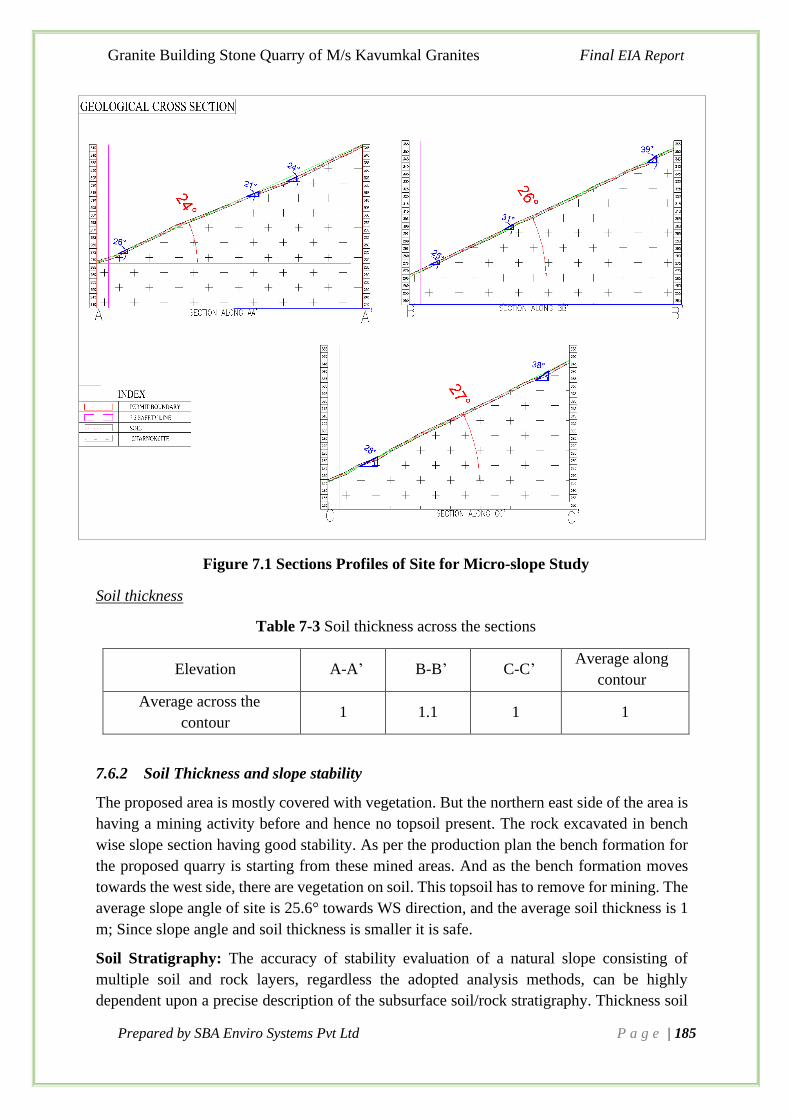
Granite Building Stone Quarry of M/s Kavumkal Granites Final EIA Report
Prepared by SBA Enviro Systems Pvt Ltd P a g e | 185
Figure 7.1 Sections Profiles of Site for Micro-slope Study
Soil thickness
Table 7-3 Soil thickness across the sections
Elevation A-A’ B-B’ C-C’ Average along
contour
Average across the
contour 1 1.1 1 1
7.6.2 Soil Thickness and slope stability
The proposed area is mostly covered with vegetation. But the northern east side of the area is
having a mining activity before and hence no topsoil present. The rock excavated in bench
wise slope section having good stability. As per the production plan the bench formation for
the proposed quarry is starting from these mined areas. And as the bench formation moves
towards the west side, there are vegetation on soil. This topsoil has to remove for mining. The
average slope angle of site is 25.6° towards WS direction, and the average soil thickness is 1
m; Since slope angle and soil thickness is smaller it is safe.
Soil Stratigraphy: The accuracy of stability evaluation of a natural slope consisting of
multiple soil and rock layers, regardless the adopted analysis methods, can be highly
dependent upon a precise description of the subsurface soil/rock stratigraphy. Thickness soil

Granite Building Stone Quarry of M/s Kavumkal Granites Final EIA Report
Prepared by SBA Enviro Systems Pvt Ltd P a g e | 186
in different profiles is given in Table 7-3. The soil thickness is negligible as shown in Figure
7.1 and distributed evenly of the slope. As the top soil is removing for the mining activities
the chance of soil slide/slip within the site is minimum. And as compare to the surrounding
areas, the proposed site is the top side of hilly terrain.
Seepage from slope face: The free subsurface flow within the site will be controlled by proper
garland drains in order to avoid excess water logs in soil. Distance of drain will cover entire
area to increase the distance better is the stability.
Vegetation helps the Slope stability in the greenbelt zones and act as a disturbance barrier to
the surrounding.
Vibrations: The strong vibration caused by blasting load might affect the soil stability and
provision of greenbelt zone will protect the surroundings and also, as the mining operation
will avoid in the rainy season, the chance of failure due to vibration is less.
7.6.3 Stability Rating Parameters in Mine Area Before the Mining Operations
1. Slope inclination: The average Slope of site is 25.6o, hence safe.
2. Soil Stratigraphy: Clay silt Combination which is middle in the scale with average
thickness of 1m.
3. Slope height: Maximum bench height of 5m and gradient control the stability.
4. Vegetation: Diversified vegetation distributed all along the mine prospect, Gives the
highest stability.
5. Previous landslide activity: None within or around proposed site.
Assessment of the above parameters indicate that this slope of the mine prospect has only
slight potential for instability before the mining Operations.
Solutions
To prevent such accelerated transport entire soil cover (90585 tonnes) of the mining area is
removed from whole of the mining prospect before the start of operations.
a. The soil thus removed will be dumped in without any possibilities of
draining off the mud, sediments and aggregates
b. Lower level of the envisaged mine is at 265 m where the bench will be flatten
and all baseline drainage is located at this level. All vertical or inclined
hydrological movement will truncate here.
c. The soil dump will be heaped up with gentler slopes and retaining barriers
preventing accelerated suspended sediment carriage in the network.
d. The minor increase in the suspended stuff from soil coated on the surface
will get settled in the retainers developed as a part of the drainage system
developed before mining.
e. Since the soil is compactly packed and wet, no air borne sediments are
expected during excavation, transportation or storage at a different location.

Granite Building Stone Quarry of M/s Kavumkal Granites Final EIA Report
Prepared by SBA Enviro Systems Pvt Ltd P a g e | 187
f. Slope stability is ultimately determined by two factors: the angle of the slope
and the strength of the materials on it. Materials on the surface is removed
and angle of slope is kept the least.
7.6.4 Stability of Slope above (east) the Mine Prospect
A detailed description of the factors of safety is given in section above
1. The prospect falls in the SW side of an elongated hill trending parallel to the regional
strike (NNW-SSE). Major portion of the proposed prospect is on the dip slope
(gentler) making it more stable. The major rock type in the site is charnockite which
is massive and devoid of any planes of weakness.
2. If the forces available to resist movement are greater than the forces driving
movement, the slope is considered stable.
3. Geomorphologic regional set up: Eastern boundary of the prospect is parallel to the
355 m contour. The geomorphic surface east of the prospect is defined by
Charnockite mass with feeble weathering staggered on the southwester gentler slope.
The escarpment steeper slope on the opposite side of the ridge and is devoid of any
weathering or rock fall or Cliff fall.
Figure 7.2 The terrain view of proposed site

Granite Building Stone Quarry of M/s Kavumkal Granites Final EIA Report
Prepared by SBA Enviro Systems Pvt Ltd P a g e | 188
Figure 7.3 Section view of site
From the figure it is shown that the proposed a rea having gentle slope towards west side.
And the NE side having bench formation and it showing presence of hard uniform single
rock strata, which devoid the chance of slope failure in the site.
A
B
B
A
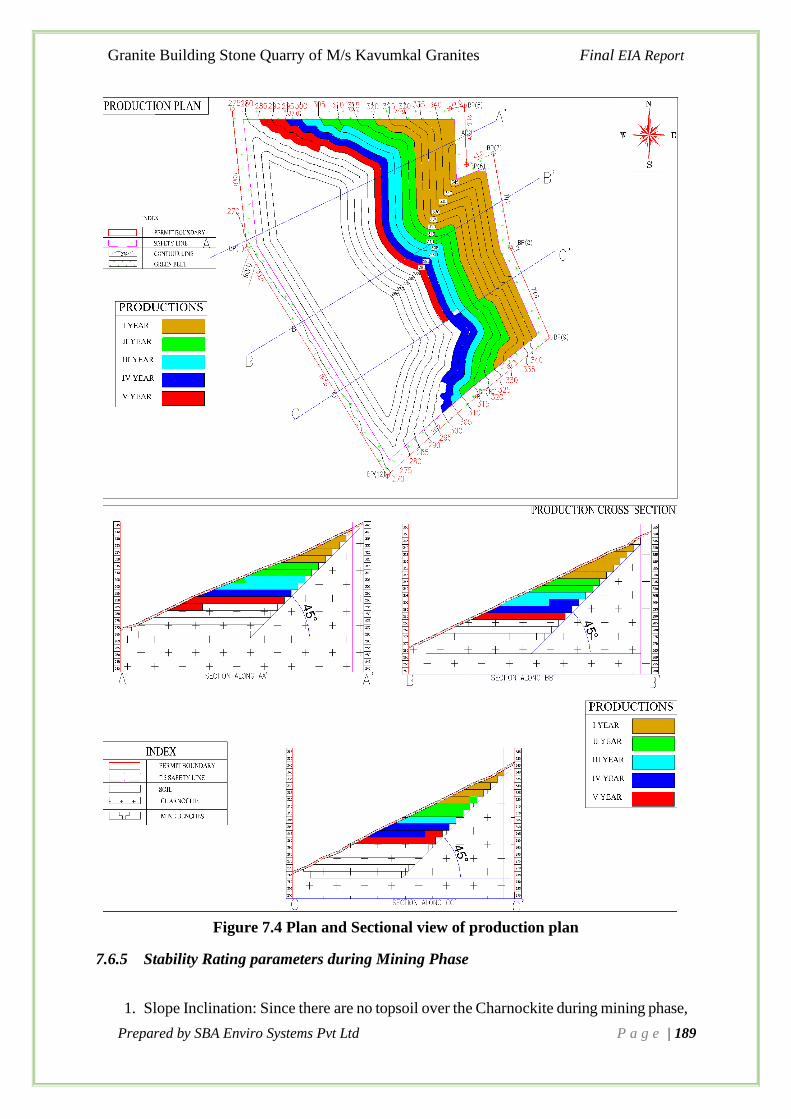
Granite Building Stone Quarry of M/s Kavumkal Granites Final EIA Report
Prepared by SBA Enviro Systems Pvt Ltd P a g e | 189
Figure 7.4 Plan and Sectional view of production plan
7.6.5 Stability Rating parameters during Mining Phase
1. Slope Inclination: Since there are no topsoil over the Charnockite during mining phase,

Granite Building Stone Quarry of M/s Kavumkal Granites Final EIA Report
Prepared by SBA Enviro Systems Pvt Ltd P a g e | 190
there is no risk.
2. Soil Stratigraphy: No soil cover on the slope
3. Seepage from slope face: No seepage as there are no overlying secondary debris on
the weathered surface
4. Slope bench: the ultimate slope of bench will be 45o, it is safe as the granite is hard
rock and also there is no stuff to topple stability.
5. Table land drainage: No apparent drainage over the slope. Proper garland drains will
manage the subsurface flow. Hence No risk
6. Previous landslide activity: None - No Risk
Assessment of the above parameters indicate that the mine prospect is stable. Slope
difference in the three profiles (N, middle and S) between the mine prospect and higher
slope east of it indicate a distinct difference in the geomorphic set up between the highest
portion of the geomorphic unit and the prospect west to that.
Mining Phase:
1. After the bench mining the general slope of the top surface will be less than the
slope of this eastern bare ridge ruling out any geo technical instability.
2. The shock of the blasting at the eastern periphery will not affect the ridge as
charnockite is massive and isometric in transmission of shock.
3. The surface water from this elevated zone will be collected along with water
from the mine prospect.
4. Mining is planned to keep a uniform gradient throughout the mining phases. This
gradient is way less than the slope of the ridge mass improving the stability of the
primary stuff.
5. Slope difference in the three profiles (N, middle and S) between the mine prospect
and higher slope east of it indicate a distinct difference in the geomorphic set up
between the highest portion of the geomorphic unit and the prospect west to that.
7.6.6 Rockfall Potential and Other Failure Potentials at Site
Rock fall is the most common type of mass movement on steeper slopes. Rock falls may
also be triggered by rainfall, changes in groundwater conditions, weathering and erosion
of the rock and/or surrounding material. No stability enhancement is not required for
the following reasons.
A. Chances of rock fall is ruled out by the following conditions:
a. Absence of any structural features like faults, joints in the rock strata
b. Absence of any geomorphic features like weathered layering, interface
between secondary rock and crystalline rocks
c. Absence of any rock lumps detached from main rock mass
d. Massive nature of the charnockite ridge.

Granite Building Stone Quarry of M/s Kavumkal Granites Final EIA Report
Prepared by SBA Enviro Systems Pvt Ltd P a g e | 191
e. Isometric distribution of the shock
B. Landslide is the second common geomorphic events to consider. Possibility of any
landslide is ruled out by:
a. Absence of debris on the crystalline slope
b. Absence of any sub surface water below the secondary lithotypes
c. Absence of triggering shocks like seismic waves, traffic shocks
d. Proposed blasting will be of zero impact at this distance
e. No scope of flooding
f. No human activity on this ridge
C. Drainage alteration and accelerated erosion is ruled out as:
a. No stream flow on this ridge. Everything is sheet flow
b. Any weathered stuff will roll down the surface
c. Weathering in the charnockite zone is weak
D. Stability Enhancement: No steps for are required as:
a. Ridge is massive with sporadic weatherizing
b. Slope of the lower mining prospect is much gentler while considering this eastern
ridge
c. No vegetation or soil
d. No drainage hence no erosion.
7.7. Traffic Movement and Transportation plan
A Study is conducted to determine the vehicular traffic measures and best possible route for
material transportation from mines to destination points. It is proposed to take the material to
destination, so as to reduce the traffic load on proposed roads due to cluster effect.
Table 7-4 Route of Transportation of Granite Building Stone
Starting point Way Places Destination
Mine
-0km
8m wide
Private Road
Edamuri –
Koothattukulam Road Koothattukulam
End Users Athikkayam –
Vechuchira Road Athikkayam

Granite Building Stone Quarry of M/s Kavumkal Granites Final EIA Report
Prepared by SBA Enviro Systems Pvt Ltd P a g e | 192
Figure 7.5 Google image showing Transportation route within 10km radius
7.7.1 Vehicular Traffic Density
The vehicular traffic density survey was carried out on 12/02/2020 for 12 hours on 8m wide
Edamuri -Koothattukulam road (1) and Athikkayam – Vechuchira Road (2). Proposed project
connect with both these roads. The nearby existing quarry of Kavumkal mainly use the
Athikkayam-Vechoochira road for transportation. The Manimalethu Crusher unit is also
connecting with Athikkayam–Vechoochira road with their quarry approach road sharing. The
traffic study on these roads counts the existing traffic due to the existing quarries. Proposed
project will use mainly the Edamuri-Koothattukulam road for truck movement, however the
study consider the load equaly on both roads. The traffic due to the proposed quarry will cause
increase in commercial vehicles as well as heavy trucks as a result traffic load will also increase
on connecting roads. Traffic load play a major role in polluting the air. To assess the traffic
load, 2 numbers of surveyors were appointed.
The vehicles plying on road in both the directions were counted continuously for 12 hours. The
vehicles were counted every hour as stipulated by Indian Road Congress (IRC). There is only
one outlet for the transportation of minerals from proposed site to State Highway.

Granite Building Stone Quarry of M/s Kavumkal Granites Final EIA Report
Prepared by SBA Enviro Systems Pvt Ltd P a g e | 193
Figure 7.6 Traffic Density Study Locations
Traffic data collected continuously for 12 hours by visual observation and counting of vehicles
has been carried out under five categories, viz., car, two-wheeler, three-wheeler, buses and
trucks. Total numbers of vehicles per hour under these categories were determined for both
stations in Passenger Car Unit (PCU).
Table 7-5 Standard PCU for Vehicles
*Values of PCU
Car 1
2-Wheeler 0.5
3-wheeler 0.8
Bus/Truck 3.5
The survey results are tabulated in the Table 7-3 and Table 7-4.
Table 7-6 Vehicular Traffic Density Survey Results of Edamuri-Koothattukulam Road
Time Car 2-
Wheeler
3-
wheeler Buses Trucks Total hourly
vehicle capacity in
PCU (V) V/C
8am -9am 16 28 20 1 0 49.5 0.03
9am-10am 22 48 13 2 0 63.4 0.04
10am -11am 20 36 19 2 5 77.7 0.05
11am – 12pm 14 16 25 1 6 66.5 0.04
12pm -01pm 16 19 24 1 8 76.2 0.05

Granite Building Stone Quarry of M/s Kavumkal Granites Final EIA Report
Prepared by SBA Enviro Systems Pvt Ltd P a g e | 194
Time Car 2-
Wheeler
3-
wheeler Buses Trucks Total hourly
vehicle capacity in
PCU (V) V/C
01pm -02pm 14 26 26 1 5 68.8 0.04
02pm – 03pm 18 25 27 1 4 69.6 0.04
03pm -04pm 21 36 28 1 3 75.4 0.05
04pm-5pm 22 43 22 2 0 68.1 0.04
05pm- 06pm 22 30 20 2 0 60 0.04
06pm -7pm 19 28 19 2 0 55.2 0.03
7pm -8pm 18 26 10 1 0 42.5 0.03
Total Volume 222 361 253 17 31 Design capacity C = 1500 (for
Rural road, IRC 64, 1990)
Max hourly traffic V= 77.7 PCU
In PCU for 12
hours 222 180.5 202.4 59.5 108.5
PCU per hour 19 15 17 5 9
Table 7-7 Vehicular Traffic Density Survey Results of Athikkayam Vechuchira Road
Time Car 2-
Wheeler
3-
wheeler Buses Trucks
Total hourly
vehicle capacity
in PCU (V) V/C
8am -9am 24 40 37 2 5 98.1 0.06
9am-10am 56 26 45 2 2 119 0.07
10am -11am 70 49 40 1 7 154.5 0.10
11am – 12pm 28 43 25 1 6 94 0.06
12pm -01pm 52 35 28 1 8 123.4 0.08
01pm -02pm 56 45 36 1 5 128.3 0.08
02pm – 03pm 32 41 32 1 4 95.6 0.06
03pm -04pm 85 42 38 1 4 153.9 0.10
04pm-5pm 68 42 31 2 6 141.8 0.09
05pm- 06pm 57 38 29 2 5 123.7 0.08
06pm -7pm 54 42 38 1 8 136.9 0.09
7pm -8pm 43 26 25 1 6 100.5 0.06
Total Volume 625 469 404 16 66 Design capacity C = 1500
(for Rural road, IRC64,
1990)
Max hourly traffic V=
154.5 PCU
In PCU for 12
hours 625 23.45 323.2 56 231
PCU per hour 52 2 27 5 19
From the traffic study results the current maximum hourly traffic volume in the Edamuri-
Koothattukulam road is 77.7 PCU and that of Athikkayam-Vechoochira road is 154.5 PCU per
hour. The implementation of proposed quarry will result in higher traffic volume in both
Edamuri -Koothattukulam road and Athikkayam – Vechuchira Road.

Granite Building Stone Quarry of M/s Kavumkal Granites Final EIA Report
Prepared by SBA Enviro Systems Pvt Ltd P a g e | 195
7.7.2 Impacts on Traffic Density
Considering the total production and transportation from the proposed quarry, the estimation
of tippers for transport of the material is estimated as given in the Table 7-6. The nearby quarry
of Johnson Rocks is currently not working, but expecting in near future. As per their proposed
production, the traffic volume expecting is also calculated. It is also taken into account for the
safety check on the service of road.
Table 7-8 Estimation of Tippers for Transport for the proposed Quarry
Particulars Proposed quarry of
Kavumkal
Johnson Rocks
(Proposed)
Maximum Annual Production
Capacity (MT) 185637.8 1,00,000
No of Working days 250 250
Production in a day (MT) 742.55 400
No of tippers/trucks per day (15 MT
capacity) 49-50 27
No of tippers per 1 hour – @8hours a
day working 7 4
Traffic Volume in PCU/hour 25 14
Total additional traffic expecting 39
From the above table, it can be seen that the total number of trucks for transport of the building
stone will be 50 trips / day (max) for the proposed quarry. Considering the proposed quarry,
the traffic volume may increase by 25 PCU/hour for both roads in addition to the existing
traffic. And due to the implementation of Johnson Rocks, the addition of 14PCU/hour in the
traffic. Hence total 39PCU/hour is estimated as traffic load due to proposed project.
Table 7-9 Impact in Traffic Density
Traffic Density
Existing
Condition After implementation of Quarry
Level of
Service
(LOS) V V/C V’
Anticipated
V/C
Max Hourly traffic in
Edamuri -
Koothattukulam road
77.7 0.05 1.1x77.7+39 =
124.5 0.08 A (Excellent)
Maximum Hourly
traffic in Athikkayam
– Vechuchira Road
154.5 0.1 1.1x154.5+39=
209 0.20 A (Excellent)
*one trips of truck = 3.5PCU additional & considering 10% increase in general traffic
10% increase traffic density was anticipated for Car, Two-wheeler, three-wheeler and Buses.
And the Level of Service is excellent and good for both roads. The road is safe for the additional
traffic.

Granite Building Stone Quarry of M/s Kavumkal Granites Final EIA Report
Prepared by SBA Enviro Systems Pvt Ltd P a g e | 196
7.7.3 Mitigation on Traffic Density
• Adequate control measures will be taken for the safe mode of transportation.
• The peak hours will be avoided for the transportation.
• School Traffic time will strictly avoid for the Quarry truck movement.
• Speed limit of 40km/hr on Quarry Access Road.
• All heavy vehicles travelling to or from the quarry must not travel over 60km/h between
the quarry and the State Highway
7.8 Drainage Management
There are no seasonal streams within the leasehold area. The seasonal streams could be seen
outside the leasehold area towards south, southwest and northwest side of the lease. The
rainwater draining from the hill slopes and the slopes in the study area carries the silt and
pebbles, which ultimately settles at the connecting streams/river. The proposed area having
gently slopy terrain with slope towards the western side. The proposed garland drains at the
higher elevation will divert the entry of water flow away from the mine. The surface runoff
from the quarry area will collect and divert using garland drains and with help of silt traps and
delay tanks the overflow will connect to nearby natural drains. The slope of adjust quarries is
towards east and northeast direction since the proposed quarry is in the opposite phase of the
hill terrain. Hence the chance of cumulative impact on the drainage is minimum.
Figure 7.7 Drainage management at the site

Granite Building Stone Quarry of M/s Kavumkal Granites Final EIA Report
Prepared by SBA Enviro Systems Pvt Ltd P a g e | 197
Figure 7.8 Drainage Management Plan of Quarry

Granite Building Stone Quarry of M/s Kavumkal Granites Final EIA Report
Prepared by SBA Enviro Systems Pvt Ltd P a g e | 198
7.8 Mine Waste Management
During the first five-year mining plan period the building stone shall be mined after recovery
of the soil, which overlain the granite building stone.
Figure 7.9 Location of Soil dumping area in Quarry
Topsoil Management
A total quantity of 90585 tonnes of topsoil and 92819 tonnes of Overburden (OB) will be
generated with in the proposed site, has to be removed during the mining operations. The
topsoil/OB excavated from the quarry will be dumped separately at predetermined place and
subsequently will be utilized in spreading over reclaimed areas for plantation. Precautions will
be taken to limit the height of the topsoil dump to 5 to 6 m in order to preserve its fertility and
shelf life. It will be suitably protected from soil erosion and infertility by planting fodder grass
and leguminous plants during temporary storage.
The anticipated impacts are:
• Run off from mine with loose soil and loss of vegetation.
• Impact on surrounding agricultural land

Granite Building Stone Quarry of M/s Kavumkal Granites Final EIA Report
Prepared by SBA Enviro Systems Pvt Ltd P a g e | 199
• Impact on groundwater quality due to leachate.
Therefore, conservation and protection of topsoil is crucial. The best practices involved in the
topsoil management are as follows;
• Scrap the topsoil prior to drilling and blasting.
• Scraped topsoil should be used immediately for the plantation work.
• If topsoil is not used immediately then it should be staked at designated area.
• Stacked topsoil area should be surrounded by embankment (2-3 m height of retaining
wall) to prevent erosion.
• Height of stacking should not exceed more than six meters.
• Drainage should be considered to handle heavy rainfall.
• Stacked topsoil should be stabilized further by grasses and bush to protect from the
wind.
• Sedimentation tanks should be constructed to treat run-offs
• The individual dump of soil should have maximum slope of 37o and an overall slope
not exceed 32o.
• The soil dump shall have retaining wall at the foot of dump.
• A garland drain shall be made at higher elevation to divert the storm water flow away
from dump.
• The mine waste (soil) management shall be as per the approved mine plan Coir mating
will be done on the dump surface to control the dust emission.

Granite Building Stone Quarry of M/s Kavumkal Granites Final EIA Report
Prepared by SBA Enviro Systems Pvt Ltd P a g e | 200
Chapter 8. PROJECT BENEFITS
The proposed building stone quarry project of M/s Kavumkal Granites is private owned land
and is allotted for mining activities on lease basis.
8.1 Improvement in Social Infrastructure
It is proposed that the socio-economic development work in the nearby area will be carried out
by M/s Kavumkal Granites to strengthen the social infrastructural needs of the villagers like
education, medical, drinking water for human beings and animals, road network, plantation,
etc. Direct employment will be generated due to mine operations and preference would be
given to the nearby villagers as per their qualification/experience, indirect self-employment
will be generated due to the proposed mining project.
Following measure will be taken to improve the Social infrastructure of the study area:
➢ Preventive medical care and educational facilities for rural population will be promoted.
➢ Priority will be given to local people for employment.
➢ Extending general benefit by way of development work in the villages through
respective Gram Panchayat.
➢ Development of Infrastructures, Educational, Health facilities and other CER project
works in the local area in consultation with Local Self-Government (LSG’s).
➢ Supplementing Govt. efforts in health monitoring camps, social welfare and various
awareness programs among the rural population.
➢ Assisting social forestry program.
➢ Financial support for solar energy harvesting and application of Solar Energy.
➢ Support and use of Solar energy for lighting and other purposes in surrounding villages
(Athikkayam, Pathanamthitta District).
8.2 Employment Potential
➢ The project would generate direct and indirect employment and preference will be
given to the locals. About 20 persons will get direct employment in the mine and also
this project would generate equal or more number of indirect employments.
➢ The local economy will receive a boost due to employee spending and services
generated by the mining operation. The overall effect will improve the buying power
of employees and the standard of living of people viz. better education, improved health
and sanitation facilities, housing and acquisition of consumer durable.
➢ Migration into the existing area will be insignificant and no displacement of the existing
population will take place due to the establishment of the proposed project. Housing;
transport; water and power supply; medical, educational and other civic amenities will
get a boost in future.
Granite Building Stone Quarry of M/s Kavumkal Granites Final EIA Report
Prepared by SBA Enviro Systems Pvt Ltd P a g e | 201
8.3 Corporate Environment Responsibility
The project proponent will incorporate the CER activities in consultation with stakeholders and
local governed bodies, and will implement in the first two years for mining and for the
remaining period the maintenance of inventoried activities will be maintained. The objective
is to obtain a social license from the stakeholders who are likely to be affected due to the
proposed mine lease area if there is any such case.
8.4 Tax Income
The proposed capital expenditure of the proposed mining activity is Rs. 2.225 crores. The
provision of employment also directly contributes to additional income tax and also indirectly
contributes to additional GST due to various transactions. The operation of the project also
results in additional GST and State by way of royalty, taxes and duties.

Granite Building Stone Quarry of M/s Kavumkal Granites Final EIA Report
Prepared by SBA Enviro Systems Pvt Ltd P a g e | 202
Chapter 9. ENVIRONMENTAL COST BENEFIT ANALYSIS
9.1. Introduction
Appendix-III of EIA Notification, 2006 (Generic Structure of Environmental Impact
Assessment Document), states that "Environmental Cost Benefit Analysis" is to be elaborated
in the EIA report provided such a study is mandated by the Expert Appraisal Committee (EAC)
/ State Expert Appraisal Committee (SEAC) at the scoping stage of the proposal. In the instant
project, since the EAC has not prescribed for such a study during the scoping stage and hence
not part of the approved ToR.

Granite Building Stone Quarry of M/s Kavumkal Granites Final EIA Report
Prepared by SBA Enviro Systems Pvt Ltd P a g e | 203
Chapter 10.
ENVIRONMENT MANAGEMENT PLAN
10.1 Introduction
This chapter deals with the description of administrative aspects of ensuring the mitigative
measures proposed for the significant impacts identified in Chapter 4 due to the mining
activities on each face of environment viz. Air Environment, Noise Environment, Land
Environment, Water Environment, Ecological Environment and Socio-economic Environment.
The EMP comprises a series of components covering direct mitigation and environmental
monitoring, an outline waste management plan and a project site restoration plan. Therefore,
EMP has been prepared for each of the above developmental activities.
10.2 Environment Management System
The M/s Kavumkal Granites will adopt Environmental Management System (EMS) which will
assist mine management to meet both current and future environmental requirements and
challenges. EMS will provide a structural view and control of the organization's environmental
performance that will be applied from planning and exploration to the mine closure.
The following components are being taken to establish an EMS; Organizational Commitment,
Environmental Policy, Environmental Impact Assessment, Objectives and Targets,
Environmental Management Plan (EMP), Documentation, Responsibilities and Reporting
Structure, Training, Environmental Review Audits and Emission and performance monitoring.
The mine management will follow a comprehensive and systematic health and safety function
which involves all personnel seeking to identify hazards and assessing risk to prevent and
eliminate all accidents/ injuries. The management will prepare a detailed eco-restoration and
mine closure plan of mine operation prior to the commencement of the mine operation.
10.3 Environment Policy
In order to protect environment and for sustainable development, an Environmental Policy will
be adopted by Lessee as follows:
"Environment, Health, Safety and Quality (EHSQ) Policy"
We, M/s Kavumkal Granites, driven by our core values and beliefs are committed to our
stakeholders and meet customer satisfaction through integrated.
EHSQ management system to achieve sustainability, in all our existing and future businesses.
To attain this objective, we shall: -
• Implement and maintain an integrated EHSQ management system to achieve
sustainable performance.
• Adopt and sustain a Business Excellence framework for continual business process
improvement.

Granite Building Stone Quarry of M/s Kavumkal Granites Final EIA Report
Prepared by SBA Enviro Systems Pvt Ltd P a g e | 204
• Protect Environment, conserve natural resources, reduce energy consumption, improve
occupational health and safety performance and mitigate risks by adopting optimal
production processes and services, driven by environment friendly technologies.
• Comply and endeavour to exceed all applicable legal and other requirements.
• Continuously strive to achieve satisfaction of all stakeholders through contribution to
social development.
• Communicate effectively about the EHSQ system and create awareness and increase
the competency of all employees through training.
• Establish specific organizational structure for guidance, implementation and regular
review of EHSQ management system.
Responsibility
The Environmental Officer is responsible for maintaining ecological balance by adequate
environmental protection and environment improvement works. In the event of observation of
non-compliance by any employee, the same is informed by the Environmental Officer to the
mine manager. These three will identify the cause and implement the mitigation measures or
engineering controls or work practices required. The Environmental Officer will monitor the
environmental performance and guide the Mines manager and the employees for maintaining
good environmental practices and to adopt newer, safe and cleaner technologies.
10.4 Environment Management Measures
The environment management measures of a project detailed the mitigation measures to be
adopted to minimize various environment impacts, expected, so as to ensure low impact due to
the project to the surrounding environment. This will ensure sustainable development and
environment friendly mining operations. The EMP for various aspects of environment are
follows under:
10.4.1 Air Pollution Control Measures
Mining activities will generate certain quantities of dust during drilling, blasting, loading and
transportation operations. The following measures will be taken to mitigate the fugitive dust
from these operations.
● Laying of haul road as per the standards, black topping of permanent haul road and
service road to avoid or eliminate air – borne dust.
● To avoid the dust generation from the drilling operations, wet drilling method will be
adopted.
● Drilling machines will be equipped with water spraying system to prevent dust to get
air borne
● Use of appropriate explosives for blasting and avoiding overcharging of blast holes.
● Controlled blasting techniques will be adopted.
● Watering of haul road and other road at regular intervals.

Granite Building Stone Quarry of M/s Kavumkal Granites Final EIA Report
Prepared by SBA Enviro Systems Pvt Ltd P a g e | 205
● Provision of dust filters / mask to workers for highly dust prone and affected areas.
● Provision of green belt all along the periphery of the lease area.
● Periodical monitoring of ambient air quality in and around the lease area.
The extracted mineral will be transported from the quarry to the end users by adopting
following measures so as to minimize dust emissions.
● In case of long transportation, the trucks after loading will be covered with tarpaulin
sheets.
● Speed of the vehicles will be maintained within the prescribed limits.
● Trucks will not be overloaded and will be maintained to the body level.
10.4.2 Noise Control Measure
The main sources of noise in the project area are Drilling, Blasting, Compressors, Vehicular
movements and Loading & unloading of materials.
The following noise control measures are undertaken to bring down the noise levels: -
● Proper maintenance of machinery, equipment and improvement on design of machines.
● Use of personal protective devices i.e., earmuffs and earplugs by workers, who are
working in high noise generating areas.
● Creation of wide green belt of dense foliage between mine areas and residential
colonies.
● Regular medical check-up related health problems
● Proper training to personnel to create awareness about adverse noise level effects.
● Planned noise monitoring at suitable locations in the plant and outside location for
proper effective remedial actions.
10.4.3 Vibration and Fly rock Control Measures
In order to reduce the vibration and fly rock, the blasting is proposed to be carried out with
NONEL technology, where the sequence of blast occurs two to three times that too from bottom
of the bench. However, certain preventive measures will be taken to minimize the risks arising
from flying fragments, which are as follows:
• Marking of danger zone: - The area falling within 250 m of the blasting area will be
marked off as danger zone with red flags, or other appropriate signs, and entry of any
unauthorized person into this zone will be prohibited during blasting operation.

Granite Building Stone Quarry of M/s Kavumkal Granites Final EIA Report
Prepared by SBA Enviro Systems Pvt Ltd P a g e | 206
• Warning signals: - An audible warning signal will be given, fifteen minutes before
actual firing of blast to enable persons to move out of danger zone. For this purpose, a
set of sirens/ hooters will be provided at appropriate places.
• Providing blasting shelters: - In order to protect the personnel engaged in blasting
operations, blasting shelters will be provided for taking shelter during blasting.
• Optimum delay sequence and stem to column ratio will be maintained to minimize the
fly rock distance and ground vibration intensity
• Usually single/double row of holes is blasted along free face to achieve optimum
powder factor, best fragmentation and minimized adverse impacts on account of
blasting.
• Maximum numbers of holes will be blasted at a time in a round are generally limited to
20 with non – electrical detonators (NONEL) to mitigate adverse impacts such as air
blast, fly rock and ground vibration.
• The Ignition will be the Non-Conventional and Eco-Friendly method by NONEL (Non-
Electric Detonators).
10.4.4 Water Management & Water Pollution Control Measures
A. Domestic Sewage
The domestic sewage generation, if discharged untreated, can contaminate the ground water
and other ground & surface water sources.
The sewage to the tune of 1 kLD will be generated from the project site and the same will be
diverted to the septic tank followed by soak pit.
B. Storm water contamination with silt
Mining activities may cause adverse impacts due to siltation due to runoff/ storm water. An
impact due to soil erosion during monsoon period is also significant in nature. This also has
the potential to clog the water channels and to spoil agriculture.
Some of the control measures adopted for controlling water pollution due to the siltation of
storm water by mining operations are as follows: -
● Storm water drains with silt traps will be suitably constructed all along the periphery of
the pit area (Garland drains) to collect the run-off from the lease area and divert into
the storm water pond/tanks proposed within the complex.
● Appropriate channelization of storm water with channels of sufficient width. All
measures will be taken not to disturb the existing drainage pattern adjacent to the other
property.
● De-siltation traps and storm water collection pond proposed for silt removal.
● The storm water collected from the lease area will be utilized for dust suppression on
haul roads, plantation within the premises, etc.

Granite Building Stone Quarry of M/s Kavumkal Granites Final EIA Report
Prepared by SBA Enviro Systems Pvt Ltd P a g e | 207
Construction of check dams and collecting channel all around at the foot of the hill to prevent
soil erosion during the monsoon season and also to collect the storm water for various use
within the mine lease area.
10.4.5 Land Planning
The total mine lease area of 4.0262Ha is private owned land. The present land use and ultimate
stage of mining land use will be as under:
Table 10-1 Land Use pattern of proposed area in Pre operational, Operational & Post
Operational Stages
No. Land Use Pre-Operational (Ha) Operational (Ha) Post Operational
(Ha)
1 Mining area 0.00 2.6409 3.4228
2 Road 0.00 0.0180 0.02
3 Safety and Plantation area 0.000 0.6034 0.6034
4 Virgin Area/ Reclamation
area 4.0262 0.7819
0.00
Total 4.0262 4.0262 4.0262
In order to minimize the adverse effects, the following suggestions have been made.
● Concurrent eco restoration will be carried out. Additional plantation will be provide
within the 0.6034 Ha safety/greenbelt zone, almost 1000nos of trees will be plant at an
interval of 3.m distance.
● Construction of check dams and collecting channel all around at the foot of the hill to
prevent soil erosion during the monsoon season and also to collect the storm water for
various use within the mine lease area.
● Green belt development along the boundary of the lease area.
● It is proposed to reclaim the pit area and this area will be suitably planted with local
species for eco-restoration in all possible means.
● Proper barricading and monitoring of the water stored area will be taken up to prevent
accidents (if any)
● The topsoil will be generated from the proposed pit, which will be properly stacked and
will be utilized for plantation over the reclaimed areas.
10.4.6 Biological Measures
The biological environment within the mining area will entirely change due to the mining
activities. Plantation will be carried out within the greenbelt barrier zone. And at the end of
mining period the total area will be reclaimed with plantation by reusing the initially removed
topsoil from the site. Mainly the local species will be planted along with the other plants such
as Rain tree, Bougainville, Picus, plantation crops like Fruit bearing plants like mango tree,

Granite Building Stone Quarry of M/s Kavumkal Granites Final EIA Report
Prepared by SBA Enviro Systems Pvt Ltd P a g e | 208
jack fruit tree will be planted. It is proposed to plant at the rate of 1,000 saplings per hectare.
Anticipated survival growth rate is about 60 – 70 %.
10.4.7 Socio-economic Management
As there are no habitations or settlements in the core zone area, no rehabilitation or resettlement
are involved. The existing environmental scenario in respect of ambient air quality, water
quality, noise levels, water aspects, biological aspects, etc. show that all these environmental
parameters are within the statutorily prescribed levels. As such, impact due to the project will
be positive on socio-economic aspects. It will be ensured that the buffer zone of the mine lease
will be properly preserved environmentally in all respects within sustainable limits through
necessary monitoring. The project will be operated with care for minimizing environmental
impacts with proper EMP measures for pollution control which will be continued in future also.
10.5 Environmental Management Cell (EMC)
Environment Management will be headed by the Environmental officer. The Environmental
Officer shall be responsible for day-to-day monitoring. The monitoring shall be conducted by
NABL accredited laboratory. Also, the Environmental Officer would be monitoring the
performance of pollution control devices proposed and appropriate steps needs to get the
performance of the pollution control devices.
Records shall be maintained for the analysis of pit water and effluents, ambient air quality data
and noise levels etc. These records are not only required for the perusal of the Pollution Control
Board authorities but also to derive at the efficiencies of the pollution control measures as the
objective of the project proponent is not only compliance with statutory regulations, but also a
serious commitment towards clean environment and sustainable mining operations. The
management shall maintain the records as per the EPA regulations and apply for the annual
consents under Air Act and Water Act.
Reporting system provides the necessary feedback for project management to ensure quality of
the mitigation measures and that the management plan in implementation. The rationale for a
reporting system is based on accountability to ensure that the measures proposed as part of the
Environmental Management Plan get implemented in the project.
The hierarchy of reporting is that the Environmental Officer will report any noncompliance to
the Mines Manager and to the CEO.
The EMC will supervise the monitoring of environmental pollution levels viz; ambient air
quality, water and effluent quality either departmentally or by appointing external agencies
wherever necessary.
10.6 Structure of the EMC
To monitor noise, air quality and other environmental parameters, NABL accredited laboratory
shall be identified to know the quality of surrounding environment in and around the mine site
as per SPCB/CPCB guidelines and as per consent order. For implementation of Environment
Management Plan, Environment Management Cell is formed under the control of the
Environmental Engineer. The responsibilities of this cell are:
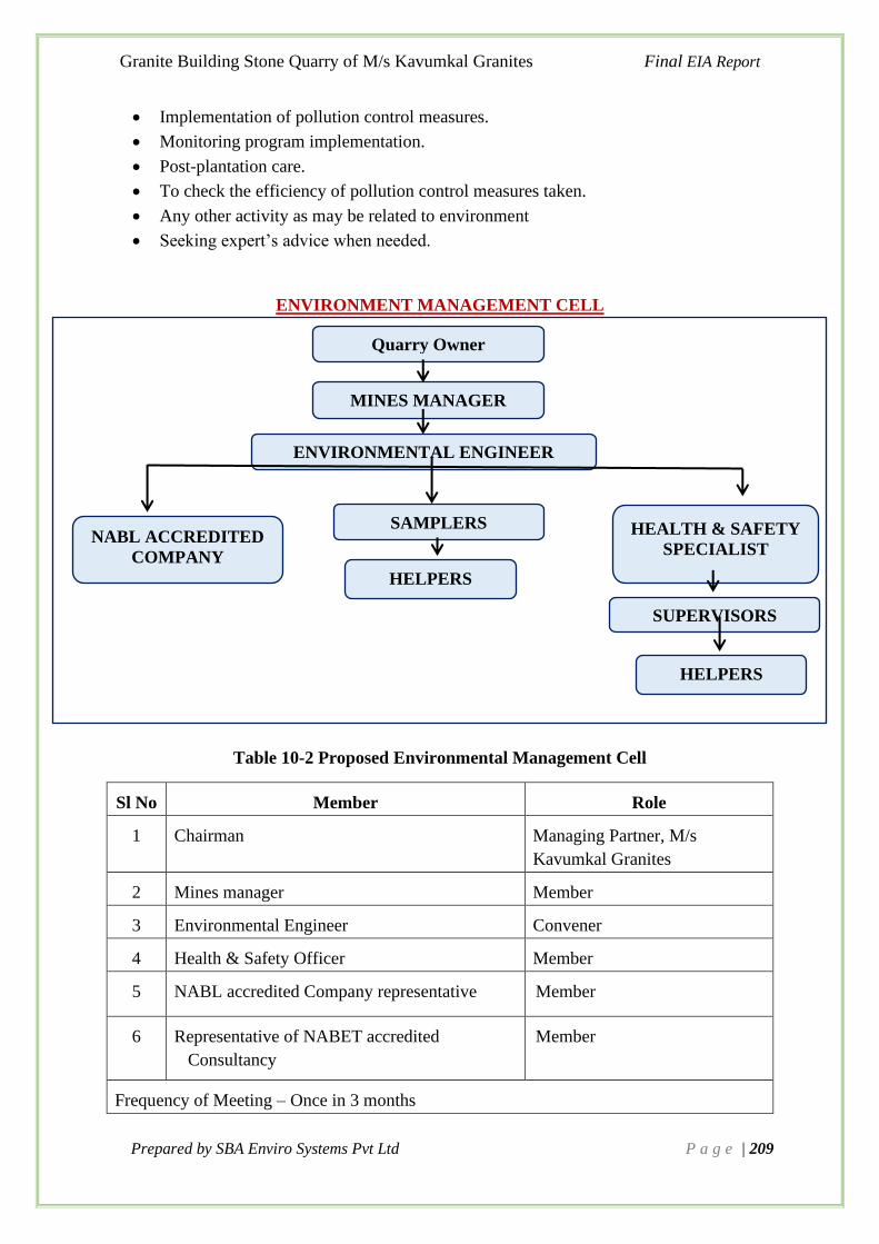
Granite Building Stone Quarry of M/s Kavumkal Granites Final EIA Report
Prepared by SBA Enviro Systems Pvt Ltd P a g e | 209
• Implementation of pollution control measures.
• Monitoring program implementation.
• Post-plantation care.
• To check the efficiency of pollution control measures taken.
• Any other activity as may be related to environment
• Seeking expert’s advice when needed.
ENVIRONMENT MANAGEMENT CELL
Table 10-2 Proposed Environmental Management Cell
Sl No Member Role
1 Chairman Managing Partner, M/s
Kavumkal Granites
2 Mines manager Member
3 Environmental Engineer Convener
4 Health & Safety Officer Member
5 NABL accredited Company representative Member
6 Representative of NABET accredited
Consultancy
Member
Frequency of Meeting – Once in 3 months
Quarry Owner
MINES MANAGER
ENVIRONMENTAL ENGINEER
HEALTH & SAFETY
SPECIALIST
SAMPLERS NABL ACCREDITED
COMPANY
HELPERS
SUPERVISORS
HELPERS
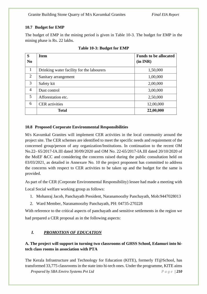
Granite Building Stone Quarry of M/s Kavumkal Granites Final EIA Report
Prepared by SBA Enviro Systems Pvt Ltd P a g e | 210
10.7 Budget for EMP
The budget of EMP in the mining period is given in Table 10-3. The budget for EMP in the
mining phase is Rs. 22 lakhs.
Table 10-3: Budget for EMP
S
No
Item Funds to be allocated
(in INR)
1 Drinking water facility for the labourers 1,50,000
2 Sanitary arrangement 1,00,000
3 Safety kit 2,00,000
4 Dust control 3,00,000
5 Afforestation etc. 2,50,000
6 CER activities 12,00,000
Total 22,00,000
10.8 Proposed Corporate Environmental Responsibilities
M/s Kavumkal Granites will implement CER activities in the local community around the
project site. The CER schemes are identified to meet the specific needs and requirement of the
concerned group/person of any organization/Institutions. In continuation to the recent OM
No.22- 65/2017-IA.III dated 30/09/2020 and OM No. 22-65/2017-IA.III dated 20/10/2020 of
the MoEF &CC and considering the concerns raised during the public consultation held on
03/03/2021, as detailed in Annexure No. 10 the project proponent has committed to address
the concerns with respect to CER activities to be taken up and the budget for the same is
provided.
As part of the CER (Corporate Environmental Responsibility) lessee had made a meeting with
Local Social welfare working group as follows:
1. Mohanraj Jacob, Panchayath President, Naranamoozhy Panchayath, Mob:9447028013
2. Ward Member, Naranamoozhy Panchayath, PH: 04735-270228
With reference to the critical aspects of panchayath and sensitive settlements in the region we
had prepared a CER proposal as in the following aspects:
I. PROMOTION OF EDUCATION
A. The project will support in turning two classrooms of GHSS School, Edamuri into hi-
tech class rooms in association with PTA
The Kerala Infrastructure and Technology for Education (KITE), formerly IT@School, has
transformed 33,775 classrooms in the state into hi-tech ones. Under the programme, KITE aims

Granite Building Stone Quarry of M/s Kavumkal Granites Final EIA Report
Prepared by SBA Enviro Systems Pvt Ltd P a g e | 211
to provide Information and Communication Technology (ICT) facilities in Classes VIII to XII
of government and aided schools.
Under this programme, all classrooms would be equipped with Digital Interactive Textbooks,
Digital Content Collection for easy learning of all subjects, Resource portal which would
ensure a round-a clock learning atmosphere to all, E-learning / M-Learning / Learning
Management system, evaluation mechanisms in addition to Computers, Multimedia Projector,
Sound System and High Speed internet connection which every student and teacher could make
use of. Each school would feature offline servers hosting educational contents, which would
be connected to classrooms, library and labs. This system would enable a secure and easy
access of contents for the students and teachers. KITE has also developed Samagra Resource
Portal with syllabus based educational contents, to be used in the high-tech classrooms.
GHSS Edamuri is managed by the Department of Education. It is located in Rural area. It is
located in Athikkayam village of Pathanamthitta district of Kerala. The school consists of
Grades from 1 to 10. Total number of room available in the school is 25. There is 30 teaching
staff and 4 non-teaching staff. (Source: Report Generated by IT@School, 2015).
This mining project will support the schools to provide the basic facilities for setting up
classrooms and computer labs to be made Hi-Tech. And also help to ensure that each classroom
and lab has tiled flooring, a secure ceiling in case of tiled roof, locker facilities, shelves and
racks for keeping the equipment, painted clean walls and a secure electrical connection with
enough plug-points.
A need base analysis was done at GHSS Edamuri and we propose to provide funding to turn
two class rooms into hi-tech. The funding is required for the following works:
Summary of activities
Particulars Calculation Total Amount
Tiling of two classrooms (30 x30 ft) 2 x 50000 1,00,000
Add up 4 number of computers to the computer
lab 4 x 25000 1,00,000
Provide shelves of dimension 6 x 6 x 1 ft for each
class room for keeping students accessories 2 x 25,000 50,000
Provide a locker facility for keeping the
equipments and Books for library 2 x 25,000 50,000
Total 3,00,000
II. HEALTH CARE
A. A need base analysis for CER conducted and discussed with LSGD and project
will provide 4 Stainless Steel Commercial RO Water Dispenser with Purifier for
the Govt. Primary Health Centre, Naranamoozhy.

Granite Building Stone Quarry of M/s Kavumkal Granites Final EIA Report
Prepared by SBA Enviro Systems Pvt Ltd P a g e | 212
Project will provide 4 Stainless Steel Commercial RO Water Dispenser with Purifier for
the Govt. Health Centre, Naranamoozhy. The purifier has a productivity of 100L/Hr. It has
an option to provide warm, cold and hot purified water outlets.
Particulars Calculation Total Amount Type of
Expense
Provide 4 Water Dispenser with Purifier 50,000 X 4 2,00,000
Non-Recurring Wheel chair and Stretcher for the Health care
unit 2x50,000 1,00,000
TOTAL 3,00,000
III. SOCIAL ASPECTS
A. A need base analysis for CER conducted and discussed with LSGD and the project
will support the 3 families from Athikkayam Village for the renovation of their houses.
Proposed renovations include repairing of damaged roofs and ceilings and also include
provision of clean sanitation system.
Particulars Calculation Total Amount Type of
Expense
Renovation of houses in the
Athikkayam Village (3 Family) 1,00,000 X 3 3,00,000 Non-Recurring
TOTAL 3,00,000
B. The project will help in improve the living condition of Naranamoozhy Panchayath
To provide lighting at night and prevent accidents and to increase the safety, solar LED street
lights will be provided. It uses the solar radiation energy to charge the battery with the solar
panel during day time, and offer energy to the LED light equipment at night. This system has
a double advantage in both utilization of new energy and energy-saving. This project will
provide 5 solar LED Street lights for Naranamoozhy panchayath.
Particulars Total Amount Type of
Expense
Will provide Solar LED Street Lights 5x20,000 Non-Recurring
TOTAL 1,00,000
C. Providing waste bins for waste management in association with Naranamoozhy
Panchayath.
Waste bins will be provided in the residential areas and segregation will be done at the initial
stage itself by giving color coded bins.

Granite Building Stone Quarry of M/s Kavumkal Granites Final EIA Report
Prepared by SBA Enviro Systems Pvt Ltd P a g e | 213
Particulars Total Amount Type of Expense
Provide waste bins 10x10,000 Non-Recurring
TOTAL 1,00,000
Table 10-4 Summary Of Cer Activities Proposed For Next 2 Years
Sl No Area of Intervention No of intervention Expenses
1
Promotion of Education –
Project will support
improvement of infra-
structural facilities of Govt.
School Edamuri
School renovation
Classroom tiling 1,00,000
3,00,000
Projector & computer 1,00,000
Shelves and Racks 50,000
locker facility for keeping
the equipments and
Books for library
50,000
2
The project will be
implemented for welfare of
Promotion of Health care
units in.
Water Dispenser with
Purifier 2,00,000
3,00,000 Wheel chair &
Stretcherfor patients
1,00,000
3
Improvement of Social
Aspects
All Activities will be
carried out through LSGD
House renovation works 3,00,000
5,00,000
Solar Led streetlights 1,00,000
Waste management
System (Provision of
waste bins)
1,00,000
Total Rs.
11,00,000
The consent form the beneficiary for above mentioned activities is obtained (Annexure 11)
and it will be done during the first 2 years of validity period of the EC and the remaining
validity period will be used to ensure that the maintenance of the interventions are undertaken.
The proponent allocated Rs 11 Lakhs for the CER activities and an extra Rs. 1 Lakh for the
maintenance purposes.
The total funds allocated for the CER activities = Rs 12 Lakhs

Granite Building Stone Quarry of M/s Kavumkal Granites Final EIA Report
Prepared by SBA Enviro Systems Pvt Ltd P a g e | 214
Chapter 11. Summary and Conclusion
11.1 Introduction
M/s. Granite Building Stone Quarry of M/s Kavumkal Granites, had applied for the mining
of Granite Building Stone, situated in Sy. Nos 781/1/28-17-1 (Re-Sy.32), 781/1/28/-17-2 (Re-
Sy.32) at Athikkayam Village, Ranny Taluk, Pathanamthitta District, Kerala State for an area
of 4.0262 Ha. The land for mining is owned private and is a fresh quarrying area. The proposed
mining activities will be carried out with mine lease accorded by Mining and Geology
Department, Govt. of Kerala for the said area with average annual production of 185637.8
MTA. The expected life of mine is about 10 years. The average estimated cost of the project is
Rs. 2.225 Crores. The project is expected to employ about 20 persons.
11.2 Project Description
The details of the proposed expansion are given in Table 11-1
Table 11-1 Salient features of the proposed expansion
Sl
No Item Details
1 Name of project M/s. Granite Building Stone Quarry of M/s
Kavumkal Granites
2 Project location
Sy. Nos 781/1/28-17-1 (Re-Sy.32), 781/1/28/-17-2
(Re-Sy.32)
Athikkayam Village,
Ranny Taluk,
Pathanamthitta
3 Applicant & Designation Mr. Kuriakose Sabu
(Managing Partner)
4
Address and contact details
of the applicant
M/s Kavumkal Granites
Chempanoli, Vechoochira P.O
Pathanamthitta-686511
Contact No: +91 9447045949, +91 9495945949,
Email id: [email protected]
5
Name, contact number &
address of Environmental
Consultant
SBA ENVIRO SYSTEMS PRIVATE LIMITED
A QCI-NABET Accredited Environmental Consulting
Organization
201, DDA Local Shopping Centre,
E-Block, Vikaspuri,
New Delhi- 110018, INDIA.
+91-11-45118929, 28542059, 28541045
Email: [email protected]
Website: www.sbaenviro.in

Granite Building Stone Quarry of M/s Kavumkal Granites Final EIA Report
Prepared by SBA Enviro Systems Pvt Ltd P a g e | 215
6 Nature of Project Granite- Building Stone Quarry
7 Extent of Lease area (Ha) Private Land– 4.0262 Ha
8 Category of Project
B1
(as per F No L-11011/175/2018-I A- II (M) dated
12th December 2018 issued by MoEF&CC)
9 Production Capacity & Life
of Quarry
Maximum annual production -185637.8 MT
Mineable reserves : 1856378 MT
Life of Mine About : 10 years
10 GPS Co-ordinate Latitude (N): 9°24'54.46"N 9°25'3.39"N
Longitude (E): 76°50'21.19"E to 76°50'28.83"E
11 Project site & Topo Sheet
No Athikkayam Village, 58C/15
12 Topography of land and
elevation
The highest elevation of the lease area is 355 m MSL
and lowest is 270 m MSL. The proposed area is
hillock and the drainage of the lease area is towards
SW.
13 New / Expansion /
Modernization New- non coal mining proposal
14 Project Cost Rs. 2,22,50,000
Description of Operations
The proposed method of mining will be Semi mechanized open cast mining. The basic mining
techniques adopted will be uses of machines. For the systematic working of open cast mines,
the main development work will be the forming of systematic benching. The height of bench
will not be kept more than 5.0m at a time and the width of the benches will be always kept safe
according to provisions. The Mining will be done with the help of tools such as drills, jack-
hammer, compressors, hand shovel, picks, excavators etc. The targeted average annual
production of Stone is about 185637.8 MTA.
The process flow chart of quarrying operation is shown in Figure 11.1.

Granite Building Stone Quarry of M/s Kavumkal Granites Final EIA Report
Prepared by SBA Enviro Systems Pvt Ltd P a g e | 216
Figure 11.1: Process Flow Chart
11.3 Baseline Environmental Studies
Field monitoring studies have been carried out by M/s. Envirodesigns Eco Labs to evaluate the
baseline status of the project site during the period of January 2020 to March 2020, covering
winter season.
Meteorology
The recorded meteorological data during study period winter season-2020 has been processed
for calculating the monthly averages and presented in Table 11-2.
Table 11-2 Summary of the Meteorological Data generated at Site
Month Temperature (0C) Avg.Relative Humidity
(%)
Avg. Wind
Speed(m/s)
Max Min Avg Max Min Avg Max Min Avg.
JAN 32.2 22.78 27.7 100 62 78.11 5.4 0 1.96
FEB 32.22 23.89 28.8 100 48 74.26 5.36 0 2.25
MAR 33.89 25 29.67 94 46 70.65 6.26 0 2.40
Removal of Top soil/ Overburden
Excavation by Drilling and Blasting
Rock Breaking & Transportaion
Stacking
Dispatch

Granite Building Stone Quarry of M/s Kavumkal Granites Final EIA Report
Prepared by SBA Enviro Systems Pvt Ltd P a g e | 217
➢ Air Quality
To establish the baseline status of the ambient air quality in the study area, the air quality was
monitored at 4 locations during the study period. The results of the monitored data indicate that
the ambient air quality of the region in general is in conformity with respect to norms of the
National Ambient Air Quality (NAAQ) Standards of Central Pollution Control Board (CPCB),
with present level of activities and also it infers that the air quality levels in the study area are
of fairly good quality.
➢ Water Quality
The baseline groundwater quality status in the region is established by analysing of 2 ground
water and 1 surface water samples. All the parameters of ground water (open well) are within
the standards as per IS:10500. All the parameters surface water is within the standards as per
IS:2296, 1982
➢ Noise Environment
The noise monitoring has been conducted for determination of noise levels at 4 locations in the
study area. The noise levels ranged between 50.6 to 53.1 dB (A) during day time and noise
levels ranged between 40.4 to 42.3 dB (A) during night time.
➢ Ecology and Biodiversity
The dominant tree species found in the study sites are Hevea brasiliensis, Macaranga peltate,
Cochlospermum sps, Artocarpus hirsutus, Cocus nucifera, Gliciridia sepium, Mangifera indica,
Xylia xylocarpa, Artocarpus heterophyllus, Swietenia macrophylla, Anacardium occidentale,
Areca catechu, Dalbergia latifolia and Caryota urens. The area around the proposed site within
2 km is basically rubber plantation, so that Hevea brasiliensis showing dominance. The
proposed quarry mining might not create much impact on both floral and faunal diversity of
the proposed site. A very large area is already excavated from the existing quarry near the
proposed site. Vegetation exists only near to the adjoining areas of the existing quarry. Both
rubber plantation and natural vegetation exists near the excavating quarry. Water body can be
seen near the excavating quarry. There is a proper road facility to the proposed site which can
support all the transportation needs, as already a working quarry exists near the site. The area
is already disturbed due to the ongoing mining activity.
➢ Socio Economics
The proposed project extending over 4.0262 Hectares, the project site is located in Athikkayam
Village, Ranni Taluk, Pathanamthitta District, Kerala State. The total Population of
Athikkayam Village 9548 and number of households’ village wise are 2477 as per 2011 census
records.
11.4 Anticipated Environment Impacts and Management
11.4.1 Air Environment
Anticipated potential impacts

Granite Building Stone Quarry of M/s Kavumkal Granites Final EIA Report
Prepared by SBA Enviro Systems Pvt Ltd P a g e | 218
● Drilling
● Blasting
● Transportation
Apart from the mining operations of drilling & blasting, movement of vehicles like dumpers,
trucks, tankers etc. will generate dust. The transportation activities on unpaved area will results
in fugitive emission.
Mitigation measures:
Mining activities will generate certain quantities of dust during drilling, blasting, loading and
transportation operations. The following measures will be taken to mitigate the fugitive dust
from these operations.
● Laying of haul road as per the standards, black topping of permanent haul road and
service road to avoid or eliminate air – borne dust.
● To avoid the dust generation from the drilling operations, wet drilling method will be
adopted.
● Drilling machines will be equipped with water spraying system to prevent dust to get
air borne
● Use of appropriate explosives for blasting and avoiding overcharging of blast holes.
● Controlled blasting techniques will be adopted.
● Watering of haul road and other road at regular intervals.
● Provision of dust filters / mask to workers for highly dust prone and affected areas.
● Provision of green belt all along the periphery of the lease area.
● Periodical monitoring of ambient air quality in and around the lease area.
The extracted mineral will be transported from the quarry to the destinations by adopting
following measures so as to minimize dust emissions.
● In case of long transportation, the trucks after loading will be covered with tarpaulin
sheets.
● Speed of the vehicles will be maintained within the prescribed limits.
● Trucks will not be over loaded and will be maintained to the body level.
11.4.2 Noise Environment
Anticipated potential impacts
The main sources of noise in the project area are
● Drilling
● Blasting
● Compressors
● Vehicular movements
● Loading & unloading of materials
Mitigation measures
The following noise control measures are undertaken to bring down the noise levels: -
● Proper maintenance of machinery, equipment and improvement on design of machines.

Granite Building Stone Quarry of M/s Kavumkal Granites Final EIA Report
Prepared by SBA Enviro Systems Pvt Ltd P a g e | 219
● Use of personal protective devices i.e., earmuffs and earplugs by workers, who are
working in high noise generating areas.
● Creation of wide green belt of dense foliage between mine areas and residential
colonies.
● Regular medical check-up related health problems
● Proper training to personnel to create awareness about adverse noise level effects.
● Planned noise monitoring at suitable locations in the plant and outside location for
proper effective remedial actions.
11.4.3 Water Environment
A. Domestic Sewage
Anticipated potential impacts
The domestic sewage generation, if discharged untreated, can contaminate the ground water
and other ground & surface water sources.
Mitigation measures:
The sewage to the tune of 0.8 kLD will be generated from the site and the same will be diverted
to the septic tank followed by soak pit.
B. Storm water contamination with silt
Anticipated potential impacts
Mining activities may cause adverse impacts due to siltation due to runoff/ storm water. An
impact due to soil erosion during monsoon period is also significant in nature. This also has
the potential to clog the water channels and to spoil agriculture.
Mitigation measures:
Some of the control measures adopted for controlling water pollution due to the siltation of
storm water by mining operations are as follows:-
● Storm water drains with silt traps will be suitably constructed all along the periphery of
the pit area (Garland drains) to collect the run-off from the mining area and divert into
the storm water pond/tanks proposed within the complex.
● Appropriate channelization of storm water with channels of sufficient width. All
measures will be taken not to disturb the existing drainage pattern adjacent to the other
property.
● De-siltation traps and storm water collection pond proposed for silt removal.
● The storm water collected from the mining area will be utilized for dust suppression on
haul roads, plantation within the premises, etc.
Construction of check dams and collecting channel all around at the foot of the hill to prevent
soil erosion during the monsoon season and also to collect the storm water for various use
within the mine area.
11.4.4 Land Environment

Granite Building Stone Quarry of M/s Kavumkal Granites Final EIA Report
Prepared by SBA Enviro Systems Pvt Ltd P a g e | 220
The total mine area of 4.0262 Ha is private owned land. The present land use and ultimate stage
of mining land use will be as Table 10-1 (Chapter 10):
In order to minimize the adverse effects, the following suggestions have been made.
● Concurrent eco restoration will be carried out. Additional plantation will be provide
within the 0.6034 Ha safety/greenbelt zone, almost 1000nos of trees will be plant at an
interval of 3.m distance.
● Construction of check dams and collecting channels all around at the foot of the hill to
prevent soil erosion during the monsoon season and also to collect the storm water for
various use within the mine area.
● Green belt development along the boundary of the mining area.
● It is proposed to reclaim the pit area and this area will be suitably planted with local
species for eco-restoration in all possible means.
● Proper barricading and monitoring of the water stored area will be taken up to prevent
accidents (if any)
● The topsoil will be generated from the proposed pit, which will be properly stacked and
will be utilized for plantation over the reclaimed areas.
In the mine closure stage, water body will be formed in the quarried void from the mine floor
level. Ultimately, out of 4.0262 Ha of mined out area, 3.4228 Ha will be reclaimed with bench
plantation. Since the mine area is a sloping terrain it is suggested to construct a retaining wall
and garland drain at the Toe of the hill on the southern side of the ML area. This will help to
retain the roll of rocks if any down wards. Besides, silted water if any will be collected in the
garland drain will flow into the settling pond. Supernatant clear water will be let out of the area
after passing through silt traps. Besides, the peripheral safety zone will also be developed with
plantation. The mined area will be properly fenced all around. The rainwater falling in the
quarry will be harvested. This pit will act as a settling pond to prevent solids escaping along
with discharge, before outlet etc. Besides, it is also suggested to construct a settlement pond
outside the mining area on the Southern side so that the water can be diverted into this pond.
11.4.5 Socio-economic Environment
As there are no habitations or settlements in the core zone area, no rehabilitation or resettlement
are involved. The existing environmental scenario in respect of ambient air quality, water
quality, noise levels, water aspects, biological aspects, etc. show that all these environmental
parameters are within the statutorily prescribed levels. As such, impact due to the project will
be positive on socio-economic aspects. It will be ensured that the buffer zone of the mine lease
will be properly preserved environmentally in all respects within sustainable limits through
necessary monitoring. The project will be operated with care for minimizing environmental
impacts with proper EMP measures for pollution control which will be continued in future also.
The quarrying operation will result in direct employment opportunities for about 20 persons.
Because of such employment prospects and enhancement of income levels of local community,
their lifestyle, conditions of living, educational and health status, etc. will considerably
improve. Besides, there are also benefits to the State and the Central governments through
financial revenues by way of royalty, tax, duties, etc. from this project directly and also
indirectly. From the above details, it is clear that the project operations will have highly
beneficial CER Activities.

Granite Building Stone Quarry of M/s Kavumkal Granites Final EIA Report
Prepared by SBA Enviro Systems Pvt Ltd P a g e | 221
11.5 Analysis of Alternatives
The building Stone Quarry (Minor Mineral) project of M/s Kavumkal Granites is situated at
Athikkayam Village, Ranni Taluk, Pathanamthitta District, and Kerala for an area of 4.0262
hectares. There is a large mineral reserve of Granite building stone within the area. The granite
building stone mineral produced from this area will be mainly used for the upcoming
infrastructure projects in the district. The targeted average annual production of mine will be
185637.8 MTA. The expected life of mine estimated will be about 10 years. The mining
operation will be carried out by opencast mechanized method as per the approved Mining Plan.
Alternative Technology
Type of mining is contingent on geological, topographical conditions of the proposed mine
area, type of mineral and product ion capacity envisaged.
The mining activity proposed as stone boulders mining with an annual capacity of 185637.8
MT. The extraction capacity is high, and manual method is ruled out. The proposed mining
method is for extraction of mineral and ROM is opencast mechanized with drilling and blasting.
Bench height and width will be maintained as 5 meters. Blast holes of 1.0 to 1.50m depth will
be drilled with help of 32mm drill rod, Jack hammer and Air Compressor of 100 cfm capacity.
Loading of blasted material is proposed with 2.5 cum bucket capacity excavator in dumpers of
15 tons capacity. Topsoil shall be removed separately and stored at the place earmarked for it
and used for green belt development.
Alternative Site
The mineral exploration of minor mineral in the proposed mine area is facilitated by the lease
of the land by Government of Kerala. The project is mineral specific and there is abundance of
the mineral in the proposed mine area.
The proposed mine area is however found to be away from any ecologically sensitive /
protected areas. There are no archaeological, historical, cultural or defence installations within
10 km from the mine lease boundary. There is no national park and wildlife
sanctuary/ecologically sensitive area within 10 km from the mine lease boundary. The
proposed mine area is not part of any flood plain nor in the land slide vulnerable zone as per
the hazard zonation map published by State Disaster Management Authority. The nearest
habitation is at 208 m apart. from the boundary of the pit area. Due to the above-mentioned
reasons, there is no need for alternative site.
11.6 Environmental Monitoring Program
Monitoring shall be carried out at the locations to assess the environmental health in the post
construction period. A post study monitoring programme is important as it provides useful
information on the following aspects.

Granite Building Stone Quarry of M/s Kavumkal Granites Final EIA Report
Prepared by SBA Enviro Systems Pvt Ltd P a g e | 222
• It helps to verify the predictions on environmental impacts presented in this study.
• It helps to indicate warnings of the development of any alarming environmental situations,
and thus, provides opportunities for adopting appropriate control measures in advance.
Detailed monitoring plan is given in Table 6-1 of Chapter-6.
11.7 Project Benefits
Improvement in Social Infrastructure
The granite building stone mineral produced from this area will be used for construction of
buildings& roads. Mineral will be transported by trucks / tippers to the end users. It is proposed
that the socio-economic development work in the nearby area will be carried out by the mine
management to strengthen the social infrastructural needs of the villagers like education,
medical, drinking water for human beings and animals, road network, plantation, rain water
harvesting etc. Direct employment will be generated due to mine operations and preference
would be given to the nearby villagers as per their qualification/experience, indirect self-
employment will be generated due to the proposed mining project.
Employment Potential
➢ The project would generate direct and indirect employment and preference will be
given to the locals. About 20 persons will get direct employment in the mine and also
this project would generate equal or a greater number of indirect employments.
➢ The local economy will receive a boost due to employee spending and services
generated by the mining operation. The overall effect will improve the buying power
of employees and the standard of living of people viz. better education, improved health
and sanitation facilities, housing and acquisition of consumer durable.
➢ Migration into the existing area will be insignificant and no displacement of the existing
population will take place due to the establishment of the proposed project. Housing;
transport; water and power supply; medical, educational and other civic amenities will
get a boost in future.
Corporate Environment Responsibility
The Office Memorandum (OM) dated 01-05-2018 Notified by Ministry of Environment &
Forests, states that every green field project having capital investment under Rs. 100 crores
need to allocate 2% of its project cost (capital investment) for activities under Corporate
Environment Responsibility (CER). The instant project is a Greenfield project and its capital
investment is Rs. 2.225 crores. Therefore, the project has to spend an amount of Rs. 4.5 lakhs
under CER in the surrounding villages. However, the project proponent has set apart an amount
of Rs. 7 lakhs (about 5.5% of the project cost, more than the mandatory requirement to carry

Granite Building Stone Quarry of M/s Kavumkal Granites Final EIA Report
Prepared by SBA Enviro Systems Pvt Ltd P a g e | 223
out CER activities. The objective is to obtain a social license from the stake holders who are
likely to be affected due to the proposed mine area.
11.8 Environment Management Plan
The EMP lists all the requirements to ensure effective mitigation of every potential biophysical
and socio-economic impact identified in the EIA. For each attribute, or operation, which could
otherwise give rise to impact, the following information is presented:
• A comprehensive listing of the mitigation measures
• Parameters that will be monitored to ensure effective implementation of the action
• Timing for implementation of the action to ensure that the objectives of mitigation are
fully met
The EMP comprises a series of components covering direct mitigation and environmental
monitoring, an outline waste management plan and a project site restoration plan. Therefore,
environmental management plan has been prepared for each of the above developmental
activities.
Detailed Environment Management Plan is given in Chapter 10.
11.9 Schedule and Cost of the proposed project
Table 11-3 Likely date of start of production and likely date of completion
Sl
No Particulars of
Time Schedule (in Month)
Remark
1-3 4th- 5th
1 Environmental Clearance
from SEIAA
2 Consent To operate from
statutory bodies
Production Start Period
*schedule plan may vary; subjected to rules & regulation / & other unforeseen
circumstances
Project cost
The estimated total cost of the project is Rs.2.225 Crores.
● Land Cost
● Cost of the machinery
● Additional preliminary works
● Working capital i.e., for the Application and processing fee, etc.

Granite Building Stone Quarry of M/s Kavumkal Granites Final EIA Report
Prepared by SBA Enviro Systems Pvt Ltd P a g e | 224
All the minerals shall be marketed. The machinery is of the company and additional
requirement if any shall be on hire basis as per the requirement for production.
11.10 Other Aspects
For effective management and control of adverse impacts,
• The recommendations as per the mining plan will be followed.
• The recommendations under the explosive license will be followed.
• The Hazardous Waste Management and Handling Rules will be followed.
• The Recommendations as per "Consent to Operate" will be followed.
• All conditions in stipulated in the existing Environmental Clearance Order will be
followed.
• All conditions in all statutory approvals will be followed
• With the effective management and mitigation measures as detailed in this report, the
project will be beneficial locally and regionally.

Granite Building Stone Quarry of M/s Kavumkal Granites Final EIA Report
Prepared by SBA Enviro Systems Pvt Ltd P a g e | 225
Chapter 12. Disclosure of Consultants Engaged
12.1. Environmental Consultant
This EIA report is prepared on behalf of the proponent, Mr. Kuriakose Sabu, Managing Partner
of M/s. Kavumkal Granites, taking inputs from proponent’s management team and other staff
by the environmental Consultant, “M/s. SBA ENVIRO Environmental Consultancy and
Laboratory”. The head office of SBA ENVIRO is at New Delhi and has branch offices at Kochi,
Pune, Delhi and Kolkata.
M/s SBA ENVIRO not only gives environmental solutions for sustainable development, but
make sure that they are economically feasible. A team of more than hundred environmental
brigadiers consists of engineers, experts, ecologists, hydrologists, geologists, socio-economic
experts, solid waste and hazard waste experts apart from environmental media sampling and
monitoring experts and management experts, strive hard to serve the clients with up to mark
and best services. M/s SBA ENVIRO offers environmental consultancy services to assist its
clients to obtain environmental clearance for their infrastructure, building construction, Coastal
Regulation Zone (CRZ), Special Economic Zone (SEZ), high rise buildings, township projects
and industries covering sugar and distilleries from respective authorities at the Central or State
Level depending on the category of the project.
The various environmental consultancy services offered by M/s SBA ENVIRO include the
following
• Environmental Impact Assessment (EIA) studies and Environmental Clearance
• Environmental Due Diligence and Audits,
• Environmental Status Reports for ULBs and Environmental Advisor for ULBs
• Water and Wastewater Project consultancy and execution,
• EC Compliances,
• Environmental monitoring and laboratory services
• O&M for ETP/STP
12.2. Credentials of SBA ENVIRO
• NABET, Quality Council of India, Accreditation for 11 project sectors.
• ISO 9001:2008, OSHAS 18001:2008 certified State of the art Environmental Laboratory
and Trained Manpower, recognised by MoEF&CC.
• Environmental Advisor for Municipal Corporations.
• Affiliated to Indian Green Building Council (IGBC), Hyderabad.
• Affiliated to United States Green Building Council (USGBC), US.

Granite Building Stone Quarry of M/s Kavumkal Granites Final EIA Report
Prepared by SBA Enviro Systems Pvt Ltd P a g e | 226
• Environmental Consultants for Federation of All India Textile Manufacturing Association
• Environmental Consultants for All India Lead Manufacturing Association.
The NABET accreditation number of SBA ENVIRO is NABET/EIA/1720/SA094 valid upto
31/05/2021. The NABET accreditation details of M/s SBA ENVIRO are given in Table 12-1.
Table 12-1: NABET Accreditation Details of the Environmental Consultant
S No Description Sector as
per
MoEF&CC
Category
1. Mining of minerals including opencast only 1(a) (i) A
2. River Valley projects 1(c) A
3. Thermal Power Plants 1(d) A
4. Metallurgical industries (ferrous & nonferrous) 3 (a) A
5. Leather/skin/hide processing industry 3 (a) B
6. Synthetic organic chemicals industry 5(f) B
7. Industrial estates/parks/complexes areas/export
processing zones (EPZs), Special Economic Zones
(SEZs), Biotech parks, Leather complexes
7 (c) B
8. Highways railways, Transport Terminals, Mass
Rapid transport System.
7(f) A
9. Building & construction projects 8(a) B
10. Townships and Area development projects 8(b) B
11. Food Processing -- --
SBA ENVIRO also provide STP/ETP/WTP project consultancy on turn-key basis apart from
Operation and Maintenance of these projects on annual contract basis. Having its own MoEF
&CC approved and NABL accredited environmental laboratory, M/s SBA ENVIRO provide
laboratory services for monitoring and analysis of various environmental media like air, water,
wastewater, stack, noise and meteorological data to its clients all over India.
12.3. Environmental Impact Assessment Team
The EIA team involved in the preparation of the EIA report for the Proposed Granite Building
Stone Quarry at Athikkayam Village, Ranni Taluk, Pathanamthitta District, is as mentioned in
Table 12-2.

Granite Building Stone Quarry of M/s Kavumkal Granites Final EIA Report
Prepared by SBA Enviro Systems Pvt Ltd P a g e | 227
Table 12-2: EIA Team
Details of the EIA study team
Name of the Project Granite building stone Quarry project of M/s Kavumkal
Granites
Name of the Client Mr. Kuriakose Sabu
EIA Coordinator Mr Yamesh Sharma (from January 2020– till date)
Team Member Yamesh Sharma (From January 2020 to till date)
Functional Area Experts Involved
S No Functional Area Name and Signature of the Expert
1
Air pollution
monitoring,
prevention and control
(AP)
Sajjathe Sulthan
2
Water pollution
monitoring, prevention
and control (WP)
Sajjathe Sulthan
3 Land Use and Land
Cover (LU) Vikrant Kumar
4 Geology Nazar Ahammed
5 Ecology and
Biodiversity (EB) Parikshit Gautham
6 Socio economics (SE) S C Barghava
7 Solid and hazardous
(SHW) wastes Sajjathe Sulthan

Granite Building Stone Quarry of M/s Kavumkal Granites Final EIA Report
Prepared by SBA Enviro Systems Pvt Ltd P a g e | 228
12.4. Details of the Laboratory
M/s SBA ENVIRO has engaged M/s Envirodesign Eco Labs for conducting the baseline
monitoring for the proposed Quarry project. M/s Envirodesign Eco Labs is recognized by
MoEF&CC, Govt. of India and NABL approved. The period of baseline monitoring was from
January 2020 – March 2020. The details of the laboratory which did the baseline monitoring is
depicted in in Table 12-3.
Table 12-3: Details of the Laboratory engaged for baseline monitoring
Name of the Laboratory Scope of services Accreditation status
Envirodesign Eco Labs
Eco Tower, Janatha Junction,
Palarivattom, Ernakulam,
Kochi - 682 025, Kerala, India
Monitoring and Analysis of:
1.Ambient Air Quality
Monitoring
2.Ground and Surface Water
Quality Monitoring
3.Noise Level Monitoring
and
4.Soil Quality Monitoring
Accredited by NABL,
Certificate No. TC-7114
The validity is extended
for one year up to
22.12.2021