Competent Authorities and Weblinks to National RBM Plans in ...
366
Competent Authorities and Weblinks to National RBM Plans in the DRBD Draft ANNEX 1 as of 27 March 2021 DRBMP Update 2021
-
Upload
khangminh22 -
Category
Documents
-
view
2 -
download
0
Transcript of Competent Authorities and Weblinks to National RBM Plans in ...

Competent Authorities and Weblinks to National RBM Plans in the DRBD
Draft ANNEX 1 as of 27 March 2021
DRBMP Update 2021

1 Danube River Basin Management Plan Update 2021
ICPDR / International Commission for the Protection of the Danube River / www.icpdr.org
Austria
Federal Ministry for Agriculture, Regions and
Tourism
Stubenring 1
A-1012 Wien
Web link: www.bmlrt.gv.at
Web link national RBM Plan:
http://wisa.bmlrt.gv.at
Bosnia and Herzegovina
Ministry of Foreign Trade and Economic
Relations
Musala 9
BiH-71000 Sarajevo
Web link: www.mvteo.gov.ba
Federal Ministry of Agriculture, Water
Management and Forestry
Hamdije Ćemerlića 2
BiH-71000 Sarajevo
Web link RBM Plan:
http://www.voda.ba/plana-upravljanja-
vodama-za-vodno-podrucje-rijeke-save-u-
federaciji-bih-(2022.-2027.)
Web link: www.fmpvs.gov.ba
Ministry of Agriculture, Forestry and Water
Management of Republika Srpska
Trg Republike Srpske 1
BiH-78000 Banja Luka
Web link: www.vladars.net
Web link RBM Plan:
http://www.voders.org/dokumentacija
Bulgaria
Ministry of Environment and Water
22 Maria-Luisa Blvd.
BG-1000 Sofia
Web link: www.moew.government.bg
Danube River Basin Directorate
60, Chataldzha str.
BG -5800 Pleven
Web link: www.bd-dunav.org
Web link national RBM Plan:
http://www.bd-dunav.org/content/upravlenie-
na-vodite/plan-za-upravlenie-na-rechniia-
baseyn/purb-2022-2027-v-dunavski-rayon/
https://www.moew.government.bg/bg/vodi/pla
nove-za-upravlenie/planove-za-upravlenie-na-
rechnite-basejni-purb/planove-za-upravlenie-
na-rechnite-basejni-2022-2027-g
Croatia
Ministry of Agriculture
Ulica grada Vukovara 78
HR-10000 Zagreb
Web link: http://www.mps.hr
Czech Republic
Ministry of Environment
Vrsovická 65
CZ-10010 Praha 10
Web link: www.mzp.cz
Ministry of Agriculture
Tesnov 17
CZ-117 05 Praha 1
Web link: www.mze.cz
Web link national RBM Plan:
http://portal.mze.cz/public/web/mze/voda/plan
ovani-v-oblasti-vod/
Germany
Bavarian State Ministry for Environment and
Consumer Protection
Rosenkavalierplatz 2
D-81925 München
Web link: www.stmuv.bayern.de/
Ministry for the Environment, Climate
Protection and the Energy Sector Baden-
Württemberg
Kernerplatz 10
D-70182 Stuttgart
Web link: www.um.baden-wuerttemberg.de/
Hungary
Ministry of Interior
Jozsef Attila u. 2-4
H-1051 Budapest
Web link:
www.kormany.hu/hu/belugyminiszterium
Web link national RBM Plan: www.vizeink.hu
Moldova
Ministry of Environment
9 Cosmonautilor St.
MD-2005 Chisinau
Web link: www.mediu.gov.md
Montenegro
Ministry of Agriculture, Forestry and Water
Management
Rimski Trg 46
ME – 81000 Podgorica

2 Danube River Basin Management Plan Update 2021
ICPDR / International Commission for the Protection of the Danube River / www.icpdr.org
Web link: https://mpr.gov.me/ministarstvo
Water Administration
Bulevar Revolucije 24
ME – 81000 Podgorica
Web link: https://upravazavode.gov.me/uprava
Romania
Ministry of Environment, Waters and Forests
12 Libertatii Blvd., Sector 5
RO-04129 Bucharest
Web link: http://www.mmediu.ro
National Administration “Apele Romane”
6 Edgar Quinet St., Sector 1
RO-010018 Bucharest
Web link: http://www.rowater.ro
Serbia
Ministry of Agriculture, Forestry and Water
Management
Nemanjina 22-26
RS-11000 Beograd
Web link:
http://www.minpolj.gov.rs/?script=lat
Republic Directorate for Water
Bulevar umetnosti 2а
RS-11070 Beograd
Web link:
http://www.rdvode.gov.rs/lat/index.php
Slovak Republic
Ministry of the Environment
Námestie L’ Stúra 1
SK-81235 Bratislava
Web link: www.enviro.gov.sk;
www.vuvh.sk/rsv2
Slovenia
Ministry of the Environment and Spatial
Planning
Dunajska 48
SI-1000 Ljubljana
Web link: www.mop.gov.si/en/
Web link national RBM Plan:
http://www.mop.gov.si/si/delovna_podrocja/vo
da/nacrt_upravljanja_voda/nuv_besedilni_in_k
artografski_del/
Web link PoMs:
http://www.mop.gov.si/si/delovna_podrocja/vo
da/nacrt_upravljanja_voda/#c18223
Ukraine
Ministry for Environmental Protection and
Natural Resources
35, Mitropolita Vasylia Lypkivskogo str.
UA-03035 Kyiv
State Agency e for Water Management
8, Velyka Vasylkivska Str.
UA-01601 Kyiv
Web link: www.menr.gov.ua

ICPDR / International Commission for the Protection of the Danube River / www.icpdr.org
DRBD Surface Water Typology
Draft ANNEX 2 as of 26 February 2021
DRBMP Update 2021

Danube River Basin Management Plan Update 2021 2
ICPDR / International Commission for the Protection of the Danube River / www.icpdr.org
Typology of the Danube River
The typology of the Danube River has been developed in a joint activity by the countries sharing the
Danube River for the first DBA in 2004. The Danube typology therefore constitutes a harmonised system
used by all these countries. The Danube typology was based on a combination of abiotic factors of System
A and System B. The most important factors are ecoregion, mean water slope, substratum composition,
geomorphology and water temperature.
Figure 1: Danube section types; the dividing lines refer only to the Danube River itself.
Section Type Name of the Section Type from - to
1 Upper course of the Danube rkm 2786: confluence of Brigach and Breg – rkm 2581: Neu
Ulm 2 Western Alpine Foothills Danube rkm 2581: Neu Ulm – rkm 2225: Passau 3 Eastern Alpine Foothills Danube rkm 2225: Passau – rkm 2001: Krems 4 Lower Alpine Foothills Danube rkm 2001: Krems – rkm 1790: Gönyű/Kližská Nemá 5 Hungarian Danube Bend rkm 1790: Gönyű/ Kližská Nemá – rkm 1497: Baja 6 Pannonian Plain Danube rkm 1497: Baja – rkm 1075 : Bazias 7 Iron Gate (Cazane) Danube rkm 1075: Bazias – rkm 943: Turnu Severin
8 Western Pontic (Cazane-Calarasi)
Danube rkm 943: Turnu Severin – rkm 375.5: Chiciu/Silistra
9 Eastern Wallachian (Calarasi-
Isaccea) Danube rkm 375.5: Chiciu/Silistra – rkm 100: Isaccea
10 Danube Delta* rkm 100: Isaccea – rkm 0 on Chilia arm, rkm 0 on Sulina arm
and rkm 0 on Sf. Gheorghe arm Table 1: Danube section types

Danube River Basin Management Plan Update 2021 3
ICPDR / International Commission for the Protection of the Danube River / www.icpdr.org
Ten Danube section types were identified (see Figure 1 and Table 1). The morphological and habitat
characteristics are outlined for each section type. In order to ensure that the Danube section types are
biologically meaningful, these were validated with biological data collected during the first Joint Danube
Survey in 2001.
Typology of the tributaries in the Danube River Basin District
The typologies of the Danube tributaries were developed by the countries individually. Stream types
relevant on transboundary water courses were bilaterally harmonised with the neighbours.
Most countries in the DRB (Germany, Austria, Czech Republic, Hungary, Slovenia, Bosnia and
Herzegovina, Serbia, Croatia, Romania, Bulgaria) have applied System B (Annex II, 1.2.1 WFD) for
establishing their river typology. Only Slovakia and Ukraine have used System A. Countries using
System B have used a number of optional factors to further describe the river types. River discharge,
mean substratum composition and mean water slope are most frequently used.
Table 2 gives an overview of the class boundaries used by the DRB countries for the common descriptors:
altitude, catchment area and geology.

Danube River Basin Management Plan Update 2021 4
ICPDR / International Commission for the Protection of the Danube River / www.icpdr.org
Descriptor Country Class boundaries
Altitude
Germany 0-200 m 200-800m > 800 m
Austria 0-200 m 200-500 m 500-800 m 800-1600 m > 1600 m
Czech R. 0-200 m 200-500 m 500-800 m > 800 m
Slovak R. 0-200 m 200-500 m 500-800 m > 800 m
Hungary1 slope categories were used in river typology
Croatia 0-200 m 200 - 500 m > 500 m
Slovenia no altitude classes were used in river typology
Serbia 0-200 m 200-500 m > 500 m
Romania 0-200 m 200-500 m > 500 m
Bulgaria 0-200 m 200-800 m > 800 m
Bosnia and
Herzegovina < 200 m 200-500 m 500-800 m > 800 m
Moldova 0-200 m 200-800m > 800 m
Montenegro
Ukraine < 200 m 200-500 m 500-800 m
Catchment
area
Germany 10-100 km² 100-1000 km² 1000-10,000 km² > 10,000
km²
Austria 10-100 km² 100-500 km² 500-1000 km² 1000-2500 km² 2500-
10,000 km²
Czech R. Not applied anymore
Slovak R.2 10-100 km² 100 – 1 000 km² 1000 – 10000 km2
Hungary 10-100 km² 100-1000
km²
1000-10,000
km² 10,000-100,000 km² > 100,000 km²
Croatia 10-100 km2 100-1000 km² 1000-10,000 km² > 10,000
km²
Slovenia <10 km2 10-100 km² 100-1000 km² 1000-10,000 km² > 10,000 km²
Serbia 10-100 km² 100-1000 km² 1000-4000 km² 4000-10,000 km²
>
10,000
km²
Romania 10-100 km² 100-1000 km² 1000-10,000 km² > 10,000 km²
Bulgaria 10-100 km² 100-1300 km² 1300-10,000 km² > 10,000 km²
Bosnia and
Herzegovina <100 km² 100-1000 km² 1000-4000 km²
4000-
10,000 km² > 10,000 km²
Moldova 10-100 km² 100-1000 km² 1000-10,000 km² > 10,000 km²
Montenegro
Ukraine 10-100 km² 100-1000 km² 1000-10,000 km² > 10,000 km²
Geology
Germany siliceous calcareous organic
Austria crystalline tertiary and quaternary sediments flysch and helveticum limestone
and dolomite
Czech R. crystalline and vulcanites sandstones, mudstones and quaternary
Slovak R. mixed
Hungary siliceous calcareous
Croatia siliceous calcareous organic mixed
Slovenia siliceous calcareous flysch3
Serbia siliceous calcareous organic
Romania siliceous calcareous organic
Bulgaria siliceous calcareous mixed
Bosnia and
Herzegovina siliceous calcareous organic
Moldova siliceous calcareous organic
1 River type-classification of waterbodies based on the slope category more powerful then altitude based on biological validation results (slope
categories: <0,15 ‰, 0,15 ‰ - 2,5‰, >2,5‰; real altitude categories are rather 0-150m, 150-350m, >350 m and used as background-
information).
2 The river typology is not based on strict boundaries of catchment area. Rivers > 1,000 km² make up individual types; definition of types for
smaller rivers is based on ecoregion, altitude and geology.
3 not for the tributaries in the Danube river basin district
Danube River Basin Management Plan Update 2021 5
ICPDR / International Commission for the Protection of the Danube River / www.icpdr.org
Montenegro
Ukraine siliceous calcareous organic
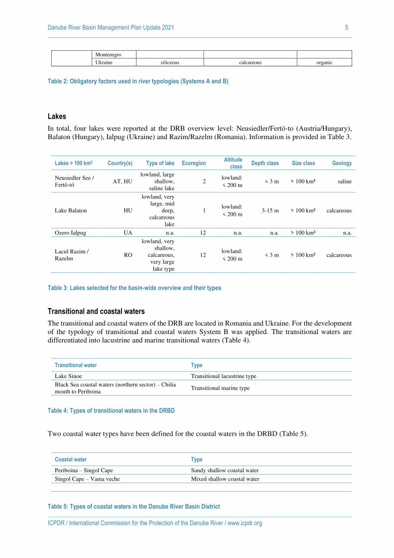
Table 2: Obligatory factors used in river typologies (Systems A and B)
Lakes
In total, four lakes were reported at the DRB overview level: Neusiedler/Fertö-to (Austria/Hungary),
Balaton (Hungary), Ialpug (Ukraine) and Razim/Razelm (Romania). Information is provided in Table 3.
Lakes > 100 km2 Country(s) Type of lake Ecoregion Altitude
class Depth class Size class Geology
Neusiedler See /
Fertő-tó AT, HU
lowland, large
shallow,
saline lake
2 lowland:
< 200 m < 3 m > 100 km² saline
Lake Balaton HU
lowland, very
large, mid
deep,
calcareous
lake
1 lowland:
< 200 m 3-15 m > 100 km² calcareous
Ozero Ialpug UA n.a. 12 n.a. n.a. > 100 km² n.a.
Lacul Razim /
Razelm RO
lowland, very
shallow,
calcareous,
very large
lake type
12 lowland:
< 200 m < 3 m > 100 km² calcareous
Table 3: Lakes selected for the basin-wide overview and their types
Transitional and coastal waters
The transitional and coastal waters of the DRB are located in Romania and Ukraine. For the development
of the typology of transitional and coastal waters System B was applied. The transitional waters are
differentiated into lacustrine and marine transitional waters (Table 4).
Transitional water Type
Lake Sinoe Transitional lacustrine type
Black Sea coastal waters (northern sector) – Chilia
mouth to Periboina Transitional marine type
Table 4: Types of transitional waters in the DRBD
Two coastal water types have been defined for the coastal waters in the DRBD (Table 5).
Coastal water Type
Periboina – Singol Cape Sandy shallow coastal water
Singol Cape – Vama veche Mixed shallow coastal water
Table 5: Types of coastal waters in the Danube River Basin District

ICPDR / International Commission for the Protection of the Danube River / www.icpdr.org
Draft ANNEX 3 as of 26 February 2021
DRBMP Update 2021
Urban Wastewater Emission Inventory

Danube River Basin Management Plan Update 2021 1
ICPDR / International Commission for the Protection of the Danube River / www.icpdr.org
Urban wastewater discharge data were collected from the countries in line with the reporting requirements of the UWWTD (non-EU countries used the same
template). The data served the assessments of the point source organic substance and nutrient emissions via urban wastewater discharges for the reference year
2016. Summarizing tables of the data submitted are presented in the followings.
Table 1: Number of agglomerations according to collection and treatment systems (highest technological level) and countries
Table 2: Summed Population Equivalents (PE) according to collection and treatment systems of the agglomerations (highest technological level) and countries
Collection and treatment system DE AT CZ SK HU SI HR BA RS BG RO MD UA Basin
NP-removal 452 526 136 142 438 78 6 3 33 175 1989
P-removal 11 76 19 7 10 2 125
N-removal 86 19 63 13 1 3 185
Secondary treatment 101 3 26 80 98 55 22 8 34 10 351 7 8 803
Primary treatment 2 32 10 9 2 41 5 2 103
Addressed through IAS 1 50 24 5 89 19 117 305
Collected but not treated 2 77 145 30 132 20 12 418
Addressed through local systems 81 150 231
Not collected 10 2 1 25 1049 112 271 1470
Total 650 605 201 344 615 138 139 168 342 120 1870 144 293 5629
Collection and treatment system DE AT CZ SK HU SI HR BA RS BG RO MD UA Basin
NP-removal 11957490 13256107 2178596 3158525 10362731 727297 247421 193836 2825464 11533293 56440760
P-removal 44988 338073 234671 139520 49665 13114 820031
N-removal 328403 69792 231835 379149 19924 149934 1179037
Secondary treatment 341627 3948 134806 334825 2404962 570017 1398946 586200 1083231 499069 2795565 96020 591705 10840921
Primary treatment 8400 392469 184897 81935 19215 559293 69400 31291 1346900
Addressed through IAS 2200 167633 68886 16032 926551 117628 511579 1810509
Collected but not treated 7172 1694803 4165316 162810 783656 92497 70624 6976878
Addressed through local systems 278650 570562 849212
Not collected 39821 9072 2050 77573 3795616 359897 1106001 5390030
Total 12672508 13598128 2620065 4040738 13657862 1313346 2804808 2568725 6096930 3721683 20142050 617814 1799621 85654278

Danube River Basin Management Plan Update 2021 2
ICPDR / International Commission for the Protection of the Danube River / www.icpdr.org
Table 3: Summed Population Equivalents (PE) according to collection types and countries
Table 4: Number of treatment facilities according to treatment types and countries
Table 5: Summed Population Equivalents (PE) according to treatment types and countries
Type of collection DE AT CZ SK HU SI HR BA RS BG RO MD UA Basin
Collected by sewer 12658003 13503800 2465154 3379826 11648962 1188875 1959491 980928 4283162 3048156 12425527 89610 583819 68215311
Collected by IAS 14505 94328 154911 642898 1457217 69295 572195 0 0 481029 281339 0 0 3767717
Collected by local systems 0 0 0 0 0 0 0 1062487 1674254 0 0 15052 0 2751793
Not collected 0 0 0 18014 551683 55176 273122 525311 139514 192498 7435184 513152 1215802 10919456
Total 12672508 13598128 2620065 4040738 13657862 1313346 2804808 2568725 6096930 3721683 20142050 617814 1799621 85654278
Type of treatment DE AT CZ SK HU SI HR BA RS BG RO MD UA Basin
NP-removal 452 526 116 89 443 46 6 3 28 143 1852
P-removal 11 76 19 6 11 2 125
N-removal 86 19 72 13 1 3 194
Secondary treatment 101 3 26 90 99 48 23 10 34 10 372 7 8 831
Primary treatment 4 33 10 1 9 3 42 5 2 109
Collected but not treated 12 18 100 73 283 41 160 20 12 719
Total 650 605 180 273 599 112 139 84 329 83 722 32 22 3830
Type of treatment DE AT CZ SK HU SI HR BA RS BG RO MD UA Basin
NP-removal 11943647 13162668 2052907 2780894 8899229 659486 174572 136157 2331560 9219123 51360242
P-removal 44885 337192 225277 215887 87990 4411 915641
N-removal 327874 63691 157365 349930 18529 136782 1054172
Secondary treatment 341597 3940 123279 199240 1982913 501660 1148225 338439 554213 476860 1438759 40266 520168 7669560
Primary treatment 5207 315878 130945 4797 44817 8326 382761 37364 23521 953616
Collected but not treated 21233 13022 27728 505748 637691 3547975 212882 1243693 11980 40129 6262081
Total 12658003 13503800 2465154 3379826 11648962 1188875 1959491 980928 4283162 3048156 12425527 89610 583819 68215311

Danube River Basin Management Plan Update 2021 3
ICPDR / International Commission for the Protection of the Danube River / www.icpdr.org
Table 6: Biochemical Oxygen Demand (BOD) discharges according to treatment types and countries (t/year)
Table 7: Chemical Oxygen Demand (COD) discharges according to treatment types and countries (t/year)
Type of treatment DE AT CZ SK HU SI HR BA RS BG RO MD UA Basin
NP-removal 3686.8 4373.1 379.5 702.6 4974.3 209.4 180.8 256.2 982.2 14523.4 30268.4
P-removal 22.3 199.2 42.9 61.5 97.3 4.5 427.7
N-removal 113.9 26.4 92.7 90.4 21.4 173.1 517.8
Secondary treatment 256.6 5.9 23.7 498.6 1535.3 146.6 7308.9 5994.8 3693.4 981.9 3429.8 525.7 671.0 25072.2
Primary treatment 19.7 265.9 2193.6 105.1 597.9 139.6 1369.0 1001.2 18.0 5710.2
Collected but not treated 165.5 607.4 9984.8 14000.6 63763.0 4628.8 5589.5 525.4 20.0 99284.9
Total 4079.6 4578.2 472.5 1540.6 6963.1 963.4 19668.1 20100.5 68310.5 6754.0 25089.3 2052.3 709.0 161281.1
Type of treatment DE AT CZ SK HU SI HR BA RS BG RO MD UA Basin
NP-removal 26980.2 28297.1 2669.5 3282.4 17562.0 1242.7 915.6 469.6 3368.1 53557.7 138345.1
P-removal 123.0 717.5 356.0 254.9 323.5 47.8 1822.7
N-removal 748.4 131.6 401.8 535.7 78.4 532.0 2427.9
Secondary treatment 1380.3 18.3 169.2 4326.6 4601.1 688.3 10463.3 10990.5 6694.0 3600.4 13936.6 744.8 1903.0 59516.4
Primary treatment 61.0 914.4 3511.2 192.7 1096.2 259.8 3390.0 1614.9 43.0 11083.3
Collected but not treated 352.4 1265.0 17461.4 25667.7 116898.8 8486.2 11381.8 893.2 40.0 182446.5
Total 29231.9 29032.9 3326.3 8679.2 23936.8 3196.0 32351.6 36850.9 125158.7 15793.0 82845.8 3252.8 1986.0 395641.9

Danube River Basin Management Plan Update 2021 4
ICPDR / International Commission for the Protection of the Danube River / www.icpdr.org
Table 8: Total Nitrogen (TN) discharges according to treatment types and countries (t/year)
Table 9: Total Phosphorus (TP) discharges according to treatment types and countries (t/year)
Type of treatment DE AT CZ SK HU SI HR BA RS BG RO MD UA Basin
NP-removal 12050.1 8327.4 1048.1 1383.6 5556.6 263.5 320.6 83.1 532.1 7147.9 36713.0
P-removal 40.0 415.2 144.1 131.1 65.7 12.8 808.9
N-removal 243.8 47.5 113.4 234.9 12.8 103.6 756.0
Secondary treatment 528.7 10.5 67.9 588.3 1283.4 239.5 4249.1 921.5 1070.3 1178.3 1602.4 166.3 761.0 12667.1
Primary treatment 12.8 221.3 687.9 17.5 114.7 21.9 366.4 168.3 13.0 1623.8
Collected but not treated 54.8 0.0 2290.9 2173.9 9351.9 694.3 1278.2 76.7 5.0 15925.7
Total 12862.6 8753.1 1307.6 2284.1 7361.9 503.0 7548.4 3112.9 10620.0 2439.4 10511.2 411.3 779.0 68494.6
Type of treatment DE AT CZ SK HU SI HR BA RS BG RO MD UA Basin
NP-removal 644.6 626.6 81.0 116.1 606.1 40.0 24.7 7.9 45.9 766.3 2959.2
P-removal 7.5 24.4 10.1 6.9 9.6 1.2 59.6
N-removal 77.7 9.3 43.8 36.5 7.5 3.9 178.5
Secondary treatment 82.4 1.8 9.6 65.2 554.9 32.9 660.2 202.6 254.8 171.8 219.4 57.5 85.2 2398.5
Primary treatment 2.1 32.6 84.3 3.5 25.2 3.5 53.6 46.7 0.9 252.5
Collected but not treated 8.7 0.0 358.8 470.0 1912.9 115.7 175.5 21.5 1.0 3064.1
Total 812.1 652.9 109.9 242.8 1239.6 72.9 1128.0 676.1 2200.7 344.5 1219.9 125.8 87.2 8912.5

ICPDR / International Commission for the Protection of the Danube River / www.icpdr.org
Draft ANNEX 4 as of 26 February 2021
DRBMP Update 2021
Industrial Emission Inventory

Danube River Basin Management Plan Update 2021 1
ICPDR / International Commission for the Protection of the Danube River / www.icpdr.org
Industrial pollutant release data were collected from the E-PRTR database (note that some data might have been updated since February 2021) and directly from
the countries which do not report under the E-PRTR system. The data served the assessments of the point source organic matter and nutrient emissions via direct
industrial dischargers for the reference year 2017. Summarizing tables of the data submitted are presented in the followings.
Table 1: Number of industrial facilities with reported Chemical Oxygen Demand (COD) discharge according to industrial sectors and countries
Table 2: Chemical Oxygen Demand (COD) discharges according to industrial sectors and countries (t/year)
Activity DE AT CZ SK HU SI HR BA ME RS BG RO MD UA Basin
Energy sector 0 0 0 1 4 0 0 0 0 0 0 3 0 0 8
Production and processing of metals 0 1 0 1 1 0 0 0 0 0 0 0 0 0 3
Mineral industry 0 0 0 0 1 0 0 0 0 0 0 0 0 0 1
Chemical industry 2 2 0 2 2 0 0 0 0 0 0 2 0 0 10
Waste and industrial wastewater management 0 6 0 0 3 0 0 0 0 0 1 0 0 0 10
Paper and wood production processing 5 4 0 2 1 2 0 0 0 0 1 0 0 1 16
Intensive livestock production and aquaculture 0 0 0 0 0 0 0 0 0 0 0 0 0 0 0
Products from the food and beverage sector 0 1 0 0 2 0 0 0 0 0 0 0 0 0 3
Other activities 0 0 0 0 0 0 0 0 0 0 0 0 0 0 0
Total 7 14 0 6 14 2 0 0 0 0 2 5 0 1 51
Activity DE AT CZ SK HU SI HR BA ME RS BG RO MD UA Basin
Energy sector 0 0 0 675 3417 0 0 0 0 0 0 1179 0 0 5271
Production and processing of metals 0 220 0 396 1176 0 0 0 0 0 0 0 0 0 1792
Mineral industry 0 0 0 0 210 0 0 0 0 0 0 0 0 0 210
Chemical industry 1419 1571 0 474 669 0 0 0 0 0 0 9651 0 0 13784
Waste and industrial wastewater management 0 21063 0 0 727 0 0 0 0 0 221 0 0 0 22011
Paper and wood production processing 8187 9088 0 4596 2208 561 0 0 0 0 1788 0 0 131 26559
Intensive livestock production and aquaculture 0 0 0 0 0 0 0 0 0 0 0 0 0 0 0
Products from the food and beverage sector 0 624 0 0 1158 0 0 0 0 0 0 0 0 0 1782
Other activities 0 0 0 0 0 0 0 0 0 0 0 0 0 0 0
Total 9606 32566 0 6141 9565 561 0 0 0 0 2009 10830 0 131 71409

Danube River Basin Management Plan Update 2021 2
ICPDR / International Commission for the Protection of the Danube River / www.icpdr.org
Table 3: Number of industrial facilities with reported Total Nitrogen (TN) discharge according to industrial sectors and countries
Table 4: Total Nitrogen (TN) discharges according to industrial sectors and countries (t/year)
Activity DE AT CZ SK HU SI HR BA ME RS BG RO MD UA Basin
Energy sector 1 0 0 1 3 0 0 2 0 0 0 0 0 0 7
Production and processing of metals 0 0 0 1 0 0 0 0 0 1 0 1 0 0 3
Mineral industry 0 0 0 0 0 0 0 0 0 0 0 0 0 0 0
Chemical industry 2 1 0 1 2 0 1 1 0 1 0 1 0 0 10
Waste and industrial wastewater management 0 2 0 1 1 0 0 0 0 0 0 0 0 0 4
Paper and wood production processing 0 0 0 1 0 0 0 0 0 0 0 0 0 1 2
Intensive livestock production and aquaculture 0 0 0 0 0 0 0 0 0 0 1 0 0 0 1
Products from the food and beverage sector 0 1 0 0 0 0 0 0 0 0 0 0 0 0 1
Other activities 0 0 0 0 0 0 0 0 0 0 0 0 0 0 0
Total 3 4 0 5 6 0 1 3 0 2 1 2 0 1 28
Activity DE AT CZ SK HU SI HR BA ME RS BG RO MD UA Basin
Energy sector 58 0 0 138 608 0 0 4.1 0 0 0 0 0 0 808
Production and processing of metals 0 0 0 161 0 0 0 0.0 0 114 0 373 0 0 648
Mineral industry 0 0 0 0 0 0 0 0.0 0 0 0 0 0 0 0
Chemical industry 170 135 0 106 241 0 68 0.1 0 626 0 55 0 0 1401
Waste and industrial wastewater management 0 443 0 82 83 0 0 0.0 0 0 0 0 0 0 607
Paper and wood production processing 0 0 0 117 0 0 0 0.0 0 0 0 0 0 71 188
Intensive livestock production and aquaculture 0 0 0 0 0 0 0 0.0 0 0 218 0 0 0 218
Products from the food and beverage sector 0 252 0 0 0 0 0 0.0 0 0 0 0 0 0 252
Other activ ities 0 0 0 0 0 0 0 0.0 0 0 0 0 0 0 0
Total 227 830 0 604 932 0 68 4.1 0 740 218 428 0 71 4121

Danube River Basin Management Plan Update 2021 3
ICPDR / International Commission for the Protection of the Danube River / www.icpdr.org
Table 5: Number of industrial facilities with reported Total Phosphorus (TP) discharge according to industrial sectors and countries
Table 6: Total Phosphorus (TP) discharges according to industrial sectors and countries (t/year)
Activity DE AT CZ SK HU SI HR BA ME RS BG RO MD UA Basin
Energy sector 0 0 0 1 2 0 0 2 0 0 0 1 0 0 6
Production and processing of metals 0 0 0 0 0 0 0 0 0 0 0 0 0 0 0
Mineral industry 0 0 0 0 0 0 0 0 0 0 0 0 0 0 0
Chemical industry 1 1 0 0 0 0 0 0 0 1 0 0 0 0 3
Waste and industrial wastewater management 0 3 0 1 1 0 0 0 0 0 0 0 0 0 5
Paper and wood production processing 0 1 0 1 1 0 0 0 0 0 0 0 0 1 4
Intensive livestock production and aquaculture 0 0 0 0 1 0 0 0 0 0 1 0 0 0 2
Products from the food and beverage sector 0 1 0 0 0 0 0 0 0 0 0 0 0 0 1
Other activities 0 0 0 0 0 0 0 0 0 0 0 0 0 0 0
Total 1 6 0 3 5 0 0 2 0 1 1 1 0 1 21
Activity DE AT CZ SK HU SI HR BA ME RS BG RO MD UA Basin
Energy sector 0 0 0 11 16 0 0 0 0 0 0 6 0 0 33
Production and processing of metals 0 0 0 0 0 0 0 0 0 0 0 0 0 0 0
Mineral industry 0 0 0 0 0 0 0 0 0 0 0 0 0 0 0
Chemical industry 6 7 0 0 0 0 0 0 0 11 0 0 0 0 24
Waste and industrial wastewater management 0 65 0 7 10 0 0 0 0 0 0 0 0 0 81
Paper and wood production processing 0 17 0 17 15 0 0 0 0 0 0 0 0 9 57
Intensive livestock production and aquaculture 0 0 0 0 4 0 0 0 0 0 109 0 0 0 113
Products from the food and beverage sector 0 6 0 0 0 0 0 0 0 0 0 0 0 0 6
Other activities 0 0 0 0 0 0 0 0 0 0 0 0 0 0 0
Total 6 95 0 34 44 0 0 0.4 0 11 109 6 0 9 315

ICPDR / International Commission for the Protection of the Danube River / www.icpdr.org
Draft ANNEX 6 as of 26 February 2021
DRBMP Update 2021
Hazardous Substances Release Inventory
Danube River Basin Management Plan Update 2021 1
ICPDR / International Commission for the Protection of the Danube River / www.icpdr.org
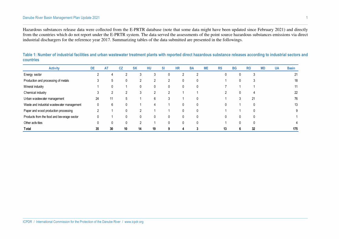
Hazardous substances release data were collected from the E-PRTR database (note that some data might have been updated since February 2021) and directly
from the countries which do not report under the E-PRTR system. The data served the assessments of the point source hazardous substances emissions via direct
industrial dischargers for the reference year 2017. Summarizing tables of the data submitted are presented in the followings.
Table 1: Number of industrial facilities and urban wastewater treatment plants with reported direct hazardous substance releases according to industrial sectors and countries
Activity DE AT CZ SK HU SI HR BA ME RS BG RO MD UA Basin
Energy sector 2 4 2 3 3 0 2 2 0 0 3 21
Production and processing of metals 3 5 0 2 2 2 0 0 1 0 3 18
Mineral industry 1 0 1 0 0 0 0 0 7 1 1 11
Chemical industry 3 2 2 3 2 2 1 1 2 0 4 22
Urban wastewater management 24 11 5 1 6 3 1 0 1 3 21 76
Waste and industrial wastewater management 0 6 0 1 4 1 0 0 0 1 0 13
Paper and wood production processing 2 1 0 2 1 1 0 0 1 1 0 9
Products from the food and beverage sector 0 1 0 0 0 0 0 0 0 0 0 1
Other activ ities 0 0 0 2 1 0 0 0 1 0 0 4
Total 35 30 10 14 19 9 4 3 13 6 32 175

Danube River Basin Management Plan Update 2021 2
ICPDR / International Commission for the Protection of the Danube River / www.icpdr.org
Table 2: Number of industrial facilities and urban wastewater treatment plants with reported direct hazardous substance releases according to compounds and countries
Basin
CHLORO-ALKANES (C10-13) CHLORG 0 1 0 0 0 1 0 0 0 0 0 0 0 0 2
DICHLOROETHANE-1,2 (DCE) CHLORG 0 0 0 1 1 0 0 0 0 0 0 0 0 0 2
DICHLOROMETHANE (DCM) CHLORG 1 0 0 0 0 2 0 0 0 0 0 0 0 0 3
HALOGENATED ORGANIC COMPOUNDS CHLORG 6 3 3 5 3 1 0 0 0 1 0 0 0 0 22
PENTACHLOROPHENOL (PCP) CHLORG 0 1 0 0 0 0 0 0 0 0 0 0 0 0 1
POLYCHLORINATED BIPHENYLS (PCBS) CHLORG 0 0 0 1 0 0 0 0 0 0 0 0 0 0 1
TETRACHLOROETHANE-1,1,2,2 CHLORG 0 0 0 0 0 1 0 0 0 0 0 0 0 0 1
TETRACHLOROETHYLENE (PER) CHLORG 0 0 1 1 0 0 0 0 0 0 0 0 0 0 2
TRICHLOROBENZENES (TCB) CHLORG 0 0 0 1 0 0 0 0 0 0 0 0 0 0 1
TRICHLOROETHYLENE (TRI) CHLORG 0 0 0 2 0 0 0 0 0 0 0 0 0 0 2
TRICHLOROMETHANE CHLORG 1 2 0 1 0 0 0 0 0 0 0 0 0 0 4
VINYL CHLORIDE CHLORG 0 0 0 0 1 0 0 0 0 0 0 0 0 0 1
AS AND COMPOUNDS HEVMET 6 2 4 1 5 1 0 0 0 3 2 1 0 0 25
CD AND COMPOUNDS HEVMET 2 2 1 4 4 0 0 0 0 1 1 2 0 0 17
CR AND COMPOUNDS HEVMET 4 1 2 2 5 2 1 1 0 1 4 11 0 0 34
CU AND COMPOUNDS HEVMET 17 9 2 0 4 2 1 0 0 6 2 11 0 0 54
HG AND COMPOUNDS HEVMET 2 2 1 5 5 0 1 1 0 0 1 1 0 0 19
NI AND COMPOUNDS HEVMET 24 13 5 1 9 6 1 1 0 5 2 19 0 0 86
PB AND COMPOUNDS HEVMET 3 6 1 0 4 0 1 2 0 5 2 7 0 0 31
ZN AND COMPOUNDS HEVMET 27 15 5 2 4 7 1 0 0 6 2 19 0 0 88
CHLORIDES INORG 11 1 1 2 1 1 0 1 0 0 1 7 0 0 26
CYANIDES INORG 0 1 2 2 1 1 0 0 0 2 0 7 0 0 16
FLUORIDES INORG 5 3 4 2 3 0 0 0 0 1 0 0 0 0 18
BENZO(G,H,I)PERYLENE OTHORG 0 0 0 1 0 0 0 0 0 0 0 0 0 0 1
DEHP OTHORG 20 2 1 3 0 3 1 0 0 0 0 1 0 0 31
FLUORANTHENE OTHORG 0 1 0 1 0 0 0 0 0 0 0 0 0 0 2
NP/NPES OTHORG 0 9 1 0 0 3 1 0 0 0 0 0 0 0 14
OCTYLPHENOLS AND OCTYLPHENOL ETHOXYLATEOTHORG 0 0 1 0 0 1 0 0 0 0 0 0 0 0 2
PHENOLS OTHORG 0 1 2 6 5 0 1 0 0 4 3 12 0 0 34
POLYCYCLIC AROMATIC HYDROCARBONS OTHORG 1 0 0 1 0 0 0 0 0 0 0 0 0 0 2
ATRAZINE PEST 0 0 0 0 0 1 0 0 0 0 0 0 0 0 1
DIURON PEST 4 2 0 0 0 0 0 0 0 0 0 0 0 0 6
ISOPROTURON PEST 1 1 0 0 0 0 0 0 0 0 0 0 0 0 2
LINDANE PEST 0 0 0 0 0 0 0 0 0 0 0 1 0 0 1
Pollutant groupSubstance AT BA BGSK HRCZDE HU SI UAMDME RORS

Danube River Basin Management Plan Update 2021 3
ICPDR / International Commission for the Protection of the Danube River / www.icpdr.org
Table 3: Reported direct hazardous substance releases according to compounds and countries (kg/year)
Substance Pollutant group DE AT CZ SK HU SI HR BA ME RS BG RO MD UA Total
CHLORO-ALKANES (C10-13) CHLORG 0.0 19.0 0.0 0.0 0.0 29.0 0.0 0.0 0.0 0.0 0.0 0.0 0.0 0.0 48.0
DICHLOROETHANE-1,2 (DCE) CHLORG 0.0 0.0 0.0 172.0 259.0 0.0 0.0 0.0 0.0 0.0 0.0 0.0 0.0 0.0 431.0
DICHLOROMETHANE (DCM) CHLORG 44.0 0.0 0.0 0.0 0.0 268.0 0.0 0.0 0.0 0.0 0.0 0.0 0.0 0.0 312.0
HALOGENATED ORGANIC COMPOUNDS CHLORG 9880.0 50460.0 4754.6 31930.0 8240.0 1030.0 0.0 0.0 0.0 2100.0 0.0 0.0 0.0 0.0 108394.6
PENTACHLOROPHENOL (PCP) CHLORG 0.0 1.9 0.0 0.0 0.0 0.0 0.0 0.0 0.0 0.0 0.0 0.0 0.0 0.0 1.9
POLYCHLORINATED BIPHENYLS (PCBS) CHLORG 0.0 0.0 0.0 0.5 0.0 0.0 0.0 0.0 0.0 0.0 0.0 0.0 0.0 0.0 0.5
TETRACHLOROETHANE-1,1,2,2 CHLORG 0.0 0.0 0.0 0.0 0.0 13.0 0.0 0.0 0.0 0.0 0.0 0.0 0.0 0.0 13.0
TETRACHLOROETHYLENE (PER) CHLORG 0.0 0.0 11.5 14.4 0.0 0.0 0.0 0.0 0.0 0.0 0.0 0.0 0.0 0.0 25.9
TRICHLOROBENZENES (TCB) CHLORG 0.0 0.0 0.0 3.3 0.0 0.0 0.0 0.0 0.0 0.0 0.0 0.0 0.0 0.0 3.3
TRICHLOROETHYLENE (TRI) CHLORG 0.0 0.0 0.0 64.4 0.0 0.0 0.0 0.0 0.0 0.0 0.0 0.0 0.0 0.0 64.4
TRICHLOROMETHANE CHLORG 125.0 76.5 0.0 119.0 0.0 0.0 0.0 0.0 0.0 0.0 0.0 0.0 0.0 0.0 320.5
VINYL CHLORIDE CHLORG 0.0 0.0 0.0 0.0 360.0 0.0 0.0 0.0 0.0 0.0 0.0 0.0 0.0 0.0 360.0
AS AND COMPOUNDS HEVMET 58.0 26.1 8.4 95.2 899.9 17.8 0.0 0.0 0.0 67.0 1358.1 13.3 0.0 0.0 2543.8
CD AND COMPOUNDS HEVMET 33.4 15.5 9.8 140.7 296.7 0.0 0.0 0.0 0.0 7.0 664.0 18.0 0.0 0.0 1185.1
CR AND COMPOUNDS HEVMET 619.2 403.0 142.0 142.9 2091.6 256.7 111.0 2.4 0.0 115.0 6479.8 3653.5 0.0 0.0 14017.1
CU AND COMPOUNDS HEVMET 5455.0 6342.0 627.0 0.0 2592.0 502.0 747.0 0.0 0.0 485295.0 6814.0 30802.5 0.0 0.0 539176.5
HG AND COMPOUNDS HEVMET 17.8 41.3 3.2 281.8 43.4 0.0 1.5 0.4 0.0 0.0 14.3 21.7 0.0 0.0 425.4
NI AND COMPOUNDS HEVMET 1717.5 4528.3 1146.1 26.1 3100.3 427.3 217.0 141.0 0.0 374.0 1827.0 4042.4 0.0 0.0 17547.0
PB AND COMPOUNDS HEVMET 586.0 1088.8 56.0 0.0 2901.0 0.0 35.2 162.6 0.0 1716.0 2764.0 975.2 0.0 0.0 10284.8
ZN AND COMPOUNDS HEVMET 35756.0 50231.0 5086.3 1632.0 13265.0 3952.0 3540.0 0.0 0.0 3056.0 14470.0 51261.0 0.0 0.0 182249.3
CHLORIDES INORG 95700000.0 22700000.0 5208671.0 8340000.0 10400000.0 2380000.0 0.0 252.5 0.0 0.0 9210000.0 321390000.0 0.0 0.0 475328923.5
CYANIDES INORG 0.0 342.0 0.0 949.8 451.0 65.0 0.0 0.0 0.0 320.0 0.0 4182.0 0.0 0.0 6309.8
FLUORIDES INORG 37340.0 32760.0 29309.0 91460.0 21170.0 0.0 0.0 0.0 0.0 21900.0 0.0 0.0 0.0 0.0 233939.0
BENZO(G,H,I)PERYLENE OTHORG 0.0 0.0 0.0 3.4 0.0 0.0 0.0 0.0 0.0 0.0 0.0 0.0 0.0 0.0 3.4
DEHP OTHORG 107.1 15.8 34.0 257.7 0.0 10.9 1.9 0.0 0.0 0.0 0.0 2960.0 0.0 0.0 3387.3
FLUORANTHENE OTHORG 0.0 3.3 0.0 1.0 0.0 0.0 0.0 0.0 0.0 0.0 0.0 0.0 0.0 0.0 4.3
NP/NPES OTHORG 0.0 57.5 2.7 0.0 0.0 58.3 1.9 0.0 0.0 0.0 0.0 0.0 0.0 0.0 120.4
OCTYLPHENOLS AND OCTYLPHENOL ETHOXYLATEOTHORG 0.0 0.0 0.0 0.0 0.0 1.8 0.0 0.0 0.0 0.0 0.0 0.0 0.0 0.0 1.8
PHENOLS OTHORG 0.0 456.0 879.4 2336.1 3187.8 0.0 114.0 0.0 0.0 366.0 2783.0 39007.4 0.0 0.0 49129.7
POLYCYCLIC AROMATIC HYDROCARBONS OTHORG 5.7 0.0 0.0 5.4 0.0 0.0 0.0 0.0 0.0 0.0 0.0 0.0 0.0 0.0 11.1
ATRAZINE PEST 0.0 0.0 0.0 0.0 0.0 26.0 0.0 0.0 0.0 0.0 0.0 0.0 0.0 0.0 26.0
DIURON PEST 9.1 3.7 0.0 0.0 0.0 0.0 0.0 0.0 0.0 0.0 0.0 0.0 0.0 0.0 12.8
ISOPROTURON PEST 1.6 1.1 0.0 0.0 0.0 0.0 0.0 0.0 0.0 0.0 0.0 0.0 0.0 0.0 2.7
LINDANE PEST 0.0 0.0 0.0 0.0 0.0 0.0 0.0 0.0 0.0 0.0 0.0 1.2 0.0 0.0 1.2

Danube River Basin Management Plan Update 2021 4
ICPDR / International Commission for the Protection of the Danube River / www.icpdr.org
Table 4: Number of industrial facilities and urban wastewater treatment plants with reported direct hazardous substance releases according to compounds and industrial sectors
Substance Pollutant groupEnergy
sector
Production and
processing of
metals
Mineral
industry
Chemical
industry
Waste and industrial
wastewater
management
Urban
wastewater
management
Paper and wood
production
processing
Intensive livestock
production and
aquaculture
Products from the
food and beverage
sector
Other
activitiesBasin
CHLORO-ALKANES (C10-13) CHLORG 0 1 0 0 0 1 0 0 0 0 2
DICHLOROETHANE-1,2 (DCE) CHLORG 0 0 0 2 0 0 0 0 0 0 2
DICHLOROMETHANE (DCM) CHLORG 0 0 0 2 1 0 0 0 0 0 3
HALOGENATED ORGANIC COMPOUNDS CHLORG 2 2 0 3 3 8 4 0 0 0 22
PENTACHLOROPHENOL (PCP) CHLORG 0 0 0 0 1 0 0 0 0 0 1
POLYCHLORINATED BIPHENYLS (PCBS) CHLORG 1 0 0 0 0 0 0 0 0 0 1
TETRACHLOROETHANE-1,1,2,2 CHLORG 0 0 0 0 1 0 0 0 0 0 1
TETRACHLOROETHYLENE (PER) CHLORG 0 1 0 0 0 1 0 0 0 0 2
TRICHLOROBENZENES (TCB) CHLORG 0 0 0 1 0 0 0 0 0 0 1
TRICHLOROETHYLENE (TRI) CHLORG 0 1 0 1 0 0 0 0 0 0 2
TRICHLOROMETHANE CHLORG 0 1 0 2 1 0 0 0 0 0 4
VINYL CHLORIDE CHLORG 0 0 0 1 0 0 0 0 0 0 1
AS AND COMPOUNDS HEVMET 5 2 4 1 3 9 1 0 0 0 25
CD AND COMPOUNDS HEVMET 1 1 1 0 0 13 1 0 0 0 17
CR AND COMPOUNDS HEVMET 3 4 0 2 0 23 2 0 0 0 34
CU AND COMPOUNDS HEVMET 3 4 6 1 2 36 2 0 0 0 54
HG AND COMPOUNDS HEVMET 2 3 0 4 0 9 1 0 0 0 19
NI AND COMPOUNDS HEVMET 6 11 3 4 5 52 1 0 1 3 86
PB AND COMPOUNDS HEVMET 3 5 3 1 2 16 1 0 0 0 31
ZN AND COMPOUNDS HEVMET 6 12 7 3 3 53 3 0 1 0 88
CHLORIDES INORG 1 2 1 5 0 17 0 0 0 0 26
CYANIDES INORG 1 3 1 2 0 9 0 0 0 0 16
FLUORIDES INORG 3 3 1 5 2 4 0 0 0 0 18
BENZO(G,H,I)PERYLENE OTHORG 1 0 0 0 0 0 0 0 0 0 1
DEHP OTHORG 0 1 0 2 1 26 0 0 0 1 31
FLUORANTHENE OTHORG 1 1 0 0 0 0 0 0 0 0 2
NP/NPES OTHORG 0 1 0 1 2 9 1 0 0 0 14
OCTYLPHENOLS AND OCTYLPHENOL ETHOXYLATESOTHORG 0 0 0 0 0 2 0 0 0 0 2
PHENOLS OTHORG 7 4 0 7 2 13 1 0 0 0 34
POLYCYCLIC AROMATIC HYDROCARBONS OTHORG 0 1 0 0 0 1 0 0 0 0 2
ATRAZINE PEST 0 0 0 0 1 0 0 0 0 0 1
DIURON PEST 0 0 0 0 1 5 0 0 0 0 6
ISOPROTURON PEST 0 0 0 0 0 2 0 0 0 0 2
LINDANE PEST 0 0 0 1 0 0 0 0 0 0 1

Danube River Basin Management Plan Update 2021 5
ICPDR / International Commission for the Protection of the Danube River / www.icpdr.org
Table 5: Reported direct hazardous substance releases according to compounds and industrial sectors (kg/year)
SubstancePollutant
group
Energy
sector
Production and
processing of
metals
Mineral
industry
Chemical
industry
Waste and industrial
wastewater
management
Urban
wastewater
management
Paper and wood
production
processing
Intensive livestock
production and
aquaculture
Products from the
food and beverage
sector
Other
activitiesBasin
CHLORO-ALKANES (C10-13) CHLORG 0.0 19.0 0.0 0.0 0.0 29.0 0.0 0.0 0.0 0.0 48.0
DICHLOROETHANE-1,2 (DCE) CHLORG 0.0 0.0 0.0 431.0 0.0 0.0 0.0 0.0 0.0 0.0 431.0
DICHLOROMETHANE (DCM) CHLORG 0.0 0.0 0.0 73.0 239.0 0.0 0.0 0.0 0.0 0.0 312.0
HALOGENATED ORGANIC COMPOUNDS CHLORG 3070.0 3770.0 0.0 9640.0 56640.0 12124.6 23150.0 0.0 0.0 0.0 108394.6
PENTACHLOROPHENOL (PCP) CHLORG 0.0 0.0 0.0 0.0 1.9 0.0 0.0 0.0 0.0 0.0 1.9
POLYCHLORINATED BIPHENYLS (PCBS) CHLORG 0.5 0.0 0.0 0.0 0.0 0.0 0.0 0.0 0.0 0.0 0.5
TETRACHLOROETHANE-1,1,2,2 CHLORG 0.0 0.0 0.0 0.0 13.0 0.0 0.0 0.0 0.0 0.0 13.0
TETRACHLOROETHYLENE (PER) CHLORG 0.0 14.4 0.0 0.0 0.0 11.5 0.0 0.0 0.0 0.0 25.9
TRICHLOROBENZENES (TCB) CHLORG 0.0 0.0 0.0 3.3 0.0 0.0 0.0 0.0 0.0 0.0 3.3
TRICHLOROETHYLENE (TRI) CHLORG 0.0 14.4 0.0 50.0 0.0 0.0 0.0 0.0 0.0 0.0 64.4
TRICHLOROMETHANE CHLORG 0.0 24.9 0.0 244.0 51.6 0.0 0.0 0.0 0.0 0.0 320.5
VINYL CHLORIDE CHLORG 0.0 0.0 0.0 360.0 0.0 0.0 0.0 0.0 0.0 0.0 360.0
AS AND COMPOUNDS HEVMET 127.7 26.1 67.0 0.0 704.0 1600.9 18.1 0.0 0.0 0.0 2543.8
CD AND COMPOUNDS HEVMET 107.0 14.4 7.0 0.0 0.0 1043.4 13.3 0.0 0.0 0.0 1185.1
CR AND COMPOUNDS HEVMET 360.9 933.6 0.0 70.9 0.0 12506.9 144.8 0.0 0.0 0.0 14017.1
CU AND COMPOUNDS HEVMET 682.0 2115.0 49195.0 91.0 306.0 486432.5 355.0 0.0 0.0 0.0 539176.5
HG AND COMPOUNDS HEVMET 20.8 44.2 0.0 279.3 0.0 75.6 5.6 0.0 0.0 0.0 425.4
NI AND COMPOUNDS HEVMET 1324.8 990.4 233.0 159.5 984.0 13595.4 123.0 0.0 52.6 84.3 17547.0
PB AND COMPOUNDS HEVMET 454.0 1774.0 689.0 51.6 172.8 7074.4 69.0 0.0 0.0 0.0 10284.8
ZN AND COMPOUNDS HEVMET 1967.3 19185.0 16626.0 12632.0 4985.0 124220.0 2319.0 0.0 315.0 0.0 182249.3
CHLORIDES INORG 252.5 8330000.0 9210000.0 318850000.0 0.0 138938671.0 0.0 0.0 0.0 0.0 475328923.5
CYANIDES INORG 53.8 2039.0 237.0 342.0 0.0 3638.0 0.0 0.0 0.0 0.0 6309.8
FLUORIDES INORG 23797.0 32350.0 8480.0 134990.0 12570.0 21752.0 0.0 0.0 0.0 0.0 233939.0
BENZO(G,H,I)PERYLENE OTHORG 3.4 0.0 0.0 0.0 0.0 0.0 0.0 0.0 0.0 0.0 3.4
DEHP OTHORG 0.0 252.0 0.0 5.4 12.0 3115.7 0.0 0.0 0.0 2.2 3387.3
FLUORANTHENE OTHORG 1.0 3.3 0.0 0.0 0.0 0.0 0.0 0.0 0.0 0.0 4.3
NP/NPES OTHORG 0.0 2.5 0.0 1.9 8.1 104.7 3.2 0.0 0.0 0.0 120.4
OCTYLPHENOLS AND OCTYLPHENOL ETHOXYLATES OTHORG 0.0 0.0 0.0 0.0 0.0 1.8 0.0 0.0 0.0 0.0 1.8
PHENOLS OTHORG 2479.9 1190.8 0.0 855.6 198.0 44365.4 40.0 0.0 0.0 0.0 49129.7
POLYCYCLIC AROMATIC HYDROCARBONS OTHORG 0.0 5.4 0.0 0.0 0.0 5.7 0.0 0.0 0.0 0.0 11.1
ATRAZINE PEST 0.0 0.0 0.0 0.0 26.0 0.0 0.0 0.0 0.0 0.0 26.0
DIURON PEST 0.0 0.0 0.0 0.0 1.6 11.2 0.0 0.0 0.0 0.0 12.8
ISOPROTURON PEST 0.0 0.0 0.0 0.0 0.0 2.7 0.0 0.0 0.0 0.0 2.7
LINDANE PEST 0.0 0.0 0.0 1.2 0.0 0.0 0.0 0.0 0.0 0.0 1.2

ICPDR / International Commission for the Protection of the Danube River / www.icpdr.org
Draft ANNEX 7 as of 26 February 2021
DRBMP Update 2021
List of Future Infrastructure Projects

Danube River Basin Management Plan Update 2021 1
ICPDR / International Commission for the Protection of the Danube River / www.icpdr.org
As in previous cycles, a list of future infrastructure projects (FIPs) of basin-wide importance has been
compiled for the DRBMP Update 2021. The following criteria were applied for the data collection.
Criteria for the collection of future infrastructure projects for the Danube River and other DRBD rivers with catchment
areas >4,000 km2
Danube River Other DRBD rivers with catchment areas
>4,000 km2
Criteria
Strategic Environmental Assessment (SEA) and/or
Environmental Impact Assessments (EIA) are
performed for the project
Strategic Environmental Assessment (SEA) and/or
Environmental Impact Assessments (EIA) are
performed for the project
or and
project is expected to provoke transboundary
effects
project is expected to provoke transboundary
effects
These FIPs, if implemented without full consideration to effects on water status, are likely to provoke
impacts on water status due to hydromorphological alterations. Consequently, these projects need to be
addressed by integrating mitigation measures in order to reduce/cancel the potential impacts on water
status.
Explanations for table
SEA = Strategic Environmental Assessment
EIA = Environmental Impact Assessment

Danube River Basin Management Plan Update 2021 2
ICPDR / International Commission for the Protection of the Danube River / www.icpdr.org

Danube River Basin Management Plan Update 2021 3
ICPDR / International Commission for the Protection of the Danube River / www.icpdr.org
Country River Water body Project title Main
purpose
Description Project status Start
imple-
mentation
Expected
deterioration
of water
body status
Trans-
boundary
impact
SEA EIA Exemption
WFD Art.
4(7)
BG Dunav DUNAV
RWB01
Fast Danube Sector 7 Belene Navigation Improvement of the navigation
conditions on the RO-BG
Danube Sector - Location 1 km
north of Belene; between km 577
â km 560
Implementation
of project
2021 Yes Yes No Intended Yes*
BG Dunav DUNAV
RWB01
Fast Danube Sector 8 Vardim Navigation Improvement of the navigation
conditions on the RO-BG
Danube Sector - Location 5 km
northeast of Vardim; between km
542 â km 539
Implementation
of project
2021 Yes Yes No Intended Yes*
BG Dunav DUNAV
RWB01
Fast Danube Sector 9 Yantra Navigation Improvement of the navigation
conditions on the RO-BG
Danube Sector - Location: 3 km
north of Krivina; between km
537 â km 534
Implementation
of project
2021 Yes Yes No Intended Yes*
BG Dunav DUNAV
RWB01
Fast Danube Sector 10 Batin Navigation Improvement of the navigation
conditions on the RO-BG
Danube Sector - Location: 2 km
north of Batin; between km 530
and km 520
Implementation
of project
2021 Yes Yes No Intended Yes*
BG Dunav DUNAV
RWB01
Fast Danube Sector 11
Konsui
Navigation Improvement of the navigation
conditions on the RO-BG
Danube Sector - Location 6 km
east of Oltenita; between km 428
â km 423
Implementation
of project
2021 Yes Yes No Intended Yes*
BG Dunav DUNAV
RWB01
Fast Danube Sector 12 Popina Navigation Improvement of the navigation
conditions on the RO-BG
Danube Sector - Location: 1 km
north of Popina; between km 408
and km 401
Implementation
of project
2021 Yes Yes No Intended Yes*
DE Donau Donau von
Einmündung
Große Laber
bis
Einmündung
Isar
Ausbau der Wasserstraße und
Verbesserung des
Hochwasserschutzes
zwischen Straubing und
Vilshofen, Teilabschnitt 1:
Straubing und Deggendorf
Flood
protection
reduction flood risks,
improvement for navigation
(Ongoing approval procedure
under public law and current
measures improving flood
protection)
Officially
planned
Not yet
determined
No No No Intended No

Danube River Basin Management Plan Update 2021 4
ICPDR / International Commission for the Protection of the Danube River / www.icpdr.org
Country River Water body Project title Main
purpose
Description Project status Start
imple-
mentation
Expected
deterioration
of water
body status
Trans-
boundary
impact
SEA EIA Exemption
WFD Art.
4(7)
DE Donau Donau von
Einmündung
Isar bis
Einmündung
Vils
Ausbau der Wasserstraße und
Verbesserung des
Hochwasserschutzes
zwischen Straubing und
Vilshofen, Teilabschnitt 2:
Deggendorf und Vilshofen
Flood
protection
reduction flood risks,
improvement for navigation
(Ongoing approval procedure
under public law and current
measures improving flood
protection)
Planning under
preparation
Not yet
determined
No No No Intended No
DE Donau Donau von
Einmündung
Lech bis
Einmündung
Paar
Polder Bertoldsheim Flood
protection
polder Planning under
preparation
Not yet
determined
No No Intended Intended No
DE Donau Donau von
Einmündung
Naab bis
Einmündung
Große Laber
Polder Eltheim Flood
protection
polder Planning under
preparation
Not yet
determined
No No Intended Intended No
DE Donau Donau von
Einmündung
Lech bis
Einmündung
Paar
Polder Grossmehring Flood
protection
polder Planning under
preparation
Not yet
determined
No No Intended Intended No
DE Donau Donau von
Einmündung
Landgraben
bei Offingen
bis Staustufe
Donauwörth
Polder Helmeringen Flood
protection
polder Planning under
preparation
Not yet
determined
No No Intended Intended No
DE Donau Donau von
Einmündung
Paar bis
Staubing
(Fkm 165)
Polder Katzau Flood
protection
polder Planning under
preparation
Not yet
determined
No No Intended Intended No
DE Donau Donau von
Einmündung
Iller bis
Einmündung
Landgraben
bei Offingen
Polder Leipheim Flood
protection
polder Planning under
preparation
Not yet
determined
No No Intended Intended No

Danube River Basin Management Plan Update 2021 5
ICPDR / International Commission for the Protection of the Danube River / www.icpdr.org
Country River Water body Project title Main
purpose
Description Project status Start
imple-
mentation
Expected
deterioration
of water
body status
Trans-
boundary
impact
SEA EIA Exemption
WFD Art.
4(7)
DE Donau Donau von
Einmündung
Landgraben
bei Offingen
bis Staustufe
Donauwörth
Polder Neugeschüttwörth Flood
protection
polder Planning under
preparation
Not yet
determined
No No Intended Intended No
DE Donau Donau von
Einmündung
Naab bis
Einmündung
Große Laber
Polder Ueberauer Schleife Flood
protection
polder Planning under
preparation
Not yet
determined
No No Intended Intended No
DE Donau Donau von
Einmündung
Lech bis
Einmündung
Paar
Polder Riedensheim Flood
protection
polder Implementation
of project
2015 No No Already
done
Already
done
No
DE Donau Donau von
Einmündung
Naab bis
Einmündung
Große Laber
Polder Woerthhof Flood
protection
polder Planning under
preparation
Not yet
determined
No No Intended Intended No
HR Kupa Kupa Projekt "Sustav zaštite od poplava karlovačko-sisačkog područja"
Flood
protection
Projekt "Sustav zaštite od poplava karlovačko-sisačkog područja"
Officially
planned
2020 No No Already
done
Already
done
No
HR Sava Sava Modernizacija lijevoobalnih
savskih nasipa
Flood
protection
Modernizacija lijevoobalnih
savskih nasipa
Implementation
of project
2017 No No Already
done
No No
HR Drava Drava Rekonstrukcija nasipa Otok
Virje Brezje
Flood
protection
Rekonstrukcija nasipa Otok Virje
Brezje - Projekt FRISCO 2.3 -
Prekogranično usklađeno smanjenje rizika od poplava 2.3 –
strukturne mjere na slivovima
rijeka Drave i Kolpe/Kupe.
Implementation
of project
2019 No No Already
done
Already
done
No
HU Mosoni-
Duna
Mosoni-Duna
alsó
Water-level rehabilitation of
the Mosoni-Danube
confluence
Flood
protection
Restoring low and mean water
levels in the estuary section of
Mosoni-Danube
Implementation
of project
2016 No Yes No Already
done
No
HU Duna Duna
Szigetköznél
Nagyműtárgyak fejlesztése és rekonstrukciója (Dunakiliti)
Flood
protection
Rekonstruction of Dunakiliti dam
to allow the reduction of flood
risk.
Implementation
of project
2016 No Yes No No No

Danube River Basin Management Plan Update 2021 6
ICPDR / International Commission for the Protection of the Danube River / www.icpdr.org
Country River Water body Project title Main
purpose
Description Project status Start
imple-
mentation
Expected
deterioration
of water
body status
Trans-
boundary
impact
SEA EIA Exemption
WFD Art.
4(7)
HU Duna Duna Gönyü-
Szob között
Esztergom árvízvédelmének
fejlesztése I. ütem
Flood
protection
Flood risk reduction of the city
Esztergom by the development of
former dykes.
Implementation
of project
2016 No No No Already
done
No
HU Duna Duna–Budapest,
Duna
Budapest–Dunaföldvár
között, Duna
Dunaföldvár–Sió torkolat
között, Duna
Gönyü-Szob
között, Duna
Sió torkolat–országhatár
között, Duna
Szigetköznél,
Duna Szob–Budapest
között
Navigation development on
the Danube
Navigation The navigable days on the HU
Danube stretch is now under 250.
It is not in line with the
international expectations
(Belgrade and AGN
Convention). On 43 sites (92 km)
modifications are foreseen.
Planning under
preparation
2022 Yes No Already
done
No Yes
RO Dunarea Dunarea PF
II - Chiciu
FAST DANUBE - Garla
Mare - sector de navigatie
administrat de AFDJ;
Mehedinti - UAT Garla Mare
Navigation 1 km sud de Garla Mare, aval
Vrav
Implementation
of project
2021 Yes Yes No Intended Yes*
RO Dunarea Dunarea PF
II - Chiciu
FAST DANUBE - Salcia -
sector de navigatie
administrat de AFDJ;
Mehedinti - UAT Salcia
Navigation 3 km sud de Salcia, aval Iasen Implementation
of project
2021 Yes Yes No Intended Yes*
RO Dunarea Dunarea PF
II - Chiciu
FAST DANUBE - Bogdan -
Secian - sector administrat
AFDJ;Dolj - UAT Calafat
Navigation <1 km sud-vest de Ciupercenii
Vechi, 3 km est de Vidbol-
Dunavsti
Implementation
of project
2021 Yes Yes No Intended Yes*
RO Dunarea Dunarea PF
II - Chiciu
FAST DANUBE - Dobrina -
sector de navigatie
administrat de AFDJ;Dolj -
UAT Desa
Navigation 6 km sud de Desa, 3 km nord de
Dobri dol - Silivata - Orsoia
Implementation
of project
2021 Yes Yes No Intended Yes*
RO Dunarea Dunarea PF
II - Chiciu
FAST DANUBE - Bechet -
sector de navigatie
administrat de AFDJ;Dolj -
UAT Bechet
Navigation 3 km sud-est de Bechet, aval
Oryahovo, 1.5 km nord de
Lekovet
Implementation
of project
2021 Yes Yes No Intended Yes*

Danube River Basin Management Plan Update 2021 7
ICPDR / International Commission for the Protection of the Danube River / www.icpdr.org
Country River Water body Project title Main
purpose
Description Project status Start
imple-
mentation
Expected
deterioration
of water
body status
Trans-
boundary
impact
SEA EIA Exemption
WFD Art.
4(7)
RO Dunarea Dunarea PF
II - Chiciu
FAST DANUBE - Corabia -
sector de navigatie
administrat de AFDJ;Olt -
UAT Corabia
Navigation la sud de Corabia, <1km nord-
vest de Zagrajden
Implementation
of project
2021 Yes Yes No Intended Yes*
RS Dunav Akumulacija
HE Đ• erdap
1 od ušća Velike
Morave do
ušća Save
Rehabilitation and
construction of the Bulk and
General Cargo Terminal of
the Port of Smederevo
Navigation Rehabilitation and construction
of the Bulk and General Cargo
Terminal of the Port of
Smederevo
Implementation
of project
2021 No No Already
done
Already
done
Yes
RS Sava Drina od ušća u Savu do
ušća Lešnice, Sava od ušća Drine do
državne granice sa
Republikom
Hrvatskom,
Sava od ušća kanala
Manđelos do ušća Drine
River traning and dredging
works on the Sava Drina
Confluence
Navigation River traning and dredging works
on the Sava Drina Confluence
Officially
planned
2022 No No Already
done
Intended Yes
RS Lim Lim od ušća Slatinske
reke do
Državne granice sa
Crnom
Gorom
Projekat izgradnje HE
Brodarevo 1 i HE Brodarevo
2
Hydropower Hydropower plant 13,5 MW Officially
planned
Not yet
determined
Yes Yes Already
done
Already
done
Yes
RS Lim Lim od ušća Zebuđe do ušća Slatinske
reke
Projekat izgradnje HE
Brodarevo 1 i HE Brodarevo
2
Hydropower Hydropower plant 22,25 MW Officially
planned
Not yet
determined
Yes Yes Already
done
Already
done
Yes
* Please note that the EIA study in relation to the Fast Danube Project (including the Impact Assessment on Water Bodies) is an ongoing process, and only its completion will conclude or not on WB deterioration.

ICPDR / International Commission for the Protection of the Danube River / www.icpdr.org
Draft ANNEX 8 as of 26 February 2021
DRBMP Update 2021
Groundwater in the DRBD

Danube River Basin Management Plan Update 2021 2
ICPDR / International Commission for the Protection of the Danube River / www.icpdr.org
Table 1: Nominated transboundary GWBs of Danube basin wide importance
GWB
Nat. part
Area [km²]
Aquifer characteristics
Main use Overlying strata [m]
Criteria for importance Aquifer
Type Confined
1 AT-1 1,650 K Yes SPA, CAL 100-1000 Intensive use
DE-1 4,250
2 BG-2 13,034 F, K Yes DRW, AGR, IND 0-600 > 4000 km²
RO-2 11,340
3 MD-3 9,662 P Yes DRW, AGR, IND 0-150
> 4000 km², GW use, GW
resource RO-3 12,646
4 BG-4 3,308 K,
F-K
No DRW, AGR, IND 0-10 > 4000 km²
RO-4 2,187 Yes
5 HU-5 4,989 P No DRW, IRR, IND 2-30
> 4000 km², GW resource,
DRW protection RO-5 2,227
6 HU-6 1,034 P No DRW, AGR, IRR 5-30
GW resource, DRW
protection RO-6 1,459
7 HU-7 7,098
P
No DRW, AGR, IND,
IRR 0-125
> 4000 km², GW use, GW
resource, DRW protection RO-7 11,355 Yes
RS-7 10,506 No
8 HU-8 1,152
P No DRW, IRR, AGR,
IND 2-5
GW resource, DRW
protection, dependent
ecosystems SK-8 2,186
9 HU-9 750
P
No
DRW,IRR 2-10
GW resource, DRW
protection, dependent
ecosystems SK-9 1,470 Yes
10 HU-10 493 K
No DRW, OTH 0-500
GW resources, DRW
protection, dependent
ecosystem SK-10 598 K, F
11 HU-11 3,337 K Yes DRW, SPA, CAL 0-2500 Thermal water resource
SK-11 563 F, K
12 HU-12 146 P No DRW, AGR 0-10
DRW protection, dependent
ecosystems, GW resource SK-12 198

Danube River Basin Management Plan Update 2021 3
ICPDR / International Commission for the Protection of the Danube River / www.icpdr.org
Table 2: Nominated transboundary GWBs of Danube basin wide importance
Transboundary GWB
Nat. part
National GWB Codes
Area [km²]
Area [km²]
Aquifer characteri-
sation
Main use
Ove
rlyi
ng
str
ata
Cri
teri
a fo
r
imp
ort
ance
Aq
uif
er T
ype
Co
nfi
ned
1:
Deep Thermal
AT-1 ATGK100158 5,900 1,650 K Yes SPA, CAL 100–1000
Intensive use
DE-1 DEGK1110 4,250
2:
Upper Jurassic – Lower
Cretaceous
BG-2 BG1G0000J3K051 24,374 13,034 F, K Yes DRW, AGR,
IND
0–600 >4000 km²
RO-2 RODL06 11,340
3:
Middle Sarmatian -
Pontian
MD-3 MDPR01 22,308
9,662 P Yes DRW, AGR,
IND
0–150 >4000 km2, GW use, GW
resource RO-3 ROPR05 12,646
4:
Sarmatian
BG-4 BG1G000000N049 5,495 3,308 K,
F-K
No /
Yes
DRW, AGR,
IND
0–10 >4000 km2
RO-4 RODL04 2,187
5:
Mures / Maros
HU-5 HU_AIQ605
HU_AIQ604
HU_AIQ594
HU_AIQ593
7,216 4,989 P No DRW, IRR,
IND
2-30 >4000 km2,
GW resource,
DRW
protection
RO-5* ROMU20
ROMU22
2,227
1,774
6:
Somes / Szamos
HU-6 HU_AIQ649
HU_AIQ648
HU_AIQ600
HU_AIQ601
2,493 1,034 P No DRW,AGR,
IRR
5–30 GW resource,
DRW
protection
RO-6* ROSO01
ROSO13
1,459
1,392
7:
Upper Pannonian-
Lower Pleistocene /
Vojvodina / Duna-
Tisza köze déli r.
HU-7 HU_AIQ528
HU_AIQ523
HU_AIQ532
HU_AIQ487
HU_AIQ590
HU_AIQ529
HU_AIQ522
HU_AIQ533
HU_AIQ486
HU_AIQ591
28,959 7,098 P No /
Yes /
No
DRW, AGR,
IND, IRR
0–125 > 4000 km²,
GW use, GW
resource,
DRW
protection
RO-7 ROBA18 11,355
RS-7 RS_TIS_GW_I_1
RS_TIS_GW_SI_1
RS_TIS_GW_I_2
RS_TIS_GW_SI_2
RS_TIS_GW_I_3
RS_TIS_GW_SI_3
RS_TIS_GW_I_4
RS_TIS_GW_SI_4
RS_TIS_GW_I_7
RS_TIS_GW_SI_7
RS_D_GW_I_1
RS_D_GW_SI_1
10,506
8:
Podunajska Basin,
Zitny Ostrov /
Szigetköz, Hanság-
HU-8 HU_AIQ654
HU_AIQ572
HU_AIQ653
HU_AIQ573
3,338 1,152 P No DRW, IRR,
AGR, IND
2–5 GW resource,
DRW
protection,
dependent

Danube River Basin Management Plan Update 2021 4
ICPDR / International Commission for the Protection of the Danube River / www.icpdr.org
Transboundary GWB
Nat. part
National GWB Codes
Area [km²]
Area [km²]
Aquifer characteri-
sation
Main use
Ove
rlyi
ng
str
ata
Cri
teri
a fo
r
imp
ort
ance
Aq
uif
er T
ype
Co
nfi
ned
Rábca SK-8 SK1000300P
SK1000200P
2,186 ecosystems
9:
Bodrog
HU-9 HU_AIQ495
HU_AIQ496
2,220 750
P No /
Yes
DRW,IRR 2–10 GW resource,
DRW
protection,
dependent
ecosystems
SK-9 SK1001500P 1,470
10:
Slovensky kras /
Aggtelek-hgs.
HU-10 HU_AIQ485 1,091 493 K
K, F
No DRW, OTH 0–500 GW resource,
DRW
protection,
dependent
ecosystems
SK-10 SK200480KF 598
11:
Komarnanska Kryha /
Dunántúli-khgs. északi
r.
HU-11 HU_AIQ558
HU_AIQ552
HU_AIQ564
HU_AIQ660
3,900 3,337 K Yes DRW, SPA,
CAL
0–2,500
Thermal water
resource
SK-11 SK300010FK
SK300020FK
563 F, K
12:
Ipel / Ipoly
HU-12 HU_AIQ583 344 146
P
No DRW, AGR 0–10 DRW
protection,
dependent
ecosystems,
GW resources
SK-12 SK1000800P 198
*...GWBs overlying
Explanation to Table 1 and 2
Transboundary GWB ICPDR GWB code which is a unique identifier and the name
Nat. part Code of national shares of ICPDR GWB
National GWB Codes National codes of the individual GWBs forming the national part of a transboundary GWB of
basin wide importance.
Area Whole area of the transboundary GWB covering all countries concerned / Area of national shares
in km²
Aquifer characterisation
Aquifer Type: Predom. P = porous/ K = karst/ F = fissured. Multiple selections possible:
Predominantly porous, karst, fissured and combinations are possible. Main type should be listed
first.
Confined: Yes / No
Main use DRW = drinking water / AGR = agriculture / IRR = irrigation / IND = Industry / SPA =
balneology / CAL = caloric energy / OTH = other. Multiple selection possible.
Overlying strata Indicates a range of thickness (minimum and maximum in metres)
Criteria for
importance
If size < 4 000 km² criteria for importance of the GW body have to be named, they have to be
bilaterally agreed upon.

Danube River Basin Management Plan Update 2021 5
ICPDR / International Commission for the Protection of the Danube River / www.icpdr.org
Table 3: Number of monitoring stations and density per GWB
Transboundary GWB
Nat. part
Area [km²]
CHEMICAL Associated to QUANTITY Associated to
Sites km²/
site
Sites bilaterally agreed for
data exchange
Drinking water protect
ed areas
Eco-system
s Sites
km²/ site
Sites bilaterally
agreed for data
exchange
Drinking water protect
ed areas
Eco-system
s
1 Deep Thermal
AT-1 1,650 4 413 -² - - 3 550 -² - - DE-1 4,250 4 1,063 -² - - 4 1,063 -² - - 5,900 8 738 7 843
2 Upper Jurassic – Lower Cretaceous
BG-2 13,034 9 1,448 2 yes - 10 1,303 2 yes - RO-2 11,340 26 436 4 - 1 11,340 4 0 -
24,374 35 696
11 2,216
3 Sarmatian – Pontian
MD-3 9,662 6 1,610 7 1,380 RO-3 12,646 19 666 0 - - 17 744 0 0 - 22,308 25 892 24 930
4 Sarmatian
BG-4 3,308 7 473 2 yes - 5 662 2 yes - RO-4 2,187 18 122 4 - 18 122 4 0 - 5,495 25 220 23 239
5 Mures/Maros
HU-5 4,989 125 40 6 94 5 110 45 5 20 8
RO-5* 2,227 1,774
20 3
111 591 5 0 -
16 3
139 591 5 0 -
7,216 148 48 129 56
6 Somes/Szamos
HU-6 1,034 25 41 5 12 4 18 57 1 2 2
RO-6* 1,459 1,392
33 6
44 232 2 0
115 7
13 199 2
2,493 64 39 141 18
7 Upper Pannonian – Lower Pleisto-cene / Vojvodina / Duna-Tisza köze deli r.
HU-7 7,098 159 45 0 105 14 151 47 0 22 15 RO-7 11,355 44 258 0 - 24 473 0 - RS-7 10,506 11 955 0 yes ** 93 113 0 ** **
28,959 214 135 268 108
8 Podunajska Basin, Zitny Ostrov / Szigetköz, Hanság-Rábca
HU-8 1,152 59 20 0 24 18 108 11 24 31 22 SK-8 2,186 133 16 0 ** ** 274 8 136 ** **
3,338 192 17 382 9
9 Bodrog
HU-9 750 12 62 0 6 0 16 47 12 0 2 SK-9 1,470 93 16 0 ** ** 92 16 8 ** ** 2,220 105 21 108 21
10 Slovensky kras /Aggtelek-hsg.
HU-10 493 13 38 0 10 6 16 31 9 6 6 SK-10 598 7 85 0 ** ** 22 27 3 ** ** 1,091 20 55 38 29
11 Komarnanska Kryha / Dunántúli-khgs. Északi r.
HU-11 3,337 23 167 0 20 1 48 70 10 5 0 SK-11 563 4 141 0 ** ** 3 188 - ** **
3,900 27 144
51 76
12 Ipel / Ipoly
HU-12 146 6 29 0 6 3 7 21 1 0 2 SK-12 198 26 8 0 ** ** 19 10 7 ** 344 32 11 26 13
*...GWBs overlying; ** no information; ² unrestricted data exchange on demand; + will be updated

Danube River Basin Management Plan Update 2021 6
ICPDR / International Commission for the Protection of the Danube River / www.icpdr.org
Explanation to Table 3
Transboundary GWB ICPDR GWB code which is a unique identifier and the name
Nat. part Code of national shares of ICPDR GWB
Area Area of the whole transboundary ICPDR GWB covering all countries concerned and of
the national shares of the ICPDR GWB in km².
CHEMICAL / QUANTITY
Sites Number of monitoring sites – Reference year (AT/DE 2018/19, BG 2016/19, RO
2017/19, SK 2018)
km²/site Area in km² represented by each site – Reference year (AT/DE 2018/19, BG 2016/19,
RO 2017/19, SK 2018)
Number of sites bilaterally
agreed for data exchange
Number of monitoring sites for which transboundary data exchange is bilaterally
agreed.
Associated to
Drinking water protected areas Number of monitoring sites associated to drinking water protected areas
Ecosystems Number of monitoring sites associated to ecosystems

Danube River Basin Management Plan Update 2021 7
ICPDR / International Commission for the Protection of the Danube River / www.icpdr.org
Table 4: Parameters and frequency for the surveillance monitoring program
AT/DE BG RS HU MD RO SK
Transboundary GWB 1 2, 4 7 5 – 12 3 2 – 7 8 – 12
CHEMICAL (with estimation of frequency)
Oxygen 1/a >1/a 1/a 1/6; <1/a 1/a*** >1/a
pH-value 1/a >1/a 1/a >1/a* 1/a >1/a
Electrical conductivity 1/a (cont. DE) >1/a 1/a >1/a* 1/a >1/a
Nitrate 1/a >1/a 1/a >1/a* 1/a >1/a
Ammonium 1/a >1/a 1/a >1/a* 1/a >1/a
Temperature cont. >1/a 1/a >1/a* 1/a >1/a
Further parameters, e.g. major ions x** x 1/a x x x
operational x x x x
QUANTITY (with estimation of frequency)
GW levels/well head pressure x x x x x x
spring flows x x x x
Flow characteristics x
Extraction (not obligatory) x
Reinjection (not obligatory) x
Remarks:
Transboundary GWB: Code of transboundary GWB of Danube basin wide importance
>1/a: More than 1 per year
x: Parameter is measured
*… In the starting year
**… A yearly program and a five year monitoring program were established. Further parameters in
DE are chloride, sulphate and total hardness
***… Monitoring frequency is according to surveillance monitoring program. The frequency is
>1/year (2/y) in case of operational monitoring program

Danube River Basin Management Plan Update 2021 8
ICPDR / International Commission for the Protection of the Danube River / www.icpdr.org
Table 5: Summary table: Groundwater CHEMICAL risk and status information of the ICPDR GW-bodies over the period of 2015 to 2027
GWB Nat. part Danube RBM Plan 2015 Danube RBM Plan 2021
Status 2015 Status Pressure
Types 2015
Significant upward trend
(parameter)
Trend reversal
(parameter)
Risk 2013→2021
Risk Pressure Types →2021
Exemptions from 2021
Status 2021 Status Pressure Types
2021
Significant upward trend
(parameter)
Trend reversal
(parameter)
Risk 2019→2027
Risk Pressure Types →2027
Exemptions
(Year of achievement)
GWB-1 AT-1
Good - - - - - - Good - - - - - - DE-1
GWB-2 BG-2
Good - - - - - - Good - - -
- - - RO-2 Cl
GWB-3 MD-3
Good - - - Risk PS, DS, WA
- Good - - - - - - RO-3 - -
GWB-4 BG-4
Good - - - - - - Good -
- - - - -
RO-4 Poor DS Risk DS 2027
GWB-5
HU-5 Poor DS
SO4 - Risk DS 2027 Poor DS
NO3, NH4, EC, SO4
Risk DS
2027+
RO-5 NH4 - Cr, Pb 2027
GWB-6 HU-6
Good - - - - - - Good - - - - - - RO-6
GWB-7
HU-7 Poor DS NO3 - Risk DS 2027 Poor DS - - Risk DS 2027+
RO-7 Good - - - - - - Good - - PO4, Cl - - -
RS-7 Good* - - - - Good - - - - - -
GWB-8
HU-8 Good -
- - -
- - Good -
- - - -
SK-8 Good NH4, NO3, Cl, As, SO4 PS, DS - PO4 NH4,***, Cl***,
SO4, TOC Risk PS, DS -
GWB-9 HU-9
Good - - - - - - Good NH4 -
Risk DS
SK-9 Poor DS, PS PO4 NH4, 2027+
GWB-10 HU-10
Good - - - - - - Good - - - Risk PS
- SK-10
GWB-11 HU-11 Good
- -
- - - - Good - - - - - - SK-11 Unknown Unknown*
GWB-12 HU-12 Good DS NO3
- Risk
- - Good - - - - - -
SK-12 Poor DS SO4 Poor DS - - Risk DS 2027+
‘-‘ means ‘No’; * The status information is of low confidence as it is based on risk assessment; ** Not yet discussed; *** The trend was partially reversed, it means for some sites identified with significant upward trends in the 2nd
RBMP. TOC - total organic carbon
Explanation: see next page

Danube River Basin Management Plan Update 2021 9
ICPDR / International Commission for the Protection of the Danube River / www.icpdr.org
Table 6: Summary table: Groundwater QUANTITY risk and status information of the ICPDR GW-bodies over the period of 2015 to 2027
GWB Nat. part Danube RBM Plan 2015 Danube RBM Plan 2021
Status 2015 Status Pressure Types 2015
Risk 2013→2021
Risk Pressure Types →2021
Exemptions from 2021
Status 2021 Status Pressure Types 2021
Risk 2019→2027
Risk Pressure Types →2027
Exemptions
(Year of achievement)
GWB-1 AT-1
Good - - - - Good - - - - DE-1
GWB-2 BG-2
Good - - - - Good - - - - RO-2
GWB-3 MD-3
Good - - - - Good - - - - RO-3
GWB-4 BG-4
Good - - - - Good - - - - RO-4
GWB-5 HU-5 Poor WA Risk WA 2027 Poor WA Risk WA 2027+
RO-5 Good - - - - Good - - - -
GWB-6 HU-6
Good - - - - Good - - - - RO-6
GWB-7
HU-7 Poor WA Risk WA 2027 Poor WA Risk WA 2027+
RO-7 Good - - - - Good - - - -
RS-7 Poor* WA Risk WA ** Poor WA Risk WA ***
GWB-8 HU-8 Poor WA Risk WA 2027
Good - - - - SK-8 Good - - - -
GWB-9 HU-9
Good - - - - Good - - - - SK-9
GWB-10 HU-10
Good - - - - Good - - -
- SK-10 Risk WA
GWB-11 HU-11 Good
- - - - Good - - - - SK-11 Unknown
GWB-12 HU-12
Good - - - - Good - - - - SK-12
- … no / not applicable; * … Status information is of low confidence as it is based on risk assessment; ** … not yet discussed; ***… information will be provided, when the Plan is officially adopted.

Danube River Basin Management Plan Update 2021 10
ICPDR / International Commission for the Protection of the Danube River / www.icpdr.org
Explanation to Table 5 and Table 6
GWB ICPDR GWB code which is a unique identifier.
Nat. part Code of national shares of ICPDR GWBs
Danube RBM Plan 2015 Danube RBM Plan 2021
Status 2015 Status 2021 Good / Poor / Unknown
Status Pressure Types 2015 Status Pressure Types 2021
Indicates the significant pressures causing poor status in 2015. AR =
artificial recharge, DS = diffuse sources, PS = point sources, OP =
other significant pressures, WA = water abstractions
Significant upward trend
(parameter)
Significant upward trend
(parameter)
Indicates for which parameter a significant sustained upward trend
has been identified.
Trend reversal (parameter) Trend reversal (parameter) Indicates for which parameter a trend reversal could have been
achieved.
Risk 2013→2021 Risk 2019→2027 Risk / - (which means ‘no risk’)
Risk Pressure Types →2021 Risk Pressure Types →2027
Indicates the significant pressures causing risk of failing to achieve
good status in 2021.
AR = artificial recharge, DS = diffuse sources, PS = point sources,
OP = other significant pressures, WA = water abstractions
Exemptions from 2021 Exemptions (Year of
achievement) Indicates the year by when good status is expected to be achieved.

Danube River Basin Management Plan Update 2021 11
ICPDR / International Commission for the Protection of the Danube River / www.icpdr.org
Table 7: Groundwater CHEMICAL STATUS 2021: Reasons for failing good groundwater chemical status in 2021 for the ICPDR GW-bodies.
GWB GWB Name National part
Year of status
assessment
Chemical Status
Which parameters cause poor status
Failed general assessment of
GWB as a whole
Saline or other
intrusion
Failed achievement of Article 4 objectives for associated
surface waters
Significant damage to GW dependent terrestrial
ecosystem
Art 7 drinking water protected area
affected
good /poor parameter Yes / - / Unknown
(parameter)
Yes / - / Unknown
(parameter)
Yes / - / Unknown
(parameter)
Yes / - / Unknown
(parameter)
Yes / - / Unknown
(parameter)
GWB-1 Deep GWB – Thermal Water AT-1
2020 Good - - - - - - DE-1
GWB-2 Upper Jurassic – Lower Cretaceous GWB BG-2 2019
Good - - - - - - RO-2 2017
GWB-3 Middle Sarmatian - Pontian GWB MD-3 2018
Good - - - - - - RO-3 2017
GWB-4 Sarmatian GWB BG-4 2019 Good - -
- - - - RO-4 2017 Poor NO3 Yes
GWB-5 Mures / Maros HU-5
2020 Poor NO3, SO4, NH4, Cl, -
- - - Yes (NO3, SO4,
NH4, Cl) RO-5 2017 NO3 Yes -
GWB-6 Somes / Szamos HU-6 2020
Good - - - - - - RO-6 2017
GWB-7 Upper Pannonian – Lower Pleistocene / Vojvodina / Duna-Tisza köze deli r.
HU-7 2020 Poor NO3 Yes (NO3) - - - - RO-7 2017 Good - -
RS-7 2019 Good - -
GWB-8 Podunajska Basin, Zitny Ostrov / Szigetköz, Hanság-Rábca
HU-8 2020 Good - - - - - -
SK-8 2013-2018
GWB-9 Bodrog HU-9 2020 Good -
- - - - SK-9 2013-2018 Poor NH4, PO4 Yes
GWB-10 Slovensky kras / Aggtelek-hgs. HU-10 2020
Good - - - - - - SK-10 2013-2018
GWB-11 Komarnanska Kryha / Dunántúli-khgs. északi r.
HU-11 2020 Good - - - - - -
SK-11 2013-2018
GWB-12 Ipel / Ipoly HU-12 2020 Good - -
- - - - SK-12 2013-2018 Poor NO3, SO4, PO4 Yes
‘-‘ means ‘No’; * The status information is of low confidence as it is based on risk assessment;

Danube River Basin Management Plan Update 2021 12
ICPDR / International Commission for the Protection of the Danube River / www.icpdr.org
Table 8: Groundwater CHEMICAL RISK 2027: Reasons for risk of failing good groundwater chemical status in 2027 for the ICPDR GW-bodies.
GWB GWB Name National
part Year of risk assessment ‚at risk‘
Which parameters cause risk
Failed general assessment of
GWB as a whole Saline or other
intrusions
Failed achievement of Article 4 objectives for
associated surface waters
Significant damage to GW dependent terrestrial
ecosystem
Art 7 drinking water protected area
affected
Risk / - parameter Yes / - / Unknown
(parameter)
Yes / - / Unknown
(parameter)
Yes / - / Unknown
(parameter)
Yes / - / Unknown
(parameter)
Yes / - / Unknown
(parameter)
GWB-1 Deep GWB – Thermal Water AT-1
2020 - - - - - - - DE-1
GWB-2 Upper Jurassic – Lower Cretaceous GWB BG-2 2019
- - - - - - - RO-2 2017
GWB-3 Middle Sarmatian - Pontian GWB MD-3
2017 - - - - - - - RO-3
GWB-4 Sarmatian GWB BG-4 2019 - - -
- - - - RO-4 2017 Risk NO3 Yes
GWB-5 Mures / Maros HU-5
2018 Risk NH4, glyphosate*,
Cl, SO4 Yes (NH4) - - -
Yes (NO3, Cl, SO4)
RO-5 2017 NO3 Yes -
GWB-6 Somes / Szamos HU-6 2018
- - - - - - - RO-6 2017
GWB-7 Upper Pannonian – Lower Pleistocene / Vojvodina / Duna-Tisza köze deli r.
HU-7 2018
Risk Glyphosate*, EC,
NH4, NO3 Yes (NH4, NO3)
- - - NO3, EC
RO-7 2017 - - - -
RS-7 2019 - - -
GWB-8 Podunajska Basin, Zitny Ostrov / Szigetköz, Hanság-Rábca
HU-8 2018 - - - - - -
- SK-8 2020 Risk NH4 Yes
GWB-9 Bodrog HU-9 2018
Risk NH4 -
- - - Yes (NH4)
SK-9 2020 NH4, PO4 Yes -
GWB-10 Slovensky kras / Aggtelek-hgs. HU-10 2018 Risk TCE
- - - - TCE
SK-10 -
GWB-11 Komarnanska Kryha / Dunántúli-khgs. északi r.
HU-11 2018 - - - - - - -
SK-11 2020
GWB-12 Ipel / Ipoly HU-12 2018 - - -
- - - - SK-12 2020 Risk NO3, PO4, SO4 Yes
‘-‘ means ‘No’; * based on single data after risk assessment period

Danube River Basin Management Plan Update 2021 13
ICPDR / International Commission for the Protection of the Danube River / www.icpdr.org
Table 9: Groundwater QUANTITY STATUS 2021: Reasons for failing good groundwater quantitative status in 2021 for the ICPDR GW-bodies.
GWB GWB Name National
part
Year of status
assessment Quantitative
status Exceedance of available
GW resource
Failed achievement of Article 4 objectives for
associated surface waters
Significant damage to GW dependent
terrestrial ecosystem
Uses affected (drinking water use,
irrigation etc.)
Intrusions detected or likely to happen due to alterations of flow directions resulting from
level changes
good / poor Yes / - / Unknown
Yes / - / Unknown
Yes / - / Unknown
Yes / - / Unknown
If yes, which?
Yes / - / Unknown
GWB-1 Deep GWB – Thermal Water AT-1
2020 Good - - - - - DE-1
GWB-2 Upper Jurassic – Lower Cretaceous GWB
BG-2 2019 Good - - - - -
RO-2 2017
GWB-3 Middle Sarmatian - Pontian GWB MD-3
2017 Good - - - - - RO-3
GWB-4 Sarmatian GWB BG-4 2019
Good - - - - - RO-4 2017
GWB-5 Mures / Maros HU-5 2020 Poor
- - Yes
- - RO-5 2017 Good -
GWB-6 Somes / Szamos HU-6 2020
Good - - - - -
RO-6 2017
GWB-7 Upper Pannonian – Lower Pleistocene / Vojvodina / Duna-Tisza köze deli r.
HU-7 2020 Poor Yes - Yes - - RO-7 2017 Good - - - - - RS-7 2019 Poor Yes Unknown Unknown Yes Unknown
GWB-8 Podunajska Basin, Zitny Ostrov / Szigetköz, Hanság-Rábca
HU-8 2020 Good - - - - -
SK-8 2013-2017
GWB-9 Bodrog HU-9 2020
Good - - - - - SK-9 2013-2017
GWB-10 Slovensky kras / Aggtelek-hgs. HU-10 2020
Good - - - - - SK-10 2013-2017
GWB-11 Komarnanska Kryha / Dunántúli-khgs. északi r.
HU-11 2020 Good - - - - -
SK-11 2015-2017
GWB-12 Ipel / Ipoly HU-12 2020
Good - - - - - SK-12 2013-2017

Danube River Basin Management Plan Update 2021 14
ICPDR / International Commission for the Protection of the Danube River / www.icpdr.org
Table 10: Groundwater QUANTITY RISK 2027: Reasons for risk of failing good groundwater quantitative status in 2027 for the ICPDR GW-bodies.
GWB GWB Name National
part Year of risk assessment ‘at risk’
Exceedance of available GW resource
Failed achievement of Article 4 objectives for
associated surface waters
Significant damage to GW dependent
terrestrial ecosystem
Uses affected (drinking water use,
irrigation etc.)
Intrusions detected or likely to happen due to alterations of flow directions resulting from
level changes
Risk / - Yes / - / Unknown
Yes / - / Unknown
Yes / - / Unknown
Yes / - / Unknown
If yes, which?
Yes / - / Unknown
GWB-1 Deep GWB – Thermal Water AT-1
2020 - - - - - - DE-1
GWB-2 Upper Jurassic – Lower Cretaceous GWB
BG-2 2019 - - - - - -
RO-2 2017
GWB-3 Middle Sarmatian - Pontian GWB MD-3 2018
- - - - - - RO-3 2017
GWB-4 Sarmatian GWB BG-4 2019
- - - - - - RO-4 2017
GWB-5 Mures / Maros HU-5 2020 Risk
- - Yes
- - RO-5 2017 - -
GWB-6 Somes / Szamos HU-6 2020
- - - - - - RO-6 2017
GWB-7 Upper Pannonian – Lower Pleistocene / Vojvodina / Duna-Tisza köze deli r.
HU-7 2020 Risk Yes - Yes - - RO-7 2017 - - - - - - RS-7 2019 Risk Yes Unknown Unknown Yes, DW Unknown
GWB-8 Podunajska Basin, Zitny Ostrov / Szigetköz, Hanság-Rábca
HU-8 2020 - - - - - -
SK-8 2017
GWB-9 Bodrog HU-9 2020
- - - - - - SK-9 2017
GWB-10 Slovensky kras / Aggtelek-hgs. HU-10 2020
- -
- - - SK-10 2017 Risk Yes
GWB-11 Komarnanska Kryha / Dunántúli-khgs. északi r.
HU-11 2020 - - - - - -
SK-11 2017
GWB-12 Ipel / Ipoly HU-12 2020
- - - - - - SK-12 2017
- means ‘No’;

Danube River Basin Management Plan Update 2021 15
ICPDR / International Commission for the Protection of the Danube River / www.icpdr.org
Table 11: Summary table: Groundwater threshold values
GWB-1 GWB-2 GWB-3 GWB-4 GWB-5 GWB-6 GWB-7 GWB-8 GWB-9 GWB-10 GWB-11 GWB-12
Parameter unit BG-2 RO-2 RO-3 BG-4 RO-4 RO-5 HU-5 HU-6 RO-6 HU-7 RO-7 HU-8 SK-8 HU-9 SK-9 HU-10 SK-10 HU-11 SK-11** HU-12 SK-12
Ammonium mg/l 0.4487 0.5 6.4 0.38 0.7 0.5–1.9 2–5 2–5 0.5–1.3 2–5 6.4 1–2 0.26 2–5 0.30 0 .5 0.27 0.5–no TV 2 0.90
AOX µg/l 20 20 20 20 20 20 20–no TV 20
Arsenic µg/l 7.6 10 10 7.7 10 40 - 10 6 6 5.5 6
Benzene µg/l 10 10 10 10 10 10 0.8 0.8 0.8 0.8
Cadmium µg/l 3.8 5 5 3.9 5 5 5 5 5 5 5 5 3.0 5 3.0 5 2.7 5–no TV 5 2.9
Chloride mg/l 189 250 250 188.75 250 250 250-500 250 250 250 250 250 135.8-137.3 250 147.4 250 131.8 250–no TV 250 135.7
Chromium µg/l 38.875 50 38.25 50 50 50 26 27 25 26
COD Mn mg O2/l 3.975 3.8625
Conductivity µS/cm 1640.625 1713.6 2500-4000 2500 2500-4000 2500 2500 2500 2500–no TV 2500
Copper µg/l 152.7 100 150.1 100 100 100 1001-1002 1004 1001 1003
Cyanides mg/l 0.04 0.04
Iron total mg/l 0.1607 0.15 0.125-0.135 0.150 0.105 0.150
Lead µg/l 8.1 10 10 7.6 10 10–20 10 10 30–70 10 10 10 6.5-7.0 10 9.0 10 5.5 10–no TV 10 7.0
Manganese mg/l 0.038 0.038 0.030 0.030 0.027 0.100
Mercury µg/l 0.8 1 1 0.8 1 1 1 1 1 1 1 0.7-0.8 1 0.7 1 0.6 1–no TV 1 0.6
Nickel µg/l 15.05 20 15.5 20 20 20 20
Nitrates** mg/l 38.5 39.87 25 25–50–no TV
Nitrites mg/l 0.3801 0.5 0.5 0.375 0.5 0.5 0.5 0.5 0.26 0.26 0.26 0.26
Phenols µg/l 2 2 4
Phosphates mg/l 0.3805 0.5 1.4 0.3798 0.5 0.5–0.6 0.5 1 0.22 0.22 0.24 0.24
Orthophosphate mg/l 2–5 0.5–2 1–5 1 1–2 0.25 0.25-no TV 2
Sodium mg/l 156.75 158.25 104.5-105.8 111.0 52.3 119.8
Sulphates mg/l 192 250 250 189 250 250 250–500 250 250 250–500 250 250 148.9–157.6 250 167.4 250 167.6 250–no TV 500 140.8
Tetrachloroethylen µg/l 7.5* 10 10 7.5* 10 10 10 10 10 10 10 10 7.5* 10 7.5* 10 7.5* 10 10 7.5*
Trichlorethylene µg/l * 10 10 * 10 10 10 10 10 10 10 10 7.5* 10 7.5* 10 7.5* 10 10 7.5*
Zinc mg/l 0.777 5 0.7537 5 5 5 5
Pesticides total** 0.375 0.375
*…7.5 for Tetrachloroethylen + Trichlorethylene; ** the quality standards for nitrates (50 mg/l) and for pesticides (0.1 for individual pesticides and relevant metabolites and 0.5 for total pesticides) are not mentioned in the table. **…The criterion for evaluating the
chemical status of geothermal GWB is the stability of the chemical composition

Danube River Basin Management Plan Update 2021 16
ICPDR / International Commission for the Protection of the Danube River / www.icpdr.org
Methodologies of status and trend assessment of the ICPDR GW-bodies
GWB-1: Deep Groundwater Body – Thermal Water
GWB-1 National share AT-1
DE-1
Status 2021 for each national
GWB?
Chemical
(substance) Quantity
List of individual GW-bodies forming
the whole national share (national code
incl. country code)
AT ATGK100158 Good Good
DE DEGK1110 Good Good
Description/Cha
racterisation of
the ICPDR GW-
body
The thermal groundwater of the Malm karst (Upper Jurassic) in the Lower Bavarian and Upper Austrian
Molasse Basin is of transboundary importance. It is used for spa purposes and to gain geothermal energy.
The geothermal used water is totally re-injected in the same aquifer.
The transboundary GW-body covers a total area of 5,900 km²; the length is 155 km and the width is up to
55 km. The aquifer is Malm (karstic limestone); the top of the Malm reaches a depth of more than 1,000 m
below sea level in the Bavarian part and 2,000 m in the Upper Austrian part. The groundwater recharge
is mainly composed of subterranean inflow of the adjacent Bohemian Massif and infiltration of
precipitation in the northern part of the GWB area. The total groundwater recharge was determined to
820 l/s. The GW-body is selected as of basin-wide importance because of its intensive use. An expert
group takes care for the permanent bilateral exchange of information and a sustainable transboundary
use.
Description of
status
assessment
methodology.
Chemical Status
The chemical status of the deep GWB will be described on the basis of measurement and analysis data
according to a procedure agreed between the two states. The decisive parameters for the evaluation of the
qualitative status of near-surface GWBs (such as nitrate and pesticides) are not relevant for deep GWBs.
As expected, the parameters measured in the GWB extending over 5900 km² differ (in some cases
considerably) from site to site. This is due to regionally different geo-hydraulic conditions. Therefore the
description of the qualitative status cannot be made in the same way as that for near-surface GWBs (on
the basis of aggregated data), but made on the basis of measurement and analysis data available at every
individual measuring site. Contrary to near-surface GWBs, it should be considered that, due to the
utilization of the waters (balneological and thermal uses), good status is not only not achieved if the
concentration of certain contents rises above a certain level, but also if it falls below it.
The available data is presently not sufficient to identify precisely enough the scope of fluctuations relevant
for individual parameters at the individual measuring sites.
Good chemical status is considered to be reached if the threshold value (TV) of the decisive parameters
neither exceed nor fall below the scope of fluctuations determined for every measuring site. It is planned
to examine the current selected scope of fluctuations on the basis of many years of monitoring, (at least
over a period of 10 years) and to adapt them, where required.
In any case, the GWB is considered to be in a good chemical status if at least 75% of the measuring sites
meet good status.
The following parameters are used as a basis for the determination of the qualitative status of the deep
GWB: temperature, electrical conductivity, total hardness, sulphate and chloride.
Quantitative Status
No Changes since 2009
There is no interaction between deep groundwater and surface waters and/or terrestrial ecosystems.
The quantitative status of the deep GWB can be described by means of:
- the identification of trends over a period of many years monitoring of the level of hydraulic pressure
at groundwater measuring sites and wells;
- a balancing calculation: a comparison between the thermal water supply and thermal water
abstractions.
Apart from Bad Füssing (records since 1948), no long-term monitoring of pressure potentials that would
be significant for a trend analysis is available.
As early as in 1998, detailed thermal water balancing was carried out for the deep GWB. In the course of
this balancing an exploitation of the available thermal water resources by thermal water abstractions of
about 25% was recorded, which corresponds to a good quantitative status (at least 30% of the quantity
available).
In the meantime, the extent of utilisation has been considerably reduced due to successfully implemented
management measures (among other things the obligation to reinject the used thermal water exclusively).
Good quantitative status could be even further improved on the basis of the level of hydraulic pressure in

Danube River Basin Management Plan Update 2021 17
ICPDR / International Commission for the Protection of the Danube River / www.icpdr.org
the thermal waters of Bad Füssing which has risen again since then.
With a view to the regionally uneven distribution of the available quantity, water abstraction points and
abstracted water quantities, a sub-division of the balance area into sub-areas can be made. For these
areas the decisive balance parameters can be determined separately
Groundwater threshold value
relationships
No changes since 2015
Verbal description of the trend
assessment methodology
No changes since 2015
Verbal description of the trend reversal assessment methodology
No changes since 2015
Threshold values per GWB
Pollutant / Indicator
TV (or range)
[unit]
NBL (or range)
[unit]
Level of TV
establishment
(national, RBD,
GWB)
Related to risk in
this GWB [yes/-]

Danube River Basin Management Plan Update 2021 18
ICPDR / International Commission for the Protection of the Danube River / www.icpdr.org
GWB-2: Upper Jurassic – Lower Cretaceous GWB
GWB-2 National share BG-2, RO-2 Status 2021 for each national
GWB?
Chemical
(substance) Quantity
List of individual GW-bodies
forming the whole national share
(national code incl. country code)
BG-2 BG1G0000J3K051 Good Good
RO-2 RODL06 Good Good
Description/C
haracterisation
of the ICPDR
GW-body
Bulgaria: The starting point for identifying the geographical boundaries of the GWB
BG1G0000J3K051 (Upper Jurassic-Lower Cretaceous) is the geological boundaries. After that
additional sub-division on the basis of groundwater flow lines and piezometric heads.The
lithological composition of GWB is: limestones, dolomitic limestones and dolomites. Overlying
strata consists of marls, clays, sands, limestones, pebbles and loess. The age of the above
mentioned deposits is Hauterivian, Sarmatian, Pliocene and Quaternary. With the exception of
small cropped out areas the GWB is very well protected. There is no significant impact on the
GWB. The main use of groundwater is for drinking water, agriculture and industry supply.
Romania: Criteria for delineation is development of Upper Jurassic-Lower Cretaceous
permeable deposits and water content in these deposits. The lithological composition is
limestones, dolomitic limestones and dolomites. Overlying strata consists of marls, clays, sands,
limestones, pebbles and loess. The age of the above mentioned deposits is Hauterivian,
Sarmatian, Pliocene and Quaternary.
Groundwater body RODL06- Valachian Platform has great extension and partially covers Valah
platform. It is a transboundary water body of great potential, the depth aquifer having partially
a free level (in the sector adjacent to the Danube) and is quartered in calcareous formations,
sometime fissured and karstic, with regional extension in the whole South Dobrogea. These
deposits are characterized by a hydraulic communication through an aquitard.
From the geological point of view, this aquifer complex has a complex structure, being divided
by a system of major older than the Sarmatian fault with orientations approximately NNE-SSW
and WNW-ESE.
Excluding small cropped out areas the GWB is very well protected. The main use is for drinking
water supply, agriculture and industry supply. In Romania the GWB has an interaction with
Lake Siutghiol situated near the Black Sea.
The criterion for selection as ‘important’ is for both GWBs the size which exceeds 4,000 km²
Description of
status
assessment
methodology.
Chemical Status
Bulgaria: Assessment of the chemical status of groundwater has been done by carrying out the
following tests and steps:
GQA-Test: General assessment of the chemical status of GWB.
Step 1: Calculation of arithmetic means per monitoring point (MP) for each indicator for the
period 2017-2020. Values below LoQ are replaced by ½ LoQ.
Step 2: Comparison of arithmetic means with the lowest QS or TVs (EQS, intrusion of salt or
polluted waters, drinking water standard or other).
Step 3: Assessment of the chemical status in the area of the MP:
- If for all indicators, the status is "good", then the GWB in the area of the MP is "good";
- If for one or more indicators, the status is "poor", then the GWB in the area of the MP
is "poor". In this case, a careful analysis was carried out of the primary hydrochemical
data. If the data are doubtful or insufficiently reliable, the indicator (indicators) are
rejected from the final assessment and a respective justification for this is presented.
Step 4: If in the areas of all MP the status is good, the GWB is determined ‘good’ and no other
tests are needed.
Step 5: The confidence of the assessment is determined by the following criteria:
- Density of the monitoring points in GWB: low (1 MP on area > 200 km²); medium (1
MP on area 50–200 km²), high (1 MP on area <50 km²);
- Data have to meet the following requirements: All analytical methods are validated in
accordance with standard BDS EN ISO / IEC-17025 or other equivalent internationally

Danube River Basin Management Plan Update 2021 19
ICPDR / International Commission for the Protection of the Danube River / www.icpdr.org
recognized standard. Accredited laboratories shall ensure minimum criteria for all applied
analytical methods. Minimum length of the time series.
Step 6: The extent of exceedance was calculated. If the status is determined as "poor" for one or
more indicators in one or more MP, then an assessment of the affected area was performed.
- Based on the conceptual model, it is determined whether the MP (points) is (are)
located in the recharge zone or in the transit zone or in the drainage zone of GWB.
- The areas of GWB in which the average annual concentrations of pollutants exceed QS
or TV have been delineated. Each area of GWB affected by pollution includes the area
located between the MP where QS or TV have been exceeded. Further, a 1 km buffer
zone was delineated around this zone or around the contaminated MP.
Step 7: If the polluted area is more than 20% of the total area of the GWB, the confidence
assessment was made according step 5.
Step 8: The places of the exceedances are connected with the groundwater receptors. Depending
on the identified locations and GW receptors, relevant tests have been applied: saline or other
intrusion, surface water bodies with deteriorated status, GW directly dependent terrestrial
ecosystems, drinking and household water supply located at polluted area.
Step 9: Local conceptual models have been developed for each exceedance point considering the
possibility for the pollutant to move through the GWB, identification of pressures, additional
trend assessment.
A GWB is in good chemical status when the extent of exceedance is less than 20% and the
remaining tests show that: the quality of groundwater used for drinking and domestic water
supply has not deteriorated, the GW status-related to surface waters and terrestrial ecosystems
(directly dependent of GW) has not deteriorated and there is no intrusion of salt or polluted
waters; no significant and sustainable upward trends in concentrations of pollutants and
pollution indicators have been identified.
Romania: The methodology for the chemical status assessment followed the requirements of the
Groundwater Directive (2006/118/EC) as well as the recommendations of the CIS Guidance
Document no. 18 – Guidance on Groundwater status and trend assessment.
The first step was to check any exceedances of the quality standards and TVs which were
established taken into consideration the NBL values. If no exceedances of the quality standards
and TVs have been recorded, the groundwater body has been considered as being in good
chemical status. If exceedances of TVs were recorded the following relevant tests were carried
out:
• General assessment of the chemical status: Data aggregation was performed and it
was checked whether the total area of exceedance was greater than 20% of the total
area of the GWB. The test showed a good status for the water body if no exceeding
occurs.
• Saline or other intrusion: not relevant.
• Significant diminution of associated surface water chemistry and ecology due to
transfer of pollutants from the GWB: The location of the exceedance of the relevant TVs
was not found in areas where pollutants might be transferred to surface waters. A
comparison of the pollutant load transferred from the GWB to the surface water body
with the total load in the surface water body did not exceed 50%. The test showed a
good status for the water body.
• Significant damage to GWDTEs due to transfer of pollutants from the GWB: No
GWDTE was found to be damaged. The test showed a good status for the water body;
• Meets the requirements of WFD Article 7(3) – Drinking Water Protected Areas: there is
no evidence of increased treatment due to changes in water quality. The test showed a
good status for the water body.
To assess the chemical status of the groundwater bodies, the following steps are considered:
• for each monitoring point the annual average concentrations for each indicators was
calculated; for the metals the concentration of the dissolved form was considered;
• For each monitoring point the annual average concentration of the each parameters
was compared with the thresholds values (determined for each GWB) or standards
value (nitrates and pesticides).
• The GWB is of good chemical status when no EQS or TV is exceeded in any monitoring

Danube River Basin Management Plan Update 2021 20
ICPDR / International Commission for the Protection of the Danube River / www.icpdr.org
point.
• The GWB is of poor chemical status when EQS or TV are exceeded at monitoring points
representing more than 20% of the GWB surface.
Quantitative Status
Bulgaria: The assessment considered data from national and self-monitoring of groundwater
abstraction facilities according to the issued permits. The main criteria for assessing good
quantitative status are the exploitable (available) groundwater resources of GWB and the
groundwater level. To verify compliance with the requirements of the WFD, various tests were
performed. The assessment was based on data from 2017–2020 and trends were assessed, with
data from 2007–2020. The following tests were performed:
- Water balance test: the assessment of the GW level downward trend is an indication
that, the available GW resources were exceeded and the GWB is in poor status.
- Surface water test and terrestrial ecosystem test: both not applicable in BG-2 as
surface water bodies and terrestrial ecosystems are not associated/connected.
- Saline intrusion test: not relevant
Romania: The criterion for risk assessment of the quantity status is based on trend assessment
evolution of the groundwater levels. The quantitative status has been assessed taking into
account the CIS Guidance no.18. The following criteria have been used:
• water balance
• the connection with surface waters
• the influence on the terrestrial ecosystems which depend directly on the GWB
• the effects of saline or other intrusions
The quantitative status analysis has been done for the GWB level by comparing the average of
the hydrostatic level from 2017 (reference year) with the multiannual average during the whole
observation period
Groundwater
threshold
value
relationships
Receptors considered:
Romania: Drinking Water standards
Bulgaria: Drinking Water standards
Consideration of NBL and EQS (environmental quality standards, drinking water standards) in
the TV establishment:
Romania: The methodology for TV establishment in Romania has been developed according to
CIS Guidance No. 18. NBL are the key elements in the process of TV setting. As described above,
during the TV establishment, the NBL have been compared with the drinking water standards.
The maximum allowable concentrations (MAC) provided by the Law no.458/2002 as amended,
were chosen as TV where NBL are smaller than MAC. Where NBL are higher than MAC, a small
addition of 0.2 NBL was used, in order to avoid misclassification of the respective GWB (TV =
NBL + 0.2 NBL = 1.2 NBL).
The updated list of TVs established for each GWB was published in the new Order of the Minster
no. 621/2014 approving TV for GWBs from Romania.
Bulgaria: The methodology for TV determination in Bulgaria has been developed according to
CIS Guidance No. 18. TVs are determined by comparing NBLs with criterial values (CVs).
CVs is the concentration of a pollutant (without taking into account the NBLs), which, if
exceeded, could lead to a distortion of the criteria for good status. CVs should take into
account the risk assessment and receptors of groundwater.
The NBL were established for each GWB as a result of the project report ‘Assessment of the
natural hydrochemical background of the substances composition of groundwater in Bulgaria"
(GEOFUND V-402), 1998’ NBLs are available for Са, Mg, SO4, Сl, HС03, Total hardness, Сu, Рb, Zn, Аs, Fe, F, Аl, Мn, Сr, Со, V, J, Аg, Ni, Na, K.
The NBLs were determined for each hydrogeological classes (5 classes) in the 90th percentile
and 50th percentile (median) of the statistical sample.
Criterial values (CVs) have been drinking water standards according to the Bulgarian
Regulation N-9.
When NBL > CV, the TV is equal to NBL.
When CV > NBL, the TV = NBL + Ktv* (CV-NBL). 0 < Ktv < 1

Danube River Basin Management Plan Update 2021 21
ICPDR / International Commission for the Protection of the Danube River / www.icpdr.org
Ktv is usually between 0.5 and 0.75, as recommended and providing reasonable assurance.
Ktv <0.5 has a large certainty and is used for GWBs, which have important economic
significance and are the sole source of drinking water supply of settlements. This value should be
used for such GWB to which they are attached particularly valuable wetlands presence of
dependent PA terrestrial ecosystems. The higher value (0.75) is used in all other cases or GWBs
already classified bodies at risk.
Verbal
description of
the trend
assessment
methodology
Bulgaria: The trend analysis is based on recognized statistical methods such as regression
method and a time series of data from 2012 to 2019 (using annual values, semi-annual or
quarterly values).
Based on regression analysis is assessed whether there is a break in the trend i.e. after
sustained upward trend follows sustained downward trend or the opposite case the sustained
downward trend is followed by sustained upward trend.
• Initially , the entire curve of the experimental data is approximated by a polynomial
curve of degree 2 ( quadratic regression curve).
• If there is detected a maximum in the polynomial curve it means that a change of the
direction of the trend is available - from ascending to descending.
• If there is detected a minimum in the polynomial curve it means that a change of the
direction of the trend is available - from descending to ascending.
• Then, (in case of available maximum) the entire curve is divided into two branches: 1st
branch – till the date of the maximum and the second branch - after the peak.
• In case with available minimum: 1st branch – till the date of the minimum and the
second branch - after the minimum.
• Data from the first and second branch are considered separately and are approximated
by linear trends ( straight lines ) . The date at which it crossed the two approximating
straight lines corresponds to the date at which it changes the direction of the linear
trend - from ascending to descending or from descending to ascending
By extrapolation of the second ( falling) trend can be predicted date at which the starting
concentration ( 75% GWQS in our case 60% TV) will be reached
Romania: In order to assess the trend in pollutant concentrations, the results of the chemical
analysis from the monitoring points have been used. Minimum period of analysis was at least 17
years (2000–2017).
The methodology for identifying significant upper trends consists in adjustment and aggregation
of the data from each monitoring points on groundwater bodies. The trend analysis was done
using the Gwstat program.
The steps used for trend assessment were:
• Identifying the monitoring points and the associated results of chemical analysis,
assessment of data series, for each year of reference period (2000–2017)
• Establishment of baseline concentration for each parameter as the average
concentration registered during the year 2000
• Calculation of annual average for the available data in each monitoring point
• Significant upward trends were identified by Gwstat software, based on Anova Test
Verbal
description of
the trend
reversal
assessment
methodology
Bulgaria: The starting point for trend reversal should be placed where the concentration of the
pollutant reaches 75% of the groundwater quality standard or 75% of the threshold value of
the relevant pollutant. Selected starting points should be possible to reverse trends in the most
effective way before pollutant concentrations can cause irreversible changes in groundwater
quality. When we have GWB who responds too slowly to changes, there may be a need for an
early starting point and vice versa - for responsive GWB should be chosen starting point at a
later moment.
Initially, the entire curve of the experimental data is approximated by a polynomial curve of
degree 2 (quadratic regression curve).
If there is detected a maximum in the polynomial curve it means that a change of the direction
of the trend is available - from ascending to descending.
If there is detected a minimum in the polynomial curve it means that a change of the direction
of the trend is available - from descending to ascending.
Then, (in case of available maximum) the entire curve is divided into two branches: 1st branch

Danube River Basin Management Plan Update 2021 22
ICPDR / International Commission for the Protection of the Danube River / www.icpdr.org
– till the date of the maximum and the second branch - after the peak
In case with available minimum: 1st branch – till the date of the minimum and the second
branch - after the minimum.
Data from the first and second branch are considered separately and are approximated by
linear trends (straight lines). The date at which it crossed the two approximating straight lines
corresponds to the date at which it changes the direction of the linear trend - from ascending
to descending or from descending to ascending
By extrapolation of the second (falling) trend can be predicted date at which the starting
concentration (75% GWQS in our case 60% TV) will be reached .Practically for the second
RBMP we have used 60 % from the TV.
Romania: Trend reversal assessment methodology consists also in the use of Gwstat software.
This method assumes that the time series can be characterized by two linear trends with a
slope change within the time interval (analysis period). Thus, by applying the 95% quantile of
the distribution, a reversal of the trend is identified, if in the first section the slope of the trend
is positive, and in the second section the slope of the trend is negative. The stages of the
method of reversing the pollutant concentration tendency:
• optimizing the choice of time sections regarding the shape of the resulting model
• examining the significance of the rift for the simple linear regression model based on
the square of the residue sum
• conducting a statistical test to verify that the 2-sections model is significantly more than
a simple regression model.
Threshold values per GWB
Pollutant /
Indicator
TV (or range)
[unit] NBL (or range) [unit]
Level of TV
establishment
(national, RBD,
GWB)
Related
to risk in
this
GWB
[yes/-]
RO Nitrates 50 mg/l National -
RO Benzen 10 µg/l National -
RO Tricloretilena 10 µg/l National -
RO Tetracloretilena 10 µg/l National -
RO Ammonium 0.5 mg/l 0.31mg/l GWB -
RO Chlorides 250 mg/l 73,87 mg/l GWB -
RO Sulphates 250 mg/l 71,44 mg/l GWB -
RO Nitrites 0.5 mg/l 0.039 mg/l GWB -
RO Phosphates 0.5 mg/l 0.08 mg/l GWB -
RO Cadmium 0.005 mg/l 0.0001mg/l GWB -
RO Mercury 0.001 mg/l 0.000042 mg/l GWB -
RO Lead 0.01 mg/l 0.0011 mg/l GWB -
RO Arsenic 0.01 mg/l 0.00075 mg/l GWB -
BG Nitrates 38.5 mg/l 2.2 mg/l GWB -
BG Pesticides sum 0.375 µg/l GWB
BG Arsenic 0.0076 mg/l 0.0004 mg/l GWB
BG Lead 0.0081 mg/l 0.0026 mg/l GWB
BG Cadmium 0.0038 mg/l 0.0002 mg/l GWB
BG Mercury 0.0008 mg/l 0.0002 mg/l GWB
BG Ammonium 0.4487 mg/l 0.295 mg/l GWB
BG Chlorides 189 mg/l 6 mg/l GWB
BG Sulphates 192 mg/l 18 mg/l GWB
BG Tri + Tetrachlo-
roethyle 7.5 µg/l
GWB
BG Conductivity 1640.625 µS/cm 562.5 µS/cm GWB
BG Manganese 0.038 mg/l 0.022 mg/l GWB
BG Total Iron 0.1607 mg/l 0.043 mg/l GWB
BG Nitrites 0.3801 mg/l 0.0207mg/l GWB
BG Sodium 156.75 mg/l 27 mg/l GWB
BG Chromium 38.875 mg/l 5.5 µg/l GWB

Danube River Basin Management Plan Update 2021 23
ICPDR / International Commission for the Protection of the Danube River / www.icpdr.org
BG Cupper 0.1527 mg/l 0.0108 mg/l GWB
BG Nikel 15.05 µg/l 0.2 µg/l GWB
BG Zink 0.777 mg/l 0.109 mg/l GWB
BG COD - Mn 3.975 mgO2/l 0.9 mgO2/l GWB
BG PO4 0.3805 mg/l 0.022 mg/l GWB
BG Cyanides 0.04 mg/l 0.01 mg/l GWB
GWB-3: Middle Sarmatian - Pontian GWB
GWB-3 National share MD-3
RO-3
Status 2021 for each national
GWB?
Chemical
(substance) Quantity
List of individual GW-bodies
forming the whole national share
(national code incl. country code)
MDPR01 Good Good
ROPR05 Good Good
Description/C
haracterisation
of the ICPDR
GW-body
Romania: The criteria for delineation of the GWB was the development of the Sarmatian aquifer
deposits on the territories of Neamt, Bacau and Vaslui districts, situated in the Siret and Prut
River Basins. Lithologically, the water-bearing deposits are constituted of sands and sandstones
thin layer. Geologically, the wells have pierced the following sub-stages of the Sarmatian:
Buglovian, Volhynian, Basarabian and Chersonian. The wells data have indicated that the
Sarmatian deposits thickness is highly variable, going from 295 m (Iaşi) to 886 m (Bârlad). It is considered that the Sarmatian deposits unconformably overlay the Late Badenian ones, because
the Early Buglovian is lacking. The upper boundary of Sarmatian, respectively the Sarmatian-
Meotian boundary, is difficult to assign due to the lack of sure paleontological elements.
Lithologically, the water-bearing deposits are constituted of thin layers with fine towards
medium grain-size (sands, rarely gravels), sometimes with lens aspect, situated at depth of 30–350 meters.
Hydrogeologically and hydrochemically, the investigation of wells data has revealed important
areal differences, of quantitative and qualitative order, both horizontally and vertically. The
differences of quantitative order are especially due to the Sarmatian deposits grain size.
The overlying strata is represented by clay of about 50 meters thickness.
The groundwater is mainly used for drinking water supply, agricultural and industrial supplies.
The criterion for selection as “important” consists in its size that exceeds 4,000 km2.
Moldova: Criteria for delineation are: geological boundaries; groundwater flow lines; chemical
and one quantitative status; GWB vulnerability; surface–groundwater interaction. The MD GWB
consists of five deep aquifers.
Silurian - Cretaceous aquifer (S-K2) is spread on the whole territory of the basin and it is used
for centralized water supply only in the northern part of the basin. Groundwater is contained in
limestone, sandstone, with interlayers of Silurian marls and argilites with total thickness varying
from 50-60 m to 100-120 m. Water bearing capacity of the aquifers vary in a wide range.
Dominating values of hydraulic conductivity and transmissivity are rather low (K=0.12–0,37
m/day, Km=10-50 m2/day). The chemical composition of the Silurian-Cretaceous aquifers is
heterogenous. In the northern part of the basin fresh groundwaters with mineralisation <1g/l
and dominating hydrocarbonate-sulphate-calcium-magnesium ions are detected. Going to the
south chemical composition of the aquifer the characteristics is changing to hydrocarbonate-
sulphate-sodium and hydrocarbonate sodium type and the amount of total dissolved solids
increases to 2-10 mg/l.
Baden-Sarmatian aquifer (N1b-s) is the most productive and most important for centralized
water supply. Water-bearing layers are represented by limestone with interlayers of fine grained
sand, sometimes clays, marls and gypsum. Thickness of the aquifer reaches 50 m, in some places
up to 90 m, with average thickness of about 25 m. In the northern part of the basin water bearing
sediments outcrop to the pre-Quaternary surface and these areas coincide with the recharge

Danube River Basin Management Plan Update 2021 24
ICPDR / International Commission for the Protection of the Danube River / www.icpdr.org
zones of the aquifer. Groundwater is discharging into the valley of Prut’s tributaries.
Southwards Baden-Sarmatian aquifer occurs deeper and near the village Gotesti it was detected
by drilling at the depth of 572 m.Hydraulic properties of the aquifer are rather poor. Hydraulic
conductivity reaches 1–12 m/day, with mean values of 5 m/day, transmissivity is also low – only
5–20 m²/day. Capacity of wells varies in a range of 0.09–8l/s.
When water bearing rocks are composed of limestones they contain fresh or slightly mineralised
hydrocarbonate-calcium-sodium water with mineralization below 1 g/l. Such areas, however,
are rather scarce and groundwaters with mineralization above 1 g/l are prevailing in the basin.
Upper Sarmatian Meotic aquifer system (N1s3-m), which can be included in this GWB is only
partially exploited for groundwater abstraction in the southern part of the river basin. Sarmat-
Meotis deposits in the area are represented by fine-grained sands and clay with the lenses of
quartz sand with total thickness of the aquifer 60–70 m. This sand is water-bearing and contains
good quality water. The thickness of water bearing layers is 4–5 m. Yields of exploitation wells
vary between 3 and 7 m³/h. Waters from the aquifer system are supplying the needs of several
enterprises. Near the Prut river valley yields of the wells increase to 10 m³/h with the drawdown
of up to 30 m. This aquifer contains hydrocarbonate-sodium waters with total mineralization of
1–1.5 g/l. In some areas chemical composition changes to sulphate-hydrocarbonate-sodium and
mineralization increases to 2 g/l. Hydraulic parameters of the aquifer are rather poor: hydraulic
conductivity varies between 0.8–5 m/day with mean values of 2.3 m/day and transmissivity
changes in a range of 10–25 m²/day, mean being 5 m²/day.
Groundwater monitoring results over three wells for the period from 2005 to 2009 indicate a
decrease in the level of groundwater. The rate of decrease is 0.5–1.4 meter per year. This can be
attributed to an increase in the water abstraction from the operating wells located in the vicinity.
Middle Sarmatian (Congeriev) aquifer (N1s2)is used for a centralised water supply in the
southern part of Republic of Moldova. Groundwater is contained in fine-grained sands with
interlayers of clays, sandstones and limestones. Thickness of water bearing sediments varies
from 5–15 m to 40–50 m with mean values of 20–30 m. Hydraulic properties of water bearing
sands are quite poor. Hydraulic conductivity changes from 0.6 to 1.9 m/day average being 1.3
m/day. Transmissivity values are also very low and do not exceed 20–50 m²/day. Depth to
groundwater aquifer depends on the landscape and varies from 1.5 to 100 m. Yields of wells
vary from 5 to 75 l/s. When hydrocarbonate-sulphate-chloride anions dominate in groundwater
its mineralisation is below 1.5 g/l. When chloride–hydrocarbonate and sodium ions prevail total
mineralization increases up to 2 g/l. Monitoring of the aquifer indicates a slight decrease in
groundwater level with the rate of 0.4–0.65 m/a.
Pontian aquifer (N2p) is spread in the southern part of Republic of Moldova. Water bearing
sediments are composed of sandy clays with interlayers of sand and shell limestone with the total
thickness of 70–80 m.Prevailing hydraulic properties of water bearing sands are rather poor.
Hydraulic conductivity changes from 3.5–3.7 with mean values of 3 m/day. Transmissivity
coefficient varies between 18–45 m²/day in some places (e.g. Giurgiulesti village) increasing to
250–260 m²/day. Depth to groundwater aquifer depends on the landscape and varies from 2 to
125 m. Yields of wells vary from 1.1–2.3 l/s, increasing southwards to 3.7–7.6 l/s. Near the
village of Taraklia few springs are discharging into Prut river valley with the capacity of 8–9
l/sec. Aquifer contains fresh groundwater with mineralisation <1 g/l (figure 2.6) and prevailing
ions of hydrocarbonate -sulphate-chloride-sodium, sometimes sulphate –hydrocarbonate-
sodium.
Groundwater from this aquifer is used for drinking and agricultural water supply.
Description of
status
assessment
methodology.
Chemical Status
Moldova: The methodology for the chemical status assessment followed the requirements of the
Groundwater Directive (2006/118/EC) as well as the recommendations of the CIS Guidance
Document no. 18 – Guidance on Groundwater status and trend assessment.
Romania: The methodology for the chemical status assessment followed the requirements of the
Groundwater Directive (2006/118/EC) as well as the recommendations of the CIS Guidance
Document no. 18 – Guidance on Groundwater status and trend assessment.
The first step was to check any exceedances of the quality standards and TVs which were
established taken into consideration the NBL values. If no exceedances of the quality standards
and TVs have been recorded, the groundwater body has been considered as being in good
chemical status. If exceedances of TVs were recorded the following relevant tests were carried
out:

Danube River Basin Management Plan Update 2021 25
ICPDR / International Commission for the Protection of the Danube River / www.icpdr.org
• General assessment of the chemical status: Data aggregation was performed and it
was checked whether the total area of exceedance was greater than 20% of the total
area of the GWB. The test showed a good status for the water body if no exceeding
occurs.
• Saline or other intrusion: not relevant.
• Significant diminution of associated surface water chemistry and ecology due to
transfer of pollutants from the GWB: The location of the exceedance of the relevant TVs
was not found in areas where pollutants might be transferred to surface waters. A
comparison of the pollutant load transferred from the GWB to the surface water body
with the total load in the surface water body did not exceed 50%. The test showed a
good status for the water body.
• Significant damage to GWDTEs due to transfer of pollutants from the GWB: No
GWDTE was found to be damaged. The test showed a good status for the water body;
• Meets the requirements of WFD Article 7(3) – Drinking Water Protected Areas: there is
no evidence of increased treatment due to changes in water quality. The test showed a
good status for the water body
To assess the chemical status of the groundwater bodies, the following steps are considered:
• for each monitoring point the annual average concentrations for each indicator was
calculated; for the metals the concentration of the dissolved form was considered;
• For each monitoring point the annual average concentration of the each parameters
was compared with the thresholds values (determined for each GWB) or standards
value (nitrates and pesticides).
• The GWB is of good chemical status when no EQS or TV is exceeded in any monitoring
point.
• The GWB is of poor chemical status when EQS or TV are exceeded at monitoring points
representing more than 20% of the GWB surface.
Quantitative Status:
Moldova: The criterion for risk assessment of the quantity status is based on trend assessment
evolution of the groundwater levels. The quantitative status has been assessed taking into
account the CIS Guidance № 18
Romania: The criterion for risk assessment of the quantity status is based on trend assessment
evolution of the groundwater levels. The quantitative status has been assessed taking into
account the CIS Guidance № 18. The following criteria have been used:
• water balance
• the connection with surface waters
• the influence on the terrestrial ecosystems which depend directly on the GWB
• the effects of saline or other intrusions
The quantitative status analysis has been done for the GWB level by comparing the average of
the hydrostatic level from 2017 (reference year) with the multiannual average levels during the
whole period.
Groundwater
threshold
value
relationships
Receptors considered:
Romania: Drinking Water standards
Moldova:
Consideration of NBL and EQS (environmental quality standards, drinking water standards) in
the TV establishment:
Romania: The methodology for TV establishment in Romania has been developed according to
CIS Guidance No. 18. NBL are the key elements in the process of TV setting. As described
previously, during the TV establishment, the NBL have been compared with the drinking water
standards. The maximum allowable concentrations (MAC) provided by the Law no.458/2002 as
amended, were chosen as TV where natural background levels (NBL) are smaller than MAC.
Where background levels are higher than MAC, a small addition of 0.2 NBL was used, in order
to avoid misclassification of the respective GWB (TV = NBL + 0.2 NBL = 1.2 NBL).
The updated list of TVs established for each GWB was published in the new Order of the Minster

Danube River Basin Management Plan Update 2021 26
ICPDR / International Commission for the Protection of the Danube River / www.icpdr.org
no. 621/2014 approving TV for groundwater bodies from Romania.
Verbal
description of
the trend
assessment
methodology
Moldova: In order to assess the trend in pollutant concentrations, the results of the chemical
analysis from the monitoring points have been used. Minimum period of analysis was at least 22
years (1996-2018).
Romania: In order to assess the trend in pollutant concentrations, the results of the chemical
analysis from the monitoring points have been used. Minimum period of analysis was at least 17
years (2000-2017).
The methodology for identifying significant upper trends consists in adjustment and aggregation
of the data from each monitoring points on groundwater bodies. The trend analysis was done
using the Gwstat program.
The steps used for trend assessment were:
• Identifying the monitoring points and the associated results of chemical analysis,
assessment of data series, for each year of reference period (2000–2017)
• Establishment of baseline concentration for each parameter as the average
concentration registered during the year 2000
• Calculation of annual average for the available data in each monitoring point
• Significant upward trends were identified by Gwstat software, based on Anova Test
Verbal
description of
the trend
reversal
assessment
methodology
Romania: Trend reversal assessment methodology consists also in the use of Gwstat software.
This method assumes that the time series can be characterized by two linear trends with a slope
change within the time interval (analysis period). Thus, by applying the 95% quantile of the
distribution, a reversal of the trend is identified, if in the first section the slope of the trend is
positive, and in the second section the slope of the trend is negative. The stages of the method of
reversing the pollutant concentration tendency:
• optimizing the choice of time sections regarding the shape of the resulting model;
• examining the significance of the rift for the simple linear regression model based on
the square of the residue sum;
• conducting a statistical test to verify that the 2-sections model is significantly more than
a simple regression model.
Threshold values per GWB
Pollutant /
Indicator
TV (or range)
[unit] NBL (or range) [unit]
Level of TV
establishment
(national, RBD,
GWB)
Related
to risk in
this
GWB
[yes/-]
RO Nitrates 50 mg/l National -
RO Benzen 10 µg/l National -
RO Tricloretilena 10 µg/l National -
RO Tetracloretilena 10 µg/l National -
RO Ammonium 6.4 mg/l 5,34 mg/l GWB -
RO Chlorides 250 mg/l 78,87 mg/l GWB -
RO Sulphates 250 mg/l 192 mg/l GWB -
RO Nitrites 0,5 mg/l 0.34 mg/l GWB -
RO Phosphates 1,4 mg/l 1,13 mg/l GWB -
RO Chromium 0,05 mg/l 0.0003033 mg/l GWB -
RO Nickel 0,02 mg/l 0.00053 mg/l GWB -
RO Copper 0,1 mg/l 0.00307 mg/l GWB -
RO Zinc 5 mg/l 0.02425 mg/l GWB -
RO Cadmium 0,005 mg/l 0.0000455 mg/l GWB -
RO Mercury 0,001 mg/l 0.000003385 mg/l GWB -
RO Lead 0,01 mg/l 0.0001825 mg/l GWB -
RO Arsenic 0,01 mg/l 0.003175 mg/l GWB -

Danube River Basin Management Plan Update 2021 27
ICPDR / International Commission for the Protection of the Danube River / www.icpdr.org
GWB-4: Sarmatian GWB
GWB-4 National share BG-4
RO-4
Status 2021 for each national
GWB?
Chemical
(substance) Quantity
List of individual GW-bodies
forming the whole national share
(national code incl. country code)
BG-4 BG1G000000N049 Good Good
RO-4 RODL04 Poor (nitrates) Good
Description/C
haracterisation
of the ICPDR
GW-body
The starting point for identifying the boundaries of the GWB BG1G000000N049 Sarmatian is
the geological boundaries. The lithological composition of water-bearing deposits is as follows:
- in Bulgaria: limestones, sands;
Overlying strata consists of loess and loesses clays and clays. The age of the above mentioned
deposits is Quaternary. The GWB is vulnerable with cropped out regions of limestones and
sandstones or covered with loess. GWB main use is for drinking water supply, agriculture and
industry supply.
Romania: Criteria for delineation are the development of Sarmatian permeable deposits and
water resources in these deposits. The lithological composition of water-bearing deposits is
oollitic limestones and organogenic limestone.
Overlying strata consists of loess and clays. The GWB is well protected in the clay covered
areas, but is vulnerable to pollution in pre-dominantly loess and sands covered areas. This
explains nitrate contamination in some areas.
GWB main use is for drinking water supply, and also agricultural and industrial purposes.
The main pressures are agriculture activities, waste landfills and less industrial plants.
The criterion for selection as “important” is the size, which exceeds 4000 km².
Description of
status
assessment
methodology.
Chemical Status
Bulgaria: Assessment of the chemical status of groundwater has been done by carrying out the
following tests and steps:
GQA-Test: General assessment of the chemical status of GWB.
Step 1: Calculation of arithmetic means per monitoring point (MP) for each indicator for the
period 2017-2020. Values below LoQ are replaced by ½ LoQ.
Step 2: Comparison of arithmetic means with the lowest QS or TVs (EQS, intrusion of salt or
polluted waters, drinking water standard or other).
Step 3: Assessment of the chemical status in the area of the MP:
- If for all indicators, the status is "good", then the GWB in the area of the MP is "good";
- If for one or more indicators, the status is "poor", then the GWB in the area of the MP
is "poor". In this case, a careful analysis was carried out of the primary hydrochemical
data. If the data are doubtful or insufficiently reliable, the indicator (indicators) are
rejected from the final assessment and a respective justification for this is presented.
Step 4: If in the areas of all MP the status is good, the GWB is determined ‘good’ and no other tests are needed.
Step 5: The confidence of the assessment is determined by the following criteria:
- Density of the monitoring points in GWB: low (1 MP on area > 200 km²); medium (1
MP on area 50–200 km²), high (1 MP on area <50 km²);
- Data have to meet the following requirements: All analytical methods are validated in
accordance with standard BDS EN ISO / IEC-17025 or other equivalent internationally
recognized standard. Accredited laboratories shall ensure minimum criteria for all applied
analytical methods. Minimum length of the time series.
Step 6: The extent of exceedance was calculated. If the status is determined as "poor" for one or
more indicators in one or more MP, then an assessment of the affected area was performed.
- Based on the conceptual model, it is determined whether the MP (points) is (are)
located in the recharge zone or in the transit zone or in the drainage zone of GWB.
- The areas of GWB in which the average annual concentrations of pollutants exceed QS
or TV have been delineated. Each area of GWB affected by pollution includes the area

Danube River Basin Management Plan Update 2021 28
ICPDR / International Commission for the Protection of the Danube River / www.icpdr.org
located between the MP where QS or TV have been exceeded. Further, a 1 km buffer
zone was delineated around this zone or around the contaminated MP.
Step 7: If the polluted area is more than 20% of the total area of the GWB, the confidence
assessment was made according step 5.
Step 8: The places of the exceedances are connected with the groundwater receptors. Depending
on the identified locations and GW receptors, relevant tests have been applied: saline or other
intrusion, surface water bodies with deteriorated status, GW directly dependent terrestrial
ecosystems, drinking and household water supply located at polluted area.
Step 9: Local conceptual models have been developed for each exceedance point considering the
possibility for the pollutant to move through the GWB, identification of pressures, additional
trend assessment.
A GWB is in good chemical status when the extent of exceedance is less than 20% and the
remaining tests show that: the quality of groundwater used for drinking and domestic water
supply has not deteriorated, the GW status-related to surface waters and terrestrial ecosystems
(directly dependent of GW) has not deteriorated and there is no intrusion of salt or polluted
waters; no significant and sustainable upward trends in concentrations of pollutants and
pollution indicators have been identified.
Romania: The methodology for the chemical status assessment followed the requirements of the
Groundwater Directive (2006/118/EC) as well as the recommendations of the CIS Guidance
Document no. 18 – Guidance on Groundwater status and trend assessment.
The first step is to check any exceedances of the quality standards and TVs which were
established taken into consideration the NBL values. If no exceedances of the quality standards
and TVs are recorded, the groundwater body is considered as being in good chemical status. If
exceedances of TVs or quality standards are recorded the following relevant tests are carried
out:
• General assessment of the chemical status: Data aggregation is performed and it is
checked whether the total area of exceedance is greater than 20% of the total area of
the GWB. In case there are no exceedances, the test indicate a good status for the water
body.
• Saline or other intrusion: not relevant.
• Significant diminution of associated surface water chemistry and ecology due to
transfer of pollutants from the GWB: the location of the exceedance of the relevant TVs
was not found in areas where pollutants might be transferred to surface waters; a
comparison of the pollutant load transferred from the GWB to the surface water body
with the total load in the surface water body did not exceed 50%. The test show a good
status for the water body if these criteria are achieved.
• Significant damage to GWDTEs due to transfer of pollutants from the GWB: No
GWDTE was found to be damaged. The test show a good status for the water body if
this criteria is achieved;
• Meets the requirements of WFD Article 7(3) – Drinking Water Protected Areas: there is
no evidence of increased treatment due to changes in water quality.
To assess the chemical status of the groundwater bodies, the following steps are considered.
• for each monitoring point the annual average concentrations for each indicator was
calculated; for the metals the concentration of the dissolved form was considered;
• For each monitoring point the annual average concentration of the each parameters
was compared with the thresholds values (determined for each GWB) or standards
value (nitrates and pesticides).
• The GWB is of good chemical status when no EQS or TV is exceeded in any monitoring
point.
• The GWB is of poor chemical status when EQS or TV are exceeded at monitoring points
representing more than 20% of the GWB surface.
The chemical status of the GWB RODL06 is poor, considering the results of applying the
methodology for chemical status assessment
Quantitative Status
Bulgaria: The assessment considered data from national and self-monitoring of groundwater

Danube River Basin Management Plan Update 2021 29
ICPDR / International Commission for the Protection of the Danube River / www.icpdr.org
abstraction facilities according to the issued permits. The main criteria for assessing good
quantitative status are the exploitable (available) groundwater resources of GWB and the
groundwater level. To verify compliance with the requirements of the WFD, various tests were
performed. The assessment was based on data from 2017–2020 and trends were assessed, with
data from 2007–2020. The following tests were performed:
- Water balance test: the assessment of the GW level downward trend is an indication
that, the available GW resources were exceeded and the GWB is in poor status.
- Surface water test and terrestrial ecosystem test: both not applicable in BG-2 as
surface water bodies and terrestrial ecosystems are not associated/connected.
- Saline intrusion test: not relevant
Romania: The criterion for risk assessment of the quantity status is based on trend assessment
evolution of the groundwater levels. The quantitative status has been assessed taking into
account the CIS Guidance no.18. The following criteria have been used:
• water balance
• the connection with surface waters
• the influence on the terrestrial ecosystems which depend directly on the GWB
• the effects of saline or other intrusions
The quantitative status analysis has been done for the GWB level by comparing the average of
the hydrostatic level from 2017 (reference year) with the multiannual average levels during the
whole observation period.
Groundwater
threshold
value
relationships
Receptors considered:
Romania: Drinking Water standards
Bulgaria: Drinking Water standards
Consideration of NBL and EQS (environmental quality standards, drinking water standards) in
the TV establishment:
Romania: The methodology for TV establishment in Romania has been developed according to
CIS Guidance No. 18. NBL are the key elements in the process of TV setting. As described above,
during the TV establishment, the NBL have been compared with the drinking water standards.
The maximum allowable concentrations (MAC) provided by the Law no.458/2002 as amended,
were chosen as TV where NBL are smaller than MAC. Where NBL are higher than MAC, a small
addition of 0.2 NBL was used, in order to avoid misclassification of the respective GWB (TV =
NBL + 0.2 NBL = 1.2 NBL).
The updated list of TVs established for each GWB was published in the new Order of the Minster
no. 621/2014 approving TV for GWBs from Romania.
Bulgaria: The methodology for TV determination in Bulgaria has been developed according to
CIS Guidance No. 18. TVs are determined by comparing NBLs with criterial values (CVs).
CVs is the concentration of a pollutant (without taking into account the NBLs), which, if
exceeded, could lead to a distortion of the criteria for good status. CVs should take into
account the risk assessment and receptors of groundwater.
The NBL were established for each GWB as a result of the project report ‘Assessment of the
natural hydrochemical background of the substances composition of groundwater in Bulgaria"
(GEOFUND V-402), 1998’ NBLs are available for Са, Mg, SO4, Сl, HС03, Total hardness, Сu, Рb, Zn, Аs, Fe, F, Аl, Мn, Сr, Со, V, J, Аg, Ni, Na, K.
The NBLs were determined for each hydrogeological classes (5 classes) in the 90th percentile
and 50th percentile (median) of the statistical sample.
Criterial values (CVs) have been drinking water standards according to the Bulgarian
Regulation N-9.
When NBL > CV, the TV is equal to NBL.
When CV > NBL, the TV = NBL + Ktv* (CV-NBL). 0 < Ktv < 1
Ktv is usually between 0.5 and 0.75, as recommended and providing reasonable assurance.
Ktv <0.5 has a large certainty and is used for GWBs, which have important economic
significance and are the sole source of drinking water supply of settlements. This value should be
used for such GWB to which they are attached particularly valuable wetlands presence of
dependent PA terrestrial ecosystems. The higher value (0.75) is used in all other cases or GWBs
already classified bodies at risk.

Danube River Basin Management Plan Update 2021 30
ICPDR / International Commission for the Protection of the Danube River / www.icpdr.org
Verbal
description of
the trend
assessment
methodology
Bulgaria: The trend analysis is based on recognized statistical methods such as regression
method and a time series of data from 2012 to 2019 (using annual values, semi-annual or
quarterly values).
Based on regression analysis is assessed whether there is a break in the trend i.e. after
sustained upward trend follows sustained downward trend or the opposite case the sustained
downward trend is followed by sustained upward trend.
• Initially, the entire curve of the experimental data is approximated by a polynomial
curve of degree 2 ( quadratic regression curve).
• If there is detected a maximum in the polynomial curve it means that a change of the
direction of the trend is available - from ascending to descending.
• If there is detected a minimum in the polynomial curve it means that a change of the
direction of the trend is available - from descending to ascending.
• Then, (in case of available maximum) the entire curve is divided into two branches : 1st
branch – till the date of the maximum and the second branch - after the peak.
• In case with available minimum: 1st branch – till the date of the minimum and the
second branch - after the minimum.
• Data from the first and second branch are considered separately and are approximated
by linear trends (straight lines). The date at which it crossed the two approximating
straight lines corresponds to the date at which it changes the direction of the linear
trend - from ascending to descending or from descending to ascending
By extrapolation of the second ( falling) trend can be predicted date at which the starting
concentration ( 75% GWQS in our case 60% TV) will be reached
Romania: In order to assess the trend in pollutant concentrations, the results of the chemical
analysis from the monitoring points have been used. Minimum period of analysis was at least 17
years (2000–2017).
The methodology for identifying significant upper trends consists in adjustment and aggregation
of the data from each monitoring points on groundwater bodies. The trend analysis was done
using the Gwstat program.
The steps used for trend assessment were:
• Identifying the monitoring points and the associated results of chemical analysis,
assessment of data series, for each year of reference period (2000–2017)
• Establishment of baseline concentration for each parameter as the average
concentration registered during the year 2000
• Calculation of annual average for the available data in each monitoring point
• Significant upward trends were identified by Gwstat software, based on Anova Test
Verbal
description of
the trend
reversal
assessment
methodology
Bulgaria: The starting point for trend reversal should be placed where the concentration of the
pollutant reaches 75% of the groundwater quality standard or 75% of the threshold value of the
relevant pollutant. Selected starting points should be possible to reverse trends in the most
effective way before pollutant concentrations can cause irreversible changes in groundwater
quality. When we have GWB who responds too slowly to changes, there may be a need for an
early starting point and vice versa - for responsive GWB should be chosen starting point at a
later moment.
Initially, the entire curve of the experimental data is approximated by a polynomial curve of
degree 2 (quadratic regression curve).
• If there is detected a maximum in the polynomial curve it means that a change of the
direction of the trend is available - from ascending to descending.
• If there is detected a minimum in the polynomial curve it means that a change of the
direction of the trend is available - from descending to ascending.
• Then, (in case of available maximum) the entire curve is divided into two branches:
1st branch – till the date of the maximum and the second branch - after the peak
In case with available minimum: 1st branch – till the date of the minimum and the second
branch - after the minimum.
Data from the first and second branch are considered separately and are approximated by
linear trends (straight lines). The date at which it crossed the two approximating straight lines
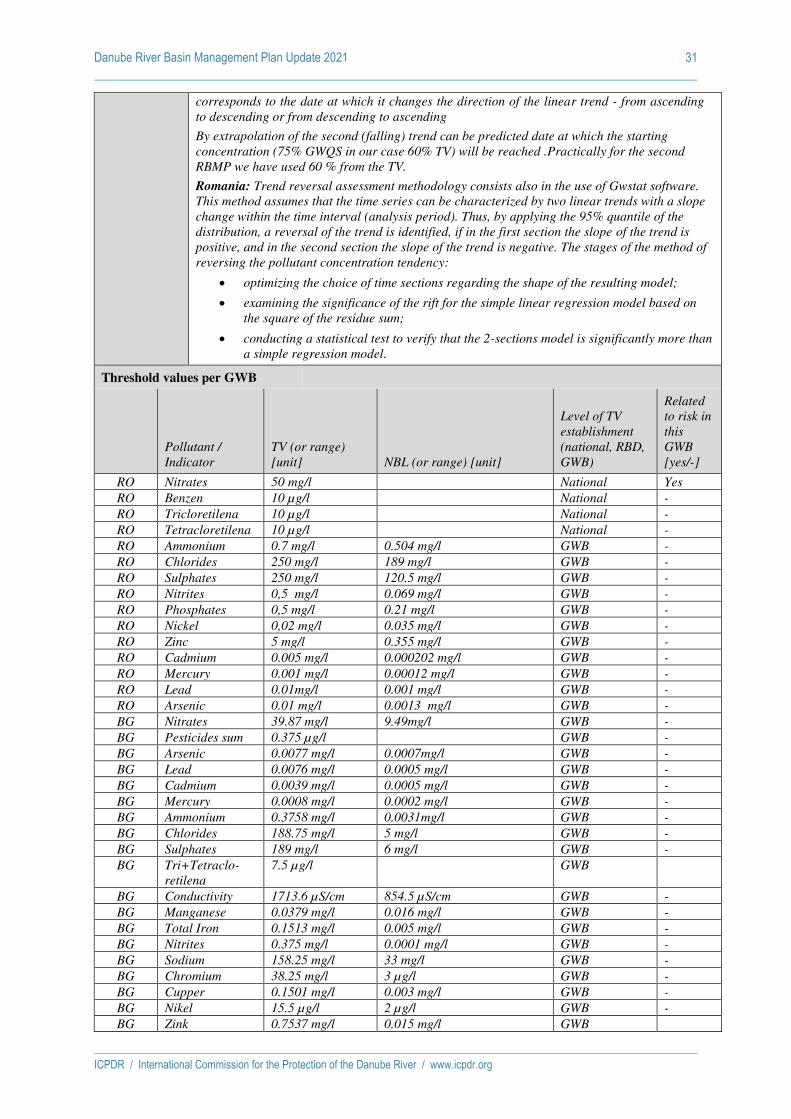
Danube River Basin Management Plan Update 2021 31
ICPDR / International Commission for the Protection of the Danube River / www.icpdr.org
corresponds to the date at which it changes the direction of the linear trend - from ascending
to descending or from descending to ascending
By extrapolation of the second (falling) trend can be predicted date at which the starting
concentration (75% GWQS in our case 60% TV) will be reached .Practically for the second
RBMP we have used 60 % from the TV.
Romania: Trend reversal assessment methodology consists also in the use of Gwstat software.
This method assumes that the time series can be characterized by two linear trends with a slope
change within the time interval (analysis period). Thus, by applying the 95% quantile of the
distribution, a reversal of the trend is identified, if in the first section the slope of the trend is
positive, and in the second section the slope of the trend is negative. The stages of the method of
reversing the pollutant concentration tendency:
• optimizing the choice of time sections regarding the shape of the resulting model;
• examining the significance of the rift for the simple linear regression model based on
the square of the residue sum;
• conducting a statistical test to verify that the 2-sections model is significantly more than
a simple regression model.
Threshold values per GWB
Pollutant /
Indicator
TV (or range)
[unit] NBL (or range) [unit]
Level of TV
establishment
(national, RBD,
GWB)
Related
to risk in
this
GWB
[yes/-]
RO Nitrates 50 mg/l National Yes
RO Benzen 10 µg/l National -
RO Tricloretilena 10 µg/l National -
RO Tetracloretilena 10 µg/l National -
RO Ammonium 0.7 mg/l 0.504 mg/l GWB -
RO Chlorides 250 mg/l 189 mg/l GWB -
RO Sulphates 250 mg/l 120.5 mg/l GWB -
RO Nitrites 0,5 mg/l 0.069 mg/l GWB -
RO Phosphates 0,5 mg/l 0.21 mg/l GWB -
RO Nickel 0,02 mg/l 0.035 mg/l GWB -
RO Zinc 5 mg/l 0.355 mg/l GWB -
RO Cadmium 0.005 mg/l 0.000202 mg/l GWB -
RO Mercury 0.001 mg/l 0.00012 mg/l GWB -
RO Lead 0.01mg/l 0.001 mg/l GWB -
RO Arsenic 0.01 mg/l 0.0013 mg/l GWB -
BG Nitrates 39.87 mg/l 9.49mg/l GWB -
BG Pesticides sum 0.375 µg/l GWB -
BG Arsenic 0.0077 mg/l 0.0007mg/l GWB -
BG Lead 0.0076 mg/l 0.0005 mg/l GWB -
BG Cadmium 0.0039 mg/l 0.0005 mg/l GWB -
BG Mercury 0.0008 mg/l 0.0002 mg/l GWB -
BG Ammonium 0.3758 mg/l 0.0031mg/l GWB -
BG Chlorides 188.75 mg/l 5 mg/l GWB -
BG Sulphates 189 mg/l 6 mg/l GWB -
BG Tri+Tetraclo-
retilena
7.5 µg/l GWB
BG Conductivity 1713.6 µS/cm 854.5 µS/cm GWB -
BG Manganese 0.0379 mg/l 0.016 mg/l GWB -
BG Total Iron 0.1513 mg/l 0.005 mg/l GWB -
BG Nitrites 0.375 mg/l 0.0001 mg/l GWB -
BG Sodium 158.25 mg/l 33 mg/l GWB -
BG Chromium 38.25 mg/l 3 µg/l GWB -
BG Cupper 0.1501 mg/l 0.003 mg/l GWB -
BG Nikel 15.5 µg/l 2 µg/l GWB -
BG Zink 0.7537 mg/l 0.015 mg/l GWB
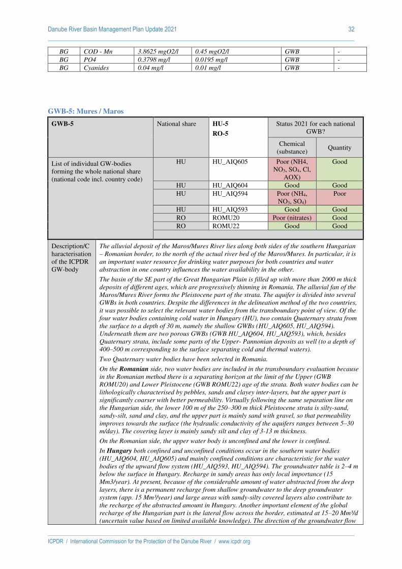
Danube River Basin Management Plan Update 2021 32
ICPDR / International Commission for the Protection of the Danube River / www.icpdr.org
BG COD - Mn 3.8625 mgO2/l 0.45 mgO2/l GWB -
BG PO4 0.3798 mg/l 0.0195 mg/l GWB -
BG Cyanides 0.04 mg/l 0.01 mg/l GWB -
GWB-5: Mures / Maros
GWB-5 National share HU-5
RO-5
Status 2021 for each national
GWB?
Chemical
(substance) Quantity
List of individual GW-bodies
forming the whole national share
(national code incl. country code)
HU HU_AIQ605 Poor (NH4,
NO3, SO4, Cl,
AOX)
Good
HU HU_AIQ604 Good Good
HU HU_AIQ594 Poor (NH4,
NO3, SO4)
Poor
HU HU_AIQ593 Good Good
RO ROMU20 Poor (nitrates) Good
RO ROMU22 Good Good
Description/C
haracterisation
of the ICPDR
GW-body
The alluvial deposit of the Maros/Mures River lies along both sides of the southern Hungarian
– Romanian border, to the north of the actual river bed of the Maros/Mures. In particular, it is
an important water resource for drinking water purposes for both countries and water
abstraction in one country influences the water availability in the other.
The basin of the SE part of the Great Hungarian Plain is filled up with more than 2000 m thick
deposits of different ages, which are progressively thinning in Romania. The alluvial fan of the
Maros/Mures River forms the Pleistocene part of the strata. The aquifer is divided into several
GWBs in both countries. Despite the differences in the delineation method of the two countries,
it was possible to select the relevant water bodies from the transboundary point of view. Of the
four water bodies containing cold water in Hungary (HU), two contain Quaternary strata from
the surface to a depth of 30 m, namely the shallow GWBs (HU_AIQ605, HU_AIQ594).
Underneath them are two porous GWBs (GWB HU_AIQ604, HU_AIQ593), which, besides
Quaternary strata, include some parts of the Upper- Pannonian deposits as well (to a depth of
400–500 m corresponding to the surface separating cold and thermal waters).
Two Quaternary water bodies have been selected in Romania.
On the Romanian side, two water bodies are included in the transboundary evaluation because
in the Romanian method there is a separating horizon at the limit of the Upper (GWB
ROMU20) and Lower Pleistocene (GWB ROMU22) age of the strata. Both water bodies can be
lithologically characterised by pebbles, sands and clayey inter-layers, but the upper part is
significantly coarser with better permeability. Virtually following the same separation line on
the Hungarian side, the lower 100 m of the 250–300 m thick Pleistocene strata is silty-sand,
sandy-silt, sand and clay, and the upper part is mainly sand with gravel, so that permeability
improves towards the surface (the hydraulic conductivity of the aquifers ranges between 5–30
m/day). The covering layer is mainly sandy silt and clay of 3-13 m thickness.
On the Romanian side, the upper water body is unconfined and the lower is confined.
In Hungary both confined and unconfined conditions occur in the southern water bodies
(HU_AIQ604, HU_AIQ605) and mainly confined conditions are characteristic for the water
bodies of the upward flow system (HU_AIQ593, HU_AIQ594). The groundwater table is 2–4 m
below the surface in Hungary. Recharge in sandy areas has only local importance (15
Mm3/year). At present, because of the considerable amount of water abstracted from the deep
layers, there is a permanent recharge from shallow groundwater to the deep groundwater
system (app. 15 Mm³/year) and large areas with sandy-silty covered layers also contribute to
the recharge of the abstracted amount in Hungary. Another important element of the global
recharge of the Hungarian part is the lateral flow across the border, estimated at 15–20 Mm³/d
(uncertain value based on limited available knowledge). The direction of the groundwater flow

Danube River Basin Management Plan Update 2021 33
ICPDR / International Commission for the Protection of the Danube River / www.icpdr.org
is from the recharge area to the discharge areas (main river valleys and zones with
groundwater level close to the surface) i.e. from SE to N and NW
Description of
status
assessment
methodology.
Chemical status
Romania: The methodology for the chemical status assessment followed the requirements of
the Groundwater Directive (2006/118/EC) as well as the recommendations of the CIS
Guidance Document no. 18 – Guidance on Groundwater status and trend assessment.
The first step is to check any exceedances of the quality standards and TVs which were
established taken into consideration the NBL values. If no exceedances of the quality standards
and TVs are recorded, the groundwater body is considered as being in good chemical status. If
exceedances of TVs or quality standards are recorded the following relevant tests are carried
out:
• General assessment of the chemical status: Data aggregation is performed and it is
checked whether the total area of exceedance is greater than 20% of the total area of
the GWB. In case there are no exceedances, the test indicate a good status for the
water body.
• Saline or other intrusion: not relevant.
• Significant diminution of associated surface water chemistry and ecology due to
transfer of pollutants from the GWB: the location of the exceedance of the relevant
TVs was not found in areas where pollutants might be transferred to surface waters; a
comparison of the pollutant load transferred from the GWB to the surface water body
with the total load in the surface water body did not exceed 50%. The test show a good
status for the water body if these criteria are achieved.
• Significant damage to GWDTEs due to transfer of pollutants from the GWB: No
GWDTE was found to be damaged. The test show a good status for the water body if
this criteria is achieved;
• Meets the requirements of WFD Article 7(3) – Drinking Water Protected Areas: there
is no evidence of increased treatment due to changes in water quality.
To assess the chemical status of the groundwater bodies, the following steps are considered:
• For each monitoring point the annual average concentrations for each indicator was
calculated; for the metals the concentration of the dissolved form was considered;
• For each monitoring point the annual average concentration of the each parameters
was compared with the thresholds values (determined for each GWB) or standards
value (nitrates and pesticides).
• The GWB is of good chemical status when no EQS or TV is exceeded in any
monitoring point.
• The GWB is of poor chemical status when EQS or TV are exceeded at monitoring
points representing more than 20% of the GWB surface.
The chemical status of the GWB ROMU20 is poor, considering the results of applying the
methodology for chemical status assessment.
Hungary: Assessment of the chemical status of GWBs was conducted: Analysing of the
chemical data of individual monitoring points within each of the GWBs; Identifying of the
pressures - sources of pollution; The NBLs were calculated and used to determine TVs. TVs
have been determined according to CIS Guidance No. 18. Contamination limits have been
determined for all indicators listed in Annex II Part B of Directive 2006/118/EC and indicators
of the report under Art. 5 of Directive 2006/118/EC.
The following parameters were investigated:
a) NBL was determined for the following components: nitrate, ammonium, specific
conductivity, sulphate, chloride, arsenic, cadmium, lead, mercury, orthosphosphate
b) For each monitoring point the median concentration of each parameters of the studied
period was compared to the TVs (determined for each GWB) or standards values (in
the case of nitrates, metals and pesticides).
c) Different tests were conducted to assess GWB status: Diffuse pollution test (nitrate,
ammonium, orthosphosphate), Drinking water supply tests for numerous elements or
components in both drinking water wells and monitoring wells and trend analysis
based on the data of the surveillance monitoring system. Studied components of these
tests are: nitrate, ammonium, chloride, sulphate, specific conductivity, mercury, lead,

Danube River Basin Management Plan Update 2021 34
ICPDR / International Commission for the Protection of the Danube River / www.icpdr.org
cadmium, pesticides and organics, furthermore in the trend analysis pH and dissolved
oxygen.
d) Based on these tests, GWB was evaluated.
Quantitative Status
Romania: The criterion for risk assessment of the quantity status is based on trend assessment
evolution of the groundwater levels. The quantitative status has been assessed taking into
account CIS Guidance No.18. The following criteria have been used:
• water balance
• the connection with surface waters
• the influence on the terrestrial ecosystems which depend directly on the GWB
• the effects of saline or other intrusions
The quantitative status analysis has been done for the GWB level by comparing the average of
the hydrostatic level from 2017 (reference year) with the multiannual average levels during the
whole observation period.
Hungary: To determine the overall quantitative status for a GWB, a series of tests should be
applied that considers the impacts of anthropogenically induced long-term alterations in
groundwater level and/or flow. Each test will assess whether the GWB is meeting the relevant
environmental objectives. The quantitative status has been assessed taking into account CIS
Guidance No.18. The following criteria have been used:
• GW alteration (Drawdown) test
• Water Balance test
• Surface Water Flow test
• Groundwater Dependent Terrestrial Ecosystems (GWDTE)
• Saline or other Intrusion test
Groundwater
threshold
value
relationships
Receptors considered
Romania: Drinking Water standards
Hungary: Drinking water
Consideration of NBL and EQS (environmental quality standards, drinking water standards) in
the TV establishment:
Romania: The methodology for TV establishment in Romania has been developed according to
CIS Guidance No. 18. NBL are the key elements in the process of TV setting.
As described previously, during the TV establishment, the NBL have been compared with the
drinking water standards. The maximum allowable concentrations (MAC) provided by the Law
no.458/2002 as amended, were chosen as TV where NBL are smaller than MAC. Where
background levels are higher than MAC, a small addition of 0.2 NBL was used, in order to
avoid misclassification of the respective GWB (TV = NBL + 0.2 NBL = 1.2 NBL).
The updated list of TVs established for each GWB was published in the new Order of the
Minster no. 621/2014 approving TV for groundwater bodies from Romania.
Hungary:
EQS for herbicides and total pesticides, tri-, tetrachloroethylenes based on 201/2001. (X.25.)
Gov. decree and the 6/2009. (IV.14.) KvVM-EüM-FVM common ministerial decree in
correspondence to I. Annex of the 2006/118/EC directive.
In Hungary, more than 95% of drinking water ensured from subsurface waters, so for all other
components the DWS is applicable.
For those GWBs where the NBL was higher than the DWS due to natural hydro-geological
reasons, the TVs for ammonium, SO4 and EC were defined by taking into account these higher
values, as described in Guidance Document No. 18.
Verbal
description of
the trend
assessment
methodology
Romania: In order to assess the trend in pollutant concentrations, the results of the chemical
analysis from the monitoring points have been used. Minimum period of analysis was at least
17 years (2000-2017).
The methodology for identifying significant upper trends consists in adjustment and
aggregation of the data from each monitoring points on groundwater bodies. The trend

Danube River Basin Management Plan Update 2021 35
ICPDR / International Commission for the Protection of the Danube River / www.icpdr.org
analysis was done using the Gwstat program. The steps used for trend assessment were:
• Identifying the monitoring points and the associated results of chemical analysis,
assessment of data series, for each year of reference period (2000–2017)
• Establishment of baseline concentration for each parameter as the average
concentration registered during the year 2000
• Calculation of annual average for the available data in each monitoring point
• Significant upward trends were identified by Gwstat software, based on Anova Test
Hungary: To assess the trend of pollutant concentrations, chemical data of the surveillance
monitoring systems were used for the period of 2000 to 2012. The trend analysis was done
using Matlab program package of Man-Kendall method with fitted Sen slope. The steps used
for trend assessment were:
• During the assessment trend of all components for all monitoring objects were created
using yearly average data and excluding time series with less than 4 data points.
• The trend of groundwater body level aggregates of yearly annual data were assessed
as well.
• Significant upward or downward trends were identified on 95 and 90% significance
level using Man-Kendall method with Sen’s slope.
Verbal
description of
the trend
reversal
assessment
methodology
Romania: Trend reversal assessment methodology consists also in the use of Gwstat software.
This method assumes that the time series can be characterized by two linear trends with a slope
change within the time interval (analysis period). Thus, by applying the 95% quantile of the
distribution, a reversal of the trend is identified, if in the first section the slope of the trend is
positive, and in the second section the slope of the trend is negative. The stages of the method of
reversing the pollutant concentration tendency:
• optimizing the choice of time sections regarding the shape of the resulting model;
• examining the significance of the rift for the simple linear regression model based on
the square of the residue sum;
• conducting a statistical test to verify that the 2-sections model is significantly more
than a simple regression model..
Hungary: To assess the trend reversal of pollutant concentrations, two consecutive time
periods were compared and evaluated
Threshold values per GWB
Pollutant / Indicator
TV (or range)
[unit] NBL (or range) [unit]
Level of TV
establishment
(national,
RBD, GWB)
Related
to risk
in this
GWB
[yes/-]
HU Nitrates 50 mg/l 0,5-12.1 mg/l GWB Yes
HU Ammonium 2-5 mg/l 1,97-4.54 mg/l GWB Yes
HU Conductivity 2500-4000 µS/cm 1210-2500 µS/cm GWB -
HU Sulfate 250-500 mg/l 20-481 mg/l GWB Yes
HU Chloride 250-500 mg/l 32,5-300 mg/l GWB Yes
HU Ortophosphate 2-5 mg/l 0.65-1.71 mg/l GWB
HU Cadmium 5 µg/l 0.16-0.83 µg/l national -
HU Lead 10 µg/l 2.7-5 µg/l national -
HU Mercury 1 µg/l 0.39-0.49 µg/l national -
HU Trichlorethylene 10 µg/l national -
HU Tetrachloroethylene 10 µg/l national -
HU Absorbed organic
halogens AOX
20 µg/l national Yes
HU Pesticides by
components
0,1 µg/l national -
HU Pesticides all 0,5 µg/l national -
RO Nitrates 50 mg/l National Yes
RO Benzen 10 µg/l National -
RO Tricloretilena 10 µg/l National -

Danube River Basin Management Plan Update 2021 36
ICPDR / International Commission for the Protection of the Danube River / www.icpdr.org
RO Tetracloretilena 10 µg/l National -
RO Ammonium 0.5–1.9 mg/l 0.216–1.56 mg/l GWB -
RO Chlorides 250 mg/l 66.755–179.57 mg/l GWB -
RO Sulphates 250 mg/l 102.04–193.99 mg/l GWB -
RO Nitrites 0,5 mg/l 0.046–0.2 mg/l GWB -
RO Phosphates 0,5–0.6 mg/l 0.134–0.5 mg/l GWB -
RO Chromium 0,05 mg/l 0.006296–0.00811mg/l GWB -
RO Nickel 0,02 mg/l 0.009–0.00836 mg/l GWB -
RO Copper 0.1 mg/l 0.0113–0.0117 mg/l GWB -
RO Zinc 5 mg/l 0.125–0.0274 mg/l GWB -
RO Cadmium 0.005 mg/l 0.0035 mg/l GWB -
RO Lead 0.01-0.02 mg/l 0.0075–0.01316 mg/l GWB -
RO Arsenic 0.04 mg/l 0.0289 mg/l GWB -
RO Phenols 0.002mg/l 0.0015 mg/l GWB -
GWB-6: Somes / Szamos
GWB-6 National share HU-6
RO-6
Status 2021 for each national
GWB?
Chemical
(substance) Quantity
List of individual GW-bodies
forming the whole national share
(national code incl. country code)
HU HU_AIQ649 Good Good
HU HU_AIQ648 Good Good
HU HU_AIQ600 Good Good
HU HU_AIQ601 Good Good
RO ROSO01 Good Good
RO ROSO13 Good Good
Description/C
haracterisation
of the ICPDR
GW-body
Reasons for selection as an important transboundary GWB
The alluvial deposit of the Somes/Szamos River extends on both sides of the northern part of the
Hungarian-Romanian border. It is also connected to the aquifer system lying in Ukraine close
to the borders. The aquifer system supplies drinking water to a population of approx. 170,000
inhabitants in Romania and 50,000 inhabitants in Hungary. On the Hungarian side, due to the
lowland character and upward flow system, the terrestrial ecosystems require surplus
transpiration from groundwater; 7% of the area of the water body is under nature
conservation. The recharge zone is in Romania and Ukraine, thus the available groundwater
resource and the status of the terrestrial ecosystems on the Hungarian side depend on the
lateral flow from the neighbouring countries. The Romanian and Hungarian parts of the water
body complex are described below.
General description
The Somes/Szamos River has formed a 30–250 m thick alluvial deposit
The aquifer is divided into several GWBs in both countries. Despite the differences in the
delineation method of the two countries, it was possible to select the relevant water bodies from
the transboundary point of view.
Four water bodies containing cold water occur in Hungary. Two of them contain Quaternary
strata from the surface to a depth of 30 m, namely the shallow GWBs (HU_AIQ649,
HU_AIQ600). Underneath are the porous GWBs (HU_AIQ648, HU_AIQ601), which beside
Quaternary strata include some parts of the Upper- Pannonian deposits as well, to a depth of
400–500 m corresponding to the surface separating cold and thermal waters.
This Holocene-Pleistocene formation is divided vertically in Romania by the horizon separating
the Upper- and Lower-Pleistocene strata. In Romania two water bodies are considered,
overlapping each other, covering a surface of 1,440 km2. According to the Hungarian approach
of delineation, the cold part of the Upper-Pannonian and the Pleistocene and Holocene layers
are vertically unified. The Hungarian part can be characterised only by an upward flow system,
thus no further horizontal separation is applied. The area covered by the water body is 1,035
km2.
In Romania, the shallow (Holocene-Upper-Pleistocene) aquifer is unconfined, consisting of
sands, argillaceous sands, gravels and even boulders in the eastern part, and has a depth of

Danube River Basin Management Plan Update 2021 37
ICPDR / International Commission for the Protection of the Danube River / www.icpdr.org
25–35 m. The silty-clayey covering layer is 5–15 m thick.
The deeper (Lower-Pleistocene) aquifer is confined (it is separated from the Upper-Pleistocene
part by a clay layer); its bottom is declining from 30 m to 130 m below the surface from East to
West. The gravely and sandy strata (characteristic to westwards from Satu-Mare town)
represent the main aquifer for water supply in the region.
In Hungary (as part of the cold water body), the Quaternary (Pleistocene) and Holocene strata
are 50 m thick at the Ukrainian border and its continuously declining bottom is around 200 m
below the surface at the western boundary. Mainly confined conditions characterise the
Hungarian part, with a silty clayey covering layer of 1–6 m (increasing from the NE to the SW).
The Quaternary aquifer is sand or gravelly sand, and the hydraulic conductivity ranges
between 10- 30 m/d. It should be noted that the Hungarian water body includes the cold water
bearing part of the Upper-Pannonian formation as well, to a depth of 400–500 m (under this
level, thermal water of a temperature greater than 30 ºC can be found).
Depth of the groundwater level (mainly pressure in confined area) below the surface ranges
between 2 and 5 m in Hungary. The flow direction is from the ENE to the WSW in both
countries, corresponding to the recharge and main discharge zones (rivers and area with
groundwater level close to the surface).
The recharge area is in the Romanian part of the water body (and in Ukraine). In Hungary the
infiltrated amount from local recharge zones supplies neighbouring discharge zones and
cannot be considered as part of the available groundwater resources.
Description of
status
assessment
methodology.
Chemical status
Romania: The methodology for the chemical status assessment followed the requirements of
the Groundwater Directive (2006/118/EC) as well as the recommendations of the CIS
Guidance Document no. 18 – Guidance on Groundwater status and trend assessment.
The first step is to check any exceedances of the quality standards and TVs which were
established taken into consideration the NBL values. If no exceedances of the quality standards
and TVs are recorded, the groundwater body is considered as being in good chemical status. If
exceedances of TVs or quality standards are recorded the following relevant tests are carried
out:
• General assessment of the chemical status: Data aggregation is performed and it is
checked whether the total area of exceedance is greater than 20% of the total area of
the GWB. In case there are no exceedances, the test indicate a good status for the
water body.
• Saline or other intrusion: not relevant.
• Significant diminution of associated surface water chemistry and ecology due to
transfer of pollutants from the GWB: the location of the exceedance of the relevant
TVs was not found in areas where pollutants might be transferred to surface waters; a
comparison of the pollutant load transferred from the GWB to the surface water body
with the total load in the surface water body did not exceed 50%. The test show a good
status for the water body if these criteria are achieved.
• Significant damage to GWDTEs due to transfer of pollutants from the GWB: No
GWDTE was found to be damaged. The test show a good status for the water body if
this criteria is achieved;
• Meets the requirements of WFD Article 7(3) – Drinking Water Protected Areas: there
is no evidence of increased treatment due to changes in water quality.
To assess the chemical status of the groundwater bodies, the following steps are considered:
• For each monitoring point the annual average concentrations for each indicator was
calculated; for the metals the concentration of the dissolved form was considered;
• For each monitoring point the annual average concentration of the each parameters
was compared with the thresholds values (determined for each GWB) or standards
value (nitrates and pesticides).
• The GWB is of good chemical status when no EQS or TV is exceeded in any
monitoring point.
• The GWB is of poor chemical status when EQS or TV are exceeded at monitoring
points representing more than 20% of the GWB surface.
Hungary: Assessment of the chemical status of groundwater was conducted: Analysing of the

Danube River Basin Management Plan Update 2021 38
ICPDR / International Commission for the Protection of the Danube River / www.icpdr.org
chemical data of individual monitoring points within each of the GWBs; Identifying of the
pressures - sources of pollution; The background levels were calculated and used to determine
threshold value. Threshold values have been determined according to CIS Guidance No. 18.
Contamination limits have been determined for all indicators listed in Annex II Part B of
Directive 2006/118/EC and indicators of the report under Art. 5 of Directive 2006/118/EC.
The following parameters were investigated:
a) Natural Background Level was determined for the following components: nitrate,
ammonium, specific conductivity, sulphate, chloride, arsenic, cadmium, lead, mercury,
orthophosphate
b) For each monitoring point the median concentration of each parameters of the studied
period was compared to the thresholds values (determined for each GWB) or
standards values (in the case of nitrates, metals and pesticides).
c) Different tests were conducted to assess groundwater body status: Diffuse pollution
test (nitrate, ammonium, orthophosphate), Drinking water supply tests for numerous
elements or components in both drinking water wells and monitoring wells and trend
analysis based on the data of the surveillance monitoring system. Studied components
of these tests are: nitrate, ammonium, chloride, sulphate, specific conductivity,
mercury, lead, cadmium, pesticides and organics, furthermore in the trend analysis pH
and dissolved oxygen.
d) Based on these tests, groundwater body was evaluated.
Quantitative Status
Romania: The criterion for risk assessment of the quantity status is based on trend assessment
evolution of the groundwater levels. The quantitative status has been assessed taking into
account the CIS Guidance No.18. The following criteria have been used:
• water balance
• the connection with surface waters
• the influence on the terrestrial ecosystems which depend directly on the GWB
• the effects of saline or other intrusions
The quantitative status analysis has been done for the GWB level by comparing the average of
the hydrostatic level from 2017 (reference year) with the multiannual average levels during the
observation period.
Hungary: To determine the overall quantitative status for a GWB, a series of tests should be
applied that considers the impacts of anthropogenically induced long-term alterations in
groundwater level and/or flow. Each test will assess whether the GWB is meeting the relevant
environmental objectives. The quantitative status has been assessed taking into account CIS
Guidance No.18. The following criteria have been used:
• GW alteration (Drawdown) test
• Water Balance test
• Surface Water Flow test
• Groundwater Dependent Terrestrial Ecosystems (GWDTE)
• Saline or other Intrusion test
Groundwater
threshold
value
relationships
Receptors considered
Romania: Drinking Water standards
Hungary: Drinking water
Consideration of NBL and EQS (environmental quality standards, drinking water standards) in
the TV establishment:
Romania: The methodology for TV establishment in Romania has been developed according to
CIS Guidance No. 18. NBL are the key elements in the process of TV setting.
As described previously, during the TV establishment, the NBL have been compared with the
drinking water standards. The maximum allowable concentrations (MAC) provided by the Law
no.458/2002 as amended, were chosen as TV where natural background levels (NBL) are
smaller than MAC. Where background levels are higher than MAC, a small addition of 0.2

Danube River Basin Management Plan Update 2021 39
ICPDR / International Commission for the Protection of the Danube River / www.icpdr.org
NBL was used, in order to avoid misclassification of the respective GWB (TV = NBL + 0.2 NBL
= 1.2 NBL).
The updated list of TVs established for each GWB was published in the new Order of the
Minster no. 621/2014 approving TV for groundwater bodies from Romania.
Hungary:
EQS for herbicides and total pesticides, tri-, tetrachloroethylenes based on 201/2001. (X.25.)
Gov. decree and the 6/2009. (IV.14.) KvVM-EüM-FVM common ministerial decree in
correspondence to I. Annex of the 2006/118/EC directive.
In Hungary, more than 95% of drinking water ensured from subsurface waters, so for all other
components the DWS is applicable.
For those GWBs where the NBL was higher than the DWS due to natural hydro-geological
reasons, the TVs for ammonium, SO4 and EC were defined by taking into account these higher
values, as described in Guidance Document No. 18.
Verbal
description of
the trend
assessment
methodology
Romania: In order to assess the trend in pollutant concentrations, the results of the chemical
analysis from the monitoring points have been used. Minimum period of analysis was at least
10 years (2000-2011).
The methodology for identifying significant upper trends consists in adjustment and
aggregation of the data from each monitoring points on groundwater bodies. The trend
analysis was done using the Gwstat program.
The steps used for trend assessment were:
• Identifying the monitoring points and the associated results of chemical analysis,
assessment of data series, for each year of reference period (2000–2011)
• Establishment of baseline concentration for each parameter as the average
concentration registered during the year 2000
• Calculation of annual average for the available data in each monitoring point
• Significant upward trends were identified by Gwstat software, based on Anova Test
Hungary: To assess the trend of pollutant concentrations, chemical data of the surveillance
monitoring systems were used for the period of 2000 to 2012. The trend analysis was done
using Matlab program package of Man-Kendall method with fitted Sen slope. The steps used
for trend assessment were:
• During the assessment trend of all components for all monitoring objects were created
using yearly average data and excluding time series with less than 4 data points.
• The trend of groundwater body level aggregates of yearly annual data were assessed
as well.
• Significant upward or downward trends were identified on 95 and 90% significance
level using Man-Kendall method with Sen’s slope.
Verbal
description of
the trend
reversal
assessment
methodology
Romania: Trend reversal assessment methodology consists also in the use of Gwstat software.
This method assumes that the time series can be characterized by two linear trends with a slope
change within the time interval (analysis period). Thus, by applying the 95% quantile of the
distribution, a reversal of the trend is identified, if in the first section the slope of the trend is
positive, and in the second section the slope of the trend is negative. The stages of the method of
reversing the pollutant concentration tendency:
• optimizing the choice of time sections regarding the shape of the resulting model;
• examining the significance of the rift for the simple linear regression model based on
the square of the residue sum;
• conducting a statistical test to verify that the 2-sections model is significantly more
than a simple regression model.
Hungary: To assess the trend reversal of pollutant concentrations two consecutive time period
was compared and evaluated
Threshold values per GWB
Pollutant / Indicator
TV (or range)
[unit] NBL (or range) [unit]
Level of TV
establishment
(national, RBD,
Related
to risk
in this
GWB

Danube River Basin Management Plan Update 2021 40
ICPDR / International Commission for the Protection of the Danube River / www.icpdr.org
GWB) [yes/-]
HU Nitrates 50 mg/l 1-11.5 mg/l GWB -
HU Ammonium 2-5 mg/l 1.5-3.3 mg/l GWB -
HU Conductivity 2500 µS/cm 649-1787 µS/cm GWB -
HU Sulfate 250 mg/l 17.8-184 mg/l GWB -
HU Chloride 250 mg/l 21.4-138 mg/l GWB -
HU Orthophosphate 0.5-2 mg/l 0.11-0.92 mg/l GWB
HU Cadmium 5 µg/l 0.04-0.16 µg/l national -
HU Lead 10 µg/l 0.38-4.7 µg/l national -
HU Mercury 1 µg/l 0.005-0.27 µg/l national -
HU Trichlorethylene 10 µg/l national -
HU Tetrachloro
ethylene
10 µg/l national -
HU Absorbed organic
halogens AOX
20 µg/l national -
HU Pesticides by
components
0,1 µg/l national -
HU Pesticides all 0,5 µg/l national -
RO Nitrates 50 mg/l National -
RO Benzen 10 µg/l National -
RO Tricloretilena 10 µg/l National -
RO Tetracloretilena 10 µg/l National -
RO Ammonium 0.5-1.3 mg/l 0.22-1.05 mg/l GWB -
RO Chlorides 250 mg/l 19.46- 51.5 mg/l GWB -
RO Sulphates 250 mg/l 19,01- 91.78 mg/l GWB -
RO Nitrites 0.5 mg/l 0.08- 0.15 mg/l GWB -
RO Phosphates 0.5 mg/l 0.16-0.41 mg/l GWB -
RO Chromium 0.05 mg/l 0.0071-0.010 mg/l GWB -
RO Nickel 0.02 mg/l 0.011-0.005 mg/l GWB -
RO Copper 0.1 mg/l 0.0153-0.024 mg/l GWB -
RO Zinc 5 mg/l 0.26-0.262 mg/l GWB -
RO Cadmium 0,005 mg/l 0.00085-0.0023 mg/l GWB -
RO Mercury 0,001 mg/l 0.000035-0.00002 mg/l GWB -
RO Lead 0.03-0.07 mg/l 0.022-0.055 mg/l GWB -
RO Arsenic 0.01mg/l 0.0021- 0.006 mg/l GWB -
RO Phenols 0.002mg/l 0.001- 0.0013 mg/l GWB -

Danube River Basin Management Plan Update 2021 41
ICPDR / International Commission for the Protection of the Danube River / www.icpdr.org
GWB-7: Upper Pannonian – Lower Pleistocene / Vojvodina / Duna-Tisza köze deli r.
GWB-7 National share HU-7
RO-7
RS-7
Status 2021 for each national
GWB?
Chemical
(substance) Quantity
List of individual GW-bodies
forming the whole national share
(national code incl. country code)
HU HU_AIQ528 Good Good
HU HU_AIQ523 Good Good
HU HU_AIQ532 Good Good
HU HU_AIQ487 Good Good
HU HU_AIQ590 Good Good
HU HU_AIQ529 Good Poor
HU HU_AIQ522 Good Poor
HU HU_AIQ533 Good Poor
HU HU_AIQ486 Good Poor
HU HU_AIQ591 Poor (NO3) Good
RO ROBA18 Good Good
RS RS_TIS_GW_I_1 Good Poor
RS RS_TIS_GW_SI_1 Good Good
RS RS_TIS_GW_I_2 Good Poor
RS RS_TIS_GW_SI_2 Good Good
RS RS_TIS_GW_I_3 Good Poor
RS RS_TIS_GW_SI_3 Good Good
RS RS_TIS_GW_I_4 Good Poor
RS RS_TIS_GW_SI_4 Good Good
RS RS_TIS_GW_I_7 Good Poor
RS RS_TIS_GW_SI_7 Good Good
RS RS_D_GW_I_1 Good Poor
RS RS_D_GW_SI_1 Good Good
Description/C
haracterisation
of the ICPDR
GW-body
The GWB is mainly used for drinking water supply, agricultural and industrial supplies. The
criterion for selection as “important” consists in its size that exceeds 4,000 km².
The whole aquifer system of the Danube-Tisza region stretches from the foothills of the
northern mountainous region of Hungary to the Danube in Serbia, where the river flows to the
south-east. The western boundary is the Danube itself downstream of Budapest in Hungary but
after crossing the Hungarian border it enlarges towards Slavonia (western part of Backa in
Croatia). The eastern boundary is somewhat east from the Tisza River in Hungary and in
Serbia it includes the Banat as well, whose eastern part is in Romania. The Danube, Tisza and
Timis Rivers are important discharge-lines but cannot be considered as pure hydrodynamic
boundaries, since there is some flow under the river in the deeper aquifer that is not discharged
into the river.
The porous aquifer system between the Danube and Tisza Rivers is the biggest geological unit
of the Pannonian Basin. It lies mainly in Hungary and Serbia, with a smaller part in Croatia
and Romania. Serbia and Hungary have selected it as an important transboundary GWB
complex because: (i) size, (ii) importance in supplying drinking water for the population and
(iii) the need to satisfy the water demand of agriculture and industry, (iv) protected areas cover
a large part of the GWB complex (protection zones for vulnerable drinking water resources,
nature conservation areas and nitrate-sensitive areas).
In Serbia, the area of the whole Dunav aquifer system is 17,435 km² (the areas of Backa and
Banat). However, the transboundary importance is related only to the GWBs adjacent to the
state borders with Hungary (a total of 6 GWBs: 3 shallow (RS_TIS_GW_SI_1;
RS_TIS_GW_SI_2; RS_TIS_GW_SI_3) and 3 deep (RS_TIS_GW_I_1; RS_TIS_GW_I_2;
RS_TIS_GW_I_3)) and with Romania (a total of 6 GWBs: 3 shallow (RS_TIS_GW_SI_4;
RS_TIS_GW_SI_7; RS_D_GW_SI_1) and 3 deep (RS_TIS_GW_I_4; RS_TIS_GW_I_7;
RS_D_GW_I_1). The area of water bodies situated towards Hungary is 5,647 km2 and towards
Romania 4,859 km2, with a total aggregated area of 10,506 km2 for the Vojvodina GWB.
In Hungary, the aquifer system is divided into several water bodies according to major
subsurface catchment areas and downward-upward flow systems. For the transboundary
conciliation, only the southern part of the aquifer system is considered, which includes 10 cold

Danube River Basin Management Plan Update 2021 42
ICPDR / International Commission for the Protection of the Danube River / www.icpdr.org
water bodies. Five of them contain Quaternary strata from the surface to a depth of 23–30 m.
Beneath these are five porous GWBs. Besides Quaternary strata, these include part of the
Upper-Pannonian deposits as well, to a depth of 400–500 m corresponding to the surface and
separating cold and thermal water bodies. The Hungarian part can be characterised by both
upward and downward flow systems that are the basis for the horizontal separation of the
GWBs. The area covered by these water bodies is 7,098 km2. The aquifer can be considered
unconfined in the shallow GWBs, despite a considerable area where the water level is in the
semi-permeable covering layer, and confined in the deeper ones.
The depth of the groundwater level below the surface ranges between 3 and 5 m in Hungary,
with a maximum depth of 7–12 m in the main recharge zones (HU_AIQ529, HU_AIQ591 and
HU_AIQ533).
In Romania, the aquifer system covers around 11,408 km2 and is adjacent to the state border
with Serbia. The GWB is generally confined, its covering strata being of Quaternary age. The
depth of the groundwater level below surface ranges from 3–20 m. The protection degree of the
GWB is very good. The main aquifer is the Quaternary alluvial deposit of the Danube lying on
the Pannonian strata. Its thickness is a few tens of meters at the northern, western and southern
boundary and increases up to 700 m in the middle of the basin (in the lower Tisza-valley). At
the eastern boundary, the thick Quaternary deposit is a mixture of the alluvial deposits of the
Danube and the Carpathian rivers. In respect to lithology, the aquifer consists of medium and
coarse sands and gravely sands with inter-layers and lenses of silty sands and silty clays.
Average hydraulic conductivity ranges between 5–30 m/d. The topographically elevated ridge
between the Danube and the Tisza is formed of eolian sand with relatively good recharge
conditions and phreatic groundwater. In the river valleys and east of the Tisza, mainly confined
conditions appear. The depth of the fluvial-swamp silty clays and swamp clays overlying strata
varies from 10-20 m in the western and southern part, and up to 100–125 m in the north-
eastern part of Backa and in Banat. Here, prior to intensive groundwater abstraction, an
artesian type of groundwater occurred.
The main recharge area is in Hungary, in the eolian sand ridge, and in Romania. In Hungary,
the estimated value of the recharge is approx. 220 Mm3/year. In Serbia, only local recharge
areas exist (areas of the Deliblat Sands and the Subotica/Horgos Sands), thus the lateral flow
crossing the border from the neighbouring country - as a component of the overall recharge - is
very important.
The groundwater is mainly discharged by the rivers (and drainage canals) and by the surplus
of evapotranspiration from vegetation in the areas characterised by groundwater levels close to
the surface. Small lakes and marshes in locally deeper areas (i.e. in topographic depressions)
must be considered as local discharge areas – they are important from the nature conservation
point of view. Besides natural discharge, there is also significant groundwater tapping for
various uses (drinking water, agriculture, industry, irrigation etc.). In Vojvodina, the entire
public water supply relies exclusively on groundwater from aquifers formed at different depths,
from 20 m to more than 200 m.
The direction of the groundwater flow in the upper part of the aquifer-system follows the
topography and recharge-discharge conditions. At the Hungarian-Serbian border, the flow
direction is almost parallel to the border (flowing slightly from Hungary towards Serbia). In
the deeper part, the general flow direction is NW to SE i.e. from the Danube to the Tisza in
Hungary and in Backa, while in Banat the general direction of the groundwater flow is from E
to W. GWB is mainly used for drinking water supply, agricultural and industrial supplies. The
criterion for selection as “important” consists in its size that exceeds 4000 km².
Description of
status
assessment
methodology.
Chemical status
Romania: The methodology for the chemical status assessment followed the requirements of
the Groundwater Directive (2006/118/EC) as well as the recommendations of the CIS
Guidance Document no. 18 – Guidance on Groundwater status and trend assessment.
The first step is to check any exceedances of the quality standards and TVs which were
established taken into consideration the NBL values. If no exceedances of the quality standards
and TVs are recorded, the groundwater body is considered as being in good chemical status. If
exceedances of TVs or quality standards are recorded the following relevant tests are carried
out:
• General assessment of the chemical status: Data aggregation is performed and it is
checked whether the total area of exceedance is greater than 20% of the total area of
the GWB. In case there are no exceedances, the test indicate a good status for the

Danube River Basin Management Plan Update 2021 43
ICPDR / International Commission for the Protection of the Danube River / www.icpdr.org
water body.
• Saline or other intrusion: not relevant.
• Significant diminution of associated surface water chemistry and ecology due to
transfer of pollutants from the GWB: the location of the exceedance of the relevant
TVs was not found in areas where pollutants might be transferred to surface waters; a
comparison of the pollutant load transferred from the GWB to the surface water body
with the total load in the surface water body did not exceed 50%. The test show a good
status for the water body if these criteria are achieved.
• Significant damage to GWDTEs due to transfer of pollutants from the GWB: No
GWDTE was found to be damaged. The test show a good status for the water body if
this criteria is achieved;
• Meets the requirements of WFD Article 7(3) – Drinking Water Protected Areas: there
is no evidence of increased treatment due to changes in water quality.
To assess the chemical status of the groundwater bodies, the following steps are considered:
• For each monitoring point the annual average concentrations for each indicator was
calculated; for the metals the concentration of the dissolved form was considered;
• For each monitoring point the annual average concentration of the each parameters
was compared with the thresholds values (determined for each GWB) or standards
value (nitrates and pesticides).
• The GWB is of good chemical status when no EQS or TV is exceeded in any
monitoring point.
• The GWB is of poor chemical status when EQS or TV are exceeded at monitoring
points representing more than 20% of the GWB surface..
Hungary: Assessment of the chemical status of groundwater was conducted: Analysing of the
chemical data of individual monitoring points within each of the GWBs; Identifying of the
pressures - sources of pollution; The background levels were calculated and used to determine
threshold value. Threshold values have been determined according to CIS Guidance No. 18.
Contamination limits have been determined for all indicators listed in Annex II Part B of
Directive 2006/118/EC and indicators of the report under Art. 5 of Directive 2006/118/EC.
The following parameters were investigated:
a) Natural Background Level was determined for the following components: nitrate,
ammonium, specific conductivity, sulphate, chloride, arsenic, cadmium, lead, mercury,
orthophoshate
b) For each monitoring point the median concentration of each parameters of the studied
period was compared to the thresholds values (determined for each GWB) or
standards values (in the case of nitrates, metals and pesticides).
c) Different tests were conducted to assess groundwater body status: Diffuse pollution
test (nitrate, ammonium, orthophoshate), Drinking water supply tests for numerous
elements or components in both drinking water wells and monitoring wells and trend
analysis based on the data of the surveillance monitoring system. Studied components
of these tests are: nitrate, ammonium, chloride, sulphate, specific conductivity,
mercury, lead, cadmium, pesticides and organics, furthermore in the trend analysis pH
and dissolved oxygen.
d) Based on these tests, groundwater body was evaluated.
Serbia: The criteria for the chemical status assessment were: present groundwater quality,
pressures and their impacts, natural protection (overlying strata),. Pressures and impacts
where assessed on the basis of the census data at settlement level for the 2011 regarding
demographics, sanitation and water supply practices (septic tanks, sewerage, water supply,
connection rates) and agricultural census data from 2012 (livestock, Agricultural land use).
The Census data was projected to 2016 for the purpose of STATUS assessment. Non
agricultural land use pressures were evaluated on the basis of CORINE 2016 data set and
CORINE CLASS specific pollution coefficients for BOD, TN. Pressures were evaluated for
organic pollution and nutrients (Indicators used were BOD, TN). Pressure analysis were
conducted for 160 analytical units (settlements covering the total area of ground water bodies).
Monitoring data for 16 groundwater monitoring stations for the 12 GWB in Serbia covering a
period from 2004 to 2018 was evaluated and stations with at least 5 years of data on

Danube River Basin Management Plan Update 2021 44
ICPDR / International Commission for the Protection of the Danube River / www.icpdr.org
monitoring were selected for status and impact assessment. Parameters considered for the
analysis included NO3 and pesticides. For each of the monitoring stations trend analysis were
conducted on all available data (minimum for 5 years, maximum for 15 years). Trend
significance was classified in terms of annual rate of increase/decrease in a manner that would
lead to the exceedance of the threshold value for NO3 (50 mg/L as NO3) within 10 years in
relation to the observed average NO3 concentration at any given station. Regression coefficient
values were used as a measure of a level of confidence of the trend assessment so that if r2
value was above 0,7 trend assessment was to be considered as high confidence assessment,
values of r2 between 0,4 and 0,7 lead to medium confidence of the trend assessment and values
of r2 indicate that trend assessment is of low confidence.
• The GWB is of good chemical status when no TV is exceeded in any monitoring point
and when no significant increasing trend is detected, and GW is not under significant
pressure (Pressure is considered to be significant if total load on the GWB exceeds 10
kg TN-N/ha/yr)
• The GWB is of poor chemical status when TV are exceeded at monitoring points
representing more than 20% of the GW samples analysed at the particular monitoring
point in the period from 2004 to 2018.
• The GWB is declared under risk if observed trend would lead to the exceedance of the
TV for NO3 within 10 if the observed trend continued at any of the monitoring stations
for a given water body. The assessment of Risk is accompanied with level of
confidence of the assessment.
Quantitative Status
Romania: The criterion for risk assessment of the quantity status is based on trend assessment
evolution of the groundwater levels. The quantitative status has been assessed taking into
account CIS Guidance No.18. The following criteria have been used:
• water balance
• the connection with surface waters
• the influence on the terrestrial ecosystems which depend directly on the GWB
• the effects of saline or other intrusions
The quantitative status analysis has been done for the GWB level by comparing the average of
the hydrostatic level from 2017 (reference year) with the multiannual average levels during the
observation period.
Hungary: To determine the overall quantitative status for a GWB, a series of tests should be
applied that considers the impacts of anthropogenically induced long-term alterations in
groundwater level and/or flow. Each test will assess whether the GWB is meeting the relevant
environmental objectives. The quantitative status has been assessed taking into account CIS
Guidance No.18. The following criteria have been used:
• GW alteration (Drawdown) test
• Water Balance test
• Surface Water Flow test
• Groundwater Dependent Terrestrial Ecosystems (GWDTE)
• Saline or other Intrusion test
Serbia: Considering the risk of not achieving good quantitative status, groundwater bodies
within which there is a registered trend of groundwater level decrease as a consequence of
abstraction are considered to be at risk. For this purpose, data time series of registered
groundwater levels were used only for shallow GWBs, since no organized monitoring of deep
aquifers exists.
For groundwater bodies where no quantitative monitoring exists, the estimate of groundwater
balance is calculated, using available data on precipitation, abstraction etc. Assessment of risk
from non-achievement of the good quantitative status until 2015 was carried out based on the
criteria that average GW abstraction over several years < 50% of groundwater recharge, no
substance intrusion into the body caused by the change of GW streaming direction and
associated surface ecosystems are not endangered by GW abstraction.
Groundwater Receptors considered:

Danube River Basin Management Plan Update 2021 45
ICPDR / International Commission for the Protection of the Danube River / www.icpdr.org
threshold
value
relationships
Romania: Drinking Water standards
Hungary: Drinking water
Serbia:
Consideration of NBL and EQS (environmental quality standards, drinking water standards) in
the TV establishment:
Romania: The methodology for TV establishment in Romania has been developed according to
CIS Guidance No. 18. NBL are the key elements in the process of TV setting.
As described previously, during the TV establishment, the NBL have been compared with the
drinking water standards. The maximum allowable concentrations (MAC) provided by the Law
no.458/2002 as amended, were chosen as TV where natural background levels (NBL) are
smaller than MAC. Where background levels are higher than MAC, a small addition of 0.2
NBL was used, in order to avoid misclassification of the respective GWB (TV = NBL + 0.2 NBL
= 1.2 NBL).
The updated list of TVs established for each GWB was published in the new Order of the
Minster no. 621/2014 approving TV for groundwater bodies from Romania.
Hungary: EQS for herbicides and total pesticides, tri-, tetrachloroethylenes based on
201/2001. (X.25.) Gov. decree and the 6/2009. (IV.14.) KvVM-EüM-FVM common ministerial
decree in correspondence to I. Annex of the 2006/118/EC directive.
In Hungary, more than 95% of drinking water ensured from subsurface waters, so for all other
components the DWS is applicable.
For those GWBs where the NBL was higher than the DWS due to natural hydro-geological
reasons, the TVs for ammonium, SO4 and EC were defined by taking into account these higher
values, as described in Guidance Document No. 18.
Serbia:
Verbal
description of
the trend
assessment
methodology
Romania: In order to assess the trend in pollutant concentrations, the results of the chemical
analysis from the monitoring points have been used. Minimum period of analysis was at least
17 years (2000-2017).
The methodology for identifying significant upper trends consists in adjustment and
aggregation of the data from each monitoring points on groundwater bodies. The trend
analysis was done using the Gwstat program. The steps used for trend assessment were:
• Identifying the monitoring points and the associated results of chemical analysis,
assessment of data series, for each year of reference period (2000–2017)
• Establishment of baseline concentration for each parameter as the average
concentration registered during the year 2000
• Calculation of annual average for the available data in each monitoring point
• Significant upward trends were identified by Gwstat software, based on Anova Test
Hungary: To assess the trend of pollutant concentrations, chemical data of the surveillance
monitoring systems were used for the period of 2000 to 2012. The trend analysis was done
using Matlab program package of Man-Kendall method with fitted Sen slope. The steps used
for trend assessment were:
• During the assessment trend of all components for all monitoring objects were created
using yearly average data and excluding time series with less than 4 data points.
• The trend of groundwater body level aggregates of yearly annual data were assessed
as well.
Significant upward or downward trends were identified on 95 and 90% significance level using
Man-Kendall method with Sen’s slope. Serbia: No methodology for trend assessment has been developed.
Verbal
description of
the trend
reversal
assessment
methodology
Romania:. Trend reversal assessment methodology consists also in the use of Gwstat software.
This method assumes that the time series can be characterized by two linear trends with a slope
change within the time interval (analysis period). Thus, by applying the 95% quantile of the
distribution, a reversal of the trend is identified, if in the first section the slope of the trend is
positive, and in the second section the slope of the trend is negative. The stages of the method of
reversing the pollutant concentration tendency:
• optimizing the choice of time sections regarding the shape of the resulting model;

Danube River Basin Management Plan Update 2021 46
ICPDR / International Commission for the Protection of the Danube River / www.icpdr.org
• examining the significance of the rift for the simple linear regression model based on
the square of the residue sum;
• conducting a statistical test to verify that the 2-sections model is significantly more
than a simple regression model.
Hungary: To assess the trend reversal of pollutant concentrations two consecutive time periods
were compared and evaluated
Serbia: No methodology for trend reversal assessment has been developed
Threshold values per GWB
Pollutant / Indicator
TV (or range)
[unit] NBL (or range) [unit]
Level of TV
establishment
(national, RBD,
GWB)
Related
to risk
in this
GWB
[yes/-]
HU Nitrates 50 mg/l 0.5-9.6 mg/l GWB Yes
HU Ammonium 2-5 mg/l 1.3-4.54 mg/l GWB -
HU Conductivity 2500-4000 µS/cm 565-2004 µS/cm GWB -
HU Sulfate 250-500 mg/l 5.6-373 mg/l GWB -
HU Chloride 250 mg/l 8-183 mg/l GWB -
HU Orthophosphate 1-5 mg/l 0.16-1.71 mg/l GWB
HU Cadmium 5 µg/l 0.01-0.52µg/l national -
HU Lead 10 µg/l 1-6 µg/l national -
HU Mercury 1 µg/l 0.06-0.52 µg/l national -
HU Trichlorethylene 10 µg/l national -
HU Tetrachloro
ethylene
10 µg/l national -
HU Absorbed organic
halogens AOX
20 µg/l national -
HU Pesticides by
components
0,1 µg/l national -
HU Pesticides all 0.5 µg/l national -
RO Nitrates 50 mg/l National -
RO Benzen 10 µg/l National -
RO Tricloretilena 10 µg/l National -
RO Tetracloretilena 10 µg/l National -
RO Ammonium 6.4 mg/l 5.33 mg/l GWB -
RO Chlorides 250 mg/l 51.66 mg/l GWB -
RO Sulphates 250 mg/l 69.47 mg/l GWB -
RO Nitrites 0.5 mg/l 0.137 mg/l GWB -
RO Phosphates 1 mg/l 0.774 mg/l GWB -
RO Chromium 0.05 mg/l 0.00505 mg/l GWB -
RO Nickel 0.02 mg/l 0.009573 mg/l GWB -
RO Copper 0,1 mg/l 0.017913 mg/l GWB -
RO Zinc 5 mg/l 0.350642 mg/l GWB -
RO Cadmium 0.005 mg/l 0.000333 mg/l GWB -
RO Mercury 0.001 mg/l 0.0004 mg/l GWB -
RO Lead 0.01-mg/l 0.00744 mg/l GWB -
RO Phenols 0.004 mg/l 0.003 mg/l GWB -

Danube River Basin Management Plan Update 2021 47
ICPDR / International Commission for the Protection of the Danube River / www.icpdr.org
GWB-8: Podunajska Basin, Zitny Ostrov / Szigetköz, Hanság-Rábca
GWB-8 National share HU-8
SK-8
Status 2021 for each national
GWB?
Chemical
(substance) Quantity
List of individual GW-bodies forming
the whole national share (national code
incl. country code)
HU HU_AIQ654 Good Good
HU HU_AIQ572 Good Good
HU HU_AIQ653 Good Good
HU HU_AIQ573 Good Good
SK SK1000300P Good Good
SK SK1000200P Good Good
Description/C
haracterisation
of the ICPDR
GW-body
Slovak Republic: The delineation consists of the following steps:
1. The aquifers are vertically divided in three floors: Quaternary sediments, Pre-
quaternary strata containing cold waters, thermal aquifers (temperature > 25°C or it
is considered as thermal by classification).
2. The pre-quaternary strata are further divided horizontally by geological types of the
aquifer: volcanic rocks, other fissured rocks, karstic rocks, porous sediments.
3. Further separation is due to the borders of the surface catchment areas considered as
river basin management units.
Hungary: The delineation of groundwater bodies in Hungary has been carried out by:
1. Separation of the main geological features: porous aquifers in the basins, karstic
aquifers, mixed formations of the mountainous regions, other than karstic aquifers.
2. Thermal water bodies are separated according to the temperature greater than 30 °C.
In the case of porous aquifers it is done vertically, while in karstic aquifers
horizontally. There are no thermal aquifers in the mountainous regions other than
karstic.
3. Further division is related to the subsurface catchment areas and vertical flow system
(in the case of porous aquifers) and to the structural and hydrological units (in the
case of karstic aquifers and mountainous regions).
For transboundary water bodies the more detailed further characterisation is carried out (n.b.
because of the numerous transboundary water bodies and the expected further 20–30 % due to
the risk of failing good status, Hungary decided to apply the methodology of further
characterisation for all water bodies).
Reasons for selecting as important transboundary GWB
The large alluvial deposit of the River Danube downstream Bratislava lies in three countries:
Slovakia (Podunajská lowland and its part: Žitný ostrov), Hungary (Northern part of Kisalföld including the Szigetköz) and in Austria. The aquifer system has been considered by Slovakia
and Hungary as an important transboundary aquifer because of (i) its size, (ii) the unique
amount of available groundwater resource and the important actual use for drinking water and
other purposes as well (iii) the groundwater dependent terrestrial ecosystem of the floodplain,
(iv) majority of the area is protected (protection zones of drinking water abstraction sites,
nitrate sensitive areas, nature conservation areas), (v) the existence of the Gabcikovo
Hydropower System.
General description
The Danube has been playing the decisive role in the formation of the aquifer system. The main
aquifer is made up of 15–500 m thick Quaternary alluvia: hydraulically connected mixture of
sands, gravels, intercalated with numerous clay and silt lenses. The average hydraulic
conductivity is in the range of 100–500 m/day providing extremely high transmissivity,
especially in the centre of the basin. Here, the bottom of the underlying Pannonian deposits is
at a depth of 3,500 m.
The aquifer is divided into several groundwater bodies in both countries. Despite the
differences in the delineation method of the two countries, it was possible to select the relevant
water bodies from transboundary point of view: two water bodies containing cold water in
Hungary, which beside the Quaternary strata include some part of the Upper-Pannonian
deposits as well, to the depth of 400–500 m corresponding to the surface separating cold and
thermal waters (1,152 km2) and two Quaternary water bodies in Slovakia (2,186 km2) have

Danube River Basin Management Plan Update 2021 48
ICPDR / International Commission for the Protection of the Danube River / www.icpdr.org
been selected, i.e. 3,338 km2 in total (see the summary table above).
The aquifer can be considered as unconfined, despite the considerable area where the water
level is in the semi-permeable covering layer.
Due to the high transmissivity of the aquifer, the groundwater regime and groundwater quality
mainly depend on the surface water. The flow system and the type of covering layer provide
surplus recharge condition in the majority of the area, but the main source of groundwater
recharge is the Danube. Before the construction of the hydropower system (1992), the riverbed
had been the infiltration surface, and the Danube’s line had been the hydraulic boundary between the countries as well (in upper parts of Danube stream between Devín and Hrušov, approximately since 1970’s, river bed started to drain groundwater). In the actual situation, the
artificial recharge system is the main source for the vicinity of the Danube, but a remaining
part of the aquifers in the Hungarian territory is recharged by the Čunovo reservoir. Where the reservoir is in the neighbourhood of the main channel (between Rajka and Dunakiliti)
considerable transboundary groundwater flow appears under the Danube. The Danube’s river bed downstream the reservoir – due to the derived flow and the consequently decreased
average water level - drains the neighbouring groundwater, causing considerable drop of
groundwater level in the imminent vicinity of the river bed. Both the quantity and the quality of
the recharge from the reservoir highly depend on the continuously increasing deposit in the
reservoir and the developing physico-chemical processes. Deposits in the reservoir are
extracted. Signs of long-term changes of quantity and quality of recharge caused by
continuously increasing deposit in the reservoir were not observed in the Slovak part of the
aquifer yet.
The depth of the groundwater table varies between 2 and 5 m. The wetting conditions of the
covering layer has substantially changed along the Danube and in the lower Szigetköz, where
prior to the derivation of the Danube the groundwater has fluctuated in the covering layer and
the existing artificial recharge system does not compensate sufficiently the former influence of
the Danube. On the Slovak territory, annual artificial flooding of the river system in the high
water periods seems to efficiently supply groundwater as well as the soil moisture resources.
Description of
status
assessment
methodology.
Chemical Status
Slovak Republic: The methodology for assessing chemical status followed the requirements of
the Groundwater Directive (2006/118/EC) as well as the recommendations of the CIS
Guidance Document no. 18 - Guidance on groundwater status and trend assessment. The
assessment of the chemical status of GWB in the conditions of the Slovak Republic consisted of
the following tests:
1. General quality assessment (GQA) test - years 2016-2017.
2. Drinking water protected areas (DWPA) test - period 2008-2017.
3. Test of significant diminution of associated surface water chemistry and ecology due
to transfer of pollutant from the GWB - named as Surface water test - period 2013-
2018.
For all tests, the procedure was based on a comparison of the arithmetic means of the
concentration of the individual component with quality standards (QS) or thresholds values
(TV) for each monitoring point. If no exceedances of the QS/TV were recorded in all
monitoring points, the whole GWB was evaluated in good chemical status. If exceedances of
QS/TVs were recorded than the methodologies were as follows:
In the GQA or DWPA test, data aggregation to whole GWB was performed. If the calculated
total area of exceedance of the QS/TV was less than 20% of the total area of the GWB, the
GWB was evaluated in good status. If the exceedance more than 20% of the total area of the
GWB was recorded and based on expert judgment, the GWB was evaluated in poor chemical
status.
In the Surface water test, each GWB (with the relevant groundwater monitoring point)
associated with the surface water body was assessed individually, taking into account the
hydrological criterion, the hydrogeological criterion, the groundwater and surface water
concentration profile, dilution (if data available) and that the estimated load of pollutant from
groundwater transferred to associated surface water could be more than 50%, the GWB was
evaluated in poor chemical status.
Hungary: Assessment of the chemical status of groundwater was conducted: Analysing of the
chemical data of individual monitoring points within each of the GWBs; Identifying of the
pressures - sources of pollution; The background levels were calculated and used to determine

Danube River Basin Management Plan Update 2021 49
ICPDR / International Commission for the Protection of the Danube River / www.icpdr.org
threshold value. Threshold values have been determined according to CIS Guidance No. 18.
Contamination limits have been determined for all indicators listed in Annex II Part B of
Directive 2006/118/EC and indicators of the report under Art. 5 of Directive 2006/118/EC.
The following parameters were investigated:
a) Natural Background Level was determined for the following components: nitrate,
ammonium, specific conductivity, sulphate, chloride, arsenic, cadmium, lead, mercury,
orthophosphate
b) For each monitoring point the median concentration of each parameters of the studied
period was compared to the thresholds values (determined for each GWB) or
standards values (in the case of nitrates, metals and pesticides).
c) Different tests were conducted to assess groundwater body status: Diffuse pollution
test (nitrate, ammonium, orthophosphate), Drinking water supply tests for numerous
elements or components in both drinking water wells and monitoring wells and trend
analysis based on the data of the surveillance monitoring system. Studied components
of these tests are: nitrate, ammonium, chloride, sulphate, specific conductivity,
mercury, lead, cadmium, pesticides and organics, furthermore in the trend analysis pH
and dissolved oxygen.
d) Based on these tests, groundwater body was evaluated.
Quantitative Status
Hungary: To determine the overall quantitative status for a GWB, a series of tests should be
applied that considers the impacts of anthropogenically induced long-term alterations in
groundwater level and/or flow. Each test will assess whether the GWB is meeting the relevant
environmental objectives. The quantitative status has been assessed taking into account CIS
Guidance No.18. The following criteria have been used:
• GW alteration (Drawdown) test
• Water Balance test
• Surface Water Flow test
• Groundwater Dependent Terrestrial Ecosystems (GWDTE)
• Saline or other Intrusion test
Slovak Republic: Assessment of groundwater quantitative status consists of 4 tests:
1. balance assessment of groundwater bodies for the period 2013-2017 and evaluation of
the long-term trend of development of balance levels of groundwater bodies for the
period 2004-2018
2. evaluation of the existence of significant declining trends in the groundwater level and
spring yield in groundwater bodies for the period 2007-2016 processed by
aggregation of point results of groundwater quantity monitoring in the facilities of the
state hydrological network of the SHMI
3. assessment of the impact of groundwater quantity on the status of terrestrial
ecosystems dependent on groundwater
4. assessment of the impact of groundwater quantity on surface water.
Groundwater
threshold
value
relationships
Receptors considered
Slovak Republic: Drinking water, Surface water
Hungary: Drinking water
Consideration of NBL and EQS (environmental quality standards, drinking water standards,
surface water standards) in the TV establishment:
Slovak Republic: The natural background level (NBL) was determined and used to derive the
threshold value (TV). The TV were determined for all indicators listed in Part B of Annex II to
Directive 2006/118/EC and in Directive 2014/80/EU. The TV for the inorganic substances were
derived according to the formula: TV = (NBL + DWS)/2. The TV for organic compounds were
derived using the formula: TV = 0.75 * DWS. These TV were used for GQA and DWPA tests.
An updated list of the TV established for each GWB was published in the amended Regulation
of the Government of the Slovak republic no. 282/2010 Coll.
Danube River Basin Management Plan Update 2021 50
ICPDR / International Commission for the Protection of the Danube River / www.icpdr.org
For the Surface water test, the TV were derived as follows: TV = CV = AF * EQS (surface
water standard)/DF, where AF (Attenuation factor) and DF (Dilution factor) are equal to 1
(the worst case).
For that GWB where the NBL was higher than the TV due to natural hydro-geological reasons,
the TV was set up as TV = NBL.
Hungary: EQS for herbicides and total pesticides, tri-, tetrachloroethylenes based on
201/2001. (X.25.) Gov. decree and the 6/2009. (IV.14.) KvVM-EüM-FVM common ministerial
decree in correspondence to I. Annex of the 2006/118/EC directive.
In Hungary, more than 95% of drinking water ensured from subsurface waters, so for all other
components the DWS is applicable.
For those GWBs where the NBL was higher than the DWS due to natural hydro-geological
reasons, the TVs for ammonium, SO4 and EC were defined by taking into account these higher
values, as described in Guidance Document No. 18.
Verbal
description of
the trend
assessment
methodology
Slovak Republic: Trend is assessed separately for groundwater quality and quantity at which
for trends in quantity the procedure applies for all GW quantity monitoring sites. The
assessment follows a stepwise procedure. Consisting of the evaluation of the data sets and the
monitoring points (no gaps in time series are allowed and data from 2007–2016 were used),
consisting of the performance of the non-parametric Mann-Kendall trend test (95% confidence
level) and comprising the regression analysis. GWBs with decreasing trends but with no
evidence of abstraction are excluded from assessment in the 2nd RBMP. For assessing trends
in concentrations of pollutants in groundwater the evaluation period was 2007–2016. The
results of surveillance and operational monitoring were applied for the assessment. Monitoring
frequency depends on the GWB type. In the analysis the values <LOQ are replaced by
LOQmax/2. Trend assessment is only performed if the number of values <LOQ is less than
50%. Non-parametric Mann-Kendall test with 5% significance level was applied for trend
evaluation. For time series showing a normal distribution, the statistical significance of the
trend was also tested by the parametric method (ANOVA) with 5% significance level. Than for
all times series with statistically significant upwards trends, the statistically significant upward
trend was evaluated and identified if the median of the values measured over the last 2 years
was higher than 0.75 * QS/TV or the calculated predicted value of the linear trend up to 2026
(regression model calculated by the least squares method or Sen's nonparametric procedure)
was higher than QS/TV. The significant sustained upward trends of pollutant concentrations
were identified at the level of monitoring points and at the GWB level.
The starting point for trend reversal was placed where the concentration of the pollutant
reaches 75% of the QS/TV of the relevant pollutant.
Hungary: To assess the trend of pollutant concentrations, chemical data of the surveillance
monitoring systems were used for the period of 2000 to 2012. The trend analysis was done
using Matlab program package of Man-Kendall method with fitted Sen slope. The steps used
for trend assessment were:
• During the assessment trend of all components for all monitoring objects were created
using yearly average data and excluding time series with less than 4 data points.
• The trend of groundwater body level aggregates of yearly annual data were assessed
as well.
Significant upward or downward trends were identified on 95% significance level using Man-
Kendall method with Sen’s slope.
Verbal
description of
the trend
reversal
assessment
methodology
Slovak Republic: Trend reversal assessment methodology consists also in the use of GWstat
software. Time series were included in the assessment, on the basis of which significant
sustained upward trends at the level of groundwater bodies were classified. The time series
entering the evaluation were supplemented by data monitored in previous years so that the
evaluation period was 14 years. The evaluation was performed by dynamically dividing the
time series into two sections with different lengths and then evaluating the statistical
significance of the trends separately for each allocated section. A reversal of the trend was
indicated if the following conditions were met at the same time: the statistical significance of
the trends evaluated within individual sections is higher than the statistical significance of the
trend evaluated on the basis of all data forming the evaluated time series, the section
representing the results of monitoring in the older period shows a statistically significant

Danube River Basin Management Plan Update 2021 51
ICPDR / International Commission for the Protection of the Danube River / www.icpdr.org
upward trend, which is followed by a statistically significant decreasing trend evaluated on the
basis of the results of monitoring in the newer period
Hungary: To assess the trend reversal of pollutant concentrations two consecutive time
period was compared and evaluated
Threshold values per GWB
Pollutant / Indicator
TV (or range)
[unit]
NBL (or range)
[unit]
Level of TV
establishment
(national, RBD,
GWB)
Related to risk
in this GWB
[yes/-]
HU Nitrates 50 mg/l 2.9-12 mg/l GWB -
HU Ammonium 1-2 mg/l 0.4-0.86 mg/l GWB -
HU Conductivity 2500 µS/cm 657-1030
µS/cm
GWB -
HU Sulfate 250 mg/l 88.8-220 mg/l GWB -
HU Chloride 250 mg/l 30-49.7 mg/l GWB -
HU Orthophosphate 1 mg/l 0.24-0.44 mg/l GWB
HU Cadmium 5 µg/l 0.17-1.1 µg/l national -
HU Lead 10 µg/l 1.9-3.1 µg/l national -
HU Mercury 1 µg/l 0.07-0.2 µg/l national -
HU Trichlorethylene 10 µg/l national -
HU Tetrachloro ethylene 10 µg/l national -
HU AOX 20 µg/l national -
HU Pesticides by
components
0,1 µg/l national -
HU Pesticides all 0,5 µg/l national -
SK1000300P Ammonium 0.26 mg/l 0.02 mg/l GWB Yes
Arsenic 6 µg/l 2 µg/l GWB -
Benzene 0.8 µg/l - national -
Cadmium 3.0 µg/l 1 µg/l GWB -
Chloride 137.3 mg/l 24.6 mg/l GWB -
Chromium 26 µg/l 2 µg/l GWB -
Copper 1002 µg/l 4 µg/l GWB -
Iron total 0.135 mg/l 0.07 mg/l GWB -
Lead 7.0 µg/l 4 µg/l GWB -
Manganese 0.030 mg/l 0.01 mg/l GWB -
Mercury 0.8 µg/l 0.5 µg/l GWB -
Nitrates 50 mg/l 6.6 mg/l GWB -
Nitrites 0.26 mg/l 0.01 mg/l GWB -
Phosphates 0.22 mg/l 0.04 mg/l GWB -
Sodium 104.5 mg/l 8.9 mg/l GWB -
Sulphates 157.6 mg/l 65.2 mg/l GWB -
Tetrachloroethylen 7.5* µg/l - national -
Trichlorethylene 7.5* µg/l - national -
SK1000200P Ammonium 0.26 mg/l 0.01 mg/l GWB -
Arsenic 6 µg/l 2 µg/l GWB -
Benzene 0.8 µg/l - national -
Cadmium 3.0 µg/l 1 µg/l GWB -
Chloride 135.8 mg/l 21.5 mg/l GWB -
Chromium 26 µg/l 1 µg/l GWB -
Copper 1001 µg/l 2 µg/l GWB -
Iron total 0.125 mg/l 0.05 mg/l GWB -
Lead 6.5 µg/l 3 µg/l GWB -
Manganese 0.030 mg/l 0.01 mg/l GWB -
Mercury 0.7 µg/l 0.4 µg/l GWB -
Nitrates 50 mg/l 14.2 mg/l GWB -
Nitrites 0.26 mg/l 0.01 mg/l GWB -
Phosphates 0.22 mg/l 0.04 mg/l GWB -
Sodium 105.8 mg/l 11.5 mg/l GWB -

Danube River Basin Management Plan Update 2021 52
ICPDR / International Commission for the Protection of the Danube River / www.icpdr.org
Sulphates 148.9 mg/l 47.8 mg/l GWB -
Tetrachloroethylen 7.5* µg/l - national -
Trichlorethylene 7.5* µg/l - national -
* 7.5 for Tetrachloroethylene + Trichlorethylene

Danube River Basin Management Plan Update 2021 53
ICPDR / International Commission for the Protection of the Danube River / www.icpdr.org
GWB-9: Bodrog
GWB-9 National share HU-9
SK-9
Status 2021 for each national
GWB?
Chemical
(substance) Quantity
List of individual GW-bodies forming
the whole national share (national code
incl. country code)
HU HU_AIQ495 Good Good
HU HU_AIQ496 Good Good
SK SK1001500P Poor (NH4,
PO4)
Good
Description/C
haracterisation
of the ICPDR
GW-body
Delineation: see GWB-8
At the common eastern border of Slovakia and Hungary, the alluvial aquifer system
corresponding to the Bodrog River catchment area in Slovakia and the Tisza-valley between
Záhony and Tokaj (confluence with the Bodrog River) has been selected as important due to (i)
its significance in meeting the water demand of the region, (ii) contamination threat of the
groundwater in the vicinity of state border between Slovakia and Hungary. Some part of the
water aquifer system is in Ukraine.
General description
The aquifer is the alluvial deposit of the Bodrog River and its tributaries. The Tisza divides the
lowland area in Hungary into Bodrogköz (northern part) and Rétköz (Southern part). Holocene
silty-clayey layers cover the surface with peaty areas. The Quaternary aquifer is around 60 m
thick in the Slovakian side and its thickness gradually increases in Hungary towards the South
(50-200 m). The fluvial sediments (from sandy gravels in the North to sands is the South with
intercalated silt and clay lenses) can be characterized by 5 – 30 m/d hydraulic conductivity.
In the Slovakian part only the Quaternary aquifer system is part of the transboundary water
body-complex while in Hungary the Upper part of the Pannonian formation is also attached
(depth is app. 500 m, corresponding to water temperature less than 30°C).
The main recharge area is in the Slovakian territory. The rain waters infiltrate at the marginal
mountains and penetrate into permeable deep aquifers. In the upstream part of the catchment
area surface waters also contribute to the recharge. In the Slovakian side the water bodies are
mainly unconfined or in some places partly confined. In Hungary both water bodies are in
discharge position and the main aquifers can be considered as confined. Here the groundwater
level lies close to (between 2 and 4 m below) the surface. Where it is around 2 m below the
surface, the groundwater can considerably contribute to the transpiration need of the
vegetation, which are adapted to that condition, and consequently they are very sensitive to the
status of the groundwater. The surplus of evapotranspiration and the artificial drainage system
(canals) collect the upward groundwater flow. From South, the sandy hills of Nyírség
contribute to the discharged groundwater as well, but the boundary of the waters of different
origin is not exactly known (that is why both discharge areas in Hungary have been attached to
the transboundary aquifer). The general direction of the groundwater flow is N-S (NE-SW) to
the North of the Tisza River and SE-NW in the Rétköz and uncertain below the Tisza.
The regional hydro-geochemical picture follows the flow system. Close to the river bed sections
recharging groundwater, the water quality is almost the same as in surface streams. Generally
low TDS, Ca-Mg-HCO3 type waters occur in the recharge areas, Na-HCO3 waters dominate in
the middle and western part of Rétköz, and mixture of these two types in the western part of
Bodrogköz region. At the centre of the Bodrogköz, elevated Cl-content indicates strong upward
migration from the deeper zones.
The major water quality problem of natural origin in the Bodrogköz Quaternary aquifer
complex is the high iron and manganese content (reducing conditions). In the Rétköz elevated
(10–30 /l) arsenic-content occurs.
The estimated amount of available groundwater resources is almost 50 Mm3/year in the
Slovakian part, out of that 10–15 Mm3/year should be maintained as lateral flow towards the
Hungarian part. It is to be mentioned, that the southern part of the Hungarian discharge area
receives water from the southern recharge areas as well, but no local recharge can be
considered available for abstraction in the Bodrogköz and Rétköz.
Major pressures and impacts
The groundwater is mainly used for drinking water supply, but partially for industrial and

Danube River Basin Management Plan Update 2021 54
ICPDR / International Commission for the Protection of the Danube River / www.icpdr.org
agricultural purposes (inc. irrigation) as well. The use ratio is quite low in Slovakia: only 10
%. The development is limited by occurrence of technologically inappropriate substances in
water (Mn, Fe) and sometimes also by groundwater pollution from surface waters, industry,
agriculture and transport infrastructure (Strážske, Hencovce, Michalovce, Čierna nad Tisou).
In Hungary the available groundwater resources of the two water bodies are quite different. In
the northern part, which is in close relation to the Slovakian part, the water demand of the
groundwater dependent aquatic and terrestrial ecosystems can be estimated at 5–8 Mm3/d,
thus the available groundwater resources is in the range of 5–7 Mm3/year. The abstracted
amount of groundwater is 3 Mm3/year, so the ratio is around 50 %, but the majority is
concentrated to Ronyva/Roňava river valley. In the southern part, the lateral flow from the
recharge zone of Nyírség (app. 30 Mm3/year) provides sufficient water for the minimum water
demand of ecosystems (8-12 Mm3/year) and for 8 Mm3/year of abstraction.
In Hungary 10 significant point sources of pollution have been registered. The shallow
groundwater has usually high nitrate under the settlements, because of the inappropriate
handling of manure and the totally or partially missing sewer systems. The agriculture
contributes to the pollution as well, through use of chemicals. The estimated amunt of surplus
Nitrogen is 15 kgN/ha/year originated from the use of 88 kgN/ha/year fertilizer and 13
kgN/year manure.
The groundwater quality in Slovakia is monitored in 17 sampling sites, groundwater samples
are taken from the first aquifer 2 times per year). The Hungarian water quality monitoring is
concentrating in the surrounding of waterworks. The quality of the Ronyva/Roňava aquifer close to the waterworks of Sátoraljaújhely shows increasing tendency of Nitrate pollution: the
average concentration is around 30 mg/l, and in one production well the Nitrate-concentration
exceeds the limit value of 50 mg/l. Information on pollution in arable lands is practically
missing in this region.
The high vulnerability of groundwater and the expected future development in water demand
requires high level of protection in the Slovakian part of the region mainly oriented to measures
focused on industrial pollution sources. In Hungary the protection zones of the waterworks (5
%) need special attention.
Description of
status
assessment
methodology.
Chemical Status
Slovak Republic: The methodology for assessing chemical status followed the requirements of
the Groundwater Directive (2006/118/EC) as well as the recommendations of the CIS
Guidance Document no. 18 - Guidance on groundwater status and trend assessment. The
assessment of the chemical status of GWB in the conditions of the Slovak Republic consisted of
the following tests:
1. General quality assessment (GQA) test - years 2016-2017.
2. Drinking water protected areas (DWPA) test - period 2008-2017.
3. Test of significant diminution of associated surface water chemistry and ecology due
to transfer of pollutant from the GWB - named as Surface water test - period 2013-
2018.
For all tests, the procedure was based on a comparison of the arithmetic means of the
concentration of the individual component with quality standards (QS) or thresholds values
(TV) for each monitoring point. If no exceedances of the QS/TV were recorded in all
monitoring points, the whole GWB was evaluated in good chemical status. If exceedances of
QS/TVs were recorded than the methodologies were as follows:
In the GQA or DWPA test, data aggregation to whole GWB was performed. If the calculated
total area of exceedance of the QS/TV was less than 20% of the total area of the GWB, the
GWB was evaluated in good status. If the exceedance more than 20% of the total area of the
GWB was recorded and based on expert judgment, the GWB was evaluated in poor chemical
status.
In the Surface water test, each GWB (with the relevant groundwater monitoring point)
associated with the surface water body was assessed individually, taking into account the
hydrological criterion, the hydrogeological criterion, the groundwater and surface water
concentration profile, dilution (if data available) and that the estimated load of pollutant from
groundwater transferred to associated surface water could be more than 50%, the GWB was
evaluated in poor chemical status.
Hungary: Assessment of the chemical status of groundwater was conducted: Analysing of the
chemical data of individual monitoring points within each of the GWBs; Identifying of the

Danube River Basin Management Plan Update 2021 55
ICPDR / International Commission for the Protection of the Danube River / www.icpdr.org
pressures - sources of pollution; The background levels were calculated and used to determine
threshold value. Threshold values have been determined according to CIS Guidance No. 18.
Contamination limits have been determined for all indicators listed in Annex II Part B of
Directive 2006/118/EC and indicators of the report under Art. 5 of Directive 2006/118/EC.
The following parameters were investigated:
a) Natural Background Level was determined for the following components: nitrate,
ammonium, specific conductivity, sulphate, chloride, arsenic, cadmium, lead, mercury,
orthophosphate
b) For each monitoring point the median concentration of each parameters of the studied
period was compared to the thresholds values (determined for each GWB) or
standards values (in the case of nitrates, metals and pesticides).
c) Different tests were conducted to assess groundwater body status: Diffuse pollution
test (nitrate, ammonium, orthophosphate), Drinking water supply tests for numerous
elements or components in both drinking water wells and monitoring wells and trend
analysis based on the data of the surveillance monitoring system. Studied components
of these tests are: nitrate, ammonium, chloride, sulphate, specific conductivity,
mercury, lead, cadmium, pesticides and organics, furthermore in the trend analysis pH
and dissolved oxygen.
d) Based on these tests, groundwater body was evaluated.
Quantitative Status
Hungary: To determine the overall quantitative status for a GWB, a series of tests should be
applied that considers the impacts of anthropogenically induced long-term alterations in
groundwater level and/or flow. Each test will assess whether the GWB is meeting the relevant
environmental objectives. The quantitative status has been assessed taking into account CIS
Guidance No.18. The following criteria have been used:
• GW alteration (Drawdown) test
• Water Balance test
• Surface Water Flow test
• Groundwater Dependent Terrestrial Ecosystems (GWDTE)
• Saline or other Intrusion test
Slovak Republic:. Assessment of groundwater quantitative status consists of 4 tests:
1. balance assessment of groundwater bodies for the period 2013-2017 and evaluation of
the long-term trend of development of balance levels of groundwater bodies for the
period 2004-2018
2. evaluation of the existence of significant declining trends in the groundwater level and
spring yield in groundwater bodies for the period 2007-2016 processed by
aggregation of point results of groundwater quantity monitoring in the facilities of the
state hydrological network of the SHMI
3. assessment of the impact of groundwater quantity on the status of terrestrial
ecosystems dependent on groundwater
4. assessment of the impact of groundwater quantity on surface water
Groundwater
threshold
value
relationships
Receptors considered
Slovak Republic: Drinking water, Surface water
Hungary: Drinking water
Consideration of NBL and EQS (environmental quality standards, drinking water standards,
surface water standards) in the TV establishment:
Slovak Republic: The natural background level (NBL) was determined and used to derive the
threshold value (TV). The TV were determined for all indicators listed in Part B of Annex II to
Directive 2006/118/EC and in Directive 2014/80/EU. The TV for the inorganic substances were
derived according to the formula: TV = (NBL + DWS)/2. The TV for organic compounds were
derived using the formula: TV = 0.75 * DWS. These TV were used for GQA and DWPA tests.
An updated list of the TV established for each GWB was published in the amended Regulation
of the Government of the Slovak republic no. 282/2010 Coll.
For the Surface water test, the TV were derived as follows: TV = CV = AF * EQS (surface
water standard)/DF, where AF (Attenuation factor) and DF (Dilution factor) are equal to 1

Danube River Basin Management Plan Update 2021 56
ICPDR / International Commission for the Protection of the Danube River / www.icpdr.org
(the worst case).
For that GWB where the NBL was higher than the TV due to natural hydro-geological reasons,
the TV was set up as TV = NBL.
Hungary: EQS for herbicides and total pesticides, tri-, tetrachloroethylenes based on
201/2001. (X.25.) Gov. decree and the 6/2009. (IV.14.) KvVM-EüM-FVM common ministerial
decree in correspondence to I. Annex of the 2006/118/EC directive.
In Hungary, more than 95% of drinking water ensured from subsurface waters, so for all other
components the DWS is applicable.
For those GWBs where the NBL was higher than the DWS due to natural hydro-geological
reasons, the TVs for ammonium, SO4 and EC were defined by taking into account these higher
values, as described in Guidance Document No. 18.
Verbal
description of
the trend
assessment
methodology
Slovak Republic: Trend is assessed separately for groundwater quality and quantity at which
for trends in quantity the procedure applies for all GW quantity monitoring sites. The
assessment follows a stepwise procedure. Consisting of the evaluation of the data sets and the
monitoring points (no gaps in time series are allowed and data from 2007–2016 were used),
consisting of the performance of the non-parametric Mann-Kendall trend test (95% confidence
level) and comprising the regression analysis. GWBs with decreasing trends but with no
evidence of abstraction are excluded from assessment in the 2nd RBMP. For assessing trends
in concentrations of pollutants in groundwater the evaluation period was 2007–2016. The
results of surveillance and operational monitoring were applied for the assessment. Monitoring
frequency depends on the GWB type. In the analysis the values <LOQ are replaced by
LOQmax/2. Trend assessment is only performed if the number of values <LOQ is less than
50%. Non-parametric Mann-Kendall test with 5% significance level was applied for trend
evaluation. For time series showing a normal distribution, the statistical significance of the
trend was also tested by the parametric method (ANOVA) with 5% significance level. Than for
all times series with statistically significant upwards trends, the statistically significant upward
trend was evaluated and identified if the median of the values measured over the last 2 years
was higher than 0.75 * QS/TV or the calculated predicted value of the linear trend up to 2026
(regression model calculated by the least squares method or Sen's nonparametric procedure)
was higher than QS/TV. The significant sustained upward trends of pollutant concentrations
were identified at the level of monitoring points and at the GWB level.
The starting point for trend reversal was placed where the concentration of the pollutant
reaches 75% of the QS/TV of the relevant pollutant.
Hungary: To assess the trend of pollutant concentrations, chemical data of the surveillance
monitoring systems were used for the period of 2000 to 2012. The trend analysis was done
using Matlab program package of Mann-Kendall method with fitted Sen slope. The steps used
for trend assessment were:
• During the assessment trend of all components for all monitoring objects were created
using yearly average data and excluding time series with less than 4 data points.
• The trend of groundwater body level aggregates of yearly annual data were assessed
as well.
Significant upward or downward trends were identified on 95% significance level using Mann-
Kendall method with Sen’s slope.
Verbal
description of
the trend
reversal assessment
methodology
Slovak Republic: Trend reversal assessment methodology consists also in the use of GWstat
software. Time series were included in the assessment, on the basis of which significant
sustained upward trends at the level of groundwater bodies were classified. The time series
entering the evaluation were supplemented by data monitored in previous years so that the
evaluation period was 14 years. The evaluation was performed by dynamically dividing the
time series into two sections with different lengths and then evaluating the statistical
significance of the trends separately for each allocated section. A reversal of the trend was
indicated if the following conditions were met at the same time: the statistical significance of
the trends evaluated within individual sections is higher than the statistical significance of the
trend evaluated on the basis of all data forming the evaluated time series, the section
representing the results of monitoring in the older period shows a statistically significant
upward trend, which is followed by a statistically significant decreasing trend evaluated on the
basis of the results of monitoring in the newer period

Danube River Basin Management Plan Update 2021 57
ICPDR / International Commission for the Protection of the Danube River / www.icpdr.org
Hungary:
Threshold values per GWB
Pollutant / Indicator
TV (or range)
[unit]
NBL (or range)
[unit]
Level of TV
establishment
(national, RBD,
GWB)
Related to risk
in this GWB
[yes/-]
HU Nitrates 50 mg/l 1.2-12.8 mg/l GWB -
HU Ammonium 2-5 mg/l 1.79-3.6 mg/l GWB Yes
HU Conductivity 2500 µS/cm 1370-1483
µS/cm
GWB -
HU Sulfate 250 mg/l 42.2-191 mg/l GWB -
HU Chloride 250 mg/l 135-214 mg/l GWB -
HU Orthophosphate 1-2 mg/l 0.3-1.45 mg/l GWB
HU Cadmium 5 µg/l 0.03-1 µg/l national -
HU Lead 10 µg/l 3.5-4.36µg/l national -
HU Mercury 1 µg/l 0.1-0.19 µg/l national -
HU Trichlorethylene 10 µg/l national -
HU Tetrachloro ethylene 10 µg/l national -
HU Absorbed organic
halogens AOX
20 µg/l national -
HU Pesticides by
components
0.1 µg/l national -
HU Pesticides all 0.5 µg/l national -
SK Ammonium 0.30 mg/l 0.09 mg/l GWB Yes
SK Arsenic 6 µg/l 2 µg/l GWB -
SK Benzene 0.8 µg/l - national -
SK Cadmium 3.0 µg/l 1 µg/l GWB -
SK Chloride 147.4 mg/l 44.7 mg/l GWB -
SK Chromium 27 µg/l 4 µg/l GWB -
SK Copper 1004 µg/l 8 µg/l GWB -
SK Iron total 0.150 mg/l 0.1 mg/l GWB -
SK Lead 9.0 µg/l 8 µg/l GWB -
SK Manganese 0.030 mg/l 0.01 mg/l GWB -
SK Mercury 0.7 µg/l 0.4 µg/l GWB -
SK Nitrates 50 mg/l 9.7 mg/l GWB -
SK Nitrites 0.26 mg/l 0.01 mg/l GWB -
SK Phosphates 0.22 mg/l 0.02 mg/l GWB Yes
SK Sodium 111.0 mg/l 22 mg/l GWB -
SK Sulphates 167.4 mg/l 84.7 mg/l GWB -
SK Tetrachloroethylen 7.5* µg/l - national -
SK Trichlorethylene 7.5* µg/l - national -
* 7.5 for Tetrachloroethylene + Trichlorethylene

Danube River Basin Management Plan Update 2021 58
ICPDR / International Commission for the Protection of the Danube River / www.icpdr.org
GWB-10: Slovensky kras / Aggtelek-hgs.
GWB-10 National share HU-10
SK-10
Status 2021 for each national
GWB?
Chemical
(substance) Quantity
List of individual GW-bodies
forming the whole national share
(national code incl. country code)
HU HU_AIQ485 Good Good
SK SK200480KF Good Good
Description/C
haracterisation
of the ICPDR
GW-body
Delineation: see GWB-8
The Aggtelek Mountain and the Slovensky kras form a large common karstic aquifer system in
the Eastern part of the counrtries. It is selected for presenting in the Danube-basin report as
important transboundary water body: (i) National Park covers the majority of its surface,
where the role of the groundwater is presented by springs and stalactite caves, (ii) significant
drinking water resource in Slovakia, regionally important in Hungary (iii) vulnerable area
requiring protection.
General description
The GWB is in a Mesozoic complex with morphologically visible karstic plateau and canyon-
like valleys of water courses, separating different units. Hydrogeological units are very
different according to the character of permeability, character of groundwater circulation, type
of groundwater regime, and also in the resulting yield of groundwater springs. From hydro-
geological point of view, the most important tectonic unit in the area is the Silicicum unit,
mainly its Middle Triassic and Upper Triassic part. The most important aquifer here is the
Middle and Upper Triassic limestone and dolomites with karst-fissure type of permeability.
Similarly important hydrogeological units in the Hungarian side are Alsóhegy, Nagyoldal,
Hasagistya and Galyaság, which contain the Aggtelek-Domica cave system. Tertiary basins act
as a regional impermeable barrier for the groundwater accumulated in Triassic limestone.
Groundwater circulation in these rocks is controlled by extreme heterogeneity of carbonate
rocks, following the tectonic development. These tectonically pre-destinated drainage
structures show the major influence on the directions of groundwater flow. Majority of
groundwater is drained towards big karstic springs. Areas between such tectonic faults are less
karstified and also less permeable. If not drained by cave systems or permeable tectonic faults,
groundwater usually feeds the Quaternary coverage. Specific hydraulic feature of the karstified
carbonate complex with preferred drainage structures is that no continuous groundwater table
ca be defined within the rock mass. Groundwater in many cases only fills up karstic openings –
conduits, sometimes enlarged into the cave systems, while segments between the preferred
groundwater routes are unsaturated. On the other hand, groundwater level changes in these
zones are sharp and show quick response to the meteorological situation. Typical amplitude of
groundwater level change is from 5 to 15 m. In such levels above the erosion base perennial
springs occur after an intensive rainfall events or sudden snowmelts. Hidden outflow to the
deeper structures within and outside of the area the territory (generally of westward direction
under the Tertiary sediments of the Rimavská kotlina Basin) is considered to be quite important
from the water management point of view. Groundwater abstraction for various purposes is
concentrated at the natural outflows of springs – relatively small portion is abstracted by
pumping from boreholes and wells.
Major pressures and impacts
The estimated amount of available resources in Slovenský kras is 40.4 Mm3/year, the actual
use is 21 % of available resources, mainly for drinking water purposes.
In the Hungarian side only the amount of karstic water is utilized, which flows out naturally
from karstic springs in Jósvafő, Szögliget, Komjáti, Égerszög and Aggtelek. There are enough data about karst spring discharge. Observed discharge data are available for a period of
nearly 30 years. Because of the National Park no important karstic water abstraction will be
planned on the area.
National Parks cover the majority of the area. In addition, in Hungary the total area of the
GWB is considered as Nitrate-sensitive. .
Description of
status
Chemical Status:
Slovak Republic: The methodology for assessing chemical status followed the requirements of
Danube River Basin Management Plan Update 2021 59
ICPDR / International Commission for the Protection of the Danube River / www.icpdr.org
assessment
methodology.
the Groundwater Directive (2006/118/EC) as well as the recommendations of the CIS
Guidance Document no. 18 - Guidance on groundwater status and trend assessment. The
assessment of the chemical status of GWB in the conditions of the Slovak Republic consisted of
the following tests:
1. General quality assessment (GQA) test - years 2016-2017.
2. Drinking water protected areas (DWPA) test - period 2008-2017.
3. Test of significant diminution of associated surface water chemistry and ecology due
to transfer of pollutant from the GWB - named as Surface water test - period 2013-
2018.
For all tests, the procedure was based on a comparison of the arithmetic means of the
concentration of the individual component with quality standards (QS) or thresholds values
(TV) for each monitoring point. If no exceedances of the QS/TV were recorded in all
monitoring points, the whole GWB was evaluated in good chemical status. If exceedances of
QS/TVs were recorded than the methodologies were as follows:
In the GQA or DWPA test, data aggregation to whole GWB was performed. If the calculated
total area of exceedance of the QS/TV was less than 20% of the total area of the GWB, the
GWB was evaluated in good status. If the exceedance more than 20% of the total area of the
GWB was recorded and based on expert judgment, the GWB was evaluated in poor chemical
status.
In the Surface water test, each GWB (with the relevant groundwater monitoring point)
associated with the surface water body was assessed individually, taking into account the
hydrological criterion, the hydrogeological criterion, the groundwater and surface water
concentration profile, dilution (if data available) and that the estimated load of pollutant from
groundwater transferred to associated surface water could be more than 50%, the GWB was
evaluated in poor chemical status.
Hungary: Assessment of the chemical status of groundwater was conducted: Analysing of the
chemical data of individual monitoring points within each of the GWBs; Identifying of the
pressures - sources of pollution; The background levels were calculated and used to determine
threshold value. Threshold values have been determined according to CIS Guidance No. 18.
Contamination limits have been determined for all indicators listed in Annex II Part B of
Directive 2006/118/EC and indicators of the report under Art. 5 of Directive 2006/118/EC.
The following parameters were investigated:
a) Natural Background Level was determined for the following components: nitrate,
ammonium, specific conductivity, sulphate, chloride, arsenic, cadmium, lead, mercury,
orthophosphate
b) For each monitoring point the median concentration of each parameters of the studied
period was compared to the thresholds values (determined for each GWB) or
standards values (in the case of nitrates, metals and pesticides).
c) Different tests were conducted to assess groundwater body status: Diffuse pollution
test (nitrate, ammonium, orthophosphate), Drinking water supply tests for numerous
elements or components in both drinking water wells and monitoring wells and trend
analysis based on the data of the surveillance monitoring system. Studied components
of these tests are: nitrate, ammonium, chloride, sulphate, specific conductivity,
mercury, lead, cadmium, pesticides and organics, furthermore in the trend analysis pH
and dissolved oxygen.
d) Based on these tests, groundwater body was evaluated.
Quantitative Status:
Hungary: To determine the overall quantitative status for a GWB, a series of tests should be
applied that considers the impacts of anthropogenically induced long-term alterations in
groundwater level and/or flow. Each test will assess whether the GWB is meeting the relevant
environmental objectives. The quantitative status has been assessed taking into account CIS
Guidance No.18. The following criteria have been used:
• GW alteration (Drawdown) test
• Water Balance test
• Surface Water Flow test
• Groundwater Dependent Terrestrial Ecosystems (GWDTE)

Danube River Basin Management Plan Update 2021 60
ICPDR / International Commission for the Protection of the Danube River / www.icpdr.org
• Saline or other Intrusion test
Slovak Republic: Assessment of groundwater quantitative status consists of 4 tests:
1. balance assessment of groundwater bodies for the period 2013-2017 and evaluation of
the long-term trend of development of balance levels of groundwater bodies for the
period 2004-2018
2. evaluation of the existence of significant declining trends in the groundwater level and
spring yield in groundwater bodies for the period 2007-2016 processed by
aggregation of point results of groundwater quantity monitoring in the facilities of the
state hydrological network of the SHMI
3. assessment of the impact of groundwater quantity on the status of terrestrial
ecosystems dependent on groundwater
4. assessment of the impact of groundwater quantity on surface water
Groundwater
threshold
value
relationships
Receptors considered
Slovak Republic: Drinking water, Surface water
Hungary: Drinking water
Consideration of NBL and EQS (environmental quality standards, drinking water standards,
surface water standards) in the TV establishment:
Slovak Republic: The natural background level (NBL) was determined and used to derive the
threshold value (TV). The TV were determined for all indicators listed in Part B of Annex II to
Directive 2006/118/EC and in Directive 2014/80/EU. The TV for the inorganic substances were
derived according to the formula: TV = (NBL + DWS)/2. The TV for organic compounds were
derived using the formula: TV = 0.75 * DWS. These TV were used for GQA and DWPA tests.
An updated list of the TV established for each GWB was published in the amended Regulation
of the Government of the Slovak republic no. 282/2010 Coll.
For the Surface water test, the TV were derived as follows: TV = CV = AF * EQS (surface
water standard)/DF, where AF (Attenuation factor) and DF (Dilution factor) are equal to 1
(the worst case).
For that GWB where the NBL was higher than the TV due to natural hydro-geological reasons,
the TV was set up as TV = NBL.
Hungary: EQS for herbicides and total pesticides, tri-, tetrachloroethylenes based on
201/2001. (X.25.) Gov. decree and the 6/2009. (IV.14.) KvVM-EüM-FVM common ministerial
decree in correspondence to I. Annex of the 2006/118/EC directive.
In Hungary, more than 95% of drinking water ensured from subsurface waters, so the DWS is
applicable. Exempt those cases, when the karstic and shallow GWBs are in direct relation to
aquatic ecosystems (GWAAE), so here the EQS nitrate is applicable (25 mg/l) instead of 50
mg/l of DWS.
For other components the DWS is applicable.
For those GWBs where the NBL was higher than the DWS due to natural hydro-geological
reasons, the TVs for ammonium, SO4 and EC were defined by taking into account these higher
values, as described in Guidance Document No. 18.
Verbal
description of
the trend
assessment
methodology
Slovak Republic: Trend is assessed separately for groundwater quality and quantity at which
for trends in quantity the procedure applies for all GW quantity monitoring sites. The
assessment follows a stepwise procedure. Consisting of the evaluation of the data sets and the
monitoring points (no gaps in time series are allowed and data from 2007–2016 were used),
consisting of the performance of the non-parametric Mann-Kendall trend test (95% confidence
level) and comprising the regression analysis. GWBs with decreasing trends but with no
evidence of abstraction are excluded from assessment in the 2nd RBMP. For assessing trends
in concentrations of pollutants in groundwater the evaluation period was 2007–2016. The
results of surveillance and operational monitoring were applied for the assessment. Monitoring
frequency depends on the GWB type. In the analysis the values <LOQ are replaced by
LOQmax/2. Trend assessment is only performed if the number of values <LOQ is less than
50%. Non-parametric Mann-Kendall test with 5% significance level was applied for trend
evaluation. For time series showing a normal distribution, the statistical significance of the
trend was also tested by the parametric method (ANOVA) with 5% significance level. Than for
all times series with statistically significant upwards trends, the statistically significant upward

Danube River Basin Management Plan Update 2021 61
ICPDR / International Commission for the Protection of the Danube River / www.icpdr.org
trend was evaluated and identified if the median of the values measured over the last 2 years
was higher than 0.75 * QS/TV or the calculated predicted value of the linear trend up to 2026
(regression model calculated by the least squares method or Sen's nonparametric procedure)
was higher than QS/TV. The significant sustained upward trends of pollutant concentrations
were identified at the level of monitoring points and at the GWB level.
The starting point for trend reversal was placed where the concentration of the pollutant
reaches 75% of the QS/TV of the relevant pollutant.
Hungary: To assess the trend of pollutant concentrations, chemical data of the surveillance
monitoring systems were used for the period of 2000 to 2012. The trend analysis was done
using Matlab program package of Man-Kendall method with fitted Sen slope. The steps used
for trend assessment were:
• During the assessment trend of all components for all monitoring objects were created
using yearly average data and excluding time series with less than 4 datapoints.
• The trend of groundwater body level aggregates of yearly annual data were assessed
as well.
Significant upward or downward trends were identified on 95 and 90% significance level using
Man-Kendall method with Sen’s slope.
Verbal
description of
the trend
reversal
assessment
methodology
Slovak Republic: Trend reversal assessment methodology consists also in the use of GWstat
software. Time series were included in the assessment, on the basis of which significant
sustained upward trends at the level of groundwater bodies were classified. The time series
entering the evaluation were supplemented by data monitored in previous years so that the
evaluation period was 14 years. The evaluation was performed by dynamically dividing the
time series into two sections with different lengths and then evaluating the statistical
significance of the trends separately for each allocated section. A reversal of the trend was
indicated if the following conditions were met at the same time: the statistical significance of
the trends evaluated within individual sections is higher than the statistical significance of the
trend evaluated on the basis of all data forming the evaluated time series, the section
representing the results of monitoring in the older period shows a statistically significant
upward trend, which is followed by a statistically significant decreasing trend evaluated on the
basis of the results of monitoring in the newer period
Hungary:
Threshold values per GWB
Pollutant / Indicator
TV (or range)
[unit]
NBL (or range)
[unit]
Level of TV
establishment
(national, RBD,
GWB)
Related to risk
in this GWB
[yes/-]
HU Nitrates 25 mg/l 8.6 mg/l GWB -
HU Ammonium 0.5 mg/l 0.26 mg/l GWB -
HU Conductivity 2500 µS/cm 732 µS/cm GWB -
HU Sulfate 250 mg/l 123 mg/l GWB -
HU Chloride 250 mg/l 88 mg/l GWB -
HU Orthophophate 0.25 mg/l 0.1 mg/l GWB
HU Cadmium 5 µg/l 0.02 µg/l national -
HU Lead 10 µg/l 0.7 µg/l national -
HU Mercury 1 µg/l 0.49 µg/l national -
HU Trichlorethylene 10 µg/l national -
HU Tetrachloro ethylene 10 µg/l national -
HU Absorbed organic
halogens AOX
20 µg/l national -
HU Pesticides by
components
0.1 µg/l national -
HU Pesticides all 0.5 µg/l national -
SK Ammonium 0.27 mg/l 0.03 mg/l GWB -
SK Arsenic 5.5 µg/l 1 µg/l GWB -
SK Benzene 0.8 µg/l - national -
SK Cadmium 2.7 µg/l 0.4 µg/l GWB -

Danube River Basin Management Plan Update 2021 62
ICPDR / International Commission for the Protection of the Danube River / www.icpdr.org
SK Chloride 131.8 mg/l 13.5 mg/l GWB -
SK Chromium 25 µg/l 0.4 µg/l GWB -
SK Copper 1001 µg/l 1 µg/l GWB -
SK Iron total 0.105 mg/l 0.01 mg/l GWB -
SK Lead 5.5 µg/l 1 µg/l GWB -
SK Manganese 0.027 mg/l 0.003 mg/l GWB -
SK Mercury 0.6 µg/l 0.1 µg/l GWB -
SK Nitrates 50 mg/l 16.7 mg/l GWB -
SK Nitrites 0.26 mg/l 0.01 mg/l GWB -
SK Phosphates 0.24 mg/l 0.07 mg/l GWB -
SK Sodium 52.3 mg/l 4.6 mg/l GWB -
SK Sulphates 167.6 mg/l 85.1 mg/l GWB -
SK Tetrachloroethylen 7.5* µg/l - national -
SK Trichlorethylene 7.5* µg/l - national -
* 7.5 for Tetrachloroethylene + Trichlorethylene
GWB-11: Komarnanska Kryha / Dunántúli-khgs. északi r.
GWB-11 National share HU-11
SK-11
Status 2021 for each national
GWB?
Chemical
(substance) Quantity
List of individual GW-bodies
forming the whole national share
(national code incl. country code)
HU HU_AIQ558 Good Good
HU HU_AIQ552 Good Good
HU HU_AIQ564 Good Good
HU HU_AIQ660 Good Good
SK SK300010FK Good Good
SK SK300020FK Good Good
Description/C
haracterisation
of the ICPDR
GW-body
Delineation: see GWB-8
Reasons for selecting as important transboundary GWB
The Middle and Upper-Triassic karstic dolomite and limestone formation of the northern part
of the Transdanubian Mountain (Hungary) and the Komarnanská Kryha (Slovakia) belong to
one of the largest karstic aquifer systems in Central Europe. It provides good quality drinking
water for the population of the region in Hungary; it contributes to the characteristic landscape
by supplying springs and the deeper part of the aquifer system is very important thermal water
resources in both countries.
General description
The karstic formation of the northern part of the Transdanubian Mountains is composed mainly
of Upper-Triassic dolomite and limestone. The considerable matrix porosity of the dolomite is
due to the dense fissure-system, while in the limestone large fractures are characteristic along
the faults. The elevated open karstic zones are separated by sunken basins, where the thickness
of the covering layer is several hundred meters. Above the thermal part it exceeds 500 m of
thickness (in some places it reaches even 2,500 m) consisting of different types of sediments:
sand, clay, marl, sandstone, Eocene karstic formation with brown coal.
The Slovakian part (the Komarno block) extends between Komarno and Sturovo. It is fringed by
the Danube River in the South and by the E-W Hurbanovo fault in the North. The southern limit
along the Danube is tectonic as well and therefore the Komarno block is a sunken tract of the
northern slope of the Gerecse and Pilis Mountains. The Komarno block consists largely of
Triassic dolomites and limestones up to 1,000 m in thickness. The surface of the pre-Tertiary
substratum plunges towards the north from a depth of approximately 100 m near the River
Danube to as much as 3,000 m near the Hurbanovo fault.
The karstic aquifer is divided into six water bodies. In Hungary, where the recharge area
appears, two water bodies bearing cold waters have been delineated according to the flow
system. The thermal water bodies (in Hungary waters with temperature more than 30 oC is
considered as thermal, while in Slovakia the limit is 25oC: HU_kt..1.2, HU_kt.1.4,

Danube River Basin Management Plan Update 2021 63
ICPDR / International Commission for the Protection of the Danube River / www.icpdr.org
SK_300010FK and SK_300020FK are in close hydraulic connection with the cold ones. To be
noted, that the missing continuation of the cold water bodies in the Slovakian part is mainly due
to the different consideration of the limit of temperature. Taking into account hydro-geothermal
aspects, the deep Slovakian karstic aquifer is divided into the Komarno high block (SK
300010FK) and the Komarno marginal block (SK300020FK).
The Danube River is the regional erosion base of the water bodies. The water level fluctuation
is in strong relation with the water level changes in the river. The water bodies are
hydraulically connected. It is valid at the border of the countries as well, i.e. under the Danube
and the Ipoly/Ipel Rivers, making the abstractions of water in both countries highly
interrelated.
The recharge area is in the Hungarian side and the total recharge is estimated at 60 Mm3/y.
Without abstraction this amount of water is discharged by the springs and by the upward flow
towards the covering layer, and some part is infiltrating to the deeper, thermal part.
The temperature of the water abstracted (captured) from the Hungarian thermal water bodies
does not exceed 60 oC. Heat-flow densities suggest that the Komarno high block can be
characterised by a fairly low (thermal spring at Sturovo and Patince are 39 and 26 oC warm)
and the marginal block by a medium geothermal activity (40–68 oC). Heat flow given in mW/m2
is 50- 60 in Komárno high block and 60–70 mW/m2 in Komárno marginal block, both
considered as low values.
Coefficient of transmissivity in the high block varies from 13 to 100 m2/d, while in the marginal
block between 4 to 20 m2/d. Prognostic recoverable amount of thermal water in the high block
is estimated at 12,000 m3/d water of 20 to 40°C warm. In the marginal block the abstracted
thermal water should be re-injected after use.
Major pressures and impacts
In Hungary the actual abstractions are apr. 30 M m3/y from the cold part and 2 M m3/y from
the thermal part. In Slovakia the thermal water abstraction is 0.6 M m3/y mainly in area
Komárno-Patince-Štúrovo. The cold karstic water is used for drinking water, the thermal water for balneology (in Hungary and in Slovakia) and for energy production (in Slovakia). Disposal
of used geothermal water is solved in Slovakia by discharge into surface water (River Danube
and Váh) after dilution with groundwater on acceptable qualitative parameters.
Due to the mining activities in the 20th century, the actual water levels - especially in the cold
water bodies in the Hungarian side - are significantly lower than the long-term natural
averages and as a consequence all cold and lukewarm karstic springs dried out. In the Slovak
side the regime of geothermal water (decreasing discharges of wells) was also affected by the
extensive pumping of karstic water from coal mines in Tatabánya and Dorog (Hungary). After
the mining was stopped (in 1993), the water levels have been showing increasing trend and the
gradual reappearance of the springs is forecasted in the coming 5–15 years.
The abandoned cuts and fields of mine submerged by the rising karstic water represent a
potential pollution source. Water quality monitoring has been installed, but data are not
sufficient for estimating future impacts.
In extremely vulnerable open karstic area a few settlements should be considered as potential
source of pollution. Relatively a high number of significant pollution exists in the area (40). The
majority is lying above the not vulnerable covered part. The average amount of Nitrogen
fertilizer is 86 kgN/ha/year, the use of manure is insignificant (3 kgN/ha/year). The surplus
Nitrogen from agriculture is 17 kgN/ha/year, but in the majority of the area the thick covering
layers provide natural protection. (Localities in real danger should be assessed at smaller
scale, focusing on open karstic zones).
Description of
status
assessment
methodology.
Chemical Status
Hungary: Assessment of the chemical status of groundwater was conducted: Analysing of the
chemical data of individual monitoring points within each of the GWBs; Identifying of the
pressures - sources of pollution; The background levels were calculated and used to determine
threshold value. Threshold values have been determined according to CIS Guidance No. 18.
Contamination limits have been determined for all indicators listed in Annex II Part B of
Directive 2006/118/EC and indicators of the report under Art. 5 of Directive 2006/118/EC.
The following parameters were investigated:
a) Natural Background Level was determined for the following components: nitrate,
ammonium, specific conductivity, sulphate, chloride, arsenic, cadmium, lead, mercury,

Danube River Basin Management Plan Update 2021 64
ICPDR / International Commission for the Protection of the Danube River / www.icpdr.org
orthophosphate
b) For each monitoring point the median concentration of each parameters of the studied
period was compared to the thresholds values (determined for each GWB) or
standards values (in the case of nitrates, metals and pesticides).
c) Different tests were conducted to assess groundwater body status: Diffuse pollution
test (nitrate, ammonium, orthophosphate), Drinking water supply tests for numerous
elements or components in both drinking water wells and monitoring wells and trend
analysis based on the data of the surveillance monitoring system. Studied components
of these tests are: nitrate, ammonium, chloride, sulphate, specific conductivity,
mercury, lead, cadmium, pesticides and organics, furthermore in the trend analysis pH
and dissolved oxygen.
d) Based on these tests, groundwater body was evaluated.
Slovak Republic: An important factor in assessing the chemical status of geothermal waters,
especially in terms of their use, is the stability of their chemical composition. The stability of
the chemical composition for individual sources will be evaluated in those indicators that
characterize the chemical type of water (Mineralization, Ca, Mg, Na, Cl, HCO3, SO4). Another
method is the evaluation of the development trend of the mentioned indicators in individual
sources of the geothermal unit. The interquartile range (IQR) method was chosen to evaluate
the chemical stability of geothermal water.
Good chemical status is if :
• the main indicators of the chemical type of water are between the lower and upper
dispersion limits,
• the trend of development of components of the chemical type of water reaches the
same course and individual deviations can be described from the source regime.
Quantitative Status
Hungary: To determine the overall quantitative status for a GWB, a series of tests should be
applied that considers the impacts of anthropogenically induced long-term alterations in
groundwater level and/or flow. Each test will assess whether the GWB is meeting the relevant
environmental objectives. The quantitative status has been assessed taking into account CIS
Guidance No.18. The following criteria have been used:
• GW alteration (Drawdown) test
• Water Balance test
• Surface Water Flow test
• Groundwater Dependent Terrestrial Ecosystems (GWDTE)
• Saline or other Intrusion test
Slovak Republic: The assessment of the quantitative status of geothermal groundwater bodies
consists of the balance assessment of individual bodies and the identification of sources for
which a critical or emergency balance state occurred during the use of groundwater during the
monitored period (2015-2017). For comparison, the state of balance in the period between the
geothermal bodies, each will use the value of balance taking into account the state transformed
usable amounts expressed in % (BST).
Good quantitative status is, if:
• the balance value of the BsT geothermal unit for the observed period may not exceed
the value of 80%,
• the trend of development of BsT values <70% is not marked, for BsT> 70% we mark
the trend with signs,
• in case of occurrence of sources with critical or emergency balance state Bs ≤ 1,18 - definition of causes.
Groundwater
threshold
value
relationships
Receptors considered
Hungary: Drinking water standards
Slovak Republic:
Consideration of NBL and EQS (environmental quality standards, drinking water standards) in
the TV establishment:

Danube River Basin Management Plan Update 2021 65
ICPDR / International Commission for the Protection of the Danube River / www.icpdr.org
Hungary: EQS for herbicides and total pesticides, tri-, tetrachloroethylenes based on
201/2001. (X.25.) Gov. decree and the 6/2009. (IV.14.) KvVM-EüM-FVM common ministerial
decree in correspondence to I. Annex of the 2006/118/EC directive.
In Hungary, more than 95% of drinking water ensured from subsurface waters, so the DWS is
applicable. Exempt those cases, when the karstic and shallow GWBs are in direct relation to
aquatic ecosystems (GWAAE), so here the EQS nitrate is applicable (25 mg/l) instead of 50
mg/l of DWS.
For other components the DWS is applicable.
For those GWBs where the NBL was higher than the DWS due to natural hydro-geological
reasons, the TVs for ammonium, SO4 and EC were defined by taking into account these higher
values, as described in Guidance Document No. 18.
Slovak Republic: The criterion for evaluating the chemical status of geothermal GWB is the
stability of the chemical composition as was described above.
Verbal
description of
the trend
assessment
methodology
Hungary: To assess the trend of pollutant concentrations, chemical data of the surveillance
monitoring systems were used for the period of 2000 to 2012. The trend analysis was done
using Matlab program package of Mann-Kendall method with fitted Sen slope. The steps used
for trend assessment were:
• During the assessment trend of all components for all monitoring objects were created
using yearly average data and excluding time series with less than 4 data points.
• The trend of groundwater body level aggregates of yearly annual data were assessed
as well.
Significant upward or downward trends were identified on 95% significance level using Mann-
Kendall method with Sen’s slope.
Verbal
description of
the trend
reversal
assessment
methodology
Hungary:
Slovak Republic:
Threshold values per GWB
Pollutant / Indicator
TV (or range)
[unit]
NBL (or range)
[unit]
Level of TV
establishment
(national, RBD,
GWB)
Related to risk
in this GWB
[yes/-]
HU Nitrates 50-no TV mg/l <1-9.8 mg/l GWB -
HU Ammonium 0.5-no TV mg/l 0.26-16.7 mg/l GWB -
HU Conductivity 2500-no TV
µS/cm
996-5097 µS/cm GWB -
HU Sulfate 250-no TV mg/l 124-266 mg/l GWB -
HU Chloride 250-no TV mg/l 35-627 mg/l GWB -
HU Orthophosphate 0.25-no TV mg/l 0.1 mg/l GWB
HU Cadmium 5-no TV µg/l 0.08-0.2 µg/l national -
HU Lead 10-no TV µg/l 2-3.42 µg/l national -
HU Mercury 1-no TV µg/l 0.21-0.5 µg/l national -
HU Trichlorethylene 10-no TV µg/l national -
HU Tetrachloro ethylene 10-no TV µg/l national -
HU Absorbed organic
halogens AOX
20-no TV µg/l national -
HU Pesticides by
components
0.1-no TV µg/l national -
HU Pesticides all 0.5-no TV µg/l national -
*: no TV for karst thermal GWB

Danube River Basin Management Plan Update 2021 66
ICPDR / International Commission for the Protection of the Danube River / www.icpdr.org
GWB-12: Ipel /Ipoly
GWB-12 National share HU-12
SK-12
Status 2021 for each national
GWB?
Chemical
(substance) Quantity
List of individual GW-bodies
forming the whole national share
(national code incl. country code)
HU HUAIQ583 Good Good
SK SK1000800P Poor (NH4,
SO4, PO4)
Good
Description/C
haracterisation
of the ICPDR
GW-body
Delineation:
The Ipoly-valley is situated in the border of Slovakia and Hungary, east of Danube River. Its
area is 145,8 km2, the elevation varies between 290 m asl to 128 m asl. The middle Ipoly-valley
has an east to west direction, while the lower Ipoly-valley is a north to south one. Left side of
the river belongs to Hungary. The middle-Ipoly valley formed by several young refilling
trenches, on the south is separated by a defined morphological barrier showing terrace-like
river valley. Several river terraces forms the lower-Ipoly-valley between the Börzsöny and
Helemba hills. Morphologically, it is a diverse pediment surface from the level of the river up
to 200 m asl.
Reasons for selecting as important transboundary GWB:
The surrounding area of this aquifer suffers from lack of water, while these groundwater bodies
are important local drinking water resources in Slovakia and Hungary. Therefore,
collaboration between SK and HU to delineate the HU and SK GWBs as common
transboundary GWB is a key to maintain safe water supply in sufficient quantities. The alluvial
deposits of the Ipeľ/ Ipoly River extend on both sides of the Hungarian-Slovakian border. The
aquifer supplies drinking water to a population of approx. 170,000 inhabitants in Slovakia and
50,000 inhabitants in Hungary. On the Hungarian side, due to the lowland character and
upward flow system, the terrestrial ecosystems (NATURA 2000 site) require surplus
transpiration from groundwater; 7% of the area of the water body is under nature
conservation. The recharge zone is in Slovakia and Hungary thus the available groundwater
resource and the status of the terrestrial ecosystems depend on the lateral flow from the
neighbouring countries. Both sides of the GWBs have issues with groundwater quality problems
The Ipeľ/ Ipoly River had formed a 0-10 meters thick alluvial deposit, along the stretch of
approximately 80km of the river, which forms a natural boundary between Slovakia and
Hungary. More importantly, hydraulic connection between the SK100080OP – HUAIQ583
groundwater bodies is anticipated (http://www.all-in.sk/enwat/ipel.html).
General description:
The middle and the lower part of the Ipoly-valley significantly differ in geology. In the area of
upper-Ipoly-valley, the maximum 10 meters thick soil covers the alluvial sand, sandy gravel
sediments. Below the maximum few tenth meters thick Holocene-Pleistocene sequence, several
hundred meters thick Oligocene schlier, sandstone, clay sequence (Szécsényi schlier,
Pétervásárai sandstone, Kiscelli clay and Hárshegy sandstone) covers the schist and gneiss
basement. In the area of lower-Ipoly-valley below the few meters thick alluvial sand and gravel
sediment few hundred meters thick Miocene marl, limestone sequence (Lajta limestone, Szilágy
clayly marl) covers the magmatic tuffs (Nagyvölgyi Dacite tuffs) sediments.
The lower boundary of the groundwater body is formed by the thick low permeability schlier
and sandstone formations, respectively thick clayly marl aquitard (Szilágyi clayly marl). In the
river terraces the Pleistocene fluvio- eolian sand and loess is a good water bearing strata,
however the main aquifer is the few meters thick (4 m in average) Holocene fluvial sand and
gravel along the river. The recharge of the upper part of the river is in Slovakia, while the
middle and lower part of it is recharged both side of the river.
The area of interest is delimited by the extent of the youngest alluvium of the river Ipoly/Ipeľ and partially also of some of its tributaries. The alluvium lies on the impermeable clayey
sediments of the Neogene filling of the Juhoslovenská and Podunajská panva basins in the
Slovakian side. In the groundwater body there are mainly alluvial and terrestrial gravel, sandy
gravel, sand, stratigraphic classification of Pleistocene - Holocene as collector rocks. In
hydrogeological collectors of the formation, the inter-grain permeability prevails. The average

Danube River Basin Management Plan Update 2021 67
ICPDR / International Commission for the Protection of the Danube River / www.icpdr.org
range of the thickness of the guardrails is <10 m, the value of the filtration coefficient here is in
the range of 1.10-4 to 1.10-3 m.s-1. The general direction of groundwater flow in the alluvial
floodplain of the quaternary formation SK1000800P is more or less parallel to the course of the
main flow. Intergranular groundwater body of Quaternary sediments of the Ipeľ river is in the Hron watershed area. The evaluated area ( agricultural land including arable land, grassland,
pastures and permanent crops plantations) shares 86.69 % of total groundwater body area, rest
of groundwater body area land cover is represented by forests, semi-natural land, surface
water tables and artificial surfaces. Within the groundwater body area, evaluated area creates
large and compact patterns which regularly cover whole area. In general, groundwater body
shows lowered potential of soil regarding possible negative influence of surface contamination
to groundwater.
The main aquifer is the alluvial sediments of the river Ipoly/Ipeľ and the connecting terraces. Their thickness is about 4-10 m, or more. The gravels and sands are covered with 1.5-4 m of
clayey flood sediments. The changing thickness sometimes causes the occurrence of the
confined groundwater. The gravels and sands have high transmissivity. The width of the river
flood plain is about 1-2 km, but at some places it is of only tens of meters. Groundwater
recharge occurs by infiltration of precipitations and infiltration of surface water at high water
levels. The changing (decreasing) surface water level of the river has negative impact of the
water supply possibilities Strong variability of groundwater chemical composition and quality
is characteristic for the Ipeľ region. Ca-Mg-HCO3 dominates in groundwater as the result of
dissolution of carbonates and hydrolytical decomposition of silicate minerals. Groundwater
qualitative properties in the region reflect either the natural character of the area or the
addition of compounds due to anthropogenic activities.
Major pressures and impacts
Anthropogenic contamination of groundwater is mostly originated by agricultural activities
and production of waste waters. It is mainly contamination of the uppermost groundwater
horizons that occurs in the area. Deteriorated groundwater quality is mainly characterized by
high contents of nitrates, chlorides, ammonia ions, phosphates or specific organic parameters
(PAH, COD) and occasionally pesticides. Locally high pesticide concentrations (> 0.5 mg/l)
are found in both surface water and in groundwater along the Ipoly/Ipeľ valley. Pesticides in unsaturated soils can be released by erosion, which can be increased by climate change.
Nitrates have also a substantial impact on the shallow parts (0-20 m) of the groundwater
systems. In general, detected pesticide concentrations suggest that water quality can be
considered to be at risk until further investigations will be made and the additional measures as
defined by WFD, will be taken. Furthermore, besides the anthropogenic pressures the locally
important drinking water resource has high natural sulphate content and electric conductivity.
The whole GWB is highly sensitive to climatic changes
Description of
status
assessment
methodology.
Chemical Status:
Hungary: Assessment of the chemical status of groundwater was conducted: Analysing of the
chemical data of individual monitoring points within each of the GWBs; Identifying of the
pressures - sources of pollution; The background levels were calculated and used to determine
threshold value. Threshold values have been determined according to CIS Guidance No. 18.
Contamination limits have been determined for all indicators listed in Annex II Part B of
Directive 2006/118/EC and indicators of the report under Art. 5 of Directive 2006/118/EC.
The following parameters were investigated:
a) Natural Background Level was determined for the following components: nitrate,
ammonium, specific conductivity, sulphate, chloride, arsenic, cadmium, lead, mercury,
orthophosphate
b) For each monitoring point the median concentration of each parameters of the studied
period was compared to the thresholds values (determined for each GWB) or
standards values (in the case of nitrates, metals and pesticides).
c) Different tests were conducted to assess groundwater body status: Diffuse pollution
test (nitrate, ammonium, orthophosphate), Drinking water supply tests for numerous
elements or components in both drinking water wells and monitoring wells and trend
analysis based on the data of the surveillance monitoring system. Studied components
of these tests are: nitrate, ammonium, chloride, sulphate, specific conductivity,
mercury, lead, cadmium, pesticides and organics, furthermore in the trend analysis pH
and dissolved oxygen.

Danube River Basin Management Plan Update 2021 68
ICPDR / International Commission for the Protection of the Danube River / www.icpdr.org
d) Based on these tests, groundwater body was evaluated.
Slovak Republic: The methodology for assessing chemical status followed the requirements of
the Groundwater Directive (2006/118/EC) as well as the recommendations of the CIS
Guidance Document no. 18 - Guidance on groundwater status and trend assessment. The
assessment of the chemical status of GWB in the conditions of the Slovak Republic consisted of
the following tests:
1. General quality assessment (GQA) test - years 2016-2017.
2. Drinking water protected areas (DWPA) test - period 2008-2017.
3. Test of significant diminution of associated surface water chemistry and ecology due
to transfer of pollutant from the GWB - named as Surface water test - period 2013-
2018.
For all tests, the procedure was based on a comparison of the arithmetic means of the
concentration of the individual component with quality standards (QS) or thresholds values
(TV) for each monitoring point. If no exceedances of the QS/TV were recorded in all
monitoring points, the whole GWB was evaluated in good chemical status. If exceedances of
QS/TVs were recorded than the methodologies were as follows:
In the GQA or DWPA test, data aggregation to whole GWB was performed. If the calculated
total area of exceedance of the QS/TV was less than 20% of the total area of the GWB, the
GWB was evaluated in good status. If the exceedance more than 20% of the total area of the
GWB was recorded and based on expert judgment, the GWB was evaluated in poor chemical
status.
In the Surface water test, each GWB (with the relevant groundwater monitoring point)
associated with the surface water body was assessed individually, taking into account the
hydrological criterion, the hydrogeological criterion, the groundwater and surface water
concentration profile, dilution (if data available) and that the estimated load of pollutant from
groundwater transferred to associated surface water could be more than 50%, the GWB was
evaluated in poor chemical status.
Quantitative Status:
Hungary: To determine the overall quantitative status for a GWB, a series of tests should be
applied that considers the impacts of anthropogenically induced long-term alterations in
groundwater level and/or flow. Each test will assess whether the GWB is meeting the relevant
environmental objectives. The quantitative status has been assessed taking into account CIS
Guidance No.18. The following criteria have been used:
• GW alteration (Drawdown) test
• Water Balance test
• Surface Water Flow test
• Groundwater Dependent Terrestrial Ecosystems (GWDTE)
• Saline or other Intrusion test
Slovak Republic: Assessment of groundwater quantitative status consists of 4 tests:
1. balance assessment of groundwater bodies for the period 2013-2017 and evaluation of
the long-term trend of development of balance levels of groundwater bodies for the
period 2004-2018
2. evaluation of the existence of significant declining trends in the groundwater level and
spring yield in groundwater bodies for the period 2007-2016 processed by
aggregation of point results of groundwater quantity monitoring in the facilities of the
state hydrological network of the SHMI
3. assessment of the impact of groundwater quantity on the status of terrestrial
ecosystems dependent on groundwater
4. assessment of the impact of groundwater quantity on surface water
Groundwater
threshold
value
relationships
Receptors considered
Slovak Republic: Drinking water, Surface water
Hungary: Drinking water
Consideration of NBL and EQS (environmental quality standards, drinking water standards,
surface water standards) in the TV establishment:
Slovak Republic: The natural background level (NBL) was determined and used to derive the

Danube River Basin Management Plan Update 2021 69
ICPDR / International Commission for the Protection of the Danube River / www.icpdr.org
threshold value (TV). The TV were determined for all indicators listed in Part B of Annex II to
Directive 2006/118/EC and in Directive 2014/80/EU. The TV for the inorganic substances were
derived according to the formula: TV = (NBL + DWS)/2. The TV for organic compounds were
derived using the formula: TV = 0.75 * DWS. These TV were used for GQA and DWPA tests.
An updated list of the TV established for each GWB was published in the amended Regulation
of the Government of the Slovak republic no. 282/2010 Coll.
For the Surface water test, the TV were derived as follows: TV = CV = AF * EQS (surface
water standard)/DF, where AF (Attenuation factor) and DF (Dilution factor) are equal to 1
(the worst case).
For that GWB where the NBL was higher than the TV due to natural hydro-geological reasons,
the TV was set up as TV = NBL.
Hungary: EQS for herbicides and total pesticides, tri-, tetrachloroethylenes based on
201/2001. (X.25.) Gov. decree and the 6/2009. (IV.14.) KvVM-EüM-FVM common ministerial
decree in correspondence to I. Annex of the 2006/118/EC directive.
In Hungary, more than 95% of drinking water ensured from subsurface waters, so for all other
components the DWS is applicable.
For those GWBs where the NBL was higher than the DWS due to natural hydro-geological
reasons, the TVs for ammonium, SO4 and EC were defined by taking into account these higher
values, as described in Guidance Document No. 18.
Verbal
description of
the trend
assessment
methodology
Slovak Republic: Trend is assessed separately for groundwater quality and quantity at which
for trends in quantity the procedure applies for all GW quantity monitoring sites. The
assessment follows a stepwise procedure. Consisting of the evaluation of the data sets and the
monitoring points (no gaps in time series are allowed and data from 2007–2016 were used),
consisting of the performance of the non-parametric Mann-Kendall trend test (95% confidence
level) and comprising the regression analysis. GWBs with decreasing trends but with no
evidence of abstraction are excluded from assessment in the 2nd RBMP. For assessing trends
in concentrations of pollutants in groundwater the evaluation period was 2007–2016. The
results of surveillance and operational monitoring were applied for the assessment. Monitoring
frequency depends on the GWB type. In the analysis the values <LOQ are replaced by
LOQmax/2. Trend assessment is only performed if the number of values <LOQ is less than
50%. Non-parametric Mann-Kendall test with 5% significance level was applied for trend
evaluation. For time series showing a normal distribution, the statistical significance of the
trend was also tested by the parametric method (ANOVA) with 5% significance level. Than for
all times series with statistically significant upwards trends, the statistically significant upward
trend was evaluated and identified if the median of the values measured over the last 2 years
was higher than 0.75 * QS/TV or the calculated predicted value of the linear trend up to 2026
(regression model calculated by the least squares method or Sen's nonparametric procedure)
was higher than QS/TV. The significant sustained upward trends of pollutant concentrations
were identified at the level of monitoring points and at the GWB level.
The starting point for trend reversal was placed where the concentration of the pollutant
reaches 75% of the QS/TV of the relevant pollutant.
Hungary: To assess the trend of pollutant concentrations, chemical data of the surveillance
monitoring systems were used for the period of 2000 to 2012. The trend analysis was done
using Matlab program package of Mann-Kendall method with fitted Sen slope. The steps used
for trend assessment were:
• During the assessment trend of all components for all monitoring objects were created
using yearly average data and excluding time series with less than 4 data points.
• The trend of groundwater body level aggregates of yearly annual data were assessed
as well.
Significant upward or downward trends were identified on 95% significance level using Mann-
Kendall method with Sen’s slope.
Verbal
description of
the trend
reversal
Slovak Republic: Trend reversal assessment methodology consists also in the use of GWstat
software. Time series were included in the assessment, on the basis of which significant
sustained upward trends at the level of groundwater bodies were classified. The time series
entering the evaluation were supplemented by data monitored in previous years so that the

Danube River Basin Management Plan Update 2021 70
ICPDR / International Commission for the Protection of the Danube River / www.icpdr.org
assessment
methodology
evaluation period was 14 years. The evaluation was performed by dynamically dividing the
time series into two sections with different lengths and then evaluating the statistical
significance of the trends separately for each allocated section. A reversal of the trend was
indicated if the following conditions were met at the same time: the statistical significance of
the trends evaluated within individual sections is higher than the statistical significance of the
trend evaluated on the basis of all data forming the evaluated time series, the section
representing the results of monitoring in the older period shows a statistically significant
upward trend, which is followed by a statistically significant decreasing trend evaluated on the
basis of the results of monitoring in the newer period.
Hungary: To assess the trend reversal of pollutant concentrations two consecutive time period
was compared and evaluated
Threshold values per GWB
Pollutant / Indicator
TV (or range)
[unit]
NBL (or range)
[unit]
Level of TV
establishment
(national, RBD,
GWB)
Related to risk
in this GWB
[yes/-]
HU Nitrates 50-no TV mg/l 9.5 mg/l GWB -
HU Ammonium 2.0-no TV mg/l 1.1 mg/l GWB -
HU Conductivity 2,500-no TV
µS/cm
1,570 µS/cm GWB -
HU Sulphate 500-no TV mg/l 284 mg/l GWB -
HU Chloride 250-no TV mg/l 119 mg/l GWB -
HU Orthophosphate 2.0 mg/l 0,91 mg/l GWB
HU Cadmium 5-no TV µg/l 0.07 µg/l national -
HU Lead 10-no TV µg/l 0.293 µg/l national -
HU Mercury 1-no TV µg/l 0.005 µg/l national -
HU Trichlorethylene 10-no TV µg/l national -
HU Tetrachloro ethylene 10-no TV µg/l national -
HU Absorbed organic
halogens AOX
20-no TV µg/l national -
HU Pesticides by
components
0.1-no TV µg/l national -
HU Pesticides all 0.5-no TV µg/l national -
SK Ammonium 0.9 mg/l 0.9 mg/l GWB -
SK Arsenic 6 µg/l 2 µg/l GWB -
SK Benzene 0.8 µg/l - national -
SK Cadmium 2.9 µg/l 0.7 µg/l GWB -
SK Chloride 135.7 mg/l 21.3 mg/l GWB -
SK Chromium 26 µg/l 2 µg/l GWB -
SK Copper 1003 µg/l 6 µg/l GWB -
SK Iron total 0.150 mg/l 0.1 mg/l GWB -
SK Lead 7.0 µg/l 5 µg/l GWB -
SK Manganese 0.100 mg/l 0.1 mg/l GWB -
SK Mercury 0.6 µg/l 0.1 µg/l GWB -
SK Nitrates 50 mg/l 1.5 mg/l GWB Yes
SK Nitrites 0.26 mg/l 0.02 mg/l GWB -
SK Phosphates 0.24 mg/l 0.08 mg/l GWB Yes
SK Sodium 119.8 mg/l 39.6 mg/l GWB -
SK Sulphates 140.8 mg/l 31.6 mg/l GWB Yes
SK Tetrachloroethylen 7.5* µg/l - national -
SK Trichlorethylene 7.5* µg/l - national -
* 7.5 for Tetrachloroethylene + Trichlorethylene
Significant pressures on the ICPDR GW-bodies

Danube River Basin Management Plan Update 2021 71
ICPDR / International Commission for the Protection of the Danube River / www.icpdr.org
Code of ICPDR GW-body GWB-1
National share of ICPDR GW-body (nationally aggregated part) AT-1, DE-1
Status pressure types 2021
Risk pressure types 2019→2027
Significant Pressures for Groundwater Chemical
Yes/- Quantity
Yes/- Chemical
Yes/- Quantity
Yes/-
AT DE AT DE AT DE AT DE Point sources - -
Leakages from contaminated sites Leakages from waste disposal sites (landfill and agricultural waste disposal)
Leakages associated with oil industry infrastructure Mine water discharges Discharges to ground such as disposal of contaminated water to soak ways
Other relevant point sources (specify below) Diffuse Sources - -
due to agricultural activities due to non-sewered population Urban land use Other significant diffuse pressures (specify below) Water abstractions - -
Abstractions for agriculture Abstractions for public water supply Abstractions by industry IPPC activities Non-IPPC activities Abstractions by quarries/open cast coal sites Other major abstractions (specify below) Artificial recharge - -
Discharges to groundwater for artificial recharge purposes Returns of groundwater to GWB from which it was abstracted (e.g. for sand and gravel washing)
Mine water rebound Other major recharges (specify below) Other significant pressures - - - -
Saltwater intrusion Other intrusion (specify below)
Description of other significant pressures than those selected above.

Danube River Basin Management Plan Update 2021 72
ICPDR / International Commission for the Protection of the Danube River / www.icpdr.org
Code of ICPDR GW-body GWB-2
National share of ICPDR GW-body (nationally aggregated part) BG-2, RO-2
Status pressure types 2021
Risk pressure types 2019→2027
Significant Pressures for Groundwater Chemical
Yes/- Quantity
Yes/- Chemical
Yes/- Quantity
Yes/-
BG RO BG RO BG RO BG RO Point sources - -
Leakages from contaminated sites Leakages from waste disposal sites (landfill and agricultural waste disposal)
Leakages associated with oil industry infrastructure Mine water discharges Discharges to ground such as disposal of contaminated water to soak ways
Other relevant point sources (specify below) Diffuse Sources - -
due to agricultural activities due to non-sewered population Urban land use Other significant diffuse pressures (specify below) Water abstractions - -
Abstractions for agriculture Abstractions for public water supply Abstractions by industry IPPC activities Non-IPPC activities Abstractions by quarries/open cast coal sites Other major abstractions (specify below) Artificial recharge - -
Discharges to groundwater for artificial recharge purposes Returns of groundwater to GWB from which it was abstracted (e.g. for sand and gravel washing)
Mine water rebound Other major recharges (specify below) Other significant pressures - - - -
Saltwater intrusion Other intrusion (specify below)
Description of other significant pressures than those selected above.

Danube River Basin Management Plan Update 2021 73
ICPDR / International Commission for the Protection of the Danube River / www.icpdr.org
Code of ICPDR GW-body GWB-3
National share of ICPDR GW-body (nationally aggregated part) MD-3, RO-3
Status pressure types 2021
Risk pressure types 2019→2027
Significant Pressures for Groundwater Chemical
Yes/- Quantity
Yes/- Chemical
Yes/- Quantity
Yes/-
MD RO MD RO MD RO MD RO Point sources - -
Leakages from contaminated sites Leakages from waste disposal sites (landfill and agricultural waste disposal)
Leakages associated with oil industry infrastructure Mine water discharges Discharges to ground such as disposal of contaminated water to soak ways
Other relevant point sources (specify below) Diffuse Sources - -
due to agricultural activities due to non-sewered population Urban land use Other significant diffuse pressures (specify below) Water abstractions - - -
Abstractions for agriculture Abstractions for public water supply Abstractions by industry IPPC activities Non-IPPC activities Abstractions by quarries/open cast coal sites Other major abstractions (specify below) Artificial recharge - -
Discharges to groundwater for artificial recharge purposes Returns of groundwater to GWB from which it was abstracted (e.g. for sand and gravel washing)
Mine water rebound Other major recharges (specify below) Other significant pressures - - - -
Saltwater intrusion Other intrusion (specify below)
Description of other significant pressures than those selected above.

Danube River Basin Management Plan Update 2021 74
ICPDR / International Commission for the Protection of the Danube River / www.icpdr.org
Code of ICPDR GW-body GWB-4
National share of ICPDR GW-body (nationally aggregated part) BG-4, RO-4
Status pressure types 2021
Risk pressure types 2019→2027
Significant Pressures for Groundwater Chemical
Yes/- Quantity
Yes/- Chemical
Yes/- Quantity
Yes/-
BG RO poor
BG RO BG RO risk
BG RO
Point sources - -
Leakages from contaminated sites Leakages from waste disposal sites (landfill and agricultural waste disposal)
Leakages associated with oil industry infrastructure Mine water discharges Discharges to ground such as disposal of contaminated water to soak ways
Other relevant point sources (specify below) Diffuse Sources - Yes - Yes
due to agricultural activities x x due to non-sewered population x x Urban land use Other significant diffuse pressures (specify below) Water abstractions - -
Abstractions for agriculture Abstractions for public water supply Abstractions by industry IPPC activities Non-IPPC activities Abstractions by quarries/open cast coal sites Other major abstractions (specify below) Artificial recharge - -
Discharges to groundwater for artificial recharge purposes Returns of groundwater to GWB from which it was abstracted (e.g. for sand and gravel washing)
Mine water rebound Other major recharges (specify below) Other significant pressures - - - -
Saltwater intrusion Other intrusion (specify below)
Description of other significant pressures than those selected above.

Danube River Basin Management Plan Update 2021 75
ICPDR / International Commission for the Protection of the Danube River / www.icpdr.org
Code of ICPDR GW-body GWB-5
National share of ICPDR GW-body (nationally aggregated part) HU-5, RO-5
Status pressure types 2021
Risk pressure types 2019→2027
Significant Pressures for Groundwater Chemical
Yes/- Quantity
Yes/- Chemical
Yes/- Quantity
Yes/-
HU poor
RO poor
HU poor
RO HU risk
RO risk
HU risk
RO
Point sources - -
Leakages from contaminated sites Leakages from waste disposal sites (landfill and agricultural waste disposal)
Leakages associated with oil industry infrastructure Mine water discharges Discharges to ground such as disposal of contaminated water to soak ways
Other relevant point sources (specify below) Diffuse Sources Yes Yes Yes Yes
due to agricultural activities x x x x due to non-sewered population x x x x Urban land use x x Other significant diffuse pressures (specify below) Water abstractions Yes - Yes -
Abstractions for agriculture Abstractions for public water supply Abstractions by industry IPPC activities Non-IPPC activities Abstractions by quarries/open cast coal sites Other major abstractions (specify below) Artificial recharge - -
Discharges to groundwater for artificial recharge purposes Returns of groundwater to GWB from which it was abstracted (e.g. for sand and gravel washing)
Mine water rebound Other major recharges (specify below) Other significant pressures - - - -
Saltwater intrusion Other intrusion (specify below)
Description of other significant pressures than those selected above.
HU: indirect water abstraction: inland excess water drainage

Danube River Basin Management Plan Update 2021 76
ICPDR / International Commission for the Protection of the Danube River / www.icpdr.org
Code of ICPDR GW-body GWB-6
National share of ICPDR GW-body (nationally aggregated part) HU-6, RO-6
Status pressure types 2021
Risk pressure types 2019→2027
Significant Pressures for Groundwater Chemical
Yes/- Quantity
Yes/- Chemical
Yes/- Quantity
Yes/-
HU RO HU RO HU RO HU RO Point sources - -
Leakages from contaminated sites Leakages from waste disposal sites (landfill and agricultural waste disposal)
Leakages associated with oil industry infrastructure Mine water discharges Discharges to ground such as disposal of contaminated water to soak ways
Other relevant point sources (specify below) Diffuse Sources - -
due to agricultural activities due to non-sewered population Urban land use Other significant diffuse pressures (specify below) Water abstractions - --
Abstractions for agriculture Abstractions for public water supply Abstractions by industry IPPC activities Non-IPPC activities Abstractions by quarries/open cast coal sites Other major abstractions (specify below) Artificial recharge - -
Discharges to groundwater for artificial recharge purposes Returns of groundwater to GWB from which it was abstracted (e.g. for sand and gravel washing)
Mine water rebound Other major recharges (specify below) Other significant pressures - - - -
Saltwater intrusion Other intrusion (specify below)
Description of other significant pressures than those selected above.

Danube River Basin Management Plan Update 2021 77
ICPDR / International Commission for the Protection of the Danube River / www.icpdr.org
Code of ICPDR GW-body GWB-7
National share of ICPDR GW-body (nationally aggregated part) HU-7, RO-7, RS-7
Status pressure types 2021
Risk pressure types 2019→2027
Significant Pressures for Groundwater Chemical
Yes/- Quantity
Yes/- Chemical
Yes/- Quantity
Yes/-
HU poor
RO RS HU poor
RO RS poor
HU risk
RO RS
HU risk
RO RS risk
Point sources - - - -
Leakages from contaminated sites Leakages from waste disposal sites (landfill and agricultural waste disposal)
Leakages associated with oil industry infrastructure Mine water discharges Discharges to ground such as disposal of contaminated water to soak ways
Other relevant point sources (specify below) Diffuse Sources Yes - - Yes - -
due to agricultural activities x x due to non-sewered population x x Urban land use x x Other significant diffuse pressures (specify below) Water abstractions Yes - Yes Yes - Yes
Abstractions for agriculture x x x x Abstractions for public water supply x x x x Abstractions by industry x x IPPC activities Non-IPPC activities Abstractions by quarries/open cast coal sites Other major abstractions (specify below) Artificial recharge - -
Discharges to groundwater for artificial recharge purposes Returns of groundwater to GWB from which it was abstracted (e.g. for sand and gravel washing)
Mine water rebound Other major recharges (specify below) Other significant pressures - - - -
Saltwater intrusion Other intrusion (specify below)
Description of other significant pressures than those selected above.

Danube River Basin Management Plan Update 2021 78
ICPDR / International Commission for the Protection of the Danube River / www.icpdr.org
Code of ICPDR GW-body GWB-8
National share of ICPDR GW-body (nationally aggregated part) HU-8, SK-8
Status pressure types 2021
Risk pressure types 2019→2027
Significant Pressures for Groundwater Chemical
Yes/- Quantity
Yes/- Chemical
Yes/- Quantity
Yes/-
HU SK HU SK HU SK risk
HU SK
Point sources - - Yes
Leakages from contaminated sites x Leakages from waste disposal sites (landfill and agricultural waste disposal)
Leakages associated with oil industry infrastructure Mine water discharges Discharges to ground such as disposal of contaminated water to soak ways
Other relevant point sources (specify below) x Diffuse Sources - Yes
due to agricultural activities x due to non-sewered population x Urban land use Other significant diffuse pressures (specify below) Water abstractions -
-
Abstractions for agriculture Abstractions for public water supply Abstractions by industry IPPC activities Non-IPPC activities Abstractions by quarries/open cast coal sites Other major abstractions (specify below) Artificial recharge - -
Discharges to groundwater for artificial recharge purposes Returns of groundwater to GWB from which it was abstracted (e.g. for sand and gravel washing)
Mine water rebound Other major recharges (specify below) Other significant pressures - - - -
Saltwater intrusion Other intrusion (specify below)
Description of other significant pressures than those selected above.
SK: discharges from wastewater treatment plant (indirect pressure)

Danube River Basin Management Plan Update 2021 79
ICPDR / International Commission for the Protection of the Danube River / www.icpdr.org
Code of ICPDR GW-body GWB-9
National share of ICPDR GW-body (nationally aggregated part) HU-9, SK-9
Status pressure types 2021
Risk pressure types 2019→2027
Significant Pressures for Groundwater Chemical
Yes/- Quantity
Yes/- Chemical
Yes/- Quantity
Yes/-
HU SK poor
HU SK HU risk
SK risk
HU SK
Point sources - Yes -
Leakages from contaminated sites x Leakages from waste disposal sites (landfill and agricultural waste disposal)
x
Leakages associated with oil industry infrastructure Mine water discharges Discharges to ground such as disposal of contaminated water to soak ways
Other relevant point sources (specify below) x Diffuse Sources - Yes Yes Yes
due to agricultural activities x x due to non-sewered population x x Urban land use Other significant diffuse pressures (specify below) Water abstractions
-
Abstractions for agriculture Abstractions for public water supply Abstractions by industry IPPC activities Non-IPPC activities Abstractions by quarries/open cast coal sites Other major abstractions (specify below) Artificial recharge - -
Discharges to groundwater for artificial recharge purposes Returns of groundwater to GWB from which it was abstracted (e.g. for sand and gravel washing)
Mine water rebound Other major recharges (specify below) Other significant pressures - - - -
Saltwater intrusion Other intrusion (specify below)
Description of other significant pressures than those selected above.
SK: discharges from wastewater treatment plant (indirect pressure)

Danube River Basin Management Plan Update 2021 80
ICPDR / International Commission for the Protection of the Danube River / www.icpdr.org
Code of ICPDR GW-body GWB-10
National share of ICPDR GW-body (nationally aggregated part) HU-10, SK-10
Status pressure types 2021
Risk pressure types 2019→2027
Significant Pressures for Groundwater Chemical
Yes/- Quantity
Yes/- Chemical
Yes/- Quantity
Yes/-
HU SK HU SK HU risk
SK HU SK risk
Point sources - Yes -
Leakages from contaminated sites Leakages from waste disposal sites (landfill and agricultural waste disposal)
Leakages associated with oil industry infrastructure Mine water discharges Discharges to ground such as disposal of contaminated water to soak ways
Other relevant point sources (specify below) x Diffuse Sources - - -
due to agricultural activities due to non-sewered population Urban land use Other significant diffuse pressures (specify below) Water abstractions - Yes
Abstractions for agriculture x Abstractions for public water supply x Abstractions by industry x IPPC activities Non-IPPC activities Abstractions by quarries/open cast coal sites Other major abstractions (specify below) Artificial recharge
Discharges to groundwater for artificial recharge purposes Returns of groundwater to GWB from which it was abstracted (e.g. for sand and gravel washing)
Mine water rebound Other major recharges (specify below) Other significant pressures - - - -
Saltwater intrusion Other intrusion (specify below)
Description of other significant pressures than those selected above.
HU: unknown pollution source, monitoring required

Danube River Basin Management Plan Update 2021 81
ICPDR / International Commission for the Protection of the Danube River / www.icpdr.org
Code of ICPDR GW-body GWB-11
National share of ICPDR GW-body (nationally aggregated part) HU-11, SK-11
Status pressure types 2021
Risk pressure types 2019→2027
Significant Pressures for Groundwater Chemical
Yes/- Quantity
Yes/- Chemical
Yes/- Quantity
Yes/-
HU SK HU SK HU SK HU SK Point sources - -
Leakages from contaminated sites Leakages from waste disposal sites (landfill and agricultural waste disposal)
Leakages associated with oil industry infrastructure Mine water discharges Discharges to ground such as disposal of contaminated water to soak ways
Other relevant point sources (specify below) Diffuse Sources - -
due to agricultural activities due to non-sewered population Urban land use Other significant diffuse pressures (specify below) Water abstractions - -
Abstractions for agriculture Abstractions for public water supply Abstractions by industry IPPC activities Non-IPPC activities Abstractions by quarries/open cast coal sites Other major abstractions (specify below) Artificial recharge - -
Discharges to groundwater for artificial recharge purposes Returns of groundwater to GWB from which it was abstracted (e.g. for sand and gravel washing)
Mine water rebound Other major recharges (specify below) Other significant pressures - - - -
Saltwater intrusion Other intrusion (specify below)
Description of other significant pressures than those selected above.

Danube River Basin Management Plan Update 2021 82
ICPDR / International Commission for the Protection of the Danube River / www.icpdr.org
Code of ICPDR GW-body GWB-12
National share of ICPDR GW-body (nationally aggregated part) HU-12, SK-12
Status pressure types 2021
Risk pressure types 2019→2027
Significant Pressures for Groundwater Chemical
Yes/- Quantity
Yes/- Chemical
Yes/- Quantity
Yes/-
HU SK poor
HU SK HU SK risk
HU SK
Point sources - -
Leakages from contaminated sites Leakages from waste disposal sites (landfill and agricultural waste disposal)
Leakages associated with oil industry infrastructure Mine water discharges Discharges to ground such as disposal of contaminated water to soak ways
Other relevant point sources (specify below) Diffuse Sources Yes Yes
due to agricultural activities x x due to non-sewered population x Urban land use Other significant diffuse pressures (specify below) x Water abstractions
-
-
Abstractions for agriculture Abstractions for public water supply Abstractions by industry IPPC activities Non-IPPC activities Abstractions by quarries/open cast coal sites Other major abstractions (specify below) Artificial recharge
Discharges to groundwater for artificial recharge purposes Returns of groundwater to GWB from which it was abstracted (e.g. for sand and gravel washing)
Mine water rebound Other major recharges (specify below) Other significant pressures - - - -
Saltwater intrusion Other intrusion (specify below)
Description of other significant pressures than those selected above.
SK: other anthropogenic pressure - unknown

Danube River Basin Management Plan Update 2021 83
ICPDR / International Commission for the Protection of the Danube River / www.icpdr.org
Groundwater measures
The overview table indicates the status of implementation of all key measures in the following way:
MC Measure implementation Completed by end of 2020
Implementation of measure is estimated to be completed by the end of 2020
MO Measure implementation On-going after the end of 2020
(Involving administrative acts, diffuse pollution, advisory services, research etc.)
PO Construction Planning On-going after the end of 2020
Planning of construction measure is on-going.
(Involving construction or building works)
CO Construction On-going after the end of 2020
Construction of measure is on-going.
(Involving construction or building works)
MP Measure implementation Not Started by the end of 2020
Implementation of measure is planned
MN Measure implementation Not Started by the end of 2020
The detailed tables provide more details on particular measures in each relevant GWB:
• description of the measure,
• responsible authority,
• quantitative information by appropriate indicators (number of measures/projects and
costs).

Danube River Basin Management Plan Update 2021 84
ICPDR / International Commission for the Protection of the Danube River / www.icpdr.org
GWBs at poor status in 2021 or at risk in 2027 and the implemented measures
DRBD-GWB GWB-4 GWB-5 GWB-7 GWB-8 GWB-9 GWB-10
GWB-12
National part RO-4 RO-5 HU-5 HU-7 RS-7 SK-8 HU-9 SK-9 HU-10 SK-10 SK-12
Poor status (Chem or Quant) Chem Chem Chem Quant Chem Quant Quant - - Chem - Chem
Risk (Chem or Quant) Chem Chem Chem Quant Chem Quant Quant Chem Chem Chem Chem Quant Chem
Basic Measures (BM) – Article 11(3)(a)
BM-01 BathingWater
BM-02 Birds
BM-03 DrinkingWater MO MO MO
BM-04 Seveso
BM-05 EnvironmentalImpact
BM-06 SewageSludge
BM-07 UrbanWasteWater CO CO MO MO CO MO CO
BM-08 PlantProtectionProducts MO MO MO MN MO
BM-09 Nitrates MO MO MO MO MO MO MN MO
BM-10 Habitats
BM-11 IPPC
Other Basic Measures (OBM) – Article 11(3)(b-l)
OBM-20 CostRecoveryWaterServices
OBM-21 EfficientWaterUse
OBM-22 ProtectionWaterAbstractions MP MP MN
OBM-23 ControlsWaterAbstraction MP MP MN
OBM-24 RechargeAugmentationGroundwater
OBM-25 PointSourceDischarge
OBM-26 PollutantsDiffuse MP MP
OBM-27 AdverseImpact
OBM-28 PollutantDirectGroundwater
OBM-29 SurfacePrioritySubstances
OBM-30 AccidentalPollution
Supplementary Measures (SM) – Article
11(4)&(5) MO MO MP MP MP MP MO MN MN MO
MC…Measure implementation completed by end of 2020, MO…Measure implementation on-going after the end of 2020, PO…Construction planning on-going after the end
of 2020, CO…Construction on-going after the end of 2020, MN…Measure implementation not started by end 2020, MP…Measure implementation not started by end 2020,
implementation of measure is planned

Danube River Basin Management Plan Update 2021 85
ICPDR / International Commission for the Protection of the Danube River / www.icpdr.org
Detailed description of measures
[BM = basic measures, OBM = other basic measures, SM = supplementary measures].
GWB-4: Sarmatian
GWB Code Size
[km²]
Pressures Status/Risk Measures
Exemptions Chemical
Quantit
y Chemical Quantity Chemical Quantity
GWB-4
BG-RO 5,412 DS -
Poor, Risk
(RO) Good BM, SM - 2027
MC - Measure implementation completed by the end of 2020
MO - Measure implementation on-going after the end of 2020
RO – Chemical:
BM-03 Ensuring the protection areas for the drinking groundwater abstraction (MO)
• description of the measure: establishment of safeguard zones and buffer zones ensuring the protected area
according to the water legislation in force (Water Law 107/1996 modified and completed, GD 930/2005 and
Order 1278/2011); banning measures for some activities and restricted use of land, in order to prevent the
water contamination risk/
• responsible authority: water authorities, local authorities;
• quantitative information: according with the Water Law 107/1996 as amended and GD 930/2005, for all
drinking groundwater abstractions are establishing the safeguard zones and buffer zones, in order to prevent
the water resources contamination.
BM-09 Applying the Action Programs (whole territory approach) in accordance to the Nitrates Directive
(MO)
In Romania, following the discussions with the EC, whole territory approach is applied according with
Decision 221983/GC/12.06.2013 of the Inter-ministerial Commission for the implementation of the Action
Programs for the protection of waters against pollution caused by nitrates from agricultural sources.
• description of the measure – programme of measures applied for the agriculture diffuse sources in order to
reduce the effects of the agriculture activities
• responsible authority: county agriculture authorities, local authorities and farmers
• quantitative information by appropriate indicators: This measure is applied in whole Dobrogea-Litoral
Water Basin Administration territory.
SM - Research study for evaluation of the type and quantity of pollutants in soil and groundwater and
the transfer/degradation mechanisms (MO)
• description of the measure: development of modelling tools for the evaluation of spatial and temporal
pollutants migration – the support tool for finalising the evaluation methodology of the groundwater status
and of the pollutant trends.
• responsible authority: Ministry of Environment, Waters and Forests, National Administration ”Romanian Waters”, National Institute for Hydrology and Water Management.
• quantitative information by appropriate indicators: research study
PO - Construction measure planning on-going after the end of 2020
CO - Construction of measure on-going after the end of 2020
RO – Chemical:
BM – 07 Construction of collecting system (CO)
• description of the measure – execution of the new sewage networks
• responsible authority: local authority

Danube River Basin Management Plan Update 2021 86
ICPDR / International Commission for the Protection of the Danube River / www.icpdr.org
• quantitative information construction of collecting systems and improvement of the waste water treatment
plant performance
MN - Measure implementation not started by the end of 2020
GWB-5: Mures/Maros
GWB Code Size [km²]
Pressures Status/Risk Measures Exemptions
Chemical Quantity Chemical Quantity Chemical Quantity
GWB-5
HU-RO 7,216 DS WA
Poor, Risk (RO, HU)
Poor, Risk (HU)
BM, OBM, SM
OBM, SM 2027+ (HU)
2027 (RO)
MC - Measure implementation completed by the end of 2020
MO - Measure implementation on-going after the end of 2020
RO – Chemical:
BM-03 Ensuring the protection areas for the drinking groundwater abstraction (MO)
• description of the measure: establishment of safeguard zones and buffer zones ensuring the protected area according to the water legislation in force (Water Law 107/1996 modified and completed, GD 930/2005 and Order 1278/2011); banning measures for some activities and restricted use of land, in order to prevent the water contamination risk/
• responsible authority: water authorities, local authorities;
• quantitative information: according with the Water Law 107/1996 as amended and GD 930/2005, for all drinking groundwater abstractions are establishing the safeguard zones and buffer zones, in order to prevent the water resources contamination.
BM-09 Applying the Action Programs (whole territory approach) in accordance to the Nitrates Directive (MO)
In Romania, following the discussions with the EC, whole territory approach is applied according with Decision 221983/GC/12.06.2013 of the Inter-ministerial Commission for the implementation of the Action Programs for the protection of waters against pollution caused by nitrates from agricultural sources.
• description of the measure – programme of measures applied for the agriculture diffuse sources in order to reduce the effects of the agriculture activities
• responsible authority: county agriculture authorities, local authorities and farmers
• quantitative information by appropriate indicators: This measure is applied in whole Dobrogea-Littoral Water Basin Administration territory.
SM - Research study for evaluation of the type and quantity of pollutants in soil and groundwater and the transfer/degradation mechanisms (MO)
• description of the measure: development of modelling tools for the evaluation of spatial and temporal pollutants migration – the support tool for finalising the evaluation methodology of the groundwater status and of the pollutant trends.
• responsible authority: Ministry of Environment, Waters and Forests, National Administration ”Romanian Waters”, National Institute for Hydrology and Water Management.
• quantitative information by appropriate indicators: research study
HU – Chemical:
BM-07
• description of the measure: BM07
• responsible authority: local governments

Danube River Basin Management Plan Update 2021 87
ICPDR / International Commission for the Protection of the Danube River / www.icpdr.org
• quantitative information by appropriate indicators (number of measures/projects and costs):
HU transposed the Urban Waste Water Directive by Gov. decree 25/2002. (II. 27.) on the National Wastewater Collection and Treatment program. The implementation of UWWD is ongoing.
BM-08
• description of the measure: BM08
• responsible authority: plant protection authority
• quantitative information by appropriate indicators (number of measures/projects and costs):
Implementation of EU the plant protection action program required by Sustainable Use of Pesticides Directive in the territory of the whole country with special regard to sensitive areas like drinking water protection zones, buffer strips of surface waters, etc. with additional voluntary measures planned under CAP 2021-27.
BM-09
• description of the measure: BM09
• responsible authority: authorities for soil protection and for water protection
• quantitative information by appropriate indicators (number of measures/projects and costs):
HU transposed the ND by the Gov. Decree No. 27/2006. (II.7.) on the protection of waters against pollution caused by nitrates of agricultural sources. Designation of nitrate vulnerable zones was revised in 2013 (NVZ; ~69% of Hungary) . The Code of Good Agricultural Practice (GAP) is obligatory on NVZ’s. Outside the NVZ’s, the agri environmental measures assist the implementation of GAP on a voluntary basis.
RO – Quantity:
OBM-23
• description of the measure - In Romania, the measures (basic and other basic measures) are taken for all groundwater bodies (even if they are in good status), to prevent deterioration of groundwater bodies status but also taking into consideration the precautionary principle.
• responsible authority: water authorities, local authorities
• quantitative information by appropriate indicators: according with the Water Law 107/1996, Annex 3 (C) as amended, the groundwater abstraction shall be authorized and controlled, and the water abstraction register is regularly update.
HU – Quantity:
SM: measure for the inland excess water retention
OBM-23: development of water information system concerning the electronic-authorisation; New regulation on water management elaborated to take action against the installation and use of illegal agricultural water wells.
PO - Construction measure planning on-going after the end of 2020
CO - Construction of measure on-going after the end of 2020
RO – Chemical:
BM–07 Construction of collecting system (CO)
• description of the measure – execution of the new sewage networks
• responsible authority: local authority
• quantitative information construction of collecting systems and improvement of the waste water treatment plant performance
•
MN - Measure implementation not started by the end of 2020
HU – Chemical:
OBM-22
• description of the measure: OBM22 – protection of water abstractions

Danube River Basin Management Plan Update 2021 88
ICPDR / International Commission for the Protection of the Danube River / www.icpdr.org
• responsible authority: authorities for water protection and water management
• quantitative information by appropriate indicators (number of measures/projects and costs):
The protection of drinking water abstraction sites is regulated by 123/1997. (VII. 18.) Gov. Decree, acc. to which protection zones of sensitive abstraction sites have to be revised every 10 years. Revision includes i. a. the review of potential pollution sources and activities in the protection zones and their impacts on water quality and taking restrictive measures or additional monitoring if necessary. In addition to the implementation of the risk-based approach in the protection zones of drinking water abstraction acc. to the new Drinking Water Directive, other basic measures to support water protective agricultural practices, e. g. forestation, special practices for areas prone to erosion, excess water or droughts, will be introduced and subsidised by CAP 2021-27.
OBM-26
• description of the measure: OBM26 – poll. diffuse
• responsible authority: authorities for soil protection and for water protection
• quantitative information by appropriate indicators (number of measures/projects and costs):
New compulsory and voluntary measures to reduce erosion and prevent nutrient (esp. phosphorus) inputs into waters in CAP 2021-27 are under elaboration.
SM - Supplementary Measures
• description of the measure: SM – education
• responsible authority: Ministry of Agriculture, farmers’ advisors
• quantitative information by appropriate indicators (number of measures/projects and costs):
Expand farmers’ advisory system and introduce consultation for farmers on water protecting agricultural practices in the fields of sustainable nutrient and pesticide management, water saving cultivation practices, irrigation, natural water retention, erosion to assist to a successful application and use of CAP subsidies, both compulsory and voluntary.
• description of the measure: SM – research, development – kiegészítő intézkedés
• responsible authority: Ministry of Interior, Ministry of Agriculture
• quantitative information by appropriate indicators (number of measures/projects and costs):
The request “Strengthening water monitoring in Hungary” (21HU07) for support under the first round of the Technical Support Instrument (TSI 2021) has been preliminarily accepted for funding by DG Reform. The project aims at ensuring high-quality monitoring and processing of water related information, integration of monitoring activity of the aquatic environment (soil, ecosystem, water, air) between sectors and organizations and closing the gap between research to practical application. (Planned budget: 650 000€, expected end: 2022)
GWB-7: Upper Pannonian – Lower Pleistocene / Vojvodina / Duna-Tisza köze deli r.
GWB Code Size [km²]
Pressures Status/Risk Measures Exemptions
Chemical Quantity Chemical Quantity Chemical Quantity
GWB-7
HU-RO-RS 28,959 DS WA
Poor, Risk (HU)
Poor, Risk (HU, RS*)
BM, OBM, SM
OBM, SM 2027+ (HU)
YYYY (RS*)
MC - Measure implementation completed by the end of 2020
HU - Quantity
SM: measures from the CAP in order to protect the groundwater resources (CAP planning is ongoing)
OBM-23: development of water information system concerning the electronic-authorisation; New regulation on water management elaborated to take action against the installation and use of illegal agricultural water wells.

Danube River Basin Management Plan Update 2021 89
ICPDR / International Commission for the Protection of the Danube River / www.icpdr.org
MO - Measure implementation on-going after the end of 2020
HU – Chemistry
BM-07
• description of the measure: BM07
• responsible authority: local governments
• quantitative information by appropriate indicators (number of measures/projects and costs):
HU transposed the Urban Waste Water Directive by Gov. decree 25/2002. (II. 27.) on the National Wastewater Collection and Treatment program. The implementation of UWWD is ongoing.
BM-08
• description of the measure: BM08
• responsible authority: plant protection authority
• quantitative information by appropriate indicators (number of measures/projects and costs):
Implementation of EU the plant protection action program required by Sustainable Use of Pesticides Directive in the territory of the whole country with special regard to sensitive areas like drinking water protection zones, buffer strips of surface waters, etc. with additional voluntary measures planned under CAP 2021-27.
BM-09
• description of the measure: BM09
• responsible authority: authorities for soil protection and for water protection
• quantitative information by appropriate indicators (number of measures/projects and costs):
HU transposed the ND by the Gov. Decree No. 27/2006. (II.7.) on the protection of waters against pollution caused by nitrates of agricultural sources. Designation of nitrate vulnerable zones was revised in 2013 (NVZ; ~69% of Hungary) . The Code of Good Agricultural Practice (GAP) is obligatory on NVZ’s. Outside the NVZ’s, the agri environmental measures assist the implementation of GAP on a voluntary basis.
PO - Construction measure planning on-going after the end of 2020
CO - Construction of measure on-going after the end of 2020
MN - Measure implementation not started by the end of 2020
HU – Chemistry
OBM-22
• description of the measure: OBM22 – protection of water abstractions
• responsible authority: authorities for water protection and water management
• quantitative information by appropriate indicators (number of measures/projects and costs):
The protection of drinking water abstraction sites is regulated by 123/1997. (VII. 18.) Gov. Decree, acc. to which protection zones of sensitive abstraction sites have to be revised every 10 years. Revision includes i. a. the review of potential pollution sources and activities in the protection zones and their impacts on water quality and taking restrictive measures or additional monitoring if necessary. In addition to the implementation of the risk-based approach in the protection zones of drinking water abstraction acc. to the new Drinking Water Directive, other basic measures to support water protective agricultural practices, e. g. forestation, special practices for areas prone to erosion, excess water or droughts, will be introduced and subsidised by CAP 2021-27.
OBM-26
• description of the measure: OBM26 – poll. diffuse
• responsible authority: authorities for soil protection and for water protection
• quantitative information by appropriate indicators (number of measures/projects and costs):
New compulsory and voluntary measures to reduce erosion and prevent nutrient (esp. phosphorus) inputs into waters in

Danube River Basin Management Plan Update 2021 90
ICPDR / International Commission for the Protection of the Danube River / www.icpdr.org
CAP 2021-27 are under elaboration.
SM - Supplementary Measures
• description of the measure: SM – education
• responsible authority: Ministry of Agriculture, farmers’ advisors
• quantitative information by appropriate indicators (number of measures/projects and costs):
Expand farmers’ advisory system and introduce consultation for farmers on water protecting agricultural practices in the fields of sustainable nutrient and pesticide management, water saving cultivation practices, irrigation, natural water retention, erosion to assist to a successful application and use of CAP subsidies, both compulsory and voluntary.
• description of the measure: SM – research, development
• responsible authority: Ministry of Interior, Ministry of Agriculture
• quantitative information by appropriate indicators (number of measures/projects and costs):
The request “Strengthening water monitoring in Hungary” (21HU07) for support under the first round of the Technical Support Instrument (TSI 2021) has been preliminarily accepted for funding by DG Reform. The project aims at ensuring high-quality monitoring and processing of water related information, integration of monitoring activity of the aquatic environment (soil, ecosystem, water, air) between sectors and organizations and closing the gap between research to practical application. (Planned budget: 650 000€, expected end: 2022)
Note
* The National Plan for the Republic of Serbia is still in progress (available as draft), therefore, the year for exemptions as well as information on measures for the national part of GWB 7 which is in quantitative risk cannot be provided before the deadline of data collection of this overview. The information will be provided, when the Plan is officially adopted.
GWB-8: Podunajska Basin, Zitny Ostrov / Szigetköz, Hanság-Rábca
GWB Code Size [km²]
Pressures Status/Risk Measures Exemptions
Chemical Quantity Chemical Quantity Chemical Quantity
GWB-8
HU-SK 3,338 PS, DS Risk (SK) Good BM, SM
MC - Measure implementation completed by the end of 2020
MO - Measure implementation on-going after the end of 2020
SK – Chemical
BM-03 Drinking water protected areas (DWPA)
• description of the measure: Reconsider the safeguard zone and restrictions in the DWPA, if they are sufficient to protect the quality of drinking water sources.
• responsible authority: Slovak Environmental Inspection, Ministry of Agriculture and Rural Development of the Slovak Republic
• quantitative information by appropriate indicators: DWPA Žitný ostrov (area 1200 km2)
BM-08 Plant protection products
• description of the measure: Continue to meet the requirements arising from the implementation of European Parliament and Council Directive 2009/128/EC concerning the reduction of pesticides pollution from agriculture and implementation of this Directive into national Law and National action programme to achieve sustainable use of pesticides. Continue to apply measure concerning the placing of plant protection products on the market according to Regulation No. 1107/2009 of the EU Parliament and of the Council.

Danube River Basin Management Plan Update 2021 91
ICPDR / International Commission for the Protection of the Danube River / www.icpdr.org
• responsible authority: Central Control and Testing Institute in Agriculture, Ministry of Agriculture and Rural Development of the Slovak Republic
• quantitative information by appropriate indicators:
BM-09 Nitrates Directive
• description of the measure: Continuing in application of requirements of the Council Directive 91/676/EEC concerning the protection of waters against pollution caused by nitrates from agricultural sources (Nitrates Directive). The Nitrates Directive requires the fulfilment of the task of the Action Programme, which is established in the SR by Act no. 136/2000 Coll. on fertilizers.
• responsible authority: Ministry of Agriculture and Rural Development of the Slovak Republic, Central Control and Testing Institute in Agriculture
• quantitative information by appropriate indicators: This measure is applied in groundwater body’s vulnerable areas (1694 km2) according to Government Regulation no. 174/2017 Coll. (will be revised in 2021/2022).
SM - Supplementary Measures
• Remediation of contaminated sites - continuing in remediation and monitoring of environmental burdens at priority sites listed in the Informational System of Environmental Burdens according to the State Remediation Programme of Environmental Burdens (2022–2027).
• Continuing in application of measures according to Rural Development Programme for SR (2014–2020) extended to 2022, when the new Common Agricultural Policy (CAP) enters into force. The measures include the advisory services for agriculture, support for organic farming, managed agricultural and forestry activities in NATURA 2000 areas, etc.
• Research, improvement of knowledge base reducing uncertainty - support of research project, support of purpose monitoring to increase information about groundwater contamination and sources of contamination.
• Strengthening control activities (personnel ad financial) including increasing the number of controls.
• Education and training in the field of water protection for the professional and public (including school).
PO - Construction measure planning on-going after the end of 2020
CO - Construction of measure on-going after the end of 2020
SK – Chemical
BM-07 Measures to reduce pollution from urban areas
• description of the measure: Construction or upgrades of sewerage systems and wastewater treatment plants according to Plan of Public Sewerage System Development for years 2021 - 2027. Measures for sewerage systems (collecting systems for urban waste water) to comply article 3 of Council Directive 91/271/EEC and measures for urban waste water treatment to comply with article 4 and article 5 of Council Directive 91/271/EEC in ground water bodies.
• responsible authority: Ministry of Environment of the Slovak Republic
• quantitative information by appropriate indicators: measures for agglomerations >2000 PE: sewerage systems in 5 agglomerations and 3 WWTP need to be (re)constructed or upgraded; measures in DWPA Žitný ostrov for agglomerations <2000 PE: 41 agglomerations sewerage systems and 5 agglomerations sewerage systems and WWTP.
MN - Measure implementation not started by the end of 2020
GWB-9: Bodrog
GWB Code Size [km²]
Pressures Status/Risk Measures Exemptions
Chemical Quantity Chemical Quantity Chemical Quantity
GWB-9 2,220 DS Poor, Risk Good BM, SM 2027+

Danube River Basin Management Plan Update 2021 92
ICPDR / International Commission for the Protection of the Danube River / www.icpdr.org
HU-SK (HU, SK)
MC - Measure implementation completed by the end of 2020
MO - Measure implementation on-going after the end of 2020
HU – Chemical
BM-07
• description of the measure: BM07
• responsible authority: local governments
• quantitative information by appropriate indicators (number of measures/projects and costs):
HU transposed the Urban Waste Water Directive by Gov. decree 25/2002. (II. 27.) on the National Wastewater Collection and Treatment program. The implementation of UWWD is ongoing.
BM-09
• description of the measure: BM09
• responsible authority: authorities for soil protection and for water protection
• quantitative information by appropriate indicators (number of measures/projects and costs):
HU transposed the ND by the Gov. Decree No. 27/2006. (II.7.) on the protection of waters against pollution caused by nitrates of agricultural sources. Designation of nitrate vulnerable zones was revised in 2013 (NVZ; ~69% of Hungary) . The Code of Good Agricultural Practice (GAP) is obligatory on NVZ’s. Outside the NVZ’s, the agri environmental measures assist the implementation of GAP on a voluntary basis.
PO - Construction measure planning on-going after the end of 2020
CO - Construction of measure on-going after the end of 2020
SK – Chemical
BM-07 Measures to reduce pollution from urban areas
• description of the measure: Construction or upgrades of sewerage systems and wastewater treatment plants according to Plan of Public Sewerage System Development for years 2021–2027. Measures for sewerage systems (collecting systems for urban waste water) to comply article 3 of Council Directive 91/271/EEC and measures for urban waste water treatment to comply with article 4 and article 5 of Council Directive 91/271/EEC in ground water bodies.
• responsible authority: Ministry of Environment of the Slovak Republic
• quantitative information by appropriate indicators: sewerage networks in 2 agglomerations (>2000 PE) and 1 WWTP need to be (re)constructed or upgraded
MN - Measure implementation not started by the end of 2020
SK – Chemical
BM-08 Plant protection products
• description of the measure: Continue to meet the requirements arising from the implementation of European Parliament and Council Directive 2009/128/EC concerning the reduction of pesticides pollution from agriculture and implementation of this Directive into national Law and National action programme to achieve sustainable use of pesticides. Continue to apply measure concerning the placing of plant protection products on the market according to Regulation No. 1107/2009 of the EU Parliament and of the Council.
• responsible authority: Central Control and Testing Institute in Agriculture, Ministry of Agriculture and Rural Development of the Slovak Republic
• quantitative information by appropriate indicators:
BM-09 Nitrates Directive
• description of the measure: Continuing in application of requirements of the Council Directive 91/676/EEC concerning the protection of waters against pollution caused by nitrates from agricultural sources (Nitrates Directive). The Nitrates

Danube River Basin Management Plan Update 2021 93
ICPDR / International Commission for the Protection of the Danube River / www.icpdr.org
Directive requires the fulfilment of the task of the Action Programme, which is established in the SR by Act no. 136/2000 Coll. on fertilizers.
• responsible authority: Ministry of Agriculture and Rural Development of the Slovak Republic, Central Control and Testing Institute in Agriculture
• quantitative information by appropriate indicators: This measure is applied in groundwater body’s vulnerable areas (1293 km2) according to Government Regulation no. 174/2017Coll. (will be revised in 2021/2022).
SM - Supplementary Measures
• Remediation of contaminated sites - continuing in remediation and monitoring of environmental burdens at priority sites listed in the Informational System of Environmental Burdens according to the State Remediation Programme of Environmental Burdens (2022 - 2027).
• Continuing in application of measures according to Rural Development Programme for SR (2014 -2020) extended to 2022, when the new Common Agricultural Policy (CAP) enters into force. The measures include the advisory services for agriculture, support for organic farming, managed agricultural and forestry activities in NATURA 2000 areas, etc.
• Research, improvement of knowledge base reducing uncertainty - support of research project, support of purpose monitoring to increase information about groundwater contamination and sources of contamination.
• Strengthening control activities (personnel ad financial) including increasing the number of controls.
• Education and training in the field of water protection for the professional and public (including school).

Danube River Basin Management Plan Update 2021 94
ICPDR / International Commission for the Protection of the Danube River / www.icpdr.org
GWB-10: Slovensky kras /Aggtelek-hsg
GWB Code Size [km²]
Pressures Status/Risk Measures Exemptions
Chemical Quantity Chemical Quantity Chemical Quantity
GWB-10
HU-SK 1,091 PS WA Risk (HU) Risk (SK) OBM, SM OBM -
MC - Measure implementation completed by the end of 2020
MO - Measure implementation on-going after the end of 2020
PO - Construction measure planning on-going after the end of 2020
CO - Construction of measure on-going after the end of 2020
MN – Measure implementation not started by the end of 2020
HU - Chemical
OBM-22
• description of the measure: OBM22 – protection of water abstractions
• responsible authority: authorities for water protection and water management
• quantitative information by appropriate indicators (number of measures/projects and costs):
The protection of drinking water abstraction sites is regulated by 123/1997. (VII. 18.) Gov. Decree, acc. to which protection zones of sensitive abstraction sites have to be revised every 10 years. Revision includes i. a. the review of potential pollution sources and activities in the protection zones and their impacts on water quality and taking restrictive measures or additional monitoring if necessary. In addition to the implementation of the risk-based approach in the protection zones of drinking water abstraction acc. to the new Drinking Water Directive, other basic measures to support water protective agricultural practices, e. g. forestation, special practices for areas prone to erosion, excess water or droughts, will be introduced and subsidised by CAP 2021-27.
SM
• description of the measure: SM – research, development
• responsible authority: Ministry of Interior, Ministry of Agriculture
• quantitative information by appropriate indicators (number of measures/projects and costs):
The request “Strengthening water monitoring in Hungary” (21HU07) for support under the first round of the Technical Support Instrument (TSI 2021) has been preliminarily accepted for funding by DG Reform. The project aims at ensuring high-quality monitoring and processing of water related information, integration of monitoring activity of the aquatic environment (soil, ecosystem, water, air) between sectors and organizations and closing the gap between research to practical application. (Planned budget: 650 000€, expected end: 2022)
SK – Quantity
OBM-3 Controls of WaterAbstractions
• description of the measure: Controls and periodically reviewed abstractions of groundwater in accordance with the national Act no. 364/2004 Coll. on waters.
• responsible authority: State water management institutions - Ministry of Environment of the Slovak Republic, Slovak Environmental Inspection, and local authorities
• quantitative information by appropriate indicators: water law permits
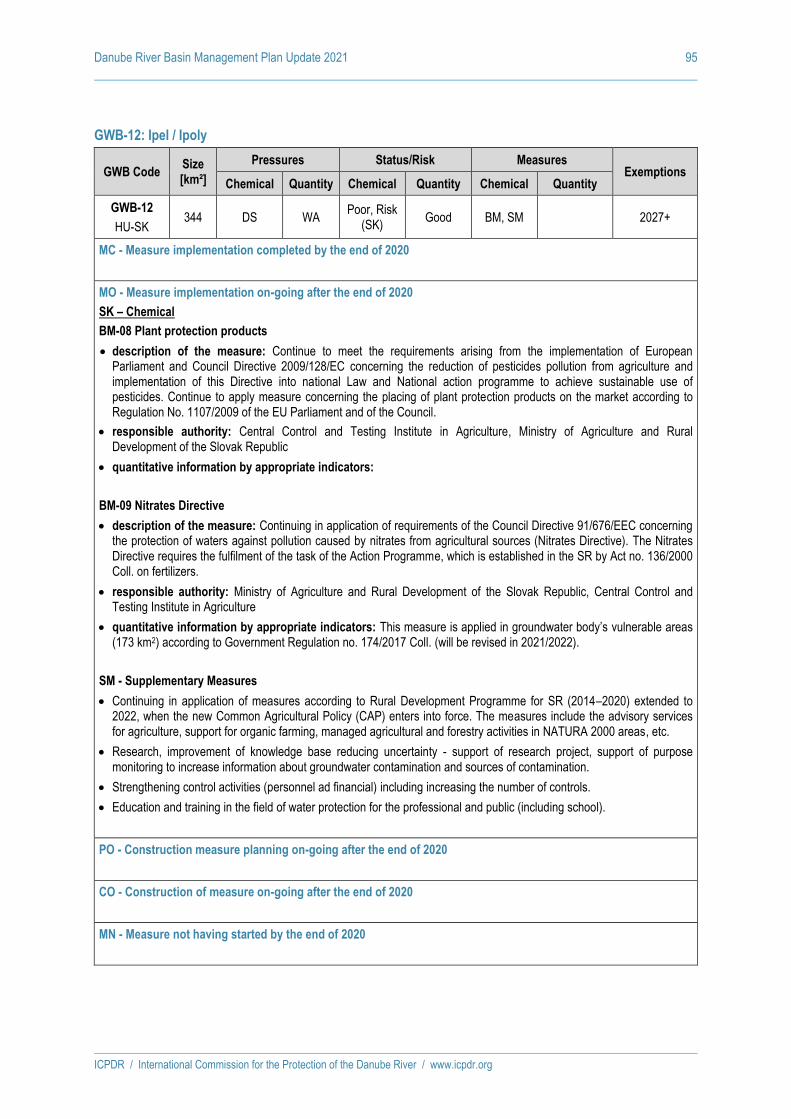
Danube River Basin Management Plan Update 2021 95
ICPDR / International Commission for the Protection of the Danube River / www.icpdr.org
GWB-12: Ipel / Ipoly
GWB Code Size [km²]
Pressures Status/Risk Measures Exemptions
Chemical Quantity Chemical Quantity Chemical Quantity
GWB-12
HU-SK 344 DS WA
Poor, Risk (SK)
Good BM, SM 2027+
MC - Measure implementation completed by the end of 2020
MO - Measure implementation on-going after the end of 2020
SK – Chemical
BM-08 Plant protection products
• description of the measure: Continue to meet the requirements arising from the implementation of European Parliament and Council Directive 2009/128/EC concerning the reduction of pesticides pollution from agriculture and implementation of this Directive into national Law and National action programme to achieve sustainable use of pesticides. Continue to apply measure concerning the placing of plant protection products on the market according to Regulation No. 1107/2009 of the EU Parliament and of the Council.
• responsible authority: Central Control and Testing Institute in Agriculture, Ministry of Agriculture and Rural Development of the Slovak Republic
• quantitative information by appropriate indicators:
BM-09 Nitrates Directive
• description of the measure: Continuing in application of requirements of the Council Directive 91/676/EEC concerning the protection of waters against pollution caused by nitrates from agricultural sources (Nitrates Directive). The Nitrates Directive requires the fulfilment of the task of the Action Programme, which is established in the SR by Act no. 136/2000 Coll. on fertilizers.
• responsible authority: Ministry of Agriculture and Rural Development of the Slovak Republic, Central Control and Testing Institute in Agriculture
• quantitative information by appropriate indicators: This measure is applied in groundwater body’s vulnerable areas (173 km2) according to Government Regulation no. 174/2017 Coll. (will be revised in 2021/2022).
SM - Supplementary Measures
• Continuing in application of measures according to Rural Development Programme for SR (2014–2020) extended to 2022, when the new Common Agricultural Policy (CAP) enters into force. The measures include the advisory services for agriculture, support for organic farming, managed agricultural and forestry activities in NATURA 2000 areas, etc.
• Research, improvement of knowledge base reducing uncertainty - support of research project, support of purpose monitoring to increase information about groundwater contamination and sources of contamination.
• Strengthening control activities (personnel ad financial) including increasing the number of controls.
• Education and training in the field of water protection for the professional and public (including school).
PO - Construction measure planning on-going after the end of 2020
CO - Construction of measure on-going after the end of 2020
MN - Measure not having started by the end of 2020

Draft ANNEX 9 as of 26 February 2021
DRBMP Update 2021
Detailed results of classification of all assessed surface water bodies according to particular biological, hydromorphological and chemical quality elements

Danube River Basin Management Plan Update 2021 2
ICPDR / International Commission for the Protection of the Danube River / www.icpdr.org
Explanations
Labels in the tables Description Possible values
Water body code Water body code (including country code)
River Name of river
Water body name Name of water body
from river-km Lower river km of the water body (on Danube River)
to river-km Higher river km of the water body (on Danube River)
Water body type Type of water body
N = natural, A = artificial H = heavily modified P = provisionally identified as
heavily modified
Biological Quality
Elements
Fish Status class for the water body
1 = high 2 = good 3 = moderate 4 = poor 5 = bad - = not applicable
Benthic invertebrates Status class for the water body
Phytobenthos and
Macrophytes
Status class for the river or lake water body
Angiosperms Status class for the coastal or transitional water body
Macroalgae Status class for the coastal or transitional water body
Phytoplankton Status class for the water body
Overall Biological Status
Status class for the water body = worst case of the status classes of all biological quality elements (acc. to one-out-all-out principle)
Hydromorphology - High
Status
Only if biological quality elements are in high status, hydromorphology must also be in high status
Y = yes N = no
General Phys. and Chem.
conditions
Status class for the water body for general physical and chemical conditions supportive to the Ecological Status
1 = high 2 = good 3 = moderate 4 = poor 5 = bad
River Basin Specific
Pollutants
Status class for the water body for specific pollutants based on national quality standards; relevant for the assessment of Ecological Status. Specific pollutants are those pollutants that are regulated at the national level (and not included in the List
G = good F = failing
OVERALL ECOLOGICAL
STATUS/POTENTIAL
Worst case of the Biological Quality Class and Specific pollutants Status Class. For High Ecological Status/Potential
1 = high 2 = good 3 = moderate 4 = poor

Danube River Basin Management Plan Update 2021 3
ICPDR / International Commission for the Protection of the Danube River / www.icpdr.org
Labels in the tables Description Possible values
additionally the General Physical and Chemical Parameters and the Hydromorphology have to be in high status.
5 = bad
Related confidence class Confidence level of assessment (agreed by the MA EG)
H = high M = medium L = low
CHEMICAL
STATUS
for priority
substances (and confidence)
…in water
Chemical status class for priority substances in water, regulated by the EU
G = good F = failing
Related confidence class Confidence level of the assessment of priority substances in water (agreed by the MA EG)
H = high M = medium L = low
…in water w/o ubiquitous
Chemical status class for priority substances in water, regulated by the EU, without ubiquitous substances according to Directive 2013/39/EU: ( i.e., without brominated diphenylethers,
polyaromatic hydrocarbons,
tributyltin compounds,
perfluorooctane sulfonic acid and
its derivatives, dioxins and dioxin-
like compounds,
hexabromocyclododecanes,
heptachlor and heptachlor
epoxide, mercury)
G = good F = failing
Related confidence class
Confidence level of the assessment of priority substances in water without ubiquitous substances (agreed by the MA EG)
H = high M = medium L = low
…in biota
Chemical status class for priority substances in biota, regulated by the EU
G = good F = failing
Related confidence class Confidence level of the assessment of priority substances in biota (agreed by the MA EG)
H = high M = medium L = low
…in biota w/o ubiquitous
Chemical status class for priority substances in biota, regulated by the EU without brominated
diphenylethers and mercury
G = good F = failing
Related confidence class
Confidence level of the assessment of priority substances in biota, regulated by the EU without brominated diphenylethers and
mercury (agreed by the MA EG)
H = high M = medium L = low
Exemptions
Exemption Art. 4(4) Usage of exemption according to EU WFD Art. 4(4)
Y = yes N = no - = not applicable
Exemption Art. 4(5) Usage of exemption according to EU WFD Art. 4(5)
Y = yes N = no - = not applicable
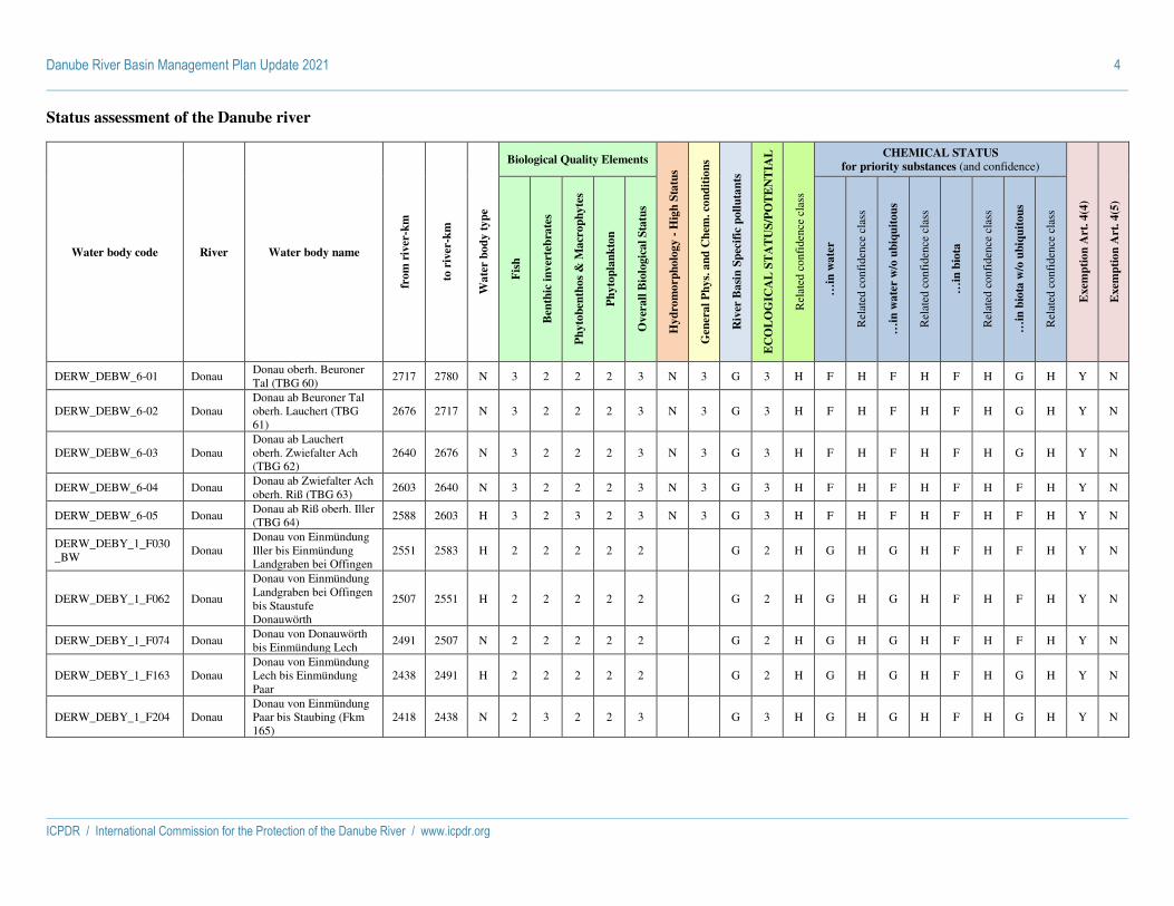
Danube River Basin Management Plan Update 2021 4
ICPDR / International Commission for the Protection of the Danube River / www.icpdr.org
Status assessment of the Danube river
Water body code River Water body name
fro
m r
iver
-km
to r
iver
-km
Wa
ter
bo
dy
ty
pe
Biological Quality Elements
Hy
dro
mo
rph
olo
gy -
Hig
h S
tatu
s
Gen
era
l P
hy
s. a
nd
Ch
em. co
nd
itio
ns
Riv
er B
asi
n S
pec
ific
po
llu
tan
ts
EC
OL
OG
ICA
L S
TA
TU
S/P
OT
EN
TIA
L
Rel
ated
con
fide
nce
clas
s
CHEMICAL STATUS
for priority substances (and confidence)
Exem
pti
on
Art
. 4
(4)
Exem
pti
on
Art
. 4
(5)
Fis
h
Ben
thic
in
ver
teb
rate
s
Ph
yto
ben
tho
s &
Ma
cro
ph
yte
s
Ph
yto
pla
nk
ton
Ov
erall
Bio
logic
al
Sta
tus
…in
wa
ter
Rel
ated
con
fide
nce
clas
s
…in
wa
ter
w/o
ub
iqu
ito
us
Rel
ated
con
fide
nce
clas
s
…in
bio
ta
Rel
ated
con
fide
nce
clas
s
…in
bio
ta w
/o u
biq
uit
ou
s
Rel
ated
con
fide
nce
clas
s
DERW_DEBW_6-01 Donau Donau oberh. Beuroner Tal (TBG 60)
2717 2780 N 3 2 2 2 3 N 3 G 3 H F H F H F H G H Y N
DERW_DEBW_6-02 Donau Donau ab Beuroner Tal oberh. Lauchert (TBG 61)
2676 2717 N 3 2 2 2 3 N 3 G 3 H F H F H F H G H Y N
DERW_DEBW_6-03 Donau Donau ab Lauchert oberh. Zwiefalter Ach (TBG 62)
2640 2676 N 3 2 2 2 3 N 3 G 3 H F H F H F H G H Y N
DERW_DEBW_6-04 Donau Donau ab Zwiefalter Ach oberh. Riß (TBG 63)
2603 2640 N 3 2 2 2 3 N 3 G 3 H F H F H F H F H Y N
DERW_DEBW_6-05 Donau Donau ab Riß oberh. Iller (TBG 64)
2588 2603 H 3 2 3 2 3 N 3 G 3 H F H F H F H F H Y N
DERW_DEBY_1_F030_BW
Donau Donau von Einmündung Iller bis Einmündung Landgraben bei Offingen
2551 2583 H 2 2 2 2 2 G 2 H G H G H F H F H Y N
DERW_DEBY_1_F062 Donau
Donau von Einmündung Landgraben bei Offingen bis Staustufe Donauwörth
2507 2551 H 2 2 2 2 2 G 2 H G H G H F H F H Y N
DERW_DEBY_1_F074 Donau Donau von Donauwörth bis Einmündung Lech
2491 2507 N 2 2 2 2 2 G 2 H G H G H F H F H Y N
DERW_DEBY_1_F163 Donau Donau von Einmündung Lech bis Einmündung Paar
2438 2491 H 2 2 2 2 2 G 2 H G H G H F H G H Y N
DERW_DEBY_1_F204 Donau Donau von Einmündung Paar bis Staubing (Fkm 165)
2418 2438 N 2 3 2 2 3 G 3 H G H G H F H G H Y N

Danube River Basin Management Plan Update 2021 5
ICPDR / International Commission for the Protection of the Danube River / www.icpdr.org
Water body code River Water body name
fro
m r
iver
-km
to r
iver
-km
Wa
ter
bo
dy
ty
pe
Biological Quality Elements
Hy
dro
mo
rph
olo
gy -
Hig
h S
tatu
s
Gen
era
l P
hy
s. a
nd
Ch
em. co
nd
itio
ns
Riv
er B
asi
n S
pec
ific
po
llu
tan
ts
EC
OL
OG
ICA
L S
TA
TU
S/P
OT
EN
TIA
L
Rel
ated
con
fide
nce
clas
s
CHEMICAL STATUS
for priority substances (and confidence)
Exem
pti
on
Art
. 4
(4)
Exem
pti
on
Art
. 4
(5)
Fis
h
Ben
thic
in
ver
teb
rate
s
Ph
yto
ben
tho
s &
Ma
cro
ph
yte
s
Ph
yto
pla
nk
ton
Ov
erall
Bio
logic
al
Sta
tus
…in
wa
ter
Rel
ated
con
fide
nce
clas
s
…in
wa
ter
w/o
ub
iqu
ito
us
Rel
ated
con
fide
nce
clas
s
…in
bio
ta
Rel
ated
con
fide
nce
clas
s
…in
bio
ta w
/o u
biq
uit
ou
s
Rel
ated
con
fide
nce
clas
s
DERW_DEBY_1_F205 Donau Donau von Staubing bis Einmündung Main-Donau-Kanal
2406 2418 N 2 3 3 2 3 G 3 H F H F H F H G H Y N
DERW_DEBY_1_F223 Donau Donau von Einmündung Main-Donau-Kanal bis Einmündung Naab
2380 2406 H 3 3 3 2 3 G 3 H G H G H F H F H Y N
DERW_DEBY_1_F348 Donau Donau von Einmündung Naab bis Einmündung Große Laber
0 2380 H 3 3 3 2 3 G 3 H G H G H F H G H Y N
DERW_DEBY_1_F361 Donau Donau von Einmündung Große Laber bis Einmündung Isar
2282 2324 N 2 2 3 2 3 G 3 H G H G H F H F H Y N
DERW_DEBY_1_F477 Donau Donau von Einmündung Isar bis Einmündung Vils
2249 2282 N 2 2 3 2 3 G 3 H G H G H F H F H Y N
DERW_DEBY_1_F478 Donau Donau von Einmündung Vils bis Einmündung Inn
2225 2249 H 2 2 3 2 3 G 3 H G H G H F H G H Y N
DERW_DEBY_1_F633 Donau Donau von Passau bis Staatsgrenze
2202 2225 H 3 2 3 2 3 G 3 H G H G H F H F H Y N
ATOK303070000 Donau Donau 2202 2223 H 5 3 2 5 N 3 G 3 H G L G L F H G L Y N
ATOK410360003 Donau Donau-Aschach 2162 2202 H 5 2 2 5 N 2 G 3 H G L G L F L G L Y N
ATOK410360005 Donau Donau-Ottensheim_Wilhering
2146 2162 H 4 2 2 4 N 2 G 3 M G L G L F L G L Y N
ATOK410360007 Donau
Donau_10, KW Ottensheim_Wilhering bis KW Abwinden_Asten, EP groß
2120 2146 H 4 2 2 4 N 2 G 3 M G L G L F L G L Y N
ATOK410360009 Donau Donau_09 KW Abwinden_Asten bis KW
2094 2120 H 4 2 3 4 N 3 G 3 H G L G L F L G L Y N

Danube River Basin Management Plan Update 2021 6
ICPDR / International Commission for the Protection of the Danube River / www.icpdr.org
Water body code River Water body name
fro
m r
iver
-km
to r
iver
-km
Wa
ter
bo
dy
ty
pe
Biological Quality Elements
Hy
dro
mo
rph
olo
gy -
Hig
h S
tatu
s
Gen
era
l P
hy
s. a
nd
Ch
em. co
nd
itio
ns
Riv
er B
asi
n S
pec
ific
po
llu
tan
ts
EC
OL
OG
ICA
L S
TA
TU
S/P
OT
EN
TIA
L
Rel
ated
con
fide
nce
clas
s
CHEMICAL STATUS
for priority substances (and confidence)
Exem
pti
on
Art
. 4
(4)
Exem
pti
on
Art
. 4
(5)
Fis
h
Ben
thic
in
ver
teb
rate
s
Ph
yto
ben
tho
s &
Ma
cro
ph
yte
s
Ph
yto
pla
nk
ton
Ov
erall
Bio
logic
al
Sta
tus
…in
wa
ter
Rel
ated
con
fide
nce
clas
s
…in
wa
ter
w/o
ub
iqu
ito
us
Rel
ated
con
fide
nce
clas
s
…in
bio
ta
Rel
ated
con
fide
nce
clas
s
…in
bio
ta w
/o u
biq
uit
ou
s
Rel
ated
con
fide
nce
clas
s
Wallsee_Mitterkirchen, EP groß
ATOK410360012 Donau
Donau_08, KW Wallsee_Mitterkirchen bis KW Ybbs_Persenbeug, EP groß
2060 2094 H 5 2 2 5 N 2 G 3 H G L G L F L G L Y N
ATOK410360002 Donau Donau_07, KW Ybbs Persenbeug bis KW Melk, EP groß
2038 2060 H 5 2 2 5 N 2 G 3 L G L G L F L G L Y N
ATOK410350000 Donau Donau_06, KW Melk bis Mautern, EP groß
2005 2038 N 5 2 2 5 N 2 G 4 H G L G L F H G L Y N
ATOK409040012 Donau Donau_05, Mautern bis KW Altenwörth, EP groß
1980 2005 H 5 2 2 5 N 2 G 3 L G L G L F L G L Y N
ATOK409040011 Donau Donau_04, KW Altenwörth bis KW Greifenstein, EP groß
1950 1980 H 5 2 2 5 N 2 G 3 H G L G L F L G L Y N
ATOK409040013 Donau Donau_03, KW Greifenstein bis KW Freudenau, EP groß
1921 1950 H 4 2 2 4 N 2 G 3 H G L G L F L G L Y N
ATOK409040008 Donau Donau_02, KW Freudenau bis Devin, EP groß
1880 1921 N 2 2 2 2 N 2 G 2 H G L G L F L G L N N
ATOK411340000 Donau Donau_01, unterhalb Devin, EP groß
1873 1880 N 2 2 2 2 N 2 G 2 L G L G L F H G L N N
SKD0016 Dunaj Dunaj 1869 1880 N 3 2 3 2 3 N 2 G 3 H F H G H F H G H Y N
SKD0017 Dunaj Dunaj 1790 1869 H 3 3 2 2 3 N 2 G 3 M F H G H F H G H Y N
HUAEP443 Duna Duna Szigetköznél 1785 1850 H 3 2 1 3 N 1 G 3 H F H G H F H F H Y N
SKD0018 Dunaj Dunaj 1708 1790 N 3 3 3 2 3 N 2 G 3 H F H G H F H F H Y N

Danube River Basin Management Plan Update 2021 7
ICPDR / International Commission for the Protection of the Danube River / www.icpdr.org
Water body code River Water body name
fro
m r
iver
-km
to r
iver
-km
Wa
ter
bo
dy
ty
pe
Biological Quality Elements
Hy
dro
mo
rph
olo
gy -
Hig
h S
tatu
s
Gen
era
l P
hy
s. a
nd
Ch
em. co
nd
itio
ns
Riv
er B
asi
n S
pec
ific
po
llu
tan
ts
EC
OL
OG
ICA
L S
TA
TU
S/P
OT
EN
TIA
L
Rel
ated
con
fide
nce
clas
s
CHEMICAL STATUS
for priority substances (and confidence)
Exem
pti
on
Art
. 4
(4)
Exem
pti
on
Art
. 4
(5)
Fis
h
Ben
thic
in
ver
teb
rate
s
Ph
yto
ben
tho
s &
Ma
cro
ph
yte
s
Ph
yto
pla
nk
ton
Ov
erall
Bio
logic
al
Sta
tus
…in
wa
ter
Rel
ated
con
fide
nce
clas
s
…in
wa
ter
w/o
ub
iqu
ito
us
Rel
ated
con
fide
nce
clas
s
…in
bio
ta
Rel
ated
con
fide
nce
clas
s
…in
bio
ta w
/o u
biq
uit
ou
s
Rel
ated
con
fide
nce
clas
s
HUAEP446 Duna Duna Gönyü-Szob között 1708 1785 N 3 2 1 3 N 2 F 3 H F H G H F H F H Y N
HUAOC756 Duna, Szentendrei-Duna
Duna Szob–Budapest között
1660 1708 N 3 2 2 3 N 2 G 3 H F H F H F H F H Y N
HUAOC752 Duna, Szentendrei-Duna
Duna–Budapest 1633 1660 H 3 2 2 3 N 2 F 3 H F H G H F H F H Y N
HUAOC753 Duna Duna Budapest–Dunaföldvár között
1561 1633 H 3 2 2 3 N 2 G 3 H F H G H F H G H Y N
HUAOC754 Duna Duna Dunaföldvár–Sió torkolat között
1497 1561 H 3 2 2 3 N 2 G 3 H F H G H F H G H Y N
HRCDRI0001_001 Dunav Dunav 1479 1561 N 2 2 2 N 2 G 5 H G H Y
HUAOC755 Duna Duna Sió torkolat–országhatár között
1433 1497 H 3 2 2 3 N 2 G 3 H F H G H F H F H Y N
HRCDRI0001_002 Dunav Dunav 1428 1479 N 3 2 1 3 N 2 G 4 H G H Y Y
RSD_10 Dunav Dunav od ušća Drave do Državne granice sa Mađarskom
1382 1433 N 2 2 2 3 F 2 M F H
RSD_09 Dunav
Dunav od Državne granice sa Republikom Hrvatskom kod Bač• ke Palanke do ušća Drave
1296 1382 N 2 2 2 3 F 2 M F H
RSD_08 Dunav
Dunav od DTD kanal Novi Sad-Savino Selo do Državne granice sa Republikom Hrvatskom kod Bačke Palanke
1253 1296 N 2 2 2 2 F 2 M G H
RSD_07 Dunav Dunav od ušća Tise do ušća DTD kanal Novi Sad-Savino Selo
1214 1261 N 3 3 3 2 F 3 M G H

Danube River Basin Management Plan Update 2021 8
ICPDR / International Commission for the Protection of the Danube River / www.icpdr.org
Water body code River Water body name
fro
m r
iver
-km
to r
iver
-km
Wa
ter
bo
dy
ty
pe
Biological Quality Elements
Hy
dro
mo
rph
olo
gy -
Hig
h S
tatu
s
Gen
era
l P
hy
s. a
nd
Ch
em. co
nd
itio
ns
Riv
er B
asi
n S
pec
ific
po
llu
tan
ts
EC
OL
OG
ICA
L S
TA
TU
S/P
OT
EN
TIA
L
Rel
ated
con
fide
nce
clas
s
CHEMICAL STATUS
for priority substances (and confidence)
Exem
pti
on
Art
. 4
(4)
Exem
pti
on
Art
. 4
(5)
Fis
h
Ben
thic
in
ver
teb
rate
s
Ph
yto
ben
tho
s &
Ma
cro
ph
yte
s
Ph
yto
pla
nk
ton
Ov
erall
Bio
logic
al
Sta
tus
…in
wa
ter
Rel
ated
con
fide
nce
clas
s
…in
wa
ter
w/o
ub
iqu
ito
us
Rel
ated
con
fide
nce
clas
s
…in
bio
ta
Rel
ated
con
fide
nce
clas
s
…in
bio
ta w
/o u
biq
uit
ou
s
Rel
ated
con
fide
nce
clas
s
RORW14-1_B1 Dunarea Dunarea PF I 1038 1261 H - - 2 2 N 3 F 3 H G H G H G
RORW14-1_B2 Dunarea Dunarea PF II 1021 1223 H - - 2 2 N 3 F 3 H G H G H G
RSD_06 Dunav Dunav od ušća Save do ušća Tise
1170 1214 N 3 3 3 3 F 3 M F H
RSD_05 Dunav Akumulacija HE Đerdap 1 od ušća Velike Morave do ušća Save
1104 1170 H 4 3 4 3 F 4 M F H
RSD_04 Dunav Akumulacija HE Đerdap 1 od ušća Nere do ušća Velike Morave
1076 1104 H 4 2 4 2 F 4 M G M
RSD_03 Dunav Akumulacija HE Đerdap 1 od Brane do ušća Nere
943 1076 H 3 3 3 2 F 3 M G H
RORW14-1_B3 Dunarea Dunarea PF II - Chiciu 445 1021 H 3 2 1 1 3 N 2 G 3 H F H G H F H G H
RSD_02 Dunav Akumulacija HE Đerdap 2
863 943 H 3 3 3 2 F 3 M G H
RSD_01 Dunav Dunav nizvodno od HE Đerdap 2 do ušća Timoka
846 863 N 3 3 3 3 F 3 M G H
BG1DU000R001 Dunav DUNAV RWB01 374 846 H - 2 G 3 H F M F M Y N
RORW14-1_B4 Dunarea Dunarea Chiciu-Isaccea 124 446 H 3 2 2 2 3 N 2 G 3 H F H G H F H G H
UADB_UA_01 Danube Danube 178 194 N - - -
UADB_UA_02 Danube Danube 119 178 N - - -
RORW14-1_B6 Dunarea Dunarea Chilia 0 133 N 2 2 2 2 N 2 G 2 H G H G H G N N
RORW14-1_B5 Dunarea Dunarea Isaccea-Sulina 0 124 H 2 2 2 2 N 2 G 2 H F H G H F H G H
UADB_UA_03 Danube Danube 22 119 N - - -
RORW14-1_B7 Dunarea Dunarea Sf. Gheorghe 0 88 N 2 2 2 2 N 2 G 2 H F H G H F H G H

Danube River Basin Management Plan Update 2021 9
ICPDR / International Commission for the Protection of the Danube River / www.icpdr.org
Status assessment of the tributaries
Water body code River Water body name
Wa
ter
bo
dy
ty
pe
Biological Quality Elements
Hy
dro
mo
rph
olo
gy -
Hig
h S
tatu
s
Gen
era
l P
hy
s. a
nd
Ch
em. co
nd
itio
ns
Riv
er B
asi
n S
pec
ific
po
llu
tan
ts
EC
OL
OG
ICA
L S
TA
TU
S/P
OT
EN
TIA
L
Rel
ated
con
fide
nce
clas
s
CHEMICAL STATUS
for priority substances (and confidence)
Exem
pti
on
Art
. 4
(4)
Exem
pti
on
Art
. 4
(5)
Fis
h
Ben
thic
in
ver
teb
rate
s
Ph
yto
ben
tho
s &
Ma
cro
ph
yte
s
Ph
yto
pla
nk
ton
Ov
erall
Bio
logic
al
Sta
tus
…in
wat
er
Rel
ated
con
fide
nce
clas
s
…in
wat
er w
/o u
biqu
itous
Rel
ated
con
fide
nce
clas
s
…in
bio
ta
Rel
ated
con
fide
nce
clas
s
…in
bio
ta w
/o u
biqu
itous
Rel
ated
con
fide
nce
clas
s
DERW_DEBY_1_F509
Inn Inn von Innstau Passau-Ingling bis Mündung in die Donau
N 2 2 2 - 2 G 2 H G H G H F H G H Y N
DERW_DEBY_1_F556
Inn Inn von Einmündung Innwerkkanal bis Einmündung Alz
H 2 2 2 - 2 G 2 H G H G H F H G H Y N
DERW_DEBY_1_F557
Inn Inn von Ausleitung Innwerkkanal bis Einmündung Innwerkkanal
N 3 2 2 - 3 G 3 H G H G H F H G H Y N
DERW_DEBY_1_F558
Inn Inn von Einmündung der Mangfall bis Jettenbach
H 2 2 2 - 2 G 2 H G H G H F H G H Y N
DERW_DEBY_1_F583
Inn Inn von Einmündung Alz bis Einmündung der Salzach
H 2 2 2 - 2 G 2 H G H G H F H G H Y N
DERW_DEBY_1_F654
Inn Inn von Einmündung Salzach bis unterhalb Stau Neuhaus
H 2 2 2 - 2 G 2 H G H G H F H F H Y N
DERW_DEBY_1_F655
Inn Inn von unterhalb Stau Neuhaus bis Innstau Passau-Ingling
H 3 2 2 - 3 G 3 H G H G H F H F H Y N
DERW_DEBY_1_F656
Inn Inn von unterhalb Kufstein bis unterhalb Erl
H 4 2 2 - 4 G 4 H G H G H F H G H Y N
DERW_DEBY_1_F657
Inn Inn von unterhalb Erl bis Einmündung der Mangfall; Moosbach; Altwasser; Husarenbach
H 3 2 2 - 3 G 3 H G H G H F H G H Y N
DERW_DEBY_1_F373
Isar Isar von Staatsgrenze bis zum Krüner Wehr
N 2 1 1 - 2 G 2 H G H G H F H F H Y N
DERW_DEBY_1_F374
Isar Isar vom Krüner Wehr bis Sylvensteinspeicher
N 2 2 2 - 2 G 2 H G H G H F H G H Y N
DERW_DEBY_1_F375
Isar Isar vom Sylvensteinspeicher bis Bad Tölz (Fkm 202,8)
N 2 2 2 - 2 G 2 H G H G H F H G H Y N
DERW_DEBY_1_F376
Isar Isar von Fkm 202,8 bis Fkm 195 (Bad Tölz)
N 2 2 2 - 2 G 2 H G H G H F H G H Y N

Danube River Basin Management Plan Update 2021 10
ICPDR / International Commission for the Protection of the Danube River / www.icpdr.org
Water body code River Water body name
Wa
ter
bo
dy
ty
pe
Biological Quality Elements
Hy
dro
mo
rph
olo
gy -
Hig
h S
tatu
s
Gen
era
l P
hy
s. a
nd
Ch
em. co
nd
itio
ns
Riv
er B
asi
n S
pec
ific
po
llu
tan
ts
EC
OL
OG
ICA
L S
TA
TU
S/P
OT
EN
TIA
L
Rel
ated
con
fide
nce
clas
s
CHEMICAL STATUS
for priority substances (and confidence)
Exem
pti
on
Art
. 4
(4)
Exem
pti
on
Art
. 4
(5)
Fis
h
Ben
thic
in
ver
teb
rate
s
Ph
yto
ben
tho
s &
Ma
cro
ph
yte
s
Ph
yto
pla
nk
ton
Ov
erall
Bio
logic
al
Sta
tus
…in
wat
er
Rel
ated
con
fide
nce
clas
s
…in
wat
er w
/o u
biqu
itous
Rel
ated
con
fide
nce
clas
s
…in
bio
ta
Rel
ated
con
fide
nce
clas
s
…in
bio
ta w
/o u
biqu
itous
Rel
ated
con
fide
nce
clas
s
DERW_DEBY_1_F377
Isar Isar von Fkm 195 bis Einmündung der Loisach
N 2 2 2 - 2 G 2 H G H G H F H G H Y N
DERW_DEBY_1_F402
Isar Isar von Einmündung der Loisach bis Corneliuswehr
N 2 2 2 - 2 G 2 H G H G H F H G H Y N
DERW_DEBY_1_F403
Isar Isar von Corneliuswehr bis Oberföhringer Wehr
N 2 2 2 - 2 G 2 H G H G H F H G H Y N
DERW_DEBY_1_F404
Isar Isar von Anfang Mittlere-Isar-Kanal bis Moosburg
N 2 2 2 - 2 G 2 H F H F H F H F H Y N
DERW_DEBY_1_F405
Isar Isar von Einmündung der Amper bis Einmündung des Mittlere-Isar-Kanals
N 3 3 2 - 3 G 3 H G H G H F H G H Y N
DERW_DEBY_1_F406
Isar Isar von Moosburg bis Einmündung der Amper
N 2 2 2 - 2 G 2 H G H G H F H G H Y N
DERW_DEBY_1_F429
Isar Isar von Einmündung des Mittlere-Isar-Kanals bis Stützkraftstufe Pielweichs bei Plattling; Kleine Isar in Landshut
H 4 4 3 - 4 G 4 H G H G H F H G H Y N
DERW_DEBY_1_F430
Isar Isar von Plattling bis Mündung in die Donau
N 2 3 2 - 3 G 3 H G H G H F H F H Y N
DERW_DEBY_1_S022
Isar Isar vom Krüner Wehr bis Sylvensteinspeicher
N 2 2 2 - 2 G 2 H G H G H F H G H Y N
DERW_DEBY_1_F121
Lech Lech mit Lechfall von Staatsgrenze bis Theresienbrücke Füssen (Fkm 168,5 - 166,3)
N 2 2 2 - 2 G 2 H G H G H F H G H Y N
DERW_DEBY_1_F122
Lech Lech von Einmündung Lechkanal Meitingen bis Mündung in die Donau
H 3 - - - 3 G 3 H G H G H F H G H Y N
DERW_DEBY_1_F124
Lech Lech Mutterbett von Einmündung Wertach bis Einmündung Lechkanal bei Ostendorf
H 3 2 2 - 3 G 3 H G H G H F H G H Y N
DERW_DEBY_1_F125
Lech Lech von Fkm 139 bis Fkm 133 (Litzauer Schleife)
N 2 2 2 - 2 G 2 H G H G H F H G H Y N
DERW_DEBY_1_F126
Lech Lech Mutterbett vom Hochablass Augsburg bis Einmündung Wertach
N 2 3 2 - 3 G 3 H G H G H F H G H Y N

Danube River Basin Management Plan Update 2021 11
ICPDR / International Commission for the Protection of the Danube River / www.icpdr.org
Water body code River Water body name
Wa
ter
bo
dy
ty
pe
Biological Quality Elements
Hy
dro
mo
rph
olo
gy -
Hig
h S
tatu
s
Gen
era
l P
hy
s. a
nd
Ch
em. co
nd
itio
ns
Riv
er B
asi
n S
pec
ific
po
llu
tan
ts
EC
OL
OG
ICA
L S
TA
TU
S/P
OT
EN
TIA
L
Rel
ated
con
fide
nce
clas
s
CHEMICAL STATUS
for priority substances (and confidence)
Exem
pti
on
Art
. 4
(4)
Exem
pti
on
Art
. 4
(5)
Fis
h
Ben
thic
in
ver
teb
rate
s
Ph
yto
ben
tho
s &
Ma
cro
ph
yte
s
Ph
yto
pla
nk
ton
Ov
erall
Bio
logic
al
Sta
tus
…in
wat
er
Rel
ated
con
fide
nce
clas
s
…in
wat
er w
/o u
biqu
itous
Rel
ated
con
fide
nce
clas
s
…in
bio
ta
Rel
ated
con
fide
nce
clas
s
…in
bio
ta w
/o u
biqu
itous
Rel
ated
con
fide
nce
clas
s
DERW_DEBY_1_F127
Lech Lech von Staustufe 23 bis zum Hochablass Augsburg
N 2 3 2 - 3 G 3 H G H G H F H G H Y N
DERW_DEBY_1_F128
Lech Lech von Staustufe 1 bis Staustufe 4 (Kraftwerk Roßhaupten bis Fkm 139)
H 4 2 2 - 4 G 4 H G H G H F H G H Y N
DERW_DEBY_1_F129
Lech Lech von Theresienbrücke Füssen bis Staustufe 1 (Kraftwerk Roßhaupten)
H - 2 2 - 2 G 2 H G H G H F H G H Y N
DERW_DEBY_1_F130
Lech Lech von Staustufe 15 bis Eisenbahnbrücke in Kaufering
N 2 2 2 - 2 G 2 H G H G H F H G H Y N
DERW_DEBY_1_F131
Lech Lech von Eisenbahnbrücke in Kaufering bis Staustufe 23
H 2 3 2 - 3 G 3 H G H G H F H G H Y N
DERW_DEBY_1_F132
Lech Lech von Mündung in Schongauer Lechsee bis Staustufe 15
H 3 2 2 - 3 G 3 H G H G H F H G H Y N
DERW_DEBY_1_F226
Main-Donau-Kanal
Main-Donau-Kanal (Altmühl) von Dietfurt bis Mündung in die Donau
H 2 5 2 2 5 G 5 H G H G H F H G H Y N
DERW_DEBY_1_F227
Main-Donau-Kanal
Altmühl bis Einmündung Wieseth N 2 3 3 - 3 F 3 H G H G H F H G H Y N
DERW_DEBY_1_F228
Main-Donau-Kanal
Altmühl von Einmündung Wieseth bis Einmündung Hungerbach
N 2 3 3 3 3 G 3 H G H G H F H G H Y N
DERW_DEBY_1_F229
Main-Donau-Kanal
Altmühl von Einmündung Hungerbach bis zum Zusammenfluss mit Main-Donau-Kanal
N 2 3 3 4 4 G 4 H G H G H F H F H Y N
DERW_DEBY_1_F243
Main-Donau-Kanal
Main-Donau-Kanal von Pierheim bis Dietfurt
A - 2 3 4 4 G 4 H G H G H F H G H Y N
DERW_DEBY_1_F251
Naab
Tirschenreuther Waldnaab unterhalb Tirschenreuth (Fkm 168,8), Waldnaab bis Zusammenfluss mit der Haidenaab; Flutkanal (Stadt Weiden i.d.OPf.)
N 4 2 2 - 4 G 4 H G H G H F H G H Y N
DERW_DEBY_1_F252
Naab Tirschenreuther Waldnaab oh. WSP Liebenstein; Heiligenbach
N 4 2 2 - 4 G 4 H G H G H F H G H Y N
DERW_DEBY_1_F253
Naab Tir. Waldnaab ab Einmündung in Liebensteinspeicher bis Tirschenreuth
N 4 2 2 - 4 G 4 H G H G H F H G H Y N

Danube River Basin Management Plan Update 2021 12
ICPDR / International Commission for the Protection of the Danube River / www.icpdr.org
Water body code River Water body name
Wa
ter
bo
dy
ty
pe
Biological Quality Elements
Hy
dro
mo
rph
olo
gy -
Hig
h S
tatu
s
Gen
era
l P
hy
s. a
nd
Ch
em. co
nd
itio
ns
Riv
er B
asi
n S
pec
ific
po
llu
tan
ts
EC
OL
OG
ICA
L S
TA
TU
S/P
OT
EN
TIA
L
Rel
ated
con
fide
nce
clas
s
CHEMICAL STATUS
for priority substances (and confidence)
Exem
pti
on
Art
. 4
(4)
Exem
pti
on
Art
. 4
(5)
Fis
h
Ben
thic
in
ver
teb
rate
s
Ph
yto
ben
tho
s &
Ma
cro
ph
yte
s
Ph
yto
pla
nk
ton
Ov
erall
Bio
logic
al
Sta
tus
…in
wat
er
Rel
ated
con
fide
nce
clas
s
…in
wat
er w
/o u
biqu
itous
Rel
ated
con
fide
nce
clas
s
…in
bio
ta
Rel
ated
con
fide
nce
clas
s
…in
bio
ta w
/o u
biqu
itous
Rel
ated
con
fide
nce
clas
s
(Fkm 168,8); Geisbach von Kriegerbühl bis Mündung
DERW_DEBY_1_F273
Naab Naab von Zusammenfluss Haidenaab und Waldnaab bis Mündung in die Donau
N 2 2 3 3 3 G 3 H G H G H F H F H Y N
DERW_DEBY_1_F640
Salzach Salzach von Einmündung Alzkanal bis Mündung in den Inn
H 3 2 2 - 3 G 3 H G H G H F H G H Y N
DERW_DEBY_1_F641
Salzach Salzach von Einmündung Saalach bis Einmündung Alzkanal
N 3 2 2 - 3 G 3 H F H G H F H F H Y N
ATOK900470001 Drau Drau N 3 2 2 3 N 2 G 3 H G L G L F L G L Y N
ATOK900470021 Drau DRAU(150) N 3 2 2 3 N 2 G 3 M G L G L F L G L Y N
ATOK900470022 Drau DRAU(140) H 4 2 2 4 N 2 G 3 H G L G L F L G L Y N
ATOK900470056 Drau DRAU(90) N 2 2 2 2 N 2 G 2 M G L G L F L G L N N
ATOK900470061 Drau DRAU(130) H 4 1 1 4 N 1 G 2 M G L G L F L G L N N
ATOK900470062 Drau DRAU(20) H 4 2 2 4 N 2 G 2 H G L G L F H G L N N
ATOK900470064 Drau DRAU(30) H 4 2 2 4 N 2 G 2 H G L G L F L G L N N
ATOK900470065 Drau DRAU(40) H 4 2 2 4 N 2 G 2 H G L G L F L G L N N
ATOK900470068 Drau DRAU(50) H 4 2 2 4 N 2 G 2 H G L G L F L G L N N
ATOK900470069 Drau DRAU(60) H 4 2 2 4 N 2 G 3 M G L G L F L G L Y N
ATOK900470071 Drau DRAU(70) H 4 2 2 4 N 2 G 3 M G L G L F L G L Y N
ATOK900470072 Drau DRAU(80) H 4 2 2 4 N 2 G 3 M G L G L F L G L Y N
ATOK900470075 Drau DRAU(100) H 4 2 2 4 N 2 G 3 M G L G L F L G L Y N
ATOK900470076 Drau DRAU(110) H 3 1 1 3 N 1 G 2 H G L G L F L G L N N
ATOK900470077 Drau DRAU(120) H 4 1 1 4 N 1 G 2 M G L G L F L G L N N
ATOK903540001 Drau Drau H 4 2 2 4 N 2 G 3 M G L G L F L G L Y N

Danube River Basin Management Plan Update 2021 13
ICPDR / International Commission for the Protection of the Danube River / www.icpdr.org
Water body code River Water body name
Wa
ter
bo
dy
ty
pe
Biological Quality Elements
Hy
dro
mo
rph
olo
gy -
Hig
h S
tatu
s
Gen
era
l P
hy
s. a
nd
Ch
em. co
nd
itio
ns
Riv
er B
asi
n S
pec
ific
po
llu
tan
ts
EC
OL
OG
ICA
L S
TA
TU
S/P
OT
EN
TIA
L
Rel
ated
con
fide
nce
clas
s
CHEMICAL STATUS
for priority substances (and confidence)
Exem
pti
on
Art
. 4
(4)
Exem
pti
on
Art
. 4
(5)
Fis
h
Ben
thic
in
ver
teb
rate
s
Ph
yto
ben
tho
s &
Ma
cro
ph
yte
s
Ph
yto
pla
nk
ton
Ov
erall
Bio
logic
al
Sta
tus
…in
wat
er
Rel
ated
con
fide
nce
clas
s
…in
wat
er w
/o u
biqu
itous
Rel
ated
con
fide
nce
clas
s
…in
bio
ta
Rel
ated
con
fide
nce
clas
s
…in
bio
ta w
/o u
biqu
itous
Rel
ated
con
fide
nce
clas
s
ATOK903540002 Drau Drau_1 N 2 2 2 2 N 2 G 2 H G L G L F L G L N N
ATOK903540003 Drau Drau_2 N 3 2 2 3 N 2 G 3 H G L G L F L G L Y N
ATOK903770000 Drau DRAU(10) H 4 2 2 4 N 2 G 2 H G L G L F L G L N N
ATOK400240027 Enns Gewässer: Enns, Abschnitt: Landesgrenze bis Radstadt
N 5 3 2 5 N 3 G 5 H G L G L F L G L Y N
ATOK400240089 Enns Enns N 2 2 2 2 N 2 G 2 M G L G L F L G L N N
ATOK400240090 Enns Enns N 2 2 2 2 N 2 G 2 M G L G L F L G L N N
ATOK400240092 Enns Enns N 3 2 2 3 N 2 G 3 L G L G L F L G L Y N
ATOK400240103 Enns Gewässer: Enns, Abschnitt: Ende Fischlebensraum bis Labgeggbach
N 2 2 2 2 N 2 G 2 M G L G L F L G L N N
ATOK400240104 Enns Gewässer: Enns, Abschnitt: Langeggbach bis Ursprung
N 1 1 1 1 Y 1 G 1 M G L G L F L G L N N
ATOK400240105 Enns Gewässer: Enns, Abschnitt: Radstadt bis Altenmarkt
H 4 2 2 4 N 2 G 3 H G L G L F L G L Y N
ATOK400240106 Enns Altenmarkt bis Flachau N 3 2 2 3 N 2 G 3 L G L G L F L G L Y N
ATOK400240163 Enns Oberhalb Flachau bis Grenze Fischlebensraum
N 4 2 2 4 N 2 G 4 H G L G L F L G L Y N
ATOK409970000 Enns Enns H 4 2 2 4 N 2 G 3 H G L G L F L G L Y N
ATOK411250006 Enns Enns_Hafen Donaurückstau H 4 2 2 4 N 2 G 3 M G L G L F L G L Y N
ATOK411250008 Enns Enns H 5 2 2 5 N 2 G 2 H G L G L F L G L N N
ATOK411250009 Enns Enns Gesäuse N 2 2 2 2 N 2 G 2 M G L G L F L G L N N
ATOK411250010 Enns Enns N 5 2 2 5 N 2 G 5 H G L G L F L G L Y N
ATOK411250012 Enns Enns, Enns-Seitenarm H 4 2 2 4 N 2 G 3 M G L G L F L G L Y N
ATOK411250014 Enns Enns_Thurnsdorf-Stau H 5 2 2 5 N 2 G 3 H G L G L F L G L Y N
ATOK411250016 Enns Enns_Mühlrading-Stau H 4 2 2 4 N 2 G 3 M G L G L F L G L Y N

Danube River Basin Management Plan Update 2021 14
ICPDR / International Commission for the Protection of the Danube River / www.icpdr.org
Water body code River Water body name
Wa
ter
bo
dy
ty
pe
Biological Quality Elements
Hy
dro
mo
rph
olo
gy -
Hig
h S
tatu
s
Gen
era
l P
hy
s. a
nd
Ch
em. co
nd
itio
ns
Riv
er B
asi
n S
pec
ific
po
llu
tan
ts
EC
OL
OG
ICA
L S
TA
TU
S/P
OT
EN
TIA
L
Rel
ated
con
fide
nce
clas
s
CHEMICAL STATUS
for priority substances (and confidence)
Exem
pti
on
Art
. 4
(4)
Exem
pti
on
Art
. 4
(5)
Fis
h
Ben
thic
in
ver
teb
rate
s
Ph
yto
ben
tho
s &
Ma
cro
ph
yte
s
Ph
yto
pla
nk
ton
Ov
erall
Bio
logic
al
Sta
tus
…in
wat
er
Rel
ated
con
fide
nce
clas
s
…in
wat
er w
/o u
biqu
itous
Rel
ated
con
fide
nce
clas
s
…in
bio
ta
Rel
ated
con
fide
nce
clas
s
…in
bio
ta w
/o u
biqu
itous
Rel
ated
con
fide
nce
clas
s
ATOK411250018 Enns Enns_Staning H 4 2 2 4 N 2 G 3 M G L G L F L G L Y N
ATOK411250020 Enns Enns_Steyr-Fließstrecke H 4 2 2 4 N 2 G 3 H G L G L F L G L Y N
ATOK411250021 Enns Enns_Garsten H 4 2 2 4 N 2 G 3 H G L G L F L G L Y N
ATOK411250023 Enns Enns_Rosenau H 4 2 2 4 N 2 G 3 H G L G L F L G L Y N
ATOK411250025 Enns Enns_Ternberg H 4 2 2 4 N 2 G 3 H G L G L F L G L Y N
ATOK411250027 Enns Enns_Losenstein H 4 2 2 4 N 2 G 3 H G L G L F L G L Y N
ATOK411250029 Enns Enns_Großraming H 4 2 2 4 N 2 G 3 H G L G L F L G L Y N
ATOK411250031 Enns Enns_Weyer H 4 2 2 4 N 2 G 3 H G L G L F L G L Y N
ATOK411250035 Enns Enns_Altennmarkt_1 H 4 2 2 4 N 2 G 3 H G L G L F L G L Y N
ATOK411250036 Enns Enns_Hilfswehr-Enns H 4 2 2 4 N 2 G 3 M G L G L F L G L Y N
ATOK411250037 Enns Enns_Thurnsdorf RWStrecke H 4 2 2 4 N 2 G 3 H G L G L F L G L Y N
ATOK304980003 Inn Inn H 3 2 2 3 N 2 G 2 H G L G L F L G L N N
ATOK304980005 Inn Inn_1 H 4 2 2 4 N 2 G 3 M G L G L F L G L Y N
ATOK304980006 Inn Inn_2 H 5 2 2 5 N 2 G 3 H G L G L F L G L Y N
ATOK304980007 Inn Inn_1 H 3 2 2 3 N 2 G 3 M G L G L F L G L Y N
ATOK304980008 Inn Inn_2 H 2 2 2 2 N 2 G 2 M G L G L F L G L N N
ATOK304980009 Inn Inn_3 H 3 2 2 3 N 2 G 3 H G L G L F L G L Y N
ATOK304980010 Inn Inn_4 H 3 2 2 3 N 2 G 3 M G L G L F L G L Y N
ATOK305340005 Inn Inn_Schärding_Neuhaus H 5 3 2 5 N 3 G 3 H G L G L F L G L Y N
ATOK305340007 Inn Inn_Egglfing_Obernberg H 4 3 2 4 N 3 G 3 H G L G L F L G L Y N
ATOK305340009 Inn Inn_Ering_Frauenstein H 4 3 2 4 N 3 G 3 H G L G L F L G L Y N
ATOK305340010 Inn Inn_Braunau_Simbach H 4 3 2 4 N 3 G 3 H G L G L F L G L Y N

Danube River Basin Management Plan Update 2021 15
ICPDR / International Commission for the Protection of the Danube River / www.icpdr.org
Water body code River Water body name
Wa
ter
bo
dy
ty
pe
Biological Quality Elements
Hy
dro
mo
rph
olo
gy -
Hig
h S
tatu
s
Gen
era
l P
hy
s. a
nd
Ch
em. co
nd
itio
ns
Riv
er B
asi
n S
pec
ific
po
llu
tan
ts
EC
OL
OG
ICA
L S
TA
TU
S/P
OT
EN
TIA
L
Rel
ated
con
fide
nce
clas
s
CHEMICAL STATUS
for priority substances (and confidence)
Exem
pti
on
Art
. 4
(4)
Exem
pti
on
Art
. 4
(5)
Fis
h
Ben
thic
in
ver
teb
rate
s
Ph
yto
ben
tho
s &
Ma
cro
ph
yte
s
Ph
yto
pla
nk
ton
Ov
erall
Bio
logic
al
Sta
tus
…in
wat
er
Rel
ated
con
fide
nce
clas
s
…in
wat
er w
/o u
biqu
itous
Rel
ated
con
fide
nce
clas
s
…in
bio
ta
Rel
ated
con
fide
nce
clas
s
…in
bio
ta w
/o u
biqu
itous
Rel
ated
con
fide
nce
clas
s
ATOK305340011 Inn Inn_Ingling Unterwasser-Fließstrecke N 2 2 2 2 N 2 G 2 H G L G L F L G L N N
ATOK305340012 Inn Inn_Ingling Stauraum H 5 2 3 5 N 3 G 3 H G L G L F L G L Y N
ATOK305850006 Inn Inn_1 H 2 2 2 2 N 2 G 2 M G L G L F L G L N N
ATOK305850010 Inn Inn_6 H 3 2 2 3 N 2 G 2 H G L G L F L G L N N
ATOK305850011 Inn Inn_5 H 4 2 2 4 N 2 G 3 M G L G L F L G L Y N
ATOK307030000 Inn Inn H 4 2 2 4 N 2 G 2 M G L G L F H G L N N
ATOK307210001 Inn Inn_1 H 3 2 2 3 N 2 G 3 M G L G L F L G L Y N
ATOK307210002 Inn Inn_2 H 4 2 2 4 N 2 G 3 M G L G L F L G L Y N
ATOK301860008 Isar Isar_11 N 4 2 2 4 N 2 G 4 M G L G L F L G L Y N
ATOK301860009 Isar Isar_10_1 N 1 1 1 1 Y 1 G 1 M G L G L F L G L N N
ATOK301860010 Isar Isar_10_2 N 1 1 1 1 Y 1 G 1 M G L G L F L G L N N
ATOK302340001 Isar Isar_1 N 2 2 2 2 N 2 G 2 H G L G L F L G L N N
ATOK302340002 Isar Isar_2 N 1 1 1 1 Y 1 G 1 M G L G L F L G L N N
ATOK301500002 Lech Lech, Formarinbach N 1 1 1 1 Y 1 G 1 M G L G L F L G L N N
ATOK301500003 Lech Lech_1_obh Zug N 1 1 1 1 Y 1 G 1 M G L G L F L G L N N
ATOK301500004 Lech Lech_2_Ort N 2 2 2 2 N 2 G 2 M G L G L F L G L N N
ATOK302370006 Lech Lech N 2 2 2 2 N 2 G 2 M G L G L F L G L N N
ATOK302370007 Lech Lech N 2 2 2 2 N 2 G 2 M G L G L F L G L N N
ATOK302370009 Lech Lech_1 H 3 2 2 3 N 2 G 3 H G L G L F L G L Y N
ATOK302370010 Lech Lech_2 H 3 2 2 3 N 2 G 3 M G L G L F L G L Y N
ATOK302370011 Lech Lech_1 N 2 2 2 2 N 2 G 2 M G L G L F L G L N N
ATOK302370013 Lech Lech_2_1 N 2 2 2 2 N 2 G 2 M G L G L F L G L N N

Danube River Basin Management Plan Update 2021 16
ICPDR / International Commission for the Protection of the Danube River / www.icpdr.org
Water body code River Water body name
Wa
ter
bo
dy
ty
pe
Biological Quality Elements
Hy
dro
mo
rph
olo
gy -
Hig
h S
tatu
s
Gen
era
l P
hy
s. a
nd
Ch
em. co
nd
itio
ns
Riv
er B
asi
n S
pec
ific
po
llu
tan
ts
EC
OL
OG
ICA
L S
TA
TU
S/P
OT
EN
TIA
L
Rel
ated
con
fide
nce
clas
s
CHEMICAL STATUS
for priority substances (and confidence)
Exem
pti
on
Art
. 4
(4)
Exem
pti
on
Art
. 4
(5)
Fis
h
Ben
thic
in
ver
teb
rate
s
Ph
yto
ben
tho
s &
Ma
cro
ph
yte
s
Ph
yto
pla
nk
ton
Ov
erall
Bio
logic
al
Sta
tus
…in
wat
er
Rel
ated
con
fide
nce
clas
s
…in
wat
er w
/o u
biqu
itous
Rel
ated
con
fide
nce
clas
s
…in
bio
ta
Rel
ated
con
fide
nce
clas
s
…in
bio
ta w
/o u
biqu
itous
Rel
ated
con
fide
nce
clas
s
ATOK302370014 Lech Lech_2_2 N 1 2 2 2 Y 2 G 2 H G L G L F L G L N N
ATOK307080000 Lech Lech N 2 2 2 2 N 2 G 2 H G L G L F L G L N N
ATOK500020001 March March, MP N 2 3 3 3 Y 3 G 3 H G L G L F L G L Y N
ATOK801180001 Mur Gewässer: Mur, Abschnitt: Landesgrenze bis Kendlbruck; 8011802
N 2 2 2 2 N 2 G 2 H G L G L F L G L N N
ATOK801180002 Mur Gewässer: Mur, Abschnitt: Kendlbruck bis Madling/Thomertalerbach Taurachmündung; 8011801
N 2 2 2 2 N 2 G 2 H G L G L F L G L N N
ATOK801180003 Mur Gewässer: Mur, Abschnitt: Madling/Thomertalerbach bis Taurachmündung
N 3 2 2 3 N 2 G 3 H G L G L F L G L Y N
ATOK801180004 Mur Gewässer: Mur, Abschnitt: Taurachmündung bis Zederhausbachmündung; 8011805
N 2 2 2 2 N 2 G 2 M G L G L F L G L N N
ATOK801180005 Mur Gewässer: Mur, Abschnitt: Zederhausbach bis Untere Au; 8011806
N 2 2 2 2 N 2 G 2 M G L G L F L G L N N
ATOK801180006 Mur Gewässer: Mur, Abschnitt: Untere Au bis Murfall
N 2 2 2 2 N 2 G 2 M G L G L F L G L N N
ATOK801180007 Mur Gewässer: Mur, Abschnitt: Murfall bis Rotgüldenbach
H 4 2 2 4 N 2 G 3 H G L G L F L G L Y N
ATOK801180008 Mur Gewässer: Mur, Abschnitt: Rotgüldenbach bis Dreischuppen; 8011807
H 3 2 2 3 N 2 G 3 H G L G L F L G L Y N
ATOK801180009 Mur Gewässer: Mur, Abschnitt: Drei Schuppen bis Nähe Zalußenalm
N 2 2 2 2 N 2 G 2 M G L G L F L G L N N
ATOK801180028 Mur Mur, Mur-Seitenarm St. Georgen N 2 2 2 2 N 2 G 2 M G L G L F L G L N N
ATOK801180029 Mur Mur H 4 2 2 4 N 2 G 3 M G L G L F L G L Y N
ATOK801180055 Mur Mur N 2 2 2 2 N 2 G 2 M G L G L F L G L N N
ATOK802710002 Mur Mur H 3 2 2 3 N 2 G 2 H G L G L F L G L N N

Danube River Basin Management Plan Update 2021 17
ICPDR / International Commission for the Protection of the Danube River / www.icpdr.org
Water body code River Water body name
Wa
ter
bo
dy
ty
pe
Biological Quality Elements
Hy
dro
mo
rph
olo
gy -
Hig
h S
tatu
s
Gen
era
l P
hy
s. a
nd
Ch
em. co
nd
itio
ns
Riv
er B
asi
n S
pec
ific
po
llu
tan
ts
EC
OL
OG
ICA
L S
TA
TU
S/P
OT
EN
TIA
L
Rel
ated
con
fide
nce
clas
s
CHEMICAL STATUS
for priority substances (and confidence)
Exem
pti
on
Art
. 4
(4)
Exem
pti
on
Art
. 4
(5)
Fis
h
Ben
thic
in
ver
teb
rate
s
Ph
yto
ben
tho
s &
Ma
cro
ph
yte
s
Ph
yto
pla
nk
ton
Ov
erall
Bio
logic
al
Sta
tus
…in
wat
er
Rel
ated
con
fide
nce
clas
s
…in
wat
er w
/o u
biqu
itous
Rel
ated
con
fide
nce
clas
s
…in
bio
ta
Rel
ated
con
fide
nce
clas
s
…in
bio
ta w
/o u
biqu
itous
Rel
ated
con
fide
nce
clas
s
ATOK802710008 Mur Mur H 4 2 2 4 N 2 G 2 M G L G L F L G L N N
ATOK802710009 Mur Mur H 4 2 2 4 N 2 G 3 M G L G L F L G L Y N
ATOK802710010 Mur Mur N 2 2 2 2 N 2 G 2 H G L G L F L G L N N
ATOK802710012 Mur Mur Graz H 4 2 2 4 N 2 G 2 M G L G L F L G L N N
ATOK802710014 Mur Mur H 4 2 2 4 N 2 G 3 H G L G L F L G L Y N
ATOK802710015 Mur Mur H 4 2 2 4 N 2 G 2 M G L G L F L G L N N
ATOK802720001 Mur Mur H 4 2 2 4 N 2 G 2 M G L G L F L G L N N
ATOK802720002 Mur Mur N 2 2 2 2 N 2 G 2 H G L G L F L G L N N
ATOK802720003 Mur Mur H 4 2 2 4 N 2 G 3 M G L G L F L G L Y N
ATOK802720004 Mur Mur N 2 2 2 2 N 2 G 2 M G L G L F L G L N N
ATOK802720005 Mur Mur H 4 2 2 4 N 2 G 3 M G L G L F L G L Y N
ATOK802720006 Mur Mur N 2 2 2 2 N 2 G 2 M G L G L F L G L N N
ATOK803280000 Mur Gewässer: Mur, Abschnitt: Nähe Zalußenalm bis Sticklerhütte
N 2 2 2 2 N 2 G 2 M G L G L F L G L N N
ATOK803280001 Mur Gewässer: Mur, Abschnitt: Sticklerhütte bis Ursprung
N 1 1 1 1 Y 1 G 1 M G L G L F L G L N N
ATOK804000000 Mur Mur (Mura) N 2 2 2 2 N 2 G 2 H G L G L F H G L N N
ATOK1000960015 Raab Raab N 5 2 2 5 N 2 G 5 H G L G L F L G L Y N
ATOK1000960017 Raab Raab N 2 2 2 2 N 2 G 2 H G L G L F L G L N N
ATOK1000960019 Raab Raab N 4 2 2 4 N 2 G 4 H G L G L F L G L Y N
ATOK1000960020 Raab Raab N 3 2 2 3 N 2 G 3 H G L G L F L G L Y N
ATOK1001040041 Raab Raab_Neumarkt N 2 2 2 2 N 2 G 2 L G L G L F L G L N N
ATOK1001040042 Raab Raab_St. Martin N 2 3 2 3 N 3 G 3 H G L G L F L G L Y N

Danube River Basin Management Plan Update 2021 18
ICPDR / International Commission for the Protection of the Danube River / www.icpdr.org
Water body code River Water body name
Wa
ter
bo
dy
ty
pe
Biological Quality Elements
Hy
dro
mo
rph
olo
gy -
Hig
h S
tatu
s
Gen
era
l P
hy
s. a
nd
Ch
em. co
nd
itio
ns
Riv
er B
asi
n S
pec
ific
po
llu
tan
ts
EC
OL
OG
ICA
L S
TA
TU
S/P
OT
EN
TIA
L
Rel
ated
con
fide
nce
clas
s
CHEMICAL STATUS
for priority substances (and confidence)
Exem
pti
on
Art
. 4
(4)
Exem
pti
on
Art
. 4
(5)
Fis
h
Ben
thic
in
ver
teb
rate
s
Ph
yto
ben
tho
s &
Ma
cro
ph
yte
s
Ph
yto
pla
nk
ton
Ov
erall
Bio
logic
al
Sta
tus
…in
wat
er
Rel
ated
con
fide
nce
clas
s
…in
wat
er w
/o u
biqu
itous
Rel
ated
con
fide
nce
clas
s
…in
bio
ta
Rel
ated
con
fide
nce
clas
s
…in
bio
ta w
/o u
biqu
itous
Rel
ated
con
fide
nce
clas
s
ATOK1001040102 Raab Raab N 2 2 2 2 N 2 G 2 M G L G L F L G L N N
ATOK1001040105 Raab Raab H 4 2 2 4 N 2 G 3 M G L G L F L G L Y N
ATOK1001040108 Raab Raab N 4 2 2 4 N 2 G 4 H G L G L F L G L Y N
ATOK1001040109 Raab Raab N 3 2 2 3 N 2 G 3 H G L G L F L G L Y N
ATOK1001040121 Raab Raab Feldbach N 3 2 2 3 N 2 G 3 M G L G L F L G L Y N
ATOK1001040122 Raab Raab N 3 2 2 3 N 2 G 3 H G L G L F L G L Y N
ATOK1002140000 Raab Raab_Grenzstrecke N 1 3 3 3 Y 3 G 3 L G L G L F L G L Y N
ATOK1002160000 Raab Raab N 4 2 2 4 N 2 G 4 H G L G L F L G L Y N
ATOK1001790012 Rabnitz Rabnitz_Piringsdorf N 4 3 3 4 N 3 G 4 H G L G L F L G L Y N
ATOK1001790013 Rabnitz Rabnitz_Oberrabnitz N 3 3 3 3 N 3 G 3 L G L G L F L G L Y N
ATOK1001790035 Rabnitz Rabnitz_Unterloisdorf N 3 3 3 3 N 3 G 3 H G L G L F L G L Y N
ATOK1001790039 Rabnitz Rabnitz_Frankenau N 4 3 2 4 N 3 G 4 H G L G L F L G L Y N
ATOK1002370000 Rabnitz Rabnitz_01, MR N 2 2 2 2 N 2 G 2 M G L G L F L G L N N
ATOK304690001 Salzach Gewässer: Salzach, Abschnitt: Gasteinerachenmündung bis KW Ausleitung in Högmoos
N 5 2 2 5 N 2 G 5 H G L G L F L G L Y N
ATOK304690004 Salzach Gewässer: Salzach, Abschnitt: Mündung Felber Ache bis Trattenbachmündung
H 5 2 2 5 N 2 G 3 H G L G L F L G L Y N
ATOK304690005 Salzach Gewässer: Salzach, Abschnitt: Trattenbachmündung bis Mündung Krimmlerache
N 2 2 2 2 N 2 G 2 M G L G L F L G L N N
ATOK304690006 Salzach Gewässer: Salzach, Abschnitt: Ende Fischlebensraum bis Überleitung Durlassboden
H 4 2 2 4 N 2 G 3 M G L G L F L G L Y N

Danube River Basin Management Plan Update 2021 19
ICPDR / International Commission for the Protection of the Danube River / www.icpdr.org
Water body code River Water body name
Wa
ter
bo
dy
ty
pe
Biological Quality Elements
Hy
dro
mo
rph
olo
gy -
Hig
h S
tatu
s
Gen
era
l P
hy
s. a
nd
Ch
em. co
nd
itio
ns
Riv
er B
asi
n S
pec
ific
po
llu
tan
ts
EC
OL
OG
ICA
L S
TA
TU
S/P
OT
EN
TIA
L
Rel
ated
con
fide
nce
clas
s
CHEMICAL STATUS
for priority substances (and confidence)
Exem
pti
on
Art
. 4
(4)
Exem
pti
on
Art
. 4
(5)
Fis
h
Ben
thic
in
ver
teb
rate
s
Ph
yto
ben
tho
s &
Ma
cro
ph
yte
s
Ph
yto
pla
nk
ton
Ov
erall
Bio
logic
al
Sta
tus
…in
wat
er
Rel
ated
con
fide
nce
clas
s
…in
wat
er w
/o u
biqu
itous
Rel
ated
con
fide
nce
clas
s
…in
bio
ta
Rel
ated
con
fide
nce
clas
s
…in
bio
ta w
/o u
biqu
itous
Rel
ated
con
fide
nce
clas
s
ATOK304690007 Salzach Gewässer: Salzach, Abschnitt: Überleitung Durlassboden bis Nähe Salzachjochütte
N 1 1 1 1 Y 1 G 1 M G L G L F L G L N N
ATOK304690078 Salzach Gewässer: Salzach, Abschnitt: Krimmlerachenmündung bis Ende Fischlebensraum
N 2 2 2 2 N 2 G 2 M G L G L F L G L N N
ATOK304690261 Salzach
Gewässer: Salzach, Abschnitt: Ende Stau KW Gries bis Mündung Felber Ache, prior Sanierungsr. I, prior Sanierungsr. II_2
N 3 2 2 3 N 2 G 3 L G L G L F L G L Y N
ATOK304690262 Salzach Gewässer: Salzach, Abschnitt: KW Ausleitung in Högmoos bis Ende Stau KW Gries
H 5 2 2 5 N 2 G 3 H G L G L F L G L Y N
ATOK305000000 Salzach Gewässer: Salzach, Abschnitt: Nähe Salzachjochhütte bis Ursprung
N 1 1 1 1 Y 1 G 1 M G L G L F L G L N N
ATOK305350001 Salzach Gewässer: Salzach, Abschnitt: Blühnbachmündung bis Mündung Kleinarlerache
H 5 2 2 5 N 2 G 3 H G L G L F L G L Y N
ATOK305350002 Salzach Gewässer: Salzach, Abschnitt: Tauglmündung bis Blühnbachmündung
N 5 2 2 5 N 2 G 5 H G L G L F L G L Y N
ATOK305350003 Salzach Gewässer: Salzach, Abschnitt: Mündung der Oberalm bis zur Tauglmündung
H 4 2 2 4 N 2 G 3 H G L G L F L G L Y N
ATOK305350004 Salzach Gewässer: Salzach, Abschnitt: von der Saalachmündung bis KW Urstein
H 4 2 2 4 N 2 G 3 H G L G L F L G L Y N
ATOK305350006 Salzach Gewässer: Salzach, Abschnitt: KW Urstein bis Mündung der Oberalm
H 4 2 2 4 N 2 G 3 H G L G L F L G L Y N
ATOK305360001 Salzach Gewässer: Salzach, Abschnitt: Stauraum KW Wallnerau bis zur Mündung Gasteinerache
N 2 2 2 2 N 2 G 2 M G L G L F L G L N N

Danube River Basin Management Plan Update 2021 20
ICPDR / International Commission for the Protection of the Danube River / www.icpdr.org
Water body code River Water body name
Wa
ter
bo
dy
ty
pe
Biological Quality Elements
Hy
dro
mo
rph
olo
gy -
Hig
h S
tatu
s
Gen
era
l P
hy
s. a
nd
Ch
em. co
nd
itio
ns
Riv
er B
asi
n S
pec
ific
po
llu
tan
ts
EC
OL
OG
ICA
L S
TA
TU
S/P
OT
EN
TIA
L
Rel
ated
con
fide
nce
clas
s
CHEMICAL STATUS
for priority substances (and confidence)
Exem
pti
on
Art
. 4
(4)
Exem
pti
on
Art
. 4
(5)
Fis
h
Ben
thic
in
ver
teb
rate
s
Ph
yto
ben
tho
s &
Ma
cro
ph
yte
s
Ph
yto
pla
nk
ton
Ov
erall
Bio
logic
al
Sta
tus
…in
wat
er
Rel
ated
con
fide
nce
clas
s
…in
wat
er w
/o u
biqu
itous
Rel
ated
con
fide
nce
clas
s
…in
bio
ta
Rel
ated
con
fide
nce
clas
s
…in
bio
ta w
/o u
biqu
itous
Rel
ated
con
fide
nce
clas
s
ATOK305360002 Salzach Gewässer: Salzach, Abschnitt: Kleinarlerachenmündung bis zum Stauraum KW Wallerau
H 5 2 2 5 N 2 G 3 H G L G L F L G L Y N
ATOK307200001 Salzach Salzach_Mündung H 5 2 2 5 N 2 G 3 H G L G L F L G L Y N
ATOK307200002 Salzach Salzach N 5 2 2 5 N 2 G 5 H G L G L F L G L Y N
ATOK307200003 Salzach Gewässer: Salzach, Abschnitt: Landesgrenze bis Saalachmündung
N 4 2 2 4 N 2 G 4 H G L G L F L G L Y N
ATOK1001760000 Spratzbach Spratzbach_02 [Rabnitz] (WB, NK) N 3 2 2 3 N 2 G 3 L G L G L F L G L Y N
ATOK1002370003 Spratzbach Spratzbach_01 N 2 2 2 2 N 2 G 2 M G L G L F L G L N N
ATOK500010030 Thaya Thaya_07, EP mittel H 4 3 3 4 N 3 G 3 M G L G L F L G L Y N
ATOK500010031 Thaya Thaya_08, EP klein H 4 3 3 4 N 3 G 3 M G L G L F L G L Y N
ATOK500010036 Thaya Thaya_06, EP mittel H 3 3 3 3 N 3 G 3 M G L G L F L G L Y N
ATOK500010038 Thaya Thaya_09, EP klein N 2 2 3 3 N 3 G 3 M G L G L F L G L Y N
ATOK500010043 Thaya Thaya_07, EP mittel H 3 3 3 3 N 3 G 3 M G L G L F L G L Y N
ATOK500040002 Thaya Thaya_10, MR N 3 3 3 3 N 3 G 3 M G L G L F L G L Y N
ATOK500040003 Thaya Thaya_11, ER N 3 2 2 3 N 2 G 3 L G L G L F L G L Y N
ATOK501710003 Thaya Thaya_04, EP mittel 2 N 4 3 3 4 N 3 G 4 H G L G L F L G L Y N
ATOK501790000 Thaya Thaya_01, MP N 2 3 3 3 N 3 G 3 H G L G L F L G L Y N
ATOK501870001 Thaya Thaya_05, EP mittel H 4 3 2 4 N 3 G 3 M G L G L F L G L Y N
ATOK501930000 Thaya Thaya_03, EP mittel 2 N 3 2 3 3 N 3 G 3 H G L G L F L G L Y N
ATOK501940000 Thaya Thaya_02, MP N 2 2 3 3 N 3 G 3 H G L G L F L G L Y N
ATOK400780000 Traun Toplitzbach N 1 1 1 1 Y 1 G 1 M G L G L F L G L N N
ATOK400780002 Traun Traun-Ursprung N 1 1 1 1 Y 1 G 1 M G L G L F L G L N N
ATOK401220004 Traun Traun N 2 2 2 2 N 2 G 2 M G L G L F L G L N N

Danube River Basin Management Plan Update 2021 21
ICPDR / International Commission for the Protection of the Danube River / www.icpdr.org
Water body code River Water body name
Wa
ter
bo
dy
ty
pe
Biological Quality Elements
Hy
dro
mo
rph
olo
gy -
Hig
h S
tatu
s
Gen
era
l P
hy
s. a
nd
Ch
em. co
nd
itio
ns
Riv
er B
asi
n S
pec
ific
po
llu
tan
ts
EC
OL
OG
ICA
L S
TA
TU
S/P
OT
EN
TIA
L
Rel
ated
con
fide
nce
clas
s
CHEMICAL STATUS
for priority substances (and confidence)
Exem
pti
on
Art
. 4
(4)
Exem
pti
on
Art
. 4
(5)
Fis
h
Ben
thic
in
ver
teb
rate
s
Ph
yto
ben
tho
s &
Ma
cro
ph
yte
s
Ph
yto
pla
nk
ton
Ov
erall
Bio
logic
al
Sta
tus
…in
wat
er
Rel
ated
con
fide
nce
clas
s
…in
wat
er w
/o u
biqu
itous
Rel
ated
con
fide
nce
clas
s
…in
bio
ta
Rel
ated
con
fide
nce
clas
s
…in
bio
ta w
/o u
biqu
itous
Rel
ated
con
fide
nce
clas
s
ATOK401220014 Traun Traun_Obertaun N 2 2 2 2 N 2 G 2 M G L G L F L G L N N
ATOK401220015 Traun Traun_Koppenschlucht_HMSG N 1 2 2 2 N 2 G 2 M G L G L F L G L N N
ATOK401220016 Traun Traun_HMWB_KW_Bad Goisern H 4 2 2 4 N 2 G 2 M G L G L F L G L N N
ATOK401220017 Traun Traun_Ausrinn_Hallstättersee N 4 2 2 4 N 2 G 4 M G L G L F L G L Y N
ATOK409920002 Traun Traun_HMWB_Bad Ischl H 4 2 2 4 N 2 G 3 M G L G L F L G L Y N
ATOK409920004 Traun Traun_Engleithen N 4 2 2 4 N 2 G 4 M G L G L F L G L Y N
ATOK409920005 Traun Traun_HMWB_Lauffen bis Bad Goisern
H 4 2 2 4 N 2 G 3 M G L G L F L G L Y N
ATOK411130036 Traun Traun_HMWB_Ebensee H 5 2 2 5 N 2 G 3 H G L G L F L G L Y N
ATOK411130038 Traun Traun_Ebensee bis Ischl N 5 2 2 5 N 2 G 5 H G L G L F L G L Y N
ATOK411130039 Traun Traun_uh Ischl H 4 2 2 4 N 2 G 2 M G L G L F L G L N N
ATOK411970000 Traun Grundlseer-Traun, Traun, Vereinigte Traun
N 5 2 2 5 N 2 G 5 L G L G L F L G L Y N
ATOK411980001 Traun Grundlseer-Traun, Vereinigte Traun N 4 2 2 4 N 2 G 4 M G L G L F L G L Y N
ATOK411980002 Traun Grundlseer-Traun N 5 2 2 5 N 2 G 5 H G L G L F L G L Y N
ATOK412090005 Traun Traun N 1 2 2 2 Y 2 G 2 M G L G L F L G L N N
ATOK412090013 Traun Traun_Traun H 4 2 2 4 N 2 G 3 M G L G L F L G L Y N
ATOK412090014 Traun Traun_Pucking H 5 2 2 5 N 2 G 3 H G L G L F L G L Y N
ATOK412090016 Traun Traun_Marchtrenk H 4 2 2 4 N 2 G 3 M G L G L F L G L Y N
ATOK412090018 Traun Traun_Wels N 3 2 2 3 N 2 G 3 L G L G L F L G L Y N
ATOK412090020 Traun Traun_Welser_Wehr H 4 2 2 4 N 2 G 3 M G L G L F L G L Y N
ATOK412090024 Traun Traun_Saag N 3 3 3 3 N 3 G 3 H G L G L F L G L Y N
ATOK412090027 Traun Traun_Ebelsberg-Rückstau Donau H 4 4 4 4 N 4 G 3 H G L G L F L G L Y N

Danube River Basin Management Plan Update 2021 22
ICPDR / International Commission for the Protection of the Danube River / www.icpdr.org
Water body code River Water body name
Wa
ter
bo
dy
ty
pe
Biological Quality Elements
Hy
dro
mo
rph
olo
gy -
Hig
h S
tatu
s
Gen
era
l P
hy
s. a
nd
Ch
em. co
nd
itio
ns
Riv
er B
asi
n S
pec
ific
po
llu
tan
ts
EC
OL
OG
ICA
L S
TA
TU
S/P
OT
EN
TIA
L
Rel
ated
con
fide
nce
clas
s
CHEMICAL STATUS
for priority substances (and confidence)
Exem
pti
on
Art
. 4
(4)
Exem
pti
on
Art
. 4
(5)
Fis
h
Ben
thic
in
ver
teb
rate
s
Ph
yto
ben
tho
s &
Ma
cro
ph
yte
s
Ph
yto
pla
nk
ton
Ov
erall
Bio
logic
al
Sta
tus
…in
wat
er
Rel
ated
con
fide
nce
clas
s
…in
wat
er w
/o u
biqu
itous
Rel
ated
con
fide
nce
clas
s
…in
bio
ta
Rel
ated
con
fide
nce
clas
s
…in
bio
ta w
/o u
biqu
itous
Rel
ated
con
fide
nce
clas
s
ATOK412090028 Traun Traun_Ebelsberg-RWStrecke N 3 2 2 3 N 2 G 3 H G L G L F L G L Y N
ATOK412090030 Traun Traun_Stadl H 4 2 2 4 N 2 G 3 M G L G L F L G L Y N
ATOK412090031 Traun Traun_Lambach H 4 2 2 4 N 2 G 3 M G L G L F L G L Y N
ATOK412090032 Traun Traun_Kemating H 4 2 2 4 N 2 G 3 M G L G L F L G L Y N
ATOK412090036 Traun Traun N 3 2 2 3 N 2 G 3 L G L G L F L G L Y N
ATOK412090037 Traun Traun_Roitham_HMSG N 1 2 2 2 Y 2 G 2 M G L G L F L G L N N
ATOK412090040 Traun Traun_HMSG_Fischerinsel N 1 2 2 2 Y 2 G 2 M G L G L F L G L N N
ATOK412090042 Traun Traun_Laakirchen H 4 2 2 4 N 2 G 3 H G L G L F L G L Y N
ATOK412100001 Traun Traun_UW_Gmunden N 3 2 2 3 N 2 G 3 H G L G L F L G L Y N
ATOK412100002 Traun Traun_KW_Gmunden H 5 2 2 5 N 2 G 3 H G L G L F L G L Y N
CZDYJ_0100 Dyje Dyje od státní hranice po vzdutí nádrže Vranov, včetně toku Křeslický potok
N 4 3 3 4 3 F 4 H F H F F H F H Y N
CZDYJ_0155_J Dyje Nádrž Vranov na toku Dyje H 2 2 3 G 3 H G M G N N
CZDYJ_0160 Dyje Dyje od hráze nádrže Vranov po státní hranici
H 2 2 2 3 G 3 H G M G Y N
CZDYJ_0170 Dyje Dyje od státní hranice po vzdutí nádrže Znojmo
H 2 2 2 3 G 3 H F M G Y N
CZDYJ_0180 Dyje Dyje od vzdutí nádrže Znojmo po státní hranici
N 4 3 2 4 3 G 4 H F M F Y N
CZDYJ_0190 Dyje Dyje od státní hranice po státní hranici N 3 3 3 3 G 3 H G M G Y N
CZDYJ_0200 Dyje Dyje od státní hranice po vzdutí nádrže Nové Mlýny I. – horní
H 4 2 3 4 3 F 4 H G H G F H Y N
CZDYJ_0295_J Dyje Nádrž Nové Mlýny I. - horní na toku Dyje
H 2 2 3 G 3 H G M G Y N
CZDYJ_1195_J Dyje Nádrž Nové Mlýny II. - střední na toku Dyje
H 4 4 3 G 4 H G M G Y N

Danube River Basin Management Plan Update 2021 23
ICPDR / International Commission for the Protection of the Danube River / www.icpdr.org
Water body code River Water body name
Wa
ter
bo
dy
ty
pe
Biological Quality Elements
Hy
dro
mo
rph
olo
gy -
Hig
h S
tatu
s
Gen
era
l P
hy
s. a
nd
Ch
em. co
nd
itio
ns
Riv
er B
asi
n S
pec
ific
po
llu
tan
ts
EC
OL
OG
ICA
L S
TA
TU
S/P
OT
EN
TIA
L
Rel
ated
con
fide
nce
clas
s
CHEMICAL STATUS
for priority substances (and confidence)
Exem
pti
on
Art
. 4
(4)
Exem
pti
on
Art
. 4
(5)
Fis
h
Ben
thic
in
ver
teb
rate
s
Ph
yto
ben
tho
s &
Ma
cro
ph
yte
s
Ph
yto
pla
nk
ton
Ov
erall
Bio
logic
al
Sta
tus
…in
wat
er
Rel
ated
con
fide
nce
clas
s
…in
wat
er w
/o u
biqu
itous
Rel
ated
con
fide
nce
clas
s
…in
bio
ta
Rel
ated
con
fide
nce
clas
s
…in
bio
ta w
/o u
biqu
itous
Rel
ated
con
fide
nce
clas
s
CZDYJ_1205_J Dyje Nádrž Nové Mlýny III. - dolní na toku Dyje
H 5 5 3 F 5 H G M G Y N
CZDYJ_1240 Dyje Dyje od hráze nádrže Nové Mlýny III. - dolní po tok Odlehčovací rameno Dyje, Poštorná
H 4 3 2 3 4 3 G 4 H F M G Y N
CZDYJ_1260 Dyje Dyje od toku Odlehčovací rameno Dyje, Poštorná po tok Kyjovka (Stupava)
N 4 3 3 3 4 3 F 4 H F H F F H Y N
CZDYJ_1300 Dyje Dyje od toku Kyjovka (Stupava) po tok Morava
N 4 3 3 3 4 3 F 4 H F M F F H Y N
CZMOV_0010 Morava Morava od pramene po tok Krupá N 1 1 1 2 G 2 H G M G N N
CZMOV_0080 Morava Morava od toku Krupá po tok Desná N 2 2 2 F 3 H F M F Y N
CZMOV_0180 Morava Morava od toku Desná po soutok s tokem Moravská Sázava
N 1 2 2 2 F 3 H F M F Y N
CZMOV_0310 Morava Morava od toku Moravská Sázava po tok Třebůvka
N 3 2 2 3 3 G 3 H F M F Y N
CZMOV_0530 Morava Morava od toku Třebůvka po tok Bečva N 5 4 3 3 5 3 F 5 H F H F F H Y N
CZMOV_0950 Morava Morava od toku Bečva po tok Haná N 4 3 2 4 3 G 4 H F M F Y N
CZMOV_1170 Morava Morava od toku Haná po tok Dřevnice H 4 3 2 2 4 3 F 4 H F M F Y N
CZMOV_1290 Morava Morava od toku Dřevnice po tok Olšava
H 5 4 3 2 5 3 F 5 H G M G Y N
CZMOV_1390 Morava Morava od toku Olšava po tok Radějovka
N 5 3 2 2 5 3 G 5 H F M G Y N
CZMOV_1430 Morava Morava od toku Radějovka po státní hranici
H 3 2 3 4 4 3 F 4 H F H F F H Y N
CZDYJ_0300 Svratka Svratka od pramene po Bílý potok N 2 3 3 3 F 3 H G M G Y N
CZDYJ_0330 Svratka Svratka od toku Bílý potok po vzdutí nádrže Vír I. N 2 3 3 3 G 3 H F M F Y N
CZDYJ_0345_J Svratka Nádrž Vír I na toku Svratka H 5 5 3 G 5 H G M G Y N

Danube River Basin Management Plan Update 2021 24
ICPDR / International Commission for the Protection of the Danube River / www.icpdr.org
Water body code River Water body name
Wa
ter
bo
dy
ty
pe
Biological Quality Elements
Hy
dro
mo
rph
olo
gy -
Hig
h S
tatu
s
Gen
era
l P
hy
s. a
nd
Ch
em. co
nd
itio
ns
Riv
er B
asi
n S
pec
ific
po
llu
tan
ts
EC
OL
OG
ICA
L S
TA
TU
S/P
OT
EN
TIA
L
Rel
ated
con
fide
nce
clas
s
CHEMICAL STATUS
for priority substances (and confidence)
Exem
pti
on
Art
. 4
(4)
Exem
pti
on
Art
. 4
(5)
Fis
h
Ben
thic
in
ver
teb
rate
s
Ph
yto
ben
tho
s &
Ma
cro
ph
yte
s
Ph
yto
pla
nk
ton
Ov
erall
Bio
logic
al
Sta
tus
…in
wat
er
Rel
ated
con
fide
nce
clas
s
…in
wat
er w
/o u
biqu
itous
Rel
ated
con
fide
nce
clas
s
…in
bio
ta
Rel
ated
con
fide
nce
clas
s
…in
bio
ta w
/o u
biqu
itous
Rel
ated
con
fide
nce
clas
s
CZDYJ_0380 Svratka Svratka od hráze nádrže Vír I. po tok Bobrůvka (Loučka) H 3 2 3 3 3 G 3 H G M G Y N
CZDYJ_0450 Svratka Svratka od toku Bobrůvka (Loučka) po vzdutí nádrže Brno
N 4 2 2 4 3 F 4 H G M G Y N
CZDYJ_0485_J Svratka Nádrž Brno na toku Svratka H 5 5 3 G 5 H G M G Y N
CZDYJ_0490 Svratka Svratka od hráze nádrže Brno po tok Svitava
H 3 2 2 3 3 G 3 H G M G Y N
CZDYJ_0670 Svratka Svratka od toku Svitava po tok Litava (Cézava)
N 3 3 3 3 3 F 3 H F M F Y N
CZDYJ_0800 Svratka Svratka od toku Litava (Cézava) po vzdutí nádrže Nové Mlýny II. - střední N 5 3 3 2 5 3 F 5 H F M F Y N
SKB0001 Bodrog Bodrog N 3 2 - 3 N 2 G 3 H F H G H F H F H Y N
SKV0003 Čierny Váh Čierny Váh N 1 2 - 2 2 H F H G H F H G H Y N
SKV0004 Čierny Váh Čierny Váh N 2 1 - 2 G 2 H F M G M Y N
SKH0001 Hornád Hornád N 2 2 - 2 N 2 F 3 H G M G M Y N
SKH0002 Hornád Hornád N 2 2 - 2 Y 2 G 2 H G M G M N N
SKH0003 Hornád Hornád N 2 3 - 3 N 3 F 3 H G M G M N N
SKH0004 Hornád Hornád N 3 2 2 - 3 N 2 G 3 H F H G H F H G H Y N
SKR0001 Hron Hron N 2 1 2 - 2 Y 2 G 2 H F H G H F H G H Y N
SKR0002 Hron Hron N 1 2 1 - 2 2 2 H F H G H F H G H Y N
SKR0003 Hron Hron N 2 2 2 - 2 2 G 2 H F H G H F H G H Y N
SKR0004 Hron Hron N 1 2 3 - 3 N 2 G 3 H F H F H F H G H Y N
SKR0005 Hron Hron N 1 2 3 3 3 N 2 G 3 H F H F H F H G H Y N
SKR0222 Hron Hron H 3 - 3 2 G 3 M F M F M Y N
SKR0223 Hron Hron H - 3 L F L G L Y N

Danube River Basin Management Plan Update 2021 25
ICPDR / International Commission for the Protection of the Danube River / www.icpdr.org
Water body code River Water body name
Wa
ter
bo
dy
ty
pe
Biological Quality Elements
Hy
dro
mo
rph
olo
gy -
Hig
h S
tatu
s
Gen
era
l P
hy
s. a
nd
Ch
em. co
nd
itio
ns
Riv
er B
asi
n S
pec
ific
po
llu
tan
ts
EC
OL
OG
ICA
L S
TA
TU
S/P
OT
EN
TIA
L
Rel
ated
con
fide
nce
clas
s
CHEMICAL STATUS
for priority substances (and confidence)
Exem
pti
on
Art
. 4
(4)
Exem
pti
on
Art
. 4
(5)
Fis
h
Ben
thic
in
ver
teb
rate
s
Ph
yto
ben
tho
s &
Ma
cro
ph
yte
s
Ph
yto
pla
nk
ton
Ov
erall
Bio
logic
al
Sta
tus
…in
wat
er
Rel
ated
con
fide
nce
clas
s
…in
wat
er w
/o u
biqu
itous
Rel
ated
con
fide
nce
clas
s
…in
bio
ta
Rel
ated
con
fide
nce
clas
s
…in
bio
ta w
/o u
biqu
itous
Rel
ated
con
fide
nce
clas
s
SKI0001 Ipeľ Ipeľ N 3 1 2 - 3 Y 2 G 3 H F H G H F H G H Y N
SKI0003 Ipeľ Ipeľ N 2 - 2 2 G 2 M F H F H F H G H Y N
SKI0004 Ipeľ Ipeľ N 2 3 3 2 3 N 2 G 3 H F H G H F H G H Y N
SKI0136 Ipeľ Ipeľ N 3 3 3 L G L G L N N
SKB0141 Laborec Laborec N - - 3 L G L G L Y N
SKB0142 Laborec Laborec N 1 3 2 - 3 N 2 F 3 H F H G H F H G H Y N
SKB0144 Laborec Laborec N 4 3 3 2 4 N 3 G 4 H F H G H F H G H Y N
SKB0264 Laborec Laborec H - - 2 L G L G L Y N
SKB0140 Latorica Latorica N 3 3 2 - 3 N 2 G 3 H F M G M Y N
SKM0001 Morava Morava H 2 3 3 3 3 N 2 G 3 H F H G H F H F H Y N
SKM0002 Morava Morava N 3 4 2 3 4 N 3 G 4 H F H G H F H F H Y N
SKN0001 Nitra Nitra N 1 2 2 - 2 2 G 2 H G M G M N N
SKN0002 Nitra Nitra N 3 2 2 - 3 2 G 3 H F H G H F H G H Y N
SKN0003 Nitra Nitra N 3 - 3 3 F 3 M F M F M Y N
SKN0004 Nitra Nitra H 4 3 - 3 4 N 3 F 4 M F H G H F H G H Y N
SKD0015
Prívodný kanál (VN Gabčíkovo) - Odpadový kanál
Prívodný kanál (VN Gabčíkovo) - Odpadový kanál
A - - - 2 2 N 2 G 2 H G M G M N N
SKS0001 Slaná Slaná N 2 2 3 - 3 2 3 H F H G H F H G H Y N
SKS0002 Slaná Slaná N 2 2 - 2 2 G 2 H G M G M N N
SKS0003 Slaná Slaná N 2 3 3 - 3 3 G 3 H F H F H F H G H Y N
SKT0001 Tisa Tisa N 3 3 2 3 3 N 2 G 3 H F H G H F H G H Y N

Danube River Basin Management Plan Update 2021 26
ICPDR / International Commission for the Protection of the Danube River / www.icpdr.org
Water body code River Water body name
Wa
ter
bo
dy
ty
pe
Biological Quality Elements
Hy
dro
mo
rph
olo
gy -
Hig
h S
tatu
s
Gen
era
l P
hy
s. a
nd
Ch
em. co
nd
itio
ns
Riv
er B
asi
n S
pec
ific
po
llu
tan
ts
EC
OL
OG
ICA
L S
TA
TU
S/P
OT
EN
TIA
L
Rel
ated
con
fide
nce
clas
s
CHEMICAL STATUS
for priority substances (and confidence)
Exem
pti
on
Art
. 4
(4)
Exem
pti
on
Art
. 4
(5)
Fis
h
Ben
thic
in
ver
teb
rate
s
Ph
yto
ben
tho
s &
Ma
cro
ph
yte
s
Ph
yto
pla
nk
ton
Ov
erall
Bio
logic
al
Sta
tus
…in
wat
er
Rel
ated
con
fide
nce
clas
s
…in
wat
er w
/o u
biqu
itous
Rel
ated
con
fide
nce
clas
s
…in
bio
ta
Rel
ated
con
fide
nce
clas
s
…in
bio
ta w
/o u
biqu
itous
Rel
ated
con
fide
nce
clas
s
SKV0005 Váh Váh N 2 2 - 2 N 2 G 2 H G M G M N N
SKV0006 Váh Váh H 3 3 1 - 3 2 G 3 M G M G M N N
SKV0007 Váh Váh H 4 4 - 4 2 4 M F M G M F H G H Y N
SKV0008 Váh Váh H 3 2 3 N 2 G 3 M F H G H F H G H Y N
SKV0019 Váh Váh N 3 3 3 3 N 2 G 3 H F H G H F H G H Y N
SKV0027 Váh Váh H 4 3 2 2 4 N 2 G 4 H F H F H F H G H Y N
SKV0472 Váh Váh N 2 2 - 2 N 2 G 2 H G M G M N N
SKV0473 Váh Váh H 3 2 - 3 N 2 G 3 M F M G M Y N
SKV0474 Váh Váh H 2 2 - 2 2 G 2 H F H G H F H G H Y N
HUAEP322 Berettyó Berettyó H 3 2 2 3 3 N 2 F 3 H F H F H F H G H Y N
HUAEP334 Bodrog Bodrog N 3 3 2 2 3 Y 2 F 3 H F H G H F H G H Y N
HUAEP438 Dráva Dráva alsó N 3 2 1 3 3 N 1 G 3 H F H G H F H F H Y N
HUAEP439 Dráva Dráva felső H 3 3 2 2 3 N 1 F 3 H F H G H F H F H Y N
HUAEP471 Fehér-Körös Fehér-Körös A 3 3 2 2 3 N 1 F 3 H F H F H F H G H Y N
HUAEP475 Fekete-Körös Fekete-Körös H 3 3 2 2 3 N 1 F 3 H F H F H F H G H Y N
HUAOC778 Hármas-Körös Hármas-Körös alsó N 3 3 2 2 3 N 2 F 3 H F H F H F H F H Y N
HUAOC779 Hármas-Körös Hármas-Körös felső H 3 3 2 2 3 N 2 F 3 H F H F H F H F H Y N
HUAEP579 Hernád Hernád alsó N 2 3 3 3 3 N 2 F 3 H F H F H F H F H Y N
HUAEP580 Hernád Hernád felső H 2 3 3 3 3 N 2 F 3 H F H G H F H G H Y N
HUAEP594 Hortobágy-Berettyó
Hortobágy-Berettyó H 3 3 2 3 3 N 2 F 3 H F H F H F H F H Y N
HUAOC785 Hortobágy-főcsatorna
Hortobágy-főcsatorna H 3 3 2 3 3 N 3 F 3 H F H G H F H F H Y N

Danube River Basin Management Plan Update 2021 27
ICPDR / International Commission for the Protection of the Danube River / www.icpdr.org
Water body code River Water body name
Wa
ter
bo
dy
ty
pe
Biological Quality Elements
Hy
dro
mo
rph
olo
gy -
Hig
h S
tatu
s
Gen
era
l P
hy
s. a
nd
Ch
em. co
nd
itio
ns
Riv
er B
asi
n S
pec
ific
po
llu
tan
ts
EC
OL
OG
ICA
L S
TA
TU
S/P
OT
EN
TIA
L
Rel
ated
con
fide
nce
clas
s
CHEMICAL STATUS
for priority substances (and confidence)
Exem
pti
on
Art
. 4
(4)
Exem
pti
on
Art
. 4
(5)
Fis
h
Ben
thic
in
ver
teb
rate
s
Ph
yto
ben
tho
s &
Ma
cro
ph
yte
s
Ph
yto
pla
nk
ton
Ov
erall
Bio
logic
al
Sta
tus
…in
wat
er
Rel
ated
con
fide
nce
clas
s
…in
wat
er w
/o u
biqu
itous
Rel
ated
con
fide
nce
clas
s
…in
bio
ta
Rel
ated
con
fide
nce
clas
s
…in
bio
ta w
/o u
biqu
itous
Rel
ated
con
fide
nce
clas
s
HUAEP614 Ipoly Ipoly N 3 3 3 3 3 N 2 F 3 H F H G H F H G H Y N
HUAEP668 Kettős-Körös Kettős-Körös H 2 3 2 1 3 N 1 F 3 H F H F H F H G H Y N
HUAEP783 Maros Maros torkolat H 3 3 2 2 3 N 2 F 3 H F H F H F H F H Y N
HUAEP784 Maros Maros kelet H 2 2 2 2 2 N 2 F 2 H F H G H F H F H N Y
HUAEP810 Mosoni-Duna Mosoni-Duna alsó H 3 2 1 3 N 2 G 3 H F H G H F H F H Y N
HUAEP811 Mosoni-Duna Mosoni-Duna felső H 3 1 3 N 1 G 3 H F H G H F H G H Y N
HUAEP812 Mosoni-Duna Mosoni-Duna középső N 3 2 1 3 N 2 G 3 H F H G H F H F H Y N
HUAEP816 Mura Mura N 3 2 3 2 3 N 1 G 3 H F H G H F H F H Y N
HUAEP898 Rába Rába (Kis-Rábától) H 3 3 3 3 3 N 2 G 3 H F H G H F H F H Y N
HUAEP899 Rába Rába (Csörnöc-Herpenyőtől) H 3 3 3 3 N 2 F 3 H F H G H F H F H Y N
HUAEP900 Rába Rába (Lapincstól) H 2 2 3 3 3 N 2 G 3 H F H G H F H G H Y N
HUAEP901 Rába Rába (ÉDÁSZ-üzemvízcsatornától) N 2 3 3 2 3 N 2 G 3 H F H G H F H G H Y N
HUAEP902 Rába Rába torkolati szakasz H 3 2 2 3 3 N 3 F 3 H F H G H F H F H Y N
HUAEP903 Rába Rába (határtól) H 3 2 3 3 3 N 2 F 3 H F H G H F H F H Y N
HUAEP904 Rábca Rábca H 3 3 2 1 3 N 2 F 3 H F H G H F H G H Y N
HUAEP919 Répce Répce felső H 2 2 2 3 3 N 2 G 2 H F H F H F H F H N Y
HUAEP920 Répce Répce alsó H 2 3 4 4 N 2 F 3 H F H G H F H G H Y N
HUAEP921 Répce Répce középső N 3 3 2 4 4 N 2 G 3 H F H G H F H G H Y N
HUAEP931 Sajó Sajó felső N 2 3 3 2 3 N 2 F 3 H F H F H F H F H Y N
HUAEP932 Sajó Sajó alsó N 2 3 3 3 N 2 F 3 H F H F H F H F H Y N
HUAEP953 Sebes-Körös Sebes-Körös felső N 4 2 2 2 4 N 1 G 4 H F H F H F H G H Y N
HUAEP954 Sebes-Körös Sebes-Körös alsó H 2 2 2 1 2 N 1 F 2 H F H F H F H G H N Y

Danube River Basin Management Plan Update 2021 28
ICPDR / International Commission for the Protection of the Danube River / www.icpdr.org
Water body code River Water body name
Wa
ter
bo
dy
ty
pe
Biological Quality Elements
Hy
dro
mo
rph
olo
gy -
Hig
h S
tatu
s
Gen
era
l P
hy
s. a
nd
Ch
em. co
nd
itio
ns
Riv
er B
asi
n S
pec
ific
po
llu
tan
ts
EC
OL
OG
ICA
L S
TA
TU
S/P
OT
EN
TIA
L
Rel
ated
con
fide
nce
clas
s
CHEMICAL STATUS
for priority substances (and confidence)
Exem
pti
on
Art
. 4
(4)
Exem
pti
on
Art
. 4
(5)
Fis
h
Ben
thic
in
ver
teb
rate
s
Ph
yto
ben
tho
s &
Ma
cro
ph
yte
s
Ph
yto
pla
nk
ton
Ov
erall
Bio
logic
al
Sta
tus
…in
wat
er
Rel
ated
con
fide
nce
clas
s
…in
wat
er w
/o u
biqu
itous
Rel
ated
con
fide
nce
clas
s
…in
bio
ta
Rel
ated
con
fide
nce
clas
s
…in
bio
ta w
/o u
biqu
itous
Rel
ated
con
fide
nce
clas
s
HUAEP958 Sió Sió felső A 3 3 3 N 3 G 3 H F H G H F H G H Y N
HUAEP959 Sió Sió alsó A 3 3 3 N 2 F 3 H F H G H F H F H Y N
HUAEP971 Szamos Szamos N 2 3 3 3 3 N 2 F 3 H F H F H F H F H Y N
HUAEQ054 Tisza Tisza Túrtól Szipa-főcsatornáig N 2 2 1 1 2 N 1 F 2 H F H G H F H G H Y N
HUAEQ055 Tisza Tisza országhatártól Túrig N 3 3 1 1 3 N 1 F 3 H F H F H F H G H Y N
HUAEQ056 Tisza Tisza Hármas-Köröstől déli országhatárig
H 3 3 2 2 3 N 2 F 3 H F H F H F H F H Y N
HUAEQ057 Tisza Tisza Szipa-főcsatornától Belfő-csatornáig
N 2 2 2 3 3 N 1 F 3 H F H F H F H F H Y N
HUAEQ058 Tisza Tisza Belfő-csatornától Keleti-főcsatornáig
N 3 3 2 3 3 N 1 F 3 H F H F H F H G H Y N
HUAEQ059 Tisza Tisza Keleti-főcsatornától Tiszabábolnáig
H 2 3 2 2 3 N 2 F 3 H F H F H F H F H Y N
HUAEQ060 Tisza Tisza Kiskörétől Hármas-Körösig H 3 3 2 2 3 N 2 F 3 H F H G H F H F H Y N
HUAIW389 Tisza Tisza Tiszabábolnától Kisköréig H 2 3 2 2 3 N 1 F 3 H F H G H F H G H Y N
HUAEQ139 Zagyva Zagyva felső H 3 3 2 4 4 N 3 G 3 L F H G H F H F H Y N
HUAEQ140 Zagyva Zagyva alsó H 2 3 2 3 3 N 2 G 3 H F H G H F H F H Y N
HUAEQ137 Zagyva-patak Zagyva-patak-alsó N 3 4 2 4 N 3 G 4 H F H G H F H F H Y N
HUAEQ138 Zagyva-patak Zagyva-patak felső és Bárna-patak N 4 4 N 3 G 4 H F H G H F H F H Y N
HUAEQ144 Zala Zala forrásvidék N 2 3 1 3 Y 2 G 3 H F H G H F H G H Y N
HUAEQ146 Zala Zala (Széplaki-patakig) N 2 3 3 2 3 N 2 G 3 H F H G H F H F H Y N
HUAEQ147 Zala Zala (Bárándi-patakig) N 2 3 3 N 2 G 3 H F H G H F H F H Y N
SI3VT197 Drava MPVT Drava mejni odsek z Avstrijo H 4 1 - 4 1 G 3 M G H G H F H G H Y N
SI3VT359 Drava MPVT Drava Dravograd - Maribor H 3 2 - 3 1 G 2 H G H G H F H G H N N

Danube River Basin Management Plan Update 2021 29
ICPDR / International Commission for the Protection of the Danube River / www.icpdr.org
Water body code River Water body name
Wa
ter
bo
dy
ty
pe
Biological Quality Elements
Hy
dro
mo
rph
olo
gy -
Hig
h S
tatu
s
Gen
era
l P
hy
s. a
nd
Ch
em. co
nd
itio
ns
Riv
er B
asi
n S
pec
ific
po
llu
tan
ts
EC
OL
OG
ICA
L S
TA
TU
S/P
OT
EN
TIA
L
Rel
ated
con
fide
nce
clas
s
CHEMICAL STATUS
for priority substances (and confidence)
Exem
pti
on
Art
. 4
(4)
Exem
pti
on
Art
. 4
(5)
Fis
h
Ben
thic
in
ver
teb
rate
s
Ph
yto
ben
tho
s &
Ma
cro
ph
yte
s
Ph
yto
pla
nk
ton
Ov
erall
Bio
logic
al
Sta
tus
…in
wat
er
Rel
ated
con
fide
nce
clas
s
…in
wat
er w
/o u
biqu
itous
Rel
ated
con
fide
nce
clas
s
…in
bio
ta
Rel
ated
con
fide
nce
clas
s
…in
bio
ta w
/o u
biqu
itous
Rel
ated
con
fide
nce
clas
s
SI3VT5171 Drava VT Drava Maribor - Ptuj N 2 1 - 2 1 G 2 H G M G M F H G H N N
SI3VT930 Drava VT Drava Ptuj - Ormož N 2 1 - 2 2 G 2 H G M G M F H G H N N
SI3VT970 Drava VT Drava zadrževalnik Ormoško jezero - Središče ob Dravi N 2 1 - 2 1 G 2 H G H G H F L G L N N
SI378VT Kanal Hidroelektrarne Formin
UVT Kanal HE Formin A - - 2 G 2 L G M G M F L G L N N
SI35172VT Kanal Hidroelektrarne Zlatoli_je
UVT Kanal HE Zlatoličje A - - 2 G 2 L G M G M F L G L N N
SI21VT13 Kolpa VT Kolpa Osilnica - Petrina N 1 1 - 1 1 G 2 H G H G H F H G H N N
SI21VT50 Kolpa VT Kolpa Petrina - Primostek N 2 1 - 2 1 G 2 M G H G H F L G L N N
SI21VT70 Kolpa VT Kolpa Primostek - Kamanje N 2 2 - 2 1 G 2 H G H G H F H G H N N
SI43VT10 Mura VT Mura Ceršak - Petanjci N 2 1 - 2 2 G 2 H G H G H F H G H N N
SI43VT30 Mura VT Kučnica Mura Petanjci - Gibina N 2 3 - 3 2 G 3 M G H G H F H G H Y N
SI43VT50 Mura VT Mura Gibina - Podturen N 2 2 - 2 2 G 2 M G M G M F L G L N N
SI111VT5 Sava VT Sava izvir - Hrušica N 3 1 2 - 3 1 G 3 H G H G H F H G L Y N
SI111VT7 Sava MPVT zadrževalnik HE Moste H 4 3 - 4 1 G 3 H G H G H F H G L Y N
SI1VT137 Sava VT Sava HE Moste - Podbrezje N 2 1 - 2 2 G 2 H G H G H F L G L N N
SI1VT150 Sava VT Sava Podbrezje - Kranj N 2 1 - 2 1 G 2 M G H G H F L G L N N
SI1VT170 Sava MPVT Sava Mavčiče - Medvode H 4 1 - 4 1 G 3 H G M G M F H G H Y N
SI1VT310 Sava VT Sava Medvode - Podgrad N 2 2 - 2 1 G 2 H G H G H F H G H N N
SI1VT519 Sava VT Sava Podgrad - Litija N 2 1 - 2 2 G 2 H G H G H F L G L N N
SI1VT557 Sava VT Sava Litija - Zidani Most N 2 1 - 2 2 G 2 H G H G H F H G H N N
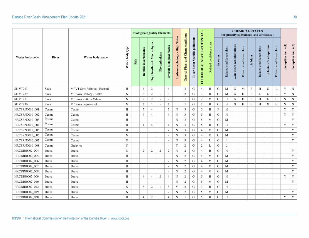
Danube River Basin Management Plan Update 2021 30
ICPDR / International Commission for the Protection of the Danube River / www.icpdr.org
Water body code River Water body name
Wa
ter
bo
dy
ty
pe
Biological Quality Elements
Hy
dro
mo
rph
olo
gy -
Hig
h S
tatu
s
Gen
era
l P
hy
s. a
nd
Ch
em. co
nd
itio
ns
Riv
er B
asi
n S
pec
ific
po
llu
tan
ts
EC
OL
OG
ICA
L S
TA
TU
S/P
OT
EN
TIA
L
Rel
ated
con
fide
nce
clas
s
CHEMICAL STATUS
for priority substances (and confidence)
Exem
pti
on
Art
. 4
(4)
Exem
pti
on
Art
. 4
(5)
Fis
h
Ben
thic
in
ver
teb
rate
s
Ph
yto
ben
tho
s &
Ma
cro
ph
yte
s
Ph
yto
pla
nk
ton
Ov
erall
Bio
logic
al
Sta
tus
…in
wat
er
Rel
ated
con
fide
nce
clas
s
…in
wat
er w
/o u
biqu
itous
Rel
ated
con
fide
nce
clas
s
…in
bio
ta
Rel
ated
con
fide
nce
clas
s
…in
bio
ta w
/o u
biqu
itous
Rel
ated
con
fide
nce
clas
s
SI1VT713 Sava MPVT Sava Vrhovo - Boštanj H 4 2 - 4 2 G 4 H G M G M F H G L Y N
SI1VT739 Sava VT Sava Boštanj - Krško N 3 2 - 3 2 G 3 H G M G H F L G L Y N
SI1VT913 Sava VT Sava Krško - Vrbina N 2 2 - 2 1 G 2 M G H G H F H G H N N
SI1VT930 Sava VT Sava mejni odsek N 2 1 - 2 1 G 2 H G H G H F H G H N N
HRCSRN0010_001 Česma Česma H 5 4 5 N 3 G 5 H F H Y Y
HRCSRN0010_002 Česma Česma H 4 4 4 N 3 G 5 H G H Y Y
HRCSRN0010_003 Česma Česma H - N 3 G 5 M G M Y
HRCSRN0010_004 Česma Česma H 4 4 4 N 3 G 5 H G H Y Y
HRCSRN0010_005 Česma Česma H - N 3 G 4 M G M Y
HRCSRN0010_006 Česma Česma N - N 3 G 4 M G M Y
HRCSRN0010_007 Česma Česma N - N 3 G 4 L G L Y
HRCSRN0010_008 Česma Grđevica N - Y 2 G 2 L G L - -
HRCDRI0002_004 Drava Drava N 2 2 2 2 N 2 G 4 H G H Y
HRCDRI0002_005 Drava Drava H - N 2 G 4 M G M Y
HRCDRI0002_006 Drava Drava H - N 2 G 4 M G M Y
HRCDRI0002_007 Drava Drava H - N 2 G 4 M G M Y
HRCDRI0002_008 Drava Drava H - N 2 G 4 M G M Y
HRCDRI0002_009 Drava Drava H 4 4 2 4 N 2 G 5 H G H Y Y
HRCDRI0002_010 Drava Drava H - N 2 G 5 M G M Y
HRCDRI0002_012 Drava Drava N 3 2 1 3 Y 2 G 3 H G H
HRCDRI0002_019 Drava Drava N - N 2 G 5 M G M Y
HRCDRI0002_020 Drava Drava H 4 2 4 N 1 G 5 H G H Y Y

Danube River Basin Management Plan Update 2021 31
ICPDR / International Commission for the Protection of the Danube River / www.icpdr.org
Water body code River Water body name
Wa
ter
bo
dy
ty
pe
Biological Quality Elements
Hy
dro
mo
rph
olo
gy -
Hig
h S
tatu
s
Gen
era
l P
hy
s. a
nd
Ch
em. co
nd
itio
ns
Riv
er B
asi
n S
pec
ific
po
llu
tan
ts
EC
OL
OG
ICA
L S
TA
TU
S/P
OT
EN
TIA
L
Rel
ated
con
fide
nce
clas
s
CHEMICAL STATUS
for priority substances (and confidence)
Exem
pti
on
Art
. 4
(4)
Exem
pti
on
Art
. 4
(5)
Fis
h
Ben
thic
in
ver
teb
rate
s
Ph
yto
ben
tho
s &
Ma
cro
ph
yte
s
Ph
yto
pla
nk
ton
Ov
erall
Bio
logic
al
Sta
tus
…in
wat
er
Rel
ated
con
fide
nce
clas
s
…in
wat
er w
/o u
biqu
itous
Rel
ated
con
fide
nce
clas
s
…in
bio
ta
Rel
ated
con
fide
nce
clas
s
…in
bio
ta w
/o u
biqu
itous
Rel
ated
con
fide
nce
clas
s
HRCDRI0002_021 Drava Drava N - Y 2 G 2 M G M - -
HRCDRI0002_022 Drava Drava A - Y 2 G 2 M G M
HRCDRN0002_001 Drava Drava H 3 2 3 3 N 2 G 4 H G H Y Y
HRCDRN0002_002 Drava Drava H - N 2 G 4 M G M Y
HRCDRN0002_003 Drava Drava N 2 2 2 N 2 G 5 H G H Y
HRCDRN0002_011 Drava Drava H - N 2 G 4 M G M Y
HRCDRN0002_013 Drava Drava N 3 2 3 N 1 G 3 H G H
HRCDRN0002_014 Drava Drava N - N 2 G 5 M G M Y
HRCDRN0002_015 Drava Drava H - N 1 G 5 M G M Y
HRCDRN0002_016 Drava Drava N - N 2 G 5 L G L Y
HRCDRN0002_017 Drava Drava H 4 3 4 N 1 G 5 L G L Y Y
HRCDRN0002_018 Drava Drava N - N 3 G 5 M F M Y Y
HRCSRN0007_003 Kanal Lonja-Strug, Lonja
Lonja Trebež N - N 3 G 4 M G M Y
HRCSRI0004_012 Kupa Kupa N 2 2 2 Y 2 G 2 H G H - -
HRCSRI0004_013 Kupa Kupa N - Y 2 G 2 M G M - -
HRCSRI0004_014 Kupa Kupa N 3 1 3 N 1 G 3 H G M Y Y
HRCSRI0004_015 Kupa Kupa N - N 1 G 3 M G M Y
HRCSRI0004_016 Kupa Kupa N 2 2 2 Y 1 G 2 H G M - -
HRCSRI0004_017 Kupa Kupa N 2 2 2 N 1 G 2 H G H - -
HRCSRN0004_001 Kupa Kupa N 5 2 5 N 2 G 5 H G H
HRCSRN0004_002 Kupa Kupa N 4 4 4 Y 2 G 4 M G H
HRCSRN0004_003 Kupa Kupa N 4 2 4 Y 2 G 4 H G M

Danube River Basin Management Plan Update 2021 32
ICPDR / International Commission for the Protection of the Danube River / www.icpdr.org
Water body code River Water body name
Wa
ter
bo
dy
ty
pe
Biological Quality Elements
Hy
dro
mo
rph
olo
gy -
Hig
h S
tatu
s
Gen
era
l P
hy
s. a
nd
Ch
em. co
nd
itio
ns
Riv
er B
asi
n S
pec
ific
po
llu
tan
ts
EC
OL
OG
ICA
L S
TA
TU
S/P
OT
EN
TIA
L
Rel
ated
con
fide
nce
clas
s
CHEMICAL STATUS
for priority substances (and confidence)
Exem
pti
on
Art
. 4
(4)
Exem
pti
on
Art
. 4
(5)
Fis
h
Ben
thic
in
ver
teb
rate
s
Ph
yto
ben
tho
s &
Ma
cro
ph
yte
s
Ph
yto
pla
nk
ton
Ov
erall
Bio
logic
al
Sta
tus
…in
wat
er
Rel
ated
con
fide
nce
clas
s
…in
wat
er w
/o u
biqu
itous
Rel
ated
con
fide
nce
clas
s
…in
bio
ta
Rel
ated
con
fide
nce
clas
s
…in
bio
ta w
/o u
biqu
itous
Rel
ated
con
fide
nce
clas
s
HRCSRN0004_004 Kupa Kupa N 5 2 5 Y 2 G 5 H G M
HRCSRN0004_005 Kupa Kupa N - N 2 G 2 M G M - -
HRCSRN0004_006 Kupa Kupa N 3 2 3 Y 2 G 3 M G H
HRCSRN0004_007 Kupa Kupa N 3 2 3 N 2 G 3 H G H
HRCSRN0004_008 Kupa Kupa N 3 2 3 Y 1 G 3 H G M
HRCSRN0004_009 Kupa Kupa N - Y 2 G 2 M G M - -
HRCSRN0004_010 Kupa Kupa H - N 2 G 3 M G M Y
HRCSRN0004_011 Kupa Kupa N 2 2 2 Y 2 G 2 M G M - -
HRCSRN0004_018 Kupa Kupa N 2 2 2 N 1 G 2 H G H - -
HRCSRN0007_001 Lonja Lonja Trebež N - N 3 F 4 M F H Y
HRCSRN0007_002 Lonja Lonja Trebež N - N 3 G 4 M F M Y
HRCDRI0003_001 Mura Mura H - N 2 G 3 M G M Y
HRCDRI0003_002 Mura Mura H 3 2 1 3 N 2 G 3 H G H Y Y
HRCDRI0003_003 Mura Mura N - N 2 G 2 M G M - -
HRCSRI0001_001 Sava Sava H 3 3 3 N 2 G 4 H G H Y Y
HRCSRI0001_002 Sava Sava N 2 2 2 2 N 2 G 5 H G H Y
HRCSRI0001_003 Sava Sava N 2 2 2 N 2 G 5 H G H Y
HRCSRI0001_004 Sava Sava H - N 2 G 5 M G M Y
HRCSRI0001_005 Sava Sava N 2 2 2 N 2 G 4 H G H Y
HRCSRI0001_006 Sava Sava H - N 2 G 5 M G M Y
HRCSRI0001_007 Sava Sava N 2 2 2 N 2 G 5 H G H Y
HRCSRI0001_008 Sava Sava H - N 2 G 5 M G M Y

Danube River Basin Management Plan Update 2021 33
ICPDR / International Commission for the Protection of the Danube River / www.icpdr.org
Water body code River Water body name
Wa
ter
bo
dy
ty
pe
Biological Quality Elements
Hy
dro
mo
rph
olo
gy -
Hig
h S
tatu
s
Gen
era
l P
hy
s. a
nd
Ch
em. co
nd
itio
ns
Riv
er B
asi
n S
pec
ific
po
llu
tan
ts
EC
OL
OG
ICA
L S
TA
TU
S/P
OT
EN
TIA
L
Rel
ated
con
fide
nce
clas
s
CHEMICAL STATUS
for priority substances (and confidence)
Exem
pti
on
Art
. 4
(4)
Exem
pti
on
Art
. 4
(5)
Fis
h
Ben
thic
in
ver
teb
rate
s
Ph
yto
ben
tho
s &
Ma
cro
ph
yte
s
Ph
yto
pla
nk
ton
Ov
erall
Bio
logic
al
Sta
tus
…in
wat
er
Rel
ated
con
fide
nce
clas
s
…in
wat
er w
/o u
biqu
itous
Rel
ated
con
fide
nce
clas
s
…in
bio
ta
Rel
ated
con
fide
nce
clas
s
…in
bio
ta w
/o u
biqu
itous
Rel
ated
con
fide
nce
clas
s
HRCSRI0001_009 Sava Sava H 3 3 3 N 2 G 4 H G M Y Y
HRCSRI0001_010 Sava Sava H - N 2 G 5 M G M Y
HRCSRI0001_011 Sava Sava H 3 2 2 3 N 2 G 4 H G M Y Y
HRCSRI0001_021 Sava Sava N 2 2 2 Y 2 G 2 H G H - -
HRCSRN0001_012 Sava Sava N 2 2 2 2 N 2 G 4 H G H Y
HRCSRN0001_013 Sava Sava H - N 2 G 5 M F M Y
HRCSRN0001_014 Sava Sava H 2 3 3 N 2 G 4 H G H Y Y
HRCSRN0001_015 Sava Sava H 3 3 3 N 2 G 5 H G H Y Y
HRCSRN0001_016 Sava Sava H - N 2 G 5 M G M Y
HRCSRN0001_017 Sava Sava H - N 2 G 5 M G M Y
HRCSRN0001_018 Sava Sava H 4 2 4 N 2 G 4 H G H Y Y
HRCSRN0001_019 Sava Sava N 2 3 3 N 2 G 3 H G H
HRCSRN0001_020 Sava Sava N - N 2 G 2 M G M - -
HRCSRI0005_001 Una Una N 3 2 3 N 2 G 3 H G H Y Y
HRCSRI0005_002 Una Una N 3 2 3 Y 2 G 3 H G M
HRCSRI0005_003 Una Una N 4 2 4 Y 2 G 4 H G M
HRCSRI0005_004 Una Una N - Y 2 G 2 M G L - -
HRCSRI0005_005 Una Una N - Y 1 G 1 L G L - -
HRCSRI0005_006 Una Una N - Y 1 G 2 M G M - -
HRCSRN0005_007 Una Una N 2 2 2 Y 1 G 2 H G H - -
BABOS_1B Bosna BA_BOS_1B N - N 1 N
BABOS_2B Bosna BA_BOS_2B N - N 5 3 F N

Danube River Basin Management Plan Update 2021 34
ICPDR / International Commission for the Protection of the Danube River / www.icpdr.org
Water body code River Water body name
Wa
ter
bo
dy
ty
pe
Biological Quality Elements
Hy
dro
mo
rph
olo
gy -
Hig
h S
tatu
s
Gen
era
l P
hy
s. a
nd
Ch
em. co
nd
itio
ns
Riv
er B
asi
n S
pec
ific
po
llu
tan
ts
EC
OL
OG
ICA
L S
TA
TU
S/P
OT
EN
TIA
L
Rel
ated
con
fide
nce
clas
s
CHEMICAL STATUS
for priority substances (and confidence)
Exem
pti
on
Art
. 4
(4)
Exem
pti
on
Art
. 4
(5)
Fis
h
Ben
thic
in
ver
teb
rate
s
Ph
yto
ben
tho
s &
Ma
cro
ph
yte
s
Ph
yto
pla
nk
ton
Ov
erall
Bio
logic
al
Sta
tus
…in
wat
er
Rel
ated
con
fide
nce
clas
s
…in
wat
er w
/o u
biqu
itous
Rel
ated
con
fide
nce
clas
s
…in
bio
ta
Rel
ated
con
fide
nce
clas
s
…in
bio
ta w
/o u
biqu
itous
Rel
ated
con
fide
nce
clas
s
BABOS_3 Bosna BA_BOS_3 N - N 5 3 F N
BABOS_4 Bosna BA_BOS_4 N - N 5 4 F N
BABOS_5 Bosna BA_BOS_5 N - N 4 4 G N
BABOS_6 Bosna BA_BOS_6 N - N 5 5 F N
BABOS_7 Bosna BA_BOS_7 N - N 5 2 F N
BADR_5B Drina BA_DR_5B P - N 5 G Y
BADR_6 Drina BA_DR_6 N - N 5 2 F N
BAUNA_SAN_2C Sana BA_UNA_SAN_2C N - N 2 2 G N
BAUNA_SAN_3 Sana BA_UNA_SAN_3 N - Y 2 2 G N
BAUNA_SAN_4A Sana BA_UNA_SAN_4A N - N 2 2 G N
BASA_1C Sava BA_SA_1C P - N 5 F Y
BASA_2A Sava BA_SA_2A H - N 5 G Y
BAUNA_2C Una BA_UNA_2C N - N 2 2 G N
BAUNA_3 Una BA_UNA_3 P - N 3 G Y
BAUNA_4 Una BA_UNA_4 N - Y 2 2 G N
BAVRB_4B Vrbas BA_VRB_4B H - N 5 G Y
BAVRB_5 Vrbas BA_VRB_5 H - N 5 F Y
BAVRB_6 Vrbas BA_VRB_6 N - N 5 2 F N
BAVRB_7 Vrbas BA_VRB_7 N - N 5 2 F N
BAVRB_8 Vrbas BA_VRB_8 N - N 4 4 G N
MEIBAR_1 Ibar Ibar N
MEIBAR_2 Ibar Ibar N

Danube River Basin Management Plan Update 2021 35
ICPDR / International Commission for the Protection of the Danube River / www.icpdr.org
Water body code River Water body name
Wa
ter
bo
dy
ty
pe
Biological Quality Elements
Hy
dro
mo
rph
olo
gy -
Hig
h S
tatu
s
Gen
era
l P
hy
s. a
nd
Ch
em. co
nd
itio
ns
Riv
er B
asi
n S
pec
ific
po
llu
tan
ts
EC
OL
OG
ICA
L S
TA
TU
S/P
OT
EN
TIA
L
Rel
ated
con
fide
nce
clas
s
CHEMICAL STATUS
for priority substances (and confidence)
Exem
pti
on
Art
. 4
(4)
Exem
pti
on
Art
. 4
(5)
Fis
h
Ben
thic
in
ver
teb
rate
s
Ph
yto
ben
tho
s &
Ma
cro
ph
yte
s
Ph
yto
pla
nk
ton
Ov
erall
Bio
logic
al
Sta
tus
…in
wat
er
Rel
ated
con
fide
nce
clas
s
…in
wat
er w
/o u
biqu
itous
Rel
ated
con
fide
nce
clas
s
…in
bio
ta
Rel
ated
con
fide
nce
clas
s
…in
bio
ta w
/o u
biqu
itous
Rel
ated
con
fide
nce
clas
s
MELIM_1 Lim Lim N
MELIM_2 Lim Lim N
MEPIV_1 Piva Piva N
MEPIV_2 Piva Piva P
METAR_1 Tara Tara N
METAR_2 Tara Tara N
RSBEG Begej Begej od DTD Banatska Palanka-Novi Bečej do Tise
H 4 4 4 5 F 4 M F H
RSDR_1_A Drina Drina od ušća u Savu do ušća Lešnice P 3 2 3 2 F 3 M G H
RSDR_1_B Drina Drina od ušća Lešnice do ušća reke Radalj
P 3 3 3 2 G 3 M G L
RSDR_1_C Drina Drina od ušća reke Radalj do brane HE Zvornik
P 4 3 4 2 G 4 M G L
RSDR_2 Drina Akumulacija Zvornik P 4 4 3 4 2 G 4 M G L
RSDR_3_A Drina Drina od akumulacije Zvornik do ušća Ljuboviđe
N 3 2 - 3 2 G 3 M G L
RSDR_3_B Drina Drina od ušća Ljuboviđe do ušća Rogačice
N 2 2 - 2 2 G 2 M G L
RSDR_3_C Drina Drina od ušća Rogačice do brane HE Bajina Bašta
P 4 2 - 4 2 F 4 M F H
RSDR_4 Drina Akumulacija Bajina Bašta do Državne granice
P 4 4 3 4 2 G 4 M G L
RSCAN_BP-KAR_1
DTD kanal Bački Petrovac-Karavukovo
DTD kanal Bački Petrovac-Karavukovo od triangla Bački Petrovac do uliva kanala Drže
A 4 3 4 2 G 4 L F L
RSCAN_BP-KAR_2
DTD kanal Bački Petrovac-Karavukovo
DTD kanal Bački Petrovac-Karavukovo od kanala Drža do triangla Karavukovo
A 4 3 4 4 F 4 L F H
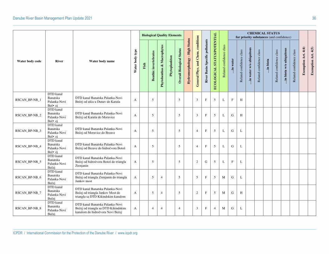
Danube River Basin Management Plan Update 2021 36
ICPDR / International Commission for the Protection of the Danube River / www.icpdr.org
Water body code River Water body name
Wa
ter
bo
dy
ty
pe
Biological Quality Elements
Hy
dro
mo
rph
olo
gy -
Hig
h S
tatu
s
Gen
era
l P
hy
s. a
nd
Ch
em. co
nd
itio
ns
Riv
er B
asi
n S
pec
ific
po
llu
tan
ts
EC
OL
OG
ICA
L S
TA
TU
S/P
OT
EN
TIA
L
Rel
ated
con
fide
nce
clas
s
CHEMICAL STATUS
for priority substances (and confidence)
Exem
pti
on
Art
. 4
(4)
Exem
pti
on
Art
. 4
(5)
Fis
h
Ben
thic
in
ver
teb
rate
s
Ph
yto
ben
tho
s &
Ma
cro
ph
yte
s
Ph
yto
pla
nk
ton
Ov
erall
Bio
logic
al
Sta
tus
…in
wat
er
Rel
ated
con
fide
nce
clas
s
…in
wat
er w
/o u
biqu
itous
Rel
ated
con
fide
nce
clas
s
…in
bio
ta
Rel
ated
con
fide
nce
clas
s
…in
bio
ta w
/o u
biqu
itous
Rel
ated
con
fide
nce
clas
s
RSCAN_BP-NB_1
DTD kanal Banatska Palanka-Novi Beč• ej
DTD kanal Banatska Palanka-Novi Bečej od ušća u Dunav do Karaša
A 5 5 3 F 5 L F H
RSCAN_BP-NB_2
DTD kanal Banatska Palanka-Novi Beč• ej
DTD kanal Banatska Palanka-Novi Bečej od Karaša do Moravice
A 5 5 3 F 5 L G H
RSCAN_BP-NB_3
DTD kanal Banatska Palanka-Novi Beč• ej
DTD kanal Banatska Palanka-Novi Bečej od Moravice do Brzave
A 5 5 4 F 5 L G L
RSCAN_BP-NB_4
DTD kanal Banatska Palanka-Novi Beč• ej
DTD kanal Banatska Palanka-Novi Bečej od Brzave do hidročvora Botoš
A 5 5 4 F 5 L G L
RSCAN_BP-NB_5
DTD kanal Banatska Palanka-Novi Bečej
DTD kanal Banatska Palanka-Novi Bečej od hidročvora Botoš do triangla Zrenjanin
A 5 5 2 G 5 L F L
RSCAN_BP-NB_6
DTD kanal Banatska Palanka-Novi Bečej
DTD kanal Banatska Palanka-Novi Bečej od triangla Zrenjanin do triangla Jankov most
A 5 4 5 5 F 5 M G L
RSCAN_BP-NB_7
DTD kanal Banatska Palanka-Novi Bečej
DTD kanal Banatska Palanka-Novi Bečej od triangla Jankov Most do triangla sa DTD Kikindskim kanalom
A 5 4 5 2 F 5 M G H
RSCAN_BP-NB_8
DTD kanal Banatska Palanka-Novi Bečej
DTD kanal Banatska Palanka-Novi Bečej od triangla sa DTD Kikindskim kanalom do hidročvora Novi Bečej
A 4 4 4 3 F 4 M G L
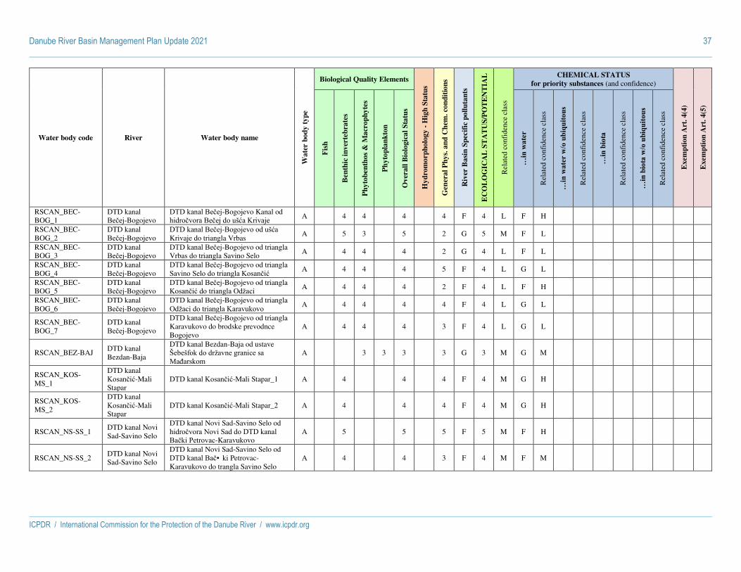
Danube River Basin Management Plan Update 2021 37
ICPDR / International Commission for the Protection of the Danube River / www.icpdr.org
Water body code River Water body name
Wa
ter
bo
dy
ty
pe
Biological Quality Elements
Hy
dro
mo
rph
olo
gy -
Hig
h S
tatu
s
Gen
era
l P
hy
s. a
nd
Ch
em. co
nd
itio
ns
Riv
er B
asi
n S
pec
ific
po
llu
tan
ts
EC
OL
OG
ICA
L S
TA
TU
S/P
OT
EN
TIA
L
Rel
ated
con
fide
nce
clas
s
CHEMICAL STATUS
for priority substances (and confidence)
Exem
pti
on
Art
. 4
(4)
Exem
pti
on
Art
. 4
(5)
Fis
h
Ben
thic
in
ver
teb
rate
s
Ph
yto
ben
tho
s &
Ma
cro
ph
yte
s
Ph
yto
pla
nk
ton
Ov
erall
Bio
logic
al
Sta
tus
…in
wat
er
Rel
ated
con
fide
nce
clas
s
…in
wat
er w
/o u
biqu
itous
Rel
ated
con
fide
nce
clas
s
…in
bio
ta
Rel
ated
con
fide
nce
clas
s
…in
bio
ta w
/o u
biqu
itous
Rel
ated
con
fide
nce
clas
s
RSCAN_BEC-BOG_1
DTD kanal Bečej-Bogojevo
DTD kanal Bečej-Bogojevo Kanal od hidročvora Bečej do ušća Krivaje
A 4 4 4 4 F 4 L F H
RSCAN_BEC-BOG_2
DTD kanal Bečej-Bogojevo
DTD kanal Bečej-Bogojevo od ušća Krivaje do triangla Vrbas
A 5 3 5 2 G 5 M F L
RSCAN_BEC-BOG_3
DTD kanal Bečej-Bogojevo
DTD kanal Bečej-Bogojevo od triangla Vrbas do triangla Savino Selo
A 4 4 4 2 G 4 L F L
RSCAN_BEC-BOG_4
DTD kanal Bečej-Bogojevo
DTD kanal Bečej-Bogojevo od triangla Savino Selo do triangla Kosančić
A 4 4 4 5 F 4 L G L
RSCAN_BEC-BOG_5
DTD kanal Bečej-Bogojevo
DTD kanal Bečej-Bogojevo od triangla Kosančić do triangla Odžaci A 4 4 4 2 F 4 L F H
RSCAN_BEC-BOG_6
DTD kanal Bečej-Bogojevo
DTD kanal Bečej-Bogojevo od triangla Odžaci do triangla Karavukovo
A 4 4 4 4 F 4 L G L
RSCAN_BEC-BOG_7
DTD kanal Bečej-Bogojevo
DTD kanal Bečej-Bogojevo od triangla Karavukovo do brodske prevodnce Bogojevo
A 4 4 4 3 F 4 L G L
RSCAN_BEZ-BAJ DTD kanal Bezdan-Baja
DTD kanal Bezdan-Baja od ustave Šebešfok do državne granice sa Mađarskom
A 3 3 3 3 G 3 M G M
RSCAN_KOS-MS_1
DTD kanal Kosančić-Mali Stapar
DTD kanal Kosančić-Mali Stapar_1 A 4 4 4 F 4 M G H
RSCAN_KOS-MS_2
DTD kanal Kosančić-Mali Stapar
DTD kanal Kosančić-Mali Stapar_2 A 4 4 4 F 4 M G H
RSCAN_NS-SS_1 DTD kanal Novi Sad-Savino Selo
DTD kanal Novi Sad-Savino Selo od hidročvora Novi Sad do DTD kanal Bački Petrovac-Karavukovo
A 5 5 5 F 5 M F H
RSCAN_NS-SS_2 DTD kanal Novi Sad-Savino Selo
DTD kanal Novi Sad-Savino Selo od DTD kanal Bač• ki Petrovac-Karavukovo do trangla Savino Selo
A 4 4 3 F 4 M F M

Danube River Basin Management Plan Update 2021 38
ICPDR / International Commission for the Protection of the Danube River / www.icpdr.org
Water body code River Water body name
Wa
ter
bo
dy
ty
pe
Biological Quality Elements
Hy
dro
mo
rph
olo
gy -
Hig
h S
tatu
s
Gen
era
l P
hy
s. a
nd
Ch
em. co
nd
itio
ns
Riv
er B
asi
n S
pec
ific
po
llu
tan
ts
EC
OL
OG
ICA
L S
TA
TU
S/P
OT
EN
TIA
L
Rel
ated
con
fide
nce
clas
s
CHEMICAL STATUS
for priority substances (and confidence)
Exem
pti
on
Art
. 4
(4)
Exem
pti
on
Art
. 4
(5)
Fis
h
Ben
thic
in
ver
teb
rate
s
Ph
yto
ben
tho
s &
Ma
cro
ph
yte
s
Ph
yto
pla
nk
ton
Ov
erall
Bio
logic
al
Sta
tus
…in
wat
er
Rel
ated
con
fide
nce
clas
s
…in
wat
er w
/o u
biqu
itous
Rel
ated
con
fide
nce
clas
s
…in
bio
ta
Rel
ated
con
fide
nce
clas
s
…in
bio
ta w
/o u
biqu
itous
Rel
ated
con
fide
nce
clas
s
RSCAN_ODZ-SO_1
DTD kanal Odžaci-Sombor
DTD kanal Odžaci-Sombor od triangla Odžaci do triangla Prigrevica
A 5 5 2 F 5 L F H
RSCAN_ODZ-SO_2
DTD kanal Odžaci-Sombor
DTD kanal Odžaci-Sombor od triangla Prigrevica do uliva Mostonge
A 5 3 5 2 G 5 M F L
RSCAN_PR-BEZ DTD kanal Prigrevica-Bezdan
DTD kanal Prigrevica-Bezdan A 5 3 5 2 G 5 L F L
RSCAN_VR-BEZ_1
DTD kanal Vrbas-Bezdan
DTD kanal Vrbas-Bezdan od triangla Vrbas do hidročvora Vrbas
A 5 3 5 5 F 5 M G M
RSCAN_VR-BEZ_2
DTD kanal Vrbas-Bezdan
DTD kanal Vrbas-Bezdan od hidročvora Vrbas do triangla Mali Stapar
A 5 3 5 2 G 5 L F L
RSCAN_VR-BEZ_3
DTD kanal Vrbas-Bezdan
DTD kanal Vrbas-Bezdan od triangla MalI Stapar do uliva Glavni kanal 221
A 5 3 5 4 F 5 L G L
RSCAN_VR-BEZ_4
DTD kanal Vrbas-Bezdan
DTD kanal Vrbas-Bezdan od uliva Glavni Kanal 221 do triangla Sombor
A 5 3 5 2 G 5 L F L
RSCAN_VR-BEZ_5
DTD kanal Vrbas-Bezdan
DTD kanal Vrbas-Bezdan od triangla Sombor do brodske prevodnice Bezdan
A 5 3 5 3 G 5 L F H
RSCAN_KIK_1 DTD Kikindski kanal
DTD Kikindski kanal od triangla Kanal Banatska Palanka-Novi Bečej do uliva Šećeranskog kanala
A - 4 F 4 L G L
RSCAN_KIK_2 DTD Kikindski kanal
DTD Kikindski kanal od uliva Šećeranskog kanala do Zlatice
A - 4 F 5 L F H
RSIB_1 Ibar Ibar od ušća u Zapadnu Moravu do Mataruga
N 2 - 2 3 F 2 M F H
RSIB_2 Ibar Ibar od Mataruga do ušća Jošanice N 2 - 2 3 F 2 M G H
RSIB_3_A Ibar Ibar od ušća Jošanice do ušća Bervenice
N 3 - 3 5 F 3 M G M
RSIB_3_B Ibar Ibar od ušća Bervenice do ušća Kaznovske
N 3 - 3 4 F 3 L F H
RSIB_3_C Ibar Ibar od ušća Kaznovske do ušća Sitnice N 3 - 3 5 F 3 L G L

Danube River Basin Management Plan Update 2021 39
ICPDR / International Commission for the Protection of the Danube River / www.icpdr.org
Water body code River Water body name
Wa
ter
bo
dy
ty
pe
Biological Quality Elements
Hy
dro
mo
rph
olo
gy -
Hig
h S
tatu
s
Gen
era
l P
hy
s. a
nd
Ch
em. co
nd
itio
ns
Riv
er B
asi
n S
pec
ific
po
llu
tan
ts
EC
OL
OG
ICA
L S
TA
TU
S/P
OT
EN
TIA
L
Rel
ated
con
fide
nce
clas
s
CHEMICAL STATUS
for priority substances (and confidence)
Exem
pti
on
Art
. 4
(4)
Exem
pti
on
Art
. 4
(5)
Fis
h
Ben
thic
in
ver
teb
rate
s
Ph
yto
ben
tho
s &
Ma
cro
ph
yte
s
Ph
yto
pla
nk
ton
Ov
erall
Bio
logic
al
Sta
tus
…in
wat
er
Rel
ated
con
fide
nce
clas
s
…in
wat
er w
/o u
biqu
itous
Rel
ated
con
fide
nce
clas
s
…in
bio
ta
Rel
ated
con
fide
nce
clas
s
…in
bio
ta w
/o u
biqu
itous
Rel
ated
con
fide
nce
clas
s
RSIB_4 Ibar Ibar od ušća Sitnice do brane Pridvorica
N - - 2 G 2 L G L
RSIB_5_A Ibar Akumulacija Pridvorica P 3 3 2 G 3 L G L
RSIB_5_B Ibar Akumulacija Gazivode P 3 3 4 G 3 L G L
RSIB_6 Ibar Ibar uzvodno od akumulacije Gazivode do Državne granice
N - - 3 F 2 M G H
RSJMOR_1 Južna Morava Južna Morava od sastava sa Z. Moravom do ušća Ribarske reke
N 4 - 4 3 F 4 M F H
RSJMOR_2_A1 Južna Morava Južna Morava od ušća Ribarske reke do ušća Moravice
N 4 - 4 4 F 4 M G L
RSJMOR_2_A2 Južna Morava Južna Morava od ušća Moravice do ušća Katunske reke
N 4 - 4 4 F 4 M G H
RSJMOR_2_B Južna Morava Južna Morava od ušća Katunske reke do ušća Nišave
N 4 - 4 5 F 4 M G L
RSJMOR_3_A Južna Morava Južna Morava od ušća Nišave do ušća Krajkovačke reke
N 3 - 3 2 G 3 M F L
RSJMOR_3_B Južna Morava Južna Morava od ušća Krajkovačke reke do ušća Toplice
N 3 - 3 3 F 3 M G H
RSJMOR_4_A Južna Morava Južna Morava od ušća Toplice do ušća Jablanice
N 4 - 4 3 F 4 M G H
RSJMOR_4_B Južna Morava Južna Morava od ušća Jablanice do ušća Vlasine
N 4 - 4 5 F 4 M G L
RSJMOR_4_C Južna Morava Južna Morava od ušća Vlasine do ušća Kopašničke reke
N 4 - 4 5 F 4 M G L
RSJMOR_5 Južna Morava Južna Morava od ušća Kopašničke reke do ušća Vrle
P 4 - 4 3 F 4 M G H
RSJMOR_6_A Južna Morava Južna Morava od ušća Vrle do ušća Korbevačke reke
P 4 - 4 2 G 4 M F L
RSJMOR_6_B Južna Morava Južna Morava od ušća Korbevačke reke do ušća Trebešinjske
N 4 - 4 2 G 4 M F L

Danube River Basin Management Plan Update 2021 40
ICPDR / International Commission for the Protection of the Danube River / www.icpdr.org
Water body code River Water body name
Wa
ter
bo
dy
ty
pe
Biological Quality Elements
Hy
dro
mo
rph
olo
gy -
Hig
h S
tatu
s
Gen
era
l P
hy
s. a
nd
Ch
em. co
nd
itio
ns
Riv
er B
asi
n S
pec
ific
po
llu
tan
ts
EC
OL
OG
ICA
L S
TA
TU
S/P
OT
EN
TIA
L
Rel
ated
con
fide
nce
clas
s
CHEMICAL STATUS
for priority substances (and confidence)
Exem
pti
on
Art
. 4
(4)
Exem
pti
on
Art
. 4
(5)
Fis
h
Ben
thic
in
ver
teb
rate
s
Ph
yto
ben
tho
s &
Ma
cro
ph
yte
s
Ph
yto
pla
nk
ton
Ov
erall
Bio
logic
al
Sta
tus
…in
wat
er
Rel
ated
con
fide
nce
clas
s
…in
wat
er w
/o u
biqu
itous
Rel
ated
con
fide
nce
clas
s
…in
bio
ta
Rel
ated
con
fide
nce
clas
s
…in
bio
ta w
/o u
biqu
itous
Rel
ated
con
fide
nce
clas
s
RSJMOR_6_C Južna Morava Južna Morava od ušća Trebešinjske do sastava Binačke Morave i Moravice
N 4 - 4 4 F 4 M F H
RSLIM_1 Lim Lim od Državne granice sa BiH do ušća Uvca
N 4 2 - 4 2 G 4 M G L
RSLIM_2 Lim Lim od ušća Uvca do brane HE Potpeć P 4 3 2 4 2 G 4 M G L
RSLIM_3 Lim Akumulacija Potpeć P 4 2 4 2 G 4 M G L
RSLIM_4_A Lim Lim od akumulacije Potpeć do ušća Mileševske
N 3 2 - 3 2 G 3 M G L
RSLIM_4_B Lim Lim od ušća Mileševke do ušća Zebuđe N 2 2 - 2 2 F 2 M F H
RSLIM_4_C Lim Lim od ušća Zebuđe do ušća Slatinske reke
N 2 2 - 2 2 G 2 M G L
RSLIM_4_D Lim Lim od ušća Slatinske reke do Državne granice sa Crnom Gorom
N 3 2 - 3 2 G 3 M G L
RSNIS_1_A Nišava Nišava od ušća u Južnu moravu do ušća Rujničke reke
N 3 2 - 3 4 F 3 M G H
RSNIS_1_B Nišava Nišava od ušća Rujničke reke do ušća Kutinske reke
P 4 4 - 4 3 F 4 M G H
RSNIS_1_C Nišava Nišava od ušća Kutinske reke do ušća Studene
N 4 3 - 4 5 F 4 M G L
RSNIS_2 Nišava Nišava kroz Sićevačku klisuru, od ušća Studene do ušća Crvene reke
P 4 - 4 3 G 4 M G H
RSNIS_3_A Nišava Nišava od ušća Crvene reke do ušća Koritničke reke
N 3 2 - 3 5 F 3 M G L
RSNIS_3_B Nišava Nišava od ušća Koritničke reke do ušća Temštice
N 2 2 - 2 5 F 2 M G L
RSNIS_3_C Nišava Nišava od ušća Temštice do ušća Jerme N 3 3 - 3 2 G 3 M F L
RSNIS_3_D Nišava Nišava od ušća Jerme do ušća Gaberske reke
N 3 2 - 3 2 G 3 M F L
RSNIS_3_E Nišava Nišava od ušća Gaberske reke do Državne granice sa Bugarskom
N 3 2 - 3 2 F 3 M G H

Danube River Basin Management Plan Update 2021 41
ICPDR / International Commission for the Protection of the Danube River / www.icpdr.org
Water body code River Water body name
Wa
ter
bo
dy
ty
pe
Biological Quality Elements
Hy
dro
mo
rph
olo
gy -
Hig
h S
tatu
s
Gen
era
l P
hy
s. a
nd
Ch
em. co
nd
itio
ns
Riv
er B
asi
n S
pec
ific
po
llu
tan
ts
EC
OL
OG
ICA
L S
TA
TU
S/P
OT
EN
TIA
L
Rel
ated
con
fide
nce
clas
s
CHEMICAL STATUS
for priority substances (and confidence)
Exem
pti
on
Art
. 4
(4)
Exem
pti
on
Art
. 4
(5)
Fis
h
Ben
thic
in
ver
teb
rate
s
Ph
yto
ben
tho
s &
Ma
cro
ph
yte
s
Ph
yto
pla
nk
ton
Ov
erall
Bio
logic
al
Sta
tus
…in
wat
er
Rel
ated
con
fide
nce
clas
s
…in
wat
er w
/o u
biqu
itous
Rel
ated
con
fide
nce
clas
s
…in
bio
ta
Rel
ated
con
fide
nce
clas
s
…in
bio
ta w
/o u
biqu
itous
Rel
ated
con
fide
nce
clas
s
RSCAN_PLBEG Plovni Begej DTD Plovni Begej od hidročvora Klek do državne granice sa Rumunijom
A 4 3 4 5 F 4 M F M
RSSA_1 Sava Sava od ušća u Dunav do ušća Kolubare
H 4 3 3 4 4 F 4 M F M
RSSA_2 Sava Sava od ušća Kolubare do STAC Km 74+000
N 3 2 2 3 2 G 3 M G L
RSSA_3 Sava Sava od STAC 74000 do Cerskog obodnog kanala
N 3 2 3 3 2 G 3 M G L
RSSA_4 Sava Sava od ušća Cerskog obodnog kanala do ušća potoka Kamičak
N 3 2 3 3 2 F 3 M G H
RSSA_5 Sava Sava od ušća potoka Kamičak do ušća kanala Manđelos
N 3 3 3 3 2 G 3 M G L
RSSA_6 Sava Sava od ušća kanala Manđelos do ušća Drine
N 3 3 3 3 2 G 3 M G L
RSSA_7 Sava Sava od ušća Drine do državne granice sa Republikom Hrvatskom
N 3 2 2 3 3 F 3 M G H
RSTAM_1 Tamiš Tamiš od ustave Pančevo do ustave Opovo
H 4 4 3 F 4 L F H
RSTAM_2 Tamiš Tamiš od ustave Opovo do ustave Tomaševac
H 4 3 4 2 G 4 L F L
RSTAM_3 Tamiš Tamiš od od ustave Tomaševac do ušća Glavnog kanala (Oređ-Bele Bare-Sutjeska)
H 4 3 4 4 F 3 M G L
RSTAM_4 Tamiš Tamiš od ušća Glavnog kanala (Oređ-Bele Bare-Sutjeska) do ušća glavnog kanala Lanka
H 4 3 4 3 F 3 M G L
RSTAM_5 Tamiš Tamiš od ušća glavnog kanala Lanka do Državne granice sa Rumunijom
H 4 3 4 3 F 3 M F H
RSTIM_1 Timok Timok od ušća u Dunav do Bregova (duž Državne granice) P 4 - 4 3 F 4 M F H

Danube River Basin Management Plan Update 2021 42
ICPDR / International Commission for the Protection of the Danube River / www.icpdr.org
Water body code River Water body name
Wa
ter
bo
dy
ty
pe
Biological Quality Elements
Hy
dro
mo
rph
olo
gy -
Hig
h S
tatu
s
Gen
era
l P
hy
s. a
nd
Ch
em. co
nd
itio
ns
Riv
er B
asi
n S
pec
ific
po
llu
tan
ts
EC
OL
OG
ICA
L S
TA
TU
S/P
OT
EN
TIA
L
Rel
ated
con
fide
nce
clas
s
CHEMICAL STATUS
for priority substances (and confidence)
Exem
pti
on
Art
. 4
(4)
Exem
pti
on
Art
. 4
(5)
Fis
h
Ben
thic
in
ver
teb
rate
s
Ph
yto
ben
tho
s &
Ma
cro
ph
yte
s
Ph
yto
pla
nk
ton
Ov
erall
Bio
logic
al
Sta
tus
…in
wat
er
Rel
ated
con
fide
nce
clas
s
…in
wat
er w
/o u
biqu
itous
Rel
ated
con
fide
nce
clas
s
…in
bio
ta
Rel
ated
con
fide
nce
clas
s
…in
bio
ta w
/o u
biqu
itous
Rel
ated
con
fide
nce
clas
s
RSTIM_2 Timok Timok od Bregova do ušća Tabakovačkog potoka
N 3 - 3 2 G 3 M G L
RSTIM_3 Timok Tabakovačka klisura do ušća Borske reke
P 3 - 3 4 F 3 M F H
RSTIM_4 Timok Timok od ušća Borske reke do sastava Belog i crnog Timoka
N 4 - 4 5 F 4 M G H
RSTIS_1 Tisa Tisa od ušća u Dunav do ušća Jegričke N 3 3 3 3 3 F 3 M F H
RSTIS_2 Tisa Tisa od ušća Jegričke do brane Novi Bečej N 3 3 3 3 2 G 3 M G L
RSTIS_3 Tisa Tisa od brane Novi Bečej do ušća Čika H 3 3 3 3 3 F 3 M F H
RSTIS_4 Tisa Tisa ušća Čika do ušća kanala S-V-0 H 3 3 3 3 2 G 3 M G L
RSTIS_5 Tisa Tisa od ušća kanala S-V-0 do Državne granice sa Mađarskom
H 3 3 3 3 3 F 3 M F H
RSVMOR_1 Velika Morava Velika Morava od ušća u Dunav do Ljubičevskog mosta
P 4 3 4 2 F 4 M F L
RSVMOR_2_A Velika Morava Velika Morava od Ljubičevskog mosta do ušća Jasenice
N 4 3 - 4 3 F 4 M G H
RSVMOR_2_B Velika Morava Velika Morava od ušća Jasenice do ušća Resave
N 4 2 - 4 2 G 3 M G L
RSVMOR_3_A Velika Morava Velika Morava od ušća Resave do ušća Lepenice
N 4 2 - 4 2 G 4 M G L
RSVMOR_3_B Velika Morava Velika Morava od ušća Lepenice do ušća Belice
N 3 2 - 3 4 F 3 M F H
RSVMOR_3_C Velika Morava Velika Morava od ušća Belice do ušća Brestovačkog potoka
N 4 2 - 4 2 G 4 M G L
RSVMOR_3_D Velika Morava Velika Morava od ušća Brestovačkog potoka do ušća Crnice
N 3 2 - 3 3 F 3 M G L
RSVMOR_3_E Velika Morava Velika Morava od ušća Crnice do ušća Jovanovačke reke
N 3 3 - 3 3 F 3 M G L
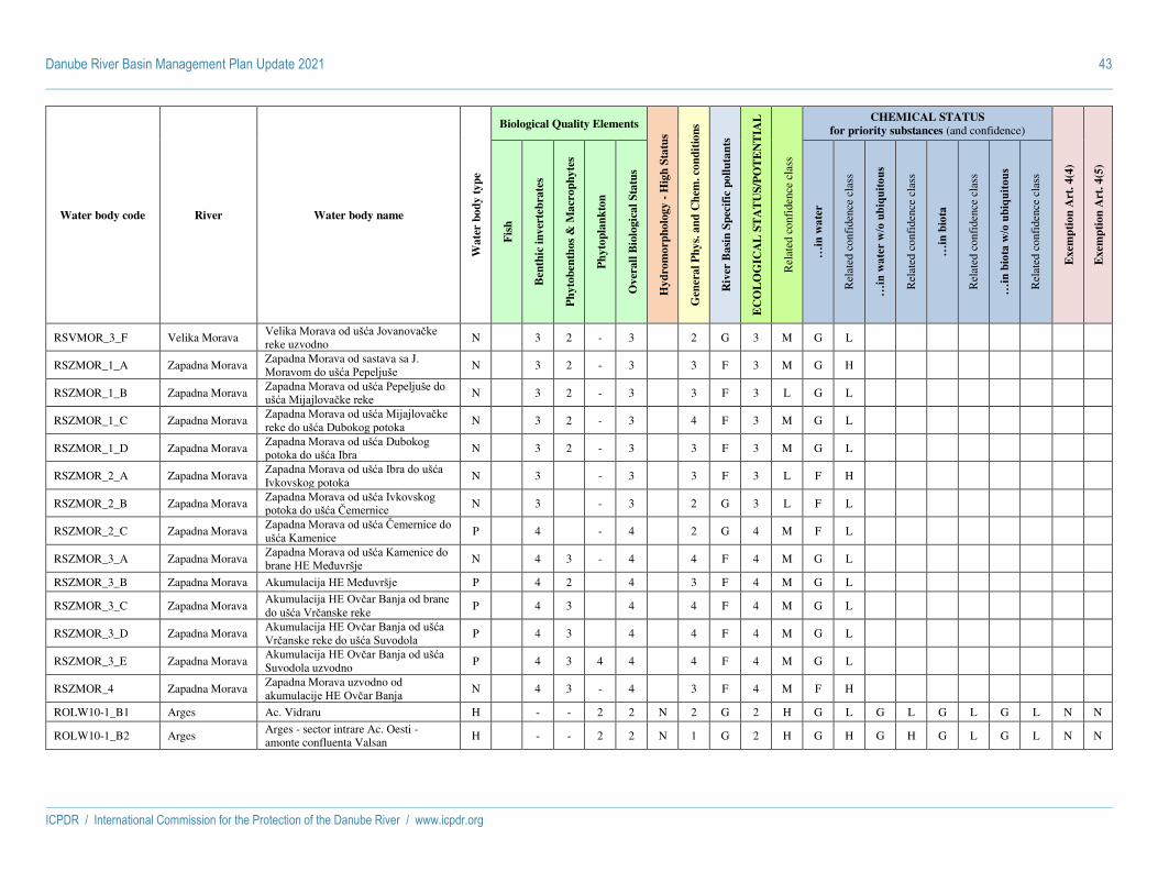
Danube River Basin Management Plan Update 2021 43
ICPDR / International Commission for the Protection of the Danube River / www.icpdr.org
Water body code River Water body name
Wa
ter
bo
dy
ty
pe
Biological Quality Elements
Hy
dro
mo
rph
olo
gy -
Hig
h S
tatu
s
Gen
era
l P
hy
s. a
nd
Ch
em. co
nd
itio
ns
Riv
er B
asi
n S
pec
ific
po
llu
tan
ts
EC
OL
OG
ICA
L S
TA
TU
S/P
OT
EN
TIA
L
Rel
ated
con
fide
nce
clas
s
CHEMICAL STATUS
for priority substances (and confidence)
Exem
pti
on
Art
. 4
(4)
Exem
pti
on
Art
. 4
(5)
Fis
h
Ben
thic
in
ver
teb
rate
s
Ph
yto
ben
tho
s &
Ma
cro
ph
yte
s
Ph
yto
pla
nk
ton
Ov
erall
Bio
logic
al
Sta
tus
…in
wat
er
Rel
ated
con
fide
nce
clas
s
…in
wat
er w
/o u
biqu
itous
Rel
ated
con
fide
nce
clas
s
…in
bio
ta
Rel
ated
con
fide
nce
clas
s
…in
bio
ta w
/o u
biqu
itous
Rel
ated
con
fide
nce
clas
s
RSVMOR_3_F Velika Morava Velika Morava od ušća Jovanovačke reke uzvodno
N 3 2 - 3 2 G 3 M G L
RSZMOR_1_A Zapadna Morava Zapadna Morava od sastava sa J. Moravom do ušća Pepeljuše
N 3 2 - 3 3 F 3 M G H
RSZMOR_1_B Zapadna Morava Zapadna Morava od ušća Pepeljuše do ušća Mijajlovačke reke
N 3 2 - 3 3 F 3 L G L
RSZMOR_1_C Zapadna Morava Zapadna Morava od ušća Mijajlovačke reke do ušća Dubokog potoka
N 3 2 - 3 4 F 3 M G L
RSZMOR_1_D Zapadna Morava Zapadna Morava od ušća Dubokog potoka do ušća Ibra
N 3 2 - 3 3 F 3 M G L
RSZMOR_2_A Zapadna Morava Zapadna Morava od ušća Ibra do ušća Ivkovskog potoka
N 3 - 3 3 F 3 L F H
RSZMOR_2_B Zapadna Morava Zapadna Morava od ušća Ivkovskog potoka do ušća Čemernice
N 3 - 3 2 G 3 L F L
RSZMOR_2_C Zapadna Morava Zapadna Morava od ušća Čemernice do ušća Kamenice
P 4 - 4 2 G 4 M F L
RSZMOR_3_A Zapadna Morava Zapadna Morava od ušća Kamenice do brane HE Međuvršje
N 4 3 - 4 4 F 4 M G L
RSZMOR_3_B Zapadna Morava Akumulacija HE Međuvršje P 4 2 4 3 F 4 M G L
RSZMOR_3_C Zapadna Morava Akumulacija HE Ovčar Banja od brane do ušća Vrčanske reke
P 4 3 4 4 F 4 M G L
RSZMOR_3_D Zapadna Morava Akumulacija HE Ovčar Banja od ušća Vrčanske reke do ušća Suvodola
P 4 3 4 4 F 4 M G L
RSZMOR_3_E Zapadna Morava Akumulacija HE Ovčar Banja od ušća Suvodola uzvodno
P 4 3 4 4 4 F 4 M G L
RSZMOR_4 Zapadna Morava Zapadna Morava uzvodno od akumulacije HE Ovčar Banja
N 4 3 - 4 3 F 4 M F H
ROLW10-1_B1 Arges Ac. Vidraru H - - 2 2 N 2 G 2 H G L G L G L G L N N
ROLW10-1_B2 Arges Arges - sector intrare Ac. Oesti - amonte confluenta Valsan
H - - 2 2 N 1 G 2 H G H G H G L G L N N

Danube River Basin Management Plan Update 2021 44
ICPDR / International Commission for the Protection of the Danube River / www.icpdr.org
Water body code River Water body name
Wa
ter
bo
dy
ty
pe
Biological Quality Elements
Hy
dro
mo
rph
olo
gy -
Hig
h S
tatu
s
Gen
era
l P
hy
s. a
nd
Ch
em. co
nd
itio
ns
Riv
er B
asi
n S
pec
ific
po
llu
tan
ts
EC
OL
OG
ICA
L S
TA
TU
S/P
OT
EN
TIA
L
Rel
ated
con
fide
nce
clas
s
CHEMICAL STATUS
for priority substances (and confidence)
Exem
pti
on
Art
. 4
(4)
Exem
pti
on
Art
. 4
(5)
Fis
h
Ben
thic
in
ver
teb
rate
s
Ph
yto
ben
tho
s &
Ma
cro
ph
yte
s
Ph
yto
pla
nk
ton
Ov
erall
Bio
logic
al
Sta
tus
…in
wat
er
Rel
ated
con
fide
nce
clas
s
…in
wat
er w
/o u
biqu
itous
Rel
ated
con
fide
nce
clas
s
…in
bio
ta
Rel
ated
con
fide
nce
clas
s
…in
bio
ta w
/o u
biqu
itous
Rel
ated
con
fide
nce
clas
s
ROLW10-1_B3 Arges Arges: sector amonte confluenta Valsan - intrare Ac. Prundu(am. confluenta Raul Doamnei)
H - - 2 2 N 1 G 2 H G H G H G L G L N N
ROLW10-1_B4 Arges Arges: sector intrare Ac. Prundu (Pitesti) - aval Ac. Golesti
H - - 3 3 N 3 G 3 H G L G L G L G L
ROLW10-1_B5 Arges Ac. Zavoiul Orbului H - - 2 2 N 2 G 2 H G L G L G L G L N N
ROLW10-1_B7 Arges Ac. Mihailesti H - - 3 3 N 2 G 3 H G L G L G L G L
RORW10-1_B1 Arges Arges: sector izvor - intrare Ac. Vidraru si afluentii
N 3 1 2 - 3 N 1 G 3 H G L G L G L G L
RORW10-1_B2 Arges Arges: sector aval Ac. Vidraru - intrare Ac. Oesti
H 1 1 - 1 N 1 G 2 H G L G L G L G L N N
RORW10-1_B3 Arges Arges: sector aval Ac. Golesti - intrare Ac. Zavoiul Orbului
N 2 1 - 1 2 N 2 G 2 H G L G H G L G L N N
RORW10-1_B4a Arges Arges: sector aval Ac. Zavoiul Orbului - av. Ac. Frontala Ogrezeni
N 2 2 - 1 2 N 2 G 2 H G L G M G L G L N N
RORW10-1_B5 Arges Arges: sector aval Ac. Frontala Ogrezeni - intrare Ac. Mihailesti
N 4 1 - 2 4 N 2 G 4 H G H G H G L G L
RORW10-1_B6 Arges Arges: sector aval Ac. Mihailesti - amonte confluenta Dambovita
H 2 1 - 2 2 N 2 G 2 H F H G H F H G H
RORW10-1_B7 Arges Arges: sector amonte confluenta Dambovita - confluenta Dunare
H 3 2 - 1 3 N 3 G 3 H F H G H F H G H
ROLW3-1-44-33_B4
Barcau Barcau - Ac.Suplacu de Barcau H - - - 2 2 N 3 G 3 H G L G L G
RORW3-1-44-33_B1
Barcau Barcau - izvor - cnf. Toplita + Afluenti N 2 2 - 2 N 2 G 2 M G M G M G N N
RORW3-1-44-33_B2A
Barcau Barcau - cnf. Toplita - cnf. Groapa H 2 - 2 N 2 G 2 H G H G H G N N
RORW3-1-44-33_B3A
Barcau Barcau - cnf. Groapa - am. Ac.Suplacu de Barcau
N 1 - 1 1 N 2 G 2 M G M G M G N N
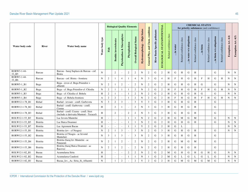
Danube River Basin Management Plan Update 2021 45
ICPDR / International Commission for the Protection of the Danube River / www.icpdr.org
Water body code River Water body name
Wa
ter
bo
dy
ty
pe
Biological Quality Elements
Hy
dro
mo
rph
olo
gy -
Hig
h S
tatu
s
Gen
era
l P
hy
s. a
nd
Ch
em. co
nd
itio
ns
Riv
er B
asi
n S
pec
ific
po
llu
tan
ts
EC
OL
OG
ICA
L S
TA
TU
S/P
OT
EN
TIA
L
Rel
ated
con
fide
nce
clas
s
CHEMICAL STATUS
for priority substances (and confidence)
Exem
pti
on
Art
. 4
(4)
Exem
pti
on
Art
. 4
(5)
Fis
h
Ben
thic
in
ver
teb
rate
s
Ph
yto
ben
tho
s &
Ma
cro
ph
yte
s
Ph
yto
pla
nk
ton
Ov
erall
Bio
logic
al
Sta
tus
…in
wat
er
Rel
ated
con
fide
nce
clas
s
…in
wat
er w
/o u
biqu
itous
Rel
ated
con
fide
nce
clas
s
…in
bio
ta
Rel
ated
con
fide
nce
clas
s
…in
bio
ta w
/o u
biqu
itous
Rel
ated
con
fide
nce
clas
s
RORW3-1-44-33_B5
Barcau Barcau - baraj Suplacu de Barcau - cnf. Bistra
N 2 - 2 2 N 2 G 2 H G H G H G N N
RORW3-1-44-33_B6
Barcau Barcau - cnf. Bistra - frontiera N 2 1 4 1 4 N 3 G 4 H F H G H F H G H N N
RORW5-1_B1 Bega Bega - izvor-cf. Bega Poienilor + afluenti
N 2 1 2 - 2 N 2 G 2 H G H G H G G N N
RORW5-1_B2 Bega Bega - cf. Bega Poienilor-cf. Chizdia N 2 1 1 1 2 N 2 G 2 H F H G H F H G H N N
RORW5-1_B3 Bega Bega - cf. Chizdia-cf. Behela H 2 1 - 1 2 N 2 G 2 H G H G H G G N N
RORW5-1_B4 Bega Bega - cf. Behela-frontiera A 2 2 - 1 2 N 2 G 2 H F H G H F H G H N N
RORW12-1-78_B1 Birlad Barlad - izvoare - confl. Garboveta N 3 2 3 - 3 Y 3 G 3 H G H G H G
RORW12-1-78_B2 Birlad Barlad - confl. Garboveta - confl. Crasna
H 2 1 - 2 N 3 G 3 H G H G H G
RORW12-1-78_B3 Birlad Barlad - confl. Crasna - confl. Siret (include si derivatia Munteni - Tecucel)
H 2 - 2 2 N 3 G 3 H G H G H G
ROLW12-1-53_B3 Bistrita Lac Izvoru Muntelui H - - - 1 1 N 2 G 2 H G M G M G N N
ROLW12-1-53_B5 Bistrita Lac Batca Doamnei H - - - 1 1 N 2 G 2 H G H G H G N N
ROLW12-1-53_B7 Bistrita Lac Agrement Bacau H - - - 1 1 Y 2 G 2 H G L N N
RORW12-1-53_B1 Bistrita Bistrita (izv - cf Neagra) N 2 1 3 - 3 N 2 G 3 H G H G H G N N
RORW12-1-53_B2 Bistrita Bistrita (cf Neagra - ac Izvorul Muntelui)
N 3 1 3 - 3 N 2 G 3 H G H G H G
RORW12-1-53_B4 Bistrita Bistrita (baraj Izv Muntelui - ac Pangarati
N 2 1 2 - 2 N 2 G 2 H G M G M G
RORW12-1-53_B6 Bistrita Bistrita (baraj Batca Doamnei - ac Racova)
N 2 1 2 - 2 N 2 G 2 H G H G H G
ROLW12-1-82_B1 Buzau Acumularea Siriu H - - 2 2 N 2 G 2 M G H G H G H G N N
ROLW12-1-82_B2 Buzau Acumularea Candesti H - - 1 1 N 1 G 2 M G L G L G L G N N
RORW12-1-82_B1 Buzau Buzau_Izv._Ac. Siriu_Si_Afluentii N 1 2 - 2 Y 2 G 2 H G M G M G M G N N

Danube River Basin Management Plan Update 2021 46
ICPDR / International Commission for the Protection of the Danube River / www.icpdr.org
Water body code River Water body name
Wa
ter
bo
dy
ty
pe
Biological Quality Elements
Hy
dro
mo
rph
olo
gy -
Hig
h S
tatu
s
Gen
era
l P
hy
s. a
nd
Ch
em. co
nd
itio
ns
Riv
er B
asi
n S
pec
ific
po
llu
tan
ts
EC
OL
OG
ICA
L S
TA
TU
S/P
OT
EN
TIA
L
Rel
ated
con
fide
nce
clas
s
CHEMICAL STATUS
for priority substances (and confidence)
Exem
pti
on
Art
. 4
(4)
Exem
pti
on
Art
. 4
(5)
Fis
h
Ben
thic
in
ver
teb
rate
s
Ph
yto
ben
tho
s &
Ma
cro
ph
yte
s
Ph
yto
pla
nk
ton
Ov
erall
Bio
logic
al
Sta
tus
…in
wat
er
Rel
ated
con
fide
nce
clas
s
…in
wat
er w
/o u
biqu
itous
Rel
ated
con
fide
nce
clas
s
…in
bio
ta
Rel
ated
con
fide
nce
clas
s
…in
bio
ta w
/o u
biqu
itous
Rel
ated
con
fide
nce
clas
s
RORW12-1-82_B2 Buzau Buzau_Ac. Siriu_Cf. Basca N 1 2 - 2 N 2 G 2 H G M G M G M G N N
RORW12-1-82_B3 Buzau Buzau_Cf. Basca_Ac. Candesti N 1 2 - 2 N 2 G 2 H G H G H G H G N N
RORW12-1-82_B4 Buzau Buzau_Ac. Candesti_Buzau N 2 2 1 2 N 2 G 2 H G M G M G M G N N
RORW12-1-82_B5 Buzau Buzau_Buzau_Cf. Costei N 2 2 1 2 N 2 G 2 H F H G H F H G N N
RORW12-1-82_B6 Buzau Buzau_Cf. Costei_Cf. Siret N 1 1 2 1 2 N 2 G 2 H G H G H G H G N N
RORW15-1-10B_B1
Canalul Dunarea Marea Neagra 1
Canalul Dunarea Marea Neagra 1 A 2 2 N 2 G 2 H G M G M G N N
RORW15-1-10B_B2
Canal Dunare Marea Neagra 2 - Canal Poarta Alba - Marea Neagra
Canalul Dunare Marea Neagra 2 - CPAMN
A 2 2 N 3 G 3 H G H G H G
RORW3-1_B1 Crisul Alb Crisul Alb - izvor - am. Ac.Mihaileni + Afluenti
N 1 2 - 2 N 2 G 2 H G M G M G N N
RORW3-1_B2 Crisul Alb Crisul Alb - Ac.Mihaileni - am. Ac.Mihaileni - baraj Mihaileni + Afluent
N 2 1 - 2 N 3 G 3 H G H G H G N N
RORW3-1_B3 Crisul Alb Crisul Alb - baraj Mihaileni - cnf. Tebea
N 1 2 - 2 N 2 G 2 H G H G H G
RORW3-1_B4 Crisul Alb Crisul Alb - cnf. Tebea - cnf. Zimbru N 1 2 - 2 N 2 G 2 H G H G H G
RORW3-1_B5 Crisul Alb Crisul Alb - cnf. Zimbru - cnf. Chisindia
N 1 2 1 2 N 2 G 2 H G H G H G N N
RORW3-1_B6 Crisul Alb Crisul Alb - cnf. Chisindia - cnf. Cigher N 1 - 1 1 N 2 G 2 H G H G H G N N
RORW3-1_B7 Crisul Alb Crisul Alb - cnf. Cigher - frontiera N 2 2 1 2 N 2 G 2 H G H G H G N N
RORW3-1-42_B1 Crisul Negru Crisul Negru - izvor - cnf. Valea Mare + Afluent
H 2 2 - 2 N 2 G 2 H G H G H G N N
RORW3-1-42_B2 Crisul Negru Crisul Negru - cnf. Valea Mare - cnf. Nimaiesti
N 1 4 - 4 N 2 G 4 H G H G H G

Danube River Basin Management Plan Update 2021 47
ICPDR / International Commission for the Protection of the Danube River / www.icpdr.org
Water body code River Water body name
Wa
ter
bo
dy
ty
pe
Biological Quality Elements
Hy
dro
mo
rph
olo
gy -
Hig
h S
tatu
s
Gen
era
l P
hy
s. a
nd
Ch
em. co
nd
itio
ns
Riv
er B
asi
n S
pec
ific
po
llu
tan
ts
EC
OL
OG
ICA
L S
TA
TU
S/P
OT
EN
TIA
L
Rel
ated
con
fide
nce
clas
s
CHEMICAL STATUS
for priority substances (and confidence)
Exem
pti
on
Art
. 4
(4)
Exem
pti
on
Art
. 4
(5)
Fis
h
Ben
thic
in
ver
teb
rate
s
Ph
yto
ben
tho
s &
Ma
cro
ph
yte
s
Ph
yto
pla
nk
ton
Ov
erall
Bio
logic
al
Sta
tus
…in
wat
er
Rel
ated
con
fide
nce
clas
s
…in
wat
er w
/o u
biqu
itous
Rel
ated
con
fide
nce
clas
s
…in
bio
ta
Rel
ated
con
fide
nce
clas
s
…in
bio
ta w
/o u
biqu
itous
Rel
ated
con
fide
nce
clas
s
RORW3-1-42_B3 Crisul Negru Crisul Negru - cnf. Nimaiesti - cnf. Soimul
N 1 - 1 1 N 2 G 2 H G H G H G N N
RORW3-1-42_B4 Crisul Negru Crisul Negru - cnf. Soimul - cnf. Valea Noua
N 1 - 1 1 N 2 G 2 H G H G H G N N
RORW3-1-42_B5 Crisul Negru Crisul Negru - cnf. Valea Noua - frontiera
N 1 3 1 3 N 2 G 3 H F H G H F H G H
ROLW3-1-44_B5 Crisul Repede Crisul Repede - Ac.Tileagd + Afluent H - - - 2 2 N 2 G 2 H G L G L G N N
RORW3-1-44_B1 Crisul Repede Crisul Repede - izvor - cnf. Sacuieu N 2 2 4 - 4 N 3 G 4 H G H G H G
RORW3-1-44_B2 Crisul Repede Crisul Repede - cnf. Sacuieu - cnf. Iad N 2 2 - 2 N 2 G 2 L G M G M G N N
RORW3-1-44_B3 Crisul Repede Crisul Repede - Def.Crisul Repede - cnf. Iad - av. Def.Crisul Repede + Afluent
N 2 1 3 - 3 N 3 G 3 H G H G H G
RORW3-1-44_B4 Crisul Repede Crisul Repede - av. Def.Crisul Repede - am. Ac.Lugasu
N 4 1 - 1 4 N 2 G 4 H G H G H G
RORW3-1-44_B6 Crisul Repede Crisul Repede - baraj Tileagd - cnf. Bonor
N 2 1 - 1 2 N 2 G 2 H G L G L G N N
RORW3-1-44_B7 Crisul Repede Crisul Repede - cnf. Bonor - frontiera H 2 2 2 2 2 N 2 G 2 H F H G H F H G H N N
ROLW11-1_B1 Ialomita Acumularea Bolboci H - - 2 2 N 1 G 2 M G L G L G L G N N
ROLW11-1_B2 Ialomita Acumularea Pucioasa H - - 1 1 N 1 G 2 M G H G H G H G N N
ROLW11-1_B3 Ialomita Acumularea Dridu H - - 1 1 N 2 G 2 M G L G L G L G N N
RORW11-1_B1 Ialomita Ialomita_Izv._Ac. Bolboci N 1 1 - 1 Y 2 G 2 H G M G M G M G N N
RORW11-1_B2 Ialomita Ialomita_Ac. Bolboci_Cf. Ialomicioara I
N 1 1 - 1 N 2 G 2 H G L G L G L G N N
RORW11-1_B3 Ialomita Ialomita_Cf. Ialomicioara I_Ac. Pucioasa
N 1 1 - 1 N 2 G 2 H G L G L G L G N N
RORW11-1_B4 Ialomita Ialomita_Ac. Pucioasa_Priboiu N 1 2 - 2 N 2 G 2 H G M G M G M G N N
RORW11-1_B5 Ialomita Ialomita_Priboiu_Cf. Izvoru N 1 3 - 3 N 3 G 3 H G M G M G M G N

Danube River Basin Management Plan Update 2021 48
ICPDR / International Commission for the Protection of the Danube River / www.icpdr.org
Water body code River Water body name
Wa
ter
bo
dy
ty
pe
Biological Quality Elements
Hy
dro
mo
rph
olo
gy -
Hig
h S
tatu
s
Gen
era
l P
hy
s. a
nd
Ch
em. co
nd
itio
ns
Riv
er B
asi
n S
pec
ific
po
llu
tan
ts
EC
OL
OG
ICA
L S
TA
TU
S/P
OT
EN
TIA
L
Rel
ated
con
fide
nce
clas
s
CHEMICAL STATUS
for priority substances (and confidence)
Exem
pti
on
Art
. 4
(4)
Exem
pti
on
Art
. 4
(5)
Fis
h
Ben
thic
in
ver
teb
rate
s
Ph
yto
ben
tho
s &
Ma
cro
ph
yte
s
Ph
yto
pla
nk
ton
Ov
erall
Bio
logic
al
Sta
tus
…in
wat
er
Rel
ated
con
fide
nce
clas
s
…in
wat
er w
/o u
biqu
itous
Rel
ated
con
fide
nce
clas
s
…in
bio
ta
Rel
ated
con
fide
nce
clas
s
…in
bio
ta w
/o u
biqu
itous
Rel
ated
con
fide
nce
clas
s
RORW11-1_B6 Ialomita Ialomita_Cf. Izvoru_Ac. Dridu N 2 - 1 2 N 2 G 2 H G M G M G M G N N
RORW11-1_B7 Ialomita Ialomita_Ac. Dridu_Ion Roata N 3 - 1 3 N 3 G 3 H G M G M G M G N
RORW11-1_B8 Ialomita Ialomita_Ion Roata_Slobozia N 2 - 1 2 N 3 G 3 H G M G M G M G N
RORW11-1_B9 Ialomita Ialomita_Slobozia_Cf. Dunare N 1 1 - 2 2 N 3 G 3 H G H G H G H G N
ROLW13-1-15_B2 Jijia Jijia CONTINUA - ac. Ezer H - - 2 2 N 2 G 2 M G M G M G
RORW13-1-15_B1 Jijia Jijia - sector izvor - ac. Ezer N 2 2 - 1 2 Y 3 G 3 M G M G M G N N
RORW13-1-15_B3 Jijia Jijia - sector aval ac. Ezer - confl. Sitna N 2 3 4 1 4 N 3 G 4 H G M G M G
RORW13-1-15_B4 Jijia Jijia - sector confl. Sitna - confl. Prut A 2 2 - 2 2 N 3 G 3 H G H G H F H G H
RORW13-1-15_B5 Jijia Jijia Veche H 3 - 3 3 Y 3 G 3 L G L G L G
ROLW7-1_B120 Jiu Ac. Isalnita H - - 1 1 N 2 G 2 M G H G H G
ROLW7-1_B26 Jiu Ac. Vadeni + Tg.-Jiu H - - 2 2 N 3 G 3 M G L G L G
ROLW7-1_B56 Jiu Ac. Turceni H - - 2 2 N 3 G 3 M G M G M G
RORW7-1_B121 Jiu Jiu Acum. Isalnita- Bratovoiesti N 2 2 2 1 2 N 2 G 2 H G H G H G
RORW7-1_B14 Jiu Jiu confl. Jiu de Est-Acum. Vadeni N 2 1 2 - 2 N 2 G 2 H G H G H G
RORW7-1_B148 Jiu Jiu Bratovoiesti-confl. Dunarea N 2 1 2 2 2 N 2 G 2 H G H G H G
RORW7-1_B1A Jiu
JIU DE VEST - izvor- loc. Paroseni si afl. Garbov, Buta, Lazar, Paraul Morii, Pilug, Sterminos, Valea de Pesti, Balomir, Mierleasa, Braia, Baleia
N 2 1 3 - 3 N 2 G 3 H G H G H G
RORW7-1_B28 Jiu Jiu Tg. Jiu-Rovinari N 2 1 2 - 2 N 2 G 2 H G H G H G
RORW7-1_B4 Jiu Jiu de Vest - loc. Paroseni-confl. Jiul de Est
N 2 1 3 - 3 N 3 G 3 H G H G H G
RORW7-1_B51 Jiu Jiu Rovinari-Ac. Turceni N 3 1 2 1 3 N 2 G 3 H G H G H G
RORW7-1_B57 Jiu Jiu Acum. Turceni-Acum. Isalnita N 2 2 1 2 N 2 G 2 H F H G H F H G H

Danube River Basin Management Plan Update 2021 49
ICPDR / International Commission for the Protection of the Danube River / www.icpdr.org
Water body code River Water body name
Wa
ter
bo
dy
ty
pe
Biological Quality Elements
Hy
dro
mo
rph
olo
gy -
Hig
h S
tatu
s
Gen
era
l P
hy
s. a
nd
Ch
em. co
nd
itio
ns
Riv
er B
asi
n S
pec
ific
po
llu
tan
ts
EC
OL
OG
ICA
L S
TA
TU
S/P
OT
EN
TIA
L
Rel
ated
con
fide
nce
clas
s
CHEMICAL STATUS
for priority substances (and confidence)
Exem
pti
on
Art
. 4
(4)
Exem
pti
on
Art
. 4
(5)
Fis
h
Ben
thic
in
ver
teb
rate
s
Ph
yto
ben
tho
s &
Ma
cro
ph
yte
s
Ph
yto
pla
nk
ton
Ov
erall
Bio
logic
al
Sta
tus
…in
wat
er
Rel
ated
con
fide
nce
clas
s
…in
wat
er w
/o u
biqu
itous
Rel
ated
con
fide
nce
clas
s
…in
bio
ta
Rel
ated
con
fide
nce
clas
s
…in
bio
ta w
/o u
biqu
itous
Rel
ated
con
fide
nce
clas
s
RORW12-1-40_B1 Moldova Moldova (izv - cf Sadova) N 2 1 2 - 2 N 2 G 2 H G H G H G N N
RORW12-1-40_B2 Moldova Moldova (cf Sadova - cf Suha) N 2 1 3 - 3 N 2 G 3 H G M G M G N N
RORW12-1-40_B3 Moldova Moldova (cf Suha - cf Vier) N 2 1 3 - 3 N 2 G 3 H G H G H G N N
RORW12-1-40_B4 Moldova Moldova (cf Vier - cf Siret) N 1 1 2 - 2 N 2 G 2 H G H G H G N N
RORW4-1_B1 Mures Mures, izvor - conf. Carbunele Negru N 1 3 - 3 N 3 3 H G L G L G
RORW4-1_B10 Mures Mures, conf. Soimos - conf. Zadarlac H 2 - 2 2 N 2 G 2 H G H G H G
RORW4-1_B11 Mures Mures, conf. Zadarlac - Romanian/Hungarian Border
H 2 2 2 2 N 2 G 2 H G H G H G
RORW4-1_B2 Mures Mures, conf. Carbunele Negru - conf. Lazarea
H 2 2 - 2 N 2 2 H G L G L G N N
RORW4-1_B3 Mures Mures, conf. Lazarea - conf.Toplita N 1 3 - 3 N 3 3 H G L G L G
RORW4-1_B4 Mures Mures, conf. Toplita - conf. Pietris N 1 3 - 3 Y 3 3 H G L G L G
RORW4-1_B5 Mures Mures, conf. Pietris - conf. Petrilaca N 1 3 - 3 N 2 3 H G L G L G
RORW4-1_B6 Mures Mures, conf. Petrilaca - conf. Aries H 2 - 2 2 N 2 G 2 H F H G H F H G H
RORW4-1_B7 Mures Mures, conf. Aries - conf. Cerna H 2 - 2 2 N 2 G 2 H F H G H F H G H N N
RORW4-1_B8 Mures Mures, conf. Cerna - conf. Dobra H 2 - 3 3 N 3 G 3 H G H G H G
RORW4-1_B9 Mures Mures, conf. Dobra - conf. Soimos N 2 - 2 2 Y 2 G 2 H G H G H G N N
ROLW8-1_B10 Olt OLT-ac.Ionesti, Zavideni, Dragasani, Strejesti, Arcesti...Draganesti si av Frunzaru
H - - 2 2 N 2 G 2 H G H N N
ROLW8-1_B11 Olt OLT -acumulare Rusanesti si Izbiceni H - - 2 2 N 2 G 2 H G H N N
ROLW8-1_B7 Olt OLT -am. Ac. Voila, Vistea, Arpas, Scorei Arig si aval ac. Racovita
H - - 2 2 N 3 G 3 H G M Y
ROLW8-1_B9 Olt OLT -am.ac.Robesti, Cornet, Gura Lotrului, Turnu...Rm Valcea, Raureni, Govora si av Babeni
H - - 2 2 N 3 G 3 H G H Y

Danube River Basin Management Plan Update 2021 50
ICPDR / International Commission for the Protection of the Danube River / www.icpdr.org
Water body code River Water body name
Wa
ter
bo
dy
ty
pe
Biological Quality Elements
Hy
dro
mo
rph
olo
gy -
Hig
h S
tatu
s
Gen
era
l P
hy
s. a
nd
Ch
em. co
nd
itio
ns
Riv
er B
asi
n S
pec
ific
po
llu
tan
ts
EC
OL
OG
ICA
L S
TA
TU
S/P
OT
EN
TIA
L
Rel
ated
con
fide
nce
clas
s
CHEMICAL STATUS
for priority substances (and confidence)
Exem
pti
on
Art
. 4
(4)
Exem
pti
on
Art
. 4
(5)
Fis
h
Ben
thic
in
ver
teb
rate
s
Ph
yto
ben
tho
s &
Ma
cro
ph
yte
s
Ph
yto
pla
nk
ton
Ov
erall
Bio
logic
al
Sta
tus
…in
wat
er
Rel
ated
con
fide
nce
clas
s
…in
wat
er w
/o u
biqu
itous
Rel
ated
con
fide
nce
clas
s
…in
bio
ta
Rel
ated
con
fide
nce
clas
s
…in
bio
ta w
/o u
biqu
itous
Rel
ated
con
fide
nce
clas
s
RORW8-1_B1 Olt OLT - izv.- aval confl.Sipos si afluentii (Medias si Sipos)
N 1 2 - 2 N 2 G 2 H G H N N
RORW8-1_B12 Olt OLT -aval acumulare Izbiceni confluenta Dunare
N 3 - 2 3 N 3 G 3 H G H
RORW8-1_B2 Olt OLT - aval confluenta Sipos - aval confluenta Cad
H 2 2 - 2 N 3 G 3 H G H
RORW8-1_B3 Olt OLT -aval confluenta Cad aval confluenta Mitaci
H 2 2 - 2 Y 3 G 3 H G H
RORW8-1_B4 Olt OLT -aval confluenta Mitaci aval confluenta Talomir
N 1 3 - 3 N 3 G 3 H G H
RORW8-1_B5 Olt OLT -aval confluenta Talomir aval confluenta Raul Negru
N 1 3 - 3 N 3 G 3 H G H
RORW8-1_B6 Olt OLT -aval confluenta Raul Negru amonte acumulare Voila
H 2 2 - 2 N 2 G 2 H G H N N
RORW8-1_B8 Olt OLT -aval acumulare Racovita -amonte acumulare Robesti
N 2 3 - 3 N 3 3 H G H
ROLW13-1_B2 Prut Prut CONTINUA - ac. Stanca - Costesti
H - - 1 1 N 2 G 2 H G H G H G N N
RORW13-1_B1 Prut Prut - sector am. ac. Stanca N 3 1 - 1 3 Y 3 G 3 H G H G H G
RORW13-1_B3 Prut Prut - sector av. ac. Stanca - conf. Solonet
N 4 1 - 1 4 Y 2 G 4 H G H G H G
RORW13-1_B4 Prut Prut - sector conf. Solonet - confl. Jijia H 1 1 - 1 1 N 2 G 2 H G H G H G N N
RORW13-1_B5 Prut Prut - sector confl. Jijia - confl. Dunarea
H 3 2 1 1 3 N 3 G 3 H F H F H F
ROLW12-1_B1 Siret Lac Rogojesti H - - - 1 1 N 3 G 3 H G M G M G
ROLW12-1_B3 Siret Lac Bucecea H - - - 1 1 N 3 G 3 H G H G H G
ROLW12-1_B6 Siret Siret (am. Galbeni - av. Beresti) H - - - 1 1 N 2 G 2 H G L N N
ROLW12-1_B8 Siret Lac Calimanesti H - - - 1 1 N 2 G 2 H G L N N

Danube River Basin Management Plan Update 2021 51
ICPDR / International Commission for the Protection of the Danube River / www.icpdr.org
Water body code River Water body name
Wa
ter
bo
dy
ty
pe
Biological Quality Elements
Hy
dro
mo
rph
olo
gy -
Hig
h S
tatu
s
Gen
era
l P
hy
s. a
nd
Ch
em. co
nd
itio
ns
Riv
er B
asi
n S
pec
ific
po
llu
tan
ts
EC
OL
OG
ICA
L S
TA
TU
S/P
OT
EN
TIA
L
Rel
ated
con
fide
nce
clas
s
CHEMICAL STATUS
for priority substances (and confidence)
Exem
pti
on
Art
. 4
(4)
Exem
pti
on
Art
. 4
(5)
Fis
h
Ben
thic
in
ver
teb
rate
s
Ph
yto
ben
tho
s &
Ma
cro
ph
yte
s
Ph
yto
pla
nk
ton
Ov
erall
Bio
logic
al
Sta
tus
…in
wat
er
Rel
ated
con
fide
nce
clas
s
…in
wat
er w
/o u
biqu
itous
Rel
ated
con
fide
nce
clas
s
…in
bio
ta
Rel
ated
con
fide
nce
clas
s
…in
bio
ta w
/o u
biqu
itous
Rel
ated
con
fide
nce
clas
s
RORW12-1_B0 Siret Siret (granita - lac Rogojesti) N 2 2 3 - 3 N 2 G 3 H G H G H G
RORW12-1_B2 Siret Siret (ac Rogojesti - ac Bucecea) N 3 1 3 - 3 Y 2 G 3 H G M G M G
RORW12-1_B4 Siret Siret (baraj Bucecea - cf Moldova) N 2 1 3 - 3 N 3 G 3 H G M G M G
RORW12-1_B5 Siret Siret (cf Moldova - ac Galbeni) N 3 2 - 2 3 N 2 G 3 H G L
RORW12-1_B7 Siret Siret (baraj Beresti - ac Calimanesti) N 3 1 - 1 3 N 2 G 3 H G L N N
RORW12-1_B9 Siret Siret (baraj Calimanesti - cf Dunare) N 2 1 - 1 2 N 2 G 2 H F H F H F N N
RORW2-1_B1 Somes Somesul Mare -izvoare-cf.Feldrisel si afluenti
N 2 1 2 - 2 N 2 G 2 H G H G H G N N
RORW2-1_B2 Somes Somesul Mare -cf.Feldrisel-cf.Sieu N 2 1 2 - 2 N 2 G 2 H G H G H G N N
RORW2-1_B3 Somes Somesul Mare -cf.Sieu-Dej H 3 3 1 - 3 N 3 G 3 H G H G H G
RORW2-1_B4 Somes Somes -Dej-cf.Apa Sarata N 2 2 3 - 3 Y 3 G 3 H G H G H G
RORW2-1_B5 Somes Somes-cf.Apa Sarata-cf.Lapus N 3 2 2 3 N 2 G 3 H G H G H G
RORW2-1_B6 Somes Somes-cf.Lapus-cf.Homorodu Nou N 2 2 2 2 N 2 G 2 H F H G H F H G H N N
RORW2-1_B7 Somes Somes-cf.Homorodu Nou-granita cu Ungaria
N 2 2 2 2 N 3 G 3 H F H G H F H G H
ROLW4-1-96_B2 Tarnava Mare Tarnava Mare, ac. Zetea H - - - 2 2 N 2 G 2 H G H G H G N N
RORW4-1-96_B1 Tarnava Mare Tarnava Mare, izvor - ac. Zetea si afluentii
N 1 2 - 2 N 2 2 H G L G L G N N
RORW4-1-96_B3 Tarnava Mare Tarnava Mare, ac. Zetea - conf. Bradesti si Desag
N 1 3 - 3 Y 3 G 3 H G H G H G
RORW4-1-96_B4 Tarnava Mare Tarnava Mare, conf. Bradesti - conf. Cris
H 2 2 - 2 N 2 G 2 H G H G H G N N
RORW4-1-96_B5 Tarnava Mare Tarnava Mare, conf. Cris - conf. Paucea
N 2 - 2 2 N 2 G 2 H G H G H G N N
RORW4-1-96_B6 Tarnava Mare Tarnava Mare, conf. Paucea - conf. Vorumloc
H 2 - 2 2 N 2 2 H G L G L G N N
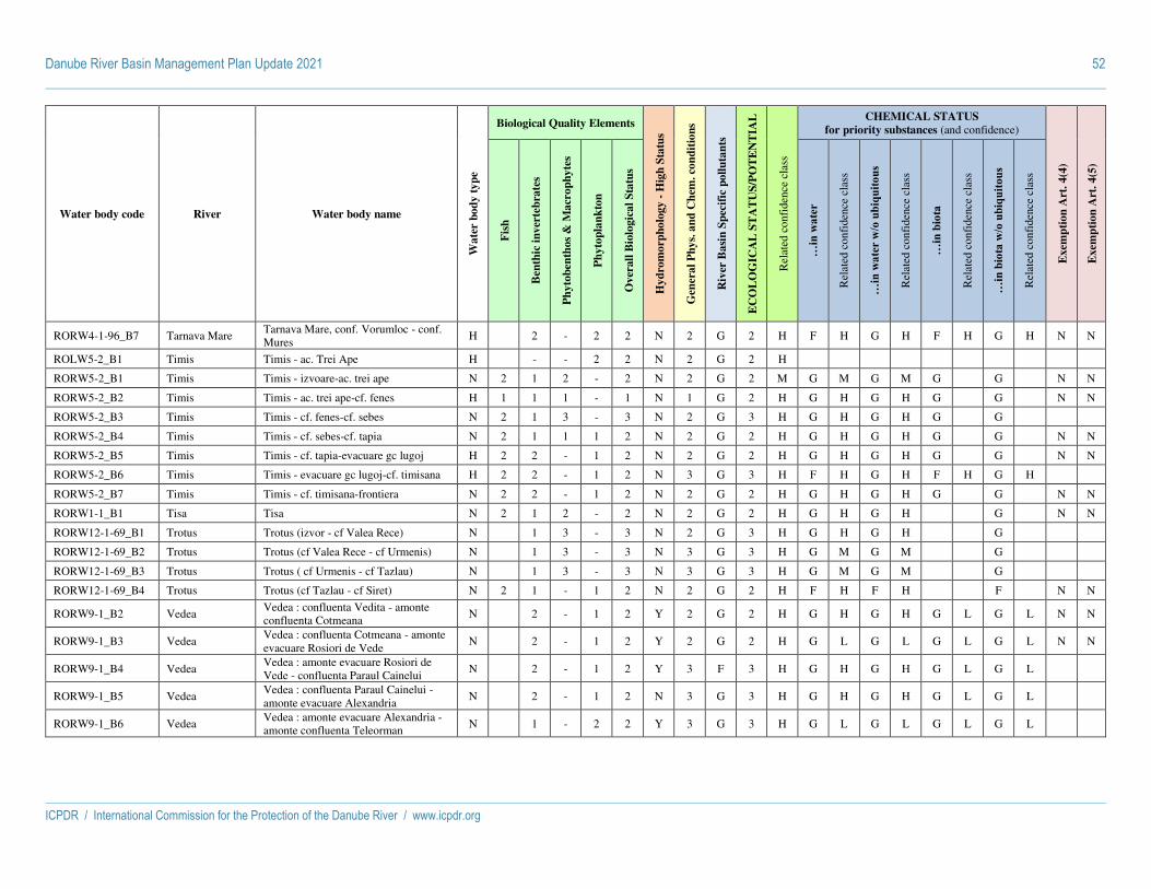
Danube River Basin Management Plan Update 2021 52
ICPDR / International Commission for the Protection of the Danube River / www.icpdr.org
Water body code River Water body name
Wa
ter
bo
dy
ty
pe
Biological Quality Elements
Hy
dro
mo
rph
olo
gy -
Hig
h S
tatu
s
Gen
era
l P
hy
s. a
nd
Ch
em. co
nd
itio
ns
Riv
er B
asi
n S
pec
ific
po
llu
tan
ts
EC
OL
OG
ICA
L S
TA
TU
S/P
OT
EN
TIA
L
Rel
ated
con
fide
nce
clas
s
CHEMICAL STATUS
for priority substances (and confidence)
Exem
pti
on
Art
. 4
(4)
Exem
pti
on
Art
. 4
(5)
Fis
h
Ben
thic
in
ver
teb
rate
s
Ph
yto
ben
tho
s &
Ma
cro
ph
yte
s
Ph
yto
pla
nk
ton
Ov
erall
Bio
logic
al
Sta
tus
…in
wat
er
Rel
ated
con
fide
nce
clas
s
…in
wat
er w
/o u
biqu
itous
Rel
ated
con
fide
nce
clas
s
…in
bio
ta
Rel
ated
con
fide
nce
clas
s
…in
bio
ta w
/o u
biqu
itous
Rel
ated
con
fide
nce
clas
s
RORW4-1-96_B7 Tarnava Mare Tarnava Mare, conf. Vorumloc - conf. Mures
H 2 - 2 2 N 2 G 2 H F H G H F H G H N N
ROLW5-2_B1 Timis Timis - ac. Trei Ape H - - 2 2 N 2 G 2 H
RORW5-2_B1 Timis Timis - izvoare-ac. trei ape N 2 1 2 - 2 N 2 G 2 M G M G M G G N N
RORW5-2_B2 Timis Timis - ac. trei ape-cf. fenes H 1 1 1 - 1 N 1 G 2 H G H G H G G N N
RORW5-2_B3 Timis Timis - cf. fenes-cf. sebes N 2 1 3 - 3 N 2 G 3 H G H G H G G
RORW5-2_B4 Timis Timis - cf. sebes-cf. tapia N 2 1 1 1 2 N 2 G 2 H G H G H G G N N
RORW5-2_B5 Timis Timis - cf. tapia-evacuare gc lugoj H 2 2 - 1 2 N 2 G 2 H G H G H G G N N
RORW5-2_B6 Timis Timis - evacuare gc lugoj-cf. timisana H 2 2 - 1 2 N 3 G 3 H F H G H F H G H
RORW5-2_B7 Timis Timis - cf. timisana-frontiera N 2 2 - 1 2 N 2 G 2 H G H G H G G N N
RORW1-1_B1 Tisa Tisa N 2 1 2 - 2 N 2 G 2 H G H G H G N N
RORW12-1-69_B1 Trotus Trotus (izvor - cf Valea Rece) N 1 3 - 3 N 2 G 3 H G H G H G
RORW12-1-69_B2 Trotus Trotus (cf Valea Rece - cf Urmenis) N 1 3 - 3 N 3 G 3 H G M G M G
RORW12-1-69_B3 Trotus Trotus ( cf Urmenis - cf Tazlau) N 1 3 - 3 N 3 G 3 H G M G M G
RORW12-1-69_B4 Trotus Trotus (cf Tazlau - cf Siret) N 2 1 - 1 2 N 2 G 2 H F H F H F N N
RORW9-1_B2 Vedea Vedea : confluenta Vedita - amonte confluenta Cotmeana
N 2 - 1 2 Y 2 G 2 H G H G H G L G L N N
RORW9-1_B3 Vedea Vedea : confluenta Cotmeana - amonte evacuare Rosiori de Vede
N 2 - 1 2 Y 2 G 2 H G L G L G L G L N N
RORW9-1_B4 Vedea Vedea : amonte evacuare Rosiori de Vede - confluenta Paraul Cainelui
N 2 - 1 2 Y 3 F 3 H G H G H G L G L
RORW9-1_B5 Vedea Vedea : confluenta Paraul Cainelui - amonte evacuare Alexandria
N 2 - 1 2 N 3 G 3 H G H G H G L G L
RORW9-1_B6 Vedea Vedea : amonte evacuare Alexandria - amonte confluenta Teleorman
N 1 - 2 2 Y 3 G 3 H G L G L G L G L

Danube River Basin Management Plan Update 2021 53
ICPDR / International Commission for the Protection of the Danube River / www.icpdr.org
Water body code River Water body name
Wa
ter
bo
dy
ty
pe
Biological Quality Elements
Hy
dro
mo
rph
olo
gy -
Hig
h S
tatu
s
Gen
era
l P
hy
s. a
nd
Ch
em. co
nd
itio
ns
Riv
er B
asi
n S
pec
ific
po
llu
tan
ts
EC
OL
OG
ICA
L S
TA
TU
S/P
OT
EN
TIA
L
Rel
ated
con
fide
nce
clas
s
CHEMICAL STATUS
for priority substances (and confidence)
Exem
pti
on
Art
. 4
(4)
Exem
pti
on
Art
. 4
(5)
Fis
h
Ben
thic
in
ver
teb
rate
s
Ph
yto
ben
tho
s &
Ma
cro
ph
yte
s
Ph
yto
pla
nk
ton
Ov
erall
Bio
logic
al
Sta
tus
…in
wat
er
Rel
ated
con
fide
nce
clas
s
…in
wat
er w
/o u
biqu
itous
Rel
ated
con
fide
nce
clas
s
…in
bio
ta
Rel
ated
con
fide
nce
clas
s
…in
bio
ta w
/o u
biqu
itous
Rel
ated
con
fide
nce
clas
s
RORW9-1_B7 Vedea Vedea : confluenta Teleorman - localitate Bujoru
H 1 - 2 2 N 3 G 3 H G L G L G L G L
RORW9-1_B8 Vedea Vedea : localitate Bujoru - confluenta Dunare
A 1 - 2 2 N 3 G 3 H F H G H F H G H
BG1IS100R1027 Iskar ISKAR RWB1027 H 2 2 - 2 3 G 3 H F M G M N
BG1IS135R1026 Iskar ISKAR RWB1026 N 3 3 - 3 3 G 3 H G M G M N
BG1IS135R1126 Iskar ISKAR RWB1126 N 3 3 - 3 3 G 3 H F M G M
BG1IS135R1226 Iskar ISKAR RWB1226 N 3 3 - 3 1 G 3 H F M G M
BG1IS135R1326 Iskar ISKAR RWB1326 N 2 3 4 - 4 3 F 4 H G M G M
BG1IS135R1426 Iskar ISKAR RWB1426 N 3 4 - 4 3 F 4 H F M F M
BG1IS135R1726 Iskar ISKAR RWB1726 N 3 2 - 3 2 G 3 H G M G M
BG1IS500L008 Iskar Dam Pancharevo H - - 3 3 2 G 3 H G M G M N N
BG1IS700L005 Iskar Dam Iskar H - 2 - 2 2 2 G 2 H G M G M N N
BG1IS700L1306 Iskar Dam Kokalyane H - 2 - 2 2 1 G 2 H G M G M N N
BG1IS700R1006 Iskar ISKAR RWB1006 N 3 2 - 3 2 F 3 H F M G M
BG1IS700R1206 Iskar ISKAR RWB1206 N 3 2 - 3 2 G 3 H G M G M N N
BG1IS789R1104 Iskar ISKAR RWB1104 N 2 2 - 2 3 F 3 H G M G M
BG1IS900R1003 Iskar ISKAR RWB1003 N 2 1 - 2 2 F 3 H G M G M
BG1NV200R1001 Nishava NISHAVA RWB1001 N 2 2 - 2 2 G 2 H G M G M N N
BG1OG100R014 Ogosta OGOSTA RWB14 H 4 3 3 - 4 2 G 4 H F M G M
BG1OG307R1013 Ogosta OGOSTA RWB1013 N 1 2 - 2 2 G 2 H G M G M N N
BG1OG307R1213 Ogosta OGOSTA RWB1213 N 3 2 - 3 2 F 3 H G M G M
BG1OG307R1313 Ogosta OGOSTA RWB1313 N 1 3 - 3 1 F 3 H F M G M

Danube River Basin Management Plan Update 2021 54
ICPDR / International Commission for the Protection of the Danube River / www.icpdr.org
Water body code River Water body name
Wa
ter
bo
dy
ty
pe
Biological Quality Elements
Hy
dro
mo
rph
olo
gy -
Hig
h S
tatu
s
Gen
era
l P
hy
s. a
nd
Ch
em. co
nd
itio
ns
Riv
er B
asi
n S
pec
ific
po
llu
tan
ts
EC
OL
OG
ICA
L S
TA
TU
S/P
OT
EN
TIA
L
Rel
ated
con
fide
nce
clas
s
CHEMICAL STATUS
for priority substances (and confidence)
Exem
pti
on
Art
. 4
(4)
Exem
pti
on
Art
. 4
(5)
Fis
h
Ben
thic
in
ver
teb
rate
s
Ph
yto
ben
tho
s &
Ma
cro
ph
yte
s
Ph
yto
pla
nk
ton
Ov
erall
Bio
logic
al
Sta
tus
…in
wat
er
Rel
ated
con
fide
nce
clas
s
…in
wat
er w
/o u
biqu
itous
Rel
ated
con
fide
nce
clas
s
…in
bio
ta
Rel
ated
con
fide
nce
clas
s
…in
bio
ta w
/o u
biqu
itous
Rel
ated
con
fide
nce
clas
s
BG1OG700L004 Ogosta Dam Ogosta H - 2 2 2 F 3 H G M G M
BG1OG789R1001 Ogosta OGOSTA RWB1001 N 2 2 2 - 2 2 F 3 H F M G M
BG1OG789R1401 Ogosta OGOSTA RWB1401 N 2 - 2 2 F 3 H G M G M N
BG1OG789R1501 Ogosta OGOSTA RWB1501 N 2 2 - 2 2 F 3 H G M G M N
BG1OG789R1601 Ogosta OGOSTA RWB1601 N 2 1 - 2 2 F 3 H G M G M N
BG1WO100R001 Timok TIMOK WORWB01 N 4 3 - 4 3 F 4 H F M F M Y
BG1YN130R1029 Yantra YANTRA RWB1029 H 3 3 2 - 3 2 G 3 H F M G M
BG1YN307R1027 Yantra YANTRA RWB1027 H 3 2 - 3 3 G 3 H G M G M N
BG1YN307R1127 Yantra YANTRA RWB1127 H 2 3 - 3 2 G 3 M G M G M N
BG1YN700R1017 Yantra YANTRA RWB1017 N 3 3 - 3 3 G 3 H G M G M N
BG1YN900R1015 Yantra YANTRA RWB1015 N 3 3 - 3 3 F 3 H G M G M
BG1YN900R1215 Yantra YANTRA RWB1215 N 1 1 - 1 2 G 2 H F M G M
BG1YN900R1415 Yantra YANTRA RWB1415 N 2 - 2 2 G 2 H G M G M N N
MD0201/01 Prut Prut N
MD0201/02 Prut Prut N
MD0201/03 Prut Prut N
MD0201/04 Prut Prut N
MD0201/05 Prut Prut (l.a.Costesti Stinca) H
MD0201/06 Prut Prut (l.a.Costesti Stinca) H
MD0201/07 Prut Prut N
MD0201/08 Prut Prut N
MD0201/09 Prut Prut N

Danube River Basin Management Plan Update 2021 55
ICPDR / International Commission for the Protection of the Danube River / www.icpdr.org
Water body code River Water body name
Wa
ter
bo
dy
ty
pe
Biological Quality Elements
Hy
dro
mo
rph
olo
gy -
Hig
h S
tatu
s
Gen
era
l P
hy
s. a
nd
Ch
em. co
nd
itio
ns
Riv
er B
asi
n S
pec
ific
po
llu
tan
ts
EC
OL
OG
ICA
L S
TA
TU
S/P
OT
EN
TIA
L
Rel
ated
con
fide
nce
clas
s
CHEMICAL STATUS
for priority substances (and confidence)
Exem
pti
on
Art
. 4
(4)
Exem
pti
on
Art
. 4
(5)
Fis
h
Ben
thic
in
ver
teb
rate
s
Ph
yto
ben
tho
s &
Ma
cro
ph
yte
s
Ph
yto
pla
nk
ton
Ov
erall
Bio
logic
al
Sta
tus
…in
wat
er
Rel
ated
con
fide
nce
clas
s
…in
wat
er w
/o u
biqu
itous
Rel
ated
con
fide
nce
clas
s
…in
bio
ta
Rel
ated
con
fide
nce
clas
s
…in
bio
ta w
/o u
biqu
itous
Rel
ated
con
fide
nce
clas
s
MD0201/10 Prut Prut N
MD0201/11 Prut Prut N
MD0201/12 Prut Prut N
MD0201/13 Prut Prut N
MD0201/14 Prut Prut N
MD0201/15 Prut Prut N
UALAR01 Latorica Latorica N - - -
UALAR02 Latorica Latorica N - - -
UALAR03 Latorica Latorica N - - -
UALAR04 Latorica Latorica N - - -
UALAR05 Latorica Latorica N - - -
UALAR06 Latorica Latorica N - - -
UA0201/01 Prut Prut N - - -
UA0201/02 Prut Prut N - - -
UA0201/03 Prut Prut N - - -
UA0201/04 Prut Prut N - - -
UA0201/05 Prut Prut N - - -
UA0201/06 Prut Prut N - - -
UA0201/07 Prut Prut N - - -
UASr01 Siret Siret N - - -
UASr02 Siret Siret N - - -
UASr03 Siret Siret N - - -

Danube River Basin Management Plan Update 2021 56
ICPDR / International Commission for the Protection of the Danube River / www.icpdr.org
Water body code River Water body name
Wa
ter
bo
dy
ty
pe
Biological Quality Elements
Hy
dro
mo
rph
olo
gy -
Hig
h S
tatu
s
Gen
era
l P
hy
s. a
nd
Ch
em. co
nd
itio
ns
Riv
er B
asi
n S
pec
ific
po
llu
tan
ts
EC
OL
OG
ICA
L S
TA
TU
S/P
OT
EN
TIA
L
Rel
ated
con
fide
nce
clas
s
CHEMICAL STATUS
for priority substances (and confidence)
Exem
pti
on
Art
. 4
(4)
Exem
pti
on
Art
. 4
(5)
Fis
h
Ben
thic
in
ver
teb
rate
s
Ph
yto
ben
tho
s &
Ma
cro
ph
yte
s
Ph
yto
pla
nk
ton
Ov
erall
Bio
logic
al
Sta
tus
…in
wat
er
Rel
ated
con
fide
nce
clas
s
…in
wat
er w
/o u
biqu
itous
Rel
ated
con
fide
nce
clas
s
…in
bio
ta
Rel
ated
con
fide
nce
clas
s
…in
bio
ta w
/o u
biqu
itous
Rel
ated
con
fide
nce
clas
s
UASr04 Siret Siret N - - -
UASr05 Siret Siret N - - -
UASr06 Siret Siret N - - -
UATISR01 Tisza Tisa N - - -
UATISR02 Tisza Tisa N - - -
UATISR03 Tisza Tisa N - - -
UATISR04 Tisza Tisa N - - -
UATISR05 Tisza Tisa N - - -
UATISR06 Tisza Tisa N - - -
UATISR07 Tisza Tisa N - - -
UATISR08 Tisza Tisa N - - -
UADUN_IAL_MD_05 (39_05)
Yalpuh Danube P - - -

Danube River Basin Management Plan Update 2021 57
ICPDR / International Commission for the Protection of the Danube River / www.icpdr.org
Status assessment of lakes
Water body code Water body name
Wa
ter
bo
dy
ty
pe
Biological Quality Elements
Hy
dro
mo
rph
olo
gy -
Hig
h S
tatu
s
Gen
era
l P
hy
s. a
nd
Ch
em. co
nd
itio
ns
Riv
er B
asi
n S
pec
ific
po
llu
tan
ts
EC
OL
OG
ICA
L S
TA
TU
S/P
OT
EN
TIA
L
Rel
ated
con
fide
nce
clas
s
CHEMICAL STATUS
for priority substances (and confidence)
Exem
pti
on
Art
. 4
(4)
Exem
pti
on
Art
. 4
(5)
Fis
h
Ben
thic
in
ver
teb
rate
s
Ph
yto
ben
tho
s &
Ma
cro
ph
yte
s
Ph
yto
pla
nk
ton
Ov
erall
Bio
logic
al
Sta
tus
…in
wat
er
Rel
ated
con
fide
nce
clas
s
…in
wat
er w
/o u
biqu
itous
Rel
ated
con
fide
nce
clas
s
…in
bio
ta
Rel
ated
con
fide
nce
clas
s
…in
bio
ta w
/o u
biqu
itous
Rel
ated
con
fide
nce
clas
s
ATOK10500200 Neusiedler See N 2 2 2 2 2 Y 2 G 2 H G H G L F H G H N N
HUAIH049 Balaton N 2 2 2 1 2 N 1 G 2 H F H F H F H G H N Y
HUAIH070 Fertő N 3 2 1 3 N 2 F 3 H F H F H F H G H Y Y
HUANS560 Tisza-tó H 3 3 2 3 N 2 F 3 H F H F H F H F H Y Y
ROLW14-1_B7 Razim N 1 2 2 2 N 2 G 2 H G H G H
UAKUW Kuhurlui N - - -
UAYAW Ialpuh N - - -

Danube River Basin Management Plan Update 2021 58
ICPDR / International Commission for the Protection of the Danube River / www.icpdr.org
Status assessment of coastal waters
Water body code Water body name
Wa
ter
bo
dy
ty
pe
Biological Quality Elements
Hy
dro
mo
rph
olo
gy -
Hig
h S
tatu
s
Gen
era
l P
hy
s. a
nd
Ch
em. co
nd
itio
ns
Riv
er B
asi
n S
pec
ific
po
llu
tan
ts
EC
OL
OG
ICA
L S
TA
TU
S/P
OT
EN
TIA
L
Rel
ated
con
fide
nce
clas
s
CHEMICAL STATUS
for priority substances (and confidence)
Exem
pti
on
Art
. 4
(4)
Exem
pti
on
Art
. 4
(5)
Fis
h
Ben
thic
in
ver
teb
rate
s
An
gio
sper
ms
Ma
croa
lga
e
Ph
yto
pla
nk
ton
Ov
erall
Bio
logic
al
Sta
tus
…in
wat
er
Rel
ated
con
fide
nce
clas
s
…in
wat
er w
/o u
biqu
itous
Rel
ated
con
fide
nce
clas
s
…in
bio
ta
Rel
ated
con
fide
nce
clas
s
…in
bio
ta w
/o u
biqu
itous
Rel
ated
con
fide
nce
clas
s
ROCT01_B1 Periboina-Cap Singol N - 2 5 3 5 N 3 G 5 H G H G H
ROCT01_B2 Mangalia H - 5 2 5 N 3 G 5 H G H G H
ROCT02_B1 Cap Singol-Eforie Nord H - 2 5 2 5 N 3 G 5 H G H G H
ROCT02_B2 Eforie Nord-Vama Veche N - 2 5 3 5 N 3 G 5 H G H G H

Danube River Basin Management Plan Update 2021 59
ICPDR / International Commission for the Protection of the Danube River / www.icpdr.org
Status assessment of transitional waters
Water body code Water body name
Wa
ter
bo
dy
ty
pe
Biological Quality Elements
Hy
dro
mo
rph
olo
gy -
Hig
h S
tatu
s
Gen
era
l P
hy
s. a
nd
Ch
em. co
nd
itio
ns
Riv
er B
asi
n S
pec
ific
po
llu
tan
ts
EC
OL
OG
ICA
L S
TA
TU
S/P
OT
EN
TIA
L
Rel
ated
con
fide
nce
clas
s
CHEMICAL STATUS
for priority substances (and confidence)
Exem
pti
on
Art
. 4
(4)
Exem
pti
on
Art
. 4
(5)
Fis
h
Ben
thic
in
ver
teb
rate
s
An
gio
sper
ms
Ma
croa
lga
e
Ph
yto
pla
nk
ton
Ov
erall
Bio
logic
al
Sta
tus
…in
wat
er
Rel
ated
con
fide
nce
clas
s
…in
wat
er w
/o u
biqu
itous
Rel
ated
con
fide
nce
clas
s
…in
bio
ta
Rel
ated
con
fide
nce
clas
s
…in
bio
ta w
/o u
biqu
itous
Rel
ated
con
fide
nce
clas
s
ROTT02_B1 Lac Sinoie N 4 4 N 2 G 4 H G H G H
ROTT03_B1 Chilia-Periboina N 2 2 2 N 3 G 3 H G H G H
UADDBS Black sea N - - -

ICPDR / International Commission for the Protection of the Danube River / www.icpdr.org
Draft ANNEX 10 as of 26 February 2021
DRBMP Update 2021
Inventory of Protected Areas

Danube River Basin Management Plan Update 2021 1
ICPDR / International Commission for the Protection of the Danube River / www.icpdr.org
Explanations
This inventory only includes water-relevant protection areas covering an area larger than 500 hectar.
Types:
H = EU Habitat (FFH) Directive
B = EU Bird Protection Directive
O = Others (Non EU MS)
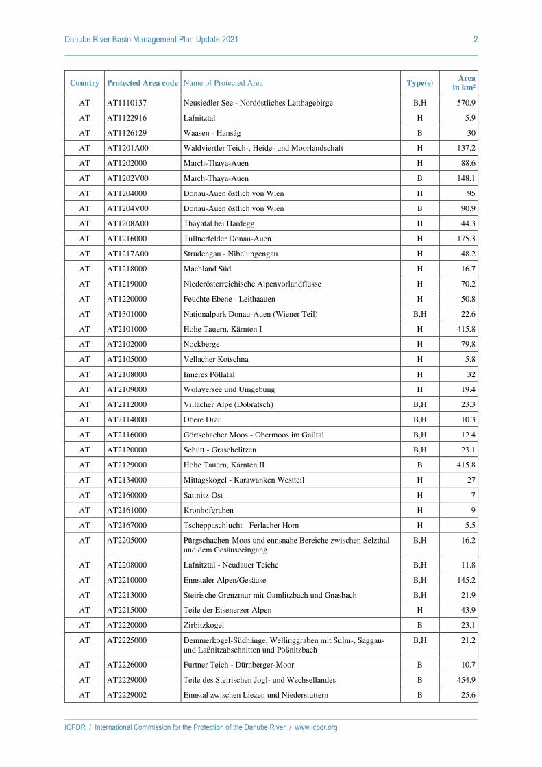
Danube River Basin Management Plan Update 2021 2
ICPDR / International Commission for the Protection of the Danube River / www.icpdr.org
Country Protected Area code Name of Protected Area Type(s) Area
in km²
AT AT1110137 Neusiedler See - Nordöstliches Leithagebirge B,H 570.9
AT AT1122916 Lafnitztal H 5.9
AT AT1126129 Waasen - Hanság B 30
AT AT1201A00 Waldviertler Teich-, Heide- und Moorlandschaft H 137.2
AT AT1202000 March-Thaya-Auen H 88.6
AT AT1202V00 March-Thaya-Auen B 148.1
AT AT1204000 Donau-Auen östlich von Wien H 95
AT AT1204V00 Donau-Auen östlich von Wien B 90.9
AT AT1208A00 Thayatal bei Hardegg H 44.3
AT AT1216000 Tullnerfelder Donau-Auen H 175.3
AT AT1217A00 Strudengau - Nibelungengau H 48.2
AT AT1218000 Machland Süd H 16.7
AT AT1219000 Niederösterreichische Alpenvorlandflüsse H 70.2
AT AT1220000 Feuchte Ebene - Leithaauen H 50.8
AT AT1301000 Nationalpark Donau-Auen (Wiener Teil) B,H 22.6
AT AT2101000 Hohe Tauern, Kärnten I H 415.8
AT AT2102000 Nockberge H 79.8
AT AT2105000 Vellacher Kotschna H 5.8
AT AT2108000 Inneres Pöllatal H 32
AT AT2109000 Wolayersee und Umgebung H 19.4
AT AT2112000 Villacher Alpe (Dobratsch) B,H 23.3
AT AT2114000 Obere Drau B,H 10.3
AT AT2116000 Görtschacher Moos - Obermoos im Gailtal B,H 12.4
AT AT2120000 Schütt - Graschelitzen B,H 23.1
AT AT2129000 Hohe Tauern, Kärnten II B 415.8
AT AT2134000 Mittagskogel - Karawanken Westteil H 27
AT AT2160000 Sattnitz-Ost H 7
AT AT2161000 Kronhofgraben H 9
AT AT2167000 Tscheppaschlucht - Ferlacher Horn H 5.5
AT AT2205000 Pürgschachen-Moos und ennsnahe Bereiche zwischen Selzthal und dem Gesäuseeingang
B,H 16.2
AT AT2208000 Lafnitztal - Neudauer Teiche B,H 11.8
AT AT2210000 Ennstaler Alpen/Gesäuse B,H 145.2
AT AT2213000 Steirische Grenzmur mit Gamlitzbach und Gnasbach B,H 21.9
AT AT2215000 Teile der Eisenerzer Alpen H 43.9
AT AT2220000 Zirbitzkogel B 23.1
AT AT2225000 Demmerkogel-Südhänge, Wellinggraben mit Sulm-, Saggau- und Laßnitzabschnitten und Pößnitzbach
B,H 21.2
AT AT2226000 Furtner Teich - Dürnberger-Moor B 10.7
AT AT2229000 Teile des Steirischen Jogl- und Wechsellandes B 454.9
AT AT2229002 Ennstal zwischen Liezen und Niederstuttern B 25.6
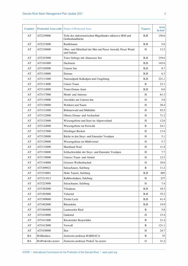
Danube River Basin Management Plan Update 2021 3
ICPDR / International Commission for the Protection of the Danube River / www.icpdr.org
Country Protected Area code Name of Protected Area Type(s) Area
in km²
AT AT2230000 Teile des südoststeirischen Hügellandes inklusive Höll und Grabenlandbäche
B,H 156.6
AT AT2233000 Raabklamm B,H 5.6
AT AT2236000 Ober- und Mittellauf der Mur mit Puxer Auwald, Puxer Wand und Gulsen
H 13.2
AT AT2243000 Totes Gebirge mit Altausseer See B,H 239.6
AT AT3101000 Dachstein B,H 145.6
AT AT3105000 Unterer Inn B,H 8.7
AT AT3110000 Ettenau B,H 6.3
AT AT3111000 Nationalpark Kalkalpen und Umgebung B,H 221.1
AT AT3113000 Untere Traun B 23.1
AT AT3114000 Traun-Donau-Auen B,H 6.6
AT AT3117000 Mond- und Attersee H 61.3
AT AT3119000 Auwälder am Unteren Inn H 5.8
AT AT3120000 Waldaist und Naarn H 38.4
AT AT3121000 Böhmerwald und Mühltäler H 93.5
AT AT3122000 Oberes Donau- und Aschachtal H 71.2
AT AT3123000 Wiesengebiete und Seen im Alpenvorland H 12.6
AT AT3124000 Wiesengebiete im Freiwald B 24.1
AT AT3127000 Eferdinger Becken H 13.4
AT AT3128000 Bäche in den Steyr- und Ennstaler Voralpen H 5.1
AT AT3129000 Wiesengebiete im Mühlviertel H 5.7
AT AT3132000 Machland Nord H 11.4
AT AT3138000 Schluchtwälder der Steyr- und Ennstaler Voralpen H 7.7
AT AT3139000 Unteres Traun- und Almtal H 12.5
AT AT3144000 Goiserer Weißenbachtal H 10.6
AT AT3209022 Salzachauen, Salzburg B 11.2
AT AT3210001 Hohe Tauern, Salzburg B,H 805
AT AT3211012 Kalkhochalpen, Salzburg H 237
AT AT3223000 Salzachauen, Salzburg H 7.4
AT AT3302000 Vilsalpsee B,H 18.3
AT AT3303000 Valsertal B,H 35.2
AT AT3309000 Tiroler Lech B,H 41.4
AT AT3402000 Rheindelta B,H 19.9
AT AT3404000 Lauteracher Ried B 5.8
AT AT3410000 Gadental H 15.4
AT AT3411000 Klostertaler Bergwälder B 21.4
AT AT3412000 Verwall B 121.1
AT AT3438000 Ifen H 24.7
BA BABardaca Zasticeno podrucje BARDACA B 35
BA BAProkosko jezero Zasticeno podrucje Prokoško jezero O 21.2

Danube River Basin Management Plan Update 2021 4
ICPDR / International Commission for the Protection of the Danube River / www.icpdr.org
Country Protected Area code Name of Protected Area Type(s) Area
in km²
BA BASkakavac Zasticeno podrucje Skakavac O 14.3
BA BAUna Zasticeno podrucje Una O 198
BA BAVrelo Bosne Zasticeno podrucje Vrelo Bosne O 6
BG BG0000106 Harsovska reka H 367.6
BG BG0000107 Suha reka H 624.8
BG BG0000113 Vitosha B,H 158.7
BG BG0000117 Kotlenska planina H 149.2
BG BG0000165 Lozenska planina H 13
BG BG0000166 Vrachanski Balkan H 360.3
BG BG0000168 Ludogorie H 594.5
BG BG0000169 Ludogorie - Srebarna H 52.2
BG BG0000171 Ludogorie - Boblata H 48.3
BG BG0000173 Ostrovche H 58.9
BG BG0000180 Boblata H 32.2
BG BG0000181 Reka Vit H 57.2
BG BG0000182 Orsoya H 24.6
BG BG0000190 Vitata stena H 26.3
BG BG0000199 Tzibar H 23
BG BG0000204 Vardim H 11.1
BG BG0000211 Tvardishka planina H 256
BG BG0000213 Tarnovski visochini H 44.3
BG BG0000214 Dryanovski manastir H 29.9
BG BG0000231 Belenska gora H 50.4
BG BG0000232 Batin H 26.8
BG BG0000233 Studena reka H 53
BG BG0000237 Ostrov Pozharevo B 9.8
BG BG0000239 Obnova - Karaman dol H 107.5
BG BG0000240 Studenetz B,H 280.6
BG BG0000241 Srebarna B,H 14.5
BG BG0000247 Nikopolsko plato H 185
BG BG0000263 Skalsko H 21.9
BG BG0000275 Yazovir Stamboliyski H 93.5
BG BG0000308 Verila H 37.5
BG BG0000313 Rui H 16.4
BG BG0000322 Dragoman H 213.6
BG BG0000332 Karlukovski karst B 142.2
BG BG0000334 Ostrov H 34.4
BG BG0000335 Karaboaz H 122
BG BG0000336 Zlatiya H 32
BG BG0000339 Rabrovo H 9.1

Danube River Basin Management Plan Update 2021 5
ICPDR / International Commission for the Protection of the Danube River / www.icpdr.org
Country Protected Area code Name of Protected Area Type(s) Area
in km²
BG BG0000340 Tzar Petrovo H 17.5
BG BG0000374 Bebresh H 68.2
BG BG0000377 Kalimok - Brashlen H 73.3
BG BG0000396 Persina H 223.8
BG BG0000399 Bulgarka H 210.9
BG BG0000432 Golyama reka H 74.5
BG BG0000494 Tzentralen Balkan B,H 312.2
BG BG0000495 Rila B,H 206.5
BG BG0000497 Archar H 6
BG BG0000498 Vidbol H 13.1
BG BG0000500 Voynitza H 23.1
BG BG0000503 Reka Lom H 14.4
BG BG0000507 Deleina H 22.6
BG BG0000509 Tzibritza H 9.6
BG BG0000517 Portitovtsi-Vladimirovo H 6.6
BG BG0000518 Vartopski dol H 9.9
BG BG0000521 Makresh H 20.6
BG BG0000522 Vidinski park H 15.8
BG BG0000523 Shishentzi H 5.7
BG BG0000529 Marten-Ryahovo H 11.7
BG BG0000530 Pozharevo - Garvan H 58.7
BG BG0000533 Ostrovi Kozlodui H 6.1
BG BG0000569 Kardam H 9.2
BG BG0000570 Izvorovo - Kraishte H 10.8
BG BG0000572 Rositza - Loznitza H 18.1
BG BG0000576 Svishtovska gora H 19.2
BG BG0000608 Lomovete H 324.9
BG BG0000609 Reka Rositza H 14.4
BG BG0000610 Reka Yantra H 139
BG BG0000611 Yazovir Gorni Dubnik H 25.4
BG BG0000613 Reka Iskar H 94.6
BG BG0000614 Reka Ogosta H 12.5
BG BG0000615 Devetashko plato H 150
BG BG0000616 Mikre H 154.5
BG BG0000617 Reka Palakariya H 31.6
BG BG0000618 Vidima H 18.2
BG BG0000624 Lyubash H 12.7
BG BG0001014 Karlukovo H 288.4
BG BG0001017 Karvav kamak H 36.5
BG BG0001036 Balgarski izvor H 26.2

Danube River Basin Management Plan Update 2021 6
ICPDR / International Commission for the Protection of the Danube River / www.icpdr.org
Country Protected Area code Name of Protected Area Type(s) Area
in km²
BG BG0001037 Pastrina H 35.5
BG BG0001040 Zapadna stara planina i Predba H 2193
BG BG0001042 Iskarski prolom - Rzhana H 226.9
BG BG0001043 Etropole - Baylovo H 191.3
BG BG0001307 Plana H 27.9
BG BG0001389 Sredna Gora H 21.4
BG BG0001493 Tzentralen Balkan - buffer H 867.2
BG BG0002001 Rayanovtsi B 132
BG BG0002002 Zapaden Balkan B 1467.7
BG BG0002004 Dolni Bogrov-Kazichene B 22.5
BG BG0002005 Ponor B 314.1
BG BG0002009 Zlatiata B 435.4
BG BG0002017 Complex Belenski Ostrovi B 66.8
BG BG0002018 Ostrov Vardim B 11.7
BG BG0002024 Ribarnitsi Mechka B 27.1
BG BG0002025 Lomovete B 43.1
BG BG0002029 Kotlenska planina B 196.9
BG BG0002030 Complex Kalimok B 92.2
BG BG0002039 Harsovska reka B 354
BG BG0002048 Suha reka B 257.5
BG BG0002053 Vrachanski Balkan B 309.2
BG BG0002062 Ludogorie B 913.2
BG BG0002074 Nikopolsko plato B 222.3
BG BG0002083 Svishtovsko-Belenska nizina B 54.4
BG BG0002084 Palakaria B 158.3
BG BG0002085 Chairya B 14.5
BG BG0002088 Mikre B 123.9
BG BG0002090 Berkovitsa B 28
BG BG0002091 Ostrov Lakat B 11.6
BG BG0002095 Gorni Dabnik-Telish B 34
BG BG0002096 Obnova B 54.2
BG BG0002101 Meshtitsa B 16.3
BG BG0002102 Devetashko plato B 78.9
BG BG0002104 Tsibarsko blato B 9.1
BG BG0002109 Vasilyovska planina B 454.8
BG BG0002110 Apriltsi B 19.4
BG BG0002111 Velchevo B 23.1
BG BG0002112 Ruy B 173.9
CZ CZ0314024 Šumava H 107.1
CZ CZ0320180 Čerchovský les H 22.7

Danube River Basin Management Plan Update 2021 7
ICPDR / International Commission for the Protection of the Danube River / www.icpdr.org
Country Protected Area code Name of Protected Area Type(s) Area
in km²
CZ CZ0323151 Kateřinský a Nivní potok H 9.7
CZ CZ0324026 Niva Nemanického potoka H 6.7
CZ CZ0530146 Králický Sněžník H 17.7
CZ CZ0614131 Údolí Oslavy a Chvojnice H 23.4
CZ CZ0614134 Údolí Jihlavy H 8.6
CZ CZ0620009 Lednické rybníky H 6.2
CZ CZ0620245 Rakovecké údolí H 7.6
CZ CZ0621025 Bzenecká Doubrava - Strážnické Pomoraví B 117.3
CZ CZ0621027 Soutok-Tvrdonicko B 95.8
CZ CZ0621028 Lednické rybníky B 6.9
CZ CZ0621029 Pálava B 85.4
CZ CZ0621030 Střední nádrž vodního díla Nové Mlýny B 10.5
CZ CZ0624064 Krumlovský les H 19.5
CZ CZ0624068 Strážnická Morava H 6.6
CZ CZ0624070 Hodonínská doubrava H 30.3
CZ CZ0624072 Čertoryje H 47.6
CZ CZ0624095 Údolí Dyje H 18.1
CZ CZ0624096 Podyjí H 60.7
CZ CZ0624099 Niva Dyje H 32.5
CZ CZ0624103 Mušovský luh H 5.6
CZ CZ0624119 Soutok - Podluží H 95.8
CZ CZ0624130 Moravský kras H 64.9
CZ CZ0710161 Království H 5.9
CZ CZ0711018 Litovelské Pomoraví B 93.2
CZ CZ0714073 Litovelské Pomoraví H 94.6
CZ CZ0714075 Keprník H 18.4
CZ CZ0714077 Praděd H 29.1
CZ CZ0714085 Morava - Chropyňský luh H 32.1
CZ CZ0714133 Libavá H 68.2
CZ CZ0720033 Semetín H 13.1
CZ CZ0720192 Velká Vela H 7.7
CZ CZ0720422 Valy-Bučník H 11
CZ CZ0720428 Na Koncoch H 17.3
CZ CZ0720435 Podkrálovec H 9.6
CZ CZ0720437 Valentová H 5.6
CZ CZ0724089 Beskydy H 634.9
CZ CZ0724090 Bílé Karpaty H 199.2
CZ CZ0724091 Chřiby H 192.3
CZ CZ0724107 Nedakonický les H 15.3
CZ CZ0724120 Kněžpolský les H 5.2

Danube River Basin Management Plan Update 2021 8
ICPDR / International Commission for the Protection of the Danube River / www.icpdr.org
Country Protected Area code Name of Protected Area Type(s) Area
in km²
CZ CZ0724121 Nad Jasenkou H 7.4
CZ CZ0724429 Hostýnské vrchy H 24
CZ CZ0724430 Vlárský průsmyk H 31.4
DE DEBW_6927341 Rotachtal H 6
DE DEBW_7226311 Heiden und Wälder zwischen Aalen und Heidenheim H 21.8
DE DEBW_7226441 Albuch B 73.6
DE DEBW_7325341 Steinheimer Becken H 30
DE DEBW_7327341 Härtsfeld H 32
DE DEBW_7422441 Mittlere Schwäbische Alb B 52
DE DEBW_7425311 Kuppenalb bei Laichingen und Lonetal H 17.3
DE DEBW_7426341 Hungerbrunnen-, Sacken- und Lonetal H 9.2
DE DEBW_7427341 Giengener Alb und Eselsburger Tal H 9.9
DE DEBW_7523311 Münsinger Alb H 48.2
DE DEBW_7524341 Blau und Kleine Lauter H 16.3
DE DEBW_7527341 Donaumoos H 9.1
DE DEBW_7527441 Donauried B 42.5
DE DEBW_7621341 Gebiete um Trochtelfingen H 7
DE DEBW_7622341 Großes Lautertal und Landgericht H 33.7
DE DEBW_7623341 Tiefental und Schmiechtal H 33
DE DEBW_7625311 Donau zwischen Munderkingen und Ulm und nördliche Iller H 11.6
DE DEBW_7722311 Glastal, Großer Buchwald und Tautschbuch H 35.8
DE DEBW_7819341 Östlicher Großer Heuberg H 8.9
DE DEBW_7820341 Schmeietal H 9.8
DE DEBW_7820342 Truppenübungsplatz Heuberg H 47.4
DE DEBW_7820441 Südwestalb und Oberes Donautal B 290.4
DE DEBW_7821341 Gebiete um das Laucherttal H 16.4
DE DEBW_7823341 Donau zwischen Munderkingen und Riedlingen H 14.3
DE DEBW_7825311 Rot, Bellamonter Rottum und Dürnach H 8.4
DE DEBW_7916311 Baar, Eschach und Südostschwarzwald H 22.3
DE DEBW_7919311 Großer Heuberg und Donautal H 83.4
DE DEBW_7920342 Oberes Donautal zwischen Beuron und Sigmaringen H 27
DE DEBW_7921401 Baggerseen Krauchenwies/Zielfingen B 7.5
DE DEBW_7922342 Donau zwischen Riedlingen und Sigmaringen H 12.8
DE DEBW_7923341 Federsee und Blinder See bei Kanzach H 28.3
DE DEBW_7923401 Federseeried B 29.3
DE DEBW_7924341 Umlachtal und Riß südlich Biberach H 7.1
DE DEBW_8017341 Nördliche Baaralb und Donau bei Immendingen H 25.4
DE DEBW_8017441 Baar B 280.2
DE DEBW_8022401 Pfrunger und Burgweiler Ried B 27.6
DE DEBW_8025341 Wurzacher Ried und Rohrsee H 18.9

Danube River Basin Management Plan Update 2021 9
ICPDR / International Commission for the Protection of the Danube River / www.icpdr.org
Country Protected Area code Name of Protected Area Type(s) Area
in km²
DE DEBW_8025401 Wurzacher Ried B 18
DE DEBW_8116441 Wutach und Baaralb B 24
DE DEBW_8117341 Südliche Baaralb H 10.6
DE DEBW_8122342 Pfrunger Ried und Seen bei Illmensee H 16.3
DE DEBW_8126311 Aitrach, Ach und Dürrenbach H 5.9
DE DEBW_8226441 Adelegg B 17.9
DE DEBY_6139-371 Waldnaabtal zwischen Tirschenreuth und Windisch-Eschenbach H 26.2
DE DEBY_6139-471 Waldnaabaue westlich Tirschenreuth B 22.6
DE DEBY_6237-371 Heidenaab, Creussenaue und Weihergebiet nordwestlich Eschenbach
H 18.7
DE DEBY_6336-301 US-Truppenübungsplatz Grafenwöhr H 192.7
DE DEBY_6336-401 US-Truppenuebungsplatz Grafenwoehr B 192.5
DE DEBY_6336-471 Vilsecker Mulde B 9.2
DE DEBY_6337-371 Vilsecker Mulde mit den Tälern der Schmalnohe und Wiesenohe H 9.5
DE DEBY_6338-301 Lohen im Manteler Forst mit Schießlweiher und Straßenweiherkette
H 7.7
DE DEBY_6338-401 Manteler Forst B 26.9
DE DEBY_6537-371 Vils von Vilseck bis zur Mündung in die Naab H 6.4
DE DEBY_6541-371 Bayerische Schwarzach und Biberbach H 5.3
DE DEBY_6636-371 Lauterachtal H 8.4
DE DEBY_6639-371 Talsystem von Schwarzach, Auerbach und Ascha H 7.8
DE DEBY_6639-372 Charlottenhofer Weihergebiet, Hirtlohweiher und Langwiedteiche
H 9.3
DE DEBY_6639-472 Charlottenhofer Weihergebiet, Hirtlohweiher und Langwiedteiche
B 9.3
DE DEBY_6728-471 Altmuehltal mit Brunst-Schwaigau und Altmuehlsee B 49.7
DE DEBY_6734-371 Binnendünen und Albtrauf bei Neumarkt H 7.4
DE DEBY_6736-302 Truppenübungsplatz Hohenfels H 149.2
DE DEBY_6736-402 Truppenuebungsplatz Hohenfels B 149.1
DE DEBY_6741-371 Chamb, Regentalaue und Regen zwischen Roding und Donaumündung
H 32.7
DE DEBY_6741-471 Regentalaue und Chambtal mit Roetelseeweihergebiet B 27.8
DE DEBY_6743-301 Hoher Bogen H 5.1
DE DEBY_6830-371 Obere Altmühl mit Brunst-Schwaigau und Wiesmet H 44.7
DE DEBY_6834-301 Trauf der mittleren Frankenalb im Sulztal H 12.3
DE DEBY_6836-371 Schwarze Laaber H 11.4
DE DEBY_6844-371 Oberlauf des Weißen Regens bis Kötzting mit Kaitersbachaue H 6.4
DE DEBY_6844-373 Großer und Kleiner Arber mit Arberseen H 23.2
DE DEBY_6844-471 Grosser und Kleiner Arber mit Schwarzeck B 35.7
DE DEBY_6935-371 Weiße, Wissinger, Breitenbrunner Laaber u. Kreuzberg bei Dietfurt
H 23
DE DEBY_6937-301 Flanken des Naabdurchbruchtals zwischen Kallmünz und Mariaort
H 14.6

Danube River Basin Management Plan Update 2021 10
ICPDR / International Commission for the Protection of the Danube River / www.icpdr.org
Country Protected Area code Name of Protected Area Type(s) Area
in km²
DE DEBY_6937-371 Naab unterhalb Schwarzenfeld und Donau von Poikam bis Regensburg
H 12.2
DE DEBY_6939-302 Bachtäler im Falkensteiner Vorwald H 13.8
DE DEBY_6939-371 Trockenhänge am Donaurandbruch H 5.2
DE DEBY_6946-301 Nationalpark Bayerischer Wald H 244
DE DEBY_6946-401 Nationalpark Bayerischer Wald B 242.5
DE DEBY_7029-371 Wörnitztal H 38.4
DE DEBY_7036-371 Trockenhänge im unteren Altmühltal mit Laaberleiten und Galgental
H 27.3
DE DEBY_7036-372 Hienheimer Forst östlich und westlich Schwaben H 11.9
DE DEBY_7037-471 Felsen und Hangwaelder im Altmuehl-, Naab-, Laber- und Donautal
B 48.4
DE DEBY_7038-371 Standortübungsplatz Oberhinkhofen H 5.3
DE DEBY_7040-302 Wälder im Donautal H 12.9
DE DEBY_7040-371 Donau und Altwässer zwischen Regensburg und Straubing H 22.6
DE DEBY_7040-402 Waelder im Donautal B 12.8
DE DEBY_7040-471 Donau zwischen Regensburg und Straubing B 32.6
DE DEBY_7043-371 Deggendorfer Vorwald H 15.1
DE DEBY_7045-371 Oberlauf des Regens und Nebenbäche H 19.2
DE DEBY_7128-371 Trockenverbund am Rand des Nördlinger Rieses H 9.2
DE DEBY_7130-471 Noerdlinger Ries und Woernitztal B 70.3
DE DEBY_7132-371 Mittleres Altmühltal mit Wellheimer Trockental und Schambachtal
H 42.6
DE DEBY_7132-471 Felsen und Hangwaelder im Altmuehltal und Wellheimer Trockental
B 36.1
DE DEBY_7136-301 'Weltenburger Enge' und 'Hirschberg und Altmühlleiten' H 9.3
DE DEBY_7136-304 Donauauen zwischen Ingolstadt und Weltenburg H 27.3
DE DEBY_7138-372 Tal der Großen Laaber zwischen Sandsbach und Unterdeggenbach
H 6.8
DE DEBY_7142-301 Donauauen zwischen Straubing und Vilshofen H 47.8
DE DEBY_7142-471 Donau zwischen Straubing und Vilshofen B 67.9
DE DEBY_7229-471 Riesalb mit Kesseltal B 120.3
DE DEBY_7230-371 Donauwörther Forst mit Standortübungsplatz und Harburger Karab
H 23.9
DE DEBY_7231-471 Donauauen zwischen Lechmuendung und Ingolstadt B 69.6
DE DEBY_7232-301 Donau mit Jura-Hängen zwischen Leitheim und Neuburg H 32.8
DE DEBY_7233-372 Donauauen mit Gerolfinger Eichenwald H 29
DE DEBY_7233-373 Donaumoosbäche, Zucheringer Wörth und Brucker Forst H 9.4
DE DEBY_7243-301 Untere Isar zwischen Landau und Plattling H 13.6
DE DEBY_7243-302 Isarmündung H 18.9
DE DEBY_7243-401 Untere Isar oberhalb Muendung B 9.8
DE DEBY_7243-402 Isarmuendung B 21.2
DE DEBY_7246-371 Ilz-Talsystem H 28.4

Danube River Basin Management Plan Update 2021 11
ICPDR / International Commission for the Protection of the Danube River / www.icpdr.org
Country Protected Area code Name of Protected Area Type(s) Area
in km²
DE DEBY_7329-301 Donauauen Blindheim-Donaumünster H 12.3
DE DEBY_7329-372 Jurawälder nördlich Höchstädt H 38.1
DE DEBY_7330-301 Mertinger Hölle und umgebende Feuchtgebiete H 8.8
DE DEBY_7330-471 Wiesenbrueterlebensraum Schwaebisches Donauried B 39.6
DE DEBY_7335-371 Feilenmoos mit Nöttinger Viehweide H 8.6
DE DEBY_7341-471 Wiesenbruetergebiete im Unteren Isartal B 13.9
DE DEBY_7347-371 Erlau H 5.7
DE DEBY_7427-471 Schwaebisches Donaumoos B 25.8
DE DEBY_7428-301 Donau-Auen zwischen Thalfingen und Höchstädt H 58
DE DEBY_7428-471 Donauauen B 80.5
DE DEBY_7433-371 Paar und Ecknach H 29.5
DE DEBY_7439-371 Leiten der Unteren Isar H 6.6
DE DEBY_7440-371 Vilstal zwischen Vilsbiburg und Marklkofen H 8.4
DE DEBY_7446-371 Östlicher Neuburger Wald und Innleiten bis Vornbach H 12.5
DE DEBY_7537-301 Isarauen von Unterföhring bis Landshut H 54
DE DEBY_7537-401 Naturschutzgebiet "Vogelfreistaette Mittlere Isarstauseen" B 5.9
DE DEBY_7630-371 Schmuttertal H 9
DE DEBY_7631-371 Lechauen zwischen Königsbrunn und Augsburg H 23.1
DE DEBY_7631-372 Lech zwischen Landsberg und Königsbrunn mit Auen und Leite H 24.8
DE DEBY_7635-301 Ampertal H 21.6
DE DEBY_7636-471 Freisinger Moos B 11.3
DE DEBY_7637-471 Nördliches Erdinger Moos B 45.3
DE DEBY_7726-371 Untere Illerauen H 8.3
DE DEBY_7735-371 Heideflächen und Lohwälder nördlich von München H 19.2
DE DEBY_7736-471 Ismaninger Speichersee und Fischteiche B 10.3
DE DEBY_7739-371 Isental mit Nebenbächen H 7.5
DE DEBY_7742-371 Inn und Untere Alz H 15.7
DE DEBY_7828-471 Mindeltal B 26.5
DE DEBY_7829-301 Angelberger Forst H 6.5
DE DEBY_7832-371 Ampermoos H 5.5
DE DEBY_7833-371 Moore und Buchenwälder zwischen Etterschlag und Fürstenfeldbruck
H 7.9
DE DEBY_7837-371 Ebersberger und Großhaager Forst H 38.5
DE DEBY_7932-372 Ammerseeufer und Leitenwälder H 9.5
DE DEBY_7932-471 Ammerseegebiet B 77.1
DE DEBY_7934-371 Moore und Wälder der Endmoräne bei Starnberg H 5.8
DE DEBY_7939-301 Innauen und Leitenwälder H 35.2
DE DEBY_7939-401 NSG 'Vogelfreistaette Innstausee bei Attel und Freiham' B 5.7
DE DEBY_8031-471 Mittleres Lechtal B 32.1
DE DEBY_8032-371 Ammersee-Südufer und Raistinger Wiesen H 8.9
DE DEBY_8032-372 Moore und Wälder westlich Dießen H 25.8

Danube River Basin Management Plan Update 2021 12
ICPDR / International Commission for the Protection of the Danube River / www.icpdr.org
Country Protected Area code Name of Protected Area Type(s) Area
in km²
DE DEBY_8033-371 Moränenlandschaft zwischen Ammersee und Starnberger See H 20.6
DE DEBY_8034-371 Oberes Isartal H 46.8
DE DEBY_8038-371 Rotter Forst und Rott H 8
DE DEBY_8039-302 Moore und Seen nordöstlich Rosenheim H 5.5
DE DEBY_8040-371 Moorgebiet von Eggstädt-Hemhof bis Seeon H 21.2
DE DEBY_8040-471 Moorgebiet von Eggstaett-Hemhof bis Seeon B 20.1
DE DEBY_8127-301 Illerdurchbruch zwischen Reicholzried und Lautrach H 9.8
DE DEBY_8131-301 Moorkette von Peiting bis Wessobrunn H 9.3
DE DEBY_8131-371 Lech zwischen Hirschau und Landsberg mit Auen und Leiten H 29
DE DEBY_8133-301 Naturschutzgebiet 'Osterseen' H 10.9
DE DEBY_8133-302 Eberfinger Drumlinfeld mit Magnetsrieder Hardt u. Bernrieder Filz
H 10.8
DE DEBY_8133-371 Starnberger See H 57.2
DE DEBY_8133-401 Starnberger See B 56.9
DE DEBY_8134-371 Moore südlich Königsdorf, Rothenrainer Moore und Königsdorfer Alm
H 10.7
DE DEBY_8135-371 Moore zwischen Dietramszell und Deining H 9.4
DE DEBY_8136-302 Taubenberg B,H 18.5
DE DEBY_8136-371 Mangfalltal H 13.4
DE DEBY_8138-372 Moore um Raubling H 12.3
DE DEBY_8139-371 Simsseegebiet H 10.3
DE DEBY_8140-371 Moore südlich des Chiemsees H 35.7
DE DEBY_8140-372 Chiemsee H 81.5
DE DEBY_8140-471 Chiemseegebiet mit Alz B 103.6
DE DEBY_8141-471 Moore suedlich des Chiemsees B 27.2
DE DEBY_8142-371 Moore im Salzach-Hügelland H 12.9
DE DEBY_8142-372 Oberes Surtal und Urstromtal Höglwörth H 8.8
DE DEBY_8227-373 Kürnacher Wald H 27.7
DE DEBY_8228-301 Kempter Wald mit Oberem Rottachtal H 40.9
DE DEBY_8232-371 Grasleitner Moorlandschaft H 20.8
DE DEBY_8233-301 Moor- und Drumlinlandschaft zwischen Hohenkasten und Antdorf
H 14
DE DEBY_8234-371 Moore um Penzberg H 11.6
DE DEBY_8235-301 Ellbach- und Kirchseemoor H 11.4
DE DEBY_8235-371 Attenloher Filzen und Mariensteiner Moore H 6.5
DE DEBY_8236-371 Flyschberge bei Bad Wiessee H 9.6
DE DEBY_8237-371 Leitzachtal H 21.6
DE DEBY_8239-371 Hochriesgebiet und Hangwälder im Aschauer Tal H 18.3
DE DEBY_8239-372 Geigelstein und Achentaldurchbruch H 32.1
DE DEBY_8239-401 Geigelstein B 32.1
DE DEBY_8241-372 Östliche Chiemgauer Alpen H 129.5
DE DEBY_8241-401 Naturschutzgebiet "oestliche Chiemgauer Alpen" B 128.6

Danube River Basin Management Plan Update 2021 13
ICPDR / International Commission for the Protection of the Danube River / www.icpdr.org
Country Protected Area code Name of Protected Area Type(s) Area
in km²
DE DEBY_8327-304 Rottachberg und Rottachschlucht H 5.2
DE DEBY_8329-301 Wertachdurchbruch H 8.6
DE DEBY_8329-303 Sulzschneider Moore H 17.9
DE DEBY_8329-401 Wertachdurchbruch B 8.6
DE DEBY_8330-371 Urspringer Filz,Premer Filz und Viehweiden H 5.4
DE DEBY_8330-471 Ammergebirge mit Kienberg und Schwarzenberg sowie Falkenstein
B 300.9
DE DEBY_8331-302 Ammer vom Alpenrand b. zum NSG 'Vogelfreistätte Ammersee-Südufer'
H 23.3
DE DEBY_8331-303 Trauchberger Ach, Moore und Wälder am Nordrand des Ammergebirges
H 11.1
DE DEBY_8332-301 Murnauer Moos H 42.7
DE DEBY_8332-371 Moore im oberen Ammertal H 6.3
DE DEBY_8332-372 Moränenlandschaft zwischen Staffelsee und Baiersoien H 25.3
DE DEBY_8332-471 Murnauer Moos und Pfruehlmoos B 72.8
DE DEBY_8334-371 Loisach-Kochelsee-Moore H 19.7
DE DEBY_8334-373 Kesselberggebiet H 6.7
DE DEBY_8334-471 Loisach-Kochelsee-Moore B 41.8
DE DEBY_8336-371 Mangfallgebirge H 149.2
DE DEBY_8336-471 Mangfallgebirge B 158.7
DE DEBY_8342-301 Nationalpark Berchtesgaden B,H 213.7
DE DEBY_8342-302 NSG 'Aschau', NSG 'Schwarzbach' und Schwimmendes Moos H 8.1
DE DEBY_8343-303 Untersberg H 35.3
DE DEBY_8426-302 Nagelfluhkette Hochgrat-Steineberg H 19.9
DE DEBY_8429-303 Kienberg mit Magerrasen im Tal der Steinacher Achen H 6.2
DE DEBY_8430-301 Naturschutzgebiet 'Bannwaldsee' H 5.6
DE DEBY_8430-303 Falkenstein, Alatsee, Faulenbacher- und Lechtal H 9.8
DE DEBY_8431-371 Ammergebirge H 275.8
DE DEBY_8432-301 Loisachtal zwischen Farchant und Eschenlohe H 6.9
DE DEBY_8433-301 Karwendel mit Isar H 195.8
DE DEBY_8433-371 Estergebirge H 60.7
DE DEBY_8433-401 Karwendel mit Isar B 195.8
DE DEBY_8433-471 Estergebirge B 119.9
DE DEBY_8434-372 Jachenau und Extensivwiesen bei Fleck H 14.4
DE DEBY_8527-301 Hörnergruppe H 11.8
DE DEBY_8528-301 Allgäuer Hochalpen H 212
DE DEBY_8528-401 Naturschutzgebiet Allgaeuer Hochalpen B 207.8
DE DEBY_8532-371 Wettersteingebirge H 42.6
DE DEBY_8532-471 Naturschutzgebiet "Schachen und Reintal" B 39.6
DE DEBY_8533-301 Mittenwalder Buckelwiesen H 19
HR HR1000001 Pokupski bazen B 350.4
HR HR1000002 Sava kod Hrušćice B 15.3

Danube River Basin Management Plan Update 2021 14
ICPDR / International Commission for the Protection of the Danube River / www.icpdr.org
Country Protected Area code Name of Protected Area Type(s) Area
in km²
HR HR1000003 Turopolje B 200.5
HR HR1000004 Donja Posavina B 1211.2
HR HR1000005 Jelas polje B 388.4
HR HR1000006 Spačvanski bazen B 434.9
HR HR1000008 Bilogora i Kalničko gorje B 949.6
HR HR1000009 Ribnjaci uz Česmu B 231.1
HR HR1000010 Poilovlje s ribnjacima B 135.1
HR HR1000011 Ribnjaci Grudnjak i Našice B 207.3
HR HR1000013 Dravske akumulacije B 96.6
HR HR1000014 Gornji tok Drave (od Donje Dubrave do Terezinog polja) B 230.2
HR HR1000015 Srednji tok Drave B 135.6
HR HR1000016 Podunavlje i donje Podravlje B 663.6
HR HR1000019 Gorski kotar i sjeverna Lika B 2236.6
HR HR1000020 NP Plitvička jezera B 296.9
HR HR1054 Plitvička jezera O 296.2
HR HR146755 Jelas polje O 195.3
HR HR146758 Bara Dvorina kraj Donje Bebrine O 7.4
HR HR15602 Kopački rit O 231.4
HR HR15605 Ue podrucje Kopačkog rita O 72.4
HR HR15614 Medvednica O 179.4
HR HR15615 Bijele i Samarske stijene O 11.3
HR HR15618 Crna Mlaka O 6.9
HR HR2000174 Trbušnjak - Rastik H 20
HR HR2000364 Mura H 61.5
HR HR2000369 Vršni dio Ravne gore H 7.6
HR HR2000371 Vršni dio Ivančice H 60.7
HR HR2000372 Dunav - Vukovar H 133.5
HR HR2000394 Kopački rit H 231.3
HR HR2000415 Odransko polje H 136.8
HR HR2000416 Lonjsko polje H 511.3
HR HR2000420 Sunjsko polje H 195.7
HR HR2000426 Dvorina H 14.8
HR HR2000437 Ribnjaci Končanica H 12.8
HR HR2000438 Ribnjaci Poljana H 16
HR HR2000440 Ribnjaci Siščani i Blatnica H 7.6
HR HR2000441 Ribnjaci Narta H 6.2
HR HR2000444 Varoški Lug H 8.5
HR HR2000447 Nacionalni park Risnjak H 63.5
HR HR2000449 Ribnjaci Crna Mlaka H 6.9
HR HR2000459 Petrinjčica H 8.4

Danube River Basin Management Plan Update 2021 15
ICPDR / International Commission for the Protection of the Danube River / www.icpdr.org
Country Protected Area code Name of Protected Area Type(s) Area
in km²
HR HR2000463 Dolina Une H 43
HR HR2000465 Žutica H 47
HR HR2000570 Crni jarki H 5.2
HR HR2000580 Papuk H 374
HR HR2000583 Medvednica H 185.3
HR HR2000586 Žumberak Samoborsko gorje H 341.2
HR HR2000589 Stupnički lug H 7.5
HR HR2000591 Klek H 8.5
HR HR2000592 Ogulinsko-plaščansko područje H 330.7
HR HR2000593 Mrežnica - Tounjčica H 10.6
HR HR2000594 Povremeno jezero Blata H 8.2
HR HR2000609 Dolina Dretulje H 5.8
HR HR2000623 Šume na Dilj gori H 150
HR HR2000632 Krbavsko polje H 134.9
HR HR2000634 Stajničko polje H 5
HR HR2000642 Kupa H 51.8
HR HR2000646 Polje Lug H 7.2
HR HR2000879 Lapačko polje H 22.1
HR HR2001069 Kanjon Une H 8.2
HR HR2001085 Ribnjak Grudnjak s okolnim šumskim kompleksom H 124.1
HR HR2001086 Breznički ribnjak (Ribnjak Našice) H 14.4
HR HR2001115 Strahinjčica H 13.8
HR HR2001216 Ilova H 8.1
HR HR2001281 Bilogora H 74.9
HR HR2001293 Livade kod Grubišnog Polja H 29.7
HR HR2001307 Drava - akumulacije H 96.6
HR HR2001308 Donji tok Drave H 215.1
HR HR2001309 Dunav S od Kopačkog rita H 138.1
HR HR2001311 Sava nizvodno od Hrušćice H 129.6
HR HR2001319 Ris H 9.1
HR HR2001324 Bjelopolje H 9.6
HR HR2001326 Jelas polje s ribnjacima H 47.6
HR HR2001335 Jastrebarski lugovi H 37.8
HR HR2001340 Područje oko Kuštrovke H 32.5
HR HR2001342 Područje oko špilje Gradusa H 18
HR HR2001346 Međimurje H 25.2
HR HR2001351 Područje oko Kupice H 25
HR HR2001353 Lokve-Sunger-Fužine H 114.9
HR HR2001354 Područje oko jezera Borovik H 72.2
HR HR2001355 Psunj H 100.5

Danube River Basin Management Plan Update 2021 16
ICPDR / International Commission for the Protection of the Danube River / www.icpdr.org
Country Protected Area code Name of Protected Area Type(s) Area
in km²
HR HR2001356 Zrinska gora H 307.6
HR HR2001373 Lisac H 91.9
HR HR2001379 Vlakanac-Radinje H 29.2
HR HR2001387 Područje uz Maju i Brućinu H 9.7
HR HR2001409 Livade uz Bednju II H 11.4
HR HR2001414 Spačvanski bazen H 381.6
HR HR2001415 Spačva JZ H 53.3
HR HR2518 Risnjak O 63.5
HR HR377823 Vuka O 5.2
HR HR377833 Mura O 143.5
HR HR377853 Ž umberak - Samoborsko gorje O 342.4
HR HR377920 Turopoljski lug i vlaž ne livade uz rijeku Odru O 33.5
HR HR378013 Odransko polje O 94
HR HR378033 Papuk O 343.1
HR HR392915 Sunjsko polje O 203.2
HR HR393049 Mura-Drava O 1448.1
HR HR5000014 Gornji tok Drave (od Donje Dubrave do Terezinog polja) H 230.2
HR HR5000015 Srednji tok Drave (od Terezinog polja do Donjeg Miholjca) H 135.6
HR HR5000019 Gorski kotar i sjeverna Lika H 2173.2
HR HR5000020 Nacionalni park Plitvička jezera H 297.8
HR HR63666 Lonjsko polje O 511.3
HR HR81108 Veliki Paž ut O 12
HR HR81116 Varoš ki Lug O 9
HR HR81145 Jankovac O 6.5
HU HU1092 Baradla barlangrendszer és felszíni védőöveze O 20.6
HU HU1093 Ipoly-völgy O 23
HU HU1099/EL/14 Farkas-sziget O 11.9
HU HU109/NP/74 Kiskunsági Nemzeti Park O 505.2
HU HU1102/EL/14 Vörös mocsárhoz kapcsolódó láprétek O 25.6
HU HU1113/EL/14 Nagy-Csukástó O 7.5
HU HU1120/EL/14 Kiskőrösi Őrjeg O 21.5
HU HU1121/EL/14 Szücsi erdő - Hortobány O 7.2
HU HU112/TK/75 Ócsai Tájvédelmi Körzet O 36.5
HU HU1133/EL/14 Csengődi-rét O 7
HU HU1175/EL/14 Káposztási-turjános és Rekettyés' O 6.7
HU HU1176/EL/14 Balázsrét-Kurjantó-Társasági-rétek O 26.9
HU HU118/TK/75 Lázbérci Tájvédelmi Körzet O 37.1
HU HU122/TK/76 Pusztaszeri Tájvédelmi Körzet O 223.3
HU HU123/TT/76 Szelidi-tó természetvédelmi terület O 6.5
HU HU124/TT/76 Péteri-tavi madárrezervátum természetvédelmi terület O 7.8

Danube River Basin Management Plan Update 2021 17
ICPDR / International Commission for the Protection of the Danube River / www.icpdr.org
Country Protected Area code Name of Protected Area Type(s) Area
in km²
HU HU126/TK/76 Zselici Tájvédelmi Körzet O 83
HU HU138/NP/76 Bükki Nemzeti Park O 420.3
HU HU139/TK/76 Vértesi Tájvédelmi Körzet O 155.3
HU HU1409 Csongrád-bokrosi-sóstavak O 8.7
HU HU140/TK/77 Soproni Tájvédelmi Körzet O 50.5
HU HU1410 Felső-Tisza O 242.6
HU HU146/TK/77 Kelet-Mecsek Tájvédelmi Körzet O 93.4
HU HU148/TT/77 Tiszadobi-ártér természetvédelmi terület O 10.2
HU HU150/TT/77 Nagybereki Fehér-víz természetvédelmi terület O 15.8
HU HU152/TK/77 Gerecsei Tájvédelmi Körzet O 86.8
HU HU158/TK/78 Közép-tiszai Tájvédelmi Körzet O 94.6
HU HU163/TK/78 Budai Tájvédelmi Körzet O 105
HU HU1645 Rába-völgy O 95.5
HU HU1646 Felső-kiskunsági szikes puszták O 128.5
HU HU164/TT/78 Tiszatelek–Tiszaberceli-ártér természetvédelmi terület O 15.1
HU HU170/TK/80 Kőszegi Tájvédelmi Körzet O 43.4
HU HU171/TK/82 Szatmár-beregi Tájvédelmi Körzet O 218.9
HU HU172/TK/84 Zempléni Tájvédelmi Körzet O 267.7
HU HU1745 Borsodi-Mezőség O 175.6
HU HU1746 Montág-puszta O 21.9
HU HU177/NP/85 Aggteleki Nemzeti Park O 201.8
HU HU180/TK/85 Mátrai Tájvédelmi Körzet O 123.8
HU HU181/TK/86 Sárréti Tájvédelmi Körzet O 22.2
HU HU183 Dinnyési-fertő és Velencei-tavi Madárrezervát O 13.5
HU HU183/TK/86 Tokaj–Bodrogzug Tájvédelmi Körzet O 52.9
HU HU184/TT/86 Bihari-legelő természetvédelmi terület O 7.7
HU HU185 Kis-Balaton O 146.6
HU HU185/TT/86 Balatonfüredi-erdő természetvédelmi terület O 8.7
HU HU186 Mártélyi O 22.5
HU HU187 Felső-kiskunsági szikes tavak O 73.9
HU HU187/TK/87 Szigetközi Tájvédelmi Körzet O 96.8
HU HU188 Pusztaszeri O 25.6
HU HU189 Hortobágy O 330.6
HU HU1963 Dél-balatoni halastavak és berkek O 95.1
HU HU201/TK/88 Hajdúsági Tájvédelmi Körzet O 70.9
HU HU210/TK/89 Kelet-cserháti Tájvédelmi Körzet O 73.1
HU HU211/TK/89 Karancs–Medves Tájvédelmi Körzet O 66.7
HU HU212/TK/89 Borsodi-Mezőség Tájvédelmi Körzet O 184.7
HU HU219/TT/90 Császártöltési Vörös Mocsár Természetvédelmi Terület O 9.3
HU HU221/TT/90 Kiskőrösi-turjános természetvédelmi terület O 6.4

Danube River Basin Management Plan Update 2021 18
ICPDR / International Commission for the Protection of the Danube River / www.icpdr.org
Country Protected Area code Name of Protected Area Type(s) Area
in km²
HU HU230/TT/90 Kecskeri-puszta Természetvédelmi Terület O 12.6
HU HU231/TK/90 Gödöllői Dombvidék Tájvédelmi Körzet O 114.8
HU HU232/TK/90 Kesznyéteni Tájvédelmi Körzet O 57.7
HU HU238/NP/91 Fertő–Hanság Nemzeti Park O 238.6
HU HU240/TK/91 Magas-bakonyi Tájvédelmi Körzet O 87.3
HU HU242/TK/91 Boronka-melléki Tájvédelmi Körzet O 85
HU HU249/TT/92 Debreceni Nagyerdő Természetvédelmi Terület O 11
HU HU253/TK/92 Pannonhalmi Tájvédelmi Körzet O 82.7
HU HU254/EL/14 Keszthely O 23.5
HU HU257/TK/93 Somló Tájvédelmi Körzet O 5.7
HU HU258/TK/93 Hevesi Füves Puszták Tájvédelmi Körzet O 161
HU HU260/TK/93 Tarnavidéki Tájvédelmi Körzet O 93.1
HU HU271/ES/14 Sósér-Böddi-szék O 14.7
HU HU271/NP/96 Duna–Dráva Nemzeti Park O 496.3
HU HU272/TT/96 Rétszilasi-tavak Természetvédelmi Terület O 14.9
HU HU274/TT/96 Long-erdő természetvédelmi terület O 10
HU HU276/NP/97 Körös–Maros Nemzeti Park O 512
HU HU277/EL/14 Marcal O 7.2
HU HU280/TK/97 Sárvíz-völgye Tájvédelmi Körzet O 34.8
HU HU282/NP/97 Balaton-felvidéki Nemzeti Park O 573.2
HU HU283/NP/97 Duna–Ipoly Nemzeti Park O 606.9
HU HU284/TK/98 Bihari-sík Tájvédelmi Körzet O 166.1
HU HU287/TK/98 Tápió-Hajta Vidéke Tájvédelmi Körzet O 41.3
HU HU293/TK/99 Dél-Mezőföld Tájvédelmi Körzet O 77.5
HU HU296/NP/02 Őrségi Nemzeti Park O 439
HU HU308/TK/07 Mura-menti Tájvédelmi Körzet O 19
HU HU319/TK/09 Nyugat-Mecsek Tájvédelmi Körzet O 103.6
HU HU326/TT/12 Pirtói-homokbuckás Természetvédelmi Terület O 5.9
HU HU328/EL/14 Principális 2. O 5
HU HU329/ES/14 Gátéri Fehér-tó O 6.2
HU HU330/TK/12 Körös-éri Tájvédelmi Körzet O 22.2
HU HU357/ES/14 Járás-rét O 10.1
HU HU418 Ócsai Turjános O 11.5
HU HU419 Tatai tavak O 19
HU HU420 Fertő O 84.4
HU HU421 Balaton O 594.8
HU HU422 Bodrog-zug O 42.2
HU HU54/TT/54 Ipolytarnóci ősmaradványok természetvédelmi terület O 5.1
HU HU56/TT/54 Fenyőfői-ősfenyves természetvédelmi terület O 5.8
HU HU64/ES/14 Velencei-tó O 14.7

Danube River Basin Management Plan Update 2021 19
ICPDR / International Commission for the Protection of the Danube River / www.icpdr.org
Country Protected Area code Name of Protected Area Type(s) Area
in km²
HU HU671/EL/14 Dabasi turjános O 17.2
HU HU711/EL/14 Ladányi tőzegbányák O 6.5
HU HU87/TT/66 Dinnyési-fertő természetvédelmi terület O 5.3
HU HU899 Rétszilasi-halastavak O 14.9
HU HU900 Gemenc O 197.7
HU HU901 Béda-Karapancsa O 86.7
HU HU902 Izsák Kolon-tó O 30.6
HU HU903 Biharugrai O 27.8
HU HU94/TK/71 Mártélyi Tájvédelmi Körzet O 22.8
HU HU97/NP/73 Hortobágyi Nemzeti Park O 811.6
HU HUAN10001 Aggteleki-karszt B 236.2
HU HUAN10002 Putnok-dombság B 71.2
HU HUAN20001 Aggteleki-karszt és peremterületei H 231
HU HUAN20002 Rakaca-völgy és oldalvölgyei H 20.8
HU HUAN20003 Bódva-völgy és Sas-patak-völgye H 27
HU HUAN20004 Hernád-völgy és Sajóládi-erdő H 50.4
HU HUAN20005 Szuha-völgy H 10.4
HU HUAN20006 Sajó-völgy H 20.7
HU HUAN21007 Bózsva-patak H 8.3
HU HUBF10001 Mórichelyi-halastavak B 6.5
HU HUBF20001 Keleti-Bakony H 226.5
HU HUBF20002 Papod és Miklád H 77.3
HU HUBF20003 Kab-hegy H 80.8
HU HUBF20004 Agár-tető H 51.4
HU HUBF20006 Tihanyi-félsziget H 7.7
HU HUBF20007 Monostorapáti Fekete-hegy H 17.9
HU HUBF20008 Csatár-hegy és Miklós Pál hegy H 16.1
HU HUBF20009 Devecseri Széki-erdő H 15.9
HU HUBF20011 Felső-Nyirádi-erdő és Meggyes-erdő H 41.8
HU HUBF20014 Pécselyi-medence H 8.7
HU HUBF20015 Marcal-medence H 48.9
HU HUBF20016 Öreg-hegyi riviéra H 12.1
HU HUBF20017 Kádártai dolomitmezők H 7.9
HU HUBF20023 Hajmáskéri Törökcsapás H 9
HU HUBF20028 Tapolcai-medence H 23
HU HUBF20029 Uzsai-erdő H 27.2
HU HUBF20033 Dörögdi-medence H 9
HU HUBF20034 Balatonfüredi-erdő H 34.9
HU HUBF20035 Keszthelyi-hegység H 149
HU HUBF20037 Alsó-Zala-völgy H 65.5

Danube River Basin Management Plan Update 2021 20
ICPDR / International Commission for the Protection of the Danube River / www.icpdr.org
Country Protected Area code Name of Protected Area Type(s) Area
in km²
HU HUBF20039 Nyugat-Göcsej H 45.2
HU HUBF20040 Vétyempuszta H 41.4
HU HUBF20043 Mura mente H 21.5
HU HUBF20044 Kerka mente H 73.4
HU HUBF20045 Szévíz–Principális-csatorna H 80.2
HU HUBF20046 Oltárc H 89.6
HU HUBF20047 Felső-Zala-völgy H 11.1
HU HUBF20048 Kebele H 19.3
HU HUBF20049 Dél-zalai homokvidék H 29.1
HU HUBF20050 Csörnyeberek H 21.3
HU HUBF20052 Sárvíz-patak mente H 11.9
HU HUBF20053 Zalaegerszegi Csácsi-erdő H 11.3
HU HUBF20054 Nagykapornaki erdő H 6.4
HU HUBF20055 Remetekert H 9.7
HU HUBF30001 Északi-Bakony B,H 257.8
HU HUBF30002 Balaton B,H 594.8
HU HUBF30003 Kis-Balaton B,H 133.4
HU HUBN10001 Bodrogzug–Kopasz-hegy–Taktaköz B 226.5
HU HUBN10002 Borsodi-sík B 362.4
HU HUBN10003 Bükk hegység és peremterületei B 662.1
HU HUBN10004 Hevesi-sík B 770.2
HU HUBN10005 Kesznyéten B 63.5
HU HUBN10006 Mátra B 373.1
HU HUBN10007 Zempléni-hegység a Szerencsi-dombsággal és a Hernád-völggyel
B 1145.4
HU HUBN20001 Bükk-fennsík és Lök-völgy H 143.8
HU HUBN20002 Hór-völgy és Déli-Bükk H 55.2
HU HUBN20004 Szarvaskő H 6.3
HU HUBN20005 Kisgyőri Ásottfa-tető–Csókás-völgy H 24.2
HU HUBN20006 Miskolctapolcai Tatár-árok–Vörös-bérc H 5.4
HU HUBN20007 Kisgyőri Halom-vár–Csincse-völgy–Cseh-völgy H 10
HU HUBN20008 Vár-hegy–Nagyeged H 20.4
HU HUBN20012 Egerbakta-Bátor környéki erdők H 26.3
HU HUBN20013 Hevesaranyosi-Fedémesi dombvidék H 12.4
HU HUBN20014 Gyepes-völgy H 30.1
HU HUBN20015 Izra-völgy és Arlói-tó H 13.5
HU HUBN20018 Upponyi-szoros H 12.9
HU HUBN20021 Domaházi Hangony-patak völgye H 11.7
HU HUBN20025 Nagybarcai Liget-hegy és sajóvelezdi Égett-hegy H 12
HU HUBN20034 Borsodi-Mezőség H 148.5
HU HUBN20035 Poroszlói szikesek H 9.2

Danube River Basin Management Plan Update 2021 21
ICPDR / International Commission for the Protection of the Danube River / www.icpdr.org
Country Protected Area code Name of Protected Area Type(s) Area
in km²
HU HUBN20040 Nagy-fertő–Gulya-gyep–Hamvajárás szikes pusztái H 18.2
HU HUBN20041 Pélyi szikesek H 27.7
HU HUBN20047 Mátra északi letörése H 7.8
HU HUBN20049 Mátrabérc–Fallóskúti-rétek H 15.1
HU HUBN20051 Nyugat-Mátra H 15
HU HUBN20055 Szentkúti Meszes-tető H 8.9
HU HUBN20056 Tepke H 24.2
HU HUBN20057 Bézma H 8.3
HU HUBN20062 Középső-Ipoly-völgy H 16.8
HU HUBN20063 Karancs H 8.8
HU HUBN20069 Kesznyéteni Sajó-öböl H 47.3
HU HUBN20071 Bodrogzug és Bodrog hullámtere H 73.7
HU HUBN20074 Tállyai Patócs-hegy-Sátor-hegy H 6.8
HU HUBN20081 Long-erdő H 31.6
HU HUBN20084 Központi-Zempléni-hegység H 86.7
HU HUBN20085 Északi-Zempléni-hegység H 18.5
HU HUBN20087 Baskói-rétek H 5.9
HU HUBN20089 Füzéri Pál-hegy H 7.3
HU HUDD10002 Nyugat-Dráva B 152.4
HU HUDD10003 Gemenc B 196.4
HU HUDD10004 Béda-Karapancsa B 87.2
HU HUDD10005 Kisszékelyi-dombság B 26.4
HU HUDD10007 Mecsek B 206.4
HU HUDD10008 Belső-Somogy B 333.3
HU HUDD10012 Balatoni berkek B 86.5
HU HUDD10013 Zselic B 230.5
HU HUDD20001 Tenkes H 15.6
HU HUDD20004 Dél-Zselic H 68
HU HUDD20007 Kelet-Dráva H 66.2
HU HUDD20008 Ormánsági erdők H 105.3
HU HUDD20011 Szekszárdi-dombvidék H 24.5
HU HUDD20012 Geresdi-dombvidék H 65.7
HU HUDD20014 Jánosházi-erdő és Égett-berek H 6.2
HU HUDD20015 Kisbajomi erdők H 13
HU HUDD20016 Észak-Zselici erdőségek H 162.5
HU HUDD20017 Mocsoládi-erdő H 25.9
HU HUDD20020 Közép-mezőföldi löszvölgyek H 16
HU HUDD20023 Tolnai Duna H 71.6
HU HUDD20026 Lengyel-hőgyészi erdők H 36.4
HU HUDD20029 Kisszékelyi-dombság H 29.8

Danube River Basin Management Plan Update 2021 22
ICPDR / International Commission for the Protection of the Danube River / www.icpdr.org
Country Protected Area code Name of Protected Area Type(s) Area
in km²
HU HUDD20030 Mecsek H 261.8
HU HUDD20031 Fehérvíz H 15.5
HU HUDD20032 Gemenc H 207
HU HUDD20035 Pogány-völgyi rétek H 19.9
HU HUDD20036 Ordacsehi berek H 7.5
HU HUDD20039 Dékány-hegy H 8.9
HU HUDD20040 Tengelici homokvidék H 57.9
HU HUDD20042 Köröshegyi-erdők H 16.8
HU HUDD20043 Kopasz-dombi erdő H 10.5
HU HUDD20044 Boronka-melléke H 114.9
HU HUDD20045 Béda-Karapancsa H 108
HU HUDD20046 Törökkoppányi erdők H 21.6
HU HUDD20047 Vityai-erdő H 12.9
HU HUDD20049 Somogytúri erdők H 17.3
HU HUDD20051 Darányi borókás H 34.8
HU HUDD20052 Ormánsági vizes élőhelyek és gyepek H 14.1
HU HUDD20056 Közép-Dráva H 62.7
HU HUDD20057 Somogymeggyesi erdő H 6.8
HU HUDD20058 Látrányi-puszta H 9.8
HU HUDD20059 Balatonkeresztúri rétek H 5.9
HU HUDD20060 Rinyaszentkirályi-erdő H 5.1
HU HUDD20061 Holládi-erdő H 19.8
HU HUDD20062 Nyugat-Dráva-sík H 51.8
HU HUDD20063 Szentai erdő H 195.3
HU HUDD20064 Ságvári dombok H 23.4
HU HUDD20065 Töttösi-erdő H 11.9
HU HUDD20066 Pécsi-sík H 5.1
HU HUDD20068 Gyékényesi erdők H 7.8
HU HUDD20073 Szedresi Ős-Sárvíz H 7.5
HU HUDI10002 Börzsöny és Visegrádi-hegység B 495.6
HU HUDI10003 Gerecse B 296
HU HUDI10004 Jászkarajenői puszták B 104.3
HU HUDI10005 Sárvíz völgye B 78.6
HU HUDI10006 Tatai Öreg-tó B 26.2
HU HUDI10007 Velencei-tó és Dinnyési-fertő B 21.8
HU HUDI10008 Ipoly völgye B 63.5
HU HUDI20003 Alapi kaszálórétek H 5.2
HU HUDI20005 Bársonyos H 12.1
HU HUDI20008 Börzsöny H 304
HU HUDI20009 Budai-hegység H 95.2

Danube River Basin Management Plan Update 2021 23
ICPDR / International Commission for the Protection of the Danube River / www.icpdr.org
Country Protected Area code Name of Protected Area Type(s) Area
in km²
HU HUDI20010 Budaörsi kopárok H 5.7
HU HUDI20012 Csévharaszti homokvidék H 12
HU HUDI20015 Déli-Gerecse H 48.2
HU HUDI20016 Epöli szarmata vonulat H 15.8
HU HUDI20017 Érd-tétényi plató H 11.6
HU HUDI20018 Északi-Gerecse H 26.9
HU HUDI20019 Felső-Tápió H 20.5
HU HUDI20020 Gerecse H 24.4
HU HUDI20021 Gerje mente H 33.4
HU HUDI20022 Gógány- és Kőrös-ér mente H 8.2
HU HUDI20023 Gödöllői-dombság H 75.2
HU HUDI20024 Tápiógyörgye-Újszilvási szikesek H 17.4
HU HUDI20025 Hajta mente H 57.9
HU HUDI20026 Ipoly-völgy H 29.4
HU HUDI20030 Központi-Gerecse H 59.1
HU HUDI20031 Lajoskomáromi löszvölgyek H 9.1
HU HUDI20033 Móri-árok H 6.8
HU HUDI20034 Duna és ártere H 165.7
HU HUDI20035 Nagykőrösi pusztai tölgyesek H 33
HU HUDI20037 Nyakas-tető szarmata vonulat H 6.1
HU HUDI20038 Nyugat-Cserhát és Naszály H 96.1
HU HUDI20039 Pilis és Visegrádi-hegység H 301.5
HU HUDI20042 Ráckevei Duna-ág H 31.9
HU HUDI20044 Sárrét H 41.1
HU HUDI20046 Székek H 36.2
HU HUDI20047 Szigeti homokok H 8.5
HU HUDI20049 Szentgyörgypuszta H 9.8
HU HUDI20050 Alsó-Tápió és patakvölgyek H 18
HU HUDI20051 Turjánvidék H 122.1
HU HUDI20053 Velencei-hegység H 40
HU HUDI20054 Velencei-tó H 10.8
HU HUDI21056 Jászkarajenői puszták H 69.7
HU HUDI30001 Vértes B,H 255.5
HU HUDI30002 Zámolyi-medence B,H 26
HU HUFH10001 Fertő-tó B 87
HU HUFH10004 Mosoni-sík B 131
HU HUFH20001 Rábaköz H 59.7
HU HUFH20002 Fertő-tó H 113
HU HUFH20003 Fertőmelléki dombsor H 25.6
HU HUFH20006 Dudlesz-erdő H 10.9

Danube River Basin Management Plan Update 2021 24
ICPDR / International Commission for the Protection of the Danube River / www.icpdr.org
Country Protected Area code Name of Protected Area Type(s) Area
in km²
HU HUFH20008 Pannonhalmi-dombság H 76.8
HU HUFH20009 Gönyüi-homokvidék H 26.9
HU HUFH20010 Répce mente H 16.3
HU HUFH20011 Rába H 51.1
HU HUFH20012 Soproni-hegység H 52.6
HU HUFH20013 Határ-menti erdők H 22.5
HU HUFH30004 Szigetköz B,H 171.8
HU HUFH30005 Hanság B,H 135.5
HU HUHN10001 Szatmár-Bereg B 528.5
HU HUHN10002 Hortobágy B 1211.1
HU HUHN10003 Bihar B 716.1
HU HUHN10004 Közép-Tisza B 136.4
HU HUHN10005 Jászság B 201.3
HU HUHN10008 Felső-Tisza B 148.2
HU HUHN20001 Felső-Tisza H 286.8
HU HUHN20002 Hortobágy H 1051.7
HU HUHN20003 Tisza-tó H 178.3
HU HUHN20004 Felső-Sebes-Körös H 5.2
HU HUHN20007 Szentpéterszeg-Hencidai gyepek H 10.2
HU HUHN20008 Kismarj-pocsaj-esztári gyepek H 24.3
HU HUHN20009 Derecske-konyári gyepek H 37.9
HU HUHN20013 Közép-Bihar H 120.5
HU HUHN20014 Kismarjai Nagy-szik H 8.5
HU HUHN20015 Közép-Tisza H 142.4
HU HUHN20016 Kék-Kálló-völgye H 15
HU HUHN20023 Hármashegyi-tölgyesek H 5
HU HUHN20032 Gúti-erdő H 56.8
HU HUHN20033 Debrecen-hajdúböszörményi tölgyesek H 56.3
HU HUHN20035 Ömbölyi-erdő és Fényi-erdő H 14.3
HU HUHN20045 Kaszonyi-hegy–Dédai-erdő H 13.3
HU HUHN20046 Gelénes–Beregdaróc H 11.6
HU HUHN20047 Vámosatya-Csaroda H 20.1
HU HUHN20048 Tarpa-Tákos H 63.5
HU HUHN20049 Lónya-Tiszaszalka H 41.4
HU HUHN20050 Kömörő-Fülesd H 19.4
HU HUHN20053 Magosligeti-erdő és gyepek H 5.6
HU HUHN20054 Csaholc–Garbolc H 40.5
HU HUHN20055 Rozsály–Csengersima H 9.8
HU HUHN20058 Teremi-erdő H 9.1
HU HUHN20063 Baktai-erdő H 9.7

Danube River Basin Management Plan Update 2021 25
ICPDR / International Commission for the Protection of the Danube River / www.icpdr.org
Country Protected Area code Name of Protected Area Type(s) Area
in km²
HU HUHN20069 Hajdúszoboszlói szikes gyepek H 5.5
HU HUHN20076 Borsóhalmi-legelő H 15.6
HU HUHN20081 Újszász–jászboldogházi gyepek H 19.6
HU HUHN20085 Jászapáti–jászkiséri szikesek H 17.8
HU HUHN20093 Kaba-földesi gyepek H 50.8
HU HUHN20098 Dél-ásványi gyepek H 14.8
HU HUHN20100 Gatály H 7.1
HU HUHN20101 Bihari-legelő H 26.4
HU HUHN20103 Berekböszörmény–körmösdpusztai-legelők H 13.7
HU HUHN20105 Csökmői gyepek H 6.1
HU HUHN20113 Kisvárdai gyepek H 6.9
HU HUHN20114 Tiszalöki szikesek H 15.9
HU HUHN20141 Tiszaigar–tiszaörsi Körtvélyes H 6.1
HU HUHN20144 Kenderesi-legelő H 5.3
HU HUHN20145 Kecskeri-puszta és környéke H 15.4
HU HUHN20146 Hegyesbor H 13.7
HU HUHN21164 Liget-legelő H 22.1
HU HUKM10001 Kígyósi-puszta B 87.7
HU HUKM10002 Kis-Sárrét B 83.4
HU HUKM10003 Dévaványai-sík B 252.1
HU HUKM10004 Vásárhelyi- és Csanádi-puszták B 218.3
HU HUKM10005 Cserebökényi-puszták B 280.7
HU HUKM20001 Hódmezővásárhely környéki és csanádi-háti puszták H 164.2
HU HUKM20002 Hómezővásárhelyi Kék-tó H 39.1
HU HUKM20004 Száraz-ér H 15.2
HU HUKM20005 Deszki gyepek H 5.4
HU HUKM20008 Maros H 59.6
HU HUKM20010 Gyula-szabadkígyósi gyepek H 106.3
HU HUKM20011 Körösközi erdők H 56.4
HU HUKM20012 Fekete-, Fehér- és Kettős-Körös H 19.8
HU HUKM20013 Bélmegyeri Fás-puszta H 6.5
HU HUKM20014 Dévaványa környéki gyepek H 140.3
HU HUKM20015 Hortobágy-Berettyó H 30.8
HU HUKM20016 Sebes-Körös H 14.6
HU HUKM20017 Hármas-Körös H 78.2
HU HUKM20019 Dél-bihari szikesek H 65.2
HU HUKM20026 Tóniszállás-szarvasi gyepek H 5.9
HU HUKM20027 Cserebökény H 100
HU HUKM20028 Tőkei gyepek H 29.9
HU HUKM20029 Szentesi gyepek H 6.1

Danube River Basin Management Plan Update 2021 26
ICPDR / International Commission for the Protection of the Danube River / www.icpdr.org
Country Protected Area code Name of Protected Area Type(s) Area
in km²
HU HUKM20030 Lapistó-Fertő H 19
HU HUKN10001 Felső-Kiskunsági szikes puszták és turjánvidék B 418.2
HU HUKN10002 Kiskunsági szikes tavak és az őrjegi turjánvidék B 357.2
HU HUKN10004 Tisza Alpár-Bokrosi ártéri öblözete B 50.3
HU HUKN10007 Alsó-Tiszavölgy B 362.9
HU HUKN10008 Balástya-Szatymaz környéki homokvidék B 61.7
HU HUKN20001 Felső-kiskunsági szikes puszta H 157.8
HU HUKN20002 Peszéri-erdő H 16.3
HU HUKN20003 Felső-kiskunsági turjánvidék H 144.4
HU HUKN20004 Dél-Bácska H 7.8
HU HUKN20005 Tass–szalkszentmártoni szikes puszta H 16.6
HU HUKN20006 Nagynyíri-erdő H 7.5
HU HUKN20008 Déli-Homokhátság H 23.9
HU HUKN20009 Felső-kiskunsági szikes tavak és Mikla-puszta H 196.8
HU HUKN20011 Fülöpházi homokbuckák H 21.2
HU HUKN20013 Fülöpszállás-soltszentimre-csengődi lápok H 31.2
HU HUKN20015 Ágasegyháza-orgoványi rétek H 43.2
HU HUKN20017 Közép-csongrádi szikesek H 11.4
HU HUKN20018 Jánoshalma-kunfehértói erdők H 13.4
HU HUKN20019 Baksi-puszta H 48.8
HU HUKN20020 Harkai-tó H 6.6
HU HUKN20021 Ökördi–erdőteleki–keceli lápok H 25.2
HU HUKN20022 Kiskőrösi turjános H 28.7
HU HUKN20023 Tázlár–kiskunhalasi homokbuckák H 19.3
HU HUKN20024 Bócsa-bugaci homokpuszta H 116.6
HU HUKN20026 Móricgáti lápok H 7.7
HU HUKN20027 Péteri-tó H 7.8
HU HUKN20028 Tisza Alpár-Bokrosi ártéri öblözet H 32.9
HU HUKN20031 Alsó-Tisza hullámtér H 79.3
HU HUKN20032 Dél-Őrjeg H 45.9
HU HUKN20035 Harkakötöny–kiskunmajsai homokbuckák H 7.1
HU HUKN20036 Imre-hegy–pirtó–kiskunhalasi homokbuckák H 15.6
HU HUKN30001 Csongrád-Bokrosi Sóstó,Csongrád-Bokrosi Sós-tó B,H 7.1
HU HUKN30002 Gátéri Fehér-tó B,H 8.5
HU HUKN30003 Izsáki Kolon-tó B,H 35.8
HU HUON10001 Őrség B 456.9
HU HUON20002 Kőszegi-hegység H 40.2
HU HUON20003 Ablánc-patak völgye H 14.7
HU HUON20005 Váti gyakorlótér H 6
HU HUON20008 Rába és Csörnöc-völgy H 121.5

Danube River Basin Management Plan Update 2021 27
ICPDR / International Commission for the Protection of the Danube River / www.icpdr.org
Country Protected Area code Name of Protected Area Type(s) Area
in km²
HU HUON20011 Kenyeri reptér H 7
HU HUON20012 Kemenessömjéni cserjés legelő H 6.2
HU HUON20018 Őrség H 441.7
MD MDPA03 Feteti-Fetesti O 5.6
MD MDPA04 La Costel-Gordinesti O 7.4
MD MDPA05 Zabriceni-Onesti O 5.9
MD MDPA06 Suta de Movila-Cobani O 6.9
MD MDPA08 Padurea Domneasca-Cobani O 60.5
MD MDPA09 Izvoare-Risipeni-Risipeneni O 15.4
MD MDPA13 Vila Nisporeni-Nisporeni O 41.6
MD MDPA14 Padurea Hincesti-Mereseni O 46.8
MD MDPA18 Prutul de Jos-Manta O 132.5
ME MEBiogradskaGora Biogradska Gora National Park O 56.5
ME MEDurmitor Durmitor National Park with the Tara River Gorge O 390
RO RO2.104. Zona carstica - Cheile Dambovita O 12.5
RO RO2.125. Valea Valsanului O 118.9
RO RO2.234. Rezervatia naturala Bucegi (Abruptul Bucsoiu, Malaesti, Gaura) O 17.2
RO RO2.243. Rezervatia naturala Cheile Dopca O 20.6
RO RO2.253. Rezervatia naturala Muntele Postavarul O 12.4
RO RO2.257. Rezervatia naturala Padurea Bogatii O 63.3
RO RO2.260. Lacul Jirlau-Trup Visani O 5.4
RO RO2.271. Balta Alba O 11.7
RO RO2.272. Balta Amara O 8.1
RO RO2.276. Rezervatia Cheile Nerei – Beusnita O 41.9
RO RO2.277. Valea Ciclovei – Ilidia O 19.6
RO RO2.282. Cheile Carasului O 32.7
RO RO2.283. Izvoarele Carasului O 5.8
RO RO2.284. Izvoarele Nerei O 50.7
RO RO2.285. Cheile Garlistei O 5.1
RO RO2.298. Rezervaţia naturala Valea Mare O 11.6
RO RO2.334. Stufarisurile de la Sic I O 5
RO RO2.337. Pestera din Piatra Ponorului O 17.1
RO RO2.345. Vama Veche – 2 Mai (Acvatoriul litoralul marin) O 55.6
RO RO2.346. Grindul Chituc DD– A O 23
RO RO2.347. Grindul Lupilor DD– A O 20.7
RO RO2.372. Mestecanisul de la Reci O 21.1
RO RO2.376. Orzea - Zanoaga O 7.1
RO RO2.389. Gogosu Stefanel O 8.2
RO RO2.399. Cleanov O 7.4
RO RO2.414. Lunca joasa a Prutului O 11.7

Danube River Basin Management Plan Update 2021 28
ICPDR / International Commission for the Protection of the Danube River / www.icpdr.org
Country Protected Area code Name of Protected Area Type(s) Area
in km²
RO RO2.422. Piatra Closanilor O 23.6
RO RO2.442. Cheile Sohodolului O 6.1
RO RO2.482. Cheile Bicazului si Lacul Rosu O 22
RO RO2.483. Masivul Hasmasul Mare, Piatra Singuratica O 8.8
RO RO2.485. Cheile Varghisului si pesterile din chei O 7.7
RO RO2.494. Rezervatia Stiintifica Gemenele O 19.3
RO RO2.497. Complexul carstic Calianu e Ponorici e Ciclovina O 15.5
RO RO2.499. Cheile si Pestera Sura Mare O 38
RO RO2.500. Pestera Tecuri (Complexul carstic Rachitaua v Tecuri) O 5.4
RO RO2.525. Codrii seculari de pe valea Dobrisoarei si Prisloapei O 5
RO RO2.530. Cheile Cernei O 5.4
RO RO2.556. Raul Prut O 53.2
RO RO2.580. Cornu Nedeii-Ciungii Balasanii O 25.1
RO RO2.583. Cheile Lapusului (intre Groape si Impreunaturi) O 14.9
RO RO2.589. Piatra Rea O 5.2
RO RO2.597. Gura Vaii - Varciorova PN - D, Municipiul Drobeta - Turnu Severin, localitatea
O 7.2
RO RO2.600. Padurea de liliac Ponoarele Comuna Ponoarele O 6.2
RO RO2.601. Tufarisurile mediteraneene de la Isverna Comuna Isverna O 5
RO RO2.602. Varful lui Stan, PN-B, Comuna Isverna O 7.1
RO RO2.603. Valea Tesna PN-B Comuna Balta O 10.7
RO RO2.613. Complexul carstic de la Ponoarele Comuna Ponoarele O 6.6
RO RO2.615. Cheile Cosustei O 7.2
RO RO2.616. Cornetul Babelor si Cerboaniei Comuna Balta O 8.5
RO RO2.619. Cornetul Baltii, Comuna Balta O 9.4
RO RO2.638. Defileul Deda - Toplita O 91.6
RO RO2.643. Cheile Bicazului O 17.5
RO RO2.658. Rezervatia de zimbri Neamt O 121.1
RO RO2.672. Abruptul Prahovean Bucegi O 56.3
RO RO2.673. Muntii Coltii lui Barbes O 8.7
RO RO2.680. Cursul inferior al raului Tur, Comuna Calinesti Oas O 15.1
RO RO2.701. Valea Balii O 5.1
RO RO2.705. Iezerele Cindrelului O 14.5
RO RO2.706. Parcul Natural Dumbrava Sibiului O 10.1
RO RO2.707. Parcul Natural Cindrel O 79.1
RO RO2.709. Golul Alpin al Munţilor Fagaras O 48.5
RO RO2.715. Tinovul Poiana Stampei O 6.4
RO RO2.722. Pietrele Doamnei-Rarau O 9.7
RO RO2.723. Codrul Secular Slatioara O 10.1
RO RO2.730. Jnepenisul cu Pinus Cembra-Calimani PN-K O 5.6
RO RO2.750. Rosca – Buhaiova DD– A O 94.6

Danube River Basin Management Plan Update 2021 29
ICPDR / International Commission for the Protection of the Danube River / www.icpdr.org
Country Protected Area code Name of Protected Area Type(s) Area
in km²
RO RO2.751. Padurea Letea DD– A O 30.9
RO RO2.752. Grindul si Lacul Raducu DD– A O 26.6
RO RO2.754. Complexul – Vatafu Lungulet DD– A O 16.2
RO RO2.755. Padurea Caraorman DD– A O 22.5
RO RO2.758. Complexul Sacalin Zatoana DD– A O 213.9
RO RO2.761. Lacul Potcoava DD– A O 6.3
RO RO2.798. Padurea Calinesti - Brezoi O 9.9
RO RO2.826. Rezervaţia naturala Valea Tisitei O 27.1
RO RO2.827. Rezervatia naturala Padurea Neagra O 6
RO ROA Delta Dunarii - zona marina O 5800
RO ROA.1 Defileul Muresului Superior O 94.9
RO ROA.1. Defileul Jiului O 111.4
RO ROB Domogled - Valea Cernei O 611.9
RO ROC Retezat O 381.2
RO ROD Portile de Fier O 1300
RO ROE Cheile Nerei - Beusnita O 367.1
RO ROF Apuseni O 760.2
RO ROG Muntii Rodnei O 472.1
RO ROH Bucegi O 326
RO ROI Cheile Bicazului - Hasmas O 69.3
RO ROII.1. Buila - Vanturarita O 44.9
RO ROJ Ceahlau O 77.4
RO ROK Calimani O 239.2
RO ROL Cozia O 167.2
RO ROM Piatra Craiului O 147.8
RO RON Gradistea Muncelului - Cioclovina O 381.2
RO ROO Semenic - Cheile Carasului O 362.2
RO ROP Muntii Macinului O 111.1
RO ROR Balta Mica a Brailei O 204.6
RO ROS Vanatori-Neamt O 308.4
RO ROSCI0002 Apuseni H 758.8
RO ROSCI0003 Arboretele de castan comestibil de la Baia Mare H 20.9
RO ROSCI0004 Bagau H 31.7
RO ROSCI0005 Balta Alba - Amara - Jirlau - Lacul Sarat Caineni H 64
RO ROSCI0006 Balta Mica a Brailei H 206.7
RO ROSCI0007 Bazinul Ciucului de Jos H 27.6
RO ROSCI0008 Betfia H 17.6
RO ROSCI0009 Bisoca H 12.2
RO ROSCI0012 Bratul Macin H 104.3
RO ROSCI0013 Bucegi H 386.9

Danube River Basin Management Plan Update 2021 30
ICPDR / International Commission for the Protection of the Danube River / www.icpdr.org
Country Protected Area code Name of Protected Area Type(s) Area
in km²
RO ROSCI0014 Bucsani H 5.1
RO ROSCI0015 Buila - Vanturarita H 44.8
RO ROSCI0019 Calimani - Gurghiu H 1352.6
RO ROSCI0020 Campia Careiului H 236.4
RO ROSCI0021 Campia Ierului H 212.3
RO ROSCI0022 Canaralele Dunarii H 261.1
RO ROSCI0024 Ceahlau H 77.6
RO ROSCI0025 Cefa H 52.2
RO ROSCI0027 Cheile Bicazului - Hasmas H 76.3
RO ROSCI0028 Cheile Cernei H 5.1
RO ROSCI0029 Cheile Glodului, Cibului si Mazii H 7.4
RO ROSCI0030 Cheile Lapusului H 17.1
RO ROSCI0031 Cheile Nerei - Beusnita H 377.2
RO ROSCI0036 Cheile Varghisului H 8.7
RO ROSCI0037 Ciomad - Balvanyos H 59.8
RO ROSCI0038 Ciucas H 219.7
RO ROSCI0039 Ciuperceni - Desa H 395.6
RO ROSCI0042 Codru Moma H 246.3
RO ROSCI0043 Comana H 265.8
RO ROSCI0044 Corabia - Turnu Magurele H 83.5
RO ROSCI0045 Coridorul Jiului H 713.7
RO ROSCI0046 Cozia H 167.3
RO ROSCI0047 Creasta Nemirei H 35.9
RO ROSCI0048 Crisul Alb H 8.3
RO ROSCI0049 Crisul Negru H 18.2
RO ROSCI0050 Crisul Repede amonte de Oradea H 20
RO ROSCI0051 Cusma H 440.9
RO ROSCI0056 Dealul Ciocas - Dealul Vitelului H 9.6
RO ROSCI0057 Dealul Istrita H 5.7
RO ROSCI0058 Dealul lui Dumnezeu H 7.1
RO ROSCI0061 Defileul Crisului Negru H 22.1
RO ROSCI0062 Defileul Crisului Repede - Padurea Craiului H 402.7
RO ROSCI0063 Defileul Jiului H 109.3
RO ROSCI0064 Defileul Muresului H 342
RO ROSCI0065 Delta Dunarii H 4536.6
RO ROSCI0066 Delta Dunarii - zona marina H 3362.1
RO ROSCI0069 Domogled - Valea Cernei H 621.2
RO ROSCI0070 Drocea H 261.1
RO ROSCI0071 Dumbraveni - Valea Urluia - Lacul Vederoasa H 180.3
RO ROSCI0074 Fagetul Clujului - Valea Morii H 16.9

Danube River Basin Management Plan Update 2021 31
ICPDR / International Commission for the Protection of the Danube River / www.icpdr.org
Country Protected Area code Name of Protected Area Type(s) Area
in km²
RO ROSCI0075 Padurea Patrauti H 87.7
RO ROSCI0076 Dealul Mare - Harlau H 250.6
RO ROSCI0084 Ferice - Plai H 19.9
RO ROSCI0085 Frumoasa H 1372.6
RO ROSCI0086 Gaina - Lucina H 8.4
RO ROSCI0087 Gradistea Muncelului - Cioclovina H 398.6
RO ROSCI0088 Gura Vedei - Saica - Slobozia H 101.4
RO ROSCI0089 Gutai - Creasta Cocosului H 6.9
RO ROSCI0090 Harghita Madaras H 133.2
RO ROSCI0091 Herculian H 129.2
RO ROSCI0092 Ignis H 196.4
RO ROSCI0094 Izvoarele sulfuroase submarine de la Mangalia H 57.9
RO ROSCI0099 Lacul Stiucilor - Sic - Puini - Bontida H 38.9
RO ROSCI0101 Larion H 30.6
RO ROSCI0102 Leaota H 13.8
RO ROSCI0103 Lunca Buzaului H 95.8
RO ROSCI0104 Lunca Inferioara a Crisului Repede H 6.4
RO ROSCI0105 Lunca Joasa a Prutului H 57.5
RO ROSCI0106 Lunca Mijlocie a Argesului H 36.5
RO ROSCI0108 Lunca Muresului Inferior H 174
RO ROSCI0109 Lunca Timisului H 101.7
RO ROSCI0111 Mestecanisul de la Reci H 21.3
RO ROSCI0115 Mlastina Satchinez H 25.2
RO ROSCI0116 Molhasurile Capatanei H 8.1
RO ROSCI0119 Muntele Mare H 16.4
RO ROSCI0122 Muntii Fagaras H 1986.3
RO ROSCI0123 Muntii Macinului H 169.3
RO ROSCI0124 Muntii Maramuresului H 1068.7
RO ROSCI0125 Muntii Rodnei H 479.4
RO ROSCI0126 Muntii Tarcu H 586.1
RO ROSCI0128 Nordul Gorjului de Est H 492
RO ROSCI0129 Nordul Gorjului de Vest H 869.8
RO ROSCI0130 Oituz - Ojdula H 153.4
RO ROSCI0131 Oltenita - Mostistea - Chiciu H 115.2
RO ROSCI0132 Oltul Mijlociu - Cibin - Hartibaciu H 29.1
RO ROSCI0135 Padurea Barnova - Repedea H 122.4
RO ROSCI0137 Padurea Bogatii H 63.4
RO ROSCI0138 Padurea Bolintin H 56.4
RO ROSCI0149 Padurea Eseschioi - Lacul Bugeac H 29.4
RO ROSCI0152 Padurea Floreanu - Frumusica - Ciurea H 189.2

Danube River Basin Management Plan Update 2021 32
ICPDR / International Commission for the Protection of the Danube River / www.icpdr.org
Country Protected Area code Name of Protected Area Type(s) Area
in km²
RO ROSCI0154 Padurea Glodeni H 11.7
RO ROSCI0156 Muntii Gosman H 171.5
RO ROSCI0157 Padurea Hagieni - Cotul Vaii H 36.8
RO ROSCI0158 Padurea Balteni - Harboanca H 5.4
RO ROSCI0162 Lunca Siretului Inferior H 249.8
RO ROSCI0166 Padurea Resca Hotarani H 16.5
RO ROSCI0168 Padurea Sarului H 67.7
RO ROSCI0172 Padurea si Valea Canaraua Fetii - Iortmac H 136.4
RO ROSCI0173 Padurea Starmina H 27.8
RO ROSCI0187 Pajistile lui Suciu H 160.2
RO ROSCI0188 Parang H 302.9
RO ROSCI0190 Penteleu H 112.8
RO ROSCI0194 Piatra Craiului H 159.1
RO ROSCI0195 Piatra Mare H 42.8
RO ROSCI0197 Plaja submersa Eforie Nord - Eforie Sud H 57.2
RO ROSCI0198 Platoul Mehedinti H 535.6
RO ROSCI0200 Platoul Vascau H 50
RO ROSCI0201 Podisul Nord Dobrogean H 848.8
RO ROSCI0202 Silvostepa Olteniei H 93
RO ROSCI0206 Portile de Fier H 1255.1
RO ROSCI0207 Postavarul H 12.9
RO ROSCI0208 Putna - Vrancea H 380.6
RO ROSCI0211 Podisul Secaselor H 70
RO ROSCI0213 Raul Prut H 105.8
RO ROSCI0214 Raul Tur H 205.4
RO ROSCI0215 Recifii Jurasici Cheia H 56.6
RO ROSCI0217 Retezat H 435.3
RO ROSCI0218 Dealul Mocrei - Rovina - Ineu H 41.9
RO ROSCI0219 Rusca Montana H 127.7
RO ROSCI0220 Sacueni H 7.4
RO ROSCI0222 Saraturile Jijia Inferioara - Prut H 106.7
RO ROSCI0224 Scrovistea H 33.5
RO ROSCI0225 Seaca - Optasani H 21.2
RO ROSCI0226 Semenic - Cheile Caras H 374.6
RO ROSCI0227 Sighisoara - Tarnava Mare H 892.7
RO ROSCI0229 Siriu H 62.4
RO ROSCI0230 Slanic H 13.9
RO ROSCI0231 Nadab - Socodor - Varsad H 78
RO ROSCI0233 Somesul Rece H 85
RO ROSCI0236 Strei - Hateg H 249.8

Danube River Basin Management Plan Update 2021 33
ICPDR / International Commission for the Protection of the Danube River / www.icpdr.org
Country Protected Area code Name of Protected Area Type(s) Area
in km²
RO ROSCI0238 Suatu - Cojocna - Crairat H 41.6
RO ROSCI0239 Tarnovu Mare - Latorita H 13.6
RO ROSCI0240 Tasad H 15.9
RO ROSCI0241 Tinovul Apa Lina - Honcsok H 78.3
RO ROSCI0247 Tinovul Mare Poiana Stampei H 7
RO ROSCI0250 Tinutul Padurenilor H 70.6
RO ROSCI0251 Tisa Superioara H 62.8
RO ROSCI0252 Toplita - Scaunul Rotund Borsec H 56.2
RO ROSCI0253 Trascau H 499.7
RO ROSCI0259 Valea Calmatuiului H 181.3
RO ROSCI0260 Valea Cepelor H 7.8
RO ROSCI0262 Valea Iadului H 29.8
RO ROSCI0263 Valea Ierii H 62.9
RO ROSCI0264 Valea Izei si Dealul Solovan H 469.4
RO ROSCI0265 Valea lui David H 14.4
RO ROSCI0266 Valea Oltetului H 15.7
RO ROSCI0267 Valea Rosie H 7.9
RO ROSCI0268 Valea Valsanului H 95.8
RO ROSCI0269 Vama Veche - 2 Mai H 123.1
RO ROSCI0270 Vanatori-Neamt H 302
RO ROSCI0273 Zona marina de la Capul Tuzla H 49.5
RO ROSCI0275 Barsau - Somcuta H 47.5
RO ROSCI0277 Becicherecu Mic H 20.9
RO ROSCI0278 Bordusani - Borcea H 58.5
RO ROSCI0281 Cap Aurora H 135.9
RO ROSCI0283 Cheile Doftanei H 26.2
RO ROSCI0285 Codrii seculari de la Strambu - Baiut H 29.6
RO ROSCI0286 Colinele Elanului H 7.4
RO ROSCI0289 Coridorul Drocea - Codru Moma H 32.3
RO ROSCI0290 Coridorul Ialomitei H 271.1
RO ROSCI0291 Coridorul Muntii Bihorului - Codru Moma H 76
RO ROSCI0292 Coridorul Rusca Montana - Tarcu - Retezat H 244.3
RO ROSCI0293 Costinesti - 23 August H 48.8
RO ROSCI0294 Crisul Alb intre Gurahont si Ineu H 11.9
RO ROSCI0295 Dealurile Clujului de Est H 196.2
RO ROSCI0296 Dealurile Dragasaniului H 76.1
RO ROSCI0297 Dealurile Tarnavei Mici - Biches H 373.5
RO ROSCI0298 Defileul Crisului Alb H 165.6
RO ROSCI0299 Dunarea la Garla Mare - Maglavit H 94.9
RO ROSCI0301 Bogata H 36.6

Danube River Basin Management Plan Update 2021 34
ICPDR / International Commission for the Protection of the Danube River / www.icpdr.org
Country Protected Area code Name of Protected Area Type(s) Area
in km²
RO ROSCI0303 Hartibaciu Sud - Est H 258.3
RO ROSCI0304 Hartibaciu Sud - Vest H 228.4
RO ROSCI0305 Ianca - Plopu - Sarat - Comaneasca H 32.4
RO ROSCI0306 Jiana H 132.6
RO ROSCI0308 Lacul si Padurea Cernica H 32.9
RO ROSCI0309 Lacurile din jurul Mascurei H 11.4
RO ROSCI0310 Lacurile Falticeni H 8.8
RO ROSCI0313 Confluenta Mures cu Aries H 8.6
RO ROSCI0314 Lozna H 102.1
RO ROSCI0315 Lunca Chineja H 9.2
RO ROSCI0318 Magura Targu Ocna H 8.5
RO ROSCI0319 Mlastina de la Fetesti H 21.1
RO ROSCI0320 Mociar H 39.4
RO ROSCI0322 Muntele Ses H 349.8
RO ROSCI0323 Muntii Ciucului H 600.5
RO ROSCI0324 Muntii Bihor H 209.3
RO ROSCI0325 Muntii Metaliferi H 143.2
RO ROSCI0326 Muscelele Argesului H 100.4
RO ROSCI0327 Nemira - Lapos H 99.8
RO ROSCI0328 Obcinele Bucovinei H 322.1
RO ROSCI0329 Oltul Superior H 15.4
RO ROSCI0333 Pajistile Sarmasel - Milas - Urmenis H 11.3
RO ROSCI0334 Padurea Buciumeni - Homocea H 49.9
RO ROSCI0335 Padurea Dobrina - Husi H 84.5
RO ROSCI0337 Padurea Neudorfului H 45
RO ROSCI0339 Padurea Povernii - Valea Cernita H 9
RO ROSCI0341 Padurea si Lacul Stolnici H 15.3
RO ROSCI0344 Padurile din Sudul Piemontului Candesti H 43.2
RO ROSCI0345 Pajistea Cenad H 59.7
RO ROSCI0350 Lunca Teuzului H 52.9
RO ROSCI0351 Culmea Cucuieti H 65
RO ROSCI0352 Persani H 22.5
RO ROSCI0354 Platforma Cotmeana H 125.6
RO ROSCI0355 Podisul Lipovei - Poiana Rusca H 359.8
RO ROSCI0357 Porumbeni H 69.8
RO ROSCI0358 Pricop - Huta - Certeze H 31.7
RO ROSCI0359 Prigoria - Bengesti H 24.6
RO ROSCI0360 Raul Barlad intre Zorleni si Gura Garbavotului H 24.8
RO ROSCI0361 Raul Caras H 5.4
RO ROSCI0362 Raul Gilort H 8.6

Danube River Basin Management Plan Update 2021 35
ICPDR / International Commission for the Protection of the Danube River / www.icpdr.org
Country Protected Area code Name of Protected Area Type(s) Area
in km²
RO ROSCI0363 Raul Moldova intre Oniceni si Mitesti H 33.6
RO ROSCI0364 Raul Moldova intre Tupilati si Roman H 47.2
RO ROSCI0365 Raul Moldova intre Paltinoasa si Rusi H 53.3
RO ROSCI0366 Raul Motru H 18.7
RO ROSCI0367 Raul Mures intre Moresti si Ogra H 6.4
RO ROSCI0370 Raul Mures intre Lipova si Paulis H 6.1
RO ROSCI0373 Raul Mures intre Branisca si Ilia H 18.6
RO ROSCI0374 Raul Negru H 23.2
RO ROSCI0376 Raul Olt intre Maruntei si Turnu Magurele H 122.2
RO ROSCI0377 Raul Putna H 6.5
RO ROSCI0378 Raul Siret intre Pascani si Roman H 37.5
RO ROSCI0379 Raul Suceava H 11
RO ROSCI0380 Raul Suceava Liteni H 12.5
RO ROSCI0381 Raul Targului - Argesel - Rausor H 131.8
RO ROSCI0382 Raul Tarnava Mare intre Copsa Mica si Mihalt H 8.9
RO ROSCI0385 Raul Timis intre Rusca si Prisaca H 14
RO ROSCI0386 Raul Vedea H 91.6
RO ROSCI0387 Salonta H 37.9
RO ROSCI0391 Siretul Mijlociu - Bucecea H 5.9
RO ROSCI0393 Somesul Mare H 5.3
RO ROSCI0395 Soveja H 45.7
RO ROSCI0399 Suharau - Darabani H 19.7
RO ROSCI0400 Sieu - Budac H 8.6
RO ROSCI0406 Zarandul de Est H 202.6
RO ROSCI0407 Zarandul de Vest H 88.7
RO ROSCI0411 Grosii Tiblesului H 9.3
RO ROSCI0424 Padurea si Lacul Margineni H 22.3
RO ROSCI0427 Pajistile de la Liteni - Savadisla H 24.3
RO ROSCI0434 Siretul Mijlociu H 29.7
RO ROSCI0435 Somesul intre Rona si Ticau H 5
RO ROSCI0436 Somesul Inferior H 22
RO ROSCI0439 Valea Chiurutilor H 12.5
RO ROSPA0002 Allah Bair - Capidava B 117.2
RO ROSPA0003 Avrig - Scorei - Fagaras B 29.4
RO ROSPA0004 Balta Alba - Amara - Jirlau B 47.5
RO ROSPA0005 Balta Mica a Brailei B 258
RO ROSPA0006 Balta Tataru B 99.6
RO ROSPA0007 Balta Vederoasa B 21.4
RO ROSPA0008 Baneasa - Canaraua Fetei B 61
RO ROSPA0010 Bistret B 20.6

Danube River Basin Management Plan Update 2021 36
ICPDR / International Commission for the Protection of the Danube River / www.icpdr.org
Country Protected Area code Name of Protected Area Type(s) Area
in km²
RO ROSPA0011 Blahnita B 440.1
RO ROSPA0012 Bratul Borcea B 133
RO ROSPA0013 Calafat - Ciuperceni - Dunare B 293.8
RO ROSPA0014 Campia Cermeiului B 244.8
RO ROSPA0015 Campia Crisului Alb si Crisului Negru B 391.6
RO ROSPA0016 Campia Nirului - Valea Ierului B 383.5
RO ROSPA0017 Canaralele de la Harsova B 73.1
RO ROSPA0018 Cheile Bicazului - Hasmas B 79.4
RO ROSPA0019 Cheile Dobrogei B 109.2
RO ROSPA0020 Cheile Nerei - Beusnita B 403
RO ROSPA0021 Ciocanesti - Dunare B 8
RO ROSPA0022 Comana B 249.8
RO ROSPA0023 Confluenta Jiu - Dunare B 195.3
RO ROSPA0024 Confluenta Olt - Dunare B 204.9
RO ROSPA0025 Cozia - Buila - Vanturarita B 217.4
RO ROSPA0026 Cursul Dunarii - Bazias - Portile de Fier B 103.3
RO ROSPA0027 Dealurile Homoroadelor B 366.6
RO ROSPA0028 Dealurile Tarnavelor si Valea Nirajului B 861.6
RO ROSPA0029 Defileul Muresului Inferior - Dealurile Lipovei B 559.5
RO ROSPA0030 Defileul Muresului Superior B 101.6
RO ROSPA0031 Delta Dunarii si Complexul Razim - Sinoie B 5083.2
RO ROSPA0033 Depresiunea si Muntii Giurgeului B 878.7
RO ROSPA0034 Depresiunea si Muntii Ciucului B 517.9
RO ROSPA0035 Domogled - Valea Cernei B 667.4
RO ROSPA0037 Dumbravita - Rotbav - Magura Codlei B 44.3
RO ROSPA0038 Dunare - Oltenita B 59.3
RO ROSPA0039 Dunare - Ostroave B 162.4
RO ROSPA0040 Dunarea Veche - Bratul Macin B 190.1
RO ROSPA0042 Elesteiele Jijiei si Miletinului B 190.8
RO ROSPA0043 Frumoasa B 1309
RO ROSPA0044 Gradistea - Caldarusani - Dridu B 64.7
RO ROSPA0045 Gradistea Muncelului - Ciclovina B 381.1
RO ROSPA0046 Gruia - Garla Mare B 29.6
RO ROSPA0047 Hunedoara Timisana B 15.3
RO ROSPA0048 Ianca - Plopu - Sarat B 20.3
RO ROSPA0049 Iazurile de pe valea Ibanesei - Baseului - Podrigai B 27.7
RO ROSPA0050 Iazurile Mihesu de Campie - Taureni B 11.9
RO ROSPA0051 Iezerul Calarasi B 50.1
RO ROSPA0053 Lacul Bugeac B 13.9
RO ROSPA0054 Lacul Dunareni B 12.7

Danube River Basin Management Plan Update 2021 37
ICPDR / International Commission for the Protection of the Danube River / www.icpdr.org
Country Protected Area code Name of Protected Area Type(s) Area
in km²
RO ROSPA0055 Lacul Galatui B 8.1
RO ROSPA0056 Lacul Oltina B 33.1
RO ROSPA0057 Lacul Siutghiol B 18.6
RO ROSPA0058 Lacul Stanca Costesti B 21.9
RO ROSPA0059 Lacul Strachina B 20.2
RO ROSPA0060 Lacurile Tasaul - Corbu B 27.3
RO ROSPA0061 Lacul Techirghiol B 29.5
RO ROSPA0062 Lacurile de acumulare de pe Arges B 22.9
RO ROSPA0063 Lacurile de acumulare Buhusi - Bacau - Beresti B 56.1
RO ROSPA0064 Lacurile Falticeni B 7.9
RO ROSPA0065 Lacurile Fundata - Amara B 20.5
RO ROSPA0066 Limanu - Herghelia B 8.8
RO ROSPA0067 Lunca Barcaului B 52.9
RO ROSPA0068 Lunca inferioara a Turului B 205.4
RO ROSPA0069 Lunca Muresului Inferior B 174
RO ROSPA0070 Lunca Prutului - Vladesti - Frumusita B 146
RO ROSPA0071 Lunca Siretului Inferior B 374.8
RO ROSPA0072 Lunca Siretului Mijlociu B 103.3
RO ROSPA0073 Macin - Niculitel B 673.1
RO ROSPA0074 Maglavit B 36.4
RO ROSPA0075 Magura Odobesti B 131.7
RO ROSPA0076 Marea Neagra B 1491.5
RO ROSPA0080 Muntii Almajului - Locvei B 1177.8
RO ROSPA0081 Muntii Apuseni - Vladeasa B 928.6
RO ROSPA0082 Muntii Bodoc - Baraolt B 566.5
RO ROSPA0084 Muntii Retezat B 383.2
RO ROSPA0085 Muntii Rodnei B 548.2
RO ROSPA0086 Muntii Semenic - Cheile Caras B 362.2
RO ROSPA0087 Muntii Trascaului B 931.6
RO ROSPA0088 Muntii Vrancei B 380.6
RO ROSPA0089 Obcina Feredeului B 637.6
RO ROSPA0090 Ostrovu Lung - Gostinu B 25.4
RO ROSPA0091 Padurea Babadag B 579.1
RO ROSPA0092 Padurea Barnova B 126.9
RO ROSPA0093 Padurea Bogata B 63.4
RO ROSPA0095 Padurea Macedonia B 45.8
RO ROSPA0096 Padurea Miclesti B 86.1
RO ROSPA0097 Pescaria Cefa - Padurea Radvani B 120.9
RO ROSPA0098 Piemontul Fagaras B 712
RO ROSPA0099 Podisul Hartibaciului B 2377.9

Danube River Basin Management Plan Update 2021 38
ICPDR / International Commission for the Protection of the Danube River / www.icpdr.org
Country Protected Area code Name of Protected Area Type(s) Area
in km²
RO ROSPA0100 Stepa Casimcea B 219.6
RO ROSPA0101 Stepa Saraiu - Horea B 41.3
RO ROSPA0102 Suhaia B 45.2
RO ROSPA0103 Valea Alceului B 36
RO ROSPA0104 Bazinul Fizesului B 16.5
RO ROSPA0105 Valea Mostistea B 66.2
RO ROSPA0106 Valea Oltului Inferior B 527.9
RO ROSPA0107 Vanatori - Neamt B 307.1
RO ROSPA0108 Vedea - Dunare B 224.1
RO ROSPA0109 Acumularile Belcesti B 21
RO ROSPA0110 Acumularile Rogojesti - Bucecea B 21.1
RO ROSPA0112 Campia Gherghitei B 76
RO ROSPA0113 Canepisti B 62
RO ROSPA0114 Cursul Mijlociu al Somesului B 332.1
RO ROSPA0115 Defileul Crisului Repede - Valea Iadului B 171.6
RO ROSPA0116 Dorohoi - saua Bucecei B 253.6
RO ROSPA0117 Drocea - Zarand B 407
RO ROSPA0119 Horga - Zorleni B 202.1
RO ROSPA0120 Kogalniceanu - Gura Ialomitei B 70.9
RO ROSPA0121 Lacul Brates B 158.8
RO ROSPA0122 Lacul si Padurea Cernica B 37.8
RO ROSPA0123 Lacurile de acumulare de pe Crisul Repede B 18.6
RO ROSPA0124 Lacurile de pe Valea Ilfovului B 6
RO ROSPA0127 Lunca Barzavei B 23.9
RO ROSPA0128 Lunca Timisului B 135.1
RO ROSPA0129 Masivul Ceahlau B 277.2
RO ROSPA0130 Mata - Carja - Radeanu B 58.7
RO ROSPA0131 Muntii Maramuresului B 710.5
RO ROSPA0132 Muntii Metaliferi B 266.7
RO ROSPA0133 Muntii Calimani B 291.6
RO ROSPA0134 Muntii Gutai B 284.4
RO ROSPA0135 Nisipurile de la Dabuleni B 110.1
RO ROSPA0136 Oltenita - Ulmeni B 124.1
RO ROSPA0137 Padurea Radomir B 12.4
RO ROSPA0138 Piatra soimului - Scorteni - Garleni B 373.9
RO ROSPA0139 Piemontul Muntilor Metaliferi - Vintu B 83.7
RO ROSPA0140 Scrovistea B 33.5
RO ROSPA0141 Subcarpatii Vrancei B 357.6
RO ROSPA0142 Teremia Mare - Tomnatic B 66.1
RO ROSPA0143 Tisa Superioara B 28.6

Danube River Basin Management Plan Update 2021 39
ICPDR / International Commission for the Protection of the Danube River / www.icpdr.org
Country Protected Area code Name of Protected Area Type(s) Area
in km²
RO ROSPA0144 Uivar - Dinias B 100.1
RO ROSPA0145 Valea Calmatuiului B 208.6
RO ROSPA0146 Valea Calnistei B 25.8
RO ROSPA0147 Valea Raului Negru B 23.2
RO ROSPA0148 Vitanesti - Rasmiresti B 11.1
RO ROSPA0149 Depresiunea Bozovici B 96.7
RO ROSPA0150 Acumularile Sarca - Podu Iloaiei B 19.3
RO ROSPA0152 Coridorul Ialomitei B 253.1
RO ROSPA0153 Defileul Crisului Alb B 165.6
RO ROSPA0154 Galicea Mare - Bailesti B 61.6
RO ROSPA0156 Iazul Mare - Stauceni - Dracsani B 22.4
RO ROSPA0158 Lacul Ciurbesti-Fanatele Barca B 5.2
RO ROSPA0159 Lacurile din jurul Mascurei B 11.4
RO ROSPA0160 Lunca Buzaului B 95.8
RO ROSPA0161 Lunca Mijlocie a Argesului B 36.5
RO ROSPA0162 Manjesti B 10.1
RO ROSPA0163 Padurea Floreanu - Frumusica - Ciurea B 189.2
RO ROSPA0165 Piatra Craiului B 159.1
RO ROSPA0167 Raul Barlad intre Zorleni si Gura Garbavatului B 23.4
RO ROSPA0168 Raul Prut B 76.6
RO ROSPA0169 Tinovul Apa Lina - Honcsok B 78.3
RO ROSPA0171 Valea Izei si Dealul Solovan B 469.4
RO ROT Cefa O 50
RO ROV.1. Lunca Muresului O 173.6
RO ROV.2 Lunca Joasa a Prutului Inferior O 72.6
RO ROV.3. Comana O 249.6
RO ROV.4. Geoparcul Dinozaurilor Tara Hategului O 1000
RO ROV.5. Muntii Maramuresului O 1300
RO ROV.6. Geoparcul Platoul Mehedinti O 1100
RO ROV.7. Putna - Vrancea O 381.9
RS RS121 Nacionalni park Fruška Gora O 266.5
RS RS155 Deliblatska pešcara O 352.9
RS RS314 Nacionalni park _Djerdap O 637.3
RS RS352 Klisura reke Mileševke O 12.4
RS RS365 Sicevacka klisura O 77.4
RS RS4514 Potamišje O 239.8
RS RS4518 Kanjiški jaraši O 35.5
RS RS4524 Slatine u dolini Zlatice O 35.9
RS RS4525 Gornja Mostonga O 35.9
RS RS4526 Slatine srednjeg Banata O 94.1

Danube River Basin Management Plan Update 2021 40
ICPDR / International Commission for the Protection of the Danube River / www.icpdr.org
Country Protected Area code Name of Protected Area Type(s) Area
in km²
RS RS4529 Srednja Mostonga O 31.2
RS RS4530 Poloj O 20.3
RS RS471 Nacionalni park Kopaonik O 120.8
RS RS483 Suboticka Pešcara O 55
RS RS484 Palic O 7.4
RS RS485 Gornje podunavlje O 193.7
RS RS50 Obedska bara O 98.9
RS RS571 Klisura reke Gradac O 12.3
RS RS595 Uvac O 77.5
RS RS599 Zasavica O 11.2
RS RS601 Pašnjaci Velike Droplje O 68
RS RS602 Karadjordjevo O 42.4
RS RS603 Selevenjske pustare O 18.7
RS RS604 Stara planina O 1132.8
RS RS605 Tikvara O 5.5
RS RS608 Koviljsko-petrovaradinski rit O 58.9
RS RS612 Lazarev kanjon O 18.1
RS RS613 Ovcarsko-kablarska klisura O 22.8
RS RS615 Golija O 759.4
RS RS619 Slano Kopovo O 9.7
RS RS64 Ludaško jezero O 8.6
RS RS661 Šargan-Mokra Gora O 108.1
RS RS663 Jegricka O 11.4
RS RS666 Vlasina O 126.8
RS RS686 Stara Tisa kod Bisernog Ostrva O 9.7
RS RS69 Carska bara O 47.3
RS RS706 Okanj bara O 55
RS RS709 Mali vršacki rit O 9.3
RS RS715 Bojcinska šuma O 6.7
RS RS722 Rusanda O 11.6
RS RS723 Goc-Gvozdac O 39.5
RS RS724 Kamena Gora O 77.8
RS RS725 Jerma O 69.6
RS RS728 Ozren - Jadovnik O 102.8
RS RS729 Ritovi donjeg Potisja O 30.1
RS RS732 Karaš-Nera O 15.4
RS RS735 Suva planina O 181.7
RS RS742 Backotopolske doline O 5.1
RS RS743 Radan O 413
RS RS744 Zlatibor O 419.7

Danube River Basin Management Plan Update 2021 41
ICPDR / International Commission for the Protection of the Danube River / www.icpdr.org
Country Protected Area code Name of Protected Area Type(s) Area
in km²
RS RS748 Rtanj O 54.2
RS RS749 Pancevacke ade O 13.1
SI SI3000051 Krakovski gozd H 34.2
SI SI3000059 Mirna H 5.5
SI SI3000062 Gradac H 15.1
SI SI3000075 Lahinja H 8.5
SI SI3000100 Gozd Kranj - Škofja Loka H 19.4
SI SI3000101 Gozd Olševek - Adergas H 8.4
SI SI3000108 Raduha H 16.3
SI SI3000110 Ratitovec H 23.3
SI SI3000117 Haloze - vinorodne H 63
SI SI3000118 Boč - Haloze - Donačka gora H 108.8
SI SI3000120 Šmarna gora H 16.9
SI SI3000126 Nanoščica H 7.7
SI SI3000166 Razbor H 14.5
SI SI3000171 Radensko polje - Viršnica H 5.2
SI SI3000172 Zgornja Drava s pritoki H 46.8
SI SI3000173 Bloščica H 7.9
SI SI3000175 Kolpa H 6.7
SI SI3000181 Kum H 59.5
SI SI3000188 Ajdovska planota H 24.1
SI SI3000191 Ajdovska jama H 17.2
SI SI3000192 Radulja s pritoki H 13.1
SI SI3000205 Kandrše - Drtijščica H 13.6
SI SI3000206 Lubnik H 12.7
SI SI3000214 Ličenca pri Poljčanah H 27.3
SI SI3000215 Mura H 100.7
SI SI3000219 Grad Brdo - Preddvor H 5.8
SI SI3000220 Drava H 36.9
SI SI3000221 Goričko H 448.2
SI SI3000224 Huda luknja H 30.2
SI SI3000231 Javorniki - Snežnik H 440.4
SI SI3000232 Notranjski trikotnik H 152.3
SI SI3000253 Julijske Alpe H 740.9
SI SI3000256 Krimsko hribovje - Menišija H 203.3
SI SI3000257 Rački ribniki - Požeg H 6.1
SI SI3000261 Menina H 41.8
SI SI3000262 Sava - Medvode - Kresnice H 11.2
SI SI3000263 Kočevsko H 1068
SI SI3000264 Kamniško - Savinjske Alpe H 145.7

Danube River Basin Management Plan Update 2021 42
ICPDR / International Commission for the Protection of the Danube River / www.icpdr.org
Country Protected Area code Name of Protected Area Type(s) Area
in km²
SI SI3000267 Gorjanci - Radoha H 118
SI SI3000268 Dobrava - Jovsi H 28.7
SI SI3000270 Pohorje H 275.7
SI SI3000271 Ljubljansko barje H 129.6
SI SI3000273 Orlica H 38.3
SI SI3000274 Bohor H 68.3
SI SI3000275 Rašica H 22.4
SI SI3000278 Pokljuška barja H 8.6
SI SI3000280 Veliko Kozje H 6
SI SI3000285 Karavanke H 230.9
SI SI3000288 Dolsko H 8.7
SI SI3000297 Mišja dolina H 6.4
SI SI3000303 Sotla s pritoki H 5.3
SI SI3000306 Dravinja s pritoki H 5.4
SI SI3000311 Vitanje - Oplotnica H 13
SI SI3000313 Vzhodni Kozjak H 16.9
SI SI3000335 Polhograjsko hribovje H 29.7
SI SI3000338 Krka s pritoki H 24.5
SI SI3000348 Bohinjska Bistrica in Jereka H 7.3
SI SI5000001 Jelovica B 97.7
SI SI5000002 Snečnik - Pivka B 549.3
SI SI5000005 Dravinjska dolina B 19.1
SI SI5000006 Pohorje B 186.9
SI SI5000009 Goričko B 402
SI SI5000010 Mura B 144.6
SI SI5000011 Drava B 100.3
SI SI5000012 Krakovski gozd - Šentjernejsko polje B 83.5
SI SI5000013 Kočevsko B 979.4
SI SI5000014 Ljubljansko barje B 123.7
SI SI5000015 Cerkniško jezero B 33.5
SI SI5000016 Planinsko polje B 10.5
SI SI5000017 Nanoščica B 19.3
SI SI5000019 Julijci B 886.5
SI SI5000024 Grintovci B 319.6
SI SI5000026 Posavsko hribovje B 35.2
SI SI5000027 Črete B 14.5
SI SI5000029 Gluha loza B 14.4
SI SI5000030 Karavanke B 43.3
SI SI5000032 Dobrava - Jovsi B 28.5
SK SKCHVU002 Bukovské vrchy B 409.3

Danube River Basin Management Plan Update 2021 43
ICPDR / International Commission for the Protection of the Danube River / www.icpdr.org
Country Protected Area code Name of Protected Area Type(s) Area
in km²
SK SKCHVU003 Cerová vrchovina - Porimavie B 301.9
SK SKCHVU005 Dolné Považie B 312
SK SKCHVU007 Dunajské luhy B 165.1
SK SKCHVU008 Horná Orava B 587.4
SK SKCHVU009 Košická kotlina B 173.5
SK SKCHVU010 Kráľová B 12.2
SK SKCHVU013 Malá Fatra B 662.3
SK SKCHVU015 Medzibodrožie B 337.5
SK SKCHVU016 Záhorské Pomoravie B 310.7
SK SKCHVU019 Ostrovné lúky B 83
SK SKCHVU021 Poiplie B 80.6
SK SKCHVU023 Úľanská mokraď B 181.7
SK SKCHVU024 Senianske rybníky B 26.7
SK SKCHVU026 Sĺňava B 5.1
SK SKCHVU027 Slovenský kras B 438.6
SK SKCHVU037 Ondavská rovina B 159.1
SK SKCHVU051 Levočské vrchy B 456
SK SKUEV0006 Latorica H 75
SK SKUEV0036 Litava H 26.3
SK SKUEV0048 Dukla H 68.6
SK SKUEV0057 Rašeliniská Oravskej kotliny H 8.4
SK SKUEV0064 Bratislavské luhy H 6.9
SK SKUEV0090 Dunajské luhy H 45.4
SK SKUEV0104 Homoľské Karpaty H 51.8
SK SKUEV0110 Levočská dubina H 6
SK SKUEV0112 Slovenský raj H 168.7
SK SKUEV0125 Gajarské alúvium Moravy H 12.4
SK SKUEV0130 Zobor H 19.1
SK SKUEV0163 Rudava H 19.6
SK SKUEV0168 Horný les H 5.6
SK SKUEV0173 Kotlina H 6.2
SK SKUEV0188 Pilsko H 7
SK SKUEV0189 Babia hora H 5
SK SKUEV0192 Prosečné H 23
SK SKUEV0194 Hybická tiesňava H 5.6
SK SKUEV0197 Salatín H 33.5
SK SKUEV0203 Stolica H 28.1
SK SKUEV0205 Hubková H 27.9
SK SKUEV0209 Morské oko H 160.1
SK SKUEV0210 Stinská H 15.3

Danube River Basin Management Plan Update 2021 44
ICPDR / International Commission for the Protection of the Danube River / www.icpdr.org
Country Protected Area code Name of Protected Area Type(s) Area
in km²
SK SKUEV0211 Daňová H 9
SK SKUEV0225 Muránska planina H 202.6
SK SKUEV0229 Bukovské vrchy H 292.3
SK SKUEV0238 Veľká Fatra H 463.5
SK SKUEV0251 Zázrivské lazy H 29.3
SK SKUEV0252 Malá Fatra H 222.5
SK SKUEV0256 Strážovské vrchy H 299.7
SK SKUEV0259 Stará hora H 24
SK SKUEV0263 Hodrušská hornatina H 102.7
SK SKUEV0264 Klokoč H 22.8
SK SKUEV0265 Suť H 90.4
SK SKUEV0266 Skalka H 97.2
SK SKUEV0267 Biele hory H 101.5
SK SKUEV0269 Ostrovné lúčky H 6.3
SK SKUEV0273 Vtáčnik H 100.6
SK SKUEV0274 Baské H 40.3
SK SKUEV0275 Kňaží stôl H 42.3
SK SKUEV0276 Kuchynská hornatina H 32.8
SK SKUEV0278 Brezovské Karpaty H 26.7
SK SKUEV0279 Šúr H 6.6
SK SKUEV0282 Tisovský kras H 14.7
SK SKUEV0287 Galmus H 32
SK SKUEV0288 Kysucké Beskydy H 70
SK SKUEV0295 Biskupické luhy H 9.2
SK SKUEV0299 Baranovo H 8.6
SK SKUEV0302 Ďumbierske Tatry H 440.3
SK SKUEV0305 Choč H 16.3
SK SKUEV0306 Pod Suchým hrádkom H 7.5
SK SKUEV0307 Tatry H 669.9
SK SKUEV0310 Kráľovohoľské Tatry H 304.8
SK SKUEV0313 Devínske jazero H 12.6
SK SKUEV0318 Pod Bukovou H 5.4
SK SKUEV0319 Poľana H 30.7
SK SKUEV0326 Strahuľka H 11.7
SK SKUEV0327 Milič H 51.1
SK SKUEV0328 Stredné Pohornádie H 70.9
SK SKUEV0331 Čergovský Minčol H 42.6
SK SKUEV0332 Čergov H 60.3
SK SKUEV0337 Pieniny H 13
SK SKUEV0356 Horný vrch H 60.3
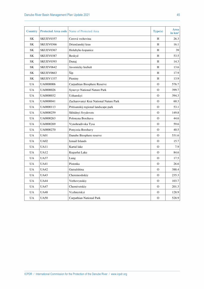
Danube River Basin Management Plan Update 2021 45
ICPDR / International Commission for the Protection of the Danube River / www.icpdr.org
Country Protected Area code Name of Protected Area Type(s) Area
in km²
SK SKUEV0357 Cerová vrchovina H 26.3
SK SKUEV0366 Drienčanský kras H 16.1
SK SKUEV0367 Holubyho kopanice H 39
SK SKUEV0387 Beskyd H 53.5
SK SKUEV0393 Dunaj H 14.3
SK SKUEV0642 Javornícky hrebeň H 13.6
SK SKUEV0663 Šíp H 17.9
SK SKUEV1337 Pieniny H 13.9
UA UA0000006 Carpathian Biosphere Reserve O 576.7
UA UA0000026 Synevyr National Nature Park O 399.7
UA UA0000032 Uzhanskyi O 394.3
UA UA0000041 Zacharovanyi Krai National Nature Park O 60.3
UA UA0000113 Pritisanskij regional landscape park O 53.1
UA UA0000259 Skhidnyi Svydovets O 149.8
UA UA0000263 Polonyna Borzhava O 44.6
UA UA0000269 Vynohradivska Tysa O 59.6
UA UA0000270 Ponyzzia Borzhavy O 40.5
UA UA01 Danube Biosphere reserve O 531.6
UA UA02 Izmail Islands O 15.7
UA UA11 Kartal lake O 7.9
UA UA12 Kugurlui Lake O 84.6
UA UA37 Lung O 17.5
UA UA41 Pistenka O 26.6
UA UA42 Gutsulshina O 388.4
UA UA43 Cheremoshskiy O 235.3
UA UA44 Verhovynskiy O 103.7
UA UA47 Chernivetskiy O 201.3
UA UA48 Vyzhnytskyi O 128.9
UA UA50 Carpathian National Park O 528.9

ICPDR / International Commission for the Protection of the Danube River / www.icpdr.org
Draft ANNEX 11 as of 26 February 2021
DRBMP Update 2021
Overview of key measures to avoid the extinction of Danube sturgeons and necessary supportive actions
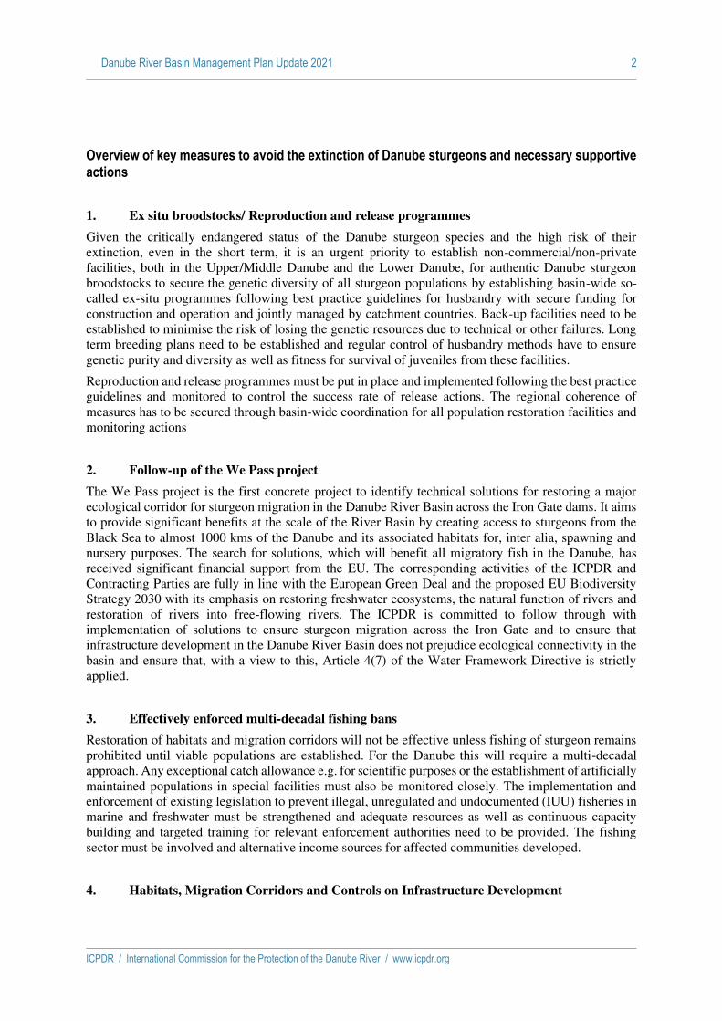
Danube River Basin Management Plan Update 2021 2
ICPDR / International Commission for the Protection of the Danube River / www.icpdr.org
Overview of key measures to avoid the extinction of Danube sturgeons and necessary supportive actions
1. Ex situ broodstocks/ Reproduction and release programmes
Given the critically endangered status of the Danube sturgeon species and the high risk of their
extinction, even in the short term, it is an urgent priority to establish non-commercial/non-private
facilities, both in the Upper/Middle Danube and the Lower Danube, for authentic Danube sturgeon
broodstocks to secure the genetic diversity of all sturgeon populations by establishing basin-wide so-
called ex-situ programmes following best practice guidelines for husbandry with secure funding for
construction and operation and jointly managed by catchment countries. Back-up facilities need to be
established to minimise the risk of losing the genetic resources due to technical or other failures. Long
term breeding plans need to be established and regular control of husbandry methods have to ensure
genetic purity and diversity as well as fitness for survival of juveniles from these facilities.
Reproduction and release programmes must be put in place and implemented following the best practice
guidelines and monitored to control the success rate of release actions. The regional coherence of
measures has to be secured through basin-wide coordination for all population restoration facilities and
monitoring actions
2. Follow-up of the We Pass project
The We Pass project is the first concrete project to identify technical solutions for restoring a major
ecological corridor for sturgeon migration in the Danube River Basin across the Iron Gate dams. It aims
to provide significant benefits at the scale of the River Basin by creating access to sturgeons from the
Black Sea to almost 1000 kms of the Danube and its associated habitats for, inter alia, spawning and
nursery purposes. The search for solutions, which will benefit all migratory fish in the Danube, has
received significant financial support from the EU. The corresponding activities of the ICPDR and
Contracting Parties are fully in line with the European Green Deal and the proposed EU Biodiversity
Strategy 2030 with its emphasis on restoring freshwater ecosystems, the natural function of rivers and
restoration of rivers into free-flowing rivers. The ICPDR is committed to follow through with
implementation of solutions to ensure sturgeon migration across the Iron Gate and to ensure that
infrastructure development in the Danube River Basin does not prejudice ecological connectivity in the
basin and ensure that, with a view to this, Article 4(7) of the Water Framework Directive is strictly
applied.
3. Effectively enforced multi-decadal fishing bans
Restoration of habitats and migration corridors will not be effective unless fishing of sturgeon remains
prohibited until viable populations are established. For the Danube this will require a multi-decadal
approach. Any exceptional catch allowance e.g. for scientific purposes or the establishment of artificially
maintained populations in special facilities must also be monitored closely. The implementation and
enforcement of existing legislation to prevent illegal, unregulated and undocumented (IUU) fisheries in
marine and freshwater must be strengthened and adequate resources as well as continuous capacity
building and targeted training for relevant enforcement authorities need to be provided. The fishing
sector must be involved and alternative income sources for affected communities developed.
4. Habitats, Migration Corridors and Controls on Infrastructure Development

Danube River Basin Management Plan Update 2021 3
ICPDR / International Commission for the Protection of the Danube River / www.icpdr.org
Successful sturgeon migration, which is a necessary component of their natural lifecycle, depends on
the availability of different habitats along their migration route as well as on their ability to overcome
any existing barriers which can prevent their migration. The network of habitats and migration routes
must extend to the scale of the Basin in order to be effective. Habitat availability is understood in terms
of both location and timing of habitat use as well as the resources and conditions needed to enable this
use. Mapping of different sturgeon habitats on the Danube River and its tributaries is highly important.
A first basin-wide map was developed in the MEASURES project and will need continuous and
coordinated updating, based on the shared set of methods and techniques described in the MEASURES
project “Danube Migratory Fish Habitat Manual” to ensure comparability and interoperability
throughout the basin. It will enable all countries in the Danube River Basin to coordinate their activities
concerning mapping sturgeon habitats, mapping and monitoring of any disturbances by human activities
(e.g. dredging, port construction, dams or weirs) and potential restoration measures. Special
consideration will have to be given to ensure the full implementation of the requirements of Article 4(7)
of the WFD to minimize the impact on sturgeon habitats and migration routes due to changes in
hydrology and structure of water bodies, e.g. as a result of new infrastructure or activities in the riverbed.
A map of sturgeon habitats could be available as a useful tool when assessing future infrastructure works
and enabling environmental impact assessment for particular sectors of the Danube River Basin.
5. Monitoring and control of by-catch in marine fisheries
While there are no records of incidental bycatch of sturgeon in Black Sea fisheries, it is equally clear
that given the critical state of stocks and the acute risk of extinction of the remaining sturgeons that
bycatch in marine fisheries may threaten the effectiveness of conservation action taken in the Danube
River Basin. It will therefore be important for ICPDR and Contracting Parties to seek cooperation with
fisheries and environmental authorities in non-Danubian Black Sea States, the Black Sea Commission,
FAO (GFCM) and the World Bank/GEF to seek improved information on the extent to which such
bycatch is taking place and its impact on sturgeon populations and identify coherent regional
management options (such as technical solutions, fisheries restrictions, closed areas and seasons) with
a view to their implementation and establishing the appropriate monitoring thereof. Action in this respect
will bring the ICPDR into line with the proposed EU Biodiversity Strategy 2030 and its emphasis on
eliminating by-catch or reducing it to levels allowing full recovery of species threatened with extinction
in marine fisheries.
6. Coordination with sturgeon conservation in the Black Sea Basin
As the Danube sturgeon populations are shared with those of the Black Sea Basin, coordination with
marine management and conservation efforts in that basin is crucial to ensure the effectiveness of actions
in the Danube River Basin. It is therefore important for the ICPDR and its Contracting Parties to seek
actively specific and close cooperation on sturgeon conservation in the Black Sea, inter alia with the
Black Sea Commission, FAO (GFCM), the World Bank and GEF as well as Black Sea States on issues
such as monitoring of sturgeon populations and the impact of marine fisheries on these, protection of
sturgeons through technical fisheries regulation and designation of marine protected areas. Furthermore,
it will be important to cooperate with non-Danubian States in the Black Sea Basin on protection and
conservation of sturgeon in their internal and inland waters.
The objective of the wider cooperation with Black Sea Basin States and the relevant international
organisations should be to ensure a regional coherence of measures and approaches to maximise the
effectiveness of policies and measures.

Danube River Basin Management Plan Update 2021 4
ICPDR / International Commission for the Protection of the Danube River / www.icpdr.org
The effectiveness of the actions outlined above is critically dependent on a number of additional,
supportive actions that are also required to facilitate effective management of sturgeon conservation in
the Danube River Basin. The most important issues are the following:
7. Sturgeon Population Monitoring
The impact of implemented measures for improving sturgeon populations in the Danube River Basin is
impossible to monitor without prior knowledge of status of native stocks of sturgeons. Due to the
migratory nature of the sturgeon, monitoring needs to be based on agreed common metrics and
methodologies, a shared monitoring network and interoperable equipment throughout the Danube River
Basin and the adjacent Black Sea catchment. It is necessary to integrate sturgeon monitoring into
fisheries management plans in each country and to collect monitoring data on a basin-wide scale. It
could include monitoring annual recruitment from the wild and capturing young of the year (YOY)
sturgeons, sampling and tagging YOY sturgeons and sampling and telemetry study of adult sturgeons.
Telemetry is the most effective monitoring technique and will require standardized equipment
throughout the monitoring area. As some scientists from Danubian countries are active in COST Action
“The European Aquatic Animal Tracking Network” (ETN) this network could be used as scientific base for the preparation of a sturgeon telemetry study. National fisheries authorities, fishermen and relevant
international organisations should be involved to enable effective implementation of sturgeon telemetry
study.
8. Establishment and maintenance of a Danube Migratory Fish Database
This will support the implementation of “Strategy for ecological corridor conservation in the Danube catchment” developed under the MEASURES project. The MIS will be used to collect relevant information on migratory fish and their habitats in the Danube River Basin and allow users to find and
visualise specific information about particular migratory fish and their habitats more easily. MIS has a
Library (open access publications, articles and reports), a meta database (relevant datasets in the region)
and a Data Centre (monitoring data of migratory fish including habitats and corridors). It will thus also
be a one-stop shop for information for use in management of the recovery of sturgeon populations in
the Danube River Basin. Like other such databases, MIS will need to be maintained and regularly
updated to retain its utility as a management tool.

ICPDR / International Commission for the Protection of the Danube River / www.icpdr.org
Draft ANNEX 12 as of 26 February 2021
DRBMP Update 2021
Economic Analysis

Danube River Basin Management Plan Update 2021 2
ICPDR / International Commission for the Protection of the Danube River / www.icpdr.org
The economics analysis of the DRBM Plan – Update 2021 is based on a questionnaire sent out to the Danube countries in Autumn 2019 and spring 2020, for the collection of qualitative information on economics important in the framework of WFD implementation (e.g. cost recovery, water pricing, environmental and resource costs etc.). The questionnaire presented the data which was included in the 2015 Update of the DRBM Plan, and asked the countries to update the information.
The tables in this Annex provide the updated information; the corresponding chapter 7 presents an overview of the approaches which are in place in the Danube countries in text form.
Note: Data from Serbia does not include data from the Autonomous Provinces Kosovo and Metohija.

Danube River Basin Management Plan Update 2021 3
ICPDR / International Commission for the Protection of the Danube River / www.icpdr.org
Table 1: Investment costs for water supply and wastewater*
Country Demand and Supply Costs1
[EUR]
Only demand costs
[EUR]
Only investment costs (without distinguishing)
[EUR]
DE - -
Water supply services: 340 million EUR / year (National total
in 2017 approx. 2.7 Billon EUR/year)
Waste water services: Approx. 610 million EUR/year (National total in 2016 approx. 4.9 Billon
EUR)
AT - - 3.3 billion (2013 - 2018)
CZ - Data not yet available Data not yet available
SK - -
501.41 million EUR** (water supply + wastewater) of which:
water supply: 36.52 million, wastewater: 464.89 million
HU*** - -
Water supply:
59 646 million HUF 192.3 million EUR
(2016-2021)
Waste water: 300 579 million HUF
959 million EUR (2016-2021)
SI
HR - -
2,9 billion € for waste water; 335 million € for water supply; (investment Plan 2014-2023 for
whole territory of Croatia)
BA - 1.1 billion
Water supply services: 390.82 million EUR (2016-2021)
Waste water services: 705.70 million EUR (2016-2021)
ME n.a.
RS - -
Total investments for DWD approx. 1.4 billion EUR
Total investments for UWWT approx. 4.5 billion EUR
RO 29.411.781 EUR – water supply and waste water infrastructure.
BG -
883.9 mio. EUR (2016-2021; wastewater collection and
treatment)
Assessment of the investment costs for the time
2022-2027 is forthcoming
-
1 According to the questionnaires: demand cost are the "total costs related to implementing the EU Directives"; supply costs are the investment costs that could be realistically covered.

Danube River Basin Management Plan Update 2021 4
ICPDR / International Commission for the Protection of the Danube River / www.icpdr.org
task in the frame of RBMP updating process.
MD
UA - -
Water supply + wastewater: 13.5 million EUR (DRBD).
Capital investments for environmental protection
expenditures on return water treatment – 0.25 million EUR
(DRBD)
*Timescales: 2015-2021, if not noted otherwise.
** (SK): Data for the whole country (Danube part represents 96.23 % of the total territory of Slovakia) and for 2014-2020.
*** (HU): Drinking water supply includes both the protection of national water resources and the implementation of a drinking water quality improvement program. The public wastewater collection and treatment also includes sewerage, wastewater treatment (below and above 2000 PE) and sewage sludge treatment. The costs were planned on the basis of the relevant EU programs, so do not include reconstructions, only direct compliance with the EU Directives. (The applied EUR/HUF exchange rate for the period of the 2nd RBMP is 310.1)

Danube River Basin Management Plan Update 2021 5
ICPDR / International Commission for the Protection of the Danube River / www.icpdr.org
Table 2: What are water services - what are water uses?
Country Only water supply and wastewater
Water supply, wastewater AND
others
Included in cost recovery
calculations (Y/N/Partly)
Other definitions
Is the definition of water services included in the national water
legislation (Y/N)
DE Y Y
AT
Y
(based on estimation)
Y
(Water services to which Article 9 par
1 second indent WFD is applied are
defined. Other water services are regulated in the frame of water
uses)
CZ
Rivers and river basin management;
surface water abstraction; GW
abstraction; discharge of
wastewater into surface water; discharge of
wastewater into GW; impoundment
for the energy production;
navigation – only recreation
Y
Y
(§ 2 let. a) of Decree No.
24/2011 Coll.)
- Any activity which provides for
abstraction, retention, collection,
treatment and distribution of
surface water or GW, or the
removal and treatment of waste
water with subsequent
discharge into surface water, for households, public institutions or any economic activity
SK
Use of hydro-energy potential of
water-course; abstraction of
energy water from watercourse; abstraction of
surface water from water-course
Y
(water supply, wastewater, use of
hydroenergy potential, abstraction
of energy water, abstraction of surface water)
Navigation is defined as a
"public service - paid by the state"
Y
HU
Public water supply, public
wastewater collection and
treatment,
Y
(the other different water uses are
taken into consideration as
“water uses”
Y

Danube River Basin Management Plan Update 2021 6
ICPDR / International Commission for the Protection of the Danube River / www.icpdr.org
agricultural water supply (irrigation, fishponds, other),
damming and storage for
hydropower production, own water abstraction
(according to WFD Article 2
Definition 39))
SI
HR Y
Additional definition of water activities has been
enacted.
Water activities are all activities that
provide for households, public
institutions or economic entities:
a) abstraction, impoundment,
storage, treatment and distribution of
surface or groundwater, and b) collection and
treatment of wastewater, subsequently
discharged into the water. Water
activities include but they are not limited to water
services.
CR calculation includes all water
activities.
Y
BA
13 other water services defined
N
ME n.a.
RS N
N
There is no definition of water
services in WL, but WL sets the charges/fees for
water abstraction and waste water
disposal for different purposes
(water use: public water supply,
irrigation, industries,
hydropower, bottling, etc., and
waste water

Danube River Basin Management Plan Update 2021 7
ICPDR / International Commission for the Protection of the Danube River / www.icpdr.org
disposal: municipal,
industrial, cooling, etc.), sediment abstraction, etc.
RO
Contributions for using water resource for hydropower,
thermal plants, nuclear power
plant for aquaculture,
irrigation, industry, households.
Structured on type of water resource
(surface and groundwater).
Y
Yes (Water Law)
BG - -
Y
All costs considered(financial, environmental and
resource costs)
Public water supply; public
collection of waste water; public treatment of wastewater;
individual water supply in industry; individual water
supply in agriculture for
irrigation; individual water
supply for stockbreeding; producing of
electric power by water electric
plant; protection of harmful impact of
water; conservation of
water; navigation and other activities
connected with navigation;
individual drinking water supply
Y
MD n.a.
UA -
Water supply, wastewater collection and treatment; agricultural; fish farming; surface water abstraction; use of hydro-energy potential.
Y
Water use - the use of water (water bodies) to meet the needs of the population, industry, agriculture, transport and other sectors of the economy,
Y
Water Code

Danube River Basin Management Plan Update 2021 8
ICPDR / International Commission for the Protection of the Danube River / www.icpdr.org
including the right to water intake, wastewater discharge and other uses of water (water bodies).

Danube River Basin Management Plan Update 2021 9
ICPDR / International Commission for the Protection of the Danube River / www.icpdr.org
Table 3: Water pricing policies in place, and prices of water services/uses
Country Water service Environmental cost
[EUR/m3, EUR/?, not assessed]
Resource cost
[EUR/m3, EUR/?, not assessed]
Payment for environmental cost recovery
[EUR/m3, no payment]
Payment for resource cost recovery
[EUR/m3, no payment]
DE
Water supply ERC are considered in the recovery of the costs of water supply
services (EUR/m3); they are not quantified individually ERC are considered in the recovery of the costs of water supply
services (EUR/m3); they are not quantified individually
Waste water treatment ERC are considered in the recovery of the costs of waste water
services; they are not quantified individually ERC are considered in the recovery of the costs of waste water
services; they are not quantified individually
AT
Water supply ERC are internalized in the price for drinking water (EUR/m3) but
they are not yet quantified individually Payments for ERC are internalized in the price for drinking water
(EUR/m3) but they are not yet quantified individually
Waste water treatment ERC are internalized in the price for wastewater treatment (EUR/m3)
but they are not yet quantified individually Payments for ERC are internalized in the price for wastewater
treatment (EUR/m3) but they are not yet quantified individually
Others (e.g. hydropower for electricity production,
navigation, aquaculture)
ERC are internalized in environmental requirements but they are not yet quantified individually
Payments are internalized in environmental requirements but they are not yet quantified individually
CZ
Drinking water supply ERC costs in the form of charges for groundwater and surface water abstraction is internalized in the price for drinking water (EUR/m3)
No separate payment exists. ERC recovery costs are internalized.
Wastewater treatment ERC are in the form of charges for pollution and volume of
discharged wastewater. See the answer above.
Water storage and impoundment for energy
production
ERC costs in the form of charges for impoundments are internalized in the price which is agreed between the customer and State
Enterprises of River Basin Management(EUR/m3) No separate payment exists. ERC recovery costs are internalized.
Navigation Not assessed Not assessed No payment No payment
SK
Water supply for households, industry and agriculture
Not assessed
Resource cost in the form of charges for groundwater
abstraction as well as payments for surface water abstraction is
internalized in the price for drinking water (EUR/m3)
No payment No separate payment, only the
internalized one
Collection and treatment of wastewater
Environmental cost in the form of charges for discharge of
wastewater is internalized in the price for the collection and
treatment of wastewater (EUR/m3)
Not assessed No separate payment, only the
internalized one No payment

Danube River Basin Management Plan Update 2021 10
ICPDR / International Commission for the Protection of the Danube River / www.icpdr.org
Country Water service Environmental cost
[EUR/m3, EUR/?, not assessed]
Resource cost
[EUR/m3, EUR/?, not assessed]
Payment for environmental cost recovery
[EUR/m3, no payment]
Payment for resource cost recovery
[EUR/m3, no payment]
Use of hydro-energy- potential of watercourse
Not assessed Not assessed No payment No payment
Abstraction of energy water from watercourse
Not assessed Not assessed No payment No payment
Abstraction of surface water from watercourse
Not assessed Not assessed No payment
The payment for surface water abstraction is determined in
EUR/m3 and is a component of the price for drinking water. This
payment is considered as covering a part of resource costs.
HU
Public wastewater collection and treatment
EC were assessed in 2006-2007 based on the 2005 data. EC are partly internalized in the water
load fee and wastewater fine and this is covered by the water price.
Not assessed
Unit water load fee (WLF) in average (depends on different
loads)
WLF: 4.4 HUF/m3 (2018)
Wastewater fine: 519.9 million HUF (2018)
In the case of a wastewater fine, it does not make sense to
calculate a specific m3 for all wastewater volumes, because
only a part of it is fined.
No payment
Up to RBMP2, the water resource fee (WRF) could only
been considered as an environmental cost, but since the
WRF rate for water bodies in poor status differs from the
others (20% higher), it can also be considered as a partial
resource cost.
Public water supply
EC were assessed in 2006-2007 based on the 2005 data. EC are partly internalised in the water
resource fee and this is covered by the water price
Not assessed 2018 water resource fee (WRF)
data: 4.42 HUF/m3 No payment
Own water abstraction EC are partly internalized in
water resource fee Not assessed
2018 water resource fee (WRF) data: Industry and other economic sector: 2.43 HUF/m3
Agriculture: 1.1 HUF/m3
Others: 11.9 HUF/m3
Water resource fee is partially serves as resource cost
Agricultural water supply (irrigation, fishponds, other)
EC are partly internalized in water resource fee
Not assessed 2018 water resource fee (WRF) data:
Water resource fee is partially serves as resource cost

Danube River Basin Management Plan Update 2021 11
ICPDR / International Commission for the Protection of the Danube River / www.icpdr.org
Country Water service Environmental cost
[EUR/m3, EUR/?, not assessed]
Resource cost
[EUR/m3, EUR/?, not assessed]
Payment for environmental cost recovery
[EUR/m3, no payment]
Payment for resource cost recovery
[EUR/m3, no payment]
Irrigation:1.15 HUF/m3
Fish pond: 0.045 HUF/m3
Rice production: 0.044 HUF/m3
Animal husbandry: 13.24 HUF/m3
Damming and storage for hydropower production
EC are partly internalized in water resource fee Not assessed
2018 water resource fee (WRF) data: In situ water use: 0.0045 HUF/m3
Water resource fee is partially serves as resource cost
SI

Danube River Basin Management Plan Update 2021 12
ICPDR / International Commission for the Protection of the Danube River / www.icpdr.org
Country Water service Environmental cost
[EUR/m3, EUR/?, not assessed]
Resource cost
[EUR/m3, EUR/?, not assessed]
Payment for environmental cost recovery
[EUR/m3, no payment]
Payment for resource cost recovery
[EUR/m3, no payment]
HR
Water Services
Water supply 0,40 EUR/m3 - an estimation based on annual Financial Plan of
Croatian Waters
water abstraction fee - 0,38 EUR/m3
Waste water collection and treatment
0.22 EUR/m3 - an estimation based on annual Financial Plan of Croatian Waters
water pollution charge - 0,18 EUR/m3 (subject to load coefficients for industrial waters discharge)
Other Water Services
Abstraction of surface water (excluding water supply and specified activities below)
not assessed (only internalized part was assessed, additional assessments are in
progress)
water abstraction charge - 0,11, 0,09, 0,07 and 0,04 EUR/m3 depending on water status (very good, good, moderate, bad and very
bad)
Abstraction of groundwater (excluding water supply and specified activities below)
not assessed (only internalized part was assessed, additional assessments are in
progress)
water abstraction charge - 0,11 and 0,04 EUR/m3 depending on water status (good or bad) and 0,15 EUR/m3 for mineral, thermos-
mineral and thermal waters
Water power for electricity production
not assessed (only internalized part was assessed, additional assessments are in
progress)
water abstraction charge - 7.5% (for plants over 5 MW) or 5% (for plants up to 5MW) of the average price per 1 kWh electricity
produced

Danube River Basin Management Plan Update 2021 13
ICPDR / International Commission for the Protection of the Danube River / www.icpdr.org
Country Water service Environmental cost
[EUR/m3, EUR/?, not assessed]
Resource cost
[EUR/m3, EUR/?, not assessed]
Payment for environmental cost recovery
[EUR/m3, no payment]
Payment for resource cost recovery
[EUR/m3, no payment]
Water power for plant operation (other than electricity
production)
not assessed (only internalized part was assessed, additional assessments are in
progress)
water abstraction charge - 0,26 EUR per 1 kWh of total installed capacity of the plant
Heating and cooling of households and offices
not assessed (only internalized part was assessed, additional assessments are in
progress)
water abstraction charge - 0,013 EUR/m3
Rafting and canoeing (as business activities)
not assessed (only internalized part was assessed, additional assessments are in
progress)
water abstraction charge - 6,57 EUR/yr per passenger seat
Anchoring floating vessels for catering and similar businesses
not assessed (only internalized part was assessed, additional assessments are in
progress)
water abstraction charge - 13,14 EUR/yr per m2 of water surface occupied
Irrigation not assessed (only internalized part was assessed, additional assessments are in
progress)
65,68 EUR/yr per ha - if the quantity is not measured, if it is measured - the tariffs for surface water and groundwater abstraction
apply
Water discharges (other than through public wastewater
facilities)
not assessed (only internalized part was assessed, additional assessments are in
progress)
water pollution charge (i) 0,18 EUR/m3 od water discharged (subject to load coefficients for industrial waters discharge), (ii) 0,000177
EUR/m3 of cooling water discharged and (iii) 0.000486 EUR/kg of nitrogen as active substance in mineral fertilizer
BA
Public water supply - - - 0.005 Euro/ m3 of abstracted
water
Bottling of water & mineral water
- - - 1.00 Euro/ m3 of abstracted
water
Water supply to industry and others (abstraction)
- - - 0.01/0.015 Euro/m3 (RS/FBiH)
Irrigation (abstraction) - - - 0.001 Euro/m3 (RS)
Fish farming (abstract) - - - 0.0005 Euro/m3 (RS only) abstr.
water
Fish farming (pollution) - - 0.01/0.025 (RS/FBiH) Euro/kg
produc. fish -

Danube River Basin Management Plan Update 2021 14
ICPDR / International Commission for the Protection of the Danube River / www.icpdr.org
Country Water service Environmental cost
[EUR/m3, EUR/?, not assessed]
Resource cost
[EUR/m3, EUR/?, not assessed]
Payment for environmental cost recovery
[EUR/m3, no payment]
Payment for resource cost recovery
[EUR/m3, no payment]
Electricity production - - 0.0005 Euro/kWh of produced
electricity -
Wastewater discharge - - 1.00 Euro/PE -
Pollution caused by vehicles - - 1.00 Euro/PE -
Pollution caused by use of artificial fertilizer
- - 0.0025 Euro/kg prod. / imported
fertilizer -
Pollution caused by use of pesticides
- - 0.04 Euro/kg of prod. / imported
pesticides -
Sediment extraction - - 0.75 Euro/m3 of the extracted
material -
General water charge - - 0.5% of the net salary (FBiH
only) 0.5% of the net salary (FBiH
only)
ME n.a.
RS
Fee for water use (public utilities), population
- - - Extracted amount
0.002
Fee for water use (public utilities), legal entities
- - - Extracted amount
0.004
Fee for raw water use - - - 0.003
Fee for irrigation water use - - - 0.001
Fee for water bottling - - - 0,010 (EUR/l)
Fee for abstracted water for electricity production in
hydropower plants below 10 MW
- - - 0.708 (EUR/MWh)
Fee for abstracted water for electricity production in
hydropower plants of 10 MW and above
- - - 0.772 (EUR/MWh)

Danube River Basin Management Plan Update 2021 15
ICPDR / International Commission for the Protection of the Danube River / www.icpdr.org
Country Water service Environmental cost
[EUR/m3, EUR/?, not assessed]
Resource cost
[EUR/m3, EUR/?, not assessed]
Payment for environmental cost recovery
[EUR/m3, no payment]
Payment for resource cost recovery
[EUR/m3, no payment]
Fee for abstracted water for thermal power plants with
recirculating cooling system - - - 0.420 (EUR/MWh)
Municipal waste water disposal - -
For the disposal of municipal waste water in general, as well as for the disposal of municipal
wastewater into hydromelioration systems, there is methodology prescribed for
calculation of environmental fee that takes into account certain parameters and their ELVs.
0.002
Industrial waste water disposal (depending on type of industry)
- -
For the disposal of industrial waste water in general, as well as for the disposal of industrial
wastewater into hydromelioration systems, there is methodology prescribed for
calculation of environmental fee that takes into account certain parameters and their ELVs.
0.044/0.026/0.024/0.012
Fee for disposal of water from thermal power plants with
runoff cooling system - - - 0.420 (EUR/MWh)
Fee for sediment extraction (depending on location of
extraction point) - - - 0.500/0.620/1.000
RO Water supply -
0
RC=foregone opportunities that other uses suffer due to the
depletion of the resource beyond its natural rate of recharge or
recovery based on the assessment of availability of the
water resource in one section
- -0

Danube River Basin Management Plan Update 2021 16
ICPDR / International Commission for the Protection of the Danube River / www.icpdr.org
Country Water service Environmental cost
[EUR/m3, EUR/?, not assessed]
Resource cost
[EUR/m3, EUR/?, not assessed]
Payment for environmental cost recovery
[EUR/m3, no payment]
Payment for resource cost recovery
[EUR/m3, no payment]
comparing to the present and future water demand
Wastewater treatment
(* includes sewerage)
0,43EUR/cm
Only Monitoring costs considered
Approximated
EC= costs of measures whose primary aim is to protect the water environment based on
existing legal (environmental)
standards
- 0,43 EUR/cm -
Water abstraction for households from surface waters
Water abstraction for industry from surface waters
Water abstraction for irrigation
Water abstraction for aquaculture
Water abstraction for hydropower
Water abstraction for thermo power plants
Water abstraction for households from groundwater
waters
Navigation (lock)
Receive pollutants in the surface waters
Water supply and waste water treatment
Approximated
by looking at the costs of measures whose primary aim is to
protect the water environment
Costs of foregone opportunities which other uses suffer due to
the
Internalized in waste water treatment costs
Level still in progress Level still in progress

Danube River Basin Management Plan Update 2021 17
ICPDR / International Commission for the Protection of the Danube River / www.icpdr.org
Country Water service Environmental cost
[EUR/m3, EUR/?, not assessed]
Resource cost
[EUR/m3, EUR/?, not assessed]
Payment for environmental cost recovery
[EUR/m3, no payment]
Payment for resource cost recovery
[EUR/m3, no payment]
based on existing legal (environmental)
standards
depletion of the resource beyond its natural rate of recharge or
recovery (e.g. linked to the over-abstraction
of groundwater). Based on the assessment of availability of the
water resource in one section comparing to the present and
future water demand
BG
Public water supply
105,837.42 EUR (2012)
(According Methodology: Costs for removal of damages, caused
by diffuse pollution from agriculture, stock-breeding and
fish- breeding)
3,765,664.71 EUR (in 2012)
1.Costs connected with present lack of water
2.Costs connected with future lack of water
Recovery through water price paid by households, industry,
agriculture and services
Price for water supply by water companies/drinking water: 0.41
€/m3; Price for water supply for
irrigation/supply by “Irrigation systems”: 0.18 €/ m3
Recovery through water price paid by households, industry,
agriculture and branch of services
Price for water supply by water companies/drinking water: 0.41
€/ m3
Price for water supply for irrigation/supply by “Irrigation
systems”:0.18 €/ m3
Public collection of waste water
13,260,866.23 EUR (in 2012)
(Costs for removal of damages, caused by diffuse pollution from
settlements without sewage system)
No identified resource costs
Recovery through prices of public collection of waste water
Price for collection of waste water: 0.09 €/ m3
N
Public treatment of waste water
27 240 608,85 EUR (in 2012)
(1.Costs for removal of damages, caused by point pollution of waste
water from households and industry /building of WWT-Plants
2. Costs for removal of damages, caused by diffuse pollution from
landfills)
No identified resource costs
Recovery through prices of treatment of waste water
Price for treatment of waste water: 0.14 €/ m3
N

Danube River Basin Management Plan Update 2021 18
ICPDR / International Commission for the Protection of the Danube River / www.icpdr.org
Country Water service Environmental cost
[EUR/m3, EUR/?, not assessed]
Resource cost
[EUR/m3, EUR/?, not assessed]
Payment for environmental cost recovery
[EUR/m3, no payment]
Payment for resource cost recovery
[EUR/m3, no payment]
Individual water supply in industry
No identified environmental costs Costs in case of future water
scarcity (no resource costs for 2008-2012: 0 €/m3)
N
Recovery through fee for water use according to National Tariff
for fees:
0.045€/m3 – surface water.
0.07€/m3 – ground water.
Individual water supply in agriculture for irrigation
7,669.38 EUR (in 2012)
(Costs for removal of damages, caused by diffuse pollution from
agriculture)
Costs in case of future water scarcity (no resource costs for
2008-2012: 0 €/m3)
Recovery through fee for water use according to National Tariff
for fees:
0.0005€/m3 – surface water
0.005€ m3 – ground water
Recovery through fee for water use according to National Tariff
for fees
0.0005€/m3 – surface water
0.005€/m3 – ground water
Individual water supply for stock-breeding and fish-
breeding
750,065.19 EUR (in 2012)
(Costs for removal of damages, caused by diffuse pollution from stock-breeding and fish-breeding)
Costs in case of future water scarcity (no resource costs for the period 2008-2012: 0 €/m3)
Recovery through fee for water use according to National Tariff
for fees:
0.0005€/m3 – surface water
0.005€/m3 – ground water
Recovery through fee for water use according to National Tariff
for fees
0.0005€/m3 – surface water
0.005€/m3 – ground water
Producing of electric power by water electric plant
16,361.34 EUR (in 2012)
(1.Costs for removal of damages, caused by drying of rivers due to water use of hydro power plants;
2. Costs for removal of damages, caused by interruption of
continuation of the rivers due to water use of hydro power plants
/costs for building of fish-passages)
Costs in case of future water scarcity, but no resource costs for the period 2008-2012: 0 €/
m3
Recovery through fee for water use according to National Tariff for fees: 0.0008 €/m3
Recovery through fee for water use according to National Tariff
for fees:
0.0008 €/m3
Protection of harmful impact of water
Costs for measures for recovery of damages due to gravel
extraction:
2008-2012: 0 €/ m3
No identified resource costs
No fee. Cost recovery:
- Own incomes of municipalities
- State financing for “Irrigation systems”
-State transfers
Total amount for 2012: 20,577,453.03 EUR;
No

Danube River Basin Management Plan Update 2021 19
ICPDR / International Commission for the Protection of the Danube River / www.icpdr.org
Country Water service Environmental cost
[EUR/m3, EUR/?, not assessed]
Resource cost
[EUR/m3, EUR/?, not assessed]
Payment for environmental cost recovery
[EUR/m3, no payment]
Payment for resource cost recovery
[EUR/m3, no payment]
Water conservation No identified environmental costs
(only financial costs) No identified resource costs
(only financial costs)
No fee. Cost recovery of financial costs only
No fee. Cost recovery of financial costs only
Navigation and other activities connected with navigation
Costs for removal and prevention of damages, caused by navigation :2008-2012 for Danube - 0 €/m3
No identified resource costs Cost recovery through harbor fees paid by shipping sector:
2008-2012 for Danube - 0 €/ m3 No
Individual drinking water supply
No identified environmental costs
Costs in case of future water scarcity, but no resource costs for the period 2008-2012: 0
€/m3
No
Cost recovery through fees for issue of permits
0.02 €/m3 – surface water
0.75 €/m3 – ground water
MD
UA
Water supply for industry
Recovery through water price paid by industry
Tariff 0,25 – 0,75 €/ m3
Recovery through water price paid by industry
Tariff 0,25 – 0,75 €/ m3
Water supply for population
Recovery through water price paid by houshold
Tariff 0,22 – 0,57 €/ m3
Recovery through water price paid by houshold
Tariff 0,22 – 0,57 €/ m3
Wastewater treatment for industry
Recovery through water price paid by industry
Tariff 0,15– 0,69 €/ m3
Recovery through water price paid by industry
Tariff 0,15– 0,69 €/ m3
Wastewater treatment for population
Recovery through fee for water use according to National Tariff
for fees:
0,16 – 0,48 €/ m3
Recovery through fee for water use according to National Tariff
for fees:
0,16 – 0,48 €/ m3

Danube River Basin Management Plan Update 2021 20
ICPDR / International Commission for the Protection of the Danube River / www.icpdr.org
Country Water service Environmental cost
[EUR/m3, EUR/?, not assessed]
Resource cost
[EUR/m3, EUR/?, not assessed]
Payment for environmental cost recovery
[EUR/m3, no payment]
Payment for resource cost recovery
[EUR/m3, no payment]
Wastewater treatment ERC are in the form of charges for pollution and volume of
discharged wastewater.
Drinking water supply ERC costs in the form of charges for groundwater and surface water
abstraction is internalized in the price for drinking water
ERC are in the form of charges for pollution and volume of
discharged wastewater.
Cost recovery through fees for issue of permits
1,74 €/m3 – surface water
2,02 €/m3 – ground water
Producing of electric power by water electric plant
ERC are in the form of charges for pollution and volume of
discharged wastewater.
Cost recovery through fees for issue of permits
0,36 €/10 ths m3 – surface water
Fish farming
ERC are in the form of charges for pollution and volume of
discharged wastewater.
Cost recovery through fees for issue of permits
1,87 €/10 ths m3 – surface water
2,24 €/ 10 ths m3 – ground water

Danube River Basin Management Plan Update 2021 21
ICPDR / International Commission for the Protection of the Danube River / www.icpdr.org
Table 4: Use and calculation of ERC
Country ERC estimations available
[Y/N/partly]
Clear Methodology for calculating ERC
[Y/N/partly]
Clear Methodology for cross subsidies
[Y/N/partly]
DE N Partly - Issue of operationalizing the concept of ERC remains challenging.
N
AT
Partly
The internalized parts of EC in AT are estimated through the quantified costs of measures.
Partly
(expert judgment involved)
Y
According to the polluter pays principle, water users
pay the environmental costs they cause in form of water
charges as well as implementation of technical measures in order to prevent
cross subsidies.
CZ Y
Partly
The calculation of EC in CZ is based on the costs of renewal and saved costs. It determines the costs that
would be necessary for compensation of impacts of water management
services on environment, respectively for the compensation of the impacts disturbing the state of surface and
GW from the quantitative, qualitative and hydromorphological point of
view.
N
(Subsidies do not play a role in CZ)
SK
N
No "full estimations of ERC for single water services"; only the
"internalized parts are quantified"2.
Partly For the estimation of EC, the cost-
based approach is used which involves the costs for certain groups of measures. The evaluation of RC is also based on a cost-based approach (e.g. construction of long-distance pipelines to areas failing to achieve good quantitative status of GWBs).
As there have not been applied regulatory measures and restrictions,
the RC which appear due to non-coverage of water requirements of
specific sectors (foregone costs approach) is not yet actual.
Partly
(subsidies play little role)
HU
Partly
EC are partly quantified, only the internalized parts are quantified. EC were assessed in 2006-2007 based on the 2005 data for waste water and drinking water. Taking the international experience into account we chose the cost-based approach, so we consider the cost
Y
EC calculation methodology is clear (cost-based methodology), but the cost of measures is missing. The
Water Load Fee (WLF) and water resource fee is internalized of (a part of the) external environmental costs.
The rate of the water load fee is defined by the product of: 1) the total
Y
There are subsidies for covering a part of the
financial cost for households when the service costs are
extremely high, the cost are above a certain threshold.
2 The share of the charges for the discharge of wastewater into the water courses on the total costs of water companies in providing of wastewater services (i.e. wastewater collection and treatment) is ca. 1,69 % (2018) – these charges are considered as environmental costs. Charges for groundwater abstraction and payments for surface water abstraction are considered as a part of the resource costs (which are paid by those who have the permission to use the water source). The share of these charges and payments for the abstraction on the total costs of water companies in providing of water supply service is about 17,96 % (2018). However, the abstraction of water could be also seen as a form of the environmental costs (because an abstraction represents one of the biggest pressures on water body)…The charges for discharge of wastewater do not represent full estimation of environmental costs. These charges are stipulated by the Decree of the Government and represent only a part (approximately 30%) of the real costs necessary for the wastewater treatment in the wastewater treatment plants.

Danube River Basin Management Plan Update 2021 22
ICPDR / International Commission for the Protection of the Danube River / www.icpdr.org
Country ERC estimations available
[Y/N/partly]
Clear Methodology for calculating ERC
[Y/N/partly]
Clear Methodology for cross subsidies
[Y/N/partly]
of the remaining measures needed in order to achieve "good
status" as EC.
amount of the annual discharge of the contaminant measured in kilograms, 2) multiplied by a specific rate per
pollutant, 3) a measure of area sensitivity and 4) sludge disposal
factors. Water resource fee (abstraction fee) is depend on the
water resource type and water uses (and some another element). New
development: there is a new so called "overload factor" in the calculation, which depends on the quantitative
status of each water body.
In general, all water users have to pay the water resource fee (WRF) for the amount of water used. The paid
amount is received by the state budget.
SI
HR
Partly
ERC are partly quantified, only the internalized parts are
quantified.
Partly
(cost-based approach)
Assessment of ERC is ongoing.
N
BA
Partly
ERC are partly quantified, only the internalized parts are
quantified.
Partly
(cost-based approach and expert judgment)
N
ME n.a.
RS
N
No "full estimations of ERC for each water service", but parts are
included in charges/fees.
Partly
(cost-based approach) N
RO
Partly
ERC are partly quantified, only the internalized parts are
quantified.
Partly (cost-based approach)
A revise of the assessment is ongoing.
No cross subsidy between different water uses is
legally provided.
BG Y
ERC are quantified (2008-2012) Y (Methodology is developed) N
MD
UA Partly
(cost-based approach)

Danube River Basin Management Plan Update 2021 23
ICPDR / International Commission for the Protection of the Danube River / www.icpdr.org
Table 5: Cost Recovery (CR)
Country
Prices and costs for water services
available3
[Y/N/partly]
Levels of CR stated
[Y/N/partly]
Levels of CR for all defined water
services
[Y/N]
Clear methodology for calculating CR
[Y/N/partly]
DE Y
(water supply and waste water services)
Y
(water supply and waste water services)
Y Y
AT
Y
(total costs and total revenues of water
services [water supply and wastewater treatment] are
available, as well as bandwidths/ ranges of average water prices)
Y
Y
Y
(based on expert judgement)
CZ Y
(abstraction, water supply and wastewater)
Partly
(all O&M costs are fully covered, when
including also subsidies on investment we
would not reach 100% of cost recovery)
N
(only water supply services and
wastewater treatment)
N
SK Y
(for all five water services)
Y Y
Partly (only financial costs, including depreciation and
internalized part of environmental and resource costs are
considered).
HU
Y
Costs, prices, revenues are available for public water supply, for public waste water collection
and treatment, agricultural water
supply, damming and storage for hydropower
production.
Internalized ERC costs for industry, agriculture
and other/own well.
Y
Yes for public water supply, public waste water collection and
treatment, agricultural water supply, damming
and storage for hydropower production
Partly for public water supply for industry and agriculture/own well).
Y
Financial cost recovery rates are calculated
(including internationalized ERC
costs) for water services (public water supply,
public wastewater collection and
treatment, agricultural water supply, damming
and storage for hydropower production).
SI
HR
Partly
(Y water supply for households and
industry, N for other water activities)
Y Y
Y
(methodology and CR calculation will be
included in National RBMP)
BA
Y
(water supply and wastewater, excluding
treatment)
Y Y Partly
(depreciation, water loses, environmental
3 For exact amounts, see table 3 above.

Danube River Basin Management Plan Update 2021 24
ICPDR / International Commission for the Protection of the Danube River / www.icpdr.org
Country
Prices and costs for water services
available3
[Y/N/partly]
Levels of CR stated
[Y/N/partly]
Levels of CR for all defined water
services
[Y/N]
Clear methodology for calculating CR
[Y/N/partly]
and resource costs are not included)
ME n.a.
RS
Partly
(water supply for households and
industry)
N N N
RO Y Y Y
Partly.
Clear methodology for Water supply and waste
water services.
Ongoing assessment for other services.
BG Y
(for all water services) Y Y Y
MD
UA
Y
(water supply for households and
industry and waste water services)
Y Y
Y
Resolutions of the Cabinet of Ministers of
Ukraine
Table 6: The links between ERC and payments
Country CR through
fees/charges/taxes CR through permits
CR through mitigation/supplementary
measures
Clear definition of water services
paying for RC and/or EC?
DE Concerted definition across Germany.
AT
Through the Programme of Measures the cost recovery regarding ERC was carried
out.
Y
(water supply and wastewater)
CZ - (CR through
mitigation/supplementary measures)
Y (water supply: RC; wastewater: EC)
SK -
(CR through
mitigation/supplementary
measures)
Y (water supply: RC; wastewater: EC)
HU
(at least for abstraction)
Y
SI
HR - Through the PoM the cost
recovery analysis regarding ERC was carried out
Y
BA - - Y
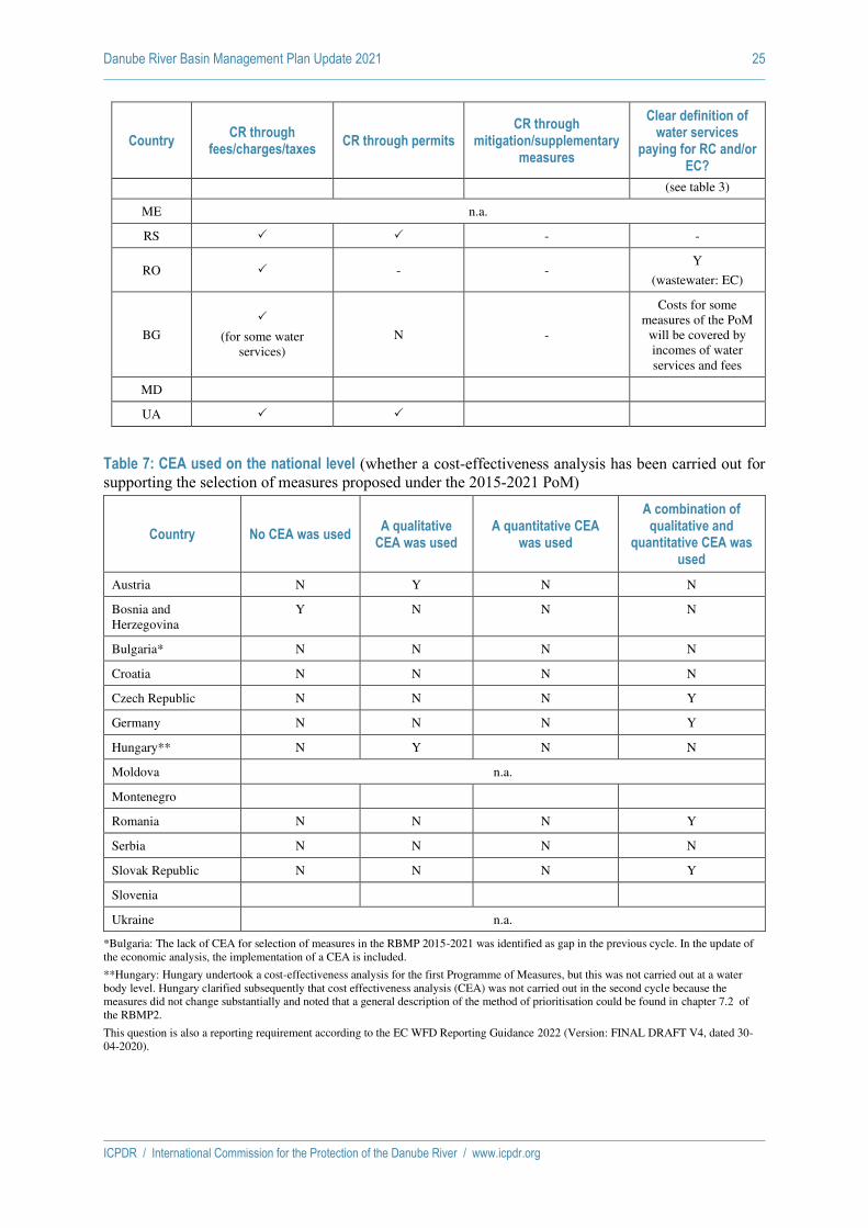
Danube River Basin Management Plan Update 2021 25
ICPDR / International Commission for the Protection of the Danube River / www.icpdr.org
Country CR through
fees/charges/taxes CR through permits
CR through mitigation/supplementary
measures
Clear definition of water services
paying for RC and/or EC?
(see table 3)
ME n.a.
RS - -
RO - - Y
(wastewater: EC)
BG
(for some water services)
N -
Costs for some measures of the PoM
will be covered by incomes of water services and fees
MD
UA
Table 7: CEA used on the national level (whether a cost‐effectiveness analysis has been carried out for supporting the selection of measures proposed under the 2015‐2021 PoM)
Country No CEA was used A qualitative
CEA was used A quantitative CEA
was used
A combination of qualitative and
quantitative CEA was used
Austria N Y N N
Bosnia and Herzegovina
Y N N N
Bulgaria* N N N N
Croatia N N N N
Czech Republic N N N Y
Germany N N N Y
Hungary** N Y N N
Moldova n.a.
Montenegro
Romania N N N Y
Serbia N N N N
Slovak Republic N N N Y
Slovenia
Ukraine n.a.
*Bulgaria: The lack of CEA for selection of measures in the RBMP 2015-2021 was identified as gap in the previous cycle. In the update of the economic analysis, the implementation of a CEA is included.
**Hungary: Hungary undertook a cost-effectiveness analysis for the first Programme of Measures, but this was not carried out at a water body level. Hungary clarified subsequently that cost effectiveness analysis (CEA) was not carried out in the second cycle because the measures did not change substantially and noted that a general description of the method of prioritisation could be found in chapter 7.2 of the RBMP2.
This question is also a reporting requirement according to the EC WFD Reporting Guidance 2022 (Version: FINAL DRAFT V4, dated 30-04-2020).

Danube River Basin Management Plan Update 2021 26
ICPDR / International Commission for the Protection of the Danube River / www.icpdr.org
Table 8: Use of Disproportionality of Costs in the Danube countries
Country
"Disproportionality of costs" used as a justification for
exemptions (Y/N)*
Disproportionality applied for
justifying Article 4.4 exemptions (Y/N)*
Disproportionality applied for justifying
Article 4.5 exemptions (Y/N)*
Methodology/analysis tools used#
Austria Y Y N CEA
Bosnia and Herzegovina
N (or partly) - - -
Bulgaria Y Y Y Cost-benefit-Analyses
Affordability*
Croatia Y Y Y
Cost-benefit-Analyses
Affordability,
Cost-Effectiveness Analysis
Czech Republic
Y Y N -
Germany (Danube
RB) Y Y N
Cost effectiveness analysis and in specific
cases targeted evaluation of costs and
benefits
Hungary Y Y Y
Financial possibilities, Affordability for
sectors, for households, for state budget in
general, CBA in the case of Article 4.5
exemptions
Moldova n.a.
Montenegro
Romania Y Y Y
Cost-benefit-Analyses
Productivity loss (in case of restoring the
longitudinal connectivity for
hydropower chain assessment )
Serbia - - - -
Slovak Republic
Y Y Y Affordability,
Cost-Effectiveness Analysis
Slovenia
Ukraine n.a.
*Bulgaria: The approach to the analysis of disproportionality of costs is set out in the national “Methodology for application of the exemptions“ but not used in 2nd RBMP cycle in Bulgaria. Questions marked with * are reporting requirements for the next reporting period, as listed in the EC WFD Reporting Guidance 2022 (Version: FINAL DRAFT V4, dated 30-04-2020).
Questions marked with # are "conditional" reporting requirements, i.e. required if disproportionality of costs has been used (EC WFD Reporting Guidance 2022 (Version: FINAL DRAFT V4, dated 30-04-2020).

Danube River Basin Management Plan Update 2021 27
ICPDR / International Commission for the Protection of the Danube River / www.icpdr.org
Table 9: Socio-economic Trends in Danube countries until 2027
Economic growth in
general until 2027
Economic growth in agriculture until 2027
Economic growth in industry until 2027
Growth in electricity
production (thermal) until
2027
Growth in electricity production
(hydropower) until 2027 (change in GWh/a produced
2020-2027)
Growth in energy production
(biomass) until 2027 (change in GWh/a produced
2020-2027)
Population growth until 2025
(changes in total population 2020-2025 at constant
fertility rates)
Water demand per capita
(development until 2027)
Austria
Remark: changed situation due to “Corona”.
Agricultural area will slightly decrease.
Agricultural production output on a constant level.
Remark: changed situation due to “Corona”.
- < 5 % - +3% (2020 -2027)
130l/day
Bosnia and Herzegovina
Average economic growth: 3,5% p.a. until 2027.
Overall economic output-growth: 3,8%
- Average economic growth in industry until 2027: 1,6%
(sp. Manufacturing industry)
Average economic growth in electricity production
(thermal) until 2027: 1,1%
Average economic growth in el. production (hydropower) until 2027:1,89%
Average economic growth in energy production (Biomass) until 2027: 1,1%
Negative (2,6%) 506
l/capita/day
Bulgaria
n.a. n.a. n.a. n.a. n.a. n.a. n.a. n.a.
Croatia
2,4 % per/yr before Corona
No data No data Gas and coal:
2.923 GWh
HP: 7.012 Gwh
Nuclear:
2.683 GWh
781 GWh 4.299,3 mil. Decrease due to the decrease in
population

Danube River Basin Management Plan Update 2021 28
ICPDR / International Commission for the Protection of the Danube River / www.icpdr.org
Geothermal, wind and solar:
5.789 GWh
Czech Republic
n.a. Stagnation Stagnation Stagnation Expected to remain on the current level
n.a. 241.000 89.2 l/cap/day
Germany
expected to grow moderately
expected to remain on the current level
expected to grow moderately
expected to remain on the current level or to fall slightly
expected to remain on the current level
expected to remain on the current level
expected to grow moderately
Long term average expected to remain on the current level or to continue to fall
Hungary
Official Projection 2020-2024 (Based on the Convergence
Program) GDP growth per year (%)
2020: -3
2021: 4,8
2022: 4,6 2023: 4,3
2024: 4,2
According to the assumptions used in
Economic growth in agriculture (in %) until 2027 is not available.
The Hungarian Food Economics Concept (2017–2050) provides a detailed description of the expected development of the sector.
Economic growth in industry (in %) until 2027 is not available.
The expected development of the sector is described in detail in the Convergence Program and the “Irinyi Plan”.
Together with other renewables, the growth is 329%
2020: 78 GWh/a
2027: 335 GWh/a
According to Hungary's National Energy and Climate Plan.
0% growth, unchanged production
2020-2027: 244 GWh /a
According to Hungary's National Energy and Climate Plan.
Biomass and renewable waste together increase by 30%:
2020: 2332 GWh/a
2027: 3029 GWh/a
According to Hungary's National Energy and Climate Plan.
2.6% decrease is projected based on 1.6 constant fertility rates, according to the Central Statistics Office (CSO) "Population Forecast 2015"
During the preparation of the 3rd RBMP, based on the assumptions used in the socio-economic forecasts, an increase in the specific water consumption of households can be expected, but the growth rate does not reach the projected annual increase in household consumption (of

Danube River Basin Management Plan Update 2021 29
ICPDR / International Commission for the Protection of the Danube River / www.icpdr.org
RBMP3, the growth rate will be similar until 2027, i.e. a minimum annual rate of 4%.
around 4%) in the Convergence Program.
The 96 liters/capita/day in 2018 could increase by 6% to 2027, i.e. to 102 liters/capita/day, taking into account the temporary decline expected in 2020 due to the epidemic.
Moldova
n.a.
Montenegro
Romania
Medium term forecast – National commission for prognosis.- 2025 Estimated a yearly increase of GDP with an
Medium term forecast – National
commission for prognosis.- 2025
Estimated an yearly increase appr. 2%
Medium term forecast – National commission for prognosis.- 2025 Estimated a yearly increase appr. 1.9%
Expected to remain on the current level or slightly decrease as result of new regulations regarding the air pollution
Expected to remain on the current level or slightly increase
According to National Energy Strategy an increasing with 10%-20% in biomass production is estimated till 2030
In progress A slightly decrease (appr.
5%) is estimated till 2030

Danube River Basin Management Plan Update 2021 30
ICPDR / International Commission for the Protection of the Danube River / www.icpdr.org
average appr. 1.8%
Serbia
+3.58% per year (2022-2023), +3.63% per year (2024-2027)
+0.66% per year (2022-2023), +1.52% per year (2024-2027)
+3.22% per year (2022-2023),
+3.44% per year (2024-2027)
+0.97% per year (2022-
2025), +1.38% per year (2026-
2027)
+0.97% per year (2022-2025), +0.79% per year (2026-2027)
+1.35% per year (2022-2025), +1.39% per year (2026-2027)
-0.24% per year (2022-2026), -0.15% per year (2026-2027)
No changes
Slovak Republic
According to the available forecast (June 2020, Ministry of Finance)
for 2020- 2023 the Slovak economy will fall by 9.8% in 2020 due to the global pandemic (baseline scenario).
In the second half of 2020, the economy should gradually recover,
Economic growth in agriculture (in %) until 2027 is not available. The COVID-19 pandemic has also caused a crisis in the agricultural sector.
In the current CAP reform, which was to apply from 2021, a transitional period of two years is necessary to ensure stability. Support for farmers under the current legal framework will continue until the end of 2022. Over the next two years, the strategic plan in line with the new CAP
Economic growth in industry (in %) until 2027 is not available.
For more particular information on the possible development of industry – see the separate part “Summary assessments of trends for some Danube countries”.
Forecast of the share of disposable electricity production (in
fossil power
plants)
according to expected development in electricity consumption of Slovakia in% is as follows:
2020: 23,3 %
2025: 13,4 %
2030: 13,8 %.
The Ministry of Economy expects the electricity consumption in
+7,19% (4,464 to 4,785 GWh/a)
2020: 4,464 GWh
2021: 4,467 GWh
2022: 4,470 GWh
2023: 4,473 GWh
2024: 4,476 GWh
2025: 4,507 Gwh
2026: 4,754 GWh
2027: 4,785 GWh
All the data/information given above is at the national level.
+43,9% (1,848 to 2,660 GWh/a).
Note: pumped storage power plants are eliminated)
The data/information given above is at the national level.
+ 0,22 %
The data given above is at the national level.
Changes in specific water consumption per capita
2020-2027:
+ 12,6%
2020: 79,3 liters
2021: 80,2 litres
2022: 81.3 liters p.c.
2023: 82.6 liters
2024: 84.0 liters
2025: 85.6 liters
2026: 87.4 liters
2027: 89.3 liters
The data/information given above is at the national level.
Danube River Basin Management Plan Update 2021 31
ICPDR / International Commission for the Protection of the Danube River / www.icpdr.org
bringing GDP growth to 7.6% in 2021. However, the economy should not catch up with the pre-crisis level until the end of 2022 (but economic growth in 2022 will reach only 1.8%). At the end of the forecast period (2023), economic growth will be supported by drawing on EU funds of the third programming period. The main negative risk to the forecast is the re-spread
legislation has to be prepared.
The strategic
planning can be considered as the biggest change in the CAP. More responsibility will shift to Member States to formulate a strategy that each state wants to achieve by 2027. Through the CAP Strategic Plan, Member States have the opportunity to design their agricultural policy according to their needs. This plan is also approved by the European Commission.
The main objectives and priorities of the agricultural sector in Slovakia for the period up to 2027 are mentioned in the separate part “Summary assessments of trends for some Danube countries”.
Slovakia will increase. Thermal power plants will gradually lose importance.
In the long term, the operation of the Nováky Thermal Power Plant (2x110 MW) is not planned any more, due to the termination of support for the production of electricity from domestic coal in 2023.
As mentioned above, production in coal-fired power plants will gradually decrease. The share of power stations producing carbon-free electricity should be increased. More than 90% of

Danube River Basin Management Plan Update 2021 32
ICPDR / International Commission for the Protection of the Danube River / www.icpdr.org
of the pandemic.
Economic growth until 2027 is not available.
electricity should be generated in Slovakia, of which 67% through nuclear power plants. The rest is renewable energy.
All data/information above is at the national level.
Slovenia
Ukraine (for DRBR)
Expected to grow moderately
National level: GDP growth at 4.6% in 2021, 4.3% in 2022 and 4.7% in 2023 (Medium term forecast – Resolutuion
Average growth in agriculture until
2027: 1,5 %
Average economic growth in industry until 2027: 1,3%
(sp. Manufacturing industry)
Expected to grow
moderately
Expected to grow moderately
Expected to slightly increase
Expected to slightly increase
No changes

Danube River Basin Management Plan Update 2021 33
ICPDR / International Commission for the Protection of the Danube River / www.icpdr.org
of the Cabinet of Ministers of Ukraine of July 29, 2020 № 671, On approval of the Forecast of economic and social development of Ukraine for 2021-2023).

Danube River Basin Management Plan Update 2021 34
ICPDR / International Commission for the Protection of the Danube River / www.icpdr.org
Summary Assessments of trends for some Danube countries
Slovakia Agriculture:
Main objectives and priorities of the agricultural policy for the next period include: sustainability of
Slovak agriculture, food self-sufficiency and development and implementation of strategic plan. However, the relevant documents currently being prepared by the management of the agricultural sector, linked to the CAP, will not be ready until next year (2021). Based on all previous knowledge optimal solutions should be applied.
The agro-sector identified increasing the food self-sufficiency of Slovakia as the main priority and committed itself to developing a long-term strategy for agriculture and the food industry. (In May 2020, the European Commission presented two key strategies that will have a major impact on the agricultural sector: the Biodiversity Strategy to 2030 and the Farm-to-Table Strategy).
The goal is also changes in payment settings - e.g. not to support only the area itself, but producers of specific foods, i.e. to support production and farmers who want to contribute to the food basket (without division into small and large farmers). The aim is to link financial support from the 1st and 2nd pillars of the CAP to specific production. E.g. the 1st pillar itself has three parts: area payments, eco-schemas and the tying of money to production (coupled payments). Eco-schemas settings are also important, as they can also be linked to production. Tying money to production is a way to recover Slovak agriculture, while coupled payments need to be increased from Eurofunds, but own state participation is also necessary to increase the current low percentage of self-sufficiency (approximately 40%). It is desirable to achieve self-sufficiency, especially in basic commodities (poultry and pork, fruits, vegetables, potatoes), so the priority is to support special animal and plant production. There are also measures to support food production in Slovakia in the government's program statement, for which financial support is necessary (approximately EUR 1 billion must be invested in food production in the next five to seven years). It should be supported that the domestic food industry processes all raw materials grown and bred in Slovakia, as financial support for food processing has been underestimated in previous years. All major steps to increase and achieve food self-sufficiency should be included in The Strategic Plan and the so-called Intervention Strategy. Industry:
General statement: Slovak industry is currently not doing well (as in Germany; there is a great link between Slovak industry and Germany - for Slovakia, Germany is the largest trading partner).
The automotive industry has a decisive influence on the Slovak industry.
According to Ministry of Finance's February 2020 macroeconomic forecast, the Slovak economy under foreign influence continued to perform at a slower pace, but was still progressing. Cooling is particularly noticeable in the export-oriented industry. After reaching its peak in 2018, the Slovak economy slowed significantly in 2019 to an estimated 2.3% (Ministry of Finance´s forecast, February 2020). The unfavorable development of foreign demand was predominantly reflected in the Slovak export-oriented industry. The February forecast projected a continuation of the economic slowdown in 2020 with GDP growth of 2.2% and expected to support exports through new production at Jaguar Land Rover, whose dynamics were expected to be dampened by weaker external demand.
According to Statistical Office of the Slovak Republic industrial production in April 2020 reached an all-time low since the establishment of the independent Slovak Republic, falling by 42 percent year on year. The decrease was mainly due to a sharp drop in the production of means of transport by 78.9 percent. This situation was significantly affected by the stop or restriction of production at four Slovak car manufacturers, as well as production restrictions at subcontractors throughout the automotive industry, which responded to the measures taken against the spread of COVID-19 in Europe.
According to Eurostat, in May 2020, in a year-on-year comparison, Slovakia recorded the sharpest drop in industrial production within the EU countries, by 33.5 percent.
However, it should be noted that at present all car manufacturers have already carried out a partial resumption or are trying to fully resume production.

Danube River Basin Management Plan Update 2021 35
ICPDR / International Commission for the Protection of the Danube River / www.icpdr.org
Due to the occurrence of the second wave of the pandemic, it is currently not possible to estimate future developments regarding the sector's performance. The document "Low Carbon Strategy of Slovakia" was approved by the Slovak Government. This Strategy will include effective and cost-effective measures in the sectors of industry, energy, energy efficiency, transport, agriculture and forestry and waste management. The Strategy is a cross-cutting document across all sectors of the economy, which must pursue individual policies so as to complement each other towards the common goal of completely decarbonising Slovakia by 2050. Energy: With an estimated 1.23% year-on-year growth, electricity consumption in Slovakia will reach 36.4 TWh in 2030. In terms of electricity demand coverage, the focus will be on the completion of Units 3 and 4 of the Mochovce Nuclear Power Plant (2x471 MW). As mentioned above, by putting these units into operation, the balance between production and consumption of electricity in the ES SR should be changed to export. The export balance of the Slovak Republic should be maintained even after the termination of operation of the Nováky thermal power plant (2x110 MW) in 2023 due to the termination of support for electricity production from domestic coal. Bosnia and Herzegovina By increase in capacity of the urban waste water treatment through construction and reconstruction of the WWTPs the water quality should be positively affected. Also in Bosnia and Herzegovina there is in strategic document planned to increase development of hydropower –electricity production and it is planned till 2021 to grow agricultural sector. Germany No new analysis of future anthropogenic developments was performed for the period until 2027 as the analysis for the period 2015-2021 remains broadly valid. The development of the different sectors remains widely interconnected though economic growth and use of resources, like water, are decoupled in an economy largely based on the provision of services. Even though interactions clearly exist, changes of economic parameters don’t necessarily induce direct changes of ecologic parameters, e.g. concerning the use of water resources and the hydrological balance. Overall, the pressure situation due to the observable trends in anthropogenic activities in the considered timeframe can be expected to remain on the current level. More detailed information on the driving forces affecting pressures on water bodies and, consequently potentially affecting water status as well as updated figures on the provision of water services, can be obtained in the River Basin Management Plan for the German share of the Danube Basin. Austria Agriculture Owing to the studied indicators of potential water pollution (livestock or landuse) and accordingly to the prognosis of the Austrian Institute of economic research (WIFO) in the background document for the Economic Analysis 2019 the following things are predicted till 2030: • in regions with favourable conditions for the expansion of milk production a slight increase of the application of organic fertilizer will take place; • an overall slight decrease of the agricultural area will happen; • the reason for regional differences in the river basins of Rhine and Danube will be led back to structural facts in these regions. The reason for the expected increase in beef production results from the increase of milk production. The impact of climate change could enhance an intensification in the coming decades. However, the agri-environmental program and conditions of the 1st pillar of the CAP weaken these trends. Industry, Production of goods Given the observed development of water intensity and the expected production growth, it should be expected, that industrial water consumption will slightly decline until 2030. It is assumed that the amount of waste water will continue to develop in line with water use; a moderate reduction of amount of waste water is to be expected in the period to 2030.

Danube River Basin Management Plan Update 2021 36
ICPDR / International Commission for the Protection of the Danube River / www.icpdr.org
Electricity generation The electricity generation by hydro power (excluding Pumped storage power plants) will increase till 2025 by an annual average of 0.9% from 132 PJ (2010) to 152 PJ. The share of hydropower (excluding Pumped storage power plants) in domestic generation falls during this period from 54% to 52%. The share of fossil fuel power decreases from almost a quarter to 17%. The share of electricity produced from renewable energy sources (wind, photovoltaic, biomass) increases from 7% to almost 15%. Due to WFD requirements it was assumed that production losses in small hydropower and run-of-river power (> 10 MW) occur from 2011 and increase linearly until 2027. The losses in storage power plants on the other hand will be limited until 2027. Furthermore, it was assumed that at the same time the existing potential for plant optimization for existing small hydro- and run-of-river power plants is used. Thus, the (2005) calculated losses are largely compensated. Czech Republic Water abstraction and waste water discharge for/from agriculture and industry in the Czech Republic are not expected to increase and the likely scenario (in abstraction and discharge) for the two sectors is stagnation. On the other hand, water abstraction and waste water discharge are expected to increase in case of households. Number of inhabitants supplied with water from water supply systems and inhabitants connected to sewerage systems and WWTPs is also expected to increase. Water quality should be positively affected by construction and improvements of WWTPs. Romania The trend of water demand for all water users has been assessed having in view the 2030-time horizon (with 2011 as the reference year). A specific methodology has been developed as basis for the 2nd and 3rd RBMPs. The methodology comprises of prognosis methods of water demand for population, industry, aquaculture, livestock farms, animal breeding and irrigation. It is based on 3 scenarios (base scenario- medium, minimal and optimistic scenario): The prognosis of water demand for population considered the population trend at national/county/local level. The prognosis of water demand for irrigation considered the abstraction water for irrigation based on future irrigated area and irrigation specific values according to the type of crops. The prognosis of water demand for livestock considered the water demand based on different livestock specific values of water consumption. The prognosis of water demand for aquaculture considered the related aquaculture surface and related volume. Trends values Medium Scenario:
• Total demand: 12300 mil. cm; • Population: 2100 mil. cm; • Industry: 7400 mil. cm; • Irrigation: 1700 mil. cm.
Trends values Optimistic Scenario:
• Total demand: 15500 mil. cm (an increase of 26% compared to the medium scenario trend); • Industry: increase of 34% compared to the medium scenario; • Irrigation: increase of 25% compared to the medium scenario; • For population, livestock and aquaculture the optimistic scenario indicates a relatively stable
demand compared to the medium scenario. Hungary Agriculture: By the Governmental Decision 1335/2017 (VI. 9.), the Government approved Hungary's Food Economics Concept for 2017–2050. With 5.4 million hectares of agricultural land and 2 million hectares of forest, Hungary has a food production potential that is far from being exploited. According to professional estimates, the Hungarian food economy has a 60% higher production potential by more efficient organization of domestic production and the market, by increasing processing and by purposefully responding to the solvent demand in the world. Hungary's strategic goal is a competitive, economically, environmentally and

Danube River Basin Management Plan Update 2021 37
ICPDR / International Commission for the Protection of the Danube River / www.icpdr.org
socially sustainable food economy, which actively contributes to the development of the national economy and the growth of jobs in rural areas through the continuous growth of its performance and added value, guarantees the country's secure food supply and maintains GMOs. -protect our natural values, preserve biodiversity, protect the environment and manage natural resources in a sustainable way. In the course of its development, agriculture must preserve the natural values of our landscapes, the fertility of the soil, the purity of water resources, protect forests and other important ecosystems, and maintain the ecological balance. Increased state involvement and intervention are needed in the management and conservation of key scarce natural resources, such as land and water. In the case of consistent adherence to the directions formulated in the Concept and the implementation of the set tasks, there is a reasonable expectation that in 2050 the added value of agribusiness sector within the national economy will reach 25%. According to the Concept, the conditions for efficient agricultural irrigation must be created in Hungary, thus increasing the proportion of irrigable areas, partly by reducing the damage related to water scarcity, partly by the safety of growing water-intensive, high value-added crops (seeds, field vegetables, fruits) and for more efficient farming in areas with good and medium production conditions but often exposed to droughts. In addition to the water demand of the given crop type, the water demand of agriculture is determined by the size of the area to be irrigated and the development of the irrigation infrastructure. According to the Concept, farmers can reduce the negative effects of climate change to the crop production by improving soil water management, soil-friendly farming, selecting the appropriate form of land use according to the current condition of the site, using water-saving and soil-retaining cultivation methods and by using micro-irrigation at a higher rate. In animal husbandry, the same goal can be achieved by developing husbandry technology. Industry: Hungary's reindustrialization strategy is the "Irinyi Plan" on defining the directions of innovative industrial development. The Plan supports energy and material-efficient production, employment and vocational training, the use of renewable energy sources (mainly biomass and geothermal energy), transport development, and the production of second-generation biofuels. Under the “Irinyi Plan”, export capacity should be increased and the development of a higher value-added industrial structure should be encouraged. Domestic raw materials must also be processed with high added value. The Irinyi Plan emphasizes the circular economy with zero waste, which also mitigates the effects of climate change. As stated in the "Irinyi Plan", significant demand can be generated by state funds for the manufacture of vehicles (public transport), the defense industry, the construction industry, the textile industry and the production of medical devices. As described in the "Hungary's Convergence Program (2020-2024)", the already announced and implemented in the coming years, with a total value of more than HUF 4,000 billion in corporate investment and manufacturing developments, will grow more dynamically than average the food industry, the chemical industry, metal processing, mechanical engineering (especially the automotive industry). As a result of the developments, Hungary's export performance may increase by 34-56% after the implementation of the developments, and in the coming years they may add a 12-16 percentage point boost to the growth rate of the Hungarian economy. In addition to large investments, a 30-50% non-repayable investment subsidy was made available by a decree of the Ministry of Foreign Affairs and Trade on the competitiveness-enhancing subsidy required as a result of the coronavirus epidemic. The total value of the investments that have been supported so far and will be completed by 30 June 2021 is HUF 377 billion. Electricity production: In January 2020, the Government adopted the new National Energy Strategy, which sets Hungary's energy and climate policy priorities until 2030, with a 2040 perspective. According to the strategy, our final energy consumption - while maintaining dynamic economic growth - in 2030 will not exceed the 2005 level of 785 PJ. After 2030, the source of the increase in final energy consumption can only be a carbon-neutral energy source. The cumulative end-use energy saving obligation for the period from 2021 to the end of 2030 is 331.23 PJ, which assumes a steady saving of 0.8% per year. The share of our renewable energy use within gross final energy consumption will increase to a minimum of 21%. In Hungary, the installed electricity capacity of hydropower production has been 57 MW since 2013, and according to the latest factual data, its production in 2018 was 234.4 GWh. According to Hungary's

Danube River Basin Management Plan Update 2021 38
ICPDR / International Commission for the Protection of the Danube River / www.icpdr.org
National Energy and Climate Plan (ITM 2020), the electricity generation capacity of hydropower will continue to be 57 MW in 2027, and its production will be 244 GWh / year. According to the WAM (with additional measures) scenario, the combined capacity of biomass and renewable waste will increase from 519 MW in 2020 to 796 MW by 2027, and its production from 2332 GWh to 3029 GWh. According to the WEM (with existing measures) scenario, there is a forecast only for 2020, 2025 and 2030, but the value for 2020 does not reach the actual data for 2018 below, so we use the WAM forecast. The Hungarian Energy and Utilities Regulatory Authority “Report on the use of renewable energy in Hungary 2010-2018" , the installed electricity capacity of biomass in 2018 was 461 MW (solid 385, biogas 76 MW), its production was 2134 GWh (solid 1799, biogas 335 GWh). The use of geothermal energy is currently typical in the heating sector, with 3.35 MW of installed capacity entering electricity generation in 2017, and with production 1 GWh in 2017 and 12 GWh in 2018. There is no specific target for the application to electricity generation, only with other renewables in total, but according to Hungary's National Energy and Climate Plan, a slight increase in geothermal capacity is expected (with built-in capacity 60 MW by 2030 and 104 MW by 2040). The spread of electricity-producing geothermal power plants covered by the Swiss-Hungarian Cooperation Program II is planned from 2020 onwards, which may be encouraged by the pilot project for the Geothermal Guarantee Fund. According to the 2018 report "Medium- and long-term source capacity development of the Hungarian electricity system" of MAVÍR Zrt., the use of geothermal energy is constantly increasing, reaching 4.8 PJ by 2016. By the end of 2016, geothermal energy was used for district heating in 13 settlements in Hungary (which was 56% of geothermal energy consumption). Of this, the agricultural sector mainly utilizes the extracted geothermal energy for heating greenhouses (29%), and the commercial and public service sector for the supply of spas, hospitals and other public institutions (14%). Ukraine The forecast of economic and social development of Ukraine for 2021-2023 was approved by the resolution of the Cabinet of Ministers of Ukraine (CMU) from 29.07.2020 №671 "About approval of the Forecast of economic and social development of Ukraine for 2021-2023". The baseline scenario envisages a resumption of the positive trend of economic development after significant losses caused by the global COVID-19 pandemic in 2020, and GDP growth at 4.6% in 2021, 4.3% in 2022 and 4.7% in 2023. In August 2020 CMU was approved the State Strategy for Regional Development for 2021-2027. The priority tasks of the new regional policy are to accelerate the economic growth of the regions, increase their competitiveness. A number of measures are envisaged in the direction of "Development of the territories of the Ukrainian part of the Danube region and cross-border cooperation". In particular
• taking into account in the sectoral strategies the priorities of the EU Strategy for the Danube Region in the areas of transport sector development, agricultural production, environmental protection, tourism development, promotion and protection of cultural heritage, etc .;
• promoting international technical assistance and international financial organizations to promote regional development, in particular in the Danube River Basin;
• introduction of mechanisms to support cross-border industrial and technological parks, economic and industrial zones on the territory of Ukraine in order to stimulate regional economic development;
• creating conditions for socio-economic and environmental development of the Ukrainian part of the Danube region, which includes, in particular, the development of transport infrastructure with the Danube countries and crossing the state border, addressing the issue of quality water supply and flood protection.
In Danube region the volume indices of industrial and agricultural production (as a percentage of the previous year) will maintain positive dynamics and in 2027 will reach the level of 103.3 and 104.0 interest respectively. Further development of agriculture is envisaged. In the context of smart specialization, a significant effect can be given by strengthening the link between agriculture and the food industry, which will increase the added value of the final product. Agricultural production will grow by an average of 1.5% per year. The volume of sold industrial products (goods, services) will gradually increase.

Danube River Basin Management Plan Update 2021 39
ICPDR / International Commission for the Protection of the Danube River / www.icpdr.org
The foundations for the formation of a forest cluster on the basis of deep wood processing and increase in value added, furniture production will be laid. Under the implementation of the optimistic scenario with an emphasis on innovative modernization, the volume of industrial production will increase at least 3 times, which will increase jobs 2 times. High rates of capacity modernization will also be observed in the food industry, sectors related to wood processing. The growth of the tourism industry is forecast. The revenue from the tourist tax to local budgets will increase significantly - almost 1.7 times. Significant growth of investments in the region's economy is forecast. Thus, fixed capital investment should more than double, and foreign direct investment by one-fifth.

ICPDR / International Commission for the Protection of the Danube River / www.icpdr.org
Draft ANNEX 15 as of 26 February 2021
DRBMP Update 2021
Progress on measures addressing hydromorphological alterations

Danube River Basin Management Plan Update 2021 1
ICPDR / International Commission for the Protection of the Danube River / www.icpdr.org
This Annex includes information on progress in measures implementation for the following
hydromorphological alterations for each country and on the basin-wide scale:
▪ Hydrological alterations – Impoundments
▪ Hydrological alterations – Water abstractions
▪ Hydrological alterations – Hydropeaking
▪ Interruptions of river and habitat continuity
▪ Morphological alterations – River morphology
▪ Morphological alterations – Disconnection of adjacent floodplains / wetlands
It provides further detailed information on data already provided in the JPM Chapter 8.1.5 of the DRBM
Plan – Update 2021.
For particular measures involving construction or building works (e.g. a fish pass, a river restoration
project, etc.), the following status-classes were reported, whereby the implementation status refers to
the status expected at the end of 2021.
▪ Not started means the technical and/or administrative procedures necessary for starting the
construction or building works have not started.
▪ Planning on-going means that administrative procedures necessary for starting the construction
or building works have started but are not finalised. The simple inclusion in the RBMPs is not
considered as planning in this context.
▪ Construction on-going means the construction or building works have started but are not
finalised.
▪ Completed means the works have been finalised and the facilities are operational (maybe only
in testing period in case e.g. a waste water treatment plant).

Danube River Basin Management Plan Update 2021 2
ICPDR / International Commission for the Protection of the Danube River / www.icpdr.org
1 Hydrological alterations - impoundments
Measures on impoundments
COUNTRY
NUMBER OF IMPOUNDMENTS TO BE IMPROVED BY 2021
IMPLEMENTATION STATUS
(reference to measures as agreed on national level)
As indicated in the JPM of the
2nd DRBM Plan
Updated information as
agreed on national level
Not started Planning on-going Construction on-
going Completed
[No.] [%] [No.] [%] [No.] [%] [No.] [%]
DE 1 1 0 0 0 0 0 0 1 100
AT 36 29 22 76 2 7 1 3 4 14
CZ 0 0 0 0 0 0 0 0 0 0
SK 0 0 0 0 0 0 0 0 0 0
HU 1 1 0 0 0 0 0 0 1 100
SI 0 0 0 0 0 0 0 0 0 0
HR 0 0 0 0 0 0 0 0 0 0
BA 0 0 0 0 0 0 0 0 0 0
ME 0 0 0 0 0 0 0 0 0 0
RS 0 0 0 0 0 0 0 0 0 0
RO 3 1 0 0 0 0 0 0 1 100
BG 0 0 0 0 0 0 0 0 0 0
MD 0 0 0 0 0 0 0 0 0 0
UA 0 0 0 0 0 0 0 0 0 0
TOTAL 41 32 22 69 2 6 1 3 7 22
2 Hydrological alterations – water abstractions
Measures on water abstractions
COUNTRY
NUMBER OF WATER ABSTRACTIONS TO BE
IMPROVED BY 2021
IMPLEMENTATION STATUS
(reference to measures as agreed on national level)
As indicated in the 2nd DRBM
Plan
Updated information as
agreed on national level
Not started Planning on-going Implementation on-
going Completed
[No.] [%] [No.] [%] [No.] [%] [No.] [%]
DE 8 8 0 0 4 50 3 37,5 1 12,5
AT 13 8 1 13 6 75 0 0 1 13
CZ 0 0 0 0 0 0 0 0 0 0
SK 0 0 0 0 0 0 0 0 0 0
HU 0 0 0 0 0 0 0 0 0 0
SI 0 0 0 0 0 0 0 0 0 0
HR 0 0 0 0 0 0 0 0 0 0
BA 0 0 0 0 0 0 0 0 0 0
ME 0 0 0 0 0 0 0 0 0 0
RS 0 0 0 0 0 0 0 0 0 0
RO 0 0 0 0 0 0 0 0 0 0
BG 0 0 0 0 0 0 0 0 0 0
MD 0 0 0 0 0 0 0 0 0 0
UA 0 0 0 0 0 0 0 0 0 0
TOTAL 21 16 1 6 10 62 3 19 2 13

Danube River Basin Management Plan Update 2021 3
ICPDR / International Commission for the Protection of the Danube River / www.icpdr.org
3 Hydrological alterations – hydropeaking
Measures on hydropeaking
COUNTRY
NUMBER OF HYDROPEAKING SECTIONS TO BE IMPROVED BY
2021
IMPLEMENTATION STATUS
(reference to measures as agreed on national level)
As indicated in the 2nd DRBM
Plan
Updated information as
agreed on national level
Not started Planning on-going Implementation on-
going Completed
[No.] [%] [No.] [%] [No.] [%] [No.] [%]
DE 4 4 0 0 2 50 1 25 1 25
AT 0 0 0 0 0 0 0 0 0 0
CZ 0 0 0 0 0 0 0 0 0 0
SK 0 0 0 0 0 0 0 0 0 0
HU 0 0 0 0 0 0 0 0 0 0
SI 0 0 0 0 0 0 0 0 0 0
HR 0 0 0 0 0 0 0 0 0 0
BA 0 0 0 0 0 0 0 0 0 0
ME 0 0 0 0 0 0 0 0 0 0
RS 0 0 0 0 0 0 0 0 0 0
RO 0 0 0 0 0 0 0 0 0 0
BG 0 0 0 0 0 0 0 0 0 0
MD 0 0 0 0 0 0 0 0 0 0
UA 0 0 0 0 0 0 0 0 0 0
TOTAL 4 4 0 0 2 50 1 25 1 25
4 Interruptions of river and habitat continuity
Measures on restoration of river continuity for fish migration
COUNTRY
NUMBER OF MEASURES TO BE IMPLEMENTED BY 2021
IMPLEMENTATION STATUS
(reference to measures as agreed on national level)
As indicated the 2nd DRBM
Plan
Updated information as
agreed on national level
Not started Planning on-going Construction on-
going Completed
[No.] [%] [No.] [%] [No.] [%] [No.] [%]
DE 22 22 0 0 14 64 0 0 8 36
AT 85 43 28 65 4 9 3 7 8 19
CZ 8 8 0 0 0 0 0 0 8 100
SK 19
HU 0 0 0 0 0 0 0 0 0 0
SI 0 0 0 0 0 0 0 0 0 0
HR 0 0 0 0 0 0 0 0 0 0
BA 0 0 0 0 0 0 0 0 0 0
ME 0 0 0 0 0 0 0 0 0 0
RS 1
RO 1 1 0 0 1 100 0 0 0 0
BG 10 8 1 13 2 25 3 38 2 25
MD 0 0 0 0 0 0 0 0 0 0
UA 0 0 0 0 0 0 0 0 0 0
TOTAL 146 102 29 28 21 21 6 6 26 25

Danube River Basin Management Plan Update 2021 4
ICPDR / International Commission for the Protection of the Danube River / www.icpdr.org
5 Morphological alterations – river morphology
Measures for improvement of river morphology
COUNTRY
NUMBER OF MEASURES TO BE IMPLEMENTED BY 2021
IMPLEMENTATION STATUS
(reference to measures as agreed on national level)
As indicated the 2nd DRBM
Plan
Updated information as
agreed on national level
Not started Planning on-going Construction on-
going Completed
[No.] [%] [No.] [%] [No.] [%] [No.] [%]
DE 40 40 21 5 4 10 21 52,5 13 32,5
AT 25 17 3 18 0 0 0 0 14 82
CZ 7 7 0 0 6 86 0 0 1 14
SK 0 0 0 0 0 0 0 0 0 0
HU 0 0 0 0 0 0 0 0 0 0
SI 0 0 0 0 0 0 0 0 0 0
HR 0 0 0 0 0 0 0 0 0 0
BA 0 0 0 0 0 0 0 0 0 0
ME 0 0 0 0 0 0 0 0 0 0
RS 0 0 0 0 0 0 0 0 0 0
RO 2 2 12 50 0 0 0 0 1 50
BG 3 3 0 0 3 100 0 0 0 0
MD 0 0 0 0 0 0 0 0 0 0
UA 0 0 0 0 0 0 0 0 0 0
TOTAL 77 69 6 9 13 19 21 30 29 42
1 Measures were no longer necessary as good ecological potential was already reached.
2 Conflicts with land reclamation owners due to technical solutions proposed

Danube River Basin Management Plan Update 2021 5
ICPDR / International Commission for the Protection of the Danube River / www.icpdr.org
6 Morphological alterations – disconnection of floodplains/wetlands
Measures on disconnected adjacent floodplains / wetlands - AREA
COUNTRY
AREA OF FLOODPLAINS / WETLANDS TO BE
ADDRESSED BY MEASURES UNTIL 2021
IMPLEMENTATION STATUS
(reference to measures as agreed on national level)
As indicated in the 2nd
DRBM Plan
Updated information
as agreed on national level
Not started Planning on-
going Construction on-
going
Completed
partially re-connected
totally re-connected
[ha] [ha] [%] [ha] [%] [ha] [%] [ha] % [ha] %
DE 2,926 2,926 0 0 0 0 2,926 100 0 0 0 0
AT 9,554 9,554 0 0 0 0 1,600 17 7,954 83 0 0
CZ 0 0 0 0 0 0 0 0 0 0 0 0
SK 0 0 0 0 0 0 0 0 0 0 0 0
HU 0 0 0 0 0 0 0 0 0 0 0 0
SI 0 0 0 0 0 0 0 0 0 0 0 0
HR 0 0 0 0 0 0 0 0 0 0 0 0
BA 0 0 0 0 0 0 0 0 0 0 0 0
ME 0 0 0 0 0 0 0 0 0 0 0 0
RS 0 0 0 0 0 0 0 0 0 0 0 0
RO 2,650 2,650 0 0 2,650 100 0 0 0 0 0 0
BG 0 0 0 0 0 0 0 0 0 0 0 0
MD 0 0 0 0 0 0 0 0 0 0 0 0
UA 0 0 0 0 0 0 0 0 0 0 0 0
TOTAL 15,130 15,130 0 0 2,650 17 4,526 30 7,954 53 0 0

ICPDR / International Commission for the Protection of the Danube River / www.icpdr.org
Draft ANNEX 17 as of 25 March 2021 DRBMP Update 2021
Detailed list of hydrological alterations in the DRBD

Danube River Basin Management Plan Update 2021 2
ICPDR / International Commission for the Protection of the Danube River / www.icpdr.org
Hydrological alterations include pressures that are causing changes to the hydrological regime, i.e.
quantity and dynamics of water flow and connection to groundwater bodies, whereby
impoundments, water abstractions and hydropeaking were recognized as the main pressure types.
The provoked alterations and applied criteria used for the assessment are provided in the Table.
Hydrological pressures, impacts and criteria for the significant pressure assessment
Hydrological pressure Impacts Criteria for significant pressure assessment
Impoundment
Alteration/reduction in flow velocity
and flow regime of the river sections
caused by artificial transversal
structures, alteration of connection
to groundwater bodies
Danube River: Impoundment length during low flow
conditions >10 km
Danube tributaries: Impoundment length during low
flow conditions >1 km
Water abstraction /residual
water
Alteration in quantity and dynamics
of discharge/flow in water, alteration
of connection to groundwater bodies
Flow below dam <50% of mean annual minimum flow1
in a specific time period (comparable with Q95)
Hydropeaking
Alteration of flow
dynamics/discharge pattern in river
and water quantity, alteration of
connection to groundwater bodies
Water level fluctuation >1 m/day or less in the case of
known/observed negative effects on biology
Since one hydrological alteration can impact more than one water body and since one water body
may be impacted by more than one hydrological alteration, they are listed separately.
Explanation for table
n.a. = Not Applicable
1 A pressure provoked by these uses is considered as significant when the remaining water flow below the water abstraction (e.g. below
a hydropower dam) is too small to ensure the existence and development of self-sustaining aquatic populations and therefore hinders
the achievement of the environmental objectives. Criteria for assessing the significance of alterations through water abstractions vary
among EU countries. Respective definitions on minimum flows should be available in the national RBM Plans.

Danube River Basin Management Plan Update 2021 3
ICPDR / International Commission for the Protection of the Danube River / www.icpdr.org
List of impoundments
Country Impoundment code Length
in km River RWB Code RWB Type Restored 2021 Measure 2027
Decisive Impact HMWB
AT AT007BAB5A-4C1B-48B6-AB66-
3360F9FE04E4 0.2 Thaya ATOK500040002 NWB Not yet Implemented by 2027 Unknown
AT AT016BA3D2-0D89-47EB-A00A-
75A76533B0D3 7.4 Enns ATOK411250025 HMWB Not yet Implemented by 2027 Unknown
AT AT01ABFFD8-1A79-4DDF-9A4C-
BA91734B5786 0.2 Thaya ATOK500040002 NWB Not yet Implemented by 2027 Unknown
AT AT0320EA39-EB95-49D9-B61F-
9E6BFE4113A8 0.6 Raab ATOK1001040105 HMWB Not yet Implemented by 2027 Unknown
AT AT037410C0-0D9C-451A-A3DB-
528BA25206C7 6.3 Drau ATOK900470061 HMWB Yes Unknown
AT AT04769C89-1AC6-4654-9960-
48E902043849 1.1 Thaya ATOK500010043 HMWB Not yet Implemented by 2027 Unknown
AT AT09501331-AD50-494F-82B3-
A48AEA8923C8 1 Mur ATOK802710002 HMWB Yes Unknown
AT AT099FCC03-E3B9-4D03-AA64-
05107EE0E7E9 0.6 Thaya ATOK500010030 HMWB Not yet Implemented by 2027 Unknown
AT AT0A244B57-C606-4E1B-89B5-
3199801C7F89 0.2 Thaya ATOK500040002 NWB Not yet Implemented by 2027 Unknown
AT AT0C409E0C-46F9-4E19-9E9A-
24C24E168ED4 5.6 Enns ATOK411250016 HMWB Not yet Implemented by 2027 Unknown
AT AT0EC1F431-A78B-4D55-8A76-
BA8B3AC5A540 1.4 Enns ATOK411250008 HMWB Yes Unknown
AT AT0F258C31-0FC8-4FAC-8390-
CE6A11B694DD 1.7 Thaya ATOK500010030 HMWB Not yet Implemented by 2027 Unknown
AT AT0FAB00AC-9CCB-45FE-93BA-
BBB15A05647F 0.4 Raab ATOK1001040122 NWB Not yet Implemented by 2027 Unknown
AT AT1099B080-2051-46ED-B14F-
7C3C1A1119B9 0.3 Salzach ATOK305350004 HMWB Not yet Implemented by 2027 Unknown
AT AT11B5594D-7DEF-4350-A8BD-
AFE316BBC8EE 0.5 Thaya ATOK500010038 NWB Not yet Implemented by 2027 Unknown
AT AT12A54BBC-D1AC-40EE-8E68-
0886E0E5E63E 2.4 Mur ATOK802710009 HMWB Not yet Implemented by 2027 Unknown
AT AT136CEC1A-01C3-41D2-B51B-
6A3443DF7C38 3 Mur ATOK802710009 HMWB Not yet Implemented by 2027 Unknown
AT AT1AE623A0-B191-4431-BAD7-
74FD396FAFE0 0.2 Raab ATOK1001040122 NWB Not yet Implemented by 2027 Unknown
AT AT1C3C04FA-D0B1-46A7-9256-
1E8DE51131E6 0.6 Mur ATOK802720005 HMWB Not yet Implemented by 2027 Unknown
AT AT1C5C764C-4B3A-4B01-9095-
13A74435838E 0.2 Thaya ATOK500040002 NWB Not yet Implemented by 2027 Unknown

Danube River Basin Management Plan Update 2021 4
ICPDR / International Commission for the Protection of the Danube River / www.icpdr.org
Country Impoundment code Length
in km River RWB Code RWB Type Restored 2021 Measure 2027
Decisive Impact HMWB
AT AT1F430DB6-FD91-42E8-850C-
037E0BB81630 1.4 Thaya ATOK500010036 HMWB Not yet Implemented by 2027 Unknown
AT AT1FB8EE8A-851E-4B96-A58F-
8FE5BF712DB0 4 Salzach ATOK305350004 HMWB Not yet Implemented by 2027 Unknown
AT AT219FE306-35C3-449E-B3C1-
388F3E52B6EA 0.1 Traun ATOK411980002 NWB Not yet Implemented by 2027 Unknown
AT AT227E1796-AA42-42F5-8272-
1A6C8DD1A311 12.1 Inn ATOK305340009 HMWB Not yet Implemented by 2027 Unknown
AT AT2382C436-6140-4E82-9E59-
E865204B057F 0.1 Thaya ATOK500010038 NWB Not yet Implemented by 2027 Unknown
AT AT24243381-33DF-40DB-90EB-
CC5D32373DB5 1.3 Thaya ATOK500010043 HMWB Not yet Implemented by 2027 Unknown
AT AT25C2BFB3-68AD-4260-A4A9-
E50E433D5A76 0.2 Thaya ATOK500040002 NWB Not yet Implemented by 2027 Unknown
AT AT27AFD996-67AC-4362-BF73-
90BB7A56518D 0.8 Mur ATOK802720001 HMWB Yes Unknown
AT AT27BB34D8-2A4E-4EDD-839D-
AAF289D9420F 1.2 Raab ATOK1001040105 HMWB Not yet Implemented by 2027 Unknown
AT AT2B12C29C-4534-48D5-BC57-
FF9CC3B4E7A0 3 Enns ATOK411250006 HMWB Not yet Implemented by 2027 Unknown
AT AT2B12C29C-4534-48D5-BC57-
FF9CC3B4E7A0 3 Enns ATOK411250036 HMWB Not yet Implemented by 2027 Unknown
AT AT2B4B46BD-B1A7-4A60-BB43-
E25C9A51D0A2 3.8 Mur ATOK802710012 HMWB Yes Unknown
AT AT2B86D98A-BF00-4ECD-9B33-
FADB2BCF994A 7.3 Inn ATOK307030000 HMWB Yes Unknown
AT AT2E180A15-8637-4D76-A310-
F0DF35B19955 0.6 Thaya ATOK500010031 HMWB Not yet Implemented by 2027 Unknown
AT AT2E180A15-8637-4D76-A310-
F0DF35B19955 0.6 Thaya ATOK500010038 NWB Not yet Implemented by 2027 Unknown
AT AT2F000441-9D78-49E4-A586-
75C80BFF109A 0.3 Thaya ATOK500040002 NWB Not yet Implemented by 2027 Unknown
AT AT30B7FC96-EE00-4363-B77E-
4AB61DAF1437 0.2 Thaya ATOK500040002 NWB Not yet Implemented by 2027 Unknown
AT AT3386D4BE-D1DB-49F1-AB0E-
8F6EC3B4D325 16.4 Inn ATOK305340005 HMWB Not yet Implemented by 2027 Unknown
AT AT382F1560-E942-47B5-BF0E-
A8C9FCD351B1 5.3 Mur ATOK802710014 HMWB Not yet Implemented by 2027 Unknown
AT AT390D2AE6-3A40-427A-9058-
4A3C482303B6 3.1 Enns ATOK411250012 HMWB Not yet Implemented by 2027 Unknown
AT AT3B24D32A-EAE5-430A-AD5E-
0CB19669AA39 0.9 Mur ATOK802710009 HMWB Not yet Implemented by 2027 Unknown
AT AT3DF4C81B-53FA-4B55-AFEB-
2CB39EC5B5EF 26.9 Donau ATOK410360007 HMWB Not yet Implemented by 2027 Unknown
AT AT4075D148-829C-4C5A-AB33-
CA091F36A08F 2.4 Mur ATOK802720003 HMWB Not yet Implemented by 2027 Unknown

Danube River Basin Management Plan Update 2021 5
ICPDR / International Commission for the Protection of the Danube River / www.icpdr.org
Country Impoundment code Length
in km River RWB Code RWB Type Restored 2021 Measure 2027
Decisive Impact HMWB
AT AT41392463-4F94-4E6B-9E79-
BF2301608D6F 2.8 Enns ATOK411250012 HMWB Not yet Implemented by 2027 Unknown
AT AT41A44A64-D0F4-4EC4-84A1-
74C53B66A1B5 1.2 Mur ATOK802710002 HMWB Yes Unknown
AT AT43970952-CB52-4725-9592-
139130595453 0.8 Traun ATOK412090020 HMWB Not yet Implemented by 2027 Unknown
AT AT43970952-CB52-4725-9592-
139130595453 0.8 Traun ATOK412090024 NWB Not yet Implemented by 2027 Unknown
AT AT453EE84A-F214-4FCE-8649-
7B1BD4866B23 1.2 Thaya ATOK500010031 HMWB Not yet Implemented by 2027 Unknown
AT AT457BAB1B-BB2F-41F3-8EC0-
56457C1B15DC 1.1 Thaya ATOK500010038 NWB Not yet Implemented by 2027 Unknown
AT AT4622D3C3-477E-48B4-B474-
E34815448E99 1.5 Thaya ATOK500010036 HMWB Not yet Implemented by 2027 Unknown
AT AT4D405CBD-DCF9-4469-948D-
B2D4A28297E6 0.6 Thaya ATOK500010038 NWB Not yet Implemented by 2027 Unknown
AT AT4E332287-7446-4523-8F84-
E5A37720F39C 27.1 Donau ATOK409040013 HMWB Not yet Implemented by 2027 Unknown
AT AT4E3795A7-329E-4895-B90B-
C24A74AF0671 7.5 Inn ATOK305340010 HMWB Not yet Implemented by 2027 Unknown
AT AT4F4748B8-5864-4637-B7BA-
23AB8D69F68D 7.6 Traun ATOK412090016 HMWB Not yet Implemented by 2027 Unknown
AT AT50B66DA6-7AA2-49CD-846E-
8F1ED206DDA8 4.1 Salzach ATOK305360002 HMWB Not yet Implemented by 2027 Unknown
AT AT50B66DA6-7AA2-49CD-846E-
8F1ED206DDA8 4.1 Salzach ATOK305350001 HMWB Not yet Implemented by 2027 Unknown
AT AT511088C0-5250-4057-A97C-
01373ECE0233 39.9 Donau ATOK303070000 HMWB Not yet Implemented by 2027 Unknown
AT AT511088C0-5250-4057-A97C-
01373ECE0233 39.9 Donau ATOK410360003 HMWB Not yet Implemented by 2027 Unknown
AT AT52CE2AB3-8B5B-46D6-9982-
16F88275CDD6 0.3 Thaya ATOK500010030 HMWB Not yet Implemented by 2027 Unknown
AT AT548C0E32-86F9-484B-BF1C-
BA7E6FF633E0 0.2 Thaya ATOK500040002 NWB Not yet Implemented by 2027 Unknown
AT AT56FE6DBE-DD05-457B-BD16-
46D2177FC6BD 1.6 Thaya ATOK500010031 HMWB Not yet Implemented by 2027 Unknown
AT AT57FE85F8-FF4C-4A79-B651-
7B3412E122BC 0.4 Thaya ATOK500010043 HMWB Not yet Implemented by 2027 Unknown
AT AT580ECA2A-54EC-4C5D-88FC-
AAF63F20E6C1 25.9 Donau ATOK409040012 HMWB Not yet Implemented by 2027 Unknown
AT AT580ECA2A-54EC-4C5D-88FC-
AAF63F20E6C1 25.9 Donau ATOK409040011 HMWB Not yet Implemented by 2027 Unknown
AT AT59348639-7D11-4DB9-A739-
C570FC1C51AF 23.8 Donau ATOK410360009 HMWB Not yet Implemented by 2027 Unknown
AT AT59A7B06D-276D-403C-BE36-
405923B6A1FB 1.1 Traun ATOK412090030 HMWB Not yet Implemented by 2027 Unknown

Danube River Basin Management Plan Update 2021 6
ICPDR / International Commission for the Protection of the Danube River / www.icpdr.org
Country Impoundment code Length
in km River RWB Code RWB Type Restored 2021 Measure 2027
Decisive Impact HMWB
AT AT59B0266D-620E-4F71-8FBE-
5962B9BE2561 0.3 Mur ATOK801180008 HMWB Not yet Implemented by 2027 Unknown
AT AT5AB2D8E3-4048-47CF-82A5-
34ABEC828892 0.3 Traun ATOK412090042 HMWB Not yet Implemented by 2027 Unknown
AT AT5B24F9D3-AC5B-4B87-9611-
D8F4263DA0C5 1.3 Thaya ATOK500010036 HMWB Not yet Implemented by 2027 Unknown
AT AT5B49977B-0887-4B6E-A098-
B1280A549C07 1.4 Traun ATOK412090037 NWB Yes Unknown
AT AT5B49977B-0887-4B6E-A098-
B1280A549C07 1.4 Traun ATOK412090032 HMWB Not yet Implemented by 2027 Unknown
AT AT5B97B038-7514-4A4F-8DD6-
A703D1B0EA06 2.7 Inn ATOK307210002 HMWB Not yet Implemented by 2027 Unknown
AT AT5D2352B0-2DB0-45E2-9E9F-
EE06A6DB9A78 12.4 Inn ATOK305340007 HMWB Not yet Implemented by 2027 Unknown
AT AT5D619D09-40D8-44D6-A7CF-
CEA1ACCFEBBF 0.5 Thaya ATOK500010036 HMWB Not yet Implemented by 2027 Unknown
AT AT5DE96A5A-171E-4706-8D54-
A7BC68CEB3D0 1.7 Traun ATOK412100002 HMWB Not yet Implemented by 2027 Unknown
AT AT5EBADECE-CB46-478B-934C-
634D28FE031C 0.2 Raab ATOK1001040122 NWB Not yet Implemented by 2027 Unknown
AT AT6021FA96-F34B-4749-AC6E-
B937EE61DE9B 0.9 Thaya ATOK500010030 HMWB Not yet Implemented by 2027 Unknown
AT AT603D53CE-DB6B-494B-8BDF-
312D67E77FCF 8.7 Enns ATOK411250020 HMWB Not yet Implemented by 2027 Unknown
AT AT603D53CE-DB6B-494B-8BDF-
312D67E77FCF 8.7 Enns ATOK411250018 HMWB Not yet Implemented by 2027 Unknown
AT AT61277085-86ED-4875-98BC-
0A280587A273 3.1 Mur ATOK802710009 HMWB Not yet Implemented by 2027 Unknown
AT AT6223E68C-11FA-449C-B9F1-
FBD6FF31143F 0.2 Thaya ATOK500040002 NWB Not yet Implemented by 2027 Unknown
AT AT634383E0-6445-45EE-BFEA-
E3C6AAA2FE92 0.5 Thaya ATOK500010038 NWB Not yet Implemented by 2027 Unknown
AT AT6486239D-A062-4AC0-9BD6-
D1D1431C2C3B 0.5 Mur ATOK801180007 HMWB Not yet Implemented by 2027 Unknown
AT AT64DF40C1-F179-43A9-B7DF-
9FE7DEE7CE1F 0.2 Traun ATOK412090042 HMWB Not yet Implemented by 2027 Unknown
AT AT65EC9A86-C703-4173-987B-
D7A83D276B5E 1.4 Traun ATOK412090042 HMWB Not yet Implemented by 2027 Unknown
AT AT69EE9BAA-F6E3-408B-A010-
F22C8413EC6D 0.1 Thaya ATOK500010043 HMWB Not yet Implemented by 2027 Unknown
AT AT6A4C9AF6-CBBB-4659-BBC1-
8903A6C64C61 1.8 Salzach ATOK305360002 HMWB Not yet Implemented by 2027 Unknown
AT AT6CD6561D-7CC2-4ECE-B1ED-
04D9FF292D61 2.7 Mur ATOK802710015 HMWB Yes Unknown
AT AT6D68A93E-263D-4955-B2DF-
BDC5BECF3ADD 7.2 Mur ATOK802710014 HMWB Not yet Implemented by 2027 Unknown

Danube River Basin Management Plan Update 2021 7
ICPDR / International Commission for the Protection of the Danube River / www.icpdr.org
Country Impoundment code Length
in km River RWB Code RWB Type Restored 2021 Measure 2027
Decisive Impact HMWB
AT AT6F12C754-C8EB-4306-9876-
6485EA645153 5 Salzach ATOK307200001 HMWB Not yet Implemented by 2027 Unknown
AT AT6FF5917E-6640-42E5-ADF5-
0798B911A60D 0.6 Traun ATOK412090042 HMWB Not yet Implemented by 2027 Unknown
AT AT701AE2C2-2628-4B24-BD91-
8F9A8B3558E3 2.8 Salzach ATOK305360002 HMWB Not yet Implemented by 2027 Unknown
AT AT71679324-08FB-4B52-89D1-
67C051543851 12.6 Enns ATOK411250029 HMWB Not yet Implemented by 2027 Unknown
AT AT718CC288-56D1-47ED-BF70-
4FA429604894 30.1 Donau ATOK409040011 HMWB Not yet Implemented by 2027 Unknown
AT AT718CC288-56D1-47ED-BF70-
4FA429604894 30.1 Donau ATOK409040013 HMWB Not yet Implemented by 2027 Unknown
AT AT74448A36-CBB6-4585-8E2E-
54F72DFA7D8C 0.3 Thaya ATOK500010043 HMWB Not yet Implemented by 2027 Unknown
AT AT7883CAF1-07FC-48AC-8D91-
F7BB73EB40F4 22 Donau ATOK410360012 HMWB Not yet Implemented by 2027 Unknown
AT AT7883CAF1-07FC-48AC-8D91-
F7BB73EB40F4 22 Donau ATOK410360002 HMWB Not yet Implemented by 2027 Unknown
AT AT78C152F6-90D7-4925-BEA6-
03271A2A0F45 0.5 Thaya ATOK500010030 HMWB Not yet Implemented by 2027 Unknown
AT AT78C9BCA1-DBA2-49DC-9DCB-
CEB11ACBA786 0.2 Thaya ATOK500010038 NWB Not yet Implemented by 2027 Unknown
AT AT7900E8ED-C338-4FBF-884A-
A0B0E8C1697E 14.3 Inn ATOK305340012 HMWB Not yet Implemented by 2027 Unknown
AT AT796586FC-399B-4D05-8EE7-
D7A1D2D9457E 0.2 Raab ATOK1001040108 NWB Not yet Implemented by 2027 Unknown
AT AT79F345B6-AA1F-4475-A7CA-
B8DD6011EE69 0.2 Thaya ATOK500040002 NWB Not yet Implemented by 2027 Unknown
AT AT7A5FD0A3-38CB-4178-9713-
AE99AE020E53 0.9 Thaya ATOK500010030 HMWB Not yet Implemented by 2027 Unknown
AT AT7B4805F3-2F4A-454E-9279-
B9987DB9DBDA 0.2 Thaya ATOK500040002 NWB Not yet Implemented by 2027 Unknown
AT AT7C741EC2-204A-4B57-A157-
40419792CE46 2.7 Inn ATOK304980003 HMWB Yes Unknown
AT AT7D767453-BC59-404D-893A-
EC6D0336A1F6 10.3 Drau ATOK900470069 HMWB Not yet Implemented by 2027 Unknown
AT AT7D767453-BC59-404D-893A-
EC6D0336A1F6 10.3 Drau ATOK900470071 HMWB Not yet Implemented by 2027 Unknown
AT AT7E2F2A8F-7F5B-42A8-8423-
3ADC93BCFD9C 1.3 Raab ATOK1001040105 HMWB Not yet Implemented by 2027 Unknown
AT AT7F3C7DB2-FD56-4BDC-9BBE-
36545D0B6E6D 0.8 Thaya ATOK500010036 HMWB Not yet Implemented by 2027 Unknown
AT AT81CE3CDD-B0F2-4C81-8203-
B5F9BADC46CF 15.7 Donau ATOK410360005 HMWB Not yet Implemented by 2027 Unknown
AT AT81CE3CDD-B0F2-4C81-8203-
B5F9BADC46CF 15.7 Donau ATOK410360003 HMWB Not yet Implemented by 2027 Unknown

Danube River Basin Management Plan Update 2021 8
ICPDR / International Commission for the Protection of the Danube River / www.icpdr.org
Country Impoundment code Length
in km River RWB Code RWB Type Restored 2021 Measure 2027
Decisive Impact HMWB
AT AT8352A1F7-E0DB-47F4-AE30-
59034593E06C 4.8 Enns ATOK411250014 HMWB Not yet Implemented by 2027 Unknown
AT AT8352A1F7-E0DB-47F4-AE30-
59034593E06C 4.8 Enns ATOK411250037 HMWB Not yet Implemented by 2027 Unknown
AT AT8352A1F7-E0DB-47F4-AE30-
59034593E06C 4.8 Enns ATOK411250036 HMWB Not yet Implemented by 2027 Unknown
AT AT845DFA45-5211-4C63-A6CB-
2F084DC964D1 0.8 Thaya ATOK500010036 HMWB Not yet Implemented by 2027 Unknown
AT AT8605AE15-E065-4632-B8FF-
69DA56EAFED6 0.8 Thaya ATOK500010043 HMWB Not yet Implemented by 2027 Unknown
AT AT863CDDD4-AC98-40BE-82A9-
6D1947DB487C 2.4 Salzach ATOK305350003 HMWB Not yet Implemented by 2027 Unknown
AT AT863CDDD4-AC98-40BE-82A9-
6D1947DB487C 2.4 Salzach ATOK305350006 HMWB Not yet Implemented by 2027 Unknown
AT AT8884F50E-20B7-4582-8061-
C6B2981BFCBB 0.2 Thaya ATOK500010043 HMWB Not yet Implemented by 2027 Unknown
AT AT88A1E606-BA96-44AE-9161-
4A5E023AA6C7 0.1 Raab ATOK1000960019 NWB Not yet Implemented by 2027 Unknown
AT AT895670FA-A9FE-4E0A-847A-
1717BAFC1607 3.2 Thaya ATOK500010036 HMWB Not yet Implemented by 2027 Unknown
AT AT8B7F24ED-D2DC-4896-BEA9-
70439610EE16 1.5 Thaya ATOK500010043 HMWB Not yet Implemented by 2027 Unknown
AT AT8D3A035A-D81F-4856-9387-
71635699E0CD 1 Thaya ATOK500010036 HMWB Not yet Implemented by 2027 Unknown
AT AT8F89BA64-AB32-4786-9E31-
6926C8607033 1 Raab ATOK1001040122 NWB Not yet Implemented by 2027 Unknown
AT AT9276B696-9851-442A-BAA9-
4C108599A2B4 13.7 Drau ATOK900470071 HMWB Not yet Implemented by 2027 Unknown
AT AT9276B696-9851-442A-BAA9-
4C108599A2B4 13.7 Drau ATOK900470072 HMWB Not yet Implemented by 2027 Unknown
AT AT9276B696-9851-442A-BAA9-
4C108599A2B4 13.7 Drau ATOK900470056 NWB Yes Unknown
AT AT93F54126-FDD4-4824-BC2F-
D3C7C9EC136C 0.8 Thaya ATOK500010030 HMWB Not yet Implemented by 2027 Unknown
AT AT94DA41AB-891D-4282-9519-
AA82A7785E2C 3.5 Traun ATOK412090027 HMWB Not yet Implemented by 2027 Unknown
AT AT94DA41AB-891D-4282-9519-
AA82A7785E2C 3.5 Traun ATOK412090028 NWB Not yet Implemented by 2027 Unknown
AT AT952C555E-FF82-40D3-878A-
FDCA1E714AA9 0.2 Traun ATOK409920005 HMWB Not yet Implemented by 2027 Unknown
AT AT9543CF55-ABA0-477A-B8A4-
DA52B0DD493F 1.3 Thaya ATOK500010036 HMWB Not yet Implemented by 2027 Unknown
AT AT97889EFC-42A9-42EC-BAAF-
DC2D7D280139 34.3 Donau ATOK410360009 HMWB Not yet Implemented by 2027 Unknown
AT AT97889EFC-42A9-42EC-BAAF-
DC2D7D280139 34.3 Donau ATOK410360012 HMWB Not yet Implemented by 2027 Unknown

Danube River Basin Management Plan Update 2021 9
ICPDR / International Commission for the Protection of the Danube River / www.icpdr.org
Country Impoundment code Length
in km River RWB Code RWB Type Restored 2021 Measure 2027
Decisive Impact HMWB
AT AT978AA4AF-9BF7-475A-9A0D-
DAFAE8E20CBC 0.9 Thaya ATOK500010030 HMWB Not yet Implemented by 2027 Unknown
AT AT982BA4B0-E7B4-4963-8E87-
92132AD5C906 4.4 Salzach ATOK305350001 HMWB Not yet Implemented by 2027 Unknown
AT AT993ADBA2-34BE-499F-8AC0-
674AE83C003B 2.3 Mur ATOK802710008 HMWB Yes Unknown
AT AT993ADBA2-34BE-499F-8AC0-
674AE83C003B 2.3 Mur ATOK802710012 HMWB Yes Unknown
AT AT9AF11E95-76EB-4F07-8ADF-
2285F91CD05C 1.8 Thaya ATOK500010030 HMWB Not yet Implemented by 2027 Unknown
AT AT9B4EE28B-75E1-4334-9B9B-
AC18230D601D 1.2 Raab ATOK1001040121 NWB Not yet Implemented by 2027 Unknown
AT AT9C2D7D64-479C-4065-B1CC-
89662487F6DA 2.1 Raab ATOK1001040105 HMWB Not yet Implemented by 2027 Unknown
AT AT9DEDB864-AFDE-42B8-96B8-
CE1456AEACC6 5.3 Salzach ATOK305350006 HMWB Not yet Implemented by 2027 Unknown
AT AT9EB36E8B-C4F1-4AE4-9591-
F7262252266D 4.6 Mur ATOK802720005 HMWB Not yet Implemented by 2027 Unknown
AT AT9EF2FBA3-23C3-4B1B-9354-
21033F08A492 4.2 Mur ATOK802710014 HMWB Not yet Implemented by 2027 Unknown
AT AT9F862E09-4406-4161-AF7B-
5526CD25B8EC 1.8 Lech ATOK302370007 NWB Yes Unknown
AT AT9F862E09-4406-4161-AF7B-
5526CD25B8EC 1.8 Lech ATOK302370010 HMWB Not yet Implemented by 2027 Unknown
AT ATA047D015-5A7C-46BC-92CE-
9C6A15C2CFFD 0.4 Raab ATOK1001040108 NWB Not yet Implemented by 2027 Unknown
AT ATA1911C67-37F4-4E86-AC4A-
7FD41953769B 0.2 Thaya ATOK500010036 HMWB Not yet Implemented by 2027 Unknown
AT ATA1993814-53AB-4748-80DC-
C8FF332DEBFC 12.2 Inn ATOK304980003 HMWB Yes Unknown
AT ATA1993814-53AB-4748-80DC-
C8FF332DEBFC 12.2 Inn ATOK307030000 HMWB Yes Unknown
AT ATA293DD81-56D5-4160-8157-
B2C8DF433F07 3.4 Salzach ATOK305350001 HMWB Not yet Implemented by 2027 Unknown
AT ATA3BD596F-B07B-4581-986A-
658DC99663B0 1.8 Thaya ATOK500010043 HMWB Not yet Implemented by 2027 Unknown
AT ATA440E65C-FD87-4800-B940-
3DD7F1257BF0 0.2 Thaya ATOK500040002 NWB Not yet Implemented by 2027 Unknown
AT ATA4FEDBDF-B0DC-42AE-96E0-
077575239A91 0.9 Thaya ATOK500010043 HMWB Not yet Implemented by 2027 Unknown
AT ATA63F9EBB-1B08-4B0E-90D7-
5DF861AD237C 1.5 Traun ATOK412090042 HMWB Not yet Implemented by 2027 Unknown
AT ATA71531B9-5750-4915-8DAC-
7A23EB2234AF 5.3 Enns ATOK411250014 HMWB Not yet Implemented by 2027 Unknown
AT ATA79429B9-BC1F-48CA-96F8-
9E635F875AEA 5.3 Mur ATOK802710014 HMWB Not yet Implemented by 2027 Unknown

Danube River Basin Management Plan Update 2021 10
ICPDR / International Commission for the Protection of the Danube River / www.icpdr.org
Country Impoundment code Length
in km River RWB Code RWB Type Restored 2021 Measure 2027
Decisive Impact HMWB
AT ATA81311B6-8D8B-4B73-A8DF-
808D91FC8790 0.5 Thaya ATOK500010043 HMWB Not yet Implemented by 2027 Unknown
AT ATA93A52D7-E55D-4D64-8F60-
7B4C4BF5CFE5 0.1 Thaya ATOK500010031 HMWB Not yet Implemented by 2027 Unknown
AT ATAA033890-80DA-4F10-AB93-
FD5D6D53FD87 3 Mur ATOK802710014 HMWB Not yet Implemented by 2027 Unknown
AT ATAA03A39C-C098-44BE-9C56-
7F35D3BE3CA5 1.2 Salzach ATOK304690262 HMWB Not yet Implemented by 2027 Unknown
AT ATABA30667-9593-44B8-9246-
3B03A0A3A1F7 0.9 Thaya ATOK500010043 HMWB Not yet Implemented by 2027 Unknown
AT ATAD8FFCA8-7929-4560-A917-
8C3CABCEEDF8 1.6 Mur ATOK801180029 HMWB Not yet Implemented by 2027 Unknown
AT ATAE504DE1-0E31-4BFB-9586-
A2924F1DF2AC 1 Thaya ATOK500010030 HMWB Not yet Implemented by 2027 Unknown
AT ATB15FC3A4-6E2E-4E97-BCA8-
A23A9C42C651 5 Traun ATOK412090013 HMWB Not yet Implemented by 2027 Unknown
AT ATB3BE207D-3129-49C9-B4E0-
B23AB6DE0F18 2.5 Mur ATOK801180029 HMWB Not yet Implemented by 2027 Unknown
AT ATB47275D1-18C1-41D3-8715-
DC576917DDB1 9.8 Drau ATOK900470061 HMWB Yes Unknown
AT ATB47275D1-18C1-41D3-8715-
DC576917DDB1 9.8 Drau ATOK900470076 HMWB Yes Unknown
AT ATB47275D1-18C1-41D3-8715-
DC576917DDB1 9.8 Drau ATOK900470077 HMWB Yes Unknown
AT ATB60AA07F-2C8B-4B38-8833-
E62B78F79F84 0.7 Raab ATOK1001040122 NWB Not yet Implemented by 2027 Unknown
AT ATB6AC7CEA-7300-45E1-A04B-
60E3CE963F27 17.2 Drau ATOK900470076 HMWB Yes Unknown
AT ATB6AC7CEA-7300-45E1-A04B-
60E3CE963F27 17.2 Drau ATOK900470075 HMWB Not yet Implemented by 2027 Unknown
AT ATB8618037-1E1A-4592-9CD7-
D77040056AE3 0.8 Raab ATOK1001040122 NWB Not yet Implemented by 2027 Unknown
AT ATB9C0A421-2ECB-40D7-898D-
DFCBFF51E8B9 1.7 Salzach ATOK305350003 HMWB Not yet Implemented by 2027 Unknown
AT ATB9C2B78A-7564-4649-BE5F-
E6E743D4C322 2.7 Salzach ATOK305350001 HMWB Not yet Implemented by 2027 Unknown
AT ATBAD326F3-DBEE-4C54-A8B4-
C614796A67A0 1.2 Mur ATOK802710002 HMWB Yes Unknown
AT ATBC2A5F78-7972-40DB-BE2A-
0F35E7FA32BF 2.3 Mur ATOK802710009 HMWB Not yet Implemented by 2027 Unknown
AT ATBD3D4A31-845B-4DA1-9A44-
AA5BEF7B72C2 1.1 Thaya ATOK500010043 HMWB Not yet Implemented by 2027 Unknown
AT ATBF1D4A32-F439-4A28-8B14-
61DDBC6FF6FE 1 Raab ATOK1001040121 NWB Not yet Implemented by 2027 Unknown
AT ATC0C04DB9-701C-4E57-AD84-
69EE293DED24 0.1 Thaya ATOK500010038 NWB Not yet Implemented by 2027 Unknown

Danube River Basin Management Plan Update 2021 11
ICPDR / International Commission for the Protection of the Danube River / www.icpdr.org
Country Impoundment code Length
in km River RWB Code RWB Type Restored 2021 Measure 2027
Decisive Impact HMWB
AT ATC15AECD8-ED2C-4934-A7F1-
B93383AAE153 24.2 Drau ATOK900470068 HMWB Yes Unknown
AT ATC15AECD8-ED2C-4934-A7F1-
B93383AAE153 24.2 Drau ATOK900470065 HMWB Yes Unknown
AT ATC278A4B5-0BC0-44AB-A473-
0806D1DC3026 3.5 Salzach ATOK305350002 NWB Not yet Implemented by 2027 Unknown
AT ATC2E65C52-4D45-44F8-ACD1-
C7C7FF5FABFE 1 Thaya ATOK500010036 HMWB Not yet Implemented by 2027 Unknown
AT ATC34B4428-19AE-4F5E-B986-
092C239845A0 0.4 Raab ATOK1000960015 NWB Not yet Implemented by 2027 Unknown
AT ATC55FA429-CDA5-4A3B-967B-
BF164BA76656 1.1 Traun ATOK401220017 NWB Not yet Implemented by 2027 Unknown
AT ATC55FA429-CDA5-4A3B-967B-
BF164BA76656 1.1 Traun ATOK409920005 HMWB Not yet Implemented by 2027 Unknown
AT ATC55FA429-CDA5-4A3B-967B-
BF164BA76656 1.1 Traun ATOK401220016 HMWB Not yet Implemented by 2027 Unknown
AT ATC57DC470-87A2-421B-B701-
442FF043798E 0.6 Thaya ATOK500010038 NWB Not yet Implemented by 2027 Unknown
AT ATC649AB33-2E13-4961-8F1E-
A8E5ECF04D4C 16.6 Drau ATOK900470064 HMWB Yes Unknown
AT ATC649AB33-2E13-4961-8F1E-
A8E5ECF04D4C 16.6 Drau ATOK900470065 HMWB Yes Unknown
AT ATC8474795-EDEC-4BFD-B649-
AA925FD09816 10 Traun ATOK412090014 HMWB Not yet Implemented by 2027 Unknown
AT ATCB190E1B-1BAF-4D23-A553-
7458B6E96A54 0.2 Thaya ATOK500040002 NWB Not yet Implemented by 2027 Unknown
AT ATCB8431FF-D7F9-43D7-8109-
1414D3FD3BDA 1.7 Thaya ATOK500010043 HMWB Not yet Implemented by 2027 Unknown
AT ATCD36BE15-96B8-4F2B-9333-
700633C25842 0.4 Traun ATOK411980001 NWB Not yet Implemented by 2027 Unknown
AT ATD029EB60-F6F2-41C4-A53A-
FC0346A6BDBE 0.2 Thaya ATOK500010038 NWB Not yet Implemented by 2027 Unknown
AT ATD0CD028C-390E-4D99-8305-
6A31C763F4A2 1.2 Thaya ATOK500010043 HMWB Not yet Implemented by 2027 Unknown
AT ATD150B73D-0840-48F0-8B5E-
D4EEE5D592DA 3 Traun ATOK412090031 HMWB Not yet Implemented by 2027 Unknown
AT ATD1C9A62E-89B9-4325-9BEF-
620E62C1739E 1.2 Thaya ATOK500010043 HMWB Not yet Implemented by 2027 Unknown
AT ATD4CA67BD-DA83-43F7-AE83-
99E5925EF87E 1.2 Thaya ATOK500010030 HMWB Not yet Implemented by 2027 Unknown
AT ATD5151239-66D2-449F-80C2-
CF4A927FA505 20 Donau ATOK303070000 HMWB Not yet Implemented by 2027 Unknown
AT ATD622F2F5-3C14-4E18-92FB-
F3C9EE97A4F0 7.3 Enns ATOK411250023 HMWB Not yet Implemented by 2027 Unknown
AT ATDB73CA95-D6EA-4117-AEEC-
E574C9DE1AD0 4.5 Salzach ATOK304690262 HMWB Not yet Implemented by 2027 Unknown

Danube River Basin Management Plan Update 2021 12
ICPDR / International Commission for the Protection of the Danube River / www.icpdr.org
Country Impoundment code Length
in km River RWB Code RWB Type Restored 2021 Measure 2027
Decisive Impact HMWB
AT ATDC7BD9C6-5D14-4D6A-B55D-
CB8AE78AB404 0.1 Traun ATOK411980001 NWB Not yet Implemented by 2027 Unknown
AT ATDCCAB743-AAFE-4EC5-A180-
E37CBF92B151 0.1 Enns ATOK400240106 NWB Not yet Implemented by 2027 Unknown
AT ATE07FDAD4-A183-4535-B9ED-
4D266F798678 10.3 Drau ATOK900470076 HMWB Yes Unknown
AT ATE0AE24B8-BE26-43F5-8736-
7646AE4E9419 9 Enns ATOK411250031 HMWB Not yet Implemented by 2027 Unknown
AT ATE2D00FA6-71BF-4B78-8604-
67515F9C3832 3.6 Mur ATOK802710014 HMWB Not yet Implemented by 2027 Unknown
AT ATE2D7EDFE-95B0-4C69-BE15-
4BB83FFC59B7 2.6 Enns ATOK411250012 HMWB Not yet Implemented by 2027 Unknown
AT ATE2D7EDFE-95B0-4C69-BE15-
4BB83FFC59B7 2.6 Enns ATOK411250008 HMWB Yes Unknown
AT ATE5623BFC-35F4-405C-92BB-
B8CDE7F45C9D 3.1 Mur ATOK802720005 HMWB Not yet Implemented by 2027 Unknown
AT ATE6505AE9-D590-4F91-832F-
BD9A4BCEC6D8 1.1 Thaya ATOK500010031 HMWB Not yet Implemented by 2027 Unknown
AT ATE7C6EE31-9C05-437B-B880-
5FDC651C3394 3.1 Salzach ATOK305360002 HMWB Not yet Implemented by 2027 Unknown
AT ATE9B2617C-0BE3-4BD6-B283-
24EF5F12F6F2 1.1 Thaya ATOK500010043 HMWB Not yet Implemented by 2027 Unknown
AT ATEA543FAB-6B4F-4109-9337-
C8C0337C88CB 0.2 Traun ATOK412090042 HMWB Not yet Implemented by 2027 Unknown
AT ATEA64571C-03EF-4D63-99BA-
CBE976A277A9 0.1 Traun ATOK411970000 NWB Not yet Implemented by 2027 Unknown
AT ATEAE80C15-1C83-43E2-8C6D-
24AFA69262F5 0.3 Thaya ATOK500010036 HMWB Not yet Implemented by 2027 Unknown
AT ATEB1FE373-492A-4EAF-A997-
E15B4B0D9771 0.2 Thaya ATOK500040002 NWB Not yet Implemented by 2027 Unknown
AT ATEC675936-0CAE-4A4A-B457-
861C2D639B56 0.2 Thaya ATOK500040002 NWB Not yet Implemented by 2027 Unknown
AT ATEE158E89-A2E3-4D0A-9398-
9127E0D65591 0.7 Mur ATOK802710002 HMWB Yes Unknown
AT ATEEC7F1CF-5253-41A9-946E-
39A2E0676F05 0.6 Mur ATOK802710002 HMWB Yes Unknown
AT ATEEE013C9-2835-4287-B863-
D7AD05DAED47 1.6 Mur ATOK802710009 HMWB Not yet Implemented by 2027 Unknown
AT ATEEE33E71-0166-461A-8D3B-
E7C3F638A436 0.1 Thaya ATOK500010038 NWB Not yet Implemented by 2027 Unknown
AT ATEF150111-EF6A-4733-A058-
70C6360792D4 5.1 Mur ATOK802710009 HMWB Not yet Implemented by 2027 Unknown
AT ATEF5C2307-EFCD-4849-A1CC-
F9580C14FA10 3.6 Mur ATOK802710015 HMWB Yes Unknown
AT ATEF647B9A-357B-4328-AD53-
E1E8ED80293F 5 Enns ATOK411250021 HMWB Not yet Implemented by 2027 Unknown

Danube River Basin Management Plan Update 2021 13
ICPDR / International Commission for the Protection of the Danube River / www.icpdr.org
Country Impoundment code Length
in km River RWB Code RWB Type Restored 2021 Measure 2027
Decisive Impact HMWB
AT ATF003E678-F5A1-44D5-B7D8-
C270B1A8924E 8.6 Enns ATOK411250027 HMWB Not yet Implemented by 2027 Unknown
AT ATF351C60D-3132-478F-B2FD-
FE786B04B1CF 12 Enns ATOK411250012 HMWB Not yet Implemented by 2027 Unknown
AT ATF351C60D-3132-478F-B2FD-
FE786B04B1CF 12 Enns ATOK411250031 HMWB Not yet Implemented by 2027 Unknown
AT ATF351C60D-3132-478F-B2FD-
FE786B04B1CF 12 Enns ATOK411250035 HMWB Not yet Implemented by 2027 Unknown
AT ATF406AE44-90BB-483B-9AD7-
DC68E93237DF 0.1 Raab ATOK1000960019 NWB Not yet Implemented by 2027 Unknown
AT ATF6DEC6DB-D961-4141-9FF1-
CBE454B720CB 6.5 Inn ATOK304980003 HMWB Yes Unknown
AT ATF70E2A75-D811-42CE-B1D1-
FC99D96ED084 14.3 Drau ATOK900470069 HMWB Not yet Implemented by 2027 Unknown
AT ATF70E2A75-D811-42CE-B1D1-
FC99D96ED084 14.3 Drau ATOK900470068 HMWB Yes Unknown
AT ATF97612D3-041B-4585-A85C-
921CC1E39891 0.2 Thaya ATOK500010038 NWB Not yet Implemented by 2027 Unknown
AT ATFAC5C7D6-E8DF-412A-81A5-
0A49378DD348 1.3 Thaya ATOK500010030 HMWB Not yet Implemented by 2027 Unknown
AT ATFBD53526-C303-485E-BF75-
49185ECBF162 1 Raab ATOK1001040042 NWB Not yet Implemented by 2027 Unknown
AT ATFBDEDE34-7009-4DAE-9C96-
44DBC0DC045D 1.1 Thaya ATOK500010036 HMWB Not yet Implemented by 2027 Unknown
AT ATFC122FCE-E9C2-44ED-9E57-
ED3F08867AC4 0.2 Thaya ATOK500040002 NWB Not yet Implemented by 2027 Unknown
AT ATFF1E58E5-714E-41A6-8CAD-
E131D15A902A 3.3 Inn ATOK305850011 HMWB Not yet Implemented by 2027 Unknown
AT ATFF5BDF74-A068-49BE-8E8A-
BD3C6B186602 6.3 Drau ATOK900470064 HMWB Yes Unknown
BG BG1_IMP_100792_2007 1.5 Iskar BG1IS135R1226 NWB Yes No
BG BG1_IMP_100979_2005 3.4 Iskar BG1IS135R1126 NWB Yes No
BG BG1_IMP_11140040_2009 1.1 Iskar BG1IS135R1226 NWB Yes No
BG BG1_IMP_11140042_2009 1.6 Iskar BG1IS135R1126 NWB Yes No
BG BG1_IMP_11140090_2010 1.1 Ogosta BG1OG307R1213 NWB Yes No
BG BG1_IMP_11140093_2010 2.5 Iskar BG1IS135R1226 NWB Yes No
BG BG1_IMP_11140101_2011 1.2 Iskar BG1IS135R1326 NWB Yes No
BG BG1_IMP_11140102_2011 2.2 Iskar BG1IS135R1326 NWB Yes No
BG BG1_IMP_11140103_2011 1.9 Iskar BG1IS135R1326 NWB Yes No

Danube River Basin Management Plan Update 2021 14
ICPDR / International Commission for the Protection of the Danube River / www.icpdr.org
Country Impoundment code Length
in km River RWB Code RWB Type Restored 2021 Measure 2027
Decisive Impact HMWB
BG BG1_IMP_11140104_2011 1.4 Iskar BG1IS135R1326 NWB Yes No
BG BG1_IMP_11140113_2011 1.2 Yantra BG1YN900R1015 NWB Not yet Implemented by 2027 No
BG BG1_IMP_11140117_2011 1.3 Iskar BG1IS135R1226 NWB Yes No
BG BG1_IMP_12140019_2009 3.1 Ogosta BG1OG307R1013 NWB Yes No
CZ CZ500011723 30.9 Dyje CZDYJ_0155_J HMWB Not yet Implemented by 2027 Yes
CZ CZ500011854 8.6 Dyje CZDYJ_1205_J HMWB Not yet Implemented by 2027 Yes
CZ CZ500011915 10 Dyje CZDYJ_0295_J HMWB Not yet Implemented by 2027 Yes
CZ CZ500011919 7.7 Dyje CZDYJ_1195_J HMWB Not yet Implemented by 2027 Yes
CZ CZ500026036 8.7 Svratka CZDYJ_0485_J HMWB Not yet Implemented by 2027 Yes
CZ CZ500026562 6.7 Svratka CZDYJ_0345_J HMWB Not yet Implemented by 2027 Yes
DE DEBY_IMP_1_F030_BW 32 Donau DERW_DEBY_1_F030_BW HMWB Yes Unknown
DE DEBY_IMP_1_F062 44.4 Donau DERW_DEBY_1_F062 HMWB Yes Unknown
DE DEBY_IMP_1_F074 15.4 Donau DERW_DEBY_1_F074 NWB Yes Unknown
DE DEBY_IMP_1_F122 19.7 Lech DERW_DEBY_1_F122 HMWB Not yet Implemented by 2027 Unknown
DE DEBY_IMP_1_F127 9.8 Lech DERW_DEBY_1_F127 NWB Not yet Implemented by 2027 Unknown
DE DEBY_IMP_1_F128 14.7 Lech DERW_DEBY_1_F128 HMWB Not yet Implemented by 2027 Unknown
DE DEBY_IMP_1_F131 23.5 Lech DERW_DEBY_1_F131 HMWB Not necessary Yes
DE DEBY_IMP_1_F132 44.6 Lech DERW_DEBY_1_F132 HMWB Not necessary Yes
DE DEBY_IMP_1_F163 53.5 Donau DERW_DEBY_1_F163 HMWB Yes Unknown
DE DEBY_IMP_1_F223 26.2 Donau DERW_DEBY_1_F223 HMWB Yes Unknown
DE DEBY_IMP_1_F226 34.3 Main-Donau-
Kanal DERW_DEBY_1_F226 HMWB Not yet Implemented by 2027 Unknown
DE DEBY_IMP_1_F273 97.6 Naab DERW_DEBY_1_F273 NWB Yes Unknown
DE DEBY_IMP_1_F348 59.5 Donau DERW_DEBY_1_F348 HMWB Not yet Implemented by 2027 Unknown
DE DEBY_IMP_1_F375 23.5 Isar DERW_DEBY_1_F375 NWB Yes Unknown
DE DEBY_IMP_1_F376 8 Isar DERW_DEBY_1_F376 NWB Yes Unknown
DE DEBY_IMP_1_F429 67.6 Isar DERW_DEBY_1_F429 HMWB Not yet Implemented by 2027 Unknown
DE DEBY_IMP_1_F430 10.6 Isar DERW_DEBY_1_F430 NWB Yes Unknown

Danube River Basin Management Plan Update 2021 15
ICPDR / International Commission for the Protection of the Danube River / www.icpdr.org
Country Impoundment code Length
in km River RWB Code RWB Type Restored 2021 Measure 2027
Decisive Impact HMWB
DE DEBY_IMP_1_F478 23.8 Donau DERW_DEBY_1_F478 HMWB Yes Unknown
DE DEBY_IMP_1_F509 4.6 Inn DERW_DEBY_1_F509 NWB Yes Unknown
DE DEBY_IMP_1_F556 16.2 Inn DERW_DEBY_1_F556 HMWB Yes Unknown
DE DEBY_IMP_1_F557 32.5 Inn DERW_DEBY_1_F557 NWB Yes Unknown
DE DEBY_IMP_1_F558 56.4 Inn DERW_DEBY_1_F558 HMWB Yes Unknown
DE DEBY_IMP_1_F633 23.3 Donau DERW_DEBY_1_F633 HMWB Not necessary Yes
DE DEBY_IMP_1_F654 48.8 Inn DERW_DEBY_1_F654 HMWB Yes Unknown
DE DEBY_IMP_1_F655 14.4 Inn DERW_DEBY_1_F655 HMWB Not necessary Yes
DE DEBY_IMP_1_F656 13.5 Inn DERW_DEBY_1_F656 HMWB Yes Unknown
DE DEBY_IMP_1_F657 19.5 Inn DERW_DEBY_1_F657 HMWB Yes Unknown
HR HRLINHAIMP00001 9 Drava HRCDRN0002_017 HMWB Not yet Implemented by 2027 Yes
HR HRLINHAIMP00002 11 Drava HRCDRN0002_015 HMWB Not yet Implemented by 2027 Yes
HR HRLINHAIMP00003 3.6 Drava HRCDRI0002_020 HMWB Not yet Implemented by 2027 Yes
HU HU1 75.5 Tisza HUAEQ059 HMWB Not necessary Not necessary for achievement
of GES/GEP Yes
HU HU100 1.1 Zagyva-patak HUAEQ138 NWB Not necessary Not necessary for achievement
of GES/GEP Yes
HU HU14 22 Sió HUAEP959 AWB Not necessary Not necessary for achievement
of GES/GEP No
HU HU15 6.7 Rába HUAEP900 HMWB Not necessary Not necessary for achievement
of GES/GEP Yes
HU HU2 116.1 Tisza HUAIW389 HMWB Not necessary Not necessary for achievement
of GES/GEP Yes
HU HU4 26.7 Kettős-Körös HUAEP668 HMWB Not necessary Not necessary for achievement
of GES/GEP Yes
HU HU5 57.8 Hármas-Körös HUAOC779 HMWB Not necessary Not necessary for achievement
of GES/GEP Yes
HU HU64 42.3 Sebes-Körös HUAEP954 HMWB Not necessary Not necessary for achievement
of GES/GEP No
HU HU65 2.8 Sebes-Körös HUAEP953 NWB Not necessary Not necessary for achievement
of GES/GEP No
HU HU66 3.5 Zagyva HUAEQ139 HMWB Not necessary Not necessary for achievement
of GES/GEP Yes
HU HU67 3.7 Zagyva HUAEQ139 HMWB Not necessary Not necessary for achievement
of GES/GEP Yes
HU HU68 7.6 Duna HUAEP443 HMWB Not necessary Not necessary for achievement
of GES/GEP No

Danube River Basin Management Plan Update 2021 16
ICPDR / International Commission for the Protection of the Danube River / www.icpdr.org
Country Impoundment code Length
in km River RWB Code RWB Type Restored 2021 Measure 2027
Decisive Impact HMWB
HU HU69 4.8 Mosoni-Duna HUAEP812 NWB Not necessary Not necessary for achievement
of GES/GEP No
HU HU70 4.9 Rába HUAEP899 HMWB Not necessary Not necessary for achievement
of GES/GEP Yes
HU HU71 6.9 Rábca HUAEP904 HMWB Not necessary Not necessary for achievement
of GES/GEP Yes
HU HU72 5.5 Rábca HUAEP904 HMWB Not necessary Not necessary for achievement
of GES/GEP Yes
HU HU73 4.8 Rábca HUAEP904 HMWB Not necessary Not necessary for achievement
of GES/GEP Yes
HU HU74 4.4 Répce HUAEP920 HMWB Not necessary Not necessary for achievement
of GES/GEP No
HU HU76 3.7 Rába HUAEP900 HMWB Not necessary Not necessary for achievement
of GES/GEP Yes
HU HU77 5.2 Rába HUAEP903 HMWB Not necessary Not necessary for achievement
of GES/GEP Yes
HU HU78 2.8 Rába HUAEP903 HMWB Not necessary Not necessary for achievement
of GES/GEP Yes
HU HU79 1.1 Rába HUAEP903 HMWB Not necessary Not necessary for achievement
of GES/GEP Yes
HU HU81 2.4 Fehér-Körös HUAEP471 AWB Not necessary Not necessary for achievement
of GES/GEP Yes
HU HU82 3.3 Berettyó HUAEP322 HMWB Not necessary Not necessary for achievement
of GES/GEP No
HU HU90 6 Hernád HUAEP579 NWB Not necessary Not necessary for achievement
of GES/GEP No
HU HU91 3.9 Hernád HUAEP580 HMWB Not necessary Not necessary for achievement
of GES/GEP Yes
HU HU92 4.9 Hernád HUAEP580 HMWB Not necessary Not necessary for achievement
of GES/GEP Yes
HU HU93 2 Hernád HUAEP580 HMWB Not necessary Not necessary for achievement
of GES/GEP Yes
HU HU94 2 Sajó HUAEP932 NWB Not necessary Not necessary for achievement
of GES/GEP No
HU HU95 1.3 Sajó HUAEP931 NWB Not necessary Not necessary for achievement
of GES/GEP No
HU HU97 1.5 Zagyva-patak HUAEQ137 NWB Not necessary Not necessary for achievement
of GES/GEP No
HU HU98 0.8 Zagyva-patak HUAEQ138 NWB Not necessary Not necessary for achievement
of GES/GEP No
RO ROHA01.14.1.0.0.0.0.0 146.2 Dunarea RORW14-1_B1 HMWB Not necessary Yes
RO ROHA02.14.1.0.0.0.0.0 82.3 Dunarea RORW14-1_B2 HMWB Not necessary Yes
RO ROHAI01.10.1.0.0.0.0.0 11 Arges ROLW10-1_B1 HMWB Not necessary Yes

Danube River Basin Management Plan Update 2021 17
ICPDR / International Commission for the Protection of the Danube River / www.icpdr.org
Country Impoundment code Length
in km River RWB Code RWB Type Restored 2021 Measure 2027
Decisive Impact HMWB
RO ROHAI01.11.1.0.0.0.0.0 2.7 Ialomita ROLW11-1_B1 HMWB Not necessary Yes
RO ROHAI01.12.1.0.0.0.0.0 11 Siret ROLW12-1_B1 HMWB Not necessary Yes
RO ROHAI01.12.1.53.0.0.0.0 25.4 Bistrita ROLW12-1-53_B3 HMWB Not necessary Yes
RO ROHAI01.12.1.82.0.0.0.0 7.8 Buzau ROLW12-1-82_B1 HMWB Not necessary Yes
RO ROHAI01.13.1.0.0.0.0.0 19.1 Prut ROLW13-1_B2 HMWB Not necessary Yes
RO ROHAI01.2.1.0.0.0.0.0 0.2 Somes RORW2-1_B3 HMWB Not yet Implemented by 2027 Yes
RO ROHAI01.3.1.44.0.0.0.0 2.3 Crisul Repede ROLW3-1-44_B5 HMWB Not necessary No
RO ROHAI01.4.1.0.0.0.0.0 2.8 Tarnava Mare ROLW4-1-96_B2 HMWB Not necessary No
RO ROHAI01.5.1.0.0.0.0.0 2.4 Bega RORW5-1_B2 NWB Not necessary No
RO ROHAI01.5.2.0.0.0.0.0 1.9 Timis ROLW5-2_B1 HMWB Not necessary Yes
RO ROHAI01.7.1.0.0.0.0.0 0.8 Jiu RORW7-1_B4 NWB Not necessary No
RO ROHAI01.8.1.0.0.0.0.0 31.1 Olt RORW8-1_B2 HMWB Yes No
RO ROHAI02.10.1.0.0.0.0.0 6.1 Arges ROLW10-1_B2 HMWB Not necessary Yes
RO ROHAI02.12.1.0.0.0.0.0 6.3 Siret ROLW12-1_B3 HMWB Not necessary Yes
RO ROHAI02.12.1.53.0.0.0.0 2.4 Bistrita ROLW12-1-53_B5 HMWB Not necessary Yes
RO ROHAI02.12.1.82.0.0.0.0 4.1 Buzau ROLW12-1-82_B2 HMWB Not necessary Yes
RO ROHAI02.13.1.15.0.0.0.0 5.2 Jijia ROLW13-1-15_B2 HMWB Not necessary Yes
RO ROHAI02.3.1.44.0.0.0.0 5.1 Crisul Repede ROLW3-1-44_B5 HMWB Not necessary No
RO ROHAI02.5.1.0.0.0.0.0 0.9 Bega RORW5-1_B3 HMWB Not necessary Yes
RO ROHAI02.5.2.0.0.0.0.0 2.3 Timis RORW5-2_B5 HMWB Not necessary Yes
RO ROHAI02.7.1.0.0.0.0.0 4.4 Jiu ROLW7-1_B26 HMWB Not necessary Yes
RO ROHAI02.8.1.0.0.0.0.0 63.8 Olt ROLW8-1_B7 HMWB Not necessary No
RO ROHAI03.10.1.0.0.0.0.0 8.3 Arges ROLW10-1_B3 HMWB Not necessary Yes
RO ROHAI03.12.1.0.0.0.0.0 5.4 Siret ROLW12-1_B6 HMWB Not necessary Yes
RO ROHAI03.12.1.53.0.0.0.0 3.2 Bistrita ROLW12-1-53_B5 HMWB Not necessary Yes
RO ROHAI03.5.1.0.0.0.0.0 5.3 Bega RORW5-1_B3 HMWB Not necessary Yes
RO ROHAI03.5.2.0.0.0.0.0 3 Timis RORW5-2_B5 HMWB Not necessary Yes
RO ROHAI03.7.1.0.0.0.0.0 2.9 Jiu ROLW7-1_B26 HMWB Not necessary Yes

Danube River Basin Management Plan Update 2021 18
ICPDR / International Commission for the Protection of the Danube River / www.icpdr.org
Country Impoundment code Length
in km River RWB Code RWB Type Restored 2021 Measure 2027
Decisive Impact HMWB
RO ROHAI03.8.1.0.0.0.0.0 84.2 Olt ROLW8-1_B9 HMWB Not necessary No
RO ROHAI04.10.1.0.0.0.0.0 7.8 Arges ROLW10-1_B4 HMWB Not necessary Yes
RO ROHAI04.12.1.0.0.0.0.0 13.8 Siret ROLW12-1_B6 HMWB Not necessary Yes
RO ROHAI04.12.1.53.0.0.0.0 2.1 Bistrita ROLW12-1-53_B5 HMWB Not necessary Yes
RO ROHAI04.3.1.44.33.0.0.0 2.3 Barcau ROLW3-1-44-33_B4 HMWB Not necessary No
RO ROHAI04.5.1.0.0.0.0.0 8.4 Bega RORW5-1_B3 HMWB Not necessary Yes
RO ROHAI04.7.1.0.0.0.0.0 8.1 Jiu ROLW7-1_B56 HMWB Not necessary Yes
RO ROHAI04.8.1.0.0.0.0.0 111.5 Olt ROLW8-1_B10 HMWB Yes No
RO ROHAI05.10.1.0.0.0.0.0 5.5 Arges ROLW10-1_B5 HMWB Not necessary Yes
RO ROHAI05.11.1.0.0.0.0.0 2.4 Ialomita ROLW11-1_B2 HMWB Not necessary Yes
RO ROHAI05.12.1.0.0.0.0.0 15.8 Siret ROLW12-1_B6 HMWB Not necessary Yes
RO ROHAI05.5.1.0.0.0.0.0 14.6 Bega RORW5-1_B4 AWB Not necessary No
RO ROHAI05.7.1.0.0.0.0.0 3.6 Jiu ROLW7-1_B120 HMWB Not necessary Yes
RO ROHAI05.8.1.0.0.0.0.0 29.3 Olt ROLW8-1_B11 HMWB Yes No
RO ROHAI06.10.1.0.0.0.0.0 6.9 Arges RORW10-1_B4a NWB Not necessary No
RO ROHAI06.11.1.0.0.0.0.0 13.6 Ialomita ROLW11-1_B3 HMWB Not necessary Yes
RO ROHAI06.12.1.0.0.0.0.0 7.7 Siret ROLW12-1_B8 HMWB Not necessary Yes
RO ROHAI06.12.1.53.0.0.0.0 2 Bistrita ROLW12-1-53_B7 HMWB Not necessary Yes
RO ROHAI06.5.1.0.0.0.0.0 15.1 Bega RORW5-1_B4 AWB Not necessary No
RO ROHAI07.10.1.0.0.0.0.0 11.8 Arges ROLW10-1_B7 HMWB Not necessary Yes
RO ROHAI07.12.1.0.0.0.0.0 2 Siret ROLW12-1_B8 HMWB Not necessary Yes
RO ROHAI07.12.1.53.0.0.0.0 4.3 Bistrita ROLW12-1-53_B7 HMWB Not necessary Yes
RO ROHAI07.5.1.0.0.0.0.0 15.1 Bega RORW5-1_B4 AWB Not necessary No
RO ROHAI08.12.1.53.0.0.0.0 2.5 Bistrita ROLW12-1-53_B7 HMWB Not necessary Yes
RO ROHAI09.12.1.53.0.0.0.0 0.6 Bistrita ROLW12-1-53_B7 HMWB Not necessary Yes
RS RSBEG_ust_Stajicevo 25.3 Begej RSBEG HMWB Not yet Not implemented by 2027 Yes
RS RSD_02_ak_DjerdapII 80.3 Dunav RSD_02 HMWB Not yet Not implemented by 2027 Yes
RS RSD_03_ak_DjerdapI 137.6 Dunav RSD_03 HMWB Not yet Not implemented by 2027 Yes

Danube River Basin Management Plan Update 2021 19
ICPDR / International Commission for the Protection of the Danube River / www.icpdr.org
Country Impoundment code Length
in km River RWB Code RWB Type Restored 2021 Measure 2027
Decisive Impact HMWB
RS RSD_04_ak_DjerdapI 43.8 Dunav RSD_04 HMWB Not yet Not implemented by 2027 Yes
RS RSD_05_ak_DjerdapI 114.1 Dunav RSD_05 HMWB Not yet Not implemented by 2027 Yes
RS RSD_06_ak_DjerdapI 60.8 Dunav RSD_06 NWB Not yet Not implemented by 2027 No
RS RSD_07_ak_DjerdapI 63.8 Dunav RSD_07 NWB Not yet Not implemented by 2027 No
RS RSDR_2_ak_Zvornik 21.3 Drina RSDR_2 HMWB Not yet Not implemented by 2027 Yes
RS RSDR_4_ak_BBasta 23.6 Drina RSDR_4 HMWB Not yet Not implemented by 2027 Yes
RS RSIB_5_ak_Gazivode 26.7 Ibar RSIB_5_B HMWB Not yet Not implemented by 2027 Yes
RS RSIB_5_ak_Pridvorica 5.2 Ibar RSIB_5_A HMWB Not yet Not implemented by 2027 Yes
RS RSLIM_3_ak_Potpec 14 Lim RSLIM_3 HMWB Not yet Not implemented by 2027 Yes
RS RSNIS_2_ust_Sicevo 2.4 Nišava RSNIS_2 HMWB Not yet Not implemented by 2027 Yes
RS RSNIS_3_A_ust_Vrgudinac 1.4 Nišava RSNIS_3_A NWB Not yet Not implemented by 2027 No
RS RSSA_1_ak_DjerdapI 30.7 Sava RSSA_1 HMWB Not yet Not implemented by 2027 Yes
RS RSTAM_1_ust_Pancevo 42.3 Tamiš RSTAM_1 HMWB Not yet Not implemented by 2027 Yes
RS RSTAM_2_ust_Opovo 43.9 Tamiš RSTAM_2 HMWB Not yet Not implemented by 2027 Yes
RS RSTAM_3_ust_Tomasevac 12.5 Tamiš RSTAM_3 HMWB Not yet Not implemented by 2027 Yes
RS RSTAM_4_ust_Tomasevac 11.1 Tamiš RSTAM_4 HMWB Not yet Not implemented by 2027 Yes
RS RSTAM_5_ust_Tomasevac 13.2 Tamiš RSTAM_5 HMWB Not yet Not implemented by 2027 Yes
RS RSTIM_3_ak_Sokolovica 6.4 Timok RSTIM_3 HMWB Not yet Not implemented by 2027 Yes
RS RSTIS_1_ak_Djerdap_I 41.1 Tisa RSTIS_1 NWB Not yet Not implemented by 2027 Yes
RS RSTIS_2_ak_Djerdap_I 26 Tisa RSTIS_2 NWB Not yet Not implemented by 2027 Yes
RS RSTIS_3_ak_Novi_Becej 25.2 Tisa RSTIS_3 HMWB Not yet Not implemented by 2027 Yes
RS RSTIS_4_ak_Novi_Becej 22.5 Tisa RSTIS_4 HMWB Not yet Not implemented by 2027 Yes
RS RSTIS_5_ak_Novi_Becej 54.6 Tisa RSTIS_5 HMWB Not yet Not implemented by 2027 Yes
RS RSVMOR_1_ak_Djerdap_I 22.3 Velika Morava RSVMOR_1 HMWB Not yet Not implemented by 2027 Yes
RS RSZMOR_2_C_ak_Parmenac 2 Zapadna
Morava RSZMOR_2_C HMWB Not yet Not implemented by 2027 Yes
RS RSZMOR_3_A_ak_Parmenac 3.2 Zapadna
Morava RSZMOR_3_A NWB Not yet Not implemented by 2027 Yes
RS RSZMOR_3_B_ak_Medjuvrsje 11.8 Zapadna
Morava RSZMOR_3_B HMWB Not yet Not implemented by 2027 Yes

Danube River Basin Management Plan Update 2021 20
ICPDR / International Commission for the Protection of the Danube River / www.icpdr.org
Country Impoundment code Length
in km River RWB Code RWB Type Restored 2021 Measure 2027
Decisive Impact HMWB
RS RSZMOR_3_C_ak_Ovcar_Banja 4.2 Zapadna
Morava RSZMOR_3_C HMWB Not yet Not implemented by 2027 Yes
RS RSZMOR_3_D_ak_Ovcar_Banja 1.7 Zapadna
Morava RSZMOR_3_D HMWB Not yet Not implemented by 2027 Yes
RS RSZMOR_3_E_ak_Ovcar_Banja 3 Zapadna
Morava RSZMOR_3_E HMWB Not yet Not implemented by 2027 Yes
SI SI01 16.5 Sava SI1VT739 NWB Not yet Implemented by 2027 No
SI SI02 4.3 Drava SI3VT197 HMWB Not yet Implemented by 2027 Yes
SI SI03 65.2 Drava SI3VT359 HMWB Not yet Implemented by 2027 Yes
SI SI04 5.4 Drava SI3VT5172 HMWB Not yet Implemented by 2027 Yes
SI SI05 13.2 SI1VT1707 Not yet Implemented by 2027 Yes
SI SI06 10.6 Sava SI111VT7 HMWB Not yet Implemented by 2027 Yes
SI SI07 2.9 Drava SI3VT950 HMWB Not yet Implemented by 2027 Yes
SI SI08 16.9 SI1VT7137 Not yet Implemented by 2027 Yes
SI SI09 22.3 Sava SI1VT913 NWB Not necessary Not necessary for achievement
of GES/GEP No
SK SKBIMP004 1.2 Laborec SKB0142 NWB Not yet Implemented by 2027 Yet to be determined
SK SKBIMP005 1.6 Laborec SKB0144 NWB Not yet Implemented by 2027 Yet to be determined
SK SKDIMP001 17.4 SKD0019 Not yet Implemented by 2027 Yet to be determined
SK SKHIMP001 1.4 Hornád SKH0003 NWB Not yet Implemented by 2027 Yet to be determined
SK SKHIMP002 20 Hornád SKH1001 HMWB Not yet Implemented by 2027 Yet to be determined
SK SKHIMP003 2.6 Hornád SKH1001 HMWB Not yet Implemented by 2027 Yet to be determined
SK SKHIMP004 1.2 Hornád SKH0004 NWB Not yet Implemented by 2027 Yet to be determined
SK SKIIMP001 3.7 Ipeľ SKI1001 HMWB Not yet Implemented by 2027 Yet to be determined
SK SKIIMP002 3.2 Ipeľ SKI0004 NWB Not yet Implemented by 2027 Yet to be determined
SK SKIIMP003 6.5 Ipeľ SKI0004 NWB Not yet Implemented by 2027 Yet to be determined
SK SKIIMP004 5.8 Ipeľ SKI0004 NWB Not yet Implemented by 2027 Yet to be determined
SK SKIIMP005 6 Ipeľ SKI0004 NWB Not yet Implemented by 2027 Yet to be determined
SK SKIIMP006 9.1 Ipeľ SKI0004 NWB Not yet Implemented by 2027 Yet to be determined
SK SKIIMP007 9.1 Ipeľ SKI0004 NWB Not yet Implemented by 2027 Yet to be determined
SK SKIIMP008 6.2 Ipeľ SKI0004 NWB Not yet Implemented by 2027 Yet to be determined

Danube River Basin Management Plan Update 2021 21
ICPDR / International Commission for the Protection of the Danube River / www.icpdr.org
Country Impoundment code Length
in km River RWB Code RWB Type Restored 2021 Measure 2027
Decisive Impact HMWB
SK SKIIMP009 7 Ipeľ SKI0004 NWB Not yet Implemented by 2027 Yet to be determined
SK SKNIMP001 4 Nitra SKN0004 HMWB Not yet Implemented by 2027 Yet to be determined
SK SKNIMP002 6.3 Nitra SKN0004 HMWB Not yet Implemented by 2027 Yet to be determined
SK SKNIMP003 7.1 Nitra SKN0004 HMWB Not yet Implemented by 2027 Yet to be determined
SK SKNIMP004 12.2 Nitra SKN0004 HMWB Not yet Implemented by 2027 Yet to be determined
SK SKRIMP001 4 Hron SKR0005 NWB Not yet Implemented by 2027 Yet to be determined
SK SKRIMP002 4 Hron SKR0005 NWB Not yet Implemented by 2027 Yet to be determined
SK SKRIMP003 2.5 Hron SKR0005 NWB Not yet Implemented by 2027 Yet to be determined
SK SKVIMP001 8.4 Váh SKV1001 HMWB Not yet Implemented by 2027 Yet to be determined
SK SKVIMP002 2.8 Váh SKV1001 HMWB Not yet Implemented by 2027 Yet to be determined
SK SKVIMP003 3.7 Váh SKV0006 HMWB Not yet Implemented by 2027 Yet to be determined
SK SKVIMP004 7.3 Váh SKV0007 HMWB Not yet Implemented by 2027 Yet to be determined
SK SKVIMP005 10 Váh SKV0007 HMWB Not yet Implemented by 2027 Yet to be determined
SK SKVIMP006 10 Váh SKV0007 HMWB Not yet Implemented by 2027 Yet to be determined
SK SKVIMP007 7.6 Váh SKV0007 HMWB Not yet Implemented by 2027 Yet to be determined
SK SKVIMP008 4.4 Váh SKV0007 HMWB Not yet Implemented by 2027 Yet to be determined
SK SKVIMP009 5.9 Váh SKV1002 HMWB Not yet Implemented by 2027 Yet to be determined
SK SKVIMP010 11.8 Váh SKV1003 HMWB Not yet Implemented by 2027 Yet to be determined
SK SKVIMP011 19.2 Váh SKV0027 HMWB Not yet Implemented by 2027 Yet to be determined
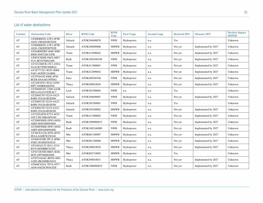
Danube River Basin Management Plan Update 2021 22
ICPDR / International Commission for the Protection of the Danube River / www.icpdr.org
List of water abstractions
Country Abstraction Code River RWB Code RWB
Type First Usage Second Usage Restored 2021 Measure 2027
Decisive Impact
HMWB
AT AT06EB8028-A7E3-4F5B-
A920-15B2EFDD7D2E Salzach ATOK304690078 NWB Hydropower n.a. Yes Unknown
AT AT06EB8028-A7E3-4F5B-
A920-15B2EFDD7D2E Salzach ATOK304690006 HMWB Hydropower n.a. Not yet Implemented by 2027 Unknown
AT AT0AB9EDFF-404F-498F-
80D8-504F528C45FB Traun ATOK412090042 HMWB Hydropower n.a. Not yet Implemented by 2027 Unknown
AT AT0F3C8D0E-F6C0-48E7-
9121-BC6576662A00 Raab ATOK1001040108 NWB Hydropower n.a. Not yet Implemented by 2027 Unknown
AT AT1D1260CB-15C1-438A-
9A16-B37DDCD66E24 Traun ATOK411980001 NWB Hydropower n.a. Not yet Implemented by 2027 Unknown
AT AT1E7771E1-9C03-4D68-
9A81-463E9C16AB66 Traun ATOK412090042 HMWB Hydropower n.a. Not yet Implemented by 2027 Unknown
AT AT1F544182-846E-4F56-
BCE8-D4AA013FFD61 Enns ATOK400240106 NWB Hydropower n.a. Not yet Implemented by 2027 Unknown
AT AT210C0543-5FA2-425D-
89F7-944B08AE0546 Thaya ATOK500010036 HMWB Hydropower n.a. Not yet Implemented by 2027 Unknown
AT AT2D68D283-12D6-4A2B-
90FA-0AA537E9FAC7 Lech ATOK301500004 NWB n.a. n.a. Yes Unknown
AT AT2D692767-E219-4A25-
B4B9-29A26AB1B206 Salzach ATOK304690001 NWB Hydropower n.a. Not yet Implemented by 2027 Unknown
AT AT2D692767-E219-4A25-
B4B9-29A26AB1B206 Salzach ATOK305360001 NWB Hydropower n.a. Yes Unknown
AT AT2D692767-E219-4A25-
B4B9-29A26AB1B206 Salzach ATOK305360002 HMWB Hydropower n.a. Not yet Implemented by 2027 Unknown
AT AT322DAF04-E753-4C01-
A5C3-DC36B4AF434C Traun ATOK411980002 NWB Hydropower n.a. Not yet Implemented by 2027 Unknown
AT AT3D8F9DEE-FF83-485D-
A8EF-6D92498994DD Raab ATOK1000960015 NWB Hydropower n.a. Not yet Implemented by 2027 Unknown
AT AT3D8F9DEE-FF83-485D-
A8EF-6D92498994DD Raab ATOK1002160000 NWB Hydropower n.a. Not yet Implemented by 2027 Unknown
AT AT3ECEA338-4F58-4D78-
8FAA-6A0B7E230148 Mur ATOK801180007 HMWB Hydropower n.a. Not yet Implemented by 2027 Unknown
AT AT4681E59B-3FCA-4FB6-
938D-3816DD36381D Mur ATOK801180008 HMWB Hydropower n.a. Not yet Implemented by 2027 Unknown
AT AT4A0A4133-28A1-4314-
B479-065DBBC931FC Thaya ATOK500010036 HMWB Hydropower n.a. Not yet Implemented by 2027 Unknown
AT AT5C52E50D-0BE5-4E46-
8839-290796D62D98 Mur ATOK802710002 HMWB Hydropower n.a. Yes Unknown
AT AT5F55A0AC-BFFD-4081-
A3B5-0B16D0B1D410 Thaya ATOK500010031 HMWB Hydropower n.a. Not yet Implemented by 2027 Unknown
AT AT666C624A-7D7A-4977-
A036-0ACEC99AC028 Raab ATOK1000960019 NWB Hydropower n.a. Not yet Implemented by 2027 Unknown

Danube River Basin Management Plan Update 2021 23
ICPDR / International Commission for the Protection of the Danube River / www.icpdr.org
Country Abstraction Code River RWB Code RWB
Type First Usage Second Usage Restored 2021 Measure 2027
Decisive Impact
HMWB
AT AT66ABB6F1-8A37-4561-
9064-349C1296F905 Thaya ATOK500010043 HMWB Hydropower n.a. Not yet Implemented by 2027 Unknown
AT AT66E57869-61DE-4065-
A65B-2F4E147BB163 Enns ATOK411250012 HMWB Hydropower n.a. Not yet Implemented by 2027 Unknown
AT AT7E04FA14-BEBB-4CC8-
82D1-B8DF57F1EBE0 Mur ATOK802720005 HMWB Hydropower n.a. Not yet Implemented by 2027 Unknown
AT AT818D6271-2013-4839-
9E00-C30F7FE3222D Mur ATOK802710008 HMWB Hydropower n.a. Yes Unknown
AT AT818D6271-2013-4839-
9E00-C30F7FE3222D Mur ATOK802710009 HMWB Hydropower n.a. Not yet Implemented by 2027 Unknown
AT AT851F483C-CDD7-457C-
84FA-91B640F642AE Raab ATOK1000960020 NWB Hydropower n.a. Not yet Implemented by 2027 Unknown
AT AT891ECA8B-38DE-4DC8-
996F-30C4DEA06FA3 Traun ATOK412090028 NWB Hydropower n.a. Not yet Implemented by 2027 Unknown
AT AT891ECA8B-38DE-4DC8-
996F-30C4DEA06FA3 Traun ATOK412090013 HMWB Hydropower n.a. Not yet Implemented by 2027 Unknown
AT AT891ECA8B-38DE-4DC8-
996F-30C4DEA06FA3 Traun ATOK412090027 HMWB Hydropower n.a. Not yet Implemented by 2027 Unknown
AT AT8C9DA7BE-7DD1-487D-
840A-6CF6FFE48587 Mur ATOK802710002 HMWB Hydropower n.a. Yes Unknown
AT AT8E083EAC-3F3F-4A15-
9D72-847DCC40118F Thaya ATOK500010043 HMWB Hydropower n.a. Not yet Implemented by 2027 Unknown
AT AT91CE1EA9-0115-44EC-
A8A2-1F20F2AB33AF Drau ATOK903540003 NWB Hydropower n.a. Not yet Implemented by 2027 Unknown
AT AT939AC56B-6905-4642-
A6A1-E0609E01A2FB Thaya ATOK500010030 HMWB
Agriculture,
forestry and fishing
(including fish
farms) canals
n.a. Not yet Implemented by 2027 Unknown
AT ATA45174B7-EF7C-4AB5-
85AB-CD98709307E4 Mur ATOK802720005 HMWB Hydropower n.a. Not yet Implemented by 2027 Unknown
AT ATA45174B7-EF7C-4AB5-
85AB-CD98709307E4 Mur ATOK802720006 NWB Hydropower n.a. Yes Unknown
AT ATB55059DD-D0C9-49C6-
8C48-45B91ADC4447 Raab ATOK1000960019 NWB Hydropower n.a. Not yet Implemented by 2027 Unknown
AT ATC818BA23-4A0F-47A9-
85E1-634A52E4C3BC Mur ATOK802720005 HMWB Hydropower n.a. Not yet Implemented by 2027 Unknown
AT ATC82ABC5F-3C15-4EAA-
AD38-57776D2026CA Enns ATOK411250012 HMWB Hydropower n.a. Not yet Implemented by 2027 Unknown
AT ATE5B35378-1B1E-4E81-
9853-0EC5D50FA179 Traun ATOK411980001 NWB Hydropower n.a. Not yet Implemented by 2027 Unknown
AT ATEDEE2554-FB4A-4EC0-
B69A-F0FE148DC5D4 Mur ATOK802710009 HMWB Hydropower n.a. Not yet Implemented by 2027 Unknown
AT ATFA53BF52-77F1-4F3F-
892C-E67F772A40D1 Mur ATOK802710009 HMWB Hydropower n.a. Not yet Implemented by 2027 Unknown
AT ATFDCD0C6C-76AC-4870-
BD83-8D354E0CD5FA Enns ATOK411250012 HMWB Hydropower n.a. Not yet Implemented by 2027 Unknown

Danube River Basin Management Plan Update 2021 24
ICPDR / International Commission for the Protection of the Danube River / www.icpdr.org
Country Abstraction Code River RWB Code RWB
Type First Usage Second Usage Restored 2021 Measure 2027
Decisive Impact
HMWB
DE DEBW_WA_6-01 Donau DERW_DEBW_6-01 NWB Hydropower n.a. Not yet Implemented by 2027 No
DE DEBW_WA_6-02 Donau DERW_DEBW_6-02 NWB Hydropower n.a. Not yet Implemented by 2027 No
DE DEBW_WA_6-03 Donau DERW_DEBW_6-03 NWB Hydropower n.a. Not yet Implemented by 2027 No
DE DEBW_WA_6-04 Donau DERW_DEBW_6-04 NWB Hydropower n.a. Not yet Implemented by 2027 No
DE DEBW_WA_6-05 Donau DERW_DEBW_6-05 HMWB Hydropower n.a. Not yet Implemented by 2027 Yes
DE DEBY_WA_1_F124 Lech DERW_DEBY_1_F124 HMWB Hydropower n.a. Not yet Implemented by 2027 Unknown
DE DEBY_WA_1_F128 Lech DERW_DEBY_1_F128 HMWB Hydropower n.a. Not yet Implemented by 2027 Unknown
DE DEBY_WA_1_F132 Lech DERW_DEBY_1_F132 HMWB Hydropower n.a. Not yet Implemented by 2027 Unknown
DE DEBY_WA_1_F227
Main-
Donau-
Kanal
DERW_DEBY_1_F227 NWB Hydropower n.a. Not yet Implemented by 2027 Unknown
DE DEBY_WA_1_F229
Main-
Donau-
Kanal
DERW_DEBY_1_F229 NWB Hydropower n.a. Not yet Implemented by 2027 Unknown
DE DEBY_WA_1_F251 Naab DERW_DEBY_1_F251 NWB Hydropower n.a. Not yet Implemented by 2027 Unknown
DE DEBY_WA_1_F252 Naab DERW_DEBY_1_F252 NWB Hydropower n.a. Not yet Implemented by 2027 Unknown
DE DEBY_WA_1_F253 Naab DERW_DEBY_1_F253 NWB Hydropower n.a. Not yet Implemented by 2027 Unknown
DE DEBY_WA_1_F273 Naab DERW_DEBY_1_F273 NWB Hydropower n.a. Yes Unknown
DE DEBY_WA_1_F373 Isar DERW_DEBY_1_F373 NWB Hydropower n.a. Yes Unknown
DE DEBY_WA_1_F402 Isar DERW_DEBY_1_F402 NWB Other major
abstractions n.a. Yes Unknown
RO ROHA01.10.1.0.0.0.0.0 Arges ROLW10-1_B1 HMWB Hydropower n.a. Not necessary No
RO ROHA01.3.1.44_B2 Crisul
Repede RORW3-1-44_B2 NWB Hydropower n.a. Not necessary No
RO ROHA01.8.1.0.0.0.0.0 Olt RORW8-1_B2 HMWB Public water supply n.a. Yes No
RO ROHA02.10.1.0.0.0.0.0 Arges RORW10-1_B2 HMWB Hydropower n.a. Not yet Not implemented by 2027 Yes
RO ROHA03.10.1.0.0.0.0.0 Arges ROLW10-1_B2 HMWB Hydropower Public water supply Not necessary No
RO ROHA03.3.1.44_B6 Crisul
Repede RORW3-1-44_B6 NWB Hydropower n.a. Not necessary No
RO ROHA04.10.1.0.0.0.0.0 Arges ROLW10-1_B3 HMWB Hydropower Public water supply Not necessary No
RO ROHA05.10.1.0.0.0.0.0 Arges ROLW10-1_B4 HMWB Hydropower Manufacturing
industry Not necessary No
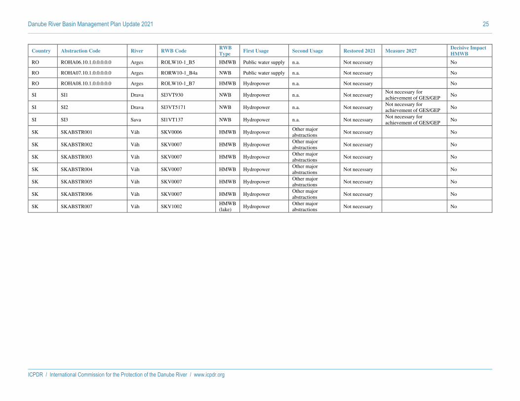
Danube River Basin Management Plan Update 2021 25
ICPDR / International Commission for the Protection of the Danube River / www.icpdr.org
Country Abstraction Code River RWB Code RWB
Type First Usage Second Usage Restored 2021 Measure 2027
Decisive Impact
HMWB
RO ROHA06.10.1.0.0.0.0.0 Arges ROLW10-1_B5 HMWB Public water supply n.a. Not necessary No
RO ROHA07.10.1.0.0.0.0.0 Arges RORW10-1_B4a NWB Public water supply n.a. Not necessary No
RO ROHA08.10.1.0.0.0.0.0 Arges ROLW10-1_B7 HMWB Hydropower n.a. Not necessary No
SI SI1 Drava SI3VT930 NWB Hydropower n.a. Not necessary Not necessary for
achievement of GES/GEP No
SI SI2 Drava SI3VT5171 NWB Hydropower n.a. Not necessary Not necessary for
achievement of GES/GEP No
SI SI3 Sava SI1VT137 NWB Hydropower n.a. Not necessary Not necessary for
achievement of GES/GEP No
SK SKABSTR001 Váh SKV0006 HMWB Hydropower Other major
abstractions Not necessary No
SK SKABSTR002 Váh SKV0007 HMWB Hydropower Other major
abstractions Not necessary No
SK SKABSTR003 Váh SKV0007 HMWB Hydropower Other major
abstractions Not necessary No
SK SKABSTR004 Váh SKV0007 HMWB Hydropower Other major
abstractions Not necessary No
SK SKABSTR005 Váh SKV0007 HMWB Hydropower Other major
abstractions Not necessary No
SK SKABSTR006 Váh SKV0007 HMWB Hydropower Other major
abstractions Not necessary No
SK SKABSTR007 Váh SKV1002 HMWB
(lake) Hydropower
Other major
abstractions Not necessary No

Danube River Basin Management Plan Update 2021 26
ICPDR / International Commission for the Protection of the Danube River / www.icpdr.org
List of hydropeaking
Country Hydropeaking Code River RWB Code RWB Type Restored 2021 Measure 2027 Decisive Impact
HMWB
AT AT011AECA1-204F-4D5F-8178-C8F6F41B0DBC Inn ATOK304980003 HMWB Yes Unknown
AT AT011AECA1-204F-4D5F-8178-C8F6F41B0DBC Inn ATOK304980006 HMWB Not yet Implemented by 2027 Unknown
AT AT011AECA1-204F-4D5F-8178-C8F6F41B0DBC Inn ATOK304980005 HMWB Not yet Implemented by 2027 Unknown
AT AT020660C3-038E-4F23-97C1-94DAFE80974E Drau ATOK903540002 NWB Yes Unknown
AT AT020660C3-038E-4F23-97C1-94DAFE80974E Drau ATOK903540001 HMWB Not yet Implemented by 2027 Unknown
AT AT04ABC100-3A62-446C-B484-EBD6B156CADD Salzach ATOK305350003 HMWB Not yet Implemented by 2027 Unknown
AT AT04ABC100-3A62-446C-B484-EBD6B156CADD Salzach ATOK305350006 HMWB Not yet Implemented by 2027 Unknown
AT AT206BB26C-3B35-44E2-AB47-151927231040 Salzach ATOK305350001 HMWB Not yet Implemented by 2027 Unknown
AT AT211C7D8D-B8AA-4F8D-B1A6-5569C9695131 Raab ATOK1001040108 NWB Not yet Implemented by 2027 Unknown
AT AT211C7D8D-B8AA-4F8D-B1A6-5569C9695131 Raab ATOK1001040109 NWB Not yet Implemented by 2027 Unknown
AT AT211C7D8D-B8AA-4F8D-B1A6-5569C9695131 Raab ATOK1002160000 NWB Not yet Implemented by 2027 Unknown
AT AT2237FAC0-F3C6-4D7A-B4E3-911E39E3BBD7 Inn ATOK304980009 HMWB Not yet Implemented by 2027 Unknown
AT AT2237FAC0-F3C6-4D7A-B4E3-911E39E3BBD7 Inn ATOK304980010 HMWB Not yet Implemented by 2027 Unknown
AT AT3387C1C0-3EB4-48AF-90E5-1BB0EBE5C01F Thaya ATOK501870001 HMWB Not yet Implemented by 2027 Unknown
AT AT46C46D07-C510-4567-B38C-40135A49DF62 Lech ATOK307080000 NWB Yes Unknown
AT AT4A153931-2560-4F9B-BE34-7FC49A47FC28 Salzach ATOK305360002 HMWB Not yet Implemented by 2027 Unknown
AT AT58F7DB2C-6D47-47AE-9BC7-61F4141E31DA Inn ATOK304980009 HMWB Not yet Implemented by 2027 Unknown
AT AT58F7DB2C-6D47-47AE-9BC7-61F4141E31DA Inn ATOK304980006 HMWB Not yet Implemented by 2027 Unknown
AT AT5AA1D134-6A23-463A-876C-2D2573DC9735 Inn ATOK305850011 HMWB Not yet Implemented by 2027 Unknown
AT AT687026EF-6390-4F64-B317-11657D86D032 Salzach ATOK305350006 HMWB Not yet Implemented by 2027 Unknown
AT AT7AF7C89D-361A-464B-9A41-39B47659C7F4 Inn ATOK304980009 HMWB Not yet Implemented by 2027 Unknown
AT AT7B9B2D7E-7D97-4F51-882B-D4E385B9702C Drau ATOK900470022 HMWB Not yet Implemented by 2027 Unknown
AT AT7B9B2D7E-7D97-4F51-882B-D4E385B9702C Drau ATOK900470021 NWB Not yet Implemented by 2027 Unknown
AT AT86D2B40B-52E5-4C1A-B7BF-7FE7C1043BC7 Salzach ATOK304690004 HMWB Not yet Implemented by 2027 Unknown
AT AT86D2B40B-52E5-4C1A-B7BF-7FE7C1043BC7 Salzach ATOK304690005 NWB Yes Unknown

Danube River Basin Management Plan Update 2021 27
ICPDR / International Commission for the Protection of the Danube River / www.icpdr.org
Country Hydropeaking Code River RWB Code RWB Type Restored 2021 Measure 2027 Decisive Impact
HMWB
AT ATA5F03313-E588-4711-98C0-D72340D09E3A Enns ATOK411250010 NWB Not yet Implemented by 2027 Unknown
AT ATA5F03313-E588-4711-98C0-D72340D09E3A Enns ATOK400240092 NWB Not yet Implemented by 2027 Unknown
AT ATA5F03313-E588-4711-98C0-D72340D09E3A Enns ATOK409970000 HMWB Not yet Implemented by 2027 Unknown
AT ATA6CEB206-B169-4073-AF7F-F6DD28C6D082 Salzach ATOK305360002 HMWB Not yet Implemented by 2027 Unknown
AT ATA7116E17-266B-4FDD-AE35-3130DB06EA55 Enns ATOK411250020 HMWB Not yet Implemented by 2027 Unknown
AT ATA7116E17-266B-4FDD-AE35-3130DB06EA55 Enns ATOK411250021 HMWB Not yet Implemented by 2027 Unknown
AT ATB1D2DC67-EC16-4ADA-898B-4D3D6BD38C85 Salzach ATOK307200003 NWB Not yet Implemented by 2027 Unknown
AT ATB1D2DC67-EC16-4ADA-898B-4D3D6BD38C85 Salzach ATOK307200002 NWB Not yet Implemented by 2027 Unknown
AT ATB2EE16C5-FA4E-412D-A347-DD95DBE2FF47 Salzach ATOK305350001 HMWB Not yet Implemented by 2027 Unknown
AT ATB2EE16C5-FA4E-412D-A347-DD95DBE2FF47 Salzach ATOK305350003 HMWB Not yet Implemented by 2027 Unknown
AT ATB2EE16C5-FA4E-412D-A347-DD95DBE2FF47 Salzach ATOK305350002 NWB Not yet Implemented by 2027 Unknown
AT ATB95E7EE8-A2E6-4160-8A30-5A1D5E29EE39 Salzach ATOK305360002 HMWB Not yet Implemented by 2027 Unknown
AT ATB95E7EE8-A2E6-4160-8A30-5A1D5E29EE39 Salzach ATOK305350001 HMWB Not yet Implemented by 2027 Unknown
AT ATB95E7EE8-A2E6-4160-8A30-5A1D5E29EE39 Salzach ATOK305350002 NWB Not yet Implemented by 2027 Unknown
AT ATB95E7EE8-A2E6-4160-8A30-5A1D5E29EE39 Salzach ATOK305350003 HMWB Not yet Implemented by 2027 Unknown
AT ATB95E7EE8-A2E6-4160-8A30-5A1D5E29EE39 Salzach ATOK305350006 HMWB Not yet Implemented by 2027 Unknown
AT ATD49938BB-DB9B-4429-9E08-5498116ACB54 Salzach ATOK305350001 HMWB Not yet Implemented by 2027 Unknown
AT ATD49938BB-DB9B-4429-9E08-5498116ACB54 Salzach ATOK305360002 HMWB Not yet Implemented by 2027 Unknown
AT ATE8E67B4A-C6D6-4B4C-AE6C-C637BDA3F9BA Salzach ATOK305350001 HMWB Not yet Implemented by 2027 Unknown
AT ATE99B6E17-B7CE-4EEC-B732-ECDD2E79FFDE Drau ATOK903540003 NWB Not yet Implemented by 2027 Unknown
AT ATFC098661-D3EC-4478-8129-EA99C9B7F82E Salzach ATOK305350001 HMWB Not yet Implemented by 2027 Unknown
AT ATFC8D1ACB-054E-4661-84B9-44F99DC4E155 Inn ATOK305850011 HMWB Not yet Implemented by 2027 Unknown
AT ATFF65EE0D-5B75-4AC6-AD22-96CBF26A8BC8 Mur ATOK801180006 NWB Yes Unknown
AT ATFF65EE0D-5B75-4AC6-AD22-96CBF26A8BC8 Mur ATOK801180005 NWB Yes Unknown
AT ATFF65EE0D-5B75-4AC6-AD22-96CBF26A8BC8 Mur ATOK801180004 NWB Yes Unknown
DE DEBY_HP_1_F122 Lech DERW_DEBY_1_F122 HMWB Not yet Implemented by 2027 Unknown

Danube River Basin Management Plan Update 2021 28
ICPDR / International Commission for the Protection of the Danube River / www.icpdr.org
Country Hydropeaking Code River RWB Code RWB Type Restored 2021 Measure 2027 Decisive Impact
HMWB
DE DEBY_HP_1_F124 Lech DERW_DEBY_1_F124 HMWB Yes Unknown
DE DEBY_HP_1_F125 Lech DERW_DEBY_1_F125 NWB Yes Unknown
DE DEBY_HP_1_F128 Lech DERW_DEBY_1_F128 HMWB Not yet Implemented by 2027 Unknown
DE DEBY_HP_1_F131 Lech DERW_DEBY_1_F131 HMWB Not yet Implemented by 2027 Unknown
DE DEBY_HP_1_F132 Lech DERW_DEBY_1_F132 HMWB Not yet Implemented by 2027 Unknown
DE DEBY_HP_1_F163 Donau DERW_DEBY_1_F163 HMWB Yes Unknown
DE DEBY_HP_1_F429 Isar DERW_DEBY_1_F429 HMWB Not yet Implemented by 2027 Unknown
HR HRTABHPEAK00001 Drava HRCDRI0002_010 HMWB Not yet Implemented by 2027 No
HR HRTABHPEAK00001 Drava HRCDRI0002_012 NWB Not yet Implemented by 2027 No
HR HRTABHPEAK00001 Drava HRCDRN0002_011 HMWB Not yet Implemented by 2027 No
HR HRTABHPEAK00001 Drava HRCDRN0002_013 NWB Not yet Implemented by 2027 No
HU HUDrava Dráva HUAEP439 HMWB Not yet Not yet determined Yes
HU HUSebesKoros Sebes-Körös HUAEP953 NWB Not yet Not yet determined No
SI SI_HE1 Sava SI1VT137 NWB Not necessary Not necessary for
achievement of GES/GEP No
SI SI_HE2 Sava SI1VT310 NWB Not necessary Not necessary for
achievement of GES/GEP No

ICPDR / International Commission for the Protection of the Danube River / www.icpdr.org
Draft ANNEX 18 as of 26 February 2021
DRBMP Update 2021
Hydromorphological lighthouse projects in the Danube River Basin District (2015-2021)

Imprint
Published by:
ICPDR – International Commission for the Protection of the Danube River
© ICPDR 2021
Contact
ICPDR Secretariat
Vienna International Centre / D0412
P.O. Box 500 / 1400 Vienna / Austria
T: +43 (1) 26060-5738 / F: +43 (1) 26060-5895
[email protected] / www.icpdr.org

3
Danube River Basin Management Plan Update 2021
ICPDR / International Commission for the Protection of the Danube River / www.icpdr.org
Table of content
Table of content 3
1. Overall context 4
2. Overview of measures 5
3. Lighthouse projects 7
3.1 AT-Traisen: Creation of a meandering river section in the River Traisen 7
3.2 AT-Danube: LIFE “Network Danube” and “Network Danube Plus” 10
3.3 DE-Isar: Restoration of the ecological continuity in the Upper Isar Valley 14
3.4 DE-Danube: Improving a Danube water body in the Upper Danube by – inter alia – removal of bank fixations and creation of gravel banks 17
3.5 CZ-Dlouhá řeka/ Morava: Nedakonice water management node 21
3.6 CZ-Bečva: Restoration of the Bečva River 24
3.7 CZ-Morava: Morphological restoration of the Morava river 25
3.8 RO-Somes Mic: Restoration of connectivity in the Somes Mic River 26
3.9 HU-Tisza: Measures to improve water retention in Bereg 29
3.10 HU-Monsoni-Duna: Measures at Mosoni-Duna estuary section 32
3.11 SI-Continuity restoration in the Sava River 35
4. Final remarks - Outlook 37
5. Projects related to hydromorphology and supported by the ICPDR 38

Danube River Basin Management Plan Update 2021 4
ICPDR / International Commission for the Protection of the Danube River / www.icpdr.org
1. Overall context
Over the last century, legitimate water uses (hydropower generation, navigation and flood protection as
well as activities related to urban settlements or agriculture) significantly changed the habitat and
hydrological conditions of surface waters and thus impacted the ecological status and functioning of
river systems.
The alteration of natural hydromorphological conditions can have negative effects on aquatic
populations. Based on increased knowledge on hydromorphological alterations and their relevance for
the achievement of the environmental objectives, measures have to be taken to restore natural or near-
natural conditions. Measures to improve the hydromorphological conditions aiming at improved water
status and increasing habitat diversity include
- Hydrological measures (e.g. increase of residual flow, dampening of hydropeaking),
- Restoration of river continuity for fish and sediment (e.g. construction of fish migration aids,
improvement of sediment transport),
- Morphological improvements (e.g. removal of bank fixation, reconnection of floodplains).
During the last water management planning cycle (2015-2021), a significant number of appropriate
hydromorphological measures were identified, many of them only started or already implemented by
Danube countries. Table 1 shows, that most measures are related to the restoration of river morphology
and continuity for fish, but also hydrological measures were implemented.
Table 1: Number of hydromorphological measures and their implementation status
Planning on-going Implementation on-going Completed
Hydrological improvements 14 5 10
Restoration of river continuity 21 6 26
Morphological improvements 14 22 29
* for more details, see Annex 15 of the DRBM Plan 2021
To highlight the importance of hydromorphological measures, this brochure presents some lighthouse
projects in the Danube River Basin District that were started or implemented since 2015.

Danube River Basin Management Plan Update 2021 5
ICPDR / International Commission for the Protection of the Danube River / www.icpdr.org
2. Overview of measures
Overall, ten measures were reported by Danube countries. Their location within the Danube catchment
is shown in Figure 1.
Figure 1: Overview map of hydromorphological measures in the Danube catchment
The main driving forces reported for the eleven lighthouse projects are hydropower (5 cases), flood
protection (7 cases) as well as irrigation, land use and navigation (2 cases each). For five locations,
several driving forces were reported, while six locations are dominantly changed by one driving force.
At most sites (i.e. 8) measures which serve the restoration of more than one hydromorphological impact
type (i.e. related to hydrology, morphology, connectivity) are implemented. The here presented sites
provide examples for restoration of river morphology and the riparian zone (7 sites), and/or floodplain
areas (8 sites), connectivity for fish (7 sites) and sediment (3 sites). Furthermore, four sites provide
examples for hydrological restorations, e.g. by improvement of water retention and flow variability.
Table 2: Overview of hydromorphological measures
Term used Hydrology Connectivity1 Morphology2 Benefitting directives Status
AT-Danube F R, F WFD, Habitats-D, Birds-D Partly finished (2019, 2023)
AT-Traisen F R, F WFD, Habitats-D, Birds-D Finished (2019)
CZ-Becva S R ,F WFD Ongoing
CZ-Dhoulá reka X F R, F WFD, Habitats-D Finished (2021)
CZ-Morava X F, S R, F WFD, Habitats-D, Birds-D Finished
DE-Danube F R, F WFD, Habitats-D Finished (2018, 2019)
DE-Isar F, S WFD, Habitats-D Finished (2018)
HU-Tisza X R, F WFD, Habitats-D Finished (2019)
HU-Monsoni-Duna X F WFD, Floods-D Finished (2021)
RO-Somes Mic F WFD, Habitats-D Finished (2017)
SI-Sava F R, F WFD, Habitats-D Finished (2017) 1) Measures for fish (F) and/or sediment (S); 2) Measures for river/riparian (R) and/or floodplain areas (F)

Danube River Basin Management Plan Update 2021 6
ICPDR / International Commission for the Protection of the Danube River / www.icpdr.org
Nine out of the eleven sites report that the planned or performed measures serve more than one directive
(see Table 2). While all restoration measures serve the fulfilment of the European Water Framework
Directive (WFD), nine are expected to bring benefits for the Habitats Directive (Habitats-D) and three
for the Birds Directive (Birds-D). One is reported to be beneficial for the Floods Directive (Floods-D).
Those projects are thus also highlighting the importance of implementation of synergetic measures that
are bringing achievement of different goals related to water management.
Nine lighthouse projects are already finished or expected to be finished by the end of 2021, while one
is still ongoing. Another example (AT-Danube) comprises of two projects of which one was finished
(2019) and one is still ongoing (2023).
Overall, more than 200 mill. were invested in the measures, whereby costs range from 38,000 € to 82 mill. These costs were often shared between EU, national and other funds (6 cases), or rely entirely on
EU- (1 case), national- (3 cases) or other funds (1 case).
Monitoring results are available for five cases. The two fish passes in Romania and Slovenia were
proven to be functional. In some cases, an improvement of the ecological status (e.g. from moderate to
good status at AT-Traisen) or individual quality elements (e.g. from moderate to good fish-ecological
status at DE-Danube) was achieved. A preliminary monitoring at AT-Danube also showed promising
results with an increase in endemic species and juvenile life-stages. Further improvements area also
expected for the remaining lighthouse projects.
The following chapter provides a more detailed description of the individual lighthouse projects.

Danube River Basin Management Plan Update 2021 7
ICPDR / International Commission for the Protection of the Danube River / www.icpdr.org
3. Lighthouse projects
3.1 AT-Traisen: Creation of a meandering river section in the River Traisen
3.1.1 Initial (impacted) situation The river Traisen is one of the biggest tributaries of the river Danube in Lower Austria. The river stretch
runs through the Natura 2000 site “Tullnerfelder Donauauen”, Austria’s largest enclosed wetland. It contains twelve protected habitat types acc. Annex I and 30 protected species acc. Annex II of the
Habitats Directive as well as 24 protected bird species acc. Annex I of the Birds Directive.
The Danube floodplains were cut off from the river due to river regulation measures for navigation
already in the 19th century. The Danube Hydropower Plant “Altenwörth” was built in the 1970ies and is operated by the VERBUND, Austria's leading electricity company. With a design flow rate of
2,700 m³/s, the run-of-river plant has a standard working capacity 1,967.6 GWh per year. This power
plant thus generates about one sixth of the electricity generated on the Austrian Danube.
During the construction of the Danube hydropower plant of Altenwörth, in 1976 the mouth of the river
Traisen was relocated about 7.5 km further downstream. The new river course was heavily regulated
disconnecting the river from the surrounding riparian forest and supressing aquatic and terrestrial
habitats that are usually found in floodplains. This situation led to an unfavourable conservation status
for the whole Natura 2000 site. Additionally, the estuary was not passable for fish to migrate from the
Danube into the river Traisen. For those reasons the concerned water body of the river Traisen reached
only poor ecological status according to the Austrian National River Basin Management Plan 2009.
3.1.2 The measure During the LIFE+ project a meandering river segment was built with a total length of approx. 10 km,
which is allowed to develop dynamically during flood events and provides multiple habitats for aquatic
species. The old channelized river course was maintained as backwater and flood drainage. The adjacent
area of the Traisen was lowered to create about 60 ha of active floodplain habitats and approximately
30 ha of typical river habitats. Furthermore, the river Traisen was re-connected to the Danube and its
fish population.
Figure 2: Construction works in the Traisen-area © Verbund

Danube River Basin Management Plan Update 2021 8
ICPDR / International Commission for the Protection of the Danube River / www.icpdr.org
Figure 3: Restored section of the river Traisen, next to the Danube River (upper right) © Verbund
The large-scale excavations during the construction of the riverbed and its adjacent floodplain resulted
in a material surplus of approx. 1.5 mill. m³, which was partly reintroduced downstream the Danube
hydro power plant “Wien-Freudenau” to counteract riverbed incision.
The project has started in 2013 and the overall measure was finished in 2019. The costs of 30 mill. € were split between EU (5.3 mill. €, provided by LIFE funds), the national Environment Fund (3.3 mill. €), VERBUND as the operator of the hydropower plant (15 mill. €), regional funds (1.9 mill. €; Federal State Lower Austria, Fishery Association of Lower Austria, via donau) and revenue from the excavated and sold gravel (4.5 mill. €).

Danube River Basin Management Plan Update 2021 9
ICPDR / International Commission for the Protection of the Danube River / www.icpdr.org
3.1.3 Conclusion The LIFE+ project “Traisen” is one of the largest ecological river engineering projects in Austria and in Europe and could only be realized through close cooperation of all project partners.
Figure 4: Restored river section of the river Traisen © Verbund
Monitoring of the fish biocenosis was carried out during and after finalization (i.e. in 2014, 2016 and
2017). Focus of the monitoring was also laid on the assessment of juvenile fish, of spawning grounds
and on temperature changes. Results show an increase from 20 to 33 species. While the old channel of
the river Traisen did not provide suitable spawning- and rearing habitats, a high density of juvenile fish
of various species were found in the new channel. The re-opening of the continuum to the Danube has
directly led to an increase and reproduction of typical Danubian fish species. To sum up, the monitoring
showed an increase in the number of species, an improvement in population structures due to higher
reproduction rates and an increase in population density. The assessment reveals an improvement of the
fish ecological status from moderate (status class 3) in 2014 to good status (status class 2) in 2017.
Furthermore, the “good ecological potential” was achieved in the adjacent water body of river Danube.
The approach of providing both – fish migration and high-quality key habitats – ensures a significant
contribution to the goals of the Habitats Directive, the Bird Directive, as well as the WFD, thus
implementing EU legislation with the aim of best value for money.

Danube River Basin Management Plan Update 2021 10
ICPDR / International Commission for the Protection of the Danube River / www.icpdr.org
3.2 AT-Danube: LIFE “Network Danube” and “Network Danube Plus”
3.2.1 Initial (impacted) situation The Austrian share of the Danube has a length of 352 km. VERBUND, Austria's leading electricity
company, is operating ten large run-of-river hydropower plants along the Austrian Danube which
generate about 20% of the public electricity production in Austria
Large sections of the course of the Austrian Danube have been shaped by river regulation and damming
measures already in the 19th century. The development of the Danube for hydroelectric power in the 20th
century has additionally reshaped about 80% of its course. The ten existing hydropower plants have a
significant ecological impact on the Danube river and its floodplains. They cause long stretches with
reduced flow velocity and the dams have fragmented the river into environmentally disconnected
sections. Moreover, the floodplains and floodplain water bodies along the river are for the most part cut
off from the Danube by dams. In the Danube and its floodplains, the key habitat of permanently
connected side arms, which provide spawning grounds and nurseries for rheophilic fish species and
shelter from ship-induced waves, is missing. As a result of these alterations, the good ecological status/
potential is currently not reached in most of the Austrian waterbodies of the Danube.
3.2.2 The measure Along the Austrian Danube there are several Natura 2000 protected areas and a National Park. The
Natura 2000 area “Tullnerfelder Donau-Auen”, Austria’s largest enclosed wetland, contains 42 species protected under the EUs Birds Directive and Annex II of the Habitats Directive. The National Park
“Donau-Auen” in the most eastern section of the Austrian Danube with an extent of over 9,600 ha is the
largest complete, (near) ecologically intact natural riverine environment of its kind in Central Europe
and provides home and refuge to many endangered plant and animal species.

Danube River Basin Management Plan Update 2021 11
ICPDR / International Commission for the Protection of the Danube River / www.icpdr.org
Figure 5: Continuity restoration in the area of Abwinden-Asten © Verbund
These areas are not ecologically connected due to the existing hydropower dams and flood protection
measures. By restoring the continuity of the river and creating new habitats in the river and its
floodplains, the protected areas can be interconnected by a network of ecological stepping stones.
The two EU-funded projects “Network Danube” and “Network Danube Plus” aim for the restoration
of connectivity and habitat improvements in the whole Danube upstream Vienna to the border with

Danube River Basin Management Plan Update 2021 12
ICPDR / International Commission for the Protection of the Danube River / www.icpdr.org
Germany. Thereby, they pursue objectives related to the WFD as well as the Habitats and the Birds
directive.
Figure 6: Bypass channel at Ottensheim-Wilhering (“LIFE Network Danube”) © Verbund
The first project “LIFE Network Danube” started in 2011 and was finished in 2019. The following measures were successfully implemented:
− Construction of bypass channels at three hydropower dams to facilitate fish migration in the
Danube
− Creation of gravel habitats (gravel banks, gravel islands) in the reservoirs of five hydro power
plants on the Danube entailing 325,000 m³ of gravel; and
− Creation of 500 m of branches and side arms on the shores of the Danube.
The project is co-funded by the EU LIFE Programme. The total costs of the measure were 25.3 mill.
Euro, whereby 4.3 mill. were funded by EU, 3.8 mill. by national funds, 16.7 mill. by Verbund and
0.5 mill. by the Fishery Associations of Lower and Upper Austria.
The second project “LIFE Network Danube Plus: Closing the gaps and promoting a river corridor system with an European perspective” started in 2019 and is scheduled until 2023. The main aims of the projects are the following:
− Restoring the passability of the Danube for all fish species: In addition to the construction of
fish migration facilities at three Danube power plants, feasibility studies on restoring the
continuity are being carried out for the two remaining non-passable dams in the Austrian
Danube. By the end of the project, unhindered fish migration will be possible between the Iron
Gates gorge in Serbia and the Ybbs-Persenbeug hydropower plant in Austria (over 1,100 km)
including the two last free-flowing stretches of the Austrian Danube;
− Creation of habitats by building gravel structures and lateral re-connection with tributaries
− Interlinking Natura 2000 sites (stepping stone biotopes between protected areas)

Danube River Basin Management Plan Update 2021 13
ICPDR / International Commission for the Protection of the Danube River / www.icpdr.org
− Strengthening of fish populations also in the Danube floodplains and tributaries
− Closing the gaps between already implemented LIFE-Projects in Lower Austria
− Strengthening and appreciating the positive impacts of former ecological projects (e.g. the
project Life-Traisen)
The project is co-funded by the EU LIFE Programme and the total costs are expected to be 10.1 mill.
Euro, whereby 4.2 mill. will be funded from EU, 0.9 mill. from national funds, 4.9 mill. from Verbund
and 0.1 mill. from the Fishery Association of Lower Austria.
3.2.3 Conclusion For the fish passes Ottensheim and Greifenstein interim results of the monitoring are available showing
very good results. In Greifenstein 46 out of 58 endemic species could be evidenced. Furthermore, all
stages of age were observed. Using pit-tags long-term monitoring is possible. With the upcoming fish
passes and their monitoring more fish will be marked and can give new inputs on the topic of far-distance
migration of fish.
Figure 7: Fish pass Greifenstein © Verbund
The projects “LIFE Network Danube” and “LIFE Network Danube Plus” are demonstrating the suitability of a targeted stepwise approach for achieving the goals of the Habitats and Birds directives
and the EU Water Framework Directive on a large spatial scale. The two projects complement each
other with interlinking sets of measures and thus are multiplying the overall benefits of each individual
project. Additionally, the measures to improve the river’s continuity enhance the positive effects of other renaturation projects. By re-connecting habitats in the Danube and its tributaries the biodiversity and the
ecological status in the Danube itself as well as in its floodplains can be improved.

Danube River Basin Management Plan Update 2021 14
ICPDR / International Commission for the Protection of the Danube River / www.icpdr.org
3.3 DE-Isar: Restoration of the ecological continuity in the Upper Isar Valley
3.3.1 Initial (impacted) situation Due to river construction works in the river Isar for infrastructure protection (flood protection and
agricultural land use) erosion caused a continuity interruption between the Isar and its tributary
Aumühlbach. Important spawning areas and habitats for juvenile fish could not be reached and thus, the
waterbody failed to achieve the good ecological status (in particular for fish).
3.3.2 The measure In order to re-established the ecological continuity for biota (e.g. European grayling, barbal, nase) a
structured ramp was established. It includes ten pools with a length of 4.3 m, which are connected by
slots of 0.45 m in width and 0.52 m in height to overcome a fall height of 0.15 m each. As a consequence,
important refuges and habitats in the near-natural tributary are once more accessible. The functionality
of the structure for fish migration was ensured for a wide range of flow situations.
The measure was finished in March 2018. The overall costs of 90,000€ were covered by national funds.
Figure 8: Construction of the measure

Danube River Basin Management Plan Update 2021 15
ICPDR / International Commission for the Protection of the Danube River / www.icpdr.org
Figure 9: View in upstream direction
3.3.3 Conclusion The measure is expected to have a positive effect on the fish fauna in the Isar, which showed only a
moderate ecological status with regard to its fish fauna before the measure was implemented. The
success of the measure will be visible in the Isar in the medium term.
This measure is part of a bundle of measures that support and promote the development of a natural,
species-rich and diverse fish community in order to achieve the good ecological potential/ status in the
Isar by 2021.
From a nature conservation perspective, the measures are also suitable to support the conservation goals
for the protected area (habitats directive) “Oberes Isartal” (Upper Isar Valley). Consequently, the measure supports the achievement of both, the WFD and the Habitats directive.

Danube River Basin Management Plan Update 2021 16
ICPDR / International Commission for the Protection of the Danube River / www.icpdr.org
Figure 10: Finished bypass

Danube River Basin Management Plan Update 2021 17
ICPDR / International Commission for the Protection of the Danube River / www.icpdr.org
3.4 DE-Danube: Improving a Danube water body in the Upper Danube by – inter alia – removal of bank fixations and creation of gravel banks
3.4.1 Initial (impacted) situation One main reason for not achieving good status in the Danube between Vohburg and Staubing is a severe
hydromorphological alteration of this water body at a length of about 20 km.
2015, the ecological status was „moderate“, because of the assessment of invertebrates und macrophytes/phytoplankton. An additional problem is caused by invasive species, which benefit from
the bank protection with (armour-)stones.
3.4.2 The measure In order to improve the ecological status of the river body and to ensure that a good ecological status
could be maintained for the future, a comprehensive programme of measures for this river stretch was
set up.
Figure 11: Overview map – location of water body and hydromorphological measures
The complete hydromophological measures for this river stretch includes the following activities:
1. Structural measures to promote natural retention (~3.8 km)
The natural water retention in the Danube floodplain increases by removing riparian deposits along the
riverbank. This was already done on a large scale during the last years and will be continued. In addition,
a flood storage basin is to be reactivated by the removal of riparian land and artificial bank protection.
2. Removal/ reduction of bank reinforcement (15 locations, approx. 14 km)
The massive bank protection on the Danube is to be partially or completely removed in areas where it
is not indispensable for the protection of settlements, bridges, roads and flood protection facilities.
3. Inserting structural elements in the existing water profile (11 locations, 11.6 km)
Armourstones that are left over from the removal of the bank protection can partly be placed in the river
profile. Short groynes (up to about mean water level) increase the variety of currents in the Danube and
promote bank erosion, flow diversity and morphological development in adjacent downstream areas.

Danube River Basin Management Plan Update 2021 18
ICPDR / International Commission for the Protection of the Danube River / www.icpdr.org
4. Creating and redesigning gravel banks
One additional gravel bank is to be created through the introduction of gravel around armourstones. Two
existing gravel banks will be redesigned in order to create new spawning habitats for characteristic
Danube fish species.
5. Developing floodplain habitats
The development of an approx. 900 m long and 50 – 80 m wide strip with typical floodplain habitats
(succession areas, grassland, wet areas) and the development of alluvial forest areas on former
intensively used meadows on a stretch of approx. 1.3 km is to be realised.
6. Recreating alluvial waters (5 locations, approx. 3.5 km)
In order to be able to develop a more natural watercourse again, it is planned to divert water from the
Danube into new branches to be created at several points. These measures are also intended to improve
the habitat conditions for typical fish species.
7. Connecting backwaters
Several backwaters are currently not or not permanently connected to the Danube river. Improvement
measures are proposed for four areas.
8. Improving lateral connectivity
The three tributaries to the Danube are not optimally passable for fish, thus the mouth areas will be
redesigned. Thereby, the backwaters in the floodplain could also be linked with the Danube.
9. Improving the sediment situation
Due to sediment retention upstream causing a strong bedload deficit, gravel was introduced into the
river at two places. It is very likely that sediment input will have to be repeated every 5 to 7 years.
Example for realisation of measures: Creation of a gravel bank for rheophilic fish
A structured gravel bank located in the area of mean flow (~250m long, gradient of ~1:25) was created
near the left bank of the Danube for which about 3,000 m³ of Danube gravel were used. A basic structure
of hydraulic building blocks serves to stabilize the gravel bank and offers protection against erosion.
The measure was finished in July 2018. The overall costs of 100,000 € were entirely covered by national funds.

Danube River Basin Management Plan Update 2021 19
ICPDR / International Commission for the Protection of the Danube River / www.icpdr.org
Figure 12: Finished gravel bank from (aerial view)
Since the measure is situated in a protected area (Habitats directive, “Donauauen zwischen Ingolstadt und Weltenburg”), the measure aligns with the WFD and the Habitats directive.
Example for realisation of measures: Removal of bank fixations
The bank fixation of the Danube was removed at approx. 500 m in order to promote the development of
structures typical of natural rivers such as bank breaks, backwash and potholes. The lining material was
used for creating different groynes. Due to the generous denudation of bank material, a softwood site
with high flood dynamics has been created. The measure was finished in November 2018, whereby the
overall costs of 60,000 € were entirely covered by national funds.
Figure 13: Removal of the bank fixation

Danube River Basin Management Plan Update 2021 20
ICPDR / International Commission for the Protection of the Danube River / www.icpdr.org
The removal of the bank fixation and the flattening of the steep bank sections also improves access to
the Danube and makes the river more tangible for the population.
Since the measure is situated in the protected area (Habitats directive): “Donauauen zwischen Ingolstadt und Weltenburg” (Danube floodplain between Ingolstadt and Weltenburg) the measure aligns with the WFD and the Habitats directive.
3.4.3 Conclusion The habitat conditions in the river have improved and will further improve as measures are implemented
step-by-step. Measure implementation will continue during the next management cycle as well as
monitoring of the progress of status improvement. Until now, inter alia, spawning grounds for typical
Danube fish species have been created and the floodplain has been reconnected to the river. This is vital
for typical Danube fish species. The quality element “fish fauna” has already reached “good status”, invertebrates are still “moderate”.
We expect that the water body will be in good ecological status in the medium term, as the ecosystem
needs some time to establish a new “good” equilibrium.

Danube River Basin Management Plan Update 2021 21
ICPDR / International Commission for the Protection of the Danube River / www.icpdr.org
3.5 CZ-Dlouhá řeka/ Morava: Nedakonice water management node
3.5.1 Initial (impacted) situation Nedakonice water management junction was created in connection with the navigation of the Morava
River in the first half of the last century. A weir with a navigation lock was placed in the newly created
river channel. By this solution a big part of the original Morava river bed was cut off from the rest of
the river. In this section, the mouth of the Dlouhá řeka River was connected to the side arm of Morava,
called Morávka. Due to the water management alteration, these flows were also separated from Moravia,
which stopped the Morávka from being supplied with water from Moravia and became a continuation
of the Dlouhá řeka River. The problems with siltation started very soon, because discharges of Dlouha
řeka River was not sufficient to transport bigger gravel of Morávka. Morávka river gradually started to
fall dry for most of the year. The river stretch locked with sediments was no longer sufficient to transport
flood water out of the area and problems with flood protection started on the Dlouhá řeka River at municipalities upstream of the locality.
Figure 14: Historic (former), impacted (before) and restored situation (after) at the Nedakonice water management node
3.5.2 The measure The aim of the revitalization measure is to ensure sufficient flow through the Morávka while at the same
time limiting the entry of sediment from the Dlouhá řeka River into the system. Dlouhá řeka River will be taken downstream of the Nedakonice-weir. The new mouth of the Dlouhá řeka River will be created
downstream of the weir ❶ . The solution also will have a positive effect on the runoff conditions in the
village of Nedakonice. The fish migration passage on the Morava River will be ensured by a new fish

Danube River Basin Management Plan Update 2021 22
ICPDR / International Commission for the Protection of the Danube River / www.icpdr.org
pass ❸ . The water for the Morávka will be collected from the Morava River upstream of weir ❷ by
a new channel. The solution will respect the requirements of the water regime of the floodplain and
floodplain forest as well as the requirements of municipal flood protection. The solution restores a
situation similar to the situation before water management and eliminates their negative impact. Only
the siltation will be removed from Morávka River ❺, the rest of this river will be cleaned by river flow
itselve. The part of river bed, which will be no longer used for Dlouha řeka river ❹, will be re-created
to a temporally flooded wetland.
The implementation of the measure is ongoing and is expected to be finished in 2021. The expected
costs are around 3.2 mill. € (without VAT) which will be covered by EU and national funds.
Figure 15: Overview of the measure
3.5.3 Conclusion The measure is expected to have a positive effect on the runoff conditions in the village of Nedakonice
and migration passage on the Morava River. The solution will respect the requirements of the water
regime of the valley floodplain and floodplain forest as well as the requirements of municipal flood
protection. The solution restores a situation similar to the situation before water management and
eliminates their negative impact. Dlouha řeka and Moravka River are connected directly to the Morava River again which restores their flow regime and increase theirs morphological condition. More than
7 km of previously dry river bed of Morávka River are restored to a functioning river with full discharge
again. Consequently, the measure serves both, the EU WFD and the Habitats Directive.
❹
❶
❷
❸
❺

Danube River Basin Management Plan Update 2021 23
ICPDR / International Commission for the Protection of the Danube River / www.icpdr.org
Figure 16: Morava river and Nedakonice water management node (on the lower right side)

Danube River Basin Management Plan Update 2021 24
ICPDR / International Commission for the Protection of the Danube River / www.icpdr.org
3.6 CZ-Bečva: Restoration of the Bečva River
3.6.1 Initial (impacted) situation Naturally, the Bečva River was a wild gravel flowing stream, but in the last century it was gradually
modified to a monotonous capacity channel with a profile of a simple trapezoid. The effort of the river
for shore erosion was suppressed by repeated building interventions. Restrictions on shore erosion and
natural gravel run have led to the acceleration of bottom erosion and the gradual decomposition of the
flow channel.
3.6.2 The measure Until the extreme floods in 1997, there was a spontaneous renaturation of several sections. These sites
have become inspiration for revitalization. At present, a four-kilometre natural river bed rehabilitation
project is being prepared. The narrow trapezoidal riverbed will be transformed into a triple-walled gravel
stream with a moving shallow cunette and a large expanse of exposed gravel. The project envisages the
restoration of the morphological processes within the created river corridor, the restoration of the natural
regime of the gravel sediment load and the improvement of the river's function during the floods.
The measure is still ongoing and the expected costs of 13,4 mill. € (without VAT) will be covered by EU and national funds.
3.6.3 Conclusion Restorations in larger rivers should always consider impacts on the catchment scale. Often, problems
arise at the tributaries (e.g. sediment deficit) and are consequently inherited by the Danube itself.
Disturbed gravel flows, which form a significant part of the hydrographic network, represent a
fundamental problem. One older project coined the name "gravel crown Danube" for them. Bečva is just one of the typical gravel streams. For this reason, the solution of its revitalization is an important
stone in the mosaic of achieving good status of the entire Danube basin.
Figure 17: Already restored section of the Bečva River

Danube River Basin Management Plan Update 2021 25
ICPDR / International Commission for the Protection of the Danube River / www.icpdr.org
3.7 CZ-Morava: Morphological restoration of the Morava river
3.7.1 Initial (impacted) situation In the 1970s, the Morava River was heavily stabilized by stone riprap between the confluence with
Cholinka River and “Štěpánovska smuha”. Nevertheless, it is still currently reported to exhibit
unaffected flow conditions. Bank stabilization prevents lateral erosion processes and increases bottom
erosion. The result is the unnatural recess of the river below the terrain of the surrounding floodplain
(i.e. river bed incision). Although everything seemed fine at the first sight, it caused a significant
deterioration of the morphological condition. This was unacceptable, especially because of the location
in the Landscape Protected Area Litovelské Pomoraví.
3.7.2 The measure To improve the situation, the heavy stone riprap will be locally removed along a 2.6 km long section of
the Morava River. In order to reduce the transport of material inside the protected landscape area, this
material will be reintroduced directly in the stream on site. Initial channelling elements (stone shoots,
islands and bottom elements) combined with wood mass (anchored strains) will be created. The
initiating elements in combination with the riverwood contribute to the decaying of the bank and
accelerate the desirable morphological development that has long been unnaturally suppressed.
The measure itself is already finished and caused expenses of 160,976 € (without VAT). However, the
purchase of land, which accounts for 742,115 €, makes up a large proportion of the overall costs.
Figure 18: Restored section of the Morava river with a man-made peninsula
3.7.3 Conclusion If the revitalization is well done, human intervention on the river should not be noticeable. This applies
here. The river again develops freely and increases its morphological value of protected landscape area.
The whole area is better adapted to climatic change, the ability to better manage water supplies is
improved. The measure supports the achievement of the EU WFD. However, the restoration measure is
also expected to have a positive effect on the Habitats- and Birds Directive (Litovelské Pomoraví”; EVL
CZ0714073, CZ0711018).

Danube River Basin Management Plan Update 2021 26
ICPDR / International Commission for the Protection of the Danube River / www.icpdr.org
3.8 RO-Somes Mic: Restoration of connectivity in the Somes Mic River
3.8.1 Initial (impacted) situation The Manastirea River Dam is located on the river Someșul Mic, at a distance of approx. 3.5 km from
the confluence with Someșul Mare river, on the territory of Mănăstirea locality, upstream of Dej municipality.
Figure 19: Location scheme- Monastery dam
The river dam and the hydropower plants were built a century ago, in the place where there used to be
a water mill. Thus, in 1910, the Monastery was the first electrified rural locality in Eastern Europe. The
current purpose of the river dam is the water intake for hydropower production in the hydropower plants
(HPP) Manastirea 1 and 2, according to the planning scheme below (see Figure 20):
Characteristics
• Pinstalled = 0.8 MW,
• Vturbined = 168.16 mill. m3/year
• Energy produced =5.91 GWh/year.
• The maximum flow that can be transited
through the arrangement section is 138m3/s.
• Main features of the dam:
o dam length = 47.6 m
o dam elevation = 238 m above sea level
o dam height = 4.5 m at the overflow ridge
(7.5 m in total)
Figure 20: Planning scheme of HPPs Manastirea 1 and 2
Two small hydropower plants are included in the hydropower planning scheme, Dej Manastirea 1 and
2, located on the banks of the Someșul Mic river, on both sides of the dam.
The water body RORW2-1-31_B4 / Someșul Mic - cf. Nadăș -cf. Someș Mare, on which the dam is located, has been designated a heavely modified water body (typology RO05CAPM) due to the
hudromorphological pressures and transversal barrierres (3 obstacles with a height >0.5 m).

Danube River Basin Management Plan Update 2021 27
ICPDR / International Commission for the Protection of the Danube River / www.icpdr.org
3.8.2 The measure The measure of equipping the dam with a fish pass facility has been etablished in the frame of River
Management Plan of the Someș-Tisa hydrographic area, estimated to be implement in the period 2015-
2021. The following considerations have been taken into account:
1. The presence of migratory fish species downstream of the transversal barrier and their absence at the
upstream monitoring sections. The monitoring of the quality element (QE) fish, performed in 2020,
indicated the presence of migratory species nase (Chondostroma nasus), barbel (Barbus barbus) and
vimba bream (Vimba vimba) in the monitoring section located after the confluence with Someș Mare river.
2. According to the distribution of the ichthyofauna in Romania (after Bănărăscu, 1964), on the respective segment of the river the barbel (Barbus barbus) is indicated as the dominant species.
3. The dam is located in a site of community importance (ROSCI0394 Someșul Mic) which was
designated in 2011. Three fish species can be found on the list of protected species within this site.
4. An acceptable level of implementation costs, compared to environmental benefits.
Figure 21: Construction scheme / Photo - fish pass
In the period 2015-2017, the measure was implemented, together with the rehabilitation works of the
dam, hydroelectromechanical equipment and HPP made by the new owner of the dam.

Danube River Basin Management Plan Update 2021 28
ICPDR / International Commission for the Protection of the Danube River / www.icpdr.org
The fish pass is located on the left bank of the dam with a total length of 28 m, the upstream level is
236.25 m above sea level, and the downstream is 230.0 mdMN. The flow through the fish pass is 1 m3/s.
Constructively, it consists of a system of pools with a size of 1.20x1.40 m, located at different heights
and communicating through slots with a size of 20x60 cm. The thickness of the walls of the pools is
30 cm. The project was funded by Somes Tisa RB Administration budget. The total costs of the measure
were 38.000 €.
3.8.3 Conclusion Following the monitoring of the ichthyofauna on the water body RORW2-1-31_B4 / Someșul Mic -cf.
Nadas-cf. Someș Mare carried out by the laboratory of the Someș-Tisa hydrographic space in 2020, in
the upstream section of the Manastirea dam, Barbus barbus species were identified, which indicates a
properly functioning of the fish pass. The fish migration route was thus extended by 20.4 km .
Also, when monitoring the biological elements carried out by the owner of the small hydro power plant,
according to the obligations contained in the water management permit, specimens belonging to the
species Barbus barbus were caught, even in the fish pass.
Figure 22: Photo Collage - MHC fish fauna monitoring (source: SC Limnades LLC)
In the 3rd planning cycle of the RBMP, works for restoring the longitudinal connectivity on the water
body RORW2-1-31_B4 are foreseen for another two transversal barriers, in the area of Gherla and
Apahida localities. The implementation of these measures will lead to the complete restoration of
longitudinal connectivity on this water body.

Danube River Basin Management Plan Update 2021 29
ICPDR / International Commission for the Protection of the Danube River / www.icpdr.org
3.9 HU-Tisza: Measures to improve water retention in Bereg
3.9.1 Initial (impacted) situation The landscape unit Bereg (579 km² in total) is located in Hungary and Ukraine. In Hungary 54% of the
area is nature protected by Hungarian laws and/or part of Nature 2000. The area is situated between the
Carpathians and the Tisza river which is flowing at the borders of Nyírség, a sandy hilly area. The area
is typically characterised by small settlements having declining birth-rate and aging population.
Before river restorations, Bereg used to be an area of little waters; creeks running from the mountains,
and swamps situated between these creeks. The mosaics of this landscape are still to be found and stand
under nature protection.
The flood protection management technics since the 1870s of the river Tisza, the irrigation and land use
changes formed the water system of the area. The floodplain became disconnected from its main river
and the creeks channelized. New drainage and irrigation channels were built which do not necessarily
follow the former river beds. The onetime wetlands are often under agricultural use, where water still
appears in form of excess water. On average 26% of the area is affected by excess water. Maximal
excess water inundation is affecting 44% of the area. It can also be mentioned that the area is within
drought zones of medium and high intensity. The excess water channels are 935 km long in Bereg.
Figure 23: Original river system

Danube River Basin Management Plan Update 2021 30
ICPDR / International Commission for the Protection of the Danube River / www.icpdr.org
Figure 24: Drainage channels
The river regulations resulted in less water in the area, as swamps were drained, creeks abolished and
new channels constructed also with the aim to drain the land. Excess water is regarded as a problem on
the agricultural land. Climate change, the need for agricultural production and nature protection aims
changed the relation to water, which is not regarded as part of the landscape.
The water managing structures of the area are mainly suitable for the drainage of water and not for
managing/ retaining it. Furthermore, the agricultural use not fully takes into account the water regime
characteristics of Bereg, which makes the agricultural production vulnerable. Nature protection is of
high importance in the area, but is also not fully sustained by the existing water infrastructure.
The restoration aimed to change the water infrastructure to better accommodate it to landscape
characteristics (small creeks, more water) and to make a land use change possible.
3.9.2 The measure The Bereg project aimed to raise water retention possibilities by ensuring more water in the area and
helping better water regulation. The concrete measures involve two new water abstraction possibilities
from the river Tisza, three new channels for water supply, channel rehabilitations,
building/reconstruction of structures to ensure water retention, rehabilitation of former mine pits to
create wetlands as also building/modernisation of new monitoring stations. Also, a water supply
possibility was analysed from the Borzsa river in Ukraine.
The creation of water retention possibilities has multiple effects:
- it sustains the water supply of dead arms and backswamps in Bereg
- landscape management can be now based on the concept of water retention. More water is
available in the area in low water situations, it also sustains the quality of available water
resources
- the new infrastructure ensures the basis for an optimal land use for e.g. forestry, nature
protection, agriculture. It adumbrates the improvement of the environmental status of the area
but also farmers’ living conditions.

Danube River Basin Management Plan Update 2021 31
ICPDR / International Commission for the Protection of the Danube River / www.icpdr.org
- landscape management can be attached to the function of overflow reservoirs. Two overflow
reservoirs of the river Tisza are situated in Bereg. In case of high floods, the reservoirs will be
able to transfer water to Bereg.
- Monitoring system (also structure operation monitoring) development in the area ensures the
continuous information on water quality and quantity.
The project was finished in 2019. The overall costs of 34 mill. € were entirely covered by EU funds.
3.9.3 Conclusion The project was initiated by foresters, nature protection experts, farmers and water managers. It was a
good example for stakeholder participation where the change of water management principles was
originating from local residents and famers.
More water in the area enables higher groundwater levels. During arid summer periods forests and
agricultural land benefit from available groundwater as also protected water dependent wetlands do. It
makes the change in land use possible that fits more to landscape characteristics.
The project is beneficial for the EU WFD, Habitats directive and the European Landscape Convention
and has connection to FD. Hungary built overflow reservoirs which intended to be multifunctional. By
retaining water from floods/ excess water the water can be used for other aims as nature protection,
landscape unit characteristic based agriculture. The project builds on the overflow reservoirs as also on
other water resources (Tisza, Borzsa) by using a holistic view.
Figure 25: Restored section

Danube River Basin Management Plan Update 2021 32
ICPDR / International Commission for the Protection of the Danube River / www.icpdr.org
3.10 HU-Monsoni-Duna: Measures at Mosoni-Duna estuary section
3.10.1 Initial (impacted) situation Szigetköz is situated in north-western Hungary and depends on Danube water. This river stretch still
shows the anabranching pattern of the Danube, while the river branches are already stationary. The
regulated water levels and transfers are ensuring this situation. Still, this area has high values in nature
protection, landscape management and recreation. The Szigetköz with its water dependent habitats is
representing a unique value.
Szigetköz is depending on the water transferred from the Gabcikovo reservoir on the Danube. After the
building of the HPP the arms of the anabranching river lost water. Several measures have been taken
since 1992 on the Hungarian side to reduce the impacts of less water, mainly smaller and larger dams/
weirs were built to ensure water retention in the side arms.
Since the 1960s, the Danube is suffering from river bed incision, as a consequence of HPPs and river
regulation in Germany and Austria.
The river bed incision of about two meters has a suction effect on the Szigetköz side arms and the
groundwater. The dam newly built at the mouth of the Mosoni-Duna arm is situated on the lowest point
of the area, where the anabranching character ends. It helps to sustain water retention on the lower part
of the area (the mitigation measures started on the upper part of Szigetköz and continued on the middle
part while the lower part was less taken into account until now).
Figure 26: Project area (confluence of Mosoni-Duna with Danube)

Danube River Basin Management Plan Update 2021 33
ICPDR / International Commission for the Protection of the Danube River / www.icpdr.org
3.10.2 The measure The main aim of the project was to raise the medium and low water levels in the lower section of Mosoni-
Danube and the connected area of Szigetköz, but also to restore the estuary water level corresponding
to the supporting effect of the Danube. It was realised by the building of a new dam at the mouth of
Mosoni-Duna.
The higher water levels in the lower Szigetköz will enable water supply for wetlands and floodplains in
Szigetköz where the former Danube branches have important values with their colourful ecosystems.
Figure 27: Before the construction works started at Mosoni-Danube and Danube estuary section

Danube River Basin Management Plan Update 2021 34
ICPDR / International Commission for the Protection of the Danube River / www.icpdr.org
Figure 28: Construction works – funding the structure
The building of the dam also sustains other water uses. Higher water levels ensure navigation of the
Mosoni-Duna: The Győr-Gönyü national port –built from 1992 – and situated near the mouth of Mosoni-
Duna will be better available for ships due to higher water levels. Also, the results of the project will
provide a more attractive view of the city Győr, where river bed incision also indicated changes. The dam will also ensure the exclusion of too high water levels of the Danube reducing the flood risk of the
cities along the lower Mosoni-Duna. The project is ongoing and expected to be finished in 2021. The
overall costs of 82 mill. € will be shared between EU (50%) and national funds (50%).
3.10.3 Conclusion The new dam raises the medium and low water levels and ensure higher water levels in lower Szigetköz.
This higher water level will be adjusted to original water levels (before the HPP was built and the
Danubean incision reduced water levels here), while ecosystem needs will be considered. It will enable
better water supply of river branches, wetlands and floodplains, and connect their woody and water
related ecosystems. The main aim is to have a more natural conditions in this area. The measure serves
the EU WFD by reducing the risk of low water situations in Szigetköz (and reaching good status) as
also Floods Directive by increasing the flood safety for the city Győr. Furthermore, the Fertő-Hanság
National park under the name Szigetközi Landscape Conservation Area and the Natura 2000 site as
Szigetköz (HUFH30004) may benefit from the measure.

Danube River Basin Management Plan Update 2021 35
ICPDR / International Commission for the Protection of the Danube River / www.icpdr.org
3.11 SI-Continuity restoration in the Sava River
3.11.1 Initial (impacted) situation There are 8 HPPs built on the Slovenian part of the Sava River. Between the most downstream HPPs
there is an additional dam that is needed for operation of a nuclear power plant. Fish passes are built on
the three most downstream HPPs. With construction of the last HPP also the dam at the nuclear power
plant becomes passable for fishes due to an increase in water level caused by the downstream HPP. The
construction of a fish pass is one of numerous mitigation measures on the HPP. There were also other
mitigation measures implemented, i.e. dynamic river banks, sand banks for kingfishers, floating islands
for terns, banks for sand martins, riparian vegetation, passages for amphibians, passability between Sava
River and tributaries etc.
3.11.2 The measure The fish pass is located on the run-of-river HPP Brežice, on the left bank of the Sava River. The fish
pass is divided in two parts – first, a near-natural part, designed as a side channel of the river and second,
a technical part, designed as sequence of pools. The first part is 830 m long and is created as meandering
channel with two larger resting places, five spawning grounds, six larger pools and nine sequences of
rapids. At the inflow to the technical part of the fish pass, an automatic system of one main lock and six
regulative locks enables inflow of the necessary discharge for every water level condition. The water
flow in the fish pass is changing depending on the fish species needs in each particular season of the
year. There is a higher discharge guaranteed in spring (800 l/s) during spawning season. Also, in summer
and early spring discharge is slightly higher (650 l/s) and then reduced in autumn and winter time
(500 l/s).
Figure 29: HPP Brežice and the fish pass on the Sava River after construction

Danube River Basin Management Plan Update 2021 36
ICPDR / International Commission for the Protection of the Danube River / www.icpdr.org
Figure 30: HPP Brežice and the fish pass on the Sava River one year after construction
The operation of the fish pass is also adjusted to high water flow conditions (when discharge of Sava is
higher than 700 m³/s). In these conditions the main lock is partially closed (7%), one of the regulative
locks is opened and the other regulative locks are closed in order to guarantee a reduced inflow of
suspended sediment into the fish pass and to prevent siltation in the fish pass. In high water conditions
fishes are hidden in pools created within the fish pass.
The operation of the fish pass is also adjusted to winter conditions. In order to prevent freezing of water
in the inflow part (when air temperature is lower than 3°C), only the first and sixth regulatory lock is
opened.
3.11.3 Conclusion After the fish pass construction in 2017, fish monitoring was established. Results showed appropriate
functioning of the fish pass. 27 different fish species were identified, whereby the near-natural part of
the fish pass featured a higher diversity of fish species.
Maintenance work on the fish passes is recognised as very important for their appropriate working. It is
very important that flow variability is guaranteed and that flow conditions prevent siltation of substrate
within the fish pass.
Figure 31: HPP Brežice on the Sava River 3 years after construction

Danube River Basin Management Plan Update 2021 37
ICPDR / International Commission for the Protection of the Danube River / www.icpdr.org
4. Final remarks - Outlook
Most of the here presented lighthouse projects aim for the restoration of more than one impact type (e.g.
hydrology, morphology, connectivity). Furthermore, most examples also serve the fulfilment of more
than one directive (e.g. WFD, Habitats Directive, Birds Directive, Floods Directive). They therefore
provide best-practice examples on how synergies can be used.
Four examples are located in the Danube or in the vicinity of the Danube. All of these projects focus on
morphological restorations, while three also serve continuity restoration. Six examples are located in
Danube tributaries. Since the Danube often inherits problems arising in tributaries (e.g. sediment
deficit), restorations in tributaries are not only relevant locally but may also be beneficial for the Danube,
in the long run.
The here presented lighthouse projects represent just an extract of many implemented measures in the
DRBD between 2015 and 2021 (see Table 1). Since efforts to restore the Danube and DRBD tributaries
will have to continue in the future, the here presented examples should provide some inspiration for
future measure implementation.
Of course, several additional measures are planned for the DRBD. While several fish passes and river
restoration projects are currently in planning or in construction phase, there are also additional measures
planned for the period 2021-2027. With 211 measures, a clear focus is given to continuity restoration.
But also 50 morphological and 25 hydrological restoration projects are foreseen. Finally, the
reconnection of 30,845 ha of wetlands/floodplains are planned until 2027. Further exchange on their
planning and implementation, the best use of synergies and contribution to fulfilment of the WFD are
encouraged in order to make the best use of available resources.

Danube River Basin Management Plan Update 2021 38
ICPDR / International Commission for the Protection of the Danube River / www.icpdr.org
5. Projects related to hydromorphology and supported by the ICPDR
Beside implemented hydromorphological measures, important progress in the field of hydromorphology
in the Danube River Basin was made through the implementation of different projects supported by the
ICPDR, mainly the DanubeSediment project, the Danube Floodplain project and the MEASURES
project (on restoring corridors for migratory fish species), which results are presented in the DRBMP
Update 2021.
Additionally, also other important projects, supported by the ICPDR, were implemented, including
projects Aquacross (hydromorphological restoration, mitigation and conservation), coopMDD
(restoration of ecological connectivity), DANUBEparksCONNECTED and WILDislands initiative
(Danube wild islands habitat corridor), DriDanube (management of drought related risks), FRAMWAT
(small water retention measures) and MARS (managing of aquatic ecosystems) or are in implementation
phase in the Danube River Basin, including projects Living Danube Partnership (rivers, floodplains and
wetlands restoration), IDES (integrative floodplain management), LIFELINE MDD (restoration of
ecological connectivity).
Several of these projects like DriDanube, FRAMWAT, MARS or IDES are also of pollution relevance
and supported and/or support ICPDR.
More information about the projects, including a short description and weblinks, can be found in the
table below.

Danube River Basin Management Plan Update 2021 39
ICPDR / International Commission for the Protection of the Danube River / www.icpdr.org
Name of the project Duration Aim/results of the project with particular
relevance for HYMO activities/objectives
Web page
AQUACROSS:
Knowledge, Assessment and
Management for AQUAtic
Biodiversity and Ecosystem
Services aCROSS EU policies
2015-
2019
An assessment of pressures on inland waters was
performed identifying the extent of
hydromorphological alterations, and specifically for
the Danube River Basin a prioritisation of the river-
floodplain systems along the navigable stretch of the
Danube for hydromorphological restoration,
mitigation and conservation was conducted.
Therefore, a novel integrative modelling approach
was developed that used different data sets
(inlcuding hydromorphological assessments) and
considered multiple targets related to biodiversity,
ecosystem services and socio-economic benefits, in
line with Ecosystem-based management.
https://aquacross.eu/
Coca Cola Living Danube
Partnership
2014-
2021
Regional partnership between WWF, COKE system
and ICPDR covering river and floodplain,wetland
restoration projects across six countries (Austria,
Hungary, Croatia, Serbia, Romania and Bulgaria).
The partnership is working closely with local
stakeholders and relevant authorities to restore areas
and connect river stretches or , inclfloodplains to the
river system by opening dams, reconnect side-arms,
installing water retention artefacts, improving water
supply channels, forest habitats or creating open
water surface. At the same time regional movement
is being created for river, wetland conservation and
restoration.
https://www.icpdr.org/main/publications/working-
together-living-danube
coopMDD 2017-
2019
In the frame of the coop MDD project, a
Transboundary Management Programme for the
future 5-country UNESCO Biosphere Reserve
"Mura-Drava-Danube" (TBR MDD) was jointly
https://www.wwf.at/de/coopmdd/

Danube River Basin Management Plan Update 2021 40
ICPDR / International Commission for the Protection of the Danube River / www.icpdr.org
developed. The “Guidelines for a dynamic river corridor” as one of the project outputs show which
objectives need to be reached to protect and restore
the dynamic river corridor for the rivers Mura,
Drava and Danube, also with regard to “River management and engineering”.
DANUBEparksCONNECTED:
Bridging the Danube Protected
Areas towards a Danube
Habitat Corridor
2017-
2019
Within DANUBEparksCONNECTED (funded by
the Interreg Danube Transnational Programme), the
Danube River Network of Protected Areas
(DANUBEPARKS) implemented transnational
measures to counteract habitat fragmentation, and to
strengthen the Danube as ecological corridor. The
WILDisland initiative has been launched: Based on
a Danube-wide inventory of all islands, the
conservation campaign for these “flagship sites of
river dynamics” resulted in pilot river restoration measures. Additionally, project actions preserved
and restored riparian soft wood forests, promoted
coherent management of Danube dry habitats, and
protected thousands of bird lives against collision at
electric powerlines (DANUBE FREE SKY
initiative).
www.danubeparks.org
http://www.interreg-danube.eu/
DriDanube 2017-
2019
The project aimed at increasing the society’s resilience to the occurrence of drought in the
Danube region by developing a regional drought
monitoring tool1 and a strategic document on
improved national response to drought2. The project
results with particular relevance for HYMO
activities/objectives is the drought monitoring tool
“Drought Watch”, developed for better drought characterisation and early warning over the region
by allowing a spatial and temporal view of the state
of soil moisture and vegetation through various
http://www.interreg-danube.eu/approved-
projects/dridanube
1 https://droughtwatch.eu/
2 http://www.interreg-danube.eu/uploads/
media/approved_project_out put/0001/38/
0363f7bdde74184f0f372bc04744650d46445c49.pdf

Danube River Basin Management Plan Update 2021 41
ICPDR / International Commission for the Protection of the Danube River / www.icpdr.org
drought-related datasets at regional and national
level. The tool integrates also the results of the
project-established “National Reporting Networks” in 10 Danube basin countries, which gather weekly
observations on the state of soil and plants, and this
way help deliver early awareness of drought damage
in place. The other product of this project, also
integrated into Drought Watch, are informative
cross-border comparable maps of drought risk in the
Danube region, prepared both in climatological
sense and in relation to expected yield loss. They
allow to recognise the areas prone to rainfall deficit
or considerable crop losses.
FramWat:
Framework for improving
water balance and nutrient
mitigation by applying small
water retention measures
2017-
2020
The main aim of the FramWat project was to support
and boost knowledge on more systematic
approaches towards the application of N(S)WRM in
river basins. One of the main tools developed within
the project is FroGIS – GIS based tool to analyse the
needs and possibilities of water retention. The rest of
the tools and outputs developed within the project,
best practices from participating countries, and
practical recommendations from pilot catchments
are collected into 5-step process of N(S)WRM
planning and presented in the Practical Guidelines
on Planning Small Water Retention in River Basins.
Addition to the Guidelines is the Decision Support
System, created for people involved in planning
water retention measures. The goal of the
application is to familiarise the user with the
catalogue of N(S)WRM and the planning process, as
well as to survey their preferences for their area of
interest.
www.interreg-central.eu/FramWat
http://WaterRetention.sggw.pl
https://www.interreg-
central.eu/Content.Node/DT353-Guidelines.pdf
https://planning.waterretention.sggw.pl/
Danube River Basin Management Plan Update 2021 42
ICPDR / International Commission for the Protection of the Danube River / www.icpdr.org
IDES:
Improving water quality in the
Danube river and its tributaries
by integrative floodplain
management based on
Ecosystem Services
2020-
2022
IDES aims to identify the retention potential of
floodplains by applying the model MONERIS and to
integrate multiple interests along the river to
accelerate the joint implementation of a sustainable
water quality management along the Danube. The
new IDES tool will help to derive optimized, nature-
based solutions by assessing all relevant ecosystem
services in an unbiased way, their trade-offs and
synergies. Based on the results of Danube wide
assessment and in pilot areas, national action plans
with prioritized areas and a joint strategy for
improving water quality at transnational level will be
developed regarding the Danube river basin
management plan and targets of PA4 and PA6 of the
EUSDR.
http://www.interreg-danube.eu/ides
lifelineMDD 2020-
2022
The project lifelineMDD addresses the issue of an
insufficient knowledge base and unused synergies
within the transboundary MDD river corridor with a
cross-sectoral partnership that aims to improve
connectivity and biodiversity. The development of a
strategic integrated approach to river restoration will
be based on scientific studies of bio-indicators (fish
and river birds) and abiotic framework conditions
(sediment transport and climate change). A cross-
sectoral learning process between nature protection
and water management authorities based on pilot
restoration actions will raise institutional
competences and cooperation between key
stakeholders.
http://www.interreg-danube.eu/approved-
projects/lifelinemdd
http://www.amazon-of-europe.com/en/lifelinemdd/
https://www.wwf.at/de/lifeline-mdd/
MARS: 2014-
2018
Aim/results of the project with particular relevance
for HYMO activities/objectives (2-3 sentences):
MARS has analysed data from various spatial scales,
i.e. local water body, single river basin and
http://www.mars-project.eu
https://freshwaterblog.net

Danube River Basin Management Plan Update 2021 43
ICPDR / International Commission for the Protection of the Danube River / www.icpdr.org
Managing Aquatic ecosystems
and water Resources under
multiple Stress
European scale, in order to better understand and
disentangle complex interactions between pressures
(including HYMO), resulting stressors and their
effects on aquatic biota. Multi-stressor situations
require knowledge on the relative importance of
different stressors (stressor hierarchy, including
dominating stressors) and their impacts in order to
find the best combination of mitigation or restoration
measures. MARS therefore has generated a general
framework supported by MARS tools for tackling
multi-stressor conditions in River Basin
Management and to select appropriate management
strategies concerning the level and type of necessary
mitigation measures, which are described in the
MARS Recommendations document.

ICPDR / International Commission for the Protection of the Danube River / www.icpdr.org
Draft ANNEX 19 as of 25 March 2021 DRBMP Update 2021
Disconnected wetlands and former floodplains with potential for reconnection in the DRBD

Danube River Basin Management Plan Update 2021 2
ICPDR / International Commission for the Protection of the Danube River / www.icpdr.org
List of wetlands/floodplains
Country Floodplain code Name Area (ha)
River RWB Code RWB Type
Restored 2021
Measure 2027
Decisive Impact HMWB
AT AT1204000 Donau-Auen östlich von Wien 9554 Donau ATOK409040008 NWB Partly Implemented by 2027 Unknown
DE DEBY_LAT_NB_IN Dynamisierung der Donauauen 3038 Donau DERW_DEBY_1_F163 HMWB Yes, completely No
DE DEBY_LAT_IS Isarmuendung 2926 Isar DERW_DEBY_1_F430 NWB Partly Implemented by 2027 No
HU HUBivaly Bivaly-tó 552 Tisza HUAEQ060 HMWB Yes, completely No
RO ROLA01.13.1.15.0.0.0.
0
Meandre/brate secundare Jijia intre
Cotu Morii si Cristesti 2650 Jijia RORW13-1-15_B4 AWB Partly Implemented by 2027 No
RO ROLA29.14.1.3.0.0.0.0 Badalan 1593 Dunarea RORW14-1_B3 HMWB Not yet Not yet determined No
RO ROLA02.14.1.0.0.0.0.0 Bistret 17300 Dunarea RORW14-1_B3 HMWB Not yet Not yet determined Yes
RS RS50 Obedska bara 9820 Sava RSSA_3 NWB Partly Implemented by 2027 No
RS RS4514 Potamišje 23989 Tamiš RSTAM_2 HMWB Partly Not yet determined No
RS RS729 Ritovi donjeg Potisja 3010 Tisa RSTIS_2 NWB Partly Not yet determined No
RS RS686 Stara Tisa kod Bisernog ostrva 970 Tisa RSTIS_2 NWB Not yet Not yet determined No
SK SKLAD0002 Devinske a Karloveske rameno
Dunaja 266 Dunaj SKD0016 NWB Partly Implemented by 2027 Yet to be determined
SK SKLAD0005 Medvedovsko-Klucovecka sustava
-lavostranne ramena Dunaja 533 Dunaj SKD0017 HMWB Partly Implemented by 2027 Yet to be determined
SK SKLAD0004 Biskupicke rameno Dunaja 420 Dunaj SKD0017 HMWB Not yet Implemented by 2027 Yet to be determined
SK SKLAD0003 Pravostranne ramena Dunaja -
Bratislava 496 Dunaj SKD0017 HMWB Not yet Implemented by 2027 Yet to be determined
SK SKLAD0001 Ramenna sustava stareho koryta
Dunaja - lava strana 2966 Dunaj SKD0017 HMWB Not yet Implemented by 2027 Yet to be determined
SK SKLAD0006 Lavostranne rameno Dunaja -obec
Klizska Nema 69 Dunaj SKD0017 HMWB Partly Implemented by 2027 Yet to be determined
SK SKLAD0009 Lavostranne rameno Dunaja - obec
Muzla 59 Dunaj SKD0018 NWB Partly Implemented by 2027 Yet to be determined
SK SKLAD0007 Velkolelske rameno Dunaja 280 Dunaj SKD0018 NWB Partly Implemented by 2027 Yet to be determined
SK SKLAD0008 Lavostranne rameno Dunaja - obec
Nova Straz 21 Dunaj SKD0018 NWB Not yet Implemented by 2027 Yet to be determined
SK SKLAH0001 Lavostranne rameno Hornadu - pri
obci Trstena pri Hornade 7 Hornád SKH0004 NWB Yes, completely Yet to be determined
UA UA01renkag Reniyskiy 800 Danube UADB_UA_01 NWB Not yet Not implemented by 2027 Yet to be determined

Danube River Basin Management Plan Update 2021 3
ICPDR / International Commission for the Protection of the Danube River / www.icpdr.org
Country Floodplain code Name Area (ha)
River RWB Code RWB Type
Restored 2021
Measure 2027
Decisive Impact HMWB
UA UA06izmkug Matroskiy 1195 Danube UADB_UA_02 NWB Not yet Not implemented by 2027 Yet to be determined
UA UA05izmkug Repida 2799 Danube UADB_UA_02 NWB Not yet Not implemented by 2027 Yet to be determined
UA UA04renkug Kugurluiskiy 1270 Danube UADB_UA_02 NWB Not yet Not implemented by 2027 Yet to be determined
UA UA03renkag Orlovskiy 795 Danube UADB_UA_02 NWB Not yet Not implemented by 2027 Yet to be determined
UA UA02renkag Kagulskiy 1300 Danube UADB_UA_02 NWB Not yet Not implemented by 2027 Yet to be determined
UA UA18kilszp SZP 4772 Danube UADB_UA_03 NWB Not yet Not implemented by 2027 Yet to be determined
UA UA17kilszp SZP 2653 Danube UADB_UA_03 NWB Not yet Not implemented by 2027 Yet to be determined
UA UA14kilvil Vilkovskiy 1180 Danube UADB_UA_03 NWB Not yet Not implemented by 2027 Yet to be determined
UA UA15kilsol Solomonov 1850 Danube UADB_UA_03 NWB Not yet Not implemented by 2027 Yet to be determined
UA UA13kilszp Liskivskiy 3400 Danube UADB_UA_03 NWB Not yet Not implemented by 2027 Yet to be determined
UA UA19kilkil Kiliiskiy 2600 Danube UADB_UA_03 NWB Not yet Not implemented by 2027 Yet to be determined
UA UA12kilstp Stepovoi 870 Danube UADB_UA_03 NWB Not yet Not implemented by 2027 Yet to be determined
UA UA11kilkit Vasilevskiy 1346 Danube UADB_UA_03 NWB Not yet Not implemented by 2027 Yet to be determined
UA UA10izmkit Kamyshovskiy 4281 Danube UADB_UA_03 NWB Not yet Not implemented by 2027 Yet to be determined
UA UA09izmkis Kislitskiy 5650 Danube UADB_UA_03 NWB Not yet Not implemented by 2027 Yet to be determined
UA UA08izmkat Lung 1730 Danube UADB_UA_03 NWB Not yet Not implemented by 2027 Yet to be determined
UA UA07izmkat Staronekrasovskiy 671 Danube UADB_UA_03 NWB Not yet Not implemented by 2027 Yet to be determined
UA UA16kilerm Ermakov 2670 Danube UADB_UA_03 NWB Not yet Not implemented by 2027 Yet to be determined
UA UAPolder_6 6 1204 Tisza UATISR05 NWB Not yet Not implemented by 2027 Yet to be determined
UA UAPolder_3 3 520 Tisza UATISR05 NWB Not yet Not implemented by 2027 Yet to be determined
RS RS69 Carska bara 4726 RSBEG_1 Not yet Not yet determined No
RS RS602 Karadjordjevo 2955 RSD09 Partly Not yet determined No
RS RS605 Tikvara 554 RSD09 Partly Not yet determined No
RS RS485 Gornje podunavlje 19604 RSD10 Partly Not yet determined No
RS RS608 Koviljsko-petrovaradinski rit 5895 RSD07 Partly Implemented by 2027 No
RS RS749 Pancevacke ade 1309 RSD05 Partly Not yet determined No

ICPDR / International Commission for the Protection of the Danube River / www.icpdr.org
Draft ANNEX 20 as of 26 February 2021
DRBMP Update 2021
Financing Joint Programme of Measures

Danube River Basin Management Plan Update 2021 2
ICPDR / International Commission for the Protection of the Danube River / www.icpdr.org
Financing
Program
Organi
sation
Description Significant Water
Management Issue
targeted
Other
eligibility
criteria
Sources/furt
her
information
regarding
application
European
Regional
Developm
ent Fund
(ERDF)
EU
(Europe
an
Structur
al and
Investm
ent
Funds/E
SIF)
The ERDF aims to
strengthen
economic, social
and territorial
cohesion in the EU
by correcting
imbalances between
regions. The ERDF
supports regional
and local
development to
contribute to all of
the thematic
objectives, laid
down in the CPR1.
TO 5 (climate change
adaptation, risk prevention
and management):
ecosystem-based
approaches for
hydromorphological
alterations (reconnection of
wetlands/floodplains),
possibly nutrient pollution
(diffuse pollution from
agriculture).
TO 6 (preserving and
protecting the environment
and promoting resource
efficiency): organic
pollution (UWWTP,
industrial point sources),
nutrient pollution
(UWWTP, industrial point
sources), hazardous
substances pollution
(UWWTP industrial point
sources),
hydromorphological
alterations (reconnection of
wetlands/floodplains).
The TOs are accompanied
by five specific objectives
(POs), of which PO2 is of
special importance for
environmental issues: “a greener, low-carbon Europe
by promoting clean and fair
energy transition, green and
blue investment, the
circular economy, climate
adaptation and risk
prevention and
management2”
Only EU
Member
States
eligible
MS/regions
are classified
according to
"more
developed
regions/transi
tion
regions/less
developed
regions"
(influencing
minimum
allocations
set for a
number of
priority areas,
such as “low carbon
economy”).
*Common
Provisions
Regulation3.
*ESIF
general:
http://ec.euro
pa.eu/contract
s_grants/fund
s_en.htm
*ERDF
general:
https://ec.euro
pa.eu/regional
_policy/en/fu
nding/erdf/
*Project
database:
http://ec.euro
pa.eu/regional
_policy/index.
cfm/en/projec
ts/?LAN=EN
&pay=ALL&
region=ALL
&the=97&typ
e=ALL&per=
2
1 The thematic objectives, applicable to all ESI Funds, are: 1. research and development, and innovation; 2. information and communication
technologies; 3.competitiveness of SMEs; 4. shift towards a low-carbon economy; 5. climate change adaptation, risk prevention; 6. protecting
the environment and promotion resource efficiency; 7. promoting sustainable transport; 8. employment and labor mobility; 9. social inclusion
and poverty; 10. education, and training; 11. institutional capacity and efficiency of public administration.
TO 5 and 6 are particularly relevant for water and marine policy.
2 Proposal for a REGULATION OF THE EUROPEAN PARLIAMENT AND OF THE COUNCIL on the European Regional Development
Fund and on the Cohesion Fund: https://eur-lex.europa.eu/legal-content/EN/TXT/?uri=COM%3A2018%3A372%3AFIN
3 More detailed information on eligibility, financial instruments, ex-ante conditionalities and management and control principles, as well as
common elements on strategic planning and programming, thematic objectives linked to the Europe 2020 Strategy and visions on the Common
Strategic Framework and on the Partnership Agreements to be agreed between the Commission and each Member State can be found in the
Common Provisions Regulation/CPR (No 1303/2013 OF THE EUROPEAN PARLIAMENT AND OF THE COUNCIL of 17 December 2013,
amended 24th April 2020), to be found here: https://eur-lex.europa.eu/legal-content/EN/TXT/?uri=CELEX:02013R1301-20200424.
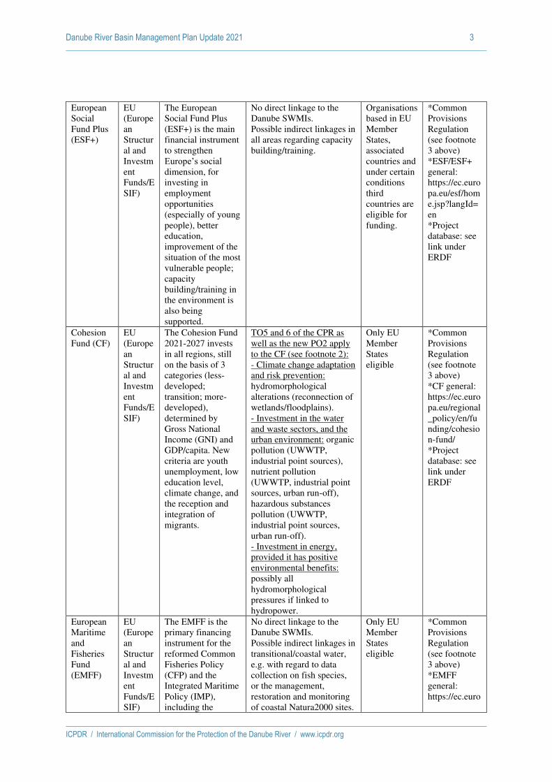
Danube River Basin Management Plan Update 2021 3
ICPDR / International Commission for the Protection of the Danube River / www.icpdr.org
European
Social
Fund Plus
(ESF+)
EU
(Europe
an
Structur
al and
Investm
ent
Funds/E
SIF)
The European
Social Fund Plus
(ESF+) is the main
financial instrument
to strengthen
Europe’s social dimension, for
investing in
employment
opportunities
(especially of young
people), better
education,
improvement of the
situation of the most
vulnerable people;
capacity
building/training in
the environment is
also being
supported.
No direct linkage to the
Danube SWMIs.
Possible indirect linkages in
all areas regarding capacity
building/training.
Organisations
based in EU
Member
States,
associated
countries and
under certain
conditions
third
countries are
eligible for
funding.
*Common
Provisions
Regulation
(see footnote
3 above)
*ESF/ESF+
general:
https://ec.euro
pa.eu/esf/hom
e.jsp?langId=
en
*Project
database: see
link under
ERDF
Cohesion
Fund (CF)
EU
(Europe
an
Structur
al and
Investm
ent
Funds/E
SIF)
The Cohesion Fund
2021-2027 invests
in all regions, still
on the basis of 3
categories (less-
developed;
transition; more-
developed),
determined by
Gross National
Income (GNI) and
GDP/capita. New
criteria are youth
unemployment, low
education level,
climate change, and
the reception and
integration of
migrants.
TO5 and 6 of the CPR as
well as the new PO2 apply
to the CF (see footnote 2):
- Climate change adaptation
and risk prevention:
hydromorphological
alterations (reconnection of
wetlands/floodplains).
- Investment in the water
and waste sectors, and the
urban environment: organic
pollution (UWWTP,
industrial point sources),
nutrient pollution
(UWWTP, industrial point
sources, urban run-off),
hazardous substances
pollution (UWWTP,
industrial point sources,
urban run-off).
- Investment in energy,
provided it has positive
environmental benefits:
possibly all
hydromorphological
pressures if linked to
hydropower.
Only EU
Member
States
eligible
*Common
Provisions
Regulation
(see footnote
3 above)
*CF general:
https://ec.euro
pa.eu/regional
_policy/en/fu
nding/cohesio
n-fund/
*Project
database: see
link under
ERDF
European
Maritime
and
Fisheries
Fund
(EMFF)
EU
(Europe
an
Structur
al and
Investm
ent
Funds/E
SIF)
The EMFF is the
primary financing
instrument for the
reformed Common
Fisheries Policy
(CFP) and the
Integrated Maritime
Policy (IMP),
including the
No direct linkage to the
Danube SWMIs.
Possible indirect linkages in
transitional/coastal water,
e.g. with regard to data
collection on fish species,
or the management,
restoration and monitoring
of coastal Natura2000 sites.
Only EU
Member
States
eligible
*Common
Provisions
Regulation
(see footnote
3 above)
*EMFF
general:
https://ec.euro

Danube River Basin Management Plan Update 2021 4
ICPDR / International Commission for the Protection of the Danube River / www.icpdr.org
Marine Strategy
Framework
Directive (MSFD).
It is aimed at
supporting the
European fisheries
sector towards more
sustainable fishing
practices, with a
particular focus on
supporting small-
scale fishermen.
A new focus in 2021-2027
is on protecting marine
ecosystems with an
expected contribution of
30% of its budget to climate
change mitigation and
adaptation, in line with the
commitments agreed under
the Paris Agreement.
pa.eu/fisherie
s/cfp/emff/
CAP/Euro
pean
Agricultur
al Fund for
Rural
Developm
ent
(EAFRD)
EU
(Europe
an
Structur
al and
Investm
ent
Funds/E
SIF)
The EAFRD is one
of the primary
financing
instruments for the
Pillar II of the CAP
(Rural
Development). The
post 2020 CAP
(whose budget is
allocated for the
multiannual
financial network
2021-2027 but the
provisional start
date of the proposed
CAP reform is 1
January 2023, with
a transitional
regulation for the
period of 2021-
2022) is proposed to
be implemented
through national
CAP Strategic
Plans, a
programming tool
that will define, for
each Member State,
the key parameters
for the
implementation of
all CAP instruments
(direct payments,
rural development
and sectorial
interventions).
The CAP Strategic
Plans will be bound
to conditionalities,
e.g. in the field
“climate and environment”.
SWMI targeted through
Pillar II payments (rural
development), which will
continue to fund
investments also in the field
of environment and climate.
This includes the agri-
environment-climate
payments supporting
environmental-friendly
farming methods and
practices beneficial for the
environment and climate,
and providing
environmental public goods
in the fields of climate
change mitigation and
adaptation, the protection
and improvement of the
environment, including
water quality and quantity,
air quality, soil,
biodiversity, landscapes and
ecosystem services.
Hence, all SWMIs (except
hydromorphology) and
cross-cutting issues are also
in future potentially
covered by EAFRD
payments.
Additionally, rural
development will continue
to support organic farming,
areas composing the Natura
2000 EU network, and also
environment/climate-
related investments,
knowledge-building,
innovation as well as co-
operation.
Only EU
Member
States
eligible
*Common
Provisions
Regulation
(see footnote
3 above)
*EAFDR
general:
https://ec.euro
pa.eu/info/foo
d-farming-
fisheries/key-
policies/com
mon-
agricultural-
policy/rural-
development#
eafrd
*CSWD on
the proposed
CAP and the
environment:
https://ec.euro
pa.eu/info/site
s/info/files/fo
od-farming-
fisheries/susta
inability_and_
natural_resour
ces/document
s/analysis-of-
links-
between-cap-
and-green-
deal_en.pdf
LIFE EU The LIFE
programme is the
only EU fund
Potentially addresses all
SWMIs through the "LIFE
Integrated Projects"
EU and non-
EU countries
(candidate
*General
information:
http://ec.euro

Danube River Basin Management Plan Update 2021 5
ICPDR / International Commission for the Protection of the Danube River / www.icpdr.org
entirely dedicated
to environmental
and climate
objectives. It
supports the
implementation of
relevant EU
legislation and the
development of key
policy priorities, by
co-financing
projects with
European added
value. In June
2018, the European
Commission
submitted a
proposal on a
regulation
establishing a new
LIFE programme
for 2021-2027. It
has two main fields
of action, covering
four sub-
programmes. 1:
Environment field
with the Nature and
Biodiversity and
the Circular
Economy and
Quality of Life sub-
programmes.
2: Climate Action
field with the
Climate Change
Mitigation and
Adaptation and the
Clean Energy
Transition sub-
programme.
(organic pollution
indirectly).
Foci are ecosystem-based
approaches: organic
pollution (indirectly
through natural buffer
zones), nutrient pollution
(diffuse sources from
agriculture and agricultural
atmospheric emissions,
urban run-off), hazardous
substances pollution
(diffuse sources, mainly
from agriculture, but
potentially also from urban
and landfill/mining sites),
hydromorphological
alterations (longitudinal
river continuity,
reconnection of
wetlands/floodplains,
hydrological alterations).
Also measures targeting
sediments (retention
measures) and IAS.
Through the many links to
climate and resilience,
synergy effects between
climate change adaptation,
mitigation and
water/biodiversity
protection are manifold
(keywords: NWRM, green
infrastructure).
countries and
the Western
Balkan
countries
involved in
the
Stabilisation
and
Association
Process, as
well as
countries to
which the
European
Neighbourho
od Policy
applies).
pa.eu/environ
ment/life/
*Information
on COM
proposal:
https://www.e
uroparl.europ
a.eu/RegData/
etudes/BRIE/
2018/628294/
EPRS_BRI(2
018)628294_
EN.pdf
*LIFE
regulation
(proposal):
https://eur-
lex.europa.eu/
legal-
content/EN/T
XT/?uri=CO
M%3A2018%
3A385%3AFI
N
*National
contact
points:
https://ec.euro
pa.eu/easme/e
n/section/life/l
ife-national-
contact-points
Horizon
Europe
EU Horizon Europe is
the funding program
for research and
innovation for the
period 2021-2027.
No direct link to Danube
SWMIs, but research to
support
measures/knowledge on
any SWMI is possible.
EU and non-
EU countries
(associated
countries).
Research
program,
SME
participation
possible.
Most projects
require at
least three
partners.
*General
information
on Horizon
Europe:
https://ec.euro
pa.eu/info/hor
izon-europe-
next-research-
and-
innovation-
framework-
programme_e
n

Danube River Basin Management Plan Update 2021 6
ICPDR / International Commission for the Protection of the Danube River / www.icpdr.org
INTERRE
G
VI/Europe
an
Territorial
Cooperatio
n (ETC)
EU INTERREG
programs are a
specific strand of
funding possibilities
within the cohesion
policy funding,
under the European
Territorial
Cooperation (ETC)
goal. INTERREG
programs typically
focus on
cooperation
between regions and
Member States, and
are generally aimed
at enabling
exchange of
experience,
knowledge and
good practices
among relevant
stakeholders from
different MS and/or
regions.
No direct link to Danube
SWMIs, but enabling
exchange of experience,
knowledge and good
practices can benefit
implementation of
measures in all areas.
EU and non-
EU countries.
Programs can
be cross-
border (along
internal EU
borders),
transnational
(cover larger
areas of co-
operation
such as the
Danube
Basin), and
interregional
at EU-28
level
(between
regional and
local bodies
in different
countries
belonging
also to
different
regions).
*Information
on Interreg VI
(legislative
process):
https://www.e
uroparl.europ
a.eu/RegData/
etudes/BRIE/
2018/628228/
EPRS_BRI(2
018)628228_
EN.pdf
*Information
on ETC and
INTERREG
V:
http://ec.euro
pa.eu/regional
_policy/index.
cfm/en/policy
/cooperation/e
uropean-
territorial/
*Project
database:
http://ec.euro
pa.eu/regional
_policy/index.
cfm/en/projec
ts/?LAN=EN
&pay=ALL&
region=ALL
&the=97&typ
e=ALL&per=
2
List of
programs:
http://www.da
nube-
region.eu/201
4-03-21-07-
28-38/etc-ipa-
cbc-and-enpi-
cbc-
programmes
Neighbour
hood,
Developm
ent and
Internation
al
Cooperatio
n
Instrument
(NDICI)
EU NDICI (replacing
ENI) is providing
direct financial
support for the EU´s
external actions.
Support for non-EU
countries participating in
cross-border
ERDF/INTERREG
programs possible.
Otherwise, potential link to
Danube SWMIs through
various funding
opportunities (in July 2020,
not yet adopted).
Non-EU
(candidates,
possible
candidates
and
neighbouring
countries; in
the Danube
region:
Moldova and
Ukraine)
*General
information
on the new
policy
(proposal):
https://www.e
uroparl.europ
a.eu/RegData/
etudes/BRIE/
2018/628251/
EPRS_BRI(2

Danube River Basin Management Plan Update 2021 7
ICPDR / International Commission for the Protection of the Danube River / www.icpdr.org
018)628251_
EN.pdf
*Proposal for
the new
regulation:
https://www.e
uroparl.europ
a.eu/RegData/
docs_autres_i
nstitutions/co
mmission_eur
opeenne/com/
2018/0460/C
OM_COM(20
18)0460_EN.
Instrument
for Pre-
Accession
Assistance
(IPA III)
EU Since 2007, the
Instrument for Pre-
Accession
Assistance (IPA)
replaces a series of
EU programs and
financial
instruments for
candidate countries
or potential
candidate countries
(such as PHARE,
ISPA, SAPRD etc.).
It is organized along
five components,
which are:
C1. assistance for
transition and
institution building;
C2- cross-border
cooperation (with
EU MS and other
countries eligible
for IPA);
C3. regional
development
(transport,
environment,
regional and
economic
development);
C4. human
resources
(strengthening
human capital and
combating
exclusion);
C5. rural
development.
In the Danube RB, only C1
and C2 are being funded:
1. assistance for transition
and institution building;
2- cross-border cooperation
(with EU MS and other
countries eligible for IPA).
Hence, no direct link to
Danube SWMIs, although
institution building and
cross-border cooperation
can benefit implementation
of measures in all areas.
EU
candidate
countries
(Turkey and
FYROM) are
eligible for
all five
components
of IPA,
potential
candidate
countries in
the Western
Balkans
(Albania,
Bosnia-
Herzegovina,
Montenegro,
Serbia, and
Kosovo
under UN
Security
Council
Resolution
1244/99) are
eligible only
for the first
two
components.
*Information
on IPAIII:
https://ec.euro
pa.eu/regional
_policy/de/20
21_2027/
*More
general
information:
http://www.w
elcomeurope.
com/european
-funds/ipa-ii-
instrument-
pre-accession-
assistance-
2014-2020-
838+738.html
#tab=onglet_d
etails
*More
information:
http://ec.euro
pa.eu/regional
_policy/index.
cfm/EN/fundi
ng/ipa/
List of
programs:
http://www.da
nube-
region.eu/201
4-03-21-07-
28-38/etc-ipa-
cbc-and-enpi-
cbc-
programmes
Internation
al Bank for
The World Bank is
an international
No direct link to Danube
SWMIs, although a
IBRD:
middle
*Products and
Services:

Danube River Basin Management Plan Update 2021 8
ICPDR / International Commission for the Protection of the Danube River / www.icpdr.org
Reconstruc
tion and
Developm
ent (IBRD)
World
Bank
(WB)
financial institution
that provides loans
to developing
countries. It consists
of two agencies
(IBRD and IDA)
and focuses on the
following fields:
- human
development (e.g.
education, health);
- agriculture and
rural development
(e.g. irrigation and
rural services);
- environmental
protection (e.g.
pollution reduction,
establishing and
enforcing
regulations);
- infrastructure (e.g.
roads, urban
regeneration, and
electricity);
- large industrial
construction
projects;
- governance (e.g.
anti-corruption,
legal institutions
development).
The IBRD and IDA
provide loans at
preferential rates to
member countries,
as well as grants to
the poorest
countries.
multitude of
projects/measures
benefitting WFD
implementation can be
financed by WB loans (see
also the examples listed
under GEF).
It has to be remarked,
however, that IBRD
provides only loans (though
at preferential rates), not
grants. IDA also provides
grants.
income and
creditworthy
low-income
countries (all
Danube
except DE
and AT).
IDA:
Moldova
(and Kosovo)
http://www.w
orldbank.org/
en/projects-
operations/pro
ducts-and-
services
*IBRD:
https://www.
worldbank.or
g/en/who-we-
are/ibrd
*IDA:
https://ida.wo
rldbank.org/
Internation
al
Developm
ent
Associatio
n (IDA)
Global
Environme
nt Facility
(GEF)
GEF The Global
Environment
Facility is a
partnership for
international
cooperation where
183 countries work
together with
international
institutions, civil
society
organizations and
the private sector, to
address global
environmental
issues.
GEF provides grants to
various types of projects
(Climate Change
Adaptation Projects and
Small Grants Programme
(SGP) most relevant)
ranging from several
thousand dollars to several
million dollars. Projects are
supported in several "focal
areas", of which the most
relevant are: Biodiversity,
Climate Change, Chemicals
and Waste. Financing is
provided through grants and
non-grants.
Most
countries
should be
eligible,
depending on
the focal
area,
eligibility
criteria
established
by the
relevant COP
of the
respective
convention,
and some
others.
*Templates
and
guidelines
available at:
http://www.th
egef.org/gef/g
uidelines_tem
plates
*Project
types:
http://www.th
egef.org/gef/p
roject_types
*Example
from
Moldova:
http://www.w
orldbank.org/

Danube River Basin Management Plan Update 2021 9
ICPDR / International Commission for the Protection of the Danube River / www.icpdr.org
Funding possible with
regard to all Danube
SWMIs.
projects/P075
995/agricultur
al-pollution-
control-gef-
project?lang=
en&tab=overv
iew
*Example
from
Romania:
http://www.w
orldbank.org/
projects/P093
775/romania-
integrated-
nutrient-
pollution-
control-
project?lang=
en
European
Investment
Bank
(EIB)
EU The EIB is the EU's
bank, offering loans
(individual for
projects over 25
Mio. €, intermediate to other
banks/institutions
for SME with
projects under 25
Mio. €). The EIB finances a broad
range of projects in
all sectors of the
economy, adhering
to one of the six
priority objectives,
of which 2Climate
and Environment” is of special
importance for
WFD
implementation in
the Danube.
No direct link to Danube
SWMIs, but the EIB´s
financing can help to
unlock financing from other
sources, particularly from
the EU budget.
It has to be remarked,
however, that the EIB
provides loans, not grants.
EU and non-
EU countries
(all Danube
countries).
*Applying for
a loan:
http://www.ei
b.org/projects
/cycle/applyin
g_loan/index.
htm
*For the
Western
Balkans, see
Western
Balkans
Investment
Framework:
http://www.w
bif.eu/
European
Bank for
Reconstruc
tion and
Developm
ent
(EBRD)
Internat
ional
The EBRD is a
development bank
offering loans and
other financial
products (like
equities) in more
than 30 countries
from central Europe
to Central Asia.
Although the name
suggests European
ownership, the
biggest shareholder
is the United States.
No direct link to Danube
SWMIs, although a
multitude of (mostly private
sector) projects/investments
can be supported (such as
improving animal
feeding/breeding lots etc.).
The "Sustainable Energy
Initiative" (including
renewable energy and
adaptation projects)
finances projects in energy
efficiency, renewable
All countries
in the
Danube RB -
except
Austria and
Germany -
are eligible
for loans.
*Products and
Services:
http://www.eb
rd.com/what-
we-
do/products-
and-
services.html
*Sustainable
Energy
Initiative:
https://www.e
brd.com/what
-we-

Danube River Basin Management Plan Update 2021 10
ICPDR / International Commission for the Protection of the Danube River / www.icpdr.org
The EBRD supports
private sector
development
(meeting the
requirements, of
which to "satisfy
banking and
environmental
standards" is a part)
in the relevant
sectors agribusiness,
energy efficiency &
climate change (see
Sustainable Energy
Initiative),
municipal &
environmental
infrastructure;
power and energy.
energy and climate change
adaptation/resilience.
It has to be remarked,
however, that the EIB
provides loans, not grants.
do/sectors-
and-
topics/sustain
able-energy-
initiative.html

Danube River Basin Management Plan Update 2021 11
ICPDR / International Commission for the Protection of the Danube River / www.icpdr.org
Funding Instruments used in the 2nd Management Cycle
Country/Funding
Instrument
National
Funding
European
Regional
Development
Fund
(ERDF)
European
Social
Fund (ESF)
Cohesion
Fund (CF)
European
Maritime
and
Fisheries
Fund
(EMFF)
LIFE HORIZON
2020
Austria yes Information
not available
Information
not
available
Information
not
available
Information
not
available
yes yes
Bosnia and
Herzegovina
yes no no no no yes yes
Bulgaria Data not available yet.
Croatia yes yes yes yes yes yes yes
Czech Republic yes yes yes yes no yes yes
Germany yes no no no no yes no
Hungary yes yes yes yes yes yes yes
Moldova Data not available yet.
Montenegro Data not available yet.
Romania yes yes no yes yes yes no
Serbia yes no no no no no yes
Slovak Republic yes yes no yes no yes yes
Slovenia Data not available yet.
Ukraine yes no no no no no yes
Note: CAP/European Agricultural Fund for Rural Development (EAFRD) is excluded, as all EU countries use this fund.
Note: Ukraine is only starting to develop RBMPs, information listed here hence covers only financing some activities in the water sector in
this region.

Danube River Basin Management Plan Update 2021 12
ICPDR / International Commission for the Protection of the Danube River / www.icpdr.org
Note: CAP/European Agricultural Fund for Rural Development (EAFRD) is excluded, as all EU countries use this fund.
Note: Ukraine is only starting to develop RBMPs, information listed here hence covers only financing some activities in the water sector in
this region.
Country/Fun
ding
Instrument
INTERRE
G
V/Europe
an
Territoria
l
Cooperat
ion (ETC)
European
Neighbourh
ood
Instrument
(ENI)
Instrume
nt for
Pre-
Accessio
n
Assistan
ce (IPA
II)
Internation
al Bank
for
Reconstruc
tion
and
Developme
nt
(IBRD)/
Internation
al
Developme
nt
Association
(IDA)
Global
Environm
ent
Facility
(GEF)
Europea
n
Investm
ent Bank
(EIB)
European
Bank for
Reconstruc
tion and
Developme
nt
(EBRD)
Austria yes Information
not
available
Informati
on not
available
Information
not
available
Informati
on not
available
Informati
on not
available
Information
not
available
Bosnia and
Herzegovina
no yes yes yes yes yes yes
Bulgaria Data not available yet.
Croatia yes yes yes yes yes yes yes
Czech
Republic
yes no no no no yes yes
Germany no no no no no no no
Hungary yes yes yes yes yes yes yes
Moldova Data not available yet.
Montenegro Data not available yet.
Romania no no no yes no yes yes
Serbia yes no yes yes yes yes yes
Slovak
Republic
yes no no no no no no
Slovenia Data not available yet.
Ukraine yes yes no yes yes yes yes