Community Priorities for the Alum Rock Corridor - San Jose ...
129
Capstone Studio in Community Planning 2019-2020 Dept. of Urban & Regional Planning San José State University Instructors: Rick Kos, AICP and Jason Su Photo Credit: Hewlett Founation, Silicon Valley One World, San José Spotlight, and LoopNet Community Priorities for the Alum Rock Corridor
-
Upload
khangminh22 -
Category
Documents
-
view
4 -
download
0
Transcript of Community Priorities for the Alum Rock Corridor - San Jose ...

Capstone Studio in Community Planning 2019-2020
Dept. of Urban & Regional Planning San José State University
Instructors: Rick Kos, AICP and Jason Su
Photo Credit: Hewlett Founation, Silicon Valley One World, San José Spotlight, and LoopNet
Community Priorities for the Alum Rock Corridor
Date: December 15, 2020
To: Councilmembers and Staff of the City of San Jose
Esteemed City of San Jose Staff and Councilmembers,
I write this letter in unconditional support of the Community Priorities for Alum Rock Corridor report done by CommUniverCity’s graduate students in the Urban and Regional Planning Fall 2019 and Spring 2020 Capstone Studio classes at San Jose State University in collaboration with community voices.
This process truly gave businesses and residents the opportunity to voice views on aspirations and challenges here in the Alum Rock community. We felt that it is more than an academic project; as we experienced a genuine concern for our community.They were responsive to specific concerns and gave us opportunity for honest input.This is evident in the comprehensive charts and assessments produced.
The final report is an invaluable reference tool that will lead to improving and better understanding life in the Alum Rock community. We are indebted to the entire team for presenting us with such a comprehensive document that, to this date, had not been invested in the East Valley. It will pay dividends for years to come as a reference and advocacy tool in responding to the challenges to come.
We thank CommUniverCity and the Urban Planning graduate students for their diligent work and real commitment to a community overlooked for far too long.
With gratitude,
Carlos Diaz Carlos DiazPresident, Alum Rock Business Network
Date: December 28, 2020
To: Councilmembers and Staff of the City of San Jose
Alum Rock Urban Village Advocates are longtime residents and business owners excited about the prospects for new developments that will bring new neighbors, preserve existing businesses, catalyze the emergence of new businesses, open new opportunities for existing residents to move into upgraded housing and celebrate the rich legacies and cultural heritage of our beloved community.
It is our pleasure to write a letter in support of the Community Priorities for Alum Rock Corridor report done by CommUniverCity’s graduate students in the Urban and Regional Planning Fall 2019 and Spring 2020 Capstone Studio classes at San Jose State University in collaboration with the community.
This process truly gave us the opportunity to voice our views on our aspirations and challenges here in the Alum Rock community. Participating in these various community and feedback meetings encouraged and supported the formation of our Alum Rock Urban Village Advocatesresident group. ARUVA developed a Plan for Equitable Development intentionally driven by a commitment to Equity – a framework for development that seeks to invest first and foremost in the existing and historical communities surrounding the City of San Jose’s Alum Rock Urban Village while secondarily creating opportunities for new communities. It is critical that the residents’ voice documented in Community Priorities for Alum Rock Corridor are incorporated into a revised Alum Rock Urban Village Plan.
We thank CommUniverCity and the Urban Planning graduate students for their hard work and commitment to learning about our way of life, community needs and engaging with us with the goal of building a better community!
With gratitude,
E Arredondo
J Alvarado
Elma Arredondo and Jaime AlvaradoARUVA, Co-Chairs

Plata Arroyo Neighborhood Association and Eastgate N.A.C. San José, California 95116
Date: 12/28/20 To: Councilmembers and Staff of City of San José Subject: Recognition of Job Well Done by CommUniverCity Plata Arroyo Neighborhood Association and Eastgate N.A.C. would like to express our appreciation for the efforts of the San Jose State University Urban Planning Students and Administration. This was a dynamic change to the attention our Community [does not receive] from City Hall, much less our Council Office. Key to the success of this Project was HONEST COMMUNICATION. From the day we found out about CommUniverCity those many years ago working and supporting Little Portugal, Plata Arroyo has been aggressive in bringing those same energies to the East Side of the 101Freeway. Having talked with other Neighborhood Association Boards and residents around us, we were very excited to finally create, construct, and share our many dreams for our Community and Families with you all. The FANTASTIC LISTENING EARS of students and Administration brought to our meetings was the breath of fresh air we have needed for a long, long time. It seemed at first that the Students were knocking around in the darkness at the start of this area project. In the future, our only request or suggestion would be that students reach out more frequently to smaller Community Organizations and individuals. We felt that had we not been in on the ground floor of this particular exercise, we surely would not have been heard much less included. It is too easy to go to the bigger Organizations. It takes Extra Efforts to bring the Smaller and Medium sized Organizations to the Table. That was a bit lacking at start. In the end though, Plata Arroyo was heard. As mentioned above, Communication was the key to getting our needs, points, and positions into the Sunlight. Once that happened, the students seemed to understand our grievances and addressed them to the best of their ability. In conclusion, our struggle continues, however; this has been the greatest experience in our Community related to documented concerns, needs, and wishes for our Families now and in the Future. Moving these findings into Action is the next step. We must give congratulations to you all for bringing a bit of light in the sad Forgotten Darkness in our East Valley Community. In Community Spirit,
Danny Garza Danny Garza President, Plata Arroyo Neighborhood Association and Eastgate N.A.C. President, Mexican American Political Association, San José / San Francisco Bay Area Region Member of LULAC, American GI Forum, ARUVA, La Raza Roundtable
SOMOS Mayfair | 370-B S. King Road, San José, CA 95116 | © SOMOS Mayfair 2021
Date: 1/14/21 To: Councilmembers and Staff of City of San José SOMOS Mayfair supports children, organizes families, and connects neighbors to uplift the dreams, power, and leadership of community and address systemic inequities. Vecinos Activos organizes tenant families in the Mayfair neighborhood. Community members (parents and youth) gather to conduct root-cause analysis of neighborhood issues that impact and advance the Mayfair community platform. Through direct action and policy change, families are organizing to address permanent affordability, neighborhood development without displacement, and other housing solutions. It is our pleasure to write a letter in support of the Community Priorities for Alum Rock Corridor report done by CommUniverCity’s graduate students in the Urban and Regional Planning Fall 2019 and Spring 2020 Capstone Studio classes at San Jose State University in collaboration with the community. This community input process truly gave us the opportunity to voice our views on our aspirations and challenges here in the Mayfair community. Participating in these various community and feedback meetings encouraged and supported the work Vecinos Activos does to ensure that working-poor communities of color benefit from the community that they have envisioned and built together. Vecinos Activos participation in this project was important, as our anti-displacement platform – A Thriving Community Without Displacement in East San Jose – aligns well with the community’s vision to build responsible and equitable development in the Alum Rock Urban Village. We are committed to achieving lasting racial and social equity through community development that supports people, preserves community assets, and provides equitable access. To this end, we support that Community Priorities for Alum Rock Corridor are incorporated into a revised Alum Rock Urban Village Plan. We thank CommUniverCity and the Urban Planning graduate students for their hard work and commitment to learning about our history, culture and community needs, and for engaging with us with the goal of building a better community! In Community Spirit,
Gabriel Hernandez Gabriel Hernandez, Program Coordinator, Vecinos Activos de SOMOS Mayfair

ContentsList of Tables and Figures
Acknowledgements Executive Summary
1 Introduction to the Alum Rock Focus Area .................................................. 12• The Asset-based Community Development
Approach ........................................................................... 13• Report Structure ............................................................. 13• Geography of the Alum Rock Focus Area .................. 13• Demographics and Key Statistics ............................... 14 • Historical Development ................................................. 18• Governing Growth .......................................................... 19 • Table of Relevant Regulatory Documents .................24
2 Community Assets and Current Conditions ................................................30
• Community Partners ..................................................... 30• ARUVA Plan for Equitable Development .................. 31 • Community with Strong Cultural Ties ..................... 35• Public Parks & Recreational Spaces ........................... 37• Status of Unique Local Businesses and Supportive
Programs ...........................................................................39• Enabling Mobility in the Community ........................ 40
3 Community Engagement ................... 44• Fall 2019 Community Engagement .............................44• Spring and Summer 2020 Community Engagement......45
• Acknowledgment of COVID-19 Impacts ....................45• Community Survey Feedback ......................................45• Interview and Focus Group Results ...........................54• Limitations to this Engagement Effort ......................58
4 Community-Driven Priorities for the Alum Rock Focus Area .....................60
• Affordability and Addressing Displacement ............ 60• Quality and Upkeep of Public Streets and Parks ....67• Enhancing Safety and Reducing Neighborhood
Crime ................................................................................. 69• Mobility ..............................................................................70• Activation of Social Gathering Spaces with Recreation
and Art ............................................................................... 74• Continuing the Conversation ....................................... 81• Comparing Community Priorities ..............................84
5 Reflections and Next Steps .............. 88• Summary of Key Findings .............................................88• Next Steps .........................................................................89• Conclusion ....................................................................... 90
Appendices .........................................91• A. History and Neighborhood Overview ...................92• B. Spring 2020 Engagement .......................................100• C. Pedestrian Oriented Zoning District ...................106• D. Community Stakeholders .......................................127

List of Tables & FiguresList of Figures1. The Boundary of Alum Rock Focus Area ....................................................14
2. Key Facts about the Alum Rock Focus Area ..............................................15
3. Hispanic or Latino Population by block group in the Focus Area .......15
4. Hispanic or Latino Population by block group in San José .................. 16
5. Per Capita Income in Northern Santa Clara County .............................. 16
6. The Average Household Income and Rate of Bachelor DegreeAttainment in the Alum Rock Focus Area........................................................17
7. Owner and Renter Occupied Housing in the Alum Rock Focus Area .17
8. The Locations of Affordable Housing Projects in the Focus Area ...... 18
9. Urban Villages in the Alum Rock Focus Area ...........................................20
10. Form-Based Code regulations in the Alum Rock Focus Area .............21
11. Zoning of Little Portugal Urban Village in the Focus Area ...................22
12. Race and Ethnicity in San José (top) vs. Alum Rock (bottom) .............35
13. Mural and Worship Locations within the Focus Area ........................... 3714. Parks and Community Centers within the Focus Area ......................... 3715. Focus Area Locations within a 10-Minute Walk to a Park ....................3816. Car Crash Locations in the Focus Area .....................................................4017. Total Injuries from Minor to Fatal Car Accidents in the Focus Area .4018. Transit Service within the Focus Area .......................................................4119. Planned Additions to the Bicycle Network in the Focus Area..............41
20. ADA sidewalk Compliance on Alum Rock Avenue .................................4221. Focus Area Locations within a 10-Minute Walk to Grocery Store .....4222. Focus Area Locations within a 10-Minute Walk to a Transit Stop ....4223. Community Strategy to End Displacement ............................................6224. Potential Amenities List for Alum Rock Identified during the May 2019 Futuro de Alum Rock Open House ...................................................8225. Potential Amenities List for Alum Rock Identified through the Fall 2019 Engagement Proces .............................................................................8326. Srping 2020 Community Priorities Pyramid ..........................................84
List of Tables1. Race and Ethnicities of Alum Rock Study Area Residents (2019) .........15
2. State, Regional, and Local Plans and Regulations that impact the Focus Area .....................................................................................................................24
3. Community Groups Represented by Survey Respondents ....................46
4. Survey Responses: Support for Local Businesses. ...................................46
5. Survey Responses: Support for Local Business Amenities. ..................46
6. Business Amenities Preferred by Survey Respondents. ........................ 47
7. Survey Responses Regarding Support for Parks and Recreation Amenities ........................................................................................................... 47
8. Survey Responses Regarding Support for Public Space Amenities. ...48
9. Parks and Public Space Amenities Preferred by Survey Respondents .......................................................................................48
10.Survey Responses Regarding Support for Cultural and Community Resource Amenities. .......................................................................................49

11. Survey Responses Regarding Support for Youth and Adult Programming. ...................................................................................................49
12. Cultural and Community Resource Amenities Preferred by Survey Respondents. ....................................................................................................49
13. Survey Responses Regarding Support for Transportation and Streetscape Amenities. ..................................................................................50
14. Survey Responses Regarding Support for Transportation, Streetscape Amenities that Improve Safety, Connectivity, and Congestion. .......................................................................................................50
15. Transportation and Streetscape Amenities Preferred by Survey Respondents. .....................................................................................................51
16. Community Assets Identified by Survey Respondents. .........................51
17. Challenges Identified by Survey Respondents.........................................52
18. Survey Responses Regarding Preferences for Future Development in the Focus Area. ................................................................................................52
19. Other Topics of Interest Identified by Survey Respondents. ..............53
20. Survey Responses Regarding Group Affiliation of Participants .........54
21. Community Assets Identified in the Interviews .....................................55
22. Focus Area Challenges Identified in the Interviews .............................. 57
23. Community Needs Identified in the Interviews. .................................... 57
24. Focus Area Improvements Identified by Interviewees. ........................58

Acknowledgements
City of San José, District 5 Office of Councilmember Magdalena Carrasco
AARP
Alum Rock Business Network
Alum Rock Santa Clara Street Business Association
Alum Rock Unified School District
Alum Rock Urban Village Advocates (ARUVA)
Alum Rock Youth Center
Amigos de Guadalupe
Catalyze SV
Catholic Charities
City of San José, Department of Parks, Recreation & Neighborhood Services
City of San José, Department of Planning, Building & Code Enforcement
City of San José, Department of Transportation
CommUniverCity
Destination:Home
District 5 United
Grail Family Services
Kelly Snider Consulting
Mayfair Community Center
Mayor’s Gang Prevention Task Force
On Lok Senior Health
Our Lady of Guadalupe Church
People Assisting the Homeless (PATH)
Plata Arroyo Neighborhood Association
Regional Medical Center
Thank you to the Residents and Businesses in the Alum Rock communityWe acknowledge many local figures and subject matter experts that spoke to us directly about the issues related to this project and the many community members gracious enough to speak with us in person or virtually over the course of this endeavor. They were an invaluable guide to understanding the priorities and perspectives of the Alum Rock community.
5

Resources for Community Development
San José Unified School District
Santa Clara County Housing Authority
Santa Clara County Public Health Department
Santa Clara Creeks Coalition
Santa Clara Valley Transportation Authority (VTA)
School of Arts and Culture at the Mexican Heritage Plaza
SOMOS Mayfair
SPUR San José
Sunset Charities
SV@Home
TransForm
Veggielution
6

Class PhotoSan José State University
Master of Urban Planning Program | URBP 295 Capstone StudioFall 2019 | Instructors: Rick Kos, AICP and Jason Su
Top Row: Gavin Lohry, Nick Towstopiat, Nick Frey, Manny Uche, Ryan Forster, Michael Shwe, Josh McCluskey.Middle Row: Instructor Richard Kos, Aishwarya Naniwadekar, Iliana Nicholas, Andrea Mardesich, Natalie
Fakhreddine, Roshni Saxena, Yeneli Constantino, Melina Iglesias, Jueun Kook, Roomin Parikh, Instructor Jason Su.Bottom Row: Ralph Robinson, Zak Mendez, Lydon George, Malaika Best.

San José State University Master of Urban Planning Program | URBP 295 Capstone Studio
Spring 2020 | Instructors: Rick Kos, AICP and Jason Su Class Photo
Top Row: Lauren Anderson, Manuel Atienza, Inbar Berman, Gweneth Buckley, Hazel Choi, Richard Davis.Middle Row: Emanuel Jacobo, Nhan Le, TaiYing Lee, Samie Malakiman, Jacob Pearl, Sahithi Pusarla.
Bottom Row: Ralph Robinson, Larissa Sanderfer, Instructors Richard Kos and Jason Su.

99
Executive SummaryAlum Rock, referred to throughout the report as the Alum Rock Focus Area, is a neighborhood centered along Alum Rock Avenue, located in Eastside San José. The Urban and Regional Planning Department at San José State University, CommUniverCity, and City Council District 5 Office of Councilmember Magdalena Carrasco participated in an on-going, multi-year project to engage residents, business owners, and other stakeholders about the future of their neighborhood.
This report presents a list of community-identified priorities that can guide community leaders, city staff, and elected officials in further discussions about future development in the Alum Rock Focus Area. The community engagement, neighborhood assessment, and stakeholder feedback identified priorities focused on affordability and displacement, quality and upkeep of public streets and parks, enhancing safety and reducing neighborhood crime, mobility, and the activation of social gathering spaces with recreation and art.
Community Priorities• Prevent Resident and Business Displacement• Increase Access to Affordable Housing • Enhance Cleanliness and Safety of Parks, Streets, and Gardens• Improve Pedestrian and Bicyclist Safety• Decrease Vehicle Speeds• Address Parking Shortages• Make More Space for Recreation Centers and Outdoor Events and Festivals• Expand Access to Open Space and Parks• Increase Access to Grocery Stores, Farmers’ Markets, and Outdoor Dining • Offer More Youth and Teen Programming• Support Local and Culturally Relevant Public Art
Community Assessment, Stakeholder Engagement, and Data Synthesis Methods
These community priorities were derived from a three-phase engagement and assessment process. The first phase assessed the Focus Area’s social, physical, and cultural characteristics through neighborhood walking tours, informal conversations with residents and businesses, stakeholder presentations, and field assessments. Phase two entailed interviewing and surveying Focus Area residents, business owners, and community members, yielding valuable quantitative and qualitative data on the demographic characteristics of the Focus Area, and the community’s perspective on how to best improve the neighborhood. Finally, phase three culminated in the synthesis of the collected data and analysis of governmental regulations and policies impacting the Focus Area.
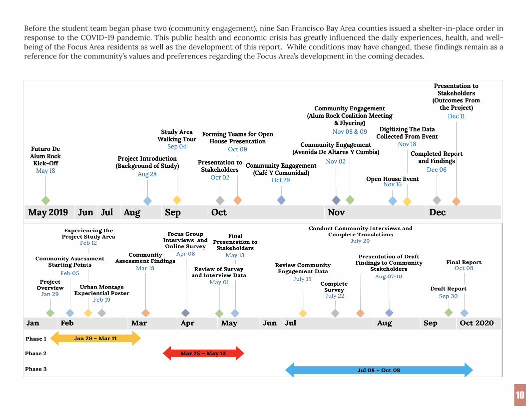
1010
Before the student team began phase two (community engagement), nine San Francisco Bay Area counties issued a shelter-in-place order in response to the COVID-19 pandemic. This public health and economic crisis has greatly influenced the daily experiences, health, and well-being of the Focus Area residents as well as the development of this report. While conditions may have changed, these findings remain as a reference for the community’s values and preferences regarding the Focus Area’s development in the coming decades.

1111
Next Steps
The SJSU graduate student team, faculty, and CommUniverCity staff have been honored to partner with many people and organizations in the Focus Area over the past 18 months. We plan to stay abreast of new developments in and around the Focus area, monitor changes to state legislation as they might affect urban village amenities, and possibly continue our partnership in the near future if community leaders, city staff, and the District 5 team foresee a need for our continued engagement with a wonderful San José community.
12
The Alum Rock Focus Area (Focus Area) includes the Eastside San José neighborhoods bounded by U.S. Highway 101 to the west, Interstate 680 to the east and south, and McKee Road to the north. Alum Rock Avenue serves as the primary transportation and commercial corridor of the Focus Area. A variety of people and organizations, including residents, local businesses, property developers, city and county government, school districts, and cultural advocacy groups, are invested in its future.
For the preparation of this report, the graduate student team consulted many of these stakeholders. Many thanks are due to these individuals and organizations—including San José City Council District 5 Councilmember Magdalena Carrasco’s Office, parents and seniors living within the Alum Rock Focus Area, and Alum Rock Avenue business owners—for their time and contribuions to this report.
Chapter 1 The purpose of this report is to establish a list of community-identified priorities for the future of the Focus Area, with an emphasis on land use, transportation, social, and cultural infrastructure and assets. The report aims to inform the existing Alum Rock Urban Village Plan, develop community priorities for future improvements and investments, and act as an advocacy tool to guide future developments. In the Fall of 2019, graduate students at San José State University undertook an assessment and engaged the community to learn about what they liked and disliked about their neighborhood. With support from CommUniverCity staff, an organization that bridges residents, City of San José initiatives, and San José State University students, the Spring 2020 student team built upon this engagement by surveying and interviewing community members. The student team gathered the data from the surveys, interviews, field assessments, and other background research to assess the community’s priorities. These findings may serve as a reference on the community’s values and preferences regarding the Focus Area’s development in the coming decades.
This report is part of an on-going, multi-year project by Councilmember Carrasco’s Office, CommUniverCity, and the Urban and Regional Planning Department at San José State University. The findings in this report should be considered part of a living document; as community engagement continues and new voices are heard, the community priorities will become more clearly defined. In addition, many policies at the local, county, regional, state, and federal levels will help to shape the future of the Alum Rock Focus Area, as detailed further in Table 2. During the development of this report, Councilmember Carrasco’s office and City of San José staff in the departments of Planning, Building and Code Enforcement, Transportation, and Parks and Recreation provided valuable input and guidance.
Introduction to the Alum Rock Focus Area

Chapter 2 | Community Assets and Current Conditions
1313
Chapter 1 | Introduction to the Alum Rock Focus Area
1.1 The Asset-based Community Development ApproachThis report was generated using an Asset-Based Community Development (“ABCD”) methodology to observe the Focus Area. The ABCD model emphasizes a “bottom-up” approach that focuses first on community strengths and assets rather than concentrating exclusively on deficits and problems. Unlike traditional models, in which urban planners get to know neighborhoods primarily through desk research, the ABCD model uses mixed methods, diverse sources of data, and on-site engagement. More importantly, the model’s emphasis on assets encourages all communities to recognize the power they already possess to mobilize and empower one another to address self-identified neighborhood improvements.1
1.2 Report StructureThis report consists of five chapters. Chapter 1 describes the Focus Area’s geography, land uses, demographics, and history and identifies regulations and policies that impact the neighborhood. Divided into six sections, Chapter 2 employs the ABCD approach to identify the assets of the Focus Area. Chapter 3 conveys how the student team engaged the community to learn about their preferences for neighborhood improvements. Chapter 4 synthesizes the interests of the community and offers relevant policies and tools for implementation. Chapter 5 notes limitations to the assessment and provides suggestions for further study. Finally, the appendices include more details on the community's history as well as pertinent regulations and illustrations of the form-based code that will shape future development in the area.
1.3 Geography, Primary Land Uses, and Commercial Activities in the Alum Rock Focus AreaThe Alum Rock Focus Area encompasses 1.6 square miles within Eastside San José. Alum Rock Avenue and San Antonio Street, which are each designated as a “Grand Boulevard,” bisect the area running east to west. Silver Creek runs diagonally through the Focus Area, from the bend of Interstate 680 in the southeast to the intersection of King Road and McKee Road in the area’s northwest corner.
Approximately 94 percent of land in San José is zoned for single-family housing.2 In contrast, approximately 63 percent of the Focus Area is zoned for residential use, of which just over half is zoned for single-family housing. The average size of the 6,511 households in the Focus Area is 3.9 persons per household, compared to the citywide average of 3.1. The larger household sizes encourage increased use of outdoor spaces for socialization and recreation. Many residents set out chairs, tables, toys, gardening equipment, and barbeques in the front and rear yards of properties, activating the streetscape and inviting informal social gathering in the residential areas of the corridor.

Chapter 2 | Community Assets and Current Conditions
1414
Chapter 1 | Introduction to the Alum Rock Focus Area
Figure 1: The Boundary of Alum Rock Focus AreaBase Map Source: Esri
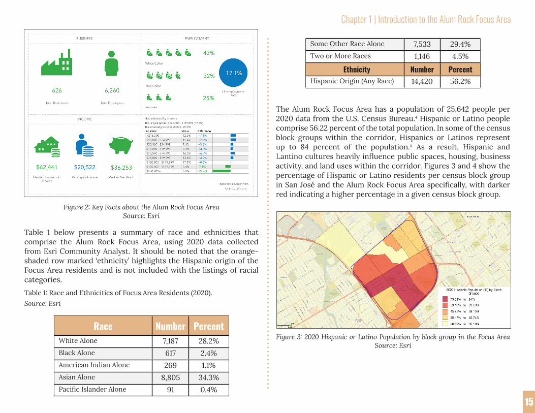
Commercial and industrial uses within the Focus Area are concentrated along Alum Rock Avenue, McKee Road, and North Jackson Avenue. According to a 2020 report from Esri Community Analyst, 626 businesses employing 6,260 people are located within the corridor. One of the major employers within the Focus Area is the Regional Medical Center, located at McKee Road and North Jackson Avenue, which employs 1,900 workers.3 A staple of the corridor, informal vendors such as taco trucks and snack and ice cream carts offer additional food choices in public spaces and help to create a sense of place. On the weekends, tag sales in yards foster further interaction between community members. Along Alum Rock Avenue, hand-made signs advertise additional off-site businesses such as fitness classes and childcare, further highlighting the importance of this informal economy.
In commercial spaces, food vendors set up folding chairs, tables, and pop-up tents in parking lots during lunchtime, activating otherwise underutilized areas throughout the day. Retail tenants set up chairs and other displays along their storefront, creating additional opportunities to rest and congregate. While there are numerous businesses in the corridor which maintain their storefronts and create inviting spaces, there are also visible vacancies that are unable to be maintained and contribute to the historically negative perception of the corridor. The degree of care and investment in the corridor from some businesses and commercial space owners juxtaposes with the lack of investment and attention paid by others.
1.4 Alum Rock at a Glance: Demographics and Key Statistics
Chapter 2 | Community Assets and Current Conditions
15
Chapter 1 | Introduction to the Alum Rock Focus Area
15
Figure 2: Key Facts about the Alum Rock Focus AreaSource: Esri
Table 1 below presents a summary of race and ethnicities that comprise the Alum Rock Focus Area, using 2020 data collected from Esri Community Analyst. It should be noted that the orange-shaded row marked ‘ethnicity’ highlights the Hispanic origin of the Focus Area residents and is not included with the listings of racial categories.
Table 1: Race and Ethnicities of Focus Area Residents (2020).Source: Esri
Race Number PercentWhite Alone 7,187 28.2%Black Alone 617 2.4%American Indian Alone 269 1.1%Asian Alone 8,805 34.3%Pacific Islander Alone 91 0.4%
Some Other Race Alone 7,533 29.4%Two or More Races 1,146 4.5%
Ethnicity Number PercentHispanic Origin (Any Race) 14,420 56.2%
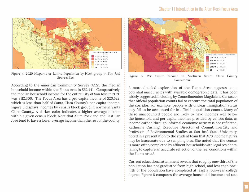
The Alum Rock Focus Area has a population of 25,642 people per 2020 data from the U.S. Census Bureau.4 Hispanic or Latino people comprise 56.22 percent of the total population. In some of the census block groups within the corridor, Hispanics or Latinos represent up to 84 percent of the population.5 As a result, Hispanic and Lantino cultures heavily influence public spaces, housing, business activity, and land uses within the corridor. Figures 3 and 4 show the percentage of Hispanic or Latino residents per census block group in San José and the Alum Rock Focus Area specifically, with darker red indicating a higher percentage in a given census block group.
Figure 3: 2020 Hispanic or Latino Population by block group in the Focus AreaSource: Esri
Chapter 2 | Community Assets and Current Conditions
1616
Chapter 1 | Introduction to the Alum Rock Focus Area
Figure 4: 2020 Hispanic or Latino Population by block group in San José Source: Esri
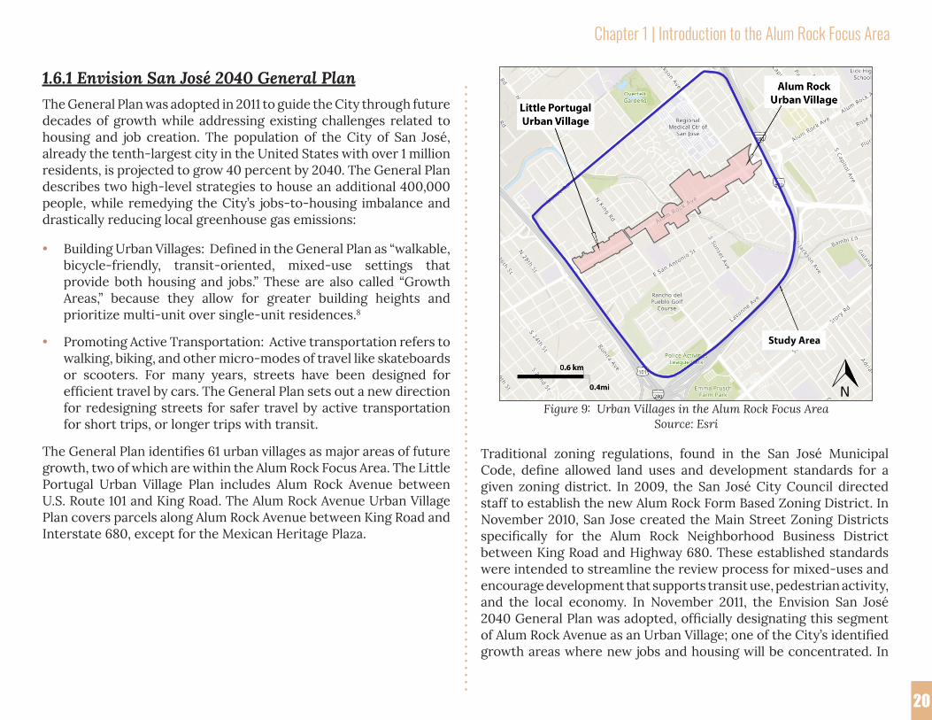
According to the American Community Survey (ACS), the median household income within the Focus Area is $62,441. Comparatively, the median household income for the entire City of San José in 2020 was $112,300. The Focus Area has a per capita income of $20,522, which is less than half of Santa Clara County’s per capita income. Figure 5 displays incomes by census block group in northern Santa Clara County. A darker color indicates a higher average income within a given census block. Note that Alum Rock and and East San José tend to have a lower average income than the rest of the county.
Figure 5: Per Capita Income in Northern Santa Clara CountySource: Esri
A more detailed exploration of the Focus Area suggests some potential inaccuracies with available demographic data. It has been widely suggested, including by Councilmember Magdalena Carrasco, that official population counts fail to capture the total population of the corridor. For example, people with unclear immigration status may fail to be accounted for in official population counts. Many of these unaccounted people are likely to have incomes well below the household and per capita incomes provided by census data, as income earned through informal economic activity is not reflected. Katherine Cushing, Executive Director of CommUniverCity and Professor of Environmental Studies at San José State University, noted in a presentation to the student team that ACS income figures may be inaccurate due to sampling bias. She noted that the census is more often completed by affluent households with legal residents, failing to capture an accurate reflection of the real conditions within the Focus Area.6
Current educational attainment reveals that roughly one-third of the population has not graduated from high school, and less than one-fifth of the population have completed at least a four-year college degree. Figure 6 compares the average household income and rate

Chapter 1 | Introduction to the Alum Rock Focus Area
1717
Chapter 1 | Introduction to the Alum Rock Focus Area
of Bachelor Degree attainment for each census block group within the Focus Area. Circle color indicates average income, with darker colors corresponding to higher incomes. Circle size references the percentage of Bachelor Degree attainment, with larger radii representing a higher ratio.
Figure 6: The Average Household Income and Rate of Bachelor DegreeAttainment in the Alum Rock Focus Area
Source: Esri
Housing stock in the Alum Rock Focus Area is largely occupied by renters, who occupy 61 percent of the housing units in the corridor. As such, Alum Rock residents are particularly vulnerable to rent increases, evictions, and displacement. According to the American Community Survey, between 2013 and 2017, 28 percent of households in Focus Area spent more than 50 percent of their income on rent compared to only 25 percent of households in the city of San José.7 These vulnerabilities may only be exacerbated by the current COVID-19 pandemic, even with the State of California temporarily addressing statewide renter vulnerabilities by placing a moratorium on all evictions.
Figure 7: Owner and Renter Occupied Housing in the Alum Rock Focus AreaSource: Esri
The Alum Rock Focus Area currently has 768 housing units designated as affordable, with another 1,044 units expected to come online in the next few years as a result of new development. Figure 8 below shows the locations of existing and proposed affordable housing projects.

Chapter 1 | Introduction to the Alum Rock Focus Area
18
Chapter 1 | Introduction to the Alum Rock Focus Area
18
Figure 8: The Locations of Affordable Housing Projects in the Focus AreaSource: Esri
1.5 Historical Development: How the Focus Area Has Transformed Since its FoundingLike much of San José, the early history of the Alum Rock Focus Area was shaped by agriculture. In the late 1800’s, San José experienced a period of rapid economic growth through its agricultural industry, evolving from fresh produce grown on small family farms into an industrial, factory-based canning center. This growth required a steady influx of labor, which attracted many immigrants. Mexican workers immigrated in large numbers to Eastside San José in the
1920’s, creating two distinct Mexican neighborhoods by 1930: one informally known as Sal Si Puedes (translation: “leave if you can”) and Sunset. These neighborhoods were characterized by a lack of infrastructure, such as paved streets, sidewalks, and streetlights, as they were yet to be incorporated into the City of San José and thus did not receive shares of city funds and investment.
Meanwhile, the interstate highway system, land use regulations, redlining practices (see Appendix i for a redlining map), and a transitioning economy further influenced how San José would develop and who would participate and benefit from that development. After World War II, the United States military made large investments in the aeronautical and computer technology industries in the South Bay, drawing large numbers of white-collar, highly paid workers to the area. Thus, agricultural land uses became less profitable and the potential for greater profits from housing sales spurred a transformation of orchards into suburban housing and commercial developments. As a result, the agricultural industry would relocate outside the San Francisco Bay Area, with the canning industry slowly following suit, taking with it a significant source of employment for the Mexican community. The divergence of these industries, along with the emerging trend of “white flight,” the movement of mostly white, middle-class Americans away from urban centers, exacerbated an existing wealth gap between the Eastside San José community and much of the rest of San José.
Residents of the Eastside San José neighborhoods felt neglected by these series of events, which were greatly influential in creating their identity as a “separate” place, often marred with the reputation of being “ghetto” and “dangerous.” These sentiments engendered a strong sense of self-empowerment and political agency among these communities in the 1950s and 1960s, motivated by the desire for equity and social justice. Terms like “Sal Si Puedes,” which described the harsh living conditions in sections of Eastside San José, would become monikers for resilience.

Chapter 1 | Introduction to the Alum Rock Focus Area
19
As the greater South Bay was undergoing economic transformation, the Eastside community was transitioning into a pivotal era of community organization and self-empowerment, catalyzed by the establishment of the Community Service Organization (CSO) by Los Angeles based organizer Fred Ross in 1952. In the same year, Our Lady of Guadalupe Church was established, becoming a source of pride for the Eastside community and a central place of congregation for social movements in the area. Building off earlier efforts to politically integrate Eastside neighborhoods into the larger conversation, the CSO sought to empower residents to build relationships, become local leaders, and advocate for local issues.
The CSO helped educate and influence many prominent community leaders to fight for voting rights, workers’ rights, infrastructure improvements, and humane treatment by police. The CSO was an early influence in the rise of César Chavez as a world-renowned activist and orgnizer, whose childhood home in Sal Si Puedes still stands on Scharff Avenue today. The historic site of one of his first organized strikes in support of the United Farm Workers, the Safeway store on King Road and Alum Rock Avenue, was utilized as the site for construction of the Mexican Heritage Plaza in 1999. The plaza today is considered “hallowed ground”, as noted by Councilmember Carrasco, and a major neighborhood hub for education as well as cultural events.
Community-bred, grassroots organizations in the Eastside were exemplified by many other groups. United People Arriba (UPA) advocated for residents facing displacement due to job loss and freeway expansion. They created in-home and permanent health clinics and educated residents on community resources as well as issues of racism. A prominent member of the UPA was Sofia Mendoza, an Eastside resident and lifelong activist, who dedicated her work to undo the culture of racism in schools and in the neighborhood, as well as to expose police brutality experienced by the Mexican community. Her work culminated in the creation of the Community Alert Patrol, a community-run police accountability group, which ultimately led to the establishment of an Independent Police Auditor to oversee San José Police Department disputes.
These are just some of the stories of this community, presented to exemplify its historic development in terms of racial dynamics, economic changes, and community organization. The efforts, movements, and leaders of this community, past and present, are vibrant and abundant. As San José continues to experience unprecedented economic transformation, it is imperative to understand this rich history of activism and the systemic discrimination from which it arose. Recognizing this important context, the legacy of the community organizations of the past can be seen in the noteworthy efforts of organizers today.
1.6 Governing Growth: The Shifting Regulatory Environment in Alum RockHousing and transportation policy is complex and directly tied to the actions of multiple agencies that operate at scales that extend beyond the City of San José. These organizations may be familiar (such as the California State Legislature or Bay Area Rapid Transit District), or they may be more obscure, like the regional transportation planning and funding body known as the Metropolitan Transportation Commission (MTC). Dozens of strategic plans and policies at local, county, regional, and state levels will impact the Focus Area in the near future.
These plans and policies cover a wide range of topics, from the City’s path to sustainable growth to safety improvements on local roads. Two of the City’s primary regulatory tools for shaping growth in the Focus Area and the city as a whole are the Envision San José 2040 General Plan (General Plan) and the Zoning Code. The impacts of these regulatory tools on the Eastside follow.
Chapter 1 | Introduction to the Alum Rock Focus Area
20
1.6.1 Envision San José 2040 General PlanThe General Plan was adopted in 2011 to guide the City through future decades of growth while addressing existing challenges related to housing and job creation. The population of the City of San José, already the tenth-largest city in the United States with over 1 million residents, is projected to grow 40 percent by 2040. The General Plan describes two high-level strategies to house an additional 400,000 people, while remedying the City’s jobs-to-housing imbalance and drastically reducing local greenhouse gas emissions:
• Building Urban Villages: Defined in the General Plan as “walkable, bicycle-friendly, transit-oriented, mixed-use settings that provide both housing and jobs.” These are also called “Growth Areas,” because they allow for greater building heights and prioritize multi-unit over single-unit residences.8
• Promoting Active Transportation: Active transportation refers to walking, biking, and other micro-modes of travel like skateboards or scooters. For many years, streets have been designed for efficient travel by cars. The General Plan sets out a new direction for redesigning streets for safer travel by active transportation for short trips, or longer trips with transit.
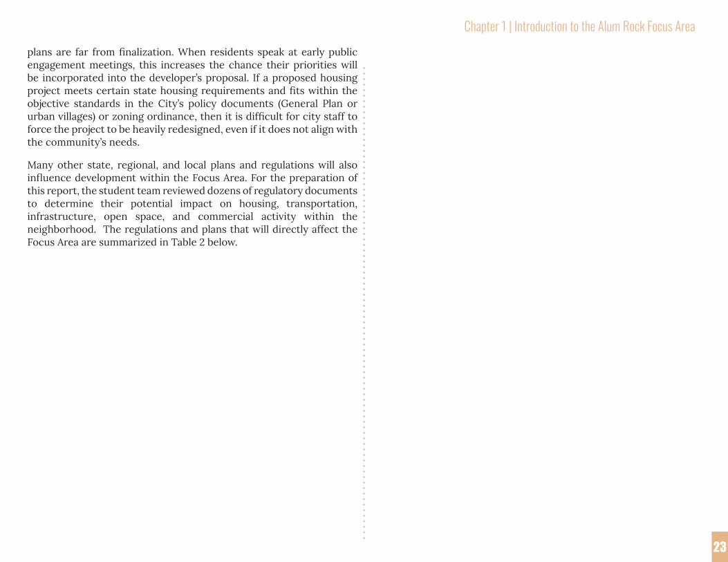
The General Plan identifies 61 urban villages as major areas of future growth, two of which are within the Alum Rock Focus Area. The Little Portugal Urban Village Plan includes Alum Rock Avenue between U.S. Route 101 and King Road. The Alum Rock Avenue Urban Village Plan covers parcels along Alum Rock Avenue between King Road and Interstate 680, except for the Mexican Heritage Plaza.
Traditional zoning regulations, found in the San José Municipal Code, define allowed land uses and development standards for a given zoning district. In 2009, the San José City Council directed staff to establish the new Alum Rock Form Based Zoning District. In November 2010, San Jose created the Main Street Zoning Districts specifically for the Alum Rock Neighborhood Business District between King Road and Highway 680. These established standards were intended to streamline the review process for mixed-uses and encourage development that supports transit use, pedestrian activity, and the local economy. In November 2011, the Envision San José 2040 General Plan was adopted, officially designating this segment of Alum Rock Avenue as an Urban Village; one of the City’s identified growth areas where new jobs and housing will be concentrated. In
Figure 9: Urban Villages in the Alum Rock Focus AreaSource: Esri

Chapter 1 | Introduction to the Alum Rock Focus Area
21
2013, the City of San José instituted a form-based zoning code in the ARUV.9 While it was originally the intent of the city to apply form-based codes to other neighborhoods of San José , the Alum Rock Urban Village remains the only area where they have been adopted.
Figure 10: Form-Based Code regulations in the Alum Rock Focus AreaData Source: City of San José
Form-based codes place emphasis on the physical shape of buildings and their relationship to surrounding spaces such as roadways and sidewalks. The intention is to promote a greater mix of land uses to improve walkability and create a sense of community in urban areas. More specifically, form-based codes stipulate in quantifiable terms the permitted placement, height, setback, bulk and spatial relationship standards for new buildings.
Form-based codes are well-suited to the mixed-use residential and commercial development envisioned for the Focus Area. Form-based codes provide developers with the flexibility to determine a mix of uses that, ideally, should respond to community-identified priorities. Due to their specificity and reliance on quantitative descriptions to shape building form, form-based codes are sometimes difficult for many people to understand, especially in the absence of illustrated examples of the standards. In response, the student team prepared
a “visual glossary,” included in Appendix C, that links the MS-G and MS-C zones in the Alum Rock Urban Village to the city’s form-based code requirements.
The Alum Rock Urban Village is one of two urban villages within the focus area of this report. The figure below depicts the Little Portugal Urban Village Area. The “urban village” zones that are defined in this area permit a wide range of development with fewer quantifiable standards than the zones in the Alum Rock Urban Village Area.
The form-based code for the Alum Rock Urban Village defines two types of “pedestrian-oriented zones.” Pedestrian-oriented zones intend to promote a lively place to walk through quantifiable urban design elements. The two pedestrian-oriented zones present in the Alum Rock Urban Village area are:
MS Main Street District
• MS-G (Main Street Commercial Ground Floor)Mix of commercial and residential uses integrated in a pedestrian-oriented design with a focus on active commercial uses at the ground level along the main street frontage.
• MS-C (Main Street Commercial)Primarily commercial uses within a pedestrian-oriented design, and allows a mix of commercial and residential uses only where such uses can be integrated on a large site in a pedestrian-oriented design that maximizes commercial opportunities.

Chapter 1 | Introduction to the Alum Rock Focus Area
22
Figure 11: Zoning of Little Portugal Urban Village in the Focus AreaSource: The Little Portugal Urban Village Plan of the City of San José
Figure 11 shows the outline of the Little Portugal Urban Village and its component zoning designations. Unlike Alum Rock Urban Village, form-based zoning does not apply here.10
1.6.2 San José’s Urban Village Amenities Framework Struck Down by State LawA new state law adopted in late 2019, the Housing Accountability Act (AB 3194), barred the implementation of San José’s Urban Village Amenities Framework. Created in 2018, the Amenities Framework was designed to compel amenities appropriate to the scale of a new project from developers in exchange for rezoning land for residential purposes. Amenity lists developed through community outreach efforts in Eastside and other areas of San José no longer had a clear path to implementation.
AB 3194 prohibits a local agency from disapproving, or conditioning approval in a manner that renders infeasible, a housing development project for very low, low-, or moderate-income households unless the project would have a specific, adverse impact upon public health or safety. It also prohibits a local agency from disapproving a housing development project, or requiring it be developed at a lower density, if it complies with applicable, objective general plan and zoning standards. Under AB-3194, California cities could no longer require developers to rezone land where a general plan land use designation stipulated that housing could be built. These new state laws took away San José’s power to ask developers for additional amenities in exchange for rezoning.
Several other recent state laws limit the planning power of local jurisdictions in the interest of promoting housing production. Two of these laws, Affordable Housing: Streamlined Approval Process (SB-35) and Supportive Housing Streamlining Act (AB-2162), require residential projects that meet certain state-defined criteria to be approved by local planning departments “by right.” SB-35 applies this standard to large affordable housing developments and AB-2162 applies it to Permanent Supportive Housing projects.
In a presentation to the student team, Jennifer Piozet, Supervising Planner for the City of San José, stressed the importance of community involvement in the creation of policy documents (like urban villages or the General Plan) and ordinance updates that specify objective standards consistent with state law requirements. Community involvement in the planning process helps ensure the community’s needs are reflected in the regulatory framework used to evaluate projects. If input is not gathered at this policy and ordinance development stage, it may be difficult to shape the project through regulation once a development application is submitted. Piozet also noted that these new state laws make it critical for residents to provide input early in the development of large projects, when developers conduct their initial public outreach.
This allows the developer to consider the project changes while the
Chapter 1 | Introduction to the Alum Rock Focus Area
23
plans are far from finalization. When residents speak at early public engagement meetings, this increases the chance their priorities will be incorporated into the developer’s proposal. If a proposed housing project meets certain state housing requirements and fits within the objective standards in the City’s policy documents (General Plan or urban villages) or zoning ordinance, then it is difficult for city staff to force the project to be heavily redesigned, even if it does not align with the community’s needs.
Many other state, regional, and local plans and regulations will also influence development within the Focus Area. For the preparation of this report, the student team reviewed dozens of regulatory documents to determine their potential impact on housing, transportation, infrastructure, open space, and commercial activity within the neighborhood. The regulations and plans that will directly affect the Focus Area are summarized in Table 2 below.

Chapter 1 | Introduction to the Alum Rock Focus Area
2424
Table 2: State, Regional, and Local Plans and Regulations that impact the Focus Area.
Current State Legislation
Bill No. Bill Name Brief DescriptionSB-35 Planning, Zoning,
Affordable Housing, and Streamlined Approval Processes (2018)
SB35 streamlines the con-struction process for cities that fail to build enough hous-ing based on their Regional Housing Needs Assessment (RHNA) mandated housing allocation. Projects applying using SB35 are ministerially approved.
SB-1333 Planning and zon-ing: general plan: zoning regulations: charter cities (2018)
SB1333 states that a City’s General Plan Land Use Desig-nations must align with zon-ing.
AB-2162 Planning and zon-ing: housing devel-opment: supportive housing (2018)
AB2162 states that support-ive housing use is allowed by right in zones where multi-family and mixed use residen-tial are allowed. Projects that apply using AB2162 are minis-terially approved.
AB-3194 Housing Account-ability Act (2018)
An amendments to the Hous-ing Accountability Act (1982), AB-3194 states that proposed housing projects cannot be forced to rezone if the project conforms with the General Plan.
SB-330 Housing Crisis Act of 2019
SB-330 streamlines housing construction by reducing the time needed to access building permits, limiting fee increases on housing applications, and prevent-ing local governments from “down-zoning” areas to limit the density of new develop-ment.
State Legislation in Committee as of July 2020Bill No. Bill Name DescriptionSB-902 Planning and zon-
ing: neighborhood multifamily project: use by right: den-sity
SB-902 would end sin-gle-family only zoning in all California neighborhoods, except for those in high fire-risk areas.
SB-1120 Subdivisions: ten-tative maps
SB-1120 would require the ministerial approval of hous-ing developments proposing two residential units within a single-family residential zone, if the proposed housing development meets certain requirements.

Chapter 1 | Introduction to the Alum Rock Focus Area
25
SB-1385 Local planning: housing: commer-cial zones
SB-1385 would deem a hous-ing development project an allowable use on a neighbor-hood lot, which is defined as a parcel within an office or retail commercial zone. The bill would require the housing development density to meet or exceed the density deemed appropriate to accommodate housing for lower income households.
AB-1279 Planning and zon-ing: housing devel-opment: high-op-portunity areas
AB-1279 would require the Department of Housing and Community Development to identify “high-resource areas” and mandate these areas to allow housing devel-opment “by-right”, if these developments meet certain affordability and displacement prevention criteria.
Regional PoliciesPolicy or Plan Brief DescriptionMetropolitan Transporta-tion Commission’s Economic Prosperity Strategy: Improv-ing Economic Opportunity for the Bay Area’s Low- and Moderate-Wage Workers (2014)
The report identifies regional strategies to build a Bay Area economy with greater oppor-tunity and mobility.
BART Expansion Phase II (ac-cessed March 4, 2020)
BART expansion to San José will include the 28th Street/ Little Portugal station pro-jected to open by 2030. BART projects 10,300 riders will use this station each day. This expansion will likely lead to more investment around the 28th Street station and the Alum Rock area.
San José Bart Station Access Planning – Final Report (April 2016)
Plan that outlines recom-mendations for station access planning around the new San José BART stations, including 28th Street station.
MTC-ABAG Plan Bay Area 2040 (adopted 2017)
Through Senate Bill 375, the state of California requires metropolitan regions to de-velop a Sustainable Commu-nities Strategy (SCS) as part of a Regional Transporta-tion Plan (RTP) that achieves greenhouse gas reduction goals established by the Cal-ifornia Air Resources Board (CARB). Titled Plan Bay Area 2040, the SCS guides the Bay Area in accommodating pre-dicted household and em-ployment growth and making strategic transportation in-vestments from 2017 through 2040.
25
Chapter 1 | Introduction to the Alum Rock Focus Area
26
East San José Communi-ty-Based Transportation Plan (May 2009)
The East San José Commu-nity-Based Transportation Plan identified transportation needs of low-come communi-ties in East San José.
Santa Clara/Alum Rock Bus Rapid Transit – Project Com-munications and Outreach (PCO) Plan (March 2014)
The Project Communications and Outreach (PCO) Plan de-tails VTA’s methods for com-municating with the public about the construction and implementation of the BRT project.
City of San José Policies and PlansCity of San José – Economic PoliciesPolicy or Plan Brief DescriptionStrong Neighborhood Initia-tive – Gateway East (2003, ended)
The Gateway East Neighbor-hood Improvement Plan was developed to help realize East San José as a safe, cohesive, vital, desirable, and ethnically diverse community
San José’s Citywide Anti-Dis-placement Strategy (January 2020)
In 2018, San José was part of a 10-city study to address displacement and create an “Anti-Displacement Policy Network” (ADPN).
Mayfair Strong Neighbor-hoods Initiative Neighbor-hood Improvement Plan (2002, ended)
The Mayfair neighborhood is one of 20 selected areas under The Strong Neighbor-hoods Initiative (SNI) that was launched in the Summer of 2000. The SNI was a partner-ship of the City of San José, the Redevelopment Agency, and local neighborhoods with the goal of building clean, safe, and attractive communi-ties with strong, independent and capable neighborhood organizations.
City of San José – Land Use and Development PoliciesPolicy or Plan Brief DescriptionEnvision San José 2040 Gen-eral Plan (adopted 2011)
The General Plan was adopt-ed in 2011 to guide the City through future decades of growth while addressing ex-isting issues related to hous-ing and job creation.
Alum Rock Avenue Urban Village Plan (2013)
The Alum Rock Avenue Urban Village Plan (the “Plan”) was approved by the San José City Council on October 22, 2013, and rezoned Alum Rock Ave-nue, between King Road and Highway 680, to MS-G (Main Street Ground Floor Commer-cial District) and MS-C (Main Street Commercial District) zonings.
26

Chapter 1 | Introduction to the Alum Rock Focus Area
27
Alum Rock Urban Village Main Street Zoning Districts (SJMC 20.75.020) (adopted into Zoning Code 2010)
See Appendix C
Little Portugal Urban Village Plan (2013)
The “urban village” zones that are defined in this area permit a wide range of development with fewer quantifiable stan-dards than the zones in the Alum Rock Urban Village Area.
Planning & Zoning City Coun-cil Policy 6-30, Public Out-reach (last amended 2004)
Full document available at https://www.sanjoseca.gov/home/showdocu-ment?id=12813.
Quetzal Gardens Develop-ment Proposal (last accessed March 10, 2020)
Located at 1695 Alum Rock Avenue. The site is within the Urban Village boundary of Little Portugal and adjacent to the Bus Rapid Transit Line.
SPUR: Zoning and Code Reform in San José’s Urban Growth Area: Cracking the Code (2015 policy paper, not binding)
This policy paper by SPUR recommends amendments in the zoning code to create a more walkable and pedestri-an-oriented environment in San José.
City of San José – Transportation PoliciesPolicy or Plan Brief DescriptionEn Movimiento: A Transpor-tation Plan for East San José (formerly East San José Mul-timodal Transportation Im-provement Plan) (2019)
This is a community-driven transportation plan that iden-tifies high priority transporta-tion investments that willenhance connections within the neighborhood, to greater San José, and to regional tran-sit services.
Vision Zero San José Two Year Action Plan 2017-2018
San José’s Vision Zero plan aims to reduce injuries caused by traffic collisions. Based on traffic collision records from 2010 to 2014, the plan iden-tified 17 priority corridors, a few of which are within the Alum Rock study area, to pri-oritize for major safety proj-ects and outreach campaigns.
San José Bike Plan 2020 (ad-opted 2009)
The San José Bike Plan 2020 considered and outlined goals and strategies for increasing bike safety and mode share.
City of San José – Parks and Recreation PoliciesPolicy or Plan Brief DescriptionActivateSJ Strategic Plan & Benchmarks (2020)
The City of San José’s Depart-ment of Parks, Recreation and Neighborhood Services’ (PRNS) plan to maintain, enhance and grow their facil-ities, park systems, programs, and services.
27

Chapter 1 | Introduction to the Alum Rock Focus Area
28
Cultural Connection: San José’s Cultural Plan 2011-2020 (2011)
This ten-year community plan for cultural development in San José informs the update of the City’s General Plan, es-tablishing arts and culture in the context of the ity’s future growth and development.
Lower Silver Creek Trail Mas-ter Plan (2007)
This plan establishes goals for the Lower Silver Creek Trail, focusing on lengthening the trail alignment, increasing the walkability of the trail sys-tem, and connecting parks, schools, neighborhoods, and bike lanes.
28

Chapter 1 | Introduction to the Alum Rock Focus Area
29
Endnotes1. John Kretzmann, and John P. McKnight, “Assets-based community development,” National civic review 85, no. 4 (Winter 1996): 23-29, accessed May 2, 2020, https://onlinelibrary.wiley.com/doi/epdf/10.1002/ncr.4100850405.2. U.S. Census Bureau, “2013-2017 American Community Survey, ACS Housing Summary,” Esri Community Analyst, accessed March 1, 2020, https:// communityanalyst.arcgis.com.3. Esri Community Analyst, “Esri Business Summary,” Esri Community Analyst, accessed March 4, 2020, https://communityanalyst.arcgis.com.4. Ibid.5. Ibid. 6. U.S. Census Bureau, “2013-2017 American Community Survey, ACS Housing Summary,” Esri Community Analyst, accessed March 1, 2020, https:// communityanalyst.arcgis.com.7. Ibid.8. Urban Villages, City of San José, accessed March 8, 2020, https://www.sanjoseca.gov/your-government/departments/planning-building-code-en forcement/planning-division/citywide-planning/urban-villages.9. City of San Jose, “Memorandum to Planning Commission,” September 12, 2013, 7.10. Little Portugal Urban Village Plan, City of San José, 2013 1-40, accessed August 26, 2020, https://www.sanjoseca.gov/home/showdocu ment?id=22371.
Chapter Name
3030
Chapter 2
The student team used the ABCD (Asset Based Community Development) approach to study the current conditions and resources of the Focus Area. This chapter presents these findings in four sections: 1) Community Partners: Advocacy Groups and Volunteer-Powered Organizations; 2) A Community with Strong Cultural Ties; 3) Public Parks and Recreational Spaces; 4) Status of Unique Local Businesses and Supportive Programs; and 5) Enabling Mobility in the Community.
Community Assets and Current Conditions
2.1 Community Partners: Advocacy Groups and Volunteer Powered OrganizationsNumerous community groups dedicated to serving those most in need operate within the Alum Rock Focus Area. Understanding the relationship between community organizations and the residents they serve is a critical component of an asset-based assessment. Although this list is by no means exhaustive, the following sections aim to provide a snapshot of the organizations committed to advancing the well-being and opportunities of Alum Rock residents and businesses. A list of community stakeholders compiled by the graduate student team in spring 2020, including advocacy groups, is presented in Appendix xv.
2.1.1 Alum Rock Business Network The Alum Rock Business Network (ABN) is an organization that supports businesses located along Alum Rock Avenue and in the surrounding neighborhoods. Recently, ABN has prioritized sharing resources and connecting local businesses to government relief and assistance programs to help them weather the economic and public health impacts of the COVID-19 pandemic. More information about ABN can be found on the organization’s Facebook page.
2.1.2 Alum Rock - Santa Clara Street Business Association
Formed in 2015, the Alum Rock Santa Clara Street Business Association (ARSCSBA) organizes small family business owners in two areas: (1) along Alum Rock Avenue between Highways 101 and 680 and (2) within the Five Wounds neighborhood along East Santa Clara Street. According to the group’s mission statement, ARSCSBA seeks to connect members with “necessary tools and resources” to help sustain and grow their business.2 ARSCSBA actively maintains a Facebook page where it provides information, in English and Spanish,

Chapter 2 | Community Assets and Current Conditions
31
about grants, resources, and City-sponsored relief programs for local business owners.3 As of May 2020, ARSCSBA had around 135 business members. According to the ARSCSBA website, “the business association fulfills four primary functions:
2.1.3 Alum Rock Urban Village Advocates (ARUVA)
Alum Rock Urban Village Advocates (ARUVA) organizes residents around investment and displacement protections for “the existing and historical communities surrounding the Alum Rock Urban Village while secondarily creating opportunities for new communities.”5 This mission applies both to residents and businesses located along Alum Rock Avenue. ARUVA’s Plan for Equitable Development framework builds upon their advocacy platform, describing specific outcomes for what they consider to be a fair implementation of the Urban Village concept in their neighborhood. ARUVA’s desired outcomes include a local preference policy to mitigate displacement and a guarantee that at least 50 percent of new rental and owned housing units are affordable to existing households in the 95116 ZIP Code in Mayfair. The ARUVA Plan for Equitable Development establishes specific outcomes that can be achieved through the development process:
1. Small business advocacy
2. Center of dissemination of educational and empowering information
3. To provide avenues for promoting small businesses
4. The development of the Alum Rock business corridor as a destination.”4
the emergence of new businesses, open new opportunities for existing residents to move into upgraded housing and celebrate the rich lega-cies and cultural heritage of our beloved community.
With great optimism we present the ARUVA Plan for Equitable Devel-opment. Our plan provides a vision for the Alum Rock Avenue corridor that ensures positive outcomes for the existing and future members of our community. In order for the Alum Rock Urban Village to achieve the most positive outcomes, we believe what is needed is a plan that intentionally is driven by a commitment to Equity – a framework for development that seeks to invest first and foremost in the existing and historical communities of surrounding the City of San Jose’s Alum Rock Urban Village while secondarily creating opportunities for new com-munities.
The ARUVA Plan for Equitable Development is focused on the out-comes that can be achieved through the development process. These outcomes are:
1. Authentic Community Input - ARUVA defines “authentic community input” as the participation of existing residents and business owners in the planning of the Alum Rock Urban Village (ARUV) - including both the overarching objective themes of the entire village as well as the individual development projects included within. All planning shall re-flect the priorities and the negative consequences that the community specifies;
2. Affordability & Anti-Displacement - Across the entire footprint of the ARUV, at least 50% of all new housing shall be affordable to exist-ing households within the 95116 ZIP code area. In this zip code area, this translates to 50% of units being built at Very Low Income (VLI) and Extremely Low Income (ELI) standards.
a. Of note, individual market rate housing projects shall build at least 15% ELI and VLI affordable units onsite.
These new housing units shall provide a mix of affordable rental and ownership opportunities. Furthermore, new housing sites shall pro-vide stable homes for a healthy mix of families, seniors, students and young adults;
3. Local Preference & Anti-Displacement policies and administrative rules shall be adopted:
a. To mitigate the very real threat of displacement of existing residents from their homes in the bordering neighborhoods; b. To mitigate the very real threat of displacement of existing businesses along Alum Rock Ave and ensure that at least 75% of ex-isting non-industrial businesses remain in operation on Alum Rock Avenue for at least the next 10 years
ARUVA Plan for Equitable Development
August 15, 2020
Dear Community Allies,
On behalf of the members of the Alum Rock Urban Village Advocates (ARUVA) we write to express our support for the renovation of the stretch of District 5 that the City has designated as the Alum Rock Urban Village (ARUV). As longtime residents and business owners inthis area, we are excited about the prospects for new developments that will bring new neighbors, preserve existing businesses, catalyze

Chapter 2 | Community Assets and Current Conditions
32
2.1.4 SOMOS MayfairBounded by King Road, East San Antonio Street, Lee Mathson Middle School, and Interstate 680, the Mayfair neighborhood makes upa large portion of the Alum Rock Focus Area. SOMOS Mayfair is a community-based organization that seeks to train Mayfair residents as community leaders. According to the SOMOS Mayfair advocacy platform, the organization seeks to “uplift the very people most affected by disparities to take action.”6 SOMOS Mayfair was selected as 2019 California Non-Profit of the Year for its success developing leadership capacity within the community.7
SOMOS Mayfair also plays an active role in shaping the Focus Area’s future development. In alignment with their mission, the organization released a statement detailing their position on development and dis-placement in the Eastside. The following text is taken verbatim from this statement:
We are committed to achieve racial and social equity through communi-ty development that supports people, preserves community assets, and provides equitable access. To this end we support the following city-wide policies:
1. Establish a community development vision and plan for Mayfair that clearly guides residential, commercial, and transportation development, while protecting our greatest assets. Implemented ideas should include a cultural/local business district, land trusts, and mural protection/creation. This plan must be rooted in an authentic community deci-sion-making process, with residents driving this effort.
2. Invest in accessible affordable housing development (20%-80% Area Median Income) that will offer local preference for residents at risk of displacement.
3. Pass a tenants’ rights policy that includes anti-harassment protec-tions, such as threats of physical harm or invasion of privacy. Prohibit discrimination against Section 8, immigration status and criminal histo-ry.
4. Implement commercial linkage fees and community benefits packag-es that tax corporations and ensure equitable funding for community amenities (i.e. affordable housing, social services, schools, parks, libraries & other community needs).
5. Enhance Inclusionary Housing policies to ensure developers are build-ing affordable housing in our communities or are paying true costs with in lieu fees.
c. For both, ARUVA is supportive of other allies’ efforts to advo-cate for the acceptance of a broad range of documents to demonstrate eligibility for local preference policies; d. ARUVA is in support of the use of local labor (defined as labor from within 35 miles of the project site).
4. Culturally Inspired and Vibrant Places for People: The project’s architecture celebrates the cultural legacies and/or new design di-rections of the historical immigrant communities of east San Jose, and seizes opportunities to enhance the human experience of the site and neighborhood. This policy is intended to ensure that the ARUV is a welcoming and walkable environment for all - existing and new res-idents - with at least five acres of open spaces for public gatherings, recreation and relaxation.
5. Healthy, Sustainable Development: ARUVA defines healthy and sus-tainable development as follows: a. Prior to construction, written verification that onsite tox-ins have been identified, cleaned up and certified as complete by local governing agencies; b. The project incorporates measurable green building features beyond what is government-required by achieving the LEED Gold standard (or its equivalent).
6. Community Space - Ensure that at least 15% of all new retail space across the entire ARUV area be dedicated and affordable for nonprofit organizations and community service organizations. In these spaces we prioritize organizations that focus on community safety, preserving and celebrating our cultural gifts and providing services to seniors;
7. Traffic & Parking - Implement traffic mitigation measures to ensure that traffic flows through the ARUV area never increase more than 10% through the conclusion of the construction phase of the ARUV Plan. Additionally, ensure that the development of new housing and busi-nesses do NOT result in additional parking congestion in the neighbor-hoods bordering the ARUV area;
With these goals and measures of success in place, we believe the Alum Rock Urban Village will be widely regarded as an example of the best type of equitable, high- density, urban infill development. With this example leading the way, we believe urban villages guided by the ARUV example will catalyze similar development across the City of San José and beyond.
Development guided by such a vision as we’ve presented is an endeav-or that we hope all fighters for justice will be called to. We invite you to join us.
Respectfully,Alum Rock Urban Village Advocates (ARUVA) http://[email protected]

Chapter 2 | Community Assets and Current Conditions
33
"SOMOS Mayfair expects transparency and accountability from all developers and investors who have projects that directly or indirectly impact the Mayfair neighborhood. First and foremost, we support community residents in advancing a just and equitable vision for our families.”
2.1.5 Vecinos ActivosVecinos Activos, which translates to “Active Neighbors,” is a group within SOMOS Mayfair that organizes volunteers around matters of housing affordability and displacement. Primarily, they support a local preference policy for future residential development within Alum Rock. A local preference policy statement, first issued by the Si Se Puede Collective and advocated by Vecinos Activos, asserts that new housing in council districts at risk of displacement should have 50 percent of affordable units open first to existing residents who live and work in San José, and allow proof of residency documents accessible to immigrants. As of May 2020, Vecinos Activos shares SOMOS Mayfair’s advocacy platform. Their own advocacy platform
SOMOS Mayfair expects transparency and accountability from
We believe that all families deserve quality and dignified access to educa-tion, economic well-being, services, programs and affordable housing.
Families in Mayfair have shared needs and dreams. We are united by a belief in the common good that ensures our families stay together and thrive. We believe that development projects that are led and rooted in community needs are part of this common good. Therefore, we prioritize the following:
1. Build affordable housing apartment units, accessory dwelling units, etc. for homeless, under-housed and low income populations. Consider alter-native, cooperative financing models that allow renters to build equity.
2. Invest in, rehabilitate and institute community-led and community-ori-ented programming run in neighborhood assets (i.e. Former MACSA Build-ing and PAL Stadium)
3. Allocate public and private spaces for community open air markets where community members can exchange goods, services and resources.
4. Designate commercial spaces at low and sliding scale costs for local mi-cro and small businesses, especially those that have been or are in danger of being displaced.
We believe that Equitable Development without Displacement of low-in-come under-resourced communities is possible. All investment in the neighborhood must support the long-term health and well-being of the community.
A developer’s relationship with community must be genuine and recipro-cal to determine solutions and address longstanding issues in neighbor-hoods through policy change and meaningful investments in programs and services such as:
1. Increased resources for quality culturally humble services for communi-ty health and well-being regardless of any status.
2. Create jobs and training programs, including ESL, skill-building, learn-ing, and trades/apprenticeships.
3. Support the creation of tangible educational pathways to good paying jobs, health benefits and wealth generation. We support minority repre-sentation, prevailing wage, and local hire in all industries, as all people have the right to make a decent living, provide for their family and have a quality standard of living.
4. Invest in local public schools with the additional resources and innova-tion to provide quality education from early learning to college.
5. Increase funding and resources to implement bilingual and dual immer-sion education and implement Ethnic Studies to honor the power, history and identity that exists in our local communities.
SOMOS Mayfair expects transparency and accountability from all developers and investors who have projects that directly or indirectly impact the Mayfair neighborhood. First and foremost, the organization supports community residents in advancing a just and equitable vision for our families.
2.1.5 Vecinos ActivosVecinos Activos, which translates to “Active Neighbors,” is a group within SOMOS Mayfair that organizes volunteers around matters of housing affordability and displacement. Primarily, they support a local preference policy for future residential development within Alum Rock. A local preference policy statement, first issued by the Si Se Puede Collective and advocated by Vecinos Activos, asserts that new housing in council districts at risk of displacement should have 50 percent of affordable units open first to existing residents who live and work in San José, and allow proof of residency documents accessible to immigrants.8 As of May 2020, Vecinos Activos shares SOMOS Mayfair’s advocacy platform. Their own advocacy platform focused on housing policy reform is in development.
Source: https://www.somosmayfair.org/about
Chapter 2 | Community Assets and Current Conditions
34
The school serves a particularly important role as a hub for community events, community organizing, as well as cultural education and celebration. Many local organizations and neighborhood groups hold their meetings at the Plaza.
2.1.9 VeggielutionVeggielution maintains a six-acre farm in Mayfair’s Emma Prusch Farm Park through a community model supported by volunteers. Veggielution’s produce is available to volunteers and nearby residents. In response to COVID-19, Veggielution has launched a farm box program and food truck meal delivery to serve food insecure and isolated residents of East San José. Veggielution is based just outside the Alum Rock Focus Area in the southern portion of Mayfair along King Road and Interstate 680.
2.1.10 Si Se Puede Collective
The Si Se Puede Collective comprises five partner organizations that are all based in the Mayfair neighborhood: Amigos de Guadalupe, Grail Family Services, the School of Arts and Culture at the Mexican Heritage Plaza, SOMOS Mayfair, and Veggielution. The Collective aims to positively impact low-income and immigrant families in the Focus Area by coordinating programs that serve basic needs and provide education, the expression of culture through art, and local outreach. On April 25, 2019, Si Se Puede was recognized by the American Leadership Forum of Silicon Valley for its exemplary collaboration in support of community needs. 9
2.1.6 Amigos de GuadalupeAmigos de Guadalupe (Friends of Guadalupe), supports neighbor-hoods within the Focus Area through its mission of “connecting resources to people.” Resources offered by the organization cover a wide range of community needs, including education programs for youth and adults, crisis counseling and mobile medical services, and housing support. Originally based at the historic Our Lady of Guadalupe Parish, the organization now operates independently as a non-profit, though its mission and values remain unchanged. Amigos de Guadalupe are partners within SOMOS Mayfair's Si Se Puede Collective.
2.1.7 Grail Family ServicesLocated near Our Lady of Guadalupe Church, Grail Family Services provides preschool care and education programs to neighborhood families. As a member of the Si Se Puede Collective, Grail Family Services can more easily reach families and schools in the Focus Area and the wider Eastside area than it would as a separate organization.
2.1.8 School of Arts & Culture at the Mexican Heritage PlazaThe school empowers youth through arts education deeply rooted in Mexican and Mexican-American music, dance, and crafts.
Source: https://www.schoolofartsandculture.org/community-engagement

Chapter 2 | Community Assets and Current Conditions
35
2.2 A Community with Strong Cultural TiesAs mentioned in Chapter one, the history of the Focus Area and East San José was initially shaped by agriculture, with orchards that supplied a prolific canning industry and in turn provided many San José residents with steady employment. As packaging, canning, and shipping methods developed, San José gained the nickname “Valley of Heart’s Delight,” and received national and international attention that attracted immigrant families seeking work. Many of these immigrant families settled in the present-day Focus Area.
Source: https://inthevalleyofheartsdelightcom.weebly.com
As San José grew in the second half of the 20th century, the last areas to be annexed into the city were low-income, immigrant communities, including the Alum Rock Focus Area. The impact of this immigration shapes the demographics of the city to this day. Figure 12 shows current race and ethnicity data for the City of San José (top) and the Focus Area (bottom)
Figure 12: Race and Ethnicity in San José (top) vs. Alum Rock (bottom). Source: US Census Bureau
Chapter 2 | Community Assets and Current Conditions
36
Religious institutions also serve an important role in the Focus Area as spaces for residents and community organizations to convene. Our Lady of Guadalupe Church is one such church in the community, as seen below.
Many public spaces incorporate artwork that express the values and history of the community. One such example was the mural seen below at the corner of Alum Rock and Sunset Ave. Unfortunately, this mural was painted over by the property owner, and as such preservation of the focus area’s existing murals should become a priority.
Portuguese and Vietnamese communities have also shaped local neighborhoods. Portuguese immigration to San José began in the mid-1850s and Vietnamese immigration to East San José started in the early 1970’s, following the Vietnam War. Today, Vietnamese and Portuguese food stands, churches, community centers, and a variety of personal services catering to each culture showcase the strong presence of the Vietnamese and Portuguese communities within the Focus Area.
Source: https://hewlett.org/wp-content/uploads/2016/08/Cesaer%20Chavez%20Day%202014.jpg
The Mexicatlan mural at Alum Rock and Sunset, before and after being painted over in 2014
Our Lady of Guadalupe Church

Chapter 2 | Community Assets and Current Conditions
37
2.3. Public Parks & Recreational SpacesSeveral neighborhood parks and other public spaces are located in the Focus Area. Ninety-five percent of the focus area, or 1.48 square miles, is within a 10-minute walk of a neighborhood park. According to City of San José Parks Planner Zak Mendez, the entire Focus Area may have sufficient park access within the next few years as the remaining 5 percent becomes linked to a park within a 10-minute walk. This is due to a proposed housing development, Sunset @ Alum Rock, which will incorporate a new park facing Alum Rock Avenue. In addition to traditional parks, the Focus Area also contains other spaces, such as a community garden, community center, and an arts
and cultural center, that function as hubs for gathering, organizing, and recreation. This section describes the prominent public spaces that serve the Focus Area.
2.3.1. Mayfair Community CenterThe Mayfair Community Center offers many services, including after school programs, youth summer camps, senior meals, recreational classes, and one of only six public swimming pools in San José. Adjacent to the community center is the popular Mayfair Skate Park. According to SOMOS Mayfair staff members Matt Gustafson and Chelsey Prewitt, local teenagers have consistently advocated for the skate park as a gathering space. The community center also features a park used by local elementary and middle school students after school.
Lower Silver Creek
Plata Arroyo Park
Rancho del Pueblo Golf Course
PAL Stadium
MayfairCommunity Center
César Chávez Family Home
Mexican Heritage Plaza
Regional MedicalCenter
Alum Rock Ave
N Jackson Ave
S Jackson Ave
N King Rd
S King Rd
E San Antonio St
S Sunset Ave
McKee
Rd
Figure 14: Parks and Community Centers within the Focus Area
Figure 13: Mural and Worship Locations within the Focus Area

Chapter 2 | Community Assets and Current Conditions
38
2.3.2 Mayfair Community GardenOperating since 1977, the Mayfair Community Garden was San José’s first public garden. It is about 2.75 acres in size and welcomes more participants than any other public garden in San José.
2.3.3. Mexican Heritage Plaza
The Mexican Heritage Plaza is a community-centered venue with a concert hall, classrooms, and garden. It is home to the School of Arts and Culture which provides children and adults art education, community engagement, leadership development, and placemaking programs. All programs are centered on the community’s cultural history and identity. Over 70,000 people visit the plaza annually and many local community events, including Futuro de Alum Rock meetings, have taken place there.
2.3.4. Community Parks
Parks in Alum Rock include Plata Arroyo Park, Zolezzi Park, Mayfair Park, and the recently completed Esther Medina Park, which is located along a sound wall adjacent to US Route 101 at the junction of Shortridge Avenue and South 31st Street. Plata Arroyo Park, the largest park in the focus area, draws a diverse crowd of children, families, and a sizeable younger skateboarding community due to its popular skate park. The smallest parks – Zolezzi Park, located adjacent to the Rancho de Pueblo Golf Course, and Esther Medina Park – lack expansive facilities.
2.3.5. Lower Silver Creek
Lower Silver Creek flows from the southeast to the northwest across the Alum Rock Focus Area. The creek is crossed by the major arterial roads of King Street, Jackson Avenue, McKee Road, and Alum Rock Avenue, as well as by the minor streets of San Antonio Street and Sunset Avenue. Additionally, three pedestrian bridges cross the creek at Kammerer Street, Lausett Street, and Plata Arroyo Park. As documented in the Lower Silver Creek Master Plan, which was adopted in 2007, the City San José Parks, Recreation, and Neighborhood Services Department plans to build a pedestrian and bike trail along the length of the creek, extending north from Alum Rock to Coyote Creek and south to Lake Cunningham.10
Mayfair Park (left) and Mayfair Skate Park (right)
Figure 15: Focus Area Locations within a 10-Minute Walk to a ParkSource: Esri

Chapter 2 | Community Assets and Current Conditions
39
2.4 Status of Unique Local Businesses and Supportive ProgramsThe Alum Rock Focus Area is home to a variety of thriving businesses, some of which have operated in the same location for decades. These businesses serve as both important sources of employment and community gathering places. Businesses are primarily located along Alum Rock Avenue and McKee Road, the two major east-west thoroughfares. Other smaller commercial buildings are located along King Road, Jackson Avenue, and San Antonio Road.
Businesses within the Focus Area are reflective of the neighborhood’s population. The community is served by a number of small and family-owned businesses, such as restaurants, bakeries, taquerias, beauty salons, clothing stores, automotive shops, and convenience stores. Eateries such as Popular Bakery, Mexico Bakery, and Mariscos La Costa reflect the neighborhood’s long-standing Hispanic and Portuguese communities. The Alum Rock Focus Area is also home to Adega, the only Michelin Star restaurant in San José. Not only do these thriving businesses serve the local population, but they also act as informal gathering places where individuals and families can meet and interact with one another.
Many informal businesses operate within the Focus Area, including pop-up flower shops, push-cart food vendors, food trucks, and small home-based businesses. These informal vendors provide additional opportunities for customers to enjoy delicacies and other representations of their culture. Many businesses also elevate the neighborhood’s culture and art by functioning as canvases for the many murals that can be found throughout the corridor.
As the extension of Bay Area Rapid Transit (BART) to the South Bay Area becomes a reality and associated real estate speculation increases, so does the threat of displacement for small, family-owned businesses. A few organizations and programs are working to address this threat. The Alum Rock and Santa Clara Street Business Association aims to protect small businesses along the Alum Rock corridor and ensure that new legislation or developments keep existing businesses’ interests in mind. While individual organizations are working to prevent business displacement, a comprehensive program for retaining small businesses has yet to be developed. As it stands today, few programs or policies exist to help businesses with relocation or the right to return once a property is redeveloped. As the neighborhood continues to grow and change, it will be important to consider the many small businesses that serve as assets to the community.
Different Types of Small Business within the Focus Area

Chapter 2 | Community Assets and Current Conditions
40
2.5 Enabling Mobility in the CommunityThe state of transportation in the Alum Rock Focus Area has changed significantly over recent decades and will continue to shift as new active transportation and transit projects come to fruition. The Valley Transportation Authority (VTA) currently operates local bus service and San José’s first Bus Rapid Transit (BRT) line along Alum Rock Avenue. Projected to open by 2030, the BART expansion to San José will include a station at 28th Street and Alum Rock Avenue and will likely have a substantial influence on travel within the Focus Area.
2.5.1 ConnectivityThe Envision San José 2040 General Plan adopted a modal hierarchy categorizing streets into eight typology classifications. Alum Rock Avenue is classified as a Grand Boulevard, which is a primary transportation corridor connecting neighborhoods in San José.
Transit service provided by VTA runs local bus routes 22, 23, and Rapid 522 along Alum Rock Avenue. These routes have the most transit activity within East San José. To provide a high level of transportation service, both high frequency and wide geographic coverage are required.11 According to the 2019 New Transit Service Plan from VTA, the 522 Rapid bus route will provide a higher frequency of BRT, with service every 15 to 20 minutes in the mornings and evenings to accommodate anticipated high demand.12 In terms of coverage, the
Figure 16: Car Crash Locations in the Focus Area Source: Vision Zero Crash Data 2008-2018 from the City of San José
Figure 17: Total Injuries from Minor to Fatal Car Accidents in the Focus Area Source: Vision Zero Crash Data 2008-2018 from the City of San José
Jackson Av
King Road
Alum Rock Ave
McKee Road
Story Road
Santa Clara St
Capitol Expressway
White Road
LegendCrashes_AlumRock_2008_2018
CurrentSafetyCorridors 0.25 0 0.250.125 Miles
Data From : Vision Zero Crash Data 2008-2018 by the City of San JoseCar Crash
Current Safety Corridor
Low
er Silver Creek
Plata Arroyo Park
Rancho del Pueblo
Golf Course
PAL Stadium
MayfairCommunity
Garden
LegendFatalInjuries
1
Total_injuries
1
2 - 3
4 - 7
" CommunityCenter
OpenSpaces 0.25 0 0.250.125 Miles
Low
er Silver Creek
Plata Arroyo Park
Rancho del Pueblo
Golf Course
PAL Stadium
N Jackson Ave
S Jackson Ave
N King Rd
S King Rd
E San Antonio St
S Sunset Ave
McKee
Rd
Fatal Injury
Injury from minor to major
Open SpaceData From : Vision Zero Crash Data 2008-2018 by the City of San Jose
Legend
MayfairCommunity
Garden
Alum Rock Ave

Chapter 2 | Community Assets and Current Conditions
41
522 Rapid connects East San José to the City of Palo Alto through Downtown San José. The extension of BART is also planned to begin service at the Alum Rock/28th Station within the decade. This is expected to generate dynamic transit connections between Alum Rock and the rest of the San Francisco Bay Area, possibly enabling the neighborhood to emerge as a key hub of transportation and business.
According to the San José Bike Plan 2020, the City is working to expand and eliminate gaps within the citywide bikeway network. East San Antonio Street is one of the top priorities for bikeway improvements such as bike lanes, sharrows, sharrows, and wayfinding signage.13
More specifically, East San Antonio Street is classified as an On-Street Primary Bicycle Facility, which serves as a backbone of the City of San José’s bicycle network. San José plans to build Class I and III bikeways connecting McKee Road to East San Antonio Street.
Pete Rice and Nick Frey, transportation planners with the City of San José Department of Transportation (DOT), discussed the current state of work on the East San José Multimodal Transportation Improvement Plan (ESJ MTIP). After conducting outreach and holding numerous public meetings, San José DOT placed an emphasis on a U.S Highway 101 overcrossing, which provides pedestrian and bicycle connectivity from the Five Wounds Neighborhood to the Focus Area.14 More than half of the community participants agreed with this proposal as the preliminary street improvement corridor prototype.
2.5.2 AccessibilityTransportation systems should be accessible for all users, including people with disabilities, seniors, and those traveling with young children. Pedestrian facilities and roadways must comply with the Americans with Disabilities Act (ADA) to prevent discrimination based on disability. In the City of San José’s Complete Streets plan,
Figure 18: Transit Service within the Focus Area Source: East San José Multimodal Transportation Improvement Plan
Figure 19: Planned Additions to the Bicycle Network in the Focus Area Source : https://www.sanjoseca.gov/home/showdocument?id=40635
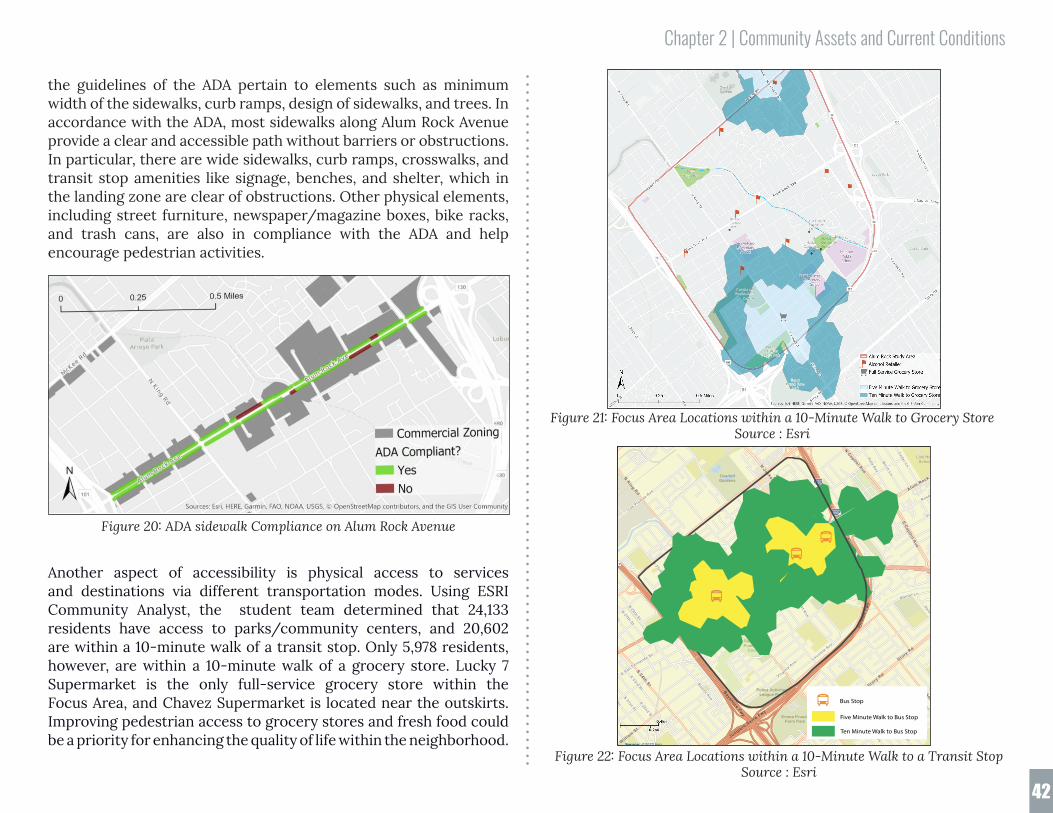
Cape HornDr
MaburyRd
pper Penitencia Creek
101
S23rd
St
E San Fernando St
S22nd
St
N28th
St
S21st St
N26th
St
N33rd
St
S19th
St
S20th
StN
27thSt
Las Plumas Ave
E
William
St
NKing
Rd
KingRd
S24th
St
680
680
SSunset Ave
Bal Harbor Way
Rose Ave
BirchLn
Karl St
Florence
PalaAve
GalahadAve
Cedar Ln
CathayDr
HopkinsDr
E San AntonioSt
Bambi Ln
BonitaAve
Gay Ave
Lavonne Ave
JoseFigueres
Ave
Virginia
Ave
Alum Rock Ave
Alum Rock Ave
StoryRd
StoryRd
NCapitol Ave
SCapitol Ave
AdrianW
ay
NJackson
Ave
NW
hiteRd
NKing
Rd Alum Rock Ave
Sincl
air
F wy
SinclairFw
y
BayshoreFwy
JuniperoSerra
Fwy
Rancho delPueblo Golf
Course
Police ActivitiesLeague Park
OverfeltGardens
Emma PruschFarm Park
Lick HighSchool
IndependenceHigh School
RegionalMedical Ctr of
San Jose
Source: ©2020 Esri
August 02, 2020
©2020 Esri Page 1 of 1
Five Minute Walk to Bus Stop
Ten Minute Walk to Bus Stop
Bus Stop
Chapter 2 | Community Assets and Current Conditions
42
Figure 21: Focus Area Locations within a 10-Minute Walk to Grocery Store Source : Esri
the guidelines of the ADA pertain to elements such as minimum width of the sidewalks, curb ramps, design of sidewalks, and trees. In accordance with the ADA, most sidewalks along Alum Rock Avenue provide a clear and accessible path without barriers or obstructions. In particular, there are wide sidewalks, curb ramps, crosswalks, and transit stop amenities like signage, benches, and shelter, which in the landing zone are clear of obstructions. Other physical elements, including street furniture, newspaper/magazine boxes, bike racks, and trash cans, are also in compliance with the ADA and help encourage pedestrian activities.
Another aspect of accessibility is physical access to services and destinations via different transportation modes. Using ESRI Community Analyst, the student team determined that 24,133 residents have access to parks/community centers, and 20,602 are within a 10-minute walk of a transit stop. Only 5,978 residents, however, are within a 10-minute walk of a grocery store. Lucky 7 Supermarket is the only full-service grocery store within the Focus Area, and Chavez Supermarket is located near the outskirts. Improving pedestrian access to grocery stores and fresh food could be a priority for enhancing the quality of life within the neighborhood.
Figure 22: Focus Area Locations within a 10-Minute Walk to a Transit Stop Source : Esri
Figure 20: ADA sidewalk Compliance on Alum Rock Avenue

Endnotes1. Ivis García, Andrea Garfinkel-Castro, and Deirdre Pfeiffer, "Planning With Diverse Communities," PAS Report (Chicago: American Planning Associ ation, January 2019), 57, https://www.planning.org/publications/report/9165143.2. Alum Rock Santa Clara Business Association, "About Us," accessed April 29, 2020, https://www.alumrock.biz.3. ARSCSBA, Facebook, accessed April 29, 2020, https://www.facebook.com/alumrockba/.4. Alum Rock Santa Clara ST Business Association, accessed August 18, 2020, https://www.alumrock.biz/.5. Alum Rock Urban Village Advocates, “Equitable Development Plan,” accessed April 25, 2020, https://www.aruva.org/equitable-development-plan.6. SOMOS Mayfair, "About Us,” accessed April 25, 2020, https://www.somosmayfair.org/about.7. SOMOS Mayfair, "Non-Profit of the Year Press Release," June 4, 2019, https://www.somosmayfair.org/somos-blog/2019/6/14/non-profit-of-the-year- press-release.8. SOMOS Mayfair, "City of San José Preference/Prioritization Policy," accessed May 1, 2020, https://static1.squarespace.com/static/59c2ef99e5dd 5b9e02e383e7/t/5d6963543471b900011813c2/1567187797305/August+20+2019_Sign+on+letter.pdf. 9. SOMOS Mayfair, "Si Se Puede Collective Recognized by ALF," accessed April 26, 2019, https://www.somosmayfair.org/somos-blog/2019/6/20/si-se- puede-collective-recognized-by-alf.10. City of San José, "Lower Silver Creek Master Plan," 2007, accessed May 7, 2020, https://www.sanjoseca.gov/Home/Components/FacilityDirectory/ FacilityDirectory/3013/2058?npage=2.11. American Planning Association, "Planning With Diverse Communities," accessed April 20 2020. https://www.planning.org/publications/re port/9165143/.12. Valley Transit Authority, "2019 New Transit Service Plan," accessed April 25 2020, http://newtransitplan.vta.org/final-plan-frequent-routes/#522.13. City of San José, "San José Bike Plan 2020," last modified November 17, 2019, accessed March 10, 2020, chrome-extension://gphandlahdpffmc cakmbngmbjnjiiahp/http://www3.sanjoseca.gov/clerk/Agenda/20091117/20091117_0602att.pdf.14. Pete Rice and Nick Frey, "Eastside Transportation Planning," Class lecture, San José State University, URBP-295 Course, April 22, 2020.
Chapter 2 | Assets in the Alum Rock Focus Area

Chapter 3Chapter 3 | Community Engagement
44
CommunityEngagement
With direction from Councilmember Carrasco and the District 5 staff, the student team conducted a collaborative community engagement process to assess the Alum Rock Focus Area’s current assets and challenges and discover the community’s vision for future development. This outreach was intended to help the City of San José prioritize neighborhood improvements that can be leveraged through new development in the Focus Area.
3.1 Fall 2019 Community EngagementIn May 2019, San José State University faculty, CommUniverCity, staff from the D5 Councilmember’s Office, AARP, SOMOS Mayfair, and other community-based organizations hosted the Futuro de Alum Rock open house event. During the open house, over 150 people provided 587 individual comments about assets, challenges, and their long-term vision for progress in the Focus Area.1
Three years of community discussions predating the Futuro de Alum Rock event were documented by Victor Vazquez of SOMOS Mayfair. His notes are included verbatim in Appendix iv.
In Fall 2019, graduate students in San José State University’s Department of Urban and Regional Planning conducted an initial series of outreach events, in partnership with CommUniverCity, in the Alum Rock Focus Area. This outreach included “Café y Comunidad” events, where residents were invited to drop in to speak with students at SOMOS Mayfair’s Family Resource Center on Kammerer Ave. Students also walked the Focus Area to conduct short interviews with local residents and promote awareness of the work the students were doing in the community.
The culminating fall event was an open house on November 16, 2019 at the Mexican Heritage Plaza. To solicit feedback from the community, the open house featured a large piece of butcher paper prompting residents with the question, “What spaces are missing from your neighborhood?” Residents wrote on the paper throughout the event, noting words and phrases and emphasizing others’ comments with check marks. The activity resulted in a total of 79 answers and check marks. According to this exercise, the most popular “missing spaces” were grocery stores (9 responses), followed by gyms (6), public art murals (6), and trees (5).2
Based on this input, along with many other data collection mechanisms employed at the open house, the Fall 2019 graduate student team developed a preliminary list of neighborhood improvements that are a high priority to the community, organized into the following four categories:

Chapter 3 | Community Engagement
45
• neighborhood-oriented commercial use
• parks and public spaces
• cultural and community resources, and
• transportation, streetscape and traffic.3
Within each category are specific improvements that were frequently requested by the community. Examples of these improvements include protections and support for existing family-owned businesses, more parks like Mayfair Park and Emma Prusch Farm Park, continued support for highly valued assets such as the Mexican Heritage Plaza, and improved roadway safety through streetscape redesign.
3.2 Spring and Summer 2020 Com-munity Engagement During the spring and summer of 2020, the student team and Com-mUniverCity staff, building upon the work completed in fall 2019, used an online survey, focus groups, and interviews to learn more about the community’s experiences and preferences. This engage-ment process sought to meet the following goals: • Distribute and collect a minimum of 100 responses to an online
survey about local preferences for development amenities; and,
• Conduct focus groups, either as group video chat calls or 1-on-1 phone interviews, with a total of 40 participants, from a cross-section of parents, seniors, business owners, and youth, to understand current community needs and desires.
A link to the survey and focus group interest form was sent to residents, community stakeholders, non-profits, and local leaders who then distributed the email and information through their networks. The survey was translated and offered in English, Spanish, and Vietnamese.
3.3 Coronavirus and COVID-19 AcknowledgmentAs a result of the spread of the Coronavirus known as SARS-CoV-2, which causes COVID-19, the world has experienced widespread health and economic crises during 2020. Predictably, this global pandemic has greatly impacted both the preparation of this report as well as the concerns, experiences, and well-being of the commu-nities within the Focus Area. The acting health officers for all nine counties in the San Francisco Bay Area issued a shelter-in-place order on March 17, 2020, before California Governor Gavin Newsom’s order. This drastically altered the community engagement process, shifting in-person focus groups to remote video chat sessions and phone interviews.
3.4 Community Survey FeedbackBuilding upon the findings from the Fall 2019 report, the survey asked residents to indicate their preferred neighborhood improve-ments within the categories of business support, parks and public spaces, cultural and community resources, and transportation and streetscape. The survey also requested general demographic infor-mation to ensure the respondents were representative of the neigh-borhood. Between April 13 and July 22, 2020, a total of 113 people completed the online survey, meeting the goal of 100 responses. The following section discusses common themes that emerged among those responses. All survey questions can be found in Appendix vii.
3.4.1 Where do you live?
The first question asked respondents to identify where they live. Respondents were restricted to residents of D5, or those who work, operate a business, or who are involved with a community-based organization within the Focus Area. The most common responses to this question were those who selected District 5 (26 responses),

Chapter 3 | Community Engagement
46
noted a specific neighborhood such as Mayfair or Plata Arroyo (18), or wrote in their specific zip code such as 95116 (15) or 95127 (13).
3.4.2 What community group do you represent?Next, the survey asked what community groups the respondents represented. This question provided six answer choices: parent of a school-aged child (18 and under), local business owner, senior (65 and older), youth (18 and under), work for a community-based organization, and other. Totals for each category are noted in the table below. Note that the combined total for this table is greater than our total survey responses (113), as respondents may represent multiple groups. Respondents who indicated “other” included adult residents with no children, employees at local schools or business, etc.
Table 3: Community Groups Represented by Survey Respondents.
Answer # of Responses Parent of a school-aged child 49
Senior 27
Other 26
Work for a community-based organization 17
Local Business Owner 11
Youth 7
3.4.3 Business-Supporting AmenitiesRespondents were asked to rate the statement on a scale of 1-5: “Business-supporting amenities should support business operations, include protections for local businesses, and help diversify retail opportunities.” The majority of respondents supported the statement, with 71.7 percent of respondents strongly agreeing or agreeing.
Table 4: Survey Responses: Support for Local Business
Answer # of Responses PercentStrongly Agree 49 43.4 %
Agree 32 28.3 %
Neutral 19 16.8 %
Disagree 3 2.7 %
Strongly Disagree 10 8.8 %
The next question asked respondents to rate the statement on a scale of 1-5: “Business-supporting amenities should support businesses through safer, greener, well-maintained streets and storefront improvements.” Most survey takers supported the statement with 84.5 percent strongly agreeing or agreeing.
Table 5: Survey Responses: Support for Local Business Amenities
Answer # of Responses PercentStrongly Agree 53 48.2 %
Agree 40 36.4 %
Neutral 6 5.5 %
Disagree 3 2.7 %
Strongly Disagree 8 7.3 %
Which amenities would you like to see for businesses in your neighborhood?
From a list of potential business amenities, respondents were asked to choose what they would like to see in their neighborhood. Respondents were given the option of selecting up to five improvements. With 62, 60, and 58 votes respectively, the three most preferred amenities were: 1) Increased sidewalk and street maintenance; 2) Increased public safety; and 3) Support for existing businesses.
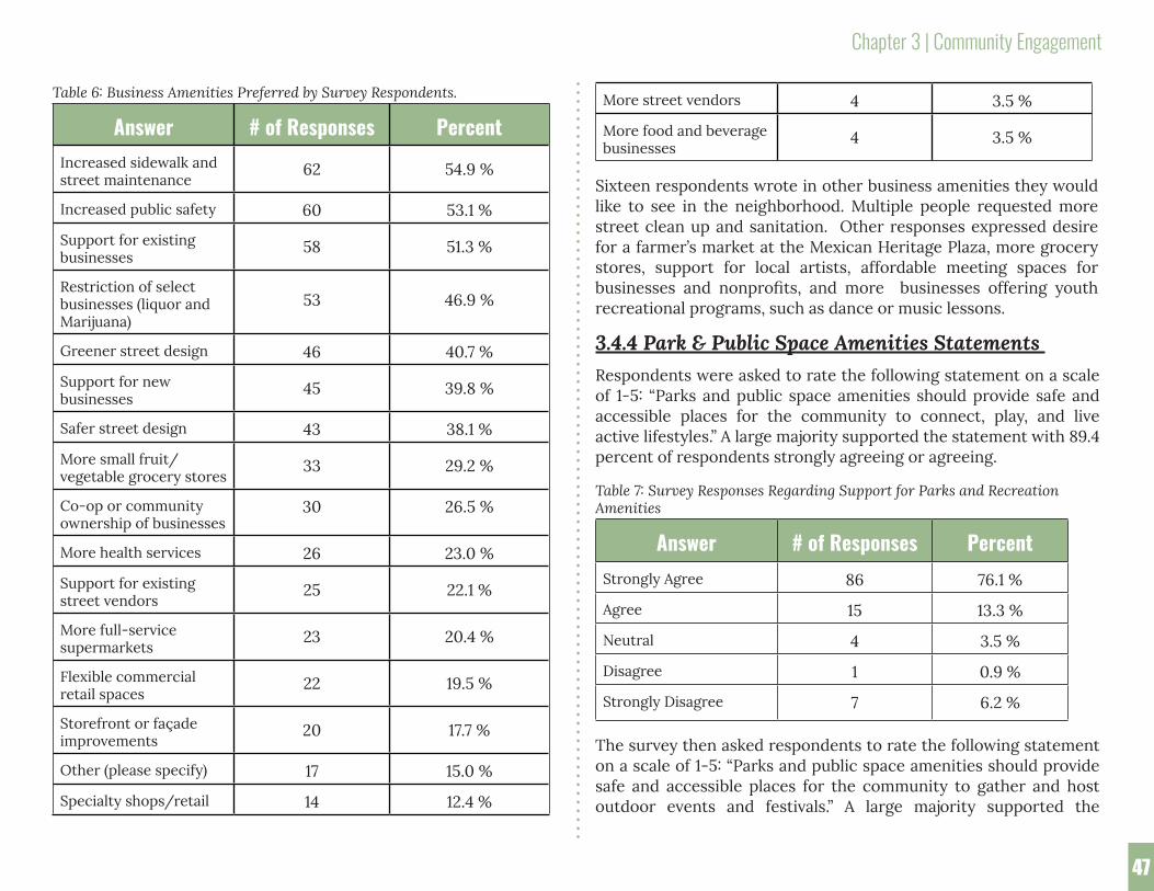
Chapter 3 | Community Engagement
47
Table 6: Business Amenities Preferred by Survey Respondents.
Answer # of Responses PercentIncreased sidewalk and street maintenance
62 54.9 %
Increased public safety 60 53.1 %
Support for existing businesses
58 51.3 %
Restriction of select businesses (liquor and Marijuana)
53 46.9 %
Greener street design 46 40.7 %
Support for new businesses
45 39.8 %
Safer street design 43 38.1 %
More small fruit/vegetable grocery stores
33 29.2 %
Co-op or community ownership of businesses
30 26.5 %
More health services 26 23.0 %
Support for existing street vendors
25 22.1 %
More full-service supermarkets
23 20.4 %
Flexible commercial retail spaces
22 19.5 %
Storefront or façade improvements
20 17.7 %
Other (please specify) 17 15.0 %
Specialty shops/retail 14 12.4 %
More street vendors 4 3.5 %
More food and beverage businesses
4 3.5 %
Sixteen respondents wrote in other business amenities they would like to see in the neighborhood. Multiple people requested more street clean up and sanitation. Other responses expressed desire for a farmer’s market at the Mexican Heritage Plaza, more grocery stores, support for local artists, affordable meeting spaces for businesses and nonprofits, and more businesses offering youth recreational programs, such as dance or music lessons.
3.4.4 Park & Public Space Amenities Statements Respondents were asked to rate the following statement on a scale of 1-5: “Parks and public space amenities should provide safe and accessible places for the community to connect, play, and live active lifestyles.” A large majority supported the statement with 89.4 percent of respondents strongly agreeing or agreeing.
Table 7: Survey Responses Regarding Support for Parks and Recreation Amenities
Answer # of Responses PercentStrongly Agree 86 76.1 %
Agree 15 13.3 %
Neutral 4 3.5 %
Disagree 1 0.9 %
Strongly Disagree 7 6.2 %
The survey then asked respondents to rate the following statement on a scale of 1-5: “Parks and public space amenities should provide safe and accessible places for the community to gather and host outdoor events and festivals.” A large majority supported the

Chapter 3 | Community Engagement
48
following statement with 84.4 percent of respondents strongly agreeing or agreeing. Table 8: Survey Responses Regarding Support for Public Space Amenities.
Answer # of Responses PercentStrongly Agree 61 56.0 %
Agree 31 28.4 %
Neutral 8 7.3 %
Disagree 0 0.0 %
Strongly Disagree 9 8.3 %
Which amenities would you like to see for parks and public spaces in your neighborhood?
From a list of potential parks and public space amenities, respondents were asked to indicate what they would like to see in their neighborhood. Respondents were given the option of selecting up to five improvements. The top three choices were outdoor exercise areas (60 votes), playgrounds or play equipment outdoor events (60 votes), and community gardens (50 votes).
Table 9: Parks and Public Space Amenities Preferred by Survey Respondents.
Answer Total Percentage of Re-spondents
Outdoor exercise areas 60 53.1 %
Playgrounds or play equipment
60 53.1 %
Community gardens 58 51.3 %
Trails along the creek 50 44.2 %
Outdoor events 49 43.4 %
Plaza or gathering spaces 46 40.7 %
Open lawn/grass area 40 35.4 %
Picnic tables 38 33.6 %
Outdoor movies 32 28.3 %
Small/pocket parks 32 28.3 %
Sports fields 29 25.7 %
Other (please specify) 19 16.8 %
Skateparks 12 10.6 %
Seventeen respondents wrote in other amenities they would prefer to see in the parks and public spaces. The majority of these comments expressed desire for the implementation of increased sanitation and safety measures at existing parks and open spaces. Several comments spoke specifically to safety and health issues presented by homeless persons and encampments within local parks. A few responses asked for more parks and open spaces, with specific requests for wildlife habitat, botanical gardens, and a nature trail.
It may be worth considering the potential impact of shutdowns caused by COVID-19 on responses in this section. With gyms closed, residents may be have been feeling an acute need for more outdoor exercise areas. Moving forward, it will be especially important to consider the role public parks and open spaces will play in meeting a growing need for outdoor exercise and recreation as we deal with the continuing impacts of the pandemic for years to come.
3.4.5 Cultural & Community Resource Amenities StatementsRespondents were asked to rate the following statement on a scale of 1-5: “Cultural amenities should highlight the neighborhood’s history and diversity, including past, present, and emerging creativity and activism.” A large majority supported the statement with 81.4 percent strongly agreeing or agreeing.

Chapter 3 | Community Engagement
49
Table 10: Survey Responses Regarding Support for Cultural and Community Resource Amenities.
Answer # of Responses PercentStrongly Agree 59 52.2 %
Agree 33 29.2 %
Neutral 13 11.5 %
Disagree 2 1.8 %
Strongly Disagree 6 5.3 %
Respondents were asked to rate the following statement on a scale of 1-5: “Community resources should provide opportunities for youth and adults to continue their education and gain skills to improve their future health and economic prospects.” A large majority supported the statement with 87.4 percent of respondents strongly agreeing or agreeing.
Table 11: Survey Responses Regarding Support for Youth and Adult Programming.
Answer # of Responses PercentStrongly Agree 68 61.3 %
Agree 29 26.1 %
Neutral 7 6.3 %
Disagree 1 0.9 %
Strongly Disagree 6 5.4 %
Which amenities would you like to see for cultural and community resources in your neighborhood?
From a list of potential cultural and community resource amenities, the respondents were asked which they would like to see in their neighborhood. Respondents were given the option of selecting up to 5 improvements. The top three choices were youth programs/after school programs (71 votes), community centers (59 votes), and libraries (53 votes).
Table 12: Cultural and Community Resource Amenities Preferred by Survey Respondents.
Answer Total Percentage of Respondents
Youth programs/afterschool programs
71 62.8 %
Community centers 59 52.2 %
Libraries 53 46.9 %
Tutoring programs 49 43.4 %
Workforce development programs
42 37.2 %
Art programs 39 34.5 %
Social service agencies 38 33.6 %
Murals 38 33.6 %
Public art 38 33.6 %
Historic preservation 37 32.7 %
Architecture that reflects local culture 36 31.9 %
Cultural district designation 22 19.5 %
Other (please specify) 14 12.4 %

Chapter 3 | Community Engagement
50
Table 14: Survey Responses Regarding Support for Transportation and Streetscape Amenities that Improve Safety, Connectivity, and Congestion.
Answer # of Responses PercentStrongly Agree 60 55.6 %
Agree 37 32.7 %
Neutral 8 7.1 %
Disagree 2 1.8 %
Strongly Disagree 1 0.9 %
Which amenities would you like to see for transportation and streetscapes in your neighborhood?
From a list of potential transportation and streetscape amenities, survey takers were asked which they would like to see in the neighborhood. Respondents were given the option of selecting up to 5 improvements. The top three selected amenities were: 1) Sidewalk cleaning and maintenance (63 votes); 2) Improved safety at intersections and street crossings (56 votes); and 3) Street design to reduce speeding (53 votes).
Table 15: Transportation and Streetscape Amenities Preferred by Survey Respondents.
Answer Total Percentage of Respondents
Sidewalk cleaning and maintenance
63 55.8 %
Improved safety at i...and street crossings
56 49.6 %
Street design to reduce speeding
53 46.9 %
Street trees 51 45.1 %
Respondents who selected “Other” wrote in comments speaking to the need for tenant protections, programs providing a pathway to home ownership, public safety improvements, parking, and differing opinions on public art and how it can or should be used to represent specific cultures.
3.4.6 Transportation And Streetscape Amenities Statements Survey takers were asked to rate the following statement on a scale of 1-5: “Transportation and street design amenities should support walking, biking, public transit, and other modes of transportation so people feel healthier and more connected while being less dependent on cars.” A large majority of respondents supported the statement with 85 percent strongly agreeing or agreeing.
Table 13: Survey Responses Regarding Support for Transportation and Streetscape Amenities.
Answer # of Responses PercentStrongly Agree 61 54.0 %
Agree 35 31.0 %
Neutral 7 6.2 %
Disagree 5 4.4 %
Strongly Disagree 5 4.4 %
Respondents were asked to rate the statement on a scale of 1-5: “Transportation and street design amenities should reduce congestion, improve safety, and better connect the neighborhood to the rest of the city.” A large majority of respondents supported the statement with 88.3 percent strongly agreeing or agreeing.

Chapter 3 | Community Engagement
51
Responses from those who selected “Other” included specific comments on adding bike lanes, street trees, safety, and parking improvements.
3.4.7 Assets, Challenges, VisionWhat are the community assets in the Alum Rock area?
The survey then asked respondents to identify community assets in the Alum Rock area. They identified a total of 135 assets. The following table lists the recurring themes.
Table 16: Community Assets Identified by Survey Respondents.
Asset # of Responses Culture 19
Community Spaces & Organizations (i.e. Mexican Heritage Plaza, Mayfair Community Center, SOMOS Mayfair)
17
Local Businesses 16
Parks 15
Diversity 11
The People 10
History/History of Activism 10
Libraries 6
Public Art 4
Schools 4
Churches 4
Bike Lanes/Facilities 3
Police/Fire Services 2
Street landscaping and flowers
41 36.3 %
Improved street lighting 40 35.4 %
Well-designed sidewalks 36 31.9 %
Roadway paving 35 31.0 %
Roadway cleaning 34 30.1 %
Improve bike lanes 32 28.3 %
Better connected transit services
32 28.3 %
Street design to increase walkability
28 24.8 %
Benches and public seating 26 23.0 %
Parking permit system 22 19.5 %
More frequent transit services
18 15.9 %
Underground parking 18 15.9 %
Bike parking 17 15.0 %
Electric vehicle charging stations
16 14.2 %
Pick-up and drop-off areas for rideshare and food deliveries
14 12.4 %
Other (please specify) 12 10.6 %
Loading zones for businesses
6 5.3 %
Reserved carsharing parking
2 1.8 %

Chapter 3 | Community Engagement
52
What would you like to see included in future development projects along Alum Rock Ave between King Road and Jackson Avenue?
Respondents were then asked what they would prefer to be included in future development projects along Alum Rock Ave between King Road and Jackson Avenue. A total of 144 unique answers were provided. The following table lists the top recurring themes reported by respondents.
Table 18: Survey Responses Regarding Preferences for Future Development in the Focus Area.
Potential Investment # of Responses More open/green space 15
Affordable space for small businesses 13
Improved safety & security 12
Affordable housing 12
Cleaning up trash, graffiti, etc. 11
Additional parking (underground, street, lots, etc.)
10
More community spaces 10
Street improvements (traffic safety, signage, etc.) 9
Additional parks 9
Additional businesses (food stores, restaurants, etc.)
9
More trees/landscaping 8
Improvements for walkability (lighting, sidewalk maintenance, etc.)
8
Art/architecture reflective of local culture 7
Youth/community/family programs 5
Solutions to homelessness 2
What are you most worried about for yourself/your family/community?
Next, respondents were asked what they were most worried about for themselves, their family, or their community. They identified a total of 147 challenges. The following table lists the top recurring themes.
Table 17: Challenges Identified by Survey Respondents.
Concern # of Responses Public Safety/Crime 44
Housing Affordability/Displacement 22
Blight/Trash/Litter/Graffiti 12
Traffic Safety (Speeding, Bike Safety, etc.) 10
Homelessness 9
Parking 8
Job Opportunities 7
Street & Sidewalk Improvements (Lighting, Bike Lanes, Circulation Issues, etc.)
6
Neighborhood Feel/Loss of Sense of Community 6
Public Health 5
Gangs 5
Need for More Open & Community Space 4
Opportunities for Youth 3
Lack of Help from City/Political Leaders 3
Taxes 2
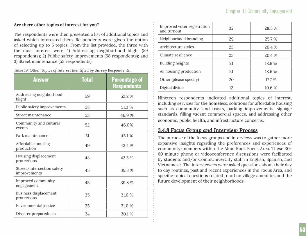
Chapter 3 | Community Engagement
53
Are there other topics of interest for you?
The respondents were then presented a list of additional topics and asked which interested them. Respondents were given the option of selecting up to 5 topics. From the list provided, the three with the most interest were: 1) Addressing neighborhood blight (59 respondents); 2) Public safety improvements (58 respondents); and 3) Street maintenance (53 respondents).
Table 19: Other Topics of Interest Identified by Survey Respondents.
Answer Total Percentage of Respondents
Addressing neighborhood blight
59 52.2 %
Public safety improvements 58 51.3 %
Street maintenance 53 46.9 %
Community and cultural events
52 46.0%
Park maintenance 51 45.1 %
Affordable housing production
49 43.4 %
Housing displacement protections
48 42.5 %
Street/intersection safety improvements
45 39.8 %
Improved community engagement
45 39.8 %
Business displacement protections
35 31.0 %
Environmental justice 35 31.0 %
Disaster preparedness 34 30.1 %
Improved voter registration and turnout
32 28.3 %
Neighborhood branding 29 25.7 %
Architecture styles 23 20.4 %
Climate resilience 23 20.4 %
Building heights 21 18.6 %
All housing production 21 18.6 %
Other (please specify) 20 17.7 %
Digital divide 12 10.6 %
Nineteen respondents indicated additional topics of interest, including services for the homeless, solutions for affordable housing such as community land trusts, parking improvements, signage standards, filling vacant commercial spaces, and addressing other economic, public health, and infrastructure concerns.
3.4.8 Focus Group and Interview ProcessThe purpose of the focus groups and interviews was to gather more expansive insights regarding the preferences and experiences of community-members within the Alum Rock Focus Area. These 30-60 minute phone or videoconference discussions were facilitated by students and/or CommUniverCity staff in English, Spanish, and Vietnamese. The interviewees were asked questions about their day to day routines, past and recent experiences in the Focus Area, and specific topical questions related to urban village amenities and the future development of their neighborhoods.

Chapter 3 | Community Engagement
54
3.5 Interview and Focus Group Results 3.5.1 Demographics and BackgroundFrom April 9th to July 26th, 2020, 46 community members participated in interviews and/or focus groups. The table below indicates the groups participants represented.
Table 20: Survey Responses Regarding Group Affiliation of Participants.
Represented group # of Responses Parent of a school-aged child 26
Senior 8
Local Business Owner 5
Youth 4
Work for a community-based organization 2
Other (adult resident) 1
Interviews began by discussing residents’ day to day routines in their neighborhood, how long they have lived or operated a business in the area, what brought them to the community originally, and what has changed in the time since. The ultimate goal of this line of questioning was to reveal what residents most valued in the community, what most concerned them, and the changes they would ultimately like to see in the future.
The following section summarizes comments and concerns frequently shared during the interviews.
3.5.2 Neighborhood Strengths and AssetsOverall, residents expressed high levels of satisfaction with living in the Focus Area. Contributing to this were favorable comments about local assets, local, family-run businesses in particular. The area, it was often said, possesses a unique, valued culture exemplified by these local businesses. Preserving them, residents noted, is central to preserving the identity of the community that is one of its strengths.
Another element of community identity is a rich history of local activism. Residents mentioned the importance of the Mexican Heritage Plaza and its location where Cesar Chavez helped lead a boycott of Safeway. Community organizations were also mentioned often in terms of their leadership both historically and in the present moment. Said one interviewee, “I see the Eastside as a place where activism grows. We have some real Eastside heroes. And grassroots activism is alive and well. I’m very proud of that.”
Residents spoke to the pride they have in their community, and how that pride is heightened by a shared sense of resilience in the face of unique challenges. Said one interviewee, “There’s a perception associated with the Eastside. We have always had to work to fight that.” Said another, “Who we are is what defines us, not where we live.”
Parents cited many benefits of raising a family within the neighborhood, including strong community connections, diversity, rich culture and history, and a variety of public spaces such as community libraries, the Mayfair Community Center, and parks.
Many parents often mentioned Emma Prusch Park as a favorite destination and place to bring children. The Mexican Heritage Plaza was also mentioned by several residents as a valuable community space and source of programming for parents and their children. Parents also spoke to the value of programs at the Mayfair Community Center, though Mayfair Park received a mix of positive and negative
Chapter 3 | Community Engagement
55
comments. Other popular parks included Plata Arroyo and Zolezzi. While most residents spoke to the value of existing parks, the need for additional park and green space was also a frequent comment, as we will cover later.
Business owners described many benefits to owning a business in Alum Rock, including the great relationship between businesses and residents, a convenient location near major freeways, relatively affordable rent compared to other parts of the city, and the diversity of businesses and varied specialties. The business owners also noted that employees in the neighborhood benefit from Spanish speaking job opportunities and comfortable working environments.
We analyzed the combined interview data to draw out features that were commonly mentioned as neighborhood assets by interviewees.
Table 21 : Community Assets Identified in the Interviews.
Asset # of mentions by interviewees
Local Businesses (shops, restaurants, cafes, etc.) 21
Local Parks (Plata Arroyo, Zolezzi, etc.) 21
Emma Prusch Park/Veggielution 11
Libraries & Other Community Spaces 9
Mayfair Community Center 6
Mexican Heritage Plaza 4
3.5.3 Neighborhood Weaknesses, Vulnerabilities, and OpportunitiesAffordability
The issue of affordability for residents and businesses was a frequent topic of conversation. For a number of residents and business owners, the relatively affordable rents of the area were what drew them to the community in the first place. Looking ahead, there are strong concerns about that continuing to be the case. “I would like to stay here but the housing prices keep going up, so most likely I’ll have to move in the future,” said one interviewee.
Business owners emphasized concerns that, should they lose their current location or face higher rents, they may need to close entirely. This existing issue of affordability for businesses has been further exacerbated by the impacts of the COVID-19 pandemic. Said one business owner, “99% of the businesses don’t have the money to move. These businesses that have been here for 15, 20 years will be gone.”
Business owners and a number of residents spoke to the need to protect local businesses, provide financial assistance for them to relocate, or give reduced rent or special preference to existing businesses within new developments. As one interviewee warned, “Small businesses will be gone if things keep going the way they are.”
Crime and Safety
Among the top concerns of interviewees, similar to results from our survey, were matters tied to crime and safety. Business owners interviewed emphasized this concern in particular. One of the businesses we spoke with was broken into in the week before their interview. A number of residents also spoke directly to issues of drug use in local parks, and feelings of insecurity caused by the growing presence of homeless individuals and encampments.
Chapter 3 | Community Engagement
56
Residents and business owners mentioned a strong need for improved policing. While comments on policing revealed past tensions between the San José Police Department and the local community, many interviewees felt that, overall, the police are doing the best they can with its available resources. However, some residents spoke to a need to keep officers in the area who have greater familiarity with the community. Reducing turnover for officers who establish themselves in the community was mentioned as a desire as well as efforts to build further trust between community members and the SJPD.
Comments on policing reflected a general theme that colored many conversations: residents feel that the area tends to be neglected by the city and its leadership. Said one resident, “There’s a big wall between east and west San José. We have to take away the wall.” Another resident put it more directly, saying “We tend to be like the stepchildren.”
Cleanliness and Upkeep
We also noted many comments about littering and trash in the area, including illegal dumping and abandoned cars. Among desired improvements commonly mentioned was additional street cleaning. One resident specifically spoke to how improving the overall sense of community could help address this issue: “[We] need to teach people to care about where they live.”
Green Space
While residents had positive comments about existing parks in the community, there was a common request in the interviews for additional parks and open space. Residents often spoke to a need for green, natural space. Residents also cited the need for more street trees to make the area more walkable.
A Sense of Community
Long term residents spoke to a sense of community that they feel has diminished recently. Examples included residents who said that, in the past, they knew more of their neighbors. Several residents said a reason for this seemed to be an increasing number of renters in the area, coupled with high turnover of these renters. A few spoke to how things have changed with the way children spend their time. Interviewees noted that this was due to parent worries about children playing outside and the appeal of digital tools for children to socialize with their peers.
Youth-Related Concerns
Interviewees from all backgrounds (youth, parents, seniors, business owners) emphasized a need for more youth and family programming. This programming could take the form of more after-school programs, sports leagues, cooking and art lessons for families, and positive spaces for youth to spend their time. Most important, interviewees emphasized, this programming should be free or available at very low cost in order to benefit those community members most in need.
Many residents spoke to existing challenges with neighborhood schools and the school district. Improving local schools should be a top priority, many interviewees said, as a way to address many of the larger issues facing the community, such as crime, lack of opportunity for youth, and improving the neighborhood for young families. As one resident put it, “We’re treating symptoms, when we should be treating the root problems. We need to focus on intervening instead of fixing.”
Transportation and Mobility
In conversations about mobility, most interviewees said that they drive to get where they need during their daily routines. In the Focus Area, parking is a an often noted concern, and there was a strong sentiment from the interviewees that parking has become scarcer and that the neighborhood has become more crowded and “overparked”.

Chapter 3 | Community Engagement
57
Construction of VTA’s Bus Rapid Transit line on Alum Rock Avenue was mentioned quite often as a factor, leading to the removal of street parking for local businesses. Some business owners on Alum Rock cited a severe loss of business, up to 50 percent compared to pre-BRT conditions). One specific concern is the inability to make left turns along much of Alum Rock Avenue, effectively cutting off half of all potential customers driving by.
Although parking concerns dominated many conversations, many interviewees noted the need for improved pedestrian and bicycle safety. High traffic speeds are a common worry, with requests made for lower speed limits along primary roads such as Alum Rock Aveue and San Antonio Street. Other priorities are ensuring upkeep for sidewalks, continuing to improve street lighting, and adding additional pedestrian amenities such as street trees and benches. While there were dissenting opinions about the city’s plan to improve bike lanes along San Antonio Street, participants overall shared a desire for improving bicycle networks. Residents to the east of the Focus Area placed particular emphasis on the need to add a bike lane on Alum Rock Avenue that would connect the focus area with Alum Rock Park.
Summary of Neighborhood Weaknesses
We analyzed the combined interview data to draw out features that were commonly mentioned as neighborhood weaknesses by interviewees. Table 22 summarizes a few of the most commonly mentioned issues.
Table 22: Focus Area Challenges Identified in the Interviews .
Issue/ Weakness Mentions by interviewees
Safety 19
Schools 4
Environment 4
Lack of Youth Programs 3
Issues with Local/City Governance 3
Street/Neighborhood Cleaning 2
Need for Additional Businesses 2
In response to these weaknesses, we followed up by asking interviewees what they would like to see more of in their community. Table 23 summarizes a few of the most commonly mentioned needs.
Table 23: Community Needs Identified in the Interviews.
Community Need Mentions by interviewees
Parks and Open Space 13
Sidewalk Amenities (benches, trees, lighting, etc.)
13
Cleaning and Maintenance 4
Additional Businesses 9
Youth Programs 7
Business Support/Space 7
Street & Traffic Safety Improvements 6
Community Space 6
Better Governance 5
Bike Facilities 5
Grocery Stores 4
Public art 3
School Improvements 3

Chapter 3 | Community Engagement
58
Addressing Housing, Displacement Issues 3
Parking 3
We also asked interviewees to choose one thing to add to their community if they were given the money to do so. Table 24 summarizes what respondents would choose to add.
Table 24: Focus Area Improvements Identified by Interviewees.
One Thing to Add or Improve Mentions by interviewees
Community Spaces, Programs and Events 14
Youth Programs 13
Addressing Housing, Displacement Issues 10
Better Safety 9
Street/Neighborhood Cleaning 9
Improved Sidewalks 8
Parks 6
Street Safety Improvements 5
Support for Businesses 5
Parking 4
Grocery Stores 4
Community Health & Environment 4
Additional Businesses 3
School Improvements 2
Art 2
3.6 Limitations to this Engagement EffortThe student team identified a number of limitations in the assessment and engagement process.
• Potentially inadequate sample of business and youth participants. While the student team and CommUniverCity staff were able to engage many parents and senior citizens, they did not reach businesses and youth as widely as intended.
• Loss of shared perspectives. Interviews were originally designed for a more interactive focus group format that created room for ideas to play off one another. Due to shelter-in-place orders, interviews were instead conducted individually by telephone.
• Interview and survey format reliant on Internet access may have been a barrier to inclusive participation. The quick pivot to remote engagement may have excluded some residents without Internet access. As such, Spring 2020’s sample may not be representative of the community at-large. Translation services were available for many interviews, but not all.

Chapter 3 | Community Engagement
59
Endnotes1. Rick Kos and Jason Su, “Amplifying the Voice of Alum Rock Corridor Neighborhoods in a Time of Great Change,” (San José, CA: San José State University, August 2019) Unpublished.2. San José State University Graduate Students, URBP-295 Course, “Vision for the Alum Rock Corridor”, Fall 2019, pg. 54, last modified December 2019, accessed April 28, 2020, https://sjsu.instructure.com/courses/1359709/files/56766631/download?wrap=1.3. Ibid., Page 69.

60
4.1 Affordability and Addressing DisplacementIn survey and interview responses, many community members expressed strong concerns about the threat of displacement to residents and businesses, a threat that has been heightened due to the impacts of the COVID-19 pandemic. Here we explore the particular conditions contributing to this issue and potential solutions to ameliorate them.
4.1.1 A Growing Threat of Business and Resident Dis-placement
Chapter 4
The assessment of the Alum Rock Focus Area, including extensive engagement with its residents, provided valuable insight into neighborhood conditions and the community’s vision for the future. This chapter examines the values, concerns, and preferences for future development and neighborhood improvements voiced during the community outreach process. Also presented in this chapter is a community-identified priority list divided into four categories: affordability and addressing displacement, quality and upkeep of public streets and parks, enhancing safety and reducing neighborhood crime, mobility, and the activation of social gathering spaces with recreation and art. The chapter concludes with a discussion of existing policies and a summary of potential strategies that address the community’s feedback.
As discussed previously, community priorities and public investment opportunities may be affected by the COVID-19 pandemic and associated economic and social impacts. This priority list should be considered a living document to be referenced when investment opportunities arise. It is not intended to be exhaustive.
Community-Driven Priorities for the Alum Rock Corridor
Summary of Potential Displacement Prevention Strategies
• Encourage and incentivize developers to provide affordable commercial spaces, particularly to nonprofits, local family-owned businesses, and those that support community priorities.
• Encourage and incentivize developers to provide tenant improvements to attract community-desired retail, nonprofits, and employment opportunities.
• Entitle commercial spaces with adequate space, dimensioned properly, and of varying sizes to support a wider diversity of retail opportunities (multiple vendors in a large hall, opportunities for street vendors to lease space, etc.).
• Prioritize “right of first refusal” at pre-existing rents for businesses impacted by new developments.
• Explore incentives for developers and property owners to encourage long-term affordable commercial space.
• Develop City business anti-displacement policies and assist services for current and prospective local businesses and nonprofits to remain and invest in their community.

Chapter 4 | Community-Driven Priorities for the Alum Rock Corridor
61
Business and resident displacement emerged as a significant community concern during the surveys and interviews. Participants and interviewees alike noted that displacement had increased over the last five to ten years, and many were unsure about their ability to remain as residents or business owners in the Focus Area.
As one resident shared during an interview, “I would like to stay here, but the housing prices keep going up, so most likely I will have to move in the future to somewhere where my family and I can afford the housing prices.”
One business owner stated, “Now we think we’re going to lose this location. We wouldn’t move, just close down. There’s no way we could find something affordable that meets our needs.”
Over 30 percent of those surveyed supported local business protection programs, and interviewed business owners stated that finding affordably priced retail, commercial, and office space was a major challenge. Contributing factors include the loss of existing commercial space to new development, which may include new commercial space that is unaffordable to existing businesses. Business owners along Alum Rock Avenue also cited dramatic losses occurring with the creation of the BRT extension, which blocks left turns along most of Alum Rock, effectively cutting off these businesses from half of their potential customers driving by.
The City of San José has policies and strategies in place to protect tenants and businesses in an effort to address displacement pressures. The San José Citywide Anti-Displacement Strategy, which was accepted by the City Council in September 2020, seeks to expand existing tenants’ protections, establish an anti-displacement hotline, and expand tenant education and neighborhood development programs. The strategy establishes thirteen recommendations addressing displacement of low-income households, defined as families of four making between $0 and $103,000, or 80 percent of the San José Area’s median income (AMI). According to U.S. Census Bureau data obtained using Esri’s Community Analyst, 72 percent of households in the Focus Area earn less than $100,000 per year, meaning the majority of residents are at risk of displacement and have higher barriers to accessing or maintaining housing.1 Figure 23 further highlights the strategies from the San José Citywide Anti-Displacement Strategy.2
As discussed in Chapter 2, the Alum Rock Urban Village Advocates (ARUVA) organize community members to discuss displacement protections for area residents and businesses. ARUVA’s Plan for Equitable Development framework calls for a local preference policy to mitigate displacement and a guarantee that at least 50 percent of new housing units, both rental and ownership opportunities, are affordable to existing households in the 95116 ZIP code area in Mayfair. The City of San José’s Office of Economic Development (OED), Planning Division, and local business associations (Alum Rock Business Network and Alum Rock Santa Clara Street Business Association) also have many programs and services in place to protect and invest in Focus Area businesses.
To further prevent displacement of residents, the City of San José could consider implementing local preference and tenant protection policies. Local preference policies help keep current residents or businesses in the neighborhood by prioritizing those who already live or operate their business near the property when leasing or selling units or buildings. The City of San José Anti-Displacement Strategy lists “establish a neighborhood tenant preference for
• Explore the potential of adopting a ‘local preference’ policy that ensures existing residents have an opportunity to new affordable housing produced in the Alum Rock community.
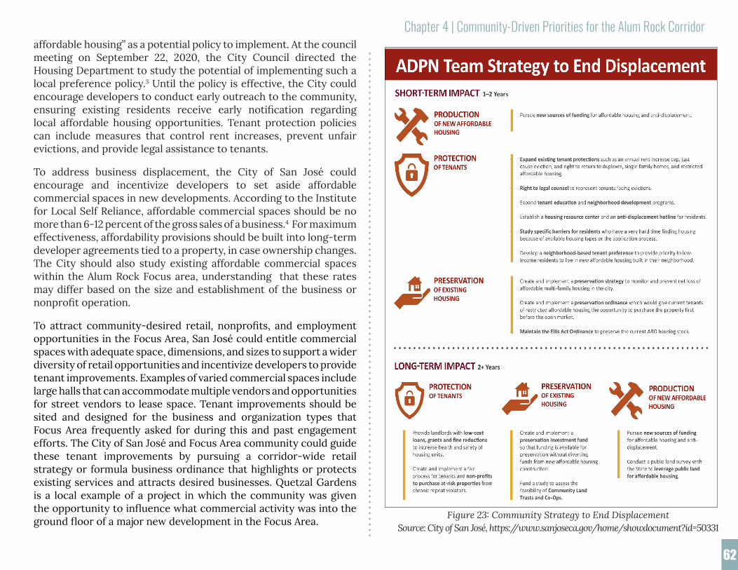
Chapter 4 | Community-Driven Priorities for the Alum Rock Corridor
62
affordable housing” as a potential policy to implement. At the council meeting on September 22, 2020, the City Council directed the Housing Department to study the potential of implementing such a local preference policy.3 Until the policy is effective, the City could encourage developers to conduct early outreach to the community, ensuring existing residents receive early notification regarding local affordable housing opportunities. Tenant protection policies can include measures that control rent increases, prevent unfair evictions, and provide legal assistance to tenants.
To address business displacement, the City of San José could encourage and incentivize developers to set aside affordable commercial spaces in new developments. According to the Institute for Local Self Reliance, affordable commercial spaces should be no more than 6-12 percent of the gross sales of a business.4 For maximum effectiveness, affordability provisions should be built into long-term developer agreements tied to a property, in case ownership changes. The City should also study existing affordable commercial spaces within the Alum Rock Focus area, understanding that these rates may differ based on the size and establishment of the business or nonprofit operation.
To attract community-desired retail, nonprofits, and employment opportunities in the Focus Area, San José could entitle commercial spaces with adequate space, dimensions, and sizes to support a wider diversity of retail opportunities and incentivize developers to provide tenant improvements. Examples of varied commercial spaces include large halls that can accommodate multiple vendors and opportunities for street vendors to lease space. Tenant improvements should be sited and designed for the business and organization types that Focus Area frequently asked for during this and past engagement efforts. The City of San José and Focus Area community could guide these tenant improvements by pursuing a corridor-wide retail strategy or formula business ordinance that highlights or protects existing services and attracts desired businesses. Quetzal Gardens is a local example of a project in which the community was given the opportunity to influence what commercial activity was into the ground floor of a major new development in the Focus Area. Figure 23: Community Strategy to End Displacement
Source: City of San José, https://www.sanjoseca.gov/home/showdocument?id=50331
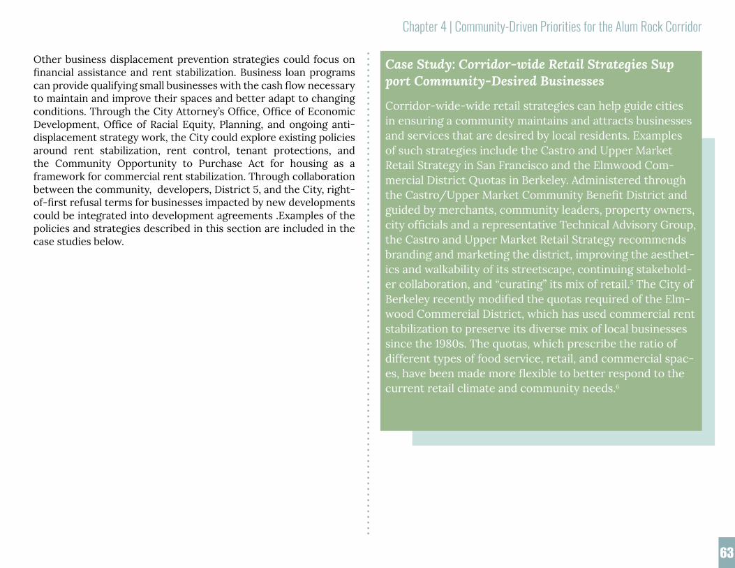
Chapter 4 | Community-Driven Priorities for the Alum Rock Corridor
63
Other business displacement prevention strategies could focus on financial assistance and rent stabilization. Business loan programs can provide qualifying small businesses with the cash flow necessary to maintain and improve their spaces and better adapt to changing conditions. Through the City Attorney’s Office, Office of Economic Development, Office of Racial Equity, Planning, and ongoing anti-displacement strategy work, the City could explore existing policies around rent stabilization, rent control, tenant protections, and the Community Opportunity to Purchase Act for housing as a framework for commercial rent stabilization. Through collaboration between the community, developers, District 5, and the City, right-of-first refusal terms for businesses impacted by new developments could be integrated into development agreements .Examples of the policies and strategies described in this section are included in the case studies below.
Case Study: Corridor-wide Retail Strategies Support Community-Desired Businesses
Corridor-wide-wide retail strategies can help guide cities in ensuring a community maintains and attracts businesses and services that are desired by local residents. Examples of such strategies include the Castro and Upper Market Retail Strategy in San Francisco and the Elmwood Com-mercial District Quotas in Berkeley. Administered through the Castro/Upper Market Community Benefit District and guided by merchants, community leaders, property owners, city officials and a representative Technical Advisory Group, the Castro and Upper Market Retail Strategy recommends branding and marketing the district, improving the aesthet-ics and walkability of its streetscape, continuing stakehold-er collaboration, and “curating” its mix of retail.5 The City of Berkeley recently modified the quotas required of the Elm-wood Commercial District, which has used commercial rent stabilization to preserve its diverse mix of local businesses since the 1980s. The quotas, which prescribe the ratio of different types of food service, retail, and commercial spac-es, have been made more flexible to better respond to the current retail climate and community needs.6

Chapter 4 | Community-Driven Priorities for the Alum Rock Corridor
64
Case Study: Preventing Business Displacement
The City of Seattle created a Community Development Fund to provide compensation to businesses that were forced to relocate or had operations interrupted as a result of the construction of a light rail corridor.10 To help busi-nesses remain open during construction, the city provided funding and technical assistance, including help with mar-keting, access plans, signage, facade improvements, and bookkeeping. Additional loans were offered to assist immi-grant-owned businesses. The cities of Minneapolis and St. Paul, Minnesota, launched a Ready for Rail Business Support Fund to provide forgivable loans to businesses along the Central Corridor that could show the light rail construction had resulted in a loss in sales.11 In addition to this safety net, the program offered loans for improving off-street parking, marketing and buying campaigns, and other technical as-sistance. As a result of robust outreach that included one-on-one technical assistance, over 80 percent of surveyed businesses participated in the program.
Case Study: Formula Business Ordinance Protects Small Business SectorIn 2007, San Francisco voters passed Proposition G, which aims to discourage formula retail establishments (chain stores) and therefore preserve diverse local businesses in neighborhood commercial districts.7
Case Study: Local Preference Policies in ActionIn 2019, the City of Seattle adopted a Community Prefer-ence Policy that allows housing developments to prioritize members of a surrounding neighborhood when leasing or selling units in communities at high risk of displacement.8 Similarly, the City of San Francisco has enacted a Neighbor-hood Resident Housing Preference policy that requires new affordable housing projects to reserve 40 percent of units for those who live within a half-mile of the project’s super-visorial district.9

Chapter 4 | Community-Driven Priorities for the Alum Rock Corridor
65
4.1.2 Affordable Housing
The shortage of affordable housing is one of the top concerns of Alum Rock Focus Area residents. One survey respondent in particular spoke to a deteriorating sense of community and local culture due to affordability and the issue of “gentrification.” To consider this problem creatively, interviewees were asked to imagine what they would do with $100,000 to spend on improving the community. Many interviewees said that they would apply these funds to the development of affordable housing. Likewise, survey respondents frequently emphasized that affordable housing must be included in future developments along Alum Rock Avenue. The Alum Rock Focus Area currently has 768 affordable housing units, with another 1,044 units expected to be completed in the next few years as a result of new development. While these new units may alleviate some of these concerns, the fear of displacement and homelessness remains top of mind for Focus Area residents, many of which have resorted to crowded living arrangements.
The City of San José has many policy tools at its disposal that may help foster affordable housing production in the Focus Area.
During his Spring 2020 presentation to the student team, Ray Bramson, Chief Impact Officer from Destination:Home, identified 21 affordable housing projects in the pipeline in the City of San José. To streamline affordable housing projects, his organization recently gave $450,000 to the City for the creation of a new planner position whose sole responsibility is processing affordable housing project applications for the next three years.
Dr. Terry Christensen, Professor Emeritus at San José State University, recommended streamlining permitting processes to encourage affordable housing production. Adopted in 2017, California’s Senate Bill 35 (SB 35) seeks to accomplish this by simplifying housing development standards. More specifically, SB 35 amends planning and zoning law statewide to require the use of uniform standards, forms, and definitions for the Housing Element of each city and county’s general plan, provides for statewide objective planning standards to simplify affordable housing application processing and approval,
Rendering of a proposed affordable housing project at 2350 Alum Rock Ave.
Summary of Potential Affordable Housing Strategies
• Enhance inclusionary housing policies to build more affordable on-site housing
• Encourage building development along Alum Rock Avenue to taper building heights from the main commercial corridor to adjacent residential neighborhoods, as required by Municipal Code.
• Alum Rock Avenue is set to meet the current affordable housing requirements for the corridor. The community and elected officials should advocate for citywide affordable housing measures to ensure affordable housing is built more widely, providing more location options for San José residents to find homes.
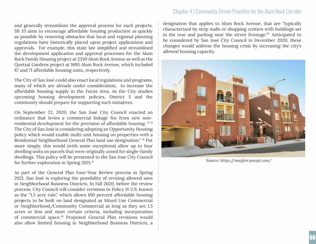
Chapter 4 | Community-Driven Priorities for the Alum Rock Corridor
66
and generally streamlines the approval process for such projects. SB 35 aims to encourage affordable housing production as quickly as possible by removing obstacles that local and regional planning regulations have historically placed upon project applications and approvals. For example, this state law simplified and streamlined the development application and approval processes for the Alum Rock Family Housing project at 2350 Alum Rock Avenue as well as the Quetzal Gardens project at 1695 Alum Rock Avenue, which included 87 and 71 affordable housing units, respectively.
The City of San José could also enact local regulations and programs, many of which are already under consideration, to increase the affordable housing supply in the Focus Area. As the City studies upcoming housing development policies, District 5 and the community should prepare for supporting such initiatives.
On September 22, 2020, the San José City Council enacted an ordinance that levies a commercial linkage fee from new non-residential development for the provision of affordable housing. 12 13 The City of San José is considering adopting an Opportunity Housing policy which would enable multi-unit housing on properties with a Residential Neighborhood General Plan land use designation.” 14 Put more simply, this would (with some exceptions) allow up to four dwelling units on parcels that were originally zoned for single-family dwellings. This policy will be presented to the San Jose City Council for further exploration in Spring 2021.15
As part of the General Plan Four-Year Review process in Spring 2021, San José is exploring the possibility of revising allowed uses in Neighborhood Business Districts. In Fall 2020, before the review process, City Council will consider revisions to Policy H-2.9, known as the “1.5 acre rule,” which allows 100 percent affordable housing projects to be built on land designated as Mixed Use Commercial or Neighborhood/Community Commercial as long as they are 1.5 acres or less and meet certain criteria, including incorporation of commercial space.16 Proposed General Plan revisions would also allow limited housing in Neighborhood Business Districts, a
designation that applies to Alum Rock Avenue, that are “typically characterized by strip malls or shopping centers with buildings set in the rear and parking near the street frontage.”17 Anticipated to be considered by San José City Council in December 2020, these changes would address the housing crisis by increasing the city’s allowed housing capacity.
Source: https://mayfair.pwapt.com/

Chapter 4 | Community-Driven Priorities for the Alum Rock Corridor
67
During the surveys and interviews, community sanitation was among the top reported challenges. Furthermore, when asked what investments they would like in their neighborhood, interviewees and survey respondents commonly requested cleaner streets, parks, and gardens.
The City of San José already has some programs and plans in place to address the cleanliness of public spaces. The City of San José’s ActivateSJ Strategic Plan includes strategies to maintain and improve aging park infrastructure.18 The City of San José currently sweeps all its streets at least once per month, with major arterial and commercial streets receiving sweeping service up to four times per month.19 No parking signs are installed on streets where parked vehicles greatly impede efficient sweeping. Other than the main arterials such as Alum Rock Avenue and King Road, most streets within the Focus Area do not contain these signs. Interview and survey responses noted problems with vehicles parked long term or abandoned in areas where parking is not monitored or where current rules are not enforced. To decrease litter and increase cleanliness of
4.2 Quality and Upkeep of Public Streets and Parks
While many community members voiced appreciation for the Alum Rock Focus Area’s public spaces, they routinely reported problems with safety and cleanliness of the streets and parks as a concern. Ensuring the availability of safe spaces for outdoor recreation and local mobility is key to maintaining public health, especially amidst the COVID-19 pandemic. This section outlines community-identified priorities for safer streets and parks and connects them to associated improvements, policies, and tools.
Summary of Potential Strategies Addressing Street Safety and Cleanliness
• Revisit how street maintenance and repairs are prioritized
• Encourage developments to repair and maintain streets and sidewalks beyond the development frontage as part of conditional use, development agreement, or other mechanisms
• Establish a process that focuses on prompt removal of illegal dumping and management of trash from encampments.
• Create an “Adopt-a-Street” program modeled after the City’s existing “Adopt-a-Park” and “Adopt-a-Trail” program.
• Community and elected officials should coordinate outreach in pursuit of establishing a business improvement district for the commercial corridor.
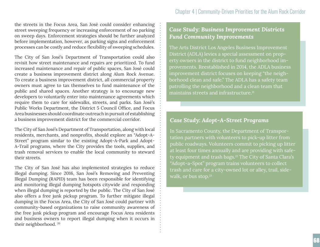
Chapter 4 | Community-Driven Priorities for the Alum Rock Corridor
68
the streets in the Focus Area, San José could consider enhancing street sweeping frequency or increasing enforcement of no parking on sweep days. Enforcement strategies should be further analyzed before implementation, however, as parking signs and enforcement processes can be costly and reduce flexibility of sweeping schedules.
The City of San José’s Department of Transportation could also revisit how street maintenance and repairs are prioritized. To fund increased maintenance and repair of public spaces, San José could create a business improvement district along Alum Rock Avenue. To create a business improvement district, all commercial property owners must agree to tax themselves to fund maintenance of the public and shared spaces. Another strategy is to encourage new developers to voluntarily enter into maintenance agreements which require them to care for sidewalks, streets, and parks. San José’s Public Works Department, the District 5 Council Office, and Focus Area businesses should coordinate outreach in pursuit of establishing a business improvement district for the commercial corridor.
The City of San José’s Department of Transportation, along with local residents, merchants, and nonprofits, should explore an “Adopt-A-Street” program similar to the existing Adopt-A-Park and Adopt-A-Trail programs, where the City provides the tools, supplies, and trash removal services to enable the local community to steward their streets.
The City of San José has also implemented strategies to reduce illegal dumping. Since 2016, San José’s Removing and Preventing Illegal Dumping (RAPID) team has been responsible for identifying and monitoring illegal dumping hotspots citywide and responding when illegal dumping is reported by the public. The City of San José also offers a free junk pickup program. To further mitigate illegal dumping in the Focus Area, the City of San José could partner with community-based organizations to raise community awareness of the free junk pickup program and encourage Focus Area residents and business owners to report illegal dumping when it occurs in their neighborhood. 20
Case Study: Business Improvement Districts Fund Community Improvements
The Arts District Los Angeles Business Improvement District (ADLA) levies a special assessment on prop-erty owners in the district to fund neighborhood im-provements. Reestablished in 2014, the ADLA business improvement district focuses on keeping “the neigh-borhood clean and safe.” The ADLA has a safety team patrolling the neighborhood and a clean team that maintains streets and infrastructure.21
Case Study: Adopt-A-Street Programs
In Sacramento County, the Department of Transpor-tation partners with volunteers to pick-up litter from public roadways. Volunteers commit to picking up litter at least four times annually and are providing with safe-ty equipment and trash bags.22 The City of Santa Clara’s “Adopt-a-Spot” program trains volunteers to collect trash and care for a city-owned lot or alley, trail, side-walk, or bus stop.23
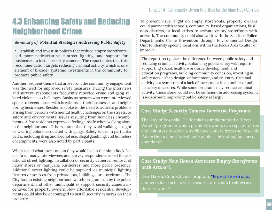
Chapter 4 | Community-Driven Priorities for the Alum Rock Corridor
69
4.3 Enhancing Safety and Reducing Neighborhood CrimeC
Another frequent theme that arose from the community engagement was the need for improved safety measures. During the interviews and surveys, respondents frequently reported crime and gang-re-lated violence as challenges. Business owners who were interviewed spoke to recent issues with break-ins at their businesses and neigh-boring businesses. Residents spoke to the need to address problems arising from persons with mental health challenges on the streets, or safety and environmental issues resulting from homeless encamp-ments. A few residents expressed feeling unsafe when walking alone in the neighborhood. Others stated that they avoid walking at night or wearing colors associated with gangs. Safety issues in particular parks, including drug and alcohol use, illegal gambling, and homeless encampments, were also noted by participants.
When asked what investments they would like in the Alum Rock Fo-cus Area, many interviewees and survey respondents asked for ad-ditional street lighting, installation of security cameras, removal of liquor stores or marijuana businesses, and more police presence. Additional street lighting could be supplied via municipal lighting fixtures or sources from private lots, buildings, or storefronts. The City has an existing neighborhood watch program run by the police department, and other municipalities support security camera in-centives for property owners. New affordable residential develop-ments could also be encouraged to install security cameras on their property.
Summary of Potential Strategies Addressing Public Safety
• Establish and invest in polices that reduce empty storefronts, add more pedestrian-scale street lighting, and support for businesses to install security cameras. The report notes that this recommendation targets reducing criminal activity, which is one element of broader systemic investments in the community to promote public safety.
Case Study: Security Camera Incentive Programs
The City of Roseville, California has implemented a “Keep Watch” program in which property owners can register a free and voluntary outdoor surveillance camera from the Roseville Police Department to enhance public safety along business corridors.24
The report recognizes the difference between public safety and reducing criminal activity. Enhancing public safety will require supporting social, health, workforce development, andeducation programs, building community cohesion, investing in safety nets, urban design, enforcement, and re-entry. Criminal activity is a symptom of a lack of investment in a number of pub-lic safety measures. While some programs may reduce criminal activity, these alone would not be sufficient in addressing systemic issues around improving public safety at large.
To prevent visual blight on empty storefronts, property owners could partner with schools, community-based organizations, busi-ness districts, or local artists to activate empty storefronts with artwork. The community could also work with the San José Police Department’s Crime Prevention through Environmental Design Unit to identify specific locations within the Focus Area to alter or improve.
Case Study: New Haven Activates Empty Storefronts with Artwork
New Haven, Connecticut’s program, “Project Storefronts,” connects local artists with vacant storefronts to showcase their artwork.25

Chapter 4 | Community-Driven Priorities for the Alum Rock Corridor
70
4.4. Mobility: Walking, Cycling, and Transit in the Alum Rock AreaDuring the community engagement process, most residents emphasized the importance of improving transportation options within the area. Eighty-nine percent of those who participated strongly agree or agree that the Focus Area would benefit from reduced traffic congestion, improved pedestrian safety, and better connections between the neighborhood and the rest of San José. Many people also expressed desire for reforms to parking, infrastructure, and pedestrian facilities, especially as new development projects come online along Alum Rock Avenue. While the COVID-19 pandemic and its impacts on business and the City of San José budget have rendered some of these improvements infeasible, we hope these strategies can guide investment decisions when opportunities arise.
4.4.1 Pedestrian Safety and Transit Equity
prog
ram in which property owners Study: Security can regior surveillance camera from the bRoseville Police Department to enhance public safety along business corri
Summary of Potential Pedestrian Safety Strategies
• Prioritize construction of safety enhancements and traffic-calming interventions at key intersections along Alum Rock Avenue (King Road, McCreery Avenue, Sunset Avenue, Jackson Avenue); as well as other major streets in the neighborhood (King Road, San Antonio Street, and McKee Road, Jackson Avenue).
• Prioritize implementing more frequent and shorter street crossings across Alum Rock Avenue.
• Redesign Alum Rock Avenue to be a “complete street,” streets that are safe for all members of the community of varying ages, backgrounds, and ability levels, and for all modes of transportation.
• Develop transit equity policies (e.g. service and capacity times, progressive fare policies, TOD with affordability and anti-displacement requirements, decriminalize fare evasion, etc.).
• Incentivize new developments to encourage their residents to use transit and advocate to enhance transit services along Alum Rock Avenue.
Many survey and interview participants expressed the need for safer pedestrian facilities in the Focus Area. About 50 percent of survey respondents asked for safer street crossings, and 32 percent requested well-designed sidewalks. To address these concerns, neighborhood improvements could include more frequent and shorter pedestrian crossings. The City of San José’s multimodal transportation improvement plan for East San José, En Movimiento: A Transportation Plan for East San José, includes plans for pedestrian crossings and other traffic calming infrastructure in the area.26
According to the plan, the City of San José plans to build pedestrian refuges, bulb-outs, and high visibility pedestrian crossings at Alum Rock and North 34th Street.27 Additionally, the San José Complete Streets Design Standards and Guidelines can inform crosswalk design.
To ensure equitable transit access within the Focus Area, Valley Transportation Authority (VTA) and the City of San José’s Office of Economic Development and Planning Division could partner to develop transit equity policies that improve transit service and capacity, implement progressive fare structures, require affordability and anti-displacement provisions within transit-oriented developments, and decriminalize fare evasion. Transit equity policies must consider affordability of residential and commercial developments because transit investment and transit equity policies are tied to land use decisions. The City of San José could also incentivize new developments to encourage transit ridership by providing subsidized transit passes or other incentives to their residents. District 5 and the community should continue to advocate for enhanced transit services as the City progresses on its mode-shift goals set in the Envision San José 2040 General Plan.

Chapter 4 | Community-Driven Priorities for the Alum Rock Corridor
71
4.4.2 Parkingprogram in which property owners can register
a free and voluntary out
The supply and ease of parking remains a concern for the commu-nity. This concern is made more complicated with a growing num-ber of homeless individuals living in their cars, and social distancing measures due to COVID-19, resulting in cars parking on streets for longer periods of time. Programs such as on street parking permits need to be carefully considered. New developments should minimize the impacts of parking on the surrounding neighborhood through a combination of sufficient parking for tenants, bicycle facilities, and incentives for transit use.
Definition of Complete Streets
The City of San José aims to create streets that are people-oriented, connected and resilient. The San José Complete Street Design Standards and Guidelines identify the following as key elements of complete streets: 28
• Mixed Flow Travel Lanes
• Bike Facilities
• Sidewalks
• Transit Facilities
• On-Street Parking
• Traffic Calming
• Stormwater Management / Green Streets
• Other Elements (Striping, Medians, etc.)
Summary of Potential Parking Strategies
• New development should not have significant impacts on the current parking supply and should provide adequate parking, incentives for transit use, and bike and active-transportation infrastructure.
• Conduct community outreach on and study impacts of parking permits in the neighborhood.
• Establish a parking benefits fund to direct funds raised from parking meters and permits to support local programs.
Case Study: Transit Equity Policies
In the report Inclusive Transit: Advancing Equity Through Improved Access & Opportunity, the TransitCenter out-lines recommendations to address inequities in access to transportation. These recommendations focus on transit service and capacity, fare policies, dialogues between tran-sit leadership and communities, capital projects, access to affordable housing, and the decriminalization of fare eva-sion.29
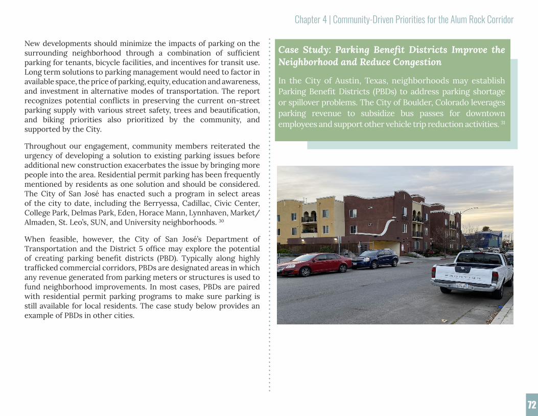
Chapter 4 | Community-Driven Priorities for the Alum Rock Corridor
72
New developments should minimize the impacts of parking on the surrounding neighborhood through a combination of sufficient parking for tenants, bicycle facilities, and incentives for transit use. Long term solutions to parking management would need to factor in available space, the price of parking, equity, education and awareness, and investment in alternative modes of transportation. The report recognizes potential conflicts in preserving the current on-street parking supply with various street safety, trees and beautification, and biking priorities also prioritized by the community, and supported by the City.
Throughout our engagement, community members reiterated the urgency of developing a solution to existing parking issues before additional new construction exacerbates the issue by bringing more people into the area. Residential permit parking has been frequently mentioned by residents as one solution and should be considered. The City of San José has enacted such a program in select areas of the city to date, including the Berryessa, Cadillac, Civic Center, College Park, Delmas Park, Eden, Horace Mann, Lynnhaven, Market/Almaden, St. Leo’s, SUN, and University neighborhoods. 30
When feasible, however, the City of San José’s Department of Transportation and the District 5 office may explore the potential of creating parking benefit districts (PBD). Typically along highly trafficked commercial corridors, PBDs are designated areas in which any revenue generated from parking meters or structures is used to fund neighborhood improvements. In most cases, PBDs are paired with residential permit parking programs to make sure parking is still available for local residents. The case study below provides an example of PBDs in other cities.
Case Study: Parking Benefit Districts Improve the Neighborhood and Reduce Congestion
In the City of Austin, Texas, neighborhoods may establish Parking Benefit Districts (PBDs) to address parking shortage or spillover problems. The City of Boulder, Colorado leverages parking revenue to subsidize bus passes for downtown employees and support other vehicle trip reduction activities. 31

Chapter 4 | Community-Driven Priorities for the Alum Rock Corridor
73
4.4.3 Bikeways
During the interviews, many parents recommended that bike lanes be installed within the Focus Area. According to San José Bike Plan 2025, the City plans to install shared (Class III) bikeways on Jose Figueres Avenue, connecting McKee Road and Alum Rock Avenue, and traditional (Class I) bike lanes from Silver Creek to East San Antonio Street past McKee Road and Alum Rock Avenue.32 These planned bikeways will serve as an alternative route to Alum Rock Avenue, which lacks a bike lane due to the BRT busway. Interviews with residents from neighborhoods to the east of the Focus Area emphasized the opportunity to create a bike lane along Alum Rock Avenue that would connect the Focus Area with Alum Rock Park.
To encourage and fund more safe and accessible bike facilities in the Focus Area, the City of San José could consider opportunities to incorporate street improvements into new development projects. The San José Department of Transportation (DOT) is currently exploring ways to accomplish this via their Multimodal Transportation Improvement Plans (MTIP). To increase access to bike parking, the City, community-based organizations, and local business associations could inform Focus Area businesses about the Department of Transportation’s free bike rack installation program. 33
Summary of Potential Strategies Addressing Bikeways
• Plan and build a bike network that factors in Alum Rock Avenue and the surrounding residential streets.
• Encourage existing businesses along Alum Rock Avenue and other major commercial corridors in the neighborhood to take advantage of the Department of Transportation’s free bike rack installation program.
4.4.4 High Vehicle Speeds
In the survey, more than half of respondents cited traffic, congestion, and speeding as pervasive problems. According to City of San José Department of Transportation staff members Peter Rice and Nick Frey, the Department of Transportation agrees that high vehicle speeds pose the greatest threat to safety within the area. 34
The City of San José has identified 17 Priority Safety Corridors, including Alum Rock Avenue, North Jackson Avenue, South King Road, and McKee Road, based on the analysis of traffic collision records in San José’s Vision Zero plan.35 Based on this data as well as feedback from the community, San José has conducted safety projects and outreach campaigns focused on reducing fatalities and injuries on roadways. The City also establishes the target speed, which is designed to regulate vehicle speeds consistent with the appropriate street classification within San José’s Complete Streets Design Guide.
North Jackson Avenue and McKee Road, which were identified as the least safe streets in the neighborhood by many survey and interview respondents, are classified as City Connector Streets with target speeds of 25-35 miles per hour (mph). Categorized as a Local Connector, South King Road adjacent to McKee Road has a target speed of 25-30 mph. The target speed of Alum Rock Avenue, designated a Grand Boulevard, is 25-40 mph.36 The City of San José considers treatments for streets that frequently exceed their target speed. Traffic calming elements, such as speed tables, raised crosswalks/interactions, and road humps, are often installed to lower speeds to the target.
Boulder, Colora
Summary of Potential Strategies to Reduce Vehicle Speeds
• Promote traffic calming measures through street design and education

Chapter 4 | Community-Driven Priorities for the Alum Rock Corridor
74
4.5 Activation of Social Gathering Spaces with Recreation and ArtMany survey and interview participants expressed their desire for more spaces and events where community members could gather and interact. Based on the survey and interview findings described in Chapter 3, the top priorities related to recreation were spaces for outdoor events and festivals, parks and recreational spaces, community- and youth-oriented programs, and community-ori-ented businesses.
While these priorities were derived from direct engagement with community members, it is important to note that the implementation of policies to support such spaces and programs may be severely impacted by the City of San José’s projected budget shortfall as a result of the COVID-19 pandemic Neighborhood groups, businesses, and community-based organizations will continue to lead the organization of outdoor events and programs.. When funding becomes available, the following sections may serve as a guide to understanding the community’s top recreational priorities and how existing policies, plans, and programs may be leveraged to achieve them.
Case Study: Neighborhood Program Calms Traffi
The City of Vancouver, Washington and the Traffic Safety Alliance developed a Neighborhood Traffic Calming Program to improve safety and walkability in residential neighborhoods. The program aims to address neighborhoods that have documented speed, safety, or traffic issues over the span of a year.37
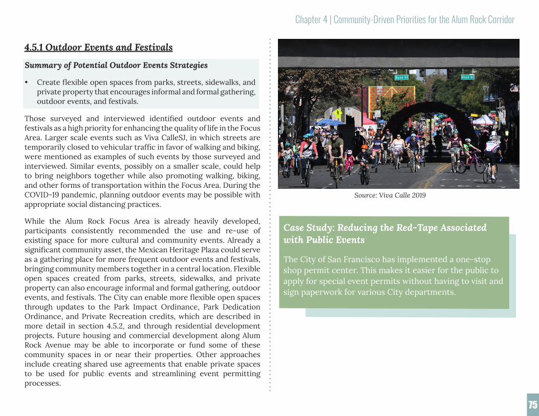
Chapter 4 | Community-Driven Priorities for the Alum Rock Corridor
75
4.5.1 Outdoor Events and Festivals
Those surveyed and interviewed identified outdoor events and festivals as a high priority for enhancing the quality of life in the Focus Area. Larger scale events such as Viva CalleSJ, in which streets are temporarily closed to vehicular traffic in favor of walking and biking, were mentioned as examples of such events by those surveyed and interviewed. Similar events, possibly on a smaller scale, could help to bring neighbors together while also promoting walking, biking, and other forms of transportation within the Focus Area. During the COVID-19 pandemic, planning outdoor events may be possible with appropriate social distancing practices.
While the Alum Rock Focus Area is already heavily developed, participants consistently recommended the use and re-use of existing space for more cultural and community events. Already a significant community asset, the Mexican Heritage Plaza could serve as a gathering place for more frequent outdoor events and festivals, bringing community members together in a central location. Flexible open spaces created from parks, streets, sidewalks, and private property can also encourage informal and formal gathering, outdoor events, and festivals. The City can enable more flexible open spaces through updates to the Park Impact Ordinance, Park Dedication Ordinance, and Private Recreation credits, which are described in more detail in section 4.5.2, and through residential development projects. Future housing and commercial development along Alum Rock Avenue may be able to incorporate or fund some of these community spaces in or near their properties. Other approaches include creating shared use agreements that enable private spaces to be used for public events and streamlining event permitting processes.
Case Study: Reducing the Red-Tape Associated with Public Events
The City of San Francisco has implemented a one-stop shop permit center. This makes it easier for the public to apply for special event permits without having to visit and sign paperwork for various City departments.
Summary of Potential Outdoor Events Strategies
• Create flexible open spaces from parks, streets, sidewalks, and private property that encourages informal and formal gathering, outdoor events, and festivals.
Source: Viva Calle 2019

Chapter 4 | Community-Driven Priorities for the Alum Rock Corridor
76
4.5.2 Parks and Recreation Centers
During the community engagement process, many participants underscored the important role of parks and public spaces within their neighborhood, echoing what was discovered during the assessment. Eighty-four percent of those surveyed strongly agreed or agreed that public space amenities should provide safe and accessible places for the community to connect, play, and live active lifestyles. Some interviewees cited the variety of public spaces, such as Mayfair Park and Community Center and Emma Prusch Park, as contributing to the family-friendly nature of the neighborhood. Out of a list of potential park and public space improvements, survey respondents identified outdoor exercise areas, playground or play equipment, community gardens and trails as top community priorities. A number of respondents asked for more parks or better maintenance and upgrades to existing infrastructure.
The survey also asked respondents what potential investments they would prefer to see in their neighborhood, and the top choice was open or green space. During the COVID-19 pandemic, providing the community with safe and accessible open space and recreational
opportunities is more important than ever. Potential improvements such as additional recreational space and open space can all contribute to the physical and mental health of residents.
The City of San José already has policies and plans in place that will help address these concerns. San José’s recreation plan, Activate SJ, establishes a goal of ensuring all residents can access a quality park within a 10-minute walk and documents plans to “create and lead a multi-department team to scour park-deficient neighborhoods for low-traffic streets, cul-de-sacs, areas along sound walls, and other underutilized publicly-owned space for conversion to parks and trails.”38 The Activate SJ Strategic Plan also includes plans to consider installing “smaller play features throughout...civic spaces.”39
San José’s Park Impact and Parkland Dedication Ordinances (SJMC 14.25 and 19.38) require that new residential developments pay an in-lieu fee, improve existing parks, or dedicate land for park space (3.5 acres of park land per 1,000 residents). In-lieu fees are distributed to a Park Trust Fund used to finance park-related projects and resources. Developers can also apply for Private Recreation Credits, allowing them to count the provision of “public and private residential on-site amenities” such as playgrounds, playing fields, plazas, swimming pools, and picnic spots towards up to 50 percent of their mandated parkland dedication or impact fee.40
As noted by Parks Planner Zak Mendez, the City of San José could encourage a proposed housing development, Sunset @ Alum Rock, to build a new park on Alum Rock Avenue.41 To meet the priorities that surfaced during the community engagement process, the City of San José should work with the developer to ensure that publicly-available outdoor exercise areas, playground equipment, and open space are integrated into the park.
As noted in Chapter 2, the City of San José’s Lower Silver Creek Master Plan details plans to construct a bike and pedestrian trail along Lower Silver Creek, which should provide valuable open space to the Alum Rock neighborhood. The trail would extend for about
Summary of Potential Strategies to Activate Parks and Recreation Centers
• Construct high-quality parks in the community, dispersed to ensure that all residents of the neighborhood are within a 10-minute walk to a park.
• Prioritize features in new parks and recreation centers, and redesign and improve features in existing parks and recreation centers to promote play, exercise, or outdoor community gatherings.
• Revisit the feasibility of completing the Lower Silver Creek Trail and organize City and community support for its completion.
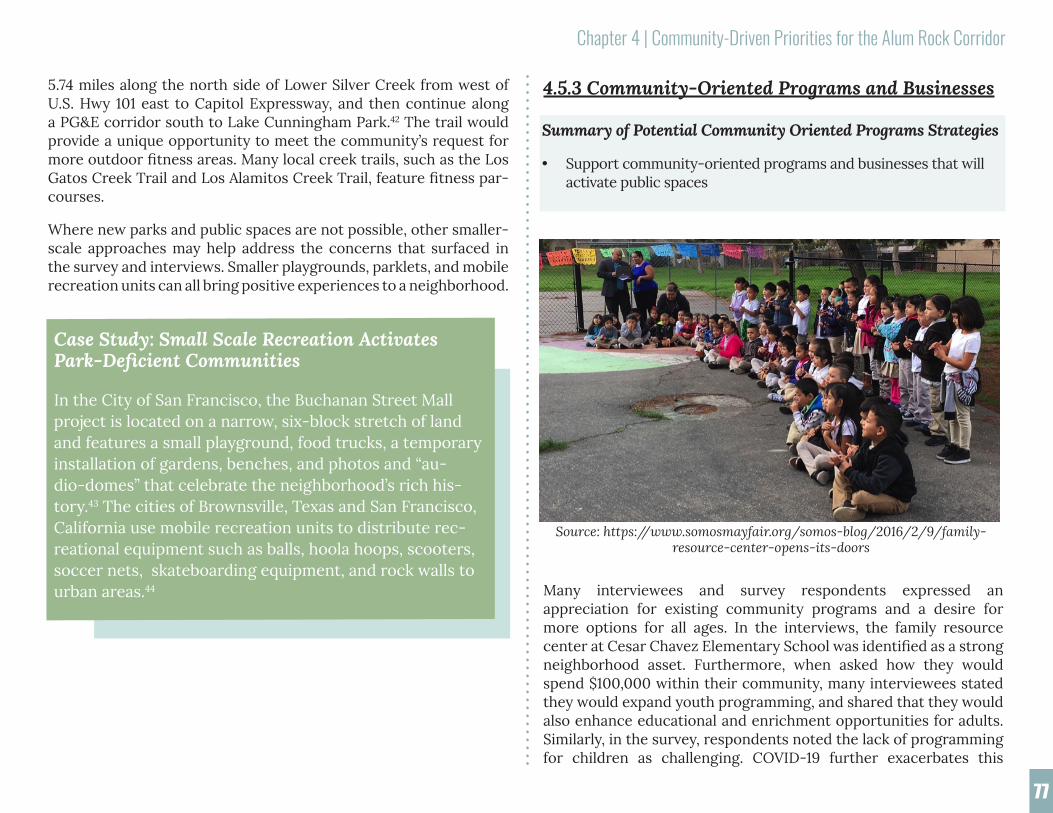
Chapter 4 | Community-Driven Priorities for the Alum Rock Corridor
77
4.5.3 Community-Oriented Programs and Businesses
Many interviewees and survey respondents expressed an appreciation for existing community programs and a desire for more options for all ages. In the interviews, the family resource center at Cesar Chavez Elementary School was identified as a strong neighborhood asset. Furthermore, when asked how they would spend $100,000 within their community, many interviewees stated they would expand youth programming, and shared that they would also enhance educational and enrichment opportunities for adults. Similarly, in the survey, respondents noted the lack of programming for children as challenging. COVID-19 further exacerbates this
5.74 miles along the north side of Lower Silver Creek from west of U.S. Hwy 101 east to Capitol Expressway, and then continue along a PG&E corridor south to Lake Cunningham Park.42 The trail would provide a unique opportunity to meet the community’s request for more outdoor fitness areas. Many local creek trails, such as the Los Gatos Creek Trail and Los Alamitos Creek Trail, feature fitness par-courses.
Where new parks and public spaces are not possible, other smaller-scale approaches may help address the concerns that surfaced in the survey and interviews. Smaller playgrounds, parklets, and mobile recreation units can all bring positive experiences to a neighborhood.
Case Study: Small Scale Recreation Activates Park-Deficient Communities
In the City of San Francisco, the Buchanan Street Mall project is located on a narrow, six-block stretch of land and features a small playground, food trucks, a temporary installation of gardens, benches, and photos and “au-dio-domes” that celebrate the neighborhood’s rich his-tory.43 The cities of Brownsville, Texas and San Francisco, California use mobile recreation units to distribute rec-reational equipment such as balls, hoola hoops, scooters, soccer nets, skateboarding equipment, and rock walls to urban areas.44
Summary of Potential Community Oriented Programs Strategies
• Support community-oriented programs and businesses that will activate public spaces
Source: https://www.somosmayfair.org/somos-blog/2016/2/9/family-resource-center-opens-its-doors

Chapter 4 | Community-Driven Priorities for the Alum Rock Corridor
78
problem as many schools and daycare centers have closed during the shelter-in-place order. These concerns could be addressed through expanded enrichment programs for children, adults, and seniors and additional educational after-school programs.
The City of San José has already made strides towards advancing recreational opportunities for all ages. The Activate SJ plan establishes the promotion of community spaces for a “Safe, Fun, and Healthy San José” as a guiding principle and sets many metrics to evaluate if programs are meeting the needs of residents of all ages and demographic groups.45 For example, the Alum Rock School District has an after-school enrichment program at San Antonio Elementary School from school dismissal until 6 p.m.46 To further these efforts, partnerships could be established with the school district, the Mayfair Community Center, or other organizations such as the YMCA, the Boys and Girls Club, local libraries (East San José Carnegie Branch Library, Educational Park Branch Library), the Si Se Puede Collective, or religious establishments to offer additional youth or adult programming and after-school enrichment opportunities. There are also a number of vacant storefronts along Alum Rock Ave which could also house a number of these services.
Another concern routinely voiced during the development of this report was the lack of youth-friendly (or more specifically, teen friendly) spaces in the Focus Area. When developing future public facilities and recreation centers, youth organizations (and the youths themselves) should be consulted for input on the design. See the case studies below for specific examples of these strategies in action in other cities.
As indicated in Chapter 3, the survey and interview findings emphasized that local businesses serve as assets and social gathering spaces within the Focus Area, aligning with findings from the community assessment portion of the report. When asked what changes they would like to see in the Focus Area, many residents stated that they wanted more sit-down restaurants and outdoor seating at food establishments and businesses.
The City of San José has some regulations in place to support outdoor dining. San José’s General Plan calls for promoting "the enjoyment of space developed for public use” and specifically mentions the inclusion of “sidewalk cafés, farmers markets, festivals, outdoor entertainment, pocket parks, street furniture, plazas, [and] squares.” Furthermore, San José’s municipal code (20.80.625) allows outdoor dining related to a retail or food establishment in all Main Street (MS) zones. In response to the COVID-19 pandemic, this application process has been made simpler and free of charge as part of the city’s Al Fresco Initiative. This program expires December 31, 2020.47 To further realize the community’s desire for more outdoor dining opportunities, San José could consider maintaining this expedited application process post-COVID-19 and/or provide incentives for developments that include outdoor seating or dining. San José is considering also allowing outdoor dining and other operations in streets, parking spaces, parks, plazas, and paseos in the future. See the case studies below for an example of these incentives.
In recent years, real estate speculation and rapid redevelopment have ignited fears of displacement among the business community. The COVID-19-induced economic downturn has further fueled this fear, causing many small businesses within the Focus Area to question their ability to ever reopen. Conversation with local business owners and business leaders suggested at least half of the existing small businesses in the Focus Area may close for good. Now more than ever, the Focus Area depends on the City and community leaders to develop policies and programs that prevent widespread business closures. Organizations such as the Alum Rock Santa Clara Street Small Business Association and the Alum Rock Business Network provide resources and advocate for small businesses within the community. The City of San José’s Small Business Ally Program also provides consulting and support to small businesses citywide.

Chapter 4 | Community-Driven Priorities for the Alum Rock Corridor
79
While these programs are vital to the success of businesses within San José, more must be done to ensure that businesses are able to remain in the face of this unprecedented economic crisis. To protect businesses from displacement as a result of future redevelopment or construction, the City of San José could implement relocation and “right to return” programs.
In addition to preserving the many small businesses that make the Alum Rock Focus Area so unique, residents are also concerned with the prevalence of many “vice” businesses (e.g. liquor stores, marijuana, payday loan businesses) and the lack of businesses that can more beneficially serve the community (e.g. grocery stores with fresh food and produce). Similarly, other community members suggested that the community would benefit from more farmers markets, which would both provide access to fresh food as well as provide opportunities for socializing.
San José has made it a priority to support more farmers’ markets, especially in neighborhoods that lack access to fresh produce. The San José Municipal Code (20.80.265) allows certified farmers' markets to operate in residential zoning districts at school sites, library sites, community center sites, or church/religious assembly sites. San José Municipal Code section 20.75.200 permits small certified farmers' markets to operate in MS zones and other certified farmers' markets to operate as a special use in MS zones. One of the goals in the Vibrant Neighborhoods section of Chapter 4 of the Envision San José 2040 General Plan encourages the location of full-service grocery stores and farmers markets. Additionally, the General Plan also gives priority to off-sale alcohol vendors which operate as full-service grocery stores. 48 These policies may be utilized by the community to advocate for better access to fresh food, while also preventing additional alcohol vendors from operating within the Alum Rock Focus Area.
Case Study: Encouraging Outdoor Dining and Farmers’ Markets
The City of San Luis Obispo provides incentives to developers that implement outdoor seating and dining. Incentives include reduced fees for application, encroachment, and parking as well as additional flexibility in required sidewalk width.49 Run by the nonprofit Fresh Approach, the East Palo Alto Community Farmers' Market is held weekly at the Ravenswood Family Health Center. The market offers incentive programs, the Fresh Checks and Market Match Program, for low income residents. Fresh Approach also runs a mobile farmers market that operates all over the Bay Area. 50
Case Study: Recreational Opportunities for Youth
The Parks, Recreation and Culture Services Department of the City of Coquitlam, Canada published a Youth Strategy report to guide their youth and adolescent programming. One of the key recommendations of the plan is consulting youth when designing recreation facilities.51 The City of Providence, Rhode Island offers a program called “Eat, Play, Learn PVD” each summer. This program provides free meals and other activities at parks as well as take-home “summer enrichment kits” in underserved communities.52
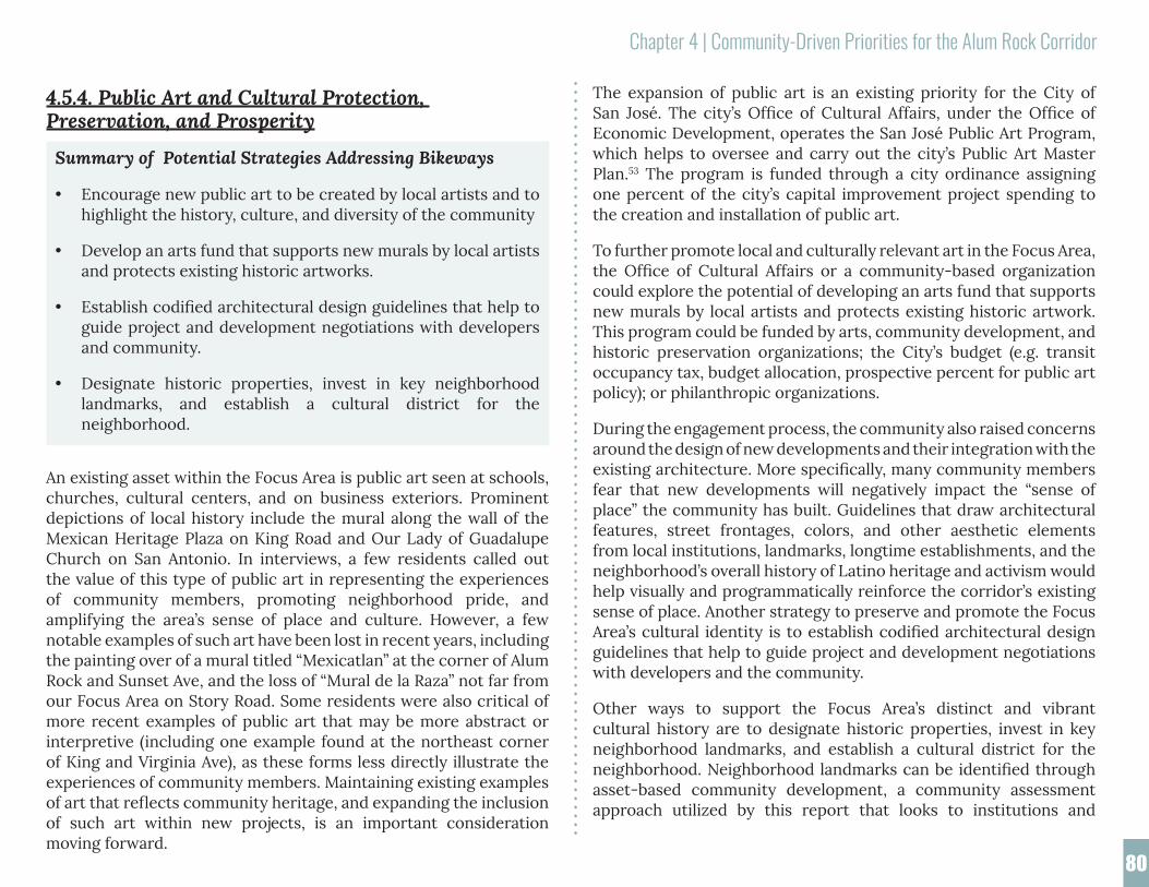
Chapter 4 | Community-Driven Priorities for the Alum Rock Corridor
80
The expansion of public art is an existing priority for the City of San José. The city’s Office of Cultural Affairs, under the Office of Economic Development, operates the San José Public Art Program, which helps to oversee and carry out the city’s Public Art Master Plan.53 The program is funded through a city ordinance assigning one percent of the city’s capital improvement project spending to the creation and installation of public art.
To further promote local and culturally relevant art in the Focus Area, the Office of Cultural Affairs or a community-based organization could explore the potential of developing an arts fund that supports new murals by local artists and protects existing historic artwork. This program could be funded by arts, community development, and historic preservation organizations; the City’s budget (e.g. transit occupancy tax, budget allocation, prospective percent for public art policy); or philanthropic organizations.
During the engagement process, the community also raised concerns around the design of new developments and their integration with the existing architecture. More specifically, many community members fear that new developments will negatively impact the “sense of place” the community has built. Guidelines that draw architectural features, street frontages, colors, and other aesthetic elements from local institutions, landmarks, longtime establishments, and the neighborhood’s overall history of Latino heritage and activism would help visually and programmatically reinforce the corridor’s existing sense of place. Another strategy to preserve and promote the Focus Area’s cultural identity is to establish codified architectural design guidelines that help to guide project and development negotiations with developers and the community.
Other ways to support the Focus Area’s distinct and vibrant cultural history are to designate historic properties, invest in key neighborhood landmarks, and establish a cultural district for the neighborhood. Neighborhood landmarks can be identified through asset-based community development, a community assessment approach utilized by this report that looks to institutions and
Summary of Potential Strategies Addressing Bikeways
• Encourage new public art to be created by local artists and to highlight the history, culture, and diversity of the community
• Develop an arts fund that supports new murals by local artists and protects existing historic artworks.
• Establish codified architectural design guidelines that help to guide project and development negotiations with developers and community.
• Designate historic properties, invest in key neighborhood landmarks, and establish a cultural district for the neighborhood.
4.5.4. Public Art and Cultural Protection, Preservation, and Prosperity
An existing asset within the Focus Area is public art seen at schools, churches, cultural centers, and on business exteriors. Prominent depictions of local history include the mural along the wall of the Mexican Heritage Plaza on King Road and Our Lady of Guadalupe Church on San Antonio. In interviews, a few residents called out the value of this type of public art in representing the experiences of community members, promoting neighborhood pride, and amplifying the area’s sense of place and culture. However, a few notable examples of such art have been lost in recent years, including the painting over of a mural titled “Mexicatlan” at the corner of Alum Rock and Sunset Ave, and the loss of “Mural de la Raza” not far from our Focus Area on Story Road. Some residents were also critical of more recent examples of public art that may be more abstract or interpretive (including one example found at the northeast corner of King and Virginia Ave), as these forms less directly illustrate the experiences of community members. Maintaining existing examples of art that reflects community heritage, and expanding the inclusion of such art within new projects, is an important consideration moving forward.

Chapter 4 | Community-Driven Priorities for the Alum Rock Corridor
81
4.6 Continuing the ConversationThe Spring 2020 graduate student team built upon the asset-based community development process begun by the May 2019 Futuro de Alum Rock community open house and the Fall 2019 team. Both of these outreach efforts resulted in the creation of a list of potential amenities identified by community members, which are shown in Figures 24 and 25.
Outreach to discuss desired neighborhood improvements in May and Fall of 2019 was initiated prior to the October 2019 passage of SB-330, the Housing Crisis Act of 2019, a state law that invalidated the City’s Amenities Framework, a legal mechanism that required developers to include community-serving amenities in their proposals.58 The amenities list developed during the outreach events nonetheless provides a valuable record of the community’s vision for future reference by community leaders, city staff, and elected officials.
Case Study: Promoting an Inclusive Public Art Process
Denver, Colorado’s Urban Arts Fund identifies areas prone to vandalizing or graffiti and organizes community youth to design, develop, and install murals on these affected areas. The fund has led to the creation of an additional 330 murals since
businesses currently supporting the community as a pathway to its future. Investments can come from existing businesses and property owners, developers, the City, nonprofits and philanthropy, or outside funding sources. Other ideas include expanding the programming and capacity of the Mexican Heritage Plaza, restoring or repurposing the Mexican American Community Service Agency (MACSA) site, or implementing storefront initiatives for long-time businesses.
The District 5 office, Office of Cultural Affairs, and community could collaborate to explore the potential of establishing a cultural district within the Focus Area. A cultural district would support and strengthen local heritage, arts, and cultural institutions, attract more economic activity, guide discussions around future development, and recognize the community’s contribution to the City’s brand and identity.54 Additionally, this would foster support for local businesses and community-based organizations as essential to protecting the history and community spirit of the neighborhood.
Case Study: Promoting an Inclusive Public Art Process
Denver, Colorado’s Urban Arts Fund identifies areas prone to vandalizing or graffiti and organizes community youth to design, develop, and install murals on these affected areas. The fund has led to the creation of an additional 330 murals since its inception in 2009.55 Denver is also home to a partnership between Historic Denver and the Chicano/a Murals of Colorado Project that has the specific goal of preserving existing murals in La Alma-Lincoln Park, a neighborhood known for its Latino cultural and historical roots.56 In San Diego, California, an area under a freeway bridge in a historic Mexican-American neighborhood was a flashpoint for organizing and demonstration in the early 1970s as the community fought to preserve a promise from the city to create a park in the space. That site became Chicano Park, now a National Historic Landmark known for towering murals that rise along the bridge’s enormous concrete supports.57

Chapter 4 | Community-Driven Priorities for the Alum Rock Corridor
82
The Spring 2020 engagement process occurred during the COVID-19 pandemic. Since the Amenities Framework could no longer be implemented, the engagement pivoted slightly to instead emphasize priorities for development, focusing on improvements that could be supported through public or private development and policies. The survey and interviews asked residents what changes they would most like to see in their community based on their experience prior to the pandemic. We found substantially consistent responses from all of the community engagement work that took place during the one-year period of this research. This is discussed below, and community priorities are presented in Figure 25.
At the base of the pyramid is the issue of affordability for residents and businesses, a critical concern voiced frequently and consistently since the start of our engagement work in May 2019. Residents and business owners want to be able to stay in the neighborhood and take ownerships over its growth and evolution. Addressing fears of displacement, according to many people we spoke with, would most directly impact resident quality of life and well-being. Put another way, anti-displacement policy for residents and businesses undertaken at the city- and state-level must serve as the foundation for all other desired neighborhood improvements.
Improving neighborhood safety related to issues of crime and extrajudicial activities follows affordability as one of the most frequently cited concerns within the Focus Area. Improvements to public space or mobility will not realize their full potential if community members do not feel safe in these areas. Creating additional public spaces, such as parks, green space, and improving landscaping and other green elements on sidewalks and other public areas follows closely behind, along with addressing issues of cleanliness and litter throughout the neighborhood. Accessible and affordable programming for youth and family was a common request, with a particular focus on expanding extra-curricular programs for children and teens in the neighborhood as a means to address academic and economic inequities. Mobility improvements that mutually enhance pedestrian and cyclist safety and calm traffic
Figure 24: Potential Amenities List for Alum Rock Identified during the May 2019 Futuro de Alum Rock Open House

Chapter 4 | Community Community-Driven Priorities for the Alum Rock Vision
Figure 25: Potential Amenities List for Alum Rock Identified through the Fall 2019 Engagement Proces
83

Chapter 4 | Community-Driven Priorities for the Alum Rock Corridor
84
Figure 26: Spring 2020 Community Priorities Pyramid
forms the next tier of the pyramid. Potential updates to current street design should also consider local demands around access to parking and enforcement of parking regulations. Finally, programming and design of public spaces should serve to help develop social connections between community members and elevate the cultural heritage of the community.
4.7 Comparing Community PrioritiesDuring the community engagement process, the student team employed different methods to ask Focus Area residents the same fundamental questions about what they appreciated in their community and how they would like to see it improve. Despite COVID-19 significantly disrupting the lives of those who participated, the responses remain largely similar: people living in the Focus Area want to see protections against displacement of residents and locally owned small businesses, safer and cleaner streets and parks, traffic calming and enhanced pedestrian and bicycle facilities, an expansion of “healthy” businesses (particularly grocery stores), and arts and cultural programs that serve youth of all ages and contribute to a sense of heritage.
Differences between the three rounds of engagement are subtle. For example, the amenities list from the Futuro de Alum Rock event called for “dedicated space for food vendors and trucks” and “development of commercial space for small businesses.” Fall 2019 and Spring 2020 student teams noted similar support for small businesses that directly serve the needs of families. While a consensus seems to have formed, the engagement process remains incomplete because many residents and organizations have not yet been sufficiently engaged in these conversations. These groups may provide additional information and will help refine and perhaps expand the community agenda.
Affordability and Financial Support for Residents and Business
Safety
Youth and Family Programming
Street Design and Mobility
Clean, Green, and Open Public Space
Culture and Connectedness
• Community Events• Public Art
• Traffic Speed Reductions• Parking for Residents & Businesses• Bike Facilities• Safer Crossing and Sidewalks Improvements
• After-School Activities for Youth• Art & Educational Programs for Families• Youth & Family-Oriented Businesses
• Maintenance & Cleaning of Public Spaces• Parks & Outdoor Exercises Space• Urban Trails & Green Space• More Street Streets
• Improved Security & Policing• Better Lighting in Select Areas
• Affordable Housing• Local Preference• Business Rent &Relocation Support
The final chapter, Reflections and Next Steps, concludes the report by thinking about how community engagement might be carried forward.

Chapter 4 | Community-Driven Priorities for the Alum Rock Corridor
85
Endnotes1. U.S. Census Bureau, Household Income Profile, accessed March 16, 2020 through communityanalyst.arcgis.com.2. City of San José, “Citywide Anti-Displacement Strategy,” Housing Department, last modified January 15, 2020, accessed May 8, 2020, https://www. sanjoseca.gov/your-government/departments-offices/housing/resource-library/housing-policy-plans-and-reports/citywide-anti-displacement-strat egy.3. City of San José, City Council Meeting Agenda September 22,2020, https://sanjose.legistar.com/DepartmentDetail.aspx?ID=21676&GUID=AC CCCFF5-F14A-4E1A-8540-9065F45A8A90. 4. Institute for Local Self Reliance, Affordable Space How Rising Commercial Rents Are Threatening Independent Businesses, and What Cities Are Doing About It, April 7, 2016, accessed September 25, 2020, https://cdn.ilsr.org/wp-content/uploads/2018/03/ILSR-AffordableSpace-FullReport.pdf.5. Castro/Upper Market Community Benefit District, Castro and Upper Market Retail Strategy, June 2015, 4-5, accessed September 25, 2020, http:// castrocbd.org/wp-content/uploads/2015-Retail-Strategy_ONLINE_Final-1-1.pdf.6. City of Berkeley, Staff Report: Planning Commission Meeting, April 20, 2016, https://www.cityofberkeley.info/uploadedFiles/Planning_and_Devel opment/Level_3_-_Commissions/Commission_for_Planning/2016-04-20_Item%2011_Elmwood%20Commercial%20District%20Quota%20Revi sions-Combined(2).pdf. 7. “Policy Basis For Formula Retail (Chain Stores)”, San Francisco Planning Department, https://sfplanning.org/project/policy-basis-formula-re tail-chain-stores.8. City of Seattle, Affirmative Marketing and Community Preference, accessed March 28, 2019, https://www.seattle.gov/Documents/Departments/ Housing/Footer%20Pages/Policy%20Update/AandFPublicDraft3282019.pdf.9. San Francisco Chornicle, “Neighborhood-preference program for affordable housing proves effective,” March 7, 2019, accessed May 15, 2020, https://www.sfchronicle.com/bayarea/article/Neighborhood-preference-program-for-affordable-13668858.php.10. Miriam Zuk et. al, “Safeguarding against Displacement: Stabilizing Transit Neighborhoods,” 2019, accessed September 1, 2020, https://www.ur bandisplacement.org/sites/default/files/images/zuk_safeguarding_chapter_full.pdf.11. Miriam Zuk et. al, Safeguarding against Displacement: Stabilizing Transit Neighborhoods, 2019, accessed May 20, 2020, https://www.urbandisplace ment.org/sites/default/files/images/zuk_safeguarding_chapter_full.pdf12. City of San José, City Council Meeting Agenda, September 22, 2020, https://sanjose.legistar.com/DepartmentDetail.aspx?ID=21676&GUID=AC CCCFF5-F14A-4E1A-8540-9065F45A8A90. 13. City of San José, “Information Memorandum: Commercial Linkage Fee Status Update,” accessed August 26, 2020, https://www.sanjoseca.gov/ Home/Components/News/News/1607/.14. City of San José, “Opportunity Housing,” accessed September 4, 2020, https://www.sanjoseca.gov/your-government/departments-offices/plan ning-building-code-enforcement/planning-division/citywide-planning/envision-san-jos-2040-general-plan/general-plan-4-year-review/opportuni ty-housing.15. City of San José, “Opportunity Housing,” accessed August 8, 2020.16. City of San José, “Memorandum: Envision San José 2040 4-Year Review Task Force Meeting,” June 25, 2020, accessed September 4, 2020, https:// www.sanjoseca.gov/home/showdocument?id=59870.

Chapter 4 | Community-Driven Priorities for the Alum Rock Corridor
86
17. City of San José, “Memorandum: Envision San José 2040 4-Year Review Task Force Meeting,” December 18, 2019, 10, accessed September 4, 2020, https://www.sanjoseca.gov/home/showdocument?id=47777. 18. City of San José, “ActivateSJ Strategic Plan (2020-2040),” 2019, 20, accessed May 7, 2020, https://www.sanjoseca.gov/home/showdocu ment?id=32533.19. City of San José, “Street Sweeping,” accessed May 7, 2020,https://www.sanjoseca.gov/your-government/departments/transportation/roads/ street-sweeping.20. City of San José, “Illegal Dumping,” accessed September 4, 2020, https://www.sanjoseca.gov/your-government/environment/illegal-dumping-lit ter/illegal-dumping/city-initiatives-to-combat-illegal-dumping.21. Arts District Los Angeles, “BID Overview,” accessed September 4, 2020, Los Angeles - https://artsdistrictla.org/about/bid-overview/. 22. County of Sacramento, Adopt -A-Street,” accessed September 4, 2020, https://sacdot.saccounty.net/Pages/Adoptastreet.aspx#:~:text=Communi ty%20benefits%20of%20the%20Adopt,cleanup%20other%20streets%20more%20frequently.23. City of Santa Clara, “Adopt-a-Spot Program,” accessed September 4, 2020, https://www.santaclaraca.gov/our-city/departments-g-z/public-works/ environmental-programs/adopt-a-spot-program.24. City of Roseville, “Keep Watch – Surveillance Camera Registry,” accessed September 8, 2020, https://www.roseville.ca.us/government/depart ments/police_department/community_services/keep_watch_-_surveillance_camera_registry. 25. National Endowment for the Arts, “Project Storefronts,” accessed September 7, 2020. https://www.arts.gov/exploring-our-town/project-storefronts.26. City of San José, En Movimiento: A Transportation Plan for East San José, 2018, accessed May 20, 2020.27. City of San José, En Movimiento: A Transportation Plan for East San José, 2019, accessed September 7, 2020.29. City of San José, The San José Complete Street Design Standards and Guidelines, accessed May 20, 2020https://www.sanjoseca.gov/home/show document?id=3311330. City of San José, “Permit Parking,” accessed July 20, 2020, https://www.sanjoseca.gov/your-government/departments/transportation/parking/resi dential-permit-parking.31. Victoria Transport Policy Institute, “Parking Management: Comprehensive Implementation Guide,” 2020, accessed July 20, 2020, https://www. vtpi.org/park_man_comp.pdf. 32. City of San José, “East San José Multimodal Transportation Improvement Plan,” last modified March 2019, accessed March 15, 2020, https:// www.sanjoseca.gov/your-government/departments-offices/transportation/planning-policies/east-san-jos-mtip.33. City of San José, “Bike Parking,” https://www.sanjoseca.gov/your-government/departments-offices/transportation/walking-and-biking/bike-parking.34. Pete Rice and Nick Frey, “Eastside Transportation Planning,” Class lecture, San José State University, URBP-295 Course, April 22, 2020. 35. City of San José, “Vision Zero Action Plan,” last modified January, 2020, accessed March 10, 2020, chrome-extension://gphandlahdpffmccakmb ngmbjnjiiahp/https://www.sanjoseca.gov/home/showdocument?id=5185936. City of San José, “San José Complete Streets Design Standards & Guidelines,” accessed March 2nd, 2020. 37. City of Vancouver, “Washington, Neighborhood Traffic Calming Program,” accessed August 25, 2020, https://www.cityofvancouver.us/sites/de fault/files/fileattachments/public_works/page/8977/nhoodtrafficcalmingprogramdoc_final.pdf. 38. City of San José, ActivateSJ. 39, accessed May 12, 2020. 39. City of San José, ActivateSJ. 54, accessed May 12, 2020. 40. City of San José, Park Impact Ordinance, Parkland Dedication Ordinance, San José Municipal Code 14.25 and 19.38,

Chapter 4 | Community-Driven Priorities for the Alum Rock Corridor
87
41. Zak Mendez, “Parks, Recreation, and Community Services,” Class lecture, San José State University, URBP-295 Course, accessed April 22, 2020. 42. City of San José, “Lower Silver Creek Master Plan,” December 10, 2007, accessed May 10, 2020, https://www.sanjoseca.gov/home/showdocu ment?id=20669. 43. San Francisco Recreation and Parks, “Buchanan Street Mall Project,” accessed August 31, 2020, https://sfrecpark.org/1134/Buchan an-Street-Mall-Project. 44. City of Brownsville, “Mobile Recreation Unit,” accessed August 31, 2020, https://www.cob.us/1687/Mobile-Recreation-Unit; “Mobile Rec,” City of San Francisco, accessed August 31, 2020,https://sfrecpark.org/1243/Mobile-Rec.45. City of San José, Activate SJ, accessed May 10, 2020, https://www.sanjoseca.gov//home/showdocument?id=43503 46. Alum Rock Union School District, “After School Education and Safety Programs,” accessed April 22, 2020, https://www.arusd.org/departments/ instructional-services/state-and-federal/after-school-education-and-saftey-programs 47. City of San José, "San José Al Fresco," accessed August 27, 2020, https://www.sjeconomy.com/why-san-jose/covid-19-guidance/sj-alfresco-initiative48. City of San José, “Envision San José 2040 General Plan - Quality of Life - Goal VN-3 Access to Healthful Foods,”Chapter 4, page 6, Accessed May 8, 2020.49. City of San Luis Obispo, “Sidewalk Dining,” accessed August 31, 2020, https://www.slocity.org/home/showdocument?id=4310. 50. Fresh Approach, “East Palo Alto Community Farmers’ Market,” accessed August 31, 2020, https://www.freshapproach.org/epa-farmers-market/.51. City of Coquitlam, Canada, Youth Strategy, 22, https://www.coquitlam.ca/docs/default-source/recreation-parks-culture-documents/strategy.pdf ry, accessed August 19, 2020.52. City of Providence, “Eat Play Learn PVD,” accessed September 20, 2020, https://eatplaylearnpvd.com/.53. City of San José, “About the Public Art Program,” accessed September 20, 2020, https://www.sanjoseca.gov/your-government/departments/of-fice-of-cultural-affairs/public-art/about-public-art.54. Americans for the Arts, " National Cultural Districts Exchange Toolkit,” accessed September 20, 2020, https://www.americansforthearts.org/ by-program/reports-and-data/toolkits/national-cultural-districts-exchange-toolkit#:~:text=Cultural%20districts%20are%20defined%20 as,and%20deepen%20local%20cultural%20capacity.55. Denver Public Art, “Urban Arts Fund,” accessed September 20, 2020, https://denverpublicart.org/urban-arts-fund56. Chicano/a Murals of Colorado Project, “Historic Denver Project Update,” accessed September 20, 2020, https://chicanomuralsofcolorado.com/ conservation/historic-denver-project-update/57. City of San Diego, “Chicano Park,” accessed September 20, 2020, https://www.sandiego.org/articles/parks-gardens/chicano-park.aspx58. Martina Davis and Jennifer Piozet, “San José Planning & Changing State Laws,” Class lecture, San José State University, San José, CA, February 19, 2020.

88
5.1 Summary of Key FindingsThis report identified the Alum Rock Focus Area’s existing assets as well as the priorities of its residents, business owners, and community members. A well-connected community with a history of advocacy, the Focus Area boasts many physical, cultural and social assets that can be leveraged to achieve the community’s vision for future development in the neighborhood. The Focus Area’s primary assets include:
• a network of active community-based organizations
• proximity to public parks and recreational opportunities (e.g. the Mexican Heritage Plaza, the Mayfair Community Center and Community Garden, and Plata Arroyo Park)
• many diverse, family-owned businesses
• multimodal transportation options
The neighborhood also grapples with daunting challenges, particularly related to growing threats of displacement and rising housing and business costs, persistent concerns about public safety and sanitation, unsafe transportation conditions, and a shortage of recreational opportunities. Nonetheless, based on our engagement with the hard-working and dedicated residents and business owners in the Focus Area, we remain confident that the community’s decades-long history of activism and strong partnerships will ensure that important conversations on these challenges remain front and center. Meaningful and equitable change that uplifts the community is within grasp.
Based on the feedback received during the outreach process, this report presents a list of community-identified priorities focused on affordability and displacement, quality and upkeep of public streets and parks, safety and reducing neighborhood crime, mobility, and activation of social gathering spaces with recreation and art.
This chapter reflects on the findings to date and considers opportunities for future research and outreach.
Chapter 5
Reflections and Next Steps
Chapter 5 | Reflections and Next Steps
89
• Prevent Resident and Business Displacement
• Increase Access to Affordable Housing
• Enhance Cleanliness and Safety of Parks, Streets, and Gardens
• Improve Pedestrian and Bicyclist Safety
• Decrease Vehicle Speeds
• Address Parking Shortages
• Make More Space for Recreation Centers and Outdoor Events and Festivals
• Expand Access to Open Space and Parks
• Increase Access to Grocery Stores, Farmers’ Markets, and Outdoor Dining
• Offer More Youth and Teen Programming
• Support Local and Culturally Relevant Public Art
5.2 Next Steps5.2.1 Opportunities for Future EngagementOutreach conducted throughout 2019 and 2020 has yielded greater clarity on the community’s priorities for the future development of the Alum Rock Focus Area. Continued engagement would further focus improvements to those that would most benefit residents and businesses. Some suggested next steps include:
• Strengthen the approved Alum Rock Urban Village Plan to reflect existing neighborhood assets, community priorities, visions for future development, and documented evidence of a robust community engagement process.
• Expand engagement to specific resident groups whose perspectives may not have been heard yet, such as local organizers or landlords that live in the Focus Area;
• Consider how urban development in neighboring District 3, containing Five Wounds and Brookwood Terrace, might overlap. The CommUniverCity-sponsored Community Leadership Program, based in District 3, may provide information that could support an analysis of solutions that impact many neighborhoods;
• Explore the impact of county-, regional- and state-level policies when analyzing potential solutions to issues raised by residents.1
• Investigate policy tools and financial and management structures that might be appropriate for helping community organizations respond to macro-level forces of community change. Such tools may include the establishment of cultural districts, community land trusts, and cooperative or worker-owned businesses.
• Develop proposals for interdisciplinary projects, such as analyzing public financing options with accounting students or developing low-cost lighting solutions with electrical engineering students. These proposals could involve stakeholders and participants outside of SJSU.
5.2.2 Actions for the Focus Area and City of San JoséThe City of San José and/or community groups within the Focus Area could take a few key actions towards achieving these community-identified priorities:
• Identify how the strategies listed in Chapter 4 relate, or can be tied, to existing projects (e.g. can the displacement prevention/ affordability priorities be reflected or addressed in housing policies currently under consideration?)
• Communicate these priorities with developers constructing new projects with the Focus Area to determine if any can be incorporated into new development.

Chapter 5 | Reflections and Next Steps
90
• Engage community-based organizations about upcoming developments and policies under consideration that may impact the Focus Area. The August 2020 Zoom-based community dialog on the SiliconSage project is a prime example of such broad-based engagement.
• Evaluate recommendations through a framework of community priority, completion feasibility, and equity, and begin progress on them. Follow-through of projects and open communication with the community would also allow for a more cohesive community-government relationship.
5.3 ConclusionThis report summarizes and reflects on the preferences and concerns voiced by the community throughout the Futuro de Alum Rock process, ultimately presenting a prioritized list of improvements that may be provided through future developments within Alum Rock Focus Area. The priorities and assets identified in this report can play a part in community-led visioning for the future of the Alum Rock Focus Area.
During the interviews and surveys, participants repeatedly emphasized their fondness for their home neihgborhood, with many specifically calling out landmarks, organizations, and the sense of
Endnotes1. Melanie Pothier, Nishan Zewge-Abubaker, Madelaine Cahuas, Carla Borstad Klassen, Sarah Wakefield, “Is ‘Including them’ enough? How narratives of race and class shape participation in a resident-led neighborhood revitalization initiative,” Geoforum 98 (2019): 162. Doi: https://doi. org/10.1016/ geoforum.2018.11.009
community as the reason they call the Alum Rock Focus Area home. Addressing these community priorities, whether it’s when City or grant funds become available or by leveraging future developments, will help realize the Focus Area as an affordable, safe, family-friendly, and culturally diverse place to live, work, and visit.

Appendices
A. History & Neighborhood Overviewi. Redlining in San José, Californiaii. Strong Neighborhoods Initiativeiii. Previous Engagement Effortsiv. Documentation of Past Community Discussions by Victor Vasquez of SOMOS Mayfairv. Pictorial Overview of Latino Urbanismvi. Planned Housing Projects In Alum Rock Focus Area
B. Summer 2020 Engagementvii. ALUM ROCK AVENUE AMENITIES SURVEY ALUM ROCK PUEBLO URBANO - ENCUESTA GENERALviii. Sample of Focus Group/ Interview Questions
C. Form-Based Code for Pedestrian Oriented Zoning Districtix. Part 1: Generalx. Part 2: Development Regulationsxi. Part 3: Use Regulationsxii. Part 4: General Regulationsxiii. Part 5 - Performance Standards
D. Community Statkeholdersxiv. Community Stakeholder List
91

92
A. History & Neighborhood Overview
i. Redlining in San José, California
Source: https://dsl.richmond.edu/panorama/redlining/#loc=4/37.76/-96.93
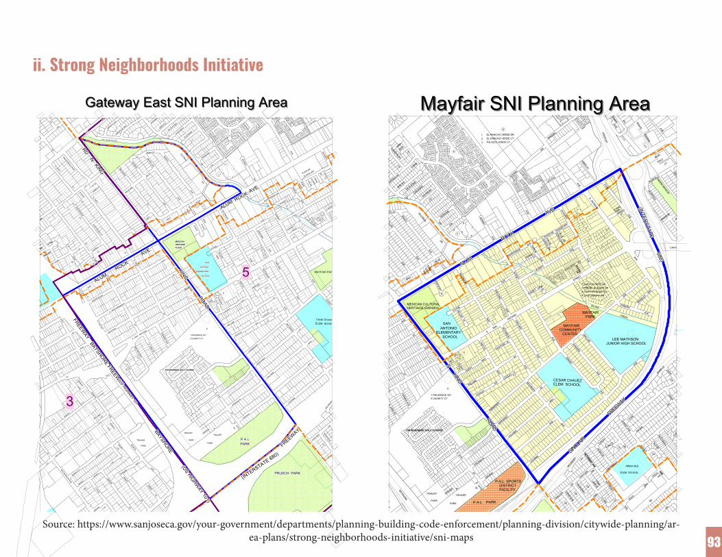
93
ii. Strong Neighborhoods Initiative
3
5
GOULAGOULAGOULAGOULGOULGOULGOULGOULGOUL
CALLECALLECALLE
CALLECALLE
CALLECALLECALLECALLEG
UAD-G
UAD-G
UAD-G
UAD-G
UAD-G
UAD-G
UAD-G
UAD-G
UAD-
WWW
GUAD-
GUAD-
GUAD-
GUAD-
GUAD-
GUAD-
GUAD-
GUAD-
GUAD-SARO
NSARO
NSARO
NSARO
NSARO
NSARO
NSARO
NSARO
NSARO
N
LAUSETT
LAUSETT
LAUSETTLAUSETT
LAUSETTLAUSETT
LAUSETT
LAUSETT
LAUSETT
VIADE
VIADE
VIADE
VIADE
VIADE
VIADE
VIADE
VIADE
VIADE
GUADALUPE
GUADALUPE
GUADALUPE
GUADALUPE
GUADALUPE
GUADALUPE
GUADALUPE
GUADALUPE
GUADALUPE
AVEAVEAVE
AVEAVE
AVEAVEAVEAVE
ALUPEALUPEALUPE
ALUPEALUPE
ALUPEALUPEALUPEALUPEALUPE
ALUPEALUPE
ALUPEALUPE
ALUPEALUPEALUPEALUPE
AVEAVEAVEAVEAVEAVEAVEAVEAVE
OAKLAND
OAKLAND
OAKLAND
OAKLAND
OAKLAND
OAKLAND
OAKLAND
OAKLAND
OAKLAND
SUNSET
SUNSET
SUNSETSUNSET
SUNSETSUNSET
SUNSET
SUNSETSUNSET
VIEWVIEWVIEWVIEWVIEWVIEWVIEWVIEWVIEW
CTCTCTCTCTCTCTCTCT
SUNSET
SUNSET
SUNSETSUNSET
SUNSETSUNSET
SUNSET
SUNSET
SUNSET
AVE.AVE.AVE.AVE.AVE.AVE.AVE.AVE.AVE.
SHORTRIDGE AVE
SHORTRIDGE AVE
SHORTRIDGE AVE
SHORTRIDGE AVE
SHORTRIDGE AVE
SHORTRIDGE AVE
SHORTRIDGE AVE
SHORTRIDGE AVE
SHORTRIDGE AVE
AVEAVEAVE
AVEAVE
AVEAVEAVEAVE
111111111
SUNSET
SUNSET
SUNSETSUNSET
SUNSETSUNSET
SUNSET
SUNSETSUNSET
CTCTCTCTCTCTCTCTCT
ROCKROCKROCKROCKROCKROCKROCKROCKROCK
MCCREERY
MCCREERY
MCCREERY
MCCREERY
MCCREERY
MCCREERY
MCCREERY
MCCREERY
MCCREERY
444444444
ALUMALUMALUMALUMALUMALUMALUMALUMALUMBLVD
BLVDBLVDBLVDBLVDBLVDBLVDBLVDBLVD
DRDRDRDRDRDRDRDRDR
KEN-KEN-KEN-
KEN-KEN-
KEN-KEN-KEN-KEN-TUCKY
TUCKYTUCKY
TUCKYTUCKY
TUCKYTUCKYTUCKYTUCKY
PLACEPLACEPLACE
PLACEPLACE
PLACEPLACEPLACEPLACE
RYRYRYRYRYRYRYRYRY
PRUSCH PARKPRUSCH PARKPRUSCH PARKPRUSCH PARKPRUSCH PARKPRUSCH PARKPRUSCH PARKPRUSCH PARKPRUSCH PARK
AVEAVEAVE
AVEAVE
AVEAVEAVEAVE
STOWE
STOWE
STOWESTOWE
STOWESTOWE
STOWE
STOWESTOWE
MAYFAIR PAR
Cesar ChavezELEM SCHOO
HELLERHELLERHELLER
HELLERHELLER
HELLERHELLERHELLER
HELLER
1 PRUDENCE WY1 PRUDENCE WY1 PRUDENCE WY1 PRUDENCE WY1 PRUDENCE WY1 PRUDENCE WY1 PRUDENCE WY1 PRUDENCE WY1 PRUDENCE WY
ANTONIOANTONIOANTONIOANTONIOANTONIOANTONIOANTONIOANTONIOANTONIO
2 CHARITY CT2 CHARITY CT2 CHARITY CT2 CHARITY CT2 CHARITY CT2 CHARITY CT2 CHARITY CT2 CHARITY CT2 CHARITY CT
ELEMENTARYELEMENTARYELEMENTARYELEMENTARYELEMENTARYELEMENTARYELEMENTARYELEMENTARYELEMENTARY
SCHOOLSCHOOLSCHOOLSCHOOLSCHOOLSCHOOLSCHOOLSCHOOLSCHOOL
KING
ROAD
KING
ROAD
KING
ROAD
KING
ROAD
KING
ROAD
KING
ROAD
KING
ROAD
KING
ROAD
KING
ROAD
TRAILERTRAILERTRAILERTRAILERTRAILERTRAILERTRAILERTRAILERTRAILER
PARKPARKPARKPARKPARKPARKPARKPARKPARK
VIRGINIA
VIRGINIA
VIRGINIA
VIRGINIA
VIRGINIA
VIRGINIA
VIRGINIA
VIRGINIA
VIRGINIA PLPLPLPLPLPLPLPLPL
STSTSTSTSTSTSTSTST
SSSSSSSSS34TH34TH34TH
34TH34TH
34TH34TH34TH34TH
FREEWAY
FREEWAY
FREEWAY
FREEWAY
FREEWAY
FREEWAY
FREEWAY
FREEWAY
FREEWAYP A LP A LP A LP A LP A LP A LP A LP A LP A LPARKPARKPARKPARKPARKPARKPARKPARKPARK
(INTERSTATE 680)
(INTERSTATE 680)
(INTERSTATE 680)
(INTERSTATE 680)
(INTERSTATE 680)
(INTERSTATE 680)
(INTERSTATE 680)
(INTERSTATE 680)
(INTERSTATE 680)
(USHIGHW
AY101)
(USHIGHW
AY101)
(USHIGHW
AY101)
(USHIGHW
AY101)
(USHIGHW
AY101)
(USHIGHW
AY101)
(USHIGHW
AY101)
(USHIGHW
AY101)
(USHIGHW
AY101)
TENNYSON
TENNYSON
TENNYSON
TENNYSON
TENNYSON
TENNYSON
TENNYSON
TENNYSON
TENNYSON
MCCREERY
MCCREERY
MCCREERY
MCCREERY
MCCREERY
MCCREERY
MCCREERY
MCCREERY
MCCREERY
DRDRDRDRDRDRDRDRDR
LNLNLNLNLNLNLNLNLN
AVEAVEAVE
AVEAVE
AVEAVEAVEAVE
SUNSET
SUNSET
SUNSET
SUNSET
SUNSET
SUNSET
SUNSET
SUNSET
SUNSET
LIDOLIDOLIDOLIDOLIDOLIDOLIDOLIDOLIDO
MARGARET
MARGARET
MARGARET
MARGARET
MARGARET
MARGARET
MARGARET
MARGARET
MARGARET
VOLLMER
VOLLMER
VOLLMER
VOLLMER
VOLLMER
VOLLMER
VOLLMER
VOLLMER
VOLLMER
KAMMERER
KAMMERER
KAMMERER
KAMMERER
KAMMERER
KAMMERER
KAMMERER
KAMMERER
KAMMERER
STSTSTSTSTSTSTSTST
WAYWAYWAYWAYWAYWAYWAYWAYWAY
AVEAVEAVEAVEAVEAVEAVEAVEAVE AVE
AVEAVE
AVEAVEAVEAVEAVEAVE
MCCREERY
MCCREERY
MCCREERY
MCCREERY
MCCREERY
MCCREERY
MCCREERY
MCCREERY
MCCREERY
LAVONNE
LAVONNE
LAVONNE
LAVONNE
LAVONNE
LAVONNE
LAVONNE
LAVONNE
LAVONNE
CHAUCER
CHAUCER
CHAUCER
CHAUCER
CHAUCER
CHAUCER
CHAUCER
CHAUCER
CHAUCER
MCCREERY
MCCREERY
MCCREERY
MCCREERY
MCCREERY
MCCREERY
MCCREERY
MCCREERY
MCCREERY
MAYFAIR
MAYFAIR
MAYFAIRMAYFAIR
MAYFAIRMAYFAIR
MAYFAIR
MAYFAIR
MAYFAIR
DRDRDRDRDRDRDRDRDR
STSTSTSTSTSTSTSTST
PLPLPLPLPLPLPLPLPL
AVEAVEAVE
AVEAVE
AVEAVEAVEAVE
AVEAVEAVE
AVEAVE
AVEAVEAVEAVE
OAKLAND
OAKLAND
OAKLAND
OAKLAND
OAKLAND
OAKLAND
OAKLAND
OAKLAND
OAKLAND
AVEAVEAVE
AVEAVE
AVEAVEAVEAVE
CTCTCTCTCTCTCTCTCT
COOLEY
COOLEY
COOLEYCOOLEY
COOLEYCOOLEY
COOLEY
COOLEYCOOLEY
WYWYWY
WYWY
WYWYWY
WY
S34TH
S34TH
S34TH
S34TH
S34TH
S34TH
S34TH
S34TH
S34TH
STSTSTSTSTSTSTSTST
VIRGINIAPL
VIRGINIAPL
VIRGINIAPL
VIRGINIAPL
VIRGINIAPL
VIRGINIAPL
VIRGINIAPL
VIRGINIAPL
VIRGINIAPL
VIRGINIA
VIRGINIA
VIRGINIA
VIRGINIA
VIRGINIA
VIRGINIA
VIRGINIA
VIRGINIA
VIRGINIA
111111111WAYWAYWAYWAYWAYWAYWAYWAYWAY
DUFFYDUFFYDUFFY
DUFFYDUFFY
DUFFYDUFFYDUFFYDUFFY
CTCTCTCTCTCTCTCTCT
DUFFYDUFFYDUFFYDUFFY
DUFFYDUFFYDUFFYDUFFYDUFFY
WILLIAM
WILLIAM
WILLIAMWILLIAM
WILLIAMWILLIAM
WILLIAM
WILLIAMWILLIAM
COOLEY
COOLEY
COOLEYCOOLEY
COOLEYCOOLEY
COOLEY
COOLEYCOOLEY
GGGGGGGGG
222222222
SANSANSANSANSANSANSANSANSAN
LYNETTE
LYNETTE
LYNETTE
LYNETTE
LYNETTE
LYNETTE
LYNETTE
LYNETTE
LYNETTE
WAY
WAY
WAY
WAY
WAY
WAY
WAY
WAY
WAY
GGGGGGGGG
AVEAVEAVE
AVEAVE
AVEAVEAVEAVE
AVEAVEAVE
AVEAVE
AVEAVEAVEAVE
EAST-EAST-EAST-
EAST-EAST-
EAST-EAST-EAST-EAST-
GATE
GATE
GATE
GATE
GATE
GATE
GATE
GATE
GATE
AVEAVEAVE
AVEAVE
AVEAVEAVEAVE
TRAILERTRAILERTRAILERTRAILERTRAILERTRAILERTRAILERTRAILERTRAILER
PARKPARKPARKPARKPARKPARKPARKPARKPARK
MEXICANMEXICANMEXICANMEXICANMEXICANMEXICANMEXICANMEXICANMEXICANHERITAGEHERITAGEHERITAGEHERITAGEHERITAGEHERITAGEHERITAGEHERITAGEHERITAGEPLAZAPLAZAPLAZAPLAZAPLAZAPLAZAPLAZAPLAZAPLAZA
AVEAVEAVEAVEAVEAVEAVEAVEAVE
AVEAVEAVEAVEAVEAVEAVEAVEAVE
STSTSTSTSTSTSTSTST
STSTSTSTSTSTSTSTST
PARMER
AVE
PARMER
AVE
PARMER
AVE
PARMER
AVE
PARMER
AVE
PARMER
AVE
PARMER
AVE
PARMER
AVE
PARMER
AVE
S31ST
S31ST
S31ST
S31ST
S31ST
S31ST
S31ST
S31ST
S31ST
STSTSTSTSTSTSTSTST
WHITTON
WHITTON
WHITTONWHITTON
WHITTONWHITTON
WHITTON
WHITTON
WHITTON
STSTSTSTSTSTSTSTST
SANANTO
NIO
SANANTO
NIO
SANANTO
NIO
SANANTO
NIO
SANANTO
NIO
SANANTO
NIO
SANANTO
NIO
SANANTO
NIO
SANANTO
NIOCTCTCTCTCTCTCTCTCT
S31ST
ST
S31ST
ST
S31ST
ST
S31ST
ST
S31ST
ST
S31ST
ST
S31ST
ST
S31ST
ST
S31ST
ST
S33RD
ST
S33RD
ST
S33RD
ST
S33RD
ST
S33RD
ST
S33RD
ST
S33RD
ST
S33RD
ST
S33RD
ST
THUNDERBIRD GOLF COURSETHUNDERBIRD GOLF COURSETHUNDERBIRD GOLF COURSETHUNDERBIRD GOLF COURSETHUNDERBIRD GOLF COURSETHUNDERBIRD GOLF COURSETHUNDERBIRD GOLF COURSETHUNDERBIRD GOLF COURSETHUNDERBIRD GOLF COURSE
E SANANTONIO
E SANANTONIO
E SANANTONIO
E SANANTONIO
E SANANTONIO
E SANANTONIO
E SANANTONIO
E SANANTONIO
E SANANTONIO
BAYSHOREFREEW
AY
BAYSHOREFREEW
AY
BAYSHOREFREEW
AY
BAYSHOREFREEW
AY
BAYSHOREFREEW
AY
BAYSHOREFREEW
AY
BAYSHOREFREEW
AY
BAYSHOREFREEW
AY
BAYSHOREFREEW
AY
ROCKROCKROCKROCKROCKROCKROCKROCKROCKSTSTST
STSTSTSTSTST
STSTSTSTSTSTSTSTST
N33RD
N33RD
N33RD
N33RD
N33RD
N33RD
N33RD
N33RD
N33RD
CTCTCTCTCTCTCTCTCTPERRY
PERRY
PERRYPERRY
PERRYPERRY
PERRY
PERRYPERRY
S34TH
S34TH
S34TH
S34TH
S34TH
S34TH
S34TH
S34TH
S34TH
S33RD
S33RD
S33RD
S33RD
S33RD
S33RD
S33RD
S33RD
S33RDALUM
ALUMALUMALUMALUMALUMALUMALUMALUM
AVE.AVE.AVE.AVE.AVE.AVE.AVE.AVE.AVE.
CTCTCTCTCTCTCTCTCT
BONITA
BONITA
BONITA
BONITA
BONITA
BONITA
BONITA
BONITA
BONITA
AVEAVEAVE
AVEAVE
AVEAVEAVEAVECTCTCTCT
CTCTCTCTCTWILLIAM
WILLIAM
WILLIAMWILLIAM
WILLIAMWILLIAM
WILLIAM
WILLIAM
WILLIAM AVEAVEAVE
AVEAVE
AVEAVEAVEAVE
USHIGHW
AY101
USHIGHW
AY101
USHIGHW
AY101
USHIGHW
AY101
USHIGHW
AY101
USHIGHW
AY101
USHIGHW
AY101
USHIGHW
AY101
USHIGHW
AY101
SHORTRIDGE
SHORTRIDGE
SHORTRIDGE
SHORTRIDGE
SHORTRIDGE
SHORTRIDGE
SHORTRIDGE
SHORTRIDGE
SHORTRIDGE
E SAN FERNANDO
E SAN FERNANDO
E SAN FERNANDO
E SAN FERNANDO
E SAN FERNANDO
E SAN FERNANDO
E SAN FERNANDO
E SAN FERNANDO
E SAN FERNANDO
AVEAVEAVEAVEAVEAVEAVEAVEAVE
S30TH
S30TH
S30TH
S30TH
S30TH
S30TH
S30TH
S30TH
S30TH
STSTSTSTSTSTSTSTST
AVEAVEAVEAVEAVEAVEAVEAVEAVE
STSTSTSTSTSTSTSTST
31STST
31STST
31STST
31STST
31STST
31STST
31STST
31STST
31STST
SSSSSSSSS
FREEWAY
FREEWAY
FREEWAY
FREEWAY
FREEWAY
FREEWAY
FREEWAY
FREEWAY
FREEWAY
STSTSTSTSTSTSTSTST
BONITA
BONITA
BONITA
BONITA
BONITA
BONITA
BONITA
BONITA
BONITAAVEAVEAVE
AVEAVE
AVEAVEAVEAVE
CTCTCTCTCTCTCTCTCT
PEACH
PEACH
PEACHPEACH
PEACHPEACH
PEACH
PEACHPEACH
STSTSTSTSTSTSTSTST
ST JOHN
ST JOHN
ST JOHNST JOHN
ST JOHNST JOHN
ST JOHN
ST JOHNST JOHN
STSTSTSTSTSTSTSTST
STSTSTSTSTSTSTSTST
STSTSTSTSTSTSTSTST
EEEEEEEEE
NNNNNNNNN
ILTONILTONILTONILTONILTONILTONILTONILTONILTON
32ND32ND32ND
32ND32ND
32ND32ND32ND32ND
STSTSTSTSTSTSTSTST
VIEW DR
VIEW DR
VIEW DRVIEW DR
VIEW DRVIEW DR
VIEW DR
VIEW DRVIEW DR
TTTMTMTMTMTMTMT
AM-AM-AM-AM-AM-
HAM-HAM-HAM-AM-
CTCTCTCTCTCTCTCTCT
WAYWAYWAYWAYWAYWAYWAYWAYWAY
TRAILERTRAILERTRAILERTRAILERTRAILERTRAILERTRAILERTRAILERTRAILER
PARKPARKPARKPARKPARKPARKPARKPARKPARK
BONITA
BONITA
BONITA
BONITA
BONITA
BONITA
BONITA
BONITA
BONITA
AVEAVEAVEAVEAVEAVEAVEAVEAVE
BAYSHORE
BAYSHORE
BAYSHORE
BAYSHORE
BAYSHORE
BAYSHORE
BAYSHORE
BAYSHORE
BAYSHORE
REMOREMOREMO
REMOREMO
REMOREMOREMOREMO
STSTSTSTSTSTSTSTST
STSTSTSTSTSTSTSTST
STSTSTSTSTSTSTSTST
AVEAVEAVEAVEAVEAVEAVEAVEAVE
LNLNLNLNLNLNLNLNLN
JASPER
JASPER
JASPER
JASPER
JASPER
JASPER
JASPER
JASPER
JASPER
BANFFBANFFBANFF
BANFFBANFF
BANFFBANFFBANFF
BANFF
LOTUSLOTUSLOTUS
LOTUSLOTUS
LOTUSLOTUSLOTUS
LOTUS
DANUBE
DANUBE
DANUBEDANUBE
DANUBEDANUBE
DANUBE
DANUBE
DANUBE
MCLAUGHLIN
MCLAUGHLIN
MCLAUGHLI
MCLAUGHLIN
MCLAUGHLI
MCLAUGHLIN
MCLAUGHLIN
MCLAUGHLI
MCLAUGHLIN
STSTSTSTSTSTSTSTST
APPIAN
APPIAN
APPIANAPPIAN
APPIANAPPIAN
APPIAN
APPIANAPPIAN
SILERSILERSILER
SILERSILER
SILERSILERSILERSILER
SUNNY
SUNNY
SUNNYSUNNY
SUNNYSUNNY
SUNNY
SUNNYSUNNY
CTCTCTCTCTCTCTCTCTCTCTCTCTCTCTCTCTCT
BONITA
BONITA
BONITA
BONITA
BONITA
BONITA
BONITA
BONITA
BONITAAVEAVEAVE
AVEAVE
AVEAVEAVEAVE
LNLNLNLNLNLNLNLNLN
SUNNY CT
SUNNY CT
SUNNY CT
SUNNY CT
SUNNY CT
SUNNY CT
SUNNY CT
SUNNY CT
SUNNY CT
SPIROSPIROSPIROSPIRO
SPIROSPIROSPIROSPIROSPIRO
DRDRDRDRDRDRDRDRDR
SUNNY CT
SUNNY CT
SUNNY CT
SUNNY CT
SUNNY CT
SUNNY CT
SUNNY CT
SUNNY CT
SUNNY CT
DRDRDRDRDRDRDRDRDR
SPIROSPIROSPIROSPIRO
SPIROSPIROSPIROSPIROSPIRO
DRDRDRDRDRDRDRDRDR
MACRMACRMAC
MACRMAC
MACRMACRMACMACR
STSTSTSTSTSTSTSTST
MCLAUGHLIN
AVE
MCLAUGHLIN
AVE
MCLAUGHLIN
AVE
MCLAUGHLIN
AVE
MCLAUGHLIN
AVE
MCLAUGHLIN
AVE
MCLAUGHLIN
AVE
MCLAUGHLIN
AVE
MCLAUGHLIN
AVE
PEACH CT
PEACH CT
PEACH CT
PEACH CT
PEACH CT
PEACH CT
PEACH CT
PEACH CT
PEACH CT
STSTSTSTSTSTSTSTST
WILLIAM
WILLIAM
WILLIAMWILLIAM
WILLIAMWILLIAM
WILLIAM
WILLIAM
WILLIAM
ERLYERLYERLYERLYERLYERLYERLYERLYERLY
WILSHIRE
WILSHIRE
WILSHIRE
WILSHIRE
WILSHIRE
WILSHIRE
WILSHIRE
WILSHIRE
WILSHIRE
AVEAVEAVE
AVEAVE
AVEAVEAVEAVE
STSTSTSTSTSTSTSTST
BEV-BEV-BEV-BEV-BEV-BEV-BEV-BEV-BEV-
EASTWOOD
EASTWOOD
EASTWOOD
EASTWOOD
EASTWOOD
EASTWOOD
EASTWOOD
EASTWOOD
EASTWOOD
MESMESMESMESMESMESMESMESMES
STSTSTSTSTSTSTSTST STSTSTST
STSTSTSTST
STSTSTSTSTSTSTSTST
N34TH
N34TH
N34TH
N34TH
N34TH
N34TH
N34TH
N34TH
N34TH
CTCTCTCTCTCTCTCTCT
EST
EST
EST
EST
EST
EST
EST
EST
EST
N34TH
N34TH
N34TH
N34TH
N34TH
N34TH
N34TH
N34TH
N34TH
EASTWOOD
CT
EASTWOOD
CT
EASTWOOD
CT
EASTWOOD
CT
EASTWOOD
CT
EASTWOOD
CT
EASTWOOD
CT
EASTWOOD
CT
EASTWOOD
CT
JAMES ST
JAMES ST
JAMES ST
JAMES ST
JAMES ST
JAMES ST
JAMES ST
JAMES ST
JAMES ST
SCHARFF
SCHARFF
SCHARFF
SCHARFF
SCHARFF
SCHARFF
SCHARFF
SCHARFF
SCHARFF
PLAZA DE
PLAZA DE
PLAZA DE
PLAZA DE
PLAZA DE
PLAZA DE
PLAZA DE
PLAZA DE
PLAZA DE
AVEAVEAVE
AVEAVE
AVEAVEAVEAVE
LUZ AVE
LUZ AVE
LUZ AVELUZ AVE
LUZ AVELUZ AVE
LUZ AVE
LUZ AVELUZ AVE
DEDEDEDEDEDEDEDEDE
SUNSET
SUNSET
SUNSETSUNSET
SUNSETSUNSET
SUNSET
SUNSET
SUNSET
ALALALEALALEALALALEAL
222222222
111111111
222222222
333333333
CIRCIRCIRCIRCIRCIRCIRCIRCIR
DRDRDRDRDRDRDRDRDR
CHECKERS
CHECKERS
CHECKERS
CHECKERS
CHECKERS
CHECKERS
CHECKERS
CHECKERS
CHECKERS
CTCTCTCTCTCTCTCTCT
PLATINUM
PLATINUM
PLATINUM
PLATINUM
PLATINUM
PLATINUM
PLATINUM
PLATINUM
PLATINUM
PERRONE
PERRONE
PERRONE
PERRONE
PERRONE
PERRONE
PERRONE
PERRONE
PERRONESILCREEK
SILCREEK
SILCREEK
SILCREEK
SILCREEK
SILCREEK
SILCREEK
SILCREEK
SILCREEK
FFFFFFFFF
222222222
ARROYO
ARROYO
ARROYO
ARROYO
ARROYO
ARROYO
ARROYO
ARROYO
ARROYO
DE PLATINA
DE PLATINA
DE PLATINA
DE PLATINA
DE PLATINA
DE PLATINA
DE PLATINA
DE PLATINA
DE PLATINAAVENIDA
AVENIDA
AVENIDA D
AVENIDA
AVENIDA D
AVENIDA
AVENIDA
AVENIDA D
AVENIDA
BALBOA
BALBOA
BALBOA
BALBOA
BALBOA
BALBOA
BALBOA
BALBOA
BALBOA
DRDRDRDRDRDRDRDRDR
BLVDBLVDBLVDBLVDBLVDBLVDBLVDBLVDBLVD
MAGELLAN
MAGELLAN
MAGELLAN
MAGELLAN
MAGELLAN
MAGELLAN
MAGELLAN
MAGELLAN
MAGELLAN
BASCH
BASCH
BASCHBASCH
BASCHBASCH
BASCH
BASCH
BASCH
STSTSTSTSTSTSTSTST
JAMES STJAMES STJAMES STJAMES STJAMES STJAMES STJAMES STJAMES STJAMES ST
RDRDRDRDRDRDRDRDRD
MCKMCKEMCKEMCKMCKEMCKMCKEMCKEMCKE
CALLE DE PLATACALLE DE PLATACALLE DE PLATACALLE DE PLATACALLE DE PLATACALLE DE PLATACALLE DE PLATACALLE DE PLATACALLE DE PLATA
MELROSE
MELROSE
MELROSE
MELROSE
MELROSE
MELROSE
MELROSE
MELROSE
MELROSE
MINAS DE ORO
MINAS DE ORO
MINAS DE ORO
MINAS DE ORO
MINAS DE ORO
MINAS DE ORO
MINAS DE ORO
MINAS DE ORO
MINAS DE OROARROYO
DE
ARROYODE
ARROYODE
ARROYODE
ARROYODE
ARROYODE
ARROYODE
ARROYODE
ARROYODE
MACDONALDAVE
MACDONALDAVE
MACDONALDAVE
MACDONALDAVE
MACDONALDAVE
MACDONALDAVE
MACDONALDAVE
MACDONALDAVE
MACDONALDAVE
DRDRDRDRDRDRDRDRDR
DRDRDRDRDRDRDRDRDR
BBBEBBEBBBEB
N34TH
N34TH
N34TH
N34TH
N34TH
N34TH
N34TH
N34TH
N34TH
LNLNLNLNLNLNLNLNLN
RDRDRDRDRDRDRDRDRD
NKING
NKING
NKING
NKING
NKING
NKING
NKING
NKING
NKING
Gateway East SNI Planning AreaGateway East SNI Planning Area
Prepared by the Department of Planning,Building and Code EnforcementPlanning Services DivisionApril 24, 2002
Scale: 1"= 500'
City Council District Boundary
Planning Area Boundary
RDA SNI Area
Freeways
Parks
Schools
WY MONTE
FIELDMUIR-
CT
VERANO
CT
FREEWAY
NANDO
(INTERSTATE 680)
(INTERSTATE 680)
(INTERSTATE 680)
(INTERSTATE 680)
(INTERSTATE 680)
(INTERSTATE 680)
(INTERSTATE 680)
(INTERSTATE 680)
(INTERSTATE 680)
E SAN
STFER-
BERKELEY
WAY
AVE
1 CASTLECREST DR2 PRINCE GEORGE DR3 CASTLEBRIDGE DR4 CASTLEBURY DR
AVE
GOULARTEMOOREDR
WY
AVE
S JACKSON
AVE.AVE.AVE.AVE.AVE.AVE.AVE.AVE.AVE. SCHARFF
ST
GUADALUPE
PLAZA DE
VIA DE
GUADALUPE
CALLE DE
GUADALUPE
AVE
AVE
OAKLAND
SUNSET VIEW
PL
LAUSETT
AVE
ROCKROCKROCKROCKROCKROCKROCKROCKROCK
SHORTRIDGE
AVE
SARON
SUNSETCT
PALACIO VERDE CT
1
A
1
2
3
ALUMALUMALUMALUMALUMALUMALUMALUMALUM
STOWE
MCCREERY
A
1
2
3
SILCREEK
F2
MEXICAN CULTURALHERTIAGE GARDEN
KENTUCKYPL
1
AVENIDA DE
COBRE
JAMES ST
WAY
MANDRIANBAL
DR
NAPLES
RDPOCO
WAY
AVE
MCCREERY
LUKE CTCHAUCER
DR
KING
LIDO
WAY
LN
TENNYSON
LN
THACKERAYLN
LINSONTOM-
P A L PARK
(INTE
RSTATE
680)
P.A.L. SPORTS DISTRICT FACILITY
PARK
TRAILERTRAILER
PARK
VIRGINIA PL
STS
34TH
(US HIGHWAY 101)
TRAILER
PARK
BAYSHORE
AVE
MANASSAS
STEIT
Z
ARBUCKLE
WYELEM SCHOOL
ALEXIS
CT
AVE
DOBERN AVE
AVE
DR
SIERRA MESA
AVE
CAPITOL
AVE
AVE
AVE
MUIRFIELD
MUIRFIELD
LENDRUM
SIERRA MEADOW
GEBHART
SUNSET
PACINA
LYONS
SUNSET AVE
NOTTOWAY
LN
POCO
AVE
LNDIANA
DIANABAMBI
LN
DR
DR
LEE MATHSONJUNIOR HIGH SCHOOL
SILVER CREEK
DR
CTMOSS DR
CINDERELLA
TURLEYTURLE
Y
SINCLA
IR
F
REEWAY
SINCLA
IR
F
REEWAY
SINCLA
IR
F
REEWAY
SINCLA
IR
F
REEWAY
SINCLA
IR
F
REEWAY
SINCLA
IR
F
REEWAY
SINCLA
IR
F
REEWAY
SINCLA
IR
F
REEWAY
SINCLA
IR
F
REEWAY
AVE
MCCREERY AVE
MCCREERY AVE
CHAUCER DR
MCCRE
ERY CT
AVE
SINCLAIR
SANDERS
SUNSET
CESAR CHAVEZELEM SCHOOL
MAYFAIRCOMMUNITY CENTER
SUNSET
E S
AN
ANTONIO
STREET
MAYFAIR PARK
MCCREERY
ST
AVE AVE
WAY
LAVONNE
VOLLMER
AVE
ST
MCCREERY
AVE
AVE
AVE
S KING ROAD
S KING ROAD
S KING ROAD
S KING ROAD
S KING ROAD
S KING ROAD
S KING ROAD
S KING ROAD
S KING ROAD
AVE
RIBBS LN
FOSS
AVE
MADDEN
DR
AVELUZ AVEALE
XIAN
SUNSET
AVE
1
4
EL RANCHO VERDE CT123
EL RANCHO VERDE DR
ARROYO
DE PLATIN
A
CTPLA
TINUM
PERRONE
DR
DR
BASCH
CIR
DR
CHECKERS
AVEAVE
AVE
AVEST
BLVD
EAST-
GATE
ERLYBEV-
CT
DIAM-
ENTE
CT
ESMERALDA
BLVD
MAGELLAN
TURQUESACT
OAKLAND
MAYFAIRPL
WILLIAM
COOLEYG
1 PRUDENCE WY2 CHARITY CT
KAMMERER
DR
CT
COOLEY
WAY
WAY
G
DUFFYCT
DUFFY
LYNETTE
MARGARET
S 34TH
ST
VIRGINIA PL
VIRGINIA
THUNDERBIRD GOLF COURSE
2
1
HELLERPL
SCHOOL
AVE
SANANTONIO
ELEMENTARY
E SAN ANTONIO
STPARM
ER AVE
ST
AVE
S 33RD ST
Mayfair SNI Planning AreaMayfair SNI Planning Area
Prepared: City of San Jose Department of Planning, Building and Code Enforcement Planning Services DivisionDate: 07/03/03
Scale: 1" = 550'
SNI Planning Area
RDA SNI Area
Schools Community Facilities
Parks
Source: https://www.sanjoseca.gov/your-government/departments/planning-building-code-enforcement/planning-division/citywide-planning/ar-ea-plans/strong-neighborhoods-initiative/sni-maps

94
iii. Previous Engagement Efforts

95
iv. Documentation of Past Community Discussions by Victor Vasquez of SOMOS MayfairCommunity Vision Notes, 2016-2019
• Summer 2016 200 residents voices Platform• Sept 22, 2016 Developer meeting• Jan 24, 2017 Developer meeting• Feb 25, 2017 Developer meeting• Mar 8, 2017 Developer meeting• May 22, 2017 Developer meeting• July 25 2018 Community meeting• Nov 29, 2018 Cafecito• Feb 20, 2019 Developer meeting
Larger Goals
• Advance a vibrant, self-sustaining East San José• Protect residents and businesses from displacement• Increase access and secure affordable commercial spaces for
small businesses• Investments into neighborhood infrastructure and public art• Establish an Urban Village Plan and Cultural Community Pres-
ervation for Mayfair (includes cultural district, access to land trusts, mural protection with an authentic community deci-sion-making process driving this effort.)
• Invest in accessible affordable housing development (20%-80% Area Median Income) that will offer local preference for resi-dents at risk of displacement.
• Pass a tenants’ rights policy that includes anti-harassment pro-tections, such as threats of physical harm or invasion of privacy. Prohibit discrimination against Section 8, immigration status and criminal history.
• Implement commercial linkage fees and community benefits packages that tax corporations and ensure equitable funding for community (affordable housing, social services, parks, libraries & other community needs).
On-Site Plazas/Privately Owned and Publicly Accessible Open Spaces (Popos)
• Mediterranean park style architecture• Colors - Replace red color with a more orange color on exterior
walls• Public plaza with stage and sitting
Commercial Space
• Prioritizing local b• usiness access• Commercial Space - Continue to coordinate closely with poten-
tial future tenants, including providing the shafts necessary for a commercial kitchen in the commercial space
Off street amenities (roadway/intersection improvements, connec-tions to transit, enhanced sidewalks or streetscapes, enhanced light-ing, landscaping, or street furniture.)
• Cross Walks - If not done with Bart improvements, consider four new enhanced crosswalks at N King and Alum Rock (will require City approval)
• Identified Crosswalks for community beautification• Fixing cracks and raised in Sidewalks and Crosswalks• Traffic Signs and alternative signs that are effective in neighbor-
hood• More speed bumps• Art - Coordinate closely with School of Arts to incorporate art
into the building• Art that represents the cities or community’s history and current
important moments• large windows with railings in lieu of French doors. We do not
advise hanging planter boxes on the railings because of water and maintenance issues.
• Art- Murals are part of our community and culture and create

96
• Creative ways to deal with parking (underground, parking hours)
• 2-hour parking in neighborhood on King• large windows with railings in lieu of French doors. We do not
advise hanging planter boxes on the railings because of water and maintenance issues.
Housing
• Long waitlist: how do we ensure local neighborhood preference• Opportunities for low- or moderate-income first-time home
buyers• Protections for families who rent• Affordable Housing• Juliette balcony keep eyes on the streets• exterior walls were set up so they could accommodate public
art.• Spanish style tiles were incorporated into the design.
Civic Engagement: Get Something done
• Families• Seniors• Youth
Organizations
• Alum Rock Union School District and/or East Side Union High School District
• Alum Rock Small Business Association• Amigos de Guadalupe (housing services)• Catholic Charities Senior Center (senior services)• City Team Ministries (youth services)• City- Housing• City- Planning• City- Police• City- PRNS and/or Mayfair Community Center
positive opportunities for friends and families to engage. Public art unifies, beautifies and allows people to express their emo-tions, identity, and ideas in a creative way for the benefit of current and future residents.
• Create new murals that are a representation of all populations in community
Open space amenities and park facilities (could include, but are not limited to, off-site trail connections, public open space or park amenities and improvements, or community center amenities and improvements)
• Community gets access to a public library in the Mayfair area for all ARUSD/Mayfair students
• Create a process for community to have access to School fields/parks to increase health, fun, safety.
• New fee structure that opens the Mayfair Community Center to more people because our families cannot afford current rates.
• Collaborate with school to increase community participation and design
• Space to have public events that have expression of art• Pay youth groups to paint murals rather than punishing them
with fines• More parks (dog parks, walking parks, exercise parks)• More trash cans• Edible food Gardens• MACSA – investing in opening up community center
Planning & Traffic
• Providing Earthquake safety reports to public• Environmental reports to public• Traffic report to public & mitigating congestion• Ensuring pedestrian impact• How to mitigate congestion• How are different projects working with each other around de-
sign and impact?

97
• City- Transportation• Grail Family Services (early education)• School of Arts & Culture at the Mexican Heritage Plaza (arts &
culture)• SOMOS Mayfair (community organizing)• Veggielution (health & wellness)
Neighborhoods (mix of youth & resident representation)
• Five Wounds• Plata Arroyo• Mayfair• Checkers• District 5 United
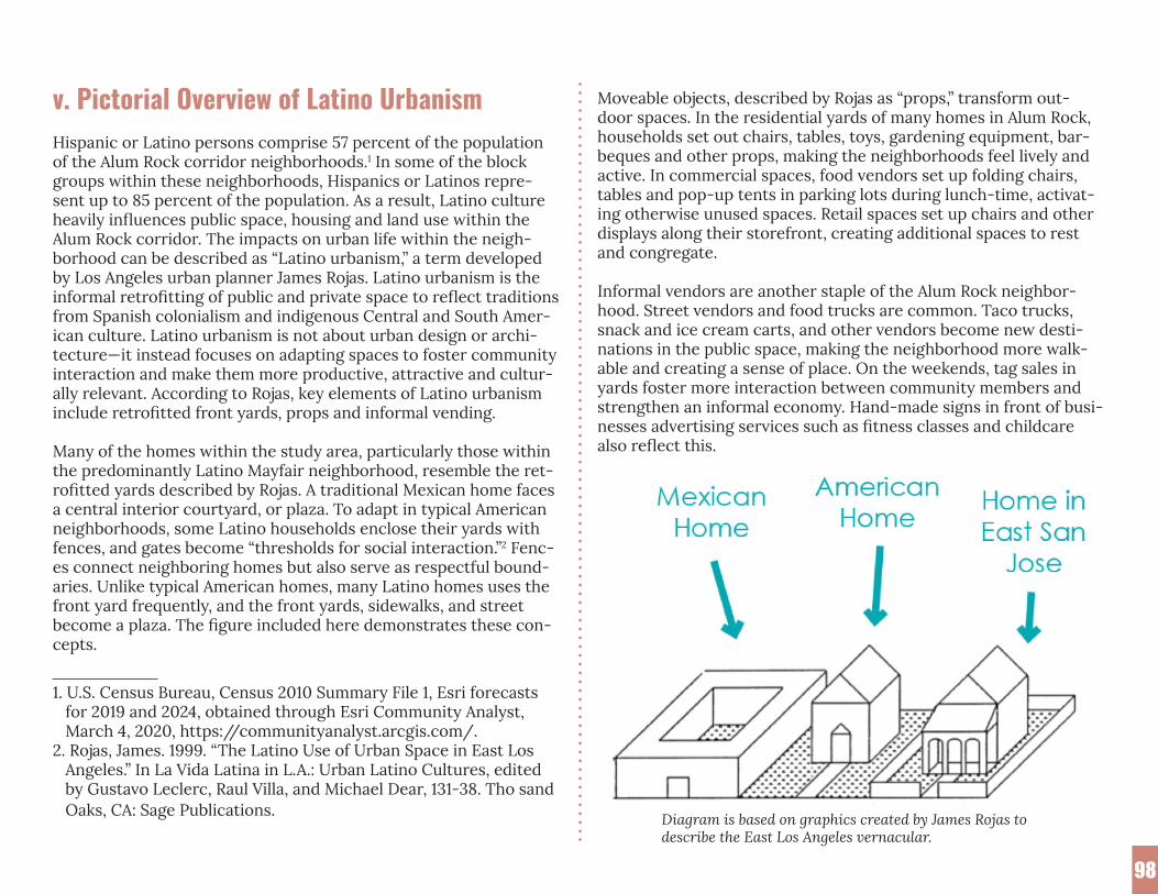
98
v. Pictorial Overview of Latino UrbanismHispanic or Latino persons comprise 57 percent of the population of the Alum Rock corridor neighborhoods.1 In some of the block groups within these neighborhoods, Hispanics or Latinos repre-sent up to 85 percent of the population. As a result, Latino culture heavily influences public space, housing and land use within the Alum Rock corridor. The impacts on urban life within the neigh-borhood can be described as “Latino urbanism,” a term developed by Los Angeles urban planner James Rojas. Latino urbanism is the informal retrofitting of public and private space to reflect traditions from Spanish colonialism and indigenous Central and South Amer-ican culture. Latino urbanism is not about urban design or archi-tecture—it instead focuses on adapting spaces to foster community interaction and make them more productive, attractive and cultur-ally relevant. According to Rojas, key elements of Latino urbanism include retrofitted front yards, props and informal vending.
Many of the homes within the study area, particularly those within the predominantly Latino Mayfair neighborhood, resemble the ret-rofitted yards described by Rojas. A traditional Mexican home faces a central interior courtyard, or plaza. To adapt in typical American neighborhoods, some Latino households enclose their yards with fences, and gates become “thresholds for social interaction.”2 Fenc-es connect neighboring homes but also serve as respectful bound-aries. Unlike typical American homes, many Latino homes uses the front yard frequently, and the front yards, sidewalks, and street become a plaza. The figure included here demonstrates these con-cepts.
1. U.S. Census Bureau, Census 2010 Summary File 1, Esri forecasts for 2019 and 2024, obtained through Esri Community Analyst, March 4, 2020, https://communityanalyst.arcgis.com/.2. Rojas, James. 1999. “The Latino Use of Urban Space in East Los Angeles.” In La Vida Latina in L.A.: Urban Latino Cultures, edited by Gustavo Leclerc, Raul Villa, and Michael Dear, 131-38. Tho sand Oaks, CA: Sage Publications.
Moveable objects, described by Rojas as “props,” transform out-door spaces. In the residential yards of many homes in Alum Rock, households set out chairs, tables, toys, gardening equipment, bar-beques and other props, making the neighborhoods feel lively and active. In commercial spaces, food vendors set up folding chairs, tables and pop-up tents in parking lots during lunch-time, activat-ing otherwise unused spaces. Retail spaces set up chairs and other displays along their storefront, creating additional spaces to rest and congregate.
Informal vendors are another staple of the Alum Rock neighbor-hood. Street vendors and food trucks are common. Taco trucks, snack and ice cream carts, and other vendors become new desti-nations in the public space, making the neighborhood more walk-able and creating a sense of place. On the weekends, tag sales in yards foster more interaction between community members and strengthen an informal economy. Hand-made signs in front of busi-nesses advertising services such as fitness classes and childcare also reflect this.
Diagram is based on graphics created by James Rojas todescribe the East Los Angeles vernacular.

99
vi. Planned Housing Projects In Alum Rock Focus Area
Source: https://drive.google.com/open?id=1Ls2v-oCu9zXk0_R4Qk1W1oDjpJ1-259V&usp=sharing

B. Summer 2020 Engagementvii. ALUM ROCK AVENUE AMENITIES SURVEY ALUM ROCK PUEBLO URBANO ENCUESTA GENERALWhere do you live? / ¿Dónde vive?
• ZIP Code / Código Posta• Neighborhood / Vecindario• District 5 / Distrito 5• Other / Otro
What community group do you represent? / ¿Qué grupo comunitario representa?
• School Parent / Padre de estudiante• Youth / Joven• Senior / De la tercera edad• Local Business / Negocio local• Community Group / Grupo Comunitario• Other / Otro
BUSINESS-SUPPORTING AMENITIES / SERVICIOS DE APOYO A NEGOCIOS
How would you rate this statement? / ¿Cómo calificaría esta declaración?
“Business-supporting amenities should support business opera-tions and protections, and diversify retail opportunities.”
“Los servicios de apoyo a negocios deben respaldar las operaciones y protecciones a negocios, y diversificar las oportunidades a mi-noristas”.
• Strongly Agree / Muy de Acuerdo• Agree / De Acuerdo• Neutral / Neutral• Disagree / En Desacuerdo• Strongly Disagree / Totalmente en Desacuerdo
How would you rate this statement? / ¿Cómo calificaría esta declaración?
“Business-supporting amenities should support businesses through safer, greener, well-maintained streets and storefront improve-ments.”
“Servicios de apoyo a negocios deben apoyar a los negocios a través del buen mantenimiento de calles, mas seguras, mas ecológicas, y mejoramientos a las fachadas de la tiendas.”
• Strongly Agree / Muy de Acuerdo• Agree / De Acuerdo• Neutral / Neutral• Disagree / En Desacuerdo• Strongly Disagree / Totalmente en Desacuerdo
Which of the following amenities would you like to see for busi-nesses in your neighborhood (select your top 5)
¿Cuáles de los siguientes servicios le gustaría ver para los nego-cios en su vecindario (seleccione sus 5 mejores)
• Support for new businesses / Apoyo para negocios nuevos • Support for existing businesses / Apoyo para negocios exis-
tentes• Support for existing street vendors / Apoyo para vendedores
ambulantes• More street vendors / Mas vendedores ambulantes • Safer street design / Diseño de calle con mas seguridad• Greener street design / Diseño de calle mas ecológico• Increased public safety / Aumentar la seguridad pública• Increased sidewalk and street maintenance / Aumentar el man-
100

tenimiento de calles y banquetas• Flexible commercial retail spaces / Espacios comerciales flexi-
bles• More full-service supermarkets / Mas supermercados de servi-
cio complete• More small fruit/vegetable grocery stores / Mas tiendas
pequeñas de frutas / verduras• More health services / Mas servicios de salud• More food and beverage businesses / Mas negocios de comida y
bebidas• Co-op or community ownership of businesses / Negocios de
propiedad tipo cooperativa o comunitaria• Storefront or façade improvements / Mejoras a las fachadas de
los negocios• Specialty shops/retail / Tiendas especializadas / venta a
menudeo• Restriction of select businesses (Liquor, Marijuana, etc.) / Re-
stricción a ciertos negocios (licor, marihuana, etc.)• Other / Otro
PARK & PUBLIC SPACE AMENITIES / SERVICIOS DE PARQUE Y ESPACIOS PÚBLICOS
How would you rate this statement? / ¿Cómo calificaría esta declaración?
“Parks and public space amenities should provide safe and acces-sible places for the community to connect, play, and live active lifestyles.”
“Los parques y los servicios del espacio público deben proporcio-nar lugares seguros y accesibles para que la comunidad se conecte, juegue y viva un estilo de vida activo.”
• Strongly Agree / Muy de Acuerdo• Agree / De Acuerdo• Neutral / Neutral• Disagree / En Desacuerdo• Strongly Disagree / Totalmente en Desacuerdo
How would you rate this statement? / ¿Cómo calificaría esta declaración?
“Parks and public space amenities should provide safe and acces-sible places for the community to gather and host outdoor events and festivals.”
“Los parques y los servicios del espacio público deben proporcio-nar lugares seguros y accesibles para que la comunidad se reúna y organice eventos y festivales al aire libre.”
• Strongly Agree / Muy de Acuerdo• Agree / De Acuerdo• Neutral / Neutral• Disagree / En Desacuerdo• Strongly Disagree / Totalmente en Desacuerdo
Which of the following amenities would you like to see for parks and public spaces in your neighborhood (select your top 5)
¿Cuál de los siguientes servicios le gustaría ver para parques y espacios públicos en su vecindario (seleccione sus 5 mejores)
• Outdoor exercise areas / Áreas de ejercicio al aire libre• Playgrounds or play equipment / Parques para niños o equipos
de juego• Skateparks / Parques de skate (monopatín)• Outdoor events / Eventos al aire libre• Outdoor movies / Películas al aire libre• Picnic tables / Mesas de picnic• Plaza or gathering spaces / Plaza o espacios de reunion• Sports fields / Campos deportivos• Open lawn/grass area / Área abierta de césped / pasto• Small/pocket parks / Parques pequeños / chiquitos• Trails along the creek / Senderos a lo largo del arroyo• Community gardens / Jardines comunitarios• Other / Otro
101

CULTURAL & COMMUNITY RESOURCE AMENITIES / SERVICIOS CULTURALES Y DE RECURSOS COMUNITARIOS
How would you rate this statement? / ¿Cómo calificaría esta declaración?
“Los servicios culturales deben resaltar la historia y la diversidad del vecindario, resaltando el pasado y la creatividad y el activismo emergente.”
• Strongly Agree / Muy de Acuerdo• Agree / De Acuerdo• Neutral / Neutral• Disagree / En Desacuerdo• Strongly Disagree / Totalmente en Desacuerdo
How would you rate this statement? / ¿Cómo calificaría esta declaración?
“Community resources should provide opportunities for youth and adults to continue their education and gain skills to improve their future health and economic prospects”
“Los recursos de la comunidad deberían brindar oportunidades para que los jóvenes y adultos continúen su educación y adqui-eran habilidades para mejorar su salud futura y sus perspectivas económicas”.
• Strongly Agree / Muy de Acuerdo• Agree / De Acuerdo• Neutral / Neutral• Disagree / En Desacuerdo• Strongly Disagree / Totalmente en Desacuerdo
Which of the following amenities would you like to see for cultur-al and community resources in your neighborhood (select your top 5)
¿Cuál de los siguientes servicios le gustaría ver para obtener re-cursos culturales y comunitarios en su vecindario (seleccione sus 5 mejores)
• Community centers / Centros comunitarios• Social service agencies / Agencias de servicios sociales• Murals / Murales• Public art / Arte publico• Youth programs/afterschool programs / Programas juveniles /
programas extracurriculares• Art programs / Programas de arte• Tutoring programs / Programas de tutoría• Libraries / Bibliotecas• Workforce development programs / Programas de desarrollo
laboral• Historic preservation / Preservación histórica• Cultural district designation / Designación de distrito cultural• Other / Otro
TRANSPORTATION AND STREETSCAPE AMENITIES / SERVICIOS DE TRANSPORTE Y PAISAJE URBANO DE CALLE
How would you rate this statement? / ¿Cómo calificaría esta declaración?
“Transportation and street design amenities should support walk-ing, biking, public transit, and other modes of transportation so people feel healthier and more connected while being less depen-dent on cars.”
“Los servicios de transporte y diseño de la calle deben ser compat-ibles con caminar, andar en bicicleta, el transporte público y otros medios de transporte para que las personas se sientan mas salud-ables y mas conectadas, mientras se sienten menos dependiente de los automóviles.”
102
• Strongly Agree / Muy de Acuerdo• Agree / De Acuerdo• Neutral / Neutral• Disagree / En Desacuerdo• Strongly Disagree / Totalmente en Desacuerdo
TRANSPORTATION AND STREETSCAPE AMENITIES / SERVI-CIOS DE TRANSPORTE Y PAISAJE URBANO DE CALLE
How would you rate this statement? / ¿Cómo calificaría esta declaración?
“Transportation and street design amenities should support walk-ing, biking, public transit, and other modes of transportation so people feel healthier and more connected while being less depen-dent on cars.”
“Los servicios de transporte y diseño de la calle deben ser compat-ibles con caminar, andar en bicicleta, el transporte público y otros medios de transporte para que las personas se sientan mas salud-ables y mas conectadas, mientras se sienten menos dependiente de los automóviles.”
• Strongly Agree / Muy de Acuerdo• Agree / De Acuerdo• Neutral / Neutral• Disagree / En Desacuerdo• Strongly Disagree / Totalmente en Desacuerdo
How would you rate this statement? / ¿Cómo calificaría esta declaración?
“Transportation and street design amenities should reduce conges-tion, improve safety, and better connect the neighborhood to the rest of the city.”
“Los servicios de transporte y diseño de calles deberían reducir la congestión, mejorar la seguridad y conectar mejor el vecindario con el resto de la ciudad”.
• Strongly Agree / Muy de Acuerdo• Agree / De Acuerdo• Neutral / Neutral• Disagree / En Desacuerdo• Strongly Disagree / Totalmente en Desacuerdo
Which of the following amenities would you like to see for trans-portation and streetscapes in your neighborhood (select your top 5)
¿Cuál de las siguientes comodidades le gustaría ver para el trans-porte y los paisajes urbanos en su vecindario (seleccione su me-jores 5)
• Street design to reduce speeding / Diseño de calle para reducir la velocidad
• Street trees / Árboles en las aceras de las calles• Well-designed sidewalks / Aceras bien diseñadas• Sidewalk cleaning and maintenance / Limpieza y mantenimien-
to de aceras• Improved bike lanes / Mejora los carriles de Bicicleta• Improved safety at intersections and street crossings / Seguri-
dad mejorada en intersecciones y cruces de calles• More frequent transit services / Servicios de transito mas fre-
cuentes• Better connected transit services / Servicios de transito mejor
conectados• Benches and public seating / Bancos y asientos públicos• Street landscaping and flowers / Diseño de jardín y flores• Underground parking / Estacionamiento subterraneo• Parking permit system / Sistema de permisos de estaciona-
miento• Roadway paving / Pavimentación de carreteras• Roadway cleaning / Limpieza de carreteras• Street design to increase walkability / Diseño de calles para
aumentar la transitabilidad• Loading zones for businesses / Zonas de carga para negocios• Pick-up and drop-off areas for rideshare and food deliveries /
Áreas para dejar y tomar pasajeros o de entrega y recogida de alimentos
103

• Reserved car-sharing parking / Zona reservada para autos compartidos
• Electric vehicle charging stations / Estaciones de recarga de vehículos eléctricos
• Improved street lighting / Mejor alumbrado público• Bike parking / Estacionamiento de bicicletas• Other / Otro
ASSETS, CHALLENGES, VISION / ASSETS, RETOS, VISION
What are the community assets in the Alum Rock area?¿Qué cosas representan bienes comunitarios en el area de Alum Rock?
CHALLENGES / RETOS
What are you most worried about for yourself/your family/com-munity?¿Qué es lo que le preocupa mas para usted/su familia/su comuni-dad?
VISION / VISION
What would you like to see included in future development projects along Alum Rock Ave between King Road and Jackson Avenue?
¿Qué le gustaría ver incluido en futuros proyectos de desarrollo a lo largo de la Avenida de Alum Rock entre las calles Jackson Avenue y King Road?
OTHER TOPICS / OTROS TEMAS
Are there other topics of interest for you?¿Hay otros temas de interés para usted?• Building heights / La altura de edificios• Architecture styles / Estilos de arquitectura
• Neighborhood branding / Marca y reputación del barrio• Public safety improvements / Mejorar la seguridad pública• Street/intersection safety improvements / Mejorar la seguridad
en calles / intersecciones• Street maintenance / Mantenimiento de la calle• Park maintenance / Mantenimiento de los parques• All housing production / La producción de Vivienda• Affordable housing production / Producción de viviendas ase-
quibles• Housing displacement protections / Protección para el despla-
zamiento de Vivienda• Business displacement protections / Protección de despla-
zamiento a negocios• Addressing neighborhood blight / Abordar el deterioro que
hace ver mal a un vecindario• Community and cultural events / Eventos comunitarios y cul-
turales• Improved community engagement / Mejorar la participación de
la comunidad• Improved voter registration and turnout / Mejorar registro
electoral y participación • Disaster preparedness / Preparación para desastres• Climate resilience / Resiliencia para el cambio climatico• Environmental justice / Justicia Ambiental• Digital divide / Division digital• Other / Otro
How much do you agree or disagree with the following state-ments?
¿Qué tanto está de acuerdo con las siguientes declaraciones?
This survey adequately captured my preferences for Alum Rock urban village amenities
Esta encuesta capturó adecuadamente mis preferencias de servi-cios urbanos para Alum Rock.
104

• Strongly Agree / Muy de Acuerdo• Agree / De Acuerdo• Neutral / Neutral• Disagree / En Desacuerdo
viii. Sample of Focus Group/ Interview Questions1. How many years have you lived / operated a business/ worked in this neighborhood (self-defined in Mayfair or East San José)? a. What led you to locate here?
2. Describe your living/ business/ work situation a. Parents: Number of children? b. Seniors: Live with family? Senior housing? c. Youth: Family size? d. Business: Number of employees? Number of locations? e. Community-based organizations: Size of organization?
3. What is your favorite place in the neighborhood. Population served? a. Neighborhood meaning within a 15 minute walk
4. Describe your typical day a. Where do you go regularly on weekdays and weekends? b. What daily activities do you do in the neighborhood? c. How do you travel around the neighborhood?
5. What has changed in the neighborhood in the last 5-10 years? In the last 10-20 years?
6. How well do you know your community? How many neighbors do you know?
7. Is there a place in the neighborhood that you enjoy going to? If so, where and why? a. Is there a place in your neighborhood that lets you feel more connected with your neighbors? If so, where and why? b. What activities do you do for fun (at home and in public)?
8. Are there areas you do not like to go in the neighborhood? If so, where and why?
9. What are some advantages of living/ raising a family/ running a business/ working in this community?
10. What is challenging about living/ raising a family/ running a business/ working in this community?
11. What would you like to see more of in your neighborhood? a. Hypothetical: If you have $100,000 to spend on improving the community, what would you spend it on?
12. What would you like to see less of in your neighborhood? a. i.e. identify specific neighborhood issue and challenges
13. Hypothetical: Suppose that you could make one change that would make the neighborhood better, what would you change?
14. Overall, how satisfied are you living here? a. Scale of 1-10, 10 being extremely satisfied
105

106
C. Form-Based Code for PEDESTRIAN ORIENTED ZONING DISTRICTix. Part 1 - General
20.75.010 Pedestrian oriented zoning 1 A. This chapter sets forth the land use and development regula-tions applicable to the pedestrian oriented zoning districts estab-lished by Section 20.10.060.
B. No building, structure or land shall be used and no building or structure shall be erected, enlarged or structurally altered in a pedestrian oriented district except as set forth in this chapter.
C. The pedestrian oriented zoning districts are intended to foster urban development that encourages pedestrian movements and
1. “San José Zoning Ordinance: Chapter 20.75-Pedestrian Oriented Zon-ing District.” City of San José. Accessed October 3, 2020. https://library.municode.com/ca/san_jose/codes/code_of_ordinances?nodeId=TIT20ZO_CH20.75PEORZODI_PT4GERE_20.75.300LAGHUSAC.
supports transit, cycling and other alternatives to vehicular travel through: 1) design standards that place building mass at the street front and emphasize pedestrian connections while minimizing ve-hicular/pedestrian conflicts; and 2) land use regulations that pro-vide a critical intensity and mix of uses. (Ord. 28858.)
20.75.020 - MS main street disticts
A. Applicability. The MS main street districts as established by Section 20.10.060 shall be applicable only to properties locat-ed within the Alum Rock Neighborhood Business District, as that district is described and identified in the general plan (as the same may be updated and/or amended from time to time).
B. Purpose. The MS main street districts are intended to provide a pedestrian-oriented commercial shopping district with ground-floor retail along the main street in a configuration that supports transit and other alternative travel modes including bicycles, car share and vanpools. The MS districts require transparent store-fronts at the ground level to accommodate active commercial uses and orient buildings to a wide pedestrian zone that connects busi-nesses along the street, allows for outdoor cafés, accommodates bicycle parking facilitates, provides access to transit and connects with pedestrian and bicycle facilities in the surrounding neighbor-hood.
1. MS-G main street ground floor commercial district. The MS-G main street ground floor district is intended to provide a mix of commercial and residential uses integrat-ed in a pedestrian-oriented design with a focus on active commercial uses at the ground level along the main street frontage.
2. MS-C main street commercial district. The MS-C main street commercial district is intended to provide a con-centration of primarily commercial uses within a pedes-trian-oriented design, and allows a mix of commercial and residential uses only where such uses can be integrated on a large site in a pedestrian-oriented design that maximizes commercial opportunities.
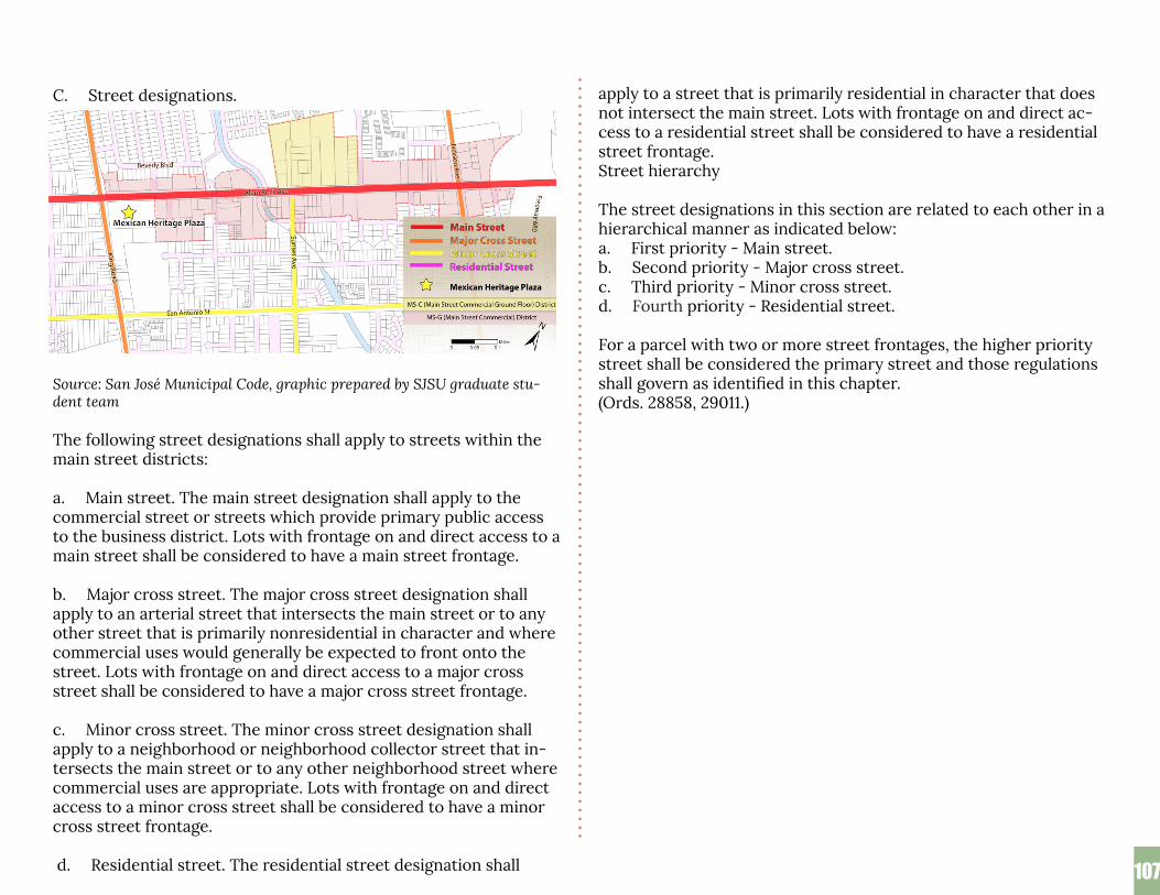
107107
C. Street designations.
Source: San José Municipal Code, graphic prepared by SJSU graduate stu-dent team
The following street designations shall apply to streets within the main street districts:
a. Main street. The main street designation shall apply to the commercial street or streets which provide primary public access to the business district. Lots with frontage on and direct access to a main street shall be considered to have a main street frontage.
b. Major cross street. The major cross street designation shall apply to an arterial street that intersects the main street or to any other street that is primarily nonresidential in character and where commercial uses would generally be expected to front onto the street. Lots with frontage on and direct access to a major cross street shall be considered to have a major cross street frontage.
c. Minor cross street. The minor cross street designation shall apply to a neighborhood or neighborhood collector street that in-tersects the main street or to any other neighborhood street where commercial uses are appropriate. Lots with frontage on and direct access to a minor cross street shall be considered to have a minor cross street frontage.
d. Residential street. The residential street designation shall
apply to a street that is primarily residential in character that does not intersect the main street. Lots with frontage on and direct ac-cess to a residential street shall be considered to have a residential street frontage. Street hierarchy
The street designations in this section are related to each other in a hierarchical manner as indicated below: a. First priority - Main street. b. Second priority - Major cross street. c. Third priority - Minor cross street. d. Fourth priority - Residential street.
For a parcel with two or more street frontages, the higher priority street shall be considered the primary street and those regulations shall govern as identified in this chapter. (Ords. 28858, 29011.)
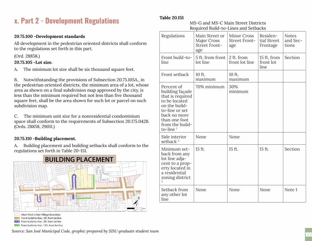
108108
x. Part 2 - Development Regulations 20.75.100 - Development standards.
20.75.100 -Development standardsAll development in the pedestrian oriented districts shall conform to the regulations set forth in this part. (Ord. 28858.) 20.75.105 -Lot size.A. The minimum lot size shall be six thousand square feet.
B. Notwithstanding the provisions of Subsection 20.75.105A., in the pedestrian oriented districts, the minimum area of a lot, whose area as shown on a final subdivision map approved by the city, is less than the minimum required but not less than five thousand square feet, shall be the area shown for such lot or parcel on such subdivision map.
C. The minimum unit size for a nonresidential condominium space shall conform to the requirements of Subsection 20.175.042B. (Ords. 28858, 29011.)
20.75.110 -Building placement. ex A. Building placement and building setbacks shall conform to the regulations set forth in Table 20-151.
Table 20.151MS-G and MS-C Main Street Districts Required Build-to-Lines and Setbacks
Regulations Main Street or Major Cross Street Front-age
Minor Cross Street Front-age
Residen-tial Street Frontage
Notes and Sec-tions
Front build-to-line
5 ft. from front lot line
2 ft. from front lot line
15 ft, from front lot line
Section
Front setback 10 ft. maximum
10 ft. maximum
Percent of building façade that is required to be located on the build- to-line or set back no more than one foot from the build-to-line 1
70% minimum 30% minimum
Side interior setback 2
None None
Minimum set-back from any lot line adja-cent to a prop-erty located in a residential zoning district 3
15 ft. 15 ft. 15 ft. Section
Setback from any other lot line
None None None Note 1
Source: San José Municipal Code, graphic prepared by SJSU graduate student team

109109
Main Street or Major Cross Street Frontage
Main Street (Alum Rock Avenue)
Major Cross Street (King Road)
Minor Cross Street (Sunset Avenue)
Residential Street
Notes: Building Code setbacks may apply.
B. Building placement requirements and exceptions. Building placement shall conform to the following:
1. The front build-to-line shall apply to that portion of a building located below the elevation of the fifth finished floor.
Source: Images on this page prepared by SJSU graduate student team to illustrate form-based code regulations

110110
2. No portion of the building shall be located within the minimum setback area between the build-to-line and the street, except as expressly allowed in Section 20.75.130A.
3. For purposes of calculating the percentage of building façade located at the build-to-line, a window that is inset from the surrounding building façade shall be assumed to be at the same plane as the surrounding building façade.
C. Buildings with a residential street frontage shall conform to the following:
1. That portion of a building façade located below the elevation of the second finished floor, except recessed building en-tries, windows and balconies, shall be located on the build-to-line.
2. No portion of the building shall be located within the mini-mum setback area between the build-to-line and the street, except as expressly allowed in Section 20.75.130B.
(Ords. 28858, 29011.)
20.75.115 -Building placement exceptions. 20.75.5 - Building placemA. Notwithstanding the provisions of Table 20-151, in Section 20.75.110 the decision maker may approve a building fronting onto a main street, major cross street or minor cross street frontage with a front setback that is greater than the maximum front setback set forth in Table 20-151, based on a finding that a greater setback is needed in order to provide one or more recessed pedestrian entries or a pedestrian plaza, or to accommodate pedestrian ramps in a flood zone.
B. Notwithstanding the provisions of Table 20-151 in Section 20.75.110, the decision maker may approve a building on a main street or cross street frontage with less than seventy percent of the build-ing façade located at the building-to-line based on a finding that such a reduction is needed to accommodate recessed pedestrian entries at the ground level or residential balconies at the elevation of the second finished floor or above.
C. Notwithstanding the provisions of Table 20-151 in Section 20.75.110, no setback is required from that portion of a property situated in a residential zoning district that is located less than one hundred feet from the main street.
D. Notwithstanding the provisions of Table 20-151 in Section 20.75.110, an interior side setback of less than five feet, but greater than zero, shall be allowed to accommodate Title 24 requirements regarding building expansion. (Ord. 29011.)
20.75.120 -Setback regulations. 75.120 - Setback regulations.A. Front build-to-line setback requirements.
1. Applicability. All development on lots with frontage on a main street, major cross street or minor cross street shall conform to the build-to-line and pedestrian zone setback requirements of this subsection.
2. Purpose. The pedestrian zone consists of a minimum ten-foot sidewalk and a private property building setback. The regulations of this section for the front building setback are intended to promote an active, safe and attractive pedestri-an zone.
3. Pavement. The area between the sidewalk and the build-to- line shall be paved to match the sidewalk.
4. Encroachments. The front setback area between the sidewalk and the build-to-line shall be kept open, un-obstructed, and unoccu-pied on the surface of the ground, above the surface of the ground and below the surface of the ground by all buildings, structures, fences, ramps, or equip-ment, except as follows:
Image prepared by SJSU graduate student team to illustrate form-based code regula-tions

111111
a. Signs, lighting, sills, eaves, belt courses, cornices, canopies, awnings, and other similar architectural features located a minimum of eight feet above grade; and
b. Walks and driveways for vehicular or pedestrian access to the lot that are at the same elevation as the adjacent public sidewalk; and
c. Overhead wires neces-sary for utility service to a building on the lot; and
d. Underground lines nec-essary for utility service to the site; and
e. Utility structures locat-ed entirely below grade; and
f. Planters or planting beds, extending not more thaneigh-teen inches into the setback area and no more than eigh-teen inches in height above grade; and
g. Movable tables, chairs, umbrellas, outdoor heaters, and retail dis-plays; and
h. Moveable partitions or planters to define an outdoor seating area subject to approval of a development permit or permit adjustment; and
i. Bicycle racks; and j. Balconies located at or above the elevation of the third
finished floor that project no more than three feet into the airspace above the pedestrian zone setback; and
k. Residential stoops on a minor cross street frontage that extend into the pedestrian zone setback a distance of no more than two feet.
B. Requirements for all other setbacks. Except as otherwise ex-pressly and specifically provided in Section 20.75.120A., every part of every setback area shall be kept open, unobstructed, and unoccupied on the surface of the ground, above the surface of the ground, and below the surface of the ground by all buildings or structures except as follows:
1. Lighting, sills, eaves, belt courses, cornices, cano-pies, awnings may project horizontally for a distance of not more than two feet into the air space above the surface of the ground in any setback area,and three feet into the air space above the surface of the ground in the front setback area of a residential street frontage; and
2. On a residential street frontage, balconies may project horizontally for a distance of not more than three feet into the air space above the surface of the ground in the front setback area; and
3. Unenclosed porches, whether or not they are covered, may extend into the minimum front setback area of a residential street frontage not more than eight feet, provided that such porches cover no more than fifty percent of the setback area. Stairs that are uncovered and unenclosed may extend not more than twelve feet into the minimum setback area;
Source: Images on this page prepared by SJSU graduate student teamto illustrate form-based code regulations
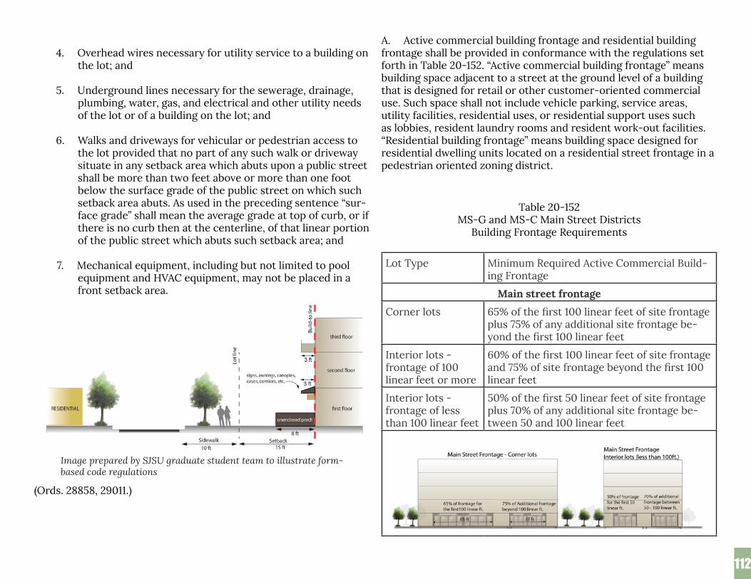
112112
4. Overhead wires necessary for utility service to a building on the lot; and
5. Underground lines necessary for the sewerage, drainage, plumbing, water, gas, and electrical and other utility needs of the lot or of a building on the lot; and
6. Walks and driveways for vehicular or pedestrian access to the lot provided that no part of any such walk or driveway situate in any setback area which abuts upon a public street shall be more than two feet above or more than one foot below the surface grade of the public street on which such setback area abuts. As used in the preceding sentence “sur-face grade” shall mean the average grade at top of curb, or if there is no curb then at the centerline, of that linear portion of the public street which abuts such setback area; and
7. Mechanical equipment, including but not limited to pool
equipment and HVAC equipment, may not be placed in a front setback area.
(Ords. 28858, 29011.)
A. Active commercial building frontage and residential building frontage shall be provided in conformance with the regulations set forth in Table 20-152. “Active commercial building frontage” means building space adjacent to a street at the ground level of a building that is designed for retail or other customer-oriented commercial use. Such space shall not include vehicle parking, service areas, utility facilities, residential uses, or residential support uses such as lobbies, resident laundry rooms and resident work-out facilities. “Residential building frontage” means building space designed for residential dwelling units located on a residential street frontage in a pedestrian oriented zoning district.
Table 20-152 MS-G and MS-C Main Street Districts
Building Frontage Requirements
Lot Type Minimum Required Active Commercial Build-ing Frontage
Main street frontage
Corner lots 65% of the first 100 linear feet of site frontage plus 75% of any additional site frontage be-yond the first 100 linear feet
Interior lots - frontage of 100 linear feet or more
60% of the first 100 linear feet of site frontage and 75% of site frontage beyond the first 100 linear feet
Interior lots - frontage of less than 100 linear feet
50% of the first 50 linear feet of site frontage plus 70% of any additional site frontage be-tween 50 and 100 linear feet
Image prepared by SJSU graduate student team to illustrate form-based code regulations

113113
Major cross street frontage
Corner lots with main street front-age
25 linear feet of site frontage within 50 feet of the main street
All other lots 50% of the linear dimension of the site front-age
Minor cross street frontage
Corner lots with main street front-age
20 linear feet of site frontage within 50 feet of the main street
All other lots 50% of the linear dimension of the site front-age
Residential street frontage
All lots Any portion of a building located within 50 feet of the public right-of-way of a residential street shall be designed for residential uses
B. Active commercial building frontage exceptions.
1. Notwithstanding the provisions of Table 20-152 in Section 20.75.140, the decision maker may reduce the required active commercial building frontage for lots with less than one hundred linear feet of frontage with a development permit based on a finding that:
a. Reduced active commercial building frontage is needed to allow for vehicular access to the site; and
b. Access cannot feasibly be provided through lot assembly
or shared access though an adjacent site.
2. If the director cannot make the findings required in Section 20.75.140B., up to two thousand square feet of building area shall be allowed with no on-site vehicle access or parking, provided the building area conforms to all other provisions of this title.
3. The active commercial building frontage requirements shall not apply to an off-street parking establishment for which the planning commission or the city council on ap-peal approves a conditional use permit which finds that the off-street parking establishment is needed to serve commer-cial uses in the area on an interim basis until such time as the site is developed consistent with the active commercial building frontage requirements of this chapter.
(Ords. 28858, 29011.)
20.75.140 -Commerical building design.
A. All active commercial building frontage required pursuant to Section 20.75.140 in the MS-G and MS-C main street districts shall conform to the design requirements set forth in Table 20-153.
Table 20-153 MS-G and MS-C Main Street Districts
Requirements for Active Commercial Building Frontage
Requirements Less than 8,000 sq. ft. of contiguous commercial space
8,000 or more sq. ft. of contiguous commercial space
Notes and Sections
Minimum height of first story 1
15 ft. 18 ft. Note 1
Minimum first floor com-mercial space depth 2
45 ft. 60 ft. Note 2

114114
Minimum glazing area
Building façades facing a street shall consist of store-fronts with clear, untinted glass or other glazing material on at least 70% of the surface area of the façade between a height of 18 inches and 96 inches.
Building en-tries
All ground-lev-el commercial space fronting on a street shall have a primary build-ing entry situated along and acces-sible from the pedestrian zone. “Pedestrian zone” means the pedes-trian zone setback and the adjacent public sidewalk. Buildings located on corner lots shall have a primary building entrance along and acces-sible from the primary street.
Notes:
1. “First story height” is the distance between the upper sur-face of the ground floor and the upper surface of the floor next above.
2. For a lot with two or more street frontages, this provision shall apply only to the primary street frontage as defined in Section 20.75.020C.2. “Depth of a first floor commercial space” is the length of a line extending perpendicular to the street between the building wall located at the street frontage and the opposing building wall at the rear of the commercial space. The measurement shall be from the in-terior wall surfaces at grade and shall reflect the minimum distance between the opposing walls along 75% or more of their horizontal dimension.
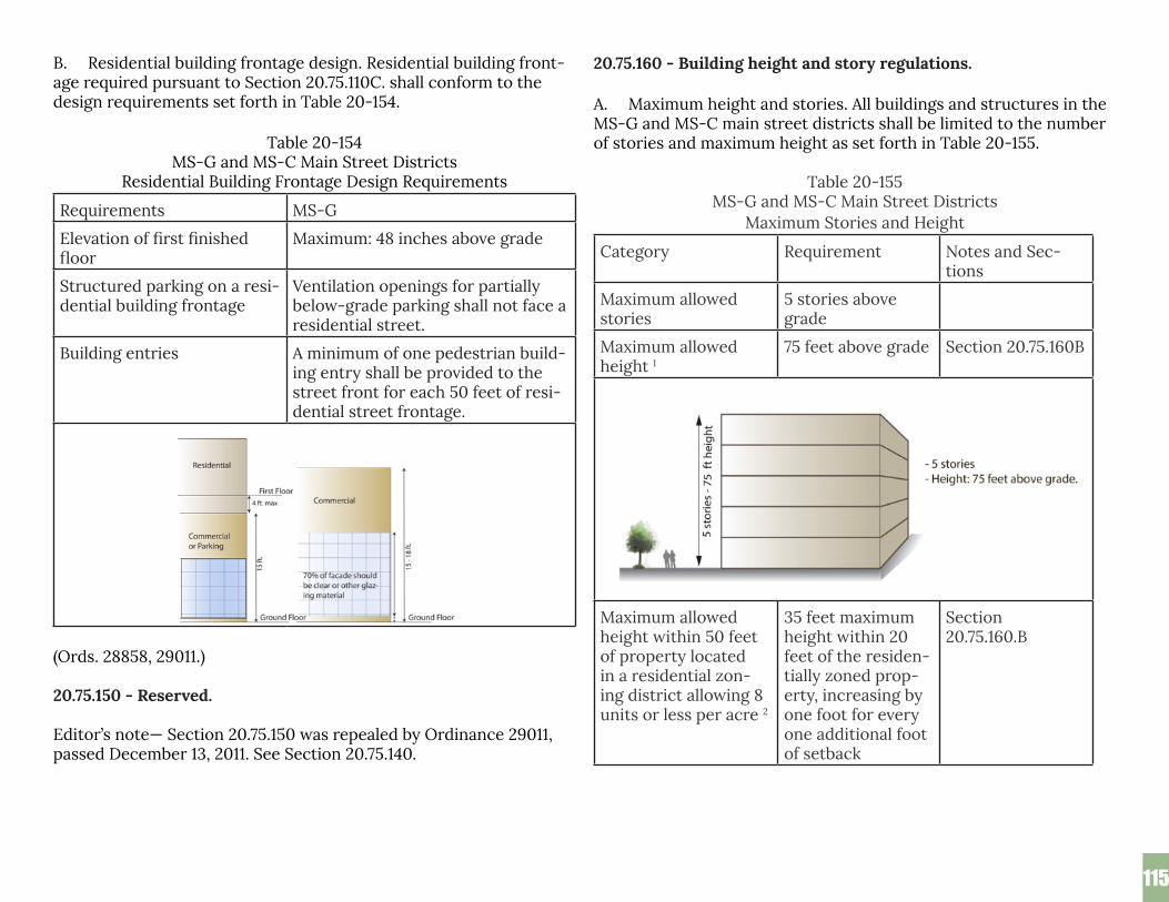
115115
B. Residential building frontage design. Residential building front-age required pursuant to Section 20.75.110C. shall conform to the design requirements set forth in Table 20-154.
Table 20-154 MS-G and MS-C Main Street Districts
Residential Building Frontage Design Requirements
Requirements MS-G
Elevation of first finished floor
Maximum: 48 inches above grade
Structured parking on a resi-dential building frontage
Ventilation openings for partially below-grade parking shall not face a residential street.
Building entries A minimum of one pedestrian build-ing entry shall be provided to the street front for each 50 feet of resi-dential street frontage.
(Ords. 28858, 29011.)
20.75.150 - Reserved. Editor’s note— Section 20.75.150 was repealed by Ordinance 29011, passed December 13, 2011. See Section 20.75.140.
20.75.160 - Building height and story regulations.
A. Maximum height and stories. All buildings and structures in the MS-G and MS-C main street districts shall be limited to the number of stories and maximum height as set forth in Table 20-155.
Table 20-155MS-G and MS-C Main Street Districts
Maximum Stories and Height
Category Requirement Notes and Sec-tions
Maximum allowed stories
5 stories above grade
Maximum allowed height 1
75 feet above grade Section 20.75.160B
Maximum allowed height within 50 feet of property located in a residential zon-ing district allowing 8 units or less per acre 2
35 feet maximum height within 20 feet of the residen-tially zoned prop-erty, increasing by one foot for every one additional foot of setback
Section 20.75.160.B

116116
Maximum allowed height within 50 feet of property located in a residential zoning district allowing 9 to 30 units per acre 2
45 feet maximum height within 20 feet of the residen-tially zoned prop-erty, increasing by one foot for every one additional foot of setback
Subsection 20.75.160.B
Maximum allowed height within 40 feet of a residential street
35 feet above grade
B. Building height exceptions.
Graphic prepared by SJSU graduate student team
117117
1. Notwithstanding the provisions of Table 20-155 in Sec-tion 20.75.160, the maximum height limits for a building or structure located within fifty feet of a residential zon-ing district shall not apply to any portion of a building or structure located within one hundred feet of the main street.
2. Notwithstanding the provisions of Table 20-155 in Section 20.75.160, the decision maker may increase the allowed height for that portion of a building or structure located within fifty feet of a residential zoning district with a de-velopment permit based on the following findings:
a. The property located in a residential zoning district is not developed with a residential use; and
b. The orientation, location and elevation of the pro-posed building(s) is compatible with adjacent develop-ment; and
c. The development does not exceed a height of seven-ty-five feet above grade.
3. Notwithstanding the provisions of Table 20-155 in Sec-tion 20.75.160, elevator shafts, roof equipment and other non-habitable building elements that do not exceed an area equal to ten percent of the area of the fifth floor of the building, may extend to a height of eighty feet. The area of any roof screen that exceeds a height of seven-ty-five feet above grade shall include the area encom-passed by that roof screen.
(Ords. 28858, 29011.)
20.75.180 - Residential recreation space requirements.
All residential development in the MS-G and MS-C main street districts shall provide useable common recreation space in confor-
mance with all of the requirements of this section.
A. Useable common recreation space shall be provided equal to one hundred or more square feet per residential unit and shall:
1. Be accessible to all residents of the building or site; and
2. Provide a minimum horizontal dimension of fifteen feet and a minimum contiguous area of three hundred square feet; and
3. Be designed primarily for recreational use; and
4. Not include pedestrian circulation unless such circula-tion is integral to the recreational use of a larger outdoor recreation area, or the pedestrian facility is a jogging trail, exercise course or other facility that is primarily recre-ational in purpose.
B. Useable common recreation space may include recreation space that is interior to a building if that interior recreation space conforms to the following additional requirements:
1. The entire area of the indoor space is designed exclusively for recreational use (including but not limited to swimming pools, work-out facilities, tennis courts or multi-use recre-ation rooms) and is available to all residents of the building or site; and
2. The area of the indoor recreation space does not exceed
fifty percent of the total useable common recreation space required for the building or site.
C. Private open space shall be provided equal to sixty or more square feet per residential unit for a minimum of fifty percent of the total residential units on the site. Private open space shall be directly accessible from the residential unit it serves and shall have a minimum horizontal dimension of six feet.

118118
D. Notwithstanding the provision of Section 20.75.180A., a res-idential development with twenty residential units or fewer shall not be required to provide useable common recreation space, if private open space is provided for every residential unit in the amount and with the configuration specified in Section 20.75.180C.
E. Notwithstanding the provisions of Section 20.75.180C., the decision maker may reduce the percentage of residential units required to have private open space to less than fifty percent of the total units through a development permit based on a finding that the private open space that would otherwise be required has been replaced on that site on a one-for-one basis by additional useable common recreation space that is above and beyond the amount required in Section 20.75.180A. (Ords. 28858, 29011.)
xi. Part 3 - Use Regulations 20.75.200 - Allowed uses and permit requirements.
A. “Permitted” land uses are indicated by a “P” on Table 20-156.
B. “Conditional” uses are indicated by a “C” on Table 20-156. These uses may be allowed in such designated districts, as an in-dependent use, but only upon issuance of and in compliance with a conditional use permit as set forth in Chapter 20.100. C. “Special” uses are indicated by a “S” on Table 20-156. These uses may be allowed in such designated districts, as an independent use, but only upon issuance of and in compliance with a special use permit as set forth in Chapter 20.100.
D. “Administrative” uses are indicated by an “A” on Table 20-156. These uses may be allowed in such designated districts, as an inde-pendent use, but only upon issuance of and in compliance with an administrative use permit as set forth in Chapter 20.100.
E. Land uses not permitted are indicated by a “-” on Table 20-156. Land uses not listed on Table 20-156 are not permitted.
F. When the right column of Table 20-156 includes a reference to a section number or a footnote, the regulations cited in the section number or footnote apply to the use. In addition, all uses are sub-ject to any other applicable provision of this Title 20 and any other title of the San José Municipal Code.

119119
Table 20-156 Pedestrian Oriented Districts
Land Use Regulations
Use Main Street Zoning Districts Appli-cable Sections & Notes
MS-G MS-C
GroundFloorCom-mercial Front-age
Resi-dential Street Front-age
AllOther
General Retail
Retail sales, goods and merchandise
P - P P
Off-sale Alcoholic Beverages - beer and/or wine only
C - C C Section 20.80.900
Off-sale Alcohol-ic Beverages - full range of Alcoholic Beverages
C - C C Section20.80.900
Bakery, retail P - P P
Certified Farmers’ Market
S - S S Part 3.5, Chapter 20.80
Certified Farmers’ Market - small
P - P P Part 3.5, Chapter 20.80
Food, beverage, gro-ceries
P - P P
Neighborhood Agri-culture
- P - - Part 9, Chapter 20.80
Nursery, Plant - - P P Note 1
Outdoor Vending A - A A Part 10, Chapter 20.80
Outdoor Vending - fresh fruits and vegetables
P - P P Part 10, Chapter 20.80
Pawn shop/broker C - C C See Title 6
Seasonal sales P - P P Part 14, Chapter 20.80
Art Studio, Retail P - P P Part 13.7, Chapter 20.80
Education and Training
Child Day Care Cen-ter located on an ex-isting School Site or as an incident to an on-site church/re-ligious assembly use involving no Building additions or changes to the site
- - P P
Day care center C - C C
Art Studio, Instruc-tional
P - P P
Art Studio, Instruc-tional, with live models
C - C C

120120
Private Instruction, personal enrichment
P - P P
School-elementa-ry and secondary (public)
P - P P
School-elementary and secondary (pri-vate)
C - C C
School, driving (class C & M license)
P - P P Note 2
School, Post - Sec-ondary
P - P P Note 3
School, Trade and Vocational
C - C C
Entertainment and Recreation Related
Amusement Game Arcade
C - C C
Dancehall C - C C
Poolroom/Bil-liard-Room
C - C C
Private club or lodge C - C C
Recreation, Com-mercial/Indoor
P - P P
Recreation, Com-mercial/Outdoor
- - C C
Relocated Cardroom - - - -
Theatre, indoor C - C C
Theatre, outdoor - - C C
Assembly C - C C
Food Services
Banquet - Facility C - C C
Caterer P - P P Note 4
Drinking Establish-ments
C - C C
Drinking Establish-ment interior to a full-service Hotel/Motel with 75 or more guest rooms
P - P P Section
Public Eating Estab-lishments
P - P P
Outdoor dining, incidental to a Public Eating Establishment or a retail establish-ment
P - P P Section
Wineries, breweries C - C C
Health and veterinary services
Animal boarding, indoor
- - P P Note 5
Animal grooming P - P P Note 5
Emergency ambu-lance service
- - C C
Hospital/in-patient facility
C - C C
Medical clinic/out-patient facility
P - P P
Office, Medical P - P P
Veterinary clinic P - P P
General Services
Bed and Breakfast Inn
- - P P Part 2, Chapter 20.80
Dry cleaner P - P P
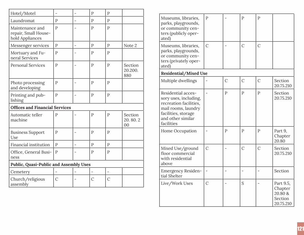
121121
Museums, libraries, parks, playgrounds, or community cen-ters (publicly oper-ated)
P - P P
Museums, libraries, parks, playgrounds, or community cen-ters (privately oper-ated)
C - C C
Residential/Mixed Use
Multiple dwellings - C C C Section 20.75.210
Residential acces-sory uses, including, recreation facilities, mail rooms, laundry facilities, storage and other similar facilities
- P P P Section 20.75.210
Home Occupation - P P P Part 9, Chapter 20.80
Mixed Use/ground floor commercial with residential above
C - C C Section 20.75.210
Emergency Residen-tial Shelter
- - - - Section
Live/Work Uses C - S - Part 9.5, Chapter 20.80 & Section 20.75.210
Hotel/Motel - - P P
Laundromat P - P P
Maintenance and repair, Small House-hold Appliances
P - P P
Messenger services P - P P Note 2
Mortuary and Fu-neral Services
P - P P
Personal Services P - P P Section20.200.880
Photo processing and developing
P - P P
Printing and pub-lishing
P - P P
Offices and Financial Services
Automatic teller machine
P - P P Section 20. 80. 200
Business Support Use
P - P P
Financial institution P - P P
Office, General Busi-ness
P - P P
Public, Quasi-Public and Assembly Uses
Cemetery - - - -
Church/religious assembly
C - C C

122122
Community televi-sion antenna sys-tems
- - C C
Off-site, Alternating Use and Alternative Parking Arrange-ments
S S S S Section
Off-street Parking Establishment
C - C C Section
Utility Structures A A A A Part 19, Chapter 20.80 and Section
Utility Facilities, excluding corpora-tion yards, storage or repair yards and warehouses
C C C C
Television, radio stu-dios without anten-na/dishes
- - - -
Short term parking lot for uses or events other than on-site
- - C C Note 6
Wireless Communi-cations Antenna
- - C C Note 12, Sections
Wireless Commu-nications Antenna, Slimline Monopole
- - S S Note 12, Sections
Wireless Commu-nications Antenna, Building Mounted
P P P P Note 12, Sections
Electrical Power Generation
Residential Care Facility, six or fewer persons
- P P P Section 20.75.210
Residential Service Facility, six or fewer persons
- P P P Section 20.75.210
Residential Care Facility for seven or more persons
- C C C Section 20.75.210
Residential Service Facility for seven or more persons
- C C C Section 20.75.210
Single Room Occu-pancy (SRO) Resi-dential Hotel
- - C C Part 15, Chapter 20.80
Single Room Occu-pancy (SRO) Living Unit Facility
- - C C Part 15, Chapter 20.80; Section 20.75.210
Drive-Through Uses
Drive Through Uses in conjunction with any use
- - C C Section
Recycling Uses
Reverse Vending Machine
A P A A Part 13, Chapter 20.80
Small Collection Facility
A - A A Part 13, Chapter 20.80
Transportation and Utilities
Data Center - - - -

123123
Private Electrical Power Generation Facility
- - C C Note 2
Co-generation Fa-cility
S - S S
Stand-by or Back-up Electrical Power Generation Facility
Facilities that do not exceed noise or air standards
A S A A
Facilities that do exceed noise or air standards
C - C C
Temporary Stand-by or Backup Electrical Power Generation Facility
P - P P
Solar Photovoltaic Power system
P P P P Section20.100.610C.7
Vehicle Related Uses
Accessory instal-lation, passenger vehicles and pick-up trucks, indoors
P - P P
Auto broker, whole-sale, no on-site storage
P - P P
Car wash, detailing - - - -
Gasoline Service Station or Charge Station
- - - -
Gasoline Service Station or Charge Station with inci-dental service and repair
- - - -
Glass sales, installa-tion and tinting
P - P P Note 10
Sale or lease, com-mercial vehicles
- - - - Note 10
Sale or lease passen-ger vehicles, pick-up trucks not exceeding 25 feet in length, and motorcycles, indoors
S - S S Note 9, Note 10
Rental passenger vehicles, pick-up trucks not exceeding 25 feet in length, and motorcycles
S - S S Note 2
Sale, vehicle parts S - S S Note 8
Tires, batteries, lube, oil change, smog check station, air conditioning ser-vicing of passenger vehicles and pick-up trucks
S - S S Note 7, Note 10
Historic Reuse
Historic Landmark Structure reuse
S C S S Part 8.5 Chapter 20.80
Notes:
(1) Landscaping materials, such as rock, mulch, and sand are limited to prepackaged sales.
(2) No on-site storage of vehicles permitted.

124124
(3) Includes public and private colleges and universities, as well as extension programs and business schools.
(4) Not a catering facility.
(5) All uses involving any type of care for animals, including but not limited to grooming, boarding, or medical care must be conducted wholly inside a building.
(6) Use must be less than twenty-four hours.
(7) Non-engine and exhaust related service and repair al-lowed as incidental.
(8) No outdoor sales areas or dismantling allowed.
(9) Incidental repair of vehicles is prohibited.
(10) All vehicle-related repair, service, and accessory or other installation shall be conducted within a fully enclosed building.
(11) Pedestal charge stations that are incidental to a separate primary use, that do not impact on-site or off-site ve-hicular circulation, and that serve patrons or residents of the primary use on-site are permitted in all pedestrian oriented zoning districts.
(12) Certain modifications of existing wireless facilities may
be permitted with an administrative permit in accor-dance with Section 20.80.1915 of Chapter 20.80.
(Ords. 28858, 29011, 29254, 29546.)
20.75.210 - Mixed use development in the MS-C district.
Residential uses in the MS-C district shall only be allowed in a ver-tical mixed-use configuration under a single development permit covering a minimum site area of eight acres.
(Ord. 28858.)
20.75.220 - Residential accessory uses.
Residential accessory uses, including recreation facilities, mail rooms, laundry facilities, storage and other similar facilities shall be allowed on a ground floor commercial frontage pursuant to a conditional use permit, provided such uses do not reduce the required active commercial building frontage required in Table 20-152 of Section 20.75.140. “Ground floor commercial frontage” means the ground floor area of a lot that has a main street or ma-jor cross street frontage located between the build-to-line and a parallel line located sixty feet back from the build-to-line.
(Ord. 29011.)
20.75.230 - Incidental use, residential.
Where residential use has been permitted pursuant to a condi-tional use permit, special use permit or administrative permit, incidental transient occupancy in compliance with Part 2.5 of Chapter 20.80 is a permitted use of the permitted dwelling.
(Ord. 29523.)
xii. Part 4 - General Regulations 20.75.300 - Late-night use and activity.
A. No establishment other than office uses, in any pedestrian oriented district shall be open between the hours of 12:00 mid-night and 6:00 a.m. except pursuant to and in compliance with a conditional use permit as provided in Chapter 20.100.
B. No outdoor activity, including loading, sweeping, landscaping or maintenance shall occur within one hundred fifty feet of any residential use between the hours of 12:00 midnight and 6:00 a.m. except pursuant to and in compliance with a conditional use per-mit as provided in Chapter 20.100.
(Ord. 28858.)

125125
20.75.310 - Permanent structure required.
No use shall be deemed to be a permitted use on a site in any pedestrian oriented zoning district unless it is being conducted as part of a business which maintains on that site a permanent, fully enclosed building erected pursuant to a valid building permit issued for that site, excepting only those uses specifically permit-ted, under this part or this title, to operate without a permanent building on site.
(Ord. 28858.)
20.75.320 - Outdoor uses within one hundred fifty feet of resi-dentially zoned property
No use, which in whole or in part, consists of, includes, or in-volves any outdoor activity or sale or storage of goods, products, mserchndise or food outdoors shall occur on any lands if any part of such lands or any part of the lot on which such buildings are located is situated within one hundred fifty feet of residentially zoned property situted within or outside the city except with a special use permit as provided for in Chapter 20.100, except for the following:
A. Seasonal sales in accordance with the provisions in Part 14, Chapter 20.80.
B. Service windows for pedestrians or automatic teller machines for pedestrians, both of which are associated with financial insti-tutions.
C. Outdoor retail displays located in the front setback that are associated with a commercial use on the property.
D. Plant nursey sales.
E. Outdoor dining incidental to a public eating establishment or a retail establishment that conforms to all of the following criteia:
1. The outdoor dining area is located within one hundred feet
of the main street or is completely separated from any property located in a residential zoning district by a minimum distance of fifty feet; and
2. The outdoor dining area does not include any equipment to produce any amplified sound; and
3. The outdoor dining area does not operate between the hours of 12:00 midnight and 6:00 a.m.; and
4. The outdoor dining area is operated in a manner that does not create a private or public nuisance.
F. Outdoor vending of whole, uncut, fresh fruits and vegetables in conformance with Part 10, Chapter 20.80.
G. Small certified farmers’ markets that are in conformance with Part 3.5, Chapter 20.80.
(Ords. 28858, 29254.)
20.75.330 - Drive-through uses.
No drive-through use shall be allowed unless the drive-through service window is separated from the main street by a minimum of one hundred feet and a building.
(Ords. 28858, 29011.)
20.75.340 - Residential uses - Prohibition on provision of ser-vices to nonresidents.
No residential use which includes the provision of service to resi-dents may offer services to nonresidents.
(Ord. 28858.)
20.75.350 - Lighting.
A. All lighting or illumination shall conform with any lighting policy adopted by the city council.
125

126
B. No ground mounted light fixture shall exceed twenty-five feet in height.
C. Any lighting located adjacent to riparian areas shall be directed downward and away from riparian areas.
(Ord. 28858.)
20.75.360 - Lighting adjacent to residential properties.
Any and all lighting facilities hereafter erected, constructed, or used in connection with any use conducted on any property situ-ate adjacent to a site or lot used for residential purposes shall be arranged and shielded that all light will be reflected away from any residential use so that there will be no glare which will cause un-reasonable annoyance to occupants of such property, or otherwise interfere with the public health, safety, or welfare.
(Ord. 28858.)
20.75.370 - Screening adjacent to residentially zoned properties.
Any use conducted on any property shall be effectively screened at the property line from any abutting property in a residential district. The screening required hereby shall be a masonry wall or a solid wooden fence five feet in height, except that any portion thereof situated in the required setback area from abutting public streets shall be not more than four feet; and in the event such use includes any outdoor activity, such screening shall also include such trees or plants as the director deems reasonable necessary to effectively screen such use from the adjoining residence district. Such screening shall at all times be maintained in good condition and be kept free at all times of signs. In addition, where a use in-volving outdoor activity is on a lot or parcel adjoining a residential district, such lot or parcel shall be landscaped in a manner ap-proved by the director.
(Ord. 28858.)
xiii. Part 5 - Performance Standards 20.75.400 - Performance standards.
A. In the pedestrian oriented zoning districts, no primary, sec-ondary, incidental or conditional use or activity related thereto shall be conducted or permitted:
1. In a manner that causes or results in the harmful discharge of any waste materials into or upon the ground, into or within any sanitary or storm sewer system, into or within any water system or water, or into the atmosphere; or
2. In a manner that constitutes a menace to persons or property or in a manner that is dangerous, obnoxious, or offensive by reason of the creation of a fire, explosion, or other physical hazard, or by reason of air pollution, odor, smoke, noise, dust vibration, radiation, or fumes; or
3. In a manner that creates a public or private nuisance.
B. Without limiting the generality of the preceding paragraph, the following specific standards shall apply in the pedestrian oriented zoning districts:
1. Air pollution. Total emissions from any use or combination of uses on a site shall not exceed the emissions and health risk thresholds as established by the director of planning.
2. Vibration. There shall be no activity on any site that causes ground vibration that is perceptible without instruments at the property line of the site.
(Ord. 28858.)
126

127
D. Community Stakeholdersxiv. Community Stakeholders List
127
AARPAffirmed HousingAlum Rock Business AssociationAlum Rock Urban Village Advocates (ARUVA)Amigos de Guadalupe Center for Justice and EmpowermentBARTBerryessa Community CenterCatalyze SVCathedral of Faith - East San JoseCatholic Charities, Eastside Neighborhood CenterChinese Cultural GardenCity of San Jose Office of Cultural AffairsCommunivercityCouncilmember Magdalena CarrascoDepartment of Parks & RecreationDepartment of TransportationDistrict 5 UnitedFirst Community HousingGrail Family ServicesHispanic Chamber of Commerce Silicon ValleyHousing ChoicesHousing Trust Silicon ValleyLee Mathson Middle SchoolLoaves and Fishes Family KitchenMartha’s KitchenMayfair Community CenterMayfair Community GardenMexican Heritage Plaza
Our Lady of Guadalupe ChurchOur Lady of Guadalupe ParishPeople Assisting the Homeless (PATH)Plata Arroyo Neighborhood AssociationRocketship SchoolsROEM DevelopersSan José Economic DevelopmentSan José Housing DepartmentSan José Planning DivisionSan Jose Police DepartmentSan Jose State University LibrarySanta Clara County Housing AuthoritySanta Clara Valley Health Center at AlexianSchool of Arts and CultureSecond Harvest Food Bank of Silicon ValleySilicon Valley ScoreSiliconSageSOMOS MayfairSPUR San JoséSV@HomeTransFormVeggielutionVTA(Valley Transportation Authority)