COMMUNITY FACILITIES AND OPEN SPACE ASSESSMENT ...
58
AUGUST 2018 SA7111 FINAL PREPARED FOR GARFIELD PASTORAL HOLDINGS & MIRVAC HOMES (NSW) COMMUNITY FACILITIES AND OPEN SPACE ASSESSMENT MARSDEN PARK NORTH
-
Upload
khangminh22 -
Category
Documents
-
view
0 -
download
0
Transcript of COMMUNITY FACILITIES AND OPEN SPACE ASSESSMENT ...

AUGUST 2018 SA7111 FINAL PREPARED FOR GARFIELD PASTORAL HOLDINGS & MIRVAC HOMES (NSW)
COMMUNITY FACILITIES AND OPEN SPACE ASSESSMENT MARSDEN PARK NORTH

© Urbis Pty Ltd ABN 50 105 256 228 All Rights Reserved. No material may be reproduced without prior permission. You must read the important disclaimer appearing within the body of this report. urbis.com.au
URBIS STAFF RESPONSIBLE FOR THIS REPORT WERE:
Director Clare Brown
Associate Director Lucy Band
Consultant Alyce Noney
Project Code SA7111
Report number Final

CONTENTS
URBIS MARSDEN PARK NORTH CFOS
TABLE OF CONTENTS
Executive Summary ............................................................................................................................................. i
1. Introduction ........................................................................................................................................... 1
Background ........................................................................................................................................... 1
Report assumptions and limitations ...................................................................................................... 1
Methodology ......................................................................................................................................... 1
Site description ..................................................................................................................................... 2
Subregional context .............................................................................................................................. 4
2. Strategic context ................................................................................................................................... 6
3. Community profile ............................................................................................................................... 12
Release area case study .................................................................................................................... 12
Population projections......................................................................................................................... 13
4. Existing community facilities and open space .................................................................................... 14
Introduction ......................................................................................................................................... 14
Education facilities .............................................................................................................................. 14
Community centres and libraries ........................................................................................................ 18
Health facilities .................................................................................................................................... 20
Open space ......................................................................................................................................... 20
Other sports and leisure facilities ........................................................................................................ 23
Future committed and planned facilities ............................................................................................. 26
5. Community facilities needs assessment ............................................................................................. 27
Benchmarking ..................................................................................................................................... 27
Assessment and recommendations .................................................................................................... 29
Community centres ............................................................................................................................. 29
Library and cultural centres ................................................................................................................ 30
Education facilities .............................................................................................................................. 30
Health facilities .................................................................................................................................... 31
Aged care ............................................................................................................................................ 31
Youth centres ...................................................................................................................................... 32
Childcare ............................................................................................................................................. 32
Recommendations summary .............................................................................................................. 32
ILP provision ....................................................................................................................................... 35
6. Open space needs assessment ......................................................................................................... 36
Benchmarking ..................................................................................................................................... 36
Assessment and recommendations .................................................................................................... 37
Needs assessment ............................................................................................................................. 37
Open Space design principles ............................................................................................................ 38
Recommendations .............................................................................................................................. 39
ILP provision ....................................................................................................................................... 40
7. Delivering social infrastructure ............................................................................................................ 41
Funding social infrastructure ............................................................................................................... 41
Cost estimates .................................................................................................................................... 41
8. Conclusion .......................................................................................................................................... 43
Disclaimer ........................................................................................................................................................ 44
Release area case study demographic profile
Benchmarking calculations

URBIS MARSDEN PARK NORTH CFOS
FIGURES:
Figure 1 – Marsden Park North Indicative Layout Plan (ILP) ............................................................................. 3
Figure 2 – North West Priority Growth Area precincts ....................................................................................... 4
Figure 3 – Location of existing preschool and childcare facilities..................................................................... 15
Figure 4 – Location of existing primary, secondary and tertiary education facilities ........................................ 17
Figure 5 – Riverstone neighbourhood centre ................................................................................................... 18
Figure 6 – Location of existing community centres .......................................................................................... 19
Figure 7 – Location of existing health facilities ................................................................................................. 21
Figure 8 – Location of existing open space assets .......................................................................................... 22
Figure 9 – Kundsen Reserve ............................................................................................................................ 23
Figure 10 – Location of existing sports and leisure facilities ............................................................................ 25
TABLES:
Table 1 – Methodology ....................................................................................................................................... 1
Table 2 – North West Growth Centre dwelling and population projections ........................................................ 5
Table 3 – Policy review ....................................................................................................................................... 6
Table 4 – Population projections ...................................................................................................................... 13
Table 5 – Existing secondary schools .............................................................................................................. 16
Table 6 – Planning outcomes for Marsden Park precinct ................................................................................. 26
Table 7 – Community facility benchmark standards ......................................................................................... 27
Table 8 – Community facilities needs assessment .......................................................................................... 28
Table 9 – Community facilities recommendations ........................................................................................... 33
Table 10 – Open space, sports and recreation facilities benchmark standards............................................... 36
Table 11 – Open space, sports and recreation facilities needs assessment ................................................... 37
Table 12 – Open space recommendations....................................................................................................... 40
Table 13 – Estimated costing ........................................................................................................................... 42

URBIS MARSDEN PARK NORTH CFOS
EXECUTIVE SUMMARY i
EXECUTIVE SUMMARY INTRODUCTION Urbis Pty Ltd (Urbis) has been commissioned by the Marsden Park North Release Group (MPNRG) to prepare a Community Facilities and Open Space (CFOS) Assessment for the Marsden Park North (MPN) precinct. This assessment builds on previous research undertaken by Urbis in 2015.
The MPN Indicative Layout Plan (ILP) includes land proposed for residential development within the MPN precinct and is generally restricted to areas at or above the 1-100-year flood level. This report aims to assess the future demands for social infrastructure generated by the projected MPN ILP population and to provide recommendations to meet these needs.
In calculating the benchmarking demand for community facilities and open space, this report is based on the MPN ILP forecast of 6,312 dwellings and a population of 20,198 people. It is recognised that the MPN precinct contains a number of dwellings (estimated to be not more than 50) that are located below the 1-100-year flood level and therefore outside of the residential development areas. These dwellings have not been included in this benchmarking assessment.
POPULATION PROJECTIONS In order to understand the likely demographic profile of the incoming MPN ILP population, a release area case study has been developed. The release area case study incorporates the suburbs of The Ponds, Stanhope Gardens and Alex Avenue in Schofields.
Based on this case study, in the early stage of the development, it is anticipated that a large proportion of incoming residents will be young families with children and many will be first home buyers. There is also potential for a high proportion of culturally and linguistically diverse (CALD) residents. As the development progresses, it is anticipated there will be a greater diversity in the household profile, including single person households and seniors looking to relocate to be closer to families in the area.
EXISTING FACILITIES To understand the current supply of social infrastructure, this report maps the existing community facilities and open space assets located within 5km of the MPN precinct. Existing facilities are generally concentrated outside of the MPN precinct, in the more established residential areas within the Blacktown LGA and Hawkesbury LGA. Consultation with Blacktown City Council indicates that facilities in the neighbouring suburbs, including existing facilities in Riverstone and planned facilities in the Marsden Park precinct, do not have capacity to support the expected incoming MPN ILP population as well as growth within their own catchments, without additional funding and expansion of their services.
COMMUNITY FACILITY RECOMMENDATIONS Community facilities are important considerations in the planning of communities as they provide opportunities for social interaction and affordable service delivery
Based on the assessment in this report, it is recommended that the following facilities are provided in the MPN ILP:
• One district community resource (CRH) hub, located in an activity centre and in proximity to multiple transport modes and other social infrastructure. Based on Blacktown City Council’s indicative baseline for floor space, a district CRH of approximately 750m2 – 1,500m2 and can serve between 13,000 – 50,000 people.
• Two public primary schools, as recommended by the NSW Department of Education, co-located with areas of active open space and transport. The potential for joint use arrangements to share school facilities with the community should be considered to maximise use.
• One community health centre, that incorporates outreach, social services and aged care services. The community health centre could be co-located with the CRH identified above, or within a commercial centre and be within proximity to public transport.

ii EXECUTIVE SUMMARY URBIS
MARSDEN PARK NORTH CFOS
• One youth centre to be integrated within the district CRH.
• Two childcare centres to be co-located with the CRH or as part of future NSW Department of Education schools. Consideration should be given to affordable places and those suitable for CALD families.
There is also a need for the following facilities, which are anticipated to be provided by the private sector:
• Up to two aged care housing facilities (Independent Living Units) are expected to be required in the later stages of the development.
• Additional demand for up to six childcare centres to accommodate children aged 0-4 years.
OPEN SPACE RECOMMENDATIONS Public open space is an important consideration as it contributes to the physical health and social wellbeing of the community. It can also have a significant impact on the attractiveness and amenity of an area.
Based on the assessment in this report, it is recommended that the following open space is provided in the MPN precinct:
• 57.16ha of open space to be distributed as an integrated network that includes:
− 32.41ha of general open space, including district, local and pocket parks; and
− 24.75ha of active open space arranged as five double playing fields and one single playing field.
The ILP includes provision for 57.18ha of open space, which includes 13 playing fields, and generally meets the recommended provision identified above. A small portion (4.14ha) of this provision is located below the 1-in-100 year flood level and will be allocated for passive recreational uses, in line with the Growth Centre Development Code principles, and also provide visual amenity for the residents.
The MPN precinct also has good access to regional and district level open space which will also serve the incoming ILP population. Maintaining connections to these areas is encouraged, where applicable, in the ILP.
DELIVERING SOCIAL INFRASTRUCTURE Section 7.11 of the Environmental Planning and Assessment Act 1979 enables Blacktown City Council to levy contributions towards the cost of providing local infrastructure that is listed on the essential works list. Funding for infrastructure not considered essential works, for example the construction of a community facility, would need to be funded via other mechanisms, including Voluntary Planning Agreements.
CONCLUSION This report has assessed the likely demand for social infrastructure generated by the expected MPN ILP population and provided recommendations to meet the needs of this population. These recommendations are reflected in the MPN precinct ILP and where this is not shown, a rationale has been provided.
Further consultation with Blacktown City Council and other relevant agencies is recommended to inform future detailed planning for the MPN precinct.

URBIS MARSDEN PARK NORTH CFOS
INTRODUCTION 1
1. INTRODUCTION BACKGROUND
Urbis Pty Ltd (Urbis) has been commissioned by the Marsden Park North Release Group (MPNRG) to prepare a Community Facilities and Open Space (CFOS) Assessment (the report) for the Marsden Park North (MPN) precinct. This assessment builds on previous research undertaken by Urbis in 2015.
The aim of this report is to:
• Review the current and potential future demographic profile of the area;
• Identify the current supply of community facilities and open space;
• Undertake an assessment of future needs for community facilities and open space; and
• Provide recommendations for the future provision of social infrastructure to meet the needs of the incoming population.
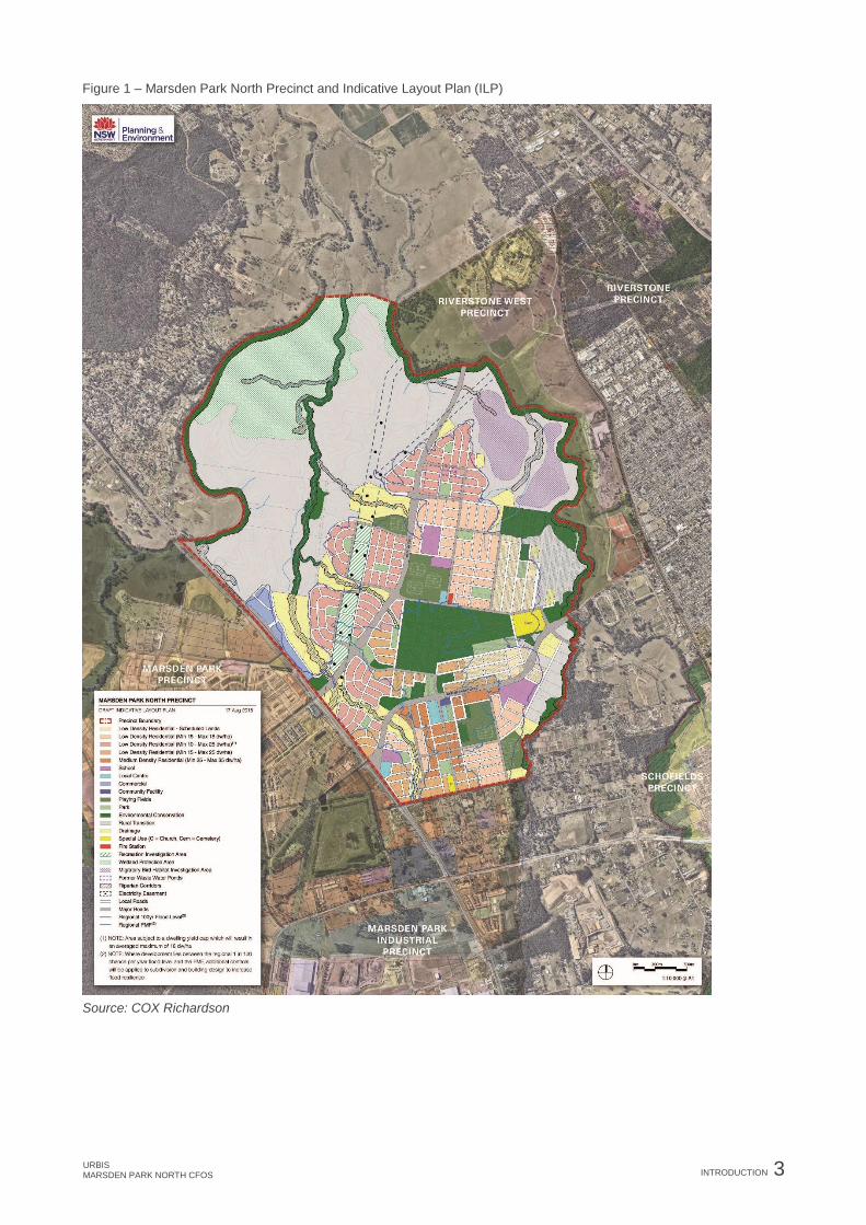
REPORT ASSUMPTIONS AND LIMITATIONS The MPN precinct has a total area of approximately 1,227 hectares, as shown in Figure 1. The MPN Indicative Layout Plan (ILP) includes land proposed for residential development that is generally restricted to areas at or above the 1-in-100-year flood line, as indicated by the blue boundary line in Figure 1.
The aim of this report is to provide recommendations for community facilities and open space to meet the needs of residents within the MPN ILP. That is, in calculating the benchmark demand for community facilities (Chapter 5) and open space (Chapter 6), this report is based on a forecast of 6,312 dwellings and a population of 20,198 people.
It is recognised that the MPN precinct contains a number of dwellings (estimated to be not more than 50) that are located below the 1-in-100-year flood level and therefore outside of the residential development areas. These dwellings have not been included in this benchmarking assessment.
METHODOLOGY The project has involved the following key stages and tasks:
Table 1 – Methodology
Stage Detail
Completed in 2015
Stage 1 • Inception meeting with the Department of Planning and Environment, Blacktown City
Council (the Council) and other technical consultants.
• Site visit to understand the context of the site and surrounding area.
• Interview with the Council to confirm the scope of this study and identify any information
which can be provided to inform the assessment.
Stage 2 • An audit of existing social infrastructure, including community facilities and open space,
in the surrounding area.
• Stakeholder interviews with key stakeholders, including the Council’s social and
recreation planners, and managers of current facilities.

2 INTRODUCTION URBIS
MARSDEN PARK NORTH CFOS
Stage Detail
Completed in 2018
Stage 3 • Review of key strategies and policies relating to the MPN precinct, North West Growth
Centre and planning for Growth Centres.
• Preparation of the demographic profile using 2016 ABS Census data.
• Interview with the Council’s social planner and recreation planner.
Stage 4 • Benchmarking assessment based on industry and Council standards for social
infrastructure.
• Preliminary costing of social infrastructure.
• Preparation of the CFOS report including recommendations for social infrastructure and
design and location considerations of future facilities.
SITE DESCRIPTION The MPN precinct has an area of 1,227 hectares (12.27km2) and is located entirely within the Blacktown Local Government Area (LGA), approximately 40km northwest of the Sydney CBD and 20km north-west of Parramatta. The precinct is bound by Richmond Road to the south west, Vine Street to the south, South Creek to the north-west and Eastern Creek to the east. While the site is situated entirely within the Blacktown LGA, it is proximate to Penrith, Hawkesbury and The Hills Shire LGA’s.
The majority of the precinct is characterised by undeveloped agricultural land, with existing development limited to farm sheds, dams, rural roads, and a series of electricity transmission lines which run north-south through the centre of the precinct. The south-east portion of the precinct is characterised by large and fragmented rural-residential lots and agricultural uses.
Two tributaries of the Hawkesbury-Nepean River, the Eastern and South Creeks, border the site. Large parts of the MPN precinct form the natural floodplain for these watercourses.
Figure 1 shows the MPN precinct, with the finalised MPN ILP indicated by the blue boundary line. The ILP outlines the proposed structure and arrangement of land uses and infrastructure within the MPN precinct. The potential construction of community and recreational facilities within the MPN ILP would be dependent upon funding from Section 7.11 contributions and Voluntary Planning Agreements (VPA).
URBIS MARSDEN PARK NORTH CFOS
INTRODUCTION 3
Figure 1 – Marsden Park North Precinct and Indicative Layout Plan (ILP)
Source: COX Richardson

4 INTRODUCTION URBIS
MARSDEN PARK NORTH CFOS
SUBREGIONAL CONTEXT The MPN precinct forms part of the North West Priority Growth Area (NWPGA), formally known as the North West Growth Centre, an area identified as strategically important in the Greater Sydney Region Plan (2018). The NWPGA covers approximately 10,200 hectares, and is estimated to have capacity to accommodate up to 90,000 dwellings and a population of approximately 250,000 people.
The NWPGA will contain up to five town centres at Box Hill, Marsden Park North, Riverstone, Schofields and in the Cudgegong Road (formally Area 20) precinct. The NWPGA will also be served by the Rouse Hill District Centre and the Marsden Park District Centre. The completion of the Sydney Metro Northwest will bring improved public transport infrastructure to the NWPGA. However, the MPN precinct is largely without public transport infrastructure, with the closest train station located at Riverstone, as shown in Figure 2 below.
The majority of the NWPGA has been rezoned, with five projects to be completed including Marsden Park North, Riverstone East, Vineyard, West Schofields and Shanes Park. The Department of Planning and Environment (DP&E) will prepare rezoning proposals for these areas as infrastructure becomes available and they are suitable for new homes and jobs. In 2014 the DP&E agreed to accelerate the release of the precincts via the Precinct Acceleration Protocol. This Protocol allows landowners to move forward with the release of land, providing there is no cost to Government. The landowner must coordinate the Precinct Planning in-line with requirements and expectations of the DP&E, including delivery of technical reports and ILP for the precinct.
Figure 2 below presents the precincts which form the NWPGA with Table 2 showing their anticipated dwelling capacity.
Figure 2 – North West Priority Growth Area precincts

URBIS MARSDEN PARK NORTH CFOS
INTRODUCTION 5
Table 2 – North West Growth Centre dwelling and population projections
Precinct Dwellings
Alex Avenue 6,300
Schofields 2,950
Cudgegong Road Station (Area 20) 4,400
Box Hill & Box Hill Industrial 9,600
Colebee 1,000
Marsden Park 10,300
Marsden Park Industrial 1,100
Marsden Park North 4,100
North Kellyville 4,500
Riverstone 9,000
Riverstone East 3,500
Riverstone West -
Shanes Park -
Vineyard 2,300
West Schofields 4,300
Source: DP&E 2017, North West Priority Growth Area
6 STRATEGIC CONTEXT URBIS
MARSDEN PARK NORTH CFOS
2. STRATEGIC CONTEXT This section provides a review of key state and local government policies that have informed the assessment in this report.
A list of the policies that have been reviewed can be found below in Table 3.
Table 3 – Policy review
Strategic context Name
State Government
policies
• Greater Sydney Region Plan: A Metropolis of Three Cities (2018)
• Western City District Plan (2018).
• State Environmental Planning Policy (Sydney Region Growth Centres) (2006).
• Growth Centres Development Code (2006).
• North West Priority Growth Area: Land Use and Infrastructure Implementation
Plan (2017).
• Planning for Marsden Park North: Discussion Paper (2015).
Blacktown City
Council policies and
studies
• Blacktown City Council Growth Centre Precincts Development Control Plan
(2010).
• Our Blacktown 2036, Blacktown City Council (2017).
• Blacktown City Council Social Profile (2016).
• Blacktown City Council Cultural Plan (2013).
• Blacktown City Council Draft Recreation and Open Space Strategy (2017).
• Blacktown City Council Section 7.11 (formally Section 94) Contribution Plans.
2.1.1. Greater Sydney Region Plan: A Metropolis of Three Cities (2018)
The Greater Sydney Region Plan: A Metropolis of Three Cities (the Region Plan) establishes a 40-year vision and a 20-year plan to manage growth and change for Greater Sydney in the context of social, economic and environmental matters. The Region Plan sets the planning framework for the five districts which make up the region including the:
• Central City;
• Eastern City;
• Western City;
• North District; and
• South District.
The Region Plan identifies ten directions for Greater Sydney which are supported by 40 key objectives. Key objectives of relevance to the planning of social infrastructure within the MPN precinct include:
• Infrastructure aligns with forecast growth;
• Communities are healthy, resilient and socially connected; and
• Public open space is accessible, protected and enhanced.

URBIS MARSDEN PARK NORTH CFOS
STRATEGIC CONTEXT 7
2.1.2. Western City District Plan (2018)
The Greater Sydney Commission’s District Plan divide Greater Sydney into five districts which represent their common locality and planning opportunities. The MPN precinct is located within the Western City District, covering the Blue Mountains, Camden, Campbelltown, Fairfield, Hawkesbury, Liverpool, Penrith and Wollondilly local government areas.
The Western City District Plan (the District Plan) is a 20-year plan to manage the District’s growth in the context of economic, social and environmental matters to achieve the 40-year vision for Greater Sydney. The District Plan is guided by four key themes that represent the planning priorities for each district, with ten directions to guide delivery. The four key themes are:
• Infrastructure and collaboration;
• Liveability;
• Productivity; and
• Sustainability.
The planning priorities of relevance to the social infrastructure needs in the MPN precinct include: following actions relevant to this report and assessment include:
• Planning for a city supported by infrastructure.
• Providing services and social infrastructure to meet people’s changing needs.
• Fostering healthy, creative, culturally rich and socially connected communities.
• Delivering high quality open space.
2.1.3. State Environmental Planning Policy (Sydney Region Growth Centres) 2006
State Environmental Planning Policy (Sydney Region Growth Centres) 2006 (SEPP Growth Centre) is the environmental planning instrument that establishes the planning rules and objectives for the Growth Centres. It seeks to:
• Co-ordinate the release of land for residential, employment and other urban development in the Growth Centres;
• Enable the establishment of vibrant, sustainable and liveable neighbourhoods that provide for community well-being and high quality local amenity;
• Provide for the orderly and economic provision of infrastructure to match development; and
• Provide controls for the protection of land of natural and cultural significance and contribute to the conservation of biodiversity.
2.1.4. North West Priority Growth Area: Land Use and Infrastructure Implementation Plan (2017)
The North West Priority Growth Area: Land Use and Infrastructure Implementation Plan 2017 (Infrastructure Plan) provides an updated planning framework for the NWPGA in light of the urban development and demand for housing since the release of the North West Growth Centre Structure Plan (2006). The District Plans focus on the increased opportunities for housing, employment and infrastructure in the NWPGA to support Greater Sydney’s expected population growth. The Infrastructure Plan provides a robust framework to support this growth in line with the provision of infrastructure.
The Infrastructure Plan highlights the necessity of coordinating infrastructure to support growth with community facilities, schools, green open spaces and other public spaces to develop the NWPGA centres as attractive and pleasant places to live and work. To achieve this, the Infrastructure Plan outlines eight key actions as follows:
• Provide more land supply for new homes;
• Protect and plan for major transport corridors;

8 STRATEGIC CONTEXT URBIS
MARSDEN PARK NORTH CFOS
• Manage residential densities to align with infrastructure;
• Protect assets and plan for evacuation;
• Transfer more planning controls back to local councils;
• Simplify planning controls within the Blacktown precincts in the NWPGA;
• Review infrastructure requirements and accelerate funding capital works; and
• Improve pedestrian, cycle and green connectivity.
The plan identifies the need to provide additional open space to service the incoming population in the NWPGA. Open space and green links should be provided that provide safe and attractive options for walking and cycling. Recommendations in relation to the provision of open space include:
• To investigate the location of planned facilities to ensure the majority of residents are within 400m of an area of local public open space;
• Investigate shared use opportunities;
• Embellishment of facilities to provide playgrounds, off-leash areas and sporting facilities; and
• Provide open space and green links which provide safe, attractive options for walking and cycling.
In relation to social infrastructure, the Marsden Park precinct is identified as having the potential to provide regional level facilities that can service the future population such as a public school, high school, library, multipurpose community centre and youth-focussed facility.
The Infrastructure Plan also recognises that additional social infrastructure facilities will be required to service the incoming population within the NWPGA. Additional social infrastructure that would be required to service the future population may include a new public school, a local community centre, additional sports and embellishment of facilities in Riverstone Park.
2.1.5. Planning for Marsden Park North: Discussion Paper (2015)
The Planning for Marsden Park North Discussion Paper (Discussion Paper), prepared by the Department of Planning and Environment, provides an overview of the planning work undertaken to date for Marsden Park North.
The Discussion Paper outlines key development outcomes for Marsden Park North in relation to the provision of community facilities and social infrastructure including:
• Open space with a focus on recreation areas including local parks, sports fields, playgrounds and community gardens;
• Pedestrian and cyclist pathways to encourage walking and cycling;
• Green corridors along creeks, protecting important vegetation and habitat for native animals; and
• Plan for facilities, including shops, community centres, parks and sporting facilities.
It is expected there will be high car usage in Marsden Park North which will place pressure on existing roads. The opportunity to provide pedestrian and cycle pathways throughout the precinct which connect to surrounding centres, interchanges and destinations will help to alleviate this pressure.
2.1.6. Growth Centres Development Code 2006
The Growth Centres Development Code (the Code) was produced by the Growth Centres Commission in 2006 to guide planning and urban design outcomes for the North West and South West Growth Centres. The Code is intended to be a reference work, providing the basis for the planning and design of precincts and neighbourhoods.
Social infrastructure is vital for creating and sustaining viable communities and are essential for the health, wellbeing and economic prosperity of communities. The Code aims to enable appropriate land to be made available for the adequate and timely delivery of social infrastructure at the precinct planning level. To achieve this, the Code provides guiding thresholds (benchmarks) for the provision of social infrastructure based on the capacity of the development area. These benchmarks are also supported by a range of

URBIS MARSDEN PARK NORTH CFOS
STRATEGIC CONTEXT 9
guiding principles relating to the location, use and accessibility of social infrastructure, which are reflected within the District Plans. The benchmarks and guiding principles within the Code have been used to inform this report.
2.1.7. Blacktown City Council Growth Centre Precincts Development Control Plan (2010)
The Council’s Growth Centre Precincts Development Control Plan 2010 (DCP) aims to:
• Communicate the planning, design and environmental objectives and controls against which the consent authority will assess development applications (DAs) in these precincts;
• Consolidate and simplify the planning controls for the Blacktown LGA’s Growth Centre Precincts;
• Ensure the orderly, efficient and environmentally sensitive development of the precincts as envisaged by the North West Growth Centre Structure Plan and SEPP Growth Centres; and
• Promote high quality urban design outcomes within the context of environmental, social and economic sustainability.
The DCP currently only applies to precincts which have progressed through the precinct planning phase, including the Alex Avenue, Riverstone, Marsden Park Industrial, Cudgegong Road (formally Area 20), Schofield, Marsden Park, West Schofields (Townson Road) and Riverstone East precincts. As precinct planning is completed for the other precincts in the North West Growth Area, a schedule is added to the DCP with precinct specific controls.
The DCP is implemented for each precinct by an Indicative Layout Plan (ILP). The ILP informs or is the basis of the site zoning. It identified the location of:
• The road network;
• Public transport routes;
• The open space and drainage networks;
• The locations of land uses including residential development, schools, community facilities, utilities, centres and employment lands;
• Areas requiring protection because of environmental or heritage values; and
• The density and types of housing that are preferred in various parts of the precinct.
2.1.8. Our Blacktown 2036, Blacktown City Council (2017)
Our Blacktown 2036 is the Council’s Community Strategic Plan (Strategic Plan) for the LGA. The Strategic Plan outlines the Council’s vision and aspirations for the future of the city and sets out relevant objectives and outcomes to achieve this.
Blacktown is the second largest LGA in NSW with current growth expected to continue, especially in the North West Growth Area. Blacktown is an area of high cultural diversity, with 32% of its current population from culturally and linguistically diverse (CALD) backgrounds and 46% speaking a language other than English at home.
The Strategic Plan outlines a key strategic direction for a sporting and active city with the LGA currently recognised as the sporting capital of Western Sydney. Key focus areas to leverage this include to:
• Provide elite sporting facilities and strong relationships to build on a cultural of sporting excellence;
• Implement a balanced framework for future planning of open space and recreational facilities; and
• Increase community participation in sporting and recreational activities.
Additionally, the Strategic Plan also recognises that improvements to the level of open space provision are needed within the LGA to increase the percentage of residents that have open space located within 800m of their homes.

10 STRATEGIC CONTEXT URBIS
MARSDEN PARK NORTH CFOS
2.1.9. Blacktown City Council Social Profile (2016)
The Blacktown City Social Profile 2016 outlines the major social issues facing the Council and provides a snapshot of the community strengths and needs, which will inform the Council’s community strategic planning.
In 2015, Blacktown LGA was the largest and fastest growing LGA in NSW, with an estimated 340,000 residents in 2016 and an expected 540,000 residents by 2036. This population growth has been generated by migration, births, urban renewal and the development of the NWGA’s. Some of the key issues which are facing the Council in relation to the NWGAs include:
• Social infrastructure: Strong population growth has resulted in the need for additional social infrastructure, particularly in the NWGCs. However, the concurrent changes to planning law have limited Council’s ability to deliver social infrastructure in these new release areas.
• Transport: Transport is a major challenges of growth centres, with poor transit infrastructure and dispersed recreational, employment and residential areas contributing to the issue.
Community and service providers have stated the newer estates in the North West Growth Areas are well planned with paths, cycle-ways, parks and great liveable spaces. In particular, the heritage of Riverstone, open spaces and the existing ‘country feel’ are valued by the local community. In relation to the North West Growth Areas, community and service providers referred to in the Social Profile also state:
• There were plenty of recreational, sporting, social, religious or cultural activities in new estates;
• There is a need for more local infrastructure including pedestrian crossings, footpaths, cycle ways, roads, bridges, railway stations or lighting;
• There is a community interest in developing more community gardens; and
• Widespread concern regarding traffic congestion, traffic flow and traffic disruptions from the roadwork and railway crossing.
2.1.10. Blacktown City Council Cultural Plan (2013)
The Blacktown City Council Cultural Plan 2013(Cultural Plan) is a statement of the Council’s commitment to the arts and cultural development of the community, it recognises the rights of all citizens to participate in a creative life and have access to arts and culture as a vital part of well-being. The Cultural Plan also outlines Council’s commitment to provide opportunities to all residents in all stages of life to participate in local arts and culture.
The Cultural Plan defines culture as:
“Culture is defined as the social landscape in which we live, work and play. It shapes and is shaped by our values, myths, attitudes and customs, geography, climate and location. Culture gives meaning to our cultural and ethnic backgrounds, our way of life, economic and political relationships. Tangible features of our culture include celebrations, the arts, language, architecture, history and heritage. Further to this, our culture encompasses our spiritual and religious beliefs, our values and attitudes.”
The Cultural Plan also identifies Council’s vision for culture and arts:
“Our arts and culture inspires, extends, connects and is a source of pride, identity and well-being for the diverse cultures and communities of Blacktown now and into the future”
2.1.11. Blacktown City Council Recreation and Open Space Strategy (2017)
Blacktown’s Recreation and Open Space Strategy (2017) (the ROSS Strategy) aims to guide future planning in Blacktown LGA to ensure all residents have equitable access to quality indoor and outdoor facilities. The ROSS Strategy recognises the importance of open space for physical, mental and social wellbeing however states that increasing densities are reducing backyard sizes and placing higher demand on public open space.
Key trends identified by the ROSS Strategy include:
• Increasing diversity of communities is increasing the demand for a range of open space opportunities.

URBIS MARSDEN PARK NORTH CFOS
STRATEGIC CONTEXT 11
• There will be an increased demand for sporting facilities as the population ages.
The ROSS Strategy identifies that the benchmark standard of 2.83 ha of open space per person may be out-dated, however, in the absence of any industry or State Government policy, it is used as the starting point for the provision of open space. Considering this, the ROSS Strategy also provides guiding qualitative principles for the provision of open space including:
• All residents to be 400-500m walking distance from open space;
• Minimum park size of 0.3ha to ensure greater useability and viability;
• Minimum two appropriately sized street frontages, preferably three.
• Playgrounds to provide a diverse mix of play opportunities within 500m walking distance of all residents.
• That open space is integrated, connected and multi-functional.

12 COMMUNITY PROFILE URBIS
MARSDEN PARK NORTH CFOS
3. COMMUNITY PROFILE As there is currently no significant development within the MPN precinct, a demographic analysis of the broader area was required to understand the local context of the area. For this purpose, a release area case study was developed to form a likely future residential profile for the incoming MPN ILP population, which is included within this section below.
RELEASE AREA CASE STUDY The demographic characteristics of the incoming population will be dependent upon a range of factors including the prevailing demographic character of the existing and surrounding areas, the proposed dwelling size and mix, market price and affordability, provision of services and facilities, and access to transport, employment, education, and leisure opportunities.
In order to understand the potential future demographic characteristics of the incoming population, a release area case study catchment has been developed to form a likely future residential profile for the incoming population. The release area case study consists of three suburbs in the north-western region of Sydney that were earlier greenfield release precincts, similar to what is anticipated for the MPN precinct. These suburbs developed between 2003 and 2011 and their shifting demographic profile can be seen across the 2006, 2011 and 2016 Census.
The release area case study incorporates the following suburbs:
• The Ponds;
• Stanhope Gardens; and
• the Alex Avenue Precinct.
This data is presented in Appendix A and the release area case study identifies the following key trends:
• Growth in the average household incomes to an average of $142,178 in 2016, which is 27% higher than the Greater Sydney benchmark;
• Slight increase in average age from 2011 to 2016 to 29.5 years. Despite the slight increase, the release area case study has the youngest average age compared to Blacktown LGA (33.7 years), NWGA (33.9 years) and Sydney (36.8 years) in 2016;
• Increase in average household size from 3.2 to 3.4 persons from 2011 to 2016;
• Growth in the proportion of family households, forming approximately 88% of all households in 2016;
• Higher proportion of children (0-14 years), representing 29% of the resident population in 2016; and
• Significantly higher proportion of dwelling purchasers (69% in 2016) which represents people who have bought a property and are paying off their mortgage.
This data reflects a number of common trends and characteristics of residents moving into similar development areas. These characteristics change over time and include:
• Early entrants (0-5 years):
− Young families with young children, or young couples without children;
− Purchasers and first time buyers;
− Residents of surrounding neighbourhoods moving to new dwellings in proximity to existing community; and
− Residents of nearby towns seeking to relocate to newly planned suburban areas.
• Mid-stage (5-10 years):
− Increasing diversity of household type;
− Increase in family sizes as couples have children;

URBIS MARSDEN PARK NORTH CFOS
COMMUNITY PROFILE 13
− Investors and renters for medium to high density dwellings;
− Single person households in higher density dwellings; and
− Increase in older singles or couple households relocating for closer proximity to families established in the area.
• Completion stages (10-25 years):
− Established, diverse, residential suburban community with similar profile to other established areas.
− Relocation of younger residents out of the area to access employment and education is likely to be limited due to the proximity of employment opportunities in surrounding growth precincts and the Western Sydney University campus.
Previous discussions with the Council and other key stakeholders also suggest that the incoming population may be characterised by high levels of:
• Employment;
• Car ownership;
• Home ownership through mortgage;
• Proportions of middle income households; and
• Cultural and ethnic diversity compared to current residents.
POPULATION PROJECTIONS The expected incoming MPN ILP population has been based on a forecast of 6,312 dwellings and a population of 20,198 people. Table 4 below outlines the expected population and dwelling numbers for the MPN ILP area over a 25-year period, assuming production rates as identified by the Urbis Retail and Employment Assessment.
Population projection figures have been calculated based on an average household size of 3.2 persons per dwelling, which is consistent with the dwelling densities for Blacktown LGA as per the 2016 ABS Census data. This also reflects the higher average household sizes which are found in the release area case study as described in Section 3.1.
Table 4 – Population projections
Year 0-5
(2016-21)
Year 5-10
(2021-26)
Year 10-15
(2026-31)
Year 15-20
(2031-36)
Year 20-25
(2036-41)
Dwelling yield 50 1,075 3,050 4,878 6,312
Population 160 3,440 9,760 15,608 20,198

14 EXISTING COMMUNITY FACILITIES AND OPEN SPACE URBIS
MARSDEN PARK NORTH CFOS
4. EXISTING COMMUNITY FACILITIES AND OPEN SPACE INTRODUCTION
This section provides an overview of existing community facilities and open space in and surrounding the MPN precinct. A catchment area of 5km radius (the study area) has been used to identify existing facilities. Within the following maps included in this section, the MPN precinct is referred to as the subject site.
It is important to note that while the incoming residents to the MPN precinct may be able to access existing facilities within the study area, in particular facilities in the nearby Riverstone Town Centre, these facilities must also support future growth within the relevant precinct. As such, planning for each precinct should consider its own population size and the potential demand for community facilities and open space generated from the incoming communities within these precincts.
The following research was undertaken by Urbis in 2015 and some changes may have occurred since this time. Advice provided by Council indicates that the current supply environment has remained relatively unchanged since this time.
EDUCATION FACILITIES 4.2.1. Preschool and child care
There are a range of different models for early education and care services in the study area.
Figure 3 below presents the location of existing preschool and childcare facilities within the study area. In total there are 11 preschools and 23 child care (including long day, occasional care, and family day care) facilities within 5km of the MPN precinct.
It should be noted that the Marsden Park Public School and the Australian Christian College also currently provide kindergarten services to the area and are located within the MPN precinct (see Figure 4).
Council manages three preschools in the area, two of which are located in close proximity to the site. The Quakers Hill Preschool operates between 8:30am – 3:00pm every weekday for 48 weeks per year and has capacity to support 40 children each day aged between 6 weeks - 6 years old. The Glendenning Preschool has similar opening hours (9am – 3pm weekdays) and capacity to support 29 children aged between 3-6 years old.
Council also manages 21 Long Day Care Centres, of which five are located in close proximity to the MPN precinct including Blackett Childcare (40 children), Hassall Grove (40 children) Kerry Jones (59 children), Nan Moran (40 children) and Riverstone (40 children) Child care centres. These centres support children from 6 weeks to 6 years of age and generally operate between 6:30am – 5:30pm for 49 weeks per year.

URBIS MARSDEN PARK NORTH CFOS
EXISTING COMMUNITY FACILITIES AND OPEN SPACE 15
Figure 3 – Location of existing preschool and childcare facilities

16 EXISTING COMMUNITY FACILITIES AND OPEN SPACE URBIS
MARSDEN PARK NORTH CFOS
4.2.2. Primary and secondary schools
Primary schools provide formal education to children from the ages of 6 to 12 years (Year 1 to 6). There are three existing schools within the MPN precinct including Marsden Park Public School, the Australian Christian College and Richard Johnson Anglican School which currently serve the local area.
Figure 4 indicates that there are a further 25 primary school facilities within 5km of the MPN precinct. Four of these facilities also provide secondary education. The majority (17) are non-denominational Government schools and in addition there are five catholic schools, two Anglican schools and one Christian school.
Secondary schools provide formal education to children from the ages of 12 to 18 years (Year 7 to 12). There is currently one secondary school facility within the MPN precinct: The Australian Christian College. The College is an independent school providing education for children from Kindergarten to Year 12 (18 years of age). Richard Johnson Anglican School is expected to provide secondary school facilities after 2019.
Figure 4 presents the location of a further 12 secondary school facilities within 5km of the precinct. Six of these facilities are non-denominational Government schools, with three Catholic, two Anglican schools and one Christian school. Table 5 below provides further details of the existing Secondary Schools which are in close proximity to the precinct.
Table 5 – Existing secondary schools
Name of school Type Capacity
Australian Christian College
Marsden Park
Primary and Secondary, Independent, Co-education,
Christian
320
Richard Johnson Anglican School,
Marsden Park Campus
Currently primary, with secondary facilities expected after
2019, Independent, Co-education, Anglican.
Recently opened in 2016 and currently provides for
Kindergarten to Year 1, with Year 6 expected in 2019.
Secondary facilities are anticipated after this date.
Expected
final
completion
capacity of
over 950.
Bede Polding Catholic College Secondary, Catholic, Co-education 1,211
Casuarina School Primary and Secondary, Government, Co-education, Non-
denominational
130
Norwest Christian College Primary and Secondary, Independent, Co-education,
Christian
388
Riverstone High Secondary, Government, Co-education, Non-
denominational
200
St Clare's Catholic High Secondary, Catholic, Co-education 1,181
4.2.3. Tertiary
The nearest Tertiary education facility to the precinct is Western Sydney University. The university has campus facilities at Nirimba Campus in Quakers Hill, located 5.3km south of the precinct, and the Hawkesbury campus in Richmond, located 8km to the north of the precinct. The Nirimba Campus forms part of the Nirimba Education Precinct with facilities shared between TAFE, Wyndham College and Terra Sancta High School. This campus provides teaching in logistics, information technology, child studies, business services, community services, music & entertainment studies.

URBIS MARSDEN PARK NORTH CFOS
EXISTING COMMUNITY FACILITIES AND OPEN SPACE 17
Figure 4 – Location of existing primary, secondary and tertiary education facilities

18 EXISTING COMMUNITY FACILITIES AND OPEN SPACE URBIS
MARSDEN PARK NORTH CFOS
COMMUNITY CENTRES AND LIBRARIES Community centres generally provide a range of facilities which can be used by the community including meeting rooms and function halls. They also provide accommodation for a range of service organisations to meet the needs of the local community which may include education, youth, family, and seniors’ services
The Council currently provides 34 community centres and neighbourhood centres across the LGA, with 11 located within 5km of the MPN precinct. Figure 6 presents the location of existing community centres and libraries in the study area.
The Riverstone Neighbourhood Centre is the closest centre to the precinct and is located at the Sam Lane Community Complex, less than 1km east of the MPN precinct. The centre provides a range of services to the community, including hosting community events; community outreach services; tailored programs for health and wellbeing; sport and exercise; education and information; and referral services. The facility also includes a community garden, Men’s Shed, Youth Centre for people aged 12-18 years, and a community hall with capacity for 60 people.
It is understood from consultation with Council that the existing Riverstone Neighbourhood Centre is currently operating at capacity and would require significant additional funding in order to support the needs of the incoming population.
The Council provides five library facilities across the LGA, with one located within 5km of the precinct. The Riverstone Library and Digital Hub is located in the Marketown Shopping Centre in Riverstone and provides five general use PC’s with internet access and printing facilities.
Figure 5 – Riverstone neighbourhood centre

URBIS MARSDEN PARK NORTH CFOS
EXISTING COMMUNITY FACILITIES AND OPEN SPACE 19
Figure 6 – Location of existing community centres

20 EXISTING COMMUNITY FACILITIES AND OPEN SPACE URBIS
MARSDEN PARK NORTH CFOS
HEALTH FACILITIES 4.4.1. Hospitals
The MPN precinct is within the Western Sydney Local Health District (LHD), which serves the areas of Auburn, Blacktown, Cumberland, Mount Druitt and Westmead. The LHD operates a number of hospitals, community health facilities, and outreach services across the area.
The nearest Hospital to the precinct is the Blacktown and Mount Druitt Hospital (BMDH), which operates two campus areas. The Mount Druitt campus is classified as a district hospital and is located 8.6km south of the site. The Blacktown campus is classified as a major metropolitan hospital and is located 11.9km south.
The Mount Druitt campus currently provides approximately 158 beds, an emergency department with paediatric emergency services, palliative care, community health and specialised child and elderly person services. The Blacktown campus provides over 330 beds with specialist cardiac, ante-natal, delivery, post-natal, care, also acute medical, coronary care, mental health, dialysis, stroke and rehabilitation units.
Both Hospitals are undergoing expansion which will increase the total number of beds to a combined total of 659.
Also of significance is Hawkesbury District Health Service, which is located just outside of the 5km radius from the subject site. The Hawkesbury District Health Service provides public and private hospital services, community and allied health, and is a teaching hospital for the University of Notre Dame.
4.4.2. Medical services
There are currently no medical service facilities within the MPN precinct. There are approximately 10 facilities within 5km from the MPN precinct, as indicated in Figure 7. These include a cluster of medical facilities in Riverstone to the east which include a family medical practice, chiropractor, X-ray facility, as well as General Practitioners.
4.4.3. Aged care
There are no aged care facilities currently within the MPN precinct. There are three facilities within 5km of the precinct. These include the Quakers Hill Nursing Home which provides 127 beds providing high, low and respite care, the St Elizabeth Home Aged Care Facility, which provides 114 places and the Southern Cross St Francis Apartments, aged care facility, which provides 40 places.
OPEN SPACE There are a number of classifications for open space assets identified within the Growth Centres Development Code (2006) including the following:
• Regional Open Space – Including regional parks, bushland, large remnant vegetation areas that serve a recreational and conservation uses, serving the needs of more than one precinct or catchment area;
• District Open Space – Including competition standard sporting fields, stadia, recreational trails, and formal gardens. These assets service a number of neighbourhoods and residential areas and will include a mix of both active and passive uses with grassed areas for informal recreation, organised sports, and hard-court surfaces for other formal sports;
• Local Open Space – Includes active recreation parks, neighbourhood parks, and pocket parks which are located in close proximity to residential areas. These spaces serve a single neighbourhood and accommodate both active and passive uses. Active recreation may include sporting fields and may include children’s playgrounds. Passive uses may include BBQ and picnic areas and seating; and
• Environmental Conservation Areas – Includes areas of significant quality and protected vegetation, or riparian corridors which are required to maintain healthy watercourses and support floodwater management. These areas are unsuitable for development however can include walking and cycling trails and form important assets for a number of neighbourhoods.
Figure 8 identifies the existing open space assets in the area and their catchment areas. This indicates that the MPN precinct is within the catchment of a number of regional and district open space assets.

URBIS MARSDEN PARK NORTH CFOS
EXISTING COMMUNITY FACILITIES AND OPEN SPACE 21
Figure 7 – Location of existing health facilities

22 EXISTING COMMUNITY FACILITIES AND OPEN SPACE URBIS
MARSDEN PARK NORTH CFOS
Figure 8 – Location of existing open space assets

URBIS MARSDEN PARK NORTH CFOS
EXISTING COMMUNITY FACILITIES AND OPEN SPACE 23
4.5.1. Regional open space
The MPN precinct is in close proximity to the following regional open space assets:
• Western Sydney Parklands – A series of interconnected open space and recreation assets covering an area of 5,280ha stretching 27km from Blacktown in the north to Leppington in the south, across three LGA’s of Blacktown, Fairfield and Liverpool. The Parklands service both the North West Growth Area and South West Growth Area.
• Rouse Hill Regional Park – Provides picnic and BBQ facilities as well as walking and cycling trails. The Park covers 43ha and is located approximately 4km to the east of the MPN precinct.
• Windsor Downs Nature Reserve – The Reserve covers 272ha and is located adjacent to the north of the MPN precinct. The Reserve provides habitat for a range of local and endangered flora and fauna species and includes a number of accessible trails through the site.
• Scheyville National Park – This National Park covers 920ha and is located 8km north east of the MPN precinct. The National Park contains a number of cultural and natural conservation assets including remnants of European settlement, and Cumberland Plain Woodland. The area is accessible via several footpaths and includes BBQ and picnic areas and amenities.
• Wianamatta Regional Park – This Park was created in 2008 on the site of the former Australian Defence Industries (ADI) site. The site in total covers 900ha and a masterplan was developed in 2013 by the NSW Office of Environment and Heritage to guide the long term direction for the site. A 63ha portion of the site is open for use for public access and recreation uses. The site is approximately 8km south west of the MPN precinct.
• Castlereagh Nature Reserve – The Reserve was established in 1995 and covers 490ha. The reserve provides camping, walking, canoeing, equestrian and mountain biking trails.
4.5.2. District and local open space
There is currently one open space asset (Knudsen Reserve) which is maintained by the Council within the MPN precinct. Knudsen Reserve lies on the banks of the Eastern Creek and includes endangered woodland habitat as well as picnic areas and a children’s playground. The reserve is maintained by Friends of Knudsen Reserve community group. The MPN precinct is also in close proximity to the following open space assets:
• Riverstone Park –The park provides a range of formal recreation facilities including a full size football and rugby pitch, running track, and a number of multi-purpose hard courts
• Mill Street Reserve – Provides playing pitches for cricket and soccer and amenity blocks for park users
Figure 9 – Kundsen Reserve
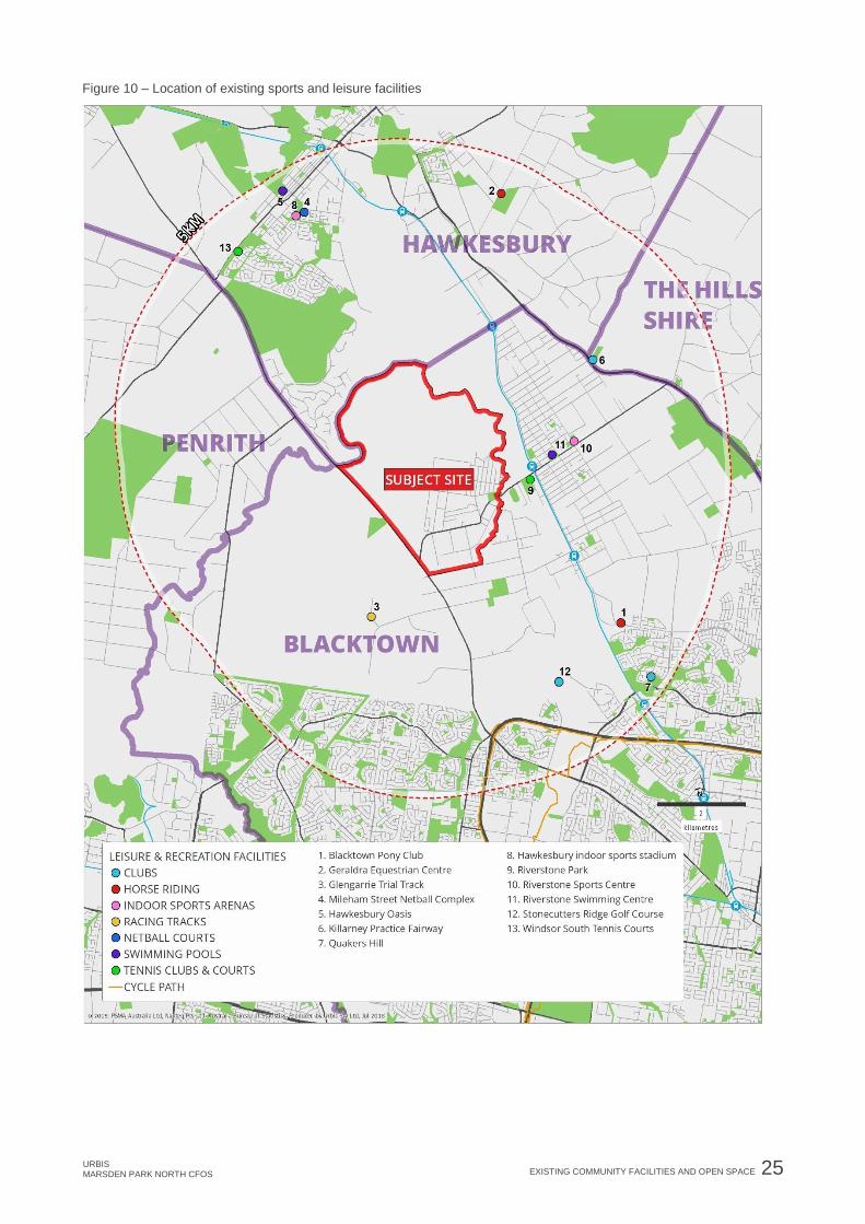
OTHER SPORTS AND LEISURE FACILITIES There are no existing sports and leisure facilities within the MPN precinct. Figure 10 identifies the following sports and leisure facilities in the surrounding area:

24 EXISTING COMMUNITY FACILITIES AND OPEN SPACE URBIS
MARSDEN PARK NORTH CFOS
• Swimming Pools – the Riverstone Swimming Centre is an outdoor swimming pool which is open from 9:00am – 6:00pm seven days per week. In the wider area, the Hawkesbury Oasis aquatic and fitness centre, located in South Windsor, provides a 25m indoor pool and 50m outdoor heated pool, leisure pools, spa, sauna, health club, fitness centre and crèche.
• Tennis – There are two synthetic grass tennis courts located at Riverstone Park.
• Golf courses – The 18-hole Stonecutters Ridge golf course and the Killarney driving range are in close proximity to the site.
• Netball – There are multi-use hard courts located at Riverstone Park near the precinct. In the wider area, the Mileham Street Netball Complex is located in South Windsor and provides 19 hard-court netball courts and is open 7 days per week between 8:00am – 10:00pm. There are also facilities at Quakers Hill Park.
• Indoor sports – The Hawkesbury Indoor Sports Stadium in South Windsor provides six multi-purpose courts for a range of sports types and is home to a number of sports association clubs including basketball, indoor soccer, badminton, netball as well as gymnastics. The facility is open seven days per week between 9:00am – 10:00pm. The Riverstone Sports Centre is located near to the precinct and is operated by the Riverstone Community Church. This facility is open to the public for hire and includes several multi-purpose indoor sports courts.
• Horse riding – The Riverstone Trotting Track is located in close proximity to the site with the Geraldra Equestrian Centre in Vineyard and Blacktown Pony Club in Schofields, also located in the surrounding area.
URBIS MARSDEN PARK NORTH CFOS
EXISTING COMMUNITY FACILITIES AND OPEN SPACE 25
Figure 10 – Location of existing sports and leisure facilities

26 EXISTING COMMUNITY FACILITIES AND OPEN SPACE URBIS
MARSDEN PARK NORTH CFOS
FUTURE COMMITTED AND PLANNED FACILITIES The following sections provide an overview of facilities which are under consideration for the Marsden Park Precinct and Marsden Park Industrial Precinct (MPIP), two release areas that neighbour the MPN precinct.
Previous consultation with Council indicated there will be no capacity within facilities provided in either the Marsden Park precinct or the MPIP, to meet the needs of the incoming MPN community.
The facilities planned for the Marsden Park precinct and the MPIP are not regional facilities and therefore are not planned to meet the needs of surrounding areas, including the MPN precinct.
4.7.1. Marsden Park Precinct
The Marsden Park precinct is likely to accommodate 10,300 new homes and approximately 29,000 residents. The Department of Planning’s Finalisation Report for Marsden Park indicates the Marsden Park precinct will include:
Table 6 – Planning outcomes for Marsden Park precinct
Land Use Area (ha)
Total Open Space 108.7
Local active open space 64.3
Local passive open space 44.4
Total Community Facilities 4.0
Aquatic Leisure Centre 3.0
Community Centres 1.0
Total School 13.9
K-12 schools 8.0
Primary Schools 5.9
Other notes
• The precinct will deliver 108.7 ha of active and passive open space, which exceeds the quota of 82.07ha of open space required to meet the needs of the future population, as identified by MacroPlan consultants in the Community Facilities and Open Space Assessment – Marsden Park (2012).
• The two community centres are identified as Community Resource and Recreation Hubs. The larger facility has a site area of 4,000m2, will be co-located with an aquatic facility and will accommodate a youth centre, performing arts/cultural centre, a district level community centre and a library; and
• A smaller CRRH with a site area of 3,500m2 is co-located with the Northern Village Centre, and will provide for a local community facility and possibly a youth centre.
4.7.2. Marsden Park Industrial Precinct
The CFOS Assessment prepared for the MPIP indicates the following key needs:
• The residential population of the precinct will be too small on its own to require the provision of community facilities;
• The residential population are likely to access facilities within the Marsden Park precinct; and
• The precinct will require the provision of 9ha of open space, including 6ha of parks and local sports field.
URBIS MARSDEN PARK NORTH CFOS
COMMUNITY FACILITIES NEEDS ASSESSMENT 27
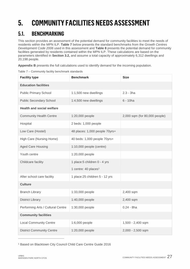
5. COMMUNITY FACILITIES NEEDS ASSESSMENT BENCHMARKING
This section provides an assessment of the potential demand for community facilities to meet the needs of residents within the MPN ILP. Table 7 below presents the standard benchmarks from the Growth Centres Development Code 2006 used in this assessment and Table 8 presents the potential demand for community facilities generated by residents contained within the MPN ILP. These calculations are based on the parameters identified in Section 3.2, and assume a total capacity of approximately 6,312 dwellings and 20,198 people.
Appendix B presents the full calculations used to identify demand for the incoming population.
Table 7 – Community facility benchmark standards
Facility type Benchmark Size
Education facilities
Public Primary School 1:1,500 new dwellings 2.3 - 3ha
Public Secondary School 1:4,500 new dwellings 6 - 10ha
Health and social welfare
Community Health Centre 1:20,000 people 2,000 sqm (for 80,000 people)
Hospital 2 beds: 1,000 people
Low Care (Hostel) 48 places: 1,000 people 70yrs+
High Care (Nursing Home) 40 beds: 1,000 people 70yrs+
Aged Care Housing 1:10,000 people (centre)
Youth centre 1:20,000 people
Childcare facility 1 place:5 children 0 - 4 yrs
1 centre: 40 places1
After school care facility 1 place:25 children 5 - 12 yrs
Culture
Branch Library 1:33,000 people 2,400 sqm
District Library 1:40,000 people 2,400 sqm
Performing Arts / Cultural Centre 1:30,000 people 0.24 - 8ha
Community facilities
Local Community Centre 1:6,000 people 1,500 - 2,400 sqm
District Community Centre 1:20,000 people 2,000 - 2,500 sqm
1 Based on Blacktown City Council Child Care Centre Guide 2016

28 COMMUNITY FACILITIES NEEDS ASSESSMENT URBIS
MARSDEN PARK NORTH CFOS
Table 8 – Community facilities needs assessment
Year 0-5
(2016-21)
Year 5-10
(2021-26)
Year 10-15
(2026-31)
Year 15-20
(2031-36)
Year 20-25
(2036-41)
Development Projections
People 160 3,440 9,760 15,608 20,198
Dwellings 50 1,075 3,050 4,878 6,312
0 - 4yrs 14 299 849 1,358 1,757
5 - 14yrs 28 602 1,708 2,731 3,535
70yrs + 5 117 332 531 687
Community Centres
Local
Community
Centre
0 0.6 1.6 2.6 3.4
District
Community
Centre
0 0.2 0.5 0.8 1.0
Culture
Branch Library 0 0.1 0.3 0.5 0.6
District Library 0 0.1 0.2 0.4 0.5
Performing Arts
/ Cultural Centre 0 0.1 0.3 0.5 0.7
Education Facilities
Public Primary
School 0 0.7 2.0 3.3 4.2
Public
Secondary
School
0 0.2 0.7 1.1 1.4
Health and Social Welfare
Community
Health Centre 0 0.2 0.5 0.8 1.0
Hospital (Beds) 0.3 beds 6.9 beds 19.5 beds 31.2 beds 40.4 beds
Aged Care
Low Care –
Hostel (places) 0.2 places 5.6 places 15.9 places 25.5 places 33 places

URBIS MARSDEN PARK NORTH CFOS
COMMUNITY FACILITIES NEEDS ASSESSMENT 29
Year 0-5
(2016-21)
Year 5-10
(2021-26)
Year 10-15
(2026-31)
Year 15-20
(2031-36)
Year 20-25
(2036-41)
High Care -
Nursing Home
(beds)
0.2 beds 4.7 beds 13.3 beds 21.2 beds 27.5 beds
Aged Care
Housing
(Independent
Living Units)
0 ILU 0.3 ILU 1.0 ILU 1.6 ILU 2.0 ILU
Youth centre 0 0.2 0.6 0.9 1.0
Childcare facility
(centres) 0 1.5 4.2 6.8 8.8
After school
care facility
(places)
1.1 places 24.1 places 68.3 places 109.2 places 141.4 places
ASSESSMENT AND RECOMMENDATIONS The results of the benchmarking assessment have been refined in the following section based on an understanding of the strategic context, capacity of existing and proposed facilities in the surrounding area, the likely demographic profile of future residents, and key issues and priorities for facility provision in the area identified previously by key stakeholders and other research.
COMMUNITY CENTRES Needs assessment Table 8 indicates that, based on benchmarks, the expected MPN ILP population will generate peak demand for 3.4 local community centres and 1.0 district centres by Year 20-25 (2036-41).
In new release areas there is generally a stronger need for strategies to promote integration of new and existing communities, to foster community cohesion and identity, which supports the provision of community centres. Other characteristics of the expected incoming population which will influence the needs for community centres include:
• A high proportion of young couple families with children who may require access to family services, childcare and youth facilities;
• Demand for services and community space by middle aged and older generations; and
• A high proportion of residents from culturally and linguistically diverse (CALD) backgrounds which may require a focal point for community integration and social inclusion, and a community centre which can cater for a range of needs and celebrate cultural diversity.
Design and location considerations
Current best practice in the delivery of community facilities has seen a move away from the provision of small standalone halls and centres, to larger multipurpose facilities.
The Council has adopted a Community Resource Hub Model (CRH) to replace the traditional approach of providing separate neighbourhood centres, community centres and halls, child care centres, youth centres and libraries2. The CRH’s are proposed to be larger buildings compared to traditional standalone facilities
2 Blacktown City Council, 2008, Community Resource Hub Model

30 COMMUNITY FACILITIES NEEDS ASSESSMENT URBIS
MARSDEN PARK NORTH CFOS
and are designed to cater for a catchment of over 10,000 residents, with one district CRH facility expected to serve between 13,000 – 50,000 people and be 750m2 – 1,500m2 in size.
The key principles of the CRH model include:
• The provision of multi-purpose, flexible spaces which can support a diverse range of programs;
• Allowing the co-location of multiple organisations within one facility resulting in synergies for service delivery and associated efficiencies;
• Located in accessible positions in close proximity to town centres, public transport and other social infrastructure including schools and open spaces; and
• Provide a focus for community activity and a hub or focal point for the community.
In general, community facilities should be centrally located within neighbourhood or town centres and be designed to be accessible via private and public transport, and for elderly residents. The design of community centres should also consider CPTED principles to ensure the facility is safe for a range of users throughout the day and evening.
Recommendations
Based on the analysis in this report, it is recommended that:
• One district level CRH which can accommodate a range of community services. The CRH would be designed to service the whole MPN precinct and should be located in a key activity hub, close to transport options that provides convenience for users.
LIBRARY AND CULTURAL CENTRES Needs assessment Table 8 indicates that, based on benchmarks, the expected MPN ILP population does not meet the threshold for the provision of a library or cultural centre.
Recommendations
Urbis recommends that, based on the benchmarks, no additional facilities are required.
EDUCATION FACILITIES Needs assessment Table 8 indicates that, based on benchmarks, the expected MPN ILP population will generate peak demand for 4.2 public primary schools and 1.4 public secondary schools by Year 20-25.
There are three existing schools within the MPN precinct; Marsden Park Public, Australian Christian College and Richard Johnson Anglican School. The future capacity of Marsden Park Public School is unknown, however previous consultation indicates Australian Christian College has capacity to expand to support future population growth within the area, across all stages of education (Kindergarten, Primary and Secondary).
Richard Johnson Anglican School established its Marsden Park campus in 2016 and currently offers Kindergarten to Year 1 facilities, with Year 6 enrolments expected from 2019. Richard Johnson Anglican School is expected to have significant capacity to the serve the needs of the incoming MPN ILP population, with the school anticipating to be larger than its existing Oakhurst Campus, which has approximately 950 enrolments.
The characteristics of the expected incoming MPN ILP population which will influence the needs for education assets include:
• The potential for a high proportion of young families with children who will require access to local education facilities across all age groups;
• The existing low levels of educational attainment within the existing population; and
• The relative disadvantage of the area in terms of education and occupation compared to other areas.
Design and location considerations
The design and location for educational facilities should consider the following factors:
URBIS MARSDEN PARK NORTH CFOS COMMUNITY FACILITIES NEEDS ASSESSMENT 31
• Education facilities should be located adjacent to areas of active open space, community uses and othercompatible land uses;
• Be in close proximity, or with good access to, public transport;
• Should not be located in close proximity to main arterial roads;
• The joint use, or sharing of facilities, including indoor sports halls, open space and playing fields, andhalls and performance areas, between schools and the community should be considered during thedesign phase to maximise opportunities for community use of school facilities. The sharing of schoolfacilities is encouraged by the DoE as per the Community Use of Shared Facilities (2009) policy; and
• The DoE new guidelines for school sites and sizes recommend an enrolment capacity of new andredeveloped schools to 1,000 students for primary schools and 2,000 students for secondary schools.School sizes are recommended to be two hectares for primary schools and four hectares for secondaryschools in Sydney greenfield and regional areas.
Recommendations
Following initial investigations, the DoE recommends the MPN ILP will require two primary schools and no secondary schools. The DoE anticipates no additional secondary facilities are required in the MPN ILP area as students are expected to be accommodated within existing and proposed facilities in the surrounding area.
HEALTH FACILITIES Needs assessment Table 8 indicates that, based on benchmarks, the expected MPN ILP population will generate peak demand for 1.0 community health centre and 40.4 hospital beds by Year 20-25.
There are a number of medical health facilities located in Riverstone, including a family medical practice and number of General Practitioners. The area is also currently serviced by the Blacktown and Mount Druitt Hospital (BMDH) which operates from two different campus areas with each providing a variety of services. The BMDH is currently undergoing an extensive redevelopment to expand its service operating, including the number of beds provided, to support the projected population growth in the NWGA. Stage 1 of the BMDH Expansion Project was completed in May 2016 with the opening of the clinical services building at Blacktown Hospital. Stage 2 is currently underway at Blacktown Hospital and Mount Druitt Hospital.
However, consultation with Council indicates that the human services sector is currently operating at, or approaching capacity, with the increased population growth placing pressure on existing social services and outreach services.
Recommendations
Urbis recommends the provision of one community health centre, provided by Council, to meet the needs of the expected MPN ILP population. The centre should incorporate outreach, social services and facilitate social and health services to support older demographics.
AGED CARE Needs assessment Table 8 indicates that, based on benchmarks, the expected MPN ILP population will generate peak demand for 2.0 aged care housing (Independent Living Units), 33 low care places and 27.5 high care beds by Year 20-25.
There are currently no aged care facilities in the MPN precinct, and three facilities within 5km. During the early stage of the development there is likely to be low demand for residential aged care facilities, however as families become established within the area, older generations may relocate to the area to be close to their families and may require aged care facilities.
Recommendations
Urbis recommends that two aged care housing (Independent Living Units) are encouraged within the MPN ILP. It is anticipated that aged care centres will be provided by the private and not-for-profit sector based on market demand for facilities.

32 COMMUNITY FACILITIES NEEDS ASSESSMENT URBIS MARSDEN PARK NORTH CFOS
YOUTH CENTRES Needs assessment Table 8 indicates that, based on benchmarks, the expected MPN ILP population will generate peak demand for 1.0 youth centre by Year 20-25.
Youth facilities and services are likely to be in high demand due to the high proportion of young families with children expected to be moving to the area. There are existing youth centre facilities in Riverstone, however they would require upgrade and additional funding to meet the needs of the incoming population to the MPN precinct.
The provision of adequate sports and recreation facilities can go some way to meet the recreation needs of young people however they are not an alternative to the development of specifically designed youth centres.
Current best practice in the delivery of community facilities has seen an emphasis on co-location and larger, multipurpose facilities. As per Council’s CRH policy, a youth centre facility should be co-located with other facilities or integrated as part of a larger community facility.
Recommendations
Urbis recommends that one youth centre be provided within the MPN ILP and be provided as part of the district level CRH identified in Section 5.3.
CHILDCARE Needs assessment Table 8 indicates that, based on benchmark standards, the MPN ILP will generate peak demand for 8.8 childcare centres, providing 351 childcare spaces and 141 after school places by Year 20-25.
Blacktown City Council Childcare Centre Guide (2016) states a maximum of 40 places for children is preferred within each centre, with a minimum of 4 places for children under 2 years of age. This has been applied in the above benchmark standards.
It is anticipated there will be demand for childcare facilities in the early stages of development, due to the expected high proportion of young families and young couples moving into the precinct.
There are a number of existing public and private childcare facilities servicing the area, including services offered at the Marsden Park Public school, the Australian Christian College, and in the Riverstone town centre. These facilities may cater for some initial demand in the early stages of the development, however their future capacity is unknown.
Recommendations
Urbis recommends that two childcare centres are co-located and provided by the Council as part of the district level CRH identified in Section 5.3, or as part of future NSW Department of Education schools. It is expected that the additional demand for six childcare centres will be met by the private sector.
RECOMMENDATIONS SUMMARY Community facilities are important considerations in the planning of communities as they provide opportunities for social interaction which are critical to developing and maintaining social cohesion. As apartment living becomes more prominent, community facilities are becoming extensions of the home and should be emphasised in the planning of future communities. Table 9 outlines the recommendations for the provision of community facilities in the MPN ILP.

URBIS MARSDEN PARK NORTH CFOS COMMUNITY FACILITIES NEEDS ASSESSMENT 33
Table 9 – Community facilities recommendations
Facility type Benchmark
requirement
Recommendation
Local Community
Centre
3.4 • Based on the assessment in this report and Council’s
preferred Community Resource Hub Model Policy (2008)
it is recommended the following community facilities are
provided:
− One district CRH.
• The CRH should be located in accessible positions in
proximity to town centres, public transport and other
social infrastructure including schools and open spaces.
• Priority should be given to the construction of a local
level CRH at the beginning of staging, to ensure there is
an appropriate meeting space for the incoming
population.
District Community
Centre
1.0
Branch Library 0.6 • Based on the benchmark, no additional facilities will be
required in the MPN ILP.
District Library 0.5
Performing Arts/
Cultural Centre
0.7
Public Primary School 4.2 • Based on the recommendations from DoE, the MPN ILP
will require:
− Two public primary schools, with an enrolmentcapacity of 1,000 students per school.
− No secondary schools, with incoming studentsexpected to be accommodated in existing andplanned facilities.
• Education facilities should be co-located with areas of
active open space and other community uses. If
constructed, the potential for joint use arrangements to
share halls, open space and performance areas with the
school and the community should be considered to
maximise community use.
• Based on the release area case study and population
projections, it is expected there will be increasing
household sizes and families with children within the mid-
stages of the development (years 5-10). Priority should
be given to the construction of schools prior to this
period, to meet expected demand.
Public Secondary
School
1.4

34 COMMUNITY FACILITIES NEEDS ASSESSMENT URBIS
MARSDEN PARK NORTH CFOS
Facility type Benchmark
requirement
Recommendation
Community Health
Centre
1.0 • Based on the assessment in this report, it is
recommended the following health facilities are provided:
− one community health centre that incorporates outreach, social services and aged care services.
• The community health centre should co-located with the
CRH’s identified above, or within a commercial centre,
and be within proximity to public transport.
Hospital (beds) 40.4
Aged care housing
(Independent Living
Units)
2.0 • Based on the assessment in this report, it is
recommended that no aged care facilities (Independent
Living Units) are provided by Council.
• Two aged care housing (Independent Living Units) are
encouraged within the MPN ILP, with demand expected
to be met by the private and not-for-profit sector based
on market demand.
• It is recommended future provision of aged care housing
is provided in proximity to the local or commercial
centres identified in the ILP, to ensure greater
accessibility to essential services.
High Care (Nursing
Home) beds
27.5
Low Care (hostel)
places
33
Youth Centre 1.0 • Based on the assessment in this report, it is
recommended the following youth facilities are provided:
− One youth centre to be co-located with the CRH identified above.
Childcare facility
(centres)
8.8 • Based on the assessment in this report, it is
recommended the following childcare and after school
care facilities are provided:
− Two child care centres provided by Council and to be co-located with a district CRH or as part of future NSW Department of Education schools.
− Additional demand for up to six child care centres is expected to be met by the private sector.
• Future child care centres provided by private sectors
should be co-located with the local centres identified in
the ILP.
After school care
facility (places)
141.4 places

URBIS MARSDEN PARK NORTH CFOS
COMMUNITY FACILITIES NEEDS ASSESSMENT 35
ILP PROVISION The ILP includes the site locations for community facilities and generally meets the recommended community facility provision as identified above. The MPN ILP Includes:
• Provision for one community centre on a 0.64ha site, which can support the requirements of a district CRH. The community centre site is located next to a local centre, residential areas and open space, maximising the accessibility of the centre.
• Provision for two schools, which can support the recommended school provision identified by DoE. The school sites are located next to active open space, which is supported by Council and DoE objectives. Consideration should be given to separate the school site locations in the ILP to allow greater accessibility to residents in the northern area of the precinct.
• Provision of four local centre sites. Consideration to the provision of child care centres and aged care housing (Independent Living Units) should be given to co-locate these facilities with the local centres to enhance accessibility.

36 OPEN SPACE NEEDS ASSESSMENT URBIS
MARSDEN PARK NORTH CFOS
6. OPEN SPACE NEEDS ASSESSMENT BENCHMARKING
The following section provides an overview of the potential need for open space and sports and recreation facilities generated by the incoming ILP population to the MPN precinct.
This assessment has been based on the benchmarks set out in the Growth Centres Development Code 2006) and recommended provisions in Blacktown City Council Recreation and Open Space Strategy, 2017.
Table 10 – Open space, sports and recreation facilities benchmark standards
Facility type Benchmark Description
Growth Centres Development Code
General open space 2.83ha: 1,000 people As per the Growth Centres Development Code 2006, an
open space system should be established as an
integrated network, incorporating regional open space,
district parks and local parks. The Council’s Section 7.11
(formally Section 94) Contributions Plan No.21 – Marsden
Park states residents should be within 400-500m walking
distance to this open space.
Blacktown City Council Recreation and Open Space Strategy (2017)
Local sports fields 1:1,850 people Minimum double playing field layout – as advised by
Council. AFL size layout is preferred by Council.
This strategy identifies the benchmark standard of 2.83ha: 1,000 people may be outdated however, in the
absence of any industry or State Government policy, it is used as a starting point for the provision of open
space. The strategy identifies several quality based principles to guide the provision of open space which
have been considered in this assessment.
Table 11 below presents an assessment of the potential need for open space, sports and recreation facilities generated by the incoming population based on the benchmarks set out above.
Appendix B contains the full calculations used to identify demand generated by the incoming MPN precinct population.

URBIS MARSDEN PARK NORTH CFOS
OPEN SPACE NEEDS ASSESSMENT 37
Table 11 – Open space, sports and recreation facilities needs assessment
Year 0-5
(2016-21)
Year 5-10
(2021-26)
Year 10-15
(2036-31)
Year 15-20
(2031-36)
Year 20-25
(2036-41)
Development projections
People 160 3,440 9,760 15,608 20,198
Dwellings 50 1,075 3,050 4,878 6,312
Open space needs
Minimum open
space required
(ha)*
0.45ha 9.74ha 27.62ha 44.17ha 57.16ha
Local sports
fields (No.)** 0.1 2.0 5.3 8.4 10.9
Notes:
*According to consultation with Council, this open space should exclude regional open space, drainage,
areas of cultural significance, flood prone land, and creek lines
** Consultation with Council indicates sporting fields should be provided in a minimum double playing field
layout, totalling 4.5ha.
ASSESSMENT AND RECOMMENDATIONS This initial benchmarking assessment has been refined in the following sections based on an understanding of the existing open space assets and future planned facilities in the surrounding area, the likely demographic profile of future residents and their areas of need, and key issues and priorities for facility provision in the area previously identified by key stakeholders and Councils key policy directions.
NEEDS ASSESSMENT Table 11 indicates that, based on benchmarks, the expected MPN ILP population will generate a peak demand for 57.16ha of open space and 10.9 local playing fields by Year 20-25.
Based on the release area case study, the characteristics of the incoming ILP population which will influence the needs for open space, sports and recreation facilities include:
• High proportion of young families with children will require playground and child safe facilities.
• High proportion of young children will require the provision of active sports and leisure space for a variety of formal and informal needs. This may include formal sports fields for soccer, cricket, rugby, and also facilities for informal sports including basketball, skate boarding, cycling etc.
• Residents from diverse cultural backgrounds will have differing needs for open space, sports and recreation facilities. This may include BBQ and picnic areas for family gatherings or cultural celebrations, and multi-use sports courts which are flexible to allow for a range of activities.
As indicated in Figure 8, the MPN precinct has good access to a range of regional and district level open space facilities. However, the MPN precinct lacks a network of smaller local parks and pocket parks which can provide more immediate open space access to residents and encourage more informal recreational uses of the space.

38 OPEN SPACE NEEDS ASSESSMENT URBIS
MARSDEN PARK NORTH CFOS
Previous consultation with Council indicated the following:
• Existing facilities within Blacktown LGA, such as Mileham Netball Complex and facilities in Riverstone and Quakers Hill, have no capacity to meet the needs of the incoming MPN ILP population.
• The proposed aquatic and indoor sports centre in the Marsden Park precinct will support the needs of the expected incoming MPN ILP population. However planned facilities in other precincts, such as the Grange Avenue facility, will not be sufficient to support the incoming MPN ILP population.
• Facilities outside of Blacktown LGA, such as Hawkesbury Indoor Sports Stadium, cannot be considered as supporting the incoming MPN ILP population as these facilities reside outside of the LGA.
OPEN SPACE DESIGN PRINCIPLES The following design principles and considerations should be taken into account when considering the provision of open space, sport and recreation facilities to meet community needs.
6.4.1. Growth Centre Development Code principles
The Growth Centres Development Code (2006) indicates that the provision of open space should:
• Form an integrated network of open space linking with high quality sports fields in adjacent precincts;
• Intergrade stormwater management within networked open space;
• Provide a balance of usable and accessible open space with stormwater management uses and protected recreational uses;
• Provide pedestrian, bicycle and equestrian trails were appropriate to create green links through the precinct;
• Enhance and protect environmental assets and seek to retain as much existing vegetation and habitat as possible to provide biodiversity benefits and contribute to local amenity;
• Incorporation, protection and co-location of Aboriginal and Non-aboriginal cultural heritage within open space networks;
• Be in close proximity to residential areas, be overlooked by at least two residential streets with good sight lines through the open space;
• Be co-located with schools, hospitals, community centres;
• Include facilities for passive recreation such as cycle tracks, horse trails, BBQ and picnic grounds; and
• Provide adequate lighting and paving for community safety and access.
6.4.2. Flood prone land and nature conservation areas
The MPN precinct is characterised by a considerable area of flood prone land which is not appropriate for significant development.
The Blacktown Growth Centres Development Control Plan (2010) applies to the precincts where precinct planning and rezoning has been completed. As precinct planning is completed for remaining precincts in the North West Growth Area, such as the MPN precinct, a schedule is added to the DCP with precinct specific controls. The Blacktown Growth Centres DCP indicates that:
“Pedestrian and cycle pathways and open space may extend within the 1% AEP flood level, provided the safe access criteria contained in the NSW Floodplain Manual are met.”
Also:
“Native trees and other vegetation are to be retained where possible by careful planning of subdivisions to incorporate trees into areas such as road reserves and private or communal open space.”
The Growth Centres Development Code (2006) states a number of objectives relating the development of flood prone land including:

URBIS MARSDEN PARK NORTH CFOS
OPEN SPACE NEEDS ASSESSMENT 39
• To enable the effective utilisation of flood-prone land;
• To minimise environmental impacts of development within the floodplain; and
• To marry the activity and development in the flood zone in a manner that is appropriate to the identified type and flood risk.
Based on these objectives, the Growth Centres Development Code (2006) states regional and local parks and private recreation are compatible development with flood prone land (1:100 ARI). It also indicates that:
“Facilities for passive recreation such as cycle tracks, horse trails, picnic grounds etc. may be located within flood prone areas (1:100 ARI)”
6.4.3. Section 7.11 Contributions Plan No – 21 Marsden Park: Open Space & Recreational Facilities
The Blacktown City Council Section 7.11 (formally Section 94) Contributions Plan No -21 Marsden Park Chapter 4: Open space & Recreational Facilities outlines the nature and provision of open space within the Marsden Park precinct.
The Council has applied a demographic/needs based approach to the provision of open space, adopting the Growth Centre Development Code of 2.83 hectare of usable open space per 1,000 persons.
The existing open space provision reflects a hierarchy of provision which allows for varying uses and diversity in recreational offering. The plan emphasises the accessibility of open space, stating that the spread and distribution of passive parks ensures that residents are within a 400 – 500m walking distance. Open spaces of various sizes should be distributed across the precinct.
6.4.4. Blacktown City Council Recreation and Open Space Strategy 2017
The Blacktown City Council Recreation and Open Space Strategy 2017 (the ROSS Strategy) identifies the benchmark standard of 2.83ha: 1,000 people may be outdated however, in the absence of any industry or State Government policy, it is used as a starting point for the provision of open space. Considering this, the ROSS Strategy also provides guiding qualitative principles for the provision of open space including:
• All residents to be 400-500m walking distance from open space.
• Minimum park size of 0.3ha to ensure greater useability and viability.
• Minimum 2 appropriately sized street frontages, preferably 3.
• Playgrounds to provide a diverse mix of play opportunities within 500m walking distance of all residents.
• That open space is integrated, connected and multi-functional.
6.4.5. Local sports fields
The ROSS Strategy identifies sporting fields are to be provided in a minimum double playing field configurations with enough space for car parking, amenities, light spill and supporting facilities (i.e. practice facilities). Consultation with Council identifies the sporting fields should cater for a variety of active sports, such as soccer, AFL, cricket and rugby league, and be 4.5ha in size.
RECOMMENDATIONS Public open space is an important consideration as it contributes to the physical health and social wellbeing of the community. It can also have a significant impact on the attractiveness of an area and demand for dwellings. A clear direction from all policies and guidelines is the development of a network of open space which performs different functions and provides a diverse range of assets for passive, active, formal and informal recreation and amenity.
Based on the benchmarks, there will be a total demand for 57.16 ha of open space. This open space can be distributed as follows:
• 32.41ha of general open space provided as a network of district, local and pocket parks.
• 24.75ha of active open space provided as 11 playing fields.
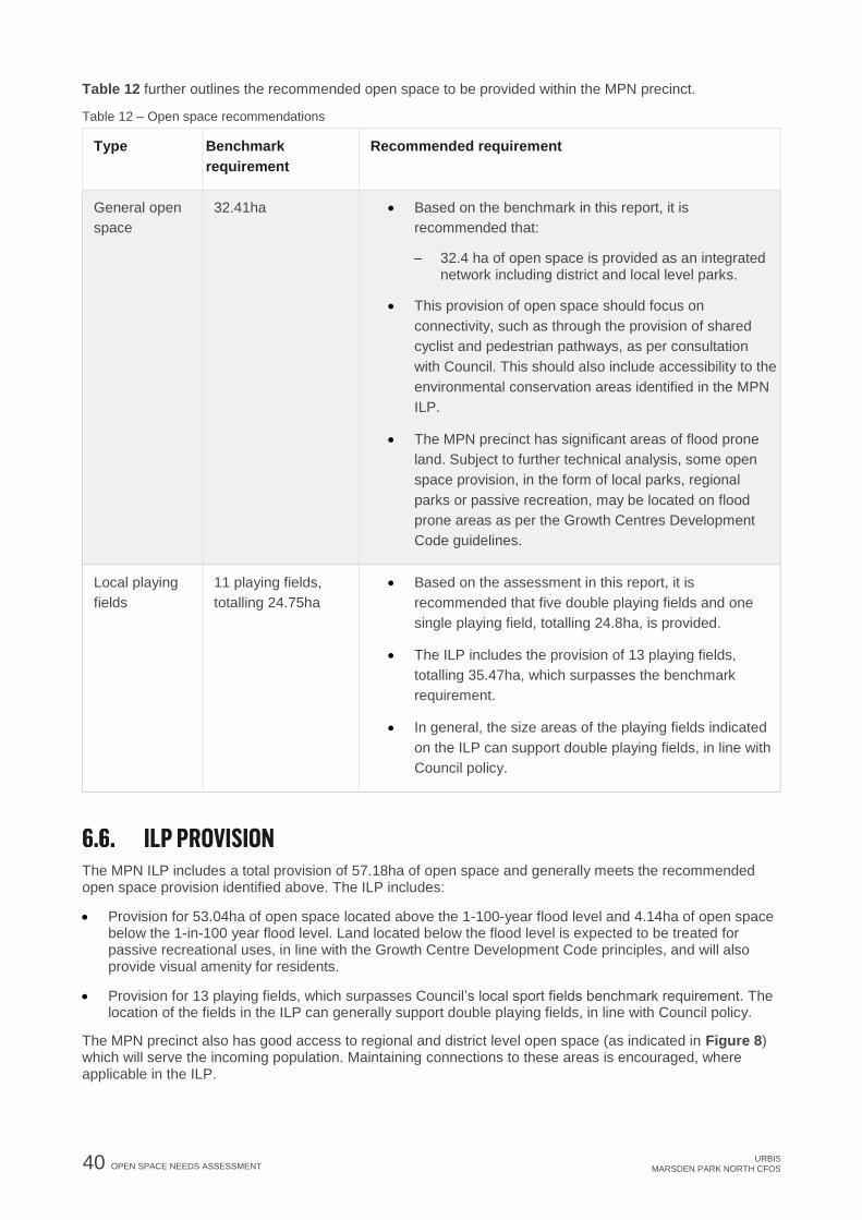
40 OPEN SPACE NEEDS ASSESSMENT URBIS
MARSDEN PARK NORTH CFOS
Table 12 further outlines the recommended open space to be provided within the MPN precinct.
Table 12 – Open space recommendations
Type Benchmark
requirement
Recommended requirement
General open
space
32.41ha • Based on the benchmark in this report, it is
recommended that:
− 32.4 ha of open space is provided as an integrated network including district and local level parks.
• This provision of open space should focus on
connectivity, such as through the provision of shared
cyclist and pedestrian pathways, as per consultation
with Council. This should also include accessibility to the
environmental conservation areas identified in the MPN
ILP.
• The MPN precinct has significant areas of flood prone
land. Subject to further technical analysis, some open
space provision, in the form of local parks, regional
parks or passive recreation, may be located on flood
prone areas as per the Growth Centres Development
Code guidelines.
Local playing
fields
11 playing fields,
totalling 24.75ha
• Based on the assessment in this report, it is
recommended that five double playing fields and one
single playing field, totalling 24.8ha, is provided.
• The ILP includes the provision of 13 playing fields,
totalling 35.47ha, which surpasses the benchmark
requirement.
• In general, the size areas of the playing fields indicated
on the ILP can support double playing fields, in line with
Council policy.
ILP PROVISION The MPN ILP includes a total provision of 57.18ha of open space and generally meets the recommended open space provision identified above. The ILP includes:
• Provision for 53.04ha of open space located above the 1-100-year flood level and 4.14ha of open space below the 1-in-100 year flood level. Land located below the flood level is expected to be treated for passive recreational uses, in line with the Growth Centre Development Code principles, and will also provide visual amenity for residents.
• Provision for 13 playing fields, which surpasses Council’s local sport fields benchmark requirement. The location of the fields in the ILP can generally support double playing fields, in line with Council policy.
The MPN precinct also has good access to regional and district level open space (as indicated in Figure 8) which will serve the incoming population. Maintaining connections to these areas is encouraged, where applicable in the ILP.

URBIS MARSDEN PARK NORTH CFOS
DELIVERING SOCIAL INFRASTRUCTURE 41
7. DELIVERING SOCIAL INFRASTRUCTURE FUNDING SOCIAL INFRASTRUCTURE
Under the Environmental Planning and Assessment Act, 1979, Section 7.11 Contributions are the primary way local councils can fund the cost of local infrastructure provision.
Section 7.11 of the Environmental Planning and Assessment Act 1979 enables the Council to levy contributions towards the cost of providing local infrastructure listed on the essential works list. Funding for infrastructure not considered essential works, for example the construction of a community facility, would need to be funded via other mechanisms, including Voluntary Planning Agreements. The following public amenities or public services are considered essential works:
• Land for open space (for example, parks and sporting facilities) including base level embellishment;
• Land for community services (for example, childcare centres and libraries);
• Land and facilities for transport (for example, road works, traffic management and pedestrian and cyclist facilities), but not including car parking;
• Land and facilities for stormwater management; and
• The costs of plan preparation and administration.
The essential works list is relevant only to those contributions plans that propose a contribution level above the relevant cap (unless otherwise directed by the Minister for Planning).
Funding works outside of this list, for example construction of a community facility, would need to funded via other mechanisms including gap funding or through the provisions of voluntary planning agreements (VPA), or other funding avenues.
COST ESTIMATES Table 13 provides a preliminary cost estimate for the social infrastructure. These preliminary cost estimates include the cost of the facility, excluding the land value.
These costs have been calculated based on Rawlinsons Australian Construction Handbook 2017, using the most similar comparative building category listed in the Rawlinsons Handbook.
Rawlinsons data provides an estimate for initial feasibility studies and is based on the average price for typical building within Sydney. There are a range of factors which can influence the cost of a building project including size, layout, design features, location, materials, financing and contractor fees. At this stage, many of these factors are unknown and it is anticipated that the Council will undertake additional costing as part of their Section 7.11 contributions planning.
Table 13 presents the estimated costing for a number of facility types which may be required to support the needs of the incoming community.
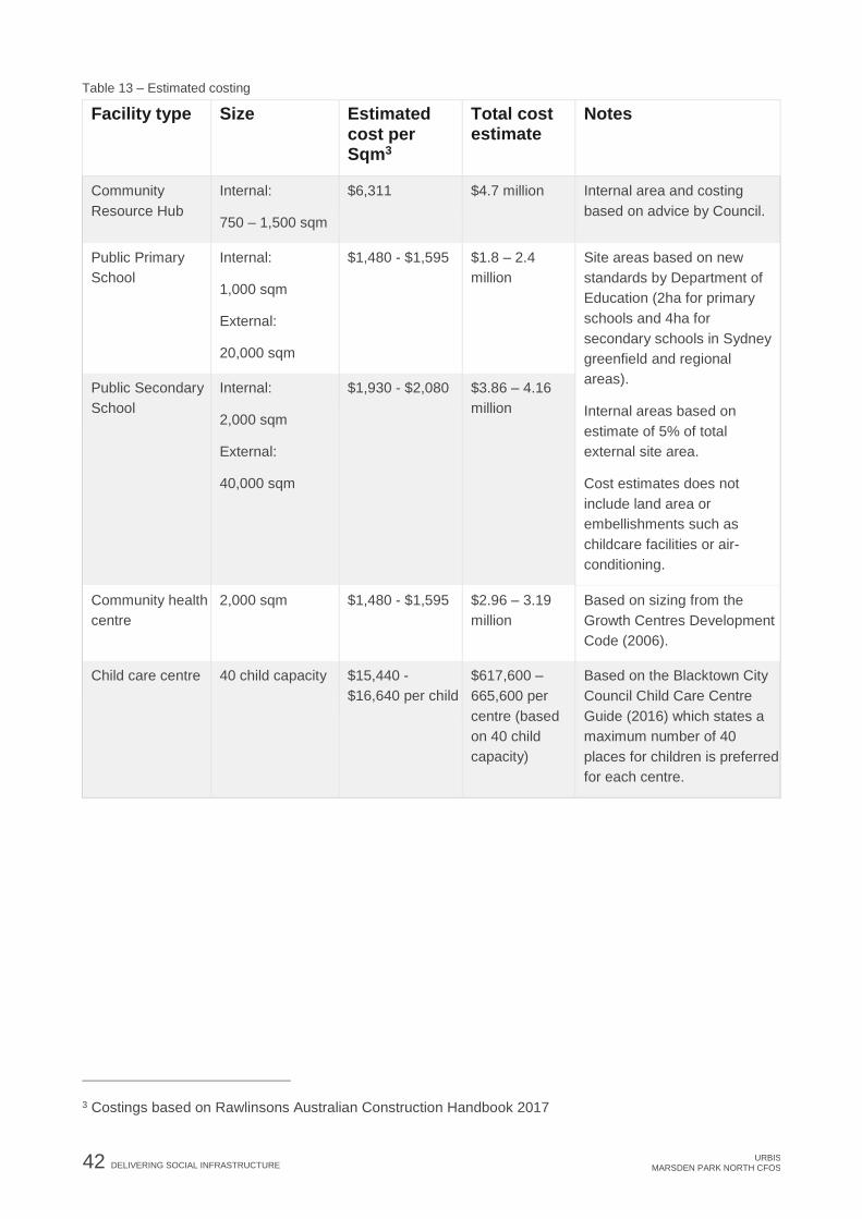
42 DELIVERING SOCIAL INFRASTRUCTURE URBIS
MARSDEN PARK NORTH CFOS
Table 13 – Estimated costing
Facility type Size Estimated cost per Sqm3
Total cost estimate
Notes
Community
Resource Hub
Internal:
750 – 1,500 sqm
$6,311 $4.7 million Internal area and costing
based on advice by Council.
Public Primary
School
Internal:
1,000 sqm
External:
20,000 sqm
$1,480 - $1,595 $1.8 – 2.4
million
Site areas based on new
standards by Department of
Education (2ha for primary
schools and 4ha for
secondary schools in Sydney
greenfield and regional
areas).
Internal areas based on
estimate of 5% of total
external site area.
Cost estimates does not
include land area or
embellishments such as
childcare facilities or air-
conditioning.
Public Secondary
School
Internal:
2,000 sqm
External:
40,000 sqm
$1,930 - $2,080 $3.86 – 4.16
million
Community health
centre
2,000 sqm $1,480 - $1,595 $2.96 – 3.19
million
Based on sizing from the
Growth Centres Development
Code (2006).
Child care centre 40 child capacity $15,440 -
$16,640 per child
$617,600 –
665,600 per
centre (based
on 40 child
capacity)
Based on the Blacktown City
Council Child Care Centre
Guide (2016) which states a
maximum number of 40
places for children is preferred
for each centre.
3 Costings based on Rawlinsons Australian Construction Handbook 2017

URBIS MARSDEN PARK NORTH CFOS
CONCLUSION 43
8. CONCLUSION This report has assessed the likely demand for social infrastructure generated by the expected MPN ILP population and provided recommendations to meet the needs of this population. These recommendations are reflected in the MPN precinct ILP and where this is not shown, a rationale has been provided.
Further consultation with Blacktown City Council and other relevant agencies is recommended to inform future detailed planning for the MPN precinct.

44 DISCLAIMER URBIS
MARSDEN PARK NORTH CFOS
DISCLAIMER This report is dated August 2018 and incorporates information and events up to that date only and excludes any information arising, or event occurring, after that date which may affect the validity of Urbis Pty Ltd’s (Urbis) opinion in this report. Urbis prepared this report on the instructions, and for the benefit only, of Garfield Pastoral Holdings & Mirvac Homes (NSW) (Instructing Party) for the purpose of CFOS (Purpose) and not for any other purpose or use. To the extent permitted by applicable law, Urbis expressly disclaims all liability, whether direct or indirect, to the Instructing Party which relies or purports to rely on this report for any purpose other than the Purpose, and to any other person which relies or purports to rely on this report for any purpose whatsoever (including the Purpose).
In preparing this report, Urbis was required to make judgements which may be affected by unforeseen future events, the likelihood and effects of which are not capable of precise assessment.
All surveys, forecasts, projections and recommendations contained in or associated with this report are made in good faith and on the basis of information supplied to Urbis at the date of this report, and upon which Urbis relied. Achievement of the projections and budgets set out in this report will depend, among other things, on the actions of others over which Urbis has no control.
In preparing this report, Urbis may rely on or refer to documents in a language other than English, which Urbis may arrange to be translated. Urbis is not responsible for the accuracy or completeness of such translations and disclaims any liability for any statement or opinion made in this report being inaccurate or incomplete arising from such translations.
Whilst Urbis has made all reasonable inquiries it believes necessary in preparing this report, it is not responsible for determining the completeness or accuracy of information provided to it. Urbis (including its officers and personnel) is not liable for any errors or omissions, including in information provided by the Instructing Party or another person or upon which Urbis relies, provided that such errors or omissions are not made by Urbis recklessly or in bad faith.
This report has been prepared with due care and diligence by Urbis and the statements and opinions given by Urbis in this report are given in good faith and in the reasonable belief that they are correct and not misleading, subject to the limitations above.

URBIS MARSDEN PARK NORTH CFOS
APPENDICES
RELEASE AREA CASE STUDY DEMOGRAPHIC PROFILE

APPENDICES
URBIS MARSDEN PARK NORTH CFOS
Table 14 – Release area case study demographic profile (The release area case study combines data from The Ponds, Stanhope Gardens and the Alex Avenue Precinct in Schofields).
Indicator 2011 2016 Change
Aged 0-4 11.2% 8.7% -2.5%
Aged 5-14 16.3% 17.5% 1.2%
Aged 0-14 26.2% 29% 2.8%
Aged 15-24 12.4% 11% -1.4%
Aged 25-39 31.7% 28% -3.7%
Aged 40-59 22.7% 25% 2.3%
Aged 60+ 7.0% 7% 0%
Aged 70+ 2.6% 3.4% 0.8%
Average Age 28.9 29.5 0.6
$Nil - $41,600 12.5% 6% -6.5%
$41,600 - $52,000 4.3% 3% -1.3%
$52,000 - $104,000 26.7% 21% -5.7%
$104,000-$156,000 31.0% 31% 0%
$156,000+ 25.5% 39% 13.5%
Average household size 3.2 3.4 0.2
Average Household
Income
$123,589 $142,178 $18,589
Family households 87.9% 88.4%
Owner 12.7% 12.2% -0.5%
Purchaser 67.8% 68.7% 0.9%
Renter 19.2% 20.5% 1.3%

URBIS MARSDEN PARK NORTH CFOS
APPENDICES
BENCHMARKING CALCULATIONS

APPENDICES
URBIS MARSDEN PARK NORTH CFOS
Table 15 – Benchmarking calculations for community facilities, open space and recreation
Facility type Benchmark
threshold
Year: 0-5
Peak population: 160
Peak dwellings: 50
70yrs+ population: 5
0-4yrs population: 14
5-14yrs population: 28
Year: 5-10
Peak population: 3,440
Peak dwellings: 1,075
70yrs+ population: 117
0-4yrs population: 299
5-14yrs population: 602
Year: 10-15
Peak population: 9,760
Peak dwellings: 3,050
70yrs+ population: 332
0-4yrs population: 849
5-14yrs population:1,708
Year: 15-20
Peak population: 15,608
Peak dwellings: 4,878
70yrs+ population: 531
0-4yrs population: 1,358
5-14yrs population:2,731
Year: 20-25
Peak population:20,198
Peak dwellings: 6,312
70yrs+ population: 687
0-4yrs population: 1,757
5-14yrs population:3,535
Calculation Calculation Calculation Calculation Calculation
Local
Community
Centre
1:6,000
people
160 people/6,000= 0
centres
3,440 people/6,000= 0.6
centres
9,760 people/6,000= 1.6
centres
15,608 people/6,000=
2.6 centres
20,198 people/6,000=
3.4 centres
District
Community
Centre
1:20,000
people
160 people/20,000= 0
centres
3,440 people /20,000=
0.2 centres
9,760 people/20,000
centres= 0.5 centres
15,608 people/20,000=
0.8 centres
20,198 people/20,000=
1.0 centres
Public
Primary
School
1:1,500 new
dwellings
50 dwellings /1,500= 0
schools
1,075 dwellings/1,500 =
0.7 schools
3,050 dwellings/1,500=
2.0 schools
4,878 dwellings/1,500=
3.3 schools
6,312 dwellings/1,500=
4.2 schools
Public
Secondary
School
1:4,500 new
dwellings
50 dwellings /4,500= 0
schools
1,075 dwellings/ 4,500=
0.2 schools
3,050 dwellings/4,500=
0.7 schools
4,878 dwellings/4,500=
1.1 schools
6,312 dwellings/4,500=
1.4 schools
Community
Health
Centre
1:20,000
people
160 people/20,000= 0
centres
3,440 people/20,000=
0.2 centres
9,760 people/20,000=
0.5 centres
15,608 people/20,000=
0.8 centres
20,198
people/20,000=1.0
centres

URBIS MARSDEN PARK NORTH CFOS
APPENDICES
Facility type Benchmark
threshold
Year: 0-5
Peak population: 160
Peak dwellings: 50
70yrs+ population: 5
0-4yrs population: 14
5-14yrs population: 28
Year: 5-10
Peak population: 3,440
Peak dwellings: 1,075
70yrs+ population: 117
0-4yrs population: 299
5-14yrs population: 602
Year: 10-15
Peak population: 9,760
Peak dwellings: 3,050
70yrs+ population: 332
0-4yrs population: 849
5-14yrs population:1,708
Year: 15-20
Peak population: 15,608
Peak dwellings: 4,878
70yrs+ population: 531
0-4yrs population: 1,358
5-14yrs population:2,731
Year: 20-25
Peak population:20,198
Peak dwellings: 6,312
70yrs+ population: 687
0-4yrs population: 1,757
5-14yrs population:3,535
Hospital 2 beds:
1,000
people
160 people/1,000=0.16
0.16 x 2= 0.3 beds
3,440 people/1,000=
3.44
3.44 x 2 = 6.9 beds
9,760 people/1,000=9.76
9.76 x 2 = 19.5 beds
15,608
people/1,000=15.608
15.6 x 2 = 31.2 beds
20,198 people/1,000=
20.198
20.198 x 2 = 40.4 beds
Low Care
(Hostel)
48 places:
1,000
people
70yrs+
5 people 70yrs+ / 1,000
= 0.005
0.005 x 48= 0.2 places
117 people 70yrs+ /
1,000= 0.117
0.117 x 48 = 5.6 places
332 people 70yrs+ /
1,000= 0.332
0.332 x 48 = 15.9
places
531 people 70yrs+
/1,000= 0.531
0.531 x 48 = 25.5
places
687 people 70yrs+
/1,000= 0.687
0.687 x 48 = 33 places
High Care
(Nursing
Home)
40 beds:
1,000
people
70yrs+
5 people 70yrs+ / 1,000
= 0.005
0.005 x 40 = 0.2 beds
117 people 70yrs+ /
1,000 = 0.117
0.117 x 40 = 4.7 beds
332 people 70yrs+
/1,000= 0.332
0.332 x 40 = 13.3 beds
531 people 70yrs+
/1,000= 0.531
0.531 x 40= 21.2 beds
687 people 70yrs+
/1,000= 0.687
0.687 x 40= 27.5 beds
Aged Care
Housing
(Independent
Living Units)
1:10,000 160 people/10,000=0
ILU
3,440 people/10,000=
0.3 ILU
9,760 people/10,000=
1.0 ILU
15,608 people/10,000=
1.6 ILU
20,198 people/10,000=
2.0 ILU
Youth Centre 1:20,000
people
160 people/20,000=0
centres
3,440 people/20,000=
0.2 centres
9,760 people/20,000=
0.5 centres
15,608 people/20,000=
0.8 centres
20,198 people/20,000=
1.0 centres

APPENDICES
URBIS MARSDEN PARK NORTH CFOS
Facility type Benchmark
threshold
Year: 0-5
Peak population: 160
Peak dwellings: 50
70yrs+ population: 5
0-4yrs population: 14
5-14yrs population: 28
Year: 5-10
Peak population: 3,440
Peak dwellings: 1,075
70yrs+ population: 117
0-4yrs population: 299
5-14yrs population: 602
Year: 10-15
Peak population: 9,760
Peak dwellings: 3,050
70yrs+ population: 332
0-4yrs population: 849
5-14yrs population:1,708
Year: 15-20
Peak population: 15,608
Peak dwellings: 4,878
70yrs+ population: 531
0-4yrs population: 1,358
5-14yrs population:2,731
Year: 20-25
Peak population:20,198
Peak dwellings: 6,312
70yrs+ population: 687
0-4yrs population: 1,757
5-14yrs population:3,535
Childcare
facility
1 place:5
children 0 -
4 yrs
1 centre =
40 child
capacity4
14 children / 5 = 2.8
places
2.8 places/40 = 0.1
centres
299 children/5 = 59.8
places
59.8 places/40 = 1.5
centres
849 children/5= 169.8
places
169.8/40 = 4.2 centres
1,358 children/5= 272
places
272 places/40 = 6.8
centres
1,757 children/5= 351.4
places
351.4/40 = 8.8 centres
After school
care facility
1 place:25
children 5 -
12 yrs
28 children/25 = 1.1
places
602 children/25= 24.1
places
1,708 children/25= 68.3
places
children/25= 109.2
places
3,535 children/25= 141.4
places
Branch
Library
1:33,000
people
160 people/33,000= 0
libraries
3,440 people/33,000=
0.1 libraries
9,760 people/33,000=
0.3 libraries
15,608 people/33,000=
0.5 libraries
20,198 people/33,000=
0.6 libraries
District
Library
1:40,000
people
160 people/40,000= 0
libraries
3,440 people/40,000=
0.1 libraries
9,760 people/40,000=
0.2 libraries
15,608 people/40,000=
0.4 libraries
20,198 people/40,000=
0.5 libraries
Performing
Arts/ Cultural
Centre
1:30,000
people
160 people/30,000= 0
centres
3,440 people/30,000=
0.1 centres
9,760 people/30,000=
0.3 centres
15,608 people/30,000=
0.5 centres
20,198 people/30,000=
0.7 centres
4 Based on Blacktown City Council Child Care Centre Guide (2016)

URBIS MARSDEN PARK NORTH CFOS
APPENDICES
Facility type Benchmark
threshold
Year: 0-5
Peak population: 160
Peak dwellings: 50
70yrs+ population: 5
0-4yrs population: 14
5-14yrs population: 28
Year: 5-10
Peak population: 3,440
Peak dwellings: 1,075
70yrs+ population: 117
0-4yrs population: 299
5-14yrs population: 602
Year: 10-15
Peak population: 9,760
Peak dwellings: 3,050
70yrs+ population: 332
0-4yrs population: 849
5-14yrs population:1,708
Year: 15-20
Peak population: 15,608
Peak dwellings: 4,878
70yrs+ population: 531
0-4yrs population: 1,358
5-14yrs population:2,731
Year: 20-25
Peak population:20,198
Peak dwellings: 6,312
70yrs+ population: 687
0-4yrs population: 1,757
5-14yrs population:3,535
General
Open Space
2.83ha:
1,000
people
160 people/1,000=0.16
0.16 x 2.83 = 0.45ha
3,440 people/1,000=
3.44
3.44 x 2.83= 9.74ha
9,760 people/1,000=
9.76
9.76 x 2.83= 27.62ha
15,608 people/1,000=
15.61
15.61 x 2.83= 44.17ha
20,198 people/1,000=
20.198
20.198 x 2.83 = 57.16ha
Local sports
fields
1:1,850
people
160 people/1,850= 0.1
fields
3,440 people/1,850= 2.0
fields
9,760 people/1,850
fields= 5.3 fields
15,608 people/1,850=
8.4 fields
20,198 people/1,850=
10.9 fields
Predicted population age structure based on the 2016 age structure of the release area case study.