Commonwealth of the Northern Mariana Islands: A Case Study in Developing a Program of Protecting...
15
1 Commonwealth of the Northern Mariana Islands: A Case Study in Developing a Program of Protecting Underwater Cultural Heritage Jennifer F. McKinnon East Carolina University Program in Maritime Studies Greenville USA 27858 Email: [email protected] Abstract This paper outlines a specific example, the Commonwealth of the Northern Mariana Islands (CNMI), and its effort to create and maintain a program for identifying, protecting and interpreting underwater cultural heritage (UCH). This paper suggests the process of developing such a program is most successful when it occurs in cooperation with all branches of the government that deal with marine/water resources and the local community who are stakeholders in the protection of their heritage. Key words: Commonwealth of the Northern Mariana Islands, Underwater Cultural Heritage, Shipwrecks, Saipan, Sustainable
Transcript of Commonwealth of the Northern Mariana Islands: A Case Study in Developing a Program of Protecting...
1
Commonwealth of the Northern Mariana Islands: A Case Study in Developing a Program of Protecting Underwater Cultural Heritage
Jennifer F. McKinnon East Carolina University Program in Maritime Studies Greenville USA 27858 Email: [email protected]
Abstract This paper outlines a specific example, the Commonwealth of the Northern Mariana
Islands (CNMI), and its effort to create and maintain a program for identifying,
protecting and interpreting underwater cultural heritage (UCH). This paper suggests
the process of developing such a program is most successful when it occurs in
cooperation with all branches of the government that deal with marine/water
resources and the local community who are stakeholders in the protection of their
heritage.
Key words: Commonwealth of the Northern Mariana Islands, Underwater Cultural
Heritage, Shipwrecks, Saipan, Sustainable
2
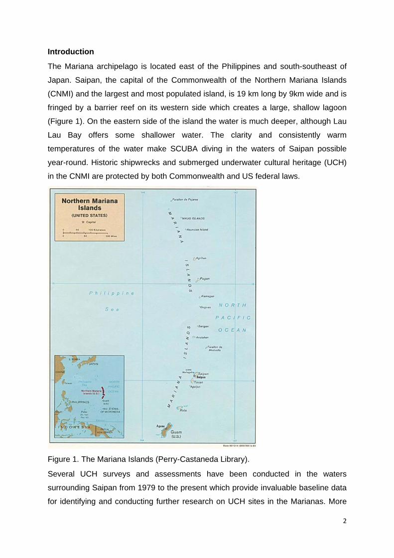
Introduction
The Mariana archipelago is located east of the Philippines and south-southeast of
Japan. Saipan, the capital of the Commonwealth of the Northern Mariana Islands
(CNMI) and the largest and most populated island, is 19 km long by 9km wide and is
fringed by a barrier reef on its western side which creates a large, shallow lagoon
(Figure 1). On the eastern side of the island the water is much deeper, although Lau
Lau Bay offers some shallower water. The clarity and consistently warm
temperatures of the water make SCUBA diving in the waters of Saipan possible
year-round. Historic shipwrecks and submerged underwater cultural heritage (UCH)
in the CNMI are protected by both Commonwealth and US federal laws.
Figure 1. The Mariana Islands (Perry-Castaneda Library).
Several UCH surveys and assessments have been conducted in the waters
surrounding Saipan from 1979 to the present which provide invaluable baseline data
for identifying and conducting further research on UCH sites in the Marianas. More

3
recently in 2008, remote sensing and diver identification surveys in Saipan were
conducted by Southeastern Archaeological Research (SEARCH) (SEARCH, 2008a;
SEARCH, 2008b). The remote sensing surveys, including magnetometry and side
scan sonar, were broad in nature; however the focus of the historical research and
diver identification was on WWII heritage. The surveys were intended to be a
baseline inventory for future investigations to build upon and were funded through a
historic preservation grant provided to the Historic Preservation Office (HPO) and
administered by the National Park Service (NPS). A total of 1,543 anomalies were
located and, “The majority of identified anomalies represents material culture from
WWII and offers a unique opportunity for Saipan to interpret its history through
maritime heritage and dive trails” (SEARCH, Inc. 2008b:i).
In 2009, a comprehensive overview of the maritime history and archaeology of the
CNMI was completed by Ships of Discovery (SHIPS) (Carrell, 2009). The project
was undertaken as part of the CNMI’s on-going efforts to meet its historic
preservation and inventory mandates and also was funded through a historic
preservation grant administered by the NPS. The maritime context document
provided an in-depth discussion of the history of the CNMI from the pre-historic
period to the present, and pulled together currently available information on UCH
sites in the islands.
Together these two projects provided the background information and emphasis for
the development of a more intensive archaeological investigation and a public
interpretation program for UCH in Saipan. In fact, at the same time that SEARCH,
Inc. was conducting survey in 2008, staff and students from Flinders University were
on the island working with the HPO to create a plan for developing a “maritime unit”
within their existing program. In an earlier trip to Saipan in 2007, the HPO voiced
concerns about their lack of ability to manage UCH (due to a lack of training in
underwater archaeological techniques), and the pressing need due to the amount of
tourist divers visiting the WWII sites. They also were interested in developing a
maritime heritage trail which would provide two favourable outcomes: 1) developing
a presence on the water as the agency charged with managing the resources and 2)
developing a heritage tourism product that could promote sustainable use of the
already heavily visited sites. Thus the idea was formulated to develop a plan to

4
accomplish a number of objectives that would assist HPO in better managing their
UCH. These objectives included:
• Training staff in underwater archaeological methods in order to create a
team of diving archaeologists
• Conducting more intensive archaeological research and recording known
and heavily visited sites
• Developing a maritime heritage trail for the purposes of creating sustainable
heritage tourism
All of the objectives have been achieved and even more developments have taken
place. Below are some of the projects and initiatives that were instigated and a
discussion on some of the obstacles encountered and ways forward.
Training staff in underwater archaeological methods
The first objective of developing a training opportunity was accomplished in January
2009 when Flinders University and HPO supported archaeological technician John
Castro to travel to Australia and participate in the Flinders University Maritime
Archaeological Field School in South Australia. Castro’s extensive diving and
archaeological background allowed him to participate as a supervisor in the two-
week field school where he gained additional underwater archaeology experience.
A new training was developed by Flinders University specifically for the Mariana
Islands context and was held in July 2009 on Saipan for staff from several
government agencies, including HPO, Coastal Resources Management (CRM), the
NMI Museum of Culture and History, and Department of Environmental Quality
(DEQ), as well as local interested divers. A total of 20 diving and non-diving
participants took part in the two-day course. Based on the Flinders University’s
Underwater Archaeology Methods topic, it included classroom lectures, practical
terrestrial exercises, a diving exercise and an intertidal exercise for those not
SCUBA certified (Figure 2). The training was a great success and provided
participants with information about the importance of preserving UCH.
Another type of training was offered later when two Heritage Awareness Diving
Seminars (HADS) were run in April 2011. HADS is a specialty course run through
the three largest diver certification agencies in the world, NAUI, PADI and SSI, and is
training intended for course directors, instructor trainers, instructors, dive masters,
boat captains and dive shop owners. It was developed to provide diving industry

5
professionals with a greater knowledge of how to proactively protect shipwrecks and
other UCH sites (Scott-Ireton, 2008). The goal of HADS is to increase awareness of
the fragility of UCH, teach proper anchoring, mooring and diving behaviour on such
sites, as well as demonstrate the need for preservation of such resources for future
generations and the economic benefits of heritage diving tourism. A total of 16
participants took part in the HADS training, including dive shop owners, the president
of a local dive professional organization, boat captains, dive instructors and dive
masters, U.S. Coast Guard staff, and a staff member from the NMI Humanities
Council. This training was funded through a National Oceanic and Atmospheric
Administration Pacific Region Grants Cooperative grant awarded to Pacific Marine
Resources, a local non-profit organisation concerned with environmental and
historical research and sustainability. HPO and CRM staff presented lectures during
this training. The training was seen as a crucial element to the development of the
heritage trail and its sustainability. It aimed at educating the end users to protect the
sites and educate their students and clients about using the sites appropriately.
Figure 2. Herman Tudela and John Starmer drafting during training.
Conducting more intensive archaeological research and recording known and heavily visited sites

6
In January 2009 SHIPS applied for an American Battlefield Protection Program
(ABPP) grant for the archaeological and historical investigation of submerged WWII
heritage and the collection of data for the development of a proposed maritime
heritage trail. Funding was announced for $49,900 in August 2009 and the project
quickly took shape. HPO, CRM, and DEQ provided an invaluable amount of in-kind
assistance during the project including: staff support both on and off the water, boats
and vehicles, equipment and fuel. Their support was instrumental to the success and
completion of the project. To date, nearly 50 UCH sites have been recorded or
investigated and several of these sites are included in the heritage trail that was
developed.
Developing a maritime heritage trail for the purposes of creating sustainable heritage tourism
The planning for a maritime heritage trail began in 2007-2008 and included a great
deal of local consultation. Public lectures were given to gauge local interest, and
meetings were held with several stakeholders including local divers and dive clubs,
HPO, CRM, DEQ, NMI Humanities Council, and the Marianas Visitors Authority
(MVA). This consultation centred on the needs and wants of the community and
government in terms of their heritage and a heritage tourism product. As a result,
three agencies (HPO, CRM, and DEQ) pledged their assistance to the project. The
demographics of diving tourists were also sought from the MVA. Several leading
experts in the field of heritage trail development were sought to provide input. More
discussions were had with the agencies charged with managing environmental and
biological resources; particularly useful were relationships with CRM and DEQ.
These agencies provided research permits and worked alongside the project staff to
develop a program for placing moorings on all the sites for use by boaters and tour
operators – a necessity for reducing anchor impacts to sites.
This trail was conceptualized as part of a plan to aid in the preservation and
protection of UCH sites that were already being impacted through tourist visitation.
By providing interpretive literature which outlined each site’s history and importance,
legal protection and proper etiquette for visiting such heritage sites, it was hoped that
divers, snorkelers, and swimmers would be better educated and develop a greater
appreciation for the heritage, thus avoiding impacting or harming the sites further. In
total nine sites were chosen for the trail including aircraft, landing vehicles,

7
amphibious assault vehicles and shipwrecks of both Japanese and US forces.
Printed waterproof dive guides were produced as well as four color posters, a
website and an eighteen-minute interpretive video to be shown at the NPS American
Memorial Park (Figure 3).
Figure 3. Japanese aircraft poser for heritage trail.

8
Management plan and in situ conservation survey
The need to develop a management plan for submerged WWII maritime heritage in
Saipan’s waters was identified during the implementation of the trail. Throughout the
archaeological survey and subsequent development of the trail, it was noted by
archaeologists that certain UCH sites were being negatively impacted by both
natural and cultural factors (for a full review see McKinnon and Carrell, 2011). These
impacts were identified as contributing to an overall loss of archaeological and
historical context and affecting the structural integrity of the sites and their long-term
survival. While some of these impacts were recorded during the archaeological
survey for the development of the trail in 2010, they were not the primary focus of the
project and were treated cursorily. Upon completion of the trail it was deemed
important to revisit selected sites and record baseline data to develop a plan to
monitor, mitigate and manage the sites into the future. A plan to conduct further
archaeological survey and initiate in situ conservation surveys was developed and
supported by a follow up ABPP grant for $72,000 in 2011. In situ conservation surveys are different from standard archaeological surveys
because they include the collection of data related to the natural environment
(chemical and physical), which can allow for a better understanding of the
destructive forces affecting sites and artifacts (MacLeod and Richards, 2011). They
also record modern cultural impacts that can be used in the management of sites,
including allowing or restricting access to sites and controls for altering behaviors of
visitors. Finally, they often collect specific cultural information including data on
material composition of objects. This data is vital to understanding the construction
of these sites from an archaeological or cultural perspective, but also contributes to
understanding the longevity of sites with relation to the material composition of
metals and organics, how they react to and survive within the environment, and their
overall structural integrity.
In situ surveys and studies are critical to regions such as the Pacific because there
are limited resources (i.e. funding, staff, and facilities) to conduct recovery and
conservation of submerged objects and sites. While the CNMI does benefit from
grant funds distributed by the NPS, this funding is limited and often only covers a
small portion of the compliance needs of the HPO (Ronnie Rodgers personal

9
communication, 2010). This means that the conservation and management of the
resources must be done in situ.
Further, understanding the condition of the resources through in situ and
archaeological surveys is an important step in the management process. An agency
cannot manage a site if they have no knowledge of its condition. The HPO needs
information about the condition of the sites in order to make informed decisions
about their management.
Additional archaeological survey was conducted alongside the conservation survey
in order to locate, record and identify new “control” sites not on the trail that could be
monitored long-term for comparison purposes. Baseline data collected on new sites
is useful because they can help managers understand the differential impacts of site
visitation on those included in the trail.
Currently the in situ conservation survey report and management plan is under
review by the granting agency and cannot be discussed until approval is sought. Indigenous seascapes and intangible heritage
The idea for a project to record Indigenous maritime sites began during discussions
in 2008 about the development of the WWII maritime heritage trail, when community
members expressed their desire to further investigate their own “maritime-related”
heritage. Thus, a conversation began with local historian Genevieve Cabrera
(Chamorro and Carolinian descent) and Herman Tudela (a traditional fisher and
archaeological technician of Chamorro and Carolinian descent), who is, about the
possibility of recording sites that are significant to their maritime past and present.
Flinders University graduate student Julie Mushynsky used the idea and project as
part of her thesis research and worked directly with Cabrera, Tudela and others to
record selected sites. The result was a community archaeology project to record the
tangible and intangible “seascape” of the island of Saipan in the Mariana Islands
(McKinnon et al. in press). The project recorded archaeological sites, oral histories,
lived experiences and contemporary understandings of maritime-related heritage
and lifeways in conjunction with community members (Figure 4). Rock art, potential
fish procurement sites, access points, oral histories and other heritage, both tangible
and intangible, were recorded and investigated as a result of this project. This type of
project is critical to ensuring that colonial maritime history is not privileged over

10
Indigenous maritime heritage and provides a balance to previous research
conducted on the island.
Figure 4. Colleagues Genevieve Cabrera and Fred Camacho leading site visits.
Obstacles and moving forward
While the CNMI has the ability to utilize and enact any and all of the legislation
outlined above and they do so effectively on terrestrial sites, the island is in need of a
review of the possible ways that this legislation can be made most effective for UCH.
This is not a call for harsher restrictions but a reference to applying the legislation
most effectively. It is also important to investigate complementary forms of
protection. This means recognizing the location of the sites within, for example, a
Conservation Area or National Landmark, both of which exist. Further, it would be
ideal if the Rules contained in the UNESCO Convention on the Protection of the
Underwater Cultural Heritage 2001 were used as a model in formulating this
process.
An obstacle in the effectiveness of the laws listed above is that at present there are
no effective means by which the sites can be protected due to a lack of trained staff
and equipment. Unfortunately, while there were three staff members at HPO who
had the dive qualifications and training to conduct underwater archaeological survey

11
(took training in 2009), today there is only one, and that person is no longer
physically able to dive. Further the HPO does not own a boat or diving equipment for
accessing the sites. This situation is contradictory to Part II, Guideline 5 of the
Abandoned Shipwreck Act 1987 which states “The agencies responsible for the
management of State-Owned waters should have (or have access to) adequate
professional staff, office and laboratory facilities, vessels, diving and underwater
survey equipment to carry out assigned responsibilities.” As a result, the community
currently relies on off-island resources and expertise to assist them with the
management of their submerged archaeological heritage through monies and
projects such as those described in this paper, which is not an ideal situation. More archaeologists and archaeological technicians (a minimum of three) need to be
hired, or existing staff needs to be trained in SCUBA and the ability to conduct
archaeological assessments underwater. Further the HPO would be better equipped
if they hired or purchased SCUBA gear and a boat for the purpose of conducting
monitoring and assessment of underwater sites and investigating infractions. An
alternative approach through interagency cooperation may provide a quicker solution
as outlined below.
Interagency Cooperation
The involvement of other government bodies in the management of UCH is critical in
the Pacific where resources and funding can be limited. In Saipan many UCH sites
are located within the Mañagaha Marine Conservation Area. The management plan
for this conservation area could include provisions for the protection and
management of UCH. To accomplish the legislative purpose of the Mañagaha
Marine Conservation Act, the CNMI Department of Lands and Natural Resources
(DLNR) was delegated the exclusive authority to manage the Mañagaha Marine
Conservation Area, as well as other marine conservation areas in the CNMI (Section
6 of PL 12-12).
The role of the DLNR in regard to the management of UCH is to promote public
access to the sites while protecting the physical remains. The 2005 management
plan for the conservation area outlines DLNR has a role in providing logistic and
financial support for placing moorings on sites to reduce impacts by anchoring.
CRM was established on 11 February 1983, with the implementation of Public Law
3-47 within the Office of the Governor. The CRM program was established in order

12
to promote the conservation and sustainable development of coastal resources.
CRM is responsible for general permitting activities which impact coastal resources
in Saipan and in particular permits for dive boats and dive tour operations. As a
result the agency should develop language for permits that supports the protection of
UCH.
An effective way to increase enforcement of heritage laws is to train and enlist other
agency staff whose job description includes enforcement of natural or environmental
legislation. Agencies such as CRM, DLNR, DFW, and DEQ, which already operate
boats and conduct regular inspections on water-related activities, could be trained in
identifying infractions of cultural heritage law. Alternatively intra-agency agreements
in which HPO staff accompany other agency enforcement officers during inspections
would allow for increased regulation. Section 6 of Public Law 12-12 states that “...the
Department [of Lands and Natural Resources] may coordinate and assist other
Commonwealth or Federal agencies in performing their emergency or other agency
functions within marine conservation areas, if the exercise of such functions is
deemed prudent or necessary by the Department, or the performance of such
functions is clearly permitted by law within marine conservation areas.” Thus there is
a precedent set in law that allows for collaborative efforts in management of marine
resources.
The local natural environment in which a wreck is located and the assemblages that
make a wreck have direct impact on the marine environment. A wreck can create a
unique local environment for fauna and flora to thrive, and this has a bearing on
defining the site's significance and issues of research and interpretation. Therefore
there is a need for further understanding of UCH sites’ local marine environment and
the habitat they create for marine life.
Recent biological researcher was conducted in conjunction with the development of
the heritage trail by a research from Sydney University. Fowler conducted two years
of fish assemblage studies on the sites included within the trail. His research
determined that “well- established vessel-reefs are capable of approximating fish
abundances and assemblage parameters on natural coral reefs” (Fowler and Booth,
2012). This research indicates that UCH sites are of natural and environmental
significance and should be protected as such. There are no provisions within Public
Law 12-12, which regulates the Mañagaha Marine Conservation Area, to identify
13
UCH as aquatic reserves or equivalent. However access to the sites, if they are
environmentally sensitive, maybe be controlled under provisions of the Mañagaha
Marine Conservation Area management plan.
Community
Traditionally there has been little communication between local divers and CNMI
HPO. Local divers report being frustrated when trying to report new sites to HPO and
receive information about their history or significance. This disconnect is a result of
HPO’s inability through training, equipment and funding to be involved in the
management of submerged sites. However, the HPO could benefit from partnering
or working with local divers, dive groups and dives shops in the location and
identification of new sites. Those who know the waters best are those who use it
regularly. It would be beneficial if HPO developed a public profile and engaged with
divers, dives shops and dive groups. Education programs, meetings, information
sessions and the development of a site-reporting program are all options for
increasing communication.
Conclusion
In concluding this paper, it is pertinent to re‐state that the CNMI, and the Pacific
region in general, has its own unique set of challenges and issues that are quite
different from other parts of the world. Therefore, it is important when developing a
UCH management program that other “models” or “programs” are not applied
wholesale to this region. An approach that considers the challenges and difficulties
CNMI is facing and a program that is suited to deal with these challenges and
resolve them into the future is the most likely successful long-term management
approach.
This paper was written with the intention of outlining some of the successes of
CNMI’s HPO and exploring ways in which they may move forward. The option of
involving other interested agencies in managing UCH is likely the best immediate
solution, but a long-term approach of hiring staff, increase funding and additional
training will need to be undertaken. The information in this paper is meant to
empower and encourage the local community to continue the positive steps they
have made in protecting their UCH and to move forward.
While much of the work on UCH has been on WWII UCH, it is important to
remember that there are many more sites from previous and later periods that are

14
significant to the history of the island. It is hoped that the HPO can continue to
develop a program for managing those sites as well. Inclusive and collaborative
efforts should be made with all regulatory agencies that deal with the marine
environment, as well as other stakeholders such as tourism companies and divers.
Further, it is important to understand that not only the interests of the U.S. and
Japanese government are at the core of this heritage, but a local perspective that
incorporates Chamorro, Carolinian, Filipino and Korean values should be considered
(McKinnon 2013).
Acknowledgments
Thank you to the CNMI community for their interest and support in protecting your
underwater cultural heritage. Thank you also to the colleagues and students who
have been a huge part of the projects described within, particularly Toni Carrell and
Jason Raupp. References
Carrell, T. L., 2009. Maritime History and Archaeology of the Commonwealth of the
Northern Mariana Islands, submitted to the CNMI Department of Community and
Cultural Affairs, Division of Historic Preservation. SHIPS, Corpus Christi, Texas.
Fowler, A. M., and Booth, D. J., 2012. How well do sunken vessels approximate fish
assemblages on coral reefs? Conservation implications of vessel-reef deployments.
Marine Biology, Vol. 159: 2787-2796.
MacLeod, I. D., and Richards, V., 2011. In-situ conservation surveys of iron
shipwrecks in Chuuk Lagoon and the impact of human intervention. Australian
Institute for the Conservation of Cultural Material Bulletin, Vol. 32: 106-122.
McKinnon, J. F., and Carrell, T., 2011. Saipan WWII Invasion Beaches Underwater
Heritage Trail. SHIPS, Corpus Christi, Texas.
McKinnon, J. F., 2013. Difficult Heritage: Interpreting Underwater Battlefield Sites. In
D. Scott-Ireton (ed.) Meeting Challenges in the Public Interpretation of Maritime
Cultural Heritage - Between the Devil and the Deep. Springer Press, New York.
McKinnon, J. F., Mushynsky, J., and Cabrera, G., in press. A Fluid Sea in the
Mariana Islands: Mapping the Seascape of Saipan. Journal of Maritime Archaeology.
Scott-Ireton, D., 2008. Teaching “Heritage” Awareness” Rather than “Skills” to Sport
Diving Community. Journal of Maritime Archaeology, Vol. 3 (2): 119-120.

15
SEARCH, 2008a. Archaeological Survey of Lagoons of on the West Coast of
Saipan, Commonwealth of the Northern Mariana Islands, submitted to the CNMI
Department of Community and Cultural Affairs, Division of Historic Preservation,
SEARCH, Pensacola, FL.
SEARCH, 2008b. Archaeological Survey of Tanapag Lagoon Saipan,
Commonwealth of the Northern Mariana Islands, submitted to the CNMI Department
of Community and Cultural Affairs, Division of Historic Preservation, SEARCH,
Pensacola, FL.
Thompson, E. N., 1984. National Register of Historic Places Inventory – Nomination
Form. Landing Beaches, Aslito/Isley Field, and Marpi Point, Saipan Island. National
Park Service Denver Service Center, Lakewood, CO.
Biography
Jennifer McKinnon is an Assistant Professor at East Carolina University in the
Program in Maritime Studies. Prior to teaching at ECU, she was a Senior Lecturer at
Flinders University, South Australia for seven years. Jennifer is a Research
Associate of the non-profit organization SHIPS, Corpus Christi.