
Clackamas County Plan Amendment DLCD File Number 007 ...
375
SUBJECT: Clackamas County Plan Amendment DLCD File Number 007-13 The Department of Land Conservation and Development (DLCD) received the attached notice of adoption. Due to the size of amended material submitted, a complete copy has not been attached. A Copy of the adopted plan amendment is available for review at the DLCD office in Salem and the local government office. Appeal Procedures* DLCD ACKNOWLEDGMENT or DEADLINE TO APPEAL: Thursday, February 27, 2014 This amendment was submitted to DLCD for review prior to adoption with less than the required 35-day notice. Pursuant to ORS 197.830(2)(b) only persons who participated in the local government proceedings leading to adoption of the amendment are eligible to appeal this decision to the Land Use Board of Appeals (LUBA). If you wish to appeal, you must file a notice of intent to appeal with the Land Use Board of Appeals (LUBA) no later than 21 days from the date the decision was mailed to you by the local government. If you have questions, check with the local government to determine the appeal deadline. Copies of the notice of intent to appeal must be served upon the local government and others who received written notice of the final decision from the local government. The notice of intent to appeal must be served and filed in the form and manner prescribed by LUBA, (OAR Chapter 661, Division 10). Please call LUBA at 503-373-1265, if you have questions about appeal procedures. *NOTE: The Acknowledgment or Appeal Deadline is based upon the date the decision was mailed by local government. A decision may have been mailed to you on a different date than it was mailed to DLCD. As a result, your appeal deadline may be earlier than the above date specified. NO LUB A Notification to the jurisdiction of an appeal by the deadline, this Plan Amendment is acknowledged . Cc: Martha Fritzie, Clackamas County Jon Jinings, DLCD Community Services Specialist Jennifer Donnelly, DLCD Regional Representative Gary Fish, DLCD Transportation Planner <paa> Y NOTICE OF ADOPTED AMENDMENT 02/18/2014 TO: Subscribers to Notice of Adopted Plan or Land Use Regulation Amendments FROM: Plan Amendment Program Specialist
-
Upload
khangminh22 -
Category
Documents
-
view
1 -
download
0
Transcript of Clackamas County Plan Amendment DLCD File Number 007 ...

SUBJECT: Clackamas County Plan AmendmentDLCD File Number 007-13
The Department of Land Conservation and Development (DLCD) received the attached notice of adoption.Due to the size of amended material submitted, a complete copy has not been attached. A Copy of the adopted plan amendment is available for review at the DLCD office in Salem and the local government office.
Appeal Procedures*
DLCD ACKNOWLEDGMENT or DEADLINE TO APPEAL: Thursday, February 27, 2014
This amendment was submitted to DLCD for review prior to adoption with less than the required 35-day notice. Pursuant to ORS 197.830(2)(b) only persons who participated in the local government proceedings leading to adoption of the amendment are eligible to appeal this decision to the Land Use Board of Appeals (LUBA).
If you wish to appeal, you must file a notice of intent to appeal with the Land Use Board of Appeals (LUBA) no later than 21 days from the date the decision was mailed to you by the local government. If you have questions, check with the local government to determine the appeal deadline. Copies of the notice of intent to appeal must be served upon the local government and others who received written noticeof the final decision from the local government. The notice of intent to appeal must be served and filed in the form and manner prescribed by LUBA, (OAR Chapter 661, Division 10). Please call LUBA at 503-373-1265, if you have questions about appeal procedures.
*NOTE: The Acknowledgment or Appeal Deadline is based upon the date the decision was mailed by local government. A decision may have been mailed to you on a different date than it was mailed to DLCD. As a result, your appeal deadline may be earlier than the above date specified. NO LUBA Notification to the jurisdiction of an appeal by the deadline, this Plan Amendment is acknowledged.
Cc: Martha Fritzie, Clackamas CountyJon Jinings, DLCD Community Services SpecialistJennifer Donnelly, DLCD Regional RepresentativeGary Fish, DLCD Transportation Planner
<paa> Y
NOTICE OF ADOPTED AMENDMENT
02/18/2014
TO: Subscribers to Notice of Adopted Planor Land Use Regulation Amendments
FROM: Plan Amendment Program Specialist

-.
OLeo FORM 2 NOTICE OF ADOPTED CHANGE TO A COMPREHENSIVE PLAN OR
LAND USE REGULATION
FOR OLeo USE
File No.:
Local governments are required to send notice of an adopted change to a comprehensive plan or land use regulation no more than 20 days after the adoption. (See OAR 660-0 18-0040). The rules require that the notice include a completed copy of this form. This notice form is not for submittal of a completed periodic review task or a plan amendment reviewed in the manner of periodic review. Use Fonn 4 for an adopted urban growth boundary including over 50 acres by a city with a population greater than 2,500 within the UGB or an urban growth boundary amendment over 100 acres adopted by a metropolitan service district. Use Form 5 for an adopted urban reserve designation, or amendment to add over 50 acres, by a city with a population greater than 2,500 within the UGB. Use FOlm 6 with submittal of an adopted periodic review task.
Jurisdiction: Clackamas County
Local file no.: 200-246
Date of adoption: 01/30/2014 Date sent: 02/06/2014
Was Notice of a Proposed Change (Form 1) submitted to DLCD? Yes: Date (use the date oflast revision if a revised Form I was submitted): 09/23/2013 No
Is the adopted change different from what was described in the Notice of Proposed Change? Yes No If yes, describe how the adoption differs from the proposal:
Only non-substantive changes were made to the text of the proposal. Limited changes were made to the prioritization of projects included in the 20-year Capital Improvement Program (CIP).
Local contact (name and title): Karen Buehrig, Supervisor Transportation Planning Division
Phone: 503-742-4683 E-mail: [email protected]
Street address: 150 Beavercreek Rd City: Oregon City Zip: 97045
PLEASE COMPLETE ALL OF THE FOLLOWING SECTIONS THAT APPLY
For a change to comprehensive plan text: Identify the sections of the plan that were added or amended and which statewide planning goals those sections implement, if any:
Ch 5 (Transportation); text, maps, figures, tables & 20-year CIP repealed & replaced in their entirety (Goal 12)
Ch 10 (Community & Design Plans); transportation-related amendments (Goal 12); repealed Kruse Way Plan
Appx B (Supporting Documents); background data
Ch 3 & Ch 4; conforming amendments
For a change to a comprehensive plan map: Identify the former and new map designations and the area affected:
Change from to acres. A goal exception was required for this change.
Change from to acres. A goal exception was required for this change.
Change from to acres. A goal exception was required for this change.
http://www.oregon.gov/LCD/Pages/forms.aspx -1- Form updated November 1, 2013
houcka
Typewritten Text
007-13 (20013) [17754]

Change from to I acres. A goal exception was required for this change. ., Location of affected property (T, R, Sec., TL and address):
The subject property is entirely within an urban growth boundary
The subject property is partially within an urban growth boundary
If the comprehensive plan map change is a UGB amendment including less than 50 acres and/or by a city with a population less than 2,500 in the urban area, indicate the number of acres of the former rural plan designation, by type, included in the boundary.
Exclusive Farm Use - Acres: Non-resource - Acres:
Forest - Acres: Marginal Lands - Acres:
Rural Residential- Acres: Natural Resource/Coastal/Open Space - Acres:
Rural Commercial or Industrial - Acres: Other: - Acres:
If the comprehensive plan map change is an urban reserve amendment including less than 50 acres, or establishment or amendment of an urban reserve by a city with a population less than 2,500 in the urban area, indicate the number of acres, by plan designation, included in the boundary.
Exclusive Farm Use - Acres: Non-resource - Acres:
Forest - Acres: Marginal Lands - Acres:
Rural Residential - Acres: Natural Resource/Coastal/Open Space - Acres:
Rural Commercial or Industrial - Acres: Other: - Acres:
For a change to the text of an ordinance or code: IdentifY the sections of the ordinance or code that were added or amended by title and number:
Substantive, transportation-related amendments to: Section 202 (Definitions); Section 1005 (Sustainable Site & Building Design); Section 1007 (Roads & Connectivity); and Section 1015 (Parking & Loading)
Conforming amendments to Sections 306, 309, 310, 312, 314, 809, 810, 822, 1009, and 1202
For a change to a zoning map: IdentifY the former and new base zone designations and the area affected:
Change from to Acres:
Change from to Acres:
Change from to Acres:
Change from to Acres:
IdentifY additions to or removal from an overlay zone designation and the area affected:
Overlay zone designation: Acres added: Acres removed:
Location of affected property (T, R, Sec., TL and address):
List affected state or federal agencies, local governments and special districts: ODOT, FHWA, Metro •
IdentifY supplemental information that is included because it may be useful to inform DLCD or members of the public of the effect of the actual change that has been submitted with this Notice of Adopted Change, if any. If the submittal, including supplementary materials, exceeds 100 pages, include a summary of the amendment briefly describing its purpose and requirements.
http://www.oregon.gov/LCD/ Pages/forms. aspx -2- Form updated November 1, 2013
The adopted amendments reflect a major update to the county's Transportation System Plan, including a revised list of 20-year needed capital improvements and policy and regulatory amendments to reflect current needs and to conform to recent state & regional regulatory changes.
NOTICE OF ADOPTED CHANGE - SUBMITTAL INSTRUCTIONS
I. A Notice of Adopted Change must be received by DLCD no later than 20 days after the ordinance(s) implementing the change has been signed by the public official designated by the jurisdiction to sign the approved ordinance(s) as provided in ORS 197.615 and OAR 660-018-0040.
2. A Notice of Adopted Change must be submitted by a local government (city, county, or metropolitan service district). DLCD will not accept a Notice of Adopted Change submitted by an individual or private firm or organization.
3. Hard-copy submittal: When submitting a Notice of Adopted Change on paper, via the US Postal Service or hand-delivery, print a completed copy of this Form 2 on light green paper if available. Submit one copy of the proposed change, including this form and other required materials to:
Attention: Plan Amendment Specialist Dept. of Land Conservation and Development 635 Capitol Street NE, Suite 150 Salem, OR 97301-2540
This form is available here: http://www.oregon.gov/LCD/fOlms.shtml
4. Electronic submittals of up to 20MB may be sent via e-mail. Address e-mails to plan.amendments@ state.or.us with the subject line "Notice of Adopted Amendment."
Submittals may also be uploaded to DLCD's FTP site at http://www.oregon.govILCDlPages/papasubmittal.as
M·
E-mails with attachments that exceed 20MB will not be received, and therefore FTP must be used for these electronic submittals. The FTP site must be used for all .zip fIles regardless of size. The maximum file size for uploading via FTP is 150MB.
Include this Form 2 as the first pages of a combined file or as a separate file.
5. File format: Whcn submitting a Notice of Adopted Change via e-mail or FTP, or on a digital disc, attach all materials in one of the following formats: Adobe .pdf (preferred); Microsoft Office (for example, Word .doc or docx or Excel .xls or xlsx); or ESRI .mxd, .gdb, or. mpk. For other file formats, please contact the plan amendment specialist at 503-934-0017 or [email protected].
6. Content: An administrative rule lists required content of a submittal of an adopted change (OAR 660-018-0040(3)). By completing this form and including the materials listed in the checklist below, the notice will include the required contents.
Where the amendments or new land use regulations, including supplementary materials, exceed 100 pages, include a summary of the amendment briefly describing its purpose and requirements.
7. Remember to notify persons who participated in the local proceedings and requested notice of the final decision. (ORS 197.6 15)
If you have any questions or would like assistance, please contact your DLCD regional representative or the DLCD Salem office at 503-934-0017 or e-mail [email protected].
http://www.oregon.gov/LCD/ Pages/forms.aspx -3- Form updated November 1, 2013

Notice checklist. Include aU that apply:
Completed Form 2
A copy of the final decision (including the signed ordinance(s». This must include city and county decisions for UGB and urban reserve adoptions
The findings and the text of the change to the comprehensive plan or land use regulation
If a comprehensive plan map or zoning map is created or altered by the proposed change: A map showing the area changed and applicable designations, and Electronic files containing geospatial data showing the area changed, as specified in OAR 660-018-
0040(5), if applicable Any supplemental information that may be useful to inform DLCD or members of the public of the effect of the actual change
http://www.oregon.gov/LCD/ Pages/iorms.aspx -4- Form updated November 1, 2013

FEB 1 0 2014
CLACKAMAS COUNTY OffiCE OF COUNTY COUNSEL
PUB LIC SERVICES BUILDING
205 1 KAEN ROAD I OREGON CITY, OR 97045
CERTIFICATE OF MAILING
Stephen L. Madkour County Counsel
Kimberley Ybarra Kathleen Rastetter
Chris Storey Scott C. Ciecko
Alexander Gordon Amanda Keller
Nathan K. Boderman Christina Thacker
Assistants
I hereby certify that the enclosed Ordinance No. ZDO-246 was deposited in the mail on February 6,2014
Signed: ----.1L:~ZU:i,!~~ /Q~c 0--1:.~'::!di~U-:!lfr!:.~::::=:==--Chery~arn~~(ln, Administrative Assistant
Clackamas County Counsel's Office (503) 655-8619
P. 503 .655.8362 f . 503 .742 . 5397 WWW.CLACKAMAS.US

ORDINANCE NO. ZDO-246
An Ordinance amending Chapters 5 and 10 and Appendix B, and making conforming amendments to Chapters 3 and 4 of the Clackamas County Comprehensive Plan; and
amending Sections 202, 1005, 1007, and 1015, and making conforming amendments to Sections 306,309,310,312,314,809,810,822,1009, and 1202 of the Clackamas County
Zoning and Development Ordinance
WHEREAS, in late 2011, the County's Transportation Planning Division began a comprehensive review of its Transportation System Plan (TSP), wh ich had not undergone a major update in more than a decade; and
WHEREAS, the Board of County Commission ers adopted a vision, goals and objectives in April 2012 to gu ide the development of both projects and policies w ith in the
Tra nsportation System Plan update; and
WHEREAS, County staff worked close ly for over two yea rs w ith a Public Advisory Committee and a Technica l Advisory Committee and provided num erous opportunities for public input to assess and recommend a set of project s, policies, tables, maps and fi gures for inclusion the updated TSP; and
WHEREAS, the Planning Director initiat ed amendm ents to Chapters 5 and 10 and Appendix B of the Comprehensive Plan and Sections 202, 1005, 1007, and 1015 of the Zoning & Development Ordinance to incorporate the recommended po licies, needed t ra nsportation projects and other associated elements in the TSP update; and
WHEREAS, the Planning Director initiated conform ing numbering and reference amendm ents to Chapters 3 and 4 of th e Comprehensive Plan and to Sections 306, 309, 310,312,3 14,809,810,822, 1009, and 1202 ofthe Zoning and Development Ordinance;
and
WHEREAS, the proposed amendments are consistent w ith the Clackamas County Comprehensive Plan, the Statewide Planning Goa ls and Guidelines, the State Tran spo rtation Planning Rule, and the Metro Regional Transportation Function al Plan and all oth er applicabl e state and federal laws and regulations; and
WHEREAS, after a duly-noticed public hearing on October 28, 2013 and Novem ber 4, 2013, the Clackamas County Plan ning Commission recommended approva l ofthe amendm ents in ZOO-246, as proposed; except recomm ended minor amendments to th e list of needed transportation project s as follows: remove the Freight Route designation on
Beavercreek Road from Meyers Road to Leland Road; remove the plann ed multi-use path from Oregon City to Mulino; move two OOOT project s to a higher priority; move portions ofthe projects with in a quarter-mile of a school on SE Clackamas, SE Thiessen, SE Webster
J
Ordi nance ZDO-246

and SE Johnson roads to a higher priority; move the South Molalla Road/Bea r Creek Bridge project to a higher priority; and change the description of the project located in Mulino at Passmore Road/Graves Road/Highway 213; and
WHEREAS, the Board of County Commiss ioners held p ublic hearings on December 4, 2013 and December 11,2013 at which it approved amendments in ZDO-246, as reco'mmend ed by the Planning Co mmiss ion; except directed staff to modify the description of proj ect in Mulino, as recommended by sta ff; and direct ed st aff to make three minor amendments to the list of needed transportation projects as foll ows: remove th e project on Holly Lane from th e list and move the pedestrian/bicycle bridges over 1-205 and the Willamette River to lower priorities; and
WHEREAS, staff did amend the project lists and maps per the Board of County Commissioners direction; now t herefore
The Board of Comm issioners of Clack.amas County ordains as follows:
Section 1:
Section 2:
Section 3:
Section 4:
Chapter 5 of the Clackamas County Comprehensive Plan is hereby repealed and replaced in its entirety as shown in Exhibit A, hereto attached.
Chapters 3, 4 and 10 and Appendix B ofth e Clackamas County Comprehensive Plan are hereby amended as shown in Exhibit A, hereto attached.
Sect ions 202, 306, 309, 310, 312, 314, 809, 810, 822, 1005, 1007, 1009, 1015 and 1202 ofthe Clackam as County Zoning and Development Ordinance are hereby amended as shown in Exhibit B, hereto attached.
This ordinance shall be effecti ve on M arch 1, 2014.
ADOPTED th is 30'h day of Jan uary, 2014
Chair
2 Ordinance ZDO-246

,
Clackamas County Comprehensive Plan
Ordinance ZDO-246
Comprehensive Plan Amendments
Chapter 5: TRANSPORTATION SYSTEM PLAN
The Clacka mas County Transportat ion Syst em Plan (TSP) wi ll gui de tran sportat ion relat ed
decisions and identify the transportation needs and priorities in uninco rporated Clackamas
Cou nty from 2013 to 2033. Th e TSP has been creat ed in coordinat ion w ith the Cou nty's 16
cities, the State of Oregon, area transit providers, and other affected agencies and has been
vetted through an extensive public process, including a series of public outreach events and
twe lve Public Advisory Committee meetings. The publ ic and county staff worked t ogether to develop th e fol lowing vision for th e TSP and six goa ls to guide implementat ion ofthis vision :
Building on the foundation of our existing assets, we envision a well-maintained and designed transportation sys tem that pravides safety, flexibility, mobility, accessibility and connectivity for people, goods and services; is tailored to our diverse geographies; and supports future needs and land use plans.
TSP GOALS
• Goa l 1: Provi de a transportat ion syst em th at opt imizes benefits to th e environment, th e economy and the commun ity
• Goal 2: Plan t he transportation system to creat e a prosperous and adaptab le economy and further the econom ic we ll -being of bus in esses and residents of t he County.
• Goa l 3: Tailor transportation solutions to suit the dive rsity of loca l comm unities.
• Goa l 4: Pro mote a t ransportation system that maintains or improves our safety, hea lth, and security.
•
•
Goal 5: Provid e an equitable transportation system .
Goal 6: Promote a fi scally responsible approach to prot ect and improve the ex ist ing
tran sportat ion system and impl ement a cost-effective syst em to meet future needs.
BACKGROUND AND ISSUES
The County's transportation syst em includes an extensive network of public and private
transportation facilities, in clud ing roads, railways, airports, pipe lines, waterways, and multi-use
paths. The system is intend ed to allow people t o trave l where th ey need to go safely and
efficiently, while a.lso providing for efficient movem ent of goods. The County's transpo rtation
system is also intended to support sustainabl e land use patterns and po licies to serve a
mu ltitude of publi c needs w ithout sacrif icing air and water quality or creat ing noise po ll ut ion.
[ 5- 1] Ordinance ZDO-246, Exhibi t A

Clackamas County Comprehensive Plan
Gove rnment agencies, publi c and pri vat e service provid ers, and deve lopers are involved in
building and maintaining th e Co unty's transportation system. M etro, Portl and's metropolitan
planning orga niza tion, set s general policy guid elines for design, distributes regional fundin g fo r
certain types of proj ect s w ithin its boundary, an d set s standard s fo r th e operation of th e
t ra nsportat ion syst em locat ed within th e Portland M etropolitan Urban Growth Bound ary
(UG B). All t ransportation facilities must conform t o st andards and guid elines outlined by
federal, state and, in som e cases, Metro regulatory docum ents.
Clackam as Co unty faces several challenges as it attempts to continue to develop and maintain a
safe and integrat ed t ransportat ion syst em, approp riate for and accessible t o all potential users.
• Limited fundin g: Funding levels for roads, the backbone of the transportation syst em, have
not kept pace w ith t he mobili ty needs of our society. Limited funding makes it a challenge
to balance th e need for maintenance and management of ex isting faciliti es with th e need for building new faciliti es to accommodate increased trip dem and. As a result, the backlog
of needed road maintenance and construction projects has grown larger.
• Redu cing congestion : Community members help reduce traffi c congestion w hen th ey
choose to take th e bus, join a ca rpool, or bicycle and walk to destin ations. Reducing congestion decreases the need for costl y road construction project s w hile improving air
quality, neighborhood livability and access to goods, services and employment.
Improving th e relationship bet ween land uses and transportation ca n also decrease reliance on automobiles and reduce congestion. Some ways to improve thi s relationship are t o: alter the site design of new construction at or near major transit st ops; increase connecti vity in
transport ation systems; provid e better pedestrian and bicycl e facilities; use land more efficiently; and encourage mixed~u se deve lopm ents.
• Balancing needs: All land-based modes of travel, except rail and pipeline, must share the public rights-of-wa y. These modes includ es autos, t ru cks, bu ses, bicycl es, pedestrians and,
in some loca lities, equestri ans. Balancing the need for mobility (through move ment of traffi c) with the need for loca l movement and access to individu al propert ies often crea tes
design an d safet y challenges for roadways.
• Safety: From 2005 to 2009, there were approximately 160 fataliti es and 1,245 serious injuries in Clackamas County du e to traffic crashes. On e ofthe County's goals is to improve
the sa fet y of its system for all users and reduce th e numb er and severity of crashes for futu re years. Developing faciliti es to accomm odat e all modes of travel w ill help reduce
confli cts that lead to sa fety problems for som e users. The adopted Transportation Sa fety Action Plan ca lls for a 50 percent reduction of fatal and serious injury crashes by 2022.
• Fost ering economic growth: M onitoring th e effect s oftransportat ion on employment and
eco nomic acti vity is important during both good and bad economic tim es. Of particular
significance are the ways t ransportation can be used as a too l t o sust ain and promot e eco nomic developm ent bo th in th e urban industri al and commercial centers and w ith in the
county's dist inctive rural economy, including agricu lture, forest ry and equestrian facil ities.
[5-2) Ordinance ZDO-246, Exhibi t A

Clackamas County Comprehensive Plan
• Addre ss ing environmental impact s: Development of transportation infrastructure needs to
be sensiti ve to potenti al impact s to neighborhood s and to the natural environm ent, in order
to create and mainta in livable communities, preserve air and water qu ality, and conserve energy.
The nort hwest urban area of the County is within a 'designated Air Qual ity Maintenance Area
(AQM A). Presently the AQMA meets state and federa l air quality standards, but federa l law
requires the reg ion to impl ement measures to maintain federal air quality standards. Federa l
law also prohib its significant degradation of air quality in the Mt. Hood Wilderness.
• Ensuring accessibility: In many areas of the County, transportation disadvantaged populat ions, such as the elderly, disa bled or low- inco me res idents, need improved access to
public trans it and special transportation services. Clackamas County wi ll ensure that new and
rebuilt roads are planned and des igned to perform all necessary function s, including being access ibl e to those who choose not to drive or cannot drive.
• Maintaining and improving rural area roads: Clackamas County also is challenged by th e responsi bility to maintain and develop a safe and functional road net work in rural areas.
Upgrades to aging rural roadways are needed to enhance sa fety and accommod ate
different mod es of travel.
TSP ORGANIZATION
To implement the vision and goals and to address the issues id entified above, a series of po licies have been created to direct t he County in its efforts to build and maintain a multi
modal transportat ion system. Under each policy category, the countywide policies are listed first , followed by the urban policies, and the rural policies.
The policies are presented in thi s chapter by major topic or tran sportation mode as follows:
Foundation and Framework: includes policies relating to coordin ation; safety; equity, hea lth
and sustainability; intelligent transportation syste ms; and transport ation dem and management
land Use and Transportation: includes policies relating to the integration of land use and
transportation; parking; rural tourism; and scenic roads.
Active Transportation: includ es policies relating to pedestrian and bicycle faciliti es and
multi-use paths.
Roadways: in cludes policies relating to funct ional class ificat ion; urban and rura l roadway
considerations; project development; improvements t o serve development; and
perform ance eva luation and access standard s.
Transit: in clu des poliCies relat ing to transit and transit-supportive amenities.
Freight, Rail , Air, Pipeline and Water Transportation : includ es policies re lating to general
freight movement; freight t rucking; ra il; airports; pipelines; and water tran sportation.
Finance and Funding: includes policies relat ing to fundin g capital transport ation
improvements and maintenance.
[5-3] Ord inance ZDO-246, Exhibit A

Clackamas County Comprehensiile Plan
Transportation Projects and Plans: includes policies relating to the 20-year and five-yea r
capital improvement plans. Also identifies Special Transportation Plans that are adopted
by reference as refin ements of the TSP and plans or studies th at need to be completed in
the future to support the TSP.
Definitions: re levant definition s for use within this chapter.
The TSP also conta ins th e followin g compon ents:
• Th e County's 20-year Capita/Improvement Plan: a complete list of needed
transportation-related proj ect s to address gaps and deficiencies in th e transportation network (Tables 5-3 [a -d]).
• Tables, Maps and Figures illustrating the transportation system and street cross sections,
and presenting guidelin es and standards for developing the system.
• Background documents including detailed findings and conclusions relating to th e various components of the transportation system (Appendix B).
[5-4] Ordinance 200-246, Exhib it A

Clackamas County Comprehensive Plan
FOUNDATION AND FRAMEWORK
Clackamas County's transporta tion networks serve loca l communities and also ti e into regional
networks. Creating a transportation syst em th at is safe and accessible for all users mu st be
done within t he co ntext of federal, state, and regional regulations. Th e syst em need s to be
responsive t o new initiatives adopted by th ese regulatory bodies to ensure th e development of
a complet e and sustainable transportation system. It needs to be responsive to new
approaches, t echniques and measures developed for assess ing the performance of th e system. Intelligent Tra nsportation Systems (ITS) and Travel Demand Manage ment (TOM) t echniqu es are
two such tools that can be effective in managing the cost s of th e syst em and enabling better
performance.
Safety is consistent ly mentioned by citizens as one ofthe highest concerns relat ed to the
transport ation syst em, regardl ess of individuals' preferred methods of trave l. The accessibility
of the transportation system for all individuals is also a primary concern. Therefore, prioriti zing
sa fety and accessibility is essential in the planning, design, operat ion and mai ntenance of the transportation system.
_.~:~: .. ~.~.,!,'pli.<ln_~e.arlcJ~()()rd i n<l!~()n Pol i ci es ........ __ .. __ .... _ .... ___ ... _. ____ ...... . S.A.l Support intergove rnmental partnerships needed to promote coordination and address
multi· jurisdictional transportation needs.
S.A.2 Work col laborative ly with federal, state, regional, and loca l agencies and with County
res id ents to pursue the County's road safety programs and plans.
S.A.3 Work w ith state and local partn ers to implement the Oregon Transportation Safety Plan.
S.A.4 Coordinate w ith the Oregon Departm ent of Transportation (ODOT) in implementing the Oregon Transportat ion Plan (OTP), Oregon Highway Plan (OHP), Sta t ewid e
Transportation Improvement Program (STIP), and w ith other state transportation
planning policies, guidel in es and program s.
S.A.S Work with the Oregon Office of Emergency Management to ensure that th e TSP
supports effective responses to natural and human·ca used disast ers and emergencies
and other incidents, and access during these incidents.
S.A.6 Urban Coordinate with M etro and loca l governments to implement th e Regional
Transportation Plan (RTP), Reg ional Transportat ion Functional Pl an (RTFP), Urban
Growth Management Functional Plan (UGMFP), and loca l transportation plans.
S.A.7 Rura l Pursue form ation of an Area Commission on Transportation (ACT) fo r t he
portions of Clackamas County outside the Port la nd M etropol itan Urban Growth
Boundary to facilitate a coordinated approach to addressing issues on the state
transportation syst em .
[5-5] Ordinance ZDO-246, Exhibit A

Clackamas County Comprehensive Plan
S.B Road Safety Policies ___ _ ______ _____ _ _________ _
5.B.1 Update th e Clackam as County Transportat ion Safety Action Plan(TSAP) every five years
to include necessa ry changes and document the progress toward th e plan's goa l of a 50
percent reduction in f at al and serious injury crashes by 2022.
5.B.2 Identify transportat ion system safety improvemen ts that w ill reduce fata l and inju ry
crashes for all mod es of travel and meet the TSAP goa l.
5.B.3 Address th e County's top three crash cause fa ctors of Aggre ss ive Driving, Young Drivers (ages 15-25) and Roadway Departure utili zing ed ucation, emergency medica l se rvices,
enforcement, engineer ing and eval uation .
5.B.4 Support programs, policies, regu lations and actions that increase awareness and
education about the sa fety of th e transportation system for all users.
5.B.5 Support programs that utilize data-driven approaches to improve safety of the transportation system.
5.B.6 Al ign County departments, externa l safety groups, and other public agencies toward common transportation sa fety goals.
5.B.7 Integrate roadway, safety and traffic data management, hea lth and emergency services
data sources.
5.B.8 Integrate Highw~y S~fcty Manual (H SM) principles into the planning, engin eerin g,
design, operation and mainten ance of the transportation system. --------------------------- --
5.C Equity, Health and Sustainability Policies
5.C.1 Support programs and projects, such as ped estrian and bike connections to transit
stops, that expand and improve transportation options for residents in areas with identified transportation-disadvantaged populations.
5.C.2 Protect neighborhoods, recreation areas, pedestrian faciliti es, bikeways and sensitive
land uses (such as schools, daycare centers and senior centers whose users are more vulnerable to pollution) from transportation-relat ed environmental degradation.
Coordin at e transportation and land use planning and use mitigation strategies, such as
physical barri ers and design features, to minimize transmiss ion of air, noise and water
pollution from roads to neighboring land uses.
5.C.3 Work with public agencies, private businesses and developers to in crease and improve infrastructure necessa ry to support use of vehicles that use alternative fuels.
5.C.4 Ensure that programs t o encourage and ed ucate peopl e about bicycl e, pedestrian, and
transit transportation options are appropriate for all County res idents, particularly
transpo rtati on-d isadvantaged pop u lations. ---- ---- --- ---
[5-6] Ordinance ZDO-246, Exhibit A

Clackamas County Comprehensive Plan
5.C.5 Bui ld work ing partn ersh ips between the County's Publ ic Health and Transportation
Divisions and uti lize t oo ls, such as health impact assessments, to better connect the
effects of transportation projects with the health of comm un it ies.
5.C.6 . Support the continued provision of public transportation services to County
popu lat ions that are un-served or und er-se rved, as wel l as the network of commu nity
based, transportation services for se niors and perso ns with disabilities.
___ ~. D __ ~~ell igen~!ra nsp0l't.'l~i.<>.r: System~E~L!,~1 ici es ________ _ ~ __ . _____ . ____ ...
5.D.1 Implement a wide range of ITS strategies aligned w ith the TSP vision and goals by
ensuring safe, effici ent, and equitable mobility fo r people and goods.
5.D.2 Update the ITS Action Plan every five years as part of th e County's 5-Year Capi t al Improvement Program.
5.E Transportation Demand Management (TDM) Policies
5.E.1 Implement Transportat ion Demand Management techniques-including educat ion,
encouragement, and enforcement-appropriate for all County residents, in order to increase efficient use of ex isting transportation infrastructure and minimize congestion
and safety concerns by offering choices of mode, route, and tim e.
5.E.2 Support and participate in efforts by M etro, the Department of Environmental Qua lity (DEQ), transit providers, and any area Transportation Management Associations (TMAs)
to develop, monitor and fund regional TDM program s.
5.E.3 Provide adequate bicycle and pedestria n faci li t ies to emp loyment areas t o encourage
use of bicycles or wa lking for the com mute to work and to improve access t o jobs for
workers without cars.
5.E.4 Support programs that work with schools to identify safe bicycle and pedestrian routes
to connect neighborhoods and schools. Seek partnerships and funding to support
improvement of th ese routes.
5.E.5 Urban Work with County emp loyers located in concentrated emp loyment areas to
develop Transportation Management Associations (TMAs) to coordin ate and support
private-sector TDM efforts and to work toward mode share targets (Table 5-1) adopted
in this Plan.
[5-7] Ordill allce ZDO-246, Exhibit A
Clackamas County Comprehensive Plan
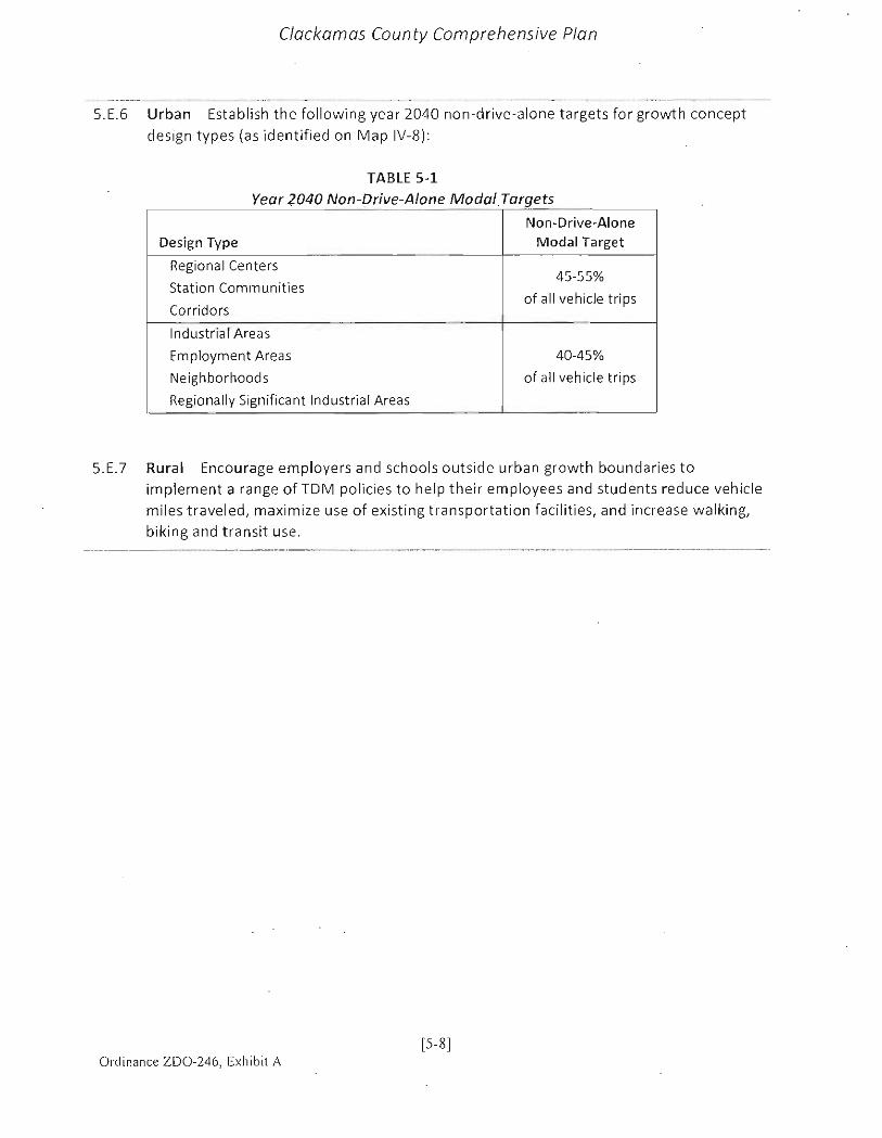
5.E.6 Urban Establish the fol lowing year 2040 non-drive-alone targets for growth concept
design types (as ident ifi ed on Map IV-8 ):
TABLE 5-1
Year 2040 Non-Drive-Alane Madal Targe ts
Non-Drive-Alone Design Type Modal Target
Regional Centers 45-55%
Station Communities
Corridors of all vehicle trips
Industrial Areas
Employment Areas 40-45%
Neighborhoods of all vehicle trips
Regiona lly Significant Industrial Areas
5.E.7 Rural Encourage emp loyers and schoo ls outside urban growth bounda ri es to
implement a range of TDM po licies to he lp th ei r employees and students reduce vehicle
mil es trave led, maxim ize use of exist ing transportation faci li ti es, and increase walking,
biking and t ransit use. ---------------------_.
[5-8] Orciillollce ZDO-246, Exhib it A

Clackamas County Comprehensive Plan
LAND USE AND TRANSPORTATION
Integrating transportation plans w ith land use plans is a key element in effecti ve management
and operation of the entire t ransportat ion syst em. Roads su pport the wi de range of land
acti vities that take place in both th e urban and rural areas. Because of th e diverse nature of
acti viti es and land use types found in Clacka mas Cou nty, it is of parti cul ar importan ce that the
transportation systems are des igned to accommodate both urban networks and th e different needs of rural area users, including providing sa fe routes for users of all modes to enjoy the
rural area's scenic bea uty, and for those participat ing in agri -tourism and activities re lated to
forestry.
Planning for appropriate amounts of parking support s effici ent development of the land within communities. Accommodating on-street parking and planning for off-street parking needs are
Transportation System Management (TSM) techniques that are consistent with the Metro
Region's 2040 Growth Concept, meet the objectives of the Transportation Planning Rule (TPRJ,
and comply w ith DEQ's Air Quality Maintenance Plan.
S.F Integration of land Use and Transportatio~~olicies
S.F.l land use and transportation policies shall be integrated consistent with state law
rega rding preservation offarm and forest lands.
S.F.2 Support efforts to enhnncc nnd maintain th e function of State highways and County
arterials through land use policies, access management strategies, and roadway
improvements.
S.F.3 Support and promote an integrated approach to land use and tran sportation planning
and implementation th at encou ra ges livab le and sustainab le comm unities, decreases
average trip length and in creases access ibility for all modes.
S.F.4 Support and promote transportation investments that support complete and
sustainable commun ities as a long-term strategy to reduce reliance on long commutes
out of the County to employment destinations.
S.F.5 Recognize the County's rural econom ic engine and the importance of moving goods
from rural businesses (including farms, nurse ri es, livestock, and lumber) to distribution
centers.
S.G Parking Policies
S.G.l Set minimum and, w here appropriate, maximum limits on allowed off-street parking
of motor veh icl es relative to building size, location and use, and to adjacent land uses.
In the urban area, parking stand ards shall be coordinated with regiona l parking
requirements.
S.G.2 Req uire new multi-family, commercial and in stitutiona l developm ent to provide
[5 -9) Ordinance ZDO-246, Exh ib it A

5. G. 3
5.G.4
5.G.5
5.G. 6
5.G. 7
5.G.S
Clackamas Coun ty Comprehensive Plan
bicycle parking.
Allow shared parking an d, where appropri ate, on-street pa rking t o be used t o co mply with parki ng standard s.
Urban Allow the remova l of ex isting, on-st reet parking along art eria ls and co llectors t o create bikeways, co nstru ct trave l or tu rn ing lanes, or increase sight dist ance .
Urban Increase area for on-street parking in res identi al zoning districts by minimi zing th e w idth of driveway accesses.
Urban Encourage off-st reet parking in comm ercia l, indust ri al, and high density residential areas t o be locat ed at the sides or rear of buildings, where practi cal.
Urban Consider allowing for decreased parkin g area requirements for development along transit routes, if the development provid es pedestri an, bicycle and transit amenities. See M ap 5-Sa.
Urban Consider req uiring shared parking w ithin mixed-use developm ent and where adjacent land uses are compat ible.
S.H Rural Tourism Policies ----------~.-----.--" .. --,- --- ---------------,-"'-,------------------ - ---._ .. __ .. _ .. __ .--------. - -- - ----_. __ ...• __ ._._--.------_._---------_ .•.•.• _._._-5.H.l Rural Encourage agri -t ourism and oth er commercial events and activi ti es that are
related t o and supportive of agri culture, in accordance with the provisions of ORS 215. M iti gat ion of traffi c impacts and other event impacts may be required to reduce the effect s of th ese limited land uses on the County road system. __ _
5.1 Rural Scenic Roads Policies
5. 1.1 Implement a County Scenic Road System that is sa fe and att ract ive for all users.
5. 1.2 Promot e the protection of recreation va lues, scenic features and an open, uncluttered character along designated sce nic roads.
Deve lopm ents adjacent t o sce nic roads shall be des igned w ith sensitivity to natural conditions and:
a) Scenic roads shall have stri ct access control on new developments. b) Scenic roads should have should ers w id e enough fo r pedestrians or bicycles, or
a separated path where feas ibl e and when fundin g is available. c) Turnouts shall be provid ed where appropriate for viewpoint s or recreat ional
needs. d) Des ign review of dE!velopm ents adjacent to scenic roads shall require visual
characteristi cs and signing appropriate t o the setting. e) Buildings shall be set back a sufficient dist ance from the right-of-way t o permit a
landscaped or natura l buffer zone.
[5- 10] Ordinance ZDO-246, Exhi bi t A

Clackamas County Comprehensive Plan
f) Park ing areas adjacent to scen ic roads shall be separated from the right-of-way
by a landscaped buffer. g) Any frontage roads adjacent to scenic roads shal l be separated by a vegetat ive
buffer wh ere feas ible h) Underground placement of utilities shall be encouraged.
5. 1.3 The fo llowing faciliti es shall be designated scenic road s: (see Map 5-1 Scenic Roads)
• Wilsonville Road
• Stafford Road (City of Lake Oswego to Mountain Road)
• Schaeffer Road
• Pete's Mountain Road (Schaeffer Road to the Tu alatin River)
• SW Mountain Road, Ca nby Ferry Road, N. Locust , NE 37th, and Holly Street
• Ca nby-Marquam Highway (City of Canby to Hwy 211)
• Clacka mas River Drive
• Springwater Road (Clackamas River Drive to Hayden Road)
• Hayde n Road
• Red land Road
• Fischer's Mill Road
• Marmot Road/Barlow Trail Road/
• Ten Eyck Road/SE Lusted Road from Ten Eyck Road to the County line.
• Lolo Pass Road
• Sa lmon River Road
• Still Creek Road
• Timberlin e Road and West Leg Road
• 1-205 west of t he Willamette River
• Highway 99E from Oregon City to New Era Rd
• Oregon City Bypass (Newell Creek Ca nyon segment)
• Highway 211 (Ca nby-Marquam Highway to Estacada)
• Highway 224 (Carver to Barton and south of Estacada)
• Highway 26 east of th e City of Sa ndy
• Highway 35/Forest Service Road 386
5. 1.4 Support implementation of the Oregon Scenic Byway System, including the Mt. Hood Scenic Byway and the West Cascades Scen ic Byway.
[5- 1 I] Ordinance ZDO-246 , Exhibit A

Clackamas Coun ty Comprehensive Plan
ACTIVE TRANSPORTATION
Recognizing the in creasing importance of having mUlt ip le ways to travel through a co mmunity
and through th e region has led t o an increased awareness for designing t ra nsportation syst ems
to sa fely enhan ce acti ve transportation modes. "Active Transportation" is defin ed t o in clude wa lking, bicycl ing and horseback rid ing.
Th e County complet ed transportation systems planning for pedestrian and bicycle modes in
1995 t o implement th e st ate's Transportation Planning Rule (TPR), particularly th e fo llowing
TPR principles:
1. Land use and transportati on are intim at ely relat ed.
2. Over reliance should not be placed on anyone t ransportation mode.
3. Walking and bicycling redu ce the number of motori zed vehicle trips.
4. Compact, mixed-use development encourages the use of non-motorized modes. 5. Well-pl anned, properl y des igned facilit ies w ill encourage people to make trips by non
mot orized modes.
6. Facilities for these non-mot orized mod es are essential for people not having access t o an automobile, and constitute des irabl e elements in a we ll-des igned community
th at are enjoyed by people w ho ca n drive, but choose to walk or bicycle.
These principles und erli e the developm ent of the Clackamas County Pedestrian M ast er Plan and the Clackam as County Bicycle M ast er Plan, both of w hich are adopted by reference. Both
master pl ans w ere prepared under the guid ance of the Clackam as Cou·nty Pedestrian and
Bikeway Advisory Committee, w hich was guided by the following vision :
Create an environment which encourages peaple to bicycle and walk an netwarked
systems thot facilitate and promote the enjoyment of bicycling and walking as saf e and
convenient transportation modes.
S.J General Active Transportation Policies ___ ~ _ _ . ________ _
5.J.1 Coord inat e the implementation of pedestrian faci lities and bikeways with neighboring jurisdicti ons and jurisdictions w ithin the county.
5.J.2 Ensure an opportunity for a diverse and representative citi zen invo lvement in th e
county pedestrian and bicycle planning process by sponsoring the Clackamas County Pedestri an and Bikeway Advisory Committee (CCPBAC) as a forum for public input.
Recruit rep resentatives of tra nsportation disadva ntaged populations as part of thi s
process.
5.J.3 Monitor and updat e th e Clacka mas Co unty Pedestrian M ast er Plan and Bicycle Mast er
Plan th ro ugh data co llection and eva lu ation, and review activit ies necessa ry t o ma inta in and expand the programs estab lished in th ese plans.
[5- 12] Ord inance ZDO-24 6, Exhibit A

Clackamas County Comprehensive Plan
S.J.4 Support bicycle, pedestrian and tran sit project s that se rve th e needs of transportation disa dvantaged populat ions.
S.J.S Coordinate w ith ped estrian, bicycle, and t rail master plans, and w ith special transportat ion pl ans of t he County, Oregon Department of Tran sportation, the Un ited States Forest Service, Metro, and pa rks providers·to achieve sa fe and convenient offroad, multi -use path and trail systems con necting to on-road pedest ri an fac ilities and th e bikeway networks.
S.J.6 Support the continuation of th e "Bikes on Transit" program on all public transit routes.
S.J. 7 Inform property owners of th eir responsibilities for th e maintenance of sidewalks and pedestrian pathways.
S.J.8 Id entify low traffi c vo lume streets th at are appropri ate for signing as bicycle routes t o enhance safety and connecti vity and to supplement the system of bikeways found on th e major street syst em.
S.J.9 Rural Support bi cycle and pedestrian projects that imp rove access to public transit st ops and provid e connections to significant loca l destinat ions.
_ !i =-~ __ [)~~i~~_£'.ol i ci es _______ . __ . _______ . __ . _____ . ____ . ________ . ____ . ______ . __ _
S.K.l Require bikeways and pedestrian facilities according to the applicable cross section for all new co llector or art erial construction or substantial reconstruction, even if not designated on the Planned Bikeway Network (Maps S-2a and S-2b), or on the Essential Pedestrian Network (M ap 5-3), allowing for fl exib ility to accommodat e characteri stics of t errain, scenic qualities, existing developm ent, and environm ental constraints, and adopted Special Transportation Plans.
S.K.2 Seek out and impl ement innovati ve bicycle and pedestrian treatments that improve the convenience and safet y ofthese faci liti es_
S.K.3 Improve the sa fety and appea l of walk ing and biking by supporting the development of bikeways and pedestri an facil ities and networks on low vo lume or loca l roads and off of existing street ri ghts-of-way.
S.K.4 Urban Id entify pedestrian facilities and bikeway improvements necessa ry to ensure direct and continuous networks of pedest rian facil ities and bikeways on the county road system.
S.K.S Urban Id entify locat ions where bicycle and pedestrian access is blocked by rivers and other natural barriers and encourage th e creation of bicycle and pedestrian facilities to extend across these barri ers:
S.K. 6 Urban Review deve lopment plans to ensure that they provide bicycle and pedestrian access.
[5- 13] Ordinance 200-246, Ex hibit A

Clackamas County Comprehensive Plan
S.K.7 Urban Create a networked system of pedestrian faciliti es and bikeways connecting
cities, neighborhoods, comme rcial areas, comm unity centers, schools, recrea tional
faci lities, employment centers, other major destinations, regiona l and city bikeways
and pedestrian faciliti es, and other transportation modes. Utili ze sepa rat e accessways
for pedestrian facilities and bikeways w here st reet connections are impract ica l or
unava il ab le.
S.K.8 Rural Support th e safe movement of equestrians in rural areas.
S.l Construction Policies
S. l.1 Construct all pedestrian facilities and bikeways according to t he cu rrent County design
st andard s.
S.l.2 Construct all pedestri an facilities, bikeways, and multi -use path s as designated on Maps
S-2a, S-2b, an d S-3, and as adopted in Special Transportation Plans.
S.l.3 Urban Requ ire that new developm ent include construct ion of wa lkways and
accessways w ithin the development and between adjacent developments, w here
appropriate.
S.L.4 Urban Constru ct interim pedestrian fac iliti es and bikeways, as app ropriat e, on ex isting street s that are not built to the applicable cross section and where the construction of full st reet improvements is not practi cable or imminent as det ermined by th e County
Planning Director and Cou nty Road Official or County Engineer.
S. l.S Rural In Unincorporated Communities, const ru ct wa lkways adjacent to or w ithin areas of development (such as schools, businesses, or employment centers) and at rural
tran sit stops. --_._--_._ .. _---_._-_._._------------_._- ----_._. __ .. _ .•.• _._----_. __ . __ ...
S.M Facilities Policies
S.M.1 Encourage the provision of approp ri ate, supportive facilities and services for bicyclists,
including showers, lockers, bike racks on buses, bike repair and maintenance informat ion/cl inics, and secure bicycle parking.
S.M.2 Est ablish and maintain way-find ing systems to f acilitate bicycle trave l.
S.M.3 Urban Encou ra ge the provision of street lighting to increase the visibility and persona l security of pedestrians and bicyclists.
S.N Multi-Use Path Policies
S. N.1 Support acquisition and deve lopment of multi-use paths on abandoned public and
private rights-of-way.
[5-14) Ord inance ZDO·246, Exhib it A

S.N.2
S.N.3
S.N.4
Clackamas County Comprehensive Plan
Coll abo rate w ith the appropriate servi ce providers, such as park providers, to plan for
multi-use paths that accommodate equestrian facilities where poss ible.
Rural Consider mul t i-use paths w here travel lan es or wide paved shoulders along
roadways may not provide adequatesafety for pedestrians or bicyclists.
Rural Consider equest rian uses when designing and constructing multi -use paths.
Work w ith loca l communities and interest groups to plan, develop and maintain multi
use paths that also provide equestrian features. Plan for parking areas at such multi
use paths that support parking needs of equ estrians, as well as needs of other path users.
[5-1 5] Ordinance ZDO-246, Exhibit A

Clackamas County Comprehensive Plan
ROADWAYS
Th e County's road system permits th e movement of goods and peopl e between communities
and regions, using any of a vari ety of modes of trave l. Roads provide access t o virtu ally all
property. They support establ ished communities and serve new deve lopment. They conn ect
rural communities and urban neighborhoods. Roads give structure to our urb an form, define
our commut ing patterns and influence our perceptions of what is far away or close at hand.
Creating and maintaining a safe, continuous County-wide road system, which acco mmodates movem ent by all travel mod es, mea ns setting st andards for developm ent of new roads and
redevelopment of ex isting road s, in cluding design and access st andards for urban and rural
roads. To ensure roads continue to meet the transportation demands of the County, a method
to measure the ongoing performance of th e syst em is essential. In respon se to new technologies and financial constraints, recent changes have been mad e to these st andards on
the st at e and regiona l levels. These changes are reflected in this TSP.
5.0 Fun_~!!9.-!:'_a.I5la~sification and Design Policies ________________ ... _._
5.0.1 Des ignate and develop roadways according to the fun ction al cla ssifications and gu id elines illust rated in th e County Road Typical Cross Sections (Figures 5-1a through 5-
If, and Figures 5-2a through 5-2f) while allowing flexibility to accommod at e
characterist ics of terrain, scenic qualities, environm ental constraints, ex isting development, and adopted Special Transportation Plans.
5.0.2 Designate freeways, arterials, co ll ectors and connectors as shown on M ap 5-4a and
Map 5-4b. Roadways that do not presently exist but are show n on these maps are
shown in approximate locat ions.
5.0.3 M aintain and improve roads consistent with their functional classification, and
reclassify roads as appropriate to reflect function and use.
5.0.4 Require changes in Comp rehensive Plan designation and zoning des ignation to comply
with th e Transportation Planning Rule (OAR 660-12). Evaluations of th e transportation syst em for this purpose shall rely on existing transportation f acilit ies and on pl anned
facilities found in the 20-Yea r Capita l Projects list (Table 5-3a). State transportation
facilities shall be eva lu ated according to the Oregon Highway Plan, Regional
Transportation Plan, Transportation Planning Rule, and other appli ca ble state
requirements.
5.0.5 Develop and implement traffic ca lming strategies, appropriate for the road funct ional
classi fica tion, th at will improve th e safety and convenience of travel by all modes,
particu larly in areas w ith high crash rates or high rates of bicycle and/or·pedestrian
acti vity.
[5- 16] Ordinance 2 DO-246, Ex hibit A

Clackamas County Comprehensive Plan
5.0.6 Urban Consider t he Metro Regional Street Design Class ifications when designing new county roads or redesigning existing county roads, prior to construction or reconstruct ion. Map 5-5 shows which roads are designated by each Design Class ificat ion.
5.0.7 Urban Minimize impacts of managing storm water by allowing for Metro's alternative street sta ndards, such as "green streets," as design alternatives.
5.0.8 Urban Des ign arteria ls and co llectors to allow safe and convenient passage of buses, bicycles, and ped estrian s.
5.0.9 Urban Street s, alleys, bikeways, pedestrian facilities, multi-use paths, tra ils and transit stops are allowed uses in all urban zoning districts. Consider all stat e and County policies relating to these facilities when widening, improving or constructing new transportation infrastructure.
5.0.10 Rural Plan to su pport the ex isting development pattern and through traffic needs of the rural communities, and not to support or promote urbanizat ion.
5.0.11 Rural Consistent with ORS 215.283(3) and OAR 660, Division 12, County road ca pita l improvement proj ects may be designed and const ru cted to improve sa fety and bri ng roads up to co unty sta ndards outside the UGB. If th e road capita l improvement project is not otherwise allowed and would require expansion of right-of-way exceedi ng the road improvement s allowed in th e Agricu lture or Forest distri cts, a goal exception would be req uired for such a project, as provided for in ORS 215.283(3).
5.0.12 Rural St reets, alleys, bikeways, pedestrian faci lities, multi-use paths, t rai ls and t rans it stops are allowed uses in all rural zoning dist ricts with the exception of Agricultural and Forest Districts in wh ich they are condit ionally allowed by ORS 215.213,215.283 or OAR Chapt er 660, Division 6 (Forest Lands).
5.0.13 Rural Recognize the importance of resource- related uses such as agriculture and forestry to th e loca l economy, and th e need to maintain a transportation system that provides opportunities to harvest agricu ltural and fo rest products and deliver them to market.
5.0.14 Rural Design, constru ct and reconstruct rural arterials and co llectors t o allow safe and convenient passage of trucks, buses, pedestrians and bicycli st s.
5.0.15 Rural Support the sa fe movement of agri cultural equipm ent in rural areas by improving ex istin g roads to county standards and considering design features such as signs, pu ll -outs for slow-movi ng veh icles, reduced speeds, and limiting curbs where eq uipment may move to the shou lder or out of the right-of-way.
[5- 17] Ord in ance ZOO-246 , Exhib it A

Clackamas County Comprehensive Plan
s. pp~?l~~_! . ~'C~_e~()~l"I1e~! Po I ic~'C~ . ...... ... __ . 5.P.1 Before bu ilding new roads or add ing capacity to exist ing roads, cons ider Transportat ion
System Management (TSM) st rategies for using the existing road system, including associated pedestrian and bicycle facilities, and system capacity most efficien tl y.
TSM strategies include: 1. Access Management; 2. Alternative/Modified Standards (Performance and/or Design Standards); 3. In te lligent Transportation System (ITS) app lications; 4. Operat ional Improvements; 5. Parking Standards; 6. Enhanced Bicycle and Pedestrian Facilit ies; and, 7. Road Diet {For example, restriping a low volume, 4-lane rood to a 3-lane configuration
__ _ ............ .... _wi t '!.!2~9'~Ie.andF'.e.'!.~ stricLn.!E!il iti'"-~L_. ____ .______. ___ . ________ .____ __ ... __ . _____ . __ ___ ....... .
S.Q Access Standard Policies
S.Q. 1 Ensure sa fe and convenient access for bicyclist s, pedestri ans, and transit users for land uses that are open to th e public. App ly access management in a f lexible mann er to allow reaso nable access and balance the needs of all roadway users.
5.Q.2 Improve multimodal ope rations and safety by ensuring that Interchange Management Areas and other access plans an d projects are coordinated w ith mult imodal connectivity standards and are design ed to support safe and convenient access and trave l for all modes, when appropriate.
5.Q.3 Support the imp lementation of state access management stand ards (OAR Chapter 734, Division 51, as amended, and the Oregon Highway Plan) on st ate highway f ac iliti es and within Interchange M anagement Areas. Coordi nate w ith th e Oregon Department of Transportation for access con trol on st ate highways.
5.Q.4 If f easible, allow only co llectors, connectors, or other arterials to intersect art erials.
5.Q.5 Access Standa rds shall be implemented through the Zoning and Development Ordinance and the County Roadway Standards. Where access management stand ards are adopted by th e Co unty in Special Transportation Plans, t hose standards shall app ly.
5.Q.6 Developments should be designed to place driveway accesses on streets with the lowest functional cla ss ification or the lowest traffic vo lum e.
[5- 18] Ordinance ZDO-246, Exhib it A

Clackamas County Comprehensive Plan
S.R Policies on Improvem_ents ~ Serve DeveloPment
5. R.l Require new develop ment to be served by adequate transportat ion facilities and access points that are des igned an d constructed to sa fely accommodate all mod es of
trave l.
5.R.2 For new developments and land divisions, require right-of-way dedicat ion, on-si te frontage improvements to th e applicable standards as shown in th e roadway Cross Section s (Figures 5-1a through 5-lf and Figures S-2a through 5-2f) and the County Roadway Stand ard s, and off-site improvements necessary to safely handle expected traffi c generated by the development and travel by active modes. Where road way stand ards are adopted by th e County in Specia l Transportation Plans, those stand ards
shall apply.
S.R.3 Assess anticipated off-site traffic impacts ca used by new deve lopm ents. The developer may be req uired to participate finan cially or otherwise in the provision of off-site improvements, dedications or other requirements.
5.R.4 For new development proposed on a site id entified on Map 5-6 (Potentially Buildable
Residen tial Sites >5 Acres in UGB), require a conceptua l street plan th at is consistent w ith requirements of thi s section and provides for full street connections at interva ls
of no more than 530 feet, where f eas ible.
5.R.5 Require new development that will require construct ion of new streets to provide full street connections ~t interva ls of no more than 530 feet, where fe as ible. If full street connections are not feas ible at such interva ls, require accessways for pedestrian s, bicycli sts or emergency veh icles at intervals of no more than 330 feet. Exceptions may be made where there are barriers, including topography, railroads, freeways, pre-exist ing deve lopment, existing easements, or environmenta l constraints such as
streams and wetl ands.
S.R.6
S.R.7
S.R.8
S.R.9
New development shall accommodate on-site traffi c circulation within the boundaries of the site, not by circulating vehicles on and off the site through multiple access points using the public road system. Internal circulation plans should avo id relying on "backing out" man euvers for new driveways onto all rural art erials and
collecto rs.
Urban Require impl ementation of a road network for undeve loped sites illustrated on Map 5-6. Existing roads shall be extended to provid e a direct, connected system.
Urban Where appropriate, develop and implement neighborhood traffic circulation plans for all mod es intended to improve circu lation whi le minimizing safety concerns
and exposure t o air an d noise pollution.
Urban Discourage motor vehicl e through-trips on" loca l, connector and collector
roads, and encourage bicycle and pedest ri an travel on these road s"
S.R.10 Urban Allow fl ex ibl e criteri a and sta ndards for loca l st reets that are less than 200
[5-19] Ordinance ZDO-246, Exhibit A

S.R.ll
S.R.12
S.R.13
Clackamas County Comprehensive Plan
feet in lengt h, are expect ed to ca rry very low traffi c volum es, and are not capa ble of
being extended .
Urban Private streets may be app rop ri at e in areas w ith topographic constraints that
make construction of a road to County standards not feasible. Private roads are not
class ifie·d as local roads and are not maintained by the County.
Urban Requ ire that changes to Co mprehensive Plan land use des ignations within the
Interchange Management Areas ident ifi ed on Map 5-7 be cons ist ent with Oregon
Administ rat ive Ru les 660-012-0060. If the land uses allowed by th e new
Comprehensive Plan land use designation would cause the interchange mobi lity standards to be exceeded, either the change shall be denied or improvements shall
be made such that th e mobility st andards are met.
Rural Discourage through trips on rura l loca l roadways.
5.S Performance Evaluation M easure Pol ici es ---------5.5.1 For County roads, establish th e method of ca lculating road way capacity and the impact
of new development on that ca pac ity in the County Roadway Standards.
5.5.2 Eva luate capacit y needs for roadways within the urban area using the Regional Motor
Vehicle Performance Measures shown in Tab le 5-2a, except as established be low. All ca pital construction shall be designed not to exceed the maximum VIC rat io.
Table 5-2a PERFORMANCE EVALUATION MEASURES FOR THE URBAN AREA
W eekday Mid-day and W eekday PM Peak Periods
Maximum Volume to Capacity (VIC) Ratio
Federal and State Principal Arterial Street Mid· day 1st Hour, PM 2nd Hour, PM Segment s and Intersections One-Hour Pea k Peak
Peak
OR 99E from OR 224 interchange north to 0.99 1.1 0.99
county line
1-205 1-5 0 .90 0.99 0.99
OR 212 OR 224 OR 213
County Street Segments and Intersections by Metro Urban Design Type
See Comprehensive Plan Map IV- 8
Regional Centers Town Centers 0 .99 1.1 0.99
M ain Streets Station Communit ies
Corridors Neighborhoods 0.90 0.99 0.99
Employment Areas Industrial Areas
Intermodal Facil ities
-
[5-20] Ordinance ZDO-246, Exhibil A

Clackamas County Comprehensive Plan
5.S.3 Exceptions t o th e perfo rm ance eva luat ion measures for rev iew of developm ent
proposed on property w ithin Metro' s bound ary are est ablished as fo llows:
5.5.3. 1 Within t he Clacka mas In dust r ia l Area, no performance eva luat ion
measures shall apply.
5.5.3.2 For t he intersect ions of SE Park Avenu e/OR 99E, SE Pa rk Avenue/SE
Oat fie ld Road, and SE Pa rk Ave nu e/SE 27th Street, perform ance eva luation measures of th e St ation Co mmunity Design Type shall app ly.
5.S.4 Eva luat e ca pacity needs for roadways in the rural area using the perform ance
eva luat ion measures shown in Tabl e 5-2b.
Table 5-2b PERFORMANCE EVALUATION_MEASURES FOR THE RURAL AREA
W eekday, AM and PM Peak Periods
Maxi mum Volume to Capacit y (VIC) Rat io
Co unty Roads and ODOT Facili ties and Intersections 1st
Hou f, PM Peak 2 1ld Hour, PM Peak based on post ed speed and highw ay classi fication Period Period
Inside city UG8s 0.80 to 0.95 0.80 to 0.95
Inside Unincorporated Communities 0.70 to 0.80 0.70 to 0.80
All other Rural areas 0.70 to 0.75 0.70 to 0.75
Minimum Level of Service (LOS) or County rural road intersections and road segments Maximum Vol ume/Capacity Ratio; outsid e of rural area cities Weekday Peak Periods
AM Peak Hour PM Peak Hour
Road segments and Unsignalized Intersections LOS E I LOS E
Signalized and Roundabout Intersections 0.90 0.90
5.S.5 Exce ption to th e perform ance eva luation meas ures for review of development
pro posed on property in t he rural area is estab lished as fo llows:
5.5.5.1 Within Governmen t Camp Vil lage, no perform ance eva luation operating
standard s shall apply.
5.S.6 Th e maximum vo lume to capacity ratio for th e ramp t erm inals of interchange ramps
shall be vic 0.85. (1999 Oregon Highway Plan, OHP Policy 1F Revisions, Ad opted by
OTC: Dec. 21, 2011)
5.S. 7 Where more than one performance measu re would apply at an intersection, the
measure allowing the higher leve l of congestion will be used, except fo r ramp t erminal
intersections.
5.S.8 Eva luat e transiti oning from tran sportati on co ncurrency to sa fet y ana lysis when a traffi c
impact study (TIS) is requ ired of new developm ent.
[5-21 ] Ord inance ZDO-24G, Exh ibit A

Clackamas County Comprehensive Plan
5.S.9 The County will work with Metro and ODOT over five years to develop Alternate Road
. Capacity Performance St andards, required by the Oregon Highway Plan Policy l.F., to
address the followin g five intersection s. These intersections were forecast not to meet
the Capacity Performance Standards adopted in the 2013 TSP and there were no
projects ident ified that cou ld make th e intersections meet the standards.
• SE Harmony Road/SE Linwood Avenu e
• OR 212/SE 172nd Aven ue - ODOT Intersect ion
• OR 212/SE 282nd Avenue - ODOT Intersection
• OR 213/S. Henrici Road - ODOT Intersection (traffic signal or roundabout)
• OR 224/SE Lake Road/SE Webster Road - ODOT Intersect ion
[5-22] Ord inance ZDO-246, Exhibit A

Clackamas County Comprehensive Plan
TRANSIT
Public t rans it service is essent ial for t he mobil ity of many County res id ents, and provid es an
affordabl e option for others who prefer t o use it. The County conta in s fi ve major pub lic
transportation systems. Tri-Cou nty Metropolitan Transportation Distri ct of Oregon (TriM et ),
th e st at e's largest transit provid er, serves generally t he western, more urbanized part of t he
county. The County also is home to four rural t ransit provid ers: South Clackamas
Transportation District (SCTD) serving th e Molalla area, Sandy Area M etro (SAM), Ca nby Area
Transit (CAT) and Wil sonvill e's So uth M etro Area Transit (SM ART). Clackamas Co unty also
directly supports th e Mountain Express service w hich provid es public transit t o the Hoodland area along the Highw ay 26 corr id or east of t he City of Sa ndy. All of th ese services provid e
pu blic transit as we ll as speciali zed services for seniors and persons with disa bili t ies
(paratransit) as mandated by the Ameri ca n w ith Disabil it ies Act.
Clacka mas County parti cipates in t he development and implementation of th e Coordinat ed Hum an Services Transportation Plan w hich addresses th e services ava ilable t o vuln era ble
populations throughout th e Port land metropolita n area.
The County ca n influence th e type of service provid ed and th e way new developm ents interface
with transit and provid e amenities for transit rid ers. Busses operated by the six distri ct s, as well
as each of th e school districts in the co unty must sa fely share the county' s roads w ith all other users.
5. T Transit Policies
5.T.1 Work with transit agencies to id entify ex isting transit defici encies in the County,
needed improvements, and ad dit ional park-and-ride lots needed to increase the access ibility of transit services t o all pot ential users.
5.T.2 Emphasize corridor or roadway improvements that help ensure reliable and on
tim e transit service in the Co unty.
5.T.3 Encourage transit providers t o restructure transit service t o effi ciently serve loca l as
we ll as region al needs.
s.T.4 Emphasize transit improvements th at improve east -west conn ection s; improve
service between th e County's industri al and comm ercial areas and neighborh oods;
and best meet the needs of all Co unty res idents, employees and employers,
regardless of race, age, ab ility, in come level and geographic location .
s.T.5 Coo rdinat e w ith all appl ica bl e t ransit agencies on all new reS idential, commercial
and industri al developments to ensure appropri at e integration of t ransit faciliti es
an d pedestr ian access to t ransit fac ilities.
5.T.6 Require maj or developments an d road construction projects along t ransit routes to
include provis ions for t ra nsit shelters, pedest ria n access to tra nsit and/or bus
turnouts, w here app ropriat e.
[5·23] Ordinancc ZOO-246, Exhibi t A

Clackamas County Comprehensive Plan
-------- --5.T. 7 Promote park-and-rid e lots, transit shelters and pedestrian/ bikeway conn ect ions t o
transit . Coordinate the loca tion of t hese faci lities w ith other land uses t o promote
shared pa rking and bicycle/ pedestrian -oriented transit nodes.
5.T.8 Coordinate an d cooperate w ith transit agencies to provid e t ransportation for
seniors, people w ith disab iliti es, an d other transportation-di sadvantaged
populations. Provide cont inu ed support for paratransit se rvices as required w ithin
a three-quarter-mile distance from fixed-route transit stops.
5.T.9 Coordin ate transit-supportive, roadway improvements w ith transit-provid ers to
ensu re financing and implementat ion of such improvements.
5.T.1O
5.T.11
5.T.12
5.T.13
5.T.14
Urban Require pedestrian and transit -supportive features and amenities and direct
access to transit for new development.
Pedestrian and t ransit support ive amenities may include pedest ri an/bikeway
faci li t ies, street trees, outdoor lighting and seating, landscaping, shelters, kiosks,
strict standards for signs, and visually aesthet ic shapes, textures and co lors. Bui ldings measuring more than 100 feet along the sid e facing the major
pedestrian/t ransit access should have more than one pedestrian entrance.
Pedestrian access should be provided to connect tran sit centers or transit stops on bus routes with centers of em ployment, shopping or medium-to-high density
res idential areas w ithin one-q uarte r mile of these routes.
Urban Coordinate with transit provid ers to achi eve th e goa l of transit service w ithin
one-quarter mil e of most residen ces and businesses w ithin th e Portland Metropolitan UGB. Support more f requent service within Regiona l Centers, Town
Centers, St ation Communities, and Corridors and Main Streets.
Urban Work with federal, st ate and regional agenci es to implement high ca pacity
transit in th e regional High Capacity Transit (HCT) Syst em Plan in order to help
relieve traffic congest ion, provide for transportation alternat ives to t he automob ile, and promote th e County's economy. See Map 5-8c for th e HCT network in the
County.
Urban Site new commercial, institutional, and multi-famil y buildings at maj or
transit stops as close as possibl e to transit, with a door facing the transit street or
side street , and with no pa rking between the building an d front lot lines.
Rural Focus sa fety improvements near existing or planned transit stop s.
[5-24] Ord inance ZDO-246, Exhib it A

Clackamas County Comprehensive Plan
FREIGHT, RAIL, AIR, PIPELINE AND WATER TRANSPORTATION
In 2009, Clackamas County adopted "Open fo r Business - Economic Developm ent Plan (EDP}."
This plan provides a comprehensive guiding policy document for th e County to impr()ve,
diversify and grow the economy in Clackam as Co unty. Crucial to economic development is the
infrast ructure that supports th e busin esses and th e emp loyees that work in those busin esses. Specific goa ls and actions ca lled out by th e Economic Development Plan includ e:
• Maintain mobi lity for peop le and freight in th e face of expected growth; and
• Respond to the opportuniti es and challenges faced by its cities and rural areas, and support
th em in their efforts to develop qu ality jobs and businesses,
Freight, ra il, air, pipe lines and w at er transportation make significant contributions to th e
movement of people and goods; improve th e quality of life; and support economic developm ent in Clacka mas County.
Po licies relating to the movement of freight vi a roads, rail, air, pipel in es or water t ransportat ion
mu st also respond to new regu lations to ensure the highest level of safety.
S.U.l
S.U.2
S.U .3
S.U.4
S.U .S
----_. __ ._--_.
Coord in ate the planning, developm ent, maintenance and operat ion of a safe and efficient freight syst em for all freight modes in Clackamas County w ith the private
sector, ODOT, Metro, the Port of Portland and the cities of Clackam as County.
Promote an inter-moda l freight transportation st rategy and work to improve multi
moda l connections among rail , industrial areas, airports and regional roadways to promote effic ient movement of peop le, materials, and goods.
Work w ith the private transportat ion industry, Oregon Economic Development
Department, Port of Portland and others to identify and realize investment
opportun ities that enhance freight mobil ity and support the County, regiona l and
state economy.
Make freight investments that, in coord in at ion w ith the County's econom ic
development strategies, help retain and grow the County's job base and strengthen the County's overa ll economy.
Ensure that freight rai l lines and truck routes do not have disproportionat ely
negative impacts on sensiti ve land uses (places where people w ith increased ri sk of
adverse impacts from exposure to noise and air pollution are likely to gather, such
as schools, senior centers, hospitals, parks, housing). Priorit ize mit igat ion efforts
for current sensitive land use areas nea r freight rail lin es and truck routes.
Mitigate impact s to sensiti ve land uses by using vegetati ve buffers, est abli shing rail
"quiet zones," and coordin ating land use plans.
15-25] Ordinance ZDO-246, Exhi bi , A

Clackamas County Comprehensive Plan
_". V F re i{1ht Truckin{1 Policies _ ____ ___ _
S.V.1 Support the Truck Freight Route System, while not prohibiting the use of other
roads for local pickup and delivery of goods and services. (See Maps S-9a and
S-9b).
S.V.2 Improve and maintain the countywide Truck Freight Route System, the Regional
Transportation Plan Freight Routes and Oregon Freight Plan Routes, as shown on
Maps S-9a and S-9b.
S.V.3 Consider Heavy and Oversize Freight Movement requirements on State and County
facilities when developing plans for transportation improvements and land use changes along freight routes designated as ORS 366.215 Corridors, as shown on
Maps S-9c and S-9d.
S.V.4 Consider the safety of all travel modes that use the Truck Freight Route System
when designing improvements to this system.
S.V.S Accommodate freight travel on the Truck Freight Route System by improving
facility design and operations.
S.V.6 Identify street improvements to reduce delays and to improve travel time reliability
on roadways in the Truck Freight Route system
S.V.7 Work to improve the safety of Truck Freight Routes for all transportation modes.
S.V.S Support the development of truck layover facilities/staging areas to reduce the
conflicts between parked vehicles and adjoining land uses.
S.V.9 Utilize Intelligent Transportation Systems (ITS) solutions to improve safety and
operations of freight movement.
S.W
S.w.1
S.w.2
S.w.3
S.w.4
S.w.S
Rail Policies
Support the safe and efficient movement of goods by rail.
Support the reduction of the number of at-grade crossings of arterial and collector
streets on main rail lines to reduce conflicts between rail use and other
transportation modes, and improve safety.
On new or reconstructed arterials and urban collectors, prohibit at-grade crossings
of main rail lines without traffic restrictive safety devices.
Support expansion and maintenance needed to establish reliable, higher speed
(110-125 mph) freight rail service and intercity rail passenger service in the
Willamette Valley.
Encourage the development of rail-accessible land uses within industrial areas
adjacent to main rail lines.
[5-26] Ordinance ZDO-246, Exhibit A
S.w.6
S.w.7
S.w.8
Clackamas County Comprehensive Plan
Support the development of conven ient inter-modal facilities such as ramp, t erminal and re load facilities for transfers from truck to ra il for long-haul freight movement.
Improve the safety and operat ions of rai l t ransport at at-grade rail cross ings and ensure that al l at-grade crossings meet the best pract ices for facilitating saf e, multimodal cross ings, as identifi ed in the most recent version of the "Railroad-Highway Grade Cross ing Handbook" (Federa l Highway Administration [FHWA]).
Identify and protect existing and abandoned rai l rights-of-way for future transportat ion faciliti es and services.
_~.~)(_ Airport Policies
S.X. 1 Coord in ate with th e Port of Portland, the Oregon Depart ment of Aviat ion, and other affected agencies to implem ent the Mulino Airport Plan.
S.X.2 Coordi nate w ith Marion County, the City of Wilsonville, the Oregon Department of Aviation, and other affected agencies t o develop and implement the Aurora Airport Plan.
S.X.3 Allow new airports as conditional uses in app ropriate zoning districts . Require new public use airports to be located within:
• one mile of an arterial roadway, and
• at least one mile away from urban res id enti al areas.
S.X.4 Cooperate with the Oregon Department of Environmental Qua lity, Oregon Department of Aviat ion and Federa l Aviation Ad ministration to minimize conflicts between airports and uses of surrounding lands.
S.X.S Req uire that new airports, airport expansions, or expansions of airport bounda ri es, except those limited to use by ultra-ligh t s an d helicopters, have a runway at least 1,800 feet long and contro l at least enough property at the end of each run way through ownership, aviation easement, or long term lease to protect their approach surfaces until th e approach surfaces are 50 feet above th e terra in . Require t he runway to be located so as to ach ieve at least a 20-foot clea rance ofthe approach surface over a county, city or public road.
S.X.6 Apply a Pub lic-Use Airport and Safety over lay zon ing district to public-use airports, consistent wi th ORS 836.600 t hrough 836.630, and as shown on Map 5-10.
S.X.7 App lya Private-Use Airport and Safety overl ay zoning district to privately-owned, private-use airports that served as the base for three or more aircra ft, consistent with ORS 836.600 th rough 836.630, and as shown on Map 5-10.
S.X.8 Recognize privately-owned, private-use airports that se rved as the base for one or two aircraft on December 31, 1994, as shown in the records of the Oregon Department of Transportation and as shown on Map 5-10.
[5-27] Ord inance ZDO-246, Exh ibit A

S. X.9
S.X.I0
Clackamas County Comprehensive Plan
Enco urage establi shm ent of heliports in industrial areas in conjun ction with st ate
and federal stand ard s for heliport des ign and location.
Support th e role Clacka mas County airpo rts serve in supporti ng emergency response and disaster assist ance.
~"- .. ~~eeli~e Poli<::L ____ ._. __ . ___ .... ___ . ____ . ____ ........... . S.Y.I Work with state and federal regulatory agencies, affected communities and pipelin e
companies to provid e sa fe, quiet, environmentally sensiti ve, and efficient transport
of bulk commodities.
~ W~.~!..!.ra!1.~..Clrta_tio~~oli.cie~ S.Z.I M aintain safe and convenient, multi·mod alland access to th e Canby ferry, and to
public and comm ercial docks and boat ramps
S.Z. 2 Support efforts to minimize noise and negative impacts ca used by river
transportation on air and w ater quality and to habitat for fi sh migration .
S.Z.3 Support the continued operation and maintenance of the Will amette Fa lls Locks t o fac ilitat e water transportation on th e Willamette River.
[5-28) Ordinollce ZDO-246, Ex hibi, A

Cfackamas County Comprehensive Plan
FINANCE AND FUNDING
The vast majority of surface transportati on fundin g in th e United Sta tes is derived from pub lic
sources at the federal, state, and loca l levels and prim arily inclu des gas and vehicle t axes and
fees. For a va riety of reasons, including more efficient vehicles, trends toward shorten ing
commutes or ca rpooling, and a genera l unwillingness to raise 'gas t ax rat es, jurisdictions across
the nation are facing decreasing leve ls of available fundin g for transportation project s. That,
combined with ri sing constru ction costs, leads to increasing chall enges in finding available
funds for all th e improvements that are needed to the transportation system.
One way to co ntrol costs is to spend w isely by focu sing on using and maintaining the
transportation systems that ex ist. The County also is comm itted to id entifying and pursuing
potential new. funding sources for transportation improvements.
S.AA General Finance and Funding Policies
S.AA. l
S.AA.2
S.AA.3
S.AA.4
S.AA.S
S.AA.6
S.BB
S.BB.l
S.BB.2
Support continu ation of cu rrent (or equ ivalent) federal, st at e, and local funding
mechanisms to construct and maintain County transportation projects. Identify and
pursue new, permanent funding mechanisms to construct and maintain County
transportation facilities and to support programs and project s identified in the TSP.
Develop dedicated fundin g sources to implement active transportation projects.
Establish fundin g for bicycle, pedestrian and transit projects that serve the needs of
transportation disadvantaged populations.
Consider a transportation system development charge methodology that ca lcu lates person trips to allow pedestrian, tran sit, and bicycle proj ect s, as we ll as motor
vehicle projects, to be funded by TSDCs.
To the extent practical, invest unrestricted funding sources in a balanced mann er
between rural and urban areas.
Urban Study creating a transportation facility funding program that estab lishes a
"fee in lieu of" process that may be used by developers to pay for all on -site and off
site transportation facilities required as part of the land deve lopment process.
Maintenance Policies
Emphasize maintenance of existing rights-of-way, with improvements wh ere
appropriate, to improve traffic flow and safety for all transportation modes at a
reasonabl e cost.
Det ermin e ro ad maintenance needs and priorities and develop an effect ive and
[5-29] Ord inance ZDO-246, Ex hibit A

Clackamas County Comprehensive Plan
efficient road maintenance program.
5.BB.3 Develop routine maintenance standards and practices for th e transportation syst em,
including traffic co ntro l devices.
[5-30] Ord inance ZDO-246 , Exhib it A

Clackamas County Comprehensive Plan
TRANSPORTATION PROJECTS AND PLANS
The County's Ca pital Improvement Plan (CIP) in clud es a 20-year pl an for needed transportat ion
improvements and the 5-year programmed projects. The CIP was deve loped through
concentrated and intense scrutiny by County staff and several advisory group s. Needed transportation projects we re reviewed and analyzed with respect to how the transportation
syst em is expect ed to fun ction in 2035; how well each refl ect ed the TSP vision and goal s; and
based on feedback from the pub lic and seve ral advisory comm ittees. The Public Adv isory
Committee (PAC) developed the final recommendation to the Planning Comm iss ion on th e
project prioriti zat ion .
Th e purpose of th e project prioritization was to identify a set of project that could reasonably
be expected to be funded over the next 20 years. The funding forecast complet ed in 2012 ind icat es that on ly around 15% of the funding will be available to construct the needed
proj ects. Therefore, the Capital Improvement Plan is divided into three project list s:
• 20- Year Capital Projects: contains the prioritized list of needed transportation project s
that can reasonably be undertaken given the current estimates of ava ilable fundin g.
• Preferred Capital Projects : contains a second group of needed, prioritized
transportation projects that the County would undertake if additional funding becomes available during the next 20 years.
• Long-Term Capital Projects: contains the rema inder of th e needed transportation projects. Although these projects will be needed to meet the transportation needs of
the County in the next 20 years, they are not expected to be funded or constructed by
th e Cou nty.
Th e CIP will be updated as needed, and add itional studies wi ll be complet ed to opt imize th e
work completed in this TSP by finding new ways to address known problems th at can not be
so lved by the current ClP. Special Transportation Plans include policy recommendations for a
specific geograph ic areas or transportation faci lities w ithin the County Where conflicts ex ist
between provision s of Specia l Transportation Plans and provisions of Chapter 5, provisions in
the Specia l Transportation Plans take precedence.
5.CC Capital Improvement Plan Policies
5.CC.1 Fund and build t he transportation improvement projects id entified as needed to
accommodate and app ropri ate ly manage future transportation needs. These
projects are found in the following lists: 20-Year Capital Projects (Table 5-3a);
Preferred Capital Projects (Table 5-3b); and Long-Term Capital Projects (Table 5-3c).
Project locations are shown on Maps 5-11a through 5-11f.
[5-3 1] Ord inance ZDO-246, Exhibit A

5.CC.2
5.CC.3
Clackamas County Comprehensive Plan
Maintain a current and complete 5-Year Capital Improvement Program (CIP), which
contains the programmed transportat ion projects in priority order, with estimated
costs and assigned responsibility for funding. Update and adopt the 5-Year Capital
Improvement Program periodica lly.
Support the construct ion of prioritized, major transportation improvements in the.
County as identified by other jurisdict ions including the Oregon Department of
Transportation, Metro, cities, transit agencies and park providers. The list of needed
transportation projects to be built by other jurisdictions is located in Tabl e 5-3d. The project locations are shown on Maps 5-11a through 5-11f.
~'[)~~I:'~~~J_ Tr<J..l1~po~t~tion Plans.~~~_~~,!!e_s __ _
5.DD.l
5.DD.2
Designate t he following as Special Transportation Plans:
A. The SE 172nd Avenue/ SE 190th Drive Corridor Management Plan,
adopted by reference in Appendix A;
B. The Clackamas County Ped estrian Master Plan, adopted by reference in
Append ix A;
C. The Clackamas Cou nty Bicycle Master Plan, adopted by reference in Appendix A;
D. The Clackamas County Airport Plan, adopted by reference in Append ix A;
E. Transportation elements of the Community Plans and Design Plans
included in Chapter 10.
F. The Exception to Statewid e Planning Goa l 3 (Agricultural Lands), Goal 11
(Public Faci lit ies & Services) and Goal 14 (Urbanization), pursuant to OAR
660, Divis ion 12, to allow for the Arndt Road improvement, which is
substantia lly complete. (For findings of fact and statement of reasons, see Board Order 2003-76.)
G. The Exception to Statewide Plann ing Goal 3 (Agricultural Lands), Goal 11
(Public Facilities & Services) and Goa l 14 (Urbanization), pursuant to OAR 660, Division 12, to allow for th e Arndt Road improvement listed as
project number 2029 on Table 5-3b and shown on Map 5-11e. (For
findin gs of fact and statement of reasons, see Board Order 2003-104.)
Complete the fol lowing studies to develop so lutions to problems that were
id entified during the existing and future conditions analysis of the transportation
system, but cou ld not be so lved within the scope of the TSP update.
[5-32] Ordinance ZDO-246, Exh ibit A

Clackamas County Comprehensive Plan
A. Conduct an alternatives analysis and land use stu dy to identify and consider
roadway improvements to address access to 1-5 within the southwest
portion of the County and capac ity defic ienci es along Arndt Road (project
111106).
B. Develop alternat ive performance standards for intersect ions and alternative ·
mobility stand ards within th e Clackamas Regional Center design plan area.
Determine if this area should be designated as a multimodal, mixed-use
area (MMA) as provided in the Transportation Planning Ru le (OAR 660-012-0060). (proj ect 111017)
C. Develop a circu lation study for the area west of th e Clackamas Town Cen t er
and conduct a Transportation Infrast ructure Analys is. (project 111018)
D. Study the 1-205 Multi-use Path gap to identify nea r term so lutions for
completing th e path. (project 11 1026)
E. Identify bicycle and pedestri an improvements to better connect OR 224 to
the Clackamas Regional Center along 82nd Avenue. (project 111032)
F. Work with ODOT, the City of Happy Va lley and the City of Damascus to
review the future need for the Sunrise Unit 2 (paral lel to Highway 212,
between 172nd Avenue and US 26), identified as a future, planned highway
corridor.
G. Work with ODOT, Metro, Oregon City, West Linn and any other affected
jurisd iction to analyze and develop a so lution to the transportation
bottleneck on 1-205 between Oregon City and the 1-205/ Stafford Road
Interchange. This process may include undertaking an Environmental
Impact Statement to identify a preferred alternative that addresses the
transportation congestion and facility operations issues on this portion of th e 1-205 corridor.
[5-33] Ordinance ZOO-246, Exhibit A

Clackamas County Comprehensive Plan
DEFINITIONS
The follow ing definition s apply t o usage within Chapter 5.
Airport,. Private Use: An airport restri ct ed, except fo r aircraft emergencies, to use by the owner
and his invi t ed guests. Th e determin ation as to whether an airport is private or publi c-use. is .
made by the Orego n Department of Aviation.
Airport, Public Use: An airport that is open to use by th e flyin g publi c, with or without a requ est
to use th e airport.
Bikeway: A paved facil ity provid ed for use by cycl ist s. There are five types of bikeways.
Shared Roadw ay: A type of bikeway w here motori st s and cycl ist s occupy th e sa me
roadway area. Shared roadways are allowed on neighborhood street s and on rural
roads and highways.
Shoulder Bikew ay: A bikeway which accommodat es cycli st s on paved road way
shoulder.
Bike Lane: A section of roadw ay designat ed for exclusive bicycle use, at the same grade
as the adj acent road way.
Bike Path: A bike lane con structed entirely separate from the roadway.
Cycle Track: An exclusive "grade-separat ed" bike facility elevat ed above the street leve l
using a low-profile curb and a distinctive pavement materi al.
Truck Freight Route System: a set of identified arteri als, collectors and St at e faciliti es that
support the effici ent movem ent of goods throughout th e County.
Functional Classification: the process by which streets and highways are grouped into classes,
or syst ems, according to th e ch aract er of traffi c service that th ey are intended to provide.
Functional cl ass ifi cations found in Clacka mas County and typical charact eristi cs of each
cla ss ification foll ow:
Principal Arterials: (Freeway/Expressw ay and other designated Principal Arteri als).
Serves interregional and intraregional trips and ca rri es heavy volum e at high speed. Prim aril y Interst at e Freeways and State Highways but also includ es other roads
des ignat ed as Principal Arteri als. These roads make up the National Highway Syst em.
Major Arterial: Carri es loca l and through t raffi c to and from destin ations outs ide loca l communiti es and co nnect s cities and rural centers. Mod erat e to heavy volum e;
moderat e to high speed.
Minor Arterial: Conn ect s co llectors to higher order roadways. Ca rri es mod erat e volume
at moderate speed.
[5-34] Ordinance ZDO-246, Ex hibi t A

Clackamas County Comprehensive Plan
Collector: Principal ca rri er within neighborh oods or single land use areas. Links neighborhoods with major act ivity centers, other neighborhoods, and arterials.
Genera lly not for through traffic. Low to moderate vo lum e; low to moderate speed.
Connector: Co llect s traffi c from and distributes traffic to local st reets w ithin neighborhoods or industri al districts. Usually longer than loca l streets. Low traffic volumes and speeds. Primarily serves access and local circu lat ion functions. Not for through traffic in urban areas.
Local: Provides access to ab utting prop erty and connects to higher order roads. New loca l roads should intersect co llectors, connectors, or, if necessa ry, minor arterials. Not for through traffic .
Alley: M ay be public or private, to provide access to the rear of property. Alleys should intersect loca l roads or connectors. Not for t hrough traffi c
Level of service (LOS): A perform ance measure that represents quality of service of an intersection or roadway segment, measured on an A-F scale, with LOS A representing the best operating conditions from the traveler's perspective and LOS F the worst .
Major Transit Stop: A transit center, major bus stop, or light rail stop, as id entified on
Comprehensive Plan Map 5-8a, Transit, Urban.
Major Transit Street: A street with a Frequent Service Bus Lin e, as identified on Comprehensive Plan Map 5-8a, Transit, Urban; existing or planned High Capacity Transit, as identified on Comprehensive Plan Map 5-8c, High Capacity Transit (HCTj Sys tem Plan; or both.
Mode (also "travel mode") : A particular form of travel, for example, walking, bicycling, traveling by automobile, or traveling by bus.
Multi-use Path: A paved path built for bicycle and pedestrian traffi c that is physically separated from motor vehicle traffic, and can be either within the road right-of-way or w ithin an independent right-of-way.
Pedestrian Facilities: Sidewalks, pedestrian pathways, or other facilities that are designed specifically for pedestrian use, as identified by functional classification in cross sections (Figures 5-1 through 5-3) or as determined appropri ate by the County Planning Director and the County Road Official or Cou nty Engineer.
Trail: A hard- or soft-surfaced facil ity for pedestrians, bicyclists, or equestrians that is separate from vehicu lar traffic. Trails often go through natural areas and are designed to have a minimal impact on the natural environm ent.
Transportation Demand Management (TOM): Strategies to achieve efficiency in th e t ransportation system by reducing demand.
[5 -35] Ordinance ZDO-246, Exhibit II

Clackamas County Comprehensive Plan
Transportation Disadvantaged: Persons who, becau se of physica l or mental disability, income
status, or age, are unable to transport themselves or to purchase transportation and are,
therefore, dependent upon others to obtain access to health care, emp loyment, educat'ion,
shopping, social activit ies, or other life-sustaining activities, or children who are handica pped or
high-risk or at-ri sk
Road: A public or private way created to provide ingress to, or egress from, one or more lots,
parcels, areas or tracts of land, or that provides for travel between pl aces by vehicles. A private
way created exc lusively to provide ingress and egress to land in conjunction with a forest, farm or mining use is not a "road ." The terms "street," "access drive" and "highway" for the
purposes of thi s Plan shall be synonymous with the term "road."
Roadway: That portion of a road or alley that has been improved for vehicula r and pedestrian
traffic.
Rural: Outside the Portland Metropolitan Urban Growth Boundary and outs ide city limits
Urban: Insi de the Portland Metropolitan Urban Growth Boundary
Volume-to-Capacity (v/c) Ratio : A vo lum e-to-capacity ratio compares vehicle vo lumes (the
roadway demand) with roadway supply (carrying capacity) . Vo lum e refers to the number of
vehicles using a roadway at a specific time period (and length of time), wh il e capacity is the road's ab ility to support that vo lum e based on its design and number of lanes.
[5 -36] Ord inance ZDO-246, Exhibit A
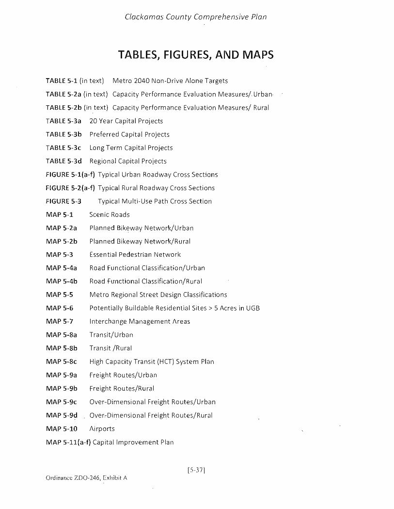
Clackamas County Comprehensive Plan
TABLES, FIGURES, AND MAPS
TABLE 5-1 (in text) M etro 2040 Non-Drive Alone Targets
TABLE 5-2a (in text ) Capaci ty Perfo rmance Eva luation Measures/Urban
TABLE 5-2b (in text) Capacity Performance Eva lu ation Measures/ Rura l
TABLE 5-3a 20 Yea r Capital Projects
TABLE 5-3b
TABLE 5-3c
TABLE 5-3d
Preferred Cap ital Projects
Long Term Ca pita l Projects
Regional Capital Projects
FIGURE 5-1(a-f) Typical Urb an Roadway Cross Sections
FIGURE 5-2(a-f) Typ ical Rural Roadway Cross Sections
FIGURE 5-3 Typical Multi-Use Path Cross Section
MAP 5-1
MAP 5-2a
MAP 5-2b
MAP 5-3
MAP 5-4a
MAP 5-4b
MAP 5-5
MAP 5-6
MAP 5-7
MAP 5-8a
MAP 5-8b
MAP 5-8c
MAP 5-9a
MAP 5-9b
Scenic Roads
Planned Bikeway Netwo rk/Urban
Planned Bikeway Netwo rk/Rural
Essentia l Pedestrian Netwo rk
Road Funct ional Classification/ Urban
Road Funct ion al Classification/Rural
M etro Region al Street Design Classificat ions
Potentially Build abl e Residenti al Sites> 5 Acres in UGB
Interchange Management Areas
Transit/ Urban
Tran sit /R ural
High Ca pacity Transit (HCT) System Plan
Freight Routes/U rban
Freight Routes/Rura l
MAP 5-9c Over-Dim ensiona l Fre ight Routes/Urban
MAP 5-9d OvercDim ensional Fre ight Routes/Rural
MAP 5-10 Airports
MAP 5-11(a-f) Cap ital Improvement Plan
[5 -3 7] Ord inance ZDO-246, Ex hib it /I

Project Map Pro ject Name /
ID Street Name
1000 County- ITS Plan Program
w ide
1001 County- Transportation Safety
wide Action Plan Program
1002 5-11a 122nd Ave
1003 s-lla 122nd Ave
1004 5-11a 122nd Ave
1005 5-11a 132nd Ave
1006 5-11a 142nd Ave
1007 5-11a 72nd Ave Multi-Use
Pat h Connection
1008 5-11a 82nd Dr
1009 5-11a 85th Ave
1010 5-11a 92nd Ave
1011 5-11a 97th Ave / Mather Rd
1012 $-lla Boye r Dr
1013 5-11a Boyer Dr / 85th Ave /
Spencer Dr
1014 5-11a Causey Ave
1015 5-11a Clackamas Industrial
area muli-modal
improvements
1016 5-11a Clackamas Reg ional
Center
Bike/Pedestrian
Corridors 1017 5-11a Clackamas Town
Center Alternative
Performance
Standards Study 1018 5-11a Clackamas Town
Center Circulation
Plan 1019 s-lla Flave l Dr
1020 5-11a Fuller Rd
Ordinance ZOO-246 Exhibit A
Last Amended March 1, 2014
Tabl e 5-3a 20-Yea r Capital Project s
Segment / Project Description
Locations
N/A Develop a program to su pport the implementation of the County's ITS Plan
and support the County's efforts to make improvements t o t raffic
operations based on the ITS Plan Deploy traffic responsive signa l timing,
ramp metering, traffic management equipment for better routing of t raffic
during incidents along the three key ODOT corridors - 1-205, 1-5, 99E.
Install signa l controller upgrades and update county ITS plan .
N/A Develop a program to support the implementation of the County's TSAP
and support the County's efforts to make improvements based on the
outcomes of the road safety audits and other safety stud ies. Eagle Glen Dr to Perform road safety audit or transportation safety review to identify
Hubbard Rd appropriate safety improvements Sunnyside Rd to Fill gaps in pedestr ian fac ilities, turn lanes at Mather Rd
Hubbard Rd Sunnyside Rd to Add bikeways and turn lanes at major intersections
Timber Va lley Dr Sunnyside Rd to OR Add bikeways, pedestrian facilities, t raffic calming and turn lanes at major
212 intersections Sunnyside Rd to OR Add bikeways and pedest ria n faci lities
212 Thompson Rd to Construct multi-use path
Harmanv Rd OR 212 to l awnfie ld Fill in bikeways and pedestrian faci lit ies gaps
Rd Causey Ave to Add sidewalks and bikeways
Monterey Ave Johnson Creek Blvd to Fill gaps in pedestrian fac il ities
Emmert View Ct Lawnfie ld Rd to Add bikeways, pedestrian facilities and eastbound left turn lanes at
Summers Ln Mather Rd / Summers Ln OR 213 to Fuller Rd Construct new 2 lane roadway with turn lanes at OR 213 and Fu lle r Rd,
bikeways and pedestria n facilit ies; install flash ing yellow arrow for left
turns on northbou nd and southbound approaches at OR 213 intersection.
OR 213 t o 1-205 bike Add bikeways
path Fu ller Rd to 1-205 Add bikeways and shared facility markings
N/A Complete bike and pedestrian connections w ith in the Clackamas Industrial
area on Jennifer St., Evelyn St., 1061h Ave, 122nd Ave, 1301h Ave and 13s1h
Ave.
N/A Construct pedestrian and bike improvements as described in the
Clackamas Regional Center Pedestrian / Bicycle Plan
Clackamas Reg ional Develop alternative performance standards for the intersect ions within
Center the Clackamas Regional Center.
West of the Town Study area circulat ion and create plan
Center
Alberta Ave to County Add bikeways
boundary
Otty St to Johnson Add pedestrian facilities, turn lanes, on-street parking, centra l med ian and
Creek Blvd landscaping.

Project Map Project Name /
ID Street Name 1021 5-11a fu ller Rd / King Rd
Improvement s
1022 5-11a Harmony Rd
1023 5-11a Harmony Rd
1024 5-11a Harmo ny Rd /
Sunnyside Rd
1025 5-11a 1-205 M ulti-Use Path
Connection
1026 5-11a 1-205 Multi-Use Path
Gap 1027 5-11a Johnson Creek Blvd
1028 5-11a Johnson Creek Blvd
1029 5-11a Johnson Creek Blvd
1030 5-11a Johnson Creek Blvd
1031 5-11a Johnson Creek Blvd
1032 5-11a Johnson Rd
1033 5-11n Lnke Rd
1034 5-Ua Li nwood Ave
1035 5-11a Monroe St
1036 5-11a Monroe St
1037 5-11a M onterey Ave
1038 5-11a M onterey Ave
1039 5-11a North Clacka mas
Regiona l Park Trai l
1040 5-11a North Clackamas
Regional Parks Trai l
1041 5-11a Otty Rd
1042 5-11a Otty St
1043 5-11a Southwest Connector
Multi-Use Path
Ordinance 200-246 Exhibit A
Last Amended March 1, 2014
Table 5-3a 20-Year Capita l Projects
Segment/ Project Description
Locations f uller Rd / King Rd Restrict access to r ight-in/right-out only
intersection OR 213 to OR 224 Construct bikeways and pedestrian faci lities
Rai lroad Ave / Railroad crossing and intersection improvements based on fu rther study
li nwood Ave / of intersect ion operat ions including bikeways and pedestrian faciliti es to
Harmony Rd be undertake jointly by the City of Milwaukie and the County
Harmony Rd / Extend queue storage on westbound approach and rebuild median;
Sunnyside Rd / OR 213 extend queue storage on eastbound approach and install med ian; convert
intersection to ri~ht- jn-rie:ht-o ut accesses on frontae:e road. Between Sunnyside Rd Construct ADA compliant access to the commercial area from the 1-205
and Sunnybrook Blvd Mu lt i-Use Path
OR 224/0R 213 to OR Study the 1-205 multi-use path gap to create a plan for con nection and
212 oath completion
55th Ave to 1-205 Perform road safety audit or transporta tion safety review to identify
appropriate safety improvements
Johnson Creek Blvd Add signal to either Johnson Creek Blvd and 79th PI or 80th Ave
near 79th PI 55th Ave t o Bel l Ave Widen to 3 lanes w ith bikeways and pedestrian facilit ies
Johnson Creek Blvd / Extend westbound left-turn lane and rebuild med ian; install dual
OR 213 inters ect ion northbound and southbound left-turn lanes
OR 213 to 92nd Ave Add pedestrian facilities, restripe for bikeways
5E l ake Rd to North Identify bike/pedest ri an connections to fill gaps along 82nd Ave
Clackamas Park Tra il Lake Rd / International Add northbound right -turn lane
Way intersection
M onroe St to Johnson Add pedestrian faci lities
Creek Blvd n nd Ave to Fuller Rd Add bikeways, pedestrian f ac ilit ies and traffic calming
Linwood Ave to 72nd Add bikeways and t raffic calming
Ave Stevens Rd to Bob Construct co llector roadway with bikeways and pedestrian facilities
Schumacher Rd OR 213 to f uller Rd Construct new 2 lane extension with pedestrian facilit ies and bikeways.
Insta ll flashing yellow arrow for left- turns on northbound and southbound
approaches at OR 213 intersection. Linwood Ave to North Construct multi-use path
Clackamas Park
Complex OR 213 to Linwood Construct multi-use path
Ave
OR 213 to 92 nd Ave Improve to minor arteria l standard consistent wi th Fuller Road Stat ion
Plan; improve curb radius; add turn lanes, on-st reet parking, cent ral
median landscaping. bikewavs and pedestrian faci lities Otty 5t / OR 213 / Otty Realign Otty St with Otty Rd at OR 213; insta ll dual westbound left-turn
Rd lanes; install fl ashing yellow arrow for left-turns on northbound and
southbound approaches. North Clackamas Construct multi -use path
Aquatic Center access
road to 82 nd Ave
2

Project Map Project Name /
ID Street Name
1044 5-11a Springwater Rd
1045 5-11a Sunnyside Rd
1046 5-11a Sunnyside Rd
1047 5-11a Tolbert St
Overcrossing
1048 5-11b 282nd Ave
1049 5-11b Amisigger Rd / Kelso
Rd 1050 5-11b Arrah Wanna Blvd
1051 5-11b Cazadero Multi-Use
Tra il
1052 5-11b Compton Rd
1053 5-11b Dodge Park Rd Bridge
1054 5-11b Eagle Creek Rd
1055 5-11b Eagle Creek Rd
1056 5-11b Fairway Ave
1057 5-11b OR 211
1058 5-11b Richey Rd
1059 5-11b Welches Rd
1060 5-11c Aldercrest Or
1061 5-11c Concord Rd
1062 5-11c Concord Rd
1063 5-11c Courtney Ave
1064 5-11c Courtney Ave
1065 5-11c Harold Ave
1066 5-11c Hull Ave
1067 5-11c Jennings Ave
1068 5-11c Jennings Ave
1069 5-11c Oak Grove Blvd
1070 5-11c Oatfield Rd
1071 5-11c Oatfield Rd
Ordinance ZDO-246 Exhibit A
last Amended March 1, 2014
Table 5-3a 20-Year Capital Projects
Segment / Project Description
locations
OR 224 to Hattan Rd Widen to 3 lanes with shou lders and pedestri an fa cilit ies; bridge remains
two lanes 93rd Ave to 126th Ave Perform road safety audit or t ransportation safety review to identify
appropriate safety improvements
Sunnyside Rd / Intersection improvements, such as additional turn lanes, turn lane
Stevens Rd extensions, and/or signal timing modifications
intersection 82nd Dr to Industr ial Construct new 2 lane Qvercrossing with bikeways and pedest rian facilities
Wav US 26 to OR 212 Perform road safety audit or transportation safety review to identify
appropriate safety improvements OR 224 to Ke lso / Add paved shoulders; turn lanes at Amisigger/OR 212 and Ke lso/Richey;
Richey Rd smooth curves. US 26 to Fairway Ave Add paved shoulders
Community of Boring Construct multi-use path
to City of Estacada US 26 to 352nd Ave Perform road safety audit or transportat ion safety review to identify
aoorooriate safety imorovements "'192 feet south of Replace bridge nearing the end of its useful life and include paved
Pipeline Rd shoulders Fi rwood Rd to Duus Rd Perform road safety audit or transportation safety review to identify
aoorooriate safetv improvements Currin Rd to Duus Rd Remove horizonta l curve, relocate intersection, add paved shoulders and
turn lanes at major intersection; investigate speed zone south of Currin Rd
Arrah Wanna Blvd to Add paved shoulders
Salmon River Rd
OR 211 / Judd Rd Realign roadway
intersection
Ke lso Rd to OR 212 Add paved shoulders and left turn lane at Richey Rd and OR 212
US 26 to Bi rdie ln Add paved shoulders; add pedestrian facilitie s in Welches rura l center
Thiessen Rd to Perform road safety audit or transportation safety review to identify
Oatfie ld Rd appropriate safety improvements
River Rd to Oatfield Rd Fill gaps in pedestrian facil ities
River Rd to Oatfield Rd Add turn lanes at major intersections
OR 99E to Oatfield Rd Fill gaps in pedestrian facil it ies and bikeways
River Rd to OR 99E Const ruct pedes tri an facilities / complete gaps on the south side; add
McLoughlin Blvdl bikeways
Concord Rd to Roethe Add pedestrian facilities and traffic calming
Rd Wilmot St to Tims Fi ll gaps in pedestrian facilities
View Ave Webster Rd to OR 99E Perform road sa fety audit or transportation safety review to identify
appropriate safety improvements
River Rd to Oatfield Rd Widen to 2-lane urban minor arterial standard with bikeway and
pedestrian faci lities infill Oatfie ld Rd to River Rd Fill gaps in pedestrian facil ities and bikeways
Jennings Ave to lake Perform road safety audit or transportation safety review to identify
Rd appropriate safety improvements
Oatfield Rd / Park Rd Insta ll traffic signa l and add turn lanes
intersection
3

Project Map Project Name /
ID Street Name 1072 $-llc Oatfield Rd
1073 5-11c Park Ave
1074 5-11c River Rd
1075 5-11c River Rd
1076 5-11c School Pedways
1077 5-11c Thiessen Rd
1078 5-11c Torbank Rd
1079 5-11d 65th Ave
1080 5-11d Advance Rd
1081 5-11d Borland Rd
1082 5-11d Borland Rd
1083 5-11d Carma n Dr
1084 5-11d Childs Rd
1085 5-11d French Prairie Bridge
1086 5-11d Rosemont Rd
1087 5-11d Stafford Rd
1088 5-11d Stafford Rd
1089 5-11d Stafford Rd
1090 5-11d Stafford Rd
1091 5-11d Tonq uin Tra il
1092 5-11d Wi lsonvi lle Rd / Ladd
Hill Rd
1093 5-11e Airport Rd
1094 5-11e Barlow Rd
1095 5-11e Beavercreek Rd
1096 5-11e Beavercreek Rd
1097 5-11e Beavercreek Rd
Ordinance ZDO-246 Exhibit A
last Amended March 1, 2014
Tab le 5-3a 20-Year Capital Projects
Segment/ Project Description
Locations Oatfield Rd / McNary Add southbound and eastbound left-tu rn lanes
Rd in tersection River Rd to OR 99E Add pedestrian facilit ies Mcl ough lin Blvd) _
l ark 5t to Courtney Add pedestrian facilities
Ave
Oak Grove Blvd to Fil l gaps in bikeways and pedestrian facilities
Risley Ave
Johnson Rd / Fill gaps in pedest r ian fac ilit ies on Johnson Rd, Clackamas Rd and We bster
Clackamas Rd / Rd with in 1/4 mile of schools
Webster Rd Thiessen Rd / Add turn lanes on Th iessen Rd; consider converting to two-way stop
Aldercres t Rd contro lled intersection River Rd to Tro lley Fill gaps in pedestrian facilit ies
Trail 65th Ave / Elligsen Rd Construct roundabout
/ Stafford Rd
intersection 53rd Ave to 43rd Dr Grade and sight distance improvements
Tualatin city limits to Add paved shoulders and t urn lanes at major intersect ions
Stafford Rd
Stafford Rd to West Add paved shoulders
Unn city limits
Lake Oswego cit y Add bikeways and pedestri an facili t ies; analyze for turn lanes
limits to Roosevelt Ave
Sycamore Ave to 65th Transfer roadway to local jur isd ict ion
Ave
W illamette River nea r Construct a bri dge cons ist ent w ith t he Connecti ng Clackamas Plan
1-5
Stafford Rd to West Add paved shoulders and tu rn lanes at major intersect ions
Unn 1-205 to Boeckman Rd Perfo rm road safety aud it or tra nsportation safety review to identify
/ Advance Rd appropriate sa fety improve ments Rosemont Rd t o 1-205 Add paved shoulde rs and turn lanes at major intersect ions
Stafford Rd / Childs Rd Install traffic signa l and southbound and northbound turn Janes or
intersection roundabout Rosemont Rd to 1-205 Perform road sa fety audit or transporta t ion sa fety review to identify
appropriate safety improvements
Wi llamette River Construct bike / pedestrian bridge consist ent with t he Con necting
t hrough Wilsonville Clackamas Plan
Wilsonville Rd / Ladd Install Co llision Countermeasure System
Hill Rd
Airport Rd / M iley Rd Install traffic signal
inte rsectio"n
8arlow Rd / OR 99E Add dual lef t -turn lanes on southbound Barlow Rd
intersection
Lower Highland Rd to Perform road sa fety audit or transportation safety review to identi fy
Butte Rd appropriate safety im provements
Ferguson Rd to Perform road safety audit or transportat ion safety review to identify
Spangler Rd appropriate safe ty im provements
Henrici Rd to Yeoman Add paved shou lders and turn lanes at major intersections
Rd/5teiner Rd
4

Project Map Project Name /
ID Street Name 1098 5-11e Beavercreek Rd
1099 5-11e Canby-Marquam
Highway
1100 5-11e Canby-Marquam Highway
1101 5-11e Clarkes Four Corners
Intersection 1102 5-11e Emerald Necklace Trail
1103 5-11e Ferguson Mu lti-Use
Path 1104 5-11e Fischers Mi ll Rd
1105 5-11e Graves Rd/Passmore
Rd/Mulino Rd/ OR 213
1106 5-11e Greater Arndt Rd/ I-
5/Canby Access
Feasibilitv Studv 1107 5-Ue Hattan Rd
1108 5-11e Henric i Rd
1109 5-11e Holly 5t
1110 5-11e Hult Rd
1111 5-11e Klang's Mill Bridge
1112 5-11e Lone Elder Rd Bridge
1113 5-11e Maple lane Rd
1114 5-11e Meridian Rd
1115 5-11e Molalla Ave Flooding
1116 5-11e Mulino Rd
1117 5-11e OR 170
1118 5-11e Redland Rd
1119 5-11e Redland Rd
1120 5-11e Redland Rd
Ordinance ZDO-246 Exhibit A
Last Amended March 1, 2014
Table 5-3a 20-Year Cap ita l Projects
Segment / Project Description
Locations Beavercreek Rd / Construct roundabout with additional analysis
Leland Rd / Kamrath
Rd intersection Canby-Marquam Hwy Reconstruct intersection; install northbound left-turn lane and
/ lone Elder Rd southbound right-turn lane
intersection ..... 1,900 ft south of Replace bridge nearing the end of its useful life with 2-lane structure
Barnards Rd including paved shoulders Beavercreek Rd / Reconstruct intersection
Unger Rd
To Canby Ferry Extend Molalla Forest Rd to Locust St
Thayer Rd to Ferguson Multi-use path to connect Ferguson Rd to Thayer Rd
Rd
Fischers Mill / Hattan Install eastbound left-turn lane
Rd intersection
Graves Rd/Passmore Work in conjunction with the Molalla River School District, ODOT and
Rd/Mulino Rd/ OR 213 community stake-holders to complete a safety audit to look at all options
for the safe movement of Mul ino Elementary School students in relation
to the adjacent transportation system . Util ize the resu lts from the audit to
develop a fist of projects and/or programs to maximize safety for all users.
Southwest County in Conduct an alternatives analysis and land use study to identify and
the vicinity of Arndt consider roadway improvements to address access to 1-5 w ithin the
Rd/I-5/Canbv Southwest County and address caoacitv deficiencies. Hattan Rd / Gronlund Insta ll southbound right-turn lane
Rd intersection Beavercreek Rd to Add paved shou lders and turn lanes at major intersections. Remove
Ferguson Rd horizontal and vertical curves Territorial Rd to Canby Add paved shou lders
Ferry OR 211 to Unger Rd Re-open and improve Hu lt Rd
-1,000 It north 01 OR Replace bridge nearing the end of its useful life
211 ~5,800 feet east of Replace bridge (nearing the end of its useful life) and include paved
Barlow Rd shoulders Beavercreek Rd to Perform road safety audit or transportation safety review to identify
Ferguson Rd appropriate safety improvements
Meridian Rd / Whiskey Limit access/egress poi nts to and from school on NE corner of intersection
Hill Rd intersection
Just south of city of Construct bridge to resolve flooding issues
Molalla
Mulino Rd / 13th Ave Relocate intersection to south away from railroad trestle
OR 99E to Macksburg Perform road safety audit or transportation safety review to ide ntify
Rd ~propriate safety improvements OR 213 to Hattan Rd Perform road safety audit or transportation safety review to identify
appropriate safety improvements
Redland Rd / Perform road safety audit o r transportation safety review to identify
Springwater Rd appropriate safety improvements
intersection Redland Rd / Holly Rd Install traffic signal and westbound and northbound left-turn lanes or
intersection roundabout
5

Project Map Project Name / ID Street Name
1121 5-11e Red land Rd
1122 5-11e Ridge Rd
1123 5-11e Springwater Rd
1124 5-11e Springwater Rd
1125 5-11e Springwater Rd
1126 5-11e Township Rd
1127 5-11e Union Mills Rd
1128 5-11e Union Mills Rd
1129 5-11e Upper Highland Rd
Ordinance ZDO-246 Exhibit A
Last Amended March 1, 2014
Table 5-3a 20-Year Capita l Projects
Segment/ Project Description locations
Redland Rd I Ferguson Construct roundabout
Rd inte rsection
""1 miles north of Fix sinkhole
Lower Highland Rd
Springwater Rd / Install signal at Clackamas River Dr
Clackamas River Dr intersection 400 ft east of Hattan Construct bridge to accommodate paved shou lders
Rd
Hattan Rd to Bakers Add paved shoulders and turn lanes at major intersections
Ferrv Rd
Centra l Point Rd to Add paved shoulders and turn lanes at major intersections
Canby City limit
OR 213 to OR 211 Add turn lanes at major intersections
OR 213 to OR 211 Const ruct a shoulder on the south side of the roadway
Beavercreek Rd to Perform road safety audit or transportation sa fety review to identify
Lower Highland Rd appropriate sa fety improvements
6

Project Map Project Name /
10 Street Name
2000 S-l1a Be ll Ave / Albe rta 5t / nnd Ave
2001 5-11a Clatsop St / luther Rd
2002 5-11a Evelyn St
2003 5-11a Evelyn St / Mangan Dr
2004 5-11a Hubbard Rd
2005 5-11a Jennifer St
2006 5-11a Lake Rd
2007 5-11a Linwood Ave
2008 5-11a linwood Ave
2009 5-11a Mather Rd
2010 5-11a Monroe St / 72nd Ave
I Thompson Rd 2011 5-11a Scouters Mountain /
Mt Scott Loop Tra il
2012 5-11a Stevens Rd / Stevens
Way 2013 5-11a Strawberry In
2014 5-11a Sunnybrook Blvd
2015 5-11a Sunnyside Rd
2016 5-11b 282nd Ave
2017 5-11b 362nd Ave
2018 5-11b Eagle Creek Rd
2019 5-11b Firwood Rd
2020 5-11c Clackamas Rd
2021 5-11c Jennings Ave
2022 5-11c lake Oswego to
M ilwaukie Bridge
2023 5-11c Roots Rd
2024 5-11c Thiessen Rd
2025 5-11c Webster Rd
Ordinance 200-246 Exhibit A
last Amended March 1, 2014
Table 5-3b Preferred Projects
Segment / Project Description
locations
King Rd to County line Add bikeways and pedestrian facilities
nod Ave to Fuller Rd Add t urn lanes and signals at OR 213 intersection; add bikeways,
Ipedestrian facilities and traffic calming
OR 224 to Jennifer St Add bikeways and pedestrian fa cilities
Jennifer St to Water Add bikeways
Ave 122nd Ave to 132nd Fill gaps in pedestrian facilities
Ave 82nd Dr to 135th Ave Add pedestrian facilities
Milwaukie City limits Fill gaps in pedestrian facil ities
east to OR 224 linwood Ave / Monroe Add curbs/sidewa lks, improve horizontal alignments
St intersection
Queen Rd to Johnson Add bikeways
Creek Blvd Su mmers In Rd to Add bikeways, pedestrian facilities and eastbou nd left t urn lanes at
122nd Ave Mathe r Rd / 122nd Ave linwood Ave to Fuller Add pedestrian facilities
Rd loop trail t hrough Construct multi-use path consistent with the Connecting Clackamas Plan
Happy Va lley,
Damascus, Clackamas
County and Portland
Causey Ave to Idleman Add pedways and optional traffi c calming
Rd Strawberry In / 82nd Install traffic signal and eastbound turn lane
Dr intersection
Sunnybrook Blvd / Add dual southbound left-turn lanes, extend queue storage for sou thbound
82nd Ave intersection left s and westbound lefts OR 213 to 97th Ave M odified boulevard treatment including lane redesign, medians,
beautification, curb extensions, reconstructed sidewalks, landscaping,
south side bikeways. Consider f lashing yellow arrow for left-turns at
signa lized intersect ions. 282nd / Ha ley Rd Install traffi c signal and reduce speed limit on 282nd
intersection 5kogan Rd to OR 211 Add paved shoulders
OR 211 to Duus Rd Add paved shoulde rs
Wildcat Mountain Dr Add paved shoulders and t urn lanes at major intersections.
to U5 26 Johnson Rd and Fill gaps in bikeways and pedestrian facilities
Webster Rd Oatfield Rd to Webster Widen to 2-lane urban minor arterial standard with bikeway and pedestrian
Rd fac ilities infill Between Sellwood and Construct bike/pedestrian crossing over the Wil lamette River
Ore.on City Webster Rd to Add pedestrian facilities
McKinley Rd Oatfield Rd to Webster Add bikeways and pedestr ian facilities
Rd OR 224 to Gladstone Fi ll gaps in bikeways and pedestrian facilities

Project Map Project Name /
ID Street Name 2026 5-11d Advance Rd
2027 5-11d Advance Rd
2028 5-11d Stafford Rd / 6Sth Ave
2029 5-11e Arndt Rd Extension
2030 5-11e Barlow Rd
2031 5-11e Beavercreek Mu lti -Use
Path 2032 5-11e Boones Ferry Rd
2033 5-11e Canby - Molalla
Ra ilroad Trail 2034 5-11e Ory land Rd
2035 5-11e Hattan Rd
2036 5-11e Henrici Rd
2037 5-11e Henrici Rd
2038 5-11e Molalla Forest Rd
2039 5-11e Mulino Rd (13th St
segment)
2040 5-11e Newell Creek Tra il /
Oregon City Loop Tra il
2041 5-11e Redland Rd
2042 5-11e Redland Rd
2043 5-11e Springwater Rd
Ordinance 200· 246 Exhibit A
Last Amended March 1, 2014
Table 5-3b Preferred Projects
Segment / Project Description
Locations "'2,900 ft west of Realign roadway and grade improvements
Mountain Rd 65th Ave to Mountain Add paved shoulders
Rd 1-205 to Boeckman Rd Add paved shoulders and turn lanes at major intersections
I Advance Rd
Barlow to OR 99E Construct new 2 or 3 lane roadway
Knights Bridge Rd to Add paved shoulders
OR 99E Loder Rd to Ferguson Construct multi -use path cons istent with the Beavercreek Road Concept
Rd Plan Boones Ferry Rd / Remove bank, remove/decrease horizontal curve
ButtevilJe Rd
intersection City of Canby to City of Construct multi-use path
Molalla Macksburg Rd S to Realign to form one intersection at Dryland Rd
M acksburg Rd N Fischers M ill Rd to Add paved shoulders and turn lanes at major intersections
Gronlund Rd
OR 213 to Beaverc reek Add paved shoulders and turn lanes at major intersections
Rd
Ferguson Rd to Add paved shoulders and turn lanes at major intersections. Remove
Red land Rd horizontal and vertical curves
City of Canby to City of Pave to provide bicyc le access
Molalla Canby city limits to OR Add paved shoulders and turn lanes at major intersections
213 Loop around the Construct multi-use path consistent with the Connecting Clackamas Plan
perimeter of Oregon
City Redland Rd / 8rad ley Install eastbound left-turn lane
Rd intersect ion Red land Rd / Fi schers Insta ll eastbound left-turn, eastbound right-turn and westbound r ight-turn
Mill Rd / Henric i Rd lanes at Henri ci Rd
intersection Spr ingwater Rd / Install southbou nd left-turn lane; rea lign intersection to fix skew
Bakers Ferry Rd
intersection
2

Project Map Project Name /
ID Street Name 3000 5-11a l06th Ave
3001 5-11a 152nd Ave Phase 2
3002 5-11a 162nd Ave
3003 5-11a 172nd Ave Bridge
3004 5-11a 82nd Dr
3005 5-11a 84th Ave
3006 5-11a 93 rd Ave
3007 5-11a Cheldelin Rd
3008 5-11a Chelde lin Rd (Clatsop
St extension)
3009 5-11a Cornwell Ave
3010 5-11a Fuller Rd
3011 5-11a Fuller Rd
3012 5-11a Hillcrest St
3013 5-11a 1-205 Pedestrian / Bike
Overpass
3014 s-lla Idleman Rd
3015 5-11a Jennifer St
3016 5-11a Johnson Creek Blvd
3017 5-11a King Rd
3018 5-11a Lake Rd
3019 5-11a Lake Rd
3020 5-11a linwood Ave Bridge
over Johnson Creek
3021 5-11a Luther Rd Bridge
3022 5-11a Mather Rd
3023 5-11a Mather Rd
3024 5-11a Mather Rd
3025 5-11a Michae l Dr
3026 5-11a Phillips Creek Multi-
Use Path
3027 5-11a Sunnyside Rd Adaptive
Signal Timing
3028 5-11a Valley View Terrace
Ordinance ZOO-246 Exhibit A
last Amended March 1, 2014
Tab le 5-3c Long Term Ca pital Proj ect s
Segment / Project Description
locations OR 212 to Jennifer St Add bikeways and pedestrian facilities
Sunnyside Rd to OR 212 Add bikeways, pedestrian facilities and turn lanes at major intersections
Sager Rd north to Add bikeways, pedestrian facilities, turn lanes at major intersections
County line ..... 140 feet south of Replace bridge nearing the end of its usefu l life
Troge Rd OR 212 to Gladstone Widen to 5 lane with bikeways and pedestrian facilities
Sunnyside Rd to Fill in bikeways and pedestrian faci lities gaps
Sunnvbrook Blvd Sunnyside Rd to Add bikeways
Sunnvbrook Blvd
Foster Rd to 190th Dr Add bikeways and pedestrian facilit ies
172nd Ave to Foster Rd Construct new two lane roadway with bikeways and pedestrian facilit ies
OR 213 to Fuller Rd Add pedestrian facilities; connect to 1-205 Multi-Use Path
Otty Rd to King Rd / OR Construct new 2 lane extension with pedestrian fac il ities and bikeways
213 Johnson Creek Blvd to Add pedestrian facil it ies
County line
92 nd Ave to Stevens Rd Add pedestrian facil it ies
Between Causey Ave Construct a bike / pedest rian cross ing over 1-205 to connect transit
and Sunnyside Rd services businesses and residents 92nd Ave to Westview Fi ll gaps in bikeways and pedestrian facilit ies
Ct 106th Ave to BOth Ave Add bikeways
Bell Ave to OR 213 W iden to 3 lanes from Bell Ave to 76th Ave and 5 lanes from 76th Ave to
82nd Ave' add bikeways and pedestrian faci lities
Milwaukie City limits to Fill gaps in pedestrian facilit ies
82nd Ave OR 224 west to Add pedestrian facilit ies and turn lanes at major intersect ions
M ilwaukie city limits
Johnson Rd to Webster Fill gaps in pedestrian facilities and bikeways
Rd Bridge Construct bridge w ith bike lanes and sidewalks
Bridge crossing Johnson Replace bridge
Creek
Mather Rd / 122nd Ave Install traffic signal or compact roundabout
intersection
122nd Ave to 132nd Construct new 2 lane roadway with pedest ri an facilities and bikeways
Ave Industrial Way to 98th Ma intain as pedestrian facilities and bikeway. Construct undercrossing at
Ave Sunrise Expresswav.
72nd Ave to Fuller Ave Fi ll gaps in pedestrian facilities
Causey Ave to North Construct multi-use path
Clackamas Regional
Parks Trail OR 213 to 172nd Ave Add adaptive timing to traffic signals
Sunnyside Rd t o Otty Rd Add bikeways and pedestr ian facilities

Project Map Project Name /
ID Street Name 3029 5-11a West 82nd Ave Parallel
Road 3030 5-11b 282nd Ave
3031 5-11b 282nd Ave
3032 5-11b 352nd Ave / Dunn Rd
3033 5-11b 362 nd Dr
3034 5-11b 362nd Dr
3035 5-11b Barlow Trai l Rd/ Lola
Pass Rd
3036 5-11b Bluff Rd
3037 5-Ub Bull Ru n Rd
3038 5-Ub Bull Run Truss
3039 5-Ub Coalman Rd
3040 5-Ub Compton Rd
3041 5-11b Coupland Rd
3042 5-Ub Eagle Creek Rd
3043 5-Ub Firwood Rd
3044 5-Ub Hayden Rd
3045 5-Ub Howlett Rd
3046 5-Ub Kelso Rd
3047 5-Ub Kelso Rd
3048 5-Ub Lolo Pass Rd
3049 5-Ub Mt Hood Aerial
Transportation Link
3050 5-Ub Orient Dr
3051 5-U b Porter Rd Bridge over
Delph Creek 3052 5-Ub Salmon River Rd
3053 5- Ub Springwater Rd
3054 5-11b Ten Eyck Rd
Ordinance ZDO-246 Exhibit A
Last Amended March 1, 2014
Table 5-3c Long Term Cap ital Projects
Segment/ Project Description
Locations King Rd to Luther Rd Construct collector road parallel to OR 213 with bikeways and pedest rian
facilities 282nd Ave / OR 212 Add second right-turn lane on 282nd Ave and add it iona l intersection
intersection improvements as needed
OR 212 to Multnomah Add paved shou lders
(ounty line
Bluff Rd to Bluff Rd Add paved shou lders
Colorado Rd to Dubarko Remove or decrease horizontal and vertical curves
Rd 362nd Ave / Deming Rd Remove or decrease vert ical curve, relocate intersection
inte rsect ion Between communities Add paved shou lders
o f Timberline, Welches
and Zie Zae Kelso Rd to County line Add paved shoulders
Ten Eyck Rd to Add paved shoulders and turn lanes at major intersections.
Multnomah County line
Bull Run truss between Replace bridge nearing the end of its useful life
Waterworks Rd and
Bowman Rd City of Sandy to US 26 Add paved shoulders
US 26 to 352nd Ave Remove vertical curve near Orient Dr and relocate intersection; add paved
shou lders Estacada City limits to Add paved shoulders and turn lanes at major intersections
Divers Rd Keegan Rd to Currin Rd Rea lign Eagle Creek Rd to remove or decrease downgrade
Fi rwood Rd / Trubel Rd Realign Tru bel Rd to remove or decrease downgrade
intersection Springwater Rd to OR Add paved shoulders
2U OR 211 t o Wi ldcat Add paved shoulders
Mountain Dr Richey Rd to Orient Dr Add paved shoulders
Orient Dr to Sandy Remove vertical CUlVe, relocate intersection, add paved shoulders and
Urban Growth turn lanes at major intersect ions; investigat e speed zone
Boundary US 26 to Barlow Trail Rd Safety ana lysis; add paved shoulders
Between Ski Bowl, Aerial transportation link
Government Camp
Vil lage and Timberline
Lod.e US 26 north to County Add paved shoulders
line .... 100 ft east o f Wil cox Replace bridge
Rd US 26 to Welches Rd Add paved shoulders
Hayden Rd to OR 211 Add paved shoulders
lusted Rd to US 26 Remove vertical curve, relocate int ersection, add paved shoulders, turn
lanes at major intersections' investigate speed zone
2

Project Map Project Name /
10 Street Name 3055 5-11b Tickle Creek Tra il
3056 5-11b Welches Rd
3057 5-11b Wildcat Mountain Dr
3058 5-11c Aldercrest Dr
3059 5-11c Clackamas Rd
3060 5-11c Hi ll Rd
3061 5-11c Johnson Rd / McKinley
Rd
3062 5-11c McNary Rd / Mabel
Ave
3063 5-11c Nael Rd
3064 5-11c Oatlie ld Rd
3065 5-11c Oatlie ld Rd
3066 5-11c Oatfie ld Ridge
Connection
3067 5-11c Oetkin Way and Naef
Rd
3068 5-11c Portland Ave
3069 5-11c Risley Ave
3070 5-11c River Rd
3071 5-11c River Rd
3072 5-11c Roethe Rd
3073 5-11c Rusk Rd
3074 5-11c Strawberry Ln
3075 5-11c Th iessen Rd
3076 5-11c View Acres Rd
3077 5-11c Webster Rd
3078 5-11c Webster Rd
3079 5-11d 65th Ave
3080 5-11d Baker Rd
3081 5-11d Be ll Rd
Ord inance ZDO-246 Exhibit A
Last Am ended M arch 1, 2014
Table 5-3c Long Term Capita l Projects
Segment / Project Description
Locations Springwater Corridor to Construct multi-use path consist ent with the Connect ing Clackamas Plan
Sandy citv limits Bi rdie Ln to Salmon Add paved shoulders
River Rd
OR 224 to Firwood Rd Add paved shoulde rs
Thiessen Rd to Oatfield Add pedestrian faci lities to one side of the road and bikeways
Rd
Clackamas Rd / 1-205 Construct bike/pedestrian bridge over 1-205
interchange
Oatfjeld Rd to Thiessen Add bikeways and pedestrian facilities
Rd
OR 224 to 1-205 multi - Bikeway and pedestrian facilities infill
use path Oatfie ld Rd to Webster Add bikeways and pedestrian facilities
Rd
Oatfi eld Rd to River Rd Add pedestrian facil ities
Oatlield Rd / Hill Rd Add left-turn lanes, install signa l if wa rranted
intersection Milwaukie city li mits to Fi ll gaps in pedestrian fac ilit ies and bikeways
Gladstone city li mits
Between Jen nings Ave Construct mu lti-use path
and Th iessen Ave over
Oatfi eld Ride:e Oatfield Rd and Wallace Add bikeways
Rd
Jennings Ave to Hull Fill gaps in pedestr ian facilities
Ave
Ari sta Dr to Hager Rd Fill gaps in pedestrian faci lities
Courtney Ave to Oak Add pedestrian facilities
Grove Blvd
Risley Ave to Rinearson Add pedestrian facilities
Rd
River Rd to OR 99E Add bikeways, pedestrian faci lities and traffic calming
McLoughlin Blvd}
OR 224 South t o Add pedestrian facilities on one side of the roadway and bikeways
Aldercrest Rd
Webster Rd to 82nd Dr Add pedestrian facilities and fill bikeway gaps
Thiessen Rd / Hill Rd Add right-turn lane on Thiessen Rd; cons ider converting to two-way stop
intersection controlled or install ing roundabout
Oatfie ld Rd to Hill Rd Add pedestrian fac ilities and traffiC ca lming
Webster Rd / Jennings Construct traffic signa ls, turn lanes
Ave and Webste r Rd /
Roots Rd intersections Webster Rd / Add signal; construct sou thbound and westbound left-turn lane
Strawberry Ln
intersect ion Stafford Rd to Tualatin Add paved shoulders
city li mits
Tooze Rd to County line Add paved shoulders
Ladd Hi ll Rd to Add paved shoulders
Wi lsonville Rd
3

Project Map Project Name /
ID Street Name 3082 5-l1d Bonita Rd
3083 5-l1d Childs Rd
3084 5-l1d Graham's Ferry Rd
3085 5-l1d Graham's Ferry Rd
3086 5-l1d Hoffman Rd / Peach
Cove Rd / Riverwood
Rd 3087 5-l1d Homesteader Rd
3088 5-l1d Johnson Rd
3089 5-l1d Ladd Hill Rd
3090 5-l1d Mountain Rd
3091 5-Ud Petes Mounta in Rd
3092 5-l1d Pleasant Hill Rd /
McConnell Rd / TOOle
Rd 3093 5-l1d Schaeffer Rd
3094 5-l1d Schatz Rd / 55th Av. / Meridian Way
3095 5-l1d Tua latin j l ake
Oswego Pedestrian
and Bicvcle Bridge 3096 5-l1d Wilsonville Rd
3097 5-l1d Wilsonville Rd
3098 5-l1d Wilsonville Rd Bridge
3099 5-l1d Wisteria Rd /
Woodbine Rd
3100 5-11. Airport Rd
3101 5-11. Bakers Ferry Rd
3102 5-11. Barnards Rd
3103 5-11. Barnards Rd
3104 5-11. Beavercreek Rd
3105 5-11. Bradl.y Rd
3106 5-11. Bradl.y Rd
3107 5-11. Buckner Creek Rd
Ordinance ZDO-246 Exhibit A
Last Amended March 1, 2014
Table 5-3c Long Term Capit al Projects
Segment / Project Description
Locations Carman Dr to 1-5 Add bikeways and pedestrian facilities
Stafford Rd to Lake Add pedestrian facilitie s, bikeways and turn lanes at major intersections
Oswego city limits
County line to Westfall Add paved shoulders
Rd Wilsonville Rd to Add paved shoulders
Wilsonville city limits Mountain Rd to Add paved shoulders
Tua latin River
Stafford Rd to Add paved shoulders
Mountain Rd Stafford Rd to West Add paved shoulders and turn lanes at major in tersections
Linn city limit s
Wilsonvi lle Rd to Add paved shoulders and turn lanes at major intersections
Washington County line
Stafford Rd to Hoffman Add paved shoulders
Rd West Linn city limits to Add paved shoulders and turn lanes at major intersections
Hoffman Rd Ladd Hill Rd to W.stfall Add paved shoulders
Rd
Mountain Rd to Petes Add paved shoulders
Mountain Rd 65th Ave to Stafford Rd Add paved shoulders
Tualatin River Bridge Construct bike / pedestrian bridge consistent with the Connecting
Clackamas Plan
Wilsonville Rd j Bell Rd Rea lign roadway and grade improvements
intersect ion Wilsonvi lle Rd j Remove bank, remove horizontal curve, relocate intersection
Edminston Rd
intersection - 300 feet south of Bell Replace bridge nearing the end of its useful life
Rd Rosemont Rd to Add paved shoulders
Johnson Rd Arndt Rd to Miley Rd Add turn lanes at major intersections
Springwater Rd to OR Add paved shoulders and turn lanes at major intersections; remove
224 horizontal curve and re locate intersect ion from Eaden Rd to OR 224 Meridian Rd to Canby- Add paved shoulders
Marquam Hwy
Needy Rd to Stuwe Rd Reconstruct bridge and widen to 36 feet
Yeoman RdjSteiner Rd Add paved shoulders
to OR 211 Redland Rd to Holcomb Add turn lanes at major intersections
Blvd Gronlund Rd to Redland Add paved shoulders
Rd Gard Rd to Cachell Rd Add paved shoulders
4

Project Map Project Name /
10 Street Name 3108 5-11e Canby-Marquam
Highway
3109 S-l1e Canby-Marquam Highway
3110 S-l1e Carus Rd
3111 5-11e Casto Rd
3112 5-11e Central Point Rd
3113 5-11e Clackam as River Dr
3114 5-11e Fellows Rd
3115 5-11e Ferguson Rd
3116 5-11e Fischers M ill Rd
3117 5-11e Forsythe Rd
3118 5-11e Forsythe Rd
3119 5-11e Forsythe Rd
3120 5-11e Gard Rd
3121 5-11e Gron lund Rd / Hattan
Rd
3122 5-11e Henrici Rd
3123 5-11e Holcomb Blvd
3124 5-11e Kamrath Rd
3125 5-11e Knights Bridge Rd
Bridge
3126 5-11e Le land Rd
3127 5-11e Le la nd Rd
3128 5-11e Lone Elder Rd
3129 5-11e Lower Highland Rd
3130 5-11e Macksburg Rd
3131 5-11e M aplelane Rd
3132 5-11e Maplelane Rd
3133 5-11e Mattoon Rd
3134 5-11e Meridian Rd
Ordinance ZDO-246 Exhibit A
Last Amended March 1, 2014
Tab le 5-3c Long Term Capita l Projects
Segment / Project Description
Locations OR 170 I Macks burg Rd Reconst ruct intersection; install southbound left-turn lane and
intersection northbound right-turn lane City of Canby to OR 211 Add paved shoulders
Central Point Rd to Add paved shoulders
Beavercreek Rd
Spangler Rd to Centra l Add paved shoulders and tu rn lanes at major inte rsections
Poin t Rd
Pa rrish Rd to Mu lino Rd Add paved shoulders; smooth curves
Oregon City limits to Add paved shoulde rs and turn lanes at Springwater Rd and Forsythe Rd
~'pJilJgwater Rd Redland Rd to Lower Add paved shoulders and turn lanes at major intersections
Highland Rd
Beavercreek Rd and Reduce the speed limit and install traffic ca lming
Henrici Rd Redland Rd to Add paved shoulders
Springwater Rd
Oregon City line to Add paved shoulders
Bradlev Rd Oregon City lim it to Add center turn lane and paved shoulders
Bradlev Rd
Forsythe Rd / Victory Rd Realign, w ide n Victory Rd; remove or decrease curves along Forsythe Rd;
intersection re locate intersection - 100 It sou t h 01 Old Const ruct bridge to accommodate paved shoulde rs
Cla rke Rd Bradley Rd to Add paved shoulde rs and turn lanes at major intersect ions
Springwater Rd
Between Driftwood Dr Widen bridge to accommodate paved shoulders
and Shore Vista Dr Edenw ild Ln to Bradley Add paved shoulders and turn lanes at Holcomb Blvd / Bradley Rd
Rd Carus Rd to Spangler Rd Safety analysis at Carus Rd, add paved shoulders, remove or decrease
horizonta l curves north of Spangler Rd -3,200 feet east of Replace bridge (nearing the end of its useful life)
Bar low Rd
Oregon City line to Add paved shou lders
Beavercreek Rd ..... 1,000 ft north of Construct bridge to accommodate paved shoulders
Warnock Rd County line to Ca nby~ Add paved shou lders
Marq uam Hwv
Beavercreek Rd to Add paved shou lders and turn lanes at major intersections
Fellows Rd
Canby Marquam Hwy to Add paved shoulders and turn lanes at major intersections
OR 213 "'1,800 ft west of Add paved shoulders
Walker Rd Oregon City Urban Add paved shoulders
Growth Boundary to
Fere:uson Rd Fischers Mill Rd to Add paved shoulders and turn lanes at major intersections; remove
Redland Rd vertical curves remove horizontal curves north of Redland Rd
Lone Elder Rd to OR 211 Add paved shoulders
5

Project Map Project Name /
ID Street Name 3135 5-l1e Meridian Rd
3136 5-l1e Miley Rd
3137 5-l1e Molalla Ave
3138 5-l1e New Era Rd / Haines
Rd 3139 5-l1e Redland Rd
3140 5-l1e Redland Rd
3141 5-l1e Redland Rd
3142 5-l1e Redland Rd
3143 5-l1e Redland Rd
3144 5-l1e Ridge Rd
3145 5-l1e Rock Creek (Kropf Rd) Bridge
3146 5-l1e 5 Killdeer Rd
3147 5-l1e South End Rd
3148 5-l1e Spangler Rd
3149 5-l1e Springwater Rd
3150 5-l1e Thaye r Rd/Ferguson
Rd 3151 5-l1e Toliver Rd
3152 5-l1e Unger Rd
3153 5-l1e Union Ha ll Rd
3154 5-11f Bird Rd
3155 5-11f Blair Rd
3156 5-l1f Ca llahan Rd S
(beginning on Ramsby
Rdl 3157 5-11f Ohooghe Rd
3158 5-11f Fernwood Rd
3159 5-1 11 Gray's Hill Rd
3160 5-11f M aple Grove Rd
3161 5-l1f Nowlens Bridge Rd
Ordinance ZDO-246 Exhibit A
Last Amended March 1, 2014
Tab le 5-3c Long Term Cap ital Project s
Segment / Project Description
Locations Elliott Prai rie Rd to Add paved shoulders; remove or decrease horizonta l and vertica l curves
Barlow Rd Airport Rd to Eilers Rd Add paved shou lders
OR 213 to Molalla City Add paved shou lde rs
limits OR 99E to l eland Rd Add paved shoulders
Fischers Mill Rd to Add paved shou lders
Springwater Rd
-900 ft west of Holly Ln Widen to include shoulders and bikeways
..... 400 ft west of Holly Ln Widen to include shoulders and bikeways
Hen riei Rd to Oregon Add paved shoulders
City limit Henrici Rd to Add paved shou lders and turn lanes at major intersections
Springwater Rd
lower Hig hland Rd to Add paved shou lders
Redland Rd -3,500 ft north of Replace bridge
Gibson Rd Ferguson Road and Extend 5 Killdeer Rd t o connect with S. Ivel Rd. and provide
Yeoman Road bike/pedestrian access Oregon City limits to OR Smooth curves; add paved shoulders
99E Casto Rd to Add paved shoulders and turn lanes at major intersections
Beavercreek Rd Bakers Ferry Rd to Add paved shou lders and t urn lanes at major intersections
Hayden Rd Oregon City line to Add paved shoulders
Redla nd Rd Oryland Rd to Molalla Add paved shoulders
ci ty limits Beavercreek Rd to OR Add paved shoulders and turn lanes at major intersections
211 Centra l Point Rd to EI Add paved shou lders
Dorado Rd Groshong Rd to Wi lhoit Add paved shoulders and turn lanes at major intersections
Rd Groshong Rd to Maple Add paved shou lders and turn lanes at major intersections
Grove Rd Dickey Prai rie Rd to Add paved shoulders and turn lanes at major intersections
Fernwood Rd
OR 211 to Fernwood Rd Add paved shoulders and turn lanes at major intersections
Dhooghe Rd to Callahan Add paved shou lders and turn lanes at major intersections
Rd Green Mountain Rd to Add paved shoulders
OR 211 Nowlens Bri dge Rd to Add paved shou lders and turn lanes at major intersect ions
Sawte ll Rd OR 213 to Maple Grove Add paved shou lders and turn lanes at major intersections
Rd
6

Project Map Project Name /
10 Street Name 3162 5-lH Sawtell Rd
3163 5-lH Wildcat Rd
3164 5-lH Wright Rd
Ordinance ZDO-246 Exhibit A
Last Amended March 1, 2014
Tabl e 5-3c Long Term Capital Projects
Segment / Proj ect Description
Locations Maple Grove Rd to Add paved shoulders and turn lanes at major intersections
Wilhoit Rd Wilhoit Rd to OR 213 Add paved shoulders and turn lanes at major intersections
OR 211 to Callahan Rd Add paved shoulders
7

Project Map Project Name /
ID Street Name 4000 County- TSP Refinement
wide
4001 $-lla 1-205 / Sunnyside
Road interchange
4002 5- 11, OR 212
4003 5-11, OR 212
4004 5-11, OR 213
4005 5-11, OR 224
4006 5-11a OR 224
4007 5-11' OR 224
4008 5-11a OR 224
4009 5-11, OR 224
4010 S-lla Sunrise Project -
Preliminary
EnRineerinll 4011 5-11' Sunrise Project - Right
of-Way
4012 5-11a Sunrise Project - Mult i-
use Path 4013 5-11b OR 224
4014 5-11b OR 224
4015 5- 11c OR 99E
4016 5-11d 1-205
4017 5-11e 1-205
4018 5-11e 1-205
4019 S-l1e OR 211
4020 5-11e OR 213
4021 S-l1e OR 213
Ordinance ZDO·246 Exhibit A
Last Amended March 1, 2014
Table 5-3d Regiona l Capita l Projects
Segment/ Project Description Priority
locations State facility locat ions TSP Refinement to develop alternative mobility targets for state High
applicab le where facilities consistent with Oregon Highway Plan (OHP) IF3.
mobility target is not
met in 2035 1-205/ Sunnyside Road Add dual northbound righHurns; install bike signal. High
in terchange OR 212/ 172nd Ave Add second eastbound left-turn lane High
intersection SE 162nd to Anderson Add bikeways, pedestrian fa cil ities ways, and landsca pe High
Rd pedestrian facil ities buffer; widen to 6 lanes within Happy Va lley;
add center turn lane within Damascus Sunnybrook Blvd to Extend fiberoptic communications, CCTV at key intersections and High
Portland City Limits adaptive signal timing
OR 224 / L'ke Rd / Add turn -lanes, including second left-turn lane on westbound OR High
Webster Rd 224, second left-turn lane and right-turn lane on northbound SE
intersection Webster Rd, and second left-turn lane on southbound SE lake Rd
OR 224/ Johnson Rd Add second left-turn lane on westbound OR 224 High
intersection OR 224 / Hubbard Rd / Add intersect ion improvements, including right-turn lanes High
135th Ave intersection
Springwater Rd / OR Add signa l and turn lanes on all approaches High
224 intersect ion Rock Creek Junction to Widen t o four lanes; add bikeways. High
Midw,y 5t
Webster Rd/ OR 224 Prel imin<'lry engineering from Webster Rd to 172nd Ave High to 172nd Ave / OR 212
Webster Rd/ OR 224 Acquire r ight-of-way to accommodate 61ane expressway plus High
to 172nd Ave / OR 212 auxil iary lanes
122nd to Rock Creek Const ruct mult i-use path from 122nd to Rock Creek Junction High
Junction Iparallel to the Sunrise projec t consistent wi th FEIS. OR 224 /232nd Ave Install traffic signal or roundabout High
intersect ion Eaglecreek Rd / OR Install signal High
224 intersection Mi lwaukie city limit to Add bikeways, pedestrian faci lities ways, median enhancements, High
Gladstone city limit crosswalks and pedestrian faci li ties refuges
SW 5t , fford Rd to OR Work with ODOT, Metro, Oregon City, West Linn and any other High
99E effect jurisdiction to ana lyze and develop a solution to the
t ransportation bottle neck on 1-205 between Oregon Ci ty and 1-
205 / Stafford Road Interchange. Possible solutions include
widening to 3-lanps in each dirpction. Willamette River to Add southbound truck climbing lane High
West Linn city limit 1-205 Corridor Corridor-wide operational improvements High
Beavercreek Rd, Union Widen t o include shoulders, bikeways, add passing lanes where High
H, II Rd to Dhooghe Rd needed and turn lanes at major intersections
OR 213 / 5p,ngler Rd Insta ll traffic signa l to replace existing two-way stop High
intersection OR 213 / Henrici Rd Install t raffic signal or roundabout and addit ional intersection High
intersection improvements as needed

Project Map Project Name /
ID Street Name 4022 5-11e OR 213
4023 5-11e OR 213
4024 5-11e OR 213
4025 5- 11e OR 99E
4026 5-11a 1-205/ Johnson Creek
Blvd interchange
4027 5-11a 1-205/ OR 212/224
Interchange
4028 5-11a OR 212
4029 5-11a OR 212
4030 5-11a OR 213
4031 5-11a OR 213
4032 5-11a OR 224
~033 5-11a OR 22~
4034 5-11. OR 224
4035 5- 11a OR 99E
4036 5-11a Sunrise Project
4037 5-11b OR 211
4038 5-11b US 26
4039 5-11b US 26
4040 5-11e OR 211
4041 5-11. OR 211
4042 5-11e OR 99E
4043 5-11e/ f OR 213
4044 5-11a OR 212
Ordinance ZDO-246 Exh ibit A
Last Amended March 1, 2014
Table 5-3d Regional Capita l Projects
Segment / Project Description Priority
locations OR 213 / leland Rd Add northbound through auxi liary lane High
intersection
l eland Rd I Union Hall Add southbound auxiliary lane High
Rd intersection Mulino t o Molalla Perform road safety audit or t ransportat ion safety review to High
identify appropriate safety improvements OR 99E / Barlow Rd Add left-turn lane on southbound Barlow Rd· To widen Barlow High
intersection Rd to add a southbound left turn lane on the north approach
would need to mOdify t he exist ing railroad cross ing warning
system 1-205/ Johnson Creek Add loop ramp and northbound on-ramp; real ign southbound off- Medium
Blvd interchange ramp and install dual right-turn lanes
In vicinity of Roots Rd Connect bikeways Medium
and McKinlev Ave Rock Creek Junction to Construct climbing lane Medium
172nd
OR 212 / SE 162nd Ave Add left-turn pockets and t raffic signal Medium
intersection Sunnyside Rd to Widen to 7 lanes with boulevard treatments Medium
Sunnvbrook Rd OR 213 / Harmony Rd Add bikeways, pedestrian facilities ways, dual northbound and Medium
/ Sunnyside Rd southbound left-turn lanes, and lighting; convert driveways north
intersection of in te rsection to right-in / r ight-out OR 224 / Rusk Rd off- Extend ri ght-turn lane on OR 224 Medium ramp Milwaukie city limits Construct multi-use path as parallel route to OR 224 Medium
to 1-205
lake Rd / Johnson Rd / Rea lign Lake Rd / Johnson Rd to provide southern OR 224 access Medium
Pheasant Ct via Pheasant Ct; add turn lanes at OR 224/ Pheasant Ct
intersection; close access at Lake / Webster south of OR 224
OR 99E / Jennings Ave Determine sa fe connection of Trolley Tra il at OR 99E / Jennings Medium
intersection Ave intersection 1-205 to 172nd Ave Construct improvements t o 172nd Medium
Hayden Rd to OR 224 Widen to rural arteria l standard with shoulders, bikeways and Medium
turn lanes at maior intersections Govt. Camp Loop W to Implement Finding of Mt Hood Multimoda l Study including Medium
OR 35 phased safety improvements OR 35 Junction to Widen roadway to include bikeways /shoulders, add passing Medium
Wasco County line lanes where needed and turn lanes at major intersections OR 170 (Canby- Insta ll eastbound and westbound left-turn lanes, and eastbound Medium
Marquam Hwy) / OR ri ght-turn lane; remove or decrease horizontal curve
211 intersection Marion County line to Widen to include shoulders, bikeways, add passing lanes where Medium
OR 170 (Canby- needed and turn lanes at major intersections
MarQuam Hwy) Ba rlow Rd to Marion Four lane w idening with median, left-turn lanes from mile post Medium
County line 24.05
Oregon City boundary Add shoulders and bikeways Medium
to Marion County line
1-205 to OR 224 Perform road safety audit or transportation safety review to low
identify appropriate safety improvements
2

Project Map Project Name /
ID Street Name 4045 5-11a OR 212
4046 5-11a OR 213
4047 5-11a OR 213 (82nd Ave)
4048 5-11a OR 224
4049 5-11a OR 224
4050 5-11b OR 211
4051 5-11b OR 211
4052 5-11b OR 211
4053 S-11b OR 211
4054 5-11b OR 211
4055 5-11b OR 211
4056 S-11b OR 211
4057 5-11b OR 211
4058 5-11b OR 224
4059 5-11b OR 224
4060 5-11b OR 224
4061 5-11b OR 224
4062 5-11b OR 224
4063 5-11b OR 224
4064 5-11b OR 224
4065 5-11b US 26
4066 5-11b US 26
4067 5-11b US 26
4068 5-11b US26
4069 5-11b US26
Ord inance ZDO-246 Exhibit A
Last Amend ed March 1, 2014
Table 5-3 d Regional Capital Project s
Segment / Project Description Priorit y
Locations Within the Damascus Obtain right-of-way for f uture 4 lane faci lity with planted median l ow City Limits (Armstrong and 5 lanes at major intersections; build as major development
Cr to 257th) occurs and apply access management t o reduce number of
driveways. (Iatsop St to OR 213/82nd Avenue Boulevard Design Improvements - Widen low Sunnyside Rd to add sidewalks, lighting, central median, planting strips and
landscaping; fi ll gaps in the bike and pedestrian facilities network.
2014 ODOT OR 213 paving project programmed King t o OR 224.
l uther Road to Perform road safety audit or transportation safety review to low Sunnybrook Blvd identi fy appropriate safety improvements Webster Rd and 82nd Provide frontage connection on the north side of OR 244 low Ave Springwat er Rd to Shoulder widen ing, hori zonta l realignment, realignment of l ow 232nd Dr roadway to bluff OR 224 to eastbound Perform road safety audit or transporta t ion safety review to l ow US26 identi fy appropriate safety improvements OR 224 to Hillcockburn Perform road safety audit or transportation safety review to l ow Rd identify appropriate sa fety improvements Tick le Creek RdjOR Remove or decrease horizontal curve, relocate intersection low 211 intersection 362nd Dr / OR 211 Remove or decrease vertica l curve and remove vegetation low intersection Eagle Creek Rd to Widen to include bikeways /shoulders and add passing /climbing low Tickle Creek Rd lanes where needed 0.14 mi les east of Widen to add shoulder / bikeways; rea lign to remove horizontal low Coop Rd to Jacknife Rd and vertica l curves
Tickle Creek Rd to Widen to include bikeways /shou lders and add passing /cl imbing l ow 362nd Dr lanes where needed Bornstedt Rd to City of Add shoulders and bikeways l ow Sandy 232nd Ave to OR 211 Perform road safety audit or transportation safety review to l ow
identi fy appropriate safety improvements Fish Creek Rd to Perform road safety audit or transportation safety review to l ow Nat iona l Forest Rd 46 ident ify appropriate safety improvements Bakers Ferry Rd / OR Add eastbound right-turn lane low 224 intersection Amisigger Rd / OR 224 Install t raffic Signal; add southbound and eastbound left-turn low intersection lanes and westbound right-turn lane Heiple Rd / OR 224 Add southbound right-turn lane low intersect ion Bakers Ferry Rd to Widen to include shoulders and bikeways; add passing lanes l ow Estacada city limits where needed OR 212 to City of Add shoulders and bikeways l ow Estacada US 26 / Ha ley Rd Develop a plan to address to address access and safety issues on l ow intersect ion US 26 at this intersection and impJement that plan Kelso Rd to Duncan Rd Perform road safety audit or transportation safety review to low
identify appropriate safety improvements Duncan Rd to Perform road safety audit or transportation safety review to l ow Langensand Rd ident ify appropriate safety improvements Firwood Rd to Sleepy Perform road safety audit or transporta ti on safety rev iew to low Hollow Dr identify appropriate safety improvements Rhododendron to OR Perform road safety audit or transportation safety review to low 35 identi fy appropriate safety improvements
3

Project Map Project Name /
ID Street Name 4070 5-11b US 26
4071 5-11b U526
4072 5-11b US 26
4073 5-11b US 26
4074 5-11c OR 99E
4075 5-11d OR 43
4076 5-11e OR 211
4077 5-11e OR 211
4078 5-11e OR 211
4079 5-11e OR 211
4080 5-11e OR 211
4081 5-11e OR 213
4082 5-11e OR 213
4083 5-11e OR 213
4084 5-11e OR 213
4085 5-11e OR 99E
4086 5-11e OR 99E
4087 5-11e OR 99E
Ordinance ZOO-246 Exhibit A
last Amended March 1, 2014
Table 5-3d Regional Cap ital Projects
Segment / Project Description Priority
Locations US 26 / Fi rwood Rd Add eastbound right-turn lane Low
intersection US 26 / Brightwood Add west bound right-turn lane Low
LoopW
US 26 / Brightwood Add westbound right-turn lane Low
Loop E
Lola Pass Rd to Govt. Implement Finding of Mt Hood Multimodal Study including ITS Low
Camp Loop Rd. W approach with variable speed signage
Park Ave to Gladstone Perform road safety audit or transportat ion safety review to Low
city limits identify appropriate sa fety improvements
Lake Oswego to Develop active transportation connection consistent with the Low
Portland Connecting Clackamas Plan Dhooghe Rd / OR 211 Remove or decrease horizontal curve, relocate in tersecti on Low
intersection OR 170 (Canby- Add shou lders and bikeways Low
Marquam Hwy) to City of Molalla Needy Rd to 0.6 miles Remove or decrease vert ical curve to allow passing zone, add Low
west of Needy Rd passing lane in one or both directions, possible relocation of
intersection Molalla city limits to Widen to rural arterial standard (2 lanes) with shoulders and Low
Estacada city limits bikeways Beavercreek Rd t o Perform road safety audit or transporta tion safety review to Low
Upper Highland Rd identify appropriate safety improvements OR 213 / Carus Rd Insta ll traffic signal to replace existing two-way stop See U339 Low
intersection OR 213 / Beavercreek Perform road safety audit or transportation safety review to Low
Rd intersection identify appropriate safety improvements Carus Rd / OR 213 Install southbound left-turn and right-turn lanes Low
intersection Macksburg Rd to Widen shoulders to state standards Low
Liberal Way Oregon City to Canby Add shoulders and bikeways Low
Sequoia Parkway to Perform road sa fety audit or t ransportation sa fety review to Low
l one Elder Rd identify appropriate safety improvements Territoria l Rd to Metro Perform road sa fety audit or t ransportat ion sa fety review to Low
boundary identify appropriate sa fety improvements
4

Figure 5 -la Typical Urban Major Arterial Cross Section
Back of sidew k] r Bock of
dewalk
l' -
Notes:
If Pedestrian facility Landscape Bikeway Travel lane Travel lane Leh turn lane and Travel lane Travel lane Bikeway l andscape Pedestrian faci lity
~
strip rai sed median strip with street
with vegetation with street
trees trees
- 2'
-~ 6'- 15' 5' - 7' 6' - B' lD'- 12' 10' - 12' 12' - 14' 10' - 12' 10' - 12' 6' - B' 5' - 7' 6' - 15' ~
typical paved width: 64' - 78 '
ROW: 88' - 126'
1. This standard cross section shall apply except where a Special Transportation plan in Chapter 5 specifies a different cross section .
2. For more detailed information on the implementation of this Cross Section - see the Zoning and Development Ordinance and/or the County Roadway Standards.
3. Cross section may vary to accommodate Regional Transportation Functional Pion 3.08. J 10 Street System Design or to accommodate topographical or environmental constraints.
4. Within the range stated, precise dimensions of typical paved w idth shall be determined by Engineering based upon adjacent land use, vehicle t raffic volume, existing travel lane width, design speed and crash history.
5. Medians, pedestrian refuges, islands, curb extensions, parking, left turn lanes or right turn lanes shall be provided per the Comprehensive Plan, Capital Improvement Projects or as warranted by Roadway Standards. These improvements may requi re additional right-or-way.
Ordinance ZOO - 246: Exhibit A Last Amended March 7,2074

Figure 5 - lb Typical Urban Minor Arterial Cross Section
•
sock of sidew :I'k- ---, Sack of
dewalk
l '
Notes:
landscape uptlOnal: r<
Pedestrian Parking Bikeway Travel lane Optional: Left turn lane and Optional: Travel lane Bikeway Parking landscape Pedestrian facility
$trip Travel lane raised median Travel lane
SHip facility
with street with street
",. with vegetation t,,. - 2'
6' - 10' 5' - 7' 8' 6' - 8' 10'- 12' 10' - 1 2' 12'· 14' 10' - 12' 10' - 12' 6'- 8' 8' 5' - 7' 6'- 10' I-
typical paved width: 32' - 78'
ROW: 60' - 118'
1. This standard cross section shall apply except where a Special Transportation plan in Chapter 5 specifies a different (ross section.
2. For more detailed information on the implementation of th is Cross Section· see the Zoning and Development Ordinance and/or the County Roadway Standards.
3. Cross section may vary to accommodate Regional Transportarion Functional Plan 3.08.110 StreerSysrem Design or to accommodate topographical or environmental constraints.
4. Within the range stated, precise d imensions of typical paved width shall be determined by Engineering based upon adjacent land use, vehicle traffic volume, existing t ravel lane Width, design speed and crash history.
S. Medians, pedestrian refuges, islands, curb extensions, parking, left t urn lanes or right turn lanes shall be provided per the Comprehensive Plan, Capital Improvement Projects or as warranted by Roadway Standards. These improvements may require additional right-or-way.
Ordinance ZDO - 246: Exhibit A Last Amended March 1, 2014

Notes:
~"ck of Si de alk
l ' -" -
!' Pedestrian
facili ty
6'-10' ...
Landscape Parking strip
with street tree
5' - 7' 8'
Figure 5 -lc Typical Urban Collector Cross Section
UptiOnal: Bikeway Travel lane Left turn lane and Travel lane Bikeway
raised median with vegetation
6'- 8' 10'- 12' 11 ' - 13' 10'- 12' 6'- 8'
typical paved width: 48' - 69'
ROW: 72' - 107'
1. This standard cross section shall apply except where a Special Transportation plan in Chapter 5 specifies a different cross section.
Parking landscape st rip
with street tree
8' 5' - 7'
2. For more detailed informat ion on the implementation of this Cross Section - see the Zoning and Development Ordinance and/or the County Roadway Standards.
.,
Pedestrian facil ity
6' - 1 0'
3. Cross section may vary to accommodate Regional Transportation Functional Plan 3.0B.I10Street System Design or to accommodate topograph ical or environmental constraints.
Back of dewalk r ,'
I ~
- 2'
I"
4. Within the range stated, precise dimensions of typical paved width shall be determined by Engineering based upon adjacent land use, vehicle traffic volume, existing travel lane Width, design speed and crash history_
5. Medians, pedestrian refuges, islands, curb extensions, parking, left turn lanes or right turn lanes shall be provided per the Comprehensive Plan, Capital Improvement Projects or as warranted by Roadway Standards. These improvements may require additional right-or-way.
Ordinance ZDO - 246: Exhibit A Last Amended March 7,2074

Notes:
~ilck of sidewa k~
I"
2'
Pedes-trian
facility
5' - 7'
Figure 5 - ld Typical Urban Connector Cross Section
landscap Jt..nd".~ strip Parking Travel lane Travel lane Parking strip
F ith Sire(! Iwith stree trees trees
6' 7' - 8' 10' -13' 10'-13' 7'- 8' 6'
typical paved width: 34' - 42'
ROW: 60' - 72'
1. This standard cross section shall apply except where a Special Transportation plan in Chapter 5 specifies a different cross section.
Pedes-trian
facility
5' - 7'
r-,
I~
2'
Bilck of dewalk
2. For more detailed information on the implementation of this Cross Section - see the Zoning and Development Ordinance and/or the County Roadway Standards.
3. Cross section may vary to accommodate Regional Transportation Functional Plan 3.08.110 Street 5ysrem Design or to accommodate topographical or environmental constraints.
4. Within the range stated, precise dimensions oftyplcal paved width shan be determined by Engineering based upon adjacent land use, vehicle traffic volume, existing travel lane width, design speed and crash history.
S. Medians, pedestrian refuges. islands. curb extensions. parking. left turn lanes or right turn lanes shall be provided per t he Comprehensive Plan, Capital Improvement Projects or as warranted by Roadway Standards. These improvements may require additional right-or-way.
Ordinance ZOO - 246: Exhibit A LastAmendedMarch 1,2014

Notes:
~~ck of sidewa , --"
•
2'
Pedes-t rian
faci lity
5' - 7'
Figure 5 -le
Typica l Urban Loca l Cross Section
landscape landscape strip Parking Travel lane Travel lane Parking strip
with street with street trees trees
6' 7' - 8' 10'-13' 10'- 13' 7' - 8' 6'
typica l paved width: 36' - 42'
ROW: 60' - 72'
1. This standard cross section shall apply except where a Special Transportation plan in Chapter 5 specifies a different cross section.
Pedes-trian
facility
5' - 7'
r ,
I"
2'
Back of dewalk
2. For more detailed information on the implementation of this Cross Section - see the Zoning and Development Ordinance and/or the County Roadway Standards.
3. Cross section may vary to accommodate Regional Transportation Functional Plan 3.08.110 Street System Design or to accommodate topographical or environmental constra ints.
4. Within the range stated, precise dimensions typical paved width shall be determined by Engineering based upon adjacent land use, vehicle traffic volume, existing travel lane width, design speed and crash his[Ory.
S. Medians, pedestrian refuges, islands, curb extensions, parking, left turn lanes or right turn lanes shall be provided per the Comprehensive Plan, Capital Improvement Projects or as warranted by Roadway Standards. These improvements may require additional right-or-way.
Ordinance ZOO - 246: Exhibit A Last Amended March 7,20 74

Figure 5 - 1f Typica l Urban Alley Roadway Section
\ :
Alley Alley Travel lane Travel lane
8' 8'
Notes: 1. This standard cross section shall apply except where a Special Transportation plan in Chapter 5 specifies a different cross section.
2. For more detailed information on the implementation of this Cross Section - see the Zoning and Development Ordinance and/or the County Roadway Standards.
3. Cross section may vary to accommodate Regional Transportation Functional Plan 3.0B.I10Street System Design or to accommodate topographical or environmental constraints.
Ordinance ZOO - 246: Exhibit A Last Amended March 1,2014

Notes:
Figure 5 - 2a
Typical Rural Arteria l Cross Section
Ditch Gravel Paved Travel lane Optional: Travel lane Paved Gravel Ditch shoulder shoulder / left turn lane shoulder/ shoulder
bikeway bikeway
8' 5'- 8' 6' - 8' 11' - 12' 12'- 14' 11' - 12' 6'-8' 5' - 8' 8'
typ ical paved width: 34' - 50'
ROW: 60' - 86'
1. This standard cross section shall apply except whe re a Special Transportation plan in Chapter 5 specifies a different cross section.
2. For more detailed information on the implementation of th is Cross Section - see the Zoning and Development Ordinance andlor the County Roadway Standards.
3. Cross section may vary depending on topographic or environmental constraints.
4. Within the range stated, precise dimensions of typica l paved width shall be determined by Engineering based upon adjacent land use, vehicle traffic volume, existing travel lane width, design speed and crash history.
5. Medians, pedestrian refuges, islands, curb extensions, parking, left turn lanes or right turn lanes shall be p rovided per the Comprehensive Plan, Capital Improvement Projects or as warranted by Roadway Standards. These improvements may require additional right-or-way.
6. Cross sections must comply with DRS 215.283.
Ordinance ZOO - 246: Exhibit A Last Amended March 7,2074

Notes:
Back of sidewal ""'
I'
2'
Pedes-trian
fac ility
6'
Land-
'''''' strip with street trees
5'
Figure 5 - 2b Typical Rural Arterial Cross Section
Unincorporated Communities
uptlOnao: Bikeway Travel lane Left tu rn lane or Travel lane Bikeway
raised median w ith vegetation
6' 11 ' - 12' 12' - 14' 11 ' - 12' 6'
typical paved width: 34' - 50'
ROW: 60' - 76'
,. This standard cross section shall apply except where a Special Transportation plan in Chapter 5 specifies a different cross section.
Land-
".'" strip with
street trees
5'
Pedes-trian
faci lity
6'
, I'
2'
Back of dewalk
2. For more detailed information on the implementation of this Cross Section - see the Zoning and Development Ordinance and/or the County Roadway Standard s.
3. Cross section may vary depend ing on topographic or environmental constraints.
4. Within the range stated. precise dimensions of typical paved wid th shall be determined by Engineering based upon adjacent land use, vehicle t raffic volume, existing t ravel lane width, design speed and crash history.
5. Medians, pedestrian refuges, islands, cu rb extensions, parking, left turn lanes or right turn lanes shall be provided per the Comprehensive Plan, Capital Improvement Projects or as warranted by Roadway Standards. These improvements may require additional right-or-way.
6. Cross sections must comply with DRS 215.283.
Ordinance ZOO - 246: Exhibit A La5t Amended March 1, 2014

Notes:
Figure 5 - 2c
Typ ical Rural Collector Cross Section
Ditch Gravel Paved Travel lane Travel lane Paved Gravel Ditch shoulder shou lder shoulder shoulder
bikeway b ikeway
9' 5'- 8' 6' 10' - 12' 10' -1 2' 6' 5'- 8' 9'
L-- typical paved width: 32' - 36' -
ROW: 60' - 70'
1. This standard cross section shall apply except where a Special Transportation p lan in Chapter 5 specifies a different cross section.
2. For more detai led information on the implementation of this Cross Section - see the Zoning and Development Ordinance and/or the County Roadway Standards.
3. Cross section may vary depending on topog raph ic or environmental constraints.
4. Within the range stated, precise d imensions of typical paved w idth shall be determined by Eng ineering based upon adjacent land use, vehicle t raffic volume, existing travel lane widt h, design speed and crash history.
5. Medians, pedestrian refuges, islands, curb extensions, parking, left turn lanes or right turn lanes shall be provided per the Comprehensive Plan, Capital Improvement Projects or as wa rranted by Roadway Standards. These improvements may requ ire additiona l right-or-way.
6. Cross sections must comply w ith ORS 21 5.283.
Ordinance ZDO - 246: Exh ibit A Last Amended March 7,20 74

Notes;
Back sidew
l' -
k""'
/
I>-
Pedes-tria n
Parking
faci lity
6' 8'
Figure 5 - 2d Typical Rural Collector Cross Section
Unincorporated Communities
uptlona l: Paved Travel lane left t urn lane and Trave l lane Paved houlde raised m edian shou lder
bikeway w ith vegetation bikeway
6' 10'- 12' 11 '- 13' 10'- 12' 6'
t ypical paved width : 48' - 52'
ROW : 62' - 81'
1. This standard cross section shall apply except where a Special Transportation plan in Ch apter 5 specifies a different cross section.
Parking Pedes-trian
fa cility
8' 6 '
Back of walk '- s"
i"
- 2'
I~r-
2. For more detailed information on the implementation of this Cross Section - see the Zoning and Development Ordinance and/or the County Roadway Standards.
3. Cross section may vary depending on topographic or environmental constraints.
4. Within the range stated, precise dimensions of typical paved width shall be determined by Engineering based upon adjacent land use, vehicle traffic volume, existing travel lane Width, design speed and crash history.
5. Medians, pedestrian refuges, islands, curb extensions, park ing, left turn lanes or right turn lanes shall be provided per the Comprehensive Plan, Capital Improvement Projects or as warranted by Roadway Standards. These improvements may requ ire ad dit ional right-or-way.
6. Cross sections must comply w ith ORS 21 5.283.
Ordinance ZDO - 246: Exhibit A Last Amended March 1, 2014

Notes:
Figure 5 - 2e
Typical Rural Connector Cross Section
Ditch Gravel Travel lane Travel lane Gravel Ditch houlde houlde
6' - 8' 2' - 5' 10' - n' 10'- 11 ' 2' - 5' 6' - 8'
,
typical paved width: 32' - 36'
ROW: 56' - 64'
1. This standard cross section shall apply except where a Special Transportation plan in Chapter 5 specifies a different cross section.
2. For more detailed information on the implementation of this Cross Section - see the Zoning and Development Ordinance and/or the County Roadway Standards.
3. Cross section may vary depending on topographic or environmental constraints.
4. Within the range stated, precise dimensions of typical paved width shall be determined by Engineering based upon adjacent land use, vehicle traffic volume, existing travel lane width, design speed and crash history.
5. Medians, pedestrian refuges, islands, curb extensions, parking, left turn lanes or right turn lanes sha ll be provided per the Comprehensive Plan, Capital Improvement Projects or as warranted by Roadway Standards. These improvements may require additional right-or-way.
6. Cross sections must comply with ORS 21 5.283.
Ordinance ZOO - 246: Exhibit A Last Amended March 1,2014

Notes:
Figure 5 - 2f
Typica l Rural Loca l Cross Section
.~ ~.,.,.:~,!~ ... . , " i.oi' : J
Ditch Gravel Travel lane Travel lane Gravel Ditch shoul- shoul-
der der
6'-8' 2' · 5' 10'· 11' 10' , 11' 2'·5' 6' · 8'
'--- typical paved width: 22' - 28' -
ROW: 46' - 56'
, . This standard cross section shall apply except where a Special Transportation plan in Chapter 5 specifi es a different cross section.
2. For more detailed information on the implementation of this Cross Section - see the Zoning and Development Ordinance andlor the County Roadway Standards.
3. Cross section may vary depend ing on topographic or environmental constraints.
4. Within the range stated. pre<:ise dimensions of typical paved width shall be determined by Engineering based upon adjacent land use, vehicle traffic volume. existing travel lane wid th. design speed and crash history.
S. Medians, pedestrian re fuges, islands, curb extensions, parking, left turn lanes or right turn lanes shall be provided per the Comprehensive Plan, Capital Improvement Projects or as warranted by Roadway Standards. These improvements may require additional right-or-way.
6. Cross sections must comply w ith ORS 215.283.
Ordinance ZOO - 246: Exhibit A Last Amended March 1, 2014

Notes:
Figure 5 - 3 Typical Mu lti-Use Path Cross Section
,1 w
Shoul-Multi-use path Optional Shoul -
d" soft- d" surface
trail
2' -3' 8'· 16' 3'- 4' 2'- 3'
'---- typica l paved _ width: B' - 16'
ROW : 15' - 23'
1. This standard cross section shall apply except where a Special Transportation plan in Chapter S specifies a different cross section.
2. For more detailed information on the implementation of this Cross Section - see the Zoning and Development Ordinance andlor the County Roadway Standards.
3. Cross section may vary to accommodate Regional Transportation Functional Plan 3.0B.II05treet System Design or to accommodate topographica l or environmental constraints.
4. Within the range stated, precise dimensions of typical paved width shall be determined by Engineering based upon adjacent land use, vehicle traffic volume, existing travel lane width, design speed and crash history.
5. The optional soft-surface trail can replace the shoulder on one side of the multi-use path.
Ordinance ZOO - 246: Exhibit A Last Amended March 7,2074

MTHOOD
NATIONAL FOREST
Scenic Roads
West Cascades -- Scenic Highway
= Mt Hood Scenic Byway
Clackamas County - Scenic Roads
,----- --, . L ____ J Incorporated City
~"'-"'I I..._" . ..l Urban Growth Boundary
Mt Hood Nationa l Forest
... NORTH
o 2 4 8 Miles r-+-~~-rl-+~-~I
Ordinance ZDO-246: Exhibit A Last Amended March 1, 2014
CLACKAMAS COUNTY
Department of Transportation & Development 150 Beavercreek Rd Oregon City, OR 97045
CLACKAMAS COUNTY COMPREHENSIVE PLAN
MAP 5-1

Damascus
Tualatin
, -......
Planned Bikeway Network
Urban
- Existing Bikeway
- - - Planned Bikeway
-- Existing Multi-Use Path
- - - Planned Multi-Use Path
.---- "1 L ___ -' Incorporated City
[.'.'.':.'l Urban Growth Boundary
.... NORTH
o 0.5 2 Miles !---<f--I-+-+--+-+---+----jl
Ordinance ZDO-246: Exhibit A last Amended March 1, 2014
CLACKAMAS COUNTY
Department of Transportation & Development 150 Beavercreek Rd Oregon Oty, OR 97045
CLACKAMAS COUNTY COMPREHENSIVE PLAN
MAP 5-2a

, I , #','" ".
I • • ... . .' 1l !.'i~[,{;~:;::lr " . ...", • • •• .$ , ,
;. ",,,,~, ..... ,": . ~ . I I 3i ' h
~I J-"'I .. .I .
~ ~ '" I • • - I
i--"~ -r~"·J,-· ,- --: ; , ..... . -: " ,. ". ~_ ... ! ... __ , .I213l" '''t
• /' "" I I
• I
I ,
i , .. ""'=' .... "\ '~
j " #' 1 ... "Ilk" !!
... 1-, I . '. , -.-r-::£ '. . . ~ , ...... ,
I
I , I
• , • , , ,
•
• • ,
,
. • t • • "\;
I
~~ , .. - ''':r'''." ..... or
• "..r-) , ~ ... ~ ! '~~ ~ .. I -,~ ~ .. ..,,~~~ ~ ...,.. .... -.. ~",.". ... -~- ~~ ..
.f .• , ••• ~ ' -- I~' ~"'" ~. ~ -tel . "" .;r .;.. ~ \~~ ,
.. _:, f~JI. .. .... --';~l I' .-<1'~- _____ ... , ,... ..! ", - ...
... .... .. . " ... +. " .. .,...., ..... ,.-., \ '. I.~ .J., ~ ~~ ~
...-" ... ~.... - "., t .r - ... - ... ... ..... , .. . , ® ., II . , ___ ... I " ""' @ "'-" .". - ~ .. .." rd
I ....... , '".
'.. ---' .. , .. ,---~. -_ .. -
o
Planned Bikeway Network
Rural
Existing Bikeway
Planned Bikeway
Existing Multi-Use Path
Planned Multi-Use Path
C::=J Incorporated City
r"'-': L",J Urban Growth Boundary
2
Mt Hood National Forest
... NORTH
4 I
8 Miles
Ordinance ZDO-246: Exhibit A Last Amended March 1, 2014
CLACKAMAS COUNTY
Department of Transportation & Development 150 Beavercreek Rd Oregon City, OR 97045
CLACKAMAS COUNTY COMPREHENSIVE PLAN
MAP 5-2b

.--... ~ .....
-
/
Essential Pedestrian Network
- Existing Arterial
• •• Proposed Arterial
-- Arteria l To Be Removed
- Existing Loca l Road
- - - Proposed Local Road
- Existing Multi-Use Path
- - - Proposed Multi-Use Path
-- Pedestrian-Only Trai l
• ••••• Pedestrian Connection
= State Highway
Other Local Roads
[~~=.llncorporated City
" .. -':: L, .. J Urban Growth Boundary
... NORTH
o 0.25 0.5 1 Miles rl -r-r-r-+-+-+-+-;I
Ordinance ZDO-246: Exhibit A Last Amended March 1, 2014
CLACKAMAS COUNTY
Department of Tra nsportation & Development 150 Beavercreek Rd Oregon City, OR 97045
CLACKAMAS COUNTY COM PREHENSIVE PLAN
MAP 5-3

\ , I ,-__ \-~I
\
Road Functional Classification
Urban
= Principal Freeway
===== Principal Expressway
=-=-= Pla nned Expressway
- Other Principal Arterial
-- Major Arterial
- - - Planned Major Arterial
-- Minor Arterial
- - - Planned Minor Arterial
-- Collector
- - - Planned Collector
-- Connector
Planned Connector
Local
Planned Loca l
IIIUIIIIIII To Be Removed
'-"-'5 L.._.1 Urban Growth Boundary
o I
[~~~] Incorporated City
... NORTH
0.5 2 Miles
Ordinance ZDO-246: Exhibit A Last Amended March 1, 2014
CLACKAMAS COUNTY
Department of Transportation & Development 150 Beavercreek Rd Oregon City, OR 97045
CLACKAMAS COUNTY COMPREHENSIVE PLAN
MAP 5-4a

- -----------~--------------------~,
Mt. Hood
National
Forest
)
i l \,
I , " ,
\--......... ,-,
26
-', , " ,
\
l I , I , , , t,
" \ , \ "
i
Road Functional Classification
Rural
== Principal Freeway
===== Principal Expressway
- Other Principal Arterial
-- Major Arterial
- - - Planned Major Arterial
-- Minor Arterial
Planned Minor Arterial
-- Collector
- - - Planned Coliector
-- Connector
- - - Planned Connector
-- Local
- - - Planned Local
--+---+ Railroad
C:::::J Incorporated City
,---; '-.. J Urban Growth Boundary
Mt Hood National Forest ... NORTH
o 1.5 3 6 Miles Ir-~I-+I-+I-+I~I~I~I~I
Ordinance ZDO-246: Exhibit A Last Amended March 1, 2014
CLACKAMAS COUNTY
Department of Transportation & Development 150 Beavercreek Rd Oregon Oty, OR 97045
CLACKAMAS COUNTY COMPREHENSIVE PLAN
MAP 5-4b

~/.I /
/ r \
\
) \
\
". (
I
~
/ I
I
,,----
Damascus
/
I
l ~ I
? ~
~A.
I (
.~ ( , \ ,
\
'"
I
-'
\
o
Metro Regional Street Design Classifications
c::===:;) Freeway; Highway
00000 Planned Highway
- Regional Boulevard
-- Community Boulevard
••••• Planned Community Boulevard
= Regional Street
OODDO Pla nned Regional Street
-- Community Street
Planned Community Street
Urban Road
Rural Road
C~~J Incorporated City
... NORTH
0.75 1.5
Ordinance ZDO-246: Exhibit A Last Amended March 1, 2014
~
3 Miles
CLACKAMAS COUNTY
Department of Transportation & Development 150 Beavercreek Rd Oregon City, OR 97045
CLACKAMAS COUNTY COMPREHENSIVE PLAN
MAP 5-5

Damascus
Tualati n
Potentially Buildable Residential Sites > 5 Acres
C::::J Urban Growth Boundary
C:=J Incorporated City
o
... NORTH
0.5 2 Miles
Ordinance ZDO-246 : Exhibit A Last Amended March 1, 2014
CLACKAMAS C O UNTY
Department of Transportation & Development 150 Beavercreek Rd Oregon City, OR 97045
CLACKAMAS COUNTY COMPREHENSIVE PLAN
MAP 5-6

Interchange Management
Areas
D Sunrise West lAMP Area
D Midpoint lAMP Area
o Rock Creek lAMP Area
-"-"1 L._ .. J Incorporated City
r-'''l Urban Growth Boundary -"'-
... NORTH
o 0.25 0.5 1 Miles I I
Ordinance ZDO·246: Exhibit A Last Amended March 1, 2014
CLACKAMAS COUNTY
Department of Transportation & Development 150 Beavercreek Rd Oregon Oty, OR 97045
CLACKAMAS COUNTY COMPREHENSIVE PLAN
MAP 5-7

Damascus
Wi 1;:;0 rl v II e
,
Transit
Urban
@ Transit Centers
TriMet Frequent Service -- Bus Li ne (20 minute or less
peak hour service)
o Major Bus Stop
TriMet Standard Service -- Bus Line
South Metro Area Reg ional Transit (SMART) Bus Line
South Clackamas Transportation District (SCTD) Bus Line
- - - , Canby Area Transit (CAT) Bus Lin
Light Rail
=-=-= MAX
=-=-= WES
III Light Rail Stop
Railroad
--+--+ Union Pacific, BN & SF, etc
~ NORTH
o 0.5 2 Miles ~I-+-+-+-+-+-+-+~I
Ordinance ZDO-246: Exhibit A Last Amended March 1, 2014
CLACKAMAS COUNTY
Department of Transportation & Development 150 Beavercreek Rd Oregon Oty, OR 97045
CLACKAMAS COUNTY COMPREHENSIVE PLAN
MAP 5-8a

-'~ .., __ ~A..~~ ---.....
,I "
\ ) , ':
\-I.
i ... , '. '. '--L ~
~ , , " ! , "
-'--' ~--'''----' "-
i, , '-
.~.
'-, , ~-.- ~--
.',
""---'--~"-'L 1
,',
\;,.,~,- .; .. ",~ . , ~~ ,:"
"-1 \ )
MTHOOD
NATIONAL FOREST
- -- ~--~~
Transit
Rural
-- TriMet Bus lines
-- Sandy Area Metro (SAM) Bus Line
-- Mountain Express Bus Line
South Clackamas -- Transportation District
(SCTD) Bus Line
-- Canby Area Transit (CAT) Bus line
South Metro Area -- Regional Transit
(SMART) Bus line
Light Rail Lines =-=-= Existing, MAX
=-=-= Existing, WES
@ Transit Centers
Mt Hood National Forest
... NORTH
o 2 4 8 Miles rl ~~~-r~~~~
Ordinance ZDO-246: Exhibit A Last Amendec March 1, 2014
CLACKAMAS COUNTY
Department of Transportation & Development 150 Beavercreek Rd Oregon City, OR 97045
CLACKAMAS COUNTY COMPREHENSIVE PLAN
MAP 5-8b

a Happy Valley
High Capacity Transit (HCT) S stem Plan
High Capacity Transit Corridors
_ Next Phase Regional Priority Corridors
_ Near-Term Regional Priority Corridors
_ Regional Vision Corridors
Light Rail Lines
=-=-= Existing, MAX
=-=- Existing, WES
Under construction, MAX
[::::J Urban Growth Boundary
... NORTH
o 0.5 2 Miles ~1-+~--~r-+-~-r~1
Ordinance ZDO-246: Exhibit A Last Amended March 1, 2014
CLACKAMAS COUNTY
Department of Transportation & Development
150 Beavercreek Rd Oregon Oty, OR 97045
CLACKAMAS COUNTY COMPREHENSIVE PLAN
MAP 5-8c

Freight Routes
Urban
/' Truck Freight Route
? Northwest Natural Gas
? Williams Pipeline Corp. (Gas)
Kinder Morgan Liquid Petroleum
/' Railroad
[~~-=J Incorporated City _ .. _'" L .. _.! Urban Growth Boundary
... NORTH
0 0.5 2 Miles I I I I I I I
Ordinance ZDO-246: Exhibit A Last Amended March 1, 20 14
CLACKAMAS COUNTY
Department of Transportation & Development 150 Beavercreek Rd Oregon Oty, OR 97045
CLACKAMAS COUNTY COM PREHENSIVE PLAN
MAP 5-9a

)
Freight Routes
Rural
/ Truck Freight Route
/' Railroad
Pipelines
? Northwest Natural Gas
? Williams Pipeline Corp (Gas)
\ Kinder Morgan Liquid Petroleum !
Mt Hood
r , National Forest "
---""''-j-- '--~
~ J
'--' ------~ S
( ~
«---",,- ~ ~ I , ",
" ,,~I ) , • \ ~ I '\ ,
t 1 --, I,
j ,
\
", '
,,' ~-~--""'---~"'""--~--~--'"""- ~-=--=--=- ==--=--=--==--=--=-~-=-=--=--=--=---=--==~=- ~-=---=--==---~-
[::::-:1 Incorporated City
['.::! Urban Growth Boundary
Mt Hood National Forest
0 I
... NORTH
2 4
Ordinance ZDO-246: Exhibit A Last Amended March 1, 2014
8 Miles I
CLACKAMAS COUNTY
Department of Transportation & Development 150 Beavercreek Rd Oregon Oty, OR 97045
CLACKAMAS COUNTY COMPREHENSIVE PLAN
MAP 5-9b

Over-Dimensional Freight Routes
Urban
- ORS 366.215 Corridors
National Highway System ,_ .. - ... L ____ ! Incorporated City _ .. - ... L.._.! Metro Urban Growth Boundary
... NORTH
o 0.5 2 Miles ~I-+-+-+-;~--r-r-;I
Ordinance ZDO-246: Exhibit A Last Amended March 1, 2014
CLACKAMAS COUNTY
Department of Transportation & Development 150 Beavercreek Rd Oregon City, OR 97045
CLACKAMAS COUNTY COMPREHENSIVE PLAN
MAP 5-9c

,,-'" , \ ,
~ l
~, ~ , \
\
- - - - ..
------------------ -------~----------------.,
Mt Hood
.r--" ~ National Forest
\ I
~ I,
-- - ---- --
'~
i \
"
\
\ \ ' I , I
~:;;.--
\ \ ,
Over-Dimentional Freight Routes
Rural
- ORS 366.215 Corridors
National Highway System ,-- , . I __ --! Urban Growth Boundary
Mt Hood National Forest
... NORTH
o 2 4 8 Miles t--+--+--+--+---+--+--+--i
Ordinance ZDO-246: Exhibit A Last Amended March 1, 2014
CLACKAMAS COUN T Y
Department of Transportation & Development 150 Beavercreek Rd Oregon City, OR 97045
CLACKAMAS COUNTY COMPREHENSIVE PLAN
MAP 5-9d

Mt Hood
r~~ / National Forest .
\ (
't
"-"-
Airports
Public Use Airports
·tt Private ly Owned
~ Publicly Owned
Private Use Airports
~ Privately Owned (3 or more aircraft)
~ 2 or Fewer Based Aircraft
Mt Hood National Forest
C::=J Incorporated City
L.' .... :J Urban Growth Boundary
... NORTH
o 2 8 Miles 1--+--+--+--+-+-+--+---11
4
Ordinance ZDO-246: Exhibit A Last Amended March 1, 2014
CLACKAMAS COUNTY
Department of Tra nsportation & Development 150 Beavercreek Rd Oregon City, OR 97045
CLACKAMAS COUNTY COMPREHENSIVE PLAN
MAP 5-10

~ 1}Q
SEMASONLN ~ ~
"tELDCREST OR ~ , r- E WillOW S1
S >-.
Sf HARNEY ST
0 0 0 M
SE RIDGEWAY DR I
Sf l iILt'fOP CT
." t.elVo~
'£:Sr-
se RICHMOND CT
4044
3015 2005
~!
w •
SE
s
SE LUCILLE
KANNE"RD ·
SE ALDRIDGe RO
RO
• Happy Valley
• w ~ •• ~ ~ . - SE t.1'ONNER • T-
~
•
.' .'
SE SAGER RO
SE HAGEN RD
• •
•
{SE H.,.R"" RO
" 0
¢ N z ~ ' w •
Sf TROGERO
~E VOGEL RO
" 0
• 5' w m w •
w -~
' ~ w •
Damascus
, 0 • 0
2' w •
Capital Improvement Plan
Greater Clackamas Regional Center I Industrial Area
Priority _ 20-Year Capital Projects (Table 5-3a)
Preferred Capital Projects (Table 5·3b)
- Long-Term Capital Project Needs (Table 5·3c)
Projects on Non-County Facilities
Priori ty _ High (Table 5-3d)
_ Medium (Table 5-3d)
_ Low (Table 5-3d)
.... NORTH
... Study'
••• I Multi-Use Path·
Incorporated City , _ .. _. L •. _ .. i Metro Urban Growth Boundary
·Symbol color consistent with Priority
o
symbologies shown above
0.25 0.5 I
1 Miles
Ordinance ZDO-246: Exhibit A Last Amended March 1, 2014
CLACKAMAS COUNTY
Department of Transportatioo & Development 150 Beavercreek Rd Oregon Oty, OR 97045
CLACKAMAS COUNTY COMPREHENSIVE PLAN
MAP 5-11a

S SKINNER RQ
"0
.-
SE PORTER RO
-3051
, ___ ~-_....:S:E MARMor RO
SE TUMAl A MOUNTAIN RD
- -~ ,
- 51:' BATY RO
-- - -------- -----
FERN DR
- ', " ,
\ r' \ - l
'l ' '\,
\ . ..-, ......
Capital Improvement Plan
East County
Priority _ 20-Year Capital Projects (Table 5-3a)
Preferred Capital Projects (Table 5-3b)
- long-Term Capital Project Needs (Table 5-3c)
Projects on Non-County Facilities
Priority _ High (Table 5-3d)
_ Medium (Table 5-3d)
_ low (Table 5-3d)
... NORTH
• Study'
••• I Multi-Use Path·
Incorporated City ,_ .. _. L •. _ .. i Metro Urban Growth Boundary
·Symbol color consistent with Priority
o
symbologies shown above
1.25 2.5 5 Miles
Ordinance ZDO-246: Exhibit A Last Amended March 1, 2014
CLACKAMAS COUNTY
Department of Transportation & Development 150 Beavercreek Rd Oregon City, OR 97045
CLACKAMAS COUNTY COMPREHENSIVE PLAN
MAP 5-11b

I J
~
.-r Lake Oswego
"OAK TE~
(-)
s RD
Capital Improvement Plan
Greater McLoughlin Area
Priority
Preferred Capital Projects (Table 5-3b)
Projects on Non-County Facilities
Priority _ High (Table 5-3d)
_ Medium (Table 5-3d)
_ Low (Table 5-3d)
A Study'
••• I Multi-Use Path*
Incorporated City
(:::j Metro Urban Growth Boundary
'Symbol color consistent with Priority symbologies shown above
... NORTH
o 0.25 0.5 1 Miles
Ordinance ZDO-246: Exhibit A Last Amended March 1, 2014
CLACKAMAS COUNTY
Department of Transportation & Development 150 Beavercreek Rd Oregon Oty, OR 97045
CLACKAMAS COUNTY COMPREHENSIVE PLAN
MAP 5-11c

---~---/
/
.-- I ,~
I /
,/ , , /
I ( I I
i -
I )
,.-'
.-- ,
( / ,J ,
I '. I ,
I )
sw , I ,
I, "
\
RO
Capital Improvement Plan
Northwest County
Priority _ 20-Year Capital Projects (Table 5-3a)
- Preferred Capital Projects (Table 5-3b)
- long-Term Capital Project Needs (Table 5-3c)
Projects on Non-County Facilities Priority
- High (Table 5-3d) ... _ Medium (Table 5-3d)
_ Low (Table 5-3d) NORTH
'" Study·
••• I Multi-Use Path*
Incorporated City ... - .. -. l .. _ .. i Metro Urban Growth Boundary
'Symbol color consistent with Priority
a 1
symbologies shown above
0.5 2 Miles 1
Ordinance ZDO-246: Exhibit A Last Amended March 1, 2014
""
CLACKAMAS COUNTY
Department of Transportation & Development 150 Beavercreek Rd Oregon City, OR 97045
CLACKAMAS COUNTY COMPREHENSIVE PLAN
MAP 5-11d

.-
,/
.'
.'--i
i
/ /
I"
/
sn ,
0
" " W
3 ~ w
SYOUNG RO
_cu HOUSE RO
5 ENGSTROM RQ ~,--
SHUNTER RQ
--x o u w
,~.
Capital Improvement Plan
Southwest County - Northern Portion
Priority _ 20-Year Capita! Projects (Table 5-3a)
- Preferred Capital Projects (Table 5-3b)
- Long-Term Capital Project Needs (Table 5-3c)
Projects on Non-County Facilities
Priority _ High (Table 5-3d)
_ Medium (Table 5-3d)
_ Low (Table 5-3d)
... NORTH
... Study"
••• I Multi-Use Path·
Incorporated City ... - .. _. l .. _ .. j Metro Urban Growth Boundary
·Symbol color consistent with Priority
o I
symbologies shown above
2 4 Miles I
Ordinance 2DO-246: Exhibit A Last Amended March 1, 2014
CLACKAMAS COUNTY
Department of Transportation & Development 150 Beavercreek Rd Oregon City, OR 97045
CLACKAMAS CO UNTY COMPREHENSIVE PLAN
MAP 5-11e

I , "
" , I
'\
\ \
/
S MILLER RO I g
S SCONCE RO ,..,
1100
~ ) ~~.~01~.~· .. ~4~O;40~-4:0~7~7--~~~' l.~----__ JL~~~. s / ~A'\ 0 9 ·' ~ «
~~( ~. ! ~ I II". , 31 45 'j 'r----~~ ..... -.~. __ 'c.\ r-'S"G""'O'S;<CO~N_"RI()O__J·,
,/1 tl \.~ S MONTE CR'sm RD - -8
' \ S OSTER RO ~
I
/
/
\ ~ SORAKE RO
~"} //
... ]/ /
-~"
~
1111 z < • i
c ~
<!! S MUNSON RD < < ~
c
~rlton < m . ~ ~ M
4076
SHUNTER RD
S YOUNG RD
------------ -------- ------ - ----
Capital Improvement Plan
Southwest County - Southern Portion
Priority _ 20-Year Capital Projects (Table 5-3a)
Preferred Capital Projects (Table 5-3b)
- Long-Term Capital Project Needs (Table 5-3c)
Projects on Non-County Facilities Priority
_ High (Table 5-3d)
_ Medium (Table 5-3d)
_ Low (Table 5-3d)
.. NORTH
... Study·
••• I Multi-Use Path"
Incorporated City "._ .. _. l .. _ .. j Metro Urban Growth Boundary
' Symbol color consistent with Priority
o
symbologies shown above
2 4 Miles I
Ordinance ZDO-246: Exhibit A Last Amended March 1, 2014
CLACKAMAS COUNTY
Department of Transportation & Development 150 Beavercreek Rd Oregon City, OR 97045
CLACKAMAS COUNTY COMPREHENSIVE PLAN
MAP 5-11f

This section is excerpted from Chapter 4: Land Use. The only proposed change in this chapter is to remove a policy that is more appropriate for and included in Chapter 5: Transportation .
CHAPTER 4: LAND USE
UNINCORPORATED COMMUNITIES
POLICIES
1.0 The following areas may be designated Unincorporated Communities :
1.1 Land which has been acknowledged as a Statewide Planning Goal 3 or 4 exception area and historically considered to be part of the community provided the land only includes existing , contiguous concentrations of:
• commercial , industrial , or public uses; and/or
• dwelling units and associated residential lots at a greater density than exception lands outside Unincorporated Communities;
1.2 Lands planned and zoned for farm or forest use provided such land :
• is contiguous to Statewide Planning Goal 3 or 4 exception lands included in the community boundary;
• was occupied as of October 28, 1994 by one or more of the following uses: church , cemetery, school , park , playground , community center, fire station, museum, golf course, or utility facility ;
• includes only that portion of the lot or parcel that is occupied by the use(s) above; and
• remains planned and zoned for farm or forest use.
2.0 Prohibit the expansion of Unincorporated Communities into areas of natural hazards.
3.0 Guide management of land use patterns in Unincorporated Communities by policies in this Plan and by those in community plans which are prepared as part of the County's continuing planning program as described in Chapter 11 .
4.0 Require development to be contingent upon the ability to provide public services
Ordinance ZDO-246, Exhibit A

(e.g., school , water, fi re , telephone) .
5.0 Develop roads in a manner and to a level compatible with Unincorporated Communities .
6.0 Residential uses should be allocated in a manner and to a level which supports the commercial and industrial uses and provides housing opportunities to meet needs while maintaining compatibility with adjacent land use designations.
7.0 Limit industria l uses to:
7.1 Uses authorized under Statewide Planning Goals 3 and 4;
7.2 Expansion of a use existing on December 5, 1994;
7.3 Small-scale, low- impact industrial uses; as defined in Oregon Administrative Rules (OAR) 660-022-0030(1 1);
7.4 Uses that require proximity to a rural resource, as defined in OAR 660-004-0022(3)(a) ;
7.5 New uses that will not exceed the capacity of water and sewer service available to the site on December 5, 1994, or, if such services are not available to the site, the capacity of the site itself to provide water and absorb sewage;
7.6 New uses more intensive than those allowed under Policies 7.1 through 7.5, provided an analysis set forth in this Plan demonstrates, and land use regulations ensure:
a. That such uses are necessary to provide employment that does not exceed the total projected work force within the community and the surrounding ru ral area ;
b. That such uses would not rely upon a work force employed by uses within urban growth boundaries; and
c. That the determination of the work force of the community and surrounding rural area considers the total industrial and commercial employment in the community and is coordinated with employment projections for nearby urban growth boundaries .
7.7 Industrial uses, including accessory uses subordinate to industrial development, sited on an abandoned or diminished industrial mill site , as defined in the Clackamas County Zoning and Development Ordinance, provided the uses will be located on ly on the portion of the mill site that is
Ord inance ZDO-246, Exhibit A

zoned for industrial uses.
8.0 Limit commercial uses to:
9.0
10.0
11 .0
12.0
13.0
1 1~ . O
a. Uses authorized under Statewide Planning Goals 3 and 4;
b. Small-scale , low-impact uses as defined in Chapter 660 , Division 22 of the Oregon Administrative Rules;
c. Uses intended to serve the community and surrounding rural area or the travel needs of people passing through the area .
Encourage commercial and industrial uses to locate in Unincorporated communities to provide employment opportunities to residents of the communities and the surrounding non-urban area.
Require design review for commercia l and industrial development.
Public facilities in Unincorporated Communities should be expanded or developed only when consistent with maintaining the rural character of the community.
Increased water service to an area shall not be used in and of itself to justify reduced lot sizes.
Sewerage systems shall be contained within urban growth boundaries or Unincorporated Community boundaries, and shall not be allowed to expand to land outside of such boundaries , except as provided by the Oregon Revised Statutes for abandoned or diminished mill sites .
P rov-itle-eikewayslj:Je€lesfFiafl-~atAways--feHea€ls--tAal-flave-a-G0llecto r 0 r hi 9 her classification .
Ordinance ZDO-246, Exhibit A

Appendix B
SUMMARY OF SUPPORTING DOCUMENTS
CITIZEN INVOLVEMENT
Citizen and Agency Involvement Program.
Clackamas County Citizen Involvement Program. Comprehensive Plan Chapter 2.
Committee for Citizen Involvement Bylaws.
Committee for Citizen Involvement Roster.
Community Planning Organization Leaders . Lists and maps of CPO areas.
NATURAL RESOURCES AND ENERGY
Clackamas County Energy Project Publications , 1983:
1. An Energy Anthology
2. Clackamas County Energy Use and Supply Background Data
3. Clackamas County Energy Management Plan
4. Technical Memorandum , Energy Emergency Plann ing
5. Technica l Memorandum , County Buildings
6. Technica l Memorandum, County Motor Fleet
7. Technical Memorandum, County Organization
Clackamas County Resources Atlas, Clackamas County Dept. of Environmental Services, Planning Divis ion. Includes maps of the following :
General Resources
Agricultural Land Types and Major Production Areas
Forest Zones and Vegeta tive Types
Cubic Foot Forest Site Classes
Appendix B -1 Ordinance ZOO-246. Ex hib it A

Forest Ownerships
Urban Forest Cover
Detailed SCS Soil Mapping Index
Unique National and Scenic Features
Open Urban Land Inventory
Park and Recreation Facilities; Historic and Cultural Sites
Fisheries and Wildlife Habitats
Aggregate Sites
Groundwater Studies Index
Geologic Hazards, Northwest Clackamas County
River Corridors , Existing Conditions and Management Strategies
Precipitation and Physiography
Draft Third Biennial Energy Plan, Action Plan and Recommendations , Oregon Department of Energy, October 1988.
Environmental Geology of the Kellogg Creek-Mt. Scott Creek and Lower Clackamas River Drainage Areas , Northwestern Clackamas County, Oregon, M.S. Thesis , Matthew John Brunego, March , 1978.
Federal Land Resource/Management Plans - Mt. Hood National Forest, Draft EIS, U.S. Forest Service, 1988; and Eastside Salem District Planning Area Land Use Plan (Clackamas Unit) , Bureau of Land Management, 1982.
Fish and Wildlife Habitat Protection Plan for Clackamas County, Oregon Department of Fish and Wildlife, 1979.
Geologic Hazards of the Bull Run Watershed , Multnomah and Clackamas Counties, Oregon , Oregon Bulletin 82 . Oregon Department of Geology and Mineral Industries, 1974.
Geology and Geologic Hazards of Northwestern Clackamas County, Oregon Bulletin 99 , Oregon Department of Geology and Mineral Industries, 1979,
Appendix B -2 Ordinance LDO-246, Exh ibit A

Geology and Ground Water of the Molalla-Salem Slope Area , Northern Willamette Valley, Oregon, U.S. Geological Survey, 1967.
Ground Water Resources in the French Prairie Area , Northern Willamette Valley, Oregon, U.S. Geological Survey, 1967.
Ground Water Resources in the East Portland Area , Oregon, U.S. Geological Survey, 1965.
Lakes of the Mt. Hood National Forest, Oregon Dept. of Fish and Wildlife and U.S. Forest Service, N.D.
National Wetlands Inventory, U.S. Dept. of the Interior, Fish and Wildlife Service, Individual Quad Maps Covering Clackamas County, 1981 to date.
1980 Major Water Tables Aquifers Map, supplied by Oregon Dept. of Environmental Quality, N.D.
1984 Census of Agriculture , U.S. Dept. of Commerce, Bureau of the Census , Vol. 1, part 36 .
Oregon Air Quality, 1988 Annual Report, Dept. of Environmental Quality, Air Quality Control Division , Portland, Oregon.
Oregon Natural Areas Clackamas County, Oregon, Natural Heritage Program, the Nature Conservancy, 1977.
Oregon Nongame Wildlife Management Plan (Revised Draft) , Oregon Dept. of Fish and Wildlife, June, 1984.
Oregon Outdoor Recreation "SCORP '83", State Parks and Recreation , Oregon Dept. of Transportation , 1983.
Oregon's Statewide Assessment of Nonpoint Source Problems, Oregon Dept. of Environmental Quality, 1978.
Planning Background Report , Energy; Clackamas County Dept. of Environmental Services, Planning Division .
Planning Background Report , Natural Hazards; Clackamas County Dept. of Environmental Services, Planning Division .
Planning Background Report , Natural Resources ; Clackamas County Dept. of Environmental Services, Planning Division.
Appendix B -3 Ordinance ZDO-246. Exhibi t /I

Planning Background Report , Rivers; Clackamas County Dept. of Environmental Services, Planning Division .
Preliminary Willametle River Greenway, Royston , Hanamoto, Beck and Abey, 1974.
Regional Urban Wildlife Habitat Maps, U.S. Army Engineer District Portland Corps of Engineers , 1978.
Review of Land , Water, Air Quality and Noise Control, 1980-88, Clackamas County Planning and Economic Development Division, 1988.
Rock Material Resources of Clackamas, Columbia , Multnomah and Washington Counties, Oregon, Oregon Dept. of Geology and Mineral Industries, 1978.
State Comprehensive Outdoor Recreation Plan, Technical Documents I, II , and III ; ODOT, Parks and Recreation Branch.
Timber for Oregon 's Tomorrow, Oregon State University School of Forestry, Beuter, John H.; Johnson , K. Norman; Scheurman, H. Lynn; Research Bulletin 19, January 1976.
U.S. Dept. of Agriculture Forest Service, "Timber Resource Statistics for Northwest Oregon," Basset, Patricia M.; preliminary copies of unpublished report , 1979.
Water Resources Data for Oregon 1976, 1977, U.S. Geological Survey.
Well Hydrographs Clackamas County, Oregon, Oregon Water Resources Dept. , unpublished .
Wilderness Management Plan for the Table Rock Wilderness (Draft) , U.S. Dept. of the Interior, Bureau of Land Management, 1986.
Willametle Greenway Plan , Bureau of Planning , Portland , Oregon , November, 1987.
The Willamette River Greenway, Oregon State Parks and Recreation Branch, Dept. of Transportation .
Appendix B -4 Ordinance ZDO-246. Exhib it 1\

LAND USE
Comprehensive Plan , Clackamas County, Oregon, Planning Dept. , Clackamas County, August, 1974.
Comprehensive Plan , Clackamas County, Oregon , Planning Dept. , Clackamas County, June, 1980.
Comprehensive Plan Update, The Sunnyside United Neighbors, June 30, 1988, Revised August 22 , 1988.
Comprehensive Plan , Clackamas County, Oregon, Planning Dept. , Clackamas County, June 1992.
Let's Build A Revised Comprehensive Plan for Clackamas County, Dept. of Environmental Services , Clackamas County, January, 1979.
Sunrise Center Task Force, Clackamas County, December, 1987.
Clackamas County Rural Cities Population Coordination Background Report and Forecasts, Clackamas County, Final: March 12, 2013.
TRANSPORTA TION
5 Year Transportation Capital Improvement Plan , Fiscal Years 1996-2000, Clackamas County, July, 1996.
Capital Improvement Plan , 5-Year Capital Improvement Program , FY 1998/99 to 2002/03, 20-Year Long Range Transportation Plan , 1998 to 2008, December 1998.
Getting There by Bike , Metropolitan Services District, Metro, 1988.
Handbook for Environmental Quality Elements of Land Use Plans , Air Quality, Oregon Dept. of Environmental Quality, 1978.
1-5/Canby/Highway 213 Access Improvement Study, Clackamas County Dept. of Transportation and Development, 1987.
Oregon Action Plan for Transportation , Oregon Dept. of Transportation , 1989.
Planning Background Report: Transportation , Clackamas County Dept. of Environmental Services , Planning Division , 1979.
Planning With Transit , Tri-Met, 1979.
Appendix B -5 Ordinance ZDO-246. Exhibit A
Public-Private Task Force on Transit Finance, Policy Report, Barney and Worth , Inc , 1988.
Regional Bicycle Plan , Metropolitan Service District , August 1983.
Regional Transportation Plan , Metropolitan Service District, 1989.
Six-Year Highway Improvement Program 1989-1994, Oregon Dept. of Transportation , 1988.
State of Oregon Bicycle Master Plan , Oregon Dept. of Transportation , Highway Division , March 15, 1988.
Oregon Bicycle and Pedestrian Plan , Oregon Department of Transportation , Highway Division , June 14, 1995.
Sunnyside 1-205 Split Diamond Interchange, Clackamas County Dept. of Transportation and Development, 1988.
Sunnyside Road , (1-205 to SE 172nd Avenue) Environmental Assessment. Clackamas County, August 21 , 1998.
Sunrise Corridor Reconnaissance Study, Oregon Dept. of Transportation , Highway Division , Region 1, 1987.
A Systems Analysis of Major Regional Transportation Corridors , MSD, 1979.
Transportation Involvement Program, Metropolitan Service District, 1987.
Transportation Plan Background Document, Qr:aft:, Clackamas County Dept. of Transportation and Development, .::J-9gg...September 2013.
Clackamas County Transportation Safety Action Plan , Kittelson & Associated , Inc, July 2013.
Clackamas County ITS (Intelligent Transportation System) Action Plan , OKS Associates, May 2011 . .::J-9g(h
Tri-Met Five-Year Transit Development Plan , Tri-Met, 1987.
SE 172nd Avenue! SE190th Drive Corridor Management Plan , Appendix AEnvironmental Baseline Report , MB&G, Inc., September 20, 2011
SE 172nd Avenue! SE190th Drive Corridor Management Plan , Appendix BAnalysis of Preferred Alternative
Appendix B -6 Ordinance LDO-246. Exhibi t A

SE 172nd Avenue/ SE190th Drive Corridor Management Plan, Appendix C-15% Design Plans , Alignment Alternative AT2 , Clackamas County, October 24, 2011
SE 172nd Avenue/ SE190th Drive Corridor Management Plan, Appendix ECorridor Centerline Survey, November 10, 2011
HOUSING
Background Report for the Clackamas County Comprehensive Plan Update 1989, Goal 10 - Housing, Clackamas County Dept. of Transportation and Development, Economic Development Section, 1989.
Plan for Community Development, Clackamas County Dept. of Environmental Services, Planning Division, 1979.
The Regional Forecast, Population , Housing and Employment Forecast to 1995 and 2010, Metropolitan Service District, 1989.
PUBLIC FACILITIES AND SERVICES
Clackamas County School Directory 1988-1989, Education Service District, 1988.
CRAG 208 Areawide Wastewater Treatment Management Study, (Volumes 1 and 2, including technical supplements), CRAG, 1977.
DEQ Coordination Program Approved by LCDC, Dept. of Environmental Quality, 1978.
Draft Plan for Community Development - Clackamas County, Clackamas County, January, 1979.
Draft Regional Water Supply Plan, U.S. Army Corps of Engineers , 1979.
Drainage Management Flood Damage Reduction Measures, Kramer, Chin and Mayo, 1978.
Drainage Management Planning Manual , Review Draft, U.S. Army Corps of Engineers, March, 1979.
Drainage Study for the City of Milwaukie, Oregon, Stevens, Thompson and Runyan , 1970.
Appendix B -7 Ord inance .cDO-246. Exhib it i\

Drainage Study of the Oak Lodge Area , Clackamas County, Stevens, Thompson and Runyan , 1970.
Guide to Water and Sewer Systems, CRAG, 1976.
Interim Guidelines for Storm Water Run-off Management in the Johnson Creek Basin , MSD, 1979.
Inventory of Existing Water Supply Systems for Major Outlying Communities , U.S. Army Corps of Engineers , 1978.
Kellogg Creek Storm Drainage, Clackamas County, CH2M, 1970.
Master Plan Report , Clackamas Community College, 1977 (revised) .
North Clackamas Urban Area Public Facilities Plan, Sanitary Sewerage Services, Clackamas County Dept. of Transportation and Development, Planning and Economic Development Division , January 1989.
North Clackamas Urban Area Public Facilities Plan , Storm Drainage Element, Clackamas County Dept. of Transportation and Development, Planning and Economic Development Division, February, 1989.
North Clackamas Urban Area Public Facilities Plan , Transportation Element, Clackamas County Dept. of Transportation and Development, Planning and Economic Development Division , November, 1988.
North Clackamas Urban Area Public Facilities Plan , Water Systems, Clackamas County Dept. of Transportation and Development, Planning and Economic Development Division, February, 1989, as amended on September 3, 1992, by Board Order 92-931 .
Sewerage Facilities Plan and Study Treatment and Disposa l Element--Tri-City Area , Clackamas County, CH2M-Hill , 1978.
Sewerage Facilities Plan for Mt. Hood Recreational Corridor, Stevens, Thompson and Runyan , 1977.
Solid Waste and Waste Management Ordinance, Clackamas County, 1970, Amended 1973, 1975, 1985, and 1989.
Solid Waste Landfill Study, Clackamas County, CH2M-Hill , 1971.
Statement of Taxes Levied in Clackamas County, Clackamas County Assessor, 1988.
Appendix B -8 Ordinance ZDO-246 . Exhibit A

Storm Sewer and Drainage Study of the Lake Oswego Area , CH2M , 1968.
Subdivision Manual , Clackamas County, 1975.
Water and Sewerage for Non-Urban Clackamas County, Clackamas County, 1970 (Vol. 1 and 2).
ECONOMICS
Background Report for the Clackamas County Comprehensive Plan Update 1989, Goal 9 - Economy of the State , Dept. of Transportation and Development, Economic Development Section, 1989.
Economic Development Plan , Clackamas County Dept. of Transportation and Development, 1986.
Tourism Background Report with Appendices , Clackamas County, Dept. of Transportation and Development, August, 1985.
OPEN SPACE, PARKS, AND HISTORIC SITES
Clackamas County Cultural Resources Inventory, Volumes I through XV, Clackamas County, 1984 and 1986.
Clackamas County Historic Landmarks, Unincorporated Urban Area , Clackamas County Dept. of Transportation and Development, June, 1988.
Clackamas County Household Survey, 1978; Portland State University, CPRC .
Maps of the Barlow Road , Mt. Hood to Oregon City, Clackamas County, Oregon, Clackamas County Planning and Economic Development Division , November, 1988.
Metropolitan Area Parks , Metropolitan Service District, 1989.
Metropolitan Regional Recreation Resources 1995 and 2010, Metro, 1988.
Oregon Recreation Trails , State Parks and Recreation , Oregon Dept. of Transportation , 1979.
Our Oregon Trail , A Report to the Governor, Oregon Trail Advisory Council , 1988.
Parks and Recreation for the East Urban Area , Clackamas County Dept. of Transportation and Development, Planning and economic Development Division , 1989.
Appendix B -9 Ordinance ZDO-246. Exhibi t A

Plan for Community Development, Clackamas County, Clackamas County Dept. of Environmental Services, Planning Division.
Recreation Economic Decisions, Richard J. Walsh , Colorado State University, 1986.
Recreation , Park and Open Space Standards and Guidelines, National Recreation and Park Association , 1987.
Regional Factbook, Demographic, Employment and Land Development TrendsPortland and Metropolitan Area , Metro, 1988.
State Comprehensive Outdoor Recreation Plan, Technical Documents I, II , and III ; ODOT, Parks and Recreation Branch.
Strategies for Parks and Recreation , Clackamas County, Technical Memorandum, 1981.
Trails for Oregon, A Plan for a Recreation Trails System; ODOT, Parks and Recreation Branch.
The 2010 Plan, State Parks and Recreation , ODOT, 1988.
The Urban Outdoors, Metropolitan Service District.
COMMUNITY AND DESIGN PLANS
Clackamas Industrial Area and North Bank of the Clackamas River Design Plan, Clackamas County Planning Department, February 13, 1997.
Clackamas Regional Center Transportation System Plan, Kittelson & Associates , Inc., January, 1999.
Kruse Way Design Plan, Clackamas County Department of Environmental Services, October, 1983.
McLoughlin Corridor Land Use and Transportation Study, Final Report , Clackamas County, June, 1999.
Mount Hood Community Plan , Clackamas County Planning Department, July, 1982.
Sunnyside Corridor Community Plan , Clackamas County Dept. of Transportation and Development, Planning Division , June, 2000.
Appendix B -10 Ordinance ZDO-246. Ex hib it A

Sunnyside Village Plan , Clackamas County Dept. of Transportation and Development, Planning Division , July, 1996.
Appendix B -11 Ordinance ZDO-146, Exhibit A

Text to be added is underl ined. Tex t to be de leted is 5lcfHek--iflHHlgfl.
CHAPTER 10
MOUNT HOOD COMMUNITY PLAN
The Mt. Hood area is unique, and the policies of the Mt. Hood Community Plan recognize this character. The economy of the community is dependent upon the conservation of the environment, which creates the setting so attractive to both residents and visitors. The Mt. Hood Community Plan, in conjunction with the Clackamas County Comprehensive Plan, provides the guidelines to assure reasonable development potential consistent with the need for environmental conservation .
The Clackamas County -Comprehensive Plan is applicable to the Mt. Hood area; however, the Mt. Hood Community Plan takes precedence where conflicts between the two documents exist.
The Mt. Hood Community Plan contains some policies which that are in addition to, or different from , the County Comprehensive Plan in four subject areas: Land Use, Public Facilities, Transportation, and Planning Process.
LAND USE
In the Mt. Hood area, the Forest, Agriculture, Rural , Rural Commercial, Urban Low Density Residential , Community Commercial , and Open Space designations of the Comprehensive Plan are applicable. Additionally, the Mountain Recreation designation may be applied . All land designated Urban in the Mt. Hood area is Immediate Urban. The three village districts of Government Camp, Rhododendron and WemmelWelches are recognized for their separate character and ind ividual environment.
VILLAGES
1.0 Government Camp
1.1 The Government Camp Village is -identified as an Urban Unincorporated Community in compliance with Chapter 660, Division 22 of the Oregon Administrative Rules (OARs).
1.2 Provide for a high intensity development character in Government Camp Village.
1.3 Development of US Forest Service lands inside the Government
X- I I Ordinance ZOO-246, Exhibit A Last Amended -"1-"1+3 3/1/14

Camp Urban Unincorporated boundary may occur only if it complies wi th the US Forest Service regu lations. Upon completion of a land transfer to private ownership , development of these lands may occur on ly if it complies with the provisions of this Plan .
1.4 Provide for pedestrian circulation and access within the business center.
1.5 Require new commercial or residential development of more than three units to provide a plan for snow removal and stockpi ling.
1.6 Require one on-site parking space for each single-family residence developed on a lot of record existing prior to the adoption of this provision.
1.7 Require all new residential development of more than three units to provide covered parking .
1.8 Limit building height to seventy (70) feet , within the Low Density Residential and Mountain Recreation designations within Government Camp. Allow modification procedures to accommodate understructure parking.
2.0 Rhododendron
2.1 Provide for a development character of low intensity (See development level chart, page 3).
2.2 Encourage development of crosswalks, signals, or a pedestrian overpass or underpass to faci litate movement across Highway 26.
3.0 Wemme/Welches
3.0 Provide for a development character of medium intensity (See development level chart, page 3).
3.1 Orient new development away from Highway 26, which is designated a scenic highway.
3.2 Encourage development of recreational-resort facilities to provide accommodations for the users of the area's recreational amenities .
X-2 I Ordinance ZDO-246, Exhibit A Last Amended -ll-1-l+J 3/1/14

3.3 Encourage development of a shuttle bus system to provide access to the ski areas.
X-3 I Ordinance ZOO-246, Exhibit A Last Amended -1.J.UlJ 3/1/14

RESIDENTIAL
1.0 Property may be zoned Recreational Residential in areas designated Rural within the Mount Hood Community Plan , when all of the following criteria are met:
a. Parcels are generally two acres or smaller,
b. The area is significantly affected by development, and
c. There are no natural hazards and the topography and soils conditions are well-suited for the location of homes.
2.0 Allow density bonuses within the Low Density Residential and Mountain Recreation designations pursuant to the County Comprehensive Plan and the Zoning and Development Ordinance. In the Mountain Recreation designation, units allowed through the density bonus provisions shall be developed with the same unit size mixture as provided in the base density for the development. For example, if a development is proposed with a mixtu re of 50 units of 700 square feet each , and 50 units of 500 square feet each , and a bonus density of 10 units is allowed -- the ten units shall include 5 units of 700 square feet each , and 5 units of 500 square feet.
3.0 The Low Density Residentia l designation of the Comprehensive Plan may be applied within the Mt. Hood urban area , according to the policies for designation stated in the Comprehensive Plan.
4.0 Implement the Low Density Residential designation by application of on ly the Hoodland Residentia l (HR) zone , which shall allow a maximum density of four (4) units per acre.
5.0 The Mountain Recreation areas provide overnight housing for the users of the recreational faci lities in the Mt. Hood area , in addition to providing for a variety in housing types at a density higher than al lowed in the Low Density Residential areas. Uses allowed include mu ltifami ly residentia l structures , resort housing and motels.
5.1 The Mountain Recreation designation may be applied within the Mt. Hood urban area , when all of the fo llowing criteria are met:
a. The land is located within a village district,
X-4 I Ord inance ZOO·246, Exhibit A

b. Public sewer and a State approved water system are available and adequate to support the development potential of this designation, and
c. The pattern and character of deve lopment within the area wou ld not be adversely affected by uses allowed by this designation.
5.2 Encourage a variety of housing types and individual unit sizes within the Mountain Recreational Resort zoning district by ca lcu lating density based on f loor area. The unique character of individua l vi llage districts shall be recognized by varying density according to the village .
5.3 Government Camp Densities : Mountain Recreational Resort zoning district - 22 units per acre. Rural Tourist Commercial zoning district - 50 units per acre for resort accommodations .
5.31 The fo llowing development level chart establishes the densities for other vi llage districts :
Floor Area per unit in sq . ft.
1200+ 1000-1199 800-999 600-799 400-599 200-399
No. of units per acre at development levels
WemmelWelches 6 7 8
10 14 32
Rhododendron 4 5 6 8
12 22
5.4 Allow incidental commercial uses within a development in the Mountain Recreation area , as a limited use.
5.5 Implement the Mountain Recreation designation with the Mountain Recreational Resort zone.
6.0 Establish density standards for frag ile or hazardous areas within the ML Hood urban area as follows :
a. Land within the 100 year floodplain shall be excluded from land area calculation's; there is no density credit allowed for this area .
b. Except as modified by policy 6.1 , identified land movement areas , wetland s, and slopes over 25% shall not be developed; 50% of the density allowed by zoning may be transferred to an unrestricted
X-5 I Ordinance ZDO-246, Exhibi t A Last Amended -+I-1-1-hl 3/1/14

area within the development.
c. Except as modified by policy 6.1, development shall not occur within stream corridor areas; 100% of the density allowed by zoning may be transferred to an unrestricted area .
6.1 Notwithstanding Policy 6.0, one single family residence may be developed on a lot of record , provided that such development is otherwise consistent with the provisions of the Comprehensive Plan and the Zoning and Development Ordinance. The policies stated in 6.0 above apply only to residential development; all other development shall be controlled by the provisions of the Comprehensive Plan and Zoning and Development Ordinance.
COMMERCIAL
1.0 The Community Commercial designation of the Comprehensive Plan may be applied within the Mt. Hood urban area , according to the criteria for designation stated in the Comprehensive Plan .
1.1 Implement the Community Commercial designation by application of only the Rural Tourist Commercial (RTC) zoning district.
2.0 The Rural Commercial designation of the Comprehensive Plan may be applied outside of the Mt. Hood urban area , according to the criteria for designation stated in the Comprehensive Plan .
3.0 The Neighborhood Commercial zone shall not be applied in the Mt. Hood area.
OPEN SPACE
1.0 All areas within the 100 year floodplain , wetlands and slopes exceeding 25% in the Mt. Hood area shall be designated Resource Protection Open Space. See Maps X-MH-1 , X-MH-2 , X-MH-3 .
2.0 For the Government Camp Urban Unincorporated Community, there are two (2) Open Space designations that are implemented through the Government Camp Open Space Management District: (1) Public and Community Use, and (2) Buffer areas.
2.1 Designate Public and Community Use areas for utility facilities and public and private recreation uses and structures , including ski facilities , ice skating arenas , and indoor and other outdoor athletic and sport training facilities .
X-6 I Ordinance ZDO-246, Exhibi t A Last Amended -1-1-11-1-3 3/1/14

2.2 Designate buffer areas as open to maintain the area's environmental character and residential privacy. Development sha ll be minimized in these areas to the fullest possible extent.
3.0 Open space uses shall not substantia lly contribute to vehicular trip generations.
PUBLIC FACILITIES
1.0 Prohibit lot divisions or development requiring subsurface disposa l systems, within the Mt. Hood urban area , except for:
a. Remodeling or additions to existing development, when such remodeling would not require any alteration or expansion of the subsurface disposal system, or
b. Parcels with unique topographic or other natural features which make sewer extension impractical.
2.0 Insure that subsurface sewage disposal systems in non-urban areas are allowed only when lot sizes give maximum assurance that no failures will occur that could require annexation to the Hoodland Service District.
3.0 Extension of sanitary sewer service to lands outside an unincorporated community boundary may be allowed in the Hoodland Service District or Government Camp Sanitary District boundary only under the following circumstances:
a. The property is located within an acknowledged unincorporated community boundary or the sanitary sewer line extension is the only practicable alternative to resolve a health hazard as defined by the State of Oregon; or
X-7 I Ordinance ZDO-246. Exhibit A Last Amended -1+:11'+J 3/1 /14

b. The sanitary sewer extension provides service to an existing , committed nonforest publ ic use area , such as Timberline Lodge and its related facilities , Silcox Hut, or a Boy Scout lodging facility provided : (1) these uses are approved as an exception to Goal 4 of the Statewid e Planning Goals ; and (2) the extension is approved as an exception to Goal 11 of the Statewide Planning Goals.
4.0 The Government Camp Water System Master Plan , dated July 2000, shall be acknowledged as the water element of the Government Camp Facilities Plan .
5.0 The Government Camp Sanitary District Wastewater Facilities Plan , dated October 1995, shall be acknowledged as the sanitary sewer element of the Government Camp Facilities Plan.
€leG TRe-R'HFal-+FaAsportati~stem--Pl~BVed February 14 , 20Q+, sflall---be acknowled§eG--as tRe tranSj39HaHoR--B!emen-t-Bf--tRe-Govemmenl Gamf3-NGiltties Plan .
I +cG ~ Clackamas County shall acknowledge periodic updates of the sanitary sewer, water and transportation elements of the Government Camp Facilities Plan .
~ 7.0 Review of development applications shall be coordinated with all service agencies to ensure facility service capacity is available to new developments.
TRANSPORTA TION
In addition to those policies which form a part of the Comprehensive Plan for the County, the development of the roads shall be in accordance with the following policies.
1.0 The functional classification and other design reguirements found in Chapter 5, Transportation. QesiWlat&t-Re-foUowin§-fOads-as-;
1.1 Major Arteria~
X-8 I Ordinance ZDO-246, Exhibit A Last Amended -1+-1-1-hl 3/1/14

1 .2 MiABf-AFlefial
a. East Bafiew...+.Fail Road
b. East--belo-P-ass-Road
Go- Salmoo-Rivef--R.ead to the US. Forest Serviee-'&lIlf1dafy
1 .3 GBlleGter
a. East \VeIGAeS Rsaa
b. East Brightwood Loop
G. East GoVefAmeAt--Gamp Loop
d. East Arrah WaAAa-BJ.v4
e. East Sleepy HBilow Drive
f. East ra iPNay AveRlJe
2.0 Encourage intersection improvements at the following intersections with Highway 26:
A. East Brightwood Loop
B. East Lolo Pass Road
C. East Welches Road
D. Highway 35
E. Entrance to Multopor Ski Bowl facilities .
F. Government Camp Loop
X-9 I Ord'inance ZDO-246 , Exhibit A Last Amended -141+:l 3/1/14

3.0 Encourage development of a loop road south of Highway 26 in Government Camp. The loop would complete access from the west to the east side of Government Camp, and would improve access to the Multorpor/Ski Bowl facilities . I nterchanges should be developed at the intersections with Highway 26.
4.0 Cooperate with the Oregon Department of Transportation to maintain a reasonable level of service and safety on US 26, in the Mt. Hood Corridor.
4.1 Limit access to Highway 26, and encourage sha red access where access to Highway 26 is necessary.
4.2 Encourage redesign of older platted areas along Highway 26, to reduce the number of access points .
4.3 Encourage the development of alternatives to automobile transportation to ski facilities , to reduce parking needs at ski areas and to reduce congestion on Highway 26 . Individual developers and existing resort facilities should be encouraged to provide shuttle systems and/or other facilities such as an aerial tram between Government Camp and Timberline Lodge. ,
4.4 Coordinate with the community and Oregon Department of Transportation to design safe and convenient pedestrian and bicycle crossings across Hwy 26.
5.0 Cooperate with the State Highway Department to provide a rest area and information center between Sleepy Hollow and Zig Zag.
6.0 Encourage development of a community-wide network of pedestrian trails.
6.1 Ensure continued public access to recreation trails shown on Map X-MH-5-and located within the Government Camp Urban Unincorporated Community boundary. Provisions may be made through appropriate legal documents , and may include requirements such as retaining conservation easements on these lands.
6.2 Encourage the efficient connection of Forest Service trails located outside the Government Camp Urban Unincorporated Community Boundary to trail systems located within the boundary, to provide an integrated network of walkways, bikeways and trails .
X-IO I Ordinance ZOO-246, Exhibit A Last Amended -m~ 3/1/14

PLANNING PROCESS
1.0 The Clackamas County Comprehensive Plan is applicable to the Mt. Hood area ; however, the Mt. Hood Community Plan takes precedence where conflicts between the two documents exist.
2.0 The statements of issues and alternatives and the inventories and data ofthe1976 Mt. Hood Community Plan , the 1976 Mt. Hood Planning Unit Draft Environmental Statement, 1989 Government Camp Village Revitalization Plan and Report , 1999 Government Camp Village Design Incentives Plan, 1980 Summit Ski Area Expansion Environmental Assessment Report, 1981 Multorpor Ski Bowl Master Plan, 1995 Government Camp Sanitary District Wastewater Facility Plan , 2000 Government Camp Water System Master Plan , 2000 Rural Transportation System Plan , Mt. Hood Corridor Plan-Final Environmental Impact Statement, and the revisions and additions to these documents are adopted as background reports for the policies and designations of the Mt. Hood Community Plan .
X- II I Ordinance ZOO-246, Exhibit A Last Amended 4+Uhl 3/1/1 4

MAPS
(Maps are not included in this package because no change is proposed)
Mount Hood Community Plan
Map X-MH-1 Map X-MH-2 Map X-MH-3 Map X-MH-4 Map X-MH-5 Map X-MH-6
Resource Protection Open Space, Zigzag Village-Rhododendron Resource Protection Open Space, Wemme-Welches Resource Protection Open Space, Wildwood-Timberline Government Camp Vi llage Plan , Land Use Plan and Boundary Government Camp Vi llage Plan , Resource Protection & Open Space Government Camp Village Plan , Recreation Trails & Facilities
X- 12 I Ordinance ZOO-246, Exhibit A Last Amended ~++/~ 3/1/14

X- 13 I Ordinance ZDO-246. Exhibit A Last Amended 4·I-m3 311/14

KRUSE WAY DESIGN-P-l-AN
Glackamas CoUftly'&-GoA'\flr-e!:tensive-~aA-aAG-imi3lemeAtifl§-Br€liAafiGes-foH-Ae Aor#fwe-&l-BrSaA--tlflfACOFpOraleEl-area-i3Fovi€le--fGHlesi§fli:llaAS foF si3ecial areas.
The desigA i3laAS are geAeFal fFamewe-rk-j3iaAs which allew-a--Hfli€jHe-fBGtlS;-flFioF to-si3e-cific-Ele-veloi3FAeAt-i3Foi3osals-oF-ai3i3licalion&;-OA-i3lJslic-faBi·lifies, cai3ital im i3FOVemeAts , larnHlse, aAEklistiActive AatlJFal areas. DesigA i3laAS are AOt iAteAde€l to be site si3ecific. They i3FOvide a geAeFal fFamewoFk i3laA fFom which ai3i3licaAts €leve loi3 Site-sj3e-GifiG-j3FOi30salsT-Ae-Elesigf\-illaA-sriAgs-toget-Aer-GoFAi3 re!:teAsive-P-lafl-3f1€l--loRifig-aOO Deve-It>i3FAeAt-GffiiA3f1ce i3FOvisioR&,-3f1G-otheF i3ubliG-j3olicies t!:tat relate to 3-Sj}8cific geogFai3hic area .
getA-G1aok-aFAas-GolJ~fl€l-t-Ae-Gi\y-of-bake-Gswe9o-sAar-e-a-tleej3-fAlerest iA the--lafld IJses aA€l i3lJblio-faBiIitie-s-foF t!:te KFlJse V'lay Corri€loF. IA recogAitioA of that commOA iAterest, the COIJAty aA€l City iA Sei3tembOf;-1980 established a DlJaWAle-rest-Afea-A9f88-FAeAt that i3r-evi€les-fof ooor4inatioA;-Rotice-to-tAe-Gi\y-or-Gololnty-laREHJ.se-AeaFiRg&,-3RG-for €leveloi3meAt of-a.-tlesigA i3laA fOF the KFuse Way area.
ffi-late 1982,--bak€-Gswe-go-joiReEl--t-Ae-GOlJflty-aRG-j3ffij38F\y-oWfieFs iA t!:te KFuse Way COFFiooHG-WOfk-\.vit!:t a tFaffic COASlJitaRt that the COIJAty hire€l to aAalyze tFaffic am:l-tf3f1SPertatiofl.c--Tl:le-resWt-of-tAat-oBOi3e-ratioA is t!:te ~ke TFaffic ciFclJlatioA-3f1G-traRs@rtatioA maflilijemeAt pFOgram. The €loClJmeAt was-reeeWe€l iA JaAlJaFY 1983 aAd '""as i3reseAted to the BoafEl of COIJAty CommissioRefS,hake-GswQ9e-Git.y-GBUftsil,--aREl-the-Gity-afl€l COlolfity-p.iaRfliRg-Gt>rnrnissioRs-oR-AWil 4, 1983. This desigA i3laA iACOFi30Fates t!:te iAteFsectioA imi3FOVemeAts aAd cai3 ital imi3FoVemeAts recommeAded by that Fei3ort, aAd cOAsoHd-ates CoUft\y-l3ojiGy-t~IJ-i€le-t-Ae deveIBi3rneAl-alioweEl-sy-l!:te-GOFAi3re!:teRsive PlaR fOF t!:te area.
T-Ae KFlJse VVay DesigA ~3R--OO\I8fS-ai3J*O*irn-alely 110 acres of t!:te IJAiACOFi30rated-area west of Lake GS'lvego. The ai3i3FOximately five aCFe afea-AO rth of Kmse-Way-aREl-ofl-t-Ae--east-si€le-of-CafrneA-Drive-is desi§Aated aRd zOAed MecHlJm DeAsity ResideAtial (MR 1). IA the area SOlJt!:t of KFlJse V\'ay fFom CaFmaA-DFive-to-B3A~G,-afli3FOximate~ acres-is-Ele&igfiateEl-aRd-Rlfled-CaFAi3lJs IAdustFial (C I) ; ai3i3FOximately 40 acre s is G e Ae-ra+-CoFAfAeFsiaI-{-G-Jt;-afid-ai3i3FO)(iFAa teIY--+e-aor-es-is-l=li§-A DeAsity ResideAtial (HDR) .
AccoFdiAg to the Buttke Fei3ort , t!:te-assIolFA8~re-lafiG-iolses iA l!:te-solli!:twest Eftladf3A!-of-\-Ae-Krtlse-Way-CBFr4€lBr---are 200m IJ It ifamHy-Gwellifl9&;-JOO !:totei-foOFAs,--+9J-tAololS3RG-gr-eS5-S'flJare feet (TGSF) of blJilrnAgs fOf
X- 14 I Ordinance ZDO-246, Exhibi t A Last Amended ~+t4:l 3/1/14

l'>erviGetGefflfflefGia l--(-Gefler·a l-Fetafl,sefviGe-fet-ail,ea nks,r-estatlf-antsj, a nd-2-,-JBB-T-Gl'>~of.-GffiG~ee-+able-'h-page-7--ef-8Ifttke--r-efleFt,
+Re-3rea-€eveFee-ey-fRis--tl esifrn-fliaR-iS-SReWR-eR-Ma fl-X- KW-1-4,
bANQ-lJ;;€
Oes ign-l2lan-Arca
QesifrR-fliafl--ar-eas-ar-e--ElesifrRatBEl-wi=lere-slffleFie r-t-ra ns4-se rv i ce an e fleeestFiaR tFaffic am fllannee in GoojtffiGtieFl--WitR GefflffleFciah--ineBsrnal,--ane multifafflily msieential uses . TFansit ane fleeestFian oFiented-uses-ar-e eflGoor-a§ee-in--t-Rese-3ma5,
P-Ian-Pel·ieies
!;nGOO-Fa§e fleeestFian ane transit oFientee eev-elBflFRent,-efflpleyment--lfse&-ane tReiF SUflflortin§ cOfflmeFcia l ane Fesieential uses .
2 . a ~teGt--tRe-GarteF-GFeek--anG-Kr*,se-Way--r-eself r-ee-flf0teGtien--areas,as sAo'Nn on the nOFtAwest uFban lane use fllan fflaj3-;----l-RFolf§R-aflpliGatieR-ef the PFOteGtion of Naillfa~tums flFOvisions in SeGtie~O of the B3ning--anEl--f)eveleflffleAt--GFetRanGe,
PFOteGt tRe eoulevaFe eesi§nation of KFuse Way tRFOU§R apflHGatiGR-ef.-tRe laneSCafl infr-flFOvisions in l'>ection 1000 of tRe Zonin§ ane DeveloflffleRt GfeinanGe7
+l~AN;;J2QRTAT ION
:r-Re--lane-If ses-wfliGR-ar-e-a Ilewee-i n--t-Ris--a Fea--are--€IfGR--tfl at-ioor-easee--tr-affiB--wili be §eneratee. It is Glackafflas Gounty's §oal as Set--fBrtfl-ifl--its GOfflflFeRensive Plan to pFOviee fOF FOaeway ane inteFsection iFRfJf0VBmeRts-sBffiGieflt--te--alIew--tfle--land-lfse eesi§nations to eevelep GGfflpatibility-witi+-et-Re r-area s-in-th6-ffletFOflGI ita n--f6§ien-wfl il6--€entinBinfr--\B maintain operable levels of traffic on tRe FOaeways,
X-I S I Ord inance ZDO-246, Exhibi t A Last Amended -1-1-1-1-+;> 311114

tA-HRe ' .... ith thi~eal--Gla€kamas County-l1ired Carl-#c-BuUke,--+n&.---Gen-sultfn§ +r-ansflertation en§ineer to silld-y---tAe---K-Hjse-Way_afea,affa!yze lanG--uses and theiHr-affiB-§ener-atiens-affG--tlevise a system of roaElway improvements and traffic mana§e-ment techniques to resolve future traffic cenfli€t&-ThQ---9Bal of the study was----te---€lete-rmine----what---imj:}rovements anE! etAe-r-mana§eme-nt--teGhffiE/Ue-&-Wot!l€l---l3e----fle-cessa ry te---ma-in-laiff-a satisfactory level of 0fle-ratfen--ef---t-he---roaflways durin§ p.m_ peak hoUfS---iH aceerflaffBe---Wi-tA---tAe land uses---a-lleweEt---iA-t-he---GlaGkamas County's and Lake Osw6§e---Gemprehensive Plans. (See---f8-flert--en TraffiB---G-iFGltlatien and a TranSJ3ertatieA-Man-aqe-ment program Kruse 'Nav CorriooF;----GaF1--1=h Buttke, Inc.)_
Based on the---result&-ef--Mr_ Buttke's stuE!y--tAe foliowifl§---im~emen-ta-tieA---5-trategies s-hall---9e--aflfllie-d--t9---feadways-affEt---iffiersections in the Kfuse-Wa-y----Qesi§n ~an area.
Tram s Ol'lerati s AS ImJ3HWeffiettts
See Map X KVV 2 titled, "Recemme-nde-d-NBmee-HJf Approach Lanes to ffiteFSections Throu§hout Corrider"-,
1_ All the interseGtien-s-aleng Kruse Way-l3etween the I 5 southbound ramps anE!---8oones Ferry RoaG---sha-ll--Be--s-i§na-lizeE!---anE!-in-l8fGeAAec--te-d--en-a coorE!in-ateE!---system_ Traffic signals shall be installed that inlBfSeGlieflS--€lf Carman Drive at MeaE!ewslQuarry Roads and at Bonita/VValuga Roads, and at the intersection of Ban§y-Read_affd---MeaOOws---Read with this si§nal ifltercenneGled to the---system alon§ Kruse Way_
2_ Kruse '/Vay and Boones Ferry RoaE!
T-h e north bo ufl-El---tfa-vfffleratieA-ef---8een~e-rry-ReaE!--tA ro u§ h the i nte rsecti on with Kruse Way shall be modified by convertifl§--tAe--insiE!e--tAFOB§h lane to a combiflatfefl--ti:H:eugh and left turn lane_
3_ K-ftlse-Way_an~fman Drive
Garman---GFi-ve shall be wiE!e-ned at the--intefSe-Gtien---w-it-h---Krus~ le-ft---turn---1ane,ene--t-hfeU§A---la-ne, and a ri§ht turn lane on botA--the----nert-h-anE! seutheeund approaches--tB----lAts-inter-seGlioi+.-----+t---is-antiGipateE! that the---1eft turn lanes in CaFfflan---f)fi-ve---wili be required during the early sta§es--ef E!e-ve1eflment within the CorriE!er-anE!--t-ha-t--the--fi§-ht--turn---1anes---wH1--Se necessaf)'-WAe-n--tAe---Gorridor is approximately 40 to 50 percenkle-ve-lej3eE! er---ey_abeut----1.gg&--te---1~f_s-ide___e8-S---J3ulleut---lanes__shall__ee_aE!E!eE!__en
Kruse Way.
~e-Way-and Westlake----Gfive
X-16 I Ordinance ZDO-246, Exh ibit A Last Amended -fAl+J 3/1/14

Ri§l'lt-ttlfA-lafles-sl'la~l-ge inslaUea-en-eaGl:l-aflflreacl'l ef Kruse-Way-te-ll'le inleFSectieA-Witl'l-WesUak-e-Gr~v~ar-siae-ellSfll~IetH-lafles-sl'lall-be
flrev~aea en eacl'l siEle-ef-Kruse-Way-alll'lis iflter-sectie~e-elJ-5-j3IJ-"ellt lafles-mIJ-5t-l:le-ef-wfficient-teA9lf1-te-accemmed ale tl'l8-j3fej3eseG-BlIS Ir-an s fer-activity---at-tl'lis-lBcat~en.,
:r-fle-neFt-i:leelJ-nEl-aj3J3feacMe-K.fllse-Way-wi~i-feqlJife-twe-ief-t-tIJ-FA--Janes-ana
cernbinalion tl'lrell§l'l-anEl-fi§I'l-t-tIJ-FR-lafl&.----+fle-€lesign of WesUake-GFive inGicates-a-4G-fBBI-r-eaElway-at-t-i:le-inteFSection and tl'le-tlesi§n-fer-tl'le greaaeeRl-access-reaEl-inaicates-lwe-ineeooEl-lafles;-a-len-feel laflGscaflea rneaiaA;-ilnEl-tl'lFee-ellleellnEl--Janes. These-tlesi§ns-satisfy-tl'le iane-re€lllirernenls, elll a0-flel-rnalch wilh each elher. Tl'ler-efere,as aevelel"rn~e-ceFFiaer coora inatien-tletween-!-i:lese-twe prejects-wilt-Be-necessaPyc
A-s~-flRase-traffic--si§nal sl'lall be installed to centrollraffic-al-tl=lis-intersecti0lt '=eft-IIJ-FA flhases are-recernrnenaed on Kwse-Way-anEl-a-seflarat8-j3RaSe fer- ll'le--setltl'leellna-mevernenl-anG--a-seflaFal8-j3l'lase-feF-tl'le-nert-i:leellna fRBVernent----Tl=le~nteFSectiBn-irnflfeV-efRenls shall be rnaae-wil-i:l-tl'le iniliai-€levelBflrnenl of the flf-0fleFty or 'Nith Ihe constwctien-ef-t-i:le-awroac-i:l reaaways . Inilially,-t-i:le-nertl'lbelloo aflproach Ie Kruse-Way-sl'lall-ee strij3eEl-fer-ene-left-tIJ-FR-Jane,Bne-Jl'l-rell§-i:l-la ne,-afla--ene-Fi§l'lt-tIJ-f-n-1 a ne,
6. Krtlse-Way ana LibeHy-Pafk+WesUake Access
+l'le-neFt-i:l-anEl-sootl'leellnEl-al"flreacl'les-frern-hieerty-P-afk-aREl-Wesllake-Je-Kmse Way-sl'lall-Be-tlevel~e-left tllrn lane and ene-cernbiflat~en-Fi§M Itlf.fl--afla Ihrellgh lane. Right turn lanes shall ee instaUeEl-en-eacl'l aflflreach ef Krllse-Way-te tl'lis inleF5ectien-aflG-faFSiae-l:ltl5-j3lJ-ilelJ-t-lanes b8-j3reviGeEl-Bn-eacl=l--siae-ef-Krtlse-Way,---Tftfs-inteFSectien-sha II-be ci§Rali20eEl-with a five phase-i.faffic signal to provide left-Jtlf.fl-j3l'lases--en Kr-tlse-lNay and one phase to conlrol the north sOllth aflflreacl'les. These irnflrevernents shall-ee-rnaae-a5-j3feflerties-Geve1e""
X-17 I Ordinance ZDO-246, Exhibit A Last Amended -1/ 1/13 31 1114

+fle easteetlA9-aflf*0aGA--ef--l=H~y 217 te the interseGtien ',vith Bangy-RGaefl~ northeoune ramps shalJ--ee-wieOfleG-ey 12 feet te proliKle a eotlble left turn lane-feast eoune to nerthbeune mevement). This-mooifisatien-wotHe reEftl+re-wieenin§}-the-i=ligllway 217 briege-ever I 5 ey aflflrel<~mately-t€n feet at the east ene amj-taflef~ng-baek--to the existing wieth at the w€St ene . Kruse Way shall be ',vieenee en the sou#!siee-tB-ferm-a-tafjer east of the-ffiteFSeGtion. The taper woule ee approximately six feet-wi€le-at-tRe interseGtieA-<lne-€l<4ene-€ast€fly-fOF-aflflfOXHnately 200 to 30G-fe~e nertfHloune on ramp to I 5 shall-tJe-wiGeneG-frem.-ene to t'.vo-ianes for approximately 500 feet north of the interseetion. It is estimatee that this eOtlele-left turn lane woule be needed ey approximately--W9G-o
+fle northeeund approach of--Bangy-Reae-sflaII-j3FffiRee-fef-\we-left..ttlrn lanes ane a-wmbination through ane right turn lane. This-mooiHsabe~angy ReaEl-is estimated te ee required by approximately 1996 or 199.]..,
The existing signal phasing at the interseGtien-wi#J-a...separate phase for the northeound approach ane a separate phase-feHhe-sew-Aeetln9-aflProa ch sHaH remain , eecatlSe it is required te aeequately contrel the-+nt€FSeGtien traffi c.
7. Bangy Road and Meadows Road
Bangy-Reae sha ll be witlOflee at the-+ffieFSeGtien-witA-Meaeews-Reae te proviee fer-a-setll-Aeetll~G-Ieft turn lane and twe northboune lane&.-M€aG.ews-Reae is estimated to funGtiefl-j3FOperly with two westbotlnd approach lanes (one fight turn lane ane one left tuFfl-l.a.Re) . A three-flAase-traffis-signal-wi1\-.l:le reqHir-eEk-
The southeound left turn lane shall be installed at the-bme-MeaeO'o'Js Roa€Hs cens-lruGted. The-aeditional nerthbeund lane ane traffic sig~e neGeSSary-tintil-#le-OOtlGle-left--ttlm-lane-is-installeEl-in-Bangy-ReaG-at Kr-tlse-Way-€~t 1996 or 10B7. The adeee northbounG-iane-is recommeneee te-BegiA-<lflj3rB*imatety 300 feet south of Meadows ReaEk-
X- IS I Ordinance ZDO-246. Exhibit A Last Amended ·l l-1-/-hl 3/1/14

8 . C a FffiaA-ffFive-aAEl-MeaElBwsIG loIaffy-ReaEls
Gafffiaf1-f4iv€-St:lall-ee-wiEleReEl-te-prBviEle-Ie#-turR-~aRes at the iRtersectieR-witR MeaEl ows/Q u a rry-RBatJ&---getwe8fl-K.r:u.se-Way-aAEl-Meaeews-RBaEI,--tRe left turn-iaA8-St:lall-I:Je-strij3eEi-as-a-€0AARIoleus-left turn laR&.---+Ais-wiEleRiR§ is-recemmeREleEl-tG-BBGHF-WitA--tfl€-iRitial-Elevelej3meRt-Bf-tt:le-aEljaceRt ftF0J38f!ie&
A-seHtReeIolRG-figt:lt turn lane-+R-Garman Drive to meaElews-ReaEl-will-ee-r-eE/uireEl ~eelli-1-9gQ.,
Meaoows-RBaEl st:lallee cORstructee to proviee a left turn laAe, a tt:lfOu§R-iaRe, aREl a ri§t:lt tWR-IaRe-at-tt:le-+Rter-sectieR-witR-GarmaR-GFivec--MeaElews RBaEl-t:las-I:JeeR-Elesi§ReEi-tB-a€€emmOOate-tFtese-tRree-laRe&
Gtlarry Roae st:la ll ee eevel0j3eEl-witt:l one eastbelolnEl-J.ane,a-€BRtiRueu-s-ieftc.turn lane eetweeR-GaHRan-GFive-aREi-Galewee,g;;treet,-a-tflf0U§R-iaRe,aAEi-a r~gt:lt-t.urn-iane-eetweeFl-G~eWBetW;t reet ane Carman Drive-fwestl:JeHAEl}
+I1is-iRtersection wit t:l Carman Drive-will require s igflalitiltiGR-witR-eitRe~~--Br
eight pt:lase traffiG-Si§Aal-eetweeR-:J..9~9(h
9 . Carman Drive-aRe BonitaNVa luga ReaEls
Traffic si§f\aliratien--Bf-tt:le-+RtersectieR-i3etween carmaA-D.five anEl Benita/Wallol§a RBaEls-wi ll-ee-r-eEfllired sometime after 1990 er wt:len traffiG-SigAa~FraRts
are met.
1 O. Mea€IBws-ReaEl
A-Iecal-imj3rovement Elistrict t:las been fermee ey j3foj3er\y-Bwf1eF&-aREl censtruction is nearing Gomj3letieR-fof-i:l-Str-eeI-wRiGR-meet-s-GBtlRly inElustrial-GeUeGtor-st-CiAElaFEls,afltHRcluEles-tlREl8f§ffiHREi-eleGtFicity, sewer, water-a REl-sterm--€lraiA-CI§e fa ci I itie&
-1. TraffiG-!ileneratieR-iimitations ' .... ill be placee on eevelopment to assist-iA maiRtaffiiAfr-lRe-cajftlGity-ef-Kru.se-W-Cly-a4H'R~j3eak-s-witt:l-Go n s iEleratien §iveR-tG-tfle-bake--Gswege-CBfRJ3reReRSive-P-IaR-GeReral-P--eIi~
wRiGR-stat~R§estee Travel during peak t:lours will be accej3table,at D-Ievel--Bf service , WHere ott:ler-G8FAffiURity-j3el iGie5-j3lo14>fier~ty-BR-fRiRimum
str-eet-wiett:ls~
2. A-Elevelej3er-j:Jf0j3esiflg-a-E!eveloj3ment wfli~eRerates mow traffi c tt:laR tt:le-aSSHffij300RS in tt:le Buttke rej30rt-fs88-f*l§~-abIe+AssumeEl ~loItlolre-l-a nEl- 6J sef,s t:l-CI II-GHemit-a-lraffiG-fflaR-CI§emefll-afla/ysis-tB-lfle
X-1 9 I Ordinance ZDO-246, Exhibit A Last Amended UU+J 3/1/14

beooly-wl:HGMemeFfStmtes-tl=!at-afly--iflcreased traffiG-i5-B0mJ:)atiele-witH t-Re-BtJttke-feJ:)ert-wRcltJ-siefls,
d . 1\ Iraffis-mafla§emeAf-fHB§farn-s-Rall-l:le-wernitted-with each iAilial develepmeRt apJ:)licatie~8-J:)ffi§ram may iRclude, but..+ Ret-liFAited-te, J:)RysiGal-site-ooRtf€l(s-BA-B-xitiR!}-Iraffic, J:).m. J:)eak--l=leur-exitifl§-lf.affic limitatieA-S-lf.a·ffis-mooiteriR§ , restrictieAS-BA-th8-fltJmGe~rkiR§-SJ:)aces, flex-time aRd sta§~tJFs. The use of maRa§eFAeAHAec-RaAisms sush-as traRsit riGers-RiHF9§f.affl.S, car aRd 'JaR J:)oels,-aRG-similaf-riGe shaF8-J:)FO§rams-GaA-ee-tJliliz-ed-by-tAe-Eievel9J:)eF-wheR-5tJsh-mechaAisms are-iA-SemFRBfl-tI-se-iA-ti:le re§ioR;-afld-are-availaGle-eA-ti:le-Kruse 'Nay beFriOOr~
4. 1\1 the time of aJ:)J:)r-eval--ef-each-fJhase of a develepmeRt-tHe-EieveleJ:)8f-Will J:)FOVid e to th e-cmmty"+RfeFFRatieA-fForn--a-ttu-alified-iraA s porta liefl J:)r-ofess-ioRal OR the curreRt p.m . J:)eak service level status eF-llf)IHFAe-te GaJ:)aGity ratio of the Kruse Way iRlersectioR(s) that will be-affeGleEl4irecUy ey-the-EieveloJ:)meAt-afld-a·(SEHRformatioR oA-ti:l~J:)eak-tra·ffic-that-wijj
b8-fleAerated-by-tAe-Eiev~meflt.,
a. Traffic maRa§ement J:)ro§f.ams-will-l:Je imJ:)lemented '.'lffieA-ifaffic-at-the ideAtified iRteFseclieR-ceRsisteA~ceeds a vellJme-te-eaJ:)acity-r-atie-ef SQ.!V",
Public Transportatiefl-SePlice
1. Coord iRate 'Nith Tri Met tEHFAJ:)FOVe service to aRd-thf€lu§heut-t-Re area as the corridor deve le~GditioRal service could be J:)reviGeG-i:lHFOviEliA9 J:)eakfeFied-s-Ruttle euses eetween the Corridor aRd other transit-ctatiens aRd for circulatioR thmH§-ReHt-the-GeFridor. It is reCOmmeRGed-tHat J:)asseR§er shelteFS-i:l8-J:)FOviGe at each eus st~H§ootJt-t-Re-Ger-Fider aRG-Ihat a central traRsfer J:)OiRt ee established OR Kruse Way at-Wect(ake Drive. MaJ:) X KIN d depicts "Suwested Future TraRsit-Serv~
Pedestr~an--&--Bic'lc I e IfRflf.9V-ements
1. Pedestrian-evercrossiR§S of Krtl5e-Way shall be iRstalied if.-aAd-wheR ceAflicts betweeR pedestr-iaA-aAd tUFAiR§ vehisle&-BsClJF-aAd-feEjtJire--this seJ:)afatieR to reduce accideRW=la~f.d·s-Br to iRcrease street-GaJ:)acil~
2. ReEjtJiFe-eaGMeveleJ:)FReRt-tB--J*9Vide--its share of an iRteFG9AAeGled system of pedestriaAtbikeway.&-WI=Iich-lfAks traRsit-facilities-aRd developmeRt aRd is separated-fForn-the imJ:)FOved peFtieA-0f.-tHe-r-i§l=lt-ef.
W3'fc
d. fl.llfledestriaRtbik-eways-shall-l:le-Eieveleped to ODGT-stclAdardsc
X-20 I Ordinance ZDO-246, Exhibit A Last Amended -1-1-1·1-1-3 3/11 14

4. ReEjUife-€aGfl-tlevele\3meAI- le-\3f0viEle-GevereEl--i:JiGYBIe-raGks-fleaf-BtliIEliH§ eAlfaAGes,wAeFe-afli3ffi\3fiat&
5. R-eEjtliFe-eaGfl-tlevele\3meAI 10 \3roviee-&-feet-siElewalk-s-a10Ag-aII-Ge~JFfty f0aEi-fi§Alf;-ef-waY-f>tlFstlaAt-tB-tj:je-Gr~teFia-ilR>eGtiG~gf21-ef-tAe GlaGkamas-GGtlHty-blAiAg aAEI Develo\3meAI OrEliAaAG&
!2YB61G-FA GJ.6-I+I·[;l;
1. SaHilary-scwer-serviBe is \3rovi€led by IAe UAifieEl Sewefa§e-A§eHGY (WaSA iH§leA-b0t1HtYt
2. Watef-5erviGe-is--\3f0vi€leEl by IAe Lake Grove Waler DistriGh
;:\ . St-erm-QfaiHa§e-aH~esioA-GeAlrol~l aHS-5AaII-GeHform-t~eGtieA-lGGg
Gf-tAe-G-IaGkamas-GGtI At-y--HmiH§-3H€l--Qeveffii3ffi€ AI 0 rEI i A a AGe .
4. E-AGOtlFa§e-\3r--evisi-eA of slreel li§~evel-0i3meHts-witj:jiH-lAe
Kruse-Wayarea .
5. Slreet-ii§AtiA§j--f5-feEjtlireEl, aAEI subjeGI 10 SeGlioA 1006 of IAe GlaGkamas GetlHty-Z-eAiH§-3AEI Deve1G\3ffi€fl1 OrEliAaHG&
6. Fire \3r-eteGtie A-is-\3r-e-viEle-El--by--+tialatifl-Nre--f}jslriGI #64 , am:l-hake-Gmve ~f-e--Qif;l-fiG~
F 1 ~I A N GI Ah-A·6'~I3-R·NA-T~-V-[;l;
~emeAt-atieHBf-imj3revemeAIs caAAol be aCAieveEl '.viIAoul Goo rEliHatiGHBf-a V3riety-ef-ftiAEliAg SGtirGes . R-eatis-tiGalIy-iH-tj:je-years-tG-GGme,fiAaHGiH§ tA-fetigA teEleral , stat-e,r-e§iGHai-aAe-tfa€litioAal 10Gai goveFAmeAI sotirGes will be reEltlce4--GeAefaH;etlffiy-r-evefwes aAEI GOtiAly roaEl ftiAEls have fAereasiA§-€IiffiGtilly meetiAg GOmmitteEl AeeEls beGatise of reEltictioA iA reVeAtie-aA€i-esea1at-iA§-G-0S\s of matefiaj,eEjtli\3m€fl\-;-aAEi-4abor..,.......+Ae GGtm\y-feaEl ftlA~eiA§-tIseEi-e-xGltlsivety-fer-maiflteAaAGe . Therefore, tAe-ElevelG\3ef;--1j:jf-0t1§MevelG\3meAI aAEI reEleve lo\3meAI of \3ro\3erties Witj:jiA-tAe-afea,w~1 be Ihe major sotirGe of ftiAEliAg f-eF-flrojeGts-i€leHtifieEl-iA IAiS-fllaA-.-
Futtlre iFHj3lemeAt-aliGHBf-tAi5-i:JlaA may inGitl€le ftiAEliAg sotirGes Aot-ifsteEl-fler-e, Gr- GGmeiAatio A s of oReS-lAat-are--lste4
boGa~-Reventie-AlteFHatives
Sever~l-leGa 1-r-eveAtie-SGtl-fGes-j:jave--i:JeeH-ieeHtifieEl . A s tI mmary-ef.-tAe-reveAtie a1t-eFAat-ives-f-ellews-
X-2 1 I Ordinance ZDO-246 , Exhibit A Last Amended ~J-1I+3 311114

+Re-bBmprehensive Plan and Zoni~nd Develoflffi€Ht-Grdinan6e-feEjW-e develep€fS-tB-deElicate land and tB--J*lY for public improvements . In the Kmse-JN-ay-ar-ea--eff-s·ite-imflrov-ements-wiII-ee-r8Ejtlir-edo
2 . Service District
Stale-law-allows-the-forffiation--ef-a-service-distFict-and-assessment-distFict-to finance a variety of improvements. A service district could-Be formeEi-to finance necessary roadway and intersection improvements.
Both-assessment-and--t-ax-lev.y-eould-e8-Used--to-fi na nce-initia I-i mp Fovements-antl t&-make-improvements as the need arises.
A ll land in the County and City '...,hich benefits from the improvements should-Be includedo
3. Local Improvement District (LIDs)
St-ate-law-atlows-loGaHm flr-evement--eests-fBH-eads,sidewalk-s,street-li9hts, underground ..... iring , sanitary sewer, storm sew8f;-Water, off streel-f)ar*in§., flood contro l, parks, and "any other local improvement for which an assessment-may-Be-made-a9.aiASt-th8-fHBfl8fty-s-flecj.alJ.y-Benefit~o-Be
assessed against the property.
X-22 I Ordinance ZOO-246, Exhibit A Last Amended 11-1./-1-3 3/1/14

+r"ElitieA a IIy,lecaHfflfjFeVOffl€flt-4stfiGt~Qsj-Bave-eeeA-ferffloEl-ia y--§ Fetlfjs-ef I*lfloFty-BwAors-t-Aretl§n-flotitioAiA§j4ne-OOtlAt)'7-At-ioasl-W%-Bf-tAo flFefloFty-BwfleFs-feflFeSoAtiA§j-al-lea s t--€iG!l/o-ef-tne-assos·soEl-vallJe-iR-t-Ao area of-a#octoEl-j3feflCfiy--frnlsI Si§A tne pelilioR. GAce th8-j3Olitioo Si§jRattlres--Rave--eeefl--\lOFifieG,--tne-Bea rEl-ef-GeHflt-y-Gefflfflis-sieRofS aflfj FeVes4ne-ld Q-ferfflatieR, tne-GeHRl-y-€iees-t-Ae-€fl§jffieefifl§;-tleveleflS aR-oEjHit-a91~ssoSSffleAt fOffflHla,Eleos-tnG-flFefloFty-woFk,--Elotor-fRiRos-t-AO fiRal 9ili,-aflEl-fletifies-eaW-f)FeflOrt-y-eWROf-9f-tnoif-aS-sossmORt Norfflally 900Els-ar-e-selEl,allewiR§-f)Feflorty-ewAers te spread flayment over 1 G to 2G yoars-o--=r-Re-eeoo5-are repaiEl-iay-assessffleRts-a§jaiflsl-flFeflorties,aREl sectlred 9y-iiORs-a§jaiflst-a#oGt09-f)Feflerties. LID fOFfflaooR-is-a tecnniEjtlo te-fHflEl-flH9IiG-flFejec-ts-wi#H3e1ow fflarket iRlerest rate 90nEls to ge reflai€i 9y4nG-flFeflerty ovmers Ihat direclly-iaORefi.h
4. Local Develoflffloflt-GerfleratioA (LOG)
A-Local-GovoleflffleRt GorporalioR (LOG) is a type-ef "9t1siAessffla~elf-nolfl eF§a~A. I I n as-flG-atltnorit-y-ie-ta·x- a Ad--fR ay-be-oitnor- a-pFefil-er flfivate nOA flFefil-er§jaAi'eatieR,
Glask"mas-BHsifless PromotioAs GOfflpaAy--is-an LOG for Glackamas-GetlA~El caH-e9taffi-lowe.H;est-fiRaHBiR§j--frOFR-tne-0ffl a II-BtlsiAess-Atlmiflfs tratioR, Tne LOG dOe&-Ael-§jORorale-FeveAtJe-foF-RoeEled ptl91ic ifflprovemeAts, 9t11 aFFafl§jes-lew-iflleresl fiAaAciR§ for developffleRI aAd redeve lopmeRI-
Fede-fa~,state and Regionai-RevenHe AlteFAatives
1. FUflEliR§j--feHile I 5/Krtlse 'Nay iAlercnaAge area improvement-s--is-iHBIH€ieEl iR-lne-Ore§on Department of TraASf'Grtatio~~¥ear--PIaR7
2. Tri Met,tJtiliBR§j--feElerai-aHEl-Fe§jieflal reveRues , may 9~e 10 fiRance SGffle-4FaRsil-faci I iii e s .
X-23 I Ordinance ZOO-246, Exhibit A Last Amended ~1"I-l3 31111 4

I App r-o x-j Illa-h.· .. -I-IH-J> Ie-me-n-t-a t-ion-a II d-GoSI-S£-hed ule-
I Ililmed-i a-le--oF \ V-hen Es I i III III od-l-98 9-GoS I
w,lUe-v-elopm Ne en-t ed
ed
I GaI1l18 n-Qr-tve-le-A--ItfH1-l a nes-at-K-r-use--Wa-y-& "- $ 140;OOG
Meadows
I I Ban<;y-Road-leA--tuFn-IaHe-at--Meadews "- $4G;OOO
I
I Baflgy-lWad-tleuble--lef!--ItlFlHane--af--i<,Fuse-Way "- $-1-40;000
aAd-adeeG-tleFthbeuIl6-lafle
I I Sio.na-IRe-Ban d & H eadews "- $80;000
I I S i D-na~i-re-GaFffiaB-f)r-we-&-MeaeGws "- +- $8G;OOO
I I GaFAlan·.f)r-i·ve-and--BeAAa--Read +- $++0;000
I I l'edesIHaA-4veli>aS5es
X--24 I Ordinance ZOO-246 , Exhibil A Last Amended ml--1J 3/1/14

X-2S I Ordinance ZDO-246 , Exhibi t A Last Amended .u+1~~ 311114

l\1A.PS
K-Ftlse-Wa-y-Qes-ig-n-ll l a n
Maf3-X- K-W-1-Map X KVV 2 Map X KIN 3
Kmse-W-ay--Qesi!i}A--f"laR-Afea Kruse Way Recommended Approach Lanes Kruse VVa~~est€d--F--tH-ure-+faAS-it--&ervic-e
X-26 I Ordinance ZDO-246, Exhibit A Last Amended ~++I.t;l 3/1/14

KRUSE WAY DESIGN PLAN AREA VICINITY MAP
m Design Plan Area
Ordinance ZDO-246. Exhibit A
CLACKAMAS COUNTY COMPREHENSIVE PLAN
• MAP X-KW-1

Ob Dt:f38S0:l
j L f-::: 0" """'"
KRUSE WAY DESIGN PLAN AREA RECOMMENDED NUMBER OF APPROACH LANES TO INTERSECTIONS THROUGHOUT CORRIDOR
, ,
-- -) Existing Lanes -> Recommended Lanes
Ordinance ZDO-246, Exhibit A
CLACKAMAS COUNTY COMPREHENSIVE PLAN
• MAP X-KW-2

'Ol:f 003BSQ:l
3 S3
" ~:
~ : ..
: . :~ : .
g 2
~ <
"
. * OI:f ADNV8 * ii-gc,;····· it'· · -. _. - _. - - - .•. ; :
KRUSE WAY DESIGN PLAN AREA SUGGESTED FUTURE TRANSIT SERVICE
* Bus Stop • Transfer Point
Ordinance ZOO-246, Exhibit A
,.,
CLACKAMAS COUNTY COMPREHENSIVE PLAN
• MAP X-KW-3

SUNNYSIDE VILLAGE PLAN
INTRODUCTION
The Sunnyside Road area of Clackamas County east of 1-205 to 152nd Avenue has seen rapid residential growth during the past 10 years. This growth has raised several issues. A lack of parks , open space, and transit as well as pedestrian and bicycle facilities, ha~vB been identified by many residences of the area. Also absent are a variety of housing types and range in housing prices . Along with these concerns, recent State Land Use and Transportation Planning rules now require Clackamas County to implement development techniques to reduce per capita vehicle miles traveled . These requirements are intended to manage growth by increasing urban densities to facilitate transit usage, preserving open spaces, and integrating land uses with the transportation network, thus improving overall livability.
The Sunnyside Village Plan was developed through an extensive citizen involvement effort to address these issues. With the recent construction of the Sieben sewer line, development will soon occur in the last large undeveloped urban area of Clackamas County.
The focus of this plan is to address the issues described above through several planning and design elements. These elements include land use mix, density, street patterns, pedestrian circulation , open space, and architectural character, all directed towards the creation of a sense of community.
The Clackamas County Comprehensive Plan is applicable to the Sunnyside Vi llage; however, the Sunnyside Village Plan takes precedent where conflicts between the two documents exist. The Sunnyside Vi llage Plan contains policies which are in addition to, or different than , the County Comprehensive Plan, in five subject areas: Land Use, Public Facilities, Transportation, Parks and Open Space, and Planning process .
GOALS
• Provide a strong sense of place through community design.
• Ensure the efficient use of land and urban services .
• Provide a mix of housing types and price ranges to accommodate neighborhood diversity.
• Ensure adequate parks and the protection of sensitive natural areas.
X-27 I Ordinance ZDO-246, Exhibit A Last Amended -1-I·ll-1-3 311114

• Provide the opportunity for jobs and services within the village to reduce trip lengths.
• Integrate land use and transportation to encourage transit , bicycle and pedestrian use.
• Provide a transportation network that emphasizes connections within the village .
POLICIES
I. Residential
1.0 Ensure a range of densities which promotes an efficient use of the land and a variety of housing choices. For purposes of ca lculating individual lot sizes, areas within Resource Protection areas shall not be included.
a. Standard Lot Single Family shall include a density between a minimum of 6 units per acre and a maximum of 9 units per acre .
b. Small Lot Sing le Family shall include a density between a minimum of 9 units per acre and a maximum of 11 units per acre.
c. Village Townhouse shall include a density between a minimum of 15 units per acre and a maximum of 22 units per acre.
d. Village Apartment shall include a density between a minimum of 18 units per acre and a maximum of 30 units per acre.
2.0 All residential development including front doors and porches shall be oriented towards the street and have reduced setbacks.
3.0 Garages, driveways and off-street parking areas shall be a scale that is subordinate to the residence .
4.0 Building location and design shall consider pedestrian scale orientation.
5.0 Provide opportunity for accessory dwelling units within the Standard Lot Single Fami ly, Small Lot Single Family, and Townhouse designated areas. Density calculations shall not include accessory dwelling units .
6.0 Ensure higher residential densities close to the village core through the following locational criteria .
a. Standard Lot Single Family shall be located on the periphery of the village .
X-28 I Ordinance ZDD-246, Exhibit A Last Amended ~1111J 31111 4 .

b. Sma ll Lot Single Family sha ll be located between the Standard Lot Single Family and the Village Townhouses and Village Apa rtments.
c. Village Townhouses and Village Apartments shall be located adjacent to , or within convenient walking distance of the village core.
II. Village Office
1.0 The Village Office designation sha ll be adjacent to Sunnyside Road and 142nd Avenue and shall be within a convenient wa lking distance of the village core .
2.0 Ensure that development is designed to human scale in a series of low rise buildings.
I 3. 0 Require that office development is oriented towards the primary streets and the adjacent apartment and townhouse uses to better integrate with the neighborhood.
4 .0 Provide incentives for employees to carpool , use transit, bike or walk .
III. Village Commercial
1.0 The Village Commercial is the heart of the village core and sha ll be easily accessible from the surrounding neighborhood by walking , biking orau~. .
2.0 Ensure that the commercial buildings are designed to human scale in a series of low rise buildings.
I 3.0 Ensure that non-anchor, smal l ancillary shops ee-are located adjacent to the street right-of-way; large anchor stores may be set back from the street to allow some parking adjacent to streets.
4.0 Require that all anchor stores be located north of the east/west pedestrian connection . Front entries in this portion of the retail area shall be oriented toward the north/south extension of 147th Avenue.
5.0 Permit residential units above commercial uses.
6.0 Ensure the integration of transit service with the Village Commercial.
X-29 I Ordinance ZDO-246, Exhibit A Last Amended ~ 3/1/14

IV. Resource Protection Area
The protection of resource areas are provided by policies in Chapter 9 of the County's Comprehensive Plan and the following policies.
10 Apply a resource protection designation to all land that is within high voltage power line easements.
2.0 Allow development within resource areas not to exceed one (1) dwelling unit per net acre.
3.0 Allow the transfer of density from the Resource Protection area to more suitable building areas on the site. Transfer of density shall not exceed the next highest land use category, ~~, Small Lot Sing le Family to Townhouses.
V. Parks
The Sunnyside Village Plan provides for the acquisition , development and maintenance of six (6) neighborhood parks. The policies in Chapter 9 of the County's Comprehensive Plan and the following policies apply.
1.0 Provide a leve l of parks to adequately serve the demands of the village.
2.0 Provide parks that are equitably distributed and accessible throughout the village as depicted on Map X-SV-4.
3.0 Develop a mechanism to acquire these sites either through dedications or fee in lieu of dedication.
4.0 Parks depicted on Map X-SV-4 may be altered in their location and dimensions during the development review process. Modifying park location shal l occur only when it can be shown that access, topographic conditions , the need to accommodate lotting patterns and site planning , or extreme engineering costs make the depicted location impractical to develop. Park sizes are shown as minimums.
5.0 Park site #6 as depicted on Map X-SV-4 shall be split proportionally based upon the lot sizes of the two parcels wRiGi:l-that the park is to be located on .
X-3~ I Ord inance ZDO·246. Exhibit A La st Amended l I-1/-l 3 .3/1/14

6.0 All park land acquisitions shal l be immediately included within the North Clackamas Parks District park land inventory. The District will be responsible for development and maintenance of these parks . The District will also be responsible for maintaining the center landscaped portion of the Village Circle north of the Village Green.
7.0 A connector or higher level street shall be located along one side of Park site #2 .
VI. Roads
The Sunnyside Village Plan provides for the integration of land use and transportation network. The policies in Chapter 5 of the County's Comprehensive Plan and the following policies apply.
1.0
2.0
3.0
4.0
5.0
6.0
8.0
I 9.0
All new developments shall build streets in the locations depicted on the Sunnyside Village Plan Map X-SV-1.
Streets depicted as Connectors (with or without bikeway) on Map X-SV-3 may be altered in their location during the development review process . Modifying these streets must occur on ly when it can be. shown that due to wetlands, topographic conditions, resource areas, the need to accommodate lotting patterns and site planning, or extreme engineering costs make the depicted street impractical to develop.
Alleys shall be allowed in all residential districts .
All alleys shall be private streets and shall be constructed as depicted in Figure X-SV-6.
All public streets within the Sunnyside Village shall be constructed to the street standards as-depicted in Figure X-SV-1 through X-SV-5.
Orient local streets whenever practical so that at least 50% of the lots face north/south taking advantage of solar access.
All street intersections that do not connect with Sunnyside Road , 142nd
Avenue, or 152nd AVenUeAG shall be constructed to the standards depicted on Figure X-SV-7.
The traffic circle located adjacent to the Village Commercial sha ll comp ly with the design standards depicted on Figure X-SV-8.
The precise location of Summers Lane to 142nd Avenue shall be defined during preliminary eng ineering . The feasibility of partial alignment through the existi ng PGE easement shall be considered .
X-31 I Ordinance ZDO·246, Exhibit A Last Amended ·1.J..1)'1-3 3/1/14

10.0
I 110
12.0
130
VII.
1.0
2.0
3.0
Develop a mechanism to pay for the cost of 1/2 street improvements of all Connector and loca l streets adjacent to parks sites 3, 4, 5 and the east/west Connector road adjacent to the south property line of the school on SE 152nd Aven ue as depicted on Map X-SV-4 .
Reimbursements of costs for the real ignment of ~El-152nd Drive sha ll be granted to the extent that they are eligible under the SOC ordinance . For properties with frontage along SE 152nd Drive , adjacent to the proposed rea lignment of SE 152nd Drive, the applicant's share of costs associated with the realignment of 152nd Drive shall be limited to the dedication of requ ired on-site right-of-way for the rea lignment of SE 152nd Drive as a co llector street, and the guarantee of financing for the requi red on-site improvements , to collector-street standards, according to the req uirements of the County Engineer.
The County will develop a list of transportation projects for the village based on a comprehensive transportation analysis for the enti re Sunnyside area . The County will seek additional funding for those projects as well as improvements to 142nd Avenue, 152nd Avenue, and Sunnyside Road .
An analysis of the present alignment of 147th and its connection to Sunnyside Road shall be considered . This project should be included in the County's Capital Improvement Plan as a "high priority" safety project.
Trails and Pedestrian Connections
All pedestrian accessways and trai ls shall be constructed to standards established by the North Clackamas Parks District at the time of development.
A ll pedestrian accessways and trai ls identified on Map X-SV-1 sha ll be either dedicated or an easement be granted to the North Clackamas Parks District.
The North Clackamas Parks District sha ll be responsible for the ongoing maintenance of all pedestrian accessways and trail s.
X-32 I Ordinance ZDO-246. Exh ibit A Last Amended 1/1/13 3/1/14

VIII. Amendments to Village Boundary
The Sunnyside Village Boundary may be amended to include property within the Sunnyside Village Boundary when all of the following criteria are met:
1.0 The property is contiguous to the Sunnyside Village Boundary.
2.0 The property is designated by Metro as an "Urban Reserve" or the property is located within the Metro Urban Growth Boundary.
3.0 The property has been under the same continuous ownership as adjacent land within the Sunnyside Village Boundary since prior to adoption of the Sunnyside Village Boundary by the Clackamas County Board of County Commissioners on August 26 , 1993,el(-GefJl-fef-J*ef'leFly Ie€ateEi--iR-#le-P--eteffiia~FBRsieFl-AFea-sh0Wfl-iA-Ma~V--~ .
4. 0 Bef-eFe-aU-Bf-a-j:leffieFl-ef-t.he-ar-ea-sfleWfl-iR-Ma ~V-2-is-i RGIHEleEi--withif1 tAe-li)HARYsiEle--Village, a cemf'lreheASive f'llaR ameRdmeRt shall-be aGef'lled-iFl-aCGBfdaRee-with-t~iGe-ViIIa~e ReetraditjeRal desi!}f1 staf1dafEis--af1d-§HideJ.i Res-ideRt+tyif1§-#le--tfaf15f'lertatieFl-f1etwe~ leGatieRs-afld af'lf'lFewiate ZGRiRg Recessaf}!-le--aceemmeElate-the-ama shewFl-iFl-Ma~aAd-mitigate the imf'lacts ef the-PeteRtia-i--E--*j3aRsieR Area uf'leR the existiRg SHflfty&ide--Villa~e-aAEi--the-wFffiUf14Fl§-afea~
I 5.0 4.0 The public sewer system serving land within the Sunnyside Village Boundary is available to serve the property by gravity flow and is adequate to support the development potential of the property. In addition , the surface water requirements of Clackamas County Service District #1 shall be met.
I 6.0 5.0 The public water system serving land within the Sunnyside Village Boundary is available and adequate to support the development potential of the property.
I 7.0 6.0 The transportation facilities and roadway network within the Sunnyside Village Boundary are either available or acknowledged by Clackamas County, through an approved master plan , as available in the future and are adequate to support the development potential of the property.
X-33 I Ordinance ZOO-246, Exhibit A Last Amended .1Jtl-1-3 3/1114

I 8.0 7.0 When property is proposed to be annexed , a neighborhood park site , shall be (or has been) adequately and proportionately increased in size wi th in the existing Sunnyside Village Boundary or a new park(s) designated according to Section 1602.03 (Park Dedication or Fees in Lieu of Dedica tion) within the property proposed to be annexed to the Sunnyside Village to compensate for the inclusion of the property within the Sunnyside Village Boundary.
I 9.0 ~ The proposed extended boundary shall not extend beyond a major topographical break such as a ravine , steep hillside, stream co rridor, etc. The determination of the topographical break shall be determined by the Department of Transportation and Development.
X-34 I Ordinance ZDO-246. Exhibit A Last Amended 111143 311/14

MAPS & FIGURES (Only maps are included in this package. Figures are not included because no change is
proposed).
Sunnyside Village Plan
Map X-SV-1 Maf-~ Map X-SV-3 Map X-SV-4 Figure X-SV-1 Figure X-SV-2 Figure X-SV-3 Figure X-SV-4 Figure X-SV-5 Figure X-SV-6 Figure X-SV-7 Figure X-SV-8 Figure X-SV-9
Sunnyside Village Plan Land Use Plan Map ~rmysiee-Villa§e-P.lan-P-etential Expansion Area Sunnyside Village Plan Street Classifications Sunnyside Village Plan Park Locations & Sizes Connector Street with Planting Strips & Bike Lanes Connector Street with Planting Strips Typical Connector Street Plan Choker & Curb Extension Design: Connector Street Local Street with Planting Strips Alleys Minimum Curb Radius at Intersections Traffic Circle Alternative Horizontal Curve for Local Streets
X-35 I Ordinance ZDO-246. Exhibit A Last Amended l llllJ 3/1/14

X-36 I Ordinance ZDO-246, Exhibit A Last Amended -11-11-1<1 31111 4

g N o o , N -I:> 0)
m x ::T 0-;:::;:
» h ,---------; ui :; c Z N M ~
Sunnyside Village Plan Land Use Plan Map
~ Village Commercial
C=:J Village Office
C=:J Village Apartments
C=:J Village Townhouse
C=:J Small-Lot Single-Family
C=:J Siandard-Lot Single-Family
~ Village Community Service
IL L ~ ~ Resource Protection 1:: : ::: 1 Parks
CLACKAMAS COUNTY COMPREHENSIVE PLAN
MAP X-SV-l Existing Sireets
Required Streets
Pedestrian Accessways & Trails
JANUARY 6, 2005

\ L
-
r--,----
I-- f--
= ~ f--f--f--
~ rr-Sunnyside Village Plan Potential Expansion Areas
Ordinance ZDO-246, Exh ibit A
L
CLACKAMAS COUNTY COMPREHENSIVE PLAN
MAP X-SV-2

r---, I I ~--, - i I I I I
SUNNYSIDE ROAD ~ I 0- I I I I I I I I 7\ I I I I
w =>
L.. __ z w w
I ~V => I z w
I z ~ I N Cl
I :"- I z I N
:!?
I I \ ,-- ------ I
\ , I I '--- '-..,
J I I /
/ I / L.------~_J
Sunnyside Village Plan CLAC KAMAS COUNTY COMPREHENSIVE PLAN
Street Classifications MAP X-SV-3 ARTERIAL COLLECTOR CONNECTOR
I • I •• CONNECTOR WITH BIKE LANE RESI9E~I+IAb LOCAL
Ordinance ZDO-246, Exhibit A Mar~b 1 ,Q14 JMlUAR¥ 6, 2Qge

~N~
~ ~." "" • - - - - ~~~!PJ;!;~ 8 u '\', ~l_ [JJ ~ , . ~ . ~ II '
i .1. -1 ~ »nf='l
il ~~ SUMMERS LN
AS COUNTY CLACKRAEHMENSIVE PLAN COMP °d Village Plan MAP X-SV-4 Sunnysl t~ ns & Sizes Park loca 10
Park Sizes (minimum) Ir(=--Park Sizes (minimum) 4 1.0 Ac.
I 96 Ac. 5 2.2 Ac. 2 2.5 Ac. 6 1.6 Ac.
~ Park Loca tions
3 2.7 Ac. J.
, , 1--1 ~~
JANUARY 6, 2005

CLACKAMAS INDUSTRIAL AREA AND NORTH BANK OF THE CLACKAMAS RIVER DESIGN PLAN
INTRODUCTION
The Clackamas Industrial area is the largest concentration of industrial land in unincorporated Clackamas County and is a critical location for jobs and business opportunities. The north bank of the Clackamas River is impacted by development in the Clackamas Industrial Area and has been targeted for preservation of open spaces to protect water quality and natural resource values.
POLICIES
I. Highway 212 Beautification
1.0 Support the development and implementation of the Highway 212 Beautification Project to enhance visual cohesiveness and economic viability of the Clackamas Industrial area .
1.1 Establish design standards for selected streets.
1.2 Establish "Gateway" sites to enhance the identification of the industrial area.
II. The North Bank of the Clackamas River Greenway
The Clackamas River is a regionally significant natural area providing unique fish and wi ldlife habitat, a municipal water supply for nearly 200,000 people and varied recreational opportunities. A Greenway along the north bank of the Clackamas River between Gladstone and Carver will be beneficial over the long term because it will : provide an open space greenbelt along the river in a growing urban area ; enhance and protect fish and wild life habitat; provide undeveloped areas for flood storage; protect and enhance water quality for drinking water; preserve unique and ecologically sensitive areas ; protect and enhance scenic beauty; and where appropriate allow areas for public recreation .
Full protection of the natural resources along the Clackamas River is best attained through public acquisition of property along the Greenway (on a willing seller, willing buyer basis only). Once under public ownership , stewardship and management by appropriate agencies needs to be master planned .
X-37 I Ordinance ZDO-246 , Exhibit A Last Amended -1-1-1+-1-3 3/1/14

The Clackamas River Greenway between the city limits of Gladstone and Carver is shown on Map X-CR-1 . Greenway lands are predominantly within the flood plain of the Clackamas River. Lands are currently under both public and private ownership . The Greenway Plan and Map is a guide for future public acquisition on a willing seller, willing buyer basis. Condemnation of lands is not a part of the Greenway program, nor is a linear trail along the entire north bank of the Clackamas River.
2.0 Plan for a Greenway along the north bank of the Clackamas River based on the following goals :
2.1 Provide for long term protection of the natural resources along the river bank and floodplain of the river.
2.2 Maintain or improve high water quality in the river.
2.3 Protect the floodplain for flood storage.
2.4 Protect and improve habitat for current or expanded populations of fish and wildlife .
2.5 Plan for public acquisition of Greenway lands on a willing seller, willing buyer basis .
2.6 Preserve and protect ecologically significant areas along the Clackamas River.
2.7 Provide linkages to tributaries and adjacent natural areas including: Cow Creek, Sieben Creek and Rock Creek .
2.8 Preserve the visual quality of the Clackamas River including the floodplain and river bluffs
2.9 Recreational access to and use of the Clackamas River is subordinate to natural resource protection .
2.10 Provide for limited recreation and public access to the Clackamas River.
2.11 Point access to the river is preferable to linear trails in most cases.
2.12 Trails shall only be on public property or on easements dedicated through the development process.
X-38 I Ordinance ZDO-246, Exhibit A Last Amended ~·I~ I~ 3 31111 4

3.0 Adopt the Greenway Map illustrating lands targeted for public ownership and management.
4.0 Adoption of the Greenway Map does not:
a. Place any additional regulations on private properties, b. Change the underlying land use and zone.
5.0 Adoption of the Greenway Map is to be used as a guide by open space and parks providers and other appropriate public agencies to acquire properties , from willing sellers over time , for the purpose of preservation of open space, water quality, scenic and wild life values as well as some passive and active recreation.
6.0 Recreational use should be planned through a public master planning process to develop a long term management and recreation plan for the area.
7.0 Greenway lands when under public ownership, will be considered eligible for Open Space Management zoning , for their long term preservation .
X-39 I Ordinance ZDO-246 , Exhibit A Last Amended -1+-1/.l3 3/1/14

X-40 I Ordinance ZDO-246, Exhibit A Last Amended -~ 3/1/14

MAP (Map is not included in this package because no change is proposed)
Clackamas Industrial Area & North Bank of the Clackamas River Design Plan
Map X-CR-1 North Bank of the Clackamas River Greenway
X-41 I Ordinance ZDO-246, Exhibit A Last Amended -1-1-11-:1.;) 311114

X-42 I Ordinance ZOO-246 , Exhibit A Last Amended ~/-1 /-13 3/1/14

CLACKAMAS REGIONAL CENTER AREA DESIGN PLAN
INTRODUCTION
Moving Towards a Preferred Future
The Clackamas Regional Center area , compris ing about 2,100 acres, is a vital and growing part of the County. It is a major hub for the residential and business communities in the southeast Portland metropolitan area. The area has grown rapidly as urban services have been provided, and is poised for even more growth. Forecasts indicate that there will be 36 ,500 jobs within the study area and 7,600 housing units by the year 2017. This will about double the amounts present in 1994. As this change occurs over the next twenty years , the area is envisioned to transition to even more intensive uses, more mixes of land uses, better access for all modes of transportation and a more attractive visual character.
The Clackamas Regional Center Area Design Plan sets the framework for decision-making to meet the challenge of planning for growth and guiding the area to a preferred future identified by citizens, the business community, and public service providers .
The overall Clackamas County Comprehensive Plan is applicable to the Clackamas Regional Center Area. This chapter of the Comprehensive Plan describes the goals and policies that are specific to the Clackamas Regional Center Area. This chapter takes precedence where conflicts exist between it and the remainder of the Comprehensive Plan .
The area of application for the Clackamas Regional Center Area Design Plan is shown on Map X-CRC-1.
X-4 3 I Ordinance ZOO-246, Exhibit A Last Amended ~-I'II·:J.:> 311114

REGION 2040 GROWTH CONCEPT PLAN DESIGN TYPES
The Clackamas Regional Center Area Design Plan focuses on three designtypes identified in the Region 2040 Growth Concept Plan and Urban Growth Management Functional Plan : a "regional center," segments of three "corridors" and a "station community ."
Regional Center
An area with the Clackamas Town Center as its focus point is designated a "regional center". The boundary is shown on Map X-CRC-1 . The Clackamas Regional Center is intended to be the focus of the most intense development and highest densities of employment and housing in unincorporated , urban Clackamas County, with high quality transit service and a multi-modal street network.
Corridors
Corridors are less dense than 'regional centers' and are intended to feature a high quality pedestrian environment and convenient access to transit , while continuing to meet the needs of the automobile . The corridors in the Clackamas Regional Center Design Plan Area are designated "regiona l streets" in the Region 2040 Functional Plan , and as such are expected to continue to support high levels of through and local vehicu lar traffic. The corridor areas are expected to transition to higher densities through infill and redevelopment. Designated corridors are SE 82nd Avenue, Johnson Creek Bou levard, and Sunnyside Road.
Station Community
Station communities are areas of development centered on a light-rail or high capacity transit station that feature housing, offices and other employment, and a variety of shops and services that are easi ly accessible to pedestrians , bicyclists and transit users, as well as vehicles . There are two light rail transit stations in the 1-205 MAX line in the Clackamas Regional Center Design Plan Area ; adjacent to 1-205 near SE Fuller Road , between SE Johnson Creek Boulevard and SE Olly Road , and adjacent to 1-205, between SE Monterey Avenue and SE Sunnyside Road. A Station Community has been designated in the area around the Fu ller Road station .
X-44 I Ordin~nce ZOO-246. Exhibit A Last Amended ~J-ll-1~ 311114

VISION AND GOALS
A Vision of how the area should look and function in 20 years was the first step in creating this plan . The Vision established the foundation upon which the plan was built. The Clackamas Regional Center Area Task Force developed and endorsed the following Vision for the Clackamas Regional Center Area in 1995:
Vision
Over the next 20 to 50 years the Clackamas Regional Center Area will be :
• The dominant commercia l and business center for the east Portland metropolitan area;
• A cultural , civic and transportation center for the east Portland metropolitan area;
• An area of diverse residential neighborhoods, commercial districts , natural features , and public attractions and spaces that serve both the local community and the region .
Goals
To achieve this Vision , the Clackamas Regional Center Area Design Plan describes policies to guide decisions on land use, transportation , housing and urban design that:
• Allow and promote compact development as a means to encourage efficient use of land , promote non-auto trips , and protect air quality.
• Promote development patterns which use land efficiently and support transportation investments.
• Transition towards more intensive use of land through infill and redevelopment, and phased development of infrastructure and urban design improvements.
• Accommodate and encourage appropriate land uses in the Regional Center, along Corridors and in the Station Community.
• Balance growth with the preservation of existing neighborhoods and affordable housing.
• Create districts and neighborhoods.
X-4S I Ordinance ZOO-246, Exhibit A Last Amended -1I-1/-l J 311/14

• Provide a range of hous ing types and density.
• Provide for more efficient parking .
• Provide or enhance public amenities such as open space , neighborhood parks , and public gathering places .
• Preserve and enhance natural features .
• Increase community attractions.
• Provide attractive streetscapes.
• Create civic spaces.
• Create a safe and pleasant environment.
• Incorporate design standards and guidelines that promote urban character.
• Increase visual identity.
• Provide a transportation network that provides for all modes of transportation .
• Improve circu lation and connections for all modes of transportation .
• Maintain excel lent regional access.
X-46 I Ordinance ZOO-246, Exhibi t A Last Amended ~'I-+I-+;> 311114
CLACKAMAS REGIONAL CENTER AREA DESIGN PLAN POLICIES
The following policies shall be applied in the Clackamas Regional Center Design Plan Area .
LAND USE POLICIES
I. LAND USE POLICIES GENERALLY
Map X GRG 2 illustrates the Land Use-P-laFHlesignatiefl-s-fef-the Glaskamas Re@ienal Genter Design Plan Area. The following uses are allowed within the Clackamas Regional Center Design Plan Area :
1.0 Mixed Use
Mixed uses shall be allowed in the Clackamas Regional Center Design Plan Area in areas designated Commercial, High Density Residential and Regional Center High Density Residential. A mix of uses will be required to be master planned in Planned Mixed Use designated areas. A mix of uses will be allowed in Station Community Mixed Use designated areas, subject to transit-oriented-development building orientation and design requirements.
2.0 Commercial
The following primarily retail commercial designations shall be provided in the Clackamas Regional Center Design Plan Area: Regional Center Commercial, Retail Commercial and Corridor Commercial.
The following primarily office commercia l designations shall be provided in the Clackamas Regional Center Design Plan Area: Regional Center Office and Office Commercial.
Commercial areas within the Clackamas Regional Center Design Plan Area shall:
2.1 Allow a mix of land uses on the development site .
2.2 Create a district accessible by all modes of transportation .
X-47 I· Ordinance ZDO-246, Exhibit A Last Amended li-1/-1-;> 311/14

2.3 Create walkable districts by providing improvements and urban design features that encourage and support pedestrian use.
2.4 Allow land uses that generate pedestrian activity and transit rid ership .
2.5 Require public or private street layouts that allow for future development of sites with redevelopment potential.
2.6 Maintain and improve pedestrian connections between commercial uses, transit corridors , recreation areas, open space and adjacent residential areas.
2.7 Locate all buildings to maximize access by emergency vehicles.
2.8 Require Design Review for all development.
3.0 Multifamily Residential
The following primarily multifamily residential designations shall be provided in the Clackamas Reg ional Center Design Plan area : Regional Center High Density Residential , High Density Residential , Medium High Density Residential , and Medium Density Residential. Multifamily areas within the Clackamas Regional Center Design Plan Area shall :
3.1 Establish minimum densities to help meet local and regional housing needs.
3.2 Provide for multifamily residential uses within walking distance of public transportation , parks , schools , employment areas and local shopping areas .
3.3 Create walkable districts by providing improvements and urban design features that encourage and support pedestrian use.
3.4 Locate all buildings to maximize access by emergency vehicles .
3.5 Require design review for all development.
4.0 Public and Community Use, Open Space
Public and Community use designations including open space shall be provided in the Clackamas Regional Center Design Plan Area .
5.0 Low Density Residential
X-48 I Ordinance ZDO-246, Exhibit A Last Amended -11-11-l3 3111 14

Low density residential designations shall be provided in the Clackamas Regional Center Design Plan area .
6.0 Industrial
The following industrial designations shall be provided in the Clackamas Regional Center Design Plan Area : General Industrial , Light Industrial , and Business Park.
II. LAND USE POLICIES FOR THE CLACKAMAS REGIONAL CENTER DESIGN TYPE AREA
1.0 Within the Regional Center boundary shown on Map X-CRC-1 , areas shall be planned to:
1.1 Provide for high intensity development to accommodate projected regional increases in housing and employment, including mixed use development.
1.2 Provide for and capitalize on high quality transit service .
1.3 Allow for a mix of land uses to support public transportation and bicycle and pedestrian usage.
1.4 Provide for the open space and recreation needs of residents and employees of the area.
1.5 Support a multi-modal street network.
2.0 Planned Mixed Use
The Planned Mixed Use designation requires master planning and development on key opportunity sites in areas designated for mixed use on the Region 2040 Growth Concept map. Generally, because of size, location, good access, and proximity to supportive land uses and existing or planned transportation improvements, these sites can accommodate more growth than other areas and sites within the plan boundary.
2.1 Create an area with a mix of land uses, both within the site itself (mix of uses) and within buildings (mixed uses) , which :
a. Provide for high employment and residential densities that support use of public transportation.
X-49 I Ord inance ZDO-246, Exhibit A Last Amended +1-+14;) 31111 4

b. Protect key natural features.
c. Provide for essential public facilities and services, including parks and public spaces.
d. Provide for structured parking .
e. Are accessible by all modes of transportation .
2.2 Establish through zoning required and allowed land uses, transportation improvements , and design standards that encourage and support pedestrian-oriented streets , buildings and public places. Apply specific requirements to specific Planned Mixed Use sites through zoning .
2.3 Apply the Planned Mixed Use designation within the Regional Center as shown on Map X-CRC-1 .
2.4 Sites planned for Planned Mixed Use but zoned for other uses may be converted to Planned Mixed Use zoning when :
a. Adequate transit services are provided to the site; and ,
b. Minimum site size requirements are satisfied .
3.0 Regional Center Office
3. 1 Apply the Regional Center Office designation within the Regional Center boundary shown on Map X-CRC-1 to :
a. Areas with an historical commitment to office use.
b. Areas served by high capacity transit service .
c. Areas with high visibil ity from a freeway.
d. Areas generally within Y, mile of a freeway interchange.
3.2 Provide support services for office development.
X-50 I Ordinance ZDO·246, Exhibit A Last Amended 1 1~1-1J 311114

3.3 Limit retail uses in order to maximize the land available for office uses and to provide for the highest employment density in the Regional Center.
3.4 Require a minimum density to help meet regional employment needs, support public transportation and use land more effi ciently.
3.5 Create walkable districts within the regional center with improvements , urban design features, and urban design standards that encourage and support pedestrian use.
3.6 Require master plans of large sites to allow for future development of sites with redevelopment potential.
4 .0 Regional Center High Density Residential
Within the adopted Regional Center boundary, designate areas suitable for the highest density multifamily uses as Regional Center High Density Residential.
4.1 Determine the density of development through zoning .
4.2 Provide for multifamily residential uses within walking distance of public transportation , parks, schools , employment areas and local shopping areas.
4 .3 Allow for a mix of land uses provided the minimum residential density is achieved for the entire development site prior to or concurrent with establishment of other allowed uses.
5.0 Regional Center Commercial
Apply the Regional Center Commercial zone to areas with an historic commitment to commercial uses within the adopted Regional Center boundary as shown on Map X-CRC-1.
5.1 Provide areas for regional and loca l shopping.
5.2 Require a minimum floor area ratio to help meet regional emp loyment needs, support public transportation and use land more efficiently.
5.3 Create walkable districts within the regional center with improvements, urban design features , and urban design standards that encourage and support pedestrian use.
X-51 I Ordinance ZDO-246, Exhibit A Last Amended l/ll-1-J 3/1/14

6.0 Amendments to the Clackamas Regional Center Boundary
The Clackamas Regional Center boundary may be amended to include property within the Clackamas Regional Center when all of the following criteria are met:
6.1 The property is contiguous to the Clackamas Regional Center boundary.
6.2 The area is , or is planned to be , a focus of compact, high density development with a mix of uses.
6.3 The area has, or is planned to have , high quality transit service , and a mu lti-modal street network.
6.4 The area has, or is planned to have; a density of 60 persons per acre on lands developed or planned to be developed (not including open space, parks , plazas or natural areas) .
II I. LAND USE POLICIES FOR CORRIDOR DESIGN TYPE AREAS
1.0 Land uses in Corridors shall be planned to :
1.1 Provide for both employment and housing , including mixed use.
1.2 Emphasize providing for a high level of bus usage, with land uses and transportation facilities to support bus use.
1.3 Encourage and support pedestrian travel with supportive land uses, frequent street connections , and sidewalks and pedestrian-ways .
1.4 Provide for vehicular traffic and auto-oriented uses, while expanding the share of trips via transit and other modes.
X-52 I Ordinance ZDO-246, Exhibit A Last Amended -1.J+1.:h1 3/1/14

2.0 Corridor Land Use Designations
A range of land use designations may be applied within a designated Corridor identified on Map X-CRC-1 . Each corridor shall include within its area land use designations which provide primarily for employment and shopping, and land use designations that provide primarily for residences.
2.1 Commercial designations that may be applied include: Corridor Commercial , Retail Commercial , and Office Commercial. Any site designated for a commercial use shall be located adjacent to the corridor street.
2.2 Multifamily designations that may be applied include: High Density Residential and Medium High Density Residential. Multifamily designations should generally be located so as to form a buffer between commercial uses adjacent to the corridor street and low density residential areas located outside the corridor.
2.3 Industrial designations that may be applied in corridors include: Light Industrial and Business Park.
2.4 Existing single family neighborhoods and mobile home parks should be zoned to discourage redevelopment to other uses.
3.0 Corridor Commercial
3.1 The following areas may be designated Corridor Commercial when located within a transportation corridor as identified on Map X-CRC-1 and when all of the following criteria have been met:
a. The site has an historical commitment to commercial uses,
b. The designation will not cause a decrease in housing capacity in the county,
c. The designation will not cause a significant traffic increase on local streets serving residential areas,
X-53 I Ordinance ZDO-246 , Exhibit A Last Amended -1~ 3/1/14

d. Adverse effects includ ing but not limited to traffic and noise , will have a minima l effect on adjacent neighborhoods or can be minimized through on-site improvements, and
e. The designation will not substantially increase an existing commercial strip or create new strips.
3.2 Provide commercial areas located in transportation corridors to meet local and regional needs for a wide range of goods and services .
3.3 Provide for the sale of large-scale items in areas with good transportation access and minimal confl ict with other uses .
3.4 Allow mixed uses in the same building (s) or in a separate bui lding(s) in the development.
3.5 Establish design and dimensional standards that encourage and support pedestrian use.
IV. LAND USE POLICIES FOR THE STATION COMMUNITY DESIGN TYPE AREA
1.0 The Regulating Plan Map, which will be incorporated in the Zoning and Development Ordinance , shall be the basis of the design and development standards fo r the Station Community and shall establish ' the requirements for street types, block pattern , existing and new streets, building frontage types , and landscap ing types.
2.0 Within the Station Community boundary shown on Map X-CRC-1, future development and redevelopment shall conform to the Regulating Plan Map, and areas shall be planned to:
2.1 Provide for development utilizing urban design elements that create and support a dynamic, safe and convenient public realm made up of inter-connected streets, parking areas , parks and plazas framed by build ings with facades and entrances facing the streets and meeting other requirements of transit oriented design.
X-54 I Ordinance ZDO-246, Exhibit A Last Amended -11-11-1J 3/1/14

2.2 Provide for a mix of retail , services , office and high intensity housing in buildings meeting the requ irements of transit oriented design , located on a street network with excellent pedestrian connectivity and supportive of local services , bicycle and pedestrian usage, and high capacity transit ridership .
2.3 Support a multi-modal street network with shared , public onstreet parking on all but the most heavily traveled streets , building facades and entrances oriented to the street, and parking located to the side and behind buildings .
2.4 Provide for the open space and recreation needs of residents and employees of the area .
3.0 Corridor Commercial
3.1 Apply the Corridor Commercial designation within the Station Community boundary shown on Map X-CRC-1 to:
a. Areas with an historica l commitment to retail uses.
b. Areas with high visibility and access from a major arterial street.
c. Areas located within Y, mile of a high capacity transit station , and providing actual or potential pedestrian connections between high capacity and bus transit.
3.2 Create an area with a mix of land uses, both within the site itself (mix of uses) and within buildings (mixed uses) , which :
a. Provide for high employment and residential densities that support use of public transportation .
b. Provide for essential public facilities and services, including shared public parking on public and private streets, accessible and attractive walkways between and through developments, and public spaces.
c. Are accessible by all modes of transportation.
d. Orient buildings and parking areas to support and . encourage pedestrian trips and utilization of high capacity transit.
X-55 I Ordinance ZOO-246, Exhibit A Last Amended -1-lll·:t-3 31111 4

3.4 Establish through zoning required and allowed land uses, transportation improvements , and design standards that encourage and support pedestrian-oriented streets , buildings, and public places .
a. Require development and redevelopment to meet transitoriented design requirements.
3.5 In designated sectors on the Regulating Plan Map, where substantial shopping center development exists , provide for a limited amount of redevelopment to occur without requiring full compliance with transit-oriented design and connectivity requirements.
a. Ensure that such redevelopment does not reduce multimodal connectivity or hinder future development of additional planned connections.
4.0 Station Community Mixed Use
4.1 Apply the Station Community Mixed Use designation within the Station Community boundary shown on Map X-CRC-1 to:
a. Areas with an historical commitment to residential , office and employment uses.
b. Areas in proximity to high capacity transit service.
c. Areas with access to major and minor arterial and collector streets.
4.2 Create an area with a mix of residential , office , service and service commercial uses within buildings and developments that meet transit oriented development standards , which:
a. Provide for high employment and residential densities that support use of public transportation.
b. Provide for essential public facilities and services , including shared public parking on public and private streets , accessible and attractive walkways between and through developments, and public spaces .
c. Orient buildings and parking areas to support and encourage pedestrian trips and utilization of high capacity transit.
X-56 I Ordinance ZOO-246, Exhibi t A Last AmeClded -ll-l .f-'hJ 3/1/14

4.3 Establish through zoning required and allowed land uses, transportation improvements, and design standard s that encourage and support pedestrian-oriented streets, buildings, and public places .
a. Require development and redevelopment to meet transitoriented design requirements.
5.0 Build public and private streets within the Station Community to the standards illustrated in the Street Type cross sections (Figures X-CRC-8 through X-CRC-11) .
6.0 Study providing on-street parking on 82nd Avenue, if future conditions warrant it.
V. LAND USE POLICIES FOR OTHER AREAS WITHIN THE CLACKAMAS REGIONAL CENTER DESIGN PLAN AREA
1.0 A range of land use designations shall be provided in portions of the Clackamas Regional Center Design Plan Area located outside the Regional Center, Corridors, and Station Community.
1.1 Land use designations shall generally increase in level of intensity in areas close to the Regional Center and Corridors.
1.2 Land use designations shall maintain the character of existing neighborhoods by providing for uses and improvements that are consistent with the type and scale of existing development.
1.3 Employment uses shall be provided for in the Regional Center, Corridors , or Station Community, and/or in locations adjacent to streets that are at least minor arterials .
VI. LAND USE POLICIES: LAND USE DESIGNATIONS THAT MAY APPLY THROUGHOUT THE CLACKAMAS REGIONAL CENTER DESIGN PLAN AREA
1.0 High Density Residential
In the High Density Residential district, allow for a mix of land uses as a limited use.
X-57 I Ordinance ZDO-246. Exhibi t A Last Amended -11-m3 3/1/14

2.0 Low Density Residential - 5,000 and 2,500 sguare foot lots
In the Low Density Residential district , include 5,000 square foot and 2,500 square foot lot size low density residential zones, subject to Policy 2.0 of the Land Use Chapter, Residential Section of the Comprehensive Plan .
3.0 Low Density Residential - Single Family Attached
3.1 In Low Density Residential areas , areas may be zoned for single family attached residences on lots that average 2,500 square feet when the area has access to a residential collector or higher functional class street.
3.2 The size of the site and adjoining properties zoned for 2,500 square foot lots should generally not exceed ten (10) acres. Sites greater than 10 acres must include a combination of attached and detached housing within the allowed Single Family Attached density.
3.3 Design dwellings to provide variation in architectural appearance .
3.4 Require Design Review for single family attached residences.
X-58 I Ordinance ZDO-246 , Exhibit A Last Amended -~+f-t3 3}1/1 4

URBAN DESIGN, PUBLIC AMENITIES , AND OPEN SPACE POLICIES
Design and development standards and physical improvements tie together land use and transportation to create a more "livable" community. Urban Design elements have been identified that will improve access by all modes of transportation ; provide public amenities such as parks and accessible trail s for recreational use; create public gathering places , and protect key natural features such as stream corridors and forested hi llsides.
VII.
1.0
2.0
3.0
4.0
5.0
6 .0
I 7 .0
URBAN DESIGN ELEMENTS
Establish design and dimensiona l standards that provide pedestrian oriented streets, buildings and public spaces.
Provide for the most intense development around public transportation routes.
Provide multi-modal connections that link neighborhoods with commercial areas , schools, parks and greenways.
Increase the visual identity of the Regional Center Area through streetscape improvements including pedestrian zones , landscaped strips between streets and sidewalks, lighting , street trees , landscaped medians, and gateways.
Protect natural features by directing development away from these areas and using rema ining land more efficiently.
Provide public or private street layouts that support future development and increase connectivity for all modes of transportation.
The Urban Design Elements shown on Map X--CRC-3 shall be provided in the Clackamas Regional Center Design Plan Area as development occurs and public improvements are provided.
7.1 All new development or major modifications to existing approved development shall provide the design elements on Map X-CRC-3.
7.2 For phased development, urban design requirements will generally be roughly proportional to the amount of development occurring in a phase . .
7.3 Key urban design elements shown on Map X-CRC-3 are defined as follows :
X-59 I Ordinance ZOO-246, Exhibi t A Last Amended ~ 1-1 1-13 3/1 /14

a. Boulevards : Streets characterized by landscaped medians and other pedestrian crossing improvements, a sidewalk sepa rated from the street by planting strips and street trees , and bike lanes.
b. Main Streets : Streets characterized by a pedestrian/furnishing zone that includes sidewalks , street trees, and space for street lights and other furnishings , onstreet parking , more frequent pedestrian crossings, and buildings oriented to the street with storefronts close to the sidewalk.
c. Special Street Standards: Streets that are characterized by a landscaped planting strip separating the sidewalk from the curb, pedestrian lighting , and pedestrian amenities .
d . Street Connections : General locations for new or enhanced street connections to improve connectivity in the area have been identified on Map X-CRC-3 . Street connections may be public or private streets and in some cases line up with important driveways to commercial areas.
e. Local Street Grid: An interconnected public or private street system that provides multi-modal access to all activities and uses.
f. Off-street Pedestrian Linkages: Street, bicycle and pedestrian paths, and greenway paths to link parks , civic spaces, retail centers , neighborhoods, and other points of interest.
g. Multi-Use Paths: Off-street pedestrian and bicycle paths . These paths may be developed primarily as a transportation facility , as an amenity , or may serve multiple purposes .
X-60 I Ordinance ZDO-246. Exhibit A Last Amended l l+I-13 311114

h. Parks and Open Space: The general locations of parks needed in the Clackamas Regional Center Design Plan area are shown on the Map X-CRC-3. Park locations are not site-specific.
i. Greenway Trails: Off-streeltrails within designated greenways (e .g." Phillips Creek and Mt. Scott Creek) that provide opportunities for environmental restoration , recreation and education .
J. Plazas: Public gathering places are typical ly one acre or less and may be publicly or privately owned . Plazas are intended as public gathering places and community focal points .
k. Natural Features : Natura l features to be protected include creeks , wetlands , steep slopes and wooded bluffs .
I. Gateways: Key intersections to be reconstructed with specia l design and landscape treatments that are intended to provide a visual announcement that people are entering a special area .
8.0 Establish though zoning transit-oriented design standards to ensure that streets and buildings are supportive of pedestrian , bicycle, and transit trips .
VIII. STREETS AND GATEWAYS
1.0 Establish design and dimensiona l standards that provide pedestrian oriented streets and bui ldings.
2.0 Design and dimensional standards for streets and gateways are intended to :
a. Improve pedestrian safety at crossings.
b. Improve visual appeal of the streets .
c. Improve the pedestrian environment along sidewalks.
d. Provide on-street parking where appropriate to help provide a supply of public parking that supports reduced parking standards on private property, and separate pedestrians from auto traffic
X-6 1 I Ordinance ZDO·246, Exhibit A Last Amended ll-tt+;> 3/1/14

e. Provide strong visual identity to distinguish the Regional Center from adjacent areas.
f. Create a local block pattern for new roads to improve ci rculation for motor vehicles and pedestrians by providing shorter and more direct connections between uses.
3.0 Boulevards , Main Streets, Gateways, and streets planned for Special Street Standards have been identified on Map X-CRC-3. Figures XCRC-1 Jhrough X-CRC-11 illustrate the intended standards for improvement.
3.1 Exceptions to these standards may be allowed subject to topography, environmental constraints , available right of way, safety considerations, and as follows:
a. General elements of a gateway intersection are illustrated in Figures X-CRC-1 and X-CRC-7 . Establish specific requirements through design .
b. Elements of the Main Street cross section may be modified to accommodate Light Rail Transit alignment.
3.2 When developing Boulevard improvements , the County should develop and implement a strategy to minimize adverse impacts to adjacent businesses.
4.0 New public and private streets should be designed to accommodate future development.
5.0 Encourage retention and development of a local street network as shown on Map X-CRC-4 , and as otherwise required in the Clackamas Regional Center Design Plan .
6.0 Require new streets to connect uses within a development and to adjacent property, when applicable.
7.0 Allow new buildings to be oriented to private streets when these streets include sidewalks or raised walking surfaces, curbs, pedestrian scale street lighting and street trees.
X-62 I Ordinance ZDO-246 , Exhibi t A Last Amended 1111-13 311/14

IX. PARKS, PLAZAS, CIVIC SPACES, OPEN SPACE, PATHS AND LINKAGES
1.0 Add parks and enhance open space to meet community needs in the general locations shown on Map X-CRC-3 . Coordinate park and open space efforts with the North Clackamas Parks and Recreation District. Provide additional parks as follows :
• Golf Course Area Park • Overland Area Park
• Windmill Area Park • Bell Area Park
• Northeast Area Park • Causey Area Park
• Fuller Area Park • Price-Fuller Area Park
• Springwater Area Park
2.0 Provide plazas at the general locations shown on Map X-CRC-3 , as well as at major transit stops and stations , in high intensity pedestrian areas, and near major employment facilities.
3.0 Provide off-street pedestrian linkages at key locations to connect residential areas, parks , and major employment areas and attractions.
4.0 Protect natural features such as wetlands, forested areas and riparian habitat.
5.0 Conduct a feasibility study of the need for a multipurpose community/cultural faci lity. The study should be coordinated with the County Tourism Development Council and area business groups.
X. PHILLIPS CREEK GREENWAY
1.0 Work with the North Clackamas Park District, public agencies, the private sector and the community to implement the Phillips Creek Greenway Framework Plan , adopted by reference .
XI. URBAN DESIGN STANDARDS
1.0 Urban design standards sha ll be implemented to meet the goa ls of the Clackamas Regional Center Design Plan through standards in the Zoning and Development Ordinance.
1.1 All new buildings in the Clackamas Regional Center shall be oriented to existing or new private or public streets .
1.2 Maximum front yard setbacks with pedestrian amenities are required in the Regional Center to further develop a high quality pedestrian environment.
X-63 I Ord inance ZDO-246, Exhibit A Last Amended -1·4/-'13 3/1114

1.3 Buildings on corner lots are encouraged to have entrances at the corner.
1 A When feasible and practical , bui ldings shal l be placed to allow future infill and intensification of the site.
1.5 Pedestrian amen ities, as defined by the Zoning and Development Ordinance , may be used to sa tisfy specific percentages of landscape requ irements.
1.6 Where appropriate , the County may allow developments to utilize regional storm water facilities and/or for multiple property owners to utilize joint facilities .
1.7 Drive-th rough facilities may be prohibited, limited or conditioned to support the goal of creating high quality pedestrian environments.
1.8 Architectu ral design shall support and promote urban character.
X-64 I Ordinance ZOO-246, Exhibi t A Last Amended -1111-1-3 311114

TRANSPORTATION POLICIES
XI I. ROADS AND STREETS SYSTEM POLICIES
1.0 Construct all roadway improvements identified in Map X-CRC-4 to maintain regional accessibility to the Regional Center and provide a network for all transportation modes that interconnects neighborhoods and districts , the Station Community, commercial areas , community centers, parks , libraries , and employment places , other major activities, off-street pedestrian linkages, regional multi-use paths , and area Greenway trails .
2.0 Street Connectivity Policies
2.1 Develop a block and grid street network that serves all transportation modes with short and direct public right-of-way routes .
2.2 In all new developments adjacent to corridor arterial streets, require public or private street, or private driveway connections to provide traffic flow parallel to the arterial.
2.3 On major arterial streets , encourage public or private street connections at intervals of no more than 660'. Encourage more frequent public or private connections on other streets , especially those in areas planned for mixed-use or dense development.
2.4 To reduce the number of local trips using 82nd Avenue, require and develop local street and commercial driveway connections on the east side of 82nd Avenue from Causey Blvd. to Otty Road . These public or private connections shall be open to public access , and may be indirect if appropriate direct routes are not feasible . This policy applies to all land use, transportation and development permits .
3.0 Require public local streets, private streets, and driveway connections between developments to provide public access and circulation between land uses and reduce local trips on collectors and arteria ls. This policy applies to all land use, transportation and development permits.
X-65 I Ord inance ZOO-246, Exhibit A Last Amended -1'/+I~ 3/1/14

I
I
4.0 In the Station Community , a network of public and private streets, includ ing arterial, co llector and local streets, will provide excellent connectivity and pedestrian access to support transit access and uti lization . Generally blocks wi ll be no more than 450 feet in length .
GeR§esiiefl-Performance eva luation measures StaReafEls-for portions of streets g2nd -AvBfHJe,St!Rflys iee-RBae, aflEhJeAHsen-Greek-BoHlevaRi located with in the Reg ional Center boundary or Ful ler Road Station Commun ity boundary (consistent with Metro Regiona l Transportation Plan standards fo r Centers, sHGA-asand Station Commun ities) sha ll be as fo llows :
Performance Eva luation Measures Clackamas Regional Center or Fuller Station Community
Weekday Mid-day and PM Peak Periods
Maxim um Volum e to Ca~acit~J Rat io b'LWeekda.y Peak Periods
Mid-day, One- 1'1 Ho ur, PM 2nd
Hour, PM
Hour Peak Peak Period Peak Period
All street segments and intersections 0.99 1.1 0.99
GGNG I:;S+ION-f2ER~RMANGE--S:r-ANfl.ARQS-{bev€1 0f-SeFv·iGe) Prefel'red A£Geptable ~eds Operating Operating QefiGienGY Standar.a Standard +i1res.neld
Mi9-9ay-<me- b-eF-GelteF Ie ~GFSe OOIH
Peak-tw0-00IU H iFst-fl0HF ~FSt-fleHF H irst-fl0HF !e--seG0AG-fl0HF !e-seG0RG-fl0HF ~eG0RG-fl0Hf
6.0 COR§estieR-Performance evaluation measures ~taReaFes-for portions of streets gJnd -AvefltJe , SU R Rysiee-RBae,aRe-JoAHse~evaRI located within the Clackamas Reg iona l Center Design Plan Area" aRe but outside the Reg ional Center boundary oF-and the Ful ler Road Station Community boundary" shall be as fo llows
Performance Evaluation Measu res Clackamas Regional Center Desig n Plan Area (outside the Center and
Station Communi ty) Weekday Mid-day and PM Peak Periods
Ma Kimum Volume to Ca~acJ!yJlli~tio
by: Weekday Peak Periods
Mid -dav .. Stn_e- 1" Hou.r:....f.M. 2"d Hou r, PM
Hour Peak Peak Period Peak Period
All street segments·and intersections 0.90 0.99 0.99
X-66 I Ordinance ZDO-246, Exhibit A Last Amended -l l-14;> 3/1/14

GQNG~GN-PE--Rf.QRMANG~lANMRQS-fbevel-of-Sepji_)
i4efeFfed AGGepta91e E-x~eds Qper~ting Ql3lffiltlng QefiGienGY Standard St~ndafd +llFesRold
Mid-Qay-one- b-oF-BeUer Q ~F-WBfSe WIlF
Peak-two-Rol# E---fir-si-AElllf E---fir-sI-ABHf F-fifst hElUf Q-SeGElnG-Rellf E---seGElA9 hElUf E---seGElAd-RElHF
7.0 Monitor transportation conditions in the SE 82 0d Avenue Corridor to determine if Comprehensive Plan strategies are contributing to the attainment of ooA@estien-performance evaluation measuresstaAeafEis as identified in Policies 5.0 and 6.0 above.
8.0 Provide for roadway and infrastructure improvements sufficient to support minimum planned development intensity and density.
8.1 The Regional Center Plan includes transportation and infrastructure planning that identifies certain needed roadway and infrastructure improvements necessary to support future development in the Reg ional Center.
8.2 These improvements, in conjunction with frontage improvements normally and legally exacted concurrent with development, are sufficient to support the minimum planned development intensity and density within the Regional Center. Developers in the Regional Center are entitled to rely on the improvements that are listed as funded in the Five (5) Year Capital Improvement Plan , as if they are already in place when submitting a master plan at the minimum densities and for approval of each phase of a multi-phase development project.
8.3 Amendments to the Comprehensive Plan or Zoning and Development Ordinance or changes in the Comprehensive Plan Map or zoning designation for property within the Regional Center shall not be authorized unless it is demonstrated that the improvements described in Policies 8.1 and 8.2 will remain adequate to support planned development intensity and density for the Regional Center.
XIII. TRANSIT POLICIES
1.0 Coordinate with Tri-Met to implement Clackamas Regional Center Design Area transit service improvements planned in the Tri-Met Primary
X-67 I Ordinance ZDO-246, Exhibit A Last Amended ~++1+3 3/1/14

2.0
3.0
I 4.0
I 5.0
I 6.0
I 7.0
I 8.0
XIV.
1.0
Transit Network and Tri -Met Choices for Livability , and implement additional transit improvements identified on Map X-CRC-6.
Coordinate with Tri-Met, Metro, ODOT, and other agencies in funding and implementing the planned Clackamas Regiona l Center Design Plan Area transportation improvements identified on Map X-CRC-6.
GeeFEiiAale-witfl-H:i-Mel-te-imJ3lemeAt-bi§At-Rail-l=faRsit-{-L--R-B-seRliee--te tl:1e-GlaBkamas--Re§ieAal-GeAter- area.
~Coordinate with Tri-Met in evaluating a fareless square for the Clackamas Regional Center Design Plan Area.
4.0 Coordinate with a Transportation Management Association (TMA) to develop and operate a frequent , fareless or low fare Loop Shuttle Service. A conceptual alignment for the shuttle service is indicated on Map X-CRC-6 ; the actual alignment is to be determined by Tri-Met and the TMA
~Establish park and ride lots at the periphery of the Clackamas Regional Center. Future shuttle bus routes should include stops at potential park and ride sites and employer locations.
6.0 To improve transit speed and the capacity of 82nd Avenue , add bus queue by-pass lanes which allow busses to by-pass auto traffic at traffic signals.
7.0 Coordinate with Tri-Met to encourage and support development of structured park-and-ride lots at high capacity transit stations . When surface parking facilities are provided , encourage TriMet to re-use these sites for transit-oriented development.
PEDESTRIAN AND BIKEWAY NETWORK POLICIES
Construct all pedestrian and bikeway network improvements identified on Maps X-CRC-3, X-CRC-7 , and X-CRC-7a, and in the Clackamas Regional Center Pedestrian/Bicycle Plan adopted by reference in Appendix A, in order to provide a network connecting Clackamas Regional Center Area Design Plan neighborhoods and districts with transit stops , commercial areas , community centers, parks, libraries, employment places, other major activities, off-street pedestrian linkages, regional multi-use paths, and area greenway trails. Other local pedestrian and bikeway network improvements may be identified and developed during land use review and as part of public improvements.
X-68 I Ord inance ZDO-246, Exhibil A Last Amended :11-11-1'> 311114

2.0 Collaborate with public agencies and private property owners , as appropriate , to implement the sign plan element of the Clackamas Regional Center Pedestrian/Bicycle Plan adopted by reference in Appendix A.
3.0 Consider the prioritized list of projects identified in the Clackamas Regional Center Pedestrian/Bicycle Plan adopted by reference in Appendix A, when allocating public funds for pedestrian and bicycle network improvements in the Clackamas Regional Center.
4.0 In the development review process , new residential and mixed use developments within the Station Community, Corridors, and Regional Center shall encourage pedestrian and bicycle travel by:
4.1 Providing direct and convenient public right-of-way routes connecting residential uses with planned commercia l uses, schools , parks, and other neighborhood facilities.
X-69 I Ordinance ZDO-246, Exhibit A Last Ame nded -ll-ll-i~ 311114

4.2 Providing bike and pedestrian connections on public easements or right-of-way when fu ll street connections are not possible, with connection spacing no more than 330' except where topography, barriers such as freeways , railroads , or envi ronmental constraints such as streams, rivers , slopes, or envi ronmental ly sensitive areas prevent street extension .
5.0 Sidewa lks shall be constructed on all public and private streets in the Clackamas Regional Center Design Plan Area , subject to topography and environmental constraints.
XV. TRANSPORTATION DEMAND MANAGEMENT (TOM)
1.0 Work with Clackamas Regional Center Design Area employers and businesses to develop strategies that will reduce vehicle miles traveled to decrease congestion and improve air quality. Strategies to be considered include but are not limited to the following :
1.1 Employer strategies that increase vehicle occupancy, encourage work trips outside peak travel times, and promote telecommuting.
1.2 NGi@es-Facility ljmprovements to encourage non-auto transportation modes, wl1-iGl=l-inciudiDfL ~. ~e building the area bike/pedestrian network,~
• implementing transit preference systems that give buses advantage over other vehicles,~
• providing transit and pedestrian amenities such as covered bus stops and lighting, ; and
• providing on-site shower and dress ing areas.
1.3 IdentifylD.g County resources and incentives needed to promote and develop TOM programs for 82nd Avenue employers , and monitor the performance of 82nd Avenue co rridor TOM programs conducted by employers.
2.0 Develop a Transportation Management Association (TMA) with businesses within the Regional Center Design Plan Area and Tri-Met to manage TOM strateg ies and ope rate a Loop Shuttle Service.
3.0 Work with employers and businesses within the Regional Center Boundary and other targeted TDM areas to initiate a Transportation Management Association (TMA) to manage area TOM strategies and operate a Loop Shuttle Service.
X-70 I Ordinance ZDO-246 , Exhibi t A Last Amended -1J-11·lJ 3/1/14

XVI. ACCESS MANAGEMENT
1.0 Implement the following access management standards on 82nd Avenue within the Clackamas Regional Center Design Plan Area .
1.1 Consolidate driveways/accesses to the targets shown on Map X-CRC-8.
1.2 Reduce signal spacing requirements from 1,320' to 500', contingent on maintaining adequate signal progression .
1.3 Coordinate with ODOT to reassess 82nd Avenuec Access Management Standards if the balance of efficient traffic flow with local access needs change as adjacent land uses develop to the Corridor and Boulevard Designs.
2.0 Develop Clackamas Regional Center Design Area Access Management Standards for the other areas of the Clackamas Regional Center Design Plan Area that:
2.1 Require driveway/access spacing to support the County functional classification of the road.
2.2 Require new driveways/accesses to line up with driveways/accesses or public streets on the opposite side of the Corridor to promote safety and efficient access and egress .
2.3 Encourage shared driveways/accesses with adjacent properties to meet minimum driveway access spacing standard that support the functional classification of the road .
2.4 Encourage connecting driveways/accesses with adjacent properties.
2.5 Require developments to provide rear access to public streets whenever feasible.
3.0 Other than the new public street access identified in Map X-CRC-8, do not allow additional access on Johnson Creek Boulevard between 82nd
Avenue and 1-205.
XVII. PARKING STANDARDS
10 Encourage more efficient land use, promote non-auto trips and improve air quality within the Clackamas Regiona l Center Design Plan Area by establishing , by zoning, minimum and maximum parking ratios .
X-7 ! I Ordinance ZDO-246, Exhibit A Last Amended -11t1-lJ 311114

2.0 Encourage parking on all local and co llector street classifications to provide a buffer between pedestrians and vehicle traffic, and provide public shared parking .
X-72 I Ord inance ZDO-246. Exh ibit A Last Amended 1i11l3 3/1/1 4

HOUSING
XVIII. HOUSING POLICIES
In addition to the policies in Chapter 4 , the following policies apply to the Clackamas Regional Center Design Plan Area :
10 Provide for a range and variety of housing types (size and density) and variety of ownership and rental opportunities, in a range of prices.
2.0 Encourage housing opportunities for employees in the Clackamas Regional Center Design Plan Area by investigating partnerships to develop housing for workers in the area.
3.0 Limit expansion of commercia l zoning into residential neighborhoods along the 82nd Avenue corridor.
4.0 Preserve existing mobile home parks by requiring a relocation plan to be developed and implemented by the developer for residents of mobile home parks whenever the zone designation on a mobile home park is changed to a zone other than MR-1. The County must approve the relocation plan as part of the zone change application.
5.0 Replace housing capacity lost in the study area by future Comprehensive Plan or zone changes. Any application for a change in Comprehensive plan designation within the Clackamas Regional Center Desigri Plan Area will be accompanied by a demonstration of how an equal amount of housing capacity is replaced on another site, or constructed on the site as part of a mixed use development.
5.1 The purpose of this policy is to maintain the potential for the amount of housing identified in the Clackamas Regional Center Area Plan .
5.2 This policy would apply to plan or zone changes made subsequent to adoption of the Clackamas Regional Center Area Plan.
5.3 This policy would apply to quasi-judicial changes from residential to a non-residential use.
5.4 Replacement housing capacity could be located anywhere within unincorporated Clackamas County located within the Urban Growth Boundary.
X-73 I Ordinance ZOO-246, Exhibi t A Last Amended '1/~/-l3 3/1/14
5.5 Approval of a design review application and any other applicable land use permit for the required amount of replacement housing on a site in a commercial or office district, not including PMU sites , wi ll meet the requirements of policy 5.0 .
6.0 Form a County Housing Advisory Committee to counsel and advise the Board of County Commissioners on housing issues.
6.1. Clackamas County shall review its policies and ordinances regarding affordable housing and develop an affordable housing strategy with a series of tools to provide for a mix of housing types and prices in the County.
X-74 I Ordinance ZOO-246, Exhibi t A Last Amended 1/1/ t3 3/1/14

X-75 I Ordinance ZDO-246 , Exhibit A Last Amended -ll-ll-lJ 311114

MAPS & FIGURES (Only maps are included in this package. Figures are not included because no change is
proposed).
Clackamas Regional Center Area Design Plan
Map X-CRC-1 Maro>-X-(;R~
Map X-CRC-3 Map X-CRC-4 Ma ro>--X-(;.R-G-B Map X-CRC-6 Map X-CRC-? Map X-CRC-?a Map X-CRC-8 Figure X-CRC-1 Figure X-CRC-2 Figure X-CRC-3 Figure X-CRC-4 Figure X-CRC-5
Figure X-CRC-6 Figure X-CRC-? Figure X-CRC-8 Figure X-CRC-Q Figure X-CRC-1 0 Figure X-CRC-11
Regional Center, Corridors and Station Commun ity baflEi-lJse-P-laA-Maro> Urban Design Elements Transportation Network (Public and Private) HlooffiAal-G.lassifiGatieA Transit Network Pedestrian and Bicycle Circulation Network Walkway Network 82nd Avenue Access Management Targets 82nd Avenue Regional Boulevard (Gateway Intersections) 82nd Avenue Regional Boulevard (Between Gateway Intersections) Sunnyside Road Harmony Road Regional Boulevard (Ful ler Road to 82nd Avenue) Monterey Avenue Main Street (1-205 to 82M Avenue with Causey Avenue Overpass) Causey Avenue Main Street (1-205 82nd Avenue) Gateway Intersection (Boulevard & Main Street) Fuller Road Station Community: Street Type "B" Fuller Road Station Community, Street Type "c" Fuller Road Station Commun ity, Street Type "0 " Fuller Road Station Community, Type "E" Pedestrian/Bicycle Connection
X-76 I Ordinance ZOO-246, Exilibil A Last Amended 1/1/13 3/1/1 4

X-77 I Ordinance ZDO-246 , Exhibit A Last Amended -1./-1.i-hl 3/1/14

Clackamas Regional Center Area Design Plan
Regional Center, Corridors, and Station Community
.. NORTH
o 500 1,000
- -I SCAlE IN FEET
Clackamas County Comprehensive Plan
MAP X-CRC-1 Last Amended February 11 , 2013
2040 DESIGN TYPES
I'·" .::J Station Community
tJ Corridor
,oJ-'l L.-' Incorporated City
. . ... Reg ional Center
2"-· I .. ';: Clackamas Regional Center Area
Ordinance ZDO-246, Exhibit A
CLACKAMAS CO UNt" "
D.p.rtm..,! 0' T •• n.portt!'on & Otvtlopm.n! !~O B."' .. c, .. ~ Ra o,togon CIV OR 970. 5

MILWAUKIE
Clackamas Regional Center Area Design Plan
Land lJse Plan
0 Low Density Residential (LOR ) 0 Office Commercial (OC)
0 Medium DenSity Residential (MDR) RegIOnal Center Office (RCO)
• High DenSIty Resldenllal (HOR) 0 Planned Mixed Use (PMU)
Medium High Density Residential (MHDR) Station Community Mixed Use (SCMU)
RegIOnal Center Htgh DenSity Residential D Generallnduslrial (Gil (RCHOR ) 0 BUSiness Park (BP) • Comdor Commercial (GG) light Industnal (LI) Reta il CommerCial (Rll) 0 PublIC & Community Use Open Space (PCU)
Ordinance ZDO-246 , Exhibit A
MULTNOMAH
h· •
... NORTH
"" "00 SCA,lE IJII FEET
Clackamas County Comprehensive Plan
MAP X-CRC-2 LastAmended February 11, 2013
I:) Clackamas Regional • Center Area
~ ~J Regional Center
f~J Incorporated City
CLACKAMAS C OU N TY
Oep~llmenl 01 fr.nspp,,",pn &. O' .... I""menl 150 Sea.e,c, ... ~d OregOf' CI'~. 0'< 970.S

\ .... ,,"
Clackamas Regional Center Area Oesign Plan
Urban Design Elements
- CLACKAMAS REGIONAL CENTER AREA
::::::: MAIN STREET ••• BOULEVARD
......... SPECIAL STREET STANDARD
+-+ STREET CONNECTION
VALLEY
Clackamas County Comprehensive Plan
Map X-CRC-3 Last Amended February 11 , 2013
LOCAL STREET GRID
••••••• OFF-STREET PEDESTRIAN LINKAGE
--- MULTI-USE PATH
POTENTIAL COMMUNITY CENTER o GENERAL LOCATION OF NEEDED PARKS
P PARK - OPEN SPACE
GREENWAY TRAIL
• PLAZA
..... NATURAL FEATURES
"" PRIMARY GATEWAY FREEWAY GATEWAY
Ordinance ZDO-246 , Exhibit A
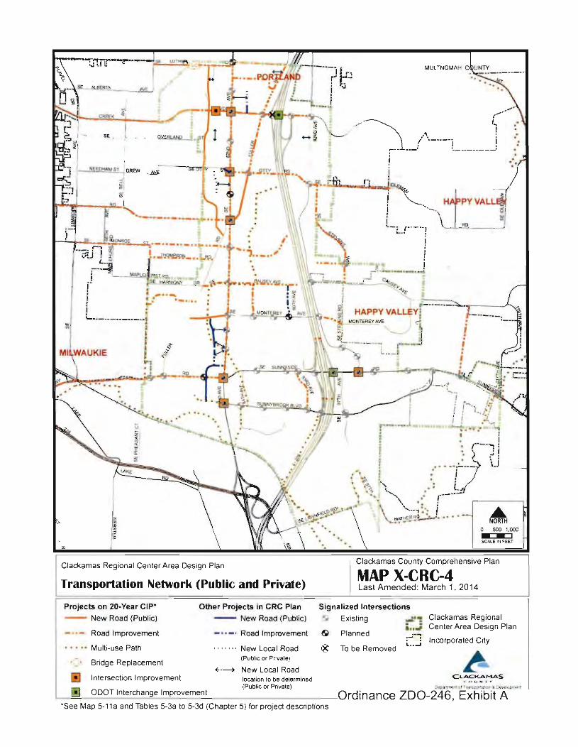
:..:'1nr-~·--
r~ ""
.'" <
~I ---• ~ CREEl(
" f Q),!EBI et!Q • 'f !
NEEDHAM 5 r I DREW
i MI WAUKIE
__ J'
I \
"
Clackamas Reg ional Center Area Oesign Plan
Transportation Network (Public and Private)
Projects on 20-Year Clp·
- New Road (Public)
_ • • - Road Improvement
••••• Multi-use Path
Other Projects in CRC Plan
-- New Road (Public)
_ •• - , Road Improvement
, , , , , " New Local Road (PubliC or Pnvate j
~ New Local Road
'. '.
'.
A NORTH
o 500 1,000
- - I SCAlE IN FEET
Clackamas County Comprehensive Plan
MAP X-CRC-4 Last Amended : March 1, 2014
Signalized Intersections
~ Existing ~~
Planned
To be Removed
ill"; .-, .- , L __ ..J
Clackamas Regional Center Area Design Plan
Incorporated City
• Bridge Replacement
Intersection Improvement location to be delermlned CL~~r~S (Pubhc or Pnvate) Oe~.run.n!c!Tr.n$~crt.o\"m& D ..... elop""'n1
L-.....".,o ~O:::.D:::.O:::.T:...:::ln.:::te.:::rc::h::::an.:!'gc::.e~lm:.:!p,,-ro:.:vc.:::e=men~t __________ - Ordi nance ZDO-246 , Ex h ibit A 'See Map 5-11a and Tables 5-3a to 5-3d (Chapter 5) for project descriptions

+- I r
~
I ..... ........ . , ., .......
Clackamas Regional Center Area Design Plan
Functional Classification
CLACKAMAS I . J REGIONAL
CENTER AREA
::::: FREEWAY FREEWAY RAMP
- MAJOR ARTERIAL MINOR ARTERIAL COLLECTOR
Ordinance ZDO-246, Exhibit A
HAPPY VALLEY
L
Clackamas County Comprehensive Plan
Map X-CRC-5 Last Amended February 11 , 2013
(g) LOCAL STREET lOCATION TO BE DETERMINED (PUBLIC OR PRIVATE)
LOCAL STREET (PUBLIC OR PRIVATE)

~,
Clackamas Regional Center Area Design Plan
Transit Network
Existing Transit Network Planned Transit Network
- Frequent Bus Service (20 min or less) •••• Planned Frequent Bus Routes
MULTNQMAH
.... NORTH
o 500 1,000
- - I SCA.lE IN FEEl
Clackamas County Comprehensive Plan
MAP X-CRC-6 Last Amended : March 1, 2014
wI·L ,..J Clackamas Regional Center
-- Standard Bus Service
- Light Rail line
• ••• Other Planned Transit Routes in CRC Plan
III Ught Rait Stop ........... Conceptual Loop Shuttle
g Park & Ride
Ordinance ZDO-246 , Exhibit A
C I. A CKAMAS CO UNfY
Oep.nmenl 01 T,.nSP<>l'It11011 & O ....... wmenl 1~0 B"\I"c,,,~ Flo Oreg"" C.v Of! 9,0.5

~ o Z N OJ
~ OJ 13
\ 1'>
r ______________ ~r_--~M~O~N~T=E~R~EY:,~~V~E~----!-----------~~~-\ ~ • % • : ~
~_=___i ! ~
Clackamas Town Center -JO
II '--'_-.J' .• • • •
'-----;=1~ ':':'-_. --........ :
~
I i i
o ,J o: i ", i z ' ~ i w i >- 1 U1 :)
I
HAPPY VALLEY
I f----------...I ! j j ! ! i ---.. _---
• Sl!INN¥5IIDE- R0 _....,.-SeJNNYI·SIBE-RBlj--:---:---..,-...:::::::4_~\.J~j~ • • • • • • : ........ . ....... , •..•.•....... :
• Clackamas Promenade
• • • w w ;0 o ~ m
r--..,..-L-s '.. : '"NNYBReeK-B~VIiJ -...., ______ L
Clackamas Regional Center Area Design Plan
WALKWAY NETWORK
./ Existing Walkways
... • •• Planned Walkways
Ordinance ZDO-246. Exhibit A
... NORTH
1.000 500 0 - -, SCALE IN FEET
Scale = 1 :25,000
Clackamas County Comprehensive Plan
MAP X-CRC-7 a Adopted 10/15/2012
CLACKAMAS CO UN r T

SUNNYSIDE CORRIDOR COMMUNITY PLAN
The Sunnyside Corridor Community Plan Area is one of the most rapidly urbanizing areas of Clackamas County. Most of the development has occurred in the last 20 years , and there is capacity for additional growth . The Sunnyside Village area has developed rapid ly since adoption of the Sunnyside Village Plan in 1993, and has provided many lessons about integrating land use and transportation , mixing uses, and accommodating higher density housing types . New planning rules affect the ways the remaining areas must be planned . These include:
• The Region 2040 Urban Growth Management Functional Plan . Sunnyside Road was identified by regional planning efforts as appropriate for designation as a Corridor design type. Corridors are planned to be areas featuring a high quality pedestrian environment, convenient access to transit , and higher employment concentrations and housing densities than surrounding areas . In order to support high quality transit service, they are planned to be developed at densities that are somewhat higher than today (2000) . Typical new development would include rowhouses, and one- to three-story office , apartment and reta il buildings.
• The National Marine Fisheries Service has listed several runs of Chinook Salmon and Steel head in the Clackamas River as "threatened " under the Endangered Species Act. The Region 2040 Urban Growth Management Functional Plan , and the county water quality plans are responding to the listings. The listings may require additional protection of riparian corridors and area streams.
In addition, the recently completed Environmental Assessment for widening Sunnyside Road identifies opportunities and limits for the types of development that are feasible and prudent in the area. The Sunnyside Corridor Commun ity Plan is designed to support the transportation improvements planned for Sunnyside Road by limiting land uses and thus traffic generation on Sunnyside Road, limiting accesses on Sunnyside Road , and increasing the connectivity within the neighborhood so that local trips won 't have to use Sunnyside Road .
The Sunnyside Corridor Community Plan is designed to promote an urban form that will support alternative modes of transportation , such as walking , bicycling , and transit. Permitted land uses, the transportation network, and development standards are all designed to support alternative modes as well as auto use, and create a development pattern conducive to face-to-face community interaction. Designations for employment and higher density housing are located to support adopted public policy for the development of the regional transportation system .
X-78 I Ordinance ZDO-246, Exhibit A Last Amended -ll-WI-J 3/1/14

The Sunnyside Corridor Community Plan is designed to focus the most intense development in two "development nodes" centered on SE 122nd Avenue and Sunnyside Road and on SE 132nd Avenue and Sunnyside Road. SE 122nd
Avenue and SE 132nd Avenue must be improved to support the levels of traffic projected . There are three schools in the vicinity of SE 132nd Avenue and it is heavily used by school children. A street design to promote safety, convenience, and comfort is of utmost importance.
The overa ll Clackamas County Comprehensive Plan applies to the Sunnyside Corridor Community Plan Area. This section of the Comprehensive Plan describes the goals and policies that are specific to the Sunnyside Corridor Community Plan Area . This section takes precedence where conflicts exist between it and the remainder of the Comprehensive Plan .
The Sunnyside Corridor Community Plan applies to the area shown on Map XSC-1 , from SE 117th Avenue to the western boundaries of the Sunnyside Village . The primary focus of the Plan is the area immediately adjacent to Sunnyside Road and other areas with vacant and redevelopable land , especially the future urban areas east of SE 132nd Avenue.
X-79 I Ordi.nance ZDO·246, Exhibit A Last Amended ·11-11-13 311114

GOALS
• Ensure the efficient use of land and urban services.
• Provide a mix of housing types , densities and price ranges to accommodate the diverse housing needs of the projected population .
• Encourage jobs and services along the Sunnyside Corridor to be concentrated at major intersections.
• Provide a transportation network that emphasizes an interconnection of streets, alleys and pedestrian ways that encourage transit , bicycle and pedestrian trips and provide opportunities for neighborhood circulation that avoids having to use Sunnyside Road .
• Reduce access points along Sunnyside Road.
• Facilitate development of sub-regional storm drainage detention and sediment control faci lities that enhance water quality in area streams and provide adequate storm water detention.
• Provide adequate infrastructure.
• Provide for joint-use public faci lities to reduce the land area committed to public uses.
• Protect the character of existing neighborhoods.
POLICIES
I. LAND USE
1.0 Map X-SC-2 illustrates the Land Use Plan designations for the Sunnyside Corridor Community Plan Area . The following uses may be allowed: Low Density Residential , Medium High Density Residential, Office Apartment, Community Commercial, and Public and Community Use. Policies directing the application of these plan designations are located in Chapter 4 of this Plan . In addition , policies establishing special standards for these plan designations when applied in the Sunnyside Corridor Community Plan Area are set out in policies 2.0 to 5.0 below.
2.0 The Growth Concept Design Type Corridor, as defined in Chapter 4, shall be applied along Sunnyside Road from approximately SE 117th Avenue to SE 138th Avenue . The Corridor Design Type location shall be defined within the Sunnyside Corridor Community Plan as development nodes, which are delineated on Map X-SC-1 .
X-80 I Ordinance ZOO-246, Exhibit A Last Amended -It·UlJ 3/1/14

2.2 The development nodes will contain concentra tions of higher intensity development, separated by Offi ce Apartment or Low Density Residentia l uses .
2.3 Corridor Policies 2.1 - 2.5 stated in Chapter 4: Urban Growth Concept shal l be applicable to the development nodes.
2.4 The development nodes will include a complementary mix of land uses. The following uses are expected to be found in the Corridor design type area : retai l, services, offices , schools, religious facilities , community facilities, and multifamily residential. The following Plan designations may be located within the development nodes : Community Commercial , Office Apartment, Medium High Density Residential and Low Density Residential.
2.5 The Corridor design type development nodes shall not be expanded to include add itiona l land area.
Residential
3.0 Res idential designations shall be allowed in the Sunnyside Corridor Community Plan Area to provide for a variety of housing choices that are compatible with the character of the area , support current and projected demographics and ensu re a range of densities to promote an efficient use of the land and urban services.
3.1 Urban Low Densi ty Residential (LOR) designations shall be applied in many locations in the Sunnyside Corridor Community Plan Area, including locations on Sunnyside Road between development nodes. R-7 zoning shall be applied to areas designated Urban Low Density Residential that are located east of SE 132"d Avenue, south of SE Sunnyside Road and west of the Sunnyside Village.
Office Apartment
4.0 The Office Apartment designation shall be applied in the Sunnyside Corridor Community Plan Area to provide for employment and limited housing uses. Office Apartment designations shall be applied as depicted on Map X-SC-2 and may be applied in other locations when the Office Apartment Area of App lication criteria are met.
X-8 1 I Ordinance ZDO-246, Exhibit A Last Amended -1+1/1J 311/14

Commercial
5.0 Within the Sunnyside Corridor Community Plan Area , the Community Commercial plan designation shall be allowed only on the south side of SE Sunnyside Road within the development node at the intersection of SE 122nd Avenue. This designation is provided to meet the retail needs of the Sunnyside Corridor Community Plan Area.
II. STREETS, ALLEYS AND PEDESTRIAN CONNECTIONS
1.0 Integrate land use with the transportation network in the Sunnyside Corridor Community Plan .
2.0 All new developments shall provide streets , vehicular connections and pedestrian connections as shown on the Maps X-SC-3 and Map 5-4a~ 4.
2.1 New streets and connections identified on Map X-SC-3 as "Iocation determined" may be modified only when it can be shown that the depicted street or connection is impractica l to develop due to wetlands , topographic conditions , resource protection , or preexisting lotting patterns.
2.2 The precise location for new streets and connections depicted as "Iocation flexible" will be determined during the development review process.
3.0 In addition to the vehicu lar and pedestrian connections required on Map X-SC-3, safe and convenient pedestrian connections shall be used to enhance access between residential and commercial developments , public facilities, activity centers, and streets when public streets are not feasib le.
3.1 A system of pedestrian connections shall be provided from subdivisions and multifamily developments to the following commercial or public facilities: existing or planned transit facility , school , park, outdoor activity area, plaza , day care center, children's play area, library, church , or similar faci lity; andc
3.2 Pedestrian access shall be provided from a dead-end street, cul de-sac, or mid-block where the block is longer than 330 feetc; and
3.3 Commercial developments shall be integrated with the neighborhood . If direct pedestrian access is not provided between commercial developments and adjacent residential areas via public streets and sidewalks , additional pedestrian and bicycle access
X-82 ·1 Ordinance ZOO-246, Exhibit A Last Amended l tll-1.J 3/1/14

sha ll be provided .
4 .0 Southeast 132nd Avenue south of Sunnyside Road sha ll be constructed to the street standard s as depicted in Figure X-SC-1 .
4.1 No new residential driveway accesses sha ll be allowed on SE 132nd Avenue south of Sunnyside Road.
4.2 The fronts or sides of primary dwelling units shall be oriented to SE 132nd Avenue . Back yards shall not line SE 132nd Avenue.
4 .3 Facades facing SE 132nd Avenue shall not consist of a blank wal l.
5.0 New local streets and new connector streets shall comply with the following design standards:
5.1 Orient local streets whenever practica l so that at least 50% of the lots front north or south to take advantage of solar access.
5.2 Provide on-street parking , planting strips between sidewalk and street, sidewa lks on both sides of the street, street trees, and short pedestrian crossing distances at intersections . Figure X-SC-2 illustrates a typical street cross section .
I 6.0 Street trees listed as prohibited in Section +€GG-1 007 of the Zoning and Development Ordinance shall not be approved as street trees in the Sunnyside Corridor Community Plan Area .
7.0 Provide vehicular and/or pedestrian connections between residential developments, public faci lities , neighborhood services, and the collector and arterial street system.
8.0 Alleys shall be allowed in all residential districts. All alleys shall be private streets and shall be constructed as depicted in Figure X-SC-3.
9.0 Access controls on Sunnyside Road shall be consistent with the preliminary design for Sunnyside Road as shown in the Sunnyside Road Environmental Assessment or more detailed design and engineering work undertaken for Sunnyside Road . In add ition , the following shall be applied :
9.1 Consolidate driveways to the targ ets shown on Map X-SC-5 , Access Management Targets for Sunnyside Road .
9.2 Whenever possible, driveway accesses shall be consolidated as development and re-deve lopment occurs. Temporary accesses
X-83 I Ordinance ZOO-246 , Exhibil A Last Amended l/-1-/-1-3 3/1 114
may be allowed when Office Apartment sites develop incrementally, but only if a master plan has been approved demonstrating how and when further driveway consolidation shall occur.
9.3 To maintain the flow of traffic on Sunnyside Road , driveways may be restricted to right-in , right-out only.
9.4 Office Apartment and Commercial developments shall minimize vehicular access to Sunnyside Road , with primary access provided on side streets whenever possible .
III. NATURAL RESOURCE PROTECTION
1.0 Restrict development of natural resource areas, including: Slopes greater than 20%, confirmed landslide hazard areas, flood hazard areas, stream buffers , wetlands and significant natural areas.
2.0 Except in stream corridor and wetland buffers, residential development may be allowed within restricted areas when it is consistent with the Policies in the Natural Hazards section of Chapter 3, and the Open Space and Floodplains section of Chapter 4 of the Comprehensive Plan.
3.0 Allow the transfer of residential development density from restricted areas to other areas on the site , subject to the following standards:
3.1 Resulting density on the developed portion of a Low-Density Residential site shall not exceed 15 dwelling units per acre.
3.2 If the density on the developed portion of the site exceeds the next highest residential Plan category, buffering from adjacent lowdensity residential uses shall be considered in the development review process .
IV. PARKS, OPEN SPACE AND RECREATION TRAILS
1.0 Provide parks that are equitably distributed and accessible from throughout the Sunnyside Corridor Community Plan Area .
2.0 Facilitate park and recreation and storm water detention and treatment providers to cooperate in the development of facilities that meet the needs of both agencies.
3.0 At the time of site development, trails shown on Map X-SC-6 shall be constructed to standards established by the North Clackamas Parks and Recreation District.
X-84 I Ordinance. ZDO·246, Exhibit A Last Amended ~+ll·hl311 114

4.0 Map X-SC-6 depicts the genera l location of a tra il that will connect to an adjacent trail in the Sunnyside Village . The final location of this trai l wi ll be determined as development occurs.
5.0 All designated tra ils identified on Map X-SC-6 shall be either ded icated to , or granted as an easement to, the North Clackamas Parks District, which wi ll be responsible for their maintenance.
X-RS I Ordinance ZDO-246, Exhibit A Last Amended -1il~3 3/1/1 4

MAPS & FIGURES (Only maps are included in this package. Figures are not included because no change is
proposed).
Sunnyside Corridor Community Plan
Map X-SC-1 Map X-SC-2 Map X-SC-3 Ma~G-4 Map X-SC-5 Map X-SC-6 Figure X-SC-1 Figure X-SC-2 Figure X-SC-3
Community Plan Area & Corridor Design Type Location Land Use Plan Map New Streets NoIAGtioAal ClassjficatioA Sunnyside Road Access Management Targets Trails 1320d Avenue South of Sunnyside Road New Local Streets Alley Cross Section
X-86 I Ordinance ZDO-246. Exhibit A Last Amended +l+t-:hl 3/1/14

RD.
1= Y-i. I~ F -jl IH
Sunnyside Corridor Community Plan Community Plan Area and Corridor Design Type Location
..... -. ....... SUNNYSIDE CORRIDOR COMMUNITY PLAN AREA
CORRIDOR DESIGN TYPE AREAS
SUNNYSIDE VILLAGE
Ordinance ZDO-246, Exhibit A
u
II I
-
-
\
-
1 -CLACKAMAS COUNTY COMPREHENSIVE PLAN
MAP X-SC-l

u
-h-
~
".I~ I~: r ~m~ ~
1,--
I \
r LD R
v ~~ etti f-----\"1rTtt@
~I I-----=1
J II
1
1--------1~ I--
CLACKAMAS COUNTY COMPREHENSIVE PLAN
r--
Sunnyside Corridor Community Plan Land Use Plan Map MAP X-SC-2
CC COMMUNITY COMMERCIAL ~ __ .:-: RESOURCE PROTECTION OA OFFICE APARTMENT
LOR LOW DENSITY RESIDENTIAL ~_;_:_~ GOAL 5 WETLAN D MHOR MEDIUM HIGH DENSITY RE SIDENTIAL PCU PUBLIC AN D COMMUNITY USE - . WETLAN D BUFFER
Ordinance znn-?.1f.J , Exhibit A

'..:'
LL IL
t:
RD.
j:: ~ ;=; l=
Sunnyside Corridor Community Plan New Streets
:::::::: COMMUNITY PLAN AREA
NEW STREET, LOCATION DETERMINED NEW STREET, LOCATION FLEXIBLE NEW PEDESTRIAN CONNECTION, LOCATION FLEXIBLE
U,ulIlance ZDO-246 Exhibit A
u
I
CLACKAMAS CDUNTY CDMPREHENSIVE PLAN
MAP X-SC-3
NEW CONNECTION, LOCATION DETERMINED
) NEW CONNECTION, LOCATION FLEXIBLE
,.~". ' 6, 200!

Sunnyside Corridor Community Plan Functional Classification
II II COMMUNITY PLAN AREA (PLAN AREA IN WHITE)
EXISTING RD PROPOSED RD
MAJOR ARTERIAL MINOR ARTERIAL
•• COLLECTOR CONNECTOR
Ordinance ZOO-246, Exhibit A
u 1.--
I lJ
JAN UARY 6, 2005

u
l lE!= f.-h I IH
--'
\--
I T ( ~
IY
I~
-
'---:-----c----
I \
I 1J
U: EI'tt ~ \-VFt~
f-----------=i~ I f----"i~ ~
f T IN
.,J., Jl r
\ ••••.
~ ...II H----.--------'---,.-----i ~ ~j ~~ = LL
:~ ~: I ~ Y :x; <6.'\ ~ RD. ~~ '- -
~ ]C i ~ ~ ~H~ ~m ~ Sunnyside Corridor Community Plan Sunnyside Road Access Management Targets
:::::::: COMMUNITY PLAN AREA
Q] NUMBER OF DRIVEWAYS TARGETED IN THIS SEGMENT
Ordinance ZDO-246, Exhibit A
-
I -, CLACKAMAS COUNTY COMPREHENSIVE PLAN
MAP X-SC-5

L, .on RD.
li: b:::J 1=1 ~ -+ 't-/ f,t:d
Sunnyside Corridor Community Plan Trails
•• 0 •• _0
TRAIL COMMUNITY PLAN AREA e o •••• •
Ordinance ZDO-246, Exhibit A
u
I 1][
-
~I
-
I - '-r CLACKAMAS COUNTY COMPREHENSIVE PLAN
MAP X-SC-6

McLOUGHLIN CORRIDOR DESIGN PLAN
The Portland metropolitan area has changed significantly in the past 20 years , and will likely experience more changes in the future. McLoughlin Boulevard , and the business and residential areas that surround it, have also changed -reflecting population and traffic changes, shifts in retail market and development types, and infill and maturation of the nearby residential neighborhoods.
A number of issues affect the future of the McLoughlin Corridor, which provided the impetus for a special study of the area in 1998-99, including :
• McLoughlin has been identified as a "Regional Street" in the Region 2040 Urban Growth Management Functional Plan , and is expected to continue to support high levels of through and local vehicular traffic.
• The area along McLoughlin is designated a "Corridor" in the Region 2040 Urban Growth Management Functional Plan . A corridor is intended to feature a high quality pedestrian environment and convenient access to transit , while continuing to meet the needs of the automobi le. Corridor areas are expected to transition to higher residential and employment densities through infill and redevelopment.
• The Oregon Highway Plan designates McLoughlin as a District Highway. As a District Highway, McLoughlin provides a link between urbanized areas and also serves local access and traffic. The management objective is to provide for safe and efficient, low to moderate speed traffic flow and for pedestrian and bicycle movements.
• McLoughlin has been designated for frequent bus service .
• The Oregon Department of Transportation (ODOT) needs to evolve policies and standards for state highways in urban areas such as the McLoughlin Corridor.
Clackamas County worked with state and local agencies, a Citizen's Workgroup , and the genera l public through a series of open houses, to develop a plan in response to these issues. The focus of the McLoughlin Corridor Study became the design of the street itself. McLoughlin Boulevard was the first four-lane highway constructed in the State . It was constructed in the 1930s, and improved incrementally since then. It generally has 120 feet of right-of-way, with an improved width of 80-90 feet. Several of the State and County policies that describe how a District Highway or Major Arterial is to be designed and constructed remain to be implemented.
X-88 I Ordinance ZDO·246, Exhibit A Last Amended l/'l1-1';) 3/1/14

The McLoughlin Corridor Design Plan is not intended to repeat policies that cover issues already addressed by other State and County plans , such as the need for continuous sidewalks , bike lanes, street lighting , and transit improvements. The Design Plan also does not attempt to modify existing state or county policies for access control. This plan focuses on designing aspects of the street for greater safety, aesthetics and utility, especially including a landscaping strip between the curb and sidewalk. Both safety and appearance will be improved by consistent design, including continuous bikelanes, landscaped strips , sidewalks, street lights, transit amenities, fewer driveways, and no on-street parking . The Design Plan includes typical cross sections, with strategies to apply them in the context of design work leading up to a reconstruction of McLoughlin and in the context of development review. Land Uses in the McLoughlin Corridor were reviewed . A market analysis addressed the market for a range of land uses, and the types of employment and housing densities that are suitable for the corridor. It was determined that the employment and housing uses and densities appropriate to a corridor are already feasible under the existing plan designations provided for in the Comprehensive Plan .
Land uses wou ld be better served in terms of access and circulation if there were better connectivity between parking lots , and between parking lots and streets to the side or rear of the development. The image of McLough lin would be improved if the existing sign ordinance were better enforced . An improved appearance may lead to more investment, more patronage of businesses , and more job creation.
The overall Clackamas County Comprehensive Plan is applicable to the McLoughlin Corridor area . This chapter of the Comprehensive Plan describes the goals and policies that are specific to the McLoughlin Corridor. This chapter takes precedence where conflicts exist between it and the remainder of the Comprehensive Plan .
GOALS
• Design and improve McLoughlin to serve the needs of travelers by all modes of transportation along and across the roadway.
• Design McLoughlin to serve a balance between regional through traffic and local access for business and residents .
• Design McLough lin to serve regional and local traffi c, including public transportation , bicycle and pedestrian travel.
• Enhance safety for all travel modes and improve the aesthetic appeal of McLoughlin .
X-89 I Ordinance ZDO-246 , Exhibit A Last Amended U1/1:> 3/1/14

• Create a high quality pedestrian environment, convenient access to tran sit, and mix of land uses that implement the "Corridor" design type.
• Enhance pedestrian safety, especially pedestrian crossings near schools .
POLICIES
Land Use
1.0 The Growth Concept design type "Corridor", as defined in Chapter 4 and displayed on Map X-MC-1 , shall be applied along McLoughlin Boulevard .
2.0 The Corridor design type is applied to properties within the McLoughlin Corridor Study area that have the following Comprehensive Plan designations: GC-General Commercial, SHD-Special High Density, HDRHigh Density Residential , MHDR-Medium High Density Residential , and MDR-Medium Density Residential and are no more than 650 feet from the McLoughlin Boulevard Right-of-Way.
3.0 Corridor Policies 2.1-2.5 stated in Chapter 4 : Urban Growth Concept shall be applicable within the Corridor design type area.
4.0 Office and commercial developments shall integrate with adjacent neighborhoods by providing , at minimum, excellent pedestrian access .
5.0 A range of land use designations may be applied within the designated Corridor design type area. Land use designations that provide primarily for employment and shopping , and land use designations that provide primarily for multi-family residences shall be considered. Land Use Designations applicable in the Corridor design type area are:
5.1 Commercial and Office designations that may be applied include General Commercial , Retail Commercial , Office Commercial and Office Apartment. Any site designated for a commercial use shall be located adjacent to McLoughlin .
5.2 Multifamily designations that may be applied include: Special High Density, High Density, Medium High Density and Medium Density Residential. Multifamily designations should generally be located so as to form a buffer between commercial uses adjacent to McLoughlin and low density residential areas.
X-90 I Ordinance ZDO-246, Exhibi t A Last Amended +J+4J 3/1/14

5.3 When applying for a Comprehensive Plan map amendment to a multi-family designation in the McLough lin Corridor" the applicant's property shall have access to a street designated as a major or minor arterial , co llector, connector or local. Siting should not result in significant traffic .increase on loca l streets serving low density res idential areas .
Trans portati on
6.0 Encourage circu lation to occur between businesses by requiring that adjacent parking lots be connected to each other or to a street at the side or rear of the development.
7.0 Develop a program for enforcement of the County's sign ordinance on McLoughlin Boulevard . Potential strategies include: providing additional funding and establishing priority with the County's Code Enforcement Section ; and setting up a "Corridor Committee" of property owners and business owners who would work towa rd compl iance by setting a good example, discussion, persuasion , and solicit ing compliance in a fr iend ly way.
8.0 ODOT's access standards are applicable to McLoughlin Bouleva rd as are their roadway standards between the cu rbs.
I 9.0 Apply the typical cross sections as shown on Figu re~ X-MC-1 -a and :lb. Map X-MC-2 shows where the various cross sections generally apply. These cross sections for the area of the roadway adjacent to a development (generally sidewalks and landscaping strips) shall be required during development review.
9.1 The standard arterial segment cross section is preferred at locations between intersections. In areas where the topography adjacent to the outside of the sidewa lk slopes so that a retaining wall higher than 3 feet would be required , the landscaped buffer may be reduced in width . The topographically constrained cross section on Figure X-MC-1 -a, portrays the maximum reduction in the improved width (landscaped buffer reduced to zero, but no reduction is allowed in sidewalk width) . Reduction in the width of the landscaped buffer sha ll be the minimum necessa ry, considering a retaining wall 3 feet high.
X-9 1 I Ordinance ZDO-246 , Exhibit A Last Amended -11-1113 311114

I 10.0 The typical cross sections as shown on Figure X-MC-1 -a and :lb, and indexed on Map X-MC-2 shall be used as guidelines for specific designs for reconstruction of McLoughlin Boulevard. More specific design work produced in preparation of a reconstruction of McLoughlin may replace the typical cross sections in regard to requirements for development and redevelopment. Desigri work for road reconstruction should start with the Final Report of the McLoughlin Corridor Land Use and Transportation Study as a guide.
11.0 Transit improvements in the McLoughlin Corridor should include a transit shuttle through the McLoughlin Corridor area .
X-92 I Ordinance ZDO·246, Exhibit A Last Amended ~ 3/1/14

X-93 I Ordinance ZDO-246, Exhibit A Last Amended -1/1/-13 31111 4

MAPS & FIGURES (Map are not included because no change is proposed) .
Mcloughlin Corridor Design Plan
Map X-MC-1 Map X-MC-2 Figure X-MC-1 Figure X-MC-2
Design Plan Area Location of Street Improvements Street Cross Sections Street Cross Sections
X-94 I Ordinance ZDO-246. Exhibit A Last Amended -ll-1-1+2 311114
• .. , • .oo • ". •
;
•
•
:
•
•
•
• '" • " . • lilt
Ordinance ZDO·246 , Exhibit A
" )( .
$! " ~ ~tt , @ , . e
. .. • ...
/..1 I
f f .
J I i
._ " ~..ao ..... .
./ r.J..~ '\
• " II • .,. •
('-"-:--..i
! r!T J )
\. ~ ;::1 ! '\ \ TIC)\ \ I
-" ;"'. "" *' , i \. I .... , . . \ ~ i i :
'" : '.... '. : t . ./. ,/ r+, ' .. / ......
I \ , . ..' \ '. .. I ', . r+-, :,1 '
.' _ •• _ .. ....... L ,J ~ , :
I "-- ' ) - \ A '--.. ; ,'- "_ ., _... . ... '\ _.", ( r
~'. ........... ."'...... ,,' ...... .. . "' \ '\ ~ I \. .,,: ,~ s;,.
.. \
. " • "Ol • ... • III.I( •
'"
"_'E. •
... . 11' , I e
...
A -'.
... "" ",I.e
...
. ..
•
•
•
:
•
• ·
SCENIC & DISTINCTIVE RESOURCE AREAS
c:=J Principal River Corridors
[=:J Wilderness Areas
o
* A
Buttes
Unique I Natural Features'
Viewpoints
.... . ' - Upper & Lower Limits of Winter Range ( Deer.
Elk - 30))' Elevation)
_ BarlOW Road Historic Corridor
( Oregon Nationa l Historic Troll )
Recreation Trails . Existing I Proposed
SceniC Roads - See Map V-3 5.· 1
. Source Nature Conservancy
CLACKAMAS COUNTY • MAP III 2 COMPREHENSIVE P\.AN •

C I..\ CKr\i\I .\ S ('()l';,\,TY 'l.O." I."C A:'\'I) U[\,EI.OI':\l EXT OIH)I;\: .\ :\'CE
Onlinancc ZDO-246
Zoning and Dcve lopment Onlinancc Amendmcnts
Text to be added is underl ined. Text to be deleted is struel, th f<Wglt.
202 DEFINITIONS
ACCESSOR Y BUILDING OR USE: A subordinate build ing or use, the function of which is clearl y incidenta l to that of the main bui lding or use on the same lot.
ACCESSWAY: A public ri ght-oF-way, a portion of which is hard sur faced, for use by pedestri ans and bicyc li sts providing a direct ro ute where public roads require significant out of direc ti on trave l.
ACCESS DRIV E: A private way, wi th a trave l surface generall y no more than 12 fee t in width, created by deed or easement to prov ide vehicular ingress to. or egress from not more than two lots or parcels.
ACTIVE REC REATIONAL AREA: An area such as a park. sports fi eld. or go lf course. where turf provides a play ing surface that is dedicated to acti ve play.
ADJOIN I G: Contiguous or abutting exclusive of street width. It shall include the terms adjacent. abutting or contiguous.
ADULT BUS INESS: A range of commercial acti vities characteri zed by li ve. closed circuit, or reproduced materi al which has an emphasis on nudity and/or specifi ed sexual acti vity. Such businesses genera ll y lim it their patrons to persons at least 18 years of age. Adult businesscs include the fo llowing types of establ ishments: adult bookstores. ad ult theaters. ad ult arcades, adult cabarets. and adu lt paraphernalia shops, as defined below, and other establishments which fea ture any combinati on of acti vity or merchandise described be low which co llecti ve ly account 1'0 1' 25 percent. or more, of the cstab li shment's acti vity or merchandi se. These de fin itions shall not be construed to allow uses or acti vities which are unlawful under State criminal laws.
"Adult bookstore" is an estab li shment havi ng as 25 percent or more of its merchandise for sale. ren t. or viewing on the premises, such items as books. magazines. other publications. fi lms. vidco tapes or video discs which arc distingui shed by thei r emphasis on spec ified sexual acti vities. as defin ed in thi s ordi nance.
"Ad ult theater" is an estab lishment used fo r more than 25 percent of shoWli me 1'01' presenting matcri al (either li ve. closed circuit , or prerecorded) fo r observation by patrons thercin which has as a dominant thcme an emphasis on nudi ty and/or spccified sex ual ac tivities. as defined in thi s ordinance.
"Ad ult arcade" is an cstab li shmcnt offering vicwing booths or rooms 1'0 1' one or 202· 1
Ordi nance ZDO· 24 6. Exhi bil B

CI .:-\ CK\)\I .\S ( 'Ol INTY ZONING ,\1\1) I)EV[I .OI)~I[NT OHDIN.\ i\'CI':
more persons in which 25 percent, or more, of the materi al presented (either li ve, closed circuit. or reproduced) is characterized by an emphasis on nudity andlor specified sex ual acti vities, as defined in thi s ordinance.
"Adult cabaret" is an estab li shment hav ing as its primary attraction live exhibitions (e ither for direct viewing, closed circuit view ing, or viewing through a transparent partition) fo r patrons, either individually, or in groups, where the exhibition material presented is characterized by an emphas is on nudity andlor spec ified sex ual activities, as defined in thi s ordinance.
"Adult paraphernalia shop" is an establi shment having as 25 percent or more of its merchandise obj ects which stimulate human genitalia and/or objects designed to be used to substitute for or be used with human genitalia while engaged in spec ified sexual activities, as defined in thi s ord inance.
AIRPORT. PERSONA L-USE: An airstrip restricted, except for aircraft emergencies. to use by the owner and, on an infrequent and occasional basis, by hi s invited guests, and to commercial activities in connection with agricultural operations onl y.
AIRPORT. PRIVATE USE: An airport restricted. except for aircraft emergencies, to use by the owner and hi s invited guests. The determination as to whethcr an airport is pri vate or publ ic-use is made by the Oregon Department of Aviation'.
AIRPORT. PUB LIC-USE: An airport that is open to use by the fl ying public. wi th or without a request to use the airport.
ALL EY: A travel wa that is uscdAny-puMie-spaee-er-l-heFeughfafe-less-than-I·G-feet but-i1e Hess-tl,a n-+Q-leet-i-n-wiet+l-wh iffi-has-0eelHlee.ieated-eHieeeec!-to-the-pu bl ic primarily for vehicular se rvice access to the back or side of properties otherwise abutti ng on a strcet.
ALTERAT ION. CULTURAL RESOU RCE: Any ex teri or change or modification, through public or pri vate action, of any cultural resource or of any property located within an hi storic di strict including. but not limited to, ex terior changes to or modifi cat ion of structure, architectural details or visua l characteristics such as paint color and surface tex ture, grading, surface paving, new structures, cutting Or removal of trees and other natural features, disturbance of archaeological sites or areas, and the placement or removal of any exterior objects such as signs. plaques. li ght fi xtures. street furniture. wa ll s. fences. steps, plantings and landscape accessori es a ffecting the exte ri or visual qualities of the property.
ANTIOUES: Goods that. by virtue of their age or unusual quality. are generall y considered to be o f hi storical andlor arti stic interest, ordinaril y such items are in good state of preservation or are restorable to their ori gina l conditions.
ARCHITECTURAL FEATURES: Features include. but are not limited to cornices. canopies. sunshades. gutters. chimneys. fireplaces. flues and eaves. Architec tural
202-2
Ordinance ZDO-246. Exhihit B

CI.AC K·\H-\ S CO(!i\T V ZON ING AM) DE\'ELOP.\I E.yr O IH)INAN(,E
fea tures shall not incl ude any porti on of a structure built for the support. occupancy, she lter or enc losure of persons or property of any ki nd .
A RC HITECTURAL FEATURES, CU LTU RAL RESOU RCE: The architectural c lements embodying style, des ign, genera l arrangement and components of a ll of the outer sur faces o f an improvement. inc luding, but not limited to , the kind, co lor, tex ture of the building materi als and type and style of all windows, doo rs, li ghts, signs and other fi xtures appurtenant to such im provements.
AUTOMATIC IRRI GATION CONTROLLER: An automati c timing dev ice used to remotely control va lves that operate an irrigation system. Automatic irrigation controll ers schedule irri gation events using either evapotranspirat ion (weather-based) or so i I moisture data.
BAB YS ITTER: A person who goes into the home of a child to g ive ca re during the tem porary absence o f the parent or legal guardi an or custodi an.
BASEM ENT: A porti on of a building which has less than one-half of its height measured from fini shed fl oor to fini shed ceiling above the average elevation o f the adjo ining ground . but not an "underground structure" as de fined in thi s ord inance.
BEACO : Any light with one or more beams directed into the atmosphere or direc ted at one or more po ints no t on the same site as the li ght source; also. any light with one or more beams that rotate or move.
BED AN D BREA KFAST ESTABLI SHM ENT: A use carri ed on in a structure designed for a single-famil y dwe lling, except as provided under Section 832, which prov ides rooms for rent on a dail y basis to the publi c and which includes a breakfast mea l as part of the cost o f the room. Bed and break Fast estab li shments do no t inc lude other similar uses, such as motels, health or limited care fac iliti es. boa rding houses, group quarters. hostels, o r rescue miss ions. A ll bed and breakfast establ ishments require touri st fac ility li censing by the ap propriate agency. Bed and breakfast residcnces and inns. as de fined below, must also sa ti sfy the Statc Hea lth Di vision requirements. Th ree leve ls of bed and breakfast estab li shments are as fo ll ows:
"Bed and Breakfast Homestay" provides overni ght accommoda ti ons plus breakfast in an owne r-occupied dwe lling that provides one or two guest rooms for occasional bed and breakfast guests, not exceeding fi ve guests at one time. Primary use of the dwe lling remains as a dwe lling. not as a lodging estab li shment. A ll reservati ons are made in ad vance. Income de ri ved li'om bed and breakfast acti vity does not generall y represent a primary source o f income. Bed and breakfast homestays are maj or home occupati ons, subj ec t to Secti on 822 .
"Bed and Breakfast Residence" prov ides overni ght accommodat ions plus breakfast and occasional fa mil y-style mea ls fo r guests. in an operator- or owneroccupied dwe lling that prov ides up to fi ve rooms on an occasional o r regular bas is. Income derived from th e bed and break Fast activity may represent a
102-3
Ordinance Z DO-24G. Exh ibi t B

primary source o f income. Bed and breakfast residences are subject to Sect ion 832. and all req uirements of the underl yi ng di stri ct.
"Bed and Breakfast Inn" provides accommodations plus breakfast on a daily o r week ly basis in an operato r- or owner-occupied dwelling that is primarily used fo r thi s purpose. This use is operated as a commerc ial enterprise, encourages direct bookings from the public, and is intended to provide a major source of income to the proprietors. This leve l includes inns that operate restaurants offering mea ls to the general public as well as to overnight guests. Bed and breakfast inns are subj ect to Section 832 and all requirements of the underl yi ng di stri ct.
BI CYC LE RACK: An apparatus designed to support the central frame ofa bicycle and allow lock ing of both wheel s, without the removal of whee ls.
BIKEWAY : A paved facility provided for use by cyc li sts. There are five types of bikeways.
Shared Roadway: A type of bikeway where motori sts and cyc li sts occupy the same roadway area. Shared road ways are allowed on neighborhood streets and on rura l roads and hi ghways.
Shoulder Bikeway: A bikeway which accommodates cycl ists on paved roadway shoulder.
Bike Lane: A section of roadway designated for exclusive bicycle use. at the same grad e as the adjacent roadway.
Bike Path: A bike lane constructed entire ly separate from the roadway.
Cyc le Track: An exc lus ive "grade-sepa rated·' bike fac ility eleva ted above the street level using a low-profile curb and a di stincti ve pavement material.
BLANKETING: The visual blocking of one sign by another as seen by a moto ri st trave ling a street or highway.
BLOCK: A parcel of land bounded by streets, rai lroad ri ght s-of-way, waterways. pa rks. unsubdiv ided acreage. or a combination thereof.
BUILDI NG: Any structure used or intended for supporting or shelte ri ng any use or occupancy.
BUILD ING ENVELOPE: The three dimensional space whic h is to be occ upied by a building.
BUILDI NG LINE: A straight line that is parallel and adjaccn t to the front s ide o f the ma in building and para lle l to the front lot line.
BUILDI NG OR STRUCTURE II EIG HT: The term "height o f building" shall be
202-1
Ordinance ZDO-246. Exh ibit B

calculated by the methods ide ntifi ed in the State of Oregon St ructura l Specia lty Code or the State of Oregon O ne and the Two Famil y Dwelling Specia lty Code. as appl icable.
BULK PLANT: Hazardous substances at the bulk plant leve l arc manufactured, co llected, repackaged, stored, or di stributed. but are genera ll y not used on the site. The primary emphasis of uses at the bulk plant level is on hazardo us substances. Materials are sto red in large permanent tanks. Bulk plant quantities are large r than amounts transported in o r out in any single shipment. Processors of hazardous substances will generall y be at this leve l. Uses which produce hazardous substances as a by-product or accessory to another product are not in thi s category.
CA RE: The prov ision of room and board and other services as needed to assist in act iviti es of dail y li ving. such as ass istance with bathing. grooming, eating, med icat ion management, money management o r recreati on.
COGENERATION FACILITY: A facility that produces. through the sequential use o f energy, electric energy and useful thermal energy including but not limited to hea t or steam, used for industrial , commerc ial, heating, o r cooling purposes; and is more than 50 percent owned by a person who is not an electri c utility, an e lectric ho lding company, an affiliated interest, o r any combi nat ion thereof.
COMM ERCIAL USE: The use of land andlo r structures for the conduct of reta il. service, office, arti san , restaurant, lodging, daycare. entertai nment. private recreational , professional. and similar uses.
COMMON OWNERSH IP: Land commonly owned to include open space lands dedi cated in planned unit developments and lands dedicated for open space wh ich are owned by homeowners assoc iati ons.
COM POSTING: The managed process of contro ll ed biological decomposition of green feedstocks. It does not include composting for the purposes o f so il remediation.
COM POSTlNG FAC ILITY : A site or facilit y, exclud ing home composting areas as described in Section 202 and agri cultura l composting conducted as a fa rm use, which utili zes green feedstocks to produce a use ful prod uct through a managed process of contro ll ed biological decomposition. Composting may include ame ndments benefic ia l to the composting process. Venniculture and ve rmi composting are considered composting facilities. Composting facilities or sites may include sa les of the fini shed product , as well as accesso ry products limited to topso il. barkdust and aggregate commonl y used in landscaping to wholesa le and retail customers. The area utili zed fo r the sale of sa id accessory products sha ll not exceed 10% of the area used for eomposting. or two (2) acres. whichever is less subject to the provisions of Subsecti on 834.03 and 834.04.
CONGREGATE 1I0USING FAC ILI TY: A build ing that conta ins more than one dwelling unit and provides common fac ilities and serv ices for residcnts who requi re
202-5
Ordinance ZDO-246. Ex hibit t3

CI.ACK·\ .\IAS CO l i:"o,TY ZO:\"IN(; ,\ N Il I)[\"[ I .OI'I\I[NT ()IWI:"<rI ,\ ' Ct:
or desire a more supporti ve li ving environment than typica ll y aflorded to res idents in multifamily, three-fa mily, two-family. or single- famil y dwellings. Regular onpremise supervision by a registered physician. registered nurse. or other hea lth care provider may be included.
CULTURAL RESOURCE: Improvements, buildings, structures, signs. features. sites. places, areas or other objects of scienti fic. aestheti c. educational. cultu ral. arch itectural, or hi storical significance to the citizens of the county.
CU LTURAL RESOURCE INVENTO RY: The official li st of designated cultural features, sites. di stricts subj ect to the provisions of Section 707, Cultural Resources.
CU LTURAL RESOURCES OBJ ECT: A material thing offunctional, aestheti c, cultural. symbolic or scientific va lue, usuall y by design or nature movable.
DA YCARE FACILITY: A facility that provides regular daycare services to children under 13 years of age, including a day nursery. nursery school group, or similar unit operating under any name. A daycare fac ility shal1 not include services provided by a physician or nurse, or facilities operated primarily for education or supervised training or instruction. or daycare provided by a "babys itter" or "family daycare provider".
DEDICATION: The des ignation of land by its owner fo r any general or public use.
DES IGNATED SITE (hi storic site. cultural resource site, landmark site): A parcel or part thereo f on which a cultural resource is situated, and any abutting parcel or part thereo f constituting part of the premises on which the cultural resource is situated, and which has been designated pursuant to thi s Ordinance.
DESIG NATED STRUCTURE (landmark, cultural resource. hi stori c structure): Any improvement that has special hi stor ica l. cultural. aestheti c or architectural character, interest or va lue as part of the development , he ritage or hi story of the county. the State of Oregon. or the nation and that has been des ignated pursuant to thi s ordinance.
DIRECT ROUTE: The shortest reasonable ro ute between two points. A ro ute is considered direct if it does not invo lve sign ificant out of direction trave l that could be avo ided. Out of direction travel is signi [jeant if it is more than 50 percent longer than the straight line between two points.
DISTINCTIV E URBAN FOREST: Forested or wood land areas which are visuall y prominent or contain un ique or rare tree and plant communit ies. These areas are usuall y found in assoc iation with other open space resources within the urban area.
DRIP IRRIGATION: Any non-spray low vo lume irri gat ion system utili zing emiss ion devices with a fl ow rate measured in ga l1 0ns per hour.
DRIP LI NE: The outermost edge or a tree ' s canopy: when delineating the drip line on the ground. it wil l appear as an irregularl y shaped ci rcle defining the canopy's
202·6
Ord inance ZDO·246. Exh ibi. B

perimeter.
DROUG HT-TOL ERANT PLANTS : Plants that will survive in the typical or somewhat less than typical amount of rain fal l in the Wil lamette Val ley. and therefore require ve ry little or no supplemental water once estab li shed.
DWELLING: A bui lding, or portion thereof, which contains one or more dwelling units. A dwelling may be a residential trailer or a manufactured dwelling but not a recreational vehicle.
DW ELLfNG. ATTACHED SING LE-FAM I L Y: A building, or portion thereof, that contains only one dwelling unit; shares at least one wa ll , or portion thereof, with another attached single-fam il y dwelling; and is located on a separate lot of record from any other dwelling, except where otherwise perm itted for an accessory dwelling unit. A manufactured dwelling or residential trailer is not an attached single-family dwelling.
DW ELLIN G. DETACHED SfNGLE-FAM ILY: A bui lding, or portion thereof, that contains only one dwelling unit and is detached from any other dwel ling, except where otherwise permitted for an accessory dwelling unit. A manufactured dwelling or residential trailer is not a detached single-family dwelling.
DWELLING. MULTIFAMIL Y: A building. or portion thereof, that contains four or more dwelling units.
DW ELLING. THREE-FAM ILY: A building, or porti on thereo f. that contains three dwelling units.
DWELLING. TWO-FAMIL Y: A bui lding. or portion thereof, that contai ns two dwclling units, both of which are located on the same lot of record . If one of the two dwel ling units is an accessory dwelling unit . the bui ldi ng. or portion thereoC is not a two-fa mily dwell ing.
DWELLI NG UN IT: A bui lding. or portion thereof. with one or more rooms des igned for residenti al occupancy by one famil y.
DWELLING UN IT. ACCESSOR Y: A dwelling unit located on the same lot of record as a primary dwelli ng. The primary dwelling may be an attached or detached single-family dwelling, as spec ified in the underl ying zoning di strict provisions.
EASEMENT: A right of usage of rea l property granted by an uwner to the public or to spec i fi c persons. firm s. and corporations.
EDIBLE GARDEN : A garden that contains plants that produce food l'o r hu man consumption.
ELECTR IC VEHI CLE CIIARGI NG STATION: A locati on where a ve hicle can plug in to an electri ca l source to re-charge its batteries.
202-7
Ordin""cc ZDO-246. Exhibit 13

CI .,\ CK\i\L\S CO l f;"lTY ZOi\ 'ING AND DEV.:I .Q PJ\J ENT OI{DINANCI':
F AM IL Y: Any ind ividua l or group of persons, regardless of relationship but not exceeding 15 persons, li ving together as a single housekeeping unit within a dwelling unit.
FAM IL Y DA YCA RE PROVIDER: A daycare prov ide r who regularl y prov ides daycare to 16 or fewer children, or as amended by ORS 657A.440, including the children oflhe provider, regardl ess of full -time or part-time status, in the provider's home in the family li ving quarters. Provision ofdaycarc to more than 16 ch ildren, including the children of the providcr, regardless of full-time or part-time status, in the provider's home in the family li ving quarters sha ll constitute the operation ofa "daycare facilit y" and shall be subject to the requ irements of thi s Ord inance for daycare facilities.
FARMERS ' MARKET: An organized seasonal outdoor market ded icated to the direct sa les by growers of agricul tural goods, includi ng plants, produce, meats, and other animal products (e.g, eggs, cheese, honey).
FLAG: Any fabr ic, banner, or bunting containing di stinctive colors, patterns, or symbols.
FLAG LOT: A lot or parcel which has access to a road, street or easement, by means of a narrow strip of lot o r easement.
FLOOR AREA: The area included within the surrounding exterior walls of a building or portion thereof, exclusive of porches and exterio r sta irs, mul tiplied by the number of stories or portion thereof. The fl oo r area of a building, or porti on thereof, not provided with surrounding exterior wa ll s shall be thc usable area under the ho ri zontal projecti on of the roof or fl oor above, Floor area shall not include portions of bui Id ings used for parking of vehicl es, except the square footage of commercial uses in parking structures can be counted as part of the total fl oo r area.
FLOOR AREA RAT IO (FAR) : A measuremen t of density expressed as the ratio of square footage of bllilding fl oo r area to the square footage of the net si te area. The greater the ratio. the greater the dcnsity. For examplc. a bu ilding occupying onefourth of the net site area has a FAR of .25: I . or .25; addi ng a second fl oor to the same building increases the cAR to .50: I. o r .5.
FRATERNITY OR SOROR ITY HO USE: A build ing occupied by and ma intained exclusively for students affi li ated wi th a school or co ll ege.
GRADE: The line of the street or ground surfacc deviation from the hori zo ntal.
GREEN FEEDSTOCKS: Are dellncd as incl udi ng ya rd debri s. non-treated wood waste. vegetat ive food waste. produce wastc. vegetat ive restaurant was te. vegetat ive food processo r by-products. crop waste and livestock man ure. Fo r the purpose of these provisions, "non-treatcd wood wastc" cxc ludcs wood waste trcated with paint , va rni sh or othcr cheniica ls or prese rvatives.
202-X
Ordinance ZDO-246. Exhibit 13

GREEN ROOF: A vegetated roof designed to treat storm runoff.
GUEST HOUSE/STUD IO: A guest house or studio is a separate accessory structure. or portion thereof, which is built to residenti al (R-3 occupancy) bu ilding code requ irements and which is used by members o f the family residing in the primary dwe lling or their nonpayi ng guests o r employees on the premises. A "guest ·house" or "studio" shall be a temporary living area. and shall not be used for boarders o r lodgers.
HARDS CAPES: In the practice of landscaping. refers to the inanimate, man made, non-planted , outdoor areas where the so il is no longer exposed and that are sur faced with pervious or non-pervious durabl e materia ls such as masonry. wood. stone, pav ing, til e, or similar materia l to create pat ios, wa lk ways, water fountains, benches, gazebos, etc .
HAZARDO US SUBSTANCE. MATERIAL O R WASTE: Any hazardous substance, material o r waste li sted in the foll owing fede ral regulations:
A. Superfund Amendments and Reauthori zati on Act (SARA) of 1986. Section 302 Extremely Hazardous Substances List (40 C.F. R 355. App. A and B);
B. Comprehensive EnviTonmental Response Compensat ion & Liability Act Superfund (CERCLA) of 1980. Hazardous Substances List (40 C. F.R 302, Ta ble 302.4);
C. SA RA of 1986, Section 3 13, Toxic Chemica ls Li st (40 C.F.R Section 372.65);
D. Resource Conservat ion and Reco ve ry Act (RCRA) o f 1976 and 1984 Amendments. Haza rdous Wastes List (P & U Catcgo ri es) (40 C.F. R Sec ti on 261 .33(e) and (f)): and
E. DOT Haza rdous Materi als Table (49 C.F. R Part 172. 10 I).
HISTORIC AREA: Any area conta ini ng improvements whi ch have a spec ial character, hi storica l interest o r aestheti c val uc or which rep resent one or more architectural periods o r styles typical of the hi sto ry o f the County and wh ich improvements constitute a d istinct secti on of the County that has been designated a cultural resource d istr ict pursuan t to thi s ordinance.
I-lOME COM POSTING: A composti ng area ope rated and contro ll ed by the owner o r person in control ora single family dwe lling unit and uscd to d ispose of vegetati ve waste. ga rd en wastcs. weeds. lawn cuttings. Icaves and prunings ge nerated from that propert y.
I-lOME OCCUPATION: An occupation or business acti vity which resu lts in a prod uct o r se rvicc; is conductcd . in whole o r in pa rt, in a dwelling and/or an accesso ry bu il d ing norma ll y assoc iatcd wi th primary uses allowed in thc underlying zon ing di stri ct: is conducted by at least one fami ly member occupyi ng the dwelling:
Ordillallce ZDO-246. Ex hibit B

and is clearl y subordinate to the residenti al use of the subject property. Home occupations do not include garage sales. yard sales. hol iday bazaars. or home parties which are held for the purpose of the sale or di stribution of goods or services unless such sa les and/or parties are held more than six times in a calendar yea r or operate in excess of24 tota l days in a calendar year.
HOMEOWNERS ASSOCIA TIO : The grouping or uniting of persons resid ing within a defined area, such as a subd ivision, into an incorporated entity for the prosecution of a common enterprise.
HOSPITAL. AN IMAL: A bui lding or premises for the medical or surgical treatment of domestic an imals or pets, including dog, cat. and veterinary hospitals.
HOTEL: A building which is designed or used to offer short-term lodging for compensation. with or without meals, for six or more people. A fac ility that is operated for the purpose of providing care beyond that of room and board is not a "hotel" ,
HOUSEKEEP ING UNIT: A li ving arrangement within a dwelling unit in which a common kitchen faci lity, laundry facilit y. li ving and dining rooms. and other genera l li ving areas of the dwelling unit, and the duties, ri ghts, and obligations associated with the performance of domesti c tasks and management of household affairs, are shared by the residents by virtue o f lega l relati onship or mutual agreement.
HYDRO ELECTRIC FACILITY: Any facility relating to the product ion of electricity by waterpower. including, but not limited to the power generating plant, assoc iated dams, diversions. penstocks, nav igation locks, fi sh ladders, fi sh screens, reservo irs and detention areas, recreation faci lities. interconnecting transmission lines. substations. access roads. offices or commercial and industrial structures proposed to be bui lt in connection with the energy fac il ity: and activities involved in thei r construction and opcration.
IMPROVEMENT: Any building structure. parking facility. fence. ga te, wa ll , work of art or other object constituting a physica l bettcrment of rea l property, or any part of such betterment.
INDIR ECT ILLUMINATION : A nonelectri c sign illuminated by an indirec t or separate light sourcc.
INDUSTRIAL USE: The use of land and/or structures lor the manufacturing or processing of primary. secondary. or recyc led materi als into a product: warehousing and assoc iated truck ing operati ons; wholesale trade: and related development.
INSTITUTIONAL USE: The use of land and/or structurcs for acti vities such as dayca re and pre-school faciliti es. public and pri va tc schools. co lleges. universities. art, music, trade and other educational and training facilities. conva lescent care fac ilities. nursing homes. hospitals. places of worship. fraternal lodges, municipal and civic buildi ngs. transit centers and park-and-ride fac ilities. parks. swimming pools
202-11l
Ordinance ZDO-246. Exhibil B

(,L.\CK,\~L\S CO I II~T\' ZO'Ii\(; ,\:,\1> DE\'EI ,OPJ\IE:\T OI{OIi" ,\:,\'CE
and other recreational facilities open to the public or a membership group, senior and community centers, libraries, Illuseums, cemeteries and mauso leums, utility facilities, and similar public and private uses,
INVAS IV E NON-NATIV E OR NOX IO US VEGETATION: Plant species that are li s ted in the Oregon Depa rtment of Agriculture's Noxio us Weed Poli cy and Classification System,
KENNE L: Any lot or premises on whi ch fo ur o r more dogs, more than six months o f age or with permanent canine teeth, are kept for purposes other than a veterinary clinic,
KIOSK: A small structure used as a newsstand , information booth, refreshment stand , bandstand , or di sp lay of goods, etc,
LAN DSCAPING: Areas of land planted wi th gro undcover, grasses, shrubs, annuals, perennials, or trees,
LIMITED USE: A use allowed in a district on a limited bas is and subj ect to conditions specifi ed there in which are generall y more restricti ve than the conditions placed on primary or accessory uses within the same di strict.
LIV ESTOCK: One or more domes ticated animals rai sed in an agricultural setting to produce commodities such as food, fi be r. and labor. The term "livestock" includes miniatu re livestock, poultry, and fanned fi sh,
LOT: A unit of land created by a subdi vision of land , For the purposes of thi s Ordinance, lot includes parce l and lot of reco rd unl ess otherwise spec i ti ed in the context of the specific provisions,
LOT AREA: The total horizontal area within the lot lines ora lot.
LOT, CORNER: A lot with stree t li'ontage on two stree ts intersecting at a corner of the lot. A lot wi thin the radius curvc of a s ingle street is no t a corner lot. A lot with access limited to, and frontage on, a state, County, public o r private road and al so with frontage on an intersec ting private road or access drive is not a corner lot fo r the purpose of determining setbacks provided that the lot does not take access onto the latter ab utting private road or access drive, In such a case, the frontage on the la ttcr private road or access dri ve sha ll be treated as a side lot line,
LOT COVERAGE: The area of a lot cove red by a building or buildings ex pressed as a perccntage of the tota l lot area,
LOT DEPTH : The "lot depth " is the mean horizontal di stance between the front line and the rear lot line ora lot.
LOT, DOUBLE FRONTAGE: A lot wi th street frontage along two opposite boundaries, See also "LOT, REVERSE FRONTAGE" AND " LOT, TI-IROUG II ",
202-11
Ord inance ZDO-246, Exh ibit B

LOT LINE. fRONT: Any bounda ry line separat ing the lot from a County, public, state or private road. or access dri ve. Except as otherwise provided in Subsection 903.07 of thi s O rdinance. the front lot line ofa nag lot , for the purpose of determining setbacks. shall be within the boundaries of the lot by a di stance equal to the width of the narrow strip or easement prov iding access to the lot. The front lot line shall be parallel to the lot line extendi ng from the road to the lot line oppos ite and most distant from the road. (See following illustration for nag shaped lot).
: .~!,jfH ,'(>r ;"' C-1- :LY (J ..... o;():s~ ;;!
:.'It:' .. ':S I"::' ,W I PA.'r. ......... I l .. -,"O ' · I 1-' :{)~ ,":"'-:!
-PUBLIC R O!I.D
FLAG SHAPED L OT
Rear 10/ fin!
+- Fron/lot lin!
PUBLIC ROAD
II CORNER LOT
Side ~/olline
LOT LI NE. REAR: Any boundary line oppos ite and most di stant from the front lot line, and not intersecting a front lot line. In the case ofa corner lot. the rear lot line shall be anyone of the boundary lines opposite the front lot lines. Any other opposite boundary line shall be a side lot line (see illustration above for corner lot). In the case of a tri angular-shaped lot. there shall be no rear lot line for setback purposes.
LOT LI NE. SIDE: Any boundary line not a front or rear lot line.
LOT Of RECORD: A lot. parcel. other unit of land. o r combination thereof, that conformed to a ll zoning and Subd ivision Ord inance req uirements and ap plicab le Comprehensive Pl an provi sions, in efrect on the date when a reco rd ed separate deed or contract creat ing the lo t. parcel o r unit of land was signed by the parties to the decd or contract: except:
A. Cont iguous lo ts under the same ownership when initi a ll y zoned shall be combined when any of these lots. parcels or units of land did no t sati s fy the lot s ize requirements of the initial zon ing di strict. excluding lots in a recorded plat.
8. A unit of land created so lely to estab li sh a separate tax account, or for mo rtgage purposes. that does not conform to a ll zoning and Subdivision Ordi nance requirements and app li cable Comprehensive Plan provi sions. in effect on the date when a rccorded separate deed, tax acco unt or contract creating it was signed by the parties to the deed or contract, unl ess it is so ld under the fo reclosure prov isions or Chapter 88 of the Oregon Revi sed Statutes.
202-12
Ordinance ZDO-246. E"hib it B

LOT. REVERSE FRONTAGE: A double-frontage lot for which the boundary along one of the streets is estab li shed as the rear lot line. The rear lot line of the lot shall be that boundary abutting a primary arteri al. railroad right-or-way or other feat ure which shall preclude access. See also ·'LOT. DOUBLE FRONTAGE" AN D " LOT. REVERSE FRO TAGE··.
LOT. THROUGH: Lots, other than corner lots, that abut on two or more streets. See also " LOT, DOUBLE FRONTAGE" AND "LOT, REVERSE FRONTAGE".
LOT WIDTH : The "lot width" is the mean horizontal di stance between the side lot lines of a lot measured with in the lot boundari es.
LOT. ZON I G: A "zoning lot or lots" is a single tract of land located within a single block, which (at the time of filing fo r a building permit) is designated by its owner or developer as a tract to be used, developed, or built upon as a unit under single ownership or control. Therefore, a "zoning lot or lots" mayor may not coincide with a lot of record .
LOW VOLUME IRRI GATION: The ap plication of irrigation water at low pressure through a system of tubing or lateral lines and low-volume emitters such as drip. drip lines, and bubblers. Low vol ume irrigati on systems are spec ifica ll y designed to apply small vo lumes of wa ter slowly at or near the root zone of plants.
MAJOR TRANS IT STO P: A transit center. major bus stop, or li ght rail stop, as identified on Comprehcnsive Plan Map 5-8a, Transi/, Urban,
MAJOR TRANSIT STREET: A street with a lOre uent Service Bus Line as identified on Comprehensive Plan Map 5-8a, Transi/ , Urban; existing or planned Hi gh Capacity Transit, as identified on Comprehensive Plan MaR 5-8c, High (;QQacit y Transit (H eT) S)Jstell'l Plan; or both.Maj{)HffiHsit-stl'eets,-feHi1e-rurpese-ef se t tin g-statlcla res-for 0 ri e n ta t·ieA-eJ:.cleve 10 pmeAHQ-tffi I1stt,-si1aH-ee-t+lOse-streets p I a n necl-fer-Jo/·i gh Ca pac i t Y-~ffiHs i t-and-P ri 11131'y-B li5-aS-S hewn-eH-Gem!3l'eflens ive P I an M a p-\L6~aHcl-aAy-ot h r st reeHha t-r-e€ei v~O-mtffil1~et ter-servi€e-aHlle-PM Peak- tr-a fr:i€-rea k~
MANUFACTURED DWELLING: A mobile home or manufactured home, but not a residential trail cr or recreational ve hi cle.
MANUFACTURED IIOME: A structu re constructed on or after June 15. 1976. for a movement on the publ ic highways that has sleeping, cook ing and plumbing faciliti es. that is designed. in tended to be and/or bei ng used for human occupancy by a fa mily for res idential purposes. and constructed in acco rdance with Federa l manufactured hous ing construction and sa fe ty standa rds and regulations in effect at the time of construction.
MA UFACTURED IIOME PARK : Any place where four or more manufactu rcd homes are located with in 500 feet or onc another on a lot. tract or parcel of land undcr thc samc ownership. the pri mary purposc of which is to ren t. lease or barter the usc or
202-13
Ordinance ZDO-246. Exhibit B

CL. \ (' K ·\ \I .\ S COL Yr\ ZON I~'G r\ I'\D DEVELOI'.\IENT OIH) I i\'A j\'CE
such rac ilit ies. A manufactured home park does not include a lot or lots located within a subd ivision.
MA TER PLAN: A sketch or other presenta tion showing the ultimate dcvelopment layo ut ofa parcel of property that is to be developed in successive stages or subdi vis ions. The plan need not be completely engineered but shall be of sufficient detail to illustrate the property's inherent fea tures and probable development pattcrn .
MI LL SITE. ABANDONED OR DIMfNISH ED: A mill , plant, or other fac ility engaged in the process ing or manu facturing of wood products, including sawmills and fac ilit ies for the production of plywood, veneer, hard board, panel prod ucts, pul p, and pape r, that is located outside of urban growth boundaries; was closed after January I, 1980, or has been operating at less than 25 percent of capac ity since January 1. 2003 ; and contains or contained permanent buildings used in the producti on or manu facturing of wood products.
MI XED USE: A mix of uses located within a single building, such as retail on the first 11 00r and res idential or offi ce uses on the upper 11 00rs.
MOB ILE HOME: A structure constructed between January I. 1962 and June 15. 1976. fo r movemcnt on the publ ic highways that has sleeping, cooking and plumbing facilities, that is des igned. intended to be and/or being used for human occupancy by a family fo r res idential purposes and met the construction requirements of Oregon mobile hOllle law in effect at the time of construction.
MOBI LE VEN DI NG UN IT: A vehicle that is used in selling and di spensing goods or services to the customer. As used in thi s definition , a vehicle is motori zed or nonmotori zed transportation equipment containing an ax le and intended fo r use on public roads. including. but not limited to . a car. van. pickup, motorcycle. recreational vehicle. bus. truck. detached trai ler. or a truck tractor with no more than one trail er.
MOTE L: A building or seri es of buildings in which lodging onl y is offered for compensati on and which Illay have more than five sleeping rooms or units for th is purpose and which is distingui shed from a hotel primaril y by reason of providing direc t independent access to and adjoining parking for each rental unit designed primaril y for automobile touri sts and transient persons. The term includes auto courts, touri st courts. touri st homes. and motor lodges.
MU LTI-USE DEVE LOPMENT: A Mult i-Use Development is a development which incl udes a number of distinct catego ri es of uses, one or more of which is not a ll owed as a primary or accesso ry use in the underl ying zoning distri ct. Multi-Usc Developments are allowed as cond itional uses subject to the procedu res and standards set forth in Section 10 16 of this Ordinance.
NATIVE PLANTS: Any indigenous or res ident species currentl y or hi stori ca ll y ro und in the Willamelte Valley.
NATURAL AREA: An area of land or wa ter that has substant iall y retained its 202-1·1
Ordinance ZDO-246. Exhibit B

character and functions as an important habitat fo r plant and animal life.
NONCONFORMI NG DEVELOPMENT: An element o f deve lopment. such as landscaping. parking, height, signage, o r setbacks that was created in conformance with deve lopment regulations wh ich, due to a change in the zone or zoni ng regulations. is no longer in conformance with the current applicab le regulations.
NONCONFORMING USE: A use of any building, structure o r land allowed by ri gh t when establi shed or that obtained a required land use app rova l when establi shed but , due to a change in the zone or zoning regulations. is now prohibited in the zo ne.
NU DITY OR UDE: Being devo id ofa coverin g for the ma le or fe male genita li a consisting of an opaque materia l which does not simulate the o rgan covered and. in the case of a female, ex posing to view one or both breasts without a covering over the nipple that is at least three inches in diameter and does not simulate the organ covered.
NURSE RY: The propagation of trees, shrubs, vines o r nowering plants for transplanting, sa le. or for grafting or budding; planting of seeds or cutt ings; grafting and bud ding one va ri ety on another; spraying and dusting of plants to contro l insects and di seases. and buy ing and selling the above plant stock at wholesale or retail. Help and seasonal labor may be employed. T he term "nursery" contemplates the sale of a prod uct o f such nursery. The conduct of a nursery business presumes parking places for customers. the kee ping of sa les reco rds, and quarters for these functions. However. the use does not include the business of reselling goods purchased off the prem ises. except plant stock , or the establi shment ofa roadside stand .
NURS ING I-lOME: A nursing. conva lescent, o r rest home facility li censed by the State under ORS chapters 441 and 442. o r an assisting li vi ng facility licensed under ORS 443. which prov ides. for a period exceed ing 24 hours. the conti nuous services o f li censed nursing personnel to care for chronica ll y ill or infirm patients, exclusive o f those patients related to the owner or fac ility admini strator by blood or marriage. Such nursing. conva lescent, or rest home must provide nursing services to those patients who. in the judgment ofa physician , registered nurse. or facilit y adm ini strator. require remedial. restorati ve. supportive, or preventi ve nurs ing measures.
OPE N SPACE: Land wi thin a development which has been dedicated in common to the ownership within the deve lopment o r to the publ ic spec ifi cal ly fo r thc purpose of providing places for rcc reational uses or fo r scen ic purposes. Open space shall be used as such in perpetuity.
OVERB URDEN: Earth that lies above a natural depos it of a m ineral.
OV ERHEAD SPR IN KLER IRR IGAT ION SYSTEMS: Systems th at dcliver water for irriga ti on from spray heads. rotors or othcr above-ground emitters that send water through the air.
202- 15
Ordinance ZDO-246. bhibit B

OWNER: Person or persons hold ing fee title to a parcel , lot o r tract of land , except in those instances when the land is being so ld on contract, the contract purchaser sha ll be deemed the owner.
PARCEL: A uni t of land created by a partition of land . Fo r the purposes of thi s Ordinance. parcel includes lot and lot of record unl ess otherwise specifi ed in the context of the speci fi c provisions.
PARKING STRUCTURE: A structure hav ing at least two leve ls which is designed and used for parking vehicl es, o r a structure hav ing one leve l of covered parking area under an open space or recreational use. A one leve l sur face parking area, garage or ca rport sha ll no t be considered a "parking structure" for purposes of thi s Ordinance.
PA RTITION: To divide an area or tract of land into two or three parce ls within a ca lendar year when such area o r tract of land ex ists as a unit or con ti guous units of land under single ownership at the beginning of such year. "PaI1ition" does not include divisions o f land resulting from lien foreclosures, divisions of land resulting from forec losure o f recorded contracts for the sa le of real property and divi sions of land resulting from the creation of cemetery lo ts; and "partiti on" does not include any adj ustment of a lot line by the relocation of a common boundary where an addit ional parcel is not created and where the ex isting parcel reduced in size by the adjustment is not reduced below the minimum lot size establi shed by an applicable zo ning ordinance. "Partition" does not include the sa le of a lot in a reco rded subdi vis ion. even th ough the lot may have been acq uired prior to the sale wi th other contiguous lots o r property by a single owner.
PEDESTRIAN AMEN ITIES : Outdoor improvements directly visible and accessible to pedestrians that promote and facilitate pedestrian use. including plazas. pocket parks. courtyards, awnings or other weather protection , ki osks o r gaze bos. wa ter features. drinking fo unta ins. sculpture. outs ide seating areas. landscape planters. tre lli ses. and street furniture.
PEDESTRIA N PA TIIW A Y: A hard-surfaced or permeable hard-surfaced pedestrian facilit y adjacent to a public roadway where there is no curb, but is protected from veh icu lar traffic o r set back behind a planting strip.
PEDESTRI AN-SCALE LIG HTIN G: Street li ght s des igned to illuminate s idewalks to prov ide security for nighttime use by pedestrians. Pedestri an sca le lighting includes ornamelllallighting with a 14- to 25-foot mounting height and which mee ts the Illum inat ion Society guidelines for Commercial Co ll ecto r roadways.
PENNANT: Any li ghtweight plasti c. fab ri c. or other materia l. whether or no t containing a message of any kind. suspended. usuall y in seri es . li'om a rope. wire. or string. and designed to move in the wi nd.
PERV IOUS: Any surface or material that allows the passage of water through the materia l and into the underlying so il.
2U2· 16
Ordinance ZDO·146. Exhibil B
CL\CK·\ ,\I .. \ S COll:\'T \ ZO;'\'ING ANI) 1)[\,[LOI'I\I[:,\,T OI{IH~L\ ,"\ CE
PLANN ING DIRECTOR: The adm inistrati ve offic ial of Clackamas County. or aut horized staff member. des ignated to administer the responsibilities of the Planning Di vision.
PLAT. FINAL: A final map and other writing con taining a ll the descri pt ions. locations. specifications, dedications, provisions, and informat ion concern ing a partition or subdi vision.
PLAT. PRELIMINA RY: A clearly legible and approximate drawing of the proposed layout of streets, blocks, lots and other e lements of a subdi vision or partition which shall help furnish a basis for the approva l o r disapproval of the gene ral layo ut of a partition or subdi vision. For the purposes of thi s Ordinance. "prel iminary plat" sha ll be synonymous with "tentati ve plan" as used in Oregon Revi sed Statutes Chapter 92.
POROUS PAVEM ENT: Surface to wa lk, drive o r park on that may red uce storrn water runoff by allowing water to soak into the ground . Examples are permeable pavers, pervious concrete. porous asphalt, and gra vel.
PREMISES : A lot. building, or portion of a lot or building, occupied by a use with its ap purtenances.
PRESE RVATION. CULTURAL RESOURCES: The identification, study. protecti on, resto ration , rehabilitati on or enhancement of cultural resources.
PRIMARY BUILD ING WALL: Exteri or building wall which conta ins a public entrance to the occupant 's premises and faces either a street or a parking a rea.
PROD UCE STA D: A tab le. bench (o r similar), cart. or structure. any o f which may be covered. that is located or erected for the purpose of direct sa les by growers of agricu ltural goods. including vegetab les. fruit s. fl owers. bu lbs. herbs. plants. honey. and s imilar products as determined by the Planning Director. but not includ ing processed foods such as jams or jellies. that are produced on the same site at whic h the produce stand is located.
PRO FESS IONAL SE RVI CES : Acti viti es such as those offered by a physician. surgeon. denti st. lawye r, architect, engineer, accountant. arti st. teacher. real estate agent, and insurance agent.
PUB LI C OWNERSH IP : Land owned by federal. s ta te. regional. or loca l governmen t. o r govern mental agency.
PUBLIC UTILITY: A utility regulated by the Public Utility Com mi ss ion unde r ORS 757 or any othe r util ity that provides e lectrical energy directl y to consumers within the State o f Oregon. includ ing, but not limited to. mun icipa liti es. coope ratives and people's utility di stricts.
PUBLIC WATER SYSTEM: A system for the provi sion to the public o f piped water for hu ma n consumption. if such system has more than three se rvice connecti ons and
202· 17
Ordi nance 7.DO-246. Exhibi t B

CL. \ CKA ,\IAS COI I.'lTY ZONI~G ..\~D Un'ELOP,\J E:\ ', OIU";,\ \ ;\,eE
is a faci lity li censed by the State of Oregon Hea lth Divis ion.
RAINWATER COLLECTION SYSTEM: A system of pipes. container (rain barre l. rainwater tank , pond. or ra in water rese rvoi r), va lves and assoc iated apparat us for collecting and storing harvested rainwater runoff. typically from rooftops via rain gutters. but also from gro und catchment systems.
RECREATIONAL VEHICLE: A veh icle licensed by the Oregon State Department of Motor Vehicles, with or without motive power, which is designed , intended to be and/or used for temporary human occupancy for recreati on. seasonal or emergency purposes, and has a gross floor area not exceed ing 400 square feet in the set-up mode. These shall inc lude but are not limited to park trail ers, travel trailers. pickup campers. motor homes, fifth wheel trail ers, camping and tent tra il ers.
RECYCLABLE DROP-OFF SITE: A convenient location not within a public rightof-way where mobile depots o r drop boxes may be sited as a recyclable material collection point for nea rby residents prior to delivery to a broker or user of such materi als.
RECYC LE/RECYCLING: A process by which solid waste material s are trans form ed into new products in such a manner that the o ri g inal products may lose their identi ty. It shall also include the co ll ecti on, transportati on, or sto rage of products by other than the o riginal user o r consumer, giving ri se to the product's being in the stream of commerce for co llecti on. di sposal, recycling, reuse. resource recovery. o r utili za ti on.
RECYCLING CENTE R: A faci lity that primarily purchases for recycling or reuse principal recyc lable material s wh ich have been source- separated by type. such as vegetati ve ya rd debri s, paper, glass. and metal , by the person who last used the unsepa rated so lid wastes, but not a salvage or junk ya rd . Principal recyclable materi als are those items defined as such by the Oregon Department of Environmental Qua li ty.
RELATIVE: A paren t. child . brother. s iste r. gra ndparent or grandchi ld of a person or person's spouse.
RESERVE STRIP: A strip or land , usuall y one foot in width . ac ross the end ofa street o r alley which shall be under the ownership of the County to insure street extensions where needed.
RES IDENTIAL IIOME: A dwelling opera ted as a single housekeep ing unit for the purpose of providing food, she lt er, personal services. care. and whe n app ropriate. a planned treatment or training program of counsel ing. therapy. or o ther rehabilitative socia l service. for persons of similar or compat ible condi ti ons or ci rcumstances.
RESIDENTIAL TRAILER: A structure constructed prior to Jan uary I. 1962. fo r movemen t on the pub li c hi ghways that has sleep ing. cook ing and plumbing facilities. that is designed. intended to be and/or bei ng used for human occupancy by a famil y far residenti al pu rposes and that was constructed in accordance with Federa l
202·18
Ordinilnce LDO-24 G. Exhibit B

Ma nufactured housing construction and sa fety standards and regulations in effcct at thc time of construction and is greater than 400 square fee t and less than 700 square feet.
RESOU RCE RECOVERY FACILITY: Any facility at which sol id waste is processed for the purpose of ex tracting. conve rting to energy. or otherwise separating and preparing solid waste for reuse, but not a sa lvage or junk ya rd.
RIGHT-OF-WAY: A passageway conveyed for a specific purpose.
ROAD: A public or private way created to provide ingress to, or egress from. one or more lots, parcels, areas or tracts of land. or that provides fo r trave l between places by veh icles. A private way created exclusively to provide ingress and egress to land in conjunction with a forest, farm or mining use is not a ·'road:·'. The terms "street". "access drive" and "highway" for the purposes of thi s Ordinance shall be synonymous with the term "road".
ROAD. COUNTY: A public way under County juri sdicti on which has been accepted into the County road maintenance system by order of the Board of County Comm i ssioners.
ROAD. PRIVATE: A private way created by deed or easement to provide ve hicular ingress to, or egress from , three or more lots or parcel s.
ROAD. PUBLIC: A public way dedicated or deeded for publi c use but not accepted into the County road maintenance system, intended primaril y for vehicu lar circu lation and access to abutting properties.
ROADW A Y: That portion of a road or all ey that has been improved for vehicular and Redestrian traffi c.
SALVAGE: Separating, collecting or retri ev ing reusable so lid waste for resale.
SALVAGE. JU K YARD: A location on which so lid wastes are separated. co ll ected. andlor stored pending resa le.
SC HOOL. COMMERCIAL: A building where instruction is givcn to pupils in arts, crafts, or trades. and operated as a commercial enterpri se as di stinguished from schools endowed andlor supported by taxation.
SC HOOL. PRIVATE: Includes pri vate kindergartens. nurse ri es. play school s. and church-related schools.
SCREEN IN G: Sight-obscuring fence. or sigh t-obscuring plan ting.
SERVICE STATION: A commercial estab li shment with sa les and services limited to the sale of motor fuels and supplying goods and service genera ll y required in the operation and maintenance of automotive vehicles and fullilling a motori st's needs.
202· 19
Ordi nance ZDO-246. Ex hibit B

These may incl ude sa le of petro leum products; sa le and serv icing of ti res, balle ri es. automoti ve accessori es and replacement itcms; was hing and lubricating se rvices; the pcrformance of minor au tomotive mai ntena nce and repa ir. and the suppl ying of other incidental customer services and products. Major automoti ve repairs. painting and fender work are exc luded. An e lectri c veh icle charg ing stat ion is not a service stat ion.
S HARED PARK ING: Parking spaces used jointl y by two or more uses within the same development, o r separate adjacent deve lopments, which e ither ha ve peak hours of operation that do no t overlap, o r typica ll y prov ide services to many o f the same patrons ( i.e. restaurant in an offi ce complex or hotel provid ing lodging for convention participants wi th in the same development). provided sati sfactory lega l evidence is presented in the fo rm of deeds, leases, or contracts securing full access to such parking spaces fo r a ll parties jointly using them.
S IDEWALK: A concrete pedestri an fac ility adjacent to a curb along a public road or setback from the curb behind a planting strip.
S IGHT-OBSCURrNG FENCE: Any fe nce or wa ll which conceals or makes indistinct any obj ect viewed through such fence or wa ll.
S IG HT-OBSCUR1NG PLANT1NG: A dense perennial evergreen planting with suffi cient fo liage to obsc ure vision and which will reach a height of at least six feet within 30 months after planting.
S IGN: A presentati on or representation. o ther than a housc num be r. by wo rds, lellers, fi gures, designs, pictures o r co lors di splayed out o f doors in vicw of the genera l public so as to give notice relative to a person. a bus iness. an articl e of merchandi se, a service, an assemblage, a so lic itati on, o r a request fo r a id o r o ther type o f identification. Thi s definition specificall y includes billboa rds. gro und signs, freestanding signs, wal l signs. roof signs. logo signs. and signs on the fo llowing: marquees, awnings. canopies. street clocks and furniture and includes the surface upon which the presentation or representati on is di splayed.
S IGN. AN IMATE D: Any sign that uses movement or change o f li ghting to depict acti on or create a spec ial effect or scene.
S IGN AREA. OR SURFACE AREA: The area. on the la rgest single face o f a s ign. with in a perimeter whi ch fo rms the outside shape of a sign. I f the sign consists of mo rc than one module. the total area of all mod ules will constitute the s ign area. The area of a sign hav ing no such perimeter or boa rder shall be computed by enc losi ng the enti re copy area wi thin the outline of either a parallelogram. tri ang le. circle o r any o ther easil y recogn ized geometric shape and then computing the area. Where a sign is o f a three-d imensiona l. round or irregular shape. the largest cross section shall be used in nat project ion for the purpose or computing s ign area.
S IGN. BU ILDI NG : Any sign allac hed to any part ofa building. as contrasted to a freestand ing sign.
202· 20
Ordinance ZDO·146. Exhibit B

S IGN. CI-IA GEA BLE COPY: A sign or porti on thereof wi th characters. le tters. o r illustrati ons that can be changed or rea rranged without altering the face o r the surface of the sign. A sign on which the message changes more than eigh t times per day shall be considered an animated sign and not a changeab le co py sign fo r purposes of thi s o rdinance.
S IGN . COMME RC IA L: Any sign assoc iated with a commercial ac ti vity.
SIGN . DIRECTOR Y: An onsite s ign that identifi es and directs tra ffi c to a number of tenants, uses, or buildings within a deve lopment.
S IGN. ELECTRON IC M ESSAGE CENT ER: A s ign. di splay or dev ice, or porti on thereo f, whose message may be changed by e lectroni c process o r remote control. and inc ludes electronic time and temperature d isplays and the dev ice known in the adverti sing industry as a commerc ia l electroni c vari able message sign.
SIGN. FREESTANDI NG: A sign not a ttac hed to a building.
SIGN . fN C IDENTAL: A sign, generall y in fo rmationa l. that has a purpose secondary to the use of the site on which it is located, such as "no parking," entrance," "loading onl y," "te lephone," and o ther simil ar directi ves.
S IGN . INTEGRAL ROOF: Any s ign erec ted or constructed as an integ ral o r essentiall y integral part o f a normal roo f structure o f any des ign, such that no part o f the sign ex tends vertica ll y abovc the hi ghest porti on of the roo r and such that no part o f the s ign is separated from the rest of the roo fb y a space o f more than six inches .
S IGN . LOGO: A sign consisting o f a trade mark or symbol.
SIG . MESSAG E: Anything d isplayed on an elec troni c message center sign, inc luding copy and graphics.
S IGN. MONUM ENT : A sign which ex tends li'om the ground or which has a support which places the bottom thereof less tha n two reet from the ground .
SIGN . OFF-PREMISES: A sign which adverti scs goods. products o r services which are not sold. manufactured, o r di stributed on or li'om the premi ses or fac iliti es on which the s ign is located.
S IGN . POL E: A sign erected and maintained on a rreestanding rrame. mast o r pole and not a ttac hed to any building but does not inc lude ground-mounted signs .
S IG . PORTA BLE: Any sign not permane ntl y a ttac hed to the ground o r o ther perm anent structure, andlor designed to be transpo rted. includ ing. but no t li m ited to. signs designed to be transported by means or whee ls: signs convcrted to A- or Tframes; menu and sand wich boa rd signs: ball oons used as signs; umb rell as used fo r adverti sing; and signs a ttached to o r pa inted on vehicles park ed and visibl e rrom the publi c ri ght-o f- way. unl ess said ve hicle is used as other than a sign in the norma l day-
202-2 1
Ordinance ZDO-246, Ex hi bit B

CLACKA .\I.\S COl 'KT \ 1.0.'111"(; .\ '\1) IHSU.O P.\I [ i\T OIU)I.'\'.\ :'I('I·;
to-day operations of the bus iness fo r transportation of goods and/or personne l.
S IGN. PROJ ECTING: Any s ign a ffi xed to a building or wa ll in such a manner that its lead ing edge ex tends more than six inches beyond the surl11ce of such bu ilding or wa ll.
S IGN. PUBLI C SERV ICE INFORMATION: Any sign, or message on an e lectronic message center sign, which prov ides th e time, date, temperature, weat her, o r information concerning c ivic. charitable o r other noncommercial activiti es.
SIGN, RESIDENTIAL: Any sign assoc iated with a dwe lling.
S IGN. ROOF: Any sign erected and constructed wholl y on and on top o rthe roofof a building, supported by the roof structure.
SIGN. SEGMENTED M ESSAGE : Any message or di stinct subunit ofa message presented by means of at least one di splay change on an electroni c message center sIgn.
SIGN, TEMPORARY : Any sign that is normall y cons idered to be of temporary duration and is not permanen tl y mounted. Examples include, but are not limited to: commercial signs for limited term events. election signs, real estate signs, e tc .
S IGN. TRAVELIN G MESSAGE: A message whic h appears to move across an e lectron ic message center sign.
S IGN, WALL: Any sign para ll el to, and attac hed within six inches of a wa ll , painted on the wall surface, or erected and confined within the lim its o f an out side wall of any bui lding or structure, whi ch is supported by such wa ll or bui ld ing. and which di splays onl y one sign surface.
S IGN. WINDOW : Any s ign. pictures. symbol. o r combination thereof, that is placed inside a window or upon the window panes or glass and is visible from the ex teri or of the windo w.
SIGNIFICANT NAT URAL AREAS: Natural areas as defined in "Oregon National Areas - C lac kamas County Data Summary" published by The Nature Conse rvancy . This li st o f natural areas may be amended by the Coul1ly as add itiona l areas are identi fi ed.
S MALL POWER PRODUCT ION FAC ILIT Y: A fac ility that produces energy primaril y by use of biomass. waste. so lar energy. wind power. water power, geothermal energy. or any combi nation thereof: is more than 50 percent owned by a person who is not an elec tri c utilit y. an electric utility holding company. an affil iated interest. o r any combinati on thereof: and has a power production capac ity that. together wi th any o ther small power production facil ity located at the same site and owned by the same perso n. is not g reater th an 80 megawatts.
202·22
Ordinance ZDO·246. Exhibit B

CL,\CK\ ,\I:\S COl l~TY ZO'\ I,'\'G .\ N I) UEVEI .OI' .\IE:\T O HDI :'\'Ai\'CE
SO IL MOISTURE SENS I G DEVICE OR SO IL MOISTURE SE SOR: A device that measures the amount or water in the soi l. The device may al so suspend or initi ate an irri gati on event.
SOLAR ENERGY SYSTEM: Any solar co ll ector, or other solar energy device, the primary purpose of which is to provide for the collecti on , storage. and di stribution of solar energy fo r space heating or coo ling, wa ter heating, or e lec tri ci ty. The power generat ing capacity of a "so lar energy system" is limited to power consumed by the development to which the system is accessory, or- if the system feeds power into the grid of a public utility company- to an amount equiva lent to no more than the annua l usage of the development to wh ich the system is accesso ry.
SO LID WASTE: Sol id waste sha ll include al l putrescib le and non-putrescible waste, including, but not limited to: garbage; compost; organic waste; yard debri s; brush and branches; land clearing debri s; sewer s ludge; residential. commercial and industrial building demolit ion or constructi on waste; d iscarded residential , commercial and industri al appliances. equipment and furniture; d iscard ed, inoperable or abandoned vehicles or ve hicle parts and vehicle tires; spec ial vehicles and equ ipment that are immobile and/or inoperab le; manufactured dwellings or residentia l trai lers which are dilapidated, partia ll y di smantl ed or fire damaged ; man ure; feces; vegetab le or animal so lid and semi-so lid waste and dead animals; and infec ti ous waste. Waste shall mean useless, unwanted or di sca rded materia ls. The fac t that materi als which wo uld otherwise come within the defin ition of Solid Waste may, from time to time, havc va lue and thus be utili zed shall not remove them from the definition. The terms "solid waste" or "waste" do not inc lude:
A. Environmen tally hazardous wastes as de fined in ORS 466.055 ;
B. Materials used for fenili zer or for other producti ve purposes on land in agricu ltural operations in the growing and harvesting of crops or the rai sing of fowl or animals. Thi s cxccpt ion does not appl y to the keepi ng of an imals on land wh ich has bcen zoned for residenti al non-agr icu ltural purposes;
C. Septic tank and cesspool pumping or chemi ca l to il et waste;
D. For pu rposes or Arti cle V of thi s Ordinance. reusab le beverage containers as defined in O RS 459A;
E. Source separated. principal recyclablc materia ls as defined in ORS 459A and the Rules promulgated thereunder and under thi s Ord inance. which have been purchased or exchanged lor rair markct value. unl ess sa id principal recyclable materia ls create a public nui sance pursua nt to Art ic le II of thi s Ordinance;
F. Appl ications of industri a l s ludges or industri al waste by-products authorized through a Land Use Compatibi lity Statement of Management Plan approval and that have been applied to agri cu ltural lands accord ing to accepted agronom ic practices or acce pted method approved by the Land Usc
2()2·1:l
Ordinance ZDO-246. Exhibit B

Compatibility Statement or Management Plan , but not to exceed 100 dry tons per ac re annua ll y;
G. Stabili zed municipal sewage sludge applied for accep ted beneficial uses on land in agricultural. non-agricultural. o r s il vicultura l operati ons;
H. Sludge deri ved products applied for beneficial uses on land in landscaping projects.
SPECIFIED SEXUAL ACTIVITIES: Real or simulated acts of human sexual intercourse, human/animal sex ual intercourse, masturbation , sadomasochi sm ab use (as defined on ORS 167.060), sodomy. or the ex hibition of human sexual organs in a stimulated state, o r the characterization thereof in printed form. This definition shall not be construed to allow uses or activiti es which are unlawf,1I under State criminal laws.
STABLE. BOARDING OR RIDING: Premises that are used by the public for the training, ridin g, boarding. public exhibition or di splay of li vestock for commercial or noncommercial purposes. An agricultural building, as defined in Chapter 4 of the Uniform Building Code, or premises used for the boarding, training or riding of three or less li vestock other than those of the operator of the premi ses shall not be a "stabl e" fo r the purposes of thi s Ordinance.
STORY: A portion ofa building included between a Iloor and the ceiling next above it, exclusive ofa basement.
STREAM: A body of perennial running water. together with the channel occupied by slich running water.
STREAM CO RRIDOR ARE A: An area including the streambed and a requ ired strip o r buffer of land on each side of the streambed necessary to maintain streamside amenities and ex isting wa ter qua lit y. The wid th of the stream co rridor area va ri es with the site conditions and shall be determined by on-the-ground in vesti gation, as provided under Subsection 1002.05(B). The intent of the stream corridor area shall be to preserve natural environmental qua liti es and the function ofland to purify water belore it reaches the stream but not to prohibit timber management acti vit ies pursuant to the State Forest Practi ces Act.
STREET FRONTAGE: The en tire linea r di stance of a lo t abutting a street. Toe strips o r Ilair strips sha ll not be used to sati sfy the minimum street lI'ontage requirements of the Ordinance.
STREET: See "ROAD".
STREET FURNITURE: Any st ructura l element other than residential. industrial or commercial buildings. streets. sidewalks and cu rbs shall be considered street furniture including. but not limited to. benches. bus shelters. newsstands. bull eti n boards. ki osks. drinking fountain s. bicyc le stall s. etc.
202-2<1
Ordinance ZOO-146, Exhibit B

STRUCTURE: Anything constructed or erected. which req uires locat ion on the gro und or a ttached to something hav ing a locati on on the ground .
SUBDIVIDE: To di vide an area o r tract of land into four or more lots with in a ca lendar year when such area o r tract ex ists as a unit or contiguous units, under a single ownership at the beginn ing of such yea r, whet her or not that area o r tract of land is divided by a water course o r a road ri ght-of-way.
SUBDIV ISION: A divi sion o f property c reating four or more lots in the same ca lendar year.
S URFACE MINING : Includes the mining of minerals by removing overbu rden and extracting a natural mineral deposit thereby exposed. or simply such extraction. Surface mining includes open-pit mining, auger mining, production of surface mining waste. prospecting and ex ploring that extracts mineral s or affects land. process ing to include rock crushing and batch plant operations, and excavation of adjacent offsite borrow pits other than those excavated for building access roads.
SURFACE MINI NG . MI NERALS : Includes so il. clay, stone, sand. grave l, and any other inorganic so lid excava ted from a natural deposit in the earth for commercial. industrial. or const ructi on use .
SURFACE MINING. NONAGGREGATE MINERALS: Coal and metal-bearing ores, including but not limited to ores that contain nickel. coba lt. lead. zinc , go ld. mol ybdenum. uranium, silver. aluminum, chrome. copper or mercury.
SURFACE MINING. OPERATOR: A lega l entity engaged in surface mining or in an activity at a surface mining site preliminary to surface mining.
SURfACE MIN ING . REC LAMATIO : Procedures designed to minimize the di sturbance from surface mining and to provide for the rehabilitation o f surface resources throu gh the use o f plant cover. soil stabili zation , and other procedures to pro tect the surface and subsurface water resources, and other measures appropriate to th e subsequent benefi c ia l use o f mined lands.
SUSTA INAB ILlTY : Us ing. developing, and protecting resources in a manner that enab les people to mec t the ir current needs and also provides that future generations can meet their own needs. Sustainabil ity requi res simultaneous ly meeting environmental. economic . and community needs.
TRACT: One or morc contiguo us lots or parcels under the same ownership .
TRA IL: A hard- or so ft- surfaced fac ility for pedestri ans. bicyclists. o r equestri ans that is separate from ve hicul ar trarli c. Trai ls of l en go through natura l areas and are designed to have a minimal impact on the natural cnvironment.
TRANSFER STATION: A li xed or mobile faci lity used as part o f a so lid waste' co ll ecti on and di sposa l system or resou rce recovery systcm . between a co llection
202·25
Ordinance ZDO-146. Exhibit B

CL.-\ (, h::-\i\ u s COl 'l\TY ZON IN(; A"' () I)I-:\T I.O ",\I EI"'T OH.IHNANCE
route and a processing faci lity or a di sposa l site. incl udi ng but not lim ited to drop boxes made ava il able for general publi c use. T hi s de fini tion does not incl ude so li d waste co ll ecti on veh icles.
TRANS IT STO P: Any posted bus o r li gh t ra il stop.
TUR F LA WN: A grou nd-cover sur face made up of thi ck, closely mowed, culti vated grass.
UN DER G ROUND STRUCT URE: A structure in which more than 50 percent of the cubi c footage of the enclosed, covered space is ( I) constructed be low the hi ghest e levation of the ground adj o ining the structure site prior to excavati on; and (2) covered over by ground mate ri a ls, such as soil , sod, sand or exteri or pav ing, which are continuous on at least one side of the structure with contiguous surface ground materi a ls. Conventional roo fing materi a ls may be used to cover any portion of the structure which ex tends above ground e levati on. For an undergro und structure to be a "dwe lling unit " access must be provided to outdoor space at fl oo r leve l (within two feet of elevation) equal to at least 20 percent of the square footage of the enclosed, covered area of the structure.
Underground structures must meet all approp ri ate U ni fo rm Building Code regul ations and the requirements of the subj ect zoning d istri ct, except as provided in Secti on 904 of thi s O rdinance.
UNlNCORPORA TED COMMUN ITY: A settl ement that conforms to the de finiti on set fo rth in Chapter 660. Di vision 22 of the Oregon Administrati ve Rul es. The County's unincorporated communiti es are identifi ed in Chapter 4 of the Comprehensive Plan and shown on Ma p IV-7 of the Comprehensive Plan.
USE : The purpose fo r w hich land o r a building is a rranged, designed or intended, o r fo r whi eh either land o r a buil d ing is or may be occupied.
UTILITY CA RRI ER CA BINET S: A small enc losure used to house utility equipment intended fo r offsi te serv ice. such as e lectri ca l transfo rm er boxes, te lephone cable boxes. cable T V boxes. lire a larm boxes, po li ce ca ll boxes, traffi c signal contro l boxes. and other s im il a r appara tus.
VEHI CLE. COMMERC IAL: A commcrcia ll y li censed and operated vehi c le exceed ing the capac ity of one ton.
VISUA LL Y SENS IT IVE A REAS: Pro minent natural landscape features such as hill sides. fo rests. and waterways; hi sto ric d istr ict; visua l co rrido rs a long major hi ghways and rive rs. Na tural la ndscapes that occ ur with in the urban area and along tra ni c co rri dors a re o f higher visual sign ifi cance.
WA LK WA Y: i\ hard-s urfaced fac ility for pedestrians. within a deve lopme nt or betwee n deve lopments. di stinc t from surfaces used by motor vehicles. A wa lk way is d isti ngu ished II'om a s idewa lk by its loca tion on pri vate property.
202-26
Ordinance ZDO-246. Exhibit B

CL\ Ch:,\ ,\IAS COLl:"lT\' ZON IN(; !\NIl Il[VELOPI\I[NT OIlIlINAI'\CE
WASTE-RELAfED USES: Waste-related uses are characteri zed by uses that rece ive so lid or liquid wastes from others for di sposal on the site for trans fer to another locat ion. uses whi ch co ll ect sanitary wastes, o r uses that manufacture o r produce goods or energy from the composting of organi c materi a l. Waste-re lated uses al so includes uses which receive hazardous wastes from others and which are subj ect to the regul ati ons of OAR 340.100-1 10, Hazardous Waste Manageme nt.
WETLA NDS : Areas that are inundated or saturated by surface or grou nd water at a frequency and duration suffi cient to support, and that under normal circul11 stances do support, a prevalence of vegetati on typ ically adapted for life in saturated so il conditions.
YARD: The open space, on a lot, between a structure or structures and any lot line. The minimum hori zontal di stance between any point on a lot line and the nearest part o f an y structure or building is the yard depth.
YARD. FRONT: Any yard abutting a state hi ghway, County road , public road, pri vate road. o r access drive, except as modified by Subsections 903.0 I and 903.07 or thi s Ordinance.
Y AR.D. R.EAR: Any yard abutting a rear lot line.
YA RD. SIDE: Any yard abutting a side lot line.
[Amended by Ord. ZOO-224, 5/3 1/1 I; Amended by Ord. ZOO-23 I, 1/3 1/ 12; Amended by Ord. ZOO-232,3/12/ 12; Amended by Ord . ZOO-234. 6171 12; Amended by Ord. ZOO-243 , 9/9/ 13]
101-17
Ordinance ZDO-246. Exhibit 13

306
306.0 1
CLACJ..:Ai\I.\S ('Ot 'i\TY ZO,\'Il\'G ,\ j\'U DE, 'EI.OI';\ IEi\'T OIW I\',\ "'(,E
MOU 'TAIN RECREATIONAL RESORT DISTRI CT (MRR)
PURPOS E
Sect ion 306 is adopted to implement the po li cies of the Comprehensive Plan for Mountain Recreati on areas.
r Amended by Ord. ZDO-224, 5/31111)
306.02 AREA OF APPLICATION
Property may be zo ned Mountain Recreati onal Resort if:
A. The site has a Comprehensive Plan designation of Mountain Recreati on; and
B. The criteri a in Section 1202 are sati sfi ed.
[Amended by O rd. ZDO-224, 5/3111 1)
306.03 PRIMARY USES
The fo llowi ng are primary uses in the Mountain Recreati ona l Reso rt District:
A. Multifamil y dwe llings ;
B. Three-family dwe llings;
C. Two-famil y dwe llings;
D. One detached single-famil y dwelling. residen ti al home. or manulactured home. A man ufactured home is subject to Section 824:
E. Congregate housing faci liti es:
17. Condominiums. subject to Secti on 803 ;
G. Nursing homes. subj ect to Secti on 810;
H. Bus shelters, subj ect to Section 823;
I. Uti lity carrier cabinets. subj ect to Secti on 830:
.I. Bed and breakfast res idences ancl inns. subj ect to Secti on 832:
K. Wireless telecommunicat ion faci li ties li s ted in Subsections 835.04(B) and (C). subject to Secti on 835:
L. Lodgin g. boardin g. and room ing houses fo r any number of guests:
Ordi nance ZDO·246. Exh ibi, B

M. Public parks, playgrounds. rcc reationa l and community buildings and gro unds. community gardens. public go l f courses. tenni s courts. and similar rec reati onal uses, all of a noncommcrcial nature. prov ided that any principal building or swimming pool shall be located a minimum of 30 feet from any other lot in a residenti al d istrict:
N. Park-and-ride facilities; and
O. Hotel s, motel s, and associated conve ntion facilities, cxcept that a new hotel or mote l in Rhododendron shall be limited to a maximum o f 35 units.
[Amended by Ord. Z DO-224, 5/31/ 11]
306.04 ACCESSORY USES
The following are accessory uses in the Mountain Recreational Reso rt District:
A. Uses and structures customari ly accesso ry and incidental to a primary use;
B. Indoor and outdoor rec reati onal facilities, such as swimming pools, saunas, game and craft rooms, excrcise rooms, commun ity mceting rooms, lounges, playgrounds, tenni s and o ther courts, bike and walking tra il s, and pedestrian plazas and courts;
C. Offices, buildings. and fac iliti es required for the operation. admini stra tion , and maintenance o f any planned rec reat iona l resort deve lopment ;
D. Parking structures;
E. Repair and maintenance se rvices:
F. The temporary storage within an enclosed structure of sou rce-separated recyclablelreusable mate ri als generated and/or used on-site prior to on-s ite reuse or removal by the ge nerator or licensed or franchi sed co ll ec to r to a user or broker;
G. Sel f-serv ice laundry fac i I iti es:
II. Solar energy systems:
I. Rain water co llec ti on systems;
.I . Elect ri c ve hi c le charging statio ns:
K. Producc stands. subject to Section 815:
L. Li vestock .s ubj cct to Section 82 1:
M. Home occupatio ns. subjcct to Sec ti on 822:
306-2 Ord inan ce ZDO-246. Exhibit B

CI.ACK\ \I.\S CO L i'T\ ZO:''I:\t; ,\ "I) n E\'EI.OI'\U:'\'r OH:I)" ,\ '\( 'E
N. Temporary buildings for uses incidental to construction work. Such buildings shall be removed upon completion or abandon ment or the construction wo rk ;
O. Family dayca re providers: and
P. Signs. subject to Subsection 306.1 O(E).
[Amended by Ord. ZDO-224, 5/3111 I J
306.05 LIMITED USES
A. Uses incidental to a primary use, including level three and four mobile vending units, subject to Section 837; eating and drinking establi shments; sports equipment rental , sa le, service. or repair; specialty shops; arts and crafts ga lleri es; personal service estab li shments; campgrounds; and similar recreational operations are permitted provided:
I . Limited uses are provided for as an integral part of the genera l plan of the development;
2. Limited uses wi ll not by reason of their location, construction. manner or timing of operations. signs. lighting, parking arrangements, or other characteri sti cs have adverse effects on residential uses within or adjoining the zoning di strict or crea te traffic conges tion or haza rds to vehicular or pedestrian traffic ; and
3. Any appli cation for a li mited use is approved in conjunction with or after building perl11its for the primary use.
[Amendcd by Ord. ZDO-23 I , 1/3 111 2]
306.06 USES SUBJECTTO REVIEW BY THE PLANN I G DIRECTOR
The Planning Director may approve the following use in the Mountain Recreational Reso rt Di strict. pursuant to Subsect ion 1305.02:
A. Wireless telecol11munication litcilities li sted in Subsections 835.05(A)(2) and (3), subject to Section 835.
IAmended by Ord. ZDO-224. 5/3111 11
306.07 CO DITIONAL USES
A. The Hea rings Offi cer may ap prove the following cond itional uses in the Mountain Recreational Reso rt District. pursuant to Sect ion 1300. Approval shall not be granted unless the proposal compl ies with Sect ion 1203 and any app l~cable provisions of Section 800.
I. Churches. subject to Section 804:
Ordinance ZDO-246. Exhibit B

CL,\Ch':A I\IAS COll;\T' 1.0'\'11"(; .\ '\'0 D[VEtOP.\IEYI" OIU)I ,'\' :\~CE
2. Schools. subject to Section 805:
3. Dayca re fac ilities. subject to Section 807;
4. Service and rec reationa l uses. subject to Section 813, except that associated shops. ga rages, and genera l administrative offices may be included with public or private utility services. water storage facilities, and sanitary sewerage treatment systcms;
5. Quarry activities or uses: rock , gravel, sand , soil, aggregates, and similar ex tractive acti vities and uses, but none within any stream corridor area or within 100 feet o f the average annual high water mark of any stream, ri ver, or other body of water. whichever is greater, subject to Section 818;
6. Sanitary landfill s, debri s fill s, and solid waste transfer or processing stations, subject to Secti on 819;
7. Manufactured dwe lling parks, subject to Section 825 ;
8. Public or private energy source development. Hydroelectri c faci liti es shall be subject to Sec ti on 829;
9. Wireless te lecommun ication facilities li sted in Subsection 835.06(A), subject to Section 835;
10. Personal use airports and heli stops;
II . Recreat iona l uses. including. but not limited to. ski areas and associated uses;
12. Multi-use developments. subject 10 Sect ion 1016; and
13. The hosting of wedd ings. famil y reunions. class reunions, company picn ics. and similar event s.
[Amended by Ord. ZDO-224. 5/311111
306.08 PROH IBITED AND PR EEX IST ING USES
A. Prohibited Uses: The following uses shall be prohibited:
I . Uses of structurcs and land not spec ifically permitted:
2. The use ora res ident ial tra iler or mobilc home as a dwelling. except within a lawfu ll y estab li shed preex isti ng manufactu red dwelling park or as authori zed unde r Sect ion 1204.
13. Preexisting Uses:
Ordinance ZOO-246. Exhibit B

306.09
CL-\ CK\ .\I .-\ S COL ;o.IT' :1.0,'\1\(;,\ \'1) DEVELOP.\I E.\'T OI{l)I~A~CE
I. The minimum lot size for a new lot created fo r a preexisting dwe ll ing shall be calcu latcd pursuant to Subsecti on 306.09(B).
2. A lot created for a preex isting dwelling sha ll not be included in the gross site area used to determ ine the maximum de nsity for the rema ining lot.
DIM ENS IONAL STANDARDS
A. Purpose: The dimensional standards are intended to:
I . Provide for the protection of the natural environment and the surro unding areas from potentia ll y adve rse influences;
2. Provide for and protect the unique character, li vability, and sce ni c qua lity of the Mount Hood community;
3. Provide for fire safety and protecti on of all structu res;
4. Protect the privacy and li vab ility o f on- and offsite dwellings and yard areas;
5. Provide fo r adequate li ght and air ci rcul at ion between structures;
6. Provide for adequate snow slide area between structures above the 3,500-foo t elevati on;
7. Ensure cons istency in the scale of structures . both verti ca ll y and hori zo ntall y: and
8. Prov ide fo r adequate open space within a deve lopment.
B. Densit y: The district land area for purposes of calcu lating density pursuant to Secti on 10 12 is 1.980 square fee t per dwe lling unit in Government Camp. In Weml11e/Welches and Rhododendron. the district land area is based on dwe lling unit size as fo llows' ..
Dwelling Unit Sizc Distri ct Land Distri ct La nd (in squa re fcet) Area in A rca in
WCllllll c/Wclches Rhodod endron
1200+ 7.260 10.890
1000- 11 99 6.223 8.7 12
800-999 5.445 7.260
600-799 4.356 5.445
Less than 600 3. 111 3.630
Ordinance 7DO-246. Exhibit 13

CL,\CK \' lAS ('( )lI .'n , '1.0.\ I.\'G .\;\' I) I) E\ 'EI .OP.\I Ei\ T O IU)INAN(' E
C. Scenic Roads: Structures built on lots adj acent to roads des ignated as scenic roads on Comprehens ive Plan Map 5-1 ¥-§ , Scenic Roads, shoul d be set back a suffi cien t d istancc from the right-o f-way to permit a landscaped o r natural bu ffer area.
D. Minimum Perimeter Yard Setbacks: 10 feet to 30 fee t depending on the fo llowing crite ri a:
I . Yard setbac k requirement s in the abutting zoning di stri ct; and
2. Adjace nt land usc.
E. Setback Exception: No perimeter ya rd setback is required fro m property lines that abut a na ti onal fo rest.
F. Minimum Structure Separation: A minimum o f 10 feet shall be required between a ll buildings. on- or off- site. Above 3,500 feet in elevation, the separation di stance between bu ildings with conti guous snowslide areas sha ll be a minimum of20 feel. "Snowslide area" means the area around a structure that may be subj ect to snow buildup as a result of snow sliding from the sloped roo f o f the structure.
G. Maximum Building I-Ieight : 40 feet. This provi sion may be modifi ed to a llow a max imum height o f 50 feet when necessary to accommodate understruclUre parking.
H. Building I-I eight Exce ption: The max imum building height fo r hote l developments in Gove rnment Camp shall be 70 fee t. This prov ision shall be modifi ed to a llow a max imum height of 87.5 feet when necessa ry to accommodate understructure parkin g or where a hi gher structure wi ll prese rve significant natural features or views.
I. Minimum Landscap in \.! Arca: 25 percent of the lo t.
J. Exceptions: Dimens ional standards are subj ect to modi fi cati on pursuant to Secti on 900.
K. Va ri ances: Dimcnsional standards may be modifi ed pursuant to Sec ti on 1205.
[Amended by O rd . ZDO-224. 5/3 1/ 111
306. 10 DEVELO PME TSTAN DARDS
A. General: Developmcnt sha ll be subject to the appl icable prov isions o f Secti ons 1000 and I 100. In add ition. except as otherwise ind icated be low. the standards appli cab le to thc Medium Density Res identi al Distric t sha ll apply.
Ordinance ZDO-246. Exhib i! B

CL,-\CK.A,\ b\S COl IV,"" ZO~ I \'G ,\ N Il OE\ 'ELOP .\IE~T O H.Dl i'/:\:'\'C.:
B. Communit y and Design Plans: Development within a Community or Des ign Plan area identi fi ed in Chapter 10 of the Comprehensive Plan shall compl y wi th the specific po li cies and standards for the adopted Community or Design Plan.
C. Restri cted Areas: Genera ll y res identi al deve lopment is pro hi bited in the r-Ioodp lain Management Distri ct regu lated by Section 703 , river and stream corridors, wetlands. mass movement haza rd areas regulated by Secti on 1003, and slopes greater than 25 percent. However, a single-famil y dwelling may be developed in a restricted area on a lot of record created prio r to the adoptio n o f thi s s tandard. subj ect to com pliance with the app li cable criteria in thi s Ordinance for such deve lopment. In the case ofa land divi sion, density accruing to restricted areas may be e li g ible for transfer to unrestri cted areas as provided in Section 10 12.
D. Building Design: The fo llowing standards shall apply to commercia l developments in Government Camp. These are recommended for a ll other developments.
1. Exteri o r Building Materi als: Primary and accessory structures shall use wood. stone, stone veneer, or stucco for exte ri o r constructi on. Stucco and tex tured concrete may be used as secondary materi als. Stucco must be ac ryli c-based and combined with heavy timber, wood. o r stone cladd ing. A rock. rock venee r, o r textured concrete base sha ll be prov ided aro und building ex teri ors vis ible fro m roadways. No ex posed plywood, parti cle board. plain conc rete, cinder block. or grooved TI-II is perm itted.
2. Roofi ng Materia ls: No composition shingles or ga lvani zed or co rrugated metal roofs arc allowed.
3. Design: Building design sha ll meet the design intent of mountai n architecture as described in the Government Camp Des ign G uidelines Il andbook. Examples of mounta in architecture inc lude "Cascadian". "Orcgon Rusti c" . and the "Nat ional Park Style".
E. Si!.!ns: Perm anent identili cati on signs shall be subject to Subsect ions 1010.09(A)( I) through (5). S igns may be indirectl y illuminated and sha ll be complementary to the unique character o f the MOllnt Hood Community in the use of graphics. symbo ls. and nat ural material s. On-site directi onal s igni ng sha ll be sens iti ve to the needs of tou ri sts. Government Camp signs shal l comply with Sect ion 1010.
r-. Manufactured Dwelling Parks: Redevelopment of a manufactured dwel ling park wi th a differe nt usc shal l require compl iance wi th Subsecti on 825.03.
[A mended by O rd. ZDO-224. 5/3 111 1 J
)06·7 Ordinance ZDO-246. Exhibit B

309
309.0 1
309.02
309.03
RURAL RESII)ENTIAL FARM FOREST 5-ACRE DISTRICT (RRFF-5)
PURPOSE
Sect ion 309 is adopted to implement the po lic ies of the Comprehensive Plan fo r Ru ral areas.
AREA OF A PPLI CATIO N
Property may be zoned Ru ra l Residenti a l Fa rm Forest 5-Ac re Di stri c t when the site has a Comprehensive Plan des ignation of Rural; the criteria in Policy 11 .2 of the Rural section of Chapter 4 o f the Comprehensive Plan are sati sfi ed; and the crite ri a in Secti on 1202 are sati sfi ed .
PRIMARY USES
The fo llowing are primary uses in the Rural Res identi al Fa rm Forest 5-Acre Distri c t:
A. One detached single-famil y dwelling, resi denti al home. o r ma nu fac tured dwelling. A manufactured dwe lling shall be subject to Section 824;
B. Current employment of land for ge nera l farm uses, including:
I . Ra ising, harvesting, and se lling of cro ps;
2. Feedin g, breeding, se lling, and management of li vestock. poultry, furbearing animals, o r honeybees;
3. Se ll ing of products o f li vestock, poultry. fur-bea ri ng animals. o r honeybees;
4. Dairying and the se lling of dairy product s:
5. Preparati on and storage of the prod ucts raised on such lands fo r man's use and animal use;
6. Distribution by marketing or o therwise of products ra ised on such lands; and
7. Any other agri cul tural use. horti cu ltu ra l use . animal husbandry. or any combinati on thereof;
C. T he propagation or harvesti ng of a fo rest prod uct. Ins ide the Portl and Metropolitan Urban Growth Bounda ry. refer to Subsecti on 1002.03 rega rdi ng a development restri cti on that Ill ay ap pl y if excess ive tree remova l occurs;
D. Publ ic and pri vate conscrvati on areas and structures fo r th e conservat ion of wate r. so il. fo rest. or wi ldl ife hab itat resources:
309- 1 Ordinance ZDO-246. Exhibi t B

309.04
309.05
CL.\('h:,\ 'lAS ("OI I;"olT' ZO;\'Ii\'G A.'IIJ IHXEI.OI'.\IE;,\T on I)!," \ '\"("[
E. Fi sh and wildlife management programs;
F. Public and private parks. community garde ns. campgrounds, playgrounds. recreati onal grounds, hiking and horse trail s, pack sta ti ons, corra ls, stabl es, and s imilar casual uses prov ided that such uses are not intended for the purpose o f obtaining a commercia l profit:
G. Bus shelters under the owncrship and/or contro l of a city, county, state, or municipal corpo rati on, subj ect to Secti on 823 ;
H. Utility carrier cabinets, subj ect to Section 830; and
I. Wireless telecommunicati on facilities li sted in Subsection 835.04, subject to Secti on 835.
ACCESSORY USES
The following are accessory uses in the Rura l Res identi al Farm Forest 5-Acre Distri ct:
A. Uses and structures customari ly accessory and incide ntal to a primary use;
B. I-lome occupations, including bed and breakfast homestays, subj ect to Section 822 ;
C. Produce stands, subj ect to the parking requirements of Sec ti on 10 15;
D. Signs, subject to Sect ion 10 10;
E. Guest houses, subject to Section 83 3:
F. Solar energy systems;
G. Rainwater co ll ecti on systems:
1-1 . Electri c vehicle charging stati ons for residents and their nonpay ing guests; and
I. Fami ly daycare providers.
USES S UBJECT TO REV IEW BY TH E PLA fNG DIRECTOR
The Planning Direc tor may approve th e following usc in the Rural Res idential Farm Forest 5-Acre District. pursuant to Subsection 1305.02:
A. Wireless telecommunicat ion fac iliti es li sted in Subsccti ons 835.05(A)(2) and (3), subj ect to Scction 835.
309-2 Ordinance ZDO,2~6. Exhib it B

309.06
CLACKt\ ,\US COl ~T" ZO~I;'\G ,\ '\ I) I) E \ ' EL(W~It: :'\'r O IWI'\',\ '\ (,E
COND ITIONAL USES
A. The Hearings O rlicer may approve the fo llowing conditional uses in the Rural Res idential Fa rm Forest 5-Acre Distri ct. pursuant to Section 1300. Approva l shall not be granted unless the proposa l complies with Sect ion 1203 and any applicable provisions of Section 800.
I. Churches. subject to Secti on 804;
2. Schools. subject to Section 80S, except as restri cted by Subsecti on 309.07(E);
3. Daycare faci liti es. subject to Section 807;
4. Cemeteri es, subj ect to Secti on 808 ;
5. Service and recreational uses that exceed the limits of Subsecti on 309.03(F), subject to Sect ion 8 13;
6. Operations conducted for the exploration. mining. and processing of geothermal resources. aggregate and other mineral resources, or other subsurface resources, subject to Secti on 818:
7. Sanitary landfill s and deb ri s fill s. subject to Sect ion 8 19;
8. Hydroelect ri c fac il ities. subject to Sect ion 829;
9. Bed and breakfast residences and inns. subject to Sec ti on 832;
10. Composting fac ilities . subject to Secti on 834;
II . Wi re less te lecommunicat ion faci lit ies li sted in Subsection 835.06(A). subject to Section 835:
12. Kenne ls. provided that the porti on o f the premi ses used is located a minimum o f 200 feet from all propert y lines:
13. A ircraft land uses:
14. Commerc ia l recreat ional uses that exceed the I imits o f Subsection 309.03(F):
15. Commerc ia l or process ing act iviti es that are in conjuncti on with ti mber and fu rnl uses; and
16. I-lome occupati ons to host events. subject to Sect ion 806.
309-3 Ordinance ZDO-246. Exhib it B
309.07
309.08
CLACK\ 'us CO l '''TY 1.0 .... 1'\ (; ,\ '\'1) nE\,ELOI'\IE'\T OIUH,\ \ '\CE
PROHIB ITED USES
The following are prohibited uses in the Ru ra l Residential Farm Forest 5-Aere District:
A. Uses of structures and land not speci fically permitted;
B. Except as approved pursuant to Subsec ti on 902.0 1(B)(4), a subdi vision or partition within the urban growth boundari es of Sandy, Molalla, Estacada, and Canby resulting in the creation of one or more lots or parcels or less than five acres In size;
C. A subdivision or partition within the Port land Metropolitan Urban Growth Boundary resu lti ng in the creation of one or more lots or parcels of less than 20 acres in size;
D. Subdivisions in areas defined as Future Urban in Chapter 4 of the Comprehensive Plan ; and
E. Schools within the areas iden tified as Employment. Industrial. and Regional ly Significant Industri al on the Metro Region 2040 Growth Concept Map.
DIM EN SIONAL STANDARDS
A. Purpose: The dimensional standa rds are intended to:
I. Provide for and protect the unique character. li vabi lity. and scenic quality of rural areas of the County;
2. Provide for fire safety and protection of al l structures;
3. Protect the pri vacy and li vab ility of dwellings and ya rd areas; and
4. Preserve. wi thin urban growth bounda ri es. large parcels of land fo r future development at urban densities.
B. Minimum Lot Size: New lots of rceord shall be a minimum offive acres in size, except as restricted by Subsec tions 309.07( B) th rough (D) or as modi fi ed by Sec tion 902. 10 13. or 10 14. For the purpose of complyi ng with the minimum lot size standard. lots that front on ex isting county or public roads may include the land area between the fi·ont property li ne and the middle of the road ri ght-of-way.
C. Minimum Front Yard Setback: 30 feet: howeve r. there shall be no minimum front ya rd setback fo r bus shelters and roads ide stands of no more than 400 square feet in area and no more than 16 feet in height.
D. Minimum Side Yard Setback: 10 feet.
309·4 Ordinance ZDO-246. Exhibit B

309.09
E. Minimum Rear Yard Setback : 30 fee t: however. accessory structures shall have a minimum rear ya rd setback of 10 feel.
F. Scenic Roads: Structures bui lt on lots adjacent to roads des ignated as scenic on Comprehensive Plan Map 5-1 V-5 . Scenic Roads. should be set back a suffi cient di stance from the ri ght-o f- way to pe rmit a landscaped or natural buffer area.
G. Exceptions: Dimensional standards are subject to modifi cati on pursuant to Section 900.
1-1 . Vari ances: The requirements of Subsecti ons 309.08(8 ) through (E) may be modi fi ed pursuant to Secti on 1205.
DEVELOPM ENT STAN DA RDS
A. General: Development shall be subjcctto the applicabl e provisions o f Sections 1000 and 1100.
B. Future Urban Areas: A partition in an area de fined as Future Urban by Chapter 4 of the Comprehensive Plan shall be approved onl y if the proposed locations o f improvements. including casements, dedications, structures, well s. and on-site sewage di sposal systems are consistent with the orderl y future deve lopment o f the property at appropriate urban densities on the basis of the criteri a in Subsecti on 301 .02.
C . Manufactured Dwclling Parks: Redeve lopment ofa manufactured dwelling park with a different use shall require compliance with Subsection 825 .03.
lAmended by Ord. ZOO-224. 5/31 / 11: Amended by Orcl. ZI)0-245. 7/1 / 131
309·5 Ordinance ZDO-246. Exhibi t 13

310
310.0 1
3 10.02
3 10.D3
FARM FOREST 10-ACRE DISTRICT (FF-IO)
PURPOSE
Section 3 10 is adopted to implemelll the policies of the Comprehensive Plan for Rural areas.
AREA OF APPLI CATION
Property may be zo ned Farm Forest 10-Acre District when the site has been designated as Rural by the Comprehensive Plan; the criteria in Policy 11 .3 of the Rural secti on of Chapter 4 of the Comprehensive Plan are satisfied ; and the criteri a in Secti on 1202 are sati s fied.
PRIM ARY USES
The following are primary uses in the Farm Forest 10-Acre District:
A. One detached single-fam il y dwe lli ng, res idential home, or manufactured dwelling. A manufactured dwe lling shall be subj ect to Secti on 824.
B. Current employment of land fo r ge neral farm uses, including:
I . Ra isi ng. harvesting, and selling o f crops;
2. Feed ing. breeding, selling. and management of li vestock, poultry. furbearing anima ls. o r honeybees ;
3. Selling of produc ts of li vestock. poultry, fur- bearing an imals. o r honeybees:
4. Dairyi ng and the se lling of dairy products;
5. Preparatio n and storage of the products ra ised on such lands l'o r man's use and animaiuse;
6. Distributi on by marketing or otherwise of products rai sed on such lands; and
7. Any other agri cu ltural use. horticultural use. animal husbandry. o r any combinati on thereof:
C. Propagation or harvesti ng of a forest product. Inside the Portland Metropol itan Urban G rowth Boundary. refer to Subsection 1002.03 rega rding a development restriction that may apply if excessive tree removal occurs:
D. Public and private conservation areas and structures fo r the conservation of water. soi l. l'orest. or w il d life hab itat resources;
3 10·1 Ordinance 7. DO·246. Exhibil B

3 10.04
3 10.05
E. Fish and wild li fe manage mcnt programs;
F. Publi c and privatc parks. communi ty gardens. campgrounds. playgrounds. recreati onal grounds, hiking and horse tra il s. pack sta ti ons. co rra ls, stab les. and sim ilar casual uses prov ided that such uses are not intended for the purpose of obtain ing a commercial pro fit ;
G. Bus she lters under the ownership andlor control of a city. county, state. o r municipal corporati on, subj ect to Section 823;
1-1. Utility carrier cabinets. subj ect to Section 830; and
1. Wireless te lecomm unicati on facilities li sted in Subsection 835.04, subj ect to Secti on 835.
ACCESSORY USES
T he fo llowing are accessory uses in the Farm Forest 10-Acre Di stric t:
A. Uses and structures customari ly accessory and incidental to a primary use;
B. I-lome occupati ons, including bed and breakfast homcstays, subj cct to Secti on 822;
C. Produce stands, subj ect to the parking requirements of Secti on 10 15;
D. Signs, subj ect to Secti on 10 10;
E. Guest houses, subj ect to Section 833;
F. Solar energy systems:
G. Rainwater co ll ecti on systems;
H. Electri c vehicl e charging stati ons for res idents and the ir nonpay ing guests; and
1. Famil y daycare prov ide rs.
USES SU BJ ECT TO REV IEW BY TH E PLANN ING DIR ECTO R
T he Planning Director may approve the fo llowing use in the Fa rm Forest 10-Acre Distri ct. pursuant to Subsecti on 1305.02:
A. Wire less telecommu nica tion fac ili ties listed in Subsecti ons 835.05(A)(2) and (3) . subject to Secti on 835.
3 10-2 Ordinance LDO·246. Exhibit B

3 10.06 CON DITIONAL USES
/\. The Hea rin gs Ofllcc r may approve the following condit ional uses in the Farm Forest I O-Acre Di str ict , pursuant to Secti on 1300. Approval shall not be granted unless the proposal compl ies with Sect ion 1203 and any appl icab le prov isions of Section 800.
I . Churches, subject to Section 804 ;
2. Schools. subject to Section 805. except as restricted by Subsecti on 3 I 0.07(C);
3. Daycare fac iliti es, subject to Secti on 807;
4. Cemeteries, subj ect to Section 808;
5. Service and recreational uses that exceed the limits of Subsec ti on 3 10.03(10), subject to Section 813;
6. Operations conducted for the ex plorat ion. mining, and processi ng of geothermal resources. aggregate and other minera l resources, o r other subsurface resources, subj ect to Sect ion 818 ;
7. Sanitary landfill s and debri s fill s, subject to Section 8 19;
8. Hydroelectri c facilities, subject to Sect ion 829;
9. Bed and breakfast reside nces and inns, subject to Secti on 832;
10. Composting facilities , subject to Section 834;
II . Wireless telecommunicati on facilities li sted in Subsection 835.06(/\ ). subject to Section 835;
12. Kennel s, prov ided that the portion of the premises used is located a minimum of200 feet from all property lines;
13. Aircraft land uses;
14. Public and private parks. campgrounds. recreational g rounds. hiki ng and horse trail s. pack stations. corra ls. boa rd ing or riding stables. and other similar uses intended for the purpose of obta ining a commercia l profit:
15. Commerc ial or processing act iviti es that are in conj uncti on wi th timber and fa rm uses; and
16. Home occupati ons to host even ts. subject to Section 806.
3 10·3 Ordinance ZDO·246. Exhibit B

310.07
3 10.08
CLACKA MAS COUNTY ZOJ\'ING AN D J)EVELOPi\II~.'I/' r ()HI)I~ "\ I\' (,E
PROI-Ill3ITED USES
The followin g are prohibited uses in the Farm Forest 10-Acre Distri ct:
A. Uses of structures and land not specifically permitted;
B. A subdivi sion or partition within the Portland Metropolitan Urban G rowth Boundary resulting in the creation of one or more lots or parcels of less than 20 ac res in size; and
C. Schools within the areas identifi ed as Employmen t, Industrial , and Regionall y Significant Industrial on the Metro Region 2040 Growth Concept Map.
DIMENS IONAL STANDARDS
A. Purpose: The dimensional standards are intended to:
I. Prov ide for and protect the unique character, li vabi lity. and sceni c quality ofruraI areas of the County;
2. Provide fo r fire safety and protect ion of a ll structures;
3. Protect the privacy and li vab ility of dwel li ngs and yard areas; and
4. Preserve, within urban growth boundaries, large parcels of land for future deve lopment at urban densi ti es.
B. Minimum Lot Size: New lots of record shall be a minimum o f 10 acres in size, except as restricted by Subsection 3 1 0.07(C) or as modified by Secti on 902 or 101 3. For the purpose of compl ying with the minimum lot size standard , lots that front on ex isting county or public roads may include the land area between the front property line and the middle of the road ri ght-ofway.
C. Minimulll Front Yard Setback: 30 feet ; howeve r. thcre shall be no minimum front ya rd setback for bus shelters and roadside stands of no more than 400 square fee t in area and no more than 16 feet in he ight.
D. Mi nimum Side Yard Setback: 10 feet.
E. Mi nimum Rea r Yard Setback : 30 fee t: howeve r, accessory structures shall have a min imum rear ya rd setback of 10 feet.
F. Scenic Road s: St ructu res buill on lo ts adjace nt to roads designated as sceni c on COlllprehensive Plan Map UV-!i. Scenic Roads. should be set back a suffi cient dis tance from the ri ght-of-way to permit a landscaped or natural buffer area.
3 10-4 Ordinance ZDO-246. Ex hibit B
3 10.09
CLACK\;\I ,\ S COI I,Y J'\' ZOi\'I~G ,\ NO I)E\'[L.OJ> ,\IE~T O IH)Ji'\ .\ i\'CE
G. Exceptions: Dimensional standards are subject to modification pursuant to Secti on 900.
H. Variances: The requirements of Subsections 31 0.08(B) through (E) may be modi fied pursuant to Section 1205.
DEVELOPMENT STANDARDS
A. General: Deve lopment shall be subject to the app li cab le prov isions of Sections 1000 and 1100.
B. Manufactured Dwelling Parks: Redevelopment ofa man ufactu red dwelling park with a different use shall require compliance with Subsecti on 825.03.
(A mend ed by O rc! . ZOO-224 , 5/3 1/ II ; Amended by Orcl. ZOO-245. 7/ I / 13]
3 10-5 Ordinance ZDO-246. Exhibit B

312
3 12.0 1
HOODLAND RESIDENTI AL DI STRI CT (HR)
PURPOSE
Section 3 12 is adopted to:
A. Implement the po licies of the Comprehensive Plan for Low Densi ty Res idential areas regulated by the Mount Hood Community Plan; and
B. Maintain and enhance the natural environmental and li ving qualities of those areas within the Mt. Hood Community which are recreational res idential in character through conservation of natural resources and carefull y controlled development.
[Amended by Ord . ZDO-224. 5/3 111 I]
3 12.02 AREA OF APPLICATION
Property may be zoned Hoodland Residential District if:
A. The site has a Comprehensive Plan designation of Low Density Residential;
B. The site is regulated by the Mount Hood Community Plan ; and
C. The criteri a in Section 1202 are sati sfi ed.
lAmended by Ord . ZDO-224, 5/3 111 I]
3 12.03 PRIMARY USES
The fo llowing are primary uses in the I-I oodland Reside ntial Di stri ct:
A. One detached single-family dwelling, res idential home, or manufac tured home. A manufactured home shall be subject to Section 824;
B. One allached single-family dwelling per lot on up to 20 percent of the total number of lots in a subdi vision or up to 100 percent of the lots in a planned unit development. I f three or more dwelling unit s are attached to one another. des ign review shall be required pursualll to Secti on I 102.
C. Bus shelters. subject to Section 823;
D. Utility ca rri er cabinets. subject to Section 830:
E. Wi reless te lecommunicat ion facilities listed in Subsections 835.04(B) and (C). subjec t to Section 835:
F. Public parks. playgrou nds. rec reational and community buildings and grounds. com mun i t y gardens. publ ie go I f courses. tenn i s courts. and si m i lar
312·1 Ordinancc ZDO-246. Ex hibit 8

recreational uses. a ll of a noncommercial nature, providcd that any principal building. swimming pool, o r use shall be located a minimum of 4S feet from any other lot in a residenti al district; and
G. Park-and-ride fac iliti es.
[Amended by Ord. ZDO-224, 5/3 111 1]
3 12.04 ACCESSORY USES
The foll owing are accessory uses in the Hoodland Residential District:
A. Uses and structures customarily accessory and incidental to a primary use;
B. One accessory dwelling unit ;
C. Produce stands, subject to Section 81 S;
D. Livestock, subject to Section 821;
E. I-lome occupations. including bed and breakfast homestays, subject to Section 822;
F. Guest houses. subject to Section 833 ;
G. Signs, subject to Secti on 1010;
H. Solar energy systems;
I. Rain water co llection systems;
J. Electri c veh icle charging stations for residents and their nonpaying guests :
K. Temporary buildings for uses incidental to construction work. Such buildings shall be removed upon completion or abandonment of the construction wo rk ; and
L.. Family daycare providers.
[Amended by Ord. Z DO-224. 5/3 111 11
3 12.05 USES SUBJECT TO REVIEW BY THE PLANNING DIRECTOR
The Planning Direc tor may approve the fo llowing use in the Hood land Residentia l Distri ct. pursuant to Subsection 1305.02:
3 12-2 Ordinance ZDO-246. Exhibit B

CL\CK-\ \I.-\S (,O l li'\T' Z(l\' IN(; AND UE\'ELOP,\IENT OHI)L".\ .\'CE
A. Wireless telecommunicat ion faci liti es li sted in Subsecti ons 835.05(A)(2) and (3). subject to Secti on 835.
IAmended by Ord . ZDO-224. 5/3 1/ II J
3 12.06 CONDITIONAL USES
A. The Hearings Officer may approve the fo llowing cond it iona l uses in the Hood land Residenti al Di strict, pursuant to Sect ion 1300. Approva l shall not be granted unless the pro posa l complies with Sect ion 1203 and any applicable provisions of Section 800.
I. Condominium conversions, subj ect to Section 803;
2. Churches. subject to Section 804;
3. Schools, subject to Section 805;
4. Daycare fac ilities. subject to Section 807;
5. Nursi ng homes, subj ect to Section 810;
6. Service and recreational uses, subject to Section 81 3;
7. Quarry acti vities or uses: rock, grave l, sand , so il , aggregates. and s imilar extracti ve acti vities and uses, but none within any stream corridor area or within 100 feet of the ave rage annual high water mark of any stream. rive r. or other body o f water, whichever is greater, subjec t to Section 8 18:
8. San itary landfi ll s. debri s fill s and so lid waste transfer stations. with a minimum site area o f 3 acres, subject to Section 819;
9. Publi c or pri vate energy source development. Hydroelectri c faci liti es sha ll be su bj ect to Section 829:
10. Bed and breakfast residences and inns, subject to Section 832;
II . Wi re less telecommuni cation fac ilities li sted in Subsect ion 835.06(A). subjec t to Secti on 835:
12. Personal use airports and hel istops;
13. Guest ranc hes. lodges . campgrounds. and similar rec reati on ope rati ons. with a minimum site area of one acre:
14. Multi-usc dcvelopments. subject to Secti on 1016: and
3 12-3 Ordinance I.DO-246. Exhibi t B

CL\( "h:AI\)AS COl 'NT\, ZO~ING ,·\ NO IJEVELO I'I\IL'IT OH,IlIN ,\ NC 'E
15. The hosti ng of weddings, fa mil y reunio ns, class re unions. company pic ni cs. and sim il ar events.
[Amended by Ord. ZDO-224, 5/3 111 1]
3 12.07 PROHIBITED USES
The following are prohibited use in the Hoodland Res identi al District:
A. Uses of structures and land not specifi call y permitted; and
B. The use ofa residential trai ler o r mobile home as a dwelling, except within a lawfully establi shed preexisting manufactured dwe lling park or as autho ri zed under Section 1204.
[Amended by Ord. Z DO-224, 5/3 1111]
312.08 DIMENS IONAL STAN DA RDS
A. Purpose: T he dimensional standards are intended to:
I . Provide for the protection of the natura l environment and the surrounding areas from potenti a ll y adverse influences;
2. Provide for and protect the unique character. li vab ility, and scen ic quality of the Mount Hood community;
3. Provide for fire safety and protection of all structures;
4. Protect the privacy and li vabi lity of on- and offsi te dwe llings and yard areas;
5. Provide for adeq uate li ght and air circul ati on betwee n struct ures;
6. Prov ide for adeq uate snow sli de area betwee n structures above the 3.500-foot elevation ;
7. Ensure consistency in the sca le of structures, both ve rti cal ly and hori zontall y; and
8. Provide for adequate open space wi thin a development.
B. Density: The d istri ct land area for pu rposes of calculating density pursuan t to Sect ion 10 12 is 10.890 square feet per prima ry dwe lli ng uni t.
C. Setback Except ion: Notwithstanding Subsecti ons 3 12.08(0). (E) and (G) . no setback is required from property lincs that ab ut a nati ona l forest.
J 12-4 Ordinance Z DO-246, Exhibit B

C I..-\CKA,\IAS COUNTY ZONING ..-\ J\' D DEV ELOP,\IEy r Oll DI~A"CE
D. Minimum Front Yard Setback: 20 fee t I,'om the fro nt propert y line o r 40 fee t from the centerline of the fronting road. whichever is grea ter. except as prov ided be low:
I . Scenic Roads: Structures built on lo ts adj acent to roads des ignated as sceni c roads on Comprehensive Plan Map 5-1 -\L3. Scenic Roads, shoul d be set bac k a suffic ient di stance from the right-of-way to permit a landscaped or natural buffer area.
2. Corner o r Through Lots : Structures on co rn er or through lots shall observe the minimum front yard setback on one road and sha ll have the option of ma inta ining a 15-foot setback o r 35 fee t fro m the centerline of the fronting road, whichever is greater. on the other road. Structures located above 3,500 feet in elevati on shall have the opti on of maintaining a 10-foo t setback, o r 30 feet from the centerline of the fro nting road, whichever is greater, on the o ther road.
E. Minimum Side Yard Setback : 10 percent o f the lot width calcul ated at the building line . However, regardl ess of lot width , a side ya rd setback shall not be less than fi ve feet, and a side yard setback of more than 10 fee t shall not be required .
F. Minimum Structure Separation: Above 3,500 fee t in elevati on, the separation di stance between buildings with conti guous snow slide areas shall be a minimum of 20 feet. "Snow slide area" means the area around the structure that may be subj ect to snow buildup as a result o f snow sliding from the sloped roof o f the structure.
G. Minimum Rear Yard Setback: 10 percent of the average lot de pth . However, regardl ess o f lot depth. a rear yard setback sha ll not be less than 10 leet, and a rear yard setback of more than 20 feet shall not be req uired. Attached singlefa mil y dwellings shall have a minimum rear ya rd setback 0 1' 20 fee t.
H. Maximum Lot Coverage:
I. Max imum lot cove rage for lots deve loped with a ttached single-famil y dwe llings sha ll be 50 percent.
2. A 20-percent lo t coverage limitati on shall appl y to lo ts conta ined in any subdi vision recorded pri o r to September 16. 1974. In a planned unit deve lopmcnt, the lot coverage limi ta ti on shall be ca lculated as a percentage of the average lot size. In ca lculati ng th e average. common areas shall be included in the total area but the result shall be d ivided on ly by the number of building lots.
I. Maximu m Build ing Height: 40 feet. This prov is ion may bc Illodi fied to allow a max imum he ight o f 50 feet when necessa ry to accommodate understructure parking. Attached single- famil y dwc llings sha ll have a max imu lll build ing height of35 feet.
3 11-5 Ordinance 7.00-246. Exhibil B

J. Exceptions: Dimensional standards are subj ect to modi fication pursuant to Section 900.
K. Variances: Dimensional standa rds may be modified pursuant to Secti on 1205.
[A mended by Ord. ZDO-224,5 /3 111 1]
312.09 DEVELOPMENT STANDARDS
A. General: Development shall be subject to the app li cab le provi sions of Sections 1000 and 1100.
B. Community and Des ign Plans: Development within a Community or Design Plan area identified in Chapter J 0 of the Comprehensi ve Plan shall compl y with the specific policies and standards for the adopted Community or Design Plan.
C. Restricted Areas: Generally res idential development is prohibited in the Floodplain Management District regulated by Secti on 703 . ri ver and stream co rridors, wetl ands, mass mo vement haza rd areas regulated by Section 1003, and slopes greater than 25 percent. However. a single-fam il y dwelling may be developed in a restricted area on a lo t of record created prior to the adoption of this standard , subject to compliance with the ap plicab le crite ri a in thi s Ordinance for such development. In the case of a land division , density accruin g to restricted areas may be eligible for transfer to unrestricted areas as provided in Section 101 2.
D. Manufactured Dwelling Parks: Redevelopment of a manu fact ured dwelling park with a different use shall req uire comp li ancc with Subsect ion 825.03.
E. Design Features: All dwellings, except temporary dwellings approved pursuant to Secti on 1204, sha ll include at least three of the following features visib le to the road. If a dwelling is located on a co rner lot. the feat ures shal l be visible to the road from which the dwelling takes access.
I . A cove red porch at least two feet deep;
2. An entry area recessed at least two feet from the ex terior wa ll to the door;
3. A bay or bow window (not nush with the siding):
4. An offset on the building face o f at least 16 inches li'om onc ex teri or wa ll surface to the other;
5. A donner;
6. A gable;
3 12-6 Ordinance ZDO-246. Exhibit B

CLACKAi\IAS COl INT" ZO~I~(; .\;\1) IH:\'EI .O I' I\IE.'\'T OIHHN, \~("I·:
7. Roof eaves with a minimum proj ection of 12 inches from the intersection of the roof and the exterior wa ll s:
8. Roo fline offsets of at least 16 inches from the top surface of one roof to the top surface of the o ther;
9. An attached ga rage;
10. Orientation of the long axis and front door to the road ;
I I. A cupola;
12. A tile or shake roo f;
13 . I-Iori zontallap siding.
[Amended by Ord. ZDO-224, 5/3\11 I)
3 12-7 Ordinance ZDO-246. Exhibi t B
314
3 14.0 1
3 14.02
3 14.03
C LAC"'-:Ai\lAS CO( I ~T\, ZONI NG :\:~O UEVELOP.\IENT Olll)Il\AI' CE
FUTURE URBAN to-ACRE DISTRICT (FU-IO)
PURPOSE
Secti on 3 14 is adopted to implement the goa ls and poli cies of the Comprehensive Plan for Future Urban areas.
AREA OF APPLI CATION
The Future Urban 10-Acre Di strict is applied to those areas des ignated as Future Urban by Chapter 4 of the Comprehensive Plan.
PRIMARY USES
The fo llowing are primary uses in the Future Urban I O-Acre Distri ct:
A. One detached single-family dwelling, res idential home, o r manufactured dwe lling. A manufactured dwe lling shall be subj ect to Section 824;
B. Current employment of land for general farm uses including:
I . Raising, harvesting, and se lling o f crops;
2. Feedin g, breedin g, selling, and manage ment of li vestock. poultry. furbearing animals, or honey bees;
3. Se lling o f products of li vestock, poultry, furbearin g animals. o r honeybees;
4. Dairying and selling o f dairy products;
5. Preparati on and storage of the products rai sed on such lands fo r man 's use and animal use;
6. Di stri bution by marketing or otherwise of products raised on such lands; and
7. Any o ther agri cultural use. horti cultural use. anima l husbandry. o r any combinati on thereof;
C. Propaga ti on or harvesting o f a fo rest product. Inside the Portl and Metropolitan Urban G rowth Boundary. refer to Subsec ti on 1002 .03 rega rding a deve lopment restri c ti on that may apply if excessive tree removal occ urs:
D. Public and pri vate conse rvati on areas and structures fo r the conservati on o f wa ter. so il. fo res\. o r wildlife hab itat resources:
E. fi sh and wil d life manage ment programs:
31 4-1 Ordinance ZDO·246. Exhibit B

3 14.04
3 14.05
3 14 .06
CI .A C K-\ ~IAS COll:\,TY ZON1:\'G A~D D[ VELOI'i\ lE"T o n.DIN:-\ .'iCE
F. Bus she lters under the ownership and/or contro l of a city. county. state, or munic ipal co rpo rati on. subject to the prov isions of Secti on 823;
G. Util ity carri er cabinets. subject to Section 830; and
H. Wire less telecommunication fac iliti es li sted in Subsecti ons 835.04(B) and (C), subject to Secti on 835.
ACCESSOR Y US ES
A. The foll owing are accesso ry uses in the Future Urban I O-Ac re Distri ct:
B. Uses and structures customari ly accessory and incidenta l to a primary use;
C. Produce stands, which in addi tion to selling produce gro wn on site, may se ll agricultural products that are produced in the surrounding community in which the stand is located;
D. Signs, subj ect to Sec ti on 1010;
E. Guest houses, subject to Section 833;
F. Home occupati ons, including bed and breakfast homestays, subject to Secti on 822;
G. Solar energy systems;
H. Rainwater co ll ecti on systems; and
I. Electri c vehicle charging stati ons for residents and their nonpaying guests.
USES S UBJECT TO REVIE W BY THE PLANNING DIRECTO R
The Planning Director may approve the fo llowing use in the Future Urban 10-Acre Di stri ct, pursuant to Subsecti on 1305 .02:
A. Wireless telecommunication facilities li sted in Subsecti ons 835.05(A)(2) and (3). subject to Secti on 835.
CON DITI ONAL USES
A. The Hea rings O ffi cer may approve the fo llowing conditional uses in the Future Urban 10-Acre Distri ct, pursuant to Secti on 1300. Approva l shall not be granted unless the pro posa l compli es with Secti on 1203 and any appli ca ble prov isions of Secti on 800.
I. Ex pansion o f ex ist ing churches. subject to Sect ion 804:
2. Ex pansion o f ex isti ng schools. subject to Secti on 805 :
3 14-2 Ordinancc ZOO-246. Exhibit B

3 14.07
3 14.08
C1 .,\ CKAi\ I ,\ S COl iN'!'\' ZONI NC ANI) IJEVELOP.\IEI\ 'T ORDI.\'AN('E
3. Expans ion of existing daycare fac ilities. subject to Secti on 807;
4. Cemeteries, subject to Secti on 808;
5. Service and recreati onal uses, excl uding recreational veh icle camping fac iliti es, subject to Section 813;
6. Sanitary landfill s, debri s fills , and transfer stations, subject to Secti on 819;
7. Hydroelectri c facilities, subject to Section 829;
8. Bed and breakfast res idences, subj ect to Secti on 832 ;
9. Wireless telecommunication facilities li sted in Subsection 835.06(A), subj ec t to Section 835;
10. Aircraft land uses;
II. Public and private parks, campgrounds, playgrounds, recreati onal gro unds, hiking and horse tra il s, pack stations, corra ls, boarding or riding stables, and other similar uses; and
12. Home occupations to host events, subject to Section 806.
PROHIBITED USES
The fo llowing are prohibited uses in the Future Urban 10-Acre Distri ct:
A. Uses of structures and land not spec ifica ll y permitted;
B. Any di vision of land resu lting in the creati on o f one or more parce ls of less than 10 acres in size, except as modifi ed by Subsecti on 902.0 1(B)(4);
C. Res identi al subdi visions;
D. The use of a res idential trailer as a dwe lling, except within a lawfu ll y estab li shed pre-ex isting manufactured dwelling park or as authori zed under Section 1204; and
E. Kennel s.
DIMENSIONAL STANDARDS
1\. Purpose : The dimensional standards are intended to:
I . Prov ide for fire safety and protection of a ll structures:
2. Protect the privacy and li vabi lity of dwe llings and yard areas: and
Ordi nance ZDO-246. Ex hibit B

3 14.09
CLACK.·\ ,\!AS COl lNTY ZO:\,ING ANI) I)[V[LOP!\IENT OHDIN.-\NC[
3. Preserve, within urban growth boundaries. large parcels o f land for future deve lopment at urban densiti es.
B. Minimum Lot Size: New lots of record shall be a minimum of 10 acres in size. except as modified by Subsection 902.0 1(B)(4). For the purpose of compl ying with the minimum lo t size standard. lots that front on ex isting county or public roads may include the land area between the front property line and the middle of the road ri ght-of-way.
C. Minimum Front Yard Setback: 30 feet ; however, there shall be no minimum front yard setback for bus shelters and produce stands of no more than 100 square feet in area and no more than 16 feet in height.
D. Minimum Rear Yard Setback: 30 feet ; howeve r, accessory structures shall have a minimum rea r yard setback of 10 feet.
E. Minimum Side Yard Setback: 10 feet.
F. Scenic Roads: Structures built on lots adjacent to roads des ignated as scenic on Comprehensive Plan Map 5-1 \1--3, Scenic Roads, shou ld be set back a suffici ent di stance from the ri ght-of-way to permit a landscaped or natural buffer area.
G. Exceptions: Dimens ional standards are subj ect to modification pursuant to Section 900.
H. Variances: The requirements of Subsecti ons 3 14 .08(C) tlu'ough (E) may be modified pursuant to Section 1205 .
DEV ELOPM ENT STANDARDS
A. General: Development is subject to the app licable prov isions o f Sections 1 000 and 1 1 00.
B. Partitions: A partition shall be appro ved onl y if the proposed locations of improvements, including easements, dedica ti ons. structures, we ll s, and on- site sewage di sposal systems are cons istent wi th the o rd erl y future development of the property at appropriate urban de nsiti es on the basis of the crite ri a in Subsecti on 30 1.02.
C. Manufactured Dwe lling Parks: Redeve lopmen t ofa manu fac tured dwelling park with a different use shall require compli ance with Subsection 825.03 .
[Amended by Ord. ZDO-224. 5/3 1/1 I: Amended by Ord . ZDO-245, 7/1 / 131
J 14-4 Ordinance ZDO-246, Ex hi bi t B

809
809.0 1
C LA C KA j\IAS CO l l~TY ZONl i' "G AN D UE\'EI.O I' i\ I ENT OI{i)INAi\'C [
HOSP ITALS
CONDITI ONA L STAN DARDS
A. Mi nim um Lot S ize: 10 ac res.
B. Access: Primary access to the site shall be from a road with a functi onal class ifi cati on of major ar teri al as identified on Comprehensive Plan Map 5-4a¥--2.a, Road FlIl1cliol1al Classijicaliol1L (Urbal1~i), or 5 -4b~e, Road FlIl1C1iol1al Class!jicaliol1L (Rural-iJ-Fea) .
C. Minimum Front. Rear. and Side Yard Setbacks: 50 fee t.
D. Max imum Building Height: Two and one-halR-V, stories or 35 feet. The max imum building height may be exceeded prov ided that the height of the building is not greater than the setback di stance from the hi gher portion of the building to any Urban Low Density Res identi al District.
[Amended by Ord. ZOO-224, 5/31/ 111
809-1 Ordi nancc ZDO-246, Exhibit B

810
810.01
CL\ Ch:A .\!.·\ S COLINTY ZONING .\ND DEVELOI' ,\IENT OHIlINM\CI::
NURSING HOMES
COND ITIO NAL STANDARDS
The fo llowing conditional standards shall apply:
A. Minimum Lot Size:
10,000 square feet
S ixe to 10 beds: 15,000 square feet
I I to 15 beds: 20,000 square feet
Plus 800 square feet for each bed over 15 beds
B. Design Review: An application for a nursing home shall be subject to design rev iew pursuant to Section 1102.
C. Mi nimum Setbacks: Minimum front. rear, and side yard setbacks shall be the same as the underlying zon ing district unl ess the Hearings Officer find s that a greater setback is indicated by uses and structures on surrounding properti es or unique circu lll stances of the site.
D. Fence: A fence of at least five,) feet in height shall be provided between property used for a nursing home and any contiguous resident ial property.
E. Public Facilities: A nursing home shall be se rved by public sewer and water.
F. Access: A nursing home shall be located within one-quarter',4 mile or a road with a functional c lassifi cati on of col lector or higher as identified on Comprehensive Plan Map 5-4a. Road Functional Classi[ication, Urban,~ or 5-4b. Road Functional Classi[ication, lU!ra/~.
G. Signs: Signs shall be subject to Section 1010.
810·1 Ordinance ZDO·246. Exhibit B

822
822.01
822.02
Cl .ACKAMAS COUNTY ZONING AND DEVELOPMENT ORDINANCE
HOME OCCUPATIONS
PURPOSE
Section 822 is adopted to:
A. Encourage economic development in the County by promoting home occupations;
B. Reduce vehicl e miles traveled by providing opportunities for people to work from their homes;
C. Recogni ze the differences between residential communities, and provide standards for home occupat ions consistent with these differences;
D. Ensure the compatibility of home occupations with other uses permitted in the underl ying zo ning di stri ct;
E. Maintain and preserve the character of the community and residential neighborhoods; and
F. Mitigate noise, traffic, and other possible negative effects ofliome occupat ions.
DEFINITIONS
Unless specifica ll y defined in Subsection 822.02, words or phrases used in Section 822 shall be interpreted to g ive them the same meaning as they ha ve in common usage and to g ive Section 822 its most reasonable ap plicat ion.
A. Abutting Properties: Properties that are contiguous to the property on which the home occupation is proposed, as well as properties directly across any access drive. o r private, public , or county road, provided the functional classificati on of the road is below that ofa collector.
B. Accesso ry Space: Any building space, other than the dwelling unit. that is used for the home occupat ion, including, but not limited to, an attac hed garage, detached garage, o r pole building. Accessory space docs not include manufactured dwellings, resident ia l tra il e rs, or recreati onal vehicles.
C. Emplovee: Anyon-site perso n. whether they work full-time or part-ti me in the home occupation. including, but not limited to. the operator. partners. ass istants. and any other persons participating in the ope rat ion or the home occupation.
D. I-lome Occupation: An occupati on or business activ it y which results in a product o r service; is conducted. in whole o r in part. in a dwe lling unit and/or
822-1 Ordinance ZDO-246. Exhibit B

822.03
CLACKAM ,\S COUNTY ZON ING AND DEV ELOPtvlENT OR DINAN('[ :
an accessory building normally assoc iated with primary uses all owed in the underl ying zoning di stri ct; is conducted by at least one resident of the dwelling unit ; and is clea rl y subordinate to the residenti al use of the subjec t property. I-lome occupations do not inc lude garage sa les, ya rd sal es. ho li day bazaars. or home parties which are held for the purpose of the sale or di stribution of goods Or services unless such sal es andlor parties are held more than six times in a calendar year or operate in excess of24 tota l days in a ca lendar yea r.
E. Incidental Use: The use of no more than 25 percent of the fl oor area o f a structure or 500 square feet, whichever is less.
F. Operator: The person who conducts the home occupati on, has majority ownership interest in the home occupati on, li ves full-time in a dwe lling unit on the subject property, and is respons ible for strateg ic decisions and day-today operations of the home occupation.
G. Propert y: A lot o f record.
H. Vehicle : An y motori zed or non-motori zed transportati on equipment intended for use on public roads and assoc iated with the home occupati on, including, but not limited to, a car, van, pickup, motorcycle, truck, d etached trail er, or a truck tractor with no more than one trail er. An exception may be made for a detached trail er or trail ers, which may be categori zed as equipment if stored within an enclosed building approved for thi s use through a home occupati on permit. Accessory space utili zed for storage ora trail er sha ll be included in the ca lcul at ion o f to tal accesso ry space approved for the home occupati on.
I. Vehicle Trip: A vehicul ar movement either to or from the subject property by any vehic le used in the home occupati on, an y deli ve ry vehicle associated with the home occupation, or any customer or client vehicl e.
LEVEL ONE MIN OR HOM E OCCUPATION
No land use permit is required fo r a Leve l I Minor Home Occupat ion. which shall compl y with the fo llowing standards:
!\. Employees: No persons o ther than res idents of the dwe lling unit in which the home occupati on is located shall be employees of the home occupati on.
B. Building Space: The home occupation shall be conducted in a dwe lling un it. but is li m ited to incide nta l use thereof. In addition. incidental use ofaccessory space is a ll owed for storage purposes onl y.
C. No ise. Vibrati on. Glare. Fumes. and Odors: The home occupati on shall not create noise. vibrat ion. glare. fumes. or odors detectable to norma l scnsory
822-2 Ordinance 7. DO-246. Exhibi t B

82204
CI.ACKAMAS COUNTY ZONING AN D DEVEI.OPM ENT ORDI NANCE
percepti on off the subject property. Vehicles enteri ng or ex iting the subject property sha ll be exem pt fro m thi s standa rd, but idling vehicles shall not.
D. Electri ca l Interfe rence: The home occupati on shall not create visual or aud ible electri cal interfe rence in any radio. telev ision, or other electroni c device off the subject property, or cause nuctuati ons in line vo ltage o ff the subject property.
E. Storage and Di splay: No outside storage, di sp lay of goods or merchandi se visible fro m outside an enc losed building space, or other ex ternal evidence of the home occupat ion shall occur, except as specificall y allowed by Subsecti on 822 .03. Notwithstanding thi s prov ision, business logos flush-mounted on vehicles used in the dail y operati ons of the home occupati on are all owed.
F. Signs: Signs shall be permitted pursuant to Secti on 10 10.
G. Tra ffi c: The home occupation shall not generate more than 10 vehicle trips per day.
H. Parkin g: Parking assoc iated with the home occupation shall be regulated as fo ll ows:
I . Vehicles assoc iated with the home occupation shall not be stored, parked. or repaired on public ri ghts-of-way.
2. The max imum number of customer or cli ent vehicles that are associated with the home occupation and located on the subject property shall not exceed two at any time.
3. The home occupation sha ll not invo lve the use, parking. sto rage, or repa ir of any vehicle exceeding a gross ve hi c le we ight of I 1,000 pounds, except deli veri es by parce l post. United Parce l Service. or similar in-town deli very service trucks. Parce l post, United Parce l Service. or sim il ar intown deli very services shall be limited to no more than one de li very per day.
4. Two parkin g spaces for customers/cl ients shall be prov ided in defi ned areas of the subject property. Such areas shall be accessi ble. usa ble, des igned, and surfaced for parkin g. The mi nimum parki ng space requirement fo r the home occupat ion shall be in add it ion to the parking requ ired for other permitted uses on the subjec t property.
LEVE L TWO MAJOR HOME OCCUPATI ON
The Plan ni ng Director may approve a Leve l Two Major Home Occupati on. pursuant to Subsec tion 1305.02. if the app li cant prov ides evidence substanti ating compli ance wit h the fo ll owing standa rds :
822-3 Orciillollce ZDO-246. Exhibi t B

CLACKAMAS COLINTY ZON ING f\ND DEVELOPMENT ORDINANCE
A. Locati on: The home occupat ion shall be located on a property where the majority of ab utting propert ies are equal to or less than two acres. A renewal application shall be eva luated on the bas is of the pa rce l size ana lysis firs t app l ied to the home occupation.
B. Operator: The operato r o f the home occupat ion shall res ide in a dwelling unit on the subject property.
C. Employees: The home occupation shall have no more than five employees.
D. Building Space : The home occupation may be conducted in a dwe lling unit, but- except in the case ofa bed and breakfast homestay- is limited to incidental use thereo f. A max imum o f 500 square fee t o f accessory space may be used for the home occupation. If onl y a porti on of an accesso ry building is authori zed for use in the home occupation, a partiti on wa ll at least seven feet in height, or a height as required by the County Building Codes Di vision, whichever is greater, shall separate the home occupati on space from the remainder of the building. A partition wall may include a door, capabl e·of being closed, fo r ingress and egress betwee n the home occupati on space and the remainder of the building.
E . No ise: No ise shall be regul ated as fo ll ows:
I . From 8:00 a. m. until 6:00 p.m., the average peak sound pressure level, when measured off the subject property, of noise created by the home occupation shall not exceed the greater of 60 d B(A) or the ambient noise leve l. During all other hours, the home occupati on shall not create noise detectable to normal sensory perception off the subject property.
a. No ise generated by vehi cles enterin g or ex iting the subject pro perty, but not by idling vehi cles, sha ll be exempt fro m Subsecti on 822.04(E)( I).
b. Subsecti on 822.04(E)( I) shall not app ly to noise detectab le on publi c ri ghts-of-way and rail road ri ghts -o f~way.
2. A noise study may be required to demonstrate com pliance with Subsec ti on 822.04(E)( I). If a noise study is requi red , measurements shall be made with a sound leve l meter. The sound leve l meter sha ll be an instru me nt in good operating conditi on, meeti ng the requirements o r a Type I or Type II meter. as spec ified in ANS I Standard 1.4-1 97 1. The sound leve l meter shall conta in at least an A-we ighted sca le. and both fast and s low meter response capab ility. Pcrsonnel mak ing measurements shall have completed training in the use of the sound leve l meter. and meas urement procedures consistent with that training shall be fo llowcd.
c. Vibrati on. Glare. Fumes. and Odors: The home occupati on shall not create vibra ti on, glare. fumes, or odors detectab le to norma l sensory perception o rr
822-4 Ordinance ZDO-246. Exhibit 13

CLACKAMAS (,GUN'I Y ZON ING AND DEVELOPMENT ORDINANCI ·
the subj ect property. Vehicles ente ring or ex iting the subject pro perty shall bc exempt from this s tandard. but idling vehicles shall not.
G. Electri ca l Interference: The home occupati on shall not c rea tc visual or audible e lectri ca l interference in any radio, te levision, o r other e lectroni c device off the subj ect property, o r cause Ouctuations in line vo ltage off the subject property.
H. Storage and Display: No outside storage, di splay o f goods o r merch andi se visible from outside an enclosed building space, o r external ev idence of the home occupation shall occur, except as specifi ca ll y a ll owed by Subsection 822.04. Notwithstanding thi s provision, business logos Oush-mounted on vehicles used in the dail y opera tions of the home occupati on are a llowed .
I. Signs: Signs sha ll be permitted pursuant to Section 10 I O.
J. Traffic: The home occupati on shall not generate more than 20 vehi cle trips per day.
K. Parking: Parking associated with the home occupation shall be regulated as follows:
I. Vehicles associa ted with the home occupation sha ll not be sto red, parked, o r repaired on public ri ghts-o f- way.
2. The maximum number o f vehi cles that are associated with the home occupation and located on the subj ect property shall no t exceed four at any time, including. but not limited to , employee vehicles and customer/client vehicl es.
3. The home occupation sha ll no t invo lve the use. parking. storage. or repair o f any vehi cle exceedin g a gross vehicl e we ight of 11 .000 pounds, except deli veri es by parcel post. United Parcel Service. o r similar in-town deli very service trucks.
4. Parking spaces needed fo r cmployees or customcrs/c l icnts o f th c home occupa ti on sha ll be provided in de fined areas o f th e subj ect property. Such areas sha ll be access ible, usable. des igned. and surfaced fo r parking. Parking fo r thc homc occupati on may be requircd to compl y with A mericans with Disab iliti es Act requirements. as dctermincd by the County Building Codes Di vision.
L. Change o f Occupancy Class ifi cati on: If the home occupation IYill a ltc r the occupancy class ifi cati on o f an ex isting structure as determ ined by the County Building Codes Di vis ion. then thc structure sha ll be made to confo rm with the current editi on o f the O regon Structural Spec ia lty Code or the O regon Residenti a l Spec ialty Codc and the requirements o f the State Fire Marsha l or the loca l fire di stri ct.
822-5 Ordinance lDO-246. Exhibi t B

822 .05
CLACKAMAS COUNTY ZON ING liN]) DEV EI .OPM ENT ORDINANCE
M. Prohibited Uses: The following uses shall be prohib ited as a home occupation:
I . Repair of motorized vehicles and eq uipment, including the painting or repair of automobiles, trucks, trailers, or boats;
2. Towing and ve hicle storage business;
3. Any other use that requires a structure to be upgraded to a more restri cti ve use, under the current edi tion of the Oregon Structural Specialty Code, than an automobi le repair shop with open name; and
4. Hazardous material s on the subject property in quantiti es greater than those norma ll y associated with the primary uses a ll owed in the underlying zoning di stri ct, or in quantiti es greater than those exempt amounts allowed by the current editi on of the Oregon Structural Specialty Code, whichever is less.
N. Access: The subject prope rty sha ll have frontage on, and direct access from , a constructed public, county, or state road, or take access on an excl usive road or easement serving onl y the subj ect property. If property takes access via a private road or easement whi ch also serves other properties, evidence must be provided by the app licant, in the form of a pet ition, that a ll other property owners who have access rights to the pri vate road or easement agree to allow the specific home occupat ion described in the appli cation. Such ev idence shall include any conditions stipulated in the agreement. A new petition shall not be required for a renewal application.
O. If the subject property is located in an EFU, TBR. or AG/F zoning di stri ct. onl y structures otherwise allowed in the zon ing di strict shall be used in the operation of the home occupati on.
LEVEL THREE MAJOR HOME OCCUPAT IO N
The Planning Director may approve a Level Three Majo r I-lome Occupation, pursuant to Subsecti on 1305.02, if the app li cant provides ev idence substanti ati ng compliance with the following standards:
A. Location: The home occupation shall be located on a property whe re a minimum of 50 percen t of ab utting properti es are greater than two acres. A renewal app li cati on shall be eva luated on the basis oC the parce l size analysis first app li ed to the home occupat ion.
B. Operator : The operator o f the home occupation shall reside in a dwe lling unit on the subject property.
822-6 Ordinance ZDO·246. Ex hibit I3

CLACKAM AS COUNTY ZON INCi AN I) I)FYEI.OPI\ IENT ORDI N/\ N(' I
C. Emplovees: The home occupati on shal l ha ve no more than five employees.
D. Building Space: The home occupation may be conducted in a dwe ll ing unit , bu t--except in the case ofa bed and breakfast homestay- is li m ited to incidental use thereof. A maximu m of 1,500 square feet of accessory space may be used for the home occupati on. Ifonlya porti on of an accessory building is authorized for use in the homc occupation, a partition wall at least seven fee t in height, o r a height as rcquired by the County Bui lding Codes Division, whichever is greater, sha ll separate the home occupation space from the remainder o f the building. A partition wa ll may incl ude a door. capable of being closed. for ingress and egress between the home occupati on space and the remainder o f the build ing.
E. No ise: No ise shall be regulated as fo llows:
I. From 8:00 a. m. until 6:00 p.m. , the average peak sound pressure level, when measured off the subj ect property. of noise created by the home occupation shall not exceed the greater of 60 dB(A) or the ambient noise level. During all other hours, the home occupation shall not create noi se that is detectable to normal sensory perception off the subj ect property.
a. No ise generated by .vehi cles entering or ex iting the subj ect property, but not by idling vehicl es. shall be exempt from Subsect ion 822.05(E)( I).
b. Subsection 822.05(E)( I) shall not apply to noi se detec tab le on public ri ghts-of-way and railroad ri ghts-of- way.
2. A noi se study may be required to demonstrate compli ance with the noise standards. I f a noise study is requircd. measure ments sha ll be made with a sound leve l meter. Thc sound level meter sha ll be an inst rument in good operating condit ion, meeting the requirements of a Type I or Type II meter, as specified in ANS I Standard 1.4-197 1. T he sound leve l meter shall contain at least an A-we ighted scale. and bo th fa st and slow meter response capability. Personnel making measurements shall have completed trai ning in thc use of the sound levclmctcr, and measurement procedures consistcnt with that training sha ll be follo wed .
F. Vibration. Glare. Fumes. and Odors : Thc home occupation sha ll not crea te vibration. glare. fum es. or odors detectable to norma l scnsory perccption off the subj ect property. Vehicl es entcring or exi ting the subj ec t pro perty sha ll be exempt from thi s standard. but idling ve hi c les sha ll not.
G. Electrica l Interference: The home occupat ion sha ll not create visua l or audibl e electrical intcrference in any rad io . televis ion. o r other e lectronic device off the subj ect property. or cause fluctuations in line vo ltage off the subject properly.
822-7 Ordinance ZDO-246, Exhibit B
CLACKAMAS COUNTY LONING AN D DEVELOPMENT ORIJINANl'L
H. Storage and Display: No outside storage, display of goods or merchandise visible from outs ide an enclosed building space, or ex ternal ev idence of the home occupation shal l occur, except as specifically allowed by Subsec tion 822.05. Notwithstanding thi s provi sion , business logos nush-mounted on veh icles used in the daily operat ions of the home occupation are al lowed.
I. Signs: Signs shall be permitted pursuant to Secti on 1010.
J. Traffic: The home occupat ion sha ll not generate more than 30 veh icle trips per day.
K. Parking: Parking associated with the home occupation shall be regulated as follows:
I. Vehicles associated with the home occupation shall not be stored, parked, or repai red on public rights-of-way.
2. The maximum number of veh icles that are assoc iated with the home occupation and located on the subj ect property shall not exceed fi ve at any time, including, but not limited to, employee vehicles, customer/client vehicles, and vehicles to be repaired. Vehicles to be repaired shall be located wi thin an enc losed building or in an area not visible from off the subject properly.
3. No more than one of the five vehi cles permitted to be located on the subject property at one time shall exceed a gross vehicle we ight of 11 ,000 pounds.
4. Parking spaces needed for employees or customers/clients of the home occupati on sha ll be provided in defined areas of the subject property. Such areas shall be accessib lc, usab le, designed, and surfaced for parking. Parki ng for the home occupat ion may be required to comply wi th Americans wit h Disabilities Act requircments. as determined by the County Building Codes Division.
L. Change of Occupancy Classificat ion: If the home occupation will alter the occupancy classifi cation of an existing structure as determined by the County Building Codes Division, then the structure shall be made to confo rm with the cu rrent ed ition of the Oregon St ructu ral Specia lty Code or the Oregon Residential Specialty Code and the requirements of the State Fire Marshal or the local fire di stri ct.
M. Prohibited Uses: The fo ll owing uses shall be prohibited as a home occupation:
I . Any use that req uires a structure to be upgraded to a more restri ctive use. under the current edition of the Oregon Structura l Specialty Code, than a ircraft engine repair: and
822-8 Ordinance ZDO-246. Exh ibi l B

822.06
CLACKA MAS COUNTY ZON ING liND DEVEl .OI'MENT ORI)I NJ\NCI:
2. Hazardous materi a ls on the subject property in quantiti es greater than those normall y assoc iated with the primary uses a llowed in the underl ying zoning di stri ct, or in quantiti es greater than those exempt amounts allowed by the current cditi on of the Oregon Structural Spec ialty Code, whichever is less.
N. Access: The subjec t properly shall have frontage on. and direct access from , a constructed public, county. or state road, or take access on an exclusive road or easement serving onl y the subject property. If property takes access via a private road or easement which a lso serves other properti es, evidence must be provided by the applicant, in the form of a petiti on, that a ll other property owners who have access rights to the pri vate road or easement agree to allow the specific home occupation described in the applicati on. Such evidence shall include any conditions stipulated in the agreement. A new petition shall not be required for a renewal application.
O. If the subj ect property is located in an EFU, TBR, or AGIF zoning di str ict, only structures otherwise allowed in the zo ning di strict shall be used in the operati on of the home occupation .
EXCEPTIONS
A. The Hearin gs Officer may approve a Leve l Two or Level Three Major I-lome Occupation that includes an excepti on to any o f the standards identified in Subsections 822 .04(C) through (M) or 822 .05(C) through (M), pursuant to Section 1300, if the applicant prov ides ev idence substanti ating the foll owing:
I. The subj ect propert y takes direct ve hicular access to a road with a functi onal class ifi cation o f co ll ector, minor or major arterial , or freeway/ex pressway as identi fi ed on Comprehensive Plan Map 5-4a. Road Func/ional Classifica /ion. Urhan,V--£a or 5--Ib. Road Flinc/ional Classifica/ion. RuraIV- 2b.
2. The use remains compatible with the area. The following factors shall be considered when determin ing if a use is compatible with the area :
a. The number of standards identifi ed in Subsecti ons 822.04(C) through (M) or 822 .05(C) through (M) that will be exceeded ; it is presumed that the more standards exceeded, the more difficult it will be to demonstrate compatibility;
b. The character of the neighborh ood, including such fac tors as the presence o f other similar uses. prox imity o f other dwe llings, the leve l o f surrounding tra ffi c. the size of accessory buildings. background noise leve ls. and other outside storage uses;
.c. The ability to mitigate impac ts by screening, landscap ing. buil ding locati on. building des ign. and other properly improvements (for example. dri veway or road improvement s):
822-9 Ordinance ZDO-246. Exh ibi t 13

822.07
822.08
CLAC KAM,\S COUN I Y ION INCi I\ NO DI·VI:LOPlvlEN'r ORDINANCE
d. Potential environmental impacts, including effects on air and water quality; and
e. Provi sion of adeq uate and safe access to public. County, or state roads.
3. Serv ices adequate to serve the proposed use are avai lable, including transportation, pub li c faci liti es, and other services exi'sting or planned for the area affected by the use. At a minimum, compliance wit h Subsect ions 1006.02(F), I 006.06(B), and I 006.08(C) (except as sct fo rth in Subsection 1006.09), and 1007.09 is required.
B. Notwithstanding Subsec ti on 822.06(A):
1. Maximum accessory space for the home occupati on shall not exceed 3,000 square feet ; and
2. If the subject property is in an EFU, TBR, or AG/F zo ning di strict, the number of employees shall not exceed fi ve .
C. A preappl icat ion confe rence is required, pursuant to Subsecti on 130 1.04, prior to the filing of an appli cation for a home occupation under Subsection 822.06.
PREEXISTING HOM E OCCU PATIONS
Home occupations legally estab li shed prior to April 22, 20 I 0, which compli ed wi th a ll provisions of thi s Ordinance then in effect, including app ropriate permits if required, are exempt from the requirements of Sect ion 822. Those preex isti ng home occupations that were subj ect to an nual permit review shall be reviewed fo r compliance wi th the standards in effect at the time of their establi shment, on the same schedul e as home occupat ions establ ished unde r the current provisions of Secti on 822 . Home occupations establi shed prior to the requ irement (or permit app licat ion and review are not subject to automatic rev iew, but must cont inue to comply wi th the standards in effect at the time o f their establi shment. Preexi sting home occupati ons may not be transferred to anot her operato r or be en larged without sati sfying a ll the requiremen ts of Section 822.
APPROVAL PERIOD AND REN EWA LS
A. A major home occupation permit is va lid for three years from the date of the fina l written deci s ion. If the County's final written deci sion is appea led, the approva l period shall commence on the date of the final appe ll ate deci s ion.
B. A majo r home occupation pcrm it may be renewed an unlimited number of times. Renewal s a lso shall be va lid for three yea rs from the date of the final written deci sion. Irthe Count y's final written deci sion is appealed, the approval period shall commence on the date of the fina l appellate deci sion.
822- 10 Ordi nance ZDO-246. Exhibit 13

CI.AC KMvlAS COUNTY ZONING AND DEVE LOPMENT ORDINANCE
C. Renewals ofa major home occupation permit, including one for a home occupation wi th previously approved exceptions under Subsection 822.06. shall be rev iewed by the Plan ning Director pursuant to Subsection 1305.02. However. if'the renewal ap plication includes a request for an exception not approved under the prior home occupation permit, the renewal shall be reviewed by the Il earings Officer pursuant to Section 1300.
[Amended by Ord. ZOO-224 , 5/3 1/ 11 ; Amended by Ord. ZOO-230, 9/26/ 11]
812-11 Ord inance ZDO-246. Ex hibit B

C LAC"" .'\,\S (,OL' ,..~n ZON ING ,\NI) I)EVE LQI'1\IENT OIWI N,\ NCE
1005 SUSTA INABLE SITE AND BU I LDI NC DESICN
1005.0 I PURPOSE
Section 1005 is adopted to ensure sites arc developed and buildings designed to:
A. Efficientl y utili ze the land used in deve lopment. particularly urban land in cente rs. corridors. stati on communities and employment areas:
B. Create li vely. safe. attractive and w<llkable centers. corridors. station communi ti es. employment areas and neighborhoods:
C. Support the usc o f non-auto modes of transportation. especia ll y pedest ri an trips to and between developments:
D. Support community interaction by creating li ve ly. safe and attract ive public use spaces within developments and on the stn:et:
E. Reduce impacts of' developmcnt on natural features and vegetation:
F. Utili ze opportunities ari sing from a sitc' s configuration or natll rnl fea tures;
G. Encourage lise o f green buildi ng technologies and green site deve lopment pral:liccs. energy conservation ancluse o r renewable energy resources;
H. Design illumination so that dark skies an.' maintained to the ex tent poss ible. balanced with the I ighting needs o r sate and timetional developments: and
I. Accoml1lodate the needs or the use rs to be located in developments.
1005- 1
Ordlllancc ZlJO- 2..t6. Exhlbll 13

CL,\Ch:Ai'lAS COUNTY i',ON I,"G ,\ .\ 1> I>E\·ELO I' .\IENT OIUl INANCE
1005.02 APPLICAIJILITY
Section 1005 shall apply to institutional. cOl1lmereiul and industrial development: multi family dwell ings: and developments of Illore than one two- or thrce-nunily dwellings. Subsection 1005.04 (F) shall also apply to attached single-family dwel lings.
1005.03 GENERA L SITE DESIGN STANDARDS
Development shall be s u~jecl to the following standards:
A. Where feasible. cluster buildings within single and adjacent developments fo r efficient sharing of walk\Vays. on-site vehicular circulation. connections to adjo ining sites. parking. loading. transit-related L1cilities. plazas. recreation areas . and simi lar amenities.
B. Cluster and modulate building masses to minimize disturbance of ex isting signilicant landforms and vegetation. Through the design review process. minimum front yard sctbacks may be rcduced or wai ved to minimize disturbance ofnaturallandlorms or vegctation. If a setback reduction is gran ted. a program for pro1l:ction of those landt<')1"[ll s and vegctation duri ng const ruction, and lor ]ongterm maintcnance. shall be provided.
C. lncorporme existing s ignilicant plants. terrain or other natural features into the landscape design and development.
D. Whcre feasible. dcsign the site so that so that thc longest building elevations can bc oriented within 20 dcgrees o f true south in order to maximize the south-facing dimcnsions.
E. Minimum setbacks may be reduced b)' lip to 50 percent as needed to allow improved solar access- as demonstrated b~, technical standards set 10l1h in Section 10 18 or b) other credible evidence- \\hen solar pancls or other active or passive solar usc is incorporated into the building plan.
I' . A continuous. interconnected on-site lIulkllay system meeting the 101101Vin£ standards shall be pro\ ided.
1. Walk\Va)s sha ll dircct!) connect each building public entrance accessible to the public to the nearest sidc\\alk or pedestrian path\\ay. and to all adjacent strects. including strcets that dead-cnd at the development or to which the development is not oriented.
2. Walk\\ays shall connect eaeh huilding 10 outdoor activit) areas including parking lots. transit stops. ch ildren· s pia) areas and plazas.
3. Walk\\<l) s shall bc illullli nated. Separate lighting shall not be required if existing lighting mk(.jmllt..'I) illuminates the \\alk\\a).
I ()05·~
Ordmancc ZDO·2..t6. E"hlblt 13

CLA(·I\.AMAS(·OU;\"TY 7.0 ."lNG AND m :\,ELOPJ\lENTOIm l .",\NCE
4. Walkways sha ll be l;onst ructcd with a wetl drained. hard-surfaced material or porous pavcment and sha ll be at leas t live feet in unobstl1lcted width.
5. Standards for walkways through veh icular areas:
a. Walkways crossing drivcways. parki ng areas and loading areas shall be constructed to bc c learl y identifiable to motorists through the lise of different paving material. rai sed elevation. warning s igns or other s imi lar mcthods.
b. Whcrc walkways arc adjacent to driveways. they shall be scparated by a raised curb. bollards. landscaping o r other physical barrier.
c. Ins ide the Portland Mctropolitan Urban Gro\\1h Boundary (UGB). ifthc distance between the building public entrance and street is 75 feet or g reater and located adjacent 10 a drivcway or in a park ing lot, the walkway shall bc raiscd. with curbs. a minimum four-IDoL-wide landscape strip and shade trees planted a maximum of 30 feet on center.
d. The exclusive use of a paintcd cross ing zone to make walkways identiliable to motorists may be lIsed only lor portions of walkways which are shorter than 30 feet and located across dri veways. parking lots. or loading arcas.
c. Walkways bordering parking spaces sha ll be at least sevcn fect wide or a minimum of five lCet wide when concrete bumpers . bollards. curbing. landscaping. o r other similar improvements are provided which prevent parked \ chic les o r opening doo rs from obstructing the walkway.
61'. The intcrconnected o nsite \\alkway system shall connect to walkways in adjacent developments. or stub to the adjacen t property line irthc adjacent Jaml is "acarll or is devcloped without walkways.
ago Walkway stubs shall be located in considemtion or topography and L'\entual redevelopment orthe adjacent property.
ph. Not\\ ithstanding the rcmai nder or Subsections 1005 .03 ( F)(§S)(·l-}-and·(·g1. \\"alb\a) linkages to adjacl..!nt developmcnt shall not be required \\ithin industrial de\ el0plllents. to industrial developmcnts. or 10 vaca11l induslriall~ Loned land.
G. Inside the UGH. e:'\cept ror industrial developmcnts. a minimum or 50 percent oj" the strcet Il'ontage orthe de\ elopment site shall have buildings located at the minimulll li·ont ~anJ setback line.
I. I I' the minimum li'ont ~ ard sctback is less than 20 ICel. the setback 111<1) be im:rcascd to 20 fcet provided pedestrian amcnitics arc developed \\ 'ithin the setback.
1005· 3
OrdlllallC"C" ZDO·246. E,hlbl1 11

CI .,\ C,,",\ .\I ,\ SCU l l:"T) 1.0' 1:"( ; \ ~ I) DE\ E I .OI" I E:"TOH. I)I ~A:"CE
2. Primm) bu ilding cntrances lor buildings used to comply with Subsection 1005.03(G). shall:
a. F<lce the street:
b. Be located at an angle hlcing both the street and a parking lo t: or
c . 13e localed to the side of the building. provided that the walkway connec ting to the street is a minimulll of e ight feet wide and is developed with landscaping and pedestrian ameni ti es .
3. I I' a development has frontage 011 Illore than one street. Subsection I 005.03(G) must be melon on l) one frontage. as follows :
a. I f one of the st reets is a major trans it street. the standard shall be met on that street.
b. Ifncither or both arc a major transit street. then the standard shal l be met on the street with the higher functional classilicat ioll.
c. Ifncither I 005.03(G)(3)(a) or (b) applies. then the standard shall be met 011 the longcst frontage.
II. Inside the UG13. park ing lots larger than three <lcres in size sha ll be buil t wi th m<ljor on-site \ chicular circulat ion \\ays that include raised walkways with curbs. u min imum lour-IOOHvide landscape strip and shade trees planted a maximum o r 30 feet on cen ter.
I. Onsilc \ eh icular c irculation ai sles lor multi 1~lIni Iy. mixed lise. commercial. institutional and industrial de\eloprlll:nts shall be a maximum or2-1 rect in width. unless addi tional \\ id th is required b) the Count~ Road\\ay Standards or in areas des igned lor truck circulation .
.I . Inside the UG ]J :
I. Thl' dc\ clopment shall ha\ e no lllorC than the mi nimulll number or drive\\a~ s Jllo\\cd b~ the DCpar1Il1Cllt ofTransponnlion and Dc\ cloprnellt on al l arterial and collcctor streets.
2. For properties ha\ ing more than onc street frontage. drivc\\ays shall bc I()cated on the strect \\ ith the 10\\ cst Illnctional e lJssi li calion. i r reasi ble.
3. Dri\ c\\a~ s shall be no \\iuer than the minimul11 \\idth allowed b) lhe Count~ Ruad\\ a~ Standards.
-I. Dri\e\\a~ s shall be IOC.ltcu su us to Ilw.\ imi l e the number orallO\\l'd on-street pa rking spaces. the number or street trees ~lIld optimulll s treet tree spacing.
I005·~

CL,\("h:Ai\ IAS ( 'UUNTY ZON ING AfIIll IJEVELOI'J\lENT OIUJ INANCE
K. New retail. onice. mixed usc" and institutional buildings located on major transit str'~cts shall have at It.::ast one public entrance facing a major transit streel. or street intersecting a major transit street.
I. A privau.: street used to meet the standards in Subsection 100S.03(K) must have raised walking surfaces 011 both sides. street trees. curbs. and pcdestrianscale st reet lighting. and must conncct at both ends to an existing or proposc.::d street.
2. If a development has frontage on more than one major transit street, this orientation requirement needs to be melon only one side.
3. The public entrance orientation requirement does not apply to warehouses or industrial bu ildings with less than S.OOO square feet of attached oniccs.
L. Nc\\· retail. onice. mi.xcd usc. mu ltifamily. and institutional buildings located at a major transit SlOp shall be sct ba.ck. a maximum of~O fcet li'om at least one orth~ following: the major transit stop, the major transit street or an intersecting street. or a p~deSlri<ln plaza at the maio)' transit SLOp or a street intersection.llu-i-lEl-i-Ag5 100oted--tl l-or near (I trunsit stoJTulf)n-g-a-mfrjer---t-r-an-sit-s~r-eet-in-lhe-Golllmu-nity Commereial. Genernl Commersial-;--QITiee--GemmeFeial-;--Retai l Gommereial ( R-=R:,-~B us-i-ness--P-a rk.f)f~Gorri dOF-Gom mere-iaH-GG-}---Q-i-stflet-s--5 J:ia-l-t-I'lflve-a lllil;X i IllU rn fren t-yardset bac k-o 1=---20-f eet fj'om-a-s la te-:-Gou n t-r-pu bl ie-;--o r- pri "Ht e
road.
I. For thc purpose or Subsection 100S.03(L). a buildingis located at <l major transit SlOp. i r:nAl-er~nea~lea-F1-5-\¥~t-R-i--A--+5-Q.-feel-O.f-an--in lefSe€l-iol-l-tllenbl---H
major transit st reet wherea"·t-l'ans iI;-5 1f)p "is-'''-J~lhin-2-5O--feet of the--interseetien, as illustrated in Figure 100S- I:
<l. The build ing is 10.f.ated on a lot that h'!ij"rolll<l!!C on the lTli\jQ[!ransit st re~ or an intersect ing stn:ct: and
b. Anl-.portioll Qf thc building is within a 200-foOl radius oi" lhc major transit SlOp.
2:-: The 20-liJot Ilwx-imum--sel-bae-k-sha-lt--appl-y---in-both-direetionS-lllong-the major transit street -and along-the--inle-rseelion·-streeHo the depth--()I-=-the designation orany zone identified-in-SuBsection- 100-5 .03(L). This setback appl ies 10 the side of the major transi+-su:eet-ha-v-i·ng-lhe-transit slOp,- and
applies ",·hether the intersection street is-a--public--slreel-or-·signalized private road;
3. Except in the CC Di strict. along a signalized pri-vate road. the maximuill setback shall npply onl)· along the lirsl----2--5G--1eet li'om the major Iransit street.
4.2 .La" fulb_ established bl3uildings that do nol cornJ2!L with the ma.\imumllonconli.)rming li'ont yard setbacks standard nw) ha\ c additional
l005-5
Ordl!1<l!1c(' ZDO·:!:--l6. E"hd'lIl B
Formatted; Indent: Left: 1.25", No bullets or numbermg

•
( ·1.,\('1.:'\ ,\1 ,\ 5 ( ·Oll,,""!"\" ZON ING ,\ ,," 1) 1)EVf.LOP,\I~:NT OR ll IN,\ NCE
height added as an expansion wi thou t bcing brought into conformance with the standardthis ma:-.:i11lu11l-SClbac\.:..
5:3 .Thc maximum setback standard requiremenl does not appl y to warehouses or industri al bui Idings with less than 5.000 square leet of attached o ffi ces.
6. ~;'x€cpl-i n-lh e-GG-Qi-slFict-;-{hi5-maxtmtHn-setBad<--trelll-majer-tr:ansit stree ts· a 11 d;-ex ccpl.-in 1 he-H.":I:!:, !;) i-st-l'i (;l--;-i 11 1 €rse€t-ing-stfeets--sba l-\-cen ta i n-no-on si te pfirkin~however-;--vehiGI e-€-ifGulat-ien--l-ane-s---are-per-ffliH-e4-i-kl'essi-R-g-walk-\¥a-)'S
are designed to ensure safet-y- fol '--pedestrians:
Figure 1005-+
• • • • • •• • ••••••••••••• I' X lEN 1 Of COMWEFlClAl70NING
M. Development in Centers. Stati on Commun ities or along Corridor Streets as idclltilied on Comprehensive Plan Map lV-So Urbnn C rOIl '11i Concep/: Xe RC-I. Clackamas Regiolla/ Cewer Area Design /'1(111. I?egiolla/ Celller. Corric!on· and S IOIioll COll1l11l1l1ily: X -SC-I. SUllllyside Corridor COI//lI/I/lliIY Plan. rO/ll/llllllil)' Plan Area alld Corridor Design 7)'pe Locatiol1: or X-Me- I . . 1/cLough/in Corridor Desigll Plan. Design Plan Area is subject to the 10 110\\ ing standa rds:
I. Si tc plans shall illustrate potentia l future de"elupment on thc site. including: aduitinnal buildings. expansions of proposed bui ldings. locations oj" understructure or structured park ing. and circulation and connections tn adjacent uses. For Corridor St reets. thi s sha ll apply to the depth of the ll1uhiral11il~. mixed use. commercial or industri al zoning.
1005-6
I Formatted: Indent: Left: 1.25", No bullets or ' numbering
t Comment [ DHIJ: FIgure 1005·1 IS deleted

C Lt\CI0\ .\ IAS COUNTY ZO:'lo' I NG ANI) I)E\'E I.OI'~ I ENT OR DI NANCE
2. The si te shall be developed to accommodate the potentia l future development illustrated .
1005.04 BUILDING DESIGN
A. The fo llowing standards apply to building lacades v is ible from a public or pri vate st reet or acccssway and to all building fa<;ades where the primary entrance is located .
I. Building facades shall be developed with architectural relief. variety and visual interest and shall avoid the effect of a s ingle, long or mass ive wall with no relation to human size. Examples of clements that subdi v ide the wa ll : changc in plane. textu re, masonry pattern o r color. or windows.
2. Building lacades shall have panicular architectural emphasis at en trances and along s idewalks and wal kways.
3. Provide v isual interest through usc o farticulati oll. placement and design of wi ndows and en trances, building trim, detailing. o rnamentation. planters or modulating building masses.
4. Ut il ize human sca le. and proportio n and rhythm in the design and placement oj" arc hitectural features.
5. Usc architectural features which are consistent with the proposed usc of the build ing. level and exposure to public view, exposure to natural clements. and ease o f maintenance.
6. When uses between ground-level spaces and upper s to ries difTer. provide difle re nti at ion through use of bays or balconies for upper stories. and aw nings. canopies, trim and olher s imilar treatments for lower levels .
B. Requi remen ts fo r building entries:
I. Public entries shall be clearly de fin ed. highl y vis ible and shel tered wi th an ove rhan g or o ther archi teclUra l fealUrc. with a depth of al least fou r feet.
2. Commercia l. mi:\(.'d-use and instilutional buildings s iled to compl y \\ ith I005.03(C) shall have public en tries that face stree ts and arc o pen to the public du ring all business hours.
C. The sireet-facing fa<;:ade of com l11ercial. mixed· use and institutiona l bu i Idings si ted to cOl11p l~ \\ ith I 005.03(G) shallmect the fo llowing rcquirellll:llts:
1005·7
Ordinance ZDO·:!-l6. bhlolt 13

I. Facades of buildings shall have transparent windows. display windows. entry areas. or arcades occupying a mi nimum 01'60 percent ofth.e lirsl noor linear frontage.
2. Transparent windO\vs shall occupy a minimulll or 40 percent of the fi rst 11001'
linear frontage. Such windows shall be des igned and placed for viewing access by pedestrians.
3. For large-format rewil bui ldings greater than 50.000 square feel. features to enhance the pedestrian environmen t other than transparent window. may be approved through design review. Such items may include. but are not limited to display cases. aJ1, archi tectu ral IcatlJres. wall articu lation. landscaping. or scaling. provided they are attractive 10 pedestrians. are buill to human scale. and provide safety through informal survei ll ance.
D. Reguiremen ts for roof des ign:
I. For buildings w ith pitched roofs:
a. Eaves shall overhang at least 24 inches.
b. Roofvcnts shall be placed on the roo f plane opposite the primary street.
2. For bu ildings. other than industrial buildings. wi th nat roofs or wililOut \ isible roof surfaces. a cornice or other architectural treatment shall be used to provide visual interest at the top of the building.
E. Requ ircmcnts for exterior buildi ne. materials:
I. Use arch itectu ral s tyle. conccpts. colors. materials and other features that are compatible with the neighborhood's intended "isual identity.
2. Building materials shall be durable and consistent with the propos!.:d us!.: orthe building. level and exposure to public vic\\'. exposu re to natural clcmcnts. and case of maintenance.
3. Walls sha ll be surfaced wi th brick. tile. masonry. stucco. stone or synthetic cljuivalcnl. pre-cast masonry. gypsum reinforced fiber concrete. wood lap siding. arehitectumll) treated concrete. glass. wood. or a combination nfthcsc or other high-image materials.
4. Notwithstanding Subsection 1005.04(E)(3) mewl nUl) be approved as an exterior building material through design review pursuant to Section 1102 Ii.n spcci fic high -image surfaces. canopies. a\\ nings. doors. screeni ng of roof .. nwu!1tcd fixtures. or other architectural features.
F. Additional building design requ irements for nlultirami lv d\\ellinl!s. t\\O- antl three-ramil" d\\'e1linl!s. and attached single- ramil" d\\cllings:

I . Fac;:ades or buildings that arc t\\'o or morc stories in height shall have a minimum of onc balcony or bay per four dwelling units.
2. Windows shall be Il·cquelll and coordinate wi th bays and balconies.
3. Where feasible, place the build ings to minimize the potenlial of windows lacing directly toward primary living areas or other dwelling units.
4. For buildings that are one or two stories in height. roofs shall be hipped. gambrel or gablcd to provide visua l interest. Flat roofs shall be allowed in arcas of these build ings wherc mcchanieal cquipment is mounted or where they arc used for roof gardens or other ou tdoor acti vi ti es.
5. For mllltif~l!llily developments. convenient areas shall be providcd lor storage 01" aJ1icles such as bicycles. barbccucs. and outdoor i"urnilUre. These arens shall be completely enclosed and easi ly accessible to respective dwclling units.
G. Reuuirernenls to increase safcty and surveillance:
I. LOCalC bu ild ings and windows to maximize potential for surveillance or entryways. walkways. parking. recreation and laundry areas.
2. Provide adcquate lighting for entryways. walkways. parking. n:crcation and laundry areas.
3. Locate parking and automobi le circulation areas to permit easy police palrol.
4. Design landscaping to allow lor survei ll ance opportunities.
5. Addresses shal1 be clearly marked. Addresses lor complexes shall be v isible from the s treet. and add resses of indiv idual businesses and d\\clling units shall be clea rl y mnrked at n pedestrian sca le with in the devclopment.
6. Locale mail boxes whcre they are easily visible and accessible.
7. Limit lcnees. walls and. except for trecs. Inndscnping bctween a parking lot and a strcelto a maximum of three Icct in height.
8. Locate play areas for clear parentnl monitoring.
II. Sular access requirements:
1. Except lor uses \\ ith greater cool ing needs than heating needs. such as Illan~ relai I uses. conccntrate \\ indow areas on the sOll lh s ide or bui tdings (\\ ilhin 20 degrees ufdue sou th ) where there is guod southern exposure.
2. PrO\ ide overhangs. balconies. or other shading de\ ices to ]xe\ r.::nl exer.::ssi\ c summer heat gains.
1005-9
()rdmallc .. · 7110·]46. ExhIbIt 13

C Lt\ Ch:,\ ,\ l ,\S COUNTY ZO .... l NG ,\ /'.' 1) DEVE1.0 l' ,\lENT OHD 1Nt\ ."(·E
J. USC architectura l fCatures. shape of buildings. fences. n<lturnllandlo r11l s. berms. and vegetation to catch and direct Slllllmer breezes for natural cooling. and minimi ze effects or winter winds.
I. Requirements for compatibil it v with the intent of the design t"pe or with the surrounding area. For purposes ofSubscctioll 1005.04(1). design typcs arc Cen ters. Station Communities o r Con'idor Streets as identified 0 11 Comprehensive Plan Map IY·8. Urban Growlh Concept: X-CRC-1. Clackamas Regional Cellfer Area Design Plan. Regional Cenler. Corridors alld Slolion COIllI11UlliIY: X-SC- I. Sunnyside Corridor ComlllunilY Plal1. CommunilY Plan Area and Corridor Design 7}pe Location; or X· MC·I . McLoughlin Corridor Desigl/ Plan. Design Plan Area, The intent o f these des ign types is stated in Chaptc;r 4 or 10 or the Comprehensive Plan.
I, Use shapes. colors. materials. textures. lines. and other architectural design features that enhance the design type area and complement the surrounding area and dcve lopmenl.
2. Use co lors. materials and sca le. as appropriate. to visuall y connect bu ilding exteriors to adjoining c ivic/public spaces such as gateways. parks. plazas and transit s tations.
J. Use bui lding or ientation and physica l design. including setbacks and modulations. to ensure a development is compatible with o ther acti vities onsitc. nearby properties. intended uses and the intent o rthe des ign lype,
4. Orient loading and delivery areas and other major service ac ti v ity ;.lre~lS o r the proposed project away from exis ting dwellings,
5. In industrial zoning d istri cts. s ite areas used ror vehicu lar operations. outdoor stornge. and outdoor process ing to minimize the impacts on adjacen t dissimilar uses.
6. Inside the P0l11and Metropolitan Urban Growth lJoundar)·. usc colo rs. materials and architectural designs to visuall y reduce the impact of large buildings.
7. In unincorporated cO tllmunities. design structu res to reilec! and enhance the loca l character and to be in scale with surrounding de, elop111ent.
8. In rural and natural resource areas. use materials. co lors and shapes that imitate o r complement those in the sun'ound ing areas. sllch as thosc used in typical j~lnn st ructures.
9, In open space or sceni c areas. usc naturnl co lo r tones. lines and materials which blend with the naturalleatures orthe site or site background,
1005-1 0
Ordlnallce ZDO-246. l:.xhlbl( 13

CL\C,,""I"IAS CO UNTY ZON ING ,\Nll D!':VELOI' ,\ IENT OHDI N"NC E
.I. Requirements ror screening mechanical equipment:
I. Rooltop mechanical cquipment. except lor sol ar energy sys tems. shall be screened from view by thc usc o r parapet wa ll s or a sight-obscuring enclosure around the equipment. The screen shall be constructed o r one of the primary materials used on the primary facades. and shall be an integral part of the building's architectu ral design.
2. Ground mounted mechanical equipment shall be located away li'om the intersectioll'oftwo public streets. to the extent practi cable. and shall be screened by onwmental fences. screening enclosures. or landscaping that blocks <It least 80% or the view.
3. Wall mounted mechanical cquipment shall not be placed on the front of a building or on a fayade that faces a street. Wall mounted mcchanical equipment that e.'~:tends six inches or marc li'olll the outer building wall shall be sc reened from view from the streets; li'om res idential. plJblic. and institutional properties: and from public areas orthe site or adjaccnt s ites through one o r the screening techniques used in 1005.04( .1 )( I ) or (2).
K. Requirements for specializcd structures in i'ndustrial zoning di stri cts:
I. In the GI District. silos. towers. and other spec ialized storage or processing structures. inc luding metal-sided structures. are permitted as pan of a primary use on ly if such structures arc enclosed in a building that complies \\ ith the other applicable standards of Subsection 1005.04 . or i I" sllch structures have the following characteristics :
a . Provide windows and canopies. awnings. \\ood or masonry siding. or other ex terior treatment to highl ight accessory ol'lice areas \\ ithin the same building. when applicable:
b. Usc cxtcr ior colors whi ch blend with the landscape. such as brO\\ n. green . tan. or. in the case of tall structures. such as silos or ton ers. use li ght colors thm blend with the sky: and
c. Do not usc bright colors. while. or Illultiple colors. except as speci licall) approved pursuan t to Section 1102 1'01' trim. accents. or to prnvide visual interest to equipment or structures thai arc unique 10 the pa rti cu la r usc.
2. In the BP and LI Districts. silos. towers. and other specia li7ed storage or processing structures arc prohibited unless the) arl.' enclusl'd in a building that compl ies wi th the other appl icablc standards or Subsection I 005.0-L or unless the) arc approved as part 01" a conditional usc.
1005-11
Ordlllance L DO-246. ExhIbI t 13

CI.ACK,\ ,\ I,\ S COUNTY ZON ING ,\ ,' llllEVEI.OI'i\ IEJ' T OI{I) INANCE
1005.05 OUTDOOR LIGHT ING
A. Outdoor lighting devices:
I . Shall be arehi lCClLJ rally integratcd w ith the character oCthe assoc iatcd s tructurcs. site design and landscapc.
2. Shall not direct light skyv.rard .
3. Shall direct downward and shie ld light ; o r direct li gh t spec ifi ca lly toward walls. landscape clements or othcr similar Ica turl:s. so that light is dinxtt.:d within the boundaries o f the subjt.:Cl propeny:
4. Shall be suitable lo r the use they serve . e.g. bollaI'd ligh ts along walkways. pole mounted lights for park ing lots:
5. Shall be compatib le with the sca le and intensi ty of uses they are serv ing. Il eight of pole mounted fi xtu res shall not exceed 25 feet o r the height of the ta llest structure onsite. whichever is less: and
6. At entrances. shall be glare-li·ee .. Entrance lighting may not exceed a height or 12 feet and Illust be di rected downward .
B. The lo llowing are exempt !i'om Subsection I005.05(A):
I . Temporary lights used lo r holiday decoralions;
2. Street lights regulated in Section 1006: and
3. Lighting associated with outdoor recreat ion uses such as ball liclc1s o r tennis courts.
1005.06 ADD IT IONAL REQU IREMENTS
In addi ti on to the requiremcnts listt.:d in Subsections 1005.03 through 1005.05. development sha ll eompl~ with a minimum orone of the lollo\\ing techniques per 20.000 squarc l'cet or si te arca. Regardless of s il l: s i /.~. a minimum orone and a maximulll or li ve tcchniques arc required. Parti al s ite art:a numbers sha ll be rounded.
A. Install a so lar energy system in the de\ c10pmenL
13. Use passive so lar hea ting or cool ing techniques 10 reuucc encrg) consumption. Lxamples o r techniques:
1. Modu late buildi ng masses to m<lximi/.l: solar ;.lCCl:S~ .
l 005-1~
Ord\ll • .lllCC ZDO·246. I:"hlbll 13

CL,\ C I..: t\ ,\IAS COIJNTY ZO~ I ~G A~I) OEVEI.OP,\IENT OI~OINAN("E
2. For developments with more than one structure. locate taller s tructures to minimize negative impacts on solar access for the development site and adjacel1l sites, as demonstrated by technical sl<lndnrds set forth in Section 10 18 or by other credible evidence.
3. Locate buildings to maximize wi nd breaks.
4. Locate structures nnd landscaping to avoid w inter Shading on the sOll th side and optimize sum mer shading all the west and ~ou t hwest sides of buildings.
5. Utilize deciduous trees to provide summer shnde and al low winter SUIl.
6. Utilize deciduous vines on fenees_ trellises. and arbors to provide summer shnde.
7. Locate and [onn bel1l1S to protect buildings and exterior lise spaces against winter winds or utilize dense evergreens or conifers to screen winter wind and protect ngninst hostile w illter elements.
8. Provide skyl ights or clerestory windows to provide natur<lllight ing. and/or so lar heating of interio r spaces.
C. Usc highly re!1cctive (high albedo) materials on roof surfaces.
D. Place major outdoor usc areas such as plazas. playgrounds. gardens. etc. Oil the south side ofbuildings.
E. Construct a minimulll of75 percent o f walkway area of po rOlls pavement.
F. Construct a minimum 01"75 percent of all parking spaces with porous pavement.
G. Provide additiona l landscaping area at k'ast 10 percent above the requirements for the site pursuant 10 Table 1009-1. For example. if the minimulll area requirement is 20 percent. then 22 percent shall be pro\ ided. Credit shall be given lor green roolS or other areas of vegetation that c."cced the min imum area requirements.
II. Include additional swales ill devclopmcntlandseaping. pursuant to Section 1009. Credit shall be given lor additional 5\\'ale(s) that c.\eeed tlK' rcquirt!ll1cnts of Subsection 1009.04(A)(2) by at lenst 10 percent oJ"are<l. For example. if 1009.04(A)(2) requires 200 square feet o/"s\\u1c area. then an additional 20 square feet of swalc area \\ould be required.
1. Col lect rainwater from roors andlor other ill1pcl"' ious surhlees and use it lor irrigation .
.I. Appl) othcr tcchniques lor onsitc storm \\ ater treatment idi..'nti lied b) the surface water management regulatory authorit).
IO(})-l3
Ordlliancl.' ZDO-246_ E-.:hlbll 13

CLACh:,\ .\ I,\S COUNT' :t.O[\' I,\ ·G , \ [\' 1) E>EVEI.OI'!\IE,\ ·T OI~DI[\' ,\[\,('E
K. Layout sites <lnd locntc buildings and on· sitc vehicular circulation to create functional open areas such as plnzns. courtyards, outdoor recreation areas. miniparks. and accessways that are open to the geneml publ ic.
L. Enhance sidewalks and/or walkways by providing additiona l width. using higher qua lity materials; sh ield ing from vehicular trafiic with enhanced planting strips. street trees and on·street parking. and/or providing pedestrian ameniti es that are compatible with the design orlhe development as well as the neighborhood as a whole.
M. Coordinate development between adjacent uses to provide for a more attractive and lively streetseape. enhance connections. minimize contlicls and provide eommon·use areas.
N. Enhance the pedestrian connection between the development and neighborhood shopping areas. nearby transit. tmils. bikeways or parks. Examples include addit ional width or pedestrian amenities.
O. Provide functional and accessible rooliop gardens.
P. For multifamily dwelling units that t~lce the street. raise lirst l100r units a minimum of two feet above street level.
Q. Provide structured or under·structure parking to mect all or part orthe parking need.
R. Provide no more than the minimum number of surface parking spaces sct out in Table 10 15· 2. all of whi ch shall be no greater than the minimum dimensions allowed in Subsection 10 15.04(13)(2) .
S. Layout sites or orient structures. to maximi;:c s igniticant vistas.
T. Locate and design structures to protcct scenic views or \·istas from adjacent properties nnd public thoroughfares. Setbacks. build ing height. and bulk should be considered.
U. Ut ili ze rail serv ice opportun iti es abutting the site.
V. Inside the UGB. a minimum 01'75 percen t ufthe street frontage or each lot shall have buildings loeatcd at the minimum front setback line. trthe minimurn li'ont setback is zero. up to 20 fee t or additional setback rna) be provided where plazas. outdoor sealing. or other pedestrian amenities arc lueated .
W. Outside the UG13. or for industrial ue\clopments. a minimulll 01'25 pcrccnt orthe street frontage or each lot slmll have bui Idings lucated at the lllinimlJlll front setback line. Up to 20 feet of additional setback ma) be providl:d where plazas . olltdoor sealing. or other pedestrian amenities arc locati..'d.
1005·1 4
Ordm:mc(' ZDO-246. Exhlhlt B

C LACK,\ ,'It\S COUNT' ZOi"' I i"'G ,\ 'I) OE\ 'ELOI' ,'IEi"'T OIWIN,\ i"'CE
X, Locate buildings at the minimulll side yard setback or within 10 fect o rthc side sctback line. whichever is greater.
Y. For developmcnts not in Ccnters. Stat ion Communi ties or along Corridor Streets si te plans shall illustrate potentia l future bui ldings and potential future expansions or proposed bui Idings. locat ions o r understructure or st ructured parking. and circulation and cOllncctions to adjaccnt uses. Layout and dcvelop the site to accollllllodate futurc additional buildings. circulation and st ructured parking,
1005.07 MODIFICATIONS
Modi fi cation OrallY standard identifi ed in Subsections 1005,03 and 1005.04 may be approved as pa rt of design review if the proposed modilication will resu lt in a developmellt that achieves the purposes stated in Subsection 1005.0 1 as well or better than the requ iremcnt li stcd.
IAmended by Ord. ZDO~224. 5/31/ 11: Amended by Ord. ZDO~243. 9/91131
100::! ·1 )
Ordllla!lce ZDO-246. Exlllhll B

1007
1007.0 1
ROADS AND CONNECTIVITY
PURPOS E
Section 1007 is adopted to :
A. Provide for safe , e ffi c ient, convenient, and economical movement of vehic les, frei ght , transit, bicyc les, and pedestri ans on a balanced and sustainable transportati on system network ;
B. Implement the provisions of Chapters 5 and 10 of the Comprehensive Plan pertaining to the design and construc ti on of necessary transportation system improvements required in conjunction with new development;
C. Protect public sa fety through functional, effic ientl y designed improvements add ress ing the impact of new deve lopment upon the roadway system;
D. Support sustainable development by effi c ient utili zation of land and resources;
E. Facilitate and encourage the use of non-auto modes of transportation , such as transit , wa lking. and bicycling;
F. Provide a hi ghl y interconnected transportation system with suitable access and route choices for pedestrians, bicyc li sts, and drivers;
G. Support improved public hea lth by providing sa fe and attractive pedestrian and bicycle faciliti es ;
I-I. Reduce ve hicl e miles traveled:
1. Create wa lkable centers, co rridors, and neighborh oods with pedestrian , bicycle. and vehi cular connections within and between destinations;
J. Reduce impacts from the transportation system on vegetati on, natural fea tures, neighborhoods. and pub li c faciliti es; and
K. Recogni ze and support the importance of streets and streetscapes as an ubiquitous aspect of the public realm in our landscape. and build streets that support and enhance community interact ion.
1007.02 A PPLI CA BILITY
1007-1
Ordinance ZDO-246. Exhib it B

Sect ion 1007 appl ies to the design o f new and reconstructed transportation improvemen ts in public ri ghts-or-way, pri vate roads, and accessways req uired throu gh deve lo pment permit approva ls that are subj ect to Secti o n 1007.
1007.03 GENERAL PROVIS IONS
A. The location , alignment, des ign. grade, width , and capacity of a ll roads sha ll be planned, coordinated, and controll ed by the Depa rtment of Transportati on and Development and sha ll conform to Section 1007, C hapters 5 and 10 of the Comprehens ive Plan, and the C lackamas County Roadway Standards. Where conflicts occur between Section 1007, the Comprehensive Plan, and the C lackamas County Roadway Standards, the Comprehensive Plan sha ll control.
B. Ri ght-of-way dedicati ons and improvements shall be required of all new developments, inc luding partitions, subdi visio ns, multifamil y dwe llings, twoand tluee-famil y dwellings, condominiums, s ingle-family dwellings. and commercial , industrial , and instituti o na l uses, as deemed necessary by the Department of Transpo rtat ion and Development and consistent with Section 1007, Chapters 5 and 10 o f the Comprehensive Plan, and the C lackamas County Roadway Standards.
C. New developments sha ll ha ve access points connecting with existing private. public. co unty. o r state roads.
I . Intersection spacing and access control shall be based on Comprehensive Plan Table V- 5, Access Requirements-oy-Funetional-£iassijicat-ion, V"ban Areas Only; Gempl'ehen5·i-ve-J2I{!fI-M{!~I&f'ed Siles La+'geF -T-han-5--1lel'esj-Subsection 3.08. 11 DC E) of the Metro Code (Regional Transportatio n Functional Plan); Chapte rs 5 and 10 of the Comprehensi ve Plan; and the C lackam as County Roadway Standards.
2. For development on any po rti on of a contiguous site identifi ed on Comprehensive Plan Map 5-6. Potentiallv Buildable Residential Sites > 5 t1ye~' lrdLG B." the <IppJi.f1!.I11shaJLRIo vide a conci!.R.Lua!Jl'@]2...QLl~",,;;tt~ets for the entire s ite. The map sha ll identify street connections to adjacent areas to promote a logica l, direct. and connected system of streets; demonstrate opportunities to ex tend and connect new s treets to ex istin g s treets, and provide d irect public ri ght-o r-way routes. Closed-end street 9~~igns _sha ll be limited to circumstances in which barriers p revent full stree t ex tensions. C losed-end strcets shall not exceed 700 feet in length and sha ll serve no more than 25 dwelling units. Subseq uent deve lopment
1007-2
Ordinance ZDO-246. Exhibit B

on the site sha ll confo rm to the conceptual street map, un less a new map is apQroved Qu rsuant to Subsection 1007.03(C)(21
;h3.Access contro l sha ll be implemented pursuant to Chapter 5 of the Comprehcnsive Plan and the C lackamas County Roadway Standards considerin g best spac ing for pedestri an access, traffi c sa fety, and s imil ar fac tors as deemed appropri ate by the Department of Transpo rtation and Development.
~A.Approaches to public and county roads shall be des igned to acco mmodate safe and effici ent flow of tra ffi c and turn contro l where necessary to minimize hazards for other vehicles, pedestri ans, and bicycli sts.
<h5 .Jo int access and circul ati on dri ves utili zing rec iprocal easements shall be utili zed as deemed necessary by the Department of Transportati on and Deve lopment.
~~Access to state hi ghways shall require a road approach permit issued by the Oregon Department of Transportati on pursuant to Oregon Rev ised Stat utes Chapter 374 .
. D. Street a li gnments, intersecti ons, and centerline defl ecti on angles sha ll be des igned according to the standards set fo rth in Chapters 5 and 10 of the Comprehens ive Plan and the Clackamas County Roadway Standards.
E. . All roads sha ll be designed and constructed to adequately and safe ly acco mmodate ve hicles, pedestri ans, and bicycles according to Chapters 5 and 10 o f the Comprehensive Plan and the C lackamas County Roadway Standards. Development-related roadway adequacy and safety impacts to roadways shall be evaluatcd pursuant to the Clackamas County Roadway Standards and also to Oregon Department of Transportati on standards fo r state hi ghways.
C. Roadways shall be des igned to acco mmodate trans it se rvices where transit scrvice is existing or planned and to prov ide for the separati on of motor veh icles. bicyc le. and pedestri an traffic, and other modes as appropriate.
G. The needs of all modes o ftransportal ion sha ll be balanced to prov ide for safe ancl effi cient fl ow of traffic . Where practi ca l, pedestri an cross ing lengths shall be mini mized and the road system shall be des igned to provide frequent pedestrian connecti ons.
1007.04 PUBLI C AN D PRI VATE ROA DWA YS
t007-3
Ordinance LDO-246. Exhibi t B
A. All roadways shall be de ve loped according to the class ifi cati ons, guidelines, tables. fi gures, and maps in Chapters 5 and 10 of the Comprehens ive Plan and the provisions of the Clackamas County Roadway Standards.
I . Deve lopment a long streets with spec ific design standards specified in Chapter 10 of the Comprehensive Plan shall improve those streets as shown in Chapter 10.
2. Development a long streets identifi ed as Regional or Community Boulevards on Comprehensive Plan Map 5-5\L3, Mel/'o Regional Sl/'eel Design C1assiOcationsTypes, shall,
a, ---Complywith the design guidelines-in-Gomprehensive-Plan Table V-4, Regional-$Ireci-Design-l'ypes,or ciemonstrate why compliance is-not feas ible;
b. pProvide pedestrian, bicycle, transit, and visual amenities in the public right-o f-way. Such amenities may include, but are not limited to , the following: street trees, landscaping, kiosks, outdoor li ghting, outdoor seating, bike racks, bus she lters, o ther transit amenities, pedestrian spaces and access to the boulevard , landscaped medians, noi se and pollution control measures, o ther enviromnentally sensiti ve uses, aestheticall y des igned lights, bridges, signs, and turn bays as appropriate rather than continuous turn lanes.;-and
c. S tri ct ly contro l vehicle access -and sighHlistance requirements.
3. Development adjacent to scenic roads identified on Comprehensive Plan Map 5-1 V-5, Scenic Roads, shall conform to the following design standarci s, as deemed appropri ate by the Department of Transportation and Development:
a. Road shoulders shall be improved to accommodate pedestri an and bicycle traffic ; and
b. Turnouts shall be provided at viewpoints or for recreational needs.
4. In centers, corridors, and station communiti es, as identi fl ed on Comprehens ive Plan Map IV-S, Urban Growlh Concepl . roads shall be designed to minimi ze the length of street cross ings and to maximize connecti vity for pedestri ans as deemed ap propriate by the Department of Transportation and Deve lopment. Other streetseape des ign elements in thesc areas include:
1007-4
Ordinance l DO-246. Exhib it 13

a. On-street parkin g;
b. Street trees;
c. Street li ghting;
d. Pedestri an ameni ti es ; and
e. Truck routes shall be specified for del iveri es to loca l businesses.
5. I n centers, corridors, and stati on communi ti es, as identi fi ed on Comprehensive Plan Map IV-8, Urban Growth Concept, on loca l streets within the Portl and Metropolitan Urban Growth Boundary (UG B), and in unincorporated communiti es, when confli cts ex ist betwee n the dimens iona l requirements for vehicles and those for pedestri ans, pedestri ans shall be afforded additional considerati on in order to increase sa fe ty and walkability. In industri al and H.ral-areas, the needs of vehicles shall take precedence.
B. The layo ut o f new public and county roads shall prov ide fo r the continuati on of roads within and betwee n the development and adj oining deve lopme nts when deemed necessary and feas ible by the Department o f Transportati on and Deve lopment.
I . When public access to adj oining property is required, thi s access shall be improved and dedi cated to the County.
2. Street stubs shall be prov ided to allow for future access to adj ace nt undeve loped property as deemed necessary by the Department o f Transportati on and Development.
3. These standards may be dev iated from when the County fin ds that sa fe and e f1i cient altern ate designs wo uld better acco mmodate:
a. Sustainable deve lopment features such as " Green Streets" as desc ribed in Metro's Green Streets: Innovative Soill tions/or Storm water and Street Crossings (2002), which sha ll be a ll owed within the UG B and in unincorR-orated commlJnitiesdefined in the Clackamas County Roadway Standards;
b. Sustainable surface wate r management so lut ions such as low infiltra ti on planters and bas ins, swales. ponds. rain ga rde ns, trees. porous pave ment , and minimal di srupti on to natura l drainage systems:
1007-5
Ordi """ce ZDO-246. [,hibi. B

c. Prese rvation of ex isting s ignificant trees and native vegetation;
d. Preservation of natural terrain and other natural landscape features;
e. Ach ievement of maximum so lar benefit for new development through orientation and block sizing;
f. Exist ing forest or agricu ltural uses;
g. Ex isting development;
h. Scenic qualiti es;
I. Planned unit developments;
J. Local access streets less than 200 feet in length which are not extendi ble; and
k. Interi or vehicular circul ati on for multifamily, commercia l, institutional , and industria l developments.
C. New county and public roads terminating in cu l-de-sacs or other dead-end turnarounds are prohibited except where natura l features (such as topograp hy, streams, o r wetl ands), parks, dedicated open space, o r existi ng developmcnt preclude road connections to adjacent properties, existi ng street st ubs. or ex isti ng roads.
D. Deve lopments sha ll compl y with the inte rsection sight di stance and roadside clear zone standards of the Clackamas County Roadway Standards. In add itio n:
I. No planting. s igning, o r fencing sha ll be permitted whic h restri cts motorists' vis ion; and
2. Curbs ide parking may be restricted a long streets w ith visib ility problems fo r motori sts, pedestri ans, and/or bicycl ists as deemed appropriate by the Department of Transportation and Development.
E. New develop men ts, subdivi sions, and partiti ons may be required to dedicate land for right-of-way purposes and/o r make road fro ntage improvements to exist ing ri ghts-of-way as deemed necessary by th e Department of Transport ation and Development and consistent with Sec tion 1007. Chapters 5 and 10 of the Comprehensi ve Plan, and the C lackamas County Roadway Standards.
1007-6
Ordinance ZDO-246. Exhibit 13

F. Road frontage improvements wjthinin the UGB and in Mt. Hood urban vi ll ages shall include:
I. Surrac ing, curbing, or concrete gutters as speci fi ed in Section 1007, Chapters 5 and 10 of the Comprehens ive Plan. and the Clackamas County Roadway Standards;
2. Pedestrian , bikeway, accessway, and trail Facilities as spec ifi ed in Subsection 1007.06;
3. Transit amenti es as specified in Subsection 1007.07; and
4. Street trees as specified in Subsection 1007.08.
G. Within public and county rights-oF-way, the following uses may be perm itted , subject to compliance with the Clackamas County Roadway Standards:
I . Solar energy systems owned and operated by a public en tity or utility;
2. Electric vehicle charging stations owned and operated by a public entity or utility; and
3. On-street parking within the UGB.
1007.05 PRIVATE RO ADS AN D ACCESS DRlVES
A. Private roads and access dri ves shall be deve loped according to class ifications and guidelines li sted in Section 1007, Comprehensive Plan FiguresTables 5-1 through 5-3, Typical Roadway Cross SeclionsV-2, Roadway Classifica tions and Guidelines, and V~3, RoadwayCiassification and Guidelines (Continued), Chapters 5 and 10 of the Comprehensive Plan. and the Clackamas County Roadway Standards, except:
I . When easements or " flag-pol e" strips are used to provide vehicular access to lots or pa rce ls, the minimum width shall be 20 ree t. unl ess a na rrower width is approved by the Department of Transportati on and Deve lopment and the applicable fire di stri ct's Fire Marshal;
2. Where the number of lots served exceeds three, a wider width may be required as deemed appropri ate or necessa ry by the Depa rtment of Transportati on and Deve lopment consistent with other provisions or Secti on 1007, the Comprehensive Plan. and/or the Clackamas Count y Roadway Standards;
1007·7
Ordinance ZDO·246. Exhibit 8

3. Access easements or ·'flag-pole" strips may be used for utility purposes in add ition to vehicular access;
4. The standards li sted above may be deviated li'om when deemed appropriate by the Department of Transportation and Deve lopment to accom modate one-half streets or private common access dri ves and roads within deve loped urban areas providing access to not more than seven lots; and
5. The intersecti on of pri vate roads or access dri ves with a public or county road and intersections of two private roads or access dr ives sha ll comply with the sight distance and clear zone standards pursuant to Subsection 1007.04(D).
100706 PEDESTRIAN AND BICYCLE FACILITIES
A. General Standards: Pedestrian and bicyc le fac iliti es shall be developed accord ing to the classificat ions and gu idel ines li sted in Secti on 1007, Comprehensive Plan fjgures 5- 1 through 5-3 , Typica l Road way Cross Sect i ons:r-{\b l es-V-~Readway-Glass4ications and Guidelines, and V-3, Roadway Classificalion-and-Gwdelines (Continued) . Chapters 5 and 10 of the Comprehensive Plan, and the Clackamas County Roadway Standards.
B. Pedestri an and Bicycle Fac ilitv Design: Pedestrian and bicyc le fac ilities shall be designed to:
1. Minimize confl icts among automobil es, trucks, pedestrians, and bicyc li sts;
2. Provide safe, convenient, and an appropriate leve l of access to va ri ous parts of the deve lopment and to locati ons such as schools. empl oyment centers, shopping areas, adjacent deve lopments, recreati on areas and open space, and transi t co rridors;
3. Allow for unobstructed movements and access fo r transportati on of di sadvantaged persons; and
4. Be consistent with Chapters 5 and 10 of the Comprehensive Plan; and Comprehensive Plan Maps 5-2aV-7a, Planned /Jikeway Netll'ork, Urban. 5-2bV-:;7b, Planned /Jikeway Network. Rural. and 5-3V-8. Essel1lial Pedestrian Network.; No rth Clackamas Parks and Rec reati on District' s Park and Recreation Master Plan ;. and Metro's Regiona l Trail s and Greenways Map.
1007-8
Ordinance ZDO-246, Ex hibit B

C. Requirements for Pedestrian and Bicycle Faci lity Construction: Within the Portland Metropolitan Urban Growth Boundary (UGB). sidewalks. pedestrian pathways, and accessways shall be constructed as required in Subsection 1007.06 for subdivis ions, partit ions, multifamily dwe llings, three-family dwell ings, attached single-fam il y dwellings where three or more dwel ling units are attached to one another, and commercia l. industria l, or institutional developments, except that for structura l add itions to exist ing commercia l, industrial , or institutional bui ldings, deve lopment of such faci liti es shall be required onl y if the add ition exceeds 10 percent of the assessed val ue of the ex isti ng structure, or 999 square feet.
D. Requirement for Sidewalk Construct ion: Within the UGB, s idewalks shall be const ructed, as required in Subsecti on I 007.06(F), for two-family dwellings, detached single-famil y dwellings, attached single-fam il y dwellings whe re two dwelling units are attached to one another, and manufactured dwellings outside a manufactured dwelling park.
E. Sidewalks or Pedestrian Pathways in Un incorporated Communiti es: In an unincorporated communi ty, e ither a sidewalk or a pedestrian pathway sha ll be constructed on arteri al or co ll ector street frontage(s) of a lot upon which a subdivision, partiti on, multi famil y dwelling, three-famil y dwelling, attached single-famil y dwelling where three or more dwe lling units are attached to one another, or a commercia l, ind ustri a l, or inst itutiona l de ve lopment is proposed.
F. Sidewalk Location: Sidewalks requi red by Subsection I 007.06(C) or (D) shall be constructed on:
I. Both sides of a new or reconstructed road, except that sidewalks may be constructed on onl y one s ide of the road if:
a. The road is not a through road;
b. The road is 350 feet or less in length and cannot be cx tcnded; or
c. In considerat ion of the factors li sted in Subsection 1007.04(B)(3).
2. The street fro ntage(s) of a lot upon which a subdivi s ion. partiti on, multifamily dwel ling, three-fam il y dwelling. attached si ngle-family dwelling where three or more dwelling units are attached to one another. or a com mercial, industri a l, or insti tuti ona l deve lopment is proposed; and
3. Loca l or col lector road street frontage(s) of a lot upon whic h a two-famil y dwelling, a detached single-famil y dwelling. an attached si ngle-famil y
1007·9
Ordinance ZDO·246. Exhibit B

dwe lling where two dwe lling units are allached to one another. o r a ma nufactured dwe lling is proposed. Thi s requirement shall be im posed as a condit ion on the issuance of a conditi ona l use pe rmit. bui lding permi t, or manu factured dwelling placement permit, but
a. T he requirement shall be wa ived if the dwelling is a replacement fo r one destroyed by an unplanned fire or natural di saster; and
b. The sidewalk requirement sha ll apply to no more than two street frontages fo r a single lot.
G. Pedestrian Pathwavs: Withinl nside the UG B, a pedestri an path way may be constructed as an alternati ve to a s idewa lk on a loca l or co ll ector road when it is recommended by the Department of Transportati on and Deve lopment; the surface water management regul atory authority approves the des ign; and at least one of the fo llowing criteri a is mel:
I . The site has topographic or natural reature constra ints that make standard sidewa lk constructi on unusuall y prob lemati c;
2. No sidewalk ex ists adjacent to the site;
3. Redeve lopment potenti al along the road is limited; o r
4 . The road is identifi ed fo r a pedestri an path way by the Ri ver Forest Neighborhood Plan adopted by the City of Lake Oswego.
H. Sidewalk and Pedestri an Pathwav Width : Sidewa lks and pedestri an pathways shall be constructed to the minimum widths shown in Table 1007-1 , and be consistent with ap pli cable requi re ments or Chapters 5 and 10 or the Comprehensive Plan.
1007-10
Ordi nance ZDO-246. Exh ibit B

Table 1007-1 : M inimum Sidewa lk and Pedestri an Path way Width
Residential Commercial or Industria l Sidewalk Sidewalk
Street Type I nsti tutional Sidewa lk
Local 5 feet 7 fee t 5 feet
Connector 5 feet 7 feet 5 fee t
Co ll ector 5 fee t 8 feet 5 feet
Arteri a l 6 feet 8 feet 6 feet
I . The entIre requIred wIdth of sidewalks and pedestri an path ways shall be unobstructed .
2. Sidewalks and pedestrian path ways at trans it stops shall be a minimum of eight feet wide for a di stance 01' 20 fee t centered on the transit shelter or transit stop sign.
3. A sidewalk set back from the curb by at least fi ve feet may be one foot narro we r (but not less than fi ve fee t) than the standard li sted above. Thi s fi ve-foot separati on strip shall be landscaped and shall be maintained by the adj acent property owner. The l andsca~set'la l'aii0fl strip may contain fi xed objec ts provided that sight d istance and roadside clear zone standards are sati sfi ed pursuant to the Clackamas County Roadway Standards.
4 . Uses located in the Campus Industri al, Li ght Industri a l. General Industri a l, or Business Park Distri ct and conta ining over 5,000 square fee t of o ffi ce space shall compl y with the requirements fo r Commercial and Institutional uses.
I. Accessways : Accessways shall compl y with the fo llowing standa rd s:
I . Accessways sha ll be req uired where necessa ry to prov ide direct routes to destinati ons not otherwise prov idcd by the road system and where topography permit s. Deve lopme nts shall not be required to prov ide ri ghto f- way for accessways on~s ite to mect th is requirement. I f right-of-way is ava il abl e off- site. the developer may be required to im prove an accessway off- site up to 150 fee t in length .
1007-11
Ordinance ZDO-246. Exhibil B

2. Accessways sha ll provide sa fe. convenient access to facilities generating substanti al pedestrian or bicycle trips. such as an ex isting or planned transit stop. schoo l. pa rk . church. daycare center. library. commercial area, or community center. Facilities such as these sha ll be accessible from dead-end streets, loops, or mid-block locations. Where required, accessways shall be constructed at interval s o f no more than 330 feet, unless they are preventcd by barri ers such as topography, ra ilroads, freeways, pre-cx isting deve lopment. or environmental constraints such as streams and wetlands.
3. An access way shall include at least a IS-foot-wide ri ght-o f-way and an eight-foot-wide hard sur face. For safety, access ways should be as straight as practicable and visible from an adjacent use if practi cable. Removable bollards or other large objects may be used to bar motor ve hicular access.
4. So that they may be safe ly used at night, accessways shall be illuminated by street li ghts or lumina ires on shorter poles. Separate li ghting shall not be required if ex isting li ghting adequately illuminates the accessway.
5. Fences are not required. but the height of a fence along an accessway shall not exceed six feet.
6. Ownership and maintcnance responsibility for accessways sha ll be resolved during the deve lopment rev iew and approva l process.
1. Bikeways: Bikeways shall bc required as foll ows:
I. Shoulder bikeways. bike lancs. bike paths, or cycle trac ks shall be included in the rcconstructi on or new constructi on of any street if a bikeway is indi cated in Chapters 5 and 10 o f the Comprehensive Plan and on Comprehensive Plan Maps S-2a V -73. Planned Bikeway Nelwork, Urban. or S-2bV -7b. Planned Bike ' I'ay Nelwork, Rural.; North Clackamas Parks and Recrea ti on Di stri ct's Park and Recreati on Master Plan;, or Metro ' s Regional Tra il s and Greenways Map.
2. Shoulder bikeways. bike lanes. bike paths. or cyc le tracks shall be considered in the rcconstructi on or new constructi on of any other arterial or co ll ector.
3. Within urban growth boundaries. shoulder bikeways. bike lanes. bike paths. or cyc le trac ks sha ll be constructcd from new public or private elementary. middle schoo l. and high school fac ilities to o fT-s ite bikeways
1007-12
Ordinance ZDO-246. Ex hib it B

to provide continuous bicycle route connecti ons with in and between surrounding deve lopments. unl ess precluded by ex isting development.
I. Trail dedications or easements shall be provided and developed as shown on Comprehensive Plan Map IX- I. Open Space Network & Recreation Needs,; the Facilities Plan (Figure 4.3) in North C lackamas Parks and Recreation Di stri ct's Park and Recreation Master Plan,; and Metro 's Regional Trail s and Greenways Map.
2. Off-road secti ons of trail s shall have a minimum 3D-foot right-of-way-or easement width.
1007.07 TRANSIT AMENITIES
All residential , commercial. institutional. and industrial developments on ex isting and plarllled transit routes shall be reviewed by Tri-Met or other appropriate transit provider to ensure appropriate des ign and integration of transit amenities into the development. The design shall not be limited to streets, but shall ensure that pedestrian/ bikeway facilities and other transit-supporti ve features such as shelters, bus pull-outs, park-and-ride spaces. and s igning will be provided. The designs shall comply with Tri-Met standards and speci ficat ions.
1007.08 STREET TREES
A. Within the Portland Metropolitan Urba n Growth Boundllry, sStreet trees are required on all road frontage-except li'ontage on private roads or access dri ves--fo r subdi visions, partitions, multifami Iydwel lings,Jhree-fami Iy dwellings, attached single-fa mil y dwellings where three o-,·.nlore dwelling units are attached to one anothe r, and com mercial. industriaL or institutional developments, except that fo r structural additions to ex isting commercial, industrial , or institutional buildings. street trees are reguired only if the addi ti on exceeds 10 jJ~!s~!.lLQf!b.~as~e;;~ed value orthe exist ing structure. or 999 sguare fee t. fronting on designated boulevards in the Comprehens ive Plan and Street trees shall comply with the following standards:
I . Partial o r complete exemptions from the requirement to plant street trees may be grantcd on a case-by-case bas i s~a5es . Exemptions may be gran ted. for example. if the excmption is nccessa ry to save ex isting signifi cant trees which can be used as a substitute for street trees;-0 l~whel'e
[<'ees-a rI' roved-u ndel~ u bsect i on I 007. 08~A-)(-21-a I'C-te-~e-I' Ia 11 ted-{) n-the pm r ert-y-aEl:i 0 i·ning-t·lle-5 treeHi-gh t- ohvay.
1007- 13
Ordinance ZDO-246. Exhib it B

2. St reet trees to be planted sha ll be chosen from a County-approved li st of street trees (i f adopted). unless approval for planting of another species is given by the Department of Transportati on and Development. Trees li sted in Table 1007-2. Prohibited Street Ji-ees , shall not be planted as street trees.
3. Location and planting of street trees may be influenced by such cond itions as topograph y, steep terrain , soi l conditions, ex isting trees and vegetation, preservation of desirab le views, and solar access.
4. Planting of street trees shall be coordinated with other uses whi ch may occur within the street ri ght-of-way, such as bikeways, pedestrian paths, storm drains, utiliti es, street li ghts, shelters, and bus stops.
5. Street trees at maturity shall be of appropriate size and scale to complement the width of the street or median area.
Table 1007-2 : Prohibited Street Trees
Scientific Name Common l'ia mc Reason for Prohibition
Acer macroph)J lum Big-leaf Maple Leaves block draina~ Roots buckle sidewalks
Acer negundo Box Elder Insect prone; Weak wood
Acer saccharinum Sil ver MaRk Shallow roots; Weak wood
Aesculus hipRocastanulll .\,::ommon Hors,:chestnu.\ Messy fruit~
Betulus sRecies Birches Insect prone; Weak wood
CalE species Hickories Fruits cause litter and safety Rrob lems
Cata lpa species Catalpas Seed Rods cause litter
1007- 14
Ordinance Z DO-246, Exhibil B

Qroblem
Corl' lus sQecies Fi lberts Fru its cause litter and safetl' Qroblems
Crataegus sQecies Hawthorns Thorns; Fruits cause litter and safetl' Qroblems
Fraxinus sQecies Ashes Seed Qods cause litter Qroblem
Gleditsia tri acanthos Honel' Loc llst (species. Seed Qods cause liller does not include Qroblem horti cul tural variants)
JUg@ll~pec ies Walnuts Fruits cause litter Qroblem
Morus sQecies Mul be rri es F rui ts cause litter and safet), Qroblems
POQ uius sQecies PORlars Shallow roots; Weak wood
Robinia sQecies Locusts Weak wood; Suckers
Salix SRecies Willows Shallow roots; Weak wood
Ulmus fulva ~Q~.r)' Elm Insect Rrone; Shallow roots; Weak wood
Ulmus pumila Siberi an Elm Shallow roots; Weak wood
B. Street trees-.a rc required for developments in the Clackamas Regional Center Area, as identifiedshowll on Comprehensive Plan Map X-C RC- l , Regional Cenler, Corridors. and Sial ion Communily.-and shall comply with the following standards:
I . Stree t trees are required along all streets, except for drive aisles in park ing lots.
2. When determining the location or street trees. consideration should be givcn to accommodating normal retai l practi ces in rront or buildings such as signage. outdoor display. loading areas, and pu llout lanes.
1007- 15
Ordinance ZDO-246. Exhi bit B

3. Street trees are required a long pri vate access streets under the following conditions:
a. On both sides when the access point is a signalized intersecti on;
b. On both sides when the street secti on has four o r more lanes at the access poi nt;
c. On both sides when the private street is deve loped to comply with building ori entati on standards;
d. On a minimum of one side when the street section has one or two lanes. and the street is not at a signali zed intersection or is not used to meet the structure orientation standards of Subsections 1700.03(C) and I 700.04(B); and
e . On a minimum of one side of the street when access is shared with adj acent prope rty. Adjoining property shall be required to insta ll trees on its side of the access street when the property is developed.
4. In the Fuller Road Station Community, as identifi ed on Comprehensive Plan Map X-CRC-I , Regional Cenler, Corridors, and Sial ion CommunilY, street trees are requ ired along both sides of all street types, and as shown in Comprehens ive Plan Figure X-CRC- f I for Type E pedestri an/ bicycle connecti ons. Street trees sha ll be spaced from 25 to 40 feet on center, based on the se lected tree species and any site constraints. Street trees sha ll otherwise comply with the other provisions of Subsections I 007.08(A) and (B).
C. In the Business Park Di stri ct, street trees are required at 30- to 40-foot interva ls a long periphery and internal circulation roads, except where signifi cant trees a lready exist.
0 -. --I A-t h e Cam pus I nd ustFia I-Qi-stl'i &t,s(.reet-trees-al'e-l'eEJHir~&.
&.~Strce t trees are req uired for developments in the Sunn yside Village Community Plan area. as identified-she-wA on Comprehensive Plan Map XSV- I. Slinnyside Village Plan Land Use Plan Map, along both s ides o f all connector and loca l streets,_and as set fo rth in Section 1600. In add ition:
I. O ne to two street trees are required per inte ri or lot. and two to four for corner lot s depending on the canopy of the tree species proposed. I I' a small canopy (less than or equa l to 25 fee t in di ameter at maturity) is
1007- 16
Ordinance ZDO-246. Exhibi t B

proposed. then two per interior lo t and four per co rner lot are req uired. If a large r canopy (greater than 25 feet in diameter at maturity) is proposed. then one per inte ri o r lot and two per corner lot are required.
2. As each portion o ra proj ect is deve loped, a specific spec ies of street tree will be chosen for each street. The developer may choose the species of street tree to be planted so long as the species is not known to cause s idewalks to buckle, does not have messy fruits o r pods, is not prone to insects or havi ng weak wood, and is not on the li st of prohibited trees. The County will ha ve final approval regarding the type of street tree to be planted.
3. A long CO lUlector streets or streets wi th a hi gher class ifi cation, metal grating, non-mortared bri ck, g rasscrete, or similar material shall be insta ll ed at grade over the planting area around street trees, or rai sed p lanters shall be constructed to prevent so il compaction and damage to the trunk . Landscape!2laHlffig strips o r tree well s are required along streets w ith a class ifi cati on below connector status.
4c--The-t rees-li steEl-~n-+abje--I-()()+-'l-afe-j3I'9 I~ibi-teEl-a5-st-reeHree!r.
:r:abl e-I-()O~-E.-P.FO h ibiteEl--S t-Feet---=r:rees-i·n-the--SHnnysiEle--V-iHage-Ge mtlHlHi-ty--ll-la H A-Fefl
S~ie ntjtl e-Name Go m mo n-+'\ ame Rells(}n-for-P.~oh·j b.t·j on
AeeHnaeFOph-y-llum Big-lea j:.M·aJ7le bea-ves-bleek-El m-i na ge; Reet-s-buekle-s iElewaIks
Aeel~negl+nEl e Be*-G-16e r l·nseet- J7I'on ; Weak- weeEl
Aeel~sacch ar i num S i·l-ve l~Ma 131 Shal-l0W-feet-5i-Weak-weeEl
Aeseul us -h i ppecast·anum Gommen-HorseGhestnut M essy41'l1 its
BeHtl-us-speei-es Birehes j.1~eet-J7f()ne;-Weak--weeEl
Garya-spec ies Il iekel'ies Fruits-cause lille l~nd
safetY-l'lI'e bl ems
1007- 17
Ordinance 1DO·246. Exh ibil 13

Gata lpa species Giltalras Seed-peds-eause-litter rreblem
Go Fy-llIS-S pec i es Fi lbeFts FFHils"€iHISe-litt~f-afl Ei
safet:y-rroblems
Grataegus speeies Hawthems :r-l-lel'nS;-ffllits-€allse-I+Her anEkilfet-y-j3roblelT1S
f>n1*iHHs-spwies Ashes SeeEl-reds--c--ause-l-i-tter rrel7lem
G I eEl its ia-l-I'i aeant-hes Iolene-y-beeust-(-sr€eies, SeeEl-reds-€au-se-lit-ter Elees-+let-~neluEle pF0blem he rt-iellituffil .. -varmnt-s-)
Juglans Sre€~ WahHlls Ff-lti-ts-eaHse-l-it{el'flF0bl~m
Mems-srec--ies Mu-I-IJe-r~ FFuit-s-eause-l-itt€I'--fIHEI safet-y-rrobl ems
Perl+I-u-s--sree-i es PerlilfS ShaHew-reets;-Weak--weeEl
Rebiniil-speeies beeHslS Weak-weed;--S-lIek~'S
Sill-~x-Speeies W~ll0WS Shal lB-w-roets;-Weak- weeEl
IJ.Im lIs-fHI-va Shrre-ry-El-Im Insee-t-pron~ hal-lew f0ets-;-Weak-woed
lJl mus-rumi-Ia Si-IJeFiilH...e.lm Shallew-F0els;-Weak-weeEl
F _ Fe l~aElEl-it-i e nal-streeHI'ee-reEjuiH~meHlS--i+l--t-Re-SUHHy-s-iEle-V-i+lilge-GeIH-mlin it yPI an-a rea-shewn-e n .. Ge mprehens i-ve .. -PI an-oM a p-X- S-V-I,s II nnys ide lLi tI age Pia n,--ba nc! .. {jse-Plan-Map-;-see-SubseetieH-1600,OJ,
1007_09 TRANSPORTATION FAC ILITIES CONCURRENCY
A_ The purpose of Subsect ion 1007 _09 is to ensure that transportation inl-rastructure is provided concurrent!)' with the new development it is requ ired to se rve or, within a reasonable period of time follow ing the approval of new developmenl.
1007 .. 18
Ordinance ZDO .. 246_ Exhibil 13

B. Subsect ion 1007.09 shall apply to the following deve lopment appli cati ons: des ign rev iew. subdi visions, partitions, and conditiona l uses.
C. Approva l of a deve lopment shall be granted onl y if the capac ity of transportation facilities is adequate o r will be made adeq uate in a time ly manner. The fol lowing shall be exempt fro m thi s requirement:
I . Deve lopment that is located:
a. In the Light Industrial , General industri al, or Business Park Distri ct; and
b. North of the Clackamas Ri ver; and
c. West of Highway 224 (so uth of Highway 2 12) o r 152",1 Drive (north of 1-1 ighway 2 12); and
d. South of Sunnys ide Road (east of82nd Ave nue) or Harmony Road (west of 82nd Aven ue) or Railroad Aven ue (west of Harmony Road); and
e. East of Interstate 205 (south of M il wauki e Ex pressway) or the c ity limits of Mi lwa ukie (north of the Mil waukie Expressway) .
2. Modification or replacement of an ex isting development (or a deve lopment that has a current land use approval even if such development has not yet been constructed) on the same property, prov ided that an increase in motor vehi cle traffic does not result;
3. Unmanned uti lity facilit ies, such as wireless te lecommunicati on faci liti es. where no employees are present except to pe rform periodic se rvici ng and maintenance;
4. Mass transit fac iliti es, such as li ght ra il transit stati ons and park-and-ride lots;
5. Home occupat ions to host events, which are ap proved pursuant to Sect ion 806; and
6. Deve lopment in the Go vernment Camp Vill age, as shown on Comprehensive Plan Map X-MI-I-4 , Governll7enf Camp Village Plan Land Use Plan & BOllnc/my. that is otherwi se consistent with the Comp rehensive Plan and zoning des ignations fo r the Vi ll age.
1007-19
Ordinance ZDO-246, Exhibit B

D. As used in Subsection I 007.09(C). "adequate" means a maximum volume-tocalX1City ratio (vi c), or a minimum leve l ofserviceM-6e-vel-of-Sel'V'iee (LOS) Q. as established by Comprehensive Plan Tables 5-2a, PerfQrmonce Eva/llolion Measures for Ihe Urban Area. and 5-2b, PerfOrmance Eva/llolion Measures for Ihe Rura/ Areoe-lEeepl.;,
1-. -J2ert·iens-ef-8~nd -A-venue,-Sl-ltlHysi Ele-ReaEl,atlEl-lehtl5cHl-Greek-Be llie-vard I 0 cated i ll-tAe-Gl-aekaIfHls-Reg-ie nal-Ge-nteF-6F-the-F-u-I-I-er--Read-Statie ll Ge mmtlni{-y,-as--idefltffi~ H-Ge1'Rj'lfe-he-nsi-ve-J2Ian-Maj34GRG-I, Regi enaI-Gml-el',Gel'Fidel'5, anGi-f>'/alierrGem m!fni1),;-sila II-be-s u ej eC+le t-he-f-el-I-ewtng-mtni·mumso
b,-6GS-F-dHIing-t-Ae--fiIst-hEHtF-atlcI-L-G&-~Hrtng-the-seeenEl-he ul'-Sf-the week-aay-J2M-J3e-ak-t-we-heur-j3er-i-e4
:&'--P-er+ietls--eI'-lR"d -A-venHe;-S-unn),!,ide-Read,and-l e hnserrGfeek- BelllcV'aFd leeated-in+he-Glaek-affi-as--R-egi-ena+-Ge-nteF-AI'e-a-lwt-elttsi-de-tAe-C--1-aek-ar-lt3S R-eg-ienal-C--enter-atld-the-~uHeF-R-ead-Stafi e Il-Gem-munity.as-i denti·ked-e n Gemprehensi-ve-fl.lan-Map-X-GR-G-I.,Reg-iena/-Genler, GeI'I· iGieFs,-mld SiafierrGemmifflily,-sI'lai+-be-suejeeHe--t·he-fel·IBwi ng-nliniHlumso
w.--bG 8 Q dllring--llie-weekdaY-lni ddaY-J3eak-elle-heuF-J3er-i edT-a nEl
b-. - bGS-£-d-uri·Ilt,>-the-fl.r-st-he ur-anEl-b9,s-~ 1I r-ing--t-he-se-eenEl-heHl~e (:+he
wee-kday-fl.M-J3e-ak-twe-heur-J3eried~
~-. - Readways- e theF-thaf1-8~"d -A·vell lle-and-8ulln·ys i de-R-eaEl- irHlle G1aekaI1'laS--R-eg-tenil+-Genter.as-ident-~fi ecl-en-Gelll J3re-hell sive-Il latl-Map-XGRG-I.,RegienaI-Genler,--GeFFidef'!f,{md-$I£IIierrf'emm uni Ir-sllall-e8 Sll ej ec-t--te-the-fel·1 ewtng-mtn i mUlllso
a, --69,s-£-EI ul'ing-the-weekElay-midElaY-J3ea k-BH- hOHf-J'leri 0Ei~ aHEi
b,-bG,s-~ Hl'iHg-the-flFSt-hOlH'-illld-bGS--&d-tII~Hg--the-secellc1-he ltHtHhe weekday-fl.M-J38ak-t-we-hBHr-J3el'ied~
4. E-xceJ'lh'ls-establ·isheEi -ey-Suesectiens- IOO:J.09(D)( I) through (3). LOS E sh a I I-a J3P 1-y-te-El e-V'e·le J3ments--J3f6 J'lesed-en-fJf6 J3eHy-in-a-Ga IHJ3l1S-I-HEllis tFiah big-ht-~Hdust-fiah--Ge11e-ffi.J-I·IlEl1l5l1'ial,R-uH1I-l·ndustFi·a 1~I~Bu s i ness fl.ark zBning-d-is tl'ieto
1007-20
Ordinance ZDO·246. E,h ibil B

§~. &xeep t-as-establi shed-by-Su bsee ~i e ns-~()();7~()9t9j(-I-)-~h re ugh+3-},--bGS-e shail-apply-t0-I~igl'l-el'np leymenl--aeve l opmen~S7-A hi gh-employment aevelepmellt-is-ene-~fll-pl'0ViGes-il-minimum-B-fc§()-j:q:e-pel~ae Fe,-G n Iy jebs-whel'e-t-Ae-em p l eyee--!'0fleFts-t0-weFk-a1-tAe-subjeet-pr-epeFt~hfll-l--be
inelHdea--i-n-thi-s-ealel+1 a ti-en,
6,-12he-perfe FmflHe-e-st-andflFEl s--idel~fiHeEl-i+l-tAe-lat-esl--eait-i-eA-(tf-the-GFego n Hig-ffi'fay P lan-sAfll-l-app~y-t0--faei+i-t-ie5--HnaeF-t-l1e-j-u fisaiet-i(tn--ei'+Re-State-ef Gfegen,--with-the-eK-c-epti-en-eJ'-~(tse-faeil-i+ies-iaen fiJ i ea- i-n-Su bseeti-ens +()()+'()'9 (-9j(-I-},-'11 EI-(-£t-
E. For the purpose of calculating capacity as required by Subsections I007.09(C) and (D), the following standards shall apply:
I . Bffi-h-Ithe method~ of calculating vic and LOS-ana-the-ae-Hni-!-iens--gi-veA-le the-bGS-le-tter-desig-natiells-are establ ished by the Clackamas County Roadway Standards, excegt that~ Fhe method of calcu lating capac ity on state faci liti es is established by the Oregon Highway Plan.
2. The minimum capacity standards shall app ly to all roadways and intersections within the impact a rea of the proposed deve lopment. The impact area shall be establi shed by the Clackamas County Roadway Standards.
3. Capacity shall be eva luated for motor vehicle traffic onl y.
~eept-aseslabli-sheEl-b-y-S ubseel-i ens--I()G-7~09(-Qj(-I-) -t-h Fe ugll-(;l-j,eapaeity shal-l--be-eVflluateEl-fer--+IH~-peak-I..§-mi-nu le-peJ·i ea-e f-belh-the-A-M--week-day aHEI-P-M-wee-kaay--peak-h-e l+F5--0l'-t-l-l~AspeFtati-en-syste l~l-wit-hiH-the
impael--31~Re-FeE]uiFel'Ael1l--te-e-valua te-ei t her- t he-A-M-or- the-l2M-peakheur,eF--be~h,-may-be-wai-ved-i-l'-t-he-]3I'Oposea-use-wil-l-not-gene!'a te motor vehieIHl'ips-duFing--the--]3efie d(-s}
F_ As used in Subsection I 007.09(C) , " time ly" means :
I. For fac i I iti es under the jurisdiction of the County. necessary improvements are included in the Fi ve-Year Capital Improvement Program, full y fund ed, and schedu led to be under construction within three yea rs of the date land use app rova l is issued ;
2. For fac iliti es under the jurisdiction ofthc State of O regon. necessary improvements are incl uded in the Statewide Transportati on Imp rove ment
1007-21
Ord inance ZDO-246. Exhi bi l B

Plan and scheduled to be under construction within four yea rs o f the date land use approval is issued:
3 . For facilities under the jurisd iction ofa city or another county, necessary improvements a re included in that juri sdiction's cap ita l improvement plan, fu lly funded , and scheduled to be under construction with in three yea rs of . the date land use approva l is issued.
4. A lternatively. " timely" means that necessa ry improve ment s wi ll be constructed by the applicant or through another mechanism, such as a local improvement di strict. Under this a lternative:
a. Prior to issuance of a certi ficate of occupancy for a conditi onal use or a development subjec t to design review and prio r to recording of the final plat for a subdivi sion or partition. the applicant sha ll do one of the following:
I. Complete the necessary improvements; o r
tl. For transportation facilities under the jurisdiction of the County, the applicant shall provide the county with a deposit, lette r of credit, performance bond. o r other su rety sati s factory to county staff pursuant to Section 1104. For transportation facilities under the juri sdiction of the state, a city, or another county, the appl icant shall comply with the respectivejuri sdiction' s requirements for gua ranteeing completion of necessa ry improvements. This opt ion is on ly ava il able if the j uri sdiction has a mechani sm in place for providing such a guarantee.
5. For a phased developmcnt. the first phase shall satisfy Subsccti ons I 007.09(F)( I) through (4) at the time of land use approval. Subsequent phases shall be subject to the following:
a. At the time of land use approva l. necessary improvements shall be identified and the phase for wh ich they are necessary sha ll be spec i fied.
b. Necessary improvements for a particular phase shall e ithe r:
I. Comply with Subsections I 007.09(F)( I) through (3) at thc timc of building permit approva l. except that the improvements shall be schcduled to be under construction within three yea rs of buildi ng
1007-22
Ordinance ZDO-246, Exhibit B

permit approval rather than within three years of land use approval ; or
II. Compl y with Subsection 1007.09(F)(4) , in which case the improvements shall be completed or guaranteed prior to issuance of a certificate of occupancy or record ing or the fina l plat for the applicable phase.
G. As used in Subsection 1007.09(10), " necessa ry improvements" are:
I. lmprovements identified in a transportation impact study as being required in order to comply with the adequacy standard identified in Subsection 1007.09(0).
a. A determination regarding whether submittal of a transpo rtation impact study is required shall be made based on the Clackamas County Roadway Standards, which also establi sh the minimum standards to which a transportation impact study shall adhere.
b. I f a transportation impact study is not required, County traffic engineering or transportation planning staff shall identify necessary improvements or the applicant may opt to provide a transportation impact stud y.
I-I. As an altel11ative to compliance with Subsection I 007.09(C). the applicant may make a vo luntary substantial contribution to the transportation system.
I. As used in thi s subsection. "substantial contribution" means const ruction ofa roadway or intersecti on improvement that is all of the following:
a. A complete project or a segmcnt ofa roadway identified in Comprehensive Plan Tab le 5-3a. 2V-Year ('api/af Projec/s, 5-3b, Pre(erred Capi/af Projec/s, or 5-3c, Long-Term C([pilaf Projec/s-lhe GI-aekamas-Goun~~O-Yeal'Gapilal-1 m provemenl-I~lan-( GI Ph the Statewide Transportation Improve men t Plan (STIP),; or the capital improvement plan (CIP) o f a city or another county.
1. For a segment of a roadway to qualify as a substanti al contribution , the roadway shall be on or abutting the subject property; no less than the entire segment that is on or abutting the subject property shall be completed; and there shall be a reasonabl e expectation that the entire project- as identified in Comprehens ive Plan Table 5-3a. 5-3b. or 5-3cthe Ciaekalllas Counl~O-YeaI'GIP ; the STIP; or
1007-23
Ordinance ZDO-246. Exh ibil B

the CIP ofa city or another county-will be completed withi n fi ve years;
b. Located within the impact area or the proposed deve lopment. The impact area sha ll be establi shed by the Clacka mas County Roadway Standards;
c. Estimated to have a mini mum constructi on cost 01'$527,000 in year 2004 doll ars. The minimum constructi on cost shall on January I st of each year fo llowing 2004 be adj usted to accou nt for changes in the costs of acquiring and constructing transportati on fac ilities. The adjustment factor shall be based on the change in average market va lue of undeveloped land, except resource pro perti es, in the County according to the reco rds o f the County Tax Assessor, and the change in construction costs accord ing to the Enginee ring News Record (ENR) Northwest (Seatt le, Washington) Construction Cost Index; and sha ll be determined as fo ll ows:
I. Change in Average Mark et Va lue X 0.50 + Change in Constructi on Cost Index X 0.50 = Minimum Constructi on Cost Adjustment Factor
II. After the adjustment factor is applied to the prev ious year's minimum construct ion cost. the result shall be ro unded to the nearest thousand .
2. Prior to issuance of a certifi cate of occupancy for a conditional use or a deve lopment subject to des ign review and prior to record ing of the final plat fo r a subd ivision or partiti on. the appli cant sha ll do one of the fo llowing:
a. Complete the substanti al contri bution; or
b. For transportat ion fac iliti es under the juri sdi cti on of the County, the applicant shall prov ide the coun ty with a depos it. le tter of credit, performance bond. or other surety sati s factory to county staff pursuant to Sec ti on 11 04. For transportati on fac iliti es under the juri sdi cti on o f the state. a ci ty. or another county, the app li cant shall comply with the respecti ve j uri sdicti on' s requ ire ments for guarantee ing com pl eti on of necessary imp rovements. Thi s option is onl y ava il able if the j urisdi cti on has a mechan ism in place for prov iding such a guarantee.
1007. 10 FEE IN LI EU OF CONSTRUCTION
1007-24
Ordinance ZDO-246, Exhibit B

For all or part of the road frontage improvements required by Sect ion 1007; located wi thin the Portland Metropolitan Urban Growth Boundary (UGI3) and required for a partition. a two- or three-family dwell ing (where no more than one such dwel ling is proposed), an attached or detached single-family dwelling. or a man ufactured dwelling; the developer may elect to pay a fee in lieu of const ruct ion as follows.
A. The fee in lieu of construction may be paid if the road frontage improvements are located on a loca l or co ll ecto r road that is not identifi ed on Comprehensive P lan Map 5-3¥-8, Essential Pedestrian Network, and payment of the fee is deemed by the Department of Transportation and Development to be an acceptable alternative to construction of the required improvements; or
B. The fee in li eu of construction may be paid if the road frontage improvements are located on a road that is identifi ed on Comprehensive Plan Map 5-3¥-8, Essential Pedestrian Network; payment of the fee is deemed by the Department of Transportation and Development to be an acceptable alternative to construction of the required improvements; and at least one of the following criteria is met:
I . The improvements are included in the Five- Year Capi tal Im provement Program ;
2. The improvements are located on a road where signifi cant topographical or natural feature constraints exist; or
3. The improvements are located on a local or col lector road where a sidewalk or pathway does not ex ist within 200 feet of the required improvements.
C. For a two-family dwelling. a detached single-family dwelling. an attached single-family dwelling where two dwelling units are attac hed to one another. or a manufactured dwel ling, the fee in li eu of construction sha ll be $25.00 per lineal foot o f frontage. The fec shall be adjusted annually to acco unt for the change in constructi on costs according to the Engineering News Record (EN R) No rth west (Seatt le. Washington) Construction Cost Index. The annua l adjustment shall be made in Jan uary on the date that the EN R publi shes its first index of the year.
D. For a partition. a three-famil y dwel ling. or an attached single-family dwelling where three or more dwelling unit s are attac hed to one another. the fee in lieu of construct ion sha ll be equal to the esti mated cost of constructing the required frontage im provements and shall be calculated as follows.
1007·25
Ordinance ZDO·246. Ex hibit B
1. A fron tage im provement cost constructi on estimate acceptab le to the Department of Transpo rtati on and Deve lopment shall be completed by an eng ineer who is registered by the State of O regon.
2. The elements to be considered when ca lcul ati ng the fee sha ll include, but shall not necessa ril y be limited to. mob ili zati on/start-up, gradi ng, rock, d rainage, asphalt , curb, sidewa lk, and retaining wa ll .
E. All fees in li eu of improvements coll ected, and interest thereon, shall be placed in a "Sidewa lk Improvement Fund ." Fees shall be spent on sidewalk or pedestri an path way constructi on on loca l or co ll ector roads within the UGB.
[A mended by Ord . ZOO·224, 5/3 1/ 11 ; Amended by Ord. ZOO·230, 9/26/ 11; Amended by Ord. ZOO-232,3/12/ 12]
1007·26
Ordinance ZDO·246. Exhibi t B

1009
1009.0 1
CL\ CK\ \I .\S (,Ol ~TY ZO~I :'\'(; .\ ND I) E \ · ELOI)~ I E.\'T O HDI NA:'\'CE
LANDSCAPING
PURPOSE
Section 1009 is adopted to:
A. Promote susta inable development practices. including energy efficiency, water conservation, red uced use of pesti cides and syntheti c fertilizers, and onsite storm wate r containment;
B. Support clean a ir and water, wi ldlife habi tat, greenhouse gas red uct ion, and the retention o f ex isting natural features;
C. Create compat ibility between adjacent land uses, with particular emphasis on mitigating off-s ite impacts to res identi al areas ;
D. Provide outdoor recreational space in residential developments;
E. Encourage the planting of ed ible gardens;
C. Create an altracti ve, safe, and functional pedestrian environment ;
G. Faci litate the safe and e ffi c ient moveme nt of traffic through parking lots; and
I-I. Enhance the appearance of development.
1009.02 GENERAL PROVISIONS
A. Landscaping materia ls shall be se lected and sited to produce a hardy and lowmaintenance landscaped area with an emphasis on fast-growing plants. Se lect ion shall include cons iderati on 01" soi l type and depth. spac ing. exposure to sun and wind. slope and contours of the subject property. bui lding wall s and overhangs. and compatibi lity with exi sting vegetati on to be preserved. Notwi thstand ing the requ irement for hard iness. ann ua ls arc permitted as provided in Subsection 1009.02(B).
B. A vari ety of plants. intermixed throughout landscaped areas, shall be provided. as follows:
I. Everg reen and deciduous:
2 . Trees. shrubs. and groundco vcr:
3. Plants of varying textures:
4. Pl ants of varying widths and height s at maturi ty: and
5. Pl ants with seasona l co lor in terest (e .g .. foliage. nowering perennial s. an nual s) .
1009- 1 Ordinance ZDO·246. Exhibit B

CLACKA.\b\S ('O l INT), ZO."ING !\~D DEVELOPMEi\'T OIH)INANCE
C. The planting of in vas ive non-nati ve or noxious vegetation shall be prohibited, and ex isting in vas ive non-native o r noxious vegetation sha ll be removed.
D. Landscaped areas shall not be used for other purposes, such as sto rage o r di splay of automobiles, equipment. merchandise, or material s.
E. Landscaping of the unimproved area between a property line and the improved pOl1ion of an adjacent road right-of- way shall be required when there are no immediate plans to deve lop or otherwise di sturb the unimproved area, and one or more of the following apply:
I. The subj ect property is located inside the Portland Metropolitan Urban Growth Boundary;
2. Landscaping is necessary to present an appearance consistent with the proposed deve lopment as viewed from the road ;
3. Landscaping is necessary to reduce dust, noi se, erosion. or fire hazard ; or
4. The road is designated as a scenic road on Comprehensive Plan Map ,2:1.\1.--3. Scenic Roads .
F. Landscaping shall be used to highlight public entrances to buildings, except that thi s requirement wil l be wa ived where bui ldings are not set back from the front property line.
G. Where feasible, landscaping shall be required adjacent to walkways and other areas intended for pedestrian use.
1009.03 MIN IMUM A R£A STANDARDS
A. Tab le 1009-1 establi shes the minimum percentage of the area of the subj ect property that shall be landscaped.
1009-1 Ordinance ZDO-246. Exhib it B

CI.ACh::-\i\IAS COl 'yrY ZONINC ,\1\'U I)EV[LOP,\IENT OHDINANCE
I. The minimum landscaping percentage shall be calculated after subtracting any public dedications li'om the area of the subject property.
2. Landscap ing in adjacent rights-of-way shall no t count toward compliance with the minimum landscaping percentage.
3. Rcquircments for surface parking and loading area landscaping, screening and buffering. landscaping strips, and outdoor recreational areas set forth in Section 1009 apply regardless of whether compliance with those requirements results in landscaping a greater percentage of the site than is required by Table 1009-1.
4. Notwithstanding Subsection I 009.03(A), additions to a commercial , industrial , or institutional development which does not currently comply with the minimum landscaping percentage standard, shall require additional landscaping area, as follows:
a. Structural additions of 1,000 to 1,999 square feet: An additional five percent oCthe subj ec t property, but no more than the percentage required by Table 1009-1 ;
b. Structural additions 01'2 ,000 to 4,999 square feel: An additional 10 percent of the subj ect property, but no more than the percentage required by Table 1009-1 ;
c. Structural additions of 5,000 square feet or more: The percentage required by Table 1009-1 ; and
d. Wherc success ive structural additions occur at different times, the required landscaping percentage shall increase until total conformance is reached.
1009-3 Ordinance ZDO-246. Exhibit 13

Table \ 009-\: Minimum Landscaped A rea
Zoning District Minimum Landscaped Area
RTL, RCO, RCC, PM U, CC, SCMU' 10 percent
NC, C-2. C-3 , RTC L, RC, SP, LL GI , RI , VCS,
IS percent YO, VC
OC, OA. RCHDRJ 20 percent
MR-I. HDR, PMD, MR1', MR-2, C I, VTH, 25 percent, except 20 percent for developments VA of attached single-famil y dwellings in the MR-
I and MR-2 zoning districts
HR 25 percent for the development of conditional uses; 20 percent for the development of attached single-family dwellings, if three or more dwelling units are attached to one another
R-2.5 through R-30, R1' , RA-I, RA-2, 25 percent for the development of conditional
RRFF-5, FF-I 0, HR, FU-I 0, VR-4/S, and uses
VR-SI7
SHD 40 percent'
2
3
·1
In the SCMU Distri c t. the minimum shall be 15 percen t for deve lopments of three-family or multifamily dwellings, including mixed-use developments that include these uses.
In the unincorporated community of Government Camp, as sho wn on Comprehensive Plan Map X-M H-4. Governll1el7l Camp Village Plan. Land Use Plan & Boundary, the minimum shall be 10 percent, except that there shall be no minimum for properties with frontage on the Old Mt. Hood Loop Road !i'om E. Wieast Trail to E. Olive Street and on E. Little Trail from E. Olive Street to E. Ch urch Street, where public plazas are provided in compliance with Subsecti on S04.09(E).
In the RCHDR Di stri ct. thi s is the minimum percen tage for landscaping. outdoor surface areas. and certai n recreat iona l facilities. as regu lated by Subsections 1706. 10(0) and (E).
This is the minimum percentage for certai n indoor rec reat iona l fac iliti es, as set forth in Subsection 304. 1 O(C). and outdoor surface areas. including the following: landscap ing; cou rtya rds: pedestrian plazas; areas dedicated for parks; onsite wa lk ways and bikeways ; recreat iona l areas and Facilities; and shared ya rds. decks. terraces: patios. and roof gardens.
1009-4 Ordinance ZDO-246. Exhibit B

CtACh:A;\IAS COl 'NT\" ZO:\,ING .'\ 1'1) I)EVEtOI'l\ I ENT OHDINANCE
B. A minimum of 75 percent of the minimum landscaped area required by Table I 009-I-excluding any area occupied by pedestrian amcnitics. active recrea tional areas, o r edibl e gardens-shal l be landscaped with nati ve or drou ght-to lerant plants.
C. Outdoor recreational areas required by Subsection 1009.08, as well as outdoor recreational areas in the Mountain Recreational Resort Di strict, shall count toward the minimum landscaped area required by Table 1009-1 , except that imperv ious surface area exceeding 25 percent of the outdoor recreational area shall be excl uded.
D. Edible gardens may compri se a maximum of 10 percent of the minimum landscaped area requi red by Table 1009-1.
E. Green roofs may comprise a maximum of25 percent of the minimum landscaped area required by Table 1009-1 .
F. Turflawn may compri se a maximum of 10 percent of the minimum landscaped area required by Table 1009-1. However, thi s limitation shall not apply to act ive recreational areas. provided that no other areas of the subj ect property are planted in turf lawn, and it shall not apply to cemeteries.
G. Pedestri an ameniti es may comprise a maximum of one-third of the minimum landscaped area required by Table 1009-1 . However, no more than 15 percent of the minimum landscaped area requ ired by Table 1009-1 and deve loped with pedestri an ameniti es shall have an impervious surface.
1-1 . Area occupied by wal ls, fences, or trelli ses constructed to comply with Subsections 1009.04 and 1009.05 shall count toward the minimum landscaped area required by Table 1009- 1.
I. In Medium. Medium Hi gh, and High Density Residential Districts. the following may compri se a maximum of20 percent of the minimum landscaped area req uired by Table 1009- 1: interior courtyards. atriums, so lar g reenhouses. so lar iums. roo f gardens, indoor recreational areas, and other comparable amen iti es.
1009.04 SURFACE PARKIN G AND LOADI NG AREA LANDSCAP ING
Surface parking and loading areas shall be landscaped as follows:
1\. Surface parking areas that include more than 15 parking spaces shall compl y with the fol lowi ng landscaping requirements :
I. Twenty-five square feet of landscap ing per parking space. exc luding perimeter parking spaces. shall be provided. except that the standard shall be reduced to 20 square feet for each parking space deve loped entire ly with porous pave ment.
1009·5 Ordinanco 11)0·246. Ex hi bit 13

CJ.,\('h:Ai\IAS COliNTY ZO,'iING ~\N() DEVEI.OI·i\IENT OIHH NAi\'CE
2. One landscape swale located between two rows of parking spaces. as shown in Figu re 1009- 1, is required for every six rows of parking spaces, unless a ll parking spaces are developed en tirely with porous pavement. Addi ti onal swa les beyond the minimum requirement are allowed.
a. For the purpose of Subsection 1009.04(A)(2), a " row" of parking spaces is one space deep, meaning that where two spaces abut at their ends. it is considered two "rows".
b. Parking spaces separated by pedestrian or veh icle crossings perpendicular to the row of parking spaces are considered to be part of a single row.
c. The first req uired swale shall be de ve loped for the entire length of the longest row of parking spaces.
d. Gaps in a required swale are permitted only to provide for pedestrian and vehicle crossings.
e. The parking lot shall be graded to allow surface water to now into a swale. Curbs shall not separate parking spaces from the swa le, and gaps between parking space tire stops are required to allow surface water to now into a swale.
r Swales shall be a minimum of four feet wide.
g. If the front portions of parking spaces are landscaped as a llowed by Subsection 101 5.04(8)( 11 ), the landscaped portion of the parking space shall be adjacent and in addition to the swale, as shown in Figure 1009-1 .
h. Turf lawn is prohibited in swales.
1009-6 Ordinance ZDO-246. Exhibit B

CI .AC" Ai\ IAS COl 'NT\, ZO,\' ING AN I) OEV ELOPj\I ENT O H, IH N,\ i\' ('E
Figure 1009-1: Pa rking Lot Swale
Tire stop
Tree
Shrubs ~+<L
'\ ~ J Area overhung by car
3. Interior landscaping not developed as swales pursuant to Subsec ti on I 009.04(A)(2) shall comply with the fo llowing standards:
a. It shall be arranged in areas at the ends of rows of parki ng or between parking spaces within rows of parking. See Figure 1009-2 .
b. It may join perimeter landscaping as long as the interi or landscape area extends at least four fee t into the parking area frolll the pcrimeter landscape line. See Figure 1009-2.
c. Landsca pi ng that ab uts. but does not ex tend into. the parking area may be included as interi or landscaping ifa ll orthe fo ll owing are met:
I. The ab utt ing landsca ped area must be in addition to req uired perimeter landscaping;
1009-7 Ordi nance ZDO-246, Exhibit 13

CLAC K,\;\l t\ S COll~TY ZONI :'iG ANI) O!-:VEI.OI' .\I EIYr OIH)INAi\ 'CE
II. Only the first 10 fee t of the ab utti ng landscaped area, measured from the edge of the parking area, may be included as interior landscaping; and
III. The landscaped area is not abutting and paralle l to required perimeter landscaping. See Figure 1009-2.
d. The interi or length and width of landscaped areas shall be a minimum of four feet.
1009-8 Ordinance ZDO-246. Exhibil B

CL\ Ch:A.\1.-\ S COl 'NT" ZO~ t" G .V\ I) J) E\'ELOI' .\I E:"IT OHI)I :"II\ 'o\("E
Buildl1l1
Ordinance ZOO-246. Exhibit B
Figure 1009-2 : Interior L lIIdscaping
PcriltlctcriandGG.lplll9
In r..eriorlanO&Gilpt:d ;:a rr: ,It\ ex t..c I'din9..-1t !f!.dt' C ~
int.o parldng ."'e.1 (ro m per·mlct.e,· I . .utdtJ<,;lplng
10 ' rn.l X
.- Per:met.cr l..lnd~!Jplng
Int.e '1orl.uld >3G.lped .ln~.h;; dP.l t:tll1-j
.ttla <II Lhln 10' of p.lrl n:) tlre.l
1009-9

CL·\ CK U1AS COt INT" ZONI.'\'G ,\ '\'1) UEVEI .OP,\I El\'T Olll)lNANCE
4. Inte ri or landscaped areas. including swales. shall include a m inimum of one tree located every eight interior parking spaces. or fraction thereof. except in the Office Apartment (OA). Village Apartment (VA). Vi ll age Community Service (YCS). Vi ll age Office (VO). and Village Commercial (VC) Districts, where a minimum of one tree sha ll be located every six interior parking spaces.
a. Where necessary to acco mmodate other design considerations, variable spacing of the trees req uired by Subsection I009.04(A)(4) is a ll owed, but in no case shall there be less than one tree planted in every 12 parking spaces.
b. The species of trees requ ired shall be determined on the basis of the growth habit and the need to provide maximum shadi ng of surface parking areas.
B. Perimeter landscap ing requirements for surface parking and loading areas adjacent to ab utting properties or ri ghts-of-way are as follows:
I . A landscaping strip with a minimum width of fi ve feet sha ll be provided adjacent to the perimeter of the surface parking or load ing area. except:
a. In the OA, VA. VCS. VO, and VC Districts, the minimum width shall be 10 feet;
b. In the BP and L1 Di stri cts, the minimum width shall be 15 feet ab utting a front lot line; and
c. In the G I Distri ct, the minimum width shall be 10 feet abutting a front lot line.
2. The required landscaping strips shall comply with the following standards :
a. Sufficient low shrubs sha ll be planted to form a continuous screen three feet hi gh and 95 percent opaque. year-round : o r a three-foot-hi gh masonry walloI' a berm may be substituted fo r the shrubs. When app li ed a long front lot lines, the screen or wall is to be pl aced a long the inte ri o r side o f the landscap ing strip .
b. In addi ti on. one tree is required for every 30 linear feet of landscap ing strip. or as otherwise required to provide a tree canopy over the landscaping strip.
C. Grou nd cove r plants must full y cover the remainder of the landscaped area.
1009· 10 Ordinance ZDO·146. Exhibit B

CL\ CKAi\ IAS COliNT\' ZONIi\(; ,VII) 1)E\'EI ,OI' ,\IENT OIWI NAi\ 'CE
3. A perimeter landscape strip is not req uired for a surface parking or loading area adjacent to an abutting property if one or more in terior dri veways connect the two properties and if the abutting property a lso is deve loped with a surface parking or load ing area adjacent to the shared property line.
4. Required wa lkways may cross perimeter landscapi ng strips.
1009.05 SCREENING AND BUFFERING
A. Screening shall be used to eli minate or reduce the visual impacts of the fo llowing :
I . Service areas and faciliti es, such as loading areas and receptacles fo r so lid waste o r recyc lab le materi als;
2. Storage areas;
3. Gro und-mounted rainwater coll ecti on faciliti es with a storage capacity of more than 100 ga ll ons;
4. Parking lots within o r adj acent to an Urban Low Density Res identi al, Rec reati ona l Res identia l, Rural Area Residenti al I-Acre, Rural Area Residential 2-Acre, Rural Residenti al Farm Forest 5-Ac re, Farm Forest 10-Acre, Hoodland Residenti al, Future Urban 10-Acre, Vi ll age Small Lot Residenti al, or Village Standard Lot Res identi a l zon ing di stri cts; and
5. Any other area or use, as requ ired by thi s Ordinance.
B. Screening shall be accompli shed by the use of sight-obscuring plant material s (generally evergreens). vegeta ted ea rth berms, wa ll s, fences, trelli ses, proper s iting of di sruptive elements. building placement, o r other des ign techniques.
C. Screening shall be required to substantia ll y block any view of materi al or equipment from any point located on a street o r accessway adjacent to the subj ec t property. Screening from wa lk ways is req uired onl y for receptacles fo r so lid waste o r recyc lable material s. A sight-obscuring fence at least six feet in height and up to a max imum of 10 feet shall be required around the material or equ ipment.
D. Buffering shall be used to mitigate adve rsc visual impac ts, dust, no ise, o r pollution, and to provide for compatib ility betwee n di ss imilar adjo ining uses. Spec ia l considerati on sha ll be given to the buffer ing between residenti al uses and com mercial or industrial uses. and in visuall y sens iti ve areas.
E. Buffering shall be acco mpli shed by one of the following:
I . A landscapi ng strip with a min imum widt h of 15 feet and planted with :
1009·11 Ordinance ZDO-246. Exhibir B

CL-\ CKA.\lAS COl iNTY ZO~l i\' (; A~ D J) [VELO I' I\IE:\,T OIU>l.~ . \ :\,C [
a. At least one row of dec iduous and evergreen trees staggered and spaced not more than 30 feet apa rt ;
b. At least one row of evergreen shrubs. spaced not more than li ve fee t apart, which will grow to fo rm a conti nuous hedge at least fi ve feet in height within one year of plant ing; and
c. Low-growing evergreen shrubs and evergreen gro und cover coverin g the ba lance of the area;
2. A berm with a minimum width of ten feet, a max imum slope of 40 percent on the side away from the area screened from view, and planted with a dense evergreen hedge;
3. A stri p with a min imum width of fi ve fee t. and incl udin g:
a. A masonry wa ll or sight-obscuri ng fence not less than fi ve fee t in height ;
b. An evergreen hedge, vines, trees, or shrubs; and
c. Low-growing evergreen shrubs and eve rgreen ground cover cove ring the ba lance of the area; or
4. Another method that provides an adeq uate buffer considerin g the nature of the impacts to be mitigated.
F. Required walkways shall be accom modated, even if such acco mmodation necessitates a ga p in required screening or buffe rin g.
1009.06 LANDSCA PING STRIP S IN IN DUSTRI AL ZON ING DI STRI CTS
A. In the BP and Ll Districts, a landscap ing strip a minimum of 15 feet wide shall be provided along front lot lines .
B. In the G I Distri ct, a landscaping stri p a mi nimum o f 10 feet wide shall be provided along front lot lines .
1009.07 FENCES
A. In the CI Di stri ct. periphery fences shall not be a ll owed. Decorati ve fences or wa ll s may be used to screen serv ice and load ing areas, pri vate pati os or courts. Fences may be used to enclose playgro unds. tenni s courts, or to secure sensiti ve areas or uses. such as vchi cle storage areas or dra inage detent ion faci liti es . Fences shall not be located where they impede pedestri an or bicycl e circul ati on th rough or bet ween si te areas.
1009-1 2 Ord inance ZDO-246. Ex hi bit [3

CI ,ACKAI\IAS CO( II'rn ' Z Oi'\' ING ;\,"10,10 n E\ 'EU W I\I ENT OHDI NAi\'( 'E
B. 1n the BP Distri ct. st reet pe rimeter fe nces or wall s and guard posts sha ll meet a mini mum setback of 15 feet and sha ll be of a materia l, co lor, and des ign complementary to the deve lopmcnt and to adjo ining prope rties and publi c access roads.
C. In the Ll Distri ct, street perimeter fences or wa ll s shall meet a minimum setback of 15 fee t fro m the fro nt lot line.
D. 1n the G1 District, street perimeter fences or wa ll s shall meet a minimum setback of 10 feet from the front lot line.
1009.08 OUTDOOR RECREATIONAL AREAS
An outdoor rec reational area shall be prov ided in developments of two-famil y, threefa mil y, or multifamil y dwellings in the Medium Density Residenti al, Medium High Density Residenti a l, and High Density Res identi al zoning distri cts, and in deve lopments of three-fam il y or mul tifamil y dwe llings, including mi xed-use deve lopments that include these uses, in the Stati on Comm unity Mixed Use (SCMU) zoning di stri ct, as fo ll ows:
A. A minimum o f 200 square feet of usable outdoor recreati onal space per dwe lling unit shall be prov ided fo r stud io, one- bed room, and two-bedroom units. The minimum shall be increased to 300 square feet per dwe lling unit for units with three or more bedrooms. No twithstanding these requirements, see Subsecti ons 1707.08(0 )( 1) and (2) fo r lim itati ons that apply in the SCMU zo ning di strict.
B. Outdoor rec reati onal areas may be des igned for passive or acti ve recreati on, including ed ible gard ening.
C. Outdoo r rec reat ional areas shall be des igned for adequate surveill ance opportuniti es.
D. Outdoor rec reational areas shall be convenientl y located and access ible to all dwe lling units.
1009.09 EROS ION CONTROL
A. Graded areas shall be re-vege tated with suitable plants to ensure eros ion contro l.
13. Netting shall be provided. whe re neccssary. on sloped areas whil e gro und cover is being establi shed.
1009. 10 PLANT ING AN D MA INTENANCE
A. Im pervious weed ba rriers (c.g. plastic sheeti ng) are prohi bited.
1009-1 3 Ordinance ZDO-246, Exhibit B

CL-\CKA M AS ('OliNTY ZOi\ I;\'G AND DEVU ,OI' ,\l i':,'iT OI{lHi'o'Ai\'CE
B. Plants sha ll not cause a hazard. Plants over walkways, sidewa lks. pedestrian path ways, and seatin g areas shall be pruned to maintain a m inimum of e ight feet below the lowest hanging branches. Plants over streets and other veh icu lar use areas shall be pruned to l11 ai ntai n a minil11ul11 of 15 feet below the lowest hanging branches.
C. Plants sha ll be of a type that. at l11aturity, typically does not interfere with aboveor be low-gro und utiliti es.
D. Plants sha ll be insta ll ed to current nursery industry standards.
E. Plants sha ll be properl y guyed and staked to current nursery industry standards as necessary. Stakes and guy wires shall not interfere with ve hicular or pedestrian traffic .
F. Landscaping l11aterials sha ll be guaranteed in writing by the developer for a period of one yea r frol11 the date of installation. A copy of the gua rantee shall be furni shed to the County by the developer. The developer a lso shall subl11it a signed l11ai ntenance contract. or provide a financial guarantee pursuant to Section 11 04, cove rin g the landscape l11a intenance costs during the guarantee period.
G. Plants sha ll be suited to the cond itions under which they will be growing. As an exampl e. plants to be grown in exposed, wind y areas that w ill not be irrigated shall be suffi c ientl y hard y to thri ve under these conditi ons. Plants sha ll have vigoro us root systel11s, and be sound, heal thy, and free frol11 defects and di seases.
1-1. When planted, deciduous trees shall be fully branc hed, have a l11inil11ul11 ca liper of two inches, and have a l11inimum height of eight feet.
1. When planted. evergreen trees shall bc full y branched and have a minimum he ight of e ight fee t.
J. Shru bs shall be supplied in minimum one-ga ll on containers or e ight-inch bu rl ap ball s w ith a minimum spread of 12 inches .
K. Gro und cover shall be planted a max imum of 30 inches on center with a maxil11ul11 of 30 inches between rows. Rows of plants sha ll be staggered. Ground cove r sha ll be supp li ed in minil11um four-i nch con tainers, except that the l11ini l11u m shall be reduced to two and one-qua rter inches or eq ui va lent if the ground cover is planted a l11 in il11ul11 of 18 inches on center.
L. Plants sha ll be spaced so that gro und coverage three years after planting is expected to be 90 percen t. exce pt where pedestrian al11e niti es, rai nwater co ll ec tion systel11s, or outdoor rec reational areas count as landscap ing pu rsuan t to Subsection 1009.03. A reas under the drip line of trees count as ground coverage.
1009- 14 Ordinance ZDO-246. Exhibit B

CI ,A('KAJ\I.\S ('()lIYIT ZO:\,ING .\NI> DEVE lOP,\IENT OHDINAN(,E
M. Irri gati on of plants shall be required , except in wooded areas, wetl ands, and in ri ver and stream buffers. The irrigation system shall be automati c, except that hose bibs and manually operated methods of irrigation may be permitted in small landscaped areas close to buildings. Automatic irrigation systems are subject to the fo llowing standards:
I . The irri gation system sha ll be designed to prevent runo ff, low head drainage, overspray, or other similar conditions where irri gati on water fl ows onto nonta rgeted areas, such as adjacent property, non-ilTigated areas, hardscapes. roadways, or structures.
2. In mulched planting areas, the use of low vo lume irrigation is required to max imize water infiltration into the root zone.
3. Narrow or irregularl y shaped areas, including turf lawn, less than eight fee t in width in any direction shall be irri gated with subsurface or low vo lume irrigation .
4. Overhead sprinkler irrigati on shall not be permitted within two feet o f any non-permea ble surface . Allowable irrigation within the two-foot setback from non-permeab le surfaces may include drip, drip line. or other low fl ow non-
. spray technology. The setbac k area may be planted or unplanted . The surfacing of the setback may be mulch. gravel, or other porous materi a l. These restri ct ions may be modified if:
a. The landscaped area is adjacent to permeable surfacing and no runo ff occurs; or
b. The adj acent non-permeable surfaces are designed and constructed to drain entirely to landscaping; or
c. The irri gati on designer specifies an alternative design or technology. and clearly demonstrates stri ct adherence to Subsecti on 1009. 1 O(M)( I).
d. Automati c irri gat ion controll ers utili zing ei ther evapotranspirati on or so il moisture senso r data sha ll be requi red for irri gat ion scheduling.
N. Appropriate methods of plant care and landscaping ma intenance shall be provided by the property owner.
O. Plants sha ll be protected I'rom da mage due to heavy foot traffic or vehicu lar tra ffi c by protec ti ve tree grates . pavers, or other suitable methods.
[Amended by Orc!. ZDO-224. 5/3 1/ 11: Amended by Ord. ZDO-243. 9/9/ 13]
1009-15 Ordinance ZDO-246. Exhibil B

CLACK.A .\IAS CO LINTY ZON I .~(; \ ND I) E \, E LO I) ~IENT OHUI NANC[
1015 PARKING AND LOADING
10 15.0 1 PURPOSE
Sect ion 10 IS is adopted to:
A. Prov ide safe. effi cient , and functional parkin g areas for automobiles and bicycl es, and adequate loadi ng areas for service vehicles;
B. Prov ide parking and loading areas that complement the des ign of the deve lopment, the street, and the community, and support planned urban fo rm in urban areas;
C. Minimize di sturbance o f so ils. impervious surfaces, and other negati ve environmental impacts o f parking and loading areas; and
D. Implement Title 4 of the Regional Transp0l1ation Functional Plan.
1015.02 APPLI CA BILITY
[f there is a confli ct between Secti on lOI S and the Clackam as County Roadway . Standards, Secti on 10 15 shall gove rn.
1015.03 GENERAL PROVISIO NS
A. The prov ision and maintenance of off:street parking and loading fac iliti es arei·s-a continuing o bli gati on~ of the property owner. When any parking area fo r the parkin g of three or more cars is to be establi shed, the standards set fo rth herein shall apply.
B. Inside the Portl and Metropol itan Urban Growth Boundary (UG B), parking. loading, and maneuvering areas shall be hard- surfaced, unless a permeable sur face is required to reduce sur face runoff, as determined by the Department o f Transportati on and Deve lopment.
C. Outside the UGB. all areas used for parkin g, loading, and maneuvering of vehicles shall be surfaced with screened grave l or better. and shall prov ide fo r suitab le drainage.
D. Parking and loading requirements fo r types of uses and structu res not spec i fi call y li sted in Tab les 1015-2, 10 15-3, and 10 15-4, or spec i fi ed in other Secti ons of thi s Ordinance. shall be subject to the req uirements for the 111 0st similar use, as determined by the Planning Direc tor.
10 15.04 AUTOMO BI LE PARKING AREA STAN DARDS
101 5- 1
Ord inance ZDO-246. Exh ibi t B

CI.ACKAi\IAS ("O I I.~TY ZONI.~C AND I)EVEl.O I )i\ I L~T ORU 1NANCE
A. Off-street parking areas shall be provided in defined areas of the su bject property and shall meet the fo llowing requirements for locati on of the parking area on the site:
1. No area shall be conside red a parking space unless it can be shown that the area is accessible and usab le for that purpose and has required maneuverin g area fo r the veh icles.
2. Automobil e parking areas shall be separated from bicycle parking areas and from load ing areas to the extent possible.
3. Commercia l or recreati onal vehicle storage areas shall be located in areas that are farther from building entrances than park ing spaces for customers and employees.
B. Off-street parking areas shall be des igned to meet the following requirements:
I. Parki ng areas must meet the requirements of the Ameri cans with Disabilities Act.
2. Except fo r parall el parking spaces, the minimum size fo r all standard parking spaces shall be 8.5 feet wide and 16 feet long.
3. Minimum dimensions of curb length, stall depth , and parking lot ais les are based on the parking space orientation as follows:
101 5-2
Ordi llnllcc ZDO-246. Ex hibit 13

CLAC .. ..:.A ,\IAS COllNTY ZON ING AND O[ VEtOI'i\ I E,yr OR I)INANCE
Ta ble \0\5- \: Minimum Parking Space and Aisle Dim ensions
Parking Space Curb Stall Orientation (A) Length (C) Depth (E)
Parallel 22 feet 8 feet
30 degree angle 17 feet 15 feet
45 degree angle 12 feet 17 feet
60 degree angle 9.75 feet 17.5 feet
90 degree angle 8. 5 feet 16 feet
Figure 101 5-1 Parking Dimension Factors
r----- I Cull' l.cngl h I e )
\ 1 Stall Depth
One-Way Two-Way Ais le (D) Aisle (D)
12 feet 20 feet
12 feet 20 feet
12 feet 20 feet
16 feet 20 feet
24 feet 24 feet
4. Double-loaded, ninety-degree angle parking bays shall be utili zed whe re possible.
5. A maximum of 50 percent o f the parking spaces may be large r than 8.5 feet wide and 16 feet long. but not large r than 9 feet wide and 18 feet long. with the follow ing excepti ons:
101 S-3
Ordinance ZDO-246. Exhibit B

CLACKAi\ I,\ S COl 'NTY ZONING AN D DEVELOI'J\I EI,\,T O H,DI NANCt
a. Outside the Portland Metropolitan Urban Growt h Boundary (UGB). more than 50 percent of parking spaces may be larger than S.S feet wide and 16 feet long, but not larger than 9 feet wide and 18 feet long.
b. For retail uses suc h as building supply stores. fu rn itu re stores, and other stores se lling bulky items, more than 50 percent of parking spaces may be larger than 8. 5 feet wide and 16 feet long, but not larger than 9 feet wide and IS fee t long.
c. More than 50 percent of parking spaces may be larger than S.S feet wide and 16 feet long, but not larger than 9 feet wide and 18 feet long, when the app li cant demonstrates that a hi gher ratio of oversized vehicles are found in parking areas of s im ilar developments and uses.
d. More than 50 percent of parking spaces may be larger than 8.5 feet wide and 16 feet long, but not larger than 9 feet wide and 18 feet long, when porous pavement is used for all parking spaces.
6. A minimum of fi ve percent, but at least one space, of the required parking spaces shall be marked and signed for use as ca rpool/vanpool spaces. These spaces shall be the c losest employee automobile parking spaces to the building entrances normall y used by employees, but shall not take priority over any spaces required fo r indi viduals with di sab ilities.
7. Required backi ng and maneuve ring areas for on-site automob il e parking spaces sha ll be located entirely ons ite.
8. In parking lots greater than one acre, major onsite circul ation drive aisles and lanes crossing to adjacent developments sha ll not have parking spaces access ing directl y onto them.
9. Where feasib le, shared dri veway entrances, shared parking and maneuvering areas, and interior driveways between adjacent pa rkin g lot s shall be required.
10. Except fo r para ll el spaces, park ing spaces heading into landscaped areas or along the perimeter of a parking lot shall be provided with a sturdy tire stop at least four inches high and located two feet within the space to prevent any porti on of a car wit hin the lot from extendi ng over the property linc.
I I . For parking spaces heading into a landscaped area. the area in front of the tire stop that is included in the parking space dimension may be
101 S-4
Ordinance ZDO-246. Exhibi t B

CL. \ CK\ \US COl i;'\TY ZO;\'l i" (; ,\ ;'\'1) OEYELOI',\I['\T OIWI'\ ,\ '\C E
landscaped instead of paved or gra ve led according to the fo llowing standards:
a. Landscaping sha ll be ground cover plant s onl y;
b. The area in front of the tire stop that is incl uded in the park ing space dimens ion shall be in additi on to the requ ired minimum dimension for a landscape planter; and
c. The landscaped area in front of the tire stop may count toward overall s ite landscaping requirements establi shed in Tab le 1009- 1. However, it may not count toward perimeter landscaping requirements establ ished in Section 1 009.04(B)( I ).
12. Required parking spaces sha ll not be used fo r sto rin g or accumu lating goods or sto ring a commerc ial o r recreationa l veh icle. camper, o r boat, rendering it use less for parking.
C. Uses located on transit service lines and that have days and hours o f operation not in confl ict with weekday use (e.g. churches, frat ern al organi zations. o r nighttime amusements) may be required under Subsect ion 1007.07, to a llow a portion of their parking a rea to be used for a park-andride lot.
D. Parking Minimums: The minimum number of park ing spaces li sted in Table 10 IS-2 applies3131*Y unless mod ified in Subsect ion 10 IS .04(F).
I . In case of ex pansion of a building or use that. prio r to the expans ion. does not meet the minimum pa rking space requircmcnts in Tab le 10 IS-2, the following provi sions shall apply:
a. The minimum number of addit ional parking spaccs req uired shall be based onl y on the floor area o r capacity added and not the arca o r capac ity ex isting prior to the ex pansion.
b. If the enlargement covers any of the pre-ex pans ion pa rking spaccs, lost parking spaces shall be rep laced. in add ition to any required additi onal spaces.
c. The max imum number o f pa rkin g spaces a ll owed for the ent ire deve lopment afte r the ex pansion shall be based on Table 10 IS-2.
2. In th e event more than one use occupies a single structure or parce l. the total minimum requirement 1'0 1' park ing shall be the sum of the minimum requirements of the severa l uses computed separatel y.
3. Parking spaces fulfilli ng the mi nim um requirement 1'0 1' a specificdusc
1015-5
Ordinance I. DO-246. Exhibi t 13

shall not be rented, leased. or ass igned to any other person or orga ni zati on, except as prov ided for under Subsection 10 15.03(F)(2)(a) for shared parkin g.
4. The conducting of any bus iness acti vity, except for temporary uses (e.g .. ·Fanners· Markets). shall not be permitted to occupy any o f the required parking spaces.
E. Parking Max imums:
I. Within the UG B, the parking max imums li sted in Table 10 15-2, Urban Zone A, apply when an area has 20-minute peak hour transit service within one-quarter mile wa lking di stance for bus transit or one-half mile walking di stance for li ght ra il transit ;
2. Within the UGB, areas not meeting the requirements o f Subsection 10 15 .04(E)( I), are subj ect to the parking max imums li sted in Tab le 101 5-2, Urban Zone B.
3. In case o f ex pansion of a building or use wi th more parking spaces than the max imum allowed by Tab le 10 15-2:
a. Exi sting parking spaces may be retained, replaced, or eliminatcd, prov ided that after the ex pansion. the to tal number of rema ining spaces complies with the minimum park ing space requi re ment of Table 101 5-2 for the enti re deve lopment : and
b. Additional parking spaces are allowed onl y if required to compl y with the minimum parking space requirement o f Table 101 5-2 for the entire deve lopment a fter the ex pansion.
1015-6
Ordi"",,ce 7 DO-24 6, Exhibit 13

CL\(" KA ,\I ,\ S ("OIl;';T \ ' ZO~Ii\(; Ai\ D I) E\'E LOP.\I [:\T Oltl)!'\; \ '\'CE
Table 101 5-2: Automobile Parking Space Requirements*
* Parki ng ratios are based on spaces per 1,000 square feet of gross leasab le area. unless otherwise stated.
La nd Use Category Minimum Maximum Maxim um P,ll'king Spaces Parking Spaces Parking Spaces
(U "ban Zone A) (Urba n Zone B)
Amusement Parks. Riding Academ ies, and 0.8 No ne No ne Camps (per I 000 square fee t of serving area)
Bank with Drive-in 4.3 5.4 6.5
Bowling All eys (per alley) 1 None None J
Daycare Fac ilities 0.5 None None
In add ition, a passenge r-
loadi ng area shall be provided
on the site.
Hosp itals 0.5 None None
Hotels and Motels (per unit) I None None
Industri a l, Manufacturing, and Processing Facilities
Zero to 24.999 square fee t 1.5 No ne None
25.000 to 49.999 square fee t 1.42 No ne None
50.000 to 79.999 square feet 1.25 None None
80.000 squa re feet and greater I None None
Medical and Denta l Clinics 3.5 4.9 5.9
Movie Thea ters (per sea t) 0.3 0.4 0.5
101 5-7
Ordinance ZDO-246. Exhibit 13

Land Use Ca tegory Minimum Maximum Maximum Parking Spaces Parking Spaces Parking Spaces
(U rban Zone A) (U "ban Zone B)
Nursing 1·lomes. Welfare or Correcti onal 0.2 None None Institutions, and Institutions for Children (pcr bed)
Office Uses (includes Office Park, "Flex- 2.7 3.4 4 .1 Space". Government Office and Mi scellaneous Services)
Places of Worship (per seat located in main 0.5. 0.6 0. 8 assembly room). unless a school, dayca re, or similar facility is proposed in conjunction with or I per 5.3 feet primary use, in which case it shall have of bcnch length separate parking requirement III main
assembly room
Produce Stands (per stand) 4 Nonc None
Dwellings, including
Si ngle-Family Dwelling or Manu fac turcd I. located behind None None Dwelling in Urban Low Density, Village the front ya rd Small Lot, or Village Standard Lot setback line Res idential District, except in a Planned Unit Deve lopment (per dwelling unit)
Planned Unit Development (per single- 2 None None family dwelling unit)
Hoodland Residential District (per I None Nonc dwel li ng unit 800 square feet or less) I
I-Ioodland Res ident ial Distri ct (per 2 None None dwelling unit greatcr than 800 square fect) I
Mountain Recrea ti onal Resort Distri ct. I None None except congregate housing fac ilities (per 600 squarc fee t of rcs idential build ing area)
IOt5-8
Ord illnllCC ZDO-246. [xh ibil 13

(' I.A('K\i\!AS COl \TY ZO,\'I i"G ,\ ,\ 1) I)E\ 'EI.O P:\I E:,\ T OHOI\.\ ' CE
La nd Use Catego ry Mi n im um Maximunt Maxim um Pa rking Spaces Parking S paces Parking Spaces
(U rban Zone A) (U rban Zone 13)
Attac hed S ingle-Family Dwelling in 2 None None Medium or Medium High Density Res identi al Distri ct (per dwe lling unit)
Attached Single-Famil y Dwelling in I onsite 2 onsite NA Station Community Mixed Use Distri ct (SCMU) District (per dwe lling unit)
Attached Single-Famil y Dwelling in I. located in a None None Vill age Townhouse Distri ct (per dwelling ga rage unit)
Two- and Three-Fami ly Dwellings (per 1.5 None No ne dwe lling unit) Manufactured Dwelling Park (per 2 None None dwe lling unit)
Multifami ly Dwelling (per one-bedroom 1.25 None None dwe lling unit)
Multifamily Dwelling (per two- bedroom 1.5 No ne None dwe lling unit)
Multifamily Dwelling (per three- 1.75 None None bedroom dwelling unit)
Congregate Housing Fac ilit ies (per 0.25 No ne No ne resident)
Accesso ry Dwe lling Units (per dwe lling I . located behind No ne None unit) the front ya rd
setbac k line Restaurants: Fast Food with dri ve-thru 9.0 12.4 14 .9 window se rvice
Restaurants: With no drive-thru window 15.0 19. 1 7' _ J
se rvice. Taverns
101 5·9
Ordinance ZDO·246 , Exhibit B

Cl.ACK ·\ \IAS COl 'NT\ ZO' I '\'G ,\ ;\ 0 m ·: \'U .O I' ,\l E.Y i" OIH>l XANCE
Land Use Catego l'Y Minimum M ~lximuln Maximum paJ'king S plIces Parking Spaces Pllrking Spaces
(U I'ban Zone A) (U rban Zone B)
Retai l/Commercia l. including shopp ing 4. 1. 5. 1 6.2 centers except in the
Clackamas Regional Center
Area. 3.0
Retail stores wi th bu lky merchandise. such as 2 5.1 6.2 furniture , appliances, automobi les, service/repair shops
Schools: Co lleges, Uni versities, and I-li gh 0.2 OJ 0.3 Schools (per student or staff member)
Schools: Elementary and Junior High Schools 15,01' 2 per None None (per school) classroom.
whicheve r is less
Service Stations (pe r employee at peak I None No ne employment period)
Sports Clu bs/Recreation Fac ilities 4.3 5.4 6.5
Surface Mining On-site No ne None vehicular
pa rking for cmployees.
customcrs and visitors.
determ i ned through
Cond itiona l Usc process.
Tenni s and Racquetball Courts I 1.3 1. 5
Theaters. Dance I-I a ll s. Community C lu bs. 0.25 No ne No ne Skati ng Rinks. Public Meeting Places (per seat. or I per 100 sq. ft. excl usive of stage)
101 5- 10
Ordinance ZDO·246. Exh ibit 13

CL\("K\ \I. \ S COL ;\'n :t.O;\I~' c. . \"lm HEVELOP\IEyr OIWI~ .·\:'\CE
Land Usc Catego ry M inimum Maximum Maximum Pa r'king Spaces Pa rking Spaces Parking Spaces
(U rban Zone A) (U rba n Zone B)
Warehouse and Storage Distributi on. and Terminal s (a ir, rail. truck. water. etc .) ** Maximum parking requ irements apply only to warehouses 150,000 gross square fee t or greater.
Zero to 49.999 square feet 0.3 None None
50,000 square feet and over 0.2 0.4** 0.5**
, - .. On land above .J,)OO- fOOl e leva tion. covered parklllg sha ll be provided for structures contain ing three or morc dwelling un its.
F. Except ions to Parking Requirements:
I. Parking maximums in Table 10 15-2 may be increased fo r the following:
a. Pa rki ng spaces in park ing structu res;
b. Fleet parking;
c. Designated empl oyee carpool spaces;
d. User paid spaces;
e. Parking for vchicles for sa le. lease. or rent; and
f. Structured parking.
2. Parking minimums in Table 1015-2 may be reduced for the foll owing:
a. The totalminimllm requircment for parking spaces may be reduced lip to 20 percent per lise when shared parking is utili zed.
b. Avai lable permitted on-street parking spaces on a deve lopment' s stree t frontage may be counted toward required parking as follows:
Ordinance ZDO-246. Exhib it 13
I. All on-strec t parking spaces may count towa rds required parking in the fo ll owing zoning d istri cts: Ne ighborhood Commercial. Community Commercia l. General Commerc ial. Offi ce Co ml11 erc ia l. Retail Commerc ia l. Campus Industri al. Light Industrial. General Inelustri a l. Business Park. Vi ll age Office, Village CO l11l11erci a l. Regiona l Cente r Office. Reg ional Center
10 15-11

CL .. \ CK \ ,\I.\ S CO l i'T" ZO~ I i'G . \ ~ I) IH:V[LO J' i\ I[~T O lllJl\'A ;"I.'CE
Commercia l. Corrid or Com mercia l, and Station Community Mixed Use District.
II . In Office Apa rt ment and Planned Mi xed Use zoning di stri cts, each on-street parking space may count towards one-half a required pa rk ing space.
III. A ll on-street parking spaces may count towards requ ired parking in Government Camp Vill age, as identifi ed on Comprehensive Plan Map X-M I-I-4 , Government Camp Village Plan, Land Use Plan & BOllndclIY. on Govern ment Camp Loop be tween Wy 'East Tra il and Church St reet and on Littl e Trail between O li ve Street and Church Street. Corner lots wi th such street frontage also may count parki ng spaces on the intersecting street.
c. Moto rcyc le parking Ill ay su bstitute for vehicle parking spaces as follo ws:
I. Up to five spaces o r fi ve percent of req uired automob ile parking, whicheve r is less. may be utili zed .
II . Fo r every four moto rcycle parking spaces provided, the automobi le parking requiremen t is reduced by one space.
III. Ex isting parking may be converted to take advantage of thi s provIsion.
IV. Each moto rcyc le space must be at least four feet wide and eight feet deep.
d. Electric ve hicle chargi ng stati ons may be installed acco rdin g to the fo llowing standards:
Ord inance ZDO-246. Exhibil 13
I. Two spaces o r fi ve percent of the minimum required parki ng spaces, whichever is greater, may be utili zed for e lec tri c vehi c le charging s tati ons and identifi ed exclusively fo r such use.
II . Additional parking spaces of the minimum required parking may be utili zed lo r e lectri c ve hicl e charg ing stati ons. prov ided they are not iden ti li ed exc lusive ly lor such use.
III. Any portion of park ing spaces provided that are beyond the req uired minillluill nUlllber of pa rking spaces may be utili zed for e lectri c vchicle charging s tations. regard less o f whether they are identified exc lusive ly fo r such use.
101 5- 12

10 15.05 BI CYCLE PARKI NG STAN DARDS
A. Bicyc le parking areas shall meet the following on-site locational req ui rements:
I. Bicycle parking racks shall be located in elBse-proximity to an entrance but shall not connict with pedestrian needs.
2. At least 75 percent of the bicycle parking spaces shall be located within 50 feet of a public entrance to the building.
3. Bicycle parking areas shall be separated from automobile parking.
4. Bicycle parking may be provided within a building, if the location is easily accessible for bicycles.
5. Bicycle parking for multiple uses, or a facility with multiple structures, may be clustered in one or several locations within 50 feet of each building' s entrance.
6. I f the bicyc le parking is not eas il y visible from the street or main building entrance, then a sign must be posted near the building entrance indicating the loca ti on of the parking facilities.
13 . Bicycle parking shall be designed to meet the foll owing requirements:
I. When more than seven bicycle parking spaces are required. a minimum of 50 percent of the spaces shall be covered. All (100 percent) of the required bicyc le spaces for schoo ls, park-and-ride lots, congregate housing facilities, and multi fa mily dwellings shall be covered.
2. Cover for bi cycle parking may be provided by building or roof overhangs. awnings. bicycle lockers. bicycle storage within buildings, or freestanding sheltcrs.
3. When more than IS covered bicycle parking spaces are required, SO percent of the required covered spaces shall be enclosed and offel: a high level of security. e.g. bicycl e lockers or a locked cage or room with locking faciliti es inside, to provide safe long-term parking.
4. Requircd bicycle parking spaccs shall be illuminated.
S. Required bicycle parking areas shall be clearl y marked and reserved for bicycle parking onl y.
6. Bicycl e parking spacc dimensions and standa rds:
101 5- 13
Ordinance ZDO-246. Exhibil 13

CL. \ CK\ .\lAS COl i:\'T \ ZO.\' I i\ G Ai\'D nE\'ELOI'i\IE~T OHDIN .. \ i\'CE
a. Bicyc le park ing spaces must be at least six feet long and two fee t wide. and in covered situations the overhead clearance must be at least seven feet.
b. An aisle five feet wide for bicycle maneuvering must be provided.
c. Bicyc le racks must hold bicycles securely by the frame and be securely anchored.
d. Hanging bicycle racks and/or enclosed, stackable bike lockers may be substituted for surface racks if, through design review pursuant to Section I 102, it is determined that comparable dimensions, maneuvering. and clearance are provided to the user.
e. Bicycle racks must accommodate both:
I. Lock ing the fram e and one wheel to the rack with a hi gh-security U-shaped shackle lock; and
II. Locking the frame and both wheels without remova l of wheels to the rack with a chain or cable not longer than six feet.
7. The minimum bicyc le parking spaces li sted in Table 1015-3 are required.
8. Notwithstanding Table 1015-3. all li sted uses located within the Portland Metropolitan Urban Growth Boundary (UG B) shall have a minimum of two bicycle parking spaces.
9. New mu lti fam il y residential. commercial. and institutional developments wi thin the UG B shall designate short-Ierm bicycle parking (less than four hours) and long-term bicycle parking (four or more hours) spaces as needed for the development.
Table 1015-3: Minimum Required Bin'c1e Parking Spaces
Land Use Catego ry Minimum Bicycle Parking Spaccs*
Elementary Schools. Junior High School s. Middl e 2 Schools, Senior High Schoo ls. and Co lleges (per classroom) (maximum required spaces - 100)
Multifamily Dwc llings (pCI' dwel ling unit) 0.5
Park·and-Ridc Lots. Transit Centers. and Commu nity 5 Parks (per acre)
101 5·1 4
Ordinance %00-246. Exhibit B

CL\ C "A'\)AS ( "Ot 'jy n " ZON ING AND UEVELQI'j\ IE;\,T o nl)lNANCE
Land Usc Category Minimum Bicycle Parking Spaces *
Preschoo ls 4
Res identi a l Care Fac iliti es, Nursing I-Iomes, and I Hospita ls (per 8 beds)
Reta il and Commerc ia l incl ud ing offices and clinics
Per 2,500 square fee t, up to 50.000 square feet I
Per each additi onal 5.000 square feet I
Theaters, Places of Worship, A uditoriums, Dance Hall s I and other Pu bli c Assembly Places (per 40 seats or per 40 persons of des ign capacity, whicheve r is greater)
Warehouses and industri a l buildings without attached I o ffi ces, automoti ve service uses such as service stati ons and tire stores, and businesses se lling la rge items such as majo r appli ances, furniture. cars, or boats (per 10,000 square feet of building area)
* Mll1Imums outsIde the UG B are 20 percent of the requIrement It sted 111 Table 10 15-3.
10 1S.06 O FF-STREET LOA DI NG STANDARDS
A. Loading areas shall meet the foll owing off- streeten s-tte locati onal requirements:
I . No area sha ll be considered a loadin g berth unl ess it can be shown that the area is access ible and usabl e fo r that purpose. and has maneuve ring area lo r vehicl es.
2. Loadin g areas shall be separated from vehicle and bicycle parkin g areas.
3. In the BP Distri ct, loading areas shall be located to the side o r rea r o f buil d ings unl ess topography. na tura l fea tures, ra il se rvice. o r other requiremen ts o f thi s Ordinance di ctate front- yard loading bays.
B. Load ing be rths ful fi lling the minim um requirement for a spec ifi ed use shall not bc rented, leased. or ass igned to any other pe rson or organi zati on. exce pt as prov ided fo r under shared loadin g berths in Subsec ti on 10 IS.06(F).
C. The conduc ti ng o f any business ac ti vity. except fo r permitted temporary uses (e.g .. Farm ers ' Ma rke ts). sha ll not occupy any o f tile minimum req ui rcd loading berths.
101 5- 15
Ordinance ZDO-246. Exhibil 13

CL\CK.\ ,\I:\S CUl i;\'TY ZO;\'I~(; :\"'1) DE\'ELOI' ,\I[i\TOlll)I i'A:"I'CE
D. 0 requircd loading berth shall bc used for storing or accumulating goods or a commercial or recreational vehicle. camper. or boat. rendering it usc less for loading operations.
101 5- 16
Ord inance ZDO-2'16, Exhibit 13

CI .ACK-\ 'lAS COl I}\'TY ZONIi\'G AND DEVELOP.'IENT OH.DlNA NC E
E. In cases of expansion of a building or use, that prior to the expans ion, does not meet the minimum load ing berth requirements in Tab le 101 5-4, the following prov isions sha ll apply:
I . The minimum number of additi onal loading berths req uired shall be based only on the 0 001' area or capacity added and not on the area or capac ity ex isting prior to the ex pansion.
2. If the expansion covers any pre-expansion load ing berths, lost load ing betths shall be repl aced, in addition to any required additional berths.
F. In the event several uses occupy a single structure or parcel of land and share the same loading berths, the total requirement for off-street loadin g shall be reduced by up to 25 percent of the sum of the requirements of the several uses computed separately.
G. The minimull1 off-street loading berths li sted in Table 101 5-3 are required.
Table 10 15-4: Minimum Required Off-Street Loading Berths
Land Usc Ca tego ry Unit of M inimum McasUI'cmcn( Rcquired
Numbcr of Loading Dimension Berths
Multifami ly Dwe llings Number of Dwelling 25 feet x 12 Units feet x 14 feet
high
Below 50 No ne
SO to 100 I
101 to 200 2
20 1 or more 0 J
1 lo tels and Motels Square feet o f 000 1' 35 !'eet x 12 area feet x 14 fee t
hi gh
Under 5,000 None
5.000 to 50.000 1
101 5-1 7
Ordinance ZDO-146. Ex hibit B

CtAC h: Ai\l AS COllNT \' ZONIJ"G ,\ ,\' () OEV[ t OI'i\ IE:NT OHOINANCE
50.00 I to 150.000 2
150,00 1 to " J
300.000
300,00 1 to 4 500,000
For each I additional berth add it ional 200,000
Instit utio na l Uses
N urs ing Homes. N um ber of beds 35 feet x 12 Welfa re or Correctional fee t x 14 feet Institu tions, and high Institutions for Children
Less than 25 0
More than 25 I
Assisted Living Square feet of floor Fac ili ties area
Below 10,000 No ne
10,000 to 60,000 I
60,00 I to 160,000 2
160,00 I to 264,000 " J
388.00 I to 520,000 5
520,00 I to 652,000 6
652,00 I to 784,000 7
784,00 I to 920.000 8
For each add itiona l I add it ional berth 140.000
101 5-18
Ordinance %DO-24 6. Exhibit B

C LA(' h:A!\l.·\S ('Oll~TY ZON L'IG ,\1"1) DEVE LOI' j\IENT OllI)INA"CE
Schools Per each school bus 0.5
Hospita ls Square feet of floor 35 fee t x 12 area feet x 14 fee t
high
Under 5,000 No ne
5,000 to 16,000 1
16,00 I to 40,000 2
40,00 I to 64,000 " ~
64,001 to 96,000 4
96,001 to 128,000 5
128,00 1 to 160,000 6
160,001 to 196,000 7
For each additional J add itiona l berth 36,000
Commercial Uses Square feet of fl oor 35 feet x 12 area feet x 14 feet
high
Under 5,000 None
5,000 to 24,999 1
25 ,000 to 49,999 2
50,000 to 100,000 " ~
Each add itional 1 50,000
Industri al. Manufacturing. Square fcet of floor 60 feet ~ 12 Warehousing. Storage. area fect x 14 feet Process ing. and Terminal s hi gh
101 5·19
Ordinance ZDO·246. Exhibit B

CI ,A( "h:A ,\IAS COl l~TY ZONl i\ 'G AND IlEVELOI'j\IEj\"T OH"DI~AN(,E
Under 5,000 None
5,000 to 16,000 I
16,00 I to 40,000 2
40,00 I to 64,000 0 ~
64,00 I to 96,000 4
96,00 I to 128,000 5
128,00 I to 160,000 6
160,00 I to 196,000 7
For each add itional I additional berth 36,000
[Added by Ord. ZOO-224, 5/3111 I; Amended by Ord. ZOO-23 I. 1/3111 2: Amended by Ord . ZOO-243. 9/9/13 ]
10 15-20
Ordi nance ZDO-246. Ex hib it B

(" LACh:.\ I\!'\S COL 'NTY ZONING Ai\D DEVELOPJ\l Elyr OHDINANCE
1202 ZONE CHANGE
1202.0 1 APPROVAL C RITERIA
The Hea rings Officer may app rove a zo ne change, pursuant to Section 1300, if the app licant provides evidence substanti ating the following:
A. Approva l o f the zone change is consistent with the Comprehensive Plan;
B. If development under the new zoning di stri ct designation has a need for public sanitary sewer. surface water management, and/or water service, it can be acco mmodated with the implementat ion of se rvice providers' existing capital improvement plans. The cumulati ve impact of the proposed zone change and deve lopment of other properties under ex isting zo ning des ignations shall be considered.
C. The transportation system is adequate, as defined in Subsection 1007.09(D), and will remain adeq uate with approval of the zone change. Transportation faciliti es that are under the jurisdiction of the State of Oregon are exempt from Subsecti on 1202.01(C). For the purpose of this criterion:
I . The eva luati on of transportation system adequacy shall include both the impact of the proposed zone change and growth in background traffi c for a 20-year period beginning with the yea r that a complete land use application is submitted.
2. It shall be assumed that a ll improvements identifi ed in C01!illrehens i v~ Plan Table 5-3a, 20-Year Capilal Pro;eclstl,e-Glaek-ilffias-C--mmty-;W~Vea r
Ga fJilal-].,HfJHweJ'HeHt-J2I-at~; the Statewide Transportation Improvement Plan,; and the capital improvement plans of other loca l juri sdicti ons are constructed.
3. It sha ll be ass umed that the subject property is deve loped with the primary use. a llowed in the proposed zo ning di stri ct, with the hi ghest motor vehicle trip generation rate.
4. Transportation fac ilit y capacity shall be ca lcu lated pursuant to Subsecti on 1007.09(E).
5. A de terminati on rega rding whether submitta l ofa transportation impact stud y is required shall be made based on the Clac kamas County Road way Standards, whi ch a lso establi sh the minimum standards to which a transportati on impac t stud y sha ll adhere.
D. The proposa l. as it relates to transportati on facilities under theiuri sdiction of the State o f Oregon. com plies with the Oregon Hi ghway Plan .
1202·1 OrdimlJ1cc lDO-246. Exh ibit B

E. Sa fety o f the transpo rtatio n system is adequate to serve the leve l of development anti cipated by the zo ne change.
1202.02 ALTERNATE ZON ING DISTRICT DESIGNATION
An app li cant may request that the Hearings Officer approve an a lternate zo ning di stri ct designati on if the Hea rin gs Officer finds that the applicant's preferred designation does not comply with the approval criteria but the alternate designation does. An alternate designation may be substituted only if the public noti ce required pursuant to Secti on 1302 includes all requested designations in its description of the app l icant's proposa l.
1202.03 PREAPPLI CA T ION CON FERENCE
A preapp li cati on conference is required, pursuant to Subsection 130 1.04, prior to the filing of an applicati on for a zo ne change.
1202.04 FINAL APPROVA L
Except as provided under Section 50 I, approval of a zo ne change is fin al on the date orthe County's fina l written decis ion. If the County 's final written dec ision is appealed, approval o f a zo ne change is final on the date of the final appellate dec ision.
[Amended by Ord. ZOO-224. 5/3 1 II I: Adopted by Ord. ZOO-2J O, 9/2611 I]
1202-2 Ordinan ce ZDO-246. Exhibit B

~ CLACKAMAS
C OUN TY
PUBLIC SERVICES BUILDING OfFIC[ O J COUNTY COUNSE L
2051 KAEN ROAO I OREGON CITY . OR 97045
.... ~\~@ . ;~\o'Y
~1,l W'" _i.q.-4\cJ
\'I' ~~"" ~OS S~~~tS cfJ(f'
~tO "S· I)tI' ~ \lS,"
,).& ~\S\\
,p"'" rI'?- ' ~
~ ... ()
#
FIRST CLASS MAIL
_
. Q..}t-<.fSf'Ost.1r,
.. "'" , I<! ~~ -JIll • 4 ~ .. ~ .~.' .;, ~ I'I'N" __
>- : 02 1M $ 06.16° ii t .' 000429~;7' .'8062"'4 .J MAILED FROM Z1PCODE 9" 45
..
Attn: Plan Amendment Specialist Dept. of Land Conservation and Development 635 Capitol Street NE, Ste. 150 Salem, OR 97301-2540