Chimpanzee conservation in light of impending iron ore mining project in SE Senegal
75
Iowa State University Digital Repository @ Iowa State University Graduate eses and Dissertations Graduate College 2011 Chimpanzee conservation in light of impending iron ore mining project in SE Senegal Kelly Morgan Boyer Iowa State University Follow this and additional works at: hp://lib.dr.iastate.edu/etd Part of the Anthropology Commons is esis is brought to you for free and open access by the Graduate College at Digital Repository @ Iowa State University. It has been accepted for inclusion in Graduate eses and Dissertations by an authorized administrator of Digital Repository @ Iowa State University. For more information, please contact [email protected]. Recommended Citation Boyer, Kelly Morgan, "Chimpanzee conservation in light of impending iron ore mining project in SE Senegal" (2011). Graduate eses and Dissertations. Paper 10215.
Transcript of Chimpanzee conservation in light of impending iron ore mining project in SE Senegal
Iowa State UniversityDigital Repository @ Iowa State University
Graduate Theses and Dissertations Graduate College
2011
Chimpanzee conservation in light of impendingiron ore mining project in SE SenegalKelly Morgan BoyerIowa State University
Follow this and additional works at: http://lib.dr.iastate.edu/etd
Part of the Anthropology Commons
This Thesis is brought to you for free and open access by the Graduate College at Digital Repository @ Iowa State University. It has been accepted forinclusion in Graduate Theses and Dissertations by an authorized administrator of Digital Repository @ Iowa State University. For more information,please contact [email protected].
Recommended CitationBoyer, Kelly Morgan, "Chimpanzee conservation in light of impending iron ore mining project in SE Senegal" (2011). Graduate Thesesand Dissertations. Paper 10215.
Chimpanzee conservation in light of impending iron ore mining project in SE Senegal
by
Kelly Morgan Boyer
A thesis submitted to the graduate faculty
in partial fulfillment of the requirements for the degree of
MASTER OF ARTS
Major: Anthropology
Program of Study Committee:
Jill D. Pruetz, Major Professor
Kaila Folinsbee
Paul Spry
Iowa State University
Ames, Iowa
2011
Copyright © Kelly Morgan Boyer, 2011. All rights reserved
ii
TABLE OF CONTENTS LIST OF FIGURES iv LIST OF TABLES v ABSTRACT vi CHAPTER 1. INTRODUCTION 1 Project Goals and Objectives 2 CHAPTER 2. BACKGROUND AND SIGNIFICANCE 3 Conservation Planning and Community Conservation 7 The Mining Zone of Southeastern Senegal 10
Falémé Zone d’Interet Cynegetique (ZIC) 14 Mining Activities in the Falémé ZIC 16
West African Savanna Chimpanzees 18 Previous Surveys in the Mandigue Plateau 19 Regional and Cultural Behaviors 21
Conservation Corridors 24 CHAPTER 3. METHODS 25 Study site 25
Chimpanzee Population Density 26
Habitat Type and Structure 29
Travel Corridors 30
Cultural Behavior Assessment 31 CHAPTER 4. RESULTS 31 Chimpanzee Population Density 31
Habitat Type 33
Travel Corridors 35 Cultural Behavior Assessment 40 CHAPTER 5. DISCUSSION 43 Population Density 43
Surveying Methods 45
Habitat Use 46
Human Disturbance 48
Cultural behaviors 51
Mine Construction 52

iii
Conservation Planning 56
Conclusion 61 BIBLIOGRAPHY 63 ACKNOWLEDGEMENTS 68
iv
LIST OF FIGURES
Figure 1. Location of study sites within Senegal; Kharakhena, Kedougou, Senegal 3
Figure 2. Kharakhena 256km2 site to the north and Koudekourou 64km2 site to the South 4
Figure 3. Map of Falémé iron ore deposits (Gineste, 2005) 6
Figure 4. Geological zones of Senegal: The striated portion to the southeast indicates the Precambian Basement. (USAID/RSI, 1985) 11
Figure 5. Zone d’Interet Cynegetique of Falémé 15
Figure 6. 256km2 Kharakhena (KR) study site with 16 six km transects. 27
Figure 7. 64km2 Bofeto study site with four six kilometer transects. 28
Figure 8. Percent available habitat at Kharakhena versus percent of nesting in each Habitat 34
Figure 9. Percent available habitat at Bofeto versus percent of nesting in each Habitat 35
Figure 10. Chimpanzee nesting sites in relation to areas of human disturbance and proposed mining sites in the Kharakhena study site 38
Figure 11. Chimpanzee nesting sites in relation to areas of human disturbance and proposed mining sites in the Bofeto study site 39
Figure 12. Putative brush-tipped termite-fishing tools found in the Kharakhena study site. 42
Figure 13. Cave use at KR site 42
Figure 14. Female carrying Piliostigma thonningii pods prior to entering KR caves 43
Figure 15. Potential corridors for chimpanzee dispersal at KR. Red circles indicate current chimpanzee territories. Blue hashed areas indicate possible areas of dispersal. White areas indicate areas of human disturbance including villages, areas of cultivation and roadways. 54
Figure 16. Potential corridors for chimpanzee dispersal at BO. Red circles indicate current chimpanzee territories. Blue hashed areas indicate possible areas of dispersal. White areas indicate areas of human disturbance including villages, areas of cultivation and roadways. 55

v
LIST OF TABLES
Table 1. Chimpanzee population densities from the Mandigue Plateau 44
Table 2. Conservation and protection status of species in the Mining Zone of Senegal 57

vi
ABSTRACT
Although metal mining is increasing in Africa, little is known about its effects on
endangered ape populations. In Senegal, much of the metal mining is located in the southeastern
region, where the effects of mining compound existing conservation problems faced by savanna
chimpanzees (Pan troglodytes verus). As mining and, subsequently, human populations increase
in Senegal, chimpanzee populations will likely be displaced from areas of suitable habitat. To
understand the effects of human disturbances on chimpanzee populations prior to mining, as well
as chimpanzee habitat use and behaviors, I collected survey data at two study sites that have been
identified by mining company ArcelorMittal as iron ore mining sites. The sites, located in the
Falémé region, were surveyed for chimpanzee nests, behavioral artifacts, habitat types, and areas
of human disturbance using reconnaissance and line transect surveys. A total of 184 nests were
recorded in and around the 256 km2 Kharakhena (KR) study site and 243 nests at the 64 km2
Bofeto (BO) site. Human disturbances including villages, cultivated areas, mining activities, and
tree cutting by herders, were recorded using GIS. Results show that although chimpanzees
around KR appear to avoid nesting within areas of human disturbance, at the BO site nesting
frequently occurs within disturbed areas. Chimpanzee behavioral data was collected
opportunistically through indirect measures during reconnaissance and transect surveys. Indirect
data indicate the chimpanzees of KR termite fish using brush-tipped tools and enter caves,
behaviors that are relatively rare for this species. Further efforts are needed to understand the
balance between shared land occupation of chimpanzees and human around the BO site, as well
as reasons for displacement as mining activities and human populations increase.

1
CHAPTER 1. INTRODUCTION
As anthropogenic habitat disturbances progress across the planet with increasing
intensity, primate populations are declining at an alarming rate (Goossens et al., 2006;
Cowlishaw and Dunbar, 2000). West African chimpanzees (Pan troglodytes verus) are no
exception, with population numbers in drastic decline over the past thirty years, to fewer than
55,000 individuals today (Kormos and Boesch, 2003; Campbell et al., 2008). Already extirpated
in Benin, Togo, and Burkina Faso, the West African chimpanzee now faces this same risk in
Senegal, Guinea-Bissau, and Ghana, where their numbers linger in the hundreds (Kormos et al.,
2003). The present study focuses on chimpanzee communities living in Senegal where
impending habitat disturbance, degradation and destruction from a proposed iron mine threaten
the country’s remaining ape population and intensify the need for conservation efforts in the
region.
The Fongoli Savanna Chimpanzee Project (FSCP) is a long-term study of the ecology
and behavior of savanna chimpanzee populations in southeastern Senegal (Pruetz, PI) initiated in
2001 (Pruetz et al., 2002; Pruetz, 2006; Pruetz, 2007; Pruetz & Bertolani 2009). As part of the
FSCP, this study specifically addresses imminent conservation concerns affecting previously
unstudied chimpanzee communities. The study sites are located within the Falémé region of
southeastern Senegal where a large-scale iron ore mining operation will be developed.
International steel company ArcelorMittal1 has signed an agreement with the government of
Senegal to begin extraction of iron ore at two sites in this region near the villages of Kharakhena
and Bofeto. In order to ultimately understand the impacts of mine construction and exploitation
1 http://www.arcelormittal.com/
2
on chimpanzees, this study focuses on determining the existing chimpanzee populations, habitat
availability and human disturbances in the region prior to mine construction.
Project Goals and Objectives
The purpose of this study is to provide an assessment of chimpanzee communities in the
Kharakhena and Bofeto areas prior to anticipated habitat disturbances caused by iron ore mining.
The results from this study will be used in future research to determine the effects of the iron ore
mine and associated activities on chimpanzee population size, density, distribution, behavior and
health. Immediate goals include:
(1) Estimating chimpanzee population density using nest counts
(2) Establishing resource availability and chimpanzee use of habitat
i. Determining current and proposed areas of anthropogenic habitat
disturbance
ii. Identifying important resources (i.e., water) and potential corridors for
chimpanzees
iii. Establishing use of each habitat type by chimpanzees via nest surveys
(3) Collecting preliminary data to determine presence and prevalence of regionally
observed behaviors (i.e., cave use, soaking in pools of water) and putative
chimpanzee cultural behaviors (ie. tool assisted hunting, baobab cracking,
termite fishing, and ant dipping) using ethoarchaological and non-invasive
methods

3
(4) Collaborating with ArcelorMittal to avoid critical areas of chimpanzee habitat
and travel corridors during the creation of the iron ore mine and associated
activities.
CHAPTER 2. BACKGROUND AND SIGNIFICANCE
The study sites lie in the Zone d’Intérêt Cynégétique (ZIC) of the Falémé region of
Senegal along the borders of Mali and Guinea (Figures 1 and 2). This region is located within
the Mandingue Plateau, an area home to an estimated 1,500 chimpanzees and listed as a priority
area of exceptional importance for West African chimpanzee conservation (Kormos and Boesch,
2003). This region defines the northern geographical range of chimpanzees in West Africa,
where the habitat is Sudanian savanna and Guinean woodland and has been characterized as a
savanna-woodland mosaic (Pruetz and Bertolani, 2009).
Figure 1. Location of study sites within Senegal; Kharakhena, Kedougou, Senegal 12°54’48.69”
N 11°31’05.65” W
4
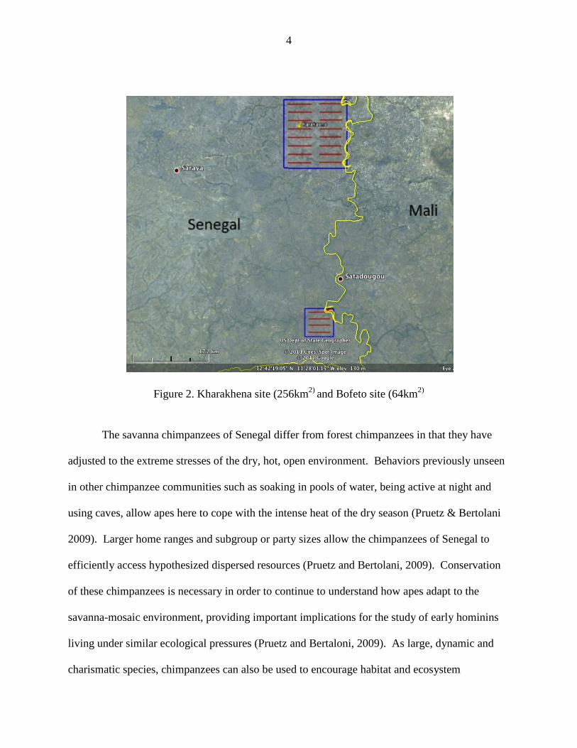
Figure 2. Kharakhena site (256km2) and Bofeto site (64km2)
The savanna chimpanzees of Senegal differ from forest chimpanzees in that they have
adjusted to the extreme stresses of the dry, hot, open environment. Behaviors previously unseen
in other chimpanzee communities such as soaking in pools of water, being active at night and
using caves, allow apes here to cope with the intense heat of the dry season (Pruetz & Bertolani
2009). Larger home ranges and subgroup or party sizes allow the chimpanzees of Senegal to
efficiently access hypothesized dispersed resources (Pruetz and Bertolani, 2009). Conservation
of these chimpanzees is necessary in order to continue to understand how apes adapt to the
savanna-mosaic environment, providing important implications for the study of early hominins
living under similar ecological pressures (Pruetz and Bertaloni, 2009). As large, dynamic and
charismatic species, chimpanzees can also be used to encourage habitat and ecosystem

5
conservation such that a wider array of biodiversity will benefit (Margules and Sarkar, 2007).
Ecologically, chimpanzees in Senegal are beneficial to the germination of Saba senegalensis
seeds, a plant species that is important both to other wildlife species and humans (Pruetz et al., in
prep), and they disperse the seeds of numerous other plant species (Pruetz, 2006). However, as
savanna chimpanzee habitat decreases, becomes fragmented or disturbed by human activities,
valuable information is lost. Southeastern Senegal, home to approximately 300 chimpanzees
(Kormos et al., 2003) and a growing mining industry, is now facing this problem.
ArcelorMittal, the world’s largest steel company, plans to develop an iron ore mine in the
Falémé region of southeastern Senegal near the villages of Kharakhena and Bofeto (Figure 3).
ArcelorMittal proposes an investment of $2.2 billion US for this mining project, which includes
750km of railway and a port in Bargny-Sendou south of Dakar to transport and export the iron
ore (ArcelorMittal Press release, February 2007). Over the course of 25 years the mine is
expected to produce 25 billion tons of iron annually, generating 75 billion CFA ($168 million
US) per year (WTO, 2009). The project, previously expected to begin production in 2011, was
postponed temporarily due to the global economic downturn and subsequent crisis in the steel
industry (Reuters and MiningMx, July 2009). Presently, the Bofeto mine of the Falémé mining
project is projected to begin construction at the end of 2011 (A. Niang, pers. comm.).

Figure 3. Map of Falémé iron ore deposits (Gineste, 2005) Black areas indicate deposits of iron ore in the form of magnetite. Amounts in megatons (Mt) for each deposit are given in
corresponding bubbles. The KR study site in outlined in red toward the southern border of the map.
6
Figure 3. Map of Falémé iron ore deposits (Gineste, 2005) Black areas indicate deposits of iron
ore in the form of magnetite. Amounts in megatons (Mt) for each deposit are given in The KR study site in outlined in red to the north, and the
toward the southern border of the map.
Figure 3. Map of Falémé iron ore deposits (Gineste, 2005) Black areas indicate deposits of iron ore in the form of magnetite. Amounts in megatons (Mt) for each deposit are given in
and the BO study site is

7
The postponement of the ArcelorMittal Falémé mining project allowed me the unique
opportunity to establish systematic data on chimpanzees before a known imminent habitat
disturbance. Such opportunities are rare and short-lived. Drilling exploration of iron ore
deposits has already begun on all three mountains near the village of Kharakhena as well as on
the three Koudekourou mountains adjacent to the village of Bofeto. With the creation of
scientific documentation and support from international non-governmental agencies, my goal is
to communicate to ArcelorMittal and local governments the importance of the surrounding
habitat to the survival of chimpanzee populations and to work towards both environmentally
conscious mining practices and the formation of community forests, such that local communities
manage and conserve their local resources. It is not possible to consider the elimination of
mining in Senegal, as the industry has the potential to not only better the country’s economy but
also to reduce poverty at a local level, if managed appropriately. The most viable strategy now is
to understand the effects mining has on chimpanzee populations in Senegal and thus mitigate
negative impacts. By working with the local communities, national and local government
agencies, private mining industries, and conservation organizations to establish sustainable and
environmentally sound practices, we can create a systematic conservation plan for chimpanzee
populations and encourage community forest programs.
Conservation Planning and Community Conservation
Recent trends indicate that the first step to effective conservation planning is identifying
stakeholders and encouraging their involvement (Margules and Sarkar, 2007). Although large
foreign investing companies and state departments may dominate the field, studies indicated that
local community involvement has a significant effect on the success of conservation initiatives
8
(Persha et al., 2011; Alden Wily, 2002; Wadley et al., 2010; Ban et al., 2009a; Ban et al., 2009b;
Henson et al. 2009). Community involvement has been shown to increase local acceptance and
success of implemented conservation areas (Ban et al., 2009b; Wadley et al., 2010). Creating
trust between the local communities and conservationists is key to effective conservation
(Berkes, 2007; Wadley et al., 2010).
Setting aside protected areas as reserves for conservation is a concept and practice that
has been around for many years. However, past practices have been biased and at times
haphazard. Historically, many of the reserves set aside have been in remote and economically
invaluable areas and neglected to protect areas targeted for resource extraction (Margules and
Pressey, 2000). These reserves were also heavily managed by the state, removing residents from
the land and alienating local rights. Today conservationists are looking to improve the method of
allocating land for conservation through the use of systematic conservation planning while
incorporating Community Based Natural Resources Management (CBNRM) programs. In order
to successfully conserve biodiversity, specifically endangered and threatened species,
appropriate planning must focus on management of both areas of production and protection as
well as community involvement. One of the most important roles of reserves is to represent the
biodiversity of a region while protecting the area and inhabitants from threats. Using the
CBNRM approach to reserve creation, these areas would not only serve to protect the habitat, but
could also continue to serve the local communities through sustainable land use management.
Areas targeted for resource extraction, such as the Mining Zone of Senegal, should not be
excluded but rather prioritized for community conservation and reserves.
It is also important to link community level conservation programs to the state and
international developmental agencies to achieve success (Berkes, 2007). At the state level,

9
many developing countries are moving toward decentralized administration and management of
natural resources such that control of resources falls in the hands of local communities (Alden
Wily, 2003). It is becoming imperative to incorporate the needs and idea of these communities.
Senegal has been known for its decentralization policies since the 1970s. However, it was not
until the 1993 forestry law was passed that local communities were given the right to participate
in forest exploitation. They were further empowered in 1998 to fully manage (and conserve) the
forests (Ribot, 1995). The 1998 law gave power to the Rural Councils of Rural Communities to
create management plans, allow or deny exploitation of resources and collect revenues from the
confiscated items (Ribot et al., 2006). Despite the ratification of the 1998 law, as of 2009 these
rights have not actually been given to the local communities. The forestry department continues
to decide management plans and to reap all benefits from forests across Senegal (Ribot, 2009).
Although unequal balance of power in the region remains, it is necessary to include all parties
and advocate the rights of the local communities in the creation of local community forest
reserves and conservation networks.
International development and environmental organizations should also be integrated in
the process of establishing conservation areas and reserves. Specifically related to mining,
international policies have been passed by various different organizations to improve the
environmental impact of mining. In 2006, the World Bank International Finance Corporation
(IFC) created new policies and performance standards to increase social and environmental
sustainability by development organizations. The IFC Standard 6 specifically addresses the need
“to protect and conserve biodiversity and to promote the sustainable management and use of
natural resources through the adoption of practices that integrate conservation needs and
development practices” (IFC, 2006). All projects associated with the IFC must assess the

10
impacts that their project will have on the biodiversity in the project area, focusing on major
threats such as habitat destruction and invasive alien species. As both natural and modified
habitats can sustain high levels of biodiversity, this standard is applied to all habitats regardless
of whether or not they have previously been disturbed and whether or not they are legally
protected. Within a given area, critical habitats must be noted and require particular attention.
These areas are defined by their importance to endemic, critically endangered and endangered,
migratory and congregatory species, as well as their biodiversity value and significance to local
communities. An example of such critical habitats would include areas such as woodland and
gallery forests of southeastern Senegal, used as critical nesting habitat for the savanna
chimpanzees (Pruetz et. al, 2008).
The Mining Zone of Southeastern Senegal
There are two major geological domains that comprise Senegal: the Sedimentary Basin
and the Precambian Basement (Figure 4) (Mining Journal Supplement, 2009). The Sedimentary
Basin extends from the Atlantic Ocean across 75% of Senegal to the Mauritanides chains in the
southeastern region of the country. It is targeted for phosphates, limestone, and attapulgite
(Mining Journal Supplement, 2009). The Precambian Basement extends from the western edge at
the Mauritanides chain through the southeastern portion of the country and is of great importance
to Senegal as it hosts numerous metal deposits. This geological domain is dominated by
Paleoproterozoic volcano-sedimentary sequences, which contain most of the country’s metal
deposits. Deposits of copper and chromium are found along the western edge in the
Mauritanides range, whereas gold, iron, tin, uranium and nickel are found further east.
11
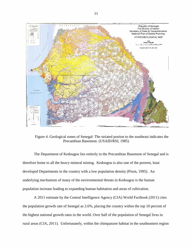
Figure 4. Geological zones of Senegal: The striated portion to the southeast indicates the Precambian Basement. (USAID/RSI, 1985)
The Department of Kedougou lies entirely in the Precambian Basement of Senegal and is
therefore home to all the heavy mineral mining. Kedougou is also one of the poorest, least
developed Departments in the country with a low population density (Pison, 1995). An
underlying mechanism of many of the environmental threats in Kedougou is the human
population increase leading to expanding human habitation and areas of cultivation.
A 2011 estimate by the Central Intelligence Agency (CIA) World Factbook (2011) cites
the population growth rate of Senegal as 2.6%, placing the country within the top 10 percent of
the highest national growth rates in the world. Over half of the population of Senegal lives in
rural areas (CIA, 2011). Unfortunately, within the chimpanzee habitat in the southeastern region
12
of Senegal, human population estimates are difficult to compile. Numbers are given either for
the region of Tambacounda, the more recently subdivided region of Kedougou (as of 2008), or
the Kedougou prefecture and are not comparable to one another over time. However, what is
known is that the increase in mining, both corporate and artisanal, is causing an increase in the
human population across southeastern Senegal (PASMI, 2009; MDL, 2009; Mining Journal
Supplement, 2009).
While ArcelorMittal’s incoming iron mine, which boasts the creation of 20,000 direct and
indirect jobs in Senegal (Mining Journal Supplement, 2009), will be the first iron mine created in
the country, gold mining occurs in Senegal via both large-scale corporate industrial mining
companies as well as small-scale informal artisanal miners. Large-scale mining companies have
established numerous gold exploration sites in the southeastern region of Senegal, most notably
in and around Sabodala. The Sabodala Mining Company is a subsidiary of Australia’s Mineral
Deposits Limited, which owns the gold mine here (Mining Journal Supplement, 2009). The
corporate mining project in Sabodala, a joint venture between Australia’s Mining Deposit
Limited and the Senegalese government, employed around 1400 people for the construction of
the mine, the majority of whom were Senegalese (MDL, 2009). In the area surrounding
Sabodala, a Canadian mining company, Oromin Explorations Limited, has created the Sabodala
Holding Company subsidiary, which is working with two Saudi investment companies. South of
Sabodala, the South African company Randgold has discovered another gold deposit, and
Canada’s Iamgold mining company is exploring along the Mali border. Both Randgold and
Oromin plan to start production in the Kedougou region within the next several years. In total, 20
pockets of gold mineralization have been discovered along with four potential mine sites. There
13
are currently gold research permits extended to eight foreign companies and nine domestic
companies for exploration (Mining Journal Supplement, 2009; Pasmi, 2009).
Small-scale artisanal gold mining is widespread in southeastern Senegal and also occurs
around the globe. The occupation is estimated to employ 10-15 million miners in 55 countries,
predominately in Africa, Asia and South America. This informal mining process is thought to
make up 20-30% of the world’s gold production (Global Mercury Project, 2007). In Senegal,
artisanal gold mining occurs in pockets across the Kedougou region. There are currently
approximately 10-20,000 artisanal miners working in Senegal with rudimentary extraction
techniques, high occupational hazards and environmental risks and no support or recognition
from the government (Pasmi, 2009). This work is believed to employ approximately 20% of the
region’s population and directly or indirectly affects 50% of the regions inhabitants (WTO,
2009). In Senegal, artisanal gold mining has directly affected the chimpanzee community in
Fongoli, for example. Since 2008, two artisanal mines have been established within the
community’s home range, increasing local human presence and disturbances (J. Pruetz, pers.
comm.).
The increase of mining jobs in southeastern Senegal has also been cited as the cause for
recent local social instability in Kedougou. On December 23, 2008 riots broke out in the town of
Kedougou as a result of biased employment by mining companies in the region (IRIN, 2009).
These riots injured 35, killed at least one and led to the arrest of 26 individuals. Further
instability and population increase in southeastern Senegal could potentially stem from the influx
of immigrants from other West African countries, such as Guinea, Ivory Coast, and Burkina Faso
which have recently suffered from political instability.
14
In addition to the influx of mining populations across the region, another significant
impact on the area is the newly created Bamako-Dakar Corridor roadway. The roadway project
known officially as, ‘Road Improvement and Transport Facilitation Programme on the
Southbound Bamako-Dakar corridor (Kati-Kita-Saraya-Kedougou-Dakar)’, has created a paved
highway running through the Kedougou region from Kedougou to Mali, including a bridge over
the Falémé river (ADF, 2005). The roadway, which bisects the KR study site, will ultimately
connect Bamako with Dakar, thus opening up the landlocked country of Mali to engage more
effectively with coastal export systems. Negative impacts of the roadway include habitat
fragmentation and destruction, increased runoff due to asphalted surfaces, increased traffic
through the Niokolo-Koba National Park (PNNK) and subsequent potential for traffic accidents,
and increased human population in the region (ADF, 2005).
Falémé Zone d’Interet Cynegetique (ZIC)
The Mining Zone of Senegal is located within the 1.3 million ha of the Zone d’Interet
Cynegetique (ZIC) of Falémé, a protected wildlife area. The area was legislated in 1972 by the
Government of Senegal in law 72-11-70 and modified in 1978 by law 78-506. The region is
considered a conservation priority by the government and was intended to act as a buffer to the
PNNK located to the west (Figure 5) (USFS, 2006).
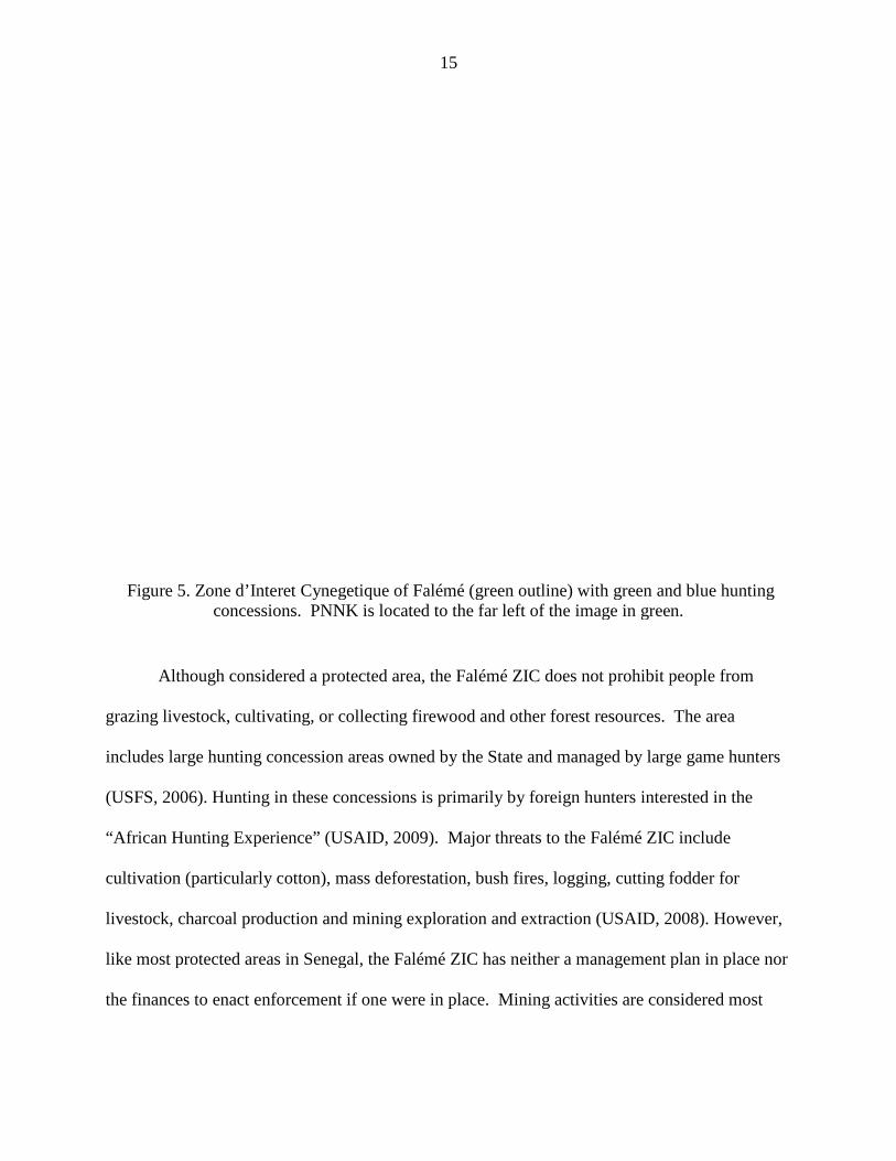
Figure 5. Zone d’Interet Cynegetique of Falémé (green outline) with green and blue hunting concessions. PNNK is located to the far left of the image in green.
Although considered a protected area,
grazing livestock, cultivating, or collecting firewood and other forest resources
includes large hunting concession areas owned by the
(USFS, 2006). Hunting in these concessions
“African Hunting Experience” (USAID, 2009).
cultivation (particularly cotton), mass deforestation, bush fires, logging, cutting fodder for
livestock, charcoal production and mining exploration and ext
like most protected areas in Senegal, the Falémé ZIC
the finances to enact enforcement if
15
Zone d’Interet Cynegetique of Falémé (green outline) with green and blue hunting concessions. PNNK is located to the far left of the image in green.
Although considered a protected area, the Falémé ZIC does not prohibit people from
livestock, cultivating, or collecting firewood and other forest resources. The area
includes large hunting concession areas owned by the State and managed by large game hunters
in these concessions is primarily by foreign hunters interested in the
“African Hunting Experience” (USAID, 2009). Major threats to the Falémé ZIC include
cultivation (particularly cotton), mass deforestation, bush fires, logging, cutting fodder for
livestock, charcoal production and mining exploration and extraction (USAID, 2008)
like most protected areas in Senegal, the Falémé ZIC has neither a management plan in place nor
the finances to enact enforcement if one were in place. Mining activities are considered most
Zone d’Interet Cynegetique of Falémé (green outline) with green and blue hunting
concessions. PNNK is located to the far left of the image in green.
Falémé ZIC does not prohibit people from
. The area
managed by large game hunters
erested in the
Major threats to the Falémé ZIC include
cultivation (particularly cotton), mass deforestation, bush fires, logging, cutting fodder for
raction (USAID, 2008). However,
a management plan in place nor
. Mining activities are considered most
16
detrimental to the biodiversity in the Falémé ZIC and are nearly unstoppable due to
governmental support and the need for short term financial gain (USAID, 2008).
Environmental Impacts of Mining Activities
Natural resource extraction, specifically mineral and metal mining, provides an important
source of revenue for many West African countries. In Senegal, mining has been increasing over
the past five years due to the rise in mineral raw materials prices (WTO, 2009) and continues to
expand as research and exploration permits are extended to foreign and domestic companies
(Mining Journal Supplement, 2009). Much of the metal mining is located in the southeastern
region of Senegal where the effects of mining will compound the already existing environmental
problems faced by the chimpanzee populations. In the past 35 years there has been a decrease in
over half of Senegal’s forest cover (Tappan et al., 2004). While natural threats have had an
impact on Senegal’s environmental degradation, including climate change, desertification and
natural fires, much of the disturbances are anthropogenic and include agriculture, livestock
grazing, cutting of plants for livestock fodder, bush fires, logging and charcoal production
(USAID, 2008). Savanna chimpanzee populations are already suffering from the effects of these
habitat disturbances. Further degradation and disruption to their habitat through mining
activities will strain the species and threaten their future survival.
Extractive industries create potential risks for great ape communities through habitat
destruction and fragmentation, pollution of natural water sources, behavioral disruption, and
disease transmission (Hockings and Humle, 2009). Habitat destruction and fragmentation caused
by mining includes clearing vegetation for mining facilities, roads and human settlements such as
base camps and relocated villages. As previously stated, mining projects are also directly linked
17
to an influx of a larger human population. Along with the increased human population, comes
the potential for an increase in human-chimpanzee conflict stemming from the creation of roads
and human settlements at mining facilities, in conjunction with decreased available habitat
(Hockings and Humle, 2009).
Mining operations have wide ranging detrimental effects on the environment, directly
causing water, air and noise pollution, deforestation and toxic waste production. Habitat loss,
due to the open pit mining system characteristic of iron mines, is marked by overall loss of
vegetation and changes in landscape (Akiwumi and Butler, 2008; Kusimi, 2008). Water
pollution occurs in both ground and surface water in mining areas, causing sources to be highly
vulnerable to heavy metal contamination (He et al., 2006; Yellishetty et al., 2009). Mining areas
can also generate potentially toxic waste products in large volumes over time (Williams and
Ansley, 2009; Tovar et al., 2009). The environmental effects of airborne contaminants, waste
tailings, and acid and metalliferous drainage (AMD) are attributed to hazardous materials
involved in the entire process of extraction (LPSDP Hazardous Materials, 2009). The
environmental impacts of waste tailings and AMD are generally restricted to the mining site and
local environment, whereas airborne contaminants can have an impact throughout the entire
process from “pit to port”. Particles are released into the air during facility construction and
development, drilling, blasting, exporting, transporting and dumping of ore, beneficiation of
materials, power plant operations, wind erosion, rail transportation and ship loading (LPSDP –
Airborne Contaminants, 2009). Hazardous materials involved in this process include asbestos,
silica, and nitrogen dioxide from blasting, sulfur dioxide and hydrogen cyanide from
beneficiation, and emissions of sulfur dioxide and various forms of nitrogen oxides from power

18
plant operations. Radioactive metals can also be released into the air through the blasting
process (LPSDP – Hazardous Materials, 2009).
If human population and corporate industry ventures continue to increase in southeastern
Senegal, increasingly fragmenting and degrading the habitat, the chimpanzee populations will
inevitably suffer. The critical moment for chimpanzee conservation is now, prior to the major
influx of mining operations and population boom. Conserving Senegal’s chimpanzees is not
only imperative for ecological and ethical reasons and to maintain genetic viability of the
population, but also to preserve the wealth of information that can be understood from the study
of their behaviors in a relatively unique chimpanzee environment.
West African Savanna Chimpanzees
West African savanna chimpanzees range across nine to ten countries in West Africa
with a total estimated population in the range of 21,000 to 55,000 individuals (Kormos and
Boesch, 2003). Even if high estimates are accurate, the population is endangered according to
the International Union for Conservation of Nature (IUCN) Red List standards. Such large
discrepancies in accuracy for population estimates permeate the data due to the difficulty in
assessing the entire chimpanzee range, as well as the constant increase in habitat destruction in
West Africa (Butynski, 2003). Many of the surveys contributing to the population database were
conducted a decade or more ago, and therefore, do not take into account the current degraded
state of the chimpanzee habitat and subsequent population declines.
19
Previous Surveys in the Mandigue Plateau
In order to successfully conserve chimpanzee populations, as well as evaluate
conservation activities, it is important to first accurately estimate population densities. By
understanding the baseline population density of an area, one can then understand the impacts of
threats on the population. Densities of unhabituated apes are primarily estimated using nest
count methods, as apes are known to create a vegetation sleeping platform, or nests, each night
(Kühl et al., 2008). There are two types of nest counts, the standing crop nest count method
(Tutin and Fernandez, 1984) and marked nest count method (Plumptre and Reynolds, 1996).
The standing crop method records all nests in an area during one surveying bout and uses both a
nest creation rate as well as a nest decay rate to estimate the population density. The marked
nest count method requires repeated surveys of an area and records only the nests that have been
created since the previous survey. The method only requires a nest creation rate to calculate
population density. Nest creation rates and decay rates vary between sites (Brncic et al., 2010;
Marchesi et al., 1995) and should ideally be specifically calculated for each survey area.
Calculating these rates, however, is not always possible for projects with economic and temporal
constraints; rather, rates are frequently taken from the literature based on similar geographical
location, climatic data and habitat structure (Kühl et al., 2008; Pruetz et al., 2002)
Whether using the standing crop or the marked nest count method, there has been debate
over whether densities should be estimated using individual nest counts or nest groups (Ghiglieri,
1984; Tutin and Fernandez, 1984). Both methods can provide population density estimates, but
both have disadvantages. Individual nest counts assume a random distribution of nests
throughout the study area, not taking into account the prevalence of preferred nesting sites and
habitats or the fact that chimpanzees nest in groups. This may be especially problematic in areas
20
where chimpanzees use habitat mosaics and range in cohesive groups. Nest groups, on the other
hand, do take into account the fact that chimpanzees primarily nest together. Groups, however,
may be difficult to determine as chimpanzees may return frequently to the same nesting site over
a series of days resulting in one nesting group being indistinguishable from another. The
inability to consistently and accurately determine one nest group from another has resulted in
researchers using the individual nest count method, despite its shortcomings (Pruetz et al. 2002;
Granier and Martinez, 2004; Fleury-Brugiere and Brugiere, 2010).
In the past ten years, few systematic chimpanzee surveys have been conducted in the
Mandingue Plateau. Of those conducted, the most significant to this study are the surveys
conducted by Pruetz et al. (2002) in Senegal at Mt. Assirik in Niokolo Koba National Park
(PNNK) and surrounding areas, including the current Fongoli field site. The Pruetz et al. (2002)
study used both systematic and reconnaissance surveys. The four systematic line transects at
Assirik were each 2km long and were surveyed twice, while selective sampling followed water
courses through two valleys with transects of 2.8km and 2.9km. The total distance surveyed in
the national park was 83.5km. Outside the park a total of 33.2km was walked in reconnaissance
surveys. Chimpanzee density at Assirik was determined to be 0.13 individuals/km2 and density
at Fongoli was 0.09 individuals/km2.
In the northeast corner of the Mandigue Plateau, located in Mali, the Bafing-Faleme
Protected Area (BFPA) was most recently surveyed by Granier and Martinez (2004). The
habitat of the BFPA is similar to that of southeastern Senegal as it is dominated by woodland and
wooded savannah (35.7% and 18.9%), with gallery forest making up only 5.5% (Granier and
Martinez, 2004). Within the BFPA, three study sites were surveyed based on a year of
reconnaissance surveying, but only two provided accurate densities (Faragama and Djakoli). At
21
Faragama eight transects were surveyed totaling 14km and, at Djakoli, seven transects totaling
11.9km were surveyed. Densities at these two sites were 0.30 and 0.39 individuals/km2
respectively. The BFPA had been previously surveyed by Pavy (1993) who, with a greater
survey intensity of 100km, found a density of 0.27 individuals/km2.
In Guinea, Fleury-Brugiere and Brugiere (2010) found the highest chimpanzee density in
the Haut Niger National Park (HNNP). The habitat of the HNNP is also similar to southeastern
Senegal and southwestern Mali with wooded savannah and dry forest dominating the landscape
(53.6% and 20.8%) and gallery forest making up 4.2% of the habitat (Fleury-Brugiere and
Brugiere, 2010). They surveyed 103.8km of transects, each transect averaging 8.2km long
(Fleury-Brugiere and Brugiere, 2010). Transects were placed in 11 randomly selected census
blocks in a selected region of the national park. The chimpanzee density found for this area was
0.87 individuals/km2 (Fleury-Brugiere and Brugiere, 2010).
Regional and Cultural Behaviors
Chimpanzees have been frequently recognized for their wide variety of behaviors, many
of which have been termed cultural (Boesch, 2003; Whiten, 2000; Sapolsky, 2006). As mining
and human populations increase in southeastern Senegal, fragmenting and degrading the
landscape, the impact may potentially affect the behavior of the Senegal’s chimpanzees. Such
habitat disturbance brings about socioecological change for chimpanzee groups in terms of
continuity of neighboring territories, which may in turn lead to the complete loss of local cultures
(van Schaik, 2002).
Culture can be defined as a distinctive collective practice socially learned from group
members and based on shared meanings between members of the same group (Galef, 1992;
22
Boesch and Tomasello, 1998; Boesch, 2003; Whiten, 2004; Sapolsky, 2006; Whitehead et al.,
2004). Boesch (2003) notes that culture is comprised of creativity, diversity, and innovation, and
can allow a release from ecological constraint through the transmission of some behaviors.
Some behaviors that are recognized as putative cultural behaviors in chimpanzees include leaf
clipping (Sugiyama, 1981; Nishida T. 1987; Boesch, 2003), hand clasp grooming (McGrew,
2001), ant dipping (McGrew, 1974; Sugiyama et al., 1988; Boesch and Boesch, 1990; Alp, 1993;
Humle and Matsuzawa, 2002; Sanz and Morgan, 2007), termite fishing (Sanz et al., 2004; Bogart
and Pruetz, 2008; Sanz and Morgan, 2007) and percussive tool use, such as nut cracking with
hammers and anvils (Boesch, 2003). West African chimpanzees have been observed exhibiting
all of these behaviors and display a range of cultural variation, with termite fishing and ant
dipping behaviors varying between research sites (Mobuis et al, 2007; McGrew et al., 2005;
Yamamoto et al. 2008).
Individuals learn certain skills either by innovation or by social learning. Innovation
appears to be rare, and it is more likely that new behaviors are learned via social learning and
diffusion across populations (van Schaik, 2002). Variations in behaviors may be attributed to
ecological, genetic or cultural influences (Langergraber et al., 2011). The loss of connectivity
between communities within a population could dramatically influence the loss of behavioral
variation by disrupting the both genetic and cultural diffusion process between communities.
Where the extinction of a local community would obviously cause the extinction of the local
cultures, it is also evident that the fragmentation of habitat would cause the loss of diffusion
between communities due to lack of dispersal corridors (Van Schaik, 2002).
Some of the putative cultural behaviors observed in Senegal that have also been observed
in other chimpanzee populations across Africa include hand clasp grooming, ant dipping, termite
23
fishing, leaf clipping, buttress drumming, and rain dances (pers. obs., 2009; McGrew et al., 2005;
Bogart and Pruetz, 2008; Pruetz, unpublished data). The chimpanzees of Senegal, however, also
exhibit unique behaviors not seen in other chimpanzee populations. For example, at the Fongoli
field site, 75km southwest of Kharakhena, the chimpanzees have been observed using caves
(Pruetz 2006), soaking in pools of water (Pruetz & Bertolani 2009), systematically hunting
mammals with tools (Pruetz and Bertolani, 2007), and performing a ‘fire dance’ (Pruetz and
LaDuke, 2010). Further research is needed throughout the southeastern region of Senegal to
determine whether other chimpanzee populations are responding to the environment in the same
manner as the Fongoli community. The southeastern region is home to a number of other
chimpanzee communities living in similar habitat types who likely experience ecological stresses
comparable to those of Fongoli apes. One would thus expect to see similar behaviors in the
Kharakhena and Bofeto chimpanzee populations. For example, chimpanzees in Mali living in
similar ecological condition to those in Fongoli have been observed exiting a cave, indicating
that chimpanzee cave usage is perhaps more widespread in the Mandingue Plateau than is
currently known (Moore, cited in Pruetz, 2002). Evidence of these behaviors would give further
insight into the range of cultural behaviors in Senegalese chimpanzee populations. If
conservation efforts are not implemented in the region to compensate for the increasing human
population and the habitat degradation, the transfer and future of these behaviors could be lost
forever (van Schaik, 2002).
Many of these putative cultural behaviors leave behind material artifacts. Chimpanzees
in East, Central and West Africa modify termite-fishing tools by cutting the length of the tool
with their hands or mouth and then stripping the tool of extraneous parts, such as other branches
or stems. In the Goualougo Triangle, Congo and Fongoli, Senegal researchers have found

24
termite fishing tools to be modified with fanned or brush-like tips, a modification which aids and
increases extraction of insects (Sanz and Morgan, 2007; Gaspersic & Pruetz, in prep.).
Researchers studying habituated communities of chimpanzees have thousands of hours of direct
observation of tool use. These data provide information of tool use and production that aids in
identifying tools used by non-habituated communities. In this way indirect methods can be used
to study behaviors of non-habituated chimpanzee communities. By the use of indirect study and
artifact recovery, we are able to analyze and interpret some behaviors without actually observing
them (McGrew et al., 2003).
Conservation Corridors
In order to best conserve the remaining chimpanzee population in southeastern Senegal,
landscape linkages are needed to increase connectivity between populations (Bennet, 2003).
Chimpanzee populations may otherwise become isolated due to habitat fragmentation and
anthropogenic barriers such as mining activities, highways or human habitations. As noted
above, protected areas have already been established in and around the Mining Zone of Senegal
such as the Falémé ZIC and PNNK. These areas however are too large to adequately manage
with current allocated resources, and chimpanzee conservation may benefit from smaller
community based reserves that encompass suitable chimpanzee habitat. Such reserves would act
as conservation corridors that either creates contiguous habitat connections or “stepping stones”
of habitat between which chimpanzee populations could move (Groves, 2003). Corridors would
thus allow for female dispersal from their natal site into other communities. This movement
between communities would permit continued genetic and cultural exchanges between
communities.
25
As more and more habitat in southeastern Senegal is disturbed due to mining activities
and human habitation, it is important to identify where chimpanzees live, what habitats they use
most frequently, and how they react to human disturbed areas. I propose that it is also necessary
to begin creating these conservation community reserves to maintain connectivity between the
remaining and threatened populations. In this study I have identified two populations whose
habitat is under threat of the impending iron mine as well as potential areas of dispersal once the
iron mines are constructed.
CHAPTER 3. METHODOLOGY
Study Sites
The study area is located in southeastern Senegal along the Malian and Guinean borders
(12°54’48.69” N, 11°31’05.65” W), within the region and department of Kedougou (Figures 1
and 2). Located 83km northeast of the town of Kedougou and 12km from the Mali border, the
targeted study area lies within a 65km by 15km belt of supergene enriched iron ore deposits
containing nine major and 19 minor ore bodies (Schwartz and Melcher, 2004). It is within this
area that ArcelorMittal is expected to develop an iron mine. My project’s two study sites
encompass the largest iron deposits. The northern study site is a 256km2 area centered on three
iron deposits and encompassing the village of Kharakhena (KR) (Figure 4). The three iron
deposits in this site total 98 megatons (Mt) of iron ore (Figure 5). The southern site is a 64km2
area centered on the mountain of Koudekourou near the village of Bofeto (BO) (Figure 6).
Surveys in the BO area were only conducted in the Senegalese portion of the study site and
exclude the northeastern section located in Mali for logistical reasons of working in that country.
26
The BO study area encompasses one iron deposit of 107Mt (Figure 7). Prior to this study, details
of water source and habitat type availability had not yet been determined for these areas and
were within the focus of this study.
Chimpanzee Population Density
Data used in this study was collected from May through August 2010 and again between
December 2010 and January 2011. The study used distance sampling surveys to estimate
population density through indirect measures, specifically standing crop nests counts (Plumptre
and Reynolds 1997, Koukakou et al. 2009; Kühl et al., 2008). Distance sampling is currently the
standard for surveying great ape populations, as it is the most well developed method, can
estimate population density, abundance and distribution, and is applicable to various types of
habitats (Buckland et al, 2001). Although there are major assumptions associated with distance
sampling, (i.e., proper design of transects and survey methods, all objects located above or on the
transect will be detected, distances to objects are accurately recorded, and that sightings are
independent events), knowledge of these assumptions and careful execution of surveys can
assure that data analysis will produce accurate measures of population densities (Kühl et al.,
2008). Additionally, counts of objects, such as nests, rather than moving organisms, helps to
reduce error associated with some of these assumptions.
In order to reduce bias in establishing line transect locations, I used a stratified systematic
sampling method. The 256km2 KR study site was divided into four sectors, each with an area of
64km2. Each sector was then delineated into four strips containing a 6km line transect
systematically distributed within the center of each strip, totaling 16 6km transects within the KR
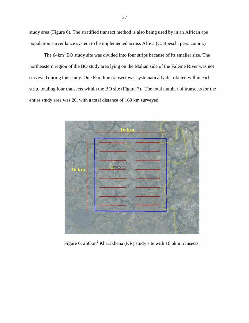
27
study area (Figure 6). The stratified transect method is also being used by in an African ape
population surveillance system to be implemented across Africa (C. Boesch, pers. comm.)
The 64km2 BO study site was divided into four strips because of its smaller size. The
northeastern region of the BO study area lying on the Malian side of the Falémé River was not
surveyed during this study. One 6km line transect was systematically distributed within each
strip, totaling four transects within the BO site (Figure 7). The total number of transects for the
entire study area was 20, with a total distance of 160 km surveyed.
Figure 6. 256km2 Kharakhena (KR) study site with 16 6km transects.

28
Figure 7. 64km2 Bofeto study site with four 6km transects.
Along with a Senegalese field assistant, I walked each transect at a rate of approximately
1.5km per hour (Plumptre, 2000) one time between May 2010 and August 2010. Nests were
recorded that were within sight perpendicular to the transect. Perpendicular distance was
measured from a point directly below the nest on the ground to the line transect (Plumptre and
Reynolds 1997). Effective transect width is determined using the equation A = 2 x ESW x L,
where A is the transect area, ESW is the effective strip width, and L is the length of the transect
(Buckland et al., 2001). The ESW of 11.52m for the KR field site was determined by using nests
to transect distances and calculated using DISTANCE software.
All night nests seen from the transect line during the surveys were marked and classified
according to age. Night nests were distinguished from day nests as being generally larger and
more solidly constructed (Brownlow et al., 2001); however, no day nests were seen during data
collection. Nest age classes include fresh, recent, old, and rotting (after Tutin and Fernandez,
29
1984). Fresh nests are characterized by having vegetation that was still green and not wilted and
may have feces and urine deposited beneath or within the nest. Fresh nests with feces or urine
were distinguished from those without. Fresh feces most accurately indicate the age of a nest.
My study recorded fresh nest with feces as well as fresh nests without feces thus allowing me to
calculate both a conservative and liberal minimum group size. Recent nests are those that contain
wilted green leaves and are assumed to be older than 24 hours. Old nest are those lacking green
leaves, and rotting nests contain no leaves at all but only the woody frame of a nest.
Behavioral impacts of habitat disturbance may be indicated by changes in party size over
time. Therefore, baseline data on nest clusters of fresh nests were recorded. Fresh night nests
were used to estimate minimum party size by counting number of fresh nests within a nest
cluster. A nest cluster is defined by Furuichi et al. (2001) as a collection of nests that appear to
have been built together on the same day, including all nests of the same age class that are less
than or equal to 30m from the nearest of the other nests. In this study I used the parameter of
30m as a guideline to determine a nest cluster and also distinguished fresh nests with feces from
those without feces. The former provides a minimum nest cluster size. Data was recorded on a
Garmin GPS and analyzed using DISTANCE and ArcGIS software.
Habitat Type and Structure
Habitat type and structure was sampled along the 20 6km transects in the two study areas.
The habitat type classification is based on Pruetz et al. (2002), which was modified from
McGrew et al. (1981) and includes gallery and ecotone forest (closed habitats), woodland,
bamboo woodland, and grassland and open grassland (open habitats). Along transects, every
500m the habitat type was indicated based on the standard definitions for each type such that
30
gallery forest indicates a tropical semideciduous lowland forest; woodland refers to a drought-
deciduous lowland woodland; bamboo woodland indicates a flat-leaved savanna with isolated
palms and deciduous trees; grassland refers to a narrow-leaved savanna with isolated deciduous
trees, distinguished from open grassland, which is a narrow-leaved savanna with isolated
deciduous shrubs; and finally, ecotone forest indicating an area where runoff from a plateau edge
produces a strip of evergreen woody vegetation (Bogart & Pruetz, 2011; Pruetz et al., 2002).
Each 500m habitat structure was also sampled by measuring diameter at breast height (DBH) for
all trees within a 5m radius from the transect line.
Travel Corridors
Potential travel corridors were identified by sweep surveys of both KR and BO study
sites. Sweep surveys followed standards set forth by the IUCN Best Practice Guidelines for
Surveys and Monitoring of Great Ape Populations (Kuehl et al., 2008) and were conducted by a
Senegalese field assistant and myself walking in the same direction. We recorded all human
signs, disturbances, and limits to chimpanzee ranging. It is important to record all human signs
and disturbances in order to understand how chimpanzees respond to the changing environment
due to human presence (Kühl et al., 2008). Locations of all disturbances or formations likely to
inhibit travel by chimpanzees were recorded and mapped with the GPS. Such disturbances
included cultivated areas, villages, roads, mining activity, and disturbances due to livestock
and/or herders (ie. tree and branch cutting for livestock fodder).
31
Cultural Behavior Assessment
The presence and prevalence of putative cultural and regional behaviors of chimpanzees
were recorded, focusing specifically on cave use, hunting with tools, soaking in water, baobab
cracking, termite fishing and ant dipping. All occurrences of direct and indirect evidence within
the study sites for these behaviors were recorded. Two camera traps were placed in the KR study
site; one was outside caves used by chimpanzees and the other at a frequented water source. One
camera was also placed along a chimpanzee path in the BO site to capture chimpanzee activity.
CHAPTER 4. RESULTS Over the course of this study, I recorded 173 nests in the KR study site and 246 nests in
and around the BO study site. The location of each nest was recorded via GPS, as was the
surrounding habitat. Using these data, I was able to determine nesting sites and habitats as well
as the spatial distribution of nests in relation to potentially influential factors such as human
disturbances and permanent water sources. These factors, areas of human disturbance and
permanent water sources, along with habitat suitability are also used to predict potential travel
corridors, which may become increasingly important as further habitat degradation occurs.
Chimpanzee Population Densities
Between May and August 2010, nest counts were completed along 20 6km transects,
totaling 120km total for the KR and BO sites (96km and 24km, respectively). In the KR site, 24
nests were recorded on 16 transects. All 24 nests were found on transect #1 in the northwestern
corner of the study site. In KR the maximum perpendicular distance from the transect was 30m.
32
Using DISTANCE software, the effective strip width (ESW) for KR was calculated first by
using the perpendicular distances of all nests recorded along transects. ESW was 11.202 meters
with a standard error of 2.3825. However, after removing three outliers with perpendicular
distances greater than 20m (and thus reducing the maximum perpendicular distance to16.1m in
21observations), the ESW was 11.141m with a standard error of 2.0941. Estimated population
density for the KR site was 0.131 with an estimated 34 chimpanzees at the site. A total of 184
nests were found either within or along the outer edges of the Kharakhena study site during
reconnaissance walks, although only 24 nests fell along the transect lines. The majority of nests
were found just outside the study site and therefore not recorded on transect walks.
The total nest count in the BO site, including both reconnaissance and transect surveys,
was 246 nests. Included in the nest count was a fresh nest cluster of 17 nests. This group of
fresh nests indicates that the smallest possible party or sub-group size for BO is 17 individuals.
If we assume this single sample is average, the actual community group size would be double
this estimate based on the average party size at Fongoli chimpanzee (15 individuals) relative to
the community size (35 individuals) (Pruetz and Bertaloni, 2009).
Although having more nests overall, only three nests in the BO site fell along the 24km
of transects. The maximum perpendicular distance from nests to the transect was 10m. With
such a small sample size of observations, it is not possible to calculate a statistically significant
ESW or estimated population densities for the BO site using the DISTANCE software. Based on
reconnaissance walks, the nest density of the BO site appears to be much greater than the KR
sites since 217 nests at the BO site were found in an area one quarter the size of the KR study
site. In order to calculate an estimated population density of the BO population, I used the
following equation:
33
Using varying nest decay and production rates from chimpanzee sites across Africa I was
able to calculate minimum, maximum and average density estimates. Minimum densities were
calculated using Sierra Leone’s nest decay rate of 139 days in woodland savanna nest sites
(Brncic et al., 2010) and a nest production rate of 1.23 from Budongo, Uganda calculated by
Plumptre and Reynolds (1997). Maximum densities used Tai forest’s decay rate of 73 days
(Marchesi et al., 1995), and a liberal production rate of 1 nest per day per chimpanzee. Averages
were calculated by using the average nest decay and nest production rates from the varying
studies. The proportion of nest builders used in the calculations was 0.83 individuals based on
results from Budongo, Uganda (Plumptre and Cox 1996; Brncic et al., 2010). Effective strip
width calculated by DISTANCE from the KR data was used for the BO calculations as well.
Using these aforementioned parameters, I found that the estimated population density at
BO ranged from 0.04 to 0.09 chimpanzees per km2 with an average of 0.05. When the same
parameters were used to calculate an estimated population density for KR, I found a range from
0.08 to 0.19 individuals per km with an average of 0.11, corroborating the density calculated by
the DISTANCE program.
Habitat Type
Habitat types not previously defined but encountered at the two sites include river, and
palm woodland. River habitat was defined specifically as areas completely contained within a
(nest duration)(production rate )(proportion of nest builders)
Dnests
Dchimps
=

river. Palm woodland habitat was defi
dominate the landscape.
Available habitat for the KR site, based o
16 6km transects, was mainly woodland
woodland/grassland mosaic (9.8%
palm woodland (0.5%) (Figure 8
were found to nest primarily in woodland
done in palm woodland (7.5%), bamboo woodland
Figure 8. Percent available habitat at Kharakhena versus percent of nesting in each habitat
0
10
20
30
40
50
60
34
habitat was defined as woodland areas where Borassus aethiopum
Available habitat for the KR site, based on data collected every 500m along each of the
woodland (50%) and grassland (33.8%), in addition to
9.8%), bamboo woodland (2.9%), human impacted
Figure 8). Based on the 173 nests in the KR study area,
woodland (49.1%) and gallery forest (38.2%). Ot
, bamboo woodland (4%), and ecotone forest (1.2%
Figure 8. Percent available habitat at Kharakhena versus percent of nesting in each habitat
Percent Available Habitat
Percent Nests per Habitat
Borassus aethiopum
00m along each of the
in addition to
, human impacted (2.5%), and
the KR study area, chimpanzees
). Other nesting was
1.2%) (Figure 8).
Figure 8. Percent available habitat at Kharakhena versus percent of nesting in each habitat
Percent Available Habitat
Percent Nests per Habitat
The available habitat in the
the four 6km transects, was predominantly
well as grassland (19.2%), human impacted
(Figure 9). In the BO site, the percent habitat
found to be almost exclusively in woodland
bamboo woodland (2%), woodland/grassland
(0.8%) (Figure 9).
Figure 9. Percent available habitat at Bofeto versus percent of nesting in each habitat
Travel Corridors
Anthropogenic habitat disturbances recorded in the KR study site include areas of
cultivation, villages, branch and tree cutting for pastoral livestock fodder, and mining activities
0
10
20
30
40
50
60
70
80
90
100
35
The available habitat in the BO site, based on habitat data collected every 5
predominantly woodland (40.4%) and woodland/grassland
, human impacted (7.7%), bamboo woodland (3.8%) and river
e percent habitat type used for nesting, based on 246 nests, was
in woodland (93.9%), with small the remaining nesting
, woodland/grassland (2%), gallery forest (1.2%), and palm woodland
Figure 9. Percent available habitat at Bofeto versus percent of nesting in each habitat
Anthropogenic habitat disturbances recorded in the KR study site include areas of
cultivation, villages, branch and tree cutting for pastoral livestock fodder, and mining activities
Percent Available Habitat
Percent Nests per Habitat
habitat data collected every 500 meters on
woodland/grassland (25%), as
and river (3.8%)
used for nesting, based on 246 nests, was
nesting in
palm woodland
Figure 9. Percent available habitat at Bofeto versus percent of nesting in each habitat
Anthropogenic habitat disturbances recorded in the KR study site include areas of
cultivation, villages, branch and tree cutting for pastoral livestock fodder, and mining activities
Percent Available Habitat
Percent Nests per Habitat

36
such as artisanal gold mining, diamond drilling for iron ore, past trenching for gold exploration,
and gallery tunneling for iron exploration. Another area of disturbance is the newly finished
Bamako-Dakar corridor highway that runs from the Mali border to the town of Kedougou. The
highway bisects the Kharakhena study site. Currently, this roadway does not appear to be
impeding the chimpanzees from traveling in the region. In November 2010, field assistant Seiba
Keita observed two chimpanzees feeding on trees within 50 meters of the highway. However
upon completion of the highway’s Senegal-Mali bridge, which is located just east of the study
site, traffic is likely to increase significantly and may ultimately create a barrier for the
chimpanzees.
Travel opportunities appear to be limited in the southeastern quadrant of the study site as
there are highly traveled roads and numerous small villages (Figure 10). Most of the traces of
chimpanzees were found in the west, and the majority of nests found were north and west of the
study site. Although suitable habitat and feeding trees are found in the eastern portion of the
study site, few traces of chimpanzee presence were found in this region. Keita reported having
seen evidence of chimpanzees nesting in gallery forests in the east in previous years, but since
the creation of the artisanal gold mine the chimpanzees no longer appear to nest in the area.
Using ArcMaps to calculate the percentage of nests found within areas of human
disturbance (designated as areas within one kilometer from a village or 500m meters from any
other disturbance), I found that 31.5% of the nests at the KR study site fell within these buffered
areas of human disturbance. Therefore, the majority of nests are located outside areas of human
disturbance (Figure 12). Buffer zones around human impacted areas are compliant with buffers
used in the USGS habitat map, but buffer areas used around cultivated areas are more
conservative in this study, as I used only 500m rather than 1km (USGS/EROS, 2011),
37
In the BO study site, disturbances also included cultivation, villages, branch and tree
cutting for pastoral livestock fodder, and mining activities (Figure 11). Mining activities,
however, were limited to the mountain areas, as there were no artisanal gold mines and limited
past mining exploration within the study site. Mining activities did include diamond drilling
points and temporary road construction for equipment on each of the three mountains.
Nests were also clustered in the northern edge of the BO study site, similar to the KR site.
However, in contrast to the KR study site to the north, the majority of chimpanzee nests recorded
at the BO site were located within the buffered areas of human disturbance. Of the 217 nests
used in this calculation2 64.5% were located within a disturbed area’s buffer zone (Figure. 13).
2 29 nests located to the south were excluded due to lack of extensive surveying of human disturbances in that area.
Figure 10. Chimpanzee nesting sites in relation to areas of human disturbance and proposed mining sites in the Kharakhena study site.Buffers of 1km were created around villages and mining sites and 500m around all other disturbances.
Chimpanzee nesting sites in relation to areas of human disturbance and proposed mining sites in the Kharakhena study site.Buffers of 1km were created around villages and mining sites and 500m around all other disturbances.
38
Chimpanzee nesting sites in relation to areas of human disturbance and proposed mining sites in the Kharakhena study site. Buffers of 1km were created around villages and mining sites and 500m around all other disturbances.
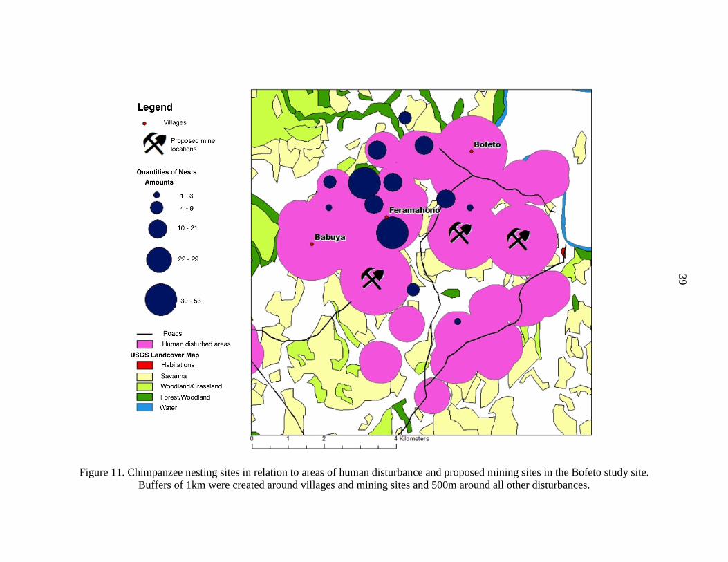
Figure 11. Chimpanzee nesting sites in relation to areas of human disturbance and proposed mining sites in the Buffers of 1km were created around villages and mining sites and 500m around all other disturbances.
Chimpanzee nesting sites in relation to areas of human disturbance and proposed mining sites in the
reated around villages and mining sites and 500m around all other disturbances.
39
Chimpanzee nesting sites in relation to areas of human disturbance and proposed mining sites in the Bofeto study site. reated around villages and mining sites and 500m around all other disturbances.
40
Travel corridors in the BO study site are difficult to assess, as the chimpanzees in the area
do not appear as currently being displaced due to human presence in an area. Therefore, nearly
all areas are currently accessible to the chimpanzee population. However, with the iron ore open
pit mine construction plan to start in December 2011, current nesting areas will no longer be
accessible. Suitable habitat is located to the northwest of the BO site and may provide the
chimpanzees a potential dispersal area.
Cultural Behavior Assessment
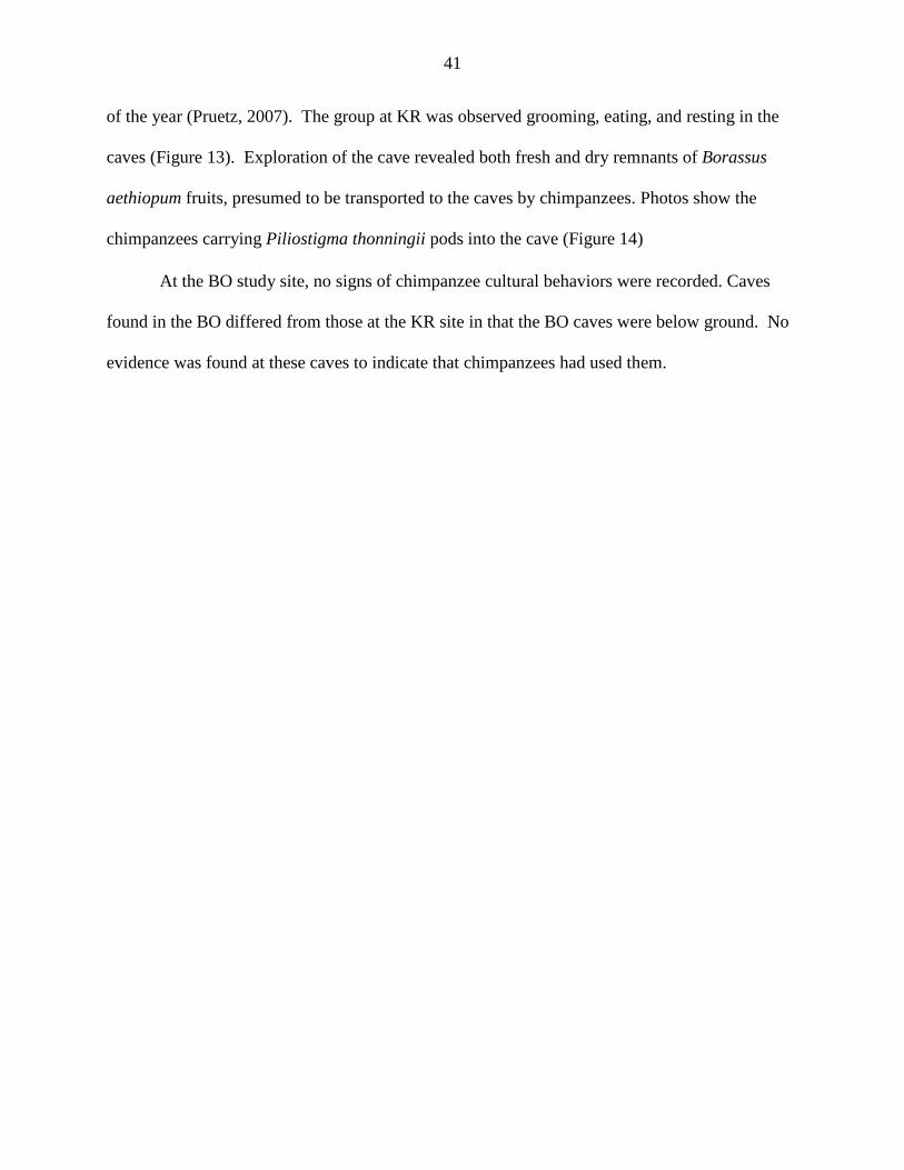
In the KR study site, two potential cultural behaviors were recorded. During transect
survey data collection, two termite-fishing tools were found in the KR study site that appeared to
exhibit ‘brush tips’ (Figure 14). Brush-tipped termite-fishing tools are characterized by a
splayed tip created by chimpanzees pulling the tool end through their teeth (Sanz et al, 2009;
Gaspersic & Pruetz, in prep.). The split end of the tool was covered with dirt from the termite
mound, indicating that this was the insertion end into the termite mound to extract the insects.
These two tools, both from the Terminalia macroptera tree, were found still resting on the
termite mound. Both tools appeared to have been recently used as they were not yet dried and
showed visible tooth marks on the plant epidermis.
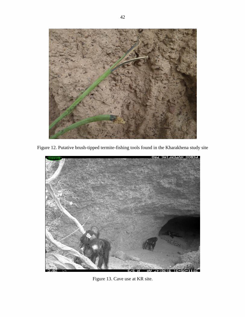
Evidence of cave use was also observed at the KR site via camera trap photos. A camera
trap was placed at the mouth of a cavern located at N 12°51.816 W -11°34.037, which record all
activity inside and in front of the cave. The cavern consists of one large chamber approximately
2m tall at the opening, 10m wide and 7m deep. The chimpanzees were recorded spending time
in and around the cave from 0800 to 1400 hours during the months of April and May. The
Fongoli chimpanzees use caves more frequently during the dry season, which is the hottest time
41
of the year (Pruetz, 2007). The group at KR was observed grooming, eating, and resting in the
caves (Figure 13). Exploration of the cave revealed both fresh and dry remnants of Borassus
aethiopum fruits, presumed to be transported to the caves by chimpanzees. Photos show the
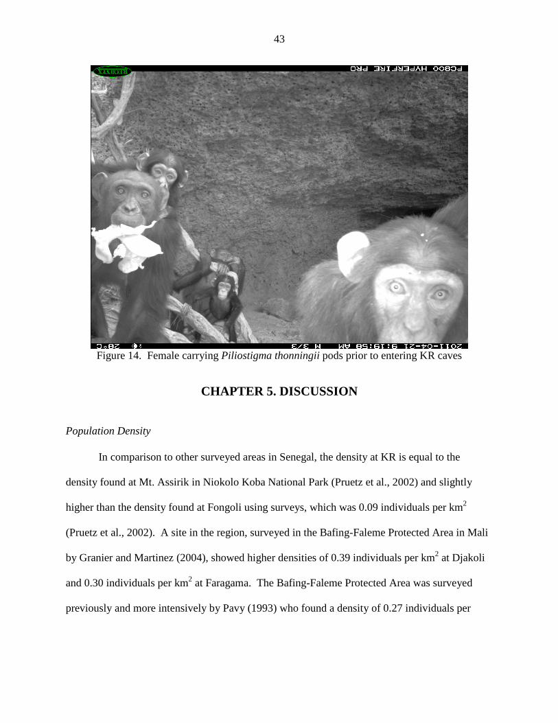
chimpanzees carrying Piliostigma thonningii pods into the cave (Figure 14)
At the BO study site, no signs of chimpanzee cultural behaviors were recorded. Caves
found in the BO differed from those at the KR site in that the BO caves were below ground. No
evidence was found at these caves to indicate that chimpanzees had used them.
42
Figure 12. Putative brush-tipped termite-fishing tools found in the Kharakhena study site
Figure 13. Cave use at KR site.
43
Figure 14. Female carrying Piliostigma thonningii pods prior to entering KR caves
CHAPTER 5. DISCUSSION Population Density
In comparison to other surveyed areas in Senegal, the density at KR is equal to the
density found at Mt. Assirik in Niokolo Koba National Park (Pruetz et al., 2002) and slightly
higher than the density found at Fongoli using surveys, which was 0.09 individuals per km2
(Pruetz et al., 2002). A site in the region, surveyed in the Bafing-Faleme Protected Area in Mali
by Granier and Martinez (2004), showed higher densities of 0.39 individuals per km2 at Djakoli
and 0.30 individuals per km2 at Faragama. The Bafing-Faleme Protected Area was surveyed
previously and more intensively by Pavy (1993) who found a density of 0.27 individuals per
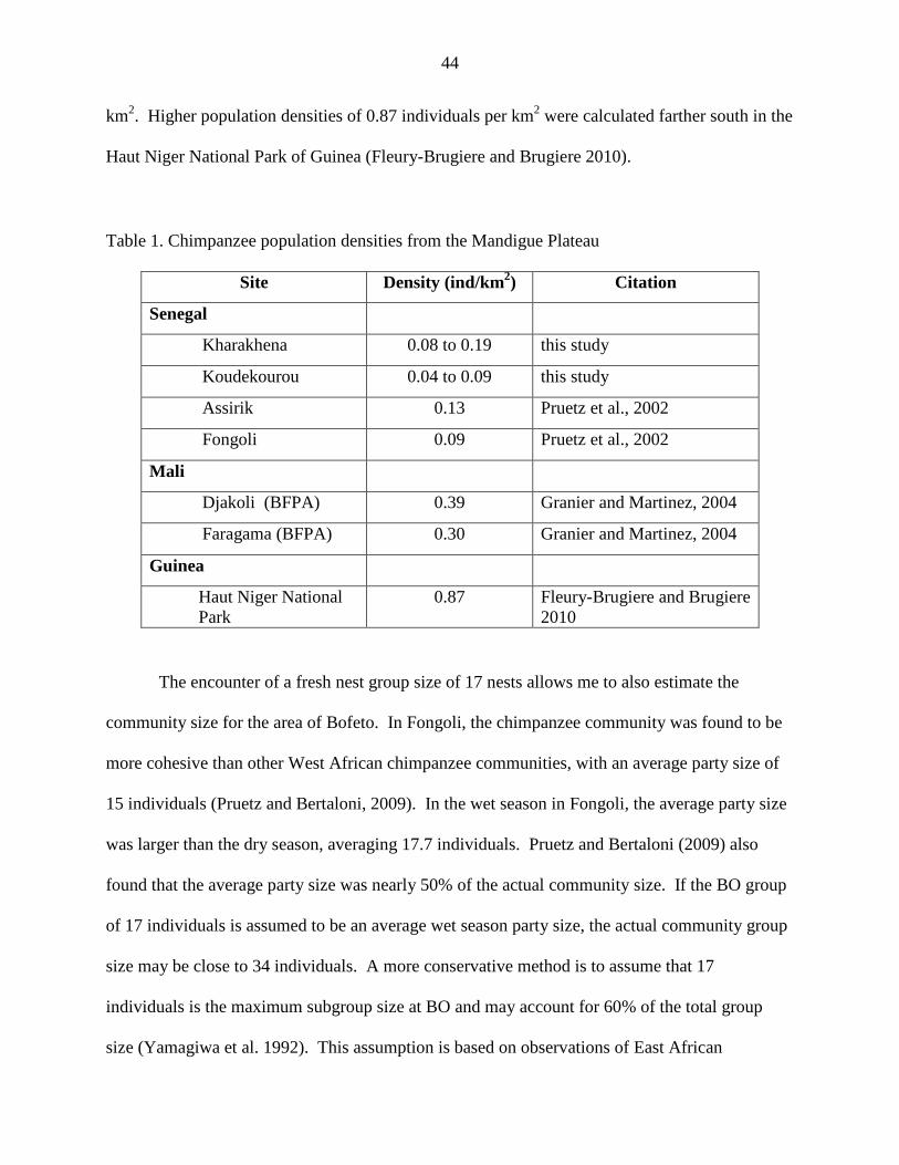
44
km2. Higher population densities of 0.87 individuals per km2 were calculated farther south in the
Haut Niger National Park of Guinea (Fleury-Brugiere and Brugiere 2010).
Table 1. Chimpanzee population densities from the Mandigue Plateau
Site Density (ind/km2) Citation
Senegal
Kharakhena 0.08 to 0.19 this study
Koudekourou 0.04 to 0.09 this study
Assirik 0.13 Pruetz et al., 2002
Fongoli 0.09 Pruetz et al., 2002
Mali
Djakoli (BFPA) 0.39 Granier and Martinez, 2004
Faragama (BFPA) 0.30 Granier and Martinez, 2004
Guinea
Haut Niger National Park
0.87 Fleury-Brugiere and Brugiere 2010
The encounter of a fresh nest group size of 17 nests allows me to also estimate the
community size for the area of Bofeto. In Fongoli, the chimpanzee community was found to be
more cohesive than other West African chimpanzee communities, with an average party size of
15 individuals (Pruetz and Bertaloni, 2009). In the wet season in Fongoli, the average party size
was larger than the dry season, averaging 17.7 individuals. Pruetz and Bertaloni (2009) also
found that the average party size was nearly 50% of the actual community size. If the BO group
of 17 individuals is assumed to be an average wet season party size, the actual community group
size may be close to 34 individuals. A more conservative method is to assume that 17
individuals is the maximum subgroup size at BO and may account for 60% of the total group
size (Yamagiwa et al. 1992). This assumption is based on observations of East African
45
chimpanzee groups in Budongo, Uganda and Gombe, Tanzania (Yamagiwa et al., 1992). This
would estimate the BO community at approximately 28 individuals. This population size would
be within the average range for chimpanzee community size as well as above the threshold group
size for as sustainable population. Both KR and BO study sites appear to be similar in
population density and probable group size as other chimpanzee communities in Senegal and
should be considered significant populations in chimpanzee conservation efforts.
In January 2011, I revisited the largest nesting sites found in BO during the summer field
season and found that chimpanzees appeared to have been nesting in these areas continuously, as
old, recent and fresh nests were found. The center of the BO chimpanzee range appears, thus far,
to be located alongside the mountains targeted for the iron mine near the villages of Bofeto,
Faramakhono, and Babouya.
Surveying Methods
The surveying methods used in the study follow the Best Practices Guidelines for
Surveys and Monitoring Great Ape Populations (Kühl et al., 2008). Line transects were placed
systematically throughout the landscape in relation to the proposed mining sites and were not
based on habitat coverage or human habitation. Additionally, I based my survey design on
previous research in the region. With the understanding that savanna chimpanzees tend to be
more dispersed over the landscape and that other survey studies in West Africa used 3km
transects (S. Regnaut, pers. comm.; Pruetz et al, 2002) I chose to double this transect length.
However, due to fragmented or mosaic habitat in southeastern Senegal, distance transect surveys
may not accurately measure chimpanzee populations. Apes do not utilize all habitats equally for
nesting and, as seen in both KR and BO, appear to have preferred habitats for nesting sites.
46
These nesting sites did not fall along the transects, resulting in skewed densities, particularly in
the BO site where despite having recorded 217 nests in the study site only four nests were
observed from the transects.
Kühl et al. (2008) acknowledges the unequal distribution of surveyed objects due to such
variables as preferred habitats and vegetation, feeding sites, and water sources. For accurate
measures of abundance, more transects would be needed at both sites so as to assure each
transect will encounter nests. However, if time and monetary constraints exist, one must chose
between increased accuracy in a smaller area or decreased accuracy but more information for a
larger landscape. Ideally, without external constraints, both field sites would incorporate more
transects with a smaller inter-transect distance, thus increasing accuracy and the possibility of
encountering frequented nesting sites while retaining long transect distances.
Habitat
Chimpanzees were found to nest in habitats that make up a very small portion of the
habitat available to them. In KR, the chimpanzees nested frequently in gallery forests, which
were so rare in the study site that none were recorded along the interval data collection points.
Over half of the nests (50.9%) occurred in less than 4% of available habitat. The majority of
nests were found in an area of 72km2. While approximately half of the nesting occurred in the
woodlands, this does not indicate a significant preference for the habitat type (X2=.0296, df=1,
p=0.001). Sample sizes for the other habitats were too small to calculate preferences.
In BO, chimpanzee nests occurred almost exclusively in woodland habitat, which makes
up less than half of the available area at the study site. However, the majority of the nests were
found only in a specific area of approximately 14.3 km2 in the northern portion of the study site.
47
The chimpanzee population of Bofeto shows a significant preference for woodland habitat
(X2=174.286, df=1, p=0.001). Sample sizes for the other habitats were too small to calculate
preference.
It is important to note that the study sites examined here may not include the entire home
range of the chimpanzees. However, other field studies in Senegal have found that gallery forest
habitat is relatively rare in southeastern Senegal comprising only 3% of the habitat at Assirik
(McGrew et al., 1981) and 2% of the habitat at Fongoli (Pruetz and Bertaloni, 2009). Woodland
habitat at Assirik and Fongoli is also similar to that of the sites in this study, comprising 37% and
46%, respectively (McGrew et al., 1981; Pruetz and Bertaloni, 2009).
It should also be noted that old and rotten nests recorded during May-August are nests
that were built during the previous dry season and therefore indicate the habitat preferences of
chimpanzees nesting in the dry season. At the Fongoli field site, habitat use changes with the
season; forests are used more frequently in the dry season than in the wet season whereas
woodland habitat is used more frequently in the wet season (Pruetz and Bertaloni, 2009).
Future research may benefit from more specific habitat classifications as used in
Yangambi classification system (Trochain, 1957). This system includes 27 different vegetative
classifications, and while many of the classes are not represented in the study sites of this study,
the habitat types that are seen in this area are broken down into more specific units than those
used in this study. For example, the classification of woodland used in this study includes both
the forêt dense sèche (dry forest), forêt claire (woodland), and cordons ripicoles (riparian
vegetation) of the Yangambi classification system. Gallery forest as used in this study includes
forêt-galerie (riparian and gallery forest) and galeries forestières (gallery forest). While the
classification system used in this study suffices for the current research, use of the Yangambi
48
system of classification may prove more successful for future collaboration and comparative
work with The United States Geological Survey (USGS) and the new habitat map of
southeastern Senegal (USGS/EROS, 2011).
Human Disturbance
Chimpanzee populations in West Africa have been reported to actively avoid areas of
human disturbances (Brncic et al., 2010; Garnier 2008; Garnier and Martinez, 2004), but the
results of this study indicate that not all chimpanzee communities avoid such areas, at least
according to the measures used here. I found a difference in the number of chimpanzee nests
located in disturbed areas between the two study sites, with the majority of nests in the KR site
outside human disturbed areas and the majority of nests in the BO site within human disturbed
areas. The differences between nesting activity in anthropogenically disturbed areas may be
related to factors such as changes in human population density, other chimpanzee communities
surrounding the study sites, and proximity to permanent water sources.
Changes in human population density in and around the KR site may have already
resulted in the displacement of chimpanzee populations. The villages of Kharakhena, Bambadji
and Lingeya are relatively old (approximately 25 years). However, newer villages such as
Gambagamba, Dialadokhoto, and the ArcelorMittal exploration camp were created in the past
eight years. Areas of suitable nesting habitat are located around these newly created villages
and, according to local inhabitants, chimpanzees were known to nest previously in these areas
and drink at water sources that are now used for human activities. At the BO site, no new
villages have been created in the past 10 years. Both Babouya and Feramakhono have been
inhabited for over 30 years, and the 10-year old settlement of Bofeto was actually a resettlement
49
of the same village. The ArcelorMittal mining camp is the only new settlement in the area and
was established in 2008. The villages closest to the chimpanzee nesting sites in BO are also
much smaller villages than those found in the KR site, with approximately 60 people living in
Babouya and 20 people in Feramahono. Comparatively, the villages of Bambadji, Kharakhena,
and Gambagamba have approximately 500, 130, and 120 residents respectively (A. Sene – Ankh
Consultants, pers. comm.).
The region around Kharakhena has been targeted for gold and iron exploration on and off
from 1957 - 1982 by the Bureau de Recherches Géologiques et Minières (BRGM) and Mines de
Fer de Sénégal Oriental (MIFERSO) (Schwartz and Melchor, 2004). Gold exploration by
multiple mining companies has been continuous in the area since the early 1990s, including
AMNERCOSA, Ashanti, AGEM and Randgold (S. Keita, pers. comm.). The BO site has also
been targeted for iron ore extraction by BRGM and MIFERSO, but gold exploration has not been
as heavy as in the KR site. Gold exploration around Kharakhena has increased the local human
population due to the increase in job opportunities from gold exploration companies as well as
the influx of artisanal gold miners looking to exploit the newly discovered areas of gold too
small or of too poor quality to be exploited by a corporation.
Another possible explanation as to why chimpanzee communities in the BO site are
nesting in areas of human disturbance may be the presence of other chimpanzee communities
living in neighboring areas. Chimpanzees that live in close proximity to other chimpanzee
communities are known to show aggressive territorial behaviors (Goodall et al., 1979; Herbinger
et al., 2001). If chimpanzee population density is greater in the southern region of Senegal
around the BO site, the population living around the villages of Feramakhono, Bofeto and
Babouya may not be able to use available habitat to the north due to the presence of other

50
chimpanzee groups. Further studies are needed around both study sites to determine whether or
not other chimpanzee communities are inhibiting the movement of those living around both the
KR and BO sites.
Lastly, the distribution of chimpanzee nests may be independent of human disturbance
but dependent on permanent water sources. The majority of nests (63.6% in KR and 93.1% in
BO) were located within 2km of a permanent water source. Water sources are valued resources
to chimpanzees in the dry season when many smaller water systems dry up (Pruetz & Bertolani,
2009). Proximity to water may be more vital to chimpanzee movement than areas of human
disturbance.
Continued monitoring of the areas studied here will be necessary to understand how the
current chimpanzee populations living at both sites will react to an increase in human disturbance
by the creation of open pit mines. Both study areas have large nesting sites in close proximity
(within 1km) of a proposed mining site. Using the Sabodala gold mine in Senegal and Yekepa
iron mine in Liberia to estimate disturbed area, it is expected that an open pit mine would
directly affect a 25km2 area. Of the nests observed in KR and BO, 72.2% and 88.2% of nests,
respectively, are within 5km of the proposed mining sites. With increases in noise, vehicular
movement, vibrations and various other disturbances from the mines, many, if not all, of the
nearby nesting sites will not be available in the coming years.
It is possible that the buffer sizes used in this study are not optimal in terms of
chimpanzee behavior. It is apparent in this study, as well as at the Fongoli field site, that
chimpanzee communities are not consistent in their avoidance and use of habitats near human
disturbed areas. Nesting sites are found in close proximity to some villages (such as
Feramohono and Babouya at the BO site) and areas of cultivation, while other villages

51
(Kharakhena, Gambagamba and Lingeya at the KR site) and fields are avoided. Chimpanzee
communities may respond differently to each village on a case by case basis depending, for
example, on the duration of the village or the behavior of the inhabitants.
Seasonality may also play a role in chimpanzee use of disturbed areas, particularly for
areas of cultivation and tree cutting by herders. Tree cutting by herders and mining exploration
activities occur typically in the dry season, whereas cultivation occurs in the rainy season. The
data from this study illustrates nesting locations primarily for the dry season. A year round study
should be conducted to identify whether chimpanzees are nesting in these areas throughout the
year or avoiding areas during periods when human presence increases.
Cultural behaviors
While most evidence of cultural and behavioral activities in chimpanzees has come from
habituated communities (Whiten et al., 2001), it is possible to understand some behaviors
without directly observing the animals. This method, however, is limited as few artifacts are left
behind. Only two putative brush-tipped termite fishing tools were opportunistically found at the
KR study site indicating that further research and focus may be placed on searching for signs of
behaviors by targeting ant nests, caves and water sources with camera traps and recurring visits
to each site to look for indirect evidence of chimpanzee use.
Camera traps placed around the KR site did capture chimpanzee activity including
general behaviors such as eating, drinking, grooming and resting. The putative cultural behavior
recorded with the cameras was cave use. Another behavior recorded by the camera traps was
nighttime activity. The chimpanzees were photographed visiting a water source at 3am, May 21,
2011, a behavior not observed in other chimpanzee populations outside of Senegal. The
52
chimpanzees of Fongoli, however, have also been observed leaving their nests during the night to
eat, drink, soak in water, and socialize (Pruetz, unpublished data).
Remnants of Saba senegalensis fruit found inside the cave suggest that the chimpanzees
in the KR may use the caves on Mt. Kharakhena Ndi, but no chimpanzees were captured on
camera at these caves. Dry season camera trapping at water sources will increase the likelihood
of capturing chimpanzees soaking in pools of water if this behavior is present in the KR and BO
communities.
One of the unique behaviors seen only in Senegal’s Fongoli chimpanzee community is
hunting bushbabies (Galago senegalensis) with tools (Pruetz and Bertaloni, 2007). Hunting
behavior was not observed during this field study, but further efforts should be encouraged to
study this behavior with non-habituated chimpanzees through indirect methods. Studies of
bushbaby ecology and natural history (ie. preferred nesting trees and habitat) coupled with direct
observational studies of chimpanzee tool making and hunting will allow researchers to develop
an appropriate methodology to study bushbaby hunting indirectly.
Mine Construction
In December 2011, construction for the Bofeto Mine near the village Bofeto is expected
to begin. Mine construction timelines for the Kharakhena Mountains and Kourou Diakhoma
Mountain within the KR study site have not yet been released but are expected to follow the
Bofeto mines (A. Niang, pers. comm.). As mine construction begins, dramatic changes to the
landscape, habitats, water, air, fauna and human population are expected to take place.
Excavation will soon take place on the three peaks of the Koudekourou Mountains. With
construction and subsequent extraction of iron, increases are expected in road infrastructure,
53
vehicular movement, noise, air and water pollution, and human populations. An increase in
human presence may lead to increased hunting as immigrants from Guinea and Mali (where
chimpanzees are hunted (Kormos et al., 2003)) seek work at the mine, despite the current lack of
bushmeat hunting by the local Senegalese populations (Garnier and Martinez, 2004). Available
habitat for chimpanzee nesting and feeding is expected to decrease as will access to water
sources located near the mines. I expect chimpanzee populations to be displaced from some of
their current nesting areas, which are located within 5km of the mountain.
Potential areas of displacement for chimpanzees are based on available habitat seen on
the USGS habitat maps of the region (USGS/EROS, 2011) as well as possible deterrents, such as
areas of human habitation, cultivation and roads. For the KR chimpanzees, areas to the north and
west appear to be the most suitable areas for dispersal with permanent water sources, suitable
nesting habitat and few areas of human disturbance. The southwestern region also has suitable
habitat without villages or areas of cultivation. This area, however, may become isolated due to
the newly paved Bamako-Dakar highway to the north, densely populated area further west
(Saraya), human impacted area to the east and road networks to the south.

Figure 15. Potential corridors for chimpanzee dispersalcurrent chimpanzee territories. Blue hashedareas indicate areas of human disturbance including villages, areas of cultivation and roadways.
For the chimpanzee population in the
to be the most suitable area for dispersal. This area is approximately 100km
Boboti River, which provides a permanent
region to the southwest of KR, this area may become cut off from other chimpanzee po
in the future. It borders the highly populated areas of Nafadji to the west, a large artisanal gold
54
. Potential corridors for chimpanzee dispersal at KR. Red circles indicate current chimpanzee territories. Blue hashed areas indicate possible areas of dispersal. White areas indicate areas of human disturbance including villages, areas of cultivation and roadways.
For the chimpanzee population in the BO site the north and northwestern regions appear
itable area for dispersal. This area is approximately 100km2 and includes the
permanent water source and gallery forests. However, like the
region to the southwest of KR, this area may become cut off from other chimpanzee po
t borders the highly populated areas of Nafadji to the west, a large artisanal gold
. Red circles indicate areas indicate possible areas of dispersal. White
areas indicate areas of human disturbance including villages, areas of cultivation and roadways.
site the north and northwestern regions appear
and includes the
water source and gallery forests. However, like the
region to the southwest of KR, this area may become cut off from other chimpanzee populations
t borders the highly populated areas of Nafadji to the west, a large artisanal gold
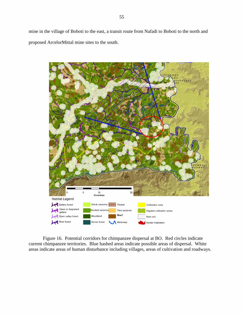
mine in the village of Boboti to the east, a transit route from Nafadi to Boboti to the north and
proposed ArcelorMittal mine sites to the south.
Figure 16. Potential corridors for chimpanzee dispersal at BO. Red circles indicate current chimpanzee territories. Blue hashed areas indicate possible areas of dispersal. White areas indicate areas of human disturbance including villages, areas
55
mine in the village of Boboti to the east, a transit route from Nafadi to Boboti to the north and
proposed ArcelorMittal mine sites to the south.
Potential corridors for chimpanzee dispersal at BO. Red circles indicate current chimpanzee territories. Blue hashed areas indicate possible areas of dispersal. White areas indicate areas of human disturbance including villages, areas of cultivation and roadways.
mine in the village of Boboti to the east, a transit route from Nafadi to Boboti to the north and
Potential corridors for chimpanzee dispersal at BO. Red circles indicate current chimpanzee territories. Blue hashed areas indicate possible areas of dispersal. White
of cultivation and roadways.
56
Conservation Planning
In terms of conservation efforts, regions targeted for resource extraction should not be
overlooked simply because they are of economic value. These areas, such as the Falémé region,
may be rich in biodiversity and threatened and endangered species. These areas may also be
important for creating corridors and links between nationally protected areas. As mining begins
in the Falémé region, it is important to set aside land as community reserves to preserve the
remaining habitat and travel corridors for wildlife. Community monitored and managed reserves
would allow local individuals to continue utilizing forest resources at more sustainable levels.
While species richness has not been calculated for the Mining Zone, it is believed to be
similar to that of Niokolo Koba National Park (PNNK) which, when created in 1981, was home
to 84 species of mammal, over 330 species of bird, 38 reptiles, 20 amphibians, 60 species of fish
and an undocumented number of invertebrate species (UNESCO, 2008). The region is not only
home to chimpanzees, an endangered species in Senegal, but also the critically endangered
Derby Eland (Tragelaphus derbianus derbianus), endangered African wild dog (Lycaon pictus),
Slender nosed crocodile (Crocodylus cataphractus), Dwarf crocodile (Osteolaemus tetraspis
tetraspis) and vulnerable but regionally endangered African Lion (Panthera leo). In the
southeastern region of Senegal there are eight species of mammals that are threatened to some
degree, two endangered reptiles, two newly identified species of unclassified, endemic snakes
and six species of vulnerable birds. Three plant species in the region are listed as vulnerable by
the IUCN, four are partially protected, two are fully protected, and one is locally endangered
(Table 1).

57
Table 2. Endangered, threatened and protection status of species in the Mining Zone of Senegal
Common Name
Scientific Name
Status
Protection status a
Comments
Citation
MAMMALS African wild dog Lycaon pictus EN Partial PNNK IUCN Redlist West African chimpanzee
Pan troglodytes verus EN Full PNNK IUCN Redlist
Hippopotamus Hippopotamus amphibious
VU Females - Full Males – Partial
Populations in West Africa are at highest risk due to fragmentation, PNNK
IUCN Redlist
Leopard Panthera pardus NT Full PNNK IUCN Redlist African Lion Panthera leo
VU Females - Full
Males – Partial Regionally endangered in West Africa, PNNK
IUCN Redlist
Northwest African Cheetah
Acinonyx jubatus hecki
CR Full May be extirpated in Senegal
IUCN Redlist
Senegal Hartebeest Damaliscus lunatus korrigum
VU Full May be extirpated in Senegal; seen in PNNK within the last decade.
IUCN Redlist
Derby Eland Tragelaphus derbianus derbianus
CR Full PNNK and Faleme region IUCN Redlist; Sournia and Dupuy 1990
REPTILES Senegal Garter Snake Elapsoidea trapei NL Full Endemic species Mane 1999 Confusing egg eater Dasypeltis confuse NL Full Endemic species Trape and Mane
2006 Slender nosed crocodile
Crocodylus cataphractus
EN Full May be extirpated in Senegal
IUCN Redlist
Dwarf crocodile Osteolaemus tetraspis tetraspis
EN Full Tentatively observed at KR site
IUCN Redlist

58
Table 2. Continued
BIRDS Black crowned crane Balearica pavonina VU Full Around Kedougou IUCN Redlist
Beaudouin's Snake Eagle
Circaetus beaudouini VU Full Throughout Senegal IUCN Redlist
Lesser kestrel Falco naumanni VU Full IUCN Redlist Egyptian Vulture Neophron
percnopterus VU Full Rarely seen in Kedougou
region, including PNNK IUCN Redlist
Lapped faced vulture Torgos tracheliotus VU Full Rarely seen in Kedougou region, including PNNK
IUCN Redlist
White headed vulture Trigonoceps occipitalis
VU Full Rarely seen in Kedougou region, including PNNK
IUCN Redlist
PLANTS African Mahogany Khaya senegalensis VU Partial Targeted by transitory
sheepherders; occurs in PNNK and outside park. Chimpanzee nesting tree.
IUCN Redlist and EIA Sabodala Gold Mine
Shea tree Vitellaria pardoxa; Butyrospermum parkii; B. paradoxa
VU Full PNNK and outside park. Important resource for humans. Chimpanzee food.
IUCN Redlist and EIA Sabodala Gold Mine
Gueno (Malinke) Pterocarpus erinaceus
NL Partial PNNK and outside park. Targeted by transitory sheepherders. Important forage resource for humans’ livestock. Chimpanzee food.
EIA Sabodala Gold Mine
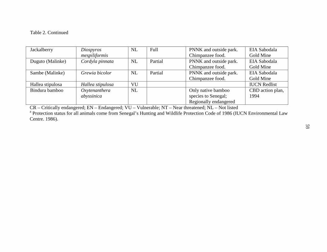
59
Table 2. Continued
Jackalberry Diospyros mespiliformis
NL Full PNNK and outside park. Chimpanzee food.
EIA Sabodala Gold Mine
Duguto (Malinke) Cordyla pinnata NL Partial PNNK and outside park. Chimpanzee food.
EIA Sabodala Gold Mine
Sambe (Malinke) Grewia bicolor NL Partial PNNK and outside park. Chimpanzee food.
EIA Sabodala Gold Mine
Hallea stipulosa Hallea stipulosa VU IUCN Redlist Bindura bamboo Oxytenanthera
abyssinica NL Only native bamboo
species to Senegal; Regionally endangered
CBD action plan, 1994
CR – Critically endangered; EN – Endangered; VU – Vulnerable; NT – Near threatened; NL – Not listed a Protection status for all animals come from Senegal’s Hunting and Wildlife Protection Code of 1986 (IUCN Environmental Law Centre. 1986).
60
While biodiversity data are scarce in Senegal, systematic conservation planning
incorporates more than simply data on species, taxa and biodiversity to create protected areas.
Analyses may also include land use practices, as seen in modeling for the proposed Biosphere
Reserve plan in Bioko, Equatorial Guinea (Zafra-Calvo et al., 2010) or hunting pressures and
anthropogenic influences when designating protected areas (Buckingham and Shanee, 2009).
Furthermore, allocation of land for protected areas is more successful when the support and
knowledge of local communities is included in the process (Wadley et al., 2010; Ban et al.,
2009a; Ban et al., 2009b; Henson et al. 2009). As southeastern Senegal faces increased human
populations and anthropogenic changes, each of these parameters is necessary to develop a
successful conservation plan.
All stakeholders in the region including members of rural communities, local department
governments, Water and Forestry Department (EFCCS), NGOs, international mining companies
and research organizations should be included in the creation of a systematic conservation plan.
Each stakeholder has in investment in the land and needs that must be met. In order to be
successful in creating a sustainable management plan for the region all partners must be involved
and the process must be transparent.
In order to prioritize conservation areas, areas of critical habitats for endangered and
threatened species, such as gallery forest and woodland for chimpanzees, including permanent
water sources must be identified. Areas of cultivation and resource exploitation, such as mining,
must also be delineated, and appropriate buffer zones for anthropogenic disturbance should be
established. Finally, all protected areas and existing conservation area networks must be
identified, e.g. the Zone d’Interet Cynegetique of Falémé and local community reserves. After
having identified these areas, a network of community conservation reserves may be established.
61
Decreasing human activity in these areas to sustainable levels, such as minimizing cultivation,
deterring transient herders, and establishing limits for resource extraction, should be encouraged.
As chimpanzees are able to live within and near areas impacted by humans, it is not necessary to
completely stop local human populations from entering and utilizing the forests. However, it is
important that sustainable practices be put into place. Ultimately this network would create
ecological corridors that will link chimpanzee communities to one another and provide dispersal
opportunities for migrating females.
Conclusions The data collected from this study will ultimately help the conservation community better
understand the effects of mining on chimpanzee populations. To effectively evaluate changes
once the iron mine is created and in production I will continue to study the distribution and
behavioral responses of the chimpanzee communities in these study areas. Specific conservation
action plans for Senegal’s West African chimpanzees, and perhaps those elsewhere, can then be
created with reference to metal mining and human disturbances.
Collaboration with mining companies is imperative to chimpanzee conservation efforts.
In January 2011, I was able to meet with chief geologist Abdoulaye Niang, who is directing all
environmental aspects of the ArcelorMittal project in the Faleme region. Mr. Niang was very
supportive of my project, and I look forward to sharing information and collaborating throughout
the course of this project with him. Final results of this project will be presented to the local
communities around the two study sites and to ArcelorMittal. Results will include critical areas
of use and travel corridors necessary for dispersal and movement of the local chimpanzee

62
groups, such as the areas to the north and southwest of KR and to the north of BO, as well as
potential areas for future research.
The project also increases awareness and educates the local Senegalese communities on
chimpanzees through researcher presence in the area, employment of local individuals and
initiating community education projects. Future endeavors in the region will include
environmental and conservation education programs at schools and villages. Local human
populations are generally unaware of the importance of and level of threat to chimpanzees in the
area (Carter et al., 2003); it is therefore necessary to encourage their involvement and to promote
education. Recent findings show that the sheer presence of researchers in a wildlife region
results in a decrease in wildlife poaching around the research station (Campbell et al., 2011).
Research presence in the area can also provide a voice for the environment and for chimpanzee
communities. Environmental impacts by large-scale mining operations on the habitat and
indigenous species must not be overlooked during organizational meetings and conferences such
as the Senegalese Mining Conference. This conference was last held in Dakar in 2010, but my
request to present my current research on chimpanzees living in mining concession zones was
denied.
Finally, the data collected on population demographics and abundances will be
contributed to the APES database3 of chimpanzee populations. Researchers from the Max
Planck Institute are compiling data from across Africa to produce an ape surveillance system.
Data collected during the proposed project will be added to the database upon analysis.
3 http://apes.eva.mpg.de/eng/index.php

63
BIBLIOGRAPHY African Development Fund (ADF) 2005. Road rehabilitation and transport facilitation programme
on the southbound Bamako-Dakar corridor. Department of Infrastructure Central and West Regions.
Akiwumi FA, Butler DR. 2008. Mining and environmental change in Sierra Leone, West Africa: a remote sensing and hydrogeomorphological study. Environmental Monitoring and Assessment 142(1-3):309-318.
Alden Wily L. 2002. Participatory forest management in Africa: an overview of progress and issues. Second international workshop on participatory forestry in Africa Defining the way forward: Sustainable livelihoods and sustainable forest management through participatory forestry.
Alden Wily, L. 2003. Governance and land relations: A review of decentralization of land administration and management in Africa. International Institute for Environment and Development, London.
ArcelorMittal. February 23, 2007. Press Release, Rotterdam/Luxembourg http://www.arcelormittal.com/index.php?lang=en&page=49&tbPress=here&tb0=76
Ban NC, GJA Hansen, M Jones, and ACJ Vincent. 2009a. Systematic marine conservation planning in data-poor regions: Socioeconomic data is essential. Marine Policy 33(5) 794-800.
Ban NC, CR Picard, and ACJ Vincent. 2009b. Comparing and Integrating Community-Based and Science-Based Approaches to Prioritizing Marine Areas for Protection. Conservation Biology 23(4): 899–910.
Bennett, AF 2003. Linkages in the Landscape: The Role of Corridors and Connectivity in Wildlife Conservation. IUCN, Gland, Switzerland and Cambridge, UK.
Berkes F 2007. Community-based conservation in a globalized world. PNAS. 104 (39) 15188–15193.
Boesch C. 2003. Is culture a golden barrier between human and chimpanzee? Evolutionary Anthropology 12(2):82-91.
Brncic TM, B Amarasekaran, and A McKenna. 2010. Final report of the Sierra Leone National Chimpanzee Census Project. Tacugama Chimpanzee Sanctuary.
Bogart S, Pruetz J. 2008. Ecological Context of Savanna Chimpanzee (Pan troglodytes verus) Termite Fishing at Fongoli, Senegal. American Journal of Primatology 70:605–612
Brownlow AR, Plumptre AJ, Reynolds V, Ward R. 2001. Sources of variation in the nesting behavior of chimpanzees (Pan troglodytes schweinfurthii) in the Budongo Forest, Uganda. Am J Primatol 55:49–55.
Buckland ST, Anderson DR, Burnham KP, Laake JL, Borchers DL and Thomas L. 2001. Introduction to Distance Sampling: Estimating abundance of biological populations. Oxford University Press.
Campbell G, Kuehl H, Kouame PN, Boesch C. 2008. Alarming decline of West African chimpanzees in Cote d'Ivoire. Current Biology 18(19):R903-R904.
Campbell G, H Kuehl, A Diarrassouba, PK N'Goran and C Boesch. 2011. Long-term research sites as refugia for threatened and over-harvested species. Biology Letters. Published online 30 March 2011.
Carter J, Ndiaye S, Pruetz J, McGrew WC (2003) Senegal, West African Chimpanzees. Status Survey and Conservation Action Plan. IUCN/SSC Primate Specialist Group. IUCN, Gland, Switzerland and Cambridge, UK (31-39)

64
Central Intelligence Agency. 2011. The World Factbook: Senegal. Retrieved June 2011, from https://www.cia.gov/library/publications/the-world-factbook/geos/sg.html
Cowlishaw G, Dunbar R. 2000. Primate conservation biology. Chicago: University of Chicago Press
Ericsson M, Lof A. 2009. Iron Ore Outlook: Facing a Slow Climb Out of the Pit. E&Mj-Engineering and Mining Journal 210(6):36-41.
Fleury-Brugiere MC and D Brugiere. 2010. High Population Density of Pan troglodytes verus in the Haut Niger National Park, Republic of Guinea: Implications for Local and Regional Conservation. International Journal of Primatology 31:383–392.
Furuichi T, Hashimoto C, Tashiro Y. 2001. Extended application of a marked-nest census method to examine seasonal changes in habitat use by chimpanzees. International Journal of Primatology 22(6):913-928.
Gineste C. 2005. Sénégalite et phosphates associés de Kouroudiako, Falémé, Sénégal, Le Règne Minéral 65:13-24.
Goossens B, L Chikhi, M Ancrenaz, I Lackman-Ancrenaz, P Andau, and MW Bruford 2006. Genetic Signature of Anthropogenic Population Collapse in Orang-utans. PLoS Biology 4 (2) 0285:0291.
Garnier N. 2008. Ecological study and conservation of chimpanzees Pan troglodytes verus in the Nimba Mountain Biosphere Reserve, Republic of Guinea. Report to the Section on Great Apes of the IUCN/SSC Primate Specialist Group and Conservation International Granier N and L Martinez. 2004. Première reconnaissance des chimpanzés Pan troglodytes verus
dans la zone transfrontalière entre la Guinée et le Mali. Primatologie, 6, 423–447. Groves C 2003. Drafting a Conservation Blueprint : A practitioner’s guide to planning for
biodiversity. Island Press. Washington DC. He KQ, Guo D, Wang XW. 2006. Mechanism of the water invasion of Gaoyang Iron Mine, China
and its impacts on the mine groundwater environment. Environmental Geology 49(8):1163-1172. Henson A, D Williams, J Dupaina, H Gichohia and P Muruthia. 2009. The Heartland Conservation
Process: enhancing biodiversity conservation and livelihoods through landscape-scale conservation planning in Africa. Oryx 43: 508-519.
Hockings K, Humle T. 2009. Best Practices Guidelines for the Prevention and Mitigation of Conflict Between Humans and Great Apes. Gland, Switzerland: IUCN SSC Primate Specialist Group (PSG). 40 pp.
Integrated Regional Information Networks (IRIN), Senegal: Scores flee town after riot over living conditions, 2 January 2009, available at: http://www.unhcr.org/refworld/docid/496321d51c.html [accessed 15 April 2011
International Finance Corporation (IFC). 2006.Performance Standard 6. Biodiversity Conservation and Sustainable Natural Resource Management.
International Union for the Conservation of Nature (IUCN) 2010. IUCN Red List of Threatened Species. Version 2010.4. http://www.iucnredlist.org>.
IUCN Environmental Law Centre. 1986. African wildlife laws. IUCN Environmental Policy and Law Occasional Paper no. 3. IUCN, Gland, Switzerland and Cambridge, UK.
Kormos R, Boesch C. 2003 Regional Action Plan for the West African Chimpanzee Kormos R, Boesch C, Bakarr M, Butynski T. 2003. West African Chimpanzees. Status Survey and
Conservation Action Plan. IUCN/SSC Primate Specialist Group. IUCN, Gland, Switzerland and Cambridge, UK.

65
Kuehl H, Maisels F, Ancrenaz M, Williamson EA. 2008. Best Practice Guidelines for Surveys and Monitoring of Great Ape Populations. Gland, Switzerland: IUCN SSC Specialist Group (PSG). 32pp.
Kusimi JM. 2008. Assessing land use and land cover change in the Wassa West District of Ghana using remote sensing. GeoJournal 71(4):249-259.
Langergraber KE, C Boesch, E Inoue, M Inoue-Murayama, JC Mitani, T Nishida, A Pusey, V Reynolds, G Schubert, RW Wrangham, E Wroblewski and L Vigilant. 2011. Genetic and 'cultural' similarity in wild chimpanzees. Proc. R. Soc. B 278: 408-416.
Leading Practice Sustainable Development Program for the Mining Industry (LPSDP). 2009. Airborne Contaminants, Noise and Vibrations. Australian Government: Department of Industry, Tourism and Resources. Commonwealth of Australia.
Leading Practice Sustainable Development Program for the Mining Industry (LPSDP). 2009. Hazardous Materials Management Handbook. Australian Government: Department of Industry, Tourism and Resources. Commonwealth of Australia.
Maisels, F., Herbinger, I., & Duvall, C. (2007). Field Issues: Logistics and data collection protocols. In Ape Survey and Monitoring Guidelines.. (ed H. Kuehl). IUCN Ape Species Specialist Group. Mane Y. 1999. Une espèce nouvelle du genre Elapsoidea (Serpentes, Elapidae) au Sénégal. Bull. Soc. Herp. Fr. 91, 13-18.
Marchesi P, N Marchesi, B Fruth, C Boesch. 1995. Census and distribution of chimpanzees in Cote D’Ivoire. Primates 36 (4): 591-607.
Margules CR and RL Pressey. 2000. Systematic conservation planning. Nature 405:243-253. Margules CR and S Sarkar. 2007. Systematic Conservation Planning. Cambridge Univeristy Press.
Cambridge UK McGrew WC, Baldwin PJ, Tutin CEG. 1981. Chimpanzees in a hot, dry and open habitat: Mt.
Assirik, Senegal, West Africa. J Hum Evol 10:227–244. McGrew, W.C., Baldwin P.J., Marchant l.F., Pruetz J.D., Scott S.e., and Tutin C.e.G. 2003.
ethnoarchaeology and elementary technology of unhabituated chimpanzees at Assirik, Senegal, West Africa. PaleoAnthropology 1, 1–20.
McGrew WC, Pruetz JD, Fulton SJ. 2005. Chimpanzees use tools to harvest social insects at Fongoli, Senegal. Folia Primatologica 76(4):222-226.
Mineral Deposits Limited (MDL). 2007. Senegal country profile. http://www.mineraldeposits.com.au/user/files/Investor%20Centre/Brochures/Country%20Profile%20-%20Senegal%20%28low%29.pdf
Mining Journal Supplement. 2009. Mining Journal Special Publication – Senegal. http://www.mining-journal.com/__data/assets/supplement_file_attachment/0015/121272/Senegal-scr.pdf
Monjezi M, Shahriar K, Dehghani H, Namin FS. 2009. Environmental impact assessment of open pit mining in Iran. Environmental Geology 58(1):205-216.
O'Roirdan T and S Stoll-Kleeman. 2002. Biodiversity, Sustainability and Human Communities: Protecting beyond the protected. Cambridge University Press. Cambridge UK.
PASM I. 2009. Artisanal Scale Gold Mining in SE Senegal. Progress towards a formalised ASGM in Senegal. Presentation. CASM – Maputo.
Pavy, J. M. (1993). Bafing Faunal Reserve. Biodiversity and human resource: Survey and recommendations. Unpublished report, Cheverly, MD.
Persha L, A Agrawal and A Chhatre. 2011. Social and Ecological Synergy: Local Rulemaking, Forest Livelihoods, and Biodiversity Conservation. Science. 331: 6024, 1606-1608
66
Pison. G. 1995 Population dynamics of Senegal. National Research Council. Working Group on Senegal
Plumptre AJ. 2000. Monitoring mammal populations with line transect techniques in African forests. Journal of Applied Ecology. 37: 356-368
Plumptre AJ, Cox D. 2004. Counting primates for conservation: primate surveys in Uganda. International Symposium on African Great Apes - Evolution, Diversity and Conservation. Kyoto, 65-73.
Plumptre AJ, Reynolds V. 1997. Nesting behavior of chimpanzees: Implications for censuses. International Journal of Primatology 18(4):475-485.
Pruetz JD. 2002. Use of caves by savanna chimpanzees in Senegal. Pan Africa News.Pruetz JD. 2007. Evidence of cave use by savanna chimpanzees (Pan troglodytes verus) at Fongoli, Senegal: implications for thermoregulatory behavior. Primates 48(4):316-319.
Pruetz JD, P Bertolani. 2007. Savanna chimpanzees, Pan troglodytes verus, hunt with tools. Current Biology 17(5):412-417.
Pruetz JD, P Bertolani. 2009. Chimpanzee (Pan troglodytes verus) Behavioral Responses to Stresses Associated With Living in a Savanna-Mosaic Environment: Implications for Hominin Adaptations to Open Habitats. Paleoanthropology. 2009: 252−262.
Pruetz JD, SJ Fulton, LF Marchant, WC McGrew, M Schiel, and M Waller. 2008. Arboreal Nesting as Anti-predator Adaptation by Savanna Chimpanzees (Pan troglodytes verus) in Southeastern Senegal. American Journal of Primatology 70:393–401.
Pruetz JD, LF Marchant, J Arno, WC McGrew. 2002. Survey of savanna chimpanzees (Pan troglodytes verus) in southeastern Senegal. American Journal of Primatology 58(1):35-43.
Pruetz JD and T LaDuke 2010. Reaction to fire by savanna chimpanzees (Pan troglodytes verus) at Fongoli, Senegal: Conceptualization of “fire behavior” and the case for a chimpanzee model. American Journal of Physical Anthropology 141 (4) 646-650.
Ribot JC 1995. From Exclusion to Participation: Turning Senegal's Forestry Policy Around? World Development, Vol. 23, No. 9.
Ribot JC 2009. Authority over Forests: Empowerment and Subordination in Senegal’s Democratic Decentralization. Development and Change. Vol. 40, No. 1.
Ribot JC, A Agrawal and AM Larson. 2006. Recentralizing While Decentralizing:How National Governments Reappropriate Forest Resources, World Development. Vol. 34, No. 11. Pp. 1864-86.
Reuters and Miningmx Reporter. July 3, 2009. http://www.miningmx.com/news/ferrous_metals/arcelormittal-suspends-faleme.htm.
Sapolsky RM. 2006. Culture in animals: The case of a non-human primate culture of low aggression and high affiliation. Social Forces 85(1): 217-233.
Sanz C, J Call, and D Morgan. 2009. Design complexity in termite-fishing tools of chimpanzees (Pan troglodytes) Biol. Lett. 2009 5, 293-296
Schwartz MO, Melcher F. 2004. The Faleme iron district, Senegal. Economic Geology and the Bulletin of the Society of Economic Geologists 99(5): 917-939.
Soldan P, Pavonic M, Boucek J, Kokes J. 2001. Baia Mare Accident Brief Ecotoxicological Report of Czech Experts. Ecotoxicology and Environmental Safety. 49: 255-261.
Sournia G and A Dupuy. 1990. Senegal. Antelopes Global survey and regional action plans, Pt 3: West and Central Africa. Eds. R East. IUCN Gland.
Tappen, G.G., M. Sall, E.C. Wood and M. Cushing. 2004. “Ecoregions and land cover trends in Senegal.” Journal of Arid Environments, 59:3, 427-469.

67
Tovar R, Barbanson L, Coreno Alonso O. 2009. Mineralogical neoformation in mining residues (tailings) at the mining district Zimapan, state of Hidalgo, Mexico. Mineria y Geologia 25: article 3.
Trape JF and Y Mane. 2006. Guide des serpents d'Afrique occidentale: savane et désert. ISBN 2-7099-1600-2.
Trochain, JL. 1957. Accord interafricain sur la définition des types de végétation de l’Afrique Tropicale. Bulletin de l’Institut d’Etudes Centrafricaines. Nouvelle série. No. 13-14:55-93.
Tutin CEG, Fernandez M. 1984. Nationwide census of gorilla (Gorilla g. gorilla) and chimpanzee (Pan t. troglodytes) populations in Gabon. Am J Primatol 6: 313–336.
USAID. 2008. Senegal Biodiversity and Tropical Forests Assessment: Properity, livelihoods and conserving ecosystems, (“Senegal 118/119 Assessment”) IQC Task Order #1
USAID/RSI. 1985. Republique du Senegal - Carte Hydrogeologique. Project No. 682-0233. U.S. Geological Survey /EROS Center. 2011. "Carte de l'Occupation des Terres de la Région de
Kédougou, Sénégal". unpublished map. 1:200,000 scale. Sioux Falls, SD, 57198. United States Forestry Service (USFS). 2006. Rapid Assessment of Existing Social, Economic and
Biological Conditions within the Zone d’Interet Cynégétique de Falemé and Recommendations for Future Management. USDA Forest Service International Programs Technical support to USAID/Sénégal and the Wula Nafaa Project.
Van Schaik CP. 2002. Fragility of traditions: The disturbance hypothesis for the loss of local traditions in orangutans. International Journal of Primatology 23: 527-538.
Wadley RL, CJ Pierce Colfer, R Dennis, and J Aglionby. 2010.The ‘Social Life’ of Conservation: Lessons from Danau Sentarum. Ecology and Society 15(4): 39.
Whiten A. 2000. Primate culture and social learning. Cognitive Science 24: 477-508. Williams DA, Anstey DR, Ausimm. 2009. Integrated Landforms for the Storage of Tailings and
Waste Rock at Magnetite Mines in Western Australia. Iron Ore Conference 2009. Perth, AUSTRALIA: Australasian Inst Mining & Metallurgy. p 333-338.
World Trade Organization (WTO). 2009. Annex 2 Senegal. Trade Policy Regime. Yamamoto S, Yamakoshi G, Humle T, Matsuzawa T. 2008. Invention and modification of a new
tool use behavior: Ant-fishing in trees by a wild chimpanzee (Pan troglodytes verus) at Bossou, Guinea. American Journal of Primatology 70: 699-702.
Yellishetty M, Ranjith PG, Kumar DL. 2009. Metal concentrations and metal mobility in unsaturated mine wastes in mining areas of Goa, India. Resources Conservation and Recycling 53: 379-385.
68
ACKNOWLEDGEMENTS
I would like to thank the United States Fish and Wildlife Service’s Great Ape
Conservation Fund, the Houston Zoo, the Blank Park Zoo, and Iowa State University for
providing funding for this project.
I would also like to thank my advisor and founder of the FSCP, Jill Pruetz of Iowa State
University, for not only giving me the opportunity to do this research but also for the guidance
and support throughout. Also, Kaila Folinsbee and Paul Spry for serving on my committee and
helping me through the process, Peter Riger of the Houston Zoo for taking me under his wing
and Gray Tappan of the USGS for the use of his beautiful maps.
Aussi, je voudrais remercier tout le monde qui me soutenir à Kédougou et dans les
villages Kharakhena et Babouya. Surtout, Sieba Keita, Simiti Damfakha, et Michel Sadiakho
pour les jours de longues et difficiles dans la brousse, Mme. Gundo Samura qui m’aide a me
senti chez moi même très loin de chez moi, les la famille Boubane pour l'aide, d'assistance et
l'hospitalité, et Dondo « Johnny » Kante pour absolument tout.
Finally, my sincerest, heartfelt gratitude to my family, Ellen Slentz, Jeanelle Boyer and
Erin Toliver for their love and support throughout my crazy adventures.