Chevron Ridges and Runup Deposits in the Bahamas from Storms Late in Oxygen-Isotope Substage 5e
14
Chevron Ridges and Runup Deposits in the Bahamas from Storms Late in Oxygen-Isotope Substage 5e Paul J. Hearty Chertsey #112, P.O. Box N-337, Nassau, Bahamas E-mail: [email protected] A. Conrad Neumann Curriculum in Marine Sciences, University of North Carolina, Chapel Hill, North Carolina 27599-3300 E-mail: [email protected] and Darrell S. Kaufman Departments of Geology and Environmental Sciences, Northern Arizona University, Flagstaff, Arizona 86011-4099 E-mail: [email protected] Received December 9, 1997 Landward-pointing V-shaped sand ridges several kilometers long are common along the windward margin of the Bahama Islands. Their axes share a northeast–southwest trend. Internally, the ridges contain low-angle oolitic beds with few erosional trun- cations. Commonly interbedded are tabular, fenestrae-rich beds such as those formed by the sheet flow of water over dry sand. Defined here as “chevron ridges,” these landforms appear to have originated in the rapid remobilization of bank margin ooid bodies by the action of long-period waves from a northeasterly source. Deposits along adjacent coastlines also preserve evidence of the impact of large waves. Reworked eolian sand bodies preserve beach fenestrae and hydraulic scour traces up to 140 m on older ridges. On cliffed coasts, 1000-ton boulders have been thrown well inland, recording the impact of large waves. Amino acid ratios confirm a correlation of the ridges across the archipelago, while stratigraphy, spacing, and cross-cutting relationships indicate em- placement as sea level fell rapidly from the substage 5e maximum at or above 16 m. © 1998 University of Washington. Key Words: sea level, interglaciation, giant boulders, substage 5e, Bahamas. INTRODUCTION The low-lying carbonate platforms of the Bahama Banks are considered to be tectonically stable (Garrett and Gould, 1984; Carew and Mylroie, 1995). As sea level floods the bank top during interglacial high stands, large volumes of sediment accumulate and blanket the platform. Upon this essentially flat-topped, sediment-laden surface, minor or brief changes in sea level can bring about large lateral shifts in coastlines and centers of depo- sition. Carbonate sediments shift from marine to terrestrial envi- ronments as wave and wind activity in the coastal zone moves them landward and to higher elevations to form coastal ridges. Upon subaerial exposure, they are quickly indurated (Halley and FIG. 1. Schematic map of chevron beach ridge. QUATERNARY RESEARCH 50, 309 –322 (1998) ARTICLE NO. QR982006 0033-5894/98 $25.00 Copyright © 1998 by the University of Washington. All rights of reproduction in any form reserved. 309
Transcript of Chevron Ridges and Runup Deposits in the Bahamas from Storms Late in Oxygen-Isotope Substage 5e

Chevron Ridges and Runup Deposits in the Bahamas from StormsLate in Oxygen-Isotope Substage 5e
Paul J. Hearty
Chertsey #112, P.O. Box N-337, Nassau, Bahamas
E-mail: [email protected]
A. Conrad Neumann
Curriculum in Marine Sciences, University of North Carolina, Chapel Hill, North Carolina 27599-3300
E-mail: [email protected]
and
Darrell S. Kaufman
Departments of Geology and Environmental Sciences, Northern Arizona University, Flagstaff, Arizona 86011-4099
E-mail: [email protected]
Received December 9, 1997
Landward-pointing V-shaped sand ridges several kilometerslong are common along the windward margin of the BahamaIslands. Their axes share a northeast–southwest trend. Internally,the ridges contain low-angle oolitic beds with few erosional trun-cations. Commonly interbedded are tabular, fenestrae-rich bedssuch as those formed by the sheet flow of water over dry sand.Defined here as “chevron ridges,” these landforms appear to haveoriginated in the rapid remobilization of bank margin ooid bodiesby the action of long-period waves from a northeasterly source.Deposits along adjacent coastlines also preserve evidence of theimpact of large waves. Reworked eolian sand bodies preservebeach fenestrae and hydraulic scour traces up to 140 m on olderridges. On cliffed coasts, 1000-ton boulders have been thrown wellinland, recording the impact of large waves. Amino acid ratiosconfirm a correlation of the ridges across the archipelago, whilestratigraphy, spacing, and cross-cutting relationships indicate em-placement as sea level fell rapidly from the substage 5e maximumat or above 16 m. © 1998 University of Washington.
Key Words: sea level, interglaciation, giant boulders, substage5e, Bahamas.
INTRODUCTION
The low-lying carbonate platforms of the Bahama Banks areconsidered to be tectonically stable (Garrett and Gould, 1984;Carew and Mylroie, 1995). As sea level floods the bank top duringinterglacial high stands, large volumes of sediment accumulateand blanket the platform. Upon this essentially flat-topped,
sediment-laden surface, minor or brief changes in sea level canbring about large lateral shifts in coastlines and centers of depo-sition. Carbonate sediments shift from marine to terrestrial envi-ronments as wave and wind activity in the coastal zone movesthem landward and to higher elevations to form coastal ridges.Upon subaerial exposure, they are quickly indurated (Halley and
FIG. 1. Schematic map of chevron beach ridge.
QUATERNARY RESEARCH 50, 309–322 (1998)ARTICLE NO. QR982006
0033-5894/98 $25.00Copyright © 1998 by the University of Washington.
All rights of reproduction in any form reserved.
309
Harris, 1979), preserving evidence of both short and long-termeustatic oscillations in the geologic record.
Coastal ridges oriented parallel to the deep water marginsthus reflect sea-level events over previous interglacial cycles.Many of these ridges, including some of the largest and mostcontinuous ones, are associated with the last interglacial period(equivalent to oxygen-isotope substage 5e) (Garrett and Gould,1984; Carew and Mylroie, 1987; Hearty and Kindler, 1993a1993b 1997).
Here we focus on the final events of substage 5e. After thebuilding of reef crests up to circa12 m, sea level rose rapidlyto at least16 m toward the end of the interglaciation, cuttingcoastal notches and flooding interior areas (Neumann andHearty, 1996). During the fall of sea level from the 5e maxi-mum, large areas of the Bahamas were reshaped by sedimen-tary processes. As lagoons shallowed and beaches widened,dunes grew so rapidly that standing trees became entombed insand (Neumann and Hearty, 1996). Along cliffed coasts duringthe same interval, giant boulders were catapulted landward asfar as 0.5 km by the action of large waves (Hearty, 1997). Onlow-lying areas of the Bahamas, extensive V-shaped storm-
beach ridges (“chevrons” in this paper) were emplaced bysimilar, high-energy events. The origin of these storm ridges,associated run-up features, and boulder deposits, plus the im-plications for climate history at the close of the last intergla-ciation, are the subjects of this paper.
DESCRIPTION OF CHEVRON RIDGES
Chevron ridges are defined as V-shaped, sublinear to para-bolic, ribbon-like landforms that extend several kilometersacross low-lying island ramps or shelf margins of the eastern,windward Bahamas (Figs. 1, 2A, and 2B). The oolitic sandridges are generally rounded to asymmetrical in cross-section,with steeper cross beds along the bankward perimeter of thechevron structure. Many individual, low-angle, tabular andcross-set beds exhibit bands of fenestral porosity, or beachfenestrae (“keystone vugs” of Dunham, 1970; “birdseyes” ofShinn, 1983; see discussion in Bain and Kindler, 1994). Beachfenestrae are formed as air bubbles are trapped in fine sandwhen inundated by sheets of water. The axes of 35 chevronridges examined in this study point southwest, indicating the
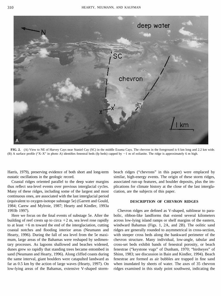
FIG. 2. (A) View to NE of Harvey Cays near Staniel Cay (SC) in the middle Exuma Cays. The chevron in the foreground is 6 km long and 2.2 km wide.(B) A surface profile (“X–X” in photo A) identifies fenestral beds (fp beds) capped by;1 m of eolianite. The ridge is approximately 6 m high.
HEARTY, NEUMANN, AND KAUFMAN310

direction of emplacement (Fig. 3). As with all substage 5edeposits in the Bahamas, the chevrons and their counterpartsare oolite that contains minor percentages of skeletal grains,peloids, and aggregates (Kindler and Hearty, 1996).
Chevron ridges are found on broad, low-lying platforms orramps throughout the Atlantic-facing deep water margins ofthe Bahamas (Fig. 3) from Abaco to Acklins Islands (;700km). The main examples used in this study are located inEleuthera (Fig. 4A; 4B), Long Island (Fig. 4C; 4D), andExumas (Figs. 2 and 5). The V-shaped limbs of chevronsconverge southwestward to a closed bankward or landwardapex (Figs. 4 and 5). The axes of the chevron ridges averageS65° 6 10°W, generally perpendicular to the shelf margintrend (Figs. 1 and 3).
The chevron landforms average ca. 3 km long with someexceeding 10 km, and width generally measures about a thirdof the length. The southwest-pointing ridges are generally 20 to100 m wide and rise 8 to 25 m high above the surroundingplains. Often the highest ridge elevations lie near the distal(landward) apex, with somewhat lower elevations along theproximal (seaward) limbs. Closed topographic depressions arecommon between chevron limbs, and are often filled by man-
grove swamps and/or salt ponds (Fig. 5). In profile, the ridgesare generally rounded to asymmetrical in cross section, withsomewhat steeper slopes along the outer flank of the limbs anddistal margins of the chevrons (Figs. 2B; 6).
Chevron ridges are composed of subparallel, aggrading bedswith few interruptions or truncations. Internal sedimentarystructures include predominantly thin, low-angle planar crossbeds, rich in beach-like fenestral porosity, that are similar tothose found in the intertidal zones of most modern beaches ofthe Bahamas (Bain and Kindler, 1994). Beach fenestrae areabundant in the oolite of the chevrons. Tabular, fenestrae-richbeds 5–10 cm thick alternate with texturally graded and pebblebeds with snails and rhizomorphs (Fig. 7A). Low-angle trun-cations are also observed, but in general the largely planar bedsremain subparallel, showing rapid aggradation of the chevronstructure. In a regional sense, fenestrae are present in theyoungest 5e beds throughout the eastern margin of the Baha-mas.
The most important characteristics that distinguish chevronridges from coastal ridges (Table 1) are their V shape, orien-tation perpendicular rather than parallel to the coast, and con-sistent trend of the axes (S65° W) that bears no apparent
FIG. 2—Continued
INTERGLACIAL WAVE ACTION IN THE BAHAMAS 311
relationship to the changing orientation of the coastline. Al-though similar to parabolic dunes in gross morphology, severalfeatures in chevrons demonstrate that chevrons are depositedby water rather than by wind. These distinctions include (Table1) the presence of beach fenestrae, graded bedding, and theabsence of the compact bedding and bedforms typical of themigratory parabolic dunes. Indeed, there are no known exam-ples of true migratory carbonate dunes in the Bahamas despiteabundant sand supply and strong prevailing winds. As de-scribed below, runup deposits and giant boulders provide sup-porting evidence of the occurrence of large waves during thelast interglaciation on pre-existing, older coastlinesadjacent tothe lowland areas where chevron ridges are found.
RUNUP DEPOSITS ON RIDGES ADJACENTTO CHEVRONS
Chevrons ridges are not found behind built-up shore-parallelridges. Instead, the youngest deposits on these ridges consist of
thick (1–5 m) fenestrae-filled seaward-dipping tabular beds ofsubstage 5e age (Figs. 6 and 7) that rise to over125 m, wellabove the sea level stand maxima of the last interglaciation(Neumann and Moore, 1975; Chenet al.,1991; Neumann andHearty, 1996). These beds are also frequently found above125 m more than a kilometer from the coast on the leewardflanks of substage 5e ridges. Scour structures, lenses of peb-bles, plant morphs, and land snails are interbedded with fenes-tral beds (Fig. 7B). Scour structures (Fig. 8) are observed insubstage 5e oolite above120 m; they show backfilling towardthe crest of the hill and are capped by fenestrae-rich planarbeds (“fp” in Fig. 8B) that dip seaward and pinch out againsttopographic irregularities in the older eolianite (Fig. 7B). Thisunit contains ripup clasts up to 10 cm long and truncates eoliansets below.
Beach fenestrae at high elevations are considered to resultfrom runup of very large waves (Wanless and Dravis, 1989). Ifso, they should resemble “intertidal fenestrae” that form when
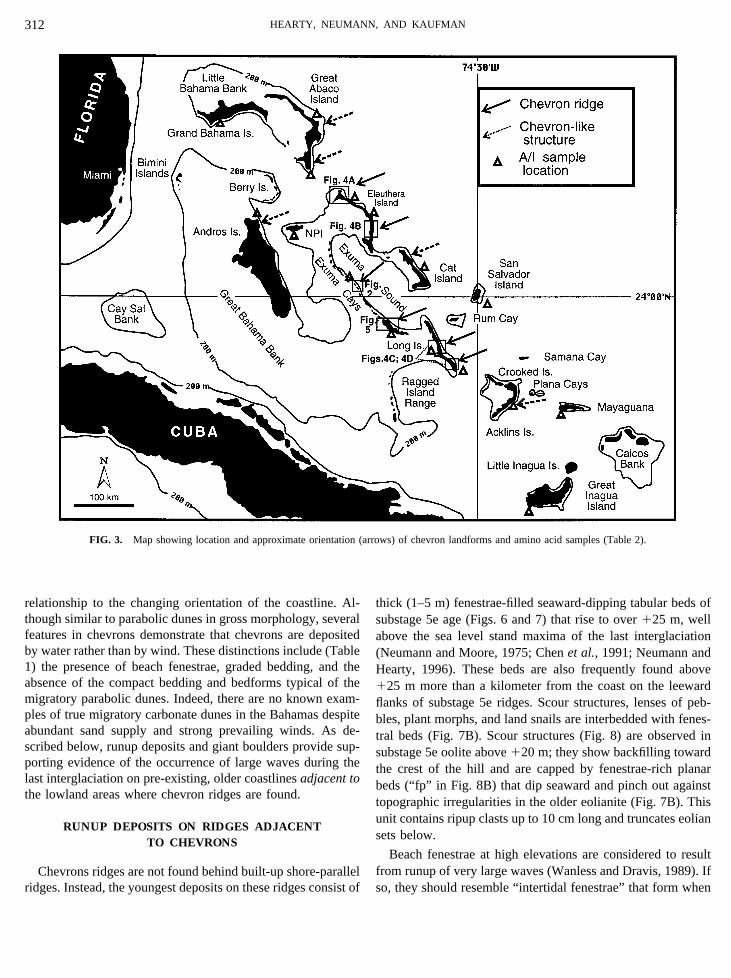
FIG. 3. Map showing location and approximate orientation (arrows) of chevron landforms and amino acid samples (Table 2).
HEARTY, NEUMANN, AND KAUFMAN312

air is trapped in dry sand by the sheet-like inundation. Therunup fenestrae fit most of the criteria outlined by Bain andKindler (1994) for intertidal fenestrae including: (1) dip of thebeds in a seaward direction; (2) alternating fine and coarselaminations; (3) flattening of the fenestrae oriented parallel to
bedding (Fig. 7A); and (4) abundant and traceable fenestrae inthis unit. On a regional scale, beach fenestrae are widespread athigh elevations in the youngest substage 5e unit across theeastern Bahamas, but are lacking in ridges of other ages.
Because we interpret wave runup to have reworked well-
FIG. 4. Sketch maps of typical areas having chevron ridges (simplified from Bahamas Department of Lands and Surveys Topographic Maps, original scale1:25,000).
INTERGLACIAL WAVE ACTION IN THE BAHAMAS 313

sorted eolian sediment, we expect some features characteristicof dunes to be associated with the runup deposits includingfine-grained, well-sorted sand and terrestrial mollusks (Cerionsp.). In the Bahamas, Bain and Kindler (1994) attributefenestrae at high elevations in late substage 5e “eolianites” totorrential rains. However, they did not consider the alternatepossibility of their genesis by wave runup, nor explain theabsence of fenestrae in dunes formed during other interglacia-tions.
RUNUP EVIDENCE FROM THE NORTHERN SHOREOF BERMUDA
Seaward-dipping planar beds rising to ca.120 m at Black-watch Pass, Bermuda have been the subject of divergent inter-pretations (Land et al., 1967; Harmon et al., 1983; Vacher andRowe 1997). These beds (Fig. 9A) are present along severalkilometers of the north coast, and stand in marked contrast tosedimentary structures in older substage 5e eolianites thatunderlie them. Beds in the youngest unit are graded, contain
numerous shell fragments up to 1 cm long, and are filled withabundant, angular beach fenestrae in platy grains and thick,air-filled laminations (Fig. 9B). Ripup clasts are observed at thebase of the beds (Fig. 9B). From the nearly identical sedimen-tary structures, facies relationships, and stratigraphic settingspresent in the Bahamas and on the north shore of Bermuda, itis apparent that these latest substage 5e beds share a commontiming and genesis.
GIANT BOULDERS
Published accounts of the mechanisms of transport ofgiant boulders in north Eleuthera (Hearty, 1997) are criti-cal to this discussion of chevron ridges because they doc-ument the occurrence of large waves about the same time,and in the immediate vicinity (,10 km), of the chevronand runup deposits. Giant waves are the only obviousmechanism powerful enough to transport the boulders, thelargest of which weighs over 2000 tons. The maximum ageof emplacement is established from the regressive substage
FIG. 5. The Steventon–Farmers Hill area of Great Exuma Island showing chevron ridges highlighted by the 20-ft (6.1 m) contour (redrawn from originalscale 1:25,000 topographic maps, Bahamas Department of Lands and Surveys Sheets 13 and 14, Exumas).
HEARTY, NEUMANN, AND KAUFMAN314

5e marine and eolian deposits upon which the boulders rest.The minimum age is constrained by onlapping terra rossapaleosols (Muhs et al. 1990), which began to form withcessation of coastal deposition (i.e., sea-level regression),probably at the beginning of substage 5d. Finally, it isreasonable to assume that the boulders were emplacedduring the late substage 5e highstand, while sea level re-mained relatively high, because even larger waves wouldhave been required at times of lower sea level during sub-stages 5c and 5a in order to lift the boulders over the cliffs(Hearty, 1997).
AMINOSTRATIGRAPHY OF CHEVRONS, RUNUP, ANDBOULDER DEPOSITS
A regional geochronological study of the youngest substage5e unit associated with chevron ridges was made across theBahamas from Abaco to Great Inagua. Whole-rock limestonesamples, including chevron fenestral beds, runup deposits onhigh ridges, sub-boulder marine and eolian deposits, and eo-lianite capping the chevrons were analyzed by amino acidracemization (AAR) techniques. Background and methods areavailable in Hearty et al. (1992). A/I ratios (or
FIG. 6. Cross-sections drawn from photos and field sketches showing morphology and internal structure of chevron ridges in Eleuthera (A), Exumas (B),and Long Island (C). Figure 6B shows the location of the photo and sketch of scour structures in Fig. 8. A/I ratios and approximate locations of whole-rock A/Isamples are identified in boxes.
INTERGLACIAL WAVE ACTION IN THE BAHAMAS 315

D-alloisoleucine/L-isoleucine) were determined on oolite sam-ples stratigraphically correlated to substage 5e (Hearty andKindler, 1993a 1997; Kindler and Hearty, 1996 1997). Mitterer(1968) showed that ooids and aragonite muds contain concen-trations of amino acids similar to those in mollusks and bio-clastic limestones.
The whole-rock AAR data demonstrate a regionally consis-tent trend (0.406 0.03, 66 samples) among 13 islands across700 km of the archipelago (Table 2; Hearty and Kindler, 1997;Hearty, 1998). This regional trend suggests that (1) variationsin sample composition are compensated by “averaging” of theratios of various allochems, with no ultimate effect on the A/Iratio; or (2) local and regional variations in sample composi-tion are too small to affect significantly the A/I ratios (Kindlerand Hearty, 1996). The reaction in whole-rock samples followswell-established kinetic guidelines by yielding higher ratios atwarmer, lower-latitude sites (Table 2).
On New Providence Island, ratios from lower and uppersubstage 5e oolites at Lyford Cay, of 0.38 and 0.36, respec-tively (Hearty and Kindler, 1997), encompass five whole-rockU-series ages averaging 123,0006 5000 yr (Muhset al.1990),confirming the correlation with substage 5e. Uranium-series
dates of corals from the Bahamas (Neumann and Moore, 1975;Carewet al.,1987; Chenet al.,1991) constrain the age of thedeposits between about 140,000 and 118,000 yr.
TIMING OF CHEVRON FORMATION DURING THEREGRESSION FROM THE SUBSTAGE 5e HIGHSTAND
That sea level was in its final regression from the substage 5ehighstand can be established from geologic evidence. First, it isapparent from the “nesting” of several chevron ridges in aseaward direction (Figs. 4 and 5) to the shelf margin that sealevel was falling. That retreat was fairly rapid is implied by thestranding of each chevron as a distinct depositional landform,not reworked or rewashed by the sea. Second, the chevron andrunup deposits occupy the youngest stratigraphic position inthe substage 5e complex. Third, facies sequences associatedwith this interval are characterized by a shallowing-upwardtransition from intertidal, to eolian, to pedogenic phases. If thechevron ridges were deposited earlier in the interglaciation, itwould be expected that in at least some coastal areas theywould have been buried by younger sediments. Furthermore,one of the several giant boulders in north Eleuthera overlies a
FIG. 7. (A) Lenses of fenestral porosity (fp) at125 m on Licrish Hill (“ELI”, Figure 4A) interbedded with pebbles, horizontally oriented rhizomorphs, andland snails. Scale is 20 cm long. (B) Pinch-out of runup fenestral beds (“fp beds”) against older eolianite and an obstacle (plant cast?) at123 m at Old Land(“XOL” in Figure 5) road in Great Exuma. Note the fenestral beds in the lee of the obstacle. Scale is 1 m long.
HEARTY, NEUMANN, AND KAUFMAN316

substage 5e shallowing-upward sequence (subtidal, beach, pro-tosol) at 12 m and is seaward of a notch at12.5 m. Theboulder, which lies in the same peritidal zone, is not notched,and lacks evidence of subsequent marine inundation of sub-stage 5e deposits following the emplacement of the boulder.
WAVE ORIGIN OF CHEVRON RIDGES
The shape, orientation, sedimentary structures, size, andcross-cutting history of the chevrons is best explained by thework of many waves acting over a short time interval, duringwhich a ridge was produced as an isolated depositional land-form within the general framework of a rapidly falling sealevel. The structure and orientation of the ridges point towell-organized sets of large waves from a northeasterly source.Wave-generated features can be traced continuously acrossflatlands where chevron ridges occur, to built-up ridges withwave runup features (Fig. 5), and to giant boulders on cliffedcoastlines (Fig. 4A).
The formation of chevrons and related features must havetaken place bankward of differing marginal environments, yetclasts from reefs or beachrock are not common in the chevrons.
This suggests that the volume of sediment composing themcame from a source such as the well-winnowed ooid sands offlood tidal deltas (FTDs). Possibly the substage 5e FTDs wereremobilized and redeposited as chevrons at the close of theinterval. The absence of large clasts is not surprising, becausethe FTDs, as we observe them today, are blanketed by fine,oolitic sediments. Furthermore, the growth of reefs likelywould not be favored under the adverse conditions created bya thick blanket of mobile ooids in a tidal pass.
On coastlines with older built-up ridges, there is evidence ofwave runup to elevations as high as140 m. In these deposits,thin lenses of land-snail shells and rhizomorphs are observedbetween layers of beach fenestrae in fine, well-sorted sand(Fig. 7A). From this, we infer that partially vegetated dunescomposed of “presorted” eolian sand were remobilized andreworked by the action of large waves. On rocky or cliffedcoastlines, crashing waves would detach and deposit stormbreccia and giant boulders (Hearty, 1997). Although thesefeatures share the same geologic interval of late substage 5e, itis not certain whether they formed simultaneously or nearlysequentially.
Figure 10 is a hypothetical reconstruction illustrating the
FIG. 7—Continued
INTERGLACIAL WAVE ACTION IN THE BAHAMAS 317

attack of large waves on coastlines with low tidal passes, olderbuilt-up ridges, and cliffed coastlines. As waves surge througha tidal pass, they would scour the basin landward of the gap(explaining the presence of ponds and depressions within thecentral basin of the chevrons). Wave energy would attenuate inall directions as it is spent on the shallow shelf, stimulatingdeposition and creating the chevron landforms. Runup andboulders would be deposited along adjacent built-up andcliffed coastlines.
WAVE-GENERATING MECHANISMS
Several mechanisms could generate the large waves capableof producing the chevron ridges and related deposits. First,powerful storms of local origin could strike the bank margindirectly; however, because of the implied great size of thewaves (Hearty, 1997) and the common SW–NE orientation ofthe chevrons, it is more likely that they originated from adistant source that would propagate large, well-organized, uni-directional waves through dispersion. The unexpected occur-rence of sets of large waves, even on fair-weather days, isdocumented in the Bahamas (e.g., October 30–31, 1991),where they are referred to as “rages” by the local population.Second, wholesale failure of a large section of the bank edge isevident based on the steep and scalloped nature of the margin(Mullins and Hine, 1989) in north Eleuthera. Possibly the shelfmargin collapsed toward the end of substage 5e, thus increas-ing the exposure of the coast to the huge waves that transportedthe megaboulders. A shallow seaward shelf (that must have
served as an ooid source for the voluminous dunes and ridgesof late substage 5e) is now missing. Tsunamis generated by thiscollapse could possibly have generated large waves, such asthose described in the Hawaiian Islands (Moore and Moore,1984; Lipmanet al., 1988), but no mechanism is known toexplain how they could strike the remainder of the east coast ofthe Bahamas while being propagated eastward. Third, tsunamisproduced by rare and random external occurrences such as asubmarine earthquake or a meteorite or comet impact in theAtlantic are more remote possibilities.
Whereas large single waves or wave sets could explain therunup and the giant boulders of northern Eleuthera, it is moreprobable that all of these features are related to the same causeor set of associated causes. We consider extreme storms andattendant waves as the probable agents that formed thesefeatures, because of the northeastern orientation of the chev-rons, the continuous and multiple bedding sets they contain,and the nature of the megaboulder deposition.
LARGE NORTHEASTERN STORMS AT THE CLOSEOF SUBSTAGE 5e?
Adkins et al. (1997) identified a “rapid shift in oceanicconditions in the western North Atlantic” about 118,000 yrago. They attribute the shift to an increase in southern sourcewaters, a marked reorganization of the oceanic circulationpatterns, and the initiation of a “climatic deterioration” over a;400-yr period. This major oceanographic shift appears to
TABLE 1Common Characteristics of Chevron Ridges in Comparison with Beach Ridges and Parabolic Dunes
Chevron ridge High-energy beach ridge Parabolic dune
Gross morphology V-shaped sand ridge extending severalkm landward (bankward),perpendicularto shelf margin, 100–200 m wide, 8–25 m high, withgreatest elevation at apex. Clearlydefined shape and consistentorientation of axes. Modifies olderheadlands.
Undulating ridge or ridges orientedparallel to deep margin. Ridgebuildup occurs within 100’s m ofcoast. Catenary between olderheadlands.
U-shaped sand ridge extensivein siliciclastic environments(not present on Holocenecoasts in Bahamas)Orientation dependent onwind direction. Often braidedpatterns of coalescentblowouts. Limited sandsupply. Migratory. Does notmodify older headlands.
Sedimentary bedformsand geometry
Subparallel, aggradational beddingfilled with beach fenestrae.Fewminor cross beds with fenestrae.Asymmetrical profile (steeper outerface) to rounded profile. Absent orthin eolian cap. On platform ofsubtidal beds.
Shore-parallel wedge of sub-,inter-, and supratidal beds thatthicken landward into the dune.Steep, extensive foresets on leeside. Common cross-bedding andreactivation surfaces.
Entirely cross-cutting eolianbedforms (steep convexforesets on lee side; scoop-shaped on windward).Nofenestrae.
Facies assemblage Thick, laminated, fenestrae-filled beds.Interbedded lenses of coarsermaterial.
Shallowing and fining upwardfrom subtidal to dune. Basalconglomerate.
Compact, well-sorted finesand. No fenestrae.
HEARTY, NEUMANN, AND KAUFMAN318

coincide with the occurrence of major storms originating fromthe same region.
The abrupt fall of sea level from the high stand at the closeof substage 5e reflects the rapid expansion of high latitudesnow cover and the following rapid growth of the ice sheets
(Andrews and Mahaffy, 1976; Neumann and Hearty, 1996).Steeper pressure, temperature, and moisture gradients adjacentto warm tropical waters could presumably spawn larger andmore frequent cyclonic storms in the North Atlantic than thoseseen today.
FIG. 8. Photo (A) and explanatory sketch (B) of wave runup deposits at the Old Land section (“XOL”, Figure 5) on older eolianite. Scour structures andfenestral beds (“fp” in sketch) lie at approximately123 m. A/I ratios are identified in boxes.
INTERGLACIAL WAVE ACTION IN THE BAHAMAS 319

In the Bahamas, the SW–NE orientation of the chevronridges and runup deposits, and the restricted wave access to themegaboulder deposits of northern Eleuthera (Hearty, 1997)favor formation from long-period waves generated from adistant northeastern source. The orientation of these features at
the Bahamas and Bermuda points to a very large and extremelyenergetic and weather systems in the North Atlantic Ocean atthis critical time of abrupt climate change. A comparison of thesize of wave-deposited boulders between the late Pleistoceneand Holocene along the northern Eleuthera coastline supports
FIG. 9. Blackwatch Pass roadcut section (Fig. 9A) along the northern shore of Bermuda showing two large eolian build-ups (early and late substage 5edunes) succeeded by a beach unit unconformably above those older dunes. Beach fenestrae (fp beds) are observed throughout the unit, while imbricated,seaward-dipping ripup clasts (Fig. 9B) occur at the base of the unit. Coin is 2 cm in diameter. These youngest beds contain runup deposits (latest substage 5e)up to 120 m. Sketch in Fig. 9A modified from an original drawing by Hearty in Vacheret al. (1995).
HEARTY, NEUMANN, AND KAUFMAN320

this hypothesis, with the size of the Pleistocene boulders av-eraging an order of magnitude greater than the size of theirHolocene counterparts (Hearty, 1997).
CONCLUSIONS
(1) Chevron ridges were emplaced perpendicular to theeastern margin of the Bahamas during high-energy oceanicevents and climatic fluctuations at the end of substage 5e. Theyare unlike any beach ridges, strand plains, or flood tidal deltasobserved today. Although they resemble parabolic dunes in ageneral morphological sense, beach fenestrae and water-madestructures are ubiquitous in the chevrons and confirm theirorigin by waves. Emplacement of the chevrons is also coinci-dent with the deposition of thousand-ton megaboulders on andover 20-m-high cliffs in northern Eleuthera and wave runupbetween120 and140 m on older ridges in the region. Thecharacteristics shared by these deposits, including A/I ratios,are strong evidence that they were formed concurrently by thesame mechanism.
(2) There are global indications of abrupt climate shifts atthe end of substage 5e. The rapid expansion of polar ice andconcomitant compression of midlatitude atmospheric cells may
have greatly amplified storms in the North Atlantic. Among themany implications of these findings, the most significant is thatpresent global warming and climate change could hasten anapparently abrupt and extreme destabilization which, fromgeologic evidence, characterized the transition from last inter-glaciation to glacial conditions of the globe.
ACKNOWLEDGMENTS
This manuscript was greatly improved by reviews from A. Strasser, M.Aurell, T., Bryant, J. Hollin, and D. Muhs. We thank colleagues P. Kindler andB. Jarrett for their participation, A. Davidson and J. Ziff for computer help, andCambridge Villas and The Cove in Eleuthera for accommodations. AARsample analyses were partially supported by faculty research grants and aninstrumentation award from the NSF (EAR-IF-9630417) to Kaufman. Partialfunding was also provided by The University of North Carolina ResearchCouncil through Grants URG 43164 and 44498 to Neumann.
REFERENCES
Adkins, J. F., Boyle, E. A., Keigwin, L., and Cortijo, E. (1997). Variability ofthe North Atlantic thermohaline circulation during the last interglacialperiod.Nature390,154–156.
Andrews, J. T., and Mahaffy, M. A. W. (1976). Growth rate of the LaurentideIce Sheet and sea level lowering (with emphasis on the 115,000 BP sea levellow). Quaternary Research6, 167–183.
Bain, R. J., and Kindler, P. (1994). Irregular fenestrae in Bahamian eolianites:A rainstorm induced origin.Journal of Sedimentary ResearchA64, 140–146.
TABLE 2Whole-Rock Amino Acid Ratios (D-Alloisoleucine/L-
Isoleucine) from the Youngest Isotope Substage 5e Oolites, Asso-ciated with Chevron Ridges and Runup Deposits
Island groupBahamasa W-R A/I Ratio—Latest 5e unitb
Northlatitude
Abaco Island 0.366 0.02 (2) 26 °459Grand Bahama 0.36 (1) 26 °409Eleuthera 0.376 0.02 (7) 25 °159North Andros 0.396 0.02 (2) 25 °109New Providence 0.346 0.01 (3)c 25 °059Cat 0.376 0.03 (4) 24 °309San Salvador 0.416 0.04 (19)d 24 °009Exuma Cays 0.406 0.03 (18) 23.5 to 24.5°Great Exuma 0.426 0.01 (2) 23 °369Long 0.436 0.03 (2) 23 °259Acklins 0.446 0.06 (4) 22 °309Mayaguana 0.45 (1) 22 °209Inagua 0.47 (1) 20 °55913-ISLAND
MEAN 0.406 0.03 (N566)
a The 13 islands are arranged according to latitude. The sample set spansover 800 km distance, 6° of latitude, and 3°C mean annual temperature of thesites.
b The mean, one standard deviation, and number of samples analyzed(brackets) is presented for each island group.
c Equated with 117,000 yr U date on oolite (Muhset al., 1990).d Correlated with;123,000-yr coral dates from Chenet al. (1991). Samples
were collected by Hearty and analyzed by Kaufman during his tenure at UtahState University.
FIG. 10. Map showing hypothetical origin of chevron ridges landward offormer tidal passes, runup deposits on older built up ridges, and giant boulderslandward of high cliffs, respectively, upon impact by giant waves from anortheasterly source.
INTERGLACIAL WAVE ACTION IN THE BAHAMAS 321

Carew, J. L., and Mylroie, J. E. (1987). A refined geochronology for SanSalvador Island, Bahamas.In “Proceedings of the Third Symposium on theGeology of the Bahamas” (H. A. Curran, Ed.), pp. 35–44. Bahamian FieldStation, Fort Lauderdale, FL.
Carew, J. L., and Mylroie, J. E. (1995). Quaternary tectonic stability of theBahamian Archipelago: Evidence from fossil coral reefs and flank margincaves.Quaternary Science Reviews14, 145–153.
Chen, J. H., Curran, H. A., White, B., and Wasserburg, G. J. (1991). Precisechronology of the last interglacial period: 234U–230Th data from fossilcoral reefs in the Bahamas.Geological Society of America Bulletin103,82–97.
Dunham, R. J. (1970). Keystone vugs in carbonate beach deposits [Abstract].American Association of Petroleum Geologists Bulletin54, 845.
Garrett, P., and Gould, S. J. (1984). Geology of New Providence Island,Bahamas.Geological Society of America Bulletin95, 209–220.
Halley, R. B., and Harris, P. M. (1979). Freshwater cementation of a 1000 yearold oolite.Journal of Sedimentary Petrology49, 969–988.
Harmon, R. S., Mitterer, R. M., Kriausakul, N., Land, L. S., Schwarcz, H. P.,Garrett, P., Larson, G. J., Vacher, H. L., and Rowe, M. (1983). U-series andamino acid racemization geochronology of Bermuda: Implications for eu-static sea-level fluctuation over the past 250,000 years.Paleogeography,Paleoclimatology, Paleoecology44, 41–70.
Hearty, P. J. (1997). Boulder deposits from large waves during the lastinterglaciation at North Eleuthera, Bahamas.Quaternary Research48(3),326–338.
Hearty, P. J. (1998). The geology of Eleuthera Island, Bahamas: A RosettaStone of Quaternary stratigraphy and sea-level history:Quaternary ScienceReviews17 (4–5), 333–355.
Hearty, P. J., and Kindler, P. (1993a). New Perspectives on Bahamian Geol-ogy: San Salvador Island, Bahamas.Journal of Coastal Research9, 577–594.
Hearty, P. J., and Kindler, P. (1993b). An illustrated stratigraphy of theBahama Islands: In search of a common origin.Bahamas Journal of Science1, 28–45.
Hearty, P. J., and Kindler, P. (1997). The stratigraphy and surficial geology ofNew Providence and surrounding islands, Bahamas.Journal of CoastalResearch13, 798–812.
Hearty, P. J., Vacher, H. L., and Mitterer, R. M. (1992). Aminostratigraphy andages of Pleistocene limestones of Bermuda.Geological Society of AmericaBulletin 104,471–480.
Hollin, J. T. (1965). Wilson’s theory of ice ages.Nature 208(5005), 12–16.
Kindler, P., and Hearty, P. J. (1996). Carbonate petrology as an indicator ofclimate and sea-level changes: new data from Bahamian Quaternary units.Sedimentology43, 381–399.
Kindler, P., and Hearty, P. J. (1997). Geology of the Bahamas: Architecture ofBahamian Islands.In “Geology and Hydrogeology of Carbonate Islands”(H. L. Vacher, and T. Quinn, Eds.),Developments in Sedimentology54,141–160. Elsevier, Amsterdam.
Land, L. S., Mackenzie, F. T., and Gould, S. J. (1967). The Pleistocene historyof Bermuda.Geological Society of America Bulletin78, 993–1006.
Lipman, P., Normark, W., Moore, J., Wilson, J., and Gutmacher, C. (1988).The giant submarine Alika debris slide, Mauna Loa, Hawaii.Journal ofGeophysical Research93, 4279–4299.
Mitterer, R. M. (1968). Amino-acid composition of organic matrix in calcar-eous oolites.Science162,1498–1499.
Moore, J. G., and Moore, G. W. (1984). Deposit from a giant wave on theisland of Lenai, Hawaii.Science226,1312–1315.
Muhs, D. H., Bush, C. A., Stewart, K. C., Rowland, T. R., and Crittenden,R. C. (1990). Geochemical evidence of Saharan dust parent material for soilsdeveloped on Quaternary limestones of Caribbean and western Atlanticislands.Quaternary Research33, 157–177.
Mullins, H. T., and Hine, A. C. (1989). Scalloped bank margins: Beginning ofthe end for carbonate platforms?Geology17, 30–33.
Neumann, A. C., and Hearty, P. J. (1996). Rapid sea-level changes at the closeof the last interglacial (substage 5e) recorded in Bahamian island geology.Geology24, 775–778.
Neumann, A. C., and Moore, W. S. (1975). Sea level events and Pleistocenecoral ages in the northern Bahamas.Quaternary Research5, 215–224.
Shinn, E. A. (1983). Birdseyes, fenestrae, shrinkage pores, and loferites: Areevaluation.Journal of Sedimentary Petrology53, 619–628.
Vacher, H. L., and Rowe, M. P. (1997). Geology and Hydrogeology ofBermuda.In “Geology and Hydrogeology of Carbonate Islands” (H. L.Vacher, and T. Quinn, Eds.).Developments in Sedimentology54, 35–90.Elsevier, Amsterdam.
Wanless, H. R., and Dravis, J. J. (1989). Carbonate environments and se-quences of Caicos Platform. Field Trip Guidebook T374.In “28th Interna-tional Geological Congress (AGU),” pp. 1–75.
HEARTY, NEUMANN, AND KAUFMAN322