Chapter 340 Transportation Standards - Baker County
31
Transportation Standards Chapter 340-1 Last Revised 01/08/14 Chapter 340 TRANSPORTATION STANDARDS 340.01 Purpose and Intent 340.02 Definitions 340.03 Access Management Standards 340.04 Bicycle and Pedestrian Standards 340.05 Road Standards 340.06 Approval of Transportation Improvement Projects Identified in the Transportation System Plan 340.07 Traffic Impact Study Requirement 340.01 Purpose and Intent. The intent of this chapter is to provide and encourage a safe, convenient and economic transportation system. This chapter applies to all of Baker County’s transportation system. The purpose of the transportation standards chapter is to consolidate all of the transportation related code into one chapter, Chapter 340. The contents of Chapter 340 apply to construction of new residential, industrial or commercial structures subject to a land use decision. 340.02 Definitions. For the purposes of this Chapter, 340, the definitions below shall apply. Abutting: Contiguous or adjoining. It shall include the terms adjacent, adjoining and contiguous. Access easement: An easement recorded for the purpose of providing vehicle, bicycle, and/or pedestrian access from a public street to a parcel across intervening property under separate ownership from the parcel being provided access. Access management: Measures regulating access to arterials, collectors, local streets, and highways from public roads, private roads, and private driveways for the purpose of improving efficiency, safety, and/or operation of the roadway. These measures may include but are not limited to restrictions on the type and amount of access to roadways and the use of physical controls such as signals and channelization. Accessway: A walkway that provides pedestrian and/or bicycle passage either between streets or from a street to a building or other destination such as a school park, or transit stop. Accessways generally include a walkway and additional land on either side of the walkway, often in the form of an easement or right-of-way, to provide clearance and separation between the walkway and adjacent uses. Accessways through parking lots are generally physically separated from adjacent vehicle parking or parallel vehicle traffic by curbs or similar devices and include landscaping, trees, and lighting. Where accessways cross driveways, they are generally raised, paved, or marked in a manner which provides convenient access for pedestrians.
-
Upload
khangminh22 -
Category
Documents
-
view
0 -
download
0
Transcript of Chapter 340 Transportation Standards - Baker County

Transportation Standards Chapter 340-1 Last Revised 01/08/14
Chapter 340
TRANSPORTATION STANDARDS
340.01 Purpose and Intent
340.02 Definitions
340.03 Access Management Standards
340.04 Bicycle and Pedestrian Standards
340.05 Road Standards
340.06 Approval of Transportation Improvement Projects Identified in the Transportation
System Plan
340.07 Traffic Impact Study Requirement
340.01 Purpose and Intent. The intent of this chapter is to provide and encourage a safe,
convenient and economic transportation system. This chapter applies to all of Baker County’s
transportation system. The purpose of the transportation standards chapter is to consolidate all
of the transportation related code into one chapter, Chapter 340. The contents of Chapter 340
apply to construction of new residential, industrial or commercial structures subject to a land
use decision.
340.02 Definitions. For the purposes of this Chapter, 340, the definitions below shall apply.
Abutting: Contiguous or adjoining. It shall include the terms adjacent, adjoining and contiguous.
Access easement: An easement recorded for the purpose of providing vehicle, bicycle, and/or
pedestrian access from a public street to a parcel across intervening property under separate
ownership from the parcel being provided access.
Access management: Measures regulating access to arterials, collectors, local streets, and
highways from public roads, private roads, and private driveways for the purpose of improving
efficiency, safety, and/or operation of the roadway. These measures may include but are not
limited to restrictions on the type and amount of access to roadways and the use of physical
controls such as signals and channelization.
Accessway: A walkway that provides pedestrian and/or bicycle passage either between streets
or from a street to a building or other destination such as a school park, or transit stop.
Accessways generally include a walkway and additional land on either side of the walkway,
often in the form of an easement or right-of-way, to provide clearance and separation between
the walkway and adjacent uses. Accessways through parking lots are generally physically
separated from adjacent vehicle parking or parallel vehicle traffic by curbs or similar devices
and include landscaping, trees, and lighting. Where accessways cross driveways, they are
generally raised, paved, or marked in a manner which provides convenient access for
pedestrians.

Transportation Standards Chapter 340-2 Last Revised 01/08/14
Adjacent: See abutting.
Administrative: A discretionary action or permit decision made without a public hearing, but
requiring public notification and an opportunity for appeal.
ADT – Average Daily Traffic: This term denotes the total traffic volume passing a point or
segment of roadway in both directions for over an average weekday 24-hour period.
Adverse impact: Negative effect of a development that can be measured (eg., noise, air,
pollution, vibration, traffic, dust, etc.).
Arterial: See Road, Arterial.
Bicycle: A vehicle having two tandem wheels, a minimum of 14” (35 cm) in diameter, propelled
solely by human power, upon which any person or persons may ride. A three-wheeled adult
tricycle is also considered a bicycle.
Bicycle facility: Any facility provided for the benefit of bicycle travel, including bikeways and
parking facilities as well as all other roadways not specifically designated for bicycle use.
Bicycle lane: A portion of a roadway which has been designated by striping and pavement
markings for the preferential or exclusive use of bicyclists.
Bikeway: A bikeway is created when a road has the appropriate design treatment for bicyclists,
based on motor vehicle traffic volumes and speeds. The following facilities are considered
bikeways: shared roadway, shoulder bikeway, bike lane or bicycle boulevard. Another type of
bikeway facility is separated from the roadway and is called a multi-use path.
Block: An area of land whose boundaries are defined by public or private streets, excluding
alleys.
Block length: The distance between intersections with other public or private roads as
measured along the near-side right-of-way line.
Capacity: The maximum rate of flow at which persons or vehicles can be reasonably expected
to traverse a point or uniform segment of a lane or roadway during a specified time period
under prevailing roadway, traffic, and control conditions, usually expressed as vehicles per hour
or persons per hour.
City street: See Road or street, City street.
Collector roads: See Road or street, Collector Road.
Conditional use: A use which requires a Conditional Use Permit (CUP).
Transportation Standards Chapter 340-3 Last Revised 01/08/14
Corner radius: The radius of a street corner, as measured around the curb or edge of
pavement.
County road: See Road or street, County road.
Crosswalk: Portion of a roadway designated for pedestrian crossing, marked or unmarked.
Unmarked crosswalks are the natural extension of the shoulder, curb line or sidewalk.
Dedication: A conveyance of right-of-way to the county.
Development: All improvements on a parcel or tract, including buildings, other structures,
parking and loading areas, landscaping, paved or graveled areas, grading, and areas devoted to
exterior display, storage, or activities. Development includes improved open areas such as
plazas and walkways, but does not include natural geologic forms or landscapes.
Driveway: Provides private vehicular access to one or two residential structures. A driveway
begins at the roadway and extends into the site. Driveways do not include parking,
maneuvering, or circulation areas within parking space areas.
Easement: A right of usage of real property granted by an owner to the public or to specific
persons, firms, and corporations.
Flag lot: A lot or parcel which has access to a road, street, or easement, by means of a narrow
strip of lot or easement.
Frontage: The dimension of a property line abutting a public or private street.
Frontage street or road: A minor street which parallels an arterial street in order to provide
access to abutting properties and minimize direct access onto the arterial.
Level of service: For transportation, a qualitative measure describing operational conditions
within a traffic stream, generally described in terms of such factors as speed and travel time,
freedom to maneuver, traffic interruptions, comfort and convenience, and safety. At
intersections, level of service is measured in terms of average delay and correlated to grades
from LOS A which indicated little delay, to LOS F which indicates significant delay.
Local road: See Road, Local road, next page.
Minor arterial: See Road, Arterial, Minor, next page.
Mitigation: To avoid, rectify, repair, or compensate for negative impacts which result from
other actions (e.g., Improvements to a street may be required to mitigate for transportation
impacts resulting from development.)
Transportation Standards Chapter 340-4 Last Revised 01/08/14
Multi-use path: A path physically separated from motor vehicle traffic by an open space or
barrier and either within a roadway right-of-way or within an independent right-of-way, used
by bicyclists, pedestrians, joggers, skaters, and other non-motorized travelers.
Multi-use road: See Road or street, Multi-use, next page.
Non-resource zones: Land that is zoned by Baker County for uses other than natural resource
use, specifically, any zone that is not Exclusive Farm Use (EFU), Timber Grazing (TG), or Mineral
Extraction (ME).
Pavement markings: Painted or applied lines or legends placed on a roadway surface for
regulating, guiding, or warning traffic.
Pedestrian: A person on foot, in a wheelchair, or walking a bicycle.
Pedestrian facility: A facility provided for the benefit of pedestrian travel, including walkways,
crosswalks, signs, signals, illumination, and benches.
Principal arterial: See Road, Arterial, Principal, next page.
Private road: See Road or street, Private road, next page.
Public use road: See Road or street, Public Use, this page.
Resource zones: Land that is zoned by Baker County for natural resource use, specifically the
Exclusive Farm Use (EFU), Timber Grazing (TG), and Mineral Extraction (ME) zones.
Right-of-way: An area that allows for the passage of people, vehicles and/or utilities. Right-of-
way includes passageways such as freeways, pedestrian connections, alleys, and all streets. A
right-of-way may be dedicated or deeded to the public for public use and under the control of a
public body, or it may be privately owned. A right-of-way that is not dedicated or deeded to
the public will be in a tract.
Roadway: The improved portion of an easement or right-of-way, excluding curbs, sidewalks,
and ditches. Road, roadway, and street will be considered interchangeable terms.
Road or street: A public or private way that is created to provide ingress and egress for a
person to one or more lots, parcels, areas or tracts of land, excluding driveways and excluding a
private way that is created to provide ingress and egress to such land in conjunction with the
use of land for forestry, mining, or agricultural purposes without a residential facility.
a. Arterial: Carries high volumes of traffic on a continuous network with no stub routes, but
provides very little direct land access.
Transportation Standards Chapter 340-5 Last Revised 01/08/14
i. Minor arterial: Provides mobility between smaller cities and towns and other
statewide traffic generators, such as resorts, that are not served by principal
arterials.
ii. Principal arterial: Provides statewide and interstate mobility, including the
Interstate System and other rural freeways that serve long distance high-volume
corridors.
b. City street: A public way, right of way, or traveled way in whole or in part that is subject
to the control of an incorporated city or town.
c. Collector roads: Provides both mobility and land access, gathers trips from localized
areas and feeds them onto the arterial network.
d. County road: A public way, right of way, or traveled way which in whole or in part is
subject to the control of the County and has been designated by the County as a part of
the County road system for maintenance or repair.
e. Local road: Low volume roadways that provide direct land access but are not designed
to serve through traffic needs.
f. Multi-use road: A road that services vehicle, bicycle and pedestrian traffic.
g. Private road: A private way, right of way, or traveled way in whole or in part that is
subject to the control of one or more private persons. A private road or street shall
provide access only to three or more abutting parcels, lots or tracts.
h. Public road: Any way, right of way, or traveled way in whole or in part that is subject to
the control of one or more public bodies.
i. Public use road: A public way, right of way, or traveled way in whole or in part that is
subject to the jurisdiction of a public body but that is not a part of the County road
system for maintenance or repair.
j. State highway: A public way, right of way, or traveled way in whole or in part that is
subject to the control of the State of Oregon.
Shared driveway: When land uses on two or more lots or parcels share one driveway. An
easement or tract (owned in common) may be created for this purpose.
Shared roadway: A type of bikeway where bicyclists and motor vehicles share a travel lane.
Shoulder: The portion of a roadway that is contiguous to the travel lanes providing for
pedestrians, bicyclists, emergency use by vehicles and for lateral support of base and surface
courses.
Transportation Standards Chapter 340-6 Last Revised 01/08/14
Shoulder bikeway: A type of bikeway where bicyclists travel on a paved shoulder.
Shy distance: The distance between the edge of a travelway and a fixed object.
Sidewalk: A walkway separated from the roadway with a curb, constructed of a durable, hard
and smooth surface, designed for preferential or exclusive use by pedestrians.
Sight distance: The distance a person can see along an unobstructed line of sight.
State highway: A public way, right of way, or traveled way in whole or in part that is subject to
control of the State of Oregon.
Street connectivity: The number of street connections within a specific geographic area.
Higher levels of connectivity provide for more direct transportation routes and better
dispersion of traffic, resulting in less traffic on individual streets and potentially slower speeds
through neighborhoods.
Street stub: A temporary street ending; i.e., where the street will be extended through adjacent
property in the future, as those properties develop. Not a permanent street-end or dead-end
street.
Traffic calming devices: Physical devices within the roadway designed to manage traffic speeds
or which disperse traffic such as speed bumps/humps and traffic circles.
V/C ratio: The ratio of demand flow rate (volume) to capacity for a traffic facility.
Volume: The number of persons or vehicles passing a point on a lane, roadway, or other
trafficway during some time interval, often taken to be one hour, expressed in vehicles.
Walkway: A transportation facility built for use by pedestrians, including persons in
wheelchairs. Walkways include sidewalks, paths, and paved shoulders.
Wide outside lane: A wider than normal curbside travel lane that is provided for ease of bicycle
operation where there is insufficient room for a bike lane or shoulder or shoulder bikeway.
340.03 ACCESS MANAGEMENT STANDARDS
340.03.01 Intent and Purpose. This section of the zoning and subdivision ordinance identifies
who is subject to apply for a road approach permit, how the number of accesses are
determined, where the access(es) may be located, access standards that must be met, and
development review procedure and submittal requirements in relation to access management.
It primarily applies to new development that would be constructing a new approach onto an

Transportation Standards Chapter 340-7 Last Revised 01/08/14
existing road and/or a change in use. It also identifies when an access needs to be improved to
meet the current access management requirements and standards.
340.03.02 Actions Requiring Road Approach Permits and Authority to Grant Road
Approach Permits
a) Projects Requiring Road Approach Permits. Road Approach Permits are required for projects
that result in a change in use. For the purposes of this chapter, a change in use is defined as:
a change in land use, a land use decision, an expansion of an existing use, or the
construction of a new dwelling. If the project meets the change in use criteria above, then
the access shall meet the current access management requirements and standards and
require a Road Approach Permit.
b) Road Approach Permits onto County Roads. Road Approach Permits onto county roads shall
be subject to review and approval by the County Roadmaster and/or his/her designee. The
criteria for granting access permits shall be based on the standards contained in this
section.
c) State Highway Access Permits. Permits for access onto State highways shall be subject to
review and approval by Oregon Department of Transportation (ODOT), except when ODOT
has delegated this responsibility to Baker County. In that case, Baker County shall
determine whether access is granted based on ODOT’s adopted standards.
d) City Roadway Access Permits. Permits for access onto city owned roadways shall be subject
to review and approval by that city, except where the city has delegated this responsibility
to Baker County. In that case, Baker County shall determine whether access is granted
based on adopted city standards.
e) Conditions of Approval with Granting of Access Permit. Baker County or other agencies with
access permit jurisdiction may require the closing or consolidation of existing curb cuts or
other vehicle access points, recording of reciprocal access easements (i.e. for shared
driveways), development of a frontage road, installation of traffic control devices, and/or
other mitigation as a condition of granting an access permit, to ensure the safe and efficient
operation of the road system.
f) Non-Conforming Access Features. Legal access connections in place as of the effective date
of this section that do not conform with the standards herein are considered
nonconforming features and shall be brought into compliance with applicable standards
under the following conditions:
(1) Change in use as defined in 340.03.02.a);
(2) When new access connection permits are requested or required.
g) County’s Authority to Change Accesses.
Transportation Standards Chapter 340-8 Last Revised 01/08/14
(1) Baker County has the authority to change accesses for all uses if it is constructing a
capital improvement project along that section of the public road. The access changes
shall meet all current standards. If it is not possible to change a particular access to
meet all the current standards, then a non-conforming access shall be acceptable only if
it improves the condition to more closely meet the current standards.
(2) Baker County has the authority to change accesses for all uses if it is necessary to
correct a safety problem related to access.
340.03.03 Access from New Private Road Easements. New proposed private road
easements shall be designated on the tentative plan and may be approved by the Planning
Director/Planning Commission if they meet the following conditions:
a) If more than two proposed or potential parcels need access, then access shall be provided
by a private road or public use road.
b) On non-resource ground, private road easement shall be approved unless the Planning
Director/Planning Commission is satisfied that such right-of-way is not presently needed,
nor will ever be needed to be extended through to adjacent property, or to be utilized for
public road purposes in the normal growth of the area. If there is a potential that additional
right-of-way is needed in the future or that the right-of-way may need to be extended
through to adjacent property, or that the road may need to be used for public purposes,
then access shall be provided by a public use road. The public use road standard can be
found in Figure 7-7 of Section 7 of the Baker County Transportation System Plan.
c) No private road easement shall be less than 30-feet wide, except that a modification may
be approved to allow a driveway easement of 20-feet to one parcel or lot.
d) Surface improvements on private road easements shall be as prescribed in Figure 7-9 of
Section 7 of the Baker County Transportation System Plan.
e) Maintenance responsibility for private road easements shall be pre-determined before final
plat approval according to OAR Chapter 660 through one of the following options:
(1) A maintenance agreement established by the developer with the legal mechanism for
the agreement to be presented prior to approval of the final plat.
(2) Any other method of providing perpetual financing for maintenance services and
improvements, provided the method is approved by the County.
340.03.04 Access from Existing Private Road Easements. There is a number of existing
private access easements in Baker County providing access to more than two parcels. No
additional access will be allowed on these private easements unless the following conditions
are met.

Transportation Standards Chapter 340-9 Last Revised 01/08/14
a) It is demonstrated that the parcel has a legal right to use the existing private access
easement or has an easement agreement from the property owners controlling the private
easement.
b) The private easement roadway meets the applicable standards of Section 340.05.008 or
340.05.009. If the private road easement roadway does not meet the standard above, then
the applicant must make the necessary improvements to meet the standard prior to
receiving access approval.
c) The Planning Commission may grant the applicant a variance if condition b) above cannot
be met. This variance may only be granted for existing substandard roadways if the
applicant can demonstrate to the Planning Commission and the County Roadmaster that
this condition does not create or make worse an unsafe condition. The County Roadmaster
shall provide his/her opinion in writing to the Planning Commission.
d) A turnaround shall be provided at the end of a private road easement. The turnaround
standard is defined in Diagram B.
340.03.05 Number of Allowed Accesses
a) Number of Allowed Accesses for Single-Family Residential Lots. A single-family residential
lot may request up to two driveways off of a local road. If two residential driveways are
requested from a single-family lot, then it shall be subject to spacing standards of
340.03.06.b).
b) Number of Allowed Accesses for Non-Residential Uses. The number of driveways allowed
for non-residential and non-resource uses shall be based on the daily trip generation of the
site in question. One driveway shall be allowed for up to 2,500 daily trips generated with a
maximum of two driveways. An exception shall be allowed if it is proven through a traffic
impact study that this limitation creates a significant traffic operations hardship for on-site
traffic. The primary criteria to allow more driveways will be level of service (see standards
in 340.07) analysis, queuing analysis, and safety analysis of the site accesses. If a
development has a need for more than two access points, then signalization of the main
access shall be investigated as a potential option prior to allowing additional driveways. A
signal warrant study will then be required to study whether or not signalization of the main
access is required. The County Roadmaster or his/her designee shall determine whether
the traffic study adequately proves that more accesses are needed for a particular project.
c) Right in, Right Out Access.
(1) If a driveway cannot meet the access spacing standards in Table 340.02.06.h) and a
variance is being sought for the development’s access, then a right in, right out
driveway shall be the first consideration to provide access. Only if a demonstrated
hardship such as the creation of significant out of direction travel is demonstrated in
Transportation Standards Chapter 340-10 Last Revised 01/08/14
the variance shall consideration be given to a conditional full access driveway. Any
conditional access shall be subject to 340.03.06.d).
(2) Right in, right out driveways shall count toward the maximum number of driveways
allowed under 340.03.05.
340.03.06 Location of Accesses. Vehicle access locations shall be provided based on the
following criteria:
a) Corner Lot Access. Corner lot driveways on local roads shall be a minimum of fifty (50) feet
from the corner of the roadway or in the case where this is impractical, then the applicant
shall file for a variance to this standard to the Roadmaster. Corner lots on arterial or
collectors shall have driveways located on the minor cross road. If this is not feasible, then
the corner lot driveway on an arterial or collector must follow the minimum access spacing
standard in Table 340.03.06.h) or in the case where this is impractical, the applicant may
file for a variance to this standard to the Roadmaster.
b) Two Single-Family Residential Driveway Spacing for One Lot. Where two single-family
residential driveways are permitted for one single-family residential lot, a minimum
separation of 50 feet shall be required. The 50 feet separation shall be measured from the
perpendicular near edge to perpendicular near edge. If this is not feasible or in the case
where this is impractical, the applicant may file for a variance to this standard to the
County Roadmaster.
c) Access onto Lowest Functional Classification Roadway Requirement. Access shall be
provided from the lowest functional classification roadway. If a tax lot has access to both
an arterial and a lower classified roadway, then the arterial driveway shall be closed and
access shall be granted along the lower functional classification roadway. This shall also
apply for a series of non-residential contiguous tax lots under the same ownership or
control of a development entity per the requirements set forth in 340.03.06.g).
d) Conditional Access Permits. Conditional access permits may be given to developments that
cannot meet current access spacing and access management standards as long as other
standards such as sight distance and other geometric standards can be met. In conjunction
with the conditional access permit, crossover easements shall be provided on all
compatible parcels without topography and land use conflicts. The conditional access
permit shall allow temporary access until it is possible to consolidate and share access
points in such a manner to either improve toward the current standards or to meet the
current access spacing standards. Figure 340.03.06.d) illustrates the concept of how the
crossover easements eventually work toward meeting access spacing standards.
e) Shared Driveway Requirement for Adjacent Non-Residential and Non-Resource Use Parcels
with Non-Conforming Access(es). Adjacent non-residential parcels or non-resource use
parcels with non-conforming access(es) shall be required to share driveways along arterial
and collector roadways pursuant to 340.03.02 which defines when the requirement is
Transportation Standards Chapter 340-11 Last Revised 01/08/14
triggered. If the adjacent use refuses to allow for a shared driveway, then a conditional
access permit may be given. As a condition of approval, cross-easements shall be granted
to the adjacent non-residential parcel to secure a shared driveway later when the adjacent
parcel redevelops, seeks to obtain an access permit, or becomes available.
f) Residential Subdivision Access Requirements. Residential subdivisions fronting an arterial
or collector roadway shall be required to provide access from secondary local roads for
access to individual lots. When secondary local roads cannot be constructed due to
topographic or physical constraints, access shall be provided by consolidating driveways
per the requirements set forth in Table 340.03.06.h). In this situation, the residential
subdivision shall still meet driveway spacing requirements of the arterial or collector
roadway.
g) Phased Development Plans. In the interest of promoting unified access and circulation
systems, development sites under the same ownership or consolidated for the purposes of
development and comprised of more than one building site shall be reviewed as a single
property in relation to the access standards of this section. The number of access points
permitted shall be as defined in 340.03.05. All necessary easement agreements and
stipulations within the phased development shall be met to assure that all tenants within
the phased development have adequate access. All access to individual uses or buildings
within a phased development must be internalized within the site plan using the shared
circulation system of the principal development.
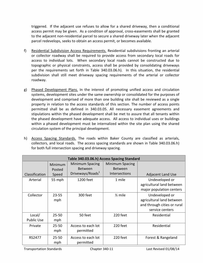
h) Access Spacing Standards. The roads within Baker County are classified as arterials,
collectors, and local roads. The access spacing standards are shown in Table 340.03.06.h)
for both full intersection spacing and driveway spacing.
Table 340.03.06.h) Access Spacing Standard
Classification
Minimum
Posted
Speed
Minimum Spacing
Between
Driveways/Roads1
Minimum Spacing
Between
Intersections Adjacent Land Use
Arterial 55 mph 1200 feet 1 mile Undeveloped or
agricultural land between
major population centers
Collector 23-55
mph
300 feet ½ mile Undeveloped or
agricultural land between
and through cities or rural
service centers
Local/
Public Use
25-50
mph
50 feet 220 feet Residential
Private 25-50
mph
Access to each lot
permitted
220 feet Residential
RS2477 25-50
mph
Access to each lot
permitted
220 feet Forest & Rangeland

Transportation Standards Chapter 340-12 Last Revised 01/08/14
Continued Figure 340.03.06.d)
Example of Crossover Easement and Conditional Access Policy
Step Process
1 EXISTING – Currently Lots A, B, C, and D have site-access driveways that neither meet
the access spacing criteria of 500 feet or align with driveways or access points on the
opposite side of the highway. Under these conditions motorists are put into situations
of potential conflict (conflicting left turns) with opposing traffic. Additionally, the
number of side-street (or site-access driveway) intersections decreases the operation
and safety of the highway
2 REDEVELOPMENT OF LOT B – At the time that Lot B redevelops, the local jurisdiction
would review the proposed site plan and make recommendations to ensure that the site
could promote future crossover or consolidated access. Next, the local jurisdiction
would issue conditional permits for the development to provide crossover easements
with Lots A and C, and ODOT would grant a conditional access permit to the lot. After
evaluating the land use action, ODOT would determine that LOT B does not have either
alternative access, nor can an access point be aligned with an opposing access point, nor
can the available lot frontage provide an access point that meets the access spacing
criteria set forth for this segment of highway.
3 REDEVELOPMENT OF LOT A – At the time Lot A redevelops, the local jurisdiction and
ODOT would undertake the same review process as with the redevelopment of LOT B
(see Step 2); however, under this scenario ODOT and the local jurisdiction would use the
previously obtained cross-over easement at Lot B to consolidate the access points of
Lots A and B. ODOT would then relocate the conditional access of Lot B to align with the
opposing access point and provide safe and efficient access to both Lots A and B. The
consolidation of site-access driveways for Lots A and B will not only reduce the number
of driveways accessing the highway, but will also eliminate the conflicting left-turn
movements on the highway by the alignment with the opposing access point.
4 REDEVELOPMENT OF LOT D – The redevelopment of Lot D will be handled in the same
manner as the redevelopment of Lot B (see Step 2)
5 REDEVELOPMENT OF LOT C – The redevelopment of Lot C will be reviewed once again
to ensure that the site will accommodate crossover and/or consolidated access. Using
the crossover agreements with Lots B and D, Lot C would share a consolidated access
point with Lot D and will also have alternative frontage access via the shared site-access
driveway of Lots A and B. By using the crossover agreement and conditional access
permit process, the local jurisdiction and ODOT will be able to eliminate another access
point and provide the alignment with the opposing access points.
6 COMPLETE – After Lots A, B, C, and D redevelop over time, the number of access points
will be reduced and aligned, and the remaining access points will meet the Category 4
access management standard of 500-foot spacing.
Transportation Standards Chapter 340-13 Last Revised 01/08/14
j) Baker County may reduce the required separation distance of access points defined in Table
340.03.06.h) where they prove impractical as defined by the County Roadmaster or his/her
designee, provided all of the following requirements are met:
(1) Joint access driveways and cross access easements are provided in accordance with this
section.
(2) The site plan incorporates a unified access and circulation system in accordance with
this section.
(3) The property owner enters into a written agreement with Baker County, recorded with
the deed, that pre-existing connections on the site will be closed and eliminated after
construction of each side of the joint use driveway.
(k) Baker County may modify or waive the requirements of this section where the
characteristics or layout of abutting properties would make a development of a unified or
shared access and circulation system impractical based on physical site characteristics that
make meeting the access standards infeasible. Modification or wavier of the requirements
of this section shall be based on the following:
(1) The application of the location of access standard will result in the degradation of
operational and safety integrity of the transportation system.
(2) The granting of the variance shall meet the purpose and intent of these regulations and
shall not be considered until every feasible option for meeting access standards is
explored.
(3) Applicants for variance from these standards must provide proof of unique or special
conditions that make strict application of the provisions impractical. Applicants shall
include proof that:
(a) Indirect or restricted access cannot be obtained;
(b) No engineering or construction solutions can be applied to mitigate the condition;
and
(c) No alternative access is available from a road with a lower functional classification
than the primary roadway.
(4) No variance shall be granted where such hardship is self-created.
340.03.07 Access Standards
a) Access Standards

Transportation Standards Chapter 340-14 Last Revised 01/08/14
(1) With the exception of parking lots used in conjunction with accepted farm and forest
practices, driveways providing access into off-road, surface parking lots shall be
designed in such a manner to prevent vehicles from backing into the flow of traffic on
the public road or to block on-site circulation. The driveway throat approaching the
public road shall have adequate queue length for exiting vehicles to queue on-site
without blocking on-site circulation of other vehicles. The driveway throat approaching
the public road shall also have sufficient storage for entering traffic not to back into the
flow of traffic onto the public road. A traffic impact study, subject to approval by the
Roadmaster or his/her designee, shall be used to determine the adequate queue length
of the driveway throat. This requirement shall be applied in conjunction with other
design requirements of parking lots. If there is a conflict between these two code
provisions, then this code provision supersedes the other parking lot code
requirements.
(2) Driveway approaches must be designed and located to provide an exiting vehicle with
an unobstructed view. Sight distance triangle requirements are identified in 340.03.07.c)
and 340.03.07.d). Construction of driveways along acceleration lanes, deceleration
lanes, or tapers shall be prohibited due to the potential for vehicular weaving conflicts
unless there are no other alternatives for driveway locations. Only after a traffic impact
study is conducted as defined in 340.06 and concludes that the driveway does not
create a safety hazard along acceleration lanes, deceleration lanes, or taper shall the
driveway be considered for approval. Approval of a driveway location along an
acceleration lane, deceleration lane, or taper shall be based on the Roadmaster or
his/her designee agreeing with the conclusions of the traffic impact study.
b) Public Road Stopping Sight Distance. Public roads shall have a minimum stopping sight
distance requirement as summarized in Table 340.03.07.b). The minimum stopping sight
distance is measured from a height of 3.5 feet to a target on the roadway nominally six (6)
inches in height.
The minimum stopping sight distance is based on design speed of the roadway. If a design
speed is not known, then the assumed design speed shall be at least 5 mph more than the
posted speed or may be measured as the 85th percentile speed.
Table 340.03.07.b)
Stopping Sight Distance Requirement
Design Speed (mph) Minimum Distance (feet)
25 155
30 200
35 250
40 305
45 360
50 425

Transportation Standards Chapter 340-15 Last Revised 01/08/14
c) Sight Distance Triangle. Traffic entering an uncontrolled public road from a stop sign
controlled public road, or from private roads or private driveways, shall have minimum sight
distances, as shown in Table .03.07.c), except as allowed in 340.03.07.d).
The sight distance triangle is based on design speed of the roadway. If a design speed is not
known, then the assumed design speed shall be at least 5 mph more than the posted speed
or may be measured as the 85th percentile speed.
The intersection and driveway sight distance is measured from an eye height of 3.5 feet
above the controlled road at least 15 feet from the edge of the vehicle travel lane of the
uncontrolled public road to an object height of 4.25 feet on the uncontrolled public road in
accordance with the table below. This definition for measuring sight distance is consistent
with AASHTO (American Association of State Highway and Transportation Officials)
standards.
Table 340.03.07.c)
Intersection/Driveway Sight Distance Triangle Requirement
Design Speed (mph) Minimum Distance (feet)
20 200
25 250
30 300
35 350
40 400
45 450
50 500
d) Uncontrolled Intersection and Driveway Sight Distance Triangle in Residential Areas. This
subsection only applies to local access roads in urban and rural residential areas.
Uncontrolled intersections shall have an unobstructed sight distance triangle of 30 feet
along the property lines of both intersection approaches. Any vegetation within the sight
distance triangle must be 24 inches in height or less. For driveways, the sight distance
triangle along the driveway and property line adjacent to the public road shall be a
minimum of 10 feet for each leg.
340.03.08 Connectivity and Circulation Standards
a) Connectivity
(1) The road system of proposed subdivisions shall be designed to connect with existing,
proposed, and planned roads outside of the subdivision.

Transportation Standards Chapter 340-16 Last Revised 01/08/14
(2) Wherever a proposed development abuts unplatted, developable land for a future
development phase of the same development, road stubs with cul-de-sacs shall be
provided to provide access to abutting properties or to logically extend the road system
into the surrounding area.
(3) Neighborhood collectors and local residential access roads shall connect with
surrounding roads to permit the convenient movement of traffic between residential
neighborhoods or facilitate emergency access and evacuation. Connections shall be
designed to avoid or minimize through traffic on local roads. Appropriate design and
traffic calming measures are the preferred means of discouraging through traffic.
b) Cul-de-sac and Accessways
(1) Cul-de-sacs or permanent dead-end roads may be used as part of a development plan
only if topographical, environmental, or existing adjacent land use constraints make
connecting and through roads infeasible. Where cul-de-sacs are planned, accessways
shall be provided connecting the ends of cul-de-sacs to each other, to other roads, or to
neighborhood activity centers unless topographical, environmental, or existing adjacent
land use constraints make it infeasible.
(2) Accessways for pedestrians and bicyclists shall be 10 feet wide and located within a 15-
foot-wide right-of-way or easement. If the roads within the subdivision are lighted, the
accessways shall also be lighted at residential/residential illumination standard. Stairs
or switchback paths may be used where grades are steep. Any vegetation planted
within the accessway shall be less than 30 inches in height and must not create a safety
issue for pedestrians and bicyclists.
340.03.09 Review Procedure for Access Management for Creating Four (4) or more Large
Development Parcels over any Period of Time
a) Applicants for Development Reviews impacting access shall submit a preliminary site plan
that shows:
(1) Location of existing and proposed access point(s) on both sides of the road for a
distance great enough to show that access spacing requirements are met;
(2) Distances from proposed access point to neighboring constructed access points, median
openings (where applicable), traffic signals (where applicable), intersections, and other
transportation features on both sides of the property;
(3) Number and direction of lanes to be constructed on the driveway plus striping plans;
(4) All planned transportation features (such as sidewalks, bikeways, signs, signals, etc.);
b) Development Reviews shall address the following access criteria:
Transportation Standards Chapter 340-17 Last Revised 01/08/14
(1) Access shall be properly placed in relation to sight distance, driveway spacing, health
and safety, and other related considerations, including opportunities for joint and cross
access.
(2) The external road system to the project site and internal road system within the project
site shall provide adequate access to buildings for residents, visitors, deliveries,
emergency vehicles, and garbage collection.
c) The Oregon Department of Transportation shall review any application that involves access
to the State Highway System for conformance with state access management standards.
d) Baker County Road Department staff shall review any application that involves road
development or access to the Baker County road system.
340.04 BICYCLE AND PEDESTRIAN STANDARDS. At the discretion of the Planning Director/
Planning Commission, special uses can be required to provide pedestrian and bicycle amenities.
The bicycle and pedestrian facility standards can be found in Section 7 of the Baker County
Transportation System Plan. The Baker County Transportation System Plan uses the standards
for non-motorized facilities that are contained in the Oregon Bicycle and Pedestrian Plan,
ODOT, June 14, 1995.
340.04.001 Bicycle and Pedestrian Circulation and Access Requirements for Site Plans.
Required elements for a site plan shall include bicycle and pedestrian circulation elements such
as accessways and walkways. The following shall be included in the site plan:
a) Pedestrian Access and Circulation. Internal pedestrian circulation shall be provided in new
commercial, office, and multi-family residential developments through the clustering of
buildings, construction of hard surface walkways, landscaping, accessways, or similar
techniques.
b) All site plans (industrial and commercial) shall clearly show how the site's internal
pedestrian and bicycle facilities connect with external existing or planned facilities or
systems.
340.04.002 Bicycle and Pedestrian Circulation and Access Requirements for Approval of
Subdivision Tentative Plans and Final Plats. Information required shall include the location and
design of all proposed pedestrian and bicycle facilities, including accessways. The following
shall be included in subdivision tentative plans and final plats:
a) Cul-de-Sacs and Accessways.
(1) Cul-de-sacs or permanent dead-end streets may be used as part of a development plan;
however, through streets are encouraged except where topographical, environmental,
Transportation Standards Chapter 340-18 Last Revised 01/08/14
or existing adjacent land use constraints make connecting streets infeasible. If
cul-de-sacs are planned, accessways shall be provided connecting the ends of
cul-de-sacs to each other, to other streets, or to neighborhood activity centers.
(2) The Hearings Body or Planning Director may determine, based upon evidence in the
record, that an accessway is impracticable. Such evidence may include but is not limited
to:
(b) Physical or topographic conditions make an access-way connection impractical. Such
conditions include but are not limited to freeways, railroads, extremely steep slopes,
wetlands, or other bodies of water where a connection cannot reasonable be provided.
(c) Buildings or other existing development on adjacent lands physically preclude a connection
now or in the future, considering potential for redevelopment.
(d) If accessways would violate provisions of leases, easements, covenants, restrictions, or
other agreements existing as of May 1, 1995 that preclude a required accessway
connection.
340.05 ROAD STANDARDS
340.05.001 Road Design Conformity. The arrangement, character, extent, width, grade and
location of all roads shall be designed to coordinate with existing and planned roads,
topographical conditions, construction and maintenance costs, public conveniences and safety,
and in their appropriate relation to the proposed uses of the land to be served by such road.
Where not shown on an area plan, the arrangement and other design standards of roads shall
conform to the provisions found in the Baker County Transportation System Plan and herein.
340.05.002 Relation to Adjoining Road System. The arrangement of roads in partitions and
subdivisions shall be designed to coordinate with existing or desired roads in adjoining areas.
340.05.003 Projection of Roads. Where adjoining areas are not partitioned or subdivided to
the maximum density allowed by the applicable zone(s), the arrangement of roads in new
subdivisions shall make provisions for the proper projection of roads.
340.05.004 Dead-end Road or Cul-de-sac. No dead-end roads shall be constructed without a
turn-around or cul-de-sac. See Diagram B.
340.05.005 Roads to be Carried to Property Lines. When a proposed partition or subdivision
joins land capable of further division, road rights-of-way shall be carried to the boundaries of
the tract to be partitioned or subdivided.
340.05.006 Frontage Roads. For non-resource ground, where a partition or subdivision abuts
or contains an existing arterial road, the Planning Commission may require frontage roads or

Transportation Standards Chapter 340-19 Last Revised 01/08/14
other such treatment as may be necessary for adequate protection of abutting properties and
to afford separation of through and local traffic in order to preserve mobility on the arterial.
340.05.007 Road Widths and Improvements
(a) Road standards shall not be less than those set forth in Figures 7-2 to 7-10 in the Baker
County Transportation System Plan, except where it can be shown that probable future
traffic development or physical characteristics are such as to justify modification of the
standards.
(b) In areas designed and zoned for commercial use, road widths may be increased by such
amount as may be deemed necessary by the Planning Commission to provide for the free
flow of through traffic without interference by parked or parking vehicles, and to provide
safe parking space for such commercial or business districts.
(c) For subdivisions, road and related improvements shall be completed or bonded for
completion prior to final plat consideration and shall be constructed and reviewed by the
County Roadmaster, according to the minimum Road Standards set forth in Figures 7-2 to
7-10 in the Baker County Transportation System Plan.
340.05.008 Driveways
(a) All Driveways for Residential Use within 150 feet of a public road:
(1) Driveways shall be a minimum of 12 feet wide. The driveway or private road shall be
constructed from the site of development to the point where the driveway connects to
a public road. See Diagrams A, B, and C of this chapter.
(b) All driveways accessing a development more than 150 feet from a public road that is
located within a fire protection district shall:
(1) Be a minimum of 12 feet wide with an all-weather load bearing surface, except any turn
sharper than a 50’ radius shall maintain a load bearing surface that is 14 feet wide for 50
feet on either side of the center point of the turn. The driveway or private road shall be
developed from the site of development to the point where the driveway connects to a
public road. See Diagram A.
(2) Provide vertical clearance of 14 feet and horizontal clearance of 14 feet. Clearance area
shall be free from all obstructions impeding emergency vehicle access. Gates must
exceed 14 feet of horizontal clearance.
(3) Have an entrance/exit at the point where the driveway connects to a road. The
entrance/exit shall be 22 feet wide for 30 feet of length before returning to 12 feet
wide. See Diagram A. Gates be placed more than 30 feet from the property line or the
point where the driveway joins the road.

Transportation Standards Chapter 340-20 Last Revised 01/08/14
(4) All driveways exceeding 150 feet in length shall provide a turnaround at the site of
development. The turnaround shall conform to the standards of Diagram B.
(5) Turnouts shall be placed so that they are visible from the next turnout, but spaced no
more than ¼ mile apart. See Diagram C. Modification from placement of turnouts may
be approved upon written consent of the verifying authority.
(6) All Driveways shall be all-weather roads capable of supporting a minimum of 60,000 lbs
gross vehicle weight on the entirety of the load bearing surface, including bridges and
culverts. A bridge equaling or exceeding 20 feet in length shall be engineered and
certified by an Oregon licensed engineer, and a sign shall be permanently posted
showing the weight limit.
(7) No Driveway grade shall exceed an average of 10%, not to exceed 12%, for no more
than 100 feet where no turns or stops are required within the length of driveway that
exceeds 10%.
(c) Baker County shall verify access standards for driveways, private roads, and fire, life and
safety issues. A fire protection district may enter into an intergovernmental agreement with
Baker County to assume responsibility within the fire district for verifying driveways or
private roads for residential use exceeding 150 feet in length meet the applicable standards
of Section 340.05.008. In the absence of said agreement, Baker County shall be the verifying
authority.
(d) A modification from the standards of Section 340.05.008 (A)-(B) or 340.05.009 may be
requested by application to Baker County. The purpose of the modification is to recognize
the variation in properties and conditions in Baker County and to provide a procedure for
modification of the above-stated requirements. The County Roadmaster, in consultation
with the local fire protection district and the applicant, shall develop a modification plan
taking into consideration i - xvi of this section. A modification plan shall be considered a
Type II decision. The following criteria shall be considered when formulating a modification
plan:
i. Public safety and emergency vehicle access
ii. Any need for public use
iii. Right-of-way or easement width
iv. Connectivity
v. Resource or non-resource zoning
vi. Geographical conditions
vii. Population density
viii. Property size
ix. Fuel load
x. Bridges and culverts
xi. Turnouts and turnarounds
xii. Road width and length
Transportation Standards Chapter 340-21 Last Revised 01/08/14
xiii. Dwelling size
xiv. Cost in relation to benefit
xv. Rough proportionality of offsite improvements
xvi. Nexus of improvements to development
e) The Roadmaster shall submit the modification plan in writing to the Planning Director.
f) Access to development outside of a fire protection district will meet the requirements of an
individual emergency access plan developed by Baker County, in consultation with the
applicant, which takes into consideration the totality of the circumstances related to that
particular development. For parcels abutting a fire protection district, the emergency access
plan will be developed in consultation with the local fire protection district. The
modification plan shall be submitted to the Planning Director in writing.
g) A modification plan may be appealed in accordance with the provisions for appealing a Type
II decision described in Section 205.05 (G) of this ordinance.
340.05.009 Private Roads for Residential Use/ Public Use Roads. When three or more
dwellings are to be served by the same vehicular access, that access shall become a private
road. The road must be named in accordance with the Baker County Road Naming and Rural
Addressing Ordinance when the road provides access to three addressed dwellings or
commercial buildings.
a) A private road or a public use road shall be a minimum of 22 feet wide with an all-weather
load bearing surface capable of supporting a minimum of 60,000 lbs gross vehicle weight on
the entirety of the load bearing surface, including bridges and culverts. A bridge equaling or
exceeding 20 feet in length shall be engineered and certified by an Oregon licensed
engineer, and a sign shall be permanently posted showing the weight limit.
b) If the private road or public use road dead-ends, a turnaround shall be provided at the end
of the road. The turnaround shall conform to the standards of Diagram B.
c) A modification from the standards of Section 340.05.009 (A)-(B) may be requested by
application to Baker County. See modification procedure in Section 340.05.008.
340.05.010 Reverse Curve. A tangent at least 100-feet long shall be introduced between
reverse curves on arterial roads.
340.05.011 Large Parcel Partitions and Large Lot Subdivisions. Where a tract is partitioned
or subdivided into larger parcels or lots than permitted by the applicable zone, such parcels or
lots shall be arranged so as to allow the opening of future roads and logical further partitioning
or subdividing.
340.05.012 Reserve Strips. Reserve strips controlling access to roads shall be prohibited
except under conditions approved by the Planning Commission.
Transportation Standards Chapter 340-22 Last Revised 01/08/14
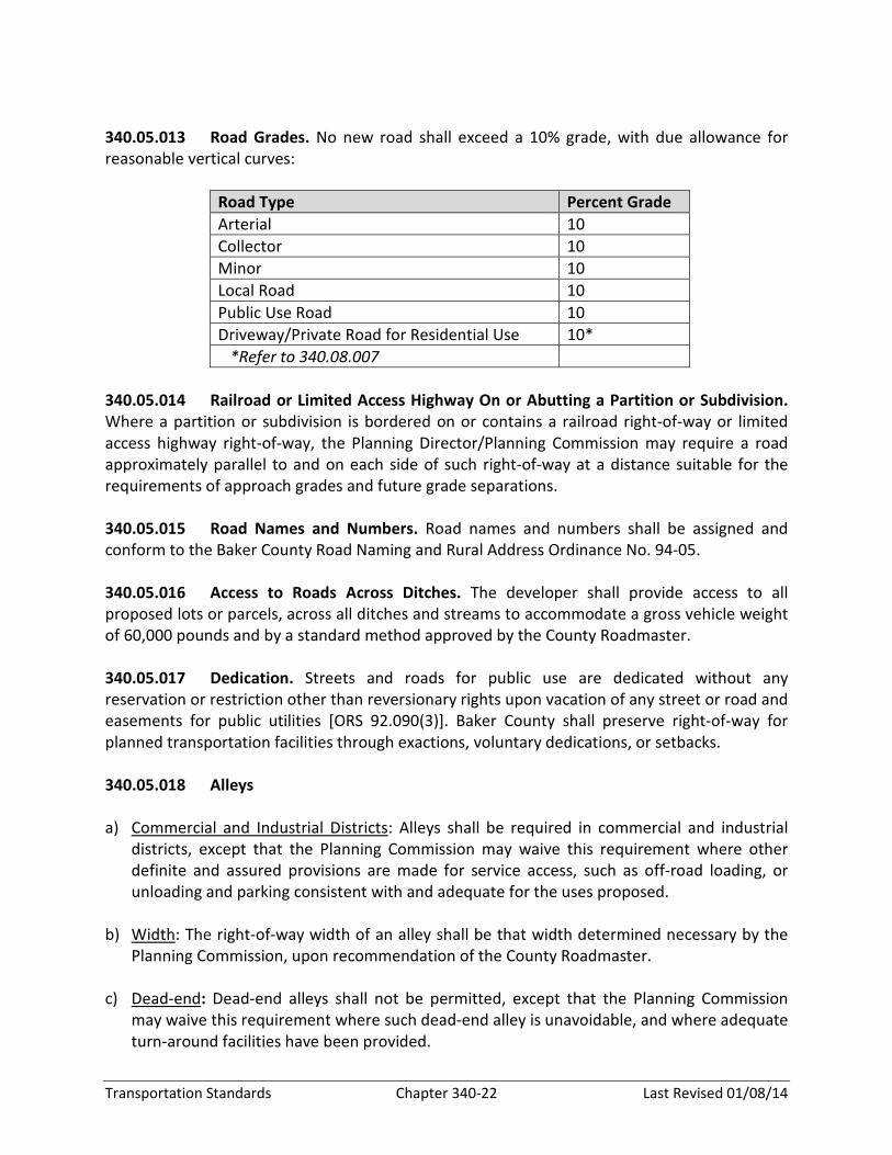
340.05.013 Road Grades. No new road shall exceed a 10% grade, with due allowance for
reasonable vertical curves:
Road Type Percent Grade
Arterial 10
Collector 10
Minor 10
Local Road 10
Public Use Road 10
Driveway/Private Road for Residential Use 10*
*Refer to 340.08.007
340.05.014 Railroad or Limited Access Highway On or Abutting a Partition or Subdivision.
Where a partition or subdivision is bordered on or contains a railroad right-of-way or limited
access highway right-of-way, the Planning Director/Planning Commission may require a road
approximately parallel to and on each side of such right-of-way at a distance suitable for the
requirements of approach grades and future grade separations.
340.05.015 Road Names and Numbers. Road names and numbers shall be assigned and
conform to the Baker County Road Naming and Rural Address Ordinance No. 94-05.
340.05.016 Access to Roads Across Ditches. The developer shall provide access to all
proposed lots or parcels, across all ditches and streams to accommodate a gross vehicle weight
of 60,000 pounds and by a standard method approved by the County Roadmaster.
340.05.017 Dedication. Streets and roads for public use are dedicated without any
reservation or restriction other than reversionary rights upon vacation of any street or road and
easements for public utilities [ORS 92.090(3)]. Baker County shall preserve right-of-way for
planned transportation facilities through exactions, voluntary dedications, or setbacks.
340.05.018 Alleys
a) Commercial and Industrial Districts: Alleys shall be required in commercial and industrial
districts, except that the Planning Commission may waive this requirement where other
definite and assured provisions are made for service access, such as off-road loading, or
unloading and parking consistent with and adequate for the uses proposed.
b) Width: The right-of-way width of an alley shall be that width determined necessary by the
Planning Commission, upon recommendation of the County Roadmaster.
c) Dead-end: Dead-end alleys shall not be permitted, except that the Planning Commission
may waive this requirement where such dead-end alley is unavoidable, and where adequate
turn-around facilities have been provided.
Transportation Standards Chapter 340-23 Last Revised 01/08/14
340.06 APPROVAL OF TRANSPORTATION IMPROVEMENT PROJECTS IDENTIFIED IN THE
TRANSPORTATION SYSTEM PLAN
340.06.001 Uses Permitted Outright. Except where otherwise specifically regulated by this
ordinance, the following improvements are permitted outright:
a) Normal operation, maintenance, repair, and preservation activities of existing
transportation facilities.
b) Installation of culverts, pathways, medians, fencing, guardrails, lighting, and similar types of
improvements within the existing right-of-way.
c) Projects specifically identified in the Transportation System Plan as not requiring further
land use regulation.
d) Landscaping as part of a transportation facility.
e) Emergency measures necessary for the safety and protection of property
f) Acquisition of right-of-way for public roads, highways, and other transportation
improvements designated in the Transportation System Plan except for those that are
located in exclusive farm use or forest zones.
g) Construction of a street or road as part of an approved subdivision or land partition
approved consistent with the applicable land division ordinance.
340.06.002 Conditional Uses Permitted. Construction, reconstruction, or widening of
highways, roads, bridges or other transportation projects that are: (1) not improvements
designated in the Transportation System Plan or (2) not designed and constructed as part of a
subdivision or planned development subject to site plan and/or conditional use review, shall
comply with the Transportation System Plan and applicable standards, and shall address the
following criteria. For State projects that require an Environmental Impact Statement (EIS) or
EA (Environmental Assessment), the draft EIS or EA shall be reviewed and used as the basis for
findings to comply with the following criteria:
a) The project is designed to be compatible with existing land use and social patterns,
including noise generation, safety, and zoning.
b) The project is designed to minimize avoidable environmental impacts to identified
wetlands, wildlife habitat, air and water quality, cultural resources, and scenic qualities.
c) The project preserves or improves the safety and function of the facility through access
management, traffic calming, or other design features.
Transportation Standards Chapter 340-24 Last Revised 01/08/14
d) Project includes provision for bicycle and pedestrian circulation as consistent with the
comprehensive plan and other requirements of this ordinance.
340.06.003. If review under this Section indicates that the use or activity is inconsistent with
the Transportation System Plan, the procedure for a plan amendment shall be undertaken prior
to or in conjunction with the conditional permit review.
340.06.004 Time Limitation on Transportation-Related Conditional Use Permits.
Authorization of a conditional use shall be void after a period specified by the applicant as
reasonable and necessary based on season, right-of-way acquisition, and other pertinent
factors. This period shall not exceed three years.
340.07 TRAFFIC IMPACT STUDY REQUIREMENT
340.07.001 Intent and Purpose. A transportation impact analysis (TIA) provides an objective
assessment of the anticipated modal transportation impacts associated with a specific land use
action. The purpose of the scope of the TIA is to demonstrate compliance with the TPR (OAR
660-0012-0060) and Statewide Planning Goal 12, Transportation. For the project to demonstrate
compliance with the TPR and Statewide Planning Goal 12, it must be demonstrated that the
proposed project’s traffic impacts are either within the performance standards of the impacted
transportation facilities or that adverse impacts are mitigated within the adopted performance
standards. A TIA answers important transportation-related questions such as:
• Can the existing transportation system accommodate the proposed development from a
capacity and safety standpoint?
• What transportation system improvements are necessary to accommodate the proposed
development?
• How will access to the proposed development affect the traffic operations on the existing
transportation system?
• What transportation impacts will the proposed development have on the adjacent land
uses?
• Will the proposed development meet current standards for roadway design?
Throughout the development of the TIA (and beginning as early as possible), cooperation
between Baker County staff, the applicant, and the applicant’s traffic engineer is encouraged to
provide an efficient and effective process.
Baker County staff may, at its discretion, and depending on the specific situation, require
additional study components in a TIA beyond what is outlined in this section or waive
requirements deemed inappropriate.

Transportation Standards Chapter 340-25 Last Revised 01/08/14
Baker County assumes no liability for any costs or time delays (either direct or consequential)
associated with the preparation and review of a transportation impact analysis.
340.07.002 When a Transportation Impact Analysis (TIA) is Required. For purposes of
appeal only, TIA requirement determinations shall be considered a land use decision. A TIA shall
be required at the discretion of the County Roadmaster when:
a) The development generates 25 or more peak-hour trips or 250 or more daily trips.
b) An access spacing exception is required for the site access driveway(s) and the development
generates 10 or more peak-hour trips or 100 or more daily trips.
c) The development is expected to impact intersections that are currently operating at the
upper limits of the acceptable range of level of service during the peak operating hour.
d) The development is expected to significantly impact adjacent roadways and intersections
that have previously been identified as high crash locations or areas that contain a high
concentration of pedestrians or bicyclists such as school zones.
e) A plan or land use regulation amendment significantly affects a transportation facility. This
is defined by if a plan or land use regulation amendment does the following:
(1) Changes the functional classification of an existing or planned transportation facility;
(2) Changes standards implementing a functional classification system;
(3) Allows types or levels of land uses that would result in levels of travel or access that are
inconsistent with the functional classification of a transportation facility; or
(4) Would reduce the level of service of the facility below the minimum acceptable level
identified in the Transportation System Plan.
340.07.003 When a Transportation Assessment Letter is Required. If a TIA is not required
by the County Roadmaster, the applicant’s traffic engineer shall submit a transportation
assessment letter to Baker County indicating the proposed land use action is exempt. This letter
shall outline the trip-generating characteristics of the proposed land use and verify that the
site-access driveways or roadways meet Baker County’s sight-distance requirements and
roadway design standards.
340.07.004 Contents of a Transportation Impact Analysis. The following format shall be
used in preparing a transportation impact analysis.
a) Table of Contents. Listing of all sections, figures, and tables included in the report.
Transportation Standards Chapter 340-26 Last Revised 01/08/14
b) Executive Summary. Summary of the findings and recommendations contained within the
report.
c) Introduction. Proposed land use action, including site location, building square footage, and
project scope. Map showing the proposed site, building footprint, access driveways, and
parking facilities. Map of the study area, which shows site location and surrounding
roadway facilities.
d) Existing Conditions. Existing site conditions and adjacent land uses. Roadway characteristics
(all transportation facilities and modal opportunities located within the study area,
including roadway functional classifications, street cross section descriptions, posted
speeds, bicycle and pedestrian facilities, on-street parking, and transit facilities). Existing
lane configurations and traffic control devices at the study area intersections. Existing traffic
volumes and operational analysis of the study area roadways and intersections. Roadway
and intersection crash history analysis.
e) Background Conditions (without the proposed land use action). Approved developments
and funded transportation improvements in the study area. Traffic growth assumptions.
Addition of traffic from other planned developments. Background traffic volumes and
operational analysis.
f) Full Buildout Traffic Conditions (with the proposed land use action). Description of the
proposed development plans. Trip-generation characteristics of the proposed development
(including trip reduction documentation). Trip distribution assumptions. Full buildout traffic
volumes and intersection operational analysis. Intersection and site-access driveway
queuing analysis. Expected safety impacts. Recommended roadway and intersection
mitigations (if necessary).
g) Site Circulation Review. Evaluate internal site access and circulation. Review pedestrian
paths between parking lots and buildings. Ensure adequate throat depth is available at the
driveways and that vehicles entering the site do not block the public facilities. Review truck
paths for the design vehicle.
h) Turn Lane Warrant Evaluation. Evaluate the need to provide turn lanes at the site
driveways.
i) Conclusions and Recommendations. Bullet summary of key conclusions and
recommendations from the transportation impact analysis.
j) Appendix. Traffic counts summary sheets, crash analysis summary sheets, and
existing/background/full buildout traffic operational analysis worksheets. Other analysis
summary sheets such as queuing and signal warrant analyses.
k) Figures. The following list of figures shall be included in the Transportation Impact Analysis:
Site Vicinity Map; Existing Lane Configurations and Traffic Control Devices; Existing Traffic

Transportation Standards Chapter 340-27 Last Revised 01/08/14
Volumes and Levels of Service (all peak hours evaluated); Future Year Background Traffic
Volumes and Levels of Service (all peak hours evaluated); Proposed Site Plan; Future Year
Assumed Lane Configurations and Traffic Control Devices; Estimated Trip Distribution
Pattern; Site-Generated Traffic Volumes (all peak hours evaluated); Full Buildout Traffic
Volumes and Levels of Service (all peak hours evaluated).
l) Preparer Qualifications. A professional engineer registered in the State of Oregon shall
prepare the Transportation Impact Analyses. In addition, the preparer shall have extensive
experience in the methods and concepts associated with transportation impact studies.
340.07.005 Study Area. The study area shall include, at a minimum, all site-access points and
intersections (signalized and unsignalized) adjacent to the proposed site. If the proposed site
fronts an arterial or collector street; the study shall include all intersections along the site
frontage and within the access spacing distances extending out from the boundary of the site
frontage. Beyond the minimum study area, the transportation impact analysis shall evaluate all
intersections that receive site-generated trips that comprise at least 10% or more of the total
intersection volume. In addition to these requirements, the Public Works Director (or his/her
designee) shall determine any additional intersections or roadway links that might be adversely
affected as a result of the proposed development. The applicant and the Public Works Director
(or his/her designee) will agree on these intersections prior to the start of the transportation
impact analysis.
340.07.006 Study Years to be Analyzed in the Transportation Impact Analysis. A level-of-
service analysis shall be performed for all study roadways and intersections for the following
horizon years:
a) Existing Year. Evaluate all existing study roadways and intersections under existing
conditions.
c) Background Year. Evaluate the study roadways and intersections in the year the proposed
land use is expected to be fully built out, without traffic from the proposed land use. This
analysis shall include traffic from all approved developments that impact the study
intersections, or planned developments that are expected to be fully built out in the
horizon year.
c) Full Buildout Year. Evaluate the expected roadway, intersection, and land use conditions
resulting from the background growth and the proposed land use action assuming full
build-out and occupancy. For phased developments, an analysis shall be performed during
each year a phase is expected to be completed.
d) Twenty-Year Analysis. For all land use actions requesting a Comprehensive Plan
Amendment and/or a Zone Change, a long-term level-of-service analysis shall be
performed for all study intersections assuming buildout of the proposed site with and
without the comprehensive plan designation and/or zoning designation in place. The
analysis should be performed using the future year traffic volumes identified in the

Transportation Standards Chapter 340-28 Last Revised 01/08/14
Transportation System Plan (TSP). If the applicant’s traffic engineer proposes to use
different future year traffic volumes, justification for not using the TSP volumes must be
provided along with documentation of the forecasting methodology.
340.07.007 Study Time Periods to be Analyzed in the Transportation Impact Analysis.
Within each horizon year, a level-of-service analysis shall be performed for the time period(s)
that experience the highest degree of network travel. These periods typically occur during the
mid-week (Tuesday through Thursday) morning (7:00 a.m. to 9:00 a.m.), mid-week evening
(4:00 p.m. to 6:00 p.m.), and Saturday afternoon (12:00 p.m. to 3:00 p.m.) periods. The
transportation impact analysis shall always address the weekday a.m. and p.m. peak hours
when the proposed lane use action is expected to generate 25 trips or more during the peak
time periods unless there is negligible traffic generated by the proposed project in those time
periods. If the applicant can demonstrate that the peak-hour trip generation of the proposed
land use action is negligible during one of the two peak study periods and the peak trip
generation of the land use action corresponds to the roadway system peak, then only the
worst-case study period shall be analyzed.
Depending on the proposed land use action and the expected trip-generating characteristics of
that development, consideration of non-peak travel periods may be appropriate. Examples of
land uses that have non-typical trip generating characteristics include schools, movie theaters,
and churches. The Public Works Director (or his/her designee) and applicant shall discuss the
potential for additional study periods prior to the start of the transportation impact analysis.
The Public Works Director (or his/her designee) has the right to condition the applicant to study
a non-peak period.
340.07.008 Traffic Count Requirements. Once the study periods have been determined,
turning movement counts shall be collected at all study area intersections to determine the
base traffic conditions. These turning movement counts shall be conducted during the weekday
(Tuesday through Thursday) between 7:00 and 9:00 a.m. and between 4:00 and 6:00 p.m.,
depending on the proposed land use. Historical turning movement counts may be used if the
data are less than 12 months old, but must be factored to meet the existing traffic conditions.
340.07.009 Trip Generation for the Proposed Development. To determine the impacts of a
proposed development on the surrounding transportation network, the trip-generating
characteristics of that development must be estimated. Trip-generating characteristics shall be
obtained from one of the following acceptable sources:
• Institute of Transportation Engineers (ITE) Trip Generation Manual (latest edition).
• Specific trip generation studies that have been conducted for the particular land use
action for the purposes of estimating peak-hour trip-generating characteristics. The Public
Works Director (or his/her designee) shall approve the use of these studies prior to their
inclusion in the transportation impact analysis.

Transportation Standards Chapter 340-29 Last Revised 01/08/14
In addition to new site-generated trips, several land uses typically generate additional trips that
are not added to the adjacent traffic network. These trips include pass-by trips and internal
trips and are considered to be separate from the total number of new trips generated by the
proposed development. The procedures listed in the most recent version of the Trip Generation
Handbook (ITE) shall be used to account for pass-by and internal trips.
340.07.010 Trip Distribution. Estimated site-generated traffic from the proposed development
shall be distributed and assigned on the existing or proposed arterial/collector street network.
Trip distribution methods shall be based on a reasonable assumption of local travel patterns
and the locations of off-site origin/destination points within the site vicinity. Acceptable trip
distribution methods shall be based on one of the following procedures:
• An analysis of local traffic patterns and intersection turning movement counts gathered
within the previous 12 months.
• A detailed market study specific to the proposed development and surrounding land
uses.
340.07.011 Intersection Operation Standards. Baker County evaluates intersection
operational performance based on levels of service and “volume-to-capacity” (v/c) ratio. When
evaluating the volume-to-capacity ratio, the total traffic demand shall be considered.
a) Intersection Volume-to-Capacity Analysis. A capacity analysis shall be performed at all
intersections within the identified study area. The methods identified in the latest edition
of the Highway Capacity Manual, published by the Transportation Research Board, are to
be used for all intersection capacity calculations. Baker County requires that all
intersections within the study area must maintain a v/c ratio of 0.95 or less. It should be
noted that the mobility standards in the Oregon Highway Plan apply to Oregon
Department of Transportation facilities.
b) Intersection Levels of Service. Baker County requires all intersections within the study area
to maintain an acceptable level of service (LOS) upon full buildout of the proposed land use
action. LOS calculations for signalized intersections are based on the average control delay
per vehicle, while LOS calculations for unsignalized intersections are based on the average
control delay and volume-to-capacity ratio for the worst or critical movement. All LOS
calculations shall be made using the methods identified in the most recent version of the
Highway Capacity Manual (or by field studies), published by the Transportation Research
Board. The minimum acceptable level of service for signalized intersections is LOS “D”. The
minimum acceptable level of service for all-way stop controlled intersections and
roundabouts is LOS “D”. The minimum acceptable level of service for unsignalized two-
way stop controlled intersections is LOS “E” or LOS “F” with a v/c ratio of 0.95 or less for
the critical movement. Any intersections not operating at these standards will be
considered to be unacceptable.
Transportation Standards Chapter 340-30 Last Revised 01/08/14
340.07.012 Review Policy and Procedure. The following criteria shall be used in reviewing a
transportation impact analysis as part of a subdivision or site plan review.
a) The road system is designed to meet the projected traffic demand at full build-out.
b) Proposed driveways do not adversely affect the functional character of the surrounding
roadways.
c) Adequate intersection and stopping sight distance is available at all driveways.
d) Proposed driveways meet Baker County’s access spacing standard or sufficient justification
is provided to allow a deviation from the spacing standard.
e) Opportunities for providing joint or crossover access have been pursued.
f) The site does not rely upon the surrounding roadway network for internal circulation.
g) The road system provides adequate access to buildings for residents, visitors, deliveries,
emergency vehicles, and garbage collection.
h) A pedestrian path system is provided that links buildings with parking areas, entrances to
the development, open space, recreational facilities, and other community facilities per the
Transportation Planning Rule.
340.07.013 Conditions of Approval. As part of every land use action, Baker County (if access
to a County roadway is proposed) and ODOT (if access to a state roadway is proposed) is
required to identify conditions of approval needed to meet operations and safety standards
and provide the necessary right-of-way and improvements to develop the future planned
transportation system. Conditions of Approval that should be evaluated as part of subdivision
and site plan reviews include:
a) Crossover easement agreements for all adjoining parcels to facilitate future access
between parcels.
b) Conditional access permits for new developments which have proposed access points that
do not meet the designated access spacing policy and/or have the ability to align with
opposing access driveways.
c) Right-of-way dedications for future planned roadway improvements.
d) Off-site improvements to bring transportation facilities impacted by development to
current standards identified in the Transportation System Plan.
340.07.014 Conditions of Approval for Comprehensive Plan and Land Use Regulation
Amendments. Amendments to the comprehensive plan and land use regulations which
Transportation Standards Chapter 340-31 Last Revised 01/08/14
significantly affect a transportation facility shall assure that allowed land uses are consistent
with the function, capacity, and level of service of the facility identified in the Transportation
System Plan. This shall be accomplished by one of the following:
a) Limiting allowed land uses to be consistent with the planned function of the transportation
facility;
b) Amending the Transportation System Plan to ensure that existing, improved, or new
transportation facilities are adequate to support the proposed land uses consistent with
the requirement of the Transportation Planning Rule; or,
c) Altering land use designations, densities, or design requirements to reduce demand for
automobile travel and meet travel needs through other modes.
340.07.015 Transportation Impact Analysis Checklist. As part of the transportation impact
analysis review process, all transportation impact analyses submitted to Baker County must
satisfy the requirements illustrated in the Checklist for Acceptance of Transportation Impact
Analyses.