Cattle Drives of the West
43
Contreras 1 When discussing cattle drives in Western historiography, scholars generally focus on the cattle drives originating from south to north. Cattle drives from Texas to Nevada, Colorado, and Wyoming are famous for such stories in Western historiography. These stories inspired works such as “Lonesome Dove,” the big drive from Kansas to Montana, “The Wagon Train Dairies,” or “Women on the Oregon Trail.” However, often neglected are the cattle drives that took place east to west. Places such as Arkansas, Missouri, and Georgia also occupy a significant role in Western historiography. Arkansas was a source for many cattle drives westward following the California gold rush, and some later cattle drives cut through Arkansas for northward routes. In comparison to Texas, Arkansas played a minor role in cattle drives, but was significantly affected by these cattle drives. There is evidence that the Cherokee drove cattle drives in the late eighteenth and early nineteenth century, but the major cattle drives out of Arkansas ensued the California gold rush in 1848. These cattle drives usually departed from Fort Smith, Sebastian County,
-
Upload
independent -
Category
Documents
-
view
3 -
download
0
Transcript of Cattle Drives of the West

Contreras 1
When discussing cattle drives in Western historiography,
scholars generally focus on the cattle drives originating from
south to north. Cattle drives from Texas to Nevada, Colorado,
and Wyoming are famous for such stories in Western
historiography. These stories inspired works such as “Lonesome
Dove,” the big drive from Kansas to Montana, “The Wagon Train
Dairies,” or “Women on the Oregon Trail.” However, often
neglected are the cattle drives that took place east to west.
Places such as Arkansas, Missouri, and Georgia also occupy a
significant role in Western historiography.
Arkansas was a source for many cattle drives westward
following the California gold rush, and some later cattle drives
cut through Arkansas for northward routes. In comparison to
Texas, Arkansas played a minor role in cattle drives, but was
significantly affected by these cattle drives. There is evidence
that the Cherokee drove cattle drives in the late eighteenth and
early nineteenth century, but the major cattle drives out of
Arkansas ensued the California gold rush in 1848. These cattle
drives usually departed from Fort Smith, Sebastian County,

Contreras 2
Arkansas. Fort Smith boomed as a western frontier as adventurers
equipped themselves there.1
Most notable of the Arkansas cattle drives are the stories
of James Miles Morse of Conway County who reportedly made two
such cattle drives west following the Arkansas River. John
Kirkbride Potts of Pope County, later the founder of Pottsville,
made at least two cattle drives west, and Thomas Jefferson Linton
of Pope County. Linton and Potts stressed the necessity of
grazing cattle in California before sale since such a journey had
devastating consequences on the livestock. Some cattle drives
west followed the route of the Butterfield Overland Express2, but
1 Encyclopedia of Arkansas, Cattle Drives,
http://encyclopediaofarkansas.net/encyclopedia/entry-detail.aspx?
entryID=4748
2The Butterfield Overland Express was a route that left Fort
Smith, AR in a southwesterly direction, cutting through Indian
Territory (present-day Oklahoma), Texas, and what would later
become the states of New Mexico and Arizona, before arriving in
San Francisco, California.
http://encyclopediaofarkansas.net/encyclopedia/entry-detail.aspx?

Contreras 3
most popular route was the Cherokee Trail.3 Cattle drives began
to diminish following the Civil War as railroad expansion in
Arkansas and points west offered alternative means of transport
making it easier to transport live animals. The introduction of
the refrigerator car also diminished cattle drives as animals
were processed closer to where they were raised.4
entryID=4748
3 The Cherokee Trail largely followed the course of the Arkansas
River from Fort Smith, AR through Indian Territory, Kansas, and
present-day Colorado. There it cut northward in the area of what
is now Pueblo, CO until it entered the present-day state of
Wyoming. The route then turned west again, running parallel to
the southern border of Wyoming, cutting across Utah and Nevada
before finally entering California.
http://encyclopediaofarkansas.net/encyclopedia/entry-detail.aspx?
entryID=4748
4 Encyclopedia of Arkansas, Cattle Drives,
http://encyclopediaofarkansas.net/encyclopedia/entry-detail.aspx?
entryID=4748

Contreras 4
This narrative addresses the neglect from historians
considering the east to west cattle drives. The Shores-Carter
cattle drive is among the many that took place out of Arkansas in
the mid nineteenth century. It is important to note that Shores
story is vague in detail, the majority of the details were
derived from a book published in 1992 out of the University of
Arkansas, Fayetteville titled “Old Brands and Lost Trails:
Arkansas and the Great Cattle Drives,” By Ivan Denton. The
Shores family historical records are a private collection of
historical document on the Shores matrilineal family line who
settled in Arkansas in the early nineteenth century. Among the
information obtain from the private collection are wills, court
records, land grants, deeds, and letters from family who
immigrated from Scotland to present day Ozark, Arkansas. Details
description on living condition geographical settlement data,
marriage, death, and birth records are among some of the
information contain in the collection, collaborate many of the
facts by Ivan Denton account on the Shores-Carter cattle drive.
However, the information is limited in detail regarding the

Contreras 5
entire cattle drive, and it was essential to use Denton’s account
to bring the narrative to light.
As the sun began to set, William Dahl Shores moved one
hundred and fifty yards away from his house to see everything in
readiness. It was customary to make an inventory of all the
stock before such a long journey to take place. Six loaded
wagons, forty-eight yoke of Oxen, eight yoke of Oxen per wagon,
and five hundred and fifty head of cattle ready were to make the
journey to California.5 As William took inventory of his stock,
he recollected on the long line of ancestors who had migrated
westward from Germany.6
5Ivan, Denton, Old brands and lost trails: Arkansas and the great
cattle drives, (Fayetteville, AR: University of Arkansas Press),
1991 79; Denton quotes “four yoke of cattle.” The term yoke
generally means a pair of animals in which case there were eight
head of cattle pulling each wagon a total of forty-eight yoke.
6 Leo J. Shane, Ancestors and Descendants of Fredrick Shore: Switzerland, 1570 to
Surry County, North Carolina, 1750 with the History and Genealogy of Related Families,
(Hillsboro, Kansas: Multi Business Press), 1983, 22-30.

Contreras 6
William’s family took great pride in keeping records of the
family’s history, and he continued to do so himself. As a third
generation, his great-grandfather, Friedrich Schorr, set sail to
the United States in 1750 and landed on the coast of North
Carolina. Tragically, Friedrich had lost his wife during the
voyage and buried her at sea. Freidrich migrated from the coast
of North Carolina to Surry County, today Yadkin County so named
for the Yadkin River that ran through the county, with his son
Fredrick Shore, William’s grandfather. William’s father, Jacob
Shore, was born two years before the Revolutionary War and
remained in Surry County until his death. William, as the
generations before him was born in Surry County in 1804 and
remained in Surry County until 1840. 7
On April 13, 1853, William in company of his fried John W.
Carter and six other fellows, whom William had hired and paid
eight dollars each per month, started their journey west. Their
7 Leo J. Shane, Ancestors and Descendants of Fredrick Shore:
Switzerland, 1570 to Surry County, North Carolina, 1750 with the
History and Genealogy of Related Families, (Hillsboro, Kansas:
Multi Business Press), 1983, 31-47.

Contreras 7
names were L. Hill, D. Crumley, Sam Kelley, F. A. Licklyter, and
John A. Tennant. As the day drew near, they sat up camp at
Lindsey’s Prairie,8 which was not even a settlement and marked
the border into Indian Territory.9 The plan was to rest the
evening and start the journey west the next day in search of the
8Gerald T. Hanson, Historical Atlas of Arkansas, (University of Oklahoma
Press, 1992. Lindsey Prairie does not appear on any Arkansas
maps for the period it is likely that it was a community west or
northwest of Fayetteville, AR, or likely today Siloam Springs,
AR.
9The border of Arkansas and Oklahoma were a result of the
Cherokee Treaty of 1828 named in honor of Major William Lewis
Lovely who served as the Arkansas Cherokee Indian agent from 1813
until his death in 1817. The Treaty created the boundary between
the Arkansas Territory and Cherokee Indian Nation by establishing
a line from the corner of Missouri down to Fort Smith. This line
still serves as the Oklahoma-Arkansas boundary. State of Arkansas
Historical Land Records.
http://www.cosl.org/history/spanish.aspx

Contreras 8
“Cherokee Trail.”10 After several day journeys, they crossed the
“Grand River” and the “Verdigrees River” southwest of Fort
Gibson11, where they set camp. William thought necessary to have
a layover since the grass was good for grazing before entering
the “Cherokee Trail.”
10 Ivan, Denton, Old brands and lost trails: Arkansas and the
great cattle drives, 63-64. Denton argues that the Cherokee trail
is a forgotten trail that historians never mention, and the
pioneer routes show neither a dot nor line indicating where it
lay. He argues that most descendants of emigrants confuse it
with the Oregon Trail, the Mormon Trail, or the Independence
Trail.
11Derek R. Everett, “On the Extreme Frontier: Crafting the Western
Arkansas Boundary,” The Arkansas Historical Quarterly Vol. 67, No. 1
(Spring, 2008), 1-26. The Grand River seems questionable as it
is nowhere to be found, however, the next point of reference
which is the “Verdigris River” southwest of Fort Gibson is likely
to be the Illinois River with its headwaters emanating at the
Arkansas-Oklahoma border due west of Springdale, AR.

Contreras 9
During the layover, William began to recall the events that
led him to this expedition. Now forty-nine years old, this was
his chance to acquire cheap inexpensive land. He recalled the
position he had accepted in 1840 as Postmaster of Sweet Home Post
Office near present day Prairie Grove, Arkansas (Washington
County); however, in 1845, the Post office discontinued, and he
remained unemployed for two years before he managed to secure
another postmaster position in Laney, Arkansas in 1847 just to
last until 1849. William knew that the only security was to
acquire land where he could sustain his own living. A father to
three children, and a wife Elizabeth, it was the only guarantee
they would have to survive in a hostile frontier environment.12
There were several methods to acquire land and William had
explored all of them. He had seen from firsthand experience the
struggles some settlers had in acquiring land through the various
12 According to the 1850 United States Federal Census, William
D. (age 45) and Elizabeth Shores (age 38) were living at West
Fork, Washington County, Arkansas. Living with them were
children: Mary (age 10), Charity (age 6), and Alfred Shores (age
1) (Year: 1850; Census Place: West Fork, Washington, Arkansas;
Roll: M432_31; Page: 374B; Image: 158).

Contreras 10
governmental means. The Military Bounty grant did not apply to
William since he was not a veteran of the War of 1812 Bounty land
was land promised to soldiers in exchange for military services.
A practice begun during Colonial times and was widely used during
the Revolutionary War, and again used during the War of 1812.
Military bounty land was an option available to qualified
veterans, the other option being a military pension. These
included the present day sates of Illinois, Arkansas and
Missouri.13
In 1841, the U.S. Congress in response to the demands of the
Western states that squatters were allowed to preempt lands.
Pioneers often settled on public lands before they surveyed and
auctioned by the U.S. government. Squatter claims were not
recognized, but in 1830, Congress passed the first of a series of
temporary preemption laws. The Act of 1841 permitted settlers to
stake a claim to one hundred and sixty acres of land. After about
fourteen months of residence, the squatter could purchase it from
13 John F. Callan, The Military Laws of the United States: Relating to the Army,
Volunteers, Militia, and to Bounty Lands and Pensions from the foundation of the
Government to the year 1886, Philadelphia: (Henry B. Ashmead, 1862), 285.

Contreras 11
the government for as little as $1.25 an acre before it was
offered for public sale.14
During the Mexican American War, the U.S. Congress
introduced the Script Warrant act of 1847. Under the Script
Warrant Act, Veterans who served during the Mexican American War
for a year were entitled to one hundred and sixty acres of land.
For those who served less than a year were entitled to forty
acres.15 However, William was exempt because he did not fight
the Mexican American War.
The only hope William had at acquiring land was through the
Land Act of 1820. Since the provision within the act eliminated
the purchase of public land in the United States on credit,
William had to procure other means by acquiring it, thus, the
cattle drive he had embarked on would provide the means for him14 Library of Congress. “The Preemption Act of 1841.” 27th
Congress, Ch. 16, 5 Stat. 453 (1841) CHAP. XVI. An Act to appropriate
the proceeds of the sales of the public lands, and to grant pre-emption rights.
15 John F. Callan, The Military Laws of the United States: Relating to the Army,
Volunteers, Militia, and to Bounty Lands and Pensions from the foundation of the
Government to the year 186, Philadelphia: (Henry B. Ashmead, 1862), 379.

Contreras 12
to purchase the land directly for the United States government.
The act required a down payment of hundred dollars and reduced
the price from $1.65 to $1.25 per acre.16
William had traveled to California in 1849 along with Carter
in search of Gold, as many Americans had during the discovery of
Gold in 1848, but soon realized that his fortune lay in as a
supplier to the miner because that is where the money was made.
Both William and John returned to Arkansas in the winter of 1852
to purchase a stock of cattle to drive out to California by the
summer of 1853. Since the supplier made the money and the miner
remained in debt, William believed he could raise enough money
from the cattle drive to purchase land.17
16 Library of Congress. “The Land Act of 1820”. 16th Congress,
Session I. Chapter 51 Stat I (1820). Chap. LI. An Act making further
provisions for the sale of Public Lands.
17 Ivan, Denton, Old brands and lost trails: Arkansas and the
great cattle drives, 79. In Denton’s account Shores had been in
California in 1849. It is unclear what his intentions were, but
given the time frame of the gold rush of 1848 it is likely he was
in search of gold as the other 100,000 American who had migrated

Contreras 13
The following day, William and John managed to acquire one
hundred and fifty head of cattle, and fifty head of horses.18
William believed this to be a wise investment since his inventory
had increased to about seven hundred head including both cattle
and horses. As they crossed the Verdigres River, they took the
Lewis-Evans Trail. “One Evening, while camping on the prairie, we
had no wood for fuel. The boys wanted to take the mules to
gather wood. I advised them that would be unwise since the timber
to California during the same time period; Robert M. Utley, A life
Wild and Perilous: Mountain Men and their Paths to the Pacific, (New York: Henry
Holt and Company, Inc.), 85. Utley argues that the supplier was
the person who gained more since supply was always in demand for
those who were trapped in remote areas.
18 Shores family historical records are a private collection of
historical document on the Shores Matrilineal family line who
settled in Arkansas. William journal is unclear how the
additional livestock stock was acquired; Ivan, Denton, Old brands
and lost trails: Arkansas and the great cattle drives, 79.
Denton’s account is also unclear as to how the livestock was
acquired.

Contreras 14
outskirts were at least ten miles away. Instead, we gathered
buffalo chips for fuel19. The wind blew so hard that we had to
dig pits where we could burn the fire”20
That evening, William pondered on the meeting he had had with
the land office in Clarksville, Johnson County, Arkansas
regarding one hundred and twenty acres, in Franklin County, a
total of two-hundred and fifty dollars, one hundred dollars for
the down payment the remainder of one-hundred and twenty five for
the acreage. At a price of eight to ten dollars per head in
Arkansas, William foresaw lucrative results. Historian J. H.
Atkinson notes that a cow that sold for fifty dollars in the gold
fields could be purchased back in Arkansas for usually five
19 Waldo R. Wedel, “The High Plains and Their Utilization by the
Indian,” Society for American Archeology: American Antiquity, Vol. 29, No. 1,(
Jul., 1963), 1-16. Buffalo chips were among the few things that
could be collected and burned on the prairie and were used by the
Plains Indians, settlers and pioneers, and homesteaders as a
source of cooking heat and warmth.
20 Ivan, Denton, Old brands and lost trails: Arkansas and the
great cattle drives, 80.

Contreras 15
dollars, given the surplus of cattle in Arkansas cattle drives to
California were a lucrative enterprise.21 Even if he could sell
the cattle in California at twenty-dollars per head, he would
profit at least $17,000.00 enough money to pay the five boys,
split half with his partner John, and pay for the cattle itself.
Not to mention if he could at least get thirty-five per head, he
looked at gaining at least $24,000.00; however, as with many
pioneers in the West he did not foresee the variables that lay
ahead. 22
Within a few days, they had reached Walnut Creek where they
found plenty of wood for fire, cooking, and bathing.23 The
21 Encycopedia of Arkansas. “Cattle Drives”
http://encyclopediaofarkansas.net/encyclopedia/entry-detail.aspx?
entryID=4748
22Love, Clara M. “History of the Cattle Industry in the Southwest”
The Southwestern Quarterly, Vol.19. No.4 (April, 1916), 376.
23 Ivan, Denton, Old brands and lost trails: Arkansas and the
great cattle drives, 80,81; Shores family historical records are
a private collection of historical document on the Shores
Matrilineal family line who settled in Arkansas in the early
Contreras 16
following day, they camped on the Cottonwood Creek24 and the next
morning reached the open plains. Good fortune had followed
William and John so far for there was plenty of food, grass, and
water on their journey. In a few days, they reached a U.S. fort,
then called Fort Mann25, and after trading for some goods, they
nineteenth century.
24 Lambert Bowman Wolf, “Extracts from Diary of Captain Lambert
Bowman Wolf,” Kansas Historical Quarterly, Vol. 1, No. 3, (May,
1932) 195 – 210. Walnut Creek was key region for travelers to
stop. Wagon trains found drinking water near the Peacock Trading
Post at the Walnut Creek Crossing. Nearby was Fort Zarah and Fort
Learned, which protected wagon trains from tribal raids. Present
day Barton County Kansas.
25 Fort Mann was established in 1845 by Captain Daniel P. Mann it
was located approximately 8 miles west of the present Dodge City
in Ford County, on the north bank of the Arkansas River, near the
site of old Fort Atkinson. It was 25 miles below the Santa Fe
Trail. There is confliction in Shore’s and Denton’s accounts of
Fort Mann because it was abandoned in 1850 and the Shores-Carter
cattle drive took place in 1853. It is possible that both Shore

Contreras 17
came upon the buffalo range. “There were so many buffalo that
they blanketed the landscape.” “The first evening we came upon
them, we lost about twenty head ran away with the buffaloes” “The
following day, we lost an additional or so dozen head along with
some horses and a fine mule I had paid a handsome price for.”
After three days among the buffalo range we were happy to be past
them.”26 It was a heavy loss for William since he had lost
nearly fifty head already and had barely reached the plains. At
this pace, by the time they reached California, he could very
well lose at least half of his head count. He had projected a
fourth lose since cattle drives had its risks.
and Denton mistook Fort Mann for Fort Atkinson.
http://www.vlib.us/old_west/forts.html#mann
26 Ivan, Denton, Old brands and lost trails: Arkansas and the
great cattle drives, 80,81; Shores family historical records are
a private collection of historical document on the Shores
Matrilineal family line who settled in Arkansas in the early
nineteenth century.

Contreras 18
The next evening while camping a ban of wild Indians were
riding in a battle formation and approaching the camp.27 The
sight alarmed William. When the Indians approached the camp at a
distance of at least one hundred and fifty yards, they halted and
their leader approached and made some signs. William made some
signs as well and after an exchange of sign language the leader
and its party dismounted. The Indians indicated that they were
on a buffalo hunt and wanted to trade. “We traded sugar and
hardtack”28 and the leader distributed them among the other
27Ivan, Denton, Old brands and lost trails: Arkansas and the great
cattle drives, 81. It is hard to assume which tribes the Indians
belong to an 1850 map of the United States tribes in the plains
suggest that there were probably of Osage-Sioux or Pawnee-Caddos.
"Courtesy of the University of Texas Libraries, The University of
Texas at Austin." http://www.lib.utexas.edu/maps/histus.html
28 Ludwell Lee Montague, “Subsistence of the Army of the Valley,”
Society of Military Affairs, Vol. 12, No. 4, (Winter, 1948), 229. Hardtack
is a simple type of cracker or biscuit made from flour, water,
and sometimes salt. Inexpensive and long lasting, it was used for
sustenance in the absence of perishable foods, commonly used by

Contreras 19
Indians. “There were probably fifty of them, I reckon.” As dusk
drew nearer, they mounted and left for their own camp. The next
morning as the party resumed the journey, they passed the Indians
who were all mounted on good ponies.29
As William readied and watched the Indians ride away, he began
to wonder if his efforts were worth all its trouble. So far, he
had lost about fifty head, supplies were becoming scarce, and
they had come upon a band of Indians. He recited a small prayer
frontiersmen on long journeys.
29Ivan, Denton, Old brands and lost trails: Arkansas and the great
cattle drives, 81. Given the extent of the conversation between
Shores and the Indians determining that they were on a buffalo
hunt, wanted to trade, and dinned with the Indians indicates that
Shores was able to communicate with them. Either they spoke
English or Shores understood their language. If indeed Shores
understood their dialect, the Indians tribe must have been
familiar to him, in which case native to the area were the Osage-
Sioux or Pawnee-Caddo. "Courtesy of the University of Texas
Libraries, The University of Texas at Austin."
http://www.lib.utexas.edu/maps/histus.html

Contreras 20
for he believed he was blessed that the Indians were friendly and
had left in peace, yet he wonder what lay ahead. Although
scarcely populated, Arkansas in comparison was miniscule for what
lay ahead. One thing that remained in his head was land. If he
could see this cattle drive through, he would not have to worry
about navigating through strange lands, dangerous encounters, or
scares resources. The Ozark Mountains was plentiful in resources,
Indians were far in between, and was hardly a strange country.
Although few roads existed, the isolation created a sense of
security for William. The nearest populated place was Fort
Smith, Arkansas, the border into Indian Territory, but he would
be in familiar land where he knew how to survive.30
Within a few days of encountering the Indians, William
reached the Arkansas River and traveled up streamed until they
reached the Rocky Mountains. The Rocky Mountains lay to their
left as the traveled to a cold stream called “Cash la Tudy.”31 As
they approached the stream, they faced a dilemma for the river
30 Shores family historical records are a private collection of
historical document on the Shores Matrilineal family line who
settled in Arkansas in the early nineteenth century.
Contreras 21
was running high. They began by crowding the cattle to get the
train started, but immediately a dozen or so broke away. William
had heard of previous trains trying to cross the “Cash la Tudy”
and failed. It was customary for drivers who owned their own
horses or mules to retrieve any lost stock, in this instance,
William ordered one of his boys to retrieve the four steers that
had broken away. William could not afford anymore lose, but it
was too late the river carried the steer until they disappeared
upstream.32
31 Ivan, Denton, Old brands and lost trails: Arkansas and the
great cattle drives, 8. Denton mentions this river as “Cash la
Tudy,” but no evidence of such a river exists. Given the location
of the drive, it was probably the Cache la Poudre River in
Colorado, which runs through present day Fort Collins Colorado.
The South Platte lays eastward about five miles. History of the
American West, 1860-1920: Photographs from the Collection of the Denver
Public Library http://memory.loc.gov/cgi-bin/query
32 Ivan, Denton, Old brands and lost trails: Arkansas and the
great cattle drives, 81.

Contreras 22
Once on the other side of the river, William was distraught,
but before he could languish on his lose another train approached
the “Cash la Tudy.” Their leader, who was a Baptist minister,
had no cable rope to guide the train through the river and asked
if he could borrow Williams’. William a man of faith himself saw
no reason why not so he let the other train borrow the cable
rope. Once the other train made it across “Cash la Tudy,” the
Baptist minister sold the cable rope to another train that
approached for twenty-five dollars. William was furious about
this, but before he could do or say anything; the Baptist
preacher rode away and hunted down the cattle, they had lost
crossing the river and took off with them as well. William sent
his boys ahead to catch up with the Baptist preacher train, but
they fail to come across him.33
33Ivan, Denton, Old brands and lost trails: Arkansas and the great
cattle drives, 83; Shores family historical records are a private
collection of historical document on the Shores Matrilineal
family line who settled in Arkansas in the early nineteenth
century. It is here where a time frame for the drive is on course
because there was a universal timeline to cross the mountains,
Contreras 23
If matters could not get any worse, a few days later after
crossing “Cash la Tudy” a raid of Indians stole some horses and
mules. William was devastated. The cattle drive he had embarked
on had become a disaster. William sat up camp as a storm was
approaching. While the Storm raged through William was
distraught, discouraged, and troubled. One of the boys
entertained everyone with Baptist sermons and singing to cheer up
the mood and get through the night. The following day there was
not a cow in sight! Williams heart about dropped to the ground.
He sent out the boys to seek the stocks, which were found five
miles away from camp behind a mountain. William was relieved at
the sight of the stock approaching camp.34
rivers, and snow. Given the amount of detail between encountering
trains suggests that the train was a due course.
34Ivan, Denton, Old brands and lost trails: Arkansas and the great
cattle drives, 83; Shores family historical records are a private
collection of historical document on the Shores Matrilineal
family line who settled in Arkansas in the early nineteenth
century.

Contreras 24
The South Platte was the next river that William’s party
arrived, but the river was low to the point that the party just
forded the river.35 However, when William approached the North
Platte, the river was running so high that they spent two weeks
making a ferry to cross. In their attempt to cross the river,
several head of cattle and horse perished totaling to almost
seventy since their journey out of Arkansas. As if matters could
not get any worse William recalls, “After this point the water we
found was bad, and we used sage brush for fuel. The brush was
35Ivan, Denton, Old brands and lost trails: Arkansas and the great
cattle drives, 83. Given Denton’s last account of Cache la
Poudre River in Colorado it is unlikely that he was in the South
Platte. In Denton’s account he was traveling North West while the
South Platte runs South West of Cache la Poudre River. It is
likely he is referring to the Larimer River because the next
river he approaches is the Medicine Bow River. History of the
American West, 1860-1920: Photographs from the Collection of the
Denver Public Library http://memory.loc.gov/cgi-bin/query

Contreras 25
scarce so we loaded the wagons when we came across it so would be
available at night” 36
The following river William came upon was the Medicine Bow
River that was low and easy to cross. Fortune must been on
Williams side because in three days’ time word reached William
that the Medicine Bow River was running as wide as one and a half
mile wide. “It is here were we came upon on first snow drifts.”
“It was the Fourth of July flowers were in bloom under two feet
of snow”37 They reached the Green River, which was wide, deep,
36 Clarence B. Bagley, “Crossing the Plains,” The Washington Historical
Quarterly Vol. 13, No. 3, (Jul., 1922), 163-180. It was not
uncommon for frontiersmen crossing the plains to construct
farriers to carry supplies across the river in times of high
water; Ivan, Denton, Old brands and lost trails: Arkansas and the
great cattle drive, 84.
37Ivan, Denton, Old brands and lost trails: Arkansas and the great
cattle drives, 84. It is here again, where a time frame for the
drive is on course because there was a universal timeline to
cross the mountains, rivers, and snow. Given the amount of detail
between encountering trains suggests that the train was a due

Contreras 26
and swift. “We were delayed here for a few days.” “We lashed two
wagons beds together creating a boat that allowed us to cross
safely and dried.”38 In a few days, they struck the heads of
Bitter Creek, which William recalls it deserved its name because
the waters were bitter in taste. “We traveled one hundred miles
down this stream and passed a U.S. Fort which I have forgotten
the name of. It was about fifty miles from Salt Lake City”39
On July 20, they reach Salt Lake Valley, which William
recalls, “it was the prettiest town I have ever saw.” Forty miles
past the City of Salt Lake, they reached the Bear River where a
Mormon was charging five to eight dollars to cross the wagons
across the river depending on the weight of a wagon. “We arrived
at noon, but it wasn’t until one o’clock the following day that
course.
38 Ivan, Denton, Old brands and lost trails: Arkansas and the
great cattle drives, 84; Clarence B. Bagley, “Crossing the
Plains,” The Washington Historical Quarterly Vol. 13, No. 3,
(Jul.,1922), 163-180.
39 Ivan, Denton, Old brands and lost trails: Arkansas and the
great cattle drives, 84.

Contreras 27
it was our turn to cross.”40 In a few days, they reached the
Humboldt River where William recalls the most horrific part of
the trip. “The water was clear at first, but the further we
traveled the dirtier the water got because there were so many
dead carcasses from dead stock.” “At night, as we camped, near
the river we had to fetch water from the river for cooking and
drinking.” “There was no use to avoid the carcasses because the
further you would walk and see the more carcasses there was so we
had to dip the bucket into the river and run as fast as you could
without vomiting all over the place.”41
They continued down the Humboldt River until they reached
the trail that led to Oregon, Lossom Trail.42 The train traveled
40 Clarence B. Bagley, “Crossing the Plains,” The Washington
Historical Quarterly Vol. 13, No. 3, (Jul.,1922), 163-180.
41 Ivan, Denton, Old brands and lost trails: Arkansas and the
great cattle drives, 85; Clara M. Love, “History of the Cattle
Industry in the Southwest,” The Southwestern Historical Quarterly, Vol.
19, No. 4, (Apr., 1916), 381-382.
42 Ivan, Denton, Old brands and lost trails: Arkansas and the
great cattle drives, 85. There is no evidence of a Oregon Lossom

Contreras 28
twenty-five miles the first day down the Lossom Trail where they
came upon the first water spring. “Here we found enough water to
cook with and by working all night we were able to gather enough
to fill our kegs, but non for our stock.” The next water spring
lay fifty miles ahead, and the trained travelled until eight
o’clock before stopping for rest. “Here I lost about fifty head
of cattle, they must have scented the water and deserted the
train in their haste.” “I got up the next morning and reached
the spring at day break, by this time almost all the stock had
made it before I did.” “There was plenty of grass and water in
the region, but the water was boiling hot and the stock had to
travel a mile or two to drink the water.” “The Spring was the
largest I had ever saw. It must have been forty to fifty feet
across and the water would boil up every little bit three to four
feet high.” William also recalls that they attempted to measure
Trail. It is likely that Denton is referring to the Oregon
Trail, or the Hudspeth Cutoff Caribou. “Courtesy of the Families
Forever: Historic Trails of the Old West.”
http://www.ida.net/users/lamar/trails.html

Contreras 29
the depth of the spring by attaching two forty footropes together
and still were not able to reach bottom of the spring.43
Williams train continued the following day after leaving the
hot spring of the region until they came upon a canyon that
Williams describes as being “two mile in length and no more than
one hundred yards in width at any place.”44 After crossing into
the plains, the next important place was the Sierra Nevada
Mountains. William recalls that it took a whole day to get over
the mountain. “We had to hitch eight yoke of cattle to each
43 Ivan, Denton, Old brands and lost trails: Arkansas and the
great cattle drives, 85; Shores family historical records are a
private collection of historical document on the Shores
Matrilineal family line who settled in Arkansas in the early
nineteenth century.
44 Ivan, Denton, Old brands and lost trails: Arkansas and the
great cattle drives, 85. The description of the canyon by
Williams suggests that it may have been the Warner Mountains.
History of the American West, 1860-1920: Photographs from the
Collection of the Denver Public Library
http://memory.loc.gov/cgi-bin/query

Contreras 30
wagon, to get up it, and the wagons were nearly empty.” “It was
at least two miles up and three miles down on the other side.”
After crossing the mountain, William train reached Goose Lake.
Here William recalls that a U.S. Calvary was stationed there to
protect emigrants from hostile Indians, which had massacred a
train of emigrants the year before.45
William train continued west the following day leaving Goose
Lake in accompaniment of three U.S. soldiers who traveled with
William’s train for three days. As the journey continued the
train past many lakes, William recalls that some of the cattle
had gone astray from the train. The next morning William could
see smoke in the horizon where he had last seen the cattle.
Here, William came upon the Indians who were eating the cattle
that he had lost the previous day. “Some of our boys and the
soldiers were determined to kill the Indians, but they failed, as
the Indians had hid in the lake.”46
45 Ivan, Denton, Old brands and lost trails: Arkansas and the
great cattle drives, 85. Denton does not give any details about
the massacre nor does Shores account.

Contreras 31
William reached his destination on October 16, 1853 in Yreka
City, California, in the northern part of California. Yreka was
founded in 1852 and had become a miner town with the discovery of
gold near Black Gulch in 1851. After six months and four days
and a head count of six hundred cattle, William had reached his
destination with a miner population in need of supplies. Here
William and John settled since William had reached his
destination, but John’s journey lay one hundred miles further
ahead. “Since I kept all the wagons, I kept most of the
supplies” John’s journey was not reachable by wagon so William
had to settle with John. “I don’t remember the amount, but it
was hefty” “The inventory consisted of: saddles, saddle bags,
curb bridles, snaffle bridles, gun flints, gun locks, blankets,
46 Ivan, Denton, Old brands and lost trails: Arkansas and the
great cattle drives, 85. At this point Denton is conflicting
because his account points out that he believes this lakes are in
Oregon, which previously just described crossing into Nevada and
over the Sierra Nevada Mountains.

Contreras 32
spurs, gun powder, and other miscellaneous which are essential
for a cattle drive.” 47
In 1857, William left Washington County, Arkansas and moved
to the Hurricane Creek area (what is now known as Shores Lake),
Franklin County, Arkansas, which at the time the county was
Crawford County. He purchased two-hundred acres of land, sixty-
five to seventy-five acres of that was in cultivation, and built
a cemetery in which his wife, Elizabeth, was the first to be
buried there.48 William lived on the Mulberry River in Franklin
47Ivan, Denton, Old brands and lost trails: Arkansas and the great
cattle drives, 85; Shores family historical records are a private
collection of historical document on the Shores Matrilineal
family line who settled in Arkansas in the early nineteenth
century. Neither Denton nor Shores accounts for what the profit
made on the cattle drive. However, the evidence is found in the
land records that Shores purchased in 1860. A total of two
hundred acres paid in cash.
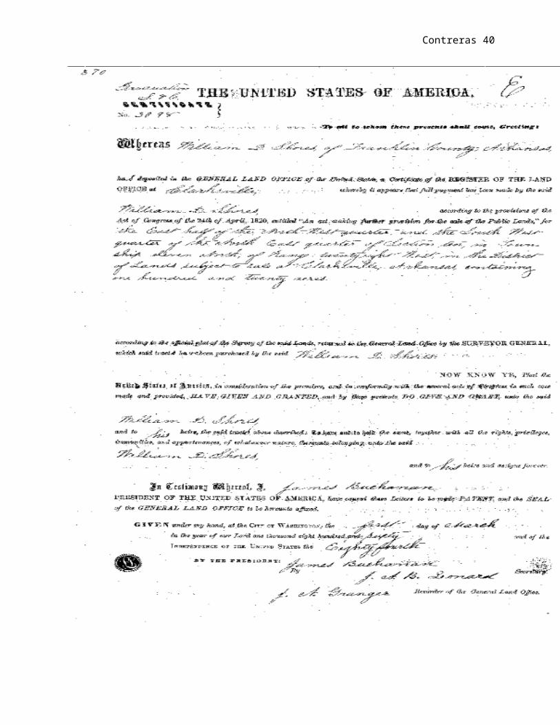
48 See illustrations of land grants courtesy of Arkansas Archives
Federal Land Grants. http://usgwarchives.net/ar/fedland.htm
Contreras 33
County, Arkansas from 1 April 1861 to Spring 1865, when he moved
thirty miles north to a colony on the middle fork of White River,
where he remained to the close of the Civil War. “At the
beginning of the ‘Rebellion’ I don’t know that I sympathized with
either side. I would rather they wouldn’t have forced the start.”
William became Justice of the Peace in Franklin County, Arkansas
in 1868. After the death of William D. Shores on 22 August 1885,
his son, Alfred Wallace Shores, continued on with all the
business operations. It was a gathering showplace for everyone,
until the government bought all of his land. The land that was
forced to sell is now known as Shores Lake.49
The story of western expansion took many forms. There was
the trapper in quest for wealth in the fur trade. Their legacy to
“Western Expansion” was the mapping of the Western routes that
49 The 1860 United States Federal Census lists W.D. Shores (age
56). Living with him were Charity S. Shores (age 16), Alfred W.
Shores (age 12), Louis C. Shores (age 10), Wm. Carmack (age 21),
and A. Fugit (age 30) (Year: 1860; Census Place: White Rock,
Franklin, Arkansas; Roll: M653_41; Page: 324; Image: 324; Family
History Library Film: 803041).

Contreras 34
allowed others to ensue. The farmer followed leaving a legacy of
sustenance farming. In this process the farmer clear land and
set rudimentary networks for food to be attained for those to
follow. The miner followed and in the process of exploiting the
resources of the West benefited from their predecessors’
accomplishments, but likewise those who followed the miners,
farmers, and trappers was the supplier. The supplier by far was
the most who benefited in the Western expansion. The supplier
was the one who supplied the trappers with the essentials to
carry on their enterprise. The supplier benefited from the
farmer in supplying the equipment, seeds, and ammunition for
sustenance farmer. The supplier also benefited from the miner.
Perhaps even more so than any of the other predecessors for the
miner not only in need of supplies but sustenance as well.50
50 Robert M. Utley, A life Wild and Perilous: Mountain Men and their Paths to the
Pacific, (New York: Henry Holt and Company, Inc.), 85. Utley argues
that the supplier was the person who gained more since supply was
always in demand for those who were trapped in remote areas.

Contreras 35
As the California Gold rush was in its full swing, the miner
was in need of supplies to carrying on their endeavors. Among
the many, the cattle drives sought to meet this demand. Unlike
pork and chicken, beef required consumption immediately after
processing. Beef was a luxury item that could not be obtain from
Spanish California as the Spanish rancher used cattle for items
such as leather, tallow, and candles. The cattle drives provided
the substance that miners required. It is because of this demand
for beef that cattle drives were a lucrative enterprise. Cattle
in Arkansas worth five to eight dollars per head sold as much as
fifty dollars per head in California making cattle drive a
lucrative enterprise for those who embarked on them.
Motivation for embarking on such expeditions varies from
individual to individual. Wealth, change of socio-economic
status, and land acquirement were among many of the motivations.
However, their motivations are examples of “Western Expansion.”
Shores story, while not unique, does describe that cattle drive
did in fact took place from east to west. This narrative sought
to address the gap from historians considering the east to west
cattle drives. Since all cattle, drives shared similar

Contreras 36
experiences, dilemmas, and tragedies; this narrative was not
unique in that aspect. The intention of this narrative was to
illuminate the fact that cattle drives in fact did originated
from east to west. The story of William D. Shores is an
embodiment of such cattle drives originating from Arkansas to
California. Shores story is more than an example of such feat
originating out of the east; it is a continuation of the story of
“Western Expansion” during the middle of the 19th century. It is
also a story of Jeffersonian ideology where Shores envision
owning land and ultimately living as a self-sufficient yeoman
farmer despite his socio-economic background. Shores story is
the epitome of “Western Expansion.”
Bibliography
Arkansas Archives: Federal Land Grants. http://usgwarchives.net/ar/fedland.htm
Bagley, Clarance B. “Crossing the Plains.” The Washington Historical Quarterly, Vol. 13, No. 3, (Jul., 1922), 163-180.
Callan, John F. The Military Laws of the United States: Relating to the Army, Volunteers, Militia, and to Bounty Lands and Pensions from the foundation of theGovernment to the year 1886. Philadelphia: Henry B. Ashmead, 1865.

Contreras 37
Denton, Ivan. Old brands and lost trails: Arkansas and the great cattle drives. Fayetteville, AR: University of Arkansas Press, 1991
Encyclopedia of Arkansas, Cattle Drive http://www.encyclopediaofarkansas.net
Hanson, Gerald T. Historical Atlas of Arkansas. University of Oklahoma Press, 1992.
Everett, Derek R. “On the Extreme Frontier: Crafting the Western Arkansas Boundary.” The Arkansas Historical Quarterly, Vol. 67, No. 1 (Spring, 2008), 1-26.
Families Forever: Historic Trails of the Old West.” http://www.ida.net/users/lamar/trails.html
History of the American West, 1860-1920: Photographs from the Collection of the Denver Public Library http://memory.loc.gov/cgi-bin/query
Hughes, Simon P. “The Progress of Arkansas” The North American Review,Vol. 143, No. 357 (Aug., 1886), 133-141.
Lambert Bowman Wolf. “Extracts from Diary of Captain Lambert Bowman Wolf.” Kansas Historical Quarterly, Vol. 1, No. 3, (May, 1932) 195 – 210.
Love, Clara M. “History of the Cattle Industry in the Southwest” The Southwestern Quarterly, Vol.19. No.4 (April, 1916), 370-399.
Library of Congress. “The Land Act of 1820”. 16th Congress, Session I. Chapter 51 Stat I (1820). Chap. LI. An Act making further provisions for the sale of Public Lands.
Library of Congress. “The Preemption Act of 1841”. 27th Congress, Ch. 16, 5 Stat. 453 (1841) CHAP. XVI.—An Act to appropriate the proceeds of the sales of the public lands, and to grant pre-emption rights.

Contreras 38
Montague, Ludwell L. “Subsistence of the Army of the Valley.” Society of Military Affairs, Vol. 12, No. 4, (Winter, 1948),226-231.
Shepard family historical records are a private collection of historical document on the Sheppard Matrilineal family line who settled in Arkansas in the early nineteenth century. Among the information obtain from the private collection arewills, court records, land grants, deeds, and letters from family who immigrated from Scotland to present day Ozark, Arkansas. Details description on living condition geographical settlement data, marriage, death, and birth records are among some of the information contain in the collection.
State of Arkansas Historical Land Records. http://www.cosl.org/history/spanish.aspx
The Public Land Survey National Atlas of the United States of America. http://nationalatlas.gov/articles/boundaries/a_plss.html
University of Texas Libraries, The University of Texas at Austin http://www.lib.utexas.edu/maps/histus.html
Utley, Robert M. A life Wild and Perilous: Mountain Men and their Paths to the Pacific. New York: Henry Holt and Company, Inc., 1997.
Wedel, Waldo R.“The High Plains and Their Utilization by the Indian.” Society for American Archeology: American Antiquity, Vol. 29, No. 1,( Jul., 1963), 1-16.
Wilson, Jaunita. Cincinnati, Arkansas, Illinois Township, 1836-1986. Siloam Springs: Siloam Springs Print, 1986
Whayne, Jeannie M., Black, Thomas A., Sobo III, George, and Arnold, Morris S. Arkansas: A Narrative history. Fayetteville: The University of Arkansas Press, 2002

Contreras 39
Contreras 40

Contreras 41

Contreras 42

Contreras 43