Case Study: Ellicott City Flood Event - Howard County
37
2016 Case Study: Ellicott City Flood Event Case Study-2016 Ellicott City Flood Event Smith Planning and Design, LLC 4/15/2017
-
Upload
khangminh22 -
Category
Documents
-
view
0 -
download
0
Transcript of Case Study: Ellicott City Flood Event - Howard County

2016 Case Study: Ellicott City Flood Event
Case Study-2016 Ellicott City Flood Event
Smith Planning and Design, LLC
4/15/2017

Case Study - 2016 Ellicott City Flood Event
Howard County Office of Emergency Management (OEM) Page 1
Section 1: Overview
1.1 Purpose
Historic downtown Ellicott City and some surrounding areas experienced a devastating flood event on July 30, 2016 that affected nearly every resident, property owner, business owner, tenant, and visitor present during the flood event. Torrential precipitation occurred on the evening of Saturday, July 30, 2016 resulting in a flash flood scenario that caused significant damage. The purpose of this Case Study is to collect information and documentation specific to properties that were impacted by the flood waters along the Tiber-Hudson Branch in historic downtown Ellicott City. Additionally, this Case Study was prepared to provide a descriptive narrative of the flood occurrences based on first-hand witness accounts.
Information/Documentation presented within the Case Study includes:
• Section 1: Timeline Provides a sequence of events during the flood incident;
• Section 2: Interviews
Includes Property Owner and/or Occupants mapping of properties in the study area that experienced flood damage during the July 30 flood, including property owner contact information and a description of the extent and value of the damage, as available;
• Section 3: Results
Includes approximate source of the flood waters, such as, stream overflowing its banks, backup of flood water behind a culvert or other channel restriction, street flooding, etc.
• Appendix A: Flood Event Log • Appendix B: ArcGIS Map Exhibits & Attribute Table • Appendix C: Description of Damages and/or Flood Conditions • Appendix D: Repository

Case Study - 2016 Ellicott City Flood Event
Howard County Office of Emergency Management (OEM) Page 2
1.2 July 30, 2016 Flood Event
On Saturday, July 30, 2016, torrential rains passed through Howard County, Maryland resulting in severe flash flooding through historic downtown Ellicott City. The National Weather Service (NWS) reported that 5.96 inches of rainfall occurred within a two hour period. According to the Ellicott City rain gauge (ELYM2), 5.48 inches of that rainfall occurred in the first 90 minutes or less. The total rainfall for the storm event recorded by the rain gauge was 6.60 inches. Due to the city’s proximity to waterways, this historic flood event caused extensive property and infrastructure damage, significant erosion, and loss of life.
1.3 Data Collection
In order to obtain the necessary data needed to complete this Case Study, property owner (residential and commercial) interviews were conducted. A total of fifty two (52) interviews were conducted, a majority of which, were in-person. Data collection occurred during November and December of 2016.
Additional sources of data collected included photographs and video taken during the flood event, as well as, various incident reports and files collected by County staff.
FIGURE 1
Image Source Page: http://www.weather.gov/lwx/EllicottCityFlood2016

Case Study - 2016 Ellicott City Flood Event
Howard County Office of Emergency Management (OEM) Page 3
Section 2: Timeline
2.1 Data Gathering
During the course of the flood event and the weeks following, various sources of information regarding the flood event were collected and cataloged in Appendix D: Repository. Types of information included:
• WebEOC Log data; • Briefing Reports; • Stream Gage data; • Pictures; and, • Video Footage.
In order to provide an overview of the flood event, a timeline was developed. In addition to the timeline, a flood event log containing more detailed information has been included in Appendix A.
Case Study - 2016 Ellicott City Flood Event
Howard County Office of Emergency Management (OEM) Page 4
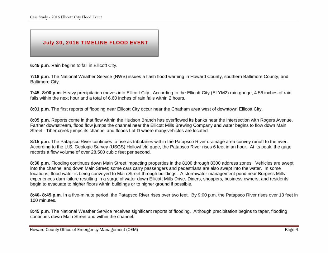
6:45 p.m. Rain begins to fall in Ellicott City.
7:18 p.m. The National Weather Service (NWS) issues a flash flood warning in Howard County, southern Baltimore County, and Baltimore City.
7:45- 8:00 p.m. Heavy precipitation moves into Ellicott City. According to the Ellicott City (ELYM2) rain gauge, 4.56 inches of rain falls within the next hour and a total of 6.60 inches of rain falls within 2 hours.
8:01 p.m. The first reports of flooding near Ellicott City occur near the Chatham area west of downtown Ellicott City.
8:05 p.m. Reports come in that flow within the Hudson Branch has overflowed its banks near the intersection with Rogers Avenue. Farther downstream, flood flow jumps the channel near the Ellicott Mills Brewing Company and water begins to flow down Main Street. Tiber creek jumps its channel and floods Lot D where many vehicles are located.
8:15 p.m. The Patapsco River continues to rise as tributaries within the Patapsco River drainage area convey runoff to the river. According to the U.S. Geologic Survey (USGS) Hollowfield gage, the Patapsco River rises 6 feet in an hour. At its peak, the gage records a flow volume of over 28,500 cubic feet per second.
8:30 p.m. Flooding continues down Main Street impacting properties in the 8100 through 8300 address zones. Vehicles are swept into the channel and down Main Street; some cars carry passengers and pedestrians are also swept into the water. In some locations, flood water is being conveyed to Main Street through buildings. A stormwater management pond near Burgess Mills experiences dam failure resulting in a surge of water down Ellicott Mills Drive. Diners, shoppers, business owners, and residents begin to evacuate to higher floors within buildings or to higher ground if possible.
8:40- 8:45 p.m. In a five-minute period, the Patapsco River rises over two feet. By 9:00 p.m. the Patapsco River rises over 13 feet in 100 minutes.
8:45 p.m. The National Weather Service receives significant reports of flooding. Although precipitation begins to taper, flooding continues down Main Street and within the channel.
July 30, 2016 TIMELINE FLOOD EVENT
Case Study - 2016 Ellicott City Flood Event
Howard County Office of Emergency Management (OEM) Page 5
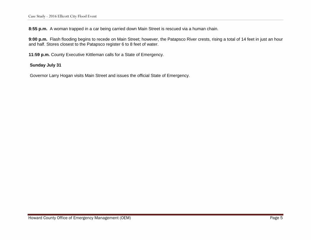
8:55 p.m. A woman trapped in a car being carried down Main Street is rescued via a human chain.
9:00 p.m. Flash flooding begins to recede on Main Street; however, the Patapsco River crests, rising a total of 14 feet in just an hour and half. Stores closest to the Patapsco register 6 to 8 feet of water.
11:59 p.m. County Executive Kittleman calls for a State of Emergency.
Sunday July 31
Governor Larry Hogan visits Main Street and issues the official State of Emergency.
Case Study - 2016 Ellicott City Flood Event
Howard County Office of Emergency Management (OEM) Page 6
Section 3: Interviews
3.1 Data Gathering
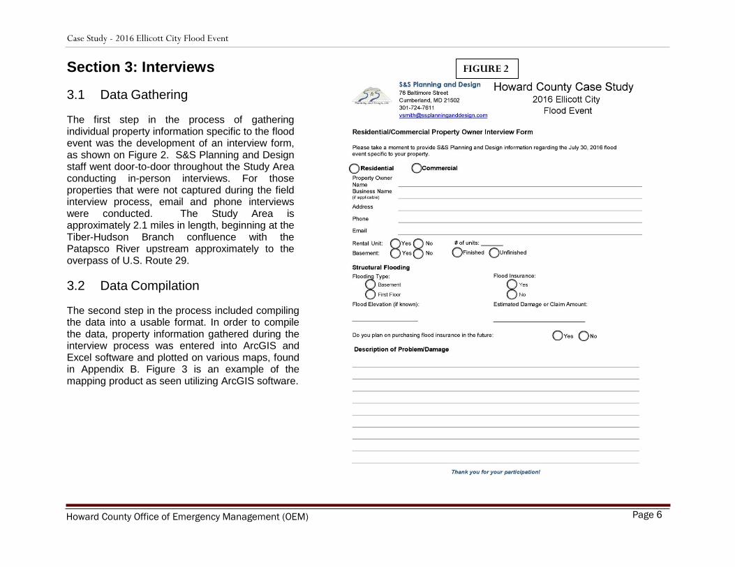
The first step in the process of gathering individual property information specific to the flood event was the development of an interview form, as shown on Figure 2. S&S Planning and Design staff went door-to-door throughout the Study Area conducting in-person interviews. For those properties that were not captured during the field interview process, email and phone interviews were conducted. The Study Area is approximately 2.1 miles in length, beginning at the Tiber-Hudson Branch confluence with the Patapsco River upstream approximately to the overpass of U.S. Route 29.
3.2 Data Compilation
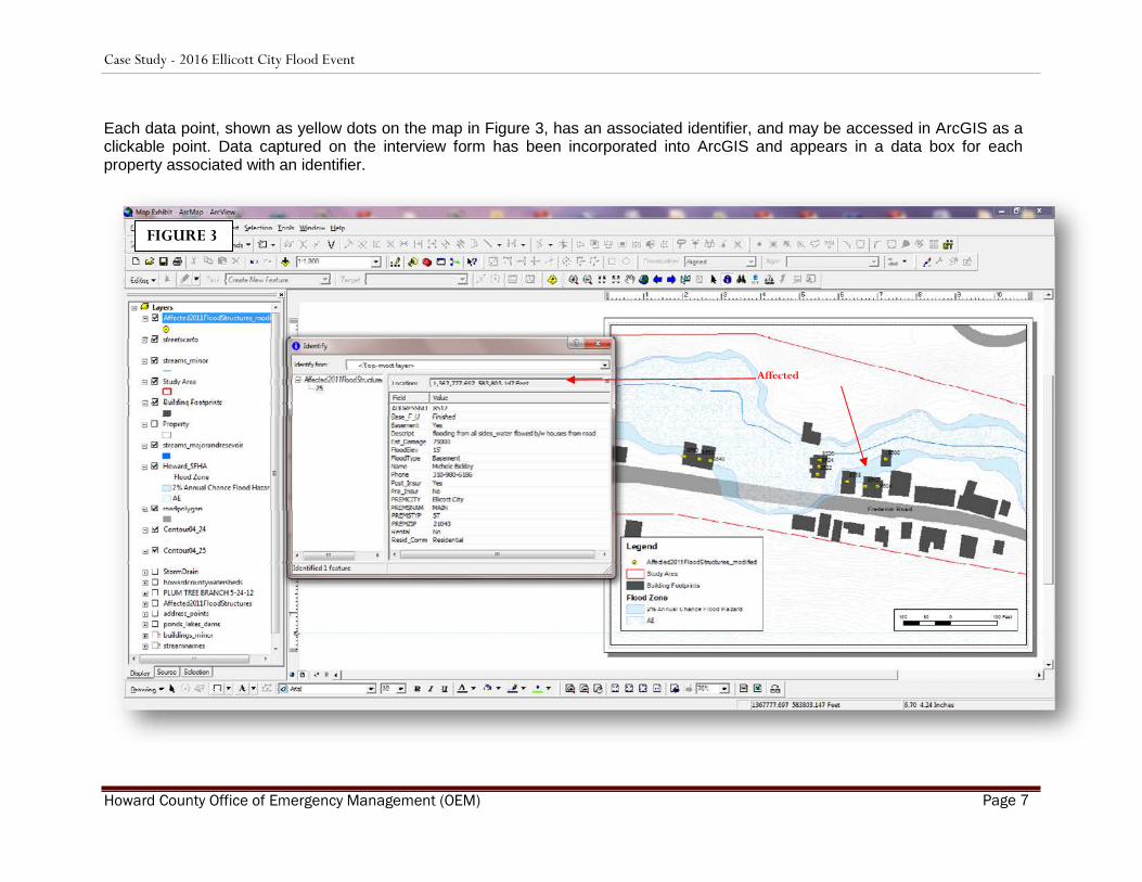
The second step in the process included compiling the data into a usable format. In order to compile the data, property information gathered during the interview process was entered into ArcGIS and Excel software and plotted on various maps, found in Appendix B. Figure 3 is an example of the mapping product as seen utilizing ArcGIS software.
FIGURE 2
Case Study - 2016 Ellicott City Flood Event
Howard County Office of Emergency Management (OEM) Page 7
Each data point, shown as yellow dots on the map in Figure 3, has an associated identifier, and may be accessed in ArcGIS as a clickable point. Data captured on the interview form has been incorporated into ArcGIS and appears in a data box for each property associated with an identifier.
Affected
FIGURE 3

Case Study - 2016 Ellicott City Flood Event
Howard County Office of Emergency Management (OEM) Page 8
3.3 Results
Information extracted from the Interview Forms is compiled and presented in Table 1.
TABLE 1
Total # of Properties Interviewed
Total # of Properties Impacted
by Flood Event
Total # of Properties Reporting
Monetary Flood Damage
52
**50
36
Residential
Commercial
Residential
Commercial
Residential
Commercial
19
33
18
32
18
32
Owner Occupied
Renter Occupied
Owner Occupied
Renter Occupied
5
13
13
19
Flood Insurance
Flood Insurance
Flood Insurance
Flood Insurance
Yes
No
Yes No Yes No Yes No
*Total Damages Reported: $ 3,431,840
*Notes: Total damages reported is estimated based on the responses received from the survey. Some property owners and/or tenants could not provide an accurate estimate at the time of the survey. **The total number of properties impacted by the flood event was much greater. This number represents the number of properties impacted that were interviewed or surveyed.
Note: To provide additional perspective on the flood’s financial impact, it is estimated that this flood event resulted in $10.8 million in public infrastructure damage and approximately $67.2 million in economic loss for Ellicott City, as described in the Jacob France Institute report completed in November 2016.
Case Study - 2016 Ellicott City Flood Event
Howard County Office of Emergency Management (OEM) Page 9
Impacted Properties Occupancy Type
Renter occupied
Owner Occupied
Properties Reporting Monetary Damages-
Flood Insurance
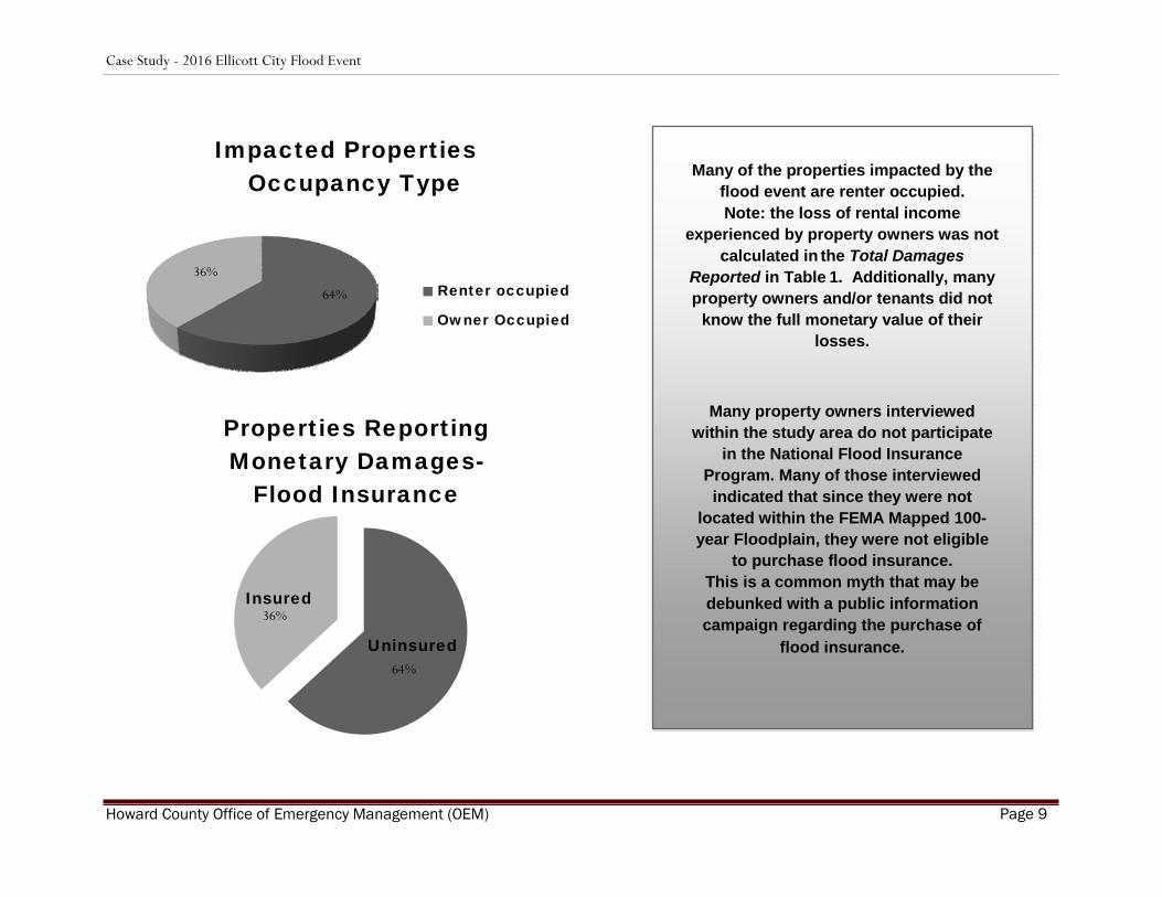
Many of the properties impacted by the
flood event are renter occupied. Note: the loss of rental income
experienced by property owners was not calculated in the Total Damages
Reported in Table 1. Additionally, many property owners and/or tenants did not
know the full monetary value of their losses.
Many property owners interviewed within the study area do not participate
in the National Flood Insurance Program. Many of those interviewed indicated that since they were not
located within the FEMA Mapped 100-year Floodplain, they were not eligible
to purchase flood insurance. This is a common myth that may be debunked with a public information campaign regarding the purchase of
flood insurance.
36%
64%
Insured
Uninsured
36%
64%

Case Study - 2016 Ellicott City Flood Event
Howard County Office of Emergency Management (OEM) Page 10
Narrative Descriptions of Flood Flow by Address Zone Information extracted from the Description of Property Damages Interview Form, as well as interviewer notes acquired during property owner interviews are compiled in narrative format and mapped to illustrate the approximate flow of flood waters by address zones. 8800 Address Zone The 8800 Address Zone, for the purposes of this study, is described as the linear area with the upper limit at the intersection of Frederick and Toll House Roads, and the lower limit as the structure located at 8799 Frederick Road. Only one (1) residential structure was impacted by flooding within the 8800 Address Zone. Witnesses at this residence described three (3) rivers of water converging in their backyard. Two “rivers” of water were coming down the powerline right-of-way across the creek from their residence. It is very likely that one flow feature (river 1) was being conveyed down the steep hill of the powerline right-of-way while the other flow feature (river 2) was coming from the Toll House Road corridor. An existing topographic depression is present that would allow flow to divert from Toll House Road and be conveyed down the right-of-way. The resident also indicated that channel flow (river 3) was elevated significantly as well from the contributing drainage area upstream of U.S. Route 29. Flood water damaged the foundation of the home and was the highest flood elevation they have witnessed. The flood waters were then backed up by the Frederick Road Bridge due to conveyance capacity and debris jams, resulting in the water breaching the road crest and bridge and sending flood flow down Frederick Road. Some flood water redirected from Frederick Road back towards the channel and floodplain, resulting in road embankment washouts along the north side of Frederick Road. Due to the channel and floodplain being completely inundated with flood flow, Frederick Road also served as a flood conveyance leading into the 8700 Address Zone. 8700 Address Zone The 8700 Address Zone is described as the linear area with the upper limit at approximately 8799 Frederick Road to the intersection of Frederick Road and Rogers Avenue. Nearly all of the structures within the 8700 Address Zone were impacted by the flood due to flood flow that escaped the channel upstream of this zone and continued to utilize Frederick Road as a flood conveyance. All of the structures within this zone are located on the south side of Frederick Road. Flood waters jumped the crossing at the Frederick Road Bridge No. 1 as indicated on the 8700 Address Zone Map. Debris accumulation at this location may have occurred, thereby resulting in or exacerbating the flood waters leaving the channel and flowing east along Frederick Road. With the channel and floodplain located to the south of the road, some flood flow attempted to migrate toward the actual floodplain and creek channel, however, witnesses reported that although the entire valley was under water, Frederick Road was the shallow section. Additionally, witnesses indicated that a large quantity of water was being conveyed down Rogers Avenue. One resident described a very large sycamore tree (2-3’ DBH) that had been deposited within the floodplain of this zone, near his structure at 8777 Frederick Road.
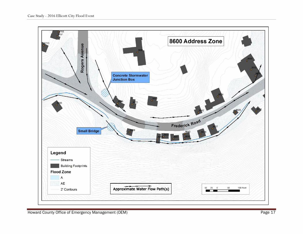
8600 Address Zone The 8600 Address Zone is described with the upper limit at the Frederick Road and Rogers Avenue intersection and the lower limit at the upper end of the West End Service facility. The majority of the structures within the 8600 Address Zone experienced flooding; however, several structures escaped flood damage. Some observers opinioned that the concrete channel section located immediately across from the Rogers Avenue intersection, along with the two bridges (1 foot; 1 vehicular) resulted in flood flow being

Case Study - 2016 Ellicott City Flood Event
Howard County Office of Emergency Management (OEM) Page 11
directed towards Frederick Road. The basis of these opinions was due to the channel size and the height of the lowest bridge chord relative to the channel. Additionally, the volume of water generated by the Rogers Avenue corridor was reiterated by several observers. The combined flows from the creek channel/floodplain, Frederick Road, and Rogers Avenue, in conjunction with the low, flat topography of the area, created a large area for floodwater to accumulate. Immediately downstream of the intersection, the topography constricts the valley again and the gradient gets steeper. The valley section within this reach is relatively confined. With the quantities of water described from both the Frederick Road and Rogers Avenue corridors, and the geomorphic valley condition, it is not surprising that flood flow through this section extended from valley wall to valley wall, had a higher concentrated depth, and increased velocity, creating a chute of deep, fast moving water. At approximately the middle of this zone, it was reported that the flow depth over the road was estimated at 3 feet. Due to the flood water elevations through this reach, structures located between the creek channel and the road experienced flooding from both sides and included basement and first floor flooding. The rears of many of these structures terminate at the stacked stone flood wall along the creek, with some structures overhanging the creek, or completely bridging the creek to the far bank. The stacked stone flood wall failed in several areas through this zone. This address zone extends downstream to just beyond the inlet of the large culvert that conveys flow under Frederick Road and several commercial properties. Witnesses reported that floodwaters were overtopping the culvert inlet and continuing down Frederick Road. Debris accumulation or blockage at this culvert inlet may have exacerbated the flood waters overtopping the culvert headwall and continuing down Frederick Road; however, it is also possible that the sheer volume of water generated by the flood event was significantly greater than the hydraulic conveyance designed for the culvert inlet. The valley begins to widen at the structure located at 8624 Frederick Road, just upstream of the West End Service facility. Witnesses stated that a hydraulic vortex (whirlpool) occurred just upstream of the facility, generating enough force to rip up and transport macadam asphalt chunks downstream into the West End Service parking lot. This occurrence will be further discussed in the 8500 Address Zone section that follows. 8500 Address Zone The 8500 Address Zone is defined at the upper limit as the West End Service facility and the lower limit at approximately 8500 Frederick Road. The majority of the structures within this address zone were affected by the flood. Flooding within the 8500 Address Zone was a combination of both flood waters from the creek and roadway. As previously described, witnesses reported significant flood flow down Frederick Road; at one location the water depth on the road was reported to be approximately 3.5 to 4 feet deep. As the valley opens up and widens at this location, flood waters spilled into the West End facility and continued along Frederick Road. The previously mentioned macadam asphalt debris generated by the vortex settled and blocked an at-grade inlet drain that drains the parking lot into the large culvert beneath the facility, thereby exacerbating the flooding through this reach. The property owners utilized heavy equipment to remove the drain impediment. They described a whirlpool effect as the water was drained and pulled into the underlying culvert that runs beneath the property.

Case Study - 2016 Ellicott City Flood Event
Howard County Office of Emergency Management (OEM) Page 12
As the flood flow continued downstream, a slight rise in the roadway elevation resulted in some of the flow along Frederick Road to be directed back towards the creek and floodplain, albeit having to flow around several structures in the process. Several rock retaining walls were destroyed in the process. Another hydraulic vortex occurred immediately behind the structure at 8580 Frederick Road and excavated enough material that witnesses described it as a sink hole. In the lower reaches of this address zone, another large culvert conveys flow between and under two structures. The channel approaching the culvert inlet is armored with gabions in a trapezoidal shape. A preponderance of Japanese Knotweed is located along both banks. Within the floodplain adjacent and upstream of this culvert, a berm has been installed. The presence and orientation of this berm has the capacity to redirect flood flow back onto Frederick Road, thereby preventing flow from returning to the channel.
8400 Address Zone The 8400 Address Zone is described with the upper limit at approximately 8500 Frederick Road and the lower limit at approximately the Frederick Road and Ellicott Mills Drive intersection. Flooding within the 8400 zone occurred from both Frederick Road and the creek/floodplain conveyance. The channel and floodplain through the upper section of this address zone is located to the north of the majority of structures within this reach. Therefore, these structures experienced some basement flooding from the channel side of their property. Flood flow was still being conveyed down Frederick Road and resulted in some first floor flooding. Several witnesses reported a large amount of water flow coming down the hill from the south in the approximate area of 8435 Frederick Road. It was described as “two large waterfalls coming off the hill and crashing into Frederick Road.” These same witnesses described how the basement and first floor of their structure were filled will floodwater from both the front and rear of the structure in a matter of minutes, with them retreating to the upper levels. A large culvert inlet is located just upstream of Ellicott Mills Drive and conveys flow to an outfall located just below Parking Lot F. the culvert inlet is located at the downstream end of a particularly steep and narrow valley section, with several cascading rock waterfalls leading down to the inlet invert. Witnesses stated that at least one car blocked the inlet of this culvert during the flood, contributing to its inability to convey the flood waters. Another swirling eddy-type vortex was created, resulting in severe erosion behind the headwall of the culvert, although it did not appear to structurally impact the headwall. However, sufficient backwater was generated to overtop Ellicott Mills Drive and continue the flooding down Main Street. Additionally, witnesses described significant flood waters coming from both Ellicott Mills Drive and Fels Lane, both of which flooded Parking Lot F, inundating and stranding cars within the parking lot. One account described a man at the intersection of Ellicott Mills Drive and Fels Lane having to climb a tree to avoid being swept away by a “wall of water”.
8300 Address Zone The 8300 Address Zone is delineated in the upper portion by the Ellicott Mills Drive and Main Street intersection to approximately the Main Street and Church Road intersection. The 8300 Address Zone demarcates the beginning of the historic downtown Ellicott City section and consists predominantly of commercial properties on the first floor levels, with some residential apartments located in upper floors. Some properties are owner occupied, however many are tenant occupied. Based on the interviews conducted, nearly every property was impacted by the flood event, ranging from mild to severe.

Case Study - 2016 Ellicott City Flood Event
Howard County Office of Emergency Management (OEM) Page 13
At upper end of the zone, the stream outfalls from a large, approximately 400 foot-long culvert that conveys flow under Ellicott Mills Road and Parking Lot F. As previously described, this culvert failed, resulting in flood waters overtopping Ellicott Mills Drive and sending flood water down Main Street and into Parking Lot F. The flood water that did not get conveyed by Main Street inundated the structures north of Main Street and west of Court Avenue as the water attempted to get back into the channel. Both basement and first floor flooding were prominent. At Court Avenue, the stream channel enters into a reach with stacked stone flood walls along both banks. This condition is, for the most part, standard practice for the remaining downstream sections, with some single-bank exceptions. Downstream of the Court Avenue crossing and immediately south of Parking Lot E, the channel is forced into a ninety degree turn in order to be conveyed under Main Street and several buildings via a large rectangular culvert that outfalls at the upper end of Parking Lot D. Although the hydraulic conveyance of this culvert appears large, a constriction in the form of an archway is located approximately under Main Street that greatly reduces flow capacity. This archway is likely the original historic bridge structure for Main Street. Witnesses reported that both a car and a dumpster were in the channel during the flood just upstream of this location. It was not clear whether either impediment reached the archway or not. Regardless, this location functioned as an additional flood “bottleneck”, with flood water backing up sufficient to spill out to Main Street to join the flood flow already directed down Main. Additionally, an erosive eddy or maelstrom was created that scoured material and damaged the structural integrity of the adjacent buildings. Flood water flooded the basement of a local pub with sufficient force to blow outward one of the basement windows to add additional flood flow to Main Street. Flood flow continued downstream through Parking Lot D, completely removing a foot bridge from its foundations, and flooding adjacent buildings.
8200 to 8000 Address Zones Address Zones 8200 to 8000 are combined within this narrative. The upper reach of this zone is defined as the region approximately between Church Road and Old Columbia Pike intersections with Main Street. At this point, the stream valley again becomes topographically constricted with steep side valley slopes and the overall gradient of the valley steepens. Additionally, the Tiber River confluences with the Hudson Branch at approximately the 8150 Main Street address at the rear of the buildings. From this confluence downstream, the channel is predominantly bridged over with buildings and roads with stone flood walls on each side of the channel. Nearly all the structures within these zones experienced flood damage, ranging from minor to catastrophic. The flood flow conveyed by Main Street was described by witnesses as a wall of water several feet deep moving rapidly. Cars and other debris were mobilized. The combination of water and debris smashed several storefronts. Entryways and at-grade windows failed due to the force of the water. The erosional force of the flood flow was powerful enough to rip a channel through the pavement along the southern side of Main Street, damaging utilities, sidewalks, and building facades.
Case Study - 2016 Ellicott City Flood Event
Howard County Office of Emergency Management (OEM) Page 14
The flood flow was severe within the channel behind and under the buildings as well. Nearly every structure along the south side of Main Street experienced severe basement flooding. Several of the rock flood walls through these sections drastically failed. Several of the buildings that bridge the channel experienced severe structural damage; the first floors of several buildings were completely gutted by the flood waters, leaving only debris and steel beams. Several accounts described the flood through this zone as several “waves” or “walls” of water coming down Main Street. One property owner in the 8000 zone indicated that the Main Street flooding preceded the channel flooding, with flood waters smashing through the front of the building prior to the basement level getting flooded by the channel under the building. Many of the buildings in this downtown section were boarded up and closed; many of the business owners interviewed during the study were unsure if those businesses were planning to rebuild. However, in the months following the flood, many of the businesses had rebuilt and reopened, or were still in the process of rebuilding.

Case Study - 2016 Ellicott City Flood Event
Howard County Office of Emergency Management (OEM) Page 15

Case Study - 2016 Ellicott City Flood Event
Howard County Office of Emergency Management (OEM) Page 16
Case Study - 2016 Ellicott City Flood Event
Howard County Office of Emergency Management (OEM) Page 17

Case Study - 2016 Ellicott City Flood Event
Howard County Office of Emergency Management (OEM) Page 18

Case Study - 2016 Ellicott City Flood Event
Howard County Office of Emergency Management (OEM) Page 31

Case Study - 2016 Ellicott City Flood Event
Howard County Office of Emergency Management (OEM) Page 32

Case Study - 2016 Ellicott City Flood Event
Howard County Office of Emergency Management (OEM) Page 33

Case Study - 2016 Ellicott City Flood Event
Howard County Office of Emergency Management (OEM) Page 34

Case Study - 2016 Ellicott City Flood Event
Howard County Office of Emergency Management (OEM) Page 35
3.4 Conclusions The July 30, 2016 flood in Ellicott City was a catastrophe in terms of loss of life and property/infrastructure damage. This was a record flood that devastated businesses, property owners, and residents. Information obtained during the data collection, compilation, and analysis of the Case Study data indicate that flood mitigation activities and projects should be undertaken. Public outreach activities regarding flood insurance and flood proofing are highly recommended.
Examples of flood mitigation could include flood proofing exterior building facades along Main Street. Flood proofing actions could include installing stronger watertight windows and doors, and elevating thresholds. One business owner described how the heavy double doors to his business were able to withstand the force of the flood waters. Building utilities should be elevated where possible to rooftops or upper floors. Hard surface building materials could be utilized for floors and first floor walls to reduce building-to-building flood conveyance due to blown out walls, and to reduce the potential for black mold growth post flood. Many property owners had flood insurance; however, many did not if it was not required. Some property owners described attempting to buy third party flood insurance and were subsequently denied coverage. Many of the properties were occupied by tenants and were not eligible for flood insurance; furthermore, many tenants with renter’s insurance stated that their contents were not covered by the insurance based on the losses due to flooding. Based on pictures, videos, and first-hand accounts, much of the damage incurred to properties along Main Street was due to vehicles mobilized by the flood waters. Therefore, preventative actions or alternatives should be evaluated and considered to minimize the potential for this type of damage to recur, at least until other mitigating actions or projects are completed that may reduce the possibility of Main Street becoming a significant floodway. The Stream Corridor Assessment (SCA) completed in conjunction with this Case Study, details specific locations within the study area that are problematic and contribute to flooding. Problems such as: blockages resulting in impediment to flow within the stream channel, deteriorated flood walls, various sized culverts within the same stream reach, and overall maintenance issues. Recommendations regarding flood mitigation activities related to the stream are detailed within the SCA.

Case Study - 2016 Ellicott City Flood Event
Howard County Office of Emergency Management (OEM) Page 36
APPENDIX A: FLOOD EVENT LOG
6:45 p.m. Rain begins to fall in Ellicott City.
7:18 p.m. The National Weather Service (NWS) issues a flash flood warning in Howard County, southern Baltimore County, and Baltimore City.
7:45- 8:00 p.m. Heavy precipitation moves into Ellicott City. According to the Ellicott City (ELYM2) rain gauge, 4.56 inches of rain falls within the next hour and a total of 6.60 inches of rain falls within 2 hours.
8:01 p.m. The first reports of flooding near Ellicott City occur near the Chatham area west of downtown Ellicott City.
8:05 p.m. Reports come in that flow within the Hudson Branch overflowed its banks near the intersection with Rogers Avenue. Farther downstream, flood flow jumps the channel near the Ellicott Mills Brewing Company and water begins to flow down Main Street. Tiber creek jumps its channel and floods Lot D where many vehicles are located.
8:15 p.m. The Patapsco River continues to rise as tributaries within the Patapsco River drainage area convey runoff to the river. According to the U.S. Geologic Survey (USGS) Hollowfield gage, the Patapsco River rises 6 feet in an hour. At its peak, the gage recorded a flow volume of over 28,500 cubic feet per second.
8:30 p.m. Flooding continues down Main Street impacting properties in the 8100 through 8300 address zones. Vehicles are swept into the channel and down Main Street; some cars carry passengers and pedestrians are also swept into the water. In some locations, flood water is being conveyed to Main Street through buildings. A stormwater management pond near Burgess Mills experiences dam failure resulting in a surge of water down Ellicott Mills Drive. Diners, shoppers, business owners, and residents begin to evacuate to higher floors within buildings or to higher ground if possible.
8:40- 8:45 p.m. In a five-minute period, the Patapsco River rises over two feet. By 9:00 p.m. the Patapsco River will have risen over 13 feet in 100 minutes.
8:45 p.m. The National Weather Service receives significant reports of flooding. Although precipitation begins to taper, flooding continues down Main Street and within the channel.

Case Study - 2016 Ellicott City Flood Event
Howard County Office of Emergency Management (OEM) Page 37
8:55 p.m. A woman trapped in a car being carried down Main Street is rescued via a human chain.
9:00 p.m. Flash flooding begins to recede on Main Street; however, the Patapsco River crests, rising a total of 14 feet in just an hour and half. Stores closest to the Patapsco register 6 to 8 feet of water.
11:59 p.m. County Executive Kittleman calls for a State of Emergency.
Sunday July 31
Governor Larry Hogan visits Main Street and issues the official State of Emergency.

Case Study - 2016 Ellicott City Flood Event
Howard County Office of Emergency Management (OEM) Page 38
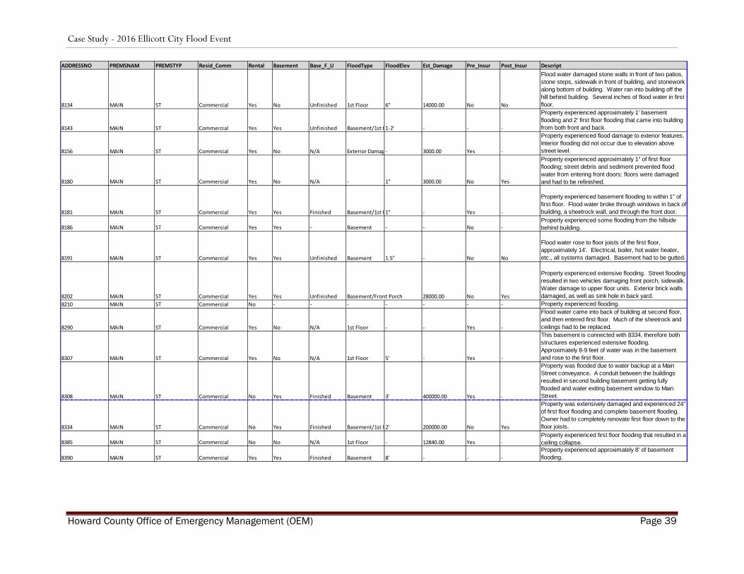
APPENDIX B: ArcGIS & ATTRIBUTE TABLE
ADDRESSNO PREMSNAM PREMSTYP Resid_Comm Rental Basement Base_F_U FloodType FloodElev Est_Damage Pre_Insur Post_Insur Descript
8388 COURT AVE Commercial Yes - - 1st Floor 2" 1000.00 - -Two properties with this identifier experienced 1-2” of flooding due to their location and elevation.
3615 FELS LANE Residential No Yes Unfinished - 0 0.00 No No
Property experienced minimal flooding. Reports described a wall of water coming down street resulting in one resident climbing a tree to escape. Two smaller tributaries to Tiber-Hudson contributed to flooding.
8444 FREDERICK RD Residential Yes Yes Finished Basement 7' - - -
Property experienced extensive basement and first floor flooding, primarily from channel, however, reports of significant water coming from the opposite hillside were reported at this location. Witnesses reported water coming from all sides. A basement door was torn in half at this property.
8512 FREDERICK RD Residential No Yes Finished Basement/1st F- 60000.00 Yes -Property experienced extensive flooding to first floor and flood walls from both channel and street flooding.
8637 FREDERICK RD Residential Yes No N/A Crawl Space/1s - 75000.00 No Yes
Property experienced first floor flooding; water was approximately 54” deep in front of the property, resulting in approximately 20” of water inside structure. Damage to flooring, drywall, insulation, appliances, heat systems, parking lot, and 3 vehicles.
8879 FREDERICK RD Residential No No N/A Crawl Space - 5000.00 Yes Yes
Property experienced basement flooding. Witness reported two large conveyances coming down powerline.
8044 MAIN ST Commercial No No N/A 1st Floor 5' 32000.00 - -
Property experienced more than 5’ of first floor flooding; the façade of the building was completely damaged by a floating vehicle down Main Street.
8055 MAIN ST Commercial No Yes Unfinished Basement/1st F- - No No
Property experienced flooding from basement from channel and street flooding. An interior wall failed from the adjoining next door neighbor, bringing lots of mud and debris. The initial flooding to the business was from the street.
8080 MAIN ST Commercial Yes Yes Finished 1st Floor 3" 65000.00 Yes -Property experienced first floor flooding. All utilities were impacted. First floor had to be stripped down to the studs.
8086 MAIN ST Commercial - - - 1st Floor 6' - - - Property experienced approximately 6’ of flooding.
8090 MAIN ST Commercial Yes No N/A 1st Floor 52" 82000.00 Yes -Property experienced first floor flooding, approximately 52”. Much of the contents were damaged.
8095 MAIN ST Commercial Yes - - 1st Floor 5' - - -
Property experienced approximately 5’ of first floor flooding predominantly from the street flooding; flood waters broke through the front door.
8125 MAIN ST Commercial - - - - - - - -
Property was extensively damaged by street flooding and channel flooding. Building was extensively structurally damaged.
Impacted Properties Attributes Table
Case Study - 2016 Ellicott City Flood Event
Howard County Office of Emergency Management (OEM) Page 39
ADDRESSNO PREMSNAM PREMSTYP Resid_Comm Rental Basement Base_F_U FloodType FloodElev Est_Damage Pre_Insur Post_Insur Descript
8134 MAIN ST Commercial Yes No Unfinished 1st Floor 6" 14000.00 No No
Flood water damaged stone walls in front of two patios, stone steps, sidewalk in front of building, and stonework along bottom of building. Water ran into building off the hill behind building. Several inches of flood water in first floor.
8143 MAIN ST Commercial Yes Yes Unfinished Basement/1st F1-2' - - -
Property experienced approximately 1’ basement flooding and 2’ first floor flooding that came into building from both front and back.
8156 MAIN ST Commercial Yes No N/A Exterior Damag - 3000.00 Yes -
Property experienced flood damage to exterior features. Interior flooding did not occur due to elevation above street level.
8180 MAIN ST Commercial Yes No N/A - 1" 3000.00 No Yes
Property experienced approximately 1” of first floor flooding; street debris and sediment prevented flood water from entering front doors; floors were damaged and had to be refinished.
8181 MAIN ST Commercial Yes Yes Finished Basement/1st F1" - Yes -
Property experienced basement flooding to within 1” of first floor. Flood water broke through windows in back of building, a sheetrock wall, and through the front door.
8186 MAIN ST Commercial Yes Yes - Basement - - No -Property experienced some flooding from the hillside behind building.
8191 MAIN ST Commercial Yes Yes Unfinished Basement 1.5" - No No
Flood water rose to floor joists of the first floor, approximately 14’. Electrical, boiler, hot water heater, etc., all systems damaged. Basement had to be gutted.
8202 MAIN ST Commercial Yes Yes Unfinished Basement/Front Porch 28000.00 No Yes
Property experienced extensive flooding. Street flooding resulted in two vehicles damaging front porch, sidewalk. Water damage to upper floor units. Exterior brick walls damaged, as well as sink hole in back yard.
8210 MAIN ST Commercial No - - - - - - - Property experienced flooding.
8290 MAIN ST Commercial Yes No N/A 1st Floor - - Yes -
Flood water came into back of building at second floor, and then entered first floor. Much of the sheetrock and ceilings had to be replaced.
8307 MAIN ST Commercial Yes No N/A 1st Floor 5' - Yes -
This basement is connected with 8334, therefore both structures experienced extensive flooding. Approximately 8-9 feet of water was in the basement and rose to the first floor.
8308 MAIN ST Commercial No Yes Finished Basement 3' 400000.00 Yes -
Property was flooded due to water backup at a Main Street conveyance. A conduit between the buildings resulted in second building basement getting fully flooded and water exiting basement window to Main Street.
8334 MAIN ST Commercial No Yes Finished Basement/1st F2' 200000.00 No Yes
Property was extensively damaged and experienced 24” of first floor flooding and complete basement flooding. Owner had to completely renovate first floor down to the floor joists.
8385 MAIN ST Commercial No No N/A 1st Floor - 12840.00 Yes -Property experienced first floor flooding that resulted in a ceiling collapse.
8390 MAIN ST Commercial Yes Yes Finished Basement 8' - - -Property experienced approximately 8’ of basement flooding.

Case Study - 2016 Ellicott City Flood Event
Howard County Office of Emergency Management (OEM) Page 40
ADDRESSNO PREMSNAM PREMSTYP Resid_Comm Rental Basement Base_F_U FloodType FloodElev Est_Damage Pre_Insur Post_Insur Descript
8398 MAIN ST Commercial No Yes Finished Basement/1st F1.5' 5000.00 - -
Property experienced extensive flood damage from both the street flooding and channel flooding. Flood waters significantly damaged a foundation wall that supports the upper floors. Extensive repairs to the bearing wall were required. Two furnaces and 2 water heaters damaged, as well as electrical systems.
8444 MAIN ST Residential Yes - - - - - - -
Property experienced extensive basement and first floor flooding, primarily from channel, however, reports of significant water coming from the opposite hillside were reported at this location. Witnesses reported water coming from all sides. A basement door was torn in half at this property.
8572 MAIN ST Residential No Yes Unfinished Basement/1st F- 2000.00 No YesProperty experienced extensive basement flooding and loss of rock retaining walls around property.
8600 MAIN ST Commercial No No N/A 1st Floor - 300000.00 No No
Property experienced extensive flooding and equipment damage. Asphalt from upstream was deposited on this property and plugged drains installed to mitigate flooding. Several rental properties on parcel were severely damaged as well.
8624 MAIN ST Commercial No No - - - - - -
Property experienced minimal flooding due to its location and elevation. All the surrounding properties were flooded.
8247/ 8249 MAIN ST Commercial Yes Yes Partial Basement/1st F3" - No -
Property experienced flooding through front door and back side door resulting in approximately 1’ of basement flooding and a few inches of first floor flooding. Water also seeped through windows. Street front and sidewalk were damaged.
8329/ 8333 MAIN ST Commercial Yes Yes Unfinished 1st Floor - 50000.00 Yes -
Property experienced approximately complete basement flooding and approximately 4’ of water on the first floor. All systems such as boiler, electrical, and water heaters were damaged. Property requires complete renovation.
8578 C MAIN ST Residential Yes - - - - - - -
Property is a 3-unit building where the first floor was damaged when flood water came in through the door. Repairs included cleaning, power-washing, painting, and rug replacement.
8436/8438/8440 MERRYMAN ST Residential Yes Yes Unfinished Basement - 1000.00 No Yes
Property experienced basement/crawspace flooding resulting in damages to floor, subfloor, drywall, water heater, and insulation.
3732 OLD COLUMBIA PIKE Commercial No - - - - - No -Property experienced first floor flooding coming from parking lot and damaged a stone retaining wall.

Case Study - 2016 Ellicott City Flood Event
Howard County Office of Emergency Management (OEM) Page 41
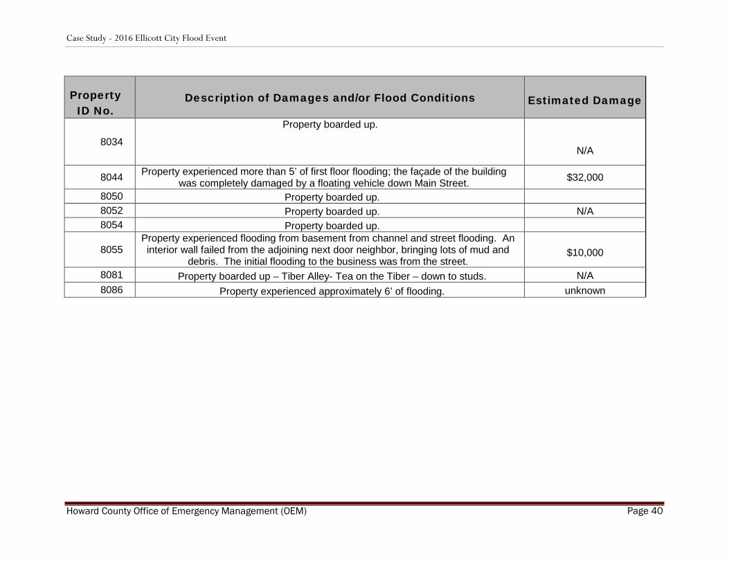
APPENDIX C
Property ID No.
Description of Damages and/or Flood Conditions Estimated Damage
3615
Property experienced minimal flooding. Reports described a wall of water coming down street resulting in one resident climbing a tree to escape. Two smaller tributaries
to Tiber-Hudson contributed to flooding.
unknown
3732 Property experienced first floor flooding coming from parking lot and damaged a stone retaining wall.
unknown
8004 Property boarded up. N/A 8016 Property boarded up. N/A 8018 Property boarded up. N/A 8026 Property boarded up. N/A
8030 Property boarded up. N/A
8032 Property boarded up. N/A
Case Study - 2016 Ellicott City Flood Event
Howard County Office of Emergency Management (OEM) Page 40
Property ID No.
Description of Damages and/or Flood Conditions Estimated Damage
8034
Property boarded up.
N/A
8044 Property experienced more than 5’ of first floor flooding; the façade of the building was completely damaged by a floating vehicle down Main Street. $32,000
8050 Property boarded up. 8052 Property boarded up. N/A 8054 Property boarded up. 8055
Property experienced flooding from basement from channel and street flooding. An interior wall failed from the adjoining next door neighbor, bringing lots of mud and
debris. The initial flooding to the business was from the street. $10,000
8081 Property boarded up – Tiber Alley- Tea on the Tiber – down to studs. N/A 8086 Property experienced approximately 6’ of flooding. unknown

Case Study - 2016 Ellicott City Flood Event
Howard County Office of Emergency Management (OEM) Page 41
Property ID No.
Description of Damages and/or Flood Conditions Estimated Damage
8090 Property experienced first floor flooding, approximately 52”. Much of the contents were damaged.
$82,000
8095 Property experienced approximately 5’ of first floor flooding predominantly from the street flooding; flood waters broke through the front door. unknown
8125 Property was extensively damaged by street flooding and channel flooding. Building was extensively structurally damaged. unknown
8134 Flood water damaged stone walls in front of two patios, stone steps, sidewalk in front of building, and stonework along bottom of building. Water ran into building off the hill
behind building. Several inches of flood water in first floor.
$14,000
8143 Property experienced approximately 1’ basement flooding and 2’ first floor flooding that came into building from both front and back. unknown
8156 Property experienced flood damage to exterior features. Interior flooding did not occur due to elevation above street level. $3,000
8180 Property experienced approximately 1” of first floor flooding; street debris and sediment prevented flood water from entering front doors; floors were damaged and
had to be refinished. $3,000
8181 Property experienced basement flooding to within 1” of first floor. Flood water broke through windows in back of building, a sheetrock wall, and through the front
door. unknown
8186 Property experienced some flooding from the hillside behind building. unknown
8191 Flood water rose to floor joists of the first floor, approximately 14’. Electrical, boiler, hot water heater, etc., all systems damaged. Basement had to be gutted. unknown

Case Study - 2016 Ellicott City Flood Event
Howard County Office of Emergency Management (OEM) Page 42
8202 Property experienced extensive flooding. Street flooding resulted in two vehicles damaging front porch, sidewalk. Water damage to upper floor units. Exterior brick
walls damaged, as well as sink hole in back yard. $28,000
8210 Property experienced flooding. unknown
8247 Property experienced flooding through front door and back side door resulting in approximately 1’ of basement flooding and a few inches of first floor flooding. Water
also seeped through windows. Street front and sidewalk were damaged. unknown
8249 Property experienced flooding through front door and back side door resulting in approximately 1’ of basement flooding and a few inches of first floor flooding. Water
also seeped through windows. Street front and sidewalk were damaged. unknown
8290 Flood water came into back of building at second floor, and then entered first floor. Much of the sheetrock and ceilings had to be replaced. Unkown
8307
This basement is connected with 8334, therefore both structures experienced extensive flooding. Approximately 8-9 feet of water was in the basement and rose
to the first floor.
Unknown
8307 (2) Property experienced extensive flooding.
Unknown
8308 Property was flooded due to water backup at a Main Street conveyance. A conduit between the buildings resulted in second building basement getting fully flooded and
water exiting basement window to Main Street. $400,000
8320 Property was extensively damaged and experienced 24” of first floor flooding and complete basement flooding. Owner had to completely renovate first floor down to
the floor joists. unknown
8329 Property experienced approximately complete basement flooding and approximately 4’ of water on the first floor. All systems such as boiler, electrical, and water heaters
were damaged. Property requires complete renovation. $50,000
8333 Same description as ID 8329.

Case Study - 2016 Ellicott City Flood Event
Howard County Office of Emergency Management (OEM) Page 43
Property ID No.
Description of Damages and/or Flood Conditions Estimated Damage
8334 Property was extensively damaged and experienced 24” of first floor flooding and complete basement flooding. Owner had to completely renovate first floor down to
the floor joists. $200,000
8385 Property experienced first floor flooding that resulted in a ceiling collapse. $12,840
8388 Two properties with this identifier experienced 1-2” of flooding due to their location and elevation.
$1,000
8390 Property experienced approximately 8’ of basement flooding. unknown
8398
Property experienced extensive flood damage from both the street flooding and channel flooding. Flood waters significantly damaged a foundation wall that
supports the upper floors. Extensive repairs to the bearing wall were required. Two furnaces and 2 water heaters damaged, as well as electrical systems.
$75,000
8436 Property experienced basement/crawspace flooding resulting in damages to floor, subfloor, drywall, water heater, and insulation.
$10,000 8438 Property experienced basement/crawspace flooding resulting in damages to floor,
subfloor, drywall, water heater, and insulation.
8440 Property experienced basement/crawspace flooding resulting in damages to floor, subfloor, drywall, water heater, and insulation.
8444 Property experienced extensive basement and first floor flooding, primarily from channel, however, reports of significant water coming from the opposite hillside were
reported at this location. Witnesses reported water coming from all sides. A basement door was torn in half at this property.
Unknown
8512 Property experienced extensive flooding to first floor and flood walls from both channel and street flooding.
$60,000

Case Study - 2016 Ellicott City Flood Event
Howard County Office of Emergency Management (OEM) Page 44
Property ID No.
Description of Damages and/or Flood Conditions Estimated Damage
8572 Property experienced extensive basement flooding and loss of rock retaining walls around property.
$2,000
8578
Property is a 3-unit building where the first floor was damaged when flood water came in through the door. Repairs included cleaning, power-washing, painting, and
rug replacement.
unknown
8600
Property experienced extensive flooding and equipment damage. Asphalt from upstream was deposited on this property and plugged drains installed to mitigate
flooding. Several rental properties on parcel were severely damaged as well.
$2.2 million
8624 Property experienced minimal flooding due to its location and elevation. All the surrounding properties were flooded.
N/A
8637 Property experienced first floor flooding; water was approximately 54” deep in front of the property, resulting in approximately 20” of water inside structure. Damage to flooring, drywall, insulation, appliances, heat systems, parking lot, and 3 vehicles.
$75,000
8879 Property experienced basement flooding. Witness reported two large conveyances coming down powerline.
$5,000
*Total Estimated Damages Reported $3,431,840
*Please note that the total damages reported in this study are estimated based solely on the responses received
from the survey. Some property owners and/or tenants could not provide an accurate estimate at the time of the survey. Furthermore, this survey only sampled a portion of the properties damaged and should not be viewed as
an official damage assessment.
Note: To provide additional perspective on the flood’s financial impact, it is estimated that this flood event resulted in $10.8 million in public infrastructure damage and approximately $67.2 million in economic loss for Ellicott City, as described in the Jacob France Institute report completed in November 2016.

Case Study - 2016 Ellicott City Flood Event
Howard County Office of Emergency Management (OEM) Page 45
APPENDIX D: REPOSITORY
Photo ID Source Date Time Location

Case Study - 2016 Ellicott City Flood Event
Howard County Office of Emergency Management (OEM) Page 46
Photo ID Source Date Time Location