CASE STUDIES - Integrated Mountain Initiative
213
This Case Study Compendium is the output of a research project titled ‘Understanding Mountain Peoples’ Approach and Practices to Combating Climate Change in the Indian Himalayan Region: Research to Renewal and Reforms’ funded by National Mission on Himalayan Studies (NMHS) under MoEFCC led by Integrated Mountain Initiative and TERI. A COMPENDIUM OF CASE STUDIES ‘UNDERSTANDING MOUNTAIN PEOPLES’ APPROACH AND PRACTICES TO COMBATING CLIMATE CHANGE IN THE INDIAN HIMALAYAN REGION’ 2017-19
-
Upload
khangminh22 -
Category
Documents
-
view
1 -
download
0
Transcript of CASE STUDIES - Integrated Mountain Initiative

This Case Study Compendium is the output of a research project titled ‘Understanding Mountain Peoples’ Approach and Practices to Combating Climate Change in the Indian Himalayan Region: Research to Renewal
and Reforms’ funded by National Mission on Himalayan Studies (NMHS) under MoEFCC led by Integrated Mountain Initiative and TERI.
A COMPENDIUM OF
CASE STUDIES‘UNDERSTANDING MOUNTAIN PEOPLES’ APPROACH AND PRACTICES TO
COMBATING CLIMATE CHANGE IN THE INDIAN HIMALAYAN REGION’
2017-19
Understanding Mountain Peoples’ Approach and Practices to Combating Climate Change
in the Indian Himalayan Region: Research to Renewal and Reforms
2017-19

Table of contents
Case Study 1: Bamboo Drip Irrigation Practice, Meghalaya 6 Case Study 2: Climate proofing of spring-sheds in Meghalaya 24 Case Study 3: Indigenous Seed Systems, Nagaland 50
Case Study 4: Agro-biodiversity for food, nutrition and ecological security, Nagaland 72
Case Study 5: Systematic and integrated jhumming along with its community based land and ecosystem management in Kamjong District, Manipur 104
Case Study 6: Community conserved areas of the Tangkhul tribe in Manipur 122
Case Study 7: Evaluation of drip irrigation practice in Mizoram 138
Case Study 8: Community forest by Young Mizo Association in Mizoram 158
Case Study 9: Agro - biodiversity and cropping pattern of Jhum (Huk)in North Tripura 174
Case Study 10: Impact of climate change in oranges and successful adaptation strategy of arecanut plantations in Jampuii and Sakhan Hills of Tripura 202
Case Study 11: Paddy cum fish culture, Arunachal Pradesh 228
Case Study 12: Kiwi Cultivation, Arunachal Pradesh 248
Case Study 13: Dhara Vikas in Sikkim - Potential for adaptation through revival of springs 266
Case Study 14: Cardamom based farming - Potential adaptive strategy, Sikkim 284
Case Study 15: Cardamom based agroforestry and climate change adaptive practices, Darjeeling 300
Case Study 16: The case of samaj stewardship in managing springs in Darjeeling and Kalimpong Himalaya 314
Case Study 17: Barah Anaj, Uttarakhand 332
Case Study 18: Jal Sanskriti, Uttarakhand 350
Case Study 19: Traditional water harvesting structures: Potential to contribute to adaptation, Himachal Pradesh 366
Case Study 20: Diversification in agriculture in response to climate change induced changes in agricultural output, Himachal Pradesh 386
Case Study 21: Traditional water distribution system (Chhu-tsir) in Ladakh 402
© INTEGRATED MOUNTAIN INITIATIVE, 2019
All rights reserved. No part of this publication may be reproduced, stored in a retrieval system, or transmitted, in any form or by any means, without prior permission in writing to Integrated Mountain Initiative, New Delhi, India, or as expressly permitted by law, or under terms agreed with the appropriate organizations. Enquiries concerning reproduction should be sent to the address:
Integrated Mountain InitiativeF-5, Ground Floor, Kailash Colony, New Delhi – 110 048, India
YOUNG RESEARCHERS TEAM
Meghalaya - Jonathan Donald Syiemlieh Nagaland - Khrolhiweu TsuhahManipur - Chanthingla HoramMizoram - Sabrina Lalhmangaihzuali Tripura - Sariel Tuikhouh ReangArunachal Pradesh - Ozi TachoSikkim - Uden L. BhutiaDarjeeling & Kalimpong - Maurice Rai Uttarakhand - Divya SharmaHimachal Pradesh - Aprajita Singh Ladakh - Tsering Dolkar
PLANNING & COORDINATION TEAM
TERIEditor: Ms. Neha BhartiReviewer and Advisor : Ms Suruchi Bhadwal
IMI Advisor: Ms Fantry Mein JaswalProgramme Coordinators: Ms. Namrata Rawat, Ms. Chhaya Vani Namchu, Ms. Prerananandita Baisnab
Designed by: Mithun TM
Cover photo credit: Tenzin Dorjee | Tawang, Arunachal Pradesh
PUBLISHED BYIntegrated Mountain Initiative (IMI)
FOR MORE INFORMATIONProgramme Coordinator, IMI, F-5, Ground Floor, Kailash Colony, New Delhi – 110 048, IndiaTel.: +91 11 40193747 Email: [email protected] | Web: www.mountaininitiative.in

Foreword
Himalayan ecosystems are projected to be extremely sensitive under climate variability and extreme events. Evidences show that even small changes in temperature in the mountain regions have resulted in negative impacts on biodiversity, water availability, agriculture, and hazards. This variability and extreme shifts of climatic patterns has had a huge adverse impact on the lives and socio-economic situation of mountain communities in the Indian Himalayan Region (IHR).
Observed impacts of historical trends include movement of apple orchards to higher altitudes, loss of certain tree species, drying up of traditional water sources, reduction in crop yields and increased vulnerability of winter cropping due to changes in rainfall patterns and planting dates.
These changes have increasingly raised the need to examine the coping strategies used by the farming communities across IHR to design adaptation and mitigation strategies. Moreover, knowledge on the vulnerability of mountain ecosystems to climate change especially for the IHR is very limited.
This Compendium of Case Studies attempts to capture the traditional and indigenous knowledge systems of farming communities across the 11 mountain states of the IHR. These findings coupled with scientific research and data can enable better-informed policies for the mountain states.
I thank the Ministry of Environment, Forests and Climate Change (MoEFCC) and GB Pant National Institute of Himalayan Environment & Sustainable Development for entrusting this study to Integrated Mountain Initiative (IMI), a civil society institution with the capability of bringing diverse stakeholders from across the mountain states together to address the urgent issues of sustainability of mountain livelihoods and development in the context of climate change.
I also thank the team of Young Researchers, IMI State Nodal Persons, IMI Secretariat for their commitment and support and The Energy and Research Institute (TERI) for leading this study. We believe that this Compendium of Case Studies will serve as an important reference document for our stakeholders by adding to the pool of resources available to carry out more informed dialogues in the Himalayan States and the Centre for mountain specific development programmes.
Sushil RamolaPresidentIntegrated Mountain Initiative
Executive Summary
The Indian Himalayan Region (IHR) is ecologically fragile and highly vulnerable to the effects of climate change. In the last few decades climate change has emerged as a new threat to this region making this young and fragile system highly sensitive on earth. Considering the sudden and drastic way climate change has impinged on all aspects of life, mountain regions foe their sensitivities and associated vulnerabilities need to focus on this issue.
It is in this context a peek into the 11 Himalayan States in India and best practices being pursued that may contribute towards adaptation have been compiled in this compendium. The compendium compiles best practices linking climate change to sustainable development, builds awareness, communicates sectoral learning and builds capacities of stakeholders thereby identifying ways for up-scaling across mountain states. The compendium documents good practices with a focus on indigenous ways of managing natural resources by the mountain communities. The compendium presents the final outcomes in the form of detailed case studies and lessons learnt through a review of the literature and consultative processes.
The compendium provides policy recommendations for climate inclusive planning through integrating local, traditional and indigenous knowledge and initiatives undertaken within the state for consideration for adaptation. This is being carried out to build resilience in priority sectors vulnerable to climate change and strengthen the role and contribution of mountain communities for sustainable development.
To formulate the compendium, a Young Researchers’ Forum was constituted with researchers from the mountain states. The Researchers conducted in-depth research on selecting case studies for highlighting good practices in their respective States. The priority sectors had been carefully selected, from the State Action Plans on Climate Change (SAPCC) along with expert opinion of the State nodal officers. The priority sectors relate to agriculture, water, forestry along with themes on disaster risk reduction and enhancing livelihood opportunities of mountain communities.
The case studies identified by the Young researchers’ are age old and are still being followed by the communities. These have been assessed and analysed with respect to their performance on ‘what works’ and ‘what makes it work’, what has enabled that practice to continue for long, what aspects of the practice inhibits its replication across other states and what factors contribute to a practice’s feasibility for scaling or otherwise.

1 2
A COMPENDIUM OF
CASE STUDIES‘UNDERSTANDING MOUNTAIN PEOPLES’ APPROACH AND PRACTICES TO
COMBATING CLIMATE CHANGE IN THE INDIAN HIMALAYAN REGION’
2017-19

3 4
MEGHALAYA
Photo credit: Handerson Chulet | Location: Khasi Hills

5 6
BAMBOODRIP IRRIGATION
PRACTICE
Author: Jonathan Donald SyiemliehContributor: Dr. Vincent Darlong
CASE STUDY 1

7 8
A. Background
Meghalaya and the Agriculture sector
The economy of Meghalaya is primarily an agrarian economy as is evident from the percentage of working population engaged in this sector with 81% of the state’s population depending on agriculture, (Rao, 2016). Agriculture continues to employ majority of workers in the state though there has been a decline in proportion of workers engaged in agriculture.
According to the 2011 census, there has been a marginal fall in rural population since 2001 from 80.4 % (2001) to 79.9 % (2011). Although there has been a drop in rural population, the level of urbanization is still low with urban population increasing marginally from 19.58 % in 2001 to 20.06 % of total population in 2011 (Census of India, 2011).
Meghalaya with an average annual rainfall of 1,150 cm and receives the highest amount of rainfall in the country. The diverse range of soil types, including red-loamy and laterite, support various agricultural crops like rice, maize, pulses, oilseeds, cotton, jute. Nearly 10% of the geographical area of Meghalaya is under cultivation with rice being the dominant food grain crop accounting for over 80% of the food grain production in the state. The net sown area as per the state directorate of agriculture is recorded at 285499 hectares and the total cropped area is recorded at 339725 hectares (Department of Agriculture, Government of Meghalaya, 2011). Although 81% of the population is dependent on agriculture, the net cropped area of the total geographical area of the state is only about 9.87%. Meghalaya still lags far behind the national level in terms of economic and agricultural growth rates.
The total expenditure in the agriculture sector stood at INR 14431.26 lakhs in 1984-85 and increased to INR 38679.46 lakhs in 2013-14 (at constant 2004-05 prices). Although there was a surge in expenditure on the agriculture sector, the contribution of this sector to real GSDP declined from 7.29% in 1984-85 to 2.90% in 2013-14 (Kumar De & Dkhar, 2018). Nevertheless, agriculture remains an important economic sector in spite of the diminishing share in GSDP due to its significance and implications in rural livelihood.
Meghalaya and Climate Change
Meghalaya, which is the wettest place in the world till date, has started to face the consequences of climate change. The recent past, has witnessed evident variability in rainfall pattern. This has given rise to innumerable problems in the predominantly agricultural state. According to a study the average temperatures are projected to increase by about 1.7°C in almost all the districts of the Northeast.
Figure 1 : A betel leaf plantation in Nongsder village,East Khasi Hills district, Pynursla block, Meghalaya
It has revealed that Northeast India, has warmed significantly in the last 10 years and the situation is likely to get worse in the near future. The study also undertook a vulnerability agricultural assessment of districts in the Northeast India covering bio-physical and socio-economic vulnerability assessments in the current and future (2030) climate scenarios and found Meghalaya to have some of the most vulnerable districts to current climate risks and long-term climate change in the region. Thus, stressed on the need to identify necessary steps to adapt and mitigate this vulnerability. Sectors like agriculture and forestry are already subjected to high climate risks currently and will be highly vulnerable to climate change risks in future (Ravindranath, 2011).
A study reveals that there will be changes in the rainfall patterns with the central plateau region projected to experience an increase in rainfall at a higher rate than the rest of the state. The occurrence of extreme rainfall events will also show an increasing trend under various projected scenarios. For example, the West Khasi hills district which already receives very high precipitation is projected to face even higher increase in precipitation. Erratic and unpredictable rainfall patterns in the state are hampering the cultivation schedule of many cash crops. For instance, Rice which accounts for over 80% of the total food grain production in the state is sensitive to climate change and bearing the brunt of extreme weather conditions (Sharma, 2017).
The study indicates that air temperature in Meghalaya is growing at the rate of 0.031 degree per year. The trend is consistent from 1981 to 2014, barring the years 1991 and 1992. This translates into 1 degree centigrade rise between 1981 and 2014, which is quite significant. Future forecasts indicate similar increase over next two decades. The study also highlights the highly fluctuating frequencies of hot days, hot nights, cold days and cold nights. There has been an increasing incidence of number of hot days and nights whereas there has been a reducing trend of cold days and cold nights which are signals of a consistently warming region.
Fluctuation in climatic conditions in the state will have extensive repercussions on various natural resources like agriculture, livestock, forestry, water etc. Extreme rainfall will provoke risks of landslides in high altitude areas causing siltation of water bodies downstream. Rain-fed agriculture in the state will be adversely hit with diminishing crop yields and production. Surge in temperature can incite forest fires and threaten endemic plant species many of which are already on the verge of extinction (Ministry of Environment and Forests, 2004).
The high resolution (0.5° x 0.5° lat. and long.) data provided by Indian Meteorological Department (IMD) for a period of 35 years (1971–2005) show that most of the districts of Meghalaya have experienced a surge in precipitation in the past 100 years.
The impacts of climate change across the globe are very much prominent. It creates a distress on food security, livelihoods, economic growth, urban and rural habitats, as an imbalance in one, will affect the other. The Meghalaya State Action Plan on Climate Change (SAPCC) has attempted to address a number of pertinent issues such as agriculture, horticulture, water, forestry and biodiversity, livelihoods, mining, energy and health etc. Tribal communities in the rural remote areas face the biggest challenges due to higher dependence on natural resources for livelihoods.

9 10
In 2011, population density for Meghalaya was 132 people per square kilometre of land area as compared to 103 people per square kilometer of land in 2001 (Census of India, 2011). Increasing populations and falling land productivity cause pressures on natural resources and are constraints for the region’s environmental sustainability.
A study by Indian Institute of Science, Bangalore and IIT Delhi conducted detailed climate change vulnerability profiles of the district level for agriculture for the current and projected future climates. The study indicated that varying climate will create additional stress and directly impact food-production systems and indirectly impact food security. According to the model, the rice yields were anticipated to decline by about 7 to 9% by 2030s in almost all districts (Aggarwal, P. K. et al, 2006).
The lack of proper irrigation facilities, fragmented and uneconomical land holdings, lack of institutional credit, adequate infrastructure and modern agricultural technologies, poor transport and communication system are some of the issues that are being faced in the state in the agriculture sector. These complications are further intensified by climate-induced extreme events such as floods and droughts which cause a diminishing agricultural produce and substantial loss of soil and erosion in the state (Das, 2009). Out of the 7 districts considered, South Garo Hills, East Garo Hills, West Khasi Hills, Jaintia Hills, and Ribhoi districts fall in the highly vulnerable to moderately vulnerable category. Participatory rural assessment (PRA) exercises in a study (Macchi, et al., 2011) indicate that lack of water during the dry period affected 50% of the villages where sowing is undertaken. The decline in soil moisture during the dry period is also becoming an issue of concern and is affecting the production of food. For instance, staple crops like rice and millet in jhum cultivated lands has fallen by 40-60% and production of rice in the wet terrace system has also fallen by 40%.
It was observed that most of the sources of water including rivulets and springs are dry especially post monsoon period and women folk have to traverse long distances to carry water for the purpose of drinking, domestic use as well as for livestock and cattle. The PRA exercise indicated that 33% of the villages were affected by rainfall associated with storms regardless of the elevations in the mountains. The stormy rainfall affects paddy transplanting, weeding as well as harvest under wet terrace cultivation systems. Similarly, under jhum, farmers are faced with interruption in weeding resulting in low production of crops affecting food and income security. The intermittent rain and hot temperature also increased the incidence of pest and disease in crops under wet terrace and Jhum.
Farmers also reported that the increase in temperature has led to reduced productivity and lower income as a result of exhaustion temperatures affect 27% of the villages. The impact on fruit and edible non timber forest produce (NTFP) rose with increasing altitude. The ground frost was also found to be affecting 22% of the villages especially those that were at high and medium altitude which reduced the rate of growth and survival of plantation crops and edible NTFP. Similarly, landslides, flash floods and soil erosion affects 6% of villages in upper altitudes especially where wet terrace cropping systems is widely practiced. Thunder and hailstorms were found to impact and affect 16% of the villages where a large portion of the damages were associated with orchards (Das, 2009).
Coping and adaptation strategies
The local communities in Meghalaya due to variability in climatic condition adopted skills to minimise the waste of water and cultivate drought resistant crops which is less water intensive. Local communities utilise their historical experience to judiciously manage and use the available resources to cultivate. For instance, local farmers grow drought tolerant paddy and millet, which has better productivity in these conditions. Maize crops are dribbled to facilitate them to resist soil moisture stress during the germination process under jhum cultivation. Farmers use a traditional maize variety which has a higher yield and produces more maize cobs. They also alter the paddy varieties for cultivation every 2-3 years. Farmers put forward that Jhum farming offers a better coping advantage to climate induced impacts as compared to wet terrace farming. Farmers use traditional knowledge to address the impact of pest and disease under Jhum, they utilise fermented bamboos shoots, leaves, use dead crabs in rice fields. Alternatively they also use poison and set trap to capture, sprinkle mud, use a device to make sound when clapped together to scare wild animals in farm fields. In order to overcome flash flood like situation in wet terrace, under rice cultivation, farmers use bamboo traps as inlet for silt and water separation, and block the intake from the channel by building mud walls. During food shortage, households seek wage labour in the neighbouring areas and the downtrodden families seasonally out of the village to meet their daily requirements.
Bamboo drip irrigation in Meghalaya
The annual gross dynamic ground water recharge of Meghalaya has been estimated at1.234 billion cubic meters (BCM). The annual allocation for domestic and industrial water requirement up to year 2025 is estimated as 0.096 BCM as per the 2001 census. Around 1.014 BCM of ground water potential may be utilized for irrigation. The level of ground water development in the state is 0.15% (Dhiman, 2012). The irrigation potential in the state is around 2.18 Lakh hectares (ha) of which 23,352 ha are under surface water irrigation and 1,913 ha underground water irrigation (GIZ, 2011) Irrigation system helps the farmers to have less dependency on rain-water for the purpose of agriculture and is one of the most important factors for assured crop production. In traditional agriculture, irrigation was recognized for its protective role of insurance against the vagaries of rainfall and drought but now, adoption of high yielding varieties, chemical fertilization & multiple cropping highly used controlled irrigation for increasing productivity. Meghalaya, being rain fed and therefore significance of irrigation is required only in the areas where the soil has poor water holding capacity. In such regions, farmers mostly practice bamboo drip irrigation and continuous flow irrigation.
According to the Guinness World Records, Meghalaya is known for the highest rainfall in the world of about 11873 mm recorded annually. The rainy months commence from June and continue until September. Although the state receives ample rainfall, an efficient managed water storage and retention system is lacking. The landscape of the Khasi, Jaintia and Garo hills is characterised with poor water retention capacity, challenges in constructing ground water channels due to topographic constraints (Singh & Gupta, 2002) and lack of a formal irrigation system to capture water from distant water sources such as natural spring and streams.

11 12
The tribal farmers in Meghalaya have been practicing an indigenous 200 year old technique of bamboo drip irrigation to irrigate their plantation crops (Jeeva, et al., 2006). This traditional system helps in efficient management of water and to re-use the harvested water (Ngachan, n.d.). Here traditional innovations use readily available bamboo materials and harness the forces of gravity by tapping springs and stream water to irrigate the rain-fed crops such as paddy, betel leaf, and black peppers especially during the dry season (Agarwal & Narain, 1997) Water from an uphill source is tapped and transported to the plantation by a main bamboo channel where it isregulated through a complex bamboo network of secondary and tertiary channels to all the sections of a plantation.
The bamboo strands of different radius are sliced and placed on wooden Y shaped bamboo sticks held above the ground. The wider strands are placed first followed by the ones that are smaller than the previous ones. Each bamboo channel is bound to another by thin bamboo strips. Smaller pipe shaped bamboo are used to divert and distribute water from the main channel where the water source is being tapped from (Dhiman & Gupta, 2011) (See figure 2 & 3).
According to the level of irrigation stages, the size and radius of the bamboo strands will be adjusted. Varying sizes of bamboo channels facilitate a control in the flow of the water to reduce spillage. This system facilitates the dissemination of 15 to 25 litres of water per minute at a rate of 20-80 drops per minute subject to the availability of water resource and the number of plants to be irrigated (Singh , 1989) (Borthakur, 1992) (Dabral, 2002)
Figure 2: Construction sketch of bamboo drip irrigation system. (Singh et.al. 2002)
Figure 3: Principle of water distribution in bamboo drip irrigation system. (Borthakur, 1992)
Figure 4 & 5: Map indicates the sample locations of villages (Village 1: Nongsder in East Khasi Hills; Village 2: Dawki in West Jaintia Hills district of Meghalaya.)
The upper portions of the hills in the study villages are filled with stones and mud making it challenging for any kind of crop to thrive. The lower portions of the hills are muddy and have fewer stones which are a result of continuous soil erosion and rainfall on hill slopes. Farmers have only been able to grow broomsticks on the upper portions of the hills where nothing can grow. This started only about forty years ago to adapt to the climate as well as soil conditions. Earlier there were only wild plantations growing on the top of the hills. Discussions with villagers also show that the upper regions of the hills are ideal places for the cultivation of broom sticks since the soil is not suitable for any kind of crops. The growing of broom sticks also take away all the nutrients from the soil so in order to ensure that the soil is recharged and restored, they practice slash and burn cultivation method once, every five years and allow the soil to remain fallow.Agriculture is the primary source of livelihoods for the villagers; members of the families are also engaged under the National rural employment guarantee scheme while most of the village folks depend upon ad-hoc contractual works.
B. Descriptions of study sites

13 14
C. Methodology
A Case study approach was undertaken to document the bamboo drip irrigation practice as described below. The study started off with an intensive review of secondary literature and peer reviewed research articles. Participatory rural appraisal tools like semi-structured key person interviews and focussed group discussions were undertaken with the practitioners of bamboo drip irrigation i.e. farmers, cultivators, village folk and local headmen. Discussions were also made with relevant stakeholders at village, district and state level including subject matter experts. Participatory rural appraisal approach was also undertaken to capture the timeline planting calendar as well as capture the perception of changes in weather, impacts on the community, coping and adaptation practices.
Stakeholder Unit (no) and theme/type of stakeholder Method
1) No. of papers on climate change 2) No. of papers on the subject of case study3) No. of papers on traditional good practice4) Meghalaya SAPCC-15) Web links of NABARD, Ministry of Water Resources Central Ground Water Board etc
1) Village headman, previous headman, village council including women groups across varying income groups.2) Grand Council of Chiefs of Meghalaya
1) Soil and Water Conservation Department, Government of Meghalaya, 2)Meghalaya Agriculture department3) Meghalaya Water Foundation4) GIZ5) Meghalaya Institute of Governance6) PCCF, Meghalaya Forest Department7) Meghalaya Institute of Natural Resources
1) North Eastern Hill University (NEHU)2) North Eastern Region Community Resource Management Project(NERCORMP)- Khawkylla Community Resource Management Society3) Meghalaya Water Federation 4) North East Slow Food and Agro biodiversity Society5) Martin Luther Christian University6) The Energy & Resources Institute (TERI)
(2 FGDs conducted, 2 Key person Interviews)
Semi Structured Key person Interviews
Semi Structured Key person Interviews
Community
State officials
Subject Experts
Literature review
Table 2: Methodology adopted for the studyTable 1: Stakeholder list
D. Discussion
Table 3: Perception of changes in weather, impacts on the community and coping strategies
Stakeholder Method
Community
State officials
Subject matter experts
Undertook in depth key person interviews and focussed group discussions to document and identify indicators of good practices. Also used PRA tools like timeline, time trend to document the changes in the activity.
In Depth interviews to document/identify indicators of good practices and primary and secondary data collection reflecting measurable benefits
In Depth interviews to document/identify indicators of good practices and data collection primary and secondary data collection reflecting measurable benefits
Season (aiom)
Summer (Lyiur)Mid-May to Mid-August
Autumn (Synrai)Mid-August to Mid-October
Perception climatic parameters
Heavy rain, thick fog, thunderstorm
Lesser rainfall quantity, delays in monsoon, no temperature variation, few thunderstorms
Perceived change/ Impacts on the community
Hailstorms in August – September which cause damage to betel leaves, reduction in crop productivity and volume, crop failure
Do not receive rain at the time of sowing in past few years; Rise in incidents of pests and diseases
Delayed sowing period, improvising with new drought tolerant crop variety, using traditional crop varieties. Participation of a household member in the MGNREGA programme
Use of sprays, tobacco and turmeric, early harvest of crops
Coping strategies

15 16
Winter (tlang)Mid-October to Mid-February
Spring (pyrem)Mid-February to Mid-May
Drop in temperature, Frost cover, scanty or no rains, water scarcity
Increase in temperature along with drizzling rain of short durations (5-10 min), thin envelope of fog, hailstorm in March April, clearer sky
Day temperatures warmer, less occurrences of frost; Pre-monsoon disparity in rainfall; Drinking water scarcity during winter months; reduction in the flow of springs and streams, drying up of springs
Fluctuation in arrival of rains (experience of having rain starting from Mid-March onward-reduction in spring season and contrasts with late arrival of monsoon rain, Less productivity of land, reduced water availability for livestock
Using traditional water harvesting and irrigation systems; Delayed sowing period; cultivate drought resistant crops; purchase water for domestic usage
Reduced land area under cultivation; pursuing other livelihood options, sale of livestock, using traditional crop varieties, water harvesting
Source: FGDs undertaken in Nongsder village, Pynursla block, East Khasi Hills district dated 18th, April, 2018
The bamboo drip irrigation practice is much more predominant in the War regions in Meghalaya. This practice can be observed in villages such as Nongkwai, Nongsder,Mawpran, Nongmadan mawpran in East Khasi Hills, Muktapur and Dawki in Jaintia Hills and can be observed in Umbir and Mawlyndep villages in Ribhoi districts of Meghalaya. These regions primarily cultivate betel leaves, arecanut and pepper. The study sample of Nongsder village (East Khasi Hills district) & Dawki villages (West Jaintia Hills district)is shown in Fig no. 4 & 5 these bamboo pipes need to be regularly maintained as they get rotten or covered in moss within a period of 1.5-2 years of usage. The old bamboo is left to rot, which over the period of time returns to the soil as humus with limited maintenance cost (Saxena, et al., 2003). The maintenance and installation of the bamboo channels is undertaken by a group of farmers who form cooperative to lend their skill and labour. The betel leaf cultivators have an informal water sharing agreement where the water is diverted at fixed intervals and timings, therefore resolving any disagreement among each other (Figure 6 & 7). The allocation of limited water resources by the entire community is judiciously utilised. The water is drawn via the halved bamboo drip from springs which are usually 400-500 metres away from the point of irrigation. The bamboo drip irrigation structure are systematically covered by the top half of the bamboo slit vertically in order to prevent any insects or leaves etc.to fall into the water stream through the bamboo channels which can cause blockage or contaminate the water stream flowing through the bamboos (Figure 11). Water from perennial streams is also diverted into storage containers or cement plastered ponds using bamboo pipes as observed in the villages in East Khasi Hills during the field visit. The overflowing water restores the catchment area for farming purposes (Borthakur, 2008).
Figure 6: Cultivator showing how water is diverted using BDI
Figure 8: BDI channels coming from 500 metres away from the water sources such as springs
Figure 7: Water diverted through bamboo channels using leaves and bamboo pieces
Figure 9: Cultivator indicating how bamboo channels are mounted on Y shaped axis to provide support to the system and tethered with bamboo strings

17 18
Figure 10: Cultivators showing how water flow is controlled utilising bundle of leaves at internodes to reduce water discharge
Figure 12: Cultivators showing how the angle of the slope of the BDI is designed to ensure controlled and efficient flow of water and also prevent soil erosion
Figure 11: Cultivators cover the BDI system with a half cut bamboo to prevent any contamination from dust, dirt and insects etc
Figure 13: Water going further down to betel leaf plantations via BDI
Coping strategy
In order to cope with the situation of lesser rains or the onset of draught, the cultivators pick the betel leaves way before the harvesting season of March-April.
Alternatives
Rubber pipes are other alternative irrigation methods competing with the traditional system. The villagers indicated that they resorted to traditional bamboo drip irrigation mainly because alternate means were not affordable. Some of the good practices that were indicated at the group discussions for farming betel leaves have been indicated in the diagram below.
Exibit 4: Good practices in farming betel leaves
Chemical freeReuse of compost from fallen betel
vine leaves
Swapping and sharing of labour
This indigenous irrigation system indirectly supports the forest areas as no trees or shrubs are felled for marking channels through the forest areas in the hills (Mishra & Sharma, 2001). Settled cultivation is practiced hence reducing the area under shifting cultivation therefore helping in conservation of the environment. The benefits of using bamboo is that it also helps to increase crop yield with less water, prevent leakage and makes use of locally available natural inexpensive material. Moreover, maintenance cost is very minimal.
Cultivation
The betel leaves depend upon rain fall during the rainy seasons from May-September. It is grown every five years. The cultivators leave it fallow every five years to facilitate recharge of soil of its nutrients. On an average, each cultivator owned around 2 acres of betel leaf plantations. The major crops cultivated were betel leaves and broomsticks. They mentioned that on an average at least 80% of the betel leaf cultivators used bamboo drip irrigation techniques.
The Khasi people especially in the War Khasi hills of Meghalaya, overlooking Bangladesh, in the middle of dense moist deciduous forests utilise their traditional drip irrigation system designed solely from bamboos and call it Shyngiar. Most of these villages in these regions grow betel nut and betel leaves and utilise this age old system to irrigate the plantations by ferrying water from a hill stream or local springs to the roots of individual plants in a plantation.
This system is very appropriate for the hills as a method of cultivating plantations. The cultivators had indicated that they practice slash and burn farming. They clear a part of the forest of large trees and undergrowth of betel plantation. These yield for five to seven years after which they are left to die and the plantation shifts to the next plot. The springs and streams from where the water is drawn through the Shyngiar is usually half to few kilometres away through the rocky and hilly landscape.

19 20
According to the cultivators the process of digging canals is harder than making the Shyngiar because the land is rocky. The BDI process is so precise that water fed in at one end produces a steady trickle at the individual plant (Figure 10). A patch of around two acres produces around 20 puris of tympiew (local name for betel leaf) and it is sold at a wholesale rate at the nearby local market. The wholesalers then transport the betel leaves either to Shillong or to Bangladesh border for further sale.
In most cases, the raw material is available for free since bamboo is grown in abundance in the forests. Few villagers stated that they would purchase the bamboos in case of shortage from any of the villagers. In general, bamboos of varying thickness are slit and carved by using a local axe called a dao. BDI system has a couple of stages and the bamboos are cut into half to make a channel and are inter-connected to each other after removing the internodes in between the bamboos except the ones at the two ends. A set of bamboo channels of different thickness with the internodes removed are made by using a curved knife. It was observed that some bamboos have small slits on one side and the bamboo runs whole for a few centimetres before it is split in half. The thickest piece of bamboo is placed onto the source of water which can be a stream in the nearby hill or in some cases a local spring. This thick bamboo is cut open along the top and notsplit into half in order to facilitate a large volume of water flow to be carried. It runs fora few metres into the plantations and is linked with the other bamboos of relatively smaller width which are part of the larger network of the irrigation channel. These channels are supported by wooden stilts (Figure 7) and are also bound by thin bamboo strips.
Secondary bamboo channels each cut at an internode are placed at right angles on top of the primary bamboo and fastened with bamboo strips. The secondary channels have small rectangular slits in their sides where they cross the primary channel. A slimmer piece of bamboo sits in the primary channel and lifts the flowing water from it into the slit of the bamboos of the secondary channel. This lift mechanism based on the angle of the slopes enables water to flow from the lower to the upper channel under its own momentum. During regular intervals, tertiary channels draw water from the secondary channels at right angles and irrigate individual betel leaf plants. The tertiary channels have smaller slits on their side. Very finely and thinly pieces of bamboo placed in the secondary channels lift water from them and into the slits on the tertiary channel bamboo pieces. These are also cut in half and go from the secondary channel to the roots of the plants. The bamboo channels are bound tightly by extremely thin strips of bamboo and when they harden into place, they make for a fairly permanent bond. All these channels are supported by an equally intricate network of branches firmly stuckin the ground.
The internodes at the two ends of each bamboo pipe make sure that all the water is channelled to the plants rather than flowing out of the end of the pipe. The Shyngiar, is constructed in such a manner to minimise water loss in the transportation (Figure 4, 5 & 8).
According to the cultivators interviewed it takes a number of hours to irrigate allthe trees in a particular area and as soon one section of the plantation is done, thecultivators shift the water to another part of the plantation by removing the little piece of bamboo that lifts water from the primary channel to the secondary channel (Figure 4 & 5). They also use bundle of leaves to block the water flow to the other side. Some cultivators mentioned that the BDI system lasts for two seasons at best and bamboos get rotten after and the entire system need to be replaced.
The plantations utilise a lot of bamboo for the purpose of irrigation every year and is usually assembled and built just before the dry season and after the rainy season during October to mid-November. The plantation owners use it till April or May, or till the rains begin, whichever is earlier. All the plantation owners in the West Khasi hills of Meghalaya build the systems themselves or with the help of skilled local labour who are members of their families or relatives.
Through FGDs it was discovered that the knowledge for the erection and assembly of BDI systems was through experience and passed on to by family members. The ratio of the thickness of the primary channel to the tertiary one ultimately determines the quantity of water that will reach the betel leaf trees.
Perceived benefits of bamboo drip irrigation method
Focused group discussions and key person interviews undertaken in 5 villages across East Khasi Hills district in Meghalaya with village headmen, members of village council, farmers and village folk brought out the perceived benefits that bamboo drip irrigation was contributing to the growth of agriculture in these remote inaccessible areas where no formal irrigation mechanisms were in place. The following are the perceived benefits that bamboo drip irrigation practice has to offer:
Optimum growing condition: This practice facilitates an optimum balance of oxygen and moisture around the root region. The gradual application of water drips through the emitters as well as a systematic scheduling of the holes on the bamboo create a conducive environment for the plants and also help eliminate wet and dry fluctuation in temperature and moisture which causes stress in plants. Systematic scheduling also helps in reducing erosion, leaching of vital nutrients below the root region as well as the compactness of the soil. Efficiency of water usage: Proper application of water at accurate quantities and location depending upon evapotranspiration requirement for such plants using indigenous knowledge helps in reducing evaporation losses. Efficient scheduling and indigenous knowledge of plants helps in reducing water wastage by knowing how much water is to be used and where it is required. Minimising pests: Bamboo drip irrigation at accurate places across the plantations, orchids etc help in reducing the incidences of pests and water borne pests such as fungal attacks. In large betel leaves and areca-nut plantations, the regions between the portions of drip irrigation are dry which eases the movement of labour while irrigation is under progress.

21 22
Minimising weed growth: The drip irrigation process drips the water at pin pointed portions of the plants specifically at the roots keeping the remaining portions of the roots dry, therefore keeping portions of the plantation dry and free from proliferation of weeds. Weeds compete for water and plant nutrients and hence this indigenous practice helps the local plants species to survive better.
Uniform quality: There is uniformity in volume produced due to growing conditions of the plants. In addition, a reduction in pests and diseases help to sustain the quality of the produce. Water is applied at frequent intervals keeping the uniformity in growth of crops as well.
Lesser investment: A hilly terrain and sloppy topography is conveniently being irrigated through bamboo drip with minimal investment on levelling of land and usage of bamboo which are mostly locally grown or locally sourced and hence relatively cheaper.
Table 4 Planting Calendar for Betel Leaf Plantations
Land preparation (humus)
Planting
Partial cutting & applying humus
BDI
Harvest
Multiple springs
Jan-Kyllalynkot
Feb-Rymphang
Mar-Lber
Apr-Iaiong
May-Jymmang
June-Jylliew
July-Naitung
Aug-Nailar
Sep-Nailur
Oct-Risaw
Nov-Naiwieng
Dec-Nohprah
Source: FGDs undertaken in Nongsder village, Pynursla block, East Khasi Hills district dated 18th, April, 2018
Dabral, P. P., 2002. Indigenous Techniques of Soil and Water Conservation in North Eastern Region of India, 12th ISCO Conference.
Das, P. J., 2009. Water and climate induced vulnerability in northeast India: concerns for environmental security and sustainability. WATCH Research Report 1. AARANYAK.
Department of Agriculture, Government of Meghalaya, 2011. Land use statistics in Meghalaya.
Dhiman, S. C., 2012. Aquifer Systems of Meghalaya.
Dhiman, S. C. & Gupta, S., 2011. Rainwater Harvesting and Artificial Recharge.
GIZ, 2011. Meghalaya state climate change action plan.
Jeeva, S. R. D. N., Laloo, R. C. & Mishra, B. P., 2006. Traditional agricultural practices in Meghalaya, North East India. Indian Journal of Traditional Knowledge, January, 5(1), pp. 7-18.
Kumar De, U. & Dkhar, D. S., 2018. Public Expenditure and Agricultural Production in Meghalaya, India: An Application of Bounds Testing Approach to Co-Integration and Error Correction Model. Int J Environ Sci Nat Res, 8(2).
Macchi, M., Gurung, A. M., Hoermann, B. & Choudhury, D., 2011. Climate Variability and Change in the Himalayas: Community perceptions and responses.
Ministry of Environment and Forests, 2004. Ministry of Environment and Forests, GOI, India’s Initial National Communication to UNFCCC (NATCOM).
Mishra, A. K. & Sharma, U. C., 2001. Traditional wisdom in range management for resource and environment conservation in north eastern region of India. Himalayan Ecol Dev, 9(1), p. 32.
Ngachan, S., n.d. Rain water harvesting and its diversified uses for sustainable livelihood support in NEH region of India.
Rao, R. G., 2016. Report on Meghalaya state profile, s.l.: Ministry of Micro, Small and Medium Enterprises.
Ravindranath, N. H., 2011. Climate Change and North East India, Bangalore: Indian Institute of Science.
Saxena, D. C., Singh, N. P., Satapathy, K. K. & Pan, A. S., 2003. Sustainable Farming Systems for Hill Agriculture. pp. 73-86.
Sharma, D. C., 2017. Why are we sweating in Shillong?. 05 July.
Singh , A., 1989. Bamboo Drip Irrigation System.
Singh, R. A. & Gupta, , R. C., 2002. Traditional land and water management systems of North-East hill region. Indian Journal of Traditional Knowledge, 1(1), pp. 32-39.
References
Agarwal, A. & Narain, S., 1997. Dying Wisdom: Rise and Fall of India’s Traditional Water harvesting System. p. 64.
Aggarwal, P. K. et al, 2006. InfoCrop: a dynamic simulation model for the assessment of crop yields, losses due to pests, and environmental impact of agro-ecosystems in tropical environments. II. Performance of the model. Agric. Syst, Volume 89, p. 47–67.
Borthakur, D. N., 1992. Agriculture of the north-eastern region.
Borthakur, S., 2008. Traditional rain water harvesting techniques and its applicability. Indian Journal of Traditional Knowledge, 8(4), pp. 525-530.
Census of India, 2011. s.l.: Ministry of Home Affairs, Government of India.

23 24
CLIMATE PROOFING OF SPRING SHEDS IN
MEGHALAYA
Author: Jonathan Donald SyiemliehContributor: Dr. Vincent Darlong
CASE STUDY 2

25 26
A. Background
Topographic features
The state of Meghalaya is also known as Meghalaya plateau and formed by a hilly upland of the Khasi, Jaintia and Garo Hills. It occupies an area of 22429 sq. km with an elevation ranging from 150 to 1961 meters above sea level. The central section of the plateau comprises of the Khasi hills and the eastern section is bound by Jaintia hills with the Garo Hills bound at the western portion of the plateau. Its capital, Shillong is located at an altitude of 1496 meters above sea level. The state has a 496 km long international borderline with Bangladesh in the south and west. It is bordered by Assam in the north and east. The eastern part is bound by the Karbi Hills which is a continuation of the Meghalaya plateau. In the north and west sides of the state lies an extensive plain drained by the river Brahmaputra and in the south, lies the river Surma and its tributaries.
Livelihoods
More than three fourth of the population of the State depend on agriculture for their livelihood bearing the testimony of the agrarian character of the economy (Jeeva, Laloo, & Mishra, 2006). Major crops cultivated include paddy, maize, wheat, potato; vegetables and fruits such as oranges, cashew nut, pineapple, areca nut (kwai), etc. Farming in the state is chiefly carried out under rain fed conditions since the total area that is being covered under assured irrigation is barely a fourth of the approximate 2.57 lakh hectares of total net sown area (Ministry of Agriculture & Farmers Welfare, 2016). Factors such as rising population, industrial growth and increasing demand of food and water, etc. are being over-exploited and unscientifically utilized.
Rampant unplanned deforestation, coupled with unscientific extraction of minerals etc. have severely affected the hydrological parameters, namely rainfall, evaporation, ground water, water yield, infiltration, soil moisture, floods, soil loss, etc. The destruction and exploitation of the catchment areas and river systems have led to the reduction in the discharge and drying up of many rivers, streams, springs and rivulets. In spite of the fact that the state receives heavy rainfall during the monsoon season, the water is however wasted as surface runoff and drains to the neighbouring states and to Bangladesh. Consequently, the state suffers from critical water scarcity during the off monsoon periods. The cultivation during this period is normally limited to only some areas which have access to springs or natural discharges which will subsequently contribute to socio-economic development of the cultivators.
Water resources
The river system of Meghalaya comprises mainly of rivers draining to the Brahmaputra Basin in the north and the Meghna Basin in the South. Hydrologically, the State comprises of two basins, namely, the Left Bank of Brahmaputra Basin (11220.11 km2) and the Brahmaputra Tributaries Basin (11208.89 km2), three catchments viz., Kalang to Dhansiri Confluence (about 4499.61 km2), Bangladesh Border to Kalang Confluence (about 6720.50 km2) and South Flowing (ielo, 2015). Some of the important rivers in the central and eastern section of the Meghalaya plateau are Umkhri, Digaru, Umiam, Kynchiang (Jadukata), Mawpa, Umiew or Barapani, Myngot and Myntdu. The major rivers in Meghalaya in the Garo Hills are Simsang, Daring, Dareng, Nitai, Sanda, Bandra, Bhogai, and the Bhupai. In the absence of soil and water conservation techniques, springs dry up a couple of months after the monsoon rains stop and many villages face shortage of
drinking water (Ministry of Tourism, Government of India, 2015). Although, the ground water in the state has not yet been over exploited to its highest extent, but there is presence of water stress in urban areas due to high rate of extraction of ground water for domestic purposes. Ground water data indicates that the depletion rate between pre and post monsoon period is about 40-80% depending on the landscape (Shabong & Swer, 2015). The annual gross dynamic ground water recharge of Meghalaya has been estimated at 1.234 billion cubic meters (BCM). The level of ground water development in the state is 0.15% (Dhiman, 2012). The irrigation potential in the state is around 2.18 Lakh hectares (ha) of which 23,352 ha are under surface water irrigation and 1,913 ha underground water irrigation (Government of Meghalaya, 2015). The replenishable ground water in Meghalaya is estimated to be 1.15 billion cubic meters (BCM). The state has 8400 ha of reservoirs and 3734 ha of ponds and tanks.
Context
The state may have the highest record for receiving over 12,000 mm of annual rainfall but the fact of the matter is that regardless of the rain, availability of water is a critical issue for both the rural and urban populations (Pawel & Walanus, 2014). It has now become a regular phenomenon to hear about springs drying up or incidents of reduced discharge in Meghalaya owing to anthropogenic stress and a combination of factors ranging from erratic rainfall pattern, seismic activity and ecological degradation associated with land use change for infrastructural development causing pressures on mountain aquifer systems (MBDA, 2015). Many of the springs and water sources have dried up or have become seasonal resulting into waters shortages for domestic usage. The dependency of large proportion of the population on spring water suggests that with varying climatic conditions and rainfall pattern, a large number of villages are facing potential drinking water shortage. The extent of the problem is illustrated by the high dependency of populations on spring water on one hand and the depleting deteriorating status of springs on the other (Pandey, 2018). The ignorance of springs in the larger context of rivers, watersheds and aquifers is also a reason for great concern as such unawareness has led to gaps in practice and policy in developing any strategic national response to spring water management in India (Shrestha & Nepal, 2015). Besides, depletion, of late, there has been increasing concern about the quality of spring water. Spring management is becoming a nationally relevant problem, more important for the Himalayan population than ground water is for those living in the plains and hence there is a crucial need to address these issues in a holistic and scientific manner. The first systematic initiative was undertaken through the Dhara Vikas Programme by the Rural Management and Development Department (RM&DD), Government of Sikkim in 2009.
B. Literature review
The Indian Himalayas is facing the threats of climate change which in likely scenarios will affect biodiversity, local ecosystems, agriculture and well-being (Chaudhary, et al., 2011). Regular occurrences of drying up of water sources and erratic weather patterns are noticeable in the Himalayas (Sharma, et al., 2009) (Chaudhary & Bawa, 2011) (Chaudhary, et al., 2011) (Tambe, Arrawatia, Bhutia, & Swaroop, 2011). The focus of studies on spring’s analysed aspects related to spring discharge in relation to rainfall patterns and catchment degradation in the western Himalayas (Singh & Rawat, 1985) (Singh & Pande, 1989) (Valdiya and Bartarya 1989; Valdiya and Bartarya 1991; Bisht and Srivastava 1995; Sahin and Hall 1996; Negi and Joshi 1996; Negi and Joshi 2004). The studies indicated that the spring discharge was a function of both the rainfall pattern as well as the recharge area characteristics (Rai et al. 1998; Negi and Joshi 1996; Negi et al. 2001).

27 28
Some studies also point out that spring discharge is also a function of the nature and character of the aquifers that feed many of these springs (ACWADAM and RMDD, 2011). These studies articulate rising instances of drying up of springs or seasonality of spring pattern which have been attributed to increasing population, top soil erosion, inconsistent rainfall patterns, deforestation, forest fire and development activities such as building construction, road building etc.
Subsequently, limited rainwater permeates to recharge the ground water, thus creating a hydrological disparity. Negi and Joshi (2002) undertook field trials to revive springs adopting a spring sanctuary approach of developing the catchment using engineering, social and biological measures which indicated promising outcomes. This procedure comprises of undertaking artificial rainwater harvesting measures like pits, trenches, check-dams and plantation of native tree species in the spring recharge area and protection by barbed wire fencing. Reducing grazing, cutting of fuel wood and grass with social mobilization will additionally help create the effect of a spring sanctuary.
Springs and their significance
Meghalaya is profoundly reliant on springs and groundwater with 6,000 villages (78%) accessing spring water for meeting their household and irrigation requirements. According to the 2011 census, about a quarter of the villagers in the state depend exclusively on springs for drinking water.
A large number of villages in the state utilise springs for drinking and/or irrigation purposes (Shabong & Swer, 2015). According to an estimate by the Meghalaya Institute of Natural resources (MINR), the State has over 60,000 springs (MBDA, 2017). Locals who reside near to the springs and whose livelihoods are fully dependent on these springs have over the years seen them get destroyed or degraded either in terms of reduction of discharge of water or in the form of algae overgrowth. This was witnessed across different study villages in West Khasi Hills districts of Meghalaya. With proliferating deforestation, the once flowing perennial streams are no longer perennial and springs which are the traditional sources of domestic water supply for many local communities are also drying up.
A random sample survey conducted for 714 springs in the state indicated that over 54% of the springs have either dried up or are facing significant reduction in water discharge. Impaired springs have caused widespread water stress in the rural landscape (MoST, 2017). So despite heavy rainfall, the state suffers from water shortages. This is chiefly due to its inability to accumulate and capture the rain water because of its location in the hilly areas, which leads to increased surface water runoff. On the basis of preliminary studies and hazard analysis in 2015 by MBDA, it was found that there was a high water runoff to the tune of 50% in exposed areas due to the loss of vegetation and a decrease in ground water recharge during winters and frequent terminal droughts cause complete drying of over 50% of the springs. It was also indicated that evapotranspiration rates and water stress is high in forests and agricultural crops, with increased dependence on springs.
It has been observed that many areas are water stressed due to the growing gap between the demand and the supply of water, leading to the local population exploiting more ground water. Changes of land use pattern, quarrying, mining, soil erosion, and deforestation are some of the major factors leading to water stress in the state. Draughts and floods are perceived to be the main causes for the deterioration of springs and ground water regimes, which in turn, adversely affect agriculture, livestock and other
allied livelihood activities. Consequently, spring shed development management and initiatives take precedence in Meghalaya and spring mapping at the initial stage is vital and important. Refer to Analysis section on ‘Developing an online atlas of springs’ for more details. The spring mapping exercise is very significant and important as it serves as a database for decision-making on initiatives related to the development of a spring shed. Some of the key objectives of spring mapping include creating an inventory of the springs in the state, develop a spring atlas and determine the vulnerability of the springs. To rejuvenate and revive the critical springs and spring sheds and to ensure water security, this exercise should integrate traditional and scientific approaches to sustainable spring protection.
The spring shed mapping exercise is being undertaken in Mawphanlur block of West Khasi Hills (WKH) district by Meghalaya Basin Development Authority (MBDA) and includes useful information like spring name, spring dimension, discharge capacity, pH levels, salinity and total dissolved solids (TDS).
C. Study Site
The West Khasi Hills districts are influenced by the South-West monsoon and rainfall is assured during summer, but differs greatly in intensity from area to area within the district. The average rainfall ranges from 1200 mm to 3000 mm per annum. The climate of the district is mildly tropical in the northern and southern foothills, while in the central upland zone, the climate is temperate and places at medium altitude in the northern, western and southern parts of the district, experience sub-tropical climate. The district occupies an area of 5247 km2. There are reported 26 springs in the Mawphanlur block which provide water supply for 40-50 villages in the area. Although the village is the source of supply for water from the springs, it faces water scarcity due to lack of storage facilities. The water is used for drinking, farming and domestic use. Agriculture is the primary source of livelihood for the villagers; members of the families are also engaged under the National rural employment guarantee scheme while most of the village folks depend upon ad-hoc contractual works.

29 30
Figure 2: Map indicates the location of villages (Village 1: Mawphanlur; Village 2: Mathadraishan) in West Khasi Hills district of Meghalaya where the study for this case study on Climate Proofing of Spring sheds was undertaken.
D. Methodology
A Case study approach was undertaken to document the climate proofing of spring sheds as described below. The study started off with an intensive review of secondary literature and peer reviewed research articles. Participatory rural appraisal tools like semi-structured key person interviews and focussed group discussions were undertaken with the practitioners of spring shed management i.e. farmers, cultivators, village folk and local headmen. Discussions were also made with relevant stakeholders at village, district and state level including subject matter experts in Mawphanlur and Mawthaidraishan villages of West Khasi Hills district, Meghalaya (Figure 2). Participatory rural appraisal approach was also undertaken to capture the key environmental issue, its causes and the intervention undertaken. The Focussed Group Discussions were undertaken keeping in mind equal participation from women folk and covering different income classes (Figure 3). The project intervention activities undertaken, the potential environmental benefit, its potential impact/risk and proposed mitigation measures have also been indicated. The methodology adopted has been described in brief in Table no 1. Table 2 indicates the number of interviews undertaken according to stakeholder type.
Table 1: Methodology adopted for the study
Stakeholder
Community
State officials & Subject matter experts
Method
Undertook in depth key person interviews and focussed group discussions (FGD) to document and identify indicators of good practices utilising participatory rural appraisal (PRA) tools
In depth interviews to identify indicators of good practices and primary data collection and secondary data collection reflecting measurable benefits
Table 2: Number of interviews conducted by stakeholder type
Stakeholder Type
Secondary research
Community
State officials
Subject Experts
Unit (no) of papers and organisation of stakeholders
1) No. of papers on climate change - 102) No. of papers on the subject of case study - 163) No. of papers on traditional good practice - 44) Meghalaya SAPCC - 15) Web links of NABARD, Ministry of Water Resources Central Ground Water Board etc - 4Total -> 35
1) Dorbar Shnong, village headman (rangbah shnong), previous headman, village council including women groups across varying income groups.2) Grand Council of Chiefs of Meghalaya
1) Soil and Water Conservation Department, Government ofMeghalaya, 2)Meghalaya Basin Development Authority (MBDA)3) Meghalaya Water Foundation 4) GIZ5) Meghalaya Institute of Governance (MIG)6) PCCF, Meghalaya Forest Department7) Meghalaya Institute of Natural Resources (MINR)
1) North Eastern Hill University (NEHU)2) North Eastern Region Community Resource Management Project (NERCORMP) - Khawkylla Community Resource Management Society3) Meghalaya Water Federation 4) North East Slow Food and Agro biodiversity Society (NESFAS)5) Martin Luther Christian University (MLCU)
Method
Literature review
2 FGDs conducted, 2 Key person Interviews
Semi Structured Key person Interviews
Semi Structured Key person Interviews

31 32
Figure 3: Undertaking group discussions with headman and members of village council in Mawphanlur, WKH
Figure 4: Site visit to Mawthaidraishan, WKH with current headman (Mawphanlur) and previous headman (Mawphanlur), MBDA and NERCoRMP
E. Analysis
Observations from site visits to West Khasi Hills district
It was observed that village folk use water from springs and streams for domestic purposes and they make efforts to keep these water sources sanitary and uncontaminated. They disallow their cattle at the places from which they collect drinking water and have strict rules in place to prevent any garbage disposal into these water bodies. Water from these community forests play a key role in their catering to domestic requirements. According to discussions with various stakeholders across villages in West Khasi Hills district, the water flow in a spring gradually declines after the end of the monsoon period and may completely dry up during December to March, causing drinking water scarcities and affecting livelihoods and increasing drudgery. The depletion of spring water during the lean season, has led to the development of unsustainable and impractical alternatives. People resort to immediate coping mechanisms like transporting water using animals and tankers especially during the lean season or during prolonged dry spells. Drudgery to women exist during the lean season when springs run dry, women of the house manually carry water from springs below their village as springs in their village dry up during the lean season.
Discussants pointed out that precipitation is only for 6-7 months causing water scarcity during the dry months in the absence of appropriate mitigating interventions. The states distinct topographical conditions also has high surface run off to the neighbouring plains of Brahmaputra and Barak basin causing many water bodies to dry up. According to SAPCC, the West Khasi Hills district has recorded highest increase in precipitation, about 6.01 mm/day in light of variation in climatic conditions (Government of Meghalaya, 2015).
According to the state customary laws, specific water related institutions do not existand traditionally, the user of land has used the water on that land. As per customary laws, streams, rivers, etc. are considered common property. The village dorbars manage the drinking water in localities outside the purview of the Shillong municipal area.
Springs get recharged from the sub-surface flow or from the rain-water that percolates down. Variations in climate patterns have severely hampered the health of the springs with changing monsoon patterns and a surge in temperature. It was observed that many of these springs are drying up or becoming seasonal with reducing discharge during the off season.
It was seen that impaired springs have caused widespread water stress in these regions especially during the winter seasons adversely affecting agriculture, horticulture, livestock and other allied livelihood activities of the people and causing hardship and drudgery. In spite of heavy rainfall, there are many areas which are water-stressed due to increase in demand-supply gap leading to a rise in ground water usage. So despite heavy rainfall, the state suffers from water shortages. This is mainly due to its inability to store and capture the rain water because of its location in the hilly areas, which leads to increased surface water runoff.
The emphasis by the institutional architecture has always been on spring development from the supply-side (For e.g. tanks and pipes). It was observed that little has been done in terms of identification of source or recharge areas and targeted aquifer protection and hence there is a widespread interest to mainstream hydrogeology and other scientific approaches.

33 34
The site visit to West Khasi Hills district to Mawphanlur village and Mawthadraishan (Figure 4) highlighted the spring shed revival programs being undertaken under the aegis of the state government. Along the slopes of the hills, construction of staggered contour trenches (Figure 5), digging of staggered pits, other methods of impounding rainwater such as water harvesting structures and creating chambers to tap spring water and artificial reservoirs. It was observed that with the help of traditional knowledge, villagers constructed an artificial reservoir (Figure 6) in Langlew village (Mawthaidraishan), WKH to tap spring water from underground. The water level has remained relatively higher during monsoons and act as a source of drinking water and for domestic use throughout the year especially during the winters. Spring tapped chambers (Figure 7) have been erected in different villages with the objective of tapping the underground spring water and preventing it from contamination or getting polluted. Changing the vegetative cover through plantations is also being undertaken with the primary purpose of increasing rainwater percolation and minimising run-off.
Staggered contoured trenches include any type of excavated depression along the lands surface with the purpose of preventing soil erosion via trapping and absorbing sediments and run-off. When the continuity of contour trenches is broken down into several scattered parts with length of 2 to 4 m, they are known as staggered contour trenches as indicated in figure 5 being undertaken in West Khasi Hills. The villagers’ states that staggered contour trenches distribute the hilly slope into smaller catchments and minimize the length of slope which results in the reduction of the quantity and velocity of run-off and therefore help in decreasing the rate of soil erosion. They indicated that contour trenches collect rainwater and run-off and redistribute the trapped water into the soil profile. According to stakeholders, there is no consensus on the suitable or correct dimension and distances between trenches. However, the size and distances of trenches are dependent on some factors such as quantity of rain and intensity, soil depth, soil water infiltration, slope steepness and crop cover.
Figure 5: Staggered contoured trenches observed in Mawthaidraishan, WKH
Figure 6: An artificial reservoir at the lower level of Langlew village, Mawthaidraishan, WKH; there is a pipe connected to a generator which pumps out water from this spring tapped chamber to the elevated sections of the nearby villages.
Figure 7: Mr. Bor Borshemlang Saiborne of NERCoRMP explaining how a spring tapped chamber has been constructed to tap the underground springs and help prevent sedimentation making it more hygienic for domestic use.

35 36
The villagers indicated that development of spring sheds and undertaking maintenance work is very significant for ground water recharge, providing drinking water security, irrigation use and even flow for micro-hydro projects in the state. North Eastern Region Community Resource Management Project (NERCORMP) is a livelihood and rural development project which aims to transform the lives of the poor and marginalized tribal families in North East India by providing funds for water supply and installation of concrete water storage in different villages. This water is sourced from local springs and brought together at one source with the help of a pump.
Discussions with state level stakeholders indicated that water spring’s having a discharge capacity of more than 5000 litres per day would be focused to reduce vulnerability of dependent communities and help secure their livelihood opportunities. Water budgeting, introduction of improved technologies and cropping strategies would be carried out for efficient utilisation of water post conservation of springs. The state government intends to develop a geographic information system (GIS) platform for information and knowledge management for better management of the project activities.
Creation of community based initiative - Para Hydrologists
State level stakeholders indicated that the state government is creating a large-scale, community-based initiative developed from ground-up to protect springs for long term water security. The state has roped in volunteers from colleges and academic institutions that will visit communities and train the youths in mapping the springs. They will be called para-hydrologists who will monitor the springs and collect the data. Similarly, communities are being encouraged to create nurseries in the spring-shed area to promote sustained groundwater recharge.
They use a proven hydro geologic approach to build awareness on the importance of springs and then build capacity to identify and protect spring sheds. Comprehensive training within line departments to help facilitate village-based decision making is also taking place to scientifically manage groundwater resources at a large scale. According to the Project Technical officer - NERCORMP (West Khasi Hills), the Department of Soil and Water Conservation have worked with a community to fence off four hectares above a spring to protect the area recharging the spring. The state has started identifying and protecting recharge source areas for village springs as indicated in the example above. The State government has also held several workshops to create comprehensive water policies, laws and programme for effective spring protection.
Developing an online atlas of springs
Discussions with Meghalaya Basin Development Authority (MBDA) indicated that the body is developing an online atlas that will provide details of all the springs in the state, including their names, GPS locations, quantity and quality of water they release to understand the extent of deterioration and the kind of intervention they require. The body has mapped 1000 springs across 11 districts and have concluded drastic reduction in the discharge levels with 20-35% of the water springs deteriorated to the extent that it is unfit for human consumption.
Some of the steps on intervention undertaken to revive wah shari include:
• The first intervention was community mobilization to prevent the catchment area from mining activities. Capacity building and training workshops were organized for local community.
• Barefoot Environmental Educators (BEES) were identified from these communities to be the whistle blower for forest fires, unwanted grazing and other damaging occurrences.
• The next step involved the creation of Soil and Moisture Conservation works like silt retention dam, staggered boulder bunds, box terraces, contour trenches and afforestation with local indigenous species such as Sohiong (Prunus Nepalensis) and Japanese Cherry Blossom (Prunus Serulatta)in the entire degraded catchment area.
• The last step was the construction of Water Harvesting Structures integrated with a filtration tank, storage tank and fencing off of the catchment.
Box 1 provides an example of a good practice for reviving wah shari utilising traditional knowledge.
Some of the proposed mitigation measures against project interventions on spring shed management indicated by stakeholders have been indicated below under Table 3.
Box 1: Example of a good practice using traditional knowledgeA major challenge faced in reviving Wah-Shari in sohra lied in the challenge of recharging the aquifer on the hill slope. Wah Shari was chosen by MBDA as a pilot project under its Spring Protection Initiative. Since 2014, Spring Protection Initiative has been trying to revive the hill state’s 70,000 perennial springs that had for generations provided drinking water to nearly all the 6,800 villages and fed several rivers in the Brahmaputra and Barak basins.
The state Soil and Water Conservation Department involved the village community in digging trenches along the hill slope which facilitates as the catchment area of the spring and helped check water runoff and soil erosion. These trenches were 0.6 metre wide and 0.45 metre deep which helped check water runoff and soil erosion. Saplings were planted in each trench to further tackle soil erosion. Within four months, water discharge from the spring increased by 100 times, creating a pool around it.
Wah Shari, trickled about five litres of water a minute in March 2015, which was hardly sufficient to cater to the drinking water needs of the 1,000 households in Khliehshnong in East Khasi hills let alone meet their irrigation demand, but by July, Wah Shari was discharging 492 litres of water a minute and had created a pool around it. Its discharge increased to 588 litres a minute by the end of November 2015 and the residents now get pure spring water for free.

37 38
Table 3 Proposed mitigation measures against project interventions on spring shed management
State initiated Intervention
Spring Shed and Community Water management
- Contour staggered Trenches
- Afforestation/ reforestation of the upper catchment
- Dug out pond
- Check dams
- Water harvesting structures for ground water recharge
Potential benefits
i) Improved annual water availability, especially in the dry season; additional wells for drinking water, diversion channels for increasing area under irrigation
ii) Improvement in spring water resources in terms of the quality, less surface runoff, protected, maintained, and utilized sustainably
iii) Cooperative water budgeting can facilitate the community in efficient management of water sources
iv) Protecting water sources to maintain quality from contamination and domestic wastewater discharges
Potential conflicts
i) Risk of contamination of the water if the spring area is not adequately protected from wastewater flows.
ii) Water sharing disputes (domestic demand versus irrigation demand) may arise
iii) Poorly designed spring shed catchment scheme may lead to slope stability issues and more hazards in downstream, localised water logging, algal growth due to increased nutrient levels in local streams.
iv) New breeding grounds for mosquitoes and possible increase in waterborne and water related diseases if the connected village tanks/ponds are not routinely cleaned
Proposed mitigation measures
i) A comprehensive inventory and mapping of village-wise springs and spring fed streams to facilitate a comprehensive treatment of the catchment should be brought within the ambit of the Community Natural Resource Management (CNRM) plan. This will also facilitate the local communities situated on the higher ridges of the catchment area of the springs towards controlling deforestation and mining activities which inevitably affect the quality and peak flows.
ii) The CNRM plan should also take into account the efficient practices of forest and non-forest land usage and related water use to help sustain normal flow of springs, streams so as to not affect the vitality of ecosystems that depend on these flows downstream, including sediment transport and circulation.
iii) Springs should be protected to prevent any household wastewater, sewage or solid waste dumping from contaminating the water quality.
iv) In cases where the spring rejuvenation and catchment conservation work would be linked to potable water supply through convergence with drinking water schemes; a water quality control and treatment should be maintained; This should be a low maintenance system which uses local filter materials such as sand to get rid of any un-dissolved impurities and bacteriological contamination.
v) Community can seek guidance from the project with regards to Payment for Ecosystem Services scheme, or setting up drinking water bottling as an economic activity
vi) Development and demonstration of functional pilot for spring rejuvenation using land use management and optimised water allocations at the community level.
vii) Document and scale up approaches such as indigenous bamboo based irrigation system to supply drinking water to villages

39 40
F. Discussion
This study through intensive stakeholder consultation and field work also highlights a universal community perception that the spring discharge during the lean period is falling at an alarming rate. Since the hills in West Khasi Hills district are of a sloping nature, there is a higher incidence of run-off which can be augmented using natural recharge artificial techniques. Flooding of the paddy fields and terraced cultivation facilitate in the spring recharge area aiding in their natural recharge. Digging staggered contour trenches and percolation pits aid in groundwater recharge. Some of the intervention that could be undertaken with and by the community including the activities indicated below in Table no 4.
Table 4 Name of interventions and activities undertaken
Interventions
Mapping of springs
Mapping of springs
Revival of springs
Revival of springs
Capacity building
Capacity building
Policy
Activity
Involvement of local community, NGOs and State Agencies in the process of mapping, making it a participatory process and establishing a national registry for springs.
Develop synergies between Institutions and community based Non-governmental organisations to provide assistance to scientific assessments both during the planning and impact phases.
Linking the livelihoods of the communities with the interventions related to revival of springs is required in ensuring the long-term sustainability of such interventions even beyond the lifespan of the project. For example, spring revival yields not only water but also biomass (from the recharge zone), which enhances livelihood opportunities.
Regular long-term monitoring of springs is required, particularly in water scarce regions of the state for identification of site specific ground water recharging measures. The institutions should work with community organisations in monitoring the springs including developing practices for reporting. Capacity building at the community level on spring-shed management is essential to improve groundwater literacy, and help in long term management of springs and sustainability of interventions.
The community based organisations should take lead in generating awareness amongst communities regarding impacts of drying/depletion of springs and the importance of spring-shed management in varying climatic conditions.
Policy should also look at meeting water demand in the mountains which cannot be fulfilled by springs alone. Greater attention is required during pre-monsoon or summer season when demand is highest due to tourism season and spring discharge is at its lowest.
Policy gaps in spring shed management:
The study on springs did not feature much in the mainstream assessment of groundwater resources and hence, knowledge on spring hydrology remains limited. The understanding of springs is incomplete without the study of the aquifers feeding it. The only emphasis on systematic approaches to springs was on the supply side, where water supply engineering focused on mechanisms to tap spring water and distribute it over various distances in meeting domestic and other needs. The systemic functioning of springs as parts of aquifers and watersheds has been one of the biggest gaps in our knowledge system.
The acknowledgment that springs are the vital groundwater resources of the hills and mountains is non-existent from both water supply and water conservation programmes at large scales (ICIMOD, 2016). Although the significance of springs is only recently gaining significance where the concept of integration of groundwater management with spring shed management is given a push, there is still need to reinforce its importance (Dhawan, 2015). The subject of springs has been stated in the National Mission for Sustaining the Himalayan Ecosystem (NMSHE) under the National Action Plan on Climate Change (NAPCC) under the broader topic of ‘Sustainable urbanization in Mountain Habitats’. A more balanced approach taking into accounts both urban and rural aspects to address the problem of reduced springs discharge should be undertaken. There is also a need to bring together local communities and the scientific community in the approaches to spring-water management under NMSHE. Also, the National Water Policy 2012 has only cited the Himalayan region in the context of deliberation of environmental issues in the planning process and lack precise prominence on springs and spring shed management in the document. Unsustainable and unplanned drilling in the hills to facilitate access to drinking and domestic and commercial usage of water create a situation of competition. This also creates a constraint on usage between natural springs and anthropogenic sources such as wells and hand-pumps that tap a common resource such as aquifers which can then affect the sustainability of river flow due to conflict between two types of sources tapping the same aquifer. The contradiction of sources and resources is not well articulated in water policy documents and there is a need to bring about improved practices of water management into policy making.
Another gap in the policy process would be in the urban planning of water supply where engineering solutions look at tapping water from nearby streams and rivers. In most cases, many springs exist near the town which can be tapped for water via gravity or pumped channels.
G. Policy Recommendations
1) Engaging communities to facilitate the planning of various potential interventions for spring shed rejuvenation. With the support of traditional knowledge; communities are able to understand the various aspects of spring shed management and derive a sense of ownership.
Policy A status report on Himalayan springs with inventorisation, current status of springs, reasons for depletions/drying and initiatives of spring revival across Himalayan States should be produced.

41 42
2) Capacity building through simple yet scientific practices can be imparted to the community and state line departments to aid them in measuring water discharge, rainfall and sometimes even water quality parameters such as fecal coliform using field test kits. The emphasis of training sessions is to bring about sensitization regarding springs and hydrogeology based participatory management to enable a shift towards community management approaches.
3) Field training and site demonstration in developing the required infrastructure for spring shed such as contoured trenches and staggered pits etc in accordance to the norms set for drinking water and other supporting infrastructure.
4) A comprehensive inventory and mapping of village-wise springs and spring fed streams should be prepared to facilitate a comprehensive treatment of the catchment within the ambit of the Community Natural Resource Management (CNRM) plan. This will also facilitate the local communities situated on the higher ridges of the catchment towards controlling deforestation and mining activities which inevitably affect the quality and peak flows.
5) The CNRM plan should also take into account the efficient practices of forest and non-forest land usage and related water use to help sustain normal flow of springs, streams so as to not affect the vitality of ecosystems that depend on these flows downstream, including sediment transport and circulation.
6) Maintaining water quality control and treatment in cases where the spring rejuvenation and catchment conservation activities would be linked to potable water supply through convergence with drinking water schemes.
7) In order to develop, plan and execute a successful spring shed program, convergence of existing government schemes including MGNREGS, National Rural Drinking Water Program, Integrated Watershed Development Program and others, as well as collaboration between responsible line departments is significant. Such programs should be able to impart sufficient resources for providing the basic infrastructure, technological support, training and capacity building at different levels. The support of the state government is important in this regard, to facilitate an enabling institutional architecture for communities to access spring recharge areas including forest lands.
H. Conclusion
The issue of drying or dying up of springs in light of climate change and population pressure is observed across the Himalayan range by many studies (Sharma et al 2009; Chaudhary and Bawa 2011; Chaudhary et al 2011; Tambe et al 2011). Observations indicate that varying precipitation pattern, attributed to climate change is adversely impacting spring discharge. With extremely high dependence on rainfall since it is the only source for ground water recharge and being seasonal in nature, it becomes pertinent that storage of rainwater either aboveground in natural or artificial reservoirs or underground in natural aquifers is undertaken.
There needs to be a push from the policy front with the intent of developing a betterlegislative environment, improving the governance architecture, building capacities, demarcating public investment, and empowering local institutions to make informed choices in relation to springs. The state needs to develop a comprehensive and integrated approach to revitalize hilltop lakes, critical streams, and springs. It was seen that one of the major challenges was in the accurate identification of the recharge area
based on the principles of geo-hydrology, developing local level capacity and institutions for spring shed development. There is a need to explore spring shed development as a means to ensure sustainability of the spring water sources through national programs such as National Integrated Watershed Management as well as the National Rural Drinking Water Programs or through ground water recharge works under National Rural Employment Guarantee program. Mainstreaming spring shed development in programs and schemes related to watershed development, rural water supply, and climate change adaptation should be expedited. There is also a need to further research studies considering the vital role springs play in ensuring rural water security in the Himalayas and their declining status.
A pan India aquifer mapping exercise is being undertaken along with mountain spring conservation program for effective groundwater management which is an optimistic move in the right direction. Field work result indicate that it is possible to supplement the natural recharge of the spring aquifer by taking up artificial rainwater harvesting. The spring discharge during the off season can be improved ensuing enhanced rural water security of the local community building resilience against climate change.
References
ACWADAM, RMDD (Mahamuni K, Kulkarni H, principal authors). (2011). Hydrogeological Studies and Action Research for Spring Recharge and Development and Hill-top Lake Restoration in Parts of Southern District, Sikkim State. Advanced Center for Water Resources Development and Management (ACWADAM) and Rural Management and Development Department (RMDD), Government of Sikkim, Gangtok.
Bisht, N., & Srivastava, A. (1995). Sustainable management and conservation of drinking water sources in Himalaya. Indian Forester, 7, 608–612.
Chaudhary, P., & Bawa, K. (2011). Local perceptions of climate change validated by scientific evidence in the Himalayas. Biology Letters, 7(5), 767–770.
Chaudhary, P., Rai, S., Wangdi, S., Mao, A., Rehman , N., Chettri, S., & Bawa, K. (2011). Consistency of local perceptions of climate change in the Kangchenjunga Himalayas landscape. Current Science, 101(3), 504–513.
Dhawan, H. (2015, April 12-17th). Improving the practice and policy of springshed management in India. ICIMOD.
Dhiman, S. (2012, September 13). Aquifer Systems of Meghalaya. Guwahati: Ministry of Water Resources, Central Ground Water Board.
Government of Meghalaya. (2015, January). Meghalaya State Action Plan on Climate Change.
ICIMOD. (2016, June). Springs, storage towers and water conservation in the midhills of Nepal. (ICIMOD Working Paper 2016/3).
ielo. (2015, January). To review and examine existing state level regulatory and

43 44
institutional framework to operationalise the National Water Policy- 2012. Gurgaon: indian environment law offices.
Jeeva, S. R., Laloo, R. C., & Mishra, B. P. (2006, January). Traditional agricultural practices in Meghalaya, North East India. Indian Journal of Traditional Knowledge, 5(1), 7-18.
MBDA. (2014, May). In Conversation with People of Meghalaya. 5.
MBDA. (2015). Springshed development in Meghalaya. Meghalaya Basin Development Authority.
MBDA. (2017, October). Meghalaya community led landscape management project. Meghalaya Basin Development Authority (MBDA), Government of Meghalaya.
Ministry of Agriculture & Farmers Welfare. (2016, April 05). All India Report on Input Survey 2011-12. New Delhi: Department of Agriculture, Cooperation & Farmers Welfare, Ministry of Agriculture & Farmers Welfare.
Ministry of Science & Technology. (2017, December). Report of the NITI Aayog Working Group on Inventory and revival of springs in himalayas for water security.
Ministry of Tourism, Government of India . (2015). Annual Final Report of Tourism Survey forthe State of Meghalaya (April 2014-March 2015). Annual Report Meghalaya.
MoST. (2017, December). Report of the NITI Aayog Working Group on Inventory and Revival of Springs of Himalaya for Water Security. Ministry of Science & Technology, Government of India.
Negi, G., & Joshi, V. (1996). Geohydrology of springs in a mountain watershed: The need for problem solving research. Current Science, 71(10), 772–776.
Negi, G., & Joshi, V. (2002). Drinking water issues and development of spring sanctuaries in a mountain watershed in the Indian Himalaya. Mountain Research and Development, 22(1), 29–31.
Negi, G., & Joshi, V. (2004). Rainfall and spring discharge patterns in two small drainage catchments in the Western Himalayan Mountains, India. Environmentalist, 24, 19–28.
Negi, G., Kumar, K., Panda, Y., & Satyal, G. (2001). Water yield and water quality of some aquifers in the Himalaya. International Journal of Ecology and Environmental Sciences, 27, 55–59.
Pandey, K. (2018, August 30). Crisis in the Himalayas: Nearly 50% perennial springs in the region have dried up. Down to Earth.
Pawel, P., & Walanus, A. (2014). Changes in orographic extreme rain events over Meghalaya Hills in Northeast India in the 20th century. Vienna.
Rai, R., Singh, K., & Solanki, R. (1998). A case study of water flows of some hill springs of Sikkim. Indian Journal of Soil Conservation, 16(1), 52–56.
Rawat, P., Tiwari, P., & Pant, C. (2011). Climate change accelerating hydrological hazards and risks in Himalaya: A case study through remote sensing and GIS modelling.
International Journal of Geomatics and Geosciences, 1(4), 687–699.
Sahin, V., & Hall, M. (1996). The effects of afforestation and deforestation on water yields. Journal of Hydrology, 178, 293–309.
Shabong, L., & Swer, A. (2015, May 15). Meghalaya’s Spring Intitiatve under IBDLP. Bhimtal.
Sharma, E., Chettri, N., Tse-ring, K., Shreshtha, A., Jing , F., Mool, P., & Eriksson, M. (2009). Climate Change Impacts and Vulnerability in the Eastern Himalayas. Kathmandu, Nepal: International Centre for Integrated Mountain Development (ICIMOD).
Shrestha, A., & Nepal, S. (2015, June 07). The Himalayan waters: complex challenges and regional solutions. Down to Earth.
Singh, A., & Pande, R. (1989). Changes in the spring activity: Experiences of Kumaun Himalaya, India. Environmentalist, 9(1), 25–29.
Singh, A., & Rawat, D. (1985). Depletion of oak forests threatening springs: An exploratory study. National Geographic Journal of India, 31(1), 44–48.
Tambe, S., Arrawatia, M., Bhutia, N., & Swaroop, B. (2011). Rapid, cost effective and high resolution assessment of climate-related vulnerability of rural communities of Sikkim Himalaya, India. Current Science, 101(2), 165–173.
Tambe, S., Kharel, G., Arrawatia, M., Kulkarni, H., Mahamuni, K., & Ganeriwala, A. (2012). Reviving Dying Springs: Climate Change Adaptation Experiments From the Sikkim Himalaya. Mountain Research and Development, 32(1), 62-72.
University of Leeds and the NERC Centre for Ecology and Hydrology. (2012, September 05). Nature Magazine.
Vaidiya, K., & Bartarya, S. (1989). Diminishing discharges of mountain springs in a part of Kumaun Himalaya. Current Science, 58(8), 417–426.
Valdiya, K., & Bartarya, S. (1991). Hydrological studies of springs in the catchment of the Gaula River, Kumaun Lesser Himalaya, India. Mountain Research and Development, 11(3), 239–258.

45 46
Annexures
Questionnaire
Brief: While springs typically are a function of the hydrogeology and rainfall patterns of an area, increasingly anthropogenic causes such as land use changes, deforestation, sanitation and population growth, as well as climate change, are affecting the availability, quantity and quality of their waters. Once perennial springs are now becoming seasonal and place enormous stress on livelihoods and biodiversity.
Some of the aims of the study:
o Understand people’s perception on climate changeo Identify vulnerabilities of indigenous people to climate changeo Assess vulnerabilities of the resource baseo Document local level changes and impacts on the livelihood, environment and land-use systemso Understand and document traditional knowledge in adaptation to climate change
• What is the institutional architecture and requisite investments for rejuvenating springs• What are the kinds of climate adaptation measures that have been encouraged which help in the protection of rural livelihoods and for ensuring sustainable development• Please share with me experiences of reviving Himalayan springs In Meghalaya• What are the community-led spring shed management interventions that have proven to greatly enhance discharge in springs even in the lean seasons?• Has there been any definitive shift in water governance from focussing on developing water sources to the management of water as a resource in aquifers.• Has there been a system where the collective knowledge and intent of government, the community, civil society and academia is harnessed to create the necessary policy environment, • What are the approaches and measures used to improve natural recharge through community support (examples like trenches, pits and check-dams in the catchment area of the springs?) • What is the capacity building measures undertaken (rainwater harvesting, geohydrology, and spring discharge measurement; use of Global Positioning System (GPS) and laying of contour trenches. Which other agencies is coordinating, impact of this?• What are the Impacts of rainfall, spring discharge rate, water quality and livelihoods after the rejuvenation program? Any Indicators• Are the recharge patterns of the springs being managed and monitored? What is the spring discharge, discuss the trend of lean period discharge over the last decade• What is the mean discharge of springs during four seasons• What other steps are being taken to harness rural water security?• What has been the impact of the project, in terms of: a) Improving vulnerable groups of the state? b) Making the project sustainable? c) Improving the natural resource management? d) Protecting and restoring the environment?• How the boundaries of recharge and discharge areas identified?
• How do the community members measure water discharge and test water quality? Social fencing• Is mapping of springs and spring sheds being undertaken?• What are the indigenous practices undertaken for the climate proofing of spring sheds
Table: Spring shed Mapping In Mawphanlur
S.N.
1
2
3
4
5
6
7
8
9
10
11
12
13
14
15
16
17
18
19
20
21
22
Date
17.04.2018
17.04.2018
17.04.2018
17.04.2018
17.04.2018
17.04.2018
17.04.2018
17.04.2018
17.04.2018
17.04.2018
17.04.2018
19.04.2018
19.04.2018
19.04.2018
19.04.2018
19.04.2018
19.04.2018
19.04.2018
19.04.2018
19.04.2018
19.04.2018
19.04.2018
Spring ID
WKH/MTRB/EFC/1
WKH/MTRB/EFC/2
WKH/MTRB/EFC/3
WKH/MTRB/EFC/4
WKH/MTRB/EFC/5
WKH/MTRB/EFC/6
WKH/MTRB/EFC/7
WKH/MTRB/EFC/8
WKH/MTRB/EFC/9
WKH/MTRB/EFC/10
WKH/MTRB/EFC/11
WKH/MTRB/EFC/12
WKH/MTRB/EFC/13
WKH/MTRB/EFC/14
WKH/MTRB/EFC/15
WKH/MTRB/EFC/16
WKH/MTRB/EFC/17
WKH/MTRB/EFC/18
WKH/MTRB/EFC/19
WKH/MTRB/EFC/20
WKH/MTRB/EFC/21
WKH/MTRB/EFC/22
Spring Name
Pung Dompyllun
Pungshrah
Umtongrim
Pung Meridian Lyngkhoi
Pung Shartira
Pungmawmi
Pungmawshiang Foundation stone
Pungmawshiang 2
Pung Bah Charlie
Pung Bah Trolling (Dompyllun)
Pung Kong Pliandaris
Phod Erbilin
Phod bailin
Pungmawmi
Pung phailin
Pung mendar syiem
Pung sharli
Phod klen 1
Phod klen2
Mawthar
Pung twiantimai
Umtongsiej
Discharge
4.13 m in 5 l of water
1.36 m in 5 l of water
6.22 m in 5 l of water
2.2 m in 5 l of water
3.16 m in 5 l of water
1.37 m in 5 l of water
2.15 m in 5 l of water
2.15 m in 5 l of water
5.5 m in 5 l of water
4.22 m in 5 l of water
5.15 m in 5 letre of water
3.4min of 4 ltre bucket
6.25 of 4 ltre bucket
5.3 of 4 ltre bucket
10.5 of 4 ltre bucket
8.9 of 4 ltre bucket
15.5 of 4 ltre bucket
5.5 of 4 ltre bucket
15 of 4 ltre bucket
6.4 of 4 ltre bucket
15 of 4 ltre bucket
4.5 of 4 ltre bucket
PH
5.71
6.27
6
5.45
5.99
6.45
5.54
5.61
5.4
5.65
6.82
7.1
5.75
5.78
5.76
6.67
6.03
5.57
5.64
5.66
6.35
5.63
Salinity
30
10
10
10
10
10
10
10
10
10
10
18.4
20.8
31.7
32.5
20.3
33.4
20
20.4
20
20
10.5
TDS
40
20
20
20
20
20
20
20
20
20
20
10.3
35.5
10.4
10.12
37.5
11.3
13.6
32.5
12.3
33.5
7
L
3
5
3
2.5
3.5
3.6
5
4
1.5
1.5
1.5
W
3.6
4.5
3
3
3
3
3
4
1.5
2
1.5
D
2.5
3
2
2
3
1.6
2
3
2
2
2
Water Use
D
D
D
D
D
D
D
D
D
D
D
D
D
D
D
D
D
D
D
D
D
D
Owner ship
C
C
C
C
C
C
C
C
C
C
C
C
C
C
C
C
C
C
C
C
C
C
C- Community, L- Length, W- Width, D-Depth Water use: D- Drinking
Source: Data collected by MBDA (West Khasi Hills unit), September 2018

47 48
NAGALAND
Photo credit: Khrolhiweu Tsuhah (Awi) | Location: Chizami, Phek, Nagaland

49 50
INDIGENOUS SEED SYSTEMS: A CASE STUDY OF NAGALAND
Author: Khrolhiweu TsuhahContributor: Amba Jamir
CASE STUDY 3

51 52
A. Background
The Indian Himalayan Region (IHR) is highly dependent on climate sensitive resources for livelihood and food security (NITI Aayog, 2018) including Nagaland. Located inNortheast Himalayan Region of India, Nagaland is characterized by undulating topography and steep terrain, deep gorges, sharp crest ridges and fragile ecosystem. The climate varies from sub-tropical to temperate receiving 1500 – 2500 mm annually and falls under mid-tropical hill zone category (Department of Agriculture and allied sectors GoN, 2012). Nagaland comprise of 11 districts (2011 census) and 16 recognized indigenous communities with diverse dialect, rich heritage, culture and customs. It represents 0.2% of the country’s population covering a geographical area of 16, 579 sq. km with 71.14% of the populace living in rural areas. Predominantly agrarian, agriculture is the key driver of the State’s economy and is the priority sector of Nagaland (Nagaland State Human Development Report, 2016). The Indian Network for Climate Change Assessment (INCCA, 2010) in its report on climate change in India and the Nagaland State Action Plan on Climate Change (SAPCC, 2012) projects Nagaland to be vulnerable in the period 2021-2050 due to heavier precipitation during monsoon, increase in extreme precipitation events and warmer average annual temperature. In the last decade or so, climate change has penetrated and impacted the small remote region. The state is dependent on rainfed agriculture and the emerging climate variations is a major concern (Nagaland State Human Development Report, 2016; Nagaland Vision 2030, 2012, Annual Report Department of Agriculture, GON, 2017-18). Rising temperature, erratic rainfall and occurrence of moderate drought have started to impact food production in Nagaland (Dinesh Sharma, 2017).
The Nagaland SAPCC streamlines the significance of climate proofing development in the context of climate change adaptation and strategies into ongoing development agenda. It acknowledges the gaps on climate change vulnerability studies in the State and the lack of adequate scientific evidence to determine the impact of climate change. Some of the key elements for climate response strategy as per the NSAPCC are accelerating inclusive economic growth, promoting sustainable development, securing and diversifying livelihoods and safeguarding ecosystem services, promoting indigenous cultivators and organic farming and strengthening capacities of the communities, individuals. The NSAPCC proposes to document Indigenous Knowledge Systems and climate change impact on the community, forest and biodiversity. However, it didn’t specify the strategy or mechanism to achieve the objective. Agriculture and biodiversity sector was chosen as it falls within the focus area of the NSAPPC document.
The adoption of UN Declaration on the Rights of Indigenous Peoples in 2007, Sustainable Development Goals (SDGs) 2030 agenda emphasizes on identification and promotion of resilient and sustainable agricultural practices and maintenance of seed diversity to strengthen and support the people, achieve food security and eradicate poverty amongst the indigenous people. The United Nations Climate Change Annual Report 2017 strongly streamlines the magnitude of indigenous peoples and local communities’ traditional knowledge and perspectives, their role and contribution to climate change adaptation and traditional coping mechanisms. The 2030 agenda emphasizes on identification and promotion of resilient and sustainable agricultural practices and maintenance of seed diversity to strengthen and support the people, achieve food security and eradicate poverty amongst the indigenous peoples. It further reports that the system is cost-effective, participatory and sustainable which maybe an instrumental tool/strategy for development of effective climate change adaptation and coping mechanisms policies.
At present, there is hardly any governmental support system that recognizes the traditional agriculture and seed knowledge systems of the indigenous communities and climate change adaptation mechanisms at the local level. It is known for centuries that traditional agriculture has been an integral part of Naga community (NEPED, 1996). The traditional seed knowledge systems passed on by fore parents have sustained the Naga mountain communities for generations. Seed conservation (in-situ and ex-situ) is practiced even today in every community thereby keeping alive the local genetic diversity and on-farm sustainable agricultural production and biodiverse farming systems. The case study is a tiny milestone to respond to the State’s agenda and hopes to contribute to the Aichi Biodiversity Targets and Sustainable Development Goals for which India is a signatory. The case study covers 14 villages representing 8 tribes of Nagaland viz., Chakhesang, Lotha, Liangmai, Zeme, Sangtam, Yimchunger, Angami, and Khiamniungan indigenous communities of Nagaland.

53 54
B. Literature Review
Seeds, carriers of genetic diversity are the first link of the food system, the building blocks of food security which is a valuable asset for farmers at the local level and for larger global society (GIZ, 2014; Global Citizen Report, 2012, Mukhopadhyay et.al. 2013). In today’s context of biological and ecological destruction, seed conservers are the true gift to humanity. The threat to seed freedom impacts the very fabric of human life and the life of the planet (Vandana, 2012). Conserving seed is thus more than merely conserving germplasm. Conserving seed is conserving biodiversity, conserving knowledge of the seed and its utilization, conserving culture, conserving sustainability. Just as agriculture is intrinsically linked to the environment, agricultural productivity is linked to poverty reduction and development (Shumei, 2012). Genetic resources for food and agriculture are key components of sustainability, resilience and adaptability which is critical for food security, nutrition, livelihood and ecosystem services (FAO, 2015).
For generations, farmers have been the key players in food production, selection, breeding, saving, preservation, management, distribution and multiplication of seed diversity feeding the entire world (Vernooy et.al. 2017). Seed keeping knowledge systems play a vital role in ecological and sustainable agriculture supporting farmers to adapt to changing climate variability (Maharjan et. al., 2017, Biodiversity International, 2017). The growing of seed and the free exchange of seed among farmers has been the basis to maintaining biodiversity and our food security (Vandana, 2012, Vernooy, 2019). Women play a substantial role as custodians of food biodiversity and genetic conservation which is critical for sustainable food systems (FAO 2008, 2015, Vernooy et. al. 2017). Recognizing the contribution of the local communities in genetic diversity conservation is vital. Seed diversity is needed to support and enhance agriculture diversification (Mukhopadhyay et.al. 2013) and the seed banks (Individual and community) can be an effective strategy towards climate smart agriculture in the midst of climate change crisis (Vernooy et. al. 2016, Abhijit Mohant et.al. 2016, Thijssen et.al. 2008). Seed banks secures improved access to locally adapted crops and varieties enhancing indigenous knowledge and skills in plant selection, management and distribution (Vernooy et. al. 2017, 2016, Gill T.B et.al. 2013) as it provides for farmers needs and preferences (Biodiversity International 2017). The indigenous seed knowledge systems and the diverse storage techniques have enabled Naga community to manage, preserve and conserve genetic seed diversity from extinction (Martemjen, 2017). It is essential to secure and mobilize genetic resources as part of national and global climate change adaptation planning (FAO 2009, 2015, Biodiversity International, 2017).
C. Methodology
The data was collected through direct interaction with respondents from the farming communities who practice seed saving and seed keeping. The technique include transect walk, semi-structured questionnaire and interviews, participant observation, Focus Group Discussion (FGD), audio recording and taking field notes. Prior informed consent was taken from the Village councils (apex decision making body at the village level) before meeting the respondents. The key informants include village community leaders, NGO and governmental agency working in the sector of selected case study. At the village level, community leaders identified key informants who represent the Village Women Society, one of the community based institutions working with/ for women. Across communities, representatives of the Women Society identified seed custodians and practitioners of biodiverse farming which are mainly women for the case study. In most of the villages, men are mostly ignorant or not interested to discuss about the traditional seed keeping system justifying that ‘seeds are women’s domain and are
Sl. No
1
2
3
4
5
6
7
8
9
10
11
12
13
14
15
16
17
18
19
Name of the agency/ organization
Community Representatives
Government of Nagaland
Climate Change Cell, Department of Science & Technology Govt. of Nagaland
Department of Forests, Ecology, Environment and Wildlife, Government of Nagaland
Agriculture Department, Government of Nagaland
State Agriculture Research Station (SARS), Agriculture Dept. , Govt. of Nagaland
IFAD – FOCUS, Kohima – Nagaland
CCA-NER, GIZ, Nagaland
North-East Initiative Development Agency, Nagaland
North East Network (NEN), Nagaland
The Energy & Resources Institute (TERI)
Integrated Mountain Initiative (IMI)
Sustainable Development Forum (SDFN)
Youthnet, Nagaland
Chakhesang Public Organization (CPO)
NEPED
Horticulture Dept., Govt. of Nagaland
Land Resources Dept., Govt. of Nagaland
Nagaland Beekeeping & Honey Mission
Sector
Farming community
Government sector
Government sector
Government sector
Government sector
Government sector
Government sector
Government sector
Non-governmental Organization (NGO)
Non-governmental Organization (NGO)
Non-governmental Organization (NGO)
Non-governmental Organization (NGO)
Non-governmental Organization (NGO)
Non-governmental Organization (NGO)
Non-governmental Organization (NGO)
Government sector
Government sector
Government sector
Government sector
historically responsible for saving, managing and preserving seeds’. In some villages, few elderly men took part in the discussion. The age group of the respondents varies from 25-80 years.
Secondary data includes published and unpublished departmental reports, books, articles, newspapers and social media.
Table 1: Stakeholder involved in the consultation
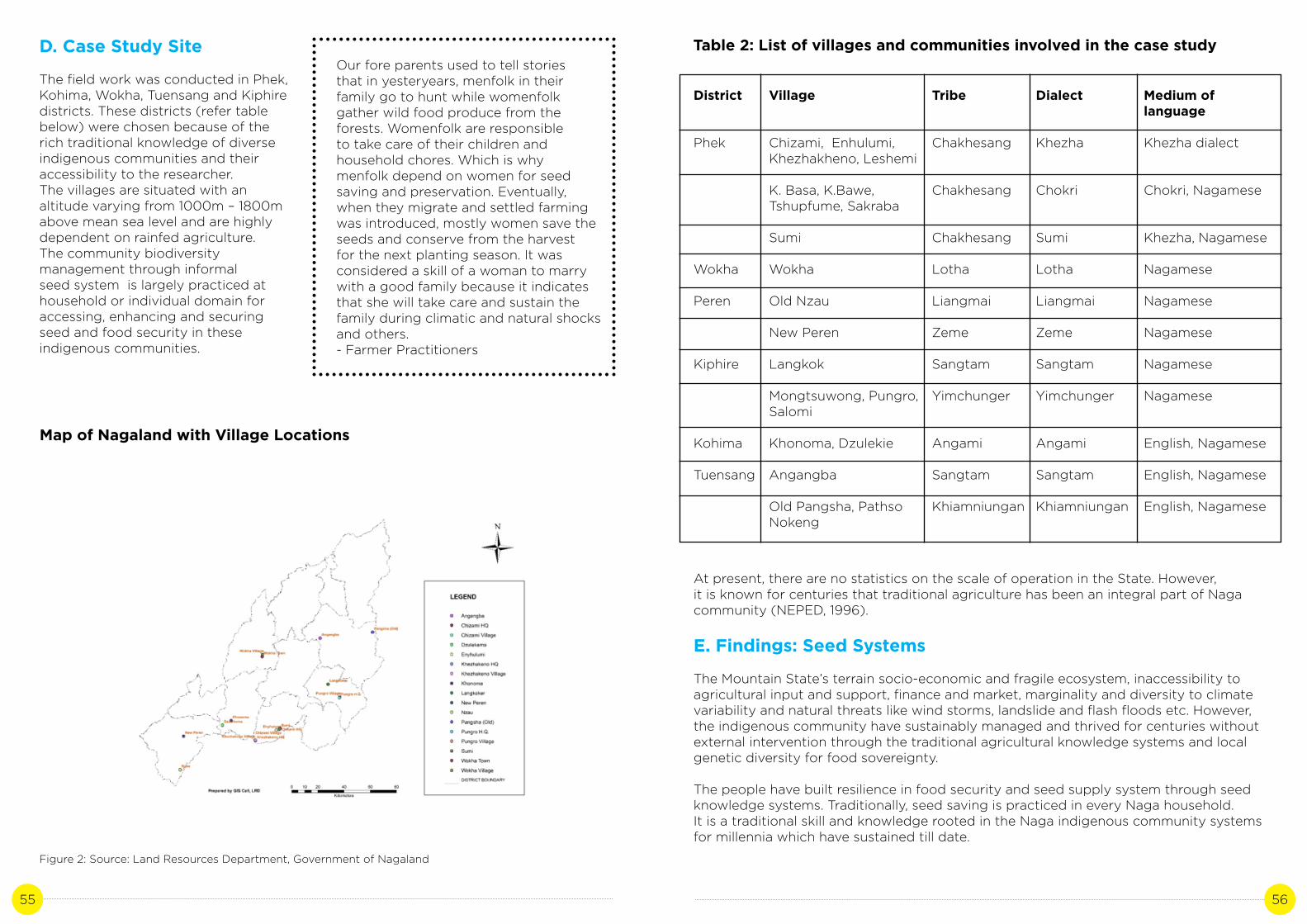
55 56
D. Case Study Site
The field work was conducted in Phek, Kohima, Wokha, Tuensang and Kiphire districts. These districts (refer table below) were chosen because of the rich traditional knowledge of diverse indigenous communities and their accessibility to the researcher.The villages are situated with an altitude varying from 1000m – 1800m above mean sea level and are highly dependent on rainfed agriculture.The community biodiversity management through informal seed system is largely practiced at household or individual domain for accessing, enhancing and securing seed and food security in these indigenous communities.
Our fore parents used to tell stories that in yesteryears, menfolk in their family go to hunt while womenfolk gather wild food produce from the forests. Womenfolk are responsible to take care of their children and household chores. Which is why menfolk depend on women for seed saving and preservation. Eventually, when they migrate and settled farming was introduced, mostly women save the seeds and conserve from the harvest for the next planting season. It was considered a skill of a woman to marry with a good family because it indicates that she will take care and sustain the family during climatic and natural shocks and others.- Farmer Practitioners
Map of Nagaland with Village Locations
Figure 2: Source: Land Resources Department, Government of Nagaland
Table 2: List of villages and communities involved in the case study
District
Phek
Wokha
Peren
Kiphire
Kohima
Tuensang
Village
Chizami, Enhulumi, Khezhakheno, Leshemi
K. Basa, K.Bawe, Tshupfume, Sakraba
Sumi
Wokha
Old Nzau
New Peren
Langkok
Mongtsuwong, Pungro, Salomi
Khonoma, Dzulekie
Angangba
Old Pangsha, Pathso Nokeng
Tribe
Chakhesang
Chakhesang
Chakhesang
Lotha
Liangmai
Zeme
Sangtam
Yimchunger
Angami
Sangtam
Khiamniungan
Dialect
Khezha
Chokri
Sumi
Lotha
Liangmai
Zeme
Sangtam
Yimchunger
Angami
Sangtam
Khiamniungan
Medium of language
Khezha dialect
Chokri, Nagamese
Khezha, Nagamese
Nagamese
Nagamese
Nagamese
Nagamese
Nagamese
English, Nagamese
English, Nagamese
English, Nagamese
At present, there are no statistics on the scale of operation in the State. However,it is known for centuries that traditional agriculture has been an integral part of Naga community (NEPED, 1996).
E. Findings: Seed Systems
The Mountain State’s terrain socio-economic and fragile ecosystem, inaccessibility to agricultural input and support, finance and market, marginality and diversity to climate variability and natural threats like wind storms, landslide and flash floods etc. However, the indigenous community have sustainably managed and thrived for centuries without external intervention through the traditional agricultural knowledge systems and local genetic diversity for food sovereignty.
The people have built resilience in food security and seed supply system through seed knowledge systems. Traditionally, seed saving is practiced in every Naga household. It is a traditional skill and knowledge rooted in the Naga indigenous community systems for millennia which have sustained till date.

57 58
Seed knowledge system is the pillar of the biodiverse farming and diverse seed production. It is largely transmitted through the informal seed supply system where seeds are shared and exchanged within the community. It was found that the heritage of Indigenous seed keeping and knowledge systems is a process, an accumulated wealth of knowledge through experiments passed from the ancestors to the present generation. It is a collective effort of the farmers and is organized and distributed at the local level. This is largely practiced at an individual and family domain.
The seed knowledge system is the connection to the past through their memories, practice and food systems, a hope and life to the present and a gift and blessing to the future generations. Farmers also shared that seeds are exchanged beyond geographic boundary. According to the seed custodians, seeds are meant to be shared, exchanged, regenerated, and distributed. In this way, the diverse produce provide food security and seeds for the next plantation season and when their crop fails in case of natural climatic crisis such as storms, erratic rainfall, heat stress etc.
Across the study area, it was also found that women are the seed guardian and harbinger for the local genetic diversity. The major types of seed sharing and exchange found are:
i) Sharing and exchange of seeds directly in the field (in-situ) between the seed producer and the seed client or user for free.ii) Sharing and exchange of seeds from the seed keeper directly at home for free. The seed keeper also shares her knowledge about the seed in terms of soil, climate, area and time of sowing.iii) Sharing of seeds directly in the field without the seed producer’s presence. Free and prior informed consent is taken or in some cases, the seed client or user informs the seed producer after s/he returns home.iv) Sharing of seeds by the seed producer by directly informing and inviting for those interested from the family, neighbor, friends and community through word of mouth to take or harvest the seed directly from the field (in-situ). This mainly happens when the farmer’s harvest is good and bountiful.v) The Church as an institution also facilitates in the informal seed supply system. They make it available, accessible and affordable to everyone. The congregation gifts the produce during the first harvest and on special occasions like Thanksgiving Day as part of their offering. During such occasions,
Figure 3: A seed keeper from Sangtam community sharing about her family heirloom seed ‘bean’ popularly known as ‘cholar’. The seed is stored in the traditional based woven with bamboo. Its best shelf life is 6-8 months. She has been farming at a young age till now.
Figure 4: Seed Custodians exhibiting their local seed varieties at the biodiversity festival cum International Women’s Day 2019 hosted by NEN.
the seeds and agricultural produce are outsourced to the members who need or require the seed variety.vi) Community seed banks (CSBs) have been initiated in recent years. Eight villages viz., Chizami, Enhulumi, Sumi, Sakraba, Dzulhami, Thurutsuswu, Ruzazho, Phughi and Akhegwo in Phek district have started Community Seed Banks (CSBs) with the support of North East Network since 2017. The CSBs objective is to preserve and conserve seed diversity, make indigenous seeds easily available and accessible for the farmers especially in times of climate crisis. These gene banks are collectively managed and owned by women in the villages. Any farmer from within the village and beyond can take the diverse seeds with prior information and verbal consent from the community seed bank. The managers of community seed banks documents the type and name of seeds available in the gene bank and also record any individual or agency who visits the bank and take the seeds. In this way, more farmer practitioners have access to diverse available local seeds. A cup of seed is loaned to the farmer and s/he returns two cups after harvest but the rule may differ from village to village. The CSBs management team has the liberty to change/prepare the regulations based on the local context.
In the above five types of systems, there are no written document to record the information on who shares and exchange the seeds. However, there is an in-depth understanding and cooperation among community members when sharing the seeds based on the ethics and values of the indigenous communities. The practice goes beyond family bloodline extending even to neighboring villages. Hence, migration of locally diverse seeds from one village to another village also takes place. It is vital to note that the villager or villages acknowledge the seed originality/copyright and identity and labelled the particular seed of the village from where the seed came originated.
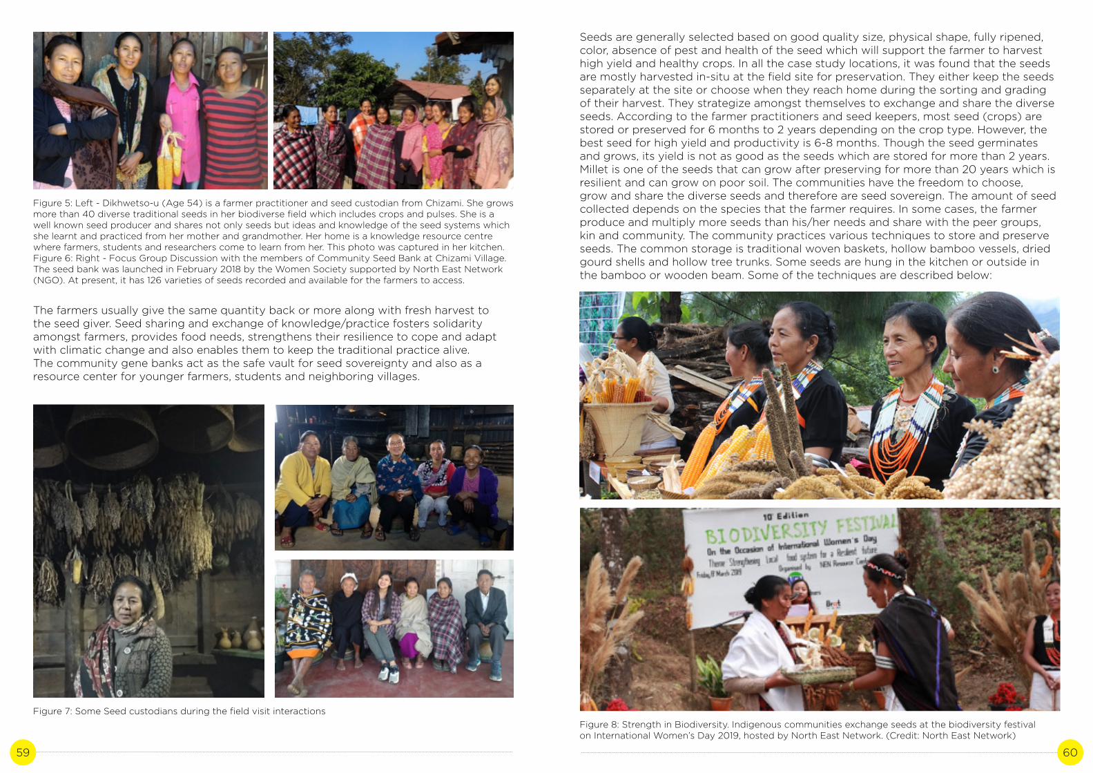
59 60
Figure 5: Left - Dikhwetso-u (Age 54) is a farmer practitioner and seed custodian from Chizami. She grows more than 40 diverse traditional seeds in her biodiverse field which includes crops and pulses. She is a well known seed producer and shares not only seeds but ideas and knowledge of the seed systems which she learnt and practiced from her mother and grandmother. Her home is a knowledge resource centre where farmers, students and researchers come to learn from her. This photo was captured in her kitchen.Figure 6: Right - Focus Group Discussion with the members of Community Seed Bank at Chizami Village. The seed bank was launched in February 2018 by the Women Society supported by North East Network (NGO). At present, it has 126 varieties of seeds recorded and available for the farmers to access.
Figure 7: Some Seed custodians during the field visit interactions
The farmers usually give the same quantity back or more along with fresh harvest to the seed giver. Seed sharing and exchange of knowledge/practice fosters solidarityamongst farmers, provides food needs, strengthens their resilience to cope and adapt with climatic change and also enables them to keep the traditional practice alive. The community gene banks act as the safe vault for seed sovereignty and also as a resource center for younger farmers, students and neighboring villages.
Figure 8: Strength in Biodiversity. Indigenous communities exchange seeds at the biodiversity festival on International Women’s Day 2019, hosted by North East Network. (Credit: North East Network)
Seeds are generally selected based on good quality size, physical shape, fully ripened, color, absence of pest and health of the seed which will support the farmer to harvest high yield and healthy crops. In all the case study locations, it was found that the seeds are mostly harvested in-situ at the field site for preservation. They either keep the seeds separately at the site or choose when they reach home during the sorting and grading of their harvest. They strategize amongst themselves to exchange and share the diverse seeds. According to the farmer practitioners and seed keepers, most seed (crops) are stored or preserved for 6 months to 2 years depending on the crop type. However, the best seed for high yield and productivity is 6-8 months. Though the seed germinates and grows, its yield is not as good as the seeds which are stored for more than 2 years.Millet is one of the seeds that can grow after preserving for more than 20 years which is resilient and can grow on poor soil. The communities have the freedom to choose,grow and share the diverse seeds and therefore are seed sovereign. The amount of seed collected depends on the species that the farmer requires. In some cases, the farmer produce and multiply more seeds than his/her needs and share with the peer groups, kin and community. The community practices various techniques to store and preserve seeds. The common storage is traditional woven baskets, hollow bamboo vessels, dried gourd shells and hollow tree trunks. Some seeds are hung in the kitchen or outside in the bamboo or wooden beam. Some of the techniques are described below:

61 62
Figure 9: A traditional seed vault for storing and conserving paddy seed varieties in Chakhesang and Angami community. Credit: Vevozo Vero
a) Rice is the staple diet of Naga community. These are the common traditional type for storing grains and seeds. It is woven and curved by menfolk in the rural communities for generations. Seed keeping is dominated by women in Naga society for centuries. Women are the seed guardians and custodians. The seeds shelf life varies from crops to crops. Except for millets, the seed keepers shared that the seeds stored for 6-7 months germinates and grow productively and yield more harvest. Rice is transplanted during May-June and harvested in October-November. The seeds for preserving for next sowing season are conserved in-situ and harvested after which it is dried in the sun and stored in the granary. In earlier days, the granary store was constructed far from the house because of the fear of fire as most of the houses were built of hay. At present, this type of storage (terminology: Liangmai – Shong, Chakhesang – ebu) is commonly used especially amongst Chakhesangs and Angami’s. The germplasm is secured in-situ.
b) Maize is one of the major cereals grown across the Naga communities. In earlier days, the communities mix the maize and rice for food for optimal utilization of rice as they cannot afford it. The corn is also used for making rice and maize beers too. It issown in the month of March and harvested in July-August. After it is fully ripe and ready to harvest, the farmers select the healthiest, heaviest and well-dried corn for the preservation. The seeds are harvested from different branches and are tied together as seen in the picture. It is hanged inside the kitchen and in the verandah for aeration and moisture level. When the sowing season arrives, women take the seeds 2-3 days before the sowing day and dry in the sun after plucking each corn. They utilize the middle of the corn for seed sowing and the right and left seed for other purposes. According to them, if they use the whole corn, its productivity and yield gets reduced and therefore selects the middle part for sowing.
Figure 10: Array of maize & local onion hung on the wooden beam of a farmer’s house for the next season to sow. The seeds are shared or exchanged directly from the beam. Credit: Vevozo Vero
c) The local spring onion is a common spice used in different local cuisines.It is selected at the site then hung outside the house on a bamboo pole. The best shelf life is between 5-7 months. Millets, maize, beans, and spring onions are hung in the kitchen’s hearth or in the porch. Some of the common seed storage photographs captured across the communities are embedded below.

63 64
Figure 11: Traditional kitchen hearth where diverse seeds are stored in different local storages.
Figure 12: Diverse seed preserved stored in the granary. Credit: Left – Vevozo Vero, Right - Vilazonuo
Figure 13: Traditional seed vault of genetic diversity preserved in dry gourd shell, hollow bamboo, baskets, and earthen pot.
The following findings below indicate that the traditional seed systems supports andenhance agriculture diversification and may be an effective strategy towards climate smart agriculture.
• Rich traditional seed knowledge systems.• Strength of communities’ network and social institutions at the village level.• Availability, affordability and easy accessibility of local seeds for farmers.• The system ensures right to food and seed sovereignty. They plan, manage, control, grow their own food and influence the gene flow.• Seeds are common property resource.• Seed exchange and sharing (during social, economic and natural shocks) at the individual level is the backbone of sustainable agriculture and seed diversity in Nagaland.• Strengthen community cohesion and solidarity.• The seed knowledge system maintains genetic diversity serving as an insurance for the farmers in combating climate variability and natural threats, because even when one crop fails, other crops thrive.• The seed keepers home are a knowledge resource center.• The practitioners of Seed knowledge Systems are building future safe vault for indigenous varieties of seeds.• Local seeds have the capacity to withstand and adapt to local environmental stresses and changes and agro-ecological conditions.• The communities are innovators. They utilize locally available resources like bamboo and wood, dry gourds, and creeper crops/pulses hanging in the kitchen hearth and wooden/bamboo beams in the house for storing diverse seeds.• The use and transmission of traditional knowledge, techniques and language, folk songs and oral histories related to traditional food and agro-ecosystems and the continued use of traditional foods in daily diet.
F. Discussion
It is evident from the study that the accessibility, availability and affordability of the diverse seeds impacts food production and consumption sustainability. Seed sharing and exchange of knowledge among the community is vital for conservation, food sufficiency and security for fostering solidarity. It also strengthens their resilience to cope and adapt with climatic change and keep the rich traditional practice alive.

65 66
The culture and transmission of knowledge systems through the genetic seed diversity across the mountain community clearly indicate that they have sustained farming through their indigenous knowledge till today withstanding the climatic changesfor generations. In a way, they contribute in addressing local and global climate change and food insecurity. The indigenous communities solves their solutions at the local level based on the community’s own priority, need, knowledge and capacities without the involvement of any external agency for generations.
The rural communities in Nagaland including the case study villages were left out of green revolution due to its marginalized socio-economic and fragile ecosystem, remoteness, inaccessibility and communication. For centuries, the seed knowledge systems have strengthened the communities through their social network at the community level and institutions.
It was found across the diverse communities that the indigenous seed system is not only the foundational element in their food system. It goes beyond self-sufficiency and food security. It is closely linked to the community’s unique identity and culture, tradition and social ties, values, skills, wealth and knowledge transmission and well-being. The indigenous communities have a deep relationship with nature and understand the ecosystem management. Seeds are a safe vault and safety net for the Naga communities during climatic threats and natural hazards like landslides, floods, droughts and excessive rain. There are exchange of not only seeds but ideas and knowledge on where, when and how to grow the crops which will thrive and provide food for the family.
The seed sharing and exchange of knowledge is also dynamic and flexible. There has been some transition in the agriculture sector due to change in the lifestyle of the Naga community. These changes are due to socio-economic and political changes in our community. Some of the changes observed in the seed systems are:
• Access to better road connectivity and communication with outside world.• External Influence of market (hybrid Seed supply) – emergence of cash crops.• Introduction of modern seeds like cauliflower, radish, carrots, tomatoes, cabbage, coffee, rubber etc. In some parts of the districts, mono-cropping culture of these crops has started.• The introduction of formal education in rural villages. The need for additional financial income for children’s education and domestic needs.• More options for employment in the private and government sector or entrepreneurship.• Integration of traditional local seed diversity and horticultural crops in the agricultural farm practicing intercropping and mixed cropping of tree crops, pulses and crops.• Inter-generational gaps between the young people and community knowledge holders.• High dependency on external market produce like rice especially people living in urban areas and near small towns.• Introduction of community seed banks in some parts of Phek and Kiphire districts.
For centuries, the Naga communities have built resilience in food security and supply system through seed knowledge systems as mentioned in the study. However, it has been observed that there are drastic change in rainfall patterns (intensity and frequency), increase in episodes of natural calamities like flash floods and landslides resulting in loss of lives, properties and ecological degradation.
The frequent hailstorm, earthquake tremors, heat stress and water stress etc. have alarmed the communities as most are not prepared. These extreme climatic changes of events and natural threats may increase the indigenous community’s vulnerability and inability not only in predicting local weather which has affected their agricultural production and systems but are at risks in food and health insecurity. The episode of flash landslides and floods in 2018 was an eye opener for most of the community and agencies in the State. Most of the communities were cut-off from the rest of the state and there was shortage of food supply, hike in price rates of the commodities etc. We must learn from our past experiences so that we are better equipped with knowledge and actions in future.
These extreme change of events will further affect agricultural viability and therefore the need and strategy to achieve food self-sufficiency and food security is critical than ever. At present, State policies and programmes ignore seed keeping heritage. There is hardly support system for seed conservation policy. The communities will need the governmental and local agencies support in the long run. The traditional seed knowledge systems can be replicated across the state where communities have lost the culture of seed saving or are eroding. Hence efforts towards a world without hunger must inevitably target genetic seed systems (Navdanya, 2012, FAO, 2015, United Nations, 2015, Gill T.B et.al. 2013, Vernooy et.al. 2017). As a step forward, there is a strong need to recognize and promote the contribution of the indigenous seed keepers and knowledge holders and the farmers to sustainable agriculture and genetic diversity in the state thereby contributing to national and global genetic pool and goals. FAO implies that ‘in order for climate change adaptation and mitigation to be sustainable and applicable on a wide scale, it must be incorporated, integrated or “mainstreamed” into the policy apparatus of governments’ (FAO, 2009). FAO, 2015 stresses on the significance of genetic diversity contribution to adapt to agriculture and food productions and the need to document locally adapted varieties of crops which are climate resistant and before the seeds and knowledge are lost because of the present negligence.
Some of the recommendations to collectively undertake in the state are:
• The recognition and need for effective State Seed Conservation Policy towards climate smart agriculture.• Research and Documentation: There is lack of written data repository of the traditional seed knowledge systems and hence documentation of Indigenous Technical Knowledge (ITK) and practices are critical more than ever. Traditional knowledge of the agricultural system can be a good source of information and may provide simple and effective solutions for climate change adaptation. Use of traditional knowledge as a strategy for decision-making and effective action on climate change.• Support and strengthen the existing community seed banks and scale up across the state to revive the traditional social seed networks which is practiced for generations before it is lost.• Recognize and promote women farmers’ contribution to sustainable agriculture through conservation of genetic diversity.• Recognize & support traditional knowledge holders and acknowledge their significant role and contribution to climate resilience across the States in the Himalayan region. Their knowledge will be their contribution to climate change adaptation and mitigation.• Build upon existing traditional knowledge systems and incorporate scientific knowledge based on the contextualized setting.

67 68
• Social convergence (partnerships with communities and other stakeholders)• Promote these initiatives and incorporate them in local development climate proofing strategies.• Introduction and promotion of the documented traditional knowledge/repository in formal education through public education to reach out to diverse stakeholders.• Capacity building of knowledge holders, young farmers and state officials.• Recognize and support farmer’s right to food and seed sovereignty.• Develop data repository of traditional knowledge system and practices of community-based climate change adaptation and coping practices.• Strengthening the existing local social institutions and support them with effective and context specific policies towards a diversified and climate resilient agriculture.
References
Abhijit Mohant et.al. 2016. Seed Banks in the Centre Of Origin: The Fight Against Climate Change. Jharkhand Journal of Development and Management Studies. 14 (2), 6971-6986.
Biodiversity International. 2017. Mainstreaming Agrobiodiversity in Sustainable Food Systems: Scientific Foundations for an Agrobiodiversity Index. Biodiversity International. Rome, Italy.
Census of India 2011
Department of Agriculture and Allied Departments. 2012. Vision 2025, Food for All: Prosperity through Agriculture. Kohima: Department of Agriculture and Allied Departments, Government of Nagaland.
Department of Planning and Coordination. 2016. Nagaland State Human Development Report. Kohima: Department of Planning and Coordination, Government of Nagaland.Directorate of Economics and Statistics. 2017. Nagaland Economic Survey 2016-17. Kohima: Directorate of Economics and Statistics, Government of Nagaland.
FAO. 2008. Climate Change and Biodiversity for Food and Agriculture. Food and Agriculture Organization. Rome.
FAO. 2009. How to Mainstream Climate Change Adaptation and Mitigation into Agriculture Policies.
Food and Agriculture Organization. 2009. FAO and Traditional Knowledge: The linkages with sustainability, food security and climate change impact: FAO.
FAO. 2015. Coping with climate change – the roles of genetic resources for food and agriculture. Rome.
Gill T.B et.al. 2013. Strengthening informal seed systems to enhance food security in southeast asia. Journal of Agriculture, Food Systems and Community Development, 2 (3), 139-159.
GIZ. 2014. Farmers’ Seed Systems: The challenge of linking formal and informal seed systems. Documentation of the Expert Talk, Bonn.
Government of Nagaland. 2012. Nagaland State Action Plan on Climate Change: Kohima.
INCCA. 2010. Climate Change and India: A 4X4 Assessment, A Sectoral and Regional Analysis for 2030s. New Delhi: Ministry of Environment, Forest and Climate Change, Government of India.
IPCC. 2007. Climate Change 2007: Synthesis Report, 2007, Geneva.
IPCC. 2014. Climate Change 2014: Impacts, Adaptation, and Vulnerability. Part A: Global and Sectoral Aspects. Contribution of Working Group II to the Fifth Assessment Report of the Intergovernmental Panel on Climate Change. Cambridge University Press. USA.
K. Mukhopadhyay, U. Kumar. 2013. The SAARC Regional Seed Bank: A Case Study of India. Cuts International. Jaipur, India.
Martemjen. 2017. Biodiversity Conservation, Indigenous Knowledge and Practices: A Naga Perspective. Chennai: Notion Press.
Michaela Scholey. 2015. A Report on Agricultural Biodiversity of Local Rice Varieties for a Sustainable Food System in Nagaland, India: Status Quo of the Rice Seed Exchange and Rice Breeding Programme & Space for Improvements. GIZ and Government of Nagaland.
Nakro Vengota. 2011. Traditional Agriculture and Sustainable Livelihood:A Thematic Report. Kohima: Department of Planning and Coordination, Government of Nagaland.
NAPCC. 2008. National Action Plan on Climate Change, Government of India, Prime Minister’s Council on Climate Change.
Navdanya. 2012. Seed Freedom: A Global Citizens’ Report: New Delhi: Navdanya.
NEPED and IIRR. 1996. Building upon Traditional Agriculture in Nagaland India. Kohima: Nagaland Environmental Protection and Economic Development and International Institute of Rural Reconstruction.
NEPED. 2006. Adding Value to Shifting Cultivation in Nagaland, India. Kohima: Nagaland Empowerment of People through Economic Development.
Pitambar Shrestha et.al. 2012. Community Seed Banks in Nepal Past, Present, Future: Proceedings of a National Workshop, 14-15 June 2012, Phokhara. Nepal.
R.Vernooy et.al. 2017. The roles of community seed banks in climate change adaptation. Development in Practice, 27 (3)
R. Vernooy et.al. (Eds). 2019. Resilient Seed Systems: Handbook. Second edition. Biodiversity International. Rome, Italy.
Seed Guardians, 2017. North-East Network, Nagaland.
Sunder Subramanian. 2016. Understanding the Synergy between National Mission for Sustaining the Himalayan Ecosystem and SAPCCS from Himalayan States. Indian Himalayas Climate Adaptation Programme (IHCAP).

69 70
Shree Kumar Maharjan, K.L. 2017. Community seed banks in Nepal; Prospects and challenges from the perspective of climate change adaptation. International Journal of Ecology and Environmental Sciences. Thijssen et.al. 2008 (Eds.). Farmers, seeds and varieties: supporting informal seed supply in Ethiopia. Wageningen: Wageningen International.UN. 2018. United Nations Climate Change Annual Report 2017. United Nations Framework Convention on Climate Change.
United Nations. 2015. Transforming our World: The 2030 Agenda for Sustainable Development.
United Nations. 2008. United Nations Declaration on the Rights of Indigenous Peoples. United Nations.

71 72
AGRO-BIODIVERSITY FOR FOOD, NUTRITION AND
ECOLOGICAL SECURITY: A CASE STUDY ON JHUM
AGRICULTURE, NAGALAND
CASE STUDY 4
Author: Khrolhiweu TsuhahContributor: Amba Jamir

73 74
A. Background
Nagaland, the 16th State of the Indian Union is located between 26°10’ N and 27°04’ N Latitude and 93°20’ E and 95°15’ E Longitude in North-East Himalayan region in the northern extension of the Arakan-Yoma ranges. Geographically, the State covers an area of 16, 579 square kilometers (sq.kms) out of 2, 55,997 sq. km. in Northeast (Geological Survey of India, 2011). The forest occupies an area of 12,966 Km2, which is 78.21% of the State’s Geographical Area (Nagaland, Economic Survey 2016-2017). Around 71.14% of the total population resides in rural areas and the remaining 28.86 % in urban areas (Census 2011). It is predominantly agrarian practicing Jhum cultivation, Terrace Rice Cultivation and Wet Rice Cultivation (Economic Survey Nagaland, 2016-2017). Its climate varies from Sub-tropical and Tropical to Temperate and receives an average annual rainfall of 1500-2500 mm. Geologically, Nagaland is the youngest among the Himalayan mountain ranges (Geological Survey of India, 2011).The State is inhabited by 16 recognized tribes with distinct dialect, culture, custom and tradition and reside within 11 administrative districts (Census 2011). The constitutional protection under Article 371(A) of the Indian constitution recognizes the unique community and safeguards the culture, traditions and way of life of the Naga people. Hence, in terms of land ownership, the land mainly belongs to the communities, clan and individuals which are governed by decentralized village councils in all the recognized villages.
Table 1: State at a glance (Census 2011)
State
Capital
Districts
Population
Density of Population
Total Area
Sex Ratio
Literacy Rate
Average Rainfall (Annually)
Main rivers
Seasons
Nagaland (Census 2011)
Kohima (1,444 meters Above Mean Sea Level)
Mon, Longleng, Tuensang, Mokokchung, Wokha, Zunheboto, Kohima, Phek, Kiphire, Peren, Dimapur
19, 80, 602
119 Per Sq.Km
16, 579 Sq.Kms
931 Female: 1000 Male
79.55%
1500 - 2500 mm
Dhansiri, Doyang, Dikhu, Tizu, Lanye
Heavy rain (May – August)
Occasional (September – October)
Dry Season (November – April)
Nagaland has formulated the Nagaland State Action Plan on Climate Change (SAPCC, 2012, SAPCC 2021-2030) to align and achieve Nationally Determined Contribution (NDC) and Sustainable Development Goals (SDGs) with co-benefit of climate change. The SAPCC states the importance of streamlining climate change concerns into ongoing development agenda to climate proof development in the mountain state. It has developed strategies to cope with climate change issues such as strengthening capacities of the communities, individuals and stakeholders to be climate resilient, introducing new resilient crop varieties, promotion of indigenous cultivators, crop intensification and organic farming amongst others. Agriculture and bio-diversity is the lifeline of Naga indigenous communities and also the largest contributor to the State’s economy (Department of Environment, Forests & Climate Change Nagaland, Annual Administrative Report 2017-2018, Nagaland Economic Survey 2016-2017, Nagaland State Action Plan on Climate Change 2021-2030). Hence, agriculture and allied sector is the priority of development in the State which also aims to achieve ‘Food for All’ by 2025 (Department of Agriculture and Allied Sectors, 2012). As per the SAPCC, the agriculture sector in Nagaland aim to:
i. To transform subsistence agriculture to organic agricultureii. Promote commercial agriculture in a sustainable way through diversification and value addition of crops, conservation of soil and forest. It also stresses on the need for research and development, enhance technology and strengthening of human capacities in agriculture based livelihood sector through sustainable agricultural development without compro mising on livelihood and food security.
Figure 1: Source - Land Resources Department, Government of Nagaland

75 76
However, there are critical concerns with regard to climate change projections in the State which may be an obstacle in achieving the objectives. The Indian Network for Climate Change Assessment (INCCA, 2010) in its report projects that climate change is likely to increase in the form of rising temperature and precipitation in the Indian Himalayan region and the North-Eastern region which is inhabited by nearly 50 million people. Nagaland thus, also falls under one of the highly climate-sensitive zone. The NSAPCC predicts that climate change in the State is likely to exacerbate the frequency and intensity of extreme weather events and will significantly enhance rise in temperature which will affect the hydrological regime, precipitation levels and evaporation. The report informs Nagaland to be highly vulnerable in the period 2021-2050s (refer table 1) due to:
i. Heavier precipitation during monsoon and increase in extreme precipitation events ii. Decrease in precipitation in summer and winter periods iii. An increase in warmer average annual temperature and iv. Increase in droughts, flood discharge and evapo-transpiration may lead to water stress and highly impact agricultural production in the future v. The temperature records for Nagaland also shows a steady warming trend in both the minimum and maximum temperatures over the past 100 years.
These predicted changes may consequently put pressure on the natural resources and biodiversity and impact the vulnerable mountain communities dependent on ecosystem-based livelihoods. The most affected groups will be small marginalized farmers and Jhum cultivators. There are existing evidences that climate induced natural calamities or climate change on extreme events has become exceedingly visible and frequent (2012-2018) in the State and is likely to worsen. An instance of changing climate in the State is the occurrence of snowfall in the winter of 2007 in Aghunato of Zunheboto district which is a new phenomenon in the area. The Nagaland State Disaster Management Authority (NSDMA) cautioned that the natural calamity or non-extreme climate events due to climate change my lead to greater risk for climate related disasters impacting lives and livelihoods of the people and biodiversity. Nagaland have experienced cyclones and extreme precipitation events like heavy rainstorm, hail and cloud resulting in loss of agricultural production and ecological degradation, which has an impact on human health-physically, mentally and psychologically. These will further intensify as per the projections (SAPCC) and may need immediate attention and action as it will have detrimental effect on the present socio-economic and cultural structure, geo-political constraints and biodiversity loss in the State. These frequent natural calamities may also reduce the mountain people’s resilience to poverty, food and water security.
The SAPCC of Nagaland does not give enough focus on the importance of traditional agricultural knowledge sustained by the community for centuries which may largely contribute to achieve the State’s mission and vision. Local institutions and civil societies play a vital role and therefore should be included in the report. The report overlooks the adaptation mechanisms by the indigenous community and thus the case study hopes to respond to the gap within the document. As mentioned, the State is highly dependent on climate sensitive resources like agriculture, forest biodiversity and water for sustenance. Despite the political instability, poor infrastructure, fragile ecosystem exposing them to climate variability, its people have built resilience and a balance to meet the present needs while conserving and protecting its biodiversity. This case study highlights the unique indigenous practice of sustainable jhum cultivation through an agro-biodiverse farming in Nagaland. This case study captures agro-biodiverse farming practice as a coping mechanism to combat climate change, food and nutrition insecurity,
market risks, erosion of community cohesion amongst others. It also bring to the fore, issues confronting jhumias today but also offer opportunities for replicating this bio-diverse indigenous farming for sustainability.
B. Literature Review
Lives and livelihoods of the mountain people in the Himalayan region including Nagaland are highly dependent on climate sensitive resources like agriculture, forest biodiversity and water for sustenance (INCCA, 2010), (Niti Aayog Report, 2018). The State’s difficult terrain, inaccessibility, marginality, diversity and fragile ecosystem expose the Naga people to climate variability and change. Sustainable Jhum cultivation in the Himalayan mountain states and Asia has been acknowledged that it is part of a strong social system, a heritage and tradition. The United Nations Declaration on the Rights of Indigenous Peoples’ adopted by the UN General Assembly on 3 September, 2007, FAO of the United Nations, 2015 and the UN Climate Change Annual Report 2017 strongly streamlines the magnitude of indigenous peoples and local communities’ traditional knowledge and perspectives, their role and contribution to climate change adaptation and traditional coping mechanisms. It also mentions the importance of providing a platform aiming at exchange of knowledge, technology and practice (ibid). Therefore, it is pertinent to understand and recognize the traditional agricultural techniques and knowledge.
The prominence of traditional agricultural knowledge system and genetic diversity is cost-effective, participatory and sustainable and can be an instrumental tool/strategy for development of effective climate change adaptation and coping mechanisms policies if integrated (The Intergovernmental Panel on Climate Change, 2010;E. N. Anjani et.al., 2013). Therefore, it is pertinent to understand, document the rich traditional repository of centuries old indigenous agricultural techniques and knowledge and that it is given due recognition in the mountain states of Nagaland and Himalayan Mountain Region considering its dependency on the biodiversity.

77 78
Women play a key role in Indigenous Peoples’ sustainable resource management and food security (AIPP et.al. 2015). As per the State Human Development Report (SHDR) 2016, illegal timber felling, coal mining and excessive wood fuel consumption etc. is the key cause for degradation of the State’s forest cover rather than shifting cultivation. It was also reported that the major cause of carbon emission in Asia is not Jhum/shifting cultivation but agriculture intensification and large scale direct conversion of forest for small scale and large scale industrial plantations (FAO, UNDP, UNEP 2008). It further reported that Jhum cultivation contributes to biodiversity enhancement, food and nutritional security and vital for in-situ genetic crop conservation and preservation. The restriction on Jhum cultivation increases food insecurity of the indigenous communities (Christian Erni. 2009).
There is a strong need to safeguard the traditional agro biodiversity conservation, food security and retain farmers’ right to traditional and local knowledge (Lipichem, 2017) to adapt to the impacts of climate change by integrating responses and adaptation measures. In addition, there is no better time but now to act for climate empowerment through public awareness and participation, access to information/resources and collaboration with wider stakeholders and foster climate resilience and climate resilient development. “The Jhum farming system needs to be understood as a highly elaborate system, that has evolved probably over thousands of years, and in this long time forest trees and agricultural crops have evolved jointly, creating a system with many forestry products and a very wide range of agricultural crops all consumed by the people.” (Bachmann, 2012 ). The agricultural biodiversity in traditional bio-diverse farming system through shifting cultivation is far better than most farming systems practiced in India, Africa and other parts of Asia. He stresses the importance to preserve the diversity and enhance the practice as an adaptation to climate change (ibid).
C. Methodology
Qualitative technique was used mainly in the case study for primary data collection. Secondary data includes published and unpublished departmental reports, books, articles, newspapers and social media. Some tools like transect walk and timeline was utilized. Voice recording and field notes were undertaken with prior permission (oral consent) from the respondents for documenting. For the data collection, tools like questionnaire, telephonic interview, in-depth interviews, Focus Group Discussion (FGD) and participant observation was used.
The in-depth study was undertaken in Chizami village. However, field visits to other villages like, Tsupfume, K.Basa. K.Bawe of Phek district, Salomi and Pungro village of Kiphire district and Old Pangsha, Hakchang of Tuensang and Wokha village of Wokha district were included in the study as these communities widely practice Jhum agriculture. In the field, the medium of communication was Khezha, the local dialect in Khezha speaking areas and Nagamese and English in Tuensang, Kiphire and Chokri speaking areas of Phek district respectively. The respondents were Jhum farmer’s and key informants include village community leaders, NGO and governmental agencies working in the selected case study sector.
Case Study Site
Chizami village is situated in Phek district of South-eastern Nagaland, 88 km away from the capital, Kohima and the altitude ranges from 981 – 2000 m (MSL). Agriculture (rainfed) is the major economic sector for food security and livelihood. The major economic activity in the village is subsistence agriculture practicing traditional Jhum
cultivation (slash/burn), wet terraced rice cultivation and wild forest produce. The communities have diversified sources of income – selling of crop produce, livestock, firewood, daily wage labor, masonry, carpentry, weaving, private and govt. employment and small shops. At present, there are six khels or wards in the village and the Village Council is the apex body and various community based organizations functions harmoniously like the Youth Society, Women Society, WATSAN, Church and Students Union. Two women representatives and each khels have equal representation in the village council and play important roles in decision-making in matters related to village governance. Chizami village is considered as a model village in the rural areas of Phek district in socio-economic reforms and environmental conservation/protection. There are no written records but the village is believed to have lived 13 generations according to the elders. The village elders, men and women echo that the first known agricultural system practiced was shifting cultivation and collection of diverse wild produce from the forests. Every household in Chizami practice Jhum cultivation or homestead garden alongside wet terrace field cultivation.
The district has a geographical area about 2026 sq. km, with altitude ranging from 520 to 2900m above mean sea level (MSL) and is bounded by Myanmar country in the East, Manipur to the South, Zunheboto and Kiphire districts to the North and Kohima district to the West. Tizu, Lanye and Sedzu are the three important rivulets and Shilloi, Chida and Dzuda are the vital lakes in the district (Census 2011). It is dominated by sedimentary terrain but some geological formation of metamorphic and igneous rocks is also found. According to 2011 census, 84.93% of the total population (163,294 people) lives in rural areas of Phek district and Shifting or Jhum agriculture occupies 12160 ha area (R K Singh, 2009).
Findings: The Traditional Jhum Agricultural System and its Processes
The bio-diverse traditional Jhum or swidden agricultural sustainable farming system is embedded in Naga’s socio-economic, ecological and cultural way of life. The practitioners of this system are known as swidden cultivators/ agriculturalists or Jhumia. Jhumias are typically small land holders or marginal farmers, who cultivate in privately owned and clan-owned plots of land, or community owned forests within and in adjoining village boundary. They are the custodians of agro-biodiversity in their community. It is a coping and adaptation mechanism to combat climate variability in rural communities. It also enhances seed sovereignty and alleviates poverty and hunger. According to the farmer practitioners, Jhum agriculture is ‘a time-tested method, accumulated knowledge of wisdom and skills, developed through practice and experiences, and have progressed in the village and as a society collectively’. As the agricultural system is rainfed and the region is characterized by steep slopes gorges and sharp crest ridges like the counterparts of Nagaland and Himalayan region, the community has therefore strategically developed this method to strengthen the resilience of their agricultural landscapes. They further stressed that ‘Jhum agriculture or ‘Melupito’ is not only a system of agriculture but the indigenous community’s social identity, heritage, wisdom and wealth, their cultural value and food and nutritional security. It is their right and collective responsibility to maintain, upholds, protect and preserve the traditional knowledge and skills and pass on to the next generation’.

79 80
Stage 1:
In the first stage, the elders and leaders of the village play a pivotal role. Historically, the decision-making mechanism on selection, principle of prior information to the community to cultivate Jhum, its management and practices of land use and tenure, land resource management including the location, size of the field, and fallow frequency amongst others are inclusively regulated through community norms and governed by the social institutions. It is also important to note that some trees, wild plants and soil, altitude and village area form the basis to select the field for Jhum cultivation. Typically, it is informed during community gatherings and also through representatives from their clusters or khels. In Nagaland, the community norms, customary laws and cultural values vary and are tribe or locality specific.
Stage 2:
Traditionally, after the swidden or land or ‘Melu’ is identified and stage 1 process is completed, the first activity for Jhum cultivation commences. At this juncture, the social institutions announces the day for clearing of vegetations in the Jhum field. Traditionally, all the men folk representatives of every household gather at the allotted time and place. It is important to note that there are two types of Jhum land that they cultivate – community cultivation site where the entire clan or community cultivates at a stretch and the other is the fragmented land where Jhum is practiced by individual families. The land may be claimed individually or allocated in every period of cultivation. The community do not clear the vegetation on the top hill or mountain so that surface runoff is lessened and infiltration increases for groundwater recharge which helps their crops productivity. Thus, the forests are not cleared outside the defined area.
It was essential during the clearing of the Jhum field that the trees are not uprooted nor completely cut down. However, all the leaves are thinned. In this way, the trees can be used as support/barriers for the bunds and the pruning remnants at a later stage act as biomass. According to the farmers, it is vital to particularly clear at this time so that the fresh wild plants and shrubs, herbs and grasses, trees and leaf litters etc. are exposed to dew and rain and thus act as in-situ repositories for the crop and the wild plant germplasm. Time management was critical as they also have to harvest the paddy cultivated in wet terrace fields. During this process, they also socialize and discuss aboutmatters pertaining to the village activities, politics and customs etc., while women bind the paddy stocks in the wet terrace fields. The community utilizes the fell trees and twigs for fuel and also keeps sturdy timber aside for the construction of hut in the Jhum field and also collects non-timber forest produce. This stage starts in later part of September till Mid October.
Soil is the most important natural resource and is the essencefor Jhum agriculture technique. It is vital that the soil is healthy and nourished. Therefore, decomposition and burning of the Jhum field at an appropriate time is imperative under optimum condition. We need to work in sync with nature within the system stresses the Jhumia’s.
- Excerpt from the Naga jhum practitioners
In a Jhum field, numerous seed varieties of 15-40 crops and pulses are grown and harvested on rotational basis. It is vastly cultivated in privately owned plots of land and clan or community owned forests within and adjoining the village boundary. Maintaining genetic diversity serve as an insurance for the farmers in the context of climate variability, because even when one crop fails, other crop thrives. The system sustains their family, contributes to community’s local food production and food chain. The various activities of the traditional agricultural system are:

81 82
Stage 3:
The cleared vegetations are left undisturbed for 4-5 months at this stage. According to farmer practitioners, ‘soil is the major life-support system and therefore, nurturing and healing the soil is their responsibility’. Low agricultural inputs is applied through efficient use of natural resources like decomposition of biomass from fell trees, wood chips, branches, twigs, leaves, shrubs and plants, residue crop mulching etc. to improve the process of soil macrofauna (earthworms, termites) enhancing the soil nutrients and soil structure. Consequently, this method act as non-chemical weed control and also generates biomass and nitrogen fixation by the root nodule of the plants. The activity starts from mid-October till the beginning of March and is locally known as ‘Metsi we’.
Stage 4: Burning of the Jhum Land
Women start preparing for the traditional seed varieties that they have saved and preserved for sowing while men folk initiate the burning process. The dried vegetation slashed during stage 3 is burnt in stage 4. Traditionally, the farmers’ practices controlled burning method. This activity starts by first week of March.
Similar to stage 2, at the community cultivation site, the farmers generally gather in groups to guard or monitor the corners of the identified land in order to effectively manage and control the fire. However, additional effort is undertaken throughout the process in individual land cultivation site as the risk is high in the fragmented lands. A fire line or ‘eme rhutsha’ is firstly demarcated (1-3m spacing). The aim is to manage and control fire so that it doesn’t spread to the adjoining plot of land or village boundary. All the Jhumia’s are responsible to guard the nook and corner of the Jhum field to prevent the spread of fire. This implies that the system is a collective responsibility and action to not only fulfill their food needs but are also accountable to protect and conserve the agro-biodiversity and local ecosystems.
Customarily, the knowledge and skill of lighting, managing and controlling of fire in Jhum land is passed down for generations to menfolk in the community since time immemorial in Nagaland. They are trained at an early age/youth or observation through practical experience learning the ways of the forest, learn how to manage fire and be aware of its implications to assess the wind direction – weather pattern, land topography, biomass and local conditions. For instance, Jhum land is not burnt during windy and rainy days.
Decades of Jhum practitioners shared that ‘the burning method is extraordinary and therefore needs to be managed with care. It can either destroy lives and ecosystem or give life and sustain our ecosystem. Our forefathers realized its importance and therefore have meticulously experienced and learnt its skill to finally pass it on to us. Based on our experience, the burning of the Jhum field treats the soil nutrients/fertility, control harsh weeds and pests and also improves habitat for plants and animals during the fallow period’. This method also helps to plant or sow at ease using even a wooden dibble stick due to the heat of the fire as it soften the surface soil and make it more friable thus providing suitable seed bed.
After the fire is controlled and subsided, the Jhum land is spread with vestiges and dotted with cinders emanating smoke. The ash is very efficient in terms of crop yield improvement and is more economical from the small-scale farmers’ point of view. This fire-fallow farming method helps fix potash in the soil, thereby increasing its fertility and availability of soil nutrients and activating quiescent soil micro-organisms to accelerate the process of nutrient release to the plants (NEPED, 1999). ‘Many plants and animals are reliant on fires for their survival and the right kind of fire can promote diversity. If the forest is suppressed for long periods, its vegetation accumulate which in turn increases the risk of adverse fires in future over swathes of territory especially during long drier spell of months’ (Plana, 2017). Immediate steps are taken after the burning activity to prevent top-soil erosion and surface runoff by shaping and preparing the land.
Stage 5: Shaping and preparation of land for Sowing
The main activity is shaping and preparation of land for sowing of diverse crops and pulses. Like many other communities Chizami Chakhesang communities also have developed different mechanical and vegetative measures for soil and water management from locally available natural resources. In gradient slopes, continuous contour bunds are undertaken while in the steep slopes, staggered contour bunds are prepared utilizing resources like split bamboos, tree stumps and poles, stone boulders and trash etc. as a barrier to prevent soil erosion, retain soil moisture, structure and collect soil nutrients from uphill slopes, decrease surface runoff and tap water for infiltration which helps to alleviate water deficit in steep slopes. This process is locally known as ‘ebudze’ and is usually completed within a day or two after the burning activity.
Figure 2: The womenfolk preparing the land for sowing with their traditional spades. Mainly women in Nagaland are responsible for preparing and shaping the land (Photo Courtesy: Vevozo Vero)

83 84
Figure 3: Photo Credit - Peter Thopi
This indigenous technique gives emphasis in steep slope (more than 50%) by systematically arranging more usage of felled trees and burnt tree remnants, stones, split bamboos and logs as a barrier in the form of staggered contour bunds. This is done to prevent or lessen erosive soil velocity and surface runoff as the first monsoon rain arrives from March-May and the crops have not grown enough to cover and protect the soil. Here, additional traditional seeds are also sown so that the farmers may harvest bountiful crops. The farmers stressed that particularly in these types of lands; traditional variety of millets is sown.
Stage 6: Seed Preparation & Sowing
After all these major activities are undertaken, sowing of diverse traditional seeds is done within a day or two after the burning process alongside during or after the ebudze activity or alongside the process or completion. Women are responsible for sowing of seeds in the plot. According to the farmers, Millets are sown within the contour bunds and maize is sowed in the contour bunds (about 1m space) and the diverse variety of crops and pulses are mixed and intercropped between the maize in the contour bund stretch on the overlain by the soil. The creeper crops/pulses are sowed on the corner location of the Jhum field due to its vine characteristics which may hamper the growth of the young saplings and affect its productivity and yield.
Figure 4: Photo courtesy - Peter Thopi
Millet is a resilient and sturdy crop (and sustain or store longer period (20-30 years) than the staple food i.e., rice. It can also grow on poor soil and adapt to rising temperature besides ensuring nutritional security despite the agricultural system being purely rainfed.
It is harvested twice a year (July and October) in the same plot of land particularly in warmer areas.

85 86
Stage 7: Weeding
According to the farmer practitioners, weeding processes are the most important after the sowing activity to nurture the crops and pulses for its yield and productivity. After the seeds germinate, the first weeding undertakes in first week of April. The weeds are removed by local spade and hands. The farmers shared that the weeds are removed and the thick seed saplings are replanted in areas required or the excess removed used for mulching in the bunds along with the weeds. This first weeding is locally known as ‘Mere Tshu’ and is the most important process of nurturing the crops noted the farmers. It was also vital because the second and third weeding becomes easier to remove with hand and spade.
The number of weeding differs from community to community in Nagaland. For instance, in Wokha village, it is done 3-4 times starting from April - July. They also utilizes ash for weeding.
Figure 5: A view captured after the first weeding completion at the Jhum field (Photo courtesy – Vevozo Vero)
The second weeding is locally known as ‘Merhe Tshu’. The weeds tend to be thicker than the first weeding. The weeds are removed by spade and hands in May. During this time, pruning of alder trees is undertaken which is used as mulching in the Jhum field. The arrival of insect Cicadidae signifies the nature signal for planting of paddy saplings in the wet terrace fields. During this time, the third weeding locally known as “Kuma Mae” undertakes in June. Here, the thick weeds are removed and put around the grown crops like maize and millet to protect its roots and in the bunds or ‘ebu’ to retain soil nutrients and capture surface rainwater to enhance infiltration which ultimately feed its roots. In mid-July-August, the farmers clear the tall weeds and grasses in the corners of Jhum field which is known as ‘Yipho Ewa’ as a way to protect the crops from attack of pests and rodents and wild animals. According to the farmers, this activity lessens the pests’ attacks.
Stage 8: Harvesting and seed keeping
Harvesting varies according to different varieties of crops and pulses starting from June – December (see table 2). The communities are satisfied with their collective or individual’s produce from their jhum field. They share the surplus produce with their relatives and neighbours which also contributes to their income through selling in their community, local marketing shed. In this way, the community’s solidarity and cohesiveness is strengthened. In a way, they create moral economy. The forest which is a common pool resource (CPR) also plays a crucial role in providing food security to the community during this activity.
Table 3: Annual Crop Calender, Chizami Village (Source: Interviews and Group Discussions)
Crops Jan Feb Mar Apr May Jun Jul Aug Sep Oct Nov Dec
Millets
Maize
Job’s tear toshube
Pochu
Paddy (Rice) menabe
Rajmah (Karhu)
Beans
Scallion
Green chilli/King chilli
Topiaca

87 88
Yams
Pumpkins
Perilla
Mustard leaves
Cabbage
Bitter Nut
Brinjal
Tomatoes
Gingers
Bottle gourd
Basil
Velvet bean
Rozelle
Cucumber
Crops Jan Feb Mar Apr May Jun Jul Aug Sep Oct Nov Dec
Sowing
Harvesting
During prolonged dry spell, the community shares millets, maize, tomatoes, chilies with others to thrive. The famer practitioners select the healthiest crop which is consistent in sizes during the harvest for seed keeping. The seeds are stored in baskets woven from bamboos, bamboo hollows, dried gourd shells and earthen pots which according to them are good for aeration and avoid attacks from pests. Seed keeping is traditionally dominated by women. They plan, manage and influence the gene flow and strengthen the traditional seed supply for their family and the community through their individual seed bank and the heritage of seed keeping.
Stage 9: Fallow Period
The fallow cycle is the most important activity in Jhum agriculture system. It varies considerably from village to village (7-20 years) depending upon the particular village involved and local environmental factors across the districts of Nagaland. After the fallow period, the same area is cleared again and the same process is followed. Some farmers plant trees during the fallow period. In Chizami, traditionally the farmers rotate on the third year to another identified Jhum field. The Chakhesang’s like the Angami community also practices agro-forestry within Jhum agriculture.
D. Discussion and Analysis
Jhum agriculture is an ecosystem based adaptation with tacit indigenous knowledge. For centuries, it has been a vastly productive form of ecological farming. Diversification of traditional crops (20-50 varieties) is critical to the farmers as they have learnt from this traditional system for generations. According to the farmers, it is important because when some crop fails, the other crop varieties thrive and sustain their family, community’s local food production, food chain and system and enhances genetic diversity during harsh climatic change and variability. In this way, their risk and vulnerability is reduced.
For centuries, the Angami tribe of Khonoma villages have traditionally integrated agro-forestry in their bio-diverse agricultural system of Jhum cultivation (NEPED, 1999), (NEPED, 2006) including Chizami community. The system is not only their food basket but a tool for income diversification and supports the ecosystem. In this way, the community has cope with climate variability through their traditional wealth of knowledge coped and management skills.
The local seed varieties play a critical role in traditional cropping plan and selection of climate resilient varieties (which can sustain and thrive during drought or heavy rainfall) to enhance and support the food chain system and ensure food security and nutritional values to the community and to all the consumers in Nagaland in general.
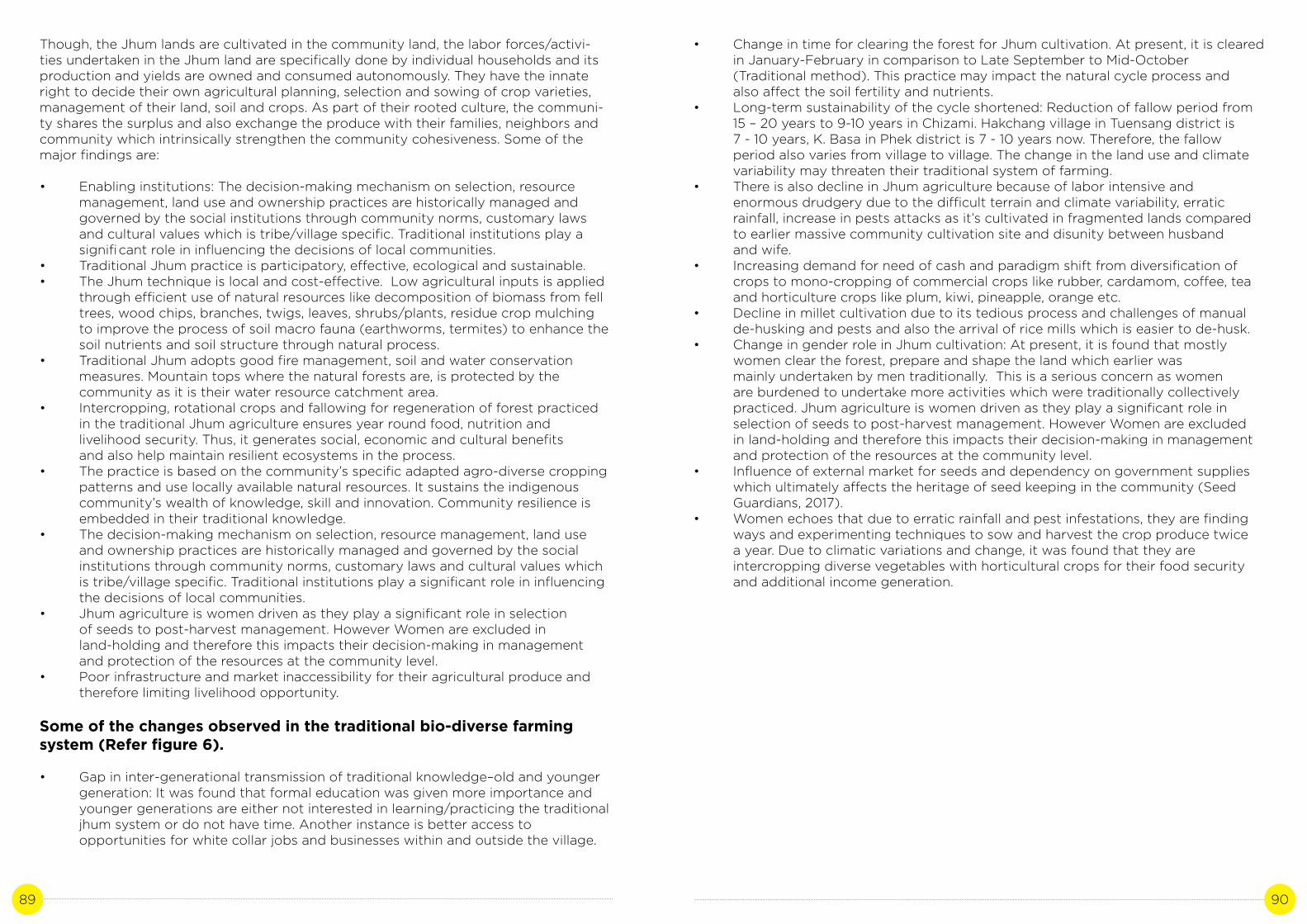
89 90
Though, the Jhum lands are cultivated in the community land, the labor forces/activi-ties undertaken in the Jhum land are specifically done by individual households and its production and yields are owned and consumed autonomously. They have the innate right to decide their own agricultural planning, selection and sowing of crop varieties, management of their land, soil and crops. As part of their rooted culture, the communi-ty shares the surplus and also exchange the produce with their families, neighbors and community which intrinsically strengthen the community cohesiveness. Some of the major findings are:
• Enabling institutions: The decision-making mechanism on selection, resource management, land use and ownership practices are historically managed and governed by the social institutions through community norms, customary laws and cultural values which is tribe/village specific. Traditional institutions play a signifi cant role in influencing the decisions of local communities. • Traditional Jhum practice is participatory, effective, ecological and sustainable.• The Jhum technique is local and cost-effective. Low agricultural inputs is applied through efficient use of natural resources like decomposition of biomass from fell trees, wood chips, branches, twigs, leaves, shrubs/plants, residue crop mulching to improve the process of soil macro fauna (earthworms, termites) to enhance the soil nutrients and soil structure through natural process.• Traditional Jhum adopts good fire management, soil and water conservation measures. Mountain tops where the natural forests are, is protected by the community as it is their water resource catchment area.• Intercropping, rotational crops and fallowing for regeneration of forest practiced in the traditional Jhum agriculture ensures year round food, nutrition and livelihood security. Thus, it generates social, economic and cultural benefits and also help maintain resilient ecosystems in the process. • The practice is based on the community’s specific adapted agro-diverse cropping patterns and use locally available natural resources. It sustains the indigenous community’s wealth of knowledge, skill and innovation. Community resilience is embedded in their traditional knowledge.• The decision-making mechanism on selection, resource management, land use and ownership practices are historically managed and governed by the social institutions through community norms, customary laws and cultural values which is tribe/village specific. Traditional institutions play a significant role in influencing the decisions of local communities.• Jhum agriculture is women driven as they play a significant role in selection of seeds to post-harvest management. However Women are excluded in land-holding and therefore this impacts their decision-making in management and protection of the resources at the community level.• Poor infrastructure and market inaccessibility for their agricultural produce and therefore limiting livelihood opportunity.
Some of the changes observed in the traditional bio-diverse farming system (Refer figure 6).
• Gap in inter-generational transmission of traditional knowledge–old and younger generation: It was found that formal education was given more importance and younger generations are either not interested in learning/practicing the traditional jhum system or do not have time. Another instance is better access to opportunities for white collar jobs and businesses within and outside the village.
• Change in time for clearing the forest for Jhum cultivation. At present, it is cleared in January-February in comparison to Late September to Mid-October (Traditional method). This practice may impact the natural cycle process and also affect the soil fertility and nutrients. • Long-term sustainability of the cycle shortened: Reduction of fallow period from 15 – 20 years to 9-10 years in Chizami. Hakchang village in Tuensang district is 7 - 10 years, K. Basa in Phek district is 7 - 10 years now. Therefore, the fallow period also varies from village to village. The change in the land use and climate variability may threaten their traditional system of farming. • There is also decline in Jhum agriculture because of labor intensive and enormous drudgery due to the difficult terrain and climate variability, erratic rainfall, increase in pests attacks as it’s cultivated in fragmented lands compared to earlier massive community cultivation site and disunity between husband and wife. • Increasing demand for need of cash and paradigm shift from diversification of crops to mono-cropping of commercial crops like rubber, cardamom, coffee, tea and horticulture crops like plum, kiwi, pineapple, orange etc. • Decline in millet cultivation due to its tedious process and challenges of manual de-husking and pests and also the arrival of rice mills which is easier to de-husk. • Change in gender role in Jhum cultivation: At present, it is found that mostly women clear the forest, prepare and shape the land which earlier was mainly undertaken by men traditionally. This is a serious concern as women are burdened to undertake more activities which were traditionally collectively practiced. Jhum agriculture is women driven as they play a significant role in selection of seeds to post-harvest management. However Women are excluded in land-holding and therefore this impacts their decision-making in management and protection of the resources at the community level.• Influence of external market for seeds and dependency on government supplies which ultimately affects the heritage of seed keeping in the community (Seed Guardians, 2017).• Women echoes that due to erratic rainfall and pest infestations, they are finding ways and experimenting techniques to sow and harvest the crop produce twice a year. Due to climatic variations and change, it was found that they are intercropping diverse vegetables with horticultural crops for their food security and additional income generation.

91 92
Figure 6: Source - Interviews and Group Discussions in Nagaland
Voices from Leshemi village, Phek district
In recent years, our communities have experienced excess heat, rainfall variability – intensity, frequency and reduce rainfall in winter, hailstorm and heavy wind and storms. We’re highly dependent on rainfed agriculture and these changes have affected us deeply particularly within this decade. In 2017, natural calamity in the form of heavy hailstorm befell upon our village. Most of our paddy fields in the Wet Terrace Field (WTF) were destroyed which is our staple diet. It was a massive setback for us that happened right before the harvest but Women were affected the most. We have to provide food for the family. Paddy from previous year’s harvest which we have stored helped most of us. However, Jhum cultivation was a blessing because due to its diverse cropping system, it supported and sustained us and we’ll never forget. It not only sustained us but also generated some income for our families. Therefore, Jhuming is an important agricultural system and needs to be encouraged. Like other parts of Nagaland, women are the most vulnerable in the face of changing climate and at the same time contribute to resilient economy or act as actors for change in their families and communities. Their voices and actions are vital.
- Group discussion with women farmer practitioners
Voices from Chizami village, Phek district Nagaland
In 2011, witnessed climate change variability in the form of rise in temperature, scanty rainfall and late arrival of monsoon rain. This significantly affected and threatened our food production, livelihood and food security particularly paddy (staple diet) in wet terrace field. However, wild forest produce and Jhum cultivation produce sustained us. Crops and pulses like millets, chilly, tomatoes was bountiful. We realized that the age-old tradition of Jhum agriculture supported us at this time of climate adversity.
In 2012-present, the Village Council decided that every household should practice sustainable Jhum cultivation as they cannot afford to witness the same situation or which might exacerbate their risks and vulnerability to increase in possible frequency of natural disasters and weather events such as rise in temperature and rainfall intensity, erratic rainfall, reduction in temporal spread of rainfall and droughts etc. The measures undertaken to combat or prepare/adapt to climate change are:i) All household to practice traditional Jhum cultivation – community, clan and individual lands. It is vital to note that in the forest area of Chuvuke, to enhance the local ecosystem services of the mountain forests and groundwater, the community was restricted to clear the forests in the top mountain ridges.ii) Deforestation, hunting and trapping of birds and animals were banned to conserve the forests. iii) Traditional controlled fire management practice emphasized during the burning of the land for agricultural purpose. iv) The community have ventured into commercial cash crops (horticulture), piggery, and handicrafts and weaving alongside Jhum cultivation.v) The Chizami Women Society have initiated “Seed bank” where diverse traditional seeds are preserved and stored in 2018. The community contributes in terms of sharing of seeds, donating traditional bamboo baskets for storing the seeds etc. This is to ensure that the genetic diversity of the community is shared, sustained and preserved. Seed keeping is mainly done by women individually traditionally.
Voices from Jhum farmer Practitioners, Nagaland
“Our lives and livelihoods depend on Jhum cultivation in earlier days. Life was simple. The need for cash didn’t exist. We were content, hard-working and supported our parents in the field and at home. Our Jhum field was our school. The earth raised and sustained us. We were taught to respect and work together with nature. It was our responsibility to take care of our Mother Earth. We’re concerned with the present and younger generations as the practice of our traditional agricultural system is also shifting. We understand and acknowledged that formal education is important and the financial need is vital more than ever in our society now. However, it is also important for the younger generation to learn the traditional method of sustainable farming to keep our heritage alive. If there is a continued drought and a famine occurs, we cannot imagine what will happen. There will be conflicts, crime and violence at a later stage for food in order to survive. A time have come now for the strong need to motivate the younger generation especially the children and youth and provide a platform to refocus on our traditional agriculture and work with nature together.”

93 94
The bio-diverse traditional Jhum agricultural system for Phek District communities and many of the indigenous community in Nagaland is thus not only a system within the system but is their food basket. It is embedded to their socio-economic, ecological and cultural way of life and is deeply connected to their rituals, festivals revolving around the Jhum. Mixed cropping and intercropping, rotational crops and fallowing for regeneration of forest is practiced so that the community is self-sufficient, their food and livelihood secure. It also indicates that the system though is labor intensive all through the year, the communities have to cope with the harsh realities over centuries. The system also provides diverse food alternatives and nutrition due to its rotational technique and also endows with the seeds as a safe vault. The system is the indigenous community’s wealth of knowledge and skill; it acts as resilience to natural disasters/climate and is the provider of food, health and livelihood securities, enhances seed sovereignty and alleviates poverty. It also utilizes locally available natural resources to support and maintains or improves soil health, preserve biological diversity and sustain local ecosystem. They have managed without the intervention of modern agricultural technologies for centuries to meet their subsistence.
E. Recommendations
The traditional system of bio-diverse agricultural system through Jhuming contributes to several strategic global goals for sustainable development (SDG’s), Aichi Biodiversity Targets and National State Action Plan on Climate Change. Below are some of the emerging lessons learnt from the Community’s coping and adaptation strategy. These also provide an opportunity for other States to replicate the bio-diverse Jhum agriculture practiced in Nagaland:
• Recognize traditional agricultural contribution and incorporate in the State climate change policies.• Recognize Indigenous communities’ contribution to ecological food and farming systems.• Safeguard the traditional agro biodiversity conservation and retain farmers’ right to their biodiversity and traditional knowledge systems.• Recognize and acknowledge women farmers’ contribution to sustainable agriculture through conservation of genetic diversity. • Integration of agro-forestry and improved fallow management: Improve or better land use management and longer fallow cycle, cropping and agro-forestry system based on local context-based solutions. • Enhancement of livelihood opportunity: Facilitate marketing opportunities for Jhumias by supporting with market infrastructure, inputs and capital to enhance their livelihood opportunities. • Identify existing traditional agriculture practices that are climate-resilient and focus on building/ improving these practices and integrate with appropriate technology.• Ensure community’s access to appropriate technology for improved production and to decrease drudgery of work, especially for women.• Research and Documentation: Documentation of Indigenous Technical Knowledge (ITK) and practices. Traditional knowledge of the agricultural system can be a good source of information at the local ground and may provide simple and effective solutions for climate change adaptation. Use of traditional knowledge as a strategy for decision-making on climate change. It could bridge the gap and complement between indigenous and scientific knowledge and promote and strengthen the multi-stakeholders synergies.
• Recognize traditional knowledge holders and acknowledge their significant role and contribution to climate resilience across the States in the Himalayan region. Their knowledge will be their contribution to climate change adaptation and mitigation.• Develop data repository of traditional knowledge system and practices of community-based climate change adaptation and coping practices.• Introduction and promotion of the documented traditional knowledge/repository in formal education and through public education to reach out to diverse stakeholders.• The urgent need to encourage younger generation the significance of the farming system and take up sustainable farming.• Strengthening the existing local institutions and support them with effective and context specific policies towards a diversified and climate resilient agriculture.• Strengthening of knowledge dissemination and provide appropriate technology and tools for improved management of agricultural diversity and ecosystem services.• The need for Shift in State policy to categorize shifting cultivation fallows as ‘arable, regeneration fallows’ from ‘abandoned wastelands’ and as ‘unclassed state forests’ (Report of Working Group III, NITI AYOG, 2018).
Annexure I: Questionnaire format
District: Block:
Village: Date of Interview:
Time:
Respondent Name:
Age:
Gender:
Occupation:

95 96
1. What kinds of agriculture technique do you practice/nature? Is it rainfed/irrigated? How long have you been practicing?2. What are the major crops cultivated? How many times do you cultivate in a year/crop cycle? 3. Please describe the activity of bio-diverse swidden agriculture or Jhum cultivation? - What are the land use system/pattern, land ownership and management? - What are the traditional understandings or knowledge applied in your land use management? - What is the average fallow period/jhum cycle? - Has it increased, decreased or remained the same over the years? What are the reasons for these factors - What are the fallow management techniques used clearing, planting or faming and fallow phases of your activities? What are the inherent knowledge’s applied for fallow management? - When do you start clearing/burning the forests (Jhum) - Are there any specific trees and plants that you do not cut or protect? If yes, what are they? - Why do you protect or not cut them? - What are the precautions that you take for conservation when you clear forest? - When do you start sowing? What are the crucial activities to be taken care during sowing? - What are the sowing patterns? What do you plant first and why? - Please make a planting table or calendar of planting of different crops? - Are there any omens, superstitions or ecological indicators with regard to sowing or planting of plants? - What technique do you apply to control soil erosion and runoff? Please elaborate each technique and describe the methodology of the technology/practice? - Are there any changes to the way this is or has been practices? - How many times do you practice weeding? Please share when, how? - Please describe your weeding activity? - Do you completely weed out the weeds or are there some plants that you allow it to grow? If yes, what are these plants and why do you do that?4. During droughts, how do you cope? What methods do you apply? What is the situation of productivity/yield? What are the challenges that you face? 5. How is the traditional practice able to sustain for generations? What kind of changes have you observed/experiences in the agricultural practice of various activities and climate? What are the factors behind these changes?6. Has the agricultural practice increased or declined at present? What are the factors behind it? Did it hamper the community’s food and nutritional security?7. Please share the role of men and women in decision-making process in swidden agricultural practice? 8. What are the benefits of the traditional & present agricultural practice?9. What is the need for sustaining the Jhum cultivation? How will it benefit the livelihoods/ community in coping with impacts of climate change at present and future generations?
Left: Jhum practitioner demonstrating about Jhum cultivation system in her kitchen. She excitedly said that when we were young, we loved to imagine drawing the Jhum field with the ashes and used a stick or hands to identify the diverse crops that our parents sow in the jhum field. We couldn’t wait to sow with our parents in the field.
Top: Jhum practitioners captured in their Jhum field at Old Pangsha Village of Tuensang District.
Top: Traditional knowledge holders and Jhum practitioners (Photo credit – Vevozo Vero, Ezewelhi and Robert)
Annexure II: Photographs

97 98
Interacting with Jhum practitioners in their Jhum field during their short break. Ezewelhi and Robert)
The farmers getting ready to go home after the long day of weeding in the Jhum field.
View of a Jhum field where more than 20 crop varieties are sown. (Photo credits – Vevozo Vero)
References
1. Akhilesh Gupta, H. K. 2017. Inventory and Revival of Springs in Himalayas for Water Security - NITI Aayog Report. 2. Bachmann, L. 2012. Adaptation to Climate Change: The Jhum/shifting cultivation farming system in Nagaland. Analysis of farming, water retention and community conserved areas. Ministry of Development of the North East Region - Adaptation to Climate Change in North-east India. 3. Cairns, M. 2007. The Alder Managers: The Cultural Ecology of a Village in Nagaland, N.E. India.4. Christian Erni. 2009. Shifting the blame? Southeast Asia’s indigenous peoples and shifting cultivation in the age of climate change. Paper presented at the seminar on “Adivasi/ST Communities in India: Development and Change”. Delhi.5. Elisabeth Kerkhoff, E. S. 2006. Debating Shifting Agriculture in the Eastern Himalayas: Farmers’ Innovations as Lessons for Policy. Kathmandu, Nepal: International Centre for Integrated Mountain Development (ICIMOD).6. Department of Agriculture and Allied Sectors, G. o. 2012. Vision 2025 Food for All: Prosperity through Agriculture. Dimapur: Department of Agriculture, Government of Nagaland.7. Department of Environment, F. &. 2018. Annual Administrative Report 2017-18. Kohima: Government of Nagaland.8. E. N. Ajani, R. N. 2013. Use of Indigenous Knowledge as a Strategy for Climate Change Adaptation among Farmers in sub-Saharan Africa: Implications for Policy. Asian Journal of Agricultural Extension, Economics & Sociology, 2(1): 23-40.

99 100
9. FAO, UNDP and UNEP. 2008. UN Collaborative Programme on Reducing Emissions from Deforestation and Forest Degradation in Developing Countries (UN-REDD). Framework Document. p. 3.10. FAO. 2008. Climate Change and Biodiversity for Food and Agriculture. Food and Agriculture Organization. Rome.11. AIPP et.al. 2015. Shifting Cultivation Livelihood and Food Security: New and Old Challenges for Indigenous Peoples in Asia. Bangkok: FAO, Asia Indigenous People’s Pact and International Work Group for Indigenous Affairs.12. Government of India, M. o. Brief Industrial Profile of Phek District, Nagaland State. 13. INCCA. 2010. Climate Change and India: A 4X4 Assessment, A Sectoral and Regional Analysis for 2030s. New Delhi: Ministry of Environment, Forest and Climate Change, Government of India.14. Kaushik Bhagawati, G. B. 2015. The Structure of (Traditional Shifting Cultivation System): Prospect or threat to Climate. International Letters of Natural Sciences ISSN: 2300-9675, Vol. 46, 16-30.15. Macchi, M. 2008. Indigenous and Traditional Peoples and Climate Change. 16. Martemjen. 2017. Biodiversity Conservation, Indigenous Knowledge and Practices: A Naga Perspective. Chennai: Notion Press. 17. Nagaland, G. o. Economic Survey 2016-2017. Kohima: Directorate of Economics and Statistics, Government of Nagaland.18. Nagaland, G. o. 2016. State Human Development Report (UNDP-GOI). Kohima: Department of Planning and Coordination, Government of Nagaland.19. NAPCC. 2008. National Action Plan on Climate Change. Government of India, Prime Minister’s Council on Climate Change.20. Government of Nagaland. State Action Plan on Climate Change Version 2012. 21. Government of Nagaland. State Action Plan on Climate Change 2021-2030.22. Nakro, V. 2011. Traditional Agriculture Practice and Sustainable Livelihood, A Thematic Report. Kohima: Department of Planning and Coordination, Government of Nagaland.23. NEPED. 1999. Building Upon Traditional Agriculture in Nagaland, India. Kohima: NEPED and International Institute of Rural Reconstruction. 24. NEPED. 2006. Adding Value to Shifting Cultivation in Nagaland, India. Kohima: Nagaland Environmental Protection through Economic Development, Nagaland, India.25. NITI Aayog. 2018. The Working Group Report III, “Shifting Cultivation: Towards a Transformational Approach” Contributing to Sustainable Development in Indian Himalayan Region. NITI Aayog. 26. Plana, E. 2017. Wildfires are raging in the Mediterranean. What can we learn?27. WIPO. 2005. Workshop on Indigenous Traditional Knowledge. Panama: World Intellectual Property Organization.28. United Nations. 2018. United Nations Climate Change Annual Report 2017. United Nations Framework Convention on Climate Change.29. United Nations. 2015. Transforming our World: The 2030 Agenda for Sustainable Development.30. United Nations. 2008. United Nations Declaration on the Rights of Indigenous Peoples. United Nations
Links
http://morungexpress.com/climate-change-nagaland-sees-shift-in-weather-patterns/ - Accessed on January, 2018
http://morungexpress.com/climate-change-in-nagaland/ - Accessed on January, 2018
http://morungexpress.com/nagaland-heat-wave-nsdma-seeks-climate-change-policies/ - Accessed on January, 2018
https://thenortheasttoday.com/nagaland-landslides-cuts-off-lifeline-route-to-12-villages/ - Accessed on March, 2018
http://morungexpress.com/hailstones-damage-paddy-100-households/- Accessed on February, 2018
http://morungexpress.com/phek-flash-flood-two-bodies-recovered/ - Accessed on March, 2018
http://morungexpress.com/heavy-flash-flood-at-new-thewati-village/ - Accessed on March, 2018
http://morungexpress.com/rains-cause-flash-flood-khuzama/ - Accessed on January, 2018
https://www.firstpost.com/india/heavy-rains-lead-to-flash-floods-landslides-in-nagaland-many-families-rendered-homeless-3810023.html- Accessed on February, 2018
http://www.dnaindia.com/india/report-heavy-downpour-causes-flash-floods-landslides-in-nagaland-2500970 - Accessed on December, 2017
https://thenortheasttoday.com/nagaland-food-crisis-hits-eastern-naga-areas/ - Accessed on December, 2017
http://morungexpress.com/search-cash-nagalands-traditional-agriculture-stake/- Accessed on February, 2018

101 102
Photo credit: Momo Irengbam | Location: Tamenglong, Manipur
MANIPUR

103 104
SYSTEMATIC AND INTEGRATED JHUMMING ALONG WITH ITS
COMMUNITY BASED LAND AND ECOSYSTEM MANAGEMENT IN KAMJONG DISTRICT MANIPUR
Author: Chanthingla HoramContributor: Thingreiphy Lungharwo
CASE STUDY 5

105 106
A. Background
Indian agriculture is facing challenges with several problems associated with global warming and climate change in the recent decades with significant negative impacts on agricultural production and livelihood of the farmers as agriculture forms the backbone of state economy. The increasing weather variability with extreme weather eventssuch as droughts, floods, tropical cyclones, heavy precipitation events, hot extremes and cold waves on high rise in the past couple of decades has also led to seasonal or annual fluctuations in food production (Gulati, et. Al, 2009; Lesk et. Al, 2016) The Indian Himalayan Region (IHR) is a crucial and dominating land entity covering an area about16.2 per cent of the country’s geographical area. It is one of the youngest, fragile and eco-sensitive zones in the Indian sub-continent sustaining more than a population of forty six million(2011 census). It is also home to several tribe groups and indigenous people living in small pockets of the mountain ranges.
Impacts of climate change in the IHR and Manipur in particular: The Indian Network for Climate Change Assessment (INCCA) in their 2010 report published the observed climate trends and projected climate change over different regions of the country. In the report, two most important climate parameters that is annual precipitation and temperature were projected for the year 2030 suggesting significant variability in thecoming years. The increase in annual rainfall in 2030’s with respect to 1970’s ranges from 5 to 13 per cent in the North-Eastern Region with the projected mean annual rainfall varying from a minimum of 940±149mm to 1330 ±174.5 mm. The monsoon rainfall during June, July and August is also likely to increase by 5 mm in 2030’s with reference to 1970’s which is a rise of 0.6 per cent. The annual temperature in the Himalayan region is projected to increase from 0.9±0.6 °C to 2.6±0.7°C in 2030’s with the net increase in temperature ranging from 1.7°C to 2.2°C with respect to the 1970’s. In the North east the rise in temperature with respect to 1970’s is ranging from 1.8 to 2.1 °C. The impacts of climate change on yields of major crops such as rice, wheat, potato and corns were also simulated and analysed showing change in the irrigated rice yields by about –10% to 5%, while the impacts on rain-fed rice are likely to be in the range of – 35 per cent to 5 per cent. In the case of wheat and maize, the yields are projected to reduce by up to 20 per cent and 40 per cent respectively. The report also states that Manipur is projected to experience an increase in temperature above 1.7°C and also increased precipitation.Especially, the northern districts of the state such Tamenglong and Senapati it is projected to experience an increase in precipitation of ≥ 21 per cent. Further, an increase in the number of extreme rainfall (100 mm/day) conditions is also projected for the state. Similarly, the impact of climate change on agriculture and its allied sectors such as decreased crop production as well as shortening of crop growing period, increasing pests’ incidence and diseases, high rainfall variability resulting into delay in rice seedling and transplanting, soil acidity problems etc. are projected by the state SAPCC report.
Gaps in Policy and SAPCC of Manipur.
The SAPCC of Manipur has eight missions of which the State Mission on Sustainable Agricultural Practices specifically focuses on agriculture and its allied activities such as husbandry and fisheries etc. It specially highlights the crucial impacts of climate change in this sector ranging from varying crop yield, change in sowing and transplanting pattern of rice and crop failure due to extreme events such as delayed monsoon and drought. The key strategies of the action plan are based on these problems but lacks comprehensiveness and specificity. It has given much emphasis on the application of modern techniques and commercialisation through horticulture.
Also, it has mentioned the development of indigenous methods of farming and crop varieties which are climate resilient. While these are good moves, it lacks specific mechanism and ways through which these can be carried out.
The state has a fairly demarcated way of agricultural practices and its associated biocultural customs and traditions between the hills and the valleys. Mountain agriculture is very different from those of plains in huge ways owing to the general geo-topographical divergence and ethnic variability. Henceforth, any sort of policies and development related recommendations made in one area may not stand suitable for the other. There is a need for formulation and implementation of mountain specific agricultural policies through a multidisciplinary and holistic approach.
Also, there is an urgent need of socio-economic vulnerability assessment of climate change for the state since the economy and livelihood is hugely driven by the agricultural sector. This could be taken up on target basis for mitigation and adaptation measure of climate change in the future.
Agriculture and its allied activities are the main sources of livelihood in the state of Manipur. It contributes a major share to the total state domestic product and provides employment to about 22.13 per cent (according to 2011 census) of thetotal workers in Manipur (ENVIS, 2017). It is also particularly the most vulnerable sector in the face of climate change therefore have chosen as the focus sector for the first case study. The agricultural practices in the states can broadly be categorized into two distinct types, viz., settled farming practiced in the plains, valleys, foothills, terraced slopes, etc. and shifting cultivation (Jhum) practiced on the hill slopes. This case study is focused only in the shifting cultivation practices in the uphill of a district in Manipur.
The case study covers six villages of Ukhrul district- Shungri (Sorde), Punge, East Tasom, Grihang, Ningchou and Bungpa Khullen. The main objective for choosing this as the case study is to address the negative perception of shifting cultivation that persist in the domain of environmental and climate change scenario of the state. Jhumming in these villages have a cycle of more than 10 years and has been in practice for centuries. It has provided food security and nutritional balance for many families for a long time. This attributes to the mixed-cropping pattern of the fields that allow growing of multiple crop types-grains, pulses, vegetables, herbs etc. Few advantages of mix cropping are same maturity period of two or more crops, climate resilient crop types, crops that fixes nutrients etc. Therefore, this type of farming is encouraged as a good adaptation practice to the climate change. Moreover, it has been the only means of securing livelihood both for sustenance and income generation.
The case study would also focus on the several sustainable practices of agriculture and forestry that exists within the Jhumming community since time immemorial. For example, community management of forests land within the Jhumming land is an integral part of adaptation to climate change.
B. Literature review
Shifting cultivation or Jhumming has been in practice since time immemorial dating back to the era when people in the hills learnt to cultivate food for subsistence in the North-eastern hills of India (Reimeingam, 2017). Although it is considered as arudimentary and conventional method of farming by many it is still commonly practiced. It is also closely knitted with the culture and socio-economic values of the tribal

107 108
communities whose lives are intrinsically linked with its ecology and natural resources. Therefore, rather than a technique of farming it is their way of life (Sharma, 2017). Owing to the topography and physiographic conditions of the upland areas, it is considered the most suitable method of farming while indispensable in some areas. Moreover, communities of shifting cultivators have a boundless store of extensive traditional knowledge base to manage their ecology and natural resources in many parts of north-east India. They also have rich local knowledge about their particular landscape, use for survival and about the efficient use of their landscape for combined agriculture, forestry and biodiversity conservation (Yadav, 2013). According to Asia Indigenous Peoples’ Pact publication (2014), shifting cultivation was actually found to be “an ideal solution for agriculture in humid tropics as long as the human population density is not too high and fallow periods are long enough to restore soil fertility. This agricultural system is ecologically sound and meets a variety of human needs with great efficiency, particularly with regard to labour and other agricultural inputs”.
The critical battle of global climate change at hand, shifting cultivation frequently is on the radar of criticism as a main culprit of forest degradation, carbon emission and biodiversity loss in the recent decades. Moreover, the prominent perception about Jhum as unproductive, primitive and destructive in the present context has further exacerbated with government programmes and policies targeting to eradicate Jhumming and rehabilitate later with alternative forms of farming (AIPP, 2015). Often times shifting cultivation is reciprocated with ‘slash and burn’ method to which the name itself carries a huge negative connotation. But, there is a huge difference between them while shifting cultivation is a systematic and a sustainable land tenure system in many places where farming lands are utilized on rotation basis or forests are kept fallow for multiple numbers of years. Whereas, slash and burn method implies to a longer- term, often permanent conversion of the tropical forest into agriculture, without an extended fallow period (AIPP, 2010). As long as a minimum cycle of 7 to 10 years can be maintained (with up to 2 or 3 years cultivation and at least 5 years fallow), shifting cultivation per se is a sustainable form of land use that does not lead to deforestation unless land scarcity forces farmers to clear new land in forest areas (AIPP, 2014). The critical period is the minimum period takes to soil to return to its original fertility level. Therefore, if the Shifting cultivation cycle in an area is longer than the critical period, natural regeneration can be expected to be satisfactory (Maithani, 2006). Recent analyses of the issue has shown that the traditional shifting cultivation (long cycle >10 years) generally prevalent in places where population density is low and in remote places appears to be good as it provides food security and livelihood without causing any significant degradation of land. Moreover, by combining farming activities with collective access to forest granary has abled the communities to secure the energy, food and medicinal components of the household economy all at once. It has helped establish a good linkage between biological and social reproduction (Yadav, 2013).
The area under shifting cultivation in Manipur has decreased from 12014.06 Km2 to852.20 Km2 from 2000 to 2010 (ICFRE, 2014). Another study which was done by Ministry of Rural Development (2010) estimates the change in area under shifting cultivation from 4816.68 to 852.20 Km2 from 2003 to 2006. However, about 85% of the cultivation in North East India is done by shifting cultivation (Sati and Rinawma, 2014). In Manipur alone huge populations of around 70,000 households still rely on shifting cultivation for livelihood. Research studies conducted in Ukhrul district, Manipur by International Centre for Integrated Mountain Development (ICIMOD) in collaboration with the North Eastern Region Community Resource Management Project for Upland Areas (NERCORMP) and Meghalaya Rural Development Society (MRDS) during the period 2002-2009, suggest that despite transformations and adoption of multiple
farming systems, 70% of the households in Ukhrul still continue to practise shifting cultivation (Tiwari and Pant, 2014). The huge percentage is due to the restrained topographical feature of the place where permanent cultivation such as standing paddy fields is not feasible in the steep-sloped valleys. Also, this method of farming is comfortable and inexpensive when compared to other methods.
Therefore, focus should be given more on management and development of shifting cultivation rather than eradication of the practice itself in upland areas. Most of our development planners and policy makers perceive the practice of shifting cultivation as unscientific, economically unviable and environmentally destructive which itself is the hurdle for development in the agricultural sector (Das, 2006).
Although agroforestry and horticulture is considered or encouraged taking its potential for high remunerative returns and ecological benefits it is capital intensive, technically demanding and requires efficient market infrastructure. In many cases it is a long term investment that consumes many years. Turning to cash crop plantations is another probable alternative but it has its numerous setbacks related to limited financial support, lack of technical know-how and market inaccessibility. Another alarming issue is theuse of agrochemicals alien to the soil system in big cash crop farms deteriorating the quality and sustainability of soil and water resources (Brown and Shrestha, 2000; Panneerselvam et. al, 2010). Most importantly, it is not viable to give up cultivation of rice which is the staple food for huge population and other seasonal groups of vegetables and pulses for daily sustenance. The practice of mixed cropping is a desirable form of cropping from the viewpoint of food security and nutritional balance to strengthening biodiversity. Also, it is of utmost importance to recognize that shifting cultivation inmost indigenous parts of the world is merely for the purpose of sustenance or remains a family farming method to ensure nutritional security of the household. Food and Agriculture Organisation (FAO), in their report opines, “Family farming is inextricably linked to national and global food security. Both in developing and developed countries, family farming is the predominant form of agriculture in the food production sector.Family farmers carefully manage their lands to sustain remarkably high levels of productivity despite having less access to productive resources such as agricultural inputs and support (most research shows an inverse relationship between land size and productivity)” (FAO, 2014). Therefore, it is safe to say that shifting cultivation method fairly fulfils the four pillars of food security that is availability, accessibility, utilization and stability to the farming communities.
C. Study site
Kamjong is a new district formed in the year 2016 which was carved out from Ukhrul district with an approximate area of 2400 Sq.km It is situated in the eastern part of Manipur making an international boundary with Myanmar in the east, Senapati in the West, Ukhrul in the North and Chandel in the South. It is a district where the Tangkhul Naga tribes form the majority group with few Kuki and Nepalese migrant inhabitantsas well. The terrain of the district is hilly with varying heights of 913 m to 3114 m (MSL).The soil type found in Kamjong district is both of residual and transported category with combination of laterite and alluvial soil. It falls under the sub-tropical temperate agro-climatic region of the north eastern plain zones. The temperature varies from thermic to hyper thermic with maximum temperature ranging between 20.1 degree to 30.7 degree and minimum temperature from 3.6 to 22.9 degrees. The mean annual precipitation which has been recorded during the last 10 years varies from 1033mm to 1905mm.

109 110
Image 1. Study siteSource: District website, Government of Manipur.
In total six villages were selected as the study site; three villages from Phungyar block-Shungri, East Tasom, and another three villages from Kamjong-Grihang, Bungpa Khullen, and Ningchou. These are all neighbouring villages with not more than 30 kms of distance from one another. The sites for case study were selected with thorough ground research of the communities living in those areas considering their peculiar lifestyle, culture and livelihood significance. The selected villages are intensively agrarian and practices shifting cultivation in community level. It was made sure that the selected villages represent as samples for the rest of the neighbouring villages in the same region.
Source: Primary data collected during field survey and Census Report, 2011.
Table 1: Village profile
Description of the case study
Shifting cultivation or Jhum has been in practice for hundreds of years or since the time when settled agriculture was adapted in the selected sites of the case study. It is an agricultural system in which a plot of land is cleared and cultivated temporarily and then abandoned for years until its fertility has been restored naturally. The land under cultivation are privately owned but managed as common resource where the site and size of cultivation area are regulated and decided by the community together ensuring people’s participation in decision making and maintains equity in resource allocation and access. The area meant for cultivation in the villages are divided into pieces of land called ‘Lamtuk/ Ramsha’ whose boundaries are demarcated by streams or any other natural marks. Each year a ‘Lamtuk’ is to be picked for cultivation and the area outside this piece of land are not allowed for cultivation/nor cutting of the tree.Therefore, it could also be termed as systematic Jhum/shifting cultivation.
The typical cycle of a Jhum consists of few important steps (see Figure 1). Firstly, during the dry season the fields are cleared of vegetation by slashing which is then left for drying. Then the dried biomass is burnt followed by sowing of seeds or plantation when the first rain would arrive. Then the harvesting of crops would start from early august depending on the type of crops planted and goes till November. After the harvest,the land is abandoned for regeneration. For the following year another site is selected through deliberation and discussion among the communities at the end of the year.
Village
Shungri/Sorde (2018)
East Tasom (2018)
Punge (2011)
Bungpa Khullen (2011)
Ningchou (2018)
Grihang (2018)
Population
458
431
220
2716
520
782
No.of Household
97
80
33
422
91
133
Sex ratio (male/female)
257/201
208/223
110/110
1632/1084
209/211
406/376
Literacy rate (%)
~70
~70
~49
81.29
99.45
98.17

111 112
D. Methodology
The methodology which has been chosen for the documentation of the case study is Focus Group Discussion (FGD) and multi-stakeholder consultations in all the sixvillages. It includes reviewing of secondary literature related to the case study while the documentation is strongly based on the analysis and findings of primary data collected from the field visits. After the selection of the sites, the research team visited all thesix villages to ensure that the information and data collected are genuine and several field interviews were conducted with the village community and representatives. The key respondents includes the apex body Village Authority, farmer groups, NGOs working on the agricultural and allied activities such as horticulture, husbandry, fisheries etc. government officials and the academic community.
The focused group discussions were carried out with the Village Authority members from each village. Individual farmers were interviewed in their respective villages. The farmer groups belong to the Tangkhul Naga tribe and are subsistence farmers mainly growing rice, pulses, tubers and vegetables. Few officials from government departments were also interviewed. Dr. T Brajakumar Singh, the Deputy Director of Directorate of Environment, Climate Change Cell was interviewed and brought into the discussion.A brief discussion was included with Dr. Solei Luiram, a subject matter specialist of Horticulture from Krishi Vigyan Kendra, Indian Council of Agricultural Research. NGOs such as Volunteers for Village Development (VVD) and NERCORMP who had already worked with the villages in agricultural and livelihood developments helped in navigating and channelling with the village folks. Moreover, undocumented case studies andon-going projects related to the case studies were referred from the NGOs.
Figure 1. A typical cycle of Jhum
Participatory tools and processes
1. Key respondent interviews2. Field visits3. Field observations4. Interviews and interaction with different stakeholders (farmers, academia, line departments, local NGOs)
E. Analysis
The practice of shifting cultivation is much more than a farming system but a way of life whose socio-economic and cultural identity are closely interlinked with the Tangkhul indigenous communities. It is a time tested way of landscape and ecosystem management at the community level. It ensures not only sustainable livelihood but also a medium for integrated management of agriculture, forestry and biodiversity conservation. After intensive field visits and interactions with the local communities (village authority, local institutions and farmer groups) and other relevant stakeholders in all the six villages under the case study, the following analysis could be drawn and reflected.
Shifting cultivation, food security and climate change
Shifting cultivation is the key to ensuring food security of upland and indigenous communities. It was to be recorded after several rounds of group interactions and discussions with first hand farmers that shifting cultivation in the study areas is practiced explicitly as subsistence or self-sufficiency oriented farming. Jhumming in these areas is simply a family and community affair for acquiring minimal sustenance and day-today livelihood with little or no remunerative return. The long existence and practice of mixed cropping in the Jhum land could be given credit for the food security that has supported these communities for centuries. It is documented to have cultivated more than 60 types of crop species (primary and supplementary crops) which includes foodgrains, pulses, vegetables, tubers, herbs etc. in a single plot of land. The major lists of crops have been tabulated in table 3. Thus besides sustaining livelihood it addresses the holistic importance of securing nutritional balance at the level of local community and ultimately the psychological and social well-being. Moreover, it preserves the rich diversity of crops by serving as an in-situ biodiversity bank/sites of indigenous crop species. Addressing the issue of climate change, it also has been noted that under jhumland, rich varieties of crops (e.g. Jobs tear, Yam, Lamyang rice etc.) tolerant to climatic stress such as drought and pest infection has been growing for years. Also, in episodes when few crops fail under variable climatic conditions few others sustain thus providing a safety from acute shortage of food. In addition, the often ignored advantage of Jhumland is that the produce is purely organic in nature as use of pesticides and fertilizers are not prevalent in these regions.

113 114
Source: Primary data and Luikham (2006)
Table 2: Major lists of crops cultivated in Jhumland
Food types
Foodgrains
Pulses- (~20types)
Vegetables (leaves, guard etc.)
Spices
Tubers
Others
Varieties (Indigenous and Non-indigenous)
Rice, Corns, Jobstear etc.
Beans and peas e.g. Sentithei, Kazikthei, Leipamthei, Theireithei, Ramreithei, Theisar, Sheiromthei, Pheikhuilathei, Maranthei etc.
Mustard leaves, Cabbages, Cauliflower, Cucumber, Guards (~7 types), Tomatoes, Brinjal, Tender Beans, bitter tomatoes,
Okra etc.
Onion, garlic, ginger, turmeric, chilly, coriander etc.Yongpa, Sari (variety of tulsi), Ramsakom (wild coriander), Namrei and Namra (leek-like leaves), Tarui (spring onions),
Suirihan (Mint) etc.
Potato, Yam (~15 types)
Pumpkins and its varieties (~5 types)
The fallow period or the Jhum cycle is still at good 10-18 years in all the six villages covered under the case study wherein villages like Shungri have seen to have been increasing its fallow cycle since the past few years. The fallow cycles for villages under the case study is given in table 2. There are numerous good practices of farming and management of ecosystem within and around the shifting cultivation lands thatare in existence for several generations. Villages like East Tasom and Shungri have for many years adopted and sustained the practice of preserving a belt of thick forest around the streams that act as spring cushion to ensure water security all year round.Another very significant practice of forest land management in these villages are the green belt areas known as ‘Uyok/thingham’ translated as ‘woodland’ of varying sizes(1-5kms) are conserved around the periphery of the settlement area. At the institutional level, regulation and laws on natural resource management have been formulated by the Village Authority (village apex body) for these green belt areas under which activities such as felling of trees and poaching of animals are prohibited. More to this, some villages like Shungri in addition to the green belt have separate reserved forest area (approx.1 lamtuk ) and East Tasom village under its community flagship have Community Conserved Area (CCA) of virgin forests (three lamtuks).
Another very important characteristic of Jhum is the reflection of equity in resource allocation at the village level. Regardless of any criteria that brings hierarchy or division of societal status, each section of the community poor or rich or even female headed families have equal rights to access land and natural resources or any common property of the villages.
Source: Primary data
Image 1: Jhum site after slashing Image 2: Jhum site after burning
Table 3: Fallow Cycle for the 6 villages under case study
Village
East/South Tasom
Shungri/Sorde
Bungpa Khullen
Grihang
Ningchou
Punge
Fallow Cycle (years)
12-13
16-18
15
10-13
12
10
Dynamics and process of burning
Burning of the Jhum is usually done not just for the purpose of clearing but for pest and weed control. The remains of the burn or ashes acts as manure and nourishes the soil. During the course of burning utmost precaution and care is taken to avoid the spread of fire to the neighbouring forests or settlement areas. A patch of forests area (~10ft.) called “meilam’ or ‘meira thing’ which could be translated as fire break is maintained around all the Jhum lands. Trees of ‘Uwang’ variety is grown which are locally known to be pest and fire resistant in nature. The fire break area is usually cleared of twigs, dried leaves and anything that could burn on the ground before the fire is set up. It is interesting to note that in the settlement area, as part of the precautionary measures womenfolk in the villages make sure that none of the family members, young and old wander off during the period of burning. Also, manpower of the village is maintained to ensure safe evacuation in case of any accident.

115 116
Image 3: Jhum site at initial growing stage Image 4: Jhum site during harvest
Sources: Images 1 and 2- Field workImages 3 and 4- M. Cairns (ICIMOD website)
In contrary to the wide concept of Jhumming as the major driver of deforestation, local communities confided that timber extraction for construction purposes, tree fuel wood and charcoal making seemed to be the bigger contributors of deforestation and forest degradation. According to many established literature, Jhumming within the fallow cycle of not less than 10 years (by 12 years primary component of trees rejuvenates) mayhave a lot to do in effective sequestration of carbon. About a foot of the tree stump are spared or pollard in the process of clearing the forests for the purpose of quick and better regeneration of foliage. The newly generated shoots are dense and young with more numbers of branches and foliage that has active metabolism (Bhan, 2008). The significance of Jhumming not only lies in the Jhum land but also with the fallow land. The primary source of Non-Timber Forest Products (NTFPs), such as wild vegetables, medicinal herbs, shrubs and scrubs for building materials etc. comes from the fallow lands. It also is the preferred grazing and breeding ground for many wild faunas. Therefore, fallow lands play an important role in providing the systematic flow of ecosystem services (Arunachalam and Pandey, 2003).
On the issue of Jhum productivity, gender division of labour is also well defined where women are responsible for activities such as planting, weeding, collection, selection and preservation of seeds whereas men are more involved in labour demanding parts such as clearing of the land, soil tilling and other community management activities.Womenfolk have intricate and elaborate knowledge of the farming system with better understanding of the ecological ways. They are majorly responsible for collection of vegetables and other edible products from fallow and forest lands as women in most indigenous communities plays the bigger role in feeding, knitting and caring the family. Most importantly, they are the carrier and transmitter of most farming knowledge especially on postharvest preservation of food items or seeds using their indigenous ways and methods.
Sustainability of Jhum in the face of population growth
It is imperative that with increase in population the pressure on land and its resources would also increase as all kinds of ecosystem has a definite carrying capacity.Likewise, in the face of upward trajectory of population the sustainability of shifting
Image 5: Traditional ways of seed preservation
Image 6: Traditional grain store house made of bamboo and straws.
cultivation is highly questionable and in the longer run may become an environmentally degrading and economically unviable method of farming. Interestingly, through interaction with the farmers in all the six villages another side of the story is revealed. In the recent decade, due to introduction and availability of multiple livelihood options and change in lifestyle preferences there has been a decline of household population whose livelihoods are dependent on shifting cultivation. The outmigration of younger generations for education or employment in urban centres has led to subsequent abandonment of farming and its allied activities. The young population lack the skills required for shifting cultivation and huge gap on knowledge transmission has been visibly recorded. Moreover, many farmers opine that there has been enormous decline in the availability of labour force owing to the aforementioned reasons. The perception of work and dignity also plays a significant role in shift of means of livelihood and reduces the image of farming as a lowly profession. Thereafter, many have taken up alternative means of livelihood such as carpentry, handicrafts, weaving, construction labour, shop owners etc. thus leading to reduction of pressure in Jhum land.
Alternative for Jhum and management challenges
As a community seeking for an alternative for an existing agricultural system or any other livelihood option and to adopt and sustain that effectively it should hold the wholesome value of nutritional security, socio-economic viability and cultural acceptability. Failing to do so has never proven to be a successful alternative butrather a compounded loss of livelihood and sustenance in many cases. Several rural development programmes and initiatives both from government and NGOs have been implemented which aims at change in land use pattern from subsistence to market- oriented production. So for Jhumming, the most general alternative that have brought about in all the six villages were more to do with farming but agroforestry based such as horticulture and mono-cropping of cash generating crops. Although, many farmers expressed their willingness to reduce or abandon Jhum provided with better livelihood options, the challenges that come along in adopting the alternatives have so far couldn’t be solved.

117 118
To mention few important challenges, the returns from the orchard or agroforestry produce are not sufficient for family sustenance that includes nutrition, education, healthcare etc. Therefore, retaining Jhum becomes imperative for supplication of everyday nutrition. Also, hybrid/non-indigenous varieties of crops in many instances were found not fruitful for reasons unknown. Initiatives such as homestead garden/settled agriculture also have been introduced by several agencies but the farmers reiterated the limitations of such initiative citing the infeasibility of terrain and less varieties and yield of crops due to lack of soil fertility. Moreover, staple food such as rice and other foodgrains can’t be grown in homestead gardens. According to the farmers, introduction of cash crops has its own demerits given the market vulnerability and uncertainty coupled with lack of skills and technology as well as mechanical interventions. The problem of mono-cropping, permanent change in land use system, use of pesticides and fertilisers are few other challenges which has to be taken into account while we look at adopting cash-crop as an alternative to Jhum. Although several success stories from pockets have been heard and seen, the vast result remains unfruitful since the implementation of these alternatives is often done with alien approaches unsuitable to the existing time tested practices of the indigenous communities.
F. Discussion and recommendations
After thorough analysis of the case study through field visits, observation and interaction with relevant stakeholders few important recommendations are to be made with utmost concern for the indigenous communities of upland areas in hill districts of Manipur.
Jhumming in its most generic sense is intricately linked to the biosocial-cultural establishment of many indigenous communities. It is the sole means of livelihood for upland communities and have adapted since ages to suit its topographical structure. Therefore, doing away with Jhum appears to be an impractical and rather an insensitive mission that further handicaps the already struggling communities of the Jhumias. It also has the potential to contribute in the adaptation of climate change if one seesit as a way of farming and sustenance. The good practices such as mixed-cropping, community ownership and management of the forest lands are all a part of it. It has fed many families for generations and thus alleviated the communities from hunger which is part of the sustainable development goals. Therefore, instead of explicitly targeting at measures to replace or eradicate this system of farming it would be more meaningful to focus on efficient management and improvisation of the existing practices. The strategies to improve this practice must be incorporated in the State Mission for Sustainable Agricultural Practices in its SAPCC.
For a diversified way of livelihood infrastructural development and mechanisation (tools and techniques, cold storage etc.) with credit availability must be ensured for linking the market and the local economy. Therefore, to have overallsustainability combined means of livelihood options may be explored where subsistence farming done for meeting daily nutritional security and market-oriented farming for better generation of income. Other livelihood options such as husbandry, carpentry,handicrafts etc. can be encouraged by tapping the readily and abundantly available bio-resources in the ecosystem. This could reduce the immense pressure on land. It can be executed by providing financial and skill support system through workshops, seminars, training etc. in coherence with the local entrepreneurs and start-ups. Most importantly, management and effective regeneration of fallow and uncultivated land is a highly recommendable. This would not only increase the area under forest cover
but improve the soil quality by reducing erosion. The degraded forest lands can also be reclaimed and revived. This can be initiated through afforestation and reforestationprogrammes at the community level with the support from the concerned government departments. Also, mountain agriculture is different from those of valley in many aspects hence qualitative research on hill agriculture and its ecosystem through subject matter specialist and participatory approach is required.
In addition to all the above recommendations, through the intensive field study and interactions with the local governing bodies, we could come to a convincing conclusion that, communities with well-established and organised local governance system corresponds with more efficient use of natural resources as well as management of their vested ecosystem. Therefore, strengthening the grassroots local institutions by recognising the existing intellectual school of indigenous knowledge and the time tested old-aged traditional practices are inevitable to attain sustainability for all and also to adapt climate change effectively in the upland areas. Needless to say, this should go hand in hand with the improvisation of traditional Jhumming with new scientific methods and interventions. To cite few examples are soil conservation measures such as contour bunding, bench trenches, grass waterways etc. These can help in maximum retention of water to reduce soil erosion.
In conclusion, taking along the communities with their traditional values and practices in a participatory approach is the way forward. As we seek and adopt adaptation measures to climate change and its impacts, it is inevitable to recognise and include all strata of communities in the policy and legal regime of the State Action Plan for Climate Change (SAPCC). Only this can ensure equitable and collective development of the state and its environment.
References
ARUNACHALAM, A and PANDEY, H. N (2003). Ecosystem Restoration of Jhum Fallows in Northeast India: Microbial C and N Along Altitudinal and Successional Gradients.Society for Ecological Restoration International, Vol. 11(2), pp. 168-173.
Asia Indigenous People’s Pact (AIPP) and Climate Change Monitoring and Information Network (CCMIN), 2010. Slash-and-Burn Agriculture - Shifting Cultivation. Assessed 25 August 2018.http://science.jrank.org/pages/6170/Slash-Burn-Agriculture-Shifting-cultivation.html
Asia Indigenous People’s Pact (AIPP) and International Workgroup for Indigenous Affairs (IWGI) (2014). Shifting Cultivation, Livelihood and Food Security: New and Old Challenges for Indigenous Peoples in Asia, Briefing paper on shifting cultivation. Assessed 12 June 2018.
BROWN, S and SHRESTHA, B (2000). Market-driven land-use dynamics in the middle mountains of Nepal. Journal of Environmental Management, 59(3), pp. 217-225.Assessed 20 May 2019.
BHAN, S (2008). Hybrid Strategies for Problems of Shifting Cultivation. Journal of Water and Soil Conservation, Vol. 7(3), pp. 49-57

119 120
DAS, D (2006). Demystifying the Myth of Shifting Cultivation: Agronomy in theNorth-East. Economic and Political Weekly, Vol. 41(47), pp. 4912-4917. Assessed 20 May 2019. https://www.jstor.org/stable/4418952?seq=2#metadata_info_tab_contents
Department of Land Resources (Ministry of Rural Development), National Remote Sensing Centre (NRSC) (2010). Wastelands Atlas of India. http://www.indiawaterportal. org/articles/wastelands-atlas-india-national-remote-sensingcentre-and-ministry-rural- development-2010
Status of Environment Related Issues. ENVIS Hub Manipur (2019). Assessed 24 May 2019 http://manenvis.nic.in/Database/Agriculture_2720.aspx
FAO, IWGI and AIPP (2015). Shifting Cultivation Livelihood and Food Security: New and Old Challenges for Indigenous Peoples in Asia. Assessed 16 june2018.
Food and Agriculture Organisation of United Nations (FAO), (2014). Family Farmers: Feeding the world, caring for the earth. Assessed 23 August 2018. http://www.fao.org/ resources/infographics/infographics-details/en/c/230925/
GULATI, A. et. al (2009). Impact of climate change, variability, and extreme rainfall events on agricultural production and food insecurity in Orissa. In: Proceedings of the workshop on Impact of Climate Change on Agriculture. ISPRS Archives XXXVIII-8/W3, pp. 371-375.
Indian Council of Forestry Research and Education (ICFRE) (2014). Statistical Year Book-2014. Ministry of Statistics and Programme Implementation (MoSPI). Assessed 03 August 2018. http://mospi.nic.in/publication/statistical-year-book-indiaIndian Network for Climate Change Assessment (INCCA) 2010. Climate Change and India: A 4X4 Assessment - A sectoral and regional analysis for 2030s. Assessed 09 May 2018. http://envfor.nic.in/division/indian-network-climate-change-assessment
LESK, C., ROWHANI, P. and RAMANKUTTY, N. (2016). Influence of extreme weather disasters on global crop production. Nature, 529, pp. 84-87. Assessed 12 May 2019. https://www.nature.com/articles/nature16467
LUIKHAM, R (2006). Varieties of crops grown by Hwung Farmers Paddy. Tangkhul Traditional Land Use System and Related Custom. Ukhrul District Community Resource Management Society (UDCRMS), pp. 43-48.
MAITHANI, B. P (2005). Shifting Cultivation in North-East India – An Overview. Shifting Cultivation in North-East India: Policy Issues and Options. Mittal Publications, pp. 7.
MARCHANG, R (2017). Shifting Cultivation in Manipur: Land, Labour and Environment. Journal of Rural Development, Vol. 36(1), pp. 98-119.
SAHANA, G. (2018). Unchecked rubber spread in northeast India threat to native forests: Study. Mongabay, India. https://india.mongabay.com/2018/03/16/unchecked-rubber- spread-in-northeast-india-threat-to-native-forests-study/
SATI, V.P and RINAWMA, P (2014). Practices of Shifting Cultivation and its Implications inMizoram, North-East India: A Review of Existing Research. Nature and Environment. Vol. 19 (2), pp. 179-187. Available at- www.natureandenvironment.com
SHARMA, S (2017). Third Perspective on Shifting Cultivation. Space and Culture, India, Vol. 5 (3). Assessed 27 May 2019. http://spaceandculture.in/index.php/spaceandculture/ article/view/252
TIWARI, B. K and PANT, R. M (2014). Shifting Cultivation: Towards Transformation Approach. National Institute of Rural Development & Panchayati Raj (NIRDPR). North Eastern Regional Centre (NERC), Guwahati. Ministry of Rural Development, Government of India. Assessed 8 August 2018. http://www.nirdnerc.nic.in/JHUM1.pdf
Ukhrul District Census Report (2011), Government of Manipur. Assessed 17 August 2018. https://cdn.s3waas.gov.in/s3598b3e71ec378bd83e0a727608b5db01/ uploads/2018/03/2018031754.pdf
Yadav, P. K. (2013). Slash-and-Burn Agriculture in North-East India. Expert Opinion on Environmental Biology, Vol. 2 (1). Available at: http://dx.doi.org/10.4172/2325- 9655.1000102
Annexure – case summary
Activity: To document the existing agricultural good practices in Jhumming communities of Tangkhul tribes in Manipur State: Manipur
Scale of operation of activity in the State –population: Approx. 5100
Case summary:
Case summary: The case study evaluates and documents the systematic Jhumming in the six representative villages of Ukhrul and Kamjong districts through intensive field work and analysis of primary and secondary data. The communities in these villages have practiced jhum as a subsistence farming method since time immemorial therefore is a way of life. The good agricultural practices and its associated ecosystem management system of the Jhumming communities were studied. While Jhumming may involve slashing and burning of vegetation, it is part of the process. In the face of climate change and its impact it is necessary to look for adaptation measures and jhum is still sustainable if managed properly. The Jhum cycle in these villages are still at good years of 10-15 years. Agricultural good practices such as mix-cropping where more than 40 types of crops are grown in the fields are documented. It not only helps in keeping nutritional security of the communities but also is the key to preserve the rich crop biodiversity of the region.
The communities also have managed their forests which are part of the fields systematically. It must be acknowledged as a good practice that contributes to the adaptation of climate change by providing better flow of ecosystem services. Therefore, instead of focusing on complete eradication of jhum it is more meaningful to focus on better management of the fallow or the uncultivated lands. Based on the analysis of the findings few discussions and recommendations have been projected for the sustainable development of hill agriculture in these villages.

121 122
Activities:
• Secondary literature analysis• Data collections from NGOs and government department offices• Online material collection• Field survey to all the six villages under case study• Focus group discussions with farmer groups, Village Institutions, NGOs and Civil societies.
Institutions/Stakeholders involved: Local NGOs, Government Line departments, Academia, Civil Society Organisations, Farmer groups and Village Authorities.
Impact of activities (bullet points on measurable impacts)
• Set up of social and institutional networks with local NGOs and local communities for further research• Bringing together different stakeholders to discuss and engage on sustainability of Jhum• Documentation of challenges faced in implementing alternatives of Jhum• Documentation of community based ecosystem management techniques and practices• Identification of role of local institutions in effective management of natural resources• Sensitization of climate change impacts and possible adaptations measures at local level
Why is it a good practice?
Jhumming sustains the livelihood of the indigenous communities under the case study. Through the practice of mixed-cropping means of farming it holds the food security thereafter the mental and social security of these communities. It also works as an integrated approach of combining forestry to agriculture by various practices such as maintenance of uyok/green belt areas around the villages and community conserved areas for biodiversity conservation. Another remarkable characteristic of this practice is it ensures equity in natural resource accessibility at all levels.
How to replicate this practice?
1. Desiminate the knowledge and skills required for practicing sustainable good practices such as mixed cropping, traditional ways of seed preservation, maintaining the high species diversity in one crop land etc2. Streghtening the local institutions for better and efficient management of natural resources.3. Financial and institutional support from government and development organisations towards better management of jhum land, fallow lands and the degraded forests in and around.
Resources
Primary data, News Articles, Academic papers, Government online documents, Data from NGOs.
COMMUNITY CONSERVED AREAS OF THE TANGKHUL
TRIBE IN MANIPUR
CASE STUDY 6
Author: Chanthingla HoramContributor: Thingreiphy Lungharwo
123 124
A. Background
The North-Eastern region is recognized by rich biodiversity and ecosystem with forest cover of about 52% of the total geographical area (INCCA, 2010). The Forest Survey of India (FSI) report 2017 indicates the overall reduction of area under forest cover in the North Eastern Region (NER) while Manipur saw an overall increase of forest area by 263 sq. km from 2015 report. The state has approximately 17,346 sq-km area under forest cover which is 77.69% of the total geographical area of state. The NER is highly prone to consequences of unprecedented weather patterns such as heavy rainfall, drought like situation etc. because of its fragile geo-ecological location as part of the Eastern Himalaya. Manipur being part of the region is equally vulnerable to these consequences. Climate change which is one of the biggest threats of today’s environmental concerns affects all spheres of natural ecosystem in which impacts on forest and biodiversity is very much huge and pronounced. The Indian Network for Climate Change Assessment report (2010) projected no change in the forest types for the short term period of 2030 and less impacted by climate change in the short term. But the vulnerability of forest due to factors such as excessive exploitation for firewood, timber, encroachment of forest land, multifarious developmental works is not ruled out which may lead to forest fragmentation, forest degradation and forest conversion. A Composite Forest Vulnerability Index (CFVI) developed by the INCCA for the two scenarios viz. current CFVI and future CFVI, found that the forests of some districts of Manipur namely Bishnupur, Churachandpur, Senapati, Imphal East, Tamenglong and Chandel have high overall vulnerability (INCCA, 2010).
Lack of definition of rights or ownership over forests is widely quoted as one major reason behind loss and degradation of forest in many places. According to ENVIS centre Manipur, around 67% of the state forest area falls under unclassed category which in general is under the ownership of local communities living largely in the hilly areas. The Community Conserved Areas (CCA) in pockets of villages falls under this category. Therefore, while addressing forest and biodiversity conservation as a potential coping mechanism to climate change and its consequences; it is critical for policy makers to take up the approach of community participatory management regime in the process of planning schemes and mapping key strategies. Also, Manipur is a state where the economy is hugely driven by the agrarian sector in which the agricultural systems are still traditional and hugely integrated within the forest landscape. So to ensure sustainable forest management the concern on agricultural sector must not be overlooked but be dealt together as a complex entity.
The following five points are the objectives of the case study from which the analysis shall be drawn upon.
1. To identify the purpose of CCAs and its role in enhancing livelihood of communities.2. To document the management and governance of CCAs at local level.3. To analyse how CCAs would contribute in the adaptation of climate change.4. To identify the challenges and threats to CCAs5. To study the role of state in better management of CCAs and scaling up to larger areas. The huge dependency of livelihood and eco-cultural connection of indigenous communities with the forest ecosystem in the hilly region of Manipur have always been reflected in the way the traditional communities have managed their forests land and natural resources. Although there has been recent shift in the livelihood options due
to opening up of other means, they still and perhaps shall continue to depend on the natural resources and ecosystem services tapped from the forest land in the years to come. Therefore, the case study would document the significance and methods of conservation adopted by few pocket villages of the Naga tribes in Manipur in the form of Community Conserved Areas (CCA). It would also examine the success and failures of the management tools and processes used by the communities while keeping a close look at the threats and challenges faced by the CCAs.
B. Literature review
Community Conserved Areas (CCAs) are natural ecosystems, including those with minimum to substantial human influence, containing significant wildlife and biodiversity value, being conserved by communities for cultural, religious, livelihood, or political purposes, using customary laws or other effective means (Kothari, 2006). According to IUCN, there are few essential requirements to identify a CCA. Firstly, the communities should have a close tie to the ecosystems being conserved, either culturally or for livelihood reasons, because the area is a traditional territory with managed under customary law. Secondly, the local communities themselves should be the major players in decision making on management under an established institutional system to exercise authority and enforce regulation. Thirdly, management decisions and work in an area contribute to the conservation of habitats, species and ecological functions and associated cultural values, although the original intention may not have been directlyrelated to the protection of biodiversity (Kothari, 2009). Indigenous Communities initiate the establishment of CCAs for different reasons. The primary objective may not be necessarily conservation of biodiversity as such but other reasons such as to enhancing natural resource availability or for improving the ecosystem services or the area falls under some culturally significant entity. Accordingly CCAs may have different types, for forest ecosystems, for wetlands, coastal and marine habitats, for protection of individual species and sacred grooves etc (Broome and Dash, 2012).
Most of the CCAs in Manipur fall under the IUCN category VI (see Table 1), that is protected area with sustainable use of natural resources that conserve ecosystems and habitats, together with associated cultural values and traditional natural resource management systems. This can be translated into Indian context of CCAs as resource reserves (grasslands, waterways, coastal and marine stretches, including wildlife habitats) under restricted use and communal rules for sustainable harvesting (Pathak and Kothari, 2009). The nature of forestry in Manipur is largely defined by clustersof small pockets of community owned forests and its ecosystem in most of the indigenous people inhabited areas. Due to various reasons like rise in population leading to diversified use of land and developmental activities the density and canopy have changed so much extent. But, then there still are several cases where communities are taking the initiative in upholding and reviving the practice of protecting their forest and natural resources through CCAs.

125 126
Table 1: Diversity of Community Conserved Areas in India
IUCN Management Categories
Category Ia-Strict nature reserves where human visitation, use and impacts are strictly prohibited and controlled.
Category Ib- Wilderness area where natural character is retained without permanent or significant human habitation.
Category II- National Parks
Category III-Natural monument or feature
Category IV-Habitat or species management area
Category V- Protected landscape/seascape
Category VI- Protected area with sustainable use of resources
Indian ICCA types
Sacred, forbidden or other no-use grooves, lakes, springs, mountains and islands, with prohibition on use except for particular occasion
Sacred, ‘forbidden’ or other ‘minimal-use’ areas, with minimal and strictly regulated use (collection of dry and fallen wood, collection of sap, ecotourism)
Natural monuments (caves, waterfalls, cliffs, rocks) protected by communities for religious, cultural or other reasons
Heronries, village tanks, turtle nesting sites, community-managed wildlife corridors, riparian vegetation areas
Traditional grounds used by pastoral communities or mobile peoples (rangelands, water points and forest patches); sacred or cultural landscapes and seascapes; collectively managed river basins with multiple land and water uses.
Resource reserves (forests, grasslands, waterways, coastal and marine stretches, including wildlife habitats) under restricted use and communal rules for sustainable harvesting.
Source: Adapted from Pathak and Kothari, 2009
Few such small cases in north east India and Manipur are as discussed further. In Meghalaya 69.5 % of the state geographic area is under the forest cover which is around 15,584 sq-km (FSI, 2001) of which area of reserved and protected forests under the control of state forest department is only 12,124 sq km and the rest are owned by the communities itself (Chatterjee et al., 2011). Based on the ownership and managementof the forest they are classified into different types and in total 105 sacred grooves have been documented in the state which are known by the names Law ‘Kyntang’, Law‘Niam’ and ‘Law Lyngdoh’ depending on the locations (CPREEC, 2016). There are similarcases in Manipur state as well.
Upper Ngatan is a village located in Senapati district of Manipur. It has been documented that since 2004 the village has been protecting about 4 sq-km (400ha) of dense tropical semi evergreen forest on lower altitude and sub-tropical on the higher altitude (Kalpavriksh, 2009). Another example is Khambi village in Kamjong district, Manipur situated roughly 70 km north-east of Imphal. This village is inhabited by the Tangkhul tribe and has forest under protection of about 300 ha in area. The protection efforts started in the 1990s and the forest has now regenerated (natural regeneration plus a few plantations). As a result the water source has revived and is protected strictly by the villagers (Kalpavriksh, 2009). Also, Mapum and Ngainga are few other mentionable villages which have effectively taken up such efforts through initiative of the NGO, International Fund for Agricultural development (IFAD). As a result Ngainga village is now protecting a patch of 142.92 ha big forest. To mention one major ecological benefit, they have better availability of water for drinking and agricultural purposes (Vincent et al., 2007).
The role of traditional institutions and its recognition is very important in the context of community-based conservation either be it for biodiversity conservation or for overall preservation of the ecosystem. This kind of conservation has a role to play in a broad pluralistic approach to biodiversity protection: it is governance that starts from the ground up and involves networks and linkages across various levels of organization (Berkes, 2007). The networks and linkages include the state and different stakeholders such as NGOs, civil society organisations and the like. To make this work it is very imperative to view forest ecosystems as an integrated socio-ecological landscape system, with appropriate linkages between the ecological and the social subsystems at varied scales (Ramakrishnan, 2007). While doing so, traditional ecological knowledge system must be recognised and used as a key instrument in the community participatory landscape management. Recently, huge recognition is given by international bodies such as the IUCN and CBD towards CCAs and despite having large areas under CCAs in India such areas lack formal recognition and conservation policies have been largely skewed towards protected areas under the state.
C. Study site
The detailed case study is drawn from the village Marem which lies 48 km north away from Ukhrul district in Manipur. According to census 2011, the village has 89 households with total population of 327 people. While three more villages namely Khamasom, Somdal and East Tasom (under Kamjong district) has also been included to support the case study objectives. Ukhrul is situated 84 km east from the capital city Imphal with population 1.3 lakhs approximately (Census, 2011). All these villages fall under thesub-tropical temperate agro-climatic region of the north eastern plain zones. The temperature varies from maximum temperature ranging between 20.1 degree to 30 degree and minimum temperature of 3 to 22 degrees. The average rainfall received is recorded at 1616 mm.
The conservation of forest ecosystem at a landscape level in the small villages of Ukhrul and Kamjong districts have known since the time when the communities adopted sedentary way of agriculture and lifestyle. It may not have been well documented but through oral traditions and customary laws they have been managing their natural resources and its ecosystem in a sustainable manner. Recently they are challenged and threatened by several factors such as rise in population and developmental activities leading to change of livelihood ways. Nonetheless, Marem is a village which has taught itself to look back and reinvent the old ways of managing their forest resource through self-regulation at the community level. During the 1980s there was national highway

127 128
construction through the village territory and also exploitation of forest products by the villagers. The community witnessed rampant depletion of natural resources leading to drying up of the springs leading to acute shortage of water. Through this realisation, the villagers under the leadership of the headman took up the initiative to strictly regulate use of forest resources by preserving a whole patch of forest. It was kept under stringent rules and regulations laid down by the village authority which is the apex governing body. The village is a deeply agrarian community with very few families holding jobs in the service sectors, therefore depending their livelihood solely on their vested natural ecosystem. The initiative has been running for almost 30 years and in the last decade they have achieved huge ecological returns like water security and increase in biodiversity of many flora and fauna. The economic value of the CCAs may not be substantialised but the villages have benefited through the better availability of many ecosystem services. Therefore, in the wake of climate change and unprecedented climate pattern that we see today, such initiative can be adopted as a potential coping mechanism.
Figure 1 Study siteSource: District website, Government of Manipur
D. Methodology
The methodology adopted for the case study is Focus Group Discussion (FDG) and semi-structured interviews of individuals along with multiple stakeholder consultations. Firstly literature review was done through secondary data availed from research journals, reports from government agencies, NGOs etc. Then field visits/field survey with semi structured interviews followed by field observations. The case documentation is hugely dependent on primary documents collected from the field surveys and interviews.The key respondents in the field interview include the Village Authority members, farmer groups, women representatives, youth and other civil society members. Other important stakeholders such as line department officials, academicians and NGOs were also involved in different levels of discussions such as policy measures and recommendations.
E. Analysis
The origin of the CCA in Marem village is a self-initiated recent effort which is in fact arevival of traditional practice to conserve the forests ecosystem. The approximate areaunder the CCA is 10 sq. km. The main source of water called ‘Mongreitha’ and four minor spring sheds are situated under the conserved area. It is a village which depend ts food production entirely on seasonal rain and springs for drinking water. The staple food rice is cultivated in rain fed paddy near the river and other vegetables in sedentaryagricultural land in and around the village. During the 1980s there was a massdestruction of forests resources due to construction of highway coupled with rampant commercialisation of forest products by few individuals. The major paddy field land called ‘Leishirim’ had dried up by then and became uncultivable with drying up of many more springs. The village folks started linking shortage of water with the loss of forest of cover leading to the initiative of preserving the forests. Within a decade the village started noticing change in the water system and the springs rejuvenated. As a result, ‘Leishirim’ is now a perfectly cultivable land with adequate availability of water.
Table 2 Case study approach
Stakeholders
Communities (Village Authorities, farmer groups and individuals)
State officials (Forest and Environment Department and Climate Change Cell, Directorate of Environment)
NGOs (NERCORMP, VVD and PASDO)
Method
In depth interviews and focus group discussions to document/identify indicators of good practices in the CCAs. Documentation of the methods and management tools used to regulate the CCAs.
In depth interviews to document and discuss how CCAs can be used as an effective tool in conservation of forest ecosystem in a holistic manner. Discussion on how the state may facilitate the existing gap with the indigenous communities through policy measures.
Consultation and discussion with the working members of NGOs and review of documented case studies on CCAs

129 130
Another very crucial component of the CCA is the ‘Jazom’, a particular patch of forest area preserved for wildlife protection which was started in the year 2014. This area of about 8 sq. km (approx.) is reserved as a breeding ground for wildlife. Since then, villagers have noticed a huge increase in number of wild animals sighting although the population hasn’t been quantified. The neighbouring villages have also reported that there has been increase in wildlife population in their villages since the area served as a safe haven for the animals.
Figure 2 FGD with Village Authority, Marem
Figure 3 Partial view of CCA, Marem village
This case can be taken as a model village to study the community participatory based management in any conservation process. The success of such initiative is a result of the capability and sincere involvement of each individual from the community itself. The village authority (VA) took up the challenge by putting up systematic and stringent rules and regulations to guide the conservation action. Few rules were written, documented and made legal at the village court and also copies were sent out to the neighbouring villages. It includes complete prohibition in entry of people; grazing and gathering of any forest resources. The VA decides the specific location for logging and opens for certain window period (September-February). Logging is strictly regulated during the period of rejuvenation (April-August). Any individual found with actions against these regulations is charged a penalty of INR 10,000 and with disciplinary actions through a guardian or confidante. Thus, the management regime of CCAs is an example of how integration of statutory laws with customary laws can lead to effective conservation. Another case of East Tasom village similar to Marem is briefly described in box 1.
During the initial years of implementation several challenges and setbacks were inevitable while making sure the rules and regulations were followed by every individual. The Youth organization and village authority members take huge role in surveying and vigilance by taking turns at different time. In the beginning, lack of communication and willingness led to tension among the villages from trespassing. This may be due to the high opportunity cost one has to incur which otherwise was providing them their livelihood. A brief case on conflicts arising from natural resource acquisition is provided in box 2. The undefined boundaries with the neighboring villages is another challenge while deciding the jurisdiction of the laws. But as the years progressed the community could understand and accept the long term benefit of conservation. It enhanced the sense of participation and support to the cause by bringing harmony and cohesiveness. In addition, the villagers opined the difficulty in maintenance due to lack of proper fencing around the CCA. A proposal was made and submitted to the State Forest Department of Manipur to finance the fencing project while the approval is still pending.
Box 1.
East Tasom village is situated in Phungyar block of Kamjong district which has 70 households and population of around 540 (Census, 2011). Agriculture is the main occupation of livelihood and practices traditional Jhum. The village is known for its systematic management of their forest ecosystem and biodiversity through different ways. Out of the 22 blocks of Jhum land, 9 have been strictly prohibited for hunting of birds and animals permanently though definite area under conservation has not been quantified. Also, logging is stringently monitored inthe green belt surrounding the village settlement area. Two particular hillocks are being protected as meditation cum orchid conservation hills. The community would collect different orchid species time to time from the jhumland to replant in the hills. Biodiversity Management Committee (BMC) is also been formed in 2018 with the help of PASDO an NGO for better management of the natural resources. This particular case reflects the evolution and development of traditional institutions through external interventions. There is also an emergence of facilitative and participatory rules in place of punitive and prohibitive regulations.
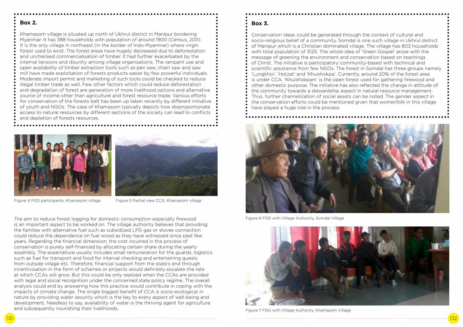
131 132
Box 2.
Khamasom village is situated up north of Ukhrul district in Manipur bordering Myanmar. It has 388 households with population of around 1900 (Census, 2011).It is the only village in northeast (in the border of Indo-Myanmar) where virgin forest used to exist. The forest areas have hugely decreased due to deforestation and unchecked commercialisation of timber. It had further exacerbated by the internal tensions and disunity among village organisations. The rampant use and open availability of timber extraction tools such as pen saw, chain saw and saw mill have made exploitation of forests products easier by few powerful individuals. Moderate import permit and marketing of such tools could be checked to reduce illegal timber trade as well. Few other factors which could reduce deforestation and degradation of forest are generation of more livelihood options and alternative source of income other than agriculture and forest resource trade. Various effortsfor conservation of the forests belt has been up taken recently by different initiative of youth and NGOs. The case of Khamasom typically depicts how disproportionate access to natural resources by different sections of the society can lead to conflicts and depletion of forests resources.
Figure 4 FGD participants, Khamasom village
Box 3.
Conservation ideas could be generated through the context of cultural andsocio-religious belief of a community. Somdal is one such village in Ukhrul district of Manipur which is a Christian dominated village. The village has 803 households with total population of 3125. The whole idea of ‘Green Gospel’ arose with the message of greening the environment and conservation based on teachingsof Christ. The initiative is participatory community-based with technical and scientific assistance from few NGOs. The forest in Somdal has three groups namely ‘Lungkhoi’, ‘Hotzat’ and ‘Khuishokpa’. Currently, around 20% of the forest areais under CCA. ‘Khuishokpam’ is the open forest used for gathering firewood and other domestic purpose. The initiative has also reflected the change in attitude of the community towards a stewardship aspect in natural resource management.Thus, further channelization of social assets can be noted. The gender aspect in the conservation efforts could be mentioned given that womenfolk in this village have played a huge role in the process.
Figure 5 Partial view CCA, Khamasom village
The aim to reduce forest logging for domestic consumption especially firewood is an important aspect to be worked on. The village authority believes that providing the families with alternative fuel such as subsidized LPG gas or stoves connection could reduce the dependence on fuel wood as they have witnessed since past few years. Regarding the financial dimension, the cost incurred in the process of conservation is purely self-financed by allocating certain share during the yearly assembly. The expenditure usually includes small remuneration for the guards, logistics such as fuel for transport and food for interval checking and entertaining guests from outside village etc. Therefore, financial support from the state’s end through incentivisation in the form of schemes or projects would definitely escalate the rate at which CCAs will grow. But this could be only realized when the CCAs are provided with legal and social recognition under the concerned state policy regime. The overall analysis could end by answering how this practice would contribute in coping with the impacts of climate change. The single biggest benefit of CCA is socio-ecological in nature by providing water security which is the key to every aspect of well-being and development. Needless to say, availability of water is the thriving agent for agriculture and subsequently nourishing their livelihoods.
Figure 6 FGD with Village Authority, Somdal Village
Figure 7 FDG with Village Authority, Khamasom Village

133 134
F. Discussion and Recommendations
In continuation with the discussion on conservation of natural resources in a holistic approach it is vital to recognise that CCAs comes under the Other Effective Area-based Conservation Measures (OECM). It is defined as a geographically defined area other than a Protected Area, which is governed and managed in ways that achieve positive and sustained long term outcomes for in situ conservation of biodiversity, with associated ecosystem functions and services and, where applicable, cultural, spiritual, socioeconomic, and other locally relevant values” (WCPA , 2018). The state at institutional level must conceptualise and integrate these other measures in the policy framing of conservation besides the state’s protected areas.
India in its ambitious INDC has pledged to create an additional carbon sink of 2.5 to 3 billion tonnes of CO2 equivalent through additional forest and tree cover by 2030 (MOEFCC, 2015). Northeast states of India compared with other states has greater forest areas but only the protected areas (PAs) are under legal recognition. Therefore unrecognised class of forests are not equally entailed with the allowances and advantages from conservation finance mechanisms. To make the conservation efforts run in long term, it is essential to offer alternative financial incentives or livelihoodoptions for stakeholders that would otherwise profit from deforestation (Global Forest Atlas, 2019). This brings out the crucial need for Payment of Ecosystem Services (PES) which means that the beneficiary or user of an ecosystem service makes a direct or indirect payment to the provider of that service. Another remarkable conclusion is also the need for the convergence from the government in acknowledging and addressing the issue of common property regime and regulations. The State Action Plan for Climate Change (SAPCC) of Manipur has a specific state mission for forest resource conservation. Since it is a state with large area of forest which is basically owned by the community, there is a need to bolster all the efforts discussed above. To make them functional they should be legally established in the SAPCC and its missions.
Most importantly, inclusion of traditional institutions as a stakeholder would bring in knowledge systems through customary laws backed by modern techniques and processes. For example, while addressing forestry as a potential coping mechanism to climate change, one need to understand the ancient ways of seeing agriculture as part of forestry. The three sectors mainly forest, agriculture and livelihood in a cultural context must be perceived at a landscape level instead of separating each. When assessed in aggregated manner these pockets of CCAs together contribute largely towards the regional forest cover. Therefore, strengthening this local conservation practice would invigorate the ecological benefits such as water security, carbon sequestration and overall flow of ecosystem services from the forest. As a conclusive remark, this case also supports the emerging approach to tackle climate change and its impacts in both adaptation and mitigation processes.
References
Area Under Forest, 2019. ENVIS centre, Manipur, Ministry of Environment, Forest and Climate Change. http://manenvis.nic.in/Database/AreaunderForest_2895. aspx?format=Print
Berkes, 2007. Community based conservation in a globalised world. PNAS, 104 (39) 15188-15193; https://doi.org/10.1073/pnas.0702098104
Broome and Dash. 2012. Recognition and Support of ICCAs in India. In: Kothari, A. with Corrigan, C., Jonas, H., Neumann, A., and Shrumm, H. (eds). Recognising and Supporting Territories and Areas Conserved By Indigenous Peoples And Local Communities:Global Overview and National Case Studies. Secretariat of the Convention on Biological Diversity, ICCA Consortium, Kalpavriksh, and Natural Justice, Montreal, Canada. Technical Series no. 64.
Climate Change and India: A 4x4 assessment a sectoral and regional analysis for 2030s. 2010. INCCA. MoEFCC.
Global Forests Atlas. 2019. Yale School of Forestry and Environmental Sciences. https://globalforestatlas.yale.edu/conservation/finance-forest-conservation-payment- ecosystem-services
Kothari. 2006. Community conserved areas: towards ecological and livelihood security. PARKS, Vol. 16 No 1.
Pathak and Kothari. 2009. Indigenous and Community Conserved Areas: The Legal Framework in India. IUCN-EPLP No. 81.
Pathak. 2009. Community Conserved Areas in India: A directory. Kalpavriksh.
Press information Bureau. 2015. http://pib.nic.in/newsite/PrintRelease.aspx?relid=128403
Ramakrishnan. 2007. Traditional forest knowledge and sustainable forestry: A North-east India perspective. Forest Ecology and Management 249 (2007) 90-91.
Sacred groves in Meghalaya. 2016. CPREEC. Ministry of Environment, Forests and Climate Change. http://www.cpreecenvis.nic.in/Database/Meghalaya_899.aspx
State of Forest Report, 2017. Forest survey of India, MoEFCC. http://fsi.nic.in/isfr2017/ manipur-isfr-2017.pdf
Updates on ‘Other effective area-based conservation measures’. 2018. WCPA. IUCN. https://www.iucn.org/news/protected-areas/201808/updates-%E2%80%98other- effective-area-based-conservation-measures%E2%80%99 time and resources.
Annexure – case summary
Activity
Document CCAs of the Tangkhul tribe in Manipur State: ManipurScale of operation of activity in the State – population: 5900 (Approx.)
Case summary
CCAs in pocket villages of Manipur have been in existence for long time which are not legally recognized under the state’s protected areas (PA). The management is well regulated by the local institutions through rules and regulations laid down by them. Marem is a village of such stature where the community has reserved forest area of about 10 sq. km. The effort is self-initiated since the 1980s and in two decades there is a huge improvement in forest cover leading to rejuvenation of springs and previously uncultivable paddy lands ‘Leishirim’ have been reclaimed. ‘Jazom’ is

135 136
the particular patch of land reserved for wildlife under the CCA. Through the past few years the numbers of wildlife sightings have increased immensely according to the village authority. Therefore, increase in forest areas have played a huge role in sustaining livelihoods of the people and maintaining the proper flow of ecosystem services.
Activities
1. Literature Review on CCAs of India and Northeast2. Field visits to Marem, Khamasom, East Tasom and Somdal Village3. Focus Group discussions with the village authorities, youth and women representatives, NGOs4. Meetings with Academicians, Forest Government officials and State Climate Change Cell
Institutions/Stakeholders involved
Village Authority, Women and Youth Representatives, Academicians, NGOs and Government Line Departments (Forest and Environment)
Impact of activities (bullet points on measurable impacts)
1. Identification of Community Conserved Areas in Ukhrul and Kamjong districts of Manipur2. Documentation of methods and processes in management of CCAs by local communities3. Identify the impacts of CCAs in livelihood and flow of ecosystem services4. Relate CCAs as a potential coping mechanism for impacts of climate change5. Identify threats and challenges faced by the CCAs6. Policy recommendations for effective management of CCAs
Why is it a good practice?
Majority of the population in the case study areas depend their livelihood on agriculture and forests resources. Therefore conservation of forests means increase in area of forest cover which bring multi-dimensional benefits either be socio-ecological and economical. It enhances the water security of the population and increases richness in biodiversity which means enhancing their livelihood through better agricultural outputs. It also creates a sense of cohesiveness among the village community by bringing together the community under one cause. Although the carbon capture capacity of the forest cannot be measured it adds to the entire forest area of a region thus contributes to carbon sequestration in local specific but regional scale.
How to replicate this practice?
First and foremost it is essential to strengthen the existing traditional institutions as they are the primary stakeholder of natural resources in case of indigenous communities.
There is the need for legal and social recognition of CCAs through institutional mechanisms and state policy implementations. Incentivisation of the ecosystem service provider or Payment for Ecosystem Services (PES) system would highly impact in replicating the practice. The conservation approach of Other Effective Area-based Conservation Measure (OECM) in addition to state protected areas can be taken up.
MIZORAM
Photo credit: Empee Renthlei | Location: Champhai, Mizoram

137 138
EVALUATION OF DRIPIRRIGATION SYSTEM IN
MIZORAM
Author: Sabrina LalhmangaihzualiContributor: Dr. John Zothanzama
CASE STUDY 7

139 140
A. Background
Water is the prime natural resource and indispensable component for sustenance of all life forms on earth. Not only the sustenance of life the availability of desired quality and quantity of water is the prime factor for economic prosperity, enhancing the quality of life and contributing to food security of the nation. The assured supply of irrigation water is the primary function of food grain production and contributes towards national food security. Irrigation for agriculture alone accounts for over 80% of water use in India, more than any ther sector. However, much of this water is applied inefficiently using flood irrigation, which remains the prevailing irrigation practice among farmers in India. This results in considerable losses of water – around 60% of water applied in the form of surface run off, percolation and evaporation that does not contribute to any increases in yield. And in rural India, there are about 180 million smallholder farmers owning less than 2 hectares of land each.
90% of the rainfall happens in just five months between June - October. Outside the rainy season, farmers have to revert to ground water resources, which are increasingly strained by overexploitation (Water Benefit Partner, 2019). And the quality and quantity of water is strained due to climate change, increase in population, lifestyle, land use pattern and urbanisation. Other consequence of climate change envisaged is increased evapo-transpiration influencing groundwater recharge and change in rainfall pattern resulting in lower agricultural productivity (Seckler D et.al. 1999). Due to Climate change a prolong dry period cause droughts which have severe impacts on economy, society and environment effecting crops, irrigation, livestock, agricultural production which severely in turn effect not only the economy of farmers but also the economy of the country (Vibha, 2017).
The period between 1950 and 1989 had 10 drought years, while there have been 5 droughts in the last 16 years (since 2000). According to meteorologists the frequency is set to increase between 2020 and 2049 (Collision et.al, 2000). Indian agriculture is crucially dependent on local climate: favourable southwest summer monsoon is critical in securing water for irrigating crops. In some parts of India, the lack of monsoons results in water shortages, resulting in below – average crop yields. Climate change hasincreased the possibility and intensity of drought (IPCC 2007). So the appropriate water management would be to increase the resilience of agricultural production to climate change. Due to climate change, ove the past 50 years, regions such as Northeast China, North China, Hetao Area, South-eastern loess Plateau and Central and western Sichuan Basin have experienced a declining annual precipitation and an aggravating drought (Ren et al.2005; Yang and Li, 2008). In 2008, drought claimed a grain loss of 16.1 Mt (CIDDC 2009), hindering China’s grain production. In the case of China, the irrigated and non irrigated farmlands make a difference in per unit yield: wheat is 1.67–1.89 times higher while corn is 1.47–1.53 times higher in irrigated land. In the case of the whole world, the irrigated agricultural land accounts for only 19% of the total but supplies 40% of the world’s food (Molden et al. 2010). Therefore, irrigation is essential for stable food production. And so by practicing drip irrigation system crops could do well with limited quantities of water. Drip irrigation, also known as trickle irrigation or micro irrigation is an irrigation method which minimises the use of water and fertilizer by allowing water to drip slowly to the roots of plants, either onto the soil surface or directly onto the root zone, through a network system of valves, pipes, tubing, and emitters. Drip irrigation equitable water distribution, can save water and energy input as well as increase crop yield. Crops yield is adversely affected both in excess or deficit water supply. However, drip irrigation system in this sense is efficient because of reduced evaporation, runoff and deep percolation loss (Muhamed MA et. al., 2014).
Agriculture irrigation accounts for 70% of water use worldwide. Improving water management of agriculture is therefore essential to a sustainable and productive agro-food sector. (Guillaume, 2019). India is not a water rich country and is further challenged due to negative impact of climate change. India has 18% of world population, having 4% of world’s fresh water, out of which 80% is used in agriculture (Vibha D, 2017). Globally, about 40% of irrigation water is supplied from groundwater and in India it is expected to be over 50%. Groundwater resources are being depleted because of unsustainable extraction levels that exceed natural recharge rates. In India, groundwater irrigation covers more than half of the total irrigated area (around 42 million ha) (Apoorva Oza). Recognizing the fast decline of irrigation water potential and increasing demand for water from different sectors, a number of demand management strategies and programmes have been introduced to save water and increase the existing water use efficiency in Indian agriculture. One such method introduced relatively recently in Indian agriculture is micro irrigation which include drip method of irrigation. It is proved to be an efficient method in saving water and increasing water use efficiency as compared to the conventional surface method of irrigation, where water use efficiency is only about 35-40%.(Narayanaswamy. T, Ananda kumar B.M. 2016).
Due to climate change the rainfall pattern has changed, so the dependency on rainfall for agricultural practice needs to be reduced. This is because monsoons are highly erratic and the farming system cannot entirely depend upon rains. Thus irrigation is very important in India for yielding better crop results. Mizoram is one of the state that is most blessed with a moderate climatic condition and is one of the most diverse state in the country. Although the state climatic condition is suitable for the growth of most of the plants it starts experiencing the effect of climate change as there is change in rainfall pattern as well as seasonal variation with prolong dry period and down pour rainfall that wash the most of the soil nutrients away and thus reduce annual crop production. And also changes in climatic condition result in scarcity of freshwater while the requirements of water for crop production increases due to increasing demand by the rising number of population within the state. This has led to requirements of techniques that enable the system to consume water efficiently. So the practice of drip irrigation in Mizoram aims round the year production of vegetables and flowers and provide water supply to the crops during droughts and unpredictable climate. And one of the main objectives being improvement of on farm water use efficiency to reduce wastage and increase availability both in duration and extent. According to SAPCC Mizoram, impact reducing pathways in order to tackle the issues face by the state are Jhum optimisation through catchment area protection, plantation crops, soil conservation, tillage practices (improving soil drainage, no-till, etc)(SAPCC 2012-2017). And some of these pathways can be meet by practicing drip irrigation system.
The year 2005, saw extended dry periods in Mizoram. Many springs and streams dried up accompanied by large scale landslides (ICIMOD, 2008). Climate vulnerability was faced in different sectors within the state of Mizoram. In the field of crop production introduction of high yielding varieties of new crops and micro irrigation which includes sprinkler and drip irrigation system are the key intervention. And also to tackle for an issue of heavy and erratic precipitation which damage the crop due to prolonged submerge or lack of timely precipitation (SAPCCC).
Present surface drip irrigation often used a combination of plastic mulch for further reducing evaporation losses. The modern technology of drip irrigation was invented in Israel by Simcha Blass and his son Yeshayahu. Instead of releasing water through tiny holes, blocked easily by tiny particles, water was released through larger and longer passageways by using velocity to slow water inside a plastic emitter.

141 142
The first experimental system of this type was established in 1959 when Blass partnered with Kibbutz Hatzerim to create an irrigation company called Netafim. Together they developed and patented the first practical surface drip irrigation emitter. This method was very successful and subsequently spread to Australia, North America, and South America by the late 1960s. This system is often treated as temporary because the dripline can be retreived and recycled yearly (George. Aet. al, 2012). The first experimental system of this type was established in 1959, when Blass partnered with Kibbutz Hatzerim to create an irrigation company called Netafim. Together they developed and patented the first practical surface drip irrigation emitter. This method was very successful and subsequently spread to Australia, North America, and South America by the late 1960s. Water allocation share of agriculture was more in high populated countries like India to ensure enough food for the rising population with existing traditional irrigation methods. It is essential to adopt and develop according to the field level requirement and apply water saving technology and management methods. A lot of research work has been done on drip irrigation system.
Drip irrigation requires little water compared to other irrigation methods. Typical sprinkler systems are, on average, about 75% water efficient, while drip irrigation systems have 90% or higher water efficiency. This is due to several key design differences. The slow delivery rate of drip irrigation allows the soil to absorb the water laterally, and maintain a uniform moisture level (George et. al, 2012).
Nowadays drip or trickle irrigation is considered most potential and water efficient system compared to other available irrigation systems because of global fresh water scarcity. Availability of fresh water is a major concern in crop production especially during dry-summer period in arid and semi-arid regions.
Indian Government provides financial assistance to farmers to adopt drip irrigation system. And the Government of Mizoram has initiated the system in order to ensure access to some means of protective irrigation to all agricultural farms and to produce per drop more crop which aims in crop production throughout the year even during the prolong dry period of the year which occur due to climate change.
The government’s watershed Development Programme for shifting cultivation Areas under NLUP not only encourages farmers to shift from Jhum to terrace agriculture. As the state suffers from water scarcity, farmers are provided funds to build water harvesting strucutres given almost free irrigation facility through drip or micro sprinkler system. The New Land Use Policy (NLUP) of 2009, is to reduce areas under jhum cultivation and increase crop production. Under this policy Rs. 1 Lakh incentive was given to farmers (India today, 2011). The land area cover by drip irrigation in Mizoram covered 2152 hactares. Various steps taken by Government for promotion micro irrigation include (1) Training and awareness programmes, (2) Awareness through print media and radio & TV talks(3) Organization of workshops, seminars and interactive meetings, (4) Publicity creation through exhibitions, fairs, kisan melas, publication and literature (Ministry of Agriculture & Farmers Welfare, 2016).
Pattern of rainfall in Mizoram during the past 20 years i.e, from 1986 to 2005 follow the usual expected trend in which maximum downpour occur during the monsoon seasons. However, when analysed on a yearly basis the trends show a gradual decline and then a sudden increase from 1990 to 1995. In fact, during the span of the 20 years, 1995 recorded the highest rainfall of 3185.98mm whereas 1994 had the lowest rainfall with a measure of 2278.29mm only. From here onwards, the trend does not show either a sharp increase or decrease in rainfall (SAPCC). Like all other North Eastern states of India, Mizoram is also facing the consequences of global climate change. Temperature is generally considered as the first variable assessment of climate change. Followed by other parameters like rainfall and humidity. Agriculture is highly dependent on these parameters and the production and yield of agriculture is likely to change due to changes in any of these parameters (SAPCC).
Multiple options for adaptations being considered by working groups which include soil and moisture conservation are activities like organic manuring, used of mulching film, etc. and to develop innovative water management and conservation techniques including micro irrigation (SAPCC).
B. Literature review:
Drip irrigation is a technique in which water flows through a filter into special drip pipes, with emitters located at different spacing. Water is distributed through the emitters directly into the soil near the roots through a special slow-release device. Compared to other types of irrigation systems such as flood or overhead sprinklers, water can be more precisely applied to the plant roots. In addition, drip can eliminate many diseases that are spread through irrigation water. Drip irrigation is adaptable to any farmable slope and is suitable for most soils (ICID, 2012). Basically, the farmer can control how much water each plant gets so that there is little water waste. This method is effective because it avoids the arbitrary placement of water over the whole expanse of a field, regardless of whether the plant is actually receiving the nourishment or not. Additionally, drip irrigation can help decrease eutrophication (which is when bodies of water receive an unhealthy dose of fertilizers such as nitrogen and phosphorus through farm runoff). Instead of excess runoff dragging harmful chemicals into rivers and streams, little to no water is wasted (Kang S et.al, 2004). Young et al., (1985) stated that drip irrigation of banana crop produced double the yield obtained from a well-managed sprinkler irrigation system in Hawaii. Sustainability of food production depends on sound and efficient water use and conservation practices consisting mainly of irrigation development and management.
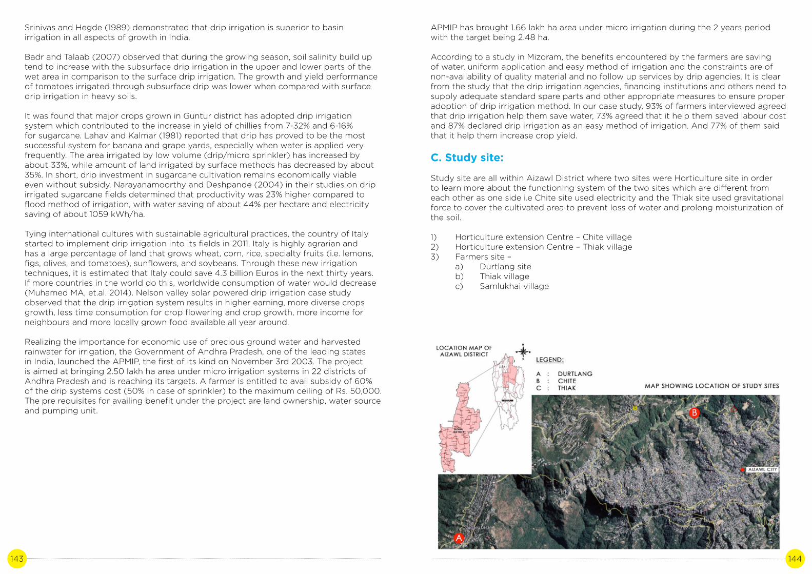
143 144
Srinivas and Hegde (1989) demonstrated that drip irrigation is superior to basin irrigation in all aspects of growth in India.
Badr and Talaab (2007) observed that during the growing season, soil salinity build up tend to increase with the subsurface drip irrigation in the upper and lower parts of the wet area in comparison to the surface drip irrigation. The growth and yield performance of tomatoes irrigated through subsurface drip was lower when compared with surface drip irrigation in heavy soils.
It was found that major crops grown in Guntur district has adopted drip irrigation system which contributed to the increase in yield of chillies from 7-32% and 6-16% for sugarcane. Lahav and Kalmar (1981) reported that drip has proved to be the most successful system for banana and grape yards, especially when water is applied very frequently. The area irrigated by low volume (drip/micro sprinkler) has increased by about 33%, while amount of land irrigated by surface methods has decreased by about 35%. In short, drip investment in sugarcane cultivation remains economically viable even without subsidy. Narayanamoorthy and Deshpande (2004) in their studies on drip irrigated sugarcane fields determined that productivity was 23% higher compared to flood method of irrigation, with water saving of about 44% per hectare and electricity saving of about 1059 kWh/ha.
Tying international cultures with sustainable agricultural practices, the country of Italy started to implement drip irrigation into its fields in 2011. Italy is highly agrarian and has a large percentage of land that grows wheat, corn, rice, specialty fruits (i.e. lemons, figs, olives, and tomatoes), sunflowers, and soybeans. Through these new irrigation techniques, it is estimated that Italy could save 4.3 billion Euros in the next thirty years. If more countries in the world do this, worldwide consumption of water would decrease (Muhamed MA, et.al. 2014). Nelson valley solar powered drip irrigation case study observed that the drip irrigation system results in higher earning, more diverse crops growth, less time consumption for crop flowering and crop growth, more income for neighbours and more locally grown food available all year around.
Realizing the importance for economic use of precious ground water and harvested rainwater for irrigation, the Government of Andhra Pradesh, one of the leading states in India, launched the APMIP, the first of its kind on November 3rd 2003. The project is aimed at bringing 2.50 lakh ha area under micro irrigation systems in 22 districts of Andhra Pradesh and is reaching its targets. A farmer is entitled to avail subsidy of 60% of the drip systems cost (50% in case of sprinkler) to the maximum ceiling of Rs. 50,000. The pre requisites for availing benefit under the project are land ownership, water source and pumping unit.
APMIP has brought 1.66 lakh ha area under micro irrigation during the 2 years period with the target being 2.48 ha.
According to a study in Mizoram, the benefits encountered by the farmers are saving of water, uniform application and easy method of irrigation and the constraints are of non-availability of quality material and no follow up services by drip agencies. It is clear from the study that the drip irrigation agencies, financing institutions and others need to supply adequate standard spare parts and other appropriate measures to ensure proper adoption of drip irrigation method. In our case study, 93% of farmers interviewed agreed that drip irrigation help them save water, 73% agreed that it help them saved labour cost and 87% declared drip irrigation as an easy method of irrigation. And 77% of them said that it help them increase crop yield.
C. Study site:
Study site are all within Aizawl District where two sites were Horticulture site in order to learn more about the functioning system of the two sites which are different from each other as one side i.e Chite site used electricity and the Thiak site used gravitational force to cover the cultivated area to prevent loss of water and prolong moisturization of the soil.
1) Horticulture extension Centre – Chite village2) Horticulture extension Centre – Thiak village3) Farmers site – a) Durtlang site b) Thiak village c) Samlukhai village

145 146
Description of the case:
Mizoram has now become affected by climate change and lack sufficient water due to prolonged dry periods leading to serious constraint on crop production. The drip irrigation system is an effective adaptive measure for climate change that enables efficient use of available water which results in all round production of crops and vegetables. In the state of Mizoram, Horticulture Department introduced the system and its application based on Israel’s technique of drip irrigation although modification was done based on the terrain for better and more suitable system.
Provision of drip irrigation system for horticultural crops was taken up by the Horticulture Department in 2015-2016 with an aim to provide round the year production of vegetables and flowers. The department took responsibility for training the farmers in operating the system to extend the functional period. Also not all the applicant received the system at a subsidised rate as due process was followed which included verification of the farmers land. The entire process from application to installation of the dripping line as well as conducting trainings after every two or three months was the responsibility of the Horticulture department. Subsidy was given for seeds, planting materials, soil nutrients and chemicals. In case of greenhouse and drip line along with installation, 90% subsidy was given to buy different structures and nets. But after the installation, proper maintenance was to be done by the farmer in order to avoid blockage and for its proper functioning. This scheme is still continuing for the farmers earning more than 1 lakh annually from their crop production as it shows positive impact as an adaptive measure for combating climate change in the field of agriculture.
In a hilly area like Mizoram where scarcity of water was the main problem faced by the people and the problem seems to accelerate due to climate change, the practice of drip irrigation could be considered as an adaptation measure for the farmer, because it required less amount of water and enable farmers to grow plants throughout the year. There are differences of practising the system in two different types of area, but both are beneficial to the farmers since it helps them grow crops throughout the year if they have a storage system that allows the farmer to harvest the rainwater. Although the practice of drip irrigation system is an adaptive measure that allow the farmers to use water efficiently the problem faced during rainy season is that, the drip line gets easily blocked by the soil that flows along with the rain water. This requires constant maintenance, which increases the average cost on the farmers.
D. Methodology
E. Results and Discussion
The questionnaire provided to beneficiaries of drip irrigation system from Horticulture Department, Govt. of Mizoram along with their feedback in percentage are given in the following table:
Stakeholder
Community
State officials
Method
I.Personal interview : a) Mrs. Mapuii, Durtlang site.b) Mr. Ramliana,Thiak site.c) Mrs. Zoliani , Durtlang site.d) Mrs. Muanpuii (Anthurium greenhouse), Durtlang site.e) Mrs. Thani , Samlukhai site.
II. Site visit
III. Telephonic interview
1) Personal interview with Mr. Henry, Horticulture Extention Officer, Horticulture Department, Govt.of Mizoram.2) Personal interview with Miss Carmelita, Horticulture Extention Officer, Horticulture Department, Govt.of Mizoram. 3) Personal interview with Mr. Zohmuna, Demonstrator, Horticulture Department, Govt.of Mizoram.

147 148
Table 1: Questionnaire with feedback from beneficiaries in percentage.
Sl. No.
1
2
3
4
5
6
7
8
9
10
Name
Has the drip irrigation system reduced the
required amount of water?
Has the system reduced the cost of labour for irrigation?
Does the irrigation system improve the quality of
production?
Does it decrease the growth of weed?
Do drip irrigation system increase annual crop yield?
Can you have a year round production after adopting
drip irrigation system?
Do you think drip irrigation system can help you tackle
the problem caused by climate change?
Eg. Scarcity of water, prolong dry period, increase
run-off of water and soil erosion due to heavy
rainfall, etc.
Do you face problem in maintaining the drip lines?
Is it true that you have to pay only 10% of the initial materials and installation
charges?
Does drip irrigation system help you improve in annual economic development?
Total no.of personal interview
5
5
5
5
5
5
5
5
5
5
Total no. of person/s giving an
answer “YES”
5
5
4
5
5
3
5
5
5
5
Percentage(%)
100
100
80
100
100
60
100
100
100
100
a) Drip irrigation on natural slope (Chite site) b) Drip irrigation on terracing land (Durtlang Mrs.Mapuii’s site).
c) Drip irrigation on plane area(Mrs.Muanpuii site)
d) Drip irrigation in greenhouse (Thiak site).
In Mizoram the drip irrigated land has covered approx. 455.15 Ha. and is gradually increasing till today. The various findings about drip irrigation from the case study are as follows:
1) Within the study area drip irrigation system was practiced in two types of land i.e. ina) slope or terracing land and b) plain area. The area type where drip irrigation system was practiced it was found that terrace areas required less amount of water compared to plain area because the water flows at a higher rate which gets distributed evenly within a shorter period of time compared to the plain area.

149 150
e) Dripping area covered with mulching film
f) Drip irrigation where plants were covered with mulching film (Thiak site)
2) A beneficiary farmer named Kapzela would get only 1500 kg paddy from six bigha farm land. But after the used of drip irrigation and terrace agriculture, his paddy produce has gone up to 3000kg. This indicates that with a condition where water scarcity increases due to climate change, drip irrigation system can be declared as an adaptive measure especially in climate change affected area.
3) Also Mrs. Mapuii from Durtlang has mentioned that her income increased after the used of drip irrigation system with lesser amount of water consumption.
4) There are about 170 houses in Thiak village where approximately 90 families are beneficiaries of the drip irrigation provided by the Horticulture Extension Centre, Department of Horticulture, Govt. of Mizoram. In Thiak site a mulching film was used to cover the water dripping areas which prevent the rapid loss of water, maintaining soil moisture content which required lesser amount of water as it conserves the water longer. The result of its effectiveness was witness in different types of crops with an increase in crop yield and income of the farmers by 1.54 times higher in tomato, 1.38 times higher in broccoli, 1.29 higher in french bean and 1.16 times higher in capsicum production during the case study in 2010 (BK Singh et al., 2010).
5) After using the drip irrigation system the water consumption rate has decreased from 70-80% to 10-25% when measured from the capacity of the storage system each farmer has or from the requirements.
The advantages of the drip irrigation were:
1. High water application efficiency and lower labour costs.
2. Minimised fertiliser/nutrient loss due to localised application and reduced leaching.
3. Ability to irrigate irregular shaped fields. Levelling of the field is not necessary.
4. Allows safe use of recycled (waste) water.
5. Moisture within the root zone can be maintained at field capacity and minimised soil erosion.
6. Soil type plays less important role in frequency of irrigation.
7. Highly uniform distribution of water i.e., controlled by output of each nozzle.
8. Usually operated at lower pressure than other types of pressurised irrigation, reducing energy costs.
9. Reduce soil erosion.
Disadvantages of drip irrigation were:
1. High cost
2. Requires proper and constant maintenance
F. Conclusion
This study illustrates that drip irrigation system is spreading in Mizoram for agriculture due to increasing demand of water. Global warming and climate change has started to affect the balance between water demand and water availability especially in water stressed areas. Day-by-day agricultural land under irrigation increases because distribution of rainfall does not coincide with the schedule of crop water requirements. Under the practise of drip irrigation various types of crops were grown throughout the year. And in comparison with other irrigation, drip system would allow for an intensification of agriculture, more efficient use of water and contribute to poverty alleviation.
In conclusion it can be stated that drip irrigation is a system that helps farmers and cultivators to grow their crop throughout the year by minimizing the water consumption level and thus enable them to grow crops all the year around. This system helps farmers to minimize the impact of climate change on agriculture.
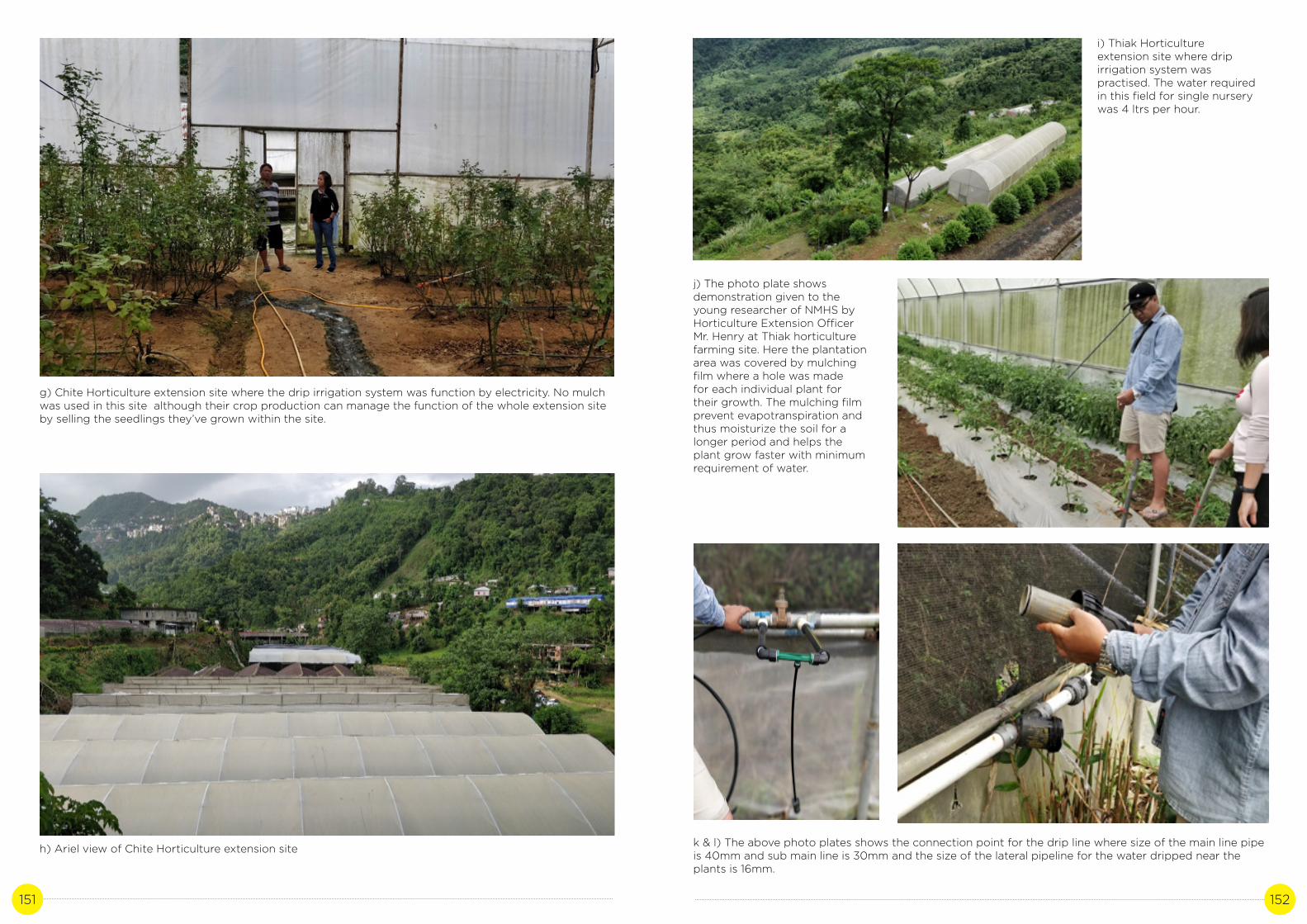
151 152
g) Chite Horticulture extension site where the drip irrigation system was function by electricity. No mulch was used in this site although their crop production can manage the function of the whole extension site by selling the seedlings they’ve grown within the site.
h) Ariel view of Chite Horticulture extension site
i) Thiak Horticulture extension site where drip irrigation system was practised. The water required in this field for single nursery was 4 ltrs per hour.
j) The photo plate shows demonstration given to the young researcher of NMHS by Horticulture Extension Officer Mr. Henry at Thiak horticulture farming site. Here the plantation area was covered by mulching film where a hole was made for each individual plant for their growth. The mulching film prevent evapotranspiration and thus moisturize the soil for a longer period and helps the plant grow faster with minimum requirement of water.
k & l) The above photo plates shows the connection point for the drip line where size of the main line pipe is 40mm and sub main line is 30mm and the size of the lateral pipeline for the water dripped near the plants is 16mm.
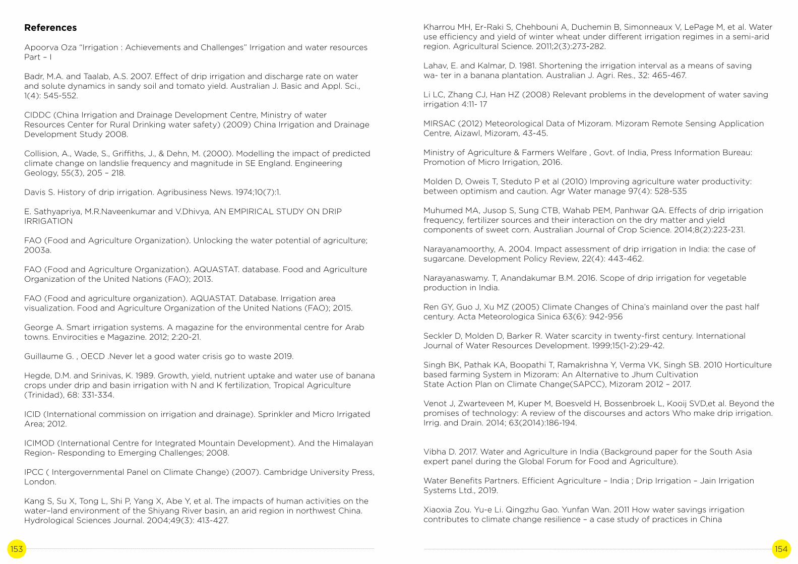
153 154
References
Apoorva Oza “Irrigation : Achievements and Challenges” Irrigation and water resources Part – I
Badr, M.A. and Taalab, A.S. 2007. Effect of drip irrigation and discharge rate on water and solute dynamics in sandy soil and tomato yield. Australian J. Basic and Appl. Sci., 1(4): 545-552.
CIDDC (China Irrigation and Drainage Development Centre, Ministry of water Resources Center for Rural Drinking water safety) (2009) China Irrigation and Drainage Development Study 2008.
Collision, A., Wade, S., Griffiths, J., & Dehn, M. (2000). Modelling the impact of predicted climate change on landslie frequency and magnitude in SE England. Engineering Geology, 55(3), 205 – 218.
Davis S. History of drip irrigation. Agribusiness News. 1974;10(7):1.
E. Sathyapriya, M.R.Naveenkumar and V.Dhivya, AN EMPIRICAL STUDY ON DRIP IRRIGATION
FAO (Food and Agriculture Organization). Unlocking the water potential of agriculture; 2003a.
FAO (Food and Agriculture Organization). AQUASTAT. database. Food and Agriculture Organization of the United Nations (FAO); 2013.
FAO (Food and agriculture organization). AQUASTAT. Database. Irrigation area visualization. Food and Agriculture Organization of the United Nations (FAO); 2015.
George A. Smart irrigation systems. A magazine for the environmental centre for Arab towns. Envirocities e Magazine. 2012; 2:20-21.
Guillaume G. , OECD .Never let a good water crisis go to waste 2019.
Hegde, D.M. and Srinivas, K. 1989. Growth, yield, nutrient uptake and water use of banana crops under drip and basin irrigation with N and K fertilization, Tropical Agriculture (Trinidad), 68: 331-334.
ICID (International commission on irrigation and drainage). Sprinkler and Micro Irrigated Area; 2012.
ICIMOD (International Centre for Integrated Mountain Development). And the Himalayan Region- Responding to Emerging Challenges; 2008.
IPCC ( Intergovernmental Panel on Climate Change) (2007). Cambridge University Press, London.
Kang S, Su X, Tong L, Shi P, Yang X, Abe Y, et al. The impacts of human activities on the water–land environment of the Shiyang River basin, an arid region in northwest China. Hydrological Sciences Journal. 2004;49(3): 413-427.
Kharrou MH, Er-Raki S, Chehbouni A, Duchemin B, Simonneaux V, LePage M, et al. Water use efficiency and yield of winter wheat under different irrigation regimes in a semi-arid region. Agricultural Science. 2011;2(3):273-282.
Lahav, E. and Kalmar, D. 1981. Shortening the irrigation interval as a means of saving wa- ter in a banana plantation. Australian J. Agri. Res., 32: 465-467.
Li LC, Zhang CJ, Han HZ (2008) Relevant problems in the development of water saving irrigation 4:11- 17
MIRSAC (2012) Meteorological Data of Mizoram. Mizoram Remote Sensing Application Centre, Aizawl, Mizoram, 43-45.
Ministry of Agriculture & Farmers Welfare , Govt. of India, Press Information Bureau: Promotion of Micro Irrigation, 2016.
Molden D, Oweis T, Steduto P et al (2010) Improving agriculture water productivity: between optimism and caution. Agr Water manage 97(4): 528-535
Muhumed MA, Jusop S, Sung CTB, Wahab PEM, Panhwar QA. Effects of drip irrigation frequency, fertilizer sources and their interaction on the dry matter and yield components of sweet corn. Australian Journal of Crop Science. 2014;8(2):223-231.
Narayanamoorthy, A. 2004. Impact assessment of drip irrigation in India: the case of sugarcane. Development Policy Review, 22(4): 443-462.
Narayanaswamy. T, Anandakumar B.M. 2016. Scope of drip irrigation for vegetable production in India.
Ren GY, Guo J, Xu MZ (2005) Climate Changes of China’s mainland over the past half century. Acta Meteorologica Sinica 63(6): 942-956
Seckler D, Molden D, Barker R. Water scarcity in twenty-first century. International Journal of Water Resources Development. 1999;15(1-2):29-42.
Singh BK, Pathak KA, Boopathi T, Ramakrishna Y, Verma VK, Singh SB. 2010 Horticulture based farming System in Mizoram: An Alternative to Jhum CultivationState Action Plan on Climate Change(SAPCC), Mizoram 2012 – 2017.
Venot J, Zwarteveen M, Kuper M, Boesveld H, Bossenbroek L, Kooij SVD,et al. Beyond the promises of technology: A review of the discourses and actors Who make drip irrigation. Irrig. and Drain. 2014; 63(2014):186-194.
Vibha D. 2017. Water and Agriculture in India (Background paper for the South Asia expert panel during the Global Forum for Food and Agriculture).
Water Benefits Partners. Efficient Agriculture – India ; Drip Irrigation – Jain Irrigation Systems Ltd., 2019.
Xiaoxia Zou. Yu-e Li. Qingzhu Gao. Yunfan Wan. 2011 How water savings irrigation contributes to climate change resilience – a case study of practices in China

155 156
Young, S.C.H., Sammins, T.W. and Wu, I. 1985. Banana yield as affected by deficit irriga- tion and patterns of lateral layouts. Transactions of ASAE, 28: 507-510.
Web links: www.fao.org/nr/water/aquastat/irrigationdrainage/treemap/index.stm www.census2011.co.in/census/district/388-aizawl.html ftp.fao.org/agl/aglw/docs/unlocking_e.pdf www.icid.org/sprin_micro_11.pdf
Web links:
www.fao.org/nr/water/aquastat/irrigationdrainage/treemap/index.stmwww.census2011.co.in/census/district/388-aizawl.htmlftp.fao.org/agl/aglw/docs/unlocking_e.pdfwww.icid.org/sprin_micro_11.pdf

157 158
COMMUNITY FOREST BY YOUNG MIZO ASSOCIATION
IN MIZORAM
CASE STUDY 8
Author: Sabrina LalhmangaihzualiContributor: Dr. John Zothanzama

159 160
A. Background
In the last two decades significant changes are noticed in the climatic variables due to increasing nature of anthropogenic activities (SAPCC Mizoram, 2012-17). Mizoram Remote Sensing Application Centre (MIRSAC) has identified a total of 20.64% of Mizoram as degraded land, which scientists say is alarming. Temperature is generally considered as the first variable assessments of climate change, followed by other parameters like rainfall and humidity. Failure of rains and occurrence of natural disasters such as floods and droughts could lead to crop failures, food insecurity, famine, loss of property and life, mass migration, and negative national economic growth within the state. The year 2005, saw extended dry periods in Mizoram (SAPCC 2012-17, Mizoram). Many springs and streams dried up accompanied by large scale landslides (ICIMOD, 2008). Inadequate rainfall (earlier or later) adversely affected sowing and harvesting of crops, because of which there was a heavy to crop yield. Moreover, it is also seen that natural wetlands are dwindling in many parts of Mizoram. Some of the ecologists have argued that more number of invasive species have appeared and distribution pattern has changed in Mizoram (SAPCC 2012-17, Mizoram).
Concepts and contingency plans for adapting forests are rarely included in state plans. Several management options for intensively managed forests in regeneration, tending, harvesting, protection, conservation and management planning can be formulated state-wide. Intensifying assessment and monitoring, establishing new tools and indicators to rate vulnerability and targeting research efforts appear most promising to cope with climate change in these forests. While this might be seen as primarily aimed at mitigating climate change, it has an adaptive component of preserving species richness, continuity of forest ecosystems and resilience. It is estimated that adverse climate change impacts will contribute to the destruction of forests and thereby promote the emission of greenhouse gases, which in turn will enhance global warming (SAPCC Mizoram, 2012-17).
Deforestation in the tropics is a major source of carbon emissions and an active contributor to climate change that leads to global warming. The Intergovernmental Panel on Climate Change (IPCC) estimated that 1.7 billion tons of carbon is released annually due to landuse change, of which the major part is tropical deforestation (IPCC 2001). Deforestation and forest degradation have received worldwide attention because of the implications for climate change. It has recently been estimated that around 12% of annual greenhouse gas (GHG) emissions are attributable to land cover changes, including forest losses (Van der Werfetal, 2009). Under the United Nations Framework Convention on Climate Change (UNFCCC), a policy known as Reducing Emissionsfrom Deforestation and Forest Degradation (REDD) is being introduced. This is a performance-based policy instrument aimed at reducing anthropogenic emissions of GHG community forestry as an evolving branch of forestry where the local community plays a significant role in forest management and land use decision making. This rewards countries that are able to reduce rates of deforestation and degradation and increase the rate of removals of carbon dioxide from the atmosphere by forest enhancement. The term “community forestry” is used in different ways. Some countries used it to describe efforts by communities - those united by a common interest or by a sense of place - to recognize and take advantage of the economic, social, and environmental opportunities afforded by their local forest resource, whether it is in public or private ownership, or somewhere in between. It involves the participation and collaboration of various stakeholders including community, government and non-government organizations (NGOs). The level of involvement of each of these groups is dependent on the specific community forest project, the management system in use and the region.
Around the world, forest communities are at risk of losing their homes to settlers, cattle ranchers, illegal loggers, and companies. These activities not only devastate the communities who depend on forests for their livelihoods and culture, but also contribute to global climate change by removing community forests as carbon sinks and emitting carbon dioxide (CO2) (King, 2014).
Community forestry is a worldwide phenomenon which began in developing countries and is gradually sweeping the U.S. from West to East. Until recently, it has been practiced mostly by communities where lifestyles and livelihoods depend upon access to healthy, productive public forest land. Community forestry first came to prominence in the mid-1970s and has continued to evolve over the last few decades in a growing number of countries. The availability of forest resources are often greatly reduced for use by the local people due to increasing pressures to cultivate the land, reliance on the forest resources are also affected by economic and political changes. More recently, community forestry has been implemented in developing countries and it has been successful in its aims of sustainable forest management, climate change adaptation and securing socio-economic benefits for local communities (Caleb et al., 2014).
Good forest management and creating forest by the community secures the survival of forest ecosystems and enhances their environmental, socio cultural and economic functions. It can both maximize forests’ contribution to climate change mitigation and help forests and forest-dependent people adapt to new conditions caused by climate change. According to strategic framework for forests and climate change in collaborative Partnership on Forests (2008), forest management helps tackle the climate change by the following:
i) Carbon sequestration through increases in forests and trees, and forest carbon stock enhancement. Forest carbon stocks conservation through reduction of deforestation and forest degradation.ii) Strengthening adaptive capacity of trees and forests especially in fragile forest ecosystems.iii) Afforestation, reforestation and increase of tree cover in farming systems (agro forestry), rural landscapes and cities.iv) Sustainable practices of forest management and use.v) Adaptive land use planning and management
SAPCC-Mizoram has formulated several key priorities in line with National Mission. The key priorities include the following:
i. Improvement of forest quality and density in degraded lands and abandoned Jhum land.ii. Improvement of the productivity of Bamboo and promotion of local value addition through establishment of market linkages.iii. Undertaking studies on climate change impacts on NTFP productivity and sustainable harvesting practices for adaptation of climate change.iv. Capacity building of communities/community forest management institutions for climate change adaptation.v. Prevention control mechanism for forest invasive species and its utilization strategies.vi. Promotion of forest based industries.

161 162
vii. Formulation of conservation strategies for Orchids and establishment of market linkages for value addition. viii. Livelihood improvement for activities for forest dependent communities.ix. Strengthening of Forest Department.x. GIS based monitoring and Evaluation of the program.xi. Strengthening of local VSS (Van Samrakshana Samithi)xii. Publicity/media and outreach.
Introduction to case study
Forests are vital storehouses of carbon in our planet. However, when forests are cleared to make way for agriculture and other activities, they emit large quantities of carbon dioxide and other greenhouse gases into the atmosphere. This contributes to climate change. Better managed forests and improved use of land help reduce vulnerability to climate change and advance both mitigation and adaptation objectives. The present study attempts to study traditional practices by the Young Mizo Association (YMA) in community forest having potential to combat the effects of climate change.Afforestation of the state ‘Green Mizoram’ Project has been taken up by YMA since 1999. Community forests in Mizoram of Northeast India have been managed and owned by the YMA for more than 40 years. The Young Mizo Association is taking care of the community forest in various parts of the state by conducting different activities for the protection and management of forests. The various activities done by YMA are fire prevention, plantation, preservation of environment, conservation of wild life.
It is important to note that there is not much support or help received from other sources by the YMA. Other than supplying seedlings for plantation by the Department of Environment and Forest, no financial support was given to the YMA by any Department under Govt. of Mizoram in any part of their action concerning environment protection and conservation. It is therefore very remarkable that considering the significant contribution made by this largest and most powerful NGO in Mizoram towards forest conservation through community forest, the steps taken by the YMA has not been studied or paid much attention. It is therefore important to know the extent and details of the contribution that YMA has towards conservation of the environment.
The Young Mizo Association (YMA) is the largest and most comprehensive non-profit, secular and non-governmental organization of the Mizo people having its own Constitution with a maxim that ‘YMA helps the needy’. It was established on 15 June 1935, where any mizo of the age of 14 or above could be a member of YMA. The association is administered by a central committee (Central YMA), headquartered at Aizawl, and under which there are 5 sub-headquarters, 47 groups and 772 branches, which covers all of Mizoram and some parts of Assam, Manipur, Meghalaya, Nagaland and Tripura. The Consituation of YMA clearly stated its aims and objectives which are:i) Useful occupation of leisure time, ii) All round development of the Mizoram andiii) Promotion of good Christian life (CYMA, 1994).
B. Literature Review
Community forests are lands held collectively by either rural or indigenous communities based on a shared history, language, culture, or lineage. Forests, when sustainably managed with the participation of local communities, can have a central role in climate change mitigation and adaptation. One of the most important forest ecosystem services is carbon sink from atmosphere during its early growing stage as compared to the late stage. And this has been used as a climate
change adaptation strategy locally and mitigation mechanism globally to curb the multi-sectorial problems of climate change (Fahey et al., 2009).
Forest management practices that increase carbon sequestration include afforestation, reforestation and forest restoration, increase of tree cover through agro forestry, urban forestry and tree planting in rural landscapes, enhancement of forest carbon stocks (in both, biomass and soils) and sequestration capacity through the modification of forestry management practices. Around 13 million hectares of forest were converted to other uses or lost through natural causes each year between 2000 and 2010. The world has an estimated 850 million hectares of degraded forests, which could potentially be restored and rehabilitated to bring back lost biodiversity and ecosystem services, and, at the same time, contribute to climate change mitigation and adaptation. Increasing forest area and density through afforestation and forest restoration results in increased absorption of carbon dioxide from the atmosphere. Once the trees are harvested, new trees can grow in their place and continue to sequester carbon. Planted forests today cover around 264 million hectares and absorb an estimated 1.5 gigatonnes of carbon from the atmosphere each year (Alam et al., 2011). The rates of carbon sequestration on forest land depend on the management practices adopted, the tree species involved, and the geographic area covered.
Climate change threatens the already vulnerable livelihoods of the 450 million forest-dependent people in Asia and the Pacific. Even with mitigation efforts, the rising seas, extreme weather events, and increased droughts and floods caused by climate change will worsen existing problems of food insecurity and water. Apart from storing carbon, they protect watersheds and provide a buffer against landslides, floods, and other natural disasters, all of which are expected to increase with rising global temperatures.
Important carbon stocks in many forests around the world have been maintained and enhanced thanks to the management practices of local communities, which range from conservation to reforestation to community fire management. Successful forest management related initiatives to mitigate and adapt to climate change must take into account the experiences and lessons learnt in community forest management. Embracing various degrees of community involvement, including arrangements such as participatory forest management, joint forest management, co-management and community-based forest management–can significantly contribute to reduce forest emissions and increase forest carbon stocks, while maintaining other forest benefits (FAO, 2010). Forests and trees are important carbon sinks. They absorb carbon dioxide from the atmosphere and store it as carbon. Carbon sequestration by forests has attracted much interest as a mitigation approach, as it has been considered a relatively inexpensive means of addressing climate change immediately (FAO, 2010).
Governments around the world legally recognize at least 513 million hectares of community forests, land held collectively by either rural populations or Indigenous Peoples. This area stores around 37 billion tonnes of carbon—29 times the annual carbon footprint of all the passenger vehicles in the world. In many countries in Latin America, rural communities and Indigenous Peoples have spent decades fighting for legal recognition of their forest rights.

163 164
Brazil, Bolivia, Guatemala, and Mexico offer strong forest rights and significant areas of legally recognized community forests—areas that sequester considerable amounts of carbon.
Most forests in Africa are still claimed by governments despite the reality that many forests are held by communities under long-established customs and traditions. In Tanzania and Niger, where governments recognize community forest rights, the carbon dividends have been substantial. In Niger, farmers added 200 million trees to the landscape over the past 20 years, which store 30 million tonnes of carbon (Caleb et al., 2014). Chipko movement which took place in the early seventies in the Garhwal Kumaon Himalaya of Uttarakhand (state) is the best-cited example of confrontation between local people and state government on common forests. This movement had developed into a reconstruction effort under the management of women welfare groups who were largely responsible for protection and plantation in community lands and for fair distribution of grass and fodder among villagers. Quite contrary to this idea this region now has activists promoting ‘Ped Kato Andolan’ or felling of trees for facilitating environmental clearance for road and water pipeline projects (Rawat, 1999). Planting of trees on panchayat land, revenue land and degraded forestland by Cooperatives in an organized manner practiced in the states of Gujarat, Rajasthan and Andhra Pradesh. The membership of these cooperatives include small marginal farmers, landless peasants and tribals who mainly depend upon common property resources. In Gujarat, the villagers planted Casuarina equisetifolia as a part of the State Village Forest Scheme. The trees were felled in 1983-84 and village panchayat determined the distribution of benefits. The Internal Rate of Return was 35%. The success of this project encouraged the villagers to undertake more planting in 1984-86 as a result of which 200 ha of woodlot was established in the area (Verma, 1988).
There are various types of forests existing in Mizoram. These can be classified as the tropical wet evergreen forests, tropical semi-evergreen forests, and montane sub-tropical pine forests. The tropical wet evergreen forests also called the virgin forest are rich in valuable evergreen species such as Dipterocarpus turbinatus, Artocarpus chaplasha, Terminalia myriocarpa, Amoora wallichii, Michelia champaca, Mesua ferrea, etc. Bamboos also occur abundantly in the middle and lower storey in evergreen type and canes are conspicuously present in this type (Sacred Forests of Mizoram, 2014). In Mizoram, a number of community reserve or conserved forests exist which are formulated by the government through law and through community initiatives. The Village Forest Reserves which are constituted under section 12 of the Mizoram Forest Act, 1955 may be classified under three classes, namely:
i) Village Safety Reserve - It is the reserve for protection against fire or reserve constituted in the interest of health and water supply. No one shall utilize for any purpose, any portion of land inside this reserve and no trees shall be cut in this reserve except with the permission of the State Government. The Village Council may dispose of any dead trees in the manner it considers most beneficial for the village.ii) Village Supply Reserve - It is the reserve to cater to the needs of the village. Any person resident in the village may cut trees and bamboos from this reserve for his household needs.iii) Protected Forest Reserve - It is reserved for the protection of valuable forest from destruction in the interest of the village community. No one shall utilize for any purpose any portion of land inside this protected Forest Reserve and no tree, shall be cut in the Protected Forest Reserve except with the permission of the State Government.
C. Study Site
Aizawl is the capital of Mizoram in India. It is the largest city in the state. Aizawl is located north of the Tropic of Cancer in the northern part of Mizoram. It is situated at an altitude of 1,132 metres (3715 ft) above sea level. Aizawl has a mild, sub-tropical climate due to its location and elevation. In the summer, the temperature ranges from 20–30 °C, and in the winter 11–21 °C. Aizawl city, the state capital is situated within the district. With a total area of 3577.00 sq km the district is geographically located between 92 37 03”E to 93 11 45” E longitudes and 23 18 17”N to 24o 25 16” N latitudes (MIRSAC (2012).
All the 50 study site were located within the Aizawl district. The various study sites selected for the study are: Chawilung, Khanpui, Sawleng, N. Serzawl, Hmuifang, E. Phaileng, Chanmari West, Tlungvel Venghlun, Damdiai, Kelsih, N. Lungpher, Keifang Venghlun, Buhban, Saitual Bazaar, Ruallung, Maite, Keifang Venglai, Mualcheng, Sihfa, Tawizo, Rulchawm, Thanglailung, Lenchim, Tualbung, Darlawn Venghlun, Zemabawk North, Baktawng Dawrveng, Central Jail Veng, Muabuang, Ratu, Baktawng Venglai, Baktawng Venghlun, Sailutar, N. Lungleng, Phulpui, Suangpuilawn, Camp area, Thingsulthliah, Zohmun, Model Veng, Aizawl, Diakkawn, TST, Sialsuk, Muallungthu, Sihphir, Sihphir Venghlun, Bawngkawn, Palsang, Dilkhan, Lamchhip, Sesawng and Tuikual ‘S’.
D. Methodology
Stakeholder Community
State officials
Subject matter experts
Method
Data was collected from YMA by the following:1) Conduct interviews to present office bearers of the various branches of YMA.
2) Telephonic interviews
3) Secondary data collected from the Central YMA office staff.
1) Personal interview with Pi. Lalrammawii Sailo the Deputy Conservator of Forests (Headquarter)E & F Dept.
2) Personal interview with Lalbiakchama Chawngthu,Division Forest Officer, Forest Ext Division and Resources .
1) Meeting with the leaders of Central YMA both present and past.
2) Regular meeting with project nodal person

165 166
E. Analysis
The community forest provide some tangible benefits in the form of food, fuel, fiber, timber and other forest products and also some intangible benefits like soil conservation, watershed management, ground water recharge etc. There are many uses of forest such as conservation, recreational benefits, commercially available benefits (i.e. newsprint, cardboard, building materials, edible fruits, wood, fuel wood etc.), eco services (i.e. bio-diversity, climate regulation service, soil erosion control, etc.). Aside from the basic role of forest in carbon sequestration, there are many other functions that can be ascribed to it. The role in soil water retention in the steep topography of the state and prevention of soil erosion is one of the important roles. The effect of forests for retaining water for springs and streams is another aspect. The provision of habitat for the rich biodiversity of the state is another important role towards conservation of biodiversity.
The activities in conservation and management of community forest by the Young Mizo Association that are still taking place throughout the state helps increase in biodiversity and forest land cover by protecting and conserving the community forest, and that in turn improve the quality of environment. The increase in area covered by forest land can be seen in table-1 (Table 1 shows the total YMA community forest within Aizawl District in 2008 was 26.63 km2 it increased by 27.0014 km2 in 2018). The driving factors behind the change or the increase in forest land cover within the state is that there has been an increasing awareness towards Climate Change and the need for environmental protection among the community. This has enabled the YMA to make more proactive steps towards environment protection activities.
As mentioned above, it is clear from the many ecosystem services provided by forests that the practice of community forest is beneficial to the environment. The overall activity appears to be growing since there is a growing concern and awareness towards the importance of environment conservation by the society as a whole in the state. Comparing the data between 2008 and 2018 the community forest tended by the YMA has increased by 27.5076 Km2. But in some areas or branches of YMA like N. Serzawl, Saitual Bazar, Darlawn Venghlun, Camp Area Thingsulthliah, Bawngkawn, Lamchhip and Tuikual’S, the area of community forest decrease from 2.386 Km2 in 2008 to 0.2599 Km2 in 2018 which is mainly due to wild forest fire, landslides and construction of volley ball and basket ball court. On the other hand areas like Chawilung, Sawleng, Hmuifang, Tlungvel Venghlun, Keifang Venghlun, Maite, Keifang Venglai, Tualbung, Central Jail Veng, Ratu, Baktawng Venglai, N. Lungleng, Sialsuk and Muallungthu conserved area has increase from 0.4158 Km2 in 2008 to 3.029 Km2 in 2018 due to plantation in degraded land by YMA. Though some branches of YMA record decreasing magnitude of forest land, the overall area under community forests taken care by the YMA has increased which means that this practice not only protected forest land from degradation but also converted the formerly degraded land into forest land. So climate change mitigation mechanism called Reducing Emission from Deforestation and Degradation (REDD) could be adopted to compensate Mizoram for keeping the forests standing and conserve more habitat to ensure greater ecosystem services function.
F. Results and Discussion
The magnitude of community forests tended by the Young Mizo Association of various branches within Aizawl district collected from primary and secondary sources are given in the following table (Table – 1) and the changes in the area covered are compared
between the year 2008 and 2018 (current status). It was found that the community forests area cover more than double from 26.64 km2 in 2008 to 54.15 km2 (+27.51) in 2018.
The reasons for the increase in community forests are: plantation degraded land was turned into forest land by expanding the area of land conserved at the same location documented in 2008 and also due to non-existence of documentation of the magnitude of forest cover in some locations in 2008. It is also observed that the community forests at Chawilung, Sawleng, Hmuifang, Tlungvel Venghlun, Keifang Venghlun, Maite, Keifang Venglai, Tualbung, Central Jail Veng, Ratu, Baktawng Venglai, N. Lungleng, Sialsuk and Muallungthu was increased from 0.4158 km2 in 2008 to 3.029 km2 in 2018. A decrease in the area of community forests at N. Serzawl, Saitual Bazar, Darlawn Venghlun, Camp Area Thingsulthliah, Bawngkawn, Lamchhip and Tuikual’S was also observed from 2.386 km2 in 2008 to 0.2599 km2 in 2018. The decrease in area was mainly due to landslides, forest fire for Bawngkawn village and construction of volleyball and basketball court for Tuikual’S village etc. Some branches may have the same magnitude of community forest but the density of the tree species and number increased like in Kelsih community forest. Although various branches of YMA have the same area of forest cover when compared from 2008 to 2018, it is worthy to be noted that the number of trees increased as plantation activities were carried out almost every year.
The Environment and Forest Department has distributed seedlings to various branches of YMA and has given cash award to Phulpui branch YMA for their hard work in conservation and management of their community forest. There was distribution of seedlings every year and financial aid was given to few branches from Department of Environmet & Forest. Social work is the main activity carried out by the YMA in maintaining and reforesting their own community forests and it was done atleast once or twice every year.
Community Forestry Alliance for Northeast India (CFANE) that is being funded by Community Forestry International is a project with relatively modest initiative began with the formation of a multistakeholder working group to review the problems and opportunities confronting community resource stewardship. In 2005, the program initiated pilot activities in Meghalaya and Manipur to assist communities, forest departments, nongovernmental organizations, and local government to collaborate in supporting community forest management (Mark et al., 2006).
The CFANE kind of project could be initiated in order to strengthen the work of YMA and other NGO’s in conserving and managing the community forest. Proper documentation, combined with community awareness building to formalize regulatory frameworks and reassert their effectiveness in arbitrating forest protection and management.

167 168
Table 1: YMA Branches of Aizawl District and Community Forests Conserved
S.No.
1
2
3
4
5
6
7
8
9
10
11
12
13
14
15
16
17
18
19
20
21
YMA BRANCHES AIZAWL DISTRICT
Chawilung
Khanpui
Sawleng
N. Serzawl
Hmuifang
E. Phaileng
Chanmari West
Tlungvel Venghlun
Damdiai
Kelsih
N. Lungpher
Keifang Venghlun
Buhban
Saitual Bazaar
Ruallung
Maite
Keifang Venglai
Mualcheng
Sihfa
Tawizo
Rulchawm
Year - 2008Community Forest (Park/
Reserve) Area (km2)
0.0125
0.0209
0.0083
0.1000
0.0167
0.0125
NA
0.2500
1.5000
0.0125
0.0125
0.0083
0.042
2.0100
0.0209
0.0125
0.0125
0.0209
0.0162
0.0417
0.0004
Year- 2018Community Forest (Park/
Reserve) Area (km2)
1.1000
0.0209
0.0417
0.0125
Park – 0.0042Reserve area - 0.126
0.0125
0.0053
1.3 + 0.0062 (park)
1.5000
0.0125 (area remain the same though increase
in no.of trees)
0.0125
0.0125
0.042
Botanical garden – 0.0834YMA park – 0.0417
0.0209
0.0209
0.0083(undisturbed)0.0125 (cemetery)
0.0209
0.0162
0.0417
0.0004
22
23
24
25
26
27
28
29
30
31
32
33
34
35
36
37
38
39
40
41
42
43
44
Thanglailung
Lenchim
Tualbung
Darlawn Venghlun
Zemabawk North
Baktawng Dawrveng
Central Jail Veng
Muabuang
Ratu
Baktawng Venglai
Baktawng Venghlun
Sailutar
N. Lungleng
Phulpui
Suangpuilawn
Camp area, Thingsulthliah
Zohmun
Model Veng, Aizawl
Diakkawn, TST
Sialsuk
Muallungthu
Sihphir
Sihphir Venghlun
0.0125
0.0040
0.0083
0.0834
0.0147
0.0104
0.0042
0.0200
0.0250
0.0042
0.0300
0.0209
0.0083
NA
NA
0.0100
5.0000
5.3600
0.0042
0.1000
0.0150
NA
9.8300
0.0125
0.0040
0.0125
0.0417
0.0147
0.0104
0.0125
0.0200
0.0959+0.0083(degraded area previously cultivated
converted into forest)
0.0062
0.0342 (new forest area within the village)
0.0209
0.0125
0.0042 (serthlum hmun)0.0209(reserve area)
0.1875
0.0042
5.0000
5.3600
0.0042
0.1251 – Zongaw, bird sanctuary
0.0417 – park0.1251- thlanmual
26.8000 – Bamboo forest
9.34 – Sanctuary

169 170
45
46
47
48
49
50
Bawngkawn
Palsang
Dilkhan
Lamchhip
Sesawng
Tuikual ‘S’
TOTAL
0.0600
0.2500
1.5000
0.0626
0.0125
0.0600
26.6415
0.0135- plantation area has been declined due to wild
fire
0.2500
1.5000
0.0209 – Park
0.0125
0.042 – Declining due to construction of court.
54.1491
References
Abstract: Community Forest Management for Climate Change Mitigation and Adaptation in Ethiopia: Determinants of Community Participation
Alam Sobuj, Norul & Rahman, Mizanur. (2011). Comparison of Plant Diversity of Natural Forest and Plantations of Rema-Kalenga Wildlife Sanctuary of Bangladesh. Journal of Forest and Environmental Science.
Angelsen, A.; Brockhaus, M.; Kanninen, M.; Sills, E.; Sunderlin, W.D.; Wertz-Kanounnikoff, S.
Realising REDD+: National Strategy and Policy Options; Center for International Forestry Research (CIFOR): Bogor, Indonesia, 2009; p. 361.
Caleb Stevens, Robert Winterbottom, Sarah Parsons and Carni Klirs - July 24, 2014 ‘Community Forests: An Undervalued Approach to Climate Change Mitigation’. -
“Central YMA president thar - Lalbiakzuala” [New president of the Central YMA - Lal- biakzuala]. Vanglaini (in Mizo). 18 October 2013. Retrieved 19 October 2013.
“CENTRAL HEALTH SERVICES LEH AIIMS DOCTOR TEN CHIEF MINISTER HMU”. DIPR.Archived from the original on 1 February 2014. Retrieved 15 August 2012.
Chitale, V., Shrestha, H. L., Agrawal, N., Choudhury, D., Gilani, H., Dhonju, H. & Murthy,M. S. R. (2014). Forest Climate Change Vulnerability and Adaptation Assessment in Himalayas. ISPRS - International Archives of the Photogrammetry, Remote Sensing and Spatial Information Sciences, XL(8), 1291-1294. doi 10.5194/isprsarchives-XL-8-1291-2014.
Community Forests: An Undervalued Approach to Climate Change Mitigation, Caleb Stevens, Robert Winterbottom, Sarah Parsons and Carni Klirs - July 24, 2014
Central Young Mizo Association, Constitution of Young Mizo Association, 1994. p.2 6David King, John Browne, Richard Layard, Gus O’Donnell, Martin Rees, Nicholas Stern, Adair Turner -2014 “ A Global Apollo Programme to Combat Climate Change”.
Fahey, T. J., et al. (2009). Forest carbon storage: Ecology, management, and policy. Frontiers in Ecology and the Environment, 8(5), 245–252.
Food and Agricultural Organization of the United Nations, FAO. 1978. Forestry for local community development. Forestry Paper 7. Rome.
Managing forests for climate change, FAO, 2010
Mark Poffenberger ; S. K. Barik; Dhrupad Choudhury; Vincent Darlong; Vishal Gupta;S. Palit ;Ivan Roy; Ibobi Singh;B. K. Tiwari ; Sanjay Upadhyay : Communities And Forest Management In Northeast India, 2006
MIRSAC (2012) Meteorological Data of Mizoram. Mizoram Remote Sensing Application Centre, Aizawl, Mizoram, 43-45.
Murugesan, Amirthalingam. (2014). Sacred Forests of Mizoram. Proceeding.
Rawat, A.S. 1999. Forest management in the Kumaon Himalaya- Struggle of the marginalized people. Indus Publishing Co., New Delhi, pp. 291.
Sunderlin, W.D.; Larson, A.M.; Duchelle, A.; Sills, E.O.; Luttrell, C.; Jagger, P.; Pattanayak, S.; Cronkleton, P.; Ekaputri, A.D. Technical Guidelines for Research on REDD+ Project Sites with Survey Instruments and Code Book; Center for International Forestry Research (CIFOR): Bogor,Indonesia, 2010.
The Mizoram University Act of 25 April 2000 Archived 3 August 2012 at the Wayback Machine
UNFCCC. Framework Convention on Climate Change: Report of the Conference of the Parties on its Sixteenth Session, held in Cancun from 29 November to 10 December 2010.
Part Two : Action taken by the Conference of the Parties at its sixteenth session, United Nations Framework Convention on Climate Change: Geneva, Switzerland, 15 March 2011.
Van der Werf, G.R.; Morton, D.C.; DeFries, R.S.; Olivier, J.G.J.; Kasibhatla, P.S.; Jackson, R.B.; Collatz, G.J.; Randerson, J.T. CO2 emissions from forest loss. Nat. Geosci 2009, 2, 737–738.
Verma, D.P.S. 1988. Some dimensions of benefits from community forestry- a case study regarding the flow of benefits from the Dhanori village woodlot. Indian Forester, 114(3): 109-127.
YMA. “Profile of YMA”. centralyma.org.in. Central Young Mizo Association. Retrieved 2013
Weblinks:
http://mizoram.nic.in/more/yma.htm https://en.wikipedia.org/wiki/Young_Mizo_Association http://www.census2011.co.in/census/district/388-aizawl.html http://www.wri.org/blog/2014/07/qa-why-are-community-forests-so-important http://www.wri.org/blog/2014/07/community-forests-undervalued-approach-cli-mate-change-mitigation www.fao.org/forestry www.fao.org/forestry/plantedforests

171 172
TRIPURA
Photo credit: Dibyendu Chakma | Location: Pencharthal, Tripura
TRIPURA

173 174
AGRO BIODIVERSITY AND CROPPING PATTERN OF JHUM
(HUK) IN NORTH TRIPURA
Author: Sariel Tuikhouti ReangContributor: Dr. Pawan K. Kaushik
CASE STUDY 9

175 176
A. Background
The hill communities of Tripura have long been practicing Jhum. Jhum is an age old traditional practice that has been serving as biologically diverse hub of food crops and trees. The hill communities have faced several challenges and threats of climate change over the years yet find their own traditional approach to resilient farming system. Jhum is practiced by all the 19 schedule tribe of Tripura. The practice was common across the dependent tribal communities and it acts as an indigenous way of managing biological resources for their livelihood security. It is still practiced by few tribes in the State, mainly in North, Unokuti, Dhalai and South Tripura. Jhumming is called as “Huk” or “Huh” in kokborok dialect. Recent study of Kuki and Halam (2016), Kandpal and Bhowmik (2017) mentioned that over the years the jhum economy has undergone many changes as land available for jhumming has decreased; leading to a shortening of the jhum cycle in Tripura. This case study aims to focus the light upon the depleting genetic resources of the indigenous crop landraces and the diversity of crops that jhum offers. Jhum as an indigenous practice not only reflect the presence of natural sources of variation among various crops in a single window but also poses an important genetic resources in plant breeding. Crop landraces is locally adapted variety resulting from the selection according to the choice of man.
Jhum harbors several crop landraces and the Jhumia (Communities practicing Jhum) preserve the seeds of these landraces traditionally making them the guardians of the landraces available in the state. Few wild relatives of crops like paddy and millets can still be found in the hilly areas of North Tripura. The study also emphasize on the recent trends of Jhumming and its implication on the environment. A recent study by Kandpal and Bhowmik (2017), mentioned that several which presented variable Jhum coverage in Tripura at different point of time. The total area under shifting cultivation in Tripura according to the survey conducted by National Remote Sensing Agency (2003) is 395.26 km2 whereas, National Forestry Commission (2006) opined that the 221 km2 of dense forest and 163 km2 of open forest area were being used for jhum cultivation in Tripura.
Rajkhowa et al. (2017) mentioned that the continuance of Jhum in Nagaland is closely linked to ecological, socio-economic, cultural and land tenure systems of tribal communities. Since the community owns the lands, the village council or elders divide the Jhumland among families for their subsistence on a rotational basis. Similarly, in Tripura Jhum is practiced by the group of people among the communities who have adequate land for shifting cultivation. The elders or the village development committee divided the land according to the working capacity of the Jhumia/farmer. But the practice of shifting cultivation has reduced lately as government initiatives aim for upscaling horticultural plantations like Arecanut & Rubber.
B. Methodology
Tripura is situated at Latitude 220 56’ & 240 32’ North and longitude 910 09’ & 920 20’ East. It shares a total boundary of 1018 Km with Bangladesh (856Km), Mizoram (109 Km) and Assam (53 Km). The study is conducted in 8 Villages randomly selected on the basis of majority population depending mainly on Jhum. Out of eight districts in the state, Dhalai and North District has maximum population depending on Jhum with a total Jhumia population of 63568 and 41424 respectively (Kandpal and Bhowmik, 2017). The villages where the survey and research has been conducted are mentioned in Table No. 1. The appraisals were conducted with the help of pre-tested questionnaire by adopting various modes as per the convenience of the farmer (respondent) with individual interview, telephonic conversation, focus group discussion and analysing the time trend. The information so collected through the questionnaire is a primary source of data for analysing the agrobiodiversity of crops in jhum.
Table No 1: List of the field Sites and the community Studied
S N.
1.
2.
3.
4.
5.
6.
7.
8.
Village
Helenpur (North Helenpur)
Kolabari
Bidyanagar
Khedacherra
Bandarima
Phuldungsei
Tlangsang
Kalagang
Community
Reang
Reang
Reang
Reang, Molsom
Reang (East)
Reang
Reang, Mizo,Tripuri
Reang,Tripuri
Total Population
264
-
332
5573
-
-
() 755
() 886
Total interviewee
50
30
27
13
60
15
8
16

177 178
Table No. 2: Case study approach
Image (i) & (ii): Jhum in Kalagang
Image (iii) & (iv): Jhum in phuldungsei
Stakeholder
Community
State officials
Subject matter experts
Method
FGD and Time Trend
Telephonic conversation
Personal visit
Image (v): Jhum in Bandarima Image (vi): Jhum in Kolabari
Image (vii): Focus Group discussion at Bidyanagar
Image (xi):FSG with the elders on crop diversity in Helenpur
Image (xii) site of Jhum in Helenpurat Helenpur.
Image (x): Regenerated fallow land (Jhum)

179 180
Image (xiii) With respondent Shri Tarani Kr. Reang
Image(viii) & (ix):Jhumland replaced by Arecanut plantations in Bidyanagar
Image (xi): Livestock in Jhumia land Image (xii): piggery in jhumias land
Image (xiii): fishery in Jhumias land Image (xiv) Mixed Intercropping of seasonal vegetables and maize with paddy in Jhum land
C. Results
Table No. 3: Time Trend analysis of Diverse Paddy Landraces & Millets in Jhum
1968-1987 1988-2008 2009-2018
Paddy
1. Chinal
2. Beti
3. Horipi
4. Kainchali
5. Jilong Ktorrma
6. Jilongkphuih
7. JilongKchauh
8. MaimiTaukha
9. MaimiWaklao
10. Maimi Nouhkham
11. MaimiOuhjra
12. Bijangrima
13. Sre
14. Koprouh
15. Mai bring
Paddy
1. Chinal
2. Beti
3. Horipi
4. Kainchali
5. Jilong Ktorrma
6. Jilongkphuih
7. JilongKchauh
8. MaimiTaukha
9. MaimiWaklao
10. Maimi Nouhkham
11. MaimiOuhjra
12. Bijangrima
13. Sre
14. Mai bring
15. Badia
Paddy
1. Chinal
2. Beti
3. Horipi
4. Kainchali
5. Jilong Ktorrma
6. Jilongkphuih
7. JilongKchauh
8. MaimiTaukha
9. MaimiWaklao
10. Maimi Nouhkham
11. MaimiOuhjra
12. Bijangrima
13. Sre
14. Nepal
15. Badia
Millet
Maikru (Pearl millet)
Maisoi (foxtail millet)
Millet
Maikru (Pearl millet)
Maisoi (foxtail millet)
Millet
Maikru (Pearl millet)

181 182
Paddy
16. Badia 17. Garo
18. Gajari
19. Maiksomma
20. Maisainiha
21. Badia rayuh
Trees & Medicinal Plants(Local Name)
1. Akao
2. Asu
3. Bosa rangjauh
4. Bochu
5. Bochung
6. Bolphanthao
Trees & Medicinal Plants(Local Name)
1. Akao
2. Bosa rangjauh
3. Bochu
4. Bochung
5. Bolphanthao
6. Bomlai
Trees & Medicinal Plants(Local Name)
1. Akao
2. Bosa rangjauh
3. Bochu
4. Bochung
5. Bolphanthao
6. Bomlai
Paddy
16. Garo
17. Gajari
18. Maiksomma
19. Maisainiha
20. Badia rayuh
-
Paddy
16. Maiksomma
17. Mai bring ------
-
1968-1987 1988-2008 2009-2018
1968-1987 1988-2008 2009-2018
Millet Millet Millet
The above table (No.3) shows that there has been a gradual changes on the availability of certain landraces over the period of time. This observation is at par with the study of Kandpal and Bhowmik (2017) where they mentioned that over the years the jhum economy has undergone many changes as land available for jhumming has decreased; leading to a shortening of the jhum cycle and a fall in income.
As per PRA undertaken in eight villages, a total 24 Jhum paddy landraces are commonly grown over the last 50 years (Table No. 3). Each landraces have unique quality of flavor, texture, size and color and most of them exhibit resistance towards abiotic and biotic stress. The potential of several landraces in the different plant breeding programmes can be explored by carrying out further scientific research. Out of total 24 jhum paddylandraces (Kainchali, Chinal, Beti, Horipi Jilong Ktorrma, Jilongkphui, Jilongkchauh, Maimi Ouhjra, Maimi Nouhkham, Maimi Waklao, MaimiTaukha, Maimlai, Badia rayuh, Maisainiha, Maiksomma, Gajari, Garo, Badia, Mai bring,Koprouh Sre, Bijangrima, Mro & Nepal),Koprouh is no longer cultivated in Helenpur since 40 years due to unavailability of grain and low productivity and the productivity of Mai also dropped due to decline in fertility status of the soil. This is mainly due to shorter period of jhum cycle where the natural process of plant regeneration and litter decomposition is not allowed to continue for a longer time.
Table No. 4: Time Trend analysis of Diverse Trees available in Jhum
7. Bomlai
8. Borisroi
9. Bospai
10. Boyeih
11. Chamathoi
12. Chambu
13. Gondori
14. Jram
15. Kainchara
16. Kambaroi
17. Khorjung
18. Khunthai
19. Khurih
20. Lela
21. Lentuma mphang
22. Manda
23. Ouhmamuhkhui
24. Phahthi
25. Poma
26. Pusnalia mphang
27. Risu mphang
28. Ruaphong
29. Ruthai mphang
30. Salong
31. Sampharoi
32. Segun
33. Silai
34. Singsrih
35. Smal
36. Slam
37. Thaiblih
38. Thaichu
7. Borisroi
8. Bospai
9. Boyeih
10. Chamathoi
11. Chambu
12. Gondori
13. Jram
14. Kainchara
15. Kambaroi
16. Khorjung
17. Khunthai
18. Khurih
19. Lela
20. Manda
21. Lentuma mphang
22. Ouhmamuhkhui
23. Phahthi
24. Poma
25. Risu mphang
26. Pusnalia mphang
27. Salong
28. Ruaphong
29. Ruthai mphang
30. Sampharoi
31. Segun
32. Silai
33. Singsrih
34. Smal
35. Thaiblih
36. Slam
37. Thaiphloh
38. Thaichu
7. Borisroi
8. Bospai
9. Boyeih
10. Chamathoi
11. Chambu
12. Gondori
13. Jram
14. Kainchara
15. Kambaroi
16. Khorjung
17. Khunthai
18. Khurih
19. Manda
20. Ouhmamuhkhui
21. Lentuma mphang
22. Phahthi
23. Poma
24. Salong
25. Sampharoi
26. Pusnalia mphang
27. Segun
28. Ruaphong
29. Ruthai mphang
30. Silai
31. Singsrih
32. Thaiblih
33. Thaiphloh
34. Thaisrem
35. Waikreh
36. Slam
37. Thaichu
-

183 184
Trees & Medicinal Plants(Local Name)
39. Thaiphloh
40. Thaisrem
41. Waikreh
1968-1987
1. Thaichem
2. Duboyeih
3. Du moiphrai
4. Chanti
5. Dubaikang
6. Lentuma
7. Bohlai
8. Khunchauh
9. Uri
10. Bel
11. Yeing
12. Thaismoi
13. Taukha Risum
14. Bandartala
15. Muhkhra paikho
1988-2008
1. Thaichem
2. Duboyeih
3. Du moiphrai
4. Chanti
5. Dubaikang
6. Lentuma
7. Bohlai
8. Khunchauh
9. Uri
10. Bel
11. Yeing
12. Thaismoi
13. Taukha Risum
14. Bandartala
15. Muhkhra paikho
2009-2018
1. Thaichem
2. Duboyeih
3. Du moiphrai
4. Chanti
5. Dubaikang
6. Lentuma
7. Bohlai
8. Khunchauh
9. Uri
10. Bel
11. Yeing
12. Thaismoi
13. Taukha Risum
14. Bandartala
15. Muhkhra paikho
Part used
1. Root
2. Stem
3. Stem
4. Roots
5. Roots
6. Leaf
7. Leaf
8. Bark, leaf
9. Leaf
10. Leaf
11. Leaf
12. Seeds
13. Tuber
14. Stem
15. Stem
Part used
1. Root
2. Stem
3. Stem
4. Roots
5. Roots
6. Leaf
7. Leaf
8. Bark, leaf
9. Leaf
10. Leaf
11. Leaf
12. Seeds
13. Tuber
14. Stem
15. Stem
Part used
1. Root
2. Stem
3. Stem
4. Roots
5. Roots
6. Leaf
7. Leaf
8. Bark, leaf
9. Leaf
10. Leaf
11. Leaf
12. Seeds
13. Tuber
14. Stem
15. Stem
Trees & Medicinal Plants(Local Name)
39. Thaisrem
40. Waikreh
-
Trees & Medicinal Plants(Local Name)
-
-
-
1968-1987 1988-2008 2009-2018
Time trend analysis on different species of trees available in the jhumming site and forest nearby showed that some species of trees like Asu, Lela and Smal have eitherdecreased or not found at all. Lela and Asu are the trees that are used by the traditional weavers for dying the cotton fibres in the past. However, the traditional dying process is time consuming and laborious according to the weavers. With the advancement of modern technology in producing different dyed cotton thread/fibres, these dye trees doesn’t play a vital role in the livelihood. Therefore, they are either not conserved or wiped out due to their insignificant purpose.
Table No. 4: Time Trend analysis of Diverse medicinal plants available in Jhum
Study on diverse medicinal plants available in Jhumlands (Table no. 4) showed that some of the vital herbal medicines are still available in the form of cultivated vegetables or herbs used for medicinal purposes. The traditional knowledge of making medicines for first aid treatment is well known to many cultivators. Medicinal plants like Muhkhra paikho, Bandartala, Taukha Risum, Thaismoi, Yeing, Bel, Uri, Khunchauh, Bohlai, Lentuma, Dubaikang, Chanti, Du moiphrai, Duboyeih, Thaichem are used by the locals for ailments against infection and diseases. In the study (Table No.5), Jhum play a role of food security hub against diverse vegetables and oilseeds.
The vegetables and oilseeds are hardy and rainfed. The traditional way of cultivating vegetables in the form of Mixed Intercropping is followed. The benefit of mixed intercropping is well known to the farmers. The basic knowledge of intercropping is the need for harnessing more variety of crops in one season. Knowingly or unknowingly, this system has been beneficial in ways of crop protection measures and soil nutrient management. The pulses & other leguminous crops intercropped with exhaustive crops like Paddy and cotton provides Nitrogen in the soil. Some flowers like marigold which grows alongside the crops as weed acts as a trap crop. Vegetable seeds are still available though not in large quantities. Farmers still follow the traditional method of storage system. More than 55 species of local vegetables belonging to the family Cucurbitaceae, Crucifereae, Solanaceae, Dioscoreaceae, Araceae, Gramineae, Malvaceae, Covolvulaceae, Euphorbiaceae & leguminoceae are cultivated in Jhum. These local vegetables are the landraces and its seed have been conserved and used generations after generations by the cultivators.

185 186
Table No. 5: Time Trend analysis of Diverse vegetables in Jhum

187 188

189 190

191 192

193 194
Table No 6: Time Trend analysis of cropping patterns, Community fire management in Jhum, Migration,Land policies, Fallow period and productivity
1968-1987 1988-2008 2009-2018
Cropping patterns
Fire Management system
Migration due to employment
Land policies/jhum policies/govt initiatives
Period of fallow land after jhuming
Productivity (per 1 tin)
Mixed intercropping
No systematic management
No
Partly restricted by Forest department
8-10
60-80
Mixed intercropping
Community controlled
Negligible
Partly restricted by Forest department
5-6
40-50
Mixed intercropping
Regulated by the village committee
Yes (Job opportunities and student education)
Introduction of Forest Rights Act, 2006. Through the land patta system, IGDC project is implemented where Plantation is slowly encouraged by the govt. as alternate and sustainable means of livelihood against shifting cultivation (Huk Chamo).
3-4
30-40
Study on time trend of cropping patterns, community fire management, migration, land policies and fallow period and productivity (Table No 6) in Helenpur showed that the crops are cultivated in a mixed intercropping system since 1968 or earlier till today. No scientific intervention is found to have been adopted by any cultivators. In the year 1968-1987, there was no fire management practiced in slashing and burning of the land for “Huk” also known as Jhumming. In 1998- 2008, a local rule for fire management was adopted by the village community. The village head in consultation with villagers decide the favourable time to slash and burn so that the accidental fire in the forest and other plots are avoided. However, in the year 2009- 2018, FRA (Forest Rights Act, 2006) was introduced where a land is allotted to farmers/cultivators as “Land Patta” which can be used for plantations. In 1968-1987 there was no migration reported from the remote jhum lands. In 1998-2008, few people migrated to progressive village for better connectivity and jobs. Within the year 2009-2018, migration from remote jhumlands is reported to be much higher due to the need for proper education and easy transport facilities. The fallow period is reported to have reduced to 3-4 years in 2009-2018 from 8-10 years in 1968-1987. Productivity of rice is reported by to have reduced to 30-40 tin upon cultivation of 1 tin paddy from 60-80 tin upon cultivation of 1 tin paddy.
Table No 7: Classification of paddy Landraces based on different observable Qualitative and quantitative attributes
According to the PRA exercise conducted upon the characteristics and importance of paddy landraces ( refer Table No 7), the paddy landraces can be categorised on the basis of texture, flavour, size and color. Kainchali, Chinal, Beti, Sre, Maimi Wakla. Bijangrima, Badia & Badia Rayuh is known for its flavour and scent. These landraces are used in auspicious ceremonies. They are consumed as “awaing” by steaming the pasted rice flour, as steamed rice or mixed with other rice in small quantities as flavoring substitute. Maimi Taukha, Kainchali, Chinal, Beti, Sre, Maimi Waklao, Maiminouhkham, Badia Rayuh, Horipi, Maimi Ouhjra are known for its sticky texture. Its current market rate is @ Rs. 50-100/kg depending on availability of produce. These are used by locals in auspicious occasion. The landraces Beti, Koprouh, Bijangrima, Badia, Mro, Mai bring, Badia Rayuh and Badia ktoma are popular for their round grain. Different people prefer different varieties of rice. These round-grain rice is popular than long grain rice. Kainchali, Chinal, Sre, Maimi Waklao, Maiminouhkham, Maimi Ouhjra and Jilong can be categorised by their slender and longer grains. Some landraces can also be categorised based on color such as Jilong kchauh exhibits purplish Red, Maimi Taukha is known for its purplish color. Bijangrima exhibits blackish color which is preferred by many. Maimi Waklao and Chinal can be identified by its flavorous, slender size and reddish color. However, the production of all these paddy landraces is very low and therefore it is not available in the market all the time.
SN
1.
2.
3.
4.
5.
6.
7.
8.
9.
Flavorous
Chinal
Beti
Kainchali
Sre
Maimiwaklao
Bijangrima
Badia
Badia Rayuh
-
Texture (sticky)
Maimitaukha,
Maimiouhjra
Maiminouhkham
Maimiwaklao
kainchali
Sre
Badia
Horipi
Badia Rayuh
Round
Beti
Koprouh
Badia ktoma
Bijangrima
Badia
Mro
Maibring
Horipi
Badia Rayuh
Long
Jilong
Kainchali
Maiminouhkham
Sre
Chinal
Maimiouhjra
Maimiwaklao
-
-
Color
Jilongkchauh (Purplish Red)
Maimitaukha (purple)
Bijangrima (Black)
Maimiwaklao (Red)
Chinal (Red)
-
-
-
-
Size (Grain)

195 196
Table No 8: Landraces that are recommended by the communities against the Biotic/abiotic stress
Sl. No.
1.
2.
3.
4.
5.
Adversity to climatic variation
Lodging
Flood/ Heavy rainfall
Drought /moisture stress
Disease and Pest
Crop duration
Adaptability of crops
Jilongkhphuih, Beti, Badia
Beti, Kaingchali, Jilong
Jilongkphuih
Chinal, Jilong kphuih
Badia , Nepal, Bijangrima, Chinal, Sre, Mai bring
Maibring, Kainchali, Beti, Horipi Jilong Ktorrma, Jilongkphui, Jilongkchauh, Maimi Ouhjra, Maimi Nouhkham, Maimi Waklao, MaimiTaukha, Maimlai, Badia rayuh, Maisainiha, Maiksomma, Gajari, Garo, Koprouh, Sre, Bijangrima, Mro& Nepal
Long Duration (Maiktoi)
Short Duration (Maikra)
Farmers are well known to the nature of paddy and its characteristics. Based on their experiences the farmers cultivated crops suiting to their prevalent environment. According to the cultivators/respondents, choosing paddy landraces based on the fertility status of soil is the key strategy for good production. The fertility status of soilis not technically obtained rather it is assumed by the observable land texture and moisture present in the soil. For example, Jilongkphuih, Jilongkchauh and Jilongktoma is said to be hardy and resistant, therefore in the cropping season where the soil moisture is observed as low or there is inadequate rainfall, these paddy landraces are cultivated. On the wind-prone area, wind resistant landraces like Beti, Badia, Jilongkphuih, Jilongkchauh is cultivated. Some landraces like aromatic paddy landraces Maibring requires “Hagra” which means a “matured forest” for higher productivity. So it is cultivated by clearing matured forest lands.
D. Discussion
Jhum can be a very controversial topic in terms of environmental pollution and unsustainable practice. It has been a topic of debate over the years in all parts of the country where shifting cultivation prevails. Keep all the debate aside, if we look through the lens of agriculture biodiversity, food & livelihood security, Jhum is a diverse hub of food, medicine and trees. In the Table No. 3, 24 Jhum paddy landraces are commonly grown over the last 50 years. Few landraces like Maibring is not cultivated by the jhumias because they are exhaustive which means they require more fertile land or matured forest land. As the jhum cycle decreases upto 3-4 years in 2009-2018 from 8-10 years in 1968-1987, farmers are often compelled to choose the paddy landraces that would give better produce even in less fertile lands. There is an urgent need to
introduce a proper technology and scientific way of cultivation in the Jhumlands to harness maximum productivity. It is well known that landraces posses high genetic variability and can be utilized in plant improvement. Therefore establishment of Local genebank for conservation of seeds (landraces) by the govt. would be a good approach towards sustainable future. The demand for jhum vegetables and paddy are increasing day by day in Tripura, whereas the productivity is decreasing day by day which has led to high inflation of Jhum vegetables and products. Rather than formulating the policy of replacing jhum with other horticultural plantations, introduction of favourable policy for scientific intervention in proper soil management, crop rotation and inclusion of agroforestry in the hilly areas of Tripura can impart sustainable jhumming and upscale the economic condition of the Jhumias.
It has also been observed that small scale industries on food processing of jhum spices like local chilli, turmeric, ginger, local herbs such as khundruphui, Moilao manda, has the potential to generate employment in the hilly areas of Tripura. The area of jhum has gradually declined over the last 50 years as a result of increasing population and the need for sustainable livelihood. Rather then depending solely on jhum,the jhum community adopted mixed farming (Livestock + Piggery + Local chicken production+ Horticultural Plantations like Moringa olifera, Areca catechu, Artocarpus heterophyllus, Mangifera Indica, Parkia speciosa) for sustainable livelihood. More than 55 species of local vegetables belonging to the family Cucurbitaceae, Crucifereae, Solanaceae, Dio-scoreaceae, Araceae, Gramineae, Malvaceae, Covolvulaceae, Euphorbiaceae & leguminoceae are cultivated in Jhum. These local vegetables are the landraces and its seeds conserved and used generations after generations by the cultivators. These local vegetables can be encouraged to grow in lowland areas with proper technologies. Since these are seasonal crops with high demand in the market, there is a scope for research on Off-season cultivation of jhum vegetables. Jhum is a hub of diverse plants and animals. It has been playing the role of local conservation centre of diverse plant species and animals including important trees and medicinal plants.
The irony of replacing jhumming practice (shifting cultivation which include mixed intercropping of rice with seasonal vegetables) with more economically efficient and sustainable horticultural practice like arecanut, rubber and tea plantations in the hilly areas of Tripura is that the communities are now striving to purchase them in the market which were once available in their plantation site. The question is how sustainable the current policy is towards the economy?
Image (xv): Jhumia farmers of Sakhan Serhmun buying rice from the distant market.

197 198

199 200
References
Bhan Suraj.2009. A case study on shifting cultivation practices in Mon Districts of Nagaland. Journal of soil and water conservation.8 (2):8-13
Bhuyan S.I. and Teyang T. 2015. Crop Diversity in Traditional Jhum Cultivated Land Practiced by Ethnic Nocte and Wancho of Eastern Himalaya. Department of Botany, University of Science and Technology, Meghalaya, India. International Journal of Advanced Research in Science,Engineering and Technology.2(1)
Das Suman and Das Madhushree Dr. 2014. Shifting Cultivation in Tripura – A Critical Analysis. Department of Geography Gauhati University Journal of Agriculture and Life Sciences. 1 (1)
Datta Jayasree, Gangadharappa N.R. and Biradar G.S. 2014.Livelihood Status of Tribal People Practicing Shifting (Jhum) Cultivation in Tripura State of North-East India.Department of Agricultural Extension. Ghandi Krishi Vignan Kendra, University of Agricultural Sciences, Bangalore, India. Tropical Agricultural Research 25 (3): 316 – 326
Kalita H., Baruah M. S., Datta D., Jini D. and A. R. 2017.Status Of Shifting Cultivation (Jhum) In Arunachal Pradesh, India. ICAR Research Complex for NEH Region, Arunachal Pradesh Centre, Basar. Jhum improvement for sustaining farm livelihood and natural re- source conservation in North eastern hill region: Vistas and Frontiers. pp. 1-12
Kandpal B. K. and Bhowmik S. N..2017.Shifting cultivation in Tripura: Challenges, Prospects and Alternatives. ICAR Research Complex for NEH Region, Tripura Centre, Lembucherra. Jhum improvement for sustaining farm livelihood and natural resource conservation in North eastern hill region: Vistas and Frontiers. Pp 57-72.
Kothari. Ashish 1999.Agro-biodiversity: The future of India’s agriculture. Maharashtra Council of Agricultural Education & Research (MCAER). Uploaded at https://www.researchgate.net/publication/239599293 on 26th July 2014.
Kuki Vanlalrema and Halam Lalramnghaka David. 2016. Livelihood option through arecanut cultivation In Tripura: A Case Study of Noagang and its neighbouring villages.Department of Economics, Tripura University. International Research Journal of Social Sciences. 5(1):47-54
Panda C.K. and Singh S.R.2016. Marginal and small farmers’ climate change perception and adaptation. Department of Extension Education, Bihar Agricultural University, Sabour, Bhagalpur-813 210, India .International Journal of Agriculture, Environment and Bio- technology.9(5): 839-846
Rajkhowa D. J., Baishya L. K., Ray Kr Sanjoy., Sharma Romen Ph., Barman J. and Ezung Khumdemo N.2017.Challenges, Scope, And Opportunities Of Jhum Rejuvenation in Nagaland. ICAR Research Complex for NEH Region, Nagaland centre, Medziphema. Jhum improvement for sustaining farm livelihood and natural resource conservation in North eastern hill region: Vistas and Frontiers. Pp 42-56.
Singh I. M., Punitha P., Ansari M. A., Roy S. S., Sharma S. K. and Prakash N. 2017. Status Of Shifting Cultivation In Manipur: An Overview.ICAR Research Complex for NEH Region, Manipur Centre, Imphal.
Jhum improvement for sustaining farm livelihood and natural resource conservation in North eastern hill region: Vistas and Frontiers. Pp. 13-19Tiwari B.K.; Pant R.M., Shifting cultivation: Towards transformational approach. NITI AYOG.

201 202
IMPACT OF CLIMATE CHANGE ON ORANGES AND SUCCESSFUL
ADAPTATION STRATEGY OF ARECANUT PLANTATION IN
JAMPUII AND SAKHAN HILLS OF TRIPURA
CASE STUDY 10
Author: Sariel Tuikhouti ReangContributor: Dr. Pawan K. Kaushik

203 204
A. Background
Tripura is in the North-Eastern part of Indian Himalayan Region covering an area of 10,491.69 sq. km with a total population of 36.74 lakh (according to 2011 census). Phyto-geographically, Tripura belongs to the sub-zone of Northern Burma (Hooker, 1909). The major hill ranges located in the state are Jampui, Sakhan-Tlang, Longtorai, Atharamura-Kalajhari and Baramura-Devtamura. Agriculture sector is the backbone of the state, contributing about 64% employment and near about 48% of the State Domestic Product (SDP). Horticulture crops occupy 20.98% of the total gross cropped area i.e. 94107 ha.
Climate change has a dramatic impact on crop. Loss of crops and livelihood due to heavy floods is a serious concern that occurs almost every year in Tripura. The State Action Plan on Climate Change mentioned the adverse effects and consequences in the State with a focus on agriculture and livelihoods. The government intends to determine the appropriate adaptation and mitigation strategies for the farmers so that they can adapt to climate change without getting affected.
In Jampui and Sakhan hills of Northern Tripura, agricultural activity is limited to Jhumming which is confined to some area and that is purely subsistence in nature. The predominant communities of Jampuii are mostly Mizo and Reang, whereas in Sakhan, the current dominant tribal community is Reang. Due to difficult topography and constraints in water availability and irrigation, potential of several agriculture crops like cereals, pulses, millets, etc. in these area have not been explored or experimented. Oranges grow favourably in Jampui and Sakhan hills of Tripura. It is a critical subject as the communities are solely dependent on orange cultivation. The practice of growing oranges has been going on since early 1960s. Back in the 1960s, the locals of Jampui grew oranges purely for self-consumption. But export of these oranges started rising across the country. This, in turn, helped in improving the economy of Jampui, which gradually encouraged people to clear more spaces of land for its production. Now, tourists from all over the world visit Jampui between the months of September to December, to witness the festival. Other horticultural crops grown in these areas are Pineapple, Orange, Arecanut, Cashewnut, Jackfruit, Coconut, Tea, Rubber, etc.
In 2013-14, the production of orange was 33905 MT in 6302 Ha. As per Annual State Plan 2017-18, the production of orange is 25762 MT in 6342 Ha recorded in 2016-17 fiscal year. This indicates a gradual decline in productivity compared to previous year. Orange cultivation started in the early 60’s which was purely for self-consumption in these regions. However, the commercial value of the fruits came into realization after 1980’s when the orange fruits of Jampui won the best fruit quality competition held in New Delhi. The quality fruits are also exported in different states all over India. Orange festival has been a pride of Jampui, Tripura since 1980’s. The productivity rapidly declined after pest infestation, fungal attack and other diseases in the past few years and these has affected the livelihood of the orange growers. According to official record, the orange production drastically reduced from 36521 MT (2014-2015) to 31,975 MT (2015-2016). Even after many collective efforts from the government and horticulture departments of the state, there has been no other successful approach to revive the quality and production of orange fruits in the region. Orange festival has stopped since 2002 and now it remains history. Despite various efforts from governments, the practices have stopped due to lack of interest of farmers.
The horticulture department explored the possibility of Arecanut plantation in the hilly area of Jampuii and Sakhan as a response to decline in orange cultivation.
Arecanut grows well in all regions of Tripura (hills and plains). Owing to higher income and potential productivity the farmers have found alternate ways to Jhumming by planting Arecanut in Noagang, North Tripura (Kuki et.al, 2016). The communities have now adopted Arecanut plantation intercropped with ginger and coffee. Within a short span of time this cultivation has been so successful that the communities are fetching huge profits and their livelihoods have been improving since then.
Climate change is inevitable. It is a reality which every nation in the world is trying to combat in sustainable ways. In this research, a study has been conducted to tap the community based management of natural resources in the form of indigenous good practice. As per the field survey, almost every family own an orange orchard. The cultivar of orange which is under cultivation in Jampui and Sakhan is “Khasi Mandarin”. Due to geographical constraints and lack of road connectivity the oranges of Sakhan Serhmun were not as popular as Jampui. The practice has contributed largely towards strengthening their economic status and livelihood. The development of Jampui is the result of success of cultivation. According to Horticulture Officer, also a grower and owner of Orange orchard, said that due to income benefits from orange produce, most of the farmers are able to send their children to good schools and colleges. Many students have bagged a good post in state government after completing their colleges in good institutions. Since then, tremendous development has taken place in the society.
B. Methodology
The study aims to highlight two important subject /objective which are as under:
1. Impact of Climate Change in Oranges of Jampuii and Sakhan Hills of Tripura2. Successful Adaptation Strategy of Arecanut plantations in Jampuii and Sakhan Hills of Tripura
This Case study is an approach to understand the adaptation practice of the hill communities for combating climate change. The priority sector in terms of vulnerability to Climate Change in the State i.e. Agriculture, has been carefully selected from the State Action Plan on Climate Change (SAPCC) and expert opinion of state nodal officer. The Case study has been selected by extensive review of literature, SAPCC and consulting with experts and specialist in the field of agriculture and climate change cell. The study will tap the available resources managed by the target communities in Jampui and Sakhan hills with respect to farming systems (plantations) mainly on orange and arecanut.
In this case study, in-depth interview and consultation with the stakeholders will uncover the gaps in policy and constraints faced by the hill communities with respect to the practice. The study aims to provide policy recommendations to existing gaps in climate inclusive planning by integrating indigenous knowledge and initiatives for climate adaptation.
C. Study site
The study is conducted in two hilly areas namely, Jampui and Sakhan of North Tripura. Out of several orange producing areas in the state, North district has been selected as orange production in this area is on a declining trend lately.

205 206
8 Villages from the North District have has been randomly selected for this study.
Site I: Jampui:
Tripura is divided into eight districts namely, West, Khowai, South, Gomati, Sepahijala, Unokuti and North Tripura. Jampui lies in the North District at 230 87” and longitude 920 26” with headquarter located at Dharmanagar which shares a boundary with Assam. Jampui shares a boundary with Mizoram and Bangladesh. As per the 2011 Census, Jampui has a total population of 12,311 (including institution and houseless population) living in a rural area of 343.74 sq. Km. Out of the total population, 11,391 ST (Schedule tribe) population, whereas negligible SC population of 26 person is recorded in the area of Jampui. The major communities of the area are Mizo and Reang. Four villages, namely Hmunpuii, Vanghmun, Phuldungsei and Sabual are selected for the study as most of the communities of the site were orange growers who turned into Arecanut cultivators.
Site II: Sakhan Serhmun (also known as S.K Serhmun)
Sakhan lies in the North District and falls under the block of Dasda. Sakhan Serhmun (also known as S.K Serhmun) is located at latitude 23080” and longitude 92016” sharing a close boundary with Bangladesh. The major communities living in the hills of Sakhan are Schedule Tribes (Reangs). As per the Habitation survey of Dasda Sub-Zone under North zone, TTAADC (Tripura Tribal Areas Autonomous District Council), Sakhan Serhmun hills has a total population of 3173 person in six villages namely Khashithai para, Saikar para, Serhmun-I, Serhmun-1I, Soilung para and S.K Tlangsang. The main occupation of these hill communities is jhumming. Most of the farmers depend on the orange (Citrus reticulata Blanco) and arecanut (Areca catechu) cultivation for their livelihood.
The respondents were selected in consultation with the Choudhury (village head), Agriculture departments and local head of the Village Panchayat. A total of 100 respondent has been interviewed for documentation of the practice i.e. Orange cultivation and adoption of Arecanut cultivation as adaptive strategy in the hills of Sakhan and Jampui.
Table No 3: Case study approach for primary and secondary data collection
Stakeholder
Orange cultivatorsArecanut cultivatorsChoudhury Mthoh (Sarpanch)
Institutions
Officials, Agriculture departmentOfficials, Horticulture department
Methods
1. Personal Interviews
2. Group discussions
1. Interviews
Interview
- Group interviews- Individual interview
The entire village is dependent on Agriculture. It is essential for every stakeholder to initially know the importance of the forest and Nature so that they understand the position and contribution of their habits and practice towards nature. The informal discussion on the trends of their day to day activities and history is discussed along with the ultimate aim to relate with the changing environment and to finally frame in timeline record. The leader of the village and the Choudhury Committee plays an important role towards regulation and functioning of the entire village system. Therefore it is of utmost importance for the Committee to be included and interviewed for investigating their management towards sustainable village and Climate Change. Due to geographical constraints in Sakhan, the information of development in terms of farming and cultivation could not be derived from the agriculture department. Therefore, primary inspection at the grassroots level will be included. YBA (Young Bru Association), the NGO of the village has an important role to play in these regard. The enthusiastic Youth of the Organisation are mostly involved in agriculture and few are graduates and post graduates. They are well informed about the difficulties coped by the communities due to climate change.
D. Findings
Site I
According to the survey and information collected from the respondents, the cultivation was considered quite a success. The success is measured by the number of educated children and youths of the region. Vanghum, a village of Jampui, is declared as the cleanest village in the entire Tripura.
The environmental changes and change in the rainfall pattern accompanied by increased humidity has adversely affected the climate leading to outbreak of diseases and pest attack on orange plantation in the hills of Jampui. Pest infestation in this site has been one critical subject which has been investigated by number of researchers and scientists over the years. The sudden attack of pest and diseases in the plantations has grasped the attention for in-depth study with respect to the fall of cultivation and impact on the livelihood of the communities.
According to Julie Vansangpuii (Agriculture Officer, Kanchanpur, TTAADC), who is also a resident of Jampui as well as owner of an orange orchard cited several reasons for decline in productivity. The status of forest stand play a great role in climate disturbances of the area. It has been observed that the area where forest disturbance is greater, the symptoms of disease and pest in orange plantation showed earlier than the undisturbed forest stands. These indicate the impact of change/alteration in the climatic requirement of the orange plantation in the area due to removal or disturbances in the forest stands.

207 208
Perception on climate parameters
Increased temperature
Frequent rainfall
Impact
- Drying of springs: result in water scarcity- Compromise with water quality - Diseases: symptoms of Diarrhoea in many children; Outbreak of mosquitoes causing malaria/ dengue- Yield/Productivity decline in oranges; Overlapping of disease (powdery mildew, Citrus greening, foot and root rot, stem pitting) affecting the livelihood
- Landslides/Mudslides: damage road connectivity; loss of plantations due to landslides; Delayed harvesting
Several attempts have been made by scientist to regain the production. Government has initiated a scheme for orchard rejuvenations. The disease free grafted plants (total 4,10,200 orange saplings) were distributed to farmers in the area. Despite all attempts the practice resulted in failure. State Action Plan on Climate Change, 2011, Tripura, urged the need to conduct research on impact of climate change on orange because of the government’s intention to determine the appropriate adaptation and mitigation strategies for the farmers so that they can adapt to climate change without getting affected.
Subsequently, arecanut cultivation was encouraged by distributing free saplings and contingencies like labour charge. The plants were distributed through various schemes like MNREGA, IWMP by the Agriculture, Horticulture department, Govt. of Tripura as well as Sub Zonal Development offices, TTAADC.
The pest and diseases has caused a drastic decline, said Mr. Zosangzuala (Agriculture Sector Officer, Vanghum, Jampuii). The main cultivar of orange that is under cultivation is “Khasi Mandarin”. Several diseases like powdery mildew, citrus decline, citrus greening has been observed.
Image 1: Mr. Zosangzuala demonstrating the Citrus greening
Image 3: Orange trees in the hills of Jampui Image 4: Orange trees in the hills of Jampui
Image 5: Arecanut plantations in the hills of Jampui Image 6: Arecanut plantations in the hills of Jampui
Image 2: In an interview with Horticulture de-partment, TTAADC, Jampui
The government has supplied various control measures through supply of pesticides, new saplings, orchard rejuvenation, contingency on cost of cultivation and supply of materials (saplings, fertilizers). Despite several efforts carried out by the government, the plantation failed to adapt well. In contrary, the government took an alternative step for introducing horticultural plantation such as arecanut, ginger and coffee. This strategy has been quite successful and productive to the growing communities.
In Sakhan, Tripura
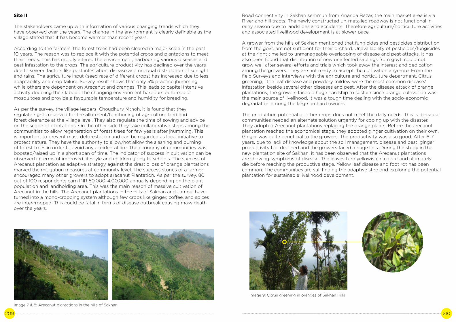
209 210
Site II
The stakeholders came up with information of various changing trends which they have observed over the years. The change in the environment is clearly definable as the village stated that it has become warmer than recent years.
According to the farmers, the forest trees had been cleared in major scale in the past 10 years. The reason was to replace it with the potential crops and plantations to meet their needs. This has rapidly altered the environment, harbouring various diseases and pest infestation to the crops. The agriculture productivity has declined over the years due to several factors like pest infestation, disease and unequal distribution of sunlight and rains. The agriculture input (seed rate of different crops) has increased due to less adaptability and crop failure. Survey result shows that only 5% practice jhumming, while others are dependent on Arecanut and oranges. This leads to capital intensive activity doubling their labour. The changing environment harbours outbreak of mosquitoes and provide a favourable temperature and humidity for breeding.
As per the survey, the village leaders, Choudhury Mthoh, it is found that they regulate rights reserved for the allotment/functioning of agriculture land and forest clearance at the village level. They also regulate the time of sowing and advice on the scope of plantations. On the other side they take collaborative steps among the communities to allow regeneration of forest trees for few years after jhumming. This is important to prevent mass deforestation and can be regarded as local initiative to protect nature. They have the authority to allow/not allow the slashing and burning of forest trees in order to avoid any accidental fire. The economy of communities was boosted/raised up in a short span of time. The indicator of success in cultivation can be observed in terms of improved lifestyle and children going to schools. The success of Arecanut plantation as adaptive strategy against the drastic loss of orange plantations marked the mitigation measures at community level. The success stories of a farmer encouraged many other growers to adopt arecanut Plantation. As per the survey, 80 out of 100 respondents earn INR 50,000-4,00,000 annually depending on the plant population and landholding area. This was the main reason of massive cultivation of Arecanut in the hills. The Arecanut plantations in the hills of Sakhan and Jampui have turned into a mono-cropping system although few crops like ginger, coffee, and spices are intercropped. This could be fatal in terms of disease outbreak causing mass death over the years.
Image 7 & 8: Arecanut plantations in the hills of Sakhan
Road connectivity in Sakhan serhmun from Ananda Bazar, the main market area is via River and hill tracts. The newly constructed un-metalled roadway is not functional in rainy season due to landslides and accidents. Therefore agriculture/horticulture activities and associated livelihood development is at slower pace.
A grower from the hills of Sakhan mentioned that fungicides and pesticides distribution from the govt. are not sufficient for their orchard. Unavailability of pesticides/fungicides at the right time led to unmanageable overlapping of disease and pest attacks. It has also been found that distribution of new uninfected saplings from govt. could not grow well after several efforts and trials which took away the interest and dedication among the growers. They are not ready to accept the cultivation anymore. From the field Surveys and interviews with the agriculture and horticulture department, Citrus greening, little leaf disease and powdery mildew were the most common disease/infestation beside several other diseases and pest. After the disease attack of orange plantations, the growers faced a huge hardship to sustain since orange cultivation was the main source of livelihood. It was a tough time dealing with the socio-economic degradation among the large orchard owners.
The production potential of other crops does not meet the daily needs. This is because communities needed an alternate solution urgently for coping up with the disaster. They adopted Arecanut plantations replacing the orange plants. Before the arecanut plantation reached the economical stage, they adopted ginger cultivation on their own. Ginger was quite beneficial to the growers. The productivity was also good. After 6-7 years, due to lack of knowledge about the soil management, disease and pest, ginger productivity too declined and the growers faced a huge loss. During the study in the new plantation site of Sakhan, it has been observed that the Arecanut plantations are showing symptoms of disease. The leaves turn yellowish in colour and ultimately die before reaching the productive stage. Yellow leaf disease and foot rot has been common. The communities are still finding the adaptive step and exploring the potential plantation for sustainable livelihood development.
Image 9: Citrus greening in oranges of Sakhan Hills

211 212
Image 10 & 11: Orange trees mortality in Sakhan Hills
Image 12: Ginger (rhizomes) for planting at Sakhan
Table no 6: SWOT Analysis of orange cultivation in Jampui and Sakhan
STRENGTH
• Long term effective and economical cultivation • Requires little management like weeding, pruning and cutting• Suitable to environment • Good Market linkage with other states • Does not require expenses on exporting, the buyers purchase fruits from the entire orchard in wholesale market rate• The orchards and landholding belongs to the cultivator• There is no government taxes imposed on the production and sale• Export all over the states in India• Good quality attributes like large size, sweetness, juicy and good flavour.• Communal harmony within the growers/cultivators and non-cultivators in the area.
OPPORTUNITIES
• The community could be provided a post harvest storage facilities for extending the shelf-life of perishable fruit i.e. Orange• Small scale industries could be implemented by the state government for value addition of the product• Govt. Of Tripura has provided the tourist lodge in Jampui. Since then, it has become a hot spot of tourism because of the beautiful landscape and oranges.
WEAKNESS
• Lack of technical management of the orchard• The wholesale are not in terms of quintal (or kg) but in bird eye view or by counting the number of trees. • Lack of post harvest management infrastructure• Lack of knowledge of value addition• Lack of irrigation facilities• Rejuvenation of orchards are not well utilised by the cultivators• Lack of disease awareness• Cultivation of oranges in a mass scale leads to monocropping• Lack of crop diversity • Lack of Research facilities for improvement in the region• Absence of orange based small scale industries to add livelihood opportunities
THREATS
• Result of mono-cropping may lead to severe infestation/infection to disease and pests. Increased susceptibility to diseases• Depending on the income alone from orange has affected socio-economic returns of the growers adversely.• Loss of crop biodiversity
E. Discussion
The study on the trend of orange production clearly indicates the role of environment and climatic factors like rainfall, temperature. Due to higher precipitation and increased temperature, the first symptoms occurred in the oranges is powdery mildew.

213 214
According to the interviews and discussion with the growers of Jampui and Sakhan hills, 100 respondents cited the same reason (powdery mildew as initial symptom) of the orange disease. Later, it is followed by the citrus decline, citrus greening, foot and root rot, viral disease showing the symptom of stem pitting in oranges. As a result, as per the findings of Kuki and Halam (2016), with higher employment potentiality, income returns and better marketing, farmers adopted arecanut cultivation. Similarly, in the hills of Jampui and Sakhan, the production of arecanut is providing means of livelihood to the communities after the orange cultivation stopped. There is a large gap between the growers and technology. It is found that the farmers have negligible knowledge about technical management of the orchard like fertilizer application, training and pruning of the trees. During the interview, 90% of the growers were not aware of the diseases. There is a possibility of regaining their orchards if awareness and management training is provided in time. Although, there have been several rejuvenation schemes and disease control measures provided by the Agriculture and Horticulture department of the State, it failed to control the diseases due to several reasons. Some of the reasons found are:
1. The horticulture department supplied initial free package of pesticides as introduction to the growers but the orchard are large in terms of plant population. It is owned entirely by the local communities therefore the purchase of insecticides/pesticide/fungicides and control measures are to be borne by the owner. Sometimes, the farmer has no idea where to buy. Besides lack of general awareness, this indicates the gap between the input suppliers and end buyers.
2. The Mountain people have different requirements and cultivate suiting to their environment. For ex-the kind of cultivar needs to be carefully suggested and grown suiting to the climate and environment. In a harsh environment and disease infected soils, the tolerant varieties like powdery mildew resistant or citrus greening resistant variety may be distributed by the govt.
3. Hill-specific trainings must be given to the growers by understanding the topography and soils of the hilly area/mountainous region. The plantation and orchards can be grown systematically to minimise the losses due to landslides. One of the major issues mentioned by the farmers during research is delayed supply of any planting material or control measures by the government.
4. There is a need to sensitize the front line managers, policy makers and essentially the staff across all levels of forest management plan.
Tripura is endowed with rich biodiversity. The study of oranges and Arecanut in the hills of Jampui and Sakhan indicates the technological, industrial and socio-economic gap in the vision of sustainable development and climate resilient initiatives. There is an urgent need to tap the genetic biodiversity of crops which is depleting in many places. The climate resilient steps and approach is necessary in terms of planning for livelihood generation. The disease outbreak will wipe out the genetic resources of many indigenous crop species. The Arecanut plantations are showing symptoms of diseases. If they are not addressed in due time, the livelihood of the communities will be on the verge of collapse. Research may be conducted by the students during the course of their study to be familiar with the landscapes, soil and potential crops of the hilly area. Hill friendly equipments and machines must be developed and distributed for minimizing labour cost and efficient cropping in the hilly areas. In Tripura, SAPCC must include the action plan focusing on the hill resident’s development particularly in terms of environment friendly agriculture and sustainable forest. In order to bridge the technological gaps, Krishi Vigyan Kendra, Van Vigyan Kendra must be established
in the hills to impart sustainable development education and research in the hilly areas of Tripura.
References
1. Annual State Plan 2017-18, Directorate of Horticulture Soil Conservation, Dept. Of Agriculture, Govt of Tripura
2. Brlansky R H; Howd D S; Broadbent P; Damsteegt V D.2002. Histology of Sweet Orange Stem Pitting Caused by an Australian isolate of Citrus tristeza viru. Plant Dis. 86: 1169-1174
3. Directorate of Food, Civil Supplies & Consumer Affairs, Govt. of Tripura
4. googleweblight.com/i?u=http://wap.business-standard.com/article/politics/tripu ra-govt-adopts-methods-to-boost-orange-production
5. https://thenortheasttoday.com/tripura-less-orange-production-forces-grow ers-to-shift-to-alternative-means/
6. https://google.co.in/amp/s/www.nativeplanet.com/amphtml/travel-guide/the-or ange-festival-of-jampuii-hill-at-tripura-003640.html
7. Panda K C and Singh R S. 2016. Marginal and small farmers’ climate change perception and adaptation. International Journal of Agricultural Environment and Biotechnology. 9(5)839-46
8. Sadanandan Sindhu; Natarajan P; Antony Jose; Vipinkumar V P.2007.Data Tools Participatory Rural Appraisal Techniques. Rajiv Gandhi Chair pub. 5, Cochin 44p
9. www.moef.nic.in >default >files >SAPCC
10. tripura.gov.in/demographics
11. tripura.gov.in/knowtripura
12. Kuki Vanlalrema and Halam Lalramnghaka David.2016. Livelihood Option through Arecanut Cultivation in Tripura: A Case Study of Noagang and its Neighbouring Villages Department of Economics, Tripura University, INDIA. International Research Journal of Social Sciences. 5(1): 47-54.
13. www.tripuraonline.in/About/Profile/Culture/Orange-Festival-of-Tripura.html
14. https://thenortheasttoday.com/tripura-less-orange-production-forces-grow ers-to-shift-to-alternative-means/
15. https://google.co.in/amp/s/www.nativeplanet.com/amphtml/travel-guide/ the-orange-festival-of-jampuii-hill-at-tripura-003640.html16. Approved Annual Agriculture Plan 2010-11, Tripura
17. Climate Change Impact on Studies on Coconut and Orange Production, Sustainable Agriculture, SAPCC, Tripura
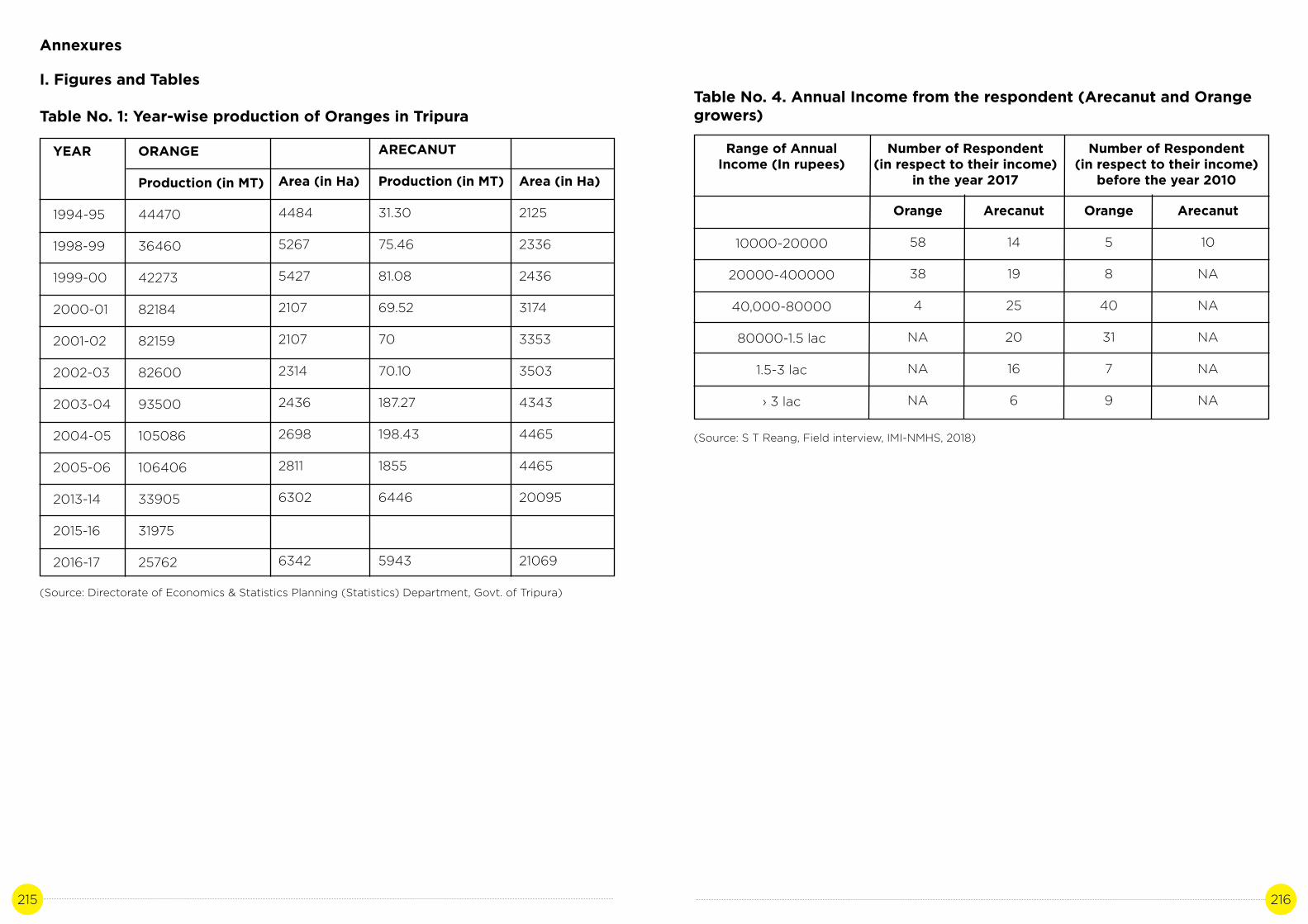
215 216
Annexures
I. Figures and Tables
Table No. 1: Year-wise production of Oranges in Tripura
YEAR
1994-95
1998-99
1999-00
2000-01
2001-02
2002-03
2003-04
2004-05
2005-06
2013-14
2015-16
2016-17
ORANGE
Production (in MT)
44470
36460
42273
82184
82159
82600
93500
105086
106406
33905
31975
25762
Area (in Ha)
4484
5267
5427
2107
2107
2314
2436
2698
2811
6302
6342
ARECANUT
Production (in MT)
31.30
75.46
81.08
69.52
70
70.10
187.27
198.43
1855
6446
5943
Area (in Ha)
2125
2336
2436
3174
3353
3503
4343
4465
4465
20095
21069
(Source: Directorate of Economics & Statistics Planning (Statistics) Department, Govt. of Tripura)
Table No. 4. Annual Income from the respondent (Arecanut and Orange growers)
Range of Annual Income (In rupees)
10000-20000
20000-400000
40,000-80000
80000-1.5 lac
1.5-3 lac
› 3 lac
Orange
58
38
4
NA
NA
NA
Arecanut
14
19
25
20
16
6
Orange
5
8
40
31
7
9
Arecanut
10
NA
NA
NA
NA
NA
(Source: S T Reang, Field interview, IMI-NMHS, 2018)
Number of Respondent (in respect to their income)
in the year 2017
Number of Respondent (in respect to their income)
before the year 2010

217 218
Name of the village
Paschim hmunpui
Purba Hmunpui
Tlakshik
Kalagang (part)
Vanghmun
Beliangchief
Sabual
Name of the village
Khasithai para
Saikar para
Serhmun-I
Serhmun-II
Soilung Para
S.K Tlangsang
Total Nos. Of family members
654
465
569
569
324
592
Metalled
-
-
-
-
-
-
Kacha road
5.4 km
4.7
5.5 km
4.4 km
3.5km
5 km
Brick soiled
-
5 km
-
-
-
-
PMGSY
-
-
-
-
-
-
Area of Village in Ha.
1839
1159
1945
505
2,263
1,305
747
Number of household
192
168
75
223
265
272
209
Person
947
797
314
886
1306
1309
1102
M
488
420
163
442
728
630
613
F
459
377
151
444
578
679
489
Present status of Road
Total population
Table No 1: Demography of the village in Jampui, North Tripura
Table No. 2: Demography of the village and source of livelihood in S.K Serhmun
(Source: District Census Handbook, Directorate of Census operations, Census of India, 2011)
(Source: O/o the Sub-Zonal Development Officer, Dasda Block, TTAADC)
Mark II
-
-
-
-
-
-
Drip Water from rocks
-
-
2
-
-
-
Ring well
-
-
-
-
2
-
Present status of
electricity
Electrified
Electrified
Electrified
Electrified
Not electrified
Not electrified
Occupation
Jhumming
Jhumming
Jhumming
Jhumming
Jhumming
Jhumming
Economic activities benefit to be extended to hardcore
jhumia1 for settled cultivation
Piggery and Arecanut Plantation
Piggery and Arecanut Plantation
Orange and Arecanut Plantation
Orange and Arecanut Plantation
Piggery and Arecanut Plantation
Orange and Arecanut Plantation
Person
120
85
38
203
192
140
136
M
68
41
22
101
102
60
75
F
52
44
16
102
90
80
61
Cultivators
232
218
107
405
375
342
347
Agriculture labours
94
27
2
20
2
21
12
Household Industry
10
62
2
-
-
14
-
Others
115
95
33
20
245
196
217
Population in age group 0-6
Present status of drinking water sources
Category of main and marginal workers

219 220
Table No 6: Aggregated indicators for the adaptive capacity of target groups in Jampui
Table No.7 : Average precipitation of North Tripura in the year 1960-1970
Sl. No.
1.
2.
3.
4.
5.
6.
7.
Year
1960
1961
1962
1963
1964
1965
1966
1967
1968
1969
1970
Jan
0
2.294
11.499
0.001
24.198
0.44
15.934
33.87
15.548
3.324
26.226
Feb
1.714
15.871
33.409
9.49
41.621
8.848
1.647
0.891
13.346
0.279
17.326
March
52.622
50.273
5.691
70.835
73.033
28.29
47.724
113.368
67.736
91.858
104.154
April
55.471
158.905
192.437
201.084
299.027
26.957
74.748
181.442
146.601
295
187.577
May
307.509
133.276
244.859
338.185
374.767
93.826
194.117
185.244
426.414
279
206.55
Name of the Village
Paschim Tlangsangbari
(Part)
Paschim Manpui
Tlakchi
Vanghmun
Beliangchip
Sabual
Simblung
Area/ Block
Jampui
APL
93
82
65
104
161
63
80
AAY
74
38
30
55
16
39
16
PG
248
156
127
144
90
92
175
Total Family
415
276
222
303
267
194
271
Families share in Food and Supplies from Govt. of Tripura
APL - Above Poverty Line, AAY - Antyodaya Anna Yojana, PG-Primitive Group (special category under Below poverty Line)(Source: Directorate of Food, Civil Supplies and Consumer Affairs, Govt. of Tripura)
June
488.297
747.95
592.146
508.025
718.426
926.851
853.509
346.776
484.719
934.82
228.047
July
731.743
472.672
519.996
496.32
1001.456
688.292
415.66
408.837
729.038
699.881
678.827
Aug
389.757
623.2
325.028
391.996
500.731
856.221
439.741
377.534
609.47
640.135
315.598
Sept
470.004
157.184
111.185
219.825
447.341
299.253
534.51
411.943
201.527
362.392
92.728
Oct
147.668
165.018
230.165
167.785
515.338
69.7
337.235
185.691
84.734
45.475
297.076
Nov
61.465
6.925
3,475
11.375
29.425
118.515
34.033
1.365
21.411
31.006
74.712
Dec
1.148
1.09
0847
0.371
2.541
31.315
56.811
0.251
0
0.31
0.502
Male
989
610
585
667
574
438
647
Female
906
583
457
610
536
471
636
Total members
1895
1193
1042
1277
1110
909
1283
0-5
113
54
29
69
62
54
94
5-12
331
153
130
212
84
139
191
12-60
1303
847
782
916
838
651
928
>60
148
112
101
80
126
65
70
Age group

221 222
Table No. 8: Average precipitation of North Tripura in the year 1971-1980
Table No.9: Average precipitation of North Tripura in the year 1981-1990
Year
1971
1972
1973
1974
1975
1976
1977
1978
1979
1980
Year
1981
1982
1983
1984
1985
1986
1987
1988
1989
1990
Jan
7.604
2.217
12.574
2.41
0.85
0.395
1.107
0.001
8.473
0.802
Jan
20.087
0.096
12.571
14.584
4.131
6.125
0.722
0.641
0.836
3.741
Feb
14.138
18.352
41.421
1.439
52.495
17.586
95.257
0.424
9.941
34.043
Feb
19.824
19.958
32.871
7.197
10.562
2.195
4.121
23.219
27.294
52.606
March
4.479
33.936
75.317
125.596
14.269
81.474
23.13
17.034
54.321
86.684
March
153.134
16.657
154.061
7.253
122.891
9.915
77.108
64.055
30.644
115.107
April
26.187
179.864
130.37
312.157
121.061
83.863
475.717
100.01
34.213
146.2
April
541.204
313.648
143.18
149.29
220.891
298.83
275.163
41.979
112.71
351.925
May
59.262
256.213
511.39
326.703
267.784
278.533
420.605
559.219
175.152
478.194
May
574.543
305.908
324.187
743.515
226.947
122.441
132.434
596.011
312.971
264.033
June
229.02
484.505
689.924
632.645
346.938
690.404
563.995
591.091
271.857
284.654
June
438.581
736.095
322.151
561.375
431.1112
243.518
226.003
481.059
468.453
406.764
July
393.055
314.879
412.425
914.748
610.91
662.347
542.487
329.894
282.901
564.43
July
634.041
300.631
527.376
497.837
309.379
490.995
541.924
547.51
450.423
508.686
Aug
372.567
419.644
202.813
361.718
236.846
475.356
215.575
239.479
523.896
493.679
Aug
336.861
591.141
583.233
497.819
389.415
300.079
415.121
533.415
144.052
136.427
Sept
206.298
91.577
186.153
479.007
285.498
39.398
176.774
258.669
380.091
264.274
Sept
176.736
235.447
435.387
321.817
298.733
396.315
400.874
266.122
299.316
409.905
Oct
219.65
71.361
200.496
209.073
183.88
104.32
160.885
92.891
189.715
210.523
Oct
16.903
27.098
230.824
206.04
39.157
246.304
156.176
266.014
224.157
166.891
Nov
71.071
2.362
165.344
66.411
131.963
19.39
45.05
2.082
31.172
0.488
Nov
3.18
49.355
19.96
0.75
3.142
144.235
58.912
69.188
5.612
43.014
Dec
1.349
0.753
3.407
0.263
0.995
0.427
13.445
0.167
26.104
4.105
Dec
57.977
3.39
36.877
7.367
2.029
1.234
28.607
4.717
1.422
16.478

223 224
Table No. 10: Average precipitation of North Tripura in the year 1991-2002
Year
1991
1992
1993
1994
1995
1996
1997
1998
1999
2000
2001
2002
Jan
9.007
7.423
35.204
13.847
13.831
0.47
5.304
8.111
4.976
14.633
3.122
21.448
Feb
34.597
35.101
42.596
39.275
26.694
24.13
8.953
16.704
4.788
35.32
12.321
5.498
March
90.546
18.244
91.61
184.46
8.132
125.186
82.128
102.56
21.089
55.805
72.643
55.603
April
61.12
83.71
111.281
185.879
100.927
233.819
131.108
211.998
42.519
356.696
165.211
308.907
May
499.843
381.325
379.16
267.352
330.063
619.608
195.944
448.957
474.143
560.64
448.228
332.271
Questionaire for the Case Study on “Studies on Impact of Climate Change in Orange Mortality of Jampuii & Sakhan Hills of Tripura”
1. What are the challenges that you face/observe as an officer/agril. Department/farmer face due to climate changes under the following sectors
• Agricultural crops • Forest( ex-deforestation, horticultural plantation), NTFPs • Water resources • Other
2. What were/are the approaches from the govt. that has been carried to combat Climate change issues?
3. Does the department have the record of production, productivity and import/export of orange?
• (For Farmer - Do you have any record of your sales/produvtivity along with year)
4. When was the last time orange festival was held in Jampuii?
5. What are the main reasons for shortfall in orange cultivation?
June
408.797
409.664
731.603
533.237
544.644
410.407
348.168
338.726
339.979
174.773
471.73
753.108
July
388.984
678.988
630.112
412.029
533.729
436.138
722.837
668.666
499.543
295.139
386.696
611.067
Aug
490.768
487.696
491.52
521.047
470.578
500.267
379.01
649.992
391.148
590.429
618.297
378.65
Sept
256.403
282.668
357.55
148.3
255.181
241.787
423.477
166.942
131.194
253.788
233.903
239.061
Oct
454.94
133.436
81.9
50.441
51.091
163.958
40.588
81.227
224.843
124.81
227.073
102.602
Nov
13.81
17.154
12.639
20.979
135.088
6448
12.965
112.78
17.206
17.118
35.163
49.145
Dec
31.271
17.749
0
4.571
0.854
1.011
25.752
0
2.938
5.597
1.622
1.842
6. What are the adaptation strategies that have been taken up? What are the consequences and impact on the environment and socio-economic status of cultivators?
7. How is Arecanut cultivation benefiting the cultivators/growing communities?
8. What are the incentives/approach from the govt./dept. in cultivation of Arecanut?
9. Was cultivation of Arecanut more productive and economical than Oranges?
10. What are the government policies enforced on Oranges/arecanut cultivation?
11. What are the good traditional practices that the community has been practicing from ancient times in the locality?
12.Do you have record of any other good practices that have scopes to flourish but are suppressed by govt/ community policies?
13. What are the approaches adopted by the local community/dept. towards sustainable agriculture in the locality?
14. Is there any Scopes of terrace farming/contour farming in the hilly areas of Jampuii/ Sakhan at the suitable site?
15. Does the community/govt. has any orchard policy? If so, how does it affect you as a grower? If not, whether it is required or not. Give your comments on it.

225 226
ARUNACHAL PRADESH
Photo credit: Momo Irengbam | Location: Lower Subangsiri, Arunachal Pradesh

227 228
PADDY CUM FISH CULTURE, ARUNACHAL PRADESH
Author: Oji Tacho Contributors: Dr. A.K Purkayastha, Egam Basar
CASE STUDY 11

229 230
A. Background
Arunachal is the largest state in the North-East India with an area of 84,000 km2. The population density of the state is one of the lowest in the country. 62% of the state is under forests. Agriculture is the primary source of the economy and contributes 43% to the state GDP (SAPCC, 2011).
Agriculture in the state of Arunachal Pradesh with nearly 81% crop land under rainfed cultivation. High dependence on the southwest monsoon has been a highly risky venture with vagaries of monsoons, besides the interplay of other abiotic and biotic factors. Climate change is set to compound the daunting complex challenges already being faced by agriculture. Agricultural productivity is sensitive to two broad classes of climate induced effects (1) direct effects of changes in temperature, precipitation or carbon dioxide concentration and (2) indirect effects through changes in soil moisture and distribution and frequency of infestation by pest and diseases.
Rainfall plays an important role in determining the fate of agriculture in Arunachal Pradesh as only 19% of gross cropped area is under irrigation (SAPCC, 2011). Getting the crops the right amount of water at the right time has always been a challenge for farmers and for the success of agriculture of the state. Too much or too little water/ precipitation can jeopardize whole agro-system, so the seasonality, amount, distribution and timing of the rainfall are of particular importance. But due to climate change, the reliability of agriculture on rain has reduced in recent years as the seasonal rainfall has been marked by delayed onsets, declining number of rainy days and increased intensities altering farming calendars with negative effects on the yields. During last decade, climate related crop failures in the eastern part of Arunachal Pradesh attracted much attention (Arunachal Times 2009, 2012). Increase in frequency and magnitude of floods in recent years devastated large areas of near ready grain fields. While low rainfall resulted in several episodes of late rains during planting seasons, and persistent droughts in large portions of the region. The frequency of extreme events like floods, landslides and drought increased in the recent decades (WWF 2005).
In terms of food crop production the state still has minus 6% deficit, producing 2,50,400 tones of grain against the requirement of 2,68,100 tones (Ngachan 2013). Climate change and uncertainty further increase the pressure on sector. Weeds, insects and diseases are benefitted by warming environment. Climate change is a concern to researchers and farmers because it would lead to changes in insect and disease dynamics, i.e.the distribution, abundance and management of insect pathogens. Climate change will probably alter the geographical and temporal distribution of insect pests. New diseases may arise in certain regions, and other diseases may cease to be economically important, especially if the host plant migrates into new areas (Coakley et al. 1999). The rice blast disease (Pyricularia oryzae) which is the most prevalent in the region and main cause behind hindrance in achieving the full potential of rice cultivars is favoured by rise in temperature in the state.
Climate of the state is influenced greatly by the Himalayan Mountains and large variations in altitude across the state. Areas that are at a very high elevation in upper Himalayas close to the Tibetan border experience alpine and tundra climates. In the middle Himalayas temperate climate is experienced. Areas at the sub Himalayan generally experience humid sub-tropical climate with hot summers and mild winters. The rainfall of Arunachal Pradesh is amongst the heaviest in the country receiving more than 3500 mm in a year. The state receives rainfall over a period of 8 to 9 months except in winter, however, most of rainfall is between May to September.
Higher regions experience snow fall during winter. The average annual rainfall is 1000 mm in the higher elevations and 5750 mm in the foot hill areas. Winter months have average temperatures in the range 150C to 210C, the monsoon month temperatures are in the range of 220C – 330C, and the summer months temperatures sometimes reach as high as are over 370C. The foot hills experience maximum temperatures around 400C during summer (Arunachal-Pradesh, SAPCC).
Around 5.15 million hectares of geographic area (61.54%) is under forests. The arable land (the net area sown plus the current & fallow lands) is estimated at 0.25 million hectares (3.08 %) of the total reporting area (8.37 million ha). Land under miscellaneous tree crops and groves, not included in the net area sown, is 0.04 million hectares (0.53%) and the culturable waste-land is 0.03 million hectares (0.4%) of the total reporting area. Agriculture is the main occupation for about 35 % of the population of Arunachal Pradesh. Jhum cultivation (Shifting Cultivation) and Terrace farming (Wetland Rice Cultivation (WRC)) are the two major patterns that farmers employ for practicing agriculture. Jhum is a way of life in the high altitude areas. But Jhum area productivityis very low (0.7 to 0.8 tonnes/ha of organic rice against average of 3 tonnes/ha). Jhum/ shifting cultivation accounts for 0.11 million hectares and permanent cultivation is about0.09 million hectares. 17% of total cultivated area is under irrigation. Jhum cultivation contributes only about 14% as compared to Terrace farming. (Arunachal-Pradesh, SAPCC) and climate of Arunachal Pradesh is conducive for cultivation of rice, millets, wheat, maize, pulses, sugarcane and potatoes.
Introduction to case study
“Paddy cum fish cultivation”
The Apatanis (Tribe of Arunachal Pradesh) practice aquaculture along with rice farming on their plots. Rice-Fish culture is a unique practices in the state where the two variety/ species of rice (Mipya and Emoh) and one species of fish (Nghi) are raised together.And this traditional practice has been followed through ages.
Integrating aquaculture with agriculture assures higher productivity and year round employment opportunities for farmers. The Apatanis use organic compost made up of domestic waste products for their paddy to enhance soil fertility as well as feed tofishes. The incorporation of rice barn poultry dropping and many other household waste material act as organic fertiliser to the crops and feed for the fish.
The rice field (Aji) is utilized for fish culture in the following two ways. Fishes are reared from the month of April to September when the paddy crops grow in the field. At present it is being practised at Ziro valley in the state which is the focus of this study. The fish culture is usually done here by synchronizing with late ripening rice variety and its production is substantial as shown in the table below. The culture of fishes which remain flooded even after the paddy is harvested, also serves as an occupation forthe farmers.

231 232
Table 1: Crop variety grown and its month of sowing and harvest.
Crop/variety
Mipya ( Early variety)
Emo,Pyaping and other variety (late maturing variety)
Month of sowing
April-May
April-May
Month of harvest
August
Mid October
Paddy field is suitable for fish culture at Ziro valley because of having strong bund (Agher) in order to prevent leakage of water, to retain up to desired depth and also to prevent the escape of cultivated fishes during flood. The bunds are built strong enough to make up the height due to geographical and topographic location of the paddy field. Bamboo mating is done at the base of the bunds for its support. Apatanis use paddy field channel (Sikho/Parkho/hehte) for the water management, constructed at the middle of the paddy fields that divides the paddy field perpendicular and horizontally bisect at a point. The Parkhoprovides the rearing space for the fishes and provides shelter during the sunny days.
B. Literature Review
Challenges/ Impact of Climate changes on agriculture sector:
When agriculture’s contribution to gross domestic product is declining throughout North Eastern region, large populations are still based in rural areas, depending on agriculture directly or indirectly for employment and income. The Eastern Himalayan region is likely to face the highest reductions in in agricultural potential due to climate change. As a result climate change will place an additional burden on efforts to meet long-term development goals in Arunachal Pradesh in particular. To cope with current crisis, the ongoing development initiatives need to be strengthened to reduce vulnerability to climate change by adopting suitable policies and technologies. The adaptation will require improvements that take existing development policies above and beyond their current capacity that encompasses innovative policies like changing investment allocations within and cross sectors, increasing the focus on risk-sharing and risk-reducing, disaster preparedness, capacity building and proper indigenous traditional knowledge on farming to compliment the scientific recommendation for wide acceptability, Jhum improvement etc. Thus the agriculture and the farming system of the state must make necessary adjustment and readjustment with the changing climate to enhance the resilience of the sector. The use of pesticides, insecticides, weedicides and fungicides which even in minute quantities are highly toxic to aquatic life and have degraded both the quality of soil and fish that are reared. Lack of poor management, pond culture at Ziro is somewhat lacking. Traditionally they use herbal poisonous plant to kill in order to catch fish (Tamoh). Further it causes imbalance of ecological niche and thereby damaging the river bank. Therefore local conservation practices needs to be followed in a sustainable manner for the conservation of the biodiversity.
And the state SAPCC have taken up various steps to combat the issues related:Sustainable Agriculture Mission and Horticulture-Existing State Policies and programs: The State’s strategy of agriculture development is centered on achieving self sufficiency in food grain production and marketing the produce at remunerative prices and generating revenue and employment opportunities. The broad strategy is to providefood (rice) security through
• Area expansion by land development• Creation of assured irrigation in settled cultivation areas• Promotion of scientific planning and cropping pattern to improve the yield per hectare• Integrated efforts for enhanced productivity in Jhum areas• Integrated crop management• Continuation of the traditional organic farming to meet market demands for organic products• Efforts for improving the rice production rate @ 8%• Ecologically sustainable and economically viable diversification of agriculture
Haimendorf (1962a) described that Apatani society provides for the enforcement of law through a representative of public opinion. The Apatani tribes knows very well that their complex economy and their whole pattern of living can be maintained only if peace reign in the valley, and peace is assured by formal treaties of friendship between the individual villages. Such treaties are known as dapo. Culture analysis refers to understanding of relevant culture peculiarities-the values, knowledge, beliefs and practice of the target groups. It involves the study of the interdependence between the social, cultural, economic and ecological written aspects ruling the life of these groups (Renshaw, 2001).
The Apatani tribes are a tribe predominantly occupying agrarian economy but Apatani of today is literate and occupying various professions as scholar, educationist, doctor, engineer etc. (Bath, 2004).
In Apatani society, there is a tight articulation between paddy maintenance, kinship and clan, the elaborate and ingenious irrigation system, gender (women are the primary farmers and paddy builder), religious ritual (close tied to agricultural cycle and landscape) (Taylor, 2005). Integrating fish culture with paddy can provide additional income without disturbing paddy cultivation protocol. Thus there is need to encourage this trend and support them with viable programme and funding (Rajkonwar, 2007).
Adoption and innovation in paddy cum fish farming
Fish culture in rice fields offer one of the best means of contemporaneous production of grain and animal protein on the same piece of land (Schuster, 1955) and is one of the most ideal methods of land use. Paddy-cum-fish culture is, so to say, production of nutritionally balanced food at the source itself. The principal factors involved, according to Schuster et al (1955) and Coche (1967) are climatic and other local conditions, fish species available, rice variety cultivated, method of rice culture, fertilization, type of fish culture method, supplementary feed etc. In a study conducted by Ghosh et al (1984), discussed the effects of artificial feeding on production of common carp (Cyprinus carpio) and water quality in paddy-cum-fish culture. Paddy fields of 40 m2 were stocked with 24 fingerlings (25 to 30 g each) 15 days after transplanting the paddy seedlings. The fish were fed a mixture of rice bran and mustard oil cake(1:1) at rates of 2, 4 and 6% total body weight. The growth of individual fish and fish yield increased with increasing feeding rates, as did concentrations of nitrite, nitrate, chemical oxygen demand, and particulate organic matter. The concentration of dissolved oxygen decreased. Economic interpretation indicated a feeding rate of 8.8% of the total body weights of the fish, calculated on the Mitscherlich model.
The values for pond conversion and water quality indicated that feeding beyond 4% was wasteful, and accumulation of the feed caused deterioration in water quality.

233 234
Integrated Pest Management (IPM) strategies should be adopted as anecessary complement to fish farming practices (Berg, 2002). IPM rice-fish farmers havethe highest net income due to comparatively low costs and high yields of both rice and fish.The feasibility of adopting integrated rice-cum-fish culture system toenhance the development of conventional aquaculture participation in Niger State and foundthat the percentage increase in rice yield as well as increase in net income due to introductionof fish was 10.1% and 54.4% respectively therefore recommended for adoption towards greater participation in aquaculture development by the farmers (Yaro, 2003).
The use of high-yielding fish of good quality is essential for economic viability. In areas where a high diversity of fish with a requisite biomass of desirable species already exists, these indigenous fish can be harvested, but their yields may only be adequate for low-income rural areas. Common carp, Cyprinus carpio L., has traditionally been a preferred cultured species. It was also stated that this type of integration also involves ecological and social benefits. High densities of fish in irrigation systems enhance the yield of land crops, alleviate the pressure of terrestrial and aquatic pests, and lower the populations of vectors of diseases of man and domestic animals.
The farmers of the Apatani tribe in Arunachal Pradesh, India have been raising a concurrent crop of fish successfully in their mountain valley rice plots for the past 40 years. They follow indigenous rice agronomy, ignoring the use of fertilizers, pesticides and even supplementary feed for the fish reared in the system.
The Apatani technique of rice–fish integration may be considered as one of the periphytonbase daquaculture (PBA) systems, Periphyton is comprised of group of algae, filamentous bacteria etc. This technology works on the basis of introduction of substrates into the water to support the growth of periphyton, which becomes food for the fish, which deserve further research attention (Das 2007).Astudy conducted by Dollo (2009) on traditional knowledge and expertise of theApatani group of villages evaluated the cultural and social cohesiveness associated with managing the land, water and agro-biodiversity. The study reported that, unlike other tribal communities in north-east India, who mainly practice shifting cultivation, the Apatani depend mainly on perennial wet-rice cultivation. They successfully grow 16 varieties of rice in the waterlogged paddy fields by means of organic farming and appropriate use of diverse natural resources. Traditional wet rice farming system is functional even today and is modified by the community as and when required. Apatani land use management is conducted using well tried traditional land law systems, and land is classified into 10 major categories on the basis of traditional uses.
Apatani people catch fish from paddy field before the culture of paddy cum fish was introduced. They catch the naturally stocked fish like snake head and zebra fish from their paddy field. The Paddy cum fish farming practice has potential of becoming commercially vibrant only with the collective efforts of government and the people toward its development. Such an important culture can also be disseminated among other surrounding tribes. The success of paddy cum fish culture in the area can be used in the form of illustration to the farmer belonging to other ethnic groups for sustainable mountain agriculture (Nimacho et al, 2010).
C. Study site
Fig 1: Paddy cum fish field after transplanting in the main field.
The headquarter of the Lower Subansiri district “Ziro” was established at North Lakhimpur in December 1940 by Col. Betts which later shifted to kimin in January 1950. Again the district headquarter of Kimin was shifted to Ziro on 24th March 1952.
Ziro valley is situated at a height of approximately 1524 meters above mean sea level. The Ziro valley covers an area of 10,135 Km2. Out of the total wet area of 715.7 hectares Rice-Fish culture covers approximately 592.0 hectares which is surrounded by hills and mountains covered with vegetable gardens, pines, bamboos and other trees.

235 236
The Ziro valley is bifurcated by the Kele river and lies between the river valleys of Kamla and Khru on the north and Palin on the south. All these rivers eventually drain into the Subansiri river, a tributary of the Brahmaputra river. It receives a mean annual rainfall of about 1,500 mm, concentrated during May-August with relatively little or no rains from November to February. The climate is temperate with mean temperature ranging from 12 °C to 25 °C during summer and from -5°C to 12°C during winter, frost is common during winter. The cool summer weather makes the state a major tourist destination. The relative humidity varies from 36.5% to 82.8%.
The topography of the area is mountainous valley and the soil type is clayey loam in nature. The permeability and water retention capacity of the soil is highly conducive for rice-fish culture.
The Apatani tribe, one of the major tribes of Arunachal Pradesh is said to have migrated to the present location from the Talle valley in the south-eastern region of lower Subansiri district which is about 30 km away from Ziro valley for some time before shifting the base to the study site. Geographically, the study site with a total area of about 1,000 km2 is a bowl-shaped and is surrounded by high hills interspersed with unique and a highly developed ingenious integrated rice with fish farming (locally called Aji-Ngyii) and bamboo with pine home garden agroforestry systems. It has 35 villages, with a total population of about 42,000 and a population density of 24 people per km2. The majority of the rural Apatani economy is largely based primarily through a mixture of agricultural activities centred on crops (Paddy, Maize, fishery and home garden agroforestry resources. They elegantly integrate animal husbandry comprising of Mithun (Bos frontalis Lam.), cattle, swine and poultry in this traditional farming system.
The Apatani tribe of Arunachal Pradesh with a highly developed valley cultivation of rice perfected over centuries has often been suggested to be one of the relatively advanced tribal societies in the north-eastern region of India (Furer-Haimendorf,C.V.F.1962). Unlike other tribes who practice traditional slash-and-burn or shifting cultivation, majority of the ethnic Apatani has developed a unique agro-landscape management in the form of integrated rice with fish farming system, by virtue of which they distinguish themselves from other tribes of the state and define their distinctive lifestyle and social system. They have a distinct civilization with systematic land use practices and rich traditional ecological knowledge of natural resources management and conservation, acquired over the centuries through informal experimentation.
This has made Ziro valley a good example of a living cultural landscape where man and environment have harmoniously existed together in a state of interdependence even through changing times, such co-existence being nurtured by the traditional customs and spiritual belief systems. Therefore, the Apatani plateau or Ziro valley has been tentatively listed by the United Nations Educational, Scientific and Cultural Organization (UNESCO) as one of the world heritage site due to its “extremely high productivity” and “unique” way of preserving the ecology (Dolloet al., 2009)
Description of the System:
The rice with fish farming practiced by the Apatani involves a uniquely ingenious way of water and agricultural resource management. Unlike the other rice with fish farming practices in the tropics(Ahmed,N. and Garnett S.T.2011), water for irrigating the fields is tapped from the streams originating from the nearby forests and adjacent catchment areas and diverted towards the agricultural fields, using traditional bamboo and pinewood pipes.
The water is usually diverted by a network of primary, secondary and tertiary channels. The water automatically flows down through the channels due to gentle slope and finally meets the major water channel at the lowest elevation which finally drains to the river Kele. The level of water is maintained by opening and closing inlets and outlets called hubur made of bamboo. The main canal may cause soil erosion in due course of time if proper care is not taken. For this, the bamboo fencing is made alongside main canals.
Today one can even find concrete embankments constructed along the canals. Maintaining this farming system is a tedious job because availability of sufficient water is critical for the growth and survival of fish without any negative impact on rice crops. The farming system is very lively based on a complex network of intricate irrigation canals and channels to ensure distribution of water in every corner involving peoples’ participation. Equitable distribution of water in the fields is a general rule, such rules are regulated (enforced) by a few nominated members of the community, who are also empowered to resolve conflicts, if any. The members are also involved in harvesting the rainwater, building a network of canals for irrigating the rice fields and maintaining the system. The bunds (Agher), supported by bamboos and wooden clips are constructed in the fields in order to hold the water and retain the nutrient-rich soils. The average size of the bund is about 1m in breadth and about 50cm in height depending on the gradient of the land and shape and size of the fields.
Field Preparation and Management:
The preparation for rice with fish farming starts just after the final harvest of rice in November. The straw is left on the field to decompose while the chaff and spikes after separation of grains are taken to and spread in the field and allowed to dry, and are then burned. Other land preparation operations during December-January include installing inlets and outlets with bamboo pipes, raising and widening of bunds, and loosening and levelling the soil. For these operations, the farmers do not make use of animal power or, machines, nor do they use advanced tools to plough their fields. Instead, they prepare the fields with conventional daos (an implement for cutting) and spades—the farmers consider these practices economically and ecologically viable. The farmers rate weeds (Ahru-tamii) as a major problem. Generally, weeding (Ahru-hodo) starts in February which is manually done about three times per season with the help of traditional bamboo hoes where both man and women actively participate, forming groupscalled Patang.
The uprooted weeds are left in the fields to decompose and sometimes weeds are converted into compost through traditional systems by gathering all the weeds in one place, which is then covered with a thin layer of soil for quick decomposition (Dollo et al., 2009). The weeds collected in February from bunds are used as compost for rain-fed garden, mainly for cultivation of chilies (Capsicum spp.). Certain species such as Houttuynia cordata Thunb is considered as a good soil binder and is used for stabilizing bunds and are left behind in the field while weeding. Some weeds are consumed by fish so that weeding operations in the integrated rice with fish farming can be less frequent than in other agricultural systems where weeding is done three to five times during a cropping season.

237 238
The rice seedlings are first raised in the nursery (Miding) of about 48 m2, which is further divided into three to four nursery beds (Hohe) of 43 m size (Dolloet al., 2009).Each indigenous landrace of rice (Table 1) is maintained separately to prevent possible mixed up of seedlings. The nursery beds are prepared just after the completion of murung festival in the month of February with the help of traditional implement (Hiita). The seeds are sown at the rate of about 80 kg·ha-1. The seedlings (Andee) are maintained with constant care for about 75 days until they attain the height of about 15 cm for transplanting. Interestingly, the seedlings of finger millet (Eleusine coracana) (Linn Z.,1996), to be planted in the field bunds are generally raised in nursery beds in the homegarden. Rice along with four local varieties of finger millet is planted on elevated partitioned bunds between the rice plots. The size, time and preparation technique of nursery beds are almost similar to those of rice. When the finger millet seedlings are about 15 cm tall, they are transplanted with the help of traditional implements (locally called Dum), after transplanting of rice seedlings from the nursery bed that begins in April is completed by the end of May.
Pictures of Paddy cum Fish cultivation in Lower Subansiri District:
Fig 1: Paddy cum fish field after transplanting in the main field.
Fig 2: Fish farming in the Paddy field.
Fig 3: Irrigation channel in the main field
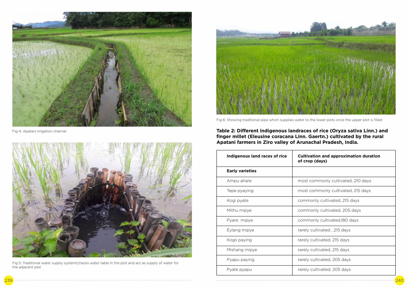
239 240
Fig 4: Apatani irrigation channel
Fig 5: Traditional water supply system(checks water table in the plot and act as supply of water for the adjacent plot
Fig 6: Showing traditional pipe which supplies water to the lower plots once the upper plot is filled
Table 2: Different indigenous landraces of rice (Oryza sativa Linn.) and finger millet (Eleusine coracana Linn. Gaertn.) cultivated by the rural Apatani farmers in Ziro valley of Arunachal Pradesh, India.
Indigenous land races of rice
Early varieties
Ampu ahare
Tepe pyaying
Kogi pyate
Mithu mipye
Pyare mipye
Eylang mipye
Kogii paying
Mishang mipye
Pyapu paying
Pyate pyapu
Cultivation and approximation duration of crop (days)
most commonly cultivated, 210 days
most commonly cultivated, 215 days
commonly cultivated, 215 days
commonly cultivated, 205 days
commonly cultivated,180 days
rarely cultivated , 215 days
rarely cultivated, 215 days
rarely cultivated, 215 days
rarely cultivated, 205 days
rarely cultivated, 205 days

241 242
Indigenous land races of rice
Late varieties
Eylang eamo
Radhe eamo
Ampu hatte
Millet varieties
Early varieties
Surpu ahare
Late varieties
Surpu latha
Akhi sarse
Sartii
Cultivation and approximation duration of crop (days)
most commonly cultivated, 240 days
rarely cultivated, 245 days
commonly cultivated, 250 days
commonly cultivated, 175 days
most commonly cultivated, 195 days
rarely cultivated ,190 days
rarely cultivated, 190 days
Table 3: Reported for yields of rice and fish under rice with fish culture of different studies(Ahmed, N., and Garnett, S.)
Approximate yields (kg-ha-1)
Rice grain
3,700
5,200 (Aman) rice
4,900 (Boro) rice
3,890
2,580
2,100 - 2,300
Fish (Fresh weight)
550
250
250
NA
530
400-450
Place/Country
Arunachal Pradesh, India
Bangladesh
Bangladesh
Sri Lanka
Nigeria
Assam, India
Table 4: Methodology adopted for the case study
Table 5: List of stakeholders interviewed
D. Methodology
A Case study approach was undertaken to document the Paddy cum Fish cultivation as described below. The study started off with an intensive review of secondary literature and peer reviewed research articles. Participatory rural appraisal tools liketransect walk, field interview semi-structured key person interviews and focussed group discussions were undertaken with the practitioners of Paddy cum Fish Cultivars i.e. farmers, cultivators, village folk and local headmen. Discussions were also made with relevant stakeholders at village, district and state level including subject matter experts. Participatory rural appraisal approach was also undertaken to capture the timeline planting calendar as well as capture the perception of changes in weather, impacts on the community, coping and adaptation practices.
Stakeholder
Community( Apatani Community of Ziro)
State officials( Agriculture Department, Ziro
Subject matter experts
Designation
Progressive farmer
Progressive farmer
Agriculture development officer/member SDFA
Asstt. Dir.Agriculture
Asso.Prof. Deptt of Forerstry NERIST
Agriculture Development Officer
Mission Director Horti./SDFA/IMI
Village
Reru village, Ziro
Bulla village, Ziro
Naharlagun
Naharlagun
Nirjulee
Ziro
Itanagar
Method
Undertook in depth key person interviews, and focussed group discussions to document and identify indicators of good practices.
Discussion with the officials were taken based on the issues related to climate change its effect on its production.
Discussion were taken up based on the technical field related to various farming techniques and varieties grown.

243 244
E. Discussions
The average yields of rice and fish reported during the present study by Baruah et al was about 3,700 kg·ha-1 rice and about 550 kg·ha-1 fish( Baruah et al,1996). reported production of about 2,300 kg·ha-1 rice and about 450 kg·ha-1 fish in neighboring state of Assam, India. (Baruah et al,2000). The study also also evaluated the prospects for fish farming in rice fields in Assam, and reported potential production of 500 kg·ha-1 rice in four months with a 17.7% increase in rice production, with 10-20 % of the plot utilized for dykes, refuge ponds and ditches. It has been reported by many studies that introduction of fish in rice fields increases rice yields by about 8%-15% (Mishra, A., and Mohanty, R. K. 2004).
The increase in rice yield could also be due to combination of several favourable factors associated with the movement of fish such as increasing dissolved oxygen levels, stirring up soil nutrients, enhancing soil organic matter, and controlling plankton, organic detritus, aquatic insects and plants that compete with rice for nutrients and energy (Ahmed et al., 2011.). The comparative data of few studies on yields of rice and fish in rice with fish farming system reported from different countries are presented in Table 2.The fish fingerlings introduced by the Apatani farmers in the rice with fish fields are cyprinids such as common carp (Cyprinus carpio Linn.), grass carp (Ctenopharyngodon idella Val.), silver carp (Hypophthalmichthys molitrix Val.), rohu (Labeo rohita Ham.), Catla (Catla-catla Ham.) and Mrigal (Cirrhinus mrigala Linn.) in April and harvested in July, during the cropping phase of the early rice. Gupta et al,1998 reported use of eight different fish species with paddy rice. The local farmers mentioned during the survey that about 2,500 fingerlings are usually used for one ha. Trenches, about 50 cm deep, are dug in the field to provide shelter to fish. When water dries up in the field, fish takes shelter in these trenches where water still remains. During hot weather, the water in deep trenches provides soothing environment for the fish. Fishes are caught easily even during the harvest from the trenches using the indigenous trap prepared from bamboo which is placed in the outlets. About 80% of fish production in the valley comes from Cyprinus carpio followed by Ctenopharyngodon idella. Cyprinus carpio, an omnivore variety, stands out from other fish species because of its high viability. They can lay eggs under natural conditions in ponds or lakes, making it easy for farmers to collect them. If left unattended in the field, these eggs are even able to hatch out. This is the reason why Cyprinus carpio is the main fish species used in rice with fish systems (Luand Li, 2006.). The fish feeds primarily on natural food such as Pteridophytic Azolla species, phytoplankton, zooplankton, periphyton, and benthos grown in the rice fields (Mustow, S. E. 2002). Presence of Azolla, a free-living, nitrogen-fixing species also adds to the nitrogen enrichment of soil. In China, Azolla is added to the rice with fish system, turning it into rice with Azolla with fish system (Huanget al., 2001.; Lin, 1996).
The annual amount of nitrogen fixed by Azolla is estimated to be 243-402 kg·ha-1, making it the main source of nitrogen circulating in the system (Luand Li, 2006). The fish also feeds on small insects like water beetle, larvae, and others that are harmful to rice. Further, the fish feeds on flies, snails and insects, and can help to control malaria mos- quitoes and water-borne disease (Matteson,2000). In turn, the waste materials of fishes work as manure to rice plants.
The rice with fish farming system has largely been practiced in a traditional way and has become an important agro-cultural activity of the Apatani tribe of Arunachal Pradesh. Indeed, the Apatani farmers do not have too many options other than practicing this indigenous farming system due to scarcity of arable land resources.
As described by (Altieri, M. A. 2002), such farming systems are rooted in the ecological rationale of traditional small-scale agriculture representing long established examples of successful forms of community-based land-use systems. According to the local farmers’ experience, the integrated rice with fish farming is considered sustainable, self-sufficient and efficient.
The rice with fish farming agro-landscape favour the conservation and maintenance of both indigenous rice and fish with a wide distribution and constituting diversified varieties. Kala and Dollo (2008) reported at least sixteen indigenous landraces of rice being cultivated by the Apatani tribe in Ziro valley, some details of these landraces are presented in Table 1. The choice of varieties, however, depends on the household preferences while the most preferred local rice varieties being cultivated are Ampu Ahare, Eylang Eamo and Ampu Hatte (because of their high productivity and socio-religious importance), which together cover about 70% of total wet rice fields. For conservation of traditional crop varieties, on-farm conservation in traditional agriculture systems has the advantage over other conservation methods because crop genetic diversity can be maintained as part of normal farm management.
Indicators of good practices:
Overall, agriculture in Arunachal Pradesh is mostly organic, with little or no use of synthetic fertilizers, pesticides, and other chemicals. Soil fertility in general is managed and maintained through recycling of agricultural wastes such as rice straw and husk, ash, weeds, cattle manure and domestic household wastes. The streams coming from the forest and flood the fields also carry many degraded organic products (decomposed litter) which may provide nutrient to the fields. As Altieri (2002) has described, in many areas of the developing world, traditional farmers have developed and/or inherited complex farming systems, adapted to the local conditions that have helped them to sustainably manage harsh environments and to meet their subsistence needs, without depending on mechanization, chemical fertilizers, pesticides, or other technologies of modern agricultural science.
The Apatani rice with fish system of Ziro valley is an excellent example of such indigenous, sustainable, organic agriculture, where the chemical-free nature of land management has led to holistic rural development. The tentative recognition of Ziro valley as a UNESCO world heritage centre is a monumental recognition of the value of this traditional system and its desirable sociocultural and ecological attributes.
Rice with fish farming is conducive to the recovery of soil fertility and the prevention of soil degradation. The interview with the Apatani farmers revealed a fact of their traditional knowledge that the recycling of nutrients by the fish through feeding anddepositing faeces serve as both a natural fertilizer for rice and enrichment for soil. Zheng and Deng (1998) reported an experiment carried out by them on integrated rice with fish cultivation for three years in the same plot showed an increase of 27.9%, 44.3%, 6.5%and 28.2% in soil total nitrogen, total phosphorus, total potassium and organic matter, respectively. According to Lu and Li, (2006), a total of 10%-20% of methane (CH4) in the atmosphere comes from rice fields and the rice with fish farming system is capable of lowering the emission of the CH4 by nearly 30% compared with traditional rice farming. Mutualistic Association: This ingenious farming system is one of the best examples of mutualism of biotic interactions, where both rice and fish are benefited. The principleof symbiosis and mutual benefits of ecosystems, and the principle of the food web are applied to optimize the current ecosystem comprising fish, rice and aquatic microbes, so that each subsystem takes advantage of and promotes one another.

245 246
In this relation, fish has the advantage for shelter and feeding, while rice has the privilege for luxurious nutrient uptake, and competitive advantages over weeds and micro flora Fish play a significant role in controlling aquatic weeds and algae that carry diseases, act as hosts for pests that would have compete with rice for nutrients. Shading by rice plants also maintains the water temperature favourable to fish during summer (Kunda et al., 2008). The decaying leaves of rice offer favourable conditions for the multiplication of microor-ganisms, which are the main fish feed. Fish, on the other hand, help to loosen the surface soil on which rice is planted, bringing about increased permeability and oxygen content of the soil, as well as enhanced vitality of microbes. Thus, the decomposition of nutrients in the soil is quickened, making it easy for rice to absorb. This cumulatively results in funneling of energy and matter of rice field ecosystem towards fish and rice production to benefit the farmers (Gurungand Wagle, 2005).
Integrated rice with fish farming is also being regarded as an important element of integrated pest management as the fish consume some of the weeds and pests leading to higher yield of rice (Berg, 2001, Halwart and Gupta, 2004). As reported by Lu and Li (2006) fish can prey on the rice leaf hopper, Naranga aenescens Moore, and on Parnara guttata Bremer Grey on the water surface, especially omnivorous fish such as Tilapia nilotica and Cyprinus carpio. As a result, the application of pesticides in rice with fish systems is substantially reduced to almost none than that of modern, high-input rice production. In this way, both fish and rice are positioned in a sound ecological environment with positive circulation systems, strengthened integrated functions and enhanced production abilities (Wu, 1995).
This multi-dimensional ingenious rice with fish farming is a viable, environmental friendly, economically attractive, and low-cost, low-risk activity with multiple benefits including increased income and availability of fish for domestic consumption, system biodiversity, and decreased use of fertilizers and pesticides. This indigenous farming technology can play a crucial role in food security, income, nutrition and livelihood of the rural folk. Fish, particularly small fishes, are rich in micronutrients and vitamins, and thus human nutrition can be greatly improved through fish consumption. Apart from use by individual households, the rice and fishes when in surplus are also sold to raise cash income.
Conclusion
The ingenious integrated rice with fish farming system of the Apatani is in urgent need of dynamic conservation. The traditional conservational attitude of local farmers to managing the rich natural resources helps them reap economic self-sufficiency and ecosystem services in this ecologically-fragile Arunachal Himalaya, north eastern India. This indigenous farming system provides an excellent example of integration of traditional ecological knowledge with scientific and eco-friendly techniques of conservation practices that help accomplish a systematic approach to resource management with economic viability. Exploitation of rice withfish farming system will not only provide an opportunity for people to learn about agriculture and ecology of this particular tribe but will enormously enhances its ecotourism potential, so that the income of the subsistence rural folks are enhanced and this important, indigenous agro-landscape is conserved and developed. A number of significant challenges, however, exist for the adoption of integrated rice with fish farming, particularly the lack of technical knowledge of farmers, and risks associated with flood and drought. Hence, proper training should be imparted that would help enriching the knowledge of rural farmers’ improving productivity and reducing risks. A full recognition of its multi-ecological functions must be achieved, such as it role in preserving biological
diversity, protecting food security, enriching soil and lowering the emission of greenhouse gases.
References
Furer-Haimendorf, C. V. F. 1962. The Apatanis and Their Neighbors: A Primitive Civilization of the Eastern Himalaya. London: Routledge & Kegan Paul Ltd..
Arunachal Pradesh Profile-Census of India. 2011. “Our Census, Our future.” Accessed November 26, 2015. http://censusindia.gov.in.
Kumar, A., and Ramakrishnan, P. S. 1990. “Energy Flow through an Apatani Village Ecosystem of Arunachal Pradesh in North-East India.” Human Ecology 18: 315-336.
Tangjang, S., and Arunachalam, A. 2009. “Role of Traditional Homegarden Systems in Northeast India.” Indian Journal of Traditional System 8: 47-50.
Dollo, M., Samal, P. K., Sundriyal, R. C., and Kumar, K. 2009. “Environmentally Sustainable Traditional Natural Resource Management and Conservation in Ziro Valley, Arunachal Himalaya, India.” Journal of American Science 5: 41-52.
Ahmed, N., and Garnett, S.T. 2011. “Integrated Rice-Fish Farming in Bangladesh: Meeting the Challenges of Food Security.” Food Sec. 3: 81-92. doi:10.1007/s12571-011-0113-8.
Lu, J., and Li, X. 2006. “Review of Rice-Fish-Farming Systems in China—One of the Globally Important Ingenious Agricultural Heritage Systems (GIAHS).” Aquaculture 260: 106- 113.
Mishra, A., and Mohanty, R. K. 2004. “Productivity Enhancement through Rice-Fish Farming Using a Two-Stage Rainwater Conservation Technique.” Agricultural Water Management 67: 119-131.
Rothuis, A. J., Nhan, D. K., Richter, C. J. J., and Ollevier, F. 1998. “Rice with Fish Culture in the Semi-deep Waters of the Mekong Delta, Vietnam: A Socio-Economical Survey.” Aquaculture Research 29: 47-57
Baruah, U. K., Talukdar, R. K., Goswami, U. C., and Bhagowati, A. K. 1999. “Impact of Evaluation of Community Management of Rice Field System in Assam, India.” Indian Journal of Fisheries 46: 205-209.
Baruah, U. K., Bhagowati, A. K., and Talukdar, R. K. 2000. “Prospects of Fish Farming in Rice Fields in Assam.” Indian Journal of Fisheries 47: 149-159.
Mohanty, R. K., Verma, H. N., and Brahmanand, P. S. 2004. “Performance Evaluation of Rice-Fish Integration System in Rainfed Medium and Ecosystem.” Aquaculture 23: 125-135.
Gupta, M. V., Sollows, J. D., Mazid, M. A., Rahman, A., Hussain, G., and Dey, M. M. 1998. Integrating Aquaculture with Rice Farming in Bangladesh: Feasibility and Economic Viability, Its Adoption and Impact. Manila, Philippines: ICLARM (International Center for Living Aquatic Resources Management).

247 248
Huang, Yibin, Wen, Boqi, Tang, Jianyang, Liu, and Zhongzhu. 2001. “Effect of Rice-Azolla-Fish System on Soil Environment of Rice Field.” Chinese Journal of Eco-agriculture 9: 74-76.
Lin, Z. 1996. “Technology and Benefits of Controlled Paddy Field.” Journal of Soil and Fertilizer 4: 37-41
Matteson, P. C. 2000. “Insect-Pest Management in Tropical Asian Irrigated Rice Fields.” Annual Review Entomology 5: 549-574.
Kala, C. P., Dollo, M., Farooquee, N. A., and Choudhury, D. C. 2008. “Land-Use Management and Wet-Rice Cultivation (Jebi Aji) by the Apatani People in Arunachal Pradesh, India.” Outlook on Agriculture 37: 125-129.
Altieri, M. A. 2002. “Agroecology: The Science of Natural Resource Management for Poor Farmers in Marginal Environments.” Agriculture, Ecosystem and Environment 93: 1-24.
Gurung, T. B., and Wagle, S. K. 2005. “Revisiting Underlying Ecological Principles of Rice-Fish Integrated Farming for Environmental, Economical and Social Benefits.” Our Nature 3: 1-12
Berg, H. 2001. “Pesticide Use in Rice and Rice-Fish Farms in the Mekong Delta, Vietnam.” Crop Protection 20: 897-905.
Goswami, M., Biradar, R. S., and Sathiadhas, R. 2004. “Techno-Economic Viability of Rice-Fish Culture in Assam.” Aquaculture Economics & Management 8: 309-317.
Saikia, S. K., and Das, D. N. 2008. “Rice-Fish Culture and Its Potential in Rural Development: A Lesson from Apatani Farmers, Arunachal Pradesh, India.” Agriculture and Rural Development 6: 125-131.
Noorhosseini-Niyaki, S. A., and Allahyari, M. S. 2012. “A Logistic Regression Analysis: Agro-technical Factors Impressible from Fish Farming in Rice Fields, North of Iran.” International Journal of Agricultural Management & Development (IJAMAD) 2: 223-227.
Roos, N., Islam, M. M., and Thilsted, S. H. 2003. “Small Indigenous Fish Species in Bangladesh: Contribution to Vitamin A, Calcium and Iron Intakes.” Journal of Nutrition 133: 4021S-4026S.
KIWI CULTIVATION: OPPORTUNITIES FOR
NEW LIVELIHOOD
CASE STUDY 12
Author: Oji Tacho Contributors: Dr. A.K Purkayastha, Egam Basar

249 250
A. Background
The kiwifruit (Actinidia delicios) a horticulture wonder. In India Kiwi fruit is grown in mid hills of Himachal Pradesh, Jammu and Kashmir, Uttrakhand, Sikkim, Meghalaya in sub-tropical regions lying between 3000-5500 ftamsl. This fruit was introduced inDirang, Arunachal Pradesh in year 2000 on trial basis as Dirang the climatic condition favourable for the fruit. Since the climate and soil condition was found suitable for Kiwi, farmers from Kalaktang, Tenzing Gaon, Rupa, Singchung, Nafra cultivate Kiwi and nowit has spread to other districts of Arunachal Pradesh in a large scale. The state Arunachal Pradesh is the leading producer of Kiwifruit, in India and the crop can also be grown in others states for expansion provided a favourable climate prevails. Despite congenial climate and soil, the lack of quality planting material, package of practices, modern technology and trained manpower are the major constraints in enhancing the productivity of kiwifruits. This study elucidates the major technologies developed for increased productivity in kiwifruits. Keeping in view the constraints, Krishi Vigyan Kendra (KVK) West Kameng and East Kameng have put forward road maps for cultivation of Kiwifruits in Arunachal Pradesh. It also discusses about the priority area, economic estimate and organic production to be studied for precision farming of Kiwifruit.
Indian Himalayas are bestowed with enormous diversity of agro-ecological conditions permitting the cultivation of wide range of horticultural crops. Many fruits viz. Apple, Pear, Peach, Apricot, Cherry, Almond, Walnut and other miscellaneous nut fruits have been introduced to Indian Himalayas. These crops have been well adopted and are contributing in the National economy through domestic consumption and export since last four decades. The Kiwifruit or Chinese’s gooseberry (Actinidia deliciosa) is another valuable introduction to Indian Himalayan region (IHR). The Kiwifruit has rusty Brown hairy surface, oblong in shape and looks like a sapota (Achruszapota). The fruit is delicate and has flavour like strawberry refreshing with pleasing aroma and high nutritive value. Since last two decades, a pioneering research work on various aspects of Kiwifruit culture have been done and well adopted to the IHR.
In India, it was first introduced in 1960 at Lalbagh garden, Bangalore, but the plant did not come into bearing due to lack of chilling requirement. Later on, in 1963, it wasintroduced by National Bureau of Plant Genetic Resources (NBPGR), Regional Station, Shimla, where the plant came into bearing in 1969. In order to assess the performance of kiwifruit cultivation in different agro-climatic conditions of Himachal Pradesh its plantation were done at different locations. Later on slowly it is tested to other partof India including, Arunachal Pradesh, Nagaland, Manipur, J&K, Uttarakhand, Darjeeling hills, Kalimpong and Coonoor(Tamil Nadu) in collaboration with Directorate of Horticulture/SAU’s of the respective states. After evaluation, this fruit was recommended for commercial cultivation in mid and low hills of the Himachal Pradesh during the 1990s as well as other hill states including mid hills of Jammu and Kashmir, Uttarakhand, Sikkim, Arunachal Pradesh, Meghalaya, Nagaland and, Nilgiri of south India.
Climate change is set to compound the daunting complex challenges already being faced by agriculture. Agricultural productivity is sensitive to two broad classes of climate induced effects (1) direct effects of changes in temperature, precipitation or carbon dioxide concentration and (2) indirect effects through changes in soil moisture and distribution and frequency of infestation by pest and diseases. Rainfall plays an important role in determining the fate of agriculture/horticulture in Arunachal Pradesh as only 19% of gross cropped area is under irrigation (SAPCC 2011).
Getting the crops the right amount of water at the right time has always been a challenge for farmers and for the success of agriculture of the state. Too much or too little water/precipitation can jeopardize whole agro-system, so the seasonality, amount, distribution and timing of the rainfall are of particular importance. But due to climate change, the reliability of agriculture/horticulture on rain has reduced in recent years as the seasonal rainfall has been marked by delayed onsets, declining number of rainy days and increased intensities altering farming calendars with negative effects on the yields. Increase in frequency and magnitude of floods in recent years devastated large areas of near ready grain fields. While low rainfall resulted in several episodes of late rains during planting seasons, and persistent droughts in large portions of the region. The frequency of extreme events like floods, landslides and drought increased in the recent decades (WWF, 2005).
Climate of the state is influenced greatly by the Himalayan Mountains and large variations in altitude across the state. Areas that are at a very high elevation in upper Himalayas close to the Tibetan border experience alpine and tundra climates. In the middle Himalayas temperate climate is experienced. Areas at the sub Himalayan generally experience humid sub-tropical climate with hot summers and mild winters. The rainfall of Arunachal Pradesh is amongst the heaviest in the country receiving more than 3500 mm in a year. The state receives rainfall over a period of 8 to 9 months except in winter, however, most of rainfall is between May to September. Higher regions experience snow fall during winter. The average annual rainfall is 1000 mm in the higherelevations and 5750 mm in the foot hill areas. Winter months have average temperatures in the range 15°C to 21°C, the monsoon month temperatures are in the range of 22°C – 33°C, and the summer months temperatures sometimes reach as high as are over 37°C. The foot hills experience maximum temperatures around 40°C during summer (Arunachal-Pradesh-SAPCC, 2011).
The Kiwifruit of the state has attained commercial identity not only in the local markets but also in national as well as international markets. This is the future crop of the state which could provide sustenance to the economy of the rural masses and the state.Diversification in any farming system provides sustainability to the major occupation. Cultivation of minor temperate fruit crops can impart sustainability to the promotion of temperate horticulture venture. Arunachal Pradesh has rich resources of soil andagro-climate making them an ideal region for horticulture industry. Fruits namely apple, pear, plum, peach are grown semi commercially in the North Eastern-Hill (NEH) states particularly in Arunachal Pradesh, Sikkim, Nagaland and Meghalaya. It is observed that Walnut, Pecan nut, Strawberry and Kiwifruit are also experiencing under area expansion.The best suited tract for apple and kiwi cultivation is in Arunachal Pradesh. The lack of quality planting material, package of practices, modern technology and trained manpower are the major constraints in enhancing the productivity of temperate fruits in general and kiwi in particular.
Challenges/impact of climate:
It is pertinent to mention that recently kiwifruit has caught popularity among the producers in Arunachal, Sikkim, Nagaland, Manipur and Meghalaya. However, the productivity of temperate fruits is low. Causes of low productivity observed are selection of areas for expansion in high hills and valleys having spring frost and temperature fluctuations during flowering time adversely affected fruits yield. Trees hardly receive desired training and pruning resulting in poor fruiting. Pollinizing varieties are insufficient and disproportionate resulting in the lack of pollination and fruit set.

251 252
Lack of quality planting material and technical knowhow have added serious dimensions to productivity problems (Jindal,2016). Performance of fruit set, yield and different attributes of kiwi fruit varieties under West Kameng District of Arunachal Pradesh (Singh et al., 2012). Team of experts has suggested priority activities and Research and Development (R&D) plans and Roadmap for expansion of kiwifruit. Based on University Roving Team for 2009-10, 2010-11, 2011-12 a road Map for Kiwifruit cultivation in Arunachal Pradesh suggests that to assess the present status and future scopes of Kiwifruit in the hills and mountains of Arunachal Pradesh. Also, to analyze climate change parameters and suggest R&D intervention areas for successful commercial cultivation of kiwi in suitable pockets. Kiwifruit has been a new crop establishment in the state and has widely spread to cultivate among the farmers. It is observed that more than the excellent productivity the quality of Kiwi fruit is like the Australian kiwifruits which fetches a good demand in the international market. The fruit is now getting its momentum in the temperate-alpine zone, particularly in the rain shadow belts of the state. The most promising locations for Kiwi fruit cultivation in the state are in the Hills of West Kameng, Tawang, Ziro, Anini and upper reaches of the state.
About Kiwifruit and thrust areas of concern in Kiwifruit Production:
The Kiwifruit is a berry, oblong in shape with brown skin similar to Sapota (Chikoo). The fruit has a refreshing, delicate flavor, pleasing aroma and high nutritive and medicinal values with low calories. The centre of origin of Kiwifruit lies in China and hence is crown as Chinese gooseberry. It is grown well in the mid hills under moderate to high rainfall conditions with a wide range of adaptability having no serious pests and diseases. The fruit ripens during October/ November which is a lean period for other fruits in the market. During this period rains stop and temperature slides down providing less chance of road blockade and spoilage thereby ensuring possibility of supply forlong periods without creating glut and fetching high prices (Jindal, 2016b).
Precision Farming (Advanced Horticulture Production Systems) In Kiwi Fruit:In general the precision farming of Kiwifruit in Arunachal Pradesh require skill in training and pruning, quality improvement of fruits besides proper post-harvest management practices as major attributes to sustain its cultivation to meet the international stan- dards.
B. Study site
The headquarter of the Lower Subansiri district “Ziro” was established at North Lakhimpur in December 1940 by Col. Betts which later shifted to kimin in January 1950. Again the district headquarter of Kimin was shifted to Ziro on 24th March 1952. It is situated at a height of approximately 1524 meters above mean sea level which lies at 26°50 N- 98°21 N latitude and 92°40 E and 94°21 E longitude. The average rainfall in Ziro valley is 108.1 cm and temperature ranges from maximum 31.6°C to 1.1°C. The relative humidity varies from 36.5% to 82.8%. The topography of the area is mountainous valley ant the soil type is clayey loam in nature.

253 254
Description of the System:
Precision Farming (Advanced Horticulture Production Systems) in Kiwi Fruit In general the precision farming of Kiwifruit in Arunachal Pradesh require skill in training and pruning, quality improvement of fruits besides proper post-harvest management practices as major attributes to sustain its cultivation to meet the international standards. Distance between plants is 6m and row to row is 5m. The transfer of technology on the improved cultivation in production with main emphasis on training and pruning will further enhance the scope of kiwifruit in mid hills of other districts of Arunachal Pradesh where other fruits have shown declining trend in the recent past due to their perishable nature and poor marketability. In order to have high yield of quality fruit of Kiwi a training manual with skill items is required for proper training and pruning of Kiwifruit plants to boost the productivity of quality fruits with international marketing standards and grades.
As the Kiwifruit vines are not self-supporting because of their size, vigor, longevity, and heavy crop load mean they need a strong, permanent support structure. There aregenerally two recognized support structure for kiwifruit, the T-bar system and overhead pergola. T-bar system is simple and cheaper to establish under the state conditions.
Fig: T-bar system of planting.
Overall yield may be lower, but this may be compensated by easier management manually and earlier attainment of full cropping potential. On the contrary pergola system though gives complete cover with leaves and fruit, but little light penetration lower side and reduction in cultural operations. In this system the plant will have no damages due to wind. However, it is more expensive to construct and needs more labour to maintain. It may also reduce access for bees and rotting may be a problem. Some of the pergola system observed in present studies is not properly laid out for want of more inputs. Hence, T-bar system is more efficient and workable in the state. As stated above the objective of pruning is to strike a balance between vegetative growth and reproductive fruiting growth so as to get fruit every year with better quality. In kiwifruit plants, the fruits are borne on current season growth is out of one year old shoots. Normally 4 to 10 buds from the base will bear fruiting. More vigorous shoots later on will twin disrupting air and light. These inter twining shoots need to be cut back or pinched off during summer little away for the fruiting nodes.
Precautions during pruning required:
1. Fruiting occurs on current reason shoots coming out of last year growth.2. Only 4-10 buds producing shoots from the base will bear fruits.3. Annual growth of shoots is normally left up to 3 meters, while excessive shoot growth will produce twinning shoots which are required to be removed in summer and winter pruning.4. Heading back of old shoots will not yield fruit in the current season.5. The buds on basal end are smaller initially but get developed in fruiting buds/ flowers where as such buds do not exist in upper side of the shoots. Keeping in view all above points, pruning is done in such a way that fruiting shoots are en couraged every year. For ensuring this, after 3-4 years lateral replacement system is followed where in basal shoots coming out of main branch need to be headed back so that these produce 4-5 fruiting shoots with 4-5 buds/internodes. The fast growing vegetative shoots which are sometimes criss-crossing should be removed in summer. The fruiting shoots need to be tripped off in summer. There are two timings of pruning viz., winter and summer.
Table 1: Plantation design for Male and Female combination of kiwi garden:
F F F F F F F F F F
F M F F M F F M F F
F F F F F F F F F F
F F F F F F F F F F
F M F F M F F M F F
F F F F F F F F F F
F F F F F F F F F F
F M F F M F F M F F
F F F F F F F F F F

255 256
(a) Winter Pruning: In dormant winter pruning, the fruiting laterals are cut book to vegetative lands beyond the last fruit. In the second year these vegetative lands produce the fruiting shoots, which is pruned again. The arms on lateral shoots are pruned and allowed to fruit for 3-4 years. After this the lateral is removed from the main branch and other laterals are selected and pruned accordingly so that balance between vegetative and reproductive growth is maintained for the continuity in the fruit production. In Hayward variety, buds are kept more during pruning so as to have more fruiting shoots as this variety is shy bearer. In first year the shoots do not bear fruits but later on 4-6 buds are maintained to have more sustainable fruiting.
(b) Summer Pruning: It is generally practiced only to maintain proper food supply to growing fruits and allow proper aeration and light, so as to encourage heavy fruiting on shoots. In summer pruning, shoots with 6-8 buds beyond fruiting area are headed back. The main purpose is check shading, removal of twining and crossing branches. The pruning wood is used for preparation of semisoft wood cuttings for propagation.
Varietal status:
Kiwifruit is a dioecious plant, bears staminate and pistillate flowers on separate plants. The kiwifruit cultivars are descendants of a progeny of some seedlings, which fruited in 1910. Mana water nursery man Bruno raised number of seedlings, when the plants fruited, he selected several types, which he propagated and sold as grafted plants. One or two other strain was also raised by another nurseryman, Hayward R. Wright. Unfortunately, none of the earlier selections were named. They were generally propagated and sold to the growers as ‘large fruited’, ‘large long’ and Giant. In 1958, after a comprehensive research throughout New Zealand, variety names were published for types which showed promise for commercial production. The commercially grown important pistillate cultivars are Allison, Monty, Abbott, Bruno and Hayward and staminate are Tomuri, Allison and Matua. Due to very narrow genetic base and limited variability amongst the cultivars of kiwifruit are recorded. The cultivar cannot be distinguished from each other on the basis of morphological characters of stems, shoots and leaves. Flowering and fruit maturity periods are also not sharply distinct as these often overlap. Fruit colour is the same in all the cultivars. On the basis of flowers types the kiwifruit cultivars are grouped into two group’s i.e. pistillate (female) and staminate (male).
Strategies for the adoption of Precision farming in Kiwifruits:
A. Introduction, evaluation and mass multiplication of suitable varieties which can bear biotic and abiotic stress: The orchards in West Kameng have mainly the varieties like Allison, Bruno and Monty. However, the variety Hayward is found to be scarce and now it is introduced widely under Technology mission.
B. Training and pruning in kiwi is very crucial in regulating the vegetative growth and fruiting: The technique of trellis on T-bar is very scientific and needs precise practice to be performed by farmers so as to have maximum fruiting wood. The farmers should possess skills to perform the activitity.
C. Crop and Quality regulation of kiwifruits: All cultivars of kiwifruit except Hayward bear heavy crop every year. The heavy crop creates a severe competition between fruits for nutrients and water which leads to production of small size fruits. Poor management practices, improper ratio of pollinizers, their placement in plantations also contribute to small fruits. Therefore to increase quality kiwi crop of good size hand thinning is
essential. The studies conducted in thinning of fruits to 4-6 fruits per bunch immediately after fruits set and treatment with CPPU biostimulant/plant growth promoter standardized by Dr. Y.S. Parmar University of Horticulture & Forestry Nauni, Solan need to be replicated in kiwi orchards.
D. Improvement for propagation and quality work in Kiwi using biotechnological tools: Quality production of planting material of Kiwifruit through improved propagation technologies and improvement of fruit growth by plant hormones.
E. Guidelines for Crop and Quality Regulation (Hand Thinning): All the cultivars of kiwifruit except Hayward bear heavily every year. This heavy crop creates a severe competition between the fruits for water and nutrient material which leads to production of small sized fruits. Therefore to harvest quality fruits hand thinning of small fruits is essential to the extent of retaining 5-6 fruits per bunch or flowering shoot will produce more ‘A’ grade fruits without having any adverse effect on total quality yield.
F. Maturity Harvesting and Storage: In Kiwifruits determination of optimum harvest maturity is difficult as there is no perceptible change in colour of skin of flesh of fruit at the time of maturity. A maturity index of 65oBrix TSS to 8.0oBrix is considered satisfactory for fruit harvest. The harvesting period varies from area to area and varieties. The fruits mature earlier at low altitudes and later at higher attributes. The fruits are harvested when they are still hand. In mid hills (1200-1500 meter) the fruits mature in first week of November while at lower elevation mature in mid-October to last week of October (Table 2).
Table 2: Time of harvesting of kiwi in mid hill of different varieties
G. Storage: Since the fruits are harvested hard, can be kept in cool place without refrigeration up to 6-8 weeks. It can be stored for about 4 months in a cold storage at 0°C with 80-90% RH, provided sugar percentage at harvest in less than 8%, the best being 6.5%.
H. Grading: As per Indian standards we need to grade fruit on the basis of fruit weight to ensure better national and international market. For international markets minimum size should be 100 gm under Arunachal conditions were rainfall is plenty during growth can have added advantage.
Sl.no
1
2
3
4
5
Variety
Allison
Abbot
Bruno
Monty
Hayward
Days from flowering to fruiting 188-194 192-200 190-199 189-197 194-202
Time of harvest
4-6 November
7-12 November
1-3 November
6-10 November
15-20 November

257 258
Table no 3: Grading of Fruits
Emphasis on Organic Farming: Organic farming is sustainable crop and soil management practice, especially for the small and marginal hill farmers. The farmers of the region are generally the locally available organic materials in their cropping system. Therefore, there is a need for standardization of doses different organic fertilizers. The emphasis should be given on the use of locally available organic materials up to the maximum extent. Although Kiwifruit production does not involve major diseases and pests, the use of botanicals to control incest pest and diseases should be encouraged. Although, Arunachal Pradesh is termed as organic by default, yet some farmers in the Lower Subansiri district have been striving hard to produce organic Kiwifruit.
C. Methodology
The study started off with an intensive review of secondary literature and peer reviewed research articles. Participatory rural appraisal tools like transect walk, field interview semi-structured key person interviews and focussed group discussions were undertaken with the practitioners i.e. farmers, cultivators, village folk and local headmen. Discussions were also made with relevant stakeholders at village, district and state level including subject matter experts. Participatory rural appraisal approach was also undertaken to capture the timeline planting calendar as well as capture the perception of changes in weather, impacts on the community, coping and adaptation practices.
Table 4: Methodology adopted for the case study
SL.NO
1
2
3
GRADE
A
B
C
WEIGHT OF FRUIT
More than 100 gm
60-100 gm
Less than 60 gm
Stakeholder
Community
State officials
Subject matter experts
Method
Undertook in depth key person interviews and focussed group discussions to document and identify indicators of good practices. Also used PRA tools like timeline, time trend to document the changes in the activity.
In Depth interviews were taken to document/identify indicators of good practices and primary and secondary data collection reflecting measurable benefits
In Depth interviews were taken to document/identify indicators of good practices and data collection primary and secondary data collection reflecting measurable benefits
Pictures of kiwi cultivation in Lower Subansiri District:
Fig 1: Organic kiwi orchard of Tage Rita
Fig 2: Organic kiwi wine production unit

259 260
Fig 3: Progressive kiwi farmer Shri. Hage Tara (organic kiwi orchard)
Table 5: List of stakeholders interviewed
Name
Tage Rita
Hage Tara
Fantry Mein Jaswal
EgamBasar
Dr. A.K.Purkayastha
Designation
Entrepreneur/ owner of kiwi wine production unit.
Progressive farmer
Secy. IMI/ CH SDFA
MissionDirectorHorti./SDFA/IMI
Advisor(Agri) Arunachal Pradesh
Village
Hong village, Ziro
Bulla village, Ziro
Itanagar
Itanagar
Naharlagun
D. Discussion
Future prospects and major thrust/benefits:
Kiwifruit has bright prospects in our country and has been assessed as one of the important future commercial fruit. As apple has revolutionized the economy of the growers in high-hills, it is a boon to the farmers in mid and low hills, where the farmers are cultivating low value stone fruits. Although, its cultivation in our country is of recent, and the total production and productivity is very low, yet there is tremendous scope for its cultivation because of:
i) High return per unit area: In mid hills among the fruit crops, stone fruits are generally grown which give very low income (INR 50,000 to 1, 00,000) per hectare. However, by growing this high value fruit crop, the farmers can earn about INR 4 to 5 lakhs per hectare annually.
ii) Precocity and high yields: The vines start bearing at an early age i.e. third year after planting and a sizeable crop is obtained after 5-6 years. The productive age of the vines is also very long i.e. 30-40 years. A full-grown plant on an average yields 60to 90 kg/vine and a yield up to 150 Kg/vine has been recorded in cultivar Allison.
iii) Regular bearing: In most of the temperate fruit like apple, pear, almond, walnut, pecan nut and some stone fruits, there is problem of alternate bearing, but kiwifruit heavily bears every year with no crop failure. Moreover, in kiwifruit flowering come in first week of May and during this period the climatic conditions (optimum temperature with no rains) are favorable for pollination and fruit set.
iv) High productivity: Although at present the total productivity of India is very lowi.e. 0.22 MT/ha because most of the plantations are in non-bearing stage. However, from the case study of an orchards of kiwifruit plants in University of Horticulture and Forestry, Solan, it has the productivity of 21 MT/ha, which is almost equal to the productivity of New Zealand.
v) High nutritive value: The fruit is highly acclaimed for the nutritive and mineral value. Fruits are very rich in vitamin C and minerals like potassium, phosphorus and iron. It is low in calories and contains more fibers. It holds a ‘wealth of health’ giving property, thus recommended for patients suffering from diabetes and heart diseases.
vi) No serious pest and diseases: Most of the temperate fruit crops are highly infested by various pests and diseases which affect the quality of the fruits. For their control, we have to adopt a tight spray schedule of pesticides and insecticide, which pollute the environment and leave their residue in the fruit. Fortunately, in kiwifruit no serious pests and diseases attack has been observed, thus it has a better scope to become commercial eco-friendly fruit crop of the country.
vii) Wider adaptability: The kiwifruit can be grown from 3000 to 6000’ altitude, where the climate is warm and humid. The vine grows well and produce good crop in humid and shady areas where other fruit crops cannot be grown because of high incidence of diseases.
viii) Free from birds and animal damage: Due to hard nature of the fruit with hairy skin surface, the fruits are not damaged by any bird and even not by the monkeys, compared to other temperate fruit grown in the region as they suffer seriously from these menace.
ix) Long shelf life: Most of the stone fruits are very perishable but kiwifruit can be stored for one month in open conditions at room temperature and for 4-6 months in cold storage.
Future emphasis:
Suitable agro-ecological region for cultivation in face of variable climate:Although kiwifruit growing has recently started in our country, yet it has great potential particularly in the north-western and north-eastern hill regions of the country as the climatic conditions are very congenial for its cultivation.
Inter-cropping with many vegetables and leguminous crops is beneficial during the initial stage five years of kiwi farming.
Kiwifruit vines has different sustainable benefits: Kiwifruit vines actively build soil carbon overtime at a rate of 3 tonnes of CO2 equivalent per hectare per annum while the soil carbon levels in many other crops are reducing.Soils rich in carbon are major driver of vine health and productivity.

261 262
Benefits of soil rich in carbon:
Improves nutrient holding capacity and reduced risk of nutrient leaching, improves water retention, decreases greenhouse gas emissions, Increases resilience to climate change, secures the supply of healthy and nutritious food. Thus many growers can create and adopt their own environmentally friendly practices to optimise and protect the natural environment individual to their orchards.
Choice of cultivars India requires the cultivars, which have sweeter fruits, resistant to high temperature and drought and produce bigger fruits with low inputs. A number of new cultivars have been evolved recently which should be introduced and evaluated in our varied agro climatic situations. Qinme, Chinese cultivar, is superior to Hayward and adoptable to both high and low temperature (42°C and–20°C) and fruits are oblong with average fruit weights is approximately 100g. Tongshan 5 is a drought resistant cultivar with high keeping quality. Two new cultivars have been released from New Zealand. Tomuta, also known as Early Hayward, is slightly sweeter than Hayward and mature two weeks before Hayward. Another very interesting cultivar bred is Hort 16 A commercially known as ZESPRI GOLD, which is yellow fleshed, sweet and fine haired kiwifruit. Introduction and evaluation of all these cultivars under our country climatic conditions need high priority.
Training and pruning:
Since training and pruning are very expensive and important in kiwifruit, more research efforts are required to evolve cheap training structure as angle iron and sleeper wood are very costlier. Similar pruning strategies are also to be standardized under our Indian condition keeping in view of cane growth, bearing and harvest an optimum crop load. Integrated management of water and nutrients. Both water and nutrients play an important role in the production of high quality fruits and giving high yield and these are scarce in our situation. Management of these inputs, therefore, is to be done in such a way that high yield of quality fruits could be obtained with minimum application of water and nutrients. Leaf standards are to be determined and fertigation is to be adopted. Since kiwifruit gives higher income, the adoption of fertigation should not be difficult.
Storage
In order to get higher price of kiwifruit in the market, it is better to store the fruits for some time instead of selling just after harvest. Fortunately, lower temperature prevail in the hills during the harvest period of the kiwifruit which should be taken as an advantage of by making low cost air cool storage. The fruit can be stored in these cool storages for few months easily and be sold at a premium later on.
Export
Kiwifruit should be exported to the Middle East, southeast, Asia and European countries. Because of its high keeping quality, fruits can be transported by sea. Since market has already been developed by New Zealand and the varieties are the same, market promotion is not required. There is no clash in the harvest season also. Hence, tremendous potential exists for export of kiwifruits in the national and international market provided we should produce good quality fruit comparable to international grade.
E. Conclusion
Arunachal Pradesh located in the eastern Sub-Himalayan ranges has huge unexplored land under temperate climate with a potential to promote of Kiwifruits. It is strongly recommended that Kiwifruit production should be taken up in commercial scale in all parts of the state. The basic requirements of development like appropriate self-reliant technology, infrastructure and techno physical marketing facilities are addressed in a mission mode with long term vision with the active participation of Horticulture Technology Mission supported by Department of Agriculture, Cooperation and Farmers Welfare Ministry of Agriculture Govt. of India, Central Institute of Horticulture, Dimapur, and Directorate of Agriculture & Horticulture, Government of Arunachal Pradesh. The Kiwifruit could be developed into a vital industry for sustainable economy of hilly region for rural people in particular of Arunachal Pradesh for their livelihoods and export to neighbouring states.
References
Rathore D S. 2001. Kiwi Fruit Production: Present Status and Future Prospects, In: Productivity of Temperate Fruits – Issues and Strategies” (ed. K. K. Jindal,D. R. Gautam), ICAR-UHF Publications, pp. 355-364.
Jindal K K. 2015. Potential and strategies for production of higher productivity and quality temperate fruits and nuts in North-Eastern regions, Proceedings of “National Conference on Temperate Fruits and Nuts- A Way Forward for Enhancing Productivity and Quality”, held at CITH Srinagar, Nov pp. 43-66.
Jindal K K and Dilip Singh R K. 2015. Low Chilling Temperate Fruits for Sub-Tropical and Tropical Zones of North East States, Proceedings of “International Symposium on Next Generation Approaches for Sustainable Development of Hill and Upland Horticulture”, held at Sikkim University Gangtok, pp. 43-46.
Jindal K K. 2016a. Prospects and Strategies for Production of Higher Quality And Productivity of Temperate Fruits - With Special Reference to Arunachal Pradesh And Sikkim States of North-East, Proceedings of “National Conference on Horticulture in North Eastern Region” (Souvenir, ed. A. K. Pandey et al), held at CAU Pasighat,pp. 56-58.
Jindal K K. 2016 b. Possibilities and Strategies in Temperate Fruits Production with Special Reference to Precision Farming in Kiwi Fruit Production in North East States (Case Study of Sikkim and Arunachal),” Proceedings of “National Seminar on Integrated Development of Horticulture in Sub-Tropical & Hill Region”, held at HRS Kahikuchi Guwahati organized by CIH Medziphema Nagaland and Assam Agriculture University, pp. 120.
Singh N D, Mishra T S and Singh A K. 2012. Performance of fruit set, yield and different attributes of kiwi fruit varieties under West Kameng District of Arunachal Pradesh.J Krishi Vigyan 1(1):58-60.
263 264
SIKKIM
Photo credit: Prashanti Pradhan | Location: Deorali, Sikkim
265 266
DHARA VIKAS IN SIKKIM – POTENTIAL FOR ADAPTATION
THROUGH REVIVAL OF THE SPRINGS
Author: Uden Lhamu BhutiaCnotributor: R.P. Gurung
CASE STUDY 13

267 268
A. Background
As per the 4th Assessment Report of the IPCC, warming of the climate system is apparent which has been attributed mainly to anthropogenic activities. Similarly, extreme weather events have increased and regional climate patterns are changing. Changing climate patterns have been attributed to anthropogenic changes (especially change in land use pattern, consumption of fossil fuels, industrialization and urbanization), driven by a variety of other socio-economic factors. The IPCC report (2007) has predicted large-scale changes in temperature and precipitation over the Asian region in the days to come. The five-year climate variability from the period 2006-2010 shows a marked decrease in rainfall in almost all the seasons and warmer nights and cooler days with the increase in minimum temperature and decrease inmaximum temperature in Gangtok (K. Seetharam 2008).
Climate change in the Indian Himalayan Region (IHR) is associated with the melting of the snow and glaciers or to erratic weather patterns. The IHR consists of 10 states of India namely Jammu & Kashmir, Himachal Pradesh, Uttaranchal, Sikkim, Arunachal Pradesh, Meghalaya, Nagaland, Manipur, Mizoram, Tripura, and hill regions of 2 statesviz. Assam and West Bengal. Mighty rivers like the Ganga and Yamuna flow from these Himalayas and hence this region is responsible for providing water to a large part of the Indian sub-continent. The population of these regions is directly dependent on the food and fuel provided by their environment and as such they will suffer the most given fewer resources to rely on. At India level, the annual mean temperature for the period 1901-2009, has risen by 0.56˚C (IMD, 2010). The higher IHR are snow glacier coveredthroughout the year and they form the sources of several large perennial rivers. In recent years, scientists have monitored a notable increase in the rate of glacier retreat across the region as a result of global climate change. This could potentially mean disaster for the people who rely on the glaciers to feed the rivers during the dry seasons (SAPCC 2013-2030).
With an area of approximately 7,096 km2, Sikkim is characterized by mountainous terrain with an elevation ranging from 280 meters to 8,586 meters. As per Census of India (2011), the total population of Sikkim stood at 6.11 lakhs which accounts for barely 0.05 percent of the total population of the country. Sikkim has vegetation that extends from temperate, subalpine to alpine and is well known for its rich biodiversity of flora and fauna. Numerous snow-fed streams combine into the major Teesta River and its tributary, the Rangeet, which flow through the state from north to south. The state has more than 80 glaciers, 227 high-altitude lakes, five major hot springs and more than 100 rivers and streams. The livelihood of the rural population is linked to agriculture and forest products that are climate sensitive (SAPCC 2013-2030).
An increase in population and urbanization, tourism and the building of communication lines into the remotest reaches have further taken their toll on this region. The key sectors impacted by climate change in Sikkim have been identified as Water, Agriculture, Horticulture and Livestock, Forests, Wildlife, and Eco-tourism, Promotion of energy efficiency and Urban and Rural Habitats and Communities. Studies carried out by the Department of Science and Technology shows a rise in the temperature of Gangtok from 1 to 1.5 °C since 1957. It has been deduced that the north western part of the North East region comprising of Sikkim shows an overall reduction in precipitation by about 3 percent in the 2030s with respect to the 1970s (INCCA, 2010). The relative climate change vulnerability rank of Sikkim amongst the mountain ecosystems in the Eastern Himalayas was found to be 51 out of 89 (Tse-ring et al. 2010). Perception of the local community captured in the recent climate change studies in Sikkim shows that there
is a reduction in the temporal spread of rainfall, an increase in intensity, with a marked decline in the winter rain (Tambe et al. 2011). All these accounts for increased surface runoff and dry winters resulting in drying up of springs and many becoming seasonal.
Gaps and Challenges
Nearly 60 percent of the geographical area of Sikkim lies above 3000m and it harbors 10 peaks that rise above 7000m. There are altogether 84 glaciers covering an area of about 440 sq. km with the total extent of permanent snowfields being 251 sq. km (SAC, 2001). While the demand for drinking water in Sikkim is mainly met through rainfall, springs, and streams, mountain springs of Sikkim also provide the main source of water to 80% of the rural population for drinking and irrigation purposes. This dependencyis likely to be impacted in the near. With decline in the winter rain, the problem of water scarcity is being increasingly felt across the State (Tambe et al. 2012). According to the datasets provided for Sikkim by the Indian Institute of Tropical Meteorology, Pune there might be a marginal increase in rainfall in Oct-Dec but South Sikkim is likely to experience a negative change in Jan-Feb where rainfall is likely to reduce by about 25% (SSPACC, 2013-2030). Similarly, towards the end summer rain shows a marked improvement but the higher altitudes are likely to face lower precipitation scenario. Spring studies carried out in Sikkim indicate increasing instances of drying of springs (Rai et al.1998 and Negi et al 2001). This would adversely affect rural water.
While the glaciers and rivers have always received more consideration, springs and streams are still largely unstudied. The discharge data of springs and streams are not recorded and data unavailable. This gap needs to be bridged especially for the springs tapped for drinking and agricultural purposes. The major concern for Sikkim to make it a water secure state would be to protect the springs and various recharge zones. One of the major challenges is the inadequate mapping of actual rainfall due to non-availability of rainfall data. The other challenges would be recharging of dried springs and natural lakes on hilltops and maintenance of forest cover at the upper catchment areas to act as recharge zones. Enabling adequate artificial water harvesting to recharge groundwater and improving the base flow of critical streams especially during the lean season and rejuvenation of stream-shed and harnessing the water from perennial streams in the lower belt could also be some of the key concerns regarding water security in Sikkim. The state also has an issue on archiving and dissemination of traditional knowledge on water harvesting and conservation (SSAPCC 2013-2030).
Dhara Vikas as a Case Study
The mountain people face the constant threat of declining discharge of the springs. It has been estimated that less than 15% of the rainwater is able to percolate down to recharge the springs, while the remaining flows down as runoff often causing floods (Tambe et al. 2013). There is a growing perception that the climate change impacts reduce the natural groundwater recharge (SSAPCC, 2013). In order to address this threat, the Rural Management and Development Department, Government of Sikkim conceptualized and piloted the Dhara Vikas initiative funded under the Mahatma Gandhi Nationa Rural Employment Guarantee Act (MGNREGA) national flagship programme with an objective to revive critical springs, streams, and lakes. The programme was launched in Sikkim in partnership with WWF-India and People’s Science Institute (PSI), Dehradun. This was implemented through the Gram Panchayat Units (GPUs) and the first project was launched in 2010 with the mapping of 700 springs.

269 270
The objective was also to empower and protect the livelihood of the local beneficiaries dependent on springs and streams for domestic and cultivation purposes.
For the entire project, the geo-hydrology technique was carried out which takes into account the type and structure of the rocks along with the nature and geometry of the underlying aquifers and provides high levels of accuracy. Dhara Vikas was conceptualized in the year 2008 and the programme was initiated by developing local human resource as master trainers. In 2009, more than 20 training programmes were organized and 7 master trainers were identified as a para-hydro-geologist resource person. The initiative started with collecting data in regard to the number of springs that had dried or were drying up. Resource mapping was undertaken by preparing a Village Spring Atlas, which provided information on nearly 700 springs of Sikkim (RMDD Sikkim). Pilot works were undertaken by harvesting rainwater for groundwater recharge where structures such as staggered contour trenches and ponds, percolation pits etc. were dug on sloping land not affected by landslides. Regular measurement of spring discharge and rainfall was recorded which was used as parameters for post-project impact analysis.
Sikkim’s Dhara Vikas programme was a success as it accomplished in covering 7 hilltop forests and has succeeded in reviving 55 springs and has recharged 1,035 million liters of groundwater annually in the last 4 years. Dhara Vikas has resulted in increased irrigation which has encouraged the farmers to cultivate new crops and fruits. The implementation of this programme has also reduced landslides and downstream field damage.
Fig 1: Spring Map of Sikkim (Source: http://www.sikkimsprings.org/)
Gaps and Challenges
A few challenges were faced during the initial phase of the project which was iden tified and analyzed by the Department. One of the mistakes was digging the trench es in terraced fields which were not effective as the surface runoff is checked by the mud boundaries (Tambe et al., 2013). In areas where daily supervision was lacking, the trenches were dug too close to each other instead of following the proper pattern which minimized the trapping of surface runoff. One of the major challenges would be the inadequate mapping of actual rainfall due to non-availability of rainfall data. Lack of baseline information on the spring discharge during the lean season could not ascertain the impact of the project (RMDD Sikkim). The Department also has an issue on archiving and dissemination of this knowledge on water harvesting and conservation which is currently being worked on.
Field Observations
Documenting the case study, a field visit was scheduled with the sole aim to undertake data collection and to understand people’s perception of the programme (Dhara Vikas). The study covered three areas (Fig 2) in two districts of Sikkim where Dhara Vikas had been implemented; this also included visiting the spring source and measuring its discharge flow (wherever possible). Apart from the visit to the spring source, the study also covered interviewing different stakeholders of the concerned areas.
1. Deythang, West Sikkim Deythang is a Village in Kaluk block in West District of Sikkim. It is located 59km towards South from District head quarters Geyzing and 47km from the state capital, Gangtok. Deythang has lower literacy rate compared to Sikkim. In 2011, the literacy rate of Deythang village was 72.23% compared to 81.42% of Sikkim. The village is comprised of different communities which include Sherpa, Tamang, Bhutia, Lepcha, Chettri, Sharma, Rai and Gurung. The local community of Deythang has always been dependent on farming and domestic animals for their livelihood. The village has a working Joint Forest Management Committee and RMDD along with the community has worked in the renovation and revival of traditional water bodies through Dhara Vikas.
2. Sumbuk, South Sikkim Sumbuk is a village located in Namchi Block of South district in Sikkim. It has two distinct divisions – Lower Sumbuk and Upper Sumbuk. Sumbuk is a small village at Greater Rangit area adjacent to Kitam Bird Sanctuary. The count of the occupied person of Sumbuk village is 589, out of which 117 individuals are totally reliant onfarming. Sumbuk has multiethnic human habitat with strong cultural variety. There are schools and a community centre at the village.
3. Bikmat, South Sikkim Located at a distance of 61km from Gangtok, Bikmat is a small village in the South district of Sikkim. In 2011, the literacy rate of the village was 87.90 percent for males and 79.01 percent for females. Approximately 40% of the population is engaged in agriculture, dairy farming, and livestock rearing while the remaining population sustains their livelihood through business, service in government and non-governmental services. The scarcity of water during the dry season is one of the critical issue faced by the local community of Bikmat which is now being worked on by RMDD’s Dhara Vikas programme.

271 272
Table 1: Village details
Table 2: Spring discharge data: Deythang, West Sikkim
Table 3: Spring discharge data: Bikmat, South Sikkim
Village
Deythang
Sumbuk
Bikmat
Source
Devithan Source
Poudyali Dhara
Dhami Dhara
Kharkharey Source
Source
Ambakay Source
Lampatey Dhara (Seti Khola)
District
West
South
South
Elevation
1425m
1047m
1598m
Springs taken under study
Devithan Source
Poudyal Dhara
Dhami Dhara
Kharkhare Source
Rolu Khola
Tuk Khola
Ambakay source
Seti Khola
Spring Status
Active
Active
Active
Active
Seasonally active
Seasonally active
Active
Seasonally active
April 2016
10 sec/5 ltr
10 sec/5 ltr
5 sec/5 ltr
10 sec/5 ltr
April 2015
20 sec/ 5 ltr
12 sec/5 ltr
No. of HH/wards dependent on
the spring
3 HH
4 HH
11 HH
14 HH
11 wards
8 wards
3 wards
6 wards
April 2018
20 sec/ 5 ltr
13 sec/ 5 ltr
15 sec/ 5 ltr
15 sec/ 5 ltr
April 2018
22 sec/ 5 ltr
13 sec/ 5 ltr
Discharge Data
Discharge Data
Deythang
Sumbuk Bikmat
B. Methodology
Prior to field survey in the targeted villages, available literatures was extensively reviwed including published journals, news articles and grey literature. To get first hand data and further for validation, field surveys were undertaken in three villages of West and South Sikkim (Deythang, West Sikkim and Bikmat, Sumbuk in South Sikkim). Information was gathered using semi-structured formats, interviews and group discussions on the success of the programme.
Fig 2: Map Of Sikkim (Highlighting the study areas)

273 274
Image 1: Focal Group Discussion, Sumbuk
(a): Deythang (b): Bikmat
Image 2: Spring Discharge Measurement
Visits to the spring source were also made to measure the spring discharge.This discharge data was then further compared with the datas obtained from RMDD, Sikkim that was recorded during the pre-implementation period.
Fig: Methodology of the Case Study
Interviews were also conducted with the officials from different Departments and experts from various organizations to document and identify the indicators of good practices. Information on local water conservation and management practices were acquired from focus group discussion with water user groups in the selected villages, Panchayat members, NGOs and govt. officials.
Selection of villages where interventions had been undertaken
Preparation of reports and draft of the case study
Field Visit
Semi-structured Interviews
Focus GroupDiscussion
Visit to springs, measuring the
spring discharge
Literature Review Interviews with NGOsand govt. officials
Selection of villages for community based
case study

275 276
C. Analysis
Dhara Vikas in Sikkim started with collecting data in regard to the number of springs that had dried or were drying up. This was implemented through the Gram Panchayat Units (GPUs) and the first project was launched in 2010 with the mapping of 704springs. For the entire project the geohydrology technique was carried out which takes into account the type and structure of the rocks along with the nature and geometry of the underlying aquifers and provides high levels of accuracy. The spring revival technique was implemented on the sloping ands which comprised mostly of staggered rows of contour trenches and ponds where artificial recharge methods were taken up.Furthermore, plantation was done in hedgerows to slow down the flow of water along with social measures such as ban on grazing and fencing of the recharge area.
The study explored 3 villages in West and South district. Spring-shed management programme (Dhara Vikas) has been seen as a promising method for water conservation and management. It has also helped to lessen the soil erosion, flash floods thereby capturing the surface runoff. According to people of Deythang, Dhara Vikas has helped to reduce water scarcity in their village. Some of the below-mentioned springs used to dry or their flow would become less during the lean season (December-April) but after its implementation, the spring flow has increased. Dhara Vikas has also helped in flood control as the run off water gets percolated in the trenches dug. According to the survey conducted, this programme has also increased the forest cover and has also helped in creating labor benefits for the local people.
The two major water source of Sumbuk are the Tuk Khola source and Rolu Khola source. After the implementation of the Dhara Vikas programme, a number of harvesting tanks have been constructed at various levels of the Tuk Khola source and even though it looks dry at the bottom during the lean period, the harvesting tanks at the top have been found to be overflowing almost all the year through. A good number of pipelines have been tapped to these tanks which provide water to almost 5 wards. No water harvesting tanks have been constructed around the Rolu Khola source, but pipelines supporting about 11 wards have been tapped to this source. One can clearly see clear evidence of water seeping through the crevices and slopes.
Because of the Dhara Vikas programme done in Beekmat village, people from other villages are also getting access to water. All the houses in Beekmat have tapped water source and number of harvesting tanks provided by the Government. With its catchment in the Ramaram Reserved forest (Manay Dara), the source which is locally known as Ambakay source provides water to about 28 households approx. In an effort to strengthen the resilience of the local communities, especially women, water storage tanks have been constructed in these drought-prone areas. The local community has currently shifted to organic farming and has been able to produce local products successfully because of the increased water availability.
The post-implementation study of the programme provides evidence on how the irrigation has increased which has benefitted agriculture and farming in the study villages, increased irrigation has encouraged farmers to cultivate new crops such as beans, radish, cauliflower, cabbage and chilly, along with paddy and tomatoes (Table 3). It has also reduced landslides and downstream field damage which has been beneficial in Disaster Risk Reduction (Table 3). As the programme is community-based it has helped in building awareness among the people on water security. The problem of water disputes is no longer seen in the surveyed villages.
However, our collection of spring discharge data shows a considerable decrease in the discharge of the spring sources of the studied villages (Table 2.1 & 2.2). The reason to this could be population increase as well as the high number of tapping from the springs. The implementation of the programme has also raised concern if this is going to sustain over a period of time as it is not the ultimate solution to the problem ofwater scarcity. The concerns being that with the revival of springs the tapping of sources is ever increasing (Image 3), as such decreasing the spring discharge. There have been instances of increased water harvesting tanks along the spring sources (Image 4).
Table 3: Impact of Dhara Vikas
Pre-Implementation
Drying of springs during lean season/reduced flow
Reduced crop production
Dry forest cover
Water disputes
Post-Implementation
Increased flow of springs/dharas
Increased irrigation – Beneficial to agriculture and farmingIncreased Forest Cover
No water disputes
Reduced landslides, flood control and downstream field damage
Image 4: Increasing number of harvesting tanks

277 278
The present work of Dhara Vikas includes the GIS mapping of spring water sources with ground truthing by GPS of the entire South and West district. The Dept. has decided to set up a monitoring mechanism on all the critical springs to document both the rainfall and discharge data. A few more critical springs will be taken under the programme and desilting of the trenches and ponds of the springs that are already under the implmentation phase have already started. This desilting of the trench and ponds are undertaken by the community of the concerned village tapping from the spring source.
D. Discussion
RMDD Sikkim’s Dhara Vikas works to revive and protect the spring’s catchment area and subsequently reviving it. The programme has also empowered and protected the livelihood of the local beneficiaries dependent on the springs for their domestic and cultivation purposes. The case study focus on how the recharging of springs by Dhara Vikas, its rejuvenation and artificial recharge along with people’s participation have potentials in enchancing rural water security in the State, to be able to be replicated in other mountain states.
To strengthen the resilience of the local communities, water storage tanks can be constructed in the drought prone areas with the digging of ponds and trench during the implementation phase. However, it would be of importance to have rainfall data as trends in the lowflow of springs and rainfall share common correlation. The issue of water management will also have to be addressed while implementing the programme as this could pose a threat to water security in near future. Micro, lift water supply schemes to pump water from downstream water sources to the villages could also be piloted along with the programme.
Image 3: Overtapping from the spring source
E. Conclusion
Climate change has an overwhelming impact in the IHR where extreme weather events have increased and regional climate patterns are changing. Among many other issues arising from climate change which threatens the mountain, water is one of the crucial sectors on which climate change can have a deep impact which in turn can cause a reflective impact on other sectors. Populations residing in the mountains are predominantly dependent on springs for ensuring their water security. Spring studies carried out in Sikkim indicate increasing instances of drying of springs or becoming seasonal which could directly or indirectly have a deep impact on the economy and livelihood of the communities. Thus, strategies for recharging the springs through the development of spring-sheds, rejuvenation and artificial recharge with people’s participation at every level need to be adopted.
In 2008, RMDD Sikkim initiated the Dhara Vikas programme in order to address the problem of water security in the State. With the implementation of the programme, a total of 55 springs and 5 lakes have been revived. The programme has also been significant in improving the agricuture and thus the economy of the people where it has been implemented. As the programme is community-based it has helped in building awareness among the people on water security. Because of Dhara Vikas the community now have a better understanding about the springs and on the importance of water conservation and management.
The present situation demands solutions to manage water resources which will help cope with the water problem. Public awareness on water conservation and management is also seen to be the need of the hour for proper water utilization. The case study also identified gaps and challenges within the programme, an important one being the lack of data repository. The State also has a lack of rainfall data as trends in the low flow of springs and rainfall share common correlation. The issue of water management needs to be looked into deeply as the number of poly pipes being tapped with the source is increasing which could pose a threat to water security in near future.
Annexure
Questionnaire Transcript
Village/Household Survey for Springshed Development Programme/Dhara Vikas
Section I: Demographic Questions
DATE: VILLAGE: GPU:
WARD: BLOCK: DISTRICT:
Respondent’s name
Age Gender Occupation
No. of members in the household Adult () Children ()
Main source of income

279 280
Section II: Drinking Water
1. Which is the main source of drinking water available in your village? a. Govt. b. Private
2. Other sources of drinking water? a. Public tap b. Springs c. Others
3. Which is the main source of drinking water used by you/your household? a. Public tap b. Springs c. Household water supply (Piped) d. Others
4. What is your source of water for agriculture purposes? a. Public tap b. Springs c. Household water supply (Piped) d. Others
5. What is your source of water for other purposes (such as cooking and washing)? e. Public tap f. Springs g. Household water supply (Piped) h. Others
6. What is the condition of the irrigation channels?
7. Is water available throughout the year? a. Yes b. No
8. Which months/season do you face scarcity?
9. If provided with enough water supply how much would they use/require per day? Section III. Climate Change and Adaptation Strategies
10. Have you heard of climate change? YES/NO
11. What is your concept of climate change?
12. What are the causes of climate change? (Please rank) a. Human activities (Specify) b. Natural process
13. Has there been a change in rainfall pattern? (Yes/No) a. Increasing b. Decreasing c. Same
14. Effect of climate change/change in rainfall pattern on crop production? a. Increase in yield b. Decrease in yield c. No effect
15. Strategies used to adapt to changes in rainfall patterns: a. Changing crop variety and cropping patterns b. Planting more drought resistant crops c. Irrigation d. Nothing/Others
16. Measures undertaken to cope with the drying up of streams: a. Harvesting of rain water b. Construction of tanks c. Improved watershed management practices d. Dependency on pipes e. Any traditional practices (In detail)
Section III. Dhara Vikas Programme
17. Are you aware of Dhara Vikas Programme in your village? a. Yes b. No
18. Were you or any other villager involved in the programme? How?
19. Any awareness programme conducted before the implementation?
20. What understanding do you have about the Dhara Vikas programmes?
21. What was the situation in the village before the implementation of the programme?
22. What intervention was taken up during the implementation of the programmes?
23. Do you think that this programme has helped in reducing water scarcity in your village/has there been an increase in water flow? If Yes, how? (Please provide details)
24. Did the landowners get any benefit?
25. Are you aware of any other watershed schemes/programmes in your village?
Case Summary
Activity: Dhara VikasState: SikkimCase Summary: Climate change has led to instances where springs are drying and in a mountain state like Sikkim where most of the population are dependent on spring discharge for ensuring water security it becomes important to adopt strategies to manage these water resources and find solutions to revive springs. RMDD Sikkim’s Dhara Vikas works to revive and protect the spring’s catchment area and subsequently reviving it. The programme has also empowered and protected the livelihood of the local beneficiaries dependent on the springs for their domestic and cultivation purposes.
281 282
The case study focus on how the recharging of springs by Dhara Vikas, its rejuvenation and artificial recharge along with people’s participation have potentials in enchancing rural water security in the State, to be able to be replicated in other mountain states.Activities:
I. Literature were extnsively reviewed including internet search to form a baseline.II. Interviews were done with the officials and experts from different Departments and organizations.III. Field surveys were undertaken in three villages of West and South district.IV. Information was gathered using semi-structured formats, interviews and group discussions on the success of the programme.V. Measurement of spring flow. Institutions/Stakeholders involved: Ecotourism and Conservation Society of Sikkim (ECOSS); Rural Management and Development Department (RMDD), Sikkim; Department of Science and Technology, Sikkim; State Institute of Rural Development (SIRD) Sikkim; State Agriculture Department; The Mountain Institute (TMI), Deythang Gram Panchayat, Sumbuk BAC, Bikmat Gram Panchayat.
Impact of activities:
I. After the implementation of the programm the flow of springs/dharas has increased.II. The irrigation has increased which has been beneficial to agriculture and farming.III. The programme has also led to increased forest cover.IV. The problem of water disputes is no longer seen in the villages.V. It has also reduced landslides, flood control and downstream field damage.
Why is it a good practice?
Dhara Vikas blends the traditional strategy with new and innovative strategy to revive the drying springs. The increased irrigation has encouraged farmers to cultivate new crops such as beans, radish, cauliflower, cabbage and chilly, along with paddy and tomatoes. Thus, the programme has also been significant in improving the agricuture and thus the economy of the people where it has been implemented. The programme has also helped in creating labor benefits for the local people. The programme has also been crucial in building awareness among the communities on water security. Because of Dhara Vikas the community now have a better understanding about the springs and on the importance of water conservation and management.
How to replicate this practice?
To strengthen the resilience of the local communities, water storage tanks can be constructed in the drought prone areas with the digging of ponds and trench during the implementation phase. However, it would be of importance to have rainfall data as trends in the low flow of springs and rainfall share common correlation. The issue of water management will also have to be addressed while implementing the programme as this could pose a threat to water security in near future. Micro, lift water supply schemes to pump water from downstream water sources to the villages could also be piloted along with the programme.
References
ACWADAM, RMDD. 2011: (Mahamuni, K. and Kulkarni, H., prin. authors). Hydrogeo logical Studies and Action Research for Spring Recharge and Development and Hill-Top Lake Restoration in Parts of Southern District, Sikkim State. Advanced Center for Water Resources Development and Management and Rural Man agement and Development, Government of Sikkim, Submitted to GIZ, India. ACWA/Hydro/2011/H-20
An Impact Assessment Study of the Usefulness and Sustainability of the Assets Created Under Mahatma Gandhi National Rural Employment Guarantee Act (MGN REGA) in Sikkim, Institute of Rural Management Anand (IRMA); Dec 2010.
Basnett, S., Kulkarni,V.,2012. Monitoring Of Seasonal Snow Cover In Sikkim Himalaya Using Remote Sensing Techniques. In Arrawatia, M.L.,Tambe,S.(Eds), Climate Change in Sikkim Patterns, Impacts and Initiatives. Information and Public Relations Department, Government of Sikkim, Gangtok.
Bates, B. C., Kundzewicz, Z. W., Wu, S. and Palutikof, J. P., 2008. Climate Change and Water. IPCC Technical Paper VI, Intergovernmental Panel on Climate Change, IPCC Secretariat, Geneva, 210 pp.
Ingty, T., Bawa,K.S.,2012. Climate Change And Indigenous Peoples. In Arrawatia,M.L.,\Tambe, S. (Eds), Climate Change in Sikkim Patterns, Impacts and Initiatives. Infor mation and Public Relations Department,Government of Sikkim, Gangtok.
Intergovernmental Panel on Climate Change (IPCC), 2001. Special Report On The Regional Impacts of Climate Change.
IPCC, 1996, Working Group II Report, Inter-governmental Panel on Climate Change. Cambridge University Press, New York.
IPCC. 2007. Climate Change 2007: Impacts, Adaptation and Vulnerability- Contribution of Working Group II to the IPCC Fourth Assessment, Cambridge University Press, Cambridge.
M. Kaustubh, K. Himanshu& U. Devdutt; Groundwater resources and Spring Hydro geology in South Sikkim, with special reference to Climate Change, Climate Change in Sikkim (Patterns, Impacts and Initiatives), Information and Public Relations Department (IPR), Sikkim, 2012, pp: 261-274.
Ravindranath, N.H., SagadevanA., Jayaraman ,M., Munsi ,M.,2012. Climate Change and Its Impacts On Forests Of Sikkim. In Arrawatia,M.L., Tambe,S. (Eds), Climate Change in Sikkim Patterns, Impacts and Initiatives. Information and Public Relations Department,Government of Sikkim, Gangtok.
Seetharam, K., Climate change scenario over Gangtok. Letters to the editor. Me teorological center, Gangtok, Indian Meteorological Department, India. Mausam, 2008, 59(3), 361–366.
Sharma,G., Rai, L.K.,2012.Climate Change And Sustainability Of Agrodiversity In Traditional Farming Of The Sikkim Himalaya. In Arrawatia,M.L., Tambe,S. (Eds), Climate Change in Sikkim Patterns, Impacts and Initiatives. Information and Public Relations Department,Government of Sikkim, Gangtok.

283 284
Tambe et.al., Reviving Dying Springs: Climate Change Adaptation Experiments from the Sikkim Himalaya, Climate Change in Sikkim (Patterns, Impacts and Initia tives), Information and Public Relations Department (IPR) Sikkim, 2012, pp: 333-350.
Tambe et.al., Rural Water Security in the Sikkim Himalaya: Status, Initiatives and Future Strategy, RMDD, Government of Sikkim.
Tambe et.al., Conceptualizing strategies to enhance rural water security in Sikkim, Eastern Himalaya, India
Tambe, S., Arrawatia, M. L., Bhutia, N. T. and Swaroop, B., Rapid, cost effective and high resolution assessment of climate-related vulnerability of rural communities of Sikkim Himalaya, India. Current Science, 2011, 101(2), 165-173.
SPACC Sikkim (2011), Water Security. pp: 35-50.
Athair Parvaiz (2017) How a Spring Revival Scheme in Sikkim Is Defeating Droughts.
Available from: http://www.thewire.in/105116/spring-revival-scheme-sik kim-defeating-droughts
Resource Himalaya ENVIS. Available from: http//www.gbpihedenvis.nic.in/Indian_ him_re.ht
Infogalactic: The planetary knowledge core (2017) Himalayas. Available from: http//www.infogalactic.com/info/Himalayas
MGNREGA in Sikkim. Available from: www.mgnregasikkim.org/success-storieswww.sikkimsprings.org
CARDAMOM BASED FARMING - POTENTIAL ADAPTIVE STRATEGY
CASE STUDY 14
Author: Uden Lhamu BhutiaCnotributor: R.P. Gurung

285 286
A. Background
The impact of Climate Change has become a major concern today, at both regional and global level. Changing climate contributes to erratic and unpredictable rainfall patterns and increased water insecurity, alters resource distribution and quality, reduces agricultural productivity and enhanced exposure to extreme weather conditions. In an assessment of vulnerabilities in the Hindu Kush Himalayas, it is argued that the agro-ecosystems in the high altitudes of eastern Nepal, Sikkim Himalayas, Bhutan, Arunachal Pradesh, and Tibetan Autonomous Region are highly vulnerable to climate change (Sharma and Tshering, 2009).
Agriculture is an important sector of the global economy and it is highly dependent on climate. Climate change has already affected agriculture and is very likely to affect food security at the global, regional and local level which is also impacting severely on cardamom-based farming systems.l (Partap and Partap 2009; Chaudhary et al 2011; Bawa and Ingty 2012; Sharma and Rai 2012). The IPCC Report (2001) has predicted that the poorest countries would be affected the most, with a reduction in the crop yields because of water scarcity and the introduction of new pests. Increasing temperatures lead to the longer growing season and faster growth in plants while global warming could lead to increased incidence of pest infestation harming the yield of staple crops. Therefore, climate change leads to reduced access to food and also affects food quality. All these factors could lead to an increase in domestic food prices.
More than 64% of the population of Sikkim depends on agriculture for their livelihood (Rai & Sharma, 2013). Maize, paddy, wheat, barley, and buckwheat are the main cereals grown in Sikkim and cardamom and ginger are the two important cash crops. The farmers of Sikkim practice mixed farming of agriculture, horticulture, and livestock rearing. The economy of Sikkim is linked with agriculture however agriculture in Sikkim faces several problems which restrict economic growth. Many of the agricultural areas are hilly and at high altitudes, unfit for cultivation. The arable land is less and the land left for cultivation is controlled by varying climatic conditions, difficult terrain andacidic soil. Recent changes in climate have resulted in low productivity and a decline in the production of winter crops. Decreasing water availability for crop production has led to crop yield instability and heavy rains and hailstorms cause the deterioration of quality in fruits and vegetables (SAPCC, 2013).
Delayed snowing and late rainfall damage crops by sudden, early and late flowering, heavy rainfall and flood damage road infrastructure risking food security, all indicate a shift in seasons which is attributed to climate change. The State has adopted the policy to become a fully organic state. In organic farming, farmers in Sikkim mostly use dried cow dung as fertilizers, use of bio-pesticides and bio-fungicides is also encouraged among the farmers. To promote organic farming the Horticulture and Agriculture boards conducts training and programmes on the proper use of organic fertilizers and has also taken up mass campaign among the farmers for organic certification.
The Sikkim Organic Mission was launched in 2010 with the aim to become fully chemical free by December 2015. With the start of Green Revolution, there was an increased use of chemical fertilizers and pesticides to increase food production in the State. Considering this, the Government of Sikkim took a decision to adopt Organic Farming in the entire State (sikkimorganicmission.gov). In 2003, Sikkim stopped imports of chemical fertilizers in the State and since then the cultivatable land there is practically organic and farmers of Sikkim are traditional users of organic manure. To ensure availability of organic manures and pesticides, the government trained farmers on
producing it. The transition has benefitted more than 66, 000 farming families (www.fao.org).
Cardamom Farming in Sikkim
Large cardamom (Amomum subulatum Roxb.) is one of the popular spices found in the Eastern Himalayas. Cardamom cultivation is confined to the Eastern Himalaya which includes Sikkim, West Bengal, and Arunachal Pradesh. Cardamom is the world’s third most expensive spice and is one of the important livelihood sources of the people residing in the Himalayan region. Large cardamom is a perennial, shade-loving crop and so it does not grow well under direct exposure to sun and is, therefore, cultivated as an understory crop in association with Himalayan Alder (Alnus nepalensis) and other shade providing forest tree species. Furthermore, large cardamom requires the cross-pollination of its flowers for crop production. Beekeeping with Apis cerana is common in the cardamom farming areas of Sikkim, where Apis cerana and cardamom have coexisted for many years (ICIMOD 2014). Historically, large cardamom locally called Alainchii has been the principle cash crop in Sikkim. Next, to Mandarin and Ginger, large cardamom contributes the highest level of annual household income. The local farmers in Sikkim grow 8 different local cultivars of cardamom which are Ramsey, Ramla, Sawney, Varlangey, Seremna, and Golsey. This crop is believed to have been first domesticated by the indigenous Lepcha tribe of Sikkim and evolved with the traditional practice of slash and burn method. Sharma et al. (2004) reported that about 1,316 ha of the reserved forests in Sikkim were used for under-canopy large cardamom cultivation on lease to farmers with no rights of cutting the trees. Gradually, a large area of agricultural lands was converted to Alnus-cardamom forestry using mono-cultures of N2-fixing Alnus nepalensis as a shade tree (Sharma et al., 2009), which increased cardamom productivity and efficiency of the soil nutrients. Cardamom based-agroforestry systems contribute significantly towards sustainable development of the mountain region benefitting the upstream and downstream communities by ensuring/accelerating the flow of multiple ecosystem services like, conservation of water and soil, rejuvenation of soil, nutrient recycling, conservation of biodiversity, watershed functions etc (Sharma et.al, 2007).
Sikkim contributes up to 88% of large cardamom production in India where its varieties are cultivated in diverse agro-ecosystems and climatic regions. However, more than 60% of cardamom plantations in Sikkim have become less productive (Sharma et al., 2015) jeopardizing the livelihoods of the farmers. Although the disease was the main reported cause of the crop decline, a combination of climate change and use of fertilizer wiped almost a major number of cardamom plants. Total production of cardamom in Sikkim has now fluctuated with a record of 5227 metric tonnes in 2002 from where it dropped to 2745 ton in 2008 (Sikkim Organic Mission, 2014). Farmers and different agencies have been working to reverse cardamom decline. For cultivation in Sikkim and Darjeeling,two High Yielding Varieties ICRI Sikkim 1 and ICRI SIKKIM 2 (selected from Sawney) was released in addition by Indian Cardamom Research Institute in the year 2004 (Negi et al., 2018). The major measure has been the shifting of cardamom from forest areas, which was grown as an understory crop in the shady area to home gardens and open spaces.Sikkim is also fast becoming known for its organic farming, and organic large cardamom has a potentially strong international market (FSADD and HCDD, 2012) and as such the concerned departments along with the farmers are now using this as a revival strategy in cardamom farming. Cardamom farmers in Sikkim mostly use dried cow dung as fertilizers, use of bio-pesticides and bio-fungicides is also encouraged among the farmers to maintain soil fertility.

287 288
B. Field Observations
The data have been collected by the interview method from the cardamom farmers in Dhanbari and Raigaon, East Sikkim. Farmers in Dhanbari were completely dependent on cardamom cultivation before disease infestation destroyed almost all their crops. At present, the farmers have shifted their cultivation from the forests to farmlands.Cardamom farmers in Raigaon, Pakyong are slowly trying to revive their cardamom production. Along with the application of organic manure, the farmers have also started to grow cardamom back in the forests because of the fact that cardamom are shade loving plants and hence they grow well in the forests.
1. Dhanbari, Tumin (1705m)
Tumin, Dhanbari is located in Rakdong Tintek, East district of Sikkim. The average annual rainfall across the study site is 3,500 mm, with higher rates (2,000–4,000 mm) at higher altitudes and lower rates at lower altitudes (1,000–2,000 mm). The area is situated within large cardamom growing areas and large cardamom is their principal cash crop. In addition to large cardamom, the farmers grow farm trees (fodder and fruit trees, beans, cauliflowers, some medicinal plants and a large number of other cash crops such as ginger, potatoes, and broom grass. Most of the people are engaged as farmers, and some work as agricultural laborers, in MGNREGA (Mahatma Gandhi National Rural Employment Guarantee Act) or as daily wage workers. A very little percentage is employed in Government work. Farmers here, still cultivate crops and vegetables native to this village.
FIG 1: Map of the study area
2. Raigaon, Pakyong (1148m)
The average rainfall of the study site is 3,894 mm. Not far from Pakyong, nestled in the midst of acres of lush green forests of Jhandi Dara, the village of Raigaon is a classic example of Young Generation Farmer’s who have taken to agriculture. Raigaon lies in East Sikkim and is one of the Gram Panchayat Unit of Namcheybong. Located at a distance of 2-3 km from the Pakyong Airport, this village has an interesting feature where a group of progressive farmers is carrying out organic farming successfully in the fallow lands. The maximum population of the village is engaged in agriculture and dairy farming while the remaining population sustains their livelihood through business, service in government and non-governmental services. With agriculture as their mainstay, there is a large quantity commercial production of potatoes, cabbage, ginger, pumpkins, and cauliflowers. Apart from this large cardamom is also grown in the area.
Image 1: A farmer on his cardamom farm in Dhanbari

289 290
Image 2: Cardamom field in Raigaon
C. Methodology
Prior to field survey in the targeted villages, available literature was extensively reviewed including published journals, news articles, and literature. Interviews were also conducted with officials from different Departments like the Food Supply and Agriculture Department, FS&AD Sikkim, Sikkim Organic Mission, Indian Council of Agricultural Research (ICAR), Spices Board and experts from various organizations such as The Mountain Institute (TMI) and WWF Sikkim to document and identify the indicators of good practices. Information on cardamom farming and potential adaptive practices were acquired from focus group discussion with water user groups in the selected villages, Panchayat members, NGOs, and govt. officials.
The current study focuses on the livelihood and the occupational pattern of cardamom farmers integral to organic farming in the East district of Sikkim. 25 small farmers from each village were included in the Focus Group Discussion. 5 marginal farmers whose families have been practising cardamom cultivation since earlier generations were also interviewed. Broom grass, turmeric, vegetables, pulses, yams, cherry pepper and potatoes are mainly cultivated by the farmers in these two villages.
The study analyzes the causes of the cardamom decline in the state and measures being undertaken to reverse it, using a combination of focus group discussion and structured questionnaire. This was followed by the field observation of the cardamom plantations.The climate change impacts on large cardamom-based farming, as well as different strategies to revive cardamom farming practices were recorded as well.
Image 4: FGD in Tumin Dhanbari
D. Analysis
Climate change induced factors like erratic rainfall, an increase in temperature and increased infestation of pests and insects has led to a decline in their crop cultivation and productivity. Although large cardamom is still cultivated yielding area has declined in Dhanbari. As many as 95% of respondents informed that the productivity of large cardamom has declined and explained that this has resulted in a change in the household economy as cardamom was always a very important source of cash income for the farmers. Interaction with the cardamom growers revealed that chirkey (mosaic streak), furkey (bushy dwarf), and rhizome decay were the main diseases in cardamom plant. Apart from diseases, some insect pests like the red ant also destroy the crop.The respondents further added that they are not sure about the quality of the sapling provided to them by MGNREGA, which accounts for their decreased productivity. The cardamom cultivators have now started cultivating cardamom in open spaces bringing them from forests to farmlands. Farmers from Dhanbari have never used fertilizers, as such they believe that it is because of this organic practice that their cardamom farms are still surviving and providing them enough yield to add to their livelihood income.Even though the community from Raigaon has been successfully practicing organic farming, changing climate and rainfall patterns are posing a question on the future agriculture in the region. The respondents felt that pest and insect infestation was the reason for the decline in cardamom productivity. Around 10% perceived no change in the weather conditions while 90% of farmers said that erratic rainfall and an increase in the temperature cause the flowers to fall and decay and also leads to an early harvest of the crop. Along with the cardamom diseases reported in Dhanbari, the farmers of Raigaon reported that another disease called Paheli (the whole plant turns yellow) also destroys the crop.

291 292
Cardamom is still grown in large in the private forests of Raigaon, where the crop receives organic manure in the form of dead leaves and barks of the forest trees.In context to Organic Farming, cardamom cultivators responded that the cardamom grown in forests shows a delay of a year or two to mature as compared to the cash crop cultivated in farms and open spaces. However, those cultivated in forest tracts survive for a longer period of time than those in open spaces, the reason being that the produce in forest receive organic manure in the form of dead and decaying leaves and barks. The respondents also believe that cardamom did well in forests tracts earlier because of the organic manure the animals excreted when they would be taken to the forests for open grazing.
Interaction with the cardamom growers revealed that chirkey (mosaic streak), furkey (bushy dwarf), and rhizome decay were the main diseases in cardamom plant. Chirkey is characterized by mosaic with pale streak on the leaves. The streaks turn pale brown resulting in drying, withering of leaves and finally death of the plants. The disease furkey is characterized by excessive sprouting and formation of bushy dwarf clumps at the base of the mother plants that gradually die. Numerous small tillers also appear at the base of the affected plants that become stunted and fail to give any yield.However, resistant varieties to chirke and furkey were not available. People started adopting different strategies to intensify the production by using manure. There was a shift in cardamom cultivation system, where earlier it was being cultivated in forest tracts which were later shifted to farmlands and open spaces. As there was a change in the cultivation pattern, the integrated farming system was adopted by the farmerswhere they have started to cultivate cardamom in the agricultural farmlands alongside the vegetables and other crops. Some of the other measures taken by the cardamom farmers to combat climate changes in the study areas are applying manure, irrigation during dry months, and diseases and pests are managed by uprooting plants and drying and burning the infected plants.
Table No 1: Large cardamom production in Sikkim and Darjeeling Himalayas
(Source: Cardamoms : Estimate by Spices Board) Cardamom continues to be the most important cash crop in the state of Sikkim and many other parts of Darjeeling Himalayas, and therefore farmers and concerned institutions are making efforts to revive cardamom. So it has become of utmost importance to sustain cardamom cultivation as the major source of income in the hills is still generated through cardamom production. Further, cardamom agro-forestry plays a major role in maintaining the ecological balance as it helps in nutrient cycling, improves soil fertility and helps in reducing soil erosion. Major revival practices are now being provided by different institutions like Spices Board, Horticulture Department, through awareness and training on cardamom farming, and financial support and subsidies.
SPICE
CARDAMOM(Large)
State
Sikkim
West Bengal (Darjeeling hills)
2015-16
Area
23082
3305
Production
4465
850
Production
4633
939
Production
4860
1049
2017-18 (estimated)
Area
23312
3305
2016-17
Area
23312
3305
E. Discussion and Conclusion
Since time immemorial, cardamom has been the source of income for many of the rural families in the Sikkim and Darjeeling Himalayas. Studies conducted by Gupta et al. (1984), Sharma and Sharma (1997), and Singh et al. (2011) analysed the contribution of large cardamom to household income. However, the contribution of large cardamom to household income declined from 50% in 1997 (Sharma and Sharma, 1997) to 29% in 2013 (Sharma, 2013). The reasons for this was the emergence of new diseases and pest infestation which led to a decline in cardamom productivity, and the new employment opportunities provided by the Government such as work under MGNREGA, emerging opportunities in the tourism sector. Against this rationalism, large cardamom continues to be the main cash crop of Sikkim.
Climate change has a diversity of effect on mountain ecosystem and simultaneously affects the livelihood of the local people including agriculture, water resources, and forest services. Respondents from the study area perceived an increasing impact of climate change on cardamom farming in the form of erratic rainfall, long dry winters, and extreme cold and heat. Bawa and Ingty (2012) describe how the people of Sikkim are aware of changes in climate parameters and have already started to cope with climate change. Climate change has had a marked impact on large cardamom farming.Climate change affects the emergence and foraging activities of pollinators and influences the flowering time and duration of crops (Partap and Tang, 2012). However, there have only been a few research studies carried out on large cardamom pollination.
Since Sikkim is fast becoming known for its organic farming and organic large cardamom has a potentially strong international market (FSADD and HCDD 2012) and as such the concerned departments along with the farmers are now using this as a revival strategy in cardamom farming. Panda et al., (2005) revealed the reasons for adopting organic farming as good safety, good value addition to agricultural products, avoidance of pesticides, fertilizers, generally modified crops, concern for animal welfare, concern for the wild life and the environment. In rainfed systems, organic agriculture has demonstrated to out-perform conventional agricultural systems under environmental stress conditions (Stanhill, 1990; Wynen, 1994; Peters, 1994).
Some of the adaptive measures taken by the cardamom farmers to combat climate changes in the study areas are applying organic manure supplied by the Horticulture and Agriculture Departments, irrigation during dry months, and diseases and pests are managed by uprooting plants and drying and burning the infected plants. The farmers are now encouraging the use of cow urine and dried cow dung as natural fertiliser and pesticide to maintain soil fertility.
A number of organizations are working to improve the production of large cardamom in Sikkim and Darjeeling, by providing subsidies, technical support, and capacity building. In Sikkim, the Horticulture and Cash Crops Development Department, and the Food Security and Agriculture Department of the Government of Sikkim is collaborating with the Indian Cardamom Research Institute (ICRI) of Spices Board of India to provide technical support and training for improving large cardamom farming (Spices Board, 2014). Different departments have initiated a number of programmes which include the establishment of nurseries, the supply of low-cost cardamom curing plants and development of quality planting materials. However, these schemes have failed to increase the production and quality of large cardamom.

293 294
Interventions are required to obtain disease-free varieties of large cardamom and research needs to be done to counter the impact of climate change which has led to the decline in yield. The concerned departments need to realize the urgency to implement programmes to improve post-harvest technology to improve the quality of large cardamom. Formation of a Large Cardamom Grower’s Group could provide farmers the power to negotiate fair prices for their product. Other intervention programmes could include the improvement in the quality of planting materials through certified sapling nurseries, increase the spread of best management practices, facilitate more efficient farmer innovation processes through communication, improve product quality through improved post-harvest technology, and increase market channel efficiency (Sharma et al,. 2016). It also becomes important to understand the sustainability of cardamom farming because of its implications in the present scenario of climate change. Issues and challenges of cardamom farming should be the priority for further research and development in this sector. Hence, more research work has to be done for sustaining cardamom cultivation and to combat the climate change effects.
Annexure
Questionnaire TranscriptCardamom Based Farming System
DATE: VILLAGE: GPU:
WARD: BLOCK: DISTRICT:
Main source of income:
Section I: Agro-ecosystems and farm economy
1. Farming system of the village 2. Vegetables/crops (Table)3. Grown for: a) Consumption b) Market (Mention the market, Income per week) c) Both
4. Dependence on Farming a) Fully dependent b) Partially dependent c) Others
5. Key cash crops (Table)6. Native food /crops grown in the village7. Staple food in the past years8. Staple food now9. i. Do the villagers gather wild fruits/NTFPS? a) Yes (Table) b) No ii. If Yes, how often? a) Rare consumption b) Over-Consumption
c) Market (which market, how much per month)
10. Are there any constraints in selling products in the market?
a. b. c.
11. Do villagers still practice modern methods of farming? (Please specify)
Section II: State/Adaptation of change
12. Changes in area under agriculture and horticulture crops (kind of change, in bullet points)13. Changes in cropping pattern (tabular form)14. Driving force of change in the villagea) Economic (list)b) Ecological (“)c) Social (“)15. Do villagers feel pressure on their farming? (Indicators)16. Crop and animal resources vanished during the last decades17. Threatened land resources18. New crops adopted by farmers? (Reasons, supplied by)19. Are the seeds of threatened/lost species available in the house (for revival)?
Section III: Climate Change
20. Have you heard about climate change? From?21. Cause of climate change?22. What are the anthropogenic causes?23. Is the village facing any kind of change in weather? (Please specify)24. How do villagers perceive the changing weather pattern?25. How is it impacting the local climate?a) Agriculture seasonsb) Farming cultures/farm management systems26. Is it one of the major reasons for changing crop pattern? If not what is the other reason?27. How does it lead to diseases and pest infection?
Section V: Cardamom Based Farming System
28. What is Organic Farming?29. Do you practice organic farming? OR30. When did the village shift to organic farming practices?31. Certification by the Department?32. Can you mention some of the practices related to organic farming done by you?33. Present scenario of Cardamom cultivation (SWOT Analysis)
STRENGTHS WEAKNESS
OPPORTUNITIES THREATS

295 296
34. Origin of cardamom based farming35. Marketing of cardamom36. Has there been a transition of cultivating cardamom from forest tracts to farms?37. Why did the transition happen?38. How is the farm/fieds designed?39. Mechanism used for cultivation40. What are the other crops grown in association with cardamom41. What is the benefit of inter-cropping?42. Measures adopted to combat Cardamom diseases43. Have there been any convergence schemes implemented by the Govt. to revive cardamom cultivation?44. Are you applying organic practices to cardamom plantation? Please specify.
I) Case Summary
* Activity: Revival of Cardamom* State: Sikkim* Case Summary: Large cardamom (Amomum subulatum) is an economically valuable, ecologically adaptive, and agro-climatically suitable perennial cash crop grown under tree shade in the eastern Himalayas. Historically, large cardamom (Amomum subulatum) had been the principal cash crop in Sikkim. Climate change-induced changes in local weather patterns are reported to have increased the incidence of diseases and pests in various crops. The decline in large cardamom farming has been attributed to several factors related to climate change, such as long dry spells, changing seasons, and erratic, scanty, and unseasonal rainfall patterns which have increased the incidence of diseases and pests.
The current study focuses on the growth and production pattern of cardamom farmers integral to organic farming in the East district of Sikkim.
Activities:
I. Literature were extnsively reviewed including internet search to form a baseline.II. Interviews were done with the officials and experts from different Departments and organizations.III. Field surveys were undertaken in two villages of East district of Sikkim.IV. Information was gathered using semi-structured formats, interviews and group discussions.V. Institutions/Stakeholders involved: Ecotourism and Conservation Society of Sikkim (ECOSS); Panchayat Cell, Rural Management and Development Depart ment (RMDD), Sikkim; Spices Board, Sikkim; State Agriculture Department; The Mountain Institute (TMI), Tumin-Dhanbari Gram Panchayat, Raigaon Gram Panchayat.
Impact of activities: Cardamom agroforestry contributes towards sustainable development like:
I. Conservation of water and soilII. Rejuvenation of soilIII. Nutrient recyclingIV. Conservation of biodiversityV. Watershed functions
Why is it a good practice?
Cardamom farming contribute significantly towards sustainable development benefitting the mountain communities such as conservation of water and soil, rejuvenation of soil, nutrient recycling, conservation of biodiversity, watershed functions etc. Cardamom has been the main cash crop for many of the rural families in the Sikkim and Darjeeling Himalayas and largely contributes to household income.
How to replicate this practice?
Cardamom farming is an existing pattern which can be implemented by states who have not yet adopted this practice. States, already practising could take up adaptive measures taken by the cardamom farmers to combat climate changes in cardamom farming.
References
FSADD, HCDD [Food Security and Agriculture Development Department, Horti culture and Cash Crop Development Department]. 2012. Sikkim Towards Fully Or ganic State by 2015. Gangtok, India: FSADD and HCCDD, Government of Sikkim.
Gudade et al., 2014. The Study on Ecofriendly Practices of Large Cardamom (Amomum subulatum) Cultivation in Sikkim and Darjeeling Region, Ecology and Conservation Paper. Volume 20, Issue 1, pp. 119-123.
Ingty,T., Bawa,K.S.,2012. Climate Change And Indigenous Peoples. In Arrawatia,M.L., Tambe,S. (Eds), Climate Change in Sikkim Patterns, Impacts and Initiatives. Infor mation and Public Relations Department,Government of Sikkim, Gangtok.
Intergovernmental Panel on Climate Change (IPCC), 2001. Special Report on The Regional Impacts of Climate Change.
Large Cardamom Guide, 2015. Spices Board, Govt. of India.
Negi, Bhawana K., Joshi Ravindra K., Pandey A., 2018. Status of large cardamom (Amomum Subulatum roxb.) Farming systems in the changing scenario of modern economics of Sikkim Himalaya, Global Journal of Bio-Science and Biotechnology, VOL.7 (1): 189-199.
Partap, Uma & Ya, Tang. (2012). BioOne The Human Pollinators of Fruit Crops in Maoxian County, Sichuan, China The Human Pollinators of Fruit Crops in Maoxian County, Sichuan, China A Case Study of the Failure of Pollination Services and Farmers’ Adaptation Strategies. Mountain Research and Development 32 (2).
Partap U, Sharma G, Gurung MB, Chettri N, Sharma E. 2014. Large Cardamom Farming in Changing Climatic and Socioeconomic Conditions in the Sikkim Himalayas. ICIMOD Working Paper 2014/2. Kathmandu, Nepal: International Centre for Integrated Mountain Development.
Sharma, R., Jianchu, X., Sharma, G. (2007) Traditional agroforestry in the eastern Himalayan region: Land management system supporting ecosystem services, Trop Ecol. 48, 189-200.

297 298
Sharma G., Sharma R., Sharma E., 2009. Traditional knowledge systems in large cardamom farming: biophysical and management diversity in Indian mounatinous regions, Indian Journal of Traditional Knowledge, Vol. 8, pp. 17-22.
Sharma, G., Rai, L. K., 2012. Climate Change and Sustainability of Agrodiversity In Traditional Farming Of The Sikkim Himalaya.
Sharma et al.,2016. Declining Large-Cardamom Production Systems in the Sikkim Himalayas: Climate Change Impacts, Agroeconomic Potential, and Revival Strate gies., Mountain Research and Development, 36(3):286-298.
Sharma G., Joshi S & Gurung, Min., 2017. Resource Book for FarmersClimate-Resilient Practices for Sustainability of Large Cardamom Production Sys tems in Nepal, ICIMOD.
SOM [Sikkim Organic Mission]. 2014. Comprehensive Progress Report 2014: Sikkim Organic Mission, Government of Sikkim.
SPACC Sikkim (2011).
Vijayan, A & Gudade, Ba & Deka, Tn & Chhetri, P. (2014). Status of Viral Diseases of Large Cardamom (Amomum subulatum Roxb.) and its Management in Sikkim and Darjeeling, West Bengal. J Mycol Plant Pathol. Vol. 44. 4.
http://www.fao.org/india/news/detail-events/en/c/1157760/
DARJEELINGAND KALIMPONG
Photo credit: Anup Sunam | Location: Darjeeling, West Bengal

299 300
CARDAMOM BASED AGROFORESTRY AND
CLIMATE CHANGE ADAPTIVE PRACTICES
Author: Maurice RaiContributors: Deependra Sunar, Roshan Rai
CASE STUDY 15
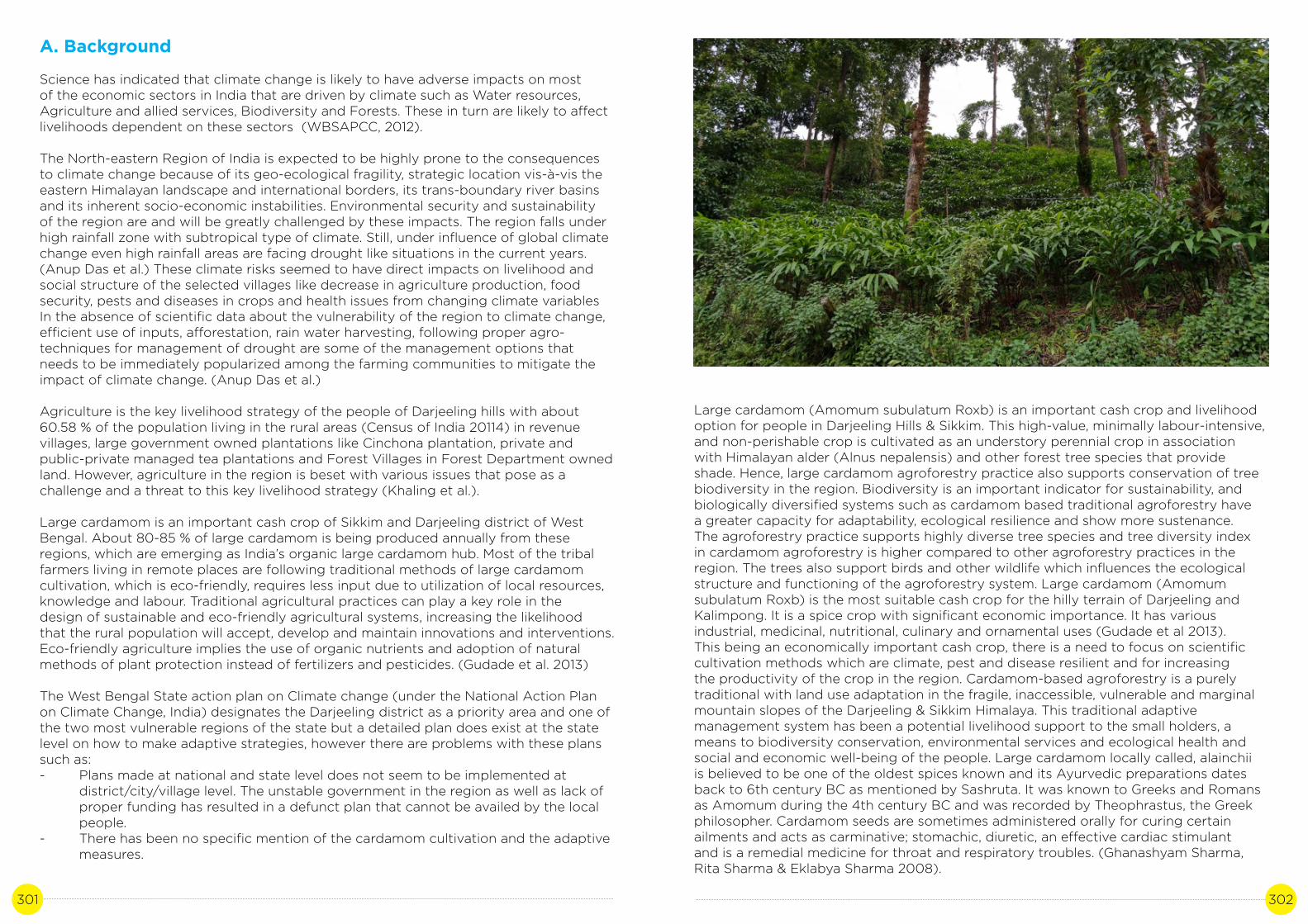
301 302
A. Background
Science has indicated that climate change is likely to have adverse impacts on most of the economic sectors in India that are driven by climate such as Water resources, Agriculture and allied services, Biodiversity and Forests. These in turn are likely to affect livelihoods dependent on these sectors (WBSAPCC, 2012).
The North-eastern Region of India is expected to be highly prone to the consequences to climate change because of its geo-ecological fragility, strategic location vis-à-vis the eastern Himalayan landscape and international borders, its trans-boundary river basins and its inherent socio-economic instabilities. Environmental security and sustainability of the region are and will be greatly challenged by these impacts. The region falls under high rainfall zone with subtropical type of climate. Still, under influence of global climate change even high rainfall areas are facing drought like situations in the current years. (Anup Das et al.) These climate risks seemed to have direct impacts on livelihood and social structure of the selected villages like decrease in agriculture production, food security, pests and diseases in crops and health issues from changing climate variablesIn the absence of scientific data about the vulnerability of the region to climate change, efficient use of inputs, afforestation, rain water harvesting, following proper agro-techniques for management of drought are some of the management options that needs to be immediately popularized among the farming communities to mitigate the impact of climate change. (Anup Das et al.)
Agriculture is the key livelihood strategy of the people of Darjeeling hills with about60.58 % of the population living in the rural areas (Census of India 20114) in revenue villages, large government owned plantations like Cinchona plantation, private and public-private managed tea plantations and Forest Villages in Forest Department owned land. However, agriculture in the region is beset with various issues that pose as a challenge and a threat to this key livelihood strategy (Khaling et al.).
Large cardamom is an important cash crop of Sikkim and Darjeeling district of West Bengal. About 80-85 % of large cardamom is being produced annually from these regions, which are emerging as India’s organic large cardamom hub. Most of the tribal farmers living in remote places are following traditional methods of large cardamom cultivation, which is eco-friendly, requires less input due to utilization of local resources, knowledge and labour. Traditional agricultural practices can play a key role in the design of sustainable and eco-friendly agricultural systems, increasing the likelihood that the rural population will accept, develop and maintain innovations and interventions.Eco-friendly agriculture implies the use of organic nutrients and adoption of natural methods of plant protection instead of fertilizers and pesticides. (Gudade et al. 2013)
The West Bengal State action plan on Climate change (under the National Action Plan on Climate Change, India) designates the Darjeeling district as a priority area and one of the two most vulnerable regions of the state but a detailed plan does exist at the state level on how to make adaptive strategies, however there are problems with these plans such as:- Plans made at national and state level does not seem to be implemented at district/city/village level. The unstable government in the region as well as lack of proper funding has resulted in a defunct plan that cannot be availed by the local people.- There has been no specific mention of the cardamom cultivation and the adaptive measures.
Large cardamom (Amomum subulatum Roxb) is an important cash crop and livelihood option for people in Darjeeling Hills & Sikkim. This high-value, minimally labour-intensive, and non-perishable crop is cultivated as an understory perennial crop in association with Himalayan alder (Alnus nepalensis) and other forest tree species that provide shade. Hence, large cardamom agroforestry practice also supports conservation of tree biodiversity in the region. Biodiversity is an important indicator for sustainability, and biologically diversified systems such as cardamom based traditional agroforestry have a greater capacity for adaptability, ecological resilience and show more sustenance. The agroforestry practice supports highly diverse tree species and tree diversity index in cardamom agroforestry is higher compared to other agroforestry practices in the region. The trees also support birds and other wildlife which influences the ecological structure and functioning of the agroforestry system. Large cardamom (Amomum subulatum Roxb) is the most suitable cash crop for the hilly terrain of Darjeeling and Kalimpong. It is a spice crop with significant economic importance. It has various industrial, medicinal, nutritional, culinary and ornamental uses (Gudade et al 2013). This being an economically important cash crop, there is a need to focus on scientific cultivation methods which are climate, pest and disease resilient and for increasing the productivity of the crop in the region. Cardamom-based agroforestry is a purely traditional with land use adaptation in the fragile, inaccessible, vulnerable and marginal mountain slopes of the Darjeeling & Sikkim Himalaya. This traditional adaptive management system has been a potential livelihood support to the small holders, a means to biodiversity conservation, environmental services and ecological health and social and economic well-being of the people. Large cardamom locally called, alainchii is believed to be one of the oldest spices known and its Ayurvedic preparations dates back to 6th century BC as mentioned by Sashruta. It was known to Greeks and Romans as Amomum during the 4th century BC and was recorded by Theophrastus, the Greek philosopher. Cardamom seeds are sometimes administered orally for curing certain ailments and acts as carminative; stomachic, diuretic, an effective cardiac stimulant and is a remedial medicine for throat and respiratory troubles. (Ghanashyam Sharma, Rita Sharma & Eklabya Sharma 2008).

303 304
A large section of farmers in the 7 target villages are engaged in large cardamom cultivation. For last 60 years cardamom has been the most crucial cash crop to these stakeholders. However, in recent times there has been a steep decline in the production of large cardamom. As per the local respondents the decline in the production of cardamom has drastically affected the livelihood of a large section of the study area.
B. Literature review
Climate Change Impacts and Vulnerability in the Eastern Himalayas
Little is known in detail about the vulnerability of mountain ecosystems to climate change. Intuitively it seems plausible that these regions, where small changes in temperature can turn ice and snow to water, and where extreme slopes lead to rapid changes in climatic zones over small distances, will show marked impacts in terms of biodiversity, water availability, agriculture, and hazards that will have an impact on general human well-being.
The Eastern Himalayas extends from the Kaligandaki Valley in central Nepal to north-west Yunnan in China encompassing Bhutan, the North East Indian states and North Bengal Region of WB in India, southeast Tibet and parts of Yunnan in China, and northern Myanmar – a total area of nearly 525,000 sq.km. The region’s complex topography and extreme altitudinal gradients – from less than 300 m (tropical lowlands) to more than 8000 m (high mountains) over a few hundred kilometres – have contributed to the highly varied vegetation patterns. The complex mountain topography has created diverse bioclimatic zones (near tropical, subtropical, lower temperate, upper temperate, subalpine evergreen, alpine evergreen, and alpine shrubs and meadows) and ‘island-like’ conditions for many species and populations, making them reproductively isolated. This isolation has given rise to genetic differences among populations, thereby contributing to the exceptionally rich array of biodiversity.
In the Eastern Himalayas, a substantial proportion of the annual precipitation falls as snow. Climate controls river flow and glacier mass balance and varies considerably from west to east. The monsoon from the Bay of Bengal, which develops over the Indian subcontinent, produces heavy precipitation – predominantly in the southeast. With rising temperatures, areas covered by permafrost and glaciers are decreasing in the region. In many areas a greater proportion of total precipitation appears to be falling as rain than before. As a result, snow melt begins earlier and winter is shorter. This affects river regimes, natural hazards, water supplies, people’s livelihoods, and overall human well-being (ICIMOD 2010).
Eco-friendly practices of large cardamom (Amomum subulatum Roxb.) cultivation in Sikkim and Darjeeling region
Green revolution technologies have more than doubled the yield potential of agriculture product. Those high input production systems requiring massive qualities of fertilizers, pesticides, irrigation and machines, however, disregard the ecological integrity of land, forests and water resources, endanger the flora and fauna and cannot be sustained over generations. In this context, eco-friendly methods are being considered as environmentally safe, selective, biodegradable, economical and renewable for use in organic farming system (Manimozhi and Gayathri, 2012). Large cardamom (Amomumsubulatum Rox-burg) belongs to the family Zinglberaceae under the order Scitaminae is an important spice crop in India. It is indigenous to moist and semi evergreen forests of Sikkim, the
Darjeeling hills and to some extent in North Eastern states like Arunachal Pradesh, Nagaland, Mizoram, Manipur, Meghalaya and Assam. Nepal and Bhutan are the other two Himalayan Countries where large cardamom is cultivated. It grows wild in forest ecosystem and is also domesticated in the sub-Himalayan region, at altitudes ranging from 1000 to 2200 m above mean sea level (Rao et a1.,7993). It is a shade loving plant (sciophyte) grown in tracts with well distributed rainfall spread around 200 days with a total of 3000-3500 mm/year. Its local names are bada elaichi in Hindi and alainchi in Nepali. Sikkim is the largest producer of large cardamom and constitute lion share of Indian and World market. The Lepchas were believed to be the first to collect large cardamom capsules from natural forests primarily for the purpose of medicine and as an aromatic edible wild fruit (Sharma et a1., 2000; Sharma et a1., 2009). With the time those large cardamom forests eventually converted into ownership and the crop was domesticated in the process. Large cardamom is used for various food preparations, in confectionaries, making perfumes and medicines. The seed contains 3% essential oil rich in cineole which is used as flavoring agent and spice. It is a perennial herb and is grown under mixed forest tree in Eastern Himalayas (B.A. Gudade et al, 2013).
Area and production
Total area of Sikkim and Darjeeling Hills of West Bengal under large cardamom cultivation as recorded in 2011-12 was 26,459 ha of which 23754 ha was recorded from Sikkim and 3305 ha from Darjeeling Hills of West Bengal. Total production of large cardamom from Sikkim and Darjeeling hills of West Bengal in 2011-12 was recorded to be 3863 MT. Large cardamom production was highest in Sikkim (3237 MT) followed by Darjeeling (626 MT) (Spices Board, 2012;B.A. Gudade et al, 2013).
C. Study site
Case study site in Darjeeling

305 306
Case study sites in Kalimpong Himalaya
Case study sites in Kalimpong Himalaya
These areas have been experiencing the impact of climate change on agricultural production and extreme events like landslides, seasonal drought, pest and disease. Changes in micro-climate are one of the factors for depletion in the production. Pressure from present day market to earn more cash has brought changes in land use pattern in the study area, resulting to number of environmental issues like water scarcity, soil erosion and decline in agriculture production.
More than 40% of the area is under forest. 4.56% of the population lives in forest villages and forest fringe areas. More than 20% of the area is under plantations and 41.45% of the population are plantation workers, tea with 35.78% and cinchona with 5.67%. The plantations are in the two sub-divisions of Kurseong and Darjeeling only as Kalimpong already had agricultural holdings and reserve forests when the plantations were introduced to the hills by the British. Approximately 20% of the population of a plantation are employed on a permanent basis. Of it, 89% work as daily rate wage earners and 50% of them are women. (Plantation Workers in WB, Labour Gazette 1994). The remaining population is employed as casual labourers whenever required. Tea forms one of the most important industries in the region providing employment directly and indirectly to about 50% of the population of the district. 23.12% of the population in the urban areas is engaged in the service sector. A sizeable portion of this population depends on tourism. Darjeeling is rich in its biodiversity due to various factors such as physiographic, edaphic, climatic, and biotic and also due to its altitude. There are a number of nature parks and reserves which inhabitats the Red Panda, the Himalayan Salamander, the Himalayan Pheasant and Rhododendron to name a few. (Census 2011)
D. Methodology
The paper extensively reviewed secondary literature on climate change, Large cardamom and other relevant issues from the study sites. A workshop with stakeholders and key informants was also facilitated to give direction to the study. The selection of the respondents was based on their dependence on the Large Cardamom cultivation. Subject experts were interviewed that gave insights into issue of Large cardamom cultivation and climate change as well as identify study sites that will be representative of adaptations/good practices to climate change in context to Large cardamom cultivation. Once the study sites were identified a combination of 14 semi-structured interviews with the community members of all the study sites viz.Todey, Tangta, Pala, Godak, Gitbeong, Pakang and Mineral spring were conducted. 2 focus group discussions with the representatives of Mineral Spring and Pakang, and transect walks were undertaken. A core group of members of the Darjeeling Himalaya Initiative brainstormed the processes and development of the study as well as analysing the data emerging from the study.
E. Analysis and Discussion
Ecological and Economic importance
The economy of the people living in the kalimpong and Darjeeling Himalaya is largely based on the Cardamom a high value cash crop. Their daily life in terms of food, education, health, etc is basically based on the income earned from Cardamom. Recent decline in cardamom production has highly affected the local economy. According to the study by Angom Ingocha Singh et.al 2013 the income per 1kg was around US$ 12.16 in the year
The study area is located in the Gram Panchayats of Todey-Tangta, Gitdubling, Lava-Git- beong and Nim within the jurisdiction of Kalimpong district and in the village of Mineral Spring (Dabai Pani) in the District of Darjeeling with sample study in 7 villages.

307 308
2013 but the recent value per 1 kg is around US$ 6.98 to 8.37. According to the local respondents the income from cardamom contributes approx. 50% to 80% of the total household income in the study sites.
The large cardamom is a perennial cash crop grown traditionally beneath the natural forest tree cover on marginal lands and slopes. It is a shade loving plant and requires high moisture and is usually cultivated in areas where mean annual rainfall varies between 1500-3500 mm. Some common shade trees for the agroforestry are Schima wallichii, Engelhardtia acerifolia, Eurya acuminata, Leucosceptrum canum, Maesa chisia, Symplocos theifolia, Ficus nemoralis, Ficus hookeri, Nyssa sessiliflora, Osbeckia paniculata, Viburnum cordifolium, Litsaea polyantha, Macaranga pustulata, and Alnus nepalensis. Hence, large cardamom agroforestry practice also supports conservation of tree biodiversity in the region (Sharma et al. 1994).
Majority of cardamom plantations have Himalayan alder (Alnus nepalensis) as shade trees since the combination of Alnus and cardamom is sympatric and has proved to be ecologically and economically viable (Sharma et al. 2007).
Large cardamom-based agroforestry systems in the Eastern Himalayan region is a multifunctional system predominantly managed by the smallholders as their adaptive traditional practice since time immemorial. Due to its ecological resilience, social acceptability and mountain specific niche cardamom has been described as high value, low volume and nonperishable cash crop. In addition, it is less labour intensive and non-nutrient exhaustive system compared to other systems (Sharma et al 2008).
Traditional agroforestry systems in the mountains are very close to natural ecosystems and they provide similar ecosystem services. These systems with a combination of forestry and agricultural components are excellent practices through which environmental services are obtained in a sustained manner for both upland communities and downstream users. Natural nutrient cycling and maintenance of soil fertility, seral growth of forestry component and related carbon sequestration, improved water quality for downstream users, and biodiversity conservation are examples of the regulating functions of traditional agroforestry systems. (Sharma 2006; ICIMOD)
During the last 5-6 decades, a large area of agricultural lands was converted to Al-nus-cardamom agroforestry using monocultures of N2-fixing Alnus nepalensis as shade tree (Sharma et al 2008). The presence of N2-Fixing species in Alnus-Cardamom Stands has helped in maintaining the soil organic levels (Sharma et al 1996). According to the study conducted by Sharma et al 1996 the presence of Organic carbon was seen at a significant level in both the forest-based cardamom stand and Alnus-Cardamom stands. The large cardamom-based agroforestry system is observed to accelerate the nutrient cycling, increases the soil fertility and productivity, reduces soil erosion, conserves biodiversity, conserves water and soil, serves as carbon sink, improves the living standards of the communities by increasing the farm incomes and also provides aesthetic values for the mountain societies. The cardamom agroforestry stores 3.5 times more carbon than the rainfed agriculture showing potential mitigation possibilities of the agro-forestry by sequestration of the atmospheric carbon. The cardamom agroforestry is an efficient management system where ratio of output to input is more than 13% compared to rainfed agriculture. Cost benefit analysis showed that the cardamom agroforestry is profiting the farmers by 5.7 times more compared to the rainfed agriculture. This agro-forestry system is a unique example of the ecological sustenance and economic viability for the mountain peoples while providing goods and services to the downstream users. In the large-scale land use change role of the cardamom
agroforestry seems quite promising for ecological and economic sustainability. It has a very high rate of returns in terms of money spent in the cultivation (Sharma et al. 2007, ICIMOD)
From late 90s the traditional forest-based cardamom cultivation system was destroyed by the disease Colletotrichum gloeosporioides, as a result most of the traditional varitieslike Ramsai, Sawney, Bharlang Ramla Ramnang Golsai, Seremna almost got extinct. In between the years 1998-2005 average yearly production of large cardamom was negative approximately 70% decline in production was observed.
Two main viral diseases namely chirke and foorkey affected the productivity of different large cardamom cultivars in Darjeeling Hills of West Bengal and Sikkim. Chirke is characterized by mosaic with pale streak on the leaves. The streaks turn pale brown resulting in drying, withering of leaves and finally death of the plants. The flowering in diseased plants is extensively reduced. The chirke disease is transmitted by mechanical sap inoculation and also by aphid, Ropalosiphum maidis Fitch. Excessive sprouting and formation of bushy dwarf clumps at the base of the mother plants that gradually die, characterize the foorkey disease. Numerous small tillers also appear at the base of the affected plants that become stunted and fail to give any yield. The spread of the disease from one area to another is primarily through infected rhizomes and further spread within the plantation by aphids, Micromyzus kalimpongensis. For the management of viral diseases of large cardamom, resistant varieties are essential. However, resistant varieties to chirke and foorkey are not available. This is the other direct factor for evaluation of level of resistance in the genotypes of large cardamom is prerequisite for developing resistant varieties to chirke and foorkey (Vijayan AK, Gudade BA, Deka TN and Chhetri P. 2014). Subsequently, there was a paradigm-shift in cultivation system. The Cardamom cultivators have adopted different measures based on their experiences and study during all these years of cultivating Cardamom to cope with the effects of ever-changing as before it was cultivated in the forest as an understory crop in the shady area which was later shifted to home steads and open spaces. People adapted different strategies to intensify the production by using farmyard manure and pipe irrigation during dry season which was not necessary in the traditional system of cultivation. The infected plants are cut down and uprooted and left to dry before burning. This method has helped to a certain extent in controlling the pest and disease infestation. As there has been a change in the cultivation pattern, integrated farming system has been adopted where people cultivate the cardamom in the farmyards along with the vegetables and other food and cash crops.
Forkey Infected Cardamom plant which has been cut down and will be uprooted and burnt

309 310
Chirkey infected Cardamom plant
Sustaining the cultivation of Cardamom is important because firstly, it’s the major source of income of the people of the region as the income generated by selling the produce plays an important role in sustaining families and in education of their children. As it is the major source of income for the people living in the hill districts of Kalimpong and Darjeeling and there has not been any climate change adaptive strategy put forward by the government in the state action plans, it’s the need of the hour that the government must intervene through various agricultural schemes. More research work has to be initiated for finding a scientific and sustainable solution to combat the effects of climate change, disease and pest in the plantation.
References
The study on ecofriendly practices of large cardamom (Amomum subulatum Roxb.)cultivation in Sikkim and Darjeeling region (B.A. Gudade”, P. Chhetri, U. Gupta, N.K. Bhattrai, T.N. Deka and A. K. Vijayan)
Climate change in northeast india: recent facts and events –worry for agricultural management (Anup Das , P.K. Ghosh, B.U. Choudhury, D.P. Patel, G.C. Munda, S.V. Ngachan and Pulakabha Chowdhury)
Ghanashyam Sharma, Rita Sharma & Eklabya Sharma 2008 Traditional knowledge systems in large cardamom farming: biophysical and management diversity in In dian mountainous regions
AK Vijayan, BA Gudade, TN Deka and P Chhetri. Status of Viral Diseases of Large Cardamom (Amomum subulatum Roxb.) and its Management in Sikkim and Darjeeling, West Bengal
Sharma, E; Chettri, N; Tse-ring, K; Shrestha, AB; Fang Jing; Mool, P; Eriksson, M (2009)
Source: Cardamoms: Estimate by Spices Board
Climate change impacts and vulnerability in the Eastern Himalayas. Kathmandu: ICIMOD Khaling. S, Lepcha.C and Rai.R; Agriculture in the Darjeeling Hills: uncertainties, potentials and adaptations Tse-ring K; Sharma, E; Chettri, N; Shrestha, A (eds) (2010) Climate change vulnerability of mountain ecosystems in the Eastern Himalayas; Climate change impact an vulnerability in the Eastern Himalayas – Synthesis report. Kathmandu: ICIMOD 2010
Angom Ingocha Singh and Anand Kumar Pothula; Postharvest Processing of Large Cardamom in the Eastern Himalaya 2013; Mountain Research and Development Journal.
Ghanashyam Sharma, Rita Sharma & Eklabya Sharma (2008); Traditional knowledge systems in large cardamom farming: biophysical and management diversity in Indian mountainous regions
Sharma, R., E. Sharma & A.N. Purohit. 1997a. Cardamom, mandarin and nitrogen fixing trees in agroforestry systems in India’s Himalayan region. I. Litterfall and decomposition.
Sharma, R. 2006. Traditional agroforestry and a safer mountain habitat. Sustainable mountain development in the greater Himalayan region- A safer and just mountain habitat for all. International Center for Integrated Mountain Development NewsletterRita Sharma, Jianchu Xu & G. Sharma 2007.Traditional agroforestry in the eastern Himalayan region: Land management system supporting ecosystem servicesPlantation Workers in WB, Labour Gazette 1994
• Census 2011
Annexure
Table 1: Cardamon - Area and production
SPICE
CARDAMOM (Large)
State
Sikkim
West Bengal (Darjeeling hills)
Area (ha)
23082
3305
Area (ha)
23082
3305
Area (ha)
23082
3305
Production (MT)
4465
850
Production (MT)
4465
850
Production (MT)
4465
850
2015-16 2016-17 2017-18 est

311 312
Table 2: Comparison of Economical benefit (based on local perception and knowledge)
Cash crop
Ginger
Large Cardamom
Seedling/sapling
per unit cost
Rs.60/kg
Rs.5/ sapling
Plantation per 1-acre
land
5 Quintals
4000 saplings*
Total expenditure (per year)
• Seedling cost - Rs.30,000
• Labour cost - Rs.15,000 (50 labours cost
@Rs.300/person)
• Manuring cost - Rs. 10,000Total - Rs.55,000
• Sapling cost - Rs.20,000
• Labour cost - Rs.9,000
(30 labours [email protected]/person)
• Manuring Cost - Rs.16,000
• Cost of fire wood for drying -
Rs.21,000Total - Rs.66,000
Final production (might vary from
time to time)
22 Quintals
3 quintals
Cash earned (value based on present market
price- it may vary from time to time)
50 per kg*2200kg=1.10
lacs
550 per kg*300= 1.65 lacs
Net profit
Rs.55,000
Rs.99,000
Source: Field interview and Key respondents
Questionnaire transcript (based on field interview)
- Have you noticed any changes in the climate recently? What are the changes according to you?- Has it affected the production of cardamom? If yes, what measures have you taken?- What kind of pest and disease that has affected the plantation and how do you manage it?- What is the major cash crop that you cultivate other than cardamom?- For how many years have been cultivating cardamom?- How beneficial is the cardamom cultivation? (economic, environmental)
Annexure – case summary
Activity: cardamom agroforesrtyState: Darjeeling and Kalimpong Hills
Scale of operation of activity in the State – population: 150
Case summary
- Large cardamom (Amomum subulatum Roxb) is the most suitable cash crop for the hilly terrain of Darjeeling and Kalimpong with significant economic importance. Cardamom-based agroforestry in Darjeeling & Sikkim Himalaya is a purely traditional adaptive management system which has been a potential live lihood support to the small holders, a means to biodiversity conservation, environmental services and ecological health & socio-economic well-being of the people. But in recent times, change in climatic conditions has drastically affected the activity resulting in low productivity & increased pest and pathogen profile. In this study, I have tried to analyse the effects of climate change & possible adaptive measures to be taken in order to sustain the activity.
Activities
- Interviews of the farmers- Interviews of agricultural officers and experts- Literature review
Institutions/Stakeholders involved:
- Gram Panchayat officials- Farmers- Key respondents
Impact of activities
- Conservation of bio-diversity,- Accelerated nutrient cycling, - Increased soil fertility and productivity,- Reduced soil erosion, - Conservation of water and soil, and - Carbon sequestration.
Why is it a good practice?
- The cardamom-based agroforestry system helps in maintaining the ecological balance by conserving biodiversity, nutrient cycling, reduction of soil erosion, and in carbon sequestration. Secondly, cardamom agroforestry is profiting the farmers by 5.7 times more compared to the rainfed agriculture, therefore, it’s a major agro-based livelihood activity of the region.
How to replicate this practice?
- There is already an existing cultivation pattern which can be learned and implemented by the people who have not yet been practicing this activity. Resources:
- Papers published by IAR kalimpong, Cardamom research institute-Sikkim, ICIMOD, WBSAPCC, Individual reasearchers,NGO.

313 314
THE CASE OF SAMAJ STEWARDSHIP IN MANAGING SPRINGS IN THE DARJEELING AND KALIMPONG HIMALAYA.
CASE STUDY 16
Author: Maurice RaiContributors: Deependra Sunar, Roshan Rai

315 316
A. Background
Mountains support 25% of world’s terrestrial biodiversity and include nearly half of the world’s biodiversity hotspots (ICIMOD 2019). Mountains are home to some 915 million people, representing 13% of global population and provide between 60 and 80% of the earth’s fresh water (FAO 2015). The Indian Himalayan Region (IHR) with a population of around 46961740. It has a geographical coverage of over 5.3 lakh square kilometre and extends over 2500 km in length between the Indus, Ganga and the Brahmaputra river systems (ENVIS and 2011 census).
Located in the north-eastern part of the IHR are the Darjeeling and Kalimpong Districts occupying 3.68 % of the total area of West Bengal (Pradhan and Bhujel, 2000). Darjeeling and Kalimpong Himalaya is part of a transboundary landscape adjoining Nepal in the west, Bhutan in the east, Sikkim in the north. As part of the Eastern Himalaya included among Earth’s biodiversity hotspots (Myers et al. 2000) the Darjeeling and Kalimpong Himalaya is of critical ecological importance.
The moisture-laden monsoon winds bring a deluge of rains in the eastern extent of the mountain range, which bears the brunt of the wind resulting it to be more biodiverse. (WWF and ICIMOD 2001). Darjeeling and Kalimpong Himalaya receive a high amount of rainfall, primarily during the monsoon months and range from annual averages of 4000 - 5000 mm in the southern slopes to 2000-2500 mm in the leeward side. This rainfall pattern coupled with a high forest cover 38.23% of the total district land area (State of Forest report 2010-11) makes water stress right across the landscape an ironical phenomenon. To make explicit the stress, the per day urban water deficits are 13,32,500 gallons in Darjeeling; 5,02,750 gallons in Kurseong town and 3,00,000 gallons in Kalimpong (2012 Municipality Reports).
Mountain springs as being the primary source of water for rural households in the Himalayan region has been highlighted by the NITI Aayog Report 2018. There are five million springs across India, out of which nearly 3 million are in the Indian Himalayan Region alone. Despite the key role that they play, springs have not received their due attention and many are drying up. Spring discharge is reported to be declining due to increased water demand with rising population, land use change, and ecological degradation. With climate change and rising temperatures, rise in rainfall intensity and reduction in its temporal spread and a marked decline in winter rain; the problem of dying springs is being increasingly felt across the Indian Himalayan Region. Besides, water quality is also deteriorating under changing land use and improper sanitation (NITI Aayog, 2018). With the NITI Aayog report focusing only on springs there has been an increased recognition of springs which has brought about a much-needed mountain lens in the water security discourse. This now needs to expand to include urban springs dotting the Darjeeling and Kalimpong Himalaya. This study explores these urban springs and makes a case for their greater recognition especially with the stressors of climate change such as increase in intensity of rainfall which will make retaining water for groundwater recharge a huge challenge (Chapter 5, Page 63, WBSAPCC).
These urban springs provide water security to a large population who are invariably not well connected to the centralised municipality water systems and remain invisible to the local and national policies. Besides climate change and a lack of policy support, these urban springs are threatened by unplanned built environment, contamination, mass tourism and rapid population rise. To further elucidate the point, Darjeeling Municipality population has grown rapidly from 16,924 in 1901 to 120,414 in 2011 (Census) within a limited area that was planned at the pre-independence era for a population of 30000.
However, in the face of all these changes, there are cases of urban springs beingmanaged through community stewardship which has emerged as good practices as part of this study and is discussed in this paper. The study also highlights a successful spring shed intervention in Lanku, rural Darjeeling, that shows the potential and need for spring shed conservation and management.
B. Literature review
Observed changes in climate as they relate to water
Climate warming observed over the past several decades are consistently associated with changes in a number of components of the hydrological cycle and hydrological systems such as: changing precipitation patterns, intensity and extremes; widespread melting of snow and ice; increasing atmospheric water vapour; increasing evaporation; and changes in soil moisture and runoff. (Climate Change and Water, IPCC technical Paper VI-June 2008) Climate change affects groundwater recharge rates (i.e., the renewable groundwater resources) and depths of groundwater tables. Groundwaters are recharged from surface water (Climate Change and Water, IPCC technical Paper VI-June 2008) and springs have been particularly affected by the depletion of shallow water table because of reduced infiltration due to crust formation and by increased intensity of rainfall (The Hindukush Himalaya Assessment, ICIMOD,2019). Springs or Dhara(s) are the points in which groundwater come into contact with the surface. (Water Security in the Darjeeling Himalaya, unravelling the seen and unseen forces, September 2016) Erratic rainfall, seismic activity and ecological degradation associated with land use change for infrastructural development are impacting mountain aquifer systems. (Report of Working Group I Inventory and Revival of Springs in the Himalayas for Water Security. NITI Aayog, 2018)
Water Crisis in Darjeeling
The water supply system of Darjeeling municipality comes from the catchment area of the Senchel Wildlife Sanctuary, located about 15 km away from the main town. A rapid rise of the population and a huge tourist influx puts tremendous stress on the water supply, especially for drinking water, from December to May. Dependence on the two lakes, coupled with poor management, have made the water situation vulnerable toall kinds of disputes and conflicts. It is estimated that the water deficit in Darjeeling is almost 1.33 million gallons/day (Chokho Pani: An Interface between Religion and Environment in Darjeeling Case Study, December 2016).
Darjeeling Himalaya defined by the monsoon and a water rich land yet with ‘water crisis’ needs to be deconstructed at various levels to get a finer nuanced understanding of the crisis. (Water Security in the Darjeeling Himalaya, unravelling the seen and unseen forces, September 2012)
Although India has sizeable water resources, the country faces huge challenges in the water sector as the distribution of water varies widely by season and region. Pressure on and competition around water resources are increasing not least due to climate change. Such increasing competition can lead to crisis and conflict potential, especially if it leads to unequal water access and availability and combines with other conflict factors, such as marginalisation or past conflicts. The water supply is put under further stress by the increased pollution of existing finite water resources, which not only restricts potential uses of available water but also threatens future use. (Water, Crisis and Climate Change in India: A Policy Brief, October 2011)

317 318
The most visible water systems in the Darjeeling Himalaya are the innumerable streamsand rivers that flow through the landscape, most of which are perennial, finding theirorigins in glaciers or snowmelt and groundwater recharged by rainfall (Water Security in the Darjeeling Himalaya, unravelling the seen and unseen forces, September 2012). However, within the Darjeeling Municipality context, it is evident that a large percentage of people are not connected to the municipality water grid and depend on local springspartially or completely for their water requirements. It is fascinating how an age-old local self-governance institution, Darjeeling Municipality, does not include these urban springs in the water discourse and policy. (Water Security in the Darjeeling Himalaya, unravelling the seen and unseen forces, September 2016).
Samaj: A Community Institution
The samaj has a long historical context. Established in 1932 in Darjeeling, the Gorkha Dukha Niwarak Sammelan (Gorkha Suffering Management Association, GDNS) wasthe original model of the institutionalized samaj. The community came together to assist people in times of need and provide social support and community sanctions to marriages, births and deaths. (Pradhan 2012).
The samaj also throw light on the fragile interplay and complex interconnections between everyday religion and environmental sustainability in the Himalaya.These samaj have evolved based on the needs of the new environmental situation, where different religious groups, ethnicities, and castes live in relative harmony andhave broken barriers and restrictions by reworking traditions. (Chokho Pani: An Interface Between Religion and Environment in Darjeeling Case Study, December 2016).
Local institutions (both formal and informal) play a pivotal role in building resilience and reducing vulnerability to climate change. This is through the range of indispensable functions they perform, including provision of physical infrastructure and services, disaster response planning, regulation of property rights, information dissemination, coordination with decision-makers at other levels, and organizing social action(The Role of Local Institutions in Adaptation to Climate Change, June 2009).
C. Study Site
Dharas/Springs studied in Darjeeling
Dharas/Springs studied in Kalimpong
The study follows the cases of the urban springs in Darjeeling and Kalimpong as well as a successful spring shed conservation at Lanku in a rural setting.
Darjeeling Municipality was established in 1850 and is one of the oldest municipalitiesin India and is touted as one of the oldest municipalities in India. The municipality in 2011 had a population of 120000 living in 13.81 km2. It is located at an average elevation of 6,982 ft (2,128 m).
The water supply system of Darjeeling town consists of tapping of 26 springs from the Senchal Wildlife Sanctuary located about 15 km away from the main town into two reservoirs, from where it is distributed by gravity through a combination of pipes and tanks across the town. Darjeeling is synonymous with ‘water crisis’, but the stories ofa large portion of the community who depend on myriad springs dotting the town are usually never discussed or entertained. After the study that highlighted the 32 urban springs (Boer, 2011) that were accessed and managed by communities a more in-depth study of the springs of Darjeeling Municipality now accounts for 90 springs (Lakpa Tamang 2016).
Kalimpong is the district headquarter with a population size of 49,403 (Census 2011) and spread over 23 wards in 3.5 km2. The town centre is located on a ridge connecting two hills, Delo and Durpin at an elevation of 1247m and 1704m. The River Teesta flows in the valley below separating Kalimpong from the state of Sikkim. The town is a major hub for the agricultural communities of the sub-division and used to be the gateway to Tibet.
A report by Kalimpong Sangrachan Samity and Gorkha Dukha Niwarak Samelan, 2012 states that water has been supplied to Kalimpong through a system from the British times. The inadequacy of water supply necessitated the Neora Khola water project. ‘Kalimpong requires about 10 lakh gallons of water every day and half of the need is met by the Neora Khola scheme.’ (The Telegraph 29 September 2015). This situation means that the town has a water deficit of 3,00,000 gallons per day and similar to Darjeeling does not account for the urban springs of Kalimpong.
Upper Lanku village, located under Gram Panchayat Unit Sittong III of Kurseong Block District Darjeeling lying between Latitude 26*57’01.6”, Longitude 088*25’09.1”,Altitude - 727.5 mts above sea level. The village lies close to the NH31A above the River Teesta and the forests surrounding the village are under Kurseong Forest Division and are contiguous with Mahananda Wildlife Sanctuary. Upper Lanku has a population of around 450. Agriculture is the main source of livelihood for most of the village, with a small population engaged as labourers and in Government service as well. Erratic rainfall pattern, no irrigation facility and drying up of natural springs have perilous effect on socio-economic life status of Lanku Valley.
The community of Upper Lanku depends on three springs, Saroj Dhara, Birsing and Gokul Dhara for their water. Community narratives talk about how all three springs in the village have shown a declining trend in its discharge over the past 10 – 15 years during the winter months of November – March during which time the villagers face serious of water scarcity. WWF-India and Lanku Valley Biodiversity Conservation Committee worked together to increase the discharge of two springs through groundwater recharge by reducing surface runoff thereby resulting in overall landscape level improvement in water availability in the springs as well as streams in lean seasons.

319 320
Map of Darjeeling and Kalimpong Himalaya
D. Methodology
This study extensively reviewed secondary literature on water, climate change and other relevant issues from the study sites. A workshop with stakeholders and key informants was also facilitated to give direction to the study. Subject experts were interviewed that gave insights into issue of water and climate change as well as identify study sites that will be representative of adaptations/good practices to climate change in context of water resources.
Urban springs of Darjeeling and Kalimpong municipalities were chosen to study community practices to cope with changing water availability. Lessons from studies conducted earlier was also referenced. Careful consideration was taken to ensure geographical representation within the municipal landscape while studying the springs. Lanku, a rural site, was chosen as it was one of the key successes in springshed management in the Darjeeling and Kalimpong Himalaya.
Once the study sites were identified a combination of 16 semi-structured interviews with the community members of all the Dharas/Springs studied viz. Lal Dhiki, Muldara, Giri Dhara, Jowar Busty, Mangalpuri in Darjeeling and Park dhara, Jhor Dhara, Subhe darney Dhara, Hart Spring, Raja Dhara, and Pari Dhara were conducted.
Two focus group discussions with the representatives of Jhor Busty Samaj, Raja dhara samaj and transect walks were undertaken. The semi-structured interviewee selection factored in diversity of people accessing the spring water. Water flows, discharge rates of 9 key springs were also documented. A core group of members of the Darjeeling Himalaya Initiative brainstormed the processes and development of the study as well as analysing the data emerging from the study.
E. Analysis
Of the 14 springs that were surveyed as part of this study across Darjeeling and Kalimpong Himalaya, 7 were in private landholding, while the rest were located in Government owned land, mainly that of Forest Department. However irrespective of land ownership, all springs are managed to a large extent by the community in many cases the local Samaj, mainly from a distribution and access point of view. The management of the spring discharge, Laldhiki, Mangalpuri, Muldara, Jowahar Busty and Giri Dhara, studied in Darjeeling Municipality shows the stewardship and the diversity and management systems adopted by the samaj, in managing access and distribution.
In the face of climate change and the overreaching implications it has on springs and water flow, these community-based management interventions are examples of good practices. However, these decentralized systems of management most often go unrecognized in the larger discussion spaces around water, and there is an urgent need to document, further strengthen and include them in the water discourse.
Climate Impacts on springs
Impact of climate change on spring flow leading to decline in discharge is now an irrefutable fact. The survey conducted as part of this study corroborates this, and across the study sites, all springs were reported by the community user groups as showing a declining trend. The percentage of decline ranged from 20 to as high as 80%. The rate of decline also varied from season to season, with many springs becoming very dry during the lean months from February to April.
However, the decline in spring flow cannot also be attributed entirely to climate change, as there are a host of other factors that have direct impact on springs. Development activities in the recharge areas, such as road construction and other built environment have also had enormous negative consequences on mountain springs which also needs to be factored in. A combination of these factors is what has led to an overall decline in most of the springs.
Muldhara samaj respondents, in the southeastern slope of Darjeeling below the iconic Chowrastha, shared that within the last twenty 20 years, the spring flow has reduced significantly. While the spring used to fill a four-inch pipe, it now barely fills a one–inch pipe. Before, residents could fill up a water container of ten10–fifteen 15 liters litres almost instantly. Now, it takes upto fifteen minutes to fill up their containers.
A quick analysis was also done to understand the water demand of 6 springs in Kalimpong and to match that with the water that was available from the spring flow. The water demand was calculated by the approximate population dependent on the springs and their daily requirement, while the availability was the amount of water that was flowing from the spring in 24 hours.

321 322
The blue bar shows the availability of water/day and the maroon bar shows the demand of water/day (source: Data collected from field visits)
As clearly seen, almost all the respondents surveyed showed disparity in the water that was available from the springs and the water that the households required for their daily needs. This does not take into account the piped water supplied by the PHE Department, which was in most cases reported to be negligible or the community did not have access to it.
Community responses about the factors that affect spring flow yielded interesting insights into their understanding of how springs work and how people associated with springs, and this necessarily was not linked to climate change or how they understood the nuances of climate change. One of the first references that people made when asked about their opinion on the reason for the decline was alluding to the religious connection and lack of cleanliness. People believed that disturbances in the spring site or increased pollution was the main reason for why the springs were declining.
Beyond this, communities also mentioned change in rainfall pattern, deforestation and excessive unplanned built environment as major factors for decrease in discharge of springs. Decreased winter rain and extreme heavy rainfall were mentioned repeatedly across all study sites. While communities understood the co-relation between rainfall and spring flow, as they had recorded the spring’s flow during the rainy months and lean seasons, geology of the area as important factor and the connections thereof were partially understood.
This decline in spring discharge made the people who were dependent on these springs for their daily requirement evolves many good practices that could be at an individual level as well as at the level of the community to cope with the situation.
Source: Data collected during field visits
Table: Details of springs from Darjeeling and Kalimpong (community perception)
No
1
2
3
4
5
6
7
8
9
10
11
12
13
14
Name of spring
Jore Dhara
Park Dhara
Subedarney Dhara
Raja Dhara
Pari Dhara
Hart Spring
Lal dhiki dhara
Mangal Puri
Giri Dhara
Mul Dara
Jowahar busty
Birsing Dhara
Gokul Dhara
Saroj Dhara
Location
Dungra Busty, Kalimpong
Ward no.19 Kalimpong
Damai Tar, Kalimpong
Bhutan house area, Kalimpong
Block C, Homes area, Kalimpong
Homes, Kalimpong
Lal dhiki, Darjeeling
Mangal Puri, Darjeeling
Below Darjeeling railway station, Darjeeling
Mul Dara, below Chowrasta, Darjeeling
Jowahar busty 2 Below tungsung, Darjeeling
Lanku Khasmahal, Sittong, Darjeeling
Lanku Khasmahal, Sittong, Darjeeling
Lanku Khasmahal, Sittong, Darjeeling
Ownership
Private Land
Govt
Private Land
Bhutan Govt
Private Land
Private Land
Govt Land
Govt Land
Govt Land
Govt land
Govt Land
Private Land
Private Land
Private Land
Possible recharge ownership
Undetermined
Different (Govt)
Different (Private)
Same
Same
Same
Different(Govt)
Different(Govt)
Different (Govt)
Different(Govt)
Different(Govt)
Large part Govt. some part Private
Large part Govt. some part Private
Large part Govt. some part Private
Households dependent (approx)
500HH
150 HH
80 HH
100 HH
80 HH
3000 population
25,000 population
200 HH
-
300 HH
300 HH
60 HH
70 HH
70 HH
Status
Decline in discharge
Decline in discharge
Decline in discharge
Decline in discharge
Decline in discharge
Decline in discharge
Decline in discharge
Decline in discharge,
Decline in discharge
Decline in discharge
Decline in discharge
Decline in discharge
Decline in discharge
Decline in discharge

323 324
At an individual household level, water use practices of people differed across the seasons and there were many interventions that households evolved to cope with the changing water situation. During the lean seasons’ households were engaged for longer periods of time in water related chores such as fetching drinking water for household consumption. The number of trips to be made for the purpose of fetching drinking water would be much more during the dry periods which would reduce during the rainy season. In many of the spring sites, community reported of 24 hours use of the spring sites with people lining up from early mornings for their turn. Individual curtailed use, reusing water multiple times were further coping mechanisms adopted.
Besides individual household level adaptation practices, this study along with other studies conducted earlier threw up some interesting insights at community coming together through traditional bodies called ‘Samaj’ who have included water management in terms of distribution and access.
Samaj are community-based organisations, across the Darjeeling and Kalimpong Himalaya, having mostly geographical entities and traditionally come together in times of need (births, sicknesses, marriages, deaths, disaster management, and minor conflict resolution). In water stressed areas of Darjeeling, some of these Samaj have included issues of water management as one of their important functions as a response to the need for addressing water security issues.
Mangalpuri samaj, on the southwest side of Darjeeling township, is a good example of samaj self-organisation in action over water management. Here the spring is located below the habitation, and a system of storing water and pumping it to a tank located above the village was set up by the samaj. The water stored in the tank is then distributed to all 200 or so households of the samaj on a rotational basis. The land where the tank is built was generously donated by a resident and all Samaj members make a monthly payment to support two people who are responsible for maintenance and distribution. This has resulted in an equitable system for the community of Mangalpuri.
Giri Dhara below the Darjeeling Railway Station in the south-west slope of Darjeeling shows varied access to the spring water discharge and evolving management norms. The distribution management Giri Dhara water is under Mahakal Samaj. Mahakal Samaj has constructed a reservoir, with open access to members as well as others for collection from the discharge point. Two families have direct piped connections from the reservoir to their houses and this connection was done at the time of building the reservoir after which the Mahakal Samaj has decided not to allow any direct connections.
An interesting case study also emerged in Kalimpong for Park Dhara on the water user group taking a stand for their water rights. Park Dhara supplied water to around 150 households in the locality, with most people coming to the spring site for doing their washing, and for fetching drinking water. The spring is also located right next to one of Kalimpong’s hotel, which began exploration for drilling of groundwater to extract it for the hotel’s commercial use. The drilling of groundwater near the spring would have long term consequences on the spring flow. When the community got aware of this they strongly opposed the drilling of groundwater and successfully managed to persuade the hotel to stop.
In contrast to the two Samaj of Darjeeling, springs in Kalimpong, in the absence of any community organisation had issues of inequitable water distribution. Water from the
springs were tapped using pipes by a select few households that were located down-stream of the spring site. This brought to light the issues of equity and access among the community, with some of them mentioning that it was the ‘privileged and wealthy lot that could have piped water access to their houses’. They also mentioned that more water being piped from the source to households situated downstream of the spring had led to a decline in water that was accessible to the community who used it right at the source. At a more sociocultural level, across the Himalayan belt, springs and water is sacred and areas around springs is kept clean and unpolluted. Most communities had very visible religious spaces like temples, Naag Devta, Devithans and invisible spaces of the animistic and shamanic traditions adjoining the spring. These practices contribute to maintaining the spring site but are challenged with changing traditions as well as increasing built environment and urbanisation.
The concept of springshed management by also factoring in the recharge area of the spring as an adaptation strategy is an emerging idea in the Darjeeling KalimpongHimalaya, with a few pilots being initiated, the first one of them being in Lanku village. In Lanku, efforts were made for increasing the flow of 3 springs in the village by interventions in the recharge area that was identified through geohydrological surveys with support from external agency such as WWF- India and in collaboration with the Forest Department. However, permissions for undertaking the activity which would have benefited the community in the long run took a long time to come through.
The Lanku case study goes beyond the water distribution and access discussion and looks at water availability from the larger perspective of long-term sustainability of the spring by bringing in recharge measures. This becomes an important issue as water management only from a distribution and access perspective alone, as is the case of the Darjeeling Samajs will not be sustainable in the long run if water flow springs is continuously showing a declining trend. The challenge in having this larger perspective on water is mainly the issue of ownership of land, as generally in most cases the recharge area of the spring would lie outside the jurisdiction of the community or the entity that owns the spring.
This was observed also in this study wherein the recharge area of the springs analysed roughly through field observations and walkabouts fell under the ownership of another, be it private or government. It was only in the case of one private school in Kalimpong, where both the spring site and the recharge area fell under the jurisdiction of the school.
Source: Data collected during Field visits

325 326
Discussion on the ownership of springs and groundwater in mountain regions has been very limited. Ownership of springs is generally determined by the ownership of the piece of land from where the groundwater emerges unto the surface and flows. The critical aspect of ownership of the recharge area through which precipitation infiltrates into the ground to ensure that the spring keeps flowing has been generally overlooked. With rapidly changing land use patterns in the recharge area of springs that are critical for water security of majority of rural population, this discussion needs to find centre space. Any conversion of land in recharge area shall inadvertently have negative consequences on the spring discharge, a trend that can already be observed in all mountain landscapes.
D. Discussion
Towards water Security in the Darjeeling Himalaya and beyond
The Lanku, Kalimpong and Darjeeling Municipality narratives, clearly highlight the importance of springs whether it be rural or urban, even though the urban springs are altogether ignored by the municipalities as well as macro-policies. For Darjeeling, even though the centralised water system of the Municipality directly collects water from springs and acknowledges it, yet fails to see the 90 odd urban springs within the town itself. An integrated management system drawing from centralised and decentralised approaches are critical for water security in the mountains.
The need for an integrated approach within the seen and unseen nature of water cannot be highlighted better than by the case of Lanku where the community live in a revenue area and the recharge is under the forest. Considering the high number of anecdotes of reducing spring discharge coupled with the fact that in Darjeeling, most of the recharge zones would lie within forest areas, this debate of land tenure is of crucial proportions. The National Water Policy 2012 states, ‘There is a need to remove the large disparity between stipulations for water supply in urban areas and in rural areas’, and if Darjeeling town can have their centralised water from within Senchel Wildlife Sanctuary, why should there be restrictions for the village of Lanku to recharge their dying spring? This narrative is also a reflection of any case which has its recharge zone lying outside of its jurisdiction which is usually the case for most springs. Even for Darjeeling town, where the layperson perspective of recharge zones, lie in cantonment, temple, Governor’s House and the zoo areas, none of whom have a water recharge or conservation mandate or finds space in the municipality planning process.
In the Darjeeling Himalaya, the need for rejuvenation of springs for ensuring water security and as an effective climate change adaptation measure is irrefutable. This cannot happen till departmental mandates are expanded to converge and to take on holistic and integrated roles. The fluidity of water, and the spaces it occupies both above and underground flowing beyond borders have to be acknowledged with responsibility that reflects governance and management of water beyond traditional departmental silos.
There is a definite need for a water policy with a mountain lens that includes the diversity of springs that communities depend upon. This policy needs to actively imbibe equity and social justice at all levels. The existing large data gap on aquifers that support these spring discharges needs acknowledgement followed by adequate measures putin place to bridge the gap. In the context of rapid urbanisation and climate change, long term strategies for recharge and rejuvenation of springs is critical for water security in the Indian Himalaya. For this to happen a multi sectoral and interdisciplinary discourse
needs to be further promoted that seeks to address the seen and unseen forces of water. The role played by the samaj should be acknowledge and supported where in absence of a water policy, climate change effects on the springs, absence of proper distribution system, they have been able to conserve and come up with an effective solution to cope and address the seen and unseen forces of water. The different samajas have asserted different strategies on the basis of cultural and ethnic values which are adopted and accepted at the individual and community level. Samajas have asserted some common bylaws and norms irrespective of their ethnicity, cultural values, religious beliefs andthe amount of flow/discharge where for example no one can enter the area of flow and above and cannot dump wastes as the area is considered as a holy place, another example form Jhor Dhara Samaj on distribution is that they have set up a rule that allows only 60 liters per day per household during lean season. The decentralised system of management needs to be acknowledged and the samaj should be capacitated for coping with the grave issues of water availability and supply which would be experienced more in the near future.
References
Climate Change and water (IPCC technical Paper VI- June 2008)
Drew & Roshan P. Rai, July,2016; Water Management in Post-colonial Darjeeling: The Promise and Limits of Decentralised Resource Provision-Georgina
R. P. Rai, P. Shrestha, D. Sunar, P. Rao, L. Tamang, 2016; Water Security in the Darjeeling Himalaya, unravelling the seen and unseen forces.
Darjeeling Himalayan Initiative, M. P. Lama, R. P. Rai; 2016; Chokho Pani: An Interface Between Religion and Environment in Darjeeling.
Food and Agriculture Organization of the United Nations - Rome, 2015; Mapping the vulnerability of mountain peoples to food insecurity.
WBSAPCC, 2012Report of Working Group I Inventory and Revival of Springs in the Himalayas for Water Security, August, 2018.
Liekel Boer, February, 2011; The perennial springs of Darjeeling, a survey to community - based conservation.
Dennis Taenzler, Lukas Ruettinger, Katherina Ziegenhagen (adelphi) Gopalakrishna Murthy, Academy of Gandhian Studies; Water, Crisis and Climate Change in India: A Policy Brief, October 2011.
Arun Agrawal, Minna Kononen and Nicolas Perrin, 2009; The Role of Local Institutions in Adaptation to Climate Change.
D Joshi; 2014 Feminist Solidarity? Women’s Engagement in Politics and the Implications for Water Management in the Darjeeling Himalaya; Mountain Research and Development.
D B Khatri, R Bista and N Gurung; Climate Change Adaptation and Local Institutions: How to Connect Community Groups with Local Government for Adaptation Planning.

327 328
The Hindu Kush Himalaya Assessment; Mountains, Climate Change, Sustainability and People ICIMOD 2019
Annexure
Questionnaire transcript:
1. For how long has this dhara been active?2. Name of the Dhara?3. Is there any historical importance of this dhara? If yes, what is it?4. Is it a seasonal or perennial spring?5. Approx. how many people or gaon/samaj depend on this spring to get the water supply in daily basis?6. Who manages or look after the spring? Management Committee/Private Owner/ Samaj/Others?7. How does the management committee etc. work for the development and maintenance of the dhara?8. What are the challenges faced while managing and maintaining the dhara?9. Is there any kind of usage charge for getting water from this Dhara?10. How do you manage the distribution for both the commercial and personal use?11. Have you seen any changes in the flow in recent years? If yes.12. What might be the cause?13. Do you think it’s the effect of climate change? If so, what could be done in order solve the problem?14. What amount of water do you fetch daily? And what amount you require for all the household uses?15. How many trips do you make to fetch water daily?16. How far do you travel every day to fetch water?
Activity:
The case of Samaj stewardship in managing springs in the Darjeeling and Kalimpong Himalaya.
State: West Bengal
Case Summary:
Climate Change, natural disasters or the infrastructure built by the people has disrupted the flow as well as has resulted in the drying up of springs/Dharas. For the peopleliving in the Mountain the major source of water for drinking, other household chores and agriculture are the springs. Therefore, in absence of awareness and the technical knowledges based on their traditional the Samajas have been conserving and managing the distribution all these years and has successfully done it.
Activities:
• Extensive review of past literatures on Water, Climate change and other relevant issues.• A workshop was organised to give a direction to the study• Field surveys of 14 springs in Darjeeling and Kalimpong Himalaya were under taken• Discharge rate of 9 key springs were taken
• Information were gathered through, Key Informant Interviews, semi-structured interviews and transect walks.
Impact of the Activities:
• The traditional method of management played by the Samaj/ local institution is of utmost importance which has coped with the disruption in the flow of springs be it due to climate change, Earthquake or constructions in the catchment areas. The Samaja’s management strategies has been crucial in the distribution and conservation
Why is a good practice?
• The stewardship played by the Samaj in managing the springs since its inception in the year 1932 in the hills of Darjeeling and Kalimpong has to be appreciated and recognised because springs are the important source of water for the people living in the mountain regions especially in Darjeeling and Kalimpong Himalaya. Therefore, the management role played by the Samaj in conservation and distribution of the springs has to be documented and recognised where the traditional form of management has contributed to the society for so long.
How to replicate this practice?
• The Samaja/Local institution’s technical knowhow has to be increased in every sphere as they are the ultimate grassroot level institutions who directly deal with the problem faced at the very individual level.

329 330
Photo pallet:
Interaction with the community members of Damai Tar at Kalimpong who solely depends on thisSubedarni Dhara.
Raja Dhara at Kalimpong where approx. 100 households are dependent
Interaction with a community member of Pari Dhara at Kalimpong
Mul Dara Dhara at Darjeeling which supports approx. 300 HHs
UTTARAKHAND
Photo credit: Shashi Bhushan Uniyal | Locatio: Bhagirathi Valley, Uttarakhand

331 332
BARAH-ANAJATRADITIONAL MIXED CROPPING SYSTEM
Author: Divya SharmaContributors: Dr. Rajendra Dobhal, Dr. G. S. Rawat
CASE STUDY 17

333 334
A. Background
Indian Himalayan region (IHR) covers 0.67 million km2 and inhabited by 44 million people. IHR extends for between latitude 26°20’ and 35°45’North and longitude 74°50’ and 95°40’East. Temperature increase in the last century in IHR region is higher than the global average temperature rise (Singh et al. 2016).
Uttarakhand (Figure 1) is the newest Indian Himalayan state where demography and environment are largely governed by altitudinal variation. Geographically it has been divided into five zones tarai, the doons, the middle Himalaya, the great Himalaya and the trance Himalaya, which are characterized by diverse climatic zone. A critical problem of the region is loss of forest cover, increased soil erosion, reduced runoff in rivers and spring discharge. Glacier and snowmelt also provide good flows in summer season. Currently, forest covers on 65% of the area (SAPCC 2012). Average rainfall of the state id about 1550 mm. Rajput is the most dominant caste in the state and ST and SC population is less than 18%. Moreover, more than 90% of the population lives in the villages. 70% of the population is engaged in Agriculture, but 92% of them are marginal cultivators. Only 10% of the agricultural area is irrigated. The state rivers have enormous cultural and religious significanece with for major shrine located near origins of Alakhnanada, Mandakini, Bhagirathi and Yamuna rivers. Livelihoods are also derived from religious as well as recreational tourism (Chopra et al. 2014). The per capita gross state domestic product GSDP of all mountain district except Chamoli, is below state average (GOU 2011), which has led to heavy out migration from the mountain districts. They have slower population growth compared to the four plain districts- Haridwar, Udhamsingh Nagar, Nainital.
Climate change might impact a large population of Uttarakhand. These impacts include excessive spells of rain and increase in mean intensity of monsoon (Ashrit, Kumar, & Krishna, 2001; Chung & Ramanathan, 2006). Agriculture in Uttarakhand is likely to affected due to change in agro-ecological zone and also increase in pest incidences and diseases due to increase in temperature. Farmers are experiencing a change in peak
rainfall time and winter precipitation and increased incidences of cloudburst (GOU, 2015). Agriculture and allied activities contribute to 27.71% (during 2015) to state gross domestic product, where as 70% of the population is dependent on it.
It has been observed in the Pantnagar observatory that the minimum temperature has been increasing at the rate 2.1degrees Celsius per 100 years Where as maximum temperature in continuously decreasing at the rate of 3 degrees per 100 yearsAlso, bright sunshine hours are also under decline and that can have effect on crops.
Uttarakhand constitutes of 97.75% mountain and hilly terrain. Though only 14% of the total land area is under cultivation, 70% of the population is dependent on agriculture (Negi & Maikhuri 2013; GoU, 2014). Resource crunch and increased risk involved in the agricultural field has led to out migration of male population (Maithani 1996). It has also been highlighted by the researchers that changing climatic condition may also affect agricultural productivity adversely in the IHR (IPCC, 2007; 2014).
Himalayan mountain communities face challenges in terms of complex bio-physical and socio-economic conditions (Singh & Thadani 2015; Shukla et al., 2016; Tiwari and Joshi, 2016). Due to topographical and climatic constrains, livelihoods opportunities are limited for these communities (Tiwari and Joshi, 2016; Maithani, 1996).
Climate change in Himalayan region is impediment to sustainable development, it adds to the existing pressure of livelihood, of the rural mountainous farmer population. The livelihoods of the majority of the population of Uttarakhand and its key socioeconomic sector are highly reliant on natural resources and ecosystem services. With current and increasing climate change threat, the region is facing deterioration of ecosystem and government will have to plan development inclusive of climate change adaptation to build resilience of subsistence based mountain community while still encouraging sustained economic growth.
Ecosystem-based adaptation (EbA) provide nature-based solutions that reduce vulnerability of people while simultaneously generating a range of social economic and enviornmental co benefit (WWF, 2013).
Figure 1: a) SAPCC Uttarakand b) Chopra et al. 2014

335 336
EbA defined as the use of biodiversity and ecosystem services as part of an overall adaptation strategy to help people to adapt to the adverse effects of climate change (Convention on Biological Diversity, 2009). Communities in Uttarakhand have a lineage of traditional practices for managing forests (Van panchayat), water (Jal Sanskriti) and food production (Barah Anaja), which due to their well thought activities have sustained as successful systems for generation. One such traditional system of practicing agriculture in the state called Barah Anaja system, prevalent amongst the community of middle Himalaya region is discussed as the part of the present case study.
The indigenous Agricultural system of Uttarakand: Barah Anaja Barah refers to “12” Anaja refers to grains. But this system includes, millets, legumes vegetables spices and fibres (Jardari 2010). This is a mixed inter cropping system prevalent in IHR, where 12 crops are sown in a piece of land simultaneously. Around 20-22 variety of crops are said to be a part of this mixed cropping system, which varies according to climatic and geographical conditions in the region. The 21 crops are: Mandua, Ramdana, Kuttu, Jowar, Corn, Rajma, Kulath, Bhatt, Reyans, Gurunsh, Tur, Urad, Lobia, Ragadvaans, Gurunsh, Moong, Bhangjeer, Til, Jakhya, Bhang, San, Kheera (Jardari 2010).
Barah Anaja system not only cater to the food security and nutrition of people in this region but also good for soil fertility and the animal husbandry. This traditional knowledge has also been highlighted by historians, who have documented the living standard on the traditional farmers in Gardwal and Kumaon region, stating that their cropping pattern catered to all the needs they had, like, food, cloths, shelter and food for the domestic animals (Jadari 2010). This system is a rain fed agricultural system, which does not require any chemical fertilizer, putting it in the category of sustainable agriculture. This system can be seen as a good practice and potential to contribute as climatic adaptation due to inherent characteristics of the system, it can offset multiple stress scenarios which might occur due to climate change.
B. Literature review
Scientific studies and observation of resident communities over the years has established that climate change impacts have started to manifest and on the most sensitive ecosystems like Himalayan region which are also being called as climatic hotspots, such a change will have maximum impacts (GOI 2010). The INCAA report, 2010, present results of PRECIS model run for Himalayan region where a net increase of 60 to 206 mm by 2030’s with respect to the simulated rainfall of 1970’s is indicatedfrom the projected precipitation trends In the Himalayan region, it is indicated that there is an increase in events of extreme precipitation (all seasons) especially in the monsoon months (GOI 2010). Moreover, increase in precipitation, is expected to result in rise in the sediment yield (up to 25%) in rivers originating in the region. This increase in the sediment yield can threaten the existing water resources projects as well as alter the natural cycle of flooding. (Bates et al. 2008; Hosterman et al. 2009; Moors et al. 2011) Besides extreme rainfall events, erraticism in rainfall has also increased. The rainfall records (2000–02) for Uttarakhand suggest that the peak of the annual hyetograph has been shifted from July to August and since the last two decades there are incidences when the peak of the annual hyetograph is being formed in the month of September.The shifting of rainfall peak in the annual hyetograph reveals that the rainfall pattern is gradually changing in Uttarakhand due to climate change (GoU, 2014). The state witnessed extreme rainfall ranging from 124.5-244.4 mm as recorded in variousmeteorological stations across the state in June 2013, which resulted in heavy flooding in different part of the state, especially causing the damage in the Kedarnath valley.
Primary source of livelihood for most of communities residing in mid hills is agriculture and allied activities. Major crops that are grown in this region are food grains, fruits and vegetables. Also, around 12% of the geographical area is cultivated and has highest share of area under spices. However, the share of net irrigated area to net sown area is as low as 12% (34% below state level), which points towards poor irrigation facilities. Moreover, the productivity of cereals are extremely poor and much below the national and state average (GoU 2012). The low productivity can be attributed to occurrence of events like landslides, fragmented land holdings, lack of fertile soil and lack of irrigation facilities.
Further, climate change will impact the agriculture sector. Government of Uttarakhand has noted that rise in temperatures could result in shortening of maturity period of winter crops and result in increase in pest infestation (GoU, 2012 ). A large reduction in wheat yields is also projected over the Indo-Gangetic Plains by 2050s due to the possible climate shifts (Ortiz et al., 2008). Hence, the complex nature of the hill agro- ecosystem makes it critical for sustainability issues to be given priority for maintaining farm productivity and ensuring food and economic security (Daniel et al., 2011).
The state of Uttarakhand is located at the foothills of the Himalayan range and is rich in natural resources especially water and forests with many glaciers, rivers, and snow-clad mountain peaks. Politically, it is a relatively new state, carved out of the state of Uttar Pradesh in 2000. The state is predominantly agrarian and around 60% of the ganga basin is occupied by agriculture (main crop types include wheat, maize, rice, sugarcane, millet, , and potato), while 20% is covered by forests, mostly in the upper mountains, and approximately 2% in the mountain peaks is permanently covered with snow (Anoop Kumar Shukla et. al 2014). However, in the state about 50% of all landholdings are less than 0.5 hectares and around 70% under 1 hectare and people mainly practice subsistence agriculture.
In the recent past rapidly increasing population, rising standards of living and exponential growth of industrialisation and urbanisation have exposed water resources, in general, and rivers, in particular, to various forms of degradation. In addition, research studies over the past decade conclude that the impacts of climate change will have considerable bearings on the Ganga basin water resources which in turn will affect the lives and livelihood of the people of Uttarakhand (Bharati, L et.al 2011; Jardari, 2011). This calls for putting in place mechanisms to build resilience of the communities to tackle the challenges posed by climate change and climate variability to sustain the development agenda of the state.
According to Ruiz-Mallen and Corbera (2013) “traditional ecological knowledge refer to people’s cumulative body of nonscientific knowledge, beliefs, and practice about local ecosystems and their management that evolves through social learning and adaptive processes, and which is supported by customary institutions and handed down through generations by cultural transmission” They also argue that traditional ecological knowledge enhance communities adaptive capacity.
Traditional knowledge built over generations has resilient practices as they have sustained populations over generations whether for producing food or harvesting water for various purposes. For agriculture, Barah Anaja is a widely practiced system prevalent in middle elevation regions of the state.

337 338
C. Methodology
For studying the traditional system of agriculture, case study approach was taken. Research was conducted with following three step approach -Step 1: A methodology frame work was put into place, Site selectionStep 2: Secondary data was collected and literature review was conducted for Barah Anaja systemStep 3: Field interview and expert interviews were conducted for better understanding Step 4: Analysis
Case study approach has been used to do detailed assessment regarding perceptions of biophysical and socio-economic drivers of vulnerability. For this, sites were selected in each elevation zone to cover impacts from variety of climatic issues and socio-economic profile of the villages to cover range of impacts on a caste and class differentiated basis. To assess community perception of vulnerability in a caste disaggregated manner and with a gendered lens, a combination of tools from participatory appraisal exercises were used along with focused group discussions and key informant interviews.
Participatory resource mapping was conducted on cadastral maps in some cases, which were made available from revenue officer (Patwari) at the village office. This map was taken to the community to identify their natural resources and initiate a discussion on them (Sharma et al. 2019).
Collection ofsecondary data,
Literature review
Field visit,Interviews Analysis
A check list was prepared beforehand and discussions were carried out revolving around a range of topics like identifying area under irrigated/unirrigated land, sources of irrigation, sources of drinking water, crop pattern and crop productivity, area under settlements, road network and village infrastructure etc.. Pie charts were used to understand various form of land use, percentage of families engaged in different forms of livelihoods, and gender and caste composition within the village.
Oral histories and narratives were collected from older men and women within the region for recording changes over a span of 30-40 years. Time lines of important events were drawn with the residents of the area to record important and relevant happenings related to climate and major changes in terms of water sources, access and availability,shift in livelihoods, demography and village infrastructure. Trends were recorded with the participants to understand perceptions in changes in precipitation and temperature, crop pattern and livelihood pattern, in or out migration, extreme events like heavy precipitation, flash floods and floods, changes in discharge of springs/levels of groundwater etc.
Figure 3: Participatory resource map Source: Sharma et al. 2019
Figure 2: Methodology

339 340
D. Study site
The case study villages lie geographically between altitudinal ranges of 1300-1900 masl in Tehri Garhwal district of Uttarakhand. Tehri Garhwal is one of the largest districts in the state with its headquarters at New Tehri. It has a population of 618931 (6.09 % of state) and the growth rate over the decade 2001-2011 was 2.35% (Census of India, 2011). Only 13% of the population lives in the urban regions of the district and the average literacy rate is 76% as compared to the state average of 79%. A typical village in Garhwal Himalayan region of Uttarakhand has an average household size of 4 to 5 members and an average land holding between 0.42 to 0.85 hectares (Mittal et al., 2008). A villagein these areas may or may not have road connectivity depending upon its location on the slope of the mountain. Usually primary and secondary schools are within 0 to3 km from the village and government hospital or private clinic could be at a distance of 3 to 15km. Universities and colleges for higher studies may be present within 10 to15 km in a nearest hilly town. Health-care facilities in remote areas of such mountainous areas are not satisfactory and most villagers have to travel for 30 to 120 kms to reach a large town with bigger hospitals and adequate facilities.
The socio-economic conditions of the district are characterized by diversity and complexity. Tehri-Garhwal along with Chamoli and Uttarkashi has more than 45% of the population below the poverty line, while the other districts in the state have around 30 to 40% of the population under the poverty line.
Figure 3: Site location in Uttarakhand.
Table 1: Details of Kimkhola village
For this study Kimkhola village, Block Dev Prayag, at the confluence of Bhagirathi and Alaknanda rivers to form Ganga was taken up for study. Kimkhola, has approximately 150 households mainly inhabited by Rajput community, is the farthest from the motorable road and is located atop a hill and spread out on slopes on both sides.It is a 3 km trek away from the road.
Agriculture and allied activities is the mainstay of the economy and total main workers in Tehri Garhwal comprised of 62.93%cultivators, 0.83 per cent agricultural labors and remaining 36.24%non-agricultural workers. The district also has high proportion of marginal workers - 31.55% as compared to the state average of 25.9%. Other sources of livelihood include household industry, casual employment, and tourism related income generating activities like shop-keeping, running eateries, providing accommodation etc. Only a minority of them work as government employees and army personnel (Wsmd, 2009). Although this is getting severely impacted by changes in climatic parameters, demographic changes, drivers of global economic changes, rise in population etc. (Situational)
Factors affecting agriculture are summarised below -
Agriculture in the mid hills is increasingly becoming difficult and all the stakeholder groups reported various factors affecting agriculture which are discussed below:
• Lower productivity/decline in productivity• Erratic/decrease rainfall• Inadequate irrigation facility• Animal menace• Out migration in search of better livelihood opportunities• Tourism - an emerging opportunity along the river Ganga• Rise in temperature• Lack of marketing facilities

341 342
Changes in bio-physical aspects like temperature and precipitation are one of the prime factors influencing agriculture. Some of the key concerns of agriculture perceived being impacted due to climate change can be summarized as follows:
• Crop yield instability: Loss of production and quality due to variability in rainfall and temperature. Decreased water availability for crop production. Increased risk of extinction of already threatened crop species (traditional crop varieties).
• Loss of soil fertility due to erosion of top soil and runoff. Loss of fields due to flash floods, landslides and rill & gully formations. Soil nutrient loss through seepage.
• Crop yield loss (flowers & fruit drop) to hailstorms. Deteriorated produce quality (fruit & vegetables) by untimely incessant heavy rains and hailstorms.
• Delayed sowing (late rainfall). Damage to crops by sudden early (paddy) and late spring (potato) frost (ref. seasons shifting)
• Outbreak of pests and diseases in the fields and during storage where they were previously unknown.
• Damages to road infrastructures risking food security.
E. Results
In the study area, soybean, potato, turmeric paddy, mandua, maize and rajma are grown in kharif season. Whereas, wheat, ginger and onion are grown in rabi season. Majorityof farmers are small and marginal. Agriculture is mostly non-mechanized, rainfed and is done for subsistence purposes.
There has been a shift in cropping pattern, as cultivation has shifted to soybean and vegetables to increase the household income. Also, few farmers have stared growing wheat instead of Mandua. The widely practiced crop diversifying system of ‘Barahanaja’ in the mid hills where more than 12 varieties of crops are cultivated together is prevalent in the study villages. Altho is has been modified to cater to the needs of the present situation of farming community.
Discussion with stakeholders also revealed that due to non-availability of credit support and inputs and poor irrigation facility and either diversification or intensification has become difficult but agro-ecological conditions favor diversification of crops. Further, events of attacks by monkeys and wild pigs on crops are on a rise and are leading to decrease interest in farming. Also, almost every household in the study village had one family member who has migrated to nearby town/city in search of employment.Crop calendar was made to understand, the barah-anaja system better.
On the positive side, the Barah anaja system though on a decline has many benefits. Firstly, it not only caters to food and nutrient security but also connects to animal husbandry. It works as a closed system and nothing is wasted. Cattles urine and dung is used in the farms for insecticide and manure. Also, cattle’s are fed with the chaff from lentils and pulses. Secondly, it maintains the agro-biodiversity as it propels the idea of growing many crops together and retaining the seeds for next season. Thirdly, it enhances social cohesion as people work together in each other’s farms for various farming activities.
Moreover, as a climatic adaptation options it caters the dimension of social cohesion and diversity. But the complications in continuity barahanaja system is also seen by the farmers. According to farmers and other stakeholders, agriculture production is facing challenges because of no rains or erratic rains. Also, due to erratic winter rains the required soil moisture is not maintained as required. Further, wild animals has been pushed out of their natural habitat due to deforestation and use of forestland for agricultural purpose. As a result they are creating nuisance on agricultural land and human settlements.
Researchers also validate the apprehensions of the stakeholders about low agricultural productivity. Researchers attribute the low productivity to small size and scattered land holdings, difficult terrain, unfavorable climatic conditions for some crops, inadequate availability of improved inputs and technology, and lack of credit and marketing facilities (Dewan & Bahadur, 2005). Farmers perception about erratic, unpredictable, insufficient rainfall and drastic reductions in cultivation of rice and other crops such as wheat, cauliflower, potatoes etc, have also been documented by Study by Beej Bachao Andolan- Save Seed Campaign (2011),
Study by Kollmair (2010) indicates that the region is witnessing high rates of male migration because of few employment opportunities and sharp reduction in agricultural incomes due to climatic variations and increased natural calamities. Another study has noted that low productivity of staple crops along with increased uncertainty in precipitation due to climate change, may discourage investment in this area of the agricultural sector (Hosterman, 2009).
Table 2: Crop Calendar (Barah Anaja)

343 344
Figures: Mixed crop system
2016: Kimkhola Village
Figure 4: Mixed crop (Barah Anaja system)
Figure 2: Healthy growth of Crop in Barha anaja system.
Figure 4 : Pumpkin plantation at the roof of a house

345 346
F. Analysis
Why is it a good practice?
Financial viability: As the barah anaja practice is an organic agricultural practice and hence has low input costs. Seeds are saved from the previous harvest, and organic manure is sourced locally as fertilizer.
Technical viability: As barah anaja practice used no modern technology and hence required no technical training The implimentation can be done with the help of local community. No additional agricultural instrument is required and hence it is fast and easy implementation; Co-benefits: Barah anaja encourages growing variety of crops and that helps in achieving biodiversity conservation (variety of grains, indigenous varieties stored). Biodiversity act as crop insurance as due to variation in the crop type, many perturbation in the weather pattern is mitigated. This practice can be said to facilitate climate resilience along with food security and livelihood needs.
Scalability: Baraha anaja has enough flexibility in terms of technique and variety that it can easily be replicated in a range or terrane and conditions enough evidence has been generated to prove that this is beneficial for meeting both livelihood and conservation challenges.
Challenges/Disabling factors
Agriculture is largely rainfed in villages of Devprayag block. In past, when water from their spring source was plenty, they used it for irrigation at times. According to one of the respondents during a FGD, ‘Near one of the spring source, there was a patch of 40 Nali (local area unit,1 Nali = 200 sq mts) of irrigated land where onions, garlic, paddy was harvested.’ The irrigation is not possible anymore due to reduced discharge in most of the spring sources.
They grow a variety of millets & vegetables throughout the year. ‘Barahanaja’ system with mixed cropping and crop rotation methods are practiced. Agriculture is largely subsistent in nature. Since the agriculture is rainfed here, droughts pose heavy risks on food security in the region. Such events have occurred in the past in 1986, when ‘even the fodder was made available from outside’ and in ‘2015 when not even a single grain of seed could be harvested’. Such droughts events have occurred 3-4 times in last 3-4 decades.
It has become increasingly difficult for them to continue farming due to multiple reasons such as conflict with the wild boars & langurs, delayed peaks and insufficient rainfall, and poor connectivity to the market. Conflict with wild animals was the most highlighted reason by people. These animals consume the crops & disrupt the field before its maturity leaving a marginal produce in their wake. Hence, more than half of the agricultural land is being left fallow in Bagi village. Since the households do not rely on agriculture as main source of income and lack the manpower due to migration, a vast majority of land has been left uncultivated. From being self-sufficient farming community to one that barely grows anything in a year, they rely heavily on the PDS system to support their nutrition.
Livestock was once a steady source of income as each household had cow/buffalo and goat. They utilized the cow/buffalo milk for personal consumption and dung as manure while the goats were sold off in the market when matured.
In Kimkhola village, residents of SC community have very less land holding and families mostly engage in off farm livelihood like labour work, masonry. Some also work as agricultural laborers. A mason may get around INR 400-500 with food per day and agriculture labor may get INR 600 for helping with ploughing and INR 200 as labor charges per day.
There is heavy male out-migration in the area. So it’s the women who mostly engage in farm related activities - unirrigated agriculture, water collection, attending to livestock, fodder collection. SC community has HHs allotted under Indira Awas Yojana.
How to replicate this practice?
Replication at newer sites will be ensured by enhanced awareness towards the concept itself, ease of access to funds, and involving multiple stakeholders at various levels, especially organisations present at grassroots levels for facilitating implementation.Collaboration with organisations at community level for ease of implementation owing to existing rapport.
Capacity building of potential implementers (government officials and planners) in order to ensure involvement at various levels and raise awareness regarding climate change adaptation and concept barahanaja system, to promote ‘soft measures’ along with ‘ hard’ in existing policies.
Ensure finance mechanisms for supporting implementation of various activities. There is budget allotted within existing programs prioritising implementation of ‘hard measures’. Such measure needs to be converged within the same ‘more crop per drop’.
Conducting timely monitoring and evaluation of adaptation measures in order to avoid maladaptation and being mindful of selection of climate appropriate strategies.
ORAL HISTORY
In one of the oral histories of a seventy year old resident of Kimkhola, described how he has seen changes in climate
during his lifetime -‘it use to snow for 8-10 days
and the snow cover would last for atleast 15 days, 50 years
back. I remember thatit snowed during the wedding of one of my distant nephews. Now snowfall does not occur
at all. Rainfall has also become erratic and amount
is not the same as earlier.’ According to another 50 year
old female respondent –‘fans were not required earlier but table fans were brought
into the houses some 20 years back.’
Due to out-migration and reduced availability of fodder, families have reduced number of domesticated animals.Residents perceive warming and reduced number of rainy days during monsoon and winter seasons. The summers and winters both are perceived to be hotter than what it was 20 years back.
Earlier residents of these villages were using light blankets during the night even in summers but now blankets are used only in autumn. when asked about other perceived climatic changes people mentioned late peaking of rainfall and overall less rainfall whichis problematic for rain-fed farming. Even winter rainfall has reduced. Earlier it use to snow in months of December and January but now it is confined to only the month of January.

347 348
References
Multi media: Documentary: Baranaja: Twelve Seeds of Sustainability Link: https://vimeo.com/126110309
Jarhdhari, V. 2015, Barahanaja: Traditional biodiverse crop system in Uttarakhand. SOBTI, Dehradun, Uttarakhand.
Ashrit, R.G., Kumar, K.R. and Kumar, K.K., 2001. ENSO monsoon relationships in a greenhouse warming scenario. Geophysical research letters, 28(9), pp.1727-1730.
Bates, B.C., Z.W. Kundzewicz, S. Wu and J.P. Palutikof, Eds., 2008: Climate Change and Water. Technical Paper of the Intergovernmental Panel on Climate Change, IPCC Secretariat, Geneva, 210 pp.
Bera, S., 2017. Trend Analysis of Rainfall in Ganga Basin, India during 1901-2000. American Journal of Climate Change, 6(01), p.116.
Bisht, D.S., Chatterjee, C., Raghuwanshi, N.S. and Sridhar, V., 2018. Spatio-temporal trends of rainfall across Indian river basins. Theoretical and applied climatology, 132(1-2),pp.419-436.
Chopra, R., Das, B.P., Dhyani, H., Verma, A., Venkatesh, H.S., Vasistha, H.B., Dobhal, D.P., Juyal, N., Sathyakumar, S., Pathak, S. and Chauhan, T.K.S., 2014. Assessment of environmental degradation and impact of hydroelectric projects during the June 2013disaster in Uttarakhand. Part I-Main Report. Submitted to The Ministry of Environment and Forests Government of India.
Chung, C.E. and Ramanathan, V., 2006. Weakening of North Indian SST gradients and the monsoon rainfall in India and the Sahel. Journal of Climate, 19(10), pp.2036-2045.
Government of India, G., 2010. INCCA: Climate Change and India: A 4X4 Assessment A sectoral and regional analysis for 2030s, s.l.: GoI.
Govt. of Uttarakhand, 2014. Uttarakhand Action Plan on Climate Change. [pdf] Govt. of Uttarakhand. Available at: <http://www.moef.gov.in/sites/default/files/ Uttarakhand%20SAPCC.pdf>
Hosterman, H.R.; McCornick, P.G.; Kistin, E.J.; Pant, A.; Sharma, B.R.; Bharati, L. 2012. Freshwater, climate change, and adaptation in the Ganges River Basin. Water Policy 14(1): 67-79.
Mainstreaming Ecosystem-based Adaptation in Vietnam. Policy Note. ISPONRE, Hanoi, Vietnam, 2013. (accessed online at: http://awsassets.panda.org/downloads/wwf_ vietnam_eba_policy_brief_2013.pdf)
Maithani, B.P., 1996. Towards sustainable hill area development. Himalaya: man, nature and culture, 16(2), pp.4-7
Ministry of Environment and Forests. Assessment of Environmental Degradation and Impact of Hydroelectric Projects during the June 2013 Disaster in Uttarakhand, Main Report, MoEF. Government of India, April 2014. Chapter 2, ToR 2.1 a. p. 34. Available online: http://www.indiaenvironmentportal. org.in/files/file/environmental%20
degradation%20&%20hydroelectric%20projects.pdf (accessed on 10 January 2016)
Moors, E.J., Groot, A., Biemans, H., van Scheltinga, C.T., Siderius, C., Stoffel, M., Huggel, C., Wiltshire, A., Mathison, C., Ridley, J. and Jacob, D., 2011. Adaptation to changing water resources in the Ganges basin, northern India. Environmental Science & Policy, 14(7), pp.758-769.
Negi, V.S. and Maikhuri, R.K., 2013. Socio-ecological and religious perspective of agrobiodiversity conservation: issues, concern and priority for sustainable agriculture, Central Himalaya. Journal of agricultural and environmental ethics, 26(2), pp.491-512.
Parry ML, Canziani O, Palutikof JP, Hanson C, van der Linden P. 2007. Climate Change, 2007: Impacts, Adaptation and Vulnerability. Contribution of Working Group II tothe Fourth Assessment Report of the Intergovernmental Panel on Climate Change. Cambridge University Press: New York,
Shukla, R., Sachdeva, K. and Joshi, P.K., 2016. Inherent vulnerability of agricultural communities in Himalaya: A village-level hotspot analysis in the Uttarakhand state of India. Applied Geography, 74, pp.182-198.
Siderius, C., Hellegers, P.J.G.J., Mishra, A., van Ierland, E.C. and Kabat, P., 2014. Sensitivity of the agroecosystem in the Ganges basin to inter annual rainfall variability and associated changes in land use. International Journal of Climatology, 34(10), pp.3066-3077.
Singh, S.P. and Thadani, R., 2015. Complexities and controversies in Himalayan research: a call for collaboration and rigor for better data. Mountain Research and Development, 35(4), pp.401-410.
Tiwari, P.C. and Joshi, B., 2016. Gender processes in rural out-migration and socio-economic development in the Himalaya. Migration and Development, 5(2), pp.330-350.
WSMD (2009) Uttarakhand state perspective and strategic plan 2009-2027. Dehradun, India: Watershed Management Directorate

349 350
JAL SANSKRITI WATER HARVESTING TRADITIONS
OF UTTRAKHAND
CASE STUDY 18
Author: Divya SharmaContributors: Dr. Rajendra Dobhal, Dr. G. S. Rawat

351 352
A.Background
Scientists have established that rapid warming is resulting in Glacier recession (National research council 2012) and decline in snow fall. It is also leading to erratic weather pattern (Tambe et al.). Climate change in impacting water availability, (IPCC 5th Assessment report), snow and ice storage in Ganga basin has shown a negative trend (Immerzeel, 2010). The change on weather pattern is not only impacting the run-off in Ganga, which has only 10% contribution from the glacial melt but also the discharge in springs (Waldiya and Bartarya, 1989; Sati, 2005). Deforestation and urbanization has also impedes recharge of springs. Mountain communities rely entirely on springs (Negi & Joshi, 2002). Increase in population in the state is also leading to rise in water demand and causing demand and supply mismatch. Scarcity of water manifest especially in mid-hill region (Bhadwal et al., 2017).
Due to the dependence on monsoon for water requirement and hence the seasonality of water availability, India has a tradition of water harvesting at community level systems. Water was been harvested directly from the raindrop, through runoffs and through flooded rivers.
In the wake of current and emerging water crisis it is imperative to look into how water demand has been dealt with the past traditionally by the communities of Uttarakhand. Current case study research aims to understand the traditional harvesting structure and water demands are met at Village level traditionally and how these water harvesting structures can be seen as potential adaptation good practices.
B. Literature review
Climate change impacts have started to manifest and it is the most sensitive ecosystems like Himalayan region, which are also being called as climatic hotspots, where such a change will have maximum impacts. Both scientific studies and observation of resident communities over the years have proven this. The INCAA report, 2010, presents resultsof PRECIS model run for Himalayan region where a net increase of 60 to 206 mm by 2030’s with respect to the simulated rainfall of 1970’s is indicated from the projected precipitation trends. All seasons in the Himalayan region indicate an increase in events of extreme precipitation especially in the monsoon months. The general implication of the increase in precipitation is expected to be a rise in the sediment yield in rivers originating in the region. The increase in the sediment yield in the Himalayan region is likely up to 25%, which can prove to be detrimental for the existing water resources projects as well as alter the natural cycle of flooding.
Besides extreme rainfall events, erraticism in rainfall has also increased. The rainfall records (2000–02) for Uttarakhand suggest that the peak of the annual hyetograph has been shifted from July to August and since the last two decades there are incidences when the peak of the annual hyetograph is being formed in the month of September. The shifting of rainfall peak in the annual hyetograph reveals that the rainfall pattern is gradually changing in Uttarakhand due to climate change (GoU, 2014). The state witnessed extreme rainfall ranging from 124.5-244.4 mm as recorded in various meteorological stations across the state in June 2013, which resulted in heavy flooding in different part of the state, especially causing the damage in the Kedarnath valley.
Researchers have reported that there are changes in intensity, amount and frequency of precipitation in Himalayan region. It is also reported that precipitation is more in the form of rain then in the form snow leading to water scarcity in the region. Moreover, rainfall has become more erratic and intense. There is shortage of water in hill region even when the region has plenty of water available from various water sources and precipitation (Shreeshta et al., 2000). This is due to the fact that most of the precipitation occurs in a very small interval of time (Pattanaik and Rajeevan, 2010) and that increases the importance of rain water harvesting. Uttarakhand is facing many challenges pertaining to effect of climate change. Water harvesting has been an essential part of rural community living in Uttarakhand.
Climate change in Himalayan region is impediment to sustainable development, it adds to the existing pressure of livelihood, of the rural mountainous farmer population. The livelihoods of the majority of the population of Uttarakhand and its key socioeconomic sector are highly reliant on natural resources and ecosystem services. With current and increasing climate change threat, the region is facing deterioration of ecosystem and government will have to plan development inclusive of climate change adaptation to build resilience of subsistence based mountain community while still encouraging sustained economic growth.
The traditional rain water harvesting can be seen as a Community Based Adaptation (CBA). CBA is an approach, where the vulnerable communities are identified, centatized about the climate change impacts in the region and then engaged for the implementation of the practice. CBA is defined as “a community-led process, based on communities’ priorities, needs, knowledge, and capacities, which should empower people to plan for and cope with the impacts of climate change” (Reid et al., 2009b, p. 13). Also, it is seen as a “vital approach to the threat climate change poses to the poor” (Huq & Reid, 2007, p. 1).
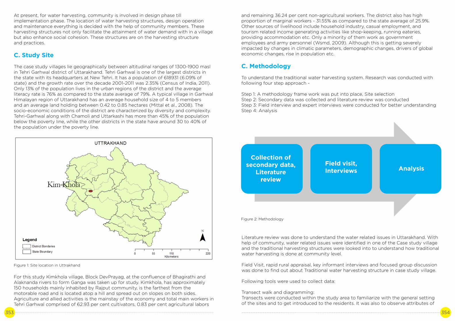
353 354
At present, for water harvesting, community is involved in design phase till implementation phase. The location of water harvesting structures, design operation and maintenance everything is decided with the help of community members. These harvesting structures not only facilitate the attainment of water demand with in a village but also enhance social cohesion. These structures are on the harvesting structure and practices.
C. Study Site
The case study villages lie geographically between altitudinal ranges of 1300-1900 masl in Tehri Garhwal district of Uttarakhand. Tehri Garhwal is one of the largest districts in the state with its headquarters at New Tehri. It has a population of 618931 (6.09% of state) and the growth rate over the decade 2001-2011 was 2.35% (Census of India, 2011). Only 13% of the population lives in the urban regions of the district and the average literacy rate is 76% as compared to the state average of 79%. A typical village in Garhwal Himalayan region of Uttarakhand has an average household size of 4 to 5 members and an average land holding between 0.42 to 0.85 hectares (Mittal et al., 2008). The socio-economic conditions of the district are characterized by diversity and complexity. Tehri-Garhwal along with Chamoli and Uttarkashi has more than 45% of the population below the poverty line, while the other districts in the state have around 30 to 40% of the population under the poverty line.
For this study Kimkhola village, Block DevPrayag, at the confluence of Bhagirathi and Alaknanda rivers to form Ganga was taken up for study. Kimkhola, has approximately 150 households mainly inhabited by Rajput community, is the farthest from the motorable road and is located atop a hill and spread out on slopes on both sides.Agriculture and allied activities is the mainstay of the economy and total main workers in Tehri Garhwal comprised of 62.93 per cent cultivators, 0.83 per cent agricultural labors
Figure 1: Site location in Uttrakhand
Figure 2: Methodology
and remaining 36.24 per cent non-agricultural workers. The district also has high proportion of marginal workers - 31.55% as compared to the state average of 25.9%. Other sources of livelihood include household industry, casual employment, and tourism related income generating activities like shop-keeping, running eateries, providing accommodation etc. Only a minority of them work as government employees and army personnel (Wsmd, 2009). Although this is getting severely impacted by changes in climatic parameters, demographic changes, drivers of global economic changes, rise in population etc.
C. Methodology
To understand the traditional water harvesting system. Research was conducted with following four step approach -
Step 1: A methodology frame work was put into place, Site selectionStep 2: Secondary data was collected and literature review was conductedStep 3: Field interview and expert interviews were conducted for better understanding Step 4: Analysis
Literature review was done to understand the water related issues in Uttarakhand. With help of community, water related issues were identified in one of the Case study village and the traditional harvesting structures were looked into to understand how traditional water harvesting is done at community level.
Field Visit, rapid rural appraisal, key informant interviews and focused group discussion was done to find out about Traditional water harvesting structure in case study village.
Following tools were used to collect data:
Transect walk and diagramming:Transects were conducted within the study area to familiarize with the general setting of the sites and to get introduced to the residents. It was also to observe attributes of
Collection ofsecondary data,
Literature review
Field visit,Interviews Analysis

355 356
research interest within the social habitation of the village including the placement of water resources. These observations were used as early illustrations and the features were recorded on a digitized cadastral map (Figure 3) to be used as a starting point for initiating discussions (Geilfus 2008, Chapter 4: Participatory Appraisal: Natural Resource Management, p65).
Timeline:
Residents from various age groups were involved to record important series of events in the study areas such as the occurrences of extreme rainfall events and change in spring water discharge. Elderly people were involved in the exercise to record historic events in the village (Geilfus 2008, Chapter 3: General Community Issues/ Social Issues, p53)
Table 1: Villager’s perceptions (Source: Field work, Khandekar et al. 2019)
Snowfall
Frequency of extreme events
Erraticity in rainfall
Spring Discharge
Villager’s Perception
Decreased
Increased (drought)
Increased
Significantly Reduced
Figure 3: Mapping water resources on cadastral map with villagers in Kimkhola Participatory Geographical Information System (PGIS) approach was used to understand the information gathered through these maps (Sharma et al. 2019)
Key Informant Interviews (KII):
KII are qualitative in-depth interview which are conducted with people who knows what is going in the community or about the phenomena under study. For the present research village Pradhan, Aganwadi worker and government officials of JalSanthan of Devprayag block were interviewed.
Focused group discussion (FGD):
FGDs involve discussing an issue or topic with a group of people of similar background and experience. FGDs were conducted with various water users with similar caste caste background.
D. Analysis
During the course of the research various traditional harvesting structures were looked into and understanding was gathered at village level. In the present water harvesting community is involved in design phase till implementation phase. The location of water harvesting structures, design, operation and maintenance everything is decided with the help of community members. These harvesting structures not only facilitate the attainment of water demand with in a village but also enhance social cohesion.
After studying the various structures prevalent in Uttarakhand, one village was selected to understand the current situation of water harvesting structures at village level and to understand the current challenges in order to operate and maintain these systems.
There are various traditional water harvesting structure in Uttarakhand. The main structures are explained below:
Chaals and Khals
Chaal are usually formed in the saddle between two adjacent crest and is found nearthe ridges of the mountain. Due to glacial snowmelt in the past, small lakes were formed, which had thick soil beds and these are present day Chaals or Khals. Khals are relatively bigger and has the ability to store several thousand cubic meters of water.
Chaals and khals not only provide water to the people in the vicinity, the water percolates through the soil and cracks and recharge the springs. Uttarakhand government has taken few initiatives on restoring chaal khals but, it is observed that in the study vIllage one chaal was inactive and was not very well maintained. People pointed out that the community water governance system is degenerating and hence the maintenance of traditional water structure is declining.

357 358
Figure 3: Water harvesting structure in Kimkhola (Study village)
Figure 4: Spring in Kimkhola village
Naulas
Naulas are stepped wells and are designed in a way that they can facilitate the collec-tion of subsurface water coming through cracks and springs. These wells are catering to the domestic water need. Kumaon region has more Naulas than Garhwal region as it has more water shortage problem. These Naulas in Kumaon are owned and maintained by local communities. The case study Village did not have any Naulas.
Dhara
Dhara is a drinking water fountain. In Dhara, subsurface water and spring water chan-nelled through a carved outlet. Water from dharas are sometimes collected in tanks and used for domestic purposes. Moreover, water from these dharas is used for field irriga-tion. In the case study village the Dharas were partially active. Few of the fields were being irrigated with one of the four springs with the help of Guhl.
Figure 5: Spring in Kimkhola village
Figure 6 Guhl in the study Village.
Guhl
Guhl are gravity flow irrigation channels used for irrigation agricultural fields and running water mills (Gharats). Water from mountain streams are diverted through channels that traverse the contours of mountain slopes. There were few Guhls in the village and most of the agriculture was rainfed. These ghuls were not in use as the water in springs has reduced overtime doesn’t had enough water that can be used for irrigation purposes.

359 360
Gharat
Gharat are water mills powered by channeled water running through Guhls. These water mills are used for flour production of local grains. In the case study village Gharat was also inactive because of the reduced water flow in the spring.
The table 1 below highlights the traditional water harvesting structure in case study village (Kimkhola).
Respondent reported that there were four active springs in the village namely: Naul hamlet spring, Jali hamlet spring, Kimkhola hamlet spring and Kagazi hamlet spring. Table 2 denotes the change in discharge of springs overtime.
Why it is a good practice?
The Indian mountainous region has fragile ecosystem and any adaptation practice that that can blend in with the present ecosystem without major externalities and provide co-benefits to the people at village level can be seen as a good adaptation practice.Rural Livelihood system of mountain community put them at higher risk of impacts of climate change as they are directly dependent on natural resources.
Table 2: Kimkhola village spring sources and changing discharge (source: seasonal calendar, field work, October, 2016)
Structure
Chaal/Khaal
Chahal
Dhara
Guhl
Gharat
Water source
Naul hamlet spring
Jali hamlet spring
Kimkhola hamlet spring
Kagzi hamlet spring
Number of families
25
16
0
0
Past SummerDischarge
(lpm)
2
6
8
4
Past WinterDischarge
(lpm)
1
3
4
2
Past MonsoonDischarge
(lpm)
1.5
4.5
6
3
Status (active -1,
inacitve -0)
0
1
0
0
Use
Groundwater percolation
Livestock consumption
Drinking water, irrigation
Irrigation
Milling
Active/Inactive
Inactive
Partially active
Partially Active
Inactive
Inactive
Financial benefits
As the harvesting structures are not dependent on any external energy source, it has less operational and maintenance cost. Moreover these structures are made of locally sourced material and build with the help of community within the village.
Co-benefits
As these structures are locally governed through participatory management, the wa-ter management system act as a cohesive force for the community. There is a constant dialogue among the community about water budgeting and how proactively the water crisis situation can be dealt with.
Also as they are micro structure, they don’t alter the ecology of the place in a harmful way.
E. Discussion
In the present situation water demand cannot be met only through traditional rain har-vesting system in the case study Village. There is a Government run water scheme called the “Bhagwanpur Scheme”, through which water is pumped from the river and supplied to tanks in village. These tanks are connected through a network of stand posts, which is accessed by the villagers to meet their water demand. Though water supplied through these standposts have been able to partially meet the water demand, villagers were not satisfied with the water quality. Villagers were of the opinion that water through springs is far better in quality and taste.
Figure 6: Standpost in study village

361 362
Also due to migration, water governance system in the village has disintegrated. There are very few villages actively participating in reviving traditional structures and maintaining them.
Though rainwater harvesting has been a tradition in Uttarakhand, new trends are emerging with respect to integration of technology in meeting water demands in the area. During the course of research one such example surfaced in Chureddhar Village, Chamba block in Tehri Ghardwal.
This Village is 82 Km from Dhanolti and has two development intervention to meet water scarcity, namely Solar Pumping station and Rain water harvesting. Rain water harvesting systems were installed in the year 2003. The system consists of drain water spouts attached to the roof and a collection tank (7 Kilo Liter capacity). Once filled, the water tank can provide water for 2-3 months (depending on the family size) for domestic purposes. This water is not used for agricultural purposes as agriculture is largely rain fed.
Figure 7: Rainwater harvesting structure (Village Chureddhar).
Figure 8: Solar Pumping Station (Village Chureddhar).
The Village has solar pumping station made by Tata Trust to help villages for drinking water needs. The station has capacity to store 12.5 kiloliter and the pump has a capacity 4 KW/DC. The pumping station has 50 solar panels and each panel produces 77.5 watts. As most of the water needs are met by women in household, this intervention might have reduced women drudgery as they had to get drinking water from the downstream.
References
Acharya, A. (2011). Managing ‘Water Traditions’ in Uttarakhand, India: lessons learned and steps towards the future. In Water, Cultural Diversity, and Global Environmental Change (pp. 411-432). Springer, Dordrecht.
Jethi, R., Joshi, K., & Chandra, N. (2016). Toward climate change and community-based adaptation-mitigation strategies in hill agriculture. In Conservation agriculture (pp. 185- 202). Springer, Singapore.
Bisht, D.S., Chatterjee, C., Raghuwanshi, N.S. and Sridhar, V., 2017. Spatio-temporal trends of rainfall across Indian river basins. Theoretical and Applied Climatology, pp.1-18.Shrestha AB, Wake CP, Dibb JE, Wayewski PA, Whitlow SI, Carmichael GR, Ferm M (2000)
Seasonal variations in aerosol concentrations and compositions in the Nepal Himalaya. Atmos
Environ 34:3349–3363
Chopra, R. (2003). Survival lessons.
Pattanaik D, Rajeevan M (2010) Variability of extreme rainfall events over India during southwest monsoon season. Meteorol Appl 17:88–104
Immerzeel, W. W., Van Beek, L. P., & Bierkens, M. F. (2010). Climate change will affect the Asian water towers. Science, 328(5984), 1382-1385.
Bera, S., 2017. Trend Analysis of Rainfall in Ganga Basin, India during 1901-2000. American Journal of Climate Change, 6(01), p.116.
Siderius, C., Hellegers, P.J.G.J., Mishra, A., van Ierland, E.C. and Kabat, P., 2014. Sensitivity of the agroecosystem in the Ganges basin to inter annual rainfall variability and associ- ated changes in land use. International Journal of Climatology, 34(10), pp.3066-3077.
Sharma, D., Khandekar, N., & Sachdeva, K. (2019). Addressing water-related shocks and coping decision through enhanced community participation: case studies from Ganga basin, Uttarakhand, India. Water Policy.
Parry ML, Canziani O, Palutikof JP, Hanson C, van der Linden P. 2007. Climate Change, 2007: Impacts, Adaptation and Vulnerability. Contribution of Working Group II to the Fourth Assessment Report of the Intergovernmental Panel on Climate Change. Cambridge University Press: New York,
Government of India, G., 2010. INCCA: Climate Change and India: A 4X4 Assessment A sectoral and regional analysis for 2030s, s.l.: GoI.

363 364
Ministry of Environment and Forests. Assessment of Environmental Degradation and Impact of Hydroelectric Projects during the June 2013 Disaster in Uttarakhand,Main Report, MoEF. Government of India, April 2014. Chapter 2, ToR 2.1 a. p. 34. Available online: http://www.indiaenvironmentportal. org.in/files/file/environmental%20degrada- tion%20&%20hydroelectric%20projects.pdf (accessed on 10 January 2016) Mainstream-ing Ecosystem-based Adaptation in Vietnam. Policy Note. ISPONRE, Hanoi, Vietnam, 2013. (accessed online at: http://awsassets.panda.org/downloads/wwf_viet- nam_eba_policy_brief_2013.pdf)
Questionnaire transcript
Questionnaire transcript
Respondents
Villagers: Kimkhola Questions (sample):
How water needs are met in the Village?
What are the different sources of water in the Village?
What are the traditional water structures in the village?
Who maintains these structures?
Do you think these structures are relevant today and should continue to be built and maintained?
HIMACHAL PRADESH
Photo credit: R Lalrinsanga | Location: Parvati Valley, Himachal Pradesh

365 366
TRADITIONAL WATER HARVESTING STRUCTURES:POTENTIAL TO CONTRIBUTE
TO ADAPTION
Author: Aprajita SinghContributor: Dr. Adesh Saini
CASE STUDY 19

367 368
A. Background
Projections and past trends for precipitations vary across the state’s different agro-climatic zones. While overall there has been an increase in rainfall for the state of Himachal Pradesh in the past 25 years, the district level trends for all precipitation are decreasing in certain areas. At a district scale, the trends vary, but Shimla, Sirmour and Solan in particular have witnessed a decrease in rainfall of 13.3%, 16.6% and 8.7% respectively in the past 25 years. In districts which will see an increase in average annual rainfall, this translates to more intense rainfall. These districts are Kangra, Kullu, Chamba and Una (DST, 2012). Broadly, the key changes that are occurring that have been identified by the State Action Plan are an average 2-4 degree temperature increase, snow and glacial field loss and associated events such as GLOFs, and doubled frequency of extreme events. It is also projected that south-eastern parts may see drought-like conditions in coming decades. The SAPCC states that moderate to extreme drought conditions are to be expected in the state, with more than a 20% increase in places, despite the overall increase in rainfall (DST, 2012). Floods are set to become more commonplace, posing a threat to human life, agriculture and the hydropower projects that form a major art of the state’s economy. Besides this, retreating glaciers will, in the long term, lead to undependable discharge in rivers (ADB, 2010).
In agriculture, productivity is expected to decrease across the state, especially in the case of rain-fed crops due to heat stress (DST, 2012). One of the most commonly cited examples of crops that are beginning to show a clear decline in productivity in response to changing climatic parameters is the apple, a commercially critical fruit crop (Vedwan and Rhoades, 2001; Singh, 2013; Rana et al., 2019). The impact on forests is to vary across the state, with the high-altitude dense forests being the most vulnerable. There is also an increased probability of forest fires. The long-term impact on forests is slated to be negative. The spread of aggressively invasive species such as Lantana has also been linked to rising temperatures making these areas relatively more hospitable for these species, creating further competition in an already overburdened ecosystem (Negi et al., 2012).
Studies based on people’s perceptions of their environs also reveal startling trends; drying water sources, changing flora and fauna, disappearing plant species, reduced crop yields, shifting apple cultivation belt and previously unknown pest species. These concerns find echoes in areas across the state (ADB, 2010). Water scarcity in rural areas is affecting the drinking supply, sanitation and forcing people to let go of their cattle (Chauhan, 2017).
In such a scenario, it is predicted that water resources and agriculture will be two of the key sectors that will directly be affected by climate change in the coming years. Water supply will especially be affected since it is essentially augmented by precipitation, snow and glacial melt. This decrease will particularly manifest in Solan, Palampur and Shimla districts or the mid-hills. According to a study, the rural population affected in summer by decreased discharge from water sources increased from 748253 to 1018870 between 2004 and 2009 (Singh et al., 2010a). These issues are exacerbated by the demands of a growing population with growing water requirements(ADB, 2010; Singh et al., 2010a, 2010b).
New reports and documentation by NGOs suggest that despite their use being on the decline across Himachal, many villages are still dependent on traditional water sources for drinking water, especially during lean periods.And although piped water supply has been provided to nearly all villages in Himachal, the supply is plagued by issues related
to maintenance and supply, the latter especially in the pre-monsoon summer months. Misuse of water is another concern, with those living far from the storage tanks or at the tail end of the pipelines being forced to resort to using the traditional structures for water (Ravi Chopra, 2003). In conjunction with a more efficient piped water supply and other measures such as springshed management, these structures may provide a viable solution to the aforementioned problems. There is historical evidence of these and similar structures of water management providing stability in times of water scarcity (Pandey et al., 2003; Kamaldeep et al., 2011). This case study addresses traditional water harvesting structures that are used for the purpose of drinking water; there are many others besides these that are used for other purposes such as bathing, for animals, irrigation etc.
B. Literature review
There are five major river basins in Himachal Pradesh. The Chenab, Ravi, Beas and Sutlej rivers drain into the Indus while the Yamuna Basin drains into the Ganga. These rivers have glacial origins and are both glacial and rainfed. 70% of the rainfall occurs between July-September, brought in by the south-western monsoon. The remaining occurs during winter months as a result of westerly disturbances (Bhardwaj, no date).
An analysis of rainfall patterns over the past few years across the state shows that the change in rainfall patterns varies across the districts. Areas in Kangra, Bilaspur and Hamirpur have been receiving below average rainfall and drought-like conditions have been persisting on and off. It is expected that the change in rainfall patterns will impact springs in rural and semi-rural areas, and hence the water supply in these areas. According Shimla Meteorological Centre, monsoon in the state is expanding, but rainfall is on a decline (Chakravorty, 2017). Weather stations in the state have been recording continuous increases in average rainfall in the state since the past few decades (Singh et al., 2010b).
Table 1: Water Sources of Himachal Pradesh
Bilaspur 827 786 0 461 0 2074
Chamba 1717 2433 3 2598 836 7587
Hamirpur 1057 485 0 231 1 1774
Kangra 1602 1317 11 1369 466 4765
Kinnaur 76 217 0 24 2 319
Kullu 0 3392 0 0 0 3392
Lahaul Spiti 1 290 0 57 0 348
Mandi 833 3924 0 1483 840 7080
Shimla 233 3917 5 2518 9 6682
Sirmour 644 2249 0 535 9 3437
Solan 344 1090 0 1215 316 2965
Una 832 123 1 21 116 1093
Total 8166 20223 20 10512 2595
TotalName of Distt. Groundwater
SurfaceWater
Rainwater
Traditional Sources
Others

369 370
Studies covering a 30 year period starting from 1980’s have shown that average air temperatures are 0.7°C to 2.4°C higher in the state as compared to the global average increase of 0.5°C. Rainfall data from 1976 to 2006 shows an increasing trend in Lahaul and Spiti, Chamba and Kangra, but decreasing trends in Solan and Kinnaur (ADB, 2010). Even in the former group of districts, increase in precipitation may not translate to improved water security. In the upper catchment villages of Spiti Valley, for example, agricultural yields have been decreasing because of changing snowfall patterns.According to the state department for Climate Change, most of the snowfall is now taking place in February and March instead of peak winters. Being high in water content, this snow melts quickly instead of staying at the source, which is critical for timely sowing. Instead, it flows down the slopes as water and causes soil erosion (Chakravorty, 2017).
Groundwater in the state occurs mostly as springs in the mountainous regions. On the whole, groundwater is sources through either tubewells or springs. The current level of groundwater development is only 32% of the potential (ADB, 2010). However, groundwater resources in the low-lying districts of Himachal are in peril. Rapid industrialization and the subsequent withdrawal of groundwater has led to rapid escalation in exploitation of these resources. Valley areas in Kangra, Una, Hamirpur,Bilaspur, Mandi, Solan and Sirmaur are mostly reliant on groundwater for water supply.Resources in Una especially, which has seen very high levels of industrialization in the past two decades, have reached critical category of development, indicating that withdrawal is happening at a greater or nearly equal rate as recharge (Bodh, 2016).Moreover, due to changing patterns of precipitation, where more intense rainfall occurs over shorter periods of time, groundwater recharge for mountain springs is expected to decrease (ADB, 2010; DST, 2012).
Niti Ayog’s composite Water Management Index, which scores Indian states based on 28 indicators on groundwater, irrigation etc., has ranked Himachal Pradesh 2nd amongst the Himalayan states in 2018. Despite this, the overall score of 53 puts the state in the medium performing category. The report lauds the state for its supply side management, which includes irrigation and watershed development, and rural and urban water supply provision. Its performance has declined by 2.7 points since 2016. The state scores high in the source augmentation (which focuses on identification and scoring of groundwater resources) in demand side management through participatory irrigation management, in urban water supply and sanitation and in the policy and governance themes (Niti Ayog, 2018).
Table 2: Status of groundwater development in Himachal Pradesh
Total replenishable groundwater resources 0.036 m ham/yr
Provision for domestic, industrial and other uses Available net groundwater resources for irrigation 0.007 m ham/yr
Available net groundwater resources for irrigation 0.029 m ham/yr
Net draft 0.005 m ham/yr
Balance groundwater resources for future use 0.024 m ham/yr
Level of groundwater development 18.18%
Utilisable irrigation potential by groundwater development 65,500 ha
The key changes in the water sector have been identified in a report compiled by the Asian Development Bank as increased frequency of heavy precipitation, increase in extreme rainfall intensity, increased variability in rainfall patterns, increased likelihood of water shortages/droughts, reduced levels of snow precipitation, loss of glacial volumes, premature snow melt and increased temperatures. The likelihood of these changes taking place has been rated as very high. The likely impacts on water resources that have been identified are increased runoff and higher sediment load, reduced groundwater recharge, increased flood flows, reduced dry season flows, drying up of minor tributaries and springs and loss of perennial sources (ADB, 2010; Immerzeel et al., 2010; Singh and Kandari, 2012).
Mitigation of current and potential impacts on the water supply is mostly seen dealt with by expanding and augmenting the rural and urban water supply in the state. Increased risk of floods has been dealt with through the construction of embankments. The state’s total geographical area is 55.67 lakh Ha, of which only 5.83 lakh ha is the net sown area. It is estimated that the total irrigation potential is 3.35 lakh ha. Most of this irrigation potential is to be achieved through small local irrigation schemes. The government also promotes rooftop rainwater harvesting schemes (DST, 2012). In recognisance of the threat posed to water in the state in the coming decades, a USD 150 million, 5 year plan has also been drawn up by the Irrigation and Public Health Department to climate-proof the state’s water resources (Sharma, 2016).
Water harvesting has been traditionally practiced across India in a myriad of forms and shapes. Whether it be the tanks and kundis of Rajasthan, ahar in Bihar, the guhls of Uttarakhand, eris in Tamil Nadu, zabo in Nagaland; human ingenuity has given rise to a number of these structures over history to serve one of our most primal needs, that of water. These structures have allowed communities to store, manage and distribute their water supply to serve the end goals of drinking water, irrigation and sanitation (Agarwal and Narain, 1997). These are, in fact, also their biggest advantages; they can be constructed and managed at a local scale, ensuring autonomy of the community over their water resources. Once pipelines made inroads in these areas, these structures became an important backup storage in case the pipeline failed or during times of excess need (Agarwal and Narain, 1997).
Traditional water harvesting structures in Himachal Pradesh, such as the chapri, or kaccha ponds for storing water for irrigation and livestock, the baoris that are used to store water for household usage, the naun for non-drinking household uses such as washing clothes and the panihar for bathing and drinking, have been in use for centuries in these areas and are community-managed structures that collect underground seepage or rainwater and store it for later use. These structures follow specific construction patterns that have been passed down over generations and all of them have a certain set of cultural practice and rituals associated with them whose intricacies are unique to every region (Ravi Chopra, 2003; Sharma and Kanwar, 2009).
C. Study site
A majority of the field work was carried out in Sirmour, Kangra and Kullu districts. These districts were selected to represent a range of elevations. These are also three of the districts that have been identified as being faced with water scarcity as one of the potential impacts of climate change and are looking at drastic changes in the water and agriculture sector (DST, 2012).

371 372
Figure 1: Map showing selected districts in Himachal in Red
Sirmour is a mountainous district with lowlands whose economy is largely agriculture based. Grains are an important produce, as are peaches. In the past decade, there are also a number of industrial hubs that have popped up in the district, the most prominent being Paonta Sahib, where a number of pharmaceutical and cement production units have been set up. There have been concerns about environmental pollution and depleting ground water levels in nearby areas. Field work was conducted in Maihat village, Sirmour.
Kangra is the most populous district of the state. The geography is largely mountainous. Low hills and valleys cover a large part of the area. Agriculture is still an important part of the district’s economy. Due to the plain area in the vast valleys, and successful traditional systems of irrigation, productivity is high. Tea is an important produce of this area. There are also several important tourism hubs in the district. The large number of perennial streams and nallahs and the gradient of the land have invited a large number of investments from small private hydropower projects. Field work was conducted in Maniyana, Dharamshala, Diyara, Bhatarka and Sathana villages.
Figure 2: Shringar baori, Palampur.
Kullu district forms the upper catchment of the Beas river basin. The elevation ranges from 1000 MSL to 6000 MSL and the terrain have been found ideal for the construction of several large hydropower projects in the district. In earlier times the valley served as an important trade route. The main sources of livelihood used to be agriculture and transhumant pastoralism. Tourism also forms an important part of the economy today, thanks to the sharp rise in the number of visitors in recent decades. Horticulture, especially apples, is also a major source of income. A large number of pomegranate plantations were also spotted during field work. It is one of the least densely populated districts in the state. Field work was carried out in Deoridhar and Shensher villages.
Description of the case
The most common traditional structure that can be seen across areas of moderate rainfall in Himachal Pradesh (Shimla, Mandi, Kangra, Hamirpur and Bilaspur) is the baori, used mainly for storage of underground seepages for drinking and other domestic uses (Ravi Chopra, 2003). A baori has been described as a circular or more commonly square step-well like structure around spots where subterranean seepages or springs emerge from the earth. The baori is built out of stone bricks that are arranged in steps such that users can descend these wells to gather water depending on the water level which varies seasonally (George, Pillai and Mathew, 2015). Most baoris are walled in and have a roof to prevent dirt from falling in and animals from using the water. Most villages have a number of them scattered across the various neighbourhoods in such a way that most households have fairly convenient access to water. As a concept these structures seem to date back several hundred centuries, but many have been constructed in the twentieth century itself. Most have some sort of cultural or religious value attached to them (Ravi Chopra, 2003; Singh et al., 2010c; George et al., 2015). Baoris are meant to be for community use in most places. In the case of some areas, however, caste-base discrimination is practiced to this day and baoris used by dalit communities are not used by those from other castes (Ravi Chopra, 2003).
Nauns are similar to baoris, but are usually bigger in size and capacity, and may also be used for bathing and washing clothes (Singh et al., 2010c). They also have a similar step-well structure, although they tend not to be enclosed as baoris are. Nauns also harvest underground seepages and store them. There is a segregated channel to allow for uses such as washing clothes without polluting the main supply (Sharma and Kanwar, 2009). Khatris are described as large, rectangular structures that are constructed by specially trained masons at a cost of IRN 10,000 – 20,000 per structure that store water that seeps through rocks (Singh, 2002). A tunnel is built into the base of a hill that leads, down a series of steps, to a basin where the water is collected. These can be found in Kangra, Mandi and Hamirpur. Those that collect water only through rock seepages are for human use only, but there are also those that collect rainwater, led down to the basin through pipes from the roof and their water is for use by domestic animals (George et al., 2008).

373 374
Most of these water harvesting structures have been built by either the members of the community themselves, either in memory of a loved one or as an act of service towards the community. Traditionally their operation and maintenance were tasks looked after the users themselves. While there is no evidence of formal groups or rules regarding their maintenance and cleaning, it was a task shared equally by the users themselves. In recent year, however, especially since the advent of piped water supply to households, many of these structures have fallen into disuse. Many have gone dry or suffer from disrepair (Ravi Chopra, 2003). A survey conducted by the State Council for Science Technology and Environment has uncovered disturbing statistics; In the 169 Panchayats that were surveyed across 7 districts, only 30.41% of the traditional water sources were found to be in good condition structurally and recharging water all year round. This figure was a mere 1% for Chamba district (Bhardwaj, no date).
Water access is considered to be one of the most vulnerable characteristics of rural communities in Himachal Pradesh due to the myriad reasons listed above. In this scenario, the age-old practice of harvesting rainwater or underground seepages in traditional, communal water harvesting structures can prove to be an important adaptation practice by providing the community with a perennial alternate source of clean drinking water as an alternative to the tap water supply, especially during dry periods and during times when the tap supply gets disrupted.
D. Methodology
The data collection methodology can be broadly divided into three parts:
1) Literature reviewExisting literature such as peer reviewed papers, online news articles, reports by NGOs active in the state, thesis on the particular or related subjects, SAPCC, reviews of SAPCC etc. was collected and reviewed in order to create a background over which primary information collected from the field sites can be superimposed.
2) Onsite data collection Field data collection was largely focused on the communities (the water users). During primary data collection, the main tools used were semi-structured interviews, focus group discussions and in certain cases, resource mapping of the villages and guided transect walks. The focus of primary data collection was to verify the broad information generated during the literature review phase and also to collect anecdotal evidence
Table 3: Activity and outcome
Perennial availability of clean, dependable drinking water and
supplementary drinking water supply to tap water.
S.No
1
Expected impactof Climate Change
Practice/activity Measurable outcome
Drinking water shortages
Perennial traditional water harvesting
structures
E. Analysis
Observations from the field all point to persisting use of traditional water harvesting structures as sources of drinking water. In areas where these are better maintained, they are the primary sources of drinking water and they are used all year round regardless of the availability of tap water or not. This is mainly because the traditional sources are considered cleaner than tap water, or in cases where the sources of the piped supply are polluted, such as the stagnant water from a reservoir. In other areas, they are mainly used when piped supply fails.
Figure 3: Focus Group Discussion with female water users, Village Dyara, Dharamshala
Table 4: Field sites and interviews
of positive adaptation based on the lived experiences of the interviewees or the participants of the group discussions, as well as to identify any gaps or threats to the technique/practice.
3) Consultation with state department representatives and subject matter expertsA draft of the case study will be shared with participants at a state level workshop and their feedback incorporated into the case study
Location(Village/Department, District) Activity*
Maihat, Sirmour KPI with farmers, FGD
Rampur, Shimla KPI with household users,
Maniyana, Palampur KPI with farmers, FGD
Dharamshala, Palampur KPI with farmers, FGD
Diyara, Palampur KPI, FGD with Mahila Mandal
Bhatarka, Palampur KPI with farmers, FGD
Sathana, Palampur KPI with farmers, FGD
Deoridhar, Kullu KPI, FGD with VDC
Shensher, Kullu KPI with farmers, FGD
Irrigation and Public Health Department, Dharamshala KPI
Irrigation and Public Health Department, Kaza KPI (Junior Engineer)

375 376
In some areas it is only one season year, when heavy rainfall might cause the piped supply to get disrupted, and in others it is two, especially in drier regions where the piped supply is prone to drying up or is not sufficient during summer.
So while these structures may not constantly bein use by all households since the advent of pipelines, it is these baoris, nawns and khatris that provide respite during times of water shortage, which is the case mostly during the summers. Also, in many cases, despite the availability of piped water, many villages still prefer to use these sources for drinking purposes, at least, because of a belief in its purity. There is also a phenomenon observed across the sites visited, which could not be identified in literature. These traditional sources are often the only sources of safe drinking water during extreme events or even periods of extreme rainfall. Landslides triggered by intense rainfall are common, and one of the most casualties of these events is the water supply pipes, which may get buried under boulders or the landslides, or sections may get damaged. Given the weather conditions, the geography of the area and the distance of the obstructed sections from the village, it may not always be possible to carry out repair work immediately. Even in areas with an abundance of water, which are not currently facing any shortages of water even during the lean summer seasons, the interviewees mentioned that the baori, while used by most people throughout the year, becomes especially important as a supply of drinking water during times such as these. And in the scenario that extreme rainfall events become more frequent, or the intensity of rainfall across these regions increases (as has been recorded in literature), it may also lead to an increase in such occurrences of pipeline failure.
In the case of District Hamirpur, the correlation between the increase in use of traditional water harvesting structures and long dry periods has become even more apparent. In the late 2000’s, the district experiences unusually long dry spells for four consecutive years. Climatically, the district is prone to such drought-like long dry spells. When the locals realized the unreliability of the piped water supplies in these conditions, they revived their local khatris and baoris and were reportedly thus able to have an assured back up supply through the worse of the dry spell. As a result of the experiences of the dry spell in Hamirpur, many villages have taken up the responsibility on ensuring clean, chlorinated khatris, and commissioned new ones to prepare for similar dry spells in the future (Thati Senu village, Sujanpur block, Himachal Pradesh, no date; Singh, 2002; Sharma, 2007).
These structures also have a cultural value attached to them. There are two aspects to this. One is the preservation of cultural heritage, which many interviewees felt was important in an era of rapid change brought on by larger external forces.
Image 4: Women collecting water and washing clothes at baori, Village Deori, Kullu
There is a sense of pride in the ingenuity of these structures and people are eager to protect and maintain them as a result. The second is the religious/ritualistic value attached to them. Many baoris are still used as sites of worship. Some are built in the memory of a beloved ancestor and the ones in Kangra often have ancestor stones places near them. One common ritual recorded across all sites was that of prayers being offered by a new bride at a baori close to the house she was marrying into, one of the first rituals that have to be observed by her on entering the village.
It is apparent that the existence of informal rules regarding the use and maintenance is crucial to the sustenance of the sources. These rules ensure that the cleanliness is maintained at and close to the source. That prayers and rituals that are offered at the sources also contribute to their cleanliness. The responsibility of maintaining the source is shared by the communities, and repair work is either funded by the Panchayat or done through contributions. All these culturally ingrained values attached to these sources have contributed to their persistence, however reduced. The sustainability of traditional water harvesting structures depends heavily on the community’s willingness to contribute to their upkeep. In light of the alarming numbers surrounding the decrepit water harvesting structures in the state, it has been suggested that it in order to effectively revive these structures, it would be necessary to involve the local community in the process (George et al., 2015).
Traditionally operation and maintenance were tasks looked after the users themselves. While there is no evidence of formal groups or rules regarding their maintenance and cleaning, it was a task shared equally by the users themselves. In recent year, however, many of these structures have fallen into disuse. Many have gone dry or suffer from disrepair (Ravi Chopra, 2003). A survey conducted by the State Council for Science technology and Environment has uncovered disturbing statistics; In the 169 Panchayats that were surveyed across 7 districts, only 30.41% of the traditional water sources were found to be in good condition structurally and recharging water all year round. This figure was a mere 1% for Chamba district (Bhardwaj, no date).
The descriptions of the conditions of the baoris visited are given in Table below. Due to their geographic distribution and relative rarity as compared to the baori, other traditional structures were not observed during field work.

377 378
Location Source Type Usage Condition Number of Dependant Households
Notes on use
Used mostly during lean periods and for religious ceremonies.
Use throughout year due to insufficient tap water supply.
Peri-urban area and high water demand.
Used only during lean periods. Algal growth in pool and
separate baoris built for use by dalit
communities.
Very well maintained and clean baori
located next to main road. Used by most
households from nearby villages as the primary source of drinking water all year round as
well as passers-by. Rules regarding cleanliness are
strictly stated and enforced.
Used mostly during lean seasons,
although some households prefer to use it all year
over tap water. The baori has recently
been reconstructed but the work has been shoddy and no water is being released from the
outlet.
Primary source of drinking water for nearby houses
because it is considered cleaner
than tap water.
Very rarely used
Maihat, Sirmour
Rampur, Shimla
Maniyana, Palampur
Dharamshala,Palampur
Diyara,Palampur
Bhatarka,Palampur
Baori 1
Baori
Baori
Sringar Baori
Baori
Baori
Baori 2
Underground seepage
Underground seepage
Underground seepage
Underground seepage
Underground seepage
Underground seepage
Underground seepage
Not in use
In use
In use
In use
In use
In use
Not in use
Unkempt but clean
Clean
Unkempt, dirty
Clean
Clean
Clean
Poor
20
40-50
20
<100
30
20
1-2
Location Source Type Usage Condition Number of Dependant Households
Notes on use
Was used as the primary source of water when piped water supply was
too polluted to drink. The water is chemically treated. Level of water in
baori has increased in recent decades
due to creation of a reservoir nearby
There is very little water in the baori as compared to a decade earlier. It is still in use, however,
for drinking purposes. There is also a demarcated section separate
from the main body where clothes can
be washed.
There is very little water in the baori as compared to a decade earlier. It is still in use, however,
for drinking purposes. There is also a demarcated section separate
from the main body where clothes can
be washed.
Larger baori, used for both drinking
water and washing clothes. Old but very clean well
maintained.
Baori is clean but has been improperly renovated, because of which the water is seeping from the
sides instead of rising to the top
Sathana, Palampur
Deoridhar,Kullu
Shensher,Kullu
Baori 1
Baori 1
Baori 2
Baori 1
Baori 2
Underground seepage
Iin use
In use
In use
In use
In use
Clean
Clean
Clean
Clean
Clean
25-30
10-15
19-20
20-30
15-20
Table: Condition and details of observed structures
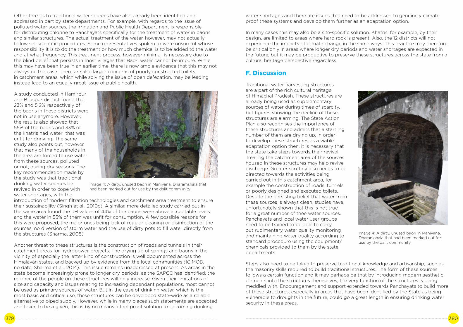
379 380
Other threats to traditional water sources have also already been identified and addressed in part by state departments. For example, with regards to the issue of polluted water sources, the Irrigation and Public Health Department is responsiblefor distributing chlorine to Panchayats specifically for the treatment of water in baoris and similar structures. The actual treatment of the water, however, may not actually follow set scientific procedures. Some representatives spoken to were unsure of whose responsibility it is to do the treatment or how much chemical is to be added to the water and at what frequency. This treatment process, however minimal, is necessary due tothe blind belief that persists in most villages that Baori water cannot be impure. While this may have been true in an earlier time, there is now ample evidence that this may not always be the case. There are also larger concerns of poorly constructed toiletsin catchment areas, which while solving the issue of open defecation, may be leading instead lead to an equally great issue of public health.
A study conducted in Hamirpur and Bliaspur district found that 23% and 5.2% respectively of the baoris in these districts were not in use anymore. However, the results also showed that 55% of the baoris and 33% of the khatris had water that was unfit for drinking. The same study also points out, however, that many of the households in the area are forced to use water from these sources, polluted or not, during dry seasons. The key recommendation made by the study was that traditional drinking water sources be revived in order to cope with water shortages, with the introduction of modern filtration technologies and catchment area treatment to ensure their sustainability (Singh et al., 2010c). A similar, more detailed study carried out in the same area found the pH values of 44% of the baoris were above acceptable levels and the water in 55% of them was unfit for consumption. A few possible reasons for this were proposed, the major ones being lack of regular cleaning or disinfection of the sources, no diversion of storm water and the use of dirty pots to fill water directly from the structures (Sharma, 2008).
Another threat to these structures is the construction of roads and tunnels in their catchment areas for hydropower projects. The drying up of springs and baoris in thevicinity of especially the latter kind of construction is well documented across the Himalayan states, and backed up by evidence from the local communities (ICIMOD,no date; Sharma et al., 2014). This issue remains unaddressed at present. As areas in the state become increasingly prone to longer dry periods, as the SAPCC has identified, the reliance of the people on these structures will only increase. Given their limitations of size and capacity and issues relating to increasing dependant populations, most cannot be used as primary sources of water. But in the case of drinking water, which is the most basic and critical use, these structures can be developed state-wide as a reliable alternative to piped supply. However, while in many places such statements are accepted and taken to be a given, this is by no means a fool proof solution to upcoming drinking
Image 4: A dirty, unused baori in Maniyana, Dharamshala that had been marked out for use by the dalit community
water shortages and there are issues that need to be addressed to genuinely climate proof these systems and develop them further as an adaptation option.
In many cases this may also be a site-specific solution. Khatris, for example, by their design, are limited to areas where hard rock is present. Also, the 12 districts will not experience the impacts of climate change in the same ways. This practice may therefore be critical only in areas where longer dry periods and water shortages are expected in the future, but it may be productive to preserve these structures across the state from a cultural heritage perspective regardless.
F. Discussion
Traditional water harvesting structures are a part of the rich cultural heritage of Himachal Pradesh. These structures are already being used as supplementary sources of water during times of scarcity, but figures showing the decline of these structures are alarming. The State Action Plan also recognises the importance ofthese structures and admits that a startling number of them are drying up. In orderto develop these structures as a viable adaptation option then, it is necessary that the state take steps towards their revival.Treating the catchment area of the sources housed in these structures may help revive discharge. Greater scrutiny also needs to be directed towards the activities beingcarried out in this catchment area, for example the construction of roads, tunnels or poorly designed and executed toilets.Despite the persisting belief that water fromthese sources is always clean, studies have unfortunately shown that this is not true for a great number of thee water sources. Panchayats and local water user groups need to be trained to be able to carryout rudimentary water quality monitoring and maintaining water quality according to standard procedure using the equipment/chemicals provided to them by the state departments.
Steps also need to be taken to preserve traditional knowledge and artisanship, such as the masonry skills required to build traditional structures. The form of these sources follows a certain function and it may perhaps be that by introducing modern aesthetic elements into the structures themselves, the very function of the structures is being meddled with. Encouragement and support extended towards Panchayats to build more of these structures, especially in areas that have been identified by the State as being vulnerable to droughts in the future, could go a great length in ensuring drinking water security in these areas.
Image 4: A dirty, unused baori in Maniyana, Dharamshala that had been marked out for use by the dalit community

381 382
References
ADB (2010) Climate Change Adaptation in Himachal Pradesh: Sustainable Strategies for Water Resources. Mandaluyong City, Philippines.
Agarwal, A. and Narain, S. (1997) Dying wisdom: Rise, fall and potential of India’s traditional water harvesting systems. (State of India’s Environment – A Citizens’ report, No. 4). New Delhi.
Bhardwaj, A. (no date) Directory of Water Resources in Himachal Pradesh. Shimla.
Bodh, A. (2016) ‘Sharp drop in groundwater level in HP’, The Times of India, 7 March. Chakravorty, A. (2017) ‘Climate change: Water crisis engulfs world’s “highest” village’, The Indian Express, November.
Chauhan, S. (2017) ‘Himachal villages hit by water scarcity, farmers forced to sell their cattle’, Hindustan Times, 20 May.
DST (2012) State strategy & action plan on climate change: Himachal Pradesh. Shimla.
George, K. V, Pillai, K. V. and Mathew, J. (2015) ‘Studies on Water Resource Management : Approaches and Strategies’, International Journal of Advanced Research, 3(11), pp.781–791.
Immerzeel, W. W., van Beek, L. P. H. and Bierkens, M. F. P. (2010) ‘Climate change will affect the Asian water towers’, Science (New York, N.Y.), 328(5984), pp. 1382–5. doi: 10.1126/science.1183188.
Kamaldeep et al. (2011) ‘Impact of Industrialization on Groundwater Quality - A case Study of Baddi-Barotiwala Industrial Belt, Distt. Solan, Himachal Pradesh, India’, Journal of Industrial Polution Control, 27(2), pp. 153–159.
Negi, G. C. S. et al. (2012) ‘Impact of climate change on the western Himalayan mountain ecosystems : An overview’, Tropical Ecology, 53(3), pp. 345–356.
Niti Ayog (2018) Composite Water Management Index: A tool for water management. New Delhi.
Pandey, D. N., Gupta, A. K. and Anderson, D. M. (2003) ‘Rainwater harvesting as an adaptation to climate change’, 85(1).
Rana, R. S. et al. (2019) ‘The impact of climate change on a shift of the apple belt in The impact of climate change on a shift of the apple belt in’, in Dubash, N. K. (ed.) Handbook of Climate Change and India Development , Politics and Governance. Routledge. doi: 10.4324/9780203153284.ch3.
Ravi Chopra (2003) Survival Lessons: Himalayan Jal Sanskriti. Dehradun.‘Reviving drying springs in the Himalayas: Mitigation measures for Hydropower’ (no date). Kathmandu: ICIMOD.
Sharma, A. (2016) ‘Climate proofing: Himachal prepares $150 mn plan to manage natural water resources’, The Indian Express, November.Sharma, C. S. (2007) ‘Hamirpur district faces severe water crisis’, The Hill Post, June.
Sharma, G., Sharma, D. P. and Dahal, D. (2014) ‘Water conflicts and benefits related to hydropower projects: A case study from Sikkim’, (1), pp. 1–5. doi: 10.1007/s13398-014- 0173-7.2.
Sharma, M. R. (2008) ‘Water Quality of Traditional Drinking Water Sources in Outer Himalayas - A Case Study of Hamirpur District , H . P .’, Nature Environment and Pollution Technology, 7(4), pp. 677–681.
Sharma, N. and Kanwar, P. (2009) ‘Indigenous water conservation systems — A rich tradition of rural Himachal Pradesh’, 8(October), pp. 510–513.
Singh, H. P. et al. (2010a) ‘Impact of drought on drinking water resources of Himachal Pradesh’, Biological Forum, 2(1), pp. 73–77.
Singh, H. P. et al. (2010b) ‘Potential of Rainwater Harvesting in Himachal Pradesh’, Nature Environment and Pollution Technology, 9(4), pp. 837–842.
Singh, H. P. et al. (2010c) ‘Sustainability of Traditional Drinking Water Sources in Himachal Pradesh’, Nature Environment and Pollution Technology, 9(3), pp. 587–592.
Singh, I. J. (2013) ‘Impact of Climate Change on the Apple Economy of Himachal Pradesh : A Case Study of Kotgarh Village’, Ecology and Tourism, (November), pp. 21–23.
Singh, R. V (2002) ‘Beating the Drought’, Down to Earth, September.
Singh, T. and Kandari, L. S. (2012) ‘Rainwater harvesting in the Wake of Climate Change : A Case Study from Shimla city , Himachal Pradesh Abstract ’:, 2(4), pp. 336–346.
Thati Senu village, Sujanpur block, Himachal Pradesh (no date) rainwaterharvesting.org.
Vedwan, N. and Rhoades, R. E. (2001) ‘Climate change in the Western Himalayas of India : a study of local perception and response’, Climate Research, 19(2), pp. 109–117.
Questionnaire transcript
1) For local users:
a) How many households still use the baori/naun/khatri?b) How many days in a year do you still visit the baori, and at what time of the year?c) Has the frequency of use changed in the past few decades and why?d) What are the main uses?e) Is the water quality satisfactory?f) Who is responsible for the maintenance of the structure?

383 384
2) Department officials
a) Are local traditional water harvesting structures still in use in your area?b) Is the water quality of these structures in your area satisfactory?c) Has there been any change in the frequency of their use in the past few decades and if yes, why?d) Who is responsible for maintaining these structures? Does your department play any role in this?e) Are there any issues related to these structures, or threats that they face?f) Do you think these harvesting structures still hold a relevance to the communities and why?
Annexure – case summary
Activity: Community-owned traditional water harvesting structures
State: Himachal PradeshScale of operation of activity in the State –population: State wide -
Case summary
Both literature and the perceptions of rural communities of Himachal Pradesh concur that community-owned and maintained traditional water harvesting structures are an integral part of the water infrastructure of a village. It is increasingly clear that despite the availability of piped water supplies, these structures are indispensable to the drinking water supply of a village, especially in times of water scarcity. These scarcities may arise as a result of long dry periods, or be short lived and emerge from damaged pipelines during extreme events or even just severe rainfall.As both these causes become increasingly frequent as a result of climate change, it is imperative that these structures be preserved and promoted to ensure the basic human right of access to clean drinking water is ensured for the people of the state.
Activities
• Construction of traditional water harvesting structures• Informal rules of use of water and maintenance of structure and cleanliness• New measures such as chemical purification of water• Social fencing within source perimeter Institutions/Stakeholders involved
Water users, Panchayati Raj Institutions, Department of Rural Development, Irrigation and Public Health Department
Impact of activities
Access to clean drinking waterAccess to drinking water during dry periodsFree, safe, local supply of drinking water during instances of disruption to piped supply
Why it is a good practice
Community-owned traditional water harvesting structures Being community owned and maintained, and also because of the spiritual and cultural value that they hold in the minds of the people, these structures have persisted for decades, even centuries in some cases. The use of local materials, minimally invasive construction techniques and traditional know-how ensures that these are relatively cheap, sustainable and controlled by the users themselves. An increase in research relating to the issues that there may exist, such as pollution of these sources, has brought an awareness and a relevant addressal of these problems.
How to replicate this practice?
These practices can be replicated across the state, wherever suitable water sources and relevant geographical conditions exist. It is also important, however, that a community based management plan also be created alongside wherever new structures are built.Such plans are ingrained in the fabric of village life where these structures already exist, and it is necessary to replicate these too alongside the physical structures for them to be a successful, sustainable adaptation measure. Beyond replication, it is also imperative to promote revival of flagging structures and to re-establish awareness amongst communities regarding their importance.

385 386
DIVERSIFICATION IN AGRICULTURE IN RESPONSE
TO CLIMATE CHANGE-INDUCED CHANGES IN AGRICULTURAL
OUTPUT
CASE STUDY 20
Author: Aprajita SinghContributor: Dr. Adesh Saini

387 388
A. Background
Agriculture (mixed farming, agro-horticulture, agro-silviculture) is the primary occupation of approximately 71% of the state’s population, but due to small land holdings and limitations of the terrain, mechanization is close to nil. Despite employing a large section of the state’s workforce, agricultural technology remains outdatedand most of the net sown area is rainfed. As per figures given by the State Planning Commission, only about one lakh hectares of land, of a net sown area of 5.6 lakh hectares has assured irrigation (GoHP, 2014, 2018a).
There has been a 45% reduction in overall rainfall for the state in the past 25 years and the statewide trends for all precipitation are decreasing. In such a scenario, it is predicted that water resources and agriculture will be two of the key sectors that will directly be affected by climate change in the coming years. This decrease will particularly manifest in Solan, Palampur and Shimla districts or the midhills. These issues are exacerbated by the demands of a growing population with growing water requirements (DST, 2012).
One of the main concerns of the agricultural-horticultural sector in Himachal Pradesh is the shifting of the lines of production to higher altitudes. Although the decrease in production in lower altitudes, especially of the apple crop, a mainstay of horticulture inthe state, has corresponded to an increase in production in some high-altitude locations, these changes have not been equivalent. Overall figures for apple production point towards a steady decline in production since the 1980s (Rana, 2013).
Agriculture in the state is highly dependent on precipitation and rainfall. Households that depend on farming for their main source of livelihood, therefore, are particularlyvulnerable. It has been observed that horticulturists in Shimla district have already begun to transition from crops with high chilling hours requirements, such as apples, to crops with lower chilling hours requirements, such as kiwi fruit and pomegranates (ADB, 2010; DST, 2012). This will be covered in detail in this case study.
The key adaptive measures mentioned in the SAPCC mainly detail programs targeted at sustainable agricultural development rather than targeting specific climate change related impacts. Having said that, there is a Weather Based Crop Insurance Scheme that provides farmers insurance and the Crop Insurance Mechanism, that extends credit to farmers in the case of a climate-related crop failure (Rana, 2013).
The department of agriculture is also expanding the state’s irrigation facilities with the help of the Rural Infrastructure Development Fund, a scheme sponsored by NABARD to aid minor irrigation development across the country. There is also a scheme on crop diversification, that is aimed at increasing the farm incomes of small and marginal farmers in five districts (Hamirpur, Una, Kangra, Mandi, Bilaspur) by improving minor irrigation facilities, improving infrastructure and market access and increasing the total area under vegetable cropping (Rana, 2013).
This particular case study, or rather a compendium of smaller case studies, has been selected because it directly seeks to address the issue of declining productivity in currently predominant crops such as apples, as mentioned above. Although these strategies may not be able to address the causes behind the productivity loss (although that is also being addressed by the state through measures such as subsidies on anti-hail nets), they can help alleviate the severity of the impact of climate change onthe farming communities themselves. Through these potential adaptation strategies,
farmers can mitigate the expected decline in farm incomes. These particular cases were selected because these have been highlighted by the state departments in the media, in workshops and in the course of personal communication and so are clearly seen as success stories. Through the course of this document, we critically examine these cases as potential adaptation options.
B. Literature review
According to the State Action Plan on Climate Change, agricultural production in the state is likely to be severely hit even with a 1° to 2° C rise in temperature, whereas current projections show that the temperature rise in the state is more likely to bein the range of 1.7° to 2.2°C. If this is to happen, then much more severe changes in agriculture and associated sectors may be expected in the form of cropping patterns and productivity, particularly in the higher elevation districts. It is also expected that any short-term gains in productivity will be offset by long term losses in the sector. Some parts of the state may be looking at a severe drop in productivity, up to 50% by 2020.Besides direct impacts on crops, impacts on water resources and soil, such as change in rainfall patterns, increase in soil erosion and increase in water stress on crops due to the rise in temperature have also been predicted (DST, 2012).
The initial wave of agricultural diversification across Himachal first began in the 1960’s-70’s. This diversification, though, was not uniform and the nature it itself was dependant on the prevailing agro-climatic conditions of the district. In Bilaspur,Hamirpur and Una, which are the low altitude districts, diversification largely took place in the late 1970’s and early 1980’s and was centred around cereal crops. The main shift that took place was from paddy to maize. In Solan during the same time period, the focus shifted towards fruits and vegetables. In the higher altitude districts, which fall under the temperate agro-ecological zone; Shimla, Chamba, Kullu, Kinnaur and Lahaul and Spiti, the diversification trend continued well into the 1990’s and was focused on fruits and vegetables. As a result, these districts have since emerged as key producers of high value fruits and off-season vegetables, earning the state a reputation for apple production in particular (Chand, 1996; Dahiya and Singh, 1997). The per capita incomes from agriculture also vary accordingly. In the high-hill areas, where most of the highvalue fruit crops are grown, the agricultural incomes are much higher than in other areas.Farm income levels in Kullu for example, increased from 31,240 INR to 1,35,160 INR in the period 1990 to 2003 (Bala and Sharma, 2005). The total area under horticultural cultivation rose from 792 Ha in 1950-51, producing 1200 tonnes per annum, to 2,29,202 Ha in 2016-17, producing 6.12 lakh, although the last figure is known to fluctuate heavily.Production in 2017-18 was 5 lakh tonnes. 49% of the total horticultural crop area and 85% of total fruit production in the state is apple (GoHP, 2018a).
It has been theorized that this successful wave of diversification and the creation of high-income livelihoods in the rural areas was the result of the intentional, planned addressal of mountain specificities such as inaccessibility by focusing state funding on transport, education, health, communication etc. which helped improved rural connectivity and addressed issues of isolation. Equally important was the creation of several notable research and development institutes focussed on agriculture such as the CSK Himachal Pradesh Agricultural University and later, the Y S Parmar University of Horticulture and Agriculture, the Central Potato Research Institute, and other non-research institutions such as the HP Horticulture Produce Marketing & Processing Corporation (HPMC). HPMC was created in the 1970’s with financial assistance fromthe World Bank to create post-harvest opportunities for horticulturists to maximize the revenue from their produce.

389 390
Another factor was access to large urban markets for their produce such as Chandigarh and Delhi and other important cities in Panjab and Haryana (Dahiya and Singh, 1997).
Evidence from across the state points towards a steady decline in the productivity of the apple crop in the last two decades. This decline is marked particularly in the case of commercially important varieties, and less so in the case of others, which are important as pollinators, but have little value from a commercial perspective. Apple crops inhabit a small ecological niche and are therefore sensitive to any change in the components of this niche, such as temperature, time and nature of precipitations etc. In the same time period, there has also been a decline in quality, and therefore its economic grade. Both these aspects are strongly linked to climatic factors such as snowfall and frost in late winter/early spring, which is why the apple crop, a clear victim of the impacts of climate change, is also a proxy indicator of changes in these climatic parameters. Besides, declining profits from apple crops are of special concern since a significant portion of the local economy in these districts depends on this crop (DST, 2012).
Specifically, the concern is that the criteria for the number of chilling hours required annually are not being met anymore in many parts of the apple growing belt. Apple plants require 800-1100 chilling units to be able to wake from dormancy and for the flowers and leaf buds to develop properly, but the number of chilling units achieved can be negated by 4 or more hours of temperatures above 700F in a 24 to 36-hour window. Not meeting the criteria for chilling units results in delayed foliation, reduced yield and poor quality (Rana, 2013). The amount and temporal distribution of snow is also a crucial factor, and current trends show less early snowfall (December – January), which is important for the crop, but more late snowfall, which lasts for a shorter period and can be detrimental to the development of the fruit (February – March) (Vedwan and Rhoades, 2001). Another concern is the rising incidence of plant diseases such as canker, which has been linked to warmer temperatures making previously inhospitable altitudes more viable for such pathogen. On the flip side, colder higher altitude area such as Lahaul and Spiti have seen an increase in apple cultivation, although availability of water is a limiting factor here (Climate Resilient Green Growth Strategies for Himachal Pradesh, 2015). It should be noted, though, that this decline has also, in part, been attributed to ageing orchards that have crossed their economic life.
Figure 1: Change in productivity - 1980 to 2010 (Source: (ClimateResilient Green Growth Strategies for Himachal Pradesh, 2015))
Other crops such as wheat have also been negatively affected. Farmers are moving away from wheat cultivation due to low productivity. In Kullu and Kangra, it has been reported that due to insufficient snowfall during winters, the wheat crop has not been receiving sufficient moisture and is vulnerable to pests. Winter crops now need more effort and material input to cultivate, such as pesticides. This is also true for other rabi crops such as rajmah (Pinto, 2018). Kharif crops are also increasingly risk prone due to increased climate variability and changing distribution of pests (Challenges: Agriculture, 2019) For example, an infestation of brown planthoppers was the first reported case in paddy crop in Kangra in 2008 (ADB, 2010).
C. Study site
Kullu district forms the upper catchment of the Beas river basin. The elevation ranges from 1000 MSL to 6000 MSL and the terrain has been found ideal for the construction of several large hydropower projects in the district. In earlier times the valley servedas an important trade route. The main sources of livelihood used to be agriculture and transhumant pastoralism. Tourism also forms an important part of the economytoday, credit to the sharp rise in the number of visitors in recent decades. Horticulture, especially apples, is also a major source of income. A large number of pomegranate plantations were spotted during field work. It is one of the least densely populated districts in the state.
Location(Village/Department, District)
Jeuri, ShimlaGanvi, Shimla
Deoridhar,Kullu
Shensher,Kullu
Dharamshala, Kangra
Banjar (Kullu)
Activity*
KPI and FGD with farmers groups
KPI,FGD with VDC
KPI with farmers,FGD
KPI – Irrigation department
KPI – BDO Kullu
Details
One group interview each conducted with a farmer focus group in Jeuri and Ganvi villageKey person interviews conducted with Pradhan, former Pradhan, 2 female farmers and one daily wage worker
Key person interviews conducted with Pradhan, local journalist, 2 farmers (male)Focus group discussion conducted with the Village development committee
Key persons interviews with 2 male and 1 female farmerFocus group discussion conducted at village level aam sabha meeting with 20 attendees
Interview with engineer, state irrigation department
Interview conducted with BDO, Banjar, kullu

391 392
Description of the case:
There are different approaches being adopted in responses to these climatic changes across the districts and depending on the resources and state support available. One of the ways in which declining apple production is being addressed is the promotion of alternatives to the currently popular cultivars of apple, mainly the Delicious varieties, which are not performing well in the low and mid-hill regions. The alternatives that are being promoted are spur type varieties, which allow for more dense planting of trees, give higher yields of better quality and colour, and many of whose varieties have lower chilling requirements. The Department of horticulture, besides targeting bringing 6000-7000 Ha land under fruit cultivation every year, distributes 15-20 lakh fruit plants to farmers. In this way, and through other support measures such as exposure visits and trainings conducted by Krishi Vigyan Kendra associated with the YS Parmar University, the introduction and expansion of these plants has been attempted in the low and mid-hills regions (‘Spur cultivars a boon to apple orchard’, no date).
Another adaptation trend that is taking place in previously majority apple cultivating areas is the introduction of new fruits that have lower chilling unit requirements such as pomegranate and kiwi. This shift is visible most clearly in Kullu, where the state government is actively promoting pomegranate cultivation in the lower parts of the district and 1000 Ha has already been brought under pomegranate. The bright orange pomegranate flowers have become a common sight in orchards in Kullu as farmersabandon the once profitable apple crop in favour of fruits more suitable under changing climatic conditions. Research on these crops and their potential is ongoing.
Figure 1: Map showing field sites
Named after the state’s capital, Shimla district falls within the Sutlej river basin. There is considerable altitudinal variation, between 300-6000 meters. Although the district is known for tourism, with the state capital drawing in almost 40 lakh visitors in 017, the mainstay of most of the district’s population is agriculture. Apple is the key horticultural crop and access to large markets makes it lucrative to cultivate vegetables, especially high value exotic crops.
Off season vegetable cultivation is another adaptation that has emerged.For reasons already discussed above, and the same reasons for which the initial wave of diversification was so successful in the state, there is immense potential to increase farm incomes and provide alternatives to crops that are not viable anymore. Reportedly, large farmers have been able to cope by purchasing land to develop orchards in areas where the fruit crops are still viable, which is not an option available to small and marginal farmers (Singh, 2013). Therefore, diversification into vegetable crops especially is seen as an ideal route towards alleviating farm incomes for small and marginal farmers.
Table 2: Potential adaptation activities and their measurable outcomes
Figure 2: Vegetable and fruit cultivation in Kullu district
S.No
1
Expected impact of Climate Change
Declining apple productivity
Practice/ activity
Introduction of alternate cultivars
Alternate crops such as kiwi and
pomegranate
High value exotic vegetables grown
using organic techniques and
precision irrigation
Measurable outcome
Increased output from apple crops
High farm incomes comparable to apple
crops
High farm incomes comparable to apple
crops

393 394
D. Methodology
The data collection methodology can be broadly divided into three parts:
1) Literature review:
Existing literature such as peer reviewed papers, online news articles, reports by NGOs active in the state, thesis on the particular or related subjects, SAPCC, reviews of SAPCC etc. was collected and reviewed in order to create a background over which primary information collected from the field sites can be superimposed.
Figure 3: FGD with women’s groups, Ganvi, Jeuri, Shimla district
Figure 4: Transect walk in Jeuri, Shimla district
2) Onsite data collection
Field data collection was largely focused on the communities. During primary data collection, the main tools used were semi-structured interviews, focus group discussions and in certain cases, resource mapping of the villages and guided transect walks. The focus of primary data collection was to verify the broad information generated during the literature review phase and also to collect anecdotal evidence of positive adaptation based on the lived experiences of the interviewees or the participants of the group discussions, as well as to identify any gaps or threats to the technique/practice.
E. Analysis
1) Farmers in low and mid hill areas of Shimla district have taken up alternate cultivars, usually of a spur variety. The Delicious varieties, once common, have very high chilling requirements and so are best suited to the high-altitude hill’s region. Due to this, the introduction of low-chill requirement spur varieties was taken up by farmers of their own accord, and also with support from their local Krishi Vigyan Kendra and Y S Parmar University in recent years. Farmers estimate that yield has nearly doubled due to this diversification, whereas the trend in other areas is of constant decline. The main reasons for this are the low chilling requirements of these cultivars, as mentioned, but also that plantations of these cultivars are much closer than other varieties, the plants give a higher yield in general, and the fruits have better colouration and size, which is important when it comes to the grading and pricing of the fruit. According to respondents, these fruits also reach maturity earlier than their high-altitude counterparts, and thereforehit the markets earlier, thus demanding a higher price in the market. It has also been observed that impressed by the success of these cultivars in the lower-altitude orchards, farmers in the high hills have also begun to adopt these varieties.
According to respondents, there is good support from the state too and farmers have been sent for training and exposure visits where they have learnt more about these varieties. Farmers groups and district/statewide committees and groups have also helped in their promotion.
However, while attempts to revive orchards through the adoption of new cultivars is a commonly attempted practice now, in the absence of sufficient state support, it is mostly the large land holders who have been able to achieve this. Some of the new cultivars are also expensive to maintain, an additional cost that smaller farmers havenot been able to bear well. This has also been corroborated by studies conducted in the Kotgarh area of Shimla district and parts of Kullu (Vedwan and Rhoades, 2001).
2) The state Agriculture Department and the Science and Technology Department have assisted in the introduction of organic cultivation of high-value ‘exotic’ vegetables such as red and yellow capsicum, lettuce, soya, celery etc., besides other vegetables such as cabbage, cauliflower and cucumber assisted by technologies such as greenhouses and precision irrigation. According to the Department of Science and Technology, 872600.3 square feet of land in District Shimla have similarly been brought under such ‘protected’ cultivation. A number of issues have cropped up in this case. One is the high initial cost of the technology, and the other is the improper utilization of these technologies due to lack of, or poor training. There are also climate changerelated issues such as the introduction of new vectors and weeds that are not addressed adequately through diversification or are potential threats. Improper or inefficient utilization of technology is an aspect that was also been documented by the Department of Science in some field sites close to Shimla.

395 396
3) The mid-hills of Kullu provide the ideal climatic conditions for the cultivation of pomegranate, which has enthusiastically been taken up by farmers in the region, as mentioned earlier. 60% of the pomegranate crop of the state comes from this area, and the state has, in 2017, become the fifth largest producer of the fruit in the country. According to respondents, cultivation of the fruit in the region first began around the early 2000s, when a drop in apple productivity was noticed. Once it became apparent that the crop was thriving in the warmer parts of the district, many farmers adopted it on their own. According to their estimates, in a good year, one kanal of land can give returns worth approximately INR 40-50,000. The high profitability of the crop makes it a good alternative to apple crops, especially in low lying areas of the state. There havebeen increasing incidences of crop disease which may affect productivity or size, which are currently being researched by state universities. This may become a more pressing issue as temperatures continue to rise and the threat of new vectors emerges in the area.
F. Discussion
In the latest economic surveys of the state (GoHP, 2018b), the diversification crops covered in this case study barely find a mention. The main horticultural activity, at least from an economic value point of view, remains apple production. But despite the mounting body of evidence pointing to repeated crop failure and drop in productivity every successive year, economic dependence on the older, more vulnerable cropsystems remains unchanged for the most part. The sense of panic that seems apparent in the literature reviewed indicates an agricultural economy that is banking on a single source of income and having enjoyed a few decades of unprecedented prosperity, now finds itself on the brink of imminent collapse.
Figure 5: Horticulture in Kullu
And although state departments have begun to address the problem and highlight changes being adopted by farmers, there is still a lot of work to be achieved in termsof capacity building, promotion of alternative crops and research into these new crops such as their vulnerability to disease, market support, and exploring the potential for value addition through processing. Although the alternatives being presented here have been accepted and are being promoted to some degree by the state departments, it remains to be established whether these are, indeed, have potential to become adaptive measures. There are many aspects that need to be considered besides just the agro-climatic viability of these crops, such as their market value relative to the crops that they are replacing, the kinds of inputs required, and the future viability of these crops, given that climate change is unlikely to halt in the near future. There are also similar horticultural shifts taking place in other Himalayan states such as those in the north-east, and these concerns need to be addressed collectively by these states which are at the forefront of climate change, rather than in silos imposed by state boundaries.
References
ADB (2010) Climate Change Adaptation in Himachal Pradesh: Sustainable Strategies for Water Resources. Mandaluyong City, Philippines.
Bala, B. and Sharma, S. D. (2005) ‘Effect on Income and Employment of Diversification and Commercialization of Agriculture in Kullu District of Himachal Pradesh’, Agricultural Economics Research Review, 18(December), pp. 261–269.
Challenges: Agriculture (2019) State Centre on Climate Change. Available at: http://www.hpccc.gov.in/chellangesAgriculture.aspx.
Chand, R. (1996) ‘Ecological and Economic Impact of Horticultural Development in the Himalayas: Evidence from Himachal Pradesh’, Economic & Political Weekly, 31(26).
Climate Resilient Green Growth Strategies for Himachal Pradesh (2015). New Delhi.
Dahiya, P. S. and Singh, R. (1997) ‘Horticultural Development in Himachal Pradesh: Profitability, Policy and Prospects’, Indian Journal of Agricultural Economics, 52(3).
DST (2012) State strategy & action plan on climate change: Himachal Pradesh. Shimla.
GoHP (2014) State Economic Survey 2014-15. Shimla.
GoHP (2018a) State Economic Survey 2017-2018. Shimla.
GoHP (2018b) State Economic Survey 2018-19. Shimla.
Pinto, A. (2018) ‘Snowfall in Himachal Pradesh: A tourist’s paradise, a farmer’s curse’, Down to Earth, October.
Rana, R. S. (2013) Impact of Climate Change on Mountain Agriculture of Himachal Pradesh under RKVY. Palampur.
Singh, I. J. (2013) ‘Impact of Climate Change on the Apple Economy of Himachal Pradesh : A Case Study of Kotgarh Village’, Ecology and Tourism, (November), pp. 21–23.
Spur cultivars a boon to apple orchard’ (no date).

397 398
Vedwan, N. and Rhoades, R. E. (2001) ‘Climate change in the Western Himalayas of India : a study of local perception and response’, Climate Research, 19(2), pp. 109–117.
Annexure – case summary
Activity
Diversification in agriculture in response to climate change-induced changes in agricultural output
State: Himachal Pradesh
Scale of operation of activity in the State –population: State-wide
Case summary
Himachal Pradesh has enjoyed its status as a major fruit producing state for a few decades now. It’s development of its horticultural recourse and the corresponding wealth it has brought to many of its rural areas is considered exemplary. However, due to rising temperatures, increasingly erratic and unpredictable rainfall and the increasing occurrence of phenomena such as hail, productivity of fruit crops, especially apples, has been in steady decline for the past few years, especially in the low and mid-hills regions. This case study complies a few examples of how this problem is being tackled by farmers across the state.
Activities
1) Adoption of better climate resilient, high productivity varieties of apple that are better suited for low and mid hills by virtue of having lower chilling requirements that previously predominant varieties.2) Diversification into high value vegetable crops using organic farming and precision irrigation techniques, providing a sustainable, high value alternative to apple crops3) Cultivation of alternative crops such as kiwi and pomegranate. The latter especially, has grown increasingly popular in Kullu district, and is well suited to low and mid hills cultivation zones.
Institutions/Stakeholders involved
Department of Agriculture, Department of Science
and Technology, Y S Parmar University of Horticulture and Forestry, Krishi Vigyan Kendras, HPPMC
Impact of activities
1) Increase in apple productivity in low and mid hills areas of Shimla district2) High farm incomes in low hill areas of Kullu3) High farm incomes in pilot sites in Shimla district where vegetable cultivation has been adopted
Why is it a good practice? These practices can be labelled as ‘good’ because they are region specific and although currently enjoy a great amount of support from the government, they were initiated by innovative farmers looking for alternatives and a solution to declining farm incomes. All three are timely interventions and there exists a robust state level infrastructure in the form of research institutions, local groups, a marketing agency and factors such as education and market access that have helped in their success. However, further research is needed into all the cases covered here and there are gaps that need to be addressed.
How to replicate this practice?
Further education and training through local institutes and organizations such as the Krishi Vigyan Kendras would help in spreading education about the alternative available to farmers, as well as in organizing camps and exposure visits, which is already happening in many areas. There is also a need to study the epidemiology of the diseases that these new crops may be vulnerable to in a warmer future. The availability of small loans to farmers, or farmer collectives would also help in their adoption of new technologies.
The following is a broad question key that was used during interviews and group discussions.
1) What are the traditional crops that were grown in the area?2) Have you noticed any changes in these crops due to jal-vayu parivartan over the past few decades?3) Have there been any changes in your fruit crops due to this reason?4) What crops do you grow at present? Which are the major cash crops and which ones do you grown only for your own use?5) If any new crops have been introduced over the past two decades, why is that so?6) Do you experience any impediments relating to the kind of crops you wish to grow?7) What sort of support do you get from the state/wish you got from the state in this regard?

399 400
LADAKH
Photo credit: Bhavesh Bhati | Location: Ladakh

401 402
TRADITIONAL WATER DISTRIBUTION SYSTEM
(CHHU-TSIR) IN LADAKH
Author: Tsering DolkarContributor: Rinchen Dolma
CASE STUDY 21

403 404
A. Background
Situated between 32º 17’N to 36º 15’ N Latitude and 75º15’ E to 80º 30’ E Longitude at an altitude ranging from 2,900m to 5,900m, Ladakh is scattered over an area of 45,110 square kilometre. Agriculture is the main source of livelihood in the district as in other parts of the state. Ladakh region is a mountainous cold desert region, where irrigation is dependent on glacial melts and snow. More than 90% of villages are dependent on glacial melt for irrigation. However, changes in local climactic pattern in terms of snowfall and temperature, has resulted in receding glaciers and water scarcity in the region. Ladakh 2025 Vision Document mentions about the current depletion of water resources, caused by decreased snow cover and glacial area. This is further intensified by inadequate conservation effort. In Ladakh, there exist a traditional institution of farming and agriculture known as Chhu-tsir (a system that ensures fair distribution of irrigation water). Under Chhu-tsir system, a Chhu-rpon (Chhu: Water, Rpon-Lord) is appointed whose responsibility lies in looking after the irrigation system and to distribute water according to the traditional rotation schedule. The number of Chhurpons is fixed in some villages (each family gets their turn to be Chhurpon) and in some villages the number is increased when the quantity of water available is scarce and within some villages, 3-4 families own one dZing (traditional water harvesting tank) to irrigate their fields. In this case, the Chhurpon does not play a role. It is solely managed by the families themselves.
In the past, the appointment of Chhurpon was made by lottery system from a list of the most suitable candidates and in contemporary times, the Chhurpon is appointed by the Goba based on the decision of the village members. However, nowadays, since people seek better livelihood options and there is shortage of family-based labour, people have started hiring non-local labourers to perform their responsibilities as Chhurpon. This is part of a general erosion of valuable traditional community-based systems. The importance of Chhurpon system lies in the fact that it ensures systematic and fair distribution of water, less scope for cheating and fewer disputes. The increasing disputes among families over irrigation water are mentioned in Helena Norberg’s Ancient Futures. This is particularly true in the villages near Leh, where disputes and acrimony within close-knit communities and even families have dramatically increased in the last few years. In Skara village I have seen heated arguments over the allocation of irrigation water, a procedure that had previously been managed smoothly within a cooperative framework Hodge (2009). This research was conducted in two villages of Leh district: Saboo and Leh. The water distribution system in Saboo is ‘without parallel’ since the village follows the Chhu-tsir system strictly according to the Chhurpons of the village. Leh, which has transformed from a hamlet to urban hub with hundreds of guesthouses and hotels, no longer practices the Chhurpon system. However, in view of increasing water crisis in Leh, there are plans to revive this system. Leh was included in the study to understand the challenges faced by families in the absence of Chhutsir system.
B. Literature review
A significant amount of the current literature on water resources in Ladakh focuses on its availability, especially in terms of glaciers and rainfall patterns. For instance, Angmo (2019) draws links between Ladakh’s geography, rainfall patterns and its agro-based economy.
Others like Lotus (2019) have analysed the rainfall data for over 100 years (1901 onwards) to conclude that precipitation patterns have changed with less snowfall and more rainfall Fig 1.
All seasons in the Himalayan regions indicate an increase in rainfall, with monsoon months of June, July, August and September showing the maximum increase in the rainfall. The winter rain in the month of January and February are also projected to increase whereas minimum increase is indicated in October, November and December (J&K SAPCC).
Similarly, there is a body of literature that studies and analyses various flood events that have occurred in Ladakh over ther last few decades. For instance, there are historical accounts of flood events (see Mason (1929); Gunn, (1930))
There has been some research on distribution and management of water resources. This includes Gondhalekar (2013) who studies the impact of tourism on water usage in Leh town and Hill (2014) who compared water management and traditional irrigation systems in conemtporary Kargil and Baltistan.
However, there is little or nothing in the current literature that investigates the role of traditional water management systems in urban and per-urban areas in the context of climatic changes and variability of water resources. It is this knowledge gap that the current research hopes to fill by investigating the Chhu-tsir system in Leh and Saboo village and lack of conservation efforts.
The Ladakh 2025 Vision Document notes main problems with respect to water resources in Ladakh. These include pollution of water resources due to mass tourism, depletion of water resources due to decreased snow cover, glacial area and precipitation figures, sub-optimal utilisation of water says traditional systems of water sharing have broken down in many Ladakhi villages to a great extent and the conservation of water (and especially waste water) is not being emphasised on as it should be in current policy circles Vision Document (2005).
Ladakh is suffering probably from its worst water crisis. This is not an understatement. The exponential rise in tourist footfall (from 524 in 1974 to 3,27,000 in 2018) allied with receding glaciers (21% decrease in the glacial area in the western Himalayas) is casting a dark shadow a dark shadow on its present and future Wangchuk (2018).

405 406
The above graph shows that the rainfall has increased over the years while the pattern remains erratic. Heavy rainfall is witnessed in the month of July-August-September. Also, flood events have become more frequent in Ladakh over the last two decades.
Figure 1 Leh Rainfall in mm
Source: J&K Meteorological Department
The data above explains the maximum and minimum temperature observed from year 2000 to 2018. The maximum temperature observed was 35.4°C in 2014 and the minimum was - 26.6°C in 2008. In comparison, the maximum and minimum temperature observed from 1951 to 1980, the maximum temperature observed was 34.2 °C in August 1976 and the minimum was - 28.3 °C in January 1899.
Source: J&K Metereological Department
Figure 2. Leh climate extremes (Temp. in deg. Cel (from 2000-2018)
C. Study sites
Saboo
Located the elevation of 3,554m (11,627 feet) and at the distance of 7.9 Km from Leh town, Saboo village of Leh district has a population of 1,233 (2011 Census). The village comprised of five wards, namely: Phu, Meyak, Saboo, Yokmos, and Ayu. The soil of Saboo is considered the most fertile in Ladakh and is one of the leading producers of Potatoes in the whole of Ladakh Bray& Shakspo (2007). The water distribution system ‘Chhu tsir’ in Saboo is without parallel according to the Churpons of the village. The main crops grown in Saboo are barley, wheat, mustard, peas along with income-generating produce such as potatoes and vegetables like cabbage, cauliflower, radish, spinach, turnip, kidney beans, tomato and onion.
The village was one of the worst affected in the August 2010 floods and continues to experience floods since then. The village is dependent on glacial melt for irrigation that comes from four valleys namely: Beda Shisa, Turdik, and Tarchud and Ltamkar. The churpon, of the village mentioned that whenever there were floods in the village, it come from a fifth valley called Lung Nyon.

407 408
The manner in which the Churpon carries out his duty varies from village to village. In Saboo, all four Churpons work together and not according to the turn of the respective wards. Their duty lasts for the duration of the farming season. Each family pays a minimum of Rs 50 and a maximum of Rs 200 depending on their land holding. Nowadays, if a person is appointed as Churpon and if this person in turn hands this duty to someone, the family has to pay Rs 80,000 or in excess of a lakh (for one agricultural season) to the person in-charge. This is in cases when families have a job to attend.
Ayu, which is located at the lower end of the village towards South, is dependent on spring water for drinking and for irrigation on glacial water when the supply is adequate. Hence, when there is less snow and rain, the impact on Ayu is more severe than the rest of the village as the spring water discharge remains low. The ward Ayu doesn’t have Churpon but follow the rotational schedule of irrigating their fields.
In addition to two springs: Spangpo che and Chhu-tsan that supply water to the villager, Saboo also has four dZings (harvesting tanks) : dZing Sarmo (2 Kanal, 13 Marla), dZing Yurgog (6 Kanal, 18 Marla), dZinglo ngis ( dZing Yog mos) (11 Kanal, 10 Marla).
In 2018, Saboo started with four Churpon and the same year four more (eight in total) have been assigned. “Since the appointed Churpons were not able to handle the Chhu tsir and crops are affected by shortage of water, the villagers took a collective decision to appoint four more Churpons in the village,” explained one of the Churpons.
Image 1 A woman irrigates a potato field in Saboo village
Image 2 Map of the Saboo Tokpo ( stream) created with the help of the Churpons
LEH
Located at the elevation of 3,500m above msl, Leh has a population of 30,870 (Census 2011). It is the district’s social, economic and administrative hub where guest houses and hotels have been built on agricultural fields over the last few decades. The study of water distribution system Chhutsir in Leh was carried to draw a comparison as Chhutsir is no longer practiced in Leh but the area having witnessed water crisis in the recent years, plans to revive the Chuu-tsir system. Leh has attracted many migrants from rural areas and tourists in summer, which has intensified the extraction of ground water and resulted in water scarcity in and around the town. The problem is compounded by receding glaciers and springs that remain the main source of water in Ladakh. Most of these water sources are on the verge of drying up and water discharge rates in rivers have been reducing over the years. Leh Hill Council’s vision document 2005 emphasises the need to establish norms and systems to manage water resources and strengthen traditional water management systems. However, there has been no check on the increasing use of private tube wells and submersible pumps along with regulation of water resource usage from LAHDC, Leh. In Leh, the few fields that are still cultivated are mostly used to grow cash crops and are irrigated through bore wells and submersible pumps.
The source of irrigation water in Leh is glacial melt originating from Phutse, Nangtse, and Khardong glacier and Gyamtsa and Gyalung (major springs). Apart from the three glaciers, water in Leh is sourced from seven minor springs: Chubi Chumik, Chamshen Chumik, Changspa, Yurtung, Shar-e-Chumik, Kartse Chumik and Gyalmo Chumik.There are 13 dZings and 81 Mayurs (canals) in Leh.

409 410
Source: Ladakh Ecological Development Group ( LEDeG). This is a rough estimation of groundwater extraction per day.
According to Goba, the village head of Leh, Rinchen Zangpo during his term (from, seven Churpons would manage the distribution of water from Gangles to Shenam-Tukcha. Later people of upper Leh realised that the fields in lower areas receive more water and the distribution system was divided into three time period: From Gangles to Gompa (4AM to 10 AM), Shenam or Sheldan or Tukcha (10 AM to 4 PM). For instance, if Shenam gets water during the day, Tukcha gets water at night and vice versa. The distribution works according to the set time table:
a. Gangles, Horzay to Gompa (4 AM to 10 AM)b. Shenam, Tukcha (10 AM to 4 PM)c. Samkar, Yurtung area (4 PM to 8 PM)d. Chubi, Yanstse, Samkar (4 AM to 10 AM)
This, nowadays, owing to division of land holding, many families refuse to take the responsibility of Churpon. They use outsiders like Nepalis. The Churpon system has stopped over the last three or four years. According to the Rinchen Zangpo - ‘I have not cultivated my land for three years. Earlier the Bes/Langde (service sharing system) would make work easy. Now we have to hire coolies. In many ways this is backwardness and not development just as the ration supply has also been reduced. Who knows tomorrow, we might die of starvation. I am 83 and have been the Goba for 24 years. Not everyone can run hotels. Some say that we can earn by growing vegetables but without water this is not possible. Earlier, the wheat and barley we sell to ration stores was given to soldiers and outsiders posted in Ladakh. They would buy fuel wood from us. In those days, we would fulfill their needs, and now we depend on the government.
At present, there is no policy for water regulation in Leh. In Leh, ground water extraction is increasing with borewells being drilled to cater to the needs of tourists. According to a study carried out by LEDeG as part of their Liveable Leh project, the town face water shortage equal to 1.43 MLD whereas the total demand is 5.06 MLD.
Figure 3 Private tube wells in Leh town
Category
Hotels
Households
Total
Number
568
3,000
Avg Extraction per day (L/day)
2,000
500
Total Extraction per day (ML)
1.136
1.5
2.636
The traditional dry compost toilet produces manure for use in the field and is pollution-free. This has now been replaced by Western wet toilets. This is contributing to wastage of water and pollution of rivers and streams.
Image 3: A woman from Shenam,Tsering Dolkar waits endlessly for water at Pagal dZing in Sankar
Image 4: Main Tokpo (stream) of Leh in the month of May 2018
Image 5: Nangtse: Rivulets coming down from the glaciers of top
Image 6: War dZing in Leh, the pond was damaged in the 2010 floods
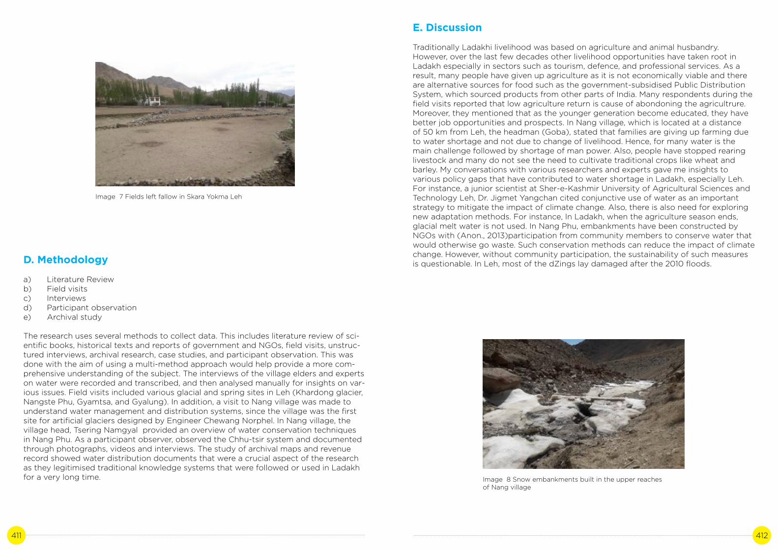
411 412
Image 7 Fields left fallow in Skara Yokma Leh
D. Methodology
a) Literature Reviewb) Field visitsc) Interviewsd) Participant observatione) Archival study
The research uses several methods to collect data. This includes literature review of sci-entific books, historical texts and reports of government and NGOs, field visits, unstruc-tured interviews, archival research, case studies, and participant observation. This was done with the aim of using a multi-method approach would help provide a more com-prehensive understanding of the subject. The interviews of the village elders and experts on water were recorded and transcribed, and then analysed manually for insights on var-ious issues. Field visits included various glacial and spring sites in Leh (Khardong glacier, Nangste Phu, Gyamtsa, and Gyalung). In addition, a visit to Nang village was made to understand water management and distribution systems, since the village was the first site for artificial glaciers designed by Engineer Chewang Norphel. In Nang village, the village head, Tsering Namgyal provided an overview of water conservation techniques in Nang Phu. As a participant observer, observed the Chhu-tsir system and documented through photographs, videos and interviews. The study of archival maps and revenue record showed water distribution documents that were a crucial aspect of the research as they legitimised traditional knowledge systems that were followed or used in Ladakh for a very long time. Image 8 Snow embankments built in the upper reaches
of Nang village
E. Discussion
Traditionally Ladakhi livelihood was based on agriculture and animal husbandry. However, over the last few decades other livelihood opportunities have taken root in Ladakh especially in sectors such as tourism, defence, and professional services. As a result, many people have given up agriculture as it is not economically viable and there are alternative sources for food such as the government-subsidised Public Distribution System, which sourced products from other parts of India. Many respondents during the field visits reported that low agriculture return is cause of abondoning the agricultrure. Moreover, they mentioned that as the younger generation become educated, they have better job opportunities and prospects. In Nang village, which is located at a distance of 50 km from Leh, the headman (Goba), stated that families are giving up farming due to water shortage and not due to change of livelihood. Hence, for many water is the main challenge followed by shortage of man power. Also, people have stopped rearing livestock and many do not see the need to cultivate traditional crops like wheat and barley. My conversations with various researchers and experts gave me insights to various policy gaps that have contributed to water shortage in Ladakh, especially Leh. For instance, a junior scientist at Sher-e-Kashmir University of Agricultural Sciences and Technology Leh, Dr. Jigmet Yangchan cited conjunctive use of water as an important strategy to mitigate the impact of climate change. Also, there is also need for exploring new adaptation methods. For instance, In Ladakh, when the agriculture season ends, glacial melt water is not used. In Nang Phu, embankments have been constructed by NGOs with (Anon., 2013)participation from community members to conserve water that would otherwise go waste. Such conservation methods can reduce the impact of climate change. However, without community participation, the sustainability of such measures is questionable. In Leh, most of the dZings lay damaged after the 2010 floods.

413 414
Through discussion with local community especially in Leh where Churpon system no longer exists, it came out that provision of incentives could help revive the Chhu-tsir in Leh and in villages where the system is at the brink of collapse. The Goba of Leh mentioned that since most families have members having government and private jobs, no one wants to take the responsibility of Churpon. There is an existence of post called Mirab (water lord) in Rural Department, however, I was not able to check if they carried out the responsibilities of a Churpon in villages as currently there are only eleven positions and all of them are engaged in class 4 jobs. The Rural Department said if they were meant to serve the job of a Churpon, then the number of posts should be equal to number of villages.
Another important point noted from discussion with locals was that there should be an arrangement to store water in dZings from streams that otherwise go waste. Since dZings help ground water recharging, more dZings should be built to store water. According to 72-year-old Mohammad Kamal, a retired Electrical Engineer, who lives in Leh “The amount of snow has decreased. There is no snow on the mountains. We have no other option than to strengthen our dZings. I don’t see any effort from the government. They should make some arrangement to store stream water that is going waste. Earlier, I remember (pointing to a dried dZing in Chute rantak), the water from the dZing was distributed in Manekhang, Kharyog and Basti Haveli (present Tehsildar office). There was a large garden over there. Now, instead of increasing the storage capacity, we are actually letting the dZings dry up. Only when we have dZings, can we manage water for our garden and fields. The most efficient way would be to give responsibility to the area head (nambardar) to look after the streams (yuras) and dZings. The administration should assist them with funds and in the development of plans and techniques. Giving responsibility to the people of the area will ensure accountability and sustainability.” Building of artificial glaciers will not only reduce shortage of water during sowing season, but also recharge natural springs.
F. Conclusion
In the wake of declining water resources due to climate change and other human-induced factors, the distribution and sharing of water resource remains a major challenge. Urgent efforts are required by local village communities, village panchayats, NGOs and district administration to revive traditional water management and distribution systems to ensure that available scarce water resources are distributed in a fair and equitable manner. Strengthening of the community ownership and participation through incentives along with policy intervention from local self government institutions such as LAHDC and Panchayats is urgently needed. This will require changes in manpower management, technology and implementing and encouraging innovative methods of conservation and harvesting of resources, such as building artificial glaciers, ice-stupa will not only reduce shortage of water during sowing season, but also recharge natural springs. Policy has to be area-specific and village-specific. This will ensure accountability and sustainability. Lifting water from the Indus for irrigation and the use of renewable energy will reduce water stress in the district. Since dZings help ground water recharging, timely release of funds for the restoration and maintenance of dZings are necessary. Cropping of plants that consumes less water will reduce water shortage. In addition, awareness and capacity-building for water conservation is needed. The district administration and Leh Hill Council should urgently develop a water policy especially in town areas, where migration, over population and tourism is contributing to increased extraction of ground water and pollution of water bodies. Meanwhile, there is need to generate awareness among people on the judicious use of water resources.
References
Hodge, H. N., 2009. http://shikshantar.org/sites. [Online].
Angmo, S., 2019. Ladakh: A Critical Environmental Survey. LADAKH REVIEW, Volume 5, pp. 33-36.
Lotus, S., 2019. Erratic Weather& Water Issues in Ladakh. LADAKH REVIEW, Volume 5, pp. 9-14.
Gondhalekar, A. A. a. D., 2013. Impacts of tourism on water resources in Leh town. INTERNATIONAL ASSOCIATION FOR LADAKH STUDIES, Volume 30, pp. 25-37.
Anon., 2005. Ladakh Autonomous Hill Development Council, Leh. [Online] Available at: https://leh.nic.in/lahdcleh/vision/[Accessed 8 April 2018].
http://jkpheirrigation.nic.in/Programmes/SAPCC%20J&K_Executive%20Summary_23-10-2013.pdf
Mason, K. 1929. Indus floods and Shyok glaciers, The Himlayan Journal, Vol. 1.
Gunn, J.P. 1930. The Shyok flood, 1929, The Himalayan Journal, Vol 2
Hill, Joe, 2014. Farmer-managed irrigation in the Karakoram (Baltistan) and trans-Himalaya (Kargil), Ladakh Studies, 31, p. 4-23
WANGCHUK, R. N., 2018. Ladakh Facing Its Worst Water Crisis Ever: How It Can Effectively Tackle Climate Change. [Online].
Bibliography
Gladfelter, S., 2018. https://sierragladfelter.com/current-research/. [Online]
Wangmo, S., 2019. Water Status in Ladakh. LADAKH REVIEW, Volume 5, pp. 78-8
H. M. Meena1, J. C. T. ,. M. S. R. ,. C. B. P. a. L. A., 2015. Influence of Weather Variation on Cropping Pattern of Leh District of Ladakh Region. Current World Environment, Volume vol10no2.
Shakspo, J. B. &. N. T. ed., 2007. Historical perspectives of Saboo. In: Recent Research on Ladakh. Leh, Ladakh: J&K Academy of Art, Culture & Languages.
Namgyal, R., 2018. Sa phut yul gi dpe deb. Leh: Self-published.
Anon., 2013. Water Mission-PHE Department. [Online] Available at: http://jkpheirrigation.nic.in/Programmes/State_Mission_on_Water_23102013.pdf[Accessed 5 May 2018].
Singh, D. A. &. P., 2006. Traditional irrigation and water distribution system in Ladakh. Indian Journal of Traditional Knowledge , Volume 5(3), pp. 397-402.

415 416

F-5, Ground Floor, Kailash Colony, New Delhi - 110048, IndiaPhone: 011 - 40193747
[email protected]_info