Carriageway Skidding Resistance Procedure - Leicestershire ...
30
Leicestershire County Council Status: Final Carriageway Skidding Resistance Procedure vs 1.9.2 Date: 23th December 2021 Last Updated: 19/02/2021 Page 1 of 30 Leicestershire County Council Carriageway - Skidding Resistance Procedure Status: Final Team: Assets and Major Programmes Date: 23 th December 2021 Approved by Highways and Transport Commissioner
-
Upload
khangminh22 -
Category
Documents
-
view
0 -
download
0
Transcript of Carriageway Skidding Resistance Procedure - Leicestershire ...

Leicestershire County Council Status: Final
Carriageway Skidding Resistance Procedure vs 1.9.2 Date: 23th December 2021 Last Updated: 19/02/2021 Page 1 of 30
Leicestershire County Council
Carriageway - Skidding
Resistance Procedure
Status: Final
Team: Assets and Major Programmes
Date: 23th December 2021
Approved by
Highways and Transport Commissioner

Leicestershire County Council Status: Final
Carriageway Skidding Resistance Procedure vs 1.9.2 Date: 23th December 2021 Last Updated: 19/02/2021 Page 2 of 30
Contents
1. DOCUMENT CONTROL 3 1.1 Document revision and amendments 3
2. TABLE OF AMENDMENTS 4 2.1 Table of Amendments 4
3. INTRODUCTION 5 3.1 Alignment with our Asset Management Policy 5 3.2 Purpose of this document 5 3.3 Background 5
4. RESPONSIBILITIES 9 4.1 Legal Responsibilities 9 4.2 Roles and Responsibilities 9
5. THE DEFINED NETWORK 12 5.1 The Annual Skidding Resistance Survey 12 5.2 Roads that are not part of the defined network 12
6. INVESTIGATORY LEVELS 13 6.1 A review of Investigatory Levels 13 6.2 Objectives for Reviewing the Investigatory Levels 13 6.3 The Procedure 13 6.4 Road Resurfacing Polished Stone Values 16 6.5 The length of approach to features 17 6.6 High Friction Surface Treatments (HFST) 18
7. SLIPPERY ROAD WARNING SIGNS 19 7.1 Criteria for erecting Slippery Road Signs 19 7.2 Early Life Skidding Resistance of Road Surfaces 19 7.3 Horses and Highway Surfacing 19
8. MONITORING ROAD TRAFFIC COLLISION LEVELS 21 8.1 Desktop study 21 8.2 Texture Depths 21 8.3 Skidding Resistance vs Road Texture depth 21
9. SITE INVESTIGATIONS 22 9.1 Visual Investigations on-site 22
10. PROCEDURE STATEMENT 24 10.1 What we will do… 24 10.2 How will we know we have made a difference…? 25
11. PERFORMANCE 26 11.1 Performance Management 26 11.2 Performance Monitoring 26
12. APPENDIX A. 27 12.1 Site Investigation report 27 12.2 Prioritisation 28
13. APPENDIX B 29 13.1 Skidding Resistance Road Network 29
14. REFERENCES 30

Leicestershire County Council Status: Final
Carriageway Skidding Resistance Procedure vs 1.9.2 Date: 23th December 2021 Last Updated: 19/02/2021 Page 3 of 30
1. Document Control
1.1 Document revision and amendments
This document has been developed by the Asset and Major Projects Team, Environment and Transport Department and will be reviewed every 3 years.
N.B. The suffix denotes an in-year amendment, rather than a revision of the whole document.
Version number
Developed / Amend by:
Approved by: Date of approval:
1.0 - -
1.7 Senior Asset Programme Manager
Highways & Transport Commissioner
10/12/2019
1.8 Senior Asset Programme Manager
Highways & Transport Commissioner
10/01/2020
1.9 Senior Asset Programme Manager
Highways & Transport Commissioner
10/12/2020
1.9(1) Senior Asset Programme Manager
Highways & Transport Commissioner
19/02/2021
1.9(2) Senior Asset Programme Manager
Highways & Transport Commissioner
23/12/2021

Leicestershire County Council Status: Final
Carriageway Skidding Resistance Procedure vs 1.9.2 Date: 23th December 2021 Last Updated: 19/02/2021 Page 4 of 30
2. Table of Amendments
2.1 Table of Amendments
Page no. Version Amendment Date
3 1.9 All reference to version 1.8 changed to 1.9 July 2020
4 1.9 Changes have been made to the Table of Amendments removing all previous references to earlier versions of the procedure. (i.e. version 1.8 etc)
July 2020
8 1.9 Additional text explaining why we don’t survey roundabouts. Dec 2020
12 1.9 Amended Section 5.1 to confirm the use of the Single Annual Skid Survey (SASS) method, not the Benchmark method as previously stated.
July 2020
16 1.9 Section 6.4 Table 1.1 Note 3 replaced. July 2020
19 1.9 Section 7.1 Amended the statement relating to the use of slippery roads signs to reflect our current approach.
July 2020
22 1.9 Text amended in 9.1 to reflect approach using Xais Expert Assets July 2020
24 1.9 Procedure Statement – Eighth bullet point, text changed relating to the erection of Slippery Road Signs, to match our current approach.
July 2020
25 1.9 Bullet point has been added to include how we liaise with our Insurance and Legal teams to ensure we are protected against third party claims
August 2020
26 1.9 Appendix A: Site Investigation Report – amended to reflect the use of Xais Expert Assets software to help with the prioritisation process and score visual observations recorded during Site Investigations.
July 2020
Minor amendment between versions
Page no. Version Amendment Date
10 1.9(1)
Moved the following responsibility statement from Network Data and Intelligence to the Traffic and Signals team: Review of the accident data associated with each skid site and conduct the initial prioritisation for site investigations.
Feb 2021
14 1.9(2) The references to various notes were amended.
Dec 2021
Numerous 1.9(2) All references to Highways England replaced with National Highways Dec 2021

Leicestershire County Council Status: Final
Carriageway Skidding Resistance Procedure vs 1.9.2 Date: 23th December 2021 Last Updated: 19/02/2021 Page 5 of 30
3. Introduction
3.1 Alignment with our Asset Management Policy
This procedure document has been developed to update and replace our existing Skidding Resistance Strategy document which was originally published in March 2013.
This procedure document forms an important part of our risk management processes relating to skidding resistance of our defined road network (here-to referred to as the defined road network) and therefore the risk element of this document aligns with our Highway Asset Management Policy, this is our overarching Policy which is, in turn aligned to our strategic Corporate objectives highlighted in Leicestershire County Council’s Strategic Plan 2018-22.
3.2 Purpose of this document
Leicestershire County Council has re-evaluated its current approach to measuring skidding resistance of the defined road network using Griptester surveys as the main survey vehicle. We are now using Sideway-force Coefficient Routine Investigation Machine (SCRIM) Surveys for our Annual skidding resistance surveys for 2019/20 and beyond.
This does not mean that there was a problem with the previous approach that was adopted by the County Council, of using a Grip tester vehicle to survey our defined network. The Grip tester survey vehicle is most commonly used by most Authorities for surveying smaller road accident investigation sites, in conjunction with traffic collision investigations and is not commonly used for surveying the whole of the authority’s defined network.
Griptester surveys will continue to be used by us, but only in relation to skid collision site investigations only. This is because it is generally a quicker and a more convenient method to deploy for smaller survey lengths, but it takes quite a lot of manual effort to process the data for this type of survey.
SCRIM Survey data provides a simpler dataset for the Surveying Contractor to process. The use of this type of survey vehicle follows a more consistent approach and one which has been widely adopted by other local Highway Authorities. This will also help with the sharing of data in relation to cross-boundary locations and will allow us to benchmark our annual performance statistics against those of our neighbouring local Highway Authorities.
This document also highlights changes to our procedures to reflect the recommendations contained withinin National Highways (formerly Highways England) guidance document, the Design Manual for Roads and Bridges (DMRB) Volume 7, Section 3, part 1, CS 228 Skidding Resistance and these changes will be implemented from April 2019. National Highways documentation can be used as guidance by Local Authorities, but is principally aimed at Motorway and Trunk road agencies therefore Investigatory Levels, road speeds and availability of funding is generally lower than those available for the Strategic Motorway/trunk road network.
CS 228 (previously HD 28/15) is predominantly the same as its predecessor, with the main difference being the removal of Annex 7 from their document. This was removed because National Highways are now using crash models in their processes and it stipulates that these models only apply to the Motorways and Trunk roads managed by National Highways overseeing organisations. Guidance for producing a similar crash model for Local Authority use is not currently available.
The use of other skid testing measurement tools such as the static pendulum skid testing will not be used as an indicator of skidding resistance on Leicestershire’s road network.
3.3 Background
Leicestershire County Council is responsible for maintaining 4,468km (2,776 miles) of road network according to the Department for Transport Statistics (rdl0202 report).
We do not currently have the level of resources, or the financial budget to survey every road in the County for the level of skidding resistance, or deal with the volume of work that this generates. Therefore, we must prioritise which roads have the highest level of importance and survey those roads

Leicestershire County Council Status: Final
Carriageway Skidding Resistance Procedure vs 1.9.2 Date: 23th December 2021 Last Updated: 19/02/2021 Page 6 of 30
and then prioritise which of these we are able to repair with given financial constraints. Our defined skid network presently consists of 707km (439 miles) of roads, which are subject to an annual skidding resistance survey. Refer to Appendix B.
Skid resistance is an important property relating to the safety of highway users, particularly in damp, or wet road conditions. Over the course of a road’s lifespan the road surface can lose some of its characteristics associated with grip. Effective maintenance of the highway network includes the requirement to systematically monitor the skid resistance of the road surface and to take a reactive approach, so that the level of skidding resistance across the network is maintained to an appropriate standard.
This procedure document takes a risk-based Asset Management approach to managing skidding resistance and puts a greater emphasis on the site investigation process than our previous Skidding Resistance document.
The objective of the Skidding Resistance procedure is to:
• Enable the public to travel safely within the County;
• Enable the County Council to robustly defend against third-party claims;
• Address the number of killed, or seriously Injured due to skid-related accidents on the County Council’s road network;
• Ensure the County Council adheres to its duty of care under the Highways Act 1980;
• Ensure the County Council has adequate defence in a Corporate Manslaughter case as either the Highway Authority or its Chief Officer;
To achieve this, we will:
• Formalise and review processes for monitoring skidding resistance across the Council’s road network on an ongoing basis
• Identify sites using skid resistance survey methods where further investigation is required
• Use accident data to determine whether inadequate skidding resistance may have been a contributing factor
• Undertake a prioritised approach to site investigations
• Recommend appropriate actions to mitigate risks where reasonably possible
• Prioritise Skid deficient sites in an annual programme of works based on where the greatest risks can be found
The Skidding Resistance procedure has been produced to provide a step-by-step approach to identifying skid deficient sites and sets out a process for deciding on their subsequent treatment, and how this can be prioritised. This process considers the available budget, current resources, the rolling-programme and takes other associated risks into account. The procedures contained within this document, set out a long-term plan to manage the skidding resistance of the County Council’s defined network, to a consistent and safe level. The procedure complements the County Council’s Highway Asset Management Policy, Highway Asset Management Strategy, and Highway Infrastructure Asset Management Plan (HIAMP), which look to manage the assets in a strategic way.
In 2019, National Highways published an updated comprehensive methodology for managing carriageway skid resistance on motorways and trunk roads and this is set out in their design bulletin, Design Manual for Roads and Bridges (DMRB) Volume 7, Section 3, part 1 - CS 228. This is a National Highways publication

Leicestershire County Council Status: Final
Carriageway Skidding Resistance Procedure vs 1.9.2 Date: 23th December 2021 Last Updated: 19/02/2021 Page 7 of 30
that principally relates to Motorways and trunk roads and not Local Authorities networks but can be considered a guide for Local Authorities to use. Local Authorities do not have the financial expenditure, nor the resources that National Highways have at their disposal. Therefore CS 228 has been generally been referred to; to form a basis for Leicestershire County Council’s Skidding Resistance procedure and adapt our document to better reflect local needs and our requirements for setting Investigatory Levels, site investigations and the use of slippery road traffic signs. These changes will take effect from April 2019. The broad principles of CS 228 and therefore the County Council’s procedures are as follows:
Where remedial treatment is deemed to be of benefit, sites will be prioritised using a risk assessment approach and inserted into a work programme for action within the resources and budget available.
• Skid resistance surveys will be undertaken annually on defined parts of the highway network which
are referred to as the SCRIM network, and its priority is based on the Resilient Route network, road
hierarchy and traffic volumes
• The defined network will be assigned Investigatory Levels depending on a range of factors such as
the speed limit and geometry of the road
• Skid resistance data for an individual section of road (a site) will be scrutinised and compared
against its Investigatory Level within the County Council’s Pavement Management System and using
other risk management tools
• Sites where skid resistance falls at; or below the investigatory level, will be identified for further desk-
top investigations
• A schedule of potential sites where the skid resistance falls at or below the investigatory level,
combined with a relevant accident record will be produced
• The schedule of potential sites will be subject to site investigations to determine whether remedial
treatment is appropriate
• Information from the site investigation, the number of collisions, their severity and the SCRIM values
of each site, will be used to assist us in prioritising our lists for site investigations and for generating
a future programme of works
• Where remedial treatment is deemed to be of benefit, the site(s) will be prioritised using a risk
assessment approach and inserted into a schedule of works programme for action within the
resources available
• Any remedial treatments where works have not been carried out during the current fiscal year,
whether because of financial, or other resource constraints, will roll into the following year’s
programme and be prioritised accordingly based on the overall risk score for that site.
The above principles will be applied on an ongoing basis, so that skid resistance across the defined highway network is continually monitored and managed appropriately. The term “skidding resistance” used in this document, refers to the frictional properties of a road surface, measured using a specified device, under standardised conditions. SCRIM testing is carried out on controlled wetted surfaces, unless stated otherwise, as the skidding resistance of a surface will be substantially lower than when the same surface is dry.

Leicestershire County Council Status: Final
Carriageway Skidding Resistance Procedure vs 1.9.2 Date: 23th December 2021 Last Updated: 19/02/2021 Page 8 of 30
Skid resistance measurements are used as an assessment of a road surface’s level of grip and as an indication of the potential need for further investigation based on known acceptable limits. However, it should be noted it does not represent the definitive grip available to a road user making a particular type of manoeuvre, at a particular time, and at a particular speed. Leicestershire County Council do not currently measure the level of skidding resistance of the non-defined carriageway network, footways, or cycle ways. Roundabouts can also be problematical to survey; this is because the weight of the vehicle can roll around as the vehicle negotiates the roundabout, placing more pressure onto the test wheel and this effect can cause adverse test readings to occur. For this reason, we choose not to survey roundabouts.

Leicestershire County Council Status: Final
Carriageway Skidding Resistance Procedure vs 1.9.2 Date: 23th December 2021 Last Updated: 19/02/2021 Page 9 of 30
4. Responsibilities
4.1 Legal Responsibilities
The County Council has a statutory duty under Section 41 of the Highways Act to maintain highways that are maintainable at public expense. Although the formal management of highway skidding resistance is not a legal requirement, it is considered good practice and it supports the aims and objectives set out in the Council’s Highway Infrastructure Asset Management Plan (HIAMP), Risk Management Strategy and other road safety documents. Section 58 of the Highways Act 1980 provides the ability to form a statutory defence to counter legal actions for negligence. The County Council must be able to prove in a court of law that it has taken ‘such care as is in all the circumstances reasonably required, to secure that part of the highway to which the action relates was not dangerous for traffic’. When considering a third-party legal action against the Council the Court will consider such factors as:
• The character of the highway and the traffic which was reasonably to be expected to use it
• The standard of maintenance appropriate for a highway of that character and used by such traffic
• The state of repair in which a reasonable person would have expected to find the highway
• Whether the County Council knew, or could reasonably have been expected to know, that the condition of the part of the highway to which the action relates was likely to cause danger to users of the highway
• Whether the County Council could reasonably have been expected to repair that part of the highway before the cause of action arose
Section 58 of The Highways Act 1980 does not stipulate the standard of maintenance applicable to the highway. It is accepted by the Courts that different standards of maintenance are applicable to the road network; this is related to vehicle and pedestrian usage as well as speeds of the vehicles using the highway. The Court are aware that it would be unrealistic for the County Council to monitor and maintain adequate levels of skidding resistance on the whole road network, as this would not be deemed “reasonably practicable”. The development of this document is to provide a suitably structured procedure is implemented for the highway under its care and adequate levels of skidding resistance are maintained within reasonable expectations as outlined in the Highways Act 1980. Importantly, this procedure document will provide documentary evidence of the County Council’s approach to the management of skidding resistance of its roads.
4.2 Roles and Responsibilities
This section sets out the various roles and responsibilities for the management of Skidding Resistance. The annual Skid Resistance Survey Programme will be procured through a specialist accredited SCRIM contractor. In terms of Skidding Resistance, the following Leicestershire County Council teams are responsible for the following: -

Leicestershire County Council Status: Final
Carriageway Skidding Resistance Procedure vs 1.9.2 Date: 23th December 2021 Last Updated: 19/02/2021 Page 10 of 30
The Environment and Transport Department’s - Asset and Major Programmes Team are responsible for:
• Management, development, implementation and regular review of the Skidding Resistance procedure
and reviewing Quality Management processes
• Review of the site categories and investigatory levels to be applied to the Pavement Management System and update procedure documents. This review will be undertaken over a 3-year rolling period
• Assignment of site categories and investigatory levels, so that the Environment and Transport’s Network Data & Intelligence team can apply these values to the digitised Pavement Management Network for cross-referencing against the skid resistance survey data
• Reviewing existing staff competence levels of all staff working on the skidding processes and arranging skills training where necessary
• Assessing whether procedures can be improved and making recommendation to the Asset Management Project Board
The Environment and Transport Department’s - Traffic and Signals Team are responsible for:
• Changes to the layout of the existing road markings
• Improvements to the geometry of the road to minimise the potential for accidents etc, such as: junction improvements, changes to road markings, traffic calming and pedestrian crossing etc
• Investigation into road collision data to determine remedial measures to make the road safer for users
• Conducting Annual appraisals of their team, identifying existing skills and training needs. Notify the Assets and Major Programmes Team of any Skid related training needs
• Review of the accident data associated with each skid site and conduct the initial prioritisation for site investigations
The Environment and Transport Department’s - Network Data & Intelligence Team is responsible for:
• Liaison with the police relating to road traffic collision data (STATS 19)
• The procurement and subsequent management of skid resistance surveys with contractors
• Processing, analysis and review of skid resistance data received from the surveying contractor
• Making changes to the digitised network, and the Pavement Management System to amend Investigatory Levels where the physical road geometry has changed on-site
• Amending the existing Investigatory Levels on the digitised road network in accordance with alterations to the Investigatory Levels in this document
• Apply road categories and associated Investigatory levels to new road sections
• Liaison with other Council departments of any issues affecting the site(s), which may be contributory to skid resistance issues
• Liaising with the Environment and Transport Department’s - Assets and Major Programmes Team regarding changes to the existing procedures which may necessitate a change in the current site category and/or Investigatory Levels for SCRIM

Leicestershire County Council Status: Final
Carriageway Skidding Resistance Procedure vs 1.9.2 Date: 23th December 2021 Last Updated: 19/02/2021 Page 11 of 30
• Conducting Annual appraisals of their team, identifying existing skills and training needs. Notify the Assets and Major Programmes Team of any Skid related training needs.
The Environment and Transport Department’s - Commercial & Business Support Team is responsible for:
• Prioritising a list for site investigations
• Making arrangement so that site investigations can be safely conducted on-site
• Carrying out the site investigations in a prioritised and timely manner following a risk-based approach
• Recording on-site observations and findings from site investigations
• Maintaining the appropriate records of site visits and associated documents
• Liaison with Highway Control for the erection, maintenance and removal of temporary slippery road signs where necessary
• Liaising with the Traffic and Signals Team and the Highway Control Team for the erection, relocation of existing or the decommissioning of old permanent Slippery Road Signs
• Providing a prioritised risk-based list of sites that would benefit from maintenance works
• Using engineering judgement to make informed decisions about how a prioritised list is integrated into the overall highways Annual and Forward Works programmes
• Liaise with the Environment and Transport Network data and Intelligence team if the Investigation Level is considered to be incorrect for the road category
• Identify and report locations for erection, or decommissioning of temporary slippery road warning signs on-site
• Identify and report to Highways Control team for refreshing of any existing road markings on the carriageway in relation to a skid site
• To develop appropriate remedial treatments and projects for future programmes of work using appropriate materials
• Conducting checks on-site to confirm that remedial works were successfully carried out by the contractor as prescribed and convey this information to the Asset and Major Programmes team
• Conducting Annual appraisals of their team, identifying existing skills and training needs. Notify the Assets and Major Programmes Team of any Skid related training needs.

Leicestershire County Council Status: Final
Carriageway Skidding Resistance Procedure vs 1.9.2 Date: 23th December 2021 Last Updated: 19/02/2021 Page 12 of 30
5. The Defined Network
For the purposes of this procedure, the defined skidding resistance network comprises of parts of the Strategic Routes, Main Distributor or Secondary Distributor Roads as defined in the County Council’s “Highway Infrastructure Asset Management Policy (HIAMP)” document specific sites are shown in (Appendix B).
This list is regularly updated by the Network Data and Intelligence Team and can be amended by consultation with the team.
5.1 The Annual Skidding Resistance Survey
The level of skidding resistance of a road surface varies as the season’s change, with the lowest values generally being recorded during the summer months, due to the accumulation of detritus on the road surface. Therefore, it is necessary to calculate an average skid resistance value taking seasonal changes to the road surface into account.
Routine measurements of skid resistance shall be made using Sideway-force Coefficient Routine Investigation Machines (SCRIM) and processed by the Survey Contractor to derive Characteristic Skid Coefficient (CSC) values. The CSC is an estimate of the underlying skid resistance level once the effects of any seasonal variations have been calculated.
As 2019 was our first year for carrying out SCRIM surveys, our Survey Contractor will arrange for surveys to be undertaken to capture the CSC values this is determined using the Single Annual Skid Survey (SASS) approach as highlighted in CS 228.
The SASS approach takes account of yearly variation and therefore the calculations are affected by maintenance carried out in the last three years. The local equilibrium correction factor (LECF) is the correction factor that shall be used within each locality to bring the current year data to a level consistent with the long-term average. The Local Equilibrium SC (LESC) shall be determined to represent the average skid resistance level for the locality over recent years if a length of road has been resurfaced within the last four years then that length should be excluded from the LECF calculation. The Local Mean Summer Coefficient (LMSC) shall be determined for the current survey. The LMSC is the average of all valid 10m sub-sections in the locality in the current year survey
The low values of Skidding Resistance on its own is not necessarily a hazard, other factors must be considered, such as the history of any road traffic collision information relating to the site and the prevailing road conditions. For example: a collision may have occurred because of mud being present on the road surface at the time of the incident which may no longer be present. Skidding may have occurred, but not due to the physical conditions of the road itself. So, no remedial work would be required, unless the mud was still present or there were other factors which needed to be taken into consideration. Driver attitude and vehicle speed must also be considered.
The data loading and processing is followed by a desk-top exercise, using engineering judgement to cross-reference each site against the STATS 19 collision information (provided by the Police). Then consideration is given to the possible causation factors involved with each collision, in relation to each skid site.
5.2 Roads that are not part of the defined network
Routine annual SCRIM surveys will only be undertaken on roads that have been identified as being part of the defined skidding resistance network.
On other roads that are not part of the defined network, site specific testing may be carried out using Griptester surveys in relation to any third-party personal injury incidents involving skidding, or where damage to highways assets is regularly occurring. Surveys may also be undertaken where customers have raised concerns about the skidding characteristics of a specific road, where resources allow.
Under these circumstances, testing will only be undertaken in the absence of any historic data, following the assessment of any existing data held in our Pavement Management System (PMS) and after a competent person undertakes a road surface site investigation of the site.

Leicestershire County Council Status: Final
Carriageway Skidding Resistance Procedure vs 1.9.2 Date: 23th December 2021 Last Updated: 19/02/2021 Page 13 of 30
6. Investigatory Levels
6.1 A review of Investigatory Levels
Investigatory Levels (IL) will be regularly reviewed over a 3-year rolling period,
But also, when: -
• The SCRIM results indicate that a section lies below the current IL value and the site investigation provides information that suggests the current IL may be inappropriate
• changes are made to the current defined network or existing road geometry.
We will not change the Investigatory Levels merely because of the number of injury incidents as recommended by CS 228, as this would be too labour intensive for our current level of resources.
Accident data analysis is currently managed by the Environment and Transport Network Data and Intelligence team. If the site is identified as being at, or below the IL value then a desk-top study will be undertaken to cross-reference the skid site data with collision data and review the types of accidents that have occurred and whether skidding may have been a contributing factor.
6.2 Objectives for Reviewing the Investigatory Levels
The objectives will be to determine:
• whether the current IL value is appropriate
• whether the extent of the area covered by the IL is sufficient
• to check that the locations of the approaches to pedestrian crossing etc. correlate to the physical asset location. This is done by cross-referencing the sites with aerial photos, or using traffic signs to identify the position of gradients, sharp bends etc
• to check that the entire length of the defined network has an appropriate IL
• to pinpoint where the road geometry may have been modified, for example: where a traffic scheme has introduced a new roundabout.
6.3 The Procedure
The review will be led by a competent, trained member of staff, supported by the Assets and Major Programmes Team and the Traffic & Signals Teams. The following information will be obtained as a minimum: -
• The latest Investigatory Level from the Pavement Management System, or where roads are not part of our defined skidding resistance network the Characteristic Grip Coefficient (CGC) will be used in conjunction with any Griptest survey data
• Any changes that have taken place within the site area, surfacing materials, or road layout e.g. the installation of traffic signals, pedestrian crossings or roundabouts
• Any relevant local factors such as non-injury accidents, complaints or repeated reports of damage
• Details of injury accidents, particularly those where the road surface was documented as being wet, or damp
• Evaluation of any previous site investigations reports.

Leicestershire County Council Status: Final
Carriageway Skidding Resistance Procedure vs 1.9.2 Date: 23th December 2021 Last Updated: 19/02/2021 Page 14 of 30
Our site investigation levels are based on National Highways standards the Design Manual for Roads and Bridges Volume 7, Section 3, Part 1 Table 4.1:
Site Category and definition
IL for CSC data (Skid data speed corrected to 50km/h and seasonally corrected)
0.30 0.35 0.40 0.45 0.50 0.55 0.60 0.65
A
Motorway (Not Applicable), these are not LCC’s responsibility, they are the responsibility of National Highways or their Managing Agents
B Non-event dual carriageway with one-way traffic
✓
C Non-event single carriageway with two-way traffic
✓
Q
Approaches to and across minor and major junctions, approaches to roundabouts and traffic signals (for roads with speed limits below 50mph) (see note 6 also see note 9)
✓
Approaches to and across minor and major junctions, approaches to roundabouts and traffic signals (for roads with speed limits of 50mph or above) (see note 6 also see note 9)
✓
K
Approaches to pedestrian crossings, traffic signals and other high-risk situations (for roads with speed limits below 50mph) (see note 6 also see note 9)
✓
Approaches to pedestrian crossings, traffic signals and other high-risk situations (for roads with speed limits of 50mph or above) (see note 6 also see note 9)
✓
R Roundabout ✓
G1 Gradient 5-10% longer than 50m (see note 7)
✓
G2 Gradient >10% longer than 50m (see note 7) ✓
S1 Bend radius <500m – dual carriageway with one-way traffic (see note 8)
✓
S2 Bend radius <500m – single carriageway with two-way traffic (see note 8)
✓
Table 1. – Site Investigation Levels adopted by LCC (see corresponding notes below)
Notes applicable: The grey boxes in Table 1 above highlight the recommended values suggested by National Highways in CS 228. National Highways suggest that if the Highway Authority should deviate outside of the grey boxes, they must justify why they have chosen alternative values. This is justification is likely to involve the collection of any scientific evidence used to support any such justification. The tick marks in Table 1 confirm which values are currently being used by Leicestershire County Council. As shown above, these all fall within the grey boxes. The lower values have been selected because the volume and traffic speeds are generally expected to be lower than those found on the National Highways network. 1. The IL should be compared with the mean CSC, calculated for the appropriate averaging length 2. The averaging length is normally 100m or the length of a feature if it is shorter, except for
roundabouts, where the averaging length is 10m

Leicestershire County Council Status: Final
Carriageway Skidding Resistance Procedure vs 1.9.2 Date: 23th December 2021 Last Updated: 19/02/2021 Page 15 of 30
3. Residual lengths less than 50% of a complete averaging length may be attached to the penultimate full averaging length, providing that the Site Category is the same
4. As part of site investigation, individual values within each averaging length should be examined and the significance of any values that are substantially lower than the mean value assessed
5. The above table is a replica of Table 4.1 shown in the Design Manual for Roads and Bridges CS 228. The tick marks highlight the Investigation Levels that Leicestershire County Council has elected to use as recommended by CS 228. National Highways suggested that the values relating to lighter boxes could be used where traffic flow is light. We have decided against taking that approach as it would overly complicate the Pavement Management process. But by highlighting the Investigatory Levels that we have chosen shows that we are still using values that are within the CS 228 recommended grey boxes.
Notes applicable to specific site categories: 6. ILs for site categories Q and K are based on the 50m approach to the feature and, in the case of
approach to junctions, through to the extent of the junction. The approach length shall be extended when the speed limit is at or greater than 50mph. On roads where 20mph restrictions are in place, the risk of skidding at this speed is considered negligible, therefore skidding resistance testing is not required in these locations.
On roads with a speed limit exceeding 50mph the Investigatory Level should be increased to 0.50 for category Q sites and 0.55 for Category K sites.
7. Categories G1 and G2 should not be applied to uphill gradients on carriageways with one-way traffic. 8. Categories S1 and S2 should be applied only to bends with a speed limit of 50 mph or above, except
if the radius of the bend is <100m, where the S1 and S2 categories shall be applied at all speeds. 9. CS 228 clarifies major junctions as being where traffic has a permanent right of way, and minor
junction are where the traffic is required to give way.

Leicestershire County Council Status: Final
Carriageway Skidding Resistance Procedure vs 1.9.2 Date: 23th December 2021 Last Updated: 19/02/2021 Page 16 of 30
6.4 Road Resurfacing Polished Stone Values
Table 1.1 must not be confused with the Highway England’s tables used for selecting which Polished Stone Value (for skidding resistance) should be used in conjunction with road resurfacing treatments. Highway’s England’s Agencies would generally refer to the Design Manual for Roads and Bridges, vol 7, Section 5, part 1 CD 236 tables 3.2a and 3.2b in this situation. Leicestershire County Council officers will refer to the following values in table 1.1 below in relation to designing carriageway maintenance schemes.
National Highways suite of documents have been referred to for guidance. The Polished Stone Values selected below in Table 1.1 have been chosen because they relate to locally sourced materials, which means a lower carbon footprint and are regularly used by our Highway Framework Contractors.
Site Category and definition
IL
Target Polished Stone Value for given IL, traffic level and type of site
Traffic (cv/lane/d
ay) at design life
0 - 100
101 - 250
251 - 500
501 – 1000
1001 - 3000
3001+
Traffic Category
H/G F E D C/B B/A
NRSWA Road Type
4 3 3 2 1 1
A Motorway (Not Applicable), these are not LCC’s remit, they are the responsibility of National Highways or their Managing Agents
N/A N/A N/A N/A N/A N/A N/A
B Non-event dual carriageway with one-way traffic
0.35 50 50 50 50 55 60
C Non-event single carriageway with two-way traffic
0.40 50 50 55 60 63 63+
Q
Approaches to and across minor and major junctions, approaches to roundabouts and traffic signals (for roads with speed limits below 50mph)
0.45 55 55 60 63+ 63+ 65+
Approaches to and across minor and major junctions, approaches to roundabouts and traffic signals (for roads with a speed limit of 50mph and above)
0.50 55 60 60 63+ 65+ 65+
K
Approaches to pedestrian crossings and other high-risk situations signals (for roads with speed limits below 50mph)
0.50 55 60 63+ 63+ 65+ 65+
Approaches to pedestrian crossings and other high-risk situations (for roads with a speed limit of 50mph and above)
0.55 60 65 65 65+ 65+ 65+
R Roundabout 0.45 50 55 60 60 60 63+
G1 Gradient 5-10% longer than 50m 0.45 55 55 55 60 63+ 63+
G2 Gradient >10% longer than 50m 0.50 60 60 60 63+ 63+ 63+
S1 Bend radius <500m – dual carriageway with one-way traffic
0.45 50 55 55 55 60 63+
S2 Bend radius <500m – single carriageway with two-way traffic (for roads with a speed limit of 50mph and above) (See note 7)
0.50 60 63+ 63+ 63+ 65+ 65+
Table 1.1 - Polished Stone Values for carriageway resurfacing treatments

Leicestershire County Council Status: Final
Carriageway Skidding Resistance Procedure vs 1.9.2 Date: 23th December 2021 Last Updated: 19/02/2021 Page 17 of 30
Notes:
1. A High Friction Surface Treatment shall not be used solely because a coloured road surface is required.
2. The (+) plus sign in the above table signifies that a higher PSV may be used if the actual value (i.e. 63) cannot be obtained from local quarries, so if 63 is not available, a 65 or higher PSV maybe be chosen instead.
3. Table 1.1 Polished Stone Values shall be applied to ALL sites on the Defined Skid Resistance Network for the treatment of all new roads, surface dressing, carriageway resurfacing and carriageway maintenance works requiring full carriageway width works greater then 15m in length. It shall also apply for the same treatments to all sites with a speed limit greater than 30mph on the Non-Defined Skid Resistance Network. Sites on the Non-Defined Skid Resistance Network with a speed limit of 30mph or less, are considered to be generally low risk sites where a standard 55PSV material shall be used unless specific accident reduction measures are recommended. For maintenance works requiring full carriageway width works less than 15m in length on either the Defined or Non-Defined Skid Resistance Network, the overall effect of the works is not expected to have a significant effect on the overall level of skid resistance provided by the carriageway and a standard 55PSV material shall be used unless specific accident reduction measures are recommended.
4. However, although the skidding requirements may vary along a site, the use of different aggregates of varying PSV on the different lengths of the site may generally be considered impractical. Particularly with regard to applying a surface dressing treatment. In this situation, the engineer should decide the most appropriate PSV for the site as a whole; but may consider resurfacing individual sections of the road where a higher PSV may be required. For example: on sharp bends, or on the approaches to pedestrian crossings.
5. In Table 1.1 the range of Commercial vehicles (0 – 3001) has been derived from the highest count found on Leicestershire County roads (during 2019), of 2,849 commercial vehicles per lane per day, so this has been used as a comparison against National Highways ranges found in CS 228. This has means we were able to streamline the above table to suit Leicestershire’s current volume of traffic.
6. It is not normal practice to provide a Binder course, or Base course layer with a PSV higher than a 55PSV. Therefore, no temporary planed surface shall be left open to traffic to travel over at high traffic speeds. In this situation, traffic speed should be restricted to a maximum 40mph through-out the duration of the works, by using of appropriate traffic management signing, lighting and guarding in accordance with the latest Traffic Signs Regulations and General Directions manual (TSRGD). For two-lane high speed roads, it may be necessary to slow vehicle speeds by closing one lane and using a chicane type system on the approach to the site.
7. For Bends with a radius <500m Single carriageways with two-way traffic, but where the speed limit is below 50mph the relevant PSV value for roundabouts will apply.
Competent Engineering judgement shall be used on all surfacing, resurfacing and surface dressing sites to determine the appropriate PSV for each location, such as outside schools and other high-risk areas, as part of the engineer’s risk-based approach.
A PSV50 can be used for dual-carriageway non-event sections, where no other categories exist within the extents of the sites, such as minor and major junctions etc.
Any deviation from this document shall require approval from the Director of Environment and Transport.
6.5 The length of approach to features
Table 2 below, shows the required length of treatments for approaches to/and across both major and minor junctions, controlled crossing and approaches to roundabouts compared with the 85th percentile speeds of traffic. This method shall apply to the following categories Q, K and R for establishing the length of surface treatment that is necessary for each approach.

Leicestershire County Council Status: Final
Carriageway Skidding Resistance Procedure vs 1.9.2 Date: 23th December 2021 Last Updated: 19/02/2021 Page 18 of 30
85th Percentile approach speed
(mph) 25 30 35 40 45 50
Length of Target PSV treatment (m)
40 50 65 80 80 80
Table 2. – Length of Surface Treatment on Approaches.
The extents and type of remedial action will be decided by a competent, trained officer following the site investigation. Engineering judgement will be used for gradients and bends <500m which will usually involve applying a higher PSV throughout the extent of the hazard.
6.6 High Friction Surface Treatments (HFST)
Historically, approaches to controlled crossings, roundabouts and traffic signals were required to have an application of High Friction Surface Treatment to increase the skidding resistance level to 68+ Polished Stone Value.
The aggregate used in High Friction Surface Treatment is traditionally Calcined Bauxite mixed with a resin binder. Aggregates with this level of skidding resistance cannot be sourced locally and must be imported from Countries such as China, or India. This dramatically increases the overall costs for this type of treatment.
This type of application is usually a thin layer of screed mixed with a Calcined Bauxite aggregate applied to the surface of the road (either hot-applied or cold-applied treatment). In addition to being expensive to lay, the Road Surface Treatment Association undertook research into this treatment and found that HFST generally wears off within 3 – 5 years depending on traffic volumes, through the braking and turning actions of the traffic travelling over it. The requirements for a 63+ PSV may in many circumstances be higher than is necessarily required in some locations, for example in urban areas where the speed limit is below 50mph.
Therefore, Leicestershire County Council will only apply High Friction Treatment Surfacing where it is deemed an essential requirement. The use of High Friction Surface Treatment requires an element of engineering judgement to determine whether it should be utilised. Other factors should be considered for example: current speed limit, proximity to schools, the locations of junctions near to sharp bends or pedestrian crossings on a downhill gradient and other potential hazards. If several hazards are within close proximity, consideration should be given by the engineer as to whether the same higher PSV should be applied throughout the site.
Rather than using a HFST, a higher Polished Stone Value (PSV) aggregate may be selected during the design stage and incorporated into the road surface courses. This can provide a more than adequate skidding resistance for the site, whilst lasting throughout the lifespan of the road surface.
This minimises construction timescales, and long-term maintenance costs, and minimises the use of scarce natural resources and therefore a more suitable and sustainable alternative treatment. During the maintenance and Design processes our Engineers will refer to table 1.1 above to establish the required level of skidding resistance, based on the volume of traffic using the site.
When an existing a site is found to have worn HFST, but the Skidding Resistance survey confirms that an adequate level of skidding resistance is still being provided by the underlying road surface. In this situation, we will continue to annually monitor the site, but choose not to replace the HFST unless our historic collision data shows the number of road traffic collisions have increased over the preceding 3-year period.

Leicestershire County Council Status: Final
Carriageway Skidding Resistance Procedure vs 1.9.2 Date: 23th December 2021 Last Updated: 19/02/2021 Page 19 of 30
7. Slippery road warning signs
7.1 Criteria for erecting Slippery Road Signs
When a site has been assessed and remedial measures have been established to repair a skidding resistance issue, these remedial works should be incorporated into the appropriate annual Capital works programme.
Any sites that are found to have a skid resistance value greater than 0.1 below the investigatory level and a known reported injury accident history; will be identified as high priority for a site investigation, with the greater value below the Investigatory Level being prioritised as the most urgent.
Slippery roads signs will not normally be erected on the approaches to a slippery road site, because road traffic accidents generally involve a number of other factors, not solely because the road surface condition is below the required investigation level. However, if during a site investigation a competent engineer decides that the site may pose a significant danger to highway users, then temporary slippery road signs may be erected to warn approaching motorists of the hazard. These signs will be erected and maintained for vehicles approaching the site.
Once the treatment has been carried out to rectify any problems and the engineer is satisfied with the outcome of the remedial measures, then the slippery road signs may be taken down and removed from site or relocated to be used at another skid related site.
The latest version of The Traffic Signs Regulations and General Directions manual should be referred to, relating to road traffic sign requirements.
7.2 Early Life Skidding Resistance of Road Surfaces
This section relates to newly laid asphalt material and the presence of a film of bitumen coating over the surface aggregate of the new road surface. Research carried out by the Transport Research Laboratory (TRL) in their report PPR060 has shown that this bitumen coating can present a problem relating to the skidding resistance properties of the road surface, which can pose an initial risk to road users until the bitumen coating has scrubbed off with the movements of traffic. However, the finding of the report states that the risk of an increase in accidents due to the presence of this binder coating is relatively small.
National Highways design manual suggests that asphalt surfacing materials exhibit different skid resistance properties in the initial period after laying compared with the same surfacing’s that have been exposed to traffic for a period of time.
CS 228 states that: “it is assumed that the surface will have reached an equilibrium state one year after opening to traffic”. This will allow time for the bitumen coating to wear off thus exposing the aggregate that provides the desired level of skidding resistance.
Leicestershire County Council’s Environment and Transport Department undertook a series of Grip Tester surveys on new thin surface course treatments in the summer of 2012. The aim was to understand both what level of grip is provided by a new surface and how it improves through trafficking.
The results demonstrated that adequate grip was available immediately from all new road surfaces. Therefore, permanent slippery road signs will not be erect in relation to new carriageway resurfacing works as early life skidding resistance is not considered to be an issue in Leicestershire.
7.3 Horses and Highway Surfacing
Some new surfacing materials have been found to be more slippery by riders of horses. This has led to the British Horse Society and the County Surveyor’s Society (now ADEPT) to specifically produce a series of guidance documents for both horse riders and the Local Highway Authority, to ensure horses remained safe on the highway.
The document is: CSS/British Horse Society ENG 03/05

Leicestershire County Council Status: Final
Carriageway Skidding Resistance Procedure vs 1.9.2 Date: 23th December 2021 Last Updated: 19/02/2021 Page 20 of 30
The guidance document included recommendations for the newly laid surface to have:
• an application of grit applied during the construction process, on specific roads that were likely to be used by horse riders near riding stables or racecourses
• or to have a High Friction Surface Treatment applied to the new road surface, especially on gradients
• or to abrade the new surface with a retexturing machine to remove the bitumen coating from the surface of the chippings
• Notify nearby stables that works are taking place in that area, so horse riders can anticipate that the surface may be slippery
Other recommendations were aimed at the owners of the horse to:
• ensure that their horse was properly shod
• Proceed to ride with caution on any new road surfaces
• If the horse’s shoes were thin, or loose then the rider should avoid using that road until the horse’s shoes had been correctly fitted by a farrier

Leicestershire County Council Status: Final
Carriageway Skidding Resistance Procedure vs 1.9.2 Date: 23th December 2021 Last Updated: 19/02/2021 Page 21 of 30
8. Monitoring Road Traffic Collision Levels
8.1 Desktop study
A desktop study of vehicle collisions should be undertaken to compare against sites that are at or below the required Investigatory Level. This should establish whether there have been any collisions over the preceding three-year period within the same location as the skid site. The frequency of accidents occurring on road surfaces within these locations can be an indication of inadequate grip.
The County Council holds records of all injury accidents reported to the Highway Authority by the Police and this will be interrogated on an annual basis and cross-referenced to the annual skidding results. This desk study will be overseen by a competent person.
Sites that have been identified as being below the required Investigatory Level and showing a trend of collisions over the previous 3 years. Should have a site investigation undertaken within three-months from the date that the desktop analysis was undertaken, in accordance with our Site Investigation Procedure in Section 7.
Records should be retained to demonstrate when the site was identified, when the site investigation was carried out and any subsequent findings from that investigation. This information will be used to prioritise the Skidding Resistance schemes for inclusion in the Annual Capital Programme.
8.2 Texture Depths
The defined network consists of roads that are also surveyed using SCANNER surveys, (Surface Condition Assessment of the National NEtwork of Roads). This type of survey uses lasers to scan the road surface and collects detailed information about the surface condition of the road.
One element of this survey assesses the Sensor Measured Texture Depth (SMTD). Refer to DMRB Vol 7 HD 29/08 2.22 or the latest revision. http://www.standardsforhighways.co.uk/ha/standards/dmrb/vol7/section3/hd2908.pdf
Changes in the Texture Depth of the road surface can indicate a potential loss of skid resistance, or some other mode of surface failure, e.g. Fretting resulting in a high Texture Depth), or indicate fatting-up of the road surface (where heated summer temperatures cause the bitumen to melt in hot weather.
This results in a loss of texture depth as the aggregate is pressed into the bitumen, or the hot bitumen is forced through the aggregate by the weight of the vehicles passing over the road surface. The average Texture depth reading will be considered for each site during the desk-top exercise.
8.3 Skidding Resistance vs Road Texture depth
There is no direct correlation between loss of skidding resistance and loss of texture, because although fatting-up may be present on a road surface the road may still offer sufficient skidding resistance. However, the presence of low texture depths may be a significant contributing factor.
Low texture depths may also be a factor of chipping loss (fretting) specifically on Hot Rolled Asphalt sites. When considering texture depths against Skidding Resistance an average texture depth below 0.8 is used to identify low texture.
Therefore, in these circumstances a site inspection is essential to determine that appropriate corrective measures are employed.
For new developments we expect the Developer to follow our Design Guidance and provide a minimum road surface texture depth of 1.2. In terms of PSV table 1.1 should be referred to and appropriate engineering judgement used for all types of road surfaces and will require Leicestershire County Council’s approval.

Leicestershire County Council Status: Final
Carriageway Skidding Resistance Procedure vs 1.9.2 Date: 23th December 2021 Last Updated: 19/02/2021 Page 22 of 30
9. Site Investigations
9.1 Visual Investigations on-site
An overall desk-top study is carried out using the Xais software Expert Assets (XA).
Within this system, parameters are set so that a score is automatically generated based on the severity of the SCRIM value (MSSC) below the Investigatory level and the severity/number of collisions relating to each site. This will firstly involve identifying the proximity of any accidents have occurred at each site over the previous three-years. A member of our Traffic and Signals team will carry out this desk-top study and will identify any valid accidents at each site. Which will produce an initial score.
Once the study is complete, the individual sites for investigation are moved to the Expert Assets Mobile solution for use with hand-held devices on-site.
At the moment, we will be investigating all sites with an initial score value of 21 or above. This threshold score will be re-assessed as part of our ongoing review of this procedure every three-years and amended accordingly to match our minimum number of site visits.
We aim to carry out a minimum of 150 site investigations each year, where reasonably practicable and when the weather and our resources are available.
By undertaking a site investigation, each visual factor will be considered recording observations that could potentially be detrimental for each site. Each of these observations will be scored to provide an overall rating for each site and generate a prioritised list for remedial works. an example of the form is shown in Appendix A.
The aim of this site investigation is to record all visual observations of:
• characteristics of the road, bends, steep gradients/cross-falls
• road geometry, junctions, pedestrian crossing etc
• environmental factors
• existing overall pavement condition
• any apparent hazards
• the existing speed limit
• any standing surface water, ponding
• any defects, potholes, fatting-up, chipping loss, rutting, texture depths etc
• assess current drainage conditions
• whether there is evidence of any incidents/collisions etc
• take other risk characteristics into account, schools, hospitals, shopping precinct, community centres, or roads that are used by horse riders etc
• the date the site investigation was undertaken
• site ID/section reference.
Each competent engineer carrying out the Site investigations will be issued with a mobile hand-held device. Each site will be investigated to collect all visual observations from a checklist on the device. The software currently used on the hand-held devices is Expert Assets, this software automatically scores these observations allowing each site to be ranked within the Expert Assets mobile application and this data is uploaded and saved to external servers. This information is retained as a record the date of each investigation and what observations were made during the time of the site visit, for future reference.
Once the site investigations have been completed, two lists shall be produced:
1. A prioritise risk-based list of all sites where urgent slippery road signs should be erected, (within one-month of the completion of the final site investigation)

Leicestershire County Council Status: Final
Carriageway Skidding Resistance Procedure vs 1.9.2 Date: 23th December 2021 Last Updated: 19/02/2021 Page 23 of 30
2. A prioritised risk-based list of all sites for remedial works, highlighting the type of work required to remedy the existing hazard (within 3-months of the final site investigation).

Leicestershire County Council Status: Final
Carriageway Skidding Resistance Procedure vs 1.9.2 Date: 23th December 2021 Last Updated: 19/02/2021 Page 24 of 30
10. Procedure Statement
10.1 What we will do…
• Ensure that staff authorised involved in assessing skidding resistance parameters, surveys,
desk top studies and on-site investigations are competent, or led by an officer who has been
trained and therefore competent to make the appropriate decisions
• Where reasonably possible, we will arrange for annual skidding resistance survey data to be
collected. This will be done using a specialist survey contractor using a calibrated and
accredited survey vehicle, and surveyed in a timely manner within the seasonal survey
window
• When the specialist contractor submits their data, we will check data quality, reliability,
appropriateness and completeness in accordance with recommendation 10 of the Code of
Practice “Well-Managed Highway Infrastructure”
• We will review and monitor our carriageway skidding resistance results annually and from this
data we will identify sites that are at, or below the required Investigatory Level (IL) for each
specified category. These results will be compared against the previous 3-year collision data.
This is from collision data that has been reported to us by the Police in relation to STATS 19
• From this information and our historic records, we will determine where to undertake our
detailed site investigations
• We will determine whether to carry out remedial works to improve the skidding resistance
characteristics of the road, to monitor the site, or consider whether other reasons may have a
contributing factor and record our follow-up actions
• We will establish a programme of works using our risk-based approach and plan to minimise
the risk to road users, as far as is reasonably practicable given our limited resources and
financial constraints
• We shall determine whether sites require advanced warning signs to be erected, to warn
approaching motorists of the potential hazard
• We shall determine which sites require remedial works and produce a prioritised risk-based
list of sites within three-months of the completion of all site investigations
• Site investigations will be prioritised based on the level of risk, if there are too many sites for
us to visit given our current level of resources, any sites not investigated will roll into the
following year’s survey for investigation
• We will retain a register of details relating to our site investigations and record any follow-up
actions
• We will liaise with our Traffic and Safety team to resolve any known issues that may require
changes to our digitised network, so it matches the existing road layout and obtain up to date
accident data from them
• We will review, update and amend the investigatory levels relating to skidding resistance at
least every three-years
• We will arrange for the removal of permanent slippery road signs where they are no longer
required, to minimise street clutter. This is in accordance with recommendation 36 of the
Code of Practice “Well-Managed Highway Infrastructure”

Leicestershire County Council Status: Final
Carriageway Skidding Resistance Procedure vs 1.9.2 Date: 23th December 2021 Last Updated: 19/02/2021 Page 25 of 30
• This document will be reviewed and updated at least every three-years and published on the
County Council’s web site
• We will liaise with our Insurance and Legal teams to ensure any changes to our Policies and
Procedures to ensure we can successfully defend against third party claims.
10.2 How will we know we have made a difference…?
• We will obtain data that will be reliable, good quality and will be consistent with previous survey data (after the initial first year of the survey)
• The number of sites that are identified as being below the required skidding resistance level and which may have experienced skidding collisions, will begin to reduce
• We will have an auditable approach to managing our skidding resistance process, in accordance with our Quality Management System (QMS)
• We will be able to defend the County Council against legal action from third party personal injury/accident claims
• Where the engineer considers the site to be a particular hazard to highway users, Slippery Road Signs will be erected to warn approaching motorists
• We will begin to see a reduction in sites below the required Investigatory Level. Providing a safer, sustainable road network for all highway users
• We will retain good quality detailed records and will have an effective programme for remedial repairs relating to potential slippery road conditions
• Closer liaison between other departments and collaboration with our neighbouring Highway Authorities, which will help resolve highway issues promptly
• Our skidding resistance Investigatory Levels will be regularly checked and updated in-line with our Quality Management System in accordance with other recommendations
• Our retention of skid resistance data will be up to date, improve data reliability, and all actions from site investigations will be recorded
• Overall our roads will be safer for highway users, sustainable and operational.

Leicestershire County Council Status: Final
Carriageway Skidding Resistance Procedure vs 1.9.2 Date: 23th December 2021 Last Updated: 19/02/2021 Page 26 of 30
11. Performance
11.1 Performance Management
The performance of our overall skidding resistance procedure will be reviewed by the Senior Management Team to ascertain that each stage is performing the desired function, in accordance with this document and our overall Asset Management function.
This process will be mapped out in our Quality Management System (QMS). This Framework will be responsible for monitoring performance of the services by the Departmental Management Team, once the processes have been approved.
11.2 Performance Monitoring
The percentage of sites identified as having low skidding resistance is critical in terms of our roads being safe for highway users.
We will prioritise our site investigations and remedial treatments of our defined skidding resistance network based on the site location in relation to:
The severity of the collision and the number of collisions within the site and:
1. Major Road Network, Resilient Network, dual carriageways
2. Principal ‘A’ class roads
3. Classified ‘B’ roads
4. Certain high use Classified ‘C’ roads
The quantity of sites treated each year, will depend on the level of funding made available for remedial treatments for skidding resistance sites. This will be determined by the Asset Programme Board.
We will also monitor the number of site investigations carried out on the road network, to ensure they have been undertaken within an appropriate timescale of the survey analysis and check that deficient sites have been prioritised and added to a future programme of works.

Leicestershire County Council Status: Final
Carriageway Skidding Resistance Procedure vs 1.9.2 Date: 23th December 2021 Last Updated: 19/02/2021 Page 27 of 30
12. Appendix A.
12.1 Site Investigation report
Site Investigations will be undertaken to gather visual information about each site.
We will be using hand-held devices equipped with mobile software for Skidding Resistance Site Investigations. This will allow engineers to record their site observations directly onto the device for reference later.
These observations will validate whether remedial works are necessary and allows each observation to be scored and sites to be prioritised. This provides greater clarity as to which sites need remedial treatment and what type of treatment(s) might be required. This will also provide a full audit trail of our actions and each site record is stored electronically and backed-up daily.
Site Investigation questions and scoring mechanism
Source Question Text Response Scoring Condition Average Deficiency* 1/-0.01/-0.10/-0.20 1/5/10/20
Condition Does the site exhibit >=25% loss of HFS within the wheel paths/braking zone?
No/Yes 0/1
Condition Does the site exhibit Fatting/Polishing/Minor Fretting within the wheel paths/ braking zone?
No (<15%)/Yes (15-75%)/Yes (>75%)
0/1/2
Condition Is there Deformation/Pushing of Material (Entire Area)? No/Yes Info Only
Condition Does the site Exhibit Major Fretting within the Surface Course (Entire Area)?
No/Yes (<=25%)/Yes (>25%) 0/0.5/1
Condition Is there evidence of standing water NOT drainage related? (i.e. Rutting/Settlement)
No/Yes 0/1
Condition Is there evidence of the drainage system not working? (i.e. Blocked drains)
No/Yes Info Only
Visual Is >50% of the Centre Line Longitudinal Road Markings clearly visible? (Due to wear not leaves, etc.)
Yes/No Info Only
Visual Are Road Markings i.e. stop lines, clearly visible? (due to wear not leaves, etc.)
Yes/No Info Only
Visual Are Road Signs clear, visible and easily understood? Yes/No (Sign Requires Maintenance) /No (Sign Obstructed)
Info Only
Visual Is the site affected by trees/ vegetation? (i.e. do braches obscure, or is foliage likely to distract drivers?)
No/Yes Info Only
Visual Majority Surface Type
HFS/HRA/SD/Micro /SMA/ Other/Bitmac
Info Only
Visual Is there Contamination (e.g. Detritus) on the road surface? No/Detritus/Oil/ Soil/Sand/Other
Info Only
Site Wet Accidents* 0/1+ 0/1
Site Fatal Accidents* 0/1+ 0/1
Site Is there evidence of past patching repairs/ pothole fillings? No/Yes 0/1
Site Is there evidence of crash damage or heavy braking (i.e. Skid marks)?
No/Yes Info Only
Site Is there presence of existing slippery road signs? No/Yes Info Only
Site Is there presence of Traffic Signal Induction Loops? No/Yes Info Only
Rd Layout Is Queuing/ Standing traffic likely at any time? (including Peak hours)
No/Yes 0/1
Rd Layout Is there sufficient space? (i.e. lane width >2.7m No Damaged Kerbs present)
Yes/No Info Only
Rd Layout Is there presence of Lay-bys or other access (i.e. property/field access)?
No/Yes 0/1
Rd Layout Is there poor advance visibility? (Cannot see event from 100m in either direction/ Complicated Turning/ Sudden stopping)
No/Yes 0/1
Site Is there evidence of cracking/ minor surface defects? No/Yes Info Only
Site Is there evidence of defective Road Studs? (i.e. missing/damaged/low)
No/Yes Info Only
Site Is there evidence of joint sealing / overbanding? No/Yes Info Only
Rd Layout Does the site have shared use? (i.e. bus or cycle lane) No/Yes Info Only

Leicestershire County Council Status: Final
Carriageway Skidding Resistance Procedure vs 1.9.2 Date: 23th December 2021 Last Updated: 19/02/2021 Page 28 of 30
Rd Layout Is there a presence of chevron signs? No/Yes Info Only
Rd Layout Other factors (e.g. schools/pedestrian crossings/local amenities/speed cameras etc.)
No/Yes Info Only
*Average Deficiency & accident information are automatically collated for each site and are not specific on-site detailed Inspection question and responses
12.2 Prioritisation
The results from the site visit are automatically compiled into a prioritised list. The list is used to develop the future year’s programme of works. This programme is then submitted to the Capital Programme Board for approval, alongside our other risk-based Capital Infrastructure projects.
The quantity of sites being approved for remedial repair being undertaken each year will depend on the level of funding allocated from the Department for Transport and the severity of risks highlighted by and relating to other assets that we have in our responsibility.
Leicestershire County Council Status: Final
Carriageway Skidding Resistance Procedure vs 1.9.2 Date: 23th December 2021 Last Updated: 19/02/2021 Page 29 of 30
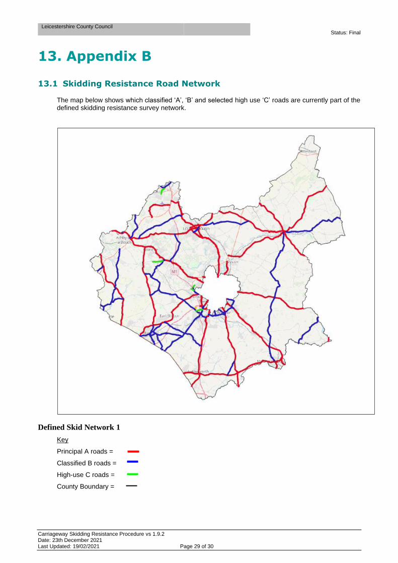
13. Appendix B
13.1 Skidding Resistance Road Network
The map below shows which classified ‘A’, ‘B’ and selected high use ‘C’ roads are currently part of the defined skidding resistance survey network.
Defined Skid Network 1
Key
Principal A roads =
Classified B roads =
High-use C roads =
County Boundary =

Leicestershire County Council Status: Final
Carriageway Skidding Resistance Procedure vs 1.9.2 Date: 23th December 2021 Last Updated: 19/02/2021 Page 30 of 30
14. References
• Design Manual for Roads and Bridges, TSO, London
• CS 228 Skid Resistance (Volume 7, Section 3, Part 1)
• Road Surface Treatment Association / XAIS guidance documents for Local Authorities on: o Road Skid Resistance Policy / Strategy 2018 o Skidding Resistance Procedure 2018
• Design Manual for Roads and Bridges, vol 7, Section 5, part 1 CD 236 tables 3.2a and 3.2b
• Interim Advice Note Ian 49/13 (now Superseded by CS 228) Use of Warning Signs for New Asphalt Road Surfaces (Volume 7, Section 5)
• Interim Advice Note 98/07 (now Superseded by CS 228) Guidance for HA Service Providers on implementing the Skid Resistance Policy (HD28/04)
• Transport Research Laboratory report PPR060, published by TRL.
• ENG 03/05 British Horse Society/ADEPT publication – Horses and Highway Surfacing