Carnotite Res,ources of Club Mesa, Montrose County, Colorado
92
(a<oo) Tl.o t"/r- t/rco. /A/-7 ----- --- --- Carnotite Res,ources of Club Mesa, Montrose County, Colorado By Leonid Bryner Trace Elements ln'Yestigations Report 147 UNITED STATES DEPARTMENT OF THE INTERIOR GEOLOGICAL SURVEY
-
Upload
khangminh22 -
Category
Documents
-
view
2 -
download
0
Transcript of Carnotite Res,ources of Club Mesa, Montrose County, Colorado

~
(a<oo) Tl.o t"/r
t/rco. /A/-7 -----------
Carnotite Res,ources
of Club Mesa,
Montrose County, Colorado By
Leonid Bryner
Trace Elements ln'Yestigations Report 147
UNITED STATES DEPARTMENT OF THE INTERIOR
GEOLOGICAL SURVEY

CONFIDENTIAL SECURITY INFORMATION
Tlti.s a6cument c_onsis ts -of 91 ·pages plus 5 figures. Npo 19 o~ ,. 55 copies. Se:ries ll '
UNITED STATES DEPARTMENT OF THE INTERIOR
GEOLOGICAL. SURVEY
CARNOTITE RESOURCES OF! CLUB MESA, IDNTltOSE COUNTY!) ·coLORA~
Leonid Bryner
November 19.52
Trace Elements Investigations Report 147
This report is distributed without edi tor.,ial and technical review for conformity with official standards and nomencla t.:ure. · It is not for public inspection or quota f. ion.
This material contains information affecting the national defense of the United States within the meaJlc=> ing of "!;.he espionage laws, Title 18, u.s.c.,, sec& .• 793 and 794, the transmission or· revelatioR of which in any manner to an unauthorized person is prohibited by law •
. ,
*Thi~ report concerns work done on behalf of the Division ot Raw Materials of the Uo So ·Atomic Energy Commission
j
CONFID:BNTIAL SECURITY INFORMATION
OFFICIAl USE ONLY

2
USGS ~ -TE:r ~'port ~r · GEOWGY ~-ay
dter..tcan -CyirtUI4 Company, -wat,rtown$ • • • • • Argo~Wte -lat~ortal: ~aboratorJi~ : 0' · --~· . o •• • • • •
Atotit - E!1el1Y · ·ca~ss~on~ :wa::;P,~l\gtqno • ·• · ·• · o •
Bat tell' M'emofiaJ..- InstituteS> .C9lo~us . • -~o ~ - . · · •
carbi(ie at').d .c~rbon Ch~mici9-s . P9~an.Y ;~ :y ... _:).Z _.Area • • Colorado Raw Material~ Offic~., JF. ij. MacPherson). • Division Qf Raw Mate$1 ,:, ffr~q ~~~ion, • • • o
Divis+on f,'f }law Materlalsj ~r#ts o · ~· · o • · - •
·niVis~on o~ ~aw _ Mate~:lr.al$~· .;o~nV,tF. • • o • • •
D1,:~;i:~~on 9f ~aw :Materj,.als~ · :Ho~ ; Springs o o o · • o
Df·i~ion of Jtaw Ma~erl;.als~ . ~~ ' l()rk ·; : . o • •
Division e.r Raw Mater:tals~ Salt Lake City' • • • Di-vision Qf Raw Mater;als$ }tle:p.field. .o • • •. o
DiviSi_on Qf .JtawJ~aterials, :autt~ o --- ~ . o • o • o
Division 9f liaw' Materialfl, Was:ping"'on o • •
J?6W ~hemi~~l- 1Compa.IlYSJ .n.ttsbur~ / • . o o • •
t ·echnical Info~tion Ser.vice~f Q;ak Jlidg*' o • •
Tennessee Vall~y. Authqrity~ Wif.s.on Dam • • o • • I , I
:U• So · Geo~o&{~aJ;. Survqg.'~ . . ' Mineral D~p~~its Bl:"atlc~.9 Waship,~n o .. .. . : ~ o • • o
Geoche,O.st~· and P~trol.agy. Brapfh, WaslUngton. - • • ·(ieophySi.C$ .. J,anc~s Wasbingt_on · ~ · o o • • • •
.llaskap: OeofOgy B~anch, Wishin~~on o . • • • • •
FuelS' 13r~pl.9 Wasb;ington~ • · ; ·· • · • • · • o • •
L. Ro Pagel> Denver. •. • • • • • o • • • o
R.. P. l'~is::cilir; Gr.&nd JUnction • • • o • • • •
.A. E~ Weissenbotn,9· Spokane o .. ~ • • . , • • • • Jo . Bo· Ca:t~&r,-~ir!}.an~c.Ci~~o,o ~ • • ,o • o • •
J• F •. _Sml.tn~-- ~r-• .9. ;Denver: • , , • • . • • • • H. M. Denerons; · D_enver • • • • • • • • • • B... w. Sw'anson 1 Spokane • • o • • • ·• • • •
Ao H •. Kos~htnarm,.9 l)enver ~ • o • o o • • • Eo B. Bailey~ San F~an~is~o. • . • • • • • • • c.. ~ t)attton~ 1•,-; .. ;n:q • ·~ • o • • • • • • •
R. A •. : La:~ten ere j) Knoxville . . • o • . • • • • • •
R~ ;J. ltq~erts.9 S~lt Lak~ Cj.t,y • • • o • or o • .
TEPC0-9 -~~hington o • • • • • o ·• • • •
~:-(~~g mast~r) - j~
. . croifrtn~NT!AL . SECUHITf ' INFOBMA TION .
OFFICIAL USE Of~L Y
• 0
• • • • • • • • 0
0 •
• • • • 0 0
• • 0 •
• 0
• • • 0 0
• • 0 0
• • • • • • 0 •
o e
0 -.
0 0
• • .. . 0 •
• • • • 0 •
• • 0 0
0 •
0 0
• • • 0
• •
• • 0
• 0
• .. 0
0
• •
• 0
•
• • . . • 0
• 0
• •
1 2 3·· t , i 6 ;".
7 8 '• 9 10 11 . 12. l}-18 19 . ~
20 r
21 22-24 25' 26-.31 .32

.3
CONTEJTS
Abstract and SU~o o • • • • • • •
thtroduction • • • • • • o • •
Geolo~;y • • • • • • • • General. features • ~ • • o • • •
Burro Canyon formation o • • • _ • •
Morrison formation$ Brush;y Basin shale membt.'r • -- · Mor.rison-_f_o~ti.o.n5r~ 5al..t . -Was.~"aandsto.ll.8--JJleDlb* •
Main or~bearing sandstone. • • • • Guides to ore • • • • 01'e deposits • • • • • • •
General f~~turetJ • . "· • • Origin • • • o • • •
Geological ·sln"v~y exploration • • • Reserves • • • . • • • •
Indicated apd iJd',t;re.d.,. l"~~,erves Definitions _. • .,:. "! :" ~ · · • •; • Thic~ess cutoff - ~ • o •
Grade. :cutoff.$ , fl ~, o · • Caleu~ation. of tonnage o : o
Cal.eulation ~f grade o o o Reserve block~ o o • o
Club Mesa reserves · o • • •
. Indic~ted and · iaferred res~rves Potential reseries • o •
Plans and recom:p1endations References •. •. o .,
0 0 0 • .
o - o · o . o
CQNFIDENTI.AL,. -SECURITY l:lfF'G1iMA TIOB
• • • • • 0
• • • • • • • • • • • •
• .. • • • • 0 0 • 0 • • 0 o· • • • • • • • • ' • 0 ~ • 0 • 0
• 0 · •
• • • • 0
• • o-
• • • • • •
• • • • • • • • • 0
•
• • • • • • • 0
• ·-• • •
• • 0
• 0 .. • 0
• • ...
~
5 6
12

Figure lo \
OFFICI A
" J ~ .
;.:
Index -map of part of the C~lorado Pl•teau» ~it~ t~ location of Club MesJ~ MQntrose County»
-Colorado. • o o o o o o • · • 0
2o GeolQgic map ~f Clll:b Me~a.9 and geologic sections o.f the main · or~b~aring .. , sandstone and adjacent beds» Club M~sa» 1!9ntrose County~ Coldrado _ ·., o o
. j -. ·. > .. 3o Detail map and, geologi~ aerctions of tne area so~th--
~- w~st of the -Club mine.9 'club. .Mesa~ ·_Montrose Co®ty .9
Colorad\0 0 • a 0 - 0 'G $ • ,o · •
h,., Detail map and keologic· sections of the area east of the Tramp mines Club Mesa.!) Montrose · Court~~ _Colorado · • • • . ~ • • • ., e
5o .Detail map and ge~logic sections o£ :t.·h• Bu.tck-Sbot -~laim area.9 -Glub Mesa.9 _Montrose Co\futy~ ColoradO
6o -.. Detail map ~ geolog~<e - s<e~tiona of \~e .,~lt - ·south. ot the -S~o~k ~nes~ Club Mesa.9 -Mohtr'Ot~ -Count~.9
0
6 • -:tn envelope
Colorado o - ~ • ' o " • • • o • - . • In envelope
Table 1• _Summary oJ' ~eserves@,., Cl.ub ~sa.9 Mbntrose c:c)\mtQ,r~ Color ado • . o ; •'" o , o o o <> ~ , ., . · • 1
2~ --,Production of ~larnotite o~e from Club MesaB -~t.ose County~ ·color~do.9 19].lp...$lo ~ o · ~ o · o 10
3o Ind:LCated and inl-erred res.rves pf Club Mesa@ --~~io-fle . County~ Colorado • o · e · • . e . • . • o- •
•
. CONF:pJ~TIAL _ ·-. .SECURITY . INFORMATION

O,.{llf,C' ~ b · ~~~ ~.· .. ,. fi.n. ~ K . . !, .. ~ ·,' .' . u . ~ ... l' ~ "' ~ l I . NF! • NTIAL
SECURITY INFORMATION
CARNOTITE RESOURCES OF CLUB MESA.9· MONTROSE COUNTY, COLORADO
By Leonid Br.yner
ABSTRACT AND SUMMARY
Club Mesa is l mile west of Uravans Montrose County, Colo. About 2009 000
short tons of carnotite ore containing an estimated o.45 .Percent u3o8 and 2ol
percent V 2o5 has been mined from the me sao This production represents about
one=fifth of the carnotite ore mined from the Colorado Plateauo
All the principal deposits on the mesa are in the main ore-bearing sand=
ztone~ which is in the top part of the Salt Wash sandstone member of the
Jurassic Morrison formation. The deposits are in tabular masses of uneven thick=
nessl' lying mor~ o-r less :parallel to the enclo$ing strata. The ore consists
mai nl;y: of sandstone impreg~ated with carnotite and vanadiferous clay mineralso
The sandstonenear the deposits is generally over 30 feet in thicknessJ' contains
noticeable quantitie-s of carbon; and vivid patches of limonite (?) stain~ Also
near ore deposits~ the mudstone in contact with the sandstone is altered from
r ed to gray or greenthrough a thickness of 3 or 4 feet • . Certain linear features
of the ore bodies and of favorable parts or' the main ore---bearing sandstone offer
clues by their orientation to extensions o:f known ore bodies and of favorable
groundo These features on Club Mesa trend mostly east to northeast.
Between March 61 1948$ and January 22~ 19521 the u. · S~ Geological Survey
drilled 651 holes for a total of 167$495 feet. · As a result of this drilling»
18 deposi·ts were discovered and partly outlined. These range in size from
200 to ss·~ooo short tons of indicated ore reserves and are in layers 1 foot or
mor e thick containing 0.10 percent or more u3n8 or loO ~_reent or more V 2o5o
SECURITY INFORMATION

6
About 85 percent of this ore is_in_ public land; the remainder is in cl,aims ,
own.ed by the United States Vanadium Go.
Reserves in deposits known from drill holes or exposures are classed
as indicated or inferred.9 and those in deposits that are. predicted solely
on , geologic evidence are classed as potentialo. The tons -of indicated and
inferred reserves and the pounds of contained u3o8 and v2o5 are summarized .
in table 1~ These reserves are subdivided also by thickness and grade
cutoffs. · At the higher grade cutoff~ reserve figures express approximately
t!1e tonnage and grade of material that might actually be mined from these
d(eposit s under 1951 condi tionso Indicat:ed and · inferred reserves of this
t:ype total 198$000 short tons, averaging Oo35 percent u3o8 and loS percent
v2o5 ~ and contain 1 1 3721 000 pounds :Of u3o8 and 7,260,000 pounds of v2o5o
These reserves are based on Geological:~Survey drillingo Potential re=
serves are pr-edicted to totai about 40~ 000 short tons, averaging about
No additional exploration on Club Mesa is planned by the Geological
- Survey, but exploration by private companies is recommendedo
INTRODUCTION
This report contains a final estimate of the reserves discovered
on Club Mesa by u. s. Geological Survey drilling in the 194S..,1952 ,period
and a description' of the geology and the ore deposits.
The mesa is 1 mile west of Uravan9 Montrose CountY.~ Colo. . uravan

Table. 1.--Summary of reserves, -Club Mesa, .J.tont:rose County I colorado
erade ._. cutoff
O.l{),C.U308
- . . f.
or I , "d t -~ $ 1.0% V205
1.32,000 .· Oo.36 ... ·lo9 950_,000 5,016,000
... ~ , .. C) ' I
:E i . +> ' Q) _H ..
~ H 0
+' : ' 0 . 0 ;
Crt . rl ~ '
aS ~~o~.-o~S~%~u-3~o~8~~~~--4-----~---h~~--~~------~~• ~ ( or 216,ooQ., 0.24 1 • .$ 1,,"037 .ooo 6;48o,opo '
Oo.5% V205 ..
0..1-Q% U308 or 66,oo·o 2,244,000
"g · lot)% ¥205 ,.,. ! ··.
~ ~~----~~~--~~~~--~----~~--~--~--~~~----~ O~OS% u3oa ~... or · 891000
o • .5% v2o.s
1/ Rounded to nearest 1,000 pounds <=> I
I . ,/
2,492,000

is 93 miles south of Grand Juncti on,p Colo4JJ by u. S'o Highway 50 and Colorado
Highway 141 · (figo 1)~ A network of ·truck trail~;s connects the drill sit.es
·and mines-with Uravan~ where the' United Sta·tes Vanadium Coo operates a
sampling plant and millo The main tr-anks of these truck trails are shoWn
in figure 2o · ' ·
Club Mesa is in sees. 31 and 32JJ and parts of secso 2-&3 29, 309 " ·1.
and 33.9 To 48 NoJJ Ro 17 "'f~j ; dd;t ~:- SEWo S and parts of sees. ~3 63 7 ~ 8$
and 9P To 41 No~ R~ i1 Wo-~ New Mexi.co principal meridian (figo 2)o
Altitudes on t he mesa rang·e from 5$)500 t~o 6.P.500 feet. The nearest
dependable water_ .supply is the San Miguel Rivero At Uravan· the riveru s
altitude is .5.9000 feet o
The mesa is public land except for 57 xnining claims belonging to
the Uni t ed St ates Vanadium Coo (fig.· 2·)o
Total production of carnotite ore from Qlub Mesa from 1911 through
' 1951 amounted to about 200.})000 tons averaging Oo4.5 percent u3o8 and 2ol
percent V205o (Tons in this report are short tons~) This tonnage re~
presents about onec.-fifth of t.l-J.e carnotite ore mined from the Colorado
Plateauo Production from ~lub Mesa is summarized in table ·2. The first
operations were in ·1911 when the Standard Chemical · Co . .. began mining and
mill_ing for radium. These operations con·tinued until 1923 when a drop
in the market price of radium forced a general shutdown on the Colo~do
Plateaua In 1934 and 1935 ~ the Unit ed St ates Vanadium Corpo s now known
as tr,te United Sta·tes Vanad;i'Ulll Go • .$- acquired the Standard Chemical Coo '
ass~tf9.9 and in 1936 started mining and milling-o This ;renewed activity ~\

-- ~-
' • U ranium-vonadi ul'l) mil I
~
0 10 -. I
sc•LE OF MH ... 'ES
ECUR ' ;
0 to ~I'<r . .-- <I:J·rr . · ro .
- :;) _J _ a···-- ~-0 -~d IU
QOLOR-ES
Tttf - LQCAT r01 . l

CONFIDENTIAL , . : ·, ... ;, . S I_NFORMATION
.. - 4 ~ ~~~-" ~
. ·111" Table 2.--Productio~ of carnotite ore /~dMJClub Mesa,
Montrose County, Colorado, 1911-51 (from U. S. Vanadium Co •. records except as noted)
Mine, group of mines,
or block
Club group
SUbtotals and averages
Tramp mine
Subtotals and averages
Shamrock group
Subtotals and averages
Mill No. 2
Period
1911-23
1938-43 1948-51
1911-23 193&-43 1948-51
1911-23 1938-43 1948-51
(m&inly Block 3B) 1950, 1951
Block JA
Block lA
Block 5 East
Totals and averages (rounded)
1951
.. 1951
1951
1911-51 .
Ore!/
(short tons)
19,151 !?/ 14,439 y
106,547 9,626
149,763
2,000 23,348 10,059
35,407
1,500 692 452
2,644
2,950
739
2,482
4,429
200,000 !I .
Percent !/
1.46 £1 0.26 y 0.3 0.50 ~
0.46 ·
1.0 0.4 0.23
0.39
1.0 0.4 0.4
0.74
0.46
0.52
0.31
0.32
0.45
4.32 £I 1.4 1.78 gj 2.84 il
2.14
3.0 2.18 gj 1.11
1.92
3.0 2.18 sf 2.2
2.65
1.82
2.36
1.58
1.81
2.1
Pounds ·!/
559,209 1,654,646 751083 404,292
639,282 3,814,383 ; 96,260 539,056
. 1,369,834 6,412,377
40,000 120,000 186,784 1,017,973 46,271 223,310
2:73,055 1,361,283
30,000 5,536 3,616
39,152
27,140
7,686
15,388
28 ,346
·90,000 30,171 19,888
140,059
107,380
34,881
78,431
160,330
1,761,000 8,295,000
!/ -Tonnages sho\'90 only to nearest 100 tons have been estimated. Grades shown only to nearest 0.1 percent have been estimated by ratio from recorded UJOS or V205 data. Pounds of U308 and V205 have been calculated from the percentages shown in this table.
12/ Hess, F. L., 1933, Ore depo·sit s of the Western states (Lindgren volume): Am. Inst. Min. Met. Eng., fig. 7, p. 468. .
~ Standard Chemical Co. mill figure for the Club mine dump, from data submitted by Blair Burwell, 1944.
9/ From data for 1942 and 1943 only.
£/ Average grade of Mill No. 1 ore (1948-51) which amounted to 58% of the Club gr6up production for this period. ·
. . ' l/ Total has been raised about 2,000 tons to include est,ima£ed Iess•-e··production from
1938-43 ,which includes m~ of the . Ra.v~en .nrl.ne .~ro.dui::tion.
UFF!!:!!!_mEt¥riAL ~MATION ~-
~- .t' n __ ._._ . ._. --- ----=----=----,;,;,;,..._....;;;...._ __ ..;....____;;,;,----..;;.;...._.....;.;....~

ll
decreasing demand for ferro= vanadium alloyso During the winter of
1949=50» the Urava.n mill was renovated by the United States Vanadium Coo
Since that time the mill has been in operation for the recovery of both
vanadium and uraniumo
Of the 1.5.9800 tons of 'carnotite ore :mined during 1951 from Club
Mesa9 109 100 tons came from deposits discovered by Geological Survey
drilling~ the proportion of tonnage mined from Geological Survey dis=
~overies will prob~bly increase in 1952.
Exploration by drilling is the chief··method by which the companies
have guided mining-. This method also was used by the u. So Bureau of
Mines on Club Mesa in August and September 1943 when:? in cooperation with
t he Geological Survey~ the Bureau drilled 51 holes on· the Shamrock group
to develop vanadium ore for wartime needs (Fischer» Duncan.~) Stokes~ and-
Rom:Lnger.9 19449 Po 749 Huleatt» Hazen.9 and Traver.s> 1946.? ppo 27 and 28).
As shown in figure 29 company drilling and Bureau of Mines drilling was
confined mostly to the vicinity of the mines» thereby leaving large areas
of the ' :mesa untest:ed. Diamond=dri.ll exploration b;y the Geological Survey
from 1948 to 19.52 was planned to discover most of the deposits of average
and better than average size and grade in these large untested areas.
·" Preliminary appraisals of this work are contained in previous reports
(Bryner» 1950~ Bryner and Withington.9 1951~ Bryner and Douglas_p l952)o~
\
-

GEOLOGY
General features
The rocks exposed on Club Mesa are part of a series of conform=
able Mesozoic sedimentar.y beds. The highest portion of the mesa is
capped by the Lower Cretaceous Burro Canyon fo .rmation~ which is unde!'l=
lain by the Upper Jurassic Morrison formation (fig. 2}o The Morrison
formation is divided into an upper member.$) cailled the Brushy Basin shale-9
and a lower member~ called the Salt Wash sandstone (Craig et alo» 195l)o
The Salt Wash sandstone member is underlain by the Jurassic Summerville
formation~ and the Summerville is underlain by the Jurassic Entrada
sandstoneo
In general these strata strike No ,50° Wo$ and dip 2!0-3° NEo The
steeper dips are in the western part of the mesao Small but possibly
significant deviations from this general attitude of the strata are
indicated at the top of the Entrada sandstone by geologic mapping.
The most notable example of this is a broad9 shallow syncline in the
outcrop below the Tramp mine. Such deviations may be related to the
localization of carnotite deposits~ but more study is needed to deteXb
:mine whether this i.s trueo
Burro Canyon fo rrna tion
The outcrop of the ·Burro Canyon formation is shown in figure 2o
The Burro Canyon consists of sandstone locally containing lenses of
conglomera teo The ed~ of the outcrop generally f:;s.,J
. EN\lb~ 'U'ii "' '\
Oi~~TION
cliff up to
~-· I
70 feet high. Persistent joints in back of this cliff permit large
· blocks from the outcrop to ride down on segments of the underlying
Brushy Basin shale. The surface of Club Mesa between the Burro Canyon
outcrop and the outer rim of the m~sa is characterized by these land-
slide masses. Close to t hSir place of origin they form distinct terraces
edged by tilted blocks. Toward the outer rim, however~ the landslides
become less distinctive~ bu·t are recognizable as mounds composed of
steeply tilt.ed. beds generally culmin~ting in one or more blocks of
Burro Canyon sandstoneo Tne difficuities of drilling through these
landslides are des:cribed on page 2!\l.
Morrison formation, Brushy Basin shale member
The Brushy Basin shale member ~l1ops out widely over Club Mesao
It consists of varicolored mudstones contqining thin beds of quartzitic
sandstone and siliceous limestone, and lenses of light-colored~ partly
coarse-tOe--pebbly sandstone. The coarse-to-pebbly sandstone in many
places is friable~ Total thickness of the member ranges from 400 to
450 feeto The contact with the underlying . Salt Wash sandstone member
is gradational, but corresponds approximately with the top of the
uppermost sandstone stratum o:f the Salt Wash (fig. 2) o On Club :Mesa
the ratio for thickness of gray mudstone to brown mudstone in the basal
150 feet of the Brus~ Basin appears~ on the basis of limited evidence,
to be greatest where the Brushy Basin overlies ground favorable for ore
in ·the Salt Washo 'Mineralized showings in the Brusby Basin member also

' ~ ~ORMATION 1.4
appear to be most common in those areas where the member . overlies
deposits in _ t~e SaJ. t Was~ ·me~~r o ~ Although ~the Brusi:Y Basin member
on Club Mesa contains a few small carnotite deposits 9 the deposits
generally do not exceed a few hundred tons each$ and are confined
mainly to the basal sandstone of the · member e. Drilling character=
istics of the Brushy Basin are presented on page 24~
Morrison formation 9 Salt wash sandstone member
The Salt Wash sandstone member consists of a varying number of
comparatively thick sandstone strata that were deposited in a st~eam
environmento The sandstone strata are separated by interbedded reddish=
brown mudstones and thin-bedded sandstones that were deposited in a
noodplain environment.
The strata of stream origin in the Salt Wash member average about
25 feet in thicknesso They are composite units consisting of lenses
generally several hundred to several thousand feet long in outcropo
The lenses merge ~th each other or pinch aut~ but where they are
distinct from each other9 they are separated by mudstone lens or seam.
In some places, the contact of the sandstone lenses with underlying
mudstones or with other sandstones is sharp and steep, suggesting
truncation-of the lower lens by stream erosion prior to deposition of
the upper lenso . The strata composed of these sandstone lenses, like the
lenses themselves, merge with each other or pinch out. The composite I
nature of the top sandstone stratum of the Salt Wash is shown in the

geologic sections in figure 2o The sandstone strata at the top and
bottom of the Salt Wash generally are the thickest and most continuouso
The top stratum crops out in a wiqe bench over most of the me sa. The
Sal·t Wash sandstone strata are white to light brown., fine- to mediUllP
grained,p and crti'B&=-laminated2 and t}fey contain ir:reguia:rly distribu·ted
clay=pebble conglomerates and fragments of fossil plantso
The localization of carnotite deposits on Club Mesa appears to be
related to variations over broad areas in the- thickness and overall
sedi mentar,y character of the Salt Wash sedimentso Most of the deposits
are in sandsto-ne lenses that accumulated in stream channels, and the
deposits are most abundant in areas where the streamPlaid material
constitutes a relatively large part of the Salt Washo In addition)
the thickness of the Salt Wash member~ a·s observed at the mesa rim~
ranges from about 180 to, 300 feet. Over broad areas near mineralized
ground~ maximum thicknesses commonly prevail~ and at barren parts of
t he outcrop about midway between the Club and Shamrock mines on the
east rim and .between the Tramp and Raven mines ·On the west rim~ mini.,
mum thicknesses are .foundo The apparent· relationship of t:pickness to
ore deposits has one notable exception in the 3J)OQ..foot interval o£ ~,
barren outcrop where the Salt Wash roomber ·is about 300 feet thick
'between tm Club mine and the workings on the Jack Rabbit claim . ~figo 2)o
Main ore-bearing sandstone (
The t.erm "main ore-bearing sandstone" is applied to the part of
the topmost stratum of the Salt Wash member that forms a mappable unit

over most of Club Mesao This sandstone stratum contains all of the
known carnotite deposits on the :mesa that individually contain more
than several hundred tonso The outcrop of the base and top of the
main ore-bearing sandstone is shown in figure 2o A.ffi indicated in
sections A-An and c~cn of figure 2 trAs sandstone pinches out or is
interrupted by mudstones in the southern part of the mesao This ·
pinchout or interruption marks what is considered in this report as
·the southern limit of the main or&>bearing sahdstoneo This limit is
identified on opposite sides of the mesa i.n figure 2 by the tennfna-
tion of the symbol for tre base of the main ore-bearing sandstoneo The _,
underground position of tpis limit is not shown because drill-hole data
are not complete enough to define it~ but the southern boundar,y of the
semifavorable belt south of the Club and Tramp mines (figo 2) more or
less corresponds to the southern edge of the main ore-bearing sandstone.
North of this line the main or&-bearing sandstone includes all of the
~club sandstoneuv and part _ of the ~iTramp sandstone~ of the Union Mines
Development Corpo report op Club Mesa (Smith, 1946 )o The distinction
between these two units is preserved, however,$) by terming the vtTramp'r•
sandstonen the nTramp lens of the main ore= bearing sandstonec>~ But the
Tr amp lensS~ on the evidence of its outcrop as well as from drill-hole
information$ i.s applied only to the northern part of the original i¥Tram:QJ ~
Originally the "Trampfi was thought to be a separate stratum from the Club,
bu·t it is more likely a bra:p.ch from the upper part of the Club or main
ore-bearing sandstone. The relati.onship between the Tramp lens and the
main ore-bearing sandstone is shown in sections C=C' andD=Dn in figure 2o
' \~.t.

A few very small deposits have been found on Club Mesa in the sand=
s t one s t rata immediately above or below the main ore=bearing sandstone as
well as in the top sandstone stratum of the Salt Wash member outside of the
ar ea underlain by the main ore=bearing sandstoneo On the eastern side of
the mesa as well as in the vi-cini ty of the Tramp mine the basal sandstone
s t ratum of the Salt Wash member also contains a few small depositso The
sandstones that contain these minor deposits are defined simply as "ore=
bearing sandstoneav as distinguished from the · "main ore-bearing sandstone"
which contains the main ore deposits.
In the main ore=bearing sandstone certain sedimentary structures
show · an a.linement similar to that of the deposits in the sandstone~ other
sedimentary structures, in addition to this simi.larity of alinement~ are
associated with t hese deposi.tso The average direction of dip of the cross-
l aminations in the main ore=be aring sandstone appro~ately parallels the
elongation of the deposits in ·the vicinity of these features. Furthermore.t~
pronounced irregularity in prof:ile of the ·co.ntact between the main ore=bearlng
sandstone and the underlying mudstone accompanies the deposits in many places~
as shown in section C=C' (figo 2;) bet ween holes 9 and U=709a as well as in
other . sections • .. ;. Individual irregularities observed at the outcrop ext:end
underground in the form of troughs or ridges$ a similarity of alinement
exists between these features ·and the deposits associated with themo Most
of the deposits in the main ore-bearing sandstone are contained within
part s of the sandstone that are 30 feet or more thicko In many cases ore
deposits are found approximately parallel to and near the edge of a mud=
stone l ens within the m~in ore-bearing sandstoneo Examples of so:rre of these

sedimentary features and their association with carnotite depos'itsare~shown
in tha geologic sections in figure 2.
From the above relationships the deposits appear to have an alinemen:t
and· position similar to that of the domina.'lt streams that deposited the main
ore-bearing sandstonee
In addition to the above-mentioned o~iginal sedimentar,y structures
cer·tain secondary features are associated with the ore deposi tso The
:most striking of these is the color alteration in the red.dis~bro-w-n. . '•
mudstone within or next to . the mai.n ore-bearing sandstone. Near ore
deposits the mudstone' in contact with the main ore-bearing sandstone com=
monly is altered from red to gray or green through a thickness of 3 to
4 feeto F~ssil plant remains in the form of carbon also are associated
with oreo Limonite (?) stain is also common in the main ore-bearing
sandstone near mineralized rocko Such stains do not accompany mineralized
ground as consistently as do carbon and altered nmdst,one9 but they are
generally a fairly reliable indication of proximity to mineralized groundo
A method of applying the features associated with ore to classifying
ground as favorable 1 semifavor~bleJ or unfavorable for ore is outlined in
the section on guides to oreo
GUIDES TO ORE
On Club Mesa the term itfavorable" applies to ground considered
favorable to ore deposits of the large size common southwest of the Club
mine. ~Semifavorablevt is used for ground of doubtful classification and
for ground where the deposits are likely to be comparatively small or widely
scatteredo The Uunfavorable~ classification does not preclude the presence
of ore9 but the chances of discovering deposits of commercial size and grade

The- cl-assif;Lcatien of -- '
~oilhd as f "avl>rabte or "c>'tn~rwise ,9 prior to -~b.e -discovery of "'thfi:f deposits
in- \h~ ground~ has an important use.9 that of concentrating drilling iri
areas where most of the reserves are likely to be. ,, I
In order to evaluate the favorableness of grolllld from drill-hole
information$ a point system was devised. This system was worked out by
~fial and error from drill-qole data. in areas wher' drilling had been
re1atively intensiveS> where the location and size Qf deposits was fairly
certain.9 and where the relationship between guides to ore and the deposits
could be studiedo In general$ ground classification made early in the ex
ploratioti program by this sys,em$ proved-to be substfl.ntially correct o:n
· the ·lntsis of the deposits folm~ after the drilling p~ogram ·· had been completed.
Hoi~~ were rated on the followtng featuresg • .;~ •·
1
· Points · (a)'~ ~ ::Ore-bearing sandstone9 30 feet or more thicko .... .,., o .. ., .... o o .. o o o o o.. l
' ~ .
Abundant " .. o ., ., o .. " .. o o o o .... o ., .. ... o ·~ ... o- o .. o o o o o ., ., ., ., .... ., o ., o ...... ., o .. .. .. • 2
(c) ·Limonite · ( ?} stain in ore= b~ari;ng sandstone • I ·''
Solid~ vi rlds yellow .... brown o ..... ., ... o o ., o .. ., 0 ..... o o ..... ~- ., .......... o .. .. . 2
Noticeable and sol.id,9 b~t not viyi.d ...... .,., .. 0.,.,0.,0""""0""00.... 1 ...
(d) Altered mudstone beds or sea~s in ~ontact with ore=bea:ring
sandstone$ 2 feet or more in total thickness. o • .,., ...... o ........
1 to le9 teet in totai .tlrlckness oo6&0f>00&006f>00006oooOt>t>t>
':Abundant fragments but no 1neasurable thi.clm_.·. ,· ers .. 0 0" 0 0" " .... 0 6
I ~' ' · . . - . ' ., . , . {-~~ CO DE .
N

The hole is scored by totali.ng the points for the above four
features~ and classified as followsa
5 points or more • 0 0 0 c> favorablEt
3 or h points 0 0 0 • • se:mifavorable
2 points or less · o • 0 .. 0 unfavorable
ORE 'DEPOSITS
General features
Club Mesa lies within the Urav&Yl. mineral belt described by Fischer
and Hilpert {1952)o The ore consists :mainly of sandstone impregnated with
uranil.III'P and vanadillJI'Pbearing IP.ineralso Some of the fragments of fossil
plants and many of the fossil logs in the sandstone are richly replaced with
ore minerals, and some mudstone pebbles within the ore are richly mineralized
with vanadiURFbearing mineralse
Carnotite is the principal uranium mineral iderrtifi.ed in the deposit so
The vanadium occurs principally in micaceous ela;y mineralso Their minute . '
flakes coat the sand grains and. partly or completely fill the pore space
of the sandstoneo These flakes col.or the rock gray~ and the color darkens
as the vanadium content increases. Some of the other vanadium minerals
identified on Club Mesa ~reg eorvusite (massive, purplishoS! and blue=black)~
vanoxite {black~ minutely cr~s-talline)9 and pascoite (a bright-orange coating
on fracture surfaces in the ore)o
The deposits are in tabular masses more or less parallel to the en=/
c-;losing beds. In their lateral lim.its and thickness the deposits are
'

maxi.mwn thickness of about 15 feet. Figure 2 shows the size range of the
deposits9 it also shows that in horizontal outline many of -the deposits are
r oughly elongate and exhibit a simi~a:rity of trend.
T.he term "roll" is commonly- applied to the elongate, thicker masses of
ore having sharp boundaries at an angle to the dip of .the -containing .stratum. . .
'f.he larger deposits on the mesa consist mai~y ·of closely grouped, -parallel
rolls interconnected by one or more thin layers of ore. The orientation
of t he rolls commonly parallels the ~longation of the deposito In general,
the larger the deposit the thicker it is" the more extreme its local
divergence from a single stratigraphic horizon, anq the larger and thicker
its rolls.
The grade and uranium and vanadium ratio of most of the deposits ori
Club Mesa does not differ markedly from one locality to another. The ratio . .
of -U.305 to V' 2p5 in the ore range~(from about 1&.4 to about ls6, but in
unusually high grade ore this ra~io is about ls3. Reserve estimates based
on Geological Survey drilling gite an average of 0.36 percent u3o8 and -lo9
percent V205• The total ore produced from Club Mesa averaged Oo45 percent
u3oe an-d 261 percent V 2o_,. Early production substant,ially raises the
overall B(Verage grade because early mining was highly selecti veo ' The grade
of ore and the tonnage produced from various parts of the mesa during the
main periods of mining activity are shown in table 2o
Origin
The primary ore minerals probably were deposited in the ore-bearing
sandstone by ground water~ The ore deposits appear to have formed near
the edges o! belts where the str!lams of Sa1t Wash ,~~d doWn tbe

thickest, depositsf) A possible e:xplanat:ion of the apparent spatial relation=
ship between Salt Wash streams and the ore deposits is that the belts of
sandstone deposited by the major streams off~red the best channels for the
mineralizing solutions. Precipitation of t~ dre :minerals may then have ·,
been effected by the plant d$}Jrl.s or its carbonized remains that accumulated
mostly near the edges of the streams. The source of the metal-bearing
solutions and the time of their introduction into the ore=bearing sandstones
have not been determinedo
A description of the geology and character of the carnotite depo~i~s ';·,,.
of the southWestern c ·olorado and adjo~~ng states is given by-1'ischer (1942 ')o
GEOLOGICAL SURVEY EXPLORATION
Diamond=drill explo~ation on Club Mesa by the Geological Survey was •
planned to find most of. the carnotite deposits of _eo:qnnercial. size and grade 9 .. . ·_.,.,;... \
to outline these deposits su.ffici.ently to provide private enterprise with
incentive to develop and mine them~ and to determine ~he total carnotite
reserves of the mesao
A total of 167~495 feet in 651 holes9 was drilled between March 69
19489 and January 22 9 19.52o Except for 7 holes that w~re drilled for ex-
perimental purposesj) this drilling_~was done on three successive contracts. ,
Most of the footage was expended in holes 200 to 600 feE?t deepJ average depth ' l
was 257 feeto About 9.5 percent of the total footage wa~ expended in un=
explored public land, and the remainder in privately own~d cl~mso
·Drilling was planned to test the main ore-bearing sandstone and,p in
some localities~ other or&--bearing sandstones near th·e· ·. -~
. ~'at .. c~\~ ., . ~ORMATION 0¥
of the Salt Wash
membero

· ·nrill-hole sp~cing gene:rally was in three orders of · magnitude~ I
(1) widely spaced holes~ SOO to 1000 feet apart -to fin~ t~ large target
offered by ground favorable to ore~ (2 )' moderately spaced holes9 200 to
500 feet apart to Qisco.ver deposits w:ithi.B the favorable ground~ and (3)
closely spaced holes~ so ·tQ :200 feet apart to outline discoveries~
Under the first exploration con~ract~ · which totaled i69 l2J feat,
drilling began alo~g three nqrt~Ptrending -lines about 3,aoo-feet apart
in which the holes were $pae~d at about 1~000=-foot intervals. The
direction of these lines was chosen to intersect extensions of the wes~
trending geologic features a,sociated with the knolfll deposits. As a result
of this drilling a large area between the Club and Tramp mines, an area
south of the Shamrock mines~ an area between the -Raven mine and the Butk
Shot claim, and an area between the Tramp mine and the . Jack R~bbit claiin
were considered to merl t further exploration. Thitt drilling also falrl7
d.efini tely eliminated as unr,yor~ble a large area ~ the northern part of l' l .
the mesa• Under ·the secoruJ -~-ontratt~ which totale9 49S>976 ·reetj) widely
sp~ced drll~ supplemented with some moderately ~aced drilling in the
areas chos~ by pr~ious e:xp:I:oratfon$ established a groUDd · elassific ation
(Bey!!er and :Withingtons l~l) · that remained fund.anie~tally unchanged during .
later explorationo At tha sapte· timeS> in the eapeeiflly favorable area
southwest of tbe Club mine» a large part· of the · totctl ·.reserves of Club
- Mesa · were dfscovered and part+:r outlined with · moder;tely to closely ·
spaced holes. Under the last contract~ which totai~d 91..$)-610 feet 9 most
of the :rootage was used in mo4erately to ·elo$ely spaFed drilling to ceomplete
the outlining of deposits tlisoovered earlier and to ,;earch for other deposits
in sparsely drilled parts of t~e favo~ble areas~ . A' ~ller · part of the ,· c- ,~;~'- , d(f'D. ==;nm

footage on ·the last contract was e:xpended in' Widely to closely spaeed
holes 400 to 600 feet deep to better define favorAble groundS) and to
discover and outline major deposit$ under the Burro Canyon outctop
:i::n generall) holf!$ that cut ore in priv·,te property were not ·offset '
wi t.h other holes.~; as the discovery was eonsi.cfered. to offer the ~
<eenti ve for the claim owner to b-lock out the 'or eo For ~le l' the
United ·states Vanadium co. drllled about ;)~.$00 fe~t near hore· 2U on
the 'Mill Noo 2 . claim,p ext~din·g and outlining the deposit discovered
by that holeo
The uneven character Qf the Brushy · Basin sha~e member~ in addition
to the wide distribution of!·. ~landslide masses that inciude larg1 ~j.lted
blocks of ~cnglomeratic Sal\dstone from the Burro· panyon formation~ made l
drilling· difficult. Friab~e» pebbly _sand~ a · the Brushy Basin member
tended to pack around and ~am the drill rods. C~ving and high water
loss generally was common$ especially in the upp~r par~ of' holej start,.
·ing in the Brushy Basin :m.eiJ!ber or. in landslide m.a;sseso
When Geological ·survq drilling 'was concluded in JanUary 1952~ about
.30 percent of the to~ .f'Qotage had been used to appraise the ground~ a.bout
25 pereent to find ·the depQsi ts on favorable gro~nd» and ~:0.-P~t 45 pe.rcent
to outline the deposits·o Of the· 6.5i holes drillt}ds; 6.7 :(lCl ~~:rc;:E}~t )'- were in
ore~ ll7 (18 percent} were in llldneralized roek tqQ: thin o~ tQ.<? l~ grade
to be class~ ·~s ore, and 467 (72 perc~t) we"' q~~sed &.=if- b~r~~·,
The indicated and _in.£tr;red reserves of o~» l f<?_o.t or llSitrt tpi,ck and
©ontaining 0.10 percent or mre ujoa and LO perQ~~~ or ~~ V~OS ... ~ribu~ - ··, ! .. .

The terms ~lNindicatednv and ."interred" restrves are aJ,~i~d to the
uraniU.. or ·vanadiUm--be a~~ _:materi~ --- iim --tm~ ~epasits th4t are knoQ ~ from
csxp:oaures .in natur@l -outcrop-s~ ~e workings·$ or drlp.l holes. -These·--
rese~s are su94Lrl?'d by t~)itess and _grade ~eff*» .ad the !ftettibd- ~'
used in calculating them i~ ex;pla:Uled · \)elow. -A: ~ry o"f -tl}e rese:rv811
and their contaiqed metals is shoim ~:- table l ~ page 7.-
Reserves t~t are extensions of workings existent prior to the
Geological-·. Survey drilling program probably ipnount to several. th0usand
tons~ but becaus4t they ·are relativeiy ·small and are being mined ·at th~r ...
time this report is written~ they are -not calcUlated. The ore found by
United states -VaJl.adium .co. drilling around geological ·survey discovery pole ' ' '
2U,$) however~ is calculated and inelu?eq, i~ -the reserve estimates beeau~e - 4
it repi"eserlis- a :relatively large body that ·· ts still ·in· great part up,in~d •
. Sinee Jannaey 19~2~ the date of -the :most rec-ent drilling and ~ping informa= ~
tio:n -1nellided in this report$ the Unitea -states ·Vanadium co. --lla~ reportedl.y
done -some drillip.g-- ~~:the Half .Shot, : ~Hill--Neo Js, and -Mill No. h cla~u riea.F
Geological. S~v~ di.$1oov-ri~s and eut , ore in_ ,evertd- holeso The ineorp6r-itien
of these new da'a in t~ pr,esent rep~t would not materially a.lter ~he over
all ~reserve J)'~0~~~d -1ikely it would only change some tonnage from t~
inferred t;o ind:J.cated tlasai:fication. .. '/'
In. additiop to the known deposits9 probably other deposits eXist which
have not yet be,n foundo -Theile <deposits are p~edie ted solely on the pa~i~
. of interpretatipn of geologic~ ertcien<ce, for there is no physical-proof of

their existence~ ·-The t·rm-91potential_w_ reserves i~ applied 'to ·-the<·-~ter!d '
iml -tmsre deposi-ts. · -Potefltia.l -reserves are described on page 36o ..
R•lerves are not eiass.d in -t -his- report · aecor~ . t9 .their avail.abiii.t~
for~ning» although cons~ration was' given to 'tlie :1951' mining .·an~ ird:tiing
praetiees in selecti-~ the :thi~~ss ~- ' higher g~~de cutoffs~ -- 'This wa~ : iiont
to obtain figures 'ror one cJtegoey of-r~es ~nat would express as nearly .,-. •. 'l- ·· ·~ . - -· . • ) f "_(··'
a~ poi!sible the tonnage and grade ·:of :~-~~-riai that might actually bt-~' ,. • t l' - ~ ,1,( ~ , ,. ,·.
-:eefin.i tions -
Known reserves are c'la$sed &$ indicated· and itlteJ:Ted.- {}Wing to -th8'.
er.ratic ·variations in thickness and grade or carnotite ore Within short
distances» and the generu·· lack o:t abundant ·sample dat" fo-r -individu~ l
. reserve bl.ocks » the amount of . reserves tbi t • can be ea:i.~ul~ted with-a small
limit of errorS> ,and- thus can be classed ai' 99measuredvt _. ~s so small as to be '
nearly neglig:fble~ tliere:forej) reservee tha.t might be el~ss~d as :measured
are included wi-th ·indicated r -eserve so -
In<i1eated reserves J are those f()I" W·hich the gra.df -is computed
.. · l The definitions used here .ff)r indicated and -iderred reserves
are _: Q~stracte4 from '_ the dttfinitions ·a<lap'\;e(i _by ·the u.·. ~so ' ·Bureau· of-Mines and ·· the Ue ·S • ·Geological Survey in _April 1943 o
from drirl~hol.e samples,- exposures in mine workings and qatu:rai ·outcrops!)
md-produ~ tion da ta.9-

... -.. ~-;,.,
for a reasonabl• distance on geologic evidenee from. points of exposure . .~
ID!erred reserves· are those for which quantitative ·~~tes are based
largely on knowledge of the geologic character .. of the deposits and for tthich
there a.re fews if any~· · samples or . measurementso
Be~ause of the 'Variatiems in thi~kne~· ·anci~rade of · ore and tba lack
of abunda.nt 8ample data, the actUal · re••.1fl. in any single indicated r..
sQrve , block might amolint to as · ~ch :41 : :f:,wice· the ~ejaa~ed tonnage or a.s • f • • 4 .. . / •• , .. . . · . '
liti!e! as ·ontt=hal! .,_the calc\uated tqnnageo · J'A-- l(~cent ·of error ·is l'ikt1y ' ' ~' . , ,} ~I ~·, ., . ·' ,.,. ..
- ' \ . ; . -:·
to ·.be l~l!ge in the s~l blc>cks and. ·small in; the 'l.arge blocks. . The li.D4 t ' 'l ' ····~ ' , ••
of er.ror of. _the totai· tonnage !or sever-8.1 blqcks-9 however:~ is likely to. ·be . '
. /
25 percent or less of the cal.~a~ed ·tonnage·. . The limit 9f errer in the l 1 .
tonnage figures is apt _to be higher for inferred: reserves than for in=
dicated · r•serves,.. The limit of error · in the grade f).gures for both
indicated and fn!erred reserves is prpbably mna11-er than the limit Qf error
· ia the tonnage · figureso
Thickness cutoff
Although . mining_ practi~.~ vary: from-. place to place :i.n the region as
well as. with individual. oper•tors$ wit-h the 1951 price schedules (A tomi4
Energy Commission.P 1.951) mo,s-1; · ore, bodies of average grade are being minjd
to w~ere they pinch to a · lay~r about l foot thick. .Restivee9 therefore~
~ classed by thickness as those that are 1 · foot or mor& thick · and tb.ose
that are less than l roo~ thick. .Layers of ore les~ than l .foo.t thick are
mined in places if the ~rade or the ore is higho-

28 - c. --- -· ~
The deposits are valued for two metals, uranium and vanadi~ These
metals occur on Club Mesa in an average ratio of apout l part ~308 to
about 5 piortS v2oso· Within the deposits~ however~ these metals are so
err~tically distributed that a single sample~ such . as obtain•d from ·a
drill hole9 is not necessari~ representative of tpe grade or metal rat~o
of ·ore near the .point s~l~ KD.owi:Dg this~ the )1liner tdll drive to a
drill hole that shows a good vanadi.um ·val.ue.9 · even though the uranium co~
'Mnt of the sample might be · neg1ig1bleo . ThU.I ta Jll&teri&l. in the vicinit7
of this sample must be class'd as ore reserves for both m.etal.s~ even ·though
the l!ample shows a value for only one metal. Furtqermore~ with the 1951
price eehedule .for ore (A toJD.i.,c . Energy~. Commi~ sion,i) 19$1) the vanadium co~
tent of ore containing the normal metal ratio for c;tub Mesa constitutes_· ··
about one-third of the m~rket value of the ore. -Tbp.s·, both meta1s must 'be
considered· in reserve apprai~ais and in sel.e~ting grade cuto.ffso
Reserves l .foot . or more thick- are classified bf- two grade cut·offso _ '!'he
higher eu~ff useci=-=0.10 perernt . u3o:8 or le:O pereenj V20$-corresponds io , the
Atomic· Energy Commission purcJlase cutoff for . uraniUf and the Monticello~ Utah~
lllill cutoff for vanadium. Re,erves -also are calcul~:ted at a lower cutoff== ;l '·
O.O$ per©ent U308 or Oo5 perc,nt V20)=be~ause con~tion:s in the future ·
might demand or permit the acc;eptanc• : 'oi -J.ower grad._ ore~ . :-• -~ ·-- ~- ;_ : ·-.-~_,_-__ -.. .. _~-
.Reserves iess than 1 rootr thick» calculated at . a cu torr equivalent to L.
. '{.. .. . . •· - .
a l=foot lqer coi,\taining t).J..Q pereent. u3o8 or,?~;G ,percent V 2o_s1 were found
to total ·onl.y several hundred tons -on Cl.ub Jft,~~- · ~ t~f.{~ore ~e not re=
ported in th& reserve table. . · · \, . \~~ · ;1 ·~ ~~ v> · }""'

The method -of calculating the volume» ~d hence the tbnnagell- of. a
·deposit is based on the pr~s_e that the ore deposits are tabular. ' The
average thickness pf the ore cut by tbe drill holes in a deposit is assumed
to be thee average thickness of the de:posit. ·Where ~ore reeoveey is low$)
·gamma.=ray. data (table 4) may }\elp in estimat:l.ng the f,Ctual thickness of • ore
fu the holeo · By definition tilt tonnage of indi-Cated ·;reserves Wis Computed
by projection for· a reasonable ¢i.s·tance on geologic e'yi.dence~w ... In general
the distance that indicated res~rves can reasonably be projected is a
.fun©tion of the ch~acteristic s~z· of the deposits in the area under eons
-gs:ideration. In the northern half! of the me.~a . indicated reserves are
- projected between drill holes .that are not more than 100 feet apart. - In · ~· _; . ' . .
t~ .&fJV~~able belt that 'rosses the mesa from east to we~t (fig 2. ).9
however9 indicated reserves ar~ co~only proje~~ed betwee~ drill holes as
much as i50 feet apart9 ;fm.d in a few :cases between holes C\S much ., as 2.50
feet apart. Where the edge of the deposit has not been l~ated9 indi=
~a ted reserv~s are not projeet~d :mre than 50 feet. Reserves are classed ·
as inferred rather than indicated if the projection exceeds these distuces.
-Inferred res~rves are projected to the -assfuned limits ·of the deposit$ as' ' dtt~rmined · by geologic evidenc~ and interpretation.
Although a single drill hole in ore obviously permits t}\e desig=
·nation of · some tonnage of. indicated reserves-9 there is no rea~onable ba~is
for projecting an indicated re~erve bio-ok mo.re tb.an a few ·:reet !rom. a
singl~ hole. Rather tharf c ale~late such an indiCated block separately~ .
·f. o't'\\'f .. ~~-=-~kfilf~rm_., iON

:0~~'-TION
or a$sign a small but arbi:tra.rilf selected amount of indicated reserve j •· '
to a sipgle·'f.fiole-9 the reserve biock is pro j~eted t, , ~t' as~umed limits and : \ ' < • : ·
the ore calculated and clas:-seQ. as inferred. r · .
A eonstwit of ih CU:~c ~e1; per tan is/pced to, Cii1ctliliie -tonnag••
1 '' •.
:pie:ment,d id part by· th+ g~·ra;y <lata given in ~~ole 4.-· .!f. tP.~· depo$i t
h-.8 ' bie~ partly ·mined.9 ... ~r is tho~'t- - w :qe· . comp:;~~~ J;o mined deposits~· 4 ' ~ .·• .- - . ' " ....... - ;- •
the gra<;ie of the ore .mined i;~ .,:lso considered:·f:n; est~blis~ing the gnde t ! _I . · ., I '
of the ~posit.
Thf aferage grade of the ~ndi~_a,ed reserve-s is caleUla~ed by
we~ghtil?.g the as~ay values of ~1 sa~les that qu-al.!!:r._ as r~servts tlithin.___ =·
the grade and th~ckness limitso Strict grade cutoffs are UStld in c~culating .,_ ~ ,. t
'res:erves~ 1 foot or :niore ·thicko ·Except as. not•a· ·in the· foilow:l,ng paragraph.9
no material belonging_ to · a cla~s with a lower cutoff is inelud1Jd wi~h
-lttl.terial ·of a higher cutoff class-9 ev~n tho1fgh the weighted av.rage gtade
· Qf the whole is· above the grade cut of$ o! the higher ·class. .:: •·
·• '
i ·foOt ttrl.ck between two · lay~: of~: o~$ 'the · three layers totaiinc l too~ ·'
or more -in thickness~ is included with the ore in calculating re~ef'ves. . The
combination of three layers is classed accord11,1g. to the weighted ·ayerage of ·
the three grades. If the middle layel" of waste or l~w grade is- move than
1 foot thicka it probably wuld be bla.Syed Sfparately fr.om the ore +ater~~
and so ore WE;rs more tbmi 1 foo\, apart arte calculated a~ separa~,- ·bo(ti.es. . . . t · J,..

-·· . .. - - - . - • - .. •. .•. -·· .. .L.-
:-ne grade assigned- to - tne inrerred reserves -is: "'based -maili17 on the grade • - ·~ - • • •• • - - - - j_ - - .... - - • • -
of ·indicated r'serves in the same block or· ill adj.cent block e.
As strict grade cutoffs ·are used~ t~- !'a.erage grade assigned to the r&=>
. serve b1oeke i' l.ikel7 to be higher than · the' averflge grade . of ore mined from
these blocks~ ~ to unavoidable · dilution with +ow grade and waste ~r-ock
during mining. On the et~ 'han4S> the tonnage assigned to tllfiuse ;bt~cks is
l.ikely to be l~er than the tonnage mined .from th•m1 owing to the ·increment
of l.ow grade o:r waste material•
Rese:rye bloc~s
Masses of mineralized :rOck that constitute indica ted or int'erred
reserves~ ·· as defined_ .by the thickness and grade cutof'f1 are called reserve
blocks. .the geometric liudtS: Of- reserve blocks are deterJiin~ by the rules
used in calculating reserves, (~e&?:: ,~ve;} !be carnotite-bearing ·ground ~
that contains the blocks is designat .. d by block f,l~ers, as shown iR figtrr$'8
2» .31 4, SJ> and 6,-but the exact position of the : blocks in this ground is
not shown. Figures expresfing the calculated tol!Jtlage and grade of the in-~i ~ •
dicat,ed and inferred reseryes for each reserve b~Qck are given in table ·3-o
Two or mo~• contiguous or qrerlapping masses of z,eserves are assigned a single
b1ock number. The numbering of blocks used ·in preliminary reserve statements 'b~-.\,J W'f-1'' r ''"':" •'':"
-(Bryner and cramer~ i9Sl and 1.9$2 9 · Trace» 19SO) ~s been retained. How.ver,
in this report$ the subdivi~ion of blocks ~to ~A" and "B" corresponds ~
their 8\lbdivisiQB into public and private land1 r•sp4pctivelyo
,..(·'
~ION'i'f.(. I

I .
.. .
Table 3 .--Indicated and inferred reserves ·of Club Mesa, Mo_ntrose CoWlty, Colorado . ·
(based on U. s. Geological Survey exploration 1948-52, except, as noted)
~·
INDICATED \ INFERRED ..
Block Location 1 foot or more thick 1 foot or more thick No.
Grade cutoff' Grade cutoff Grade cutoff Grade cutoff 0.10% UJOS(or 0.05% UJ08 or 0.10% UJ08 or 0.05% U~08 or
1.0% V205 0.5% V205 r ·.Q;t v2o5 0.5% 205 Short. Percent Short Percent Short Percent Short · Percent tons U30g V205 tons U308 V205 tons UJ08 V205 tons U308 V205 -- -- - -- -- -- ·- --
1 A Public land 12,000 0.30 1.7 19,000 0.24 1.5 5,000 0.30 1.7 5,000 0.30 1.7
1 B Buck Shot claim 700 0.30 1.7 1·,600 0.16 1.1 2,000 0.30 1.7 4,000 0.17 1.2
2 Public land "900 0.55 2.9 ·1,000 0.50 2.7 100 0.55 2.9 2,000 0.20 1.0
3 A Public land 13,000 0.45 2.3 15 ,ooo 0.37 2.0 2,500 0.45 . 2.3 2,500 0.45 2.3
3 B ·J/ ..
Mill f'.b • 2 cl aim 18,000 0.40 1.8 26,000 0.29 1.4 ;.,500 0.40 1.8 4,500 0.40 1.8
4 Public land 4,000 0.20 1.3 6,000 0.15 1.1 3,000 0.20 1.3 4,500 0.15 1.0
5 ·East Publi c land 35 ,ooo 0.30 2.0 54,000 0.21 1.6 8,000 0.30 2.0 10,000 0.24 1.7
5 West Public land 20,000 0.50 2.5 35,000 0.31 1.7 4,000 0.50 2.5 15,000 0.17 1.1
6 Public land 11,000 0.40 /2.5 13,000 0.35 2.2 2,000 0.40 2.5 2,000 0.40 2.5
7 Public land 4,000 0.20 1.7 8,000 0.13 1.1 5,000 0.20 1.7 6,500 0.16 1.3
8 Public land 13 ,ooo 0.30 1.5 36,000 0.14 0.9 25 ,ooo 0.30 1.5 25,000 0.30 1.5
9 Mill No. 4 claim 200 0.30 1.8 200 0.30 1.8 2,000 0.30 1.8 2,000 0.30 . 1.8
10 Public land 0 -- - 500 0.08 0.4 i · 1,000 0.35 2.0 3,500 0.16 0.9
11 Public land 0 -- - 0 -- - 900 0.30 1.7 900 1.30 1.7
12 Public land 0 - - 0 -- - 0 -- - 200 0.50 2.5
13 Joe JW1ior claim 0 - - 0 -- - 250 0.20 1.5, 600 o.u 0.8
14 Public land 0 - - 0 -- - 250 0.34 1.2 250 0.34 1.2
15 Public land 0 -- - "100 0.05 0.5 0 -- - 0 - -16 Public land 200 0.+5 1.0 200 0.15 1.0 500 0.15 . 1.0 500 0.15 1.0
17 Public land 0 - - 0 -- - 0 - - 500 0.15 1.0
18 . Lost furs e claim 0 -- -- 0 -- - 0 - - 150 0.06 0.4
Totals and averages -(rounded) 132,000 0.36 1.9 216,000 0.24 1.5 66,000 0.32 1.7 89,000 0.24 1.4
y Ore blocked out by U. s. Vanadium Co. Survey discover.y hole

3:3 .. -- .. - j__ . ,.
Geological Su~ey drillinf{ _discqvered and outlined thr~ major deposits==
BlocJtj ·ll-JB · and -$ East-.5 W\est (fig 3J~v an.d ·Block 8 (figo it)J four dfPo~_ita.
of intermediate · stize=-Block u-u~ (figo S')Sl --Blocks -4 ~d 6 (fig. 3 ), --.nd ~
_ Bl~ck 7 (figo 6.-.)~' and eleven -smdl .. de:poai..ta-1310dt$r~:?sc 16~ and 17 ·· (:fi~ '6)$,
Blocks 9~ lOa ill~: and 12 (fig. )')., .and Blocks 13,· l-4, 1$, and 18 (tigo !)o fJ
The largest deposits on the mesa ~re in thff ~n ore-be~ing sandstone
·u the belt ·of favorable groi.tn¢ that crosses th' mes4\ betwe~ the Clu'Q and
·Tramp mines {fig.· 2-). The main depo,si ts cQ.~qovf!red b,: Geol.ogical SUrv"ey
drilling. &>u thwest of the Club · ~e arer similar in si z-. and q.abi t to the
bodie~5 developed in the Club mine.o :rft -these n•wly: discqvereq deposit~ most
of the ·tonnage · is probably -in rolls as •ch ,s 15 feet t~ck. In overall
thickness -the · -deposits p rebably aveTag" .3 to 5 ;feet. T.e rolls in th, Club
min• trend about lfo 70° ·E. ·- ~outhwest :,o£ "the _ Cl~b mine~ howevera t}le ;oil~ .. -
' trend more nearly approaches\ due east :or slightly south of east. Thic; is . I
. - -- .· I true at least of the ·Tramp mF• and Blo9k~ 3.~-3~ and 5 East, where rotls can
.be examined in the workings 1(fig• 3). These wo:rkings also fh9w that ~11s i:n
Bl,oek~ 3A.~3B and 5 East range from l.Q , by 50 ·teet. to 50 by 200 feet Jn 1'-teral.
diansion.s.-9 and reach 12 feet in tb:i.Qlaitutso ' The largtst roll was found · in
Block 5 East. Block 8, in this favo;~ble belt, prooably:izt int,erm:e.diate· in ._· . ' ' 1, ,, . ~--
size betw~ tb~'.' Tr~- : mine deposit ~d J3loek 5 ~ast--5 We sf, ~d res.embles
iohe~e deposits. TbJ ~~ck•et miner~ized intttrvU known ip Block 8 :is 12
feeto Ia it~ thickeBt part tll;e d<tp~si t proba'b:Ly f.Ver\"~- - Sl~out, 4 re,t {;tf.-(. o-\:~·~ . ~;:.~ ·

' .
0 _,.Q- '
or~grade material."' Along the northern edge of t~ favorable belt~ which
includes the ore blocks and mines described above, the deposits tend to be
smaller than the deposits a].ong ·the central. and S<fUthern edge of this belt•
Figures .3 and 4 show detail~d- maps an(fgeoio.gic s,ctions of the deposits in
this main favorable belt. ·
Block JA-iB ~ the main ore= bearing sandston13 in the Buck Shot claim.
locality (fig. 5)probably consists mainly -of rolls averaging 4 o:r 5 feet
t~ck COJU1ected by lqers Qf llinera.lized rock about 1. foot. thick. Most ,. or
t~e rolls so far opened in the deposit have a no~theasterly orientation.
A:t hole 24.)9 however.9 the ~oll orientation is only a few degrees east of" i
north. The I;arg~·st ra'll rfVealed by '·the present workings is 30 by 120- feet
in its l~terf,il dimensions9 and 7 feet in its thiqkest part. Most of the
tonnage so ;tar extracted .from Block lA-lB was in this large .roll. .The ore
from this roll consisted of rusty-looking sandstone cont-aining very iitf,l.e
rlsible carnotite and1 prac,:icaily no visible gray vanadium Drl.neral.so Ace.
cording to th~ min~rs this rock avertt'ged about 0.1 percent u3oa l:(ttt by mining \ l
it together with the l:ayer' of dark9 higher grad~ ore connnonly adjacent to l .
\ . . . . - " it$ an ayer~g~ shipping grq.de of 0.31-percent _ u
3q-8 and 1o5c6 percent Vfo5 was
maintained. • . A detalfed map and ~eologic section~ of Block lA-lB are shown in
figure 5•· '· \".
In the Shamro·ck mines ·in the northeastern p~t of the mesa (fig~ ._ 2.) the
ore is in rolls 3 to 4 feet thick connected b7 tabular layers less than 1
foot thick~, -These rolls r~ely exceed JO feet· iu their widest dimension~ 5
to 10 feet being the eonnnon. wid tho- Roll orientatP.on and the belt .o'ccupied

by the deposits both bf..ve a southeasterly ·trend. i].ock 2 (fig~ 2· ~d 6)~
·di:s·covered ·m .. ·the-·_'1118in., ore=> pearing sandstone by Ge,ologicaJ. Survey drilling
on public{ iand, is si*Uar. -iri size and habit to the~ -shamrock mine deposi_ts.
'the deposit appears3 however.9 from its north=Soutb elongatiori9 more likely
to contain soutbatrend:ing rolls' than southeas'tP\r~ding ones such as are
common in the Shamrock mine areao
· T_he wide vertical distribution of mineraliaeQ. rock in. ~ol.e 15$ '.of
B1o~k 7 (fig. 6) ._and 'tm Mbit of other deposits·:.ormClub Mesa sugg,~st that
this deposit also contains rolls. Th~ orie~tatioh of the deposit and it~
lcreseentic outline su.~gest roll orientations. from northwesterly in the
westerp to northeasterly in · the eastern parts of the deposit. In areal
~ent and habit$ Block 1 :w:-esemeles moclt ·u .. l:B more than it resembles the ' ~ ' ' ', '
_Shamrock ~e deposits.. . .Assays o~ di amopd-dril1 . core from Block 7 show that
th:l,s deposit is.;,~r.:iemde _and has ~ l 'o,Ier ,U.36.sgv:2o$ :ratio th$11 the other
deposits on th$ ·:mesa; Li.k~ tb,e othe~ l~rge deposit~ on the .me~Ja~ Block 7 -~ ... ..
is· in the main or~be~ ~datonec.
The only. deposit de!initeiy: not in the main ore=beari~ ·sandstone di.&
c~v~red by Geological Survey drilli~g is the small one. :i.n -Block 15 (fig. 2-). ' ' ., ~ • .
This deposit, is in a sandstone bed e. sh9rt interval below 1; he · stratigraphic
position of the main ore-bearin~ sandstQrie.
· The deposits discovered by Q.eologi~ai Survey drlllinJ raJl,ge in d~pth
from 55 to 565 !eeto Depths from the surface to the ore in t4e drill holes
are given in table ·· 4o
Ore blocks ~scovered by Geologic~ · Survey drl'iling on Club ~Mesa are ·~'. .,
/ 1 . '
des~ribed individually in prelimin~ rtserve statements {B~er and Gramer, ,
19:51 and 19.52$ Trace 1 1950 )-.

;.
·potetttia.l.reservee
·po-tential . reserves ar~ in the undiscoVered ~~posits wltlQ}l are pre
dicted· sol.ely on geolo¢-e evidQnee • . Estiilates of' this type of reserve a.re
for mineralized roeic: .. f .i'oot or more . thick» c·ontaip.i.Bg OoiO J>ercent or more Uj9g or l~O percent or mor~ V20,5• The potential ;reserves of Clttb Mesa are
estimated at 40$}000 tons averaging about ·o~J5 percemt t1 jOB and l~-9 pere~nt
V 2osi) About .3o~ooo tons o.f these r ·esenes. is predicted to be in the mai.n
favorable belt in the relatively une~loreci areas between -~lock - 8 and the
surraunding . deposits . (fig. :2 ). About 5»000 tons ;s pr~dicted for t 'he . Min
.Noo <3 and· M:iil .Noo · k · clai .. and-UReJq>lored parts ·o:r the two :teased areas west
of the .}ti.ll -~Oe ·4 claim$ and· about · ,3»000 t~:fts for the large Semi:faverable area
that includes the .Shamrock mines. -· Also included ®der the heading of potejltial
reserves ~ is 2;000 tons in the Hai:r' Sh~rt claim. '.Cp:i.·s latter is not strictly
a potential ~reserve estimate~ as ' the report pf a discovery by company ~lling
on the . •aif ::,shot claim add.s factual.· s.upport . :to the existence of undeseri bed
reserves · in this area (p. 2'5 )0'
. . .
No :f'wther qn.iiing is plat1ned on · Cl\lb Mesa ·by ' the Geological Survey 9.:
but some e:xplora.tion by priva~e · companl.~s1 - either by drilling or by e;xp..
tension of underground workings, is reec)mpiended. The most promising area
for such exploration is ·the main belt of !avo:rabiE:fground t -hat crosses tl~l mesa
betwe_en the ~lub aqd ~ramp min~s. In, this belt-there U.e:·rive- favorab'l..e ·
though weakly ~e:ralizeci · ·hoies· (1471 ~70~ 574» 60~~ liltd ··61~·) tnat ~ve 'not
been ot:tset by oe~r holes lind tliai ~~::.:ibQ··~,;\'~in unproveJt djp()n ts
. .· .. Q~TICw7~~~ . . . ..

o:t minable size and grade. Also in this belt ther~ ·is a fair chance that
Block 8 has undiscovered extensions to the ~est and to the nerth~ and that
undiscovered sateilitie bodies clie ·\<> the w 'st and e·outh ef W.ll b}.ocko An
area of ie ss promise but some ·:p ossibiii tf -l;s the lari.e ~ifav,orable area
bOrdering the .favorable belt on t]a,e ~ortho }This ar~a is large enough ·to
' .
contain small deposits tha. t :Qav~ ~ot been fo~nd by Geological Survey drilling.
Another area tl)~ .fiay contain minable deposits is tpe ijal.t Shot claim and some
of the . ground east of' ito · The ore-bearing sandston~ is fairly close to the
surface here and could be explored in part by w~goll=>d.ri.ll · holes.

Atom±.~ · Energjr C(jmmissj.,0~\9 Wa~hington~ D. c.~>" Febrlttar:r· 269 195ls .,. Domestic uranima ~-f~ , ~ircular 5 ~ Revise~B part 60o
.' . Bryner, L.eonid9 Apr~ l~~9~ . Di~ond-drill eXplor~tiom on Clu:t> >l,!esa$
· Montr..ose Count-y~ C~.,pg u. So Geo1 . ... SUr'V~y Colorado P.lateau Project - Memorandum~~~· · 3l> 3 pp. . . .
''--~~ ' . -. . --.:_,.~ - June 19.50~ Prelim.;i.nar;t :~pp~-.isal · ot tl}e res\11ts of Q;i~py~dri~ . exploratio~~.<~+uq ·x~sa9 :Montro~,, Gpun~y 9 Coloradog · .
. ·-4J'«> So Gtol. 5~vey Tt~~eL'.Illnnents M~orandum :;ttepto lll.~ ·12 -PP•
B.eyn~r9 t ·eonidll .and .cr.ame:r9 M. A. 9 October 1951.9 Preliminary reserve
/
statement-~- reservQ- block 6~ Club .Mesa~ H~;m:trose County Sl CQ10... rado& ~· So Geol. · ··Sl,t~ey Tra.t:~ Elements Me.orandum Repto 2$69 .3 PP• \
' '" ' ;
' T - -- · = 1 January 19$?9 Preliminary reservt statement 22~1 reserve block 1~ Club · Mesa.,. l(~ntrose .County$! Col.ora9og Uo So ·Geolo Survey 'J!race ~.eme~ts Memorandum liept. · 260$). 3 PPo
-~-=·f'~ ~-=~ =?>" ==9 Jat'ch -l9.$2D f'rel~n~ey reserve statement 2.3_9 res~rve . block _8, Club Mesa_, llh.trose ··county~ co_ loradog Uo S. _Geolo Survey
Trace El.e:rnents M~or~dum Rep to 261~ 4 PPo . . ,
Bi-yner9 Leonid and Douglas.9 R. F. 9 March 1952~ Interim report on exploration on _6lub Mesas Montro'se __ C~unty» Colorado& · u. So Geolo Surve;y Trace E1EDen ts Meniorandlim Rept. 296~ 1 PP• -Confidential.o
Bryner» ~onid and -Withing:ton» c. F~.,. May·l9.51.9 Ix:aterim rep_ort ~f diamond->drl~ _e:xp1.orft_· tion~ Club Mesa$) ~ontrose county~ Colorados U. So Geol. Survex. Trace Elements Memorandum Rep-t. 204» ,9 PP•
Craig$ Lo c.~ et al.$. NovEmber 1.951» Pl-eiiminaey report on the stratigrapb;y of the Morr~~on. ·and related fo ·nnations of the Colorado Plateau Regiong 'ti• -s. ·eeol.o Survey Trace Elements -Investig-ations Rept • . 180» 64 PP• ·; · · .
·Fisc·her9 R. p·~ 9 1.9~.9 Vanadium deposits of Colorado and Utaha a preliminary r-epor-tg Uo 5• , Geolo ·survey -:SUllo 93~P; -31 PP•
F-ischerf,R. P.s DUncan~ . D. G.~ Stokesa w __ • L .• ~J" and . Roming~r~ J;o . Fo 9· _.:
1944.s> Federal exploration for . vanadium 'in southeastern Utab and southwesteriJ Co1orado8· u. · So Gaol. Sllriey manuscript Rept.$ . 75 pp)
Fiseher.9 Ro p. and Hilpert.9 t. S.·i ·1952.9 Geolotf ,'Of the Uravan mineral beltg u. S. Geol. Survey Bulletl.n 988=-A.9 :~.3-PP•

_,. 1' u~ ''!': :~ .. -11-\ ~ J I C€M'IDENTI!L
.. sEbURlU ,IN!QBl«TJON .
.39
Iitlslt F:;~ Lo ~· ~9.):3~ in -!90-re :Deposits ef 'the Wefitern Statesii (:&indire:n · · volume )g · Am. ):nat~; Min.- Mete Eng~ ;9· 3:1.· ·ppo · , · ·
Hu1eatt;9 w• · p·~ · Hazen~ s~ w~~- Jr.$ and _ Traver.~. lt• -·M.$ -Jr<i~ -1946J Exploration of vanadi"Ulll region ot w~sterrt Co).orado and eastern utahg· -11 • .. So Bur.~ M;i.~u~s Rept. !nv. 3930~: ~0 PP• ·
· :McKay~ Eo J.~. l9Sl,p iiaz.te-scib.e _ g~()~~gie g~idd,·s lO e~ot:i.te_ deposits in the Uravan and Gateway di$t+icts, Mon~ro~e and ·Mesa Counties 1 Coloradog Uo :so Gtolo Survey Trace Element~ Memorandum Repto· 27l,p ll pp·.
· SJJ4th,p ,Co To~: May 1946$ ~eport o~ tJravan distric$~ in ~Geology and · ·Ore Resouf.'ces of :·the Ur~i~V~adium .Depo$~tional -.~o~nce of
-the C~olorado ·plateau region~" PY Bo Ne W~bb~rg .,: Union .·.Mines . 1 . . · •
Development Corpo manuscript ~ ~~pt6 -~ lO ppo~ and Club: Mesi\ loeeJ_ity sheet-s ··. Noso l=-6o
TraceS> lio --D~ ,st -September _l9S(l)$ · prel~nazi ~serv. stateme~ts 1, 2$ .3.9 and 4.t> reserve blocks 1 9· :3;· 4~ · 5' ~East a,nd .5 West$ Club :_Mesa, :MontP&Se County 5> ColQrado~ Uo J 3. Geol~ Suryey ~Trace Elements
·· ~emorandulJl.· Reptso ·1769 -1-77:.9 l.76s> and .. ~ 1·9• ·· · :
· 4
· ~- October 1.9.$0~ _Preiimina.ey ~re$erve $t~t~ent 89 ·reserve block . 2~· · . Club :-:~esaJ> · Montrose c9unt;y~ :Coloraao·g .. Uo·· ·So Geolo Survey · Trace . Elements Memorandum ·Rept.; 184, ·1 · po· ·
. Weir~ Do -B~·~ _1952 ~ · Geolo~c . g\l~~es to prospecting_ :for. carnotite . deposits . on Colorado Plateau& · · u~,- ~·· :·.;~~~lo - S~e;y .Bulletin 988-B, 13 ·ppo ·
'I' .. ',i

~· - CONFIDENTIAL
~~TION i i;,Jh ~~· ··. f " - o·. ~ ~ . " 4J · Wt. 'jr(l('.
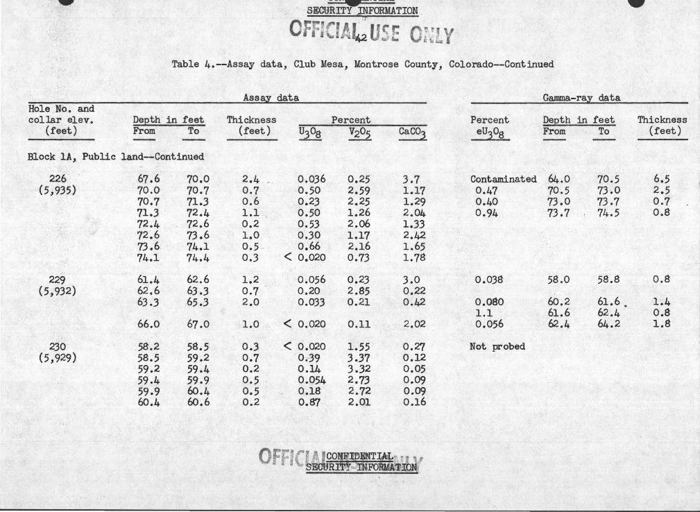
Table 4.,-~Assay data, Club Mesa, Montrose County, Colorado
Geological Survey exploration, 1948-520 Assays by the Geological Survey 1948-52. Samples in _ sandstone unless otherwise notedo
Uo So Vanadium Coo exploration, 1948-49o Assays by the U., So Vanaciium Coo, 1948-49. Hole numbers have the prefix V or S~
Rock units containing less than Oo020% U30g, less than Oo020% equivalent U30g, and less than · OolO% V~05i as dete~~ned by assay of drill core, are considered to be barren. Barren holes and ~ock units are omitted from this tableo
Gamma-ray data obtained by probing drill holes with a radiometric logging uriit ~ · Radioa:cti vity expressed as percent equivalent U308o Values less than Qo020% eU30g are omitted from this table.,
Assay data listed under ''block" (ioeo _;sleek lA) are within the blocks of calculated reserves. J , ..
' Assay data listed under 11 other holes" are within areas from which no re$erves were_~alculated because the samples .. recovered are too thin or too weakly mineralized to q11alify for the sele·cted grade and thickness cutoffs.,
Mo~_t collar elevations obtained by transit and stadia survey methods; others by less accurate methods shown with asterisk.,
e Equivalent
< Less than
ifiJJTIAL .. OFfJa.:JifT~"J! y /

• CON.NTIAL . SECURITY INFORMATION[ • At ··
Table 4 .. ~-Assay data, Club Mesa, Montrose County, Colorado--Continued
Hole No .. -and collar elev ..
(feet) Depth in feet From To
Block -lA, Public land
91 - 61 .. 1 63 .. 4 (5 '938) 63 .. 4 64 .. 3
64o3 64 .. 4
142 78 .. 2 ' 79o2 (5 ,943) 79 .. 2 79.5
161 69 .. -0 71 .. 2 (5, 937)
198 ~7 .. 8 68 .. 0 (5,929)
74.6' 74 .. 9
79.7 80 .. 5
84 .. 7 85o0
214 66.,6 67~0 (5,926)
68o1 70 .. 6 70 .. 6 71o9
!I Sample in mudstone
Assay data
Thickness (feet)
2o3Y 0 .. 9 0 .. 1
"-<; • •. , :.. ~ •
1 .. 0 0.3 '-
2 .. 2
0 .. 2
0 .. 3
0.8~
o.3Y
0 .. 4
2.,5 1 .. 3
Percent ~ Y22i
Oo02Q!J 0.15 b
0 .. 26£/ 2 .. 0 b
0 .. 401 3 .. 70
0.140 lo52 0.020 <O .. I
0.65 4 .. 38
< 0.020 1 .. 25
< 0.,020 0.17
< 0 .. 020 0.19
0 .. 024 0 .. 17
< 0 .. 020 0 .. 19
·0.,022 0 .. 31 0 .. 18" 0.61
.,.
CaC03
3 .. 27 Undet ..
Oo57
1 .. 52 3 .. 1
1 .. 08
0.13
1 .. 55
9 .. 4
6o3
3 .. 2
3 .. 0 5 .. 7
Percent eu3oa
Not probed
Not probed
Not probed
Not probed
Not probed
Ga.rilma-ray data
Depth in feet From To
• ~ ... :, ... ."1 •
Thickness (feet)
Pi Estimated value .. Sample taken by Atomic Energy Commission for thermo-conductiv}ty tests, but not saved for ass a~
OFF~TIJS ,_ QflU y SECURITY INFORMA_T1oN '~ ~
~ V'-J..L', - ... .. ... ..L..&;·~ -- .,
· · SECURITY~FORMATION _
Offrf'IA L ucr: o~q . .. .'- ~ ? '4&:." 6-. '; '~~; • . • • f"_o(~
Table 4.--Assay data, Club Mesa, Montrose County, Colorado--Continued
Assaz data Gamma-raz data Hole . No-~ · and collar elev. De:eth .in feet Thickness Percent Percent Deeth in feet Thickness
(f~~t) From To (feet) U308 V205 Caco3 eu3o8 From To (feet) - -·-Block lA, Public land--Continued
226 67.6 70.0 2.4 ,. 0.036 0.25 3.7 Contaminated 64.0 70.5 6.5 ( 5,.935) 70.0 70.7 0.7 0.50 2.59 1.17 0.47 70.5 73.0 2.5
70.7 71.3 0.6 0.23 2.25 1.29 0.40 73.0 73.7 0.7 71.3 72.4 . 1.1 .. 0.50 1.26 2.04 0.94 73.7 74.5 0.8 72.4 - 72.6 0.2 0.53 2.06 1.33 72.6 73.6 1.0 0.30 1.17 2.42 73.6 74.1 0.5 > > 0.66 2.16 1.65 74.1 74.4 0.3 < 0.020 0.73 1.78
229 ... 61.4 62.6 1.2 0.056 0.23 3.0 0.038 58.0 58.8 0.8 (5,93~) 62.6 63.3 0.7 0.20 2.85 0.22
63.3 65.3 2.0 0.033 0.21 0.42 0.080 60.2 61.6. 1.4 1.1 61.6 62.4 0.8
66.0 67.0 1.0 . < 0.020 0.11 2.02 0.056 62.4 64.2 1.8
230 58.2 58.5 0.3 < 0.020 1.55 0.27 Not probed (5,929) 58.5 59.2 . 0.7 0.-39 3.37 0.12
59.2 59.4 0.2 0.14 3.32 0.05 59.4 59.9 0.5 0.054 2.73 0.09 59.9 60.4 0.5 0.18 2.72 0.09 60.4 60.6 0.2 0.87 2.01 0.16

OFftCIAf 4/SE ONLY Table 4o--Assay data, Club Mesa, Montrose County, Colorado--Continued
Hole Noo and collar elevo . DeEth in feet
(feet) From To ---··
Block lA, Public land--Continu~d
236 56.7 57 o3 · (5 '934) 57o3 57o5
57o5 5~L2 58o2 58o4 58o4 59o0 59o0 60o7
237 69o2 70.4 (5,948)
238 68o9 7lo2 (5/149) 71o2 72ol
72.1 73 o2 73o2 74ol
!/ Sample in mudstone
Assay data
Thickness (feet) U308
Oo6 . < Oo020 0.2 Oo50 Oo7 Oo81 Oo2 ··: Oo44 Oo6~ Oo20 lo7a < Oo020
lo2 Oo024
2o3 Oo082 0.9 0.36 lol 0.028 0.9 < 0.020
Percent V205
0.34 3o02 2o42 Oo91 Oo87 Oo29
0.35
Oo31 lo51 0.37 0.13
CaC03
3o5 Oo36 2o6 4o0 3o7 lo05
2o8
5o3 5o4 6o3 2o5
Percent eU30g
Not probed
Not probed
Not probed
Gamma-ray data
Depth in feet From To
Thickness (feet)

CONFIDENTIAL .,~~URITY- ~ORMATION . ·t'"
;'\~' "c ',) 4:£
Table 4.,--Assay data, Club Mesa, Montrose County, Colorado~-Continued
Assay data Hole Noo and collar e lev., Depth in feet Thickn~ss Percent
(feet) From To (feet) U30g V205 CaC9~
Block lA, Public land--Continued
243 (5 ,932)
246 (5,941)
251 (5~939)
69o0
?OoO 7le9 72.,4 72o8 73o6 74ol 74.3 74o5 75o0 76o4 76o8
81.,0
75o9 77o7
76.,4
811)4
69o8
?lo9 72o4 72o8 73o6 74ol 74o3 74o5 75.,0 76 r4 76o8 77o3
81.,6
77 .. 7 78o3
79o2
82o?
0.,8
1.,9 ... 0.,5. 0.,4 0.8 0 .. 5 Oo2 0.,2 Oo5 1.,4 0.4 Q.5
Oo6
loS Oo6
2o8
4o3 ,._
< 0.020 0.,28 4.,8
Ool6 4o24 Oo61 Oo35 3o27 lo04 Oo24 3.,86 0.75 0 .. 10 o. 70 2 .. 8 0.,24 Oo62 2o? Ool5 lo28 2o9 Ool8 3o67 lol8 Oo28 2o90 2o06 0.060 Oo6Q 4 .. 0 Oo36 3o84 OoJ? Oo040 Oo67 4oJ
<Oo020 0.23 12.,1
0.,15 Oo39 4o9 Oo027 Oo15 4o8
Oo041 Oo18 5o9
0.048 Oo4J 4o0
~.~ft:~~lhiltENTIA: .... ··~ · rr . . · - ~~· v -~1 ·r. ·~ y . . lti~
Percent eu3o8
-Not probed
Not probed
Oo09Q 0.,065
Oo8J
Gamma-ray data
Depth in feet From To
75o2 76o0
?9o4
76.0 76o5
80o~
Thickness (feet) -
0.8 Oo5
Oo9

CONFIDENTIAL - ~ :.-- SECURITY lNFQRMA'TION . . t :· -..
~;t.t::;~~--· .
,(",. ~-. ;, . . _,.. ~ v. !,'1 ,, '
. . • \.._~! l· ~ ~ ·•. 'f~ Table 4 q--Assay data, Club Mesa, Montrose County;~ 8olorado--Continued
Hole. ~Oo and collar e lev o
(feet) Depth in feet From To
Block lA, Public land--Continued
253 ( 5, 938)
259 (5,942)
?boO 77ol 77o4 79ol BOoB 8lo4 B3 o2 83 0 7 BJ+o2 84o4 84o9 87o5
88o9
94ol 94o4 94o8
94o8
95o8
§} Sample-in mudstone
??ol 77o4 79ol 80.8 8lo4 83 02 8Jo 7 84c2 84o4 84o9 ·87 .5 88o6
$9o4
94o4 . 94o8 95.0
95o3
97o9
Assay data
Thickness (feet)
' . 1.~1; Oo3 lo? lo7 Oc6 1~8 Oo5 Oo5 0~2
. Oo5 -4o6 lol
Oo5 . -
0.3 Oo~ Oo a .
Oo5
2ol
,
Percent ~ ~ CaG03
Oo05Q Oo48 2o49 Oo2B lo23 lo08 Oo094 Oo65 2o42 Ool? lo34 lo37 Oo24 ·• 2o43 Oo43 Oc059 ~ Oo68 2o24 Ool8 2o48 Oc48 Oo50 2c32 lo90 Oo32 2o04 lo?O 0.35 lo69 lo62 Oo20 lolQ "lo46 Oo043 lo62 lo61
<Oo02Q Ool3 7o2
<Oa020 Oo58 ' 4o8 Ooll 4o26 3o9
<Oo02Q Oo21 4o0
Oo021 Ooll . 9o6
Oo026 Oo28 6o4
Or:r:,rr !I Jrr •, ., c ~.,.,,, . it '•\ r.: -.. . . i ... j '" ~. ~' • o~rr' CONFIDENTfAL·1! :J ~..- ·Cj~ :·
_SEGQiU~I .. ·lNFORMATION
Percent eU30g
Not probed
0 .. 94
Gamma-ray data
Depth in feet from To
90o0 90o7
Thickness (feet)
Oo?
~-

Table 4o-=Assay data, Club Mesa, Montrose County, Colorado--Continued
--- -·.
Assal data Gamma-ray data -Role Moo and collar elevo DeEth in feet Thicknes$ Percent Percent De~th in feet Thickness
(feet) From To (feet) u.3o8 V205 CaC03 eU308 From To (feet) ~
Block lA, Public l~nd~~Continued
_262 '' - Oo067 72o4 73ol Oo7 ·-~(5,938)
_263 50o9 52o6 lo7:. Oo032 Oo37 lolO Not probed -~ . (5~919)
52o8 53o4 Oo6 Oo61 ,1¥
3o82 Oo22
268 Oo075 99ol · lOOoO 0.9 (5,945)
274 ,.;_$6o4 . 86o8 Oo4!/ <OoQ2Q Ooll 2o00 (5 ,.940) .. . ~· '·
Block lB, Buckshot claim :.:
89- 77 o3 77 o6 OoJ -Qo048 <DolO loll Oo078 _ 76ol 77ol laO .
(5.9965) 84 .. 5 86o4 lo9 0.023 Oo27 9o37 Oo038 84o0 85o2 lo2
248 53o4 --54.1 Oo? <Oo020 Oo21 . 2o5 Not probed (5,918)
54 ~-4 --'--~- 55 0 7 lo3 Oo04jl Oo66 1061 55o7 56o2 Oo5 Oo08Q Oo61 -- ··1 -~'os
56o2 57o0 Oo8 0,032 Ool6 2o6
§/ Sample in mudstone

"'.4. ._.0'ftjr;!fl,M;...-~:.t':Pll.I.VlJ\ l. J.Ul'J .... -- • . . ..

'\,
CONFIDENTIAL _ .. ,-· ,~~i:~~·aECURTTY ~FORMA~tONi~~lf:''· ,·:\+< _: ~l·:i:ft~~~-: .. -- ~' -·~~.--. - L7'._,.. ;:.· -·· ·· :~'_,. . . :-: . _-:~_- : ·- - - ~;.. -: .... ·-· ~ _. .• £··~~ -"': .. ~---. .. , ...... 11·
rr-!:f(r A. , . 1,,.,. . 0 j ti ~ B Jl~L 4t ~ :;., 1- .~· ·
411ri~ &h. t w lit.
Table 4o=-Assay data, Club Mesa, Montrose County; Colorado--Continued
Assay _data. Hole Noo an4 collar elevo
(feet) Depth in feet-- ThicknE1ss From To (feet)
Block 2, Public · land--Continued }
252 '. (59666)
258 (5 ,690)
.294 {5,654)
295 (5,690)
12-4o2 124o8 125o0 125o3 125o7 126'ol 126o6 127ol
147ol
124o2
I
152o9 155o2
124o8 125o 125o3 125o7 126ol
. 126o6 127:oJ / 127o7
/
148o5
125o9 .
155o2 157o6
Oo6 Oo2 Oo3 0.4 Oo4
-Oo5 • Do5 Oo6
lo4
lo?
2o3 2o4
Percent U308 V205
< Oo02Q Ool8 < Oo02Q Oo57
Oo40 4o50 lo 77 7o41 lo60 7o0}:-
· Oo65 8o.86 Oo28 4~.18 '
. Oo44 2ol7
Ool8 OoJl
~~- ,, .• ,...
< Oo020 OQ13
Oo045 0~ 11 < Oo02Q · O.oll_
""--
Ca.C03
lo90 Oo95 Oo21 Oo45 Oo4J Oo21 Oo24 ' Oo48
4o9
llo8
3o2 4ol
Percent eu3og
. Oo99
.·1\ '\ '
I
-Not probed
Not probed
Not probed
\ '
Gamma-ray data
Depth in feet From To
124o0 125o2
'"
Thickness (feet)
lo2
.

. . . - · · ~CONFIDENTIAL
- ·_ OIJ_;. ~zrTroo . . .,. . -·
· · · · 49 '.jE ON
Table 4o-~Assay data, Club Mesa, Montrose County, Colorado-=Continued
. Hole No o and collar eleva
(feet) Depth in feet From To
~
Block 3AJ Public land
171A 204o3 204o6 (5,944)
210o6 210o8
212o8 213o4 213 o4 213 o8 213o8 214o5
··'--.214o5 218ol 218ol 219o9 219o9 220o6 220ob 22lo4 22lo4 22lo7 22lo7 222~0 222o0 222o4 222o4 225o2
225o9 220o6
226o9 t227 o9 .
228o2 228o4
230o4 232o4
£1 Sludge sample __ -
Assay dC3,ta
Percent Thickness "(feet) U308 V205
Oo3 -• < Oo020 Oo21
Oo2 < Oo02Q ' Oo29
Oo6 Oo4 Oo? 3o6 lo8 Oo? Oo8 · Oo3 Oo3 Oo4 ' 2o8
Oo?
loQ
< Oo02Q lo23 Oo077
< Oo020 2o54 OolJ Oo42 Oo84 lo40 Oo77 Oo034
.< Oo02Q
_ < opo2o
Oo2 " ;,_,- < Oo020
2ooi/ · < Oo020
Oo53 15o00
5676 l .Q08 7o25 7?26 6ol6 2ll52 2o25 2ol6 0<>27
Oo19
0.,.20
Ool?
Oo25
CaC03
5o5
Oo29
Oo 59 Ool9 Oo26 Ool? Oo48 Oo28
. Oo33 , Oo23 Oo24 Oo27 Oo48
,2()6
3o~
3o4
lo2l:.::-:
Percent eU308
Not probed _ ...
Depth infeet From To
Thickness (feet)

.._,.
~ .~·~~~ . ... ,-,.
Table 4o~-Assay data, Club Mesa, Montrose Countr, Colorado--Continued
'Hole Noo and collar elevo
(feet) Depth in feet .From To
Block .3A, Public land--Continued
176 (5 '943)
. 217 (5,951)
299 ( 5 9949) .
211o0
212o6
215o4
206o4
208o1
224o9
214ol
219o8
··\·
2llo8
213 o9
216o4
207o0
208o4
225ol
215o2
22\f·:l ,. ('~
Assay data
Thickness (feet)
Oo8 .
lo3
loO
Oo6
0.3
Oo2
lol
Oo3·
~
< 0~020 < Oo02Q
< Oo02Q
< Oo02Q
< 0.020
< Oo02Q
Oo036
Oo024
Percent V205 CaC03
Oo~O 3o0
3o98 Ool9
Oo4.4 7o5
Oo21 9o1
Oo.12 Oo35
Oo2J Bo?
Ool4 Oo72
Oo24 Oo24
Percent eU30g
Not probed
Not probed
Not probed
Gamma=ray -data
.. Deoth in feet From To
~
Thickness (feet.)

..._.. ..._..
.... ... ·{~ ... :·,· ~ .. :;..-:....
~ "''Y . · ~· ,~ .
~able 4o=~Assay data, Club Mesa, Montrose County, Colorado=-Continued
Hole Noo and collar elevo
(feet) Depth in feet From To
Block 3A, Public land--Continued
.305 (5,944)
307 (5,960)
206o4
· 216 o.3 216o4 218o5 218o8 219o2 219o7 220o0 22lo0 22lo5 22Jo4
224o7
201o0
22lo0 ' 22lo6
224,9
~ Sample in mudstone
207o0
216o4 218o5 218o8 219o2 2l9o7 220o0 22lo0 22lo5 223 o4 224o2
225o 2
20lo3
22lo6 223 o6
229o0
Assay data
Thickness (feet)
Oo6~
Ool 2ol . Oo3 Oo4 Oo5 Oo3 loO Oo5 lo9 Oo8
Oo5
Oo3
Oo6 2o0
4ol
Percent U308 V205
< Oo02Q Oo34
< Oo02Q Ool3 Oo039 lo05 Oo027 Oo57 Oo20 Oo79 OolO lol8 Ool9 3 ·o-27 Ool6 lo36 Oo073 lolO
<Oo02Q Oo84 < Oo02Q 0<)31
< Oo02Q Ool8
< Oo020 OolO
Oo024 Oo88 < Oo020 Oo18
< Oo020 Oo48
CaC03
lol8
2o~6-Oo66 Oo08 OolO Oo07 0 olJ Oo~5 Ooll lo91 7o7
9o8
Ool9
Oo85 lo50
4o65
Percent eU30g
Not probed-
Not probed
Gam.ma=ra.y data
Depth in · f E:)et From To
...._...
Thickness (feet)

-' ~"It,, \'Ai<ii,
Table 4o==Assay data, Club Mesa, Montrose County, Colorado--Continued
Hole N.oo and collar elev o
(feet) Depth in feet From To
Block 3B, Mill Noo 2 claim
14 209o2 210o6 (5,940)
21A 178o5 179o8 (5 '936) 179o8 180ol
180ol 18lo3
2llo4 212o6
212o8 213o9 213o9 214o7 214c7 211o6 217 o6 217o8 217o8 218o0 2l8o0 218c4 218o4 219o9 219o9 220.8
22lo8 222oJ 222o3 223 o2 223 o2 223o5 223o5 225.o4
23lol 23lo5 . ; ~-'
~ Sample in mudstone
Assay data
Thicknes~ (feet) .
1.,4
J-o3 -, Oa3
. To2W
lo2
lol Oo8 2o9 Oo2 Oo2 Oo4 lo5 Oo9 ·'
Oo5 Oo9 Oc J /,~ lc9
Oo4
Percent ~ V205
Oo020 <DolO
Oo02Q < O.olO Ool7 OoJO
< Oc02Q OolO
Oo040 Oo31
Oo960 6o92 Oo84 lo17 Oo030 O"rll Oo51 Oo66 lo46 1.,65 Oo53 1 ·~54 O·ol4 0671 ' OoQ5 Oo3?
< Oo02Q lo92 Oo05 0.10 Oo19 < OolO Oo03 < O,.;rlO
< Oo02Ci· Ooll
Ca.C03
lo07
7o2 208
13o9
lo58
Oo45 Oo93 2o91 2o29 lo82 Oo22 0&18
.... · .. Oo67
00'11 lcl)OO 2o28 6o47
17 o4
Percent eU30g
Not probed
Nott ,probed
··.;:...
Gamma=ray data
Depth in feet From To
..._,.
Thickness (feet)

...._...
Table 4o<-=Assay data; Club Me~a, Montrose County, Colorado--Continued
Assay data Hole No" and collar elevo
(feet) Depth in feet From To
Thickness (feet)
Block 3B, Mill No" 2 claim==Continued
25 (5,937)
V=241 ( 5~938)
v~242
(59938)
V=243 (5 9932)
V=244 (59 937)
V=245 (5,937)
203 o4-
210o5
21lo2 2llo7 214o0 218o0
2l?o0 2l8oO .~ 225o0
205o0 209o0 212o5 215o2
216o0 216.7 224ol 225ol
219o3 219o9
205o4
212o9
2llo7 214o0 218·0 0 222o0
218o0 225o0 229o0
209o0 212o5 215o2 2l9o8
216o7 224ol 225ol 232o0
219o9 222o3
2 0 0.,.
2~4
Oa5 2o3 4o0 4o0 .
loO ?oO ~ 4o0 " ' ~ .. 4o0 ... Jo5 2o7 4o6
Oo{
7o4 ~ ,-.. lc,O
6o9
Oo6 2~4
Percent ~ ... v2os
Oo046 Qo32
Oo02Q <OolO
Oo02 'Oo53 Oo50 lo49 Oo31 · lo85 Oo05 Oo54
Oo-69 2o67 Undeto Undeto
Oo03 Oal6
. Oo04 Qo25 Ool3 lo06 Oo03 Oo51 Oo06 Oo20
Oo05 , lo69 Oo04 Oo21 lol6 . )o62 0,10 0o26
Ooll · Oo26 Oo09 Oo86
GaC03
Oo54 -3o{O
Undeto Undeto Undet o -Undeto
Undeto Undeto Undet o
Undeto Undet 0
Undeto Undeto
Undet o Undeto Undeto Undeto
Undeto Undet"
Perpent eu3o8
Not probed :>"
Not probed
Not probed
Not probed
Not probed
Not probed
Garnma=ray data
Depth in feet From To
Thickness (feet)

..._,.. ..._,.. CONFIDENTIAL
.· ,.~ y "\¥ ib
Table 4o==Assay data, Club Mesa, Montrose County, Colorade==Continued
Hole Noo and collar elevo
(feet) Depth in feet ·From To
Assay data
Thickness (feet)
Percent ~ ~2°5
·Block 3B, Mill Noo 2 claim=Continued
~:- '
V=246 (5 .9938)
V=247 ( 5 ~ 936)
V=248 (5.9937)
V-249 (5'.9940)
V'=274 (5.9 939)
214·o9 216o? 217o8 219o2
209o7 21JoQ 220oQ 223 oO 223 o9
217o0 2l9~7 220ol'r
213o0
22Jo0 228o0
20Jo6
217o7
216o7 loS. 217a8 lol 219o2 lo4 219o7 Oo5 ,
213o0 JoJ 220o0 ?oO 223 oO 3o0 22) o9 Oo9 225'0 7 lo.8
219 0 7 - 2o7 220o4 Oo? 22201 io?
218o0 5o0
228o0 5o0 228o5 Oo5
204o,l · Oo5
219o6 lo9
Oo51 2o6J Oo48 2ol4 Ool8 Oo80 OolO lo02
Oa09 2o20 OoQJ Oa29
<Oo02Q Oo64 Ool2 lo44 0;29 0.,68
loJO , 3o26 OoJ6 Oo55 Ool6 lo40
Oo02 · Ool2
Oo02 Oo28 Oo54 5 .40
Oo03 Oo21
Ool1 Oo44
CONFIDENTIAL ,y ···
CaC03
Undeto Undet o U.rideto Undet a
Undeto Undet o Undet a Undet o
Undeto
Undeto Undet o Undeto
Undet o ·
Undet o Undeto
Undet o
Undeto
Percent eU303
Not probed
Not probed
Not probed
Not probed
Not probed
Gamma~ray data
Depth in feet From To
..._,..
Thickness (feet)

CONFIDENTIAL
0. F~~~tjffY . -~!.fAG~"'' ~ . ~ - ~ .. -~ 55
Table 4o==Assay data, Club Mesa, Mont~ose County, Colorado-=Continued
Assay data Hole Noo and collar elevo
(feet) Depth in feet From To
Thickness (feet)
Block 3B, Mill Noo 2 claim==Continued
V-275 (5 .9929)'
V=277 (5 .9923)
V~278
(5.9926)
V=280 (5.9922)
210o9
218o0
193o0
193 o9
200o9
217o0
189o6
192o3 l96o7 199ol
Block 4.9 Public land
132 (5.9967)
215o3 215o5 216o0
2~lo5 Oo6.
219o3 lo3
193o6 Oo6
194o3 Oo4
20lo2 - . Oo3
1 219 oO · ~oQ ;
19lo0 lo·4 . ;
196o 7 4o4 199ol 2o4 20lo6 205
21' 5 5~~;f~t::. 0 2 o . rp;: ;tf~ ' ·: · .:·. . · o · , . ~
216o0 , Oobf' 216 ol o~· l
Percent U308 \7205
<Oo02Q
Oo38
Oo07
Ool6
Oo05
Oo02
Ool4
Ool8 Oo)B
<Oo02Q
<Oo02Q Oo048 . Oo027
Oo36
2o00
Oo57
loJ5
Oo20
Oo21
Oo99
Oo61 lo22 Ool6
Oo48 5ol5 Oo66 '
CaC03
Undeto
Undeto
Undeto
Undeto
Undet o
Undeto
Undet ·o
Undeto Undeto Undeto
Oo67 Oo35 Oo47
Percent eU308
Not probed
• Not probed
Not probed
-Not probed
Not probed
Ga.mma~ray data
Depth in feet From To
Thickness (feet)

CONFIDENTIAL
Table 4o~=Assay data, Club Mesa, Montrose County, Colorado--Continued
Assay data Gamma-ray data Hole Nco and collar elev o DeEth in feet Thickness Percent Percent DeEth in feet Thickness
(feet) From To (feet) ~ Yh Caco1 eUJ08 From To (feet)
, ;'Wi(
Block 4j Public land
186 223o9 228o6 -4o7 <OoQ2Q ·- lo37 Oo60 Not probed (5 '973)
237 o6 238o6 loO <Oo02Q Oo.23 5a9
239o8 24lo5 - lo7 Oo033 Oa21 6o7
187 212o3 213o7 lo4 Oo026 Oo30 lo33 Not probed (5.9963) 213 o7 214o2 Oo5 Oo039 lo04 Oo64
214o2 214o9 Oo7 < OoQ2Q Oo23 2o40
191 204o5 205o3 OoB <OoQ2Q Oo24 5o7 Not prob~d (5,969)
210o3 2llo9 lo6 <Oo02Q Oo26 3o3 2llo9 212o4 Oo5 Oo24 2o75 Oo49 212o4 212o7 OoJ <Oo02Q Oo92 Oo78 212o7 213o2 Oo5 Ool3 Oo89 Oo29 213o2 21Jo8 Oo6 Oo074 Oo44 7o4 213o8 214ol OoJ OolJ Oo42 8o8 214ol 216ol 2o0 Oo041 Oo57 13o7
217 o3 : 218o8 lo5 0.026 Oo22 6ol ' ' 227o5 227o7 Oo2 <Oa020 0.28 17o6
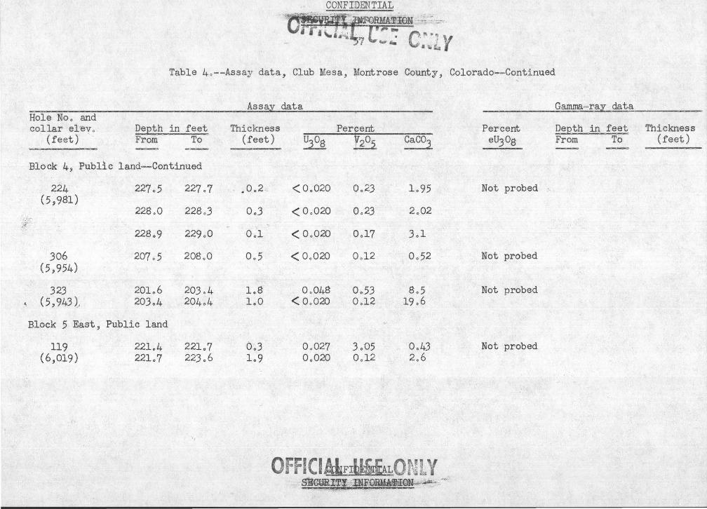
f j • 1:.' '=
Table 4o - -Assay data, Club Mesa, Montrose County, Colorado-- Continued '
Assay data Gamrna=ray dci.ta Hole Noo and collar el'ey o DeEth in feet Thickness Percent Percent DeQth in feet Thickness
(feet) From To (feet) U308 V205 Caco3 eU30g From To (feet)
Block 4, Public land--Continued
224 227o5 227o7 • Oo2" < Oo02Q Oo23 lo95 Not probed (5,981)
228o0 228o3 Oo3 < Oo02Q Oo23 2oQ2
228o9 229o0 Ool < Oo02Q Ool7 3ol
306 207o5 20~LO Oo5 < Oo02Q Ool2 Oo52 Not probed (5,954)
323 20lo6 203 o4 loB Oo048 Oo53 8o5 Not probed ~ (5 '943 )._ 203o4 204o4 loO < Oo02Q Ool2 19o6
Block 5 East, Public land
119 22lo4 22lo7 Oo3 Oo027 3o05 Oo43 Not probed (6,019) 22lo7 223o6 lo9 Oo02Q Ool2 2o6
OffiCIALFrtlS£LQ[%!i Y s1J~~1fi;<I~lF{)~lQN;~'~" ;:·-~

!$,fJ" Y lhli.
Table 4o=-Assay_data, Club Mesa, Montrose County, Colorado-=Continued
Hole Noo and collar elevo · (feet)
\ ~
Depth in feet From To
Block 5 East, Public land--Continued
·- 308 ( 6,013)
216o.6
218o4 219o4 220o0 2?lo4 222o0
223 o5 224o8
!/. Sample in mudstone
218o2
219o4 22Qo0 22lo4 222o0 222o5
224o8. 227 08 >
Assay data
Thickness (feet)
lo6
loO Oo6 · lo4 Oo6 Oo5
1~3!Y 3o0a .
Percent U308 V205
<Qo020 OoJl
Oo24 5o94 Oo20 Oo94 Oo043 - Oo42 Ool4 2ol8 Oo·02Q Oo65
Oo031 0.?•24 Oo046 Oo40
CaC03
4o5
Ool2 Ool8 Oo48 Oo25 2oOJ
2o99 3o8
'
Percent eu3og
Not probed
Ga.m.tna-ray data
Depth in feet From To
Thickness (feet)

........ ...... _
-.--... - .. ~
O~::•cl A [' ,~ ~,. E • • • ~ u~ !e Of-JlY Table 4 o==Assay data, Club Mesa, Montrose County~ Colorado==Continued
._ --- -·- ~ --- -
Hole No o arid - -----
collar elev o DeEth in feet (feet) From To . - -
Block 5 East, Public land=-Continued
315 212o4 214o5 (6,022)
217 o2 218oQ
219o3 219o8 219o8 220o8
222o2 222o7 222o7 223o2 223 o2 223 o8 223o8 224o0 224o0 224oJ 224o3 224o5 224o5 225o8 225o8 226o3 226o3 226o6
\-z,·· ·
~
Assay data ·- -
Thickness Percent (feet) U308 V205 Caco3
2ol · Oo02Q Ool6 Oo35
Oo8 < Oo02Q Ooll 2o29
Oo5 Oo08Q lo04 Ool4 loO Ool8 lol6 Oo09
Oo5 Oo096 Oo84 Oo41 Oo5 Oo41 2.07 Ool8 Oo6 Ool2 Oo88 Oo60 Oo2 2o25 lo90 Oo36 Oo3 Oo55 2o69 Ool7 Oo2 Ool5 2o29 Ool3 loJ 0.068 lo33 Ool7 Oo5 < Oo020 lo32 Oo46 Oo3 Oo0~4 Oo36 lo71
v SEe:=TI2ft· I
Percent eu3o8
Not probed
Gamm.a=ray data
Depth in feet From To
......:;.
Thickness (feet)

Table 4o--Assay data~ Club Mesa, Montrose County~ Colorado-=Continued
Hole Noo and collar elev o
(feet) Depth in feet From To
Block 5 East, Publi'c land-=Gontinued
316 216o0 216o5 (6"~013) 216o5 Z]..6o8
218o3 218o6 2i8o6 218o8 218o8 219o3 219 o3 22lo3 22lo3 222ol 222ol 222o4 222o4 223 o8 223 o8 224o4 224o4 225o0 225o0 226o0 226o0 227o5
Assay data
Thickness (feet)
Oo5,. Oo3
Oo3 Oo2 Oo5 2o0 . Oo8 Oo3 lo4 Oo6 Oo6 loO lo5
Percent U308 V205
< Oo02Q Oo39 Oo06Q Ool4
OolO Oo24 Oo025 Oo44 Oo036 2o48 Oo095 lo84 Oo031 2o38 Oo066 Oo89 Ool2 lo60 Oo29 lo86 Oo75 4o00 Oo092 lo21 Oo045 lol4
....
CaC03
lo54 lol6
Oo67 lo26 Oo27 Ool4 Ool7 Oo06 Ooll Ool2 Oo41 Ool2 Oo6Q
·Gamma<=ray data
Percent eU30g
Depth in feet From To
Not probed :. ,.
Thickness (feet)

61 "\~ ~' ·' .. t!::
Table 4o-=Assay data, Club Mesa, Montrose CountyJ Colorado=-Coptinued
Hole Noo and collar eleva
(feet) Depth in feet From To
Block 5 EastJ Public land~-Continued
319 (6,027)
320 (6,019)
210o5 2llo4 213ol 214o0
216o7 217o0 217o6
222o0
223o5 224o3
215o2 2l6o6 219oJ 220oJ
222o9
~ Sample in mudstone
2llo4 213:1 214o0 216o2
217o0 217o6 220o0
223o3
224o3 224o5
216.6 219o3 220 ,3 220o8
223 o7
Assay data
Thickness (feet)
Oo9 lo7 Oo9 2o2 .
OoJ Oo6 2o4
lo3W
Oo8 Oo2
lo4 · 2o7 loO Oo5
Oo8
Percent U308 V205 Caco3
Ooll 2oJl OoJ8 Oo2J lo54 Oo29 Ooll lo02 Oo08
< Oo020 O.o29 20~
< 0.,020 Ool2 5o5 Ool6 lo35 lol5 Oo048 Oo47 lo02
< Oo02Q Oo27 Ool9
Ool6 lo22 2o09 Oa022 3o91 Ool8
Oo025 Oo45 Oo60 Oo032 Oo23 lo27 Oo042 Oo7l Oo93 Oo031 Oo20 lo89
< Oo020 Ool2 lo57
'FFir_~ lfJiifl .. · S~M. ····· ·· - - T@f _~il . . == , . · . _ r~ . _ ~0 • • , ~ 2 ~~
Percent eu3og
Oo035 Ool4 Oo22 Oo20 0_.,))
Oo027 Oo39 0.11 Oo44
Not probed
Garmna=ray data
Depth in feet From To
.. 209 0 7 210o6 ~J-Poq 212o0 212oQ 213 ol 213 ol 213 o9 213o9 214o5 214o5 .. ~1808 218o8 220o6 22no.6 223 ol 223ol 224o2
Thickness (feet)
Oo9 lo4 lol Oo8 Oo6
' 4oJ lo8
' 2o5 lol

\
" Table 4o==Assay data, Club Mesa, Montrose County, Colorado~=Continued
Assail ciata ' Gamma.=ral data
Hole Noo and collar- e lev o DeEth in feet Thickness Percent Percent De12th in feet Thickness
(feet) From To (feet) U308 V205 Caco3 eu3o8 From To (feet)
Block 5 East~ Public land-=Continued
328 213o0 215o3 · 2o3 · Oo02Q Ool3 3o3 Not probed (6,006)
- - - 329 - - - 217-o-0 219o5 2o5 ·_. . - Oo06Q Oo89 Oo63 ..;.._ ... Not probed (6,019) 219o5 22lo3 lo8 Oo090 lo09 Oo72
22lo3 222o0 Oo 7 • lo05 5o05 Oo40 222o0 222o7 Oo? Oo21 3o0l 0"10 222o7 223 ol Oo4 Ool3 lolO Ool7 ~3ol 223o5 Oo4 Oo64 lol4 Ool7 223 o5 225o0 lo5 lo83 4o52 Oo20 225o0 225o5 Oo5 Oo35 ~ 3o78 Ool3 225o5 226o0 Oo5 oo-070 Oo58 -0.08 226o0 227o0 loQ Oo022 Oo 73 OolO 227o0 227o5 Oo5 Oo37 lo35 Ool8 227o5 228.0 Oo5 Oo75 2,o30 Ool3 228o0 230o0 2o0 Oo2Q l .. o31 Oo50 23Qo0 230o9 Oo9 Oo047 ; Oo56 22o7
. · ~- ... ·<
<
fFIQt&;~ "'~.JI' w ""'' :.·~:~ .

CONFIDENTIAL -· · SEGURI'l'Y INi(R»k'JION
,·· ~ ~~· J rJ .~ . I 6:;." , .,~ l ~ ~\.14"*• .. ~ ~'··-' ·'
Table 4o~-Assay data, Club Mesa, Montrose County~ Colorado--Continued
Hole Noo and collar elev o
(feet) Depth in feet From To
Block 5 East, Public land-~Continued
330 (6,002)
··331 (63001)
206o6 207o4
208ol 208.8 20~-~ 8 ~ 209 o8 209oB 2llo2 2llo2 212o2 212o2 . 213 o2 213o2 214o2 214o2 215o2
192o2 192o8
193o1 193 ()·9
196o7 198o5 198oS 199ol 199 ol 200o4 200o4 20lo8
208ol 209o4
210o7 2llo0
!( Sample in mudstone
Assay data
Thickness (:feet)
Oo8
Oo7 loO - --~
lo4 loO I
loQ loO 1o0
Oo6
Oo8 )
loS ' Oo6 loJ lo4
lo3 .
Oo '3~
Percent U308 V205
Oo048 Oo35
0 ~ 020 0~16 Oo098 Oo17 Oo027 Oo25 Oo092 lo71 Oo06Q Oo67 Oo021 Oo20
< 0~020 O.o67
< Oo02Q Oo50
< Oo02Q Oo23
< Oo02Q Oo31 Oo052 Oo-16 Oo028 1o01
< Oo02Q Oo22
< Oo02Q 1o00
< Oo02Q Oo20
CaC03
lo06
lo26 ~ 1;34
Oo94 Oo26 Oo07 Ool4 1o33
Oo46
Oo22
1.33 2o09 Oo89 3o4
Oo37 ·
Oo56
Percent eu3o8
Not probed
Oo062 'Oo02Q
Oo026
Gamma.=ray data
Depth in feet From To
19608 198o6
200o3
198o6 199o8
200o8
-
Thickness . (feet)
loS 1o2
Oo5

Table 4.oo-Assay data, Club Mesa, Montrose County, Colorado~~Continued
Assay data Hole No., and collar e lev o DeEth in feet Thickness
(feet) From To (feet) U308 - - -
Bloqk 5 East, Public land-=Continued
334 201.,8 202o1 0.3 Oo66 (6,025) 202o1 202.7 0.,6 0.24
202.,7 203.,2 0.5 0.14 203.,2 204o5 lo3 · OQ085 204o5 205o3 Oo8 0.059 205o3 206o8 1o5 Oo088 206.8 207 o8 1.0 < 0.,020
339A 215o2 216o9 1.7 Oo022 (6,004) 216.,9 21~"5 .i 1.6 < Oo020
218 .. 5 219:i 5 1.0 0.,20 219. 5,.; 220 ~ 9 1.4 0.,24
*=:. 0.4 220 0 g;;;{::, . 221.3 Oo5l ·-.:···J, .
Oo067 221.3 ''i,l;; . 222 0 7 1.,4 222.,7 223.6 0.9 < Oo020
341 188~0 188~4 0~4 0:53 (5,976) 188~4 188~9 o:5 0.~14
188.,9 189o9 loO 00049
191~5 192~3 0~8 o:o4s 192~3 194:4 . 2:·1 ' < 0:020 194o4 195.,8 lo4~ 0.,023
196o2 196o5 OoJ~ . < Oo020 ... . ... ":.' ~
~ Sample in mudstone
Percent V205 , --
6 .. 14 4.,69 1.,80 2.,96 1.,73 2,47 Oo34
0.11 Ool2 0_.,60 lo33 \
lo36 0_.,20 0.,10
5~19 1~42-Oo85
1: 25 0~50 Oo28
Ool3
Caco3 --
0.,95 Oo33 0.15 0.,20 0.,19 0.,20 1.30
Oo89 1.93 2.,14 2o39 5.0
20o0 24.,6
0 ~32 2~6 4,o0
o:67 11:7 2702
18oQ
.:.;..\;
Percent eu3o8
Not probed
Not probed
Not probed ·
Gamma-ray data
Depth in feet From To
~
Thickness (feet)
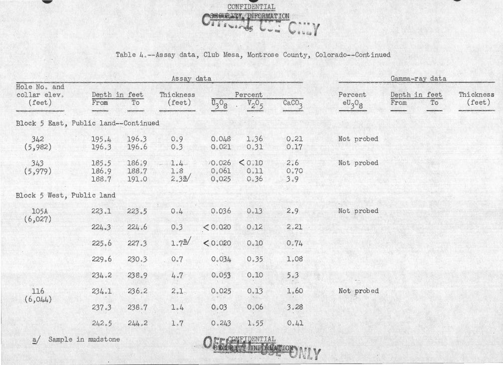
~
"Jl!l. ~ ~
~ '\,;, -
Table 4o--Assay data, Club Mesa, Montrose County, Colorado--Continued
Hole No o and collar elevo
(feet) Depth in feet From To
Block 5 East, Public land-=Continued
342 195 o4 (5,982) 196o3
343 185o5 (5,979) 186o9
188o7
Block 5 West, Public land
l05A (6,027)
116 (6,044)
223 ol
224o3
225o6
229o6
234o2
234ol
237 o3
242o5
y Sample in mudstone
196o3 196.6
186 ~ 9 188o7 191o0
223o5
224o6
227o3
230oJ
238o9
236o2
238o 7
244o2
Assay data
Thickness (feet)
Percent . (]3°8 · V2°5 Caco3
,~ •• 1
Oo9 Oo048 Oo3 Oo021
lo4 -· ' 0 p026 1 ~ 8 0 0 061 2o3~ 09025
Oo4 Oo036
Oo3 < OoQ2Q
1o 7~ < Oo02Q
Oo 7 Oo034
4o7 Oo053
2ol ..
1o4
lo?
Oo025
OoOJ
Oo243
1o36 OoJl
< 0 ~ 10 Oo11 OoJ6
OolJ
Ool2
OolO
Oo35
OolO
Oo13
Oo06
lo55
-
0~21 Oo17
2~6 0~70
3o9
2.,9
2o21
Oo74
1.,08
5o3
1o60
3o28
Oo41
Otf&I.§TIAL ... ·.··.- ·. Jl ·~'t)Mt " ' . . . . .. . . ~ ... i (! ~"'
Percent eu3o8
Not probed
Not probed
Not probed
Not probed
Gamma-ray data
Depth in feet From To
~
Thickness (feet)

., ••• CONFIDENTIAL SECURITY INFORMATION
~ ·~",..,I I . .r ,, i;.:' . . • . flf..t:,_ il~ i .~&"':li.~
Table 4o--Assay data, Club Mesa, Montrose County~ Colorado--Continued
Hole Noo and collar e lev o .
(r'eet) Depth in feet From To
Block 5 West, Public land--Continued
116--Continued 244~2 244o4 (6,044) 244o4 245o0
245o0 246o5 246o5 246o8 246~8 247o9 247o9 248o9 248o9 249o6
122B 199o5 200o2 \6,040)
200o4 20lo4 201o4 201o9
208o8 209o0
124 230,2 230,9 ( 6,030)
243 o5 246o8
127 . 259.,3 · 200o2 (6,056)
137 256~9 257~2 (6.!1045) 257o2 257o4 ·
!I Sample in mudstone
Assay data
Percent Thickness (feet) U308 V205
Oo2 OolOO 2o73 0,6 1~681 2~85 ,.
1~5 Oo?07 1~74 0~3 2 ~ 540 ·2o6l lol lo207 2~10 loO 'Oo140 lo47 Oo? . ·o,ose .. Oo50
Oo? Oo929 Oo27
loO : Oo.38 3 o62 ,. Oo5 Q,051 Oo32 ..
' Oo2 < Oo02Q Ooll
Oo7 Oo038 1.,88
3o3§/ 0,026 Oo19
Oo9 < Oo02Q ·lo66
Oo3 < 0~020 0~24 Oo2 Oo19 Oo37
CaC03 ~
0,25 0~20
0~22 0~28
0~25 Oo37
16o8
17o4
5o2 17;,0
Oo79
Oo35
8o9
lloO
8~2.
17 o6
Gamma-ray data
Percent eU303
. Depth in feet From To
~
Not probed
!N.ot probed
Not probed ~
~ - ·
Not probed
•
Thickness (feet)

• CONF.TIAL SECURITY:.-~B·FORMATI{)N -
. Ill.~\ ?:.:; ·~~" q ,,6."""~ ii j • ll -..., ·~- ...; ... \......,-....
¥" ~ ~~
Table 4o--Assay data, Club Mesaj Montrose County, Colorado--Continued
Hole Noo and collar elevo
(feet) Depth in feet From To
Block 5 West, Public land--Continued
183 ( 6,023)
196 (6,050)
257 (6,058)
265 (6,057)
249o3
249o8
222o0
226o2
228o0 228o6 229o4 230~3 233 oO 233o8 234o8
-: 212o5 213o2 214o2 214o5
215~7 218o8 220o5
'· 220 ~ 9 "*22lo9
~ Sample in mudstone
249o6
250ol
225o9
227.3
228o6 229o4 230o3 233o0 233,o8 234o8 237o5
213 o2 214o2 214o5 216o3
218~8 220~5 220~9 22lo9 222o3
... Assay data
Thickness (feet)
0.,3
Oo3
3o9
lol
Oo6 Oo8 Oo9 2~7~ Oc8a loO 2o7
., Oo?. loO 0~3 loS
.3~1 , 1~7 Oo4 1~0
Oo4
Percent U308 V205
< Oo020 Oo22
< Oo020 Ool5
.< Oo020 Oo27
< Oo020 0.44
Oo52 4.74 0~15 0~90 Oo88 5o84 Oo076 Oo65 Oo36 Oo98 Oo073 loll 0.037 Oo30
Ool8 Oo76 0~67 4o35 Oo36 3 ~58 .
Oo027 Oo32
< Oo020 Ool8 0~040 0~19
0~35 3~58 0 ~ 71 2~78 OolO 6o54
Caco3
7.6
llo5
2ol2
0.57
Oo38 0~18 0~44 1~90 1~65 3o0 3o0
Oo53 0~18 Oo26 lo87
2~44 1~88 0 ~ 48 0 ~ 20
Oo25
Percent eu
3o8
Not probed
Not probed
Not probed
Not probed
Gamma-ray data
· Depth in feet From :;ro
•
Thickness (feet)

• . SEGUR~ioo C ••• ,_, Q ,._.,. r . ...
ri' i li ........... ~ \,. ~ ~ L, • "
Table 4o--Assay data, Club Mesa, Montrose County, Colorado-=Continued
Hole No, ,and collar elevo
(feet) Depth in feet From To
Block 5 West, Public land--Continued
265--Cbntinued 222o3 (6,057)
269 (6,018)
302B (6,061)
303 . (6J059)
223o2 224~9 225o2 225~4 225o5
220o5
216o0 219 oS . 22lo0 222o2 222o7 223 o2
• 224o4 224o9 225o5
227o8
222o8
224~9 225~2
225o4 225o5 226o9
220o7
219o8 22lo0 222o2 222o7 223 o2 224o4 224o9 22_5 o5 228o5
230o0
Assay data
Thickness (feet)
Oo5
1~7 0 :3 . Oo2 Ool 1.4
Oo2
.... #
3o8 1o2 1o2 Qo5 Oo5-· 1o2 0,5 Oo6 ' 3o0
2o2
Percent U308 V205
< Oo02Q Oo39
< 0~020 0~30 1~32 14~76 0~37 llo61 Oo42 3 ~48 Oo024 Oo39
< Oo020 Oo21
Oo031 O·o25 Oo~6 2~43 Oo094 4~79 Oo41 1~33 Oo080 Oo55
< Oo020 0~70 0.082 2o58
. 1o91 9o09 Oo020 0{126
~ Oo02 Ool3
CaC03
Oo42
0~24 0~59 0~50 Oo29 Oo44
Oo62
5o0 0~46 0~13 0~33 1~04 1~04 0~83 0~75 1o03
lo63
Percent eu3o8
Not probed
Not probed
Not probed
Gamma-ray data
Depth in feet From To '
•
Thickness (feet)

W' VVl\ll'..L. & J...L...H..U
Table 4o--As-say data, Club Mesa, Montrose County :J Colorado--Continued
Assay data Hole No., and collar elev o
' P.eQth in feet Thickness
(feet) From To (feet)' U30B -Block 5 West, Public land--Continued
304 225o0 225 o7 Oo7 Oo27 ( 6,039)
227o5 22Bo0 0~5 0~072 22Bo0 22Bo5 Oo5 ~- 00029
309 219oB 224o0 r4o2 < Oo02Q (6,046)
226~0 226~4 0~4 O~:l3 220~ 228~4 2~0 < 0~020 22Bo4 229~5 1~1 0~17 249~5 230~0 0~5 Boll 230oQ 23lo7 l ,o 7 < OoO;;O
313 22lo4 222o4 loO " \ 0~036 (6,059) 222o4 223 ol 0~7 Oo25
223ol 223 o5 Oo4 ' 0~55 223 o5 224o3 OoB lol3 224o3 224o7 ~ Oo4 lo48 224~7 225o6 .Oo9 Oo34 225o6 227o0 1~4 0 ~16 227o0 227o4 0~4 : .,. [,' OoJ2 227o4 22B~4 1~0 1~25 22B~.4 22Bo9 Oo5 .. lo$3
Percent V205 -~
5o7B
1;61 Oo27
Ool2
Oo57 ' 1~91 loBO 5 ·~83 Oo26
O~lB 1.,93 2~35 2~67. 4o22 2o89 3oOB .\
3o4l 9~41 5o83
Caco3
Oo59
0~59 l o86
lo79
0~75 0~30 0~23
0~55 2o42
1~' 04
0~12 Ool5 0~17 Oo26 Oo05 0~07 OolB 0.46 Oo25
Percent eu3oB
Not probed _,.
Not probed
Not probed
Gamma~ray data
Depth in feet From To
W'
Thickness (feet)

_ CONFI . TIAL - ~ SECURITY INFORMATION • n t.- ...-, .,... ~ .... ' '-"- \...., ... ....
Table 4.,-=Assay data, Club Mesa, Montrose County, Colorado--Coflt.inued
Hole No., and collar elev.,
(feet) Depth in feet F::rom To
Block 5 West, Public land~-Continued
314 (6,068)
318A (6,070)
"~--·~-
326 (6,029)
333 _(6 ,060)
335 ( 6.9037)
2lq.,7
216.,7
222~1
224~8 225~1 227.,3
239 ~ 6 241.,1 242.,7 243.,0 243.,8 244.,1
267.,2
,245 ~1 245.,6 246 . .,9
~ Sample in mudstone Y Sludge sample
219.,2
217.,7
224~8 225 ~1 227~3 228.,0
241~1 242~7 243~0 243o8 244o1 244.,4
269.,7
'--
245~6 246.,9 248.,1
Assay data
·Percent Thickness (feet) U308 V205
2.,5~ Oo041 Go83
1.,0 < 0.,020 0.,24 .
2., 7 .. < 0~020 0~12 .
0~3 0 ~ 25 3:49 2 ~ 2 0 ~ 052 0~33 0.,7 0.,24 4.,11
1.,5 0~084 0 : 62 1~6 < 0.,020 · o~62
0~3 0~055 0.,56 0.,8 1~44 2~26 0.,3 '· 0922 0.,60 0.,3 < 0.,020 0., ,52
2.,52/ < O.,Q20 0.,63
0 < OoO~O 0 ~ 42 lo3 < O.,Q~O 0.,60 1.,2 . < o.,62o 1.,37
CaC03
3.,4
0.,84
3~7 0 ~ 40
0~47 0.,12
1~14 1~64 1~99 2~7 4~1 3.,2
2.,40
1~85 2.,50 2.,6
Percent , eU308
Not probed
Not probed
Not probed
Not probed
Not probed
Gamma-ray data
Depth in feet From To
•
Thickness (feet)

CONFII. l'IAL • - --~ -:.3ECURITY INFORMATION
tr?t" (l"'!·-:- ... "'' --~ C. . i ~'"'*
.. Table 4 o--Assay data, Club Mesa, Montrose County, Colorado-~Continued
Assay data Gamma- ray data Hole No o a.nd collar eleva DeEth-,. in feet Thickness Percent Percent De£th in feet Thickness
{f$et) From To (feet) -~ ~ V205 CaC03 eU308 From To - -- ~
Block 6, Public land
129 282o5 282o9 :. ·· ,,Qo4 :.;,· < O o O~O Oo36 loBi Not probed ~~, (6,075)
290 o0 _/290 o 7 Oo7 0 ~ 028 1 ~35 0~77 290~7 291o4 Oo7 , 0 ~ 158 0~42 2~19 291~4 292o3
.. Oo9 < Oo02Q Oo12 3o50
;.t
36.5 ~·
247 ~ 9 248~6 0 ~ 7 - C> ~ 061 0~43 6 ~ 5 Not probed (6,012) 248o6 250 o1 lo5 ' ·oo26 2o05 9o3
371 0~025 75~8 76~5 0 ~ 7 (5 ~993) 0.044 76o5 77o6 lo1
378 .,
Oo030 143.6 144.8 1o2 ( 6~030)
0.034 - .. 2.57-o· 5 -.. 258.6 1o1
Oc,020 259o7 - 260.7 1o0
0.,022 267.1 267o8 Oo?
. 396 . 262o7 263~9 lo2 Oo48 6o5$ 3~9 Oo039 136.0 1)7o0 loO ( 6,039) 263 o9 264o4 Oo5 Oo061 . Oo~~ 3o2
· Oo62 262o7 264o0 loJ 268o7 270o2 1o5 Oo51 1o81 11o3
ci .. lf>4 268.4 269 o8 1 o4

~ CONFIDW'fiAL . .,
·.-~
!\ ~--
Table 4o- - Assay data, Club Mesa, Montrose County, Colorado--Continued
1 Assay data ff.Oie Noo and -~-- ------- ~
collar elev. ~ Depth in feet Thickness · (feet) From To (feet) --- __ _,
Block 6, Public land--Continued
. 397 ( 6,037)
421 (6,059)
42.3 ( 6,073)
439 ( 6 ,034)
260~l 26loB
284o2
294~4 295o4
257o0
261~8 26208
284o4
295 :4 296o4
257o5
1~7 ' . loO
Oo2
1~0~ loO
.. Oo5
Per~ent
U308 V205 ~ ~
. 0~25 6~09
Oo053 3ol3
0.,040 Ool4
0~11 0 ~ 64 Oo044 0~39
~ . 0,027e Ool2
259o9 260.1 o·.,2 .· .. < Oa020e Ool8
446 (6,018)
447 (6,047)
448. ( 6,013)
/ "'~ ".
~60.1 260o7 260c7 262~0 262o0 263 oO
239 oO . 241 o5
273o2 273,7
~
· ~ Sample in mudst~ne
1.
0~6 Ool8 0 .. 20 1~3 2o06 9~76 loO 0.1~. Oolp
.:i .. ,.
r .. .--, ... :'T '~
2o5 < Oo020e Oof6
0.,5 Oo33 lo57
CaC03
0~1 0,;2
Undeto
5o2 . Undeto
Undet 0
Undeto 0 ~ 9 0~3 lo7
Undet,
2o7
Percent _eu3o8
Not pro[)ed
Oo·026
Oo020
Oo20
0.-038
0.041
lo8
0.036
Oo55"
Oo033
Ga.mma-r~y data
Depth in feet From To --
285~3 286 .ol
288o9 290ol
294o6 295 o8 >}."; ' :·~
143o8 ·1'!
145o0
256o2 257o4 ~-
,26!:5. 26lo6 '
264o6 _.~ 265 o3
272 o8 273o6
J2lo8 122o8
Thickness (feet)
Oo8
lol
lo2
lo2
lo2
lol
0.7
Oo8
loO

... •;o.-r.i:-'!.~ --~ ~~ ,, . . , ... ~..
Table 4o-:Aspay data, Club Meaa, Montrose County~ Colorado--Continued
' .,,,.. Assay data Hole Noo arid collar elev o ,--;
(feet) Depth ·in feet From To
Block -6, Public land--Continued
·451 .(6,028)
.,~{t ~''·~ ~ ,.,., I .Jit) ~~-{
498 (6,019)
; • ! '
254~5 254~7 255o5
. -·~:~:2'6:l;) ·
245~0
245o7 2.46~7 246~9 247~9-248~2 248~7 Z49 .~9 250~1 250o3
246~7 247o2
255c7 256~5 258~2 259~2 26lol
254~7 255~5 256o0
263o8
-245 ~ 7 246o 7 246~9 247o9 248o2 248o7 249~9 250~1 250:3 25lo3
~47~2 248o9
2·56~5 25~L.2 259~2 261;1 26lo7
Thickness (feet)
0~2
0~8 Oo5
Y•b
Oo5
0~7 1~6 0~2 1~0 OoJ .. 0~5 1~2 o;2 . o:2 loO
0~5 lo7
Oo8 lo7 1~0
169 Oo6
_,.;
?ercent U308 ·- V295 CaC0.3 -
0~03l ·t>~34 3~2 O~;Ll 0~16 8c5 Oo043 Ooll .Undet o
< Oo02Qe lo89 lo3
< 0~020e 0~22 2;6 0~040 3~12 0~3 0~31 ' 4~13 0~2
0~059 2~37 o:2 0~29 1~31 0~1
0~31 2~41 0~3 0~70 2~80 3~8 0 .. 31 0~53 3~9 0~11 0~25 5~6 Oo033 Oo12 7o0
0~028 ~0~10 11~8 0 .. 280 lo33 4o8
0~041 Ool7 2~7 Oo460 2o5S 6~9 0~056 0:13 12~1 Oo280 1~04 11~0
Oo032e Oo23 7o9
n~tatll'~tm:A.LIDrr r ~ Jl\~11 ~, r .1 ~ ..,~
'.,~ ..:-.:~.<li'UU . ' -, ..... .• rc '-·,;· ... ;. •"' is¥.· .. •\-"J,
Percent eu3o8 ~
Oo22 \
0~080 1~2 Oo025
Oo025 o. 78
Oo83 Oo50 Oo83 0~35 Oo.J8
Gamma-ray data ,
Dept.h · in feet 'From To
.. .t258.6
245~9 248;4 249o9
248~0 249o4
256~3 257~2 257~7 258~6 259 o4 ., .. ...
259o4
248~4 249~9 252o3
249o4 250o3
257~2 257o7 25EL6 · 259~4 26lo4
Thickness (feet)
0.,8
2~5 1~5 2o4
lo4 Oo9
0~9 0~5 0~9 0~8 leO
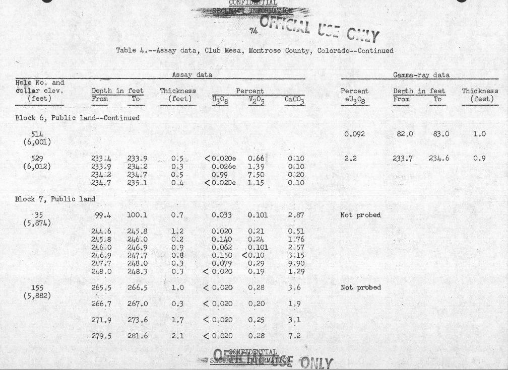
...._,.. ..._...
r•~~~- --· ' "',.-
I
.. 4V-
~f!l··y • 1:. ~
Table 4o--.Assay data, Club - ~esa, Montrose Gounty, Colorado--Continued
/ Assay data
~- ·--~·- .. ·····-----FJ~·e No·-:-a:n.~ .. o'o i,J.ar e.lev o Depth in feet Thickness Percent
· (feet) From To (.feet) U30g V205 CaC03
Block .6, Public land--Continued
514 (6;ooi)
529 (6,012)
233 ~4 233~9 234~2 234o7
Block 7 j Public land
•35 (5,874)
155 (5,882)
99c4
244o6 245~8 246~0 -246~9 247~7 248o0
265o5
266 .. 7
27lo9
279 0 5.
_j233o9 234~2 234.,7 235ol
100ol
245o8 2/.;.boO 246o9 247~7 248o0 24.S.3
266o5
267o0
273 .. 6
28la6
0 ~ 5.:.: 0~3 0~5 . Oo4
Oo7
1~2 0;2 0~9 0~8 0.;3 0.3
loO
0 .. 3
lo7
2ol
•' ,,
< 0~020e 0~.66 0~.10
0"026e 1~39 0~10
Oo99 7~50 0~20
< OoOZOe lol5 OolO
OoQJJ OolOl 2c87
o:o2o 0~21 0~51 0~140 0~24 lo76 0~062 o:1o1 2~57 0~150 <o;1o 3:15 Oo079 0~29 · 9~90
< 0.020 0.,19 lo~9
< Oo020 Oo28 3o6
< Oo02Q Oo20 lo9
< Oo020 Oo25 3 . .,1
< Oo020 Oo28 7o2
Percent · eu3o8
Oo092
2c2
Not probed·
Not prblb.~ed
Gamma-ray data
Depth in feet Thickness From To (feet) ~
82o0 83o0 loO
233~7 234o6 Oo9

~- ~' y ' ,1 '··--e..
Table 4o--Assay data, Club Mesa, Montrose County, Colorado-...:continued
Hole No o and col l ar elevo
(feet) Depth in feet From To - __,__,
Block 7, Public land--Continued
158A (5.9861)
247 (5.9884)
291 (5,842)
495 (5,889)
515 (5,889)
247o7 248o0 248o0 250oQ
218 o8 -·-- 219 o3
265o8 266ol 266ol 206o3 266o3
9
266o5 266o5 267ol
234o6 236o9 236o9 238o9
256o5 257o3
268o6 27lo6 27lo6 274o0
Assay data
Thickness (feet)
Oo3 2oQ
..... O.o.5.
Oo3 Oo2
·• ' Oo2 Oo6
2o3 2o0
Oo8
3o0 2o4
Percent U308 V205
Oo88 Oo96 < Oo02Q Oo32
Oo021 Ool2
< Oo02Q Ool8 Oo73 boOO Oo055 Oo65 Oo32 4o68
Oo05(' <DolO Oo021 <OolO
Ool2 Ool2
OolO lo30 Oo057 0,31
Caco3
2o36 lo66
3o6
Oo25 Oo36 lo62 Oo33
8o4 llo4
7o0
lo2 3ol
Percent eu3o8
Not probed
Not probed
Not probed
Oo27
Oo027 Oo31 Oo14 Oo28
0,;022
Gamma-ray data
Depth in f eet From To
255o9 256o 7 -- -- --
263 o4 26606 266o6 26fLO
. 268.0 269o0 269o0 270oQ
-- _ ,
266,1 267o3
-
Thickness (feet)
OoB
3o2 1o4 1o0 1o0
1~2

Table 4o=-Assay data, Club Mesa; Montrose County, Colorado-~Continued
Assal data Gamma~ray data Hole No~ and collar elevo DeEth in feet . Thickness Percent Percent DeEth in feet Thickness
(feet) From To (feet) UJ08 V205 CaC03 eU308 From To (feet) ----= ,_,__.,
~
Block 7, Public land==Continued
521 263 o9 265o+ lo2 < Oo020e Ool5 Undeto Oo2Q 264o6 265o5 Oo9 (5,886) 265ot 2b5o6 0,5 e/ Oo098 lo25 OobO 0.080 265o5 266,.2 0,7
256o5 266o4 Oo8a Oo029e Oo33 Undeto " -
531 26lo5 26lo'7 Oo2 < Oo020e Oo26 Undeto 0,59 262o7 263 o7 loO (5,887) ~6lo7 ·"> 262o6 Oo9 Oo034 Oo87 2.ol
262o-6 263,6 loO OoJ8 3o31 2o2 Oo094 267ol 268o0 Oo9
267o7 267o9 0,2 0,031 lo82 3o8 267<>9 268o6 Oo7 0~082 0,59 5o5 268.6 268o9 OoJ 0 o023e Oo57 5,3
594 2b8o0 268o5 0,5 Oo0~2 2o21 lo7 Oo044 267o6 268o7 lol f5 ,'886) 268o5 268o7 Oo2 < Oo020.e lo73 2oJ
- Oo022 27lol 272o2 lol I .. ,
595A 237 o9. 23~L4 Oo5 Oo25 4o68 · Oo2 Oo047 l56ol 156o9 Oo8 (5,879)
2J6o0 Oo44 236o7 Oo7
605 263o2 264o7 lo5 ., ' Oo055 Ool9 4o8 Oo38 263ol 264ol loD (-5 ,885) Ool8 · 264ol. 264o9 Oo8
y Sample in mudstone

CONFIDENTIAL ~- SEC11~()Il:MATION " o~L
·;·""' ·. ~· . .... ~,.., ...... . ............
Table 4o-=Assay dataj Club Mesa., Montrose County, Colorado-=Continued
Assay data ~~~~~ ' collar elev o -~ Depth in feet Thickness Percent
(feet) ~ ~ (feet) U30g ~205
Block 8j Public land
347 ( 6 j367)
588 ( 6 ,-490)-3f
606 (6,379)
621 ( 6,364)
480o0 480o5
55lo5
553 o}
465-o4
467 oO 467o5
467 o8
46~0~ 468o9 470oQ 470o7
480o5 48lo2
55lo6
554ol
465o6
467o5 467o6
468ol
468o9 470o0 470o7 47lo5
Oo5 0.052 0.,22 Oo7 < Oo02Q Ool3
Ool· < Oo020e Oo80
Oo8 <Oo020e lo04
Oo2 0;052 <O.l
Oo5 Oo042 2o30 Ool < Oo020e Oo32
OoJ < Oo020e Oo25
Oo3 0 ~ 032e Oo39 lol < 0~020e Oo81 Oo7 Oo33 2o38 Oo8 Oo52 lo23
CaC03
3o7 4o3
Oo6
Oo6
Oo7
Ool Undeto '
Undeto
Undeto 0~2 Oo5 lo2
~~~E QM~. SEeD ~ ~ 0 - r~~
Percent eU30g
0.029
8o6 Oo027 Oo26 Oo029
Oo022 ·
Oo032
Oo055 Oo032 0.045 Oo63 Oo21
Gamma=ray data
Depth in feet Thickness From To (feet)
- ,_,. 475 .3 476o2 Oo'9
47lo7 472o 7 loO 472o7 474o7 2o0 474o7 475o4 Oo7 475o4 476o3 Oo9
477.8 47~~~~ Oo8
463.6 464o5 Oo9
465o3 466o3 T;,B -_ 466o3 467o3 loO
. -::_ 467 o3 ·468e6 lo3 468o6 469o9 lo3 469o9 472o0 lol

Table 4o=-Assay data, Club Mesa~ Montrose County, Colorado~=Continued
Assal data Gamma=ral data Hole Noo and collar elev o DeEth in feet Thickness Percent . Percent DeEth in feet Thickness
(feet) From To (feet) U308 V205 CaC03 eU30g From To (feet) - _ _, -- __ _,
Block 8, Public land=-Continued
621--Continued 47lo5 472o0 Oo5 Oo32 Oo67 lo4 ( 6·,364) 472o0 472 ~2 Oo2 OoJJ lo47 2ol
472o2 472o5 OoJ OolJ lo60 2o0 472 0 5 ___ 472o7 Oo2 Ool3. Oo68 7o0 4'J2o 7 473o2 Oo5 Oo24 lo38 7o6 473o2 473o4 , . Po~ . Oo091 Oo34 J2o0
628 494o8 495 o2 Oo4 < Oo020e Oo67 Oo9 Oo026 48Jo7 484o6 Oo9 (6~404)
497o8 498o0 Oo2 Ool9 OoJJ 2oJ 0.051 492ol 49Jol loO 498o0 498o3 OoJ Oo035 Oo32 2o8 498o3 499o0 Oo7 Oo088· Oo47 6o2 Oo094 495o2 496o5 lo3 499o0 499o2 Oo2 Oo042 Oo31 Jol
630 495o5 496o0 Oo5 OoQJ2 lo31 Oo5 Ool4 494o8 496ol loJ (6,395) 496o0 496o5 Oo5 Oo062 Oo21 Oo4
' 496o5 497ol Oo6 Ool4 lol4 lo6 497ol 497o8 Oo7 Oo075 Qo28 loS 497o8 499ol lo3 <Oo020e Ool4 Undeto
..
631 493o7 494o9 lo2 < Oo020e Qo59 loO 0.031 495o2 496o5 loJ (6,414) 494o9 ·41j oO Ool Q.056 . Ool4 loS
Ool3 499o6 500oJ Oo7 495o2 495o5 0.,3 Oo023e <:OolO Undeto

~'LY '~ . .
Table 4.,-~Assay data, ClUb Mesa, Montrose County, Colorado--Continued
Assal data Gamma-rail data Hole N.Qo arid col1a:r e1evc DeEth in feet Thickness Percent Percent DeEth in feet Thickness
(feet). From To (feet) U308 V205 CaC03 eU308 · From To (feet)
Bl9ck 8, Public 1and-=Cbntinued
6J1=-Continued 495o5 496o5 loO Oo03Qe <OolO Undeto 0.,15 501.,8 $03.,0 1o2 ( 6 ,414) 496.,5 497o2 Oc7 Oo0;23e <OolO Undet"
500o0 500o4 Oo4 · Oo041 Oo47 1o2
502o7 503o8 1ol Oo021 0.,11 1o7
632 482o7 483.,4 Oo7 Oo074 ~o18 Oob 0.48 482o2 482o8 0.,6 (6,387) 483 o4--_/ 484o2 0.,8 Oo023e Oo95 Oo6 Oo59 482.,8 484o7 1o9
484.,2 484.,4 Oo2 Oo059 0~36 2o5 0.,025 484o7 486o2 lo5 484o4 484o6 0.2 Oo046 Oo39 1o4 484.,6 484o8 Oo2 < Oo020e 0.,17 Undeto
\
485ol 485o6 Oo5 0.,058 0.,13 , 5o2
633 546o7 547o1 Oo-4 0.045 0{>21 11o8 0.029 379o4 380o9 1o5 (6,484)
-..
634 Oo021 466o6 467 o2 Oo6 (6,485)
0.022 490o4 . 491o8 1o4
637 514o0 514o;2 ·Qo2 <Oo020e Oo36 Undet -~ 1.1 516.0 517o5 1o5 (6,445) 514o2 514.,7 Oo5 Oo02$e Oo45 Undet o Oo78 517o5 51So3 Oo8
514c7 515o0 OoJ Oo057 Oo46 0.2 2o8 518o3 519.,4 1ol
~ --------.-f~l

CONFIDENTIAL ,-~<. . . ~i..~~.:...: ,-i'· J, ·I• ;/. ' •"• '
-~:· · . .sE~TY .J:NFORMA TION
g~ us;: c::tv Table 4o .,--Assay data, Club Mesa, tJontrose County, Colorado=-Cont inued
Assaz data Gamma-raz data Hole No., and collar elev ., DeEth in feet Thickness Percent Percent DeEth in feet Thickness
(feet) From To (feet) U308 V205 Caco3 eu3o8 Fre>m To (feet) - · -
Block 8, Public land--Continued
637--Continued 515~0 516.7 lo7 - Oo048 2o54 0.,2 0.,17 519.,4 521.,1 lo7 (6,445) 516o7 520o6 3o9 Oo34 lo31 0.,7 0.032 521.,1 523o2 2ol
520o6 52lo6 leO Ool2 0.,36 2.,5 0.,098 523 o2 524.,6 lo4 52lo0· 522ol 0.,5 ' Oo024e Oo28 Undet" 522ol 523ol loO Oo048 Oo35 4o4 523ol 523 o6 Oo5 Oo2le Oo31 Undet" 523o6 524~1 . 0.,5 0.,04.3 Oo29 4o0 524ol 524o6 Oc5 0.,023e Oo31 Undeto 524o6 525o0 Oo4 Oo096 Oo32 lo8 525o0 525.,2 Oo2 0.,025 Oo56 2o0 525o2 525o5 0.3 .. <0.020e Oo42 Undeto
·:
526o2 526o5 Oc3 0.,030 Oo31 4.,4
638 ?? ·> Oo032 499o9 500.,9 loO ,··( 6,407)
639 507o8 508of) oo?~ 0.,34 2o68 i Oo9 lol 507ol 507o8 Oo? (6,408) 508.,5 508.7 0.,2 < 0.,020e Ool3 Undet.,
0.,056 509o2 509.,9 0.,7 509o8 5llo2 1.,4 Oo028 6.,93 Oo2
~ Sample in mudstone

- CONFIDENTIAL , "':_ ·;:s~m1'R.!TY INFQIDJA'Tl'TON -~:. '-<
.•. }<_ ·,,.;.;' . ~" ' : ·. . . . . " ' ·. .L..L! . : ••. ~ ... ~-.:-·". ~~- .. ·.-. -
C,. .... ;.• It
rr•'-• g..f " ~ "': ,.. • " • '' ~CW' ... '-"~ ..... •
Table 4o=-Assay data, Club Mesa, Montrose County, Colorado--Co1ltinued
Percent eU308
Oo59 Oo39
OoOJJ
Oo21
Not probed
Npt probeP.
Ganma-ray data
Depth in feet From To
"175 o9 176o8 176o8 177o3
175o8 178.0
177o4 178ol
Thickness (feet)
Oo9 Oo5
2o2
Oo7

CONFirlmTIAL ~
"~: ... ;SEC~l ... fl.TION .:·~: ~
o·~~-~ .. ~r2 u~~ . ow:-·flv rra\.IA .)C b ~ ·~t.
Table 4o--Assay data, Club Mesa, Montrose County, Colorado~-Continued-
··~ ·- Assail. data Ganma- rail. data Hole Noo arid collar elevo DeEth in feet Thickness Percent Percent DeQth in feet Thickness
(feet) From To (feet) U308 V205 Caco3 eu3o8 From To (feet) - -Block 10, Public land--Continued
312A . 27lo'"/ 273o0 1.3 Oo034 0 .. 41 5o7 Not probed (6,075) .
273 o2 '?.72o7 0.5 < Oo020 Ool3 11 .. 1
278 .. 9 280 .. 1 1.2 < 0 .. 020 0 .. 16 4 .. 3 280.1 28lo2 lol 0.054 0 .. 60 0 .. 90 -28lo2 28;2ol Oo9 0.10 0 .. 60 1 .. 36 282ol 28.3 .. 6 lo5 Oo025 Oo23 6 .. 0 283 .. 6 284 .. 8 1.2 Oo02Q 0 .. 17 7o9
· 284o8 286o4 1 .. 6 Oo092 Ool2 17o0
359 246o0 246o3 OoJ 0.052 <OolO 8 .. 4 0.071 255o4 256o2 0 .. 8 (6,058)
Oo04) <OolO 250.3 25Ll Oo8 3.9 0.033 261.6 262o3 Oo?
403 ........ ~ . . .. ~· 0 .. 065 185.4 185 .. 9 0.5 ( 6,103)
285.6 286o2 0.6 0.041
462 0.021 189.1 190.1 1.0 (6,050)
466 274o6 274 .. 8 0.2 0.096 <::0.10 4.4 0 .. 034 272 .. 7 274.5 1.8 (6,064) ...
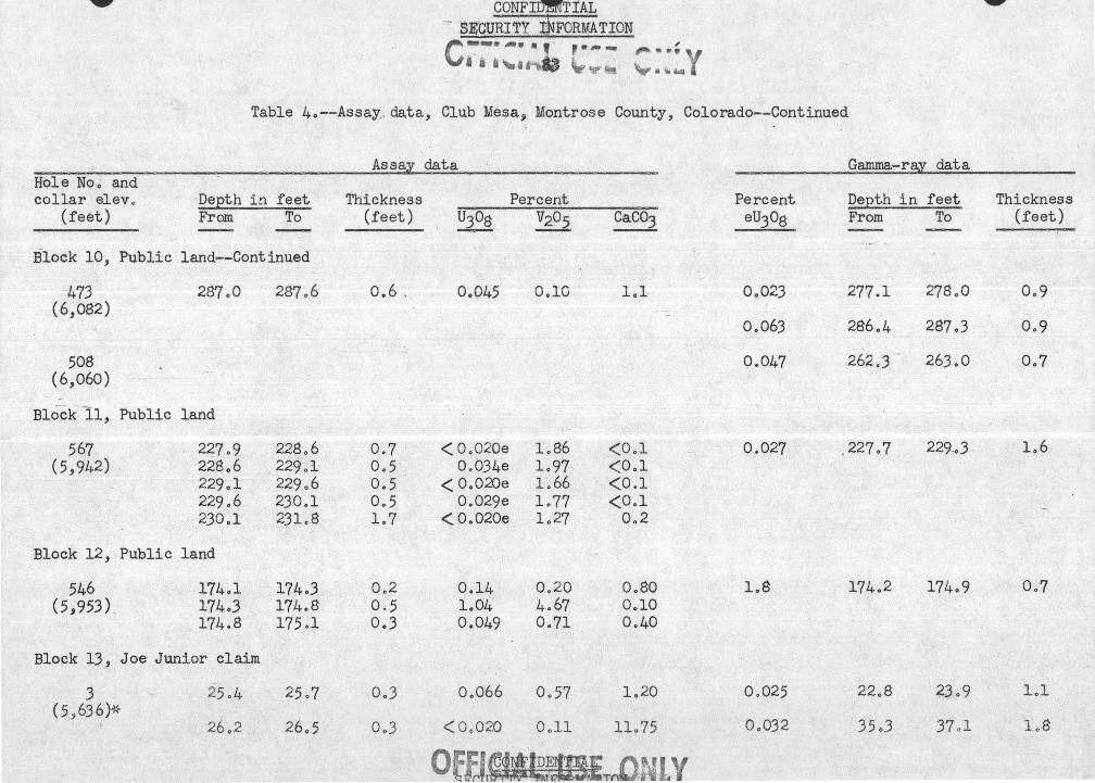

CONFIDENTIAL . ,..- .. :c<~··· ···· ' ·inM· ;;i·--·-·:,:c:~;~~~~·:·::'
Table 4o--Assay ctata, Club Mesa, Montrose County, Colorado--Continued
Ass a.~ dat:.a Gamma-raz data Hole No" and :I
collar elevo DeEth in feet Thickness Percent Percent DeEth in feet Thickness (feet) From To (feet) U308 V205 Caco3 eu3og From To (feet)
-==--- - -Block 13~ Joe Junior claim--Continued
-,3.;..-Continued 26oS · 27o0 Oo2 < 0 .. 020 0 .. 28 6 .. 12 (5,636)*
27 .. 7 28o5 Oo8 < Oo020 Oo22 7o27
28o7 28o9 0 .. 2 < 0 .. 020 Oo23 10 .. 67
36o0 36o5 Oo5 < 0 .. 020 0 .. 14 23 .. 00 36o5 36o8 0 .. 3 < 0 .. 020 OoJl 6o62 36 .. 8 37o3 ._ ;•it.
' '· ~ Oo5 00025 lol5 llo20
37 0 '3 37o8 Oo5 Oo080 lo98 .13 o7 3·7 o8 38o2 .Oo4 0 .. 020 lo34 14 .. 32
Block 14, Public land !
3q$ 565o0 566o5 lo5~ Oo34 lol8 lo9 Not probed . . (6,516) 566o5 566 .. 7 Oo2 < Oo020 Oo48 4 .. 7 ~-
Block 15, Public land
63 90o9 9lo8 0 .. 9 < 0 .. 020 Oo20 13 o42 Oo022 88 .. 1 88o7 0 .. 6 (5j987)* 9lo8 92 .. 0 0 .. 2 < Oo02Q OolO 7o40
92o0 92o2 0 .. 2 < Oo020 Oo42 2 .. 70 Oo035 89o5 90o5 1 .. 0 92 .. 2 92 .. 4 Oo~ 0 .. 061 2 .. 18 8o40 0 .. 092 90o5 9lo5 loO
,.
~ Sample in mudstone

CONFIDENTIAL . SEOOR:t'F¥~:1 £NFd@i·Il.ON.
I , ..... -,. 7 ,.
,,, . $J
Table 4o--Assay data, Club Mesa, Montrose County, Colorado--Continued
Assay data Hole Noo and collar el ev o DeEth in feet Thickness
(feet) From To (feet) U308 --Block ~5, Public land-- Continued
-C..
159 102o9 104o2 1.,3 0.,021 "~( 5 '997)*
Block 16, Public land
478 . ~76o5 179o0 2.,5 Ool2 (5, 766) 179o.O 18lo5 2o5 Ool8
Block 17, Public land
179 154.,5 154o6 Ool < 0.,020 (5,692) 154o6 155.,2' : Oo6 Oo19
155o2 i55.,4 0.,2 < 0.,020
Block 18, Lost Horse. claim
97 85o0 87 o5 2.,5 Oo060 (5,596)~-
1.
Other holes, Ka.iser claim
10 (53629)*
Percent V205 Caco3
Oo24 -5o40
Oo26 2.,5 0.,17 5o0
0.,67 Ool? 0.,51 Oo22 0.,67 0.,97
Oo45 _9.59
v
Percent eu3o8
0.,030
2o4
o.p33
Not probed
0.21
0.,020
Oo085
Gamma-ray data
Depth in feet From To
' 102o6
177o4
179.,7
85.,0
-71.,6
73 .,3
103o5
178ol
180.8
86.,0
72o4
74ol
Thickness (feet)
Oo9
Oo7
l.,l
laO
0.,8
Oo8

liUI'Jr .LU.l!..NT.lll.L
_ SECURI~-iNFORMA"iieN :....-.-.... ~~-... •. . ~ ..,. , .... ... . . ' ' _. '
0 ... ,,.,. f d-4 . .... '4a4~ jlf:. ~ og p .~~-: ('~··'·· ~... C< "<." ',... l . ' . ~ •l t, ~ u ~
Table 4o--Assa.y data, Club Mesa, . Montrose· County, Colorado--Continued
.Hole Noo . arid collar elevo
(feet) Depth in fe~t From To -
Other holes, Kaiser claim--Continued
17 (5,619)*
25o5
Other holes, Jo Mo claim
19 (5,644)*
66o4
Other holes, Big $hot .claim
72 (6,100)*
64o0
Other holes , Irene · clcd.m ·
-98 (5,606)*
99 ( 5' 605 )~-
145o0
~ Sample in mudstone
·· 27 o6
66o7
64o9
146o5
Assay· data
Thickness (feet)
2ol
OoJ
Oo9Y
lo5-
I'
·Percent i
U308 V205 · GaC03
0 .. 030. <OclO l8o0
Oo02 <DolO 3o8
Oo020 < OolO 2o58
<Oo02Q Oo38 2o91
CONFIDENTIAL
OF~·-· ·I~Tif1~~ !1 y ~.QC 1fF,T ' ~ ii '\; (["
Percent eU30g
Oo050
· Not probed
Oo022
Oo022
Gamma-ray data
Depth in fe ·et Thickness From To · (feet)
26o7 2?oJ Oo.6:: -
67o8 69o3 lo5
144o5 146o2 l 'o7

CONFirlfriAL SE9URll])1,:;1·,ttfJtOR.MATION _
" , , '~ ~~.' ~
> " ti fi
Table 4o-~Assay data, Club Mesa., Montrose County, Colorado--Continued
Hole No·o ·· arid collar elev o ·
(feet) Depth in feet From To
· Other holes·, Public land
39 (5 ,703)
42.A (5 ,960)~~
59 A (6,050)*
109A (5,925)
114A (6,205)*
130· (6,056)
139 (6,226)*
147 (6,074)
135o2
136oJ
142·,2
224,9
233~4
I'
216o0
269,5
268oJ
~ Sample in. mudstone
136,0
137o9
142o5 -
225o4
233,8
216,5
270,0
268.6
Assay data
Thickness Percent (feet) tr3o8 . ,. _ v2o5
OoSY Oo083 Oo60
lo6§/ < 0,020 O-o25
0,3 OoOJ4 <0,10
Oo5 '. Oo023 0,12
Oo.4 ' 0.03..0 <OalO
Oo5 _- <0.040 0,2l
··-Oo5 Oo034 <OolO
OoJ <Oo020 OolJ
~Oi-~
Caco3
Oo42
lo56
Oo52
15o9
1,90
4o9
10o6
lo82
~~ -- o~ ~-"~ ,_L ~'! '" r~ 'i
Percent eu3o8
Not probed
0,033
Not probed
Not probed
Not probed
Not probed
Not probed
Giimma-ray data
Depth in feet From. . To
158o0 158o6
,.,
Thickness (feet)
Q,6
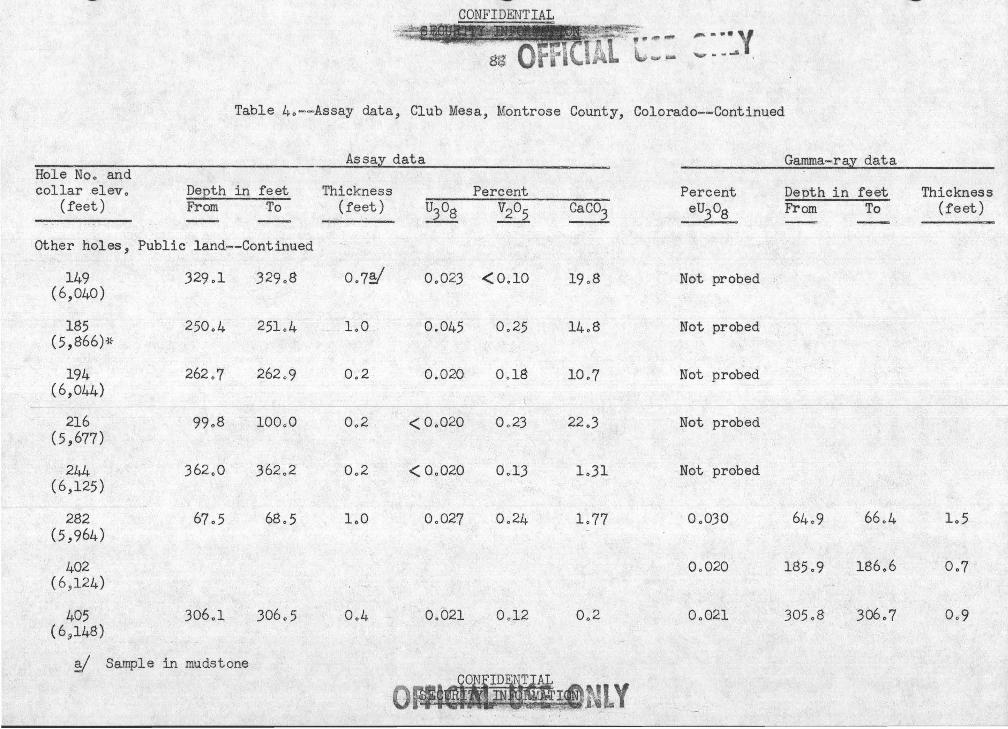
~
~ • •• , J ~ ......... 1
Table 4o--Assay data, Club Mesa, Montrose County, Colorado--Continued
-------~-------
As sail. data Garnma-ra:y data Hole Nco and collar .elevo DeEth in feet Thickness Percent Percent DeEth in feet
(feet) From To (feet) U308 V205 Caco3 eu3o8 From To -- --- -·-
other holes, Public land--Continued
149 329ol 329o8 Oo?§/ (6,040)
Oo02J <O .. lO 19o8 Not probed
185 250o4 25lo4 l .oO ' (5,866)*
0.045 Oo25 14o8 Not probed
194 262o7 262o9 Oo2 0.020 Ool8 10o7 Not probed (6,044)
216 99o8 lOOoO Oo2 < Oo020 Oo23 22o3 Not probed (5,677)
244 J62o0 J62o2 Oo2 < Oo020 Ool3 loJl Not probed (6,125)
282 67o5 68o5 loO Oo027 Oo24 lo77 OoOJQ 64o9 66 .. 4 (5,964)
402 Oo02Q 185o9 186o6 (6 ,124)
405 J06ol J06o5 Oo4 0 .. 021 Ool2 Oo2 Oo021 J05o8 J06o7 (69148)
~ Sample in mudstone
lrH . c~FNG=~=.::J::eNLY
.....,..
Thickness (feet)
lo5
Oo?
Oo9
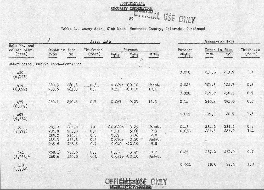
..... .,..._
rs~
Table. 4o=-Assay data, ·club Mesa,, Montrose County, Coloradq--Contlnq_Qd
.·\
Hole No o ar;td collar elev ,
(feet)
~
} r'\
Depth in feet :From To
Other holes, Pub~~ic land--Continued
-410 (§,168)
414 (6,022)
477 (6,009)
493 . (5,662)
504 (5~979)
524 (5,958)-r,
530 (5 ,.,989)
260.,3 260o6 260.,6 261.,0
250o1 250o8
283.,8 284.,8 284o8 285o0 285o0 285oJ 285.,3 · 285.,8 285.,8 286.,5
268.,1 268.,6 268o6 269.,0
Assay data
Thickness (feet)
__ ,, QJ,3 ...... Oo4
Oo?
loO . 0.,2 0.,3 0.,5 Oo?
Oo5 0.,4
Percent · uJ_os- v2q5 __
\ \
' '
Oo029e <0.,10 0.,35 <0.,10
0.,063 Oo23
<o.,ozoe 0.,25 0.,41 5.,6$ 0.,69 3 .,36 0.,030e Oo20 ,,,: , Oo04Q <OolO
0.,36 3 J.,.? 0.,027e (0.,10
CaC03 -----
Undeto 18o1
11.,3
Undet., 2o3 2o8
Undet., 5.,8
10.,7 Undet.,
Percent eu3o8
Q.,020
0.,026
0.,330 ..
0.,14
o.,-029
0.,43 0.,038
OoS5
OoQ21
Gamma-ray data
Depth in f'e;~t From .,". 'rQ--
:. 212.,6 213o7
101.,5 102$3
257o8 258.,5 --
250o2 251.,0-
· 19o4 20.,?
284o6 285.,5 285.,5 286.,9
267o2 2b7o9
88.,4 89o4
Thickness (feet)
l.,l
0.,8
Oo7
0.,8
1.,3
0.,9 1.,4
0.,7
loO

- .""W''
CONFIDENTIAL · .. ,~·, · {s~mm!T!~~F6aiinor~ -~ .
' :S.·.;.
·.· .. c;-. -~ · ·, ·9o · '• IUAL Irr .. i?-
l~i:f :{. . . · Jl ~~: ,.. n~-~'" t .... __ .
• \, t.. Table 4o--Assay data, Club Mesa, Montrose County, Colorado--Cent ued
Hole Noo and collar el ev..,
(feet) Depth in feet From To --
Other holes, Public land--Continued
541 (5, 943)
560 (6,005)
564 (5,996)
570 ( 6,913)
574 (5,966)-~r
591 (6,024)
593 (6,207)*
601 ( 6 ,20l)~r
257o7
258o7
263 Q6
155o0
203ol
310<14
24lo8 243o0 243,o5
. ~ "'
235o2
258o0
259o0
263o8
155o2
203o5
311'c.2
243o0 243o5 244o8
235 o3
Assay data
Thickness (feet)
OoJ
Oo3
Oo2
Oo2
Oo4 ·.
0 ... 8
"
lo'2 Oo5 lo3
Ool
Percent U308 V205
Oo034
Oo044
01'034e
Oo033e
Oo21
Oo075
<Oo020e
2o06
Ool4
Ool2
OolO
7-o60
Oo75
OolO Oo024e <::..OolO
<Oo020e Ool5
<oo020e Oo23
Caco3 .
3o5
10o3
Undet Q
Undet o
OoJ
Oo5
Undet o Undet o Undeto
Undeto
-NTIAL . ;{) .· · .. .. , ~.· · .-~~-P,(}~I'V ¢.; • Iii 'lo W;i
Percent eu3o8
Oo083 Oo045
Oo022
Oo049
Oo47 /: f'' ·· <
i1k 0.19 ;V
"L
Oo022
Oo023
Oo042
Gamma-ray data
Depth in feet From To
257o4 258o4
258o4 259o3
90o5 9lol
263o2 --264o3
202 0 2 203o0
309o4 310o2
241,5 242o7
243o3 245o5
235o4 236ol
Thickness (feet)
loO Oo9
lol
lol
Oo8
Oo8
lo2
2o2
Oo7

·,.~·· ..... ..... ..
Table 4o-~Assay data, Club Mesa, Montrose County, Colorado--Continued
Hole Noo and collar .@leVo
(feet) Depth in feet FrOm < To ~ -·-----
Other holes, Public land---Cc;>.ntinued
609 (6,3JJ~)
612 (6,036)
t>l4 <5,996)
615 (6,320)
325.,0 326o2
J26o2 J26o5
Assay cliltar
Thi ckrress~
(feet)
l:oZ 1o3
Percent UJOS V2_t,l5 . - ~
< Oo020e Ool9 OoOJ8 Oo2J
CaC03
Undeto lo5
Percent eUJOS .·
Oo02Q
0.,022
Oo02Q
· - Gamma-ray data
Depth in feet From .·· To -
490o8 49lo4
200o8 20lo9
46lo3 461~9
,; • J ~
Thickness (feet)
Oo6
lol
0.6