Can place names be used as indicators of landscape changes? Application to the Doñana Natural Park...
16
Landscape Ecology 16: 391–406, 2001. © 2001 Kluwer Academic Publishers. Printed in the Netherlands. 391 Research Article Can place names be used as indicators of landscape changes? Application to the Doñana Natural Park (Spain) Arturo Sousa and Pablo Garc´ ıa-Murillo Departamento de Biolog ´ ia Vegetal y Ecolog ´ ia, Universidad de Sevilla, Apdo. 874, 41080 Sevilla, Spain Received 23 August 1999; Revised 18 January 2000; Accepted 18 December 2000 Key words: Abalario, Doñana, Spain, forestry cultivation, lagoons, landscape, peat bogs, place names, vegetation Abstract This work broaches the possibility of using place names as indicators of original landscapes that have been much transformed. The reconstruction of landscape elements from place names is commonly disputed because such daring notion is impossible to demonstrate. The present case avoids this by making a preliminary study of changes in the landscape using conventional methods. With the knowledge gained from objective and reliable sources, the possibility is analyzed of whether place names are a reflection of landscape changes taking place over a considerable period of time (the last few centuries). It is concluded that, for the present case study, in natural areas with a high rate of change of land use (Doñana Natural Park), place names indicate not only changes in the landscape, but also how such changes are perceived. In the study area, this is especially clear regarding the fens. Introduction Early studies analyzing visual perception of the land- scape, such as that of Litton (1968), note that place names suggest variations in the spatial definition of the landscape. More recently, Alcázar et al. (1988) indicate that place names, besides being of cultural and linguistic value, are signposts in the historical re- construction of landscapes subjected to a high degree of transformation. The landscape and its changes can be analyzed in various ways. One way is to study the references to landscape elements appearing in local and regional place names as a reflection of already vanished ele- ments. However, this approach has always been hotly discussed by detractors and defenders. The former are critical towards studies that deviate from a purely linguistic interpretation and use place names as instru- ments for the reconstruction of historical environments (Corominas 1972; Rackham 1986; Calvo and Pellicer 1992). Such works are criticized, above all, for the lack of data to confirm their hypothesis, and for being more a personal interpretation or exercise in guess- work. Other authors (Gelling 1984, and 1987; Alcázar et al. 1988; López Ontiveros et al. 1991; González Bernáldez 1992; Aybes and Yalden 1995) seem to have stake more on the information supplied by place names. Regardless of the language (English, Spanish, Gaelic, Basque, French, Arabic) of the place-name source (historical maps, interviews with local inhabi- tants, land registers, compilation of terms), the contro- versy remains alive, even though several works (Bor- naechea et al. 1984; Alcázar et al. 1988; Aybes and Yalden, 1995) include statistical analysis reinforcing their conclusions. Consequently, the only toponymic approaches fully accepted by the scientific community are etymology-based lexicological ones (García de Diego 1959, 1972; Corominas 1972, 1997; Ekwall 1990; Gordon and Ruhstaller 1991) or geographical, mainly because of the compilation of terms (C.E.T.U. 1989, 1990a). Works with an ecological slant, such as those restricted to wetlands (González Bernáldez 1992), to hunting and hunting country (López Ontiveros 1987; López Ontiveros et al. 1991), or to already extinct species (Aybes and Yalden 1995), are treated with greater suspicion. This may be why the bibliography
-
Upload
independent -
Category
Documents
-
view
0 -
download
0
Transcript of Can place names be used as indicators of landscape changes? Application to the Doñana Natural Park...
Landscape Ecology 16: 391–406, 2001.© 2001 Kluwer Academic Publishers. Printed in the Netherlands.
391
Research Article
Can place names be used as indicators of landscape changes? Applicationto the Doñana Natural Park (Spain)
Arturo Sousa and Pablo Garcıa-MurilloDepartamento de Biologia Vegetal y Ecologia, Universidad de Sevilla, Apdo. 874, 41080 Sevilla, Spain
Received 23 August 1999; Revised 18 January 2000; Accepted 18 December 2000
Key words: Abalario, Doñana, Spain, forestry cultivation, lagoons, landscape, peat bogs, place names, vegetation
Abstract
This work broaches the possibility of using place names as indicators of original landscapes that have been muchtransformed. The reconstruction of landscape elements from place names is commonly disputed because suchdaring notion is impossible to demonstrate. The present case avoids this by making a preliminary study of changesin the landscape using conventional methods. With the knowledge gained from objective and reliable sources,the possibility is analyzed of whether place names are a reflection of landscape changes taking place over aconsiderable period of time (the last few centuries). It is concluded that, for the present case study, in naturalareas with a high rate of change of land use (Doñana Natural Park), place names indicate not only changes in thelandscape, but also how such changes are perceived. In the study area, this is especially clear regarding the fens.
Introduction
Early studies analyzing visual perception of the land-scape, such as that of Litton (1968), note that placenames suggest variations in the spatial definition ofthe landscape. More recently, Alcázar et al. (1988)indicate that place names, besides being of culturaland linguistic value, are signposts in the historical re-construction of landscapes subjected to a high degreeof transformation.
The landscape and its changes can be analyzed invarious ways. One way is to study the references tolandscape elements appearing in local and regionalplace names as a reflection of already vanished ele-ments. However, this approach has always been hotlydiscussed by detractors and defenders. The formerare critical towards studies that deviate from a purelylinguistic interpretation and use place names as instru-ments for the reconstruction of historical environments(Corominas 1972; Rackham 1986; Calvo and Pellicer1992). Such works are criticized, above all, for thelack of data to confirm their hypothesis, and for beingmore a personal interpretation or exercise in guess-work. Other authors (Gelling 1984, and 1987; Alcázar
et al. 1988; López Ontiveros et al. 1991; GonzálezBernáldez 1992; Aybes and Yalden 1995) seem tohave stake more on the information supplied by placenames.
Regardless of the language (English, Spanish,Gaelic, Basque, French, Arabic) of the place-namesource (historical maps, interviews with local inhabi-tants, land registers, compilation of terms), the contro-versy remains alive, even though several works (Bor-naechea et al. 1984; Alcázar et al. 1988; Aybes andYalden, 1995) include statistical analysis reinforcingtheir conclusions.
Consequently, the only toponymic approachesfully accepted by the scientific community areetymology-based lexicological ones (García de Diego1959, 1972; Corominas 1972, 1997; Ekwall 1990;Gordon and Ruhstaller 1991) or geographical, mainlybecause of the compilation of terms (C.E.T.U. 1989,1990a). Works with an ecological slant, such as thoserestricted to wetlands (González Bernáldez 1992), tohunting and hunting country (López Ontiveros 1987;López Ontiveros et al. 1991), or to already extinctspecies (Aybes and Yalden 1995), are treated withgreater suspicion. This may be why the bibliography

392
dealing with this topic of interest from the view-point of landscape and ecological interpretation isdisperse and largely discontinuous, in contrast to thaton traditional toponomastic analysis via linguistics.
The present paper is a contribution towards dilu-cidating this controversy. It is a specific study whichdoes not use place names to visualize and recreatethe evolution of the landscape, but rather the reverse.That is, historical changes in the study area have beenanalyzed using classic methodology, and then con-trasted. Only when changes have been reconstructedfrom more-objective sources (and thus, not subject tointerpretation) has their reflection in place names beenstudied.
If the initial hypothesis is verified – that is, ifplace names are indicators of change undergone bythe landscape – such change should be reflected inthe place names on historical maps whenever the zonehas strongly transformed ecosystems. To verify thisnotion, Doñana Natural Park (the western sector, orAbalario) was chosen as study area. The region hasbeen subjected to strong changes in landscape overa relatively short recent period (Sousa and GarcíaMurillo 1998), providing abundant information onlocal processes of transformation.
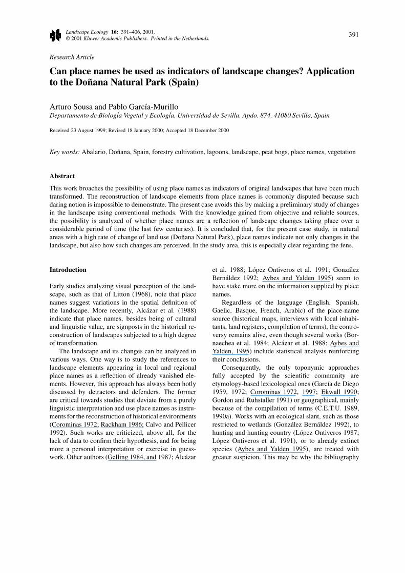
Study area
The study area occupies some 25 000 ha of the total55 000 of Doñana Natural Park (south-west Spain).Specifically, it is located on the coastal arc of Huelva,between the mouths of the rivers Guadalquivir andTinto. Its boundaries are largely those of the westernsector of Doñana Natural Park, although other landnot belonging to the Park is included in the study forgeographic coherence (Figures 1 and 2).
The substrate is a Quaternary eolic mantle, a prod-uct of successive lines of dunes. In the northernand western zones, Pliocene sands crop out at somepoints (Leyva and Pastor 1976). The climate is typicalMediterranean, although with a strong Atlantic trend– seen as a succession of milder temperatures (annualmean temperature 16.5 ◦C), and greater precipitationthan inland [annual mean precipitation 699 mm (Allue1990)].
The landscape is characterized by a plant cover thatis scant and unordered. Autochthonous trees are prac-tically absent. The autochthonous vegetation is repre-sented by a sparse shrub of Halimium halimifolium,heathers, and gorses. Stunted pines, and eucalyptus of
different species, are dotted about, with isolated ju-nipers, strawberry trees, and cork oaks (García Murilloand Sousa 1999).
This cover includes recognizable natural plantunits superimposed on remains of ancient forestry cul-tivation (Pinus pinea, Eucalyptus sp. pl.). A commonfeature of these units is their not very mature state;that is, they are serial communities whose develop-ment seems to have been interrupted. They give thestudy area a disorganized aspect. The result is seen as adestructured plant landscape, without obvious patternsof organization explained by the characteristics of thephysical medium.
The study area, despite being in southern Europe,was practically unknown territory until well into the20th century. This was basically because of its inac-cessibility (with an almost total lack of roads), a veryunproductive substrate for farming, and unhealthy en-vironment created by the numerous lagoons, withmalaria being endemic.
In human terms, the zone is practically uninhab-ited. There are only a few isolated houses (Cabezudos,Acebuche) of wardens, and coastal infrastructuresconnected with holiday use (campsites, hotels). Agood impression of the demographic change is givenby the fact that at the height of forestry activity in thewhole study area (25 000 ha approximately), in themid-1950s, the population was around 1000. By themid-1980s, it had fallen to just 191.
Methods
The main instrument used was the compilation of lo-cal place names on historical maps of the area fromthe 17th century to date. The compilation was lim-ited to maps for two reasons. On the one hand thereis the essential need to associate each term in spaceand time – to know the date and area where the stud-ied terms appeared and disappeared. On the other,some authors (Centro de Estudios Territoriales y Ur-banísticos 1990a) indicate that, in Spanish territory,military maps are considerably more reliable than oth-ers (such as those of the Catastros de Rústica (RuralLand Registers)).
The methodology used was to compare the com-piled place names with landscape elements and struc-tures detected by more exact analytical techniques(such as studies of the changes in plant cover, ge-ographical features, and land use). The latter weremainly from our own data obtained from archives,
393
Figure 1. Study area, located in the south-west of the Iberian Peninsula.
aerial photography, satellite images, and fieldwork,some of which have already been published in variousarticles.
The toponymic information from available his-torical maps was analyzed after the place names orterms referring to singular territorial elements werecompiled (see detailed listing in Sousa and GarcíaMurillo 2000). Almost 700 place names were ana-lyzed in this review; it is estimated that in the wholeprovince of Huelva (SW Spain) there are 15 794 dif-ferent terms recorded (C.E.T.U. 1990b). Certain im-precise or uncommon place names [laguna (lagoon),camino (track), senda, (path)] were included wheneverthey were associated spatially to some cartographic
element (geo-referencing). Terms or symbols repre-senting temporary local attributes (type of crop, fire-breaks, etc.) were excluded, as were unspecific orrepeated ones (path, track, etc.).
Once this information was gathered, the placenames were classified according to their reference tonatural elements (geographical, geomorphological, orplant features, etc.) or artificial ones (houses, paths,wells, etc.). The natural ones were separated into fourgroups: those related with animals, plants, wetlands,and forestry. Within the first two, a subgroup wasdistinguished of place names referring to autochtho-nous animals and plants respectively of the wetlands.Within the wetlands place-name group, subgroups

394
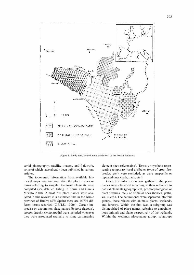
Figure 2. General map of the study area, occupied by numerous small lagoons.
Table 1. Classification of place names used.
– Natural
– Animals
∗ Animals∗ Autochthonous animals of wetlands
– Plants∗ Plants∗ Plants perceived as autochthonous.
– Wetlands∗ Lagoons.∗ Brooks.∗ Other wetlands.
– Forestry∗ Pine-groves∗ Eucalyptus groves
– Others
– Artificial
– Route infrastructures
– Urban infrastructures
– Others
395
were established of lagoons, brooks, and other wet-lands. In the forestry place names, terms referring topines were distinguished from those to eucalyptus.
Another group included terms denominating artifi-cial or anthropic elements, in which those referring toroute infrastructures (tracks, paths, bounds, passages,roads, lanes, etc.) were distinguished from those refer-ring to urban infrastructures (cottages, houses, nurs-eries, campsites, communities, etc.), as indicated inTable 1.
It should be noted that the place names were listedas ‘natural versus artificial’ rather than ‘natural versusanthropic’. Although the two expressions are similar,there is a difference in their meaning: the perceptionof forest mass, farm animals, game animals, etc. is dif-ferent to that of elements (also of anthropic origin) notdirectly affected by the characteristics of the physicalor biotic medium (as in the case of the route infrastruc-tures). This means that the former are seen (althoughwith some differences) more as an intrinsic elementof the landscape than as one that has been added orsuperimposed (such as a tarred road).
As we will see later, this difference leads to dif-fering responses in the transfer of these new elementsto the working map (via place names). Therefore, thegeographic criterion (C.E.T.U. 1989, 1990a) has beenused in this work for the classification of place names,rather than the lexicosemantic one (Gordon 1988).This criterion is similar to that used by Gelling (1984)to classify English place names referring to landscape.
The attempt to make a quantitative study of all thecompiled place names created several problems: theolder maps (prior to 1869) were scarcer in place namesand were of smaller scale (which can cause consid-erable distortion in data analysis), while more-recentmaps showed redundancy and repetition of terms. Itwas therefore decided to make a selection. For thequantitative analysis, 8 maps were selected that in-cluded most of the place-name terms over the periodstudied, and whose scale was acceptably reliable anddetailed (Appendix 1). From these maps, the num-ber and percentage of each place-name type weredetermined. All historical maps were used for thequalitative analysis. The complete list of cartographyused, and all the place names, revised and dated, canbe found in Sousa and García Murillo (2000).
Landscape changes and reconstruction were deter-mined from field observations, aerial photographs, anda study of the archives of various authorities. The re-sults are gathered in García Murillo and Sousa (1997,1999) and Sousa and García Murillo (1998). For a bet-
ter understanding of the processes, the Results sectionincludes a brief ecological history, indicating the mostimportant events in the regional transformation.
Results
Brief ecological history
The original landscape of the study area, which couldstill be seen at the beginning of the 20th century, andwhich is described by old inhabitants of the regionand in chronicles and ancient documents, shows a de-serted territory with immense sandy areas dotted withjunipers. This had not been put into agricultural usebecause of the outstanding poverty of the soil and thethreat of malaria, endemic in the area. At that timethe area contained frequent cork oak groves and wascrossed by numerous brooks and rivulets bordered byfrondous riverside woodland. A feature of these oldreferences is the abundance of lagoons and pools, ofwhich only some very reduced ones can still be recog-nized (Laguna de los Ansares, Lagunas del Río Loro,etc.), in most cases persisting only as depressions cov-ered with pasture and hygrophytic heather, testifyingto their bygone functionality.
This whole landscape disappeared following in-tensive forestry activity in the territory at the end ofthe Spanish Civil War (1936–1939). The Spanish stateauthorities, within the framework of an autarchic post-war economy, set out to obtain urgent raw material byforestry monoculture. The ‘unproductive’ traditionaluses (essentially predatory-type: hunting, clearance,charcoal burning) were replaced by new cultivation(technically alien) of rapidly growing trees, in par-ticular eucalyptus, which in a short time could yieldvaluable raw materials such as wood pulp, essentialoils, timber, etc.
The result of such colonialist intervention meanta radical change for the territory. It went from be-ing perceived originally as a wasteland without usefulvalue (although with a high environmental value be-cause of its numerous lagoons, spatial non-uniformity,and high organism, community, and species diversityover a large range of uncommon species, etc.) to beingan archetypal region, a model of forestry use, with anideal production of raw materials.
Later, during the 1960s, the gradual ending offorestry, as a result of the progressive fall in production(inherent to this type of crop) and the loss in valueof the raw materials, caused a new transformation in
396
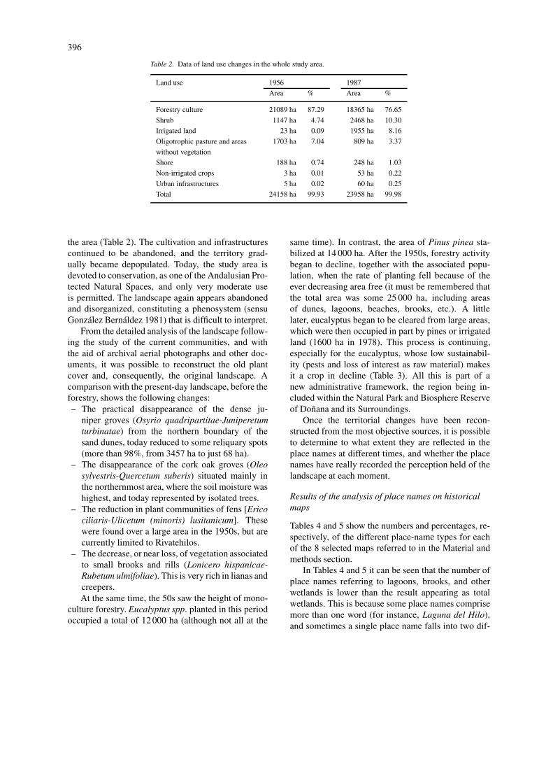
Table 2. Data of land use changes in the whole study area.
Land use 1956 1987
Area % Area %
Forestry culture 21089 ha 87.29 18365 ha 76.65
Shrub 1147 ha 4.74 2468 ha 10.30
Irrigated land 23 ha 0.09 1955 ha 8.16
Oligotrophic pasture and areas 1703 ha 7.04 809 ha 3.37
without vegetation
Shore 188 ha 0.74 248 ha 1.03
Non-irrigated crops 3 ha 0.01 53 ha 0.22
Urban infrastructures 5 ha 0.02 60 ha 0.25
Total 24158 ha 99.93 23958 ha 99.98
the area (Table 2). The cultivation and infrastructurescontinued to be abandoned, and the territory grad-ually became depopulated. Today, the study area isdevoted to conservation, as one of the Andalusian Pro-tected Natural Spaces, and only very moderate useis permitted. The landscape again appears abandonedand disorganized, constituting a phenosystem (sensuGonzález Bernáldez 1981) that is difficult to interpret.
From the detailed analysis of the landscape follow-ing the study of the current communities, and withthe aid of archival aerial photographs and other doc-uments, it was possible to reconstruct the old plantcover and, consequently, the original landscape. Acomparison with the present-day landscape, before theforestry, shows the following changes:– The practical disappearance of the dense ju-
niper groves (Osyrio quadripartitae-Juniperetumturbinatae) from the northern boundary of thesand dunes, today reduced to some reliquary spots(more than 98%, from 3457 ha to just 68 ha).
– The disappearance of the cork oak groves (Oleosylvestris-Quercetum suberis) situated mainly inthe northernmost area, where the soil moisture washighest, and today represented by isolated trees.
– The reduction in plant communities of fens [Ericociliaris-Ulicetum (minoris) lusitanicum]. Thesewere found over a large area in the 1950s, but arecurrently limited to Rivatehilos.
– The decrease, or near loss, of vegetation associatedto small brooks and rills (Lonicero hispanicae-Rubetum ulmifoliae). This is very rich in lianas andcreepers.At the same time, the 50s saw the height of mono-
culture forestry. Eucalyptus spp. planted in this periodoccupied a total of 12 000 ha (although not all at the
same time). In contrast, the area of Pinus pinea sta-bilized at 14 000 ha. After the 1950s, forestry activitybegan to decline, together with the associated popu-lation, when the rate of planting fell because of theever decreasing area free (it must be remembered thatthe total area was some 25 000 ha, including areasof dunes, lagoons, beaches, brooks, etc.). A littlelater, eucalyptus began to be cleared from large areas,which were then occupied in part by pines or irrigatedland (1600 ha in 1978). This process is continuing,especially for the eucalyptus, whose low sustainabil-ity (pests and loss of interest as raw material) makesit a crop in decline (Table 3). All this is part of anew administrative framework, the region being in-cluded within the Natural Park and Biosphere Reserveof Doñana and its Surroundings.
Once the territorial changes have been recon-structed from the most objective sources, it is possibleto determine to what extent they are reflected in theplace names at different times, and whether the placenames have really recorded the perception held of thelandscape at each moment.
Results of the analysis of place names on historicalmaps
Tables 4 and 5 show the numbers and percentages, re-spectively, of the different place-name types for eachof the 8 selected maps referred to in the Material andmethods section.
In Tables 4 and 5 it can be seen that the number ofplace names referring to lagoons, brooks, and otherwetlands is lower than the result appearing as totalwetlands. This is because some place names comprisemore than one word (for instance, Laguna del Hilo),and sometimes a single place name falls into two dif-
397
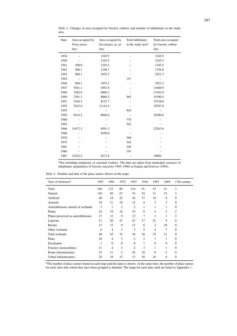
Table 3. Changes in area occupied by forestry cultures and number of inhabitants in the studyarea.
Date Area occupied by Area occupied by Total inhibitants Total area occupied
Pinus pinea Eucalyptus sp. pl. in the study areaa by forestry culture
(ha) (ha) (ha)
1936 – 1245.5 – 1245.5
1940 – 1245.5 – 1245.5
1941 100.0 1245.5 – 1345.5
1942 508.1 1248.7 – 1756.8
1943 968.1 1955.2 – 2923.3
1945 – – 147 –
1946 968.1 1955.2 – 2923.3
1947 7041.1 4567.8 – 11608.9
1948 7282.6 6060.3 – 13342.9
1950 7301.3 8089.2 565 15390.5
1951 7410.3 8127.7 – 15538.0
1952 7643.6 11143.4 – 18787.0
1955 – – 945 –
1956 9414.2 8966.6 – 18380.8
1960 – – 778 –
1965 – – 542 –
1966 13672.3 8591.3 – 22263.6
1968 – 6550.0 – –
1970 – – 368 –
1975 – – 342 –
1981 – – 349 –
1986 – – 191 –
1987 14522.2 4571.8 – 19094
aNot including temporary or seasonal workers. The data are taken from municipal censuses ofinhabitants (population of forestry nurseries 1945–1986) in Espina and Estevez (1992).
Table 4. Number and date of the place names shown on the maps.
Year of referencea 1987 1981 1972 1947 1936 1897 1869 17th century
Total 184 123 89 116 91 47 41 3
Natural 136 89 67 74 54 31 33 3
Artificial 48 34 22 42 37 16 8 0
Animals 18 11 10 12 4 3 3 0
Autochthonous animal of wetlands 3 1 2 2 1 1 1 0
Plants 24 19 16 19 8 4 2 2
Plants perceived as autochthonous 17 12 9 12 7 3 1 2
Lagoons 31 28 21 23 17 21 5 0
Brooks 13 15 9 12 6 2 10 0
Other wetlands 6 4 3 3 5 4 7 0
Total wetlands 48 45 32 36 26 25 21 0
Pines 10 4 3 2 2 1 1 0
Eucalyptus 1 0 0 0 1 0 0 0
Forestry monocultures 11 4 3 2 3 1 1 0
Route infrastructures 15 11 2 26 18 0 2 0
Urban infrastructures 24 18 15 13 16 16 6 0
aThe number of place names found on each map (and the date) is shown. At the same time, the number of place namesfor each class into which they have been grouped is detailed. The maps for each date cited are listed in Appendix 1.

398
ferent classes. In the example, this would correspondto both ‘lagoons’ and ‘other wetlands’, but as a sin-gle place name, would be counted as such in the totalwetlands.
Discussion
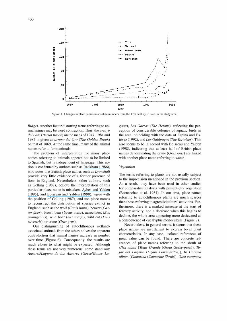
The compilation enables certain general conclusionsto be drawn. For instance, a great distortion is intro-duced by the place names from very old historicalmaps (≤ 18th century), since the number of placenames shown on such maps is very low (see Table 4),above all in those at small scale. Another fact thatseems very clear is that the number of place namesshown on the maps for a given area increases inabsolute terms over time (Figure 3). Thus, it can be de-duced that the increase in place names is linked to theincrease in exploitation of territorial resources. Espina& Estévez (1993) show that the civil de-amortizationand the land censuses in this territory during the 19thcentury are reflected in the appearance of new placenames denominating the properties acquired, main-taining them for the scrubland (in Spanish: cotos) intowhich the state authorities later structured the area.
With increasing exploitation, the region becomesmore recognizable territorially, with more elements ofreference [it is no longer the blank and unknown landappearing on the ‘Andalucía Nova’ map (1606) or in‘Li Regni de Granata E D’Andalucía’ (1696)].
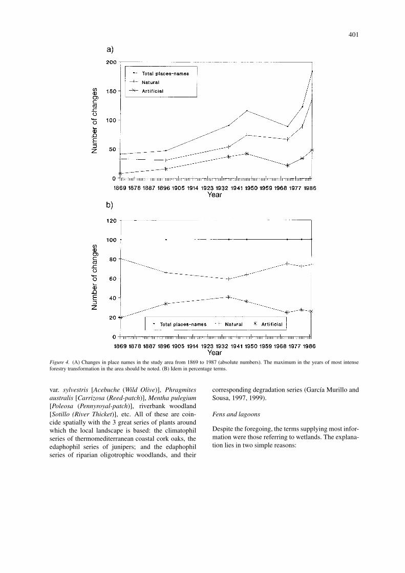
It can be seen clearly (Figure 4a) that the numberof place names in the study area is maximum (in ab-solute terms) in the years following the Spanish CivilWar. It is no coincidence that this peak is during theperiod when Spanish public bodies were most stronglypromoting reforestation. In the analysis at percentagelevel, the most frequently appearing place names arethose referring to natural rather than artificial elements(Figure 4b).
The fact that the absolute number of place namesincreases with time is very important in the later analy-sis, since it can distort the conclusions drawn. For thisreason, when analyzing quantitatively how a specifictype of place name (such as those referring to land use,forestry, animals, etc.) varies over time, it is necessaryto use percentage data of this place-name type withrespect to total place names.
Discussion on land use
As abundantly shown in other works (Ojeda 1987;Espina and Estévez 1992, 1993), the study area was
originally (19th century and beginning of the 20th)an inhospitable and unhealthy area, considered a de-serted and improductive. The land use in that period isreflected in the place names shown on contemporarymaps. Thus, various place names appear that refer tojuniper charcoal burning, or tunny-fishing with nets.
After the Spanish Civil War (1936–1939), thistype of place name begins to disappear from histori-cal maps. Its place is taken by place names referringto forestry activities. It will be remembered that aforestry transformation was begun at that time by thestate, ultimately reforesting approximately 20 000 hawith pines and eucalyptus. This activity covered atleast 90% of the area, and explains why place namesreferring to nurseries, communities, and forestry ac-tivities began to appear. It can also be seen in theincrease in the number of place names referring toanthropic elements, which reached their peak at theend of the 1950s (Tables 4 and 5), coinciding withthe most active period of forestry transformation anddemographic occupation (Table 3).
Finally, due to the inclusion of the study area in thenetwork of legally protected natural spaces (DoñanaNatural Park), the more-intensive land uses began todisappear. Coinciding with this, many of the termsreferring to forestry activity disappeared (although atthe same time, certain ancient terms were recovered).In their place appeared new place names referring toland use more closely linked to coastal tourist activity,such as references to campsites on maps of the 1980s.
Thus, with time the place names appearing onthe maps refer to the different types of land useand occupation. Another revelation, which we feelvery important, is that the terms referring to artificialor anthropically-originating elements (and generallylinked with all types of infrastructure) very quicklybecome fixed in the place names and on the maps.Compared with terms referring to natural elements,they are more aggressive, as they are fixed sooner(such as tracks, lanes, and paths on the maps of 1947).However, they are less permanent, as they disappearalmost immediately after removal of the infrastruc-tures from which they derive, rather than becomingresident. This could be the case of the already men-tioned uses linked with fishing, or, as will be seenbelow, of strictly forestry use.
Discussion of forestry cultivation
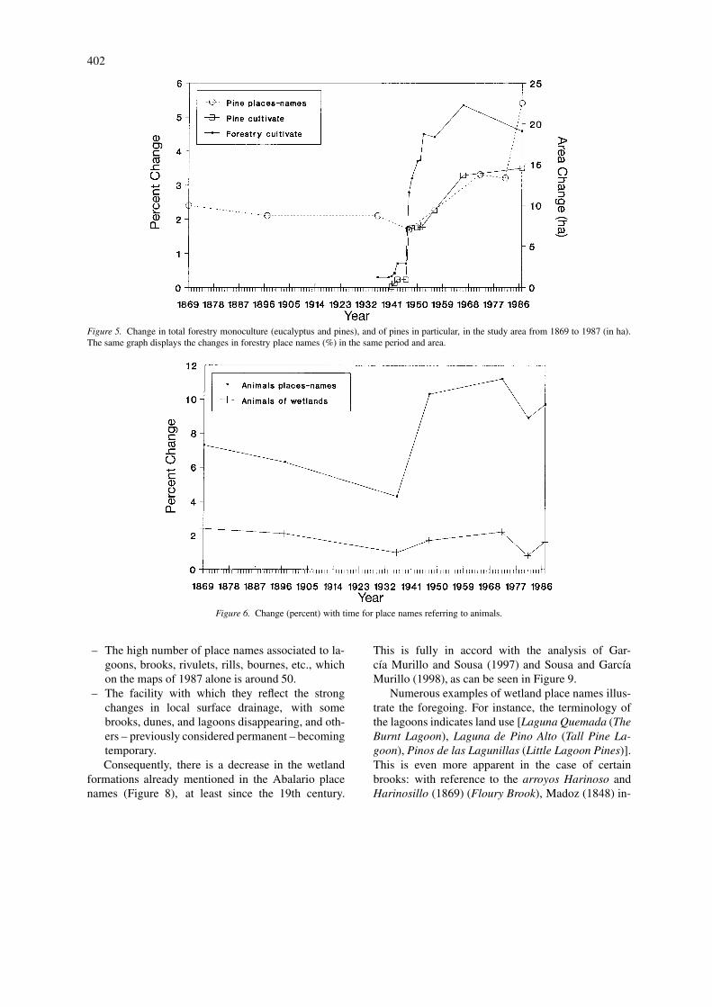
Changes in local forestry monoculture with time areshown in Figure 5. It can be seen that the increase
399
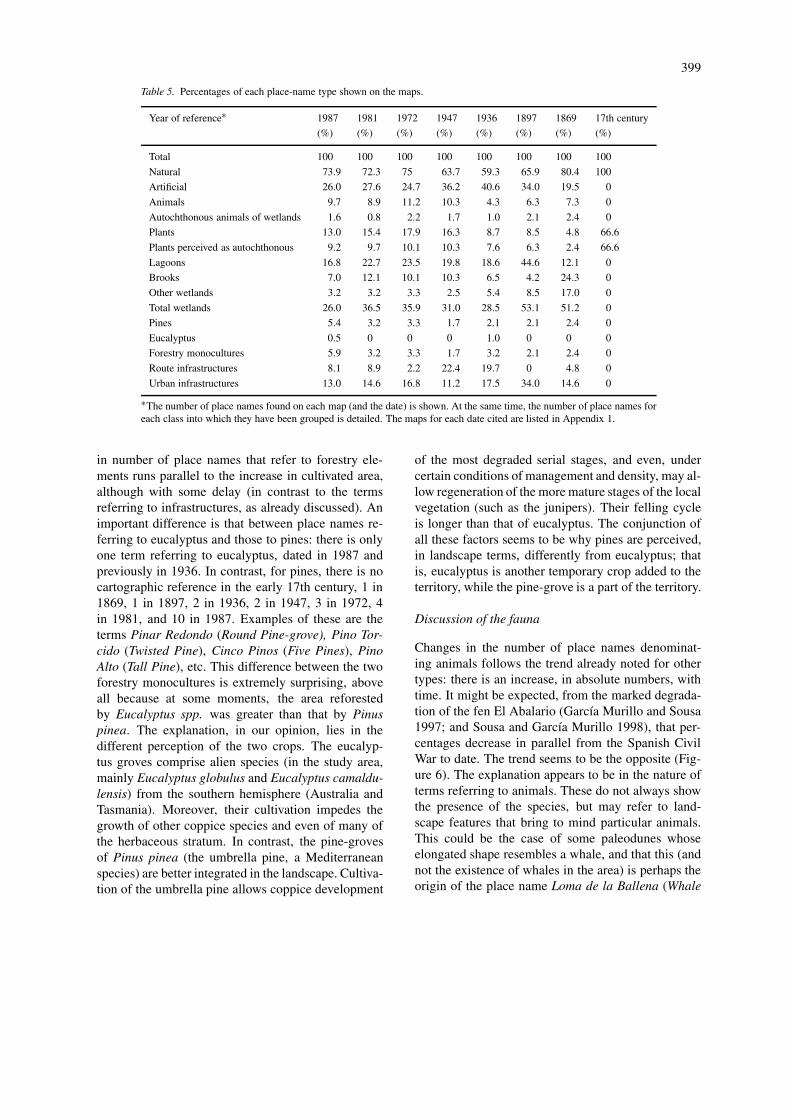
Table 5. Percentages of each place-name type shown on the maps.
Year of reference∗ 1987 1981 1972 1947 1936 1897 1869 17th century
(%) (%) (%) (%) (%) (%) (%) (%)
Total 100 100 100 100 100 100 100 100
Natural 73.9 72.3 75 63.7 59.3 65.9 80.4 100
Artificial 26.0 27.6 24.7 36.2 40.6 34.0 19.5 0
Animals 9.7 8.9 11.2 10.3 4.3 6.3 7.3 0
Autochthonous animals of wetlands 1.6 0.8 2.2 1.7 1.0 2.1 2.4 0
Plants 13.0 15.4 17.9 16.3 8.7 8.5 4.8 66.6
Plants perceived as autochthonous 9.2 9.7 10.1 10.3 7.6 6.3 2.4 66.6
Lagoons 16.8 22.7 23.5 19.8 18.6 44.6 12.1 0
Brooks 7.0 12.1 10.1 10.3 6.5 4.2 24.3 0
Other wetlands 3.2 3.2 3.3 2.5 5.4 8.5 17.0 0
Total wetlands 26.0 36.5 35.9 31.0 28.5 53.1 51.2 0
Pines 5.4 3.2 3.3 1.7 2.1 2.1 2.4 0
Eucalyptus 0.5 0 0 0 1.0 0 0 0
Forestry monocultures 5.9 3.2 3.3 1.7 3.2 2.1 2.4 0
Route infrastructures 8.1 8.9 2.2 22.4 19.7 0 4.8 0
Urban infrastructures 13.0 14.6 16.8 11.2 17.5 34.0 14.6 0
∗The number of place names found on each map (and the date) is shown. At the same time, the number of place names foreach class into which they have been grouped is detailed. The maps for each date cited are listed in Appendix 1.
in number of place names that refer to forestry ele-ments runs parallel to the increase in cultivated area,although with some delay (in contrast to the termsreferring to infrastructures, as already discussed). Animportant difference is that between place names re-ferring to eucalyptus and those to pines: there is onlyone term referring to eucalyptus, dated in 1987 andpreviously in 1936. In contrast, for pines, there is nocartographic reference in the early 17th century, 1 in1869, 1 in 1897, 2 in 1936, 2 in 1947, 3 in 1972, 4in 1981, and 10 in 1987. Examples of these are theterms Pinar Redondo (Round Pine-grove), Pino Tor-cido (Twisted Pine), Cinco Pinos (Five Pines), PinoAlto (Tall Pine), etc. This difference between the twoforestry monocultures is extremely surprising, aboveall because at some moments, the area reforestedby Eucalyptus spp. was greater than that by Pinuspinea. The explanation, in our opinion, lies in thedifferent perception of the two crops. The eucalyp-tus groves comprise alien species (in the study area,mainly Eucalyptus globulus and Eucalyptus camaldu-lensis) from the southern hemisphere (Australia andTasmania). Moreover, their cultivation impedes thegrowth of other coppice species and even of many ofthe herbaceous stratum. In contrast, the pine-grovesof Pinus pinea (the umbrella pine, a Mediterraneanspecies) are better integrated in the landscape. Cultiva-tion of the umbrella pine allows coppice development
of the most degraded serial stages, and even, undercertain conditions of management and density, may al-low regeneration of the more mature stages of the localvegetation (such as the junipers). Their felling cycleis longer than that of eucalyptus. The conjunction ofall these factors seems to be why pines are perceived,in landscape terms, differently from eucalyptus; thatis, eucalyptus is another temporary crop added to theterritory, while the pine-grove is a part of the territory.
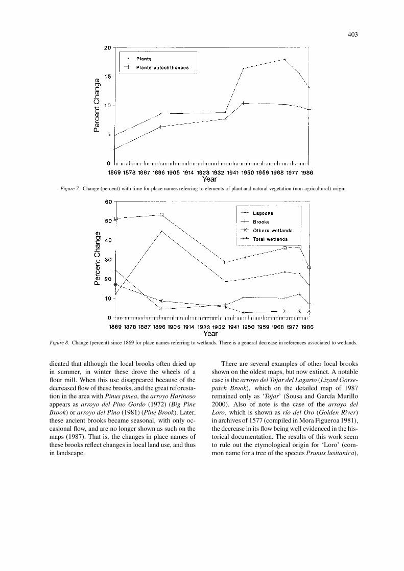
Discussion of the fauna
Changes in the number of place names denominat-ing animals follows the trend already noted for othertypes: there is an increase, in absolute numbers, withtime. It might be expected, from the marked degrada-tion of the fen El Abalario (García Murillo and Sousa1997; and Sousa and García Murillo 1998), that per-centages decrease in parallel from the Spanish CivilWar to date. The trend seems to be the opposite (Fig-ure 6). The explanation appears to be in the nature ofterms referring to animals. These do not always showthe presence of the species, but may refer to land-scape features that bring to mind particular animals.This could be the case of some paleodunes whoseelongated shape resembles a whale, and that this (andnot the existence of whales in the area) is perhaps theorigin of the place name Loma de la Ballena (Whale
400
Figure 3. Changes in place names in absolute numbers from the 17th century to date, in the study area.
Ridge). Another factor distorting terms referring to an-imal names may be word contraction. Thus, the arroyodel Loro (Parrot Brook) on the maps of 1947, 1981 and1987 is given as arroyo del Oro (The Golden Brook)on that of 1869. At the same time, many of the animalnames refer to farm animals.
The problem of interpretation for many placenames referring to animals appears not to be limitedto Spanish, but is independent of language. This no-tion is confirmed by authors such as Rackham (1986),who notes that British place names such as Lyonshallprovide very little evidence of a former presence oflions in England. Nevertheless, other authors, suchas Gelling (1987), believe the interpretation of thisparticular place name is mistaken. Aybes and Yalden(1995), and Boisseau and Yalden (1998), agree withthe position of Gelling (1987), and use place namesto reconstruct the distribution of species extinct inEngland, such as the wolf (Canis lupus), beaver (Cas-tor fiber), brown bear (Ursus actos), aurochs/ox (Bosprimigenius), wild boar (Sus scrofa), wild cat (Felissilvestris), or crane (Grus grus).
Our distinguishing of autochthonous wetland-associated animals from the others solves the apparentcontradiction that animal names increase in numberover time (Figure 6). Consequently, the results aremuch closer to what might be expected. Althoughthese terms are not very numerous, some stand out:Ansares/Laguna de los Ansares (Geese/Goose La-
goon), Las Garzas (The Herons), reflecting the per-ception of considerable colonies of aquatic birds inthe area, coinciding with the data of Espina and Es-tévez (1992), and Los Galápagos (The Tortoises). Thisalso seems to be in accord with Boisseau and Yalden(1998), indicating that at least half of British placenames denominating the crane (Grus grus) are linkedwith another place name referring to water.
Vegetation
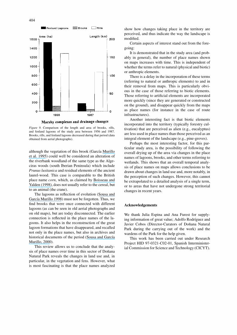
The terms referring to plants are not usually subjectto the imprecision mentioned in the previous section.As a result, they have been used in other studiesfor comparative analysis with present-day vegetation(Bornaechea et al. 1984). In our area, place namesreferring to autochthonous plants are much scarcerthan those referring to agrosilvicultural activities. Fur-thermore, there is a marked increase at the start offorestry activity, and a decrease when this begins todecline, the whole area appearing more desiccated asa consequence of eucalyptus monoculture (Figure 7).
Nevertheless, in general terms, it seems that theseplace names are insufficient to express local plantcharacteristics. In any case, isolated references ofgreat value can be found. There are concrete ref-erences of place names referring to the shrub ofUlex minor [Tojar Grande (Great Gorse-patch), To-jar del Lagarto (Lizard Gorse-patch)], to Coremaalbum [Camarina (Camarine Shrub)], Olea europaea
401
Figure 4. (A) Changes in place names in the study area from 1869 to 1987 (absolute numbers). The maximum in the years of most intenseforestry transformation in the area should be noted. (B) Idem in percentage terms.
var. sylvestris [Acebuche (Wild Olive)], Phragmitesaustralis [Carrizosa (Reed-patch)], Mentha pulegium[Poleosa (Pennyroyal-patch)], riverbank woodland[Sotillo (River Thicket)], etc. All of these are coin-cide spatially with the 3 great series of plants aroundwhich the local landscape is based: the climatophilseries of thermomediterranean coastal cork oaks, theedaphophil series of junipers; and the edaphophilseries of riparian oligotrophic woodlands, and their
corresponding degradation series (García Murillo andSousa, 1997, 1999).
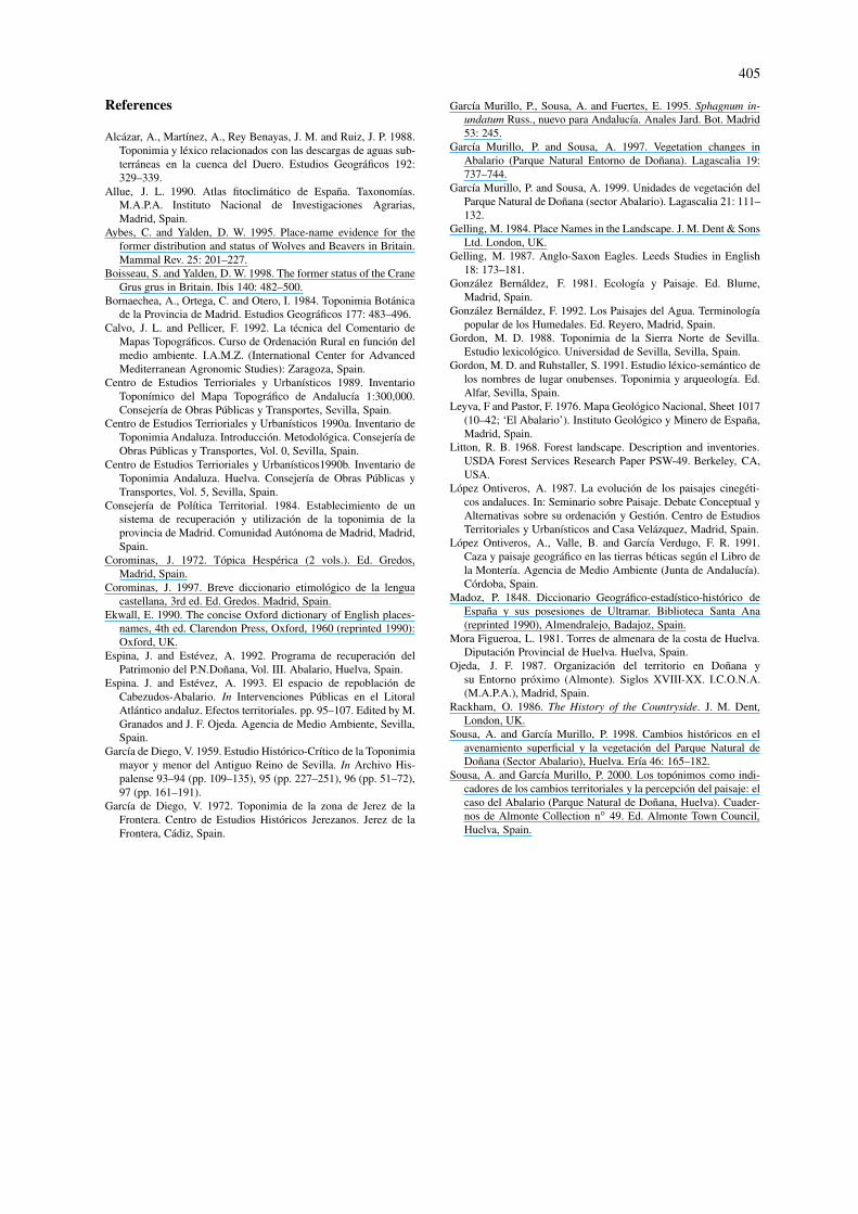
Fens and lagoons
Despite the foregoing, the terms supplying most infor-mation were those referring to wetlands. The explana-tion lies in two simple reasons:
402
Figure 5. Change in total forestry monoculture (eucalyptus and pines), and of pines in particular, in the study area from 1869 to 1987 (in ha).The same graph displays the changes in forestry place names (%) in the same period and area.
Figure 6. Change (percent) with time for place names referring to animals.
– The high number of place names associated to la-goons, brooks, rivulets, rills, bournes, etc., whichon the maps of 1987 alone is around 50.
– The facility with which they reflect the strongchanges in local surface drainage, with somebrooks, dunes, and lagoons disappearing, and oth-ers – previously considered permanent – becomingtemporary.Consequently, there is a decrease in the wetland
formations already mentioned in the Abalario placenames (Figure 8), at least since the 19th century.
This is fully in accord with the analysis of Gar-cía Murillo and Sousa (1997) and Sousa and GarcíaMurillo (1998), as can be seen in Figure 9.
Numerous examples of wetland place names illus-trate the foregoing. For instance, the terminology ofthe lagoons indicates land use [Laguna Quemada (TheBurnt Lagoon), Laguna de Pino Alto (Tall Pine La-goon), Pinos de las Lagunillas (Little Lagoon Pines)].This is even more apparent in the case of certainbrooks: with reference to the arroyos Harinoso andHarinosillo (1869) (Floury Brook), Madoz (1848) in-
403
Figure 7. Change (percent) with time for place names referring to elements of plant and natural vegetation (non-agricultural) origin.
Figure 8. Change (percent) since 1869 for place names referring to wetlands. There is a general decrease in references associated to wetlands.
dicated that although the local brooks often dried upin summer, in winter these drove the wheels of aflour mill. When this use disappeared because of thedecreased flow of these brooks, and the great reforesta-tion in the area with Pinus pinea, the arroyo Harinosoappears as arroyo del Pino Gordo (1972) (Big PineBrook) or arroyo del Pino (1981) (Pine Brook). Later,these ancient brooks became seasonal, with only oc-casional flow, and are no longer shown as such on themaps (1987). That is, the changes in place names ofthese brooks reflect changes in local land use, and thusin landscape.
There are several examples of other local brooksshown on the oldest maps, but now extinct. A notablecase is the arroyo del Tojar del Lagarto (Lizard Gorse-patch Brook), which on the detailed map of 1987remained only as ‘Tojar’ (Sousa and García Murillo2000). Also of note is the case of the arroyo delLoro, which is shown as río del Oro (Golden River)in archives of 1577 (compiled in Mora Figueroa 1981),the decrease in its flow being well evidenced in the his-torical documentation. The results of this work seemto rule out the etymological origin for ‘Loro’ (com-mon name for a tree of the species Prunus lusitanica),
404
Figure 9. Comparison of the length and area of brooks, rills,and fenland lagoons of the study area between 1956 and 1987.Brooks, rills, and fenland lagoons decreased during that period (dataobtained from aerial photographs).
although the vegetation of this brook (García Murilloet al. 1995) could well be considered an alteration ofthe riverbank woodland of the same type as the Alge-ciras woods (south Iberian Peninsula) which includePrunus lusitanica and residual elements of the ancientlaurel-wood. This case is comparable to the Britishplace name corn, which, as claimed by Boisseau andYalden (1998), does not usually refer to the cereal, butto an animal (the crane).
The lagoons as reflection of evolution (Sousa andGarcía Murillo 1998) must not be forgotten. Thus, wefind brooks that were once connected with differentlagoons (as can be seen in old aerial photographs andon old maps), but are today disconnected. The earlierconnection is reflected in the place names of the la-goons. It also helps in the reconstruction of the greatlagoon formations that have disappeared, and recallednot only in the place names, but also in archives andhistorical documents of the period (Sousa and GarcíaMurillo, 2000).
This review allows us to conclude that the analy-sis of place names over time in this sector of DoñanaNatural Park reveals the changes in land use and, inparticular, in the vegetation and fens. However, whatis most fascinating is that the place names analyzed
show how changes taking place in the territory areperceived, and thus indicate the way the landscape ismodified.
Certain aspects of interest stand out from the fore-going:
It is demonstrated that in the study area (and prob-ably in general), the number of place names shownon maps increases with time. This is independent ofwhether the terms refer to natural (physical and biotic)or anthropic elements.
There is a delay in the incorporation of these terms(referring to natural or anthropic elements) to and intheir removal from maps. This is particularly obvi-ous in the case of those referring to biotic elements.Those referring to artificial elements are incorporatedmore quickly (since they are generated or constructedon the ground), and disappear quickly from the mapsas place names (for instance in the case of routeinfrastructures).
Another interesting fact is that biotic elementsincorporated into the territory (typically forestry cul-tivation) that are perceived as alien (e.g., eucalyptus)are less used in place names than those perceived as anintegral element of the landscape (e.g., pine-groves).
Perhaps the most interesting factor, for this par-ticular study area, is the possibility of following theoverall drying up of the area via changes in the placenames of lagoons, brooks, and other terms referring towetlands. This shows that an overall temporal analy-sis of place names on maps allows conclusions to bedrawn about changes in land use and, more notably, inthe perception of such changes. However, this cannotbe extrapolated to a detailed analysis of a single term,or to areas that have not undergone strong territorialchanges in recent years.
Acknowledgements
We thank Julia Espina and Ana Furest for supply-ing information of great value; Adolfo Rodríguez andJavier Cobos (Director-Curators of Doñana NaturalPark during the carrying out of the work) and thewardens of the Park for the help given.
This work has been carried out under ResearchProject HID 97-0321-C02-01, Spanish Interminister-ial Commission for Science and Technology (CICYT).
405
References
Alcázar, A., Martínez, A., Rey Benayas, J. M. and Ruiz, J. P. 1988.Toponimia y léxico relacionados con las descargas de aguas sub-terráneas en la cuenca del Duero. Estudios Geográficos 192:329–339.
Allue, J. L. 1990. Atlas fitoclimático de España. Taxonomías.M.A.P.A. Instituto Nacional de Investigaciones Agrarias,Madrid, Spain.
Aybes, C. and Yalden, D. W. 1995. Place-name evidence for theformer distribution and status of Wolves and Beavers in Britain.Mammal Rev. 25: 201–227.
Boisseau, S. and Yalden, D. W. 1998. The former status of the CraneGrus grus in Britain. Ibis 140: 482–500.
Bornaechea, A., Ortega, C. and Otero, I. 1984. Toponimia Botánicade la Provincia de Madrid. Estudios Geográficos 177: 483–496.
Calvo, J. L. and Pellicer, F. 1992. La técnica del Comentario deMapas Topográficos. Curso de Ordenación Rural en función delmedio ambiente. I.A.M.Z. (International Center for AdvancedMediterranean Agronomic Studies): Zaragoza, Spain.
Centro de Estudios Terrioriales y Urbanísticos 1989. InventarioToponímico del Mapa Topográfico de Andalucía 1:300,000.Consejería de Obras Públicas y Transportes, Sevilla, Spain.
Centro de Estudios Terrioriales y Urbanísticos 1990a. Inventario deToponimia Andaluza. Introducción. Metodológica. Consejería deObras Públicas y Transportes, Vol. 0, Sevilla, Spain.
Centro de Estudios Terrioriales y Urbanísticos1990b. Inventario deToponimia Andaluza. Huelva. Consejería de Obras Públicas yTransportes, Vol. 5, Sevilla, Spain.
Consejería de Política Territorial. 1984. Establecimiento de unsistema de recuperación y utilización de la toponimia de laprovincia de Madrid. Comunidad Autónoma de Madrid, Madrid,Spain.
Corominas, J. 1972. Tópica Hespérica (2 vols.). Ed. Gredos,Madrid, Spain.
Corominas, J. 1997. Breve diccionario etimológico de la lenguacastellana, 3rd ed. Ed. Gredos. Madrid, Spain.
Ekwall, E. 1990. The concise Oxford dictionary of English places-names, 4th ed. Clarendon Press, Oxford, 1960 (reprinted 1990):Oxford, UK.
Espina, J. and Estévez, A. 1992. Programa de recuperación delPatrimonio del P.N.Doñana, Vol. III. Abalario, Huelva, Spain.
Espina. J. and Estévez, A. 1993. El espacio de repoblación deCabezudos-Abalario. In Intervenciones Públicas en el LitoralAtlántico andaluz. Efectos territoriales. pp. 95–107. Edited by M.Granados and J. F. Ojeda. Agencia de Medio Ambiente, Sevilla,Spain.
García de Diego, V. 1959. Estudio Histórico-Crítico de la Toponimiamayor y menor del Antiguo Reino de Sevilla. In Archivo His-palense 93–94 (pp. 109–135), 95 (pp. 227–251), 96 (pp. 51–72),97 (pp. 161–191).
García de Diego, V. 1972. Toponimia de la zona de Jerez de laFrontera. Centro de Estudios Históricos Jerezanos. Jerez de laFrontera, Cádiz, Spain.
García Murillo, P., Sousa, A. and Fuertes, E. 1995. Sphagnum in-undatum Russ., nuevo para Andalucía. Anales Jard. Bot. Madrid53: 245.
García Murillo, P. and Sousa, A. 1997. Vegetation changes inAbalario (Parque Natural Entorno de Doñana). Lagascalia 19:737–744.
García Murillo, P. and Sousa, A. 1999. Unidades de vegetación delParque Natural de Doñana (sector Abalario). Lagascalia 21: 111–132.
Gelling, M. 1984. Place Names in the Landscape. J. M. Dent & SonsLtd. London, UK.
Gelling, M. 1987. Anglo-Saxon Eagles. Leeds Studies in English18: 173–181.
González Bernáldez, F. 1981. Ecología y Paisaje. Ed. Blume,Madrid, Spain.
González Bernáldez, F. 1992. Los Paisajes del Agua. Terminologíapopular de los Humedales. Ed. Reyero, Madrid, Spain.
Gordon, M. D. 1988. Toponimia de la Sierra Norte de Sevilla.Estudio lexicológico. Universidad de Sevilla, Sevilla, Spain.
Gordon, M. D. and Ruhstaller, S. 1991. Estudio léxico-semántico delos nombres de lugar onubenses. Toponimia y arqueología. Ed.Alfar, Sevilla, Spain.
Leyva, F and Pastor, F. 1976. Mapa Geológico Nacional, Sheet 1017(10–42; ‘El Abalario’). Instituto Geológico y Minero de España,Madrid, Spain.
Litton, R. B. 1968. Forest landscape. Description and inventories.USDA Forest Services Research Paper PSW-49. Berkeley, CA,USA.
López Ontiveros, A. 1987. La evolución de los paisajes cinegéti-cos andaluces. In: Seminario sobre Paisaje. Debate Conceptual yAlternativas sobre su ordenación y Gestión. Centro de EstudiosTerritoriales y Urbanísticos and Casa Velázquez, Madrid, Spain.
López Ontiveros, A., Valle, B. and García Verdugo, F. R. 1991.Caza y paisaje geográfico en las tierras béticas según el Libro dela Montería. Agencia de Medio Ambiente (Junta de Andalucía).Córdoba, Spain.
Madoz, P. 1848. Diccionario Geográfico-estadístico-histórico deEspaña y sus posesiones de Ultramar. Biblioteca Santa Ana(reprinted 1990), Almendralejo, Badajoz, Spain.
Mora Figueroa, L. 1981. Torres de almenara de la costa de Huelva.Diputación Provincial de Huelva. Huelva, Spain.
Ojeda, J. F. 1987. Organización del territorio en Doñana ysu Entorno próximo (Almonte). Siglos XVIII-XX. I.C.O.N.A.(M.A.P.A.), Madrid, Spain.
Rackham, O. 1986. The History of the Countryside. J. M. Dent,London, UK.
Sousa, A. and García Murillo, P. 1998. Cambios históricos en elavenamiento superficial y la vegetación del Parque Natural deDoñana (Sector Abalario), Huelva. Ería 46: 165–182.
Sousa, A. and García Murillo, P. 2000. Los topónimos como indi-cadores de los cambios territoriales y la percepción del paisaje: elcaso del Abalario (Parque Natural de Doñana, Huelva). Cuader-nos de Almonte Collection n◦ 49. Ed. Almonte Town Council,Huelva, Spain.

406
Appendix 1.
Historical maps used for the quantitative analysis ofthe place names cited in Tables 4 and 5.
S. XVII. Mapa de España de Carlos III. J. Danck-aert. Map Library Instituto Geográfico Nacional:Madrid, Spain.
1869. Huelva. F. Coello. Historic library of mapsServicio Geográfico del Ejército: Madrid, Spain.
1897. Provincia de Huelva, nivelación. InstitutoGeográfico Estadístico. F. Noriega and J. Cobo delGuzmán. 1897–1900. Instituto Geográfico Estadís-tico: Madrid, Spain.
1936. Mapa Geológico de España 1:50 000 ymemoria explicativa. Sheet 1.017 (‘El Asperillo’). J.Gavala and Laborde. Ed. Instituto Geológico y Minerode España: Madrid, Spain.
1947. Mapa Topográfico Nacional 1:50 000. Sheet1.000 (Moguer) and Sheet 1.017 (‘El Picacho’). 1st ed.Instituto Geográfico y Catastral and Servicio Geográ-fico del Ejército: Madrid, Spain.
1972. Mapa Topográfico Nacional 1:50 000. Sheet1017 (‘El Abalario’). 2nd ed. 1974. Instituto Geográ-fico y Catastral: Madrid, Spain.
1981. Cartografía Militar de España. 1:50 000.Series L, Sheet 10-14 (1017) (‘El Abalario’). 1981,2nd ed. 1984. Sheet 10–41(1000) (‘Moguer’). 1982,2nd ed. 1988. Servicio Geográfico del Ejército:Madrid, Spain.
1987. Mapa Topográfico de Andalucía, 1:10 000.Sheets: 4-4, 3-3, 4-3, 3-1, 2-3, 2-1, 4-4, 2-4 and 2-2. Ed. Centro de Estudios Territoriales y Urbanísticos,Junta de Andalucía: Sevilla, Spain.