bulletin1981967smit.pdf - Smithsonian Institution
280
-
Upload
khangminh22 -
Category
Documents
-
view
0 -
download
0
Transcript of bulletin1981967smit.pdf - Smithsonian Institution


SMITHSONIAN INSTITUTION
|. ^ , BUREAU OF AMERICAN ETHNOLOGY>>< BULLETIN 198
Inter-Agency Archeological Salvage Program
RIVER BASIN SURVEYS PAPERS
Robert L. Stephenson, Editor
No. 39—AN INTERPRETATION OF MANDAN CULTURE HISTORYby W. Raymond Wood
sVk02Hf^
U.S. GOVERNMENT PRINTING OFFICEWASHINGTON : 1967
vu
For sale by the Superintendent of Documents, U.S. Government Printing Office
Washington, D.C. 20402 - Price $3 (Qoth)
JUL 51967
Si -(^^<y^^o •
EXPLANATION OF THE INTER-AGENCYARCHEOLOGICAL SALVAGE PROGRAM
The Inter-Agency Archeological Salvage Program is a cooperative
plan of the Smithsonian Institution; the National Park Service andthe Bureau of Reclamation, Department of the Interior; and the
Corps of Engineers, Department of the Army. It was formulated,
through a series of interbureau agreements, for the purpose of recov-
ering archeological and paleontological remains that would otherwise
be lost as a result of the numerous projects for flood control, irrigation,
hydroelectric power, and navigation improvements in the river basins
of the United States. Various State and local agencies have assisted
in the work. To carry out its part of the joint undertaking, the
Smithsonian Institution organized the River Basin Surveys as a
unit of the Bureau of American Ethnology. The National ParkService has served as liaison between the various agencies and has
provided the Smithsonian Institution with all of the necessary in-
formation pertaining to the location of proposed dams and other
construction and their priorities. It has also had responsibility for
budgeting costs of the program, funds for which are provided in the
annual appropriations of the Department of the Interior. The opera-
tions of the River Basin Surveys, Smithsonian Institution, have beensupported by funds transferred to it from the National Park Service.
Through agreements with the National Park Service, money has also
been made available to State and local agencies to supplement their
own resources and aid them in their contributions to the program.
The River Basin Surveys Papers, of which this is the 10th
bulletin, are issued under the scientific editorship of Robert L.
Stephenson, acting director of the River Basin Surveys.
Ta
PUBLISHER'S NOTE
A separate edition is published of each paper in the series entitled "River
Basin Surveys Papers." Available copies of Papers 1-39 can be had upon re-
quest to the Publications Office, Smithsonian Institution, Washington, D.C.
20560.
River Basin Surveys Papers Published Previouslt
No. 1. Prehistory and the Missouri Valley Development Program: SummaryReport on the Missouri River Basin Archeological Survey in 1948, byWaldo R. Wedel. Bull. 154, pp. xv-xviii, 1-59, pis. 1-12, fig. 1. 1953.
No. 2. Prehistory and the Missouri Valley Development Program: SummaryReport on the Missouri River Basin Archeological Survey in 1949, byWaldo R. Wedel. Bull. 154, pp. 61-101, pis. 13-15. 1953.
No. 3. The Woodruff Ossuary, a prehistoric burial site in Phillips County,
Kansas, by Marvin F. Kivett. Bull. 154, pp. 103-141, pis. 16-28, figs.
2-3. 1953.
No. 4. The Addicks Dam site:
I. An archeological survey of the Addicks Dam Basin, Southeast
Texas, by Joe Ben Wheat. Bull. 154, pp. 143-252, pis. 29-47,
figs. 4-23. 1953.
II. Indian skeletal remains from the Doering and Kobs sites, Addicks
Reservoir, Texas, by Marshall T. Newman. Bull. 154, pp. 253-
266, figs. 24-28. 1953.
No. 5. The Hodges site:
I. Two rock shelters near Tucumari, New Mexico, by Herbert W.Dick. Bull. 154, pp. 267-284, pis. 48-54, figs. 29-30. 1953.
II. Geology of the Hodges site. Quay County, New Mexico, by Sheldon
Judson. Bull. 154, pp. 285-302, figs. 31-35. 1953.
No. 6. The Rembert Mounds, Elbert County, Georgia, by Joseph R. Caldwell.
Bull. 154, pp. 303-320, pis. 55-56, figs. 36-40. 1953.
No. 7. Archeological investigations in the Oahe Dam area, South Dakota,
1950-51, by Donald J. Lehmer. Bull. 158, 190 pp., 22 pis., 56 figs.,
6 maps. 1954.
No. 8. Excavations in the McNary Reservoir Basin near Umatilla, Oregon, by
Douglas Osborne. With appendixes by Marshall T. Newman, Arthur
Woodward, W. J. KroU, and B. H. McLeod. BuU. 166, 250 pp., 40
pis., 6 figs., 19 maps. 1957.
No. 9. Archeological investigations in the Heart Butte Reservoir area. North
Dakota, by Paul L. Cooper. Bull. 169, pp. 1-40, pis. 1-12, figs. 1-2.
1958.
No. 10. Archeological investigations at the Tuttle Creek Dam, Kansas, by Rob-
ert B. Gumming, Jr. Bull. 169, pp. 41-78, pis. 13-24. 1958.
No. 11. The Spain site (39LM301), a winter village in Fort Randall Reservoir,
South Dakota, by Carlyle S. Smith and Roger T. Grange, Jr. Bull.
169, pp. 79-128, pis. 25-36, figs. 3-4. 1958.
No. 12. The Wilbanks site (9CK-5), Georgia, by William H. Sears. Bull. 169,
pis. 37-45, figs. 5-9. 1958.
PUBLISHER'S NOTE V
No. 13. Historic sites in and around the Jim Woodruff Reservoir Area, Florida-
Georgia, by Mark F. Boyd. Bull. 169, pp. 195-314, pis. 46-55, figs. 10-
11. 1958.
No. 14. Six sites near the Chattahoochee River in the Jim Woodruff Reservoir
Area, Florida, by Ripley P. BuUen. Bull. 169, pp. 315-357, pis. 56-73,
figs. 12-13. 1958.
No. 15. Historic sites archeology on the Upper Missouri, by Merrill J. Mattes,
Bull. 176, pp. 1-24.
No. 16. Historic sites archeology in the Fort Randall Reservoir, South Dakota,
by John E. Mills, Bull. 176, pp. 25-48, pis. 1-9, figs. 1-2, map 1. 1960.
No. 17. The excavation and investigation of Fort Lookout Trading Post II
(39LM57) in the Fort Randall Reservoir, South Dakota, by Carl F.
Miller, Bull. 176, pp. 49-82, pis. 10-18, figs. 3-14, map 2. 1960.
No. 18. Fort Pierre II (39ST217), a historic trading post in the Oahe Damarea, South Dakota, by G. Hubert Smith, Bull. 176, pp. 83-158, pis.
19-30, maps 3-4. 1960.
No. 19. Archeological investigations at the site of Fort Stevenson (32ML1).Garrison Reservoir, North Dakota, by G. Hubert Smith. (Introduc-
tion by Robert L. Stephenson and an appendix by Carlyle S. Smith),
Bull. 176, pp. 159-238, pis. 31-54, figs. 15-20, maps 5-6. 1960.
No. 20. The archeology of a small trading post (32MN1) in the Garrison Reser-
voir (Kipp's Post), South Dakota, by Alan R. Woolworth and W.Raymond Wood, Bull. 176, pp. 239-305, pis. 55-65, figs. 21-25, map 7.
1960.
No. 21. Excavations at Texarkana Reservoir, Sulphur River, Texas, by EdwardB. Jelks, Bull. 179, pp. xiii-78, pis. 1-17, figs. 1-9. 1961.
No. 22. Archeological investigations at the Coralville Reservoir, Iowa, by War-ren W. Caldwell, Bull. 179, pp. 81-148, pis. 18-29, figs. 10-24. 1961.
No. 23. The McNary Reservoir: A study in plateau archeology, by Joel L.
Shiner, Bull. 179, pp. 151-266, pis. 30-46, figs. 25-40, maps 1-7. 1961.
No. 24. The Sheep Island site and the Mid-Columbia Valley, by Douglas Osborne,
Alan Bryan, and Robert H. Crabtree, Bull. 179, pp. 269-321, pis. 47-56,
figs. 41-43. 1961.
No. 25. Archeology of the John H. Kerr Reservoir Basin, Roanoke River,
Virginia-North Carolina, by Carl F. Miller. (Appendix by Lucile E.
Hoyme and William M. Bass), Bull. 182, 447 pp., pis. 1-110, figs. 1-65,
maps, 1-8. 1962.
No. 26. Small sites on and about Fort Berthold Indian Reservation, Garrison
Reservoir, North Dakota, by George Metcalf. Bull. 185, pp. 1-56, pis.
1-11, figs. 1-5, 1 map. 1962.
No. 27. Star Village: A fortified historic Arikara site in Mercer County, NorthDakota, by George Metcalf. Bull. 185, pp. 57-122, pis. 12-17, figs.
6-16, 3 maps. 1962.
No. 28. The dance hall of the Santee Bottoms on the Fort Berthold Reservation,
Garrison Reservoir, North Dakota, by Donald D. Hartle. Bull. 185,
pp. 123-132, pi. 18, figs. 17-18. 1962.
No. 29. Crow-Flies-High (32MZ1), a historic Hidatsa village in the Garrison
Reservoir area, North Dakota, by Carling Malouf. Bull. 185, pp. 133-
166, pis. 19-26, figs. 19-25. 1962.
No. 30. The Stutsman Focus: An aboriginal culture complex in the JamestownReservoir area. North Dakota, by R. P. Wheeler. Bull. 185, pp. 167-
233, pis. 27-36, figs. 26-38. 1962.

VI PUBLISHER'S NOTE
No. 31. Archeological manifestations in the Toole County section of the Tiber
Reservoir Basin, Montana, by Carl F. Miller. Bull. 185, pp. 235-255,
pis. 37-45, figs. 39-40, 1 map. 1962.
No. 32. Archeological salvage investigations in the Lovewell Reservoir area,
Kansas, by Robert W. Neuman. Bull. 185, pp. 257-306, pis. 46-57,
figs. 41-43. 1962.
No. 33. The Paul Brave site (32SI4), Oahe Reservoir area. North Dakota, byW. Raymond Wood and Alan R. Woolworth. Bull. 189, pp. ix-xiv,
1-66, pis. 1-6, figs. 1-12, maps 1-5. 1964.
No. 34. The Demery site (39C01), Oahe Reservoir area, South Dakota, byAlan R. Woolworth and W. Raymond Wood. Bull. 189, pp. 67-138,
pis. 7-14, figs. 13-24, maps 6-13. 1964.
No. 35. Archeological investigations at the Hosterman site (39P07), OaheReservoir area, Potter County, South Dakota, 1956, by Carl F. Miller.
Bull. 189, pp. 139-266, pis. 15-38, figs. 25-52. 1964.
No. 36. Archeological investigations at the Hickey Brothers site (39LM4), Big
Bend Reservoir, Lyman County, South Dakota, by Warren W. Cald-
well, Lee G. Madison, and Bernard Golden. BuU. 189, pp. 267-290,
pis. 39-46, figs. 53-57. 1964.
No. 37. The Good Soldier site (39LM238), Big Bend Reservoir, Lyman County,
South Dakota, by Robert W. Neuman. Bull. 189, pp. 291-318, pis.
47-50, fig. 58. 1964.
No. 38. Archeological investigations in the Toronto Reservoir area, Kansas, byJames H. Howard. BuU. 189, pp. 319-370, pis. 51-58, figs. 59-66.
1964.

CONTENTSPAGE
Preface xi
Abstract 1
Introduction 3
The setting 4Environmental setting 4
Cultural setting 9
Origin traditions 9
Language, communication, and records 11
Social and political organization 12
Villages and dwellings 14
Burials 18
Intertribal trade 18
The food quest 19
Commentary 21
New data: the Huflf Site (32M011) 21
Fieldwork 21
The site 21
Historical background 24
Excavations 28Excavation methods 28
Houses 31
Fortification ditch and palisade 54
Human remains 57
Miscellaneous test excavations 61
Artifacts 62
Pottery 62
Chipped stone 75Ground stone 82Bone 85Antler 94Shell 96
Miscellaneous 98Faunal remains 99
The Huff Focus 100
Community pattern 100
Structures 102
Artifact complex 105
Pottery 105
Chipped and ground stone 107
Bone and antler 108
Shell 109
Population characteristics 111
Taxonomy 112
Chronology 114
Vin CONTENTS
PAGESynthesis: The Mandan archeological sequence 116
Mandan precedents 117
Nomadic hunters 117
Semisedentary horticulturalists 119
Thomas Riggs Focus: Derivation 122
Huff Focus: Accretion 131
Heart River Focus: Coalescense 137
Historic Mandan: Acculturation 139
Correlation with prior syntheses 144
The nature and source of change in Mandan prehistory 146
Spheres of change 147
Habitat and subsistence 147
Intertribal relations 150
Internal social and ceremonial change 155
Alternatives and displacement in material culture 158
Patterns of change 162
Recapitulation and conclusions 165
Literature cited 169
Appendix 1. Corn and squash from six sites in North and South Dakota,
by Hugh C. Cutler 177
Appendix 2. Notes on the bison bone from the Huff, Paul Brave, andDemery Sites, by W. Raymond Wood 183
List of reports, articles, and notes relating to the salvage program published
in other series 189
Index 221
ILLUSTRATIONS
PLATES
(All plates follow page 188)
1. Huff Site; oblique and vertical aerial photographs.
2. Huff Site; northwest bastion and east section.
3. Houses 3 and 12.
4. Houses 6 and 8, including burial 1.
5. Features from Houses 6, 7, and 8.
6. Restored Stanley Tool Impressed vessels.
7. Fort Yates Cord Impressed rim sherds.
8. Rim sherds.
9. Rim sherds.
TEXT FIGURESPAGE
1. Pottery shoulder patterns and elements (various scales) 73
2. Fragmentary pottery shoulder patterns and elements 74
3. Projectile points and drills 76
4. Chipped stone artifacts 79
5. Chipped and ground stone artifacts 80
6. Ground stone artifacts 83
7. Bone artifacts 87
8. Bone artifacts 88
9. Bone awls and a spatulate 90

CONTENTS IX
PAGE10. Bone artifacts 921 1
.
Antler artifacts 9512. Shell artifacts and miscellaneous bone artifacts 9713. Speculative reconstruction of the Huff long-rectangular houses 103
14. Village plans and characteristic house types (various scales) 125
15. Characteristic pottery rim profiles, vessel shapes, and shoulder pat-
terns (various scales) 126
16. Diagram showing the number of grains and cupule width of cob frag-
ments from six North and South Dakota sites 178
17. A, Frequencies of bison bones at Paul Brave, Huff, and Demery Sites.
B, Modal frequencies of bison bones in four groups of sites 185
MAPSPAGE
1. Vicinity of the Huff Site (32M011) and the Missouri River Valley near
Bismarck, N. Dak 222. General area of the Huff Site (32M011) and nearby sites 253. Resume of Huff Site cartography, 1905-1960 (various scales) 264. Map of the Huff Site (32MOI1) showing the 1938-39 and the 1959-60
excavations (facing) 285. Plan of House 1 336. Plan of House 2, the ceremonial lodge (after Howard) 35
7. Plan of House 3, the southeastfortification ditch and Bastion A-_ (facing) 368. Plan of House 4 389. Plan of House 5 40
10. Plan of House 6 4311. Plan of House 7 4512. Plan of House 8 4713. Plan of Houses 9 and 13 and the northwest fortification system., (facing) 4814. Plan of Houses 10, 11, and 12 5015. Contour map of surface of House 19 5516. Plan of Bastion D and the Excavation 2 ditch profile (after Howard) __ 5617. A, East profile of Excavation 12, in mound at Site 32M011b. B, Sur-
face profile of the southeast fortification ditch and palisade (profile B)of the Huff Site (32M011). C, West profile of Excavation 5
(profile A) of the Huff Site (32M011) 58
18. Landforms of North and South Dakota (copyright 1957 by E.
Raisz) (facing) 1 17
19. The Central Plains and Middle Missouri regions showing the location
of various sites discussed 12920. Contraction of the Mandan habitat, showing certain sites 130


PREFACE
The hamlet of Huff is some 18 miles southeast of the city of Mandan,
N. Dak., on the west bank of the Missouri River. About one-half
of a mUe southeast of Huff, adjoining the Missouri River bank, is a
large, fortified Indian village site which bears the name of the town
(map 1). Of the village sites along the course of the Missouri River
within the present State of North Dakota, the Huff Site (32M011)
has perhaps been the focus of as much comment and speculation as
any of the others, largely because of its size and its distinctive forti-
fication system. Archeological interest in this site has grown since
the partial pubUcation of the results of Thad. C. Hecker's fieldwork
there in 1938-39. Hecker excavated one long-rectangular house at
Huff and tested several others (WUl and Hecker, 1944, pp. 19-23,
60-61, 94-96, passrni).
The Huff Site wUl be subject to wave action from the impounded
waters of the Oahe Reservoir when that body of water is at full pool.
For this reason, salvage work at the site was initiated in 1959. At that
time, the State Historical Society of North Dakota and the University
of North Dakota, assisted by funds from the National Park Service,
sent a field party to the site. The 1959 field party, under the direc-
tion of Dr. James H. Howard, of the University of North Dakota,
excavated two long-rectangular houses and two of the corner bastions
of the fortification system. A summary account of this work has
been published (Howard, 1962 b). Fm^ther work seemed desirable,
however, and during the summer of 1960 a second salvage field party
spent 10 weeks at Huff, under my du-ection while I was then at the
University of Oregon. This fieldwork was underwritten by the State
Historical Society of North Dakota and by the National Park Service.
During this last season the fortification ditch and palisade were
further explored and eight additional houses were dug. Since no
further work is anticipated at Huff, the investigations of Thad. C.
Hecker and of James H. Howard have been incorporated into this
study. Maps pubHshed by these two excavators have been redrawn
for the sake of consistency.
The excavations of 1960 were implemented by the interest and
cooperation of many people. The late Paul Beaubien, regional
archeologist, Region II, National Park Service, and Dr. Robert L.
Stephenson, then chief, Missomi Basin Project, are responsible for
the 1960 excavations having been undertaken. RusseU Reid, super-
intendent, State Historical Society of North Dakota, saw that the
field party was fully equipped and prepared to go into the field.
Norman Paulson, museum aide, supervised the cataloging of specimens
XI

XII PREFACE
SO closely and efficiently that this task was completed shortly after
the close of the field season. His assistance in many other respects
has been invaluable, not only during the time the site was being
excavated but in innumerable instances since then. I am also grateful
to Dr. James H. Howard, University of South Dakota, for his advice
during a visit to the site, and for the loan of his site maps, redrawn in
this study.
The able and hard-working crew included Neil Kirschner as assist-
ant archeologist. There were six field assistants : John Berg, Walter
H. Birkby, Lawrence W. Hanson, Jon Muller, Gordon F. Robinson,
and Stephen W. Robinson. During the last few weeks of work at the
site, when a multitude of problems and adverse weather arose, it was
the sustained interest and labor of these men which brought the season
to a successful close.
Mr. Robert P. White, caretaker. Fort Abraham Lincoln State
Park, was in large part responsible for the amount of work completed
in 1960. His help in removing overburden from three of the houses
materially shortened the excavation time, and his constant aid madelife in camp more enjoyable—one might say endm-able. The North
Dakota National Guard also assisted in the work at Huff. Capt.
James P. Grimstad took the very fine aerial photograph of the site
which was used as the base for the site map, and Sgt. Peter Wang,
Jr., capably handled the National Guard road patrol which was
employed late in the season to strip overburden from a niunber of
the houses. Robert P. White also operated the road patrol whenother duties prevented Wang from being at the site.
Technical assistance was given by a number of specialists. Dr.
WiUiam M. Bass III and Walter H. Birkby, Museum of Natural
History, University of Kansas, studied the human skeletal material.
Dr. Hugh C. Cutler, Missouri Botanical Garden and Washington
University, analyzed the corn from Huff and other nearby village
sites. A-Ir. Loye Miller, Department of Zoology, University of
California at Davis, identified the bird bones. Dr. J. Arnold Shot-
well, Museum of Natural History, University of Oregon, assisted in
the identification of animal bones and the stone from Huff. Dr.
F. D. Holland, Jr., North Dakota Geological Siu-vey, supplied data
relevant to fossils at the site, and Dr. J. P. E. Morrison, Division
of Mollusks, U.S. National Museum, identified the mollusks. Thanks
to this multitude of assistance, and to the many courtesies of friends
in Huff, Mandan, and Bismarck, it was possible to complete the
samphng of this important village site.
The material recovered in 1960 was forwarded to the Department
of Anthropology, University of Oregon, for study and analysis dmingthe fall and winter of 1960-61. The final report on the Huff Site

PREFACE XIII
(Wood, MS. b) and its subsequent interpretation in a doctoral dis-
sertation (Wood, MS. c) was completed under National Science
Foundation Grant No. G-12970, for "Northern Plains Prehistory:
A One Year Archeological Study of Mandan Cultiu-e History." I
am deeply indebted to Dr. L. S. Cressman, head of the Departmentof Anthropology at Oregon, and principal investigator for the grant,
for his unfailing interest in promoting this research. The field maps,
photographs, and specimens from Huff were ultimately returned
to North Dakota and are now on file in the Museum of the State
Historical Society, in Bismarck. A sample of pottery rim sherds
from Huff was submitted to two institutions for their permanentcomparative collections: the South Dakota Museum, University of
South Dakota, VermiUion; and the Smithsonian Institution Missouri
Basin Project, Lincoln, Nebr.
This study is the culmination of intensive archeological fieldworkin North and South Dakota between 1954 and 1960. My first
training in this area began in 1951 as a field assistant to RobertGumming, Jr., and continued in 1952, as assistant to Franklin
Fenenga, both of whom were directing field parties for the Smithsonian
Institution, Missouri Basin Project. I owe a great debt of gratitude to
Fenenga, for his patient and extended discussions of archeological
techniques and anthropological problems; it was under his tutelage
in the field that I came to comprehend some of the problems in
Northern Plains prehistory.
Undergraduate and graduate work in the Department of Anthro-
pology, University of Nebraska, was done under Dr. John L. Champe,chairman of the Department, and under Drs, E. Mott Davis andJohn M. Roberts. My gratitude to each of these scholars is great,
and to each of them I tender the most heartfelt gratitude for whatI learned from them ; they had much to offer.
Intensive fieldwork in the Northern Plains began in 1954, whenI joined Alan R. Woolworth at the State Historical Society of NorthDakota, in Bismarck, with whom I had the pleasm-e of working for
the next 3 years. Much of the content of this study derives fromfieldwork completed while serving as Woolworth's assistant, and hehas generously permitted our joint site report manuscripts (nowpubUshed) to be synthesized in this study. In this sense, much of
the body of this report is as much his as my own, for it embodiesthe results of the disappointments and triumphs of om- joint fieldwork
for 3 years. I am genuinely sorry that we were unable to collaborate
on the work done at Huff in 1960.
The last stages of my graduate work, in the Department of Anthro-pology, University of Oregon, were supervised by Dr. L. S. Cressman,head of the department, imder whom my dissertation (the inter-

XIV PREFACE
pretative portion of this study) was written. My deepest thanks
are extended to him and to the staff of that department, whose
stimulation and encouragement are warmly appreciated: Drs. HomerG. Barnett, Vernon R. Dorjahn, Raymond D. Gastil, and Theodore
Stern. Drs. Kenneth W. Porter, Department of History, and J.
Arnold Shotwell, Museum of Natural History, joined Drs. Cressman,
Dorjahn, and Stern on my advisory committee.
Many people have directly and indirectly helped the research
embodied in this report through the years of fieldwork and study.
At the risk of omission, I must mention Russell Reid, superintendent
of the State Historical Society of North Dakota, and J. NormanPaulson, museum aide of the Society; Paul Beaubien, late regional
archeologist. National Park Service, Region II; Dr. Robert L.
Stephenson, chief, Smithsonian Institution, Missouri Basin Project
(now acting director, Smithsonian Institution, River Basin Sm'veys),
and the following members of his office: G. Hubert Smith, Richard
P. Wheeler, Dr. Theodore White, Dr. Charles H. McNutt, and Robert
W. Neuman. Dr. Alfred W. Bowers, University of Idaho, Dr.
Wesley R. Hurt, University of South Dakota, Dr. Edward M.Bruner, Southern lUinois University, and many others have contrib-
uted, through conversations and correspondence, knowingly and
unwittingly, to this study. Drs. Donald J. Lehmer, Dana College,
and Warren W. Caldwell, Missouri Basin Project, have particularly
aided in the research. Frank C. Leonhardy and James A. Scholtz
generously assisted in the proofreading of the dissertation. Permis-
sion to quote from pages 11 to 12 of Bruce Nelson's "Land of the
Dacotahs" was granted by the University of Minnesota Press (copy-
right 1946 by the University of Minnesota). Dr. Erwin Raisz
kindly granted permission to use a part of his map "Landforms of
the United States" (from Atwood, 1940), 6th revised edition (1957),
as map 18 in the text.
Alan Woolworth and I were both very fortunate in having hard-
working, congenial crews, who, in the long run, moved the dirt and
unearthed much of the basic data for this study. AU of this assistance
is gratefully and respectfully acknowledged: I hope that this work
will be of some assistance to those who will continue to build upon
the expanding framework of Northern Plains prehistory.
Finally, I must thank my patient wife, Bonnie H. Wood, without
whose assistance this report would not have been written. I hope
that it, in some small measure, is commensurable with the disad-
vantages inciunbent on the wife of an archeologist through the
months of distant fieldwork and through the often tedious weeks
and months of actual writing.

An Interpretation of Mandan Culture History
By W. Raymond Wood
ABSTRACT
This study presents the results of a field excavation and subsequent
research project which investigated the major hypothesis that MandanIndian culture emerged about A.D. 1500 under the impact of trade
and contact with semisedentary village peoples from the Central
Plains, and with adjacent pedestrian nomads. The research began
with an intensive analysis of the material from the Huff Site (32M011)
in the upper Middle Missouri area.
Huff is a prehistoric Indian site enclosed by a rectangular fortifi-
cation ditch, earthwork, and bastioned palisade. These defenses
enclose a village of 103 long-rectangular and four-post houses alined
in rows parallel to the river, with the entrances facing away from
the river. In the village center a large long-rectangular structure
facing an open plaza is identified as the village ceremonial lodge.
Huff is named as the type site of the Huff Focus, which includes sev-
eral as yet unexcavated and tentatively identified components.
The village has been dated by tree rings between A.D. 1485 and
1543, a median date of A.D. 1500 for the occupation being acceptable
pending additional dating.^ The site is regarded as culturally inter-
mediate between components of the Thomas Riggs Focus and sites
of the protohistoric Mandan. The four-post house at Huff may rep-
resent one of the first stages in the shift from the older long-rectangular
houses to the circular, four-post earth lodge of the historic period.
Huff pottery approaches the types in the historic Mandan sites, but
a number of stylistic changes stUl separate it from Mandan pottery.
The differences which place Huff apart from Thomas Riggs Focus
sites are suspected to derive from down the Missouri River from sites
affiliated with the La Roche Focus. The four-post house and several
alien rim sherds are believed to be innovations deriving either from
this source or one much like it. The unique fortification system at
Huff is felt to derive from sites along the Missouri River to the south,
below Pierre; there is no compelling reason to derive it overland from
such Middle Mississippian sources in the Mississippi Valley as Aztalan.
« Five radiocarbon dates, received after this manuscript had gone to press, are discussed on pages 115-116;
It has not been possible to modify the text tliroughout to take these new data into account.
1

2 BUREAU OF AMERICAN ETHNOLOGY [Bull. 198
The major hypothesis of the study derives from an analysis of the
ecological, economic, social, and exterior factors which shaped Mandanculture history. The Mandan habitat is related to historic Mandanculture, and the archeological record of this group is reviewed from
the earliest complex which may be regarded as culturally cognate with
them to the historic period. Prior syntheses were found, with minor
refinements, to be essentially sound. These data led to the formula-
tion of the following archeological sequence:
Thomas Riggs F0CU8 A.D. 1100-1400
Huflf Focus 1400-1600
Heart River Focus 1600-1797
Historic Mandan 1797-1886
The terms "Direct Tradition" and "Branch" both seem adequate as
descriptive syntheses of the Mandan sequence as it is comprehended
here.
Communities of the Thomas Riggs Focus are the earliest mani-
festations which can be attributed to the Mandan with any degree
of assurance. This complex is postulated to derive from a syncretism
of the Chamberlain Aspect with other local groups. The numerous
settlements of this focus represent widely spaced, probably largely
isolated and autonomous villages which occupied about 500 miles of
the Missouri River Valley in North and South Dakota.
There is a heavy complement of Mandan elements as early as the
Thomas Riggs Focus, but the basic structure of the historic Mandandoes not begin to emerge until about A.D. 1500. At this time, the
lightly integrated Thomas Riggs Focus village people abandoned their
peripheral villages and formed a coalition consisting of the large
fortified sites of the Huff Focus, clustered near the mouth of the
Heart River. This contraction is postulated to have resulted from
climatic desiccation and hostile outside pressure by nomads and/or
nearby alien village groups. Dentalium from the Northwest Coast is
inferred to represent trade with pedestrian nomads to the west, and
there are ceramic and architectural elements at Huff suggesting
contacts with alien village people farther down the Missouri River.
It is concluded that the dual nature of the contacts between the
Mandan and their neighbors about A.D. 1500 elicited two responses.
(1) The nomads or, perhaps, the vUlage groups, were responsible for
the coalition of the Mandan into compact, fortified villages; for
more elaborate expressions of Mandan solidarity; and for an intensi-
fication of mechanisms for social control. (2) The contacts with
downriver village groups provided new alternatives for a number of
Mandan traits, many of which were adopted and subsequently dis-
placed the Mandan equivalents. The major facets of historic Mandan

pLp No^' 39]' MANDAN CULTURE HISTORY—WOOD 3
culture, then, emerged as a result of two separate factors: cultural
cohesion resulting from nomadic aggression, and acculturation traced
to adjacent village populations. These two forces shaped the formerly
scattered Mandan villages into the tribe known to history.
INTRODUCTION
The goal of this study was a concise, comprehensive statement
of the ecological, economic, and exterior factors which shaped Mandanculture history. The reaUzation of such a goal has been, of course,
impossible. Far too little work has as yet been done on the Mandanto permit any firm conclusions or assertions that have promise of
withstanding continuing fieldwork. In this light, the present workcan do nothing more than offer one set of hypotheses for future
research to either validate or modify. The principal merit of attempt-
ing to explain the dynamics of Mandan development at this stage is,
I suppose, that I felt the need for such a statement.
The Mandan were a Siouan-speaking, horticultural village group
which moved into the Great Plains from the Eastern Woodlands.
Archeological and botanical data, consistent with linguistic evidence,
suggest that they are a western islet of eastern linguistic groups which
separated from Proto-Siouan at an early date. Their movementinto southeastern South Dakota is presumed to be reflected in sites
tentatively attributed to the Chamberlain Aspect.
The significance of this project lies in part in the fact that an
analysis of the development of the Mandan, a "type" tribe in the
Northern Plains, should aid in the comprehension of the adaptation
of the population to a Plains subsistence. That certain commonfactors may be operative in such adaptation is suggested by the fact
that the total culture of the Mandan does not differ strikingly from
other "Plains" complexes having semisedentary villages and practicing
horticultiu:"e, abetted by hunting.
The principal hypothesis of this study is that historic Mandanculture emerged about A.D. 1500 under the impact of trade andcontact with (1) sedentary village peoples from the Central Plains,
and (2) adjacent pedestrian nomads. The results of contacts with
these groups were quite different, but both acted to modify the prior
culture of the Mandan.The archeological record to be interpreted in this study begins
with a brief resume of Paleo-Indian through Woodland complexes, to
set the stage for the appearance of the Mandan themselves. Researchin the years since 1906, when Will and Spinden published their volume"The Mandans," has failed to reveal the antecedents of that tribe
locally. The earliest identifiable sites which can be reasonably
equated with the Mandan appear in the Northern Plains as a fuU-
221-350—67—i—
2

4 BUREAU OF AMERICAN ETHNOLOGY [Bull. 198
blown complex. Since cultures cannot appear spontaneously, Mandanculture is most likely derived through migration or syncretism.
Migration alone cannot be accepted as a satisfactory explanatory
hypothesis since earlier manifestations of the complex elsewhere are
lacking. Syncretism of two or more precedent complexes would
create a new and distinct configuration of elements. Further, it
provides a testable hypothesis which, if demonstrated, would give
useful clues toward an understanding of the subsequent trends of
Mandan development.
Once the Mandan are identifiable in the archeological record, they
undergo markedly little change in economy or material culture. Mostof the changes that do take place appear to have origins outside the
group, rather than reflect internal change. The Mandan complex
was gradually modified, partly owing to contacts with nomadic
populations to the west and with more sedentary groups to the south.
These contacts, in addition to progressive adaptations to the Missouri
River valley environment, were essential factors in shaping the pre-
historic complex into that of the tribe known from the historic period.
The Mandan are reviewed through about 1886, at which date the tribe
was removed to reservation lands. The post-Woodland sites and
complexes discussed encompass approximately eight centuries, from
about A.D. 1100 to 1886.
This study attempts to trace Mandan history in detail, however,
only to about 1797. Data from documented, historic Mandan sites
are rare, in no instance approaching the completeness of the record
now available from the prehistoric sites. The reader desiring a state-
ment of Mandan change for the historic period is referred to a study of
differential change in Mandan culture by Bruner (1961). This study
and that of Bruner are complementary, in that emphasis here is on
prehistoric change whereas Bruner concentrates primarily on the his-
toric scene. The analyses of both investigators, carried out inde-
pendently, have led to essentially the same conclusions. Because
Bruner's study reached print first, I have been able to cite his study
in support of my own argumentation.
THE SETTING
ENVIRONMENTAL^BETTING
The area of continental North America embracing North and
South Dakota hes in the geographical center of that continent.
These twin States (see map 18) are unequally divided, in a generally
north and south line, into two great physiographic provinces: to the
west, extending to the flanks of the Rocky Mountains, is the Great
Plains Province; to the east, sweeping as far as the Great Lakes
region, is the vast Central Lowlands Province (Fenneman, 1931).

pLp N^.' id]' MANDAN CULTURE HISTORY—WOOD 5
The Missouri River is one of the most prominent and important
natural features of the two Dakotas, entering North Dakota on its
northwestern boundary and flowing along the eastern fringe of the
Great Plains in a generally southeastern course through a broad, flat-
floored valley, leaving South Dakota on its southeastern border. For
its entire length through the Dakotas the major tributaries of the
Missouri River head far to the west, some of them in the foothills of
the Rocky Mountains. The Central Lowlands drain to the south,
its streams entering the turbulent Missouri in southeastern South
Dakota; to the north, the Red River of the North and the Souris
River flow into the Canadian prau'ies, ultimately to empty into the
Hudson Bay.
This is a land of contrast, for which one natural event is largely
responsible—glaciation. Two to four ice sheets moved south across
this region during the Pleistocene. The last glaciation largely ob-
scured evidence of former ice sheets, although glacial drift 40 to 60
miles southwest of the Missouri River indicates that at least one
early glaciation moved over the Missouri River vaUey (Hainer, 1956,
p. 21).
The contrasts between the eastern and western Dakotas were
sufiiciently pronounced that they loomed as important factors in the
earliest recorded literature of this area, Mandan origin traditions.
East of the Missouri the land is a gently undulating to rolling and
hilly plain, the end product of glacial drift deposited on the surface
of an old, nearly level erosional plain. The division between the
Great Plains and the Central Lowlands is marked by a prominent
escarpment, the Coteau du Missouri, which is bounded by vast
sheets of glacial moraines. The many smaU lakes and marshes along
the Coteau result from the fact that erosion has not yet had time to
develop a drainage pattern here, the land remaining essentially un-
changed from the time of the retreat of the last glaciation. TheSouris Plain and the valley of the Red River are the floors of former
glacial lakes, stepped with beaches, while the hilly Turtle Mountainsare the isolated remnants of strata removed by the erosion that
created the surrounding erosional plain (ibid., pp. 7-13).
West of the Missouri the terrain was shaped more effectively byerosion, as distinct from the undissected blanket of glacial drift
smothering the erosional plain east of the river. Popularly knownas the "Missouri Slope," this is a land of wide, gentle slopes between
west- to east-trending streams, but locally along these watercourses
erosion has cut deeply into the soft clays and sands to sculpture the
earth into barren forms so rugged and bizarre that they were long
ago styled "hell with the fires out." Rising above the general level of
the "Slope" are buttes 400 to 700 feet high, usually small but some-

6 BUREAU OF AMERICAN ETHNOLOGY [Bull. 198
times extensive. Among them is Black Butte, the highest point
in North Dakota, 3,468 feet high. In southwestern South Dakota
the Black Hills, a maturely dissected dome, provide the highest
elevations between the Rocky Mountains and the Atlantic Ocean.
Harney Peak reaches 7,242 feet in height, rising 4,000 feet above the
surrounding prairie. In both Dakotas the land rises progressively
to the west, from less than 1,000 feet along the Red River valley to
2,000 to 3,000 feet in the "Slope" area.
Most of the archeological work in the Dakotas, including the body
of data herein treated, has been done along the vaUey of the Missouri
River itself. Since the time this river stabilized itself in its valley
it has been cutting on the downstream side of each of the many bends
and simultaneously building extensive terraced bottoms on the up-
river sides. At least three terraces are now discernible. Because
of constant shifting of the river channel, the floodplain (Mt-0)
rarely contains anything of archeological significance. An inter-
mediate terrace (Mt-1), 35 to 45 feet above the river; and the upper
terrace (Mt-2), which stands at heights of 80 to 100 feet above the
river, both contain evidence of aboriginal occupation (Coogan and
Irving, 1959).
The valley floor supports a heavy growth of timber, and Huscher
and McNutt (1958, pp. 7-8) have noted a regular, ecologically deter-
mined sequence of forest types in the vaUey. Dense growths of
willow accumulate on newly formed islands and bars. Such groves
enlarge the bar by subsequently slowing flood waters passing over
them so that additional silt is deposited. These willows are later
replaced by a dense growth of cedar. On still older islands and on
botton lands the cedars are replaced by a climax forest of mixed
hardwoods: cottonwood, ash, elm, box elder, and hackberry. There
is virtually no timber on the intermediate terrace today except
locally along tributary streams.
Above the upper terrace the Missouri River bluffs customarily
rise abruptly to a high, level, treeless upland, the monotony of which
is broken by occasional tree-lined streams and by high, flat-topped
buttes. From such elevations early travelers reported the vast
herds of bison of former years, and views from the buttes provide
sweeping panoramas of the Missouri River valley for as much as 20
miles of its course.
The plain above the river bottoms was formerly the range for
several important game animals. Foremost was the bison, grazing
in vast herds or, seasonally, in smaller groups. Elk, deer, and
antelope were once plentiful and held an important place in the
Indian economy. The bison and elk are now gone, but white-tailed
and mule deer are still abundant. Smaller mammals of various signifi-
pLp No siT"MANDAN CULTURE HISTORY—WOOD 7
cance to the Indians included such carnivores as black and grizzly
bear, badger, wolf, coyote, gray and Swift fox, kit fox, and skunk;
among rodents were porcupine, beaver, prairie dog, jackrabbit, and
cottontail. Wading birds such as the whistling swan and whooping
crane, and birds of prey including the golden and bald eagles, the
great horned owl, and crow were caught. Other birds included the
Canadian goose, grouse, hawks, raven, and passenger pigeon. Fish,
principally catfish and sturgeon, turtles, and mollusks were other
fauna in aboriginal diets.
The continental climate of the Dakotas is marked by extreme
seasonal temperature fluctuations, a growing season of variable
length, and cyclical annual precipitation. The annual mean tem-
perature ranges from about 36° to 44° F. Summer temperatures
of 100° with low humidity are not rare, and subzero readings are
commonplace in winter. The average growing season has about 121
days without severe frosts. Ordinarily, the last killing frost in
spring is in early May and the first frost in fall occurs in late Sep-
tember. Precipitation is the most important climatic factor.
Droughts may be severe, but much of the soil yields surprisingly
weU on httle moisture, provided it is present when most needed.
The average precipitation in the center of both of the Dakotas is
between 16 and 17 inches; precipitation is greater in the eastern
parts of the States, and lower in the west. About 75 percent of the
annual precipitation falls during the corngrowing season (May-October) either as showers or as heavy rainstorms accompanied bythunder and lightning. There may be heavy snowfall in winter
but snow cover is generally light, with occasional snowstorms with
high winds and subzero temperatiu-es. Wind velocities average 10
miles an hour. During the growing season the prevailing wind is
from the south-southeast, but during the rest of the year winds are
from the north-northwest (U.S. Dept. Agr., 1941, pp. 1045-1054,
1109-1118).
Aboriginal farmers appear to have been far less dependent uponprecipitation than their modern representatives, for the Indians
farmed the sandy river bottoms which they could till with their
bone-shod digging tools. The Indian food plants were well adapted
to the chmate, as testified by the fact that many of them were taken
over by modern seed companies for commercial development anddistribution when imported varieties proved not hardy enough (Will
and Hyde, 1917, pp. 24-29). While the dry years of the 1930's
drove thousands of farmers from the Plains States, the prehistoric
counterparts of these droughts may not have been as severe for the
Indians, who hilled and mulched their gardens and conserved mois-
ture (Will and Hyde, 1917, pp. 70-73, 97, 141-142). Nevertheless,

8 BUREAU OF AMERICAN ETHNOLOGY IBull. 198
the limit of aboriginal horticulture at the time of European penetra-
tion of the Dakotas extended no great distance beyond the mouth of
the Knife River in North Dakota, and even modern White farmers
have been largely unsuccessful in their efforts to farm north of this
point (Will, 1924 b, pp. 203-205).
The climate is severe and the land lacks many of the attractions
of the more temperate and productive lands in the American Middle
West, but the country offers compensations, for native populations
grew to large size. One of the most sympathetic and, perhaps,
partisan reporters of the Dakotas, Bruce Nelson (1946, pp. 11-12),
has given a vivid work picture of this harsh but beautiful land of
perpetual sameness yet of precipitous change:
One who has not himself seen the northern plains can have no accurate concep-
tion of their nature. They have been called a desert; yet, while there are patches
of arid land here and there, there are millions of acres of grassy prairies, innu-
merable creeks and rivers, and heavy growths of timber. They have been called
a flat and monotonous prairie, but there are badlands of tortured and twisted
beauty, buttes and bluffs and hills and valleys, and gently rolling plains that rise
and fall like ocean swells as far as the eye can reach. And in the Black Hills
this 'flat' land possesses the highest elevation between the Rockies and the At-
lantic seaboard: Harney Peak.
The plains have been called treeless, but there are great forests, and all the
creek and river valleys are lined with lofty cottonwoods and thick with low-
hanging willows. They have been called cold, yet the thermometer sometimes
rises in midsummer to 120 degrees; and they have been called hot, although
winter temperatures occasionally drop to 40 degrees below zero or lower. They
have been called barren, these plains that once supported such a wealth of wild
game and profusion of natural vegetation; and this, too, is partly true, for in the
1930's the prairies lay parched and lifeless, but in the 1940's they produced such
a wealth of grain and livestock that their wheat crops alone were measured in
the hundreds of millions of bushels and lay spoiling on the ground for lack of
storage and transportation facilities.
It is a land of savage extremes, this land of the Dacotahs, of bitter cold and
intense heat. Yet in spring there are balmy air and soft winds and the revivifying
green of prairies grass and flowers, and in fall, when summer's head has dwindled,
the flaming gold and scarlet of wooded hill slopes. But in winter, when the
whistling winds knife southward from Saskatchewan and Manitoba, the air is
filled with stinging pellets and the blanketed earth lies cold and rigid as iron. The
clear bright days of summer turn suddenly black with the purple menacing clouds
of the prairie hailstorm, and hot summer nights erupt into flashing thunderstorms
of incredible awesomeness and beauty: every lowering cloud hurls its lances of
flame earthward and the thunderous artillery of the skies is continuous and
deafening. There are times of drought and protracted heat, when the land lies
prostrate and gasping, the prairie roses droop and die, and the very native grasses
wither; and there are times of fearful flood and disaster, when the glutted rivers
spread destruction over the level bottomlands.
It is a land of superb sunsets and magnificent distances, of limitless arch of sky.
On its eastern border the broad yellow curve of the Missouri sweeps sharply
southward toward the sea; to the west the jagged peaks of the Rockies thrust
themselves up boldly, like a great sinew in the shoulder of a sprawling continent.
pLp. S"3^9Y' MANDAN CULTURE HISTORY—^WOOD 9
And between river and mountain range is the vast running sweep of the plains
country: prairie and hill and lake and forested valley.
And always there is the wind ....
CULTURAL SETTING
The Mandan Indians may be briefly characterized as a Siouan-
speaking, semisedentary \allage tribe which resided, at the time of the
earliest contact with Europeans, in fortified circular earth lodge vil-
lages in what is now the State of North Dakota. Their villages,
situated on terraces adjacent to the Missouri River, were large aggre-
gates of dweUings siu-rounded by a dry moat and a post palisade.
Economically, they were almost equally dependent upon horticulture
and hunting, dramng lesser subsistence from'^gathering. Theyoccupied a restricted locaUty near the mouth of the Heart River,
which was to them the heart of the universe. In one myth, for ex-
ample, the earth is pictured as an earth lodge, with the Heart River
as the fireplace (Bowers, 1950, p. 280, note 1).
The Hidatsa lived on the lower reaches of the Knife River, a short
distance to the north. The Mandan and Hidatsa share a strong feeling
of unity based on common traditions and on linguistic similarities,
although the languages are mutually unintelligible. On the basis of
tradition and speech they extend this feeling of oneness to embracethe River and Mountain Crow, who lived as nomads to the west, in
present-day Montana. But in every sense the closest and most inti-
mate ties were with the Hidatsa, from whom they differed only slightly.
South of the Mandan, downstream along the Missouri River, were the
Caddoan-speaking but not culturally distant Arikara. Together, these
groups are known as the "Three Tribes," or as the "Prakie Villagers."
ORIGIN TRADITIONS
The traditional histories of the Mandan and Hidatsa have beencollected by early travelers in the Dakotas as well as by more recent
ethnographic fieldwork. The origin traditions and, to a lesser extent,
other traditions provide clues, however elusive, to the histories of these
cognate tribes. The Mandan migration traditions are separate anddistinct from those of the Hidatsa, although each episode contains
references to the other.
There are two distinct and conflicting Mandan origin myths. Inthe first version of creation (Bowers, 1950, pp. 347-365; Beckwith,
1938, pp. 1-21; and Maximilian, 1906, vol. 2, pp. 304-312) the HeartRiver is the heart of the universe, where two culture heroes. Lone Manand First Creator (Coyote), created the earth and where all rites andceremonies are said to have originated. Lone Man created the flat
prairies east of the Missouri River, while Fhst Creator fashioned the

10 BUREAU OF AMERICAN ETHNOLOGY [Bull. 198
rugged terrain west of the Missouri which was the preferred hunting
territory of the Mandan. While this version depicts the Mandan as
an indigenous group spontaneously originating in their historic habitat,
a second version presents a very different story (Bowers, 1950, pp.
156-163; Beckwith, 1938, pp. 10-11; Maximilian, 1906, vol. 2, pp.
312-317; and Catlin, 1876, vol. 1, pp. 178-180).
According to Wolf Chief's version of the latter tale (Bowers, 1950,
pp. 156-163), the Mandan originated on the right bank of the Mis-
sissippi near the ocean, where they emerged from beneath the earth,
bringing corn with them. Their chief was named Good Furred Robe.
Moving north, they reached the mouth of the Mississippi River, where
they found people living on the other bank in a large village. Theycould understand these people and considered them as Mandan.Continuing north until they reached the mouth of the Missouri River,
they crossed to its north bank and resided there for a time. Theythen moved on up the Mississippi, settling not far from the pipestone
quarries in Minnesota. About this time one clan moved to a point
north of the Turtle Mountains, "building vUlages along the way,"
where they remained until they later moved west to the Missouri
River. The rest of the Mandan moved southward, settling another
village with lodges of the "eagle trapping type with grass and dirt
covering the sides." Not long after, the Mandan rediscovered the
Missouri River, moved west, and buUt a village on the east bank,
opposite the mouth of White River. At this time, the Awigaxa band
vanished, and although some of them later returned, they talked
differently. Under the continued dhection of Good Furred Robe, the
rest of the tribe moved north along the Missouri until they reached
the Heart River, where they joined the others whom Lone Man and
First Creator had placed there. They contiaued to live in this
vicinit}^ until their discovery by European explorers.
The Hidatsa traditions, as well as those of the Awatixa and Awaxawi(Amahami) groups, have been summarized by Bowers (MS. a, pp.
18-19).^ The Amahami, like the Mandan, claim to have emerged
from the earth far to the southeast long ago, and to have moved north.
They lived along streams in eastern North Dakota and western
Minnesota, ultimately reaching Devils Lake. They remained here
for a tune before advancmg to the Missouri River, where they found
the Mandan, as well as a village of their own people, the Awatixa,
nearby. The Hidatsa proper, including at that time the River Crow,
separated from the Amahami in western Minnesota. This group
moved north until they dwelt in a land where winters were very
severe, later moving south to Devils Lake. They discovered the
2 See also Bowers, 1965, pp. 297-303, for a more exhaustive statement regarding Hidatsa mythology.

o'.'^- ^v!*- .f5.'7' MANDAN CULTURE HISTORY—WOOD 11
Mandan soon afterward and also rnovod to the Missouri River, taking
up residence north of tlic Knife River and the Mandan villaji^es. TheRiver Crow Bej)aru1.ed from tijern }iere and moved west into pre.sent-
day Montana, and the Jlidatsa moved to tfje mouth of tlje Knife
]{iver and establislied their villages,
Tljese sources jjrovide interesting data for the comf>re}iension of
the \\hU)vy of the two trihes. 'i'he accuracy of tJjc Mandan tra(Jitions
Is evaluatwl in later pages, hut Bowers was deeply impressed with the.
conservati;-;rn of the Marjdan in details of social and ceremonial
organization, no significant changes having been introduced between
the early 1800's and the lO.'jO's. 'I'his same observation may be
extended \/i the folklore, whiclj was intimately associated witli their
ceremonialism, liut if the rnigi-ation traxiition Is acceptable as
generally accurate, it appears that each and every myth excluiiive of
the second version of tlie migration tradition has heerj reinterjjreted
so that even minor landmarks are now integrated with the mythology.
This fa<it alone testifies U) an extender! residence in the vicinity of tlie
Jfeart River, Tlie numerous divisions of the tribe, tJjcir erratic
movenjents, and other facU>rs deduced from the folklore highlight
the probability tliat Mandan arche^dogy will be^xjme sul>stantially
more complex than jjresent data suggest.
LANGUAGE, COMMUNICATfO V, AND JtKCORDS
The Mandan are Siouan speakers, their nearest linguistic relatives
being the Ilidatsa and Crow (Dorsey, I880, pp. UlU 'J2:i; Voegelin,
\'.Hi, pp. 240-249J, There were some minor differences between the
dialects of the different bands (Maximilian, 1906, vol. 2, p. 2/59;
IJowers, 1950, p, 25). Other related languages include:
Dakota (SaritfiC, Yankton, TaUm, AhHinifjoin)
Dhf.'j^iha (Omaha, Ponca, Karusa, Otax'^a, Qixapaw)
Chiwoni (Iowa, Oto, Missouri)
Winn'ibago
Catawba (Allan tic coast: extinct)
Tiittlo (Viru,uibi: extinct)
Biloxi (MijiHisHippi-Alabanria coast: extinct)
Ofo or MoKoj'><;Lfia (South west^;rn Ohio: extinct)
Hidatsa-Crow
Voegelin includes Mandan with Dhegiha and Chiwere, and perhaps
Dakota, in a "MisHissif>pi Valley" subgroup. Mandan and Ifidatsa-
Crow are wjparate, and Wolff (1950, pp. 01-02; regards VVirirxjbago
as most nearly like Chiwere, and, since Mandan is more archaic than
Dakota, Marjdan may have beerj arrjong tlje first to sriparute fromiVoto-Siouan. It is relevant tljat, except for the Crow, all of tljese
tribes Uved well to the east and 6f>utheast of the Mandan.

12 BUREAU OF AMERICAN ETHNOLOGY [Bull. 198
Maximilian (1906, vol. 2, pp. 365-366) reports that the Mandanwere "more apt in learning foreign languages than many other na-
tions." Most of them spoke Hidatsa, although few of the latter
learned Mandan. Catlin (1876, vol. 1, p. 186) makes the sameobservation. In view of their role as middlemen in a vast trade
network, discussed later, it was probably mandatory that they compre-hend a large number of different languages.
Like other local tribes thay had a mnemonic device used for
calendric purposes: the winter count, a series of pictographs painted
on hides, each of which represented a "winter." M. W. Smith (1960,
pp. 199-205) interpreted this technique of calendar-keeping to meanthat history, to them, was "in large part a set of interlocldng Hfe
histories" much like our own concept of history.
SOCIAL AND POLITICAL ORGANIZATION
The villages of the Mandan may be regarded as constituting a
tribe for several reasons: (1) They shared common social and cere-
monial organizations, (2) clans extended through all the villages,
and (3) the entire tribal population was classed as relatives and weretreated as such. Mandan village leadership was vested in a council
of bundle owners, from whose ranks the war chief and the peace
chief were chosen. The most important of the ceremonials was the
elaborate Okipa, which was essentially a dramatization of Mandancreation and history. The owner of the Okipa bundle was the mostimportant social leader of the village. Daily activity and the yearly
cycle was rigorously regulated by tradition.
The political structm-e of the Mandan has received little attention,
but a number of generalizations by Roberts (1964) are germane to
our study of Mandan culture history.
The Mandan . . . villages were not organized into a tribal unit possessing
formal methods of communication and retrieval. Indeed, the Mandan had only
the rudiments of a tribal organization [for] it would appear that there were noorganized political institutions overarching the villages during the period whenthe tribe was flourishing. [Roberts, 1964, pp. 448-449.]
On the other hand, Miu-dock (1959, table 1, p. 683) has characterized
the several compact vUlages or towns of the Mandan as "Minimalstates, i.e., political integration in independent units averaging be-
tween 1500 and 10,000 in population" (ibid., p. 674). This charac-
terization is apparently based in part on the following statement byBowers
:
Although each permanent Mandan village was in a large measure a separate
economic, social, and ceremonial unit, the villages were not entirely independent.
The turtle drums, which were considered the most sacred objects of the tribe,
were held within the Nuptadi band of east-side Mandan, and the other villages

pS N^' sIY'MANDAN culture history—WOOD 13
were obliged to borrow them for ceremonial purposes. Whereas the sacred cedar
in the center of the village was the symbol of village unity, the Mandan considered
the turtle drums a symbol of tribal unity. [Bowers, 1950, p. 36.]
Since chiefs could not prevent intravillage warfare any more than
they could prevent the removal of part of a village to form a separate
village (Bowers, 1950, p. 36), the "political integration" of the Mandanvillages was little more than a ceremonial fiction. The villages were
in fact aU but totally politically autonomous in spite of the ceremonial
symbols of tribal unity. Rather than being a "minimal state," the
Mandan consisted of "Autonomous local communities, i.e., politically
independent local groups which do not exceed 1500 in average popu-
lation" (Murdock, 1959, p. 674), even though the total tribal popula-
tion was probably in excess of 5,000 before smallpox decimated them.
Furthermore, the use of the term "state" itself in reference to the
Mandan is misleading. Thirty years ago, Linton made the following
distinction between "tribe" and "state":
The formal organization of tribes, and with it the degree to which they can
control their members, varies so much that it cannot be used as a criterion for
determining what constitutes a tribe and what does not. The real test is whether
the members of the tribe consider themselves a single society, and this seems the
only valid reference point for distinguishing between tribe and state. The tribe
is a social entity, while the state, as the term will be used here, is a political
entity. . . . While most of the tribe's activities are automatic and largely
unconscious, those of the state are deliberate and conscious. [Linton, 1936,
pp. 239-240.]
The Mandan, without a doubt, were a tribe, but they cannot be
regarded as even a "minimal" state.
Villages consisted of a number of matrilineal, exogamous, non-
totemic clans divided into nameless matri-moieties. These clans
comprised one or more matriUneages closely identified with the
household, a matrilineal, matrilocal unit composed of one to three
independent polygynous families. The household was the smallest
economic unit, and such a group could leave a village at will and moveto another village, where it affiliated with its nearest relatives. Mar-riage was outside the clan and preferably with a member of the other
moiety. Both the levirate and sororate were factors in marriage
(Bowers, 1950, pp. 26-37, 111).
Lowie (1917, p. 8), in addressing himself to the problem of "how to
conceive the relation of the villages to the social divisions" (clans),
availed himself of a passage in Maximilian's journals (1841, vol. 2,
pp. 103-104), here quoted from the Thwaites edition (1906, vol. 2,
pp. 253-254):
They call themselves Numangkake {i.e., men), and if they wish to particularize
their descent, they add the name of the village whence they came originally.
Some, for instance, call themselves Sipuske-Numangkake, the men of the bear,
14 BUREAU OF AMERICAN ETHNOLOGY [Bull. 198
from the village Mato-Mihte, bear village, &c . . . Though the above-namedvillages do not all exist at this time, these Indians still call themselves by their
several names.
Lowie (ibid., p. 8) then proceeds with the assertion that:
This is a clear-cut statement that the Mandan clans developed in recent times from
formerly distinct local groups.
This is a conchision of no mean vahie to the prehistorian if it is amen-
able to verification by archeological techniques and is not simply the
result of a systemizing tradition. Archeological data (pp. 157-158)
suggest that prehistoric Mandan villages were isolated and autono-
mous, and Lowie's suggestion that Mandan clans developed from
formerly distinct local groups is reinforced by the analysis of Mandanpolitical structure. The near if not total autonomy of historic
Mandan villages appears to be an expression of a long-standing
tradition of autonomy of subtribal units.
The inheritance of potterymaldng techniques follows the general
pattern of inheritance (Bowers, 1950, pp. 52, 62, 91-92, 283). Thetechniques and decorations applied to pottery were said to be "secret."
When the women of the household were making pottery the girls
would make their own crude vessels, but when they were older they
bought the knowledge and prerogatives of technique and decorative
patterns from tlieir mothers or clanswomen. The mother or grand-
mother explained the steps in pottery manufacture, from the selec-
tion of clay and grit tlu'ough drying and firing the completed vessel.
Pottery was embellished with a number of patterns, and the womanbujnng the right to make pottery was permitted to use only those
patterns her mother had the prerogative to make. If a womandesired to use other patterns it was necessary to purchase the right
from the person owning the decoration (see pp. 72-73).
VILLAGES AND DWELLINGS
Historic Mandan settlements consisted of tightly grouped clusters
of dwellings within an enclosing diy moat and palisade. The stout-
ness of these defenses made their homes ^'irtually inaccessible to
du'cct assault. The ditch, sm-rounding the village on the sides facing
the prairie, was augmented by a vertical post palisade along its outer
edge. The line of the ditch and palisade was interrupted by strate-
gically placed protruding bastions, from which enfilade fu-e could be
dii'ected against warriors assaulting the palisade wall.
Each village was poUtically independent. For the most part,
the villages were also sepai'ate economic, social, and ceremonial
units, although each was sometimes dependent upon others for
ceremonial assistance and they acted collectively in time of war
(Bowers, 1950, pp. 3G-37). Households could leave one village

Pap. S/siT' MANDAN CULTURE HISTORY—WOOD 15
and join another at will. Several related households commonlymoved as a unit to another village, where they affiliated with their
nearest relatives. Such moves were not uncommon, and were
precipitated by internal conflicts and by the availability of tillable
land near the village site. Related families tended to live near one
another within the village (Bowers, 1950, pp. 26, 28).
The procedure in village planning was as follows: the owners of
the Corn bundles selected the village site, and the individuals imper-
sonating Lone Man and Hoita (Speckled Eagle, representing the
People Above) laid out the village plaza, the ark of Lone Man, andthe ceremonial lodge (Bowers, 1950, p. 194). The sequence of
events parallels in large measure the steps described by Wilson (1934,
pp. 351-352) for laying out Like-a-Fishhook Village. The important
medicine men sat down to plan the village, and asked Missouri-
River, the owner of the most important bundle in the tribe, for his
suggestions. Missouri-River walked in a wide circle which circum-
scribed the area which became the village plaza, then the medicine
men asked three of the powerful men of the tribe to choose lodge
sites, after which Missouri-River chose his site. All these menselected positions adjacent to the plaza. Missouri-River then said:
"This is all. Rise. The rest of you may choose lodge sites, but
keep the circle open as I have marked it."
Each village reserved this open plaza, about 150 feet in diameter
and near the village center, for the Okipa ceremony (fig. 14). Nohouses were permitted in this area, although there were occasional
scaffolds erected in it. The center of the plaza contained a cedar
post representing the body of Lone Man, surroimded by a barrel-
shaped wall of planks, symbolizing the wall built by Lone Man to
protect the Mandan against a mythological flood. This structure
was secured by willow rods, which marked the highest advance of
the waters. The houses around the perimeter of this plaza were
occupied by officials of the Okipa and other prominent men, and the
entrances of the dwellings faced the sacred cedar (see Catlin, 1876,
pis. 47, 67, 69).
The village ceremonial lodge, in which the rites of the Okipa were
carried out, was north of the cedar. This building was distinguished
from other lodges by its relatively greater length and a flat front at
the entrance, which faced south toward the plaza (fig. 14). Eachmoiety built and owned opposite sides of this lodge, symbolized as
"Corn" and "Buffalo." It was occupied by a prominent male of the
principal clan (WaxikEna) and his family, who acted as custodians
(Bowers, 1950, pp. 111-115; Catlin, 1876, vol. 1, pp. 88, 158; andMaximilian, 1906, vol. 2, p. 269).

16 BUREAU OF AMERICAN ETHNOLOGY [Bull. 198
The women built the earth lodges with the help of their clan members,
except for the assistance of men in raising heavy beams (Bowers,
1950, p. 82). Several forms of dwelUngs were in use, but the principal
ones were three-pole tipis (Wilson, 1934, p. 420) and circular earth
lodges. The general floor plan of the earth lodges did not vary
strikingly from those used by the Hidatsa and Arikara.
The summer earth lodges were circular dwellings, perhaps built
over shallow pits. There was a rock-lined basin fireplace in the
house center, around which were four large center posts, connected
by crossbeams. Eleven to fifteen posts were set along the walls
and were connected by stringers. A covered entrance passage
projected from one side, toward the village center and away from
the river. The entire structure was covered with rafters and sealed
with grass and wiUows, and capped with a layer of earth and clay.
MaximUian's description and plan (1906, vol. 3, pp. 37-40) of a
Mandan winter earth lodge shows a fire screen of "reeds and osier
[wiUow?] twigs woven together," and Wilson's plans (1934, p. 386)
of Hidatsa lodges show a fire screen consisting of puncheons set in
a shallow trench between the entrance and the fireplace. Both
screens necessitated a turn to the right on entering the house. Such
houses were commonly occupied from 7 to 12 years, contained 4 to 8
beds, and housed 5 to 16 individuals (ibid., pp. 358, 372). An average
of 10 individuals to a house seems a reasonable estimate. Thewinter villages, built in timbered areas in river bottoms to avoid
winter winds, consisted of smaller models of the summer lodges
(MaximiUan, 1906, vol. 2, p. 272).
According to Bowers, the standard earth lodge was not adopted
by the Mandan until they reached the Missouri River. Before this
time they dwelt in a simplified variant of the earth lodge known as
the "eagle trapping lodge." Four center posts were erected, and
rafters were leaned upon their cross members from the ground, leaving
an opening at the top for a smoke hole. The sides were covered with
flat bark, grass, and earth. Elderly people with no relatives to care
for them built such lodges even as late as the occupation of Like-a-
Fishhook Village, since they were easily repaired. Such lodges were
20 feet or more in diameter (Bowers, MS. a, p. 71).
The houses were crowded together within the fortification system
with little spare room. Lewis Henry Morgan (1871, p. 43), visiting
the abandoned site at Fort Clark in 1862, highlighted the crowded
conditions when he wrote
:
These houses were thickly studded together to economize the space within the
stockade, so that in passing through the village you walk along semi-circular
foot paths which turn at a few paces both to the right and left. There is not only
no street, but it is impossible to see in any direction except for short distances . . .
The foot paths tread a labyrinth of circular houses.

pkp. N^.'slY'MANDAN CULTURE HISTORY—WOOD 17
He continues that even the open spaces between the houses contained
drying scaffolds, about one for each house. Sanitation in such
crowded conditions must have been a problem, a lead to which is
provided by Libby (1906, p. 434) when he states that village law,
enforced by the Black Mouth Society, enjoined the disposal of rub-
bish over the riverbank. La Verendrye (1927, p. 339), in 1738,
attested to the neatness of the village he visited: ".. . They keep
the streets and open spaces very clean . . .."
The crowded nature of the villages, as Morgan states, was a func-
tion of economizing the space within the defensive ditch. The labor
of digging such a ditch, several feet deep and several hundred yards
in length, must have been immense, but the very survival of the Man-dan in the face of the hostile Dakota depended upon its strength.
Such works were built and weak spots repaired by the women, under
the supervision of the Black Mouth (soldier) Society, as Lowie
(1913, p. 279) reports for the Hidatsa. A number of early travelers
have described, often inconsistently and all too briefly, the construc-
tion of the defensive works. The earliest account is that of LaVerendrye (1927, p. 339) in 1738:
. . . the palisade is supported on cross pieces mortised into posts fifteen feet
apart with a lining [of] green hides fastened only at the top in places where they
are needed. As to the bastions, there are four of them at each curtain well flanked
Catlin (1876, vol. 1, p. 81), visiting Fort Clark in 1832, is somewhatmore specific:
... a strong piquet, and a ditch inside it, of three or four feet in depth. Thepiquet is composed of timbers a foot or more in diameter, and eighteen feet high,
set firmly into the ground at sufficient distances to be fired between them. Theditch ... is inside the piquet, in which their warriors screen their bodies fromthe view and weapons of their enemies ....
Maximilian (1906, vol. 2, pp. 266, 269), visiting the same village a
year later, provides a second eye-witness account of the same defenses:
The [ditch] forms an irregular circle, and was anciently surrounded by strong
posts, or palisades, which have, however, gradually disappeared .... At four places,
at nearly equal distances from each other, is a bastion built of clay, furnished
with loop-holes, and lined both within and without with basket-work of willow
branches. They form an angle, and are open towards the village; the earth is
filled in between the basket-work; and it is said that these bulwarks, which are
now in a state of decay, were erected for the Indians by the Whites.
The latter statement is anything but true, as the advent of such
fortifications significantly predates the appearance of Europeans, not
only locally but elsewhere in North America. Bodmer (see Thwaites,
1906, vol. 25, pi. 58) illustrates the palisade in the background of oneof his plates of a shrine outside the village at Fort Clark.

18 BUREAU OF AMERICAN ETHNOLOGY [Bull. 198
BURIALS
Mandan cemeteries were 200 to 300 paces from the village; they
consisted of numerous rectangular, four-post scaffolds on which the
dead were placed in "aerial sepulchre." Both Catlin, in 1832, and
Maximilian, in 1833, described the burial practices carefully (Catlin,
1876, vol. 1, pp. 89-91; Maximihan, 1906, vol. 2, pp. 340, 360-362).
When an individual died, the corpse was quickly removed from the
village. The face was painted red, and the body was richly dressed,
oiled, "feasted," and supplied with weapons, pipe and tobacco, and
provisions adequate for several days. The remains were wrapped in
bison skins and tightly v^^:apped with thongs and placed on the scaffold
with the head to the east (Maximilian; also Beckwith, 1938, p. 38),
west (Catlin), or northwest (Bowers, 1950, p. 99).
When, in time, the scaffolds collapsed, the desiccated bones of
adults were gathered together and buried in the village refuse or
along the river and creek banks. The skulls were often placed in
shrines in a circle on the ground, 20 or more feet in diameter, near the
scaffolds. One passage in Maximilian (1906, vol. 2, p. 361), suggests
that the burial modes had but recently changed, for he asserts that
the Mandan declare that:
The Lord of Life [First Creator] has, indeed, told us that we come from the ground,
and should return to it again; yet we have lately begun to lay the bodies of the
dead on stages, because we love them, and would weep at the sight of them.
Bowers reports that one of his informants thought that suicides were
buried (1950, p. 100), and Maximilian says (1906, vol. 2, p. 384) that
among the Hidatsa only those who quarrel and kill each other were
buried. The Hidatsa also preferred scaffold burial, but Lowie (1917,
pp. 51-52) asserts that the choice of burial was left to the dying man.
Scaffold burial was customary, but less frequently the body was
placed in a pit and covered with earth (see also Beckwith, 1938, p. 240).
INTERTRIBAL TRADE
At the time of Lewis and Clark there were two principal trading
centers in the northern Dakotas. One of them was the Mandan-Hidatsa vUlages at the mouth of the Knife River, and the other was
the Arikara villages downstream, at the mouth of the Grand River.
There were three main routes by which horses and other goods came
into Mandan hands, each of them involving exchange with nomadic
hunters who came to the Mandan villages to trade. (1) The Crowcame to their villages from the upper Yellowstone with goods obtained
from the Shoshoni Rendezvous in southwestern Wyoming. Here,
the Crow obtained goods from the Shoshoni as well as goods from the
west from the Nez Perce and the Flathead, and from the Spanish

pip. No^' slY"MANDAN CULTURE HISTORY—WOOD 19
Southwest from the Ute. (2) Another route, suspected of being the
older, was between the Spanish Southwest and the Mandan andArikara by the nomadic Kiowa, Kiowa-Apache, Comanche, andCheyenne and Arapaho. Of these groups, the Cheyenne and Arapahowere probably participants only after having left the Minnesotaforests, and the Kiowa and Kiowa-Apache seem to have been moreactive than the Comanche. (3) The Mandan and Arikara also
exchanged goods with the nomadic Cree and Assiniboin, who lived
to the northeast (Ewers, 1955, pp. 7-14, fig. 1; 1954, pp. 430-431).
Ewers has pointed out that these trade routes emphasized exchangebetween nomads and horticulturalists : the nomads brought dried
bison meat and other produce of the chase to trade for corn and other
products of the villagers' gardens. This must "have had the effect of
intensifying the labors of the nomads and the horticulturalists in their
own specialities" (Ewers, 1954, p. 435), the nomads working harder
at the chase, and the horticulturalists harder in their gardens in order
to have the necessary surplus for trade. From his studies of the diffu-
sion of the horse and from aboriginal trade patterns. Ewers (1955,
p. 14) deduced that the horse trade exemplified "an historic elaboration
of a prehistoric trade pattern among the Plains Indians," but he
(1954, pp. 435, 440) cautions the prehistorian that the nearly exclusive
exchange of perishables renders archeological detection of a true
picture of this trade impossible. Among the few items which offer
promise to the prehistorian are Dentalium and Olivella from the Pacific
coast. Maximilian (vol. 2, p. 289 n.) commented on the importation
of the former shell as follows:
The dentalium sheila were by intertribal exchange brought from the Pacific
Ocean; the Mandan prized them so highly that white traders began to importthem.
Dentalium was used as ear ornaments, as described in another passage
from Maximilian (ibid., p. 285) which corroborates his statement
quoted above
:
. . . they make some apertures in the outer rim of the ear, in which they hangstrings of beads, brass or iron rings ... or shells, the last of which they obtainfrom other Indian tribes. If they are questioned respecting these shells, theyanswer that they were brought from the sea.
Bodmer (see Thwaites, 1906, vol. 25, pi. 24) illustrates this usage of
the Dentalium.
THE FOOD QUEST
Mandan subsistence rested equally on hunting and horticulture,
with minor reliance on the gathering of wild food plants. Hoe culti-
vation was carried on by women in the fertUe, sandy river bottoms,
the soil being tUled by bone-shod digging tools, principally a scapula
221-350—67 3

20 BUREAU OF AMERICAN ETHNOLOGY [Bull. 198
hoe lashed to a wooden handle. Maximilian (1906, vol. 2, pp. 241,
276) said that each family cultivated 3, 4, or 5 acres each, a figure
quoted with approval in Will and Hyde's study of aboriginal maize
horticulture, with yields of 20 to 40 bushels to the acre (WiU and
Hyde, 1917, pp. 99-100, 142). When the plots were exhausted they
were allowed to lie fallow and new plots were opened. Principal
crops were flint and flour corn, beans, squash, pumpkins, and sun-
flowers. Tobacco was grown by the men. In line with the earlier
comments relating to trade with the Pacific coast, the following
statements by Lowie (1963, p. 28) seem particularly relevant:
The Hidatsa, Mandan, and Arikara cultivated Nicotiana quadrivalvis, the CrowA'', multivalvis. Botanically, both these varieties are related to N. bigelovii,
which appears wild as well as cultivated in California and Oregon; and they are
conceived as having originated from this Pacific form by simple mutations. It
is a suggestive fact that the word used by the Crow and Hidatsa for tobacco is
dp, ope, which is virtually identical with the terms applied to it by the Diegueno
of southern California, the Shasta in the northern part of the state, and the
Takelma of Oregon. Since the majority of Siouan tribes have other words for
tobacco, it seems reasonable to suppose that N. bigelovii was diffused from the
coast inland, along with the native designation, and mutated into TV. quadrivalvis
among the Hidatsa and N. multivalvis among the Crow.
If this conclusion is verified by continuing work in plant genetics, the
dependence of the Northern Plains groups on trade and contact with
the Pacific Coast will be greatly underscored.
The village crops were sometimes poor but they rarely failed en-
tirely. The harvest was stored in the villages in deep, bell-shaped
pits which held 20 to 40 bushel lots. In times of plenty corn was
abundant enough that Maximilian (1906, vol. 2, p. 273) mentions that
it was fed to horses. The fields were prepared in May and harvested
in October. The latitude of the land demanded hardy, quick-ripening
plants, and the success of the Mandan farmers is ample documenta-
tion that most of their plants were well adapted to the cold, dry
climate. Gathering provided root plants and fruits for the diet.
Juneberries, chokecherries, wild plums, feverol, and Indian turnip
(tipsin roots) were among those collected.
Game was abundant; bison, providing the bulk of the proteins,
deer, antelope, bighorn sheep, and, more rarely, beaver, rabbit, bear,
and waterfowl were taken for food. Wolves, foxes, ermine, mountain
lion, eagles and other birds of prey were hunted for their hides and
plumes.
Bison were hunted throughout the year when they were found near
the villages. The summer hunt was an important part of the yearly
cycle, and was scheduled after the preparation of the gardens and after
performing the Okipa ceremony. The Mandan hunted exclusively
in the rugged lands of the "Slope" west of the Missouri River, ranging

Pa^' N^'slT' MANDAN CULTURE HISTORY—^WOOD 21
to the course of the Little Missouri River in western North Dakota.
The men butchered the animals and brought the flesh to the camps,
where the women remained to cut and dry it on scaffolds, The hunt
was ended and the people returned to the village before the corn
was in the milk stage (Bowers, 1950, pp. 88-90).
After harvesting the gardens many families moved west into the
badlands along the Heart River and other streams to trap eagles.
These eagle-trapping exciu-sions had a dual purpose: the securing
of feathers and augmenting the winter's supply of meat and hides.
In the latter purpose it might be regarded as an adjunct to the summerbison hunt. There were eagle-trapping lodges at permanent sites,
to which the men and their wives went, carrying with them pottery
and other necessary items (Bowers, 1950, pp. 232-233, 355).
Antelope, second in importance to bison, were driven in large
groups into enclosures and killed with stone clubs. Pitfalls were
used to catch smaller game, and fish were taken from the river in
traps and with hook and Hne. When the ice on the Missouri River
melted during the spring thaw, the Mandan retrieved the bodies of
drowned bison from the river below their villages. The meat of
such animals was preferred to fresh meat. Other sources of meatincluded the dried bison meat traded to the Mandan by western
nomads in exchange for garden produce.
COMMENTARY
At the time of European contact, the Mandan and Hidatsa wereliving in relative prosperity in their fortified villages along the
Missouri River. Their villages were important centers of trade
between the nomadic hunters to the west and southwest and the
tribes of the prairies to the northeast. Their movements before
European contacts are obscure, but there is httle doubt that conditions
in the Northern Plains were quite different before they settled in their
historic habitat and developed their role as trading intermediaries.
Following the presentation of the basic data from the Huff Site,
attention will be directed to some of these conditions, and to their
movements as detected through archeology.
NEW DATA: THE HUFF SITE (32M011)
FIELDWORK
THE SITE
The Huff Site is situated in the center of the line separating sec. 5
and sec. 8, T. 136 N., R. 79 W., Morton County, N. Dak. It is onthe west, or right, bank of the Missouri River 18 miles southeast of
the city of Mandan, and one-half mile southeast of the hamlet of

22 BUREAU OF AMERICAN ETHNOLOGY [Bull. 198
Map 1.—Vicinity of the HuflF Site (32M011) and the Missouri River Valley near
Bismarck, N. Dak.

pip S'slT' MANDAN CULTURE HISTORY—WOOD 23
Huff. The Missouri River here flows to the southeast with a current
of about 5 miles an horn- (maps 1, 2). The village site was built
adjacent to the riverbank on a high terrace which has never flooded,
although lateral erosion by the river has carried away part of the
site. The village is between two deep ravines, although the occupa-
tional area itself is on flat prau'ie without appreciable rehef. TheMissouri River bluffs rise abruptly from the vaUey floor about a
mile to the southwest.
In 1960 the village consisted of a continuous fortification ditch,
earthwork, and paUsade about 2,130 feet long which enclosed an
area of about 8.5 acres. This fortification system is rectangular in
plan, measiu-ing approximately 700 by 800 feet, and encloses the
village on three sides. The side facing the river is protected by a
precipitous bank 43 feet high, which is roughly parallel to the long
axis of the enclosm-e provided by the fortification. Since this large
site has never been cultivated, the village plan is unusuaUy distinct.
The ditch is visible as a shallow trench 15 feet wide and with an
average depth of 2 feet. The soil which the builders removed from
this ditch was thrown to the site interior, resulting in a low but
obvious ridge inside the ditch. This ditch is relatively straight on
the southeast and southwest sides of the village, but it is conspic-
uously convex on the northwest side. Ten bastions project out
from the main enclosm-e at fairly regular intervals. There is a
bastion on the south and the west corners of the village, and the
others are spaced from 180 to 240 feet apart along the remainder of
the entrenchment. The bastions project well into the ditch, creating
a corresponding bulge in its opposite side (pi. 2, a). The houses
within this elaborate defensive system are predominantly long-
rectangular, and are clearly visible as rectangular depressions in
the sod. A contour map was prepared of the most distinct house
depression (see map 15), and it may be taken as representative of
the rest of the houses.
The site map (see map 4), showing a total of 103 houses, was madefrom a vertical aerial photograph taken by the North Dakota National
Guard from an elevation of about 1,000 feet (pi. 1, &). The map wasprepared from a projection of this photograph without compensationfor parallactic displacement (H. T. U. Smith, 1943, p. 37), and
consequently it cannot be regarded as a precise plat of the viUage,
although it is unquestionably accurate in major details.
The houses in the viUage are roughly alined in rows, or lanes. Theyare not spaced in such rigorous order that they deserve to be termed"streets." With the exception of House 20, the long dimension of each
house is northeast-southwest, and in each of the excavated houses the
entrance faced away from the river. The exceptionally large House 2,

24 BUREAU OF AMERICAN ETHNOLOGY [Bull. 198
in the approximate center of the village, faces a large, open, sunken
area which corresponds in position to the plaza in historic Mandanvillages. It might be supposed that the inhabitants had placed a
replica of the sacred cedar in the center of the plaza. A circular
irregularity in the sod, about 5 feet in diameter, was observed in the
plaza center in 1960, but a test pit (Excavation 11) unfortunately failed
to reveal post remains or artifacts other than a recent tin can lid.
At the time of the 1960 excavations, the elevation of the village
level above the river level was 43 feet. There was a narrow beach
at the base of the bank at that time, but local residents informed
me that it was not formerly visible except during periods of drought.
The low water level in 1960 was the result of the fact that the Garrison
Dam, upstream, was retaining more water than usual. A note on
a map of the site made in 1905 by E. R. Steinbrueck (collections,
North Dakota Historical Society; see map 3) asserts that water rose
to within 20 feet of the terrace surface during the annual June rise
of the Missouri River.
There is a small hill southwest of the site, across the Northern
Pacific RaUroad tracks and the county highway. This rise is capped
by an artificial tumulus about 35 feet in diameter and 2 feet high.
This mound appears to be a cemetery area, since small pieces of
human bone were in the back dirt of an intruding gopher hole. Atest pit (Excavation 12) in this feature in 1960 revealed no burials
or artifacts. The mound is designated as 32MOll-b (map 2).
The Huff Site has long been a State park under the supervision and
protection of the State Historical Society of North Dakota. TheHistorical Society purchased part of the site in 1910 and the re-
mainder in 1932. A field-stone monument was erected by the
Society in the west corner of the park, and the entire site was enclosed
by a barbed-wire fence. State ownership has saved the village from
obliteration by cultivation, and it has tended to discourage—but not
prevent—amateur excavations.
HISTORICAL BACKGROUND
There are a number of manuscript maps and notes in the State
Historical Society of North Dakota collections relevant to the de-
veloping interest in and knowledge of the Huff Site by North Dakota
amateur and professional archeologists. A review of them should
prove interesting to those concerned with the history of archeology in
North Dakota. The first such map was made in 1905 by Emil R.
Steinbrueck, a former resident of Mandan and once employed bythe Society. His 1905 map, labeled "Arikara Fort" (map 3, a) is
essentially a plat of the fortification system. It does not include

Riv. Bas. Sur.Pap. No. 39]
MANDAN CULTURE HISTORY—WOOD 25
T. 137 N,
T. 136 N.
BURLEIGH CO.
EMMONS CO.
Adopted from- U.S. Corps
of Engineers, Missouri
River mop series, Sheet 133
WRW, to/25/60
Map 2.—General area of the Huff Site (32M011) and nearby sites.

26 BUREAU OF AMERICAN ETHNOLOGY [Bull. 198
>"'m,M,Hiu,'»"'""""""'""""""""""""""'"t'
.ob°oooOOooOOo00ooor' .--OoOOO oOo "^^o O '
Sfeinbrueck /905
Jo°Q° q?°°ooOocbOaJ
ro ooOooOon8°°° oooOoOoCffo^i'cPoOooOOl
b
Sfeinbrueck 1908
""II.MlllMlllllllililii,,,
O O/qOoo oO ""i""i""HillMiMUI|ii|;il
o°oA8o°°o°°o°6oOoOo^
I o° nQ° ^ooo ooJVooo ooOo o oOo|
iii|iiii/aiM"ii'ihi,„„„„- p, "(H'liiiiiii.,,
qoO O n '""MiuiiiMii
_ :>§ OqOo OooTOO OOo o°°fOOOO oo^o
,'°o°Oo °o°o%/
°o°o <?o°°o°°.^O^r^^ oO „000.
-\^-
—
stout a Ste/nbrueck 1908 Will a Sp/nden /9I9
e
Hecker 1939
<...u„ , 1 ...01 ,m,|„„l.|..l,.".„.-..;<..>'4'l"
oo°o°-"'^°° 00
^QOOOOOo0000 00 „ nO 00 00
lo°o°ooooO°o dD
n 000
ooooo
0> 0'
OQ Q
iiiimifMiiiii/iiiiii/miiii,,,,,,, „„,,,
)U|-)u';""'iniiiiimniMniiiiiiinn„|,||,„|,„iMl
Howord (959 Wood I960
WRW, 3/23/62

P?"' No^'slT"MANDAN CULTURE HISTORY—WOOD 27
house depressions, although marginal notations on the map include
an estimate of 130 houses.
Steinbrueck made a second map in 1908 (map 3, b), again labeled
"Arikara Fort." This sketch map shows 182 houses inside the ditch,
a considerable increase over the 130 houses enumerated 3 years
earlier. Eleven of the houses are depicted as long-rectangular, andthe rest of them as circular. It is interesting that both this mapand the 1905 Steinbrueck map show 11 bastions. Subsequent
maps show only 10 of them, although there seems to have been noappreciable erosion along the river bank since 1905. Another feature
which occurs only on these two maps is a miniature bastionlike
protrusion between Bastions A and B ; no other observer has noticed
such a feature.
Between June 29 and July 1, 1908, Steinbrueck returned to Huffaccompanied by A. B. Stout. There are several copies of a map they
prepared at that time (map 3, c). Since Stout was a professional
surveyor, this map and others prepared by him of local sites deserve
careful consideration. This map is an improvement over the 1908
Steinbrueck in several respects. It shows 144 houses, a numbermore closely approximating the 103 houses on the 1959 and 1960
field maps (map 3, f,g). SLx of their houses, north of the ditch,
were checked by Thad. Hecker in 1939, and his fieldnotes state that
excavation proved them to be natural depressions. Of the 144
houses, 12 are rectangidar, and notes accompanying the map state
that several others appeared less plainly rectangular, and three of
these were plotted as circular. Stout also made extensive notes
on the village, measuring the "diameters" of the houses, and preparedsketch maps of 9 of the 10 bastions. He reported that test pits in
two of the rectangular houses uncovered fireplaces near then- south-
western ends.
A later map of the site was based on fieldwork in 1919 by George F.
Will and Herbert J. Spinden, and was published in 1924 (Will,
1924 a, fig. 12). This map (map 3, d) shows 102 houses, all of themcircular and inside the ditch. The 1959 and 1960 field maps nearly
agree with this map in the number of houses, although I have notbeen successful in correlating them.
Another map was prepared in 1939 by Thad. Hecker from an aerial
photograph (illustrated as pi. 1, a) and a "surface check of the village"
(Will and Hecker, 1944, p. 95, pi. 2, bottom). The 84 houses onhis map (map 3, e) are arranged in lanes; it is this map which hasfostered the myth that the houses at Huff were in "streets." The
Map 3.—Resume of Huflf Site cartography, 1905-60 (various scales)
.

28 BUREAU OF AMERICAN ETHNOLOGY [Bull. 198
most casual comparison of the vertical aerial photograph taken
in 1960 with the Steinbrueck, WUl and Spinden, and Hecker mapscan only lead to the conclusion that they are sketch maps drawn
without the benefit of any precise ground-level controls. The next
published map (Howard, 1962 b) of Huff (map 3, /) is a carefuUy
prepared plane-table survey plat, and the present map (map 3, g)
was prepared from the vertical aerial photograph taken in 1960.
This resume of the history of Huff cartography is particularly
interesting in revealing the extent to which preconceptions effect
the perception of field data. The first long-rectangular house
excavated in North Dakota was House 5 at Huff, dug by Thad.
Hecker in 1938-39. Prior to that time there was no hint in the
literature of villages composed solely of long-rectangular houses.
The local historic earth lodges were cu'cular and, despite the large
number of sites available of long-rectangular houses, field workers
persisted in "seeing" the circular houses they expected to find.
It is probable that the 1960 field map of Huff reflects a bias for
long-rectangular houses, but each individual house was carefully
observed at different times of the day for either alternative. Fromthe surface, only House 9 appeared to be circular or square (depending
upon the time of day and the angle of sunlight), but unfortunately
the excavation of this depression did not reveal a satisfactory house
pattern. A glance at the site map wUl reveal a number of houses
which might either be square houses or abbreviated long-rectangular
houses, since floor plans are not precisely reflected by surface indica-
tions. Perhaps some houses were missed because they were not
clearly defined, but I do not feel that more than four of five of them
could be added in the space available. Surface indications of houses
were generally quite distinct, except in the northern part of the site
east of House 13. The open spaces between the visible houses inside
the ditch were carefully checked, both on the ground and on the
aerial photograph, but these areas were conspicuous in their lack of
relief.
EXCAVATIONS
EXCAVATION METHODS
The 1960 field season began with an agreement between the State
Historical Society and the National Park Service that the archeologist
was to restrict salvage operations within a 100-foot strip of the site
adjacent to the river bank. When the Oahe Reservoir reaches full
pool level it is anticipated that wave action from the lake will cut into
the loosely consolidated sediments underlying the site. Ultimately,
the entire site could slump into the reservok and be lost. The U.S.
Army Corps of Engmeers, by which the Oahe Dam is being built.
1


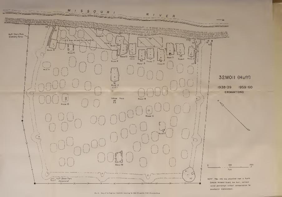
M_J_J_J_ U R I
32M0II (Huff)
1938-39 1959-60
EXCAVATIONS
NOTE: This mop was projecltd from o North
Ookoto Notionol Guord, low level, verticol
otrial photograph without compiniotion for
parallactic displocement
Mai* 4.—Mut> of Uif HulT Site I32MOU] sllovviDg tile l»3H-30 anil the It>ii0-I10 t!XcaTatlou«.


Riv. Bas. Sur.Pap. No. 39]
MANDAN CULTURE HISTORY—WOOD 29
has plans to stabilize the bank here by an emplacement of rip-rap.
In order to do so, and to preserve the rest of the site, a 100-foot strip
of the village adjacent to the riverbank will be beveled down byearth-moving equipment. This work, I understand, has now been
completed.
James H. Howard opened five excavation units at Huff in 1959,
His excavations were as follows : Excavation 1 was House 1 , Excava-
tion 2 was Bastion D, Excavation 3 was House 2, and Excavation 4
was Bastion A. Houses were not given excavation numbers in 1960,
but were numbered in sequence, continuing where Howard left off in
1959. Thus, the 1960 field season began with House 3 and continued
through House 12. Excavations that did not contain houses contin-
ued Howard's sequence of excavation units; thus, the 1960 field season
began work in Excavation 5 and continued through Excavation 14.
The house excavated by Thad. Hecker in 1938-39 was redesignated
House 5 (Hecker referred to it as House 25). The various excavations
at Huff by the three successive field parties are summarized in table 1.
Table 1.
—
Excavation units identified
Identification ExcavationNo.
Year
House 1
Bastion DHouse 2 --
Bastion AHouses 3, 4HousesHouses 6-12Fortification ditch profile
Northwest palisade line
Southeast palisade line
Test pit (east of House 4)
Garbage pit (outside ditch)Latrine pit (outside ditch)Test pit (plaza area)Mound test pit (outside village: 32M011-b).Area stripped byroad patrol
Do -
19591959195919591960
1938-3919601960196019601960196019601960196019601960
The first work done in 1960 after establishing the field camp wascutting a cross section of the fortification ditch (Excavation 5) along
the riverbank at the north side of the site. Subsequently, 75 feet
of the palisade was exposed in Excavation 6 west of this cross section,
and about 85 feet of the paHsade was unearthed on the south side of
the site in Excavation 7, commencing with the line of postholes ex-
posed by Howard in Bastion A in Excavation 4. The technique con-
sisted of cross trenching the inner side of the ditch and earth ridge.
When postholes were found, a trench 4 feet wide was cut to a depthof 0.8 foot, at which depth an almost continuous line of postholes wasobserved. The soil was still mixed at the bottom of the excavation,
but since the purpose of this work was to determine the paUsade line,
work was halted when this line was defined.

30 BUREAU OF AMERICAN ETHNOLOGY IBull. 198
Houses 3 and 4 were then respectively cross trenched and test-
pitted. When floor level was estabHshed, excavation walls were
extended until both sidewalls were defined. The wall postholes
were then followed out to their ends, and the house floor was cleared.
A trench to the southwest was required to expose details of the
entrance passage. House fill was essentially a structureless, aeolian
silt and sand deposit that was sterile except for a few artifacts and
some detritus which had been brought from deeper levels and re-
deposited by burrowing animals.
House floors were marked by artifacts lying horizontally in the
soil, and by the deposits of charcoal and ash on the floors of houses
which had been destroyed by fire. The house fill was removed by
spading, but the soil immediately above the floor was removed bycareful horizontal scraping with shovels. Fireplaces and other
features were cored with trowels. Pit fill was screened only whenlarge numbers of small artifacts occiu-red or when the fill was ashy
enough to presume that such perishables as corn might be recovered;
none of the house fill was screened. Four weeks were required to
excavate Houses 3 and 4, approximately two weeks for each house.
At least half of this time was spent removing the extraordinarily
tough sod and the sterile overburden.
In order to facilitate the removal of overburden, farm equipment
was used to strip the siu-faces of Houses 6, 7, and 8. The ground wasfirst plowed, then the loose sod and soil was removed with a front-
end loader on the tractor. This expediency removed most of the
overburden and left about half a foot of fill above the floors. These
three houses were then excavated by conventional handtools as
described above. Three weeks were spent in the excavation of these
houses, approximately one week per house; that is, excavation time
was halved by the use of power equipment. A search was made for
houses and other features northeast of these three houses with a smaUroad patrol, but with essentially negative results (Excavation 14).
By this time the summer budget was nearly exhausted, and a road
patrol was employed to strip the overburden from the rest of the
unexcavated houses within the 100-foot strip along the river. Through
the cooperation of the North Dakota National Guard, a road patrol
was made available and House 9 was stripped of soil to a point a few
tenths of a foot below the floor. The crew excavated this house
while the road patrol was cutting and clearing Excavation 13. Theplan at this time was to continue clearing house floors in a line with
those already excavated. House 10 was subsequently exposed and
the wall of House 11 delimited. We hoped to strip most of the floors of
houses exposed by the road patrol, map their postholes, and spot-
test cache pits for a minimal sample. This plan was abandoned with

Riv. Bas. Sur.Pap. No. 39]
MANDAN CULTURE HISTORY—WOOD 31
the discovery of House 12. This house departed so radically from
the architectural pattern seen previously in the houses that the rest
of the season was devoted to its excavation. Time and money were
exhausted by the time it was completed, and the site was abandoned
at the end of the 10th week of the season. At this time, 11 houses
had been dug, either by our party or previously, and about 10 percent
of the houses at Huff had been sampled.
The excavations at Huff in 1938-39 and in 1959-60 were designed
to explore and define details of (1) the dwelling and ceremonial struc-
tures, (2) the fortification system, and (3) burial customs. Theresults of these objectives are summarized below.
HOUSES
The floor plans of the Huff houses are rectangular. One of them(House 12) is nearly square, with four center posts, but the rest of
the structures seem to be long-rectangular. These long-rectangular
houses are remarkably consistent in architectural details, the differ-
ences consisting largely in size and in floor features. Table 2 gives
the major dimensions and selected traits of this architectural complex.
Table 2.-

32 BUREAU OF AMERICAN ETHNOLOGY IBuU. 198
Dimensions.-—Length (measured from the interior entrance posts to the endpost) ranges from 27 to 49 feet. Width is usually different at the house front,
center, and back, with the front ranging from 23 to 38 feet, and the back, from
20 to 29 feet (see table 2).
House pit walls.—Unfaced native soil. Houses were built over pits dug 1.0
to 1.2 feet into the former ground level. As much as 1.5 feet of aeolian sand and
silt deposits covered the house floors, although overburden on level parts of the
site area outside the houses was only about 1 foot deep.
/^Zoor.—-Tramped earth, the center depressed, and sloping up gently toward
the sides and ends.
Roof supports.—There were two large interior entrance posts; one large post
in the house midline, offset toward the back wall; and a large end post. Theentrance and the end posts were consistently about the same size and, except for
House 1, the center post was always the largest and deepest of the group.
These four posts are presumed to have provided support for a central ridge
pole (see fig. 13, p. 103, for a speculative reconstruction). Wall posts were confined
to the sidewalls. In most instances they extended a few feet beyond the house
front (as marked by the interior entrance posts), but rarely beyond the end post.
There was considerable variation in their size, and they were often irregularly
spaced. House walls were usually gently convex.
Entrance passage.—All entrys were directed toward the southwest, away from
the river. The passage was composed of two sets of two posts, which provided
the frame for an elongated entryway, the sides of which were enclosed by small
posts, generally set into shallow trenches somewhat shorter than the entry length.
The length of the entry was independent of the house length, and was 7.5 to
20 feet long and 2.5 to 6 feet wide. A ramp or step of undisturbed native soil
extended into the house pit, terminating at the interior entrance posts.
Firescreens.—An L-shaped trench in House 3 seems to be part of a firescreen
which necessitated a turn to the right on entering the house. Parts of others
were present in other houses, often containing the butts of small poles.
Fireplaces.—The primary fireplace was in the midline of the house between
the entrance and the center post. It was a basin-shaped pit about 3 feet in
diameter and 0.6 of a foot deep, filled with hard ash and charcoal, and floored
with burned earth. Two houses, 3 and 6, had clay-lined hearths. Most of them
contained pottery sherds, burned bone, and fragmentary household detritus.
House 1 was atypical in lacking a central, primary fireplace.
Other.—Houses 1, 2, 4, 5, 7, 8, and 11 had been burned. Their floors were
scattered with ash and charcoal and occasional charred posts from the house
superstructure. Most of the posts appeared to be of oak or cedar. Many of
them were in excellent condition and these were saved for Carbon- 14 determina-
tions and tree-ring analysis. The post bases were charred, apparently the trees
having been felled by charring the trunk rather than by chopping.
The ridge of earth along the house sidewalls, shown in the contour map of
House 19 (see map 15), suggests that sidewalls of wattle and daub were banked
with earth. House ends were apparently not banked, although the house fronts
were cut steeply into the native soil. There were variations in other features in the
houses, and these variations and individual features are discussed in the descrip-
tions below.
House 1 (map 5)
:
Shape: Long-rectangular.
Floor: There was a large number of auxiliary posts on the house floor. The
house had burned, and charred timbers and ash littered the floor.

Riv. Bas. Sur.Pap. No. 39] MANDAN CULTURE HISTORY—WOOD 33
HOUSE I
Excavation limit
@ Fireplace
(Qt' Undercut pit
(_J Basin- shaped pit c
^ Cylindrical pit
'v,_,' Unexcovated pit
^^Stones
• Pesthole
^^ Pesthole, braced
• Pesthole inclined in
direction shownZ^ Shallow trench
3Charred timber
Probable position ofroof beams
Map 5.—Plan of House 1.

34 BUREAU OF AMERICAN ETHNOLOGY [Bull. 198
Entrance: It was lined by two parallel trenches 11.5 and 12.5 feet long, 0.7
foot wide and 0.5 foot deep, which contained the butts of poles 0.2 to 0.3 foot
in diameter. The outer pestholes of the entry were not located.
Fireplaces: There was no primary fireplace between the firescreen and the
center post, as in all of the other houses, but there were several other fireplaces
along the sidewalls.
Firescreen: Two separate trenches are interpreted as parts of a firescreen.
One of them was 10 feet long, 0.8 foot wide, and 0.5 foot deep; it contained the
butts of poles 0.3 foot in diameter. The other trench, 6 feet long, 0.5 foot wide,
and 0.4 foot deep, lacked any trace of post butts.
Comments: The house had burned, and a number of posts were saved for tree-
ring analysis. Six cache pits (Features A-F) in the floor of this structure, whichhad been excavated by Howard in 1959, were noted and dug in 1960, at whichtime the house was remapped. Howard's features are included and identified
in table 3. See Howard (1962 b, pp. 11-13, fig. 1) for additional discussion of
this house, which is identified as a dwelling unit.
Table 3.
—
House 1 floor features
EXCAVATED IN 1960
Feature

Fa' ?kf'39Y"MANDAN CULTURE HISTORY—WOOD 35
HOUSE 2
WRw, 10/4/60 feet
Map 6.—Plan of House 2, the ceremonial lodge (after Howard)
,
221-350—67 4

36 BUREAU OF AMERICAN ETHNOLOGY [Bull. 198
Fireplaces: The primary fireplace was 3.5 feet wide and 0.6 foot deep. Therewas one surface hearth near the back of the house 1.8 feet wide, and one fireplace,
containing burned stones and ash, north of the entrance; it measured 3.8 by 4.7
feet in diameter, and was 0.4 of a foot deep. There were three concentrations of
fire-cracked rocks elsewhere on the floor, perhaps the remains of sweat lodges;
one of them overlay the orifice of Feature A, a bell-shaped pit. One auxiliary
fireplace overlay the mouth of Feature C, also a bell-shaped pit.
Firescreen: No trace of a firescreen was found.
Other: This house had burned. This structure is interpreted as the village
ceremonial lodge for two reasons: it is larger than the other houses, and it is
prominently placed with the entrance facing the center of the village plaza.
Household detritus in the bell-shaped pits in its floor, however, suggest that it
was a domestic dwelling. This house was dug by Howard in 1959 (1962 b,
pp. 11-13, fig. 5). Seven additional pits (Features A-G) were excavated in this
house in 1960 when the house was remapped.
Table 4.
—
House 2 floor features *
EXCAVATED IN 1960
Feature


-^-L±^~L-U_LxJ_L
Excova+ion
O Fireplace
(Q; Undercut pit
Q Basin-shaped pit
Cylindrical pit
;^ _} UnexcQva+ed pi +
^ S+ones
— Approximate »dg»
of ditch
• Pos+hole
^ Pos+hole, broced
"Posthole inclined in direction shown
I^ID Shallow trench
23Charred timber
Probable position of roof beams
DSouthtott ttnct lint,
Hull State Park
Map 7.—Plan of House 3. Uie southeast fortiOcation ditch and Bastion A.


Riv. Bas. Sur,Pap. No. 39]
MANDAN CULTURE HISTORY—WOOD 37
Entrance: It was lined by two parallel trenches 8 and 8.5 feet long, 0.5 foot wide,
and 0.4 foot deep. These trenches contained the closely spaced molds of posts
averaging 0.3 foot in diameter.
Fireplaces: The primary fireplace differed from those in most of the other houses
in being lined with a dense, yellow clay hardened by the heat of the fire; a clay
lining was found elsewhere only in House 6. There were five auxiliary fireplaces.
Firescreen: Feature 28 is of primary interest because of its completeness. It is
L-shaped in plan, and U-shaped in cross section. It contained the remains of
no posts, and if its identification is correct the screen itself was composed of a
perishable material. This feature yielded a number of pottery sherds and other
debris.
Other: An old excavation, presumably made by Thad. Hecker, extended from
the wall posts on the west side to a point near Feature 20. This pit barely missed
a fragmented bison skull, stained with red ocher, lying on the floor beside Feature
20. This skull may be part of a household shrine. The structure had not burned,
and the floor was determined by the level of floor features and by artifacts lying
horizontally in the soil. The house is interpreted as a dwelling unit.
Table 5.
—
House 3 floor features
FeatureNo.

38 BUREAU OF AMERICAN ETHNOLOGY [Bull. 198
Excavation limi+
\^ Fireplace
(0) Undercut pit
Q Basin-shaped pit
^ Cylindrical pit
( ) UnexcQvated pit
^ Stones HOUSE 4
• Pesthole
^ Posthole, braced
9 Posthole inclined mdirection shown
Shallow trench
Charred timber
Probable position of roof beams
Map 8.—Plan of House 4.

Klv. Bas. Sur.Pap. No. 39]
MANDAN CULTURE HISTORY—WOOD 39
House 4 (map 8)
Shape: Long-rectangular.
Floor: The floor was well-defined, particularly in the southwest corner, where
it was covered with a deep layer of heavy ash and burned timbers. The tops of
wall posts were only a few tenths of a foot below the ground surface in this corner.
They had been preserved by charring, and projected well above the floor.
Entrance: The outer posts were irregularly spaced, and both sides of the passage
were lined with small poles set in shallow, parallel trenches 15 and 16 feet long.
A third (and extraneous) trench, 11 feet long, 0.6 foot wide, and 0.5 foot deep
was in the entryway; it was lined with closely spaced posts 0.4 to 0.5 foot in
diameter.
Fireplaces: The primary fireplace was in the house midline, between the entrance
and the center post. A large number of pottery sherds were in and around this
feature, and at least four or five restorable vessels were crushed nearby when the
house collapsed. There were four auxiliary fireplaces in the house.
Firescreen: A trench, parallel to the midline of the house, and north of the
entrance, may be part of a firescreen. It contained the butts of two posts 0.4
foot and 0.5 foot in diameter.
Other: Before excavation, an irregular pit was cleared that extended from
Feature 40 to the northwest house wall. It was probably the work of Thad.
Hecker. A large sandstone metate and a mano were along the southeast wall,
both of them blackened and fire-cracked. Grooved ironstone nodules, grooved
mauls, and other heavy ground stone tools were especially plentiful along the
sldewalls, near the postholes. Most of them, like the mano and metate, showedthe effect of the fire which had destroyed the house. This structure is probably
a dwelling unit.
Table 6.
—
House 4 floor features
FeatureNo.

40 BUREAU OF AMERICAN ETHNOLOGY [Bull. 198
•Excavation
^ Fireplace
\Q1 Undercut pit
yj) Basin-shaped pi+
^ Cylindrical pi +
>^ } Unexcavo+ed pit
^ S+ones
HOUSE 5
9 Pos+hole
•^ Pos+hole, braced
# Pos+hole inclined in
direction shown
i^:^ Shallow trench
H3Charred timber
Probable position of roof beams
Map 9.—Plan of House 5.
from his field notes dated January, 1939, and August 12, 1939, and from his pub-
lished account (Will and Hecker, 1944, pp. 19-23, 95). Instructed by George F.
Will to select a house at Huff for excavation, Hecker began work on one tested
earlier in the summer of 1939 by students from the Columbia University field
party then working at On-a-Slant Village (32M026). Hecker's examination of
their trench revealed 6 to 8 inches of windblown sediments overlying 6 to 8 inches
of mixed earth.

pLp. N^; 3^9Y'MANDAN CULTURE HISTORY—WOOD 41
Floor: The well-packed floor was distinguished by ash and other detritus, andit sloped down gently toward the house center. The structure had burned, asshown by charred wall posts, roof beams, and ash on the floor. The wall posts6 to 8 inches in diameter, were slightly staggered, alternate posts having a slight
slant to the interior and exterior. There was one large end post. Scattered acrossthe floor were timbers or impressions of timbers from the superstructure, most of
them lying approximately at right angles to the side and end posts. He traced anumber of such timbers for lengths up to 10 feet.
Hecker mentions two rows of "stakes," 2 to 3 inches in diameter, that extendedacross the back wall of the house. He also illustrates them across the front end.The 1959 and 1960 excavations in eight similar houses revealed no similar arrange-ment—with the posts set in holes in such straight lines. Traces of posts in thehouse ends were in fact quite rare, generally consisting only of traces of woodwhich probably represent the butts of poles which rested on the former floor level
rather than in holes.
The floor did not extend beyond the end wall posts, and Hecker suggests thatthe walls were vertical, rather than slanting. Trenches cut beyond the sidewallsshowed that the earth "piled against the walls sloped up from approximately 6 feet
out from the wall at ground level." There was no indication of clay along thesides, and he rejected the possibility of wattle-and-daub walls, a possibility ac-cepted by Howard (1962 b, p. 11) and myself on the basis of our work at Huff.Hecker did not find the large exterior entrance posts, but the passage extended atleast 6 feet to the southwest. He states that the passage was "easily traced " butthat there were no indications of posts more than 6 feet beyond the interior en-trance posts.
Features: There were five shallow, oval pits on the floor. Features 182 to 186.
They were about 30X40 inches in diameter, and 1 foot deep. "One pit was full
of granite rocks and ashes; no doubt the granite was being burnt to be used for
pottery tempering." The other four holes were filled with ash and refuse. Heckermentions three other pits, about 18 inches in diameter and a foot deep, but showsthe location of only one of them, Feature 187. "The use of two are indeterminate •
they are near the east wall." The small pit (Feature 188) near the concentrationof pottery vessels north of the fireplace he incautiously but definitely identifies asthe site of a "wooden mortar."
In addition to these features, dug in 1938, he dug two other pits in 1939. Oneof them, Feature 180, was 2.5 feet in diameter and 2 feet deep. It is shownas a bell-shaped pit on the house map prepared for this study since it was of
"the usual type used for storage." The other and larger pit, Feature 181, was5 feet deep and 5 feet in diameter at its base. Among other artifacts, it containsa small pipe Hecker identified as catlinite. I have questioned the identification
as catlinite since there is no other record of this material in the site, and he mayhave confused the dense scoria, common enough here, with catlinite. Elsewhere,also, he speaks of catlinite beads, which strongly suggest the scoria beads foundin 1960. The primary fireplace, Feature 179, was 3 feet in diameter, but hedoes not specify depth. Between the fireplace and Feature 188 was an areaabout 6X8 feet where "no less than 20 cooking pots were left standing. . .
."
He states that small pits were scooped out in the floor in which to set them.They were badly shattered and were not recovered; see his comments in Willand Hecker (1944, p. 22). He did recover one nearly intact vessel which wasinverted in a shallow pit filled with earth and ash (pi. 6, c).
He also remarks that the "house had a small room or lean-to on the outsideof the [back] wall of the lodge. This small room had a floor space of 5 by 7 feet.

42 BUREAU OF AMERICAN ETHNOLOGY [Bull. 198
No post or stake holes showed around this small floor space .... The floor
sloped slightly towards the lodge and was sharply defined level [sic] and covered
with the usual floor debris. . . ." Excavations in 1959 and 1960 revealed no
further instances of such features in other houses.
Comments: The map prepared for this report (map 4) includes this house in
its correct relationship to the rest of the dwellings. This was done by relocating
the large support posts and the primary fireplace in 1960. To those familiar
with Huff data, it is obvious that the house has been redrawn (map 9) from
Hecker's published map (ibid., pi. 6). This new map is in fact an interpretation
of Hecker's map, based on his field map and notes and on comparisons with the
houses dug in 1959 and 1960. This map was prepared to show how closely
Hecker's work was verified by later work, and to show that, despite idiosyn-
cracies in his cartography, it closely conforms to the floor patterns of the rest
of the long-rectangular houses. The dotted line connecting two postholes on
his published map, previously unidentified, is in the position of the firescreens
noted in other houses. Hecker has often been belabored by local archeologists,
but this has been done without recourse to his field notes and maps. His ex-
cavation technique, questionable in many respects, resulted in generally precise
excavation maps—even if they do not always show all the details we might wish.
House 6 (map 10; pi. 4, o)
Shape: Long-rectangular.
Floor: This structure revealed fewer auxiliary postholes and floor features
than any of the other houses except House 5. A unique feature of the walls of
this house is the fact that many of the postholes were inclined toward the house
interior. These inclined posts were irregularly placed among otherwise vertical
postholes at angles between 8 and 30 degrees. This arrangement is something
like that reported by Hecker in House 5, although none of the posts in House 6
were inclined outward.
Entrance: Directed toward the southwest, it diminished in width away from
the house. It was lined by two convex rows of small post butts 0.2 to 0.3 foot in
diameter; they were not set in trenches.
Fireplaces: The primary fireplace was lined with yellow clay, as was the hearth
in House 1. There were no auxiliary fireplaces in the house, although one was
present behind the house.
Firescreen: A probable firescreen trench northwest of the entrance posts was
devoid of any trace of posts.
Other: The house had not burned, and the floor level was determined by the
tops of such features as the primary fireplace and other pits, and by artifacts
lying horizontally in the soil. The structure is interpreted as a dwelling unit.
Map 10.—Plan of House C.

Riv. Bas. Sur.Pap. No. 39]
MANDAN CULTURE HISTORY—^WOOD 43
®FIOO
F98
FI05 F93
OF9I F89
• F109® ''^O'^'S?
,*/'^^®F95;;'®FI92; FI9I
F|'07®*.(f87)f96
Excava+ion limit
@ Fireplace
O Undercut pi +
Q Basin- shaped pi+
® Cylindrical pit
(^J Unexcavated pit
^i- Stones
HOUSE 6
• Posthole
^ Pesthole, braced
• Posthoie inclined
in direction shown
Z3 Shallow trench
Charred timber
Probable position of
roof beams

44 BUREAU OF AMERICAN ETHNOLOGY [Bull. 198

Riv. Bas. Sur.Pap. No. 39]
MANDAN CULTURE HISTORY—WOOD 45
Excava+ion li
(B) Fireplace
O Undercu+ pi+
(3 Basin- shaped pit
^ Cylindrical pif
C_) Unexcavated pit
^ Stones
HOUSE 7
25
• Post hole
^ Post hole, braced
9 Post hole inclined in
direction shown
' Shallow trench
HH3 Charred timber
Probable posi+ion of
roof beams
SCALE IN FEET
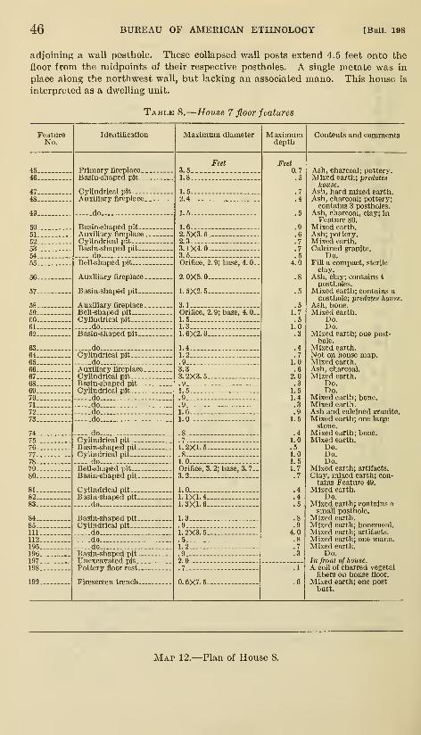
46 BUREAU OF AMERICAN ETHNOLOGY [Bull. 198
adjoining a wall posthole. These collapsed wall posts extend 4.5 feet onto the
floor from the midpoints of their respective postholes. A single metate was in
place along the northwest wall, but lacking an associated mano. This house is
interpreted as a dwelling unit.
Table 8.
—
House 7 floor features
FeatureNo.
Identification Maximum diameter Maximumdepth
Contents and comments
Primary fireplace.
Basin-shaped pit-.
Cylindrical pit
Auxiliary fireplace.
-do.
Basin-shaped pit...
Auxiliary fireplace .
Cylindrical pitBasin-shaped pit,-.
doBell-shaped pit
Auxiliary fireplace.
Basin-shaped pit--.
Auxiliary fireplace.Bell-shaped pit
Cylindrical pit
doBasin-shaped pit--.
do -.Cylindrical pit
doAuxiliary fireplace
-
Cylindrical pitBasin-shaped pit--.
Cylindrical pit
.do-do.-do..do.
doCylindrical pit.-.Basin-shaped pit-
Cylindrical pit---do
Bell-shaped pit...Basin-shaped pit.
Cylindrical pit--Basin-shaped pit-
do
Basin-shaped pit-Cylindrical pit
dodo -do
Basin-shaped pit-Unexcavated pit..
Pottery floor rest.
Firescreen trench.
3.5-1.8-
Feet Feet
1.5-2.4-
1.5-
1.6
2.5X3.52.3
3.1X4.03.5Orifice, 2. 9; base, 4. 0.
2.0X5.0
1.5X2.5-
3.1 -Orifice, 2.9; base, 4.0-1.5.1.3
1.6X2.0
1.4-1.2-
3.3
3.2X3.5-
1.5-.9-.9-1.6-1.0-
.7
1.2X1.5.
1.0 -
Orifice, 3. 2; base, 3. 7-
3.2- —1.0
1.1X1.4.1.3X1.6.
1.3.
1.2X3.5..51.2
2.0..7..
0.6X7.5-
0.7.5
.5
.6
.7
.7
.54.0
.51.7.5
1.0.3
.4
.71.0.6
2.0.31.51.4.3.91.5
.41.0.51.01.51.7.7
.4
.4
.5
4.0.8.7.3
Ash, charcoal; pottery.Mixed earth; predates
house.Ash, hard mixed earth.Ash, charcoal; pottery;contains 3 postholes.
Ash, charcoal, clay; inFeature 80.
Mixed earth.Ash; pottery.Mixed earth.Calcined granite.
Do.Fill a compact, sterile
clay.Ash, clay; contains 4
postholes.Mixed earth; contains a
posthole; predates house.Ash, bone.Mixed earth.
Do.Do.
Mixed earth; one post-hole.
Mixed earth.Not on house map.Mixed earth.Ash, charcoal.Mixed earth.
Do.Do.
Mixed earth; bone.Mixed earth.Ash and calcined granite.Mixed earth; one large
stone.Mixed earth; bone.Mixed earth.
Do.Do.Do.
Mixed earth; artifacts.
Clay, mixed earth; con-tains Feature 49.
Mixed earth.Do.
Mixed earth; contains asmall posthole.
Mixed earth.Mixed earth; bonemeal.Mixed earth; artifacts.
Mixed earth; one mano.Mixed earth.
Do.In front of house.A coil of charred vegetal
fibers on house floor.
Mixed earth; one postbutt.
Map 12.—Plan of House 8.

Riv. Bas. Sur.Pap. No. 39] MANDAN CULTURE HISTORY—WOOD 47
F2I6
Excava+ion limi+
Qv^ Fireplace
O' Undercut pi+
QJ) Basin- shaped pi+
q3 Cylindrical pi-f
kJ Unexcova+ed pH-
^^ Stones
• Pos.+hofe
^ Posthole, braced
• Pos+hole inclined in
direction shown
^11^ Shallow trench
^33 Charred timber
Probable position of roof beams

48 BUREAU OF AMERICAN ETHNOLOGY [Bull. 198
House 8 (map 12)
Shape: Long-rectangular.
Floor: The house had been burned, and it waa thinly spread with a deposit of
ash. The floor was built over a number of older refuse pits: Features 113, 120,
122, 140, 141, 143, and 144 clearly predate the construction of the house, since
Table 9.
—
House 8 floor features
FeatureNo.
Identification Maximum diameter Maximumdeptli
Contents and comments
Bell-sliapedpit-
Cylindrical pit...
Basin-shaped pit.
Cylindrical pit...
doBell-shaped pit -
.
FeetOrifice, 2.9; base, 3.1.
Feet
.do.Basin-shaped pit in floor
of irregularly shapedpit.
Auxiliary fireplace
Two intersecting basin-shaped pits.
Cylindrical pit
dodo
Basin-shaped pit...Auxiliary fireplace
Cylindrical pit
do -.
Auxiliary fireplace
Primary fireplace
Basin-shaped pit
doAuxiliary fireplace
Cylindrical pit
Bell-shaped pit
Cylindrical pit..
do
3 intersecting cylindricalpits.
Irregularly shaped pit
Irregularly shaped pit-
Cylindrical pit-
Bell-shaped pit-
Irregularly shaped plt.
Bell-shaped pit
Basin-shaped pit...
dodo..
Auxiliary fireplace.
Cylindrical pit.
do.do
Basin-shaped pit
2 intersecting tjasin-
shaped pits.
Basin-shaped pit
doCylindrical pit
do..Basin-shaped pit
Cylindrical pit
dodo..
Orifice, 4.2; base, 4.9.
Orifice, 2.4; base, 3.0.
7.0
4.0.
6.0; 4.0.
,
1.6X2.0..9.
1.0
1.4
1.5
3.6X4.5.2.0
4.0
.9
1.3
4.4X5.51.5
Orifice, 3.5; base, 4.0.
1.6
1.2
1.0 (each).
6.5
8.5X10.5.
.
2,2
Orifice, 3.4; base, 5.0.
7.7
Orifice, 3.5; base, 5.0.
2.8
.7
2.7X3.5-2.5
.7.. ,
1.4 _
1.2 (each).
1.3-
1.8
1.2
3.52.0
2.0
1.41.51.4.3.61.12.5.2.5.6
1.02.51.5
1.0
.9 (each)
1.5
1.0
1.44.2
1.2
4.81.7.3.3
.6
.5
1.0.9.5
1.1 (each)
.4
.91.01.0.3
1.0-
.6-.
1.0-
Mixed earth, ash; artifacts;predates house.
Mixed earth.Do.
Mixed earth; bone.Mixed earth.Mixed earth, clay, char-
coal; largest excavatedpit.
Mixed earth.Mixed earth; 5 intrusive
pestholes; predates house.
Ash; adjoining smallundercut pit 1.0 feet
deep; orifice 1.2, base 1.5.
Mixed earth; 4 intrusivepostholes; predates house.
Mixed earth; artifacts.
Mixed earth.Do.Do.
Ash, pottery.Mixed earth; bone.Mixed earth.Ash.Ash, pottery.Mixed earth.
Do.Ash.Mixed earth.Mixed earth, clay.Mixed earth, ash.Mixed earth; granite
stones.Mixed earth; bone; arti-
facts.
Mixed earth; 5 intrusivepostholes; predates house.
Mixed earth; predateshouse.
Mixed earth.Intrusive pesthole; pre-
dates house.
4 intrusive postholes; pre-dates house.
Mixed earth; Burial 1.
Mixed earth; bone.Mixed earth.
Do.Ash, in wall line; predates
house.
Not on map; between ri28and F129.
Mixed earth.Do.
Ash.Mixed earth.
Do.Do.Do.Do.Do.Do.Do.Do.


I
Approximate edge of difch
Maximum depth of diich
SCALE IN FEET
32M0II (Huff)' / I I I I 1 1 \
»
Mai- 13.—Plan of Houses 9 and 13 and the northwest fortifleatlon system.


pLp. Nlf.'s^QY'MANDAN CULTURE HISTORY—WOOD 49
wall posts had been set into the fill of most of them. It is more than likely that
other pits similarly predate the structure.
Entrance: There were two partial rows of postholes averaging 0.4X0.5 foot
along its sides. Some of these posts were intrusive into Feature 140, an older,
refuse-filled pit.
Firescreen: No evidence of a firescreen was found.
Burial: A single, flexed adult human female skeleton was in Feature 145,
a deep bell-shaped pit in the back of the house. There were no direct burial
associations, although the fragmented remains of a small canid skeleton were onthe pit floor near the woman.
Comments: The floor of this house is marked by a number of large refuse-filled
pits that obviously predate the construction of the house. These features wereprobably dug between Houses 1 and 7, and House 8 was built on this location
after these pits had been filled with refuse. There seems to be no significant
difference between the fill of these pits and the artifacts from the house floor
(see table 15), and it is presumed that there was no great timelag between the
filling of these pits and the construction of the house itself. The structure is
interpreted as a dwelling unit.
House 9 (map 13)
Shape: Indeterminate. This house site was marked by a prominent but am-biguous depression in the sod about 16 feet in diameter and a foot deep; it waseither squarish or circular in outline. No clear house pattern was observable at
the completion of the house excavation.
Dimensions: Unknown. No wall lines nor identifiable center support posts
are present.
House features: Pit walls, if once present, were removed by the road patrol
when it scraped the house down to the floor level. The only fireplace, Feature
151, was 2.5 feet in diameter and 0.5 foot deep; it was in the approximate center
of the house depression and it was about the same size as the primary fireplaces
in the long-rectangular houses. The house floor was rather dish shaped, with the
fireplace in its center. There was one bell-shaped pit, Feature 147; its orifice was4.0 feet wide, and it was 3.2 feet deep, and 4.6 feet wide at the base. There weretwo cylindrical pits, Features 149 and 150, respectively 1.0 and 1.5 feet in diameter
and 1.3 and 1.0 feet deep. One pit, 2.0 feet in diameter, and capped with mixedearth, was not excavated.
Comments: The features surrounding the fireplace, and the position of the fire-
place in a basin-shaped depression beneath a distinct surface depression, suggest
that this complex of features represents a house. It appears unlikely that these
features were placed in an old borrow pit, the only other plausible source for adepression of this size. It is equally improbable that the road patrol removed all
evidence of wall and center posts. The floor of the cut was checked constantly
throughout the work, and no posts were removed that were not later verified.
Had the road patrol removed the tops of postholes their bottoms should haveremained, for only a few tenths of a foot were removed from the tops of features
around the fireplace. In view of these circumstances, it is probable that this
house differed in architecture from the rest of the structures excavated at the site.
House 10 (map 14)
Shape: Long-rectangular.
Floor: This house was initially stripped to floor level by the road patrol, andany evidence of a former house pit was obliterated by this operation. Most of

50 BUREAU OF AMERICAN ETHNOLOGY [Bull. 198
XI3Excavat
Fireplace
Undercut pit
Basin-shaped pit
Cylindricol pit
ted pit
stones
Posthole
Posthole, braced
Posthole inclined in direction shown
Shallow trench
Charred timber
Probable position of roof beams
HOUSE IISCALE IN FEET
Map 14.—Plan of Houses 10, 11, and 12.
the floor was covered by a few tenths of a foot of house fill when excavation with
handtools began.
RooJ supports: There was a distinct second line of wall posts along the south-
east wall for the entire length of the house, spaced 5 to 6 feet inside the sidewall.
Part of a second line of posts was on the northwest sidewall, but it was nearer
the wall than the other auxiliary row. Initially it was assumed that these auxiliary
rows were part of a second structure, but it was not possible to define a second
entrance or end post. These additional rows of posts may have resulted from

RIv. Bas. Sur.Pap. No. 39]
MANDAN CULTURE HISTORY—WOOD 51
partial rebuilding, or from structural forms not present in the other excavated
houses.
Entrance: The exterior entrance posts were apparently under the overburdenbeyond the edge of the road patrol cut; if so, the passage was more than 8 or 9
feet long.
Firescreen: No evidence of a firescreen was observed.
Comments: The house had not been burned. A number of pita in the floor
were not dug because of the lateness of the season and of the desirability of
completing the worli on House 12.
Table 10.
—
House 10 floor features
FeatureNo.
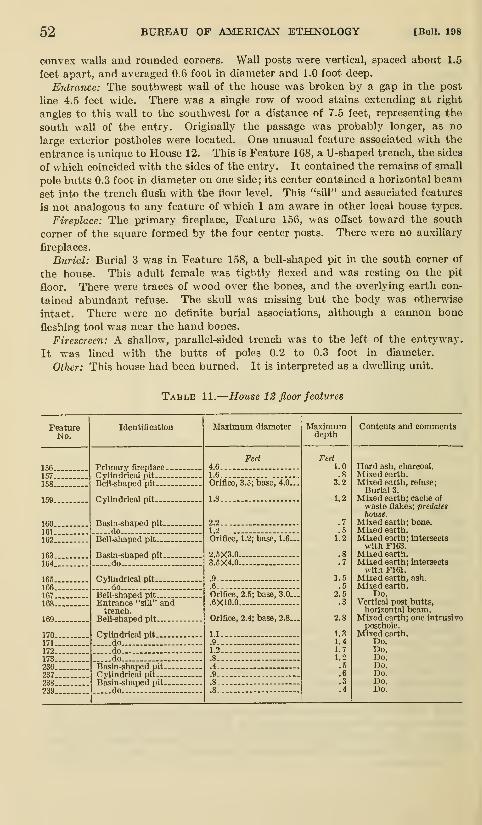
52 BUREAU OF AMERICAN ETHNOLOGY [Bull, 198
convex walls and rounded corners. Wall posts were vertical, spaced about 1.5
feet apart, and averaged 0.6 foot in diameter and 1.0 foot deep.
Entrance: The southwest wall of the house was broken by a gap in the post
line 4.5 feet wide. There was a single row of wood stains extending at right
angles to this wall to the southwest for a distance of 7.5 feet, representing the
south wall of the entry. Originally the passage was probably longer, as no
large exterior pestholes were located. One unusual feature associated with the
entrance is unique to House 12. This is Feature 168, a U-shaped trench, the sides
of which coincided with the sides of the entry. It contained the remains of small
pole butts 0.3 foot in diameter on one side; its center contained a horizontal beam
set into the trench flush with the floor level. This "sill" and associated features
is not analogous to any feature of which I am aware in other local house types.
Fireplace: The primary fireplace. Feature 156, was offset toward the south
corner of the square formed by the four center posts. There were no auxiliary
fireplaces.
Burial: Burial 3 was in Feature 158, a bell-shaped pit in the south corner of
the house. This adult female was tightly flexed and was resting on the pit
floor. There were traces of wood over the bones, and the overlying earth con-
tained abundant refuse. The skull was missing but the body was otherwise
intact. There were no definite burial associations, although a cannon bone
fleshing tool was near the hand bones.
Firescreen: A shallow, parallel-sided trench was to the left of the entryway.
It was lined with the butts of poles 0.2 to 0.3 foot in diameter.
Other: This house had been burned. It is interpreted as a dwelling unit.
Table 11.
—
House 12 floor features
FeatureNo.

pLp. ?kf." siT' MANDAN CULTURE HISTORY—WOOD 53
House 13 (map 13)
Shape: Long-rectangular.
Comments: Thad. Hecker's previous work at Huff had shown that the front
of Houses 5 and 18 was distinctly wider than the back. In order to determine
whether this variation was a constant or a coincidence, he dug the sidewalls of
House 13. This summary of the work was taken from his field notes dated October
1939, and from his published account (Will and Hecker, 1944, pp. 19, 95).
"Only enough posts in each side of this lodge were located to definitely showthe contour of the side walls," since the earth was so hard at the time of the work
that it broke into large clods, and he "did not want to spoil the [house] site for
future [excavation] . . .." Within the limits of five irregular trenches, Hecker
determined that there was a difference of 6 feet between the width of the front
and that of the back walls. The structure was 47 feet long; the front end was 33
feet wide, and the back end was 27 feet wide. He prepared a sketch of the post-
holes located, but it was not possible to overlay this plat with a map of the
excavations made in 1960,
Houses 14-17 (see map 4)
Shape: Long-rectangular.
Comments: In addition to excavating House 5, and testing the walls of Houses
13 and 18, Thad. Hecker also tested a number of other houses at Huff. I wasunsuccessful in finding any notes Hecker may have made regarding these test
excavations among the manuscript material he left with the State Historical
Society of North Dakota. The test pits in Houses 14 through 17, therefore,
were remapped in 1960, but since they were not reopened at that time, there is
nothing to add to the site data.
House 18 (see map 4)
Shape: Long-rectangular.
Comments: The following remarks on this house derive from field notes byThad. Hecker dated August 1939, and from his published account (Will and
Hecker, 1944, pp. 19-21). His work was designed to determine the house outline;
only a fraction of the floor was excavated.
A trench 2 to 3 feet wide was dug along the southeast wall to expose posts, with
two smaller trenches on the northwest wall for the same purpose. The walla
were defined well within the edges of the house depression. House dimensions:
length, 48 feet; back width, 31 feet, and front width, 35 feet. As elsewhere in
the site, there was a difference in house width, with the southwest end 4 feet
wider than the opposing end.
Most of the posts found protruding above the floor were left standing and
undisturbed; they were 6 to 8 inches in diameter. The house had burned, and
Hecker noted three charred oak posts, broken when the house collapsed. Oneof them, on the southeast wall, was 4 feet 1 inch long; the two along the northwest
wall were 4 feet 3 inches and 4 feet 5 inches long. The house was built over
a pit about a foot deep. I append here a statement from his notes which is not
wholly clear: ". . . the posts on the South wall show that the logs were set in
panels with the ends overlapping (sixteen foot logs being used in the construction
of the side wall)."
Only part of the house ends were dug, as no posts were found when the end of
the floor was reached and he did not wish to go below the floor level to seek them,
and thus disturb the house for possible later work. Only a small part of the
floor was exposed, and only a few artifacts recovered, including a "broken platform
pipe made of fine sandstone." The pipe to which he refers was in the Historical

54 BUREAU OF AMERICAN ETHNOLOGY [Bull. 198
Society displays and is illustrated here (see fig. 6, c). It is not a platform pipe
but a T-shaped form.
House 19 (map 15)
This structure was directly south of House 2. It was chosen as the subject
for a detailed contour map in 1960 because it was perhaps the most clearly defined
house depression at the site. The depression was distinctly rectangular in
outline. It was 48 feet long; the southwest end was 39 feet wide, and the oppos-
ing end about 28 feet wide. This conformation parallels, in slightly exaggerated
form, that observed in the floor plans of the excavated long-rectangular houses.
A number of surface features appear to be directly related to the presumed
floor plan of the underlying house, assuming that the wide end is the front of the
house, as it is in each of the excavated lodges. The front edge of the depression
is steep, with a slight ridge of earth along the front end and very conspicuous
ridges along both sides. There was a very slight hummock about 5 feet from
the front of the house depression; such features, larger and more prominent in
some of the other houses, are in the approximate position one might expect to
locate the primary fireplace. A feature noted in other houses, but lacking here,
was a low ridge of earth extending along the midline of the house depression.
FORTIFICATION DITCH AND PALISADE
Excavation 2 (map 16)
The delineation of Bastion D in this excavation by Howard (1962 b, fig. 4) pro-
vides an exceptionally clear picture of the complex nature of the Huflf fortifica-
tions. The defensive measures at Bastion D consisted of a ditch 4.5 feet deep,
along the inner edge of which was a line of small pestholes slanting outward,
Howard (1962 b, pp. 2, 14) speculates that this line represents a sort of cheval-de-
frise of sharpened stakes, the ends of which faced the ditch. Five feet inside this
line were the vertical posts of the bastion wall.
The bastion gorge, or entrance, was 7.0 feet wide, the flanks expanding toward
the convex end; the bastion projected 13.0 feet out from the square corner of the
fortification system. There was a fireplace, 3.0 feet in diameter and about a foot
deep, in the bastion's center; it was filled with hard white ash and charred refuse.
The evidence on which Howard (1962 b, pp. 2, 14) based his statement that there
was a sort of watchtower in the bastion set on posts is unfortunately not detailed,
although there are a number of posts within the bastion.
Excavation 4 (map 7)
This excavation was first opened by Howard in 1959 (1962 b, fig. 6), and it was
cleared and then remapped in 1960 when Excavation 7 was made. This unit ex-
posed Bastion A, on the eastern extremity of the fortification system. This fea-
ture was 20 feet long, but since the palisade was indented on the south side of the
bastion, it projected only 16 feet beyond the palisade line. The gorge was 8 feet
wide, and the flanks converged toward the squared end, which was 5 feet wide.
The structure was built on a level to somewhat rounded prominence of native
earth left standing when the ditch was excavated along the bastion faces. There
was a shallow depression on the inner side of the ditch on the southwest side of the
bastion that corresponds to a gap and indentation in the palisade line. This gap,
marked by a " Y" on map 7, may have served as an entrance into the fortified area.
Excavation 7 (map 14)
This unit continued the line of the palisade toward the southwest from Bastion
A for a distance of 85 feet. The 75 postholes exposed in the unit were spaced

Rlv. Bas. Sur.Pap. No. 39] MANDAN CULTURE HISTORY—WOOD 55
HOUSE 19
Contour interval 0.2 toot
feet
Map 15.—Contour map of surface of House 19.

56 BUREAU OF AMERICAN ETHNOLOGY [Bull. 198
O
o
o
c3
/
G

pLp. Na'slY' MANDAN CULTURE HISTORY—WOOD 57
about 1 foot apart, and averaged 0.4 foot wide and 0.7 foot deep; they were first
noted at an average depth of 0.8 foot. The posts themselves were represented bywood dust and occasional small pieces of wood, but there were no timbers suitable
for tree-ring analysis.
As nearly as can be determined the palisade followed the top of an earthen
ridge along the inside of the ditch, as shown in profile B (line B-B', map 7, andmap 17, b). The palisade posts were set vertically in this loose soil, which derived
from the excavation of the ditch by the builders, and were not set in individually
excavated postholes. There are a few gaps in the palisade line, accounted for
by the fact that the posts were set in mixed earth, and in spots rodent activity
had scattered wood dust throughout the soil and obscured the molds. Thepalisade line was relatively straight, with a few gentle undulations in the line
that did not appreciably aflfect its general trend toward Bastion B. There wassome refuse along the palisade, notably bone, with a few chert flakes and pottery
sherds present.
Excavation 5 (map 13)
A cross section of the fortification ditch was made in the riverbank in the
northern extremity of the site. This cut (profile A, line A-A', map 13 and map17, c) was 34 feet long and was taken to a maximum depth of 5.5 feet, completely
exposing the ditch profile. The ditch was originally dug to a depth of 2.5 feet
into a sterile yellow clay. It was 8.5 feet wide, and broadly U-shaped. Its
floor was covered with thin lenses of water-laid deposits, and the rest of its fill
consisted of fine windblown silt and sand. The ditch rims were blanketed witha thin layer of humus and refuse-laden soil, which in turn was covered with wind-
blown deposits a foot in thickness. There were no artifacts in the ditch fill, but
a few fragments of animal bone were present.
Excavation 6 (map 13)
The palisade line was continued in this excavation from the Excavation 5
profile to the southwest. This irregular unit extended for 79 feet along the inner
edge of the ditch, exposing 67 postholes. As in Excavation 7, the line of posts
is relatively undulating, but this deviation does not affect the generally straight
westerly trend of the line toward Bastion J. During the work the molds, notedat an average depth of 0.8 foot below the surface, were simply marked by stakes,
and the excavation was mapped without having cored them. In view of the
salvage nature of the project it was deemed adequate to show that the palisade
line exhibited no special features within the 100-foot strip adjacent to the river.
The posts were assumed to have been of the same general size as those in Excava-tion 7, an assumption confirmed by observations made at the time they wereexposed, and the posts are accordingly shown as such on map 13. It was estab-
lished, however, that they were set vertically into the earth. It should be re-
marked here that in neither Excavation 6 nor 7 was the trench wide enough to
reveal the line of outward-pointing holes that Howard noted at Bastion D in
Excavation 2, 5 feet out from the vertical palisade line.
human remains
The burial customs of the inhabitants of Huff are known only bythe observations on three individual burials exhumed in 1960; from
a few bones recovered in House 2 in 1959; and from information
provided by a local amateur. The remains from a mound outside

58 BUREAU OF AMERICAN ETHNOLOGY [Bull. 108
N ^

pLp. S'siT' MANDAN CULTURE HISTORY—^WOOD 59
the ditch, recovered in 1960, are of dubious affihation with the village.
The three burials recovered in 1960 were studied in detail by Dr.
Wilham M. Bass III and Walter H, Bu-kby, of the University of
Kansas, Museum of Natural History. Their analyses of these
burials (Bass and Birkby, 1962) have been abstracted in the following
descriptions.
Burial 1 (pi. 4, b) :
Context: The most complete of the three burials was in Feature 145, a bell-
shaped pit in the rear of House 8. The individual, identified as female, waslying on her right side in a flexed position, with her back against the pit wall.
The orientation of the body was north-south, with the face directed to the south-
east. The bones were resting directly on the pit floor, together with scraps of
bison bone and a fragmented canid skeleton. There were no artifacts clearly
associated with her, although pottery and other refuse were inclusive in the fill
above and around the bones. The pit fill above the burial contained abundantrefuse, the pit having served as a refuse pit after the inhumation had been made.
Analysis:
Sex: Female.
Age: 45-50.
Stature: 5 feet 8>^ inches (173.44 cm.) to 5 feet 11 inches (180.54 cm.).
Mean, 5 feet 9% inches (176.99 cm.).
Pathologies: Osteoarthritic changes in the spine and long bones. All
teeth were badly worn, five of them having been lost before death.
Anomalies: 25 presacral vertebrae (24 are normal), 13 left ribs (12 are
normal). Two neural arches are separate and articulate with L5and SI.
Miscellaneous: The majority of the hand bones are missing.
Burial 2:
Context: The remains of this individual were located during the stripping of
sod and overburden in Excavation 13 (map 4). The first clue to the burial wasthe recovery of a rib protruding from the wall of the road patrol cut. The patrol
was diverted to other work and the remains were removed with all haste consonant
with necessary observations of context. The mandible, a clavicle, the humeri,
and a number of ribs were recovered. From the scattered position of the bones
the burial is identified as a bundle burial. It was 1.5 feet below the present
surface and about 0.6 foot below the former ground level in a pit about 2.5 feet
in diameter, but of indeterminate form. There were no associated artifacts.
Analysis:
Sex: Female.
Age: 20-24.
Stature: 5 feet Yi inches (154.32 cm.) to 5 feet 4J^ inches (163.22 cm.).
Mean, 5 feet 2}^ inches (158.77 cm.).
Pathologies: Teeth were worn; two of them were lost before death.
Miscellaneous: The mandible and fragmentary arm bones were the
only criteria for sex and height.
Burial 3:
Context: This burial was in the south corner of the floor in House 12, in
Feature 158, a bell-shaped pit. The bones were resting on about half a foot of

60 BUREAU OF AMERICAN ETHNOLOGY [Bull. 198
refuse-laden pit fill, but there were no clear burial associations. A cannon bone
fleshing tool near the hands may be a grave offering but this is indeterminate,
since there was much refuse near the flesher. The individual was resting on the
left side and was tightly flexed. The bones were in poor condition, and the skull
and hand bones were missing, although a mandible was present. The body was
oriented northeast-southwest, and was covered with traces of wood, over which
was the refuse-laden fill of the pit.
Analysis:
Sex: Female.
Age: 40-45.
Stature: 5 feet 5 inches (164,76 cm.) to 5 feet 7% inches (171.86 cm.).
Mean, 5 feet 6% inches (168.31 cm.).
Pathologies: Osteoarthritic changes in the spine and long bones; T8and T13 are compressed in the spine. The right pelvis and wrist
show healed fractures. The teeth are badly worn; eight of themwere lost before death.
Anomalies: 13 thoracic vertebrae (12 are normal), all with rib facets.
L5 is completely sacralized and T6 and T7 are completely fused.
Miscellaneous: The skull and hand bones are missing.
Human remains from house 2
:
Four boneS'—an adult radius, ulna, and two vertebral segments'—were re-
covered in the level from the surface to a depth of 6 inches in House 2, Excavation
3, in 1959 (Howard, 1962 b, p. 10).
Human remains in excavation 12
:
A mound about 35 feet in diameter and 2 feet high, designated as 32M011-b,
was situated on a low hill southwest of the site (map 2). It is probably coin-
cidental that a line drawn from the end post in House 2 and between the two
entrance posts very nearly bisects this mound. The structure was noticed as
early as 1908, when A. B. Stout remarked: "Due west of Bastion E—about
700 feet is an artificial mound 35X30Xl)i [feet] that is evidently a burial [area]"
(MS. collections, State Historical Society of North Dakota). A. W. Bowers
(personal communication) directed my attention to the fact that human bone
was in the mound, and a visit to the tumulus in 1960 was rewarded with the
recovery of small fragments of long bones and a molar tooth, all from the back-
dirt of a gopher hole.
The mound had never been tested, to my knowledge, and in 1960 a north-
south trench 10 feet long and 5 feet wide was cut in its center. The following
stratigraphy was noted:
0,0-0,7-foot level: Plow zone of churned, mixed earth.
0.7-2,8/3,0-foot level: Dark mixed clayey loam, containing horizontal
lenses of white ash in the top and middle levels and sprinkled with
flecks of charcoal.
2.8/3.0-3.4-foot level: Dense undisturbed yellow clay.
Gopher burrows were noted in several parts of the trench (map 17, a), and it
was in the disturbed soil of these burrows that some human bone was recovered,
consisting of several long bone splinters and part of a frontal bone.
The results of the work were inconclusive. There were no artifacts from the
excavation, and it appears likely that the human bone was carried in from
some spot outside the trench. Since the excavation was in the mound center,
Pap. No^'slT' MANDAN CULTURE HISTORY
—
WOOD 61
perhaps there are burials near its perimeter. The structure is obviously an
artificial mound, originally more than 3 feet high, perhaps built in stages markedby the various ash lens. The lack of distinctive elements in the mound preclude
any hint as to its cultural aflSliation. In view of the many burial mounds along
the Missouri River the chances are good that this mound is not associated with
the village despite its proximity to and its direction from it.
Other human remains:
During a visit to the site in 1960, Jacob Ericson, a local collector and long-
time resident of Bismarck, remarked that he had found human remains along
the riverbank at Huff several years previously. At least four skulls and asso-
ciated bones were seen at the base of the riverbank near the north end of the
village. The bones were in poor condition and were not collected, so no further
data are available.
Howard, however, states that local residents reported that human bones were
found beside a road cut not far from the town of Huff (1962 b, p. 10). This
locality was recently regraded, and in so doing the road patrol exposed several
burials in the road cut. Personnel from the State Historical Society of NorthDakota recovered what remained of the burials and a number of associated
artifacts, which consisted largely of shell disks and bone awls. Unfortunately,
there was no pottery, and none of the other implements were distinctive of anyparticular site or complex. However, if this cemetery area is to be associated
with any village area, probability seems to favor its association with site 32MO 12,
the Jennie Graner Site (Will and Hecker, 1944, p. 96) ; the cemetery is accordingly
designated as 32M012-b (map 2).
MISCELLANEOUS TEST EXCAVATIONS
A number of miscellaneous test pits made at Huff in 1960 may be
briefly summarized. Excavation 8 was a 4- by 10-foot trench 1
foot deep, dug to explore the possibihty that paUsade posts were
present along the riverbank near Bastion A; results were negative.
Excavation 9 was a 5-foo't square dug to a depth of 5 feet for use as
a garbage pit, southeast of Bastion A. Despite its proximity to the
fortification ditch, no trace of any cultural material was noted.
Similarly, Excavation 10, a few feet distant, measuring 2 by 2 feet
and 4 feet deep, lacked any cultural debris. Excavation 11 was a
shallow trench 4 by 6 feet, dug in the center of the village plaza in
hopes of detecting the sacred cedar, a prominent feature in historic
Mandan sites: nothing was found in the test.
Two areas stripped of sod and overbiu^den were designated as
excavations. Excavation 13 stripped the overburden from all or
part of 12 individual houses, including the excavated Houses 10
and 12. Excavation 14 was a large rectangular area stripped of sod
between Houses 6 and 8 and the riverbank. It was stripped to
determine whether there were houses in the area, but only five post-
holes and two features were recorded. Feature 200 was a fireplace
2.0 feet in diameter, containing ash, charcoal, and floored with

62 BUREAU OF AIMERICAN ETHNOLOGY IBull. 198
burned earth. Feature 230 was a cylindrical, ash-filled pit, 1.8 feet
in diameter and at least 1.2 feet deep.
ARTIFACTS
POTTERY
The pottery descriptions to follow are based solely on the sherds re-
covered in the 1960 excavations. Most of the pottery was so consist-
tent in paste, surface finish, and elements of form that it is attributed
to a single intensive occupation of the site. A few atypical sherds are
ascribed to alien contacts or to trade with groups which were contem-
poraneous with Huff.
Unfortunately it was not feasible to gather together the material
from Thad. Hacker's 1938-39 fieldwork, although an inspection of the
bulk of his material in the summer and fall of 1960 did not reveal anyspecimens which differed significantly from those described below. Thedescription and classification of the 1960 material was carried out
independently of the analysis published by Howard (1962 b), based on
his 1959 excavations at Huff. A number of elements noted by Howardhave been incorporated into the discussion of the general character-
istics of the pottery, immediately following, but in only one case have
they been added to the type descriptions as such.
The pottery from the 1960 excavations is herein assigned to three
separate and previously defined wares: Riggs, Fort Yates, and Stanley
Braced Rim wares. A fourth ware, Le Beau S-Rim Ware, is based on
prior descriptions. Although both Howard, in his 1962 classification,
and I found a few unclassifiable rims, most of the pottery can be
equated with types for which there are now adequate descriptions from
sites elsewhere on the Missouri River in the Northern Plains.
Howard's classification of the Huff pottery is not used here. There
are several reasons for this decision. First, it is clearly undesirable
to continue to multiply the already burdensome number of pottery
types in the Northern Plains. Most of the types now named have
been defined on the basis of work at a single site. It is therefore under-
standable that many of them are unduly restrictive, reflecting simply
the variation permissible among the potters in a single village of what
obviously was a concept shared among many villages over a period of
time greater than the longevity of any given village. In many in-
stances two different pottery types have been defined for the samematerial simply because the intervening variations at other sites were
unknown. This has happened time and again in the Northern Plains
during the past decade. In the classification to follow, several namedwares and types are modified to include the somewhat divergent vari-
eties at Huff.

pLp. K'slY" MANDAN CULTURE HISTORY—WOOD 63
The decision to modify the types in question was made during the
course of a consultation with Donald J. Lehmer and reflects our current
thinking relative to pottery types in this area.' The resulting classi-
fication not only avoids adding to the number of named types, but
more clearly reveals the status of Huff as a site transitional between
the Thomas Riggs and Heart River Foci.
General Characteristics:
Sample: 943 rim sherds and 3,779 body sherds.
Paste:
Method of manufacture: The irregular breakage of the pottery suggests
that the vessels were lump modeled.
Temper: Grit, composed of calcined or decomposed granite, is identifiable
through the presence of quartz, mica, and feldspar particles, whicli rarely
exceed a range in size from 0.5 to 2 mm. in diameter. The surfaces of
breaks show a variation in the amount, but not in the size, of temper;
smaller vessels contain less temper.
Hardness: 2.5 to 3.5 (Moh's scale), predominantly 3.0.
Texture: The paste is compact and well worked, having the same consistency
as pottery in Heart River Focus sites. It is appreciably less compactthan "La Roche" or Chouteau Aspect pottery. Surfaces are smoothto somewhat sandy to the touch.
Color: Light buff through black, with intermediate shades of brown andgray, with dark grays predominating. A few sherds are light orange.
Cores are frequently dark gray, even when interior and exterior surfaces
are lighter in tone.
Surface finish: The vessel was brought to form during the shaping process
by the use of a grooved paddle. This technique resulted in vertically stampedrims and shoulders, with the paddle marks tending to be random below the
shoulders and at the base. Rims, necks, and shoulders were subsequently
horizontally smoothed, but this action rarely obliterated the stamps, andthey are generally visible as faint parallel ridges. The smoothing typically
produced smooth but rarely glossy to polished surfaces; light reflection is low.
Decoration: Varies with the different wares and component types.
Form:Lip: Predominantly round, w ith a few pointed to flat examples.
Rim/neck: Varies with the different wares and component types.
Orifice: In every instance where vessel fragments were large enough to deter-
mine the outline, the orifice was wide and circular.
Shoulder: Gently rounded, joining the rim at the neck in a smooth, gentle
curve or, more rarely, in a slightly angular curve. There are two instances
of a sharply angular shoulder, both on sherds of indeterminate type.
Body/appendages: Varies with the different wares and component types.
Size: The orifices of 40 vessels were determined from the arcs of large,
restored rim sections and from large rim sherds. They clustered in three
size ranges:
80-118 mm 7 vessels
162-238 31
297-336 2
3 This consultation resulted, on my part, in the statements on the following pages. For Lelimer's inter-
pretation of part of our discussion, see his recently published study of the Fire Heart Creek Site (Lehmer,1966, pp. 29-32).

64 BUREAU OF AMERICAN ETHNOLOGY [Bull. 198
Classification:
Riggs WareRiggs Plain
Riggs Decorated Lip
Riggs Filleted RimFort Yates Ware
Fort Yates Cord Impressed
Fort Yates Incised
Fort Yates Plain
Le Beau S-Rim WareLe Beau Cord Impressed
Stanley Braced Rim WareStanley Tool Impressed
Stanley Plain
Miscellaneoris unclassified
Unassigned strap handles
Rim Examples A-DUnclassified cord-impressed rims
Riggs Ware
Sample: 118 rim sherds, 12.5 percent of the 1960 site sample.
Surface finish: Conforms to the statements in General Characteristics except
that 12 rims of the type Riggs Decorated Lip are vertically or obliquely brushed,
although the brushing is partly obscured by horizontal smoothing. In a few
instances the rim is lightly polished.
Form:Lip: Usually rounded, but may be somewhat pointed or fiat on the decorated
rims; thickness, 4 to 9 mm.Rim: Gently outflaring to nearly vertical. Rim thickness remains constant
or nearly so from the lip to the shoulder, except that the type Riggs Filleted
has an added fillet of clay applied to the exterior on the midrim. Rimheight, 12 to 62 mm.; thickness, 4 to 9 mm.
Neck: Constricted to various degrees because of the outflaring rim. The
rim joins the body in a smooth to slightly angular curve.
Orifice: The projected arcs of seven large rim sherds and restored rim sec-
tions are:
80 mm.

pLp. No/ 3^9Y"MANDAN CULTURE HISTORY—^WOOD 65
Plain for rim sherds having no decorations of any sort, and using the term Riggs
Decorated Lip for rims with lip embellishment. This proposal is accepted
here.
There are only minor dififerences between the Riggs Plain from the Paul
Brave Site and Riggs Plain and Riggs Decorated Lip from Huff: rim castella-
tions are all but lacking at Huff (they were rare even at Paul Brave), and a few
of the rims from Huflf of the type Riggs Decorated Lip are lightly brushed—
a
technique wholly absent at Paul Brave.
RIGGS DECORATED LIP
Sample: 101 rim sherds, 10.7 percent of the 1960 site sample (pis. 8, e; 9, b).
Decoration:Lip: Oval or circular punctates occur on the crest or outer margin of the
lip of 24 sherds. The rest are decorated by oblique, transverse, or cross-
hatched tool impressions.
Rim: Plain.
Shoulder: Many shoulders were incised with rectilinear patterns, but only
one of them is distinct (fig. 2, f,g; pi. 9, 6).
Appendages: Small, erect and plain appliqued tabs occur on 3 sherds; 10 rims
have small, horizontally projecting appliqued triangular tabs attached to the
outer rim. Seven of the latter are decorated by an apical incision or by a
continuation of the lip embellishment; 3 are plain.
Comments: See Riggs Plain.
RIGGS filleted RIM
Sample: 4 rim sherds, 0.4 percent of the 1960 site sample (pi. 8, f).
Decoration:Lip: Plain.
Rim: Punctates were horizontally applied along the fillet attached to the
midrim.
Shoulder: Plain.
Appendages: A plain, horizontally projecting triangular lug was attached to
one of the fillets.
Comments: This type is much the same as the type "Riggs Punctate," described
by Kleinsasser (1953, p. 29) from the Thomas Riggs Site. However, not all of
the sherds described as "Riggs Punctate" from Thomas Riggs have fillets, andfilleted rims of this nature in other related sites do not always carry punctates.
For this reason, the type Riggs Punctate is now defined to include flaring rims
of the Riggs Ware which are punctated on the rim exterior just below the lip,
while Riggs Filleted Rim consists of those Riggs Ware rims elaborated by a
clay fillet applied just below the lip or in the midrim area (see Lehmer, 1966,
pp. 30, 62).
Fort Yates Ware
Sample: 235 rim sherds, 25.3 percent of the 1960 site sample.
Surface finish: See "General Characteristics"; some rims are lightly polished.
Form:Lip: Predominantly rounded, with a few flat examples; thickness, 3 to 8 mm.Rim: Gently curving, low S-shaped rims of nearly equal thickness from the
lip to the shoulder, with occasional instances of thickening or collaring near
the base of the convex upper rim. These rims are low with respect to
those of Le Beau Cord Impressed. The height of the convex upper part

66 BUREAU OF AMERICAN ETHNOLOGY [Bull. 198
of the rim is greater than or equal to the height of the concave lower rim.
Total rim height, 28 to 62 mm.; thickness, 4 to 9 mm.Neck: Constricted to various degrees, the rim joining the shoulder in a tight
but smooth curve to a slightly angular curve.
Orifice: The orifices of 12 restored rim sections and estimates of the projections
of the arc of large rims are:
109 mm. 180 mm. 199 mm. 218 mm.164 188 208 221
175 194 216 297
FORT YATES CORD IMPRESSED
Sample: 220 rim sherds, 23.4 percent of the 1960 site sample (pi. 7, a-g), and part
of 317 unclassifiable cord-impressed rim sherds.
Decoration:Lip: Plain.
Rim: Three to ten lines of horizontal cord impressions occur on the upperrim; two rims are decorated with cord-wrapped stick impressions. Themajority of the cord-impressed lines were made with cord having an S twist;
a few rims, with cord having a Z twist. On many sherds, the decorated
zone is interrupted by four equally spaced cord-impressed triangles, at
the apex of which are usually small appliqued nodes. More rarely, there
are nodes without triangles below them. The triangles are composed of
two to four lines, and the base of the triangle is bounded by a single cord-
impressed line or, less often, left open. The triangles are predominantly
rectilinear, but a few of them are curvilinear or "rainbow" in appearance.
Shoulder: One shoulder pattern was recorded (fig. 1, d). Many of the shoul-
ders were decorated, but the breakage of the rim from the shoulder generally
left only traces of the pattern. Two shoulder patterns are illustrated byHoward (1962 b, figs. 8, e-g, and 23, a) which were not duplicated in the
sample from the 1960 excavations.
Appendages: Small applique nodes occur at the apex of most of the triangular
elements, but they may be lacking.
Comments: These rims extend the range of variation previously described for this
type (Wood and Woolworth, 1964, pp. 20-21). The Huff rims are more evenly
S-shaped, usually lacking the collar or thickening toward the lower part of the
convex upper rim that was so prevalent at Paul Brave, the rim being of nearly
equal thickness from the lip to the shoulder. The distinction between this type
and Le Beau Cord Impressed lies in the fact that the height of the convex upper
part of the rim is usually nearly equal to the height of the concave lower rim,
while in the Le Beau rims the upper rim is less than the height of the concave
lower rim. The only other differences between the Huff sample and that from
Paul Brave is the somewhat greater number of cord-impressed lines on the Huff
rims.
FORT YATES INCISED
Sample: 14 rim sherds, 1.5 percent of the 1960 site sample (pi. 8, a-c; pi. 9, h).
Decoration:Lip: Plain.
Rim: The upper rim is incised or trailed with 4 to 9 horizontal lines. On four
rims these lines were traced over lines that were first impressed with cord
having a Z twist. These horizontal bands are interrupted on some sherds
by trailed triangular elements composed of three oblique lines, at the apex

Pap. No^.' SqT" MANDAN CULTURE HISTORY—WOOD 67
of which are small applique nodes. Three of the rims are incised below the
triangle; two of them are not. One sherd, trailed over cord impressions,
is illustrated (pi. 8, a), as well as an atypical incised rim (pi. 9, h).
Shoulder: Plain.
Appendages: Small applique nodes are attached to some of the rims at the apexof the triangular element.
Comments: See Fort Yates Cord Impressed for comments relevant to rim form.
Lehmer's decision to lump the type Fort Yates Cross-Hatched with other incised
S-shaped rims is accepted here, since there is no apparent temporal significance
to the use of crosshatched incised lines on the type Fort Yates Cross-Hatched
as it was defined by Wood and Woolworth (1964, p. 21) from the Paul Brave Site.
FORT YATES PLAIN
Sample: 1 rim sherd, 0.1 percent of the 1960 site sample (pi. 9, f).
Decoration: None.
Comments: This type is the same as the unclassified Example D rims from Paul
Brave (Wood and Woolworth, 1964, p. 22) and the "Riggs Plain" rims from the
Thomas Riggs Site (Kleinsasser, 1953, p. 28). Sherds of this character continue
to turn up in sites in the Northern Plains, and Lehmer and I feel it will be use-
ful to formally recognize it as a type.
Le Beau S-Rim Ware
Sample: 106 rim sherds, 11.1 percent of the 1960 site sample.
Surface finish: See "General Characteristics"; some rims are lightly polished.
Form:Lip: Predominantly rounded, with a few flat examples; thickness, 3 to 7 mm.Rim: Gently curving, high-S rims of nearly equal thickness from the lip to
the shoulder, with only rare instances of thickening or collaring near the
base of the convex upper rim. The rims are very high in contrast to those
of Fort Yates Cord Impressed at Huflf. The height of the convex upperpart of the rim is less than that of the concave lower rim, while the convexupper part of the rim of Fort Yates Cord Impressed is nearly equal to
the height of the concave lower rim. Total rim height, 26 to 87 mm.;thickness, 4 to 8 mm.
Neck: Slightly constricted, the rim joining the shoulder in a smooth to slightly
angular curve.
Orifice: The projected arcs of 10 large rim sherds and restored rim sections are
:
118 mm.

68 BUREAU OF AMERICAN ETHNOLOGY [Bull. 198
Decoration:Lip: Plain.
Rim: The upper rim is decorated with 3 to 10 horizontally cord-impressed
lines. This zone of decoration is interrupted on many sherds by cord-
impressed erect triangles, four of which were equally spaced around the
rim of some vessels. The cord used usually had an S twist; cord with a Ztwist was rare. Small applique nodes are often attached to the rims at
the apex of the triangular elements; rarely, there are nodes without triangles
below them. The triangular elements are composed of two to four lines,
and the base of the triangle is bounded by a single cord-impressed line or,
less often, left open. A few of the triangular elements are curvilinear or
"rainbow" in form, but most of them are rectilinear.
Shoulder: One incised pattern is known to be associated with this type
(fig. 1, c) . Many of the shoulders of this type were decorated, but breakage
of the rim from the shoulder usually left little more than traces of the
pattern.
Appendages: Most vessels of this type had small applique nodes attached to
the rim above the triangular elements.
Comments: This type is based on the description of the "Le Beau Horizontal
Cord Impressed" variety of the "Le Beau S-Shaped Rim" from the SwanCreek Site (Hurt, 1957, p. 41). At Swan Creek this type and variety wasascribed to "Le Beau Ware," an aggregation of types including those with
flared, straight, and variously proportioned recurved or S-shaped rims.
It is proposed here that the type "Le Beau S-Shaped Rim" be elevated to
a ware, here called Le Beau S-Rim Ware, and that the variety "Le BeauHorizontal Cord Impressed" be elevated to a type, here called Le Beau Cord
Impressed, the name being shortened to exclude the term "horizontal" as a
distinguishing characteristic. Objections to the latter name can be raised
because Hurt (1957, pp. 38-39) has already named a flared rim type by this
same term from the Swan Creek Site. However, rim form has been adopted
as a ware criterion in the Northern Plains, and the flared rim "Le Beau Cord
Impressed" should be subsumed under a different ware in the near future.
The rim form involved in the Huff pottery here called Le Beau S-Rim Ware is
sufl5ciently distinctive that it deserves ware status, for it is not an S-shaped rim
in the sense that this term is now used. Rather, it can be roughly likened to
an S-shaped rim in which the lower, concave part of the S is replaced by a high,
nearly vertical neck. In effect, the upper curve of the rim has been displaced
upward by the addition of a cylindrical neck.
The type as presently defined also includes what was originally called "RyghRainbow Corded" (Hurt, 1957, pp. 42-43) from the Swan Creek Site, as well as
most of the rims of the type "Fort Rice Cord Impressed" from the DemerySite (Woolworth and Wood, 1964, pp. 100-101).
Stanley Braced Rim Ware
Sample: 160 rim sherds and 3 restored or restorable vessels, 16.9 percent of the
1960 site sample.
Surface finish: Conforms to the statements in the "General Characteristics"
except that four rims of the type Stanley Tool Impressed are vertically or
obliquely brushed, although the brushing is nearly obscured by horizontal
smoothing. Some of the rims are lightly to well polished.
pLp. nI)!" siT* MANDAN CULTURE HISTORY—WOOD 69
Form:Lip: Generally rounded, but may be pointed or flat as a result of decoration;
thickness, 4 to 9 mm.Rim: Vessels of this type have vertical to outflaring braced rims, the bracing
having been produced by one of two techniques. In most cases, the crest
of the rim is thickened by folding down a thin flap of clay over the outer
rim, which was then smoothed down to create a slight thickening of the
upper rim. In other cases, the bracing is more pronounced, for a clay
fillet was added to the outer margin of the lip, creating a distinct thickening
of the rim. In most cases it is impossible to tell from viewing the cross
section which technique was used, owing to careful compaction andmodeling of the rim, although the added fillet appears to be less common.Rim height, 18 to 63 mm.; thickness, 4 to 8 mm.
Neck: Constricted to various degrees, the rim joining the shoulder in a
slightly angular curve on the more nearly vertical rims, and in a smoothcurve on the outcurving rims.
Orifice: The orifices of 12 vessels were measurable or were estimated fromthe arcs of large rims or large rim sections:
90 mm.
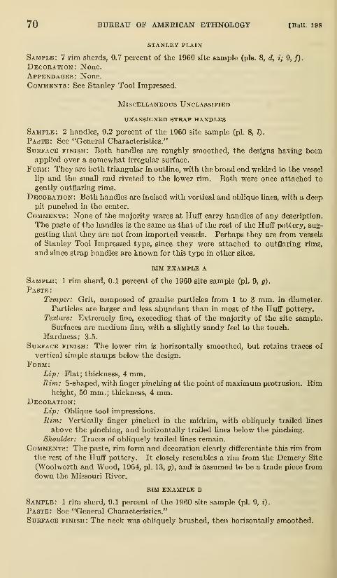
70 BUREAU OF AMERICAN ETHNOLOGY [Bull. 198
STANLEY PLAIN
Sample: 7 rim sherds, 0.7 percent of the 1960 site sample (pis. 8, d, i; 9, /).
Decoration: None.
Appendages: None.
Comments: See Stanley Tool Impressed.
Miscellaneous Unclassified
unassigned strap handles
Sample: 2 handles, 0.2 percent of the 1960 site sample (pi. 8, l).
Paste: See "General Characteristics."
Surface finish: Both handles are roughly smoothed, the designs having beenapplied over a somewhat irregular surface.
Form: They are both triangular in outline, with the broad end welded to the vessel
lip and the small end riveted to the lower rim. Both were once attached to
gently outflaring rims.
Decoration: Both handles are incised with vertical and oblique lines, with a deeppit punched in the center.
Comments: None of the majority wares at Huflf carry handles of any description.
The paste of the handles is the same as that of the rest of the Huff pottery, sug-
gesting that they are not from imported vessels. Perhaps they are from vessels
of Stanley Tool Impressed type, since they were attached to outflaring rims,
and since strap handles are known for this type in other sites.
RIM example a
Sample: 1 rim sherd, 0.1 percent of the 1960 site sample (pi. 9, g).
Paste :
Temper: Grit, composed of granite particles from 1 to 3 mm. in diameter.
Particles are larger and less abundant than in most of the Huflf pottery.
Texture: Extremely fine, exceeding that of the majority of the site sample.
Surfaces are medium fine, with a slightly sandy feel to the touch.
Hardness: 3.5.
Surface finish: The lower rim is horizontally smoothed, but retains traces of
vertical simple stamps below the design.
Form:Lip: Flat; thickness, 4 mm.Rim: S-shaped, with finger pinching at the point of maximum protrusion. Rim
height, 50 mm.; thickness, 4 mm.Decoration:
Lip: Oblique tool impressions.
Rim: Vertically finger pinched in the midrim, with obliquely trailed lines
above the pinching, and horizontally trailed lines below the pinching.
Shoulder: Traces of obliquely trailed lines remain.
Comments: The paste, rim form and decoration clearly diflferentiate this rim fromthe rest of the Huflf pottery. It closely resembles a rim from the Demery Site
(Woolworth and Wood, 1964, pi. 13, g), and is assumed to be a trade piece fromdown the Missouri River.
RIM example b
Sample: 1 rim sherd, 0.1 percent of the 1960 site sample (pi. 9, i).
Paste: See "General Characteristics."
Surface finish: The neck was obliquely brushed, then horizontally smoothed.

pLp. No.' slT' MANDAN CULTURE HISTORY—WOOD 71
Form:Lip: Flat; thickness, 5 mm.Rim: Slightly outflaring. Rim height, about 50 mm.; thickness, 5 mm.
Decoration:Lip: Oblique tool impressions.
Rim: Three horizontally incised lines were high on the rim (this observation
based on field notes, as the sherd crumbled on removal from the soil)
.
Comments: The neck brushing, in conjunction with the horizontally incised lines,
suggests a relationship to the type Nordvold Horizontally Incised (Wilmeth,
1957, pp. 44-45). The Huflf rim, however, has a simple flat hp; the Nordvoldrims generally have extruded lips.
RIM EXAMPLE C
Sample: 1 rim sherd, 0.1 percent of the site sample (pi. 9, k).
Paste: See "General Characteristics."
Surface finish: Although the impressions are too faint for positive identification,
the rim was either vertically brushed or was cord roughened before it wassmoothed.
Form:Lip: Flat; thickness, 6 mm.Rim: Gently outflaring.
Decor.'Vtion:
Lip: Zigzag hnes of alternating oblique, deep incisions.
Rim: Plain.
Shoulder: Traces of an incised design remain.
Comments: This rim differs from other local types and examples, particularly
if it is cord roughened, and not brushed.
RIM example d
Sample: 2 rim sherds, 0.2 percent of the site sample (pi. 9, I).
Paste: See "General Characteristics."
Surface finish: Horizontally smoothed.Form:
Lip: Flat; thickness, 6 mm.Rim: S-shaped, with the rim thickest above the point of maximum protru-
sion. Rim height, 35 mm.; thickness, 6 to 10 mm.Decoration:
Lip: Plain.
Rim: Evenly spaced punctates on the upper rim.
Appendages: One rim has a small, horizontally projecting lug.
Comments: This rim is unlike any previously described pottery from nearbysites.
unclassified cord impressed rims
Sample: 317 rim sherds, 32.6 percent of the 1960 site sample.Comments: These are unclassifiable fragments of the two cord-impressed types
in the site, Fort Yates Cord Impressed and Le Beau Cord Impressed.
Body Sherds
All of the pottery from Huff recovered in 1960 appeared to havebeen modeled with a grooved paddle, resulting in a ridged surface
generally termed simple stamped. The majority of the body sherds
are classed as simple stamped: 2,381 sherds, or 63.0 percent of the

72 BUREAU OF AMERICAN ETHNOLOGY [Bull. 198
sample. Any sherd which retained traces of these stamps was classed
as simple-stamped, even though smoothing had nearly obliterated
the impressions, since virtually all vessels were smoothed to somedegree. There were only rare cases where clear, clean paddle im-
pressions remained unmarred by smoothing. The category of
smoothed sherds is seK-explanatory; they included 814 sherds, 21.6
percent of the sample. Decorated sherds are next in order of occur-
rence; there were 533 of them, 14.0 percent of the sample. Theywere incised, trailed, or punctated, and in all instances were from
the vessel shoulder area. Three complete patterns were recorded
(fig. 1, a-c), and parts of several others (fig. 1, d-e; fig. 2; pi. 9, 6).
These patterns and pattern fragments were carefully analyzed in
an effort to illustrate the full range of variation found.
The distributions of these patterns and elements are plotted byhouse, and the number of fragments identifiable as to pattern or
design element, as illustrated in figures 1 and 2, are recorded in
table 12. The incentive for this tabulation was a statement by Bowers
(1950, p. 62) that a Mandan girl made "crude pots when the womenof the lodge were making pottery, and, when old enough, she bought
her mother's rights in the techniques and designs of pottery-making."
Only a few of the patterns—most of them fragments—were confined
in their distribution to any one house. This pattern of distribution
suggests that pottery inheritance, if it did pass rights to designs from
mother to daughter, involved concepts of distinctiveness of pattern
not recognized in the sorting; that is, what I regarded as an unim-
portant variation may have been a subtle variation "owned" by an
individual. An alternative suggestion is that the patterns were in
fact owned by a larger entity, probably the clan. Since clan memberstended to build their homes near one another, we could expect that

pLp No siT'MANDAN CULTURE HISTORY—^WOOD 73
'JLt. HI V I t . I
I l> /I'iill.!'//
.r
Qooagaaoo oaaooo o a oao o aoooooiiQQaoooaoQOoacioooooooooooooo
Figure -t.—Pottery shoulder patterns and elements (various scales).
houses close together would tend to contain the same patterns. The
fragmentary nature of the patterns, however, prevents any reaUy
detailed presentation of their distribution.
There were 51 red-filmed sherds, or 1.4 percent of the sample.
These sherds, including both simple-stamped and smoothed examples,
were coated on their interiors with a thin film of red ocher. There

74 BUREAU OF AAIERICAN ETHNOLOGY [Bull. 198
Figure 2.—Fragmentary pottery shoulder patterns and elements. a,b, "Bear
foot" elements. f,g, Two sherds from the same vessel, juxtaposed in positions
believed to approximate the continuation of the pattern, c-e, h-j, Other
fragmentary patterns. Sherds are oriented so that the neck is toward the
top of the figure.
was no trace of cord-roughened or of check-stamped sherds in any of
the extensive 1959 or 1960 excavations, although Bowers (MS. b,
p. 77) states that 1.2 percent of his sample from the site was check
stamped.

pip No^' 39]' MANDAN CULTURE HISTORY—WOOD 75
Secondary uses for pottery included the manufacture of rough-
shaped disks. One of them (pi. 9, m) is centrally pierced. Theother piece is partly shaped, four edges having been smoothly ground.
CHIPPED STONE
PROJECTILE POINTS (88 SPECIMENS)
The first four of the seven classes of projectile points are small
specimens made from thin flakes of gray chert and from Knife River
chalcedony. They are usually bifacially flaked, although a few re-
tain one surface of the original flake. Flaldng is random. Thebasic form of these four classes is triangular, with straight to gently
convex blade edges; their size suggests that they are arrowpoints.
1. Triangular, straight base, two side notches (22 specimens).
—
Lengths of complete specimens range from 20 to 33 mm.; widths,
from 11 to 16 mm.; thickness, from 2 to 3 mm. (fig. 3, a).
2. Triangular, concave base, two side notches (17 specimens).—
Lengths of complete specimens range from 24 to 34 mm. (with lengths
of broken points estimated up to 40 mm.) ; widths, from 13 to 19 mm.
;
thickness, from 2 to 5 mm. (fig. 3, b).
3. Triangular, straight base, unnotched (18 specimens).—Lengths of
complete specimens range from 20 to 40 mm.; widths, from 14 to 23
mm.; thickness, from 2 to 6 mm. (fig. 3, c).
4. Triangular, concave base, unnotched (7 specimens) . —Lengths of
complete specimens range from 24 to 27 mm. (with lengths of broken
specimens estimated up to 40 mm.); widths, from 15 to 19 mm;thiclaiess, from 3 to 4 mm. (fig. 3, d).
Triangular points lacking bases, no apparent side notches (15 speci-
mens). These consist of unci assifiable point tips.
The following three classes of projectile points differ from the
first four classes in being much larger and heavier than points generally
regarded as arrowpoints. They may be dart points or knives.
5. Lanceolate, straight base and sides, two side notches (2 specimens) .
—
These two broken artifacts are composed of light-gray quartzite and
of dark-brown chert. The more nearly intact specimen (fig. 3, /)
is now 49 mm. long, 25 mm. wide, and 5 mm. thick; originally it
may have been twice as long. The base and the notches are smoothly
ground. The smaller fragment, consisting only of the base broken
through the side notches, is 39 mm. wide and 7 mm. thick; the base
is not ground (fig. 3, e).
6. Triangular, straight edges, irregular base, two side notches (2
specimens).—The one complete implement, of Knife Kiver chalce-
dony, measures 65X27X6 mm. The cross section is thickly lentic-
ular; the base is thinned but is not ground (fig. 3, j). The base of

76 BUREAU OF AMERICAN ETHNOLOGY [Bull. 198
L N
Figure 3.—Projectile points and drills, a, Triangular, side-notched arrowpoints
with straight bases, h, Triangular, side-notched arrowpoints with concave
bases, c, Triangular, unnotched arrowpoints with straight bases, d, Trian-
gular, unnotched arrowpoints with concave bases, ej, Large side-notched
points, g, Straight-shafted drills, h, Expanding base drills. i,j, Large,
triangular, side-notched points. k,l, Hanna points, m-o, Unclassified points.
The dots above the notches denote the extent of basal grinding.

pip. N^f." slY" MANDAN CULTURE HISTORY—^WOOD 77
what appears to be a similar point is broken above the side notches
(fig. 3,i).
7. Miscellaneous 'points (5 specimens),—Two of these points con-
form to the description of the Hanna point (Wheeler, 1954, pp.
8-9), and were identified as Hanna points by Wheeler (personal
communication). One of them, lacking only the tip, measures
39X21X6 mm. (fig. 3, k). The other point, also broken, is 38X22X6mm. The sides of the stem and base are smoothed (fig. 3, t). Bothpoints are composed of Knife River chalcedony.
Three of the five miscellaneous points are of unnamed types. Eachof them is side notched, the blade outline ranging from lanceolate
to triangular. The lanceolate specimen (fig. 3, m) measures 50X 19X7mm. The cross section is lenticular, the base lacks grinding. Wheel-
er (personal communication) says that the form, finish, size, and
proportions suggest that it may be contemporaneous with McKean,Duncan, and Hanna points {i.e., Middle Prehistoric, Early Stage);
it was made from Knife River chalcedony. The other two points
(fig. 3, n, o) measure 42X20X8 mm. and 36X22X6 mm. Thelarger one is of gray chert, the other of petrified wood. Neither
of them is smoothed on the base or sides, and both have lenticular
cross sections. Wheeler states that the form, finish, size, and propor-
tions of the specimens suggest that they postdate the Hanna points
{i.e., Middle Prehistoric, Late Stage).
STRAIGHT-SHAFTED DRILLS (5 SPECIMENS)
Long, thick flakes of gray chert and of Knife River chalcedony are
bifacially flaked, with diamond-shaped cross sections, and have one
blunt and polished tip. Shafts taper from a convex base toward the
tip. Complete specimens measure 42X15X6 mm. and 54X13X6mm. (fig. 3, g). One of them, with two side notches near the base, wasprobably hafted.
EXPANDING BASE DRILLS (4 SPECIMENS)
Irregular flakes of Knife River chalcedony with one pointed end were
bifacially flaked to bring this point to a sharp tip, which has been pol-
ished by use. Maxium length, 42 mm. (fig. 3, h).
END SCRAPERS (165 SPECIMENS)
1. Planoconvex scrapers (136 specimens).—Each implement in this
class was prepared from a planoconvex flake; the steep working edge
is on the end opposite the bulb of percussion. The convex surface maybe keeled, flaked, or irregular. They are subdivided as foUows:

78 BUREAU OF AMERICAN ETHNOLOGY [Bull. 198
Small Largetools tools Figure No.
Keeled, symmetrical working edge 12 4, a, &.
Keeled, asymmetrical working edge
Keeled, with graver tip on working edge
Flaked or irregular upper surface, symmetrical workingedge
3 .

pLp. No^; siT' MANDAN CULTURE HISTORY—WOOD 79
w
Figure 4.—Chipped stone artifacts, a-g, Planoconvex end scrapers, h-m,Bifacially flaked end scrapers. n,o, End scrapers with gravers on workingedges. p,q, Plate chalcedony knives, r, Broad, oval knife. s,t, Broad,
triangular knives with straight bases, u-w, Leaf-shaped knives.

80 BUREAU OF AMERICAN ETHNOLOGY [Bull. 198
G
5J I 1 I
N
Figure 5.—Chipped and ground stone artifacts. a,b, Narrow, oval knives.
c,d, Narrow, pointed knives. e,f, Pendants, g, Scoria bead, h, Groovedironstone nodule, i, Large planoconvex end scraper, j, Large bifacially
flaked end scraper. k,l, Sandstone shaft smoothers. 4r m, Chopper, n, Sand-
stone game piece, o, Scoria abrader. p, Shaped^mano.

pip. No^'slY' MANDAN CULTURE HISTORY—WOOD 81
2. Triangular knives with straight bases (10 specimens).—Theseknives, essentially triangular in outline, have gently convex edges,
straight (but sometimes oblique) bases, and blunt tips. Material
includes gray chert, Knife River chalcedony, and mottled gray chert.
Only one of them is unifacially flaked. In size they range from
55X41X6 mm. to 126X38X12 mm. (fig. 4, s, t).
3. LeaJ-shaped knives (21 specimens).—There is considerable vari-
ation in the size range of this class, with examples ranging from
29X29X4 mm. to as large as 101X33X8 mm., and it includes the
smallest class of tools termed "broad knives." Some of the smaller
implements are small enough to be classed as projectile points,
probably arro\^^oints, but their inclusion with knives is based on
the lack of notching and upon the roughness of flaking and asymmetryof outline (fig. 4, w). Materials include gray chert and Knife River
chalcedony, with rare use of mottled chert and translucent chalcedony.
Specimens have distinctly convex blade edges, with evenly convex
bases and sharp to predominantly blunt points. All are bifacially
flaked. A sample of them is illustrated to depict the range in size
and form (fig. 4, u-w).
4. Broad knije fragments (65 specimens).—Fragments of broken
broad knives, none of them identifiable as to form, may be classed
as follows: pointed ends, presumably tips, 22 specimens; straight
ends and convex ends, presiunably knife bases, 14 and 11 specimens,
respectively; and midsections, 18 specimens.
NARROW KNIVES (57 SPECIMENS)
This class of knives differs from the preceding class in that they
are elongated, narrow implements with more nearly parallel blade
edges. There are two categories, based on blade outline, and each
of them is bifacially flaked, with evenly lenticular cross sections.
Material is gray chert and Knife River chalcedony. The flaking
on them is finer and more regular than on the broad knives.
1. Oval knives (9 specimens).—These are exceptionally elongated
oval knives with gently convex blade edges and convex ends. Theyrange in size from 52X20X6 mm. to one exceptionally large imple-
ment 108X24X7 mm. (fig. 5, a, b).
2. Leaf-shaped knives (13 specimens).—This category tends to havegently convex to nearly straight bases, gently convex blade edges,
and sharp to predominantly blunt tips—it is sometimes difficult to
separate them from oval knives, for there is no clear break betweenthem. Size ranges from 53X18X6 mm. to 91X19X7 mm. (fig.
5, c, d).
3. Narrow knife fragments (35 specimens).—Fragments of knives
not classifiable as to form include pointed ends, presumably tips, 10

82 BUREAU OF AMERICAN ETHNOLOGY [Bull. 198
specimens; midsections, 10 specimens; and convex ends, either bases
or tips, 15 specimens.
CHOPPERS (45 SPECIMENS)
Large flakes that have been bifacially percussion flaked to form
oval tools are described as choppers. Gray chert was the preferred
material; there is only one specimen of diorite, and one of Knife
River chalcedony. These are aU large tools with thick cross sections,
roughly lenticular, and edges are even to predominantly irregular.
There is little secondary finish flaking along the edges. They range
in size from 95X57X16 mm. to 174X66X24 mm. (fig. 5, m).
MODIFIED FLAKES (404 SPECIMENS;
Irregular flakes and symmetrical blades, including a few ribbon
flakes, were used as cutting and scraping implements without pur-
poseful flaking except along the edge. They are divided into the
following classes:
Flake scrapers (unifacially flaked) 279
Edges purposefully flaked 150
Edges retouched by use 129
Flake knives (purposefully, bifacially flaked) 125
The most popular stones were gray chert and Knife River chalcedony,
with rare examples of petrified wood, translucent chalcedony, red
chert, and dark mottled chert.
GROUND STONE
DIORITE CELTS (40 SPECIMENS)
Diorite celts, pecked and smoothly ground to shape, are sub-
rectangular in outline, with one end ground to a sharp, wedge-shaped
edge; polls are flattened and usually battered from use as a hammer.
Cross sections are predominantly subrectangular, but four of them
are oval in section. The cutting edges are about the same width
as the maximum width, or slightly narrower, and are often battered.
The size ranges from 100X55X39 mm. to 199X85X50 mm. (fig. 6,/).
One atypical specimen has been slightly reduced in diameter between
its midpoint and the poll (fig. 6, e).
DIORITE AX (l specimen)
This pecked and ground ax is flatly oval in cross section, with one
end ground to a wedge-shaped cutting edge, and with a convex,
battered poll. A full groove encircles the ax near the poll. It
was first pecked out, then ground smooth. The implement measures
174X66X24 mm. (fig. 6, d).

Rlv. Bas. Sur.Pap. No. 39]
MANDAN CULTURE HISTORY—WOOD 83
Figure 6.—Ground stone artifacts, a, Grooved abrader. h, Spherical ham-merstone. c, Pipe, d, Diorite ax. e,f, Diorite celts, g, Grooved maul.
ARROWSHAFT SMOOTHERS (5 FRAGMENTS)
Boat-shaped blocks of a coarse-grained, light-brown sandstone
have straight, symmetrical longitudinal grooves in their long axes.
These grooves are shallow and U-shaped. The ends of the objects
are straight or convex (fig. 5, k, I).
221-350—67 7

84 BUREAU OF AMERICAN ETHNOLOGY [Bull. 198
ABBADERS (41 SPECIMENS)
There are 12 slabs of coarse-grained sandstone, as much as 165
mm. long and 17 to 31 mm. thick, bearing irregular grooves on their
flat surfaces. The grooves, U- and V-shaped, are of unequal depth.
The remaining 29 implements are chunks of scoria, with maximumdiameters of 110 mm.; they have one or more smoothly ground sur-
faces or are grooved along one or more flat surfaces (fig. 5, o; fig.
6, a).
GROOVED IRONSTONE NODULES (l6 SPECIMENS)
Spherical nodules of ironstone, ranging from 35 to 62 mm. in
diameter, are encircled by a full groove. The ends are not battered.
The grooves are V-shaped cuts in 12 specimens, and are shallow
pecked grooves in 4 others. Three of the nodules were in a group
together near a sidewall in House 4, and elsewhere also they occurred
most commonly along house walls (fig. 5, h).
GROOVED MAULS (24 SPECIMENS)
Oval to somewhat irregular granite pebbles, grooved at their
midpoint, are battered on both ends. The only modification beyond
grooving the implement by pecking and by battering the ends occurs
on two implements which were pecked and smoothed to achieve a more
regular form than was provided by the original pebble. There is one
three-quarter grooved maul; the rest of them are full grooved (fig.
6, g). In size they range from 46X46X37 mm. to 165X137X108mm.
ANVIL (l specimen)
A large, oval granite cobble, measuring 154X151X75 mm., is
pitted on one flat face. The shallow, basin-shaped pit was pecked
into the stone.
METATES (23 SPECIMENS)
Irregular to rectangular slabs of coarse-grained sandstone or
granite were used as meahng stones. One side bears a shallow
trough with longitudinal striations; manos were frequently located
beside them. They were most common along the sidewaUs of the
houses (e.g., maps 8 and 11, Houses 4 and 7).
SHAPED MANOS (8 SPECIMENS)
All of these implements are made from granite pebbles. Two of
them, rectangular in form, are fully shaped, with aU surfaces evenly
finished. One of them measures 82X72X53 mm.; the other, 105
X
70X56 mm.There are also six discoidal pebbles with evenly convex edges,
battered and pecked into oval to circular form. There is a shallow
depression pecked into one of the two flat faces. Surfaces are

pip. N^'slT' MANDAN CULTURE HISTORY—^WOOD 85
smoothed, and flat surfaces striated. Size ranges from 84X82X47mm. to 113X99X54 mm. (fig. 5, p).
HAMMER MANOS (19 SPECIMENS)
Granite pebbles, oval in shape, are ground smooth on one or morefaces, and are battered on one or both ends or along their edges.
They range from 70X66X29 mm. to 109X85X67 mm.
BATTERED SPHERE HAMMERS (14 SPECIMENS)
Thirteen gray chert cores, and one ironstone nodule, were evenly
battered on all surfaces, resulting in a nearly spherical form. Diam-eters range from 52 to 101 mm. (fig. 6, b).
PEBBLE HAMMERSTONES (25 SPECIMENS)
Granite pebbles, from 50 to 94 mm. in diameter, were used as
hammers on either or both ends, or on their sides, without further
shaping.
GAME PIECE (1 SPECIMEN)
A thin disk of fine-grained sandstone, 49 mm. in diameter and 13
mm. thick, was roughly shaped by grinding both flat faces and bypecking and grinding the edges (fig. 5, n).
BEADS (4 SPECIMENS)
Three large and one small disk beads were made from dense scoria;
they were pierced from both sides. The three large beads average
18 mm. in diameter and 8 mm. in thickness (fig. 5, g) ; the small beadis estimated to have been 10 mm. in diameter and 6 mm. thick.
PENDANTS (2 SPECIMENS)
One rectangular, broken piece of dense scoria (fig. 5,/), and a small,
irregular piece of very dense buff clay (fig. 5, e) have been pierced
for suspension.
PIPE (1 SPECIMEN)
This broken specimen was recovered by Thad. Hecker in House 18
during fieldwork in 1939. The illustration (fig. 6, c), prepared from
photographs, depicts this gray sandstone pipe. It is now 63 com. long
(the prow is absent), 63 mm. high, and 38 mm. wide. The orifice of
the bowl is 30 mm. in diameter.
BONE
(SCAPULA HOES 180 SPECIMENS)
This most common of bone implements was fashioned from bison
scapulae that were modified only by the removal of the spine and poste-
rior border in order to obtain a flat working surface. The glenoid is
intact and there is no apparent notching on the blade edges. Size

86 BUREAU OF AMERICAN ETHNOLOGY [Bull. 198
varies considerably, depending on the original size of the scapula andupon the amount of use, since dull hoes were resharpened until they
were quite short. Ends of the hoes are usually straight when they
are sharp (fig. 7, e), but the duller blades are convex. Two hoe
fragments are pierced near the blade edge (fig. 10, d).
HORN CORE-FRONTAL BONE SCOOPS (19 SPECIMENS)
The proximal ends of bison horns and adjoining parts of the frontal
bonewere hacked from the skull and fashioned into scoop-shaped imple-
ments. Interior surfaces are concave and could have accommodateda handle; all of them are grooved along their edges. These grooves
could have been used for securing the tool to a handle, but they also
provide very comfortable handgrips. The blade edge is generally dull
and much worn (fig. 7, d).
SCAPULA KNIVES 16 (SPECIMENS)
Six of these implements are pohshed, rectangular sections cut
from thin sections of bison scapulae. One edge retains traces of
a reduced scapular spine, and the opposing edge is sharpened.
Lengths range from 119 to 196 mm.; widths, from 74 to 95 mm.(fig. S,h).
Elongated, generally convex-edged slivers of scapula are also classed
as knives when one or both edges are sharpened. Such tools rarely
retain any part of the scapular spine, and surfaces are smooth to
glossy; one end of the tool is generally pointed (fig. 8, d). One of
them is hook-ended (fig. 8, c). Lengths range from 125 to 186 mm.;widths, from 29 to 44 mm.
SHAFT WRENCHES (8 SPECIMENS)
One or two holes occur in large ribs. None of the tools are intact,
and most of them are broken through the perforations. The holes
are consistently oval, with the edges of the hole beveled. In each
instance the beveling is most pronounced on the long axis of the
tool. A pencil inserted in these holes and incHned along the long
axis lies flush on the beveled edges on opposing sides of the hole.
This circumstance lends support to the suggestion that they are,
in fact, "shaft wrenches." It is hkely that thong-stropping would
have created a somewhat less symmetrical hole. Lengths of the
total implement were in excess of 180 mm. Four of them are decora-
ted. One is simply incised along the edges; on another, two incised
lines form an "X" on one side. Two others are illustrated (fig. 8,
e,f) that depict anthropomorphic designs.

Rlv. Bas. Sur.Pap. No. 39]
MANDAN CULTURE HISTORY—WOOD 87
5.J I
cm.
i
! i
Figure 7.—Bone artifacts, a, Bison humerus gouge, b, Bison humerus
abrader. c, Cannon bone flesher. d, Bison horn core-frontal bone scoop.
e, Scapula hoe.
CANNON BONE FLESHERS (2 SPECIMENS)
The cannon bones of elk were used with some of the anklebones
in articulation, presumably held in place by the ligaments and sldn,
while the middle of the shaft of the bone was cut and worked into a

88 BUREAU OF AMERICAN ETHNOLOGY [Bull. 198
4m
L.iil
]m
ui m
E F G H
FiGUEE 8.—Bone artifacts, a, Punches, b, Chisel, c, Hook-ended scapula
knife, d, Elongated scapula knife. e,f, Embellished arrowshaft wrenches.
g, Polisher, h, Rectangular scapula knife.
rounded blade. The most complete specimen is 295 mm. long; the
blade edge is beveled but not serrated (fig, 7, c). The fragments
of another specimen bear V-shaped serrations on the blade.
BIRD BONE TUBES (2 SPECIMENS)
Both of these items, probably ornaments, are broken. One of
them, split in half, is 44 mm. long; the other was originally more

pip. No^; slY' MANDAN CULTURE HISTORY—^WOOD 89
than 65 mm. long. Both are lightly polished but their ends are not
smoothed.
BISON HUMERUS ABRADERS (5 SPECIMENS)
The cancellous tissue in the bison humerus cap served as a hide
grainer or thinner when the cap was removed from the shaft andthe side opposite the broad articulating surface was smoothed.
There is a gradation in size according to the amount of work doneto bring them to shape. The largest, and perhaps least-used im-plement is illustrated (fig. 7, 6), but others no longer retain any of
the outer compact bone layer.
BONE AWLS (103 SPECIMENS)
The following classification of the bone awls follows that of Kidder
(1932), with modifications as necessary:
Mammal long bone 82Head of bone left intact 2
Head of bone unworked, split 19
Head of bone partly worked 39Head of bone removed 12
Splinter awls 2
Unclassifiable tips 8
Mammal rib awls 6Mammal scapula splinter awl 1
Bird long bone awls 13
Head of bone left intact 10Head of bone removed 1
Splinter awls 2
Needle (?) 1
Total 103
Mammal long bone awls (82 specimens):
Head of hone left intact (2 specimens).—One of these, part of the
metapodial of an immatiu-e deer, has a detached epiphysis; it is 84 mm.long (fig. 9, a, right). The other, made from the distal end of a canid
tibia, is 113 mm. long. Near the tip the bone is glossy, but the butt
is rough, suggesting that it may have been covered with hide (fig. 9,
a, left).
Head of hone unworked except hy original splitting (19 specimens).
—
All of these seem to be made from deer metapodials, the bulk of them(12) fashioned from the proximal ends. They are from 65 mm. to
more than 164 mm. long. The seven awls made from the distal endare 67 to 132 mm. long; most of them are short and stubby, withsharp tips (fig. 9, 6).
Head of hone partly worked down (39 specimens).—Specimens of
this class are also made from deer metapodials, and, again, the prox-

90 BUREAU OF AMERICAN ETHNOLOGY [Bull. 198
imal end is more popular (24 instances). Lengths range from 46 to
more than 145 mm. (fig. 9, c).
B

Pap. N^f.' 39]' MANDAN CULTURE HISTORY—WOOD 91
Head oj bone removed (12 specimens).—These awls cannot be
certainly identified as to the source bone, but most of them appear
to be made from deer metapodials, although some are obviously
from larger and heavier bones. Lengths range from 52 to 167 mm.;points are sharp and tapered (fig. 9, d).
Splinter awls (2 specimens).—These are made from irregular bonesplmters, one pointed end having been ground to a sharp point
(fig. 9, 6).
Unclassifiable tips (8 specimens).
Mammal rib awls (6 specimens)
:
Large ribs, probably from bison, were split, and the midsections
fashioned into broad, flat awls with sharply tapering tips and rounded
butts. The cancellous tissue is removed and the bone is smoothed;
lengths range from 95 to 144 mm. (fig. 9, j).
Mammal scapula splinter awl (1 specimen).— This awl is made from
a splinter of the scapula of a large animal, perhaps bison. One end
is ground to a point; the length is 90 mm. (fig. 9, k).
Bird long bone awls (13 specimens):
Head oj hone left intact (10 specimens).—Proximal and distal
ends of bird ulnae, radii, and tibiae were made from the whistling
swan, golden eagle, whooping crane, and great horned owl (?), Onearticular end is intact on each; the center of the shaft was brought
to a very sharp point. Lengths range from 53 to 156 mm. (fig. 9, g).
Head of bone removed (1 specimen).—This section of unidentified
bone is 79 mm. long; the tip is quite sharp (fig. 9, h).
Splinter awls (2 specimens).—These splinters, 75 and 126 mm. long,
have very sharp tips; butts are not smoothed.
Needle (?) (1 specimen)
:
This unusual specimen, made from compact bone with no cancellous
bone remaining, may be a small awl or a needle. It is now 74 mm.long (both ends are gone) and is 2 mm. thick. The shaft is square
in section, but toward the small end it is circular (fig. 9, i).
GAME PIECES (22 SPECIMENS)
These are rectangular pieces of bone cut from the wall of long
bones of large mammals, probably bison, \\dth symmetrical outlines
and smoothed edges. Some of them, perhaps unfinished pieces, have
battered edges and show marks of transverse sawing. The largest
(and unfinished) specimen is 72X48X7 mm.; the smallest and finest
piece is 42X32X6 mm. The convex outer surfaces are glossy and
polished, and the inner surfaces are smoothed so that cancellous
tissue is nearly obliterated (fig. 10, 6). SLx of them are pierced or
decorated with incised lines. Holes were made by drilling from both
sides with a conical drill. Five of the six embellished pieces are il-
lustrated (fig. 10, a).

92 BUREAU OF AMERICAN ETHNOLOGY [Bull. 198
p"^

pip. N^f; slY' MANDAN CULTURE HISTORY—WOOD 93
and form among them, but it was not feasible to divide them into
distinctive subclasses. By and large, they consist of tools that are
rounded on both ends, merging with specimens that are rounded onone end and pointed on the other, with no clear break between these
forms. None of them are decorated. Lengths of complete speci-
mens, 68 to 275 mm. (fig. 10, e).
BIFACIALLY FLAKED LONG BONE SECTIONS (2 SPECIMENS)
Both of these objects were fashioned from midsections of large
mammal long bones. One of them is complete: it is 106 mm. long,
29 mm. wide, and 10 mm thick. One squared end was shaped bybifacial percussion flaking; the other ead is smooth and rounded.
Their function is unknown (fig. 10, c).
CHISELS (9 SPECIMENS)
Sections of large mammal long bones, articular ends of bison
scapulae, and scapula fragments were made into chisels. Thesetools are not finished except for a carefully prepared chisel edge onthe smaller end of the bone. One side of the blade is beveled. Artic-
ular ends are retained only in the case of two bison scapulae; the
other implements were used without specially preparing the butt or
they are broken (fig. 10, f). One intact specimen with a sharp
chisel edge is battered on one end from hammer blows heavy enoughto detach large flakes of bone (fig. 10,/, lejf).
SPATULA (2 SPECIMENS)
One section of what appears to be a mammal long bone has two small
"wings" on the end opposite the spatulate end. It is 82 mm. long;
surfaces are glossy (fig. 9,/). Another less elaborate specimen has
one spatulate end and the other is battered. It is made from long
bone, is highly polished, and is 63 mm. long.
POLISHERS (9 SPECIMENS)
Segments of bison scapulae and midsections of large mammal ribs
and long bones have one pointed end which is ground to a dull finish.
These ends are faceted and are occasionally lightly striated. In
three instances the end opposite the point is battered. Lengthsrange from 162 to 198 mm. (Fig. 8, g).
PUNCHES (6 SPECIMENS)
These tools resemble awls in some particulars, but their blunt
tips distinguish them from awls. Three are long bone splinters
with one pointed end ground to a blunt tip; one is a midsection of
a large rib with one worked end; and two others are tips brokenfrom split rib tools. Butts are either broken or were not specially

94 BUREAU OF AMERICAN ETHNOLOGY [Bull. 198
prepared; lengths of the larger and not obviously broken tools range
from 128 to 152 mm. (fig. 8, a).
BISON HUMERUS GOUGE (1 SPECIMEN)
A rectangular section of bone from near the proximal end of a bison
humerus provided the raw material for this tool. One end was hackedaway and ground to a sharp edge; the butt is rough and may be broken.
The sides are battered and rough and there are shallow notches which
would have been convenient for lashing down a handle. The length
is 89 mm. (fig. 7, a).
MISCELLANEOUS BONE TOOLS (5 SPECIMENS)
These items, found sketched in Thad. Hecker's notebook from House5, have been redrawn here (see fig. 12, a-c). Except for the bone tubes
or beads they are not readily identifiable, although item c may be a
fishhook blank.
ANTLER
SCRAPER HAFT (1 SPECIMEN)
An L-shaped scraper haft, made from the brow tine of elk, is 311
mm. long, with a maximum diameter of 49 mm. at the grip. The end
used to attach the scraper is fragmented and the inner surface of the
short arm is unmodified. The handle is smoothed, and there is a
lightly incised groove encircUng the handle at the midpoint (fig. II, i).
BRACELETS (13 SPECIMENS)
Five broad, flat bracelets were made from thin strips of antler.
Four of them are embellished; none of them is intact. Ends, whenpresent, are pierced from both sides by a conical drill. The convex
sides are smooth to glossy; the concave surfaces are scored by parallel
striations remaining from the shaping process. The bracelets are 13
to 38 mm. in width, 2 to 4 mm. in thickness. The largest one is lightly
incised with the body of a bird (fig. 11, a); two others are scored along
the edges (fig. 11, c, d); and the other is engraved with part of an arrow-
shaped element (fig. 11, b).
Eight segments of bracelets are oval to rectangidar in cross section;
none is decorated. Seven ends are pierced for attachment from
both sides with a conical drill, and one is scored for attachment.
The most slender one (fig. 11, f) is carefully smoothed on all sur-
faces, while the others are less carefully finished (fig. 11, g). Diam-eters are 4 to 10 mm.
BARREL-SHAPED ANTLER TOOLS (6 SPECIMENS)
Short, cylindrical segments transversely cut from near the butt
or from the midsection of large deer antlers may be rubbing tools.
One end is smoothed and gently convex, while the other is unfinished

Rlv. Bas. Sur.Pap. No. 39] MANDAN CULTURE HISTORY—WOOD 95
k?m
B
Figure 11.—Antler artifacts, a-d, Broad bracelets, e, Tine flaker. /,gf, Narrowbracelets, h, Barrel-shaped rubbing tools, i, L-shaped scraper haft.
on each complete specimen. Three of the convex ends are pitted
as though they had been used for pestles. Intact specimens range
from 46 to 58 mm. in length, but larger and fragmentary examples
attain lengths in excess of 78 mm. (fig. 11, h).
TINE FLAKERS (5 SPECIMENS)
Tines were sometimes cut from the racks of deer or elk by trans-
versely sawing through the outer compact layer, then by snapping

96 BUREAU OF AMERICAN ETHNOLOGY [Bull. 198
the softer interior. Two of these objects were made in this manner.The tine shafts are longitudinally scored by a multitude of closely
spaced grooves, and the tips are round and blunt. Three other
implements, simply broken from the rack, carry small nicks andstriations near and at the tip which resemble those on tines which
were experimentally used to flake chert. Lengths range from 65
to 136 mm. (fig. 11, e).
SHELL
SCRAPERS (27 SPECIMENS)
The valves of fresh water moUusks were cut and ground to formtools best described as scrapers. There are two forms: (1) Theshell was cut from the umbo (or from a complementary position on
the ventral side) obliquely toward the anterior end, leaving a sharp
to blunt tip; there are seven such specimens (fig. 12, q). (2) Other
valves were cut on both sides of the anterior end, the resulting tool
having a V-shaped working end with a shai-p to blunt tip; there
are six such implements (fig. 12, r). In addition, there are 14 specimens
so broken that they cannot be clearly identified as to form. Thesize of the implement depends on the size of the moUusk chosen as
raw material. Species used include Lampsilis luteola (Lamarck),
Lasmigona complanata (Barnes), and Anodonta grandis Say (identifi-
cations all by Dr. J. P. E. Morrison).
PENDANTS (2 SPECIMENS)
The valve of a small fresh-water mollusk identified by Morrison as
Crenodonta costata (Rafinesqtie) is pierced near the umbo by sawing
through the shell (fig. 12, n). A broken piece of thin, fresh-water
mollusk shell, originally oval in outline, was pierced for attachment
by a biconical hole (fig. 12, m).
RING (1 SPECIMEN)
This ring-shaped item, 42 mm. in diameter, was cut from the shell
of a heavy, fresh-water mollusk. The broken ends have been
smoothed; the cross section is rectangular (fig. 12, o).
THUNDERBIRD EFFIGY (1 SPECIMEN)
The valve of a large, heavy mollusk shell was carved into a form
best understood by reference to the illustration (fig. 12, I). It was
broken, but the piece seems to consist of a styhzed bird head in profile
and part of the breast and one wing. The outhne reconstruction is
based on the assumption that it is part of a form like those from the
Tony Glas Site (Howard, 1962 a, pi. 6, 8-12).

Rlv. Bas. Sur,Pap, No. 39]
MANDAN CULTURE HISTORY—WOOD 97
M N
5-I I I
Figure 12.—Shell artifacts and miscellaneous bone artifacts, a-c, Bone items,
recovered by Thad. Hecker in House 5 in 1938-39 and redrawn from his field
sketches, d, Dentalium. e, Rough-shaped shell disks. /, Shaped shell disk.
g, Pierced disk, h, Pierced fossil shell bead, i, Ground Olivella shell bead.
j,k, Shell disk beads. I, Shell thunderbird. m, Shell disk pendant, n, Pierced
mollusk shell pendant, o, Shell ring, p, Tubular shell bead. q,r, Molluskshell scrapers, s, Cut mollusk shell.

98 BUREAU OF AMERICAN ETHNOLOGY {Bull. 198
DENTALIUM (4 PIECES)
These shells of Dentalium sp. are of marine origin; they are not
local fossil forms (p. 109). Three of them are relatively small pieces,
but one is quite large (fig. 12, d).
SHELL DISKS (6 SPECIMENS)
Four of these items are rough-shaped disks, cut from the shell of
heavy moUusks; they are 17 to 24 mm. in diameter and average 5 mm.thick (fig. 12, e). One shaped disk is 13 mm. wide and 2 mm. thick
(fig. 12, /), and a final specimen is an irregularly shaped disk cut
from heavy shell, the center of which is pierced by working on both
faces with a tapered drill; it is 24 mm. wide (fig. 12, g).
DISK BEADS (8 SPECIMENS)
Thin to chunky disks cut from shell are centrally pierced from both
sides with a tapered drill, or with a C3dindrical tool leaving a parallel-
sided hole. Diameters are 9 to 16 mm. (fig. 12, j, k).
BARREL BEAD (1 SPECIMEN)
This bead was cut from a massive, unidentified shell, the structure
of which resembles marine conch shell. It is 15 mm. long and 10 mm.wide; it was longitudinally pierced by a tapered drill inserted from
both ends. There is a conical pit in this perforation, made after the
bead was broken (fig. 12, p).
CUT MOLLUSK SHELL (1 SPECIMEN)
A fragment of a fresh-water moUusk is cut and may be raw material
for the manufacture of some other artifact (fig. 12, s).
GASTROPOD BEADS (7 SPECIMENS)
Six fossil Ambloxis nebrascensis served as raw material for beads.
They are sawed to provide a hole for attachment (fig. 12, h). OnePacific coast marine shell (Olivella biplicata Sowerby) is also modified
for suspension (fig. 12, i); these species were identified by Morrison.
MISCELLANEOUS
VEGETAL REMAINS
Remains of this character consist solely of Northern or Eastern
Flint corn from Feature 102, behind House 6 (see Appendix 1), and
the coil of charred vegetal fibers in House 7 (Feature 198, pi. 5, c).
pLd No^'sqT' MANDAN culture HISTORY—^WOOD 99
WATTLE-AND-DAUB
An irregular chunk of daub retains impressions of fibrous bundles
or twigs 5 mm. in diameter. It is composed of a light buff, highly-
fired clay from the floor of House 7.
CALCITE CRYSTALS
Irregular calcite crj^stals, none of them modified, were probably
picked up elsewhere and carried to the village area.
PIGMENTS
Two lumps of hematite probably served as the base for red pigment;
three pieces of a soft, buff earthy clay would have served for anoff-yellow color; and two samples of soft, chalky earth may have beenused to provide a white pigment.
POTTERY CLAY AND TEMPER
Two samples of clay from House 9 and from the surface may beunprepared pottery clay, lacking temper. Both lots are fine-grained,
dark-gray clay containing no sand. When pulverized and moistened
it is quite tenacious, yet is easily modeled, retaining its form well
although remaining pliable.
Three pits in House 7 (Features 53, 54, and 72) were filled with pul-
verized granite, so fine that it resembled coarse sand. This material,
perhaps obtained by burning granite pebbles, was likely raw tempering
material for pottery making. Such stone might have been taken fromfireplaces and crushed.
FAUNAL REMAINS
The following list is thought to include all the identifiable faunal re-
mains from Huff. The mollusks were identified by Dr. J. P. E. Mor-rison, Di\asion of Mollusks, U.S. National Museum; the birds, byLoye ]\Iiller, Department of Zoology, University of California, at
Davis; the bison, fish, and reptiles, by Wood; and the remaining species
by Dr. J. Arnold Shotwell, Museum of Natm-al History, University of
Oregon.
Mollusks:
Gastropods Fossil Ambloxis nehrascensis (Meek and Haj'-
den).
Olivella biplicata SowerbyScaphopods Dentalivm sp.
Pelecypods Fresh water mollusks
:
Crcnodonta costata (Rafinesque)
Lasmigona complanata (Barnes)
Lampsilis luteola (Lamarck)
Anodonta grandis Say
221-350—67 8

100 BUREAU OF AMERICAN ETHNOLOGY [Bull. 198
Chordates:
Fish Catfish, probably Ictalurus
Reptiles Turtle, unidentified
Birds:
Birds of prey Golden eagle, Aquila chrysaetos
Great horned owl. Bubo virginianus{1)
Marsh hawk. Circus cyaneus
Hawks, Buteo sp.
Wading and swimming Whistling swan, Cygnus columbianus
birds Whooping crane, Grus americana
Goose, Branta canadensis
Duck, unidentified
Other Heath hen, Tympanuchus cupido
Bittern, Botaurus lentiginosus
Crow, Corvus brachyrhynchos
Raven, Corvus corax
Magpie, Pica pica
Mammals:Carnivores Dog, wolf, or coyote, Canis sp.
Badger, Taxidea taxus
Gray fox, Urocyon cinereoargenteus
Rodents Jackrabbit, Lepus sp.
Ground squirrel, Citelhis sp.
Beaver, Castor canadensis
Artiodactyls Bison, Bison bison (88 individuals)
Deer, Odocoileus sp. \ ,n • j- -j ^ \. , : A i-i f (6 mdividuals)Antelope, Anhlocapra sp.)
Elk, Ccrvus canadensis (3 individuals)
A detailed discussion of the bison remains from Huff, as well as those
from the Paul Brave and Demery Sites, is included here as Appendix2 (see also Wood, 1962 a). The avian data appearing above were
taken from a tabulation of bird remains from thi'ee local sites—Huff,
Paul Brave, and Demery (Miller, 1961). It should be noted that in
the table appearing on page 126 of Miller's article the 10 bones iden-
tified as "Specimens worked into awls" are from the Huff Site; they are
incorrectly listed under the Paul Brave Site.
THE HUFF FOCUS
COMMUNITY PATTEKN
The Huff Site was built on the first high terrace of the Missouri
River, and was originally placed so that it abutted very nearly uponthe riverbank. In this respect it did not differ from most of the
other semisedentary village sites along the Missouri River in the
Dakotas. The really distinguishing feature of the site is the elaborate
fortification system which enclosed the vUlage area. A ditch, fortified
on its inner edge by a line of outward slanting stakes, within which
was a palisade wall and periodic bastions mounted on an earthen
embankment, formed a rectangular enclosure, one side of which was

pLp. N^f." siT" MANDAN CULTURE HISTORY—^WOOD 101
formed by the riverbank. The present area inside the enclosure
is 8.5 acres, and contains 103 houses and a large open plaza; whenthe site was first built it may have contained as many as 10 acres
and 115 houses.
The houses were arranged in irregular lanes inside the ditch,
with their entrances oriented away from the river. The large, open,
depressed area in the vUlage center is probably correctly identified
as a plaza, and it is likely that it contained the sacred cedar of the
vUlage. Facing directly upon this plaza was an exceptionally large
structure. House 2. This house is interpreted as the village cere-
monial lodge for two reasons: it is very large, and it is prominently
placed wdth the entrance facing the center of the plaza. Noneof the other houses is in an analogous position. The presence of
broken household implements and food refuse in the floor pits mayindicate that it was a domestic dwelling, but a statement by Bowers
(1950, p. 115) regarding Mandan ceremonial lodges may explain
this fact: "The ceremonial lodge was occupied by a prominent
male of the WaxikEna clan who was known as the custodian of
the Okipa lodge. His family lived with him in the lodge." Exceptfor its size and location, therefore, there was nothing to identify it
as a ceremonial structure.
There were no large refuse middens at the site, and debris wasprobably deposited over the riverbank and in old storage pits, in
and around the houses, which had become stale with age.
This village pattern cannot be exactly duplicated among sites for
which published data are readily available, or in the manuscript
sources in the State Historical Society of North Dakota files. Theclosest local site which seems to conform to the fortification system
is the Shermer Site (32EM10) across the Missouri River and a few
miles downstream. There is a manuscript map of Shermer in the
Historical Society collections, prepared by A. B. Stout and E. R.
Steinbrueck, dated July 2-4, 1908, which conforms closely to one
prepared by George F. Will and Herbert J. Spinden in 1919 (Will,
1924 a, fig. 11), The Will map depicts all of the Shermer houses as
circular, whUe the Stout-Steinbrueck 1908 map includes six long-
rectangular houses with their long axes oriented perpendicular to
the edge of the river terrace. Further verification of the presence
of long-rectangular houses here is contained in Will and Hecker
(1944, p. 78), which asserts that the houses are rectangular. De-tails of house placement and of any village plaza are now obscured
by cultivation, but to judge from both maps, the fortification systemwas roughly rectangular in plan, with regularly spaced bastions.
An examination of the pottery and other artifacts from Shermer in
the Historical Society collections reveals that they are virtually the

102 BUREAU OF AMERICAN ETHNOLOGY [Bull. 198
same as those from Huff. Recent fieldwork at Shermer by Sperry
(1966) has confirmed most of the observations made above.
The Tony Glas Site (32EM3) also has a clearly rectangular forti-
fication ditch, but it lacks bastions (Howard, 1962 a). The TonyGlas houses are irregularly placed but there is a tendency for themto occur in lanes; dwellmgs face a village plaza and the southwest,
as do those at Huff. The site is closely related to HufF, since it
resembles the Paul Brave and Thomas Riggs Sites in artifact content.
There has been much speculation that the Huff fortification sys-
tem is directly or indirectly derived from such Middle Mississippian
sources as Aztalan, in southeastern Wisconsin (Barrett, 1933), Apartfrom the general outline of the fortification system there are few
specific similarities: the Aztalan system encompasses more than
twice the area of Huff; the palisade is composed of large, closely
spaced posts, while those at Huff* are small and spaced about a foot
apart; the bastions at Aztalan are square, with the gorge lined solidly
with posts, a situation not paralleled at Huft'; and there is no forti-
fication ditch at Aztalan as there is at Huft\ The palisade at Aztalan
was, however, mounted in an earthen embankment; at Huff the
palisade was likewise set in earth, thrown up when the ditch wasdug around the vUlage. The nonceramic artifacts shared by both
sites are of types with wide temporal and spatial distribution that
hold little promise of demonstrating direct relationships. There are
no distinctive parallels in pottery, although horizontally applied
cord impressions on vessel rims occasionally mterrupted by cord-
impressed triangles (Barrett, 1933, figs. 84-85, 108, 110) are similar
in both sites. The Aztalan pottery, however, is cord roughened
rather than simple stamped or smoothed. Even considering these
differences one suspects some connections between the sites, con-
nections which are discussed later (pp. 136-137).
STRUCTURES
Eleven houses have been excavated at Huff, and the sidewalls of
a number of others have been tested. Nine of them were clearly
long-rectangular; one was nearly square, with a four-post foundation;
and one revealed no clear indication of the floor plan.
The long-rectangular houses were alined in lanes roughly parallel
to the riverbank, and in each case the entrance was directed awayfrom the river. The general characteristics of this particular archi-
tectural tradition were covered earher (pp. 31-32, and table 2). Aspeculative reconstruction of these houses is offered here in figure 13.
Drawing on the basic data presented earlier, a sketch was prepared
showing one possible method of supporting a roof, given the following

Rlv. Bas. Sur.Pap. No. 39]
MANDAN CULTURE HISTORY—WOOD 103
a,w.

104 BUREAU OF AMERICAN ETHNOLOGY [Bull. 198
structural details inferred from the pesthole pattern and from charred
timbers on house floors.
1. A central ridgepole supported by two entrance posts, a large center post,
and an end post.
2. A covered entrance passage projecting at right angles from one end of the
house, lined with posts set in trenches or by posts resting on the ground level.
3. Vertical sidewalls, built of posts much too thick to have been flexible enough
to bend down over the ridgepole. Sidewalls were at least 5 feet high.
4. No substantial postholes in either end of the house, but traces of small
timbers indicative of poles resting on the ground surface.
5. The house floor set in a pit, with the entrance projecting into the floor area
as an earthen ramp.
6. The primary fireplace between the entrance and the center post, and a
firescreen set in a trench which necessitated a turn to the right upon entering
the house.
7. A bank of earth along the sides of the house, but not along the ends, covering
a wattle-and-daub wall.
The resulting "construction" is, of course, only one of the ways in
which the house could have been built; but the superstructure de-
picted follows so closely upon conditions imposed by the floor plan
that it is not hkely that the construction departs radically from the
original structure. The only detail which does not seem "natural"
is the method shown of merging the entrance roof supports with the
interior entrance posts; a more plausible technique of so doing is
iUustrated by Wilson (1934, fig. 40). No effort was made in the
drawing to suggest what cover was placed over the superstructure,
but quite possibly the roof was either bark or mat covered, or blanketed
with willows, then grass, and then sod, after the manner of the historic
earth lodges. Perhaps the ends were also covered with mats or skins,
since they do not seem to have been banked with earth.
The same architectural pattern occurs in the Paul Brave and the
Thomas Riggs Sites, the only significant difference at these sites
being that the center post is directly in the house center; at Huff
the "center" post is offset toward the back wall. Much the same sort
of construction would be imposed at these sites as was observed
at Huff.
The firescreens in the Huff houses have yet to be duplicated in
other long-rectangular structures, although they are known in historic
Hidatsa earth lodges (Wilson, 1934, p. 386) as well as in Mandanlodges (ibid, p. 386 fn.). One other feature deserves special note,
the "pottery rest" from the floor of House 7 (Feature 198). This
feature consisted of a charred coil of vegetal fibers 0.7 foot in diameter
and 0.1 foot thick. Will and Spinden (1906, pp. 157, 181) recovered
three or four of these from the Double Ditch Site (32BL8) and Bowers
(1950) identifies them as rests to keep round-bottomed pots up-

Riv. Bas. Sur.Pap. No. 39]
MANDAN CULTURE HISTORY—WOOD 105
right on the house floor. The bison skull in House 3 that was stained
with red ocher suggests that it was some form of household shrine.
House 12 departs from the common architectural pattern at Huff
in many ways. First, it has four center posts, clearly different
from the central ridgepole of the long-rectangular houses; second,
it is nearly square, as opposed to the 3:2 length-width ratio in the
other houses; third, the house ends are closed in with posts; fourth,
the entrance passage lacks the large interior entrance posts and anytrace of entrance trenches; and fifth, it has a unique feature inside
the entrance (Featm*e 168) not yet reported for any other house
type in the Plains. Architecturally, it is deviant, but in terms of
artifact content (see table 15) it is indistinguishable from the rest
of the houses at Huff. The source for this house type at Huff is
undoubtedly from sites downriver along the Missouri, a problem
which is discussed at some length in a later section (pp. 134-136, 159).
ARTIFACT COMPLEX
A large inventory of artifacts of many classes was found at Huff,
most of which are shared with a great number of village sites of
differing cultural affihation in the Central and Northern Plains.
Major distinctions appear in the configuration of the elements or
attributes present, rather than in the elements themselves, and this is
particularly true in the case of the pottery. Most of the pottery
is assigned to four wares and to nine types. The wares are dis-
tinguished on the basis of rim form, and the types on the basis of
rim modification and decoration. Types and examples that occurred
are shown in table 13.
Table 13.
—
Majority and minority types at Huff
Majority types

106 BUREAU OF AMERICAN ETHNOLOGY [BuU. 198
examples of Fort Yates Incised. Table 14 illustrates the overlapping
of the two classifications; the figures in the table are the number of
examples reported by Howard from Huff.
Table 14.
—
-Huff site pottery types

pLp. N<f." siT"MANDAN CULTURE HISTORY—^WOOD 107
specimens. Example B is a flared rim with three horizontally incised
lines near the Hp. It is typologically nearest the type Nordvold
Horizontal-Incised (Hurt, 1957, pp. 44-45) described from the SwanCreek Site; it also occurs at the Rosa and the Payne Sites (Hurt,
1959; and Wilmeth, 1958). The Huff rim has faint brushing on the
neck. Example C, a flared rim with an incised lip and shoulder, is
horizontally smoothed over what was either vertical brushing or cord
roughening. Example D is a gently recurved, punctated rim with
the maximum thickness at the lip. Neither of the two latter pottery
examples closely resembles named types.
The patterns incised on the shoulders of Huff pottery are not
directly comparable to others yet published from the Middle Missouri
area. Their nearest parallels are with the geometric abstract pat-
terns in Thomas Riggs Focus components. They have been dis-
cussed in some detail in a separate and earlier paper (Wood, 1962 b),
and are briefly considered in a later section of this study (pp. 161-162).
The Huff body sherds are predominantly simple stamped (63.0
percent), with smoothed and decorated sherds less common (21.6
percent and 14.0 percent, respectively). Red-filmed sherds were
present but rare (1.4 percent). No clear evidence of cord-roughened
body sherds occurs in the excavated sample. During the 1960 field
season a single cord-roughened body sherd was taken from the river-
bank at a depth of about 1 foot, some 20 or 30 feet north of the north-
ern boundary fence of the park, and well outside the ditch. During
the analysis of the pottery a few smoothed sherds were noted which
might have been originally cord roughened, then smoothed, but the
impressions were too faint for positive identification. Another bodytreatment lacking in the excavated sample was check stamping; not
even a hint of this treatment was observed.
CHIPPED AND GROUND STONE
Most of the projectile points from Huff are small, triangular arrow-
points with straight or concave bases, nearly all of them having twoside notches. Two large, lanceolate, side-notched points may be
lance tips, as well as two large, triangular side-notched points. Five
other points, which are more heavily patinated than the rest of the
projectiles, are interpreted as aboriginal "collector's items": these
include two Hanna points and three other points of about the sameage as Hanna points, or a Httle later. Howard (1962 b, p. 20, 19, c)
also recovered the base of a lanceolate point which probably predates
the village.
The straight-shafted and expanding base drills, and planoconvex
end scrapers are of forms widespread in the Plains. A rare form of
end scraper is bifacially flaked, with the appearance of having been
made from knife ends or midsections. Plate chalcedony knives,

108 BUREAU OF AMERICAN ETHNOLOGY [Bull. 198
several classes of broad and narrow knives, choppers, and modified
flakes (flake laiives and scrapers) were common.Ground stone includes diorite celts and one unusual, pecked diorite
ax, neatly and fully grooved. Arrowshaft smoothers, grooved mauls,
and abraders are of common forms. Rather less common are a
series of grooved ironstone nodules. Metates were used together
with shaped manos and with unshaped hammer manos, most of
the shaped manos being pitted on one face. One mano was recovered
at Paul Brave (Wood and Woolworth, 1964, p. 34) ; there were eight
from Thomas Riggs (Hurt, 1953, p. 39) ; and Strong reports themfrom On-a-Slant Village (1940, p. 364). Pebble hammerstones, a
sandstone game piece, scoria beads, scoria and clay pendants, and
a stone pipe complete the list of stonework.
BONE AND ANTLER
Scapula hoes, used without modification of the glenoid, and bison
horn core-frontal bone scoops are common digging tools. Squash
knives are of two forms, rectangular and elongated. Two of the
shaft wrenches are incised with anthropomorphic figures, but the
cannon bone fleshers, bone tubes, bison humerus abraders, gamepieces, pottery modeling tools, chisels, and bone awls are all of familiar
forms. Spatulas, polishers, punches, and a bison humerus gouge
are rare items. Two very unusual implements, resembling chisels,
have bifacially flaked "bits"; flaked bone is not a common trait
anywhere in the Plains, and analogous cases are unknown.
Antler tools include an L-shaped scraper haft, similar in outhne to
those from Tony Glas (Howard, 1962 a, p. 28, pi. 5, 8); tine flaking
tools; cyhndiical antler tools; and bracelets. The bracelets are of
two forms: broad flat ornaments; and more narrow ones, with oval
to subrectangular cross sections. The Huff specimens appear to
have been made in the manner described by Steinbrueck (1906).
These items are very nearly restricted in their distribution to the
Northern Plains, where they seem to occur predominantly in sites
of Mandan affiliation or related sites. They occur at Paul Brave
(Wood and Woolworth, 1964, pp. 45-46, fig. 11, a, g-i); Tony Glas
(Howard, 1962 a, pi. 4, 7); Double Ditch (Will and Spinden, 1906,
p. 172, pi. 36, w-z) ; and they are in the Historical Society collections
at Bismarck from On-a-Slant Village. Baerreis and Dallman (1961,
pp. 316-327) report the same forms from sites in the vicinity of
Mobridge which they identify as having been made from bone;
they should probably be reexamined to see if they might not be
antler. Wedel has also found implements of this sort in the Tobias
site in central Kansas (1959, pp. 298-299, pi. 34, a-h, e-h, j-k),
and they occur sporadicaUy in other sites to the south and east
of the Dakotas.

pLp. No^; siT' MANDAN CULTURE HISTORY—^WOOD 109
SHELL
Beveled fresh-water mollusks, used as scrapers, are identical to
specimens illustrated from Double Ditch (Will and Spinden, 1906, p.
167, fig. 5, a). A shell "ring" was recovered at Huff that does not
closely resemble any local shell item, although the pendants, a pierced
moUusk shell, disks, and disk beads are familiar items in Northern
Plains village sites. One carved shell fragment shown in figure 12, 1,
is restored on the assumption that it is part of a form like the thunder-
bird effigies from the Tony Glas Site (Howard, 1962 a, pi. 6, S-12).
Four pieces of Dentalium were recovered on house floors in 1960,
and Howard (1962 b, p. 24) recovered thi-ee other fragments in 1959.
Dentalium was an important trade item during the historic period andwas widely used for embellishment on Plains Indian costumes andartifacts. This species of shell occurs today only in offshore waters
along the Pacific Northwest Coast, and this was the source of many of
the shells used in the historic trade. Fossil shells do occur in the OaheReservoir, however, and Dr. F. D. Holland, North Dakota Geological
Survey (in a letter to Dr. Wilson M. Laird, State Geologist of NorthDakota, November 1960), states that
The genus Dentalium occurs as Dentalium gracile in the Pierre and Fox Hills andas Dentalium pauperculum in the Cannonball near Mandan and in the Fox Hills
from the Sheyene River and Standing Rock Indian reservations in North andSouth Dakota. These are both very small species, however, about one-half inch
long with the diameter of the shell being about one-eighth of an inch.
It is important that each of the shells from Huff exceeds the dimensions
given by Holland for the local fossils. Since they are not local, it is
legitimate to infer prehistoric trade, direct or indirect, with the Pacific
Northwest Coast. Another marine shell, Olivella biplicafa, has beenidentified as also deriving from the Pacific Coast. More recently, seven
specimens of Olivella baetica Carpenter were recovered from a small
butte-top campsite in Grant County, N. Dak. (Cvancara and Kent,
1963). These marine shells were associated with a vessel which com-pares favorably with examples from Heart River Focus Mandan sites
of the historic and protohistoric period, implying that the trade
continued well into later periods.
Six local fossil gastropods were recovered at Huff, each of themmodified for use as beads. This trait was also noted at Paul Brave(Wood and Woolworth, 1964, pp. 48-50). The Paul Brave gastro-
pods are identified as local fossils, deriving from the Fox Hills, Can-nonball, and Tongue River formations (F. D. Holland, letter to W.M. Laird, November 1960). Small parties probably gathered these
fossils while they were on hunting or gathering excursions in the
vicinity of the villages, along the river bluffs, where these fossil-
bearing strata are exposed. (See table 15.)

110 BUREAU OF AMERICAN ETHNOLOGY [Bull. 198
Table 15.
—
Artifact inventories: houses and site total >

Rlv. Bas. Sur. MAMDAArPap. No. 39] MAJNUAJN
Table 15.
—
Artifact in

112 BUREAU OF AMERICAN ETHNOLOGY [Bull. 198
of 67.51) compares favorably mth the Mandan skulls reported byStrong (1940, p. 363). Strong's three males had a mean of 73.4
and his four females a mean of 75.5, supporting his assertion that
the Mandan are strongly dolichocephalic.
Probably the most significant post-cranial anomaly was the pres-
ence of 25 presacral vertebrae in burials 1 and 3—7 cervicals, 13
thoracic, and 5 lumbar—although the incidence of 25 presacral
vertebrae has been noted for other non-North American groups in
percentages ranging from 3.9 to 7.2 percent. This anomaly serves
to—
point up the importance of further work at the Huff site, for this may be a mor-phological indication of an inbreeding pre-historic Plains population. It is true
that no more than a supposition can be made from such limited skeletal material,
but the fact cannot be ignored that the only 2 primary burials that were exca-
vated had such similar and unusual anomalies. [Bass and Birkby, 1962, p.
166.]
Since Mandan of the same clan usually lived fairly near one another
in the village, and since the houses in which the burials were re-
covered (Houses 7 and 12) were not far distant, it is perhaps pos-
sible that both individuals belonged to the same clan. Since ano-
malies of this type commonly occur in families, we may be dealing
here with a situation which was not reflected in the village as a
whole, although only a larger sample can resolve this most inter-
esting problem.
TAXONOMY
The archeological work at Huff in 1960, in conjunction with prior
excavations at the site, has revealed a rather complete picture of
this noted village. Huff has been variously identified, in a taxonomic
sense, as the "Huff Focus" and as "Middle Mandan." The relative
merits of both terms deserve consideration.
Alfred W. Bowers, in his doctoral dissertation (MS. b, 1948), namedthe Huff Focus, using Huff as the type site. Among his determinants
were long-rectangular houses enclosed in a rectangular fortification
Avith bastions; the ceramic attributes of the focus were contrasted
with the pottery of his Heart River Focus. The latter focus includes
such protohistoric and historic Mandan villages near the mouth of
the Heart River as Double Ditch and On-a-Slant Village. A numberof local sites resemble Huff, sharing its general fortification pattern
and long-rectangular houses, and contain pottery typologically the
same as that at Huff. Notable among these sites is Shermer, a few
miles down the Missouri River and on the opposing bank. There
are two other sites even nearer Huff that, on the basis of pottery in
the collections of the North Dakota State Historical Society, resemble

pip. No^' slY* MANDAN CULTURE HISTORY—^WOOD 113
the Huff ceramics: these are the Jennie Graner and the Huff Station
Sites (32M012 and 32M013), just north and east of the hamlet of
Huff (see map 2). The latter two sites, unfortunately, are knownonly from surface collections of pottery, and nothing is known of
other artifact types. The Shermer, Jennie Graner, and Huff Station
Sites are tentatively assigned to the Huff Focus, as defined in table 15
and in the preceding text, until excavation clearly reveals their status.
There is little doubt but that a large number of other sites will ulti-
mately be shown to be similar to the type site.
In the Will and Hecker formulation, the Huff Site and related
villages are termed "Middle Mandan," Huff being regarded as a
type site for this "complex" or "horizon" (Will and Hecker, 1944).
These writers proceeded on the assumption that there was a cultural
continuum from such sites as Paul Brave, through Huff, to the
historic Mandan. This assumption has been amply demonstrated
by recent fieldwork, and at the time this study was first written I
conceived of a development from the Thomas Riggs Focus thi^ough
the Huff and Heart River Foci to the historic Mandan. This view,
for example, was contained in a partial summary of the first draft of
this study (Wood, 1965 b).
In the latest synthesis and reclassification of the village complexes
in the Middle Missouri area, Lehmer and Caldwell (1966) advocate a
revised and refined taxonomy in which Huff is ascribed to the
"Terminal Middle Missouri horizon." This horizon largely corre-
sponds to, although it is not necessarily equivalent to. Will and
Hecker's "Middle Mandan." The recent publication of the Fire
Heart Creek Site (Lehmer, 1966), with the new data it contains in
interpretative section (presented in terms of the Lehmer and Caldwell
reclassification) reveals that earlier simplistic schemes will share the
fate of other syntheses based on too few data—revision and
elaboration.
Lehmer and Caldwell's reclassification is based on the conceptual
scheme of Willey and PhiUips (1962), with such modifications of this
scheme as they felt necessary in interpreting the data in the Northern
Plains. In this reclassification, they recognized the thi-ee cultural
traditions of the Plains village cultures earlier postulated by Lehmer(1954 a; 1954 b): the Central Plains Tradition, the Middle Missouri
Tradition, and the Coalescent Tradition. Each of these cultural
traditions has, as its core, a number of technological traditions which
provided the means for its recognition. The Central Plains Tradition
includes the Upper RepubHcan and Nebraska complexes; the Middle
Missouri Tradition consists of the early village cultiu-es in the
Missouri River trench in the Dakotas; and the Coalescent Tradition
includes those cultures resulting from a late fusion of the Central

114 BUREAU OF AMERICAN ETHNOLOGY [Bull. 198
Plains and Middle Missouri traditions (Lehmer and Caldwell, 1966,
p. 513).
The Middle Missouri and Coalescent traditions are crosscut by-
three horizons, as follows (Lehmer and Caldwell, 1966, p. 513):
Middle Missouri Tradition
Horizon Phases (foci) Estimated dates
Initial
Rlv. Bas. Sur.Pap. No. 39] MANDAN CULTURE HISTORY—^WOOD 115
The range in cutting dates is from 1485 to 1543, spanning 58 years.
Even with error in the Will calculations, a median date of A.D. 1500
seems consonant with current impressions of the local archeological
sequence. Tree-ring analyses of the wood obtained by the recent
excavations at Huff, including a reanalysis of the older timbers
studied by WUl, shoidd be made.
The results of five Carbon-14 age determinations are now on handfrom the Huff Site, provided by the Radiocarbon Dating Section,
Smithsonian Radiation Biology Laboratory.
Sample

116 BUREAU OF AMERICAN ETHNOLOGY [Bull. 198
to be rather too late. Until more data are available, therefore, it is
still my impression that the site dates between A.D. 1400-1600.
SYNTHESIS: THE MANDAN ARCHEOLOGICAL SEQUENCE
This section presents the archeological record of Mandan pre-
history, based both on the extant archeological and the ethnographic
evidence. The narrative begins about the 8th century or earher,
deriving 13th-century Mandan culture from preexisting culture
complexes. The earliest historical records of the region in which
the Mandan lived, dating back to the early 18th century, often
speak of tribal fusions, intermarriage, and schisms. There is no
reason to suspect that such intermingling and separation of genes
and ideas have not been going on for a very long time and that the
16th-century predecessors of the Mandan differed in many respects
from the tribe as described by the early explorers and by subsequent
ethnographic fieldwork.
It is manifest that the sequence of prehistoric complexes in the
Dakotas discussed here can be attributed only to the Mandan or
to culturally cognate groups. These prehistoric complexes are
certainly not Mandan as that tribe is known to history, but the prop-
osition will be defended that they are in the Mandan tradition,
having contributed directly to the cultural stream that ended with
the historic Mandan. Such a proposition is clearly an assumption,
but at the present time it seems to be a useful working hypothesis
that underlies the thinking of most of the local students of prehistory,
even in carefully controlled discussions of taxonomy and sequence.
Denials of this proposition rest principally on the fact that there is
not yet an archeological record sufficient to demonstrate it, even whenall other lines of evidence seemingly support the hypothesis. As
the prehistoric manifestations which provide the bulk of culture
history are slowly tied to historic tribes, we become less interested
in describing the changes and differences between prehistoric com-
plexes than we are with the story of the admittedly inferential histories
of tribal groups. While it seems permissible, however, to discuss
"Mandan" history as early as the 13th century, prior to that time
the utility of tribal reference is lost and their fortunes are best dis-
cussed under taxonomic names.
The following data relate primarily to sites and complexes in North
and South Dakota, and their relations with manifestations in adjoining
areas. The Dakotas have been variously referred to as the "North-
ern Plains" and as the "Upper Missouri" area, but more recently this
region has come to be known to archeologists as the "Middle Missom'i"
area (Lehmer, 1954 a, map 5). References to the "Central Plains"
are to the present State of Nebraska and immediately contiguous

iM--
J''
j|k.v-^~
twsiiiii 11 .(j YotU jrigii'iqo'ji B.torfBU .IJuo^s &n« tfmtV. V> HHVumutH

a (copyright 1957 by B. Raisz).

5*^-?r"^- ,q"/- MANDan culture history—WOOD 117
Pap. No. 39]
areas, while the "Eastern Woodlands" will refer to the regions east of
the Middle Missouri and Central Plains areas, and encompass the area
sometimes known as the "Upper Mississippi Valley" (map 18).
MANDAN PRECEDENTS
NOMADIC HUNTERS
The earliest settlers in the Middle Missom-i area appear to postdate
the retreat of the last glaciation. These groups were dependent upon
big game hunting, with food gathering inferred to have been of sec-
ondary importance. Suspected of having consisted of smaU bands of
free-wandering hunters, they hunted elephants and, later, now extinct
forms of giant bison. The size of their projectile points hints that the
atlatl was the primary weapon. This general pattern of life endured
almost to the beginning of the Christian era, when they were replaced
or absorbed by a Woodland population with a more complex material
culture and a broader economic base, presumed to have moved in from
the east or northeast.
In the Central Plains these Woodland people lived in the fertile river
valleys and, although there were presumably large herds of bison
roaming the adjacent plains, these groups were essentially small game
hunters, rarely hunting the bison and even more rarely dependent on
horticultural produce (Kivett, 1952, pp. 57, 67-68). But these people
were more settled than the earlier big game hunters, judging from their
possession of pottery and from occasional evidence of dwellings and
horticulture. Some of the Woodland sites in the Middle Missouri
area differ from this general pattern in the presence of scapula digging
tools of a type used later in horticulture, and in the presence of bison
bones in their campsites and cemeteries, both of which suggest a better
adaptation to the Plains environment than the otherwise similar groups
living in the Central Plains. Burial mounds attributed to these Wood-land hunters are common in the eastern Dakotas, and they are present
in some number along the Missouri River through most of its course
into western North Dakota. There are fewer known campsites, as
they were ordinarily in river bottoms and are less easily detected than
the upland burial mounds.
Two components of the Woodland Loseke Focus, in southeastern
South Dakota, were in now-exposed areas in river valleys adjacent
to river bottoms. At the Scalp and EUis Creek components, 39GR1and 39GR2, hints of temporary shelters took the form of small,
basin-shaped depressions. Among artifacts of particular interest
are bison scapula digging tools, a polished celt, a grooved maul, an
atlatl weight, and globular, cord-roughened pottery tempered with
quartz particles and decorated with cord-impressed and incised rims.
Bison, deer, and an occasional elk were the animals hunted. There

Map 18.—Landforms of North and South Dakota (copyright 1957 by B. Raisz).


118 BUREAU OF AMERICAN ETHNOLOGY I Bull. 198
were a few atypical rim sherds which the excavator regarded as re-
lated to Central Plains varieties of the Upper RepubHcan and Ne-braska Aspects, and to Middle Missouri types of the Over Focus,
suggestive of partial contemporaneity with these semisedentary
village populations. There is continuity in many artifacts between
the Loseke Focus and later sedentary village foci in the Dakotas,
but the ceramics and details of settlement are sufficient to distin-
guish the two groups (Hurt, 1952, pp. 28-32). Another campsite
in a now-open river bottom is reported farther north, along the
Missouri River a short distance above the North and South Dakotaboundary. This camp, the Porcupine Component (32SI6), yielded
cord-roughened pottery tempered with crushed granite, and decorated
with interior bosses and incised lips. This pottery, together with
a grooved maul and a few scapula digging tool fragments, suggests
general parallels with the Loseke Focus farther south, and may date
from the same general time period. It is relevant to note that the
partial remains of at least five bison were in the limited excavations,
but there were only two deer (Scheans, MS., pp. 76-81, and appendix).
The Boundary Mound Site (32SI1), straddhng the North and
South Dakota boundary on the Missouri River a few miles south of
the Porcupine Component, consists of four dome-shaped tumuli
covering log-covered tombs with secondary scattered and bundle
burials. The projectile points from this site closely resemble those
from the Porcupine Component, but more exotic items include stone
pendants, modified bear teeth, and atlatl spurs. Bison skulls were
placed around the burial pit before the mound was erected (Wood,
1960). One speculative interpretation of this feature is that bison
were economically important and that they possessed certain cere-
monial significance. Similar mounds occur in the Bald Hill area in
eastern North Dakota (Hewes, 1949), revealing that this mound group
is part of a widespread Woodland burial mound complex.
A particularly interesting burial mound complex from central
South Dakota provides data on a somewhat aberrant complex. TheTruman Mound Site (39BF224), consisting of six dome-shaped burial
mounds, contained both primary flexed burials and secondary scat-
tered or bundle interments both in pits and on the mound floor.
Grave goods included large undecorated conoidal pottery vessels
tempered with quartz particles and finished with oblique impressions
from a grooved paddle. Other burial furniture included triangular
projectile points with corner notches or side notches, end scrapers,
knives, grinding stones, and bone beads; work in shell included
spoons, disk and tubular beads, and pendants. The excavator esti-
mated its age, based largely on the pottery surface treatment, be-
tween A.D. 800 and 1200 (Neuman, 1960, pp. 78-92).

Pap. NasiT' MANDAN CXILTURE HISTORY—WOOD 119
Many other Woodland sites and burial mounds are known, but
the data introduced suggest that these hunters, depending upon the
bison to an extent unknown in the Central Plains, were widespread
in the Dakotas over an indefinite period, but likely persisting until
the advent of the semisedentary village groups in both the Central
Plains and the Middle Missouii areas. The members of these com-
plexes made conoidal pottery vessels, and hunted with the atlatl
and almost certainly with the bow and arrow. Many, if not most of
them, constructed artificial mounds over their cemeteries. The pri-
ority of cord-roughened pottery among these people is suggested on
the basis of comparative material from the better-known Central
Plains, followed by vessels modeled by using grooved paddles. This
sequence of pottery body treatment wdll be seen to be repeated
among their successors, the semisedentary, horticultural village
populations of the Central Plains and Middle Missouri areas.
SEMISEDENTARY HORTICULTURALISTS
About the 8th century A.D., or a little earlier, a large population
of settled village people occupied the Missouri River valley and the
banks of its major northerly affluents over most of southeastern
South Dakota. Their villages, and those of all succeeding sedentary
peoples, were built on high terraces above flood levels, and near
large streams. Recent Carbon-14 dates suggest that these villages
were occupied from A.D. 700 to 1200. The Monroe, Over, and
Anderson Foci have been described to mclude sites of these early
villagers (Meleen, 1938; Over and Meleen, 1941; Hurt, 1951; andLehmer, 1954). These foci may be briefly described as villages of
long-rectangular houses often fortified by dry moats and palisades,
with the people relying on horticulture but with heavy emphasis on
the hunting of bison, deer, and lesser game. The internal consist-
ency of the components of the Mom-oe, Over, and Anderson Foci is
such that Hurt (1953, p. 47) coUectively designated them the
Chamberlain Aspect. In Lehmer and Caldwell's (1966) recent syn-
thesis of the semisedentary village complexes in the Middle Missouri
area, this aspect and related complexes are referred to as the "Initial
Middle Missouri Horizon."
The origin of the Chamberlain Aspect, relevant ot the problem of the
Mandan as it may be, is outside the scope of this study. Hurt (1953,
pp. 57-58) and Spaulding (1956, pp. 96-99) both have expressed the
opinion, bolstered by the few data now available, that sites of this
aspect are related to, and probably derived from, adjoining and pre-
sumably earlier complexes of both Woodland and Middle Mississippian
affiliation in northwestern Iowa, southwestern Minnesota, and south-
eastern South Dakota. Sites of the Chamberlain Aspect have, for

120 BUREAU OF AMERICAN ETHNOLOGY (Bull. 198
example, both Great Oasis and Mill Creek vessel shapes and the S-
shaped, cord-impressed rim of Cambria. Spaulding (1956, p. 98) has
underscored the strength of Middle Mississippian influence at one of
the Over Focus Sites (Twelve Mile Creek) in his statement that a sherd
from the surface of the site "is an unqualified example of the RameyIncised type [Griffin, 1949, p. 51, pi. 1] which might well have been
made at Cahokia or Aztalan." He continues with the thesis that the
Over Focus was likely extant during the occupation of Aztalan, when
similar Middle Mississippian elements were reaching the Nebraska
Aspect. It seems clear that the antecedents for the Chamberlain As-
pect, or at least the more influential neighbors of the complex, are to
be found both to the northeast and southeast.
The village sites of the Chamberlain Aspect may be fortified or open.
Villages, when they are fortified, were most often built on terrace spurs
and defended by a short, straight ditch cut across the neck of the spur
isolating the village on the terrace. The Mitchell Site (Meleen, 1938)
and the Pretty Head Site (39LM232, W. W. Caldwell, personal com-
munication) are exceptions to this generalization. The twin ditches
at the Mitchell Site swing in a wide arc around the village, protecting
it on the sides facing the adjoining level prairie, and the Pretty HeadSite is protected by a rectangular ditch.
The houses in these villages are uniformly long-rectangular dwellings
set in shallow pits. The houses of the earlier villages (Monroe, Mit-
chell, and Twelve Mile Creek Sites) have posts on each of the four walls;
later, they occur only along the two long walls, as at Brandon and
Swanson. Other house details are much the same: a covered pas-
sageway to the southwest or southeast, one or two rows of center posts,
and one or two fireplaces in the midline of the house. A consistent
feature is the fact that the front end of the house is narrower than the
back.
Ceramics strongly suggest that the Chamberlain Aspect was a
composite group, if not a participant in a broad exchange of ideas
with groups in Minnesota, Wisconsin, and Iowa. Whatever the
derivation, the ceramics of the Chamberlain Aspect had stabilized
into a reasonably predictable pattern: globular vessels with rounded
or angular shoulders with flared or S-shaped rims; bodies shaped by
a cord-wrapped paddle but subsequently smoothed to various de-
grees; shoulder areas decorated with broad-trailed lines, rims with
incisions, punctates, and cord-impressed fines; and preferred ap-
pendages were opposed, paired loop handles. Specific attributes to
which reference is often made include rim embellishment and two
distinctive types of shoulder design, patterns which consist of (1)
a solid field of horizontally incised fines, and (2) rectifinear and cur-

Pap. No^.' siT' MANDAN CULTURE HISTORY—WOOD 121
vilinear geometric abstract patterns, with some use of concentric
circles (see fig. 15, p. 126).
The nonceramic inventories are essentially the same as those
found in virtually all contemporary and subsequent village complexes.
The partial list following (modified from Bowers, MS. b) is an effort
to present a basic inventory which may be expected in most of the
Middle Missouri area sites. Artifacts of known or suspected diag-
nostic value have been excluded from this list and will be introduced
in subsequent sections of this unit.
Pottery:
Grit tempered
Mass modeled, shaped by paddle and anvil
Globular, with rounded or angular shoulders
Flared and recurved (S-shaped or collared) rim forms
Incised and cord-impressed rim designs
Chipped stone:
Triangular side-notched or unnotched arrowpoints
Triangular and leaf-shaped broad knives
Elongated, narrow two-edged knives
Drills
Planoconvex end scrapers
Ground stone:
Grooved mauls
HammerstonesGrooved pumice or sandstone abraders
Arrowshaft smoothers
Elbow pipes
Diorite celts
Bone:
Scapula hoes
Bison horn core-frontal bone scoops
Arrowshaft wrenches
Scapula knives
Serrated metapodial fleshers
Pottery modeling tools (or quU flatteners)
Split metapodial awls
Shell and antler:
Shell disk beads and disks
Broad antler bracelets
Subsistence was based on hunting and on horticulture. Therelative emphasis on either source of food is unknown, but the presence
and number of animal bone and vegetal produce strongly suggest a
basic economy much the same as that of the historic Mandan andother historic horticultiu-al tribes. Fishing, the collection of moUusks,
and the gathering of wild fruits and vegetables are presumed to havebeen auxihary to the meat and garden produce.
The internal relations of this complex have yet to be analyzed in
any detail. Carbon-14 dates are, however, available for a number

122 BUREAU OF AMERICAN ETHNOLOGY [Bull. 198
of the sites. A date for the Breeden (Monroe Focus) Site is A.D.71 9 it 200; the Swanson and Crow Creek Sites (Over Focus) are dated
A.D, 858± 200 and 1058± 200, respectively; the Anderson Focus
at the Dodd Site is dated A.D. 1158± 200. (These dates, respectively
samples M-608, M-839, M-836, and M-843, were obtained by the
Missoiu-i Basin Chronology Program, Missouri Basin Project, Smith-
sonian Institution, through Eobert L. Stephenson, chief.) These
dates provide the following sequence: Monroe, Over, and Anderson,
a sequence which was earlier inferred from stratigraphy and ceramic
seriation.
Of these three foci, the Over Focus is perhaps the best known to
date. It will be recalled from the preceding section (p. 118) that
Hurt noted a continuity in many of the artifact types from the Loseke
Focus into the Over Focus, but that ceramics and village plan were
profoundly changed. Because of the limited data on Woodland sites
in the Dakotas, there is little comprehension of the contributions of
these people to the later sedentary horizons. Evidence is accumu-
lating that may be interpreted as contact between these hunters and
the horticulturalists—apparent cross-finds of pottery sherds, and the
mutual presence of scapula hoes and grooved mauls—but it is rather
likely that such contacts were not always mutually agreeable. Thefortifications built by the village people represent a great expenditm-e
of time and energy, and it is not likely they were carried out without
ample justification. If our assumptions are correct, the Woodlandpeople were hunters, with limited horticulture, necessitating nomadic
and perhaps transient populations. Some groups may have attained
respectable strength, judging from the size of their mound groups.
Although internecine warfare between village groups may also be
advanced as an explanation for the elaborate defensive fortifications
of the villages, it is not impossible that these pedestrian nomads were
also responsible for some of the defensive measures undertaken by the
village people.
THOMAS RIGGS FOCUS: DERIVATION *
The earliest village sites which may be regarded as culturally
cognate with the Mandan are along the Missouri River in North and
* Since this section was written, a number of comments on tlie discussion offered here seem necessary.
First, the Thomas Riggs Focus is ascribed to the Extended Middle Missouri horizon by Lehmer and Cald-
well (1966, p. 513). Second, Lehmer (1966, pp. 58-60) has advanced convincing arguments that the northern
Extended Middle Missouri sites should be assigned to different taxonomic units, rather than including
them all under the Thomas Riggs Focus, as I do here. Thus, he assigns the recently excavated Fire Heart
Creek Site (32SI2) and the Paul Brave Site (32SI4) to a new unit, the Fort Yates Phase (Willey and Phillips,
1962, p. 22). The Tony Glas Site (32EM3) is unassigned, appearing to be transitional between the Extended
and Terminal Middle Missouri sites.
Also, the Thomas Riggs Site itself was shown, by 1965 fieldwork of the Smithsonian Institution River
Basin Project, to be fortified. Figure 14 shows the ditch at this site as it is presently known. There is
also an interior palisade line there (Richard B. Johnston, personal communication).

pip. >kf/ siT' MANDAN CULTURE HISTORY—WOOD 123
South Dakota between the mouth of the White River in south-central
South Dakota and the mouth of the Little Missouri River in western
North Dakota (see map 20, p. 130). These sites are those classified
by Will and Hecker (1944) as "Archaic Mandan" and by Bowers(MS. b) as the "Cannonball Focus." These two terms are synony-
mous with the more recently defined "Thomas Riggs Focus" (Hurt,
1953), which provided the fii'st systematic definition of the complex
encompassed by the older terms.
The Thomas Riggs Focus now consists of fom* excavated and
reported "pure" components for which there seem adequate data:
the type site, Thomas Riggs, 39HU1 (Meleen, 1949; Hurt, 1953);
Paul Brave, 32SI4 (Wood and Woolworth, 1964); Grandmother's
Lodge, 32ME59 (Woolworth, 1956) ; and Tony Glas, 32EM3 (Howard,
1962 a). Will and Hecker (1944, pp. 118-121) fist 48 "Archaic
Mandan" sites, predominantly in North Dakota, many of which
Bowers (MS. b) subsumes under his "Cannonball Focus." A num-ber of the sites in North Dakota here presumed to be components
of the Thomas Riggs Focus have been variously estimated to date
about A.D. 1250-1300 (Howard, 1962 a), A.D. 1350-1450 (Hewes,
1949, p. 23), A.D. 1200-1300 (Will, 1946, p. 17), and A.D. 1300-
1400 (Wood and Woolworth, 1964, p. 63). There is an early tree-
ring date for the type site (Will, 1948, p. 69) of A.D. 1478-1515. ACarbon-14 date of 1228dz200 is now available for the Thomas Riggs
Site (sample M-838, determination by the Radiocarbon Laboratory,
University of Michigan, for the Missouri Basin Chronology Program).
This date considerably predates the tree-ring dates obtained byWill, but substantive tree-ring work now in progress seems to indi-
cate that the Will dates are in fact correct and the Carbon-14 date
is far too early. The final outcome of the dating of the ThomasRiggs Focus is a matter of no httle interest, for components of the
focus have been postulated as the antecedents for the Huff Focus
from the time of Will and Hecker's 1944 formulation to the present
study. If Will's dates for Thomas Riggs are correct, it implies that
Huft' and Thomas Riggs were approximately contemporaneous, and
deprives Huff of what otherwise is thought to be its antecedent.
Warren W. Caldwell (personal communication) informs me that
tree-ring work recently carried out by the River Basin Project sup-
ports, in general, the later dating. However, sites comparable to
Thomas Riggs do seem to be in the southern part of the distribution
of the focus. Until the temporal position of the Thomas Riggs
Focus is clarified, interpretations of the data are necessary. For
the purposes of the present study, the dates A.D. 1100 to 1400 are
proposed.

124 BUREAU OF AMERICAN ETHNOLOGY [Bull. 198
Sites of this focus consist of generally small, open or fortified
villages of 14 to 45 houses occupying from 4.0 to 17.3 acres. In the
north, only the transitional Tony Glas site is fortified by an enclosing
ditch, rectangular in plan, although the possibility exists that other
nearby open sites were fortified by techniques leaving no conspicuous
surface indications. The sprawling nature of these northern villages
does not, however, suggest that defense was as important as it was
farther south, where the Thomas Riggs and other related sites are
often fortified. There is no rigorous arrangement of houses in the
northern villages, although there is a tendency for them to be alined
in irregular rows with the entrances facing the southwest. Thecrescentic arrangement of houses at the fortified Thomas Riggs Site
suggests that they faced a central plaza, and at the fortified TonyGlas Site there was a central, open village plaza (see fig. 14).
The houses are uniformly long-rectangular dwellings built over
shallow, trapezoidal pits, with a covered passageway and wall posts
set along the long walls only. In these and other details they closely
correspond to the open-ended houses of the Chamberlain Aspect.
Pottery attributes are uniform in each of the sites. Vessels were
made by lump modeling and shaped with a grooved paddle and sub-
sequently smoothed, with only rare cord-roughened sherds. Vessels
are globular, with rounded shoulders and either flaring or coUared
rims. Rim designs include incised crosshatching on rims of both
forms. Horizontal bands of cord impressions on the collared rims
are commonly interrupted by four equally spaced cord-impressed
triangles with an apical node on the vessel lip. Both shoulder
patterns of the preceding Chamberlain Aspect occur with only minor
differences in the application of the elements (see fig. 15).
Aside from pottery, material culture includes each of the categories
listed in the preceding section for the Chamberlain Aspect, with no
significant additions that cannot be attributed to vagaries of pres-
ervation and accidents of discovery. These are, for the most part,
artifact classes which are generally rare and which might not be
recovered in a partially excavated site.
No exhaustive count of these sites has yet been made, but it is
probable that they are well in excess of one hunderd. Spatially,
they occupy a vast geographic range along more than 500 river miles
of the Missouri Valley trench (see map 20). The homogeneity of
the cultural inventories of these sites is such that Will and Hecker
(1944, pp. 10, 58) saw "no perceptible variation" despite the distances
separating them. This conclusion was largely supported by the
comparison of the frequencies of elements in the type site, ThomasRiggs, and the Paul Brave Site, separated by a distance of more
more than one hundred airline miles (Wood and Woolworth, 1964,

Riv. Bas. Sur.Pap. No. 39 J
MANDAN CULTURE HISTORY—^WOOD 125
~,o
"Q^O'-,O O O vv
^ 00 A,.o/
A/o floor plans
reported
0%,
' o,
^oo.'OOaO,
'o Oo \<r> n O
^ooo,o^o^ •/x°
Figure 14.—Village plans and characteristic house types (various scales).

126 BUREAU OF AMERICAN ETHNOLOGY tBull. 198
/^/^/?^
m^m
Figure 15.—Characteristic pottery rim profiles, vessel shapes, and shoulder
patterns (varittuS' scales)
.

pip. No^.' siT' MANDAN CULTURE HISTORY—WOOD 127
tables 4, 5). The consistent similarities in these widely distributed
sites are taken to indicate near contemporaneity. Obviously, it
is unlikely that aU, or even most of them, were occupied at the sametime, but their homogeneity is strong evidence that they may be
bracketed within a relatively brief period, here estimated between
about A.D. 1100 and 1400.
The southernmost of these sites in South Dakota geographically
overlap with the western extension of sites of the Chamberlain Aspect
(maps 19, 20). To date, there is only one reported instance of the
superposition of a Thomas Riggs component over a Chamberlain
Aspect manifestation, at the Hickey Brothers Site, 39LM4 (CaldweU,
Madison, and Golden, 1964). In this instance, the lower componentis either a Monroe or an Anderson Focus occupation. This direct
evidence corroborates a number of lines of evidence invoked earlier
that seemed to demonstrate that Thomas Riggs was the more recent,
the most compelling of which are the Carbon-14 dates. On the other
hand, the more centrally located and northernmost of the ThomasRiggs Focus Sites are not known to be stratigraphicaUy underlain byany sedentary village horizon. There is an abrupt appearance of the
focus in the northern Dakotas which postdates the earlier occupation
of the area by local Woodland groups, and in this area the focus mustbe presumed to derive from elsewhere. The evidence that these sites
may be traced from the cultiu^ally similar and temporally precedent
Chamberlain Aspect is, to a large degree, circumstantial, but the
hypothesis has the virtue of economy. Further, it correlates not
only with the Mandan migration traditions themselves, deriving themfrom the southeast and downriver, but with inferences drawn byeach ethnographer who has concerned himself \vith analyses of their
social and ceremonial activities, from Lowie's early fieldwork until
Bowers' more recent investigations.
On the basis of the archeological record alone, the cultural and
temporal relationships between these two complexes assume the
following pattern: (1) The sites of the Chamberlain Aspect are morenearly hke Thomas Riggs Sites than those of any other known pre-
ceding complex, (2) the Chamberlain Aspect is earlier in time byseveral centuries than the Thomas Riggs Focus, and (3) the differences
between the two complexes in most instances reflect a more wide-
spread pattern of change in the Plains. Briefly, the Chamberlain
Aspect fulfills virtually every requirement necessary for an antecedent
for Thomas Riggs. This assertion, however, should not be interpreted
to mean that there are not very real differences between them.
The basic similarities between the complexes lie in their economic
orientation, domestic architecture, and the basic kit of tools of aU
categories. The degree of difference is such as one might expect

128 BUREAU OF AMERICAN ETHNOLOGY [Bull. 198
between two related groups separated by a gap in time: the major
facets of both complexes are the same, the differences lying in minor
changes in techniques of manufacture, a great many of them ceramic.
First, there is but one shaping technique in Chamberlain Aspect
pottery making; malleation with a cord-wrapped paddle. Vessels
of the Thomas Riggs Focus have been malleated with a grooved paddle,
with less than 3 percent of the pottery being cord roughened. Except
for the loss of angular shoulders in Thomas Riggs, vessel form remains
constant, and there is continuity in the shoulder patterns between
the complexes, although in the later manifestations incised shoulders
become more popular than broad-trailed patterns. Rim forms also
change: there are fewer rim forms and they are more standardized,
and the decorations apphed are fewer and more standardized. Theflaring rims of the Chamberlain Aspect become higher and less ornate,
and the S-shaped rims are thickened at the base and become collared,
and the rolled lips of the Chamberlain Aspect are lost (see fig. 15).
At the risk of simphfication, such types as Foreman Cord Impressed,
Foreman Plain, and Kimball Modified Lip are similar to the ThomasRiggs types—Fort Yates Cord Impressed, Riggs Plain, and Riggs
Punctate.
The generalization that ceramic changes occur at a much faster rate
than nonceramic changes is directly related to the extreme plasticity of
clay. Accordingly, a gap in the archeological record is certain to be de-
tected in a corresponding gap in a ceramic sequence. The patent sim-
ilarities between the two ceramic complexes are, therefore, tempered bythe distinct break between them in two significant ways: (1) by the
shift in technique of manufacture from the use of a cord-wrapped pad-
dle to the near-extinction of this implement in preference to a grooved
paddle, and (2) by the use of fewer and more standardized decorative
techniques.
The range of dates now available for the Chamberlain Aspect, from
A.D. 719 to 1158, covers a 450-year period, during which we might
expect more diversification of a complex than we find in the ThomasRiggs Focus, here estimated to range from A.D. 1100 to 1400. Thedates available do not now cluster but are spread over a long timespan
with few gaps, but to judge from the ceramic record there is a distinct
diastema not covered by reported sites. If the hypothesis of tran-
sition between the Chamberlain Aspect and the Thomas Riggs Focus
has any vaHdity, we should expect to find the transitional sites in the
overlap zone of these complexes (maps 19, 20) in the vicinity of the
Big Bend of the Missouri River. This particular area is one of the
least-known portions of the Missouri River trench, but it has recently
been opened to archeological investigations under the spm* of the con-
struction of the Big Bend Reservoir, which wiU ultimately inundate

Rlv. Bas. Sur,Pap. No. 39]
MANDAN CULTURE HISTORY—WOOD
Nebr.
Colo.
Ft. Clark
On-a-Slanl.
Koehlgr
Shermer) ^P.Porcupine comp. -
—
-i -•-*
Paul Brove\ ) '^j.Robert Zohn\'f, V»Fire heart-.—'.\~~- rony Glas
Boundary Mounds'
Payne
• Swan Creek
Thomas Riggs
/ Robinson ^
Black Partiiany/^ OLH/c*ey Bros.-^//1' ^
I Mounds ^/^vtonson ^^.Arp r
Scalp, Ellis Cr
components
Twelve Mile •'^
Creekla.
rMILL
Cff££-»<
"^DBlRo poCUS
CENTRAL-
PLAINSo VMo
Kon.
Map 19.—The Central Plains and Middle Missouri regions showing the location
of various sites discussed.

130 BUREAU OF AMERICAN ETHNOLOGY [Bull. 198
Thomas Riggs
Huff
Heart River
100
Miles
Historic site
Map 20.—Contraction of the Mandan habitat, showing certain sites.
virtually this entire critical area. It is hardly surprising to find that
transitional sites are presently lacking. There are, perhaps, morethan a thousand major village sites along the Missouri Eiver in the
Dakotas, excluding smaller settlements which may be deeply buried
and have escaped detection, or others which have been cut away by the
river—and less than 5 percent of the known sites have been tested.
In sum, the Chamberlain Aspect is the most likely candidate for anantecedent for the Thomas Riggs Focus. The differences between the

pip N^'slT" MANDAN CULTURE HISTORY—WOOD 131
complexes may be laid to three factors: internal change, outside con-
tacts, and the suspicion that there is a period for which we lack an
archeological record. It should be understood that the major dis-
tinctions between the complexes lie in pottery, a technological field
which is notable for its sensitivity to impacts of many kinds.
As a hypothesis for further investigation, it is postulated that con-
tacts with outside populations led to the replacement of cord-wrapped
paddles by grooved paddles. The immediate stimulus for this change
may lie in certain of the local Woodland groups. Attention is imme-
diately directed to the Truman Mound Group population who used
grooved pottery paddles, although it is equally possible that both of
these groups may have acquired this pottery-shaping technique from
another and as yet unknown complex. Contact with Upper Repub-
lican manifestations in the Central Plains is intimated by some of the
pottery in the Chamberlain Aspect Swanson Site, but these contacts
seem to have had little lasting effect.
The Thomas Riggs Focus emerged from the Chamberlain Aspect
mold as a distinctive, homogeneous complex, a circumstance which
suggests that the latter complex derived, perhaps, from one segment
of this aspect. Despite the regional differences in the Chamberlain
Aspect, the emergent Thomas Riggs Focus was a homogeneous group
which, throughout its distribution, shares a remarkably similar stamp
of manufacturing techniques.
This emergence was perhaps completed by about A.D. 1100, and
this complex moved into more northern areas up the Missouri Valley
trench until it reached the limit of aboriginal maize horticulture.
This movement seems to have encountered little if any initial op-
position, to judge from the relative scarcity of fortified sites. This
"conquest" of the Northern Plains appears as relatively sudden.
Whether this was a massive entry through an ecological funnel,
a consequence of the disintegration of the prior complexes, or some
other reason, the archeological data presently at hand must be
augmented, for it is insufficient to hint at the reason now. Once
established in the Northern Plains, the people dwelt peaceably for
a time until, as the fortifications at Tony Glas indicate, contacts
were again made with hostile populations, and the plateau of cul-
tural stability that had been attained was disrupted by new migrants
moving up the Missouri Valley, with whom contacts were to have
far-reaching effects.
HUFF FOCUS: ACCRETION
The Huff Site provides the basic data for the next period of Mandanprehistory, a role which it has retained since the first synthesis of
Mandan archeology by Will and Hecker (1944). This large and221-350—67 10

132 BUREAU OF AMERICAN ETHNOLOGY {Bull. 1»8
striking village site, a few miles south of the mouth of the HeartRiver in North Dakota, has been spasmodically investigated andinterpreted for the past half century, this study comprising the latest
such work. This village was dated by tree-ring cutting dates be-
tween A.D. 1485 and 1543 (Will, 1946, pp. 15-16), and a mean date
of A.D. 1500 for the occupation appears to be acceptable pending
substantive tree-ring analysis and Carbon-14 age determination.
This large site served as the type site for Will and Hecker's "MiddleMandan" period (1944), and for Bowers' "Huff Focus" (MS. b, pp.
84-91), the latter designation having been adopted for the complex
represented at this and related villages.
The Huff Site now consists of an area 8.5 acres in extent, containing
103 dwellings, although originally it is estimated to have encom-
passed 10 acres and 115 houses. A rectangular fortification ditch,
augmented by an interior earthwork supporting a bastioned palisade,
enclosed the long-rectangular and subrectangular houses. Thehouses are set in rows or lanes roughly parallel to the riverbank,
with entrances facing the southwest and away from the river. There
is a large long-rectangular structure northeast of an open plaza in
the center of the village which is identified as the ceremonial lodge
(see map 4).
The diffuse nature of the Thomas Riggs Focus components, spread
thinly over a distance of more than 500 river miles, contrasts mark-edly with the limited distribution of the Huff Focus, clustered in
less than one hundred mUes of the Missouri River valley between
the mouths of the Cannonball and Knife Rivers in North Dakota.
This distribution reflects a withdrawal from the more northernly
sites as well as an even more dramatic abandonment of the villages
farther down the Missouri River (map 20). The constriction of this
habitat is seen to parallel the grouping in much larger and corre-
spondingly better fortified settlements. The village and fortifica-
tion plan at Huff is a striking departure from the open ThomasRiggs villages, but it is one which is anticipated in the Tony Glas
Site in which, however, the bastions so prominent at Huff are
conspicuously lacking (see fig. 14).
Differences between the Thomas Riggs and Huff Foci are not
striking. Architecturally, Thomas Riggs houses differ in having the
house center post exactly midway between the entrance and the
rear supporting post; at Huff, this post is offset toward the back of
the house. The intermediate rows of five posts between the side-
walls and the house midline, noted at Paul Brave, are lacking at
Huff (fig. 14). These differences are rather minor, however, for
the floor plans of houses in both foci would require very much the
same sort of superstructiu-e. There is, however, concrete evidence

pip. n"'3?]'' MANDAN culture history—^WOOD 133
of change in the distinctive House 12, a subrectangular structure
supported by four center posts set around a central fireplace, with
closely set vertical wall posts along each of the four gently convex
walls (fig. 14). This house type, wholly alien to the preceding andcontemporary dwellings in Thomas Riggs and Huff, is clearly derived
from complexes farther south, in central South Dakota.
The nonceramic artifact classes at Huff are virtually all carry-
overs from the precedent Thomas Riggs Focus. There are a few
new items, such as grooved ironstone nodules and diorite axes, but
the continuity between the two foci is patent, for the inventories
approach identity. There are a few distinctions in the pottery, but
even here continuity is obvious. There are four pottery wares at
Huff: Fort Yates and Le Beau S-Rim wares, both with S-shaped or
recurved rims; and Riggs and Stanley Braced Rim wares, both with
straight to flaring rims.
Riggs Plain, Riggs Decorated Lip, and Riggs Filleted are all
carryovers from the Thomas Riggs Focus, but at Huff they occur
in slightly different frequencies, and two of the Riggs Ware types,
Riggs Incised and Riggs Pinched Rim (Wood and Woolworth, 1964,
p. 20) have been abandoned. The number of flared-rimmed types
was not reduced, however, for two new types were added. Stanley
Tool Impressed and Stanley Plain vessels had been added to the
inventory, both of them types of Stanley Braced Rim Ware (Lehmer,
1954 a, pp. 45-46), best known from sites in central South Dakota.
The Stanley Braced Rim Ware types at Huff are upriver varieties
of the South Dakota types; but they are not simple importations,
for they vary from the southern varieties in several respects—at
Huff the strap handles so popular in the south are lacking, the bracing
is less conspicuous, and the vessel necks are less commonly brushed.
The flared-rimmed types, therefore, show both continuity and dis-
continuity from the precedent Thomas Riggs Focus types. Someof the Riggs Ware types persist almost unchanged, and others are
abandoned at the same time that bracing is added to the flared-
rimmed types which remain—the inspiration for the bracing comingfrom a source alien to the Thomas Riggs Focus.
In the types with S-shaped or recurved rims, other changes are
taking place. All the types of the Fort Yates Ware from the ThomasRiggs Focus carry over into Huff—Fort Yates Cord Impressed, Fort
Yates Incised, and Fort Yates Plain—although the Huff varieties
are somewhat different in rim conformation from those in ThomasRiggs. The thickening or collaring of the lower margin of the convexupper rim has all but vanished, resulting in an S-shaped rim that is
of nearly equal thickness from the lip to the shoulder. Furthermore,
the neck is higher and less constricted, giving the rims a flatter pro-

134 BUREAU OF AMERICAN ETHNOLOGY [Bull. 198
file. This modification of the rim profile led, in some cases, to an
essentially new rim form, sufficiently distinctive that it is assigned
to a different ware, Le Beau S-Rim Ware. The new rim form can
be hkened to an S-shaped rim in which the neck, or concave lower
part of the S, has been replaced by a high, nearly vertical neck, the
height of which is now greater than that of the convex upper rim.
Although the statement might be misleading, it might be said that
the rim is not set on the shoulder, but on an intervening cylindrical
neck. The one component type of this ware at Huff, Le Beau CordImpressed, derives directly from the earlier type with S-shaped rims,
Fort Yates Cord Impressed. There is every gradation in rim formfrom the low S-shaped rims to the newer, high-S rim form of the
Le Beau variety. The latter rim form, more common and even morepronounced in the Heart River Focus Sites (WiU and Spinden, 1906,
pi. 37, a), is characteristic of historic Mandan pottery. The braced
rim types similarly carry over into Heart River Focus Sites, providing
clear evidence of the intermediate position of Huff in this sequence.
Continuity in shoulder patterns on the pottery, however, is lacking,
for there are few resemblances between the shoulder patterns of Huff
and those of either the Thomas Riggs or Heart River Focus. BothThomas Riggs and Huff used abstract geometric patterns, but there
are no detailed resemblances beyond the use of chevrons and a carry-
over of a modified "bear-foot" element into Huff (see fig. 15, j, k, w)
Another shoulder pattern typical of Thomas Riggs, involving a hori-
zontally incised shoulder (fig. 15, z) was lacking at Huff. Also, the
rare check-stamps and cord roughening of Thomas Riggs components
do not occur at Huff.
Most of the nonceramic traits carry directly through from ThomasRiggs to Huff, includmg such exotic items as shell thunderbirds as
well as the more homely bone awls and most of the classes of bone,
stone, and antler artifacts. Among items lackmg at Huff that occur
in Thomas Riggs sites, however, are: scapula hoes notched at the
glenoid, scapula hoes with pierced blades, split tibia picks, beamers,
fishhooks, bone knife handles, grooved and lipped axes, and antler
"bow guards." The absence of a few other usually rare artifacts maybe apparent rather than real, inasmuch as these items do not occur
universally even in Thomas Riggs sites.
In addition to the differences already cited between Thomas Riggs
and Huff, it is now relevant to add at least two others. Fu'st, there
is the addition of the four-post house to the existing long-rectangular
house tradition. The source for this house without doubt is down the
Missouri River, from a source not unlike the Arzberger Site, which
is estimated by Spaulding (1956, p. 110) as "approximately on the
boundary between the fifteenth and sixteenth centuries," or roughly
p'ap. ?kf.' slY'MANDAN CULTURE HISTORY
—
^WOOD 135
coeval with Huff. This estimate has been corroborated by two
Carbon-14 dates of A.D. 1461±150 and 1531 ±200 (samples M-1126and M-1126a, determination by the Radiocarbon Laboratory, Uni-
versity of Michigan, for the University of Nebraska, in conjunction
with the Missouri Basin Chronology Program).
Spaulding (1956, p. 168, pi. 14, a-e) reports five cord-impressed rim
sherds from Arzberger which he identifies as trade sherds. Two of
these five rims are obliquely impressed; one of the two (pi. 14, a)
can be duplicated in the Huff collections, but the other (pi. 14, h) is
unlike other cord-impressed Huff rims. Spaulding says that:
In form all are slightly convex and were probably faintly S-curved rims on the
general order of rim form 74 ... . Thickness about 1 cm. below the lip ranges
from 5 to 7 mm., but two sherds are shghtly thicker towards the base than they
are at the lip. [Spaulding, 1956, p. 168.]
If I interpret this statement correctly, it suggests that the rims
were perhaps more "collared" than S-shaped, a circumstance which
recalls the Fort Yates Cord Impressed type from Thomas Riggs
components more than the rims from Huff, which are consistently
the same thickness from just below the lip to the shoulder. Therefore
I would be more inclined to derive the Arzberger cord-impressed rims
from a Thomas Riggs source than from Huff. Another reason for
this inclination is the fact that there is a large percentage of cord-
roughened sherds at Arzberger, a few at both the Thomas Riggs
and Paul Brave Sites, but none at Huff.
Check-stamping was present in some abundance at Arzberger.
Bowers (MS. a) reported this body treatment from Huff, but check-
stamped sherds were totally lacking in the samples excavated in
both 1959 and 1960. It is felt to be significant that check stamping
was present, but rare, in the Thomas Riggs component at the Paul
Brave Site (Wood and Woolworth, 1964, p. 24, pi. 6, d). One last
comment in this vein is concerned with the pendant cord-impressed
triangle on one of the Arzberger rims (Spaulding, 1956, pi. 14, h):
this feature is wholly lacking in both the Thomas Riggs and the
Huff Foci. Altogether, however, the data suggest that the source
for the atypical rim sherds at Arzberger derive from the ThomasRiggs Focus rather than Huff.
Nevertheless, Arzberger and certain related sites remain central
in the problem of deriving the Huff four-post house, for the Arzberger
population was apparently shifting their preference in dwellings
from a four-post, subrectangular form to a four-post circular lodge.
This transition has been recorded in two other sites in the Middle
Missouri area: Talking Crow Site, Component D (C.S. Smith,
personal communication), and the Black Partizan Site, 39LM218(CaldweU, 1960, pp. 54, 56), both of which seem to represent an

136 BUREAU OF AMERICAN ETHNOLOGY [Bull. 198
early development within the Campbell Creek Focus, a complexnot distantly related to Arzberger. It is clear that the Huff house
type was adopted from a downriver complex which had not yet
fully evolved the circular house type.
The Arzberger Site itself seems excluded as a source, to judge
from a few incised rim sherds and handles at Huff which are inter-
preted as trade pieces and which may be taken to suggest the source
of the Huff four-post house. One pinched and incised rim fromHuff (pi. 9, (j) resembles specimens from the Robinson and La RocheSites of the La Roche Focus in central South Dakota (George, 1948,
p. 25; Meleen, 1948, pi. 2, 7). One horizontally incised rim, ver-
tically brushed, suggests the La Roche type Nordvold Horizontally
Incised (Hurt, 1957, pp. 44-45). Two incised strap handles andthe rare brushed rim sherds from Huff are similarly out of place
but they, too, resemble La Roche ceramics. In sum, the atypical
Huff pottery and architecture appear to derive from a CampbellCreek Focus and La Roche Focus provenience, but to date there
are no reported sites which provide a clear source for both the four-
post house and the trade pottery.
There is also clear evidence of other and later contacts in the domi-
nant local wares at Huff. The Stanley Braced Rim Ware types at
Huff are not only indicative of close contacts with early Arikara
populations farther down the Missouri River, but they provide
additional evidence of the temporal proximity of Huff to the proto-
historic Mandan villages, in which braced rims occur—albeit rarely.
In addition to these contacts, Dentalium and Olivella from Huff
imply contacts with western nomadic groups who were importing
these marine shells inland by group-to-group trade from the Pacific
coast in prehistoric times. This matter is taken up in some detail
in later pages.
There has been ample speculation in the past on the origin of the
fortification system at Huff, the principal hypothesis being that it
derives from Middle Mississippian soiu-ces in the Eastern Wood-lands. The principal source suspected is Aztalan, a village on the
Rock River some 30 miles west of Milwaukee, in southeastern Wis-
consin (Barrett, 1933). The Huff fortification, as Spaulding (1956,
p. 104) observed, is a miniature Aztalan, particularly in the confor-
mation of the village outline, the presence of bastions, and the fact
that a stream forms one edge of the village. This form of fortifi-
cation, common enough in the Mississippi Valley, may have entered
the Middle Missouri area by way of the Missouri River trench in
southeastern South Dakota. Keyes (1927, p. 225) reports two Mill
Creek Sites in northwestern Iowa that are not only rectangular in
plan, but are enclosed by a broad ditch. Fortified sites with bastions

pip. N^/slY" MANDAN CULTURE HISTORY—WOOD 137
are as yet unreported outside of the immediate vicinity of the Mis-
souri River valley in the Dakotas, supporting the hypothesis that
this village feature was diffused north along the Missouri River to
such sites as Huff. Smithsonian Institution, River Basin Project,
field parties have recently found sites in the Big Bend Reservoir,
on the Missouri River below Pierre, S. Dak., that superficially re-
semble the Huff village pattern. One such site, Black Partizan
(39LM218), is still under analysis (Caldwell, 1960, pp. 53-57), but
promises interesting leads in this matter.
The cultural differences which distinguish Huff from the precedent
Thomas Riggs Focus are suspected of having been derived from downthe Missouri River trench, from sites affiliated with the Campbell
Creek Focus and the La Roche Focus. The foiu--post house and
several atypical rim sherds beheved to be trade pieces point to these
sources as the stimuli for the Huff novelties. The distinctive forti-
fication system at Huff is beUeved to derive from sites of uncertain
affihation along the Missom-i River to the south and within the range
of the distribution of the La Roche Focus. There is no reason to
derive it overland from such Middle Mississippian sources in the
Eastern Woodlands as Aztalan. The Middle Mississippian over-
tones at Huff are felt to have diffused north along the same route by
which the Mandan reached North Dakota—up the Missouri River
valley.
The complex represented by the Thomas Riggs Focus is continued
at Huff, and the changes in material culture in part bridge the gap
between Thomas Riggs and the late Mandan sites now to be discussed.
The conclusion that Huff represents a complex in a state of change
is inescapable. Precisely which of the changes can be attributed to
internal momentum and which to external contacts remain to be
determined except in the case of the newly adopted four-post house
and a few pottery traits, but the outstanding changes seem to be
the result of outside contacts.
HEART RIVER FOCUS: COALESCENCE
A number of excavated and reported sites are in the vicinity of the
mouth of the Heart River which postdate the Huff Site, and are
identified as protohistoric and historic Mandan villages. These in-
clude the Double Ditch, or Bourgois Site, 32BL8 (Will and Spinden,
1906) ; On-a-Slant Village, 32M026 (Strong, 1940) ; and the Koehler
Campsite, 32GT1, a transient settlement on the Heart River (Cooper,
1958). These and other sites at the mouth of the Heart River,
collectively designated the Heart River Focus (Bowers, MS. b, pp.
83-84), are the "Later Heart River" sites of Will and Hecker (1944).
They are located within a 20-mile radius of that river, and represent

138 BUREAU OF AMERICAN ETHNOLOGY [Bull. 198
a further contraction of the Mandan territory (map 20). TheHidatsa arrival on the Missouri Kiver about A.D. 1650 (Bowers,
MS. b) may in part be responsible for the abandonment of sites as
far north as the Knife River.
The shift from long-rectangular to circular dwellings (Will and
Hecker, 1944, p. 66) seems to have taken
place about the same time as the concentration of the population into six villages
near the Heart River and apparently the greater part of the change occurred
when those villages were first built. Rectangular [house types were present in
both the Thomas Riggs and Huff foci, but] several villages whose ceramic types
closely precede the . . . Heart River period types apparently have both lodge
types present in the village. This condition appears to exist in the MandanLake and Ward sites [320L21 and 32BL36].
The Double Ditch Site is a large, fortified circular earth lodge village
consisting of two concentric ditches enclosing a large number of dwell-
ings placed in no apparent order. The viUage plaza is on the north-
east edge of the site, now between the two fortification ditches. ThevUlage lacks prominent bastions, and the excavators report no pali-
sade on the inner side of the ditch. If it was present at all, it was likely
outside the ditch. The palisade at Huff was inside the ditch, as it is
in most of the fortified vallages in the Dakotas, but in the historic
Mandan sites the references are consistent in stating that it was outside
the ditch (p. 17). The shift in location apparently dates between
about A.D. 1500 and 1700. Another change is the fact that most of
the houses now face the village plaza, whereas previously they all faced
the same direction as that assumed by the ceremonial lodge. Themost striking feature of this site, apart from its large size, is the tre-
mendous accumulation of refuse middens, some of them more than 7
feet high. Middens are also characteristics of other local and pre-
sumably contemporaneous sites such as Boley, Motsiff, and Sperry.
Apart from the pottery, there are no significant differences in the arti-
fact inventories of Double Ditch and Huff. There were stone gamepieces which resemble the embeUished bone pieces from Huff, and
there was a carved bone baton (Will and Spinden, 1906, fig. 11) which
resembled a crane's head, and only a few other minor differences inso-
far as the stone, bone, and shell work is concerned. A significant ad-
dition is catlinite, which must have reached these vUlages from trade
with the Arikara, who in turn derived it from the Dakota in south-
western Minnesota—southeastern South Dakota (Ewers, 1954, p. 440).
Most of the pottery from Double Ditch is S-shaped and cord im-
pressed, but only a few pieces closely resemble those from Huff. TheDouble Ditch S-shaped rims carry more intricate decorations executed
with a smaller cord, and cord-impressed triangles are superseded by
cord-impressed "rainbows." Many of these S-shaped rims have thick-

pLp. N^f; S^gYMANDAN CULTURE HISTORY—WOOD 139
ened lips. There are a few braced rims at Double Ditch, but only a
few of them parallel the Stanley Ware rims at Huff, the rest of
them being obliquely cord impressed, an attribute lacking at Huff. Theshoulder patterns at Double Ditch do not closely resemble those at
Huff, the Huff chevrons and "bear foot" elements giving way to intri-
cately incised panels of vertical columns of elements (see fig. 15).
Check stamps, lacking in Huff, are present but rare in Double Ditch.
A campsite, some distance west of the Missouri River, on the north
bank of the Heart River, was reported by Cooper (1958, p. 33), whostates:
The artifact inventory, while leaving much to be desired from the standpoint of
quantity and range of forms, seems to point unmistakably to a close relationship
with certain sites . . . near the mouth of the Heart River ... in view of its lo-
cation, its general character, and its apparent cultural relationships . . . the Koeh-
ler site was a recurrently occupied hunting camp of a people closely related cultur-
ally to the occupants of the Double Ditch site.
The Mandan affiHation of both the Double Ditch earth-lodge village
and the Koehler campsite seems assm-ed by Strong's assertion that
On-a-Slant Village, identified as Mandan by one of Lewis and Clark's
informants, is virtually culturally identical to Double Ditch (Strong,
1940, p. 363). Will and Hecker (1944, p. 35) report that On-a-Slant
Village and Sperry are the earliest Mandan sites in which horse bones
are found.
Cultural continuity from sites of the Thomas Riggs Focus to the
historic Mandan has been shown by mvestigations in the intermediate
site of Huff. Links in this sequence are of course still lacking. Huff
provided much-needed data on the important "Middle" period of
Mandan prehistory, but what is now necessary are data from either
deep and stratified sites or separate component sites, both earlier and
later than Huff. Sucn sites will pro\ade more insight into the adoption
of the circular earth lodge by the Mandan, a process which was com-
pleted between the time of Huff and Double Ditch; and provide data
relevant to internal change and outside contacts which modified the
Huff complex into the culture borne by the Mandan at the time of the
first European contacts, when the first description of these sedentary
folk was set down by eyewitnesses.
HISTORIC MANDAN: ACCULTURATION
The history of the Mandan after about 1797 is less a matter of
archeology than of historical chronicle, for there are no systematically
investigated Mandan villages between the time of the occupation
of On-a-Slant Village and the Mandan merger with the Hidatsa at
Like-a-Fishhook Village between 1845 and 1858. This section briefly
discusses the movements of the tribe during this period and a few
archeological observations based on the limited data available, and

140 BUREAU OF AMERICAN ETHNOLOGY [Bull. 198
concludes with the transformation of the group into reservation
Indians.
In 1773 the Mandan were in the vicinity of the Heart River,
living in 9 to 13 villages on both sides of the river in sufficient numberto raise several thousands of warriors (Schoolcraft, 1851-57, vol. 3,
p. 253). As Bowers (1950, p. 10) has pointed out, the Mandanhave never claimed as many as 13 villages, and he presumes that
this reference includes both Mandan and Hidatsa groups. There
are no accounts of the Hidatsa predating 1797, when David Thompson(1916) recognized that the Hidatsa were a group separate from the
Mandan, although they were living in three adjacent villages. Thedate 1797 accordingly has been used here as the beginning of the
historic period. The Mandan villages were reorganized after the
severe smallpox epidemic in the late 18th century, and villages on
both banks of the Missouri River moved north and banded together
for mutual assistance against the mounting depredations of the
equestrian and nomadic Dakota who, "From the viewpoint of the
agricultural tribes . . . were to be classed with the smallpox, the
drought, and the grasshopper, as one of the great plagues of existence,"
as Will and Hyde (1917, p. 45) tellingly observe. The Mandanultimately settled near the mouth of the Knife River at Fort Clark
(32ME2) and Deapolis (32ME5). They were visited at Fort Clark
by Catlin in 1832 and Prince Maximilian in 1833.
The site at Fort Clark is now a State park under the supervision
of the State Historical Society of North Dakota, but Deapolis has
been obliterated by an encroaching gravel pit. Working in advance
of the draglines, two enthusiastic and conscientious Bismarck col-
lectors, Ralph S. Thompson and Roger E. Holkesvik, recovered a
large quantity of specimen material from this site, which they gener-
ously permitted me to inspect and photograph.
Trade goods are abundant at Deapolis and include virtually aU
varieties dispensed by the local fur traders, but native goods are
still very much in evidence. Steel hoes and arrowpoints have largely
replaced native-made items, but the pottery from the site closely
resembles that from Double Ditch and On-a-Slant, although it is
less carefully made. Three items of particular interest from Deapolis
are scapula hoes with the articular end chopped away, a large series
of ice gliders cut from bison ribs, and a small model of a horse of
baked clay which had been set on stick legs. Such items have been
found in Ankara sites (Lehmer, 1954; Fenenga, 1954; and Wood,MS. a), but were previously unrecorded for the Mandan. Exclusive
of the trade goods, most of the remaining artifacts can be duplicated
in the Double Ditch and On-a-Slant Village collections except for
a number of pecuUar items made from bison ribs, which are probably

pLp. No^.' slY" MANDAN CULTURE HISTORY—^WOOD 141
part of the runners for dog sledges as illustrated by Bodmer (Wied-
Neuwied, 1906, vol. 25, pi. 29). The only other reported examples
of artifacts of this nature are those described by Lehmer (1966,
pp. 46-47, pi. 14, a) from the historic Arikara component at the Fire
Heart Creek Site (32SI2).
The Mandan remained at Fort Clark until the smallpox epidemic
of 1837, at which time they were virtually annihilated; soon after-
ward they joined the Hidatsa in the establishment of Like-a-Fishhook
Village, well above the mouth of the Knife River. Extensive exca-
vations have been conducted at this large village and in the associated
trading posts of Fort Berthold I (1845-62) and Fort Berthold II, or
Fort Atkinson (1858-ca.l890). The reports of the work done in
the Mandan and Hidatsa sectors of the village are not yet published
(Howard, MS.), but historical records and the work in the Arikara
sector of the village suggest that the Mandan and Hidatsa were
undergoing virtually the same acculturative processes as the Arikara.
The following interpretations are based, then, on the assumption
that the Arikara material excavated in 1954 (Wood, MS. a) may be
extended to include the Mandan and Hidatsa, the validity of which
must be assessed when the Mandan data become available. G. H.Smith, who is currently correlating the massive archeological pro-
gram which was carried out there, informs me (personal communi-cation) that the "Mandan" remains excavated at Like-a-Fishhook
Village seem to be indistinguishable from the "Hidatsa." He feels
that by 1845 the two tribes, to all intents, were one people.
After the founding of Fort Clark in 1831 near the mouth of the
Knife River, the Mandan, Hidatsa, and Arikara seem to have adjusted
to a new pattern of export trade, and to have become almost wholly
dependent upon trade with Whites for their very existence. AtLike-a-Fishhook Village continuous trade firmly established the
dependent nature of the native groups, although the trade itself
had already begun its permanent decline. The traders had been
supplying many of the material wants of the Indians, including
textiles and food. The natives became increasingly dependent on
the trader for household utensils, tools and weapons, and garments.
Native dress, for example, quickly waned, leaving only vestiges of
native traits which rapidly became essentially heirloom goods. Like-
a-Fishhook Village is a critical site in the histories of the Three
Tribes, for it was the last village in which native lifeways were fol-
lowed and it was here that the transition to a "reservation" people
was begun and largely completed. Although the details are poorly
documented, the role of the White trader in this transition wasprobably much greater than that of missionaries and the Indian
Agency officials (Smith and Woolworth, MS., pp. 16-18).

142 BUREAU OF AMERICAN ETHNOLOGY [Bull. 198
When the Mandan and Hidatsa moved to the site of Fishhook
Village, they enclosed their circular earth lodges with a palisaded
and bastioned fortification south of the site of Fort Berthold I.
When that fort was razed by the Dakota in 1862, the ground occupied
by the fort and adjacent land was taken over by the Arikara, leading
to the unique circumstance of a historic White site being stratigraph-
ically overlain by an Indian occupation site. The earth lodge of the
Three Tribes was here supplemented with auxiliary log cabins, or
replaced by them. Storage continued to be made m bell-shaped
cache pits, but despite the availability of shovels these pits were still
being dug with hoes. Hoes now were predominantly of steel, for
although Matthews (1877, p. 19) reports a great number of bison
scapula hoes in use at the village, only one such tool was recovered
in the Arikara sector. Native-made items are rare, including only
a few examples of chipped stone blades, arrowpoints, choppers,
cobble hammerstones, and abrading stones, although grooved mauls
were relatively abundant. Pottery making had been virtually
abandoned by the Arikara, although work in the Mandan-Hidatsa
sector of the vUlage recovered a number of sherds. A number of
aboriginal items were now being made from White-introduced mate-
rials: steel arrowpoints in place of stone, gun-barrel fleshing tools for
the serrated elk cannon bone flesher, and glazed earthenware gamepieces for the native pottery or bone disks.
The conditions under which trade with the natives was carried out
illumkiate some of the processes of culture change at Fishhook
Village. While the more conservative Indians must have been less
receptive to many of the White items, in time of famine and poverty
all individuals obtained whatever they could from the Whites. TheIndians, particularly the Mandan, were resentful of the Whites after
the tragic epidemic of 1837, but the dependence on the traders kept
this resentment on a verbal level. There were probably no more than
8 or 10 Whites at Fishhook VUlage at any one time, including half-
breeds and excluding the military occupation of Fort Atkinson from
1864 to 1867. These men were largely responsible for the welfare of
the perhaps 1,500 members of the Three Tribes.
The Indians were closely confined to the village and, except for
war parties, rarely ventured far from their homes. There were
large numbers of well-armed Dakota in the vicinity who awaited just
such movements and promptly set upon hunters or others rash enough
to venture out without heavy strength of arms. Until the Dakotawere pacified, about 1878, the Three Tribes were forced to trade with
the White companies at the village or risk death in an effort to trade
elsewhere (Mattison, 1954, pp. 33-38). The traders at Fishhook
Village, therefore, had an unwilling but captive audience, and were

pip. ?Io^' siT' MANDAN CULTURE HISTORY
—
^WOOD 143
able to retain a close and exclusive relationship with the ThreeTribes, the extent of which may be judged by the fact that the Indian
Agent for all of the tribes of the Upper Missouri from 1842 to 1846,
Andrew Drips, was from time to time an employee of the trading
company (Abel, 1932).
The Indians looked upon these Whites as poor men who could
find no means of earning a living at home (Kurz, 1937, p. 114) andthe Whites found it necessary to maintain as distinguished a role
as possible in order to retain the respect of the Indians. Despite
this attitude of superiority, the Indians strove for identification
with the Whites, particularly in dress (ibid., p. 134), This fact,
combined with the feeling that White goods were incomparably
superior to native-made goods (ibid., p. 149) materially accelerated
acculturation in this sphere.
The radical transition of native lifeways began about 1863, ac-
cording to Matthews, who commented:
Although these Indians have long known the Whites, it is only [after ca. 1864—
65] that our intercourse with them has been sufficiently extensive to modifytheir customs and ideas .... Before the period to which I refer, we had . . .
wrought little change in their minds or manners .... The conservatives werestill much the same as their grandfathers were. [Matthews 1877, pp. 29-31.]
The Three Tribes were the more tractable of the local tribes, andthere seems to have been Httle overt reaction of a ceremonial nature
involving contraacculturative movements. There have been few
attempts to sponsor nativistic movements. Peyote was introduced
about 1912, but soon languished, and the Ghost Dance, although it
was accepted by the Three Tribes, never attained prominence (Mooney1896, p. 817).
In 1883 the Indian Agent contemplated the distribution of the
Indians on family land allotments, but fear of hostiles kept the
Indians at Fishhook Village. In 1885 the Indian Agent was suc-
cessful in his efforts to persuade two Arikara to move onto allotments
and break ground. Fishhook Village was deserted by 1886, and
the period of reservation life began (U.S. Bureau of Indian Affairs,
1883, p. 32; 1885, p. 30; and 1886, pp. 62-63). Fishhook Village
provides a link between the basically unmodified villages of the 18th
and 19 th centuries and the modern Indians now Hving on the Fort
Berthold Indian Reservation in the vicinity of this village (map. 20).
This was the locale in which the Three Tribes lost their native heri-
tage. Prior to their removal to Fishhook Village, they were still
in a primarily aboriginal state. When they left, 20 to 40 years later,
they had lost most of their material culture and a substantial segment
of their behavioral traits. Their fortunes from that time to the
present is a matter for study by disciplines other than archeology.
14A: BUREAU OF AMERICAN ETHNOLOGY [Bull. 19S
The Mandan, as a tribe, are now extinct, so thoroughly have they
mingled with their White neighbors and adjoining Indian groups,
and the generation of elders which can recall having Uved at Like-a-
Fishhook Village has all but vanished, leaving to the ethnographer
the assessment of problems remotely, if at all, related to their sepa-
rate histories.*
CORRELATION WITH PRIOR SYNTHESES
Archeological data on the prehistoric village complexes in the
Dakotas had been accumulating for half a century before George Will,
assisted by Thad. Hecker, drew this literature and their own fieldwork
together m a pioneer effort to bring a degree of order to the basic data.
The several statments of their thesis (Will and Hecker, 1944, pp. 6-7,
117-llS, passim), and a more recent study by Bowers (MS. b) are, for
the most part, complementary. The present study abandons someof the prior terminology and retains others as follows:
Present terminology Will and Hecker Bowers
Thomas Riggs Focus Archaic Mandan Cannonball Focus.
Huff Focus Middle Mandan Huff Focus.
Heart River Focus Later Heart River Heart River Focus.
Historic Mandan Decadent Mandan
The present terminology abandons both prior designations for the
first complex. There are many good reasons for jettisoning the con-
notations evoked by "Archaic." and the earher designation of the com-
plex here called the Thomas Riggs Focus as the ''Cannonball Focus"
was not stipported by adequate description, and the priority of namingand describing the material faRs to Hurt (1935). The Huff Focus was
adopted from Bowers to the exclusion of "Middle Mandan," and I have
preferred Bowers' Hej\rt River Focus to the longer but synonymous'Tiater Heart River." The Historic Mandan comprehends the sites
described as "Decadent Mandan."It should be emphasized that the present study has not substan-
tially changed the picture envisioned by these first syntheses. WiUand Hecker viewed the hortictiltural "Archaic Mandans" as moving
into the Dakotas and building small, unfortified settlements over
a wide area. These people, and the "Middle Mandans" who derived
from them, built long-rectangular houses widely separated in the
site area. The advent of the middle period seems to be marked bylarger villages and by the idea for the necessity of fortifying the
villages, as well as by substantial ceramic changes. The growth
of fortifications they traced from the irregtilar ditches in such pre-
stimably earher villages as the North Cannonball Site i,32MOl) to
the "perfectly planned and executed" ditch at Huff. The transition
from this middle period to the "Later Heart River'' was marked

pip. ?Jo^" siT' MANDAN CULTURE HISTORY—WOOD 145
by the crowding together of the houses within a small village area,
the shift from a long-rectangular to a circular dwelling, and the
concentration of the formerly widespread villages into five or six
villages in the vicinity of the mouth of the Heart River, The "Deca-
dent" period follows the introduction of smallpox and Europeanimplements after about 1750. %
Bowers' work along the Missouri River, at many of the same sites
discussed by Will and Hecker, has corroborated this sequence with
one substantial elaboration. He asserts that about A.D. 1500 the
Mandan were divided into two regional groups, which he termed
the Huff and the Lower Grand Foci. He continues
:
The division of the Mandan into two groups is consistent with native tradition
that, when the southern group moved northward to the vicinity of Heart River,
they found other Mandan already living there. The archeological evidence
indicates that the southern group were the first to adopt the circular earth lodge
and that the northern group adopted it between 1550 and 1600, retaining a
modified rectangular lodge for ceremonial purposes thereafter until the native
population moved onto the reservation. Whereas emphasis was on cord-impressed
pottery at the Heart River, the southern group emphasized incised pottery
(Bowers, 1950, pp. 16-17).
The supporting evidence for these statements is embodied in his
unpubHshed doctoral dissertation (MS. b), and in the preliminary
report by Strong (1940) on work at sites in the vicinity of Mobridge,
S. Dak. The implications of his hypothesis have not been outlined
here, but it is apparent that full publication of the supporting data
should profoundly augment the Mandan sequence as it is nowcomprehended.
The culture history of this group may now be set in perspective
against a broader synthesis of Plains prehistory advanced by Lehmeron two occasions (1954 a; 1954 b). Lehmer argues that there were
significant differences between the basic sedentary complexes of
the Middle Missouri area and those of the Central Plains. These
differences he conceptualizes as two comparable but distinct cultural
traditions. Sites in the IMiddle Missouri Tradition include those
of the Chamberlain Aspect and later sites in the Dakotas with a
long-rectangular architectural pattern, while the Central Plains
Tradition includes those sites assigned to the Upper Republican
and Nebraska aspects to the south. Lehmer and Caldwell (1966) and
Lehmer (1966) have elaborated Lehmer's original proposal (see p. 113).
The contrasts between house types and settlement patterns are
among the most striking differences between these two broad tradi-
tions, and he has detailed in convincing fashion other significant
differences in their artifact complexes. Although it is unnecessary
to enumerate the details here, this basic dichotomy of the Central
Plains and Middle Missouri areas was not to be perpetuated into

146 BUREAU OF AMERICAN ETHNOLOGY [Bull. 198
the historic period. Following Wedel's (1941, pp. 25-26) ideas
relating to the importance of Central Plains droughts and their
probable importance in Plains prehistory, and citing Wealdey's (1950)
studies of climatic cycles in the Central Plains, Lehmer accepted the
proposition that the Upper Republican occupation of the Central
Plains was terminated by drought. In his words (Lehmer, 1954 b,
p. 147) it is likely that:
The Missouri River valley in South Dakota probably served as a refuge area
for at least some of the emigrants from the drought-striken Central Plains. In
contrast to the rivers of Nebraska and northern Kansas, which are mainly of
local origin, the Missouri River derives a large part of its flow from the Rockies
and hence would have been relatively unaffected by drought conditions in the
plains.
Strong's description of the Arzberger Site (Strong, 1940, pp. 382-383)
indicated to Lehmer that it was basically in the Central Plains
Tradition, but with definite infusions of Middle Missouri Tradition
traits. This instance not only supplies evidence of a movement into
the Middle Missouri area, but
They also serve to demonstrate that there was a considerable trait exchange
between the immigrant and the native populations. This interw^eaving of the
Central Plains and Middle Missouri fabrics appears to be responsible for the
basic similarity of the later villages of both the Middle Missouri and Central
Plains subareas, villages which appear to represent what might be called a
Coalescent Tradition.
The coalescence of Middle Missouri and Central Plains traits seems to have
taken place in the southern part of the Middle Missouri area. The new com-
plex presumably spread upriver from there, and also back into the Central Plains
when the area was reoccupied. [Lehmer, 1954 b, p. 147.]
He continues with an account of similarities and distinctions be-
tween the later occupations of both areas, but concludes (ibid.,
pp. 148-149) that
Despite this tendency to a certain polarity in the survival of Central Plains
and Middle Missouri traits, the Coalescent sites show an undeniable basic
similarity which contrasts sharply with the regional differences between the
Central Plains and the Middle Missouri Traditions of the early part of the Seden-
tary Horizon.
The consequences of the intrusion of the Central Plains people into
the Dakotas had important ramifications for the culture history
of the village peoples living along the western margin of the Great
Plains. The consequences so far as the Mandan are concerned are
detailed in the pages that follow.
THE NATURE AND SOURCE OF CHANGE IN MANDANPREHISTORY
The preceding synopsis of Mandan history and prehistory reveals
in broad outline the general trends which we may expect future

pip. No^' siT' MANDAN CULTURE HISTORY—^WOOD 147
research to round out and more fully document. The earHest sites
which we may identify as culturally cognate with the Mandan with
any degree of reH ability, sites of the Thomas Riggs Focus, were
postulated to have been derived from preceding village complexes
in a manner not yet clear. The nature of the changes which markthe subsequent history of the derived Thomas Riggs Focus through
the Historic Mandan is the subject of this unit and is encompassedin several brief sketches of different aspects of habitat and culture.
SPHERES OF CHANGE
HABITAT AND SUBSISTENCE
The basic Woodland pattern of small game hunting was overlain,
in the Dakotas, by heavy reliance on bison. This reUance is directly
attested to in the food bones found in their camps. It is further
suggested by bison bone in some of then- cemeteries, which offers
the possibility that this dependence was on occasion ritualized byceremonial offerings of bison to the dead. No significant part of the
biome was neglected, however, and subsistence relied also on small
game and food gathering. Indirect evidence for horticulture for
some time consisted of rare bison scapula digging tools used as hoes
by the historic groups, and by storage pits. Recent work at the ArpSite, south of Chamberlain, S.Dak., jdelded burned corncobs as well
as socketed scapula hoes in a Woodland site containing artifacts
closely related to those of the Woodland component at the Scalp
Creek Site in Gregory County, S.Dak. (Jelks, 1962, p. 71).
The culturally distinct and, presumably, not closely related later
settled village people who occupied southeastern South Dakota byat least A.D. 700 elaborated this basic economy in at least one dimen-
sion: intensive horticulture Avas practiced on the basis of the direct
evidence of corn, beans, and squash and on the mdirect evidence of
settled villages, large storage pits, and bone agricultural implements,
all of which are paralleled in the historic, sedentary village horticul-
tural peoples. The long history of agriculture in the Dakotas wasposited long ago by agricultural studies of the historic Indian food
plants and horticultural practices, all of which were carefuUy selected
and well-adapted to the cold dry climate of the Dakotas (WiU andHyde, 1917, p. 290).
After his analysis of corn remains from Huff, Boley, and Deapolis,
Cutler (Appendix 1) found that with the exception of a single popcornfrom Huff, this corn was northern flint. The latter corn ranges fromthe Atlantic States to the Plains. The differences between the east-
ern flints and those in the Plains are considered to be the result of
mixing with corn from the Southwest.
221-350—67 11

148 BUREAU OF AMERICAN ETHNOLOGY ,[Bull. 198
We may well imagine that the first horticulturalists were less suc-
cessful than their descendants, but the steady upriver movement along
the Missouri postulated appears to have occurred slowly enough that
gradual selection of the more hardy and productive varieties was ac-
complished over a long period of time. Data are not yet at hand to
ascertain whether the corn of the settled village peoples consisted of
the varieties they brought with them from further east or whether they
may have adopted some of the varieties being grown by the precedent
Woodland populations—either alternative is plausible.
There were doubtless minor and major shifts in the degree of de-
pendence upon horticulture versus hunting, and even perhaps between
different food animals, but bison provided the bulk of the meat diet
of the village peoples. Data from the vUlage sites reveal that more
than 95 percent of the food bone in village refuse consists of bison bone.
There is a remarkable tenacity of the basic pattern of mutual horticul-
ture and hunting that intimates that this pattern, once established,
was found to be well suited to the population density, land productivity
and game resources, and the aboriginal level of technology. This
assertion requires elaboration. The Mandan and their cultural pred-
ecessors have been in the Dakotas for at least a millennium, but the
increasing data convey the distinct impression that there was no sig-
nificant change iu the subsistence base during this time. Unfortu-
nately, this impression cannot be quantified on the basis of food remains;
vegetal materials are rarely preserved unless they are charred, and the
bone in villages directly reflects butchering techniques. An analysis
of the bones in village sites in the Dakotas reveals at least two separate
butchering techniques attributed to the Hidatsa and to the Mandan-Arikara, but which involve only miaor variations m the patterns
(Wood, 1962 a; and Appendix 2 of this report). The following data
(from White, 1953, p. 163 for Monroe and Anderson; and Wood, 1962
a, for Paul Brave and Huif) suggest that there was no clear trend
through time for utilization of the bison:
Number Numberof of
Houses Bison Ratio
Monroe 4 59 14.8
Anderson 7 36 5. 1
Paul Brave 3 53 17.6
Huff 8 88 11.0
The adaptation to the environment of the Dakotas appears to have
been acquired early and endured without substantial modification.
The vagaries of climate may have temporarily changed the relative
emphasis on bison versus garden produce, but it is difficult to escape
the conclusion that the subsistence base of the sedentary village

pip. No^'slY' MANDAN CULTURE HISTORY
—
^WOOD 149
peoples was stabilized by the local environment, which has not been
profoundly modified in the recent past,
Weakly's work with tree rings in Nebraska is taken to substantiate
the recent stabilization of climate. The droughts in the Central
Plains reveal an alternation of wet and dry periods over a long time
period and "offer no evidence that climate has either changed greatly
in the recent past or is now changing. In other words, drouths
have occurred at more or less frequent intervals over the past 400
years" (Weakly, 1950, p. 92). He continues that "It is entirely
possible and probable that during some of the protracted drouths
of the past, the country closely approached an absolute desert char-
acter." The careful plotting of drought periods in the Central
Plains is not yet matched by work in the Dakotas; however, Weakly,
now beginning work in this area, informs me (personal communica-tion) that the reaUy severe droughts of considerable duration appear
in both areas, although patterns and diu-ation do not always agree.
It is possible that conditions were somewhat more favorable in
the Dakotas where, as Will (1950, p. 96) asserts, the same amountof rainfall is subject to less evaporation. In addition, Lehmer(1954 b, p. 147) has reminded us that the Missouri River drawsmuch of its flow from the Rocky Mountains, and would have been
relatively unaffected by lowered precipitation in the Northern
Plains. Utilization of the river bottoms by the Indians drew on
natural subirrigation from the river, permitting crops even through
a series of several dry years. Will (ibid.) observed that only three
or four complete crop failures occurred in 50 years in the Dakotas.
The villages of the Three Tribes along the Missouri River were
bordered by Plains short-grass lands (map 18). If the hypothesis
can be substantiated that the predecessors of the Mandan are to
be found in the western prairies of southeastern South Dakota in
the Chamberlain Aspect, we are faced with
. . . something special: agricultural prairie tribes who entered the plains butretained their prairie culture. The cause is not clear, but it was evidently
not . . . wholly the lure of the bison. It may have been hostile pressure fromdownstream or to the east; or a mere experiment . . . [They] did not needextensive farm lands and planted in the bottoms, so that it mattered little to
them whether the rest of their range lay in short or tall grass. [Kroeber, 1947,
p. 83.]
In a real sense, the Three Tribes isolated themselves in a peripheral
area "as an islet detached from its former habitat and cultural affilia-
tions" (Ej-oeber, 1947, p. 85), inasmuch as the Missouri River valley
is little more than a tongue of the Southern Hardwood Forest pro-
truding into the Plains Grassland (Schantz and Zon, 1924).
The penetration of the Dakotas by both Caddoan and Siouan
horticulturalists appears to have taken place in southeastern South

150 BUREAU OF AMERICAN ETHNOLOGY [Bull. 198
Dakota. The predecessors of the Mandan continued to move north
along the Missouri River and its major tributaries to the maximumextent of aboriginal maize horticulture, this movement having been
accomplished well before A.D. 1500. It has been inferred that the
earliest village populations in southeastern South Dakota had estab-
lished a subsistence base that was not profoundly modified until
contact with Europeans brought far-reaching consequences not only
in subsistence but in every other aspect of life.
INTERTRIBAL RELATIONS
The fact that some of the earliest Chamberlain Aspect sites in
southeastern South Dakota are fortified provides an interesting
lead to the relations with adjoining groups. The houses of this
complex were commonly shielded behind a short ditch which isolated
the village on the tip of a terrace spur. These defenses can best
be interpreted as a reaction to a local hostile population, not as
bulwarks against people from whom they had fled under pressure
from, say, the east. That the local hostiles were not consistently
aggressive is suggested by the sporadic occurrence of the fortifications.
The subsequent Thomas Riggs Focus populations may have been
forced upstream to escape these depredations, for many of the ThomasRiggs Focus settlements downstream (including the Thomas Riggs
Site itself) are fortified. If this view is correct, they appear to have
been relatively successful. Among the excavated and reported sites
in the north, only one is known to be fortified, the Tony Glas Site,
and it is felt to be transitional between the Thomas Riggs and Huff
Foci. The qualification "known" is necessary in the event that
apparently "open" sites were fortified by means that did not include
a ditch or other features which would leave telltale surface indications.
There is a broad distribution of such apparently unfortified villages
in the north, a circumstance which implies that it was unnecessary to
group the villages for mutual protection.
The Tony Glas Site was enclosed by a rectangular ditch similar
to that at the later Huff Site except that this ditch—like most of
the other fortifications predating Huff—lacks bastions. It is at
Huff that the fortification complex seems to reach its most complex
expression, which can be interpreted as a renewal of hostilities at
an even higher level of intensity than that exhibited by the Cham-berlain Aspect Sites. At the same time, the Huff Focus represents
a drastic contraction of the area occupied by the Thomas Riggs
Focus, At the time this study was first formidated, the reduced
territory occupied at the time of Huff was related to a period of
climatic desiccation which postdated the Thomas Riggs villages
(Wood, MS. c, pp. 80-81). The villages of the Thomas Riggs

pLp No' S^g'rMANDAN CULTURE HISTORY—WOOD 151
Focus, as well as sites of the Chamberlain Aspect, are often blanketed
by thick mantles of aeolian sand and sUt, sometimes attainmg depths
of 3 feet or more. This sand and sUt was lifted by the strong local
wdnds from the flood plains of the Missouri River during low water
stages when large tracts of dry sand and sUt were exposed (Lobek,
1939, p. 389). The lack of a deep aeolian mantle at Huff and the
more shallow deposits over later Mandan sites (Will, 1924 a, p. 342)
suggested recency and that they postdated a period of extensive
desiccation.
Correspondence with Donald J. Lehmer and Alan H. Coogan has
exposed the fallacy of this position. Lehmer pomted out that there
was no aeolian mantle at either the Dodd Site (39ST30) or the Fire
Heart Site (32SI2). Furthermore, the aeolian deposits overlying
sites seem to be rather sporadic in contrast to the situation in the
central Nebraska Upper Republican sites covered by windblown
sediments. Coogan (personal communication) has provided a
number of statements, based on his work in the Big Bend area,
which materially assist in the understanding of the uneven deposi-
tion of aeolian deposits on the river margins. Sites which can
be expected to lack a good mantle wUl be those exposed to strong
winds on the upwind side of the source of silt, the river. On the
other hand, the mouths of creeks on the downwind side usually
have a good silt cap on the older terraces, usually two to three times
thicker than on the main terrace. Since, as Coogan says, this is
probably due to lack of erosion by wind in the confined creek valley,
it is also likely that terraces low enough to carry a tree cover—or
which are sheltered behind trees—wUl siuiilarly bear a thick mantle.
Two of his conclusions are especially pertinent: (1) Thickness is
not related directly to the length of time of deposition. Thicker
silt caps are not "older" than thinner ones, nor did they take longer
to accumulate. (2) No special processes or dramatic changes in
climate are needed to account for these silt caps. Thus, the uneven
deposition of aeolian deposits is a function of wind direction at the
time the river bars are exposed, as well as the conformation of the
vaUey floor with respect to the river channel. This digression should
lay to rest any supposition that the sUt mantles over the sites under
discussion are the direct result of drought conditions.
The question of silt mantles aside, however, there are clues deriving
from climatic studies in the Central Plains which lend support to
the assertion that droughts did figure prominently in the prehistory
of the Dakotas. Wedel (1959, p. 571) has suggested that the drought
of A.D. 1439-1468 may have been the stimulus which led to the
abandonment of the Central Plains by the Upper Repubhcan people
and their movement north into the Dakotas. Droughts of this

152 BUREAU OF AMERICAN ETHNOLOGY [Bull. 198
duration must have rendered the Central Plains a virtual desert,
with heavy filling of canyons by windblown soils (Weakly, 1950, p. 93).
If the dating of Huff at A.D. 1500 is at all accui-ate, the transition
from Thomas Riggs to Huff was taking place during the time of this
drought farther south which, from its length and severity, must have
had important consequences even in the Dakotas. This line of
thought leads to the very strong suspicion that the drought would
have affected nomadic hunters no less than horticultural peoples, and
that nomads, preying upon villages weakened through drought and
loss of crops, may have forced a retreat into consolidated, fortified
redoubts. I am not here espousing a "nomadic eruption" which
washed over the village groups, but it seems obvious that any group
which subsists on the prairie grasses—by way of the game animals
it supports—will turn to the gardens of horticulturalists when these
grasses are desiccated. Toynbee regards this as a "mechanical
reaction" to forces beyond the nomads' control in his discussion and
survey of the historic interventions of nomads against sedentary
societies (1934, vol. 3, pp. 7-22).
There is, of course, an alternative explanation for the Huff Focus
contraction into a smaller territorial unit, and this is the possibility
of hostility between the terminal Thomas Riggs Focus and early
Huff Focus settlements and downriver village groups. A growing
number of Plains archeologists are incHned to accept the hypothesis
that, about A.D. 1550, the Thomas Riggs and Huff Foci populations
were competing for the Missouri Valley trench in the Northern
Plains with derivatives of the Central Plains Tradition groups from
Nebraska (Caldwell, 1964, pp. 2-3). As Caldwell states, "the exact
situation is unclear but at the very least it must have been a time of
trouble and tension." The large numbers of La Roche Focus and
related villages in the southern Middle Missouri imply that their
populations were great, and could have provided very formidable
antagonists for the Thomas Riggs and Huff Foci peoples. Theavailable surface collections and the excavations at present do not
reveal any overlap in the distributions of the Huff and La Roche or
culturally related sites, a circumstance which lends some support to
the hypothesis of competition between these groups. Certainly, the
two groups were in part contemporaneous and, at least in the villages
on opposing territorial limits, were in contact. Such contact is
seemingly demonstrated in the cultm-al inventory of the Demerycomponent (39C01), the northernmost of the sites in the La Roche
"tradition" (Woolworth and Wood, 1964, pp. 128-135). It is obvious,
however, that as the data accumulate a very careful reading of the
avidence is necessary to determine precisely who was preying on
whom, if this in fact can be determined from the archeological record.

pLp.N^/slY' MANDAN CULTURE HISTORY—WOOD 153
In any event, the hostile stimuli which precipitated the removalof the Huff populations into large, consolidated villages continued
unabated until the warring nomads were pacified by the AmericanGovernment late in the 19th century. The identity of the Huffantagonists is unknown, but after about A.D. 1750 the raids on the
Mandan vUlages were by the now-equestrian, nomadic Dakota, newlyexpelled under pressure of westward-moving Whites and Indians
from the territory that is now the State of Minnesota. Some time
after A.D. 1500 and before A.D. 1700 the Mandan settlements
changed from large, ordered villages of long-rectangular houses to
smaller, highly compact settlements of circular earth lodges.
The protohistoric and historic Mandan villages at the mouthof the Heart River were surrounded by curvilinear ditches, palisades
and bastions, within which the houses were tightly clustered, leaving
little more than enough room in which to carry on daily activities.
The villages not only were notably larger after fortifications werereintroduced at the time of Tony Glas and Huff, but there was a
much larger population residing within the village, which may haveenabled the defenders to better maintain a proportionately smaller
village perimeter against attack. Such measures were paramount,for these settlements were subject to such severe attack by the
Dakota that the villages, which La Verendrye regarded as impreg-
nable, were destroyed and the occupants dispersed with heavy casual-
ties (Will, 1924 a, pp. 306-307). As Bruner (1961, p. 210) remarked,the assailants were not playing the game of smaU-scale ambushesfamiliar from the literature. They were seriously intent on the
annihilation of their victims, and the fortifications were accordingly
designed for protection against direct, frontal, massive assault. In
this struggle the diseases introduced by the Europeans were distinct
factors contributing to the eventual near-eradication of the village
peoples. Table 16 clearly reveals the increasing village population
with respect to the actual volmne of land occupied. In this tabulation,
column 1 is based on estimates of the original size of the village.
Column 3 is based on an estimate of 10 individuals per household,
less 10 percent for the possibility that all houses were not occupied
simultaneously.
The contraction in the area occupied by Thomas Riggs Focussettlements, which was still further constricted in the Huff Focusperiod, need not be interpreted as a reduction in population. Asthe area of occupation and the number of villages diminished, the
size and population of settlements rose, and it was possible that
population was not significantly reduced until the advent of Europeandiseases and the arrival of the Dakota in the mid-1 8th century.

154 BUREAU OF AMERICAN ETHNOLOGY [Bull. 198
Table 16.— Variation in village population and density
Chamberlain Aspect:Mitchell-- -Brandon
Thomas Rlggs Focus:Thomas Riggs..-HavensPaul BraveTony Glas
Hufl Focus:ShermerHuff
Heart River Focus:LarsonDouble DitchOn-a-Slant
Historic Mandan:Fort Clark
Number

pip. K.'slT' MANDAN CULTURE HISTORY—WOOD 155
Oreg. (Spier and Sapir, 1931, pp. 224-228). The finding of these
two varieties of marine shell at Hiiff corroborates Ewers' contention
that the historic horse trade routes simply elaborated earlier trade
routes between the Mandan and adjoining tribes. Both varieties of
shell are turning up in sites along the prehistoric trade routes. Forexample,
Throughout the sequence [in Wilson Butte Cave in south-central Idaho] cultural
relations appear to have been closest with the Plains area, but Olivella and Den-talium shell beads in the latest prehistoric deposit indicate trade relations withthe distant Pacific Coast. [Borden, 1961, p. 582.]
The prehistoric and historic data together point up the fact that the
village people in the Plains were in contact with each other and withthe nomadic hunters over a large area, and that there was interaction
from very early times. The late Northern Plains nomads are, in
many respects, a people with no history—yet they appear to becritical to an understanding of the culture history of this area. Dis-
tant events had their impact in the Dakotas, as witness the fact
that the Mandan had very good accounts of the Spanish as early
as 1738 through intermediaries to the southwest (La Verendrye, 1927,
p. 336).
In addition to the western and southwestern contacts. NorthDakota groups were getting catUnite from the pipestone quarries
in what is now Minnesota as well as conch shell traded north throughas yet unknown channels from the Gulf of Mexico. The presence of
Dentalium, cathnite, and conch shell in some of the as yet unreportedWoodland sites in the Dakotas demonstrates that this trade waswell estabUshed even before the Mandan intrusion, hinting that the
Mandan adopted or usurped their trade network from their prede-
cessors.
This assumption carries with it the implication that the Woodlandgroups engaging in such trade were horticultural, at least in part.
The recent discovery of corn in a Woodland site in South Dakota(Jelks, 1962, p. 71) strengthens this possibihty; what more likely
commodity than corn would have drawn the western nomads into
trade with Woodland settlements? There would have been little
economic gain for western nomadic hunters to have exchanged prod-
ucts of the chase with Woodland hunting groups. Furthermore,trade networks often alternate between hunters and horticulturalists,
which enable "each group to supplement its own economy with the
products of the other's labor" (Ewers, 1954, p. 433).
INTERNAL SOCIAL AND CEREMONIAL CHANGE
The picture emerging from the study of Thomas Riggs Focuscomponents is one of a series of small settlements occupied by

156 BUREAU OF AMERICAN ETHNOLOGY [Bull. 198
about 15 to 40 houseliolds, loosely arranged in irregular rows along
the Missouri Ilivcr terraces, with the entrances consistently oriented
to the southwest. During this period tliore is evidence of a village
plaza, for at the Thomas Riggs Site the houses seem to be arranged in
a crescentic pattern facing what may be a plaza at the village edge
southwest of the houses (fig. 14). It seems hardly accidental that
the entrance to the largest of the long-rectangular houses excavated
at this site faced the approximate center of this open area. At the
Tony Glas Site the houses envelop an open area a])i)roximately in
the village center and, again, the entry to the very large House 2
faces the center of this space, which with some justification may be
referred to as a plaza.
At Huff the houses are more regularly arranged in rows than in
any of (he Thomas Riggs Focus settlements, and the open ])laza in the
heart of tlie village is a conspicuous feature of tlie village plan (fig. 14).
Here, too, the entrance to a long-rectangular dwelling larger than any
of the remauiing houses faces the southwest and the plaza center.
The Heart River villages of circular lodges subsequent to Huff con-
sistently have an open plaza at or near the village center, and there
are ethnogra])hic data to iiulicate that the now-circular but flat-
fronted ceremonial lodge faced the south overlooking this plaza.
There is considerable nmge in variation in the size of the ThomasRiggs and IIufT long-rectangular houses, and the fact that one of themis very much lai'ger than other excavated houses is, alone, insufhcient
reason to postulate it as the village ceremonial lodge. But at ThomasRiggs, Tony Glas, IIiifT, and the historic Mandan sites the fact that
the largest known houses in the site faced south or southwest seems
adequate reason for the identification of these prehistoric houses as
ceremonial in the face of the ethnographic data. The Mandan folk-
lore claims that the Okipa was introduced at the mouth of the White
River, in South Dalvota. This seems consistent with the archeological
data, for the village plaza seems to have been an integral part of the
Thomas Riggs Focus settlements, the location of which remained
constant with respect to the position of the ceremonial lodge, although
it was shifted from a spot adjacent to the village until, at the time of
Huff, it was in the very center of the settlement. '^I'lie form of the
ceremonial lodge itself was changed after about A.D, 1500. As late
as Huff it was a long-rectangular structure resembling the commondwelling type but of larger dimensions. In the historic sites at the
Knife River it was a cii-cular lodge distinguished by a Hat front—
a
seeming retention of the front aiul entry of the older religious structure.
Carryovers of older elements in such contexts tuo paralleled by the
pit house becoming the kiva in the American Southwest. There is,
in fact, a documented, historic example of precisely this sort of
r!ip No Sdl^'MANDAN CULTURE HISTORY—WOOD 157
carryover among the remnants of the Three Tribes themselves. At
the time the circular earth lodge was abandoned in favor of White-
style rectangular log houses on the Fort Berthold Reservation,
circular "council houses" or "dance lodges" were made of logs
(Dcnsmore, 1923, pi. 3, 6; Hartle, 1963).
Data relating to the sacred cedar, wliich was placed in the plaza
center, is restricted to tlie historic sites and to ctlmographic state-
ments, but it is entirely possible that it was a part of this complex as
early as Thomas Riggs. A very real effort sliould be made to locate
this ceremonial feature in each of the sites of suspected Mandan afhli-
ation, particularly since it is an element known only for this tribe and
may be regarded as a diagnostic for Mandan villages.
The long-rectangular houses of both Thomas Riggs and Huff con-
tain a primary fireplace offset toward the entrance and, commonly, a
large auxiliary fireplace offset toward the side or rear wall, separated
by tlie central roof support post. These multiple fireplaces suggest
that these houses were occupied by extended famiUes, each with its ownhearth. The actual volume of living space within tlie house varies
considerably in any given site, but a computation of the square feet
of living space revealed no trend for either an increase or decrease in
size from Thomas Riggs to Huff. Village density rose from about 1.6
houses per acre at Thomas Riggs to 3.8 per acre at the fortified Tony
Glas Site, then to 11.5 at Huff, and ultimately to 13.6 at Double Ditch,
but if the area of the house living space is any indication there was no
radical cliango in the household composition.
Efforts to reach conclusions respecting village social and ceremonial
organization beyond those already stated are frankly speculative, but
it does not seem unreasonable to suggest that each of tlie Thomas Riggs
Focus settlements was politically autonomous. They may well
have been relatively isolated, perhaps at some distance from one an-
other. The extreme geographic distribution of tliese closely related
sites certainly lends support to such an assumption. There are, in ad-
dition, several hints in the ethnographic data to support a degree of
isolation at one or another stage of Mandan development. Lowie's
(1917, p. 8) conclusion that the Mandan clans developed in recent times
from formerly distinct local groups (seep. 13-14) seems consistent with
Bruner's conclusion (1961, p. 193) that the distinctive dialectual dif-
ferences within Mandan noted by both Bowers (1950, p. 25) and Maxi-
milian (1906, vol. 2, p. 259) must have either developed or been main-
tained at an early period. Bruner (1901, p. 204) advances the hypoth-
esis that
The elaborate ceremonial structure, clan organization, and age-graded society
system, which were such colorful and important features of historic Mandan
158 BUREAU OF AMERICAN ETHNOLOGY [Bull. 198
culture, would not seem necessary as integrating mechanisms during [this] period
because of the small size of the community and low level of political integration.
He continues
:
The concentration of villages and higher population density called for moreelaborate means of societal integration and social control (Eggan, 1952, p. 42;
Wedel, 1956, p. 90), accomplished by the age-grade society system, clan organi-
zation, and such elaborate ceremonials as the Mandan Okipa, which has manyfeatures in common with the traditional Plains Sun Dance.
The shift from villages of 200 to 400 individuals of the Thomas Riggs
Focus to the Huff population of nearly 1,000, combined with increased
village density, certainly must have had an impact on the social
system. The building of fortifications and their maintenance by the
women, under the direction of the Black Mouth soldier society, musthave simultaneously modified the procedure of village planning, the
horticultural pursuits of the women, and perhaps even the strength
and influence of the Black Mouth society itself. It is even possible
that the Okipa ceremony itself was elaborated at the time of Huff.
Bowers' (1950, pp. 111-163) description of this important ceremonial
clearly reveals its function as an integrative device, which could surely
be expected to elaborate under such stress as is indicated by the heavy
Huff fortifications.
ALTERNATIVES AND DISPLACEMENT IN MATERIAL CULTURE
In addition to the transformations inferred in social and ceremonial
life through both the influences of hos tiles and neighbors who were
at least intermittently friendly, Mandan material culture was sub-
stantially modified in two primary areas : domestic architecture and art.
Until about A.D. 1500 the architectural forms used both for dwell-
ings and ceremonial lodges were long-rectangular structures which
varied somewhat from site to site and persisted over a long period
of time, but which changed only slightly with respect to the primary
details of floor plan and, inferentially, roofing techniques. Changes
between Thomas Riggs and Huff involve only minor details of the
position and number of central support posts upon which the ridge-
poles rested, and much the same sort of reconstruction of the super-
structm-e would be imposed by the conditions present in houses of
both complexes.
One structure at Huff signals the change from this long-rectangular
house tradition to the circular earth lodge of historic times. This
transition at Huff is marked by a four-post, subrectangular dwelling
with waU posts closely spaced along each of the walls (fig. 14). Thepresence of this unique house type is attributed to contacts with
groups to the south, in central South Dakota. The historic Plains
circular earth lodge has been postulated to have derived from a square

pip. N^.'slT" MANDAN CULTURE HISTORY—WOOD 159
four-post earth lodge of a form known from such complexes in the
Central Plains as Upper Republican. Such square to circular transi-
tions are documented in four widely separated sites, one of them
an Upper RepubUcan site in central Nebraska, Sweetwater (Champe,
1936), and a second in what the excavators and reporters feel to be
a derivative of Upper Republican in South Dakota, at Arzberger
(Strong, 1940; Spaulding, 1956). Two other sites, not distantly
related to Arzberger and probably attributable to the Campbell
Creek Focus, have yielded houses much like the four-post Huff
house: these are Component D at the Talking Crow Site, and a
component at the Black Partizan Site (C. S. Smith, personal com-
munication; and CaldweU, 1960), both sites in south-central South
Dakota. The prototypes and the transitional houses at each of
these sites differ from the historic Plains earth lodge in one important
respect: the walls are composed of closely set vertical posts, while
the historic lodges have waUs made up of widely spaced primary
posts connected by stringers, and closed in with leaners resting
against the stringers. The four-post, subrectangular house at Huff
resembles these southern prototypes in the possession of closely
set wall posts.
The derivation of the four-post house at Huff from such southern
sites, felt to be of Caddoan affiliation, is strengthened by the presence
of sherds at Huff of types found in the La Roche Focus, which is
thought to be undifferentiated Pawnee-Arikara (Smith and Grange,
1958, p. 124), perhaps derived from Arzberger or a Campbell Creek
Focus source. Four-post square or subrectangular houses are as yet
unreported for La Roche Sites, but since trade pottery at Huff resem-
bles La Roche pottery more than it does Arzberger or Campbell
Creek, this circumstance prompts the speculation that the shift
from square to circular houses had not been wholly completed bythe time La Roche had differentiated, at least ceramically, from its
parent stock. In any event, present data suggest that the four-
post house type at Huff finds its clearest parallels, and almost cer-
tainly its prototype, in central South Dakota sites under strong
suspicion of Caddoan authorship. The A.D. 1500 date suggested
for Arzberger by Spaidding, and corroborated by Carbon-14 dates,
and the estimated dates of A.D. 1550 to 1650 for the Chouteau
Aspect (Spaulding, 1956, p. 110; Smith and Grange, 1958, p. 124)
are near enough the tree-ring cutting dates for Huff of A.D. 1485-
1543 to permit the contacts between central South Dakota and Huff
necessary for the transmission of the house type into the Mandansequence.
Unfortunately, there are no earth lodge floor plans of either Mandandwellings or ceremonial lodges reported between the time of the occu-
160 BUREAU OF AMERICAN ETHNOLOGY [Bull. 198
pation of Huff and Like-a-Fishhook Village—a period of about 350
years. Schematic drawings are, however, available for the historic
dwellings (Bowers, 1950, fig. 14). Little can be said regarding
architectural changes during this period except that the houses of
the Heart River area dating around the mid-1 700's appear to be
consistently circular, the shift from the Huff long-rectangular houses
to the historic circular form having taken place by about A.D. 1600.
On the ethnographic level, only the slab-lined fireplaces of the Mandanearth lodges distinguish them from the Hidatsa and Arikara lodges.
Changes in community plan and architectural forms may be de-
tected by the most superficial examination of the surface features
at these sites, but it is necessary to turn to the results of more detailed
examinations of the artifacts from excavations to reveal changes
in other spheres of life. Except for pottery, the gross inventories
of artifacts from the majority of Plains village groups manifest a
striking homogeneity during the Coalescent period, with only a
few traits appearing to have temporal significance or which are
characteristic of particular groups. The most rewarding comparisons
are those of the decorations on tools and ornaments, particularly
those on pottery rims and shoulders. In virtually every class of
artifacts there are a few items made either with a degree of perfection
not required by its function, or embellished with, usually, incised
decorations. Occasional projectUe points of excellent finish are pres-
ent in all the sites. Grooved, ridged, and highly polished stone
axes occur in both the Chamberlain Aspect and in Thomas Riggs,
the degree of finish far exceeding that necessary for utilitarian pur-
poses. Bone tools are commonly embellished, as witness the incised
bone tubes and awls of sites from the Chamberlain Aspect through
Huff. Anthropomorphic figures on two of the Huff arrowshaft
wrenches are unique, and the swan-headed bone batons at Double
Ditch do not occur in earlier sites. There are a number of plain
and incised mollusk shell thunderbird effigies at Tony Glas, but
only one fragment of a plain specimen at Huff. By and large,
however, such artifacts are too rarely found to provide data of any
completeness for historical studies, and many more sites wUl have to
be studied to acquire enough data to compensate for the small samples
from these partially excavated villages.
Pottery making was a major activity of the women in every house-
hold. Mandan pottery was well made and reasonably hard, but the
large numbers of sherds in their sites suggest that vessels had no
great longevity. Vessel rims were virtually all decorated in one
way or another, but shoulders were less often embellished.
Rim designs in the Chamberlain Aspect were incised or cord
impressed with horizontal lines interrupted by closely spaced erect

pip No^' siT" MANDAN CULTURE HISTORY—WOOD 161
triangles, with rare crosshatching and continuous chevrons. In
Thomas Riggs components, embellishment on the collared rims con-
sists of either continuous, uninterruped horizontal cord-impressions
or horizontal cord impressions interrupted by four equally spaced
cord-impressed erect triangles capped by lip nodes. At Huff the
majority of embellished S-shaped rims follows this identical pattern.
The crosshatched rims, present in varying number in Thomas Riggs
components, but consistently rare, are lacking in Huff and later sites.
New elements characterize the Huff ceramics: the Stanley Tool
Impressed and Stanley Plain vessels at this site continue into sites
as late as Double Ditch. The S-shaped runs at Double Ditch are
impressed \vith finer, more closely spaced cords and a multitude of
minor elaborations, but all essential elements are anticipated in the
Huff sample (fig. 15).
Shoulder patterns constitute a series of discrete patterns which
hitherto were unexploited, for the most part, in the Dakotas. Thefollowing comments derive from a recent study of such designs and
their historical application (Wood, 1962 b). Two general patterns
are detected in the relevant sites:
1. Shoulders covered with closely spaced horizontaUy incised lines with irregularly
placed oblique or vertical incisions and "drooping cornstalk" elements.
2. Shoulders decorated with abstract geometric patterns consisting of alternating
largely rectilinear elements.
The first pattern type with the solid horizontaUy incised field spans
the Chamberlain Aspect and the Thomas Riggs Focus, but has
vanished at Huff and does not reappear. The variations within the
second pattern type are more subtle and must be examined more
closely. They are executed in two ways. In the Chamberlain Aspect
the dominant technique is "broad trailing," the lines made with
a blunt tool leaving a broad, U-shaped trough. This technique
declines in Thomas Riggs and Huff with the ascendancy of incising
with a sharp instrument which left narrow, V-shaped lines. This
latter technique persisted until the decline of pottery making.
Chamberlain Aspect shoulders bear continuous bands of connected
chevrons or chevrons alternating with punctates and crosses as well
as with concentric circles. In Thomas Riggs sites upward-pointing
chevrons typically alternate with the "bear foot" element in an ABAB AB AB succession, dividing the vessel into quadrants. Curvi-
linear elements, including concentric circles, are quite rare. AtHuff, the chevrons persist, but the alternating element, the "bear
foot," is more elaborate, and the same succession of elements is
followed. Another abstract geometric pattern, consisting of alter-
nately upward-pointing and downward-pointing chevrons is introduced
with the same succession. At Double Ditch, the opposed, nested

162 BUREAU OF AMERICAN ETHNOLOGY [Bull. 198
chevrons persist, but two new patterns dominate. One of these
consists of vertical cokimns composed of a variety of oblique and
vertical elements. The second, at once new to Double Ditch and the
dominant pattern in downriver sites, is the "alternating triangle"
pattern, which is characteristic of complexes of suspected Caddoanafl&liation including the Nebraska Aspect, the Arzberger Site, the LaRoche and related Foci, and historic Pawnee and Arikara villages,
among others (fig. 15, w'). Patterns of all categories at Double
Ditch and On-a-Slant are far more elaborate than those of the pre-
ceding complexes, representing, in this sequence, the climax of
ceramic embellishment in the Northern Plains.
Although the impact of the Europeans was to have the greatest
and the most devastating effect on Mandan material culture, from
the time the first European goods were introduced untU about A.D.
1750, the actual changes in Mandan material culture were negligible.
As Bruner (1961) observed, "Manufactured goods, such as the gun
and metal objects, were simply alternatives, not replacements for
the bow and arrow, pottery, and tools of stone, bone and wood."
It was not until the Mandan settled in Like-a-Fishhook Village that
the displacement of native-made goods by White-made goods was
accelerated until native items became heirlooms (p. 142). This
transition came when the Mandan lost their independence through
two interrelated factors: the diminution of their population and the
constant harassment by the Dakota, and their turn to the Indian
agents and traders for their very existence.
PATTERNS OF CHANGE
Culture change in the Mandan sequence has been inferred from
modifications in habitat and distribution and details of communitypatterning, and has been observed in the displacement of certain
classes of artifact attributes, although changes of the former category
rest on far less substantial grounds than those of the latter category.
Changes in social and ceremonial life have been deduced by specu-
lative interpretations of the broad distribution of the small settle-
ments of the Thomas Riggs Focus, as opposed to the restricted
distribution of the large, heavily fortified and compact Huff Site
and subsequent historic sites. This sequence of events is posited
to have derived from the incorporation of isolated, politically auton-
omous villages into still autonomous but larger aggregates, in which
the need for integrating mechanisms may have led to elaborations
in the ceremonial structure, clan organization, and age-grade societies
such as the Black Mouth soldier society.
Settlements and material inventories of the Thomas Riggs Focus
were very similar throughout their distribution, and no convincing

Pap. No^' sl"' MANDAN CULTURE HISTORY—WOOD 163
instances can be cited of borrowing or extensive contact with neighbors
except the presence of the Dentalium at the Thomas Riggs Focus
site (39AR201) in South Dakota (Stephenson, 1961, p. 461). It is
at the Huff Site, now under heavy assault by outsiders, that novelties
begin to appear and Mandan culture begins to assiune its historic
expression. The incorporation of the small villages into such large,
fortified redoubts as Huff has been posited as the result of weakening
of the small village groups by drought, combined with increasing
depredations by nomads and, perhaps, competing downriver village
groups, affected by the same climatic factors.
The presence at Huff, as well as in earlier sites, of Dentalium points
up the fact that relations M^ere maintained with nomadic tribes far to
the west. The Mandan, even as early as Thomas Riggs, Avere probably
trading within the same sort of network as that reported by Ewers for
the period of La Verendrye and Lewis and Clark, the genesis of which
may be as early as the Woodland period sites in which Dentalium oc-
curs (Stephenson, 1961, pp. 460-461). The trade with these nomads,
almost exclusively conducted in perishables, left its evidence in the
Huff Dentalium and Olivella, and perhaps also in such elements re-
ported in the historic literature as sinew-backed bows. When the
nomads came to the Mandan villages to trade they must have brought
with them only such items as were necessary en route, such as weapons,
food preparation implements, and garments, most of which were muchthe same as their Mandan counterparts (see also Lehmer, 1954 b, p.
154).
The Mandan model for change was based, so far as the archeological
data are concerned, on the Arikara. At Huff the Mandan had ac-
cepted a new house type which the Arikara themselves had not yet
fully developed. The evidence for Arikara prototypes in pottery rim
treatment, such as braced rims, is evident at Huff, and in the later
Heart River Focus sites they have adopted the distinctively Arikara
"alternating triangle" shoulder pattern (fig. 15, iv'). The reasons for
adopting a new house type, when the form they were using had been
stabilized by nearly eight centuries of use, may be those stated byHoward (1962 a, p. 16), who feels that it was ".
. . probably one of a
number of important ecological adaptations which took place ... as
a result of the shift from a Woodland to a Prairie environment." Theearth-covered earth lodge was, in aU probability, warmer than the
long-rectangular houses, if the reconstruction inferred from their floor
plans is correct (pp. 102-104; fig. 13) in that the house ends and perhaps
roof were bark or mat covered, and only the sides banked with earth.
Ample opportunity for viewing Arikara implements in use and
even during manufacture would be afforded by the mutual exchanges
between the Mandan and Arikara recorded from the historic horizon.
221-350—67 12

164 BUREAU OF AMERICAN ETHNOLOGY [Bull. 198
As Bamett (1953, pp. 375-377) observed, artifacts are more readily
comprehended than ideas, and their relative merits are more easUy
detected, for they can be treated impersonally. Furthermore, their
adoption does not require group consent. The Mandan were re-
ceptive to change in both ideas and in objects, and this is attested
to by a number of observations which underscore their intellectual
curiosity and willingness to accept something new. Maximilian,
for instance (1906, vol. 2, p. 288), states that "Many of them dispute,
with great earnestness , . , our ideas of the various heavenly bodies,
and of the origin of the universe."
While some of them laughed outright when he affirmed that the
earth was round, and revolved around the sun, others accepted this
view. The linguistic abilities of the Mandan in learning the languages
of their neighbors were attested by the early travelers, a circumstance
no doubt prompted by their role as middlemen in the trade network.
The data are less precise in the area of social institutions, but Lowie
(1913; 1917) feels that the evidence is convincing that the Mandanand Hidatsa actively adopted one another's age-grade societies and
ceremonials, as well as drawing on Arikara societies.
The impression grows that the Mandan, once they abandoned
their isolated, autonomous villages for the more cosmopolitan, com-
pact, and larger vUlages, were faced with a greater variety of alterna-
tives through more extended contact with outsiders, however hostile.
Their "contact community" was immeasurably increased. There
was a relatively free exchange of social and material items with both
the related Hidatsa and the adjacent Arikara. The generalization
that they may have drawn upon the Hidatsa for ideational novelties,
and upon the Arikara more heavily for material novelties is tempting,
but its verification must await the reporting of a sequence for the
Hidatsa. After the intrusion of Europeans and the decimation of the
tribe by smallpox and the equestrian Dakota, the choice of models
was no longer a free one: they were acculturated under American
Governmental policies which recognized few of their old values and
which effectively destroyed their ethos.
The Mandan sequence is not yet complete, but many of the general
trends are now emerging in sharper relief. Many of the more promi-
nent changes have been discussed in some detail, a review of which
creates the impression of a slowly changing cultural continuum in
which internal drift is increasingly abetted by the acceptance of
novelties from outside sources. This process ultimately terminated
in the deterioration of the pattern under European impact, which
differed both in nature and scope from aboriginal contacts. It mayperhaps be best descriptively synthesized as a "Direct Tradition,"
which is characterized "by an essentially unchanging continuity.

pip.£ &Y' MANDAN CULTURE HISTORY—WOOD 165
Those changes which take place do not effectively shift lines of devel-
opment within the tradition" (Wauchope, 1956, pp. 42-45), I donot feel that the material novelties accepted by the Mandan altered
the momentum of internal change so much as they displaced alterna-
tives in what might be termed a "Direct, Displacing Tradition."
Another term, the "Branch," has been borrowed by Lehmer (1954 a,
p. 117) from the Southwest and applied to a local sequence in the
vicinity of Pierre, S. Dak. This term seems to denote, in its majorfeatures, a locally restricted Direct Tradition, and both concepts
seem applicable as descriptive syntheses of the Mandan sequence as
it is comprehended here.
RECAPITULATION AND CONCLUSIONS
This study has been an endeavor to isolate some of the critical
factors which shaped Mandan culture history. As such, it has been
necessary to collate the prior syntheses of Mandan prehistory with
the rapidly accumulating data resulting from post-World War II
Inter-Agency Archeological Salvage programs along the Missouri
River in the Dakotas. If it is true that "facts do not speak for
themselves. They must always be cross-examined," (Kluckhohn andLeighton, 1962, p. 27) it is more than obvious that working hypotheses
advanced to provide frames of reference for research must be constantly
revised and appraised as work continues. The syntheses of Will andHecker and of Bowers, based on initial impressions and on limited
fieldwork, were found to be perceptive and sensitive indices to the
chronology, periods, and rate of change in Mandan culture history.
The increase in the available data has required only slight refinements
and modifications of these pioneer efforts. As a result, a cultural
sequence has emerged which seems essentially sound, but which will
require elaboration and change as work progresses.
The hypothesis that Mandan culture is the result of trade and con-
tact with representatives of village groups deriving from the Central
Plains and with adjacent pedestrian nomads must be considered in
view of the interpretation of Mandan prehistory advanced here.
The Mandan are a Siouan-speaking, horticultural village group
which moved into the Great Plains from the Eastern Woodlands.
Archeological and botanical data, consistent with the Mandanorigin traditions, support eastern derivation. Furthermore, lin-
guistic evidence suggests that they are a western extension of eastern
linguistic groups, and separated from Proto-Siouan at an early date.
Although the reason for this northwesterly migration is unknown, it
extended over a period of time sufficient that their derivation is only
subject to the suspicion of a syncretism of Mississippian and Wood-land elements of imknown quantity. Their movement into south-

166 BUREAU OF AMERICAN ETHNOLOGY [Bull. 198
eastern South Dakota is reflected in sites of the Chamberlain Aspect.
At approximately the same time, the Central Plains were occupied
by Upper Republican people, and there was limited contact between
these two broad areal traditions.
Communities of the Thomas Riggs Focus are the earliest mani-
festations which can be attributed to the Mandan with any degree of
assurance. This complex is postulated to derive from a syncretism
of the Chamberlain Aspect with other groups, although transitional
sites are still lacking. The cultural sequence which associates the
Thomas Riggs Focus with the historic Mandan is:
Thomas Riggs Focus A.D. 1100-1400
Huflf Focus A.D. 1400-1600
Heart River Focus A.D. 1600-1797
Historic Mandan A.D. 1797-1886
The small settlements of the first complex represent widely
spaced, probably largely isolated and autonomous villages, a cir-
cumstance lending credence to the Imguistic and ethnographic clues
that the Mandan developed from formerly distinct local groups.
This complex is not suspected of haviug had extensive contacts
with other groups, for there is only one item of nonlocal material
in their settlements indicative of extensive trade; Dentalium is present
in one village site. While there is a heavy complement of Mandanelements as early as Thomas Riggs, the basic structure of the historic
Mandan does not begin to emerge untU about A.D. 1500.
By this time the lightly integrated Thomas Riggs Focus villagers
had abandoned their peripheral villages and formed a coalition con-
sisting of the large fortified sites of the Huff Focus, with the Heart
River as the midpoint of their distribution. Climatic desiccation
and out-group aggression were advanced as factors in precipitating
this contraction and merger. Two significant changes are postulated
to have occurred in the internal and external social relations of these
large villages.
(1) Internal relations.—The coalition of the small village groups in
the heavily fortified, populous Huff settlements must have necessitated
more elaborate means of social control and integration. The fortifi-
cations are direct evidence for aggression by outside groups, and it is
reasonable to suppose that this show of force was met by an increase
in group solidarity. In the historic Mandan, such solidarity was
largely expressed by the Okipa ceremony, for which each village
reserved an open plaza and maintained a ceremonial lodge. Thevillage plaza-ceremonial lodge complex existed in the Thomas Riggs
Sites, but it was progressively moved from a position adjacent to the
village untn, at Huff, it stood in the very heart of the settlement.
The intimate association of this complex with the ceremony prompts

pip. N^'slT' MANDAN CULTURE HISTORY—^WOOD 167
the speculation that this shift in locale may correspond to an increased
importance of this ceremony in the maintenance of group solidarity.
In sum, there is every reason to believe that tensions arising from both
the unaccustomed coalition of formerly scattered groups and the
enforced association for protection against hostile groups were metwith the elaboration of existing social mechanisms to insure the
perpetuation of the group.
(2) External relations.—At the very time when the Mandan were
drawing together against hostile forces there is direct evidence for
their increasing participation in a widespread trade network. Den-
talium and Olivella from Huff and earlier sites is evidence that the
Mandan engaged in trade relations of a sort which, in historic times,
extended from the Pacific Northwest Coast to the Great Lakes and
into the Southwest. This trade brought the Mandan into contact
with both eastern and western pedestrian nomads, as weU as with
village groups living south of them along the Missouri River. Thelatter people are believed to have been undifferentiated Pawnee-
Arikara, who abandoned the Central Plains under the pressure of
severe droughts and moved north into central South Dakota. Contact
between Huff and these village groups is demonstrated in the dis-
tinctively alien domestic architecture and trade sherds at Huff, and
in pottery in the Mandan tradition from such sites as Arzberger mSouth Dakota.
The trade relations of the Mandan with other groups were struc-
tured by a network of ritual kinship relationships which enabled them
to trade even with their enemies. Although the antagonists of the
Huff settlements are uncertain, it is suspected that pedestrian
nomads were in part responsible for the coalition of the Mandanvillages and for the subsequent internal relations detailed above.
Trade with these nomads involved essentially perishable goods, or
at least goods shared by both the Mandan and the nomads, for, except
for the Pacific Coast marine shells, there is no significant accretion
in material culture which can be directly attributed to the nomads.
Trade with village groups living down the Missouri River provided
the model for the observed changes in Mandan material culture.
The Mandan at Huff were adopting a subrectangular four-post house
which ultimately displaced their older architectural form except in
ceremonial contexts, and they also adopted a number of ceramic
novelities from the same source. Although there is evidence that
these downriver populations may have been competing with the
Mandan for the Missouri River trench, from the time of Huff to the
reservation period, contacts with the Arikara, as well as with the
Hidatsa, continued to mount and there is increasing evidence of
borrowing from these groups.

168 BUREAU OF AMERICAN ETHNOLOGY [Bull. 198
So far as archeological data can illuminate the processes, the dual
nature of the contacts between the Mandan and their neighbors at
about A.D, 1500 seems to have elicited two responses: (1) Thenomads and, perhaps, downriver competition from other village
groups were responsible for the coalition of the Mandan into compact,
fortified villages; for more elaborate expressions of Mandan solidarity;
and for an intensification of mechanisms for social control. (2) Thecontacts with downriver village groups provided new alternatives
for a number of Mandan traits, many of which were adopted and
subsequently displaced the Mandan equivalents. The major facets
of historic Mandan culture, then, are felt to have emerged as a result
of two separate but contemporaneous factors: cultural cohesion de-
riving from nomadic and sedentary village aggression, and accul-
turation traced to adjacent village populations. These two forces
shaped the formerly scattered Mandan villages into the tribe knownto history, the consolidation of which apparently predates the arrival
of the nomadic Dakota from the east. It is quite possible that the
defensive measures adopted earlier, and later elaborated, is a major
reason why the Mandan survived the years of intensive aggression
at the hands of the equestrian Dakota.

LITEKATURE CITED
Abel, Annie Heloise, Editor.
1932. Chardon's journal at Fort Clark, 183^1839. Pierre, S. Dak.
Atwood, Wallace W.1940. The physiographic provinces of North America. New York.
Baerreis, David A., and Dallman, John E.
1961. Archaeological investigations near Mobridge, South Dakota. Soc.
Amer. Archaeol., Archives Archaeol. No. 14. Madison, Wis.
Barnett, Homer G.
1953. Innovation: the basis of cultural change. New York.
Barrett, Samuel A.
1933. Ancient Aztalan. Bull. Publ. Mus. Milwaukee, vol. 13.
Bass, William M., and Birkby, Walter H.1962. The first human skeletal material from the Huflf site, 32M011, and a
summary of putative Mandan skeletal material. Plains Anthrop.,
vol. 7, No. 17, pp. 164-177. Lincoln, Nebr.
Beckwith, Martha W.1938. Mandan-Hidatsa myths and ceremonies. Amer. Folklore Soc. Mem.,
vol. 32.
Borden, Charles E.
1961. Notes and news: Northwest. Amer. Antiq., vol. 26, No. 4, pp.582-585.
Bowers, Alfred W.. Archeology of the Upper Missouri. MS. a. On file, River Basin
Project, Lincoln, Nebr., 1948.
. A history of the Mandan and Hidatsa. MS. b. Ph.D. dissertation,
Univ. Chicago, 1948.
1950. Mandan social and ceremonial organization. Chicago.
1965. Hidatsa social and ceremonial organization. Bur. Amer. Ethnol. Bull. 194,
Bruner, Edward M.1961. Differential change in the culture of the Mandan from 1250-1953. In
"Perspectives in American Indian culture change," edited by E. H.Spicer.
Caldwell, Warren W.1960. The Black Partizan site (39LM218), Big Bend Reservoir, South
Dakota: a preliminary report. Plains Anthrop., vol. 5, No. 10,
pp. 53-57.
1964. Fortified villages in the Northern Plains. Plains Anthrop., vol. 4,
No. 23, pp. 1-7.
Caldwell, Warren W.; Madison, Lee G.; and Golden, Bernard.1964. The Hickey Brothers site (39LM4), Big Bend Reservoir, Lyman
County, South Dakota. Bur. Amer. Ethnol. Bull. 189, Riv. Bas.
Surv. Pap. No. 36.
169
170 BUREAU OF AMERICAN ETHNOLOGY IBull. 198
Catun, George.1876. Illustrations of the manners, customs, and condition of the North
American Indians. 2 vols. London. [Originally published in 1841
as "Letters and notes on the manners, customs, and condition of the
North American Indians."]
Champe, John L.
1936. The Sweetwater culture complex. Chap. Nebraska Archeol., No. 3,
pp. 249-297.
CooGAN, Alan H., and Irving, William N.
1959. Late Pleistocene and Recent Missouri River terraces in the Big BendReservoir, South Dakota. Iowa Acad. Sci. Proc, vol. 66, pp.
317-327.
Cooper, Paul L.
1958. Archeological investigations in the Heart Butte Reservoir area, NorthDakota. Bur. Amer. Ethnol. Bull. 169, Riv. Bas. Sur. Pap. No. 9.
CvANCARA, Alan M. and Kent, Barry C.
1963. A marine shell-pottery find in North Dakota. Plains Anthrop., vol.
8, No. 21, pp. 170-173.
Densmore, Frances.
1923. Mandan and Hidatsa music. Bur. Amer. Ethnol. Bull. 80.
Dorset, J. Owen.1885. On the comparative phonology of the four Siouan languages. Ann.
Rep. Smithsonian Institution for 1883, pp. 919-929.
Eggan, Fred R.
1952. The ethnological cultures and their archeological backgrounds. In
"Archeology of Eastern United States," edited by James B. Griffin,
pp. 35-45. Chicago.
Ewers, John C.
1954. The Indian trade of the upper Missouri River before Lewis and Clark:
an interpretation. Missouri Hist. Soc. Bull., vol. 10, No. 4, pp.
429-446.
1955. The horse in Blackfoot Indian culture. Bur. Amer. Ethnol. Bull. 159.
Fenenga, Franklin.
1954. The interdependence of archeology and ethnology as illustrated bythe ice-glider game of the Northern Plains. Plains Anthrop.,
No. 1, pp. 31-38.
Fenneman, Nevin M.1931. Physiography of Western United States. New York.
George, Edythe L.
1948. A report of the investigation of the Robinson site, Hughes County,
South Dakota. South Dakota Archaeol. Comm., Archaeol. Stud.,
Circ. No. 1.
Griffin, James B.
1949. The Cahokia ceramic complexes. Proc. Fifth Plains Conf . for Archaeol.,
Notebook No. 1, Lab. Anthrop., Univ. Nebraska, pp. 44-58. Lincoln.
Hainer, John L.
1956. The geology of North Dakota. North Dakota Geol. Surv. Bull. 31.
Hartle, Donald D.
1963. The dance hall of the Santee Bottoms on the Fort Berthold Reser-
vation, Garrison Reservoir, North Dakota. Bur Amer. Ethnol.
Bull. 185, Riv. Bas. Surv. Pap. No. 28.

pip. Nch' siT' MANDAN CULTURE HISTORY—WOOD 171
Hewes, Gordon W.1949. Burial mounds in the Baldhill area, North Dakota. Amer. Antiq.,
vol. 14, No. 4, pp. 322-328.
Howard, James H.•
—
. The Like-a-Fishhook Village site—old Fort Berthold: McLeanCounty, North Dakota. MS. On file, Missouri Basin Project.
Lincoln, Nebr., 1953.
1962 a. Report of the investigation of the Tony Glas site, 32EM3, EmmonsCounty, North Dakota. Univ. North Dakota Anthrop. Pap. No. 1.
1962 b. Report of the investigation of the Huff site, 32M011, MortonCounty, North Dakota. North Dakota Anthrop. Pap. No. 2.
Hurt, Wesley R., jr.
1951. Report of the investigation of the Swanson site, 39BR16, Brule
County, South Dakota. South Dakota Archaeol. Comm., Archaeol.
Stud., Circ. No. 3.
1952. Report of the investigation of the Scalp Creek site, 39GR1, and the
Ellis Creek site, 39GR2, Gregory County, South Dakota. SouthDakota Archaeol. Comm., Archaeol. Stud., Circ. No. 4.
1953. Report of the investigation of the Thomas Riggs site, 39HU1, HughesCounty, South Dakota. South Dakota Archaeol. Comm., Archaeol.
Stud., Circ. No. 5.
1957. Report of the investigation of the Swan Creek site, 39WW7, WalworthCounty, Sovith Dakota. South Dakota Archaeol. Comm., Archaeol.
Stud., Circ. No. 7.
1959. Report of the investigation of the Rosa site, 39P03, Potter County,
South Dakota. South Dakota Archaeol. Comm., Archaeol. Stud.,
Circ. No. 9.
HuscHER, Harold A., and McNutt, Charles H.
1958. Appraisal of the archeological resources of the Big Bend Reservoir,
South Dakota. [Mimeographed.] Lincoln, Nebr.
Jablow, Joseph.
1951. The Cheyenne in Plains Indian trade relations: 1795-1840. Amer.Ethnol. Soc. Mono., vol. 19.
Jelks, Edward B., Editor.
1962. Notes and news. Plains. Anthrop., vol. 7, No. 15, pp. 70-74.
Ketes, Charles R.
1927. Prehistoric man in Iowa. Palimpsest, vol. 8, No. 6, pp. 185-229.
Kidder, A. V.
1932. The artifacts of Pecos. Southwestern Expedition Pap. No. 6, Phillips
Academy. New Haven, Conn.KiVETT, Marvin F.
1952. Woodland sites in Nebraska. Nebraska State Hist. Soc. Publ.
Anthrop. No. 1.
Kleinsasser, Glenn.1953. Thomas Riggs pottery types. In "Report of the investigation of the
Thomas Riggs site . . ." by Wesley R. Hurt, Jr. South DakotaArcheol. Comm., Archeol. Studies, Circ. No. 5, pp. 22-31.
Kluckhohn, Clyde, and Leighton, Dorothea.1962. The Navaho. [Rev. edition.] New York.
Kroeber, a. L.
1947. Cultural and natural areas of native North America. Univ. Cali-
fornia Publ. Amer. Archeol. and Ethnol., vol. 38. [1st ed. 1939.]
Berkeley.

172 BUREAU OF AMERICAN ETHNOLOGY [Bull. 198
KuRZ, Rudolph Friederich.
1937. Journal of Rudolph Friederich Kurz. Edited by J. N. B. Hewitt,
translated by Myrtis Jarrell. Bur. Amer. Ethnol. Bull. 115.
La VilRENDRYE, PlERRE GaULTIER DE VaRENNES.1927. Journals and letters of Pierre Gaultier de Varennes de La V^rendrye
and his sons. Edited by Lawrence J. Burpee. Toronto.
Lehmer, Donald J.
1954. Archeological investigations in the Oahe dam area, South Dakota,1950-51. Bur. Amer. Ethnol. Bull. 158, Riv. Bas. Surv. Pap.
No. 7.
1954 b. The sedentary horizon of the Northern Plains. SouthwesternJourn. Anthrop., vol. 10, No. 2, pp. 139-159.
1966. The Fire Heart Creek site. Smithsonian Inst., Riv. Bas. Surv., Publ.
in Salvage Archeol., No. 1. Lincoln, Nebr.
Lehmer, Donald J., and Caldwell, Warren W.1966. Horizon and tradition in the Northern Plains. Amer. Antiq., vol. 31,
No. 4.
LiBBT, OrIN G.
1906. The Mandans and Grosventres. State Hist. Soc. North Dakota Coll.,
vol. 1, pp. 433-435.
Linton, Ralph.
1936. The study of man. New York.
LOBEK, A. K.
1939. Geomorphology: An introduction to the study of landscapes. NewYork.
LowiE, Robert H.1913. Societies of the Hidatsa and Mandan Indians. Amer. Mus. Nat.
Hist, Anthrop. Pap., vol. 11, pt. 3, pp. 21^358.1917. Notes on the social organization and customs of the Mandan, Hidatsa,
and Crow Indians. Amer. Mus. Nat. Hist., Anthrop. Pap., vol. 21,
pt. 1, pp. 1-99.
1963. Indians of the Plains. [1st ed. 1954.] New York.
Matthews, Washington.1877. Ethnography and philology of the Hidatsa Indians. U.S. Geol. and
Geogr. Surv., Misc. Publ. No. 7. Washington.
Mattison, Rat H.1955. Report on historic sites in the Garrison Reservoir area, Missouri
River. North Dakota Hist., vol. 22, Nos. 1-2, pp. 5-73.
Maximilian. See Wied-Neuwied.
Meleen, Elmer E.
1938. A preliminary report of Mitchell Indian village site and burial moundson Firesteel Creek, Davison County, South Dakota. Univ. South
Dakota Mus., Archaeol. Stud., Circ. No. 2, pt. 1.
1948. A report on an investigation of the La Roche site, Stanley County,
South Dakota. Univ. South Dakota Mus., Archaeol. Stud. Circ.
No. 5.
1949. A preliminary report on the Thomas Riggs village site. Amer.
Antiq., vol. 14, No. 4, pp. 310-321.
Miller, Loye,
1961. Bird remains from Indian middens in the Dakota area. Southern
California Acad. Sci. BuU., vol. 61, pt. 3, pp. 122-127.
pip. No^" siT' MANDAN CULTURE HISTORY—^WOOD 173
MooNEY, James.
1896. The Ghost-Dance religion and the Sioux Outbreak of 1890. 14th Ann.Rep. Bur. Amer. Ethnol. for 1892-93. pt. 2, pp. 641-1136.
Morgan, Lewis Henry.1871. The stone and bone implements of the Arickarees. Univ. State New
York, 21st Ann. Rep., pp. 24-46.
MURDOCK, G. P.
1957. World ethnographic sample. Amer. Anthrop., vol. 59, pp. 664^685.
Nelson, Bruce.
1946. Land of the Dacotahs. Minneapolis, Minn.Neuman, Robert W.
1960. The Truman mound site. Big Bend Reservoir area. South Dakota.Amer. Antiq., vol. 26, No. 1, pp. 7&-92.
Over, William H., and Meleen, Elmer E.
1941. A report on an investigation of the Brandon village site and the
Split Rock Creek mounds. Univ. South Dakota Mus., Archaeol.
Stud., Circ. No. 3.
Roberts, John M.1964. The self-management of cultures. In "Explorations in cultural
anthropology," edited by Ward Goodenough, pp. 433-454. NewYork.
ScHEANs, Daniel J.
. The archeology of the Battle-Porcupine Creek area, Sioux County,North Dakota. MS. On file. State Hist. Soc. North Dakota.
Bismarck.
Schoolcraft, Henry R.
1851-57. Historical and statistical information respecting the history, con-
dition and prospects of the Indian tribes of the United States.
6 vols. Philadelphia.
ScHANTZ, Homer LeRoy, and Zon, Raphael.1942. Natural vegetation. U.S. Dept. Agri., Bur. Agr. Economics, Atlas of
Agriculture, pt. 1.
Smith, Carlyle S.
1953. Notes and news: Plains. Amer. Antiq., vol. 19, No. 2, pp. 197-198.
Smith, Carlyle S., and Grange, Roger T., Jr.
1958. The Spain site (39LM301), a winter village in Fort Randall Reservoir,
South Dakota. Bur. Amer. Ethnol. Bull. 169, Riv. Bas. Surv.
Pap. No. 11.
Smith, G. Hubert, and Woolworth, Alan R.
. Excavations at the site of Fort Berthold I (32ML2) : interim report.
MS. On file, Missouri Basin Project. Lincoln, Nebr.
Smith, H. T. U.
1943. Aerial photographs and their application. New York.
Smith, Marian W.1960. Mandan "history" as reflected in Butterfly's winter count. Ethno-
history, vol. 7, No, 3.
Spaulding, Albert C.
1956. The Arzberger site, Hughes County, South Dakota. Univ. MichiganMus. Anthrop. Occas. Contr. No. 16.
Sperry, James E.
1966. 1965 excavations at the Shermer site, 32EM10. Plains Anthrop.,
vol. 11, No. 32, pp. 161-162.

174 BUREAU OF AMERICAN ETHNOLOGY [Bull. 198
Spier, Leslie, and Sapir, Edward.1931. Wishram ethnograph. Univ. Washington, Publ. Anthrop., vol. 3.
Steinbruck, Emil R.
1906. The manufacture of the horn ornaments of the Mandans. State
Hist. Soc. North Dakota CoU., vol. 1, pp. 456-459.
Stephenson, Robert L.
1961. Notes and news: Plains. Amer. Antiq., vol. 26, No. 3, pp. 459-463.
Strong, William Duncan.1940. From history to prehistory in the northern Great Plains. Smithsonian
Misc. Coll., vol. 100, pp. 353-394.
Thompson, David.
1916. David Thompson's narrative of his explorations in western America:1784-1812. Edited by J. B. Tyrrel. Toronto.
Thwaites, Reuben G., Editor.
1906. Early western travels, 1748-1846. 32 vols. Cleveland.
Toynbee, Arnold J.
1934. A study of history. 6 vols. London, England.
U.S. Bureau op Indian Affairs.
1866-86. Report of the Commissioner of Indian Affairs. Washington, D.C.
U.S. Department of Agriculture.
1941. Chmate and man. Yearbook, U.S. Dept. Agr. Washington, D.C.
VOEGELIN, C. F.
1941. Internal relationships of Siouan languages. Amer. Anthrop., n.s., vol.
43, No. 2, pp. 246-249.
Wauchope, Robert, Editor.
1956. Seminars in archaeology: 1955. Soc. American Archaeol. Mem. No.11.
Weakly, Harry E.
1950. Dendrochronology and its climatic implications in the Central Plains.
Univ. Utah Dept. Anthrop. Pap. No. 11, pp. 90-94.
Wedel, Waldo R.
1941. Environment and native subsistence economies in the Central Great
Plains. Smithsonian Misc. Coll., vol. 101, No. 3.
1956. Changing settlement patterns in the Great Plains. In "Prehistoric
settlement patterns in the New World," edited by Gordon W.Willey. Viking Fund Publ. Anthrop. No. 23, pp. 81-92. New York.
1959. An introduction to Kansas archeology. Bur. Amer. Ethnol. Bull. 174.
Wheeler, Richard P.
1954. Two new projectile points: Duncan and Hanna points. Plains
Anthrop., No. 1, pp. 7-14.
White, Theodore.
1953. Observations on the butchering technique of some aboriginal peoples:
No. 2. Amer. Antiq., vol. 19, No. 2, pp. 160-164.
Wied-Neuwied, Maximilian Alexander Philipp, Prinz von.
1841. Reise in das innere Nord-America in den jahren 1832 bis 1834. Coblenz.
[Translated by H. Evans Lloyd, 1843, London.]
1906. Travels in the interior of North America. In "Early western travels,"
edited by Reuben G. Thwaites, vols. 22-24. Cleveland.

pip. No^' 39T'MANDAN CULTURE HISTORY—WOOD 175
Will, George F.
1924 a. Archeology of the Missouri Valley. Amer. Mus. Nat. Hist.,
Anthrop. Pap., vol. 22, pt. 6, pp. 285-344.
1924 b. Indian agriculture at its northern limits in the Great Plains region
of North America. Annals of the 20th International Congress of
Americanists, pp. 203-205. Rio de Janeiro.
1946. Tree ring studies in North Dakota. Agric. Exper. Sta. Bull. 338.
Fargo.
1948. Additional notes on dendro-chronology in the Dakotas. Plains
Archeol. Conf. News Letter, vol. 1, No. 4, pp. 68-70. [Reprinted
1949.] Salt Lake City.
1950. Dendrochronology, climate, and prehistory on the upper Missouri.
Univ. Utah. Dept. Anthrop. Pap. No. 11, pp. 95-97.
Will, George F., and Hecker, Thad. C.
1944. The upper Missouri River valley aboriginal culture in North Dakota.North Dakota Hist. Quart., vol. 11, Nos. 1-2, pp. 5-126.
Will, George F., and Hyde, George E.
1917. Corn among the Indians of the Upper Missouri. St. Louis.
Will, George F., and Spinden, Herbert J.
1906. The Mandans, a study of their culture, archaeology and language.
Peabody Mus. American Archaeol. and Ethnol. Pap., vol. 3, No. 4.
WiLLEY, Gordon R., and Phillips, Philip.
1962. Method and theory in American archaeology. Chicago.
WiLMETH, ROSCOE.
1957. Swan Creek pottery types. In "Report of the investigation of the
Swan Creek site . . .," by Wesley R. Hurt, Jr., South Dakota Archaeol.
Comm., Archaeol. Stud., Circ. No. 7, pp. 36-51.
1958. Report of the investigation of the Payne site, 39WW320, WalworthCounty, South Dakota. South Dakota Archaeol. Comm., Archaeol.
Stud., Circ. No. 8.
Wilson, Gilbert L.
1934. The Hidatsa earthlodge. Amer. Mus. Nat. Hist., Anthrop. Pap,,
vol. 33, pt. 5, pp. 341-420. Edited by Bella Weitzner.
Wolff, Hans.1950. Comparative Siovian I. Intern. Journ. American Ling., vol. 16, No. 2,
pp. 61-66. Baltimore.
Wood, W. Raymond., Native pits and artifacts on the site of Fort Berthold I, 32ML2.
MS. a, 1955, State Hist. Soc. North Dakota. Bismarck.
. The Huflf site, 32M011, Oahe Reservoir, North Dakota: 1960 exca-
vations. MS. b, 1961, State Hist. Soc. North Dakota. Bismarck.
. An interpretation of Mandan prehistory. MS. c, Ph.D. thesis, 1961,
Dept. Anthrop., Univ. Oregon. Eugene.
1960. The Boundary mound group (32SI1): An eastern Woodland moundcomplex in North Dakota. Plains Anthrop., vol. 5, No. 10, pp.
71-78.
1962 a. Notes on the bison bone from the Paul Brave, Huff, and Demerysites (Oahe Reservoir). Plains Anthrop., vol. 7, No. 17, pp.
201-204.
1962 b. A stylistic and historical analysis of shoulder patterns on Plains
Indian pottery. Amer. Antiq., vol. 28, No. 1, pp. 25-40.

176 BUREAU OF AMERICAN ETHNOLOGY [Bull. 198
1965 a. The Redbrid Focus and the problem of Ponca prehistory. Plains
Anthrop., Mem. 2. Lincoln, Nebr.
1965 b. The Middle Missouri tradition: the late stage. Plains Anthrop.,
vol. 10, No. 30, pp. 250-255.
Wood, W. Raymond, and Woolworth, Alan R.
1964. The Paul Brave site (32SI4), Oahe Reservoir, North Dakota. Bur.
Amer. Ethnol. Bull. 189, Riv. Bas. Surv. Pap. No. 33.
Woolworth, Alan R.
1956. Archaeological investigations at site 32ME59 (Grandmother's Lodge).
North Dakota Hist., vol. 23, No. 2, pp. 79-102. Bismarck.
Woolworth, Alan R., and Wood, W. Raymond.1964. The Demery site (39C01), Oahe Reservoir, South Dakota. Bur. Amer.
Ethnol. Bull. 189, Riv. Bas. Surv. Pap. No. 34.

APPENDIX 1. CORN AND SQUASH FROM SIX SITES INNORTH AND SOUTH DAKOTA '
By Hugh C. Cutler
Missouri Botanical Garden and Washington University
Corn.—Most of the corn from Huff and the five other nearby
sites in North and South Dakota belongs to the race called Northern
Flint (Anderson and Cutler, 1942; Brown and Anderson, 1947) or
Eastern Flint, because it is found in the Eastern United States fromthe Gulf of Mexico through New England and in southeastern Canada.
The eastern forms of this race have extremely hard cobs with rather
wide cupules, usually measuring 8 to 10 or even 13 mm.; they usually
have 8 rows of grains, occasionally 10 rows, and very rarely 12 rows.
When there are 12 rows of grains there is ordinarily some evidence
of hybridization with other kinds of corn, often a small-grained
popcorn. The plants of Northern Flint are relatively low, and branch
or sucker greatly at the base; each plant bears two or more ears.
Usually the second ear is smaller and somewhat later, and if moreears are borne they are very small and in many instances are not
pollinated or do not mature. Ears borne on suckers are smaller
than those borne on the main stem.
West of the Mississippi, plants of the Northern Flint race are com-monly shorter, and usually the ears are smaller and have more rowsof grains. The cobs are softer and smaller, and in many instances
the cupules are about 7 mm. in width. (A cupule is a hollow in the
cob associated with a pair of grains. It is used here as an index
of cob size.) There are larger numbers of imperfect ears. Theincrease in the number of rows of grains in Plains corn is a result of
mixing it with other kinds of corn from the Southwest as weU as with
popcorn. Will and Hyde (1917) picture selected ears of Plains corn
that are somewhat larger than the average ears. Even these selected
ears are shorter than the average ears of good New England or NewYork forms of Northern Flint.
The colors of the original corn cannot be identified from the car-
bonized cob fragments submitted, but it is likely that they were the
same as in ears pictured by WiU and Hyde (1917). To judge fromdescriptions in early travelers' accounts, and from the samples and
' The respective sites and the collectors are: Paul Brave—A. R. Woolworth and W. R. Wood, 1955;
Hufl—J. H. Howard, 1959, and W. R. Wood, 1960; Demery—Woolworth and Wood, 1956; Sperry—R. S.
Thompson, 1961; Boley—M. P. Mosbracker, 1954-55; and Deapolis—R. S. Thompson, 1960.
177

178 BUREAU OF AMERICAN ETHNOLOGY [Bull. 198
notes in the Missouri Botanical Garden's collection (some of which
dates back to the early 1900's), the most common color was a
light yellow, with white being second in abundance.
The several collections of popcorn present can be identified readUy
by their larger number of rows of grains, smaller cupules, and smaller
grains (fig. 16). The popcorn analyzed was probably the same kind
still grown in the Plains by several tribes, iucluding the Mandan, in
historic times, and by some farmers in the area even today. Will
and Hyde (1917, p. 307) describe Pawnee popcorn as "like Queen's
o Paul Brave
• Huff
• Demery
X Sperry
a Boley
<& Deapolis

pLp. No^' slY"MANDAN CULTURE HISTORY—WOOD 179
Golden," a variety still listed in many seed catalogs a few years ago.
Popcorn similar to this has been found in some sites farther south
and in the Southwest, and it appears to be an older kind of corn than
Northern Flint. It may have come into the Plains before Northern
Flint was introduced, but we still do not have sufficient material to
work out an accurate history of Plains agriculture.
Squash.—The only species of squash cultivated in the Plams area
before Eiu-opeans arrived was Cucurbita pepo, and several varieties
are known from early descriptions and from archeological material.
The most common cultivar (or horticultural variety) from the North-
ern Plains is called Mandan. This is a small green and cream color
striped pumpkin with rather broad and blunt seeds. Summersquashes, field pumpkins, and yellow-flower ornamental gourds were
also grown; but it is difficult to distinguish all of these by their seeds
alone. The history of cidtivated cucurbits in the Americas has
recently been summarized by Cutler and Whitaker (1961).
PAUL BRAVE SITE (32SI4)
The two cob fragments from Paul Brave belong to the Plains
form of Northern Flint. The lower glumes are slightly thinner than
usual, but the ears may have been somewhat immature.
Feature 15 Feature 46{cat. 1493) (cat. 1606)
Rows of grains (number) 10 10
Kernel thickness (mm.) 3.2 4.0Cupule width (mm.) 7 9
Five medium-sized corn kernels (cat. 1495, Feature 15) are typical
Plains Northern Flint and may be either flint or flour corn.
A single carbonized and distorted seed of Cucurbita pepo (cat. 1494,
Feature 15) apparently belongs to the cultivar known as Mandan,pictured in Will and Hyde (1917), for the seed is relatively broad.
No reliable measurement of width could be made, but the seed is
approximately 14 mm. long.
HUFF SITE (32M011)
The Huff corn all came from Feature 102, a pit behind House 6.
There is one charred cob fragment 27 mm. long, with the lower glumesbroken but the cupules intact; it has eight rows of grain, and the
kernel thickness is calculated from cupule lengths as 3.1 mm.; the
cupule width is 8 mm. at the butt end of the fragment to 7 mm. at
the tip end. This is typical Northern Flint.
One kernel was so expanded by heat that measm^ements are
estimates of original size. It is 9.5 mm. wide, 6 mm. high, with a
221-350—67—!—13

180 BUREAU OF AMERICAN ETHNOLOGY [Bull. 198
thickness of about 3.3 mm.; it is crescent-shaped and is from 8-rowed
Northern FHnt.
Another kernel, expanded by heat and shghtly damaged, is probably
from a 12-rowed ear or is a tip kernel from an ear with fewer rows of
grains. The width is 6 mm.; height, 6.2 mm.; and thickness, 3 mm.(all estimated).
James H. Howard sent a single carbonized cob to the Missouri
Botanical Garden from his 1959 work at Huff. The cob is from a
16- or 1 8-rowed corn with rather small kernels (kernel thickness
3.2 mm.) and small cob cupule size (cupule width 5.5 mm.). The corn
was probably a rather hard popcorn, not greatly different from the
popcorns which the Mandan and Pawnee are reported to have grown.
DEMERY SITE (39C01)
The sample from Demery, although large, is probably not typical
of Mandan corn of the period. About one-quarter of the sample,
an unusually large amount, consists of popcorn and, perhaps, sweet
corn, which can be distinguished by their smaller cobs (as measured
by cupule width in fig. 16) and higher row numbers. About one-
fifth of all the cobs measiu*ed are charted in figure 16, and the eight
cobs in the lower left of the diagram are probably popcorn or sweet
corn. This is a high proportion because popcorn and sweet corn
together probably amounted to less than 3 percent of the corn
harvested by Plains Indians. The rest is typical Northern Flint
of the Plains and resembles that from collections from many other
Plains sites and from historic Indians of the region.
There is a small section of braided cornhusks from Feature 65.
Early travelers in the West mention corn as being sold or stored in
braided strands. Storage of corn in braids suggests a fixed village,
occupied for a long period. Corn can be packed in a smaller space
if it is not braided. A survey of the methods of storing corn should
be made; even casual observation of the habits of living Indians shows
that practices vary greatly.
There are 11 medium-sized flour or flint kernels from Feature 67,
somewhat crescent-shaped as is usual for kernels of Northern Flint.
There are also two small popcorn or hard flint kernels from 12-to
14-rowed ears from the same feature.
A single charred seed of Cucurhita pepo from Feature 65 is too
distorted to be certain of measurements or of kind, but there are
three weU-preserved peduncles of this species. Two of the latter
come from medium-sized pumpkins or squashes, and the third is
from either a very small summer squash or one of the small ornamental
pepo gourds.

pLp. >fo^.' slY'MANDAN CULTURE HISTORY—WOOD 181
Half of a seed of the common bean (Phaseolus vulgaris), measuring
5.6X9 mm., was found in Feature 67. This fragment is similar to
others which have been found in sites in the Plains.
Three grape seeds and a juniper seed were also recovered in Feature
67.
SPERRY SITE (32BL4)
All of the six carbonized cob fragments from Sperry belong to the
Northern Flint race, but the single 12-rowed fragment may be the
result of hybridization with some Southwestern race of corn. Ears
which result from hybridization with Mandan popcorn or sweet corn,
both of which may have 12 or more rows of grains, usually havesomewhat smaller cupules. The sample is not large enough for a
thorough analysis. Three of the cobs fall in the lower range for
cob size and may be ears from tillers, second ears on a stalk, or slightly
immature ears. Measurements are as follow.
Rows of grains (number)_8 8 8 8 10 12
Kernel thickness (mm.) _. 3.5 2.9 3.3 3.5 3.8 4.2
Cupula width (mm.) 6.6 6.3 7.4 8.4 7.0 8.1
BOLEY SITE (32M037)
All of the corn from Boley is carbonized and in good condition.
Part of the com is from a depth of 6 feet in a midden:
Rows of grains (number) 8 8 8 8
Kernel thickness (mm.) 4.0 3.3 3.6-4 3.3Cupula width (mm.) 10-9 10-9 11 10
The lower glumes ranged from firm to medium fine. One tip
fragment could not be measured, but apparently came from an in-
completely pollinated ear. Corn from a depth of 5 feet in the middenmeasures
:
Rows of grains
(number) 8 888 88 8 8 10
Kernel thickness
(mm.) 3.4 4 3 3.4 3 3.4 2.5 3.1 3.2
Cupula width
(mm.) 7 10 7 7 8 7 6.4 7.4 7.5
Twenty seeds, not carbonized, are from squash (Cucurbita pepo) andrepresent at least two fruits: (1) One is probably a summer squash or
a small pumpkin. (2) The other is probaly the cultivar Mandan.The seeds vary from 11X7.5 mm. to 14X9 mm.
DEAPOLIS SITE (32ME5)
There are four carbonized Northern Flint cob fragments from
Deapolis, the fourth of which is probably a fragment from the same cob
as the third:

182 BUREAU OF AMERICAN ETHNOLOGY [Bull. 198
Rows of grains (number) 8 8 10 10
Kernel thickness (mm.) 3 3.4 3.6
Cupule width (mm.) 9 8.5 8
There are crescent-shaped, carbonized, and distorted kernels from
8-rowed ears, also of the Northern Flint race. A single dried cob frag-
ment has 8 rows of grains; the kernel thickness is 3.8 mm. and the
cupule width 10.3 mm.One wild plum seed was included in the sample of material. Nine-
teen seeds of squash (Cucurbita pepo) are from at least two fruits; (1)
One is probably a small field pumpkin; seeds from this cultivar are
about 15X8.5 mm. in size. (2) The other is probably the cultivar
Mandan illustrated in Will and Hyde (1917). Seeds from this cultivar
are very broad and blunt and have been identified from a number of
sites in the Plains (Cutler and Whitaker, 1961). Typical measure-
ments of Deapolis seeds are 10-13X7.5-8.3 mm.
REFERENCESAnderson, Edgar, and Cutler, Hugh C.
1942. Races of Zea Mays: I. Their recognition and classification. Missouri
Bot. Gardens, Ann. vol. 29, pp. 69-88.
Brown, W. L., and Anderson, Edgar.1947. The Northern Flint corns. Missouri Bot. Gardens, Ann, vol. 34, pp.
1-28.
Cutler, Hugh C, and Whitaker, Thomas W.1961. History and distribution of the cultivated cucurbits in the Americas.
Amer. Antiq., vol. 26, No. 4, pp. 469-485.
Will, George F., and Hyde, G. E.
1917. Corn among the Indians of the upper Missouri. St. Louis, Mo.

APPENDIX 2. NOTES ON THE BISON BONE FROM THEPAUL BRAVE, HUFF, AND DEMERY SITES (OAHERESERVOIR) '
By W. Raymond Wood
These data and comments are based on the identification of the
bison bone recovered in three viUage sites in North and South Dakota.
The Paul Brave Site (32SI4), the Demery Site (39C01), and the
Huff Site (32M011) were excavated by parties from the State His-
torical Society of North Dakota in 1955, 1956, and 1960. The Paul
Brave and Demery Sites were excavated by parties du-ected by Alan
R. Woolworth and myself, and Huff was dug by a party under mydirection. Work in these villages, which are to be inundated or
destroyed by wave action of the water retained by the Oahe Reservoir
on the Missouri River, was carried out under cooperative agreements
between the Historical Society and the National Park Service. Thelaboratory analysis of the bone was made at the University of Oregon
in 1961 in the course of an interpretation of Mandan culture history
underwritten by National Science Foundation grant. G-12970.
The total number of animals represented in the collections from
Paul Brave, Huff, and Demery is given in table 1. This table was
prepared on the basis of the criteria used by White (1953, 1954, 1955)
in his analysis of bone from other Northern Plains sites. These
figures include both worked and unworked bone. Totals were deter-
mined by separating the most abundant element of the species into
right and left components, and using the greater number as the unit
of calculation. Brief comments follow on the butchering techniques.
As far as it was possible to determine, the method of dismembering
the carcass parallels the descriptions offered by White (1953, p. 163)
and Kehoe (1960, p. 422). Such comments as are offered here are
essentially designed to supplement the data in table 1.
Skull and mandible.—In each of the sites the frequency of skull
parts is low with respect to the greatest number of individuals repre-
sented. Complete skulls were rare, only one occurring at Huff and
one at Paul Brave. Mandibles were the more common element,
although none was complete. Most of them were broken between
the incisors and cheek teeth, perhaps to extract the tongue. Nasal
1 Reprinted, with slight revisions, from the Plains Anthropologist, vol. 7, No. 17, pp. 201-204. Used
with permission.
183

184 BUREAU OF AMERICAN ETHNOLOGY [Bull. 198
bones were common, and most of them were separated, perhaps fromboiling to make soup. "Snout soup" was a rich consomme.
Vertebrae.—The atlas is less common than the axis, but fewer
atlases were broken. Most of the axes were identified by the presence
of the anterior articulating surface, suggesting that the skull wassevered through this bone. All elements of the spine are rare bycomparison with these two elements, and most of them must have
been left at the kill site.
Scapula.—-In each of the three sites the scapula is the most commonelement, representing 100 percent of the greatest number. Theinference drawn by White (1954, p. 258) for this fact is that not
enough bison were killed near the vUlage to provide scapula hoes or
bull boat paddles, so additional scapulae were brought from moredistant kill sites. At Paul Brave, left and right scapulae were used
without any significant preference: 53 rights, 50 lefts. At Huff, right
scapulae were preferred: 88 rights, 67 lefts. The same preference is
seen in Demery: 95 rights, 66 lefts. No ready explanation for this
preference is apparent.
Forelimh.—Greater differences between the sites are apparent in
the bones of the forelimb. The occupants of Huff returned the least
number of elements from this part of the bison; Paul Brave, nearly
twice as many as Huff, and Demery, nearly three times as many as
Huff. It is interesting to note that the occupants of Demery con-
sistently returned larger segments of the bones, as well as more of
them. At Paul Brave and Huff the articulating ends of the humerus,
radius, and ulna were represented by little more than the articulating
surface, but at Demery a respectable part of the shaft remained
intact. A plausible reason for this is that the occupants of Demerydid not shatter the bones as thoroughly as did those of Paul Brave
and Huff in the preparation of bone grease.
Pelvis.—'The very low frequency of the pelvis in each site suggests
that it was normally left at the kill site. Pelves, when they do
occur, consist largely of the acetabulum and the immediately con-
tiguous bone; it is likely that this part of the pelvis was carried to the
village stni attached to the hind limb.
Hind limb.—-The frequency distribution of the elements of the hind
limb closely approximates that of the forelimb, although fewer femora
were returned than humeri. The maximum number of individuals
represented and the corresponding percent of greatest number for
each site is nearly the same. As was the case in the forelimb, frag-
ments of the bones of the hind limb were notably larger at Demerythan they were at Paul Brave and Huff.
Phalanges.—The frequencies for phalanges are fairly close for Paul
Brave and Huff, but Demery shows a much greater number of these

Rlv. Bas. Sur.Pap. No. 39]
MANDAN CULTURE HISTORY—WOOD 185
elements than either one of them. These elements were used for
soup and glue. A similar situation was seen to obtain in the elements
of the forelimb and hind limb. The first phalanx is least common in
each site, for they were uniformly split or broken; they were only
rarely intact, for the first phalanx was the point of detachment for
the feet. The second phalanx was usually intact, as well as the
thkd phalanx. The number of second phalanges is greatest in each
case, likely owing to the breakage of the first phalanx and to
deterioration of the third phalanx in the soil.
• Hull, Poul Brove, DcmeryPhillips Ronch, Buffolo Poslu
Night Wolker's, Rock Villoge
Monroe, Andecson
Figure 17.—Frequencies of bison bone at various sites, a, Frequencies of
bison bones at Paul Brave, Huff, and Demery Sites, b, Modal frequencies of
bison bones in four groups of sites.
A graphic presentation of the data in table 1 (see fig. 17) yields very
similar curves of distribution for each of the three sites—^a similarity
of pattern which approached identity. Except for the relatively
greater return to the site of a number of elements, Demery shares with
Paul Brave and Huff exceedingly similar butchering habits. Themode of the frequencies of these three sites is plotted in figure 17, b,
in which the modes of the frequencies from a number of other village
sites and components on the Missouri River have also been plotted.
Theodore White has analyzed and tabulated the data on bison bonefrom the Anderson and Monroe components at the Dodd Site, 39ST30(1953, table 6; 1954, table 12); the Phillips Ranch and Buffalo

186 BUREAU OF AMERICAN ETHNOLOGY [Bull. 198
Table 1.
—
Frequencies of the bison bone front Paul Brave, Huff, and Demery Sites
Number of individualsrepresented
PaulBrave
Huff Demery
Percentage of greatestnumber
PaulBrave
Huff Demery
Skull, occiputSkull, horn coresSkull, maxillaMandible —Vertebra, atlas
Vertebra, axis
Vertebra, cervicalVertebra, dorsalVertebra, lumbarVertebra, sacralVertebra, caudalDorsal spinesScapulaHumerus, proximal..Humerus, distal
Radius, proximalRadius, distal.
Ulna, proximalMetacarpal, proximal.Pelvis --
Femur, headFemur, proximalFemur, distal
PateUaTibia, proxhnalTibia, distal
AstragalusCalcaneumMetatarsal, proximal..1st phalanx2d phalanx3d phalanx
5.77.5
17
20.53.89.43.82
2
22
100213.213.211.320.55.723.823.85.72
1528.3155.77.5
17
9.4
3.414.821.6254.510.23.41
2.3
1005.76.8
1
2.34.54.55.783.4814.813.64.54.510.210.2
3.27.49.531.69.55.34.23.221
3.2100
223.21911.629.5217.43.224.24.22
2018.929.512.626.34027.4
Pasture Sites, 39ST14 and 39ST6 (1954, table 11); and Rock Village
and Night Walker's Butte in the Bull Pasture, 32ME15 and 32ML39(1954, table 12; 1955, table 12).
On the basis of his interpretations of the data from these sites,
White (1954, p. 259) concluded that "the frequency distribution of the
bison bone from the Phillips Ranch and Buffalo Pasture Sites describes
essentially the same pattern," and that (p. 262) "the over-all pattern
of the frequency distribution of the skeletal elements is essentially the
same for the Monroe and Anderson components and Rock Village and
is interpreted to indicate culturally related peoples." Accordingly,
the mode of the Phillips Ranch and Buffalo Pasture Sites and of the
Monroe and Anderson components was plotted for figure 17, b. Since
the frequency distributions of the bone from Rock Village and Night
Walker's Butte also resemble one another closely, they were similarly
plotted together in figure 17, b.
The similarities and differences between the four groups of sites maybest be illustrated by reference to the table. Two obvious differences
are immediately apparent: (1) The percentage of bones returned from
the hunt is significantly higher for Monroe-Anderson and Rock
Village-Night Walker's Butte, and (2) the mandible and distal tibia
are the most common elements for Monroe-Anderson and Rock

pLp. N^f; siT' MANDAN CULTURE HISTORY—WOOD 187
Village-Night Walker's Butte, as opposed to the scapula for the other
sites. In brief, there are two distinct patterns of distribution in
the nine sites which reflect rather consistent habits of butchering
practice. It is obvious that Paul Brave, Hufi, and Demery mostclosely approximate the distributions of PhUlips Ranch and Buffalo
Pasture.
The results of this comparison directly contravened the a priori
assumption with which the comparison began, i.e., that Demerywould most nearly correspond to Phillips Ranch and Buffalo Pasture,
and that Paul Brave and Huff would approach the distribution of the
Monroe and Anderson components and Night Walker's Butte. If the
comparisons in figure 17, h, are valid, they suggest that Mandanbutchering techniques (as seen at Paul Brave and Huff) are nearer
the Arikara techniques (as reflected in Phillips Ranch and Buft'alo
Pasture) than they are to Hidatsa (as seen in Rock Village and NightWalker's Butte). More simply stated, the Mandan and Arikara
would seem to have shared a number of butchering habits that
were not shared with the Hidatsa, when we might have anticipated
that Mandan and Hidatsa would be different, if not distinct, fromthe Arikara.
This hypothesis requires a great deal of further checking, particu-
larly using data from many more sites and from more soundly docu-mented sites. If the two broad types of butchering habits are shownto be mutually exclusive as additional data accumulate, added insight
will be provided for the study of the development of the groups resi-
dent in the Northern Plains from late prehistoric to historic times. It
is of course possible that these two "types" may be shown to simplyrepresent the poles of a continuum, but the possibility of seriating suchinterrelated data might offer even greater results than would the com-parison of two distinct, if related, phenomena.
REFERENCESKehoe, Thomas F., and Kehoe, Alice B.
1960. Observations on the butchering technique at a prehistoric bisonkill inMontana. Amer. Antiq., vol. 25, No. 3, pp. 420-423.
White, Theodore E.1953. Observations on the butchering technique of some aboriginal peoples:
No. 2. Amer. Antiq., vol. 19, No. 2, pp. 160-164.1954. Observations on the butchering technique of some aboriginal peoples:
Numbers 3, 4, 5, and 6. Amer. Antiq., vol. 19, No. 3, pp. 254-264.1955. Observations on the butchering technics of some aboriginal peoples:
Numbers 7, 8, and 9. Amer. Antiq., vol. 21, No. 2, pp. 170-178.


BUREAU OF AMERICAN ETHNOLOGY BULLETIN 193 PLATE 1
PM^: si»».ir
?B. - _ ...
Hull Siic; iibliciuc and xortical aerial plioioL-raplis. n, I., iw oblique view of Huff, view to
the northeast (photograph by Russell Reid). b, Vertical aerial photograph of Huff froman altitude of about 1000 feet (photograph by the North Dakota National Guard).

BUREAU OF AMERICAN ETHNOLOGY BULLETIN 198 PLATE 2
Huff Site; northwest bastion and east section, a. The northwest fortification ditch, with
Bastion I in the foreground, h. High obhque view of the east part of the site.

BUREAU OF AMERICAN ETHNOLOGY BULLETIN 198 PLATE 3
^>-^-4«r''p.->-**rflr — ^:^:-%
-] \^^• '' '^.
Houses 3 and 12. a, House 12, view to the northeast, b, House 3, view to the southwest.

BUREAU OF AMERICAN ETHNOLOGY BULLETIM 10R pi ^TE 4
Houses 6 and 8, including burial 1. a, House 6, view to the southwest, b. Burial 1, in
Feature 143, House 8 (adult female).

BUREAU OF AMERICAN ETHNOLOGY BULLETIN 198 PLATE 5
Features from Houses 0, 7, and 8. a, Panorama of Houses 0-8, view to the southeast.
h. Removing an entrance post in House 7. c. Charred coil of vegetal figers, Feature 198,
on floor of House 7. The scale is in inches.

BUREAU OF AMERICAN ETHNOLOGY' BULLETIN 198 PLATE 6
B
At I L
Restored Stanley Tool Impressed vessels.

BUREAU OF AMERICAN ETHNOLOGY BULLETIN 198 PLATE 7
Fort Yates Cord Impressed rim sherds.

BUREAU OF AMERICAN ETHNOLOGY
\
BULLETIN 198 PLATE 8
I
^ <>h»
1
\77,
)
L 9Rim sherds, a-c, Fort Yates Incised, d, i, Stanley Plain, e, Riggs Decorated Lip.
/, k, Stanley Tool Impressed, g, h, Riggs Plain. ;, Riggs Filleted Rim. /, Atypical,
incised strap handle.

BUREAU OF AMERICAN ETHNOLOGY BULLETIN 198 PLATE 9
amI
I 1 r—I 1 I
I
Rim sherds, a, c-e, Stanley Tool Impressed, b, Riggs Decorated Lip. /, Stanley Plain.
g. Example A. h, Fort Yates Incised, i, Example B. j, Fort Yates Plain, k, Example
C. I, Example D. m, Pierced pottery disk.


LIST OF REPORTS, ARTICLES, AND NOTES RELATINGTO THE SALVAGE PROGRAMS PUBLISHED IN OTHERSERIES
(As of October 1, 1965)
Adams, Lee M.1950. The Table Rock basin in Barry County, Missouri. Missouri Archaeol.
Soc, Mem. No. 1.
Adams, William R.
1946. Archeological survey of Maz^tin County, Indiana Hist. Bull., vol. 23,
No. 6, pp. 195-224.
1949. Archaeological notes on Posey County, Indiana. Indiana Hist. Bur.
Adams, William Y., and Adams, Nettie K.
1959. An inventory of prehistoric sites on the Lower San Juan River, Utah.
Mus. Northern Arizona, Bull. 31, pp. 1-54.
Agogino, George A., and Galloway, Eugene.
1963. Osteology of the Four Bear burials (1958-59 excavation season).
Plains Anthrop., vol. 8, No. 19, pp. 57-60.
Anderson, Harry H.
1956. A history of the Cheyenne River Indian Agency (South Dakota) and
its military post. Fort Bennett, 1868-1891. South Dakota Hist.
Coll., vol. 28, pp. 390-551.
1961. The Fort Lookout Trading Post sites—A reexamination. Plains
Anthrop., vol. 6, No. 14, pp. 221-229.
1962. Additional descriptive material on Fort Pierre II, an historic site on
the Oahe Dam area, South Dakota. Plains Anthrop., vol. 7, No. 17,
pp. 193-196.
Baby, Raymond S.
1946. Survey of Delaware Reservoir area. Museum Echoes, vol. 19, No. 8,
Ser. No. 208.
1949. Cowan Creek mound exploration. Museum Echoes, vol. 22, No. 7,
Ser. No. 243.
1949. Stratton-Wallace site. Ohio State Archeol. and Hist. Soc, Ann. Rep.,
pp. 11-12.
1951. Explorations of the Cordray and Goldsmith mounds. Museum Echoes,
vol. 24, No. 12, Ser. No. 272.
Barnes, Paul L.
1964. Archaeology of the Dean site: Twin Falls, Idaho. Washington State
Univ., Lab. Anthrop. and Geochronol., Rep. No. 25. Pullman.
Barr, Thomas P.
1963. Archaeological survey of Project 12, Camp-Salt Creek watershed,
Lincoln and Creek Counties, Oklahoma. Oklahoma Riv. Bas. Surv.
Proj., Gen Surv. Rep., No. 3, pp. 32-43. Norman.
1964. An archa,eological survey of the Birch Creek Reservoir. Oklahoma
Riv. Bas. Surv. Proj., Gen. Surv. Rep., No. 6, pp. 118-127. Norman.
189
221-350—67 15

190 BUREAU OF AMERICAN ETHNOLOGY [Bull. 198
Bass, William M.1962. A preliminary analysis of burial data on 255 individuals from the
Sully site, 39SL4, Sully County, South Dakota. Plains Anthrop.,
vol. 7, No. 16, pp. 77-78.
1963. The use of heavy power equipment in the excavation of human skeletal
remains. Plains Anthrop., vol. 8, No. 20, pp. 122-123.
1963. Report on the 19}^ Plains Conference. Plains Anthrop., vol. 8, No. 20,
pp. 124-125.
1964. The variation in physical types of the prehistoric Plains Indians.
Plains Anthrop., vol. 9, No. 24 (Mem. No. 1), pp. 65-145.
Bass, William M., and Birkby, Walter H.1962. The first human skeletal material from the Huff site, 32M011, and a
summary of putative Mandan skeletal material. Plains Anthrop.,
vol. 7, No. 17, pp. 164-177.
Bass, William M., and Jantz, Richard L.
1965. Two human skeletons from 39LM227, a mound near the Strieker site,
Lyman County, South Dakota. Plains Anthrop., vol. 10, No.
27, pp. 20-30.
Bell, Robert E.
1948. Recent archeological research in Oklahoma. Texas Archaeol. andPaleont. Soc, Bull., vol. 19, pp. 148-154.
1949. Recent archeological research in Oklahoma, 1946-1948. Chronicles
of Oklahoma, vol. 27, No. 3, pp. 303-312.
1949. Archeological research in Oklahoma during 1947. Fifth Plains Conf.
Archeol., Proc, Note Book No. 1, Univ. Nebraska, Lab. Anthrop.,
pp. 6-7.
1949. Archeological excavations at the Harlan site. Fort Gibson Reservoir,
Cherokee County, Oklahoma. Plains Archeol. Conf., News Letter,
vol. 3, No. 1, pp. 3-15. Lincoln.
1950. Notes on work at the Harlan site. Archeol. Newsletter, vol. 1, No. 4,
pp. 1-2. Norman.1951. Notes on work in Eufaula and Tenkiller Reservoirs. Archeol. News-
letter, vol. 2, No. 2, pp. 1-2. Norman.1951. Notes on Tenkiller excavations. Archeol. Newsletter, vol. 2, No. 3,
pp. 1-2. Norman.1951. Notes on work at the Vanderpool sites. Archeol. Newsletter, vol. 2,
No. 4, pp. 1-2. Norman.1951. Notes on Tenkiller and Eufaula excavations. Archeol. Newsletter, vol.
2, No. 5, pp. 1-4. Norman.1952. Notes on Keystone Reservoir survey. Oklahoma Anthrop. Soc. News-
letter, vol. 1, No. 1, p. 8.
1952. Prehistoric Oklahomans: or the Boomers came lately. OklahomaQuart., vol. 1, No. 3, pp. 33-35.
1952. Keystone archeological survey. Oklahoma Anthrop. Soc. Newsletter,
vol. 1, No. 2, p. 4.
1952. Archeological field work, Morris site. Oklahoma Anthrop. Soc. News-
letter, vol. 1, No. 3, pp. 1-3.
1953. Digging for Indian history. The Indian Sign, vol. 4, No. 2, pp. 9-12.
1953. The Scott site, Le Flore County, Oklahoma. Amer. Antiq., vol. 18,
No 4, pp. 314-331.
1954. Excavations at Lake Texoma, Marshall County, Oklahoma. Okla-
homa Anthrop. Soc. Newsletter, vol. 3, No. 3, pp. 2-3.

pip. K' siT' MANDAN CULTURE HISTORY—WOOD 191
1956. Radiocarbon date from the Harlan site, Cherokee County, Oklahoma.Oklahoma Anthrop. Soc. Newsletter, vol. 5, No. 3, pp. 6-7.
1956. Radiocarbon dates from the Harlan site, Cherokee County, Oklahoma.Oklahoma Anthrop. Soc. Newsletter, vol. 5, No. 6, p. 2.
1958. Harlan site excavations. Oklahoma Anthrop. Soc. Newsletter, vol. 7
No. 3, pp. 1-2.
1958. Archeological investigations at the Boat Dock site, Ma-1, in the LakeTexoma area, Marshall County, Oklahoma. Oklahoma Anthrop.
Soc, Bull., vol. 6, pp. 37-48.
1958. Radiocarbon dates from Oklahoma. Oklahoma Anthrop. Soc. News-letter, vol. 7, No. 3, pp. 3-4.
1959. Radiocarbon dates from Oklahoma sites. Oklahoma Anthrop. Soc.
Newsletter, vol. 8, No. 4, pp. 2-3.
Bell, Robert E., and Baerreis, David A.
1951. A survey of Oklahoma archeology. Texas Archaeol. and Paleont.
Soc, Bull., vol. 22, pp. 7-100. [General study which contains in-
formation obtained by salvage program.]
Bell, Robert E., and Dale, Charlene.1953. The Morris site, Ck-39, Cherokee County, Oklahoma. Texas Archaeol.
and Paleont. Soc, Bull., vol 24, pp. 69-140.
Bell, Robert E., and Fraseh, Richard.1952. Archaeological discoveries at the Morris site, Cherokee County,
Oklahoma. Chronicles of Oklahoma, vol. 30, No. 2, pp. 216-235.
BiRKBY, Walter H.1962. A preliminary report on the dentition of the skeletal population of the
Sully site. Plains Anthrop., vol. 7, No. 16, pp. 79.
Bliss, Wesley L.
1949. Archeological reconnaissance in Wyoming and Montana, 1946-1947.
Fifth Plains Conf. Archeol., Proc, Note Book No. 1. Univ.
Nebraska, Lab. Anthrop., pp. 7-12.
1949. Early man in the Northwestern Plains. Fifth Plains Conf. Archeol.,
Proc, Note Book No. 1, Univ. Nebraska, Lab. Anthrop., pp. 121-
126.
1950. Birdshead Cave, a stratified site in the Wind River Basin, Wyoming.Amer. Antiq., vol. 15, No. 3, pp. 187-196.
Bowers, Alfred W.1963. Investigations in the Mobridge area, South Dakota. Plains Anthrop.,
vol. 8, No. 20, p. 118.
Bradham, James R.
1963. The Simmons mound, 23CE104, a rock and earth fill mound in CedarCounty, Missouri. Missouri Archaeol., vol. 25, pp. 69-85.
Bray, Robert T.
1956. Some outstanding finds from Table Rock Reservoir area. Missouri
Archaeol. Soc. Newsletter, No. 99, pp. 5-7.
1963. The Button Cairn, 23HI208, Hickory County, Missouri. Missouri
Archaeol., vol. 25, pp. 41-54.
1963. Site 23HI30B, Indian Hill mound. Missouri Archaeol., vol. 25, pp.55-61.
Breternitz, David A.
1957. Heltagito rock shelter (NA6380). Plateau, vol. 30, No. 1, pp. 1-16.
Flagstaff.
1957. A brief archeological survey of the Lower Gila River. Kiva, vol.
22, Nos.^2-3. Tucson.

192 BUREATI OF AMERICAN ETHNOLOGY IBull. 198
RiiEw, John Otis.
]9()1 . lOnKM'gcMicy archiu^oloRy: Salvage in ndvance of technological progress.
Amer. Philos. Soc, Proc, vol. 105, No. 1, pp. I-IO,
11)01. Salvage in rivor basins: A world view. Arcluieology, vol. 14, No.
4, pp. 232-235. New York.
BuEW, John ()., et Ah.
1947. Symposium on river valley archeology. Amer. Antiq., vol, 12, No. 4,
pp. 209-225.
Brown, Lionel A.
1963. Survey of the Pony Creek watershed, Iowa. Plains Anthrop., vol. 8,
No." 20, p. 117.
1903. Archaeology of the Lower Yellowtail IU'S(>rvoir, Montana. Plains
Antluop., vol. 8, No. 20, p. 119.
1963. The Fort Smith medicine wheel, Montana. Plains Anthrop., vol. 8,
No. 22, PI). 225-230.
1963. A Crow lodge frame. Plains Anthrop., vol. 8, No. 22, pp. 273-274.
1964. The Lungren site: An archaic manifestation in southwestern Iowa
74th Ann. Meet. Nebraska Acad. Sci., Proc, p. 3.
1965. Excavations at Chapelle Crook, Hughes County, South Dakota.
Plains Anthroj)., vol. 10, No. 27, pp. 48-49.
Pnuios, A MOW M.1959. Skeletjil material from the Morris site, Ck-39. Oklahoma Anthrop.
Soc, Bull., vol. 7, pp. 03-70.
BiiYAN, Ai.AN L., and (UniuN, Hutu.
1964. ProbhMns relating to the neothermal climatic sequence. Amer.
Antiq., vol. 29, No. 3, pp. 307-315.
Buck, Authuii Diqwey, Jr.
1959. The Custer Focus of the Southern Plains. Oklahoma Anthrop.
Soc, Bull., vol. 7, pp. 1-32.
Bun-EN, RiPbriY P.
1950. An archeological survey of the Cliatlah(Jochee River Valley in Florida.
Washington Acad. Sci., Journ., vol. 40, No. 4, pp. 101-125.
BuivdM, UomouT F.
1949. Archeological field work of the University of Colorado Museum in
1947. Fiftlj Plains Conf. Archeol., Proc, Note Book No. 1, Univ.
Nebraska, Lab. Anthrop., pp. 12-14.
BuRRouons, John.
1958. Last look at a forgotten civilization. Popular Mechanics, pp. 114-116,
May.Butler, B. Robert.
1955. The Wakemap Project—"operation last chance." Mazama, vol. 37,
No. 13, pp. 33-38.
1957. Dalles Reservoir pri>history: A preliminary analysis. Washington
Archaeol., vol. 1, No. 8, pp. 4-7.
1958. Ash Cave (45 WW 61) : A preliminary report. Washington Archaeol.,
vol. 2, No. 1, pp. 3-10.
Caldwell, Joseph R.
1948. Palachacolas Town, Hampton County, South Carolina. Washington
Acad. Sci. Journ., vol. 38, No. 10, pp. 321-324.
1950. A preliminary report on excavations in the AUatoona Reservoir.
Early Georgia, vol. 1, No. 1, pp. 5-22.
1955. Cherokee pottery from northern Georgia. Amer. Antiq., vol. 20,
No. 3, pp. 277-280.

flip wir -M]' MANDAN CUT.TTIRTO TTISTORY—WOOD 193
1058. ThmkI iiiul tnidiUoii in {,\w. prtilii.story of tlu; eiialorn United yUilos.
Anicr. Andirop. Ahhuc, Sci. I'lip., vol. 10, JVl(*ni. N(j. HH. Amor.
AnMirop., n.H., vol. 00, No. (l, pi. '2.
CAIiUWlSlili, JOHKI'H U.; TllOMPMON, (JllAUhKH E.) 1111(1 (!a l-O WIOI-I/, 9111011,A \\.
1952. The Booker Boltom mound; A ForHyth Tcriod Bito in Hall t'oimly,
OoorgiiL. Amor. Aii(i<|., vol. 17, No. I, pp. :{I9 IJ'JH.
CaI-DWIOI-L, SlllOILA Kl!il;I,V.
l'J50. Uocoiistruotion of (lio WoodHl.ocik l'\)rL I'^iu'ly ( ioor^^in, vol. I, No. 2,
I)p. 22 ;{0.
CAIiDWKLL, WaUUKN W.195-1. rol.liiiiiUiig iiikoa Hiivvy. Norl.livvi'n(. Living Mag., Ii'iihniai y 7.
I'ortliuid, Orog.
1950. TIk! iirclioology of Wakcmiij): A Hl.ni.lili(^d HiU; iK-ar 'i'iio DallcH of liio
Coliiinlmi. University Microlilms, I'lihl. No. 17, 119. [Micro-
lilnied ubs.] Ann Arbor.
1957. Cultural traditions in tho Ooliiinhia I'Inlcau and Hotithcni Noilliwi'Mt
C'oant. Nohraaka Acad. Sci. I'roc, p. 4.
1957. Archoologicid ealvago in tho Miaaouri Baain. Progross, Missouri
lUvor Basin, Iiitorior Miaaouri Baaiii li'iold (lonmiitlco, Oc.t.-
])ec., pp. 47-55. Billinga, Mont.
i!)5K. Important archoological diacovorica in tlio Arknnaaa Valley. O/.arka
Mounlainoor, vol. 0, No. 8, p. 7.
1900. Tho Black Partisan site (39LM218), Big B(!nd Reservoir, Soiitii
Dakota: A j)reliminn,ry report. I'laiiia Aiithrop., vol. 5, No. 10,
pp. 53 57.
1900. Firearms Jind rolatod matiiiiala from Ft. I'ierro 11 (:{9BT17), ()a,iio
H<!aervoir, South Dakota. Miaaouri Aroiiaciol., v(j1. 22, l)(!C(!mb((r.
( 'olumbia.
1900. Doiidroclironology and tiu! Miaaouri Baain oiiroiiology prograui.
Tr('0 Iting Bull., vol. 2;j, No. :{.
1901. l';.\(;avationa at certain La Roclio a,iid 'I'homaa ifigga aittia in Wtc, Kig
Bend and Oiihc Uoservoira, 1900. I'laina Antiiroi)., vol. 0, No.
12, pt. I, p. 57.
1901. Archoological invcstigaliona at the (Jcjrnlville l{caervoir, Iowa,. Bur.
Amor. lOthnol. Bull. 179. Uiv. Baa. Surv. I'aj). No. 22.
1902. Tree-ring dating and tlio village cultures of Hoiitli I )id<ota. Progress,
Inttirior Missouri Haain l''iel(i ('oiiimittei;, Jan. -Ma,r(!li, pji. 159-48.
Billinga, Mont.1902. I'^ortified villagea of tiio Daicotas. Progn^as, Interior Miaaoiui Haaiii
Field (Jonimitte(!, Oct.-Doc, pp. 55-0;{. Billinga, Mont,.
190:i. Fortified villages in the North(!iii I'liiina. :{2d Ann. Moot,. Hoc. Amer.
Archeol. Boiiidei-, (!olo.
190.'{. Investigations in I, lie Lower Big Bend I{,eaervoir, Houlii l)akotii.
Plains Anthrop., vol. 8, No. 20, p. I 18.
1904. I'ortificid vilhigos in the Northern Plains P!;iina Anliirop., vol. 9,
No. 2:5, pp. 17.Caldwkm,, Wauukn W.; McNu'I't, ('^AUl.^;^i H.; and Smi'i'ii, (1. II (iiuwcr.
1900. l''ort Randall liriaorvoir. (Joijis of I'ingineera, ()nia,li;i, N(!braaka,
Spec. Piibl. l)(!Combor.
Caldwkm., Waiuikn W., and Smith, (J. IIuiikut.
1902. (iarrison Roacirvoir. Corps of Engineers, Om.ilia, Nebr.
190;5. Oahe Reservoir. Corps of Engineora, Omaiia, Nebr.

194 BUREAU OF AMERICAN ETHNOLOGY [Bull. 198
Caldwell, Warren W.; Stephenson, Robert L.; and Smith, G. Hubert.1959. Gavins Point Dam: Lewis & Clark Lake. Corps of Engineers,
Omaha, Nebr., pp. 1-23.
Cason, Joe F.
1952. Report on archeological salvage in Falcon Reservoir, season of 1952.
Texas Archaeol. and Palcont. Soc, Bull., vol. 23, pp. 218-259.
Champe, John L.
1949. White Cat Village. Amer. Antiq., vol. 14, No. 4, pt. 1, pp. 285-292.
Chapman, Carl H.
1949. Archeological field work in Missouri, 1946-1947. Fifth Plains Conf.
Archeol., Proc, Note Book No. 1, Univ. Nebraska, Lab. Anthrop.,
pp. 17-19.
1954. Preliminary salvage archeology in the Pomme de Terre Reservoir
area, Missouri. Missouri Archaeol., vol. 16, Nos. 3-4. Columbia.
1965. Continued excavations on the Little Osage Indian village site in the
Kaysinger Bluff Reservoir area. Plains Anthrop., vol. 10, No. 27,
p. 61.
Chapman, Carl H., and Bray, Robert T.
1956. Preliminary salvage archaeology in the Table Rock Reservoir area,
Missouri. Missouri Archaeol., vol. 18, Nos. 1-2. Columbia.
Chapman, Carl H., et al.
1957. Table Rock salvage archeology. In "A report of progress, archeologi-
cal research by the University of Missouri, 1955-1956." Missouri
Archaeol. Soc, Spec. Publ., February, pp. 5-37. Columbia.
Chapman, Carl H., and Chapman, Eleanor F.
1964. Indians and archeology of Missouri. Univ. Missouri, Missouri
Handbook No. 6.
Chapman, Carl H.; Maxwell, Thomas J., Jr.; and Kozlovich, Eugene.
1951. A preliminary archeological survey of the Table Rock Reservoir area
Stone County, Missouri. Missouri Archaeol., vol. 13, No. 2, pp.
8-38. Columbia.
Chase, David W.1955. Archeological reconnaissance of the middle Chattahoochee River
valley. Early Georgia, vol. 2, No. 1, pp. 20-21.
1959. The Averett culture. Coweta Mem. Assoc. Pap., No. 1. Columbus,
Ga.
Clinehens, Stephen S.
1960. Further archaeological excavations in the Lower Grand Coulee of
central Washington. Washington State Univ., Lab. Archaeol.
and Geochronol., Rep. No. 7. Pullman.
Coale, George L.
1956. Archeological survey of the Mt. Sheep and Pleasant Valley Reservoirs.
Davidson Journ. Anthrop., vol. 2, No. 1, pp. 1-27.
Cole, David L.
1963. Excavations at the Wildcat Canyon site, Oregon. 28th Ann. Meet.
Soc. Amer. Archaeol., p. 28. Boulder, Colo.
1965. Report on archaeological research in the John Day Dam Reservoir
area, 1964. Mus. Nat. Hist. Eugene, Oreg.
Cole, David L., and Rice, Harvey S.
1965. Archaeological research in Mason Dam Reservoir, Sumpter Valley,
Oregon. Univ. Oregon and National Park Service.

pLp. No^; 3l)T'MANDAN CULTURE HISTORY—WOOD 195
Combes, John D.
1962. An archaeological survey of Pacific Gas Company's Alberta to Cali-
fornia pipeline system: MP 108.0 to MP 722.0, phase II. Wash-
ington State Univ. Lab. Archaeol. and Geochronol. Rep. No. 13.
CooGAN, Alan H.1960. Geological age of Soldier Creek, Buffalo County, South Dakota. Iowa
Acad. Sci., Proc, vol. 67, pp. 314-325. Des Moines.
CooGAN, Alan H., and Irving, Wm. N.
1959. Late Pleistocene and recent Missouri River terraces in the Big Bend
Reservoir, South Dakota. Iowa Acad. Sci., Abs., vol. 66, pp. 317-327.
CooLEY, Maurice E.
1958. Physiography of the Glen-San Juan Canyon area, pt. 1. Plateau,
vol. 31, No. 2, pp. 21-33. Flagstaff.
1958. Physiography of the Glen-San Juan Canyon area, pt. 2. Plateau,
vol. 31, No. 3, pp. 49-60. Flagstaff.
Cooper, Paul L.
1949. Archeology 's new look. Interior Missouri Basin Field Committee,
Progress, pp. 27-35. April.
1949. Recent investigation in Fort Randall and Oahe Reservoirs, South
Dakota. Amer. Antiq., vol. 14, No. 4, pt. 1, pp. 300-311.
1949. An archeological survey of the Fort Randall Reservoir, South Dakota.
Fifth Plains Conf. Archeol., Proc, Note Book No. 1, Univ. Nebraska,
Lab. Anthrop., pp. 19-20.
1955. The archeological and paleontological salvage program in the Mis-
souri Basin, 1950-1951. Smithsonian Misc. Coll., vol. 126, No. 2.
CoRBETT, John M.1949. Salvage archeology in river basins. Planning and Civic Comment,
Amer. Planning and Civic Assoc, Quart. July-Sept.
1954. New dates from old data. Reclamation Era, vol. 40, No. 3, pp. 56-58.
1961. River basin salvage in the United States. Archeol., vol. 14, No. 4,
pp. 236-240. New York.
1964. Current trends in National Park Service archeology. Park Practice
Guideline, U.S. Dept. Int., pp. 77-82.
Crampton, C. Gregory.1959. OutHne history of the Glen Canyon region, 1776-1922. Univ. Utah,
Anthrop. Pap., No. 42.
1960. Historical sites in Glen Canyon, mouth of San Jan River to Lee's
Ferry. Univ. Utah, Anthrop. Pap., No. 46, pp. 1-130.
1962. Historical sites in Glen Canyon, mouth of Hansen Creek to mouth
of San Juan River. Univ. Utah, Anthrop. Pap., No. 61.
Creer, Leland Hargrove.1958. Mormon towns in the region of the Colorado. Univ. Utah, Anthrop.
Pap., No. 32.
1958. The activities of Jacob Hamblin in the region of the Colorado. Univ.
Utah, Anthrop. Pap., No. 33.
Cressman, L. S.
1960. Cultural sequences at The Dalles, Oregon. Amer. Philos. Soc, Trans.,
vol. 50, pt. 10. December.
Cressman, L. S.; Cole, David L.; Davis, Wilbur A.; Newman, Thomas M.;
and Scheans, Daniel J.
1959. Cultural sequences at The Dalles, Oregon. Univ. Oregon.
196 BUREAU OF A:^IERIC-\X ETHXOLOGY [Bull. 19S
CuMMiNGs, Thomas S.
1953. A preliminary report on the Blue Stone Focus, White Rock Aspect.
Nebraska Acad. Sci.. Proc, May.
Danson, Edw.vbd B.
1955. The Glen Canyon project. Plateau, vol. 30, No. 3, pp. 75-7S. Flag-
staff.
Daughertt, Richard D.1952. Archeological investigations in O'Sullivan Reservoir, Grant County,
Washington. Amer. Antiq., vol. 17, No. 4, pp. 374-3S3.
1956. Archeology of the Lind Coulee Site, Washington. Amer. Philos.
Soc, Proc, vol. 100, No. 3, pp. 2-24-27S.
1956. An archeological survey of Rocky Reach Reservoir. State CoU.
Washington Research Stud., vol. 24, No. 1, pp. 1-16.
1959. Early man in Washington (archeology of Lind Coulee site). Div.
Mines and Geol., Inf. Circ. No. 32.
1959. Archaeological excavations in the Ice Harbor Reservoir, 1959: Aprogress report. Washington State Univ., Lab. Archaeol. andGeoohronol.. Rep. No. 3.
1961. Exca\-ation in the Ice Harbor Reservoir, 1957-1960: A preliminary
report. Washington State L'niv., Lab. Archaeol. and Geochronol.,
Rep. No. 10.
1962. Interim report: Archeological salvage at Ford Island, Ice HarborReservoir, Washington. I. Archeological examination. Wash-ington State Univ., Lab. Archaeol. and Geochronol.. Rep. No. IS.
1962. Archeological research in the Boundary Dam Reservoir area, Wash-ington. Washington State Univ., Lab. Archaeol. and Geochronol.,
Rep. No. 19.
Davis, E. Mott.1950. The present status of the study of "early man'" in Nebraska. Nebraska
Acad. Sci., Proc., May.1951. "Early man'" sites in the Medicine Creek Reservoir area. Nebraska
Acad. Sci., Proc, April.
1953. Early human occupation of the Plains area. Nebraska Acad. Sci.,
Proc, May.1953. Recent data from two paleo-Indian sites on Medicine Creek, Ne-
braska. Amer. Antiq., vol. IS, No. 4, pp. 380-386.
1954. The Bridger Basin, Wyoming: An area of archeological promise.
Nebraska Acad. Sci., Proc. April.
1956. Archeological survey of the Big Sandy Reservoir area, southwestern
Wyoming. Univ. Nebraska, Lab. Authrop.. Note Book No. 2.
Lincoln.
1%1. Archeological sequence at the Ferrell's Bridge Reservoir, northeastern
Texas. Plains Anthrop.. vol. 6, No. 12. pt. 1, p. 61.
1962. Archeological salvage investigation of the Harling mound in Fannin
County, Texas. Amer. Philos. Soc, Year-Book, pp. 487-489.
1%2. Archeology of the Lime Creek site in southwestern Nebraska. Univ.
Nebraska State Mus., Spec. Publ., No. 3.
DA^^s, E. Mott, and Schcltz, C. Bebtkand.1952. The archeological and paleontological sal\-age program at the Medicine
Creek Reservoir. Frontier County, Nebraska. Science, vol. 115,
No. 2985, pp. 2SS-290.

pLp. No^.' si)"/"MANDAN CULTURE HISTORY—WOOD 197
Davis, Hester A.
1961. 1960 fieldwork in Beaver Reservoir, Arkansas. Plains Anthrop., vol.
6, No. 12, pt. 1, p. 72.
Davis, William A., and Davis, E. Mott.1960. The Jake Martin site: An Archaic site in the Ferrell's Bridge Reservoir
area, northeastern Texas. Univ. Texas, Archeol. Ser., No. 3.
Day, Kent C, and Dibble, David S.
1963. Archeological survey of the Flaming Gorge Reservoir area, Wyoming-Utah. [With addenda by David M. Pendergast and Kent C. Day.]
Univ. Utah, Anthrop. Pap., No. 65, pp. 1-86.
De Baillou, Clemens.1962. Archeological salvage in the Morgan Falls Basin. Univ. Georgia,
Lab. Archeol., Ser. Rep. No. 4, pp. 1-18.
Deetz, James J. F.
1961. Archeological evidence of Arikara kinship change. Amer. Anthrop.
Assoc, Abs. 60th Ann. Meet., 1961, p. 7.
1965. The dynamics of stylistic change in Arikara ceramics. Univ. Illinois,
Illinois Stud. Anthrop., No. 4.
DeJarnette, David L., and Hansen, Asael T.
1960. The archeology of the Childersburg site, Alabama. Florida State
Univ., Notes Anthrop., No. 6.
Dibble, Charles E.
1959. Ecological studies of the flora and fauna in Glen Canyon. Univ. Utah,
Anthrop. Pap., No. 40.
Dibble, David S., and Day, Kent C.
1962. A preliminary survey of the Fontenelle Reservoir, Wyoming. Univ.
Utah, Anthrop Pap., No. 58.
Di Peso, Charles C.
1953. The Sobaipuri Indians of the Upper San Pedro River Valley, south-
eastern Arizona. The Amerind Foundation, Inc., No. 6. Dragoon,
Ariz.
Dittert, Alfred E., Jr.
1957. The salvage archeology program is resumed at the Navajo Dam. El
Palacio, vol. 64, Nos. 7-8, pp. 245-246. Santa Fe.
1958. Salvage archeology and the Navajo project: A progress report. El
Palacio, vol. 65, No. 2, pp. 61-72. Santa Fe.
1958. Recent developments in Navajo project archeology. El Palacio, vol.
65, No. 6, pp. 201-211. Santa Fe.
Dittert, Alfred E., Jr., and Eddy, Frank W.1963. Pueblo period sites in the Piedra River section, Navajo Reservoir
district. Mus. New Mexico, Pap. Anthrop., No. 10. Santa Fe.
Dittert, Alfred E., Jr., and Wendorf, Fred.
1963. Procedural manual for archaeological field research projects of the
Museum of New Mexico. Mus. New Mexico, Pap. Anthrop., No.
12. Santa Fe.
Dittert, Alfred E., Jr.; Hester, Jim J., and Eddy, Frank W.1961 . An archaeological survey of the Navajo Reservoir district Northwestern
Mexico. School Amer. Res. and Mus. New Mexico, No. 23.
Santa Fe.
Dragoo, Don W.1951. Archeological siu-vey of Shelby County, Indiana. Indiana Hist. Bur.
Indianapolis.

198 BUREAU OF AMERICAN ETHNOLOGY i[Bull. 198
DUFFIELD, LaTHEL F.
1961. The Limerick site at Iron Bridge Reservoir, Rains County, Texas.
Texas Arched. Soc, Bull., vol. 30, pp. 51-116.
1962. Archeology of the Sanford Reservoir in the Texas Panhandle. Plains
Anthrop., vol. 7, No. 16, p. 79.
1964. Three Panhandle aspect sites at Sanford Reservoir, HutchinsonCounty, Texas. Texas Archeol. Soc, Bull., vol. 35, pp. 1-81.
DuFFiELD, Lathel F., and Jelks, Edward B.
1961. The Pearson site: A historic Indian site at Iron Bridge Reservoir,
Rains County, Texas. Univ. Texas, Archeol. Ser., No. 4.
Eddy, Fkank W.1961. Excavations at Los Pinos Phase sites in the Navajo Reservoir dis-
trict. Mus. New Mexico, Pap. Anthrop., No. 4. Santa Fe.
Epstein, Jeremiah F.
1960. Centipede and Damp caves, excavations in Val Verde County, Texas,
1958. Texas Archeol. Salv. Proj., Univ. Texas. September.
1963. Centipede and Damp caves: Excavations in Val Verde County,
Texas, 1958. Texas Archeol. Soc, Bull., vol. 33, pp. 1-129.
Evans, Glen L.
1962. Notes ou terraces of the Rio Grande, Falcon-Zapata area, Texas.
Texas Archeol. Soc, Bull., vol. 32, pp. 33-35.
Evans, Oren F.
1958. Analysis of flint materials from the Lee and Lacy sites. OklahomaArcheol. Soc, Newsletter, vol. 6, No. 7, pp. 2-3. Norman.
Fairbanks, Charles H.
1954. 1953 excavations at site 9HL64, Bviford Reservoir, Georgia. Florida
State Univ., Stud. Anthrop., No. 16, pp. 1-25.
Fenenga, Franklin.
1952. The archeology of the Slick Rock Village, Tulare County, California.
Amer. Antiq., vol. 17, No. 4, pp. 339-347.
1953. Rediscovering the past in the Missouri Basin. Interior Missouri
Basin Field Committee, Progress, June, pp. 202-209. Billings,
Mont.1953. The ice-glider game, an 18th-century innovation in Northern Plains
culture. Nebraska Acad. Sci., Proc, May.1954. The interdependence of archeology and ethnology as illustrated by
the ice-glider game of the Northern Plains. Plains Anthrop.,
No. 1, pp. 31-38. May.
FisKE, Timothy.1965. University of Manitoba, field work, summer 1964. Plains Anthrop.,
vol. 10, No. 27, p. 45.
Flowers, Seville, et al.
1960. Ecological studies of the flora and fauna of Flaming Gorge Reservoir
basin, Utah and Wyoming. Univ. Utah, Anthrop. Pap., No. 48.
FoRBis, Richard G.
1963. Field work in Alberta, 1961-62. Plains Anthrop., vol. 8, No. 20, p. 120.
Fowler, Don D.
1959. The Glen Canyon archeological survey, part III. Univ. Utah,
Anthrop. Pap., No. 39.
1963. 1961 excavations, Harris Wash, Utah. Univ. Utah, Anthrop. Pap.,
No. 64.

pLp. K'slY' MANDAN CULTURE HISTORY—WOOD 199
Fowler, Don D., et al.
1959. The Glen Canyon archeological survey, part I. Univ. Utah, Anthrop.
Pap., No. 39, pp. 1-316.
1959. The Glen Canyon archeological survey, part II. Univ. Utah, Anthrop.
Pap., No. 39, pp. 319-707.
Frantz, Wendell.1962. Crazy Bull site (39LM220), Big Bend Reservoir, South Dakota.
Plains Anthrop., vol. 7, pp. 36-42.
Fryxell, Roald.1960. Statigraphy and geologic dating of the Windust and Votaw Archaic
sites, Washington. Washington State Univ., Lab. Archaeol. andGeochronol., Rep. No. 8.
1961. Geologic field examination of the Park Lake Housepit site 45-GR-90.
Washington State Univ., Lab. Archaeol. and Geochronol., Rep.
No. 9.
1962. Interim report: Archeological salvage at Fort Island, Ice HarborReservoir, Washington. II, Geologic examination. WashingtonState Univ., Lab. Archaeol. and Geochronol., Rep. No. 18.
1963. Interim report: Archeological salvage in the Lower MonumentalReservoir, Washington, 1962. Washington State Univ., Lab.
Archaeol. and Geochronol., Rep. No. 21.
Fryxell, Roald, and Daugherty, Richard D.
1962. Interim report: Archeological salvage in the lower MonumentalReservoir, Washington. Washington State Univ., Lab. Archaeol.
and Geochronol., Rep. No. 21,
1962. Schematic geoarcheological chronology for eastern Washingtonand related areas. Washington State Univ., Lab. Archaeol. andGeochronol., Rep. No. 11.
1963. Late glacial and post glacial geological and archeological chronology
of the Columbia Plateau, Washington: An interim report to the
National Science Foundation. Washington State Univ., Lab.
Archaeol. and Geochronol., Rep. No. 23.
Gaines, Xerpha M.1957. Plants in Glen Canyon. Plateau, vol. 30, No. 2, pp. 31-34. FlagstaflF.
Gant, Robert.1962. The Big Bend burials, 39BF221, Buflfalo County, South Dakota.
State Univ. South Dakota, W. H. Over Museum, Museum News,vol. 23, Nos. 4-5, pp. 3-7,
Garrett, John W.1952. Preliminary investigations of an aboriginal occupation site near Sanish,
North Dakota. Montana State Univ., Anthrop. and Sociol. Pap.,
No. 13.
1965. The Birdwood culture of the west-central Plains. Amer. Antiq., vol.
31, No. 1, pp. 74-80.
Garth, Thomas R.
1951. Historic sites in the Fort Randall Reservoir area. Nebraska Acad,
Sci., Proc, April.
1964. Further comment on the Sheep Island site, McNary Reservoir,
Washington. Amer. Antiq., vol. 30, No. 1, pp. 100-102.
Gilbert, Elizabeth X.
1961, A pithouse village on the San Juan River, N. Mex. Southwestern
Lore, vol, 27, No. 1, pp. 9-16,

200 BUREAU OF AIiIERICAN ETHNOLOGY /[Bull. 198
Gradwohl, David M.1965. Archaeological investigations in the Red Rock Reservoir, Iowa, 1964.
Plains Anthrop., vol. 10, No. 27, pp. 49-50.
Graham, John Allen, and Davis, William A.
1958. Appraisal of the archeological resources of Diablo Reservoir, Val
Verde County, Texas. Nat. Park Serv., Archeol. Salv. Prog. Field
Office. Austin, Tex.
Grange, Roger T., Jr.
1963. Excavations in the Red Willow Reservoir, Nebraska. Plains Anthrop.,
vol. 8, No. 20. pp. 117-118.
Green, F. E.
1961. Archaeological salvage in the Twin Buttes Reservoir area, San Angel o,
Texas. Texas Archeol. Soc, Bull., vol., 30 (for 1959), pp. 183-197.
Greer, John W., and Benfer, Robert A.
1963. Langtry Creek burial cave, Val Verde County, Texas. Texas Archeol.
Soc, Bull., vol. 33 (for 1962), pp. 229-256.
Grove, Fred.
1949. Archeologists uncover real Sooners. Univ. Oklahoma, News of the
Month, vol. 2, No. 3, pp. 2-3.
Gunkel, Alexander.1961. The archeology of the Rocky Reach Reservoir. (A comparative
cultural analysis of four archeological sites in the Rocky ReachReservoir region, Washington.) Washington State Univ., Dept.
Sociol. and Anthrop.
Gunnerson, James H.
1958. Archeological survey of the Kaiparowitz Plateau. A preliminary
report. Utah Archeol. Newsletter, vol. 4, No. 3, pp. 9-20. Salt
Lake City.
1959. 1957 excavations, Glen Canyon area. Univ. Utah, Anthrop. Pap.,
No. 43.
Handley, Charles O., Jr.
1953. A new South Dakota locality for the kangaroo rat, dipodotnys. Joum.Mammalogy, vol. 34, No. 2, p. 264.
Harris, Arthur H., and Eddy, Frank W.1963. Vertebrate remains and past environmental reconstruction in the
Navajo Reservoir district. Mus. New Mexico, Pap. Anthrop.,
No. 11. Santa Fe.
Harris, R. K.
1951. Plainview point from site 18C7-3. Dallas Archeol. Soc, The Record,
vol. 10, No. 1, p. 2.
Harris, R. K., and Suhm, Dee Ann.1963. An appraisal of the archeological resources of Forney Reservoir,
Collin, Dallas, Kaufman, and Rockwall Counties, Texas. Texas
Archeolog. Salvage Proj., Univ. Texas. December. Austin.
Haskell, Horace S.
1958. Flowering plants in Glen Canyon—late summer aspect. Plateau,
vol. 31, No. 1, pp. 1-3. Flagstaff.
Hedden, Mark.1958. Surface printing as a means of recording petroglyphs. Amer. Antiq.,
vol. 23, No. 4, pt. 1, pp. 435-439.
Heldman, Donald P.
1961. Archaeological work within the proposed Joanna Reservoir, Plains
Anthrop., vol. 6, No. 12, pt. 2, pp. 110-111.
pip. N^'slT" MANDAN CULTURE HISTORY—^WOOD 201
Henning, Dale R.
1961. Archaeological research in the proposed Joanna Reservoir, Missouri.
Missouri Archaeol., vol. 23, pp. 133-183.
1962. The Joanna Reservoir. Plains Anthrop., vol. 7, No. 16, pp. 84-86.
1963. Archaeological research in the Joanna Reservoir, Missouri. Plains
Anthrop., vol. 8, No. 20, p. 121.
Henning, Darrell D.
1965. The Alkire mound (32SI200). Plains Anthrop., vol. 10, No. 29,
pp. 146-151.
Hensley, G. S.
1952. Story of first midwest farmers unfolds in White River Valley. Missouri
Farmer, pp. 6-9. September. Columbia.
Hester, James J., and Shiner, Joel L.
1963. Studies at Navajo Period sites in the Navajo Reservoir district.
Mus. New Mexico, Pap. Anthrop., No. 9. Santa Fe.
Hewes, Gordon W.1949. The 1947 summer field session in archeology. University of North
Dakota. Fifth Plains Conf. Archeol., Proc, Note Book No. 1,
Univ. Nebraska, Lab. Anthrop., pp. 21-24.
1949. Pottery from the sites excavated by the 1947 North Dakota field
session. Fifth Plains Conf. Archeol., Proc, Note Book No. 1,
Univ. Nebraska, Lab. Anthrop., pp. 58-67.
1949. Burial mounds in the Baldhill area, North Dakota. Amer. Antiq.,
vol. 14, No. 4, pp. 322-328.
1950. Sheyenne River. Sixth Plains Conf. Archeol., Proc, Univ. Utah,
Anthrop. Pap., No. 11, p. 9.
Hlady, Walter M.1963. Field work in Manitoba—1962. Plains Anthrop., vol. 8, No. 20,
pp. 120-121.
HoEKMAN, Steven.
1952. The history of Fort Sully (South Dakota). South Dakota Hist.
Coll., vol. 26, pp. 222-227,
Hoffman, John J.
1963. Temporal ordering and the Chouteau Aspect. Plains Anthrop., vol.
8, No. 20, pp. 91-97.
1963. Excavations at Molstad Village in Oahe Reservoir. Plains Anthrop.,
vol. 8, No. 20, pp. 118-119.
1963. Investigations of the Swift Bird House (39DW233) in the OaheReservoir, South Dakota. Plains Anthrop., vol. 8, No. 22, pp.249-256.
1963. Prehistoric houses along the Middle Missouri River. Interior Missouri
Basin Field Committee, Progress, Oct.-Dec, pp. 43-57.
1965. Excavation of Fort George Village (39ST17) in the Big Bend Reservoir
of South Dakota. Plains Anthrop., vol. 10, No. 27, pp. 46-47.
1965. Survey of salvage archeology in the Rathbun Reservoir of Iowa.
Plains Anthrop., vol. 10, No. 27, p. 50.
Holder, Preston, and Wike, Joyce.
1949. The frontier culture complex, a preliminary report on a prehistoric
hunter's camp in southwestern Nebraska. Amer. Antiq., vol. 14,
No. 4, pp. 260-266.

202 BUREAU OF AMERICAN ETHNOLOGY [Bull. 198
1950. The Allen site (FT-50) : Archeological evidence of an early hunter's
camp on Medicine Creek, Frontier County, Nebraska. Sixth
Plains Archeol. Conf. (1948), Proc, Univ. Utah., Anthrop. Pap.,
No. 11, pp. 105-107.
Howard, James H.
1962. Report of the investigation of the Huff site, 32M011, Morton County,
North Dakota, 1959. Univ. North Dakota, Anthrop. Pap., No. 2,
Howard, Lynn E.
1951. Archeological survey in the Bull Shoals region of Arkansas. Missouri
Archaeol., vol. 13, No. 1, pp. 3-17. Columbia.
HuBBELL, T. H.; Laessle, a. M.; and Dickinson, J. C.
1956. The Flint-Chattahoochee-Apalachicola region and its environments.
Florida State Mus. Bull., Biol. Ser., vol. 1, No. 1. Gainesville.
Hughes, Jack T.
1949. Investigations in western South Dakota and northeastern Wyoming.Amer. Antiq., vol. 14, No. 4, pp. 266-277.
1950. An experiment in relative dating of archeological remains by stream
terraces. Texas Archaeol. and Paleont. Soc, Bull., vol. 21, pp.
97-104.
Hurt, Amy Passmore.
1958. The race for treasiue. Denver Post, Sunday Empire, Mag., Aug. 31.
Hurt, Wesley R., Jr.
1951. Report of the investigations of the Swanson site, 39BR16, Brule
County, South Dakota, 1950. South Dakota Archaeol. Comm., Ar-
chaeol. Stud., Circ. No. 6.
1952. Report of the investigation of the Scalp Creek site, 39GR1, and the
Ellis Creek site, 39GR2, South Dakota, 1941, 1951. South DakotaArchaeol. Comm., Archaeol. Stud., Circ. No. 4.
1952. House types of the Over Focus, South Dakota. Plains Archeol. Conf.
News Letter, vol. 4, No. 4, pp. 51-52.
1953. Report of the investigation of the Thomas Riggs site, 39HU1, HughesCounty, South Dakota, 1952. South Dakota Archaeol. Comm.,Archaeol. Stud., Circ. No. 5.
1954. Report of the investigations of the Spotted Bear site, 39HU26, andthe Cottonwood site, 39HU43, Hughes County, South Dakota, 1953.
South Dakota Archaeol. Comm., Archaeol. Stud., Circ. No. 6.
Hurt, Wesley, R., Jr., et al.
1962. Report of the investigations of the Four Bear site, 39DW2, DeweyCounty, South Dakota, 1958-59. State Univ. South Dakota,
W. H. Over Mus., Archeolog. Stud,, Circ. No. 10.
Husted, Wilfred M.1963. Investigations in the Upper Yellowtail Reservoir, Montana and
Wyoming. Plains Anthrop., vol. 8, No. 20, p. 119.
1965. Site 39LM219 in the Big Bend Reservoir, South Dakota. Plains
Anthrop., vol. 10, No. 29, pp. 171-180.
1965. The Meander site (39LM201) in Fort Randall Reservoir, South
Dakota. Plains Anthrop., vol. 10, No. 29, pp. 152-165.
1965. A new complex from the northwestern Plains. Plains Anthrop.,
vol. 10, No. 27, p. 46.
1965. Early occupations in Bighorn Canyon, Montana. Plains Anthrop.,
vol. 10, No. 27, pp. 7-12.

pLp n'o^/sqY'MANDAN culture history—WOOD 203
Ice, Dannie M.1962. Archeology of the Lava Butte site, Deschutes County, Oregon. Wash-
ington State Univ., Lab. ArcheoL and Geochronol. Rep. No. 15.
Irving, William N.
1958. The chronology of early remains at the Medicine Crow site, 39BF2,South Dakota. Nebraska Acad. Sci., Proc, p. 3. April.
Jelks, Edward B.
1952. The River Basin Surveys archeological program in Texas. Texas
Journ. Sci., vol. 4, No. 2, pp. 131-138.
1953. Excavations at the Blum rockshelter. Texas Archaeol. and Paleont.
Soc, Bull., vol. 24, pp. 189-207.
1959. Salvage archeology in Texas. 24th Ann. Meet. Soc. American ArcheoL,
p. 23.
1959. Archeologists add new data on Texas' past. Univ. Texas, Engineering
Science News, vol. 7, No. 1, pp. 1-4.
1962. The Kyle site, a stratiQed Central Texas Aspect site in Hill County,
Texas. Univ. Texas, Archaeol. Ser., No. 5.
Jelks, Edward B., and Tunnell, Curtis D.
1959. The Harroun site: A Fulton Aspect component of the Caddoan area,
Upshur County, Texas. Univ. Texas, Archaeol. Ser. ,No. 2.
Jennings, Jesse D.
1947. An atlas of archeological sites within the reservoirs located in the
Missouri River Basin. U.S. Dept. Interior, Reg. 2, Nat. Park
Serv., Missouri Basin Recreation Survey. Omaha.1948. Plainsmen of the past, a review of the prehistory of the Plains. U.S.
Dept. Interior, Reg. 2, Nat. Park Serv., Missouri Basin Recrea-
tion Survey. Omaha.1948. Saving a segment of history. Reclamation Era, vol. 34, No. 10, pp.
192-193.
1955. The archeology of the Plains: an assessment. U.S. Dept. Interior,
Reg. 2, Nat. Park Serv. and Univ. Utah, Dept. Anthrop.
1961. Salvage and scholarship. Northwestern Univ. Tri-Quart., vol. 3, No.
2, pp. 43-47.
1963. Administration of contract emergency archaeological programs.
Amer. Antiq., vol. 28, No. 3, pp. 282-285.
Jensen, Richard E.
1965. The Sommers site, 1964. Plains Anthrop., vol. 10, No. 27, p. 48.
Johnson, Frederick.
1951. The inter-agency archeological salvage program in the United States.
Archaeology, pp. 25-40. Spring.
Johnson, LeRoy, Jr.
1961. The Devils Mouth site: A river terrace midden, Diablo Reservoir,
Texas. Texas ArcheoL Soc, Bull., vol. 30, pp. 255-285.
1961. An archeological survey of Blackburn Crossing Reservoir on the
upper Neches River. Texas ArcheoL Soc, Bull., vol. 31, pp.213-238.
1964. The Devil's Mouth site: A stratified campsite at Amistad Reservoir,
Val Verde County, Texas. Univ. Texas, Archaeol. Ser., No. 6.
Johnson, LeRoy, Jr., and Jelks, Edward B.
1958. The Tawakoni-Ysconi village, 1760: A study in archeological site iden-
tification. Texas Journ. Sci., vol. 10, No. 4.

204 BUREAU OF AMERICAN ETHNOLOGY ,[Bull. 198
Johnson, LeRoy, Jr.; Suhm, Dee Ann; and Tunnell, Curtis D.1962. Salvage archeology of Canyon Reservoir: The Wunderllch, Foot-
bridge, and Oblate sites. Univ. Texas, Texas Mem. Mas., Bull.,
No. 5, pp. 1-26.
Johnston, Richard B., and Black, Glenn A.
1962. Two graves in Warrick County, Indiana, near Angel site. IndianaHist. Soc, Prehist. Res. Ser., vol. 4, No. 1, pp. 1-37. Indianapolis.
Keefe, Jim, and Saults, Dan.1953. Out of the dust of yesterday. Missouri Conservationist, vol. 14, No. 1.
Kellar, James H. ; Kelly, A. R. ; and McMichael, Edward V.
1962. The Mandeville site in southwest Georgia. Amer. Antiq., vol. 27, No.
3, pp. 336-355.
Keller, Charles M.1961. Activities in the Kasinger Bluff Reservoir. Plains Anthrop., vol. 6,
No. 12, pt. 1, p. 67.
Kelly, Arthur R., and Neitzel, R. S.
1961. The Chauga site in Oconee County, South Carolina. Univ. Georgia,
Lab. Archeol., Ser. Rep. No. 3.
Kelly, Arthur R.; Nonas, Richard; et al.
1962. Survey of archaeological sites in Clay and Quitman Counties, Georgia,
Univ. Georgia, Lab. Archeol., Ser. Rep. No. 5.
Kerr, Henry P., Ill, and Wyckoff, Don G.
1964. Two prehistoric sites, My-72 and My-79, in the Markham Ferry
Reservoir area, Mayes County, Oklahoma. Oklahoma Anthrop.
Soc, Bull., vol. 12, pp. 55-86.
Kiehl, Mary.1953. The Glen Elder and White Rock sites in north central Kansas.
Nebraska Acad. Sci., Proc, May. [See also: Rusco, Mary K.]
Kivett, Marvin F.
1948. Mechanized archeology. Plains Archeol. Conf. News Letter, vol. 1,
No. 4, pp. 16-17.
1949. Archeological investigations in Medicine Creek Reservoir, Nebraska,
Amer. Antiq., vol. 14, No. 4, pp. 278-284.
1949. An archeological survey of the Garrison and Baldhill Reservoirs.
Fifth Plains Conf. Archeol., Proc, Note Book No. 1, Univ. Nebraska,
Lab. Anthrop., pp. 24-25.
1950. An Archaic horizon? Plains Archeol. Conf. News Letter, vol. 3, No. 4,
pp. 4-7.
1952. Woodland sites in Nebraska. Nebraska State Hist. Soc, Publ.
Anthi-op., No. 1. [While some of the material in this report wasobtained during earlier investigations, a considerable portion of the
publication is based on the results of salvage projects.]
1954. Notes on the burial patterns of the Central Plains Indians. NebraskaAcad. Sci., Proc, April.
1962. Archaeological field report, 1961. Plains Anthrop., vol. 7, No. 16, p.
77.
KiVETT, Marvin F., and Hill, A. T.
1949. Archeological investigations along Medicine Creek. Fifth Plains Conf.
Archeol., Proc, Note Book No. 1, Univ. Nebraska, Lab. Anthrop.,
pp. 25-26.
Krause, Richard A.
1962. Nordvold I: A preliminary evaluation. Plains Anthrop., vol. 7, No.
16, p. 94.

pip. S' siT' MANDAN CULTURE HISTORY—WOOD 205
Lawton, Sherman P.
1962. Test excavations at the George Smith-1 site, Choctaw County,Oklahoma. Oklahoma Anthi-op. Soc, Bull., vol. 10, pp. 153-164.
Lehmer, Donald J.
1951. Pottery types from the Dodd site, Oahe Reservoir, South Dakota.Plains Archeol. Conf. News Letter, vol. 4, No. 2, pp. 1-15.
1952. The Turkey Bluff Focus of the Fulton Aspect. Amer. Antiq., vol.
17, No. 4, pp. 313-318.
1952. The Fort Pierre Branch, central South Dakota. Amer. Antiq., vol.
17, No. 4, pp. 329-336.
1952. Animal bone and Plains archeology. Plains Archeol. Conf. News Let-
ter, vol. 4, No. 4, pp. 53-55.
1954. The sedentary horizon of the northern Plains. Southwestern Journ.
Anthrop., vol. 10, No. 2, pp. 139-159.
Lehmer, Donald J., and Caldwell, Warren W.1965. Willey & Phillips in the Northern Plains. 34th Ann. Meet. Soc. Amer.
Archaeol. Urbana, 111.
Lindsay, Alexander J., Jr.
1961. The Beaver Creek agricultural community on the San Juan River,
Utah. Amer. Antiq., vol. 27, No. 2, pp. 174-187.
Life, William D.
1960. 1958 excavations. Glen Canyon area. With appendices by Christy G.
Turner II, Lyndon L. Hargrave. Univ. Utah, Anthrop. Pap., No.44.
Life, William D., and Fowler, Don.1958. Archeological excavations and survey in Glen Canyon: Preliminary
reports of 1958 work. Utah Archeol., vol. 4, No. 4, pp. 4-16. Salt
Lake City.
Life, William D.; Sharrock, Floyd W.; Dibble, David S.; and Anderson,Keith M.
1960. 1959 excavations. Glen Canyon area. With appendix by Christy G.
Turner II, and addendum by Dee Ann Suhm. Univ. Utah, Anthrop.Pap,, No. 49.
Lister, Florence C.
1964. Kaiparowits Plateau and Glen Canyon prehistory: An interpretation
based on ceramics. Univ. Utah, Anthrop. Pap., No. 71.
Lister, Robert H.
1957. Salvage archeology in the Southwest. Southwestern Lore, vol. 23,
No. 3, pp. 34-35. Boulder.
1957. The Glen Canyon survey in 1957. Univ. Utah, Anthrop. Pap., No. 30.
1958. A preliminary note on excavations at the Coombs site, Boulder, Utah.
Utah Archeol.: A Newsletter, vol. 4, No. 3, pp. 4-8. Salt Lake City.
1959. The Coombs site, with a chapter. Pottery, by Florence C. Lister.
Univ. Utah, Anthrop. Pap., No. 41.
1962. Archaeological survey of the Blue Mesa Reservoir, Colorado. South-
western Lore, vol. 28, No. 3, pp. 41-60.
Lister, Robert H., and Lister, Florence C.
1961. The Coombs site. Part 3, summary and conclusions. Univ. Utah,
Anthrop. Pap., No. 41.
Lister, Robert H.; Ambler, J. Richard; and Lister, Florence L.
1960. The Coombs site. Part 2. Univ. Utah, Anthrop. Pap.. No. 41.
221-350—67 16

206 BUREAU OF AlMERia^X ETHNOLOGY [Bull. 19S
Livingston, Jerry L.
1963. The construction and use of a scale model. Plains Anthrop., vol. 8,
No. 22, pp. 218-219.
1965. Suggested aids and techniques for illustrating. Plains Anthrop., vol.
10, No. 27, pp. 14-19.
Logan, Wilfred D.
1952. Graham cave, an Archaic site in Montgomery- County, ^Missouri.
Missouri Archaeol. Soc, j\lem., No. 2.
Long, Joseph K., Ill
1961. Three central Texas Aspect sites in Hill County, Texas. TexasArchaeol. Soc, Bull., vol. 30 (for 1959), pp. 223-252.
^McDouGALL, Walter B.
1959. Plants of the Glen Canyon area in the herbarium at the Museum of
Northern Arizona. [^limeographed.]
McEvoT, Frederick D.
1963. A preliminary note on the Dean-Dole site, 14PH12, on Prairie DogCreek, Kansas. Plains Anthrop., vol. 8, No. 20, pp. 123-124.
McKusicK, Marshall B., and Watson, R. S.
1959. Grinding implements from Vaquero Reservoir, San Luis Obispo andSanta Barbara Counties. Univ. California, Ann. Rep., Archeol.
Surv., Dept. Anthrop. Sociol., pp. 13-14. Los Angeles.
McMichael, Edward V., and Kellar, James H.
1960. Archeological salvage in the Oliver Basin. Univ. Georgia, Lab.
Archeol. Ser. Rep. No. 2.
McNuTT, Charles H.
195S. La Roche ware and relative chronology. Nebraska Acad. Sci., Proc,
April, pp. 3-4.
1959. The ^Missouri Basin chronology program. Interior ^Missouri Basin
Field Committee, Progress, Oct .-Dec, pp. 43-60.
McNuTT, Charles H., and Wheeler, Richard P.
1959. Bibliography of primary sources for radiocarbon dates. Amer. Antiq.,
vol. 24, No. 3, pp. 323-324.
Mallort, Oscar L.
1961. An archaeological survey of Pacific Gas Company's Alberta to Cali-
fornia pipehne system: MP 108.0 to MP 722.0. Washington
State Univ., Lab. Archaeol. and Geochronol., Rep. No. 12.
1962. Continued archaeological appraisal of the lower Grand Coulee, central
Washington. Washington State Univ., Lab. Archaeol. and Geo-
chronol., Rep. No. 14.
1963. Survey of the ^Missouri Breaks region, ^Montana. Plains Anthrop.,
vol. 8, No. 20, p. 120.
1965. Report of field activities for 1964. Plains Anthrop., vol. 10, No. 27,
pp. 47-48.
Malouf, Carlixg.
1950. The archeology of the Canyon Ferry region, Montana, 1950. Univ.
Montana, Anthrop. and Sociol. Pap., No. 11.
1951. Archeological studies of aboriginal occupation sites in northwestern
North Dakota. ^lontaiia State Univ., Anthrop. and Sociol. Pap.,
No. 7.
^Marshall, Richard A.
1962. Archaeological survey of Jasper County, ^Missouri. Plains Anthrop.,
vol. 7, No. 10, pp. 82-84.

pip. No^' 39Y'MANDAN CULTURE HISTORY—^WOOD 207
1963. Lander shelter 2, 23SN245, Stone County, Missouri. Missouri
Archaeol., vol. 25, pp. 109-134.
1965. Serious land leveling problem in southeast Missouri. Plains Anthrop.,
vol. 10, No. 27, p. 54.
Mattes, Merrill J.
1947. Historic sites in Missouri Valley reservoir areas. Nebraska Hist.,
vol. 28, No. 3, pp. 1-15.
1949. Historic sites in the Fort Randall Reservoir area. South DakotaHist. Coll., vol. 24.
1952. Revival at old Fort Randall. Military Engineer, vol. 44, No. 298,
pp. 88-93.
1952. Salvaging Missouri Valley history. The Westerners Brand Book, vol.
9, No. 3, pp. 17-19, 22-24.
1954. Under the wide Missouri (historic sites in Missouri Basin reservoirs).
North Dakota Hist., vol. 21, No. 4, pp. 146-167.
Mattison, Ray H.
1951. Old Fort Stevenson, a typical Missouri River military post. NorthDakota Hist., vol. 18, Nos. 2-3, pp. 2-40.
1954. The Army post on the northern Plains, 1865-1885. Nebraska Hist.,
vol. 35, No. 1, pp. 1-27.
1954. Report on historical aspects of the Oahe Reservoir area, Missouri
River, South and North Dakota. South Dakota Hist. Coll. andRep., vol. 27.
1955. The Indian reservation system on the upper Missouri, 1865-1890.
Nebraska Hist., vol. 36, No. 3, pp. 141-172.
1955. Report on historic sites in the Garrison Reservoir area, Missouri
River (North Dakota). North Dakota Hist., vol. 22, Nos. 1-2,
pp. 5-73.
1956. The military frontier on the upper Missoiu-i. Nebraska Hist., vol. 37,
No. 3, pp. 159-182.
1956. Report on historic sites adjacent to the Missouri River, between Big
Sioux River and Fort Randall Dam, including those in the GavinsPoint Reservoir area (South Dakota and Nebraska). South DakotaHist. Coll., vol. 28, pp. 22-98.
Mayer-Oakes, William J.
1953. An archeological survey of the proposed Shenango River Reservoir
area in Ohio and Pennsylvania. Carnegie Mus., Ann., vol. 33,
Art. 3, Anthrop. Ser. No. 1, pp. 115-124.
1962. Archaeological work at Grand Rapids, Manitoba. Plains Anthrop.,
vol. 7, No. 16, p. 88.
Meleen, Elmer E.
1949. A preliminary report on the Thomas Riggs village site. Amer. Antiq.,
vol. 14, No. 4, pt. 1, pp. 310-321. [This paper includes material
from investigations in the Oahe Reservoir area prior to the salvage
program but also reports on work done in 1947.]
Metcalf, George.1956. Additional data from the Dodd and Phillips Ranch sites. South
Dakota. Amer. Antiq., vol. 21, No. 3, pp. 305-309.
Miller, Carl F.
1948. Early cultural manifestations exposed by the archeological survey of
the Buggs Island Reservoir in southern Virginia and northern NorthCarolina. Washington Acad. Sci., Journ., vol. 38, No. 12, pp. 397-
399.

208 BUREAU OF AMERICAN ETHNOLOGY ,[Bull. 198
1949. The Lake Spring site, Columbia County, Georgia. Amer. Antiq., vol.
15, No. 1, pp. 38-51.
1949. Appraisal of the archeological resources of the Buggs Island Reservoir
in southern Virginia and northei'n North Carolina. Archeol. Soc.
Virginia, Quart. Bull., vol. 4, No. 1.
1949. Early cultural manifestations exposed by the archeological survey of
the Buggs Island Reservoir in southern Virginia and northern North
CaroHna. Archeol. Soc. Virginia, Quart. Bull., vol. 4, No. 2.
1950. Early cultural horizons in the southeastern United States. Amer.
Antiq., vol. 15, No. 4, pp. 273-288. [A general article but containing
data collected diu'ing survey work.]
1950. An analysis and interpretation of the ceramic remains from site 38
Mc6 near Clarks Hill, South Carolina. Washington Acad. Sci.,
Journ., vol. 40, No. 11, pp. 350-354.
1951. Cherokee pottery types found on sites in northwestern Georgia.
Eastern States Archeol. Fed., Bull., No. 10, p. 9.
1952. A study of pipes from the Clarksville region. Archeol. Soc. Virginia,
Quart. Bull., vol. 6, No. 4.
1955. Burin types from southernVirginia : A preliminary statement. Archeol.
Soc. Virginia, Quart. Bull., vol. 9, No. 3.
1956. Burin types from southern Virginia: A preliminary statement. Amer.
Antiq., vol. No. 3, p. 311.
1958. A monolithic axe from Alabama. Amer. Antiq., vol. 24, No. 2, pp.
182-183.
1959. Physical structure of Rock Mound at 9ST3, Georgia. Archeol. Soc.
North Carolina and Univ. North Carolina Res. Lab. Anthrop.,
Southern Indian Stud., vol. 11, pp. 16-19.
1963. Polyhedral cores from northeastern Kansas. Plains Anthrop., vol. 8,
No. 21, pp. 174-175.
1964. Polyhedral cores from northeastern Kansas. Chesopiean: Journ.,
Atlantic Coast Archeol., vol. 2, No. 2, pp. 24-25.
1964. Bone flutes from southern Virginia. Masterkey, vol. 38, No. 3, pp.
115-118. Los Angeles.
Miller, Carl F., and Liles, Paul V., Jr.
1964. Human-headed adornos from western Georgia. Univ. North Carolina,
Southern Indian Stud., vol. 14, pp. 11-12. October.
Miller, E. O., and Jelks, Edward B.
1952. Archeological excavations at the Belton Reservoir, Coryell County,
Texas. Texas Archeol. and Paleont. Soc, Bull., vol. 23, pp. 168-217.
Miller, Loye H.1957. Bird remains from an Oregon Indian midden. Condor, vol. 59, No.
1, pp. 59-63.
Miller, William C, and Breternitz, David A.
1958. 1957 Navajo Canyon survey, preliminary report. Plateau, vol. 30,
No. 3, pp. 72-74.
1959. 1958 Navajo Canyon survey, preliminary report. Plateau, vol. 31,
No. 1, pp. 3-7.
Mills, John E., and Osborne, Carolyn.1952. Material culture of an Upper Coulee rockshelter. Amer. Antiq., vol.
17, No. 4, pp. 352-359.

pip. K' iof' MANDAN CULTURE HISTORY
—
^WOOD 209
MosiMAN, James, and Rabb, George B.
1952. The herpetology of Tiber Reservoir area, Montana. Copeia, No. 1,
pp. 23-27. June 2.
MuLLOT, William.
1954. The McKean site in northeastern Wyoming. Southwestern Joum.Anthrop., vol. 10, No. 4, pp. 432-460.
Neuman, Robert W.1957. Supplementary data on the White Rock Aspect. Nebraska Acad.
Sci., Proc, April, pp. 3-4.
1959. Two unrecorded pottery vessels from the Purcell Landing site, HenryCounty, Alabama. Florida Anthrop., vol. 12, pp. 101-104.
Tallahassee.
1960. Burial patterns revealed in mounds of the Big Bend area, central
South Dakota. Nebraska Acad. Sci., Proc, p. 5.
1960. Indian burial mounds in the Missouri River Basin. Interior Missouri
Basin Field Committee, Progress, pp. 35-45.
1960. The Truman mound site, Big Bend Reservoir area. South Dakota.Amer. Antiq., vol. 26, No. 1, pp. 78-92.
1961. Excavations at four mound sites in the Oahe Reservoir. Plains
Anthrop., vol. 6, No. 12, pt. 1, pp. 57-58.
1961. The Olson mound (39BF223) in Buflfalo County, South Dakota.Plains Anthrop., vol. 6, No. 13, pp. 164-170.
1961. Salvage archaeology at a site near Fort Thompson, South Dakota.
Plains Anthrop., vol. 6, No. 13, pp. 189-200.
1961. Domestic corn from a Fort Walton mound in Houston County,
Alabama. Florida Anthrop., vol. 14, Nos. 3-4, pp. 75-80.
Tallahassee.
1962. Salvage archeology in the Missouri River Basin and the role of the
amateur. Wyoming Archaeol., vol. 5, No. 4, pp. 2-6.
1962. A green pigment from North Dakota burial mounds. Plains Anthrop.,
vol. 7, No. 18, pp. 232-236.
1962. Field season, 1961. Plains Anthrop., vol. 7, No. 16, p. 81.
1962. Historic Indian burials. Fort Thompson, South Dakota. Plains
Anthrop., vol. 7, No. 16, p. 95.
1903. Check-stamped pottery on the northern and central Great Plains.
Amer. Antiq., vol. 29, No. 1, pp. 17-26.
1963. Check stamping on the Great Plains. Ann. Meet. Soc. Amer. Archaeol.,
Proc, p. 35. Boulder.
1963. Field work in Dewey County, South Dakota, Oahe Reservoir area.
Plains Anthrop., vol. 8, No. 20, pp. 121-122.
1964. Projectile points from preceramic occupations near Fort Thompson,
South Dakota: A preliminary report. Plains Anthrop., vol. 9, No.
25, pp. 173-189.
1964. A Woodland camp and burial mound complex in Dewey County,
South Dakota. Ann. Meeting Soc. Amer. Archaeol., Proc, p. 35.
Chapel Hill.
1965. Atlatl weights on the northern Plains. Plains Anthrop., vol. 10, No.
27, pp. 55-56.
1965. A review of radiocarbon dates and archeology on the Northern and
Central Great Plains. Inter. Carbon-14 and Tritium dating Conf.,
pp. 10-11. Washington State Univ.

210 BUREAU OF AMERICAN ETHNOLOGY ([Bull. 198
Neuman, Robert W.; Kendle, Earl R.; and Witt, Larry A.
1964. Prehistoric artifacts from the Little Nemaha River drainage, Otoe
CountyJ-Nebraska. Plains Anthrop., vol. 9, No. 23, pp. 22-28.
Osborne, Douglas.1950. An archeological survey of the Benham Falls Reservoir, Oregon.
Amer. Antiq., vol. 16, No. 2, pp. 112-120.
1953. Archeological occurrences of pronghorn antelope, bison, and horse in
the Columbia Plateau. Sci. Month., vol. 77, No. 5, pp. 260-269.
1959. Archaeological tests in the Lower Grand Coulee, Washington. Wash-ington State Univ., Lab. Archaeol. and Geochronol. Rep. No. 5.
Osborne, Douglas, and Crabtree, Robert H.
1961. Two sites in the Upper McNary Reservoir. Tebiwa, Journ. Idaho
State Coll. Mus., vol. 4, No. 2, pp. 19-36.
Osborne, Douglas; Caldwell, Warren C; and Crabtree, Robert H.
1956. The problem of Northwest Coastal-Interior relationships as seen from
Seattle. Amer. Antiq., vol. 22, No. 2, pp. 117-128.
Osborne, Douglas; Crabtree, Robert; and Bryan, Alan.
1952. Archeological investigations in the Chief Joseph Reservoir. Amer.
Antiq., vol. 17, No. 4, pp. 360-373.
Osmundson, John, and Hulse, Christopher.
1962. Preliminary report on an archeological survey of the Bruces EddyReservoir, north-central Idaho, 1961. Tebiwa, Journ. Idaho State
Coll. Mus., vol. 5, No. 1, pp. 11-29.
Pangborn, Rolland E.
1965. A Historic burial mound in Stockton Reservoir, southwestern Missoiu-i.
Plains Anthrop., vol. 10, No. 27, p. 51.
Parent, Annette R.
1962. Hurry-up archaeology. Pacific Discovery, vol. 15, No. 6, pp. 2-9.
Peckham, Stewart.1958. Salvage archeology in New Mexico, 1957-58: A partial report. El
Palacio, vol. 65, No. 5, pp. 161-168.
Pendergast, David M., and Meighan, Clement W.1959. The Greasy Creek site, Tulare County, Arizona. Univ. California,
Ann. Rep., Archeol. Surv., Dept. Anthrop. Sociol., pp. 1-9. Los
Angeles.
PiERSON, Lloyd.
1957. A brief archeological reconnaissance of White Canyon, southeastern
Utah. El Palacio, vol. 64, Nos. 7-8, pp. 222-230.
Porter, James Warren.1962. Notes on four lithic types found in archeological sites near Mobridge,
South Dakota. Plains Anthrop., vol. 7, No. 18, pp. 267-269.
Prewitt, Elton R.
1964. Excavations at the Terri and Lightfoot sites. Proctor Reservoir,
Comanche County, Texas. Texas Archaeol. Soc, Bull., vol. 35,
pp. 143-187.
Proctor, Charles C.
1953. Report of excavations in the Eufaula Reservoir. Oklahoma Anthrop.
Soc, Bull., vol. 1, pp. 43-59.
PuRDY, William M.1959. An outline of the history of the Flaming Gorge area. Univ. Utah,
Anthrop. Pap., No. 37.
pip. No^'slT' MANDAN CULTURE HISTORY—WOOD 211
Rat, Max A.
1960. The James site, Br-11, an archaeological site in Bryan County, Okla-
homa. Bull, of the Oklahoma Anthrop. Soc, vol. 8, pp. 53-74.
Roberts, Frank H. H., Jr.
1948. A crisis in U.S. archeology. Sci. Amer., vol. 179, No. 6, pp. 12-17.
1951. The dating of archeological remains by radioactive carbon content.
Interior Missouri Basin Field Committee, Progress, March, pp. 52-
53.
1952. River Basin Surveys: The first five years of the inter-agency archeo-
logical and paleontological salvage program, Ann. Rep. Smith-
sonian Inst, for 1951, pp. 351-383.
1955. The inter-agency archeological and paleontological salvage program in
the United States. Pro Natura, vol. 2, pp. 213-218. [Series pub-lished by International Union for the Protection of Nature, Brussels.]
1955. The inter-agency archeological and paleontological salvage program.
Missouri Archaeol. Soc, News Letter, No. 96, pp. 7-10. November.1962, Excavations at Agate Basin, Wyoming. Plains Anthrop., vol. 7, No.
16, pp. 89-91.
Rudy, Jack R., and Stirland, Robert D.
1950. An archeological reconnaissance in Washington County, Utah. Univ.
Utah, Anthrop. Pap., No. 9.
RuNKLEs, Frank A.
1964. The Garza site: A neo-American campsite near Post, Texas. TexasArchaeol. Soc, Bull. vol. 35, pp. 101-125.
Rusco, Mary K.1960. The White Rock Aspect. Univ. Nebraska, Lab. Anthrop., Note Book
No. 4, Lincoln.
ScHOLTZ, James A.
1962. Salvage archaeology in Arkansas. Plains Anthrop., vol. 7, No. 16, p.
84,
SCHROEDER, AlBERT H.1953. A brief survey of the lower Colorado River from Davis Dam to the
international border. U.S. Nat. Park Serv., Reg. 3. Santa Fe.
ScHULTz, C. Bertrand, and Frankforter, W. D.
1948. Early man. Amer. Antiq., vol. 13, No. 3, pp. 279-280.
1948. Preliminary report on the Lime Creek sites: New evidence of early
man in southwestern Nebraska. Univ. Nebraska State Mus., Bull.,
vol. 3, No. 4, pt. 2.
1949. The Lime Creek sites. Fifth Plains Conf. Archeol., Proc, NoteBook No. 1, Univ. Nebraska, Lab. Anthrop., pp. 132-134.
Schwartz, Douglas W,1961. The Tinsley Hill site. (A late prehistoric stone grave cemetery in
Lyon County, Ky.) Univ. Kentucky, Stud. Anthrop., No. 1.
1962. The Driskill site; a Late Woodland occupation in the lower Cumber-land River Valley. Kentucky Acad. Sci., Trans., vol. 23, Nos. 1-2,
pp. 1-13.
1963. An archaeological survey of Nankoweap Canyon, Grand Canyon Na-tional Park. Amer. Antiq., vol. 28, No. 3, pp. 289-302.
1965. Nankoweap to Unkar: An archaeological survey of the Upper GrandCanyon. Am.er. Antiq., vol. 30, No. 3, pp. 278-296.
Sears, William H.1950. Preliminary report on the excavation of an Etowah Valley site. Amer.
Antiq., vol. 16, No. 2, pp. 137-142.

212 BUREAU OF AMERICAN ETHNOLOGY i[Bull. 198
Shaeffer, James B.
1965. Salvage archaeology in Oklahoma. (Volume I, Papers of the Okla-
homa Archaeological Salvage Project, Nos. 8-15.) OklahomaAnthrop. Soc, Bull., vol. 13, pp. 77-151.
Shafer, Harry J.
1964. An appraisal of the archeological resources of Bardwell Reservoir, Ellis
County, Texas. Texas Archeol. Salv. Proj., Univ. Texas, pp. 1-22.
Shafer, Harry J.; Suhm, Dee Ann; and Scurlock, J. Dan.1964. An investigation and appraisal of the archeological resources of Belton
Reservoir, Bell and Coryell Counties, Texas: 1962. Texas Archeol.
Salv. Proj., Misc. Pap., No. 1.
Shane, Ralph M.1956. A short history of Fort Berthold [Indian Reservation]. 22 pp. Fort
Berthold Indian Agency, Newtown, N. Dak.Sharrock, Floyd W.
1964. 1962 excavations. Glen Canyon area, Univ. Utah, Anthrop. Pap., No.
73.
Sharrock, Floyd W., and Keanb, Edward A.
1962. Carnegie Museum collection from southeast Utah. Univ. Utah,
Anthrop. Pap., No. 57.
Sharrock, Floyd W., et al.
1963. 1961 excavations. Glen Canyon area. Univ. Utah, Anthrop. Pap.,
No. 63.
Sharrock, Floyd W.; Anderson, Keith M.; Fowler, Don D.; and Dibble,
David S.
1961. 1960 excavations. Glen Canyon area. (With appendices by Don D.
Fowler and Christy G. Turner II.) Univ. Utah, Anthrop. Pap.,
No. 52.
Sharrock, Floyd W.; Dibble, David S.; and Anderson, Keith M.1961. The Creeping Dune Irrigation site in Glen Canyon, Utah. Amer.
Antiq., vol. 27, No. 2, pp. 188-202.
Shiner, Joel L.
1952. The 1950 excavations at site 45BNG6, McNary Reservoir, Washington.
Amer. Antiq., vol. 17, No. 4, pp. 348-351.
Shippee, J. Mett.1953. A Folsom fluted point from Marshall County, Kansas. Plains
Archeol. Conf. News Letter, vol. 5, No. 4, p. 54.
Smith, Carlyle S.
1949. Archeological investigations in Ellsworth and Rice Counties, Kansas.
Amer. Antiq., vol. 14, No. 4, pp. 292-300.
1949. Archeological research at the University of Kansas, 1946-1947. Fifth
Plains Conf. Archeol., Proc, Note Book No. 1, Univ. Nebraska,
Lab. Anthrop., pp. 29-30.
1949. Field work in Kansas, 1949. Plains Archeol. Conf. News Letter,
vol. 2, No. 4, pp. 5-6.
1950. Climate and archeology in Kansas. Sixth Plains Archeol. Conf.
Proc, Univ. Utah, Anthrop. Pap., No. 11, pp. 98-99.
1951. Pottery types from the Talking Crow site. Fort Randall Reservoir,
South Dakota. Plains Archeol. Conf. News Letter, vol. 4, No. 3,
pp. 32-41.
1953. Digging up the Plains Indian's past. Univ. Kansas Alumni Bull.
December.

pip. No^'slT' MANDAN CULTURE HISTORY—WOOD 213
1954. Cartridges and bullets from Fort Stevenson, North Dakota. Plains
Anthrop., No. 1, pp. 25-29.
1955. An analysis of the firearms and related specimens from Like-a-Fish-
hook Village and Fort Berthold I. Plains Anthrop., No. 4, pp. 3-12.
1959. Reconstructing a Plains Indian earth lodge. In "The Archaeologist
at Work," by Robert F. Heizer, pp. 131-133. New York.
1959. The temporal relationships of coalescent village sites in Fort Randall
Reservoir. Act as del XXXIII Congreso Internacional de Ameri-
canistas, tomo II, pp. 111-123. San Jose.
1963. Time perspective within the coalescent tradition in South Dakota.Amer. Antiq., vol. 28, No. 4, pp. 489-495.
Smith, Carlyle S., and Birkby, Walter H.
1963. Investigations in the Melvern Reservoir, Osage County, Kansas.Plains Anthrop., vol. 8, No. 20, p. 116,
Smith, G. Hubert.1953. Trade beads from Fort Berthold, North Dakota. Central Texas
Archeol., No. 6, pp. 41-56. Waco.1954. Excavations at Fort Stevenson, 1951. North Dakota Hist., vol. 21,
No. 3, pp. 127-135.
1954. Archeological work at 32ML2 (Like-a-Fishhook Village and Fort
Berthold), Garrison Reservoir area. North Dakota, 1950-1954.
Plains Anthrop., No. 2, pp. 27-32.
1957. Archeological salvage at historic sites in the Missouri Basin. Progress,
Missouri Basin Field Committee, pp. 39-50. January-March.Billings.
1957. The presnt status of research on early historic sites of the Missouri
Basin. Nebraska Acad. Sci., Proc, April, p. 3.
1960. Historical archeology in Missouri Basin Reservoir areas: Current
investigations. Plains Anthrop., vol. 5, No. 10, pp. 58-64.
1961. Historic sites in the Oahe and Big Bend Reservoir areas. Plains
Anthrop., vol. 6, No. 12, pt. 1, p. 57.
1963. Excavations at Fort George, South Dakota. Plains Anthrop., vol. 8,
No. 20, p. 122.
1965. Principal explorations in the Missouri Basin before 1857. Guidebookfor Field Conference D, Central Great Plains. Inter. Assoc.
Quaternary Res. (INQUA), Vllth Cong., pp. 9-11. Lincoln.
Smith, Jack E.; Lafave, Jacqueline M.; and Wire, Marcia V. V.
1961. Archeological resources of Vaquero Reservoir. Univ. California,
Dept. Anthrop. and Sociol. Los Angeles.
SoLECKi, Ralph S.
1949. An archeological survey of two river basins in West Virginia. WestVirginia Hist., vol. 10, No. 3, pp. 189-211, and No. 4, pp. 319-432.
1952. Photographing the past. Interior Missouri Basin Field Committee.Progress, pp. 1-9. September.
1953. A Plainview point found in Marshall County, Kansas. Plains Archeol.
Conf. News Letter, vol. 5, No. 4, pp. 52-53.
Sperry, James E., and Krause, Richard A.
1962. 1961 excavations at the Leavenworth site, 39C09. Plains Anthrop.,
vol. 7, No. 16, p. 80.
Sprague, Roderick.
1959. Burial patterns of the lower Snake River region. Washington State
Univ., Lab. Archaeol. and Geochronol., Rep. No. 4.
214 BUREAU OF AMERICAN ETHNOLOGY -I Bull. 198
1960. Archeology in the Sun Lakes area of Central Washington. Wasliington
State Univ., Lab. Archeol. and Geochronol., Rep. No. 6.
Stallabd, Bruce.1957. Report on talk by Jim Gamer concerning removal of Nespelem Indian
burials from Chief Joseph Reservoir. Washington Archeol., vol. 1,
No. 8, p. 1.
1957. An archaeological survey of the Wells Reservoir area. WashingtonState Univ., Lab. Archaeol. and Geochronol., Rep. No. 1.
1958. Preliminary survej^s for highway salvage in the State of Washington:A final report. Washington State Univ., Lab. Archaeol. andGeochronol., Rep. No. 2.
Stanton, Robert B.
1961. The Hoskaninni Papers, mining in Glen Canyon, 1897-1902. Univ.
Utah, Anthrop. Pap., No. 54.
Steen, Charles R.
1955. A survey of archeology and history in the Arkansas-White-Red River
basins. Nat. Park Serv., Reg. 3. Santa Fe.
1956. The archeological salvage program today. Archaeology, vol. 9, No. 3,
pp. 175-181.
Steen, Virginia.
1963. A study of the chemical and physical characteristics of pumice from
Glacier Peak, Washington, and Mount. Mazama (Crater Lake),
Oregon: Report of progress, June 16-September 7, 1963.
Wasliington State Univ., Lab. Archaeol. and Geochronol., Rep. No. 24.
Stephenson, Robert L.
1947. Archeological survey of Whitney Basin. Texas Archaeol. and Paleont.
Soc, Bull., vol. 18, pp. 129-142.
1948. Archeological survey of McGee Bend Reservoir. Texas Archaeol.
and Paleont. Soc, Bull., vol. 19, pp. 57-73.
1949. A note on some large pits in certain sites near Dallas, Texas. Amer.Antiq., vol. 15, No. 1, pp. 53-55.
1949. Archeological survey of the Lavon and Garza-Little Elm Reservoirs.
Texas Archaeol. and Paleont. Soc, Bull., vol. 20, pp. 21-62.
1949. A survey of the Whitney Basin in Hill and Bosque counties, Texas.
Fifth Plains Conf. Archeol., Proc, Note Book No. 1, Univ. Nebraska
Lab. Anthrop., pp. 31-32.
1952. The Hogge Bridge site and the Wylie Focus. Amer. Antiq., vol. 17,
No. 4, pp. 299-312.
1953. Archeological salvage Missouri River Basin. Interior Missouri
Basin Field Committee, Progress, Oct.-Dec, pp. 71-81.
1954. Salvage archeology. Bible Archeol. Digest, vol. 9, No. 2, pp. 2-11.
1954. Taxonomy and chronology in the central Plains—middle Missouri
River area. Plains Anthrop., No. 1, pp. 15-21. May.1954. The Stansbury site: An historic site in the Whitney Reservoir, Texas.
Nebraska Acad. Sci., Proc. April.
1955. Recent archeological salvage operations in the Missouri Basin. In-
terior Missouri Basin Field Committee, Progress, Oct.-Dec, pp.
65-73.
1957. Some research problems emerging out of Missouri Basin salvage.
Nebraska Acad. Sci., Proc, p. 4. April.
1958. The Missouri Basin chronology program. Nebraska Acad. Sci.,
Proc, p. 4. April.

pip. No^' slT' MANDAN CULTURE HISTORY—^WOOD 215
1961. 1960 progress report, Missouri River Project. Plains Anthrop., vol. 6,
No. 12, pt. 1, p. 55.
1962. Three Smithsonian salvage sites. Plains Anthrop., vol. 7, No. 16,
pp. 80-81.
1963. Administrative problems of the River Basin Surveys. Amer. Antiq.,
vol. 28, No. 3, pp. 277-281.
1965. Quaternary occupation of the Plains. In "The Quaternary of the
United States," pp. 685-696. Inter. Assoc. Quaternary Res.,
Vllth Cong. Princeton.
Stoney, George.1950. Georgia's archeologists before the camera. Early Georgia, vol. 1,
No. 2, pp. 18-21.
Strong, Wm. Duncan; Johnson, Frederick; and Webb, William S.
1945. National archeological resources. Science, vol. 102, No. 2637, p. 44.
SwANSoN, Earl H., Jr.; Touhy, Donald R. ; and Bryan, Alan L.
1959. Archeological explorations in central and south Idaho, 1958. Idaho
State Coll. Mus., Occas. Pap., No. 2.
Taylor, Walter W., and Rul, Francisco Gonzales.1961. An archeological reconnaissance behind the Diablo Dam, Coahuila.
Texas Archaeol. Soc, Bull., vol. 31, pp. 153-165.
Treganza, Adan E.
1952, Archeological investigations in the Farmington Reservoir area in
Stainislaus County, California. Univ. California, Archaeol. Surv.
Rep., No. 14.
1954. Salvage archeology in Nimbus and Redbank Reservoir areas, central
California. Univ. California, Archaeol. Surv. Rep., No. 26.
1958. Salvage archaeology in the Trinity Reservoir area, northern California.
Univ. California, Archaeol. Surv. Rep., No. 43, pt. 1.
1959. Salvage archaeology in the Trinity Reservoir area, northern California,
1958 field season. Univ. California, Archaeol. Surv. Rep., No. 46.
Treganza, Adan E., and Heicksen, Martin H.
1960. Salvage archeology in the Whiskeytown Reservoir area and the Wintupumping plant, Shasta County, California. San Francisco State
Coll., Occas. Pap. Anthrop., No. 1.
Tunnell, Curtis D.
1961. Evidence of a Late Archaic horizon at three sites in the McGee BendReservoir, San Augustine County, Texas. Texas Archaeol. Soc.
Bull., vol. 30 (for 1959), pp. 123-158.
TuoHY, Donald R., and Swanson, Earl H.
1960. Excavation at Rockshelter lO-AA-15, southwest Idaho. Tibiwa,
Journ. Idaho State Coll. Mus., vol. 3, Nos. 1-2, pp. 20-24.
Turner, Christy G., II.
1965. Petroglyphs of the Glen Canyon region. Mus. Northern Arizona,
Bull. 38. Flagstaff.
Wallace, William J.
1960. Archaeological resources of the Buena Vista watershed, San Diego
County, California. Univ. California, Ann. Rep., Archaeol. Surv.,
Dept. Anthrop. Sociol., pp. 277-294. Los Angeles.
Weakly, Harry E.
1961. Current developments in Plains dendrochronology. Plains Anthrop.,
vol. 6, No. 12, pt. 1, p. 59.

216 BUREAU OF AMERICAN ETHNOLOGY {Bull. 198
Weakly, Ward F.
1961. A site in the Fort Randall Reservoir, Brule County, South Dakota.Plains Anthrop., vol. 6, No. 14, pp. 230-241.
1961. 1960 excavations at the Leavenworth site, 39C09. Plains Anthrop.,
vol. 6, No. 12, pt. 1, p. 58.
1965. 1964 archeological salvage in the Elk City Reservoir. Plains Anthrop.,
vol. 10, No. 27, p. 52.
1965. A preliminary report on an analysis of the Big Bend tree-ring chronol-
ogy. Plains Anthrop., vol. 10, No. 27, p. 55.
Wedel, Waldo R.
1947. Prehistory and the Missouri Valley development program; summaryreport on the Missouri River basin archeological survey in 1946.
Smithsonian Misc. Coll., vol. 107, No. 6.
1947. The Missouri basin archeological survey. Nebraska Hist., vol. 28,
No. 1, pp. 32-40.
1948. Prehistory and the Missouri Valley development program: summaryreport on the Missouri River basin archeological survey in 1947,
Smithsonian Misc. Coll., vol. Ill, No. 2.
1949. Some provisional correlations in Missouri basin archeology. Amer.Antiq., vol. 14, No. 4, pt. 1, pp. 328-329.
1949. A summary of recent field work in central Plains archeology. Fifth
Plains Conf. Archeol., Proc, Note Book No. 1, Univ. Nebraska, Lab.
Anthrop., pp. 3-5.
1950. Missouri River Basin Survey 1984 season. Sixth Plains Archeol.
Conf., Proc, Univ. Utah, Anthrop. Pap., No. 11, pp. 3-8.
1951. The use of earth-moving machinery in archeological excavations. In
"Essays on Archeological Methods." Univ. Michigan, Mus. An-
throp., Anthrop. Pap., No. 8, pp. 17-28.
1961. Prehistoric man on the Great Plains. Univ. Oklahoma Press. Nor-
man.Wedel, Waldo R., and Griffenhagen, George B.
1954. An English balsam among the Dakota aborigines. Amer. Journ.
Pharmacy, vol. 126, No. 12, pp. 409-415.
Wedel, Waldo R., and Kivett, Marvin F.
1956. Additional data on the Woodruff ossuary, Kansas. Amer. Antiq., vol.
21, No. 4, pp. 414-416.
Wendorf, Fred.
1963. Archaeology and private enterprise: A need for action. Amer. Antiq.,
vol. 28, No. 3, pp. 286-288.
Wendorf, Fred; Luebben, Ralph A.; Brugge, David; and Schroeder,Albert H.
1953. Salvage archeology in the Chama Valley, New Mexico. (With ap-
pendices by Irene Emery, Earl H. Morris, and Erik K. Reed.)
School Amer. Res., Monogr., No. 17.
Wheat, Joe Ben.
1947. Archeological survey of the Addicks basin: A preliminary report.
Texas Archaeol. and Paleont. Soc, Bull., vol. 18, pp. 143-145.
Wheeler, Richard P.
1950. Archeological investigations in Angostura Reservoir, Cheyenne River
basin. South Dakota. Nebraska Acad. Sci., Proc, May.1951. The archeology of the Boysen Reservoir, Fremont County, Wyoming.
Nebraska Acad. Sci., Proc, April.

pip. No^'slY* MANDAN CULTURE HISTORY—WOOD 217
1952. A note on the McKean lanceolate point. Plains Archeol. Conf. NewsLetter, vol. 4, No. 4, pp. 45-50,
1952. Plains ceramic analysis: A check list of features and descriptive terms.
Plains Archeol. Conf. News Letter, vol. 5, No. 2.
1953. The distribution, cultural relationships and chronology of mounds andearthworks in the Dakotas. Nebraska Acad. Sci., Proc, May.
1954. Selected projectile point types of the United States: II. OklahomaAnthrop. Soc, Bull., vol. 2, pp. 1-6. March.
1954. Two new projectile point types: Duncan and Hanna points. Plains
Anthrop., No. 1, pp. 7-14.
1954. Check list of Middle Missouri pottery wares, types, subtypes. Plains
Anthrop., No. 2, pp. 3-21.
1954. New contributions to the archeology of Oahe Reservoir. NebraskaAcad. Sci., Proc, April.
1955. Recent archeological salvage operations in the Missouri Basin. In-
terior Missouri Basin Field Committee Progress, Oct.-Dec, pp. 65-
73.
1957. Archeological field data and their interpretation. Nebraska Acad.
Sci., Proc, April, p. 4.
1958. A bibliography of the Indian archeology of the Central and NorthernPlains. Nebraska Acad. Sci., Proc, April, pp. 4-5.
Wheeler, Richard P.
1959. Archeological surveys of three localities in southern and southeastern
Iowa. Iowa Archeol. Soc, Joum., vol. 8, pp. 39-46. Iowa City.
Wheeler, Richard P., and Smith, G. Hubert.1953. The prehistory and early history of the Niobrara River basin. Mis-
souri River basin project, Niobrara River basin development plan,
U.S. Dept. Int., Bur. Reclam., Reg. 7. Denver.
White, Theodore E.
1952. Observations on the butchering technique of some aboriginal peoples:
I. Amer. Antiq., vol. 17, No. 4, pp. 337-338.
1952. Preliminary analysis of the vertebrate fossil fauna of the BoysenReservoir area. U.S. Nat. Mus., Proc, vol. 102, No. 3296, pp.185-208.
1952. Suggestions on the butchering technique of the inhabitants at the
Dodd and Phillips Ranch sites in the Oahe Resen^oir area. Plains
Archeol. Conf. News Letter, vol. 5, No. 2, pp. 22-28.
1953. Studying osteological material. Plains Archeol. Conf. News Letter,
vol. 6, No. 1, pp. 8-16.
1953. Bison steaks and venison chops—the Flint-age way. Montana Farmer-Stockman, p. 8. September 15.
1953. A method of calculating the dietary percentage of the various food
animals utilized by aboriginal people. Amer. Antiq., vol. 18, No. 4,
pp. 296-398.
1953. Collecting osteological material, or how to get a block plastered.
Plains Archeol. Conf. News Letter, vol. 6, No. 1, pp. 3-7.
1954. Preliminary analysis of the fossil vertebrates of the Canyon Ferry
Reservoir area. U.S. Nat. Mus., Proc, vol. 103, No. 3326, pp.395-438.
1954. Observations on the butchering technique of some aboriginal peoples,
Nos. 3, 4, 5, and 6. Amer. Antiq., vol. 19, No. 3, pp. 254-264,

218 BUREAU OF AMERICAN ETHNOLOGY [Bull. 198
1955. Observations on the butchering techniques of some aboriginal peoples,
Nos. 7, 8, and 9. Amer. Antiq., vol. 21, No. 2, pp. 170-178.
1956. The study of osteological materials in the Plains. Amer. Antiq.,
vol. 21, No. 4, pp. 401-404.
1958. The big dogs of the earth lodge people. Nat. Park Serv., Reg. 3,
Res. Abs. No. 198. Santa Fe.
1960. The big dogs of the earth lodge people. Plains Anthrop., vol. 5,
No. 9, p. 35.
Williams, Bob.
1953. The Ward site, Le Flore County, Oklahoma. Oklahoma Anthrop.
Soc. Newsletter, vol. 1, No. 9, pp. 2-9.
WiLMETH, ROSCOE.1956. The Payne site. Univ. South Dakota, W. H. Over Mus., Mus. News,
vol. 18, Nos. 11-12, pp. 18-21.
1958. Appraisal of the archeological resources of the Pomona and MelvemReservoirs, Osage County, Kansas. Kansas State Hist. Soc.
1958. Report of the investigation of the Payne site, 39WW302, WalworthCounty, South Dakota, 1956. South Dakota Archaeol. Comm.,Archaeol. Stud., Circ. No. 8. Pierre.
Withers, Abnold.1950. Survey in eastern Colorado—University of Denver. Sixth Plains
Archeol. Conf., Proc, Univ. Utah, Anthrop. Pap., No. 11, pp. 10-11.
Witty, Thomas A.
1961. Excavations in the Wilson Reservoir area, Russell County, Kansas.
Plains Anthrop., vol. 6, No. 12, pt. 1, p. 64.
1962. Archeological salvage in the Milford and Council Grove Reservoirs.
Plains Anthrop., vol. 7, No. 16, pp. 79-80.
1962. Archeological investigations of the Hell Creek Valley in the Wilson
Reservoir, Russell and Lincoln Counties, Kansas. Kansas State
Hist. Soc, Anthrop. Ser., No. 1.
1963. The Woods, Avery and Streeter archeological sites, Milford Reservoir,
Kansas. Kansas State Hist. Soc, Anthrop. Ser., No. 2.
1963. Archeology of the Council Grove Reservoir, Kansas. Plains Anthrop.,
vol. 8, No. 20, p. 117.
1965. 1964 excavations in the Council Grove Reservoir, Morris County,
Kansas. Plains Anthrop., vol. 10, No. 27, pp. 51-52.
Wood, W. Raymond.1953. Additional data on the La Roche Focus. Nebraska Acad. Sci., Proc.
May.1954. Kipp's Post, 32MN1, Garrison Reservoir, North Dakota. Interim
Report. North Dakota State Hist. Soc.
1958. Excavations of a village site in the Table Rock Reservoir. Missouri
Archaeol. Soc, News Letter, No. 119, p. 3. February.
1961. 1960 field work at the Huff site, North Dakota. Plains Anthrop., vol.
6, No. 12, pt. 1, p. 56.
1961. The Pomme de Terre Reservoir in western Missouri prehistory.
Missouri Archaeol., vol. 23, pp. 1-132. December.
1962. Mandan culture history. Plains Anthrop., vol. 7, No. 16, pp. 93-94.
1962. Notes on the bison bone from the Paul Brave, Huff, and Demery sites
(Oahe Reservoir). Plains Anthrop., vol. 7, No. 17, pp. 201-203.
1962. Cord-roughened pottery in north central North America. Plains
Anthrop., vol. 7, No. 18, pp. 232-236.

pip. K'siT' MANDAN CULTURE HISTORY—WOOD 219
1965. River basin salvage in Missouri. Plains Anthrop., vol. 10, No. 27,
pp. 50-51.
1965. The Redbird Focus and the problem of Ponca prehistory. Plains
Anthrop., vol. 10, No. 28 (Mem. 2), pp. 83-145.
Woodbury, Angus M.1965. Notes on the human ecology of Glen Canyon. Univ. Utah, Anthrop.
Pap., No. 74.
Woodbury, Angus M., and Staff Members of the Division of Biological Sciences,
University of Utah.
1958. Preliminary report on biological resources of the Glen Canyon Reser-
voir. Univ. Utah, Anthrop. Pap., No. 31,
Woodbury, Angus M., et al.
1959. Ecological studies of flora and fauna in Glen Canyon. Univ. Utah,
Anthrop. Pap., No. 40.
1961. Ecological studies of the flora and fauna of Navajo Reservoir basin,
Colorado and New Mexico. Univ. Utah, Anthrop. Pap., No. 55.
1962. Ecological studies of the flora and fauna of the Cui'ecanti Reservoir
basins, western Colorado. Univ. Utah, Anthrop. Pap., No. 59.
Woodbury, Angus M.; Durrant, Stephen D.; and Flowers, Seville.
1959. Survey of vegetation in the Glen Canyon Reservoir basin. Univ.
Utah, Anthrop. Pap., No. 36.
1960. A survey of vegetation in the Flaming Gorge Reservoir basin. Univ.
Utah, Anthrop. Pap., No. 45.
1961. Survey of vegetation in the Navajo Reservoir basin. Univ. Utah,
Anthrop. Pap., No. 51.
1962. A survey of vegetation in the Curecanti Reservoir Basins. Univ.
Utah, Anthrop. Pap., No. 56.
WooLwoRTH, Alan R.
1954. A search in the past (river basin salvage in North Dakota). NorthDakota Outdoors, vol. 16, No. 9, pp. 6-7. North Dakota State
Game and Fish Dept. Bismarck.
1956. Archeological investigations at Site 32ME59 (Grandmother's Lodge).
North Dakota Hist., vol. 23, No. 2, pp. 22-36.
WooLwoRTH, Alan R., and Wood, W. Raymond.1960. Excavations at Kipp's Post. North Dakota Hist., vol. 29, No. 3,
pp. 237-251.
WoRMAN, Frederick C. V,
1959. 1957 archaeological salvage excavations at Los Alamos, New Mexico:A preliminary report. El Palacio, vol. 66, No. 1.
Wyckoff, Don G.
1963. The Kerr Dam site, My-48, a stratified site in the Markham Ferry
Reservoir area. Oklahoma Riv. Bas. Surv. Proj., Occas. Publ.,
Archeol. Site Rep., No. 1. Norman.1963. The archeological survey of the Mangum Reservoir area, Greer and
Harmon Counties, Oklahoma. Oklahoma Riv. Bas. Surv. Proj.,
Gen. Surv. Rep., No. 2. Norman.1963. Archeological survey of Pine Creek Reservoir, McCurtain County,
Oklahoma. Oklahoma Riv. Bas. Surv. Proj., Gen. Surv. Rep.,
No. 3.
1964. The Jug Hill site, My-18, Mayes County, Oklahoma. OklahomaAnthrop. Soc, Bull., vol. 12, pp. 1-53.

220 BUREAU OF AMERICAN ETHNOLOGY ,[Bull. 198
1964. The archeological report of the Buncombe Creek site, Marshall
County, Oklahoma. Oklahoma Anthrop. Soc, Bull., vol. 12, pp.103-140.
1964. The cultural sequence at the Packard site, Mayes County, Oklahoma.Oklahoma Riv. Bas. Surv. Proj., Archaeol. Site Rep., No. 2.
1964, The archaeological survey of the Kaw Reservoir, Kay and Osage
Counties, Oklahoma. Oklahoma Riv. Bas. Surv. Proj., Gen. Surv.
Rep., No. 6.
Wtckoff, Don G., and Barr, Thomas P.
1964. 1963 archaeological activity in the Markham Ferry Reservoir area,
Mayes County, Oklahoma. Univ. Oklahoma Res. Inst., Gen. Surv.
Rep., No. 4.
Wyckoff, Don G.; Robison, Philip; and Barr, Thomas P.
1963. Markham Ferry Reservoir archaeological resources, Mayes County,
Oklahoma. Oklahoma Riv. Bas. Surv. Proj., Gen. Surv. Rep.,
No. 1.

INDEXAbel, Annie Heloise, 143Abrader, bison humerus, 87 (fig.)> 89,
108grooved, 83 (fig.), 108sandstone, 85scoria, 80 (fig.), 84
Abrading stones, 142Aeolian sand deposits, 151Agriculture, 147, 179
implements, bone, 147tribal, 140
Amahami group, 10Ambloxis nebrascensis, 98, 99Ambushes, 153Anderson components, 185, 186, 187Anderson Focus, 119, 122, 127, 148Animal bones, xii, 57, 183Anodonta grandis, 96, 99Antelope, 6, 20, 21, 100Antler, 94-96Anvil, stone, 84Apple Creek, 22 (map)Aquila chrysaetos, 100Arapaho Indians, 19Archaic Mandan, 144
sites of, 123Architecture, changes in, 160
domestic, 58, 167Arikara Fort, 24, 27Arikara Indians, 9, 16, 19, 20, 136, 138,
141, 142, 143, 163, 164butchering technique of, 187relations with, 164, 167sites, 18, 140, 141
Arp Site, 147Arrowpoints, lanceolate, side-notched,
107steel, 142stone, 81, 107, 142
Arrowshaft smoothers, stone, 80 (fig.),
84, 108Arrowshaft wrenches, bone, 88 (fig.), 160Art, changes in, 158Artifacts, 30, 37, 42, 53, 57, 59, 60, 61,
62-100, 101, 160, 164adoption of, 164antler, 121 (list)
bone, 85-94 (fig.), 97 (figs.), 110(table). 111 (table), 121 (list), 134
bone and antler, 108, 110-111(table), 134
chipped stone, 75-82, 107-108, 110(table), 121 (list)
ground stone, 82-85, 107-108, 110(table), 121 (list)
miscellaneous, 98-99, 111 (table)
nonceramic, 102, 121 (list), 133, 134pottery, 62-75, 101, 110 (table),
121 (list)
Artifacts—Continuedshell, 96-98, 109-111 (table), 121
(list)
Artiodactyls, 100 (list)
Arzberger Site, 134, 135, 136, 146, 159,162, 167
Ash, 6, 54, 60Assiniboin Indians, 11, 19, 154Atlantic Ocean, 7, 8Atlatl, 117, 119Atlatl spurs, 118Atwood, Wallace W., maps from, xivAwatixa band, 10Awaxiwi band, 10Awigaxa band, disappearance of, 10Awls, bone, 61, 89, 108, 134, 160
mammal and bird, 89, 90 (fig.), 91Ax, diorite, 82, 83 (fig.), 108, 133
grooved and lipped, 134, 160stone, 160
Aztalan, Mississippi Valley, 1, 102, 120,136, 137
Badger, 100Bad Lands, Heart River, 21BaldHUl area, 118Barnett, Homer G., xiv, 164Barrett, Samuel A., 102Barter, trading method, 154Basket-work, used on bastions, 17Bastion, 17, 23, 27, 100, 101, 102, 136,
138, 150, 153entrance to, 54miniature, 27no. A, 29, 54, 61no. B, 57no. D, 54, 56 (map), 57no. E, 60no. J, 57use of, 17, 132walls of, 54
Baton, bone, 138, 160Beads, barrel, 98
bone, 94catlinite, 41dentalium, 155disk, 85fossil shell, 97 (fig.)
gastropod, 98Olivella, 997 (fig.), 155scoria, 80 (fig.), 85, 108sheU disk, 97 (fig.), 98, 109, 118stone, 118tubular shell, 97 (fig.), 118
Beamers, 134Beans, cultivated, 20, 147, 181Bear, 7, 20Bear teeth, modified, 118Beaubien, Paul, xi, xiv
221221-350—67- -17
222 BUREAU OF AMERICAN ETHNOLOGY [Bull. 198
Beaver, 7, 20, 100Beckwith, Martha W., 9, 10, 18Berg, John, xii
Big Bend Reservoir, 128, 137area, 151
Biloxi Indians, 11
Birds, 7, 99, 100bones of, xii
of prey, 20, 100 (list)
wading and swimming, 100Birkby, Walter H., xii, 59Bismarck, N. Dak., xii, xiii, 22 (map),
108, 114Bison, 6, 20, 21, 99, 100, 117, 118, 119,
148, 149drowned, use of, 21giant, now extinct, 117hunting of, 21, 147meat, 19, 21offerings to the dead, 147skins, uses of, 18skull, 37, 105, 118, 183
Bison bison, 100Bison bones, 59, 91, 94, 117, 140, 147,
148, 183, 184, 185 (figs.)
scapula, 85, 86, 93, 184, 187Bison horns, 86Bittern, 100Black Butte, N. Dak., 6Black Hills, S. Dak., 6, 8Black Mouth Society, 17, 158, 162Black Partizan Site, 135, 137, 159Blades, chipped stone, 142Bodmer see Thwaites.Boley Site (32M037), 138, 147, 177, 178,
181Bones, animal, xii, 57, 183
human, 18, 24, 52, 57, 59, 112, 134See also: Bison.
Borden, Charles E., 155Botaurus lentiginosus, 100Boundary Mound Site (32SI1), 118Bourgois Site (32BL8), 137Bow and arrow, 119, 162Bowers, Alfred W., xiv, 9, 10, 11,
13, 14, 15, 16, 18, 21, 60, 74, 101,
104, 112, 121, 123, 127, 132, 137,
138, 140, 144, 145, 157, 158, 160,
165Bow guards, antler, 134Bows, sinew-backed, 163Box elder, 6Bracelets, antler, 94, 95 (fig.), 108Brandon Site, 120, 154 (table)
Branta canadensis, 100Breedon Site (Monroe Focus), 122
Bruner, Edward M., xiv, 4, 153, 154,
157, 162Bubo virginianus ?, 100Buffalo Pasture Site, 186, 187Bull Pasture Site (32ME15), 186Bundle owners, 12, 15Burial, 18, 52, 59, 111
bundle, 118flexed, 59, 60, 118no. 1, analysis, 59, 112
Burial—Continuedno. 2, 59no. 3, 59-60, 111, 112primary, 118scaffold, 18secondary, 118
Burial mounds, 117, 118Burial practices, 18, 31, 57Butchering techniques, 148, 183, 185,
187Buteo sp., 100
Cabins, log, 142Cahokia, 120Calcite crystals, 99Caldwell, Warren W., xiv, 120, 123,
135, 137, 152, 159Calendar device, 12Campbell Creek Focus, 136, 137, 159Campsites, 117, 118Canada, 5, 177Canis sp., 100Cannonball Focus, 123, 144Cannonball River, 132
formation, 109Carbon-14 dating, 1, 32, 115, 119, 121,
123, 127, 132, 135, 159Carnivores, 100Castor canadensis, 100Catawba Indians, 11
Catfish, 7, 100Catlin, George, 10, 12, 15, 17, 18, 140Catlinite, 41, 138, 154, 155Cedai", 6
sacred, symbol of Village unit,
13, 24, 61, 101, 157Cedar posts, 15, 32Celts, 82, 108, 117Cemetery, 18, 24, 62, 117, 119Central Plains, 105, 116, 117, 119,
129 (map), 131, 146, 149, 151,
152, 159, 165, 166, 167peoples from, 1, 146, 152prehistory, 146, 152tradition, 113, 114, 145, 146
Ceramics, 118, 120, 122, 161adopted by Mandans, 167embellishments on, 162Huff, 113
Ceremonies, 11, 110, 154, 167adoption of, 164Father-Son adoption, 154structure of, 101, 157, 162
used in trade, 154See also: Okipa.
Cervus canadensis, 100
Chalcedony, Knife River, 75, 76, 77, 81,
82Chamberlain, S. Dak., 147
Chamberlain Aspect, 2, 3, 119, 120, 124,
127, 128, 130, 131, 145, 149, 150,
151, 154 (table), 160, 161, 166
Champe, John L., xiii, 159
Charcoal and ashes, 30, 32, 44, 60, 61,
115

INDEX 223
Chert, 96flakes 57gray, 75, 76, 77, 81, 82, 85
Cheyenne Indians, 19Chief, 12, 13Chipped stone, 75-82Chisels, 88, 92 (figs.), 93, 108Chiwere Indians, 11Chokeberries, 20Chopper, stone, 80 (fig.), 82, 142Chordates, 100 (list)
Chouteau Aspect, 159Christian Era, 117Circus cyaneus, 100Citellus sp., 100Clan, 13, 157, 158, 162
development of, 14, 157members, builders of earth lodge, 16
Climate, continental, 7, 8effect of on activities, 148
Clubs, stone, 21Coalescent period, 113, 114, 146, 160,
166, 167Columbia River, 154Columbia University, 40Comanche Indians, 19Coogan, Alan, 151Coogan, Alan D., and Irving, William
N., 6Cooking pots, 41Cooper, Paul L., 137, 139Corn, XII, 10, 20, 21, 30, 147, 148, 178,
ISOEastern Flint, 177flint, 20, 98, 147, 179, 180flour, 20, 179fodder, 20Huff, 179New England, 177New York, 177northern flint, 177, 178 (fig.),
179 (table), 180, 181 (table), 182(table)
Plains, 177, 178, 179storing, 180sweet, 180, 181trade in, 19, 154
Corn bundle, owners of, 15Corncobs, burned, 147, 177, 179, 180,
181Cora husks, braided, 180Corvus brachyrhynchus, 100Corvus corax, 100Coteau du Missouri, 5Cottonwood, 6, 8Coyote, 7, 100Crane, whooping, 7, 100Cranial index. 111
Cree Indians, 19, 154Crenodonta costata, 96, 99Cressman, L. S., xiii, xivCrow, 7, 100
Crow Creek Site, 122
Crow Indians, 11, 18, 20, 154
Crystals, calcite, 99
Cucurbita pepo, see Squash.Cummings, Robert, Jr., xiii
Cutler, Hugh C, xii, 147Cutler, Hugh C, and Whitaker, Thomas
W., 179, 182Cvancara, Alan M., and Kent, Barry C,
109Cygnus columbianus, 100
Dakota Indians, 11, 17, 138, 140, 142,
162attacks by, 153, 164, 168language of, 11
nomadic, 153, 168Dalles, Oreg., 154,Dana College, xivDavis, E. Mott, xiii
Dead, preparation of, 18Deapolis Site (32ME5), 140, 147, 177,
178, 181Decadent Mandan, 144, 145Deer, 6, 20, 95, 100, 117, 118, 119Deer antlers, 94Demery component, 152Demery Site, (39C01), 68, 100, 106,
177, 178, 180-181, 183, 184.
185 (figs.), 186 (table), 187Densmore, Frances, 157Dentalium, 2, 19, 98, 99, 109, 136, 154,
163, 166, 167ornaments of, 19, 97 (fig.)
Dentalium gracile, 109Dentalium pauperculum, 109Depressions, basin-shaped, 117Designs, anthropomorphic, 86, 108Devils Lake, 10Dhegiha Indians, 11
Diegueno Indians, of Southern Cali-
fornia, 20Digging tools, 7, 19, 108, 147Diorite, 82Diseases, 153Disks, bone, 142
pierced, 97 (fig.)
pottery, 75, 142shell, 61, 97 (fig.), 98, 109
Ditches, 153defensive, 17, 27, 54, 61, 120, 136,
144, 150fortification, 138, 150rectangular, 120, 150See also: Fortification ditch.
Dodd Site (39ST30), 122, 151, 185
Dog, 100Dog sled, 141Dorjahn, Vernon R., xivDorsey, J. Owen, 11
Double Ditch Site (32BL8), 104, 108,
109, 112, 114, 137, 138, 139, 154
(table), 157, 160, 161, 162
Drills, 76, 78 (fig.), 98, 107
Drips, Andrew, Indian Agent, 143
Droughts, 7, 140, 146, 149, 151, 152
Drying scaffolds, 17
Duck, 100

224 BUREAU OF .\MERICAX ETHXOLOGT [BaU. 19S
Dwellings:, circular. 13S, 145entrance of, 15
Eagles, 2a 21bald. 7golden. 7, 100
Eagle trapping, 21Ear ornaments, 19Earthwork. 1, 23Eastern Woodlands. 117. 136. 137
migration from, 3, 165Efficv. thunderbird. 96. 97 (fig.)
Egg~:vn, Fred R., 15S '
Efephants, 117Elk. 6. S7. 94. 100. 117EUis Creek Component, 117Elm, 6End scrapers, 76-77, 79 (fig.), SO (fig.),
lisbifacially flaked. SO (fig.), 107gravers on working edges. 79planoconvex, SO (fig.), 107
Entrance passage. 30. 31-32, 37. 41. 42,
44, 49. 51. 52. 102, 105Entrance posts, 104, 105Ericson, Jacob, 61Ermine, 20Erosion, effects of, 5Eiirop)eans. contact with, 10, 139, 150,
155. 16i 164Ewers, John C. 19, 13S, 154, 155, 163Excavation, 2S-62
miscellaneous test, 61No. 1. House Xo. 1. 29Xo. "2, Bastion D, 29, 54, 56 (map),
57No. 3. House Xo. 2, 29Xo. 4. Bastion Xo. A. 29. 54Xo. 5. 29. 57, 5S vm^p)Xo. 6. 29, 77Xo. 7. 29. 54. 57Xo. S, 29. 61Xo. 9. 29. 61Xo- la 29, 61Xo. 11. 29, 61Xo. 12, 29, 5S (map). 60Xo. 13, 29, 30, 59. 61Xo. 14. 29. 30profiles of. 7S (map)
Extended Middle Miss^ouri horiion, 122
Fabrics, Central Plains, 146Families, extended. 157Farmers, 7. S, 20Fenenga, Franklin, xiii, 140Fenneman. Xe\in M.. 4Feverol. 20Fibrous bundles, 99FigiiT^Ss anthropomorphic, 160Fife Heart Creek Site »,32S12), 63, 113,
1-22, 141. 151Fireplaces, 27. 30, 33 (map\ 35 (miap),
37, 42, 44, 49, 52, 54. 61, 104, 1'20,
133, 157atixiliary, 157primarv. 157
Fireplaces—Continuedrock-Uned basin, 16. 32. 33 (map)slab-lined, 160
Fire screen, 36, 37, 42, 44. 49. 51, 52,
104pimcheons set in shallow trench,
16, 32reeds and osier twigs, 16
Fish, 7. 21. 99. 100Fishhooks, 21. 94, 134Fishhook Village, Sfe Like-a-Flshhook
VUlage.Fishing. 121Fishtraps. 21Flakers. tine. 95 (fig.). lOSFlathead Indians. IS, 154Fleshing tool. 52, 60, 87, 108, 142Floodplain (,Mt-0), 6Hoods, 8Floor, 41, 42, 44, 4S, 49. 51Floor pits. 36Folklore. 11. 156Food, quest of, 19-21, 117. 147. 14SFood plants, 7, 19, 20, 147Footpaths, 16Forest types, succession of, 6Fort Abraham Lincoln State Park, xii
Fort Atkinson. 141. 142Fort Berthold I. 141. 142Fort Berthold II. 141Fort Berthold Indian Reservation, 143,
157Fort Qark, 16, 17. 140, 141, 154 (table)
Fortification ditch, 1. 23, 29. 54-57.100, 101, 102, 112. 124, 132. 142.
150Fortification svstem, 1. 23, 24, 31, 54,
100, 101, 102, 122, 136, 153,
15S. 166bmlt and maintained by women, 158
Fort Rice, 22 i^map)
Fort Yates Phase, 122, 133Fox. 7. 20. 100Fox HiUs. 109Fruits, wild. 20, 121Fur traders, 140
Game animals, 117, 147, 1-52
Game pieces, bone, 92 ^.figs,), 108, 138,142
embellished, 91. 92 i,figs.)
glared earthenware, 142sandstone, 80 (fig.), 85, 106stone, 13S
Garden produce, 121Garments, 141Garrison Dam, 24Gastil. Ravmond D.. xivGastropods, 99. 1C>9
Gathering. 9. 19, 109. 117. 147George, Edythe L., 136Ghoet Dance, 143Gladation. effects of, 5Glas, Tout, 123Goose, 100
ICanadian, 7
INDEX 225
Gopher, 24, 60Gouge, bison humerus, 87 (fig.), 94, 108Gourds, ornamental, 179, 180Grain, 8Grand River, 18Grandmother's Lodge (32ME59), 123Granite, 84
calcined, 44pulverized, 99, 118
Grant County, N. Dak., 109Grapes, 181Great Lakes Region, 4, 167Great Oasis, vessel shapes, 120Great Plaiias, migration to, 3, 146, 165Great Plains Province, 4, 5Gregory County, S. Dak., 147Griffin, James B., 120Grimstad, Capt. James P., xiiGrinding stones, 118Grouse, 7Grus americana, 100Gulf of Mexico, 155, 177Guns and metal objects, introduction
of, 162
Hackberry, 6Hainer, John L., 5Hammers, 85, 93Hammerstone, cobble, 142
pebble, 85, 108spherical, 83 (fig.)
Hanson, Lawrence W., xii
Harney Peak, 6, 8
Harvest, 20, 21
Havens Site, 154 (table)
Hawks, 7, 100Hearth, clay-lined, 32Heart River, 2, 9, 10, 11, 21, 22 (map),
112, 132, 137, 138, 139, 140, 145,153, 166
area, 160Heart River Focus, 2, 63, 109, 112, 113,
134, 137, 144, 154 (table), 163,166
coalescence, 137-139, 166villages of, 156
Hecker, Thad C, xi, 26, 27, 28, 31, 37,39, 41, 42, 53, 62, 85, 94, 97, HI,114, 144
Hematite, 99Hen, heath, 100Hewes, Gordon W., 118, 123Hickey Brothers Site (39LM4), 127Hidatsa-Crow Indians, 11
Hidatsa Indians, 9, 10, 11, 16, 17, 18,
20, 21, 139, 140, 141arrival on Missouri River, 138butchering technique of, 187contacts with, 164, 167language of, 12move to Fishhook Village, 141, 142
Historic Mandans, 2, 113, 144, 147, 154(table), 166
Historic Period, 109
Hoe, scapula, 85-86, 87 (fig.), 108, 134,140, 142, 147, 184
spatula, 20, 94 (fig.)
steel, 142Holkesvik, Roger E., 140Holland, F. D., Jr., xii, 109Horses, 18, 19, 154
bones of, 139model of, 140trade in, 19, 155
Horticulture, 3, 8, 9, 19, 117, 119, 121,122, 147, 148, 152, 155, 165
Caddoan, 149House:
cover, 16, 163depression, 23, 27, 54ends, 105, 163entrances, 1, 16, 23, 124, 132, 156fill, 30, 50floors, 30, 31, 104, 105, 109, 111no. 1, 29, 31, 32 (table), 33 (map),
34 (table), 42, 49no. 2, 23, 32 (table), 34, 35 (map),
36 (list of furnishings), 54, 57,101, 156
no. 3, 29, 30, 32 (table), 36, 37 105,115
no. 4, 29, 30, 32 (table), 38 (map),39 (table), 84
no. 5, 28, 29, 32 (table), 39, 40(map), 42, 53, 94, 97
no. 6, 29, 30, 32 (table), 37, 42, 43(map), 44 (table), 61, 98, 179
no. 7, 29, 30, 32 (table), 44, 45(map), 46 (table), 49, 84, 98, 99,
107, 112no. 8, 29, 30, 32 (table), 47 (map),
48 (table), 59, 61, 115no. 9, 28, 30, 49, 99no. 10, 29, 30, 32 (table), 49, 50
(map), 51 (table), 61
no. 11, 29, 30, 32, 50 (map), 51
no. 12, 29, 31, 50 (map), 51 52(table), 59, 61, 105, 112, 115, 133
no. 13, 28, 53no. 18, 32 (table), 53, 85no. 19, 54, 55 (map)no. 20, 23no. 25, see no. 5
passagewa}^, 120, 124roof, 104, 163walls, 31, 32, 104, 157, 163
House pits, 31, 32, 36, 37 ,44, 49
walls of, 31
Houses, 14-17, 31-54, 101, 102alined in rows, 23, 101, 102, 124, 132architecture of 132, 167
Council, 157
floor plans of, 31, 158, 163
fortified, 119
four-post, 1, 31, 102, 105, 134, 135
136, 137, 158, 159, 167log, 157

226 BUREAU OF AMERICAN ETHNOLOGY [Bull. 198
Houses—Continuedlong-rcctangular, 1, 23, 27, 28, 31,
32, 34, 36, 39, 42, 44, 48, 49, 51,
53, 54, 101, 102, 103 (fis.), 104.
105, 112, 119, 120, 124, 132, 134,
138, 144, 145, 153, 150, 157, 158,
160, 163pit, 156phu'(Mnont of, 101, 102, 156prototype, 159reconstruction of, 102, 103 (li^.),
158round, 27, 28, 101
square, 28, 31, 102, 105subrectanguhvr, 51, 132, 133, 135,
167superstructure of, 104, 158surface features of, 160transitional, 159, 160
Household, smallest economic unit, 13-
15, 157House types, 125 (figs.), 136, 145, 159,
163Howard, James H., xi, xii, 26, 28, 29,
31, 35, 41, 54, 61, 62, 96, 102,
105, 107, lOS, 109, 123, 141, 163,
177, 180Hudson Bay, 5Huff, XI, 22, 61, 113Huff Focus, 1, 2, 100-116, 123, 132, 133,
134, 138, 144, 145, 150, 152, 153,
154 (table), 158, 166accretion, 131-137fortified sites of, 2, 100, 112, 166
Huff Site (32M011), xi,xii,xiii,l, 21-62,
69, 71, 99, 100, 105, 106, 107,
109, 111, 112, 115, 131, 132, 134,
135, 136, 137, 139, 147, 148, 151,
152, 153, 154 (site), 155, 156,
157, 159, 160, 161, 162, 163, 167,
177, 178, 179-180, 183, 184, 185(figs.), 186 (table), 187
cartography (various scales), 26,
27, 28fieldwork, 21-62historical background, 24-28vicinity of, 22 (map), 25 (map),
62, 152, 177village pattern, 137
Human renuiins, 57-62Hunters, 21, 109, 117, 152, 155Hunting, 3, 9, 19, 119, 121, 148
summer, 20, 21Hurt, Wesley R., xiv, 68, 107, 108, 118,
119, 122, 123, 136, 144Huscher, Harold A., and McNutt,
Charles IT., 6
Ice gliders, bison bone, 140Idalunis, 100Impleuu>uts, food-preparation, 163Iowa, 119, 120Iowa Indians, 1
1
Ironstone nodule, 85, 108, 133
Jablow, Joseph, 154
Jackrabbit, 7, 100Jelks, Edward B., 147, 155Jeimie C.raner Site (32M012), 61, 113Jolmston, Richard B., 122JniH'berrics, 20Juniper, 181
Kansa Indians, 11
Kansas, 146Kehoe, Thonuvs F., and Kehoe, Alice B.,
183Keves, Charles R., 136Kidd(>r, A. V., 89Kinship, ritual, 154, 167Kiowa- Ajmche Indians, 19Kiowa huhans, 19Kirschner, Neil, xii
Kiva, cerenu^nial lodge, 156Kivett, Marvin F., 117Kluckholn, Clyde, and I.eight on,
Dorothea, 165Knife handles, bone, 134Knife River, N. Dak., 8, 11, 18, 132,
138, 140, 141, 156Knives, 118
broad, 77-81, 108flake, 108fragnu-nts of, 81-82leaf-shaped, 79 (fig.), 81narrow, 80, 81, 108oval, 77, 79 (fig.), SO, 81plate chalce(lonv, 77, 79 (fig.), 107scapula, 86, 88," 108sq\iash, 108triangular, 79, 81
Koehler Campsit(> (32C.T1), 137, 139Kroeber, A. L., 149Kurz, Rudolph Frederick, 143
Laird, Wilson M., 109Lantpsilis Itileolo, !)(>, 99Languages, 9, 11, 157, 165, 166
Eastern, 3Mandan 12, 164
La Roche Focus, 1, 115, 136, 137, 152, 159
La Roche Site, 136, 159. 162Larson Site, 154 (table)
l.a^inigona complanala, 96, 99La Yerendrye, Pierre Caultier de
Vareiuies, 17, 153, 155, 163Leadership, vested in bundle owners, 12Leaiu^rs, resting against stringers, 169Lean-to, 41Lehmer, Donald J., xiv, 63, 69, 113, 114,
116, 119, 122, 133, 14t\ 141, 145,
146, 149, 151, 163, 165Lelnner, Donald J., and Caldwell,
Warren W., 113, 114, 119, 122,
145Leonhardy, Frank C, xivLevirate, 13Lewis and Clark, 18, 139, 163Libby, Grin G., 17Like-a-Fishhook Village, 15, 16, 139,
141, 142, 143, 144, 160, 162laying out of, 15

INDEX 227
Linton, Rulph, 13Little Heart liiver, 22 (map)Little MisHOuri River, 21, 123Livestock, 8Lobek, A. K., 151
Lod^e, earth, 9, 1(), 2.S, 104, IM, H)3circular 1, H), 28, 1:55, 138, 139,
M2, 145, 153, 156, 158own(!r,shi[) of, 15Plains, 150square four-post, 159BUininer, 16winter, 16
Lodges:Arikara, 160ceremonial, 1, 15, 35, 101, 132, 138,
145, 156, 159, 166construction of, 16dance, 157eagle-trapping, 10, 16, 21ITidatsa, 16, 104, 160historic, 159Mandan, 104, 159, 160Okipa, 101, 166
Loseke Focus, 117, 118, 122Lower Grand Focus, 145
Lowie, Robert II., 13, 14, 17, IS, 20,
127, 157, 164
McNutt, Charles II., xivMagpie, 100Maize see Corn.Marniruils, 6, 100 (list)
Mandan, N. Dak., xi, xii, 21, 22 (maj))
Mandan Indian culture, 1, 2 (table), 183historic, 2, 3, 157, 163, 168patterns of change, 162-165, 167
shaping of, 2, 3, 4, 116Mandan Lake .Site, 138Mandan origin traditioiLS, 5, 127, 164, 165Mandan prehistory, 4, 116, 131, 139
146-165Mandan sequence, 145, 162, 164, 165Mandan sites, 122, 151
historic, 1, 4, 108, 138, 156, 162Manitoba, 8Manos, shaped, 80 ((ig.), 84, 85, 108Marriage, 13Mato-Mihte (bear village), 14
Mats, 104Matthews, Washington, 143Mattison, Ray 11., 142Maul, grooved stone, 83 (lig.), 84, 108,
117, 118, 122, 142Maximilian, Rrince, 9, 10, 11, 12, 13, 15,
16, 17, 18, 19, 20, 140, 157, 164
Meat, 21, 121M(!dicine men, 15Meleen, Elmer C, 119, 120, 123, 136Men, tasks of, 21Menok(!n, N. Dak., 22 (map)Metate, 46, 84, 108Middens, 101, 138, 181Middle Mandan, 112, 113, 132, 144Middle Mississipiiian culture, 1,
119, 120, 136, 137102,
Middle Missouri Area, 1, 107, 113, 116,
117, 119, 129, 136, 145, 146, 152Middle Missoiui Tradition, 113, 114
(table), 118, 119, 145, 146Mill Cr(!(;k Sit(«, 136Mill Cr(!(!k vessel shapes, 120Mil!(!r, Loye, xii, 99, 100Milwaukee, Wise, 136Minnesota, 10, 19, 119, 120, 138, 153,
155Mississippi Rivcir, 10Mississippi Valh^y, 2, 136Missouri Basin Chronology Program,
122, 135Missouri Basin Project, xi, xiv, 122Missouri Botanical Garden, xii, 178,
180Missouri Indians, 1
1
Missouri River, owner of importantbundle, 15
Missouri Hiver, xi, 1, 2, 5, 6, 8, 9, 10,
11, 16, 20, 21, 22 (map), 23, 24,
25 (map), 62, 100, 101, 10.5, 106,
112, 114, 117, 118, 122, 130, 132,
134, 136, 137, 139, 140, 145, 146,
148, 149, 150, 151, 165, 167, 183,
185"slope," 5, 6, 20terraces, 156trench, in the Dakotas, 113, 124,
128, 136, 137, 152, 167vaUey, 4, 5, 6, 114, 119, 131, 132,
137, 146, 149Mitchell Site, 120, 154 (table)
Moats, dry, 9, 14, 119Mobridge, S. Dak., 108, 145Modeling tools, bone, 92 (fig.), 108Moiety, 15Mollusks, XII, 7, 99 (list), 121
cut, 97 (fig.), 87freshwater, 96, 98, 109
Monroe component, 120, 148, 185, ISO,
187Monroe Focus, 119, 121, 127Montana, 9, 11
Mooruiy, James, 143Morgan, Lewis Henry, 16, 77Morrison, J. P. E., xii, 96, 98, 99Morton (Jounty, N. Dak., 21, 22 Cmap)Mosbrucker, M. P., 177Mosop(;l<!a Indians, ace Ofo.
Motsiff Site, 138
Mound, 24, 60-61, 118, 122
Mountain Crow Lidians, 9
Mountain lions, 20Muller, Jan, xir
Murdock, G. P., 12, 13
Mythology, characters in:
First Creator (Coyote), 9, 10Good Furred Robe, 10Hoita (Speckled I'^agle), 15
Lone Man, 9, 10, 15Lord of Life, 18People Above, 15
Myths, 9

228 BUREAU OF AMERICAN ETHNOLOGY [Bull. 198
National Park Service, xi, xiv, 28, 183National Science Foundation, xiii, 183Nebraska, 116, 146, 149, 152Nebraska Aspect, 113, 118, 120, 145,
162Nebraska Upper Republican sites, 151,
159Needle (?), bone, 89, 90 (fig.), 91Nelson, Bruce, xiv, 8Neuman, Robert W., xiv, 118Nez Perce Indians, 18, 154Nicotiana bigelovii, 20Nicotiana muUivalvis, 20Nicotiana quadrivalvis, 20Night Walker's Butte (32ML39), 186,
187Niobrara River, 106Nodule, grooved ironstone, 80 (fig.), 84Nomadic populations, 4, 117-119, 153,
163, 168Northern Plains, 155pedestrian, 122, 165, 167trade with, 18, 19, 21, 136, 163, 167
North Cannonball Site (32M01), 144North Dakota, xi, xiii, 2, 4, 5, 9, 10,
21, 24, 106_ 116, 117, 118, 123,127, 132, 137, 154, 178
sites of, 177-182, 183North Dakota Geological Survey, 109North Dakota Historical Society, 24,
112North Dakota National Guard, xii, 23,
30Northern Pacific Railroad, 25Northern Plains, 62, 68, 105, 108, 109,
113, 116, 131, 149, 152, 162, 179,187
groups, 20, 21prehistorj^, xiii, xiv, 3, 115sites, 183
Novelties, acceptance of from outsidesources, 164, 165
Nuptadi, 12
Oahe Reservoir, xi, 28, 109, 183Oak, burr, 114Oak posts, 32Odocoileus sp., 100Ofo Indians, 11Okipa ceremony, 15, 20, 101, 156, 158,
166OHvella, 19, 136, 154, 155, 163, 167Olivella baetica, 109Olivella biplicata, 98, 99, 109Omaha Indians, 11On-a-slant VUlage, 40, 108, 112, 137,
139, 154 (table), 162Ornaments, decorations on, 19, 97, 160Osage Indians, 11
Oto Indians, 11
Over, William H., and Meleen, Elmer,119
Overburden, removal of, 30Over Focus, 118, 119, 120, 122Owl, great horned, 7, 100
Pacific Coast, trade relations with, 155Pacific Coast groups, 20Pacific Northwest Coast, 109, 154, 167Paddle, bull-boat, 184
Paddle, used for pottery, 63, 71,118, 119, 120, 128, 131"
Palisade, 23, 29, 102, 119, 138bastioned, 1, 14, 17, 100, 112, 132,
153post, 9, 14
Paul Brave Site (32SI4), 64, 65, 100,
102, 104, 108, 109, 113, 122, 123,124, 132, 135, 148, 154 (table),
177, 178, 179, 183, 184, 185(figs.), 186 (table), 187
Paulson, Norman, xi, xivPawnee-Arikara, 159, 162, 167Payne Site, 107Pebbles, discoidal, 84
granite, 85PelecjTJods, 99Pendants, claj% 85, 108
scoria, 85shell, 96, 97 (fig.), 109, 118stone, 80 (fig.), 108, 118
Pepo gourds, 180Perishables, trade in, 19, 154, 163, 167Pestles, antler, 95Petrified wood, 76Peyote, 143Pica pica, 100Phaseolus vulgaris, 181Phillips Ranch, 185, 186, 187Picks, split tibia, 134Pierre, S. Dak., 137, 165Pierre Hills, 109Pigeon, passenger, 7Pigments, bases for, 99Pipe, catlinite, 41
gray sandstone, 85ground stone, 83, 108platform, sandstone, 53T-shaped, sandstone, 54
Pipestone quarries in Minnesota, 10, 155Piquet, use of, 17Pit, 41, 111, 120, 124
bell-shaped, 20, 41, 142burial, 49, 52, 118cache, 30, 142floor, 101garbage, 29, 61latrine, 29refuse, 48, 59, 101, 115storage, 20, 101, 147test, 24, 27, 29, 61
PitfaUs, for small game, 21Plains Indians, 109, 155, 160, 180Plaza, vUlage, 15, 24, 101, 102, 124, 132,
138, 156, 166Plums, wild, 20, 182Polisher, bone, 88 (fig.), 93, 108Ponca Indians, 11
Popcorn, 147, 177, 178, 179, 180Mandan, 181Pawnee, 178, 180"Queen's Golden," 178

INDEX 229
Population characteristics, 111-112Porcupine, 7Porcupine Component, 118Porter, Kenneth W., xivPestholes, 29, 30, 33 (map), 42, 53, 54,
57, 61, 102Posts, built over fireplace, 16
center, 104, 120, 132, 133, 157, 158entrance, 31, 132palisade, 57wall, connected by stringers, 16, 31,
41, 49, 50, 51, 52, 53, 124, 133,
158, 159Pottery, 21, 62-75, 102, 105-107, 112,
113, 117, 121, 124, 131, 133, 160,
162appendages, 64, 65, 66, 67, 68, 69,
70, 71, 120Arzberger, 135, 159Aztalan, 102Bear-foot element, 134, 139, 161body sherds, 71-75, 107Cambria, 120Campbell Creek, 159check-stamped sherds, 74, 107, 134cord-impressed, 66, 71, 74, 102, 117,
124, 138, 145, 160, 161cord-roughened, 118, 119, 128, 134,
135cross-hatched rims, 161decorations, 63, 66, 67, 68, 69, 70,
71, 72, 105, 106, 117, 128, 160,
161flared-rimmed t.ype, 133Foreman Plain, 128forms, 63, 65, 67, 69, 70Fort Rice Cord Impressed, 68Fort Yates Cord Impressed, 67,
105, 106, 128, 133, 134, 135Fort Yates Incised, 105, 106, 133Fort Yates Plain, 105, 106, 133Fort Yates ware, 62, 64, 65-67, 106,
133globular cord-roughened, 117, 121handles, 120, 136Historic Mandan, 134Huff, 105, 106, 139, 161incised, 66, 107, 118, 120, 139, 145Kimball Modified Lip, 128La Roche, 136, 159Le Beau Cord Impressed, 67, 68,
105, 106, 134Le Beau S-Rim ware, 62, 64, 65,
68, 106, 133, 134lips, 65, 66, 67, 68, 69, 70, 71, 128Mandan, 160, 167manufacturing method, 14, 63, 128,
131, 142, 160, 161miscellaneous, 64, 70-71necks, 67, 69Nordvold Horizontal-Incised, 107orifices, 67, 69paddle-marked, 118paste, 63, 70, 71, 106patterns, 120-121plain ware, 67
Pottery—ContinuedRamey Incised, 120red-filmed sherds, 73Riggs Decorated Lip, 65, 105, 106,
133Riggs FUleted, 105, 106, 133Riggs Incised, 133Riggs Pinched Rim, 133Riggs Plain ware, 62, 64, 65, 105,
106, 128, 133Riggs Punctate, 128rim designs, 160, 163rim embellishment, 120, 124, 128,
161rim forms, 128, 133, 134, 136rim modification, 105rim profiles, 126 (fig.), 134rims, 65, 66, 67, 68, 69, 70-71, 102,
105, 106, 117, 118, 120, 144, 133,
136, 137, 161, 163rim sherd, 106, 107, 135rolled-lips, 128Rygh Rainbow Corded, 68S-shaped cord impressed rims, 120,
126 (fig.), 128, 133, 134, 136, 161Shermer, 101shoulder patterns, 72 (table), 73
(figs.), 74 (figs.), 120, 124, 126(figs.), 128, 134, 139, 161, 163
shoulders, 68, 69, 120, 128simple stamped, 71, 72, 73, 102smooth sherds, 72, 73Stanley Braced Rim ware, 62, 64,
68-69, 133, 136Stanley Cord Impressed, 69Stanley Plain, 70, 105, 106, 133, 161Stanley Tool Impressed, 68, 69, 105,
106, 133, 161Stanley Wavy Rim, 69, 139strap handles, 69, 70, 133surface finish, 63, 65, 68, 70, 71temper, 41, 44, 63, 99, 117texture, 63trade in, 154trade sherds, 106, 136unclassified, 105vessels of, 41, 126
Pottery patterns and decorations, 14,
161-162Prairie culture, 149, 163Prairie dog, 7"Prairie Villagers," see Three tribes.
Pretty Head Site (39LM232), 120Projectile points, 75-76, 78 (figs.), 81,
117, 118, 160Duncan, 76Hanna, 76, 78 (fig.), 107McKean, 76
Proto-Siouan group, separation from, 3,
11, 165Pumpkins, cultivated, 20, 179
field, 179, 180, 181, 182Punches, 88 (fig.)
bone, 93, 108
Quapaw Indians, 11

230 BUREAU OF AMERICAN ETHNOLOGY {Bull. 198
Quartz, temper material, 117, 118Quartzite, light-gray, 75
Rabbit, 7, 20Radiocarbon, see Carbon-14.Rainfall, 7, 149Raisz, Edwin, xivRaven, 7, 100Redbird Focus, 106Red ocher, 73, 105Red River of the North, 5Red R,iver valley, 5, 6Reid, Russell, xi, xivReptiles, 99, 100Ridge pole, 31, 104, 105, 158Ring, shell, 96, 97 (fig.), 109River Crow Indians, 9, 10, 11Road patrol, 30, 49, 51, 61Roberts, John M., xiii, 12Robinson, Gordon F., xii, 12Robinson, Stephen, xiiRobinson Site, 136Rock River, 136Rock Village, 186Rocky Mountains, 4, 5, 6, 8, 146, 149Rodents, 7, 100 (list)
Roofing technique, 158Roof supports, 31, 33 (map), 50, 51, 157Rosa Site, 107Rubbish, disposal of, 17
Sandstone, 80, 85Santee Indians, 11
Saskatchewan, 8Scaffolds, 18, 20Scalp Creek Site, S. Dak., 14?Scalp Focus, 117Schantz, Homer LeRoy, and Zon,
Raphael, 149Scheans, Daniel J., 118Schmidt, N. Dak., 22 (map)Schoolcraft, Henry R., 14()
Scoops, 86, 87 (fig.), 108Scraper haft, elk antler, 94, 95 (fig.), 108Scrapers, bifacially flaked, 77, 79 (fig.),
82flake, 108planoconvex, 76-77, 79 (fig.)
shell, 96, 97 (fig.), 109unifacially flaked, 82
Settlements, palisaded, 14unfortified, 144
Shaft smoothers, sandstone, 80 (fig.)
Shaft wrenches, 86, 108Shasta Indians, 20Sheep, bighorn, 20Shells:
conch, 155fossil, 98, 109fragments of, carved, 109marine, 154, 155moUusk, 98, 160Pacific Coast marine, 167
Shells, trade in, 155, 167Shermer Site (32EM10), 101, 112, 154
(table)
Sheyene River, 109Scholtz, James A., xivShoshoni Indians, 18, 154Shotwell, J. Arnold, xii, xiv, 99Shrine, household, 37, 105
for skulls, 18Sipuske-Numangkake (Men of the
Bear), name for the Mandans, 13Skeletal material. 111
canid, 49, 59flexed female, 49, 59, 111Mandan, 111, 112See also: Skulls.
Skins, 104Skulls, disposal of, 18
dolichocephalic. 111, 112male, 112Mandan, 112
Skunk, 7Smallpox epidemic, 140, 141, 145, 164Smith, Carlyle S., and Grange, Roger
T., Jr., 135, 159Smith, G. Hubert, xiv, 141Smith, G. Hubert, and Woolworth,
Alan R., 141Smith, H. T. U., 23Smith, Marian W., 12Smithsonian Institution, xiii, xiv, 122,
137Snowfall, 7Social and political organization, 12-14,
158, 162, 167Social control, mechanisms for, 168Society system, age-graded, 157, 158,
162, 164Sororate, 13Souris River, 5South Dakota, 2, 3, 4, 5, 69, 106, 116,
117, 118, 119, 123, 127, 133, 136,
138, 147, 149, 150, 155, 156, 158,
159, 163, 166, 167, 178sites in, 177-182, 183
Southern Hardwood Forest, 149Southern Illinois University, xivSpatulate, bone, 90 (fig.), 93, 108Spaulding, Albert C, 119, 120, 134, 135,
136, 159Sperry, James E., 102Sperry Site (32BL4), 138, 139, 177, 178,
181Spier, Leslie, and Sapir, Edward, 155Spindon, Herbert J., 26, 27Spoons, shell, 118Squash, cultivated, 20, 147, 179, 180,
181, 182Mandan, 179, 181summer, 179, 180, 181
Squirrel, 100Standing Rock Indian Reservation, 109State, definition of, 13State Historical Society of North
Dakota, xi, xiii, xiv, 28, 53, 60,
61, 101, 106, 140, 183Steinbrueck, E. R., 24, 26, 27, 28, 101,
108Stephenson, Robert L., xi, xiv, 122, 163

INDEX 231
Stern, Theodore, xivStout, A. B., 27, 60, 101Strong, William Duncan, lOS, 112, 137,
139, 145, 146, 159Sturgeon, 7Sugai'loaf Butte, 22 (map)Suicides, burial of, 18Sun Dance, traditional, 158Sunflowers, cultivated, 20Swan, whistling, 7, 100Swan Creek Site, 68, 107Swanson Site, 120, 121, 131Syncretism, effects of, 4, 165
Takelma Indians, 20Talking Crow Site, 135, 159
Component D, 159Taxidea taxus, 100Teeth, human, 59Teton Indians, 11
Thomas Riggs component, 127, 135,
155, 161Thomas Riggs Focus, 1, 2, 63, 106, 107,
113, 122, 123, 127, 128, 130, 131,
132, 133, 134, 137, 138, 139, 144,
147, 150, 152, 153, 154 (table),
155, 157, 158, 161, 162, 163, 166Thomas Riggs Site (39IIU1), 102, 104,
108, 122, 123, 124, 150, 152, 154(table), 156, 160
Thompson, David, 140Thompson, Ralph S., 140, 177"Three Tribes," composition of, 9, 141,
142, 143, 157Thunderbird effigy, shell, 96, 97 (fig.),
134, 160Thwaites, Reuben G., 17, 19Tine flakers, 95 (fig.)
Tipi, 16Tipsin roots (Indian turnip), 20Tobacco, 20Tobias Site, 108Tombs, log-covered, 118Tongue River formation, 109Tony Glas Site, 96, 102, 108, 109, 122,
124, 131, 132, 150, 153, 154(table), 156, 157, 160
Tools:barrel-shaped antler, 94, 95 (fig.),
108bone, 160, 162decorations on, 160European, 145, 162food preparation, 163household, 101, 141miscellaneous bone, 94, 97 (fig.),
162pottery modeling, 108rubbing, 94, 95 (fig.)
scapula digging, 117, 118wooden, 162
Toynbee, Arnold J., 152Trade, 18-19, 21, 141, 154, 155
network, middlemen in, 12, 155relationships, 154, 167routes, 18, 19, 155
Trade—-Continuedwith nomads, evidence of, 2, 167
Trade goods, 140, 154, 167Traders, 19, 141, 142, 143
dependence on, 162Tree-ring analysis, 32, 114, 115, 123,
132, 149, 159Trenches, 41, 42, 53, 60, 104, 105Truman Mound Site (39BF224), 118, 131Tubes, bone, 160
bird, 88, 94, 108Turnip, Indian (tipsin roots), 20Turtle drums, 12, 13Turtle Movmtains, 5, 10Turtles, 7Tutelo Indians, 11
Twelve Mile Creek, 120Tympanuchus cupida, 100
U.S. Army Corps of Engineers, 25, 26,28
U.S. Bureau of Indian Affairs, 143U.S. Department of Agriculture, 7U.S. National Museum, xii, 99University of California, xii, 99Univereity of Idaho, xivUniversity of Kansas, xii, 59University of Michigan, 123, 135University of Minnesota, xivUniversity of Nebraska, xiii, 135University of North Dakota, xiUniversity of Oregon, xi, xii, 99, 183University of South Dakota, xii, xiii,
XIVUpper Missouri area, 116, 143Upper Mississippi Valley, 117Upper Republican complex, 113, 117,
131, 145, 146, 159people, 151, 166
Upper Yellowstone River, 18Urocyon cinereoargenteus, 100Ute Indians, 19
Vegetables, wild, 121Vegetal fibers, 98, 104Villages, 14-18, 145
attacks on, 153autonomy of, 14, 164, 166composed of clans, 13consolidated, 153, 164, 166, 167, 168destruction of, 153earth-lodge, 9, 139, 153fortified, 120, 153, 163, 166, 168Historic Mandan, 24, 112, 137, 153,
168internal relations, 166-167Mandan, 11, 153, 154, 157, 163, 168Mandan-Hidatsa, 18, 142organization of, 12, 157peripheral, abandonment of, 166plan of, 23, 101, 122, 125 (figs.), 156population density of, 119, 148, 153,
154, 163, 165, 168prehistoric, 144protohistoric, 112, 136, 137, 153winter, 16

232 BUREAU OF AMERICAN ETHNOLOGY [Bull. 198
Vogelin, C. F., 11
Walls, 53, 133, 157, 158, 159plank, 15
wattle-and-daub, 41, 99, 104
Wang, Sgt. Peter, Jr., xii
Ward Site, 138Washington Universitj^, xii
Watchtower, 54
Waterfowl, 20Wattle-and-daub, 41, 99, 104
Wauchope, Robert, 165
Waxikena, 15, 101
Weakley, Harry E., 146, 149, 152
Weapons, 141, 163
Wedel, Waldo R., 108, 146, 151, 158
Wheeler, Richard P., xiv, 76
White, Robert P., xii
White, Theodore, xiv, 148, 183, 184, 185
186
White River, 10, 123, 156
Wied-Neuwied, see Maximilian.
Will, George F., 8, 27, 40, 114, 132, 144,
149, 151, 153
Will, George F., and Hecker, Thad. C.,
27, 28, 40, 41, 53, 61, 101, 113,
115, 123, 124, 131, 132, 137, 138,
139, 144, 145, 165
Will, George F., and Hyde, George E.,
7, 20, 140, 147, 177, 178, 179
Will, George F., and Spinden, HerbertJ., 3, 27, 28, 101, 104, 108, 109,
134, 137, 138Willey, Gordon R., and Phillips, Philip,
113, 122Willow, 6, 8Wilmeth, Roscoe, 107Wilson, Gilbert L., 15, 16, 104Wilson Butte Cave, Idaho, 155Wind velocity, 7Winnebago Indians, 11Wisconsin, 120Wolf, 7, 20, 100Wolf Chief, Mandan Indian, 10Wolff, Hans, 11Women, tasks of, 17, 19, 21, 158, 160Wood, Bonnie H., xiv, 26Wood, W. Raymond, xiii, 99, 106, 107,
113, 118, 140, 141, 148, 150, 161,177
Wood, W. Raymond, and Woolworth,Allan R., 64, 108, 109, 123, 124,
133, 135Woodland culture, 117, 122, 127, 131,
147, 148, 163, 165burial mound complex, 118, 119hunting patterns, 147sites, 117, 119, 122, 147, 155, 163
Woolworth, Allan R., xiii, xiv, 123, 183Woolworth, Allan R., and Wood, W.
Raymond, 68, 106, 152, 177
Yankton Indians, II
U.S. GOVERNMENT PRINTING OFFICE: 1967