Borders and Districts in Descriptions of the Conquest of the West in Tiglath-pileser III's...
24
State Archives of Assyria Bulletin Volume XVI (2007) BORDERS AND DISTRICTS IN DESCRIPTIONS OF THE CONQUEST OF THE WEST IN TIGLATH-PILESER III'S INSCRIPTIONS AND IN BIBLICAL HISTORIOGRAPHY * Nadav Na'aman The association between the descriptions of borders in biblical historiography and in ancient Near East documents has been extensively researched. 1 Among other aspects, scholars have examined the literary and ideological similarities between the two sets of descriptions, as well as the marked differences that divide them. Many of the border delineations in the Bible have an obvious ideological purpose, and have been compared to royal inscriptions in the ancient Near East, in which border delineations likewise serve obvious ideological and even propagandistic purposes. The prominence of these descriptions in biblical historiography and their aims resemble the way descriptions of conquest and territorial expansion were used in royal inscriptions in the ancient Near East. The “from – up to” formula (i.e., the spatial merisms) defining borders and dis- tricts is commonly used both in the Bible and in ancient Near East documents, and often in a standard form that clarifies for the reader the geographic territory indicated by the specified sites. The detailed descriptions of the tribal allotments (Joshua 13-19) have been com- pared with the border descriptions in ancient Near East documents, most notably with the treaties concluded in the Hittite empire in the 15th to 13th centuries BCE. In light of * The preparation of the article for publication was made with the generous financial support of the Is- rael Science Foundation (ISF). 1. The material for the discussion was collected and examined in detail by Wazana 1998; 2000, pp. 165- 186. For a discussion of the relations between boundary descriptions in the Ugaritic tablets and the biblical tribal territories, see Hess 1994, pp. 123-138.
Transcript of Borders and Districts in Descriptions of the Conquest of the West in Tiglath-pileser III's...
State Archives of Assyria Bulletin
Volume XVI (2007)
BORDERS AND DISTRICTS IN DESCRIPTIONS OF THE CONQUEST OF THE WEST
IN TIGLATH-PILESER III'S INSCRIPTIONS AND IN BIBLICAL HISTORIOGRAPHY *
Nadav Na'aman
The association between the descriptions of borders in biblical historiography and in ancient Near East documents has been extensively researched. 1 Among other aspects, scholars have examined the literary and ideological similarities between the two sets of descriptions, as well as the marked differences that divide them. Many of the border delineations in the Bible have an obvious ideological purpose, and have been compared to royal inscriptions in the ancient Near East, in which border delineations likewise serve obvious ideological and even propagandistic purposes. The prominence of these descriptions in biblical historiography and their aims resemble the way descriptions of conquest and territorial expansion were used in royal inscriptions in the ancient Near East. The “from – up to” formula (i.e., the spatial merisms) defining borders and dis-tricts is commonly used both in the Bible and in ancient Near East documents, and often in a standard form that clarifies for the reader the geographic territory indicated by the specified sites.
The detailed descriptions of the tribal allotments (Joshua 13-19) have been com-pared with the border descriptions in ancient Near East documents, most notably with the treaties concluded in the Hittite empire in the 15th to 13th centuries BCE. In light of
* The preparation of the article for publication was made with the generous financial support of the Is-
rael Science Foundation (ISF). 1. The material for the discussion was collected and examined in detail by Wazana 1998; 2000, pp. 165-
186. For a discussion of the relations between boundary descriptions in the Ugaritic tablets and the biblical tribal territories, see Hess 1994, pp. 123-138.

40 NADAV NA'AMAN
the comparison it was suggested that the source for the tribal border descriptions lay in archival documents available to the author and incorporated in his composition. 2 There are naturally some similarities, from a literary viewpoint, between the Hittite treaties and the biblical border descriptions, due to the need to describe borders in particular en-vironments. However, the border descriptions in the Hittite treaties were operative in the political life of the kingdoms that concluded the treaty, which aimed at establishing the actual borders between the empire and its vassals. This contrasts with the system of tribal allotments, which was quite detached from the realities on the ground during and after the First Temple period. The inheritance system was shaped with a desire to claim the whole great territory as the domain of ancient Israel, conquered then divided among the twelve tribes who comprised the nation and wielded its dominion over all parts of the land. The author of the boundary system deliberately enlarged the territories he de-scribed as the allotments of the twelve tribes by systematically incorporating in them tracts of all the kingdoms that adjoined Judah and Israel during the First Temple period (i.e., Philistia, Edom, Moab, Ammon, Aram and Tyre), and as he delineated the bounda-ries of each tribal territory he could extend or reduce it at will. 3 The fundamental differ-ences between the operative function of the Hittite treaties and the literary-ideological function of the tribal allotments, and between the concrete realities reflected in the former as against the essentially a-historical nature of the latter, create an enormous gulf between them and make it impossible to productively compare them. The similarity between the Hittite and Biblical boundary descriptions is only typological, reflecting the way in which borderlines were drawn by scribes working in these two disparate lands.
We may further recall that internal boundary systems defining administrative dis-tricts within a vast territory are not found in the rich corpus of third and second millen-nium ancient Near Eastern texts. The system of tribal borders concerned primarily the respective boundaries of the twelve tribal domains — which between them added up to a large territorial entity — and only secondarily to the totality's external borders. But there is no known example in the Hittite or any other ancient Near Eastern documents of a detailed description of internal borders within a large territorial framework. This is not surprising, because such systems served no purpose in the administration of the king-dom, and royal scribes had no motive for drawing them. For this reason, and because of the ahistorical nature of the tribal system, we must dismiss the suggestion made by some scholars that the perimeters of the twelve tribal borders could have been derived
2. Wazana 1998, pp. 95-101; 2000, pp.179-181. 3. For a discussion of the relations between the tribal allotments and the boundaries of the kingdoms of
Israel and Judah, see Lissovsky – Na'aman 2003, pp. 302-319.
BORDERS AND DISTRICTS IN DESCRIPTIONS OF THE CONQUEST OF THE WEST 41
from sources originating from the royal archives. 4 This suggestion, formulated in an ef-fort to substantiate the antiquity and historical authenticity of the system of tribal allot-ments, lacks any textual support and had best be abandoned. 5
A detailed description of borders and territories appears also in the inscriptions of the kings of Assyria in the first millennium BCE, most notably in the inscriptions of Ti-glath-pileser III. Although the boundary descriptions in Tiglath-pileser's inscriptions are chronologically closer to the biblical descriptions than are those that date from the sec-ond millennia BCE, and, unlike all the other ancient Near Eastern documents, include descriptions of districts within the framework of a larger territorial entity, they have not so far been studied in comparison with the biblical material. The reasons are obvious — the physical condition of the inscriptions, their publication in the old research and our lack of familiarity with the locations they cite. The problems involved in reconstructing and studying the Tiglath-pileser inscriptions have been extensively discussed in the edi-tion published by Tadmor (1994), which indeed placed the study of the Assyrian king's inscriptions on a new basis. Although many of the inscriptions are broken and incom-plete, the existence of parallel ones makes it possible in some cases to reconstruct the missing texts, so that these inscriptions can now be examined from a geographic-histori-cal viewpoint as well.
Reconstructing the text is, of course, only the first step towards understanding it — for the description to become comprehensible, it is necessary first to locate the cited to-ponyms. Only when we have succeeded in identifying the location of many of the places mentioned can we understand the way in which the ancient author presented the boundaries he sought to define. This is why it is not possible to rely on descriptions, however detailed, when many of the places mentioned are not identified on the ground. The toponymy of considerable regions in the Assyrian empire, especially the peripheral ones, is obscure, and in the absence of secure identifications we are unable to sketch the outlines of the descriptions left by the Assyrian scribes.
When we examine all of the inscriptions of Tiglath-pileser III, we find that the prin-cipal material for a detailed topographic-historical discussion is found in the descrip-tions of the Assyrian provinces in northern and central Syria which the Assyrian ruler annexed in 738 BCE (Kessler 1975). In that year, for the first time in the history of Assyria, its boundary was extended far beyond the Euphrates to include four new prov-
4. See e.g., Alt 1925, pp. 100-104; 1927, pp. 13-24; Noth 1953, pp. 185-201; Aharoni 1967, pp. 230-233;
Kallai 1986, passim; Hess 1988, p. 912; Ahituv 1995, p. 22; Wazana 1998, pp. 95, 97, 101, 115; 2000, pp. 165, 179, 181, 186.
5. For a critical discussion of the comparisons drawn between the Hittite treaties and the biblical tribal allotments, as well as a rejection of the assumption that the tribal territories were drawn on the basis of archival documents, see Lissovsky and Na'aman 2003:297-302; 319-322.

42 NADAV NA'AMAN
inces (Arpad, Kullani, @atarikka and $imirra), an unprecedented move described exten-sively in many of the Assyrian ruler's inscriptions. Of the original descriptions of that year's events there remain two parallel texts of annals inscriptions, a number of sum-mary inscriptions, and the ruler's stele that was found in Iran; by combining all these sources we can substantially reconstruct the texts that describe the territorial arrange-ments made that year. Among the toponyms listed in the sources there is a sufficient number of known sites that can be marked on the map, and with their aid we may at-tempt to locate other sites of less certain identity, and thus try to determine the manner in which the royal scribes outlined the territory that was captured and annexed to Assyria in that year. The provinces of @atarikka and $imirra in the Annals of Tiglath-pileser III The following is a translation of the passage describing the annexation of the provinces of @atarikka and $imirra in the Annals edition:
From the land of G[ub]la¨ […], his ally, El[li^u, $imirra, Arqa, Zimarra], Us-nu, Siannu, R[e"si-#uri¨], Ka^puna, which is on the sea-coast, together with the towns and [custom-houses¨], up to Mount Saue, which touches the Leba-non, Mount Ba"ali-$apuna, up to Mount Ammanana, the boxwood mountain, Mount Saue in its entirety, the district of Kar-Adad, the city of @atarikka, the district of Nuqudina, the land of @asu[ati to]gether with the towns of (its) en-virons, the cities of Ara [and GN], both of them, and the towns of their envi-rons, Mount Sarbua, the mountain in its entirety, the cities of Aš~ani (and) Yad/\abi, Mount Yaraqu, the mountain in its entirety, the cities of x-ri, Elli-tarbi (and) Zitanu, up to the city of Attini[a], the city of Bumame — 19 dis-tricts of Hamath together with the cities of their environs, which are on the sea-coast of the west, which in rebellion attached (themselves) to Azriyau, I annexed to Assyria. I placed two of my eunuchs over them as governors.6
Notes Line 4: The Layard facsimile 7 shows the signs URU.KUR, but Smith's notebook shows the signs TA? KUR, 8 meaning “from the land of …”. In the Layard facsimile this is fol-lowed by two Winkelhakens, which may be the beginning of the sign GU. In view of
6. Tadmor 1994, pp. 58-63 and 88-89, 4-11, and Pls. XVI-XVIII, XXV, XXVII. 7. Tadmor 1994, Plate XVI. 8. Tadmor 1994, Plate XXVII, line 2.
BORDERS AND DISTRICTS IN DESCRIPTIONS OF THE CONQUEST OF THE WEST 43
this, I would reconstruct the beginning of the line as follows: TA (ištu) KUR.g[u-ub]-lu, “from the land of G[ub]la”. In some of Tiglath-pileser's inscriptions Gubla (Byblos) is mentioned as a kingdom on the border of the territory annexed by the Assyrian ruler, and thus its mention in the beginning of the descriptions in the annals fits its appearance in his inscriptions. 9
Line 5: Tentative restoration: URU.S[AG?_#u?-ri?].
Line 7: On the restoration KUR.~a-su-[a-ti a-di], “the land of Hasu[ati together with]”, see Na'aman 2007.
Line 9: The restoration “The city Atinni[a]” rests on Smith's copy, 10 which shows the edge of the sign IA at the end of the line.
Discussion The first part of the text (lines 1-3; not translated here) presents the end of the war against Azriyau, no doubt the king of Hamath, his capture and perhaps his removal to Assyria. It then recounts the new arrangements imposed by Tiglath-pileser in the kingdom of Hamath, including the installation of Eni-Ilu on the throne. 11 After concluding the episode of Hamath, Tiglath-pileser describes in great detail the scope of the territory he annexed, the pretext for the annexation (namely, the support of the kingdom's districts for the rebellious ruler Azriyau), the division of the territory into two provinces, over which he placed two of his eunuchs as governors, and (in a passage not translated here) the extensive deportations carried out later to the annexed territory. The territory is pre-sented as a combination of regions, mountains and cities, including their surrounding areas. Here it should be noted that every mention of a mountain — except Mount Lebanon, which was well-known to the readers — was followed by a qualification: “Mount Saue, which touches the Lebanon”; “Mount Ammanana, the boxwood mountain”; “Mount Sar-bua, the mountain in its entirety”; “Mount Yaraqu, the mountain in its entirety”. In Ak-kadian, as we know, the same determinative denotes both mountain and land, so the scribe uses the qualification to inform the reader which of the toponyms mentioned are moun-tains and which lands, a distinction that greatly helps us to understand the description.
The first part of the translated text (lines 4-6) gives the contours of $imirra, which lies on the Mediterranean coast, by means of a list of cities and mountain ranges. It starts in the kingdom of Gubla, on the southwestern boundary of the annexed territory, which remained an independent kingdom till the end of the Assyrian empire. Then it lists — going northwards from the south — a series of cities on the sea coast. These include
9. Na'aman 2004, p. 33-34. 10. Tadmor 1994, Plate XXV, line 4. 11. Na'aman 1995, pp. 276-277.

44 NADAV NA'AMAN
Eli^u = Ullasa, in the area of Tripoli; $imirra = Tell Qazel; Arqa = Tell `Arqa; Zimarra = Zimrin; Usnu = Tell Daruk; Siannu = Tell Sianu, and possibly Re`si-#uri = Ras Ibn Hani. 12
Ka^puna, the last city in the list, lies on the southern boundary of the province — a puzzling deviation from the hitherto consistent topographic description. 13 Mount Saue is Jebel An#ariyeh, north of Mount Lebanon, and the description “to Mount Saue, the moun-tain adjoining Mount Lebanon” defines the province's eastern boundary that passes along these two lofty mountain ranges. Mount Ba"ali-#apuna is Jebel Aqra`, and Mount Ammanana is the southern extension of Mount Amanus. 14 Mount Saue (Jebel An#ari-yeh), previously mentioned in the delineation of the province of $imirra's eastern bound-ary, is mentioned here “in its entirety” and marks the easternmost region of the province of $imirra.
The district of Kar-Adad closes the list of toponyms and its location is debated among scholars. 15 The Iran stele mentions “A~ta, the custom-house on the seashore, the royal store-house” (see below). 16 A~ta appears in the stele after Mount $apuna and before Mount Ammanana (“the boxwood mountain”), but this important port is absent in the annals. I therefore suggest that Kar-Adad, mentioned in the annals after Mount Ba"ali-$apuna and Mount Ammanana, is the Assyrian name assigned by Tiglath-pileser to A~ta, which was identified in modern al-Mina, north of the Orontes mouth. 17 This would explain how a north Syrian site, that until the time of Tiglath-pileser was not part of the Assyrian empire, bore a typical Assyrian name. 18 The district of Kar-Adad is proba-bly the westernmost district of Unqi that was annexed to the province of $imirra.
The description shows that the province of $imirra stretched along the coast be-tween Gubla's northern boundary and the southern extension of Mount Amanus, and in-cluded the entire coastal area, which on its eastern flank touched the province of Kul-lani. All the sea ports and anchorages on the Mediterranean coast which were annexed
12. Parpola – Porter 2001: Map 8; Na'aman 2004, pp. 33-39. 13. For the identification of Ka^puna at Kusba, south of modern Tripoli, not far from the town Immiu,
the Ammiya of the Amarna letters (modern Amyun), see Na'aman 1978, p. 230; Sader 1987, p. 226 fn. 106; Parpola – Porter 2001, p. 11 and map 7.
14. Mount Ammanana, “the boxwood mountain” — probably the southern ridge of Mount Amanus, south of the Syrian Gates — marked the northern boundary of the province of $imirra. See Malamat 1965, p. 368a; Zadok 1996, p. 11. The identification of Mount Ammanana with the Anti-Lebanon range is unacceptable. See Cogan 1984; Tadmor 1994, p. 61.
15. For the identifications formerly suggested for Kar-Adad, see Yamada 2005, pp. 66-67. 16. Tadmor 1994, p. 104, 12-13. 17. Zadok 1996, pp. 11-12 18. For the element Kār-X, “quay of X”, in Neo-Assyrian toponyms, see recently Yamada 2005, with
earlier literature.
BORDERS AND DISTRICTS IN DESCRIPTIONS OF THE CONQUEST OF THE WEST 45
by Assyria in 738 were included in one province, no doubt due to their common admin-istrative and economic concerns.
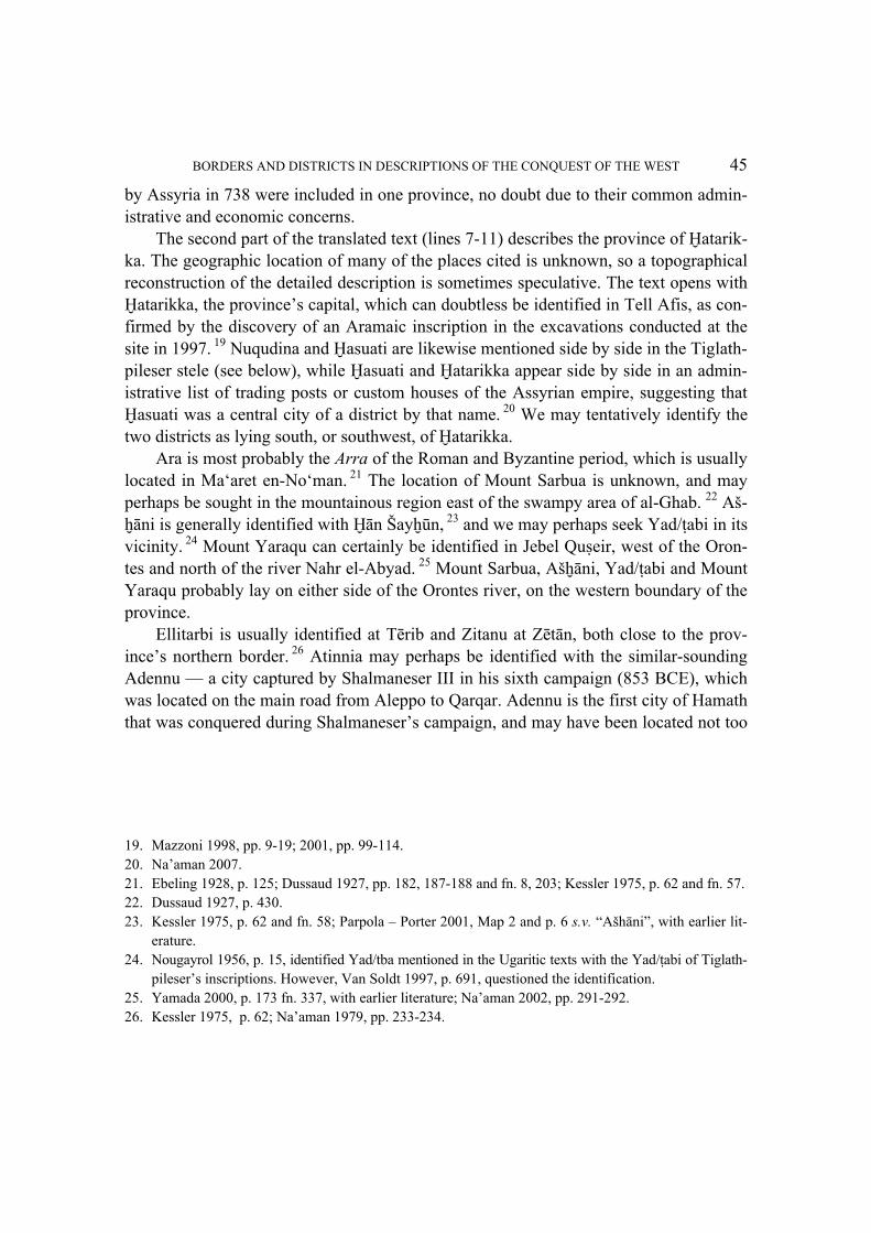
The second part of the translated text (lines 7-11) describes the province of @atarik-ka. The geographic location of many of the places cited is unknown, so a topographical reconstruction of the detailed description is sometimes speculative. The text opens with @atarikka, the province's capital, which can doubtless be identified in Tell Afis, as con-firmed by the discovery of an Aramaic inscription in the excavations conducted at the site in 1997. 19 Nuqudina and @asuati are likewise mentioned side by side in the Tiglath-pileser stele (see below), while @asuati and @atarikka appear side by side in an admin-istrative list of trading posts or custom houses of the Assyrian empire, suggesting that @asuati was a central city of a district by that name. 20 We may tentatively identify the two districts as lying south, or southwest, of @atarikka.
Ara is most probably the Arra of the Roman and Byzantine period, which is usually located in Ma‘aret en-No‘man. 21 The location of Mount Sarbua is unknown, and may perhaps be sought in the mountainous region east of the swampy area of al-Ghab. 22 Aš-~āni is generally identified with @ān Šay~ūn, 23 and we may perhaps seek Yad/\abi in its vicinity. 24 Mount Yaraqu can certainly be identified in Jebel Qu#eir, west of the Oron-tes and north of the river Nahr el-Abyad. 25 Mount Sarbua, Aš~āni, Yad/\abi and Mount Yaraqu probably lay on either side of the Orontes river, on the western boundary of the province.
Ellitarbi is usually identified at Tērib and Zitanu at Zētān, both close to the prov-ince's northern border. 26 Atinnia may perhaps be identified with the similar-sounding Adennu — a city captured by Shalmaneser III in his sixth campaign (853 BCE), which was located on the main road from Aleppo to Qarqar. Adennu is the first city of Hamath that was conquered during Shalmaneser's campaign, and may have been located not too
19. Mazzoni 1998, pp. 9-19; 2001, pp. 99-114. 20. Na'aman 2007. 21. Ebeling 1928, p. 125; Dussaud 1927, pp. 182, 187-188 and fn. 8, 203; Kessler 1975, p. 62 and fn. 57. 22. Dussaud 1927, p. 430. 23. Kessler 1975, p. 62 and fn. 58; Parpola – Porter 2001, Map 2 and p. 6 s.v. “Ašhāni”, with earlier lit-
erature. 24. Nougayrol 1956, p. 15, identified Yad/tba mentioned in the Ugaritic texts with the Yad/\abi of Tiglath-
pileser's inscriptions. However, Van Soldt 1997, p. 691, questioned the identification. 25. Yamada 2000, p. 173 fn. 337, with earlier literature; Na'aman 2002, pp. 291-292. 26. Kessler 1975, p. 62; Na'aman 1979, pp. 233-234.
46 NADAV NA'AMAN
Fig. 1. Eber-nari in the inscriptions of Tiglath-pileser III.
BORDERS AND DISTRICTS IN DESCRIPTIONS OF THE CONQUEST OF THE WEST 47
far from the kingdom's northern border. 27 Bumame's location is unknown, but may perhaps be sought near the northern border of the province. According to this reconstruction, the Assyrian scribe presented first the capital city of the province (@atarikka), then described districts and town south of it (the districts of @asuatti and Nuqudina and the city Ara). He then mentioned mountains and cities on the province's west side, on both banks of the Orontes river, and finally presented its north, as far as its border with the provinces of Kullani and Arpad. The description starts from the province's centre, and turns clockwise to the south, west and north, whereas the territory of the province is described by means of its regions, cities and mountains.
It is significant that the city of Qarqar, which from the early days of research was identified with Tell Qarqur, located 3 km south of Jisr e^-&ughur, within the boundaries of the province of @atarikka, is not mentioned in any of the inscriptions that describe the newly-established province. Rather, it appears as a stronghold of Yaubi"idi, king of Hamath, outside the area annexed by Assyria in 738 BCE. 28 This appears to support my contention that Qarqar must be sought in Tell Asharneh, near the northward turn of the Orontes river, not far from the southwestern border of the @atarikka province. 29
Another partly-extant inscription, originally engraved on a stone tablet, includes a list of major cities conquered in the course of the Assyrian campaigns and listed accord-ing to the annexed territories. The following is the list of the cities of Hamath:
@atarikka, Gu[bla, Elli^u], $imirra, Arqa, [Zimarra], Usnu, Siannu, [Ma"ara-ba], Re"si-#uri, [Kar-Adad], Ara, Nuqudina, [@asuati], Aš~ani, Yad/\abi, [xx-ri], Ellitabi, Zit[anu], Turanu, Bumame — cities of the land of @a[math]. 30
The list parallels the annals inscription in the names of the cities and their order of ap-pearance. It begins with @atarikka, the main centre in the eponymous province, then lists the cities in the same order as do the royal annals, omitting the names of the moun-tains. The main difference between the two sources is that Turanu appears in place of Atinnia. The striking resemblance between the two inscriptions may mean that the list of cities (or its origin) was one of the sources used by the royal scribe in composing the annals inscription.
27. For the suggested identifications of Adennu on the basis of the similarity of names, see Yamada 2000,
p. 154 fn. 265. 28. Sader 1986, p. 133; Dion 1997, p. 159. 29. Na'aman 1999, with earlier literature. For the excavations conducted at Tell Qarqur, see Dornemann
2000, pp. 459-486. For the recent excavations of Tell ‘Asharneh, see Cooper – Fontin 2004, pp. 17-55. 30. Summary Inscription No. 5:Tadmor 1994, pp. 148-149, II, 16-24.

48 NADAV NA'AMAN
Before proceeding to accounts of the annexation of the four Assyrian provinces, we should consider the description of the arrangements carried out in the kingdom of Tyre after its conquest in 734:
[I se]t [my inspector¨ (qēpu) over them …… I assigned] under the control of my eunuch, the governor of $i[mirra], (the area) from Ka^puna, which is on the shore of the [Lower] Sea, [as far as …]. 31
Notes Line 8: For the restoration [áš-k]un, see Frahm 1997-98, p. 403a. For the installment of qēpu, see Tadmor 1994, pp. 142 line 24; 190 line 22. For the qēpu installed in Tyre in the time of Esarhaddon, see Parpola – Watanabe 1988, p. 25 lines 6-14.
Discussion Significantly, the captured coastal strip is placed under the supervision of the governor of $imirra, most probably Qurdi-A^^ur-lamur, the writer of several letters discovered in the archive of Calah. 32 We have seen that in 738 this governor was put in charge of the entire coastal region, from the slopes of Mount Amanus to the province's border with the kingdom of Gubla, and four years later the coastal region to its south was added to his administration. We may conclude that Tiglath-pileser wanted to impose a uniform policy along the entire coastal region, which would explain why he put the governor of $imirra in charge of all the coasts of southern Phoenicia, no doubt as far as the Carmel, the southern boundary of the kingdom of Tyre. Tyre, like Gubla, was not annexed to Assyria, but its ports were placed under the supervision of Assyrian officials and some of their income was consigned to the treasury of the conquering power. 33 Tiglath-pileser's annexations in 738 BCE according to three Summary Inscriptions and the Iran Stele The four inscriptions below describe the territories of the conquered and annexed north Syrian kingdoms in the framework of a broad territorial bloc, which was divided into four provinces. I begin with the three summary inscriptions, which are all directly re-lated to the description of the events of the year 738 in the annals inscription.
31. Summary Inscription No. 8: Tadmor 1994, pp. 176-177, 8-9; for discussion of the passage, see Na'aman
1995, pp. 268-271. 32. Saggs 2001, pp. 154-167. 33. For the Assyrian supervision of the Tyrian harbours already in 738 BCE, see Saggs 1955, pp. 127-
130; 2001, pp. 155-158; Postgate 1974, pp. 390-393.
BORDERS AND DISTRICTS IN DESCRIPTIONS OF THE CONQUEST OF THE WEST 49
a) The annexation of the four provinces in Summary inscription No. 9:
I ravaged the land of Bit Agusi. 30 talents of gold, 2000 talents of silver, moveable property [I carried off to Assyria. The land of Bit Agusi] I annexed to Assyria. [I placed my eunuch over them as governor]. I conquered [the land of Unqi] in its entirety. 20 talents [of gold …], move-able property [… I carried off to Assyria. I annexed Un]qi to Assyria. [I placed my] eunuch [over them as governor]. I annexed to Assyria [the city of @a]tarikka, as far as Mount Sa[ue, the city of] Ka^puna on the shore of the Lower Sea [as far as Mount Ammanana. I placed over them] my two eunuchs as governors.34
b) The annexation of the four provinces in Summary inscription No. 6: 35
I ruled over [the land of Bit Agusi up to its outer boundary and over the land of Unqi] and its environs. I placed [over] them [my two eunuchs as governors. I annexed to Assyria's territory the city of @atarikka as far as Mount Saue, the city of $imirr]a, the land of Arqa, [(GN), the city of Ka^puna on the lower sea coast] as far as Mount Ammanana. I placed over them [my two eunuchs as gover]nors.
c) The annexation of the four provinces in Summary inscription No. 4:
I ruled [from¨ the land¨ of Bit Agusi¨ …… the land of Un]qi¨, which [borders …], the city of @atarikka as far as Mount Sau[e, in its entirety], the cities of Gub[la, Elli^u¨, $i]mirra, Arqa, Zimar[ra, GN], Usnu, [Siannu, Ma]"araba, Ri"si-#u[ri, Kar-Adad¨, together with customhou]ses which are [on the shore] of the Upper [Sea] (É–ka]-ri šá [a-~i tam-tim] e-li-te). I placed four (text: six) eunuchs [of mine over] them [as governors]. 36
Notes on the translation Line 1: The reconstruction of the opening relies on a comparison with the two other in-scriptions. The beginning of line 1 should be restored [… KUR.un]-qi rather than [... KUR. ia-ra]-qi, as I have previously suggested.
34. Tadmor 1994, pp. 176-177, Obv. 24-27 - Rev. 1-2; for a discussion of the passage, see Na'aman 2001a. 35. Tadmor 1994, pp. 152-153, 20-24; for a discussion of the passage, see Na'aman 2001a. 36. Tadmor 1994, pp. 136-139, 1-5a; for a discussion of the passage, see Na'aman 1998; 2001a.
50 NADAV NA'AMAN
Discussion The three inscriptions present the conquest and annexation of the four provinces in a largely similar manner, though in different degrees of detail. None of the inscriptions delineates the boundaries of the provinces of Arpad and Kullani. In the first inscription, the boundaries of the provinces of @atarikka and $imirra are given by means of a short formula of ends — the first from east to west (@atarikka to Mount Saue), the second from south to north (Ka^puna to Mount Ammanana). The second inscription repeats the ends formula from east to west to define the boundary of the province of @atarikka, while the boundary of the province of $imirra is given by means of a series of cities, followed by an ends formula (though the text is badly broken and the reconstruction therefore uncertain). The third inscription may describe the outline of the entire con-quered territory, with a detailed list of cities in the province of $imirra. All three sum-mary inscriptions are markedly dependent on the annals inscription of Tiglath-pileser, and must have been based on it, or on its source. Each of the authors of the summary inscriptions made his own selection from the extended text at his disposal to suit the nature and scope of his inscription.
A detailed description of the territory of the four provinces appears on the stele erected by Tiglath-pileser during his campaign to Media in 737. The description on the stele is independent of the annals inscription, and calls for a thorough geographic-his-torical discussion.
I annexed to Assyria [the entire] land of Bit-Agusi up to [its outer boundary] (and) the entire land of Patina from the city An[a-A^^ur-uter-a#bat (…)], Nanpigi, on the bank of the Euphrates river, the cities Qarne, @adatete, Da-[na], Qinasrina of the steppe [up to¨] Damascus (and) Hamath, the lands of @asuatti, |urinaqadina, the land of Siannu in its entirety, the cities of Elli^u, $imirra at the foot of Mount Lebanon, Re"si-#uri, Mount Zaphon, the city A~-ta, the custom-house on the seashore, the royal store-house, the boxwood moun-tain, the city Tu"ammu as far as Til-karme of Gurgum. 37
Notes Line 5: Zadok 1996, observing that Nanpigi (the classical Hierapolis, today Membij) lies far from the Euphrates and does not fit the description “on the bank of the Euphrates river”, assumed that the city in question was in a district whose centre was Nanpigi. The city's name begins with a vertical sign (DIŠ), and I tentatively reconstruct it “An[a-A^-^ur-uter-a#bat” — the name by which Shalmaneser III called Pitru, which he describes
37. Tadmor 1994, pp. 102-105, 4-15; for discussion of the text, see Zadok1996; Na'aman 1998; 2001a.
BORDERS AND DISTRICTS IN DESCRIPTIONS OF THE CONQUEST OF THE WEST 51
as lying “on the Sajur river, on the other side of the Euphrates”. 38 Pitru has been identi-fied as Au^ar, near the mouth of the Sajur river, and Nanpigi is southwest of it. 39 Either the author of the inscription juxtaposed the two cities, although only one of them was located on the banks of the Euphrates, or else Pitru was described as a city in the district of Nanpigi (as assumed by Zadok).
Line 9: The place of Damascus and Hamath in the list is problematic, not only because neither of them was located in the annexed territory, but also because Damascus was a good distance south of the southern boundary of the province of @atarikka. The transla-tion “[up to] Damascus (and) Hamath” solves this problem, and assumes that the author wished to emphasize that neither of these were included in the new system of provinces. I have noted that Byblos was included in the list of cities on the Phoenician coast, even though it had not been annexed by Assyria. It seems that in seeking to present the new array of provinces, the Assyrian scribes sometimes used the boundaries of neighbouring kingdoms to outline the periphery of the annexed territory. Discussion The description of the territories annexed in 738 begins apparently with the city Ana-A^^ur-uter-a#bat (Pitru), located on the bank of the Euphrates, in the northeastern corner of the province of Arpad. The location of @adatete is not known. Qarne is mentioned to-gether with Kullani, Dana and Arpad in a Neo-Assyrian letter reporting on the number of horses found at each of the listed sites. 40 Dana has been identified at a site by the same name on the boundary between the kingdoms of Arpad and Unqi, north of the kingdom of Hamath. 41 It is probable that Qarne, too, was in the territory of one of these kingdoms. If the three cities (Qarne, @adatete and Dana) were listed in geographic or-der, than Qarne was its eastern end and Dana the western.
Tadmor identified Qinasrina (“the eagles' nest”) in Qinnasrin — i.e., the ancient Chalkis, which was south of Zitanu, on the northwestern end of the salt lake of al-Mattah. 42 But the designation “in the desert” does not quite fit the city's location, and it should be sought in a site to its east, on the frontier of the Syrian desert. The continua-tion, “[up to] Damascus and Hamath” draws the province's southern border by means of
38. Yamada 2000, p. 362, 36; 367, 85; 374; 378; Grayson 1991, p. 19, 36; 23, 85. 39. For the identification, see Yamada 2000, p. 127 and fn. 180. 40. Waterman 1930, pp. 259-260 [letter 372]; Postgate 1974, p. 8, group 2. 41. Honigmann 1938, p. 116. 42. Tadmor 1994, p. 103; Parpola – Porter 2001, p. 15 and Map 2. For the history of Chalkis-Qinnasrin
in the Middle Ages, see Neubauer 1965, pp. 305-307; Honigmann 1923, pp. 176-177; Dussaud 1927, pp. 181-182, 432-434, and Map XIV.
52 NADAV NA'AMAN
the kingdoms to its south, which were not included in its territory. I have discussed above the presumed location of the districts of @asuati and |urinaqadina-Nuqudina, south or southwest of the city of @atarikka, and they must have outlined a large area in within the province of @atarikka. It is remarkable that the author of the stele does not mention @atarikka, the province's capital, unlike all the other inscriptions which do mention it.
Having drawn the eastern and southern boundaries of the province of @atarikka, the author proceeds to outline the boundary of the province of $imirra. First he notes a re-gion at the heart of the province (the land of Siannu), names two cities to its south (Elli-^u and the capital $imirra) and one to its north (Re"si-#uri), passes to Mount Ba"ali-#apuna (Jebel Aqra‛), which closes off the Phoenician coast in the north, refers exten-sively to the port city of A~ta north of the mountain, most probably al-Mina, which lies north of the mouth of the Orontes (for the identification with Kar-Adad see above), and concludes with “the boxwood mountain”, i.e., Mount Ammanana, the southern exten-sion of Mount Amanus.
Tu"ammu, the next city on the list, is mentioned (as Tu"imme) in Tiglath-pileser's annals as the destination of deported inhabitants from the Iranian plateau, followed by a mention of Til-karme “of the land of Gurgum”, which was also a destination for deport-ees. Their repeated mention side by side suggests that they were not far from each other. 43 In a treaty from Sefire, Tw"m is mentioned as one of the cities of Arpad. Le-maire and Durand, as well as Zadok, identified it in Tell Tawami, 27 km southwest of Aleppo, near the Hamath-Arpad border. 44 But this identification does not allow for its proximity to Til-karme, and it should be sought on the kingdom's northern border, not far from the kingdom of Gurgum. Among the cities listed in the treaty from Sefire, Tw"m appears beside Srn, which is usually identified with Surunu, mentioned in the an-nals of Shalmaneser III, and with Saruna, mentioned in Tiglath-pileser's inscriptions — which, it has been suggested, should be identified in Sārin, approximately 15 km south-east of Gaziantepe. 45 It seems that Tu"ammu should also be sought in this area, on the northern border of the kingdom of Arpad with the kingdoms Kummu~ and Gurgum, whereas “Til-karme of Gurgum”, which doubtless lay in the northern reaches of the an-nexed territory, should be sought west or southwest of Gaziantepe (the ancient Paqar-~ubuna).
According to this reconstruction, the author began his description with the Euphra-tes area, in the northeastern corner of the four provinces, followed by three cities in the
43. Tadmor 1994, pp. 66-67, 6b-9a; 87, 1. 44. Lemaire – Durand 1984, p. 75 and the map on p. 78; Zadok 1985, p. 314. 45. Weippert 1972, p. 159; Lemaire – Durand 1984, pp. 74-75; Yamada 2000, p. 115, with earlier lit-
erature in fn. 141

BORDERS AND DISTRICTS IN DESCRIPTIONS OF THE CONQUEST OF THE WEST 53
provinces of Kullani and Arpad. He then proceeded to the desert frontier in the east and the southern boundary of the annexed territory, naming two large regions within the ter-ritory of the province of @atarikka. Then he proceeded to present the province of $imir-ra, starting with a central district and cities to its south and north, and concluded with the southern ridge of Mount Amanus, the province's northern end. Finally, he men-tioned two locations at the northern end of the annexed territory, on the border of Arpad with the kingdoms of Kummu~ and Gurgum. Thus the annexed territory was depicted in full, to the far ends of its boundaries, to include cities and districts in each of the four new provinces.
Having described the extent of the territory he had annexed in 738, Tiglath-pileser presented a kind of general summary of his conquests to date, as follows:
I captured (foreign) lands larger than the territory of Assyria. I added to its people countless people and continuously herded them in safe pastures. I am Tiglath-pileser, king of Assyria, whose hands captured all the lands from sun-rise to sundown. I placed governors where the chariots of the kings, my ances-tors, never passed. From the Great Sea of the rising sun up to Re"si-#uri and Gubla, on the shore of the Great Sea of the sundown, I marched to and fro, and ruled the world. 46
For the present article, what is significant is the “from - up to” formula which defines the empire, whose western extreme is presented by two cities on the coast, in the north (Re"si-#uri) and south (Gubla) of the province of $imirra. Borders and districts in Tiglath-pileser's inscriptions and in the Bible The descriptions given in the annals inscriptions and in the stele from Iran share some common elements, but also differ in important aspects. The descriptions in both sources combine cities, districts and mountain ranges to outline the annexed territory, and also use the spatial merisms formula — “from – up to” — to designate the borders of the area in question. Only the description of two provinces survived in the annals, whereas the stele describes the contours of all four provinces annexed by Tiglath-pileser in 738 BCE. The starting point of the descriptions as well as many details differ markedly in the two inscriptions. The annals begin with a description of the province of $imirra from south to north and east, followed by a description of the province of @atarikka. This begins with @atarikka, the province's capital, and presents districts and cities to the
46. Tadmor 1994, pp. 104-105, 15-24.
54 NADAV NA'AMAN
south of it. The author then presents the west of the province and proceeds northwards. The description runs clockwise, starting from the district capital, passing to the south, then west and north. The description in the stele from Iran begins in the northeast, at the bend of the Euphrates, proceeds first northwards, naming a number of cities in the provinces Arpad and Kullani, goes on to the eastern frontier, represented by a single site (Qinasrina), and south, bounded by two neighbouring kingdoms (Damascus and Ha-math), and lists districts in the province of @atarikka. The description then turns west, lists a series of cities along the sea-coast, and ends at the northern corner of the annexed territory. The stele inscription, too, like that of the annals, lists internal regions and be-side them locations near the border of the annexed territory. The clockwise order of description is also common to the two descriptions.
The description of the four Assyrian provinces is largely open outward and the de-piction is directed inward, into the annexed territory. The related toponyms form a kind of mosaic whose overall combination defines the province's territory. Adjoining territo-ries are sometimes mentioned as a way of defining the relevant boundary. Among these is the reference to Gubla in the annals and Damascus, Hamath and Gurgum in the stele. Mount Ammanana is on the margin of the province of $imirra and may be seen as a geographical object marking its boundary from outside.
The contour of the province of $imirra is long and narrow and both inscriptions present it by means of a list of cities, going from south to north. This description was also used in all of the king's summary inscriptions. But the province of @atarikka, which consists principally of a plateau bounded in the east by a desert and in the west by a high mountain range, is defined in all three summary inscriptions by two toponyms — one in the east (@atarikka) and the other in the extreme west (Mount Saue).
Finally, I would like to emphasize the achievement of the Assyrian scribes who de-scribed the system of Assyrian provinces. I have noted that the boundaries known from ancient Near Eastern texts, in particular in the Hittite treaties, were all associated with political relations and the fixing of borders between adjacent kingdoms, while — as far as we know — internal systems of districts were never described in detail before. The authors of the Assyrian province system lived in a world totally unlike ours in all its ele-ments and concepts and they had to outline the boundaries of diverse regions, all of them far from where they lived, never having seen any drawings, photographs or maps, nor any comprehensive picture of the land they were describing. 47 Some of the prob-lems that bedevil our reconstruction of the system of Assyrian provinces are due to the
47. For a discussion of the Assyrian concept of the borders, see Liverani 1999-2001, pp. 57-85. For the
conceptual problems entailed in the reconstruction of vast regions in antiquity, see Lissovsky – Na'a-man 2003, pp. 302-303 and fn. 15; 323-324.
BORDERS AND DISTRICTS IN DESCRIPTIONS OF THE CONQUEST OF THE WEST 55
difficulties experienced by the Assyrian scribes when they tried to delineate the district system. Yet in spite of these difficulties they succeeded in presenting the system so that its main outlines can easily be reconstructed.
Do the descriptions of the provinces captured and annexed by Tiglath-pileser in 738 have any features in common with the descriptions of borders and districts in the Bible? The author of the principal geographic-historical document in the Bible — the inheri-tances of the Israelite tribes (Joshua 13-19) — was attempting to depict the boundaries of adjacent territorial divisions. The delineation of the borders was presented as a sys-tem consisting of twelve adjacent territorial portions, defined from outside, whereas the territory of each inheritance was often defined by means of a list of cities, originating in administrative lists available to the author, which did not always correspond to the boundaries of the particular portion. 48 The delineation of districts within the framework of a vast territorial unit is common to both the Assyrian province system and the tribal border system, but the two systems are described in essentially different ways. In the former system the scribes sought to present the overall scope of the annexed territory and the confines of each province by listing the districts, cities and mountains they comprised, and left the external borders mainly open, whereas in the latter system the scribe sought to delineate the external borders of each inheritance and thereby depict a system of twelve inwardly closed portions. We should remember that the ancient scribes had limited possibilities of describing borders and districts and that all descriptions of territories have to contain some of the same elements, such as the use of toponyms, or a reference to the territory's limit by the term “up to”. But the decisive factor in choosing the form of description was the historiographical purpose that the author tried to achieve with his composition, and both the similarities and differences between the composi-tions are primarily due to their authors' objectives. The respective historiographical aims of the authors of the Assyrian province system and of the tribal inheritances were en-tirely different, and these aims set them far apart.
Some of the regions included in the system of tribal inheritances are defined by a combination of city lists and borderlines (the territories of Dan, Issachar, Zebulun, Asher and Naphtali). But this combination of city lists, taken from administrative records, with outer borders, which are mostly partial and schematic, is quite unlike the combination of cities and inner regions in the descriptions of the Assyrian provinces.
There is some similarity between the description of the tribal land of Gad and the summary inscriptions of Tiglath-pileser, which combine the “from - up to” formula with
48. Kallai 1986, pp. 329-444; Lissovsky – Na'aman 2003, pp. 297-302, 320-322.

56 NADAV NA'AMAN
city lists. Here, by way of illustration, are two summary inscriptions of Tiglath-pileser (Nos. 4 and 6), alongside the description of Gad's territory (Josh. 13:25-27):
1) I ruled [from¨ the land¨ of Bit Agusi¨ …… the land of Un]qi¨, which [bor-ders …], the city of @atarikka as far as Mount Sau[e, in its entirety], the cities of Gub[la, Elli^u¨, $i]mirra, Arqa, Zimar[ra, GN], Usnu, [Siannu, Ma]"araba, Ri"si-#u[ri, Kar-Adad¨, together customhou]ses which are [on the shore] of the Upper [Sea]. I placed four (text: six) eunuchs [of mine over] them [as gover-nors]. 2) I ruled over [the land of Bit Agusi up to its outer boundary and over the land of Unqi] and its environs. I placed [over] them [my two eunuchs as gov-ernors. I annexed to Assyria's territory the city of @atarikka as far as Mount Saue, the city of $imirr]a, the land of Arqa, [(GN), the city of Ka^puna on the lower sea coast] as far as Mount Ammanana. I placed over them [my two eunuchs as gover]nors. 3) And it became their territory: Jazer, all the towns of Gilead, part of the country of the Ammonites up to Aroer, which is close to Rabbah; and from Heshbon to Ramath-mizpeh and Betonim, and from Mahanaim to the border of Lidbir; and in the Valley, Beth-haram, Beth-nimrah, Succoth and Zaphon … down to the edge of the Jordan and up to the tip of the Sea of Chinnereth on the east side of the Jordan.
This similarity between the description of the tribal allotment of Gad and those of the Assyrian provinces is chiefly due to the resemblance between their territorial layouts — in both cases there is a combination of a broad highland with a narrow coastal strip or a long narrow valley. The highland is presented by means of a “from – unto” formula, and the coastal strip or valley by a string of settlements from south to north. Thus a similar-ity of topographic layout can give rise to a similarity of descriptions, even in cases in which there has been no literary contact between the descriptions.
There is a marked similarity between Tiglath-pileser's inscription that lists the ma-jor cities conquered in the course of his campaigns according to the annexed king-doms 49 and the town lists in the tribal inheritance in the Book of Joshua. At the end of each list of towns mentioned in the Assyrian text appears the name of the conquered kingdom. For example: “cities of the land of Enzi, […] and of the land of Urar\u”;
49. Summary Inscription No. 5: Tadmor 1994, pp. 149-154.

BORDERS AND DISTRICTS IN DESCRIPTIONS OF THE CONQUEST OF THE WEST 57
“cities of the land of Bit A[gusi]”; “cities of the land of Ha[math]”. The town list of Ju-dah also includes broad regions — “the Negeb”, “the Shephelah”, “the Mountain”, “the Desert”, and we may infer that they were copied from a document which served the author as a source for the town list. The other town lists in the Book of Joshua are also divided between the tribal allotments, but were integrated in a historiographical com-position and lost their original administrative function. This is particularly clear in the lists of Galilean towns (Zebulon, Asher and Naphtali), where the lists of towns were in-corporated in the border descriptions in a way that blurred the nature of the source from which they were copied.
The Bible presents the land of Canaan and its boundaries (Numbers 34:1-12) by means of a sequence of toponyms outlining the limits of the territory described, and it is notable that the description makes no reference to adjacent regions. In this it differs markedly from the description of the new allocations in the land of Canaan in the Book of Ezekiel (47:13-20), where the author makes extensive use of the boundaries of adja-cent regions. Describing the borders of the land of Canaan, the author does not present the details of the territory bounded by the system of borders, whereas in Ezekiel there is a schematic description of the 12 tribes comprised in the system. The toponyms in the two descriptions run clockwise — beginning in the description of the land of Canaan (Numbers 34) south of the Dead Sea, and from the northeastern corner in the description of Ezekiel — and this element is shared by both with the description of the Assyrian province system. Overall, these two descriptions differ decisively from the way the annexed territories are described in the Tiglath-pileser inscriptions — clearly, the very different historiographical aims of their respective authors makes it impossible to draw a useful comparison between them.
Solomon's system of districts (1 Kings 4:7-19) differs from the system of tribal ter-ritories and the descriptions of the boundaries of Canaan in that it makes no attempt to define an outer border. The districts are listed seriatim, so that their totality reflects the comprehensive outline of the territory in question (I Kings 4:7-19). 50 It shares this prin-ciple of delineation with the descriptions of the system of Assyrian provinces. The Solo-monic district list combines regions, defined by geographic terms or tribal tags, with the names of cities, and in this too it resembles the description of the Assyrian provinces in Tiglath-pileser's inscriptions. To illustrate, here are the regions and the cities in their or-der of appearance in the system of districts: “the hill country of Ephraim” (v. 8);
50. Of the vast literature written on the Solomonic boundary system, see Alt 1913; Albright 1925, pp.
25-36; Abel 1938, pp. 79-83 and map 5; Mettinger 1971, pp. 111-127; Caquot 1972; Aharoni 1976; Kallai 1986, pp. 40-72; Niemann 1997, pp. 279-288; Ash 1995; Mulder 1998, pp. 169-186; Kamlah 2001; Na'aman 2001, pp. 419-436.

58 NADAV NA'AMAN
“Makaz, Shaalbim, Beth-shemesh and Elon-beth-hanan” (v. 9); “Arubboth … Socho and all the land of Hepher” (v. 10); “all Naphath-dor” (v. 11); “Taanach, Megiddo, and all Beth-shean … from Beth-shean to Abel-meholah, as far as the other side of Jok-meam” (v. 12); “in Ramoth-gilead” (v. 13); “in Mahanaim” (v. 14). Beside the districts and city names are listed districts whose names are also known from the biblical tribal lists: Naphtali (v. 15), Asher and Bealoth (v. 16), Issachar (v. 17), Benjamin (v. 18). 51 The list focuses on the names of the district governors, but if we leave them out and view the list as an attempt to define the territory of the kingdom of Israel by means of its districts, we see obvious similarities between the presentation of Solomon's twelve districts and the description of the “nineteen districts of Hamath” in Tiglath-pileser's annals inscription. 52 It goes without saying that the district list in the Book of Kings was written in the framework of a large historiographical work, which is why it is more stylized and schematic, and ideologically loaded, than the system of Assyrian provinces, which was composed not many years after the events described in the inscriptions commemorating the achievements of the Assyrian ruler.
The study of the toponyms mentioned in documents originating from the Assyrian empire is at its height, and there is constant progress in identifying the listed sites, and thus in understanding the descriptions in which they are mentioned. This progress al-lows us to hope that further details in the inscriptions discussed in the present article will be clarified, and the geographic setting of additional inscriptions will also become known. Advances in the research of the Assyrian inscriptions are of great use in the study of the boundary lists in the Bible, as these inscriptions are chronologically and descrip-tively much closer to the biblical lists than other groups of documents (in particular, the Hittite treaties) with which they were previously compared. Even if there is no question of one scribal tradition influencing the other, it is reasonable to assume that inscriptions dating from a particular period might have been influenced by the perceptions and world-concepts of their time. The Assyrian inscriptions have a considerable potential for the study of topographical lists in various parts of biblical historiography, and we may hope that additional research will shed light on further similarities between them.
51. Some tribal districts were originally geographic and gave their names to the tribes and clans who lived
there. For discussion, see Noth 1960, pp. 56, 60-61, 66-67; Täubler 1958, pp. 177-187; de Vaux 1978, pp. 547, 641, 663, 644-645, 665. I deliberately omitted v. 19, as its original attribution to the district list is questionable. See Na'aman 2001, pp. 421-423.
52. It goes without saying that the Solomonic district list (1 Kings 4:7-19) does not reflect the situation in the tenth century BCE (the time attributed to the “United Monarchy”), but that of a much-later period. For its date, see Ash 1995, pp. 67-86; Na'aman 2001, pp. 430-433, with earlier literature.
BORDERS AND DISTRICTS IN DESCRIPTIONS OF THE CONQUEST OF THE WEST 59
BIBLIOGRAPHY
Abel F.M. 1938, Géographie de la Palestine II, Paris. Aharoni Y. 1967, The Land of the Bible: A Historical Geography, Philadelphia. —— 1976, “The Solomonic Districts”, Tel Aviv 3, pp. 5-15. Albright W.F. 1925, “The Administrative Divisions of Israel and Judah”, Journal of the
Palestine Oriental Society 5, pp. 17-54. Ahituv S. 1995, Joshua: Introduction and Commentary (Mikra Leyisra'el), Jerusalem (in Hebrew). Alt A. 1913, “Israels Gaue unter Salomo”, in: A. Alt et al. (eds.), Alttestamentliche Studien Ru-
dolf Kittel zum 60. Geburtstag dargebracht, Leipzig, pp. 1-19 (Reprint: in Kleine Schriften zur Geschichte des Volkes Israel II, München 1953, pp. 76-89).
—— 1925, “Judas Gaue unter Josia”, Palästina Jahrbuch 21, pp. 100-116 (Reprint: in Kleine Schriften zur Geschichte des Volkes Israel II, München 1953, pp. 276-288).
—— 1927, “Das System der Stammesgrenzen im Buche Josua”, in W.F. Albright et al. (eds.), Sellin-Festschrift. Beiträge zur Religionsgeschichte und Archäologie Palästinas, Leipzig, pp. 13-24. (Reprint: in Kleine Schriften zur Geschichte des Volkes Israel I, München 1953, pp. 193-202).
Ash P.S. 1995, “Solomon's? District? List”, Journal for the Study of the Old Testament 67, pp. 67-86.
Caquot A. 1972, “Préfets”, in Dictionnaire de la Bible, Supplément 8, Paris, pp. 273-286. Cogan M. 1984, “From the Peak of Amanah”, Israel Exploration Journal 34, pp. 255-259. Cooper E. — Fontin M. 2004, “Tell ‘Acharneh in the Middle Orontes Valley and the Assyrian
Presence in Syria”, in G. Frame (ed), From the Upper Sea to the Lower Sea. Studies on the History of Assyria and Babylonia in Honour of A.K. Grayson, Leiden, pp. 17-55.
Dion P.-E. 1997, Les Araméens à l’âge du fer: histoire politique et structures sociales, Paris. Dornemann R.H. 2000, “The Iron Age Remains at Tell Qarqur in the Orontes Valley”, In G.
Bunnens (ed.), Essays on Syria in the Iron Age (Ancient Near Eastern Studies Supplement 7), Louvain, pp. 459-486.
Dussaud R. 1927, Topographie historique de la Syrie antique et médiévale, Paris. Ebeling E. 1928, “Arâ”, in RlA 1, Berlin _ Leipzig, p. 125. Frahm E. 1997-98, Rev. of H. Tadmor, The Inscriptions of Tiglath-pileser III King of Assyria,
Jerusalem 1994, Archiv für Orientforschung 44-5, pp. 399-404. Grayson A.K. 1991, Assyrian Rulers of the Early First Millennium BC, vol. II (858-745 BC)
(The Royal Inscriptions of Mesopotamia. Assyrian Periods 3), Toronto. Hess R.S. 1988, “Tribes, Territories of the”, in G.W. Bromiley (ed.), International Standard
Bible Encyclopedia 4 (revised edition), Grand Rapids, pp. 907-913. —— 1994, “Late Bronze Age and Biblical Boundary Descriptions of the West Semitic World”,
in G.J. Brooke _ A.H.W. Curtis _ J.F. Healey (eds.), Ugarit and the Bible. Proceedings of the International Symposium on Ugarit and The Bible. Manchester, September 1992 (Ugari-tisch-Biblische Literatur 11), Münster, pp. 123-138.
Honigmann E. 1923, “Historische Topographie von Nordsyrien in Altertum”, Zeitschrift des Deutschen Palästina-Vereins 46, pp. 149-193.
60 NADAV NA'AMAN
—— 1938, “Dana”, RlA 2, Berlin _ Leipzig, p. 116. Kallai Z. 1986, Historical Geography of the Bible. The Tribal Territories of Israel, Jerusalem _
Leiden. Kamlah J. 2001, “Die Liste der Regionalfürsten in 1 Kön 4,7-19 als historische Quelle für die
Zeit Salomos”, Biblische Notizen 106, pp. 57-78. Kessler K. 1975, “Die Anzahl der assyrischen Provinzen des Jahres 738 v. Chr. in Nordsyrien”, Die Welt des Orients 8, pp. 49-63. Lemaire A. _ Durand J.-M, 1984. Les inscriptions araméennes de Sfiré et l’Assyrie de Sham-
shi-ilu, Genève _ Paris. Lissovsky N. _ Na'aman N. 2003, “A New Outlook at the Boundary System of the Twelve
Tribes”, Ugarit-Forschungen 35, pp. 291-332. Liverani M. 1999-2001, “The Sargon Geography and the Late Assyrian Mensuration of the
Earth”, State Archives of Assyrian Bulletin 13, pp. 57-85. Malamat A. 1965, “Campaigns to the Mediterranean by Iahdunlim and Other Early Mesopota-
mian Rulers”, in H.G. Güterbock _ Th. Jacobsen (eds.), Studies in Honor of Benno Lands-berger on his Seventy-Fifth Birthday (Assyriological Studies 16), Chicago, pp. 367-373.
Mazzoni S. 1998, “Une nouvelle stele d'époque araméenne de Tel Afis (Syrie)”, Transeuphra-tène 16, pp. 9-19.
—— 2001, “Tell Afis and the Lu‘ash in the Aramaean Period”, in P.M.M. Daviau _ J.W. We-vers _ M. Weigl (eds.), The World of the Aramaeans, II: Studies in History and Archaeology in Honour of Paul-Eugène Dion (Journal for the Study of the Old Testament Supplement Series 325), Sheffield, pp. 99-114.
Mettinger T.N.D. 1971, Solomonic State Officials. A Study of the Civil Government Officials of the Israelite Monarchy (Coniectanea Biblica), Lund.
Mulder M.J. 1998, 1 Kings, Vol. 1: 1 Kings 1-11 (Historical Commentary on the Old Testament), Leuven.
Na'aman N. 1978, “Looking for KTK”, Die Welt des Orients 9, pp. 220-239. —— 1995, “Tiglath-pileser III’s Campaigns against Tyre and Israel (734-732 B.C.E.)”, Tel Aviv
22, pp. 268-278. —— 1998, “Tiglath-pileser III’s Annexations according to the Iran Stele (IIB)”, N.A.B.U.
1998/1, No. 14. —— 1999, “Qarqar = Tell ‘Asharneh?”, N.A.B.U. 1999/4, No. 89. —— 2001a, “Damascus, Hatarikka and $imirra in Tiglath-pileser III’s Summary Inscriptions”,
N.A.B.U. 2001/2, No. 24. —— 2001b, “Solomon's Province List (1 Kings 4:7-19) and the Assyrian Province System in
Palestine”, Ugarit-Forschungen 33, pp. 419-436. —— 2002, “Aribua and the Patina-Hamath Border”, Orientalia Nova Series 71, pp. 291-295. —— 2004, “Gubla, Ra’shu, Re’si-#uri and the Ancient Names of Ras Ibn Hani”, Bulletin of the
American Schools of Oriental Research 334, pp. 33-39. —— 2007, “The District of Hasua(t)ti”, N.A.B.U. 2007/1, No.2. Neubauer A. 1965, La géographie du Talmud, Amsterdam (originally published in Paris 1868).
BORDERS AND DISTRICTS IN DESCRIPTIONS OF THE CONQUEST OF THE WEST 61
Niemann H.M. 1997, “The Socio-Political Shadow Cast by the Biblical Solomon”, in L.K. Handy (ed.), The Age of Solomon. Scholarship at the Turn of the Millennium, Leiden, pp. 252-299.
Noth M. 1960, The History of Israel, London. Nougayrol J. 1956, Le Palais Royal d’Ugarit IV. Textes accadiens des archives sud (Archives
internationales) (Mission de Ras Shamra 9), Paris. Parpola S. _ Watanabe K. 1988, Neo-Assyrian Treaties and Loyalty Oaths (State Archives of
Assyria vol. II), Helsinki. Parpola S. _ Porter M. 2001, The Helsinki Atlas of the Near East in the Neo-Assyrian Empire,
Helsinki. Postgate J.N. 1974, Taxation and Conscription in the Assyrian Empire (Studia Pohl Series
Maior 3), Roma. Sader H. 1986, “Quel était l'ancien nom de Hama-sur-l'Oronte?”, Berytus 34, pp. 129-133. —— 1987, Les états Araméens de Syrie depuis leur fondation jusqu’à leur transformation en
provinces Assyriennes, Beirut. Saggs H.W.F. 1955, “The Nimrud Letters, 1952 – Part II”, Iraq 17, pp. 126-154. —— 2001, The Nimrud Letters, 1952 (Cuneiform Tablets from Nimrud V), London. Tadmor H. 1994, The Inscriptions of Tiglath-pileser III King of Assyria, Jerusalem. Täubler E. 1958, Biblische Studien: Die Epoche der Richter, Tübingen. Van Soldt W. 1997, “Studies in the Topography of Ugarit (2). The Borders of Ugarit”, Ugarit-
Forschungen 29, pp. 683-703. de Vaux R. 1978, The Early History of Israel I-II, London. Waterman L. 1930, Royal Correspondence of the Assyrian Empire Translated into English, with
a Transliteration of the Text and a Commentary. Part I: Translation and Transliteration, Ann Arbor.
Wazana N. 1998, Biblical Border Descriptions in Light of Ancient Near Eastern Literature. Ph.D. Thesis, Hebrew University of Jerusalem (in Hebrew).
—— 2000, “The Tribal Boundaries in Light of Tarhuntašša Border Descriptions”, Shnaton: An Annual for Biblical and Ancient Near Eastern Studies 12, pp. 165-186 (in Hebrew).
Weippert M. 1972, Rev. of S. Parpola, Neo-Assyrian Toponyms, Kevelaer _ Neukirchen-Vluyn 1970, Göttingische gelehrte Anzeiger 224, pp. 150-161.
Yamada S. 2000, The Construction of the Assyrian Empire. A Historical Study of the Inscrip-tions of Shalmaneser III (859-824 BC) Relating to His Campaigns to the West (Culture and History of the Ancient Near East 3), Leiden.
—— 2005, “Kārus on the Frontiers of the Neo-Assyrian Empire”, Orient 11, pp. 56-90. Zadok R. 1985, Geographical Names according to New- and Late-Babylonian Texts (Répertoire
Géographique des Textes Cunéiformes 8) (Beihefte zum Tübinger Atlas des Vorderen Orients, Reihe B Nr. 7/8), Wiesbaden.
—— 1996, “Geographical and Onomastic Remarks on H. Tadmor, The Inscriptions of Tiglath-pileser III King of Assyria (Jerusalem 1994)”, N.A.B.U. 1996/1, No. 17.

62 NADAV NA'AMAN