Creative Districts around the World
233
http://creativedistricts.imem.nl/ CREATIVE DISTRICTS AROUND THE WORLD CELEBRATING THE 500 TH ANNIVERSARY OF BAIRRO ALTO LÉNIA MARQUES AND GREG RICHARDS (EDS) NHTV, BREDA, 2014 ISBN/EAN: 978 ‐ 90 ‐ 819011 ‐ 3 ‐ 0
Transcript of Creative Districts around the World

http://creativedistricts.imem.nl/
CREATIVE DISTRICTS AROUND THE WORLD CELEBRATING THE 500TH ANNIVERSARY OF BAIRRO ALTO
LÉNIA MARQUES AND GREG RICHARDS (EDS)
NHTV, BREDA, 2014 ISBN/EAN: 978‐90‐819011‐3‐0

http://creativedistricts.imem.nl/
CREATIVE DISTRICTS AROUND THE WORLD CELEBRATING THE 500TH ANNIVERSARY OF BAIRRO ALTO
The 500th anniversary of one of the historic creative districts of the world, Bairro Alto, in
Lisbon (Portugal) served as a catalyst for the publication of this interactive e‐book. In a
journey that starts in the heart of the Bairro, several authors and artists take us through
different creative districts around the globe. Creative Districts around the World is a
snapshot of the dynamic changes taking place in very different cities, such as London, New
York, Johannesburg or Melaka.
Enjoy your journey around the creative districts of the world!
Lénia Marques and Greg Richards

Table of Contents
Editors introduction: Creative districts around the world ................................................................... 1
Lénia Marques and Greg Richards
Lisbon and the Bairro Alto: 500 years ................................................................................................... 5
Jorge Mangorrinha
Architecture and society in Bairro Alto: prostitutes, artists and stabbings; palazzi, streets and
alleys ...................................................................................................................................................... 9
Fabiana Pavel
Gentrification and cultural heritage in Bairro Alto: Prelude to a creative district ........................... 17
Luís Mendes
The Unusual path of 'rural urbanisation': The creative transformation of Ponta Delgada, The
Azores .................................................................................................................................................. 23
Emese Panyik, Carla Miguel and Rosa Vilaça
Alameda de Hercules ........................................................................................................................... 33
Guido Cimadomo and Pilar Martínez Ponce
The Ouseburn Valley ........................................................................................................................... 37
James Whiting
East-West identities and creative fusions in London’s ‘Asian Quarters’ ........................................... 47
Stephen J. Shaw
Custard with the colourful taste of creativity .................................................................................... 57
Peter Horsten and Peter van der Aalst
The Veemarktkwartier: Pioneer in The Netherlands ......................................................................... 67
Simon Wijs and Kristel Zegers
Fashion district Arnhem: Creative entrepreneurs upgrading a deprived neighbourhood ............... 75
Dany Jacobs, Ewan Lentjes and Esther Ruiten
The Finlayson/Tampella Area ............................................................................................................. 81
Mariangela Lavanga
Creative districts of Helsinki – Two distant relatives ......................................................................... 87
Pekka Mustonen and Taru Lindblom

New life of New Holland in a classical city .......................................................................................... 93
Valery Gordin, Marina Matetskaya and Mariya Dedova
A Post‐Socialist transformation – From a factory to a creative quarter ............................................ 99
Ieva Rozentale and Timurs Tomsons
The Creative heart of Budapest ........................................................................................................ 105
Anita Zatori and Melanie Smith
From a Jewish Quarter into a creative district ................................................................................. 111
Anett k. Tóth, Barbara Keszei and Andrea Dúll
Transformation through the revival of industrial heritage .............................................................. 119
Emese Panyik
Revitalisation through creativity ...................................................................................................... 129
Milica Ilincic
Varosha – A creative meaning through the years ............................................................................ 137
Liliya Terzieva
New cultural polarities and the revival of Beyoğlu in Istanbul ....................................................... 143
Jérémie Molho
Creative districts in the Global South: Maboneng Precinct, innercity Johannesburg .................... 149
Christian M. Rogerson and Jonathan J. Rogerson
The Saadiyat Island cultural district in Abu Dhabi ........................................................................... 155
Hamed Al Hamed, Shabbar Jaffry and Alexandros Apostolakis
Creative heritage: Melaka and its past ............................................................................................. 163
Can‐Seng Ooi and Shevren Lai
Animation breathes life into Chinese cities ...................................................................................... 171
Vincenzo de Masi and Yan Han
Communality without collectivity .................................................................................................... 179
Daisy Tam
High‐end luxury retail and the city: A timeline of Bond Street, Fifth Avenue, Omotesando‐Aoyama
as luxury capitals of the world .......................................................................................................... 185
Bhakti Sharma

Revitalizing Micronesia’s capital city of Hagåtña: Creating historic corridors ................................ 191
Fred R. Schumann
Marvellous Melbourne – More than a city ....................................................................................... 197
Sally Webster
Creative districts: Surry Hills, Sydney ................................................................................................ 203
Sing D’Arcy and Lisa Zamberlan
The Old charm of Newtown: Exploring cultural diversity in Sydney’s Newtown ........................... 209
Siobhan Lyons
Downtown New Bedford, Massachusetts: A case of creative placemaking in the United States . 217
Leila Valoura and Don Burton
These boots are not only made for walking .................................................................................... 227
Juan Antonio Serrano García and Paloma Baquero Masats
A Caribbean creative district ............................................................................................................. 233
Marsha Pearce
Creative Artisans Districts In The Province Of Lima .......................................................................... 241
Charline Cayeman

Introduction to: Marques, Lénia and Richards, Greg (eds) (2014) Creative districts around the world. Breda: CELTH / NHTV. URL: http://creativedistricts.imem.nl/
INTRODUCTION: CREATIVE DISTRICTS AROUND THE WORLD EDITORS INTRODUCTION
LÉNIA MARQUES (CELTH, NHTV UNIVERSITY OF APPLIED SCIENCES, THE NETHERLANDS)
GREG RICHARDS (UNIVERSITY OF TILBURG / CELTH, NHTV UNIVERSITY OF APPLIED SCIENCES, THE NETHERLANDS)
Creativity has been a “buzz” word that seems to characterise the first years of
the young 21st century. Although arts and culture have been playing a role in the life
and development of cities for centuries, it has been only recently that studies have
been considering the role of culture and, in a broader sense, creativity in the life and
development of the city. Traditionally, arts and culture were mainly accessible for the
elite, restricted to specific cultural locations. Creativity has also long been an important
element of the image of various cities (for example, arts and bohemian life are
embedded in the image of Paris). However, the more recent development of culture
and creativity in cities has been a more diffuse, organic process, sometimes motivated
by decision makers and sometimes stimulated by people living in these quarters.
Creative districts are increasingly an integral part of the city and they are at the heart
of the artistic life, often side by side with bohemian and alternative lifestyles.
Bairro Alto, in the heart of Lisbon, is a district full of history, stories, struggles,
creations and bohemia. In December 2013, this historic district celebrated its 500th
anniversary and provided the catalyst for creating a snapshot of what is happening in
creative districts around the world. Having undergone many historical, cultural and
social changes, Bairro Alto has been redeveloping recently as a hub for night life, art
and creativity in Lisbon. The Bairro becomes then an example of a variety of
development processes, features and roles that entail diverse consequences in
different places around the world.
The case studies in this volume show that the core presence of creativity in some
districts is not new, but has developed along many different trajectories over time. In
each era of development, different stories are given a voice, and each phase of
development has its own timeline. Creativity becomes part of an organic process of

2
developing the district, being born, or implanted, and sometimes dying out. Some
creative districts stem from medieval city quarters, others emerged in the post‐
industrial era or were part of the reconstruction of cities in the post‐World War II.
Some districts are more traditionally orientated towards culture (cultural districts with
museums and galleries), while others are mostly connected to ‘popular culture’, hubs
for alternative lifestyles.
Despite the variety of creative district forms and development trajectories, there
are some common features. The life of the creative district is anchored in different
creative businesses and is highly embedded in the local culture. Creative districts are
often linked to alternative lifestyles and subcultures and increasingly they are
becoming the place where creative networks are shaped.
The co‐existence of these features, along with their diversity, means that these
districts are in a permanent state of flux, which is part of their organic development.
Although this allows for great flexibility, it also means that, on the one hand, it is
difficult to identify particular development stages and, on the other hand, people
(artists, inhabitants, visitors) also experience constant adaptive processes. In what we
could call the ’pop‐up’ era, the phenomena observable in these districts are
themselves temporary and ongoing. However, this is not simply a superficial or
insignificant process. The impacts in the quarters themselves, but also in the cities as a
whole, are significant and entail different aspects such as a sense of community or
gentrification. Creative districts often provide the space and time in which people
come together to experiment with new forms of relationality in ‘trusting spaces’,
allowing people to form new, creative bonds within the network society.
We can often see in different cases that these districts are originally in poor
developed areas of cities, sometimes run‐down and desolate. Some of these districts
are seen as problems that need to be solved (e.g. Surry Hills, Sydney). Often close to
the urban centres, ateliers, bars, restaurants and other facilities attracted by cheap
rents and whose core activity is based on short term fashions and trends. Often these
processes are at the edge of or beyond the law, as in the case of squatting actions for
example (e.g. the ruin bars in Budapest). Precariousness is also a keyword when
understanding the relationship of these districts to place but also to business and
employment. Nothing seems to be fixed or permanent and risks are involved. As Anett

3
K. Tóth, Barbara Keszei and Andrea Dúll state, it is a ‘romance of transition’, both for
people and space. Gentrification often emerges, and although it is often felt that this
can threaten the creative district itself, it can be argued that gentrification is after all
part of the ongoing process of changes inherent to urban development. Independently
of how the creativity became a major feature of the district, whether via grassroots
activism or policy‐induced, the need for a deeper reflection on urban planning and
policy making in these districts is evident.
In the present publication, we present a collection of cases from creative districts
in different parts of the world, both as an ebook and as an interactive platform. This
publication aims at giving visibility to creative districts that gained a new life from the
creative dynamics of the cities around them. The aim is to provide an analytical
resource for researchers and students, rather than to provide an exhaustive list of all
the creative districts in the world. Each case presented here demonstrates salient
features of the dynamic landscape of global creativity and the places where this ‘lands’
in cities. But there are many others. Our journey around the creative districts of the
world starts in Bairro Alto and continues towards East, against the clock, travelling
through different continents (Europe, Africa, Asia, Australasia, America).
Acknowledgements
The editors would like to thank all the people involved in this project, from
authors, to photographers and the technical team that made this interactive platform
possible. Without your contribution, Creative Districts around the World wouldn’t have
seen the light of day.
A special thanks to Paul Buchanan, Fleur van 't Slot, Robbert Klaver and Michael
Schlejen for embarking on this project.

Case study published in: Marques, Lénia and Richards, Greg (eds) (2014) Creative districts around the world. Breda: CELTH / NHTV. URL: http://creativedistricts.imem.nl/
LISBON AND THE BAIRRO ALTO 500 YEARS
BAIRRO ALTO, PORTUGAL
JORGE MANGORRINHA (UNIVERSIDADE LUSÓFONA DE HUMANIDADES E TECNOLOGIAS, LISBON, PORTUGAL)
On the 500th anniversary of Lisbon´s most remarkable neighborhood, the long
standing relationship between creative innovation and the urban experience and more
recently, the relation between the Lisbon citizen and tourists, must be celebrated.
Throughout the Bairro Alto, cultural events have been set to take place from April 2013
until the end of the year, both in the historic area of the Bairro Alto and in the
surrounding areas. These creative celebrations planned to entertain this part of
downtown Lisbon include theatre, recitals, tours, bibliographical exhibits, lectures,
tribal “farrobodó” folklore‐like street markets (present since the XVIII century), an
international congress and a lottery, in a neighborhood where the contemporary
atmosphere intertwines with History. “Our” Lisbon has the Bairro Alto, its origin goes
back 500 years. Thus, this is the year to celebrate five centuries of History as well as to
update our personal considerations on a neighborhood that with its attributes and
issues enjoys the same appeal in this city and has set itself as a row model worldwide,
so as to envision a network with other similar microcosms.
It is a fact that the creative expression, in its varied forms, places this
neighborhood in parallel with worldly realities, in other words, a great number of
historic neighborhoods that with renewed human energy have reinvented their own
existence and peculiarities. Will we manage to connect the 500 years of the Bairro Alto
to the increment of a worldwide network?
A portrait is the record of a moment. In a nutshell, the Bairro Alto is a story… and
an important reality to bear in mind. New architectures as well as shut and ruined
houses. Incredible bars and restaurants and beer bottles for a euro on the street.
Memories of the hot 80s… very few! Only from those who lived it. But the Bairro
renews itself through peaceful mutations and peaceful coexistence, or not so much,
refusing to be another city centre neighborhood walking towards desertification and

6
with significant social and economic losses. The earlier memories take us to records of
a Vila Nova de Andrade, witness of an experimental time that nourished the glorious
government of King Manuel I and its Discoveries enterprise or the Jesuits that settled
in the top of São Roque, the outer bound of the Bairro Alto or even the stately houses
– a very coherent architectonic group. This matrix was kept even after the Earthquake
and was integrated and respected in the plan to reconstruct the city. The memories of
the 1800s everyday are what is left of the intellectuality and bohemia that still exists
today, with another outline nevertheless.
Ever since the first geometrical plan for Lisbon was authorized in 1513, when
Lopo de Athouguia agreed with owners Bartolomeu de Andrade and his wife Francisca
Cordovil the division of the Bairro in blocks, initially named as Vila Nova de Andrade, it
became home to artisans and fishermen, and also home to petty politics, intellectual
debating and culture in its many expressions. Its architecture went on to be preserved,
in its general structures, with few deep changes, even refusing to succumb to the 1755
Earthquake, when in the aftermath wealthy families coming from the Baixa,
established themselves here building their stately houses and throwing musical
parties. Since the XIX it was the setting for important activities, such as the Press and
the Fado Houses, a very important duo for the bohemia that was to come. In those
times, journalists would attend it day and night. Fado singers only by night. In the
1980s it transformed itself to welcome numerous commercial establishments that
provided the city´s Night a new capital, with brand new ideas and trends.
Throughout time, the mark of creation together with different lifestyle
experiences have been a constant, despite often times being frowned upon, always
subject to popular and liberal thinking and behavior. The Bairro Alto is evidence of
avant‐garde.
In the last decades, the Bairro Alto has been the heir to that popular experience
which went on to intensify itself, despite in an irregular fashion. Grocery shops,
taverns, pensions and old time Fado Houses either coexist or give way to modern
stores or workshops. It is not what it used to be two or three decades ago but still one
can breathe the busy day life unsuspected of what goes on by night and vice‐versa, for
both experiences are so different. The Bairro Alto may not be fully captured without
the day life scents and the nightlife noises, often source of tensions. The majority of its

7
inhabitants are the elderly and youngsters. The Bairro Alto still manages to be a
platform to advertise the work of emerging artists, promoting exhibitions, events and
stimulate intellectual debate in an interactive atmosphere, a differentiating selection
that provides unique spaces.
The Bairro Alto is located in Lisbon´s most dynamic area, nevertheless it manages
to provide a good sense of intimacy. Beyond the threshold life transfigures from day to
night. It is marked by a daytime peace, only thrown, for instance, by heated street
chats, packages drop offs or by the crowds rushing to the National Conservatory. On
the other hand the night is louder, tense, intoxicating, restless, presently somehow
different from its golden years from 20 or 30 years ago. The small shops showcases
display a mix of national fashion and international brands. Young residents, Portuguese
and foreign, and some of Lisbon´s intellectual elite, among some old timers eager to
share their life experience, together, they form a 600 000 people community. Through
them it is possible to uncover memories and know of brand new concepts that connect
this neighborhood to the worldwide forefront. We should jointly celebrate such a
meaningful landmark, task which has been carried out by the sisterhood charity
Irmandade da Misericórdia, the charity Misericórdia de São Roque, the Association of
Bairro Alto Residents, Rio de Janeiro Club, the Pharmacy Museum and the Portuguese
Association of Vintage Bookshops.
There is no other Bairro like this one [“Bairro como este não há nenhum”]. It is
known worldwide and it has a birth certificate! This year: “Bairro Alto, it´s show time!”
[“silêncio, velha Lisboa, vai cantar o Bairro Alto!”].

Case study published in: Marques, Lénia and Richards, Greg (eds) (2014) Creative districts around the world. Breda: CELTH / NHTV. URL: http://creativedistricts.imem.nl/
ARCHITECTURE AND SOCIETY IN BAIRRO ALTO: PROSTITUTES, ARTISTS AND STABBINGS; PALAZZI, STREETS AND ALLEYS BAIRRO ALTO, PORTUGAL
FABIANA PAVEL
Celebrations are underway for the five‐hundredth anniversary of Bairro Alto’s
spatial and social identity. When one looks for the guiding thread throughout the
existence of this traditional Lisbon neighbourhood whose cultural roots are both
highbrow and lowbrow, or for the relationship between its spatial and sociocultural
identity, one must inescapably draw a brief history of the neighbourhood’s formation
in consonance with its chief morphological and social features.
In the last quarter of the fifteenth century, Lisbon was a city of narrow streets
where circulation was difficult, and it was insalubrious and incapable of keeping up
with the social and economic transformations then underway. It was a city in
demographic growth, trying to respond to the new demands of being capital of a sea
empire by extending its boundaries.
It found a prime outlet for expansion westward (the area adjacent to the
Fernandine wall), where a vast estate existed. The Atouguia and Andrade families (the
owners and leasers of these lands) started sub‐leasing parcels of land for the
construction of new buildings, thus creating the new neighbourhood of Vila Nova de
Andrade. 1
The first stage of urbanisation (1498‐1512) was polarised between the Gates of
Santa Catarina and “Cata‐que‐Farás”. As from 1513 (second stage) the urbanisation
had been polarised by the Santa Catarina Gates, leading westwards to the Santos
Road.
The third stage began in 1553, when the high‐lying part of the area became
autonomous, and the centre of gravity was displaced to the Alto de São Roque, where
1 Historiography has given as the starting date of urbanisation 15 December 1513. Helder Carita (1999, op.cit.), demonstrated the existence of a document from 1498 that moves back the start of this urbanisation.

10
the Company of Jesus established itself. Thus, that area acquired the name of Bairro
Alto de São Roque [High Neighbourhood of St Roch] (Figure 1). After the 1755
earthquake2, from an urbanistic point of view, the area became fully autonomous as
‘Bairro Alto’.
Initially, the subleasers are commoners connected with sea trades. At a later
moment, a population of larger means arrived, particularly after the Jesuit
establishment at São Roque.
Bairro Alto is held as the city’s first large urbanisation, and as a landmark in
Lisbon’s urbanistic and social history for some characteristics, such as rapid
construction, its being a melting pot both socially and architecturally, and its
rectangular grid layout, which was extremely modern for the time.
The most important element is the option to make sub‐lease contracts based on
a key measurement module: the chão.3 This applied to the construction of the
characteristic orthogonal grid as to the coexistence of different architectural styles
(small buildings for people of poor means standing beside aristocratic palaces) as well
as to the social mélange of the area.
This key module is featured in the entire grid, appearing in multiples or
submultiples. The systematic use of a constant measurement in every block permits a
better and more rational organisation of urban space (Figure 2). The urban grid of
Bairro Alto is made up of a regular parcelling, based on the chão measure, which
propagated as time went on from south to north. This layout permitted the
implantation of buildings of different sizes and importance, and the subleasing of
larger or smaller plots according to the economic capacity of the party interested.
The Bairro Alto area may be regarded as a private plot allotment ante litteram, in
which speed of execution and maximum exploitation of available space are essential
factors. Bairro Alto shows some features similar to private allotments created in the
twentieth century such as the lack of gardens and public spaces, maximising the
exploitation of land for construction; strict rules for deadlines and methods of
construction; attention to ease of use of vehicles (carriages, at the time); good
2 That was a very strong earthquake that destroyed many areas in Lisbon and in its surroundings.
3 Chão [literally, ground]: an agrarian measurement used in the Middle Ages, corresponding to a rectangle of 60 hands’ (13.2m) length by 30 hands’ (6.6m) width.

11
environmental qualities such as good lighting in the streets or proper ventilation
systems.
These morphological features may have fostered the making of an extremely
heterogeneous society in Bairro Alto. Here commingled people of poor means
connected with maritime activities, palace servants and tavern keepers, prostitutes
and people connected with shady business, besides the bourgeois and families of the
high aristocracy. There was always a deep conviviality among all these classes. We
note that one of the most important personages born here was the Marquis of
Pombal4, who in his youth led the Band of the White Capes, the terror of the Bairro in
the first half of the eighteenth century.
After the 1755 earthquake, the aristocracy moved out to its suburban estates,
leaving their palaces abandoned or subletting them. While the Quake did not seriously
affect the architecture of Bairro Alto except for a small area adjacent to today’s
Camões Square, it did alter, partly, its social mix.
The neighbourhood closed in on itself, at the same time as it became central
relative to the city that was growing around it. In the nineteenth century, it became a
privileged place for the flourishing of an artistic ambiance connected with some degree
of marginality, becoming a noted spot of bohemian Lisbon, where a strong connection
existed between the world of prostitution and other illicit activities in the respectable
bourgeois world. 5
The palaces abandoned by the aristocracy offer (in the latter half of the
nineteenth century) the ideal installations for newspapers. At the same time, the old
carriage houses provide locations for cheap restaurants and taverns. Thus arises a
peculiar atmosphere, lively and heterogeneous at all hours of the day and night, in
which the conversations of journalists and artists commingles with those of pimps,
prostitutes and the fado fauna ever ready for crime.
It is important to note that if the newspapers, on the one hand, bring a new flair
to the Bairro, on the other hand, they do not alter its base structure, made up of a
social class of poor means, largely small traders and artisans with their shop on the
ground floor and living quarters above.
4 The Marquis de Pombal (1699‐1782) was the prime minister of Portugal at the time.
5 PAÍS, Machado José, 2008, op. cit..

12
In the second half of the twentieth century, the newspapers started relocating
from the Bairro, seeking larger installations with easier access. Today, only one
remains: A Bola.
Following the exodus of the press, Bairro Alto resumed an atmosphere of
abandonment, regarded with distrust by other Lisboners. Even so, its peculiar social
and cultural heterogeneity continued to attract bohemian spirits.
Particularly in the 1980s, the old stables and carriage houses were revamped as
Disco spaces and, to this day, Bairro Alto has consolidated its fame as the nightlife
area. 6
The palaces continue in our century to offer spaces coveted by many (property
developers, artistic projects, etc.), not only because of the possibilities their ample
areas allow, but also because of the Bairro’s central location in the city.
This brief chronicle shows that there has always been a guiding thread through
the social history of this traditional Lisbon neighbourhood, made up of strongly
interconnected and mutually dependent revelry and roguery, side by side with artistic
endeavour and the lives of humble people who had their home and business here.
The Bairro Alto of today is quite different. On the one hand, traditional
commerce is dying out and being replaced by bars and convenience stores. The night
revellers no longer have any direct ties with the Bairro; they merely ‘consume’ it at
weekend nights.
This situation is becoming a big reason for controversy between two local actors:
the association of inhabitants and the association of commerce. On the one hand, the
inhabitants complain about the negative effects of noise and filthiness of the streets
on their well‐being. They aim at impeding new bars from opening and at reduced
opening times of the existing ones. On the other hand, the existing businesses are
against the changes in opening hours of bars and they oppose the existence of
convenience stores. These are considered to be ‘unfair’ competition because they sell
drinks at lower prices although their maintenance, hygiene parameters and tax costs
are different from a bar.
6 Together with Cais de Sodré and Santos.

13
Figure 1: Plan of section of Bairro Alto, Lisbon, Portugal, showing the main streets, buildings and stages of town development. No scale. Source: Fabiana Pavel.
Besides this controversy, due to its history and central location, Bairro Alto is now
being ‘consumed’ by property developers through the construction of luxury

14
condominiums and ‘charm’ hotels. The dubious use of the term ‘rehabilitation’ seeks
to utilise the history of Bairro Alto as a marketing instrument, while there is nothing
antique in the buildings but their facade.
Luxury condominiums are products targetting the upper middle class, just as the
palaces of 1500. The condominiums, however, are closed, which entails non‐
relationship with the neighbourhood – they are like isolated islands, contrary to the
old aristocratic palaces. In some cases (for example, Convento dos Inglesinhos), the
residents have been trying to fight these condominiums. However, the critical
awareness towards this situation has not yet developed a great deal.
This text has affirmed that there is a strong, distinct social and morphological
identity in Bairro Alto, living through centuries, adapting itself to the socio‐economic
situations of each historical moment, yet remaining its true self, making the Bairro a
historically cultural neighbourhood.
Figure 2: Plan of a section of Bairro Alto, Lisbon, Portugal, showing building measurements. Source: Fabiana Pavel.

15
While there are at present some venues and projects that promote the social and
cultural aspects typical of the area, there is also a strong tendency to ‘consume’ that
same identity, using it to sell luxury venues, nightlife spots, restaurants and fado
houses devoid of the charisma and quality of yesteryear.
The old population is given scant possibilities to preserve its identity, 7 «in
accordance with its own dynamics of reproduction and change». It is not feasible to
regard «the conservation of the local identity» as an «anachronistic folkloric survival»
since such an identity is a «factor – if not indeed a condition – of active social
protagonism».8
If the phenomena of gentrification underway persist, we risk having a Bairro Alto
transformed into an open‐air museum for visitors, where we may only dine, listen to
fado or have a drink before going back home.
7 For example, the Gabinete Técnico Local (GTL – Local Technical Bureau) has done much work in favour of the residents. 8 COSTA, 1999, op. cit., p. 472.

16
References
ARAÚJO, Norberto de ‐ Peregrinações em Lisboa. XV Vol. 2nd edition (1st edition 1937).
Lisbon: Veja, 1993.
BARATA SALGUEIRO, Teresa – “Lisboa, metrópole policêntrica e fragmentada.”
Finisterra, Revista Portuguesa de Geografia, XXXII, (63). Lisbon: 1997, pp.179‐190.
CÂMARA MUNICIPAL DE LISBOA ‐ Livro das Posturas Antigas. Lisbon: Câmara Municipal
de Lisboa, 1974.
CARITA, Helder ‐ Bairro Alto Tipologias e Modos Arquitectónicos. Lisbon: Câmara
Municipal de Lisboa, 1990.
CARITA, Helder – Lisboa Manuelina e a formação de modelos urbanísticos da época
moderna (1495‐1521). Lisbon: Livros Horizonte, 1999.
COSTA, António Firmino da ‐ Sociedade de Bairro. Dinâmicas Sociais da Identidade
Cultural. Oeiras: Celta Editora, 1999.
CASTILHO, Júlio de ‐ Lisboa Antiga, O Bairro Alto. Vol. 5 3rd edition (1st edition 1906).
Lisbon: Oficinas gráficas da CML, 1954‐1966.
FRANÇA, José‐Augusto – Lisboa Pombalina e o Iluminismo. Lisbon: Bertrand Editora, 3rd
edição, 1987 (1st edition 1983).
PAÍS, Maxado José – A Prostituição e a Lisboa Bohemia. Do século XIX a inícios do
século XX. Porto: Ambar, 2008.

Case study published in: Marques, Lénia and Richards, Greg (eds) (2014) Creative districts around the world. Breda: CELTH / NHTV. URL: http://creativedistricts.imem.nl/
GENTRIFICATION AND CULTURAL HERITAGE IN BAIRRO ALTO: PRELUDE TO A CREATIVE DISTRICT LISBON, PORTUGAL
LUÍS MENDES (CENTRO DE ESTUDOS GEOGRÁFICOS, INSTITUTO DE GEOGRAFIA E ORDENAMENTO DO TERRITÓRIO DA UNIVERSIDADE DE LISBOA, PORTUGAL)
Focusing on Bairro Alto’s case study, this paper argues that gentrification as a
trend of (re)investment in the city’s historical centre is rooted on a reconfiguration of
the social structure in the scope of a post-modern urban condition, which is
increasingly associated with consumer culture, the aestheticisation of social life, but
especially with a movement of cultural heritage. This movement is characterised by
discourses and projects that advocate the rebuilding, preservation and revalorisation
of diverse vestiges of the urban past, which are essential to reinvent the feeling of
community and group cohesion that are crucial to assert the identity of a creative
district.
Located in the pericentral and western area of Lisbon’s downtown, Bairro Alto is
one of the most traditional and popular neighbourhoods of Lisbon’s historical centre,
with its valued architecture and urban heritage where more than 500 years of history
have unfolded. It had its origins in the 16th century, in the kitchen gardens and
vineyards of a great estate that resulted from an allotment intervention. At that time,
a new idea of city, as modern and rational, was asserted by the clarity of the
geometrical tracing that took advantage of the good natural conditions of the place.
From an architectural point of view, Bairro Alto is still nowadays an area of
morphological coherence, characterised by great utility between the cohesive physical
structure and a rich and heterogeneous urban image1.
Bairro Alto presents a social urban environment that is ethnically mixed and
tolerant, refusing the conventional suburban normativity and the canons of the
revanchist city. This environment attracts what is usually addressed as marginal
gentrification. This movement corresponds, in general terms, to less privileged cohorts
1 Matias Ferreira, V.; Calado, M. (1992), Freguesia de Santa Catarina (Bairro Alto). Lisboa: Contexto Editora.

18
of the new middle classes that present a significant cleavage between high academic
and cultural capital and low economic capital. These are individuals who are
underemployed or temporarily employed in a precarious situation, but continue to
prefer the central areas of the city to reside, becoming leading gentrifiers, presumably
attracted by the non-conformist lifestyle offered by these areas. Single women,
students, artists, gay and lesbian communities, and monoparental families are included
in these groups2. There is a clear correspondence between the concept of marginal
gentrifier and these individuals’ preference to appropriate and reside in the city
centre, what Richard Florida has called ‘the creative class’, and the privilege that this
attributes to open, tolerant and plural communities3. Tolerance and diversity are key
aspects to harnessing identities so they contribute to overall vitality and do not cause
conflict and fragmentation4.
The distinctive urbanism of gentrification in Bairro Alto, as a critical and
emancipatory practice, is the fact that marginal gentrifiers privilege diversity,
tolerance, and the freedom of expression of different cultures and lifestyles, but also
the architecture, heritage and urban specificity that characterise the identity of the
historical centre, as in other traditional neighbourhoods of the city, such as Alfama or
Mouraria. However, the difference between these areas and the Bairro Alto is that the
latter has revealed typical features of a creative district since the beginning.
This is understood as a liminal emancipation space, as opposed to increasing
social, cultural and lifestyle homogenisation and uniformity of suburban spaces and
modern urbanism5. Its cultural heritage is very rich and that derives especially from the
unique character of its urban forms. The image of its streets is built in a great variety of
details, related to different architectural solutions that result from long-lasting
sedimentations and from the corresponding stylistic evolution.
Bairro Alto’s social mix has granted the neighbourhood a local and urban culture
with specific characteristics, creating a great variety of expressions and cultural
2 Mendes, L. (2008), A Nobilitação Urbana no Bairro Alto: Análise de um Processo de Recomposição Socio-Espacial. Tese de Mestrado. Departamento de Geografia da Faculdade de Letras da Universidade de Lisboa. Lisboa. (policopiado) 3 Florida, R. (2002), The Rise of the Creative Class. And How It’s Transforming Work, Leisure, Community and Everyday Life. Nova Iorque: Basic Books. Florida, R. (2004), Cities and the Creative Class. Nova Iorque: Routledge. 4 Landry, Ch. (2008), The Creative City: A Toolkit for Urban Innovators. Londres: Earthscan. 5 Rodrigues, W. (2010), Cidade em Transição. Nobilitação Urbana, Estilos de Vida e Reurbanização em Lisboa. Oeiras: Celta Editora.

19
manifestations. At an earlier stage, Bairro Alto was occupied in the south by modest
people linked to the sea and swiftly became a sought after place for the clergy and
nobility who built a great number of palaces, convents and churches here. The other
face of Bairro Alto, marginal and with its nightlife, gained its reputation from the
constant armed robberies, conflicts and fights, making this area known for its bohemia
and riotous populations. The ludic and inviting reputation that characterises the
neighbourhood has also been shaped in the past decades through the existence of a
great number of famous restaurants and neighbouring taverns – nowadays bars and
pubs – and the places of cultural sessions, where famous literates, artists, politicians
and journalists got together.
Despite being a repository of rooted and old manifestations and cultural
traditions, Bairro Alto has in the past few years endured profound transformation of its
social fabric with the arrival of new dwellers with distinctive lifestyles, as well as with
the introduction of new commercial spaces aimed at new audiences who seek
alternative cultural activities and practices. It is within this framework that the concept
of gentrification appears as a process through which some groups have become
central to the city as they have turned the city into a central place for themselves. They
have done so not only from the point of view of a privileged residential location, but
also through its usage, especially through its appropriation as a mark of social
centrality (promoted by territorial centrality), the symbolic power that it assigns, and
the social distinction it allows. We refer, in particular, to the so-called “new middle
classes”, the main agents of a recentralisation movement that rediscover in the
historical and/or architectural value of neighbourhoods the capacity to reinvent
themselves at social and cultural levels. Yet, the city’s old neighbourhoods had been
understood until recently as obsolete, outdated, non-practical, and unable of
guaranteeing acceptable living conditions under contemporary circumstances.
However, these have nevertheless, and increasingly so, provided the most adequate
answers to the criticisms aimed at the new models proposed by modern urbanism and
architecture. For instance, Ley (1996) argues four main factors that justify the
residential location in the inner city, over the residence in the suburbs: the fact that
the price of housing in those neighbourhoods be relatively acceptable taking into
account the price commonly practised in the rest of the metropolitan area, the

20
possibility and potential of a long-term investment (especially with the current
revaluation of those areas), a central location that facilitates access either to local
employment, either to a more diversified offer of cultural and leisure services, and
finally, the importance of architectural and historic character of the neighbourhoods.
In this perspective, such as supporting other authors, the choice of residence in the old
quarter implies either a choice in favour of economic benefits (and autonomy
associated with ownership) or a choice of location in relation to centrality6.
Figure 1: Location of the area studied – Bairro Alto, in Lisbon’s Metropolitan Area. Source: Author’s
elaboration (2008)
6 Ley, D. (1996), The New Middle Class and the Remaking of the Central City. Oxford: Oxford University Press.

21
In the same way as other urban spaces, Bairro Alto is currently being subjected
to a heritage quest that has been understood as a (post-modern?) reaction to the
disappearance of “traditional ways of living”, to social atomisation, to the acceleration
of modern life, to the contemporary unrootedness and hedonistic individualism, as
well as to the space-time compression produced by globalisation. These phenomena
homogenise urban landscapes and thus stimulate the desire of spatial distinction
through local difference and identity distinctiveness. Nevertheless, it is certain that the
refunctionalisation of this urban past for the creative class shifts between reactivation,
reinvention and idealisation. It reveals the principle of cultural heritage since it may
constitute both the discovery of something that already existed (but because it has
ceased to be integrated in everyday life practices is rediscovered for new functions – a
second life) and the manifestation of processes of invention, staging and simulation of
local uniqueness and historical continuity.
When the reinvention of a past urbanity is referred to, it is important to stress
the idea that gentrification, as it is presented and practised nowadays, is a “product”
created by (and for) some of the highest social classes, serving their distinctive urges
and social reproduction7. Besides, the reinvention of community feeling and group
cohesion also serves the essential condition for Bairro Alto’s identity as a creative
district as it stimulates consumption demand, leisure, tourism, and housing by specific
cohorts of the population. This demand then promotes the appearance and
sustainability of highly competitive and deeply spatialised clusters of cultural activities
based on the agglomeration/centralisation of creativity and on the inter-relationships
established between the different agents. The cultural activities that stand out in the
neighbourhood these days are associated, on the one hand, to the historical clusters in
the area (such as antiques, bookstores and the press and graphic editing), and the
traditional small craft activities (bookbinders, restorers) that still manage to maintain
their activity. However, on the other hand, the new cultural industries (fashion,
nightlife, design, traditional commerce)8 are increasingly highlighted.
7 Hobsbawm, E.; Ranger, T. (1983), The Invention of Tradition. Cambridge: Cambridge University Press. Jager, M. (1986), Class definition and the aesthetics of gentrification: Victoriana in Melbourne, in N. Smith; P. Williams (eds.), Gentrification of the City. Londres: Allen & Unwin, 78-91. 8 Costa, P. (2007), A Cultura em Lisboa. Competitividade e Desenvolvimento Territorial. Lisboa: Instituto de Ciências Sociais da Universidade de Lisboa. Costa, P. (2009), Bairro Alto – Chiado. Efeitos de Meio e Desenvolvimento

22
In conclusion, gentrification and cultural heritage go in tandem in Bairro Alto and
create the ideal conditions to the formation, empowerment and support of a creative
milieu that acts, on the one hand, as a collective space of aestheticised emancipation
and, on the other hand, as a way of preserving the traditional identity and collective
memory of this historical neighbourhood of Lisbon.
Sustentável de um Bairro Cultural. Lisboa: Direcção Municipal da Cultura e Departamento de Património Cultural da Câmara Municipal de Lisboa. Lopes, R. (2001), Competitividade, Inovação e Territórios. Oeiras: Celta Editora.

Case study published in: Marques, Lénia and Richards, Greg (eds) (2014) Creative districts around the world. Breda:
CELTH / NHTV. URL: http://creativedistricts.imem.nl/
THEUNUSUALPATHOF'RURALURBANISATION':THECREATIVETRANSFORMATIONOFPONTADELGADA,THEAZORESTHE AZORES, PORTUGAL
EMESE PANYIK (CATHOLIC UNIVERSITY OF PORTUGAL – UCP, BRAGA)
1. Introduction
While towns in continental Portugal struggle to emerge from the shadow of the two
major cities, Lisbon and Porto, Ponta Delgada, the administrative capital of the Archipelago of
the Azores has successfully leveraged its geopolitical position to derive economic, political and
commercial benefits which trans‐formed the once rural town into a vibrating cosmopolitan city.
Located in the middle of the Atlantic Ocean almost half way between Europe and the United
States, the Azores Islands have played a strategic role in the transatlantic transport and trade
routes from as early as the Age of Discoveries (see Figure 1). Even today, the Azores remains
subject to constant political negotiation due to its location on the boundaries between
Portuguese and American spheres of interests, particularly with regard to the shared
coordination of the Lajes Air Base since World War II.
The once small agricultural and fishing village of Ponta Delgada is now the most
populated city of the Islands and a leading settlement in terms of economic activity. While back
in the 1960s children used to rush down to the beach in between two classes to catch octopus
for lunch, today, we are witnessing the dramatic changes induced by the inauguration of the
post‐modern multifunctional 'recreational marina'. This complex integrates a large‐scale
maritime terminal with an extensive leisure area that incorporates a pool, gardens, an
underground car park, pavilions for cultural and sports events, galleries and a multitude of
restaurants and shops.
CARLA MIGUEL (CATHOLIC UNIVERSITY OF PORTUGAL – UCP, BRAGA)
ROSA VILAÇA (CATHOLIC UNIVERSITY OF PORTUGAL – UCP, BRAGA)

24
Figure 1: The location of the Azores. Source: http://www.europa‐turismo.net/portugal‐acores.htm
It has been widely accepted that creativity is closely linked to regeneration, as it often
serves as a source of inspiration for creative transformation. The growing pressure for
structural change on deprived rural or industrial areas may give rise to new, innovative ideas of
development or alternative ways of restructuring. These creative elements are deeply rooted in
the unique historic, geographical, social, cultural and economic characteristics of the area,
which are, in turn, transformed into strategic leverage by creativity. Within this context, the
present chapter aims to identify what factors have contributed to the creative transformation
of Ponta Delgada and which are the unique aspects of this path of modernization. In order to
answer these questions, it explores how the city`s specific characteristics have been used as a
source of creativity in the urbanisation process of Ponta Delgada.
2. The historic roots of creative transformation
Ponta Delgada enjoys a prominent status as the administrative capital of the Regional
Government for almost four decades. This privilege has been, however, gained historically by
economic and political merits of the settlement earned throughout the past centuries.

25
Historically, the urbanisation of Ponta Delgada can be described by three milestones of
transformation, which put the present political privileges and the large‐scale creative
investments into perspective. First, the rural village of Ponta Delgada became relatively early a
growth pole of urbanisation soon after the Great Discoveries by the inclusion of the Americas in
international commerce. The village became a prominent exportation partner of agricultural
products, and by the 19th century, the city exerted control over the entire citrus exports to the
United Kingdom. Second, on the basis of this pivotal role in international commerce, Ponta
Delgada took over the intercontinental distribution of Atlantic navigation between four
continents: Europe, America, Africa and Asia. Lastly, as a result of this evolving role the village
was granted the status of a city in 1546 by King D. João II.
Undoubtedly, the ocean coast has always been a drive of urban transformation not only
in Ponta Delgada but in the entire archipelago as well. The first agglomerations formed along
the coastline as the international trade activity attracted considerable foreign‐owned
businesses. However it was only in the 20th century when the different districts that spread
across the coastline have become integrated by a main avenue and by new circular roads that
linked the scattered city districts (Figure 2). Centuries later, in 1976, the first shopping centre
was erected also in front of the sea and named as the “Sun‐Sea Tower”. Most recently, the new
marina complex gave new functions to the seacoast. However, just as in the case of the Algarve
in the south of continental Portugal, it was the opening of the international airport in Ponta
Delgada that permitted the substantial growth of international tourism in the Azores.
3. Changing sectoral pattern of local economy as a pathway to creative industries
While agriculture and fisheries have always been the pillars of economic activity, the
expansion of the service sector in the second part of the 20thcentury became the main drive of
urban concentration. After 1976 when the Azores become an autonomous region of Portugal,
various public institutions have been established, including the University of the Azores. This
new model of development led to the slowdown of the industrial sector and the deterioration
of city areas where most industries were located. The expansion policy of agricultural
production and monoculture farming centered on dairy products and beef converted the island

26
into an extensive grassland and dragged people into the main urban center: Ponta Delgada.
Today, the city experiences the decline of agricultural production in parallel with the rise of a
new alternative: tourism.
Figure 2: Coastline of Ponte Delgada in the late 19th century and today. Source: Collection of the Public Library and
Regional Archive of Ponta Delgada; Municipality of Ponta Delgada; http://acoresapenoveilhas.blogspot.pt by Nuno
Ferreira
Although the number of arrivals is the lowest in the Azores as compared to the other
regions and airports of Portugal (less than half million arrivals in 2012 ), and low‐cost
companies do not operate in the archipelago, local initiatives play a major role in expanding not
only the national but also the international tourism flows. This has been evidenced by the fact
that the Regional Tourism Organisation of the Azores announced to prepare a timetable of all
27
local events in 2014 together with the local entities and distribute it among the tourist
operators of the main outbound markets.
Local events are considered as a major driving force of boosting tourism. In Ponta
Delgada, the religious events look back to a long history: the feast of the Holy Christ of Miracles
, which is the second largest religious festival in Portugal and the feast of Devotion to the Divine
Holy Spirit are both 500 years old. Today, these festivals successfully integrate religious rituals
with local folk art exhibitions and performances, including handicrafts made of basalt, sea shells
and fish scale, jewelry design and local gastronomy. Typical local dishes, such as for example
the Soup of the Divine Holy Spirit are distributed freely among the visitors. More recently, but
with no less popularity, the annual “Walk & Talk” festival attracts growing number of visitors.
Organised for the first time in 2011, the festival is dedicated to public art, gathering national
and international artists and involving local communities in the co‐creation experience. The
activities consist the renovation of facades, street art, performances, concerts and workshops
with the aim to create a new space for dialogue in arts, helping to position Ponte Delgada
creatively in contemporary arts and introducing the city to its public and stakeholders.
Another creative tourism initiative is the “Festa Branca” or “White Party”, which was, for
the first time organised in Ponta Delgada, during the inauguration of the city`s Coliseum
Micaelense in 2006. For eight consecutive years, the Coliseum dresses in white hosting the
event that has become the biggest summer festival in Ponta Delgada. In addition, a new event
that has emerged in 2013 is the “Noites de Verão”, or “Summer Nights”, which spans virtually
the entire summer from the beginning of July till mid‐September. It hosted a Gourmet Market,
which allowed local producers and businesses to promote their products, thereby contributing
to the sustainability of the high‐quality gourmet segment.
4. From whale hunting to whale watching
Whale hunting was one of the main sources of income of the population from the middle
of the 19th century for more than hundred years, having driven the construction of several
factories. Due to the growing environmental concerns in the 20th century, the United Nations
established the International Convention for the Regulation of Whaling in 1946. As a result

28
whale hunting ceased in the Azores in 1984. Despite the loss of income and the closing of
factories, Ponta Delgada saw a unique opportunity boosting the regional economy by
transforming hunting into the observation of whales. In only five years the end of whaling gave
way to observation and research. These activities have ensured economic return by creating
many companies, have educational aims and induce the flow of thousands of people. Even the
captains of the former hunting vessels cooperate actively with whale watchers as tourist guides
on the sea. This made the Azoreans to accept and embrace whale watching as an integral part
of the Azorean life.
5. Urban Park: A creative path to urban sustainability?
Linking social welfare with sustainable recreation, the concept of the Urban Park in Ponte
Delgada serves as a creative example of sustainable management of large‐scale, functionless
and/or abandoned urban areas. The park was constructed in 2008 and it represents the highest
municipal investment in the Azores of all times (Melo, 2007). With a territory of 50 hectares it is
the biggest park not only in the city but in the entire archipelago as well, which involved the
plantation of thousands of trees and altogether 53 species. The park was created as part of the
sustainable development strategy of the city. It assumes complex functions in addition to
pedestrian and bicycle routes, including a golf training zone, a multifunctional pavilion, lakes
and areas designed for hosting events. Special attention was given to using traditional materials
and preserving the current natural and architectural landscape.
6. Doors to the sea: ‘Portas do Mar‘
The relation with the sea has played a crucial role in the transformation of the city`s main
avenue into a brand image. The "Portas do Mar" or "Doors to the sea" was a grandiose project
inaugurated in 2008, with the aim to reconstruct the seafront of Ponta Delgada in a way to
combine a modern maritime terminal and ferryboat rank with a leisure and commercial area. In
order to develop a design suitable to create a city symbol, the project was developed by the
well‐known Portuguese architect, Manuel Salgado. As it can be seen on Figure 3, the
multifunctional 'recreational marina' follows a post‐modern, minimalist design which has
become a new attraction and reference in tourism of the islands. This is in line with the main

29
goals of the city`s urbanisation plan which aimed at the touristic and recreational utilisation of
the seafront areas (Municipality of Ponta Delgada, 2000). Within this context, the main profile
of the complex is catering, with an emphasis on local gastronomy. For example, the restaurant
Anfiteatro, which belongs to the local Hospitality Vocational School, combines the traditional
with contemporary cuisine. The importance of this recreational marina can be shown by the
fact that in 2011 it hosted the event where "The seven wonders of Portugal" were announced,
among them the "Lagoon of the Seven Cities" ("A Lagoa das sete Cidades") pertains to the area
of Ponta Delgada.
Figure 3: The seafront of Ponta Delgada in the late 19th century and today. Source: Collection of the Public Library
and Regional Archive of Ponta Delgada; http://olhares.sapo.pt by Helder Freitas.
30
7. Conclusions
It is notable in the case of Ponta Delgada, that throughout its history the city has
creatively leveraged its geographic assets, primarily its maritime location, and converted
misfortunate historic events into political or economic advantages that boosted the
modernisation process of the city. After the original capital of the Azores had been devastated
by an earthquake in 1522, Ponta Delgada, the already flourishing merchant town was elevated
to the status of a city. After bombardment during World War I, a naval base was established in
the city which gave way to the rapid development of air transport. More recently, whale
hunting was substituted by whale watching as an alternative to one of the oldest local
economic activities.
The city`s urbanisation has always been intimately related to the sea; in the past, when
the first agglomerations were established along the coast; in the present, when a new seafront
marina complex has become the main drive for the diversification of services and tourism
development, and most likely it will remain in the future as well when sustainability issues will
prevail. Ponta Delgada was the first city in Portugal to develop a local Agenda 21, dedicated to
urban rehabilitation of its historic centre, and it created the largest urban park of the islands
within this agenda. The actual trends of urbanisation suggest that future sustainable strategies
will involve integrated land and sea use planning based on the diversification of service
provision, and the emerging creative industries in the city play a strategic role in this regard.

31
References
Melo, B. S. (2007) Parque Urbano de Ponta Delgada: Maior investimento camarário de sempre,
Correio dos Açores. Retrieved 03/2013 from
http://www.correiodosacores.net/index.php?mode=noticia&id=1301.
Municipality of Ponta Delgada (2000). Plano de Urbanização de Ponta Delgada e Áreas
Envolventes. Retrieved 03/2013, from http://cm‐
pontadelgada.azoresdigital.pt/site/frontoffice/default.aspx?module=article/article&ismenu=
1&id=81&ismenu=1&menuleft=0&idterceironivel=140.

Case study published in: Marques, Lénia and Richards, Greg (eds) (2014) Creative districts around the world. Breda:
CELTH / NHTV. URL: http://creativedistricts.imem.nl/
ALAMEDA DE HERCULES SEVILLA, SPAIN
GUIDO CIMADOMO
PILAR MARTÍNEZ PONCE
Alameda de Hercules, built in 1574 over the earlier known Stink Pond, was until the Romantic
era the favorite place for the aristocracy of Seville to meet: a tree‐covered promenade, with more
than 1,700 trees, fountains and columns taken from an ancient Roman temple. From the 19th
century, with the expansion to the south of the city and the creation of new aristocratic parks,
Alameda had started to decay, becoming an unsafe place during the day and especially at night.
During the 1960s this neighborhood already lost all its enchantment; buildings and villas
were demolished and replaced by smaller and more cost‐effective apartments, and any cultural
activity disappeared, replaced by insecurity, prostitution, drugs, etc.
Only in the 1990s, with the European support of the Urban Plan Project, the situation
changed again, not only making the whole district a safer place to live, but also realising the
infrastructures needed to dynamically revive the area. The central piece of this process was the
renovation of the Alameda de Hercules, a project that despite its conception as a hard square, with
the once prosperous trees reduced to a few lines of poplars, made the revitalisation of the area
possible. An attractive place for neighbors and tourists to enjoy its bars, cultural activities, and a
number of shops that distinguish themselves because of the alternative characteristics of its
objects and products.
This regeneration made possible a renewed interest to live in the district for a new profile of
people, mostly professionals (lawyers, architects, professors, etc.), artists and white‐collar workers.
The peculiar aspect that we can observe in this district is that gentrification has not appeared here
like in many similar cases around the world, probably thanks to a particularly open character that
could be defined as “street culture.” Here everybody is enriched by the experiences of others
because the city of Seville is like a village, and each one expresses his way of life that is accepted as
natural, and at the same time influences his neighbors, no matter what his social or economic
status. This heterogeneous mixture of cultures facilitate these exchanges: it is easy to hear spoken
English, German or Gipsy. We can identify the street (la calle) as the main element that is used by
everybody, and is considered as the extension of one’s own living room. A place to talk, have
discussions, where new ideas arise and are started: whether they are original, utopian, brilliant or
meaningless, it does not really matter.

34
The most relevant aspect to understand this neighborhood is undoubtedly the stratification
of activities that coexist and evolve, where the newest are an evolution of the historic ones, but do
not exclude the latter. For example, we can still find the historic typology of corrala, wide spaces
for art in the courtyards of the biggest buildings, but also new buildings that offer a range of
residences and spaces for new modern activities, jewelry, artists and cooking labs, offering the
possibility to live and work in the same building.
The open‐air spaces are also the setting for multiple public activities, periodically celebrating,
amongst other things, puppet shows, dance festivals and sports activities or organic food markets.
But in the same places, and often at the same time, we can also attend activities organised by
private people like birthday parties, collective t’ai chi trainings, or the Thursday Market, the oldest
in the city dating from the 13th century, when Fernando III conquered the city and where it is
possible to find antiquities, second‐hand objects and where haggling is a must.
Figure 1. XXXIII International Puppets Festival : Las hazañas del caballero de la Mancha by Compañía El Carromato.
Photo: Pilar Martínez.

35
The urban morphology of the district, with old and new squares, narrow streets and public
courtyards, is a great stage to films, and we can either come across the making of a Hollywood
production or a film being developed in the streets and bars we were talking before. So we can
find Tom Cruise and Cameron Díaz on the set of Knight & Day (2010), local director Santi Amodeo's
Who killed Bambi? being recorded, or some Bollywood production that showed interest in
establishing more Indian audio‐visual recordings in the city. Local actors, directors and scriptwriters
are gaining a position in this hard business thanks to original ideas that cannot be developed in
more traditional and conformist environments, and the support of the Sevilla Film Office.
Voluntary associations have an important role in the life of the district, gathering the
neighbors to share their personal interests but also lobby for public interests such as the
conservation of the city's heritage. In this way it was possible to save relevant industrial buildings,
like the Fabrica de Sombreros or archaeological sites from the real estate agents’ and developers'
pressures. The use of these spaces for public activities is really important, like in the case of green
spaces or vegetable patches that open to the neighbors, in a dense urban built environment that
has its origin in the Middle Ages and cannot offer many green spaces to its inhabitants. Other
buildings of the early 20th century, great examples of the regionalism or rationalism styles, are,
however, mostly abandoned, waiting to be rehabilitated, recover their ancient glory and offer new
settings for coming activities. These same voluntary associations face the globalisation challenges
and the politics established by the multinational companies that are imposing rules at all levels: a
few months ago in the Pumarejo square, one of the hottest spots during the Republic Period, a
new market was set up, where all kind of handicrafts, but also time and professional services like
babysitting, nursing or caring for the elderly, or repair and maintenance jobs are bought and
exchanged with a new symbolic coin, the Puma. It is based on the complementary coins system
LETS CES, a public domain exchange system, not run by any entity with interests far from the
communities in which it operates. A share of the total amount of the service or good is paid with
this coin based on the mechanism of exchange, which ensures that simply keeping track of who
receives what from whom, it is possible to create an environment of openness and transparency,
building community and fostering local production and consumption. It is a way to reclaim social
values that our contemporary society is forgetting like improving the relations between neighbors,
empowering the neighborhood, and retaining the richness created among the residents.

36
Figure 2. Claim against the construction of a new parking. Photo: Pilar Martínez.
In such a district artistic activities are widely intertwined with the life of the neighborhood.
The few official galleries (a kind of activity that is disappearing from the city) are being substituted
by bars, shops and bookshops that offer an informal space to artists in which they can present their
works, keeping up a creative tension that positively influences the community’s daily life at every
single hour.
A varied mix of people, from the traditional to the most modern, come together in the
Alameda district, generating new activities and new shared and participatory ways to experience
the city. If Seville is known for being traditional, this district is really different from the rest of the
city, and without a doubt the most dynamic and creative of them all.

Case study published in: Marques, Lénia and Richards, Greg (eds) (2014) Creative districts around the world. Breda: CELTH / NHTV. URL: http://creativedistricts.imem.nl/
THE OUSEBURN VALLEY NEWCASTLE UPON TYNE
JAMES WHITING (UNIVERSITY OF SUNDERLAND, UK)
Introduction
The Ouseburn Valley in Newcastle upon Tyne has developed from being one of the
earliest zones of industrial production in England to, in recent decades, a creative hub for
the city of Newcastle upon Tyne and the wider north‐eastern region of England. This case
study offers an overview of the development of this creative quarter, and then offers some
discussions on how changes in this bohemia in recent years are viewed ambivalently by
some of the earlier artist settlers in the Valley. Through this discussion we are able to see
how gentrification trajectories in the Ouseburn Valley, understood as processes of
commercialisation and regulation, challenge the place meaning of the Valley to earlier artist
‘settlers’ as a space of non‐regulated or lesser regulated artistic and lifestyle expression.
Changes in the Valley that are related to gentrification processes are its increasing
popularity as a specific location in Newcastle’s night‐time economy; increasing focus on the
Valley, on behalf of the local authority, as a centre for economic growth fuelled by creative
industry; tourism in the Valley; and larger numbers of creative businesses and residential
dwellings in the Valley and immediate surroundings leading to inflation in property prices
and rents.
The Ouseburn Valley
The lower Ouseburn Valley lies around a mile to the East of Newcastle upon Tyne
city centre. The industrial age architecture of the Valley is a legacy of the area’s role in the
early industrial revolution in Newcastle, some of it dating from the 18th century. The Valley
used to be a centre of glassmaking, pottery, flax manufacture, lead working, tanning and,
due to its proximity to the River Tyne, coal transportation and warehouses for the export of
the city’s produce (Morgan 1995). Due to changes of scale and location of industrial
production in the region, the Valley’s decline predates the wider general decline of
Newcastle and the wider Tyneside area. During the 20th century areas in direct proximity to
the Valley were used as tipping grounds, and due to unsanitary living conditions, residential

38
clearances in the Valley were conducted in both the 1930s and 1960s. A mixture of general
neglect and landscaping over the rubbish tips in the area meant that by the 1970s and early
1980s the area was a mixture of dilapidated industrial age architecture, urban green spaces
and small‐scale auto shops, transportation firms, manufacturing enterprises and breakers
yards. A number of the Valley’s pubs had also survived the earlier exodus of industry and
residents.
Artist Settlers and the Valley as a Bohemia
The late 1970s and early 1980s saw the opening of a city farm in the Valley, followed
by the creation of an artists’ cooperative – 36 Lime Street Studios – in the old Cluny Whisky
warehouse building in the centre of the area, which also incorporated a theatre space.
Artists, attracted by the low rent offered by the area and the appeal of the post‐industrial
urban aesthetics and the greenery of the landscaped sections of the Valley were joined by a
practice and recording studio in 1990, and these years also saw the emergence of a festival
in the Valley (Ouseburn Trust 2012). In 1988 the East Quayside Group was established, an
advocacy body consisting of local residents, artists and the church that sought to preserve
the unique industrial heritage and greenery of the area from the machinations of the Tyne
and Wear UDC’s regeneration of the adjacent Newcastle Quayside1 into a centre of leisure
consumption and business services provision with a ‘glass and chrome’ waterfront aesthetic
(Langley and Robinson ND). The early 1990s also saw the creation of a heritage group in the
area, partly formed in reaction to fire settings in the Valley that the founding members saw
as attempts by unscrupulous property developers to raise certain of the industrial edifices
to the ground to create space for new development. The mid‐1990s saw the transformation
of the East Quayside Group into the Ouseburn Trust, a charitable organisation tasked with
the preservation of the Valley’s character and the sustainable regeneration of the area
(Ouseburn Trust 2012).
The period since the Millennium has witnessed an increasing momentum of change
in the Valley (Ouseburn Trust 2012). The Valley’s profile as a centre of leisure consumption
and as a centre for creative industries has been raised considerably, and in the year 2000
the local authority granted the area a conservation status due to its architectural and
1 See Byrne (1999) for an overview of Tyne and Wear Urban Development Corporation (TWDC) and Wilkinson (1992) for discussions of the Quayside more specifically.

39
environmental qualities. In 1999 the Cluny Bar and art gallery opened, in the same building
as 36 Lime Street Studios; a venue promoting alternative music, and it was expanded in
2004. This period also witnessed the opening of a number of studio art galleries including
the Mushroom Works (2004), the Biscuit Factory (2006) and the Artworks Gallery2 (2006), as
well as a number of public art projects in the Valley, signifying that the ‘artistic mode of
production’ (Zukin 1989) had arrived in Newcastle, and that the ‘creative class’ (Florida
2002) were alive and well in this northern English city.
The development of the Valley as a creative district with strong elements of leisure,
tourist and heritage development3 was strongly supported by Newcastle City Council in this
period (Newcastle city council 2003; 2012), and it is clear that this once neglected and
polluted area of the city was now, through creative industries, to play a key role in urban
regeneration; by the early 2000s the area was also seen by some as an ‘alternative’ nightlife
drinking circuit in Newcastle (Chatterton and Hollands 2001). Recent years have also
witnessed the opening of a centre for the children’s book Seven Stories, the expansion of a
stables and horse‐riding school in the area and the renovation and reopening of Byker City
Farm as Ouseburn Farm. In 2009 a barrage was opened on the Ouseburn River (Newcastle
City Council 2008), allowing for the water level of this contributory to the Tyne to be
controlled – and raising suspicions amongst some that the area was being primed for
‘waterfront development’. In 2012 a large space for technologically oriented creative
industries was opened – the Toffee Factory. Although residential development in the Valley
has been limited, such is the appeal of the area to creative workers and broader groups of
users that a new housing development is being planned for the Valley (Proctor 2013).
2 The Artworks Gallery has since closed for financial reasons brought on by flattening demand due to the financial crisis. It was a gallery run on the premise of affordable display spaces for artists, with the gallery taking the full rent for space only when an artist had managed to sell a work. One artist interviewed as part of my research project lost money and work in the liquidation. The previous owner of the gallery – himself an artist – has since relocated to a small town near Newcastle upon Tyne and has set up a small gallery space; mainly to display and sell his own work. 3 See Richards and Wilson 2007, and Richards 2011 for broader accounts of the growing attractiveness of creative districts to tourists and leisure users.

40
The Ouseburn Valley, left to right: 36 Lime Street Artists’ cooperative and studios; a view of the Valley from
Byker Bridge; greenery and animals in the Valley. Source: Author.
Artists’ Perceptions of Change
Smith (2002) suggests that although artists are often seen to be central (and
unwitting or unwilling) agents of place change, and gentrification or regeneration
trajectories of urban areas (see Clay 1979; Zukin 1989; Caulfield 1989; Ley 1996; 2003),
their views of these processes are often ignored. More recently, artists have been corralled
into a segment within a very broad definition of a ‘creative class’ (Florida 2002), even
though this conceptual category may be ill‐defined (Peck 2005), and may ignore the
differences between artists and other ‘creative workers’ (Markusen 2006), as the former are
often bearers and promoters of romantically inflected critical discourses and practices in the
modern world (Markusen 2006; Blanning 2010; Siegel 1986). Participant observation and
interviews in the Ouseburn Valley suggest that many artists in the area are ambivalent or
critical of the developments that the location has seen in recent years, as
commercialisation, through the development of the leisure economy and property
speculation, and regulation through increased interest on behalf of developers and the local
state have become more prominent. These changes have curtailed the opportunities for
autonomy, spontaneous self‐expression and ‘freedom’ that the earlier dilapidated Valley,
not yet under the gaze of developers and the council, offered to counterculturally inflected
artists. Some earlier settlers to the Valley have also experienced displacement, due to
inflation of rent space and change of land use directives.
Although many of the artists in the Valley, especially ones with experiences and
memories of the place stretching back to the 1990s and in some cases the 1980s or even

41
late 1970s, suggest that development in the Valley has been beneficial in terms of clearing
pollution away from the area (left behind by lead‐working and other industrial processes),
and the growth of a much larger community offers opportunities for networking and work,
there is also a sense of ‘loss’ in many accounts of change. For many working artists in the
Valley, the greenery of the location, the presence of animals (due to the stables and the
farm), the river, and the presence of industrial age architecture are still appreciated. These
features clearly demark the Valley as a place of distinction in opposition to the commercial
centre of Newcastle and the ‘glass and chrome’ edifices of the regenerated Newcastle
Quayside and bestow a sense of place on the Valley. This sense of place that is often
contrasted by the Valley’s users and workers with a ‘generica’ (Florida 2002) or non‐place
(Augé 1995) that is perceived to be present in other parts of the city. Although sharing a
general dislike of ‘generic’ consumption‐scapes and mass produced modern architectures,
critiques that respectively are shared with the broader ‘creative class’ (Florida 2002), and
previously held views of artists in relation to modern planning and suburbs (Ley 1996;
Kaufman 2004; Giles 2004; Kenyon 2004), interviewees clearly stated that they have
ambivalent attitudes towards the development of the Valley as a place of popular leisure
consumption and creative industries.
The gentrification or regeneration of the Valley was seen to have heralded a new
form of inhabitant, a creative worker more aligned to business philosophies than the
‘traditional’ critical‐romantic ideoscapes of modern artists. One artist, interviewed as part of
my doctoral research4, suggested that he didn’t like ‘all the ‘suits’ coming into the Valley
these days”, whilst another commented, ironically, that the Valley was a good place if “you
need to get an advertising firm or a graphic designer”. Another respondent suggested that a
“different tier of creative worker” has come into the Valley more recently, on that was
perhaps “less idealistic”, whilst one of the earliest ‘artist settlers’ suggested that “it’s all
about money [in the Valley] these days”. The ‘commercialisation’ of the Valley was also
linked to the growth of the area as a popular leisure resource – especially for drinking in the
Valley’s pubs. Although many respondents still greatly valued the pubs in the Valley, there
were concerns, in the words of one interviewee that “the masses are coming down here
now”, and that elements of antisocial behaviour commonly associated with certain areas of
4 I gained my PhD in late 2012, graduating in July of 2013.

42
Newcastle city centre were beginning to enter the Valley. One respondent, with a long
association with the Valley, suggested that the Ouseburn Festival, once, in their view a
festival focused on “grassroots community building” was now “odious ... money‐making”
and intimated humorously “I call it the Boozeburn Festival!”
As well as a more commercial ethic entering the Valley, many artists with longer
associations with the area also commented on increasing regulation. Regulation, due to
greater interest in the space on behalf of developers, and importantly the local state, was
seen to have grown in a number of ways. Pressures on banal activities such as car parking
charges (where, in the older ‘emptier’ space of the Valley there used to be none) were
commented on, as were health and safety regulations that were now required for the
staging of events at the festival. A number of respondents commented on the practice of
‘fire setting’ at summer solstice, that had been a fairly frequent practice in the Valley. It
wasn’t deemed possible these days for in the words of one of the interviewees “the police
would be here in 5 minutes!” The conservation status awarded by the local authority in
2000 was also viewed ambivalently by one respondent who suggested that making
impromptu fences or minor changes to the landscape was not possible anymore; “the Do‐It‐
Yourself spirit has gone” commented another. One early settler suggested that bureaucratic
machinations over development, although necessary due to the increasing pressure on
space in the Valley meant that the ‘thick bonds’ of a fairly autonomous artistic community in
the Valley had to a degree been weakened; the past may have seen the Valley as a dirty,
polluted post‐industrial space but it also contained the possibilities for, in their words, “lots
of crazy anarchic stuff” to occur.
Conclusions
This brief look at the development of the Lower Ouseburn Valley in Newcastle upon
Tyne has shown how a derelict post‐industrial space in a provincial English city has, through
recent decades, transformed from a zone inhabited by a small number of artists, to being a
focus for property development, creative industries and leisure consumption. In a broad
sense then we can see that the development of the Ouseburn Valley echoes the well‐worn
theoretical path of ‘stage theories’ of gentrification; artists forge a new sense of desirability
and safeness to previously dilapidated urban areas, and then broader groups of users and
also larger amounts of capital investment and property development/speculation follow.

43
This case study though gives voice to the views of artists on the merits of such processes,
where they have often, in the past, been ignored or assumed. This chapter has also pointed
to how working artists can often have ambivalent views towards other ‘members’ of ‘the
creative class’, and as such supports work by Peck (2005) and more specifically Markusen
(2006) in problematizing this category. We have also seen how processes of gentrification or
regeneration may affect the desirability of a place in the eyes of artist settlers. Even without
the much more serious threat of displacement, places like the Ouseburn Valley that have
become more commercially orientated and more regulated due to processes of
gentrification can threaten the ‘ontological’ values of ‘freedom’, ‘authenticity’ and ‘self‐
expression’ so valued by modern artists.

44
References
Augé, M. (1995). Non‐places: Introduction to an anthropology of supermodernity. Verso:
London.
Byrne, D. (1999). Tyne and Wear UDC – turning the uses inside out: active de‐
industrialisation and its consequences. Ch 5. pp. 128‐145. In Imrie, R. and Thomas, H.
(Eds). British Urban Policy. SAGE: London.
Caulfield, J. (1989). Gentrification and desire. Canadian Review of Sociology and
Anthropology. 26, 617‐32.
Chatterton, P. & Hollands, R. (2001). Changing our ‘Toon’ – Youth, Nightlife and Urban
Change in Newcastle. University of Newcastle: Newcastle upon Tyne.
Clay, P. (1979). Neighbourhood Renewal: Middle‐Class Resettlement and Incumbent
Upgrading in American Neighbourhoods. D.C. Heath: Lexington. pp. 30‐33 In Lees, L.,
Slater, T. and Wyly, E. (2008). Gentrification. Routledge: London.
Florida, R. (2002). The rise of the creative class: and how it’s transforming work, leisure,
community and everyday life. Basic Books: New York.
Giles, J. (2004). The Parlour and The Suburb, Domestic Identities, Class, Femininity and
Modernity. Berg: Oxford.
Kauffmann, E. P. (2004). The Rise and Fall of Anglo America. Harvard University Press:
Cambridge, Mass.
Kenyon, A. M. (2004). Dreaming Suburbia: Detroit and the production of post‐war space and
culture. Wayne State University Press: Detroit.
Langley, B. and Robinson, P. (No Date). Sustainability and Regeneration in the East End of
Newcastle. No publisher or place of publication.
Ley, D. (1996) The New Middle Class and the Remaking of the Central City. OUP: Oxford.
Ley, D. (2003). Artists, Aestheticisation and the Field of Gentrification. Urban Studies. Vol.
40. No. 12. pp. 2527‐2544
Markusen A. (2006). Urban development and the politics of a creative class: evidence from a
study of artists. Environment and Planning A. Vol. 38. No. 10. pp.1921‐1940.
Morgan, A. (1995). Bygone Lower Ouseburn. Newcastle City Libraries and Arts: Newcastle
upon Tyne.
Newcastle City Council (2003). Regeneration Strategy for Lower Ouseburn Valley. Newcastle
City Council: Newcastle upon Tyne.

45
Newcastle City Council (2008). Ouseburn Barrage: A Newcastle City Council Regeneration
Project. Newcastle City Council: Newcastle upon Tyne.
Newcastle City Council (2012). Ouseburn Regeneration and Action Plan. Newcastle City
Council: Newcastle upon Tyne.
Peck, J. (2005). Struggling with the creative class. International Journal of Urban and
Regional Research, Vol. 29. No. 4. pp.740‐770.
Proctor, K. (2013). ‘Ouseburn Valley homes are given the go‐ahead’. The Journal. 07 January
2013. Accessed 25 March 2013. <http://www.journallive.co.uk/north‐east‐news/todays‐
news/2013/01/07/ouseburn‐valley‐homes‐are‐given‐the‐go‐ahead‐61634‐32555892/>
Richards, G. and Wilson, J. (2007) Tourism development trajectories: from culture to
creativity? Ch.1. pp.1‐34. In Richards, G. and Wilson, J. (Eds.) Tourism Creativity and
Development. Routledge: London.
Richards, G. (2011). Creativity and Tourism: the State of the Art. Annals of Tourism Research
Vol. 38. No. 4. pp. 1225‐1253.
Smith, D. (2002). Extending the temporal and spatial limits of gentrification: a research
agenda for population geographers. International Journal of Population Geography. Vol.
8. pp. 385‐394.
Wilkinson, S. (1992). Towards a New City? A Case Study of Image‐Improvement Initiatives in
Newcastle upon Tyne. In Healey, P. et al. Rebuilding the City: Property Led Urban
Regeneration. London: Spon.
Zukin, S. (1989). Loft Living: Culture and Capital in Urban Change. 2nd ed. Rutgers University
Press. New Brunswick.

Case study published in: Marques, Lénia and Richards, Greg (eds) (2014) Creative districts around the world. Breda: CELTH / NHTV. URL: http://creativedistricts.imem.nl/
EAST-WEST IDENTITIES AND CREATIVE FUSIONS IN LONDON’S ‘ASIAN QUARTERS’ LONDON, UNITED KINGDOM
STEPHEN J. SHAW (CITIES INSTITUTE, LONDON METROPOLITAN UNIVERSITY, UK)
This paper discusses districts in London whose reputation rests on the creative
drive of residents with cultural roots in the Indian sub-continent. As in other cities
that are gateways to immigration and settlement, their colourful cityscapes are
promoted as vibrant and exotic places to visit. A positive outcome is that former
associations with the poverty and hardships experienced by many immigrant
communities in the comparatively recent past have been overwritten with more
optimistic place-narratives. The main case study of Brick Lane showcases
Banglatown: London’s curry capital, and celebrates the contribution of British Asians
to the life of the contemporary city. However, it also highlights new tensions that
may arise. Two further case studies of Green Street, Newham and Southall
Broadway illustrate alternative strategies for development and promotion of
creative districts associated with Asian communities in London.
Robertson (1992: 173-4) emphasises some inherent ambiguities in the evolving
concept of ‘glocalisation’: the co-presence of universalising and particularising
tendencies of local-global exchange that may feature altruistic as well as commercial
characteristics. As Lin (2011: 48-50) points out in his discussion of the ‘power of
ethnic places’, the former includes social movements that make reference to
universal Human Rights that protect the identity of particular groups. These, in their
turn, have inspired ‘roots’ movements that have played a leading role in
‘discovering’ the traditions and continuing creativity of ethnic minorities in urban
neighbourhoods, such as Los Angeles Chinatown. Commercial drivers of local-global
exchange include intermediaries, who diversify a co-ethnic customer base for goods
and services, adapting selected products to the tastes of mainstream majority
culture, other ethnic minorities, and in some cases international tourists.

48
In recent years, there has been a greater questioning of adaptations that
reinforce stereotypes and ‘package a racialized construct tuned to multicultural
consumption’ (Jacobs 1996: 100). In contrast, there is increasing interest in
innovative interactions between cultures (Bloomfield and Bianchini 2004). For
example, the City of Birmingham in the UK has capitalised British Bhangra music and
dance, and cuisine that features the Birmingham Balti and halal Chinese (Henry et al.
2002). Further, the ‘creative’ turn of leisure and tourism has brought a shift away
from passive consumption, blurring boundaries between production and
consumption (Richards and Raymond 2000; Richards and Wilson 2006). The
significance of these trends is explored in the cases below.
Brick Lane in Spitalfields - less than two miles (three km) east of the City of
London’s financial quarter - has been a hub for the commercial, social and religious
activities of successive waves of immigrants. As the long established Jewish
community moved away in the 1970s, the neighbourhood accommodated
newcomers from Bangladesh. At first a mainly bachelor society, many of the young
men found work in textile factories, but global competition led to closures and rising
unemployment. Further, the street attracted unwelcome visitors from race-hate
groups, and violent scenes of conflict were broadcast through the news media.
Somewhat against the odds, by the mid 1990s a handful of Bangladeshi-owned cafés
were attracting non-Asian customers and a few adventurous tourists. The area also
attracted artists and designers from the majority culture and counter-cultural
followers who gave the street a certain shabby chic.
The London Borough of Tower Hamlets (LBTH), in partnership with public, third
sector and commercial agencies, gave strong support to the emerging visitor
economy and ‘creative’ industries, and secured Government funding from the ‘Single
Regeneration Budget’ for area-based development and promotion (Shaw 2012). By
2002 there were over 40 curry restaurants whose customers were ‘overwhelmingly
White’, with around 70% in the 25-34 age group’ (Carey 2002: 4). Further
developments included design studios and exhibition space in a converted brewery,
boutique style clothing shops and nightclubs; streetscape enhancements included
ornamental arches and lamp posts with ‘Asian style’ motifs (Shaw 2008; 2013). Place
promotion included re-branding of the street as Banglatown, a new rival to London’s

49
West End Chinatown, and two ‘multicultural’ festivals were established: the Brick
Lane Festival (autumn) and Baishakhi Mela (spring).
Figure 1. Brick Lane: London's 'New East End' (1). Source: Author.
The transformation of Brick Lane dramatically improved popular perceptions of
the area. The mix of design studios and boutiques, curry restaurants and other
evening entertainment attracted higher-spending visitors, generated badly-needed
employment, and encouraged investment in neglected commercial buildings.
Nevertheless, the regeneration strategy proved deeply controversial. The
‘Restaurant Zone’, stimulated by business grants and relaxation of planning controls,
led to something of a gold rush; pioneering innovations in ethnic cuisine gave way to
serial reproduction of a successful formula. Discounting of menus and street
canvassing of prospective customers by waiters suggested over-supply of an
undifferentiated product. Local opinions became polarised when a group of
restaurateurs lobbied LBTH to give the visitor economy a further boost by creating a
pedestrian mall for outdoor dining and drinking, but the proposal was dropped after
a stormy public meeting.

50
Figure 2. Brick Lane: London's 'New East End' (2). Source: Author.
Extensive consultation on the future of Banglatown in the early 2000s
highlighted much wider concerns of residents, small businesses and community
organisations over the presence of high spending, non-Asian ‘tourists’. Neither the
restaurant trade, nor the fashionable ‘designer’ scene had much connection with the
low-income communities in adjacent social housing to the east of Brick Lane: two
very separate ‘worlds’ depicted in Monica Alli’s (2003) novel Brick Lane. The
unintended consequences of the Banglatown project include issues which have
required attention by LBTH and other public agencies over the past decade (Shaw
2011, 2012, 2013):
a) Noise, nuisance and crime associated with the night economy,
including drug dealing and prostitution;
b) Loss of convenience shops serving the local community;
c) Displacement of local residents, especially older women of
Bangladeshi origin, from the public realm of Brick Lane and surrounding
streets;

51
d) Inappropriate juxtaposition of the ‘party zone’ and worship at the
London Jamme Masjid (Great Mosque) in Brick Lane.
Six miles (nine km) east of central London, residents in the neighbourhoods
around Green Street, London Borough of Newham, were predominantly White
working class. However, following closure of nearby docks and factories in the
1970s, this population began to move away and the area became more ethnically
mixed. Asian entrepreneurs expelled from Uganda became key agents that
revitalised the commercial street and by the 1990s pioneers among them were
developing successful jewellery businesses targeted at wealthier Asian customers
across London (Shaw et al. 2004). By the early 2000s, Green Street became more
widely known as the ‘new Asian Bond Street’, famed for its innovative fashion
clothing and jewellery that fuses Eastern and Western influences, and which attracts
both Asians and non-Asians to the locality. Unlike Banglatown, its promoters
eschewed the idea of associating Green Street with one minority, nor did they wish
to create a ‘curiosity’ (Shaw and Bagwell 2012). Instead, streetscape enhancements
such as murals symbolise ‘togetherness’, while street festivals foreground the area’s
cultural diversity e.g. Afro-Caribbean and Central European music (Shaw and Bagwell
2012: 44-5).
Figure 3. Brick Lane: London's 'New East End' (3). Source: Author.

52
Southall Broadway, London Borough of Ealing, is eleven miles (seventeen km)
west of central London, and close to Heathrow Airport. From the 1960s, job
opportunities attracted immigrants, the majority of whom came from the Indian
Punjab. Unfortunately, like Brick Lane, the locality became a focus for racist
intimidation and violence. Nevertheless, Southall has developed a strong local
economy, and today, it is an important shopping and entertainment centre with a
colourful array of food, jewellery and fabric shops for Punjabis and other minorities.
The ‘Southall experience’ also attracts some visitors from the mainstream majority,
e.g. for Little India walking tours by a well-known cookery writer, and to purchase
spices. Nevertheless, a campaign in the
1990s to brand it ‘Punjabi Bazaar’ was
unsuccessful. Instead, the Southall
Town Centre Strategy 2002-12 has
promoted it as an ‘international
gateway for excellence in
multiculturalism, commercial
development’, linked through the
airport to Asia’s rising ‘tiger’ economies.
Major players include and Noon Foods
and Sunrise Radio, symbols of a very
different enterprise to those visited on
the Little India tour (Shaw and Bagwell
2012: 46-7).
Figure 4. Brick Lane: London's 'New East End' (3).
Source: Author.
As Landry and Bianchini (1995: 28) commented ‘[s]ettled immigrants are
outsiders and insiders at the same time... they have different ways of looking at
problems and different priorities. They can give a creative impulse to a city’. The
creative districts described above illustrate the significance of global-local exchange

53
initiated by ethnic minority residents of gateway cities such as London: transnational
communities who maintain close links with their homelands. Comparison of Brick
Lane, Green Street and Southall Broadway, and their respective development over
the last 30-40 years, illustrates the unintended consequences that may arise, and
which need to be addressed. It highlights dissatisfaction with well-worn stereotypes
and the significance of creative intercultural fusions that appeal to diverse co-ethnic,
mainstream and other visitors. Increasingly, ‘creative tourists’ seek satisfying
experiences that involve them, and which offer deeper insights into local-global
influences that endow a sense of place. Above all, sustainable development of
creative districts in ethnic minority neighbourhoods requires the goodwill and long-
term commitment of ‘host’ communities: local residents, firms and other
stakeholders who provide the drive to innovate and adapt.
Figure 5. Brick Lane: London's 'New East End' (3). Source: Author.

54
References
Ali, M. (2003) Brick Lane, London: Doubleday;
Bloomfield, J. and Bianchini, F. (2004) Planning for the Intercultural City, Stroud:
Comedia;
Carey, S. (2002) Brick Lane, Banglatown: A Study of the Catering Sector, final report,
Research Works Limited, Hendon, London: prepared for Ethnic Minority
Enterprise Project and Cityside Regeneration;
Henry, N., McEwan, C. and Pollard, J. S. (2002) 'Globalisation from below:
Birmingham – post-colonial workshop of the world?' Area, 34 (2), pp. 117-12;
Jacobs, J. M. (1996) Edge of Empire: Postcolonialism and the City, London and New
York: Routledge Jacobs 1996: 100);
Landry, C. and Bianchini, F. (1995) The Creative City, London: Demos;
Lin, J. (2011) ‘The Power of Ethnic Places: Cultural Heritage and Community Life’,
London and New York: Routledge;
Richards, G. and Raymond, C. (2000) Creative Tourism, ATLAS news (23), 16-20;
Richards, G. and Wilson, J. (2006) ‘Developing Creativity in tourist experiences: A
solution to the serial reproduction of culture? Tourism Management, 27, pp.
1209-1223.
Robertson, R. (1992) Globalisation: Social Theory and Global Culture, London: Sage
Publications;
Shaw, S. (2013) ‘Ethnic Quarters: Exotic Islands or Hotbeds of Transnational
Innovation’, pp. 339-345, in M. Smith and G. Richards (Eds.), Routledge Handbook
of Cultural Tourism, London and New York: Routledge;
Shaw, S. (2012) ‘Faces, Spaces, and Places: Social and cultural impacts of street
festivals in cosmopolitan cities’, pp. 401-415, in S. Page and J. Connell (Eds.)
Routledge Handbook of Events, Routledge: London and New York;
Shaw, S. (2011) ‘Marketing Ethnoscapes as Spaces of Consumption: Banglatown -
London's Curry Capital’, Journal of Town and City Management, Volume 1,
number 4, March-May, pp. 381-395;
Shaw, S. (2008) ‘Hosting a Sustainable Visitor Economy: Messages from London's
Banglatown’, Journal of Urban Regeneration and Renewal, Volume 1, Number 3,
December/January, pp. 275-285;

55
Shaw, S. and Bagwell S. (2012) ‘Ethnic Minority Restaurateurs and the Regeneration
of “Banglatown” in London's East End’, pp. 34-51, in V. Aytar and J. Rath (Eds.)
Selling Ethnic Neighborhoods: The Rise of Neighborhoods as Places of Leisure and
Consumption, New York: Routledge.
Shaw, S., Bagwell, S. and Karmowska, J. (2004) ‘Ethnoscapes as Spectacle: Re-
imaging Multicultural Districts as New Destinations for Leisure and Tourism
Consumption’, Urban Studies, 41 (10), pp. 1983-2000.

Case study published in: Marques, Lénia and Richards, Greg (eds) (2014) Creative districts around the world. Breda: CELTH / NHTV. URL: http://creativedistricts.imem.nl/
CUSTARD WITH THE COLOURFUL TASTE OF CREATIVITY BIRMINGHAM, UNITED KINGDOM PETER HORSTEN (NHTV BREDA UNIVERSITY OF APPLIED SCIENCES, THE NETHERLANDS) PETER VAN DER AALST (NHTV BREDA UNIVERSITY OF APPLIED SCIENCES, THE NETHERLANDS)
Revitalising Birmingham, transforming Digbeth
The Big City Plan, launched September 2010, sets out how the city centre of
Birmingham will be redeveloped and revitalised over the next 20 years. The plan identifies
five key areas of development potentially worth £10 billion. Aims of this ambitious plan are
to increase the size of the city core by 25%, to improve transport connectivity and to provide
more than 5000 new homes and 50.000 new jobs. Digbeth is one of key areas, with
ambitious plans as the (re) development of Bermeo Tower, Warwick Bar and Birmingham
Coach Station and visions on transforming the historic water infrastructure of the old canals
and river Rea into a kind of “Water City”.
Digbeth
Digbeth was the first centre of industry in Birmingham and became one of the most
heavily industrialized areas in town. As in many cities it became run-down with abandoned
and derelict buildings and untidy spaces. Only a few are monuments, most are not attractive
awful buildings. Over the past decades Digbeth started regenerating the old industrial
buildings into apartments, retail premises, offices and arts- and leisure facilities. Today the
area is becoming a hub for digital media, music, games, arts companies and charity
organisations, where the historic buildings give home to this growing creative sector. This is
complemented by a diverse nightlife scene and festivals.
Digbeth is also known as the Irish Quarter. Many Irish once worked there digging the
canals in the 18th and early 19th centuries. Beside the old Dubliner (rebuilt in 2008 after
fire) there are many local Irish pubs and the traditional St Patrick’s Day Parade is held here.
From this cradle of industry world famous iconic brands like Typhoo Tea and Custard
originated. These old icons became the breeding ground for the future of Digbeth. Thypoo
Wharf is considered to become a mix of residential, retail, business and leisure

58
opportunities. In this article we focus on the role of the other icon: the Custard Factory,
which can be considered to be the main driver in the regeneration of Digbeth.
The Custard Factory
With the decline of the manufacturing industry in Western Europe, change was
needed. Birmingham strongly bet on tourism, leisure and creative industries. As a result of
this new scope some interesting places developed where the creative industry could
flourish. The redevelopment of the Custard Factory can be seen as an iconic example for
many developed creative hotspots in old factories worldwide afterworths and a blueprint of
the regeneration of Digbeth as a whole.
The Custard Factory is located approximately half a mile from the city center. It was
built 100 years ago by Sir Alfred Bird, the inventor of custard. Once over a thousand people
were working at the Custard Factory, but by the early 80’s custard lost its attraction and the
factory fell derelict.
Figure 1. Photo: Peter Horsten & Arend Hardorff Figure 2. Photo: Peter Horsten & Arend Hardorff

59
Developer Benny Gray bought the Custard Factory in 1988. He saw himself as ‘a
landlord for creative industries'. He owned several projects in London and wanted to invest
in Birmingham. He had dropped his eye on the office tower The Big Peg in the Jewelry
District. Gray could only buy this if he would take over the Custard Factory as well. Custard is
a household name in Britain, but it is so tasteless and colourless it hardly appeals to the
imagination. As an opposit to gray Birmingham, where concrete and highways pollute the
city image, Gray painted the Custard Factory in bright colors. He wanted to create an open,
diverse and creative environment, matching the lifestyles of creative workers and artists.
Gray realized that the attraction of a creative hotspot lies in the presence of a diverse mass
of creative people. Creating possibilities to connect with other creative people and
stimulating inspiration became major focus. ‘A spot is as good as the people who come up to
us with good ideas' stated central management of the Custard Factory.
The Custard Factory became the first area in Birmingham for the creative industries
and ‘took Digbeth by the arm’. From the start the success was overwhelming. Step by step
the factory was restored into an attractive surrounding with both production and
consumption places, green and open spaces, fountains and sculptures. This area really
appealed to the creative talent of Birmingham. What began with nineteen studios for artists,
became in 25 years a cluster of several buildings, containing more than 500 creative
professionals. Looking at the surrounding area more then 5000 people work her. The
Custard Factory now includes an entirely new environment with mutually reinforcing
buildings, courtyards and functions. It combines affordable studios and offices, a theatre,
skate board ramps, event and exhibition spaces, antique shops, meeting rooms, dance
studios, holistic therapy rooms, music venues, art galleries, bars and restaurants and gives
home to a dynamic community of artists and small creative enterprises.
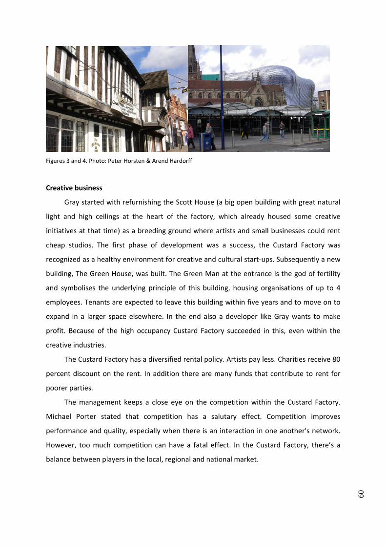
60
Figures 3 and 4. Photo: Peter Horsten & Arend Hardorff
Creative business
Gray started with refurnishing the Scott House (a big open building with great natural
light and high ceilings at the heart of the factory, which already housed some creative
initiatives at that time) as a breeding ground where artists and small businesses could rent
cheap studios. The first phase of development was a success, the Custard Factory was
recognized as a healthy environment for creative and cultural start-ups. Subsequently a new
building, The Green House, was built. The Green Man at the entrance is the god of fertility
and symbolises the underlying principle of this building, housing organisations of up to 4
employees. Tenants are expected to leave this building within five years and to move on to
expand in a larger space elsewhere. In the end also a developer like Gray wants to make
profit. Because of the high occupancy Custard Factory succeeded in this, even within the
creative industries.
The Custard Factory has a diversified rental policy. Artists pay less. Charities receive 80
percent discount on the rent. In addition there are many funds that contribute to rent for
poorer parties.
The management keeps a close eye on the competition within the Custard Factory.
Michael Porter stated that competition has a salutary effect. Competition improves
performance and quality, especially when there is an interaction in one another's network.
However, too much competition can have a fatal effect. In the Custard Factory, there’s a
balance between players in the local, regional and national market.
61
Figure 5. Photo: Peter Horsten & Arend Hardorff
Benefits of being in this creative community are, besides cheap rent, the facilities, the
presence of supporting organisations and the inspiring climate; the numerous possibilities
to connect to other creative people and build a creative community. Within the creative
industries boundaries blur between work and leisure. Because these functions flow into one
another in time and space, the gathering of a critical mass of people, both diverse and
kindred, is essential to professionally co-create or just to spend time with privately.
The creative cluster in Digbeth shows the benefits of a mix of companies. Because the
complete creative chain (creation, production and consumption) are represented work and
leisure comes naturally together. Besides that, creative products are often combinations of
specialisations, requiring different kind of knowledge and skills. Also the co-existence of
starters and larger, established companies is an advantage. The presence of major players is
significant for the growth of new companies. Major players feed small players with orders
and their image positively affects the entire cluster. Major companies also benefit from
relationships with small players and new talent. They make them flexible and offer
innovative power.

62
Split image
Is it that easy? Of course not. Around 2006 the original buildings had been furnished
for artists and young businesses that were looking for a low-rent location and the level of
facilities had been adapted to this. Management faced a dilemma. The success of the
Custard Factory had his effect on the tenants. A lot of them got more, bigger and higher
clients. So the basic interior didn’t fit everybody anymore. However with better facilities, the
prices of the starters locations and workshops would rise and become priceless for the major
group of starters and small businesses. Only limited investments could be made to keep it
financially feasible for this core group, much to the dissatisfaction of the growing bigger
players. Some of them left the Custard Factory at this time.
A split image emerged. The public saw the area as a space for interesting experiments,
but at the same time as a place which suffered from a lack of professionalism and where
partially subsidised work was carried out. Major players left for new areas, which confirmed
this image even more.
Figure 6. Photo: Peter Horsten & Arend Hardorff
One company decided to rent a custom made building in the surroundings of the
Custard Factory. In this way it could build its own professional image, but still benefited from

63
the Custard Factory’s vibe. Aware of this example the management changed his strategy and
made Custard Factory a bigger part of the Digbeth District. Buildings in a larger area of
Digbeth were bought by the Custard Factory management and furnished for the major
players. Tailor-made agreements during the preparation phase turned this into an
operationally viable situation, where the larger players again gave the entire area prestige
and ensured the necessary business. In this second phase the Custard Factory started
delivering spaces in a higher segment, for example the Fazeley Studios. This originally pastry
cream factory was transformed into admirable daylighted studio’s, which can be used for
numerous creative applications. Much attention is paid to the big spacious communal areas
that are ideal for meetings, entertainment and networking, an important aspect in the
diverse, cooperative creative industry.
Figure 7. Photo: Peter Horsten & Arend Hardorff
Adjustments to maturity
Although buildings in Digbeth slowly become filled, recession made it more difficult to
find new tenants and original plans had to be adjusted. The intention was for example that
there would start a high level brasserie at Fazeley. This had to become a USP of the building
and attract new entrepreneurs at the upper segment. But because of the crisis, the
candidate withdrew and now this works in a bit of counter-productive way.

64
Also the wished transition from production place to consumer area has been reframed
a few times. Although nightlife flourished in Digbeth, especially in the weekend, the area
around the Custard Factory insufficient succeeded to become a vibrant leisure place at
daytime. At nighttime events are succesfull and the new multifunctional event location for
1500 people was even in recession a good investment. The nearby futuristic Bull Ring mall
however isn’t really the intended gate to the surrounding areas. Due to the lack of sufficient
daytime flow of people, shops are changing rapidly. In the Custard Factory mainly shops with
a clear internet turnover, using the ‘sexyness’ of the area, survived. Meeting place Rooty
Frooty dissappeared and plans to invest in a large vintage-market, a hotel and leisure-
attractions were more or less abandoned. There maybe will be more ground for retail and
leisure as more apartments will be developed in the nearby future. When boundaries blur
between work and leisure, delivering the whole package of work, leisure and housing is
evident. The lack of sufficient housing made many creatives move to other parts of
Birmingham in the past, where they were able to combine work, living and leisure. However,
the existing energy makes sure that Digbeth will reach its full potential in the upcoming
years.
Figure 8. Photo: Peter Horsten & Arend Hardorff

65
Custard Factory started as a "loose’ business idea that worked. From ‘grassroots
developments’ a new creative community of artists and entrepreneurs arose. With the
increasing popularity the concept for this area further developed. Trial and error were part
of that. Flexibility is te key in projects like this. The market dynamics are changing constantly
and one has to deal with quirky and independent clients. The creative entrepreneur is less
bound by ancient laws of place, thanks to the internet. To stay a hotspot, the challenge is to
strengthen the creative vibe of excitement, energy and innovation. The magic of this kind of
area lies not in "places & spaces" but in the connection between 'creative ideas and creative
people’. In 25 years a lot has happened in Digbeth, the principles of Gray stayed unchanged.
This article is based on several visits from 2007 till 2011 to Digbeth. In the context of an international research
on creative clusters diverse interviews were made with management of the Custard Factory, programm
management Creative Space of City Council and a combination of entrepreneurs and artists within Digbeth
area.
This research has resulted in a Colin/NHTV Magazine (Uncover 1: Creative Hotspots (Hardorff, Horsten & Van
der Aalst 2007)), Toolkit for creative clusters (CD/Booklet in cooperation with Tilburg City council (2007) and
several publications ( MM Nieuws 2008 Vol.10 Nr.6 & MMNieuws 2009 Vol. 11, nr 5).
Case study published in: Marques, Lénia and Richards, Greg (eds) (2014) Creative districts around the world. Breda: CELTH / NHTV. URL: http://creativedistricts.imem.nl/
THE VEEMARKTKWARTIER: PIONEER IN THE NETHERLANDS TILBURG, THE NETHERLANDS
SIMON DE WIJS (LEISURE ACADEMY BRABANT / NHTV BREDA UNIVERSITY OF APPLIED
SCIENCES, THE NETHERLANDS)
KRISTEL ZEGERS (LEISURE ACADEMY BRABANT / NHTV BREDA UNIVERSITY OF APPLIED
SCIENCES, THE NETHERLANDS)
The Veemarktkwartier is a creative district of Tilburg, a medium‐sized city with 203,000
inhabitants in the province of North Brabant, the Netherlands. Originally, the weekly cattle
market took place here, hence the name of the quarter. The city of Tilburg had to reinvent
itself when the textile industry collapsed in the 70’s and 80’s of the previous century. Since
the textile industry had long been the dominant economic sector, the problems arising in
this industry led to high unemployment rates and increased governmental spending due to
massive demolition of factories causing financial problems for the city. It was forced to
develop new perspectives and to transform from an industrial to a postindustrial city (Van
Boom & Mommaas, 2009). The Veemarktkwartier is one of the first projects in the
Netherlands in which economic and urban development are designed around cultural
clustering. At its start, the creed of the district was ‘culture as the engine for economic
development’. Later on, this changed to ‘marketplace for curiosity’ and today the creed is
‘urban zone for creation and innovation’.
In this article we would like to discuss the development of this creative district and the
challenges it currently faces.
Pioneering and clustering
Ideas for cultural clustering as a driver for urban and economic development in the
Veemarktkwartier already date from the 1990s when the first creative activity settled in the
area and when Poppodium 013 (013 Pop Centre) opened in 1998. A big sprint started in the
new millennium with the opening of Villamedia in 2002. The amendment 'CreaTief in Tilburg'
(Creative in Tilburg) by ETIN advisors (2004) subsequently worked as a catalyst. Many plans,
activities and physical clusters followed. A range of these clusters is now present in the area,
all of which have their own flavour, theme, size and history of development. From the
beginning onwards, there has been creative activity in Carré (an old hospital) and the

68
Faxxgebouw (an old bank building) quickly followed. With more than 100 artist’s workshops,
Carré is the biggest cluster and serves as a breeding ground for artists. Villamedia is a long‐
time showpiece. This cluster for new media companies has been the symbol for
developments in this area since 2002. The concept of grouping together (collectivity) (ICT
infrastructure, public areas and lunch) especially acts as an example in the Netherlands.
Later, NS16 (mix of artists and creative entrepreneurs), V39 (cluster for the music sector and
youth organisations, smartly located opposite 013), Villa Minoretti (internet services cluster)
and het Duvelhok (breeding ground for artists) follow. By now, some 250 creative businesses
have settled in the area. They are a very mixed group, with new media, audio‐visual, arts and
music as main creative sectors. The Veemarktkwartier developed rapidly in the first decade
of the 21st century into a fine billboard for the city. An important reason for this is that apart
from just making plans, there is actual clustering.
Figure 1. Creative Enterprise Alinea‐Doc in Villamedia. Photography: Collection Studio VMK
Key figures and cooperation
Not only physical clustering in buildings is important; it also involves people’s
networks. Yolanda Mout, director of Studio VMK indicates: "It is not just about the

69
hardware, but also the software. People, network, connections, social innovation are
central." For instance, two entrepreneurs, Jos Kuijsters and Harrie Dona, together with a few
public servants for integral development of the inner city, have laid the foundations of what
is now developing in the Veemarktkwartier by means of personal effort and strength.
Mommaas (2005) nicely phrases the importance of this type of key people: "This project
depended and depends on the guts, the inspiration and the will‐power of self‐willed
individuals: strong aldermen, inventive public servants, insistent culture managers,
enthusiastic and flexible network agents. It involves many unpaid hours, unorthodox
working hours and unregulated emotions. In the end, these kinds of projects rest on mutual
enthusiasm and trust, not on models and agreements (p.23)."
The wilfulness and perseverance eventually led to a unique public‐private partnership.
The above‐mentioned forerunners together with the municipality of Tilburg succeeded in
finding an investor (Red Concepts, developer of Creative City Zones) for further
development. In order to shape the plans, Foundation Veemarktkwartier (representing
entrepreneurs and organisations in the Veemarktkwartier), Red Concepts and the
municipality of Tilburg entered into a cooperation agreement. Together, the parties came up
with a (new) master plan (2007) containing a complete concept for the area.
Concept and capital
The underlying concept for the area foresees a lively mixture between the functions
create (companies and breeding grounds), learn (education and workshops), experience
(stages, festivals, hotel and catering industry) and live (living) for the area. For this, Yolanda
Mout underlines the great importance of the presence of organisations that focus on
innovation and research such as Tilburg University, Tilburg Innovation Centre and Colin
(platform for creative industries).
With the successes in both hardware and software, opportunities arise for important
and large subsidies that could boost the further development of the cluster. The European
Regional Development Fund attributes a one‐time subsidy of €8,500,000. Moreover, the
Veemarktkwartier participated in Collabor8 (transnational European project focusing on new
clusters of entrepreneurs within the cultural, creative, rural, tourism and recreational
sectors) from 2007 to 2012 making another €1,070,000 for the development of the area
available. The funds are not solely spent on buildings. Within Collabor8, investments in

70
programming, networks, knowledge development and creating business are taking place.
The subsidies contribute to the (eventual) realisation of a front office: Studio VMK. Yolanda
Mout, who has been fulfilling the task of agent in the area for several years, phrases the
tasks of Studio VMK as follows: "We take care of profiling the area, providing information,
forming a network and supporting cultural entrepreneurs.”
Figure 2. Performance Beukorkest in 013. Photography: Anja Dierx
Necessity and risks
The Veemarktkwartier is a pioneer and already came into existence before the 'mass
production' of creative clusters. Big and strong steps forward have been made over time.
However, since the crisis started in 2008 times have been changing and realism has set in.
Hence, some lessons and difficulties that cannot be ignored:
Everywhere in the Netherlands competing creative areas keep arising. Constant
renewal is necessary. An 'innovator' cannot rest on his laurels. For instance, the
Villamedia concept, which was great at the start, is now in need of renewal and
intensification. Competition for attracting creative entrepreneurs is increasing

71
even within the city of Tilburg. It looks like new initiatives tend to prefer other
(and cheaper) locations than the Veemarktkwartier.
Despite the large potential of the Veemarktkwartier (its central urban position,
public area and mixture of consumption and production), it has the image of a
production area or the city centre's backstage.
The strength of key figures at the same time represents the dependency on
these people. What happens when network agents drop out, aldermen are not
re‐elected or investors see other opportunities in the market? Securing
continuity and the body of thought needs to be a high priority.
Plans need to go beyond what lies in the future. Large‐scale plans regularly fall
through or new developments have a different effect than planned. Recently,
the Veemarktkwartier experienced some blows: developments are postponed,
Tilburg University decided not to enter the district because of financial reasons,
and cultural landmark Midi theatre went bankrupt. The negative effects of this
can be devastating. In this, the balance between software and hardware is
important. Whereas large‐scale plans often rest on buildings and infrastructure,
investments in people and networks could be the central support of urban
development more often.
There is also the issue of dependency on the dominant money stream.
Currently, new European and governmental money streams are available for
further investments in the area although it is still questionable whether the
latest plans will become reality. Still, what will happen after the temporary
influx of big subsidies?
Sustainability and future
What is the business model for the future? A necessary bridge that needs to be built is
that of creative industries to a creative economy. A stand‐alone cluster preliminarily focusing
inwards does not provide a sustainable base for durable productivity. The creative cluster
should be connected to the wider challenges and developments in the city. In the case of the
Veemarktkwartier this means connections with leisure, railway areas, life sciences and the
Europe 2020 agenda. This is reflected by the new role Studio VMK has been given by the
municipality of Tilburg. Studio VMK should become the studio for the creative industries of

72
Tilburg. Phrased differently, the power of the Veemarktkwatier is used for the city of Tilburg
as a whole and not only for the district. The Veemarktkwartier as the beating heart of the
city is supposed to provide energy to different economic sectors. This fits well with the
regional economic development plan of Tilburg that focuses on social innovation: new ways
of tackling social challenges (see Mulgan et al., 2007). It requires open and dynamic
collaborations across existing organisational structures and disciplines. The creativity and
innovation of the Veemarktkwartier has the potential to accelerate this. In doing so,
Veemarktkwartier can continue its pioneering role with this next step in the development of
a cultural district.
Explore: Poppodium 013 : www.013.nl Colin: Creative Organisations Linked In Networks : www.colin.nl Interreg programme Collabor8 : www.collabor8.me Real estate developer Red Concepts : www.redconcepts.nl Studio VMK : www.veemarktkwartier.nl Cluster Villamedia : www.villamedia.net
Authors contacts:
Simon de Wijs, [email protected]
Kristel Zegers, [email protected]

73
References
ETIN Adviseurs (2004). CreaTief in Tilburg. Tilburg: ETIN Adviseurs
Mommaas, H. (2005). De creatieve stad; het fragiele evenwicht tussen economie en cultuur.
In: Mommaas, H., K. Nauta, H. Horsten and L. Knippenberg (eds). Zoeken naar nieuwe
wegen, kansen voor duurzaam Brabant, Themaboek Telos 2005. (pp. 15‐26). Tilburg:
Tilburg University
Mulgan, G., S. Tucker, R. Ali and B. Sanders. (2007). Social Innovation. What it is, why it
matters and how it can be accelerated. London: The Young Foundation
Van Boom, N. and H. Mommaas (2009). Comeback cities: transformation strategies for
former industrial cities. Rotterdam: NAi

Case study published in: Marques, Lénia and Richards, Greg (eds) (2014) Creative districts around the world. Breda: CELTH / NHTV. URL: http://creativedistricts.imem.nl/
FASHION DISTRICT ARNHEM: CREATIVE ENTREPRENEURS UPGRADING A DEPRIVED NEIGBOURHOOD ARNHEM, THE NETHERLANDS
DANY JACOBS (ARCCI, ARNHEM CENTRE FOR CREATIVE ECONOMY AND INNOVATION, THE
NETHERLANDS)
EWAN LENTJES (ARCCI, ARNHEM CENTRE FOR CREATIVE ECONOMY AND INNOVATION, THE
NETHERLANDS)
ESTHER RUITEN (CITY OF ARNHEM, THE NETHERLANDS)
The Arnhem Fashion District, which started in 2005, offers workspaces, shops and places to live
for fashion designers. More than fifty fashion designers and other creative entrepreneurs have
located their business in this neighbourhood. For a few years most of the fashion chain has been
present: design and sales of designer clothes and accessories, a model agency, a fashion
photographer, stylist, small‐scale production facilities (sample workshop) and a fashion incubator
(Arnhem Mode Incubator) which mainly supports start‐up entrepreneurs to develop their business
skills.
How the Arnhem Fashion District was developed
The Arnhem Fashion District started in 2005 as part of an urban upgrading process with the
objective to bring liveliness and economic activity back into the deprived neighbourhood
Klarendal. This old workers’ neighbourhood with more than 7,000 inhabitants, not far from the
city centre, did not have a good reputation for a long time. Since the 1970s, it had become a
depressed area: high unemployment, low incomes, little schooling and drug‐related problems.
Its lively shopping axis gradually fell silent.
An area like this is in general, however, quite popular with students and artists, and
Arnhem has a lot of them. Therefore, upgrading this part of the city complied with the city’s wish
to better promote the famous Fashion Design department of the ArtEZ Institute of the Arts
together with the fashion reputation of Arnhem itself. Internationally known fashion designers
such as Viktor & Rolf and Alexander van Slobbe studied at ArtEZ; fashion labels like People of the
Labyrinths and Spijkers en Spijkers have been based in Arnhem for years and also two larger
fashion retail chains (Score and Open 32) have their headquarters there.

76
There was also a strong wish to find out how talented fashion designers could be
supported to keep them in Arnhem. As a result, the Fashion District was established offering
designers a combination of affordable workspaces, shops and living apartments. The whole
project was a co‐operation between the housing association Volkshuisvesting Arnhem and the
City of Arnhem. Volkshuisvesting Arnhem invested twenty to thirty million euros in making the
premises they own in the neighbourhood suitable for the designers as well as in buying real
estate at locations that were important ‘stepping stones’ in the neighbourhood. The City of
Arnhem invested in reconstructing streets and public spaces, as well as projects for coaching and
training designers to become more entrepreneurial. As a third party, the province of Gelderland
has financially supported the project.
From the start the Fashion District was defined as a project, with the end date pending on a
critical mass of entrepreneurs and their ability to become self‐organising. This has worked out
well, as one can see that since 2011 more and more responsibilities have been taken over by the
entrepreneurs themselves, resulting in the association of entrepreneurs in the neighbourhood
taking its place as an important new stakeholder. Current attention focuses on bottom‐up co‐
operation with other organisations of entrepreneurs in the area and investment in a marketing
strategy for the Fashion District as a whole. As a result, the association organised several fashion‐
related initiatives, such as regular fashion shows and the exciting yearly Fashion Night. Also, new
initiatives such as MoMarket are born in other parts of the neighbourhood. MoMarket will take
place every first Sunday of the month, where designers from all over the country will be able to
sell their designs.

77
Figure 1. Property of Volkshuisvesting Arnhem ‐ the Arnhem fashion district Klarendal: before the renovation.
Figure 2. Property of Volkshuisvesting Arnhem ‐ the Arnhem fashion district Klarendal: after the renovation.
Strengths and weaknesses
The project was successful for Klarendal. Unemployment has gone down (nowhere in the
city more than in this area), the number of jobs has increased, the neighbourhood is safer and
private individuals and companies are investing in real estate again. Different surveys indicate
that the people from the neighbourhood are finally regaining confidence in their future and

78
becoming more satisfied with their housing conditions.1 The National Renovation Platform
awarded Klarendal the Golden Phoenix for the best area transformation in the Netherlands and
in 2013 the even more prestigious Golden Pyramid State Prize was awarded to this area for its
development.
The upgrading of a deprived neighbourhood has been connected with start‐up support for
fashion designers. Besides, the project has succeeded in keeping more creative talent in the city.
More than fifty jobs were created in the creative sector. Since 2009 also a sample workshop, that
can organise small‐scale production up to 150 pieces, has been located there. It also supported a
project – Arnhem Fashion Connection – aiming at a closer co‐operation between ArtEZ’s fashion
department (the fashion designers) and the vocational training institute RijnIJssel (the so‐called
fashion makers).
Some people in the neighbourhood were wary about this creative reorientation of their
area. But gradually they warmed up to the project as they saw that living conditions are
improving. Quite important, however, for the success has been that also other businesses came
to the neighbourhood: a few very popular café‐restaurants and a cultural centre in former army
barracks. This brought another hundred jobs to Klarendal. Recently the fashion and design hotel
Modez started business with twenty unique rooms, all decorated by fashion and product
designers educated in Arnhem – under the guidance of fashion illustrator Piet Paris.
A unique feature in the Fashion District is that one can buy designer clothes and
accessories directly from the designers themselves. Moreover, craftsmanship and sustainability
are important values of the project. For example, Elsien Gringhuis, one of the designers, develops
highly innovative patterns in which waste is maximally reduced. Another, Pauline van Dongen,
combines high‐tech materials and new technologies with traditional techniques and
craftsmanship. In this way the Fashion District offers space for experiments and functions as an
open innovation system, a so‐called living lab.
However, the relative success of the Arnhem Fashion District is not an isolated story. It is
an important element of the wider policy of the city to focus on fashion and design as one of its
two most promising economic clusters (the other one being energy and environmental
technology). This is supported by the province of Gelderland and recognised by the national
government. Proof of this ambition is shown in other examples such as the Mode Biennale
Arnhem, whose fifth edition has taken place in 2013. MoBA presents the state of the art of
1 Municipality of Arnhem (2012) Wijkprofielenboek 2011: 22; Municipality of Arnhem (2012) Leefbaarheid en Veiligheid in Arnhem. Resultaten Veiligheidsmonitor 2011: 4, 8‐19, 28‐35, 42‐44, 49‐50.

79
innovative fashion design at an international level every two years. During six weeks MoBA 13
informed and inspired a large audience of fashionistas, students, tourists and professionals with
exhibitions, fashion shows, workshops, seminars, and an educational programme. Of course
there was a close cooperation with the Fashion District, entrepreneurs in the city centre, cultural
institutions and the like.
Another stimulating support of the creative economy is that, not only in the Klarendal
neighbourhood but also in the city centre, designer fashion shops have been attracted to
strengthen Arnhem’s fashion signature: apart from Humanoid, Trix & Rees, and Jones which
already existed, fashion shops such as Coming Soon, Sjaak Hullekes, People of the Labyrinths and
By Maeve have recently appeared on the stage. Another ambition is to make a better connection
between the Klarendal district and the city centre by realising a kind of design‐oriented corridor
between the two areas.
And last but not least, Modekern, the initiative to collect and digitise the archives of Dutch
fashion designers for further research and public presentation was recently allotted to Arnhem.
Here the fruitful co‐operation between Gelders Archief (the Gelderland Archives), ArtEZ, the
Museum of Modern Art Arnhem and Premsela, the Netherlands Institute of Design and Fashion2,
supported by the city of Arnhem and the province of Gelderland, contributes to Arnhem’s
position as city of fashion and design of the Netherlands.
The Klarendal project also has its weaknesses. From a study we undertook with ARCCI in
2010‐20113 it appeared that the entrepreneurial skills of most of the designers located in the
Fashion District were underdeveloped. This endangered the long‐term sustainability of the
project. Therefore, it was a nice opportunity that by the middle of 2011 the Arnhem Mode
Incubator was launched and started coaching and training programmes for existing and new
designers, tackling their lack of entrepreneurial skills. Also the provision of new retail space to
fashion designers is now the object of a tougher screening of their entrepreneurial skills and
business plans. Finally, as said before, more common initiatives are taken by the Klarendal
designers in the last few years to attract more customers to the neighbourhood: fashion shows,
the yearly Fashion Night, workshops and tours and participation in the Arnhem Stock Days in
which leftovers and unique pieces are sold.
2 From January 2013, Premsela merged with the Netherlands Architecture Institute and the e‐culture knowledge institute Virtueel Platform to form The New Institute. 3 Elshof, Marjon, Kees van het Hof & Kartini Slaats (2011) Modeontwerpers in Klarendal. Bedrijfsmodellen in kaart gebracht, Arnhem: ARCCI.
80
Conclusion
The establishment of the Arnhem Fashion District has been a clear success as far as the
upgrading of the neighbourhood and the further positioning of Arnhem as a city of fashion and
design are concerned. However, there is still quite some work to be done in order to guarantee
the long‐term sustainability of the project.
Contact details
For more concrete information about the Fashion District:
Berry Kessels
Volkshuisvesting Arnhem
www.modekwartier.nl

Casestudypublishedin:Marques,LéniaandRichards,Greg(eds)(2014)Creativedistrictsaroundtheworld.Breda:CELTH/NHTV.URL:http://creativedistricts.imem.nl/
THE FINLAYSON/TAMPELLA AREA TAMPERE, FINLAND
MARIANGELA LAVANGA (ERASMUS UNIVERSITY ROTTERDAM, THE NETHERLANDS)
Figure 1. Finlayson. Source: Mariangela Lavanga.
Tampere is the third largest city (204,337 inhabitants) in Finland, and its region
(490,000 inhabitants) is the second main economic hub of Finland. The key branches
of industry are technology and forest industry, with Nokia being the largest private
employer. Tampere is not a capital city like Helsinki or a heritage city in the
traditional sense like Turku, the former capital of Finland. During the 19th century,
Tampere became a major industrial centre for textile, metal and paper factories,
nicknamed ‘the Manchester of the North’ and ‘the Beautiful City of Factories’. The
city is located on the Tammerkoski Rapids between two large lakes, connected by a
canal overlooked by old factories, paper mills and smokestacks. Today, the contrast
between the perfectly restored industrial heritage and the water environment
makes the urban landscape unique.
The Finlayson/Tampella old industrial area marks the urban spaces of the city
centre. For more than a century, the Finlayson site was ‘a town within the town’,

82
closed to outsiders. The structural change in industry in the 1970s meant a gradual
transformation of the use of the industrial buildings and the beginning of a planning
process for the area’s redevelopment at the end of the decade. At the beginning, the
idea was to demolish the industrial buildings and to invest in high quality
architecture. As a consequence, several buildings were destroyed raising questions
on the preservation of industrial heritage. By the 1980s the value of industrial
heritage started to be realised. The reuse of the old factories was then carried out in
conjunction with a general plan for the city centre. The aim of the new plan was to
create a stimulating urban quarter containing all kinds of city‐centre activities
without destroying the cohesiveness and uniqueness of the existing industrial
buildings. The industrial sites were reused and integrated to the city centre from the
point of view of function, traffic and urban design.
The Museum Centre Vapriikki, which moved to the Finlayson/Tampella area in
1991, contributed enormously to the revitalisation of the site and to the
improvement of its image, while being at that time its only non‐industrial activity. A
Figure 2. Tampella. Source: Mariangela Lavanga.
further boost for this museum quarter came when the City received 10 million euro
investments from the government to prepare itself for the European Summit in

83
1999. Institutions such as the Rupriikki Media Museum, the Aamulehti newspaper
and the School of Art and Media from the Tampere University of Applied Sciences
(TAMK) were offered convenient working space and moved to the Finlayson
buildings, contributing to the regeneration cycle of the place.
Today, the Finlayson/Tampella area houses, apartments, offices, over hundred
companies, theatres, a movie complex with 10 screens, restaurants and cafés with
over 3,500 seats, shops, new museums and the Mältinranta Artcenter, operated by
Tampere Artists’ Association. An average of 9,000 people visit the site every day. The
range of mixed uses and activities support and reinforce each other and it is not
limited to the pattern of the normal working day ‐ an exciting evening and nightlife
adds an additional stream of economy. Many annual events are organised by some
of the businesses, museums and school present there, alone or in close collaboration
with other local institutions. Among the most important events, there are the
Tampere International Short Film Festival, the Literature Event and the MindTrek
Conference – International Digital Media and Business Festival. In addition, smaller
events such as book shows, poetry readings, interviews and small exhibitions give a
further contribution to make this part of the city alive day and night, all year long.
Since 2008, the Finlayson/Tampella area has also housed Demola, a publicly
funded innovation platform that connect universities and businesses for developing
projects in the fields of technology, services, digital media, games and social
innovation. The companies are offered the opportunity to test their product
development ideas with students from the three Tampere universities. In this way
students can participate in real projects with real businesses. Every year Demola
executes some 100 projects with some 400 students. Up to 85% of the projects’
results have been commercialised.
Demola was part of the Creative Tampere programme, the largest regional
creative sector business development programme in Finland running between 2006
and 2011. The City of Tampere financed the programme with around 7 million euros
as seed money. The City of Tampere acted as a facilitator while the implementers
were businesses, research and educational institutions, associations and other
organisations. The overall volume of the projects was over 35 million euros. Creative
Tampere was was a very broad co‐operation programme, with the aim to increase

84
innovation. The programme was divided into three mutually supporting segments:
the Creative Industries, Innovation and Entrepreneurship, and Attractive City. Apart
from Demola, Creative Tampere has stimulated new ways of working like LUKE (a
development programme for creative businesses), Voimala (new way to learn
entrepreneurship for young people), and YES‐kummit (entrepreneurs as godfathers
for schools). Since the beginning of the Creative Tampere programme, growth in the
creative industries has been fast compared to other industries and compared to the
rest of Finland. In addition, the financial crisis of 2008 did not affect the creative
industries as much as other industries. Creative Tampere is often mentioned as a
‘best practice’ in Finland and abroad and it received an award for exemplary
development of Finnish innovation and invention from the Ministry of Economic
Affairs. Projects that have been started through the programme have also been
nominated and won awards both in Finland and abroad. The work done within the
Creative Tampere programme will be continued with the new Avoin (Open) Tampere
programme, started in 2012.
Thanks also to the recent projects developed under the Creative Tampere
programme, the Finlayson/Tampella area has become the hotspot for the new
creative businesses. The Hub Tampere opened in 2010 and it offers workspace for
entrepreneurs who are members of the Hub global network. In the coming years the
regeneration of a former sock factory into a building for creative industries will be
completed; the idea is somewhat different from the Hub as it will offer workspace
but also it will allow visitors (non‐members) to enter the building.
The new uses within the Finlayson/Tampella area had strong impacts on the
structure, functions and appearance of Tampere. All in all, they have supported the
recovery of the identity of the city. Citizens seem to have adopted the
transformation of the Finlayson/Tampella area as an extension of the old industrial
city. What used to be walled industrial areas, restricted to the industrial community,
have been transformed into urban spaces with a public and open character. The
cultural investments allowed the (re)definition and reinforcement of the city’s
identity and its participative and inclusive character. At the same time, cultural
investments produced benefits in terms of improvements in city image. Both
processes reinforce themselves in a positive cycle.

85
Its industrial image has not prevented the city from developing into an active
cultural and creative centre. Tampere is today renowned for being a festival city
(over 30 well‐established festivals per year), the theatre capital of the country, and
an important educational centre in arts and culture, hosting several museums, the
biggest city library in Finland, the Tampere City Library (2.3 million customers in
2010), and the largest concert and congress centre in Scandinavia, the Tampere Hall.
Residents make up the main proportion of cultural consumers; and a substantial
percentage of the municipal budget is allocated to cultural accessibility, art
education and youth centres. The role of universities has been fundamental for the
(re)development of the city. Their embedded nature and commitment were and are
very strong. Innovative research and education and cooperation between companies
and universities have maintained and further developed the competitiveness of the
region’s industry. The merger between the old economy and the new one with the
development of globally competitive high‐tech products in traditional fields, the
support of higher education institutions and the strong cultural investments have
provided Tampere with a solid knowledge industry. The preservation and reuse of
the industrial buildings is a constant reminder of the fact that industrialisation has
never ended in Tampere, making the city a hub of high technology, higher education
institutions, culture and creativity. The new economic and industrial policy
programme for 2012‐2018 – Open Tampere – aims at strengthening those relations,
using “innovation factories” as spaces, communities, operational models to keep
developing open innovation environments that allow cross‐pollination and
innovation between the different actors.

86
References
Creative Tampere, 2011. Creative Tampere 2006‐2011 Final Report. Tampere:
Creative Tampere [online] Available at:
<http://www.luovatampere.fi/arkisto/CreativeTampere.pdf> [Accessed 28 March
2013]
Demola, 2013. What is Demola? [online] Available at:
<http://tampere.demola.fi/about> [Accessed 28 March 2013]
Lavanga, M., 2006. The Contribution of Cultural and Creative Industries to a more
Sustainable Urban Development. The case studies of Rotterdam and Tampere. In:
ACEI, 14th International Conference on Cultural Economics (ACEI). Vienna, 6‐9
July 2006.
Lavanga, M., 2009. Becoming a sustainable creative city. Cultural industries and
urban (re)development in Tampere. In: F. Eckardt & L. Nyström (Eds.), Culture and
the City. (Future Urban Research in Europe, 3) (pp. 217‐239). Berlin: BWV ‐
Berliner Wissenschafts‐Verlag.
Open Tampere – Minds Wide Open, 2013. The Program [online] Available at:
<http://www.avointampere.fi/en/the‐program/> [Accessed 10 September 2013]
Tampere Region Economic Development Agency Tredea Oy, 2011. Tampere Facts &
Figures 2011. Tampere: Hämeen Kirjapaino Oy. [online] Available at: <
http://www.tredea.fi/@Bin/137214/Facts_figures_2011.pdf> [Accessed 28 March
2013]

Case study published in: Marques, Lénia and Richards, Greg (eds) (2014) Creative districts around the world. Breda:
CELTH / NHTV. URL: http://creativedistricts.imem.nl/
CREATIVE DISTRICTS OF HELSINKI – TWO DISTANT RELATIVES HELSINKI, FINLAND
PEKKA MUSTONEN (SENIOR RESEARCHER, CITY OF HELSINKI URBAN FACTS, FINLAND)
TARU LINDBLOM (POSTDOCTORAL RESEARCHER, UNIVERSITY OF TURKU, FINLAND)
Helsinki is a pocket size metropolis on the shore of the Baltic Sea. The inner city is home to
just about 300,000 inhabitants, suburbs about the same and neighbouring suburban towns another
half a million. When creative industries are discussed, the focus is usually on downtown Helsinki,
especially the southernmost neighbourhoods.
These areas are largely responsible for Helsinki's reputation as a thriving creative city. Most of
the activities that are commonly linked to creative industries occur there. Just a few blocks in
southern Helsinki contain a third of the jobs of the city. The concentration is particularly strong in
the case of creative industries – no matter how the concept is understood. Artists and ICT
professionals alike are concentrated in southern Helsinki.
In downtown Helsinki, different districts differ fundamentally from each other – even the
neighbouring blocks may represent totally different demographics and atmosphere. Creative
activities have spread all over. However, there are two districts that should be highlighted, namely
Kallio and Punavuori. These two most important creative areas two or three kilometres apart,
share some common characteristics but had been quite distant from certain perspectives – until
very recently.
What distinguishes Kallio from Punavuori is their history; how it is present, how it is
presented and on the other hand, what is the symbolic meaning of history. Structurally, the areas
are also relatively different. Still, these two neighbourhoods are also very similar to a certain
extent. They share similar kind of working class history and are now both lively in the creative field.
Also, they are both forward‐looking, urban spirited and beautiful in a crude unconventional way.

88
Figure 1. Good Life Coffee – a small independent café that sells coffee from small roasteries. Coffee is prepared by the best Finnish barista of 2011. The address in the middle of the greyest Kallio is shared by recently opened very famous bar/restaurant. This small corner of Kallio has changed rapidly during the past year. Photo: Heidi Taskinen, City of Helsinki Urban Facts
The district of Kallio, literally “the rocky hill”, together with its surroundings is an extremely
interesting case and is such in a very classic way. Like many creative areas around the world, Kallio
is also a former workers’ area that has been the first Helsinki home for students and young people
for years. Moreover, it is slowly turning into the area that gains interest and praise even amongst
mainstream media and discussions.
Kallio is situated just one kilometre northbound from the centre of Helsinki and is separated
from the southern city by a bridge. There has been a bridge for more than 350 years at the same
spot. The name of this concrete structure, Long Bridge, does not refer to its length – the bridge is
not that massive – but rather to its symbolic meaning. The bridge separated the proletariat on the
north side from the bourgeoisie on the south side, and to a certain extent, still does.
Kallio attracts young people, and in addition to a tolerant and lively atmosphere there are
structural reasons for this. Flats are small and rents, if not low, are still lower than in the areas in
the most southern parts of Helsinki. Despite rapid changes, from the viewpoint of some statistical
measures Kallio still remains behind the areas on the other side of the bridge. To give some
examples, its education level in general is lower, unemployment is higher and consequently the

89
proportion of residents benefiting from social welfare is higher in Kallio. In addition, bigger
apartments suitable for families are nearly absent, which has slowed down the evident
gentrification process and development in its part.
Figure 2. Brklyn Bakery on one of the main streets of Punavuori, in the heart of the “design district”. The tiny bakery is a sister of Brooklyn Café opened a couple of years ago a few blocks away. There are many independent places like this in Punavuori. Photo: Heidi Taskinen, City of Helsinki Urban Facts
Punavuori is remarkably smaller than Kallio. It is neighboured by characteristically bourgeoisie
areas and the borders are blurred. Thus, the middle‐class or even bourgeoisie ethos easily typifies
Punavuori as well. While Kallio seems to be in the early stages of affirming its own creative class‐
consciousness, Punavuori has gone far, probably partly for the above reasons. It might have even
left its trendy years behind. It has a well‐established and matured, rather self‐conscious image.
The image of Punavuori has changed remarkably during the past decades. Back in the days,
and we do not have to go far into history, the proximity of the dockyard and sea made Punavuori
the infamous outskirts of Helsinki. There were marine bars, illegal activities and dirty alleyways.

90
Thus, from this historical perspective, Punavuori resembles Kallio. Both areas were notably
working‐class quarters, though Punavuori used to be seemingly more decadently associated. The
image of drunken, heavily tattooed sailors escorted by skimpily dressed prostitutes is history, no
matter how little it had to do with reality even in the past.
A short while ago the second last marine bar was transformed into a restaurant. Now in 2014
there is only one marine bar left, maintaining the area’s legendary history alone. Perhaps it will
eventually turn into a curiosity that would nicely fit the image of the neighbourhood. Nowadays
Punavuori is shamelessly middle‐class and it tries to find its role in the battle of “new urbanity” and
homogenised city life.
This is to say that the traditional history of the area is no more visible, especially when
compared with Kallio. The old Punavuori was so characteristically distinct that the change is severe.
Unlike Kallio, today’s Punavuori is not connected with its colourful history any longer. Now, when
people think of Punavuori they think of its advertising agencies, bakeries and high estate prices –
and, on the other hand, new urban activities, festivals, street life and parties usually occupying its
street. Punavuori has traditionally been a place where people go to enjoy these new manifestations
of urban life – however much they have changed their shape. It is still central although the area
might be losing its role as an eminent leader. And it is losing it to Kallio and its surroundings. Just to
give an example, an iconic record store just closed its doors in Punavuori only to be reopened as a
new landmark in Kallio.
Stereotypically, people who live in Punavuori and in Kallio want to stay there. Everything is
near, moving from place to place is easy, so cars are not needed. Urban activities are always readily
available and networks can be reached easily whenever needed. If Kallio is not a backwoods
anymore, Punavuori is not dull. It has struggled to remain energetic. When thinking of the amount
of people working in the creative field, Punavuori is still the most important area. Relatively old
buildings and city structures based on post‐industrial city planning provide space for enterprises of
different sizes. Even though some important companies have packed their open‐plan offices and
moved to the north, most of creative activities still occur in Punavuori or in nearby blocks.
Bigger advertising or creative agencies cannot work in the centre of Kallio due to a lack of
space. And due to a lack of bigger apartments, many, especially bigger families have been ‘forced’
to leave. However, there is also a countertrend we have witnessed increasingly over the years:
families stay in Kallio and choose to live in more cramped space in order to stay in the core of the
action.

91
Kallio is the laboratory where different layers collide and where urbanism occurs in different
light every day. Depending on the “gaze”, the eye of the urban stroller confronts everything from
despair to passion on the same street corner at the same time. For example, a long line of
unemployed people queuing for free bread may sprawl in front of the steps of a trendy brunch
restaurant and next of a children’s playground.
Despite being one of the most vibrant and diverse areas of Helsinki, tourists and occasional
visitors rarely come to Kallio. There is nothing to see in a traditional touristic sense. For someone
who is looking for urban soul and hidden beauty of the city, Kallio is an oasis. The legacy of the past
decades, when the Long Bridge really separated two worlds from each other, remains here. The
proletarian history is present everywhere and this very fact is the most important thing separating
Kallio from Punavuori, currently the somewhat commoditised “design district” of Helsinki just on
the other side of the city centre.
The spirit of Kallio is unique. Even though there are elements that are surely trendy, its
authenticity has not faded. It seems that you can be genuinely unaware of trends in Kallio. This,
however, does not mean that Kallio is a backwoods. Not at all. In Kallio, the newer somewhat
homogenised urban phenomena have not yet surpassed the older layers. Time will tell what will
happen to the area as we know it today and have known it for decades. On the northern side of the
Long Bridge you can see low life every day; in gateways leading to flats with the most rapidly rising
estate prices in Helsinki. In Punavuori low life belongs to the movies. In Kallio, you may not want to
walk alone at night. In Punavuori you can establish a pop‐up restaurant that is open only at night.
Kallio is home to some services and small enterprises that seem to belong there better than
anywhere. The public sauna is one very good example. There are a couple of traditional public
saunas in the heart of Kallio. There used to be dozens of these in Helsinki but nowadays all the
public saunas can be found from the northern side of the Long Bridge. Even the brand new Design
Sauna is in Kallio.
Kallio represents the unconventional creative district. Creativity in Kallio is somewhat hidden
whilst in Punavuori everything appears just before your eyes. You can hardly see “creativity” when
walking across the Kallio hill in the winter. Creative enterprises, agencies and people working in the
creative sector seem to be somewhere else. There are only few characteristically trendy bars,
restaurants or shops. Buildings are mainly grey. Instead, there are shops where you can buy toilet
paper for one euro. There are also bars where the price of a pint is barely half the price of a pint in
Punavuori.

92
Nevertheless, the whole city is changing fast and so is Kallio. A couple of years ago it was
impossible to get a decent espresso in Kallio. Now there are cafés that sell coffee roasted the same
morning in a nearby micro‐roastery. Fresh pasta can be bought from a small factory established in
an old abattoir just a small walk away from Kallio. Small eateries and wine bars are established here
and there. There are many examples. There is nothing special in cafés or bakeries per se, but when
brought to Kallio, they represent a totally new era. That is probably because they are somewhat out
of place there. The contrast is so big and so visible. The change is the evident result of gentrification
in which process Kallio is in a different phase at the moment. Probably Kallio is finally reaching
Punavuori. Or maybe it has gone past already and become the new birthplace of the “cool”.
Kallio is a neighbourhood that draws strength, apart from its history, from its people. The
social networks and neighbourhood associations establish festivals and maintain flower plantings in
parks. Kallio seems to be proud of itself. These characteristics attract creative people to Kallio and
to nearby areas. Many creative people who live in Kallio also work there – and vice versa. Many are
self‐employed or they run small companies. These are not visible to the street. The only hint that
something is happening beyond the surface is a constant buzz. In addition, the statistics tell about
where people of certain professions live and work.
What will happen in the future? It is likely that the outskirts of Kallio will become more
interesting. Due to structural reasons, it is also likely that the ethos of the proletariat will remain.
From the perspective of urban planning, Kallio is also remarkably more demanding. The spirit of the
area spreads further from Kallio itself and this makes the area quite big and diverse.
Punavuori, instead, will probably become even more middle‐class. New initiatives will be born
both in Kallio and in Punavuori; the former representing the more underground level. The closeness
of the city centre will keep the money flows coming into Punavuori. Setting up a small restaurant or
shop for niche markets would still be remarkably more risky in Kallio.
The dynamics between the creative areas can and should be approached structurally
especially in the context of a small city such as Helsinki. This has not been the case in Helsinki
where discussion has been rather superficial. It seems clear that both Kallio and Punavuori provide
creative professionals with the best possible environment. The areas do not compete with each
other. Instead, they complement each other. The fact that the city centre separates these areas is
probably a big blessing for this city’s great urban diversity.

Case study published in: Marques, Lénia and Richards, Greg (eds) (2014) Creative districts around the world. Breda: CELTH / NHTV. URL: http://creativedistricts.imem.nl/
NEW LIFE OF NEW HOLLAND IN A CLASSICAL CITY NEW HOLLAND, ST. PETERSBURG, RUSSIA
VALERY GORDIN (DR. SC, FULL PROFESSOR,NATIONAL RESEARCH UNIVERSITY HIGHER SCHOOL OF ECONOMICS, ST. PETERSBURG, RUSSIA) MARINA MATETSKAYA (CAND. SC, ASSOCIATE PROFESSOR, NATIONAL RESEARCH UNIVERSITY HIGHER SCHOOL OF ECONOMICS, ST. PETERSBURG, RUSSIA) MARIYA DEDOVA (POSTGRADUATE STUDENT, NATIONAL RESEARCH UNIVERSITY HIGHER SCHOOL OF ECONOMICS, ST. PETERSBURG, RUSSIA)
Since the early 1700s, when St. Petersburg was founded by Peter the Great, the city
had been continuously developing as an industrial and military centre of Russia. In recent
decades the city has been undergoing de‐industrialisation and demilitarization processes
that are typical of many post‐Soviet cities. Today restored industrial and military objects are
found side by side with well‐known museums, cathedrals and other sites of the city with
incredible cultural heritage. A city quarter named New Holland is located within walking
distance of the Mariinsky Theatre, the Yusupov Palace and the St. Petersburg House of
Music. The Museum Quarter, the territory of the residential quarter in the historic city
centre comprising nine museums and exhibition halls, bounded by Moika, Kryukov Canal
Embankment, Horseguards Boulevard and St. Isaac's Square is located in the immediate
vicinity of New Holland. In the foreseeable future this territory will become a part of a great
tourist cluster in the city.
New Holland is a man‐made island in the centre of St. Petersburg which was called like
that because of the Dutch shipbuilders were invited by Peter the Great to create his model
city on reclaimed swamps. The island has been under naval control from the moment of its
erection. The huge territory of approximately 7.8 hectares was used for storing lumber for
shipbuilding. Rows of red‐brick barracks and warehouses were constructed for this purpose;
a basin for testing ships as well as a naval prison in a rounded form nicknamed The Bottle
were also designed on the island. In the early 1890s New Holland also became a laboratory
for experimenting on smokeless gunpowder under supervision of Dmitry Mendeleev. The
basin was employed for testing prototypes of Russian battleships, frigates and Soviet
submarines. Later, in the 20th century, the navy built a radio station at the island, from
which Vladimir Lenin announced the start of revolution in 1917. During World War II New

94
Holland was heavily destroyed by artillery attacks. After the war tumbledown architectural
buildings were left deserted untill the beginning of the 21st century.
Figure 1. New Holland. Source: Metro News (www.metronews.ru)
The idea of converting the island into a cultural centre was firstly claimed by architect
Veniamin Fabritsky in the 1970s. However, the renovation of the island was firstly initiated
only in 2004, when the ownership rights were transferred from the navy to the city of St.
Petersburg. After the tendering process Russian developing company ST New Holland in
cooperation with celebrated British architect Norman Foster was to create a complex of
modern art galleries, a theatre, hotel, shops, apartments and restaurants on the island
directly connecting it with Nevsky Prospect, the Mariinsky Theatre and the Hermitage
Museum by new bridges. The project ran into financial difficulties and a new investor
represented by Roman Abramovich’s Millhouse Company acquired a right from the city to
redevelop the island in 2010. The current concept of the island is being implemented by the
American architectural firm WORCac aiming at creating “a city within the city” with a variety
of cultural programmes.
The redevelopment project is to be ready in 2017, but already in 2011 the island was
opened to the public and instantly became popular among citizens and tourists representing
a creative approach towards urban space development. During summer time most of the
space is transformed into a green lawn with deckchairs, place for yoga, skate pool, fitness
classes or frisbee playing. Stationary decommissioned shipping containers scattered all over
the island are used as kitchens for a few cafes run by St. Petersburg’s restaurants, open

95
library regularly replenished with donated books, sport ground for playing table tennis,
computer‐equipped club and art gallery hosting temporary exhibitions of contemporary art.
The summer programme is also saturated with various outdoor events such as music or
poetic concerts, theatre performances, cultural festivals, thematic days for children and
their parents, various workshops and markets.
Over the summer of 2012 the island attracted more than 200,000 visitors compared to
130,000 visitors in 2011. Most frequent visitors are aged between 18 and 25 years.
According to a representative of the Iris Foundation that runs the island during the
reconstruction period all activities taking place on the island is a marketing research aiming
at learning public opinion for future development of the investment project. However,
despite its temporary character Summer in New Holland has become one of the most
popular projects in the creative industries initiated in recent years. The high popularity of
the project can be explained by the possibility for visitors to spend their time outdoors.
Currently there are more than ten creative spaces in St. Petersburg offering various
types of activities, but all of them are located in revitalised buildings of former factories or
other abandoned industrial sites. The low number of urban parks and absence of organised
creative activities make New Holland a unique example of outdoor cultural space in the city
with five million inhabitants.
Figure 2. Summer in New Holland. Photo: Mariya Dedova

96
One of the main features of the project is private ownership meaning that
regeneration development strategy is formed by the current investor New Holland
Development, a division of Millhouse Company. It is the investor who provides different
types of services for a whole row of customers. The first group of customers are visitors of
the island, both residents and tourists. They are offered various opportunities for creative
leisure activities. The second group is represented by the local government interested in
providing public space for common use. It is worth mentioning that entrance to the island is
free of charge as well as the greater part of activities provided, but to enter the island you
need to pass face control. The third group is formed by artists who get a chance to use the
island to present their artworks. The managing foundation stays very open to ideas of
contemporary artists. Finally, there is a large number of particular customers interested in
specific events. If it is a handmade market, independent designers are offered an outlet for
their entrepreneurial activities. If it concerns a painting workshop for children, both parents
and children receive creative educational services. Thus, a plethora of available services
makes this island be a centre of attraction among active parts of population.
However, in our view, the creative character of the present concept of the island
development ignores the history of the quarter. Being a place for recreation and cultural
activities, the identity of the territory is obscured. Right opposite the island, on the far bank
of the canal, there is one of the oldest Russian museums and one of the world's largest
naval museums, Central Naval Museum. It seems that creative New Holland would enhance
its attractiveness by cooperating with the museum. Such cooperation would help to develop
the identity of the space that, in its turn, would foster the formation of St. Petersburg’s
brand as a sea capital which is currently not being attributed and articulated enough.

97
References
Mendick, R. and Rosser, N. Roman Abramovich to spend £250 million on St. Petersburg art
museum project, The Telegraph, 28 November, 2010. URL:
http://www.telegraph.co.uk/news/worldnews/europe/russia/8164981/Roman‐
Abramovich‐to‐spend‐250‐million‐on‐St‐Petersburg‐art‐museum‐project.html (Accessed
15.03.2013)
Minner K., WORKac to Redesign St. Petersburg’s New Holland Island, ArchDaily, 3 August
2011. URL: http://www.archdaily.com/156067/workac‐to‐redesign‐st‐petersburgs‐new‐
holland‐island/ (Accessed 15.03.2013)
Museum Quarter. St. Petersburg URL: http://www.museum‐city.ru/ (Accessed 12.03.2013)
Tyomkin, A. Abramovich wins New Holland tender, The St. Petersburg Times, Issue 1626
(87), November 16 2010. URL:
http://www.sptimes.ru/index.php?action_id=2&story_id=32950 (Accessed 15.03.2013)
Work Architecture Company: New Holland Island, St. Petersburg URL: http://work.ac/new‐
holland‐island‐st‐petersburg/ (Accessed 14.03.2013)
Wrathall, C. St Petersburg’s Cultural Revolution, Financial Times, August 10 2012. URL:
http://www.ft.com/cms/s/2/71dc9640‐dcc0‐11e1‐99f3‐
00144feab49a.html#axzz2PDUTwsBQv (Accessed 15.03.2013)
Axмедова, А. и Ковтун, Н. "Красное знамя" продадут за долги его владельца
(Akhmdeova, A., Kovtun, N. "Krasnoe znamya" sold for the debts of the owner), Деловой
Петербург, 14 August 2012. URL:
http://www.dp.ru/a/2012/08/13/Krasnoe_znamja_prodadut/ (Accessed 10.03.2013)
Новую Голландию этим летом посетили более 200 тысяч человек (More than 200,000
people visited New Holland this year), Фонтанка.ру, 6 September 2012. URL:
http://www.fontanka.ru/2012/09/06/160/ (Accessed 10.03.2013)

Case study published in: Marques, Lénia and Richards, Greg (eds) (2014) Creative districts around the world. Breda: CELTH / NHTV. URL: http://creativedistricts.imem.nl/
A POST‐SOCIALIST TRANSFORMATION – FROM A FACTORY TO A CREATIVE QUARTER RIGA, LATVIA
IEVA ROZENTALE (UNIVERSITY OF AMSTERDAM, THE NETHERLANDS)
TIMURS TOMSONS (ASSOCIATION OF CREATIVE QUARTERS AND SPACES, RIGA, LATVIA)
Evolved from an artist commune to a creative quarter, the recent development of
the former VEF1 territory illustrates what bottom‐up initiatives can do for regenerating
post‐industrial areas in countries where such initiatives are neither common, nor
planned. Its emergence has been and still is largely dependent on the enthusiasm and
initiative of the ‘creatives’ inhabiting this space. Consequently, the evolution of VEF can
be approached in two ways. On the one hand, it is a creative quarter in development,
which enables monitoring how artistic acts can induce the clustering of other activities
around them. On the other hand, its appearance can be further interpreted as an
anticipated advance following the shift from the Soviet system to a democracy in
Latvia.
VEF was the biggest manufacturer of electrical and electronic products in the
former USSR. Established in April 1919 VEF entered the world market with the
development of the world’s smallest camera at this time – Minox. In the 1960s and
1970s two out of three phones in the USSR were produced by VEF. By that time the
factory had grown to occupy a sizeable territory. After the re‐establishment of Latvia’s
independence in 1991 and the opening of Western markets VEF could not compete
anymore due to the declining quality of its goods and services (Rikards, 2009). These
developments left a massive abandoned territory in Riga’s urban space, which is now in
the course of transformation into a rather classic post‐industrial creative district in a
less conventional geopolitical setting.
The occupancy of this industrial heritage by local artists can be considered as a
consecutive process in the development of the post‐Soviet cultural environment. The
1 Latvian acronym for Valsts Elektrotehniskā Fabrika (State Electrotechnical Factory)

100
VEF cultural quarter grew from an initiative of few artistically minded people aimed at
creating a place for alternative art forms to develop and at connecting Riga’s art scene
with that of the rest of the world. The first artistic performance in the abandoned
factory was organised in May 2008 by a group of artists who desired to provide the
Latvian contemporary artistic scene with a more global outreach by inviting some
foreign experts. After a few performances organised in this abandoned territory, there
was only one enthusiast left ‐ Kaspars Lielgalvis. He founded the contemporary art
centre Totaldobže, which is now the core of this quarter’s art life. Within the context of
the economic crisis, which struck the country exactly in 2008, this territory offered a
cheap and big rental space for his ideas to be realised. While the creation of an
alternative art centre was the primary goal of Kaspars Lielgalvis, very soon he realised
that it is impossible without the development of the whole quarter (Lielgalvis, 2013;
Ozola et al., 2011).
Today Totaldobže, created in 2010, is a private multifunctional cultural centre
with a main focus to create an ongoing platform for interdisciplinary art and
educational projects. It currently organises interdisciplinary artistic workshops,
performances and improvisations events for both local and foreign artists. The centre
also has two concert halls and it holds for a development objective the expansion of its
residency programmes as well as a transformation into a larger artistic and creative
laboratory and working station. The centre is continuously participating in many local
and European projects both for the sake of its main artistic activities and for the
quarter development. In addition, it has received the annual cultural award White
Sparrow for fostering the popularity of contemporary art (Lielglavis, 2013; Totaldobže,
2010).
The creation of Totaldobže further triggered the settlement of other activities in
this abandoned district. Even though the district is still in its infancy, its evolutionary
progress since 2010 makes it a very interesting case. While the creative and related
activities do not occupy the whole territory, it is becoming a more and more vibrant
centre of both artistic creation and alternative leisure activities, particularly during the
warm months of the year. At the moment VEF encompasses artistic residences,
fashion, photography and silkscreen studios, art gallery, extreme sports centre, café, an
entertaining horror leisure track, a dance school and some enterprise offices.

101
Furthermore, there are ongoing informal discussions between the inhabitants of the
quarter and the potential investors about the creation of an IT cluster in the district
(Lielglavis, 2013; Totaldobže, 2010; Ozola et al., 2011; Rīgas Radošie Kvartāli, 2013).
©DidzisGrodzs
Notwithstanding the discussions of the potential development scenarios the
future of the VEF quarter and likewise the other creative quarters of Riga is not at all
clear. In 2014 Riga is European Capital of Culture. The city’s creative quarters are
presented under the RIGA2014 programme Survival Kit – a contemporary art festival
that gives them a space for creation. The organising agency of RIGA2014 is currently
the only governmental institution that recognises the creative quarters as an important
cultural player of the city. While the development process of this quarter shows the
importance of such creative spaces in the improvement of the quality of the city's
cultural life and its overall livability, it is not yet recognised as such by any of the
important local governing institutions and other stakeholders. Thereby, led by the arts
centre with the support of the rest of its ‘inhabitants’, the creative district is currently
very actively engaged in positioning itself as a prime case of urban regeneration and
artistic development. Additional lobby activities will have to be done during the year of
ECoC (Lielagalvis, 2013).

102
©Totaldobže Art Centre
Apart from the issues related to the political agenda, the representatives of the
district have to deal with several other problems. Firstly, as a result of privatisation the
territory is divided between many owners. It is therefore very difficult to create a
common development plan and to negotiate long‐term contracts and strategies.
Moreover, they face a number of difficulties related to the general development of the
city such as very poor road infrastructure, transport links, access to heating and other
physical components of the systems needed for the operation of the quarter. Thirdly,
while enthusiastic, the district representatives engaged in positioning the clustered
activities as a creative quarter often lack qualified personnel, legal expertise and
political know‐how, e.g with respect to lobbying at a municipal level (Lielgalvis, 2013).
In order to solve these problems, the VEF quarter as an entity has joined an umbrella
organisation uniting similar territories located in Riga ‐ Association of Creative Quarters
and Territories. Its mission is to create a general development strategy for all the
creative quarters, offering the city new prospects of sustainable and socially
responsible urban development through culture‐led regeneration.
Notwithstanding the difficulties mentioned, the situation is constantly improving
somewhat. These improvements manifesting in the district have also changed the
mindsets of the real estate owners and other stakeholders a great deal with regard to
the necessity of such processes. There is a growing overall willingness to cooperate and
support the cause. To conclude, we believe that this story of the evolution of VEF’s
quarter illustrates a greater trend and also the necessity of bottom‐up creation of
creative districts in parts of the world where culture has not yet been, as we showed,
put on the political agenda as a tool for developing livable urban environments.

103
References
Lielgalvis, K. (2013). Interview with the founder of Totaldobže and the representative of
the quarter. Interviewed by Timurs Tomsons and Ieva Rozentale [in person] Riga,
Latvia, 28 March 2013.
Ozola, E., Groskaufmanis, M. and Zībarte, I. (2011). Riga’s Creative Quarters. [e‐book]
Riga: Rīga 2014.
http://www.meetriga.com/userfiles/files/Iesutitie/RRK_online_small_spread.pdf
Rīgas radošie kvartāli (2013). VEF. [online] Retrieved from:
http://radosiekvartali.wordpress.com/category/rigas‐radosie‐kvartali/
Rikards, N. (2009). Ieskats VEF vēsturē. [An insight into VEF’s history]. [online] Retrieved
from: http://www.bedre.lv/index.php?id=read&show=225
Totaldobže (2010). About. [online] Retrieved from: http://www.totaldobze.com/about/

Case study published in: Marques, Lénia and Richards, Greg (eds) (2014) Creative districts around the world.
Breda: CELTH / NHTV. URL: http://creativedistricts.imem.nl/
THE CREATIVE HEART OF BUDAPEST BUDAPEST, HUNGARY
ANITA ZATORI (CORVINUS UNIVERSITY OF BUDAPEST, HUNGARY)
MELANIE SMITH (UNIVERSITY OF APPLIED SCIENCES, BUDAPEST, HUNGARY)
In Budapest, downtown parts of districts VI and VII are arguably the capital’s creative pulse.
This includes the historic Jewish Quarter, Király Design Street, and Szimpla, the world's first
so‐called ’ruin pub’. Within a relatively small space within walking distance of one another
are some 220 architectural monuments, 180 restaurants, 31 ruin pubs, 25 hotels, 15
galleries, and 22 design shops. The area is home to a diverse range of residents of all ages
and backgrounds and is visited by many Budapest residents and tourists who enjoy its vibe.
Walking from the centre of the city towards Deák Square, and behind the fascinating
sight of UNESCO World Heritage Andrássy Avenue, one can find oneself in a district
characterised by narrow streets and an unusual area of strange contrasts. While some
streets are full of life and never sleep, others are basically deserted. A mixture of luxury
apartments, houses owned by the local government, and empty half‐ruined buildings make
the district appealing and mysterious at the same time. This district is made up of two city
parts – the bigger one is constituted by inner Erzsébetváros (Elizabeth Town), and the
smaller one by inner Terézváros (Teresa Town). Sometimes it is referred to as the Historical
Jewish district, or Multicultural District, or district of cultural and alternative nightlife, which
is “the city’s most dynamically developing part”[2], “the creative heart of the city”[3], and/or
where “something exciting happens all the time”[1]. This 1 km2 area is a real meeting point
of cultures and lifestyles.
The district has always had a special place in Budapest’s history. Until the 19th century,
it could be found just outside the city walls of Pest. Markets were held here, and Király
Street was a typical commercial street filled with shops run by rich merchants. One of the
first theatres was established in the neighbourhood in Hackler House at the end of the 18th
century. According to Kálmán Mikszáth, a contemporary writer from the 19th century:
”Since the beginning of time it has been the centre of night life. Bustling, lively, and noisy.”
(Sárközi, 2006:10).

106
Budapest’s Jewish population has always lived in the area, which resulted in both
glorious and horrific historical milestones. In 1859, the biggest synagogue of Europe
(currently the second biggest in the world) was built on Dohány Street, and in 1944, the
walls of the Jewish Ghetto were erected in the vicinity of the impressive Synagogue. Dob
Street, a dark, narrow street winding through the district, is well‐known as the main street of
the historical Jewish Ghetto, and it is located parallel to Király Street. Its rejuvenation only
began during the previous decade. Mostly tiny streets connect the three main veins (Király,
Dob, and Dohány Street), some of them hiding forgotten pieces of cultural heritage of old
synagogues.
Figure 1. Király Street. Photo: Anita Zatori.
The district’s glory faded after WWII. The area was mostly neglected by local
authorities and city planners during the Communist era, when the apartment houses
became state properties, and no renovations were undertaken. Since the nineties, the
district has seen several property transaction scandals, which happens to be one of the
reasons why some abandoned historical apartment buildings could not be reconstructed
until now. The derelict condition of some buildings meant that the property prices were
significantly lower in this area than in nearby downtown areas, especially the illustrious

107
Andrássy Avenue, which has always been seen as the most exclusive in the city, but even in
the majority of other neighbouring inner districts (e.g. Districts V and VI). The latter fact
enabled several community groups and art movements to settle in the district, which
spiralled into a trend, and creativity began to bloom.
This was one of the main antecedents why a cutting‐edge concept was born in the
district, the phenomenon of now world‐famous ’ruin pubs.’ These ruin pubs are located in
abandoned buildings or on vacant lots, and are characterised by thrift‐shop decor. At first,
these venues and any subsequent investments tended to be be temporary and uncertain,
but once ruin pubs became popular, a new style of interior design was born. The owners of
abandoned buildings and lots also benefited from the growing popularity of ruin pubs, since
they could easily sell or rent out their properties. The number of ruin pubs has mushroomed,
with each venue having its very own, unique design. These peculiar pubs represent an
authentic and characteristic element of Budapest’s culture and nightlife, and attract a large
number of foreign and domestic visitors.
Szimpla Kert (Szimpla Garden), established in 2002 by converting an old factory into a
huge open‐air cinema and pub, was the pioneer of this concept. Szimpla Kert is a cultural
reception space of offbeat art genres, and as a civic organisation it is constantly supporting
initiatives for urban sustainability. As a unique, never‐before‐seen pub, it became popular
within a blink of an eye among locals, expats and tourists – “it represents an intercultural
meeting point”[1]. While it was established „without material source, mostly by the power
of idea”[1], the gist of its concept is to offer freedom and a creative space, and to encourage
interactions. Moreover, it promotes itself as a ”frame creating innovator”, and this
innovative frame has attracted so many people that ruin pubs have mushroomed in the
area. Szimpla has not only been a pioneer, it also brought visitors and vibe to Kazinczy
Street, as the first highly popular venue on the street. The concept embodied in ruin pubs
plays an important role in the lifestyle of a generation of like‐minded people, so many
decided to settle down in this district. ”It became a lifestyle to attend ruin pubs”[1]. Szimpla
gives home to a wide variety of arts and civil movements, it has its own theatre company,
regular exhibitions, concerts, art workshops, and movie screenings. Moreover, the pub itself
is a piece of art – each room is characterised by a different atmosphere and thus by a
distinguishable style of not‐so‐commonplace interior design. On Sundays, a farmers’ market

108
with the partial aim of charity takes place at Szimpla, while another organisation, Lumen
runs a vegetable incubator programme meant to popularise vegetables grown in courtyards.
The prestigous VAM Design Centre is located in the district, and the recently
renovated, fascinating Gozsdu Udvar Court accommodates many hospitality businesses ‐ e.g.
Kolor, a club giving home to Vírus Est, a non‐profit, weekly series of thought‐provoking
presentations boasting the slogan „the idea infects”. The district hosts several art workshops
and exhibition spaces (such as the art students’ den, Telep), small theatres (such as Spinoza
Café, loved by tourists and locals alike), bars with various cultural programs (e.g. Mika
Tivadar, Gozsdu Manó), and community‐creating venues (like Siraly). The idea to bracket the
district’s creative initiations and to encourage cooperations while catalyzing new ideas
originates from Siraly’s community, from Marom Klub Association. Quarter6Quarter7,
organized twice a year, is a festival centred around Jewish religion, culture and identity.
However, it aims to involve all cultures and nationalities, locals and non‐locals. It provides a
creative space to participate in design workshops (e.g. to create a subjective city map),
workshops about empty properties and square renovation ideas, concerts, exhibitions,
sports events, and guided walks provided by BUPAP about the district’s history, myths and
culture with an educational purpose.
Királyutca‐Designutca Cluster (in English: Király Street – Design Street), is a local
business network initiation (as a member of TOCEMA Europe) , the sibling cluster of KultUnio
(which covers the whole district), with a goal to bring back the old fame and interest of Király
Street and to increase the neighbourhood’s commercial magnitude by revitalising the empty
shops and brand building. Design‐themed markets and similar events are organised a few
times a year, and a special card was recently introduced which enables free services and
discounts for customers. They were among the initiators of the big firewall painting on one
of the corners of Király Street, which was realised within the course of the Colourful
City programme; a movement based on the building‐ and firewall‐decorating concept of
Victor Vasarely. Another pair of large‐scale paintings appeared in the district recently, and
many more empty and functionless firewalls are offering this opportunity. There is also an
unusually high number of organisations and civil movements offering a platform for value
co‐creation, just to name a few – KÉK, Klauzália, Lakatlan, Fogasház.
Three organisers, platforms of local life and culture were asked to express their
opinions regarding the district’s creativity factor and potential. [1] Gábor Kátai, PR manager

109
of Szimpla Kert, [2] Klára Murányi, chief organiser of the Quarter6Quarter7 Festival, and [3]
Regina Papp, editor‐in‐chief of We Love Budapest. All three think alike about this issue, and
all agreed on the high creativity factor of the area. Moreover, they all pointed out the
increasing number of creative entrepreneurs and initiatives. ”The city gains creative energies
from this small territory”[2] , while the district attracts ”people who are looking for
opportunities”[3], because ”it enables solutions which do not necessarily require financial
investments”[3]. The district is a place ”where innovations are born”[1].
Figure 2. Quarter6Quarter7Festival. Photo: Gyozo Horvath.
„Nothing is rootless... the functions are intact”[1] – the district was a vibrant area in
the past, a meeting place with an intensive pulse, and after a dark past full of hardships, the
district has come to life again, and boasts a colourful, multifarious image. The district, due to
its undeveloped and neglected situation, offered space available for creative expression and
self‐fulfilment. The impression of belonging to no‐one leads to an impression of belonging to
anyone and everyone. It infers creativity of individuals, creativity of communities, artists and
young professionals, but also cohesion of residents, networking of business entities and civil
movements.
Király Street and its vicinity was chosen as a prioritised project area by the Budapest
Municipality for a five‐year‐long period, from 2011 to 2016. With the support of local
governments, a preferably joint network of investors and all the stakeholders of the district,
the area might overcome its flaws of ruined buildings, neglected streets and empty parcels.
As more and more investments are realised, the district might blossom into a more liveable

110
and aesthetically more pleasing area although careless plans of development might rid the
district from the unique vibe and creative atmosphere of the present.
Figure 3. The painted firewall. Photo: Anita Zatori
Sources:
Sárközy, M. (2006): A Király utcán végestelen‐végig. (All along Király Street). Kortárs
Könyvkiadó, Budapest.
[1] Interview with Gábor Kátai, PR manager of Szimpla Kert, Budapest, 11 April 2013.
[2] Interview with Klára Murányi, chief organiser of the Quarter6Quarter7 Festival, Budapest,
10 April 2013.
[3] Interview with Regina Papp, editor‐in‐chief of We Love Budapest, Budapest, 10 April
2013.

Case study published in: Marques, Lénia and Richards, Greg (eds) (2014) Creative districts around the world. Breda:
CELTH / NHTV. URL: http://creativedistricts.imem.nl/
FROM A JEWISH QUARTER INTO A CREATIVE DISTRICT BUDAPEST, HUNGARY
ANETT K. TÓTH (MA IN COMMUNICATIONAND MEDIA STUDIES AT BUDAPEST UNIVERSITY OF
TECHNOLOGY AND ECONOMIC, HUNGARY)
BARBARA KESZEI (PSYCHOLOGIST, ENVIRONMENTAL COMMUNICATOR, STUDENT AT DOCTORAL
SCHOOL OF PSYCHOLOGY, EÖTVÖS LORÁND UNIVERSITY, BUDAPEST, HUNGARY)
ANDREA DÚLL (PHD, ASSOCIATE PROFESSOR, HEAD OF DEPARTMENT OF ECONOMICS AND
ENVIRONMENTAL PSYCHOLOGY, EÖTVÖS LORÁND UNIVERSITY, BUDAPEST, HUNGARY)
Introduction
The seventh district of Budapest once was home to the Jewish community, but World
War II left the once flourishing Jewish neighbourhood with abandoned houses and poorly‐
maintained buildings, which were squatted in the early 2000s by ruin pubs and subsequently
attracted and were populated by underground artists and cultural creatives ‐ now the area
hosts subcultural1entrepreneurs, creative communities and a lively nightlife concentrated
around the unique venues of the city called „ruin pubs”.
This paper aims to illustrate the present dynamics and characteristics of this creative
urban environment through a case study of grassroots, small‐scale fashion designers and
retailers. By focusing on these space users and their relations we intend to give insight into the
buzz that whirls around in this area and to reveal part of its fascinating socio‐cultural history at
the same time, since the present creative ecology feeds upon its unique past.
Our goal was on the one hand to put down the factors and the reasons behind the
location decisions of the small‐scale fashion designers and retailers and to find out what makes
the “special appeal” and the “magnetic atmosphere” of the district. On the other hand we also
examined Budapest’s 7th district from a relational perspective (Zhong, 2012) to get a glimpse of
the interconnectedness and the creative symbiosis of the district. In order to map these
1We use the term subcultural to refer to those entrepreneurs who produce for and satisfy the needs of a niche market, defined by a certain look, sound, style, or identity. (For a detailed discussion of subcultures, see Hebdige, D. (1979) Subculture: The Meaning of Style)

112
informal relations among the representatives of this alternative cultural production, we used
snowball sampling2combined with semi‐structured interviews as our method.
Even though we have focused only on a narrow sector, through the connections these
actors identified ‐ as further credible representatives of this creative sector ‐ a lively and far
reaching world unfolded with diverse actors such as ruin pubs, restaurants, festivals and
community organizations.
In accordance with an identified research gap (Zhong, 2012), we also believe that the
most efficient way to introduce a creative district is by focusing on its space users, who
contribute significantly to the atmosphere of the district, which make up a “creative milieu”.
(Hall, 2000 cited in O’Connor, 2010).By taking alternative, grassroots businesses and subcultural
entrepreneurs as the centre of our research, who once began as part of the localised scene, we
can illustrate the distinctive and local bias that makes every creative district around the globe
different, since they “thrive on easy access to local, tacit know‐how – a style, a look, a sound –
which is not accessible globally.”(Leadbeater and Oakley, 1999:14)
In the creative district of Budapest this local style is highly influenced by ruin bars, which
in the early 2000s were the common playground of underground scenes, now they are the
flagship of city marketing and urban planning. And since the micro‐businesses examined by us
have grown from the soil that these ruin bars have planted, before we demonstrate the present
dynamic of the district, we have to understand its past.
Romance of transition
According to Ongjerth (2013)3 these ruin bars “were the mix of a workshop, a showroom
and a partyplace, and they have worked along a community concept, which brought a new
quality in the wide range of services.” The first ruin bar, Szimpla4 was opened in 2001 in an old,
derelict building and soon other bars have followed. The countless empty buildings gave space
to unemployed creatives, who started their own, community based enterprises here. The
2See the appendix for the list and a short introduction of our interviewees. 3The cultural manager of Szimpla and the founder of Fogasház. 4Szimpla means simple in hungarian, but since the socialist era it’s also the common name of a type of coffee.

113
consumers and the visitors of the bars were often friends of the owner, so they often had a
distinct subcultural profile.
Due to their uncertain and unpredictable future (both financial and political) they only operated
on short‐term contracts so they always had a transitional feeling, which was described by
Ongjerth as “the romance of transition”. This was reflected in the ”design” of the places which
consisted of old pieces of furniture, often gathered from the street and from evacuated
buildings and the walls were covered with graffitis, which made them the perfect “playground
for adults” (Ongjerth, 2013).
Figure 1. Map of the creative district and its surroundings. Source: Printa.
Although these places required small financial investment, the operators “often invested
considerable personal time and effort into the design and rebuilding of the physical space”, and
they were involved directly in the management of the venues, and maintained a personal and
intimate relationship with the consumers, which resulted in a friendly, welcoming environment.

114
Due to the above mentioned actions the space users were able to develop place attachment, a
strong feeling for the place, so these bars would serve as a second home. Therefore place
identity could become a decisive feature of the district. (Dúll, 1996) An example of expressing
the importance of this network is the map created by Printa (see picture below) to satisfy the
needs of tourists looking for such places.
The evolution of the ruin phenomenon and the special atmosphere of these venues has even
been conceptualized under the term of “guerrilla hospitality”. (Lugosi et al., 2010) Their
common features ‐ entrepreneurial cultures that thrive by exploiting their physical and social
ecology and by mobilising local networks and resources ‐ distinguished them from the
traditional, purely functional and operational venues such as bars and cafés. So, instead of
taking only an “ancillary” position, these ruin bars became „cultural focal points” in the urban
fabric, by hosting cultural events, activities, concerts, fashion shows and partys, and had a
strong commitment towards community actions. (Ibid.) This commitment is intensively present
among the venues who opened before the “post‐ruin bar era”5 and therefore they can be
assessed as subculturally credible actors. For instance the Negyed6negyed7 festival and Lumen
both emphasize this with the involvement of the locals in their programs, which is inspired by
the district.
Case studies
In our case studies we examined subcultural entrepreneurs who were also important
members of the ruin bar scene. They were either one of the costumers, visitors of these bars, or
they were directly involved in their activities. For example Szputnyik, which is a vintage and
designer boutique, had a pop‐up‐store in a ruin bar called Fogasház, and the gallery of Chimera
project started from the upper floor of Telep, a bar which was run by their close friends. By
being part of this subcultural network, they got to know the niche market demands and they
could start to adress these demands by making their own stores, but they kept the
characteristics of the ruin bars and became some kind of “hybrid form” of guerrilla hospitality.
(Lugosi et al. 2010)
5 With this term we refer to the ruin pub boom in 2005, when several pubs have been opened, exploiting the popularity and copying the design of ruin bars.

115
Just like in ruin bars, the owners of the shops also have a personal attachment to the
place: they are directly involved in the shop’s management and try to develop a more intimate
relationship with costumers. As the owner of Printa (which is also a concept shop, a gallery, a
screen printing studio and a café)put it: “We are standalone among the galleries, since this is a
commercialized gallery. Here people can shop and have a coffee at the same time – so they
don’t feel uncomfortable“.
They also try to balance between “the necessities of a commercial enterprise with the
desire to mobilise credible, alternative forms of sub‐cultural capital” (Ibid: 3093). They sell for a
mostly foreignclientele, who “don’t shop in malls, but can appreciate handmade, designer
items” (Siberia, Retrock). They offer carefully selected, often self‐made pieces, that reflect their
subculture and the urban environment around them. Printa for example has its own collection
inspired by the 7th district, consist of t‐shirts, mugs, and even a map, a so called alternative
version of the “I love Budapest” souvenirs.
These shops not only dip inspiration from the district, but also talents. They are
searching for artists and designers, who will fit into their distinct profiles at local art fairs,
galleries, or selecting from the ones who approach them from the street.
Locational decisions
Indeed, when we asked about the reasons why they moved in the 7th district, the
concentration of talent and the aesthetics and cultural meanings of locality were mentioned as
an important factor.(See Zhong 2012)
Since the 7th district is in the city centre, in the old Jewish district which attracts
thousands of tourists every year, it wasn’t a surprise that the prestige, the centrality and
popularity of this location and its relatively cheap rental prices were among the most important
factors as well. Also, given the networked nature of the district described above, factors such as
the networking opportunities (“Even if you just go out to grab lunch, you are going to meet
someone who is working in the industry” ‐ Szputnyik), or the cohesion of the cluster (“The guys
from Chimera project borrowed our ladder when they painted their gallery” ‐ Printa), or the
closeness to partners and consumers (“We would definitely support the concentration of shops

116
with a similar profile. Tourists would know that they have to come to that particular area to
shop and they could stroll from shop‐to‐shop without going to the other part of town for that
particular shop. And this would have a positive effect on our income as well.” ‐Retrock,
Szputnyik) were also mentioned.
Naturally, beyond the obvious, we wanted to investigate the implicit environmental
reasons that could also stay behind the formation of creative clusters. Budapest’s most
characteristic housing type is the tenement building. The layout of these buildings contains an
enclosed inner yard which has been highly favorable for the temporary and transitional ruin
bars.6 Another fortunate advantage is that these yards can be easily covered and „autumnised”,
i.e. make suitable for the autumn and winter season. Due to the district’s jewish and merchant
past, the existing storefronts and workrooms can nowdays be used by small‐scale fashion
designers.
The 7th district’s unique feature that it is located in the center of city, it had the
opportunity to accomodate flourishing ruin bars and in the meantime it also offers the
opportunity to create shops. These transactional characteristics with the creative people made
this district the creative district of Budapest.
Final thoughts
By „playfully commenting on urban decay”7 the ruin bars of Budapest turned the ruined,
decayed buildings into an aesthetic feature, that has determined the special atmosphere of the
district. These characteristics and the appeal of the district doesn’t seem to face any changes in
the near future despite the fact that shops and bars are in a continuous motion. Neither does
the networked, cooperative relationship between these actors. As Anna Zaboeva, the russian
designer of Siberia put it: "I get to know the people who move in, and we become friends."
6Lugosi et al., 2010 7Ibid.:3090
117
References
Dúll A.(1996): A helyidentitásról. Magyar Pszichológiai Szemle,4‐6, 363‐390.
Hall, P. (2000): Creative Cities and Economic Development. Urban Studies 37(4), 639‐649. Cited
in O’Connor, J., Gu, X. (2010): Developing a creative cluster in a postindustrial city : CIDS and
Manchester. The Information Society, 26(2), 124‐136.
Hebdige, D. (1979): Subculture: The Meaning of Style. Routledge, London
Leadbeater C., Oakley K. (1999): The Independents: Britain’s new cultural entrepreneur. Demos,
London
Lugosi P., Bell D., Lugosi K. (2010): Hospitality, Culture and Regeneration: Urban Decay,
Entrepreneurship and the'Ruin' Bars of Budapest. Urban Studies, 47 (14), 3079‐3101.
Ongjerth D. (2013):Az önfenntartó közösségi helyek története Budapesten. Retrieved
fromhttp://prezi.com/_ih64ksnwoxr/az‐onfenntarto‐kozossegi‐helyek‐tortenete‐
budapesten/(Accessed on 10.04.2013)
Zhong, S. (2012): Production, Creative Firms and Urban Space in Shanghai. Culture Unbound, 4,
169–191.

118
Appendix
List and short introduction of our interviewees in the order they were identified as credible
representatives in the course of our snowball sampling:
Chimera project (since 2011) Contact between fine art, subculture and contemporary
urban cultures http://www.chimera‐project.com/
Printa (since 2010) Design shop, gallery, screen printing studio and café.
http://www.printa.hu/
Szputnyik (since 2009) Vintage and designer boutique
http://szputnyikshop.blogspot.hu/
Siberia (since 2009) Uniquely designed shoes http://www.facebook.com/SIBERIAshop
Retrock (since 2001/2012) Vintage, one‐piece creations and designer clothes
www.retrock.com/
Telep (since 2010)Bar and gallery http://www.facebook.com/TelepGaleria
Negyed6Negyed7 (since 2008) Festival in the 6th and 7th districts
www.negyed6negyed7.com
Lumen (since 2012) Greengrocery and Community Service
www.facebook.com/lumenzoldseg
Case study published in: Marques, Lénia and Richards, Greg (eds) (2014) Creative districts around the world. Breda:
CELTH / NHTV. URL: http://creativedistricts.imem.nl/
TRANSFORMATION THROUGH THE REVIVAL OF INDUSTRIAL HERITAGE THE ZSOLNAY QUARTER, PÉCS, HUNGARY
EMESE PANYIK (CATHOLIC UNIVERSITY OF PORTUGAL, BRAGA REGIONAL CENTRE, PORTUGAL)
1. Introduction
Just as industrial mass production of modern times, old factory facilities and products of
vanished technologies have always attracted visitors around the world. Industrial tourism em‐
braces both: visits to modern factories as well as to industrial heritage locations. Today, oper‐
ating sites from chocolate manufacturers to power stations and automobile factories to textile
producers open their doors to the public as industrial tourism offers numerous advantages to
industry players: the diversification of their activities, the generation of extra income, the im‐
provement of their image, the attraction of more employees and last but not least proximity to
their customers which allows them to have a better understanding of their needs (Barnes,
2010).
Despite being a recently coined term, industrial tourism finds its roots in the Industrial
Revolution at the turn of the 19th century, which substituted manual labour with mechanised
production and changed the manufacturing process forever. The Industrial Revolution left a rich
industrial heritage not only in its birthplace, England, but also across Europe. Examples such as
the Blaenavon industrial complex in Wales or the Zollverein Coal Mine Complex in Essen are
UNESCO World Heritage sites. However, most of the old industrial heritage sites in Europe
struggle with maintenance issues. Their rehabilitation is one of the most challenging tasks of
urban revitalisation due to the volume of investment and architectural transformation such
large‐scale properties require. The Manufaktura regional shopping centre in Łódź, Poland,
transformed from the prominent 19th century textile factory by the French commercial real
estate developer Apsys group, was, for example, the largest single retail asset investment in
the Central Eastern European region in 2012 (Apsys, 2012).
120
In this regard, the aim of this chapter is to explore the challenges and practices of urban
transformation through the revival of industrial heritage. The case context is an old industrial
district of Pécs city in Hungary, which has evolved from the internationally known prestigious
Zsolnay Porcelain Manufacture during the past one and a half centuries. The unique character‐
istic of this factory is that it serves as its own reference point: the building complex, as well as
various other prominent buildings in Pécs and in Budapest were built using the pyrogranit ce‐
ramics and the eosin glazing technique both invented by the Zsolnay family. Following its gold‐
en age at the turn of the 20th century, the factory fell into decline during the socialist era after
World War II. It was only revitalised on the occasion of the city being elected the Cultural Capi‐
tal of Europe in 2010, which has become one of the largest projects of industrial revitalisation in
Central Europe (Takáts, 2009). The chapter follows the dramatic transformation of a depressed
and abandoned industrial area into a new ‘city pole’ by the establishment of a new cultural
complex centred around the Zsolnay factory.
2. Pécs: The borderless city
Despite not being a metropolis with millions of inhabitants, Pécs is facing the same prob‐
lems of urbanisation as most large European cities. Located in the south‐west of Hungary, 20
kilometres from the Croatian border, Pécs is the fifth largest city of the country with about
150,000 inhabitants (Figure 1). Pécs has always been a multicultural city throughout its 2,000
years of history and a home for numerous ethnic minorities. Its location and multicultural char‐
acter have been the source of inspiration for the motto of the city used as the European Capital
of Culture in 2010: ‘The borderless city ‘.

121
Figure 1. The location of Pécs, Hungary. Source: http://expandingeurope.pte.hu (photo by: Péter Proksza),
www.graphicmaps.com
The origins of the city`s rich historic heritage can be traced back to Roman times when the
city was established in the beginning of the second century. By the fifth century it became an
early Christian centre, leaving behind a necropolis complex which is today a UNESCO World
Heritage site. In addition to the early Roman ruins, there is also significant Turkish heritage
from the Ottoman era. The cultural profile of the city is rooted in historic traditions: the first
university in the country was established in Pécs in 1367 and even today its successor is the
largest university in the country with about 30,000 students.
3. Old city districts: The dilemma of reconstruction
Today, Pécs is divided structurally into a historic city centre and a surrounding suburbia.
The latter comprises garden cities of middle‐class inhabitants that gradually left the city centre,

122
combined with active and inactive industrial areas. The suburbia has three city poles which
function almost as “cities within the city” located in different directions from the historic city
centre: to the West, a garden city established in the 1960s for miners' families working in the
nearby uranium mine; to the South, a large garden city built in the 1970s to alleviate the hous‐
ing shortage and to the East, the Zsolnay factory, and its surroundings, which is the oldest of all.
Established in 1853 the Zsolnay manufacture was a success story of industrialisation due
to its various innovations: the non‐freezing pyrogranit and the eosin ceramics were emblematic
elements of Art Nouveau on the turn of the 20th century. The factory rapidly expanded and the
Zsolnay brand became known not only in Hungary but also in the European market. After WWII
the factory was nationalised and used for mass production of common tableware goods, which
restrained the utilisation of the sophisticated, artistic techniques and degraded the Zsolnay
brand (Rádóczy, 2010). After the collapse of the socialist regime in 1989, the condition of the
factory became unstable, and as it can be seen in Figure 2, the buildings of the factory complex
deteriorated considerably throughout the decades of decline. The situation was only resolved
in 2005 when the factory became the property of the Municipality of Pécs. This provided the
opportunity for the city leaders to define the strategy of reconstruction and incorporate the
project in the forthcoming application of Pécs city for the Cultural Capital of Europe in 2010.
What was the direction of development defined by the project management? Often, the
urbanisation efforts to restructure the historic centre and reduce the outflow of residents have
negative side effects. Past experience shows that reconstruction for tourism purposes can dis‐
tort the original character of the district creating an 'artificial atmosphere' of a museum. Simi‐
larly, commercial and business purposes may also lead to the partial or total loss of the unique
attributes (Takáts, 2009). As old industrial districts that were once attached to the city are shut‐
ting down, large and quickly amortising 'islands' remain in between old and new districts.

123
Figure 2. Detail of the Zsolnay factory complex before reconstruction in 2011. Source: Zsolnay Örökségkezelő Non‐
profit Kft.
4. The Zsolnay Quarter as a decisive element in the success of Pécs city`s application for Cul‐
tural Capital of Europe
The objective in the present case was the revival of industrial heritage by integrating it in
the existing rich cultural heritage of the city. Earlier, the main street of the city ended at the
border of the city centre, which separated two sharply different districts. People walking on the
main street left from the main square and ended in a roundabout at a large open area in the
outskirts. Although the Zsolnay Quarter is not located right in its neighbourhood, this spacious
area provided the opportunity to erect landmark cultural institutions which served as 'stations'
on the extension of the main street.
The three key institutions that function as the pillars of the project are the Music Centre
named after Zoltán Kodály, the Conference Centre and the Regional Library and Information
Centre which integrated the material of most of the formerly existing libraries in Pécs. In order
to link these key sites to the historic city centre and to the Zsolnay Quarter, landscape elements

124
were developed and reconstructed: bicycle and pedestrian routes, parks, squares and a long‐
abandoned lake which served as a bath until the early 1980s and was left unused during the
past three decades.
In order to emphasise the integrating role of the quarter, a bridge was erected above the
principal highway which crosses the Zsolnay Quarter and separates the city centre and the sub‐
urbia. Pedestrians can walk across the bridge from the direction of the three main institutions
to the main factory complex. The virtually transparent, artistic bridge has become the symbol
of the quarter (Figure 3).
Figure 3. The bridge of the Zsolnay Quarter. Source: Author
The deteriorated or functionless buildings built in the socialist era were demolished and
only the valuable factory buildings were reconstructed. The current production was moved to a
smaller section of the factory which is now open to the visitors: the production process and

125
hand‐painting techniques are presented (See: Figure 4). Thus the visitors are introduced directly
to the Zsolnay brand, thereby creating a marketing effect that the factory alone, using tradi‐
tional marketing methods and its own resources, could never be able to achieve. The Zsolnay
heritage was organised into three permanent thematic exhibitions. The Zsolnay family and fac‐
tory history is presented in the oldest building where the 'Zsolnay legend' was born. Two other
collections are displayed separately: one from the early pink era exhibiting pink pieces from the
experiments of the founder Vilmos Zsolnay, and another from the Golden Age of the factory.
Figure 4. The Zsolnay Quarter in 2013. Source: Author
The remaining buildings were given new cultural, educational and commercial functions.
This shows that the transformation of the new quarter was driven by the city`s greatest
strength, the cultural character, which manifested in the relocation of various cultural institu‐
tions to the new city pole, including the city`s puppet theatre, Youth Centre, and the University
Theatre. Furthermore, the artistic character and creative development could be witnessed by
the fact that the only Faculty of Arts of the country, which belongs to the University of Pécs,

126
was moved to the Zsolnay Quarter. Hence the future generations of artists will get their first
visual learning experiences (the so‐called imprinting process) from the Zsolnay brand (Komor,
2010). The site also provides an opportunity for the introduction of the city`s artists, through
the main festival of the quarter, which is held in the off‐season in May every year. The first
Zsolnay Festival in 2012 had 60 programmes while a year later more than 140 programmes at‐
tracted 10,000 visitors. This included new initiatives led by local artists such as the “Factory
Tourists” performance series, “the Zsolnay Factory Capriccio ‐ Our City” photo competition (in‐
spired by Bohumil Hrabal’s world‐famous romance entitled Cutting it short, in Hungarian: Sör‐
gyári capriccio) and the Arts Market.
The new city pole is, however, more than just a cultural and arts complex. It also includes
an interactive scientific exhibition for children and a planetarium, a hostel, restaurants, winer‐
ies, cafés and a shopping street where traditional handicrafts such as chocolates, candies, ce‐
ramics and leather products can be purchased by the visitors.
Moreover, the Zsolnay Quarter holds a symbolic meaning not only for the residents but
also for the visitors. Located on the eastern border of the city it represents a cultural gateway
to the East. In fact, Pécs city itself is located on the cultural periphery of Western and Eastern
cultures, which put the project in perspective. Not only it allows for multipolar cultural devel‐
opment by balancing the central role of the capital, Budapest, but also contributes to the inte‐
gration of central‐eastern arts and the Balkan cultures into the international cultural networks.
5. Conclusions
For almost two decades after the collapse of Socialism in Hungary in 1989, the situation
and ownership of the once illustrious factory had been unresolved. The reconstruction plans
were put on hold until the project became the core element of the winning application of Pécs
city for the European Capital of Culture in 2010. The final choice on the city among various oth‐
er candidates both in Hungary and abroad can be attributed to a long‐matured project which
put the urban development priorities (city district reconstruction) into a holistic perspective
(conjunction of West and East, Centre and Periphery in European culture), within a future‐
forward strategy of urban decentralisation.

127
Despite this success, however, the title awarded could not have been sufficient to finance
the monumental project of a city district reconstruction. It was therefore co‐financed by the
operational programme of the New Hungary Development Strategy for the 2007‐2013 financial
period. In order to stabilise the challenging number of a quarter million yearly visitors as re‐
quired by the feasibility study, the programme organisers and marketing management play a
key role in extending the high season and providing year‐round activities. To this end, art fairs,
handicrafts markets and concerts are held on a regular basis, targeting all age groups. In winter,
a large backyard is transformed into a skating rink.
More recently, similar processes of urbanisation could be observed in other city districts
of Pécs. In the southern commuter town called ‘Kertváros’ (which means ‘garden city’), a new
event and conference centre has been built and the Municipality of Pécs introduced, for the
first time in 2013, the 'Kertváros Day' dedicated to the residents of the district. In addition, the
'University Days of Pécs' was moved to the former and also abandoned leather factory. This
suggests that the urban planning model of the Zsolnay district, which targets the establishment
of jobs and the growth of visitor flows as opposed to the mere extension of residential areas
seems to have a multiplier effect on urban dynamics.
Acknowledgement
Special thanks to Balázs Arató from the South‐Transdanubia Regional Library and Information
Centre, Pécs.

128
References
Apsys (2012). Manufaktura deal of the year. Retrieved in 03/2013 from:
http://en.apsysgroup.com/manufaktura‐deal‐of‐the‐year‐183.htm.
Barnes, J. (2010). Industrial tourism: An Introduction. Tourism Insights. Retrieved in 03/2013
from:
http://www.insights.org.uk/articleitem.aspx?title=Industrial+Tourism%3A+An+Introduction#
References
Komor, I. (2010). The Zsolnay Cultural Quarter. In: The Cultural Quarter as an Urban Develop‐
ment Strategy. Európa Centrum Kht: Pécs.
Rádóczy, L. (2010). The Specialty of the Architectural Rehabilitation of the Zsolnay Factory. In:
The Cultural Quarter as an Urban Development Strategy. Európa Centrum Kht: Pécs.
Takáts, J. (2009). A határtalan város. Pécs Európa Kulturális Fővárosa 2010. Projektkönyv. Euró‐
pa Centrum Kht.: Pécs.

Case study published in: Marques, Lénia and Richards, Greg (eds) (2014) Creative districts around the world. Breda: CELTH / NHTV. URL: http://creativedistricts.imem.nl/
REVITALISATIONTHROUGHCREATIVITYSAVAMALA, BELGRADE, SERBIA
MILICA ILINCIC (UNIVERSITY OF GIRONA, SPAIN)
Introduction
In almost every metropolitan city it is common to encounter a corner or a district where
there is a greater concentration of arts and culture, creative activities and organisations, as well
as bars and restaurants. These so‐called bohemian quarters traditionally represent gathering
points of a city’s cultural elite, intellectuals and artists, and provide a perfect backdrop for idea
exchange and, in numerous cases, the birth of radically new socio‐cultural and artistic
movements. Moreover, such places have always been magnets for visitors and tourists eager to
get to know a true bohemian side of the city they are visiting.
Paris has its famous artistic Montmartre, New York’s counterculture scene flourishes in
Greenwich Village, Bairro Alto is a centre of Lisbon’s creativity, and likewise Belgrade has its
own creative district called Savamala. Over the years, the historical quarter of Savamala has
undergone many changes from being the cultural and social epicentre of the city, and becoming
one of the most neglected parts of the city’s downtown, to finally regaining the reputation of a
bustling centre of Belgrade’s nightlife and its artistic and creative production in recent years.
Savamala and its Former Glory
Savamala is one of the oldest urban neighbourhoods of Belgrade located on the right
bank of the River Sava. Its name is derived from the name of the river and the Turkish word
‘Mahala’, meaning settlement or city area (Belgradian.com, 2013).
Savamala has been developed from the mid‐19th century when Prince Milos decided to
tear down old dilapidated houses in the area and, in their place, build his residence and other
important buildings such as Grand Brewery and Djumurkana (Customs), which is the first
theatre in Belgrade (Maksimovic, 1995). Following these, some of the most beautiful buildings
of its time were constructed: the academism style Belgrade Cooperative Building, the art

130
nouveau building of Bristol Hotel, the secessionist Vuco House, the traditional Balkan Manak’s
house, and others. These buildings still exist today, but are badly in need of restoration.
Parallel with its architectural development Savamala was becoming a bustling quarter of
trade and crafts (Milic, 1995). Its main streets, Gavrilo Princip and Karadjorjeva, abounded in
elite merchant and artisan shops. Consequently, the area saw the rise of many traditional
Serbian cafés, called kafana, where people used to meet, discuss business proposals, exchange
ideas or just socialise.
In conclusion, Savamala became an important river port, a centre of the city’s economic,
social and cultural life, populated by rich artisan and merchant city families.
The Era of Neglect
Unfortunately, after the period of flourishing came the time of neglect of once beautiful
Savamala. The neighbourhood was heavily damaged during the First and, especially, the Second
World War when much of its stunning buildings were turned into ashes. Despite the fact that
the area was reconstructed afterwards, its initial glow never returned. In the last few decades,
the local government has made no significant investments in Savamala (Savamala Drustvo,
2013). Many of its important buildings that survived the bombing started to decay, particularly,
when the main street of Savamala, Karadjordjeva Street, was turned into a transit road through
Belgrade and started to be used by heavy trucks and other large vehicles. Thus, the beauty of
spacious streets, river bank and many exquisite architectural masterpieces, are hidden behind
gray facades and deteriorated buildings, as well as the heavy traffic that constantly pollutes
Savamala. Only a few, out of numerous craft shops, managed to survive this period of crisis and
resist the pressure of time.
The Creative Revitalisation of Savamala
Luckily, circumstances in Savamala are slowly changing, as a number of initiatives has
recently raised awareness of the district’s importance and its unused potentials. Local cultural
organisations and communities are working hard on reinventing this quarter as the centre of
culture, art and design.

131
It all started in 2007 when the Youth Centre of Belgrade transformed an abandoned
warehouse of the former publishing house Nolit into a cultural centre called Magacin
(www.domomladine.org/magacin), a place for people to meet, watch films, attend lectures and
organise exhibitions and performances. The space consisting of an exhibition hall, video rooms
and offices was then ceded to artistic associations and organisations for preparing and realising
cultural and artistic projects.
Following their steps, in 2009, the cultural centre Grad (www.gradbeograd.eu) was
formed in one of the old port warehouses dating back to 1884. Grad is the result of the
cooperation between Cultural Front Belgrade and the Felix Meritis Foundation from
Amsterdam, and they are all supported by the Dutch Ministry of Foreign Affairs. It houses a
large gallery, art library, café bar and an art shop. The idea was to create a multifunctional
creative space for organising different cultural and social programmes, while keeping the
atmosphere of the old Sava warehouse at the same time.
Figure 1. Belgrade Cooperative Building – once one of the most beautiful buildings of Savamala that had long been neglected is now used as a venue of the Mikser festival. Photo: Milica Ilincic

132
Furthermore, probably the most important initiative taking place in Savamala is the
Mikser Festival (www.mikser.rs), the biggest festival of creative arts in the region. In 2012, this
event moved from the Danube industrial area to Savamala. This was due to the district’s great
need for enhanced visibility and revitalisation through creativity. Numerous venues of
Savamala, old, but once beautiful buildings (see Figure 1), industrial sites, cafés and bars, as
well as open spaces on the river bank, provided a perfect backdrop for artistic experimentation,
dynamic and site‐specific inventions, workshops and performances.
The programme covered different fields, from architecture and urban planning to design
and visual arts, and involved both regional and international artists as well as upcoming young
talent. Consequently, key spots of Savamala have been uncovered and its systematic problems
highlighted. Reuse of former industrial sites and activities, such as the restoration of old,
rundown street doors through street art (see Figure 2) already infused certain urban
transformations. Working in cooperation with the locals, the so‐called ‘Savamalians’, and the
municipality, Mikser set itself the long‐term goal to give back to Savamala the reputation of
Belgrade’s socio‐cultural melting pot.
Figure 2. Street doors in Savamala restored by street art. Photo: Milica Ilincic.
133
Recognising the potential of Savamala, the Goethe Institute in Belgrade decided to
invest in the restoration of the district through a one‐year project called Urban Incubator
(www.goethe.de). Incubator started in March 2013 and was conceived as a bottom‐up project,
in which the future of the quarter would not be created by urban planners, politicians and
investors. Instead, artists, architects and activists will join their efforts with the locals in
implementing ten different artistic, cultural and social projects. One segment is the
development of ‘micro factories’ by revitalising existing crafts and arts shops that should cause
a positive loop and eventually lead to the opening of new shops and galleries. The aim of the
Urban Incubator is to initiate the development of Savamala looking at the concept of ‘creative
city’ already implemented in different European metropolises such as Berlin, Hamburg,
Amsterdam and Zurich.
Although the initiatives still have not brought any capital investments, they have
managed to transform the face of Savamala and reinvent it as a creative city quarter. A greater
concentration of arts, creative spaces and events, as in the case of East London (Pappalepore,
2010) or Amsterdam’s Jordaan neighbourhood (Richards & Wilson, 2007), brought with it a
certain atmosphere, a particular buzz that keeps attracting people to the area. Not only have
artists chosen Savamala for their galleries and shops, but now, the area is abounded with cafés,
bars and nightclubs making it the centre of the city’s nightlife. Moreover, the atmosphere of a
place acts as a magnet, increasingly drawing the attention of international artists and tourists
(Richards, 2011) eager to experience a countercultural area of Belgrade.
It can be said that the charm of Savamala, thought to be lost, is once again being
revitalised and unleashed thanks to its reawakened creativity, its vibrant atmosphere and
diversity of its offering.
Conclusion
Utilisation of cultural and creative industries as a means of regenerating deprived city
areas has been seen all over the world. Though such culture‐driven strategies have shown
positive effects in terms of social, economic and physical development, their long‐term effects
have not yet been confirmed and certain accompanying risks have been noted: insufficient

134
social inclusion, increased housing costs, low benefits for the local population and decreased
social diversity and authenticity (Pappalepore, 2010).
However, a bottom‐up approach adopted in the case of Savamala has been advocated
as one that can counteract the aforementioned risks. It allows involvement of different
stakeholders, primarily local communities and people that inhabit the area and possess greater
sensitivity towards the needs for and context of reform (Evans, 2005). The emphasis is put on
intangible aspects of culture (Pappalepore, 2010), on maintaining and enhancing the identity of
a place (Ploger, 2001) and retaining local authenticity (Gibson, 2005) making such a reform
more realistic and sustainable.
For now, the urban transformation of Savamala is visible in a greater concentration of
multifunctional creative spaces and cultural events, in attracting creative people to the area
and creating an overall lively atmosphere, all of which generally characterise creative districts
around the world (Montgomery, 2003). Even though the reputation of Belgrade’s creative
quarter brought many medium‐sized and small enterprises which infused greater tourist and
local spending, it has not brought any major capital investment to the area to date.
The next step will be to attract such investments necessary for improving the district’s
infrastructure, restoration of its neglected buildings, roads and riverfront. The seed for this step
has been planted by having the city’s officials and the international community pay more
attention to the district’s importance and its problems. Whether this seed will grow and
flourish, allowing a complete revitalisation of Savamala still remains to be seen.

135
References
Evans, G. (2005). Measure for measure: evaluating the evidence of culture’s contribution to
regeneration. Urban Studies 42(5/6), 959‐984.
Gibson, L. (2005). Cultural Planning and the Creative Tropical City. Retrieved March 15, 2013,
from https://lra.le.ac.uk/bitstream/2381/131/1/Lisanne%2520Gibson.pdf
Maksimovic, B. (1995). Urbanisticki razvoj Beograda od 1830. do 1941. godine. In Istorija
Beograda (pp. 247‐262). Beograd: Balkanoloski institut SANU.
Milic, D. (1995). Drustvo i privreda u XIX veku. In Istorija Beograda (pp. 209‐245). Beograd:
Balkanoloski institut SANU.
Montgomery, J. (2003). Cultural Quarters as Mechanisms for Urban Regeneration. Part I:
Conceptualising Cultural Quarters. Planning Practice and Research 18(4), 293‐306.
Pappalepore, I. (2010). Tourism and the development of ‘creative’ urban areas: evidence from
four non‐central areas in London. PhD thesis, University of Westminster, School of
Architecture and the Built Environment. Retrieved December 27, 2012, from
http://westminsterresearch.wmin.ac.uk/8880/
Ploger, J. (2001). Millennium Urbanism ‐ discursive planning. European Urban and Regional
Studies 8(1), 63‐72.
Richards, G. (2011). Creativity and Tourism. State of the Art. Annals of Tourism Research 38(4),
1225‐1253.
Richards, G., & Wilson, J. (2007). Tourism, Creativity and Development. London: Routledge.
Belgradian (2013). Savamala. Retrieved March 28, 2013, from
http://www.belgradian.com/sightseeing/savamala/
Savamala Drustvo (2013). Savamala Projekti. Retrieved March 03, 2013, from
http://www.savamala.com/%D0%BF%D1%80%D0%BE%D1%98%D0%B5%D0%BA%D1%82%D
0%B8/

Case study published in: Marques, Lénia and Richards, Greg (eds) (2014) Creative districts around the world. Breda: CELTH / NHTV. URL: http://creativedistricts.imem.nl/
VAROSHA – A CREATIVE MEANING THROUGH THE YEARS LOVECH, BULGARIA
LILIYA TERZIEVA (NHTV UNIVERSITY OF APPLIED SCIENCES, BREDA, NETHERLANDS)
One of the oldest towns in Bulgaria – the city of Lovech – is situated in the Forebalkan
area of the Northern part of the country, on both sides of the river Osam. During the
Medieval times it was an important military strategic centre and by the 11th century used to
be called Lovuts, which actually means a town of hunters. That is where the name of the
town came from.
During the 13th and the 14th century Lovech was one of the biggest towns and
fortresses in Northern Bulgaria and had reached a good economic prosperity. Later on, after
the country fell under Ottoman Rule (1396), during the years of the national liberation
movement Lovech turned into the revolutionary capital of Bulgaria. The most popular
Bulgarian hero Vassil Levski established a revolutionary headquarter in the town. Nowadays
Lovech has established itself as a big cultural and tourism centre, attracting visitors mostly
for the monuments and the unique architecture buildings, as well for the unique and
beautiful natural wonders of the region.
Lovech has a population of 45,000 people and is situated between the hills of Stratesh,
Hisarya and Bash Bunar. An old legend says that everyone who comes to the town and
drinks water from them stays here forever. It is truly believed by the ancestors that the lilac
literally captured the whole Stratesh Park because once it drunk from the water, it fell in
love with the nature there. Therefore in the winter days, there is a scent of spring.
Lovech is the place where the architectural and historical district Varosha is located.
The basic part of the architectural legacy of the region is related to the construction during
the Revival. The old residential district of Lovech – Varosha – was declared an architectural
and historical protected area in 1968. 200 historical and architectural monuments of local
and national significance are located there. Merchants and people, engaged with handcraft,
started living in the region of the Lovech Medieval Fortress - Varosha, in the era of the
Bulgarian Enlightenment and Revival. After the Liberation from the Ottoman Empire, the
district evolved according to the necessities of the new time.

138
The streets of the Varosha district are narrow, winding and sometimes unexpectedly in
front of them there appears either a thick wall or a house entrance. The houses are rather
small and in most cases surrounded by high stone walls. The yards have several levels and
are decorated with plants such as lilac and roses. The houses, built in the period 1850-1870,
are the best representatives of what is called “the Varosha architecture”. These architecture
of these houses is designed like this that they do not have a small shop at the front side since
the entire handcraft and trading activity is concentrated on the Merchants’ street and under
the Covered Bridge. The Covered Bridge is one of the main symbols of the city. It has been
designed by the very famous Bulgarian architect Master Kolyo Ficheto. During the Ottoman
times, Midhad Pasha asked the Master to build “something original” – a bridge over the
Lovech open market, under which the road between Sofia and Veliko Tarnovo could pass,
and at the same time to join the two parts of the town that were divided by the river Osam.
The genius builder studied the terrain and came up with a special design. The columns were
strong and from stone, the construction above from wood. It was built without nails and
joints, without estimation means, without a surveyor’s level and without cement. Similar to
the Florentine Ponte Vecchio, the Lovech Bridge had small shops under one roof. The master
wanted people to feel that they are on a real market street. The bridge was finished in 1872.
It was 10 meters wide with 64 shops. It took almost 30 years after the Liberation wars when
the bridge was almost completely demolished (1878), for its renovation to start all over
again. In 1925 the original bridge was rebuilt, wooden and covered as it used to be in the old
times. Today the Covered Bridge is the link between the Varosha district and the city centre.
The amazing appearance of the architectural heritage of the Varosha district is created
by the Lovech Enlightenment House. In the process of its building and its design there can be
seen the skillful combination of the steep
and rocky terrain and the medieval
characteristics. The façade of the house is
usually towards the yard. The ground floor is
built with a thick stone wall with small
windows for air-refreshment and defense.
Above this floor is the living part with either
Figure 1. The district architecture, Creative Commons
Bulgaria. Source: MrPanyGoff.
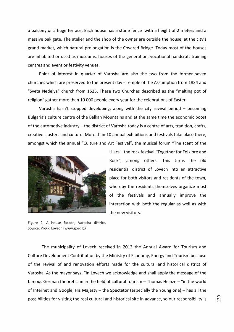
139
a balcony or a huge terrace. Each house has a stone fence with a height of 2 meters and a
massive oak gate. The atelier and the shop of the owner are outside the house, at the city’s
grand market, which natural prolongation is the Covered Bridge. Today most of the houses
are inhabited or used as museums, houses of the generation, vocational handcraft training
centres and event or festivity venues.
Point of interest in quarter of Varosha are also the two from the former seven
churches which are preserved to the present day - Temple of the Assumption from 1834 and
"Sveta Nedelya" church from 1535. These two Churches described as the “melting pot of
religion” gather more than 10 000 people every year for the celebrations of Easter.
Varosha hasn’t stopped developing; along with the city revival period – becoming
Bulgaria’s culture centre of the Balkan Mountains and at the same time the economic boost
of the automotive industry – the district of Varosha today is a centre of arts, tradition, crafts,
creative clusters and culture. More than 10 annual exhibitions and festivals take place there,
amongst which the annual “Culture and Art Festival”, the musical forum “The scent of the
Lilacs”, the rock festival “Together for Folklore and
Rock”, among others. This turns the old
residential district of Lovech into an attractive
place for both visitors and residents of the town,
whereby the residents themselves organize most
of the festivals and annually improve the
interaction with both the regular as well as with
the new visitors.
Figure 2. A house facade, Varosha district. Source: Proud Lovech (www.gord.bg)
The municipality of Lovech received in 2012 the Annual Award for Tourism and
Culture Development Contribution by the Ministry of Economy, Energy and Tourism because
of the revival of and renovation efforts made for the cultural and historical district of
Varosha. As the mayor says: “In Lovech we acknowledge and shall apply the message of the
famous German theoretician in the field of cultural tourism – Thomas Heinze – “in the world
of Internet and Google, His Majesty – the Spectator (especially the Young one) – has all the
possibilities for visiting the real cultural and historical site in advance, so our responsibility is

140
– despite the age, social and religious status – to create a story, a fairy tale, a myth or a
legend, told with the means of the contemporary audio-visual technologies to enhance him
or her in really becoming part
of it with his presence. “This is
exactly what we keep doing in
Lovech.”
Figure 3. The covered bridge by night, The Experts, Travel and Hospitality Experts (http://thexperts.bg/Pokritiat-most-v-Lovech-stava-chast-ot-iniciativa-na-UNESCO)

141
References
Changova, Y., Lovech – the fortress of the medieval city XII – XIV, 2006, Military editorial
Tsanev, St, “Bulgarian Chronicles”, 2008, Ciela, Sofia
Бръняков Б. Действията около град Ловеч през Освободителната война 1877-1878 г.,
Печатница „ Светлина “, Л., 1928.
Известия на РИМ - Ловеч, т. I-VIII, Л., Вт., 1992-2011
Каниц Ф., Градът Ловеч от основаванието му до освобождението му, Вт., ИК „Витал“,
2001.
Кузманова К. (съставител ), Почетните граждани на Ловеч, Регионален исторически
музей-Ловеч, ИК „Витал“, Вт., 2009
Кузманова К., Смислени години. История на Борисовото училище 1893-1945 г., ИК „
Сафо“, Л., 2003.
Кузманов Ю., Смислени години. История на училище „Христо Кърпачев“ 1945-1991 г. ,
Издателство „Инфовижън“, Л., 2012
Лалев И., Американският девически колеж в Ловеч, Вт., ИК „Витал“, 2001
Лалев И., Държавно кожарско училище в Ловеч 1928-2008 г., ИК „Сафо“, Л., 2008
Ловеч и Ловчанско, кн. I., Печатница „Книпеграф“ А.Д, С. 1929; Кн. II. С., 1930; Кн. III. С.,
1931; Кн. 4., С., 1932; Кн. 5., С., 1934.
Маринов Х. и колектив, Ловеч-пътеводител, С., 1989
Миховски М., Църковно-музикална летопис на Ловеч 1854-1994 г., Бл., Издателство
„Интелект А“ ,1996
Станимиров С., Нова добавка към „Из черковната история на гр. Ловеч“, сб. Ловеч и
Ловчанско. Географско, историческо и културно описание, кн. 5, С., 1934
Стоянов П., Градът Ловеч като център на Българския централен революционен комитет,
столица на Васил Левски и роден град на поборника Тодор С. Кирков, Вт., ИК
„Витал“, 2001

Case study published in: Marques, Lénia and Richards, Greg (eds) (2014) Creative districts around the world. Breda: CELTH / NHTV. URL: http://creativedistricts.imem.nl/
NEWCULTURALPOLARITIESANDTHEREVIVALOFBEYOĞLUINISTANBUL ISTANBUL, TURKEY
JÉRÉMIE MOLHO
“When I first came here in 1994, I felt very very far from home, like the other side of
the world, and now in 2012, I feel very much at home.”
These words of the jazz star Marcus Miller is reflective of the new aura that
Istanbul has gained for foreign artists1. Flows of people in streets, music coming
from all parts, images and sounds flavoured with a blend of East and West. The
media does not need to investigate very long to find the good clichés of the ‘Cool
Istanbul’ that has emerged over the last decade.
This image comes with a territorial paradox: on the one hand, it portrays
Istanbul as a global metropolis of more than 15 million inhabitants. On the other
hand, the clichés of ‘Cool Istanbul’ are mainly focused on a single neighbourhood:
Beyoğlu. This 9 km2 hilly district located on the European shore and surrounded by
the waters of the Bosphorus and the Golden Horn has constituted both a magnet for
the creative sector and a showcase for Istanbul’s effervescence. Since the 1980’s
Beyoğlu has undergone a massive transformation in its physical, social and economic
structure.
Beyoğlu’s golden past: myth and reality
The 19th‐century Beyoğlu is commonly remembered as a cosmopolitan,
tolerant, and a cutting‐edge neighbourhood. This nostalgic memory goes along with
the idea that recent urban transformations have enabled a return to its past glory
after half a century of degradation.
1 This quote is taken from a report that presents several cases of artists that chose to come to Istanbul for a short or long term : http://blogs.afp.com/cross‐culture/?post/2012/07/20/La‐bouillonante‐Istanbul‐attire‐les‐artistes

144
Formerly referred to as Pera, a Greek word meaning ‘across’, it was opposite
the centre of power of the Ottoman Empire, on the other side of the Golden Horn.
Due to the presence of the port of Galata, many foreigners frequented or settled in
the district: Venetian and Genoese traders as well as Greeks and Armenians.
Along the 19th century, Europeanisation of Beyoğlu went along with the
development of trade, industrial revolution, and the growing influence of European
nations in the Ottoman Empire. French, Italian and Greek schools and embassies
settled there.
The Great Fire of 1870 accelerated this movement. After the destruction of
traditional Ottoman wooden houses and the construction of European style multi‐
storey stone buildings, the reorganisation of the street grid was eased.
Thus in the early 20th century, Beyoğlu offered not only very modern urban
services such as an underground train and an electric tram, but also a wide range of
entertainment. From cabarets, cafés and passages, to cinemas and theatres. This
lively and cosmopolitan atmosphere went along with a strong social contrast
between port workers and rich merchants or diplomats.
Conversely, in the 1980’s, this same district was mainly associated with crime,
prostitution, destitution, rural migrants living in deprived housing left empty by
Greek populations forced out of the country in 1955.
This description has found a common ground with the critic of the modern
state, accused to have promoted a uniform national identity against Istanbul’s
cosmopolitan richness. Yet, until the late 1970’s cultural activities were still very
active: cinema production, concentrated in Yeşilçam Street, was at its highest peak.
Publishing and visual arts were also very prolific in Beyoğlu.
Just like the destructions of the Great Fire of 1870 had accelerated urban
transformation, the 1980 military coup appears as a turning point for Beyoğlu.
Repression destroyed the creative sectors as the flames had destroyed wooden
Ottoman houses. Literature, cinema, visual art, as long as they were prompt to carry
subversive political messages were hampered. Many intellectuals, writers and
cineastes had to leave the country. This was followed by waves of liberalisation both
in cultural and urban policies. Private television companies developed,
philanthropists took over the city’s cultural policy and obtained tax cuts. As for urban
145
planning, the ‘Beyoğlu project’ launched in the beginning of the 1980’s opened
major road axes within the district while pedestrianising other areas for
consumption activities, especially the famous Istiklal Street. Thus, the nostalgia of
the golden past of Beyoğlu favoured policies that furthered its specialisation in
cultural consumption.
Beyond the revival discourse: What made Beyoğlu a creative district?
Despite the restrictive policies that were put in place in the beginning of the
1980’s, Beyoğlu kept its attractiveness. Although the centrality of the service sector
moved north with the rise of a central business district in Levent, Beyoğlu was still
accessible by all modes of transport and was in close proximity to the gravity centre
of the tourism sector on the historic peninsula. Besides, many international
institutions were maintained in Beyoğlu: consulates, foreign cultural centres, schools
and research centres. The various types of heritage present in this district
represented a potential of rehabilitation: stone buildings built in the 19th century,
passages, but also industrial heritage. Finally, the atmosphere of tolerance is also a
factor that enabled Beyoğlu to remain attractive for creative workers, in contrast to
other districts where social control can be perceived as too intrusive.
The planning system in Beyoğlu involves various levels of governments: Apart
from the municipality of Beyoğlu, the municipality of Greater Istanbul is in charge of
the planning through the urban conservation area development plan. Additionally,
some areas are controlled by the central government, along with real estate
developers. Due to the complexity of the planning system and its limited
implementation, powerful private actors took over the rehabilitation of some areas.
Thus, the large industrial consortiums owned by major families (Koç, Eczacıbaşı,
Sabanci) started to build a cultural showcase in Beyoğlu.
The establishment of cultural poles has occurred through a pragmatic
approach and generated emulation within the cultural sector, which contributed to
an organic development of cultural activities in the proximity of these cultural poles.
The Biennial launched in 1989 by the Eczacıbaşı family is the most
emblematic example of this strategy. Since its creation, this event had been hosted
in various buildings after negotiation with public authorities. Although the two first

146
editions were located in historical buildings such as Hagia Sophia, it later settled in
industrial buildings and in public spaces. It was a way to experiment with a cultural
function for these buildings and to open the opportunity to institutionalise it. This
trial and error process enabled the creation of many cultural facilities. For example,
Istanbul modern, which opened in 2004, was a 8,000 square metre dry cargo
warehouse and was used for the Biennial in 2003. It is now a private museum of
modern and contemporary art headed by the Eczacıbaşi family. Similarly, the
Biennial of 2005 used a historical building in Istiklal street and a tobacco factory,
which were rehabilitated by Garanti Bank and Osman Kavala, respectively, and
turned into cultural centres: Salt Beyoğlu and Depo.
The southern part of Beyoğlu and its major cultural poles.
Many other new cultural poles were settled in Beyoğlu, among which can be
mentioned Arter (2009) and Pera museum (2000), both put in place by the Koç
family. The first is a contemporary art centre located in Istiklal Street. The second
was installed in a former 19th‐century hotel and took its name from the old name of
the neighbourhood, in a way to assert this revival of Beyoğlu’s golden past. One of
the latest of these poles is Salt Galata opened in 2011. This building of the former
Ottoman bank was turned into a cultural complex: it comprises a museum, a library,
temporary exhibition spaces and archives.
Following the establishment of these various cultural poles, organic
development of creative activities took place. First, art galleries opened in the
proximity of the cultural poles soon after their opening while rents were still low.
They have been successively clustering in Galata, Tophane and Karaköy. Thus,
Istanbul modern constituted a magnet for these galleries. As they settled in lower‐
class neighbourhoods, they were accused of contributing to the rise of prices and
gentrification.

147
Figures 1 and 2. Depo cultural center during the Biennial in 2005 and then in 2011.
A creative district in transition
Some worries have been expressed for the future of this district as a creative
district. The same unplanned approach that enabled an organic development of
creative activities is progressively detrimental as it promotes consumption‐ oriented
and profitable urban renewal over maintaining a creative production system.
The example of Emek sineması has been emblematic of this trend. Despite civil
society’s years of mobilisation to claim for the heritage value of this historic cinema,
its conservation was not deemed profitable enough by the real estate developer that
bought the building.
Such programmes may entail the decline of Beyoğlu as a creative district. The
development of cultural poles that started in the 1990’s relied on the discourse of a
golden past that had to be recovered after the degradation of the 20th century,
discarding the fact that this cosmopolitan atmosphere was rooted in a long lasting
social mix.

148
References Ayatac, H., 2007. ‘The international diffusion of planning ideas: The case of Istanbul,
Turkey’. Journal of Planning History.
Çelik, Z. 1993. The remaking of Istanbul: portrait of an Ottoman city in the nineteenth
century. Berkeley: University of California Press.
Durmaz, B. Platt, S., Yigitcanlar, T., 2010, ‘Creativity, culture tourism and
place‐making: Istanbul and London film industries’, International Journal of
Culture, Tourism and Hospitality Research.
Seni N. (2010), ‘Istanbul à l’heure des musées privés’, Méditerranée.

Case study published in: Marques, Lénia and Richards, Greg (eds) (2014) Creative districts around the world.
Breda: CELTH / NHTV. URL: http://creativedistricts.imem.nl/
CREATIVEDISTRICTSINTHEGLOBALSOUTH:MABONENGPRECINCT,INNER‐CITYJOHANNESBURGJOHANNESBURG, SOUTH AFRICA
CHRISTIAN M. ROGERSON (SCHOOL OF TOURISM & HOSPITALITY, UNIVERSITY OF
JOHANNESBURG, SOUTH AFRICA)
JONATHAN J. ROGERSON (ST JOHN’S COLLEGE, JOHANNESBURG, SOUTH AFRICA)
Johannesburg is seeking to be recognised as Africa’s ‘world‐class’ city. One area of
strategic significance within Johannesburg is the inner city, which historically developed as
the commercial and retailing hub of the metropolitan area. Moreover, in proximate suburbs
to the inner city there evolved important nodes of industrial and warehousing with
entrepreneurs engaged in a range of light manufacturing operations that included clothing,
printing and furniture. From the period of the late 1970s, however, Johannesburg’s inner
city had begun to experience a phase of economic decline with the decentralisation of
offices, commercial and retail developments to newer suburban nodes in the northern parts
of Greater Johannesburg. The economic weakening of the inner‐city economic cluster was
accelerated by an associated rise in levels of crime and violence. Areas such as Sandton,
Rosebank and Fourways emerged as the new economic spaces of Johannesburg and
attracted private sector investment away from the inner city. The surrounding industrial
zones also experienced decline as many expanding enterprises sought out larger industrial
space in peripheral areas and other factories experienced downturn and closure because of
the impacts of international competition.
Since the 1980s the ailing inner city of Johannesburg has been the geographical focus
of a wave of initiatives led by the City Council and aimed at physical and economic
regeneration of its fabric. A range of initiatives have been mounted to assist the revival of
the inner city as a commercial, industrial and recreational focus for the city. In addition, the
promotion of the inner city as part of the tourism economy of Johannesburg has been
attempted through the establishment of new cultural districts and heritage developments.
At the core of all the Council initiatives has been the goal of attracting and sustaining the
confidence of private sector investors to participate in the economic and physical
regeneration of Johannesburg’s inner city. One sector that has been targeted for bringing

150
new economic life into the inner city has been that of the creative industries. As part of
strategic economic development planning for Johannesburg as a world class city in 2005 the
Council identified a number of targeted sectors for support in order to assist job creation,
investment attraction and poverty alleviation. Alongside new support programmes for
business process outsourcing, call centres, ICT, freight and logistics, and sport, it was
announced that the Economic Development Unit of Johannesburg would actively support
the sector of creative industries. Since 2005 a number of policy initiatives have been
launched to assist the expansion of creative industries in the city with most attention
focussed on the film sector, the fashion industry, and arts and crafts. These initiatives
around creative industries contributed to a limited degree to the goals of physical
regeneration of parts of the inner city.
Figure 1. Maboneng on the Eastern Side of Johannesburg Central Business District. Photo: Arabella Rogerson.

151
Figure 2. Arts on Main, part of the Maboneng Precinct. Photo: Arabella Rogerson.
Arguably, the Maboneng Precinct represents the most dramatic manifestation of the
role of creative industries in the economic and physical regeneration of inner‐city
Johannesburg (Plates 1 and 2). This area is situated on the eastern edge of the Johannesburg
Central Business District and historically was occupied by light industries, mainly clothing
and printing establishments, and warehousing. In parallel with other parts of the inner city
the area experienced economic deterioration because of the exodus of surrounding
commerce and offices and of factory closures. It was a part of the industrial rustbelt of
Johannesburg and avoided by most city residents and private investors. In 2008, however,
the derelict warehouses and industrial premises began to attract the attention of one
private property developer, Jonathan Liebmann, whose subsequent initiatives have led to a
process of gentrification centred around the making of a creative hub styled by the Sotho
word Maboneng meaning ‘Place of Light’.

152
Figure 3. New Retail space at Arts on Main. Photo: Arabella Rogerson.
Former construction offices and warehouses, dating back to the early 1900s, were
refurbished by 2009 as Arts on Main, which began as an artists’ refuge and gallery outlets.
This development rapidly emerged as a complex of art studios, bookshops, boutiques, a
restaurant called Canteen and a bustling Sunday market that injected new energy and
vibrancy into a neglected part of the inner city. With the subsequent refurbishment of a
second derelict neighbouring building, Main Street Life, new work and recreation spaces
were made available to artists, filmmakers, fashion designers, actors, entrepreneurs and
residents. The six‐storey building, Main Street Life, consists of residential apartments, a
boutique lifestyle hotel, several restaurants and the Bioscope, which is a trendy venue for
indie movie goers. Completed in 2010 Main Street Life is considered one of the most
progressive residential units in Johannesburg offering a range of accommodation, a rooftop
bar, gardens and a boxing gym as well as ground floor retail that includes the cinema, a
theatre, restaurants and exhibition spaces. The boutique hotel, 12 Decades, situated at the
top of Main Street Life, offers twelve individual designer rooms each representing one of
the twelve decades of Johannesburg history. Here guests are invited to an ‘authentic’
Johannesburg experience. The hotel offers an innovative artists exchange for national and
international artists stopping over in Johannesburg, allowing creative individuals to stay at

153
12 Decades for a determined period in exchange for a piece of artwork that becomes part of
the collection.
The broad vision at Maboneng was to craft a creative integrated lifestyle which was
based on innovation, entrepreneurship and leadership. The consolidation of Maboneng as a
new creative focus in inner‐city Johannesburg was confirmed with the decision by the world
renowned South African artist William Kentridge to move his studio into a large space
shortly after the opening of Arts on Main. Other organisations that sought space in this
development included the Goodman Gallery, the Goethe Institute, and local fashion design
brands. Further renovation of abandoned buildings in the surrounding area have included
new development of residential apartments and an urban museum space designed to
showcase African cutting‐edge design. The Museum of African Design is a multi‐disciplinary
exhibition, event and performance space with the central aim of advancing problem‐solving
ideas for Africa.
In terms of the global South Maboneng precinct represents an emerging African
initiative to use creative industries as the catalyst for a physical and economic regeneration
of declining urban space. In particular, at the regular Sunday market Maboneng becomes an
oasis of life, energy and creativity as compared to other parts of Johannesburg’s inner city.
Overall, the precinct represents the crafting of well‐designed and unique mixed use spaces
that are a hub for encouraging entrepreneurship, culture, creative expression and design.
The developments taking place in and around the precinct are becoming recognised as new
recreation and tourism spaces in Johannesburg and ‘consumed’ by both local residents as
well as a growing number of international tourists.
Case study published in: Marques, Lénia and Richards, Greg (eds) (2014) Creative districts around the
world. Breda: CELTH / NHTV. URL: http://creativedistricts.imem.nl/
THESAADIYATISLANDCULTURALDISTRICTINABUDHABIABU DHABI, UNITED ARAB EMIRATES
HAMED AL HAMED(PORTSMOUTH BUSINESS SCHOOL, UNIVERSITY OF PORTSMOUTH,
UK)
SHABBAR JAFFRY (PORTSMOUTH BUSINESS SCHOOL, UNIVERSITY OF PORTSMOUTH,
UK)
ALEXANDROS APOSTOLAKIS (PORTSMOUTH BUSINESS SCHOOL, UNIVERSITY OF
PORTSMOUTH, UK / TECHNOLOGICAL EDUCATIONAL INSTITUTE OF CRETE, GREECE)
Introduction
The concept of cultural quarters or districts is based on the seminal work by
Jacobs (1970), Marshall (1920) and Schumpeter (1934). The concept, developed in
the back of economic geography context (Monk and Monk 2007), has received
considerable attention and has grown exponentially in terms of popularity.
Essentially, cluster (or geographical district) formation and emergence can be
attributed to the emphasis placed on the encouragement of industrial clusters in
early 1950s as a response to declining post‐industrialised economies and
economically deprived locations (at either the local, regional or national level).
Marshall himself considered the spatial concentration of factors of production as an
essential step in the realisation of pecuniary, agglomeration and labour externalities.
Porter (1990) then argued that ‘geographically localised’ or ‘clustered’ firms could
potentially enhance economic growth.
In culture and tourism settings, the concept has proven to be considerably
popular among researchers, practitioners and managers alike, despite its relative
short association with either of the two sectors. Basically, the argument is that
clustering of cultural tourism resources in close geographical vicinity is an important
influential factor on urban development (Zheng 2011). According to Scott (2004,
2006) cultural quarters can be described as cultural production centres providing
conducive cultural environment and scope for better economic achievement and
entrepreneurship (Heur 2009). In particular, the emergence of cultural quarters as
facilitators of local economic growth and development is based upon the

156
conceptualisation of cultural heritage as capital (Rizzo and Throsby 2006, Scott
1997). Thus, cultural heritage capital may be conceived as a resource with a high
economic potential (Ashworth and Voogd 1986). The literature in the area has
provided a rich account of case studies and relevant papers applying the concept of
cultural quarter or district as a form of policy panacea to solve local economic
development and other economic related objectives (Bassett et al. 2002).
Abu Dhabi Cultural Quarter
Recently, the Abu Dhabi Administration has publicised its intentions to break
away from the monoculture economy relying heavily on oil reserves, by taping more
systematically on to the tourism industry, following the example of neighbouring
Dubai. The intention in Abu Dhabi is to build on Dubai’s successful practices without
repeating the same mistakes (tourism on a mass scale, emergence of prostitution
and gambling, exclusion of indigenous population from the property market)
(Henderson 2006, Ponzini 2011). Abu Dhabi’s objective as stated in the promotional
literature is ‘not to become a commoditised destination for mass tourism.’ Reflecting
on the intention of the Emirate to offer a unique tourist experience, Abu Dhabi
tourism authorities have focused on the evolution of cultural and heritage tourism in
the area.
In an effort to create a destination of international standing, and at the same
time differentiate the nature of the economy, Abu Dhabi authorities have recently
embarked on a very ambitious project. Their plan is to create a cultural district that
would house and accommodate local as well as international cultural expressions.
This project, called Saadiyat island cultural quarter, is expected to be completed in
2015 and is expected to lure tourists to the emirate and at the same time create jobs
in the cultural sector for UAE citizens (The Financial Times, 24 January 2012). As part
of this objective, Abu Dhabi is planning to create a 670‐acre cultural district (the
Cultural District of Saadiyat Island) with the purpose of creating a cultural oasis in the
desert.
The Saadiyat island cultural quarter development has been put forward by the
Abu Dhabi emirate in order to create a major cultural ‘oasis’ in the Middle East
region (Department of Planning and Economy, 2009; Oxford Business Group, 2007)).
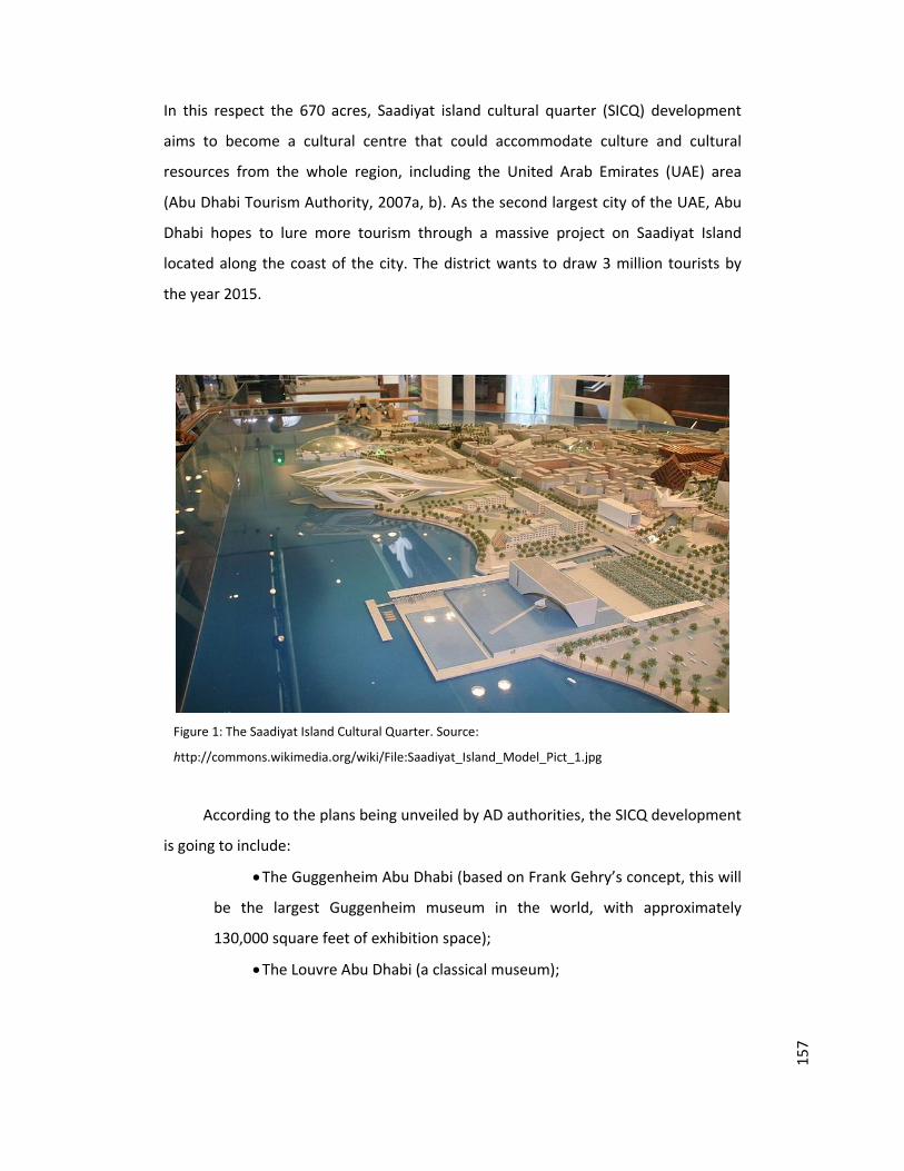
157
In this respect the 670 acres, Saadiyat island cultural quarter (SICQ) development
aims to become a cultural centre that could accommodate culture and cultural
resources from the whole region, including the United Arab Emirates (UAE) area
(Abu Dhabi Tourism Authority, 2007a, b). As the second largest city of the UAE, Abu
Dhabi hopes to lure more tourism through a massive project on Saadiyat Island
located along the coast of the city. The district wants to draw 3 million tourists by
the year 2015.
Figure 1: The Saadiyat Island Cultural Quarter. Source:
http://commons.wikimedia.org/wiki/File:Saadiyat_Island_Model_Pict_1.jpg
According to the plans being unveiled by AD authorities, the SICQ development
is going to include:
The Guggenheim Abu Dhabi (based on Frank Gehry’s concept, this will
be the largest Guggenheim museum in the world, with approximately
130,000 square feet of exhibition space);
The Louvre Abu Dhabi (a classical museum);

158
The Sheikh Zayed National Museum (a museum devoted to the history
and traditions of Abu Dhabi and the legacy of the emirate’s much admired
late ruler His Highness Sheikh Zayed Bin Sultan Al Nahyan;
A performing arts centre (a museum presenting the best that the UAE
has to offer in terms of music, theatre and dance);
A maritime museum (a museum reflecting the rich maritime history of
the UAE and the Arabian Gulf).
In total, the SICQ will include 5 landmark museums, 29 hotels, around 8,000
residential properties, 3 harbours, 1 park, 1 golf course and 1 sailing club. Each one
of the 5 museums (Louvre Abu Dhabi, Guggenheim Abu Dhabi, Sheikh Zayed
National Museum, a maritime museum, and a performing arts centre) has been
designed by a world renowned architect. Ultimately, the objective would be to
create a cultural landmark which every western tourist would have to visit.
It is envisaged that this would allow the Emirate to diversify its monoculture
economic base and compete on equal grounds with other Middle Eastern
destinations (Devlin and Page 1999, Garb 2004, Krens 2007). Emirate authorities
have signed agreements with the Louvre and the Guggenheim museums for long
term loans to be exhibited in the Abu Dhabi cultural district once this is completed.
Novelty in Operations
Abu Dhabi’s objectives behind the development of a cultural/creative quarter
have been different from those of other destinations (Zheng 2011, Scott 2006).
Sharpley (2003) as well as Al‐Hamarneh and Steiner (2004)) indicated long ago that
one particular challenge faced by Abu Dhabi Emirate in its effort to develop a
successful and sustainable tourism industry was its run down and dilapidated stock
of resources. Sharpley (2003) and Hall (2000) have argued that focusing on culture
and the provision of cultural tourism resources capable of luring local, regional as
well as international tourists could provide a solution to this challenge. This
assertion, relating to the provision of major developments and the financial support
of mega‐ projects as pillars of tourism development in a destination has been
greatly facilitated through the concept of cultural quarters, or cultural districts
159
throughout the world. In this respect, (actual or prospective) destinations such as
Abu Dhabi envisage that the spatial agglomeration of cultural resources could
generate a comparative advantage for the destination.
However, the process of generating a comparative advantage in cultural
tourism in SICQ follows a slightly different pathway. Policy officials and planners in
Abu Dhabi have recognised that utilising a local‐global nexus to permeate their
operations could offer them the chance to retain their comparative advantage in the
long term. Hence, the concept of sustainable comparative advantage, as opposed to
comparative advantage. In other words, policy makers have recognised that relying
on mega structures and world renowned architects alone (both examples of push
marketing strategies) is not enough anymore. These marketing strategies are geared
towards the pushing power of world brands and names to attract visitors to the
area. For that reason, the Abu Dhabi administration has put forward a cultural
tourism strategy that would attract major brand names in the area, but also actively
promoting local artists and indigenous cultural heritage at the same time.
The objective here is to obtain the maximum degree of visibility and exposure
to a globalised market, and promote local culture at the same time. Although these
practices have been adopted many times, this does not mean that they have always
generated the same level of success. This is partly down to their ‘passive’ and ‘low
value’ nature. Relying on mostly imported talent and resources would probably be
adequate to attract an international audience in the region at the beginning, but
would not manage to create a strong sense of local cultural entrepreneurship and
revitalisation leading to urban regeneration. Focusing equally on attracting global
(mostly imported) resources, as well as facilitating the production of local (native)
cultural resources and output offers a novel way to urban regeneration through
cultural quarter developments. Thus, adopting a local‐global nexus as far as Abu
Dhabi’s Saadiyat Island cultural quarter is concerned could ensure long‐term
sustainability of comparative advantage.
Instead, pulling marketing strategies tend to focus more on the utilisation and
exploitation of the comparative advantage generated through local differences and
variations. These pulling marketing strategies entail retailers or policy makers
identifying the features and attributes of the local or domestic supply that are mostly

160
appealing to customers and provide them – supply and demand in its purest form.
This is the basis of a pull strategy. Create the demand, and the supply channels will
almost look after themselves. Or in other words, a globalised strategy with a local
twist.

161
References
Abu Dhabi Tourism Authority (ADTA), (2007a January 31) Abu Dhabi Commissions
World’s Top Architects for Museum and Performing Arts Centre Designs. Abu
Dhabi: ADTA.
Abu Dhabi Tourism Authority (ADTA), (2007b) Saadiyat Island Cultural District
Exhibition. Abu Dhabi: Emirates Palace.
Al Hamarneh, A. and Steiner, C. (2004), Islamic Tourism: Rethinking the Strategies
of Tourism Development in Arab World after September 11, 2001, Comparative
Studies of South Asia, Africa and the Middle East, 24, pp. 18 – 27
Ashworth, G. and Voogd, H. (1986) The Marketing of Urban Heritage as an Economic
Resource. Paper at the Conference on ‘Planning without a Passport', Maastricht
November 5 – 9, 1986
Bassett, K. Griffiths, R. and Smith, I. (2002) Cultural Industries, Cultural Clusters and
the City: The Example of Natural History Film Making in Bristol, Geoforum, 33,
pp. 165 – 177
Department of Planning and Economy, (2009), “The Abu Dhabi Economic Vision
2030”, The Government of Abu Dhabi: Abu Dhabi
Devlin, J. & Page, J. (1999) Stepping stones: Arab integration, competitiveness and
the Euro‐Med Agreements, ERF Workshop on the Dynamics of New Regionalism
in MENA: Integration‐Euro‐Med Partnership Agreement and After, Cairo, 6 – 7
February.
Financial Times, The (2012) Abu Dhabi Approves Spending Boost. The Financial
Times. http://www.ft.com/cms/s/0.html. Accessed 25 January 2012
Hall, P. (2000) Creative Cities and Economic Development, Urban Studies, 37, pp.
639 – 649
Henderson, J. (2006) Tourism in Dubai: Overcoming Barriers to Destination
Development, International Journal of Tourism Research, 8, pp. 87 – 99
Garb H., (2004), “The Dubai Shopping Festival as a Catalyst for Tourist Development
and Urban Transformation”, In: Long, P. and M. Robinson (Eds.), Festivals and
Tourism: Marketing, Management and Evaluation, Business Education Publishers:
Sunderland
Jacobs, J. (1970) The Economy of Cities. New York: Vintage Books

162
Krens, T. (2007) Cultural Endeavours, The Report Abu Dhabi 2007, Oxford Business
Group: Abu Dhabi Tourism Authority
Marshal, A. (1920) Principles of Economics (8th ed.), London: MacMillan
Monk, A. and Monk, C. (2007) Economic Geography: The Rising Star of the Social
Sciences, Oxonomics, 2, pp. 16 – 20
Oxford Business Group, (2007), “The Report; Abu Dhabi 2007”, Abu Dhabi Tourism
Authority, Abu Dhabi
Porter, M. (1990) The Competitive Advantage of Nations. New York: Free Press
Ponzini, D. (2011) Large Scale Development Projects and Star Architecture in the
Absence of Democratic Politics: The Case of Abu Dhabi, UAE, Cities, 28, p. 251 –
289
Rizzo, I. and Throsby, D. (2006) Cultural heritage: Economic Analysis and Public
Policy, In: Ginsburg, V. and Throsby, D. (Eds.), Handbook of the Economics of Art
and Culture, Amsterdam: Elsevier
Scott, A. (1997) The Cultural Economy of Cities, International Journal of Urban and
Regional Research, 21 (2), pp. 323 – 339
Scott, A. (2004) Cultural Products Industries and Urban Economic Development
Prospects for Growth and Market Contestation in Global Context, Urban Affairs
Review, 39, pp. 461 – 490
Scott, A. (2006) Creative Cities: Conceptual Issues and Policy Questions, Journal of
Urban Affairs, 28, pp. 1 – 17
Sharpley, R. (2003) The Challenges of Economic Diversification Through Tourism:
The Case of Abu Dhabi, International Journal of Tourism Research, 4, pp. 221 –
235
Schumpeter, J. (1934) The Theory of Economic Development: An Inquiry into Profits
Capital, Credit, Interest and the Business Cycle. Harvard University Press:
Cambridge MA
van Heur, B. (2009) The Clustering of Creative Networks: Between Myth and
Reality, Urban Studies, 46(8), pp. 1531 – 1552
Zheng, J. (2011) ‘Creative Industry Clusters’ and the ‘Entrepreneurial City’ of
Shanghai, Urban Studies, vol. 48(16), pp. 3561 – 3582

Case study published in: Marques, Lénia and Richards, Greg (eds) (2014) Creative districts around the world. Breda:
CELTH / NHTV. URL: http://creativedistricts.imem.nl/
CREATIVEHERITAGE:MELAKAANDITSPASTMELAKA, MALAYSIA
CAN‐SENG OOI (COPENHAGEN BUSINESS SCHOOL, CENTRE FOR LEISURE AND CULTURE SERVICES,
DENMARK)
SHEVREN LAI (COPENHAGEN BUSINESS SCHOOL, CENTRE FOR LEISURE AND CULTURE SERVICES,
DENMARK)
Despite the celebration and promotion of the creative economy, there is still a “dark” side
to creativity. Creativity entails experimentation, chaos and failures. A creative space blends the
aesthetics with chaos, sleek design with experimentation, and economic development with
failed ideas. This case looks at the ambiguous and ambivalent interfaces of history in the
historical city of Melaka (also known as Malacca) in Malaysia.
History, by its definition, is a documentation of the past. Any historical documentation
can be contested and revised. This case will not engage in the debate on revisionist history.
Instead, it will show how history and heritage is negotiated and appropriated under present
circumstances in the historic city of Melaka. The re‐interpretation and revision of history is part
of the everyday creative response to changing circumstances. Such contemporary responses to
the past, however unclear and acrimonious, are the essence of a creative place.
A short history of Melaka
Melaka was a maritime powerhouse and gave its name to the world’s busiest shipping
lanes, the Straits of Malacca. It is also where the founding story of Malaysia unfolded. Malaysia
is said to have started as the sultanate of Melaka in 1396 when Parameswara, a Sumatran
Prince set foot on the small fishing village (Wee 2009; Worden 2003). Today, the state of
Melaka is 1,664 km² in size, located 148 km from Kuala Lumpur, the capital of Malaysia.
Sitting on the maritime highway that connects Europe to Asia, Melaka has attracted
merchants and traders over the centuries. It thus was and is a confluence of diverse cultures
from the West and East. Because of its maritime importance, the city was sought after by

164
European powers. Melaka was colonised by three European powers, starting from 1511 to
1957. The first was by the Portuguese for 130 years, then the Dutch (154 years), followed by
the British, who colonised the whole of Malaya for 162 years. Today, Melaka Historical City is a
UNESCO World Heritage Site, designated so since July 2008.
Histories
The rich past of the historical city is a resource for Melakans and their leaders to imagine
and envisage the city. But since the country’s independence in 1957, the national authorities
have an ambivalent relationship to the country’s colonial pasts. The colonial past is a reminder
of the weaknesses of its earlier rulers but the colonialists, especially the British, have left
behind useful legacies, such as English as a working language, a functional bureaucracy and a
well‐oiled legal system. Melaka is the seed of this colonial past, and thus embodies this
ambivalence.
The Portuguese ruled Melaka for 130 years, and the remnants of the walls of St. Paul’s
Church are visible reminders of this past. Outside the ruins, a white marble statue of St. Francis
Xavier, a Catholic priest who manned the church in 1545 until his death in 1553, stands tall
(Wee 2009). Also, the remains of the front gate of the fortress ‘Porta De Santiago’, built in 1512
by General Alfonso d’ Albuquerque to protect the Portuguese colony, has become a tourist icon
for the city (see Williams 2010, Picture 1). Such heritage sites sit uncomfortably with the
authorities because they are reminders of a colonial past and indicate a strong previous
presence of Christianity in the now Muslim country. Regardless, such remnants are central in
recognising Melaka as a UNESCO World Heritage Site.

165
Figure 1. Locals doing morning exercises in front of the fort and St. Paul’s Church (on hill). Photo: Can‐Seng Ooi.
A response to the highly visible Portuguese past is to assert the presence of other histories. The
St. Paul’s Hill Civic Area where the fort and church reside, and is part of the designated world
heritage site has been transformed into an area with numerous museums. Colonial
architectural buildings acquire new use and meanings. For instance, the Stadthuys building, the
former Dutch town hall is now the Museum of History and Ethnography, which showcases the
history of pre‐Malay Sultanate of Melaka to the present; the emphasis, however, is on the
injustice and cruelty of colonialism and the glory of a newly independent Malaysia. The building
itself is reduced to a shell telling politically acceptable stories of the present.
There are about twenty other museums – e.g. Kite Museum, Melaka Stamp Museum, Malay
and Islamic World Museum, Architecture Museum of Malaysia – in Melaka, all managed by the
Melaka Museum Corporation, a statutory agency in the Melakan government. Most of these
museums are housed in beautiful colonial buildings. Essentially, new social, cultural and
historical contents are injected to these old spaces. The ‘museum district’ highlights Malaysia’s

166
Figure 2. Inside a Chinese Peranakan restaurant,
besides food being served, one can buy souvenirs.
Photo: Can‐Seng Ooi.
journey from feudal state into modern
nation, and celebrates a Malay‐Muslim
oriented view of the world. Thus new
stories and histories are creatively
embedded into old physical heritage.
Such official views of the past draw
responses from the local communities, too.
In the current social engineering
programme in Malaysia, the Malays are
given more privileges and rights. Minority
ethnic groups, including the Chinese and
Indians, lament that they are treated as
second‐class citizens. In response to the
state‐supported museums, private
individuals and firms are now creating their
private museums to celebrate their own
non‐Malay and Muslim‐oriented heritage.
For instance, the Baba‐Nyonya Heritage
Museum celebrates the Peranakan or
Straits Chinese culture. In a nutshell, Peranakan culture is a blend of Chinese and Malay culture.
There is also the Indian‐Malay Peranakan culture. Nearby, Singapore has celebrated Peranakan
culture because it is considered an indigenous evolution of a local community (Ooi, 2010). But
in Malaysia, the Peranakans are seen as a threat to the official view that the Malays are the
true indigenous people.
Regardless, locals and local businesses soon discovered that the authorities may tolerate
the accentuation of Peranakan culture, especially if it is presented in a non‐political manner. In
fact, the Peranakan community during the British colonial times was well educated, English
speaking and largely pro‐British. After more than half a century, the presented Peranakan
heritage seems to be devoid of politics and has been reduced to social cultural interests, even

167
by non‐state supported and private enterprises. There are at least two reasons for this. The first
is that members of the community are subjected to the Malaysian social engineering
programme, as they are educated to speak Malay and see their country through the struggle
for independence led by the Malay community. Many younger Malaysians do not know of the
Peranakan’s political and historical contributions. The second reason is that private enterprises
have experimented and now have learned not to arouse the ire of the authorities. So, a
depoliticised Peranakan culture has been translated not only through the private museums but
also restaurants, hotels and tourist souvenirs (Picture 2). Peranakan culture flourished under
the tourism trade, as it has been translated into objects for tourist consumption. This fits nicely
into the official “Malaysia – Truly Asia” destination brand of the country, which communicates
that Malaysia is home to a blend of various Asian cultures.
Lessons have also been learned from best practices in the regeneration of urban areas
and urban planning, and consequently the authorities encourage initiatives, and now enliven
the city through the beautification process. One of the most prominent projects is the colourful
murals along the river (Picture 3). People taking the river cruise will enjoy the walls of old
buildings painted with tropical flowers, local foods and Malaysians in different ethnic costumes.
This celebrates a non‐politicalised and tolerant multi‐culturalism.
Photo 3. Colourful wall murals along River Melaka. Photo: Can‐Seng Ooi.

168
Conclusions: Creativity with Malaysian characteristics
The picture we have presented tells about the politics behind a heritage city. History and
heritage is political. Nonetheless, we want to highlight how history is not only politically
contested, it has become an arena for creative responses to current social political reality.
St. Paul’s Church and the fort are focal points for the local community, which the authorities
cannot ignore. The response is to layer other stories and histories to show that Melaka is richer
than its colonial past. These other stories and histories tend to tow the official Malay‐Islam‐
oriented lines. As national policies explicitly discriminate other ethnic communities in Melaka
(and Malaysia), locals have responded in different ways. Many non‐Malay opposition politicians
call for an overhaul of Malaysia’s ethnicity‐based politics, others in the ruling coalition merely
want to draw concessions from the government. In the case of Melaka, local enterprises have
found ways to celebrate and draw economic gains from local heritage. As in the case of the
Peranakan, their rich past is gloriously presented, albeit devoid of political contents.
What this case shows is that creativity is as much about aesthetics, ideas and economic
growth, as it is about dealing with local circumstances and political realities. With this in mind,
Melaka has become a creative place at various levels. The residents and other stakeholders use
the city’s heritage in ways that do not threaten the current political reality, while pushing the
limits; they have expanded their spaces for cultural expressions. Non‐official histories authentic
to Melaka have now emerged, serving social, cultural and economic needs. In turn, the
authorities find new boundaries for their social engineering efforts; non‐political but culturally‐
rich expressions do not seem to threaten the system but offer economic potentials, and an
image of a tolerant society. Such expressions are thus largely accepted, if not encouraged.
169
References
Ooi, C.‐S., (2010) Histories, tourism and museums: Re‐making Singapore. In Hitchcock, M.; King,
V.T. and Parnwell, M. (Eds.) Heritage Tourism in Southeast Asia. Copenhagen: NIAS Press. 83‐
102.
Wee, B., (2009) Malacca: A World Heritage Site, Historically Majestic. Kuala Lumpur: Purple
Production & PR Consultants (M) Sdn Bhd.
Williams, T., (2010) Melaka and World Heritage Status. Conservation and Management of
Archeological Sites, 12(3), 197‐208.
Worden, N., (2003) National Identity and Heritage Management in Melaka. Indonesia and The
Malay World, 31 (89), 31‐43.

Case study published in: Marques, Lénia and Richards, Greg (eds) (2014) Creative districts around the world. Breda: CELTH / NHTV. URL: http://creativedistricts.imem.nl/
ANIMATIONBREATHESLIFEINTOCHINESECITIESCHINA
VINCENZO DE MASI
YAN HAN
Keywords: Chinese animation, soft power, animation industry, creative economy,
animation districts.
The animation industry today is considered one of the most interesting
industries, both economically and culturally. From the creative point of view this
sector is one of the most innovative because it can span different languages, taking
inspiration from literature, film, TV, music, and other artistic features (Newman,
2012), and then merge them into a new artistic expression (Aldrich 2007, Bittanti
2008).
The Chinese government in line with the policy of soft power has recognised in
the animation industry a strategic sector in the context of the creative industries;
that's why since 2006 the Chinese central government has financed and supported
this sector, urging local governments, regions, provinces and cities to finance and
help through tax breaks, direct loans, interest subsidies, etc. (Keane 2007,
Montgomery 2010).
In fact in the last few years China has become the first world producer of
animated products with upwards of 220,000 minutes produced in 2011. To reach this
goal, the Chinese central government has offered financial support with tax relief in
order to help the birth of new industrial areas in China, changing and regenerating
districts and areas of small and big cities.
Cities such as Beijing, Shanghai and Tanjin have upgraded old quarters in order
to establish an industrial design focused on animation, for example, in the Chinese
capital new creative poles such as the district near the Beijing Cartoon Art Museum

172
were born with the help of the central government, an animation department was
created at the Communication University of China (Figure 1) and Beijing film
academy; an air industrial was
revitalised with companies
having as a principle the
creativity and art such as the
798 Art Zone in Beijing. In fact,
previously this industrial
district was dedicated to the
production of military
technology. (Figures 2 and 3),
and here there was the birth of
some very famous design and
production studios such as the
Hutoon Studio (Figures 4 and
5) led by the animation
director Pisan.
Figure 1. Department of Animation at the Communication
University of China, Beijing. Photo: Yan Han.
Since October 2006 China had already been able to generate new creative jobs
with the birth of 5473 animation studios. There were 477 animation departments
and 1,230 universities offering studies on animation (Xiang 2006). According to Zhao
Shi, Deputy Director of the State Administration of Radio, Film and (SARFT) in the last
few years there were about “64,000 graduated students majoring in animation at
university and more than 466,000 were studying in colleges.”1
1 Xinhua News Agency, Record 81,000 Minutes of Cartoons Produced in 2006,
http://www.china.org.cn/english/news/194658.htm, last visit 16 June 2013.

173
The goal of the government is to allow the creative people to work with a
multitude of people who, through the products of animation, were able to create a
virtuous new economy, giving importance especially to the creative features rather
than the material ones.
Even though the animation industry is in its early stage of development, many
steps have been made on this creative wave, for example, in the Proceedings of 2007
Chinese City Planning. It showed that there were four big‐scale animation and comic
industry cluster areas around mainland China by 2006. They are Beijing‐centred
Bohai Rim, Yangtze River Delta which centred in Shanghai, Hangzhou and Nanjing,
Pearl River Delta centred in Guangzhou and Shenzhen, and middle part cluster region
centred in Chengdu, Changsha and Wuhan. At the same time, the 2006 China
Animation Yearbook listed the mainly productive animation companies in mainland
China by 2006, including CCTV China International Television Corporation, Shanghai
Studio, Sanchen Cartoon Group, Wuxi Taihu Digital Animation Film Pioneer Park,
Shenzhen Yijing National Animation and Comic Industrial Base, etc.
Figure 2. 798 Art Zone, in Chaoyang District of Beijing. Photo:
Vincenzo De Masi.

174
However, as an advocate of creative industry and preferential policy, the places of
animation emerged all over the country. According to the 2010 China Animation
Yearbook, there are four types of places under the title of ‘National Animation and
Comic Industrial Base’.
Figure 3.Another place of 798 Art Zone, in Chaoyang District of Beijing. Photo: Vincenzo De Masi.
They are National Animation Industrial/Educational Base belonging to SARFT,
National Animation Video Game Industrial Revitalisation Base belonging to the
Ministry of Culture, National Online Game and Ani‐com Industrial Development Base
belonging to GAPP, and National New Media/Software Technology Base belonging to
MOST. From the list we can see that Hunan province, Liaoning province and Sichuan
province all hold three types of bases following Shanghai and Beijing. Jiangsu
province and Guangzhou province only have two. Zhejiang, Jilin, Fujian, Shanxi,
Shanxi, Hubei, Hebei and Shandong are the emerging animation provinces. However,
in the 2011 China Animation Yearbook, it is stated that the Top 5 of animation
production is Zhejiang, Jiangsu, Guangdong, Liaoning and Fujian, which does not
have the most Animation Bases.

175
Type City & Province
Animation Industrial/ Educational
Beijing, Shanghai, Jiangsu, Zhejiang, Hunan, Guangdong, Hubei, Liaoning, Chongqing (Sichuan), Jilin, Fujian, Shanxi, Shanxi
Animation Video Game Shanghai, Jiangsu, Hunan, Liaoning Sichuan
Online Game and Ani‐com Beijing, Shanghai, Guangdong, Liaoning Sichuan, Hebei
New Media/ Software Technology
Beijing, Shanghai, Hunan, Sichuan, Shandong
Table 1. The most important Chinese cities and provinces and their major productive specialities.
By comparing the situation of Chinese animation in 2006 and 2010, one can
see a significant development in the industry across the various provinces so that its
magic has touched the production of animation which was not only booming in big
cities such as Beijing and Shanghai, but also in small cities. Take Xiamen as an
example. Xiamen Software Park was set up in 2000 and now its third‐phase project is
under development. Its aim is to create headquarters dealing with software, Ani‐com
& games and circuits. At the same time, the regions that have advanced in politics,
economy and culture are turning to expand the depth and breadth of Chinese
Animation. On the one hand, developing new media technology and combining with
traditional animation, and on the other hand, completing the animation industrial
chain. For example, in 2009 the first Animation and Comic Museum opened in
Xuzhou, province of Jiangsu2, then Shanghai Animation and Comic Museum opened
in 2010 and in 2013 the National Animation and Comic Museum (中国动漫博物馆,
Zhōngguó Dòngmàn Bówùguǎn) that cost 1 billion RMB, scheduled to open in
Hangzhou by the end of 2013.
The China’s Culture Industry Development Report (2012‐2013) points out that
the development of China’s cultural industry is entering into a substantial inflection
point; the culture market will change from a shortage into overproduction.
2 Xuzhou Animation Museum, http://www.86wiki.com/view/3115941.htm, last visit 12 June 2013.

176
In addition to the opening of Disneyland (Disney Resort), planned to open at the end
of 2015 in Shanghai, the first in mainland China, another interesting project named
the China Comic and Animation Museum (CCAM) will be opened and it will be
realised by the Hangzhou Urban Planning Bureau (L'Espresso 2008). This work began
in 2012 and is very interesting because it plays a part in upgrading into a developing
part of the city through the introductions of cultural cornerstones becoming a focal
point of the district. It is expected to be completed by 20133. The museum is very
special from an aesthetic point of view. In fact, it will have the form of eight balls
which host the international museum of animation inside. The area of the museum is
estimated to be some 30,000 square
metres, a number of public plazas, an
expo centre of about 13,000 square
metres and a number of islands in the
parks. The project is designed by the
Belgian architecture studio MVRDV
with a budget of some 92 million euros.
The Chinese central government plays a
fundamental role in the development
of this sector – one that had little
reason to shine on the world stage a
few years ago.
Figure 4. Hutoon animation Studio at the 798 Art
Zone, in Chaoyang District of Beijing. Photo:
Vincenzo De Masi.
3 China Daily, China Comic and Animation Museum design unveiled,
http://www.chinadaily.com.cn/m/hangzhou/e/2011‐05/04/content_12443622.htm, last visit 27 June
2013.

177
Due to the new interest and involvement in animation productions, the appearance
of many districts and provinces is slowly changing in China causing a significantly high
social and economic knock‐on effect which will be evident in the near future. Based
on the fact that China is one of the eastern countries taking centre stage it is only
right that design is now following suit. The creative industry of animation has had a
dramatic impact in a few years’ time and it has felt the need to create places that
harboured this kind of creative industry. Besides the Chinese corporate interest, large
American companies are planning to create new jobs in China finding it impossible to
ignore the possibilities for growth. Disney and Dreamworks plan to enter this market
and are already building theme parks and collaborating with the animation industry
for the production of films and television series co‐produced by the brand created in
China. Japan is ahead of the rest already taking advantage of the ripe source, studios
are already present in China, having sold the rights for the construction of a park and
a museum dedicated to Japanese productions. In fact, the Hello Kitty theme park is
expected to open in 2014 in China's Zhejiang province. Projects will surely be
completed in the coming years and new ones will be born making China become an
important player for the creative industry and its urban development.
Figure 5. Inside Hutoon animation Studio at the 798 Art Zone, in Chaoyang District
of Beijing. Photo: Vincenzo De Masi.

178
References
Aldrich C., Gibson D., Prensky M. (2007), Games and Simulations in Online Learning:
Research and Development Frameworks, Idea Group Inc (IGI).
Animation Bluebook (2012), Chinese Animation Industry Development Report
(2012), Social Sciences Academic Press (China).
China Animation Yearbook 2006, China Radio and Television Press, 2007, 378‐393
China Animation Yearbook 2010, Anhui children press,2011, 235‐239+
L'Espresso (2008), Volume 55, Edizioni 13‐17, Editrice L'Espresso.
Guthrie D. (2012), China and Globalization: The Social, Economic and Political
Transformation of Chinese Society, Routledge.
Jin D., Chee F. (2008), Age of New Media Empire: A Critical Interpretation of the
Korean Online Game Industry, Games and Culture, A Journal of Interactive Media,
38‐58.
Keane M. (2007), Created in China: The Great New Leap Forward, Routledge .
Montgomery L. (2010), China's Creative Industries: Copyright, Social Network
Markets and the Business of Culture in a Digital Age, Edward Elgar Publishing.
Proceedings of 2007 Chinese City Planning, Heilongjiang Science and Technology
Press 2007,1537‐1540.
The China’s Culture Industry Development Report (2012‐2013) points out that
http://news.xinhuanet.com/newmedia/2013‐03/25/c_124500718.htm, last visit 16
June 2013.
Xiang Zhong 廖祥忠 主编(2006), 中国动画年鉴 (China Animation Yearbook),
中国广播电视出版社 (China Radio and Television Press), p.13.

Case study published in: Marques, Lénia and Richards, Greg (eds) (2014) Creative districts around the
world. Breda: CELTH / NHTV. URL: http://creativedistricts.imem.nl/
COMMUNALITYWITHOUTCOLLECTIVITYFOTAN, HONG KONG
DAISY TAM (HONG KONG BAPTIST UNIVERSITY)
The Fotan industrial village is located in the North East part of Hong Kong;
tucked away in the New Territories on the mainland1, it is, to many (even those who
live in Hong Kong), a world away. Unlike Central, whose skyline is the face of the city,
the humble industrial estate is not graced by the design of world famous architects.
Like many other industrial areas, the unremarkable concrete buildings were
originally built for light industries; but as the cost of real estate and labour reached
for the sky, factories moved north of the border into mainland China. These
industrial estates that stood for the past 50 years have witnessed Hong Kong’s
economic backbone shift from manufacturing to finance. The loading bays that have
seen the heyday of this era mutely observed as the containers and traffic dwindled.
Fotan, as with other industrial areas of Hong Kong, quietly became forgotten. Today,
apart from a handful of printing business and food processing plants, the majority of
the units have turned into offices and storage spaces.
Hong Kong prides itself as the financial centre of Asia, but what the celebrated
skyline of bank towers also points to, is a lack of investment and support for the
development of art and culture. Coupled with high property prices, artists have long
been victims of the neo‐liberal economy in the city also known to insiders as the
“cultural‐desert”. In a capital driven society, industrial spaces from a bygone era
became the only haven for displaced artists, which offered relatively large spaces at
a low cost well‐suited to the setting up of studios and workshops. Most of these
studios are independent but they are united by the cheaper rent that the older
1The geographical territory of Hong Kong is composed of Hong Kong Island, Kowloon Peninsula and the New
Territories. Hong Kong island houses the Central Business District and is often regarded as the heart of Hong
Kong. The Kowloon Peninsula and the North Eastern New Territories are located on the continent bordering with
mainland China.

180
buildings offer. Local painters, sculptors, carpenters, designers slowly gathered and
settled in the emptied units of the massive blocks of towers. As the trend gained
momentum, a critical mass formed and Fotan became a hub for local artists.
These newcomers are not always welcome and are in fact often met with
raised eyebrows from older tenants from the industrial era. The young, often hip and
rather bohemian group of youngsters is perceived to be somewhat interrupting the
normal running of business2. Artists and local entrepreneurs sit rather
uncomfortably alongside each other, each keeping to their own territory. This is in
turn juxtaposed with a precariousness from the government: from a legal
perspective, industrial lease requires the units to be used for production or go down
purposes. As many of these businesses and artists are not technically adhering to the
lease, the common secret joins these occupants in an unspoken pact, each tacitly
maintaining cover for the other.
For most of the year, Fotan operates to a normal business rhythm and the only
sign of artists are the dispersed lights in various buildings that shine late into the
night. All except for the weekends of one month in the year, when studios open its
doors for Fotanian – a festival where artists invite the public to view their workshops
and their work. During that time, a striking transformation takes place. Shutters are
pulled up and doors are pulled back, letting music and light flood the dark and quiet
corridors. The streets, deserted by the weekday workforce, are replaced by
crisscrossing visitors armed with maps. The cargo lifts, usually smoothly operated by
professional workmen, jolted in the hand of amateurs. The whole area transforms
itself into a giant art safari, where not only galleries, but buildings and roads and
local daipai dongs3 also become part of the scene. Fotan, with its lack of attractions
is not a usual destination, and for many, industrial spaces were as much of an exotic
experience as the art.
2According to the Planning Department of Hong Kong Government, the majority of industrial floor space is used for warehouse/ storage purposes (55.9%), second and third largest uses are office (11.9%) and ancillary office (8.7%) (Industrial Report 2009) The majority of offices house trading companies which most deals with business in China. 3Local outdoor eateries – roast pigeons and chicken congee are Fotan’s specialty.

181
Figure 1. Floor numbers. Photo: Stan Diers (www.standiers.com)
Fotanian, as the first art festival of its kind in Hong Kong, has been growing
steadily in the past ten years and 2013 was by and far the largest one ever to be
held, with over100 studios and 300 artists participating. With the increasing success

182
of the event, sponsors came in with money and publicity, talks were organized, apps
were built and there was even a mobile exhibition truck cruising the streets of Hong
Kong. The success of the festival indicates that while the presence of artists in the
area are not fully supported by the law4 they are, however, not completely
clandestine either. The precarious presence of the live‐in artists exists in between
the legal/illegal boundary. But why are they tolerated and how does this community
operate?
Figure 2. Industrial building. Photo: Stan Diers (www.standiers.com)
The tacitly maintained boundaries between artists, entrepreneurs, visitors and
to a certain extent, even the government, operate on a delicate balance which
counts on each turning a blind eye. Within this environment, individuals employ
their own tactics to find ways of slipping between the formal structures and rules.
They recognize what they can get away with, they surf on the margins of what is
permissible, teasing the boundaries of what is punishable. The rule that somehow
operates beside the law carefully crafts out an environment where Fotan flourishes
within the carefully maintained boundaries.
4 Many artists also make their homes in these studios which is illegal according to Hong Kong Law; but they are not the first or the only ones, due to the unaffordability of the city’s housing prices, many of the urban poor live in illegally subdivided bedsits in industrial units.

183
Rather than arguing for the need to legitimize through governmental
intervention, it seems that the current paradoxical presence of all the parties
involved is in itself the perfect balance. The government’s strategy of revitalization
often means redevelopment5 with the goal of tearing down old depilated buildings
to build new ones more in line with the modern façade of Hong Kong. Unfortunately,
the mere mention of such intention in the 2009 policy address has already resulted
in the doubling of prices over a period of 2 years causing many artists to strain under
the increased rent. Already, developers and speculators are circling the units like
vultures, buying them up with increasing speed. Like many new developments in
Hong Kong, high prices of homogenous spaces after regeneration often become a
sterile deathbed for creativity.
The re‐appropriation of industrial spaces by artists as well as entrepreneurs are
individuals’ way of making‐do6 with the ever‐expanding urban‐regulatory
environment. The multiple ways in which these spaces are creatively imagined
introduce a plurality of goals and desires into the otherwise deserted buildings.
Behind the quiet façade these units pulse with a myriad of activities. There is in
fact no need for governmental intervention; revitalization has already taken place –
if revitalization means to re‐enliven a space, to make it more active, vivacious,
spirited and to give it more life. A creative space is not a space that can be fashioned
through management. Regenerated areas of Hong Kong (and surely other parts of
the world) have proved prone to gentrification. A creative space, or an vitalized
space is a space that allows for life, by which I mean a space that enables individuals
to create meanings through their practices, which are by nature, plural, multiple and
multi‐directional. It is what facilitates ideas and collaborations to be forged, festivals
such as Fotanian to be generated.
5The Revitalizing Industrial Buildings Policy introduced in 2009‐10 policy address is defined by the new measures to promote revitalization through “encouraging redevelopment and wholesale conversion” (Hong Kong Development Bureau 2010) 6 Individuals’ resourceful ways of appropriating in everyday life is of particular interest tocultural theorist Michel de Certeau, who regards these practices as a form of tactics, understood as power for the powerless; this is opposed to strategies which are institutional or structures of power (1988) The Practice of Everyday Life University of California Press.

184
Figure 3. Rooftops. Photo: Stan Diers (www.standiers.com)
The brutalist buildings of the industrial era might not make it onto Hong Kong’s
postcards but within the concrete walls, displaced individuals find their footholds
that enable each to pursue his/her own goals, creating a functioning system in Fotan
where there is communality without collectivity. If revitalization could be
understood from the perspective of enlivening a space, then the value of Fotan lies
precisely as such.
Visuals by:
Stan Diers, Graphic Designer
www.standiers.com

Case study published in: Marques, Lénia and Richards, Greg (eds) (2014) Creative districts around the world. Breda:
CELTH / NHTV. URL: http://creativedistricts.imem.nl/
HIGH‐END LUXURY RETAIL AND THE CITY: A TIMELINE OF BOND STREET, FIFTH AVENUE, OMOTESANDO‐AOYAMA AS LUXURY CAPITALS OF THE WORLD NEW YORK, USA / LONDON, UK / TOKYO, JAPAN
BHAKTI SHARMA (STATE UNIVERSITY OF NEW YORK, BUFFALO)
Bond Street in London, Fifth Avenue in New York City, and Omotesando‐Aoyama in Japan are
synonymous with luxury retail. Located in different parts of the world, luxury retail is not the
only common thread between the three neighbourhoods. This paper examines the urban
sprawl, the timeless collection of architecture, the cultural activity surrounding these centres,
and the perpetual destruction, revival, and reconstruction that comes with the territory called
retail. The social and the cultural impact of luxury retail on neighbouring areas are analysed
through the comparative study of a timeline of these luxury districts.
Keywords: Luxury retail, urban neighbourhood, socio‐cultural impact
Luxury streets around the world can be interchanged to another geographical location
and the unsuspecting eye may not spot the difference. But the similarity in appearance of
flagship stores and brands is not the only reason that this swap may be possible. The user – a
shopper, a tourist, or a native – of London’s Bond Street might find a similar peace in New
Yorkʼs Fifth Avenue as as s/he may in Tokyoʼs Omotesando‐Aoyama. But as Magrou (2011) in
his text about the Louis Vuitton store on Fifth Avenue points out, “individual buildings would
seem pale‐ faced without the others that surround them”. So, is it just the architecture that
creates prominent themes in the retail districts or are creative districts identical around the
world or there is there more to this theory? The study of two main ideas centred on common
historical threads that transformed these districts into retail Meccas, and subsequent historic
and retail development can help us answer this question. Luxury fashion districts are centred

186
around fashion – a field not only embellished by the creative field of profession, but one that is
usually accompanied by masterpieces from avant‐garde artists and creative expression of
architects in the shape of buildings.
The Old and the New Bond Streets in London replaced an imposing palace and garden
when its namesake founder Sir Thomas Bond purchased the property in 1688. Fifth Avenue in
New York City became synonymous with luxury when rich socialites moved into the
neighbourhood in the 1860s and the opening of the now Hotel Waldorf Astoria in 1893 further
strengthened this position. The 1964 Olympics in Tokyo brought fashion houses to the
Omotesando‐Aoyama districts, originally planned for aristocratic residences. It is not by
coincidence that the most expensive shopping streets in the world also have the most
exclusive residential clientele. While in London and Tokyo, high‐end retail spawned off around
elite residential areas, the luxury status of Fifth Avenue was confirmed with the settlement of
rich socialites in the area.
The sprawl of residential and retail settlements in these neighbourhoods prompted
better connectivity to these areas. The Piccadilly underground station that opened in 1928
serving 50 million people and the now Omotesando station that opened in 1938 are evidence
of the economic growth that resonated through all these three neighbourhoods in their early
stages of development. The development of mass transit systems allowed for the growth of
other recreational activities around these retail centres. The Kensington Gardens, Queen Mary
Gardens, and the Buckingham Palace Gardens surrounding the Bond Street area meet their
counterpart in Central Park, the culmination point of Fifth Avenue and the Meiji Shrine gardens
in Omotesando‐Aoyama. In addition, the side streets or the backstreets around these main
streets filled with boutiques, bookstores, florists, barbers, galleries, second‐hand shops, and
antique shops grew as well.
These historic streets are home to extraordinary museums, businesses and stores, parks,
luxury apartments, and historical landmarks that are reminiscent of its history and vision for
the future. Shopping, art, and culture are close allies for the shopper who is looking for a
connection with the surroundings at a cognitive, emotional and intuitive level — something to
hold on to, to take back as a memory, some memory stronger than the item they have just

187
purchased. For centuries the intent has been to convert retail into experience fully integrated
into other cultural activities such as theatre and art (Cairns, 2010). The Fine Arts Society that
opened in 1876 and Sotheby’s Auction House that opened in 1917 in Bond Street in London
helped in the development of Bond Street as the centre for top‐end art and antiques dealers.
Omotesando‐Aoyama in Tokyo can also boast of its rich past and present in high‐end art.
The opening of the Metropolitan Museum of Art in 1874, the Soloman ‐ Guggenheim
Museum in 1939, and the Whitney Museum of Art in 1966 on Fifth Avenue also parallels the
development of art and the avant‐garde in the retail district. In Tokyo, after the 1964
Olympics, the fashion houses started developing flagship stores. On the same lines as Bond
street and Fifth Avenue, the Watari Museum of Contemporary Art opened in 1990 in the
Omotesando‐Aoyama area.
Figure 1. Timeline development of creative districts centred around high‐end retail
But the development of these neighbourhoods was not all smooth sailing. While in the
18th century, Bond street in London was catered to the male population that frequented the
clubs and high‐class brothels at night‐time, during the American Civil War between 1861‐1865
prices of the land in and around Fifth Avenue dropped tremendously forcing the owners to
face losses. There are ups and downs in history but the three neighbourhoods have stood the
test of time and continue to be the most expensive shopping streets in the world. So, is there
a formula that can be used to develop a new all‐inclusive high‐end retail area that is a catalyst
for creative growth in the areas surrounding it as discussed on the parameters above? This

188
retail area does not need to be another mall. It could be the same idea that Louis Vuitton used
with Nagoya Sakae while entering the Japanese market. It could be an area where luxury
brands open their flagship stores to revitalize a neighbourhood and the arts and theatre that
these stores bring via their flagship stores can be used to promote cultural tourism? Throw in
rich residential clients, a mass‐transit system, a few artists and writers that treat the creative
district in question as their muse, back alleys that both feed from and to the main streets, a
troubled past, and statement architecture and you may have a chance. Or is the truth quite
the contrary? Maybe all you need is one powerful brand. As Okinkwo (2007) states, “The
answer is simple: luxury brands have the power of branding!”
Bring in Chanel and the rest will follow suit.

189
References
Cairns, Graham. 2010. ...Deciphering advertising, art and architecture. London: Libri Publishing
Magrou, Rafael. 2011. London Bond Street. In Louis Vuitton Architecture and Interiors., Eds.
Frederic Edelmann, Ian Luna, Rafael Magrou and Mohsen
Mostafavi, 142. Hong Kong: Rizzoli. Okinkwo, Uche. 2007. Luxury Fashion Branding: Trends,
Tactics, Techniques. New York: Palgrave Macmillan

Case study published in: Marques, Lénia and Richards, Greg (eds) (2014) Creative districts around the
world. Breda: CELTH / NHTV. URL: http://creativedistricts.imem.nl/
REVITALIZING MICRONESIA’S CAPITAL CITY
OF HAGÅTÑA: CREATING HISTORIC
CORRIDORS HAGÅTÑA, GUAM, USA
FRED R. SCHUMANN (SCHOOL OF BUSINESS AND PUBLIC ADMINISTRATION, UNIVERSITY OF
GUAM, USA)
The city of Hagåtña has served as downtown, dating as far back as the sixteenth
century before Spanish settlers arrived on Guam. The result of World War II, from the
Japanese occupation of Guam to its recapture by the U.S. military, left many of
Hagåtña’s historical sites and the city itself damaged from repeated bombings. Although
Hagåtña remains the seat of the island’s government, there have been concerns over the
capital’s residential population decline. Efforts are underway to revitalize, preserve and
protect the heritage and economic vitality of Guam’s capital. Hagåtña holds memories of
a resilient and vibrant history of Guam and the island’s people.
Guam, U.S.A. – The mid-Pacific city of Hagåtña has served as a central location for
the Chamorros - the indigenous people of Guam - dating as far back as the sixteenth
century before Spanish settlers arrived on Guam. As its capital, Hagåtña serves an
important role as the center of government. In 1668, Padre San Vitores, a Spanish
missionary, was instrumental in establishing the first Spanish (Catholic) church in
Hagåtña, forcing most of the indigenous population of Guam to relocate to the city.
Hagåtña has been the capital of Guam since the Spanish-American War of 1898
when the United States seized control of Hagåtña from the Spanish. The result of World
War II, from the Japanese occupation of Guam to its recapture by the U.S. military, left
many of Hagåtña‘s historical sites and the city itself damaged. However, there are still a

19
2
number of historical monuments and remains that can be viewed, including sections of
buildings left over from the time of Spanish rule, such as the Plaza de Espana near the
cathedral of the Archdiocese of Agana, and Latte Park, where visitors can see pre-
Spanish stone pillars referred to as Latte Stones. The devastation of the city, however,
forced the once most populated village prior to World War II, to the least populated
area that serves primarily as a center for government and business.
In the past decade, many loosely related efforts have been made towards the
redevelopment of the once vibrant capital. A serious commitment towards the need to
restore and redevelop Guam‘s capital was first written intoGuam’s public law, known as
the Hagåtña Restoration and Redevelopment Act. The Act created an autonomous
agency, the Hagåtña Restoration and Redevelopment Authority, to carry out the
purposes of the legislation. Other government agencies have also addressed
redevelopment efforts for Hagåtña. The Guam Economic Development Authority,
charged with economic development initiatives for Guam, has directed redevelopment
efforts toward Hagåtña. The Guam Visitors Bureau, responsible for developing Guam‘s
visitor industry, has also addressed the development potential of downtown Hagåtña.
Additionally, market forces evidenced through private organizations such as the Guam
Chamber of Commerce, have made it a priority in recent years to redevelop the flailing
downtown area.
A recent initiative to restore Downtown Hagåtña is to capitalize on its unique
assortment of historical sites. In 2010 the Hagåtña Heritage Walking Trail, which
comprises 17 historical sites, was launched. It was developed to transform what has
been described as a “ghost town” to a livelier center. The 4-kilometer Hagåtña Heritage
Walking Trail has been viewed as a way to provide economic stimulus through increased
local government revenue by way of tourists who spend an extra half-day to experience
the walk.

19
3
Revitalization Strategies
After reviewing potential downtown revitalization strategies for Hagåtña, a
professional team put together by the University of Guam’s Pacific Center for Economic
Initiatives (PCEI) determined an overall strategy for downtown Hagåtña in 2012. This
strategy is based on three strategic initiatives: Celebrating the unique culture and
history of Hagåtña through events; Educating people on the history of Hagåtña and the
significance of the area; and Preserving Hagåtña’s unique history and historical sites for
future generations to come.
The team reviewed current research on consumer needs and demands, and also
the needs of businesses in Hagåtña to determine what needs they have in order to
maximize their revenue generating opportunities. It was determined that the businesses
in Hagåtña need to build up a sense of community and cohesiveness to determine
specific strategies and programs that can deliver more customers, clients and revenue.
This was done with the partnering of businesses with agencies and academic institutions
by using “economic gardening” approaches and initiatives. This was seen as an effective
strategy for an island with a population of only 170,000, and where almost all
companies meet the definition of “small business”.
The University of Guam, the Pacific Center for Economic Initiatives and the Small
Business Development Center have played key roles in developing programs that
address the needs of the businesses. These include the development of business and
entrepreneurial opportunities, providing training for business owners and staff, and
assisting with technical and professional expertise at both the small business level and
government policy level. The Guam Preservation Trust organization has also been an
important partner and provides expertise to business owners on the history of Hagåtña.
One of the unique features of Hagåtña that has been lost in many similar villages
on Guam is that of the family clans and relationships. Many of the same families that
populated the capital of Hagåtña in the 1800's and 1900’s still reside on Guam. Their
memories and stories are a valuable asset as to setting the stage for modern Hagåtña,

19
4
as well as providing historical information and personal stories of the village and life in
the village during the various periods.
Although the collection of Hagåtña historical sites represent a variety of periods,
the predominant “theme” and period that appears to have lasted the longest and
therefore has made the largest impact in terms of cultural remnants is that of the
Spanish period. During this period, barrios were established, each with their own saints
and character. A map from 1915 was used to identify the barrios and businesses that
occupied the locations during the Spanish period. Because of the legacy of the Spanish,
it was decided that this period best represents “historical” Hagåtña.
Based on determining the significance of the Spanish period, the approach for the
action plan used was as follows:
• Identify the barrios
• Identify corridors within the barrios that surround the various historical
attractions
• Meet with the businesses that are located on those corridors and begin
developing a group associated with those historical attractions, based on their
proximity.
• Bond the businesses with the historical attraction through a common
theme.
• Honor the relationship between the historical attraction and the business
by hosting a small gathering of the businesses and the key revitalization players
and giving each business a plaque to display at their place of business.A variety
of businesses exist in the barrios, ranging from cafes, restaurants, bakeries,
taverns, cultural arts and crafts retailers, and event planners.
In December 2012, the first barrio, corridor and historical attraction were
identified, as well as partnering six retail and service businesses with the “Old Spanish
Bridge” historical attraction because of their location. Plaques were created and given

19
5
to the businesses during a brief public ceremony to demonstrate their commitment to
efforts in the revitalization of Hagåtña.
A map was produced identifying the current businesses in Hagåtña and showing
the Heritage Trail with each of the 17 historical sites indicated by a latte stone, a
common cultural symbol in Micronesia. Using the map as a guide, a program of
identifying and honoring businesses that are affiliated with the sites was developed
along with an execution plan and schedule.
In late December 2012, the first Historic Hagåtña Corridor was unveiled,
highlighting the unique history of downtown Hagåtña, beginning with the site of the San
Antonio Bridge (Tollai Acho). Plans are underway to incorporate the next phases of the
project to include monthly mobile bazaars in the barrio to feature products from
Guam’s creative masters. While historic events and creative artists are already in place
in various areas of Hagåtña, more events tying in to legends, superstitions, and folklore
will be introduced around the corridors from this effort.
Figure 1. Plaque placed in San Ignacio Barrio, a
part of Historic Hagåtña Corridor. Source: Fred
R. Schumann .

19
6
Figures 2 and 3: University of Guam’s Dr. Anita Enriquez (on the left) and project members at the
unveiling of the first Historic Hagåtña Corridor (on the right). Source: Fred R. Schumann.
Plans are underway to develop four more Historic Hagåtña Corridors. These
corridors will be aligned with the remaining barrios that comprise downtown Hagåtña.
Not only will they provide residents and businesses an opportunity to participate in
downtown revitalization efforts through the establishment of these creative districts,
but they will also give residents, tourists, and artists a gathering place to interact and
share ideas and products of creativity.

Case study published in: Marques, Lénia and Richards, Greg (eds) (2014) Creative districts around the world.
Breda: CELTH / NHTV. URL: http://creativedistricts.imem.nl/
MARVELLOUS MELBOURNE – MORE THAN A CITY MELBOURNE, AUSTRALIA
SALLY WEBSTER (CENTRE FOR CULTURAL DIVERSITY AND WELLBEING, COLLEGE OF ARTS,
VICTORIA UNIVERSITY, MELBOURNE, AUSTRALIA)
Melbourne, Australia’s fastest growing city is a ‘metropolis’ that has a ‘carnival
atmosphere’. It has the ‘enthusiasm of celebration’ and ‘a feeling of ambition’ as the city offers
events and cultural activities on a ‘larger scale than any previously witnessed in Australia’. It
sparkles with ‘special illuminations on buildings’, and ‘necklaces of lights reflected in the [Yarra}
river’ with fairy lights that ‘shine through the leaves and trees’ in the ever elegant ‘Paris‐end’ of
Collins Street.
Walking around Melbourne, a visitor might marvel at this very cosmopolitan city and
agree enthusiastically with these comments. Yet, these observations featured in newspaper
articles across Australia described Melbourne’s’ Centenary Celebrations close to 80 years ago.
It would appear that not much has changed in Melbourne.
As in the 1900s, the Melbourne of now is acclaimed for its arts, its creativity, its cultural
events, and its soul – pulsing with life as displayed through digital illuminations onto public
buildings, fairy lights in the fashion precinct of Collins Street, music performed by buskers at
special vantage points across the city, public festivals for every creative industry imaginable,
street art celebrated in the labyrinth of laneways, and the city’s endless pavement cafes
offering culinary creations from what seems to be the most diverse range of international
cuisine possible. It may be no surprise then that Melbourne has been named as the most
liveable city in the world by the Economist Intelligence Unit not once but three times in 2011,
2012 and 2013, and been ranked in the top three since 2009.
The energy and appeal of Australia’s second largest city is reminiscent of its early
foundation years in the mid‐1800s when the city experienced a boom due to its Gold Rush
and at this time was the number one travel destination for the British. Within two decades of
its founding in 1835, as it was the cultural, education and culinary capital of Australia, and as
such was the unofficial capital of Australia until the modern capital Canberra was created in
1927. Due to the gold discovered in the nearby regional areas of Melbourne, the city quickly
became the grand dame of Australia. This natural wealth paid and paved the way for major
development and large scale, monumental civic buildings. It also funded the arts and cultural

198
attractions. The goal at the time was to herald the arrival of a new city in the British Empire.
Hugh Stretton wrote in Ideas for Australian Cities in 1989, a publication acknowledged for its
analysis and critique on the shaping of Australian cities, that through gold Melbourne
capitalised on developing links with the city centre and the surrounding country areas and
this in turn enabled the development of its own industrial and manufacturing base, further
expanding the development and wealth in the city. The boom that Melbourne experienced
enabled it to become a sophisticated city as was captured in the silent film Marvellous
Melbourne 1910 – Scenes of the City of Melbourne.
Then the city lost its sparkle. As a result of the post‐war depression in the late 1940s,
the critical manufacturing industries of food processing, coach building, textiles and
engineering – industries that had been pivotal to Melbourne’s prosperity – departed the city
centre due to closures or in search of more economical rents on offer in the outer suburbs.
Even the artists moved out for financial reasons and in search of life which was now
considered devoid within the city. Melbourne was labelled ‘dull’ as Stretton confirms. It
became known as the ‘9‐5 city’, because the city was deserted once the office workers went
home. It limped and stagnated in a neglectful state until the 1980s when both the Victorian
State Government and the City of Melbourne, the city council, actively worked to return
Melbourne to its glory days, and establish it as the dynamic city it has become.
In Melbourne, Biography of a City the conscious, strategic rejuvenation was illustrated as:
‘…the frantic development of the city in its earliest days has a reference to
Melbourne’s recent years with it proliferation of high rise buildings, updating
of important institutions such as the State Library and Museums, introduction
of the City Square and the splendid Victorian Arts Centre and Concert Hall, the
completion of the underground City (Rail) Loop, the refurbishing of the city’s
railway stations, the landscaping of the Yarra River, the cleaning up of the
attractive lakes in the Royal Botanic Gardens, the ‘recovery’ of Victoria’s first
Government House and the development of Melbourne’s China Town – to
name but a few.’
Melbourne was reborn celebrating its earlier grandeur while managing to bring to life
areas of the city that had languished even during the boom times. Melbourne is designed
around a grid and interlinking its main, wide streets with its criss‐crossing trams there is an
abundance of lanes and arcades. Not a handful, but a few hundred and nearly all previously

199
derelict, many once used as public urinals, garbage dumps, and as a result a magnate for vice
and crime. With the support of the city council through changes to local by‐law regulations in
the late 1980s permitting retail and hospitality use of the lanes, these previous ugly areas
now showcase all that is Melbourne – its art, fashion, music, food and culture. Whatever you
may be looking for it will be found in one of Melbourne’s many lanes or arcades.
These once neglected and much avoided lanes are now among the stars of the city,
many of which are designated public art spaces putting Melbourne on the international street
art map. The charm and appeal of Melbourne’s laneways became a feature of the Tourism
Victoria 2007 campaign: ‘It’s easy to lose yourself in Melbourne’ which according to Tourism
Research Australia helped boost Melbourne’s international tourists to close to two million a
year. The popularity and public interest in the lanes means any disruption to the street art
makes leading news as when the artist Adrian Doyle converted a well‐decorated lane back
into a blank canvas for it to be quickly covered again with fresh street art.
Figure 1. Hosier Lane, Graffiti Street art.

200
The quirky uniqueness of
Melbourne’s lanes, their diversity in
profiling art and Melbourne’s ever
dynamic culture from its migrant roots
of Greek, Italian, Lebanese,
Macedonian, Croatian, Chinese,
Vietnamese, Indonesian, Korean,
Ethiopian, Eritrean and beyond, capture
what is the essence of Melbourne. It is
as Sophie Cunningham, Melbourne icon
and author, explains in her book
Melbourne:
‘Liveable cities don’t happen by
accident, and their vitality is the result
of small things writ large.’
Figure 2. Melbourne Centre way Laneway, City of Melbourne
As it was almost a hundred years ago when as Hugh Stretton explained in Ideas for
Australian Cities that there was much public interest in the shaping of Melbourne, there is
again a renewed interest in how the city is presented and how it is to be shaped with forums
hosted regularly seeking ideas on what is a liveable city and open discussion on how a
creative city can be achieved through the arts. Melbourne has experienced its boom and its
bust all of which has shaped the cultural heart of the city for today. It now flourishes with a
creative energy that is so entrenched it seems this has always been this way. Sophie
Cunningham best describes it in her book Melbourne.
‘Melbourne is a city you get to know from the inside out…It’s a city of
inside places and conversation…of intimacy. It’s a city that lives…you
have to love it.’

201
Hyperlinks (in order as appear in text)
Play Melbourne. Visit Victoria, Tourism Victoria. 2011. http://www.visitvictoria.com/play/
Retrieved 20 November 2013.
Melbourne – Most liveable city in the world. Invest Victoria, uploaded 1 August 2010.
http://www.youtube.com/watch?v=7Uylhn5dHMU Retrieved 20 November 2013.
Marvellous Melbourne 1910 – Scenes of the City of Melbourne
http://www.youtube.com/watch?v=wuVH8dgKymU (producer unkown) retrieved
20 November 2013.
Lost in Melbourne laneways.Tourism Australia.2011.
http://www.youtube.com/watch?v=5SqipXnOzDE Retrieved 20 November 2013.
It’s easy to lose yourself in Melbourne. Tourism Victoria.2006.
http://www.youtube.com/watch?v=WaZbnWpm5aU Retrieved 20 November 2013.
Graffiti uproar as Melbourne artist turns laneway blue.The Age.Uploaded and retrieved
26 August 2013. http://media.theage.com.au/news/national‐news/graffiti‐uproar‐as‐
melbourne‐laneway‐turns‐blue‐4692413.html
Participate Melbourne – Achieving a creative city through the arts. City of Melbourne.
http://participate.melbourne.vic.gov.au/projects/arts‐strategy?tool=news_feed retrieved
28 November 2013.

202
References
Centenary Celebrations, The Sydney Morning Herald (NSW.), Tuesday 16 October 1934, p. 8.
Cunningham, S. (2011). Melbourne. Sydney, NSW: New South (p. 275 and p. 7).
Economist Intelligence Unit (2012).The Global Liveability Report.The Economist. Retrieved from:
http://www.eiu.com/site_info.asp?info_name=The_Global_Liveability_Report
30 September 2012
Freeman K. and Pukk, U. (2013).Laneways of Melbourne. Melbourne: Melbourne Books.
http://www.portraitsofvictoria.com.au/ablanebk.html
Melbourne Celebrations, The Sydney Morning Herald (NSW.), Tuesday 26 June 1934, p. 8.
Melbourne Centenary Celebrations, Advertiser (Hurstbridge, Vic.) Friday 3 November 1933,
p.6.
Museum of Victoria (2013) Marvellous Melbourne. Retrieved from:
http://museumvictoria.com.au/marvellous/postwar/index.asp 11 February 2013.
Newnham, W. H. Melbourne, Biography of a City. (revised ed 1985. from 1956) Melbourne,
Victoria: Hill of Content Publishing, p. 36.
Stretton, H. (1989). Ideas for Australian Cities. (3rded.). Sydney, NSW: Transit Australia
Publishing.

Case study published in: Marques, Lénia and Richards, Greg (eds) (2014) Creative districts around the world.
Breda: CELTH / NHTV. URL: http://creativedistricts.imem.nl/
CREATIVE DISTRICTS: SURRY HILLS, SYDNEY SYDNEY, AUSTRALIA
SING D’ARCY (INTERIOR ARCHITECTURE PROGRAMME, UNIVERSITY OF NEW SOUTH WALES,
SYDNEY, AUSTRALIA)
LISA ZAMBERLAN ( INTERIOR ARCHITECTURE PROGRAMME, UNIVERSITY OF NEW SOUTH
WALES, SYDNEY, AUSTRALIA)
The history of Surry Hills in many ways mirrors the urban and cultural development of Sydney
as a whole. Its transformation from agricultural land to urban district commenced in the early
nineteenth century, propelled by the economic development of the colony and the lucrative profits
of property speculation. Culminating in the 1890s, this boom brought with it a rapid increase in
uncontrolled development and poorly-serviced infrastructure. Whilst this gave the area its distinct
urban morphology of brick terrace houses, narrow streets and laneways it also contributed to its
quick decline into what became known as ‘The Slums of Surry Hills’. Despite the lack of planned
development, the character of Surry Hills as a diverse, industrious community was forged during this
time, marked by the presence of artisans, small shopkeepers and garment makers.
At the turn of the century the newly constructed Sydney rail lines allowed middle-class
families to relocate to the utopia of the suburban lifestyle. This exodus left behind a Surry Hills with
a reputation for disease, crime and other unsanitary practices of the inner city. This negative tag
continued through the depression of the 1930s and into the post-war period, as the district was seen
as a problem that needed to be solved. In line with Modernist thinking, numerous solutions were
sought to the area’s plight, ranging from the demolition of the old fabric and reconstruction as high-
rise housing, through to its rezoning as an industrial site for the city. The legacy of intervention
resulted in the current urban fabric and building type mix. As traditional Australian families
abandoned urbanism for sub-urbanism, the inner city houses and jobs that they had left behind in
Surry Hills were taken up by recent European immigrants, saving the district from complete decline.
A key distinction of Surry Hills is its urbanity – an uncommon trait in the antipodes where sub-
urbanity is the paradigm. Whilst Australia is traditionally identified as land where distances between
places and people can be expansive and isolated, Surry Hills condenses experience, inhabitation and
networks in its closely-packed masonry assemblage.
A Creative District
Currently, the range and diversity of creative practices in Surry Hills includes fashion,
architecture and design, creative agencies, art galleries and artists’ studios along with a variety of
niche retail and hospitality services, both permanent and ‘pop-up’. Mixed through this, the

20
4
continued high-density residential presence has meant that this district maintains a vibrancy, unlike
many other areas of the city that empty out after dark. The revitalisation of Surry Hills emerged from
its nature as a forgotten district, central in location but peripheral in consideration.
This curious heritage is what has encoded Surry Hills as the district for creative practices in
Sydney. The confluence of a diversity of histories, spaces, cultures and communities allowed for a
liberty of expression and experimentation that was not supported by the systems and attitudes of
the suburban ideal. From the 1970s onwards ‘alternatives’ and ‘creatives’ colonised the derelict
spaces taking advantage of the cheap rents, generously-scaled warehouse interiors and the
proximity to the city, its universities and art schools. Taking refuge within the heart of the inner city,
far from the disapproving eyes of the mainstream, an alternate and authentic sense of community
grew.
The 1980s saw the consolidation of this presence with establishments such as the Brett
Whitley Studio, Ray Hughes Gallery and Belvoir Street Theatre, that would become the cornerstone
institutions of the district in later years. The occupation and transformation of these former spaces
of industry and manufacture into ones which housed emerging creative fields instilled a new sense
of value and worth where others had only seen deterioration and decay.
Vital to the creative code of the district is the coexistence of conception, production, sale and
service. Entering any of the large industrial blocks it is common to find creative practices side-by-side
with storehouses, sewing workshops or printing presses.
The undulating physical geography of Surry Hills determines the cultural and commercial
landscape. Valleys define unique pockets within the district. Enclaves such as Lacey Street typify the
way in which creative ventures engage with the heritage of setting and story. In a stronghold of the
garment district Chalk Horse art gallery is located in the loading bay of a large brick warehouse. Its
presence only marked by a white neon sign, superimposed on the original store signage. Opposite,
Roller, a branding agency combines its day-time practice with pop-up events after hours activating
the lane in a two-way dialogue with its neighbour. The public realm of the lane way is conceived as
an extension of the work-and-play space of the studios whilst above strata of the day-to-day
activities of the rag trade continue undeterred.
Geographic ridges connect the micro-districts, forming the high streets of the area, running
like spines north to south. Streets such as Reservoir Street run perpendicular to these, part of
nineteenth-century attempts to bring order to the chaos of development. Connecting the high
ground of Taylors Square with Central Station below, this link exemplifies the diversity that defines
the area. At the top a century-old water reservoir has been transformed into a new retail and
hospitality hub. Tracking down the street is a mix of hot-desk creative offices, terrace homes both

20
5
grand and neglected, a Chinese noodle factory, bookshops, dance studios and the old Silknit House –
an industrial icon from the beginning of the twentieth century. This building originally housed
clothing production up until the 1980s, as these types of industries began to disappear from the city
centre; the large interior spaces were divided up and rented out for music and art studios and the
underground party scene. By the beginning of the 21st century, Silknit House, like many of its type,
was to succumb to the forces of gentrification in the last decade; transformed into high-end
residential development.
2030
Surry Hills is Sydney’s confirmed creative epicentre, a fact that has not been lost on local
government and property investors. The characteristics and traits that had long made the area
undesirable have now become its drawcard. The district is under threat from an increasing
commodification of its offerings, jeopardising the very essence that has made it unique. As with
Silknit house and many other similar sites, the value of the land and lifestyle is causing a rapid
redevelopment of extant spaces, transforming them into the exclusive domain of the wealthy. The
City of Sydney has developed ‘Sydney 2030’, a strategic vision that nominates cultural and creative
infrastructure as a key priority. The Council has identified Surry Hills as creative hub, with a new
library complex as its centrepiece. The City acknowledges that a nuanced approach is necessary in
order to sustain the integrity and vitality of the district in the face of ever-higher demand, rising
costs and potentially competing interests. Some such initiatives include: a promotion and subsidy of
creative work and living spaces; a public art programme; reinvigorating underutilised council spaces
for the use of creative practices and start-ups; promoting fine-grain retail, residential and hospitality
within the existing urban fabric.
Creative districts worldwide, irrespective of their heritage, require the liberty and democracy
of access to spaces, networks and communities alternate to the mainstream. If historic creative
districts such as Surry Hills fall victim to their own success, what environments will be left for future
generations seeking to escape, immerse and create? Key to the success of the Council’s strategic
vision will be its ability to negotiate the accessibility and affordability within the area to allow its
creative heritage to continue.

20
6
Figure 1. Chalk Horse Gallery, Lacey Street, Surry Hills.
Photo: S. d’Arcy and L. Zamberlan.
Figure 2: Roller Studio, Lacey Street, Surry Hills. Photo: S.
d’Arcy and L. Zamberlan.

20
7
Figure 3. Gnome of Gnome Espresso and Wine Bar, corner of
Crown and Davies Streets, Surry Hills. Photo: S. d’Arcy and L.
Zamberlan.

Case study published in: Marques, Lénia and Richards, Greg (eds) (2014) Creative districts around the world. Breda:
CELTH / NHTV. URL: http://creativedistricts.imem.nl/
THE OLD CHARM OF NEWTOWN: EXPLORING
CULTURAL DIVERSITY IN SYDNEY’S NEWTOWN
SYDNEY, AUSTRALIA
SIOBHAN LYONS (MACQUARIE UNIVERSITY, AUSTRALIA)
The Allure of the Alternative: Newtown Today
From December 2012 to December 2013, Newtown, the renowned cultural hub of
Sydney’s Inner West is celebrating its Sesquicentenary year. The suburb is home to some of
Sydney’s most illustrious street art, musical life and artistic talent, making it a culturally
significant area as well as a historic district. As 2013 is a pivotal year for Newtown, the City of
Sydney Archives has launched a new campaign called the Newtown Project, aimed at
contextualising, educating and entertaining readers about the kaleidoscopic suburb.
Many have devoted much writing, music, and studies to the suburb, all aiming to
articulate its cultural atmosphere. As Fasche writes, many acknowledge Newtown to be a
‘vibrant, lively, unique and creative place, a melting pot where academics and the university
crowd mingle with families and gays’ (2006: 153). Admired for its attraction to the alternative,
Newtown stands out as a more culturally and ethnically diverse precinct. Tim Freedman, lead
singer of the Sydney-based band The Whitlams, a band whose music has been greatly inspired
by the suburb of Newtown, describes it as ‘essentially an artistic, broad-thinking community.
Newtown would have to be one of the most ethnically, culturally, economically and sexually
diverse suburbs in Sydney (cited in Tingwell, 1997: 38). Indeed, one need only walk up or down
King Street, arguably Newtown’s most famous site (see Figure 1), to appreciate the ways in
which the suburb expresses its renowned diversity, through fashion, cuisine, art and music.
Being a cultural hub is, therefore, directly linked to the creative industries that aim to nourish
the various artists. On another site dedicated to Newtown’s culture, the suburb is described as
a colourful creative quarter:

21
0
‘Leisure management, creative industries and cultural tourism are sectors of
exceptional growth in today’s economy. Newtown Precinct is well populated
with cultural producers –event managers, photographers, film makers,
actors, writers, animators, architects, artists, designers; and cultural
consumers – those of us who buy their product—devouring films, plays,
musical performance, and street life; attending galleries, festivals and
exhibitions (Creative Quarters: 2013).’
This kind of artistic liberty—a key component to artistic and creative districts around the
world—is exemplified in the famed ‘Martin Luther King’ graffiti mural (See Figure 2) on King
Street. The Martin Luther King mural, painted by Andrew Aiken and Juilee Pryor, with Tony
Spanos, boasts the famous phrase ‘I have a dream’, etched in gothic lettering, along with the
Aboriginal flag and an image of King himself. The mural, which has been preserved since August
1991, is the longest standing mural in Newtown. Several articles express the avid devotion
Newtown residents have for the mural, including ‘Councils brush up their views on preserving
heritage-listed street art’ (McKenny, 2012); ‘Newtown’s iconic Martin Luther King mural razed
by fire (Habib, 2011); and ‘What’s the story behind the Martin Luther King mural on King
Street?’ (Earlwood: 2008).
Though the work was created illegally - an element that undoubtedly adds to its allure - it
has developed heritage status. However, local councils are ambivalent in regard to its existence:
‘The growing profile of street art – much of it classified as graffiti and illegal – has left local
government grappling with how to manage it’ (McKenny, 2012). Moreover, a documentary by
Darrin Baker and Liz Paddison named “I Have A Dream : The Making of A Mural” (2012), is set
to be widely released in 2013, which hopes to cement the mural’s place in Newtown’s history.
As Marrickville council’s manager of culture and restoration, Josephine Barret states, the mural
is ‘incredibly important in terms of telling one of the stories of Newtown’ (cited in McKenny,
2012). It is, therefore, just one of the many stories about the culturally significant Newtown.
While this mural is perhaps the most famous, it is by no means the only culturally
significant site in Newtown. Part of Newtown’s vibrant culture is the element of rebellion. In a

21
1
2012 interview with Natalie Gould, now the owner of the famed Gould’s Book Arcade, she
states that part of the bookshop’s raison d’etre upon its establishment was that it was always
opposed to censorship: ‘this place was really established in terms of progressive ideas and
opposition to censorship—state censorship—which I think is really important.’ (Lyons, 2013).
Newtown, therefore, has been founded on the progressive, the rebellious and ultimately, the
unorthodox way and celebration of culture.
Newtown: A History
Newtown has frequently undergone urban regeneration and development which has
inevitably affected its place in history and the people involved. As Carroll and Connell write,
‘During the 1990s Newtown experienced rapid gentrification, amidst much local concern at the
‘loss of community’ and the emergence of a ‘dual city’” (2000: 145). But Newtown has
experienced dramatic transformation prior to the 1990s. Although Newtown was initially
established as a prosperous suburb (the name of which is anecdotally taken from a shop),
during the late nineteenth and early twentieth century the suburb, though already boasting a
diverse culture, became synonymous with low-brow, ‘blue-collar’ culture, even being called a
slum. As Spearritt writes, Newtown as well as other Inner West suburbs were ‘thought of as
slum municipalities’ (2000: 163).
According to Pollen and Healy (1988), Newtown was originally a farming area. As the
story goes, John and Eliza Webster opened a store between Australia and Eliza streets, naming
it New Town Store. The earliest use of the name has been traced back to 1832. By 1838, as
Pollen and Healy write, ‘The area, always a mixed one, with working-class homes and large
estates standing side by side, began to evolve as a busy workers’ suburb, until, in 1923, it was
described as a ‘thickly populated suburb adjoining the city, with numerous works and factories,
and a splendid tram service every two or three minutes down King Street’ (1988: 186).
Cashman and Meader also write of the suburb as becoming a distinctly ‘mixed’ one: ‘In its early
years Newtown was an elite suburb; Enmore Road and King Street south of Newtown Bridge
were bordered by large estates and fashionable homes, but by the 1870s Newtown had

21
2
become a mixed suburb with a diverse population of the well-to-do and tradesmen’ (Cashman
and Meader, 1990: 52-53).
Moreover, Cashman and Meader argue that as Newtown progressed, it became ‘justly
famous’ (53). The ‘significance of King Street retail precinct and the importance of the Victorian
retail premises which line a curving streetscape were recognised in the 1980s’ (53). The suburb
gradually and popularly became an ethnically diverse one, as the aforementioned theorists
attest to. Greek, Lebanese, Spanish, Mandarin, Thai, and other cultures assimilated in
Newtown, making it one of the more culturally fascinating areas of Sydney: ‘In the immediate
post-World War Two period, Greek-Australians continued settling in Marrickville, Enmore,
Newtown and Redfern’ (Turnbull & Valiotis, 2001: 8).
Figure 1. King Street/ Enmore Road intersection, Newtown. Photo: Siobhan Lyons.
The area has developed both notoriety and fame not simply around its cultural sites but
also through its apparent associations: ‘A character in Charles Dickens’s famous novel Great
Expectations is said to have been inspired by the fate of a Newtown resident, the daughter of

21
3
Judge Donnithorne, who was jilted on her wedding day, a few years after her father’s death in
1852’ (Pollen and Healy, 1988: 187). But Newtown is not without its controversy in regard to
the dramatic urban renewal. As Kendig writes,
‘Industrial expansion also intruded into the residential fabric of inner Sydney
in the same period…The city council remained concerned at the pace of
transfers from residential use and believed the Housing Commission
programme of urban renewal was not providing new homes in the inner city
to keep pace with these changes. From 1958 until mid-1963 the city council
attacked the problem energetically, considering projects in Glebe,
Paddington, Moore Park, Rosebery, Alexandria, Newtown and Darlington’
(Kendig, 1979: 96).
Thus Newtown’s history greatly informs its eclectic present. Today, Newtown exists as a
culturally dynamic area in itself whose uniqueness is physically as well as culturally evident. In
contrast to many other more commercial suburbs, it resists the kinds of changes that would
undoubtedly impact on its intrigue. For example, where in other suburbs there exist the
popular chains (Event Cinemas, Hoyts Cinemas, Dymocks Books and McDonalds), in contrast,
Newtown has the indie Dendy Cinemas, a wide variety of second hand bookshops that are
frequently listed as the best in Sydney (and moreover Australia), and due to changing
demographics in Newtown in the 90s (Newtown Project, 2009), the McDonalds restaurant was
closed in 1998. As a result Sydney is left with perhaps one of the few remaining iconic areas in
which its history is as central to its cultural make-up as its present, creating a distinctly neo-
bohemian vibe. As Nova and The Experience sing in their song ‘Shooting Words’, ‘We could
move to Newtown and find ourselves bohemian’.

21
4
Figure 2. Famed ‘Martin Luther King’ Mural, King Street, Newtown. Photo: Siobhan Lyons.

21
5
References
Carrol, J. & Connell, J. (2000) ‘You gotta love this city: The Whitlams and inner Sydney’, Australian
Geographer, Vol. 31, No. 2, pp. 141-154
Cashman, R. and Meader, C. (1990) Marrickville: Rural outpost to inner city, Australia: Hale & Iremonger
Pty
Earlwood, R. (2008) ‘What’s the story behind the Martin Luther Kinfg Mural on King Street?’ Timeout
Sydney, May 20, 2008, accessed February 17, 2013 at http://www.au.timeout.com/sydney/the-
bridge/features/1230/martin-luther-king-mural
Fasche, M. (2006) ‘Creative People and the Gentrification: “Sowing the seeds of demise?” Evidence from
Newtown, Sydney’, in Band 60
Habib, R. (2011) ‘Newtown’s iconic Martin Luther King Mural razed by fire’, Inner West Courier, May 10,
2011, accessed February 17, 2013, at http://inner-west-
courier.whereilive.com.au/news/story/artists-restoring-burnt-mural/
Kendig, H. (1979) New Life for Old Suburbs: post-war land use and housing in the Australian inner city,
Sydney: George Allen and Unwin
Lyons, S. (2013) ‘Digging through the Trash and Treasure: Gould’s Book Arcade and the second-hand
book culture’, Trash Culture Journal, Vol. 1, No. 1, pp. 66-75
McKenny, L (2012) ‘Councils brush up their views on preserving heritage-listed street art’, Sydney
Morning Herald, August 12, 2012, accessed February 17, 2013, at
http://www.smh.com.au/nsw/councils-brush-up-their-views-on-preserving-heritagelisted-street-art-
20120812-242ve.html
Pollen, F. and Healy, G. (1988) The Book of Sydney Suburbs, Australia: Angus and Robertson Publishers,
1988
Spearritt, P. (2000) Sydney’s Century: A History, Sydney: University of New South Wales Press
Tingwell, J. (1997) ‘The world comes to Newtown: The Globe Venue’, Drum Media, August 26
Turnbull, C. & Valiotis, C. (2001) ‘Beyond the Rolling Wave: A Thematic Study of Greek Settlement in
New South Wales’, The Centre for Community History, University of New South Wales, for the New
South Wales Heritage Office, Professor Ian Tyrrell, 2001
Films
Baker, D., and Paddison, L. (2012) I have a dream: The making of a mural, 30 minutes, Marrickville
Council

21
6
Websites
Newtown Project: Newtown Council - 150 Years, accessed online, February 13, 2013, at
http://www.sydneyarchives.info/
Creative Quarters: Why does everyone love Newtown Precinct? Newtown Precinct Business Association,
Accessed February 12, 2013 at http://www.newtownprecinct.com.au/experiencing/creative-quarters

Case study published in: Marques, Lénia and Richards, Greg (eds) (2014) Creative districts around the world. Breda: CELTH / NHTV. URL: http://creativedistricts.imem.nl/
DOWNTOWN NEW BEDFORD, MASSACHUSETTS: A CASE OF CREATIVE PLACEMAKING IN THE UNITED STATES MASSACHUSETTS, USA
LEILA VALOURA (BRIDGETHINK.ORG / BRISTOL COMMUNITY COLLEGE)
DON BURTON (BRIDGETHINK.ORG)
“Yeah, you could take a walk with me, talk with me, as we take a tour of New B... Take a walk with me down 13 mile road, memories meant to hold in the city's cobblestones, Visitors from all over the world, to learn about Frederick Douglass, Herman Melville, Rotch Jones… Duff.” "Walk with Me" ~ Lyrics by New Bedford teens in the Youth Ambassador Program, a collaboration between the National Park Service and 3rd Eye Youth Empowerment Inc.
The Place, Its History and Social‐Economy
New Bedford, Massachusetts is the setting for the opening of Herman Melville’s
internationally acclaimed novel Moby Dick. Portraying the adventures and dangers for whalers
in the 19th century, Melville highlighted the economic relevance that whaling and international
trade had to New Bedford.
In a time with no electricity, New Bedford “lit the world” (New Bedford Whaling Historical
Park 2013) through whale oil burned in lamps across the globe. Many of its whalers came from
the Portuguese Islands of Madeira, the Azores, and at that time Cape Verde. New Bedford
became the world's “richest city per capita” (City of New Bedford 2013) and, more importantly,
conveyed cultures to and from countless foreign ports. Today, the sea still plays an essential
role as New Bedford has become the nation's number one commercial fishing port in value of

218
landed catch (New Bedford Whaling Museum 2013).
No less important than the sea are the city's remarkable mills built in the late 19th
century, when the textile industry grew, bringing another source of wealth to New Bedford.
Once thriving, however, this city experienced economic decline during the Great Depression
and the fading of its textile industry. Today, with a population of 95,183 (U.S. Census Bureau
2011) as many as 22.7% of its community lived below the poverty level in 2010 (SouthCoast
Urban Indicators Project 2013) which only touches on the challenges facing New Bedford.
Despite adversity, though, an extraordinary resilience characterizes this community
whose bold vision has created a vibrant renaissance in New Bedford's downtown district. As
the lyrics of the song above suggest, this is a place where stories emanate from the
cobblestoned streets.
Downtown New Bedford Today: A Vibrant Creative District
Considered by Richard Florida the seventh most artistic city in the US for artists per capita
(2011), this creative district rises up from its waterfront wharfs, spreading roughly across 38
blocks crowned with Greek Revival structures and captain's homes dating to its whaling days.
Today, creators from printmakers to aerial dance artists occupy the city's historic spaces.
There's a pulse in this downtown. And as that pulse beats, café and pub owners have
begun to locate in refurbished waterfront buildings. The New Bedford Art Museum curates
world‐class exhibitions in a 95‐year‐old converted bank, drawing visitors from Boston and
Providence. Midsize and boutique galleries invigorate the district, bringing color and
excitement like ArtWorks! recently “yarn bombed” water fountain or Gallery 65's exhibition
which included vintage refrigerators converted into stylish couches. It is not unlikely to see the
phrase, “I 'heart' NB” on skaters' T‐shirts hanging out at any number of downtown eateries.
New Bedford as a ‘brand’ goes back decades when Elaine's Black Whale retail started
printing the city's unofficial mascot, a whale of course, on various apparel. Today, love of place
spawns urban art projects such as UGLYgallery's “#wheresthelove?” which brings murals to
abandoned corners and begs viewers to look longer, harder at this city.

219
The National Trust for Historic Preservation even named the city one of the nation's
“Dozen Distinctive Destinations” in 2011 for “dynamic downtowns, cultural diversity... historic
preservation, sustainability and revitalization” (2011).
What draws people to this creative place? Perhaps it is the feeling of place itself. For, all
the above efforts are grassroots and therefore, together they create a uniquely local
personality. Within that local framework, longtime residents as well as new arrivals eagerly
shape the identity of New Bedford by adding their voices to its evolving story.
The Groundwork for Placemaking
New Bedford is a multilayered case where place is viewed as a whole, calling diverse
members to inspire and form this community. “When you think about placemaking, it’s really
about people,” says Lee Heald, Director of AHA!, the city's free monthly arts and culture night
and collaborative organization interviewed on March 19, 2013. “It’s everybody’s stories and it’s
told from their point of view... it's powerfully local.”
AHA! emerged from a Regional Community Congress in the 1990's, whose vision was to
make New Bedford “an arts and culture hub” (AHA! Project 2013). Today, AHA! has 66 partners
that include galleries, restaurants, shops, cultural organizations, museums, churches and
universities who all agree to provide free themed programming once a month on AHA! Night.
“It's basically a community organizers model from the bottom up,” says the Director of
AHA!. “It's allowed small owner operated businesses and large organizations to come together
and have equal footing.”
According to Heald, approximately 3000 visitors descend on downtown on an average
AHA! Night. They naturally stimulate the economy, both during AHA! and by returning to
support local businesses.
According to a study from the University of Massachusetts Dartmouth’s Center for
Policy Analysis (2009), in 2009 AHA! spent $289,093 with an economic impact of $734,719.
That's a 2.5‐dollar return on every dollar spent. Operating in part with $35,000 in state grants,
for every state dollar invested in the arts and culture in New Bedford, that dollar leveraged an
220
impact of $21 dollars.
“There really is a success story built on collaboration,” says Heald. “A rising tide actually
does float all boats.”
Preservation's Roll in this Renaissance
One extraordinarily early effort providing the setting for today's renaissance is the non‐
profit WHALE, short for Waterfront Historic Area LeaguE. WHALE was formed in 1962 by a
group of concerned citizens who acted to preserve the heavily blighted downtown when much
of it faced brutal demolition.
WHALE purchased and restored 150‐year‐old threatened structures, even moving
buildings when the highways came through. This tremendous community effort left New
Bedford with a distinctly unique feel, “where the past speaks out clearly and movingly”
(McCabe & Thomas 1995).
In 1996 WHALE joined other intrepid citizens and the Old Dartmouth Historical Society –
New Bedford Whaling Museum to accomplish something visionary. Together they lobbied
Congress to designate 13 downtown blocks as the New Bedford Whaling National Historical
Park. According to Arthur Motta, Senior Director of Marketing and Communications for the
museum, interviewed on April 1, 2013, the institution's 700,000 plus objects were crucial in
this success as were WHALE's efforts in saving the buildings.
The 275,000 yearly visitors drawn to New Bedford because of the park spent $12.8
million in 2010 alone and generated sales of $17.6 million in the local region (Cook 2012: 9).
Another milestone in the district's renaissance was in 1998 when The University of
Massachusetts Dartmouth, in collaboration with State Senator Mark C. W. Montigny, took an
unprecedented risk by renovating the historic center of downtown commerce, the dilapidated
Star Store. When the district was still considered a ghost town after 5pm, the effort built
critical mass by turning this 120,000 square foot 1898 building into a flagship arts campus for
UMass Dartmouth's College of Visual and Performing Arts (CVPA) and a downtown campus for
Bristol Community College (BCC).
221
“When we brought the Star Store in, we had a core for young artists to rally around.
And when young people walk out the front door, they want to go somewhere,” says Senator
Montigny, interviewed on March 27, 2013, who acknowledges that $40 to $50 million public
dollars were earmarked for the project. Included were funds for market rate housing in
converted adjacent buildings so people could live in the district.
Opening in 2001, the Star Store became an “arts incubator that has anchored the
creative economy,” says the CVPA’s Dean, Adrian Tió interviewed on March 21, 2013. “Students
assigned studios in the Star Store live in the immediate area. In return, the downtown... has
grown into a vibrant district of arts, culture, and entertainment,” highlights Tió.
Bristol Community College has also established two additional buildings as part of the
project, contributing to the critical mass.
By 2009, more than $80 million in private investment had come to the surrounding
blocks, along with redevelopment of more than half a million square feet of commercial space –
over a third of downtown's available commercial space (Lyons & Whelan 2009). From vintage
shops to wine bars to the refurbished 1200‐seat Zeiterion Theatre, doors were opening to
welcome new crowds.
“All of a sudden,” says Montigny, “the downtown becomes a magnet of culture for the
entire South Coast of Massachusetts.”
Conclusion
At a 2010 Gateway Cities Roundtable, Lee Blake, President of the New Bedford Historical
Society, encouraged listeners to “see who’s not at the table... whose story needs to be told, and
help people tell their own story.”
That call‐to‐action is as important today as it was in previous decades as New Bedford
addresses its challenges. But for sure, its collaborative players have shaped a sense of place in
this downtown – a shining example of the creative economy at work.
And those newest members who weave the city's cultural fabric – the young rappers in
the Whaling National Historical Park's Youth Ambassador Program – say it well:

222
“Wow, I thought New Bedford was just nonsense who
woulda known that it'd be filled with so much
knowledge...
...I'm speaking it local you hearing my vocals...
So c'mon y'all come and take a walk with me...
…as we take a tour of New B.”
Find out more about this renaissance at: www.destinationnewbedford.org

223
Figure 1. “AHA! Night in New Bedford.” Visitors gather for live music during AHA! Night at one of 66 partner venues. AHA! is a free arts & culture event which takes place on the second Thursday of every month in Downtown New Bedford. Photo courtesy of AHA! New Bedford.

224
Figures 2 and 3. (Above) “The New Bedford Whaling Museum and Working Waterfront.” The New Bedford Whaling Museum with today's working waterfront behind it. (Below) “Mechanics Lane.” Mechanics Lane is one of New Bedford's cobblestoned streets from its historical whaling era. Photos: Don Burton.

225
References
AHA! Project 2013, Painting the Future: Arts and Culture in the City of New Bedford. Available
from: http://www.ahanewbedford.org/acpc.html [20 March 2013].
City of New Bedford 2013, History of New Bedford. Available from: http://www.newbedford‐
ma.gov/Tourism/OurHistory/Historyofnb.html [5 March 2013].
Cook, PS 2012, ‘Impacts of Visitor Spending on the Local Economy: New Bedford Whaling
National Historical Park, 2010’, University of Idaho, Moscow, ID 83844‐1139, p. 9.
Florida, R 2011, The Most Artistic Cities in America. Available from:
http://www.theatlanticcities.com/arts‐and‐lifestyle/2011/11/most‐artistic‐cities‐america/592/
[5 March 2013].
Lyons, T & Whelan, W 2009, ‘Danger to region if we lose Star Store, ATMC’, The Herald News 17
June. Available from:
http://www.heraldnews.com/opinions/letters_to_the_editor/x737331991/GUEST‐OPINION‐
Danger‐to‐region‐if‐we‐lose‐Star‐Store‐ATMC‐06‐18‐09?zc_p=1. [29
March 2013].
McCabe, M & Thomas, JD 1995, Not Just Anywhere, Spinner Pubns Inc, New Bedford, MA.
National Trust for Historic Preservation 2011, National Trust for Historic Preservation Selects
New Bedford, Massachusetts, as one of America’s Dozen Distinctive. Available from:
http://www.preservationnation.org/who‐we‐are/press‐center/press‐releases/2011/new‐
bedford.html [5 March 2013].
New Bedford Whaling National Historical Park 2013, Historical Information. Available from:
http://www.nps.gov/nebe/index.htm [5 March 2013].
New Bedford Whaling Museum 2013, New Bedford: The Commercial & Industrial Evolution of
an American Port City. Available from:
http://www.whalingmuseum.org/explore/exhibitions/upcoming/commerce‐industry‐
evolution‐american‐port‐city [5 March 2013].
Project for Public Spaces 2009, What is Placemaking? Available from:
http://www.pps.org/reference/what_is_placemaking/ [8 March 2013].

226
Umass Center for Policy Analysis 2009, The Economic Impact of the Vibrant Marketplace in
Downtown New Bedford: 4 Projects in the Culture Economy 2009. Available from:
http://www.umassd.edu/media/umassdartmouth/seppce/centerforpolicyanalysis/aha_fy09.
[8 March 2013].
U.S. Census Bureau 2011, Annual Estimates of the Resident Population for Incorporated Places:
April 1, 2010 to July 1, 2011. Available from:
http://www.census.gov/popest/data/cities/totals/2011/SUB‐EST2011‐3.html [30 March
2013].
SouthCoast Urban Indicators Project, Poverty – New Bedford. Available from:
http://southcoastindicators.org/economy/poverty‐new‐bedford/#!prettyPhoto [1 April 2013].
Youth Ambassador Program 2011, ‘Walk with Me’(video file). Available from:
http://home.nps.gov/nebe/photosmultimedia/index.htm. [8 March 2013].

Case study published in: Marques, Lénia and Richards, Greg (eds) (2014) Creative districts around the
world. Breda: CELTH / NHTV. URL: http://creativedistricts.imem.nl/
THESE BOOTS ARE NOT ONLY MADE FOR
WALKING
NEW YORK, USA
JUAN ANTONIO SERRANO GARCÍA (SERRANO + BAQUERO)
PALOMA BAQUERO MASATS (SERRANO + BAQUERO)
Transformation of the Meatpacking District through the type of footwear of the users
who visit it
Picture 1. (From left to right) Picture taken in the 1940s. Source: Anonymous photographer. Picture 2.
Film frame of ‘Cruising’, directed by William Friedkin. Picture 3. George Seagal working on the sculpture
Parking Garage in his atelier. Photo: Donald Lokuta. Picture 4. Set of the show Gossip Girl in the streets
of the Meatpacking District. Photo: CV-DK. Picture 5. The High Line Park. Photo: Mat McDermott.
Shoes are not only made for walking, otherwise they would all be the same. It is
possible to tell the story of a place by looking carefully at the shoes which people have
used to walk through its streets.
In the neighbourhood commonly known as Meatpacking District1 located in
Manhattan, New York, many different types of shoes have been seen in a period of
150 years, which offer valuable information about its transformation over time.
What distinguishes this neighbourhood from other similar ones is that every time
a new type of footwear appears in scene, which means that some changes are taking
place, the pre-existing activities and ways of life are not completely erased but they
somewhat coexist leading to new situations which enhance community living.
The first occupation of the Meatpacking District was accomplished in 1840,
consisting of the construction of some row houses. It soon expanded developing into
1 Officially known as Gansevoort Market, it runs from West 14th Street south to Gansevoort Street, and
from the Hudson River to the east of Hudson Street.

22
8
tenement buildings, single-family homes and industry, unlike most other
neighbourhoods at the time which were not mixed-use.
Butcher shoes
In the 1870s, during the post-Civil War period, many people left this place
looking for more desirable districts to live in. This fact, together with the Gasenvoort
and West Washington markets beginning to work in the area, made this
neighbourhood to become the most important meat and poultry industry in the world.
By 1900 it was home to about 250 slaughterhouses, from where meat was
distributed to all the butcher’s and restaurants in the City. They coexisted with other
pre-existing industrial activities such as cotton printers, cigar making or auto repair
shops and with a residential function to a lesser extent.
In the 1950s more efficient and cost-effective forms of distribution of meat were
achieved, causing the industry of the area to decay, and leading to the abandonment
of many of the slaughterhouses and infrastructures which had been built.
Leather boots
Some entrepreneurs with few economic resources opened some nightclubs in
the area in the 1980s. Prostitutes, transvestites and drag queens mixed late at night
with rats of the size of rabbits. The activities which could not be carried out in other
districts of the City found their place inside the empty slaughterhouses.
The Meatpacking District became then known because of drug dealing and
prostitution, particularly involving transsexuals. Many underground sex clubs
flourished in the area, most of them under the control of the Mafia as shown in the
film Cruising starring Al Pacino, a thriller set in the sex clubs of the area.
Artists shoes
The district, which had become very dangerous, was the centre of Mafia
operations and the focus of the city's burgeoning BDSM (bondage, dominance, sadism
and masochism) subculture. The fight against AIDS forced many nightclubs to close,
leaving the industrial structures empty once again.

22
9
In 1985 Florent Morellet, an artist living in the area, opened a restaurant inside
one of them and created an association called ‘Save Gansevoort’ together with Jo
Hamilton in order to revitalise the neighbourhood preserving its scale and mood, as
some important promoters were willing to invest and wait for a possible reassessment
due to the strategic position of the area. This initiative was very successful, ushering in
a gradual occupation of the reused buildings by chefs, artists, filmmakers and
designers.
The industrial character of the Meatpacking district and the faint plants of the
buildings soon attracted creative activities, becoming then art galleries, fashion
restaurants, artist ateliers, architecture offices and recording studios.
Some of the most important contemporary art galleries of the moment are
located here: Heller (420 West 14th St.), Ivy Brown (675 Hudson St.) or Bohen
Foundation (415 West 13th St.). The Whitney Museum of American Art will move to its
new building in Gansevoort Street in 2015, consolidating the creative character of the
area.
High-heeled shoes
The opening of Jeffrey Shoes in 1999 marked the beginning of fashion retail in
the Meatpacking district. At the beginning, only the designer ateliers were located
here, but after the revitalisation of the area it became the perfect spot for fashion due
to its bohemian atmosphere and its consideration as a cultural hub of New York City.
Diane von Furstenberg bought a big ex-industrial structure in 2004 to host her
home and studio, and three years later her flagship store. Recently, Stella McCartney,
Lucy Barnes and Alexander McQueen have opened big new stores in this place, too.
It has become the trendiest neighbourhood of New York City, being the
background of many international TV series like Sex in the City or Gossip Girl. Michelle
Dell, the Hogs & Heifers saloon owner, recalls: ‘I'll never forget when the
neighbourhood started to transition. You know, women rolling around in their Jimmy
Choos and their Guccis, slipping and sliding in these streets which were covered in this
thin film of meat sludge.’

23
0
Sneakers
The inhabitants of the district have always been very active and have continued
the work of Florent and Hamilton, achieving the consideration of Gansevoort Market
as a historical district and the consequent preservation of its heritage. In this way, the
recent transformations of the area have been developed in a very sentient way,
excluding some cases, just as it happened before, when the occupation by the
different activities was spontaneous. Thanks to them and through a non-profit
association called ‘Friends of the High Line’ an elevated railroad which runs along the
lower west side of Manhattan, rebuilt in 1934 to carry meat, was preserved and reused
as a public linear parking in 2009 through a project of Diller Scofidio+Renfro architects.
It is known as ‘The High Line’.
One of the most interesting aspects of the Meatpacking district is the reusing of
infrastructures so that they are able to preserve the echoes of past lives. It is one of
the few places in the world where you can find a high couture store in the same space
where there was a painter atelier, previously a sex club and formerly a slaughterhouse.
Furthermore, all these transformations are visible as the structure has registered the
previous activities and the passing of time.
The twisted iron bars, the big hooks and the wagon rails sparkle along with the
stunning sculptures and the polished dance floors.
Transformation of the Meatpacking district through the activities held on it at each
time
Picture 1. The Meatpacking district before the construction of the High Line. 1916.
Photo: G.W. Bromley. Picture 2. Photo: Katsu Naito. Picture 3. The Florent. Photo:
Miriam Meckel. Picture 4 and 5. The High Line Park. Photo: Tony Stewart.

23
1
At the moment 30 businesses related to meatpacking remain, processing half a
million kilogrammes of meat every year and coexisting with sophisticated sculptures,
luxury items and LED screens.
Every year new stores and restaurants arrive to the quarter as well as new
galleries and ateliers. Besides, a very big project is expected for 2015: the opening of
the new Whitney Museum of American Art, which moves from Madison Avenue to
Gansevoort Street at the southern entrance of ‘The High Line’.
Contact
SERRANO + BAQUERO. Juan Antonio Serrano García and Paloma Baquero Masats
C/ Puentezuelas 22 Bis
18002. Granada, España
www.serranoybaquero.com

Case study published in: Marques, Lénia and Richards, Greg (eds) (2014) Creative districts around the world. Breda: CELTH / NHTV. URL: http://creativedistricts.imem.nl/
ACARIBBEANCREATIVEDISTRICTWOODBROOK, THE REPUBLIC OF TRINIDAD AND TOBAGO
MARSHA PEARCE (UNIVERSITY OF THE WEST INDIES, TRINIDAD AND TOBAGO)
Woodbrook is a historic creative district located in the west of Port of Spain,
the capital city of the Caribbean twin island Republic of Trinidad and Tobago.
Comprising 367 acres, the district was a sugar cane estate with a number of different
proprietors. Among the owners were French Governor Phillipe Roume de St Laurent,
Henry Murray, who was a Registrar of Slaves and the Scottish company W.F. Burnley
of Glasgow. In 1899, the estate was purchased by the Siegert family, who are noted
for their development of the Angostura aromatic bitters formula – a product used in
beverage and food recipes around the globe. In 1911, the Siegerts sold the property
to the Port of Spain Town Board – the precursor of the Port of Spain City Council –
for 85,000 pounds. Port of Spain had become overcrowded. It was necessary to seek
land to develop into a residential area and the state looked at Woodbrook. That
development thrust would be interwoven with the establishment and rise of a
number of creative spaces, practices and expressions. Over the years, since the early
twentieth century, the tone of life in Woodbrook has and continues to be inflected
by the arts.
The year 2011 marked 100 years of state‐managed growth of the district.
Today, connections to the past are evident with district street names such as
Murray, as well as those such as Cornelio, Carlos, Alfredo, Luis, Alberto, Rosalino,
Ana, Petra and Gallus, which are all names of members of the Siegert family. There is
also a public park called Siegert Square. Yet, while the district’s history lives in the
present, Woodbrook has transformed, from a colonial site for the cultivation of
sugar cane, into a dynamic residential and burgeoning commercial area and, notably,
a hub for art and diverse forms of creativity.
The island of Trinidad was exposed to the art of motion pictures with the
opening of its first cinema in Woodbrook: The London Electric Theatre, which was
established in 1911. The cinema was later called Astor when it was sold in the 1930s.
What was once a location for film screenings is now a church for ritual practices.
Dance, music and dramatic stage performances would also find a home in

234
Woodbrook. Dancer, choreographer and Woodbrook native Beryl McBurnie founded
the Little Carib Theatre in the district in 1948. McBurnie was an advocate of
Caribbean folk dance. She was also a proponent of steelpan (or pan) music – a
steelpan is a percussion instrument made from oil drums. It was invented in the twin
island Republic of Trinidad and Tobago. Folk dance and steelpan music were
stigmatised as art forms of society’s lower class. Yet, McBurnie believed that these
were key arts in the development of Trinidad and Tobago’s cultural identity at a time
when the islands sought to attain independence from Great Britain.1 Beryl McBurnie
was the first to put a steelpan band – the Invaders Steel Orchestra – on stage and
she did so at the Little Carib Theatre. Today the venue remains an important one for
the performing arts.
Figure 1. Street Art is a feature of the Woodbrook district. Source: © Anthony Moore.
In the same year that the Little Carib Theatre was launched, the Trinidad and
Tobago Music Association inaugurated a festival in which both children and adults
could compete in a showcasing of their musical prowess. One location for the music
1 Trinidad and Tobago gained independence in 1962.

235
festival competitions was the Roxy Cinema, located in Woodbrook.2 Although
Woodbrook would no longer serve as a host for the music festival when a concert
hall was later built in another area of the capital city, music remains a strong creative
force in the district – particularly steelpan music.
Six pan yards are situated in Woodbrook. A pan yard is the practice area for
pannists (steelpan musicians) and the home of a steelband. The district is the base
for the Woodbrook Playboyz Steel Orchestra, Woodbrook Modernaires, the Invaders
Steel Orchestra, Silver Stars Steel Orchestra, Phase II Pan Groove and Starlift Steel
Orchestra. With these pan yards, Woodbrook is energised by the sound of steelpan
music in the lead‐up to the twin islands’ annual carnival festival. The preliminary
round of Panorama – the carnival season steelpan competition – is held at various
pan yards around the islands. Adjudicators along with pan enthusiasts make their
way to Woodbrook each year. For carnival 2014, Woodbrook’s Phase II Pan Groove
won their seventh National Steelband Panorama championship title.
The district is also a centre for the construction of carnival costumes.
Numerous mas camps can be found. “Mas” is the shortened form of the word
“masquerade.” Mas camps are sites where costumes are fashioned and distributed.
The building at the corner of Ariapita Avenue and French Street was the mas camp of
renowned carnival artist and Emmy award‐winning designer Peter Minshall, who
designed the opening ceremony of three Olympic Games: the Barcelona Summer
Olympics in 1992, the Atlanta Summer Olympics in 1996, and the Salt Lake City
Winter Olympics in 2002. When Minshall moved his operations, the building would
become the Mas Camp Pub in 1986. Today, it is called De Nu Pub. The Pub is noted
for its sustained promotion of calypso, an African‐influenced genre of music, which
originated in the Republic of Trinidad and Tobago. Despite the fact that what was
once a mas camp is now a place with a different creative focus, the district is still
known as a core for carnival costume production. Woodbrook has over forty mas
camps including Tribe Carnival, Spice Carnival, Bliss Carnival, MacFarlane, Island
People Mas, K2K Carnival Mas, Charm Carnival, D’Harvard Revellers, D’Midas
2 Roxy Cinema is now a Pizza Hut fast food outlet.
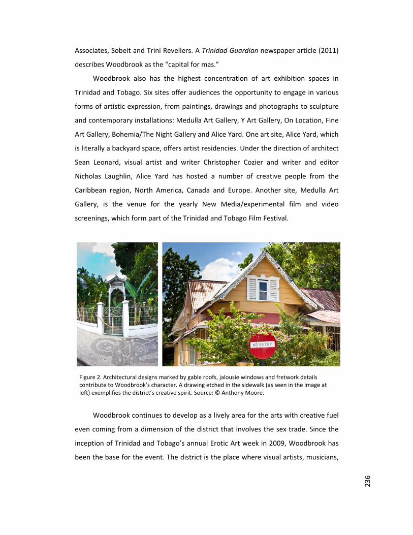
236
Associates, Sobeit and Trini Revellers. A Trinidad Guardian newspaper article (2011)
describes Woodbrook as the “capital for mas.”
Woodbrook also has the highest concentration of art exhibition spaces in
Trinidad and Tobago. Six sites offer audiences the opportunity to engage in various
forms of artistic expression, from paintings, drawings and photographs to sculpture
and contemporary installations: Medulla Art Gallery, Y Art Gallery, On Location, Fine
Art Gallery, Bohemia/The Night Gallery and Alice Yard. One art site, Alice Yard, which
is literally a backyard space, offers artist residencies. Under the direction of architect
Sean Leonard, visual artist and writer Christopher Cozier and writer and editor
Nicholas Laughlin, Alice Yard has hosted a number of creative people from the
Caribbean region, North America, Canada and Europe. Another site, Medulla Art
Gallery, is the venue for the yearly New Media/experimental film and video
screenings, which form part of the Trinidad and Tobago Film Festival.
Figure 2. Architectural designs marked by gable roofs, jalousie windows and fretwork details contribute to Woodbrook’s character. A drawing etched in the sidewalk (as seen in the image at left) exemplifies the district’s creative spirit. Source: © Anthony Moore.
Woodbrook continues to develop as a lively area for the arts with creative fuel
even coming from a dimension of the district that involves the sex trade. Since the
inception of Trinidad and Tobago’s annual Erotic Art week in 2009, Woodbrook has
been the base for the event. The district is the place where visual artists, musicians,
237
poets and writers gather to share their imaginative perspectives and probe such
issues as sensuality, sexual desire, arousal, power and taboos.
Clothing design also has a home in the district. The fashion house of Meiling
Esau, one of the Caribbean’s leading designers, is located at 6 Carlos Street,
Woodbrook. The location is a collective or community of people working to execute
their artistic visions. In 2012, Meiling – as she is known in the fashion industry – took
inspiration from the Woodbrook address to launch the 6 Carlos Magazine, which
aims to mirror the artistic community out of which the publication was born.
Heather Jones, another principal Caribbean fashion designer, also operates from
Woodbrook, with her business located in Luis Street.
The culinary arts are also a huge feature of Woodbrook. The district’s popular
Ariapita Avenue is characterised by several restaurants and roadside vendors. Along
with eateries, the presence of bars and casinos make the avenue an axis on which
Woodbrook’s vibrant nightlife revolves. Poetry and jazz are also part of the
nighttime offerings. The magnetism of Ariapita Avenue is perceived as being so
strong that the location has been included in new tourism initiatives. In 2012, the
government approved a multi‐million dollar plan to shape the avenue into a tourist
attraction.
Ariapita Avenue’s status as a place of creative articulation was also reinforced
when it served as the setting for local fashion designer and season nine Project
Runway television show winner Anya Ayoung Chee’s Spring/Summer 2013
collection. On January 31, 2013, Ariapita Avenue was transformed into a runway for
Ayoung Chee’s event entitled Fashion Rocks the Avenue – a fashion show with free
admission for the public. Audiences crowded the avenue for an event which was
Ayoung Chee’s first Caribbean showing since winning the North American fashion
design television competition in 2011.
The avenue is not the only node of interest. Woodbrook’s built environment is
also of significance. The district’s suburban face reflects both old and new
architecture. Woodbrook is known for its colonial‐era gingerbread buildings, which
are identified by wooden jalousie windows and ornate fretwork. These structures
stand in sharp contrast to and are under the threat of being ousted by more recently
erected high‐rise properties of concrete, steel and glass. This tension of styles and

238
approaches to the designing of space in Woodbrook is one key source of continued
conversations about the art of self‐definition, identity and the trajectory options for
growth and change in islands seeking to demonstrate their modernity and have a
distinctive voice in the world. Woodbrook is a creative district in which the arts –
from theatre to architecture – play a pivotal role in Caribbean processes of self‐
exploration and ‘becoming’.
Figure 3. Woodbrook’s built environment resonates with creative energy. Source: © Anthony Moore.
239
References Blood, Peter Ray. “Mas Camp Turns 25.” Trinidad Guardian. 2 June 2011. Web. 27
Mar. 2013. <http://guardian.co.tt/lifestyle/2011/06/01/mas‐camp‐turns‐25>.
Homer, Louis. “100 Years of Woodbrook.” Trinidad Express. 11 Sept. 2011. Web. 7
Jan. 2013. <http://www.trinidadexpress.com/news/100_years_of_woodbrook‐
129628453.html>.
MacLean Geoffrey and Vel Lewis. The Built Heritage of Trinidad and Tobago. Port of
Spain: The National Trust of Trinidad and Tobago, 2012. Print.
Ramdass, Anna. “Ariapita Avenue to be Tourist Resort.” Trinidad Express. 10 May
2012. Web. 27 Mar. 2012.
<http://www.trinidadexpress.com/business/Ariapita_Avenue_to_be__tourist_res
ort_‐151059665.html>.
Rampersad, Joan. “100th Anniversary Celebrations.” Newsday. 5 Nov. 2011. Web. 7
Jan. 2013. <http://www.newsday.co.tt/features/print,0,150115.html>.
Raymond, Judy. “Beryl McBurnie: The First Lady of Dance.” Caribbean Beat 20
(1996): n. pag. Web. 7 Jan. 2013. <http://caribbean‐beat.com/issue‐20/beryl‐
mcburnie‐first‐lady‐dance>.
Woodbrook Celebrates 100 Years. Trinidad Guardian. 13 Aug. 2011. Web. 7 Jan.
2013. <http://www.guardian.co.tt/entertainment/2011/08/13/woodbrook‐
celebrates‐100‐years>.

Case study published in: Marques, Lénia and Richards, Greg (eds) (2014) Creative districts around the world. Breda: CELTH / NHTV. URL: http://creativedistricts.imem.nl/
CREATIVEARTISANSDISTRICTSINTHEPROVINCEOFLIMALIMA, PERU
CHARLINE CAYEMAN (MASTER’S STUDENT IN TOURISM DEVELOPMENT STRATEGIES AT
UNIVERSITY OF LUSÓFONA DE HUMANIDADES E TECNOLOGIAS, LISBON, PORTUGAL)
In the province's capital of Peru, Lima, there are two artisans districts. The district of
Tawaq in Ate Vitarte and Ichimay Wari in Lurin. These two districts have the particularity of
relaying Quinua culture (place of origin of the artisans) through cultural events and artistic
designs in their products. Since its arrival in the province of Lima, the districts have been
created, improved and were able to start receiving tourists. The artisans use their creative art
to give life to the district. The activities undertaken within the district revolve around
"experiential tourism".
It was in a time of social and economic problems. In the 80s in Peru, Ayacucho (Peru's
poor department) had started terrorism. It was a very violent time with a current extremist
who murdered both civilians and military. It was in this difficult situation that provincials
migrated to the capital, fleeing violence. They came in different circumstances and to
different places in the province of Lima, for example, Ate Vitarte and Lurin. Municipalities of
two small towns giving facilities to people living in poverty to buy their own land. People
from Ayacucho were young and turned into families of artisans. They began to produce and
sell their crafts in order to survive and build a future for themselves and their families.
At first, the sale conditions were difficult and the artisans were paid below the price of
their products. In Lima discrimination and exploitation were predominant among employers.
For this reason, the artisans took the initiative to form an association, which valued their jobs
and could no longer be abused by employers.
Artisans from Quinua district (department of Ayacucho) who arrived at Ate Vitarte
founded an artisan association called Tawaq in Lima on 23 December 1985. At the beginning,
the association had 6 members and now Tawaq has 31 partners. The translation of the Tawaq
acronym means: "Wari Ayllu Associated Workshops of Quinua". "Wari" is a reference to the

242
culture whose men were recognised for being great potters of the Pre Inca; "Ayllu" is a
Quechua word meaning "family reunification", and "Quinua" as the name origin of artisans.
Tawaq aims to develop the craft, preserve and defend the identity of its people and Andean
culture. Its mission is to market its products through export and reception of experiential
tourism that respects the principles of fair trade and seeking to improve the quality of life of
its members. The workshops mainly engage people in the pottery of Quinua and retables,
representative of handicraft products from Ayacucho.
Concerning the artisans who migrated to Lurin, they have also created an association in
the artisan district, the association of Ichimay Wari. Since 1999, the association has had 19
families who produce ceramics, textiles and altarpieces. With the formation of their
association, artisans have developed their communities and workshops with the help of
financing from NGOs and
universities. Promoting their
culture is an important mission
for the artisans of Ichimay Wari.
The name of the district
association and Artisanal
contains the Quechua word Wari
referring to ancestral culture,
and the word Ichma was used by
a pre‐Incan culture situated in
the area of Lurín. The name
contains two cultures and thus
reflects adaptation to a new
environment. The drawings
present in their art represent the
two ancient cultures. It is by
their designs that the artisans
transmit their history.
Figure 1. Artisan: Gedion Fernandez (member of the Tawaq
association). Photo: Charline Cayeman.

243
When these two people’s artisans arrived in the province of Lima, they arrived at a
virgin land. Over the years, they have built their homes, their workshops and their districts.
District development has been slow due to economic difficulties. But thanks to the creation
of their association, they help each other to reproduce their former home of Ayacucho. And
little by little, their creative art has settled in the district streets. Their creation has installed
ceramic decoration in their district. For example, plates with decorations of Wari culture
identify artisan workshops, sculptures and paintings in tissue to welcome the visitors.
Artisans living in the two districts will be delighted to explain the meaning of each piece of
their work that composes their workshop. Handicrafts, for example, drawings of landscapes
of Ayacucho, convey scenes of cultural life that are usually associated with the seasons and
the rites tied with their
beliefs. In the districts,
they celebrate daily habits
of their original people. It
is through these
associations, Tawaq and
Ichimay Wari (acting as a
community), that these
districts have started to
develop.
Figure 2. Learning one of the techniques with the artisan Juan Nolasco
Chavez, member of the Association Ichimay Wari.
Given that the inhabitants are almost exclusively artisans in these two districts, cultural
life in these districts focuses on crafts. The artisans transmit the artistic know‐how from
father to son. Cultural activities related to crafts are means of artistic expression and a way to
preserve and protect the culture of Ayacucho. Artisans want to give more life to their district
by making it attractive for tourist activities. But tourism is nevertheless not the dominant
source of activities in districts. Tourism has some social impacts such as improving the quality
of life and fulfillment, identity consolidation, participation in the cultural expansion. Tourism
helps artisans develop their districts and informs visitors of the products they can create and

244
sell. It has happened that tourism helps to get customers from abroad. On the one hand,
tourism is important to promote them but on the other hand, it is important to teach their
skills and give information about their culture. Indeed, the activities are provided to visitors
through the establishment of a participative tourism and experiential tourism. The idea is to
offer visitors a learning experience on culture and handicraft techniques. It is an exchange of
know‐how and passion from artisans to visitors. But sometimes from visitors to artisans who
develop their creativity among their experience. This type of approach can be related to the
trend of creative tourism1. Artisans of Tawaq and Ichimay Wari wanted to use a different way
from traditional tourism to create experiences that will benefit both tourists and the local
community.
In terms of cultural activities, both districts organise meetings and community life
events. Music, dance, gastronomy, sport and cultural activities are available in these two
districts. In fact, they used to celebrate holidays such as Father's Day and more general
activities all together around a banquet. The family has an important role in the functioning
of cultural life of the districts. The Tawaq and Ichimay Wari districts maintain and preserve
various cultural activities related to ancestral practices. The most important example is
gastronomy. There is a Peru delicacy: the Pachamanca, a delicious and traditional Peruvian
dish, based on baking, buried under the ground and cooked over hot stones for about 2 to 3
hours. It is a typical ancestral activity, and more than a method of cooking it is a celebration
in and of itself, a source of fertility and life. Each region has a different version of the
Pachamanca, but the principle remains the same. The preparation of the dish is accompanied
by a true ancestral ritual in Peru related to Mother Earth (Pachamama). This dish is cooked in
local districts and this one is sometimes shared with visitors. So, some cultural practices of
the past are always present in inhabitants’ customs and beliefs, which allow its preservation.
In conclusion, these two districts, Ate Vitarte and Ichimay Wari, have a rich culture
from their place of origin and they have adapted to what they found in the province of Lima.
This is conveyed by the handicraft through drawings found in their production. The two
districts were created from nothing in the 1980s to become a cultural and attractive place to
visit today. Artisans have been creative in establishing a tourism focused on participation and
1 Creative tourism is defined by UNESCO as: “It is travel directed toward an engaged and authentic experience, with participative learning in the arts, heritage, or special character of a place and it provides a connection with those who reside in this place and create this living culture.”

245
learning their know‐how or sometimes culinary experience. And cultural life is centred on
sharing events between families in the community. The future of these two districts is rather
promising as they have a good basis and good practices to continue to grow. It is important,
however, that the artisans continue to help each other to take care of their creative districts
and continue to move forward.
Figure 3. Photo: Charline Cayeman.