Book of Abstracts - CORE
520
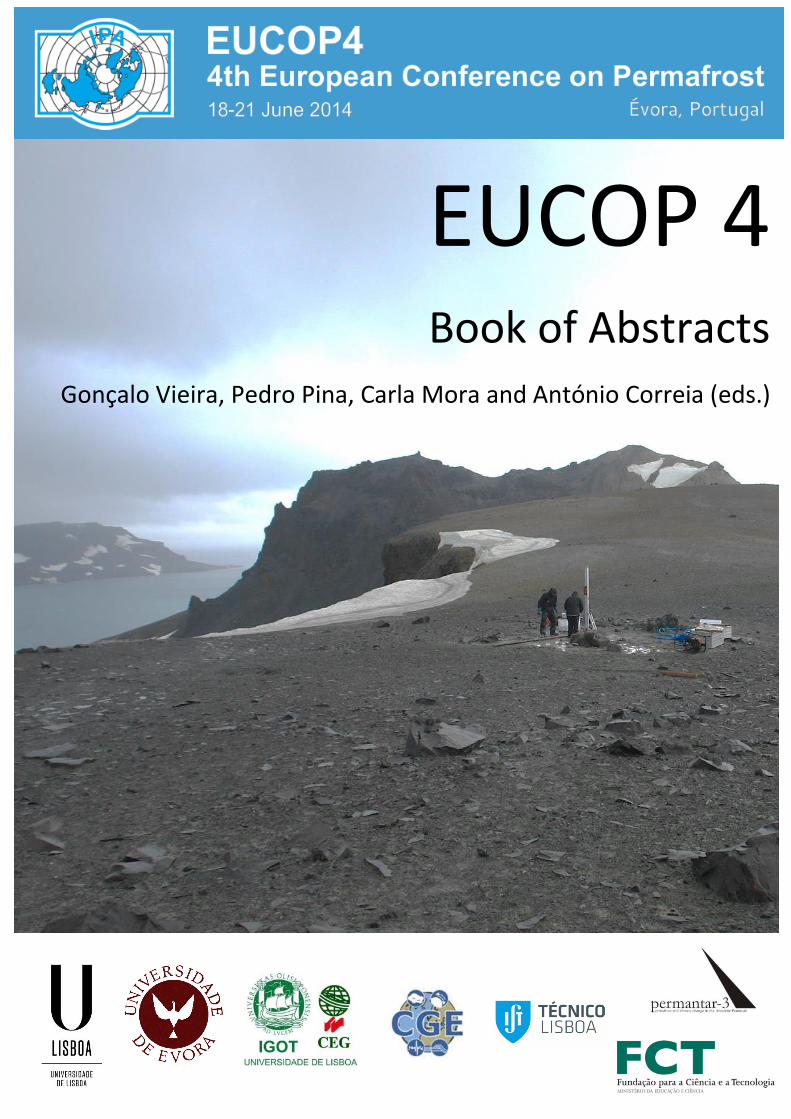
Book of Abstracts of EUCOP4 – 4 th European Conference on Permafrost 18-21 June 2014 - Évora, Portugal EUCOP 4 Book of Abstracts Gonçalo Vieira, Pedro Pina, Carla Mora and António Correia (eds.)
-
Upload
khangminh22 -
Category
Documents
-
view
2 -
download
0
Transcript of Book of Abstracts - CORE
Book of Abstracts of EUCOP4 – 4th
European Conference on Permafrost 18-21 June 2014 - Évora, Portugal
EUCOP 4 Book of Abstracts
Gonçalo Vieira, Pedro Pina, Carla Mora and António Correia (eds.)
Book of Abstracts of EUCOP4 – 4th
European Conference on Permafrost 18-21 June 2014 - Évora, Portugal
EUCOP4 - Book of Abstracts 4th European Conference on Permafrost 18-21 June 2014 Évora, Portugal Editors Gonçalo Vieira University of Lisbon, CEG/IGOT Lisboa, Portugal Pedro Pina University of Lisbon, CERENA/IST Lisboa, Portugal Carla Mora University of Lisbon, CEG/IGOT Lisboa, Portugal António Correia University of Évora, CGE Évora, Portugal Published by the University of Lisbon and the University of Évora June 2014
Book of Abstracts of EUCOP4 – 4th
European Conference on Permafrost 18-21 June 2014 - Évora, Portugal
PREFACE
EUCOP4, the 4th European Conference on Permafrost and Regional Conference of the International
Permafrost Association is hosted by the Portuguese Universities of Lisbon and Évora and is to be held
in Évora from the 18th to the 21st June 2014. The conference provided the opportunity to bring
together researchers from all over the world to present and discuss some of the most recent advances
and results in permafrost and related subjects. More than 370 researchers from 24 countries have
registered.
A very positive response to the Call for Papers for EUCOP4 was obtained, with more than four hundred
and fifty submissions. This book contains 425 abstracts, including those from the 3 plenary lectures, 1
from The Wiley-Blackwell Permafrost and Periglacial Processes Public Lecture and 23 session keynote
lectures. The high quality of the scientific program is to be thanked to the authors and also to the
chairs of the 23 thematic sessions, that made a fantastic work in their promotion and also in
conducting all reviewing and selection procedures. We are very indebted to all of them.
We are also very pleased to benefit from the participation of our guest speakers Prof Oleg Anisimov,
State Hydrological Institute (Russia), Prof Frederick Nelson, Univ. Wisconsin (USA), Prof James
Bockheim, Univ. Wisconsin-Madison (USA) and Prof Christian Hauck, Univ. Fribourg (Switzerland), for
their plenary lectures. We are also very delighted to receive at EUCOP4 ‘The Wiley-Blackwell
Permafrost and Periglacial Processes Public Lecture - PPP Award for Excellence in Permafrost
Research’ by Prof. Chris Burn, Carleton University (Canada). We express our gratitude to these world
renowned experts on permafrost.
The International Scientific Committee has supported the Local Organizing Committee since an early
stage in defining the science program and has provided timely comments on key questions on the
organization. We are indebted to all members who accepted to support us. Special thanks are due to
Toni Lewkowicz, Hanne H. Christiansen, Bernd Etzelmuller, Hans Hubberten and Miguel Ramos for
their support. The International Permafrost Association Council members are also warmly thanked for
their support towards the organization of this conference in Portugal.
Finally, as editors of the Book of Abstracts, we acknowledge the excellent support, patience and
cooperative spirit of all the Local Organizing Committee: Alexandre Nieuwendam, Alice Ferreira, Ana
Salomé David, André Oliveira da Fonseca, Gonçalo Prates, João Canário, Lourenço Bandeira, Marc
Oliva, Mário Neves and Maura Lousada.
We are very pleased to welcome all the participants of EUCOP4 in Évora and look forward for another
excellent European Conference on Permafrost, after Rome (2001), Potsdam (2005) and Longyearbyen
(2010).
Évora, June 2014
Gonçalo Vieira
Pedro Pina
Carla Mora
António Correia

Book of Abstracts of EUCOP4 – 4th
European Conference on Permafrost 18-21 June 2014 - Évora, Portugal
Book of Abstracts of EUCOP4 – 4th
European Conference on Permafrost 18-21 June 2014 - Évora, Portugal
INTERNATIONAL SCIENTIFIC COMMITTEE
Adriano Ribolini, Università di Pisa, Italy
Andreas Kellerer-Pirklbauer, Graz
University of Technology, Austria
Anna Kurchatova, Tyumen State Oil and
Gas University, Russian Federation
Antoni Lewkowicz, University of Ottawa,
Canada
António Correia, University of Évora,
Portugal
António Gomez Órtiz, University of
Barcelona, Spain
Augusto Pérez-Alberti, University of
Santiago de Compostela, Spain
Bernd Etzelmüller, University of Oslo,
Norway
Bo Elberling, University of Copenhagen,
Denmark
Carla Mora, University of Lisbon, Portugal
Carlos Schaefer, Federal University of
Viçosa, Brazil
Christian Hauck, University of Fribourg,
Switzerland
Enrique Serrano, University of Valladolid,
Spain
Ernst Hauber, DLR, Germany
Frederick Nelson, University of Delaware,
USA
Gisle Håland, Statoil, Norway
Gonçalo Vieira, University of Lisbon,
Portugal
Hanne H. Christiansen, The University
Centre in Svalbard, Norway
Hans Hubberten, Alfred Wegener Institute
for Polar and Marine Research,
Germany
Hugh French, University of Ottawa, Canada
Huijun Jin, Chinese Academy of Sciences,
Lanzhou, China
James Bockheim, University of Wisconsin-
Madison, USA
Jerry Brown, Woods Hole, USA
João Canário, University of Lisbon, Portugal
Joseph Levy, Oregon State University, USA
Ko van Huissteden, Vrije Universiteit
Amsterdam, The Netherlands
Lourenço Bandeira, University of Lisbon,
Portugal
Marc Oliva, University of Lisbon, Portugal
Mário Neves, University of Lisbon, Portugal
Mauro Guglielmin, University of Insubria,
Italy
Michel Allard, Université de Laval, Canada
Miguel Ramos, University of Alcalá de
Henares, Spain
Oleg Anisimov, State Hydrological Institute,
Russia
Ole Humlum, University of Oslo, Norway
Pedro Pina, University of Lisbon, Portugal
Peter Kuhry, Stockholm University, Sweden
Rajmund Przybylak, Nicolaus Copernicus
University, Poland
Reynald Delaloye, Université de Fribourg,
Switzerland
Stephan Gruber, University of Zurich,
Switzerland
Vladimir Romanovsky, University of Alaska,
Fairbanks, USA
Wilfried Haeberli, University of Zurich,
Switzerland
Book of Abstracts of EUCOP4 – 4th
European Conference on Permafrost 18-21 June 2014 - Évora, Portugal
6
LOCAL ORGANIZING COMMITTEE
Gonçalo Vieira, University of Lisbon, CEG/IGOT – Chair
Alexandre Nieuwendam, University of Lisbon, CEG/IGOT
Alice Ferreira, University of Lisbon, CEG/IGOT
Ana David, University of Lisbon, CEG/IGOT
André Fonseca, University of Évora, CGE
António Correia, University of Évora, CGE
Carla Mora, University of Lisbon, CEG/IGOT
Gonçalo Prates, University of Algarve and CEG/IGOT
João Canário, University of Lisbon, CQE/IST
Lourenço Bandeira, University of Lisbon, CERENA/IST
Marc Oliva, University of Lisbon, CEG/IGOT
Mário Neves, University of Lisbon, CEG/IGOT
Maura Lousada, University of Lisbon, CERENA/IST
Pedro Pina, University of Lisbon, CERENA/IST

Book of Abstracts of EUCOP4 – 4th
European Conference on Permafrost 18-21 June 2014 - Évora, Portugal
7

Book of Abstracts of EUCOP4 – 4th
European Conference on Permafrost 18-21 June 2014 - Évora, Portugal
8
Book of Abstracts of EUCOP4 – 4th
European Conference on Permafrost 18-21 June 2014 - Évora, Portugal
9
TABLE OF CONTENTS
PLENARY LECTURES ........................................................................................................................................... 11
PUBLIC LECTURE ................................................................................................................................................ 17
PERMAFROST RESEARCH AND SOCIETY: FROM HISTORY TO THE FUTURE ....................................................... 21
S1+S2. History of permafrost research and education and outreach ............................................................ 21
S3. Open session on permafrost ..................................................................................................................... 35
PERMAFROST ENVIRONMENTS - INTERDISCIPLINARY CROSSROADS ............................................................... 59
S4. Periglacial geomorphology ....................................................................................................................... 59
S5. Permafrost and mountain microbiology: from microbial function, adaptation and activity to
environmental impacts ......................................................................................................................... 105
S6.Biogeochemistry of permafrost in transition ........................................................................................... 117
S7. Topography and microclimate effects on permafrost and seasonally frozen ground ........................... 151
S8. From kinematics to dynamics: geomorphic and physical controls of permafrost creep ....................... 183
S9. Limnological processes in permafrost environments ............................................................................. 199
S10. Dynamics of ice-wedge polygons and thermokarst in tundra landscapes – inventory, functioning and
development ......................................................................................................................................... 223
S11. Planetary permafrost, geomorphology and Earth analogues ............................................................... 243
S23. From coastal to subsea permafrost ...................................................................................................... 255
PERIGLACIAL PALEOENVIRONMENTS .............................................................................................................. 277
S12. Techniques of paleoenvironmental reconstruction from periglacial deposits ..................................... 277
S13. Reconstruction and modelling of paleo-permafrost ............................................................................ 289
REGIONAL FOCUS – GLOBAL SIGNIFICANCE .................................................................................................... 301
S14. Yedoma origin, records and future projections in a changing Arctic .................................................... 301
S15. Tropics to middle latitudes, volcanic high mountain permafrost ......................................................... 315
METHODS AND TECHNIQUES .......................................................................................................................... 323
S16. The role of geophysics in permafrost studies ....................................................................................... 323
S17. Remote Sensing, DEMs and GIS applications in periglacial research.................................................... 343
S18. Permafrost and frozen ground engineering .......................................................................................... 385
MONITORING AND MODELLING...................................................................................................................... 409
S19. Bridging the gap between models and observations in permafrost landscapes .................................. 409
S20. CALM at Twenty: Multi-decadal perspectives on an international permafrost monitoring program .. 431
S21. Permafrost modelling across different scales ....................................................................................... 447
S22. Permafrost international monitoring, observing and coordinating activities ...................................... 473
INDEX OF AUTHORS ......................................................................................................................................... 507

Book of Abstracts of EUCOP4 – 4th
European Conference on Permafrost 18-21 June 2014 - Évora, Portugal
10
Book of Abstracts of EUCOP4 – 4th
European Conference on Permafrost 18-21 June 2014 - Évora, Portugal
11
PLENARY LECTURES

Book of Abstracts of EUCOP4 – 4th
European Conference on Permafrost 18-21 June 2014 - Évora, Portugal
12
Book of Abstracts of EUCOP4 – 4th
European Conference on Permafrost 18-21 June 2014 - Évora, Portugal
13
Plenary Lecture 1
Challenges of permafrost predictive modeling under a changing climate
Oleg Anisimov, State Hydrological Institute, Russia
Frederick Nelson, Univ. Wisconsin, USA
Variety of models of different complexity have been developed to study the climate- and ecosystem-driven changes in
permafrost, impacts of such changes on the environment and infrastructure, and the feedbacks to the global climate
through emission of greenhouse gases. Relatively simple permafrost models assume that the ground thermal regime is
in equilibrium with the atmospheric climate. Despite their simplicity, such models demonstrate good results in
replicating the current state of permafrost, and are often used to construct permafrost projections at geographical
scales from local to hemispheric. More sophisticates models explicitly account for the dynamics of the ground
temperature regime and seasonal thawing/freezing, so that transient response of permafrost to changing climatic and
environmental conditions may be simulated. To get insight into the future the stand alone permafrost models require
climatic projections, at minimum monthly air temperature and precipitation data. Alternative approach is to model
dynamics of the frozen ground directly in the land surface modeling schemes within GCMs. However this approach is
computationally very expensive, which imposes serious limitations on the level of details and complexity of permafrost
parameterizations.
At minimum, two problems in permafrost predictive modeling remain open. The first is associated with the insufficient
amount of data on soil, surface (i.e. snow and vegetation), and atmospheric parameters that are needed to validate and
run permafrost models. Such kind of limitations are particularly restrictive for the sophisticated dynamical models that
could not be used effectively unless the full set of required input data and parameters is defined with reasonable level
of accuracy. The other problem is modeling methodologies adopted in most studies to date. Even the most
comprehensive permafrost models are deterministic, while permafrost parameters at local scales are largely governed
by small-scale variability of soil, vegetation, snow parameters and topography. The new type of stochastic permafrost
models has recently come into existence. Unlike conventional models, they take into account the probabilistic nature of
climatic projections and small-scale spatial variability of soil, snow, and biophysiographic parameters in the calculations
of the statistical ensemble representing potential states of permafrost under the prescribed conditions. This new
methodology is fully harmonized with the ensemble approach that is used to construct probabilistic climatic projections
on the basis of results derived from several GCMs. On the other hand, it provides important information that directly
addresses the practical stakeholders needs and may be used in various applications such as the risk assessment of
potential infrastructure damage and evaluation of other threshold-driven processes and impacts associated with
thawing permafrost.
Book of Abstracts of EUCOP4 – 4th
European Conference on Permafrost 18-21 June 2014 - Évora, Portugal
14
Plenary Lecture 2
Recent advances on Antarctic permafrost and soils
James Bockheim, Univ. Wisconsin-Madison, USA
The objectives of this presentation are to describe the evolution of Antarctica’s cryosphere, to provide an historical
overview of permafrost research in Antarctica, to discuss recent research achievements, and to identify critical research
needs. Antarctica covers 14 million km2, but only 0.35% (49,500 km2) is ice-free. Despite the lack of exposed land,
there is a remarkable record of soil development in what is now Antarctica since the Permian (350 Ma). Antarctica’s
present cryosphere developed once the continent separated from Gondwanaland during the Cretaceous (80 Ma). The
separation of the Scotia Arc enabled the Antarctic Circumpolar Current to become established. The Antarctic
continental ice sheets developed during the Oligocene (40-34 Ma). The current hyperarid, hypergelic climate has
remained in effect since the mid-Miocene (14.8-13.6 Ma). Antarctica’s oldest ice dates back more than 1 Ma. The
Antarctic ice sheets are underlain at a depth of 1.3 km by a complex network of streams and lakes. The earliest studies
of permafrost were conducted by the Russians in the late 1950s. Over the past 20 years, the key research themes in
Antarctic permafrost have been microbial ecology, methods of detection, thermal/physical properties, and buried ice.
There are 126 boreholes in Antarctica but only 7 exceed 25 m in depth. Permafrost is continuous throughout the
Antarctic continent. The hyperarid conditions in Antarctic have yielded “dry permafrost” throughout the inland
mountains. Permafrost temperatures range between -0.35 and -1.8°C along the western Antarctic Peninsula (WAP), -8.3
and -9.8°C along the East Antarctic coast, and -14° and -24°C in the inland mountains. The maximum depth of
permafrost measured to date is 970 m in the McMurdo Dry Valleys. Active-layer depths range between 1 and 7 m or
more along the WAP, 0.8 to 2 m in coastal East Antarctica, and 0.03 to 0.5 m in the inland mountains. In 2002 buried ice
was discovered in the McMurdo Dry Valleys that was dated at 8.1 Ma and was later shown by David Gilichinsky to
contain viable bacteria. In the past several decades the mean annual and mean winter air temperatures along the WAP
have increased by 3.4°C and 6°C, respectively. In north Victoria Land warming over the period 1997-2009 resulted in a
0.1°C/yr increase in permafrost temperature and a 0.01 m/yr increase in active-layer depth (Guglielmin and Cannone).
Critical permafrost research needs in Antarctica include a comprehensive drilling program in climatically sensitive areas,
a greater number of deep boreholes, and a greater understanding of the role of terrain attributes, especially snow, for
modeling Antarctic permafrost distribution.
Book of Abstracts of EUCOP4 – 4th
European Conference on Permafrost 18-21 June 2014 - Évora, Portugal
15
Plenary Lecture 3
Monitoring ice and water content – New developments in permafrost geophysics
Christian Hauck, Univ. Fribourg, Switzerland
The application of geophysical techniques has a long tradition in permafrost research, as these methods can be used as
flexible and cost-effective alternative to complement standard (thermal) mapping and monitoring techniques.
Traditional permafrost observation techniques rely mainly on thermal monitoring in vertical and horizontal dimension,
but they provide only weak indications of physical properties such as ice and liquid water content or porosity. In
addition, the investigation depth is often limited to the uppermost 10 metres and/or the active layer depth.
Geophysical techniques can be used to characterise permafrost occurrences over much larger depth ranges, and to
monitor their temporal and spatial changes as the physical properties of frozen and unfrozen ground measured by
geophysical techniques are markedly different.
In recent years, electromagnetic, seismic but especially electrical methods have been used to monitor permafrost
occurrences over several years (even up to 1-2 decades) and to detect changes of the physical properties within the
active layer and regarding the ice content within the permafrost layer. With respect to applied studies, increasingly
detailed information is being drawn from geophysical surveys, including quantitative estimation of water storage, ice
contents, water flow and temperature. These data are not only important in a monitoring context, but also to validate
coupled transient thermal/hydraulic models which are used to predict the evolution of permafrost occurrences under
different climate change scenarios. These models rely on suitable validation data during an observation period, which
are usually restricted to data sets of ground temperature and active layer depth. Because ground ice and unfrozen
water content in the active layer are important initialisation and validation data for these models, geophysically-derived
estimates of these properties become more and more valuable.
In this contribution new developments regarding the application of geophysical methods in permafrost studies will be
presented, focusing on methods which allow the quantification of subsurface ice and water content and an increased
process understanding regarding water flow in the active layer and its interaction with the thermal regime of the
permafrost. These methods include e.g. continuous geoelectrical monitoring and ice content quantification using
petrophysical relationships based on seismic/electrical measurements. Ground truth data are available from borehole
temperatures, borehole geophysics and water content measurements in the uppermost part of the active layer.
Most of the presented geophysical data originate from mountain permafrost stations in the Swiss Alps, but also other
data, e.g. from Antarctica and high latitudes will be discussed.

Book of Abstracts of EUCOP4 – 4th
European Conference on Permafrost 18-21 June 2014 - Évora, Portugal
16
Book of Abstracts of EUCOP4 – 4th
European Conference on Permafrost 18-21 June 2014 - Évora, Portugal
17
PUBLIC LECTURE

Book of Abstracts of EUCOP4 – 4th
European Conference on Permafrost 18-21 June 2014 - Évora, Portugal
18
Book of Abstracts of EUCOP4 – 4th
European Conference on Permafrost 18-21 June 2014 - Évora, Portugal
19
The Wiley-Blackwell Permafrost and Periglacial Processes Public Lecture PPP Award for Excellence in Permafrost Research
Permafrost and climate change near the western Arctic coast of Canada
Chris Burn, Carleton University, Canada
The western Arctic coastlands of Canada have historically been a focal area for research on permafrost due to the
potential for hydrocarbon development and because of the 60-year legacy of Professor J.R. Mackay. Examination of
permafrost conditions has concentrated on factors that may influence infrastructure development, and since 1995
interest in the response of the terrain to climate change has increased. Dr Mackay’s work left several benchmarks
against which changes in terrain conditions can be measured. The region has a relatively long climate record, which
shows a substantial increase in air temperatures since 1970, mostly in the autumn and winter. The total change in
annual mean temperature has been about 2 °C. At the same time, precipitation has shown no trend. As a result, we
must assess the first extensive set of hill slope movements in the region, observed in September 2009 near Inuvik, as a
result of an extreme precipitation event rather than due to climate change. We have occupied a series of sites that
were established by J.R. Mackay and D.K. MacKay in 1968 at Garry Island, and determined the response of the ground
at points with systematically varying snow covers to changes in air temperature between 1969-71 and 2004-13. The
change in mean annual ground temperature has been about 1.8 °C at most sites, but less (1.2 °C) at the warmest
location. The temperature at the surface of permafrost is independent of air temperature during freeze-back of the
seasonally thawed active layer and it appears that a critical control on the annual mean temperature in permafrost is
the duration of freeze-back. Mitigation of rising ground temperatures in permafrost may be achieved by control of
snow accumulation early in winter. In 1983, Dr Mackay established a line of 12 points along a tundra hill slope where
the thickness of the active layer has been measured for over 30 years. These data have shown that sites on slopes
respond quite differently to climate change from sites in flat terrain, where water from ground ice that melts towards
the end of the summer is refrozen in autumn. On slopes some of the water is, instead, lost, and as a result subsidence
on slopes is becoming evident. The subsidence is concentrated above ice wedges, and has become readily apparent
since 2011. Such subsidence is the most pressing geotechnical issue facing infrastructure in the western Arctic.

Book of Abstracts of EUCOP4 – 4th
European Conference on Permafrost 18-21 June 2014 - Évora, Portugal
20
Book of Abstracts of EUCOP4 – 4th
European Conference on Permafrost 18-21 June 2014 - Évora, Portugal
21
PERMAFROST RESEARCH AND SOCIETY:
FROM HISTORY TO THE FUTURE
S1+S2. History of permafrost research and
education and outreach
Chairs:
J. Brown, F. Nelson, A. Klene and J. Stanilovskaya

Book of Abstracts of EUCOP4 – 4th
European Conference on Permafrost 18-21 June 2014 - Évora, Portugal
22
Book of Abstracts of EUCOP4 – 4th
European Conference on Permafrost 18-21 June 2014 - Évora, Portugal
23
Keynote Lecture 1
Activities for permafrost education and outreach
Kenji Yoshikawa, Water and Environmental Research Center, Institute of Northern Engineering, University of Alaska Fairbanks, USA
The International Permafrost Association (IPA) has been active in developing a series of products and initiatives to meet scientific and regional communities demands, most recently targeted towards the next generation of scientists with programs and for indigenous people and their northern community. Education and Outreach are not just an integral part of modern science, but also important to recognize local communities where located on permafrost. We will present last three years of the activities of the IPA Education and Outreach Standing Committee. We are responsible for leadership and international coordination of education and outreach activities that support IPA goals. The Education and Outreach Standing Committee works with various partners at multiple levels, e.g. site, network, organizational, community, and international. We should 1). ensure the presence and involvement of young researchers and educators in IPA activities, 2). seek to develop educational products for non-specialist audiences, including youth, teachers, journalists or policy-makers, 3). support the development and maintenance of the International University Courses on Permafrost (IUCP) database, 4). seek to develop the place of permafrost in education curricula, 5). support and foster the development of field courses and summer schools on permafrost-related topics, 6). support PYRN and ensure that its activities are known in the permafrost community and beyond (e.g. APECS), 7). make recommendations to the permafrost community and the wider public to better publicize media and outreach products on permafrost. The International University Courses on Permafrost (IUCP) database and partnership with University of the Arctic (Thematic Network on permafrost) are good examples of our recent efforts. We will present summary of the project for the each level such as K12, teachers and students, undergraduate, graduate school, and general audiences.
As awareness of permafrost continues to grow within the research community and the general public, it will be crucial to integrate Education and Outreach as an important part of our science activities.
Book of Abstracts of EUCOP4 – 4th
European Conference on Permafrost 18-21 June 2014 - Évora, Portugal
24
Keynote Lecture 2
A short history of permafrost research
Frederick Nelson, University of Wisconsin-Milwaukee, USA
Although substantial advances in permafrost science and engineering have occurred over the past century, the body of historical work describing, interpreting, and relating them to external influences is very small. Permafrost studies have rich and complex relations with other branches of science, including physics, civil and mechanical engineering, geomorphology, Quaternary studies, hazards, ecology, and climate change. This presentation provides a skeletal overview and timeline of the development and evolution of geocryology, the accomplishments of its practitioners, and historical events that have helped to shape the existing body of knowledge about frozen ground and its relations with human activities. We also explore the potential for developing a historiography of permafrost science and engineering.

Book of Abstracts of EUCOP4 – 4th
European Conference on Permafrost 18-21 June 2014 - Évora, Portugal
25
The shifting motivation for permafrost research in Norway and Svalbard: a historical review
Ole Humlum, Department of Geosciences, University of Oslo, Norway & Department of Geology, UNIS, Svalbard, Norway
The existence of permafrost in Svalbard was known since initial cloal mining attempts and the first IPY in 1882. Already in 1883 ground temperatures were recorded and in 1913 ground ice studies were initiated.
The first review of frozen ground phenomena in Spitsbergen was published in 1922, and several other observations on permafrost were published between 1924 and 1937, describing patterned ground and other themes. In 1941 observations from Spitsbergen on solid bodies of ground ice emphasised the importance of topography, soil type and moisture supply to understand the distribution of ground ice.
After the 2nd World War, most peremafrost studies in Svalbard had a geomorphological focus, but after 1998 (PACE), several permafrost boreholes were established, especially during the IPY 2007-09. Modern permafrost in Svalbard has a general geomorphological approach, characterised by field observations and monitoring of permafrost temperatures and meteorological parameters.
In mainland Norway permafrost research began later than in Svalbard. Presumably one of the first publications referring to permafrost in Norway was a paper in 1957 on water resources in northern Norway. Here the existence of permafrost was suggested by combining a climatic approach with an early permafrost model. In addition, 20 m thick permafrost was reported from mining activities in Lyngen peninsula, Norway, at an altitude of 750 m a.s.l.
However, scientific knowledge on permafrost remained sparse until the mid-sixties, where a study of permafrost in ice-cored moraines in Norway was published. This was followed by several investigations of landforms indicating the former existence of permafrost, e.g., a special type of circular lake, ice-wedge casts, and fossil polygon patterns on raised beach ridges.
A suite of other investigations then followed during the following 25 years. During the first 10 years of this important development investigations mainly had a geomorphological research focus, and permafrost was usually addressed only indirectly. This, however, changed in 1984, when geophysical research methods became frequent in Norwegian permafrost research, resulting in a change of focus from periglacial geomorphology to permafrost temperatures studied by geophysical means.
After 1998 the European PACE program have contributed importantly to the recognition and description of permafrost in Norway and other parts of Scandinavia. Several permafrost boreholes were established from 1998, but especially during the 2007-09 IPY period (TSP-Norway and CRYOLINK). The new field observations on permafrost temperatures recently resulted in the development of a modeling approach in Norwegian permafrost research. This recent permafrost research development should also be seen on the background of increasing political interest in permafrost since 2000, motivated by the general concern for climate change, with consequences for research funding possibilities.

Book of Abstracts of EUCOP4 – 4th
European Conference on Permafrost 18-21 June 2014 - Évora, Portugal
26
Cores, comics and communities: Bringing permafrost research to decision-makers in Yukon, Canada
Bronwyn Benkert, Northern Climate ExChange, Yukon Research Centre, Yukon College, Canada
Fabrice Calmels, Northern Climate ExChange, Yukon Research Centre, Yukon College, Canada
Louis-Philippe Roy, Northern Climate ExChange, Yukon Research Centre, Yukon College, Canada
Since 2000, the Northern Climate ExChange (NCE), part of the Yukon Research Centre at Yukon College, has been carrying out activities related to adaptation, mitigation, education and outreach focused to the impacts of climate change in the Yukon. Recognizing the significant impact of current and future permafrost change on Yukon communities, NCE has been developing its capacity to conduct permafrost research, through personnel development and the enhancement of field and lab-based research capacities, as well as via strong collaborations with southern-based researchers. As a result, NCE has developed a suite of research projects related to the impacts of climate change on permafrost and the interface between local conditions and decision-making. These include projects addressing landscape hazards mapping and the characterization of permafrost conditions under key public infrastructure in Yukon communities, and an assessment of the vulnerability of the North Alaska highway to permafrost thaw. All of NCE’s permafrost-related projects aim to develop tools to inform decision-making for climate change adaption planning.
Because the success of the projects listed above is linked with the integration of results in decision-making processes, NCE has worked to develop communication tools aimed at Yukon communities and practitioners impacted by permafrost. This presentation will discuss the approaches we have employed in communicating our project ideas, progress and findings, and their associated challenges and successes.
In developing communications approaches for our projects, we recognize that we must communicate complex information to both technical and lay audiences, and that our communications are done both in-person and independently. The diversity of our audience has compelled us to employ multiple communication methods for each of our projects. We have had limited success with traditional community-based open houses, and instead have held dinners, invitational meetings and celebrations as ways of engaging community-based practitioners. We have also worked to develop novel ways of communicating project results outside of face-to-face interactions. We have created a comic-style communication piece, to convey context, purpose, methods, results and applicability of findings from our research projects to non-technical audiences, but also to capture the attention of the scientific audience. We are working on the development of lay reports, guides, posters, video and other tools for independent perusal by non-technical audiences, and we held a workshop with the consulting, planning and governmental communities in the Yukon, to scope most appropriate ways of distributing project results for integration by practitioners. By sharing our experiences applying these communication methods in results dissemination, we hope to contribute to the body of resources available to researchers wanting to ensure project outcomes are incorporated in decision-making.
Book of Abstracts of EUCOP4 – 4th
European Conference on Permafrost 18-21 June 2014 - Évora, Portugal
27
Promoting Polar Science in Portugal for the next generation
Ana David, Center of Geographical Studies - University of Lisbon, Portugal
Alexandre Nieuwendam, Center of Geographical Studies - University of Lisbon, Portugal
José Seco, Institute of Marine Research - University of Coimbra, Portugal
José Xavier, Institute of Marine Research - University of Coimbra, Portugal
Patrícia Azinhaga, Institute of Marine Research - University of Coimbra, Portugal
Sara Aparício, Center for Environmental and Sustainability Research -New University of Lisbon, Portugal
Sílvia Lourenço, Portuguese Institute of the Ocean and Atmophere, Portugal
Since the 2006-2007 International Polar Year (IPY), the Portuguese polar earlier career science community has been growing constantly, incorporating the Association of Polar Earlier Career Scientists (APECS), the Portuguese National Committee and APECS Portugal. This last group has around 50 earlier career scientists that integrate Portuguese and international teams working in both the poles and the cryosphere in areas like marine biology, conservation, chemistry, glaciology, permafrost and geopolitics. More recently, the community also started to have teachers as active members. Dedicated to give voice to the Portuguese Polar earlier career scientist, the APECS Portugal works to promote interdisciplinary and educational innovative activities, in a non-polar country, in collaboration with numerous countries, and playing an important role in promoting Portuguese Polar science beyond IPY.
During 2013, the APECS Portugal organized and was involved in several activities and events promoting interdisciplinary and educational outreach, e.g., the International Polar Week, an international education & outreach project, and the 4th APECS Portugal Career development Workshop.
During the last Fall International Polar Week, APECS Portugal through the new educational project “Profissão: cientista polar” in coordination with the Portuguese Polar Program (PROPOLAR), APECS Brazil and Polar Educators International (PEI) organized 35 activities with schools: workshops, Skype calls, talks in schools, and universities, discussion panels, symposiums, international seminars and interactions with students that used scientific data for their school projects, involving about 10500 students, 158 teachers and 13 scientists from Portugal, Brazil, United Kingdom and Angola .
Since 2010, the APECS Portugal organizes the career development workshops as a parallel event of the Portuguese Polar Sciences Conferences. In the 4th APECS Portugal career development workshop had 20 people including earlier career scientist (EC), mentors and international guests (from Bulgaria, Canada, Germany and Sweden), talking about “How to be a Polar Scientist”. With 10 short presentations about their science, two talks about how to better communicate science and the international head researchers of Canada and Germany, ideas and discussions about how to be a better polar scientist and effectively communicate science arose during all day.
The growing number of members of APECS Portugal covering several and distinct research areas in both poles as well as the consolidation in the E&O work with the schools is a good example of the consolidation of Portugal as a non-polar country conducting research in Polar regions.
Book of Abstracts of EUCOP4 – 4th
European Conference on Permafrost 18-21 June 2014 - Évora, Portugal
28
Planned education and outreach activities during the ICOP 2016, Potsdam, Germany
Inga May, IPA, Germany
Rainer Lehmann, Middle School Hannover, Germany
Kenji Yoshikawa, University of Alaska, Fairbanks, USA
Lutz Schirrmeister, Alfred-Wegener Institut, Germany
During the International Polar Year (IPY) 2007- 2008 education and outreach became more and more important and many different initiatives were started to foster this aim. It got obvious that without a meaningful communication of scientific results to the broader public, including all ages, the very important research outcomes will not be understood and accepted by the public. As this is a key in order to convince stakeholders, decision makers, politicians, but also just normal individuals, that these outcomes are of high importance for everybody’s daily life it and there is a high need to be active and react, it must be the goal of every scientist to make its research as understandable as possible. Maybe even more important is this content is to raise the awareness of the next generation for sensitive issues such as global change, climate warming and the impacts of the different regions of the world.
Inspired by the activities of the IPY also the permafrost community started to foster their education and outreach projects. As they recognized its importance the International Permafrost Association (IPA) even launched and Education and Outreach committee in 2010 and started the collaboration with many educational institutions such as the University of the Arctic or APECS. Financially supported by the IPA this committee started its work during the last years and already could achieve some substantial outcomes. For the upcoming International Conference on Permafrost in 2016 (ICOP 2016), that will be held in Potsdam, Germany, it is intended that education and outreach will play an even more important role. For this a special education and outreach conference team was created, that will be responsible for the activities during the conference. They are planning to involve international schools and teachers to the conference activities, which will be a very new and innovative initiative.
This presentation will present the proposed actions during, but also before and after, the conference. This could include a video competition for international schools to attend the event, the involvement of one or two local schools and a workshop for international teachers. A special event could be an evening lecture held by a scientist that will be open for the public. It will be a semi-entertaining, semi-scientific presentation that will be easy understandable for non-scientists. One main goal of the planned education and outreach activities will also be the possibility for children and the public to get in touch with ‘real’ scientists, communicate with them and in that way somehow close the gap between science and the daily live.
All activities and events will be organized by the education and outreach conference team but mainly supported by the IPA Education and Outreach committee as well as the German ‘coole Klassen’ (cool classes) project, an initiative of the working group ‘Polar Teachers’ of the German Association of Polar Research (DGP).
Book of Abstracts of EUCOP4 – 4th
European Conference on Permafrost 18-21 June 2014 - Évora, Portugal
29
Celebration of the 50th Anniversary of the First International Conference on Permafrost
Jerry Brown, Woods Hole, MA, USA
Frederick Nelson, University of Wisconsin-Milwaukee, USA
This past year marked the 50th anniversary of the First International Conference on Permafrost (ICOP) that was held at Purdue University on 11-15 November 1963. To celebrate the 50th anniversary, a one-day program was convened on November 15, 2013, at Purdue University. The program included speakers representing topics that were discussed at the Conference and others engineering, climate-related and geotechnical subjects and a concluding banquet. Four participants of the 1963 conference attended.
The 1963 conference was a historic event in that it brought together for the first time the leading researchers and practitioners from North America and other countries that had diverse interests and activities in the study and applications of perennially frozen ground, cold regions engineering and related laboratory investigations. The 285 registered participants represented engineers, researchers, manufacturers and builders from the USA (231), Canada (42), the USSR (5), Sweden (3) and Argentina, Austria, Great Britain, Japan, Norway, Poland, Switzerland, and West Germany. The conference was organized by the Building Research Advisory Board of the U.S. National Academy of Sciences–National Research Council (NAS-NRC). The carefully edited volume, published in 1966 by the NAS, is considered to be the first multi-national, English-language collection of papers devoted entirely to permafrost topics. The 100 published papers followed closely the actual conference venue and panel discussions: soils and vegetation (9), massive ground ice (10), geomorphology (16), phase equilibrium and transition (8), thermal aspects (8), physico-mechanical properties (7), exploration and site selection (11), sanitary and hydraulic engineering (14), and earthwork and foundations (17).
The First ICOP essentially broke the “ice” between Soviet and Western permafrost researchers and set the stage for the Second ICOP that was held in 1973 in Yakutsk, Siberia. All subsequent conferences maintained the interdisciplinary principles set forth at Purdue: two more in the United States (Fairbanks 1983, 2008), two in Canada (Edmonton 1978, Yellowknife 1998), and one in Trondheim, Norway (1988), Beijing, China (1993), and Zurich, Switzerland (2003), one more in Russia (Salekhard 2012).
Throughout the 50-year history of the International Conferences on Permafrost, publication of Proceedings has been the major legacy of each conference. Over the course of the 50 years more than 2000 papers in English were published in the Proceedings with the assistance of many hundreds of international reviewers and editors. Starting in 2003 (8th ICOP), a second form of publication was initiated that involved Extended Abstracts. For the 2012 conference a Transactions of the International Permafrost Association was initiated to coincide with future ICOPs.
Book of Abstracts of EUCOP4 – 4th
European Conference on Permafrost 18-21 June 2014 - Évora, Portugal
30
Frost tube in Russian communitis/schools
Julia Stanilovskaya, Sergeev Institute of Environmental Geoscience RAS, Russia
Kenji Yoshikawa, University of Alaska, USA
Mikhail Prisyazhniy, North-Eastern Federal University, Russia
Project "Frost tube in Russian schools " is a pilot program that the establishing of monitoring sites where comunitties located in Russian cryolithozone since 2012. In this project, students from remote areas can learn more about the permafrost . In addition, students can participate in major scientific research community of the International Permafrost Association, expanding their horizons and forming the scientific worldview .
During the year, the students under the guidance of the teacher of geography , physics or biology measure the depth of soil freezing in frost tube of Danilin on schoolyard. Concomitantly, observations of air temperature and snow depth.
Since April 2012 , six of western Siberian communities began to monitor on this project in Yamal-Nenets Autonomous District (Salekhard, Labytnangy) during and before the 10th International Conference on Permafrost. In July 2012 frost tube was installed at the Children's Environmental station in Novy Urengoy , schools of BAM (Severobaykalsk, Chara, Novaya Chara, Tynda) , Southern Yakutia (Zolotinka, Iengra, Berkakit, Neryungri, Serebryny Bor, Chulman , Khatymi), Yakutsk. During the May expedition "Frost tube in the Baikal region " in 2013 frost tube was installed in 11 settlements of the Irkutsk region: Baikalsk, Sludyanka, Kultuk, Irkutsk, Ust -Orda, Bayanday, Kachug, Birulka, Anga, Butakovo and Verkholensk. September's expedition in 2013 took place on the Sakhalin Island, and frost tube was installed in four localities: Nekrasovka (the most northern settlement of Sakhalin Island), Okha, Nogliki and Pobedino. Today, there are 40 educational institutions participating in the project from 29 settlements in Russian cryolithozone.
In different schools we found a peculiar interest of teachers and students to cryogenic phenomena. The study of icings in Kultuk, mudflow dam erected after the famous 1971 in Sludyanka, the searching of ice caves near Verkholensk, daily weather observations from 1981 continuing by teacher of geography in Butakovo - this valuable material students will necessarily use when writing school papers on the project "Frost tube".
Active teacher Alena Struchkova from school 14 in Yakutsk works with students to promote knowledge about permafrost, developing route "Kingdom of permafrost". Areas of work are included the history of permafrost study;
observation; excursion activity ; communication with permafrost scientists.
Pupils of secondary school have already visited the underground laboratory of Permafrost Institute. The year-round is winter there, and summer visit of young "travelers" has special delight .
The first award of the international project "Frost tube in Russian schools" is recived and diploma of students and their head Alfiya Khabibulina from Novy Urengoy on Yamal Second Environmental Forum in April 2013.
The data and newsletters about the expeditions, competitions, conferences for students are here http://permafrost.edublogs.org and http://vk.com/frost_tube
Book of Abstracts of EUCOP4 – 4th
European Conference on Permafrost 18-21 June 2014 - Évora, Portugal
31
Frost tube outreach program in Japan
Koichiro Harada, Miyagi University, Japan
Kenji Yoshikawa, UAF, USA Go Iwahana, UAF, USA
Julia Khalilova, Sergeev Institute of Environmental Geoscience RAS, Russia
Yuki Sawada, Fukuyama City University, Japan
Toshio Sone, Hokkaido University, Japan
In order to emphasis their interest for earth sciences, an outreach program through measurements of frost depth is conducting in Japan. This program is made at elementary, junior high and high schools since 2011 winter in Hokkaido, northern part of Japan where seasonal ground freezing occurs. At schools, a lecture was made and a frost tube was set at schoolyard, as the same tube and protocol as UAF’s Permafrost Outreach Program, using clear tube with blue-colored water. Frost depth was measured directly once a week at each school by students during ground freezing under no snow-removal condition. In 2011 season, we started this program at three schools, and the number of participated school is extended to 19 schools in 2013 season, 15 elementary schools, three junior high schools and one high school. We visited schools summer time and just before frost season to talk about the method of measurement. After the end of measured period, we also visited schools to explain measured results by each school and the other schools in Japan and Alaska. The measured values of frost depth in Hokkaido were ranged between 0cm and more than 50cm. We found that the frost depth depends on air temperature and snow depth. We discussed with student why the frost depth ranged widely and explained the effect of snow by using the example of igloo. In order to validate the effect of snow and to compare frost depths, we tried to measure frost depths under snow-removal and no snow-removal conditions at one elementary school. At the end of December, depths had no significant difference between these conditions, 11cm and 10cm, and the difference went to 14cm, 27cm and 13cm after one month, with about 30cm of snow depth. After these measurements and lectures, students noticed snow has a role as insulator and affects the frost depth. The network of this program will be expected to expand, finally more than a hundred schools.
Book of Abstracts of EUCOP4 – 4th
European Conference on Permafrost 18-21 June 2014 - Évora, Portugal
32
What is TNP - The IPA and UArctic Thematic Network on Permafrost – and how to use it
Kenji Yoshikawa, University of Alaska Fairbanks, USA
Hanne H. Christiansen, The University Centre in Svalbard, Norway & CENPERM, Department of Geosciences and Natural Resource Management, University of Copenhagen, Denmark
Atsuko Sugimoto, Hokkaido University, Japan
Mikhail Prisyazhniy, North-Eastern Federal University, Russia
It is important and necessary to educate and train a large number of permafrost researchers and engineers, and raise general knowledge and understanding of permafrost, especially in higher education institutes in Northern communities. However, it is also important to train local communities living on permafrost to improve their understanding of permafrost.
The Thematic Network on Permafrost – TNP was developed as a major activity of IPA Standing Committee of Education and Outreach, and formally endorsed in summer 2013 by the University of the Arctic. The primary goal is to establish, sustain and strengthen a network of university institutions that give permafrost research based education primarily between University of the Arctic (UArctic) members, and with some non UArctic partners. The network will promote research, education collaboration and joint projects in the area of permafrost, its impact on environment and adaptation to climate change. The main form of cooperation is joint research and education projects such as summer schools, ambitions to develop a joint Master/PhD program, as well as knowledge sharing aimed at addressing, in a multidisciplinary way, the contemporary issues in the field of cryosphere focusing on permafrost.
The TNP is led by the University of Alaska Fairbanks (UAF), and with both the University Centre in Svalbard (UNIS), Norway, the North-Eastern Federal University (NEFU), Russia and Hokkaido University, Japan as co-leaders. Otherwise there are four other UArctic partners, and 18 non UArctic partner institutions.
Already, and as a legacy of the IPY 2007-2008, the online International University Courses on Permafrost, IUCP, is existing, providing an overview service to students about where which permafrost courses are offered when. In the TNP we aim to also offer special courses with several TNP partners involved in the lecturing, providing students with a pan Arctic approach and knowledge about permafrost. One such example is the International Bachelor Permafrost Summer Field School funded by UArctic and hosted at UNIS in Norway. This have been designed and will be run for two summers 2014 and 2015 at UNIS in Svalbard by several TNP partners and offered internationally. It will be announced by IPA, UArctic, APECS, CliC, UAF, NEFU and UNIS.
TNP has its first international master student studying both at UAF, UNIS and Uni. of Copenhagen on in an interdisciplinary study. Hopefully more master students will use the TNP to assist them with coordinating their permafrost master degree potentially involving more TNP partners.
We hope that in the future the above presented TNP activities through increased interaction between science, education and local authorities will accommodate several new permafrost educational and outreach activities, which you as students and researchers assist us with suggesting and developing!
Book of Abstracts of EUCOP4 – 4th
European Conference on Permafrost 18-21 June 2014 - Évora, Portugal
33
To experience of education in the field of permafrost in Siberia
Vladimir Sheinkman, Tyumen State Oil and Gas University, Earth Cryosphere Institute, SB RAS, Russia
Vladimir Melnikov, Tyumen State Oil and Gas University, Earth Cryosphere Institute, SB RAS, Russia
There is no unexpectedness in that most of Russian territory (almost two thirds) is the area under permafrost conditions. In turn, most of the Russian permafrost area has been situated in Siberia, as it is located in the north of Eurasia and exists under continental climatic conditions. It binds to study permafrost phenomena in this region at great length and to educate specialists in the field of permafrost. For this reason Earth Cryology sub-department has been set up in the Tyumen State Oil and Gas University, and it carries out corresponding work in all above-mentioned directions. At present it is a leading educational institution in Siberia.
It would serve not so significant purpose to present here in detail a daily routine of the educative process in the sub-department, because it is a usual procedure, as in other similar institutions. It is more profitable to argue another point – in respect to such measures as organizing the field practical trainings for students in order to teach them by dint of direct studying the representative permafrost objects. There are enough objects along these lines in Siberia; they are numerous, and, what is very important, reachable by means of public transport facilities. For example, the sections with magnificently expressed repeated ice wedges, originated during the Late Pleistocene, have been situated in a scenic locality in the basin of Chara River (Trans-Baikal Region) quite near the railway station New Chara linked by daily rotes with all chief towns of Russia.
At present the Earth Cryology sub-department has plenty of experience also in the field of international collaboration. As an example it can be referred to the participation in the arrangements of the TICOP in 2012. Twelve students from the sub-department had participated then in the field practical trainings in Polar Ural where investigations to learn the laws of permafrost nature have been carried out together with about thirty young men from different countries.
Field practical trainings for the students of the Earth Cryology sub-department have been realized to date in different regions with well-expressed permafrost phenomena, such as Polar Ural, Trans-Baikal Mountains, Altai, Yakutia and so on. The regions are also remarkable in that permafrost phenomena develop there together with large modern glaciers which have been specific as they form under cold continental climate of Siberia. The glaciers undergo an effect of deep cooling and come out very cold. As a result they become a peculiar component of cryolithozone, so that it provides for students a visual representation of observing different components of Cryosphere in their interaction.
All of this forms a good basis for a fruitful international collaboration to teach and train students during fieldwork. The Earth Cryology sub-department of the Tyumen State Oil and Gas University is ready to promote such a measure and to undertake corresponding effort on necessary fronts.
Book of Abstracts of EUCOP4 – 4th
European Conference on Permafrost 18-21 June 2014 - Évora, Portugal
34
Lena River Delta Expedition Outreach – Students conceptions of the Arctic and their importance for teaching
Wiebke Kaiser, Institute of Soil Science, KlimaCampus, University of Hamburg, Germany
Benjamin R. K. Runkle, Institute of Soil Science, KlimaCampus, University of Hamburg, Germany and Postdoc-Kolleg, Center for a Sustainable University, University of Hamburg, Germany
Lars Kutzbach, Institute of Soil Science, KlimaCampus, University of Hamburg, Germany
Alexander Tillmann, Institute of Education, Didactics of Geography, University of Hamburg, Germany
Authentic experiences play an important role for learning. The 2013 Lena River Delta Expedition brought two education students to collaborate with permafrost researchers in the field and to learn their methods first-hand. En route, a school in Tiksi, Siberia, was visited and the students there provided us a glimpse of their views of the Arctic. Children’s questions were answered in a child’s way, and a teaching unit was created to present our Arctic expedition in German classrooms. In ten schools around Hamburg, Germany, we used a storytelling approach to teach a simple climate model demonstrating connections between the permafrost soil and the atmosphere. During the lesson pictures of permafrost soil and the drilling of a soil core from the Lena Expedition were shown.
Pre-conceptions play a decisive role in the way that students integrate taught material into their personal cognitive construction of a given subject. In didactics of geography, only a few studies have focused on preconceptions of the cryosphere. Hence, this study assessed students´ preconceptions of the cryosphere before introducing the project´s Arctic material.
For this study, 201 nine year old students from different primary schools filled out questionnaires and painted images regarding their pre-instructional conceptions of the Arctic. At school they have not yet been taught about the Arctic region or different climate zones. Nevertheless, the Arctic is already familiar to the majority of these students and they can describe typical characteristics ranging from a barren icy landscape including polar bears, penguins, igloos up to modern life in that area. The study shows different concepts of the arctic landscape such as an icy desert, a mountain chain, or a floating ice sheet. Furthermore, the results show clearly that the Arctic soil is not in the students´ focus with respect to the climate change. Following the growing research awareness of the importance of the permafrost for the global climate, it is necessary to bring this topic to school. Global climate protection is only possible if students know why they should protect something. And therefore it is good to know for students that there are regions in the world, far away from Germany but where climate-induced changes of landscape are already visible.
This teaching unit taught how to develop a successful introduction to a unit on the Arctic and polar research. It was impressive for the students to see and touch a real polar work suit. Pictures based on the teacher´s experience in this region created an authentic learning mood. Moreover, it became apparent that the students´ concept that the Arctic soil consists only of pure ice is a barrier for their learning. To build up an adequate mental model, it is important to teach them that soil has structures, looks differently and has different functions in general.
Book of Abstracts of EUCOP4 – 4th
European Conference on Permafrost 18-21 June 2014 - Évora, Portugal
35
PERMAFROST RESEARCH AND SOCIETY:
FROM HISTORY TO THE FUTURE
S3. Open session on permafrost
Chairs:
R. Muskett and A. Ferreira

Book of Abstracts of EUCOP4 – 4th
European Conference on Permafrost 18-21 June 2014 - Évora, Portugal
36
Book of Abstracts of EUCOP4 – 4th
European Conference on Permafrost 18-21 June 2014 - Évora, Portugal
37
Keynote Lecture 3
Field investigations to characterize current ground thermal conditions in the Alaska Highway Corridor, Yukon Canada
S.L. Smith, Geological Survey of Canada, Natural Resources Canada, Canada
A.G. Lewkowicz, University of Ottawa, Canada
M. Duguay, University of Ottawa, Canada
M. Ednie, Geological Survey of Canada, Natural Resources Canada, Canada
A. Bevington, University of Ottawa, Canada
The Alaska Highway corridor traverses the discontinuous permafrost zone of the southern Yukon. Although a significant amount of information on permafrost conditions was collected over 30 years ago to support a previous pipeline proposal, little recent information on ground thermal conditions existed. Air temperatures in the region have increased 0.4-0.5°C per decade since the 1970s and recent studies in the corridor indicate that warming and thawing of permafrost has occurred over the last 3-4 decades (e.g. James et al. 2013). Recent proposals for construction and operation of a natural gas pipeline and the need to develop climate change adaptation strategies for existing highway infrastructure has stimulated the need for updated information on current permafrost conditions.
The Geological Survey of Canada measured ground temperatures in the corridor in 17 boreholes between 1978 and 1981 (Burgess et al. 1982). In summer 2011, eleven of these boreholes between Whitehorse and the Alaska border were instrumented for ground temperature measurement to depths of up to 8.5 m. Ground temperature records of up to two years in length have been acquired from these boreholes. Eight boreholes (up to 10 m deep) drilled along the highway easement in 2011, were instrumented in summer 2013. Electrical Resistivity Tomography (ERT) surveys have also been conducted at many of the borehole sites to better describe the vertical and lateral extent of frozen ground.
The ground thermal data collected since 2011 indicates that permafrost is generally warm (above -1.5°C) in the section of the corridor between Whitehorse and the Alaska border. However, colder permafrost (-3°C) was found near the Alaska border. Results from ERT surveys indicate that permafrost thickness varies from less than 25 m near Kluane Lake to greater than 60 m near the Alaska border.
Comparison of recent temperature measurements with those made 1978-1981, indicates that permafrost persists at sites where it was present three decades ago. However, our analysis indicates ground temperatures at the depth of zero annual amplitude may have increased by more than 0.5°C since the late 1970s. Increasing air temperatures are partially responsible for the observed ground warming. Environmental disturbance related to clearance of vegetation at some sites has also resulted in ground warming and increased thaw depths. Additional modelling studies are planned to facilitate the attribution of the apparent ground warming in the corridor.
References
Burgess MM, Judge AS, & Taylor AE. 1982. Yukon ground temperature data collection - 1966 to August 1981, Earth Physics Branch Open File 82-1.
James M, Lewkowicz AG, Smith SL & Miceli CM. 2013. Multi-decadal degradation and persistence of permafrost in the Alaska Highway corridor, northwest Canada. Environ. Res. Lett. 8 045013, 10pp.
Book of Abstracts of EUCOP4 – 4th
European Conference on Permafrost 18-21 June 2014 - Évora, Portugal
38
Permafrost below timberline - Isolated ice patches confirmed by a dendroecological approach
Alexander Bast, Swiss Federal Research Institute WSL, Switzerland
Isabelle Gärtner-Roer, Department of Geography, University of Zürich, Switzerland
Holger Gärtner, Swiss Federal Research Institute WSL, Birmensdorf, Switzerland
Permafrost is a common phenomenon in high mountain ecosystems. Even though its main distribution is restricted to areas above timberline, there are several sites where permafrost occurs in lower elevations. Those ecological “coldspots” are characterized by a patchy distribution of relative warm ice lenses in the near subsurface due to multifaceted parameters (e.g. shaded north-face exposition with a small amount of incoming solar radiation, vegetation/moss layer, chimney effect, cold air pockets in winter) . Furthermore they are often discussed as relict permafrost occurrences.
The study site is a north-facing slope in the Bever Valley/Upper Engadine (1800 – 1900 m a.s.l.) covered by European larch and Swiss stone pine. Trees do not show any morphological differences to those, which were grown adjacent of the slope. Permafrost was proven there by geophysical soundings and temperature measurements.
Two main questions form the base of our study: (i) Is it possible to detect the presence of permafrost, or rather cold subsurface conditions round about 0°C, by analyzing ring-width variations in larch (ii) Will the results help indicating changes of the permafrost conditions back in time?
88 dominant larch trees with an average age of 210 years were cored and the position of each sampled tree was documented in a detailed map. In addition, a reference chronology was established consisting of 18 trees.
Our dendroecological approach allowed the determination and mapping of isolated ice patches in the subsurface, which are characterized by cold temperatures. All cored trees show a comparable higher growth level for more than 100 years before the 1870s/80s. Thus, probably the ice-lenses were not existing before that time period and changing environmental conditions led to the performance of permafrost/cold subsurface conditions. Some larch trees show a growth release since the 1970s, indicating a possible temperature increase in the subsurface. Even though the results of tree-ring analyses and former electrical resistivity soundings do coincide, it cannot be definitely stated that growth suppressions do show permafrost, but at least areas of low soil temperature. More research concentrating on wood anatomy and oxygen isotope analyses is currently done to analyze this in detail.
Book of Abstracts of EUCOP4 – 4th
European Conference on Permafrost 18-21 June 2014 - Évora, Portugal
39
Permafrost as a factor of geochemical flow formatting in the Lena River Delta
Antonina Chetverova, Saint-Petersburg Stait University, Arctic and Antarctic Research Institute, Russia
Irina Fedorova, Arctic and Antarctic Research Institute, Saint-Petersburg Stait University, Russia
Anne Morgenstern, Alfred Wegener Institute Helmholtz Centre for Polar and Marine Research, Germany
Olga Bobrova, Saint-Petersburg Stait University, Russia
The Lena River delta is the largest delta in the Arctic and unique natural object. River deltas are serve an important function of sedimentary geochemical barriers, and kind of bio-filters of terrigenous material for up to 90% of suspended particular matter and up to 40% of dissolved substances flowing to the ocean.
Delta is a changeable system due to high activity of channel processes, high accumulation and riverbanks deformations. Geochemical flows formation, its distribution and transformation in the river channels of the Delta influenced by many of factors. Permafrost dominates among of these. The catchment area of the delta is covered by wetland landscape and includes a numerous of water objects formed in the condition of continuous permafrost including Yedoma. In consequence of thermoerosion and thermokarst processes lowered lakes, the tributaries from lakes as well as tributaries from Yedoma add dissolved and suspended components to the total flow of the river and forming a significant source of geochemical flow. It can be seeing on the basis of outflows from Yedoma case study carrying colder, more muddy and mineralized water is to the river. The impact of such factors are changing the distribution in river channels influenced by them.
Detail study of geochemical situation in the Lena river delta allows understanding processes of geochemical flows formation in the delta and distribution of the components from the delta head to the sea, to access amount of material transported by the river and accumulated.
Book of Abstracts of EUCOP4 – 4th
European Conference on Permafrost 18-21 June 2014 - Évora, Portugal
40
Opaline silica as a weathering product in the cold climate
Elena Kuznetsova, SINTEF Building and Infrastructure, NTNU (Norwegian University of Science and Technology), Norway
John Charles Walmsley, SINTEF Material and Chemistry, NTNU (Norwegian University of Science and Technology), Norway
Laminar opaline silica with a typical disc shape was discovered for the first time in the volcanic soils developed less than 500 years ago at Hokkaido, Japan. And this opal was mostly found in the 0.2-5 µm fractions and had a pedogenic origin. Laminar opaline silica was found in volcanic soils at Tohoku, Kanto and Kyushu, Japan; Papua New Guinea; Oregon, USA; and in New Zealand. Henmi T. and Parfitt R.L. (1980) concluded that opaline silica is characteristic of the early stages of weathering of volcanic ash in the humid temperate climatic zone. Our observations of volcanic tephra show that cold humid climates and permafrost can preserve opaline silica.
The volcanic tephra used in our investigation was preserved in cold and humid climate of Kamchatka, Far-East of Russia, in the area where permafrost and periglacial processes are widespread. Volcanic ash was erupted mostly in the Quaternary and the upper part of the early Pleistocene (Q21). IR analyses showed the presence of oplaine silica in all samples.
Opaline silica was present as very fine particles and these could only be seen clearly at high magnification using transmission electron microscopy (TEM). TEM micrographs showed that the opaline silica particles are spherical in form and are closely packed in microaggregates. The forces and processes involved in the aggregation of the particles are not entirely understood, but there are suggestions that the long range electrostatic repulsion force, that is between similarly charged objects, and the short range van der Waal’s forces are the major forces that predetermined the configuration of the aggregate made up of silica spheres. The opaline silica particles are extremely small; the size of each particle can be up to 10-20 nm.
Some TEM images showed a corroded edge of the opaline silica around glass particle which suggests that dissolution occurs during weathering. The completely altered soft zone is filled with spherical bodies and these are characteristic of opaline silica. These particles differ from glass fragments which are more angular and larger. The elemental composition of the opaline silica showed the chemistry of opals linked it to that of the host volcanic rock, even if modified by weathering processes. Gaillou et al. (2008) has emphasized that opal is not a pure form of silica, as it contains water as a component and various impurities and trace elements can also enter its structure. The most common impurity in our samples was aluminium, which substitutes for silicon, as well as Ca, K, Mg, Fe and Na were also presented. The most common "trace element" was Ti.
Gaillou E., Delaunay A., Rondeau B., Bouhnik-le-Coz M., Fritsch E., Cornen G., Monnier C. (2008) The geochemistry of gem opals as evidence of their origin. Ore Geology Reviews, 34, 1-2, 113-126.
Henmi T. & Parfitt R.L. (1980) Laminar opaline silica from some volcanic ash soils in New Zealand. Clays and clay minerals, 28, 57-60.
Book of Abstracts of EUCOP4 – 4th
European Conference on Permafrost 18-21 June 2014 - Évora, Portugal
41
Vulnerability of the North Alaska Highway to climate change, Yukon, Canada
Fabrice Calmels, Yukon College, Canada
Joel Pumple, University of Alberta, Canada
The Alaska Highway is the single overland route by which to distribute food, supplies and medical necessities to several Yukon and Alaskan communities. It is also the only all-season highway that provides access to Alaska's interior.
The northern 200 km of the Alaska Highway, from Destruction Bay to the Yukon/Alaska border, is underlain by extensive discontinuous, warm (> -2°C), and potentially ice-rich permafrost. An increase in heat flow from the ground surface can produce rapid permafrost thawing, resulting in damage to highway infrastructure. Increased ground temperature can result from climate warming, construction activities, or changes in surficial conditions. Preliminary research suggests a combination of these factors has already initiated thawing of permafrost underlying this section of highway. In the future, climate changes may accelerating permafrost thaw, further destabilizing the foundations of the highway.
Highways and Public Works (H&PW) has partnered with the Northern Climate ExChange (NCE), Yukon Research Centre, Yukon College, to develop a climate change adaptation strategy for this section of the Alaska Highway. The project examines the potential sensitivity of the permafrost along the highway to present and future climate variability.
The objectives are: 1) to identify and characterize sensitive permafrost areas underlying the highway; 2) to establish potential future climate scenarios for the study region; and 3) to estimate the potential impacts of the identified climate scenarios for areas of the highway underlain by thaw sensitive permafrost. A multi-disciplinary approach is being used, including permafrost coring, geocryological analyses, ground temperature and climate monitoring, ERT (Electrical Resistivity Tomography), and remote sensing techniques.
We are presenting the results of the survey for a specific area located north to Beaver Creek, YT, an area where permafrost distribution and characteristics are inherited from the regional glacial history. Sites underlain by permafrost, located within a few square kilometers of each other, exhibit a wide range of ages, ground temperatures, thicknesses, and ground ice content and nature. This variability complicates the understanding of the potential impacts of climate change on the foundation of the North Alaska Highway; a difficulty that can only be overcome through knowledge of the Quaternary history of the study area.
The assessment of the nature of future permafrost changes will facilitate the development of appropriate maintenance and remediation strategies, ensuring the highway’s continued viability.
Book of Abstracts of EUCOP4 – 4th
European Conference on Permafrost 18-21 June 2014 - Évora, Portugal
42
Methodical advances in borehole temperature measurement – Insights from the MOREXPERT project, Kitzsteinhorn (3.203 m), Austria
Ingo Hartmeyer, alpS - Centre for Climate Change Adaptation, Innsbruck, Austria
Markus Keuschnig, alpS - Centre for Climate Change Adaptation, Innsbruck, Austria
Johann Golser, Geodata Group, Leoben, Austria
Andreas Schmidjell, University of Salzburg, Austria
Lothar Schrott, University of Bonn, Germany
Temperature data from shallow and/or deep boreholes is pivotal to the success of many permafrost-related investigations. Among others, borehole temperature data is utilized for the study of active layer dynamics, the calculation of permafrost thickness, the recognition of long-term climate trends, or the validation of geophysical measurements. Despite heavy reliance on borehole temperature data there only exists a surprisingly low number of scientific contributions addressing the technical details and methodical challenges that come along with the instrumentation of boreholes in permafrost-affected ground. Within this methodological contribution two technical developments from the research project MOREXPERT (“Developing a Monitoring Expert System for Hazardous Rock Walls”) are presented.
Firstly, an improved system for temperature measurement in deep boreholes (>10m) is introduced. The measurement system, which has been developed by the Austrian company Geodata, consists of an impermeable polyethylene casing that prevents water and air entry into the borehole. The polyethylene casing is furnished with brass rings which are located in the designated depths of the temperature sensors. Brass was selected as it is non-corrosive and possesses a high thermal conductivity. The temperature sensors which are inserted into the casing automatically establish mechanical contact to the brass rings. The annulus (i.e. the space between casing and bedrock) is then filled up with concrete from bottom to top. As opposed to numerous other techniques the newly introduced system enables significantly improved thermal coupling between the temperature sensors and the surrounding rock and is therefore able to deliver highly representative temperature data. In order to demonstrate the functionality of the newly developed system we present, for the first time, temperature data from four boreholes (20-30m deep) that have been drilled into permafrost-affected rock at the Kitzsteinhorn (3.203 m), Austria.
Secondly, a low-cost and easy-to-apply strategy for temperature measurement in hand-drilled, shallow boreholes is introduced. The presented measurement strategy is based on the deployment of specifically adapted iButton® sensors. iButtons® are computer chips enclosed in a 16mm thick stainless steel can. In contrast to conventionally used temperature loggers, iButtons® are inexpensive and easy to replace in case of damage. For this reason a large number of measurement sites can be equipped for the measurement of near-surface rock temperatures and thermal offsets. A special workflow for the installation of iButtons® in depths of 10 and 80 cm is presented within this contribution. All iButtons® were attached to polyethylene rods and placed in previously drilled holes. The presented results, which cover different elevations and slope aspects of the Kitzsteinhorn summit pyramid, show the great potential of the introduced measurement strategy.
Book of Abstracts of EUCOP4 – 4th
European Conference on Permafrost 18-21 June 2014 - Évora, Portugal
43
Assessment of geologic and permafrost hazards for achieving sustainable development
Irina Chesnokova, Water Problems Institute Russian Academy of Sciences (WPI RAS), Russia
Recent analysis of the situation in the world carried out by the UN Commission on Sustainable Development has shown that hazardous geological processes cause enormous economic damage to the economy and the environment. Up to 250 extraordinary events happen annually on the average in Russia; average annual damage from them is about $ 15 billion.
Increasing development of natural disasters is determined by natural and social-economic causes, among them:
• Development of new territories, which were earlier considered unsuitable for living and cultivation due to increased probability of permafrost hazards;
• Development of a specific complex of hazardous natural and technogenic processes provoked by human activities;
• Errors and miscalculations in the strategy of providing security for regions.
Studying, systematization, and assessment of the economic damage resulted from permafrost change allow evaluate the risk of accidents and propose effective measures to minimize it in cities in general and in separate parts of the infrastructure (buildings, houses, run-ways of the airport, pipelines, railways, etc.). Currently, these issues present a series problem for Russia. Proposals are put forward to elaborate new laws and regulations in the Russian Federation for providing security for the population from dangerous natural permafrost processes.
We know that natural and social-economic systems undergo temporal variability so generating new problems associated with 1) value of the variability for a certain period of time and with 2) which part of this variability is associated with climate change and which - to other factors.
Nature-society interaction, promotion of sustainable development of regions in Russia and other countries is a complex problem. Studying permafrost processes, we believe that at present the main problem for people of many countries of the world is to preserve security, standard of living, peaceful and sustainable development. Protection of people and the development of new social-economic policy is an international problem. It requires increasing use of the entire potential accumulated by scientists in theory and practice.
Incidentally, further research in this new for our science direction should be carried out jointly with economists, sociologists, ecologists, as these aspects of the geological environment are so far insufficiently investigated, though they significantly effect the economic policy, so predetermining our future.
To provide sustainable development and to attain new ethic in the global management, it is necessary to select priorities, among them:
• Educating of the population. People should understand the essence of the phenomena, they are faced with.
• Issues of sustainable development should be integral part of the state policy. They should be interrelated with the main tendences of the economic, social, and ecological policy.
• Scientific information aimed at obtaining sustainable development.
Book of Abstracts of EUCOP4 – 4th
European Conference on Permafrost 18-21 June 2014 - Évora, Portugal
44
Organic carbon pools and genesis of Alpine soils with permafrost: a review
James Bockheim, University of Wisconsin, USA
Jeff Munroe, Middlebury College, USA
Soils with mountain permafrost may occupy 3.5 million km2 worldwide, with 69% occurring on the Qinghai-Tibet Plateau and the Altai-Khangai Mountains of central Asia. High-mountain environments are characterized by “warm” permafrost with temperatures at the top of the permafrost of -0.5°C to -3.5°C and thick active layers, commonly 2 to 8 m. From a global database of 41 sites and 312 pedons, alpine soils with permafrost generally are strongly acid (pH = 5.0 to 5.5), have intermediate cation-exchange capacities (20 to 25 cmolc/kg) and base saturation (44 to 85%), an isotic mineral class, and abundant soil organic C (SOC). SOC tends to be concentrated in the upper 30 to 40 cm, with profile density averaging 15.2 +/- 1.3 kg/m2 (range = <1.0 to 88.3 kg/m2), which is comparable to temperate grasslands (13 kg/m2) but substantially less than moist arctic tundra (32 kg/m2). Mountain soils underlain by permafrost occur in 8 of the 12 orders in Soil Taxonomy, with Cryepts being dominant in alpine grasslands, Cryorthents in areas of young drift and permanent snow, and Haplocryods in subalpine conifer forests. Gelisols appear to be restricted to high-latitude mountains. We estimate mountain soils with permafrost to contain 66.3 Pg of SOC, which constitutes 4.4% of the global pool. Mountain soils with deep active layers contrast strongly with high-latitude soils in areas of continuous permafrost. The presence of permafrost in the upper 2 m induces cryoturbation in the profile, acts as a barrier to water movement, and generates cooler temperatures resulting in greater SOC levels. However, both high-elevation and high-latitude soils are experiencing warming of air temperature and permafrost and a thickening of the active-layer depth.
Book of Abstracts of EUCOP4 – 4th
European Conference on Permafrost 18-21 June 2014 - Évora, Portugal
45
Influences of snow cover on thermal and mechanical processes in steep permafrost rock walls (ISPR): external forcing and internal response
Michael Krautblatter, Faculty of Civil, Geo and Environmental Engineering, Technische Universität München, Germany
Marcia Phillips, WSL Institute for Snow and Avalanche Research SLF, Davos, Switzerland
Daniel Dräbing, Institute of Geography, University of Bonn, Bonn, Germany Anna Haberkorn, WSL Institute for Snow and Avalanche Research SLF, Davos, Switzerland
Significant achievements have recently been made for thermal modelling of idealised undisturbed permafrost bedrock. However, most permafrost rock walls accumulate significant quantities of snow, which influences the temporal evolution and fluctuations of permafrost temperature, ice- and water content.. Climate change alters snow timing, duration, physical characteristics and thickness - which all influence permafrost development.
Here we provide an overview of the results of the first 1.5 years of the German/Swiss (DFG/SNF) project ISPR. The project aims at deciphering snow control in steep permafrost rocks and its sensitivity to climate change. We target at developing 1) a novel methodological/modelling framework to investigate snow forcing, 2) process understanding for snow impact quantification and 3) future scenarios for estimating the impact of snow cover changes in steep permafrost rock walls.
Two rockwall crestlines in Switzerland at the fringe of permafrost distribution have been instrumented for this (Steintälli (3150 m a.s.l., Matter Valley, Valais) and Gemsstock (2960 m a.s.l., Andermatt, Uri). Both sites were intensively monitored before the start of the project and both exhibit active pre-failure displacements and rockfall activity.
An external forcing subproject focuses on surface heat/water flow characterization using continuous snow cover quantification, terrestrial laser scanning (TLS), the calibration of physical snow properties (snow pits) and surface rock temperature (temperature loggers) measurements. An internal response subproject investigates the subsurface impact of snow on the thermal and mechanical behaviour inside rockwalls using laboratory-calibrated 3D geophysical monitoring (electrical resistivity and seismic refraction tomography) as well as acoustic, hydraulic and geotechnical observation of instability and hydro-mechanical forcing.
We apply a realistic model for snow cover and snow melt in steep bedrock (SNOWPACK) and a coupled model that reveals hydro-thermal and hydro-mechanical effects of snow melt infiltration in fractured bedrock (UDEC). Model results will be validated using thermal and mechanical observations in the snow cover, at the rock surface and in the rock subsurface (borehole). The sensitivity of the models to altered snow scenarios will provide a more holistic view of climate change impacts on potentially hazardous permafrost rock faces.
Here we report on the research outline, innovative instrumention, modelling techniques and key findings of the first 1.5 years of the German/Swiss (DFG/SNF) project ISPR.
Book of Abstracts of EUCOP4 – 4th
European Conference on Permafrost 18-21 June 2014 - Évora, Portugal
46
Downstream water quality impacts and recovery from permafrost disturbance
Scott Lamoureux, Queen's University, Canada
Melissa Lafreniere, Queen's University, Canada
Physical landscape disturbance due to permafrost change has been widely documented across the Arctic, and can play an important role in altering the fluxes from slopes to channels and downstream aquatic ecosystems. We investigated the erosion rates and sediment fluxes from recent active layer detachments in five small catchments in a larger High Arctic watershed to determine what geomorphic and hydrological factors affect downstream water quality. These catchments represent different disturbance size, slope position and hydrological connectivity including an undisturbed control catchment. We collected seasonal discharge, suspended sediment and water quality data from the catchments from 2007-12.
The disturbances generated high initial downstream sediment delivery in catchments where flow was channelized through disturbances. Sediment yields and concentrations decreased in subsequent years, in some cases following exponential decay rates, and showing more complex patterns in other cases. One catchment continued to evolve substantially through prominent channel incision through a disturbed area, resulting in increased sediment transport for several years, while other catchments developed stable internal channel systems and decreased yields and concentrations. Disturbances that did not have downstream channel systems showed reduced or minimal response to upslope disturbance.
The divergent geomorphic conditions that emerged in the study catchments suggest that recovery will likely result in different equilibrium sediment loads. These loads will contribute to long term heterogeneity of sediment transport from slopes, similar to the range of yields observed before the 2007 disturbances. These results will contribute to our modelling efforts of the impact of localized disturbance on downstream surface water quality, and will also aid in investigating biogeochemical changes in these river settings.
Book of Abstracts of EUCOP4 – 4th
European Conference on Permafrost 18-21 June 2014 - Évora, Portugal
47
Spatial variability of dissolved carbon in sub-arctic headwater streams
Elin Jantze, Department of Physical Geography and Quaternary Geology, Stockholm University, Sweden
Steve Lyon,Department of Physical Geography and Quaternary Geology, Stockholm University, Sweden
Hjalmar Laudon, Department of Forest Ecology and Management, Swedish University of Agricultural Sciences, Sweden
Helen Dahlke, Department of Land, Air and Water Resources, University of California, USA
The sub-arctic landscape is complex with high heterogeneity in vegetation and topography, which control both the sub-surface and surface hydrology as well as water geochemistry in time and space. Large variation in stream water geochemistry, especially in small streams, is the result from diverse land cover, lithology and the coupled terrestrial hydrology. There is a shortage in data and studies of dissolved carbon (C) exports for small-scale sub-arctic and arctic systems. The lack of knowledge is due to the landscape complexity in combination with remoteness and inaccessibility of these environments together with technical challenges in measuring both lateral and vertical C fluxes of streams in time and space. Here we show, for sub-arctic headwater streams in northern Sweden, that vegetation cover and lithology cannot solely explain concentration and mass flux rates of dissolved organic and inorganic carbon (DOC and DIC respectively). We found that DOC and DIC concentrations in small headwater streams show high variability with regard to catchment size, discharge, vegetation and lithology. Further that mass flux rates of DOC and DIC show strong dependence of catchment size, discharge and water travel time. For both concentration and mass flux rate, the dissolved CO2 is independent of catchment size, discharge, vegetation and lithology due to supersaturation. Our results demonstrate the importance of studying lateral carbon transport in combination with hydrological flow paths at small scale to establish the knowledge foundation for expected carbon cycle and hydroclimatic shifts due to climate change.
Book of Abstracts of EUCOP4 – 4th
European Conference on Permafrost 18-21 June 2014 - Évora, Portugal
48
Glaciation in Siberia as a specific component of cryolithozone and a manifestation of cryodiversity
Vladimir Sheinkman, Earth Cryosphere Institute SB RAS, Tyumen State Oil and Gas University, Russia
Vladimir Melnikov, Earth Cryosphere Institute SB RAS, Tyumen State Oil and Gas University, Russia
For a long time study of glaciation in Siberia had been carried out on the base of the Alpine scientific concept defining high snow supply and ice turnover to form the glaciers. The glaciers have been then considered as so called warm ice bodies which lie on the ground outside the permafrost area and are a result of primary snow transformation. They must grow quickly under a cooling, since the snow supply is firstly enough against sharp ablation decrease yielded by the cooling. Such a process will go until the humid and cold (cryogygrotic) stage of the cooling will change by the dry and cold (cryoxerotic) stage. So, under initial high moistening the glaciation can reach the sheet form over geologically short, relatively, Pleistocene cryochrones.
This model is suitable in the regions with climate similar to the Alpine, in order to explain forming the past ice sheets in Northwest Europe moistened from the Atlantic. However the model is not suitable in Siberia where dry and cold environments prevailed over the Quaternary as an effect of cryoaridization (permafrost promoting under cold and arid conditions). For this reason the glaciation in Siberia had been denied for a long time, whereas use of the Alpine rules yielded reconstructions of giant ice sheets alien to the Siberian terrain.
Study of different modern glaciers under continental climatic conditions in Siberia was carried out and cleared up that there is not azonality in their development. In spite of low snow supply and active ablation (that is an attribute of continental climate) the glaciers exist due to big cold storage in their bodies: it keeps additional ice feeding, when thawed water repeatedly freezes on their surface. So, in Siberia, the glaciers, being under the initial developed cryoxerotic stage, had to react to the cooling during the Pleistocene cryochrones by slow growth. Their snow supply decreased as the cryoaridization was stronger, and during the cryochrones they, gradually absorbing scanty supply, could reach the valley form only.
Cold continental climate in Siberia has made conditional on the particular environments to form glaciers and to determine their dynamics. The glaciers, interacted with permafrost, become a new element of cryodiversity – a set of objects and phenomena produced by cold – and differ from the glaciers which have been considered from the position of the Alpine glaciation model. Being cooled till enough low temperature (significantly lower than 0ºС), the glaciers in Siberia obtain properties which are more characteristic for Cryolithozone, than for the Alpine-type glaciers. The obtained quality requires reckoning the formed combination of the glaciers with Cryolithozone to the specific geosystems. We name such geosystems as cryolitogenic-glacial systems.
Book of Abstracts of EUCOP4 – 4th
European Conference on Permafrost 18-21 June 2014 - Évora, Portugal
49
Glacial permafrost
Wojciech Dobinski, University of Silesia, Poland
In the initial period of the research of permafrost, the presence of permafrost was not excluded from the glacial environment. The occurrence of permafrost in glaciers was perceived as obvious by R. F. Legget and A. L. Washburn, and others. Its exclusion from this domain of science was due to an increasing specialization of scientific research. Perhaps this was the reason why in the mid 70s Embelton and King stated that “cold glaciers are permafrost by Muller’s definition, but conventionally they are excluded from the term”.
The question if the ice can freeze is not unjustified when we realize that a large portion of glacial ice occurring in the world, (temperate ice) may be found at the temperature of pressure melting point. There are no such doubts regarding cold ice which being present in a glacier usually above temperate ice creates a frozen layer responsive to climate. This layer fits the definition of permafrost.
Scientific precision, requires acknowledging that permafrost does not have to be frozen. The cryotic state, which is synonymous with permafrost, occurs in highly mineralized medium or in medium under pressure. Cryotic state certainly spreads on the temperate ice, in which the temperature never rises above 0°C. This finding allows statement that each glacier is always and completely encompassed by permafrost, which in the way analogous to ice can be called respectively: temperate or cryotic glacial permafrost or cold permafrost when referring to cold ice.
Ice is classified as a component of the hydrosphere, and the definition of permafrost refers to the rock or ground. This error can be easily rectified by changing the classification of ice, which is always perceived as a mineral and rock and in petrography and geology.
The exclusion of permafrost from glaciers caused a breakdown in the cryospheric sciences which henceforth have not been capable of the complete synthesis of the acquired knowledge in this domain. Restoration of permafrost presence in glaciers to permafrost science is possible and necessary to preserve the unity of science. This will allow a definitive settlement of at least three important issues:
• The final, based on scientific evidence recognition of the Antarctic as a continent. When the Antarctic ice sheet is classified as a part of the hydrosphere, the Antarctic is merely an archipelago.
• The final determination of the surface of the Earth which is encompassed by permafrost. Currently the inaccuracy refers to about 15 x 106 km-2 area of the Antarctic and Greenland, which is unacceptable in other disciplines of Earth sciences .
• The uniform treatment of ice on the Earth and other cellestial bodies wherein, as in the case of the moon Europa, the ice surface is perceived as the lithosphere.
The adoption of these findings opens new horizons for research in many disciplines, and in particular allows a full development of interdisciplinary studies between glaciology and permafrost science.
Book of Abstracts of EUCOP4 – 4th
European Conference on Permafrost 18-21 June 2014 - Évora, Portugal
50
Stability of permafrost for 60 years in the Northeast of the Europe
Vanda Khilimonyuk, Lomonosov Moscow State University, Russia
Sergei Buldovich, Lomonosov Moscow State University, Russia
Anatoly Brouchkov, Lomonosov Moscow State University, Russia
In the fifties of the last century observations of permafrost temperatures were carried out by Kudryavtsev and Redozubov in the Northeast of the European part of Russia near Vorkuta city. Now we can compare their results and modern measurements started by MSU since 2010. It was expected that the global climatic changes in the end of 20th century may influence the thermal mode of soils.
The territory of the area represents accumulative plain elevated up to 200 m above sea level. Quaternary deposits have considerable thickness of about 100 m. Relatively high-temperature permafrost occupes up to 80-90% of the territory on all elements of relief. Mostly permafrost thickness is about 40-80 m, and the maximum depth is about 200 m. Average annual temperatures of breeds change from-0,1 to -2 °C. Sites with permafrost distributed under active layer occupy 60-70% of the area on positive forms of relief. Average annual temperatures of soils in the area in general is from -0,1 to -2,0°C. Permafrost distributed from a certain depth below active layer is observed in dry depressions and in river valleys, its thickness is about 5-20 m. Active layer depth varies from 0,3 to 2,5 m. The observation site is located on a left bank of Vorkuta river (1,5 km from the river) elevated up to 100 m above sea level. Sixty years ago the area was the typical flat tundra with slight dry depressions of about 10 - 50 m wide. On the site permafrost is under active layer. At the moment as far as we can judge natural conditions are in the range described 60 years ago. According to thermometry in boreholes temperature of soils now is -0,4 -0,8°C up to the depth 15м, and it was about -1,0 -1,5°C sixty years ago. We did not found permafrost began below active layer. Location and sizes of taliks found sixty years ago are the same now.
Thus, permafrost conditions on the site appear to be steadier with the climate changes than we could expect.
Book of Abstracts of EUCOP4 – 4th
European Conference on Permafrost 18-21 June 2014 - Évora, Portugal
51
ICESat-Derived elevation changes on the Lena Delta and Laptev Sea, Siberia
Reginald Muskett, Geophysical Institute University of Alaska, Fairbanks, USA
We employ elevation data from the NASA Ice, Cloud, and land Elevation Satellite (ICESat) Geoscience Laser Altimeter System (GLAS) to investigate elevation changes across the Lena Delta and sea ice of the coastal Laptev Sea, Siberia during winters of 2003 through 2008. The GLAS three-laser two-channel system sampled Earth’s land, oceans and atmosphere in 91-day repeat campaigns until October 2009 when laser-2 ceased function. Amongst the many applications of ICESat GLAS data we used it to aid in the evaluation of glacier mass balance research in south-central Alaska and kinematic-static GPS-derived elevations and snow cover thickness on the ice covered tundra lakes of the Alaska Arctic Coastal Plain. The follow-on NASA ICESat-2 mission is in full development and tentatively scheduled for launch in July 2016.
Our ongoing research interest is in detecting elevation changes on permafrost terrains particularly the northern hemisphere. The large expanse, harsh conditions and complexity of field logistics necessitate satellite-based and sub-orbital reconnaissance measurement campaigns. The Lena Delta on the Siberian coast of the Laptev Sea offers a unique setting and long history of field research into its geologic history, meteorology, permafrost and surface conditions.
From the thousands of ICESat GLAS datasets we extract only those profiles with exact-to-within 60 m footprint locations at the times of acquisition for elevation change detection and measurement. First, we compare ICESat GLAS-derived elevation changes point-wise along profiles about 200 km in length crossing the Lena Delta and onto coastal sea ice. We first consider elevation changes on sea ice and on the Bykovskaya and Sardakhskaya Channels with datum-corrected tide gauge height measurements from Danai, Sannikova and Tiksi stations. We find the coastal sea ice and large inland ice covered channels elevation changes are in phase with the tide-height changes on a same-month-year and datum controlled basis. Next, we find elevation change on tundra drained lake basins to be +0.03 ± 0.02 m, on average. Our results indicate ICESat GLAS is capable of detection of tide fluxes of ice covered coastal rivers and with a small error range is suitable for investigations of active-layer and permafrost dynamics associated with seasonal freezing (heave) and thawing (subsidence) using repeat-location profiles.
Reference: Muskett, R.R. “ICESat-Derived Elevation Changes on the Lena Delta and Laptev Sea, Siberia,” Open Journal of Modern Hydrology, in press December 2013; http://www.scirp.org/journal/ojmh/
Book of Abstracts of EUCOP4 – 4th
European Conference on Permafrost 18-21 June 2014 - Évora, Portugal
52
INTERFROST: a benchmark of thermo-hydraulic codes for cold regions hydrology
Nicolas Roux, LSCE UMR 8212, France
Christophe Grenier, LSCE UMR 8212, France
François Costard, IDES UMR 8148, France
Marc Pessel, IDES UMR 8148, France
Large focus was put recently on the impact of climate changes in boreal regions due to the large temperature amplitudes expected. Large portions of these regions, corresponding to permafrost areas, are covered by water bodies (lakes, rivers) with very specific evolution and water budget. These water bodies generate taliks (unfrozen zones below) that may play a key role in the context of climate change.
Recent studies and modeling exercises showed that a fully coupled 2D or 3D Thermo-Hydraulic (TH) approach is a minimal requirement to model and understand the evolution of the river and lake – soil continuum in a changing climate (e.g. Mc Kenzie et al., 2007; Bense et al 2009, Rowland et al 2011; Painter 2011; Grenier et al 2012; Painter et al 2012 and others from the 2012 special issue Hydrogeology Journal: “Hydrogeology of cold regions”).
However, 3D studies are still scarce while numerical approaches can only be validated against analytical solutions for the purely thermal equation with conduction and phase change (e.g. Neumann, Lunardini). When it comes to the coupled TH system (coupling two highly non-linear equations), the only possible approach is to compare different codes on provided test cases and/or to have controlled experiments for validation.
We propose here to join the benchmark exercise. We give an overview of some of its planned test cases (phase I) as well as provide the present stand of the exercise and invite other research groups to join. This initial phase of the benchmark consists of some test cases inspired by existing literature (e.g. Mc Kenzie et al., 2007) as well as new ones. Some experimental cases in cold room complement the validation approach. In view of a Phase II, the project is open as well to other test cases reflecting a numerical or a process oriented interest or answering a more general concern among the cold region community.
A further purpose of the benchmark exercise is to propel discussions for the optimization of codes and numerical approaches in order to develop validated and optimized simulation tools allowing in the end for 3D realistic applications.
A web site hosted by LSCE was created recently (wiki.lsce.ipsl.fr/interfrost/) to allow easy interaction or downloading. Future prospects will be envisioned including organization of specific meetings or conference sessions. This will provide the opportunity to propel networking among researchers, discuss the content of further phases of the benchmark (increase model or parameter complexity) and discuss strategies for project funding. Please consider joining the benchmark.
Book of Abstracts of EUCOP4 – 4th
European Conference on Permafrost 18-21 June 2014 - Évora, Portugal
53
Monitoring permafrost at Hoher Sonnblick, Austria
Claudia Riedl, Central Institute for Meteorology and Geodynamics, Austria
Stefan Reisenhofer, Central Institute for Meteorology and Geodynamics, Austria
In the southern summit area of Hoher Sonnblick (3105 m a.s.l., Austrian Central Alps) Permafrost in bedrock has been monitored in three 20 m deep boreholes since 2007. The mean gradient between the topmost and the lowest borehole is 27° and the total altitude difference counts 34 m.
The top borehole is located next to the Observatory; the lowest borehole is adjacent to a continuous snow field and Goldbergkees. The thickness of the debris layer around the boreholes is about 2 m or less as measurements with ground penetrating radar indicated. The active layer thickness ranges between 0.7 m and 1.35 m in the past six years in the borehole next to Goldbergkees and between 0.8 m and 1.04 m between 2008 and 2011 at the topmost borehole and depends most on the depth and duration of the snow cover. Ground temperatures have been increasing slightly in the past three years. These measurements are the longest series in Austria but for the detection of significant changes in the thermal state of the permafrost at Sonnblick a longer observation period is needed. Additionally data from seismic and geoelectric measurements, temperature sensors at the ground surface and extensive meteorological measurements from the Sonnblick Observatory are available.
Book of Abstracts of EUCOP4 – 4th
European Conference on Permafrost 18-21 June 2014 - Évora, Portugal
54
The interpretation of the 100 k.y. cycle of the environmental changes recorded in Antarctic ice cores on the basis of the new concept of the orbital paleoclimate theory
Vladimir Fedin, Moscow State University, Russia
Vyacheslav Bol'shakov, Moscow State University, Russia
The Antarctic ice cores give unique information about changes of the environment from the modernity to 800 thousand years (k. y.) before present. Primarily these are changes of temperature and concentration of greenhouse gases in the Earth’s atmosphere. The changes of proxy paleoclimatic indicators show the prevalence of 100 k. y. eccentricity periodicities in core records. As is known, the predominance of the 100 k.y. rhythm in paleoclimatic records of the last million years is one of the most important problems of the Pleistocene paleoclimate. The path of solution of this problem proposed by us is the comparison of δD Epica Dome C (EDC) record with orbital climatic diagram (OrCD). OrCD reflects the relative probability of coolings and warmings (expansion and reduction of the cryosphere) for the last 1240 k. y. The good agreement between OrCD and EDC 100k.y. eccentricity cycles, and also some other considerations led to the next conclusion. The eccentricity 100 k. y. variations in insolation directly and predominantly control the global climate oscillations in specific climatic conditions of the last 1240 k.y.
Book of Abstracts of EUCOP4 – 4th
European Conference on Permafrost 18-21 June 2014 - Évora, Portugal
55
Model assessment for changing interaction of snow–permafrost
Hotaek Park, JAMSTEC, Japan
Alexander Fedorov, MPI, Russia
Snow is an important factor influencing on the Arctic system. The snow cover/depth indicates overall the decreasing rates during the past few decades associated with climate warming, although the increase in the rates is found in some regions (i.e. eastern Siberia and northern Canada). To assess the insulation effect of the snow on soil thermal regimes, a land surface model (CHANGE) was applied to the period 1901–2009, with eight experiments treating precipitation differently. The increases (i.e. more 30% than the original) in precipitation during the winter season enhanced soil warming resulting in the decrease (i.e. 3–4 × 10⁶ km2) in near-surface permafrost extent and vice versa. The increased/decreased snow depth caused soil temperature to change ±1.2 in maximum, which was mostly significant in regions covered by continuous permafrost classified by International Permafrost Associate (IPA). Regionally, the significant increase in permafrost temperature was found in eastern Siberia, while the increase in North America was relatively weak. These phenomena were identified by a linear multi-regression analysis that assess the contribution rates of snow depth and air temperature to soil temperature, indicating that snow depth explained 50% or more the variance of soil temperature at 3.6 m in the eastern Siberia. The experiments using CHANGE model suggest that in addition to the warming of air temperature, snow depth plays a role enhancing the warming of permafrost temperature, at least in the continuous permafrost.
Book of Abstracts of EUCOP4 – 4th
European Conference on Permafrost 18-21 June 2014 - Évora, Portugal
56
Analysis of near-surface temperature variability in alpine terrain - Sonnblick area, Austria
Stefan Reisenhofer, Central Institute for Meteorology and Geodynamics, Austria
Within the project ‘Permafrost Monitoring Sonnblick’ (PERSON) the spatial distribution of permafrost is investigated by the ‘Zentralanstalt für Meteorologie und Geodynamik’ (ZAMG) in the Sonnblick area, in the Hohe Tauern in Austria. The aim of PERSON is to identify parameters affecting permafrost (geological, geomorphological, orographical and climatic factors), to determine its spatio-temporal behaviour under present day climate conditions and to estimate its possible future extension under a climate change scenario.
PERSON makes use of a permafrost monitoring network that was installed 2005 in the Sonnblick area and is made up by four study sites: On the one hand the spatial extension of permafrost was focused at the ice-dammed lake Pilatus and the rock glacier Zirmsee. On the other hand, at two sites, namely Goldbergspitze and Wintergasse measurements of ‘Ground-Surface Temperature’ (GST) and ‘Bottom Temperatures of the Snow cover’ (BTS) are measured. In order to record temperatures in the uppermost layer of the ground and avoid heating by direct solar radiation loggers were buried a few centimetres into the ground or installed in boreholes at depths between 2 and 140 cm. Each of the ‘Near Surface Temperature’ (NST) borehole mouths is closed up with insulating foam to protect the measurements from atmospheric influence. The evaluation of the GST and NST data with the analysis of their topographic variables will be presented.
Book of Abstracts of EUCOP4 – 4th
European Conference on Permafrost 18-21 June 2014 - Évora, Portugal
57
Long term permafrost monitoring in West Siberia northern taiga
Nataliya Moskalenko, Earth Cryosphere Institute, Russia
Olga Ponomareva, Earth Cryosphere Institute, Russia
Elena Ustinova, Earth Cryosphere Institute, Russia
Nikolay Berdnikov, Earth Cryosphere Institute, Russia
Andrey Gravis, Earth Cryosphere Institute, Russia
Svetlana Lobotrosova, Earth Cryosphere Institute, Russia
Marina Rud, Earth Cryosphere Institute, Russia
Long term permafrost monitoring has been carried out in the West Siberia northern taiga since 1970 at the Nadym site. The observation site is located on the flat boggy surface of the III fluvial-lacustrine plain. Patches of permafrost are closely associated with peatlands, tundras, peat mires, and frost mounds. Observations are included measurements of permafrost temperature and active layer thickness, microrelief levelling, soil and vegetation descriptions on 28 fixed plots (10x10 m), 2 CALM grid (100x100 m) and 8 transects.
According to the Nadym weather station for 1963-2012 the mean annual air temperature increased. Ten year moving averages of mean annual air temperature rose from -6,90С up to -4,30С in the last decade. The amount of atmospheric precipitation during the last decade in the north of Western Siberia also increased.
In this connection process of bog development on flat poorly drained surfaces of plains becomes more active. As a result, tussocky and hummocky pine cloudberry-wild rosemary-lichen-peat moss open woodlands with lenses of permafrost on the hummocks are replaced by andromeda-cotton-grass-sedge-peat moss thawed bogs.
Observed climate changes caused increase in the active layer thickness and permafrost temperature.
The air and permafrost temperature increase on the palsa peatland is the likely cause for the appearance of tree species (Betula tortuosa, Pinus sibirica, Pinus sylvestris) and rise in frequency, height and coverage of shrubs (Ledum palustre, Betula nana).
On cotton grass-peat moss bogs with the lowered permafrost table on formed on it dwarf shrub-peat moss hummocks after cold winters it is observed formation of new frozen ground. Mean active layer thickness on these hummocks is 80 cm.
Long-term monitoring of the northern taiga ecosystem changes has allowed revealing impact of climatic changes on the vegetation cover and permafrost.
The research was supported by project Circumpolar Active Layer Monitoring (CALM); Thermal State of Permafrost (TSP) project; grant RFBR N13-05-00811 and Council under grants of the President of the Russian Federation (grant NSH-5582.2012.5), grant TGA.
Book of Abstracts of EUCOP4 – 4th
European Conference on Permafrost 18-21 June 2014 - Évora, Portugal
58
Characteristics of permafrost along the highway transportation corridor, eastern Qinghai-Tibet Plateau
Jing Li, Chinese Academy of Sciences, China
Yu Sheng, Chinese Academy of Sciences, China
Ji Chen, Chinese Academy of Sciences, China
Shengting Wang, Chinese Academy of Sciences, China
Xiaoying Hu, Chinese Academy of Sciences, China
Characteristics of permafrost along the Highway No. 214 in Qinghai province (Mile K310-K670) including distribution patterns of permafrost and seasonally frozen ground (SFG), ground ice content and the mean annual ground temperatures (MAGT) were analyzed based on a large amount of drilling and the measured ground temperature data. Three parts were divided along the highway according to the general topography, which were the northern mountains, the medium SAYR plain areas and the southern Bayan Har Mountains. The horizontal distribution patterns of permafrost along the highway can be concluded into four sections, which were, from north to south, the continuous permafrost zone (Mile K310-K460), the island permafrost zone (Mile K460-K560), the continuous permafrost zone (Mile K560-K630), and the discontinuous permafrost zone (Mile K630-K670). Vertically, PLLs of discontinuous zone were 4200m/4325m, 4230m/4350m, and 4350m/4450m in the north-facing and south-facing slopes of Ela Mountain, Longstone Mountain and Bayan Har Mountains, respectively. Permafrost was generally warm with MAGT varying between -1.0-0°C in the first continuous permafrost zone, and appropriately around -0.5°C in the island permafrost zone, and between -1.5-0°C in the third continuous permafrost zone, and higher than -0.5°C in the discontinuous permafrost zone. In contrast, the spatial variations of ground ice content were mainly controlled by local soil water content. Relations between the mean annual air temperature (MAAT) and PLL indicated that PLL varied between -3°C- -4°C in the northern Ela Mountain and Longstone Mountain, and -4°C- -4.5°C in the southern Bayan Har Mountains.
Book of Abstracts of EUCOP4 – 4th
European Conference on Permafrost 18-21 June 2014 - Évora, Portugal
59
PERMAFROST ENVIRONMENTS -
INTERDISCIPLINARY CROSSROADS
S4. Periglacial geomorphology (co-sponsored by the International Association of Geomorphologists)
Chairs:
O. Humlum and L. Schrott

Book of Abstracts of EUCOP4 – 4th
European Conference on Permafrost 18-21 June 2014 - Évora, Portugal
60
Book of Abstracts of EUCOP4 – 4th
European Conference on Permafrost 18-21 June 2014 - Évora, Portugal
61
Keynote Lecture 4
Why permafrost rocks become unstable and how this affects geomorphology and natural hazards
Michael Krautblatter, Faculty of Civil, Geo and Environmental Engineering, Technische Universität München, Germany
The destabilisation of permafrost rocks is commonly attributed to changes in ice-mechanical properties. The effect of low temperatures on intact rock strength and its mechanical relevance for friction and critical/subcritical fracture propagation has not been considered yet. However, mechanical strength such as compressive and tensile strength are reduced by up to 50% and more when intact rock thaws (Mellor, 1973). Here we show, that the reduction of the shear resistance of rock-rock contacts and along rock-ice contacts in discontinuities may play a key role for the onset of larger instabilities in thawing permafrost rocks.
The presence of permafrost can increase shear stress due to altered hydrostatic pressure (i.e. by perched water) and cryostatic pressure (i.e. by ice segregation). The shear resistance of ice-filled fractures responds to four different mechanical processes acting individually, in succession or in combination: (i) friction/fracture along rock-rock contacts, (ii) friction/fracture along rock-ice contacts, (iii) fracture/deformation of ice in fractures.
Based on a Mohr-Coulomb assumption, we defined a failure criterion of an ice-filled rock fracture, with cohesive rock bridges, contact of rough fracture surfaces, ductile creep of ice and with a representation of rock-ice “failure” mechanisms along the surface and inside the ice body. To test the importance of reduced friction, we conducted shearing tests on homogeneous fine-grained limestone specimen taken from a permafrost site (Zugspitze, Germany) and from other Alpine sites ith active permafrost rock instability.
Failure along existing sliding planes can be explained by the impact of temperature on shear stress uptake by creep deformation of ice, the increased propensity of failure along rock-ice fractures and reduced total friction along rough rock-rock contacts. This model may account for the rapid response of rockslides to warming occurring along existing planes of weakness (reaction time). In the long term, brittle fracture propagation is initialised. Warming reduces the shear stress uptake by total friction and decreases the subcritical/critical fracture toughness along rock bridges. The latter model accounts for slow destabilisation of former permafrost rock slopes over decades to millennia, subsequent to the warming impulse (relaxation time).
Thawing-related changes in rock-mechanical properties may significantly influence early stages of the destabilisation of larger thawing permafrost rocks irrespective of the presence of ice in the system. The models imply that only after the deformation accelerates to a certain velocity level (where significant strain is applied to ice-filled discontinuities) ice-mechanical properties outbalance the importance of rock-mechanical components. The presented models have significant implications for geomrophology on a Quaternary and Postglacial time scale as well as for natural hazards in the forseeable future.
Book of Abstracts of EUCOP4 – 4th
European Conference on Permafrost 18-21 June 2014 - Évora, Portugal
62
The impact of climatic factors on slope instability processes in permafrost areas: the case study of the Matterhorn (Northwestern Alps)
Roberta Paranunzio, Italian National Research Council, CNR-IRPI, Torino, Italy
Francesco Laio, Department of Environment, Land and Infrastructure Engineering, Politecnico di Torino, Torino, Italy
Guido Nigrelli, Italian National Research Council, CNR-IRPI,Torino, Italy
Marta Chiarle, Italian National Research Council, CNR-IRPI, Torino, Italy
Fausto Guzzetti, Italian National Research Council, CNR-IRPI, Perugia, Italy
Permafrost degradation represents one of the main indicators of ongoing climate change in high mountain areas. The Alpine region warmed twice than other areas in the last century and it represents one of the most interesting study areas in order to comprehend climate change impacts on geohazards. The consistent rise in temperature occurred in the last 20-30 years may have significantly influenced permafrost distribution and a remarkable increase in the number of slope failures have been documented at high elevation in the European Alps. It seems reasonable to assume a cause-effect relationship between climatic factors and high elevation instability events, which could result from a detailed short-term climatic assessment.
We provide some preliminary results of a climatic analysis concerning some slope failures documented in the Matterhorn peak area (Aosta Valley, Northwestern Italian Alps), which represents one of the highest peaks in the Alps, with its 4478-m summit. The choice of this site was justified by the important number of slope failures occurred. Our inventory includes six rock falls occurred between July 1943 and August 2009, as follows: 1) 9 July 1943 2) 4 August 2003 3) 18 August 2003 4) 18 July 2005 5) 25 July 2006 6) 28 August 2009. The rockfalls are located between 3700 m and 4200 m a.s.l. and occurred mainly in the late afternoon (18 August 2003, 18 July 2005, 25 July 2005 events). On the six case studies, the last four are concentrated in the surroundings of the Carrel Hut (3829 m a.s.l.).
A climatic analysis was performed, combined with geological and geomorphological data, with the aim to shed light on processes responsible of rock fall triggering in the study area, in order to contribute to the understanding of the relationship between the climatic factors and slope failures in mountain areas under permafrost conditions. In most cases, rockfalls are related to a thermometric anomaly (except for the July 1943 event), detected on different time intervals, from daily to quarterly scale. Only the last event considered (28 August 2009) could also be attributed to a pluviometric anomaly, with precipitations above the average value during the accumulation season (October-May). Further analyses are needed, in order to better comprehend the processes leading to natural instability in this permafrost area.
Book of Abstracts of EUCOP4 – 4th
European Conference on Permafrost 18-21 June 2014 - Évora, Portugal
63
The influence of snow cover on thermal and mechanical processes in steep permafrost rock walls – examples of internal response from the Swiss Alps
Daniel Draebing, Department of Geography, University of Bonn, Germany
Michael Krautblatter, Chair of Landslide Research, Technische Universität München, Germany
Degradation of permafrost rock wall causes instability due to changes in rock- and ice-mechanical as well hydraulic properties. Conductive, convective and advective thermal processes alter mechanical and hydraulic properties of rock walls (Draebing et al., in rev.). On a seasonal scale, snow cover is a poorly understood key control of timing and extent of thermal processes. Our project partners of the ISPR project research temporal and spatial evolution and distribution of snow cover by using a multi-method approach (Haberkorn et al., EUCOP 2014). We use (i) manual snow pole measurements to evaluate snow depth distribution, (ii) laboratory-calibrated time lapse Seismic Refraction Tomography (SRT) to quantify active-layer response and (iii) automatic continuous crackmeters to monitor mechanical response of a rock wall in the Steintaelli in August 2012 and 2013.
In August 2012, the mean air temperature in the Steintaelli at 3100 m a.s.l. (6.4°C) was slightly lower than in the heat summer 2003 (7.4°C) and slightly higher than in 2013 (5.1°C).
(i) Manual snow pole measurements show an up to 1.5 m thick snow cornice covered the crestline of the rock wall, south and north facing slopes were snow free, in 2012. In the following year, the snow cornice expands to thickness of 2-4 m and additional up to 2 m thick snow patches covered the less inclined parts of the north facing slope.
(ii) The active-layer thawing was quantified by using SRT (Krautblatter & Draebing, 2013). In 2012, the active layer thawed to depths of 5-15 m. Snow isolation prevented or delayed thawing and active layer extended to depth of 0-5 m in 2013. Time-lapse SRT shows an overall annual cooling effect due to snow cover.
(iii) Ten automatic crackmeters monitored fracture movement between September 2012 and August 2013. During snow free periods temperature changes resulted in expansion and contraction of rocks and closing and dilation of fractures, respectively. Volumetric expansion was observed during extreme low temperatures and zero curtain periods. During snow covered periods ice segregation resulted in fracture opening of 0.4-0.9 cm.
Here we show for the first time, how snow cover controls the timing and the extent of active layer thawing and kinematic processes in permafrost affected rock walls.
References:
Draebing, D., M. Krautblatter, and R. Dikau (in rev.), Interaction of thermal and mechanical processes in steep permafrost rock walls: a conceptual approach, Geomorphology.
Haberkorn, A., Phillips, M., Rhyner, H. & M. Hoelzle (2014), The influence of snow cover on thermal and mechanical processes in steep permafrost rock walls – examples of thermal response in the Swiss Alps. EUCOP Abstract (these proceedings).
Krautblatter, M., and D. Draebing (2013), Pseudo 3D - P-wave refraction seismic monitoring of permafrost in steep unstable bedrock, Journal of Geophysical Research: Earth Surface, 2012JF002638.

Book of Abstracts of EUCOP4 – 4th
European Conference on Permafrost 18-21 June 2014 - Évora, Portugal
64
Permafrost in alpine rock faces of Southern Norway
Bernd Etzelmüller, University of Oslo, Norway
Tobias Hipp, University of Oslo, Norway
Sebastian Westermann, University of Oslo, Norway
The warming and degradation of mountain permafrost within alpine areas is an important process influencing the stability of steep slopes and rock faces. In the mountains of Southern Norway (Jotunheimen), an increase in ground temperatures has been recorded during the last 12 years and modelling studies suggest the possible degradation of most mountain permafrost in the course of this century. To better estimate the thermal state of permafrost in steep rock walls in Norway, five temperature loggers were installed in 2009 and 2010, measuring the near-surface rock wall temperatures in vertical rock faces. Surface temperatures in rock walls in Norway are on average higher than the ambient air temperature, about 1°C in shaded faces to more than 3°C in the other aspects. An aspect-dependency of rock wall temperatures is mainly visible during summer with deviations of up to 4 °C between north and south facing walls. Based on a 1D transient heat flow model, the active layer thickness was estimated to be in the range of 3 m to 5 m at 2300 m a.s.l. and 1600 m a.s.l., respectively. As a first order approximation, a spatial regression model based on elevation and potential incoming short-wave radiation was used to estimate lower limit and distribution of rock wall permafrost under present conditions and for a scenario with average air temperatures increased by 2 °C. Today, the lower limit ranges from 1200-1300 m a.s.l. to 1600-1700 m a.s.l. in north- and south-facing rock walls, respectively. This aspect-depending difference is about 50% of what is observed in lower-latitude mountain ranges like the Alps. The presentation discusses these results in the light of geohazard and landscape development.
Book of Abstracts of EUCOP4 – 4th
European Conference on Permafrost 18-21 June 2014 - Évora, Portugal
65
Fast degradation of subsurface ice at Corvatsch, Eastern Switzerland
Isabelle Gärtner-Roer, Department of Geography, University of Zurich, Switzerland
Johann Müller, Department of Geography, University of Zurich, Switzerland
Sina Schneider, Department of Geosciences, University of Fribourg, Switzerland
Martin Hoelzle, Department of Geosciences, University of Fribourg, Switzerland
Rockglaciers are known as typical landforms of the high mountain cryosphere and as indicators for the occurrence of permafrost. It is assumed that changes in the temperature regime and related changes in geomorphological processes lead to respective changes in the landforms geometry. Therefore, these landforms provide insight into ongoing processes and changes.
In our study we document the degradation of rockglacier ice based on a set of surface and subsurface information. The Marmugnun rockglacier below the Corvatsch summit in Eastern Switzerland exhibits significant changes in the last 15 years. Spatio-temporal characteristics of rockglacier kinematics are quantified for the period 1996 to 2013 by combining in-situ and remote sensing techniques. The characterization of subsurface conditions (ice body and the active layer) is based on Electrical Resisistivity Tomography (ERT) surveys. While the landform shows “normal” creep behavior in the horizontal component, distinct thickness changes (up to 30cm/y) are detected. These can only be explained by significant ice degradation, since mass transfer is not supported by the data. By including the headwall into the analysis, the repeated occurrence of large snow avalanches seems to have a major effect on the heat transfer into the rockglacier system, leading probably to strong melting effects at the permafrost table and enforcing the degradation.
The purpose of this study is to analyze rockglacier geometry changes related to loss of subsurface ice and to derive a better understanding of the ongoing slope processes including geomorphological and climatic parameters. By the analysis of normal creep behavior shown at the neighboring rock glacier Murtèl versus the degrading landform like Marmugnun in the same catchment, geomorphic and climatic controls on rockglacier kinematics are assessed. The findings allow for a first description of rockglaciers sensitivity
Book of Abstracts of EUCOP4 – 4th
European Conference on Permafrost 18-21 June 2014 - Évora, Portugal
66
Landslides from degrading permafrost into new lakes in deglaciating mountain ranges
Wilfried Haeberli, Geography Department, University of Zurich, Switzerland
Yvonne Schaub, Geography Department, University of Zurich, Switzerland
Christian Huggel, Geography Department, University of Zurich, Switzerland
Lorenz Boeckli, Geography Department, University of Zurich, Switzerland
While glacier volumes in most cold mountain ranges rapidly decrease due to continued global warming degradation and thawing of periglacial permafrost above and below glaciers is much slower. As a consequence, many still existing glacier and permafrost landscapes are transforming within decades into new landscapes of bare bedrock, loose debris, sparse vegetation, numerous new lakes and steep slopes with slowly degrading/thawing permafrost. These new landscapes are likely to persist for centuries if not millennia to come.
During variable but mostly extended future time periods, such new landscapes will be characterized by pronounced disequilibria within their geo- and ecosystems, including long-term stability reduction of steep/icy mountain slopes as a slow and delayed reaction to stress redistribution following de-buttressing by vanishing glaciers and to changes in mechanical strength and hydraulic permeability caused by permafrost degradation and thaw. With the formation of many new lakes and systems of lakes in close neighborhood to, or even directly at the foot of, so-affected slopes, the probability of far-reaching flood waves from large rock falls into lakes systematically increases for extended future time periods.
Quantitative information for anticipating possible developments exists in the European Alps. The present (2013) glacier cover is some 1750 km2, the still existing total ice volume 80 ± 20 km3 and the average annual rate of volume loss about -2 km3 ice. The permafrost area has recently been estimated at some 3000 km2 with a total subsurface ice volume of about 25 km3; loss rates remain hardly known but are certainly much smaller than for glaciers – probably by at least a factor of 10. Based on a detailed study for the Swiss Alps, total future lake volume is a few percent of the presently remaining glacier volume, i.e. a few km3 for the entire Alps. Forward projection of such numbers into the future indicates that more subsurface ice in permafrost may remain than surface ice in glaciers already from the second half of the 21st century on. Similar scenarios are likely to take place in many other cold mountain chains.
Using integrated spatial information on glacier/permafrost evolution and lake formation together with models for rapid mass movements, impact waves and flood propagation in connection with vulnerability considerations related to settlements and infrastructure, hot spots of future hazards from potential flood waves caused by large rock falls into new lakes can already now be recognized. This enables in-time planning of risk reduction options, which may include adapted spatial planning, early-warning systems, improved preparedness of local people and institutions, artificial lake drainage or lake-level lowering, and flood retention optimally in connection with multipurpose structures for hydro-power production and/or irrigation. Examples from the Cordillera Blanca in Peru and from the Swiss Alps are described.
Book of Abstracts of EUCOP4 – 4th
European Conference on Permafrost 18-21 June 2014 - Évora, Portugal
67
Current changes in high mountain glacier systems and their relations with the nature and the spatial distribution of ground ice: a multi-methods and multi-sites study in the European Alps
Jean-Baptiste Bosson, Institute of Earth Surface Dynamics, University of Lausanne, Switzerland
Christophe Lambiel, Institute of Earth Surface Dynamics - University of Lausanne, Switzerland
Beyond the controversy on rock glacier genesis, numerous degrading high mountain glacier systems (HMGS) still contain important amount of ground ice sheltered under or within sediment bodies. Indeed, these systems may contain (1) massive sedimentary ice related to the burial of glacier by debris in the current negative mass balance context and (2) interstitial ice mainly due to the congelation of percolating water within the sediment bodies. These HMGS are often characterised by complex glacier-permafrost interactions because of their location within the periglacial belt (roughly above the isogeotherm of -2°C). Finally, due to Holocene climate history and with inefficient connectivity with hydrosystems for the evacuation of sediment load, large unconsolidated moraine accumulations can exist in these systems.
In this geomorphic context, the response of these systems to the intensified climate forcing is an important issue in mountainous geomorphic systems. This response is complex and especially related to the nature and amount of ground ice and its spatial distribution.
Based on two years of multi-methods field studies (ground surface temperature and dGPS monitoring, electrical resistivity tomography) in five HMGS located in the northwestern European Alps, this presentation will aim to give an overview on the current changes occurring in these systems and on associated geomorphic processes. Depending on the nature and the distribution of ground ice, three main behaviours seem to emerge :
- areas without ground ice have a null to weak geomorphic activity. Detected movements are mainly related to superficial postglacial rebalancing and localised mass wasting in summer.
- areas with interstitial magmatic ground ice present weak to moderate geomorphic activity. Changes seem to be linked with the downslope slow deformation of frozen sediment body, correlated with the topographic slope angle.
- areas with massive sedimentary ground ice have important geomorphic dynamic. In addition to the probable massive ice flowing and/or sliding, a rapid melt-out is occurring each summer, as shown by the measured movements : the measured vertical component is significantly larger that the one expected according to slope angle and horizontal component.
Book of Abstracts of EUCOP4 – 4th
European Conference on Permafrost 18-21 June 2014 - Évora, Portugal
68
The variability and climatic sensitivity of the active layer and permafrost thermal regimes across periglacial landforms with high resolution cryostratigraphy in Svalbard 2008-2013
Hanne H. Christiansen, Arctic Geology Department, The University Centre in Svalbard, UNIS, Norway & CENPERM, Department of Geosciences and Natural Resource Management, University of Copenhagen, Denmark
Stefanie Härtel, The University Centre in Svalbard (UNIS), Department of Arctic Geology & Center for Permafrost (CENPERM), Department of Geosciences and Natural Resource Management, University of Copenhagen, Denmark
Graham Gilbert, University of Oslo, Norway & The University Centre in Svalbard, Norway
Markus Eckerstorfer, Earth Observations, Northern Research Institute AS Tromsø, Norway
Ground temperature observations are the key to understanding the state of the permafrost by which it is defined, and is the primary method to delimit its extent. Detailed analyses of the ground temperatures in combination with knowledge about the cryostratigraphy provide improved understanding of how different landforms react to climatic variations. Increased understanding of the variability of and controls on the ground thermal regime of various periglacial landforms in permafrost environments is important for future improved forecasting of permafrost landscape changes. Much research have described the thermal characteristics at individual sites, but there is very only few detailed analyses providing detailed understanding of local and regional variability at landform scale. Such understanding is vital to improve, not only permafrost temperature modelling, but also to increase the understanding of the physical process dynamics that occur in different landscapes and landforms, and at different scales.
In Svalbard air temperature, wind speed and direction and snow precipitation have been identified as the most important factors controlling various parts of the periglacial landscape. We present and analyse the first five years of permafrost ground thermal data collected across the natural variety of periglacial landform in continuous permafrost in two areas of Svalbard. Data has been obtained since the International Polar Year 2007-2008 initiation of long-term permafrost observations in different periglacial landforms was started. Recently, during the PAGE21, DEFROST and PermaSAR projects, permafrost coring down to 12 m has allowed detailed high resolution cryostratigraphical knowledge about several of the landforms, from the same sites as where thermal monitoring is ongoing. The purpose is to study how large ground thermal variability there is between the different periglacial landforms in an arctic maritime landscape. This is done by presenting the current thermal state of permafrost in Svalbard in combination with the high resolution cryostratigraphical and meteorological data, quantifying the landform variability, and thus identifying the influence of lithology, geomorphology and meteorology on the ground thermal regime. We present data from ice-wedge polygons, block-fields, solifluction sheet, a rock glacier, a pingo, a snowdrift site and an loess covered terrace in the Longyearbyen area in central Svalbard. From the west coast of Svalbard at Kapp Linne we present data from the strandflat, a solifluction sheet, a rock glacier, an organic rich site and a snowdrift site. In addition, recent wintertime warming events and their impact on the ground thermal regime of the different landforms are presented and discussed.
Book of Abstracts of EUCOP4 – 4th
European Conference on Permafrost 18-21 June 2014 - Évora, Portugal
69
Geomorphological controls on ground-ice distribution: Developing a geocryological map of the Adventdalen valley, Svalbard
Stefanie Härtel, The University Centre in Svalbard (UNIS), Department of Arctic Geology, Norway & Center for Permafrost (CENPERM), Department of Geosciences and Natural Resource Management, University of Copenhagen, Denmark
Hanne H. Christiansen, The University Centre in Svalbard (UNIS), Department of Arctic Geology, Norway & Center for Permafrost (CENPERM), Department of Geosciences and Natural Resource Management, University of Copenhagen, Denmark
Graham Gilbert, University of Oslo, Norway & The University Centre in Svalbard (UNIS), Department of Arctic Geology, Norway
Bo Elberling, Center for Permafrost (CENPERM), Department of Geosciences and Natural Resource Management, University of Copenhagen, Denmark
Insight into vertical and spatial geocryology is crucial to assess permafrost landscape response to climate changes. Combining geocryological data with knowledge of ground ice-forming processes permits upscaling, which is vital to provide input data for permafrost models that lead to more reliable projections of active-layer thickness, carbon-dynamics, and periglacial landscape dynamics. Consequently, winter drilling campaigns were conducted in the Adventdalen valley in 2012 and 2013 as part of the PAGE21 and DEFROST projects. 17 drill sites were selected to cover the variability of periglacial landforms. Permafrost cores were recovered down to 11 m depth. 7 sites have ground thermal monitoring in the boreholes.
The cores were analysed to determine cryolithostratigraphy, ice- and carbon contents, water chemistry, grain size and 14C ages. We used results of the top 3 meter of core to develop the first geocryological map of the Adventdalen valley, in addition to geomorphological mapping from field observations and aerial images.
The results show the top of permafrost to be overall ice-rich. Excess ice was present in all but one site, with a maximum excess ice content of 55 %. As expected, higher ice-contents occur in silty deposits from the valley bottom, where ice-wedge polygons are widespread. Solifluction slopes show on average lowest ice-contents, but also the largest range with variation in lithology and aspect. Besides, at a weathered bedrock site a relatively high excess ice content of 25 % in the top meter of permafrost was encountered.
Stratigraphically, cryolithology is closely linked to grain size with higher ice-content present in silty deposits. However, the maximum excess ice-content in the top meter of permafrost was found in alluvial deposits composed of gravels with only a minor portion of silt. The silt content in all cores is, partly, related to Holocene aeolian sedimentation, which is significant to syngenetic permafrost aggradation. This is also reflected in small-scale variation of cryostructures within similar lithology implying changes in sedimentation rate and thermal regime. Besides, ice layers up to more than 1 m thick were found at the transition from marine to aeolian deposits. While the stratigraphical data reflects the importance of local conditions for geocryology, it also improved our understanding of the periglacial geomorphology needed for the upscaling to develop a geocryological map.
Results show that high permafrost ice-contents in the valley are closely related to sediment type, periglacial landforms and the permafrost aggradation history. The generally high ice-content observed in the top permafrost could act as a thermal buffer against future climate change, although significant changes may occur over longer time scales, with increasing active-layer thickness and associated surface settlement, changes in hydrology and periglacial processes.
Book of Abstracts of EUCOP4 – 4th
European Conference on Permafrost 18-21 June 2014 - Évora, Portugal
70
Holocene permafrost and landscape reconstruction from a 60 m permafrost core: Adventdalen, Svalbard
Graham Gilbert, University of Oslo, Norway & The University Centre in Svalbard, Norway
Hanne H. Christiansen, The University Centre in Svalbard (UNIS), Department of Arctic Geology, Norway & Center for Permafrost (CENPERM), Department of Geosciences and Natural Resource Management, University of Copenhagen, Denmark
Henning Dypvik, University of Oslo, Department of Geoscience, Norway
Christine Thiel, Centre for Nuclear Technologies (Nutech), Technical University of Denmark, Risø Campus, Denmark & Aarhus University, Nordic Laboratory for Luminescence Dating, Department of Geoscience, Denmark
Andrew S. Murray, Aarhus University, Nordic Laboratory for Luminescence Dating, Department of Geoscience, Denmark
Adventdalen is a glacial and periglacial-modified valley located within the continuous permafrost zone in central Spitsbergen. Extensive previous permafrost research from this environment makes it an ideal location for further studies of the overall permafrost and landscape development since the last glacial maximum (LGM).
A reconstruction of antecedent environmental conditions in Adventdalen has been developed using cryostratigraphic and sedimentary evidence from a 60 m permafrost core in combination with existing knowledge regarding sea-level variations and glacial history. This core was retrieved in September 2012 as part of the UNIS CO2 Lab from the Adventdalen well park (9 m.a.s.l., 78°12’N, 15°49’E). Encompassing the interval between the ground surface and Cretaceous bedrock (Carolinefjellet Fm) at ca. 60 m depth, this core forms the basis for the first comprehensive description of Holocene permafrost and sedimentary development in Adventdalen. To our knowledge, this is the deepest core obtained from Svalbard with the express purpose of reconstructing permafrost conditions and development, exceeding previous depths of ca. 15 m.
The presence of cryostructures allows for the determination of the nature of permafrost aggradation and conditions under which the sediment has accumulated. In addition to cryostratigraphy, detailed sediment analysis has resulted in a facies model, permitting inference of changes in depositional environments. To establish temporal variations in sedimentation rates ca. 40 samples were taken for dating. Optically stimulated luminescence was the primary method used; however, a few samples were selected for 14C AMS in order to obtain a more complete chronostratigraphy.
Three main cryostructures have been identified in the Adventdalen permafrost core: pore ice, layered ice, and ice lenses. The distribution of these ice types in combination with the dating results indicates that permafrost aggradation at this site began ca. 4 kya – once the ground was exposed subaerially. Presently, the lower areas of the Adventdalen valley are dominated by a wide braided river plain, which drains into the Adventfjord. Since the LGM this river system and its associated delta has prograded ca. 10 km from the head of Adventdalen to its present position. Core sedimentology and chronology indicates that during the LGM, a fast-moving ice stream, located in Adventdalen, removed all unconsolidated sediments, leaving only a 1 m thick layer of till. Following deglaciation, marine conditions dominated during the early Holocene. The transitioning to delta-driven sedimentation occurred at ca. 5 kya during which time a high sedimentation rate of ca. 40 m/ky is reconstructed. Establishment of the modern, aeolian dominated environment took place ca. 4 kya, and coincides with the onset of conditions favorable to permafrost aggradation. This conclusion suggests that permafrost in the valley bottoms throughout Svalbard is likely a recent phenomenon.
Book of Abstracts of EUCOP4 – 4th
European Conference on Permafrost 18-21 June 2014 - Évora, Portugal
71
Measurements of permafrost thermal conductivity through Ct-Scan image analysis: A new technology for permafrost characterization
Marc-André Ducharme, Centre d’études nordiques, Université Laval, Canada
Michel Allard, Centre d’études nordiques – Université Laval, Canada
Jean Côté, Université Laval, Canada
Emmanuel L’Hérault, Centre d’études nordiques, Canada
Structural and thermal design considerations when building in the Arctic require precise knowledge of the thermal and geotechnical properties of permafrost. Property values are also necessary as input for the parameterization of heat transfer models and thaw settlement prediction. Previous studies (Calmels and Allard, 2008 and Calmels, 2010) showed great potential in using X-ray computed tomography for volume measurements of permafrost components. The technology also provides visualization of the cryostructure.We are developing a new approach to measure permafrost thermal conductivity. This approach combines proven thermal conductivity models (Schwerdtfeger, 1963; Farouki, 1981; Côté and Konrad, 2005) and computed tomography analyses. The aims of this study are to (1) present the application of an innovative and non-destructive approach using CT-scan to estimate thermal conductivity of undisturbed permafrost samples and (2) validate the results computed from CT-scan image analysis with experimental thermal conductivity tests. We use a three-step model that takes into account the soil type, the porosity of ground ice and the cryostructure in the samples to assess the potential of the proposed method. To do so 20 permafrost samples with different textures and cryostructures (French and Shur, 2010), ranging from homogeneous fine-grained soils with stratified ice lenses to coarse-grained diamictons well-bonded with pore ice, were extracted from various sedimentary environments in the Nunavik and Nunavut regions. The core samples were scanned using a Siemens Somatom 64TM scanner at the Institut National de la Recherche Scientifique (INRS) in Québec city. According to the core diameter (100 mm), voxel resolution of 0.19 x 0.19 x 0.6 mm was obtained. By selecting a range of Tomographic intensity (TI) values corresponding to each of the soil components (sediments, ice, and gas) (Clavano et al., 2011), voxel classification and quantification of the sample components were achieved using ORS Visual © software, therefore providing volumetric contents of the frozen cores. The thermal conductivity tests are conducted following the same experimental setup as Côté and Konrad (2005), inside a cell surrounded by an insulated box at a constant temperature of about -8 °C. Temperature boundary conditions at the top (-4 °C) and bottom (-12 °C) of the cores were maintained with two independent heat exchangers creating a vertical heat flow through the sample. The CT-scan used in this study provides voxel resolution larger than the porosity of fine-grained sediments, yielding an underestimation of pore ice and air content which is affecting the prediction of effective thermal conductivity. Nevertheless, the comparative results between CT-scan derived conductivities and thermal conductivity cell results show a great potential for the method.
Book of Abstracts of EUCOP4 – 4th
European Conference on Permafrost 18-21 June 2014 - Évora, Portugal
72
Evolution of cryogenic microrelief in the Subarctic mountains
Ekaterina Garankina, Lomonosov Moscow State University, Russia
Sporadic permafrost and seasonal ground freezing, various rocks and loose sediments, unsteady regional and local climatic features are typical for the subarctic mountainous massifs. These landscapes are sensitive to even slightest changes in the environment. Its impact focuses first of all on the smallest forms among which here cryogenic microrelief is most common.
Our main aim is to reveal the space-time patterns of cryogenic microrelief development in combinations of natural conditions in the Subarctic mountains. Cryogenic microrelief is a complex of landforms (from tens of centimeters up to first meters in size) those appear due to alternate freezing and thawing of the soppy ground composed of fine and coarse material.
Our research is proved by vast amount of field data gathered during 2006-2012 in 17 expeditions to the Russian North: the Khibini mountains in the Kola Peninsula, the Polar Ural and the mountains of Kamchatka. For the first time we have widely used grain-size and chemical analyses of ground samples, radiocarbon dating of the organic interlayers and the buried sod, large-scale mapping and profiling. A station for the solifluction rates measurement has been established in the Khibini in 2010. A bulk of morphometric data of the cryogenic forms features (length, width, height and composition of its elements) and the environmental conditions (altitude, angle and exposition of the sites) was processed and analyzed, typical limits for each parameter and each region are found.
We consider, following A.L. Washborn, three main types cryogenic microforms in the Subarctic mountains due to its cells form and profile: isometric (polygons, circles, nets), linear (stripes) and stepped (steps, terraces). They are divided into subtypes, kinds and subkinds on morphologic, structural and compositional features, but are genetically common. They constantly transform in space and time because of the combinations of local conditions which determine the thermal regime of the ground. Each type and subtype of cryogenic microrelief develops through several stages. At the stage of growth the outward appearance and internal structure of the ground are noticeably changed. At the stage of stable functioning exterior and structure of the landforms are preserved, but often its height differences and seldom its size increase. At the stage of degradation the microforms are slowly destroyed losing at first its morphologic evidence and then its internal structure.
The duration of each stage is from first decades up to several hundreds of years. They naturally replace each other in time, or evolve, and form the genetic sequences. The direction its evolution is defined by the combination of initial natural conditions. Then it depends on the self-development of forms due to local redistribution of temperatures and moistening in the ground. This secondary differentiation of local conditions causes the cyclic development of the cryogenic forms.
Book of Abstracts of EUCOP4 – 4th
European Conference on Permafrost 18-21 June 2014 - Évora, Portugal
73
The geomorphic and hydrologic relation between water track development and patterned ground on a High Arctic slope
Michel Paquette, University of Montreal & Centre for Northern Studies (CEN), Canada
Daniel Fortier, University of Montreal & Centre for Northern Studies (CEN), Canada
Warwick F. Vincent, Laval University & Centre for Northern Studies (CEN), Canada
Patterned grounds in cryo-conditioned landscapes have long been a subject of research as signs of periglacial conditions. Theories and models on their development have been discussed for more than a century, but their role and significance in the landscape remain to be well understood. This study focused on the role of patterned ground and their sloping transition in the hydrologic organisation of a watershed in a polar desert. It addressed the hypothesis that patterned grounds form preferential flow pathways at the local (microtopographic) scale, and incidentally control the delivery of meltwater runoff. The evolution of patterned ground along a slope was examined on Ward Hunt Island in Nunavut (83.1°N, 74.2°W), with detailed measurements of surface and subsurface morphology. Water was carried preferentially along the striped patterns, and we recorded discharge and suspended sediment concentrations in a representative « patterned ground stream ». We made the same measurements in a typical snowdrift stream in order to compare the erosion and denudation potential of these two flowing water systems. Finally, to determine how water travels to and from the streams, we monitored soil moisture content and water table depth along a transect extending from a hydrologically active stripe.
The patterned grounds consisted of sorted and non-sorted nets, where water would flow preferentially in the less elevated, coarse section. As the slope steepened, the net pattern grew longer, coalesced, and surface flow sometimes occurred in a non-incised channel (water track). This channel was partly vegetated and also linked to many vegetated sub-channels created by non-sorted nets. This network acted as a « secondary network », spreading the moisture away from the original water track and its hyporheic zone.
The network of stripes and nets affected the timing and magnitude of sediment delivery, as the peak suspended sediment concentrations were not coincident with the peak discharges in the water track. This pointed to active-layer thaw deepening as a limiting factor for sediment transport. Thermal disturbances affecting these water tracks could therefore significantly increase their SSC, which was almost an order of magnitude higher in the water track (mean of 7.8 times higher) compared to the snowdrift stream.
Overall, our results imply that, in this particular slope section, the hydrological routing of meltwater through soils and in surface channels are strongly influenced by microtopographic landforms generated by particle sorting processes. As channeling occurs, it is amplified by the leaching of fines during sub-surface flow. This research underscores the importance of local scale geomorphologic processes on hydrologic organisation of the watershed, on soil moisture regimes and on sediment transfers in the extreme High Arctic environment.
Book of Abstracts of EUCOP4 – 4th
European Conference on Permafrost 18-21 June 2014 - Évora, Portugal
74
Mechanisms controlling the evolution of High Arctic coasts in periglacial and paraglacial context – recent advances from Svalbard
Matt Strzelecki, Department of Geomorphology, University of Wroclaw, Poland
Antony Long, Department of Geography, Durham University, UK
Jeremy Lloyd, Department of Geography, Durham University, UK
Maria Jensen, Department of Arctic Geology, University Centre in Svalbard, Norway
Piotr Zagórski, Department of Geomorphology, UMCS in Lublin, Poland
In contrast to mid and low latitude coasts, relatively little is known regarding the potential impacts of climate and sea-level change on High Arctic coasts. Indeed, many of the existing intellectual paradigms regarding the functioning of High Arctic coastal zone are now out-dated and based on descriptive studies. In-depth understanding of the mechanisms controlling coastal evolution in polar climates still remains an open question of periglacial geomorphology.
This is an important area of research given the pace of recent climate change and future predictions. Svalbard provided a superb location to quantify how High Arctic coasts are responding to climate warming and the associated paraglacial landscape transformation.
In this presentation, we summarize the results of several coastal studies carried out by our research teams along paraglacial coast of Svalbard during the last two decades.
We reconstruct the post-Little Ice Age evolution of coasts in western, central and southern Spitsbergen to illustrate high variability in coastal zone responses to the paraglacial and periglacial landscape transformation.
The presented results document dramatic changes in sediment flux and coastal response under intervals characterized by a warming climate, retreating local ice masses, a shortened winter sea-ice season and thawing permafrost.
Research was based on the combination of methods including aerial photogrammetric and GIS analyses, sedimentological tests of coastal deposits and field-based geomorphological mapping in Kongsfjorden, Billefjorden, Van Mijenfjorden, Bellsund, Hornsund and Sørkappland.
The study highlights the need for a greater understanding of the controls on High Arctic coastal geomorphology, especially given the potential for future accelerated warming and sea-level rise.
We also present the future research plans of SVALCOAST research initiative that was established to develop and unify coastal change research on Svalbard based on the network of Polish research stations.
Book of Abstracts of EUCOP4 – 4th
European Conference on Permafrost 18-21 June 2014 - Évora, Portugal
75
The evolution of periglacial patterned ground in East Anglia, UK
Mark Bateman, Sheffield University, UK
S. Hitchens, Sheffield University, UK
J.B.Murton, Sussex University, UK
J.R. Lee, British Geological Survey, UK
P.L. Gibbard, Cambridge University, UK
During the Late Pleistocene, East Anglia in Britain experienced multiple cycles of periglacial activity. This research investigates whether the extensive well-developed chalkland patterned ground in this region was formed or reworked during one or more of these cycles or whether it only reflects conditions during the Dimlington and/or Younger Dryas Stadials which were the last periods of intensive periglacial activity to affect lowland Britain. Using twenty-six coversand samples from six spatially diverse polygon and stripe sites, single grain optically stimulated luminescence (OSL) measurements have been used to differentiate post-depositional disturbance from sand deposited under periglacial conditions. Cluster analysis of this OSL data has been used to establish dominant ages of periglacial sand burial. These have been used to reconstruct activation histories of the periglacial phenomena thereby giving a better understanding of the timing and development of periglacial conditions in East Anglia. Results show multiple phases of activity only within the last 90 -10 ka but nothing from earlier cold cycles. East Anglian polygons and stripes appear to have been most active in four phases; (1) ~55-60 ka, (2) ~31-35 ka, (3) ~20-22 ka and (4) ~11-12 ka. Most sites show some activity around the Greenland Stadial 2a and the Younger Dryas Stadial but polygon sites show a longer, more temporally and spatially varied record than those found at stripe sites. Interpreted phases of activity mostly coincide with stadials within the last glacial-interglacial cycle, possibly at the end of climatic cold phases.
Book of Abstracts of EUCOP4 – 4th
European Conference on Permafrost 18-21 June 2014 - Évora, Portugal
76
Thermoerosion of permafrost - Reconstitution of an extreme flood discharge event, Pangnirtung, Nunavut, Canada
Pascale Gosselin, Centre d’études nordiques (CEN), Université Laval, Canada
Michel Allard, Centre d’études nordiques (CEN), Université Laval, Canada
We reconstructed the parameters of an extreme flood event of the Duval River which eroded 90000 m3 of sediments in permafrost in a matter of several hours in the community of Pangnirtung in June 2008. To compensate for the absence of precipitation, river flow data and insufficient permafrost characterization to properly explain the catastrophic event, permafrost soils in the whole river basin were mapped, river discharge was measured over various summer regimes, permafrost was cored near the river banks, a thermistor cable was installed, ground ice content was measured on intact permafrost cores, the erosion scars of the event were studied, and witnesses were interviewed, some providing photographs and even a short video. By combining those data, discharge during the flood event was estimated, the temperature of permafrost (-2.8°C) and its ice content (~20%) were obtained, the temperature of the river water could be estimated as well as the duration of the event. The sequence of cutting of thermo-erosion niches at the base of the river bank and retrogressive bank collapse was reconstructed. Low soil permeability due to high permafrost table in early June and the important presence of bedrock in the basin upriver had reduced the soil storage capacity causing the rapidly saturating overland flow during an extreme rain event. The probable convective heat transfers between the river and permafrost during high discharge ranged between 860 and 8300 W/m2. Water temperature is the parameter with the strongest influence on the rate of thermo- erosion and bank retreat. Applying Manning's equation, the Duval River discharge was estimated to be 280 m3/s, i.e. 20 times larger than during the spring runoff measured in 2010 by us and in the 70-80's by other authors. This value is in good accordance with Du Boys and Shields equations, from which the minimal discharge required to displace the large boulders that armour the river bed is ~ 205 m3/s. Radiocarbon dating of buried organic matter found in alluvial deposits on fluvial terraces along the river indicates that river incision in the village area began about 2000 years ago and that five major downcutting events in permafrost have taken place since then. The last major event likely had occurred about 800 years ago, leaving no human memories of the potential risk. Discharge is actually the limiting factor to thermoerosion in Pangnirtung as a boulder pavement armours the river bed and the foot of the river banks. It limits contact between water and permafrost. The size of the boulders, close to a meter in diameter, indicates that a particularly strong discharge is necessary to move them in order to have the water flowing in direct contact with the permafrost.
Book of Abstracts of EUCOP4 – 4th
European Conference on Permafrost 18-21 June 2014 - Évora, Portugal
77
Recent discoveries concerning the palaeoclimate during and after the LGM in China
Stuart A. Harris, Department of Geography, University of Calgary, Canada
Huijun Jin, CAREERI, Chinese Academy of Siences, Lanzhou, China
Recent research in China is showing that there have been vast changes in temperature and precipitation on the NE slopes of the Qinghai-Tibetan Plateau in the last 25ka. Field work in 2013 produced a second location where rock tessellons in cryoturbated bedrock occur near Maqü in the Yellow River basin at 3447m. They are overlain by two loesses including a palaeosol. At the Yellow River Village, loess tessellons were found at 4226m elevation in bedrock, overlain by a younger loess that has a soil wedge in the top of the older compacted loessic fill of the tessellon. At 4636m, blanket peat smooths out the surface of the uplands. A pit showed 50 cm of cryoturbated humified peat with charcoal, overlying gravel at 110 cms, with pockets of peat and clearice with reticulate ice veins. Hydraulic pingos are present ranging from low, conical mounds to flat, tabular plateaus with the characteristic pure ice core. Alongside them are oval lithalsas up to 300 m in length, over 20m in height, with reticulate or interstitial ice in a 25 m thick permafrost core. The rest of the area lacks permafrost. At Shandan in the Hexi Corridor. loess tesellons in bedrock grade down into ice-wedge casts in depressions. In the same area, spectacular loadcasting >5 m in depth occurs along a road cut in the 5 m terrace at Huangcheng (3048m). These finds should provide a start to establishing a palaeoclimatic history for this key area of China.
Book of Abstracts of EUCOP4 – 4th
European Conference on Permafrost 18-21 June 2014 - Évora, Portugal
78
Applicability of a frozen soil matric potential sensor for moisture migration research
Zhi Wen, State Key Laboratory of Frozen Soil Engineering, Chinese Academy of Sciences, China
Ke Xue, State Key Laboratory of Frozen Soil Engineering,Chinese Academy of Sciences, China
Mingli Zhang, State Key Laboratory of Frozen Soil Engineering,Chinese Academy of Sciences, China
Liangzhi Chen, State Key Laboratory of Frozen Soil Engineering,Chinese Academy of Sciences, China
Abstract: Soil matric potential is a water retention capacity caused by capillary force and the adhesive force of the soil particles surface. It is one of the key parameters in the research of freezing soil moisture migration. Soil matric potential is relate to the moisture migration in frozen fringe, ice lens formation mechanism, and the relationship between temperature and pressure. However, limited by instrument and testing technology, soil matric potential of the frozen soils can not be directly measured before. The existing instrument such as tensiometer, can not be used to measure the matric potential of frozen soils due to the limitation of positive operating temperature. A new soil moisture content sensor coupled with a new matric potential sensor of pf meter that can operate in the subfreezing environment were used to measure the moisture content and soil matric potential dynamics of Qinghai-Tibetan silty clay. The results show that soil matric potential decreases with the drop of soil temperature and increases with increasing soil temperature. Soil matric potential value at freezing point is about -30 KPa. It is found that soil matric potential has a colse relationship with moisture mitigation and the occure of frost heave. Soil water content at upper part of soil sample was increased about 3% after a freezing-thawing cycle. The difference of soil matric potential for freezing soil reaches approximately 400 KPa.The study confirmed that the soil water potential of frozen soil controlled the migration direction and the moisture migration in freezing soil can be described by soil water potential.
Book of Abstracts of EUCOP4 – 4th
European Conference on Permafrost 18-21 June 2014 - Évora, Portugal
79
Short-term geomorphic dynamics of the Yukon and Herschel Island coasts based on LIDAR DEMs from 2012 and 2013
Jaroslav Obu, Alfred Wegener Institute Helmholtz Centre for Polar and Marine Research, Germany
Hugues Lantuit, Alfred Wegener Institute Helmholtz Centre for Polar and Marine Research, Germany
Michael Fritz, Alfred Wegener Institute Helmholtz Centre for Polar and Marine Research, Germany
Veit Helm, Alfred Wegener Institute Helmholtz Centre for Polar and Marine Research, Germany
Torsten Sachs, Helmholtz-Centre Potsdam - German Research Centre for Geo Sciences, Germany
Arctic permafrost coasts, especially when they are unconsolidated and ground ice rich, are extremely vulnerable to climate change. Rising temperatures of air and seawater, lengthening of the open-water season and increase in storm events are likely to prompt higher rates of coastal erosion and consequently increase the rate of land loss and material transport to the near-shore zone. Many studies have addressed this issue by compiling rates of shoreline erosion over the past fifty to sixty years to find trends, yet few investigations have attempted to look at it in three dimensions and at annual time scales, although erosion of Arctic coasts is known to be very complex and nonlinear.
This study focuses on high resolution short-term (one year) erosion rates and geomorphic change. It is based on DEMs that were obtained from LIDAR surveys of the Yukon Coast and Herschel Island during the AIRMETH campaigns in 2012 and 2013. The DEMs were processed to obtain a horizontal resolution of 1 meter and serve as an elevation source from which the comparison was made. The elevations from the 2012 DEM were then deducted from elevations in 2013 to obtain erosion and accumulation values for each pixel.
Preliminary results show that coastal retreat encompasses a range of processes acting at different temporal and spatial scales. They can be divided into denudation and abrasion processes. Denudation is the various types of mass wasting, such as translational slides, active layer detachments or retrogressive thaw slumps. The material delivered from these abrupt events is made available for abrasion, which is transferring the material to the shoreface at longer time scales. The accumulated material temporarily protects cliffs from incident wave energy and abrasion is reactivated when the material is removed. The erosion from gullies and thermo-erosional valleys is another form of material delivery to coast.
Shoreline retreats from 2 to 5 meters were recorded on the most exposed parts of the coast, while vertical changes of cliffs account locally for more than 10 meters and extend up to 20 meters laterally. Locations where these high numbers are observed are often characterised by the adjacent accumulation of material on the beach.
This study shows that the pathways for the transfer of material from the coast to the sea are very diverse and are often limited by the ability of abrasion to remove material delivered by the mass wasting of coastal bluffs.
Book of Abstracts of EUCOP4 – 4th
European Conference on Permafrost 18-21 June 2014 - Évora, Portugal
80
Urbanized areas as places of transformation of natural geomorphological conditions
Emma Likhacheva, Institute of Geography Russian Academy of Sciences, Russia
Irina Chesnokova, Water Problems Institute Russian Academy of Sciences, Russia
One of important objectives of modern geomorphology is elaboration of the model of development of anthropogene-geomorphologic processes, permafrost in particular, in urbanized regions.
The European part of Russia (EPR) that we are considering in our research is situated in the center of the East European Plain composed of pereglacial deposits. In addition to erosion-denudation processes this area is also affected by processes of seasonal freezing and, consequently, frost heaving of ground.
The natural environment of the territory experienced significant anthropogene impact. Due to technogenesis, the micro- and macrorelief, the regime of ground and surface water, as well as lithological composition of rocks here have changed. Irrespective of climate changes, climatologists define urbanized areas as “warmth islands”. Taking into consideration global trends in climate change, we can refer urbanized areas to “centers of transformation of exomorphogenesis processes”.
Frost heaving processes are difficult to predict in natural conditions. And in the territories changed by urbanization they acquire the character of “hidden disaster”. Frost heaving is manifested in the form of surface deformations, which particularly affects roads and communications. Averaged characteristics of surface deformations, caused by frost heaving, in the North European part of Russia amounts to 15 cm. For extensive urban areas, made up on the surface of blanket and till adobe, the heave magnitude at the appropriate circumstances (overmoistening, significant ground freezing) can reach 60 cm and more.
The map of probable frost processes, which might occur in natural conditions, can be compiled using the data on spreading of Quaternary deposits. Urbanized areas exhibit substantial correlations. This is primarily due to development of technogenic deposits. Among the factors influencing the development of heaving processes there are: fluctuations of ground water level; thermal, chemical, and static effect on soil. Dynamic vibration field generated in urban conditions also has a significant effect. Sites of anthropogenically activated frost heaving processes spontaneously appeared in urban areas.
Currently, it is very important to analyze the available data with a purpose to prevent this hidden danger.
This work was supported by Russian Foundation of Basic Research (Projects # 13-05-00570 and # 13-05-00462).
Book of Abstracts of EUCOP4 – 4th
European Conference on Permafrost 18-21 June 2014 - Évora, Portugal
81
Investigations regarding the internal structure of rock glaciers and alpine talus slopes from Southern Carpathians assessed by Ground-Penetrating Radar (GPR)
Alexandru Lucian Onaca, West University of Timisoara, Romania
Adrian Cristian Ardelean, West University of Timisoara, Romania
Petru Urdea, West University of Timisoara, Romania
Florina Ardelean, West University of Timisoara, Romania
This article presents the first detailed investigations regarding the internal structure and composition of three rock glaciers from Retezat Mountains and several stratified scree slopes from Făgăraș Mountains, based on Ground Penetrating Radar (GPR) measurements. The GPR data were collected using a 50 Mhz and a 100 Mhz antennae, revealing details of the reflector patterns to depths of 20-40 m. A clear and continuous basal reflector interpreted as the contact between the rock glaciers unconsolidated deposits and the bedrock interface was found in most of the profiles at 15-25 m depth. In all the cases the rock glaciers depth is decreasing downwards. A chaotic structural pattern of few meters depth was interpreted as an openwork structure containing coarse, blocky-material and air-filled interstices. Below the active layer a more homogenous structure with most of the reflectors approximately parallel to the surface was intercepted. Some of these reflectors showed an abrupt increasing of the velocity range, from less than 0.10 to 0.12-0.15 m ns-1, which is characteristic for ice-rich debris. In some situations the numerous reflections within these structures indicate the occurrence of mixed ice and debris. These results confirm the hypothesis that isolated patches of permafrost could exist in the Southern Carpathians at sites particularly favorable to permafrost conservation. The preservation of permafrost in these rock glaciers it is possible because of the openwork structure of the active layers, allowing a significant cooling beneath the bouldery mantle and the storage of cold air in winter below thick snow cover.
In case of the measurements performed on the talus slope deposits from Făgăraș Mountains the preliminary findings reveals evidence for a complex architecture with several clear strata. More homogeneous layers composed by fine grained deposits intercalated between coarse-grained layers were identified along the profiles. Buried features like the bedrock, morainic materials, different geological structures, drainage systems in the bedrock, rockfall deposits and debris-flows materials could be recognized. The GPR data allowed us to formulate an evolution scenario of the investigated talus slopes from Făgăraș Mountains for the Holocene.
Book of Abstracts of EUCOP4 – 4th
European Conference on Permafrost 18-21 June 2014 - Évora, Portugal
82
Paleocryolithological reconstruction of the Last Quaternary glaciation in the central Russian Plain
Dmitry Nekrasov, MSU, Russia
Field studies to soil horizons in areas where permafrost is absent now, but where it existed during the Pleistocene, allows us to obtain new data. This data allows to reconstruct paleoсryolithological conditions and to predict cryolithozone movement due to climate changes. On the first and second terraces along the west bank of the Don River, near Voronezh on the central Russian Plain revealed a large concentration of Upper Paleolithic sites. Obviously, the confinement of paleosoil horizons to cultural layers indicates that people came to the territory in periods of warming during the glacier’s recession. Here in 2011–12 took place complex field and laboratory studies of soils, formed in the late Pleistocene.
Sectional view within the Upper Paleolithic site K-14 is a thick (15 m) layer of deluvial-solifluction loams. In the lower section there are horizons with an increased number of inclusions of chalk rubble and fine-grained sandstone. In the upper section there are silty loess-like loam sediments with a subtle structure, which is typical for cryolithozone deposits.
In the upper section there are 2 levels of paleosoils, named upper humic bed (UHB) dating to 36-31 ka and lower humic bed (LHB) dating to 42-40 ka. Between them there is volcanic ash layer, which was identified specifically as the Campanian Ignimbrite Y5 (CI Y5) tephra dated by Ar/Ar to 40–39 ka.
Accumulation of LHB, located at a depth of 4-5 m, occurred during MIS 3. Paleolandscape reconstruction of this territory - spruce forests, and then complex forest broad-leaved trees communities. LHB corresponds to the cultural layer IVb.
LHB is covered with a thin layer of loamy slope deposits (0.1-0.2 m) and a layer of volcanic ash (0.05-0.3 m) associated with one of the catastrophic eruptions in the area of the Phlegraean Fields 40-39 ka. This horizon corresponds to the cultural layer IVa.
39-38 ka cold snap started – seasonal cryogenic processes had increased substantially, their role remained stable over the next stages. This period is characterized by intense loess accumulation associated with activation of cryogenic and aeolian processes in conditions of low vegetation. Cryogenic structures were formed in buried ash and LHB horizons simultaneously with the accumulation of loess-like loam sediments (0.2 - 1.0 m). In site sections lenses of volcanic ash deposited not only on the upper contact of the LHB, but also within it, which is associated with some displacement of the entire thickness and the penetration of elements in a layer when solifluction processes had activated.
UHB, located at a depth of 3-4 m, is divided into two soil complex. The lower one corresponds to the cultural layer III (34-33ka), the upper one – to the cultural layer II (32-31 ka). Lenticular, scalloped, with microfibration inside structure of humic layers in both soil complexes indicates permafrost deformations of these layers, for example, clearly visible signs of active displacement and collapse of humic layers.
Book of Abstracts of EUCOP4 – 4th
European Conference on Permafrost 18-21 June 2014 - Évora, Portugal
83
An assessment of tundra trail damage near Barrow, Alaska using remote imagery
Wendy R. Eisner, University of Cincinnati, USA
Changjoo Kim, University of Cincinnati, USA
Kenneth M. Hinkel, University of Cincinnati, USA
In the past several decades, the use of all terrain vehicles (ATVs) has proliferated in many Arctic communities in North America. One example is the village of Barrow, Alaska, with a 2010 population of 4,212 people. This coastal community has only local roads, so all access to the interior utilizes off-road machines. During the snow-free summer, ATVs replace the snowmachine as the primary means of tundra traverse and transport. These 4-wheel vehicles are used by hunters and berry-pickers to travel across the open tundra, and by village residents accessing summer camps. Traveling cross country is difficult due to the large number of thermokarst lakes, and tundra trails tend to follow dryer higher ground while avoiding areas of high microrelief such as high-centered ice-wedge polygons. Thus, trails tend to follow the strandlines of drained or partially drained thermokarst lake basins where it is flat and dry, and the trails are heavily used. The deeply-ribbed tires of the heavy and powerful ATVs cause damage by destroying the vegetation and disturbing the underlying organic soil, and by soil compaction. Exposure of the dark soil enhances summer thaw and leads to local thermokarst of the ice-rich upper permafrost. The damage increases over time as vehicles continue to follow the same track, and sections eventually become unusable; this is especially true where the trail crosses ice-wedge troughs. Deep subsidence in the ponded troughs results in ATV users veering to avoid the wettest area, which leads to a widening of the damaged area. Helicopter surveys, site visits, and collection of ground penetrating radar data were combined with time series analysis of high-resolution aerial and satellite imagery for the period 1984 - 2012. High-resolution rectified aerial photography, DOQ, Quickbird, and Landsat are used to identify changes to the tundra. The analysis reveals an increase in the total length of the trail system near Barrow over the period of record, and segments of substantial local trail widening of up to 100 m. Damage to the tundra is especially pronounced in wet areas, and where trails converge at stream crossings. Interviews with knowledgeable local tundra travelers indicate that indigenous people are aware of the problem, and the problem has become exacerbated by the reported use of snowmachines on tundra trails in summer. Some remediation has been attempted by using heavy-duty PVC matting in areas of greatest damage, but this approach is prohibitively expensive on a large scale.
Book of Abstracts of EUCOP4 – 4th
European Conference on Permafrost 18-21 June 2014 - Évora, Portugal
84
Geocryological facies and ice wedge patterns in a sandur-delta as revealed by surficial geology mapping, drilling and geophysics, Iqaluit airport, Nunavut, Canada
Valérie Mathon-Dufour, Geography Department and Centre d’études nordiques, Laval University, Québec, Canada
Michel Allard, Geography Department and Centre d’études nordiques, Laval University, Québec, Canada
The Iqaluit airport, located in the Canadian Arctic, was built during WWII and expanded in the late fifties. The airport is built over a sandur-delta formed at deglaciation time, around 7700 cal BP, as glacial melt waters deposited sand and gravel layers in the shallow post-glacial sea. A detailed permafrost investigation, in support of upgrading the airport and adapting it for climate change impacts, was carried by mapping periglacial landforms and surficial geology and by characterizing subsurface permafrost conditions.
Mapping of surficial deposits, hydrography and landforms was produced by interpreting aerial photographs and satellite images. Ground penetrating radar was used to determine the depth of the thaw front, the presence of ice bodies such as ice wedges, the extent and thickness of stratigraphic units and the depth to bedrock. Electrical resistivity surveys (capacitive and galvanic methods) were done to delineate areas of ice rich permafrost and help modelling of the sub-surface stratigraphy in 3D. Nine drill holes with frozen core extraction (average depth ≈ 8 m) were made following a spatial pattern representing the potential variability of terrain and permafrost conditions. The extracted cores were shipped to Laval University for laboratory analyses, among which CT-Scan, a non-destructive method provided accurate ground-ice (excess ice) quantification and structure visualization, and conventional analyses such as grain size analysis and radiocarbon dating of organic materials. The gathered information from all sources has been integrated in a GIS application. The permafrost characteristics measured in the lab have been extended to stratigraphic units defined from surficial geology mapping, drilling and geophysics and have been synthesized in cross-sections.
Results show that the surficial deposits are composed of sandy and gravelly sediments. Abundant pore ice is found in these coarse sediments. In the proximal part of the sandur-delta the coarse sediments are over 6 m thick and they overlain sandy marine sediments. In the distal part of the delta, the coarse surficial layer seems to get generally thinner (about 3 m) and overlies very ice rich stratified silt and sand layers (bottom set beds) dominated by interstitial ice and segregation ice lenses. The preconstruction active layer could be observed in the cores drilled through the infrastructure embankment, the former soil surface having ice-rich organic horizons and the top of the paleo-permafrost having an ice-rich layer containing aggradation ice. Two large ice wedges were cored through and show typical vertically oriented vein structures with sediments inclusions. As the mapping shows, ice wedges were forming an extensive polygonal pattern in the natural terrain prior to airport construction. Understanding the Quaternary geology framework and history was instrumental in integrating together surficial geology and landform mapping, geophysical results and core drilling.
Book of Abstracts of EUCOP4 – 4th
European Conference on Permafrost 18-21 June 2014 - Évora, Portugal
85
Rock resistance variability across High Arctic rocky coastal zones – case studies from sheltered fjords of Svalbard and tsunami-affected coasts of Western Greenland
Matt Strzelecki, Department of Geomorphology, University of Wroclaw, Poland
Recent decade has seen the major advance in Arctic coastal geomorphology due to research progress along ice-rich permafrost coastlines of Siberia and Alaska. On the contrary little attention was paid to Arctic rocky coastlines and their response to the reduction of sea ice cover and increased number of storms reaching Arctic region. A significant limit to current understanding of cold coast evolution is the paucity of field observations regarding rock resistance of different polar coastlines and, in particular, the controls of different environmental variables on spatial patterns of shoreline morphology. Results are presented from a pilot survey of rock resistance using Schmidt Hammer Rock Tests across rocky cliffs and and shore platforms developed in:
- sheltered bays of Billefjorden, Svalbard characterized by prolonged sea-ice conditions and very limited operation of wave and tidal action
- Vaigat Strait and Isfjorden in W Greenland influenced by landslide-triggered tsunamis and waves induced by ice-berg roll events.
The aim of a pilot study was to test the hypothesized coastal impact on the rate of rock weathering in high latitude regions.
To do so I characterise the changes in rock resistance on the following coastal landforms:
- modern and uplifted wave-washed abrasion platforms
- focusing on a relation between degree of rock surface weathering and distance from the shoreline as well as thickness of sediment cover on platform surface - modern and uplifted rocky cliffs
- focusing on a relation between degree of rock surface weathering and distance from the shoreline as well as difference in height above the sea level and relation to rock lithology
The results present another line of argument supporting intensification of weathering processes in periglacial coastal settings.
Book of Abstracts of EUCOP4 – 4th
European Conference on Permafrost 18-21 June 2014 - Évora, Portugal
86
Periglacial processes incorporated into a long-term landscape evolution model
Jane L. Andersen, Department of Geoscience, Aarhus University, Denmark
David L. Egholm, Department of Geoscience, Aarhus University, Denmark
Mads F. Knudsen, Department of Geoscience, Aarhus University, Denmark
Little is known about the long-term influence of periglacial processes on landscape evolution in cold areas, even though the efficiency of frost cracking on the breakdown of rocks has been documented by observations and experiments.
Cold-room laboratory experiments show that a continuous water supply and sustained sub-zero temperatures are essential to develop fractures in porous rocks (e.g. Murton, 2006), but the cracking efficiency for harder rock types under natural conditions is less clear.
However, based on experimental results for porous rocks, Hales and Roering (2007) proposed a model relating frost-cracking intensity to the mean annual air temperature (MAAT). The model integrates temperature variations in the subsurface following an annually oscillating surface temperature. Hales and Roering (2007) assumed that frost-cracking intensity is a simple function of the temperature gradient and the time span during which the conditions for frost cracking are fulfilled (i.e. a bedrock temperature between -8 and -3 °C and availability of water along a monotonous temperature gradient). Using this approach, Hales and Roering (2007) found a correlation between zones of intense frost cracking predicted by their model and the elevation of scree deposits in the Southern Alps, New Zealand. This result suggests a link between frost-cracking efficiency and long-term landscape evolution and thus merits further investigations.
Anderson et al. (2012) expanded this early model by including the effects of latent heat, daily temperature oscillations, snow cover, and transport limitations of water required to flow through cold bedrock. We have incorporated these elements into a numerical model and explored the sensitivity of frost-cracking rates to variations in MAAT and the thickness of regolith cover. This approach allows us to study the conditions under which a regolith cover is likely to accelerate frost cracking. We find that thin layers of regolith may accelerate erosion in cold regions where the presence of surface water drives bedrock cracking during the summer period.
The detailed sensitivity analysis also allows us to couple the frost-cracking model to a long-term landscape evolution model where surface elevation, sediment thickness, and air temperature evolve through time. This enables us to explore the spatial distribution of frost cracking in realistic landscapes, and to study the slow feedbacks between periglacial erosion, sediment transport, and the evolving topography.
References
Anderson et al. (2012). Rock damage and regolith transport by frost: an example of climate modulation of the geomorphology of the critical zone. Earth Surface Processes and Landforms.
Hales et al. (2007). Climatic controls on frost cracking and implications for the evolution of bedrock landscapes. Journal of Geophysical Research, 112(F2).
Murton et al. (2006). Bedrock fracture by ice segregation in cold regions. Science, 314(5802), 1127-1129.
Book of Abstracts of EUCOP4 – 4th
European Conference on Permafrost 18-21 June 2014 - Évora, Portugal
87
Link between surface temperature and documented rockfalls in the Mont Blanc massif rockwalls
Florence Magnin, EDYTEM Laboratory, Université de Savoie, CNRS, Le Bourget-du-Lac, France
Philip Deline, EDYTEM Laboratory, Université de Savoie, CNRS, Le Bourget-du-Lac, France
L. Ravanel, EDYTEM Laboratory, Université de Savoie, CNRS, Le Bourget-du-Lac, France
Recent studies show that rockfall activity has increased along the three past decades in high mountain areas, and permafrost degradation is regarded as the main triggering factor. 433 rockfalls affecting the steep rockwalls of the Mont Blanc massif have been inventoried and documented (time and precise location, topographical and geological settings, volume, conditions, etc.) from 2007 to 2011. With the aim of better understanding geomorphic processes, we address questions about the thermal state of the unstable rockwalls within this study area.
A statistical model of the Mean Annual Rock Surface Temperature (MARST) for the 1961-1990 period has been implemented on a 4-m-resolution DEM of the Mont Blanc massif. The model runs with Potential Incoming Solar radiation (PISR) calculated with GIS tools and air temperature parameters computed from Chamonix Météo France’s records. 87 rockfalls are located at the geographical margins of the DEM, where the PISR calculation doesn’t take account of the surrounding hillshading and biased MARST simulation. Thus, only 346 rockfalls were kept and linked to a MARST value after data sorting.
Preliminary results show that rockfalls occurred over a modelled MARST range of -6°C to 5°C. MARSTs ranging from -2.5°C to 2.5°C encompass about 60% of the rockfalls. The mean MARST value for the 346 rockfalls is of -0.9°C. Simulated warm permafrost areas (> -2°C) are therefore appearing as the most affected by instabilities. These first observations reinforce the hypothesis that permafrost degradation is likely the dominant triggering factor of these rockfalls.
The 1961-1990 period is supposed to be representative of the conditions at depth that are not affected by the recent climate warming. This means that the here presented results are mainly valuable for rockfalls related to pluri-decadal signal. But they also suggest that MARST model is an interesting tool to explore the link between rockwall instability and permafrost state. Simulations at various time scales would allow more precise reconstruction of the bedrock temperature during each year of rockfalls. Model possibilities and the related outcomings will be also presented.
Book of Abstracts of EUCOP4 – 4th
European Conference on Permafrost 18-21 June 2014 - Évora, Portugal
88
Interactions between solifluction processes and vegetation on lateral moraines in the Turtmann glacier forefield (Switzerland)
Jana Eichel, Department of Geography, University of Bonn, Germany
Sebastian Schmidtlein, Institute of Geography and Geoecology, Karlsruhe Institute of Technology, Germany
Richard Dikau, Department of Geography, University of Bonn, Germany
Glacier retreat exposes large volumes of unconsolidated sediments, which is stored in glacigenic landforms, e.g., lateral moraines. These sediment storages are reworked by a variety of geomorphic processes, including periglacial cryoturbation and solifluction. Solifluction processes are controlled by the freeze-thaw regime, soil characteristics, moisture status and the morphometry of the higher scale slope system. Vegetation cover has been recognized to inhibit needle-ice creep and diurnal freeze-thaw, which results in deeper and slower solifluction movements. While the influences of vegetation patterns on solifluction processes and movement rates are an established research focus, the influence of specific species and species compositions has been rarely investigated. However, recent biogeomorphic research shows that not only the occurrence of vegetation per se can influence geomorphic processes and landforms. Rather, species composition probably strongly matters. Certain species possess traits specifically adapted to the occurrence of geomorphic disturbances. These species are called ‚geomorphic-engineer species’ and are a major research focus of our project.
Our biogeomorphic research project investigates Little Ice Age lateral moraine systems in the Turtmann glacier forefield (Switzerland). It is focused on relationships between the occurrence of certain plant species and solifluction processes and landforms. The lateral moraines are characterized by a heterogeneous pattern of geomorphic processes and vegetation. Where sheet and rill erosion and debris flows are dominant, vegetation is sparse and dominated by pioneer species. Solifluction processes and landforms, however, are associated with the occurrence of Alpine grass communities with dwarf shrubs (Dryas octopetala). Based on adapted plant functional traits (strong and widespread root system with mycorrhiza, mat growth form), Dryas octopetala here acts as a scree-dammer. It has been shown that the occurrence of this species significantly decreases sediment transport by wash and flow processes and enhances slope stability. We assume that Dryas octopetala is a geomorphic-engineer species capable of interacting with geomorphic processes and the underground material. In our lateral moraine systems, the occurrence of this species could induce a process transition from sheet and rill erosion and debris flow processes to a solifluction regime. The empirical results of our study indicate that the significance of vegetation and its species composition for geomorphic process development and behaviour should be a further research focus in alpine and periglacial geomorphology.
Book of Abstracts of EUCOP4 – 4th
European Conference on Permafrost 18-21 June 2014 - Évora, Portugal
89
Pingos in Mongolia - Distribution, morphology, structure and landform developments
Mamoru Ishikawa, Hokkaido University, Japan
Ya Jambaljav, Institute of Geography, MAS, Mongolia
Takahiro Sakai, Hayasaka Rikoh Ltd. Co., Japan
Kenji Yoshikawa, University of Alaska, Fairbanks, USA
The pingos evolve its shape according to their developing and decaying stages. This is typically seen as steeping its slope in young stage, subsequent dilation cracking on the summit of mature pingo and obvious scars and thermokarst ponds in the collapsing stage. In Mongolia, southern fringes of the Siberian permafrost, thawing permafrost would accelerate pingo degradation, although systematic descriptions of pingo over this country have documented poorly. This study is to establish a pingo inventory in Mongolia with the special attention to their distribution, morphology and internal structure and development stages. We found a large number of pingos on the several research districts; Arsain, Mongot, and Chuluut with continuous permafrost, Jaramtai with discontinuous permafrost, and Galuut with sporadic permafrost. The 88 pingos identified by ALOS images were categorized in accordance with their evolutional stages. Field measurements included DEM creation through GPS measurements and electric resistivity tomography for 19 pingos. Further drilling was also conducted at well-developed mature pingos in the Arsain and Jatamtai in order to correlate resistivity values with icy subsurface materials and to reconstruct chronologically pingo development.
1. In the Arsain area, isolated pingos occur on the drained lake basin and the paleo-river channels. Such geographic locations are typical of the closed-system pingos in the tundra regions. On the contrary a group of pingos occurs on the flood plain at the toe of alluvial fan in the Mongot, Jaramtai, and Galuut. In the Chuluut pingos are distributed densely on the flood plain at the valley bottom. These distributions are typical for open-system pingos and seen in other discontinuous permafrost.
2. The basal diameter, slope and height of pingos ranged between 80 to 280m, 12 to 32° and 4 to 22m, respectively. These topographic parameters did not differ between northern and southern districts. Nevertheless they seem to be more largely dependent on the evolutional stages. There is no large mature pingo having height grater than 40m. Furthermore deep topographic depression over collapsed forms indicated that Mongolian pingos could not grow as large as those in other regions. Relatively warmer and drier climatic conditions would limit its developments.
3. The internal structures largely depend on the evolutional stages of each research district. Resistivity tomography over mature pingos showed the presence of the extensive ice core. On the contrary ice core was not found in the young and old pingos. One exception for the young pingo having ice core was interpreted that new mound begins to develop in the crater.
4. We conducted 35m-deep drilling to reconstruct development of a pingo at Arsain district, extensive depression over paleo-lake. Analysis using stable isotope of ground ice, cryostratigraphy, soil composition and C14 revealed that this pingo is closed system type and initiated 3.3ka after lake drainage.
Book of Abstracts of EUCOP4 – 4th
European Conference on Permafrost 18-21 June 2014 - Évora, Portugal
90
Decennial evolutions of high mountain glacier systems and their relation with the nature and the spatial distribution of ground ice: a multi-methods and multi-sites study in the European Alps
Jean-Baptiste Bosson, Institute of Earth Surface Dynamics - University of Lausanne, Switzerland
Maxime Capt, Institute of Earth Surface Dynamics - University of Lausanne, Switzerland
Natan Micheletti, Institute of Earth Surface Dynamics - University of Lausanne, Switzerland
Simone D'Aujourd'hui, Institute of Earth Surface Dynamics - University of Lausanne, Switzerland
Christophe Lambiel, Institute of Earth Surface Dynamics - University of Lausanne, Switzerland
The management of water resource and sediment fluxes requires a sound knowledge of high mountain sedimentary environments. Besides, the current response of these environments to the climate forcing is closely related to ground ice occurrence. In this way, the knowledge of recent geomorphic evolution and ground ice nature, amount and distribution in sedimentary environments is an important issue.
Photogrammetry, historical document analyses and electrical resistivity tomography are complementary methods, which allow a detailed analysis of decennial geomorphic evolution and ground ice distribution. This study has been led in three high mountain glacier systems located in the northwestern European Alps (Entre-la-Reille, Tsarmine and Chalti-Wasser, Switzerland). Local sediments stores are characterised by complex ground ice occurrence and glacier-permafrost interactions. This poster illustrates the evolution of these systems during the last decades. In particular, the relation between geomorphic evolution and the nature and the spatial distribution of ground ice is examined.
Book of Abstracts of EUCOP4 – 4th
European Conference on Permafrost 18-21 June 2014 - Évora, Portugal
91
First geomorphological maps and geocryological studies from the Zackenberg valley, NE-Greenland
Stefanie Härtel, Center for Permafrost (CENPERM), Department of Geosciences and Natural Resource Management, University of Copenhagen, Denmark & The University Centre in Svalbard (UNIS), Department of Arctic Geology, Norway
Wesley Farnsworth, The University Centre in Svalbard (UNIS), Department of Arctic Geology
Graham Gilbert, University of Oslo, Department of Geosciences, Norway & The University Centre in Svalbard (UNIS), Department of Arctic Geology, Norway
Hanne H. Christiansen, The University Centre in Svalbard (UNIS), Department of Arctic Geology, Norway & Center for Permafrost (CENPERM), Department of Geosciences and Natural Resource Management, University of Copenhagen, Denmark
Bo Elberling, Center for Permafrost (CENPERM), Department of Geosciences and Natural Resource Management, University of Copenhagen, Denmark
Ole Humlum, , University of Oslo, Department of Geosciences, Norway & The University Centre in Svalbard (UNIS), Department of Arctic Geology, Norway
Mette Bendixen, Center for Permafrost (CENPERM), Department of Geosciences and Natural Resource Management, University of Copenhagen, Denmark
Kjersti Gisnås, The University of Oslo, Department of Geosciences, Norway
Cecilie Skov-Nielsen, Center for Permafrost (CENPERM), Department of Geosciences and Natural Resource Management, University of Copenhagen, Denmark
Juri Palmtag, University of Stockholm, Departments of Physical Geography and Quaternary Geology, Sweden
Suvi M. Saarnio, University of Oulu, Department of Geography, Finland
Niels Weiss, University of Stockholm, Departments of Physical Geography and Quaternary Geology, Sweden
Andreas Westergaard-Nielsen, Center for Permafrost (CENPERM), Department of Geosciences and Natural Resource Management, University of Copenhagen, Denmark
Christine Thiel, Nordic Laboratory for Luminescence Dating, Department of Earth Sciences, Aarhus University & Technical University of Denmark, Center for Nuclear Technologies, Risø, Denmark
Geomorphological and geocryological knowledge is essential for understanding permafrost landscapes response to climate change. Since 1996, ecological and periglacial research was conducted at the Zackenberg Ecological Research Station ZERO, 74º28’N, 20º34’W, in high-arctic NE-Greenland. Long-term monitoring data sets make this area suitable for modeling approaches of permafrost, carbon, and nitrogen dynamics. However, a regional geomorphological map and information about the geocryology was not available. Consequently, detailed geomorphological mapping and cryostratigraphical investigations were carried out in the Zackenberg valley in 2012 and 2013 as part of several cooperating project, PAGE21, CENPERM and DEFROST.
In summer 2012, permafrost drilling down to 20 m depth was done in four periglacial landforms. For the first time, thermal monitoring was established in boreholes. During 2013, a geomorphological map (1:25000) of the Zackenberg valley was developed based on aerial images and field observations. In summer 2013, the map was completed with geomorphological field mapping. Also in 2013, ten PhD and master students performed detailed geomorphological mapping (1:5000) in the Zackenberg valley on the research core area. The investigations included coring to more than 4
Book of Abstracts of EUCOP4 – 4th
European Conference on Permafrost 18-21 June 2014 - Évora, Portugal
92
m depth at 10 sites in 5 different periglacial landforms. Stratigraphical studies were conducted along river and coastal exposures. The students attended the PhD course AG 833 "High-Arctic Permafrost landscape dynamics in Svalbard and NE-Greenland" with the goal to reconstruct post-glacial landscape history, and linking periglacial processes with carbon and nitrogen dynamics.
Analysing 14 permafrost cores and four exposures have resulted in detailed descriptions of stratigraphy, ice and carbon content, grain size, and water chemistry. The chronostratigraphy is based on 14C AMS and OSL dates. Based on these data we can also present a first geocryological map of the Zackenberg valley. Results show a strong dependency of geomorphology on parent material and glacial history. Metamorphic bedrock, resistant to weathering, is exposed on the western side of the Zackenberg valley. Here, weathering material and glacial landforms predominate, periglacial reworking is less. In contrast, sedimentary bedrock is exposed on the eastern side of the valley. Here, periglacial processes are strongly superimposed on the glacial landscape, and the permafrost is particularly ice-rich. The highest amounts of ground ice were documented within alluvial fans, widespread in the mid to lower valley-bottom. We find that fan aggradation is related to nivation and solifluction processes on the slopes, and primarily controlled by shifts in the precipitation/nival regimes during the Holocene. For the first time, estimations of sedimentation rates, ground ice aggradation rates, and burial rates for carbon in the different periglacial landforms are presented.
Book of Abstracts of EUCOP4 – 4th
European Conference on Permafrost 18-21 June 2014 - Évora, Portugal
93
New field instrumentation for real-time monitoring of solifluction in Northern Norway
Markus Eckerstorfer, Northern Research Institute, Norway
Hanne H. Christiansen, University Centre in Svalbard, Norway & CENPERM, Departement of Geosciences and Natural Resource Management, University of Copenhagen, Denmark
Fraser Smith, University of Dundee, UK
Harald Ø. Eriksen, Northern Research Institute, Norway, Tom Rune Lauknes, Northern Research Institute, Norway
Solifluction sheets and lobes are widespread periglacial landforms, occurring both in and outside permafrost zones. Due to their potential high near-surface ice content, seasonal solifluction movement is highly variable and largely influenced by meteorological conditions. Due to their climatic sensitivity, solifluction landforms can act as indicators of periglacial landscape change.
Here we describe new field instrumentation installed in August 2013 on a solifluction lobe in the discontinuous permafrost zone in Northern Norway. The field station is located on a low-inclined (3°) solifluction lobe. The site was selected based on detailed geomorphological mapping of the area, as well as annual InSAR ground deformation maps from the period 2009–2012. Selective criteria were a distinct morphological lobe form on the foot of a steep topographic step-down, as well as high annual InSAR movement rates. The solifluction lobe is vegetated and contains a thin humus layer above glacial till. The solifluction movement is presumably mainly driven by water inflow from a large seasonal snowpatch, which points to a rather shallow but relatively rapid movement. This means that maximum movement is expected to happen during spring snow melting and ground thawing. Additionally to this expected annual movement, diurnal frost creep probably also takes place. This might sum up to a total annual solifluction movement in the range of 20–30 mm. The deformation style and depth of the solifluction movement will ultimately also tell us if the solifluction lobe is located in permafrost or not. This data can then be compared with the InSAR data to upscale our monitoring and determine which periglacial landforms in the area are actively driven by the presence of permafrost.
Similar solifluction field monitoring stations were initially designed and located in Svalbard and southern Norway by Charles Harris. The station uses a supporting frame, anchored to the ground by four poles, that provides a stable mounting for two LVDT displacement transducers. These LVDT’s end in a thin metal plate, placed on the ground surface, allowing continuous monitoring of frost heave, thaw settlement and downslope movement on an hourly basis. Additionally the station records air temperature and ground temperatures at different depths, as well as pore water pressure and soil moisture. An automatic digital camera takes one image per day of the solifluction station mainly monitoring snow depths. All hourly collected data is sent daily to a server via a GSM modem, thus the station data is available online to us in near-real time.
Here we present the updated station design and give recommendations towards real-time periglacial solifluction monitoring. We also present first data of almost one year of solifluction monitoring from this site in Northern Norway and compare it to our InSAR results.

Book of Abstracts of EUCOP4 – 4th
European Conference on Permafrost 18-21 June 2014 - Évora, Portugal
94
Ice-rich permafrost observed in Holocene slope deposits from shallow geophysics and a coring program in Pangnirtung, Nunavut, Canada
Andrée-Sylvie Carbonneau, Department of Geography and Centre d’Études Nordiques, Université Laval, Québec, Canada
Michel Allard, Department of Geography and Centre d’Études Nordiques, Université Laval, Québec, Canada
Anne-Marie LeBlanc, Earth Science Sector, Natural Resources Canada, Ottawa, Canada
A study of permafrost conditions was undertaken in the Hamlet of Pangnirtung, Nunavut, by the Geological Survey of Canada (GSC) and Université Laval’s Centre d’études nordiques (CEN) to support decision makers in their community planning work. Due to demographic growth, the community needs to expand despite a limited territory affected by thaw unstable ice-rich permafrost.
A combination of geophysical and geomorphological survey methods were used, including drilling of permafrost cores in coarse frozen surficial deposits and ground penetrating radar surveys. Laboratory analysis allowed a detailed characterization of permafrost in terms of ice contents and grain size. Cryostratigraphic analysis was done via CT-Scan imagery of frozen cores using medical imaging softwares such as ImageJ. This non-destructive method allows a 3D imaging of the entire core in order to locate the amount of excess ice, determine the volumetric ice content an, also, to interpret the ice-formation processes that took place during freezing of the permafrost.
Our map of the permafrost conditions in Pangnirtung illustrates that the dominant mapping unit consists of a surface layer between 1 and 4 meters thick of ice-rich colluvial deposits into which aggradational ice formed syngenetically with accretion of colluviums on slopes. The measured volumetric ice contents as high as 83 % are uncommon for permafrost in coarse soils. Also, buried organic layers and paleosols were found imbedded in this colluvium cover. Radiocarbon dating on 18 layers reveals that colluviation associated with overland-flow during snowmelt took place almost without interruption since the early land emergence about 7080 year BP ago. The majority of the radiocarbon dates correspond to the establishment of organic soil during warm and wet periods, mostly since 2000 BP. In the eastern sector of town, colluviums cover till and a network of ice wedges that were revealed by regularly spaced hyperbolic reflectors on GPR profiles. In the western sector of town the colluviums cover ice-rich marine silt and bedrock. The volumetric epigenetic ice content of the underlying marine sediments can be as high as 99 %. The permafrost in Pangnirtung can be considered as polygenetic as permafrost is epigenetic in the till and marine sediments and syngenetic in the surface colluviums.
The community is located on a terrace with a gentle slope towards the fjord. The significant water supply from snow-melt runoff from the mountain side contributes to the development of ice-rich syngenetic permafrost in colluviums. This still active process makes difficult the planning of new infrastructures and housing projects. Nonetheless, consideration should be given to the surface drainage to avoid or minimize as much as possible drainage concentration that could create thermal erosion of the ice-rich permafrost or even worse, erosion and tunneling along ice wedges.
Book of Abstracts of EUCOP4 – 4th
European Conference on Permafrost 18-21 June 2014 - Évora, Portugal
95
Periglacial dynamic and surface movement of debris cones in Cantabrian high mountain (Picos de Europa, Northern Spain)
Enrique Serrano, University of Valladolid, Spain
José Juan Sanjosé, University of Extremadura, Spain
Debris talus and cones are a common active landform in the high mountain of the Picos de Europa massif. Dynamic of debris talus and cones have been studied by several researchers since the eighties in cold environments but the morphogenetic processes and debris displacement are not well known and new techniques permit us to know better the deformation modes. Picos de Europa massif (43°10′N–4°50′W) is located in the North of the Iberian Peninsula. It is a glaciokarstic relief featured by Pleistocene glaciations with the highest peaks reaching 2,600 m a.s.l. The climate is oceanic, characterised by precipitations around 2,500 mm a-1 and warm temperatures, and the nivoperiglacial belt is located above 1900 m a.s.l. The most important geomorphic processes are the nivation, linked to a changing snow cover and snow avalanches, karstification, solifluction and gelifraction.
The aim of this work is to know the deformation mechanisms of debris talus and cones, the debris transfer from the walls to the talus slopes and estimate the movement and deformation of debris cones. Sixteen cones and talus have been analysed. Techniques applied in this work have been a detailed geomorphological map (1:10.000), a surface morphological and sedimentological analysis, soil thermal regime control by dataloggers around Peña Vieja Group and in the La Vueltona area have been analysed the winter snowcover changes by images. Finally, the surface dynamic and evolution of two debris cones have been studied by Terrestrial Laser Scanner (TLS) during five years. The TLS is a useful tool to monitoring changes, movements and deformations on surface of landforms. The surface of three debris cones has been scanned in summers of 2008 to 2013. The TSL technique is very efficient to survey the annual volumetric changes and tendencies to short and middle time, with suitable accuracies for to the surface movements.
Processes involved in the dynamic of debris talus are rock fall by gelifraction, debris flow, related to the spring melt and storm episodes, creep, small movements not related to frost, nival processes and snow avalanches. Three debris cones types can be differentiated: gravitational debris cones with debris flow, snow avalanches debris cones and mixed debris cones. The TLS show small displacement and deformations affecting at all body. During the study years the most important changes take place in the debris flow channel by infill of sediments. On the cones surface changes are bigger than 50 cms a-1 and the portions more active are the upper and lower parts in both debris cones. The evolution of the profile presents two different dynamics: one characterised by fall, torrential and solifluction, and the other one by snow avalanches, fall, distal solifluction and mass movements. The processes related to the ice are moderated, and dominant processes are linked to snow melt, snow avalanches and solifluction, with bigger influence of the snow than the frost.
Book of Abstracts of EUCOP4 – 4th
European Conference on Permafrost 18-21 June 2014 - Évora, Portugal
96
Active periglacial processes and landforms in the Western Massif of Picos de Europa (Cantabrian Range, NW Spain)
Jesús Ruiz-Fernández, Department of Geography, University of Oviedo, Spain
Cristina García, Department of Geography, University of Oviedo, Spain
David Gallinar, Department of Geography, University of Oviedo, Spain
The study of periglacial dynamics in the Cantabrian Range (Northern Spain) has experienced great progress in the last decades. However, there are still significant gaps especially regarding current morphoclimatic conditions of high mountain and associated morphodynamics. In this research active periglacial processes and landforms of Western Massif of Picos de Europa are analyzed. This calcareous massif has also been intensely affected by karstification, Quaternary glaciers and fluvio-torrential processes.
Currently in the high mountain of the Western Massif of Picos de Europa there are low annual average soil and air temperatures and heavy precipitations (with abundant snow precipitation), much higher than 2,000 mm annually. The annual evolution of the snow cover and the succession of freeze-thaw cycles play an important role in the high mountain morphodynamics.
The gelifraction plays an important retouch on crests and rock walls, and along with other processes is responsible for the construction of talus slopes, which occupy large areas in the massif. Another active process associated with the presence of ice in the soil is cryoturbation. Cryoturbation generates here very characteristic morphologies of periglacial environments such as sorted circles and sorted stripes. This type of landforms are found from 1950-2000 m altitude, especially around groups of peaks high altitude and the three areas glaciated during the Little Ice Age (North side of Peña Santa de Castilla, Cemba Vieya and Forcadona).
Mass movements are very common. The spring snowmelt or the unleashing of storms can generate rapid mass movements such as debris flows. The abundance of fine particles and ice or water triggers the slow flow of the soil. Therefore the solifluction processes are very frequent and fully active, forming different morphologies as solifluction lobes, terracettes and ploughing boulders.
The landforms associated with nivation are also very common, highlighting the abundance of pronival ramparts with different levels of activity, nivation hollows, avalanche channels, and so on. At altitudes and favorable orientations remain some permanent snow patches; and there is still an ice patch covered by debris in the Forcadona area.
The altitudinal distribution of active periglacial processes allows to differentiate two sectors within the periglaciar belt of the massif: (i) nivoperiglacial (1800-2200 m), characterized by a moderated dynamics (processes and landforms related to snow cover, the availability of water from rain and melting, and freeze-thaw cycles: snow avalanches, debris flows, solifluctions, nival karst, pipkrakes, and so on); and (ii) crionival (>2200 m) defined by more intense cryogenic processes (intense karst dissolution, greater effectiveness of gelifraction, action of processes like cryoturbation, very dynamic environment although with a very reduced extension).
Book of Abstracts of EUCOP4 – 4th
European Conference on Permafrost 18-21 June 2014 - Évora, Portugal
97
Quantification of recent landform dynamic in periglacial environment: application of digital photogrammetry, terrestrial laser scanning and DEMs of difference (DODs)
Marek Ewertowski, Durham University, Durham, UK & Adam Mickiewicz University, Poznań, Poland
Aleksandra M. Tomczyk, Adam Mickiewicz University, Poznań, Poland
Landforms transformations in recently exposed forelands of several Svalbard’s were quantified for different spatio-temporal scales. Time-series orthophotos and digital elevation models from 1961, 1990 and 2009 (with ground resolution varying from 0.4 m to 0.7 m) were used for quantification of decadal changes for the whole catchments. Time-series geomorphological maps were constructed using a combination of DEM visualization and stereoscopic viewing of aerial photographs. Planar transformations of landforms were quantified based on orthophotomaps, whereas changes of the volume landforms were assessed by creation of digital elevation models of differences (i.e. elevation changes between sequential DEMs). Repetitive geomorphological and geodetic field surveys were applied to estimates seasonal and inter-seasonal transformations of various landforms assemblages and individual landforms.
Research were carried out for several forelands in the central part of the Spitsbergen Island, including: Nordenskiöldbreen, Ebbabreen, Raganrbreen, Hørbyebreen, Cambridgebreen, Balliolbreen, Svenbreen and Ferdinandbreen. In the period LIA-2013, glaciers’ margins retreated seriously, moreover ice volume and glaciers’ surface profiles changed enormously emphasizing the relative importance of glaciers’ thinning over area loss. In terms of landscape alteration, the landforms response was much more varied between catchments. Most important transformation included: (1) developing of a terminoglacial and/or supraglacial lakes, which acted as a sedimentary trap and at the same time probably accelerated glacier erosion, (2) developing the lateral moraines whose transformations were divided into creation, initial, mature, and senile phases, with various magnitudes of debris flow and backwasting activity that changed with time (3) developing of end moraine complexes, which are now the most stable components, alternated mainly by dead-ice downwasting and to a lesser extent by sporadic debris flows. Short-time dynamics of different components showed very high variability in transformation and illustrate relative importance of ice backwasting over downwasting for studied forelands.
In terms of paleoglaciological reconstructions, our studies suggest that chronological interpretations of landform evolutions ought to take into account the occurrence of permafrost and its impact on lagging in landform alteration.
Book of Abstracts of EUCOP4 – 4th
European Conference on Permafrost 18-21 June 2014 - Évora, Portugal
98
Landcover surfaces and soils related to periglacial processes within ice-free areas in the Northern Antarctic Peninsula region
Thomas Schmid, CIEMAT, Spain
Enrique Serrano, University of Valladolid, Spain
Jerónimo López-Martínez, Universidad Autónoma de Madrid, Spain
Tanya O'Neill, Waikato University, New Zealand
Juan José Durán, IGME, Spain
Manuel Rodríguez-Rastrero, Universidad Autónoma de Madrid, Spain
Marta Pelayo, Universidad Autónoma de Madrid, Spain, Spain
Sandra Mink, Universidad Autónoma de Madrid and IGME, Spain
Ana Nieto, Universidad Autónoma de Madrid, Spain
Periglacial landforms have an important presence in the ice-free areas of the Antarctic Peninsula region, reaching 30% to 50% of the surface in some of these existing areas. Evidence of periglacial processes related to permafrost environments exist on highest areas and non-permafrost related processes are present in lowland areas and beaches. In order to describe the landcover on the ice free areas it is necessary to consider the periglacial processes and landforms together with soil and sediment properties.
The main objective of this work is to characterize different landcover surfaces, soils and landforms within ice-free areas in periglacial environments of the Northern Antarctic Peninsula region. This included the morphological identification of land covers, where the periglacial landforms have an exceptional interest, as well as soil and sediment sampling within different selected study areas carried out in a field campaign during the austral summer of 2012-2013. The studied areas were Fildes Peninsula on King George Island, Half Moon Island, Hanna Point on Livingston Island, Deception Island and Cierva Point on the Antarctic Peninsula.
A geomorphological survey and soil sampling were carried out during the fieldwork. Periglacial processes related to the active layer, the most common in the studied areas, determine the wet content associated to the soil texture. A wide variety of active landforms related to cryoturbation, frost cracking, nivation, frost creep, gelifluction, frost heaving, sorting and fall are the most significant. Standard chemical, physical and mineralogical laboratory analyses were carried out to determine soil and sediment properties. The results of these analyses were thereafter compiled into a georeferenced data base together with the field observations and characterizations as well as associated auxiliary data for the different study areas. Initial results show that the soils range from extremely acid to moderately alkaline and are in general non saline. Furthermore, the soil texture is in a number of cases sandy loams, which indicates a good drainage and in other cases the texture is a clay loam and the soils are poorly-drained. Drainage and surface processes defining the land cover are closely related to the permafrost environments, active layer depth and soil development. This study compilates an initial reference data base that is needed for a detailed study of the land surface covers and soils, but also serves for calibration and validation purposes of ongoing research related to the distribution of landforms and soils influenced by the periglacial processes over a wider area.
Book of Abstracts of EUCOP4 – 4th
European Conference on Permafrost 18-21 June 2014 - Évora, Portugal
99
Morphometric analysis of ice-wedge polygonal networks Adventdalen, Svalbard
Miguel Cardoso, Centro de Estudos Geográficos - IGOT, Universidade de Lisboa, Portugal
Maura Lousada, CERENA/IST, Portugal
Gonçalo Vieira, Centro de Estudos Geográficos - IGOT, Universidade de Lisboa, Portugal
Pedro Pina, CERENA/IST, University of Lisboa, Portugal
Hanne H. Christiansen, The University Centre in Svalbard, UNIS, Norway
Permafrost gives rise to a number of unique and complex landforms. Ice-wedge polygons are the most widespread, most visible, and most characteristic landform of lowland permafrost terrain formed by repeated freeze-thaw cycles. The morphology of the ice-wedge polygons is controlled by various environmental factors which determine dimensions, shape, and orientation of polygons.
This study was performed on the polygonal networks of the Adventdalen valley in Svalbard. Morphometrical parameters of the polygonal network were calculated for more than 10,000 polygons identified in very-high spatial resolution remotely sensed images (four-bands RGB+NIR with 0.2 m/pixel of spatial resolution). Several polygon areas were field studied in 2010, 2011 and 2012. Multivariate statistics (factor analysis, hierarchical classification and discriminant analysis) were used to describe the polygon's morphometric parameters, and to determine their relationship to local environmental controlling factors. Based on the morphometric similarity (dimension, shape and topology) 6 major groups of polygons were identified. Their spatial distribution in Adventdalen highlights a general morphometric zoning from west to east. The groups located in the western part of the valley have a greater asymmetry in polygon size, while in eastern areas a more uniform distribution of the mean polygon area and greater overall polygon sizes were found.
The spatial zoning that was identified suggests a spatial control on polygon morphometry, probably controlled by geo-ecological variables, which may affect the growth and shape of polygons. Preliminary results from discriminant analysis show that geo-ecological factors (e.g. geology, geomorphology, slope, wetness index, distance to river/sea) contribute to successfully classifying more than 80% of the polygons within the 6 major morphometric groups.
Book of Abstracts of EUCOP4 – 4th
European Conference on Permafrost 18-21 June 2014 - Évora, Portugal
100
Underground permafrost conditions in Picos de Europa high mountain: the ice caves
Enrique Serrano, University of Valladolid, Valladolid, Spain
Manuel Gómez-Lende, University of Valladolid, Valladolid, Spain
Ice caves are a periglacial feature in the cryosphere not well known nowadays. This fact generates confusions in both terminology and its epistemology and its location within the scientific disciplines involved in the cryospheric studies. Its definition involves those natural karst cavities which hold perennial ice mass. In which an underground environmental conditions set by interacting relations between internal and external air masses are necessary. In ice caves direct or indirect water or snow inputs are decisive factors for growth and volume of ice stored. Given periglacial zoning in surface environments, ice caves can be found both inside and outside periglacial domains. And they can be into environments in which frost action dominates or not necessarily. Ice caves studied are located in Picos de Europa high mountain and show permafrost conditions with mean annual air temperature below 0ºC. In these caves many cryomorphologies are preserved similar that can be found in other typical periglacial environments. Specially, large and perennial blocks of metamorphic ice greater volumes than other surface forms (snowpatches and icepatches). For development and maintenance of ice and permafrost conditions have an important implication the azonal processes such as air and water circulations, translated into thermal and hydrological flows. In order to keep on permafrost conditions it´s necessary the heat exchange between external and internal air. This makes its underground feature an important factor to form an ice cave. Perennial ice accumulated in ice caves studied is fed primarily by snow, and by freezing of infiltration water (precipitation or snow melt) secondarily. Significance ice cave studies and their permafrost conditions in Picos de Europa lies in the marginal nature of frost processes and in its possible permafrost. This fact can be applied to the Cantabrian Mountains in general.

Book of Abstracts of EUCOP4 – 4th
European Conference on Permafrost 18-21 June 2014 - Évora, Portugal
101
Periglacial processes and landforms at Deception Island volcano, Maritime Antarctica
Gabriel Goyanes, Instituto de Estudios Andinos “Don Pablo Groeber” (UBA-CONICET), Argentina
Gonçalo Vieira, Instituto de Geografia e Ordenamento do Territorio, Centro de Estudos Geográficos, Universidade de Lisboa, Portugal
Alberto Caselli, Universidad Nacional de Río Negro, Argentina
Alice Ferreira, Instituto de Geografia e Ordenamento do Territorio, Centro de Estudos Geográficos, Universidade de Lisboa, Portugal
Diego Winocur, Instituto de Estudios Andinos “Don Pablo Groeber” (UBA-CONICET), Argentina
Miguel Cardoso, Instituto de Geografia e Ordenamento do Territorio, Centro de Estudos Geográficos, Universidade de Lisboa, Portugal
Antoine Marmy, Alpine Cryosphere and Geomorphology Group, University of Fribourg, Switzerland
Ice-free areas in the South Shetland Islands and in the northern Antarctic Peninsula region have periglacial conditions that are characteristic of the maritime Antarctica. This region shows one of the highest temperature increases on Earth in the last fifty years. Therefore the study of processes and landforms in this region is of special interest.
The climate of the South Shetland Islands is cold maritime, with summer rains and high cloudiness. Permafrost is sporadic on the lowest beaches, but on higher platforms and slopes, permafrost extends over wider areas. Therefore an active layer and processes related to the presence of permafrost are frequent.
The study in Deception Island, the south-westernmost island of the Bransfield Strait (Mar de la Flota), is of special interest because the soils are affected by the interaction between cryogenic processes and anomalous warm terrains because of recent volcano activity.
Respect to the island´s geomorphology, glaciers cover approximately 50 % of the island surface. The rest of the island is affected by volcanic, landslide, fluvial, aeolian, periglacial and marine processes. Periglacial activity is represented by hummocky terrains, nivation hollows, patterned ground, rock falls, debris and mudflows generated by water saturation of active layer, slopes with gelifluction processes, gelifluction lobes and terraces and thermokarst hollows.
Hummocky terrains are continuous surfaces with decimetre to meter wide and decimetre depth bumps located mainly in the lower section of sloping lapilli and scoria terrains. Patterned grounds are represented by stripes and circles. In some places the polygonal mesh is unsorted. But in elevated sites, such as Mount Irizar, well-defined circles and stripes are found, showing a few centimetres diameter. Along the island there are low to moderate slopes without evidence of water streams but with the occurrence of ploughing boulders due to freezing-thawing processes. Gelifluction lobes and terraces appear as isolated, tongue- or linear-shaped features with a steep front and a smooth upper surface. Examples are found in Kendall Terrace and in Cerro de la Cruz. Thermokarst hollows appear as irregular depressions, caused by local melting of ground ice. Their diameters vary from a few meters to up to ten meters. They are common at Crater Lake and Refugio Chileno. The origin of many termokarst hollows is associated with past fumarole activity during the 1967, 1969 and 1970 eruption. For this reason its location and differentiation can help us to infer old fumarole places. On the other hand, debris and mudflows processes are common around the island at present time, but during the past eruptions they were more active processes.
Book of Abstracts of EUCOP4 – 4th
European Conference on Permafrost 18-21 June 2014 - Évora, Portugal
102
Dynamic of ice breakups on the Lena river, Central Yakutia
François Costard, UMR 8148 IDES, Orsay, France
Emmanuele Gautier, UMR 8591 Meudon, France
Alex Fedorov, Permafrost Institiut, Yakoutia, Russia
Pavel Konstantinov, Permafrost Institiut, Yakoutia, Russia
Laure Dupeyrat, UMR 8148 IDES, Orsay, France
During the last few years, various papers have documented a significant impact of the recent global warming at the Lena basin. In Yakutia, meteorological studies show an increase of the permafrost temperature up to 1°C and an increase of the thickness of the active layer since the end of the 1980s. In spite of a relatively good understanding on the initial stage of the break up period of these periglacial rivers, only a few studies report on the role of fluvial thermal erosion during the flood season.
We analyze the impact of the breakup on the erosional process on the head of several fluvial islands from one of the largest Arctic fluvial systems – the Lena River (Yakutia). The purpose of this work was to evaluate the role of the thermal erosion during ice breakups of the Lena River. In 2008-2011, a 4-years observation program was initiated to quantify the relative influence of fluvial thermal erosion during the ice breakup of the Lena River. During the initial stage of the ice breakup, ice pushes into riverbanks and produces huge accumulations of sediment that protect the island head against the mechanical and thermal effects of the river flow. That initial stage is relatively short, and occurs within a few days period. In a second phase after the fluvial ice thawing, the island heads are ice-free. In the case of high water levels, the flood, in permanent contact with the frozen riverbank, undergoes efficient thermal and mechanical erosion, sometime through the fall season during a secondary discharge peak. The careful analysis of the annual data shows a high variability of the erosion rate, mostly due to the variability of the duration and timing of the flood season. The heads of islands undergo strong erosion with mean values of 12 m per year and maximal values reaching 40 m.
A numerical modelling as well as a laboratory simulation was proposed to quantify the potential impact of the recent global warming, by means of an increase of the water stream temperature, and an acceleration of the thermal erosion along the frozen riverbanks. A hydraulic channel in a cold chamber simulate the ground thawing produced by heat transfer from the flow of water through the frozen ground; followed by mechanical transport of the thawed sediments. Result reveals that the measured increase up to 2°C of the water stream temperature could alone multiply the erosion rate by 16% and explains the acceleration of the mobility of fluvial islands on the Lena river.
Book of Abstracts of EUCOP4 – 4th
European Conference on Permafrost 18-21 June 2014 - Évora, Portugal
103
The forgotten recognition of the Glacial Theory from 1844 in Central Germany
Christian Opp, University of Marburg, Faculty of Geographie, Germany
Different glacial scrapes in the Swiss Middle Land and Swiss Jura had been identified as traces from a former Alpine glaciation already during the first half of the 19th century. A comprehensive description about the Alpine glaciation during the Pleistocene have published Albrecht Penck & Eduard Brückner 1909.
Since the oral presentation “Schliff-Flächen und Schrammen auf der Oberfläche des Muschelkalkes von Rüdersdorf” of the Swedish Otto Martin Torell during the session of the Deutsche Geologische Gesellschaft (German Geologic Society) in November 1875 in Berlin the theory of the Scandinavian Inland Glaciation became recognized. Torell found glacial detersions on the uplifted Muschelkalk at Ruedersdorf, near Berlin, which he identified as traces of glacial denudation caused by Northern glaciers during the Pleistocene.
Nearly to our days the scientific community, respectively the biggest part of it did not mentioned about the first detection of the Scandinavian Inland Glaciation in Central Germany. Central Germany’s the river valleys, such as Saale River and Weiße Elster River, into which the Pleistocene Scandinavian glaciers had deposited their tills, became famous, because of their locus typicus function for the differentiation of the Pleistocene into Elsterian and Saalian glacial (for North West Europe) stages. However, already approximately 170 years ago, 30 km east of Leipzig, Bernhard von Cotta and Carl Friedrich Naumann had identified northic detersions, on the Hohburg Hills. Apparently von Cotta was the first who saw the glacial detersions 1843. Naumann was the first, who studied them systematically 1844. Naumann showed the polished traces on the porphyritic hills and outcrops near Hohburg and Boelitz, north of Wurzen, to the Swiss Adolph von Morlot – who had experience in glacial traces from Switzerland. The last one was assured about the glacial origin of the detersions from the Hohburg Hills. In his publication: “Ueber die Gletscher der Vorwelt und ihre Bedeutung“ from 1844 von Morlot has identified the polished surfaces near Wurzen as traces stemming from the big Scandinavian glaciers.
Other scientists of this time period have visited the location north of Wurzen, among them the English Charles Lyell, the founder of the drift theory, and the Swiss Albert Heim. While Lyell did not commend the founded situation, Hein declined it. From the today’s point of view it seems to be that Heim saw periglacial traces, which occur to the same area too. These probably were the reasons why the recognition of the Glacial Theory from Central Germany took place 35 years later. After the dead of Lyell and after the publication of the German geologist’s Hermann Credner from 1879 the polished traces near Wurzen became recognized as glacial traces of the Scandinavian glaciation.
Glacially polished traces on porphyritic outcrops and hills can be still seen today on the foothill of the Spielberg, near Boehlitz and on the top of the Kleiner Berg.
Book of Abstracts of EUCOP4 – 4th
European Conference on Permafrost 18-21 June 2014 - Évora, Portugal
104
Active periglacial processes and landforms in the Ubiña Massif (Cantabrian Range, NW Spain)
David Gallinar, Department of Geography, University of Oviedo, Spain
Jesús Ruiz-Fernández, Department of Geography, University of Oviedo, Spain
Cristina García, Department of Geography, University of Oviedo, Spain
In recent decades the knowledge of periglaciarism in the Cantabrian Range has experienced a significant development (Brosche, 1978; Castañón and Frochoso, 1994 and 1998; Rodríguez, 2009; Serrano and Gonzalez-Trueba, 2004; González-Trueba, 2007; González-Trueba and Serrano, 2010; Santos-González, 2010; Pellitero, 2012; Ruiz-Fernández, 2013). However, significant gaps still exist, especially regarding the current morphodynamics. Even some of the main high mountain massifs, as the one included in this abstract, are still not studied. Indeed, the Ubiña Massif has several peaks over 2,400 m a.s.l. (Penubiña, 2.414 m; Fontán Norte, 2.416 m; Fontán Sur, 2.417 m), clearly standing out among the ridges and massifs of their surroundings. This space, composed mainly of Carboniferous limestones, has been extensively transformed by Quaternary glaciers, fluviotorrencial activity and karstification.
The active processes that we have identified during the fieldwork, allow us to make a clear differenciation between two areas within the periglacial environment of the Ubiña Massif:
(1) A lower periglacial belt, present in many other mountain areas of the Cantabrian Range. In this belt various processes and landforms associated to the abundance of snow, melting water and freeze-thaw cycles are developed. Among these are: snow avalanches, solifluction lobes, ploughing blocks, pipkrakes, nival karst, etc.
(2) An upper periglacial belt characterized by more intense cryogenic processes, and confined to the highest areas of the massif. In this belt the gelifraction is much more effective: greater number of freeze-thaw cycles which have a significant impact on the rock walls. The snow cover persists between 8 and 9 months on average, and there are even permanent snow patches of small dimensions. The karst dissolution is also very intense, abounding nival dolines and different types of free karren. But the action of cryoturbation is the most remarkable feature of the upper periglacial belt, where this process generates sorted circles and sorted stripes. This latter morphologies are very abundant in the vicinity of the peaks of The Fontanes (North aspect). Therefore, previous observations of Brosche (1978), which indicates the existence of current patterned grounds in a few mountain areas of the Cantabrian Range, including the Ubiña Massif, are confirmed.

Book of Abstracts of EUCOP4 – 4th
European Conference on Permafrost 18-21 June 2014 - Évora, Portugal
105
PERMAFROST ENVIRONMENTS -
INTERDISCIPLINARY CROSSROADS
S5. Permafrost and mountain microbiology: from
microbial function, adaptation and activity to
environmental impacts
Chairs:
S. Liebner and S. Evgrafova

Book of Abstracts of EUCOP4 – 4th
European Conference on Permafrost 18-21 June 2014 - Évora, Portugal
106
Book of Abstracts of EUCOP4 – 4th
European Conference on Permafrost 18-21 June 2014 - Évora, Portugal
107
Keynote Lecture 5
Microbial communities and function in permafrost environments: current scientific challenges
Dirk Wagner, GFZ German Research Centre for Geosciences, Germany
The currently observed climate change due to global warming is expected to have a strong impact, notably on permafrost environments. The thawing of permafrost is suggested to be associated with a massive release of greenhouse gases, in particular methane. Thus, permafrost regions play a fundamental role within the global carbon cycle and the future development of Earth’s climate. To understand how the system will respond to climate changes it is not only important to investigate the current status of carbon turnover but also how the system reacted to climate changes in the past. Predicting future carbon fluxes is complicated by the diversity of permafrost environments, ranging from high mountains, southern boreal forests, frozen peatlands and Pleistocene ice complexes (yedoma) up to several hundred meters deep, which vary widely in soil composition, soil organic matter quality, hydrology and thermal regimes.
This presentation therefore takes a journey through time and space from the recent active layer of permafrost in the Arctic and on the Tibetan Plateau as well as to Holocene and Late Pleistocene permafrost deposits in permafrost environments, to describe the modern microbial driven carbon dynamics and the dynamic during glacial-interglacial climate changes in the past.
Under anaerobic conditions caused by flooeding of permafrost soils and the effect of backwater above the permafrost table, the decomposition of organic matter can only be realized stepwise by specialized microorganisms. Methanogenic archaea and methane-oxidizing bacteria were the object of particular attention in permafrost studies, because of their key role in the carbon cycle under anoxic conditions and consequently of their significance for the global methane budget.
Generally, in-situ methane contents of the deposits reflect the TOC profile with depth underlining the correlation of the distribution of organic matter and methanogenesis. Significant amounts of methane could also be found in Late Pleistocene deposits of an age of more than 100 ka. Lipid biomarkers and amplifiable DNA were successfully recovered throughout such permafrost sequences. Analysis of the abundance and distribution of microorganisms revealed a temperature response to climate changes during the Late Pleistocene and Holocene. Past warming trends seem to cause an enhancing of methanogenic communities, while cooling trends conversely caused them to decrease. Furthermore, indications for recently living archaeal communities in frozen ground could be found, using phospholipid ether lipids (PLEL) as specific markers. Phylogenetic analyses on the basis of clone libraries and 16S rRNA genes (DGGE) of the respective methanogenic communities show changes in composition and dominance of the different genera with depth. These results indicate a quantitative and qualitative temperature response of the methanogenic communities in terrestrial permafrost deposits to past climate changes.
Book of Abstracts of EUCOP4 – 4th
European Conference on Permafrost 18-21 June 2014 - Évora, Portugal
108
Microbial communities and greenhouse gas production in a thawing permafrost environment in interior Alaska
Mark Waldrop, USGS, USA
Jack McFarland, USGS, USA
Eugenie Euskirchen, University of Alaska Fairbanks, USA
Merritt Turetsky, University of Guelph, Canada
Jennifer Harden, USGS, USA
Kristen Manies, USGS, USA
Miriam Jones, USGS, USA
Janet Jansson, Lawrence Berkeley National Labs, USA
Jenni Hultman, University of Helsinki, Finland
Climate change in northern latitudes is expected to cause widespread permafrost thaw in Interior Alaska over the 21st century. One result of permafrost thaw is land subsidence and the formation of thermokarst bogs. The net result of permafrost thaw on carbon (C) balance largely depends on the difference between permafrost forest carbon loss and plant productivity in the bog. In general, trace gas feedbacks, including methane (CH4) and nitrous oxide (N2O), can be significant from a thawed saturated permafrost environment, strongly modifying the net climate forcing caused by CO2 exchange. We hypothesized that although both unthawed black spruce forests and thermokarst bogs may be a net sink for CO2, CH4 production by bogs would reduce or even eliminate them as a C sink. Furthermore, we hypothesized that shifts in pathways of biogeochemical cycling associated with the conversion of permafrost forests to thawed bogs would be reflected in the metagenomics and metatransciptomics of the soil microbial communities. Our field sites are located at the Alaska Peatland Experiment (APEX), part of the Bonanza Creek LTER outside Fairbanks, Alaska. We examined net changes in C storage, greenhouse gas fluxes, and soil nutrients in a lowland black spruce forest with intact permafrost and an adjacent thermokarst bog. Using combined flux towers and autochambers, we quantified net ecosystem exchange (NEE), ecosystem respiration (ER), and gross primary productivity (GPP). We also quantified semi-continuous CH4 fluxes and 13C-CH4 in the field. Chamber and tower measurements indicate that the permafrost forest and thermokarst bog are both net sinks for CO2, but CH4 release by the bog reduces its C sink strength by up to 10%. Comparison of soil microbial communities shows that as permafrost thaws, the composition of the microbial community shifts and becomes dominated by methanogens such as Methanosarcina. Analysis of microbial functions at genomic and transcriptomic scales, in addition to incubation studies, indicates that potential rates of anaerobic decomposition are high, and strongly tied to rates of methanogenesis. This study links our understanding of anaerobic decomposition, methanogenesis, and plant productivity to decadal scale changes in C storage in thawing permafrost environments.
Book of Abstracts of EUCOP4 – 4th
European Conference on Permafrost 18-21 June 2014 - Évora, Portugal
109
MIcrobial dynamics in a thawing world
Rhiannon Mondav, Uppsala University, Sweden
Carmody K. McCalley, University of Arizona, USA
Suzanne B Hodgkins, Florida State University, USA
Ben J. Woodcroft, University of Queensland, Australia
Virginia I. Rich, University of Arizona, USA
Gene W. Tyson, University of Queensland, Australia
Steve Frolking, University of New Hampshire, USA
Scott Saleska, University of Arizona, USA
Jeff P. Chanton, Florida State University, USA
Patrick M. Crill Stockholm University, Sweden
Microbial assemblages in the active layer of thawing permafrost were investigated over two years across a spatially related thaw gradient. In situ measurements of geochemical parameters enabled linkage of the community dynamics to significant shifts in C (carbon) balance and community structure. The study investigated communities from a palsa mire with three internal sites selected that were representative of distinct stages of permafrost degradation. The pristine stage of permafrost was represented by the raised section of a palsa, the end stage of thaw was represented by a 'fen' with open water and graminoid vegetation sunken several meters below the palsa in which no permafrost exists. The intermediate thawing stage, 'bog’, was an actively subsiding region with a perched water table covered by a sphagnum lawn. The community membership of each site was distinct with few shared species. Microbial assemblage structure in the palsa and fen samples had high richness and evenness supporting ecological theories of climax communities. The palsa site had typical soil and permafrost microbes being dominated by Acidobacteria and Proteobacteria. Microbial assemblages within the bog lost richness and diversity with depth, similar to ecosystems undergoing disturbance. Archaea, especially methanogens, dominated the bog and fen being most abundant at the water-table. C isotope signatures in porewater and CH4 flux supported a shift from putative hydrogenotrophic methanogens in the bog to mostly acetotrophs in the fen. The prevalence of methanogens in permafrost and active layer soils is known, but the dominant microbes were previously thought to be bacteria. Here whole community surveys by SSU rRNA gene analysis reveal that Archaea in general and methanogens specifically can dominate these environments at species level. The discovery of a novel methanogen of the RCII archaeal lineage at up to 70% relative abundance of the community allowed recovery of a population genome. The environmentally recovered genome and proteome of this archaea, Candidatus Methanoflorens stordalenmirensis, indicates that methane production is its main energy conservation pathway. Meta-analysis of community surveys, 16S rRNA and mcrA genes, suggested that ‘Methanoflorens spp.’ are dominant and ubiquitous methanogens in permafrost and peatland soils. This lineage had until recently only been identified as significant in temperate peatlands and was thought to be a negligible contributor to methanogenesis at high latitudes. 'Methanoflorens spp.' dominance may therefore be an indicator of circumpolar warming and thawing of permafrost.
Book of Abstracts of EUCOP4 – 4th
European Conference on Permafrost 18-21 June 2014 - Évora, Portugal
110
mcrA amplicon pyrosequencing reveals diverse methanogenic communities in soils affected by frozen ground on the Tibetan Plateau
Sizhong Yang, GFZ German Research Center for Geosciences, Section 4.5 Geomicrobiology, Telegrafenberg, Potsdam, Germany
Susanne Liebner, GFZ German Research Center for Geosciences, Section 4.5 Geomicrobiology, Telegrafenberg, Potsdam, Germany
Mashal Alawi, GFZ German Research Center for Geosciences, Section 4.5 Geomicrobiology, Telegrafenberg, Potsdam, Germany
Corina Dörfer, University of Tübingen, Department of Geosciences, Tübingen, Germany
Peter Kühn, University of Tübingen, Department of Geosciences, Tübingen, Germany
Thomas Scholten, University of Tübingen, Department of Geosciences, Tübingen, Germany
Dirk Wagner, GFZ German Research Center for Geosciences, Section 4.5 Geomicrobiology, Telegrafenberg, Potsdam, Germany
The Tibetan Plateau is the largest altitudinal frozen ground on the earth, which significantly influences the alpine ecosystems. The dominant alpine steppes and alpine meadows occupy over 60 % of the total area of the plateau. Moreover, the Tibetan plateau accounts for more than 51 % of the total wetland in China. The soil organic carbon (SOC) storage in the top 1m in the alpine grasslands was estimated to 7.4 Pg in total, about 10.7 % of that in China (Yang et al. 2008). Spatially, SOC density showed a decreasing trend from the southeast to the northwest of the plateau. In particular, the SOC density in the alpine grasslands is significantly linked with soil moisture (Yang et al. 2008; Baumann et al. 2009). The climate and alpine ecosystem types, together with the very bulk of altitudinal permafrost, make the plateau a unique region for studying the biogenic turnover of SOC in high-altitude ecosystems. Despite its significance, the turnover of organic matter in Tibetan environment remains poorly understood. The structure of relevant groups of methanogens, for example, is a prerequisite for understanding the last step of anaerobic carbon conversion. For this reason, we investigated methanogens in the frozen-ground-affected soils in the northeastern part of the Tibetan Plateau where the soil is mainly influenced by the Eastern Asian monsoon. The methanogenic structure and diversity were profiled by 454 pyrosequencing with functional mcrA primer set (mlas/mcrA-rev). The sequences were mainly processed by software of MOTHUR and taxonomically distinguished according to our custom taxonomy database. The mcrA gene sequences were classified at the cutoff values of species and genus levels which were obtained through pairwise comparison from 67 described methanogens. The preliminary results suggest very diverse methanogenic communities with a large proportion of yet unclassified methanogens and Methanomassiliicoccus and Methanosarcina- related species. The methanogenic diversity and structure also show spatial and vertical variations across the libraries of the different study sites. The variations can be largely attributed to environmental factors such as CaCO3, total organic carbon content and pH. The mcrA amplicon pyrosequencing showed promising to capture methanogenic diversity in the inadequately studied soils on the Tibetan Plateau. More work is necessary to approach their eco-physiology in the future.
Reference
Yang, Y. H., Fang, J. Y., Tang, Y. H., Ji, C. J., Zheng, C. Y., He, J. S., Zhu, B. 2008. Storage, patterns and controls of soil organic carbon in the Tibetan grasslands. Global Change Biology, 14: 1592-1599.
Baumann, F., He, J. S., Schmidt, K., Kühn, P., Scholten, T. 2009. Pedogenesis, permafrost, and soil moisture as controlling factors for soil nitrogen and carbon contents across the Tibetan Plateau. Global Change Biology, 15: 3001-3017.
Book of Abstracts of EUCOP4 – 4th
European Conference on Permafrost 18-21 June 2014 - Évora, Portugal
111
Genomics of permafrost isolates
Corien Bakermans, Altoona College, Pennsylvania State University, USA
Lyle Whyte, McGill University, Canada
Dirk Wagner, GFZ German Research Center for Geosciences, Germany
Max Haggblom, Rutgers University, USA
As the Arctic warms and permafrost thaws, the metabolic processes of permafrost organisms - of which little is known - will begin to release the planet’s vast stores of frozen carbon into the atmosphere. It is essential to examine the genetic basis of thermal adaption and carbon metabolism of microorganisms that inhabit permafrost and are responsible for carbon mineralization, transformation and release to the atmosphere. In this project, genome sequences of twelve microbial species isolated from permafrost and frozen environments that are capable of reproduction at low temperatures and represent different components of the carbon cycle are being analyzed. These include species of Rhodococcus, Sporosarcina, Microbacterium, Cellulomonas, Methylobacterium, Polaromonas, Psuedomonas, Mucilaginibacter, and Methanobacterium as well as Psychrobacter muriicola and Methanosarcina soligelidi. Genomes were sequenced and assembled by the US DOE Joint Genome Institute. Six genome sequences have been completed and are currently being analyzed for thermal stress adaptations (from warming to freezing), metabolic capabilities, and how stress adaptations might affect metabolic activity at different temperatures. Furthermore, these reference genomes will facilitate a comprehensive characterization (through metagenomics and transcriptomics) of microbial growth and carbon utilization in permafrost at different temperatures for future incorporation into models of carbon cycling in permafrost.
Book of Abstracts of EUCOP4 – 4th
European Conference on Permafrost 18-21 June 2014 - Évora, Portugal
112
Quantifying microbial communities of the methane cycle in subsea permafrost deposits of the Central Laptev Sea
Julia Magritz, GFZ German Research Centre for Geosciences, Potsdam, Germany
Paul Overduin, Alfred Wegener Institute, Helmholtz Centre for Polar and Marine Research, Potsdam, Germany
Christian Knoblauch, Institute of Soil Science, University of Hamburg, Germany
Susanne Liebner, GFZ German Research Centre for Geosciences, Potsdam, Germany
The extent and significance of microbial activity in carbon transformation as well as the reactions of microorganisms to changing environmental conditions in permafrost during global warming are poorly understood. We investigate the impact of degrading permafrost due to rising sea levels on methane cycle associated microbial communities and carbon dynamics in a terrestrial submarine permafrost core of the north-east Siberian Laptev Sea shelf. Submarine permafrost of this Arctic coastal area was formed when Holocene sea level rise flooded terrestrial permafrost and warmed the frozen sediments. A 52 m deep borehole was drilled about 800 m offshore to the west of the Buor Khaya Peninsula in the central Laptev Sea. Frozen permafrost was encountered at 28 m below sea level. Methane concentrations varied between 0.21 nmol g-1and 279.33 nmol g-1 with highest values in the frozen permafrost and lowest values in the overlying unfrozen sediments. Near the boundary between frozen and unfrozen sediment (16.25-28.20 m b.s.l.), highest carbon isotope values of methane (-29.8 ‰ VPDB) were measured, indicating microbial oxidation of methane under in situ conditions accompanying thawing of submarine permafrost. We analyzed the archaeal and bacterial abundance by subjecting 16S rRNA and functional genes of the methane cycle to real-time PCR. Thereby, the DNA of intact cells and external DNA were discriminated to differentiate between potentially active and dead cells contributing to either methane oxidation or production in the unfrozen and ice-bonded terrestrial sediments under the sea floor. Our data give first insights into how the inundation of terrestrial permafrost by sea water influences the abundance of active members of the microbial methane cycle.

Book of Abstracts of EUCOP4 – 4th
European Conference on Permafrost 18-21 June 2014 - Évora, Portugal
113
Cryobiology of Antarctic green microalgae in a frozen-ground/permafrost model
Sebastián Ruiz, DPA-UMAG, Chile
Pedro Cid-Agüero, DPA-UMAG, Chile
Pedro Acuña, BIOREN-UFRO, Chile
Antarctic green photo-dependant microalgae kept frozen for two consecutive years is analyzed in regard to its cryobiological adaptation.
The strain, usually present in surface snow at warm season, is used to develop a frozen-ground model in order to compare it to its natural condition. Evidence has put similar microalgae in permafrost environments, therefore the importance of comparing its adaptation considering quasi-liquid layer, liquid activity and heat-transfer implications for the ground-cell interaction.
The polarity ratio of membrane lipids is acknowledged as one of the key-factors involved.
Book of Abstracts of EUCOP4 – 4th
European Conference on Permafrost 18-21 June 2014 - Évora, Portugal
114
Methanotrophy in aquatic ecosystems of the Lena Delta, Northeast Siberia
Roman Osudar, Alfred Wegener Institute, Helmholtz Centre for Polar and Marine Research, Potsdam, Germany
Ingeborg Bussmann, Alfred Wegener Institute, Helmholtz Centre for Polar and Marine Research, Helgoland, Germany
Dirk Wagner, GFZ German Research Centre for Geosciences, Potsdam, Germany
Great amounts of methane, a very potent greenhouse gas, are produced via anaerobic microbial decomposition of organic carbon in permafrost-affected soils and aquatic sediments of the Lena Delta area, Northeast Siberia. With predicted global climate change permafrost thaws and probably more methane will escape to the atmosphere through soils and water bodies. Methanotrophic bacteria can act as counterpart of these processes and as important sink of methane in these ecosystems.
The aim of this research was to investigate the distribution of methane and to determine methane oxidation (MOX) rates in lakes and streams of the Lena Delta, in the Lena River itself and in the adjacent Laptev Sea; and also to analyze the physico-chemical parameters, which affect MOX rates in changing environments (suspended particulate matter, light, salinity). We quantitatively and qualitatively characterized the aquatic methanotrophic communities to define their role as methane sink. Additionally we investigated the fate of soil-bound methanotrophic bacteria exported into the different water bodies.
The main investigations were conducted on Samoylov Island, located in the central-south part of the Lena Delta, along the Bykovskaya Protoka, one of the largest Lena River channels and in the adjacent Laptev Sea. Lakes and streams along the shore of Samoylov Island and nearby Lena River were the main sampling sites. Methane concentrations were determined using gas chromatography, methane oxidation rates were counted following radiotracer (tritiated methane) technique using liquid scintillation counter. Molecular analysis included real-time PCR, and DNA sequencing.
Investigation revealed that methane concentrations in lakes and streams varied from relatively low (200 nM) to extremely high (20 µM). MOX rates also varied in a wide range from 0.2 nM h-1 to 360 nM h-1. Turbidity (suspended particulate matter) and salinity but not light influenced the MOX rate. MOX rates were correlated with the abundance of methanotrophs. Quantitative PCR analyses and detailed methanotrophic community analyses based on functional genes are currently in progress.
To sum up: some lakes and streams of the Lena Delta contain high amounts of methane which in combination with high methane oxidation rates, reveals that methanotrophy plays an important role in carbon cycle of this aquatic ecosystem.
Book of Abstracts of EUCOP4 – 4th
European Conference on Permafrost 18-21 June 2014 - Évora, Portugal
115
Diversity and distribution of fungal communities through a permafrost core profile from the Qinghai-Tibet Plateau
Weigang Hu, MOE Key Laboratory of Cell Activities and Stress Adaptations, School of Life Sciences, Lanzhou University, China
Qi Zhang, MOE Key Laboratory of Cell Activities and Stress Adaptations, School of Life Sciences, Lanzhou University, China
Dingyao Li, MOE Key Laboratory of Cell Activities and Stress Adaptations, School of Life Sciences, Lanzhou University, China
Gang Cheng, MOE Key Laboratory of Cell Activities and Stress Adaptations, School of Life Sciences, Lanzhou University, China
Jing Mu, MOE Key Laboratory of Cell Activities and Stress Adaptations, School of Life Sciences, Lanzhou University, China
Qingbai Wu, State Key Laboratory of Frozen Soil Engineering (SKLFSE), Cold and Arid Regions Environmental and Engineering Research Institute (CAREERI), Chinese Academy of Sciences, China
Fujun Niu, State Key Laboratory of Frozen Soil Engineering (SKLFSE), Cold and Arid Regions Environmental and Engineering Research Institute (CAREERI), Chinese Academy of Sciences, China
Lizhe An, MOE Key Laboratory of Cell Activities and Stress Adaptations, School of Life Sciences, Lanzhou University, China
Huyan Feng, MOE Key Laboratory of Cell Activities and Stress Adaptations, School of Life Sciences, Lanzhou University, China
Fungal diversity and distribution through a vertical permafrost core profile from the Kunlun Mountain Pass, Qinghai-Tibet Plateau have been investigated using culture-dependent techniques combined with cloning-restriction fragment length polymorphism (RFLP) analysis of PCR-amplified ITS rRNA gene fragments. We detected 83 fungal phylotypes from 15 orders representing three phyla. Ascomycota was the predominant group of fungi in the permafrost core, with respect to both clone and phylotype number. A number of the phylotypes belong to taxonomic groups that were found in cold environments most frequently and designated as cosmopolitan psychrophilic/psychrotolerant fungi. These included members of basidiomycetous yeast, such as the genera Cryptococcus, Rhodotorula, Dioszegia, Leucosporidium and the mycelial genera Aspergillus, Penicillium, Mortierella, Geomyces and Thelebolus. Futhermore, fungal species richness did not decrease with increased core depth, only positively correlated with the soil organic carbon and total nitrogen content. However, differences in fungal community composition were observed along the depth, where these communities largely distributed according to core layers. Similarly, significantly different distributions of fungal taxa were detected in distinct layers, where ascomycetous fungi were more abundant in permafrost, whereas basidiomycetous fungi were more abundant in active layer. These results suggested that fungal distribution through the core profile was apparently correlated with the vertical gradient of soil physicochemical characteristics, and further confirmed that the unique conditions within permafrost had selected different microbial groups compared with active layer soils.
Book of Abstracts of EUCOP4 – 4th
European Conference on Permafrost 18-21 June 2014 - Évora, Portugal
116
Patterns of species and phylogenetic beta diversity in bacteria through a permafrost core profile in Qinghai-Tibet Plateau
Weigang Hu, MOE Key Laboratory of Cell Activities and Stress Adaptations, School of Life Sciences, Lanzhou University, China
Qi Zhang, MOE Key Laboratory of Cell Activities and Stress Adaptations, School of Life Sciences, Lanzhou University, China
Dingyao Li, MOE Key Laboratory of Cell Activities and Stress Adaptations, School of Life Sciences, Lanzhou University, China
Gang Cheng, MOE Key Laboratory of Cell Activities and Stress Adaptations, School of Life Sciences, Lanzhou University, China
Jing Mu, MOE Key Laboratory of Cell Activities and Stress Adaptations, School of Life Sciences, Lanzhou University, China
Qingbai Wu, State Key Laboratory of Frozen Soil Engineering (SKLFSE), Cold and Arid Regions Environmental and Engineering Research Institute (CAREERI), Chinese Academy of Sciences, China
Fujun Niu, State Key Laboratory of Frozen Soil Engineering (SKLFSE), Cold and Arid Regions Environmental and Engineering Research Institute (CAREERI), Chinese Academy of Sciences, China
Lizhe An, MOE Key Laboratory of Cell Activities and Stress Adaptations, School of Life Sciences, Lanzhou University, China
Huyuan Feng, MOE Key Laboratory of Cell Activities and Stress Adaptations, School of Life Sciences, Lanzhou University, China
While vertical patterns of bacterial alpha diversity in the terrestrial subsurface have been widely studied, beta diversity – how the bacterial community composition changes with spatial distance, are still rarely understood. Here, in an effort to assess the patterns of vertical beta diversity, we investigated bacterial beta diversity in a 10-m-long sediment core obtained from a unique extreme habitat – permafrost context. To gain insight into the forces that structure these patterns, we adopted a multifaceted approach to incorporate information on community composition and phylogeny. We found that bacterial species and phylogenetic α-diversity (richness and envenness) decreased monotonically with increasing depth. According to canonical redundancy analysis with variation partitioning, contemporary environmental variables explain beta diversity in a greater proportion than depth. Based on a distance-based approach, we detected that community dissimilarities significantly increased with vertical spatial distance and environmental distance, however, bacterial species turnover was also mostly related to environmental heterogeneity. Then, this is highlighted by the pure effects of vertical spatial distance were non-significant for bacteria. Finally, a metric of phylogenetic beta diversity revealed that bacterial lineages were not randomly distributed but rather exhibited significant spatial and environmental structure along the vertical gradient, suggesting that bacterial lineages harbor increasingly disparate ecological features at increased vertical spatial distances as a probable consequence of abiotic filtering. We thus conclude that, in such a extremely cold environment, the forces involved in structuring species and phylogenetic beta diversity were correlated more with environmental filtring than dispersal limitation. Furthermore, we emphasize that future studies need to consider more sites, deeper cores to confirm the present findings because sample scale will more or less influence the observed patterns.
Book of Abstracts of EUCOP4 – 4th
European Conference on Permafrost 18-21 June 2014 - Évora, Portugal
117
PERMAFROST ENVIRONMENTS -
INTERDISCIPLINARY CROSSROADS
S6.Biogeochemistry of permafrost in transition
Chairs:
W. Vincent and J. Canário

Book of Abstracts of EUCOP4 – 4th
European Conference on Permafrost 18-21 June 2014 - Évora, Portugal
118
Book of Abstracts of EUCOP4 – 4th
European Conference on Permafrost 18-21 June 2014 - Évora, Portugal
119
Keynote Lecture 6
Controls and variability of greenhouse gas production and emissions from thawing permafrost
Bo Elberling, Center for Permafrost (CENPERM), Department of Geosciences and Natural Resource Management, University of Copenhagen, Denmark
Climate change in the Arctic is leading to accelerated thawing of permafrost and the mobilization of soil organic matter that have accumulated over thousands of years. Photochemical and microbial transformation will liberate a fraction of both carbon and nitrogen. A recent focus has been on the release to the atmosphere in the form of CO2, CH4 and N2O.
Incubation experiments are used to quantify and discuss the importance of single factors and variability on CO2, CH4 and N2O production and further linked to recent result from experimental permafrost sites. In addition field measurements have provided new insight into the interaction of processes responsible for the production of mainly CO2 and CH4 associated with thawing permafrost and have thereby improved the understanding of both short and long term controls on the production of these gasses. The focus here is on (1) differentiating between short and long term effects and trends, (2) feedback mechanisms linked to heat production and changes in the availability of water and nutrients and (3) stable land surfaces undergoing slow and steady thawing/warming as compared to rapid changes linked to erosion as observed in e.g. permafrost thaw ponds, coastal erosion and warming experiments.
Results presented highlight (1) the importance of moisture and future water balance on the net gas emissions in areas with thawing permafrost, (2) the problems using short term incubation results when predicting future effects of permafrost thawing, (3) the importance of using landscape development and not only current vegetation types when scaling up and predicting permafrost C and N stocks and turnover and finally (4) the links between C and N when assessing ecosystem feedbacks as a results permafrost thawing.

Book of Abstracts of EUCOP4 – 4th
European Conference on Permafrost 18-21 June 2014 - Évora, Portugal
120
The influence of rapidly degrading discontinuous permafrost in the Northwest Territories, Canada on atmospheric carbon dioxide and methane fluxes
Manuel Helbig, Université de Montréal, Canada
Matteo Detto, Smithsonian Tropical Research Institute, Panama
Karoline Wischnewski, Université de Montréal, Canada
Laura Chasmer, Wilfried Laurier University, Canada
William L. Quinton, Wilfried Laurier University, Canada
Natascha Kljun, Swansea University, UK
Fanny Payette, Université de Montréal, Canada
Kellina L Higgins, Université de Montréal, Canada
Oliver Sonnentag, Université de Montréal, Canada
A large portion of Canada’s northern landscapes, including boreal forest, peatland and tundra ecosystems, is affected by permafrost. A rapid conversion of forested permafrost peat plateaus to permafrost-free wetlands during recent decades is observed at the southern limit of the permafrost zone. These changes might cause a strong net feedback to the climate system of unknown magnitude and direction by altering important land surface characteristics and/or fluxes of carbon dioxide (CO2) and methane (CH4) between the biosphere and the atmosphere. Open-path eddy covariance methods enable quasi-continuous observations of landscape-scale carbon and energy fluxes at remote sites in the Arctic. Therefore, we measured net exchanges of CO2 and CH4 between the biosphere and the atmosphere with an open-path eddy covariance system at Scotty Creek, Northwest Territories, Canada (N 61°18, W 121°18), a hydrologically well-characterized watershed in the discontinuous permafrost zone. We present results on the seasonal and spatial dynamics of atmospheric CO2 and CH4. Land cover maps together with remote sensing-based footprint analysis that accounts for footprint specific surface characteristics are used to derive the origin of the tower fluxes. This novel approach allows us to assess the impact of changing bog and plateau coverage on net ecosystem exchange, gross primary productivity, ecosystem respiration, and CH4 emissions of this rapidly changing landscape.
The footprint of the tower consists mainly of permafrost-free bogs and forested permafrost plateaus. Growing season CO2 uptake between May and September 2013 amounts to 189 g C m-2 despite rapidly degrading permafrost. The difference in overall CO2 uptake from bog dominated footprints and from permafrost plateau dominated footprints is small. However, large quantities of CH4 are mainly released from the bogs and account for a total of 4.8 g C m-2 between May and August 2013. Permafrost thaw increases the coverage of bogs and fens at the expense of forested permafrost plateaus. Current pathways of permafrost thaw thus favour higher landscape-scale CH4 fluxes in the southern zone of discontinuous permafrost. Highest CH4 fluxes were measured in the summer, when soil temperatures peaked. But a short period of increased CH4 emissions was also observed in spring coinciding with the disappearance of the seasonal frost layer in the bogs. Our results suggest that CH4 release is likely to increase with increasing conversion of peat plateaus to bogs. Changes in CO2 sink or source strength are less obvious and require further research efforts.
Book of Abstracts of EUCOP4 – 4th
European Conference on Permafrost 18-21 June 2014 - Évora, Portugal
121
Impact of climatic forces on the thawing process of a retrogressive thaw slump and its sediment and carbon release to the nearshore zone
Stefanie Weege, Alfred Wegener Institute Helmholtz Centre for Polar and Marine Research, Germany
Hugues Lantuit, Alfred Wegener Institute Helmholtz Centre for Polar and Marine Research, Germany
The Canadian Yukon Coast is an ice-rich permafrost coast. This is a fragile ecosystem and reacts strongly to changing environmental conditions. Retrogressive Thaw Slumps are thermal erosion features and are commonly found along this coast. They release large quantities of sediment and organic material to the nearshore zone. Arctic temperatures are projected to increase over the next century. As a result these Retrogressive Thaw Slumps are predicted to become more active and therefore release greater quantities of sediment, organic carbon and nutrients. However, a thorough understanding is lacking of the climatic forces of the erosion process of Retrogressive Thaw Slumps.
In the summers of 2012 and 2013 research was conducted in a Retrogressive Thaw Slump on Herschel Island off the Yukon Coast in North-West Canada. The thawing ice-rich headwall measures over 30 m in height and 440 m in width, and undergoes erosion at a rate exceeding 9 m/yr. Two weather stations were erected, one within the close vicinity of the thawing headwall and one above the Retrogressive Thaw Slump, on the undisturbed tundra. These were measuring incoming solar radiation, temperature, precipitation and wind speed determining the microclimatic effects on the thawing of the headwall. A cut-throat flume was installed in the outflow of the Retrogressive Thaw Slump, measuring the meltwater-sediment discharge. Meltwater-sediment samples were collected in the outflow on an hourly basis and tested for pH, conductivity, sediment and organic carbon content.
Data of the cut throat flume and weather stations were analysed. They show that discharge from the Retrogressive Thaw Slump is characterized by a strong intra-seasonal, as well as inter- and intra-diurnal variability. This correlates with changing microclimatic conditions, specifically temperature and precipitation.
Book of Abstracts of EUCOP4 – 4th
European Conference on Permafrost 18-21 June 2014 - Évora, Portugal
122
Soil organic carbon and content and age: case studies from Ny-Ålesund area, Svalbard
Ivar Berthling, Norwegian University of Science and Technology, Norway
Bernard Hallet, University of Washington, USA
Ronald Sletten, University of Washington, USA
In order to improve knowledge on high Arctic soil organic carbon (SOC) stocks and to provide a basis for understanding the potential release of carbon during climate change, we initiated a study in the Ny-Ålesund area, Svalbard. Our primary High Arctic study site is at Kvadehuksletta on Brøggerhalvøya, complemented by a comparative study conducted off the coast from Brøggerhalvøya at Fuglehuken, the north-western part of the island Prins Karls Forland. Both sites are located on strandflats. On Kvadehuksletta, sorted circles are widespread, caused by frost-induced soil turnover (cryoturbation) of the frost-susceptible silt-rich weathering products from dolomitic bedrock and beach deposits. The amount of surface vegetation on Kvadehuksletta is sparse. We trenched a representative sorted circle developed in an area of beach deposits from the Late Weichselian, and retrieved 26 soil samples from the cross-section to a maximum depth of 75 cm below the surface. 6 of these were fixed volume samples for determination of bulk density. We also took three samples from the surface crust. The soil samples were analyzed for soil organic carbon (SOC) content. 17 of the samples were dated by AMS. For comparison with soils where cryoturbation is not dominant, samples were retrieved from two pits on Late Weichselian beach ridges, to maximum depths of 60 and 100 cm (4x2 TOC samples). On Fuglehuken, sorted circles and mudboils are present but not dominant. Due to extensive fertilization from bird cliffs, the vegetation is here lush. This site also differs from Kvadehuken by being below the Holocene marine limit. Here, we sampled a trench across one sorted circle (7 TOC, 3 AMS ages) and one additional soil pit (4 TOC), as well as peat in sections cut by ephemeral streams along ice-wedges (9 TOC, 1 AMS age). The TOC content of the soils at the sites is high. On Kvadehuksletta, highest SOC is found in the coarse-grained borders of the sorted circles and on the undisturbed beach ridges where it reach 4-5% by weight. In the fine grained domain of the sorted circle, SOC range from 1.7% to 4.3%. The Fuglehuken samples have less than 2% SOC in the mineral horizons of the soil, but the organic horizons have SOC ranging from 19 to 35%. The obtained AMS ages on Kvadehuksletta imply that a large part of the material have a Late-Weichselian age, pointing towards a marine origin for some of the SOC, but recent and mid-Holocene ages are also found. The ages reveal no strong pattern with respect to position in the sorted circle section, suggesting multiple cycles of soil convection, but the coarse boarder samples are younger than most of the fine-domain samples. The Fuglehuken samples for AMS ages were not densely enough sampled to provide much information on soil convection, but do show that both recent and several thousand year old SOC is present. We discuss the obtained results in the light of SOC dynamics under global warming.
Book of Abstracts of EUCOP4 – 4th
European Conference on Permafrost 18-21 June 2014 - Évora, Portugal
123
Decomposition patterns of soil organic matter in a forest tundra ecotone as related to permafrost
Georg Guggenberger, Institute of Soil Science, Leibniz Universität Hannover, Hannover, Germany & VN Sukachev Institute of Forest, SB-RAS, Krasnoyarsk, Russia
Olga Shibistova, Institute of Soil Science, Leibniz Universität Hannover, Hannover, Germany & VN Sukachev Institute of Forest, SB-RAS, Krasnoyarsk, Russia
Jeff Baldock, CSIRO Land and Water – Waite Campus, Adelaide, Australia
In boreal and subarctic ecosystems permafrost is one of the major factors controlling organic carbon cycling in soil. Here, we investigated storage of organic carbon and the decomposition pattern of organic matter in a small catchment at the forest tundra ecotone in northern Siberia, which is characterized by a large heterogeneity in active layer thickness. The soil organic carbon and total nitrogen stocks in permafrost-affected soils showed pronounced meso-scale variability, with higher values in soils of little active layer thickness. The degree of lignin decomposition, as estimated by the alkaline CuO oxidation method, was more pronounced in mineral soils without permafrost than in their counterparts with permafrost. Phospholipid fatty acid profiles further revealed that in the better aerated non-permafrost soils, fungi, which are most responsible for lignin decomposition, were more prominent. In the bog soils, the organic matter in the active layer was surprisingly well decomposed, as is indicated by the high contribution of alkyl C in the 13C NMR spectra and the high (ac/al)V ratios of the lignin. The large contribution of fungi to microbial biomass fits to this observation. We explain this by a temporal complete aeration of the active layer of the bog, which favours decomposition of the organic matter. In contrast, the organic matter of the frozen parts of the bog resembled fresh plant material of vascular plants and Sphagnum mosses. Soil respiration as related to the soil organic carbon stocks showed that CO2 efflux from soils without permafrost was about 2-5 times larger than that from permafrost soils. This result was confirmed by laboratory incubation, where the heterotrophic respiration rate was by a factor of 3.4 larger in soils without permafrost than in permafrost soils. The less bioavailable organic matter in permafrost soils under standardised conditions shows that permafrost results in larger carbon stocks not only due to freezing and anaerobiosis but also due to different structure and decomposition pathways of the organic matter.
Book of Abstracts of EUCOP4 – 4th
European Conference on Permafrost 18-21 June 2014 - Évora, Portugal
124
The permafrost deep fossil carbon inventory – Quantity and quality
Jens Strauss, Alfred Wegener Institute, Periglacial Research Unit Potsdam, Germany
Lutz Schirrmeister, Alfred Wegener Institute, Periglacial Research Unit Potsdam, Germany
Kai Mangelsdorf, Helmholtz Centre Potsdam - GFZ German Research Centre for Geosciences, Germany
Guido Grosse, Alfred Wegener Institute, Periglacial Research Unit Potsdam, Germany
Sebastian Wetterich, Alfred Wegener Institute, Periglacial Research Unit Potsdam, Germany
The estimation of organic carbon stored in Arctic permafrost and its biogeochemical characteristics are important topics in today’s permafrost research. In particular, large uncertainties and sparse data on the quantity, quality and distribution of permafrost-stored deep organic carbon affect how well carbon cycle models can project permafrost carbon feedbacks to the atmosphere.
We studied the organic carbon content of the Alaskan and Siberian Yedoma region, where substantial quantities of organic matter such as peat inclusions, twigs and root fragments, other solid plant remains, and finely distributed plant detritus, were embedded in permafrost soils and in thick sediments over millennia during the late Quaternary. This region is also unique because of its high amount of ground ice and thus vulnerability to thaw and surface subsidence. Rapid inclusion of organic matter into permafrost halted decomposition and resulted in a long-term carbon sink in ice-rich sediments that are tens of meters thick. With this survey we estimated the amount and quality of deep ancient carbon stored in the Alaskan and Siberian Yedoma region.
We show that two major sub-reservoirs compose deep frozen organic carbon of the Yedoma region: Yedoma deposits (late Pleistocene ice- and organic-rich silty sediments) and deposits formed in drained thaw-lake basins (generalised as thermokarst deposits). Using a biomarker approach, we revealed that thermokarst deposits are slightly more degraded than Yedoma deposits. Nevertheless, both deposits still show a high risk for microbial reactivation and decomposition to methane or carbon dioxide. Quantitative estimates reveal significant differences to former area estimates of the Yedoma coverage, thickness of the frozen deposits, ground ice content, and organic carbon content. As a result, we suggest a revised total deep permafrost carbon pool for the northern high latitude Yedoma region. This pool has a high range of uncertainty due to full incorporation of statistical uncertainties in each variable used for organic carbon pool calculation by observation-based bootstrapping statistics.
In conclusion, we quantified the organic carbon pool to 83+61/-57 Gt for Yedoma deposits and to 128+99/-96 Gt for thermokarst deposits. The total Yedoma region with an organic carbon pool of 211+160/-153 Gt is a substantial amount of thaw-vulnerable and potentially labile organic carbon if the temperature rises in the far north. To reduce the for the first time estimated large quantity uncertainties in the organic carbon pool, we suggest that more data is especially needed on the spatial extent (lateral and thickness) as well as ice wedge content of Yedoma and thermokarst deposits.
Book of Abstracts of EUCOP4 – 4th
European Conference on Permafrost 18-21 June 2014 - Évora, Portugal
125
Methane in Arctic and Antarctic permafrost
Elizaveta Rivkina, Institute of Physicochemical and Biological Problems in Soil Science Russian Academy of Sciences, Pushchino, Russia
Ekaterina Karaevskaya, Institute of Physicochemical and Biological Problems in Soil Science Russian Academy of Sciences, Pushchino, Russia
Kirill Krivushin, Institute of Physicochemical and Biological Problems in Soil Science Russian Academy of Sciences, Pushchino, Russia
Arctic permafrost is a huge reservoir of ancient biogenic methane that is excluded from the present day biogeochemical circulation. Unlike hypogene methane, formed deep beneath the surface, the methane in the upper permafrost horizons could be easily liberated into the atmosphere, should the permafrost degrade. Furthermore, one can expect that upon permafrost thawing, the paleomicrobial community will be actively re-involved in the modern biogeochemical processes. This also includes production of greenhouse gases - methane due to accessibility of organic matter or carbon dioxide due to oxidation of buried methane by CH4-oxidizing bacteria. The mechanism of biogenic methane presence in permafrost includes original methane formation in sediments at temperatures above zero followed by its conservation during freezing. Discovery of viable methanogens in ancient permafrost sediments provides evidence of the stability of these microbial populations through extremely long (geologically significant time) existence at subzero temperatures.
Compared to the Arctic, permafrost of the Antarctica has not been sufficiently studied. Little is known about its contribution to the global biogeochemical cycle. Unlike Arctic permafrost, Antarctic permafrost has low organic carbon content (0.01%–1.5%) and today its contribution to the greenhouse gas emission is negligible on a global scale. In the future, however, the role of Antarctic permafrost as a source of carbon may become more important as the vast territory is freed off ice and activity of the active layer is increased through colonization by the new plant species and communities of microorganisms as well as the release of the methane deposits conserved in the permafrost. Our research on the permafrost sediments in the free of ice Antarctic regions has shown presence of methane of biogenic origin in the marine and the lacustrine sediments as well as the sediments of the seasonal waterways near the Bellingshausen station, near the Progress and the Novolazaresvkaya stations, as well as in the Bunger Oasis. We used 16S rRNA gene based clone libraries to assess the archaea communities in the marine terrace permafrost sediments near the Bellinsghausen station and the lacustrine sediments in the Bunger Oasis. Our analysis has identified dominant phylotypes closely related to the methanogenic archaea in the permafrost sediments of the marine and lacustrine origin. Marine sediments were represented by a large diversity of the dominant and minor phylotypes of the genera Methanosarcina, Methanobrevibacter, Methanogenium, Methanolobus and Methanoculleus, and two dominant phylotypes of the Methanomicrobia class. The Archae diversity in the Bunger Oasis sediments was less extensive and was only characterized by two representatives of class Methanomicrobi. the Antarctic permafrost sediments. The role of these sediments as the methane reservoir is yet to be established.
This work was supported by RFBR grant 12-05-01085.
Book of Abstracts of EUCOP4 – 4th
European Conference on Permafrost 18-21 June 2014 - Évora, Portugal
126
Isotopic and geochemical insights into the susceptibility of permafrost to microbial mineralization
Paul J. Mann, Northumbria University, UK
Aron Stubbins, Skidaway Institute of Oceanography, USA
Jorien E. Vonk, Utrecht University, The Netherlands
Cameron McIntyre, ETH Zurich, Switzerland
Lukas Wacker, ETH Zurich, Switzerland
Anna Davydova, North-East Science Station, Siberia, Russia
Nikita Zimov, North-East Science Station, Siberia, Russia
Timothy I. Eglington, ETH Zurich, Switzerland
Robert G. M. Spencer, Woods Hole Research Center, USA
Northern perennially frozen soils and deposits contain approximately one-third to half of the global estimated belowground organic carbon (OC) pool. Arctic permafrost carbon therefore represents one of the most significant potential positive climate feedbacks due to the size of these carbon pools coupled with the intensity of warming across these regions. As permafrost degrades, ancient OC can be mobilized into streams and rivers, mobilizing carbon that shapes and interacts with the contemporary OC cycle.
We examined the reactivity of natural OC in waters using short-term (28 d) incubations of waters (4 – 20oC) from a range of sites spanning small streams through large rivers across the Kolyma River basin, Siberia. Using 14C-DOC measurements in combination with DOC concentration loss, we trace the amount and relative age of the OC utilized in fluvial systems. Compositional measurements (geochemical and optical) of OC end-members (permafrost thaw & Kolyma R) were further examined to identify differences in OC structure and to investigate the fractions fueling high respiration rates reported in ancient permafrost-derived OC.
Our results demonstrate that OC from Yedoma permafrost can be rapidly remineralized to carbon dioxide in rivers and coastal ocean waters. We show that the selective degradation of permafrost-derived carbon in Arctic freshwaters may result in a rapid feedback of aged carbon to the atmosphere.

Book of Abstracts of EUCOP4 – 4th
European Conference on Permafrost 18-21 June 2014 - Évora, Portugal
127
Preservation of labile organic matter in cryosols of Northern Alaska
Carsten W. Müller, Lehrstuhl fuer Bodenkunde, TU Muenchen, Germany
Janet Rethemeyer, University of Cologne, Institute of Geology and Mineralogy, Cologne, Germany
Jenny Kao-Kniffin, Cornell University, Department of Horticulture, Ithaca, USA
Sebastian Löppmann, Lehrstuhl für Geographie und Landschaftsoekologie, Ludwig-Maximilians-Universitaet Muenchen, Germany
Kenneth Hinkel, University of Cincinnati, Department of Geography, Cincinnati, USA
James Bockheim, University of Wisconsin-Madison, Department of Soil Science, Madison, USA
Various studies predict altered organic matter (OM) dynamics in arctic soils due to climatic change. While bulk soils react slowly to changing climate, the study of soil organic matter (SOM) fractions may offer a more detailed picture of the dynamics of differently preserved SOM pools in climate sensitive arctic regions. Due to cryoturbation, especially permafrost affected soils exhibit a structurally very heterogeneous matrix across a wide range of spatial and temporal scales. However, processes controlling the stabilization and utilization of SOM happen at submicron scales. In order to combine chemical information of isolated SOM fractions and their possible role in the micro-scale architecture of Cryosols, we combined NMR spectroscopy with nano-scale secondary ion mass spectrometry (NanoSIMS).
Approximately 50-75% of Alaska’s Arctic Coastal Plain is covered with thaw lakes and drained thaw lakes that follow a 5,000 yr cycle of development (between creation and final drainage), thus forming a natural soil chronosequence. The drained thaw lakes offer the possibility to study SOM dynamics affected by permafrost processes over millennial timescales. In April 2010 we sampled 16 soil cores (including the active and permanent layer) reaching from young drained lakes (0-50 years since drainage) to ancient drained lakes (3000-5500 years since drainage). Air dried soil samples from soil horizons of the active and permanent layer were subjected to density fractionation in order to differentiate particulate OM and mineral associated OM. The chemical composition of the SOM fractions was analyzed by 13C CPMAS NMR spectroscopy. From some soil cores subsamples were taken and embedded in epoxy resin for further in-situ spectrometric analyses. The NanoSIMS technology allows the simultaneous analysis of e.g. 12C-, 13C-, 12C14N-, 12C15N- and 28Si- with high sensitivity and lateral resolution. This enables the analysis of biogeochemical processes and properties of soils at a submicron scale.
For the studied soils we can show that up to over 25 kg OC per square meter are stored mostly as labile, easily degradable organic matter rich in carbohydrates. In contrast only 10 kg OC per square meter were sequestered as presumably more stable mineral associated OC dominated by aliphatic compounds. Comparable to soils of temperate regions, we found small POM (< 20 µm) occluded in aggregated soil structures which differed in the chemical composition from larger organic particles. This was clearly shown by increased amounts of aliphatic C in these small POM fractions. As revealed by 13C CPMAS NMR, with advancing soil age increasing aliphaticity was also detected in occluded small POM fractions. By the study of microscale elemental distributions using NanoSIMS we were able to show the initial formation of aggregates and soil interfaces in the studied permafrost soils.
Book of Abstracts of EUCOP4 – 4th
European Conference on Permafrost 18-21 June 2014 - Évora, Portugal
128
Changes in the controls of carbon fluxes in a thawing permafrost peatland
Avni Malhotra, McGill University, Canada
Nigel Roulet, McGill University, Canada
Approximately 35% of the carbon stored in permafrost soils occurs in peatlands. In the discontinuous permafrost zone, peatlands often occur as a mosaic of varying wetland types, with biogeochemically variable components, ranging from permanently frozen (eg. palsa) to permafrost-free and minerotrophic bogs. Discontinuous permafrost peatlands are currently experiencing increased rates of thaw, affecting their ecosystem structure and biogeochemistry. The substantial spatial heterogeneity of these ecosystems, and hence their biogeochemistry makes them challenging landscapes to incorporate into regional or global carbon estimates. It is thus critical to understand the spatial variability in carbon fluxes (CH4 and CO2) as well as the abiotic and biotic controls of these fluxes to improve the carbon budgets of discontinuous permafrost landscapes.
The Stordalen peatland in northern Sweden represents a thawing landscape with highly spatially heterogeneous ecosystem structure and carbon biogeochemistry. While past research has quantified the net carbon balance of the major thaw stages at Stordalen, it is unclear how controls of carbon fluxes change across these stages. Additionally, the biogeochemical relevance of thaw stages intermediate to the major stages is not understood. We selected 10 habitats representing various stages along a thaw gradient and used a space for time substitution approach to identify the major changes in carbon fluxes and their controls.
Across the 10 thaw stages, C fluxes showed a high variability in their magnitude and controls. Two year average growing season CH4 fluxes ranged from -1.6±0.4 mg CH4 m-2 yr-1 in the intact permafrost to 300.8±41.3 mg CH4 m-2 yr-1 in the completely thawed stage. Strengths of CH4 flux controls (active layer depth, water table depth and soil temperature) generally increased as the permafrost thawed. Notably, comparison of Arrhenius plots of the 10 thaw stages showed that CH4 flux became 30% more responsive to temperature going from intact to thawed stages. Similar variability in fluxes and their controls was also seen in CO2 flux data, wherein the control of photosynthetically active radiation and temperature increases from 60% to 90% as the permafrost thaws. Temperature becoming a stronger driver of C fluxes with permafrost thaw could be related to increased availability of litter for decomposition by microbes, switching the system from a substrate to temperature limitation. To further explore these controls, data on decomposition rates, litter quality and plant community structure are currently being analysed and will also be presented.
Our results show that controls on C fluxes change significantly and non-linearly along a permafrost thaw gradient. Variability in controls of C fluxes such as temperature suggest that C models may require spatially variable parameterization to better estimate current and future C balances, especially in heterogeneous landscapes where permafrost is thawing.
Book of Abstracts of EUCOP4 – 4th
European Conference on Permafrost 18-21 June 2014 - Évora, Portugal
129
Controls of CO2 fluxes in natural conditions and under warming tests in histic and turbic cryosols, Salluit, Nunavik, Canada
Julien Fouché, CEN/Université Laval, Québec, Canada
Michel Allard, CEN/Université Laval, Québec, Canada
Jean Paul Ambrosi, CEREGE/Aix Marseille Université, France
Catherine Keller, CEREGE/Aix Marseille Université, France
Cryosols in tundra ecosystems contain large stocks of organic carbon as peat and as organic cryoturbated layers. Increased organic matter decomposition rate in those arctic soils due to increasing soil temperatures and to permafrost thawing can lead to the release of greenhouse gases, which potentially contributes to a positive feedback on global warming. Instrumentation was installed on two permafrost-affected soils in Salluit (Nunavik, Canada) in order to get a comprehensive understanding of ecosystem respiration (ER) kinetics and temperature sensitivity. Furthermore, we aimed to assess the temperature-independent variables that control diurnal and seasonal CO2 fluxes. Two experimental sites under tussock tundra vegetation were set up: one is on a Histic Cryosol (H site) in a polygonal peatland; the other one is on a Turbic Cryosol reductaquic (T site) on post-glacial marine clays. At each site an open top chamber was installed during the entire growing season of 2011 to warm the soil surface. Thermistors and soil moisture probes were installed both in natural (N) surface thermal conditions and in warmed (W) stations. At each station, ER was measured three times per day every second day with an opaque closed chamber linked to a portable IRGA. In natural conditions, despite warmer conditions, average ER at the HN station (1.29 ± 0.45 μmolCO2.m-2.s-1) was strongly lower than at the TN station (2.30 ± 0.74μmolCO2.m-2.s-1). A mean diurnal warming of soil surface of 4.0°C lead to a ~39 % increase in ER at the HW station. At the TW station a ~3.3°C increase induced an ER enhancement of only ~16 %. Our data supported the assumption that soil warming would increase CO2 fluxes from tundra ecosystems but with different strengths between soil types, which may show that ER originates from various processes and temperature is not the only control factor of ER.
Decoupling of ER from soil temperature was highlighted by daily evolution of temperature-sensitivity (i.e. Q10), which leads to hysteretic loops of diurnal ER cycles at both stations. Considering the temperature-sensitivity of each measurement period separately increases the ER variance explanation. However, part of the ER variance remained unexplained. At the H site, models were improved when we added daily amplitude of temperature, thaw front depth and deep horizon temperature. These results support the assumption that organic matter decomposition might be major source of CO2 at the Histic Cryosol. In contrast at the T site, adding wind speed and solar radiation in models improved the ER variance explanation. We assumed that plant-derived processes dominate ER and warming ER enhancement at the Turbic Cryosol. We suggest that concern about the soil nature and the diurnal evolution of ER should be taken when interpreting the temperature-sensitivity of CO2 fluxes. Moreover, more environmental variables have to be taken into account to model CO2 release from Cryosols in the warming Arctic.
Book of Abstracts of EUCOP4 – 4th
European Conference on Permafrost 18-21 June 2014 - Évora, Portugal
130
High efflux rates of greenhouse gases from thermokarst lakes in transition
Alex Matveev, Centre d'études nordiques, Université Laval, Quebec, QC, Canada
Warwick F. Vincent, Département de biologie, Université Laval, Quebec, QC, Canada
Isabelle Laurion, Centre Eau Terre Environnement, INRS, Québec, QC, Canada
In response to climate warming, Arctic permafrost regions appear to be releasing increased quantities of methane and carbon dioxide to the atmosphere. However, the specific nature, magnitude and spatial variability of sources of these rising emissions remain uncertain. We addressed these gaps in understanding within the NSERC Discovery Frontiers program “Arctic Development and Adaptation to Permafrost in Transition” (ADAPT), by way of greenhouse gas concentration and flux measurements in a series of thermokarst lakes in the Nunavik region of subarctic Québec, Canada. Thermokarst lakes were sampled at three sites that differed in their state of permafrost degradation: a set of shallow humic thermokarst lakes of Kuujjuarapik region formed alongside organic-rich palsas in the Sasapimakwananisikw River valley (SAS, 55°13’N 77°42’W); lakes located near the village of Umiujaq (BGR, 56°61’N, 76°21’W); and lakes located along the Nastapoka River, 30 km to the north of Umiujaq (NSP, 56°9’N, 77°1’W). The objectives of this research were to quantify methane and carbon dioxide dynamics along the redox gradients in these water bodies and to address the questions: (1) How much carbon is mobilized by methanogens and released to the water column in the form of methane and carbon dioxide? (2) How much of that methane is sequestered by methanotrophy at the oxic-anoxic interface? (3) What proportion of methane emanating from lake sediments is released directly to the atmosphere via bubbling, and what are the microbiological controls on that process? (4) What is the net efflux of greenhouse gases to the atmosphere under different conditions of permafrost degradation?
Epilimnetic CO2 and CH4 concentrations varied greatly in the lakes with different degrees of permafrost degradation and carbon content, from undersaturation of carbon dioxide (negative differential from saturation up to 14 µM) for turbid lakes in continuous and discontinuous permafrost landscapes (NSP, BGR), to oversaturation, up to 470 µM carbon dioxide and 15 µM methane in the organic-rich SAS lakes on highly degraded permafrost, plus an additional efflux of highly concentrated with methane (>450 µM) and carbon dioxide (>2000 µM) as gas bubbles from the anoxic bottom waters of lakes undergoing erosion and expansion. The measured increase in methane concentrations from the surface to the bottom of the water column ranged from minimal in the NSP lakes (∆CH4 up to 1.5 µM) to several orders of magnitude higher in the SAS palsa lakes (∆CH4 up to 165 µM) that may be partly controlled by methanotrophy throughout the water column. The concentrations and fluxes of methane and carbon dioxide in the degrading palsa lakes are in line or surpass the highest values reported for thermokarst lakes elsewhere in North America and in Siberia, indicating that this type of permafrost thaw lake may be a major source of greenhouse gases as the circumpolar North continues to warm.
Book of Abstracts of EUCOP4 – 4th
European Conference on Permafrost 18-21 June 2014 - Évora, Portugal
131
How stable is organic matter in the active layer of permafrost soil? A case study in the Siberian Arctic
Silke Höfle, Institute of Geology and Mineralogy, University of Cologne, Germany
Janet Rethemeyer, Institute of Geology and Mineralogy, University of Cologne, Germany
Stephan John, Institute of Geology and Mineralogy, University of Cologne, Germany
Dries Roobroeck, Isotope Bioscience Laboratory - ISOFYS, Ghent University, Belgium
Pascal Boeckx, Isotope Bioscience Laboratory - ISOFYS, Ghent University, Belgium
Carsten W. Müller, Chair of Soil Science, Technical University Munich, Germany
Gesine Mollenhauer, Alfred-Wegner Institute for Polar and Marine Research Bremerhaven, Germany
Polar Regions are postulated to be most strongly influenced by the on-going global warming. This will probably turn permafrost soils from sinks into sources of the greenhouse gases CO2 and CH4 as permafrost is being degraded and the superficial annually thawing layer (active layer) gains in thickness. Microbial metabolic activity is the key factor for the mineralization of soil organic matter (OM) and takes place mainly in the active layer. So far little is known about OM stabilization and its accessibility for microorganisms in permafrost soils.
We first characterize OM distribution and composition in different depth intervals of the active layer and the uppermost frozen permafrost layer in the polygonal tundra of the Lena-Delta (Siberia) using bulk, molecular and radiocarbon analysis as well as physical fractionation with the aim to gain information on stable and labile OM pools. We then use compound-specific radiocarbon analysis on specific microbial membrane biomarkers to identify which carbon pools are preferentially metabolized by bacterial microorganism. Different physically defined soil fractions in combination with radiocarbon dating have been used to identify stabilization mechanisms due to their individual chemical properties and bioavailability.
The results show that the different cryogenic structures (polygon rim and centre) were both dominated by little decomposed, mainly higher plant-derived material as shown by lipid biomarkers. Soil OM of the water saturated polygon centre was very young throughout the entire depth interval (0 to 43 cm depth: modern-300 yrs BP) indicating that plant roots introduce modern carbon into deeper soil layers. In contrast, OM of the polygon rim had much higher apparent 14C ages in the active layer (0 to 25 cm depth: 860-1950 yrs BP) and in the uppermost permafrost layer (> 25 cm depth: 3050 yrs BP). 14C-ages of fine silt and clay fractions of the polygon rim were lower than the bulk OM (520-2700 yrs BP) whereas medium and coarse silt were older (1580-11354 yrs BP). Particular OM occluded in aggregates had increasing carbon contents over depth and higher 14C ages (55-3080 yrs BP) than free light particulate OM (modern-1240 yrs BP) suggesting that soil aggregation seems to be a stabilization mechanism at greater depth in the active layer of the polygon rim.
The living microbial biomass seems to feed mainly on younger/labile carbon pools, as radiocarbon ages of individual phospholipid fatty acids (membrane lipids of living microbial cells) were always lower compared to the 14C ages of the bulk OM in the same soil layer of the polygon rim. Therefore, it is either possible that old carbon pools are not amenable to microbial decomposition or are not bioavailable or are degraded by microorganisms other than (aerobic) soil bacteria. Further analysis of more specific microbial lipid biomarkers will help to verify these suggestions.
Book of Abstracts of EUCOP4 – 4th
European Conference on Permafrost 18-21 June 2014 - Évora, Portugal
132
Stoichiometric analysis of nutrient availability (N, P, K) within soils of the polygonal tundra – implications for future plant nutrition
Fabian Beermann, University of Hamburg, Germany
Lars Kutzbach, University of Hamburg, Germany
Annette Teltewskoi, University of Greifswald, Germany
Eva-Maria Pfeiffer, University of Hamburg, Germany
Plant growth in arctic tundra is known to be commonly limited by nitrogen. Changes in plant species composition under higher temperatures (e.g. shrub encroachment) are expected and already observed. By influencing soil hydrology regime, albedo and snow holding capacity, vegetation dynamics cause different climate feedbacks and change the conditions for soil microbial activity. Changes in plant species composition may also enhance the carbon storage potential of arctic ecosystems. Thus, it is crucial to understand state and dynamics of nutrient limitation under climate variability.
We investigated different compartments of the trophic web in the polygonal tundra: Soils and vegetation biomass were studied and analyzed for their contents of carbon, nitrogen, phosphorus and potassium. Also content of carbon, nitrogen and phosphorus in the microbial biomass were analyzed. The study site was located in the Indigirka lowlands in north-eastern Siberia, Russia. Samples were taken during one expedition in July and August 2011. One single ice-wedge polygon was investigated in a highly detailed grid. We used a stoichiometric approach based on the N/P ratios in the different analyzed fractions of the soils to analyze limitation relations in our system. By these integrated analyzes we were able to get a detailed overview on the relationships within the trophic web of the arctic polygonal tundra.
In contrast to large amounts of total nitrogen but little amounts of available inorganic nitrogen, an excess in inorganic plant-available phosphorus and potassium in the soils was observed. Most of the mineralized inorganic nitrogen appears to be instantly consumed by plants and/or microorganisms whereas mineralized inorganic phosphorus can accumulate to some extent. However, the elemental composition of the microbial biomass suggest that nitrogen mineralization and fixation, as key processes for plant nutrition, may be limited at present by phosphorus.
Higher temperatures in the arctic tundra probably will lead to increased nitrogen mineralization and thus enhanced supply of available inorganic nitrogen. As there is currently an excess in inorganic plant-available phosphorus increased primary production and changes in the plant-species composition might follow. But as the pool of potentially mineralizable phosphorus is limited, in the long-term strict phosphorus limitation is possible.
Book of Abstracts of EUCOP4 – 4th
European Conference on Permafrost 18-21 June 2014 - Évora, Portugal
133
Permafrost disturbance impacts on solute and nutrient export
Melissa Lafreniere, Queen's University, Canada
Scott Lamoureux, Queen's University, Canada
Physical disturbance as well as the thermal perturbation of the active layer both have the potential to alter the physical hydrology and the fluxes of solutes from the landscape to rivers and downstream aquatic environments. Several studies have documented that permafrost disturbance in arctic watersheds leads to increases in solute concentrations in downstream surface waters, however the spatial extent or the duration of these impacts are poorly understood. Here we investigated the fluxes of dissolved organic carbon (DOC), dissolved nitrogen (N) species and total inorganic ions from five small catchments in a High Arctic watershed, that were affected by recent active layer detachments to determine the extent that geomorphic and hydrological factors affect downstream solute fluxes. The five catchments represent a range of different disturbance size, and hydrological connectivity, including an undisturbed control catchment. We collected seasonal discharge and samples for dissolved organic matter (including DOC and dissolved organic N) and inorganic ions (including ammonium (NH4+) and nitrate (NO3-)) from the catchments from 2007-12.
In general, total inorganic ion concentrations in runoff increased with the spatial extent of physical disturbance in the catchment, especially towards the end of the melt season, while the DOC concentrations decreased with disturbance extent. Nitrate (NO3-) concentrations were substantially higher in disturbed catchments, especially following late season rainfall. Total seasonal inorganic solute fluxes, and total dissolved N fluxes did not always increase with the spatial extent of physical disturbances, but organic matter fluxes did appear to decrease with disturbance extent. The results show that the impact of the disturbance area on total solute fluxes is limited by discharge and hydrological connectivity of the disturbed areas, and that summer rainfall allows for enhanced export of inorganic ions, including NO3- from catchments subject to physical disturbance. Recent analysis of the soluble ions and total soluble N and C in frozen cores from the study area indicate that the upper permafrost, below the depth of typical active layer development is the likely source of the higher concentrations of inorganic solutes and N.
Book of Abstracts of EUCOP4 – 4th
European Conference on Permafrost 18-21 June 2014 - Évora, Portugal
134
Carbon fluxes of soils in discontinuous permafrost zone of Western Siberia
Anna Bobrik, Lomonosov Moscow State University, Department of Soil Science, Russia
O. Yu Goncharova, Lomonosov Moscow State University, Department of Soil Science, Russia
How do permafrost affect the production of carbon dioxide and the composition of soil organic matter in discontinuous permafrost zone of Western Siberia? It’s the main question of our work.
The research area is located in the north of Western Siberia (Nadym, Yamalo-Nenets Autonomous District, Russia) within the northern boundary of north taiga.
The research was carried out at three sites: the forest site, the frozen peatland and the relic frozen peatland.
The forest site represents lichen-pine forest without permafrost in the soil profile. The average annual temperature of soil on 20 cm is 1,9ºС. The soil was classified as Histic Podzols.
The frozen peatland represents flat and slightly inclined main surfaces of peatlands with cloudberry-sphagnum cover. The active layer is peaty horizon with underlying mineral stratum. Permafrost occurs below 80 cm. The average annual temperature of soil on 20 cm is 0,0ºС. The following type of soil was identified as Turbic Cryosols.
The relic frozen peatland is characterized with locally bare peat spots, sparse vegetation and permafrost from 60 cm in the peat layer. The average annual temperature of soil on 20 cm is -1,1ºС. The soil is classified as Cryic Histosols.
Regime monitoring of the carbon dioxide emission and concentration in soil horizons (CO2 flux), regime monitoring of the temperature were determined in field conditions.
The values of carbon dioxide emission are low in this region (115 ± 77 mgСО2/m2hr), which indicates the low biological activity of research soils. Maximum values of emissions are characterized by soil of forest ecosystems, minimal - cryogenic peatland soil. Mean values of emissions are virtually identical for the three years of measurement and placed in the confidence intervals for ecosystems.
Change in the concentration of CO2 in the soil profile depends on the depth and presence of permafrost and hydrothermal conditions: soils with deep permafrost are characterized by a sharp increase in concentration with depth.
The clear daily dynamics of gas emission and concentration, with a maximum in the afternoon, is associated with the daily air temperature dynamics.
Soils of forest are characterized by the highest biological activity, which related with favorable geocryological, hydrothermal conditions in comparison with other objects.
Research ecosystems are characterized with small variation of the total carbon content (37-53%) and high variation of labile organic carbon (0,35-1,65% of C total) in organic profile of the soils. The maximum carbon content found in organic profile of Podzols. Also research ecosystems are characterized with high variation of the microbial carbon content (from 1,3 mg C/g soil in Histosols to 11 mg C/g soil in Podzols).
So the main factor which determine soil CO2 fluxes is the availability and proximity of permafrost, as it determines the type of ecosystem in such transitional landscapes and organic matter transformation processes.
Book of Abstracts of EUCOP4 – 4th
European Conference on Permafrost 18-21 June 2014 - Évora, Portugal
135
Geochemical analysis on Alaskan active-layer and upper-permafrost soils: quantifying greenhouse gas content by depth and implications for the environmental components during the frozen period
Eunji Byun, Seoul National University, South Korea
Jinho Ahn, Seoul National University, South Korea
Jiwoong Yang, Seoul National University, South Korea
Yongwon Kim, University of Alaska Fairbanks, USA
Permafrost soil cores were collected from five locations in Alaska using 90 cm SIPRE auger during the Seoul National University (SNU) – University of Alaska Fairbanks (UAF) joint field trip in April/May of 2013. The sites were chosen along the trans-Alaskan pipeline including latitudinally various environmental conditions (coastal tundra, boreal forest, and wildfire affected forest). After coring, twelve temperature sensors and loggers were installed inside the boreholes for monitoring annual temperature variations at thermal regime of coring sites. The core samples were transported in frozen condition and stored under -20 at walk-in freezer of SNU and core archives are preserved in UAF. About the core samples in SNU some basic analysis in physical and chemical properties for depth profiles are planned. Each core will be cut by every 5 cm in depth still under frozen conditions, and divided 4 parts for moisture contents, total organic carbon contents, carbon per nitrogen ratio and greenhouse gases (methane and carbon dioxide) concentrations (Harden et al., 2012). The trapped gases from frozen core samples will be extruded by a headspace method and measured in CO2 and CH4 concentration (Waldrop et al., 2010; Kim et al. 2012). Data earned for every 5 cm depth intervals will be plotted with each measured component—depth profiles for assessing the change of properties at different environmental conditions. Especially for methane concentration changes by depth, we expect to check the gas diffusivity during the active layer frozen period. All soil core samples were retrieved at the beginning of the spring of 2013, when they were still frozen. Because they have been kept frozen, the CH4 profile in the active layer is preserved since the summer of the last year at some part. Additionally, correlation analyses will be carried out to show relationships between greenhouse gas concentrations and soil physical or chemical properties (Michaelson et al., 2011). Finally, the gas composition will be possibly compared with in-situ winter fluxes of CO2 and CH4 (Kim et al, 2013).
Harden, J. W., et al. (2012), Field information links permafrost carbon to physical vulnerabilities of thawing, Geophys. Res. Lett., 39, L15704.
Kim, J-H., et al. (2012), Inferences on gas transport based on molecular and isotopic signatures of gases at acoustic chimneys and background sites in the Ulleung Basin, Organic Geochemistry 43, 26-38.
Kim, Y., et al. (2013), Latitudinal distribution of soil CO2 efflux and temperature along the Dalton Highway, Alaska, Polar Science 7, Issue 2, 162-173.
Michaelson, G. J., C. L. Ping, and M. T. Jorgenson (2011), Methane and carbon dioxide content in eroding permafrost soils along the Beaufort Sea coast, Alaska, J. Geophys. Res., 116, G01022.
Waldrop, M. P., et al. (2010), Molecular investigations into a globally important carbon pool: permafrost-protected carbon in Alaskan soils. Global Change Biology, 16: 2543–2554.
Book of Abstracts of EUCOP4 – 4th
European Conference on Permafrost 18-21 June 2014 - Évora, Portugal
136
Effect of drainage disturbance on CO2 fluxes from a moist tussock tundra ecosystem
Fanny Kittler, MPI-BGC, Germany
Mathias Goeckede, MPI-BGC, Germany
Martin Heimann, MPI-BGC, Germany
Since permafrost landscapes contain a massive amount of organic carbon and their response to the climate change is uncertain, detailed understanding of high latitude carbon cycle processes is critically important. At the same time, the observational network, particularly in high-latitude regions, is limited so far. In the context of the project presented here,, a continuous monitoring program for carbon cycle components and their environmental drivers was established in 2013 near Cherskii in North-eastern Siberia (68.75°N, 161.33°E). For this moist tussock tundra, also ‘historic’ flux measurements of carbon dioxide are available for the period 2002-2005. As a special feature, part of the observation area is disturbed by a drainage ditch ring that was installed in 2004, significantly altering the soil water conditions in the surrounding area.
Recent investigations started mid July 2013, with parallel flux monitoring sites established over the disturbed and a reference area nearby, resp. The experiment has been designed to provide ecosystem-atmosphere exchange fluxes year round by the eddy-covariance technique, and in addition take ancillary measurements such as meteorological and soil physical properties. The aim is to evaluate the role of hydrologic disturbance on the carbon cycle processes within this wet tussock tundra.
Here, results from nearly one year of observations (July 2013 - June 2014) are presented. Thereby the contributions of the shoulder as well as the winter seasons to the annual carbon budget are evaluated. A comparison of the flux signal between the reference and the drained sites, resp., demonstrates the changes in biogeochemical and biogeophysical site characteristics due to the altered water table and therefore modified conditions for the carbon cycle. Furthermore the carbon fluxes within the growing seasons are compared to the historic dataset to evaluate how the tundra ecosystem adapted to climate change over the past decade, depending on the disturbance regime. Subsequently results of the investigation of the causal relationship between various environmental parameters and the spatiotemporal fluxes are presented.
Book of Abstracts of EUCOP4 – 4th
European Conference on Permafrost 18-21 June 2014 - Évora, Portugal
137
Contrast of pore-water biogeochemistry between histic and turbic cryosols, Salluit, Nunavik, Canada
Julien Fouché, CEN/Université Laval, Québec, Canada
Michel Allard, CEN/Université Laval, Québec, Canada
Jean Paul Ambrosi, CEREGE/Aix Marseille Université, France
Catherine Keller, CEREGE/Aix Marseille Université, France
Increasing soil temperatures and permafrost thawing with the ongoing arctic warming can lead to strong changes of Cryosol biogeochemical functioning through both increasing microbial decomposition, plant productivity and mineral weathering. Instrumentation was installed on two permafrost-affected soils in Salluit (Nunavik, Canada) in order to determine the main processes that control the organic and inorganic solute composition in Cryosols differing in parent material and formation history. Furthermore, we aim to assess if Cryosols show an original biogeochemical functioning. Two experimental sites under tussock tundra vegetation were set up: one is on a Histic Cryosol (H site) in a polygonal peatland; the other one is on a Turbic Cryosol reductaquic (T site) on post-glacial marine clays. We performed high frequency monitoring of chemistry of soil solutions, rainfall and river water during the entire growing season 2011. According to our observations, we assumed that the H site could be considered as an ombrotrophic bog where inorganic element inputs are only provided by rainfall. The T site is located in the middle of a moderate slope that is continuously waterlogged and where solute inputs originate from both upstream and in-situ weathering. As expected, soil solutions at the H site showed higher concentrations of dissolved organic carbon and dissolved total nitrogen and major ions were more concentrated in soil water at the T site owing to parental materials and water pathways. At the T site, anions were less concentrated in capillary than in gravitational water because they are mainly provided by rainfall while Ca2+ and Mg2+ contents were higher in capillary water than in gravitational water, which highlighted a greater residence time and reflected equilibrium with respect to the soil mineral phases.
In both site, the thaw front depth was the main environmental parameter that controlled inorganic solute concentrations. We assume that permafrost functioning with arctic warming may lead to the increase of mineral ion concentrations in soil water of both Histic and Turbic Cryosols. The peatland may change its hydrological functioning during summer. At the beginning of the growing season, the small thickness of the soil profile does not allow the groundwater flow in peatland polygons and the only solute input comes from rainfall. With the thaw front deepening, polygons connect to subsurface water flows from the upstream slopes. Thereby, we assumed that the peatland shift from a bog-like to a fen-like peatland, which may lead to strong ecological changes such as a shift of vegetation communities with a long-term permafrost degradation. A the T site that is located on a mineral slope, we assumed that the correlation between solute contents and the thaw front deepening originated from both the weathering profile thickening and the melting of ice lenses at the permafrost upper limit, which are highly concentrated in major cations.

Book of Abstracts of EUCOP4 – 4th
European Conference on Permafrost 18-21 June 2014 - Évora, Portugal
138
Coastal erosion and fluxes of dissolved organic carbon from ground ice in the Canadian Arctic
George Tanski, Alfred Wegener Institute Helmholtz Centre for Polar and Marine Research, Germany
Michael Fritz, Alfred Wegener Institute Helmholtz Centre for Polar and Marine Research, Germany
Hugues Lantuit, Alfred Wegener Institute Helmholtz Centre for Polar and Marine Research, Germany
Jens Strauss, Alfred Wegener Institute Helmholtz Centre for Polar and Marine Research, Germany
Karl-Tilman Rost, Freie Universität Berlin, Institute for Geographical Science, Germany
Nicole Couture, Geological Survey of Canada, Canada
Arctic regions are highly vulnerable to climatic change processes and are currently undergoing the most rapid environmental transition experienced on Earth. Changing environmental conditions affect the sensitive ice-rich permafrost coasts in northern Canada that erode due to warmer climate, longer open water seasons and stronger storms. Coastal erosion in the Canadian Arctic that is among the highest in the world releases terrestrial organic carbon stored in ice-rich permafrost into the Arctic Ocean, which fosters the feedback mechanisms between carbon cycle and climate.
The Yukon Coastal Plain, located in the western Canadian Arctic, is characterized by the occurrence of ice-rich permafrost and large massive ground ice bodies. This ice contributes to facilitate coastal erosion, which is known to occur at great pace during the short summer season. Ground ice in permafrost contains organic carbon in the dissolved state that will be released to the ocean by coastal erosion. However, the amounts of DOC present in the ground and eventually lost to the sea as well as the origin of this DOC are still unknown or poorly understood.
Several massive ground ice bodies and ice wedges exposed by coastal erosion or thermal denudation were sampled on Herschel Island and along the mainland coast of the Yukon Territory. DOC concentrations were determined on melted solutions of 41 ice samples. These values were then combined with existing datasets on coastal erosion, morphometry, and stratigraphy to calculate annual DOC fluxes into the Beaufort Sea.
First estimations yielded DOC concentrations in massive ground ice bodies and ice wedges in a range of 1.0 and 19.5 mg/L. DOC concentrations in ice wedges were up to eight times higher than in massive ground ice bodies. Calculated DOC fluxes varied greatly, depending on the scenario. A low-case scenario revealed a DOC flux of 148 kg/yr, a moderate-case scenario yielded 274 kg/yr and a high-case scenario gave a DOC flux of 466 kg/yr for the whole coast.
DOC fluxes from the erosion of massive ground ice at the coast seem to play only a minor role in the carbon budget as it is much lower than DOC fluxes from arctic rivers and fluxes of particulate organic carbon derived from coastal erosion. However, DOC released by coastal erosion is assumed to be more labile and could therefore be more bioavailable in the nearshore zone. Furthermore, pore ice, which makes up the biggest part of the ground ice and is assumed to be a greater source of DOC was not taken into consideration yet but will be subject to upcoming investigations.
Book of Abstracts of EUCOP4 – 4th
European Conference on Permafrost 18-21 June 2014 - Évora, Portugal
139
Dissolved organic carbon content estimation in the Lena River Delta
Olga Bobrova, Saint-Petersburg State University, Saint-Petersburg, Russia
Irina Fedorova, Arctic and Antarctic Research Institute, Saint-Petersburg, Russia
Antonina Chetverova, Saint-Petersburg State University, Saint-Petersburg, Russia
Tatyana Potapova, Saint-Petersburg State University, Saint-Petersburg, Russia
Vasiliy Dmitriev, Saint-Petersburg State University, Saint-Petersburg, Russia
Benjamin Runkle, University of Hamburg, Hamburg, Germany
Anne Morgenstern, Alfred Wegener Institute Helmholtz Centre for Polar and Marine Research, Potsdam, Germany
Antje Eulenburg, Alfred Wegener Institute Helmholtz Centre for Polar and Marine Research, Potsdam, Germany
An estimation of the dissolved organic carbon formation and runoff to the Arctic Ocean by rivers is one of the important aims of the permafrost hydrology.
The source of the historical data about organic carbon is the values of the permanganate oxidation (PO) from Roshydromet polar stations. According to historical data a mean PO value for the Lena River for 1960-1975 in Kachyug station (upstream of the river) is 9.2 mg/l, for Kusur station (downstream, near delta) – 10,9 mg/l. PO is the closest to the modern useful parameter DOC (dissolved organic concentration) but not equal. There are special local coefficients of conversation, we used an average value (DOC=0.5*PO). Based on recalculation mean annual DOC discharge for Lena, Kusur could be 91 kg/s.
In the Lena River delta on Samoilovsky research station measurements of different components of carbon cycle were carried out for several years as a part of Russian-German expeditions. In August of 2012 and in July 2013 investigations at the catchment of the Fish Lake were carried out. Fish Lake is a thermokarst-polygonal lake, and the landscape of its catchment is typical for the Lena River delta.
These measurements were done in order to study the income of DOC to the lake from an active layer of catchment. For this purpose the depth of the active layer and soil moisture were measured. In August 2012 the depth of the active layer was 20 to 60 cm, 20-30 cm on polygon rims and 30-60 cm in polygon centers and near the lake. For twenty days an increase of the depth ranged from 10 to 15%. Soil moisture value was 28-72%. In July 2013 the depth of active layer was from 17 to 48 cm, an increase for month was from 0 to 10%. Soil moisture value was 18-90%.
In 2012 DOC concentrations in pore water ranged from 8 to 51 mg/l, and average DOC concentration in the catchment Fish Lake was 25 mg/l. Highest values were in the dry centers of the polygons. In the water objects like the polygon ponds and the Fish Lake DOC concentration was 5-7 mg/l.
These measurements allowed calculating the income of DOC in the lake during one month. Considering that the water runoff from the catchment of Fish Lake is 32 m3 per day (Ogorodnikova, 2011), the DOC runoff to the lake is about 800 g per day. Thus preliminary the flow rate (493 g/km2*day) could be obtained.
So, following measurements PO and DOC allow understanding clearer processes of carbon formation, to receive current carbon runoff and to estimate its changes in Arctic Rivers.
Book of Abstracts of EUCOP4 – 4th
European Conference on Permafrost 18-21 June 2014 - Évora, Portugal
140
Comparative analysis of elemental composition of plant species in the Lena River Delta region and the Tiksi area, North-Eastern Siberia, Russia
Iuliia Antcibor, Hamburg University, Germany
A. Eschenbach, Hamburg University, Germany
E.-M. Pfeiffer, Hamburg University, Germany
Trace metals are one of the major groups of pollutants which can be found in the Arctic. The input of trace metals to Polar Regions can be both of natural and anthropogenic origin and occurs mainly through local human activity and via long-range atmospheric transport. The north-eastern Siberian region is remote from industrial centres prompting suggestions that this area is pristine. However, the metal input to this region via a long-range transport cannot be neglected. The use of vegetation as biomonitors is an effective technique to assess the aerial transport of contaminants. Mosses (Hylocomium sp. and Aulacomnium sp.), lichens (Cetraria cucullata), and bushes (Vaccinium vitis-idaea) from two regions in north-eastern Siberia were used for understanding the elemental composition pattern in the studied area. The vegetation samples from the Lena River Delta region and the Tiksi area were processed and analysed for environmentally significant elements such as copper (Cu), iron (Fe), manganese (Mn), nickel (Ni), lead (Pb), and zink (Zn) through atomic absorption spectrometry (AAS). Results showed that mosses and lichen species, inhabited in the Lena River Delta region, accumulated Fe and Cu more intensively than in the Tiksi area. Vaccinium vitis-idaea species of the Tiksi area did accumulate more Cu, Mn, Ni, and Zn when compared to the Lena River Delta region. Overall comparison showed Fe, Ni, and Pb to be present in high concentrations in moss species when compared to lichens and bushes. A considerably high amount of Mn was accumulated by Vaccinium vitis-idaea species in comparison to other individual vegetation groups. Within the lichen species, elemental data showed the lowest accumulation of Mn. Concentration ranges of the majority of elements found in the studied species were comparable to the values reported for the Arctic and sub-Arctic regions. It was concluded that vegetation species differences in major and trace metal accumulation reflect mainly their biogeochemical specificity. This specificity coincides with the studies for other northern areas. Moreover, the features of landscape geochemical structure and specifity of biogeochemical element distribution in the tundra zone additionally influence the element uptake by plants.
Book of Abstracts of EUCOP4 – 4th
European Conference on Permafrost 18-21 June 2014 - Évora, Portugal
141
Regional scale assessment of methane emission from Arctic permafrost for improving process-based models
Katrin Kohnert, GFZ German Research Centre for Geosciences, Potsdam, Germany
Andrei Serafimovich, GFZ German Research Centre for Geosciences, Potsdam, Germany
Stefan Metzger, National Ecological Observatory Network, Boulder CO USA & University of Colorado, Boulder CO, USA
Jörg Hartmann, Alfred Wegener Institut – Helmholtz Zentrum für Polar- und Meeresforschung, Bremerhaven, Germany
Torsten Sachs, GFZ German Research Centre for Geosciences, Potsdam, Germany
Wetlands are the dominant natural source of methane release on a global scale. Estimates about the contribution of Arctic permafrost wetlands to the emission are still uncertain and need further assessment. A reason for that variability is the heterogeneity of the Arctic permafrost landscapes. They extend over large areas and are characterized by varying environmental properties like land cover, surface temperature or soil water content. With chamber and tower measurements, exchange processes of matter fluxes have been measured for decades and have contributed to our understanding of the underlying processes. These results give an idea about possible changes in the future related to changing climatic conditions. For conclusions on a regional scale, however, these measurements cannot represent the true spatial variability of these fluxes, due to their local quality. Regional information about the fluxes, especially carbon fluxes, is indispensable for assessing and predicting the climatic importance of the Arctic permafrost regions. Therefore, regional flux information can help to develop large-scale prediction models for the Arctic.
To overcome this spatial limitation we use airborne measurements. During the Airborne Measurements of Methane Fluxes (AIRMETH) campaigns we conducted low level flights across the North Slope of Alaska and the Mackenzie Delta in Canada in the summers of 2012 and 2013. A combination of mechanistic and data-driven analysis tools allows us to relate the measured methane fluxes to spatio-temporally resolved surface properties and basic meteorological information. The aim is to develop a predictive model that produces maps of methane emissions, based on the spatial variation of the land surface and meteorological states. Here we will show first results from the campaigns conducted in the Mackenzie Delta in 2012 and 2013.
Book of Abstracts of EUCOP4 – 4th
European Conference on Permafrost 18-21 June 2014 - Évora, Portugal
142
Cryogenic transport of methane in the freezing soil
Gleb Kraev, Center of Forest Ecology and Productivity, Russian Academy of Sciences, Russia
Ernst-Detlef Schulze, Max Planck Institute of Biogeochemistry, Germany
Elizaveta Rivkina, Institute of Physicochemical and Biological Problems in Soil Science, Russian Academy of Sciences, Russia
The gas seeps in Kolyma lowland are associated with methane inclusions in permafrost. These inclusions are formed by methane squeezed by epigenetic freezing of methane saturated deposits. This is proved by the biological genesis of the methane, by the isotopic data and the lower radiocarbon age of the methane from the gas seep in comparison with the radiocarbon age of the host deposits. The experimental data and observations of methane distribution in permafrost indicate that the methane distribution in the stra tum of frozen deposits is a result of methane migration during cryolithogenesis. The regularities of methane distribution in the deposits and formation of methane inclusions may change the idea of the character and volumes of emission of greenhouse gases into the atmosphere upon degradation of permafrost.
Book of Abstracts of EUCOP4 – 4th
European Conference on Permafrost 18-21 June 2014 - Évora, Portugal
143
The influence of thermokarst on potential decomposability of soil organic matter in Kytalyk and Spasskaya Pad, Russia
Niels Weiss, Department of Physical Geography and Quaternary Geology (INK), Stockholm University, Sweden
Daan Blok, Center for Permafrost (CENPERM), University of Copenhagen, Denmark
Gustaf Hugelius, epartment of Physical Geography and Quaternary Geology (INK), Stockholm University, Sweden
Matthias Siewert, Department of Physical Geography and Quaternary Geology (INK), Stockholm University, Sweden
Peter Kuhry, Department of Physical Geography and Quaternary Geology (INK), Stockholm University, Sweden
High latitude permafrost soils in Siberia contain large amounts of soil organic carbon (SOC). Climate change could cause perennially frozen soil organic matter (SOM) to thaw out and start to decompose, with the subsequent emission of greenhouse gases into the atmosphere. The landscape in this permafrost region is greatly influenced by thermokarst features, either as present-day thermokarst lakes or as relic landforms. Thermokarst controls soil conditions through oxygen availability (aerobic or anaerobic decomposition) and ground temperature. Expansion both in area and depth increases the availability of SOM for decomposition. Past episodes of thermokarst are recognized to influence the state of the SOM and decrease its potential to further decompose.
In order to shed light on the potential decomposability (lability) of SOM in thermokarst-affected areas, a series of geochemical analyses have been performed on samples obtained in summer 2012. The samples were acquired at two field sites in Siberia, Russia. Both Spasskaya Pad (62°N, continuous permafrost under Taiga vegetation) and Kytalyk (70°N, continuous permafrost in Yedoma deposits under tundra vegetation) have a history of complex thermokarst dynamics that is expected to be reflected in the quality of the stored SOM. In both field sites two representative profiles in (former) thermokarst and two profiles in areas not affected by thermokarst have been selected (eight profiles in total). A characterization of SOM properties (total organic C, C:N ratios, stable isotopes of C and N, radiocarbon ages) have been compared to results from in situ respiration experiments performed during the field campaign.
The aim of this study is to provide results that will contribute to develop a (set of) simple geochemical indicator(s) as a signature of the potential for mineralization of SOM under aerobic and anaerobic conditions.
Book of Abstracts of EUCOP4 – 4th
European Conference on Permafrost 18-21 June 2014 - Évora, Portugal
144
Organic carbon and nitrogen storages of Yedoma-underlain areas of the Lena River Delta
Sebastian Zubrzycki, Institute of Soil Science, KlimaCampus, University of Hamburg, Hamburg, Germany
Lars Kutzbach, Institute of Soil Science, KlimaCampus, University of Hamburg, Hamburg, Germany
Anne Morgenstern, Alfred Wegener Institute, Helmholtz Centre for Polar and Marine Research, Potsdam, Germany
Guido Grosse, Geophysical Institute, University of Alaska Fairbanks, Fairbanks, Alaska, USA
Eva-Maria Pfeiffer, Institute of Soil Science, KlimaCampus, University of Hamburg, Hamburg, Germany
The Lena River Delta (LRD) is located in northeast Siberia and extends over a soil covered area of around 21,500 km². It is the largest Arctic delta and likely holds more than half of the entire soil organic carbon (SOC) mass stored in the seven major deltas in the northern permafrost regions. LRD consists of several geomorphic units. Recent studies showed that the spatially dominating Holocene units of the LRD (61 % of the area) store around 240 Tg of SOC and 12 Tg of nitrogen (N) within the first meter of ground. These units are a river terrace dominated by wet sedge polygons and the active floodplains. About 50 % of these reported storages are located in the perennially frozen ground below 50 cm depth and are excluded from intense biogeochemical exchange with the atmosphere today. However, these storages are likely to be mineralised in near future due to the projected temperature increases in this region.
A substantial part of the LRD (1,712 km²) belongs to the so-called Yedoma Region, which formed during the Late Pleistocene. This oldest unit of the LRD is characterised by extensive plains incised by thermo-erosional valleys and large thermokarst depressions. Such depressions are called Alases and cover around 20 % of the area.
Yedoma deposits in the LDR are known to store high amounts of SOC. However, within the LRD no detailed spatial studies on SOC and N in the soils overlying Yedoma and thermokarst depressions were carried out so far.
With this work we present our “investigation in progress” on soils in these landscape units of the LRD. Our first estimates, based on 69 pedons sampled in summer 2008, show that the mean SOC stocks for the upper 30 cm of soils on both units were estimated at 13.0 kg m 2 ± 4.8 kg m 2 on the Yedoma surfaces and at 13.1 kg m 2 ± 3.8 kg m 2 in the Alases. The stocks of N were estimated at 0.69 kg m 2 ± 0.25 kg m 2 and at 0.70 kg m 2 ± 0.18 kg m 2 on the Yedoma surfaces and in the Alases, respectively.
The estimated SOC and N pools for the depth of 30 cm within the investigated part of the LRD add to 20.9 Tg and 1.1 Tg, respectively. The Yedoma surfaces (1,313 km²) store 17.1 ± 6.3 Tg SOC and 0.9 ± 0.3 Tg N, whereas the Alases (287 km²) store 3.8 ± 1.1 Tg SOC and 0.2 ± 0.05 Tg N within the investigated depth of 30 cm.
Further analyses of the soil core material collected in spring 2013 will provide SOC and N pool estimates for a depth of 100 cm including both, the seasonally active layer and the perennially frozen ground. With continuing advanced analyses of an available digital elevation model, slopes will be designated with their extents and inclinations since the planar extents of slopes derived from satellite imagery do not correspond to the actual slope soil surface area, which is vital for spatial SOC and N storage calculations as well as trace gas release estimates. The actual soil surface area of slopes will be calculated prior to result extrapolations.
Book of Abstracts of EUCOP4 – 4th
European Conference on Permafrost 18-21 June 2014 - Évora, Portugal
145
The importance of abiotic sediment parameters on Arctic permafrost carbon turnover
Samuel Faucherre, Center for Permafrost (CENPERM), Denmark
Christian Juncher Jørgensen, Center for Permafrost (CENPERM), Denmark
Bo Elberling, Center for Permafrost (CENPERM), Denmark
The vulnerability of permafrost carbon to greenhouse gases production is a key factor for understanding the potential carbon feedback mechanisms to the atmosphere from thawing permafrost. Northern hemisphere permafrost carbon pools represent approximately 50% of the global subsurface organic carbon pool and are important to the understanding of the global carbon cycle and Arctic carbon climate feedback mechanism .
While it is widely accepted that the rate of carbon release is strongly related to soil temperature, bulk soil carbon concentration and carbon age, recent studies have shown that certain combinations of conditions are needed for microorganisms to decompose soil organic matter more efficiently. In addition, long term mobilization rates are unknown and therefore needed in order to better understand the long term changes in the rate of carbon remobilization.
In this study, we will present incubation results from more than 300 samples from four contrasting Arctic localities and diverse landscape units. The results from the first six months of incubation under different conditions are discussed as well as the mechanisms driving carbon release-decay. We show the significance of both physical sediment parameters such as the initial organic carbon content, the sediment temperature, the grain size; as well as chemical parameters such as the pore water chemistry, the iron oxidation and the activation energy needed to decompose old carbon. We conclude that abiotic factors can be very significant and need to be considered in future estimates of permafrost carbon dynamics.
Book of Abstracts of EUCOP4 – 4th
European Conference on Permafrost 18-21 June 2014 - Évora, Portugal
146
Interpreting carbon fluxes in a transient permafrost peatland: Scaling from plant scale to ecosystem scale
Silvie Harder, McGill University, Canada
Nigel Roulet, McGill University, Canada
Patrick Crill, Stockholm University, Sweden
Ian Strachan, McGill University, Canada
Various microform types make up a heterogeneous peatland complex resulting in ecosystems with a wide range of spatial heterogeneity. Water table level, vegetation cover, ground temperature, carbon gas flux rates and, in a northern peatland, permafrost distribution, vary from microform to microform. Thawing permafrost can have many important implications on the carbon fluxes, energy and water balances of a peatland. In order to understand how these systems will transform with climate change, one must understand the linkages and interactions between all of these components.
Ecosystem-scale flux measurements are often made with the eddy covariance method; this method however, can overlook spatial heterogeneity as it integrates fluxes from a large source area. Understanding and measuring local-scale controls of peatland biogeochemistry (hydrology, microtopography, vegetation) is useful for interpreting the eddy covariance measurements and for calculating the various components of the eddy covariance footprint as well as source weighting for the interpretation of the eddy covariance measurements.
We have initiated a series of CO2 fluxes measurements across a heterogeneous peatland complex where we are measuring the fluxes from the scale of plants associations to that of the entire peatland complex. We are examining if it is possible to derive the spatially integrated ecosystem wide fluxes measured from eddy covariance (EC) based on simple light use efficiency (LUE) and ecosystem respiration (ER) models and a knowledge of the spatial variability of the vegetation and water table and active layer depths. The LUE and ER models are being developed using several years of continuous autochamber flux measurements for the three major plant functional types (PFTs) in the Stordalen peatland in northern Sweden (68°22’N, 19°03’E). Stordalen is a suitable site because as well as being highly heterogeneous due largely to the presence of discontinuous permafrost, the landscape is transient due to permafrost thaw.
An EC flux measurement system has been measuring the CO2 at the centre of the palsa complex since 2008. Lidar was used to produce a 1 m resolution digital evaluation model of the complex. Continuous water table depths have been measured for four years at over 40 locations in the complex, and peat temperatures and active layer depths in surveyed every 10 days at more than 100 locations. High-resolution digital colour air photography is being used to map the various vegetation classes. The EC footprint is calculated for every half-hour and the PFT based models are run with the corresponding environmental variables weighted for the PFTs within the EC footprint. In this poster we will report on the EC flux measurements and the spatial variability of the physical variables in the EC footprint, and will show some preliminary results on the development of the LUE and ER PFT based models.
Book of Abstracts of EUCOP4 – 4th
European Conference on Permafrost 18-21 June 2014 - Évora, Portugal
147
Impact of active rock glaciers on solute chemistry in Alpine headwaters
Ulrike Nickus, Institute of Meteorology and Geophysics, University of Innsbruck, Austria
Hansjoerg Thies, Institute of Geology, University of Innsbruck, Austria
Karl Krainer, Institute of Geology, University of Innsbruck, Austria
Kathrin Lang, Service for Geology and Material Testing of the Autonomous Province Bozen, Italy
Volkmar Mair, Service for Geology and Material Testing of the Autonomous Province Bozen, Italy
Richard Tessadri, Institute of Mineralogy and Petrography, University of Innsbruck, Austria
Monica Tolotti, IASMA Research and Innovation Centre, Edmund Mach Foundation, Italy
David Tonidandel, Service for Geology and Material Testing of the Autonomous Province Bozen, Italy
Mountain permafrost is abundant in the European Alps where mean annual air temperature (MAAT) is below -3°C, but there are also sites with MAAT around -1°C. Studies based on borehole soundings have revealed a warming of mountain permafrost of up to 1°C during recent decades. An important form of mountain permafrost in the European Alps are active rock glaciers, lobate- or tongue-shaped bodies of unconsolidated rocks and debris with an ice core or ice-matrix structure, which makes active rock glaciers sensitive indicators of climate change. There is evidence that the increase in air temperature has recently favored the solute release from active rock glaciers, and pronounced changes in water quality of headwaters in the Alps have been described (Thies et al. 2007, 2013).
Here, we report on the seasonality of solute concentrations in selected rock glacier streams in the Central Eastern Alps (Austria, Italy). Bedrock at the sites consists of paragneiss and micaschist of the Oetztal metamorphic complex. Only negligible anthropogenic impacts were observed at the selected sites (e.g. minor summer grazing of cattle). Substance concentrations of most streams revealed a strong increase up to a factor of 5 through the summer season, and thus reflected the seasonally varying contributions of the melting winter snow pack, summer precipitation, groundwater and ice melt to the discharge of active rock glaciers. Dominating ion species were sulfate, calcium and magnesium, which comprised about 98% of the total ion load. High concentrations of metals like aluminum, nickel or manganese were found in acidic streams at pH values of 4.4 to 5.2. Reference streams without any impact of active rock glaciers, on the contrary, revealed no seasonality in solute concentrations and values remained one to two orders of magnitude below those of rock glacier streams. We show vertical solute profiles in the ice of a 40 m long core drilled at an active rock glacier in the Italian Alps, where distinct layers of extremely high ion and metal concentrations were detected and peak values of electrical conductivity exceeded 1000 µS/cm.
Book of Abstracts of EUCOP4 – 4th
European Conference on Permafrost 18-21 June 2014 - Évora, Portugal
148
A metabolomics approach to infer organisms-environment interactions in permafrost soils of the Taymyr peninsula, northern Siberia
Olga Shibistova, Institute of Soil Science, Leibniz Universität Hannover, Germany & VN Sukachev Institute of Forest, SB-RAS, Krasnoyarsk, Russia
Georg Guggenberger, Institute of Soil Science, Leibniz Universität Hannover, Germany & VN Sukachev Institute of Forest, SB-RAS, Krasnoyarsk, Russia
Vladimir Ossipov, Laboratory of Organic Chemistry and Chemical Biology, University of Turku, Finland
Robert Mikutta, Institute of Soil Science, Leibniz Universität Hannover, Germany
Norman Gentsch, Institute of Soil Science, Leibniz Universität Hannover, Germany
Galina Zrazhevskaya, VN Sukachev Institute of Forest, SB-RAS, Krasnoyarsk, Russia
Birgit Wild, University of Vienna, Department of Microbiology and Ecoystem Sciences, Austria & VN Austrian Polar Research Institute, Vienna, Austria
Jörg Schnecker, University of Vienna, Department of Microbiology and Ecoystem Sciences, Austria & VN Austrian Polar Research Institute, Vienna, Austria
Andreas Richter, University of Vienna, Department of Microbiology and Ecoystem Sciences, Austria & VN Austrian Polar Research Institute, Vienna, Austria
Jiří Bárta, University of South Bohemia, Department of Ecosystem Biology, České Budějovice, Czech Republic
Petr Čapek, University of South Bohemia, Department of Ecosystem Biology, České Budějovice, Czech Republic
Hana Šantrůčková, University of South Bohemia, Department of Ecosystem Biology, České Budějovice, Czech Republic
Nikolay Lashchinskiy, Central Siberian Botanical Garden, SB-RAS, Novosibirsk, Russian Federation
Antje Gittel, VN Austrain Polar Research Institute, Vienna, Austria & University of Bergen, Centre for Geobiology, Norway
Ricardo J. Eloy Alves, VN Austrian Polar Research Institute, Vienna, Austria & University of Vienna, Department of Ecogenomics and Systems Biology, Austria
Tim Urich, VN Austrian Polar Research Institute, Vienna, Austria and University of Vienna, Department of Ecogenomics and Systems Biology, Austria
Along with abiotic conditions, the substrate quality and, thus its availability to the microbial community is a key factor defining the response of permafrost soils to global warming. this concerns in particular to cryoturbation, which has been considered as an important mechanism to preserve soil organic matter in carbon rich permafrost soils.
Here, we made an attempt to apply soil metabolomics as an approach to examine links between in vivo biological activity and environmental parameters in permafrost soils. We compared metabolic profiles of different horizons of cryoturbated soils from Taymyr peninsula, northern Siberia. Our soil metabolome database included 72 samples (observations) and 109 metabolites (variables), among which 71 metabolites were selected as the most important markers (DMs). The relative abundances of almost all sugars, lipids and organic acids were highest in organic and mineral top soils (O and A horizons), and strongly decreased with the soil depth. The results showed a prominent difference in the composition of plant and microbial derived metabolites between the organic and the mineral soils in a line with revealed metabolic similarity between genetically close horizons (i.e., the unburied and buried mineral
Book of Abstracts of EUCOP4 – 4th
European Conference on Permafrost 18-21 June 2014 - Évora, Portugal
149
topsoils), suggesting that similar microbial processes are occurring in both horizons of same origin, irrespectively of their location. Our data indicates preservation of the metabolites in the permanently frozen part of the soil and confirms the anabolic activity in soils with permanent below zero temperatures.
Book of Abstracts of EUCOP4 – 4th
European Conference on Permafrost 18-21 June 2014 - Évora, Portugal
150
Soil carbon and nitrogen of the active layers in the permafrost regions in Three Rivers' Headstream region
Xiaodong Wu,Cryosphere Research Station on the Qinghai-Tibetan Plateau, State Key Laboratory of Cryospheric Sciences, Cold and Arid Regions Environmental and Engineering Research Institute, Lanzhou, China
Guanglu Hu, School of Environmental and Municipal Engineering, Lanzhou Jiaotong University
Hongbing Fang, Cryosphere Research Station on the Qinghai-Tibetan Plateau, State Key Laboratory of Cryospheric Sciences, Cold and Arid Regions Environmental and Engineering Research Institute, Lanzhou, China
Lin Zhao, Cryosphere Research Station on the Qinghai-Tibetan Plateau, State Key Laboratory of Cryospheric Sciences, Cold and Arid Regions Environmental and Engineering Research Institute, Lanzhou, China
Tonghua Wu, Cryosphere Research Station on the Qinghai-Tibetan Plateau, State Key Laboratory of Cryospheric Sciences, Cold and Arid Regions Environmental and Engineering Research Institute, Lanzhou, China
Ren Li, Cryosphere Research Station on the Qinghai-Tibetan Plateau, State Key Laboratory of Cryospheric Sciences, Cold and Arid Regions Environmental and Engineering Research Institute, Lanzhou, China
The pedogenesis, soil organic carbon (SOC),soil inorganic carbon (SIC), hot water-soluble organic carbon (WSOC) total nitrogen (TN) of the active layers were examined beneath four typical vegetation communities in the permafrost regions in Three Rivers' Headstream region in the Qinghai-Tibetan Plateau. The SOC and TN were greatly affected by the vegetation types. In all soils but steppe, the SOC and TN showed rapidly decreasing trends along with depth. The SOC, WSOC and TN showed the highest contents of the swamp meadow, and their contents in the eluviate layer were amount to 180.9 g.kg-1, 40.2 g.kg-1 and 10.9 g.kg-1, respectively. In the steppe, the average SOC, WSOC and TN in the 180 cm depth were 6.2 g.Kg-1, 0.67 g.Kg-1 and 0.59 g.Kg-1. The SIC showed increasing trends along with depth in the soils under steppe community. The correlation analysis suggested that the moisture, and fine particle fractions significantly positively correlated to SOC, TN, WSOC, while bulk density, pH negatively correlated to SOC, TN, and WSOC. The SIC were significantly positively correlated to pH but negatively to SOC, TN and WSOC. The C/N ratios negatively related to pH while positively related to SOC, TN and fin soil particles. The results suggested that the moisture, soil texture is the most important determinant of the SOC and TN stocks while SIC, pH values and C/N ratios in the soils can reflect the soil microbial activity and the decomposition of the soil organic matter in in this semiarid, cold region.
Book of Abstracts of EUCOP4 – 4th
European Conference on Permafrost 18-21 June 2014 - Évora, Portugal
151
PERMAFROST ENVIRONMENTS -
INTERDISCIPLINARY CROSSROADS
S7. Topography and microclimate effects on
permafrost and seasonally frozen ground
Chairs:
C. Mora and M. Ramos

Book of Abstracts of EUCOP4 – 4th
European Conference on Permafrost 18-21 June 2014 - Évora, Portugal
152
Book of Abstracts of EUCOP4 – 4th
European Conference on Permafrost 18-21 June 2014 - Évora, Portugal
153
Keynote Lecture 7
Surface temperature inversion and importance of detailed in situ measurements in periglacial studies
Matti Seppala, Department of Geosciences and Geography, University of Helsinki, Finland
The mean annual air temperature based on standard meteorological observations has been used as a general indicator of permafrost. The problem is that stations recording temperatures are only sporadically available and not very representative for the periglacial features. That is why the local climate associated with mires containing frost features as palsas and pounus is poorly known and it is difficult to explain their existence. Local topography controls especially winter temperature regimes in subarctic fell areas, northern Finland. In a valley measured temperatures can be 20˚C lower than on the summit 400 m above the valley bottom. This inversion is caused by heavy cold air draining to the valley and forming so called cold air lake. The vertical cooling gradient, 0.6˚C/100 m, of air temperature with increasing height in atmosphere cannot be used when moving from one place to another. Detailed measurements on snow surface in Finnish Lapland on a mire containing permafrost have brought out a very large inversion, which would not have been detected at the official recording height of 2 m above the mire surface. The maximum inversion was 35˚C and the monthly temperature departure was 7.8˚C in December 1992 (Tabuchi & Seppälä 2012). Surface inversion develops just at the snow surface because of strong outgoing radiation during the polar night (December-January) when sun is months below horizon and after that when the sun rises just above horizon during daytime in January. Very low surface temperature and thin snow cover formed new permafrost in small peat hummocks, pounus. Cores of pounus stayed frozen several years (from 1992 to 2005). With these detailed measurements with frequent intervals came out new aspects of frost feature development as Kevin Hall (2003) clearly pointed out with micro-transducers and high-frequency rock temperature measurements in his rock weathering studies. My message is that we have to do the temperature measurements and other environmental physical observations just in situ where the processes take place.
.
References:
Hall, K. (2003). Micro-transducers and high-frequency rock temperature data: changing our perspectives on rock weathering in cold regions. In Phillips, Springman & Arenson (eds.): Permafrost 1. Proceedings of the Eighth International Conference on Permafrost, Zurich. 349-354.
Tabuchi, H. & Seppälä, M. (2012). Surface temperature inversion in the palsa and pounu fields of northern Finland. Polar Science 6, 237-251.
Book of Abstracts of EUCOP4 – 4th
European Conference on Permafrost 18-21 June 2014 - Évora, Portugal
154
Variations in GST over mountain permafrost in Switzerland: the role of landform- and site-specific effects and regional aspects
Benno Staub, Department of Geosciences, Geography unit, University of Fribourg, Fribourg, Switzerland
Reynald Delaloye, Department of Geosciences, Geography unit, University of Fribourg, Fribourg, Switzerland
Mountain permafrost in Switzerland is usually located at elevation levels above 2500 m asl., where the ground surface remains snow-covered and thus shielded from the atmosphere for at least 6-7 months during winter season. In these mountainous environments, characterized by a distinct relief and heterogeneous surface and subsurface materials, the temperatures of the uppermost ground layers are affected by a variety of properties and effects and vary thus spatially and temporally very strongly. Near-surface ground temperature (GST) measurements are therefore a valuable indicator for the influence of weather effects (e.g. influencing air temperature, net radiation and snow cover) as well as the local topographical context (e.g. elevation, aspect, slope, albedo, terrain roughness, surface cover and composition, water and ice content of the substrate) on the very site-specific ground thermal regime.
Within the Swiss Permafrost Monitoring Network (PERMOS), GST are measured at more than 200 spots and 17 different field sites, mostly for about 10 years. Pursuing the overall objective to assess the sensitivity of different landforms (rock walls, rock glaciers, talus slopes, debris mantled terrain, ice-cored moraines, push moraines), ground materials and topographical situations to weather events and changes in climate, the unique PERMOS data set is analyzed regarding inter-annual and seasonal variations of GST anomalies, ground thawing and freezing degree days as well as surface offsets. Within the scope of the SNSF Sinergia project «The Evolution of Mountain Permafrost in Switzerland» (TEMPS, 2011–2014), special consideration is devoted to the identification and quantification of the dominant processes for ground warming and cooling at different scales.
Despite of the heterogeneity of the subsurface materials and the diverse precipitation patterns in different parts of the Alpine arc, the regional differences in GST anomalies are surprisingly small and its evolution among the study sites is relatively homogeneous. However, variations in GST anomalies can be as large at small-scale as at regional scale, what points on the importance of the local topographical context and the composition of the surface and subsurface material. Interestingly GST seem to react more homogeneous on warming than on cooling effects, but the latter can be more effective in some cases.
Book of Abstracts of EUCOP4 – 4th
European Conference on Permafrost 18-21 June 2014 - Évora, Portugal
155
Towards incorporating vegetation into modelling the impacts of climate change on surface temperature in areas of mountain permafrost, Yukon, Canada
Philip Bonnaventure, University of Ottawa / Queen's University, Canada
Antoni Lewkowicz, University of Ottawa, Canada
Vegetation directly influences surface and subsurface temperatures in permafrost terrain through shading in summer and by forming an insulating surface organic mat, and indirectly through its effect on snow accumulation in winter. Permafrost distribution is strongly associated with vegetation zonation in mountainous areas through most of the Yukon. A previous analysis showed that significant differences exist between the freezing and thawing n-factors (ratios of air to ground freezing or thawing degree-days) for forested, shrub-covered and alpine tundra zones (Lewkowicz et al., 2012). Forested areas have the lowest mean and median nf and nt values, shrub-covered zones have slightly higher values, and the alpine tundra have the highest of all. Differences among the groups were all statistically significant but the biggest change numerically is between shrubs and tundra. Consequently, while permafrost can be present beneath low-elevation forested or mid-elevation shrub-covered terrain, it becomes prevalent beneath alpine tundra. Modelling the long-term effects of climate warming on permafrost distribution in the Yukon mountains, therefore requires both climatic and vegetation changes to be taken into account.
We report on modeling undertaken for two contrasting study areas: the Wolf Creek basin southwest of Whitehorse (60° 29” N, 135° 14” W) where mean air temperature surface lapse rates are normal but weak, and the region around Dawson (64° 04” N, 139° 30” W) where lapse rates are inverted on an annual basis. The goal is to model the displacement of the shrub to tundra and shrub to forest boundaries using climatologically derived variables. This requires establishing predictive relationships for current climate and then imposing scenarios of climate warming. Data extracted from the Canadian Forest Service’s Earth Observation for Sustainable Development of Forests project, represent the dependent variable in a multiple logistical regression, with previously modeled mean annual air temperature and permafrost probability employed as independent variables. Changes to both mean annual air temperature and permafrost probability models according to IPCC warming scenarios can then be used to develop predictions of ecotone displacement, identifying areas particularly susceptible to change under equilibrium conditions. Finally, the previously derived n-factors can be used to predict changes in mean ground surface temperatures associated with the changes in vegetation. The study serves as an initial effort towards incorporating vegetation expansion into modelling the impacts of climate change on mountain permafrost in this region.
Reference
Lewkowicz AG, Bonnaventure PP, Smith SL, & Kuntz Z. 2012. Spatial and thermal characteristics of mountain permafrost, northwest Canada. Geografiska Annaler 94: 195-213.
Book of Abstracts of EUCOP4 – 4th
European Conference on Permafrost 18-21 June 2014 - Évora, Portugal
156
Permafrost investigation in the Mont Blanc massif steep rock walls: a combined measurement, modelling and geophysical approach
Florence Magnin, EDYTEM Laboratory, Université de Savoie, CNRS, Le Bourget-du-Lac, France
Philip Deline, EDYTEM Laboratory, Université de Savoie, CNRS, Le Bourget-du-Lac, France
L. Ravanel, EDYTEM Laboratory, Université de Savoie, CNRS, Le Bourget-du-Lac, France
Stephan Gruber, Carleton University, Ottawa, Canada
Michael Krautblatter, Technische Universität München, Germany
The steep rockwalls of the Mont Blanc massif have been affected by an increase in rockfall activity in the last decades. Permafrost degradation is suggested as the most likely triggering factor. To better understand geomorphic processes we investigate permafrost distribution and address questions on its pattern in steep alpine bedrock.
We use GIS-modeling to simulate Mean Annual Rock Surface Temperature (MARST) distribution. Rock temperature measurements including three 10-m-deep borehole monitoring at the Aiguille du Midi (AdM, 3842 m a.s.l) serve to estimate the temperature offset (i.e. temperature difference between rock surface and depth of negligible inter-annual temperature varibility). The estimation of the lower extent of permafrost distribution is derived from a combination of both approaches and hypotheses on permafrost occurrence are evaluated with Electrical Resistivity Tomography (ERT) measurements.
The MARST model indicates that the 0°C isotherm extends down to 2600 m a.s.l in the most shaded faces and rises up to 3800 m in the most sun-exposed areas. According to recent literature and the AdM borehole thermal profiles, we postulate that permafrost could extends down below MARST reaching up to 3°C due to temperature offset processes. ERT measurements performed along 160-m-long profiles at six different sites which the top are located from 3360 m a.s.l to 2760 m a.s.l and the MARST range from 3°C are the first of this kind. Five of sites are located in the granite area making them directly comparable. They all show high resistivity values at depth (>200 kΩ) interpreted as permafrost bodies. Lower resistivity values (< 90 kΩ) are found either above the high resistivity bodies and interpreted as thawed active layer, or below MARST warmer than 2-3°C and interpreted as non-perenially frozen rock. Two sites were measured in autumn 2012 and autumn 2013 allowing for time-lapse investigation which demonstrates the change in resistivity in repeated measurements.
These preliminary results could confirm that steep alpine bedrock permafrost exists below surface temperature reaching up to 3°C. A temperature-resistivity calibration will be performed in a freezing laboratory at the Technical University of Munich to better assess ERT results and their interpretation in terms of permafrost occurrence and interannual changes.
Book of Abstracts of EUCOP4 – 4th
European Conference on Permafrost 18-21 June 2014 - Évora, Portugal
157
The influence of snow cover on thermal and mechanical processes in steep permafrost rock walls – examples of the thermal response in the Swiss Alps
Anna Haberkorn, Institute for Snow and Avalanche Research SLF, Davos, Switzerland & Department of Geosciences, University of Fribourg, Switzerland
Marcia Phillips, WSL Institute for Snow and Avalanche Research SLF, Davos, Switzerland
Martin Hoelzle, Department of Geosciences, University of Fribourg, Switzerland
Hansueli Rhyner, WSL Institute for Snow and Avalanche Research SLF, Davos, Switzerland
Changes in rock temperature and variability in the ice and water content of permafrost rock walls can lead to rock wall instability. Not only rising air temperatures and consequently rock temperatures are key control factors of permafrost degradation, but also changes in snow cover thickness, duration and distribution. The snow cover either has an insulating or cooling effect on rock temperatures, due to the strong spatial and temporal variability of snow thickness and distribution. The snow cover significantly affects the energy balance and water supply, thus altering the ice and water content of the rock wall discontinuities, which can lead to rock instabilities. We applied a multi-method approach to assess the temporal and spatial evolution and distribution of the snowpack and the corresponding influence on the thermal regime and mechanical stability of the rock walls (see Draebing & Krautblatter EUCOP 2014).
Several south and north facing permafrost rock walls in the Swiss Alps have been investigated since 2012. To obtain information on both rock temperatures and on snow cover duration, near-surface rock temperature (NSRT) measurements are carried out in 10 cm depth, using iButtons. Snow cover stratigraphy and temperatures are investigated in-situ with snow pits. Automatic cameras register snow distribution and weather conditions hourly. Terrestrial laser scans are carried out to obtain the depth and the spatial distribution of the snow cover at regular intervals and borehole temperatures are measured to determine the influence of the snow cover at depth. The data obtained from these investigations is used in parallel to model the thermal interactions between the snow cover and rock walls using the 1D model SNOWPACK.
NSRT measurements in steep rock slopes provide valuable information on the thermal regime of the rock surface and on snow cover distribution, which are both highly dependent on aspect, slope, shading effects and surface roughness. The south facing slopes are subject to high daily temperature variations of up to 20°C in summer and winter, if no snow can accumulate, whereas NSRT remains close to 0°C under snowpack conditions. On these rock slopes the snow cover typically consists of rounded grains, melt crusts and ice lenses at the snow-rock interface. NSRT on the north facing slopes are closely linked to air temperature under snow-free conditions, while the NSRT data indicate a delayed and damped atmospheric signal under a thick snowpack. On these slopes the winter snowpack typically consists of faceted crystals and depth hoar. Snow adheres to and accumulates on rock slopes up to around 70°. All aspects and angles can accumulate ephemeral rime during storms. Borehole temperatures indicate that summer precipitation events and spring snow melt can rapidly influence temperatures at depth due to melt-/ rain water infiltration through rock discontinuities, highlighting the importance of advective flows far from the rock surface.
Book of Abstracts of EUCOP4 – 4th
European Conference on Permafrost 18-21 June 2014 - Évora, Portugal
158
Enthalpic method and microclimatic variability in Livingston Island. A decade of experimental monitoring in the vicinity of SAS Juan Carlos I (Antarctica)
J.J. Jiménez, University of Alcalá, Madrid, Spain
M. Ramos, University of Alcalá, Madrid, Spain
M.A. de Pablo, University of Alcalá, Madrid, Spain
G. Vieira, University of Lisbon, Lisboa, Portugal
A. Molina, Centro de Astrobiología (INTA-CSIC), Torrejón de Ardoz, Spain
Active layer thermal regime is studied to identify inter-annual trends in order to detect the impact of the climatic variability in this area, with a focus on the effects of snow and microclimatic variables. A ten-year record (2002-2012), is analyzed at the experimental site Incinerador, in the vicinity of the Spanish Antarctic Station Juan Carlos I.
The annual thermal regime shows three different phases: freezing, deeply dependent of sensible heat; insulation, derived from the snow layer effect, and thawing, with water from snow and ice melting.
Enthalpy modelling is used to evaluate the seasonal soil energy balance between the soil surface and the atmosphere, using shallow borehole temperatures at different depths. Controls by snow thickness and air temperature are evaluated.
When snow is thicker than 20 cm the depth reached by 0ºC isotherm decreases, due to the insulation effect. This effect is also observed in the value of the freezing Enthalpy per surface unit, that decreases to values of ci. 60% of those for a year with shallow snow cover.
The results show the occurrence of cooling periods (three isolated years from 2002 to 2012), within a general warming trend observed during the decade. Microclimatic controls and local variability factors are analysed.
Book of Abstracts of EUCOP4 – 4th
European Conference on Permafrost 18-21 June 2014 - Évora, Portugal
159
The sensitivity of rock wall temperatures along a latitudinal transect in Norway
Kristin Myhra, University of Oslo, Norway
Bernd Etzelmüller, University of Oslo, Norway
Sebastian Westermann, University of Oslo, Norway
During the past century, the number of slope failures in periglacial areas in the European Alps has increased, leading to an increasing attention on degrading permafrost as a possible triggering factor for slope failure. Though degrading permafrost is considered to have an impact on the stability of rock slopes, the physical processes behind the causality are not fully understood.
This project tries to contribute to a better understanding of the sensitivity of the thermal regime in a rock slope to changing meteorological conditions. It is known that permafrost act as a stabilizing factor in steep rock walls, but the relationship between permafrost and rock slope stability for the Scandinavian mountains is poorly understood. Therefore, we aim to investigate this relationship for typical Norwegian conditions, for selected sites along a latitudinal transect from southern to northern Norway.
For the thermal part of this project, a 2D transient thermal model has been developed. The model includes both spatial and time dependent thermal parameters, as well as latent heat through phase transitions. Unconformities such as ice-filled joints can be included into the model geometry. As forcing, we have used temperature and snow data interpolated from meteorological observations to the study sites. The results are validated against measured borehole temperatures at the surface of rock walls or slightly inside them.
Book of Abstracts of EUCOP4 – 4th
European Conference on Permafrost 18-21 June 2014 - Évora, Portugal
160
Small scale influence of vegetation on thaw depth in a discontinuous permafrost peatland landscape, NWT, Canada: Field and experimental evidence
Kellina Leslie Higgins, Département de Géographie, Université de Montréal, Canada & GEC3, Global Environmental Climate Change Centre, Montréal, Canada
Fanny Payette, Département de Géographie, Université de Montréal, Canada & GEC3, Global Environmental Climate Change Centre, Montréal, Canada
E. Lévesque, Département des Sciences de l’Environnement and Centre d’études nordiques, Université du Québec à Trois-Rivières, Canada
W. Quinton, Department of Geography, Cold Regions Research Centre, Wilfrid Laurier University, Canada
O. Sonnentag, Département de Géographie, Université de Montréal, Canada & GEC3, Global Environmental Climate Change Centre, Montréal, Canada
The high degree of spatial and temporal variability in active layer depth is influenced by several factors, both physical and biological. While studies allude to the effect of broad vegetation groups on permafrost dynamics at a large-scale, the role vegetation plays in affecting the spatial variability of thaw depth on the scale of metres is largely unknown. The present study explored the influence of vegetation on frost table depth, both the above-ground component, the effect of trees and shrubs, as well as the ground cover component, the effect of different bryophyte and lichen species. The study was carried out in a boreal forest-peatland landscape characterized by forested peat plateaus underlain by permafrost, and treeless, permafrost-free collapse bogs and channel fens. The study area (1.4km x 1km) is located in the discontinuous permafrost zone in the southern Taiga Plains ecoregion, Northwest Territories, Canada (N 61°18, W 121°18). We surveyed 80 permafrost sites and 20 reference sites in permafrost-free bogs and fens in July and August 2013. At six locations per site spaced at 1-2m intervals, we compared thaw depth to both the following vegetative characteristics: leaf area index (LAI) measured optically, tree density (almost exclusively Picea mariana) and shrub, forb, lichen and bryophyte percent cover by species. For the above ground component, greater tree density and size was associated with shallower thaw depths (R2=0.10, p<0.0001). Variations in cover of 10% to 50% of the dominant shrub species (Ericaceous evergreens: Rhododendron groenlandicum, Vaccinium vitis-idea, and Rubus chamaemorus) did not seem to influence the thaw depth significantly (R2=0.03, p=0.13), while the other species of shrubs and forbs did not have sufficient cover to make any conclusions. The variability in tree and shrub cover was also measured by leaf area index (LAI-2200). The ground cover component depending on the different nonvascular plant species had the biggest effect on thaw depth. Locations with Sphagnum fuscum had the greatest thaw depth (62cm), while locations with shrub lichens (mostly Cladonia rangifera and C. mitis) and feather mosses (mostly Hylocomium splendens and Pleurozium schreberi) had the shallowest thaw depth (50cm) (p<0.0001). Also, microtopography influences the thaw depth with greater thaw observed on hummocks (57cm) and shallower thaw in hollows (48cm). To support our field observations, experimental freezing and thawing of large (25cm x 25cm x 25cm) soil samples representing the dominant ground cover types was carried out. As well, the spectral characteristics of the different ground cover species were measured to evaluate the influence of ground surface albedo on thaw depth. This research contributes to our understanding of the impact of vegetation on permafrost thaw, and thus on thermal and hydrological processes, in a boreal forest-peatland landscape.
Book of Abstracts of EUCOP4 – 4th
European Conference on Permafrost 18-21 June 2014 - Évora, Portugal
161
Development of slope instabilities on experimental permafrost: topography, warming and water effects
Marianne Font, Normandie University, France
Emeric Védie, CETE NP, France
Jean-Louis Lagarde, Normandie University, France
Daniel Amorèse, Normandie University, France
Physical modelling experiments (full-scale) have been carried out in a cold room to test the effects of topography (small scale steep slopes) during warming and thaw of experimental permafrost. The initial morphology of two 2 meters-long models is characterised by a regular slope (30°). One of the model (model B) has a steeper part (45°) one metre below the top of the model, to analyse the behaviour of the frozen soil when the dip of the slope increases as often observed in the field.
Digital elevation models of the slopes' surfaces were computed with an ultrasound sensor. At the end of each freeze-thaw cycle phase, the sensor was deployed on a graduated metal structure to obtain coordinates and elevations of a regular grid. These grids are used to quantify heave, roughness and slope gradient evolution, longitudinal and transversal topographies, surface and volume of eroded zones.
On the homogeneous slope gradient model (model A, the warming accompanied by moderate rainfall during thawing phases impacts neither the surfacic roughness, nor the frost-heave. The hydraulic pressure gradient is not high enough to trigger mass movement. This behaviour continue even with increasing rainfall.
The model with the change of slope (model B) has a completely different behaviour under the same climatic conditions. (i) When warming is accompanied by the simulation of moderate rainfall during thaw phases, the experimental permafrost is slightly degraded. However the topography, marked by a slope increase, focuses the initiation of a small-scale drainage network and the development of a little crest line which shows a progressive upslope migration. With such boundary conditions, water supply is insufficient to evacuate downslope the whole of the eroded material and a topographic smoothing is observed at the scale of the experimental slope. (ii) When warming of the permafrost is accompanied by the simulation of heavy rainfall during thaw periods, rapid mass wasting (small mud-flows and debris flows) become prominent. Slope instabilities and failures are largely controlled by the topography with steeper slope and by the water saturation of the active layer. Rates of erosion and maximum incision increase leading to significant slope degradation with (i) a marked retreat of the crest line at the top of the steeper slope, (ii) the development of deep scars comparable to gullying, (iii) the basal accretion of coarse material which led to a significant smoothing of the initial slope.
These experiments provide useful insights in the development of small-scale slope instabilities during warming of experimental permafrost. They highlight the influence of both steeper slopes and water supplies during warming.
Book of Abstracts of EUCOP4 – 4th
European Conference on Permafrost 18-21 June 2014 - Évora, Portugal
162
Long-term energy balance measurements at three different mountain permafrost sites in the Swiss Alps
Martin Hoelzle, University of Fribourg, Switzerland
Christian Hauck, University of Fribourg, Switzerland
In the framework of the PERMOS permafrost monitoring program, meteorological data is collected at several high altitude sites in the Swiss Alps since the late 1990s. From these stations, three were selected, which all are equipped with standard meteorological sensors such as a four component radiation sensor, air temperature, humidity, wind speed and direction as well as ground temperatures and snow height (Hoelzle and Gruber 2008). The energy balance constitutes one of the most important input parameter for the ground heat flux regime, and it is therefore crucial to understand the influence of the individual fluxes. As the individual measurements and the different approaches to calculate the energy balance show large uncertainties, a special focus is laid on the quantification of the uncertainty range of each flux. It is further discussed what one can learn from these measurements in relation to different modeling approaches, such as the one presented by Gubler et al. (2013) or Scherler et al. (2013). In addition, a special focus is laid to the individual heat transfer processes in the ground at each site (Panz and Hoelzle 2010). All three sites differ considerably by their ground material composition. The Murtèl-Corvatsch site is located in the Engadine, Eastern Swiss Alps and is situated on a rock glacier consisting mainly on coarse blocky debris in the active layer followed by an ice supersaturated layer of around 25 m thickness, the Schilthorn site is located at the Northern slope of a mountain summit in the Bernese Alps and is composed by deeply weathered micaceous shales, which are covered by fine grained debris of sandy and silty material and the Stockhorn site is located on a small plateau slightly inclined to the south in the Southern Valais Alps close to Zermatt, the bedrock consists on Albit-Muskovit schists and shows at some places the development of patterned ground, especially at the site where the station is located. Ice content at the Schilthorn and at the Stockhorn plateau sites are estimated based on geophysical soundings to be much less compared to the Murtèl-Corvatsch site.
Gubler, S. Endrizzi, S. Gruber, S. and Purves, R. 2013: Sensitivities and uncertainties of modeled ground temperatures in mountain environments. Geoscientific Model Development, 6, 1319-1336.
Scherler, M, Schneider, S., Hoelzle, M. and Hauck, C. 2013: A two-sided approach to estimate heat transfer processes within the active layer of rock glacier Murtèl-Corvatsch. Earth Surface Dynamics Discussion, 1, 141-175.
Hoelzle, M. and Gruber, S. 2008: Borehole and ground surface temperatures and their relationship to meteorological conditions in the Swiss Alps. Ninth International Conference on Permafrost, Fairbanks, Alaska, 1, 723-728.
Panz, M. and Hoelzle, M. 2010: Thermal processes within the active layer of the rock glacier Murtèl-Corvatsch, Upper Engadin, Switzerland. Geophysical Abstracts, 12, EGU2010-6280.
Book of Abstracts of EUCOP4 – 4th
European Conference on Permafrost 18-21 June 2014 - Évora, Portugal
163
Ecological and geomorphological time sequence of permafrost degradation mound, Tasiapik, Nunavik
Maude Pelletier, Université Laval, Canada
Michel Allard, Université Laval, Canada
Esther Lévesque, Université du Québec à Trois-Rivières (UQTR), Canada
Climate warming is actually leading to permafrost degradation and concurrent major ecosystem changes. Among other impacts, geomorphic changes due to thaw settlement, expansion of vegetation cover, increased snow depth in thermokarst hollows and the recycling of organic matter and carbon in the transforming ecosystems concur over time during the process of permafrost thaw to a drastic change in ecosystem structure and functioning. In order to make a quantitative assessment of ecosystem changes associated with permafrost degradation and to assess the speed of the changes, we selected six sample plots located on a silty ice-rich permafrost mound in the Tasiapik valley, near Umiujaq, in Nunavik. The six plots are representative of the regional ecological time sequence associated with permafrost degradation which includes increasing active layer thickness, soil compaction, plant cover densification and snow cover change. Our objectives are to determine the changes that occur in the flow of energy between the three layers of the ecosystem (vegetation / snow cover, active layer, permafrost) during the degradation of permafrost and the feedbacks that occur during evolution. The rate of transition is assessed by analysis of time-lapse aerial photographs and through dendrochronology on shrubs and trees. Local micro-topography, height and species composition of the vegetation cover, thickness and composition of the organic horizons and soil moisture were measured. The thickness and density of the snow cover were measured at saturation time in March-April 2013. Each sample plot was equipped with automatic data acquisition systems that continuously measured the temperature and humidity at maximal active layer depth, -30, -15, -5 cm depth and at 20 cm in the canopy / snow cover. One full year of data was recovered at August 2013. The methodology follows the ADAPT protocol. Preliminary data compilation and analysis indicate that between original permafrost conditions to final disappearance (when the active layer does not entirely freeze back and is replaced by seasonal frost) 80 cm of settlement has occurred. The vegetation cover evolved from lichens to shrubland and low forest with major shifts in species composition. Soil organic horizons evolve from thin and discontinuous to a thickness of about 15 cm. Snow cover increased from virtually nothing to over 2 m. Overall, the transformed ecosystem stores more carbon in the soil and in the biomass. The changes took place over a period of time of about 100 years. A more refined analysis is currently in preparation. Vegetation height, thickness of moss covers, soil horizon structure and the increasing carbon storage will be represented in six topographic profiles to facilitate comparisons. The overall information shall allow to measure the combined impact of increasing snow cover thickness over active layer depth, ground temperature profiles and ecosystem changes.
Book of Abstracts of EUCOP4 – 4th
European Conference on Permafrost 18-21 June 2014 - Évora, Portugal
164
The influence of microtopography on the ground surface temperature of Judele rock glacier, Retezat Mountains, Southern Carpathians (Romania)
Petru Urdea, West University of Timişoara, Romania
Flavius Sîrbu, West University of Timişoara, Romania
Alexandru Onaca, West University of Timişoara, Romania
Brigitte Magori, West University of Timişoara, Romania
For the alpine belt of the Carpathians Mountains, especially for Southern Carpathians, or Transylvanian Alps, the periglacial landforms are charcateristics. For the geomorphological landscape of the highest mountain massives (Retezat, Parâng, Făgăraş, Iezer-Păpuşa), rockglaciers are very commons landforms, connected with the presence of the sporadic permafrost. Applying complex methods to identify and monitoring the permafrost in Carpathians area (GST, BTS, ERT & GPR sounding), we believe that the ground surface temperature (GST) is an important indicator of the geomorphological processes that occur in the areas with sporadic permafrost. This paper aims to analyze the influence of microtopography on ground surface temperature regime in case of Judele rock glacier, Retezat Mountains, situated in the Western part of the Southern Carpathians.
Judele rock glaciers is situated on the south side of the range, in the largest glacial complex from Southern Carpathians, Bucura, below the Judele (2400 m) – Slăveiu (2347 m) ridge, in granitic-granodioritic rocks. The rock glaciers front is situaded at 2150 m s.s.l, its medium slope is 15-17°, ant is oriented to East.
The micro topography was analyzed using plan curvature, based on a digital elevation model (DEM) resulted from a topological survey, with a horizontal resolution of 1m. The elevation data were classified in ridges and furrows. The GST were recorded during one season, using 8 thermistors installed in different locations on the Judele rock glacier. For a better spatial covering of the rock glacier measurements on the bottom temperature of snow cover (BTS) were conducted in early March 2013. Both datasets were statistically analyzed using linear correlation for determining the dependence of GST and BTS on micro topography. In average the mean annual ground surface temperature (MAGST) in case of furrows is 4oC lower than the MAGST recorded in the upper part of the ridges, while the mean daily ground surface temperature (MDGST) of furrows is constantly smaller than that measured in the case of the ridges throughout the year. From a total of 45 BTS measurements, 34 of them were in the range of probable permafrost and only 5 of them correspond with ridges topography. The distribution of BTS points showed that 8 BTS points with values higher than -3⁰C corresponds to ridges and only 3 of them to furrows topography. Considering the obtained results, we concluded that, in case of Judele rock glacier, the presence of well developed topographical features, such as small ridges and furrows, can be used as a proxy for MAGST, the winter equilibrium temperature, the ground freezing index and snow cover duration, all of these valuable indicators of the permafrost occurrence in the Southern Carpathians.
Book of Abstracts of EUCOP4 – 4th
European Conference on Permafrost 18-21 June 2014 - Évora, Portugal
165
Thermal regime of active layer and permafrost under a penguin rookery in of Hope Bay, Antarctica Peninsula
Carlos Schaefer, Universidade Federal de Viçosa, Brazil
Thiago T. C. Pereira, Universidade Federal de Viçosa, Brazil
Ivan Carlos C. Almeida, Universidade Federal de Viçosa, Brazil
Felipe N. B. Simas, Universidade Federal de Viçosa, Brazil
Polar and subpolar regions have as a common feature the presence of permafrost and are known to be highly sensitive to climate change because of the effects that alterations in the energy transfer may have in ecosystems functioning. Therefore, studies and monitoring of the active layer and permafrost are of great importance for the evaluation of the impacts of such changes. For this reason, the thermal state of permanently frozen ground is one of the Essential Environmental Variables of the GCOS. The objective of the present work is to study temperature and water content variations in ornithogenic cryosols from the northernmost part of the Antarctic Peninsula and evaluate their relationship with air temperature and site characteristics. Two sites were studied: active penguin rookerie (site 1) and abandoned penguin rookerie (site 2). The monitoring system in composed by air a temperature sensor, soil temperature and water content probes in a vertical array from the soil surface to the depth of 80 cm, connected to a datalogger (CR1000 - Campbell Scientific, INC), programmed to collect data at hourly intervals. The system was installed in February 2009 and in the present work we present data for two consecutive years (until February 2011). Our results show lower average air temperatures in 2009 (-7,6 °C). The lowest air temperature was in July 2009, reaching -30,6 °C and the highest in November 2010, reaching 11,8 °C. At site 1, maximum temperatures and water content were almost two times higher than at site 2, evidencing that the deposition of guano and is transformation though microbiological processes creates hotspots along the landscape. However site 1 also had the lowest minimum temperatures, which was cole to that of site two only at the depth of 80 cm, which marks the likely depth of the permafrost table for both sites.
Book of Abstracts of EUCOP4 – 4th
European Conference on Permafrost 18-21 June 2014 - Évora, Portugal
166
Changes in ground and air temperatures on the Kaffiøyra Plan (NW Spitsbergen) in the summer season, 1975-2013
Rajmund Przybylak, Department of Meteorology and Climatology, Faculty of Earth Sciences, Nicolaus Copernicus University, Toruń, Poland
Andrzej Araźny, Department of Meteorology and Climatology, Faculty of Earth Sciences, Nicolaus Copernicus University, Toruń, Poland
Changes in ground and air temperatures over northern high-latitude permafrost regions have an important impact on the surface energy balance, hydrologic cycle, carbon exchange between the atmosphere and the land surface, plant growth, and ecosystem as a whole. The location of Spitsbergen in the northern part of the warm North Atlantic Current makes its climate especially sensitive to atmospheric and oceanic changes.
Research related to the ground temperatures on the Kaffiøyra Plain (NW Spitsbergen) was conducted over 21 summer seasons (with “summer” here being taken as July 21st to August 31st) in the years 1975, 1977-80, 1982, 1985, 1989, 1997, 1998, 2000, 2005-13. During all the research periods measurements were always taken in the same locations and the same measurement techniques were used. Ground temperatures were measured using mercury thermometers placed at depths of 5, 10, 20 and 50 cm. An additional measurement of ground temperature was taken at a depth of 1 cm. Thermometer readings were taken 100, 700, 1300 and 1900 local mean time (LMT) (UTC + 1 hour).
Measurement sites were selected with reference to three ecotopes: a sandy beach, the flat frontal-lateral summit moraine of the Aavatsmark Glacier, and the tundra. The beach site is located on the flat shoreline away from the range of influence of the Greenland Sea. The ground here is mostly sand and gravel and the surface layer is dry and free of vegetation. The moraine site is situated on the flat frontal-lateral summit moraine of the Aavatsmark Glacier composed of sandy clay, gravel, mud, and sand. About 20% of the moraine has vegetation cover. The last point, the tundra site is situated on the cone of the glacial outwash (sandur) emerging from the moraine of the Aavatsmark Glacier. The cone is largely made up of sand/gravel deposits with large quantities of rock scree. Around 70% of the surface is covered with tundra vegetation. There is a high level of moisture content in the ground at this site.
Long-term analysis of the ground temperature data confirms that the coolest site at all depths (1-50 cm) is the measurement point on the sandy beach; the tundra is warmer, and the warmest is the moraine site.
Air temperature is a meteorological variable, which has the greatest influence on the values of ground temperature. Air temperature in Kaffiøyra Plain is subject to considerable variability from year to year. Mean long-term (1975-2013) air temperature in the summer season was 4.9°C. It ranged from 3.3°C (1982) to 6.3°C (1998). In the period analyzed a rising trend of air temperature was noted (0.26°C/10 years).
Mean ground temperature at the beach site calculated for 21 summer seasons varied from 6.6°C (1 cm) to 2.8°C (50 cm). Significant increase in ground temperature in the entire layer 1-50 cm equal to about 1°C was observed between measurement periods 1975-80 and 2006-10. However, deeper layers have warmed slightly more than shallow ones.
Book of Abstracts of EUCOP4 – 4th
European Conference on Permafrost 18-21 June 2014 - Évora, Portugal
167
About the existence of permafrost conditions in the high lands of Sierra Nevada
Marc Oliva, Centre for Geographical Studies-IGOT, University of Lisbon, Portugal
Antonio Gómez-Ortiz, Department for Physical and Regional Geography, University of Barcelona, Spain
Ferran Salvador-Franch, Department for Physical and Regional Geography, University of Barcelona, Spain
Montserat Salvà-Catarineu, Department for Physical and Regional Geography, University of Barcelona, Spain
David Palacios, Department for Physical and Regional Geography, Complutense University of Madrid, Spain
Luis Miguel Tanarro Garcia, Department for Physical and Regional Geography, Complutense University of Madrid, Spain
Lothar Schulte, Department for Physical and Regional Geography, University of Barcelona, Spain
Within the project Permafrost and Climate Change in Europe (PACE), several deep drillings wew carried out along a latitudinal transect from Svalbard (78°N) to Sierra Nevada (37°N). We introduce the data corresponding to the drilling of 114.5 m depth at the Veleta peak (Sierra Nevada, Spain), at 3380 m.
In this communication we analyze the section covering the first 60 m depth. UTL-1 loggers were installed at depths of 0.2, 0.6, 1.2, 2.6, 4, 7, 10, 13, 15, 20 and 60 m. The observation period spans from 2002 to 2013. Data were taken at regular intervals every 2 h.
The most surficial loggers recorded the largest annual temperature oscillations, reaching 22.6°C at 20 cm. Down to 10 m depth the annual temperature amplitude is still remarkable and seasonal temperature changes are even observed at depths of 15 to 20 m. Below this level the temperature remains constant. The logger installed at 60 m depth recorded small temperature changes between 2006 and 2009, oscillating between 2.38 and 2.61ºC. Since January 2010 the temperatures stabilized at 2.61°C. However, this slight temperature increase must be framed within the margin of instrumentation error of the devices.
Data shows evidence of the inexistence of permanent negative temperatures at depth. In contrast to what happens in the nearby Veleta cirque floor (3100 m), where marginal permafrost conditions have been recorded, in the Veleta peak (3380 m) data points to the absence of a permafrost regime. This may be due to several factors:
a) The existence of permafrost in the Veleta cirque is directly related to the presence of fossil glacier ice corresponding to a glacier that existed there during the Little Ice Age.
b ) The early melting of snow cover in the Veleta peak due to wind effect and incidence of solar radiation condition the absence of permafrost conditions at the summit in contrast to the Veleta cirque floor, where the longer persistence of snow favours the presence of continuous negative temperatures.
c) The topographical setting of the Veleta peak favours a major incidence of radiation through the rock walls, conditioning higher temperatures.
Book of Abstracts of EUCOP4 – 4th
European Conference on Permafrost 18-21 June 2014 - Évora, Portugal
168
Seasonal snow cover variability and its impact on ground surface temperature regimes in Hurd Peninsula (Livingston Island, Antarctic)
Alexandre Nieuwendam, Center of Geographical Studies-University of Lisbon, Portugal
Miguel Ramos, Department of Physics, University of Alcalá, Spain
Gonçalo Vieira, Center of Geographical Studies-University of Lisbon, Portugal
The purpose of this work is to characterize the shallow ground thermal regimes, with special reference to detecting the influence snow cover in permafrost spatial distribution. The study area is the ice-free terrains of northwestern Hurd Peninsula in the vicinity of the Spanish Antarctic Station “Juan Carlos I” and Bulgarian Antarctic Station “St. Kliment Ohridski”. We analyzed ground temperatures and snow thickness data from four sites along an altitudinal transect from 2007 to 2013: Nuevo Incinerador (25 m asl), Collado Ramos (110 m), Ohridski (140 m) and Reina Sofia Peak (275 m).
The data covers 7 cold seasons showing different conditions: i) very cold with thin snow cover; ii) cold with a gradual increase of snow cover; iii) warm with thick snow cover. The data shows three types of periods regarding the ground surface thermal regime and the thickness of snow cover: a) thin snow cover and short-term fluctuation of ground temperatures; b) thick snow cover and stable ground temperatures; c) very thick snow cover and ground temperatures nearly constant at 0°C.
a) Thin snow cover periods: Collado Ramos and Ohridski sites show frequent temperature variations, alternating between short-term fluctuations and stable ground temperatures. Nuevo Incinerador displays during most of the winter stable ground temperatures;
b) Cold winters with a gradual increase of the snow cover: Nuevo Incinerador, Collado Ramos and Ohridski sites show similar behavior, with a long period of stable ground temperatures;
c) Thick snow cover periods: Collado Ramos and Ohridski show long periods of stable ground, while Nuevo Incinerador shows temperatures close to 0°C since the beginning of the winter, due to early snow cover, which prevents cooling.
Reina Sofia shows a very different behavior from the other sites, with a frequent stabilization of ground temperatures during all the winters, and last until late-fall. This situation could be related to the structure, and physical and thermal properties of snow cover.
The analysis of the Freezing Degree Days (FDDs) and freezing n-factor reveals significant interannual variations. Ohridski shows the highest FDDs values followed by Reina Sofia. Nuevo Incinerador showed the lowest FDDs values. The freezing n-factor shows highest values at Ohridski, followed by Collado Ramos and Reina Sofia with very similar values. Nuevo Incinerador shows the lowest n-factor values.
Snow cover doesn’t insulate the ground from freezing, but depending on its thickness, density and the amount of heat in the ground, it decreases ground temperatures amplitudes and increases delays relative to air temperature changes. Even where snow cover remains several centimeters thick for several months, slow decrease of bottom temperature is possible, reaching a minimum value at the end of the winter. The results demonstrate that Reina Sofia and Ohridski sites, because of the seasonal behavior, FDDs and freezing n-factor, demonstrate higher winter ground cooling.
Book of Abstracts of EUCOP4 – 4th
European Conference on Permafrost 18-21 June 2014 - Évora, Portugal
169
Geomorphic controls on thermal regime and frost cycles in glacial cirques and block fields of the Karkonosze Mountains, SW Poland
Andrzej Traczyk, University of Wrocław, Poland
Marek Kasprzak, University of Wrocław, Poland
Krzysztof Migała, University of Wrocław, Poland
In this work it is aimed to demonstrate how the geomorphic factors influence the diversity of thermal conditions and the frequency of frost cycles in the high-altitude (>1200 m a.s.l.) belt of the Karkonosze Mountains, above the regional timberline, where extensive granite block fields and glacial cirques are common. Both types of landforms are inherited from the Pleistocene and reflect the intensive operation of periglacial and glacial processes, respectively. Field work was carried out on slopes covered by block fields and in the floors of glacial cirques. Ground surface temperature (GST) was monitored using Onset Hobo Pro miniature data loggers, in the period following the end of May 2008 to the early July 2009. In parallel, geomorphometric analysis was attempted to determine potential direct incoming radiation and potential incoming solar radiation. This part of the study was based on a DEM with 10 x 10 m resolution, derived from airborne laser scanning.
The monitoring revealed that in the altitude zone 1250-1450 m a.s.l. the number of days with the GST below 0°C varies from 143 to 162 days. For comparison, at a nearby culmination of the main ridge, at 1505 m a.s.l., the number of such days was 121. The number of frost cycles in the analyzed period varied from 19 on the north-facing, steep convex slopes to as low as 5 on local summits and in slope hollows with a thick blanket of snow throughout the winter period.
GST measurements and GIS-based modelling of radiation conditions show that frost processes are favoured on east- and northeast-facing slopes in the 1250-1350 m a.s.l. altitude belt, rather than on summits and remnants of a planation surface above 1450 m a.s.l. There is a good spatial correspondence between the area apparently subject to most intense frost phenomena and the actual distribution of block fields. In addition, the average diameter of boulders within the block fields appears to play a role. Thermal variation is less pronounced within more homogeneous debris covers, with smaller boulders.
The large number of frost days and frost cycles in the altitude belt above the timberline on the northern slopes of the Karkonosze is decisive for the activity of frost weathering, heaving and sorting. Hence, contemporary patterned ground can be found in the forest-free floor of the Śnieżne Kotły cirques, as low as at 1245 m a.s.l. The development of sorted circles is influenced by rheological factors (soil moisture, grain-size composition) and microclimatic conditions of the cirque floor. Of significant importance are characteristics of snow cover (duration, thickness) and the absence of permanent vegetation cover. The presence of patterned ground at such a low altitude indicates that the lower boundary limit of these forms is more controlled by local geoecological factors rather than by direct climatic impacts.
Book of Abstracts of EUCOP4 – 4th
European Conference on Permafrost 18-21 June 2014 - Évora, Portugal
170
Permafrost conditions across an arctic elevational tree line in the continuous permafrost zone, NWT, Canada
Brendan O'Neill, Carleton University, Canada
Chris Burn, Carleton University, Canada
Steve Kokelj, Northwest Territories Geoscience Office, Canada
Permafrost conditions across forest-tundra transitions are predominantly controlled by changes in snow conditions and air temperature. In uplands east of the Mackenzie Delta, annual mean permafrost temperatures (TPS) decline across the latitudinal tree line from about -1 to -3 °C in forest to around -6 to -7 °C in dwarf-shrub tundra in response to lower snow depths, and lower air temperatures near the western Arctic coast. Understanding how permafrost conditions vary across the vegetation gradient is important for planning future infrastructure and managing existing structures.
Permafrost conditions were studied across an elevational tree line in continuous permafrost on Peel Plateau, SW of the Mackenzie Delta. Ground and air temperature sensors were installed in forest and tundra between 30-500 m ASL. Snow depths and densities were measured in each vegetation unit. Mean annual air temperatures (MAAT) from three monitoring stations across the elevation range were -7.5 to -6.8 °C in 2011-12 and -7.8 to -7.5 °C in 2012-13, with the coldest MAAT in both years occurring at the lowest elevation, due to persistent winter inversions. The average inversion lapse rate was 1.2 °C/100 m; freezing degree-days declined with elevation.
TPS at 10 tall- and dwarf-shrub tundra sites (427-494 m ASL) ranged between -0.5 and -4.4 °C between 2010-2013 (n = 14), with a median value of -1.6 °C. In forest (326 m ASL), TPS was between -1.7 and -2.7 °C in 2010-13 (n = 3). In forest on Peel Plain (31 m ASL), TPS was between -2.5 and -2.8 °C (n = 3).
Snow depths were generally lower in tundra than in forest, but more variable. Late-winter snow depths were predominantly associated with topographic setting, and vegetation height was of secondary importance. The deepest snow (> 1 m) was observed in tundra in depressions and at the base of slopes, whereas flat, exposed areas had thin (< 50 cm) snow covers. Snow accumulated rapidly at tundra sites following wind events, whereas the accumulation was gradual in forest where wind redistribution was negligible. This, combined with the temperature inversions, is likely a factor contributing to the more rapid freeze back and lower TPS observed in forest than in tundra.
In summary, ground temperatures were observed to increase across an elevational tree line. Strong and persistent winter temperature inversions combined with the early establishment of snow cover likely cause the warmer permafrost temperatures observed in tundra compared to forest. The increase in TPS across the Arctic elevational tree line contrasts with the pattern observed both at latitudinal tree line in the continuous permafrost zone and across elevational tree lines in the discontinuous permafrost zone.
Book of Abstracts of EUCOP4 – 4th
European Conference on Permafrost 18-21 June 2014 - Évora, Portugal
171
Permafrost distribution and degradation within a subarctic peat plateau, northern Sweden
Britta Sannel, Stockholm University, Sweden
Gustaf Hugelius, Stockholm University, Sweden
Peter Kuhry, Stockholm University, Sweden
Permafrost peatlands cover extensive areas in the northern circumpolar permafrost region and are important soil organic carbon reservoirs. To increase our understanding of how permafrost peatlands will respond to future climate change and assess the carbon-climate feedback as a result of permafrost thaw, a better knowledge about the impact and relative importance of different meteorological parameters on ground temperatures is needed. In Tavvavuoma, located in the sporadic permafrost zone in northernmost Sweden, meteorological parameters and ground temperatures have been monitored in a peat plateau since September 2005. Various landscape units within the peat plateau complex have different ground temperatures. Permafrost is absent in fen deposits of drained thermokarst lakes and in lake sediments. Alongside a thermokarst lake shoreline, a maximum thermo-erosion rate of ~0.2 m/yr has been registered and at one site ground subsidence of 0.5 m has taken place between 2102 and 2013. In the central part of the peat plateau permafrost is present, but close to 0°C. The monitoring data show that despite a slight cooling trend in the air temperature record between 2006 and 2012, ground temperatures at 2 m depth have increased by 0.05°C/yr and at 6 m depth the permafrost has started to thaw from below. According to simple linear regression analyses the mean summer temperature, both the present and preceding year, and mean annual temperature the preceding year are variables affecting the thaw depth (p<0.1). For the ground temperature at 1 m depth the number of thawing degree-days in the summer, mean summer temperature the preceding year, mean winter temperature and snow depth are possible contributing factors (p<0.2). However, it is still difficult to explain why the ground temperature is getting warmer despite the overall cooling trend in air temperature during the monitoring interval (2006-2012). An explanation could be that the permafrost in this peat plateau is relict and not in equilibrium with the current climate. From meteorological stations around Tavvavuoma a long-term increase in air temperature has been recorded since the mid 20th century. If the ongoing increase in ground temperature in Tavvavuoma is a result of this continuing warming trend, short-term variability in meteorological parameters can still have an impact on the rate of permafrost degradation, but unless pronounced climate cooling would take place the overall long-term thawing of the peat plateau is inevitable.
Book of Abstracts of EUCOP4 – 4th
European Conference on Permafrost 18-21 June 2014 - Évora, Portugal
172
Detailed mapping of snow cover as a contribution for identifying ground thermal regimes in high cloudiness Polar environments. Results from C and X-band microwave imagery in the South Shetlands (Antarctica)
Carla Mora, CEG/IGOT, Universidade de Lisboa, Portugal
Gonçalo Vieira, CEG/IGOT, Universidade de Lisboa, Portugal
Pedro Pina, CERENA, Instituto Superior Técnico, University of Lisbon, Portugal
João Catalão, Instituto Dom Luiz, Universidade de Lisboa, Portugal
Snow plays an important role in controlling ground thermal regime and thus influencing permafrost distribution in the lower areas of the South Shetlands archipelago, where late lying snowpatches protect the soil from summer warming. However, summer snow distribution is complex in the mountainous environments of the Maritime Antarctica and it is very difficult to obtain accurate mapping products of snow cover extent and to monitor snowmelt. Field observations of snow cover in the region are currently based on: i) thickness data from a very scarce network of meteorological stations, ii) temperature poles allowing to estimate snow thickness, iii) and time-lapse cameras allowing for assessing snow distribution over relatively small areas. The high cloudiness of the Maritime Antarctic limits good mapping results from the analysis of optical remote sensing imagery such as Landsat, QuickBird or GeoEye. Therefore, microwave sensors provide the best imagery, since they are not influenced by cloudiness and are sensitive to wet-snow, as occurs during the melting season.SAR and ASAR sensors of Envisat and ERS (C-band) have been widely used to characterize snow packs and snow cover. X-band imagery shows also good results to detect wet snow and in recent applications, TerraSAR-X, which is mainly used for interferometric applications has been used for snow mapping.
In this poster, we synthesise the results of the application of C-band imagery (Envisat ASAR) at 12m pixel resolution for mapping snow cover in Deception Island and compare them with other applications with TerraSAR-X with ci. 1m pixel resolution for snow mapping in King George and Livingston Islands. Ground truthing was made with time-lapse photos and snow temperature miniloggers in Deception Island. In King George Island, we have made field observations at the time of satellite overpass: snow pits, mapping snow patch boundaries and snow temperature monitoring. C-band imagery of Envisat ASAR provided poor quality results for detailed mapping of snow, only allowing for regional assessment of snow melt patterns. TerraSAR-X showed very good results and allowed for very high resolution mapping of snow patches. In the austral summer of 2013-14 we have planned the acquisition of a new series of spotlight scenes for King George and Livingston islands with the objective of mapping snow melt patterns and the distribution of late-lying snow patches. Results from this campaign will also be included in the poster and a discussion on the potential of microwave remote sensing for mapping snow melt patterns will be presented. Such an approach, which uses simple algorithms will be of easy application by the permafrost monitoring and modelling community. This research is part of the project PERMANTAR-3 (Permafrost monitoring and modelling in Antarctic Peninsula – PTDC/AAG-GLO/3908/2012 of the FCT and PROPOLAR).
Book of Abstracts of EUCOP4 – 4th
European Conference on Permafrost 18-21 June 2014 - Évora, Portugal
173
Air advection processes within an active protalus rampart (Petit Mont Rouge, Arolla, Swiss Alps)
Christophe Lambiel, Institute of Earth Surface Dynamics, University of Lausanne, Switzerland
Cristian Scapozza, University of Applied Sciences and Arts of Southern Switzerland, Switzerland
Through ground surface temperature measurements, several studies showed that air advection might be very active in porous landforms such as talus slopes. A reversible mechanism of winter ascending and summer descending of internal air - the so-called chimney effect - has been proposed as being one of the main factors controlling the distribution of permafrost within talus slopes.
To investigate the working of ventilation processes within the ground, 3 boreholes were drilled in 2009 across an up-down profile on a protalus rampart and its associated talus slope at Petit Mont Rouge (Arolla, Swiss Alps). B1 (26 m depth) is located on the protalus rampart, B2 (23 m depth) in the middle part of the slope and B3 (15 m depth) in the upper part. At B1 ground ice is present between 4.5 m and 18 m depth and at B2 between 8 m and 16 m depth. At B3 the ground is unfrozen. The ground surface temperature (GST) is monitored at 5 other locations to complete the thermal picture of the up-down transect. Borehole logging as well as electrical resistivity and refraction seismic tomography profiles were also performed to get a precise picture of the permafrost stratigraphy and repartition within the slope. An automatic camera was also installed to study the evolution of the snow cover.
The main results are :
- In the upper part of the slope, GST remain always positive in winter (max. 1.3°C) and warm up when outside air cools down. At that place funnels through the snow cover appear in winter and the snow mantle disappears significantly earlier than lower down in spring.
- Mean winter GST oscillate between -2°C and -5°C at B1 and B2.
- During the winter cold periods GST drop extremely rapidly in the front of the protalus rampart.
- At all other locations GST warm up during cold spells.
- Temperatures below the frozen body (at 20 m depth) in B1 react in an opposite way to outside air temperature.
- Micro inverse variations are also visible within the frozen body at B2.
These results point to very efficient advective exchanges of air within the landform. By cold weather in winter, air is not only expelled at the upper part of the slope, but also in the lower sectors. At the same time, aspiration occurs only in the front of the protalus rampart. At depth, the air circulates both within the active layer and below the permafrost body, as shown by data at B1. The micro variations in the frozen layer at B2 seem also to show air advection, which is only possible if the sediment is under-saturated with ice.
This study brings new teachings on air advection processes at depth, but still let numerous questions open. In particular, the connection between the sectors of air aspiration and air expulsion and the exact movement of air within the ground remain unclear and thus require further investigations.
Book of Abstracts of EUCOP4 – 4th
European Conference on Permafrost 18-21 June 2014 - Évora, Portugal
174
Ground surface temperature controls and permafrost distribution in Livingston Island (Maritime Antarctic)
Alice Ferreira, Instituto de Geografia e Ordenamento do Território, Universidade de Lisboa, Portugal
Gonçalo Vieira, Instituto de Geografia e Ordenamento do Território, Universidade de Lisboa, Portugal
Miguel Ramos, Departamento de Física, Universidade de Alcalá de Henares, Spain
The evidence of climate change in Western Antarctic Peninsula (WAP) is now well known although its impacts on permafrost, active layer and ground surface thermal regime are scarcely understood. In periglacial environments, at a local scale, microclimatic factors such as snow, solar radiation, soil physical properties, moisture and vegetation determine the spatial distribution of permafrost. The WAP is a key area for studying impacts of climate change on the terrestrial ecosystems and therefore the significance of this research on GST regimes and controlling factors is accentuated.
In the WAP the knowledge about permafrost and its climatic sensitivity is still scarce. The average annual air temperatures, ranging between -4 and -2º C, put it close to the climatic threshold of permafrost. Warm permafrost areas and discontinuous and sporadic permafrost are sensitive to climate change effects since temperatures are near thaw. The study of freezing indexes and n-factors in key locations helps understanding the influence of snow cover on the soil thermal regime. Snow pack duration, thickness and physical properties are crucial in determining the thermal characteristics and spatial distribution of permafrost.
The main focus of this research is on the microclimatic and topographical controls on Ground Surface Temperatures (GST), the role of snow cover distribution and thickness on GST evolution and how this information contributes to better understanding permafrost distribution in Hurd Peninsula (Livingston Island), through modelling Temperature of the Top of Permafrost (TTOP). An additional aim is identifying the climate change sensitivity of permafrost in this area.
Results comprise data for seven sites in the vicinity of the Bulgarian and Spanish Antarctic Stations, focusing on the freezing seasons from 2007 to 2012 for air, surface and ground temperatures, as well as snow thickness. Data is analysed for distinct locations with different geographical settings allowing to determine the site-specific ground thermal regime controls. N-factors show a high interannual variability due to snow conditions, although a decrease with increasing altitude was found. Four main thermal regimes of GST evolution throughout the freezing season were identified and these are primarily determined by snow cover conditions. TTOP modelled values were close to observational data. No permafrost was found below 36 m altitude and thermal offset values calculated for rock showed low values. This evaluation contributes to understanding the spatial variability of GST and its controlling mechanisms and for the development of spatial models on the distribution of permafrost.
Book of Abstracts of EUCOP4 – 4th
European Conference on Permafrost 18-21 June 2014 - Évora, Portugal
175
Spatio-temporal variability of the heat balance of the active layer of permafrost within the tundra in relation to the soil and weather conditions (Spitsbergen)
Alfred Stach, Institute of Geoecology and Geoinformation, Adam Mickiewicz University, Poland
Michał Rychlik, Institute of Combustion Engines and Transport, Poznań University of Technology, Poland
Grzegorz Rachlewicz, Institute of Geoecology and Geoinformation, Adam Mickiewicz University, Poland
Krzysztof Rymer, Institute of Geoecology and Geoinformation, Adam Mickiewicz University, Poland
Research aim was to identify spatial variability of tundra thermal conditions in the scales from 0.01 to 100 m and determination of its significance for the assessment of active layer heat budget.
Test area is situated in the mouth section of Ebba valley (Spistbergen island, 78°42' 14" N, 16°36'21" E), about 1-2 meters above sea level. It is designed as 100x100 m square. The surface of test area is smoothly inclined towards north, with an elongated lowering, a remnant of the river channel in its central part. Subsurface sediments consist of moderately sorted very fine sands and fine sands enriched by the more coarse-grained fraction. Covering soils are of initial character with weakly developed organic layer reaching 15 cm of thickness. Soil humidity is relatively high at this part of Ebba valley. Vegetation cover is poor and consists of various species of mosses, lichens, grasses and sedges with some clusters of Dryas octopetala, Salix polaris, Equisetum arvense and Saxifraga oppositifolia.
Active layer monitoring on the test field is performed since 2009. Its thickness is reaching a maximum of about 1.5 m. Between August 8 and September 8, 2013, once a day, the measurements of ground surface layer (down to 10 cm) temperature, humidity and electric conductivity were done with the use of temporal reflectometry sensor (TDR) in 126 points determined on the field surface, with use of geodetic methods. Because measurements were repeated at each location tree times, their total amount reached more than 12 thousands. Results will be related to weather conditions and constant registration of active layer temperatures at various depths, registered in one point in the central part of the test area. To assess microscale changeability of heat flux on the ground surface, three times 1 m2 thermovision images were taken around of all 126 measurement points.
During the studied period in August 2013 weather conditions at the study site (SKO) differed distinctly from the multi-year averages available from the closest meteorological station in Longyearbyen (LYR - about 60 km SW). Average SKO August 2013 air temperature was 6.8oC (average for LYR was 7.2oC, while normal (since 1965) was 4.7oC) and the SKO sum of precipitation reached 40.0 mm (LYR sum of precipitation amounted 59.2 mm, while the multi-year is more than half of this i.e. 23.0 mm).
Average ground surface temperature on the test field varied within the observations month between 2.4 and 12.2oC and its humidity from 31.8 to 40.1%. Both parameters revealed spatial autocorrelation in two spatial scales. First – isotropic, ranged from 3-5 to 20-30 cm and was connected with plants cover structure, and the second – anisotropic, reaching 30/>100 m, referred to terrain micro-topography. The latter structure was dynamic, displaying range and orientation changes, following the expansion and recession of areas saturated with precipitation water.
Book of Abstracts of EUCOP4 – 4th
European Conference on Permafrost 18-21 June 2014 - Évora, Portugal
176
Geothermal anomalies and ground thermal regime at Irizar Alluvial Fan, Deception Island (Antarctica)
Gabriel Goyanes, Instituto de Estudios Andinos “Don Pablo Groeber” (UBA-CONICET), Argentina
Gonçalo Vieira, Centre for Geographical Studies/Institute of Geography and Territorial Planning, University of Lisbon, Portugal
Alberto Caselli, Universidad Nacional de Río Negro, Argentina
Diego Winocur, Instituto de Estudios Andinos “Don Pablo Groeber” (UBA-CONICET), Argentina
Miguel Cardoso , Centre for Geographical Studies/Institute of Geography and Territorial Planning, University of Lisbon, Portugal
Antoine Marmy, Alpine Cryosphere and Geomorphology Group, University of Fribourg, Switzerland
Ivo Bernardo, Centre of Geophysics, IDL, University of Lisbon, Portugal
Christian Hauck, Alpine Cryosphere and Geomorphology Group, University of Fribourg, Switzerland
Deception Island is an active strato-volcano located in the Bransfield Strait (South Shetland Islands, Maritime Antarctica) with recent eruptions in 1967, 1969 and 1970. Subaerial fumaroles, underwater degassing and anomalous ground temperature sites are common in several areas at the island. The Irizar alluvial fan is an area located close to the Argentinean station “Decepción” and is dominated by debris-flow, run-off and rock fall processes. The lower part of the fan enters into a lagoon. Frozen ground occurs in parts of the fan, but also a geothermal anomaly without associated surficial phenomena is present in the lower part of the fan. This study aims at understanding the spatial distribution and characteristics of the frozen terrain, as well as those of the anomalous warm terrain, in order to detect the volcanic controls on permafrost and the associated landforms. Surface and air temperatures and thaw depths have been measured. In addition, active layer-permafrost thermal regime was investigated using shallow borehole temperatures.
Data shows a temperature increase with depth near the lagoon in the base of the fan, reaching 13 ºC at 80 cm depth, without permafrost occurrence. The shallow borehole located at this site shows a stable thermal stratification all year-round and only the first 20 cm react to air temperature changes. In addition, the winter satellite imagery shows both the absence of lagoon ice and snow cover near this site. In the alluvial fan and debris cones, ca. 100 m from the lagoon, frozen ground is present at ~70 cm depth as shown by mechanical probing. There, the entire shallow borehole shows a good coupling between air and ground temperatures and the thermal regime agrees with the presence of permafrost.
The temperature drop and the breakdown of the thermal stratification that occurred October 2011 and November 2012 at the borehole located at the alluvial fan base deserve special attention. This phenomenon lasts for a few weeks and then the thermal stratification returns. This anomalous behaviour marks both the beginning of snow melt and active layer thaw. Thus, the cold surface water infiltrates favoured by the high permeability of volcanic debris, causing the temperature to decrease and the rupture of the thermal stratification. When the thawing of the active layer occurs upslope, water infiltrates and does not reach the area of the heat anomaly, restoring the thermal stratification at the alluvial fan base. Due to the high availability of water and the occurrence of permafrost at depth, the active layer saturation occurs at that time and debris and mud flows are triggered upslope.
Results show here evidence on how volcano activity inhibits permafrost development only locally. On the other side, the development of permafrost and its active layer would be responsible for the current geomorphological dynamics.
Book of Abstracts of EUCOP4 – 4th
European Conference on Permafrost 18-21 June 2014 - Évora, Portugal
177
Short-term changes in temperature and thickness of active layer of permafrost in Petuniabukta Region, central Spitsbergen, Svalbard
Grzegorz Rachlewicz, Institute of Geoecology and Geoinfromation, Adam Mickiewicz University, Poznań, Poland
Alfred Stach, Institute of Geoecology and Geoinfromation, Adam Mickiewicz University, Poznań, Poland
Krzysztof Rymer, Institute of Geoecology and Geoinfromation, Adam Mickiewicz University, Poznań, Poland
Ireneusz Sobota, Faculty of Earth Sciences, Nicolaus Copernicus University, Toruń, Poland
Piotr Weckwerth, Faculty of Earth Sciences, Nicolaus Copernicus University, Toruń, Poland
Marcin Nowak, Faculty of Earth Sciences, Nicolaus Copernicus University, Toruń, Poland
Petuniabukta (Petunia Bay) is the most north-eastern part of Isfjorden system in central Spitsbergen (Svalbard archipelago), the region, the least glaciers covered within all parts of the archipelago, influenced by dry, quasi-continental climate of the inner-fjord area of the island. Permafrost active layer observations were carried there by Adam Mickiewicz University in Poznan (AMU) expeditions within the last three decades, including thaw depth, ground temperature and periglacial processes intensity.
The thickness of permafrost active layer has been monitored in several places around Petuniabukta. Measurements presented here were carried over 100x100 m test fields, realizing requirements of CALM program, one of which is located on the raised marine terrace, about 5 m a.s.l. (dry site), and another on the proglacial river terrace, close to the river mouth, about 1.5 m a.s.l. (wet site).
The measurements of the temperature and humidity of the active layer (ground) were made with the use of automatic temperature loggers installed at the measurement sites at various depths (temperature: 5, 10, 20, 50, 100 and 130 cm (dry site), 145 cm (wet site); humidity 5 and 10 cm). The new automatic weather station (AWS) was installed in the vicinity of test sites. AWS was equipped with data-loggers and following sensors: atmospheric pressure, air temperature and humidity, wind speed and direction, precipitation, total and UV radiation.
This study is a part of the project started in 2013: “Cryosphere reactions against the background of environmental changes in contrasting high-Arctic conditions on Svalbard”. One of its aims is to determine seasonal and sub-seasonal changeability of the structure, dynamics and the temperature distribution of permafrost active layer and its substratum.
On the basis of short-term measurements in summer 2013, a differentiation in the thermals and dynamics of the active layer of permafrost in diverse conditions were found. From the mid-summer to the fall thaw depth changed at the dry site from the range between 91 and 120 cm to 110-145 cm and at the wet site from 86-145 to 102-well below 145 cm. While in dry ground conditions the thaw dynamics seems to be constant, in the water-soaked, low-lying, coastal-close terrain, presumably influenced by infiltrating brackish ground water, permafrost table development is unpredictable, partly with elevated ice lenses formation and partly with unfrozen water above. According to constant data acquisition, following seasons will bring more complex approach with modelling possibilities.
Book of Abstracts of EUCOP4 – 4th
European Conference on Permafrost 18-21 June 2014 - Évora, Portugal
178
Thermal regime of permafrost active layer on James Ross Island, Maritime Antarctica in the years 2011-2012
Filip Hrbáček, Department of Geography, Masaryk University, Brno, Czech Republic
Kamil Láska, Department of Geography, Masaryk University, Brno, Czech Republic
Zbyněk Engel, Department of Physical Geography and Geoecology, Charles University in Prague, Czech Republic
Recent climate changes affect natural environment around the world and cryosphere in particular. One of the most sensitive parts of cryosphere is the permafrost and the active layer. It’s estimated that the atmospheric warming should have a huge impact on the permafrost distribution and active layer properties. In contrast to numerous monitoring sites in Arctic, network of permafrost boreholes and active layer monitoring sites is limited in the Antarctic. This is a serious shortcoming because Maritime Antarctica represents one of the most rapidly warming parts of our planet in the last 50 years. Our poster presents initial results of measurements of permafrost active layer thickness and its thermal regime on the Ulu Peninsula, the northern part of James Ross Island. Climate conditions of the Ulu Peninsula are characterized by a short summer (December-February) with positive air temperatures up to 10°C and annual mean air temperature around -7°C. Total precipitation is estimated between 200 and 500 mm water equivalent per year.
Since 2011, data acquisition system records temperatures in the active layer at marine terrace on the northern shore of the Ulu Peninsula. Temperature conditions are measured by platinum resistance probes installed in the shallow borehole down to the depth of 200 cm. Air temperature, snow depth, global and reflected radiation are measured by an automatic weather station located several meters from the permafrost borehole (nearby the Czech Johann Gregor Mendel Station). From March 2010 to March 2011 snow thickness ranged between 5 and 30 cm and strong wind speed was the most significant factor of day-to-day variation. We found that annual mean ground temperature at depth of 5 cm was -5.8 °C, while absolute maximum and minimum reached 15.3°C (December 2011) and -26.0°C (August 2011). Daily temperature variation was clearly seen up to depth of 50 cm. Moreover, mean ground temperatures varied from -5.7°C (50 cm) to -6.2°C (100 cm) in the study period. The maximum active layer thickness of 58 cm was estimated from 0°C isotherm and confirmed by a measurement at the end of January 2012. We also determined the effect of air temperature and global radiation on ground temperature in days with and without a snow cover. Correlation coefficients between snow thickness and daily ground temperature amplitude were used for assessing insulation properties of the snow at study site.
Book of Abstracts of EUCOP4 – 4th
European Conference on Permafrost 18-21 June 2014 - Évora, Portugal
179
Short-term changes in temperature and thickness of active layer of permafrost in Kaffiøyra Region, NW Spitsbergen, Svalbard
Ireneusz Sobota, Faculty of Earth Sciences, Nicolaus Copernicus University, Toruń, Poland
Piotr Weckwerth, Faculty of Earth Sciences, Nicolaus Copernicus University, Toruń, Poland
Marcin Nowak, Faculty of Earth Sciences, Nicolaus Copernicus University, Toruń, Poland
Grzegorz Rachlewicz, Institute of Geoecology and Geoinformation, Adam Mickiewicz University, Poznań, Poland
Alfred Stach, Institute of Geoecology and Geoinformation, Adam Mickiewicz University, Poznań, Poland
Krzysztof Rymer, Institute of Geoecology and Geoinformation, Adam Mickiewicz University, Poznań, Poland
Kaffiøyra is coastal lowland situated on Forlandsundet, bordered to the north by Aavatsmarkbreen, which terminates in Hornbaek Bay, and to the south by Dahlbreen which terminates in the bay of the same name. Since 1975 the thickness of permafrost active layer has been monitored in a few fixed measurement points on the Kaffiøyra Plain around of the Nicolaus Copernicus University (NCU) Polar Station.
The thickness of permafrost active layer has been monitored in several places on the Kaffiøyra Plain. Measurements presented here were carried over 100x100 m test fields, realizing requirements of CALM program, one of which is located on the sandy beach, about 2 m a.s.l. (dry site), and another on the tundra plain, about 3 m a.s.l. (wet site).
The measurements of the temperature and humidity of the active layer (ground) were made with the use of automatic temperature loggers installed at the measurement sites at various depths (temperature: 5, 10, 20, 50 and 100 cm; humidity 5 and 10 cm). The new automatic weather station (AWS) was installed in the vicinity of test sites. AWS was equipped with data-loggers and following sensors: atmospheric pressure, air temperature and humidity, wind speed and direction, precipitation, total and UV radiation.
This study is a part of the project started in 2013: “Cryosphere reactions against the background of environmental changes in contrasting high-Arctic conditions on Svalbard”. One of its aims is to determine seasonal and sub-seasonal changeability of the structure, dynamics and the temperature distribution of permafrost active layer and its substratum.
On the basis of short-term measurements in summer 2013, a differentiation in the thermals and dynamics of the active layer of permafrost in diverse conditions were found. From the mid-summer to the fall thaw depth changed at the dry site (the sandy beach) from the range between 119 and 157 cm to 125-170 cm and at the wet site the (tundra plain) from 113-184 to 116- below 225 cm. While in dry ground conditions the thaw dynamics seems to be constant, in the water-soaked, low-lying, coastal-close terrain, presumably influenced by infiltrating brackish ground water, permafrost table development is unpredictable, partly with elevated ice lenses formation and partly with unfrozen water above. According to constant data acquisition, following seasons will bring more complex approach with modeling possibilities. On the basis of short-term measurements in summer 2013, a large differentiation in the thermals and dynamics of the active layer of permafrost in these areas was found.
Book of Abstracts of EUCOP4 – 4th
European Conference on Permafrost 18-21 June 2014 - Évora, Portugal
180
Net radiation and air temperature effects on the active layer thermal regime in Petuniabukta (central Spitsbergen) in summer 2013
Kamil Laska, Department of Geography, Masaryk University, Brno, Czech Republic
Filip Hrbacek, Department of Geography, Masaryk University, Brno, Czech Republic
Permafrost regions are highly sensitive to recent climate changes. The influence of atmospheric warming on permafrost active layer development has been documented by numerous studies from the Atlantic region of the Arctic, Svalbard archipelago in particular. However, only a few studies have addressed permafrost-related issues in the central part of Svalbard. In this study, active layer thermal regime is presented in relation to net radiation components, air temperature and surface albedo variation at the Petuniabukta from July to August 2013. Petuniabukta is a northward oriented bay, which is connected with Billefjorden and Isfjorden, the second longest fjord in the Svalbard archipelago. The coastal zone of Petuniabukta is predominantly glacier-free, formed by tundra vegetation (numerous vascular plants, mosses, and lichens), shallow pools, seepages, bare soils (cryosols/gelisols type) and sedimentary rocks. Climate conditions of the Petuniabukta are characterized by annual mean air temperature around -5°C. Daily air temperature ranges from 3°C to 10°C in summer (June-August). Total precipitation is estimated around 200 and 300 mm water equivalent per year. During summer season, the permafrost table is located in the depth of 60-120 cm depending on the slope and relief exposition.
Data acquisition system was installed on the north-western shore of the Petuniabukta to record temperatures in the active layer. Several platinum resistance probes were installed in a shallow borehole into increasing depths with maximum of 150 cm. Incoming and outgoing short- and longwave radiation were measured by a CNR4 Kipp & Zonen radiometer mounted on a mast at the height of 2.0 m above the ground. Surface albedo was estimated from single measurements of incoming and outgoing shortwave radiation under clear-sky conditions. The resulting average albedo was estimated at 0.13 for snow-free ground. From July to August 2013, daily mean of global radiation was 117 Wm-2, while daily minima and daily maxima varied between 37 to 306 Wm-2. Diurnal variability of incoming solar radiation was clearly apparent from the changes of active layer temperature up to depth of 30 cm. We found that mean ground temperatures of 9.1°C, 4.2°C and 0.9°C were obtained for the depths at 5, 30 and 75 cm respectively. Negative temperatures were recorded at the depths of 100 and 150 cm. Multivariable regression analysis of data was applied in order to estimate ground temperatures at the individual depths, considering the effects of air temperature, incoming radiation and surface albedo as the independent variables.
Book of Abstracts of EUCOP4 – 4th
European Conference on Permafrost 18-21 June 2014 - Évora, Portugal
181
The control of altitude, exposure, and declivity on freeze-thaw processes on rockwalls in non-permafrost mountain areas: the Southern Carpathians, Romania
Mirela Vasile, Faculty of Geography, University of Bucharest, Romania
Alfred Vespremeanu-Stroe, Faculty of Geography, University of Bucharest, Romania
It is often stated that the distribution of freeze-thaw cycles on free rockwalls could be used as an indicator of frost processes control on mountain slopes evolution. This study presents the conditions of freeze-thaw cycles regime in the Southern Carpathians, a mountain range that mainly lacks permafrost or it preserves it in sporadic patches, presenting seasonal frost even at the highest elevations. In terms of intensity and frequency, frost behaviour is defined by a sum of controlling factors of which, the present work evaluates the weighting of the altitude, exposure and declivity. Thermal regime was monitored at more than 40 sites in order to find the rockwall facets that are probably the most affected by thermal weathering. The measurements were extended between 1600 and 2450 m a.s.l., on northern, southern, eastern and western rockwalls, and undertaken on slopes varying from 0 to 90 degrees. Both seasonal and diurnal freeze-thaw cycles were taken into account for the assessment of frost action on rockwall surfaces. Thermal amplitude, duration and freezing index were calculated for each cycle and used in the estimation of freeze-thaw cycles efficiency and frost depth. The proposed model was designed based on a very careful consideration of the most recent results of in-situ studies concerning the other elements involved in frost damage generation, that is moisture content, frost propagation and frost-crack initiation. A special attention was given to moisture content estimation and to snow cover evolution.
Southern rockwalls seem to be twice to three times more affected by efficient diurnal freeze-thaw cycles than the northern ones, while seasonal frost propagates to estimated depths of about 2 m greater on North comparing to the South, for elevation higher than 2000 m. No obvious correlation was set between the total number of freeze-thaw cycles and elevation levels. Nevertheless, the magnitude (expressed by the frost depths) increases with altitude and the maximum of freeze-thaw efficiency is encountered within 2000 - 2300 m level. Mean and high slopes (30 to 90 degrees) should be the most responsive to thermal weathering, except for the northern rockwalls where declivity is less significant. Rockwalls distribution in the Southern Carpathians, as well as the characteristics of the deposits below are presented, in the attempt to establish whether or not good correlations can be determined between the topographic factors and the frequency of rock facets and gelifracts deposits.
Book of Abstracts of EUCOP4 – 4th
European Conference on Permafrost 18-21 June 2014 - Évora, Portugal
182
Assessing the effects of debris porosity for alpine permafrost preservation in Făgăraș Massif, Southern Carpathians, Romania
Andrei Popescu Răzvan, University of Bucharest Faculty of Geography, Romania
Alfred Vespremeanu-Stroe, University of Bucharest Faculty of Geography, Romania
Mirela Vasile , University of Bucharest Faculty of Geography, Romania
Loredana Bîzgan, University of Bucharest Faculty of Geography, Romania
Nicolae Cruceru, Spiru Haret University Faculty of Geography, Romania
Făgăraș Massif has the greatest surface with potential for permafrost existence in Southern Carpathians according to Global Permafrost Zonation Index Map (Gruber, 2012). In comparison with the other massifs of Southern Carpathians, it presents higher altitudes and deeply incised valleys with an enhanced shading effect. In spite of these favorable permafrost conditions, the rock glacier (RG) density is twice lower comparing to Retezat Mountains (Urdea, 1998) and most of them seem to be relict in the present. The permafrost investigations performed so far in Făgăraș Massif revealed its existence in very restrained surfaces (Onaca et al., 2013). The present study aims to evaluate the debris porosity as a critical factor for alpine permafrost preservation in marginal conditions of Făgăraș Massif. New results regarding the spatial distribution of permafrost assessd by thermal measurements are also presented.
Thermal measurements (ground surface temperature – GST, bottom temperature of snow during late winter – BTS and spring water temperature of alpine springs during late summer – SWTS) were performed in 2008 - 2013 time interval on four RG from the central area of Făgăraș Massif situated arround the 0 °C air temperature isotherm (RG mean altitudes between 1810 and 2280 m a.s.l.). They suggest permafrost existence only in the upper and lower parts of Doamnei RG while in Văiuga, Capra and Bâlea RG the thermal regime is very similar with the adjacent alpine meadow (near 0 °C temperature during the entire winter) suggesting that permafrost is absent at these locations. Also, the geoelectric measurements (Onaca et al., 2013) indicated permafrost resistivity values of 25 - 140 kΩm in the upper part of Doamnei rock glacier and 20 - 45 kΩm values in the lower part both situated at a depth of 3-5 m.
The active layer textural measurements revealed that upper and lower parts of Doamnei RG present high clasts volumes with mean values of >0.2 m3 while all the other sites from Văiuga, Bâlea and Capra presented mean volumes with an order of magnitude lower (0.01-0.03 m3). The contrast of altitude and potential incoming solar radiation between Doamnei RG (2100 m/ 633 kwh/m2) and Văiuga RG (2280 m/ 607 kwh/m2) indicate that debris porosity imposed by lithology is much more important than the other permafrost controlling factors. Thus, permafrost presence in Doamnei RG is allowed only by the unusual (for crystalline schist lithology) high debris porosity which is comparable to the values encountered in the granitic massifs.
Book of Abstracts of EUCOP4 – 4th
European Conference on Permafrost 18-21 June 2014 - Évora, Portugal
183
PERMAFROST ENVIRONMENTS -
INTERDISCIPLINARY CROSSROADS
S8. From kinematics to dynamics: geomorphic
and physical controls of permafrost creep
Chairs:
I. Gärtner-Roer and M. Phillips

Book of Abstracts of EUCOP4 – 4th
European Conference on Permafrost 18-21 June 2014 - Évora, Portugal
184
Book of Abstracts of EUCOP4 – 4th
European Conference on Permafrost 18-21 June 2014 - Évora, Portugal
185
Keynote Lecture 8
From kinematics to dynamics: significance of field and laboratory approaches to understand periglacial mass movements
Norikazu Matsuoka, University of Tsukuba, Japan
Advances in on-site and remote-sensing techniques have promoted illustration of 2D or 3D kinematics of periglacial mass movements. To improve the understanding of the dynamics of moving rock/soil masses, however, the analysis of kinematics has to be accompanied by monitoring of controlling factors and rheological interpretation. In addition, long-term monitoring and controlled laboratory experiments lead to more precise physical models of landscape evolution. This presentation highlights recent comprehensive studies on dynamics of various periglacial mass movements, ranging from permafrost to seasonal and diurnal frost processes. One focus is on how significant the choice of methods and continuation of monitoring are.
Approaches to periglacial dynamics vary according to the target processes. Here examples are shown for permafrost creep, seasonal frost processes (solifluction and cryoturbation) and diurnal frost processes (frost creep and small-scale sorting). Recommendable (combination of) approaches are proposed and illustrated with some important results.
Permafrost creep is detected by installing sensors at >3m depth to register internal deformation and thermal regime, as well as high-resolution monitoring of surface movements, the choice of setup being modified according to permafrost conditions. Long-term monitoring is significant to detect interannual variability. Examples from warm permafrost (Swiss Alps) and cold permafrost (Svalbard) show contrasting features of thermal regimes and movements.
Analyses of seasonal frost (active layer) processes, including solifluction and cryoturbation (mudboil/hummock formation), require installation of sensors down to the uppermost permafrost to detect soil heave and internal deformation, and to illustrate thermal and moisture profiles of the whole active layer. Long-term monitoring highlights interannual variability of movements, the primary control of which differs between the seasonal frost areas (snow conditions) and cold permafrost areas (active layer depth). The dynamics are further confirmed by daily surface images shot with automatic cameras in the field and by full- to reduced-scale laboratory simulations of solifluction and involution.
Diurnal frost processes, including frost creep and small-scale frost sorting, are approached by year-round, short-interval (hour-scale) monitoring of the top layer (<5 cm in depth) displacement by needle ice, which provides high-resolution 3D kinematics of surface grains. Monitoring also targets thermal and moisture regimes in the shallow (<30 cm) subsurface. Understanding of dynamics is reinforced by information on the frequency and amount of precipitation (rain and snow), and the depth and period of snow cover. Full-scale laboratory simulations allow us to visualize the kinematics of soil movements and to evaluate factors controlling the initial formation of miniature sorted patterns.
Book of Abstracts of EUCOP4 – 4th
European Conference on Permafrost 18-21 June 2014 - Évora, Portugal
186
PermaSense L1-GPS for kinematic monitoring
Samuel Weber, Department of Geography, University of Zurich, Switzerland
Jan Beutel, Computer Engineering and Networks Laboratory, ETH Zurich, Switzerland
Bernhard Buchli, Computer Engineering and Networks Laboratory, ETH Zurich, Switzerland
Stephan Gruber, Department of Geography and Environmental Studies, University, Ottawa, Canada
Tonio Gsell, Computer Engineering and Networks Laboratory, ETH Zurich, Switzerland
Roman Lim, Computer Engineering and Networks Laboratory, ETH Zurich, Switzerland
Philippe Limpach, Institute for Geodesy and Photogrammetry, ETH Zurich, Switzerland
Hugo Raetzo, Hazard Prevention Division, Federal Office for the Environment FOEN, Switzerland
Zhenzhong Su, Institute for Geodesy and Photogrammetry, ETH Zurich, Switzerland
Felix Sutton, Computer Engineering and Networks Laboratory, ETH Zurich, Switzerland
Christoph Walser, Computer Engineering and Networks Laboratory, ETH Zurich, Switzerland
Vanessa Wirz, Department of Geography, University of Zurich, Switzerland
Knowledge of processes and factors affecting the stability of periglacial slopes is essential for detecting and monitoring potential hazard zones. A detailed understanding of when and where slopes can develop into destructive mass movements is a prerequisite for hazard assessment and especially early warning. The deployment of a network of distributed L1-GPS devices, coupled with differential processing of the collected raw satellite data, allows monitoring terrain kinematics of different slope movement types with very high temporal resolution, spatial accuracy and large spatial coverage.
In order to apply this approach to the case of alpine permafrost, we have designed a low-power measurement setup consisting of L1-GPS receivers (ublox LEA-6T) with active antennas (Trimble Bullet III) and data loggers integrated into a 868 MHz wireless multi-hop network. The wireless communication is designed for real-time data transfer and system monitoring as well as for remote configuration. In cases where only few measurement locations are collected or where wireless communication is unavailable, the system can be used as a standalone data logger with manual data retrieval. To mount the system at a measurement location, a fully-integrated mast design consisting of a 100 mm glass-fiber reinforced tube with a steel foot is used. With this setup, all electronics and cables are protected inside the mast against environmental impacts. Power is provided by a mast-mounted 12V solar system. An additional 2-axis inclinometer enables assessment and compensation of the mast tilt.
Currently, 25 of the above described systems are deployed in the Dirruhorn and Grabengufer study sites (Matter Valley, Switzerland). This high alpine deployment sites at elevations between 2600 and 3200 m a.s.l. exhibit a spatial extent of approximately four square kilometers. The phenomena encountered in this area are diverse with active and inactive rock glaciers, deep seated depression zones and complex landslides.
The raw GPS data is post-processed using the Swiss national GPS reference stations and our own differential reference stations installed at non-moving positions within the deployment area. Different post-processing techniques yield daily position and velocity data with sub-centimeter accuracy. Open access to all primary and processed secondary data is available online at data.permasense.ch.
With over two years of successful deployment, with a data yield of over 95%, we are capable of performing detailed assessments of the slope kinematics, e.g. upon intra-annual variations, with unprecedented level of detail. The high resolution of the measurements allow us to extract various different movement patterns and to identify influencing factors; for example certain rock glacier tongues suddenly accelerate during the snow-melt period with horizontal

Book of Abstracts of EUCOP4 – 4th
European Conference on Permafrost 18-21 June 2014 - Évora, Portugal
187
velocity peaks exceeding 3 cm/day. In other locations the average velocities encountered are much lower, on the order of 3 to 6 cm/year.
Book of Abstracts of EUCOP4 – 4th
European Conference on Permafrost 18-21 June 2014 - Évora, Portugal
188
Rockfall events on Pizzo Cengalo (Valle Bregaglia, Switzerland): possible triggering mechanisms
Rachel Lüthi, WSL Institute for Snow and Avalanche Research SLF, Switzerland
Marcia Phillips, WSL Institute for Snow and Avalanche Research SLF, Switzerland
Andrew Kos, Terrasense, Switzerland
Florian Amann, Department of Earth Sciences, ETH Zurich, Switzerland
As steep rock slopes are more directly coupled to atmospheric conditions due to their discontinuous and rather thin snow cover there is a strong need to improve understanding of rockfall triggering mechanisms in permafrost areas in the context of possible effects of climate change. In this study the example of one rock failure on Pizzo Cengalo was investigated. During the last decade several rock slope failures of different magnitudes (up to > 1.5 million m3) occurred here. To determine the role of various influencing factors, conditions before the events were investigated. For this purpose meteorological data was evaluated and local conditions modeled with a physically-based energy balance model. For some rockfalls pictures and observations during and after the event were available.
As an example the evaluations for the rock slope failure from 24th September 2013 at 17:03 pm (ca. 100’000 m3) are summarized. This occurred in a part of the slope where the granite is strongly jointed and foliated as well as being affected by recent glacier retreat at the base. During the months before the failure, cumulative thawing degree-days were exceptionally high. Active layer thickness was presumably maximal at this time of the year. This suggests that heat conduction may have contributed to the failure. The evaluation of nearby webcams as well as meteorological data show solid precipitation from 6th to 9th and from 14th to 18th September. Both snowfall periods were followed by warming and snowmelt. Photographs of the detachment area show traces of water and snow. This suggests that advection driven by meltwater infiltration may have affected stability. Air and rock temperatures at sites with similar meteorological and topographical conditions showed several freeze-thaw cycles and large variations in near-surface rock temperatures during the preceding month. Such thermal contrasts with potential phase changes can reduce rock mass strength by thermomechanical forcing (e.g. Gischig et al., 2011). In addition, an earthquake of magnitude 1.2 was detected 26 km away by the Swiss Seismological Service on 24th September at 11:23 am.
This example shows how many factors can potentially influence rock slope failure and emphasizes the importance of investigating all possible contributing processes. This should be done using a combination of remote and in-situ measurement methods allowing to identify and model the complex interaction between the structural geological characteristics, the thermal regime and other key influencing factors.
References
Gischig, V. S., J. R. Moore, K. F. Evans, F. Amann, and S. Loew (2011), Thermomechanical forcing of deep rock slope deformation: 1. Conceptual study of a simplified slope, J. Geophys. Res., 116, F04010, doi:10.1029/2011JF002006.
Book of Abstracts of EUCOP4 – 4th
European Conference on Permafrost 18-21 June 2014 - Évora, Portugal
189
Rockglacier rheology – Recent developments in modeling approaches and future perspectives
Johann Müller, Department of Gography, University of Zürich, Switzerland
Isabelle Gärtner-Roer, Department of Gography, University of Zürich, Switzerland
Rockglaciers as a visually detectable feature of mountain permafrost have received a lot of attention concerning their kinematics and thermal characteristics. Despite the extensive kinematic and thermal monitoring of these creeping permafrost features, few attempts to understand and model their dynamics have been undertaken so far.
In order to improve the understanding of the dynamics of rockglacier creep, there is a need to analyze kinematic data in a rheological context, considering ground surface temperatures (GST), borehole temperatures at different depths and subsurface material properties using a modeling approach. This study presents a comprehensive review of existing modeling approaches focusing on different aspects in order to assess rockglacier dynamics. Current models use numerous simplifications such as continuous temperature variations and the assumption of homogenous sub-surface material or concentrate on one component only. Improved modeling approaches will have to incorporate realistic sub-surface characteristics, water infiltration and latent heat fluxes. These process model simulations will allow for an assessment of how changes of climatic parameters can lead to changes in subsurface characteristics and finally to a rheological response.
The main objectives of this study are: a) a critical literature review on existing modeling approaches on rockglacier dynamics by listing strengths and limitations and b) giving resulting recommendations for a modeling approach focusing on the rheological response to changing forcing factors. The key issue - represented by real data – is the change of landform geometry, that reflects mass changes and/or fluxes. This is based on a comprehensive long-term kinematic dataset derived from remote sensing and terrestrial surveying to simulated surface velocities, their temporal variability, discrepancies can be assessed and attributed to advective processes, such as percolating water within the permafrost body.
Book of Abstracts of EUCOP4 – 4th
European Conference on Permafrost 18-21 June 2014 - Évora, Portugal
190
Investigating the thickness of Hochebenkar rock glacier with ground penetrating radar and a simple rheological model
Lea Hartl, Institute for interdisciplinary mountain research (oeaw), Geography Institute (U. of Innsbruck), Alpine Forschungstelle Obergurgl (U. of Innsbruck), Austria
Andrea Fischer, Institute for interdisciplinary mountain research (oeaw), Austria
Christoph Klug, Geography Institute (U. of Innsbruck), Austria
Äußeres Hochebenkar (HEK) rock glacier is one of the most intensely monitored rock glaciers in the Austria Alps. Surface flow velocities have been recorded since the 1930s by measuring the displacement of marked blocks. In addition to the long term monitoring campaign, high resolution LiDAR data has been used to determine flow velocities in recent years. In 2002, 2008 and 2013 ground penetrating radar (GPR) measurements were carried out at HEK rock glacier to determine the depth of the bedrock.
The radargrams were analysed using the software ReflexW. To determine the depth of the reflectors, the propagation velocity of the radar pulse must be known. This velocity is likely to vary with density variations. In order to account for this, a range of possible propagation velocities was used in the analysis. Results suggest that the total thickness of the rock glacier ranges from 5 – 10 meters at the lowest parts and increases to up to about 50 meters in upper regions. Based on the GPR results, the main body of the rock glacier is assumed to consist of an ice-rich layer of permafrost covered by a thick layer of ice-free debris.
It is further assumed that the deformation of the ice-rich layer drives the movement of the rock glacier. Using a modified version of Glen’s flow law that takes into account the effect of the surface debris, the thickness of the rock glacier is modelled at varying spatial and temporal resolutions. Using flow velocity information gained from LiDAR data, the model is applied to the entire area of the rock glacier. Calculations are also carried out for the transects where block displacement is measured, resulting in a 50 year time series of modelled depth, which shows the considerable effect velocity variations have on the model.
The information gained from the GPR measurements is compared with the model results, allowing a discussion of the possible strengths and limitations of the modelling approach and how these can change over time and due to variations in terrain.
Book of Abstracts of EUCOP4 – 4th
European Conference on Permafrost 18-21 June 2014 - Évora, Portugal
191
Furrow-and-ridge morphology on rockglaciers explained by gravity-driven buckle folding: A case study from the Murtèl rockglacier (Switzerland)
Marcel Frehner, Geological Institute, ETH Zurich, Switzerland
Isabelle Gärtner-Roer, Department of Geography, University of Zurich, Switzerland
Anna Hui Mee Ling, ETH Zurich and University of Zurich, Switzerland
Rockglaciers often feature a prominent furrow-and-ridge topography. The Murtèl rockglacier in the Upper Engadin valley (Switzerland) is a very spectacular example for such morphology, with amplitudes and wavelengths in the order of 5 m and 20 m, respectively. Previous studies have suggested that these structures develop under the influence of a longitudinal compressive flow regime in the lower part of a rockglacier. However, these hypotheses have mostly been based on descriptive observations and therefore remained speculative.
Buckle folding is the mechanical response of a layered viscous material to compression if the mechanical contrast between the layers is significant. The resulting buckle folds are common structures in rocks and have been studied extensively in field outcrops, experimentally, numerically, and mathematically. We believe that buckle folding is also the main responsible process for the formation of the transverse furrow-and-ridge morphology on rockglaciers. In this cross-disciplinary study we use the buckle folding theory, which is well-established in the field of structural geology, and apply it to the field of rockglacier geomorphology.
The Murtèl rockglacier is an ideal case study due to its well-studied internal structure, which can be approximated by two layers: an upper mixed rock-ice layer and a lower almost pure ice layer, both exhibiting a viscous rheology. Such a simple structure is a prerequisite for the mathematical buckle folding expressions, which assume a single layer embedded in a weaker material. A 1 m-resolution digital elevation model (DEM) based on low-altitude aerial photographs of the Swiss Permafrost Monitoring Network, is analyzed using the Fold Geometry Toolbox (FGT). This software uses the mathematical buckle folding expressions and hence provides a quantitative relationship between the observed wavelength, layer thickness, and the effective viscosity ratio between the folded layer and the underlying ice.
We developed a numerical finite element (FE) algorithm to simulate dynamical 2D buckle folding of a layered viscous medium and apply it to the gravitational flow of a two-layer rockglacier. For the lower almost pure ice layer we use standard density and viscosity values for ice; for the upper mixed rock-ice layer we use material parameters obtained from the previous FGT-analysis of the Murtèl rockglacier DEM. The model setup is inspired by the Murtèl rockglacier geometry. The simulated gravitational flow leads to a buckling instability of the upper layer due to the mechanical contrast to the underlying ice layer. The resulting wavelengths and amplitudes are similar to the Murtèl rockglacier. In addition, the modeled deformation field highlights the basal shear zone and the quasi-parabolic deformation profile, both of which are also observed in boreholes.
Our study promotes buckle folding as the dominant process for the formation of transverse furrow-and-ridge morphology on rockglaciers.
Book of Abstracts of EUCOP4 – 4th
European Conference on Permafrost 18-21 June 2014 - Évora, Portugal
192
Diversity of occurrence and kinematical behavior of several rapidly moving destabilized rock glaciers in the Swiss Alps
Reynald Delaloye, Department of Geosciences, University of Fribourg, Switzerland
Luc Braillard, Department of Geosciences, University of Fribourg, Switzerland
Chloé Barboux, Department of Geosciences, University of Fribourg, Switzerland
Damien Abbet, Department of Geosciences, University of Fribourg, Switzerland
Sébastien Morard, Department of Geosciences, University of Fribourg, Switzerland
Rapidly moving destabilized rock glaciers are periglacial landforms moving faster than a few meters per year on mountain slopes and exposing sometimes scarps or crevasses features. The early development of ongoing destabilization phase, the internal structure of the rock glacier and its current (5-10 years) kinematical behaviour have been almost systematically investigated on a set of 8 rock glaciers in the Swiss Alps essentially by analysing former aerial and terrestrial photos back to 1930, by performing geophysical measurements and by performing regularly repeated DGPS surveys. This contribution aims to provide results and discussion elements on the triggering and controlling factors of the destabilization phase(s).
Our study has shown the large diversity of occurrence, development and kinematical behaviour of the destabilization phases on the investigated rock glaciers. One documented destabilization phase occurred for instance already around 1940 (Grabengufer), another one probably started already before (Dirru), another one in 1958 (Gugla/Laengenschnee), another one only during the last ten years (Gugla/Bielzug), etc. Destabilization phases can be short (a few years) and intense (velocity up to 100 m/year or even more) (Grabengufer, Gugla/Laengenschnee), but also continuing for several tens of years (Dirru, Gänder), concerning a part (Petit-Vélan, Grosse Grabe, Gugla/Bielzug) - not in any case the front (Gänder, Jegi) - or the whole of the rock glacier (Grabengufer), reactivating former dormant (inactive) but still frozen terminal sections of rock glaciers (Grosse Grabe). In two cases at least the destabilized rock glaciers tongue separated from an intact upper section (Petit-Vélan, Grosse Grabe).
It appears that the involved triggering mechanisms can be diverse. Beside the role played by the internal structure of the rock glacier, a destabilization phase has appeared to be the result of the varying and combined influence of several factors related to the thermal state of the permafrost, to the topography of the terrain over which the rock glacier is evolving, to the progressive changes in the geometry of the rock glacier and to a possible local overloading in debris consecutive to the Little Ice Age advance of a glacier, to a landslide or to increased rock fall activity from headwalls. In the two latter situations a mechanical surge is triggered and can take up to decades to reach the rock glacier front. The progression of the rock glacier front over a steep topography can in turn pull down a large part (if not the whole) of the rock glacier behind it.
Book of Abstracts of EUCOP4 – 4th
European Conference on Permafrost 18-21 June 2014 - Évora, Portugal
193
Statistical analysis of cleft dynamics in steep bedrock permafrost
Samuel Weber, Glaciology, Geomorphodynamics and Geochronology, Department of Geography, University of Zurich, Switzerland
Andreas Hasler, Department of Geosciences, University of Fribourg, Switzerland
Jan Beutel, Computer Engineering and Networks Laboratory, ETH Zurich, Switzerland
Steep fractured rock faces with heterogeneous microtopography and surface characteristics are a typical constituent of high alpine permafrost. Due to the strong thermal control of the mechanical conditions in bedrock permafrost, their sediment production and rock fall hazard is sensitive to climate change. ,The detailed understanding of the processes linking meteorological conditions, permafrost evolution and rock fall in high alpine bedrock is however limited. This is because the complexity arising from diverse feedback mechanisms and the high spatial variability limit the applicability of reductionist models and hinder empirical investigations. One possible approach to gain knowledge about the controlling processes of slope stability in bedrock permafrost is the monitoring of kinematics in active rock faces: Observed rock slope creep may be a pre-failure deformation of a rock fall or, at least, have similar controlling mechanisms.
In this study, we perform a statistical analysis of the relative movements at ten rock joints, that were measured with surface crack meters since 2010 at Matterhorn Hörnligrat (Switzerland). Hereby, we test two hypotheses that were postulated in a recent study based on a qualitative interpretation of a subset (5 joints) of these rock movements from 2008–2010 and a review of other studies on rock slope movements: A) A negative temperature dependency oft the joint expansion is caused by thermo- mechanical forcing and is typical for fractured bedrock in general, and B) an enhanced cleft expansion or cleft shearing during summer is caused by a thawing related strength reduction, which is specific for periglacial rock slope creep. A multiple linear regression model is applied to predict the location specific mode of the thermo-mechanical forcing. The residuals of these statistical models are analysed with respect to meteorological controlling factors. Differences in timing and magnitude of thawing related creep are compared regarding their topographic and microclimatic situation and the interannual variation in meteorological conditions.
This analysis reveals similarities of the thawing related rock slope creep in steep bedrock permafrost to the summer-autumn creep velocity of rock glaciers reported in recent studies. These similarities are a) an abrupt joint expansion or rock glacier acceleration that coincides with the snow melt and b) a slowly enhanced expansion, shearing or creep rate that corresponds to the conductively increased temperature at some meters depth. Hence, besides general warming of the rock masses, snow melt intensity is a crucial second factor for the control of deformation in steep bedrock permafrost. Further studies with complementary methods are needed to better understand the impact of liquid water on the deformation of fractured (frozen) rock.
Book of Abstracts of EUCOP4 – 4th
European Conference on Permafrost 18-21 June 2014 - Évora, Portugal
194
Rapid changes in the dynamics of an active rock glacier (Tsaté-Moiry, Swiss Alps)
Christophe Lambiel, Institute of Earth Surface Dynamics, University of Lausanne, Switzerland
Aline Corpataux, Institute of Earth Surface Dynamics, University of Lausanne, Switzerland
Nicola Deluigi, Institute of Earth Surface Dynamics, University of Lausanne, Switzerland
The Tsaté-Moiry rock glacier is located on a northeast slope in the Anniviers valley (Swiss Alps), at a mean elevation of 2800 m a.s.l. The surface morphology presents typical signatures of destabilisation processes, such as transversal scars and lateral crests against which sliding horizons appear. This indicates that sliding is very active within or at the base of the rock glacier. Electrical resistivity and seismic tomography profiles carried out on the landform showed that, surprisingly, permafrost is no more present in the first 60 meters uphill the front. Then, the data evidenced the presence of a thin (~10 m) frozen body with a probable low ice content. At the roots, even if unclear, the ERT signals may indicate the absence of ground ice.
Digital photogrammetry analysis was carried out in order to study the evolution of the landform within the last decades. In 1965, the surface morphology appeared smooth. In 1988, a first scar was present at the roots, but the overall morphology did not changed significantly. Strong modifications appeared between 1988 and 1999, with the development of several scars and a substantial advance of the front. This destabilisation process continued during the period 1999-2005. In total, the base of the front progressed of about 40 m downslope in 17 years.
Since 2005 the position of around 50 blocks is measured every year early and late summer with DGPS. The data collected display different behaviours across the rock glacier. Velocities strongly increased between 2005 and 2009 in the lower part, reaching values of around 9 m/y in 2009. Since that period, the velocities decreased severely, to reach values of 0.7 m/y in 2013. Uphill this sector, the velocities decreased almost continuously since the beginning of the measurements, going from 4.5 m/y to 1 m/y. Finally, the movements gently increased from 2007 (~0.6 m/y), to reach in 2013 values of 1.5-2.5 m/y in the median and rooting part. Thus, the former very active frontal part of the rock glacier almost completely stopped and the sectors with the highest activity moved uphill, to be located now at the roots. These changes have also been documented by daily pictures recorded since fall 2009 by an automatic camera.
This study shows that rock glacier dynamics can change very rapidly. In the studied landform, the major slowing down of the frontal part and the increase of the movements in the rooting area cannot be explained by changes in MAGST or water infiltration only. Increase of the sliding friction due to the slope angle decrease in the frontal part and the absence of ground ice in this sector (recent and rapid degradation ?) are probably the main factors involved in the stop of the frontal part of rock glacier. On the other side, the increasing activity at the roots may be linked to the thickening of the sediment, which might have led to higher shear stress.
Book of Abstracts of EUCOP4 – 4th
European Conference on Permafrost 18-21 June 2014 - Évora, Portugal
195
Ridge and furrow formation on the Schwarzhorn and Murtèl-Corvatsch rock glaciers
Robert Kenner, WSL Institute for Snow and Avalanche Research SLF, Switzerland
Martin Bimböse, Formerly Martin-Luther-University Halle-Wittenberg, Germany
David Morche, Martin-Luther-University Halle-Wittenberg, Germany
Rock glacier Schwarzhorn is located at the Flüela Pass in the eastern Swiss Alps and rock glacier Murtèl is situated in the Upper Engadin close to St. Moritz. Both rock glaciers show distinctive series of ridges and furrows. The topography of the Schwarzhorn rock glacier is specified by a flat terrace-like upper part, a steep and narrow middle section and a flat lower part where the ridges and furrows are located. Murtèl rock glacier is on a slope with continuously decreasing steepness from the foot of a rock wall to a flat area where ridges and furrows develop.
Terrestrial laserscanning has been carried out since 2009 to observe the creep kinematics of these rock glaciers. We observed spatially intermittent creep processes, causing heave and subsidence (Kenner et al. 2013). We assume that the observations on both rock glaciers show a similar process, yet in a different stage: in an accumulation zone, a given threshold thickness of the creeping layer is recurrently reached, either by rockfall deposits or by a compressing flow regime in flat areas or narrowing sectors. This releases a wavelike acceleration of a package of material. The wave type is comparable to a Rayleigh wave and forms a new ridge structure when the wave arrives in an underlying topographic compression zone. Rock glacier Schwarzhorn displays such a rapidly creeping wave structure in the central steep sector of the slope, released from the overlying narrowing accumulation zone. Based on our measurements, the amplitude of this wave and so the increase in thickness of the creeping layer is about 5.5m. The wavelength is 90m and - assuming that the high creep velocity in the range of the wave corresponds to the wave velocity - the cycle duration is about 180 years. In contrast, rock glacier Murtèl displays a rapidly creeping mass in the flatter runout zone of the slope, decelerating at its front by building a new ridge structure, similar to a wave running aground.
R. Kenner, Y. Bühler, R. Delaloye, C. Ginzler, M. Phillips, 2013 in press. Monitoring of high alpine mass movements combining laser scanning with digital airborne photogrammetry, Geomorphology, Available online 30 October 2013,
Book of Abstracts of EUCOP4 – 4th
European Conference on Permafrost 18-21 June 2014 - Évora, Portugal
196
The sediment yield at the front of active rock glaciers, a study based on observations and field measurements conducted in the western Swiss Alps
Mario Kummert, University of Fribourg, Switzerland
Luc Braillard, University of Fribourg, Switzerland
Reynald Delaloye, University of Fribourg, Switzerland
The recent creep acceleration observed for numerous rock glaciers in the Alps (e.g: Roer et al. 2008, Delaloye et al. 2013) tends to raise concerns about natural hazards. Indeed, if we consider that the sediment yield at the front of active rock glaciers is related to their velocity, this recent acceleration will increase the production of easily transferable sediment. Thereby, the possibility of developing debris flow will be reinforced (Delaloye et al. 2010). Sedimentary connectivity on periglacial hillslopes represents thus an important aspect in the assessment of natural hazards in mountain areas.
The current contribution intends to present results from observations and measurements carried out on several study sites in the western Swiss Alps. The first goal is to observe the processes responsible for the sediment discharge at the front of active rock glacier and to point out the influencing factors. The second goal is to find out how to estimate the volumes and the rates of the sediment yield.
Our results are based on data collected using different methods (webcam images analysis, DGPS, photogrammetry, …). They point out the major role of liquid water in the erosion of rock glacier fronts and illustrate the link between the sediment yield and the creep velocity. Additionally, terrestrial laser scanning campaigns performed at the front of two rock glaciers during the summer 2013 allow to assess the volumes and the spatial distribution of the sediment discharge.
References:
Delaloye, R., Lambiel, C., Gärtner-Roer, I. (2010). Overview of rock glacier kinematics research in the Swiss Alps. Seasonal rhythm, interannual variations and trends over several decades. Geogr. Helv., 65: 2, 135–145.
Delaloye, R., Morard, S., Barboux, C., Abbet, D., Gruber, V., Riedo, M., Gachet, S. (2013). Rapidly moving rock glaciers in Mattertal. In: Mattertal - ein Tal in Bewegung. Graf, C. (eds). Publikation fur Jahrestagung der Schweizerischen Geomorphologischen Gesellschaft 29. Juni - 1. Juli 2011, St. Niklaus, Birmensdorf, Eidg. Forschungsanstalt WSL. 21–31.
Roer, I., Haeberli, W., Avian, M., Kaufmann, V., Delaloye, R., Lambiel, C., Kääb, A. (2008). Observations and considerations on destabilizing active rockglaciers in the European Alps. In : Kane, D.L. & K.M. Hinkel (eds): Proceedings of the 9th International Conference on Permafrost, June 29-July 3, 2008, Fairbanks, Alaska, 2, 1505-1510.
Book of Abstracts of EUCOP4 – 4th
European Conference on Permafrost 18-21 June 2014 - Évora, Portugal
197
Monitoring the surface deformation of Hurd rockglacier using D-GPS measurements and D-INSAR: first results (Livingston Island, Antarctica)
Gonçalo Vieira, CEG/IGOT-ULisboa, Portugal
João Catalão, IDL-ULisboa
Gonçalo Prates, CEG/IGOT-ULisboa and Ualgarve, Portugal
António Correia, CGE-Uévora, Portugal
Rockglaciers have been described by various authors in the South Shetlands archipelago (Antarctic Peninsula region), with the main contribution being that of Serrano and Lopez-Martínez (2000), who have described 9 rockglaciers and 11 protalus lobes. However, little is known about the deformation rates of rockglaciers in the region nor about possible changes associated with climate warming. Since the Western Antarctic Peninsula region is one of the areas on Earth which has been warming at a faster rate, monitoring rockglacier deformation should provide insight into the influence of climate change on geomorphodynamics. Hurd rockglacier is located in the south part of Hurd Peninsula, in a glacial cirque with a ridge varying from 227 to 301 m asl that connects directly to False Bay through a series of raised-beach terraces. The bedrock is composed of sandstones, shales and greywackes with a flysch facies, of the Myers Bluff formation. The valley shows steep rockwalls with extensive scree slopes and a small retreating valley glacier with a prominent frontal moraine, from where the rockglacier develops. The rockglacier body is ci 630 m long and 290 m wide and the surface shows frequent pressure ridges and furrows, especially in the lower sector. The rockglacier front is 15-20 m high and shows a slope of 45º (Serrano and López-Martínez 2000). In this poster we present the first data from surface deformation monitoring using stakes and D-GPS measurements conducted annually since 2011. Preliminary results show deformation values of 8 to 15 cm/year. Since 2011 we are also conducting DInSAR analysis using TerraSAR-X imagery and despite problems related mostly to snow cover, we have obtained image pairs allowing to identify deformation similar to field observations. We expect to be able to present new results from the summer of 2013-14 campaign, which include a more intensive image acquisition plan. Results from a Vertical Electrical Sounding fro 2013 confirming the presence of permafrost, as indicated by Serrano et al (2004) are presented. The preliminary results from the monitoring of Hurd rockglacier and especially the application of DInSAR monitoring techinques indicate that such an approach is valid for monitoring surface deformation in the Maritime Antarctic and that it can be used to identify areas of high deformation rates, without a priori field knowledge. The main limitation is the short snow free period and the irregularity of snow fall events that occur also during the summer.

Book of Abstracts of EUCOP4 – 4th
European Conference on Permafrost 18-21 June 2014 - Évora, Portugal
198
Book of Abstracts of EUCOP4 – 4th
European Conference on Permafrost 18-21 June 2014 - Évora, Portugal
199
PERMAFROST ENVIRONMENTS -
INTERDISCIPLINARY CROSSROADS
S9. Limnological processes in permafrost
environments
Chairs:
M. Oliva and D. Antoniades

Book of Abstracts of EUCOP4 – 4th
European Conference on Permafrost 18-21 June 2014 - Évora, Portugal
200
Book of Abstracts of EUCOP4 – 4th
European Conference on Permafrost 18-21 June 2014 - Évora, Portugal
201
Keynote Lecture 9
Lake settings as a means to observe polar environmental change
Georg Schwamborn, Alfred-Wegener-Institute, Helmholtz-Centre for Polar and Marine Research, Germany
various colleagues, Germany and Russia
Lake settings in permafrost have gained increasing attention in recent years and they have been studied for the following reasons. (1) Interests in short-term processes have considered changes of the seasonal ice cover duration. Temporal shifts of the beginning and the end of the annual lake ice growth have been recognized across multi-annual to decadal periods. Temporal sets of aerial and satellite imagery provide suitable data for this objective. (2) Lake level fluctuations and drainage events in thermokarst lake terrain have been detected across decadal to centennial periods. The growth and shrinkage of a water body is linked to a regional hydrological change or to geomorphic disturbance. These features are also extracted from comparing temporal data sets of aerial and satellite imagery or from studying sediment sections including hydrochemical changes in the ground ice. (3) Studying Arctic lake sediment records commonly resolve environmental change in the centennial to millennial range. High-resolution geochemical proxies and grain size data demonstrate that depositional events can be linked to local permafrost degradation e.g. due to thaw slump activity in the catchment, which triggered pulses of sediment to a basin. Downcore succession of diatom assemblages have been interpreted as habitat changes and to reflect drainage or deepening of lake basins. Diatom-based alkalinity reconstructions demonstrate that catchment forests only slowly respond to climate change due to a delayed change of soil chemistry in continental settings. (4) Thermokarst lakes attract attention as an Arctic source of atmospheric methane. Due to microbial decomposition of organic matter that is either in-lake produced or imported by soil erosion the lake basins have been releasing methane for several thousand of years. This also includes the thaw bulb (talik) below the lake bodies, which can be estimated in size by geophysical means (e.g. high-resolution seismics, NMR) and modeling. Knowledge about a talik dimension helps assessing a site in the context of thermokarst hydrology and the potential greenhouse gas activation from carbon cycling in the thawed zone. (5) On long time scales (> 1 mio years) lakes can be a recorder of the weathering history in permafrost landscapes. Quartz is less stable in freeze–thaw (F/T) cycles, which are typical for the active layer, and breaks down to silt sized grains. F/T weathering also produces a distinct single quartz grain micromorphology such as microcracks and brittle textures of the surface. Both of these sediment-mineralogical features have been used in lake sediment records to recognize the onset of F/T weathering as a first-order age estimate of permafrost conditions. This paper presents own research focussing on permafrost features at 3.6 Ma old Lake El’gygytgyn, NE Russian Arctic. It is flanked by aspects gained from a literature survey, which highlight the potential lakes have when studying polar environmental change.
Book of Abstracts of EUCOP4 – 4th
European Conference on Permafrost 18-21 June 2014 - Évora, Portugal
202
Deglaciation process in Byers Peninsula (Livingston Island, Maritime Antarctica) based on lake records
Marc Oliva, Centre for Geographical Studies-IGOT, University of Lisbon, Portugal
Dermot Antoniades, Dept. Géographie & Centre d’Études Nordiques, Université Laval, Québec, Canada
Santiago Giralt, Instituto de Ciencias de la Tierra Jaume Almera-CSIC, Barcelona, Spain
Ignacio Granados, Parque Natural de Peñalara, Spain
Manuel Toro, Centro de Estudios y Experimentación de Obras Públicas, Spain
Sergi Pla-Rabes, Centre de Recerca Ecològica i Aplicacions Forestals (CREAF-CSIC), Spain
Gonçalo Vieira, Centre for Geographical Studies-IGOT, University of Lisbon, Portugal
The South Shetland Islands are located in the northwestern tip of the Antarctic Peninsula. This area has been one of the regions in Earth where the climate warming recorded during the second half of the XXI century has been more significant (+2.5 ºC). However, a slight decrease in the rate of warming has been observed during the last decade.
The HOLOANTAR project aims to provide accurate data on the Holocene climate conditions in this region in order to better frame this warming trend within the natural climate variability in the region. Our research is focused on the westernmost part of Livingston Island, Byers Peninsula, the largest ice-free area in the South Shetland Islands where tens of lakes and ponds are distributed.
During the field work campaign in November-December’12 we collected the complete sedimentary sequence of four lakes distributed along a transect following the deglaciation of the peninsula: Chester, Escondido, Cerro Negro and Domo lakes. Geochemical, biological and geochronological studies are being undertaken on several of these cores. The ongoing analisys of their properties are providing insights about the Holocene palaeoenvironments and palaeoclimate conditions in Byers.
In this communication we introduce the chronological framework for the Holocene deglaciation process in Byers Peninsula based on OSL, C14, Pb210 and Cs137 datings, as well as on tephrochronological data. According to these data, the deglaciation in Byers Peninsula started during the Early to Mid Holocene and continued through the Late Holocene, when the lakes distributed along the present-day moraines were formed.

Book of Abstracts of EUCOP4 – 4th
European Conference on Permafrost 18-21 June 2014 - Évora, Portugal
203
Tephra stratigraphy of lake sediments from Byers Peninsula, Antarctica: insights from volcanology
E.J. Liu, Department of Earth Sciences, University of Bristol, UK
M. Oliva, Instituto de Geografia e Ordenamento do Território, Universidade de Lisboa, Portugal
S. Giralt, Instituto de Ciencias de la Tierra Jaume Almera-CSIC, Barcelona, Spain
D. Antoniades, Dept. Géographie & Centre d’études nordiques, Université Laval, Canada
I. Granados, Parque Natural de Peñalara, Spain
M. Toro, Centro de Estudios y Experimentación de Obras Públicas, Spain
S. Pla-Rabes, Centre de Recerca Ecològica i Aplicacions Forestals, Spain
Primary tephra layers in lake sediments represent geologically ‘instantaneous’ depositional events, and therefore provide important isochrones on which to anchor chronologies. The chemical ‘fingerprint’ of a tephra layer is typically used to correlate between different sediment cores, assuming that the layer represents primary deposition without reworking. However, this approach often proves problematic where one volcanic source dominates the volcanogenic input to a catchment (as chemical differences between eruptions can often be subtle) or where there is the potential for tephra reworking. In these cases, detailed volcanological study of the tephra grains themselves can provide the additional information needed to uniquely characterise specific layers. The sizes, shapes and internal microtextures (i.e. crystallinity and vesicularity) of volcanic ash particles are directly related to the eruptive processes occurring at the source volcano. Variation in these properties can be used to identify changes in eruption style, both within and between different tephra layers. Combining this information on source processes with compositional fingerprints offers a robust approach for tephra correlation.
Multiple tephra layers have been identified within sediment sequences from four lakes in Byers Peninsula (Livingston Island, Antarctica). We have applied chemical characterisation (EPMA) to each of these layers, along with grainsize measurements, morphological observations (SEM), and quantitative image analysis of SEM images. Our aim is to use these data to explore the potential for unambiguous tephra correlation in this region, and to determine the limnological processes responsible for the deposition of these tephra layers.
Preliminary results highlight that each of the layers are sufficiently distinct in their characteristics to be correlated effectively between different sediment sequences. Three main tephra layers can be identified in all cores, forming well-defined isochrones. Intra-layer vertical stratification in grainsize is also preserved within two of these tephra layers, which can be used to assess the orientation of slumped sediments in disturbed cores. The chemical compositions of all tephra layers plot comfortably in the compositional field of Deception Island. This source is not unexpected, as Byers Peninsula is located only 20km northwest of the volcano. Relating the observed differences in ash particle properties to eruption mechanisms will therefore provide important insights into the volcanic evolution of the Deception Island volcano. Variation in glass chemistry between the different layers appears systematic with respect to changes in tephra microtextures. This suggests that the distinct chemical ‘fingerprints’ of specific tephra layers may be directly related to the degree of melt crystallisation prior to eruption.
Book of Abstracts of EUCOP4 – 4th
European Conference on Permafrost 18-21 June 2014 - Évora, Portugal
204
Assessing aquatic habitat changes following permafrost thaw in the western Canadian sub-Arctic using lake sediment profiles
Joshua R. Thienpont, Brock University, Canada
Kathleen M. Rühland, Queen’s University, Canada
Steve Kokelj, Government of the Northwest Territories, Canada
Jules Blais, University of Ottawa, Canada
Michael Pisaric, Brock University, Canada
John P. Smol, Queen’s University, Canada
The thawing of permafrost has important implications for limnological conditions and processes in high-latitude regions. The western sub-Arctic of Canada is a region with a variety of permafrost conditions that are rapidly changing due to accelerated climate warming. Our research has focused on understanding the impact of permafrost thaw on aquatic ecosystems in western Canada, including the Mackenzie Delta and the Great Slave Plains and Lowlands, two globally significant ecoregions. In the Mackenzie Delta, retrogressive thaw slumps represent the most obvious and spectacular form of thermokarst, and are increasing in size and number as a result of recent warming. Using diatom (algae of the class Bacillariophyceae) records preserved in dated lake sediment cores, we have shown that one of the main limnological impacts associated with thaw slump initiation is a counter-intuitive rapid increase in water clarity and subsequent littoral macrophyte community development. These changes were found to have important aquatic ecosystem implications. In contrast to the Mackenzie Delta uplands region, which is characterized by relatively thick, ice-rich continuous permafrost, the Great Slave Plains and Lowlands ecoregions are situated in the discontinuous permafrost zone. In these regions, rapid and significant lake expansion has been documented over the last 1-2 decades, with some lakes expanding in surface area by as much as 60% in a single year. One of the leading hypotheses concerning the cause of this hydrological change is the thawing of permafrost in this poorly-drained, water-logged landscape. We have applied the same techniques utilized in the western Canadian sub-Arctic to assess limnological changes following rapid lake expansion in the Great Slave region. We show that diatom-based paleolimnological techniques represent a successful tool for tracking the aquatic habitat changes following disturbance by permafrost thaw in high-latitude lake ecosystems. These results outline the usefulness of lake sediment-based techniques, in particular the analysis of algal subfossil remains, for inferring aquatic habitat changes following permafrost thaw in a variety of high-latitude regions, including the ecologically significant and climatically sensitive Mackenzie Delta and Great Slave regions of western Canada.
Book of Abstracts of EUCOP4 – 4th
European Conference on Permafrost 18-21 June 2014 - Évora, Portugal
205
The ability of insect remains to reflect methane processes in modern thermokarst lakes
Kimberley Davies, University of Southampton, UK
Mary Edwards, University of Southampton, UK
Peter Langdon, University of Southampton, UK
Melanie Leng, University of Leicester, UK
Thermokarst lakes (TKLs) have recently been identified as a source of biogenic methane (CH4) emissions. This source of CH4 has yet to be included in regional or global climate models as there is a high degree of variability in emission location and rate, even within a single lake; therefore, accurate predictions of CH4 flux are difficult to obtain. There is a need to quantify the amount of CH4 produced from TKLs over a range of timescales, in order to better assess variation of CH4 flux through time (i.e. under different climatic conditions) and give context to their current contributions to climate change.
This study tested the applicability of stable isotopes from chironomid remains as indicators of CH4 production in TKLs and assessed inter-lake and intra-lake variation in distribution of the isotopic signals. We tested the relationship between chironomid assemblages and CH4 production and assessed the relationship between stable isotope measurements of chironomid remains and CH4 production within a lake.
Within lakes chironomid assemblages vary between areas of high and low CH4 production. The distribution of taxa such as Chironomus spp. show spatial heterogeneity across the lake; however, it is likely the patterns reflect a number of co-varying environmental factors such as depth and macrophyte abundance and not solely CH4 production.
The δ13C values of chironomid larvae and head capsules ranged from -30‰ to -39‰ and showed high intra- and inter-taxon variation with differences of up to 4‰ between repeat samples. The chironomid remains were consistently more depleted than the surrounding bulk sediments and macrophytes from the same environment but not depleted enough to suggest CH4 is a substantial contributor to chironomid carbon content, even in high CH4 production areas. The offset in δ13C of chironomid remains from the bulk sediment is present regardless of spatial distribution within the lakes or proximity to areas of high CH4 production. This highlights that chironomid remains maybe an unreliable proxy for CH4 production. Caution should be taken when inferring CH4 production from the palaeo record.
Book of Abstracts of EUCOP4 – 4th
European Conference on Permafrost 18-21 June 2014 - Évora, Portugal
206
Water level regime of thermokarst lakes in the mountain areas
Elizaveta Makarycheva, Sergeev Institute of Environmental Geoscience Russian Academy of Sciences (IEG RAS), Russia
Dmitry Sergeev, Sergeev Institute of Environmental Geoscience Russian Academy of Sciences (IEG RAS), Russia
Veronica Kapralova, Sergeev Institute of Environmental Geoscience Russian Academy of Sciences (IEG RAS), Russia
Huijun Jin, Cold and Arid Regions Environmental and Engineering Research Institute Chinese Academy of Sciences (CAS), China
During fieldwork and remote sensing studies around village of Chara (Northern Transbaikalia) the so-called "flickering" lakes were identified on the middle and upper Pleistocene sediments of end moraines in Chara basin. This type of lakes is characterized by considerable fluctuations of the water level from complete drainage to subsequent re-filling of the lake depression. Fluctuations of the lake water level are not always synchronous and do not uniquely depend on the regime of atmospheric precipitation.
Constant monitoring of the rocks temperature regime on the GTN-P program was organized near Vega lake. The obtained data allowed to calculate the capacity of permafrost near the lake. It did not exceed 35 meters, while in the greater part of the adjacent territory the capacity of permafrost was more than 400 m (Zheleznyak, 2005). During the period of observations the lake water level has changed from zero (full drainage) in 2009 to complete filling in 2012. On the lake’s shores micro landslides and surface subsidences were observed.
A similar phenomenon was noted around the County of Mohe (Heilongjiang province) in China. On the Northern slope of the Great Khingan Mountain a fully drained lake was found. The drainage of the lake occurred in a very short period in 2012. The diameter of the lake basin exceeds 400 meters. At the bottom of the lake depression a sequence of failures filled with water was discovered. Geodetic and geophysical works were carried out on the lake, and pitting of the longitudinal profile was made. Permafrost was found in pits on the slope adjacent to the lake, as well as on the lake shores. There were intensified erosion and landslides within the lake depression, and numerous suffusion failures were identified.
Our data suggest that the water level fluctuations in the lakes are caused by dynamics of under lake appearance of taliks, through which occurs the periodic flow of over-permafrost and under permafrost groundwater.
It is necessary to consider the groundwater movements dependent on geocryological conditions in the assessment of the environmental safety of economic activities.
Book of Abstracts of EUCOP4 – 4th
European Conference on Permafrost 18-21 June 2014 - Évora, Portugal
207
Vulnerability of shallow tundra lakes to evaporate and dessicate under low snowmelt runoff conditions: an example from two of Canada’s largest lake-rich permafrost landscapes
Frederic Bouchard, Laval University, Canada
Kevin W. Turner, Brock University, Canada
Lauren A. MacDonald, University of Waterloo, Canada
Chelsea Deakin, Wilfrid Laurier University, Canada
Hilary White, Wilfrid Laurier University, Canada
Nicole Farquharson, Wilfrid Laurier University, Canada
Andrew S. Medeiros, Wilfrid Laurier University, Canada
Brent B. Wolfe, Wilfrid Laurier University, Canada
Roland I. Hall, University of Waterloo, Canada
Reinhard Pienitz, Laval University, Canada
Thomas W.D. Edwards, University of Waterloo, Canada
Snowfall and snow cover duration are changing in the Arctic, with direct implications on freshwater ecosystems in changing permafrost landscapes. Snowmelt is a crucial source of water for many shallow thermokarst lakes, but climate models predict that snowfall will decrease in some permafrost regions, with profound ecological, hydrological, and limnological consequences.
Here, we use lakewater isotope data (δ18O) across gradients of terrestrial vegetation cover (open tundra to closed forest) and topographic relief to identify lakes that are vulnerable to desiccation under conditions of low snowmelt runoff in two subarctic permafrost landscapes – Old Crow Flats, Yukon, and Hudson Bay Lowlands, Manitoba (Canada). Lakes located in low-relief, open-tundra catchments in both landscapes displayed a systematic, positive offset between directly measured lakewater δ18O over multiple sampling campaigns and lakewater δ18O inferred from cellulose in recently deposited surface sediments. We attribute this offset to a strong evaporative 18O-enrichment response to lower-than-average snowmelt runoff in recent years. Notably, some lakes underwent near-complete desiccation during mid-summer 2010 following a winter of very low snowfall. Based on the paleolimnological record of one such lake, the extremely dry conditions in 2010 may be unprecedented in the past ~200 years. Findings fuel concerns that a decrease in snowmelt runoff will lead to widespread desiccation of shallow lakes in these highly dynamic landscapes.
For regions that experience a decline in snow-cover extent and reduction in snowmelt runoff with continued warming, our isotope data coupled with field observations from two of Canada’s largest lake-rich permafrost landscapes indicate that shallow thermokarst lakes located in low relief, open-tundra terrain are particularly vulnerable to desiccation by evaporation. Such hydrological changes will have profound impacts on wildlife habitat, carbon cycling, and other aquatic ecosystem services.
Book of Abstracts of EUCOP4 – 4th
European Conference on Permafrost 18-21 June 2014 - Évora, Portugal
208
The increased occurrence of thaw ponds and their impact on greenhouse gas emission from the Siberian arctic tundra.
A. Gallagher, Earth and Climate Cluster, Vrije University Amsterdam, The Netherlands
J. van Huissteden, Earth and Climate Cluster, Vrije University Amsterdam, The Netherlands
A. Budischev, Earth and Climate Cluster, Vrije University Amsterdam, The Netherlands
B. Li, Nature Conservation and Plant Ecology Group, Wageningen University, Wageningen, The Netherlands
M.M.P.D.Heijmans, Nature Conservation and Plant Ecology Group, Wageningen University, Wageningen, The Netherlands
A.J. Dolman, Earth and Climate Cluster, Vrije University Amsterdam, The Netherlands
The distinct polygonal vegetation patterns, a common feature of tundra ecosystems, incorporates a substantial number of shallow water bodies. These distinct characteristics are a constant yet dynamic features within the stable Arctic tundra environment, underlain with continuous permafrost. Rising global temperatures is threatening the stability of continuous permafrost environments, the effects of which will be experienced on both a large scale (expansion of lakes) and small scale (creation of small ponds).
The increased occurrence of thaw ponds and their impact on vegetation is been studied at the Kytalyk research station, located in Indigirka lowlands, Northeast Siberia. This area is located on the drained bed of an Early Holocene thaw lake and is characterised by the presence of low and high centred polygons. The edges of the high centred polygons are subject to frequent thawing, creating shallow ponds that contain decaying vegetation.
Comparison, using high resolution satellite images from 1977 (American Keyhole project image) and 2010 (Geoeye), showed increased occurrence of thaw ponds over a 33 year period. Flux measurements from a selection of these ponds showed elevated emission of CO2 and CH4. Dead Betula nana produced fluxes of 114.04 mg CO2 m-2 hr-1 and 2.57 mg CH4 m-2 hr-1 (three year mean).
However, a decrease of GHG fluxes occurs when Carex and Eriophorum (sedges) vegetation invades these ponds. The CH4 emission from sedges is still high, 9.1 mg CH4 m-2 hr- in 2010 and 3 year mean of 4.57 mgCH4m2hr-1, but this is compensated by rapid CO2 uptake. It is therefore likely that GHG emission from this type of shallow permafrost degradation is strongly influenced by ecosystem recovery rates.
Book of Abstracts of EUCOP4 – 4th
European Conference on Permafrost 18-21 June 2014 - Évora, Portugal
209
Permafrost thaw lakes: anaerobic bioreactors in the forest-tundra region of the Canadian subarctic
Bethany Deshpande, Université Laval, Canada
Warwick F. Vincent, Université Laval, Canada
Oxygen influences all chemical and biological processes in lakes, including the decomposition of organic matter and growth of heterotrophic organisms which rely on respiratory processes. This molecule is a master variable controlling many biogeochemical and biotic processes, including greenhouse gas production and loss processes. Though respiration is the largest sink process for organic matter, it remains understudied and represents a substantial gap in our understanding of the global carbon cycle. Carbon dioxide and methane emissions have been measured in some high latitude lake ecosystems, however little is known about the associated oxygen dynamics.
The central objective of this research is to achieve an improved understanding of oxygen variability and its controlling processes in permafrost thaw lakes and ponds. As part of the Canadian research program ‘Arctic Development and Adaptation to Permafrost in Transition’, we investigated lakes at five sites along a gradient of sporadic to continuous permafrost which extends from Kuujjuarapik-Whapmagoostui (55° 15' N, 77° 45' W) to north of Umiujaq (56° 33' N, 76° 32' W), Quebec.
Automated measurements of oxygen were obtained to define the seasonal and short-term dynamics of oxygen, and laboratory experiments were made to assess oxygen loss rates (respiration). For long-term measurements, an experimental mooring system was installed in Lake BGR1 on discontinuous permafrost, and oxygen, conductivity and temperature were measured throughout one year. Oxygen was measured with MiniDO2T optical sensors (PME Inc, USA), conductivity with HOBO U24 sensors (Onset, USA), and temperature with Vemco sensors (AMIRIX Systems Inc, Canada).
Laboratory studies were completed to understand pelagic and benthic oxygen activity. Pelagic water samples were transferred to glass bottles containing an oxygen-sensitive optical sensor with incubation in a water bath under controlled temperatures. Oxygen concentrations were measured using a fibre optic system (Fibox 3, PreSens Inc, Denmark) at six hour intervals for a total of 36 hours. Sediment samples were taken from the littoral zone and a 10 mm oxygen profile was obtained at the sediment-water interface using an oxygen microsensor (Unisense, Denmark) with a diameter of 25 µm, at measurement intervals of 100 µm.
Permafrost thaw lakes are biologically active, heterotrophic systems, with thriving decomposer populations in both pelagic and benthic zones. Results from the mooring deployment indicated the prevalence of anoxia throughout the water column through much of the year. Integrating through depth and time, over the course of one year, anoxic and hypoxic conditions are present in more than 50% of the lake by volume, representing an ideal environment for anaerobic processes such as methane production. These data will provide input to a numerical model of thaw lake oxygen, to be ultimately coupled to a module describing greenhouse gas efflux from these systems.
Book of Abstracts of EUCOP4 – 4th
European Conference on Permafrost 18-21 June 2014 - Évora, Portugal
210
Frozen ponds – production and storage of methane during the Arctic winter
Moritz Langer, Alfred Wegener Institute, Germany
Sebastian Westermann, University of Oslo, Norway
Katey Walter-Antony, Water and Environmental Research Center, USA
Julia Boike, Alfred Wegener Institute, Germany
Lakes and ponds play a key role in the carbon cycle of permafrost ecosystems. They are considered to be hotspots of carbon dioxide and methane emissions. However, the strength of the emissions is controlled by a variety of physical and biochemical processes whose responses to climate warming are complex and still poorly understood. In some Arctic regions up to 25% of the land surface area are occupied by free water surfaces. Often, a large fraction of these water surfaces is attributed to small lakes and ponds which are highly abundant in lowland tundra landscapes. These small water bodies are usually not accounted for in land surface classifications and calculations of the Arctic carbon balance. Nevertheless, small water bodies receive increased attention since recent studies demonstrate that ponds can strongly contribute to the CO2 and CH4 emissions of tundra ecosystems. In addition, water bodies strongly affect the thermal state of the surrounding permafrost. During the freezing period water bodies prolong the duration in which thawed soil material is available for microbial activity.
For the first time, this study presents CH4 production rates of ponds in a typical lowland tundra landscape in northern Siberia during the freezing period. For this purpose the CH4 concentrations in ice cores of different ponds are measured. The production rates of CH4 are calculated by fitting a mass balance model to the measured CH4 concentration profiles. The results reveal strong differences in CH4 production between the ponds. Shallow and intact polygonal ponds show low production rates on the order of 10-11 to 10-10 mol m-2 s-1, whereas deeper ponds with clear signs of thermal erosion show CH4 production rates on the order of about 10-6 mol m-2 s-1. These production rates equate in magnitude to the summertime CH4 emission rates that are reported for the same site as average for the tundra landscape. Thus, strong CH4 production still occurs long after the tundra soils are completely frozen and microbial productions is supposed to be minimal. The release of the produced CH4 to the atmosphere potentially occurs during the melt period.
Book of Abstracts of EUCOP4 – 4th
European Conference on Permafrost 18-21 June 2014 - Évora, Portugal
211
A pan-Arctic estimate of methane flux from lakes using refined lake cover data
Mary Edwards, University of Southampton, UK
Homero Paltan, University of Southampton, UK
Jadu Dash, University of Southampton, UK
Lakes are major contributors to biogeochemical cycles in the Arctic, particularly as carbon sources and sinks. Omission of lakes as a land-cover type when up-scaling empirical data and in regional or global model simulations contributes uncertainty to the estimation of carbon fluxes. Extant sources of lake cover information such as the Global Lakes and Wetlands Database omit many lakes, particularly small ones. We developed a comprehensive database of Arctic lakes using 617 cloud-free Landsat satellite images for the summer months between 2003 and 2012. From this we identified about 3,700,000 lakes; these cover nearly 5% of the Arctic land surface (about 350,000 km2). Newly described lakes are typically small (<10 ha). Lake cover is particularly dense in permafrost areas covered by tundra vegetation and in lowlands; these include regions underlain by yedoma. The large contribution of small lakes to the total number of lakes in the Arctic is related to the dynamic hydrology of permafrost landscapes.
We used the new database to upscale pan-Arctic methane emission estimates using existing field measurements and published regression equations for ebullition, diffusion and storage flux. Lakes in yedoma areas, which are typically of thermokarst origin and small, feature higher levels of emissions than non-yedoma lakes due to the availability of labile carbon in yedoma substrates. We therefore applied different factors to yedoma and non-yedoma lakes. The contribution of arctic lake methane fluxes to the atmosphere was estimated at 12.24±2.45 Tg CH4 y-1, with flux by ebullition the most significant source. The value calculated here increases between 30% and 50% current arctic methane flux projections that account for wetland/tundra emissions alone. In our estimate, yedoma areas of Siberia alone account for about 25% of the total arctic lake flux. Fluxes may nevertheless still be underestimated as small lakes have large margin: area ratios and much ebullition is associated with margins. Lakes also function as carbon sinks via their sediment deposition, and the balance between carbon sequestration and emission is a critical area for further investigation. The new database provides an important tool for this and other investigations of arctic lakes.
Book of Abstracts of EUCOP4 – 4th
European Conference on Permafrost 18-21 June 2014 - Évora, Portugal
212
Evidence of rock glacier melt impacts on periphytic diatoms in Alpine headwater streams and lakes
Monica Tolotti, IASMA Research and Innovation Centre, Edmund Mach Foundation, Italy
Renate Alber, Biological Laboratory, Environmental Agency, Autonomous Province of Bozen/Bolzano, Italy
Birgit Loesch, Biological Laboratory, Environmental Agency, Autonomous Province of Bozen/Bolzano, Italy
Ulrike Nickus, Institute of Meteorology and Geophysics, University of Innsbruck, Austria
Danilo Tait, Biological Laboratory, Environmental Agency, Autonomous Province of Bozen/Bolzano, Italy
Hansjoerg Thies, Institute of Geology, University of Innsbruck, Austria
Bertha Thaler, Biological Laboratory, Environmental Agency, Autonomous Province of Bozen/Bolzano, Italy
Active rock glaciers are highly sensitive to increasing air temperature in high mountain areas due to their location near the lower altitudinal boundary of permafrost (Haeberli et al., 2006). Though still sparse, there is first evidence about a climate related impact by rock glaciers on high mountain lake water chemistry in the Alps (Thies et al., 2007).
A first study on the potential effects of rock glacier melt waters on the ecological quality of alpine headwater streams was recently conducted at high alpine freshwaters in the Oetztal Alps (Tyrol, Austria). It revealed pronounced differences in chemical properties, species composition and biodiversity of epilithic diatoms in streams emerging from two active rock glaciers and in adjacent unaffected reference streams (Thies et al., 2013). The streams impacted by active rock glaciers are characterized by high electrical conductivity (EC) values, but differ in acidity, heavy metal concentrations and by the proportion of acidophilous and acidobionthic diatoms. On the contrary, all reference streams exhibit low EC and circumneutral to slightly acidic pH values (characteristic for surface waters on crystalline bedrock), with no detectable heavy metals and a diatom composition typical for high altitude softwater streams. Differences in diatom diversity between impacted and reference streams are not univocal, as they largely depend on the abundance of a set of taxa with different tolerance toward water acidity and mineralization level.
Within the project Interreg IV Italy-Austria PERMAQUA (ID5302) the study was extended to permafrost impacted running waters and lakes located in different siliceous mountain districts of North and South Tyrol, in order to better understand diatom responses to melting permafrost. Due to their remoteness these headwaters can be characterized as almost pristine without any direct anthropogenic impact like domestic sewage, mining, agriculture or settlements. Land use is restricted to summer grazing by some sheep or horses. Both permafrost affected and reference springs, streams, lakes and ponds were investigated in late summer for water chemistry, species composition and diversity of periphytic diatoms. The study confirms a clear response of diatom species composition to permafrost driven changes in water mineralization level and acidity.
Book of Abstracts of EUCOP4 – 4th
European Conference on Permafrost 18-21 June 2014 - Évora, Portugal
213
Characteristics of thermokarst ponds and lakes of the Lena River Delta, Northern
Julia Boike, Alfred Wegener Institute for Polar and Marine Research, Potsdam, Germany
Moritz Langer, Alfred Wegener Institute for Polar and Marine Research, Potsdam, Germany
Sina Muster, Alfred Wegener Institute for Polar and Marine Research, Potsdam, Germany
Anna Abnizova, York University, Toronto, Ontario, Canada
Elizabeth Miller, Alfred Wegener Institute for Polar and Marine Research, Potsdam, Germany
Anne Morgenstern, Alfred Wegener Institute for Polar and Marine Research, Potsdam, Germany
Katya Abramova, Lena-Delta Nature Reserve, Tiksi, Sakha, Russia
Irina Fedorova, Saint Petersburg State University, Russia
Antonina Chetverova, Saint Petersburg State University, Russia
Niko Bornemann, Alfred Wegener Institute for Polar and Marine Research, Potsdam, Germany
Karoline Wischnewski, Alfred Wegener Institute for Polar and Marine Research, Potsdam, Germany & Université de Montréal, Canada
Hans-Wolfgang Hubberten, Alfred Wegener Institute for Polar and Marine Research, Potsdam, Germany
The Lena River Delta in Northern Yakutia forms one of the largest deltas in the Arctic and its catchment area (2 430 000 km2) is one of the largest in the whole of Eurasia. The study site is one of the coldest and driest places on Earth, with a mean annual air temperatures of about -13 °C, a large annual air temperature range of about 44 °C and summer precipitation usually less than 150 mm. Permafrost plays a major role for storage and release of water to rivers and surface and subsurface water bodies. Very cold continuous permafrost of about −8.6°C underlays the area between about 400 and 600 m below the surface and since 2006 the permafrost has warmed more than 1°C at 10.7 m.
Roughly half of the land surface is dominated by wet surfaces, such as polygons, thermokarst lakes and ponds. Ponds are generally well mixed and experience high water temperatures up to 23°C during the summer and therefore are hotspots for biological activity and CO2 emission. Compared to the gaseous emissions, however, the lateral export of dissolved carbon from the polygonal tundra was negligible due to the small volumes of runoff. The ponds in the study area freeze completely in winter, whereas the deeper thermokarst lakes do not freeze to the bottom. These deep thermokarst lakes are thermally stratified during winter and reach maximum water temperatures of up to 19°C during summer. There are distinct differences in the zooplankton community between ponds and lakes, depending on their hydrological and chemical characteristics. Most productive ecosystems are thermokarst ponds with a high abundance of zooplankton and biomass.
The summer water balance at the catchment scale was found to be mainly controlled by vertical fluxes (precipitation and evapotranspiration). Overall, the long-term summer storage (precipitation minus evapotranspiration) in the polygonal tundra from 1958-2011 is reasonably balanced with an average surplus of 5 mm. But it is also characterized by high inter-annual variability due to changes in precipitation. During negative water balance years where evapotranspiration exceeds precipitation, shallow water bodies dry out. This indicates that the extent of wetlands and water bodies will shift with changes in vertical water fluxes as well as permafrost warming and thaw.
Book of Abstracts of EUCOP4 – 4th
European Conference on Permafrost 18-21 June 2014 - Évora, Portugal
214
Methods mathematical morphology of landscape and remote sensing for studying thermokarst lakes
Veronika Kapralova, Sergeev Institute of Environmental Geoscience Russian Academy of Sciences (IEG RAS), Russia
More than 25% of Earth is within a permafrost zone. Accordingly problems of permafrost and related exogenous geological processes are very important. Thermokarst is one of geocryological processes especially sensitive to anthropogenic intervention and climatic changes.
One of the important problems is to find principles of distribution and dynamics of thermokarst development with the purpose of forecasting environmental changes. Many researchers have been devoted to studying thermokarst processes (e.g. Zolotarev 1983, Burn&Smith 1990, and others), but inadequate attention has been given to statistical methods. In particular, little consideration has been given to quantitative analysis of the morphological structures produced by thermokarst processes.
The purpose of this work is to study the development and regularity of morphological structures associated with thermokarst lakes. An attempt is made to solve two problems, by analyzing the spatial regularity of morphological structures associated with thermokarst lakes, and that of their dynamics. In this work we use mathematical morphology of landscape – a branch of landscape science, investigating quantitative laws of construction of mosaics which are formed on an earth surface by natural units, and methods of mathematical analysis of these mosaics (landscape patterns) (Viktorov 1998, 2008). The theoretical basis of mathematical morphology of a landscape is formed by mathematical models of morphological structures – the quantitative dependences describing the basic properties of morphological structures. Researches demonstrate that basic equations do not depend on a lot of particular conditions, for example, the material structure of surface sediments, annual sum of precipitation, etc. Thus, the model allows us to examine the problems in general, i.e., obtaining a solution applicable to a broad spectrum of natural geographical conditions.
After data analysis, the probabilistic mathematical dependences reflecting the most essential geometrical properties of a pattern for territories with thermokarst processes have been developed by Viktorov (1998, 2006, 2007, 2008). The obtained expressions include: probabilistic distribution of the number of thermokarst lakes which have appeared within a specified site during a given time interval;
probabilistic distribution of changes of thermokarst lake areas.
Investigation was carried out for parcels in Siberia, Canada and Alaska. The analysis shows that a number of deductions from the proposed mathematical model for thermokarst lake plains are generally corroborated by empirical data. The model of lake dynamics was directly verified from repeated data for a specified territory. These conclusions have essential practical value. The researches broadly confirm the validity of the model, which in turn permits forecasting of risks for linear, areal, and point objects.
Book of Abstracts of EUCOP4 – 4th
European Conference on Permafrost 18-21 June 2014 - Évora, Portugal
215
Impacts of retrogressive permafrost megaslumps on aquatic ecosystems, Peel Plateau, Northwest Territories
Michael Pisaric, Brock University, Canada
Stephanie Delaney, Carleton University, Canada
Joshua Thienpont, Brock University, Canada
Jesse Vermaire, Carleton University, Canada
Roberto Quinlan, York University, Canada
Scott Lamoureux, Queen's University, Canada
Steven Kokelj, Government of Northwest Territories, Canada
Recent environmental change due to climate warming is particularly acute across high-latitude regions. Over the last century, northwest Canada has warmed by as much as 3–4°C and temperature projections based on climate models for the current century suggest future temperature increases will be higher. Temperature increases of this magnitude will alter precipitation and hydrologic regimes, vegetation cover, and permafrost. The thawing of ice-rich permafrost across the circumpolar north will result in increasing terrain disturbance and thus have major consequences for the limnological conditions of nearby impacted aquatic ecosystems. Retrogressive thaw slumps are a spectacular form of thermokarst that are prevalent across parts of the western Canadian Arctic. In the Mackenzie Delta region in the far Northwest Territories, a significant increase in the number and size of thaw slumps has occurred in recent decades. The impact of thaw slumps on aquatic biota, in particular larval chironomids, which are an important component of aquatic food webs, has not been explored. We collected a sediment core from a small lake near Fort McPherson, Northwest Territories, Canada. The lake, informally named FM1, has a large retrogressive thaw slump (nearly 1 kilometre in diameter) within it’s catchment that continues to actively transport large amounts of glacio-fluvial sediments to the lake, altering the physical and chemical characteristics of the lake itself. FM1 is a relatively small lake basin, with a surface area less than 2 ha and radiocarbon dating indicates the sediment core recovered from this lake spans the past ~1000 years. Inputs from the retrogressive thaw slump have overwhelmed the FM1 lake system, leading to elevated conductivity levels and dramatically altering the colour and turbidity of the lake. Initiation of the slump also led to dramatic decreases in sedimentary organic content, and major changes in the dominant grain size distribution and chironomid assemblages. The ecological impacts of this increasingly important landscape disturbance will be presented. Lake sediment cores were also collected using a vibra-coring system from two other lakes and these will be analysed for their sedimentological properties. These analyses will include loss-on-ignition to measure organic content, magnetic susceptibility and particle grain size analysis. Sediment cores from Eagle Lake and Husky Lake measured >1m in length and radiocarbon dating indicates the sediment core record covers the past ~2500 cal. BP. These lake sediment records will be used to gain a better understanding of the frequency of retrogressive thaw slumps in this region in relation to known climatic anomalies such as the Medieval Climate Anomaly and the Little Ice Age. Analyses from these lakes will also allow recent retrogressive thaw slump activity to be placed in a long-term context.
Book of Abstracts of EUCOP4 – 4th
European Conference on Permafrost 18-21 June 2014 - Évora, Portugal
216
First inventory of optical lake types in the permafrost landscapes of the central Lena River Delta and central Yamal - case studies of dissolved organic matter and turbidity regimes
Birgit Heim, Alfred Wegener Institute, Potsdam, Germany
Annett Bartsch, Ludwig-Maximilians University, Munich, Germany, Austrian Polar Institute, Austria and Vienna University of Technology, Vienna, Austria
Barbara Widhalm, Vienna University of Technology, Vienna, Austria
Anne Morgenstern, Alfred Wegener Institute, Potsdam, Germany
Samuel Stettner, Alfred Wegener Institute, Potsdam, Germany
Sascha Niemann, Alfred Wegener Institute, Potsdam, Germany
Antje Eulenburg, Alfred Wegener Institute, Potsdam, Germany
Julia Boike, Alfred Wegener Institute, Potsdam, Germany
Marina Leibman, Earth Cryosphere Institute (ECI) SB RAS, Tyumen, Russia
Yuri Dvornikov, Earth Cryosphere Institute (ECI) SB RAS, Tyumen, Russia
Irina Fedorova, St. Petersburg State University and Arctic and Antarctic Research Institute (AARI), St. Petersburg, Russia
Antonina Chetverova, St. Petersburg State University and Arctic and Antarctic Research Institute (AARI), St. Petersburg, Russia
Tatyana Skorospekhova, Arctic and Antarctic Research Institute (AARI), St. Petersburg, Russia.
We provide a first satellite-based inventory of optical lake types in the permafrost landscapes of the central Lena River Delta and central Yamal using multi-sensor satellite data. Within our thematic network between our groups we seek to investigate how we may link:
• multi-sensor remote sensing analysis (optical and radar)
• tachymmetrical and satellite-based stereographical analysis
• geochemical and hydrodynamical ground investigations
in the thermokarst- and thermoerosional-influenced landscape types in the central Lena Delta and the Yamal region in Siberia.
We are investigating the turbidity regimes of the lakes and the catchment characteristics (vegetation, geomorphology, topography) using satellite-derived information from optical and radar sensors. For some of the lakes in Yamal and the central Lena River Delta we were able to sample for Dissolved Organic Carbon, DOC, and coloured dissolved organic matter, cDOM (the absorbing fraction of the DOC pool). The sediment sources for turbidity spatial patterns are provided by the large subaquatic sedimentary banks and lake cliffs. The cDOM regimes influence the transparency of the different lake types. However, turbidity seems to play the dominant role in providing the water colour of thermokarst lake types.
Book of Abstracts of EUCOP4 – 4th
European Conference on Permafrost 18-21 June 2014 - Évora, Portugal
217
Hydrological effects of permafrost degradation in central Mongolia
Danuta Szuminska, Kazimierz Wielki University, Poland
Permafrost covers 63.3% of the country and occurs in a continuous, discontinuous, peninsular, insular as well as sporadic form. In view of climate warming in Mongolia observed in the last decades, the question of permafrost response to this process has arisen. Most vulnerable are the areas where permafrost is discontinuous or sporadic, of relatively small thickness and irregular distribution, mainly at the southernmost part of its occurrence range.
Apart from direct observation of the affected frost formations (pingo, palsa), the response of the river-lake systems constitutes the most notable evidence of permafrost degradation. During the scientific expeditions to central Mongolia in 2005 and 2013 a number of phenomena were recorded that confirm the degradation of permafrost at the southernmost part of its occurrence range. Moreover, certain forms were found to indicate marked fluctuation of surface area of several lakes located in the region – with a tendency to decrease. Based on the analysis of satellite photographs taken in 1973-2010, a tendency was indicated regarding lakes surface area changes in relation to the observed climatic trends, as well as changes in temperature and thickness of the active layer of permafrost in Mongolia.
Book of Abstracts of EUCOP4 – 4th
European Conference on Permafrost 18-21 June 2014 - Évora, Portugal
218
Holocene environmental evolution of Barton peninsula (King George Island, Antarctica) based on lacustrine records
Dermot Antoniades, Dept. Géographie & Centre d’études nordiques, Université Laval, Canada
Marc Oliva, Instituto de Geografia e Ordenamento do Território, Universidade de Lisboa, Portugal
Santiago Giralt, Instituto de Ciencias de la Tierra Jaume Almera-CSIC, Barcelona, Spain
João Agrela, Instituto de Geografia e Ordenamento do Território, Universidade de Lisboa, Portugal
Ignacio Granados, Parque Natural de Peñalara, Spain
Sergi Pla-Rabes, Centre de Recerca Ecològica i Aplicacions Forestals, Spain
Manuel Toro, Centro de Estudios y Experimentación de Obras Públicas, Spain
Gonçalo Vieira, Instituto de Geografia e Ordenamento do Território, Universidade de Lisboa, Portugal
Barton Peninsula is an ice-free area located in the SW corner of King George Island (South Shetland Islands, Maritime Antarctica). Numerous lakes formed following the deglaciation of this peninsula. During the field campaign of January-February’12 we cored five of these lakes in order to reconstruct the palaeoenvironmental conditions and infer the calendar of glacier retreat in the area.
In this communication we present the first radiocarbon dates from the base of five cores. According to these datings, the onset of the deglaciation in Barton Peninsula dates back from the Early Holocene. During this period lacustrine sedimentation in the lakes located near the coast did already start, meaning that they were ice-free. By contrast, radiocarbon dates from the bottom sediments of lakes distributed next to the present-day glacier front are of Late Holocene age, which suggests small glacier fluctuations during the last two millennia in Barton Peninsula.
Book of Abstracts of EUCOP4 – 4th
European Conference on Permafrost 18-21 June 2014 - Évora, Portugal
219
Thermokarst pond initiation in Arctic permafrost regions
Guido Grosse, Alfred Wegener Institute Helmholtz Centre for Polar and Marine Research, Potsdam, Germany
Christopher Arp, Institute of Northern Engineering, University of Alaska Fairbanks, USA
Benjamin Jones, US Geological Survey, Anchorage, USA
Vladimir Romanovsky, Geophysical Institute, University of Alaska Fairbanks, USA
Regional permafrost thaw is dominated by gradual press disturbances such as active layer thickening. However, rapid thaw of near-surface ice-rich permafrost can be facilitated by formation of thermokarst ponds. Thermokarst ponds can substantially increase the rate of thaw and result in rapid landscape change on short time scales. Factors that result in initiation of ponds are complex and may include natural or anthropogenic disturbances. In most cases, thermokarst pond formation results in complex feedbacks with soil carbon pools, biogeochemical cycles, hydrology, and flora and fauna.
Here we show quantitative measurements for the formation of new thermokarst ponds in ice-rich permafrost regions in Alaska and Siberia, both in natural and anthropogenically disturbed areas, using remote sensing image time series, terrain models, and field data. We further provide insights into the thermal characteristics of such early ponds on their trajectory to large thermokarst lakes. Our study regions include the Seward Peninsula, the Alaska Northslope, Interior Alaska, and the Kolyma lowland.
Observed thermokarst pond formation and expansion in our study regions were closely tied to ice-rich permafrost terrain, such as syngenetic Yedoma uplands, but was also found in old drained thermokarst lake basins with epigenetic permafrost and shallow drained thermokarst lake basins whose ground ice had not been depleted by the prior lake phase. The very different substrates in which new ponds have been forming indicate a broad range of possible biogeochemical feedbacks that require further study. Thermokarst pond formation in these different settings also follow different growth trajectories and pond survival rates, highlighting the importance of pre-existing topography for future thermokarst lake formation and permafrost vulnerability. The information on growth rates and abundance of such small new ponds is useful for parameterization of thermokarst landscape models.
Book of Abstracts of EUCOP4 – 4th
European Conference on Permafrost 18-21 June 2014 - Évora, Portugal
220
The oxygen isotope record from diatoms at Lake El’gygytgyn –Quaternary Far East Russian Arctic palaeo-temperature and talik dynamics
Hanno Meyer, Alfred Wegener Institute, Helmholtz Center for Polar and Marine Research, Research Unit Potsdam, Germany
Bernhard Chapligin, Alfred Wegener Institute, Helmholtz Center for Polar and Marine Research, Research Unit Potsdam, Germany
Georg Schwamborn, Alfred Wegener Institute, Helmholtz Center for Polar and Marine Research, Research Unit Potsdam, Germany
Hans-W. Hubberten, Alfred Wegener Institute, Helmholtz Center for Polar and Marine Research, Research Unit Potsdam, Germany
Since continuous terrestrial palaeoclimate records dating back beyond 125 ka are rare in the Arctic, scientific ICDP drilling was performed in winter 2008/2009 in the El’gygytgyn Crater lake, far eastern Russia. Lake El’gygytgyn provides 315m of lacustrine sediments (core 5011-1) spanning the last 3.6 Ma (complemented with a shorter core Lz1024). These are compared with a 141 m long permafrost core 5011-3 taken at the crater rim beneath the lake for studying past catchment-lake interaction.
Biogenic silica (diatoms) was used for oxygen isotope analysis (δ18O) from lake sediments as no carbonates were preserved. The usefulness of δ18Odiatom as a proxy for reconstructing air temperatures and the isotope composition of precipitation has been underlined in several studies. In Lake El’gygytgyn, two diatom species prevail: Cyclotella ocellata, present throughout the whole core and Pliocaenicus costatus mainly existing in the Holocene. Both species were easily separated as they occur in different size fractions. Downcore variations in δ18O values show that glacial-interglacial cycles are present throughout the core and δ18Odiatom values are mainly controlled by δ18Oprecipitation. Changes in the diatom isotope record reflect the Holocene Thermal Maximum, the Last Glacial Maximum and the interglacial periods corresponding to MIS 3, MIS 5 and MIS 7 with a peak-to-peak amplitude of Δ18O=5.3 ‰. Our record is the first continuous δ18Odiatom record from an Arctic lake directly responding to precipitation and dating back more than 250 ka. The record correlates well with the other climate reconstructions such as the stacked marine δ18O LR04 (r=0.58) and δD EPICA Dome-C record (r=0.69). These results indicate links of a terrestrial permafrost site to both marine and ice-core records and strong interhemispheric climate connectivity. Therefore, records from Lake El’gygytgyn can be used to further investigate the past natural climate variability and sensitivity of the Arctic climate to both past and future global climatic changes.
Recent studies on the core 5011-1 showed extremely warm “super interglacial” conditions during the MIS 11.
Additionally, the stable isotope variations (δ18O, δD) in ground ice from the permafrost core were examined to reconstruct repeated freeze and thaw cycles. The lake marginal permafrost dynamics were controlled by lake level changes that induced episodic thaw in the underlying frozen ground. Both a synsedimentary palaeo precipitation signal preserved in the near-surface permafrost and a postdepositional record of talik zone thawing and refreezing in deeper layers of the core. At least three cycles of freeze and thaw during marine isotope stage (MIS) 7, possibly MIS 5, and the Allerød (AD) are visible and suggest a vertical and horizontal water migration of the talik freezing front through time, which will be compared to the temporal changes in lake δ18O derived from the diatom isotope studies.
Book of Abstracts of EUCOP4 – 4th
European Conference on Permafrost 18-21 June 2014 - Évora, Portugal
221
Phase I of the Circumarctic Lakes Observation Network (CALON) Project
Kenneth Hinkel, University of Cincinnati, USA
Christopher Arp, University of Alaska-Fairbanks, USA
Richard Beck, University of Cincinnati, USA
Wendy Eisner, University of Cincinnati, USA
Karen Frey, Clark University, USA
Guido Gross, University of Alaska-Fairbanks, USA
Benjamin Jones, USGS-Alaska Science Center, USA
Changjoo Kim, University of Cincinnati, USA
John Lenters, LimnoTech, USA
Hongxing Liu, University of Cincinnati, USA
Amy Townsend-Small, University of Cincinnati, USA
Instruments are deployed in over 50 lakes in Arctic Alaska as the first phase of CALON, a project designed to observe variability in physical, biogeochemical and limnological processes in high-latitude lakes. The network consists of ten observation nodes on two parallel transects extending from the Arctic Ocean south to the Foothills of the Brooks Range. At each node, six representative lakes of varying size are instrumented and field measurements collected on lake physical and biogeochemical properties, terrestrial and lake-surface climatology, and lake sediment and permafrost temperatures. Lakes are monitored using basic, enhanced, or comprehensive instrument packages, allowing for the study of lakes across climatic and biological gradients, and in differing geomorphic settings. In April, sensors measuring water temperature and water depth are installed through the ice cover, ice and snow thickness is measured, and water samples are collected. Sensors are recovered from lakes and meteorological stations in August and redeployed. Results to date indicate that lake ice thickness generally increases with latitude. In 2012, ice on deeper (>2 m) lakes averaged 1.4 m thick in the Arctic Foothills and 1.7 m thick near the Arctic Ocean. Lake ice thickness was 20 cm thicker in winter 2013 although winter temperatures were several degrees warmer than winter 2012; this is probably due to a thinner 2013 snow cover. Regionally, ice-off occurs 2-4 weeks later on lakes near the Arctic Ocean reflecting the regional climate gradient and maritime effect, but there is significant inter-lake variability associated with lake size and depth. Following ice-off, rapid warming occurs and water temperature varies synchronously in response to synoptic weather events. Average mid-summer (July) lake temperatures ranged from 7°C to 18°C in 2012, with small shallow lakes and more inland lakes experiencing higher temperatures. Lakes are well–mixed and nearly isothermal, with short periods of thermal stratification occurring in deeper lakes during calm, sunny periods. Over the ice-free season, the bulk of the net radiation is expended on evaporation, followed by sensible heat flux and warming of lake bottom sediments. Using a spatio-temporal co-kriging method, thermal bands of MODIS and Landsat imagery were fused to generate daily lake surface temperature estimates at Landsat spatial resolution; these show close correspondence to measured near-surface lake temperature. Biogeochemical and inorganic geochemical constituents measured include dissolved greenhouse gas concentrations (CO2, CH4, and N2O), DON and DOC, inorganic N, alkalinity, chlorophyll-a, major ions, and CDOM. Stable isotope analyses of CH4 (δ13C and δ2H) show that several of these lakes have fossil fuel methane sources. Methane concentrations under ice (April) were several thousand times higher than in open-water conditions (August). Data collected during this 4-year project are archived at A-CADIS.

Book of Abstracts of EUCOP4 – 4th
European Conference on Permafrost 18-21 June 2014 - Évora, Portugal
222
Book of Abstracts of EUCOP4 – 4th
European Conference on Permafrost 18-21 June 2014 - Évora, Portugal
223
PERMAFROST ENVIRONMENTS -
INTERDISCIPLINARY CROSSROADS
S10. Dynamics of ice-wedge polygons and
thermokarst in tundra landscapes –
inventory, functioning and development
Chairs:
S. Wetterich and A. Teltewskoi

Book of Abstracts of EUCOP4 – 4th
European Conference on Permafrost 18-21 June 2014 - Évora, Portugal
224
Book of Abstracts of EUCOP4 – 4th
European Conference on Permafrost 18-21 June 2014 - Évora, Portugal
225
Keynote Lecture 10
Arctic polygon mires: the state of our understanding
Hans Joosten, Institute of Botany and Landscape Ecology, Germany
The widely distributed Arctic polygon mires with their 250,000 km² of concentrated carbon represent a potentially very strong source of methane and carbon dioxide. Polygon mires form as a result of seasonal frost cracking and ice-wedge growth on fine grained or peaty soils under conditions of permafrost, poor drainage and low mean annual temperatures (about -10°C). Whereas the many morphological forms of ice-wedge polygons cannot easily be classified into a genetic order, two major types are generally distinguished:
• low-centred polygon mires with raised borders and central, often water filled depressions, with peat thicknesses ranging from a few centimetres to over half a meter, and
• high-centred polygon mires, with much thicker peat layer, collapsed ridges and degraded ice-wedges.
Low-centre polygons are usually characterized by active peat formation, high centre polygons by peat degradation.
Generally a genetic sequence of polygon development is assumed starting with a flat stage with initial ice-wedge formation and continuing via low-centre polygons to different degradation stages (coalescing polygon ponds and lake development, high-centre polygons with dry elevated centres), overgrowth and disappearance of the polygon microrelief or rejuvenation of ridge growth. These supposedly autonomous processes are thought to be locally modified by inclination and exposition, substrate characteristics, and moisture conditions.
Predicting the reaction of polygon mires on global warming is difficult because the interactions between permafrost and the organic layer are poorly understood. Three-dimensional, high temporal resolution palaeoecological reconstruction of polygon mire development suggests the importance of selfregulation processes and the interference of climate (weather) with polygon internal selforganisation processes. Warmer and drier conditions were associated with the establishment of higher rides, whereas ridge collapse was associated with colder and wetter conditions. Locally deeper thawed ridge parts resulting from thermal erosion allow lateral water exchange between adjacent polygons. Such ‘hydrological windows’ reduce the heat stored by preventing high water levels in the polygon centres. At the same time intensified thermal erosion caused by increased water supply may eventually lead to gully erosion and formation of drainage channels along the ice wedges. Collapsed polygon ridges may re-establish rapidly, which is probably attributable to the accumulation of segregation ice, lifting up the surface, and changing both surface vegetation and its thermal properties in a positive feed-back mechanism.
By the complex interaction of vegetation, ice, peat and water polygon structural elements may thus rapidly change from dry to wet (‘thermokarst’) and from wet to dry (by development of segregation ice) with large consequences for their greenhouse gas emission and carbon sequestration behaviour.
Book of Abstracts of EUCOP4 – 4th
European Conference on Permafrost 18-21 June 2014 - Évora, Portugal
226
Spatio-temporal dynamics of an ice-wedge-polygon in the Indigirka-Lowlands (NE Siberia, Russia)
Annette Teltewskoi, University of Greifswald, Germany
Pim de Klerk, University of Greifswald, Germany
Vigdis Ratzbor, University of Greifswald, Germany
Dierk Michaelis, University of Greifswald, Germany
Hans Joosten, University of Greifswald, Germany
Ice-wedge polygon mires are typical features of the Arctic zone, where climate change has been and will be particularly intense. Little is known to what extent polygon mire dynamics are controlled by climate change and to what extent they result from polygon internal feed-back processes.
The low-high center polygon Lhc11 near Chokurdakh was subject to high-resolution studies both in space and time, including mapping of vegetation and height of ground surface and frozen soil in a grid of one meter resolution, and palynological surface studies for better understanding the relation between actual vegetation and pollen deposition in the Arctic tundra.
Furthermore six closely-spaced peat sections of one polygon were studied palaeo-ecologically to reveal short-distance differences and changes in polygon development.
First results indicate that the polygon ridge migrated inwards from its original position that is now occupied by a trough. Analysis of pollen, macrofossils and various abiotic parameters of 210 contiguous 0.5 cm thick samples of a current wall section provides the currently most detailed palaeo-record of the Arctic, with a base dating of ca. 4000 calendar years B.P.
Book of Abstracts of EUCOP4 – 4th
European Conference on Permafrost 18-21 June 2014 - Évora, Portugal
227
Polygon mires on the Yukon Coast, Canada: Vegetation composition and active layer properties
Juliane Wolter, Alfred-Wegener-Institute for Polar and Marine Research Potsdam, Germany
Hugues Lantuit, Alfred-Wegener-Institute for Polar and Marine Research Potsdam, University Potsdam, Germany
Ulrike Herzschuh, Alfred-Wegener-Institute for Polar and Marine Research Potsdam, University Potsdam, Germany
Michael Fritz, Alfred-Wegener-Institute for Polar and Marine Research Potsdam, Germany
Polygonal nets of ice wedges enclosing mires are a common feature of arctic landscapes. They are known to act as a carbon sink on long timescales. Increasing air temperatures and evapotranspiration or decreasing precipitation may interrupt the dynamic equilibrium of polygon development and peat accumulation, leading to a reversal from a carbon sink to a greenhouse gas source and to regional vegetation change.
Small-scale changes in hydrology, surface height and active layer depth create a number of different microhabitats inside and between polygons, and vegetation communities may change within decimeters. The aim of this work is to investigate the relationship between active layer properties and vegetation composition in polygon mires. During the summers 2012 and 2013 four polygon mires were investigated and sampled on the Yukon Coastal Plain in the NW Canadian Arctic. They are situated within and beyond the maximum extent of the former Laurentide Ice Sheet on different types of substrate and represent three main types of polygon mires (high-centered, low-centered and intermediate-centered).
In order to quantify vegetation differences in different types of polygons, vegetation surveys were carried out along transects through each polygon using a modified Braun-Blanquet relevé approach. Other environmental parameters such as surface height, active layer depth, soil moisture, pore water hydrochemistry and soil temperature were recorded. Data analysis suggests that the main factors determining plant species distribution are indeed active layer depth and surface height. Soil moisture, however, even though suspected to have a large influence, does not seem to explain the variance found in the data. Low-centered polygons are much more diverse in all investigated aspects including plant species richness, while high- and intermediate-centered polygons consist mostly of plant communities found on the rims of low-centered polygons. Increased thawing and changes in hydrological conditions will most likely lead to drastic changes in vegetation composition on vast expanses of arctic land area.
Book of Abstracts of EUCOP4 – 4th
European Conference on Permafrost 18-21 June 2014 - Évora, Portugal
228
Soils and cryostratigraphy of ice wedge polygons in Arctic Alaska
Chien-Lu Ping, Palmer Research Center, University of Alaska Farbanks, USA
Julie Jastrow, Argonne National Laboratory, US Department of Energy, USA
Mark Jorgenson, Ecoscience, Fairbanks, USA
Roser Matamala, Argonne National Laboratory, US Department of Energy, USA
Gary Michaelson, Palmer Research Center, University of Alaska Farbanks, USA
Yuri Shur, Department of Civil and Environmental Engineering, University of Alaska Fairbanks, USA
Ice wedge polygons are ubiquitous on the arctic coastal plain of northern Alaska due to cold temperatures, and wedge formation is an important factor affecting soil development. We studied the cryostratigraphy and organic matter distribution of soils from cross-sectional pits and cores for 3 polygon types: low-center polygons (LCP), flat-center polygons (FCP) and high-center polygons (HCP), with each replicated 3 times. The top-widths of the ice wedges averaged 2.3 m for LCPs, 1.9 m for FCPs and 3.5 m for HCPs. Depths to ice wedges under polygon troughs averaged 38 cm for LCPs, 30 cm for FCPs and 28 cm for HCPs; and depths from the polygon center averaged 50 cm for both LCPs and FCPs, and 54 cm for HCPs. Trough active layers consisted of a surface organic horizon (O) over a silty gleyed mineral horizon (Bg) over the ice wedge. In the center of the polygons, the surface O horizons ranged from fibrous (Oi) in LCP to partially decomposed (Oe) in FCPs to highly humified (Oa) in HCPs. Below the active layer, a transition zone from 50 to 90 cm contained an organic-rich, mixed-broken cryoturbated O/Bgjjf horizon in the upper part, with the cryoturbated O horizon inter-fingering downward into the underlying ice-rich upper permafrost to depths >180 cm. The upper permafrost (90 to 180 cm) was dominated by a mixture of ataxitic (suspended), lenticular and reticulate cryostructures with ice contents ranging from 60 to 80% with up to 15% cryoturbated organic matter (Wf/Cg/Oejjf). Along the edges of the ice wedges (Wf), the surface Oi and Bg horizons were cryoturbated, vertically oriented and formed stratified ice-rich layers (Wf/Bgjjf and Wf/Cgjjf) with lenticular structure and fingers of organics as deep as 100 cm. Such deformation was more prominent in HCPs compared to the LCPs and FCPs. Marine-derived sediments were commonly found below ataxitic-rich horizons at depths of 150–180 cm and extending to 200–300 cm. Sediments were characterized by soft permafrost, bluish color, fine-silty texture and lenticular, reticulate and pore-porphyritic cryostructures. Often irregular layers of yellowish fine sand inter-fingered with the marine sediments. This sand layer along with the bluish silty material often protruded upward toward the ice wedge indicating wedge expansion deformed both the active layer and the substratum. Degradation of ice wedges helped form HCPs by leaving the polygon center relatively high, while the deformed stratigraphy indicates that ice wedge expansion and thickening of the ataxitic cryostructures also contributed to heaving of the polygon centers. The extent of soil deformation and size of ice wedges among polygon types indicate that HCPs represent older portions of the landscape. Observed age-related differences in deformation greatly affect the distribution of organic materials, and this should be considered when predicting the responses of polygonal-ground permafrost and soil carbon to climatic change.

Book of Abstracts of EUCOP4 – 4th
European Conference on Permafrost 18-21 June 2014 - Évora, Portugal
229
Interannual variability of ice wedge dynamics in Adventdalen, central Spitsbergen
Norikazu Matsuoka, University of Tsukuba, Japan
Hanne H. Christiansen, University Centre in Svalbard, Norway
Tatsuya Watanabe, Geological Survey of Hokkaido, Japan
Long-term, comprehensive monitoring of ice-wedge dynamics was started in 2002 in a low-centered polygonal field in Adventdalen, central Spitsbergen. The monitoring aimed to illustrate seasonal variability of ground deformation around ice-wedge troughs, to identify thermal thresholds for ice-wedge cracking, and to study interannual variability of ice-wedge activity. This presentation summarizes findings during an intensive monitoring period 2005–2013, highlighting the thermal thresholds and interannual variability.
The automatic monitoring targets (1) 2D movements of three troughs and a rampart with extensometers, (2) timing of crack generation with acceleration loggers and breaking cables, (3) ground thermal conditions well into the permafrost, (4) moisture in the active layer and (5) snow conditions with an automatic camera. In addition, regular manual measurements provide data on (6) horizontal movements of steel benchmarks across troughs, (7) active layer depths in late summer and (8) the distribution of new cracks at the end of winter and in summer. These measurements are complementary such that the automatic monitoring focuses on detailed movement of some specific points, while the manual methods allow extensive evaluation of activity.
The trough-rampart system repeated seasonal activity primarily associated with frost heave and thaw settlement. Seasonal frost heave 2–3 cm of the ramparts in early winter was accompanied by outward expansion at the same time as the troughs contracted, while the opposite occurred during thaw settlement in summer. Deformation resulting from the net polygon movement led to tilting of the rampart benchmarks towards the center of the troughs. In midwinter, however, temporary extension of troughs by thermal contraction cracking occurred during some rapid, significant cooling events. Following intensive ground acceleration events, the extensometer across a trough began expanding and finally the breaking cable was cut. A common threshold for cracking in three troughs is ground surface cooling below -20°C, and a thermal gradient in excess of 10°C/m, which indicates that cracking requires both a brittle frozen layer and rapid cooling.
Crack mapping showed the most extensive crack activity during the 2009–2010 winter, despite a warm winter on the whole. Temporary positive air temperature in January melted almost all snow cover at the monitoring site. Subsequent rapid drop in air temperatures promoted extensive ground cooling, and eventually triggered intensive cracking in late February.
Our results show that in marginal thermal conditions for ice-wedge activity (MAAT~-4°C) the primary control on ice-wedge cracking is rapid cooling enhanced by the lack of snow or the presence of an ice cover. Short-term, rapid cooling allows at least minimum activity, while a long-lasting, very low temperature period is not always necessary.
Book of Abstracts of EUCOP4 – 4th
European Conference on Permafrost 18-21 June 2014 - Évora, Portugal
230
Subsurface thermal erosion of ice-wedge polygons: implications for permafrost geosystems in transition
Daniel Fortier, University of Montreal & Centre for Northern Studies, Canada
Étienne Godin, University of Montreal & Centre for Northern Studies, Canada
Esther Lévesque, Université du Québec à Trois-Rivières & Centre for Northern Studies, Canada
Subsurface thermal erosion is triggered by convective heat transfers between flowing water and permafrost. In inland ice wedge polygons terrains, heat advection due to infiltration of surface waters in the active layer, in the ice-rich upper portion of permafrost and especially in massive ice wedges creates sink holes and networks of interconnected tunnels in the permafrost. Mass movements such as collapse of tunnel’s roof, retrogressive thaw-slumping along exposed permafrost and active layer detachment slides lead to the development of extensive gully networks in the periglacial landscape. These gullies drastically change the hydrology of ice-wedge polygons terrains and the fluxes of heat, water, sediment and carbon within the permafrost geosystem. Removal and exportation of sediments by fluvial processes within gullies are positive mechanical feed-back effects that keep gully channels active over decades. Along gully margins, drainage of disturbed ice-wedge polygons and ponds, slope drainage and consolidation, plant colonization of disturbed gully slopes and wet to mesic plant succession of drained polygons change the thermal properties of the active layer and creates negative feedback effects that stabilize active erosion processes along gully margin and promote permafrost recovery in gully slopes and adjacent disturbed polygons. On Bylot Island (Nunavut), over 40 gullies were mapped and monitored to characterized gully geomorphology, thermal and mechanical processes of gully erosion, rates of gully erosion over time within different sedimentary deposits (organic, eolian, colluvial), total volume of eroded permafrost at the landscape scale and gully hydrology. We conducted field and laboratory experiments to quantify heat convection process and speed of ice wedges ablation in order to derived empirical equations that were used to validate a numerical, fully-coupled, heat and mass (water) transfer model of ice-wedge thermal erosion. We used data collected over 10 years of geomorphological gully monitoring, regional climate scenarios, our physics-based numerical thermal erosion model and our field/laboratory-based empirical thermal erosion model to evaluate the potential response of ice-wedge polygons terrains to changes in snow, permafrost thermal regime and hydrological conditions over the coming decades and its implication for the short and long term dynamics of arctic permafrost geosystems.

Book of Abstracts of EUCOP4 – 4th
European Conference on Permafrost 18-21 June 2014 - Évora, Portugal
231
Investigation of past and recent dynamics of Central Yakutian thermokarst landscapes
Mathias Ulrich, Leipzig University, Institute for Geography, Germany
Alexander N. Fedorov, Melnikov Permafrost Insitute SB RAS, Russia
Christine Siegert, Alfred Wegener Institute Helmholtz Center for Polar and Marine Research, Germany
Lutz Schirrmeister, Alfred Wegener Institute Helmholtz Center for Polar and Marine Research, Germany
Paraskovia Gogoleva, North-Eastern Federal University Yakutsk, Russia
Peter Efremov, Melnikov Permafrost Insitute SB RAS, Russia
Yuri Danilov, North-Eastern Federal University Yakutsk, Russia
Aisen Vasiliev, North-Eastern Federal University Yakutsk, Russia
Roman Desyatkin, Institute for Biological Problems of Cryolithozone SB RAS, Russia
A new project was established to clarify, which parameters are influencing thermokarst dynamics and to assess future landscape evolution and potential hazards associated with thermokarst in Central Yakutia. Two thermokarst key sites were thus investigated in summer 2013. Both sites are located on different Lena River terraces that are geomorphologically classified with regard to differing Yedoma accumulation and degradation. At both sites, the field work included detailed sedimentological, geomorphological, and botanical surveys, as well as bathymetrical measurements.
The Yukechi study site located on the higher Abalakh Terrace is characterized by many young thermokarst features surrounding an older alas system. The evolution and age of this alas system still remains uncertain. Several small thermokarst lakes could be explored on the Yedoma remains around the Yukechi alas. Many of these lakes were evidently developed after land use until the 1960’s (e.g. in former agricultural areas). These lakes are no larger than 100m in diameter, about 4-6m deep, and show very strong lake shore expansion in all direction. The Yukechi alas is about 500 m in diameter and about 8-10m deep. During the time of the field trip three alas lakes were measured to be about 2-3 m deep. The bathymetrical profiles reveal the deepest parts are located at the foot of the alas slopes. Different elevated ground levels of the dry alas bottom are likely a sign for spatial differences in the lithology and ground-ice contents and suggests that the current alas system was formed by the coalescence of 3-4 larger (lake-) basins. A talik could be proven below the alas bottom that is about 4.5m deep and possibly mark a residue of recent anomalous years with deep active layers.
The second Khara Bulgunakh study site is located on the lower Tyungyulyu Terrace. The investigated alas started to develop about 12 to 10ka BP, is about 1000m in diameter and 5-6m deep, and is part of a large alas system. This basin is a good example for traditionally intensive agricultural use of large alases in Central Yakutia. Large parts of the alas bottom are used for cereal cultivation, hay farming, and pasturing. The lakes inside and around the alas are shallower than the lakes at the Yukechi site. This alas system is furthermore characterized by the existence of several pingos. Pingos are particularly widespread on the Tyungyuluy terrace as sandy deposits below the Yedoma deposits providing the water-bearing layers necessary for pingo genesis.
Finally, first insights gained from extensive coring at both thermokarst key sites reveal no clear cryolithological conditions that could be linked to stable lacustrine conditions during alas development, as it would be expected from a classical view on thermokarst evolution. Rather, it appears that lateral expansion by thermo-erosional processes on alas slopes have been the primary processes during alas development in Central Yakutia.
Book of Abstracts of EUCOP4 – 4th
European Conference on Permafrost 18-21 June 2014 - Évora, Portugal
232
Ecology and paleoecology of testate amoebae of polygon tundra in NE Siberia
Anatoly Bobrov, Department of Soil Science, Moscow State University, Russia
Sebastian Wetterich, Department of Periglacial Research, Alfred Wegener Institute for Polar and Marine Research, Germany
Andrea Schneider, Department of Physical Geography and Quaternary Geology, Stockholm University, Sweden
Lutz Schirrmeister, Department of Periglacial Research, Alfred Wegener Institute for Polar and Marine Research, Germany
Lyudmila Pestryakova, Department for Geography and Biology, Northeastern Federal University of Yakutsk, Russia
The testate amoebae (Protozoa: Testacealobosea and Testaceafilosea) are a group of free-living protozoans. In 2011, in course of the POLYGON project we investigated the population of testate amoebae in across six polygons in transects from the polygon rim towards the center. At each point, samples were taken from different soil horizons of the active layer. Furthermore, we studied testate amoebae communities in sediments of polygon ponds. In total, 126 samples were analyzed. The study aims at the analysis of environmental and spatial distribution patterns of testate amoebae in a polygonal tundra landscape.
The study area was located in the floodplain and the adjacent thermokarst-affected lowland along the Berelekh River, a tributary of the Indigirka River, 28 km northwest of the settlement of Chokurdakh near the Kytalyk WWF (World Wildlife Fund) station (70° 83' 12.1'' N; 147° 48' 29.9'' E). The testate amoebae records obtained consist of 150 taxa at the species and intraspecific levels related to 25 genera. The number of taxa per sample varies from individual finds the permafrost table to 20 or more species and subspecies in the surface horizons.
The following conclusions can be drawn: (1) Environmental parameters that affect testate amoeba communities in arctic polygon tundra vary within the studied polygon from the rim toward the center and/or with depth; (2) the most important controls on testacean species distribution are the moisture regime, which varied according to position within the studied polygon, and pH; (3) the number of species increases from the polygon rim toward the center where warmer and wetter conditions prevail in a seasonally deeper thawed active layer; (4) along the rim-to-center gradient soil-eurybiontics and xerophiles are replaced by sphagnophiles in surface samples, and soil-eurybiontic species are replaced by hygro-hydrophiles in lower Oi and Oe soil horizons; (5) using the ecological indication of testacean taxa, increasing soil moisture can be only observed for the Oi and Oe horizons; and (6) lowermost (and coldest) Bg horizons directly above the permafrost table lack testaceans.
In comparison to the modern testate amoebae record described above, 212 taxa have been found in late Pleistocene and Holocene sediments of polygon origin at various sites of NE Siberia.
Differences in the paleoclimatic setting and corresponding soil conditions are reflected by species diversity and ecological indication of testate amoebae taxa. At least temperature variations during the Quaternary past can be distinguished by the composition of fossil testate amoebae communities. The study was conducted under the auspices of the joint Russian–German project 'Polygons in tundra wetlands: State and dynamics under climate variability in polar regions' (RFBR grant no. 11-04-91332-NNIO-a, grant no. HE 3622-16-1). Financial support came also from the RFBR Project no. 11-04-01171-a 'Geography and ecology of soil-inhabiting testate amoebae'.
Book of Abstracts of EUCOP4 – 4th
European Conference on Permafrost 18-21 June 2014 - Évora, Portugal
233
Ice-wedge polygons as habitat for freshwater ostracods in the Indigirka Lowland, north-east Siberia
Andrea Schneider, Department of Periglacial Research, Alfred Wegener Institute Helmholtz Centre for Polar and Marine Research, Germany & Department of Physical Geography and Quaternary Geology, Stockholm University, Sweden
Sebastian Wetterich, Department of Periglacial Research, Alfred Wegener Institute Helmholtz Centre for Polar and Marine Research, Germany
A. Britta K. Sannel, Department of Physical Geography and Quaternary Geology, Stockholm University, Sweden
Lyudmila A. Pestryakova, Department for Geography and Biology, Northeastern Federal University of Yakutsk, Russia
Lutz Schirrmeister, Department of Periglacial Research, Alfred Wegener Institute Helmholtz Centre for Polar and Marine Research, Germany
Ice-wedge polygons often accommodate small and shallow periglacial surface waters. They provide suitable habitats for freshwater ostracods (Crustacea, Ostracoda) in Arctic Siberian tundra landscapes, and are well known from Pleistocene and Holocene permafrost successions. Freshwater ostracods are sensitive to environmental conditions, and have been widely used as biological indicators for past and present environmental changes in temperate regions.
In Arctic environments, habitat conditions of ice-wedge polygon ponds are barely constrained, and the abundance and diversity of ostracods is currently documented in scattered records with incomplete ecological characterizations. In order to further develop the ostracods potential as biological indicators from ice-wedge polygon tundra landscapes, the taxonomic and ecological range of ostracod assemblages and habitat conditions in polygon ponds in the Indigirka Lowland (north-east Siberia, Russia) were determined. Furthermore, we focused the seasonal variability of a selected pond site, its ostracod population, and the geochemical properties of ostracod valve calcite.
Well-oxygenated and dilute ponds with slightly acidic pH hosted an abundant and diverse ostracod fauna. A total of 4849 identified ostracods from 8 species and 3 taxa represent the first record of the ostracod fauna in the Indigirka Lowland. Fabaeformiscandona krochini and Fabaeformiscandona groenlandica were documented for the first time in continental Siberia. Fabaeformiscandona sp. I and Fabaeformiscandona sp. II were newly found taxa holding a strong indicative potential for hydrochemical parameters. Repeated sampling of a typical low-center polygon pond revealed detailed insights in the population dynamics of Fabaeformiscandona pedata. Substrate properties, physical and hydrochemical conditions in the polygon ponds offered the ostracods largely homogeneous habitats. However, river flooding and differences in pond morphology resulted in variations in substrate, vegetation, hydrochemical and stable water isotope composition.
Air temperature and precipitation were identified as the main external drivers of water temperatures, water levels, ion concentrations, and stable water isotope composition in polygon ponds on diurnal and seasonal scales. Freshwater ostracods inhabiting polygon ponds have the potential to store environmental information on a seasonal scale in their population structure and valve geochemistry. In particular, ostracod valve calcite recorded seasonal variations in stable oxygen isotopes of the ambient waters. This information needs to be interpreted carefully with regard to species-specific ecology, the pond´s water supply, and meteorological conditions.
A better understanding of seasonal dynamics of ice-wedge polygons and their freshwater ostracod assemblages supports the paleoenvironmental interpretation of fossil records in response to climate change, and allows detecting changes in modern Arctic environments.
Book of Abstracts of EUCOP4 – 4th
European Conference on Permafrost 18-21 June 2014 - Évora, Portugal
234
Linking thermokarst lake development to tundra environments and ice-wedge patterns at a remote site in northern Siberia
Boris Biskaborn, Alfred Wegener Institute, Germany
Philipp Schleusner, Alfred Wegener Institute, Germany
Dmitry Subetto, Herzen State University & North Water Problems Institute, Russia
Bernhard Diekmann, Alfred Wegener Institute, Germany
Thermokarst activity is a widespread arctic feature in Arctic periglacial regions. The highly dynamic relationships between limnogeological processes, permafrost degradation/aggradation and climate change, however, are yet not fully understood.
To gain insight into the complex nature of climatic and non-climatic processes in the Arctic, we investigated palaeoenvironmental archives in a thermokarst landscape setting at Lake El’gene-Kyuele (71°17'N, 125°34'E, 157 m a.s.l.) in the tundra of northeastern Siberia. The lake is about 3 km long and 0.5 km wide with a maximum water depth of 10.5 m. It is located 125 km southwest of Tiksi near the Lena Delta, on the southern part of the watershed between the Lena and Olenek rivers. The waterbody is cutting into Holocene alas and Pleistocene Ice Complex sediments. In the latter case, thaw slumps occur associated with increased sediment transport.
We analysed grain-size distributions, organic matter contents, elemental and mineralogical compositions, stable carbon isotopes, and plant macrofossils in sediment cores from the bottom and the shoreline of the lake. Sr/Rb ratios (related to feldspar and illite) serve as high-resolution grain-size proxies, Br correlates with the TOC content, and the Fe/Mn ratio reflects the degree of oxidisation.
Radiocarbon dated samples indicate that the Late Pleistocene was affected by fire, which potentially triggered the initiation of thermokarst processes. A number of fine sand layers with the maximum age of ~10.9 cal. kyr BP is linked to depositional events associated with thaw slump activity on the thermokarst slopes. Besides the general dependence on hydroclimate variability, repeated phases of fine sand input and retrogressive thaw slumping indicate a close linkage with the orthogonally oriented patterns of the ice-wedge networks in the ice-rich permafrost within the catchment area. During the early Holocene Thermal Maximum (HTM) the lake rapidly expanded surrounded by forest or forest tundra vegetation composed of larches, birch trees, and shrubs. Maximum lake depth and lowest limnic bioproductivity occurred during the longest time interval of about ~7 kyr starting in the HTM and lasting throughout the progressively cooler Neoglaciation. Partial drainage and a westerly migration occurred ~0.9 cal. kyr BP.
We conclude that the limnogeological regime (within the lake) is driven by small-scale processes depending on the spatial permafrost variability, whereas the lake development as landscape feature was driven by both, the climate history and the local environmental setting.
Book of Abstracts of EUCOP4 – 4th
European Conference on Permafrost 18-21 June 2014 - Évora, Portugal
235
Recent cryogenesis studies – how to calibrate an isotope thermometer for ice wedges
Hanno Meyer, Alfred Wegener Institute for Polar and Marine Research, Research Unit Potsdam, Germany
Clara Kleine, Alfred Wegener Institute for Polar and Marine Research, Research Unit Potsdam, Germany
Ulrike Herzschuh, Alfred Wegener Institute for Polar and Marine Research, Research Unit Potsdam, Germany
Alexander Dereviagin, Moscow State University, Faculty of Geology, Russia
The reconstruction of past temperatures with ground ice, especially with ice wedges is possible, but reduced by the missing correlation of ice veins to the exact year of their formation. Therefore, we performed recent cryogenesis tracer experiments on Samoylov Island, Northern Siberia, to calibrate a stable isotope thermometer for ice wedges.
In 2002, a low centre polygon (20 m in diameter) was selected showing clearly visible (several mm wide) frost cracks and a well-developed relief between polygon wall and centre. Here, coloured Lycopodium spores, (each year a different colour) have been applied in autumn to a polygon with recent ice-wedge growth (between 2002 and 2009) to trace ground ice formed in the considered years. The spores should to be transported with snow/snowmelt into the open frost crack in spring.
In 2010, 13 permafrost cores were taken from the ice-wedge polygon. In the cold laboratory, these ground-ice cores have been processed and individual ice veins have been sampled for spore identification and stable isotope analyses. Single ice veins were melted and examined under the light microscope for spores. All spores colours could be recovered, with red spores (2002) being most abundant followed by green (2003) and violet (2004). An overall decrease in spore abundance is probably related to changing hydrological conditions and polygon degradation. Additionally, frost cracking experiments (breaking cables) were installed to the polygon, intended to break when a sudden rupture (i.e. a frost cracking event) takes place. Data loggers detected the precise moments of cracking on Samoylov Island generally occurring between November, 8 and February, 10 (N=12).
The stable isotope composition of every single melted ice vein has been analysed with a Picarro L2120i water isotope analyser and, if spores were present, attributed to the respective year of formation. However, attribution to the year of formation is complicated by eventual occurrence of more than one colour in a sample, which has been assessed by statistical methods. The isotope composition of single ice veins could be measured for the first time in high resolution with a Picarro laser-optical spectrometer and showed no significant isotope fractionation during freezing.
The combination with meteorological data allows correlating the local temperature with the δ18O of ice-wedge ice formed in a discrete year. The δ18O and δD values of recent ice veins correspond roughly to the LMWL in Tiksi (δD=7.57 δ18O–6.8), indicative for meteoric precipitation stored in ice wedges. However, the broad scatter of the data shows large inter-annual and seasonal variability of the frost cracking process. A first comparison with meteorological data indicates that December temperatures may best explain the variability in recent ice wedge isotope composition.
Book of Abstracts of EUCOP4 – 4th
European Conference on Permafrost 18-21 June 2014 - Évora, Portugal
236
Palaeoecological implications from an 11,500 year old thermokarst lake in Northwest Canada (Herschel Island, Yukon)
Josefine Lenz, AWI, Germany
Michael Fritz, AWI, Germany
Konrad Gajewski, University of Ottawa, Canada
Nathalie Paquette, University of Ottawa, Canada
Peter Frenzel, University of Jena, Germany
Hugues Lantuit, AWI, Germany
Sebastian Wetterich, AWI, Germany
A thermokarst lake sediment core from the centre of Herschel Island was analysed in order to reconstruct post-glacial palaeoenvironmental changes and landscape dynamics in this part of the Western Canadian Arctic. The ice-rich island in the Southern Beaufort Sea is of outstanding scientific interest since it archives the northernmost terrestrial lake record of the Yukon Territory. Besides previously published sedimentological and biogeochemical analyses, we applied micropaleontology and hydrochemistry on pore waters.
The formation of the lake occurred during the Holocene Thermal Maximum, around 11.5 to 10.0 cal ka BP. Here, brackish shallow water ostracods (Heterocyprideis sorbyana) and foraminifers (Cribroelphidium excavatum) prevailed and electrical conductivity of pore waters of approximately 13,000 µS/cm demonstrates a marine influence. Reworking from older sediments, however, cannot be ruled out completely. The lake development until about 7.0 cal ka BP was associated with a period of intense thermokarst activity and the pollen-based temperature reconstruction shows that TJuly was greater than 8°C during the early Holocene at the initial stage of Lake Herschel. The freshwater ostracod Cytherissa lacustris was the dominant species.
Pollen concentrations and influx were low prior to 6.0 cal ka BP and subsequently increased, especially in the past thousand years. The ostracod association became more diverse in the Mid-Holocene; Fabaeformiscandona levanderi is the dominant species besides C. lacustris. The reconstructed TJuly were lower from 7.0 to 5.5 cal ka BP and relatively high but variable until 1.8 cal ka BP. Pollen of Cyperaceae and Poaceae were generally the most abundant taxa. However, Poaceae pollen increased in sediments younger than 3.0 cal ka BP and Cyperaceae pollen decreased after 1.8 cal ka BP. Pollen from several shrubs were found in relatively high quantities, including Alnus, Juniperus and Betula; only the latter is found in the recent tundra environment. The ostracod associations show a persistent lake with high input of allochthonous material and possibly elevated salinity.
A change in the sedimentation rate between 1.8 to 0.9 cal ka BP is explained either by a hiatus due to modified drainage conditions or slumping. Bioproductivity increased, as shown by a richer fauna (Chironomidae). Foraminifers are abundant and occur together with fresh and brackish water ostracods reflecting elevated salinity. The change of facies is also recorded in pore waters chemistry characterized by lower pH values, slightly higher electrical conductivity and increased Ca, Mg, Mn, Sr and SO4 ion content.
The final late-Holocene phase, beginning by 0.9 cal ka BP, was characterized by an elevated and variable NO3 ion content in pore waters, a poorer ostracod fauna and disappearance of foraminifers, as well as pollen-based TJuly below 7°C.
Book of Abstracts of EUCOP4 – 4th
European Conference on Permafrost 18-21 June 2014 - Évora, Portugal
237
Summer and annual environmental variations of two polygons in the Indigirka-Kolyma lowland
Lutz Schirrmeister, Alfred Wegener Institute, Germany
Andrea Schneider, Alfred Wegener Institute, Germany
Sebastian Wetterich, Alfred Wegener Institute, Germany
Lyudmila A. Pestryakova, Federal University Yakutsk, Russia
Environmental parameters of polygonal patterned ground were monitored near the Kytalyk Station (Indigirka-Lowland, 2011-2012) as well as near the fishing village Pokhodsk (Kolyma Delta, 2012-2013) in north-east Siberia. Both sites, located in a thermokarst depression (alas) and on a flood plain of a small river branch, respectively, are typical low-center polygons of about 20 m in diameter, enclosed by polygon walls and frost cracks. Sensors recorded ground temperature up to one meter depth and soil moisture conditions in the active layer down to the permafrost table. The air temperature was measured at 2 m height on the polygon rim. In polygon ponds, electrical conductivity, water level and water temperature were logged during field seasons from mid-July to the end of August. All data loggers measured every 30 minutes to record diurnal cycles. At both sites ground and air temperature records were collected for a complete year. Furthermore, soil moisture was recorded for a year at the Pokhodsk site, where the monitoring continues until 2015.
The recorded air and water temperatures co-vary and show similar daily pattern during the monitored summer period, with a general cooling trend towards the end of the season. Both air and water temperatures seem to be related to water level changes and variations in electrical conductivity. Furthermore, a ground temperature differentiation in the active layer is present. Main peaks and dips follow air temperature patterns, even in the lowermost and coldest horizon of the active layer. Compared to the record from the enclosing polygon rim the temperature differentiation in the polygonal depression is more distinct in the lower horizon and shows a wider temperature range. Soil moisture sensors show mostly constant over time moisture contents in the active layer. Surface soil horizons were driest, interrupted by some short term events, which point to abruptly increasing surface moisture (rainfall) that were also registered as a weaker increase in moisture in the deeper sections. The lowest sensor, which was located close to the permafrost table, did not measure the highest soil water content. This was recorded by the second lowest sensor three centimeters higher and coincides with field observations. The records obtained from two sites in north-east Siberia demonstrate that environmental parameters of polygonal patterned ground are closely linked to local weather variations and climate conditions.
Book of Abstracts of EUCOP4 – 4th
European Conference on Permafrost 18-21 June 2014 - Évora, Portugal
238
Classification of ice-wedge polygonal networks using multivariate data analysis: Preliminary results
Maura Lousada, CERENA/IST, Universidade de Lisboa, Portugal, UNIS, Longyearbyen, Norway, Portugal
António Jorge Sousa, CERENA/IST, Universidade de Lisboa, Portugal
Pedro Pina, CERENA/IST, Universidade de Lisboa, Portugal
Gonçalo Vieira, Centro de Estudos Geográficos - IGOT, Universidade de Lisboa, Portugal
Polygonal terrain patterns commonly occur in periglacial regions of the Earth, where seasonal processes of freezing and thawing cause the soil to expand and contract, leading to the formation and growth of cracks and patterns of networks. The networks studied in this work result from ice-wedges located in the Adventdalen valley, Svalbard archipelago, at 78º N. The contours of these networks were digitized from the analysis of very-high spatial resolution remotely sensed images (four-bands RGB+NIR with 0.2 m/pixel of spatial resolution), acquired in 2009 by the Norwegian Polar Institute. More than 10,300 individual polygons in 120 networks were identified and incorporated into a GIS. The largest of these networks (a total of 17 networks and 6166 polygons) were analysed in detail. Qualitative and quantitative parameters were extracted, for each polygon of the 17 networks, into a database. These include geometric parameters (area, perimeter, mean, major and minimum axis, or the standard deviation of the length of the faces of the polygons, as a measure of asymmetry for the networks), topological parameters (number of neighbours and the valence of each vertex or the ratio of tetra-trivalent vertices), several parameters derived from a GDEM –Digital Elevation Model (slope (max, min, range), curvature (convex and concave cells), slope orientation (aspect- map), the distance to the mainstreams. The percentage of area of each geological and geomorphological unit within network was also computed. In order to obtain underlining similarities between the variables related to the physical or geomorphological processes that lead to a specific shape or size of polygon, a set of multivariate data analysis techniques was applied to the whole dataset of parameters of this database. In particular, a cluster analysis technique was used, in order to detect, from different circumstances (variables), a clustering of the typologies of networks. This technique, designed to perform classification by assigning observations to groups/ networks, was very helpful in our study to find groups more homogeneous and simultaneously distinct from other groups/ networks. The clusters of networks are noticeably different in what concerns the geometric/topologic features of the polygons, which we found to be related to their site of development: for instance, over flat terrain and loess sediment they exhibit small and orthogonal polygons whereas in slopes and consolidated formations they exhibit large, asymmetric and more hexagonal polygons. In addition, the locations of the networks belonging to the same cluster seem to be consistent in the different sites along the whole Adevntdalen. Finally, a preexistent scheme of classification for this kind of structures could be helpful not only for cataloging and comprehending the underlying processes involved in the formation/evolution of these networks, but also where in-situ observations are not possible to be performed (like on Mars).
Book of Abstracts of EUCOP4 – 4th
European Conference on Permafrost 18-21 June 2014 - Évora, Portugal
239
Morphometry and hydrochemical water composition of thermokarst lakes of Indigirka and Kolyma lowlands
Viktor Sitalo, Alexander Herzen State Pedagogical University, Russia
Lutz Schirrmeister, Alfred Wegener Institute for Polar and Marine Research, Germany
Dmitry Subetto, Northern Water Problems Institute RAS, Russia
The state and dynamics of tundra wetlands under climate variability in Siberian Polar Regions is the topic of a joint German-Russian research project that started in 2010. Two expeditions focusing, among other topics, on limnological and paleographic characteristics of thermokarst lakes were carried out in the Indigirka River floodplain (Kytalyk, 70°N 147°E) and in the Kolyma Delta (Pokhodsk, 68°N, 161°E) in 2011 and 2012. A major objective was to explore the ages and geneses of periglacial landscapes by studying the origin, location, and shapes of eleven different thermokarst lakes. Pursuing these objectives, scientists carried out coring of ground deposits. Collected sediment cores will be analyzed for TOC, TIC, TN, TS contents, grain size composition and stable isotope ratios (δD, δ18O, δ13C) and geochronology in order reconstruct lake dynamics and to establish sedimentation rates in the different stages of lakes evolution.
To distinguish different types of thermokarst lakes, hydrochemical data (e.g. pH, oxygen concentration, acidity, alkalinity, main ions) as well as temperature and electrical conductivity were measured. Based on morphometric (lake size, lake area, shoreline shape, lake orientation) and bathymetric data, different lake types were classified with respect to their form e.g. round, triangular) and orientation. Thermokarst lakes in thermokarst depressions, on the higher plain of the Khalerchinskaya Tundra (Kolyma Lowland) and lakes of floodplain genesis were classified. In the Yedoma ice complex landscape of the Indigirka River region (Kytalyk), the border of modern thermokarst lakes seems to be parallel to the border of old dry lakes basins (alas depressions). The shape of modern lakes remains round and has an average depth of 1.3 to 1.5 m. The surrounding territory is dominated by polygonal structures, including numerous small polygonal ponds. Lakes in the Kolyma Lowland are deeper (in average 2.2 to 2.5 m) and have a triangular shape and a north-eastern orientation. The Kolyma Lowland lake density is significantly higher than in the Indigirka Lowland. Bathymetric measurements allow the constrcuction of 3D-models of lakes useful for differentiation. Physico-chemical characteristics of the studied lakes together with climatic data obtained from weather stations (e.g. air temperature, precipitation and solar radiation) helps to elucidate the modern condition of thermokarst lake formation. The project was implemented with financial support from German Science Foundation (DFG), the Russian Foundation for Basic Research (RFBR 11-04-91332) and the German Academic Exchange Service (DAAD).
Book of Abstracts of EUCOP4 – 4th
European Conference on Permafrost 18-21 June 2014 - Évora, Portugal
240
What can Northeast Siberian ice wedges contribute to Holocene Arctic paleoclimatology?
Thomas Opel, Alfred Wegener Institute Helmholtz Centre for Polar and Marine Research, Department of Periglacial Research, Potsdam, Germany
Hanno Meyer, Alfred Wegener Institute Helmholtz Centre for Polar and Marine Research, Department of Periglacial Research, Potsdam, Germany
Thomas Laepple, Alfred Wegener Institute Helmholtz Centre for Polar and Marine Research, Department of Periglacial Research, Potsdam, Germany
Alexander Dereviagin, Moscow State University, Faculty of Geology, Moscow, Russia
The Arctic currently experiences a pronounced and unprecedented warming. This highly dynamic response on changes in climate forcing and the global impact of the Arctic water, carbon and energy balance make the Arctic a key region to study past and future climate changes. Recent proxy-based Arctic-wide temperature reconstructions for the past two millennia show a long-term cooling trend that has been reversed by the ongoing Arctic warming. Single Arctic proxy records and a Northern Hemisphere temperature reconstruction indicate that the long-term cooling started already about 8 kyrs ago and is mainly related to a decrease in solar summer insolation. Climate models on the other hand show no significant change or even a slight warming over this period. This model-proxy mismatch might be caused by the fact that most records used for temperature reconstructions are based on proxies that record summer information. As the reconstructions are, thus, expected to be seasonally biased towards the summer there is strong need for past winter climate information. Ice wedges may fill this gap.
Polygonal ice wedges are a widespread permafrost feature in the Arctic tundra lowlands. Ice wedges are formed by the repeated filling of thermal contraction cracks by snow melt water, which quickly refreezes at negative ground temperatures and forms ice veins. As the seasonality of frost cracking and infill is generally related to winter and spring, the isotopic composition of wedge ice is indicative of past climate conditions during the cold season. δ18O of ice is interpreted as proxy for air temperatures in the region of precipitation. Radiocarbon dating of organic remains in ice-wedge samples enables one to generate chronologies for single ice wedges as well as regionally stacked records with an up to centennial resolution.
Here, we report results from several study sites in the Lena River Delta and the coastal lowlands of the Laptev Sea region in Northeast Siberia. The co-isotopic relationship of wedge ice is close to the Global Meteoric Water Line pointing to no significant isotopic changes during ice-wedge formation and, therefore, to a good suitability for paleoclimate studies. Our single-ice wedge and stacked records show a marked variability in δ18O reflecting changing cold-season climate conditions during the Holocene. The most important features are general increasing trends over the Mid and Late Holocene and the unprecedented warming in recent times. Both may be related to the increases in solar insolation during the cold season as well as in greenhouse gas concentrations over the last millennia. However, this temperature pattern is in contradiction to most other Arctic temperature records that, in turn, are likely summer-biased.
Our ice-wedge records add therefore unique and substantial climate information for understanding the seasonal patterns of Holocene paleoclimate and might help to bridging the gap between proxy records and climate models in the Arctic.
Book of Abstracts of EUCOP4 – 4th
European Conference on Permafrost 18-21 June 2014 - Évora, Portugal
241
High resolution macrofossil analysis of an NE-Siberian ice-wedge polygon
Vigdis Ratzbor, Greifswald University, Germany
Annette Teltewskoi, Greifswald University, Germany
Dierk Michaelis, Greifswald University, Germany
Hans Joosten, Greifswald University, Germany
Ice-wedge polygon mires are typical features of the Arctic zone, where climate change has been and will be particularly intense. Little is known to what extent polygon mire dynamics are controlled by climate change and to what extent they result from polygon internal feed-back processes.
The low-high center polygon Lhc11 in the Indigirka-Lowlands near Chokurdakh was subject to high-resolution macrofossil studies both in space and time.
One centimeter resolution analysis of several closely-spaced peat sections allows the reconstruction of polygon development. Extensive reference material from the study site serves as determination support. The macrofossil analysis reveals changes within the polygon between dry (ridge) and different wet (e.g. central depression, trough) conditions and illustrates the highly dynamic character of ice-wedge polygons.

Book of Abstracts of EUCOP4 – 4th
European Conference on Permafrost 18-21 June 2014 - Évora, Portugal
242
Book of Abstracts of EUCOP4 – 4th
European Conference on Permafrost 18-21 June 2014 - Évora, Portugal
243
PERMAFROST ENVIRONMENTS -
INTERDISCIPLINARY CROSSROADS
S11. Planetary permafrost, geomorphology and
Earth analogues
Chairs:
P. Pina and M. A. de Pablo

Book of Abstracts of EUCOP4 – 4th
European Conference on Permafrost 18-21 June 2014 - Évora, Portugal
244
Book of Abstracts of EUCOP4 – 4th
European Conference on Permafrost 18-21 June 2014 - Évora, Portugal
245
Keynote Lecture 11
Geomorphic evidence for permafrost on Mars
Ernst Hauber, DLR-Institut für Planetenforschung, Berlin, Germany
Mars is currently dry and cold, with year-average surface temperatures well below the freezing point of water. By definition, it is a permafrost planet, and the geomorphic evidence for permafrost and ice-related surface and near-surface processes is rapidly growing. Images with resolutions as good as ~30 cm/pixel reveal a rich inventory of landforms that are morphologically analogous to terrestrial cryogenic features. Basically all known terrestrial glacial and periglacial phenomena have been hypothesized for the case of Mars, including thermal contraction cracks, solifluction lobes, pingos, thermokarst features, rock glaciers, and glaciers with associated landforms such as crevasses, trim lines and moraines. Other landforms and processes, e.g., debris flows and associated erosional and depositional features, have been linked by some authors to snow and/or ice melt and would also belong to the realm of the cryosphere. Finally, there are certain classes of surface features (e.g., so-called “thumbprint terrain”) that do not have terrestrial morphological analogues, but may be related to subsurface volatiles such as water ice. Most of these phenomena appear to be relatively young, based on the paucity of superposed impact craters and the pristine morphology. Some rock glacier-like features display surface ages of a few hundred mission years, but some debris flows in young craters may be less than a million years old. Nevertheless, the exact dates and in particular the relative ages of some of the features are still poorly known. Some of the features are observed in close spatial vicinity and in an apparent chronological sequence, raising the question whether a change in climate (perhaps episodic or even periodic) was responsible to trigger their formation. An attractive hypothesis is that changes in the planet’s obliquity and orbital parameters (e.g., eccentricity) forced climatic changes that redistributed volatiles on a global scale. If that was indeed the case, then it may be feasible to reconstruct climate cycles and associate them to the sequential formation of specific landforms (analogous to glacial cycles on Earth). This approach requires a good understanding of the relative stratigraphy between cryogenic landforms. In our review, we present examples of Martian permafrost features from the northern lowlands and from craters in the southern highlands, which we compare to terrestrial lowland and mountain permafrost phenomena, respectively. We will present some ideas on how glacial, periglacial, and paraglacial scenarios could be combined to produce the observed assemblage of landforms on Mars and their inferred chronological sequence. We will also outline possible tests of the climate change hypothesis to further constrain the recent volatile history of Mars.
Book of Abstracts of EUCOP4 – 4th
European Conference on Permafrost 18-21 June 2014 - Évora, Portugal
246
Mapping the northern plains of Mars: Origins, evolution and response to climate change – A new ISSI (International Space Science Institute) International Team Project
Antoine Séjourné, Université de Paris Sud, France
François Costard, Université de Paris Sud, France
Matthew Balme, Open University, UK
Susan Conway, Open University, UK
Colman Gallagher, University College Dublin, Ireland
Stephan van Gasselt, Freie Universität Berlin, Germany
Ernst Hauber, DLR-Institut für Planetenforschung, Germany
Andreas Johnsson, University of Gothenburg, Sweden
Akos Kereszturi, Research Center for Astronomy and Earth Science, Hungary
Thomas Platz, Freie Universität Berlin, Germany
Jason Ramsdale, Open University, UK
Dennis Reiss, Westfälische Wilhelms-Universität Münster, Germany
James Skinner, US Geological Survey, USA
Zuzanna Swirad, Scott Polar Research Institute, UK
An ISSI (International Space Science Institute) international team has been convened to study the Northern Plain of Mars. The northern plains of Mars are extensive, geologically young, low-lying areas that contrast in age and relief to Mars’ older, heavily cratered, southern highlands. Mars’ northern plains are characterised by a wealth of landforms and landscapes that have been inferred to be related to the presence of ice or ice-rich material near, beneath, or at the surface. Such landforms include ‘scalloped’ pits and depressions, polygonally-patterned grounds, and viscous flow features similar in form to terrestrial glacial or ice-sheet landforms. Furthermore, new (within the last few years) impact craters have exposed ice in the northern plains, and spectral data from orbiting instruments have revealed the presence of tens of percent by weight of water within the upper most ~50 cm of the martian surface at high latitudes.
The northern plains comprise three linked zones: Acidalia Planitia, Utopia Planitia and Arcadia Planitia. Each region consists of a shallow basin, with the three areas are separated by low topographic divides. Our aim is to study the ice-related geomorphology of each region in order to understand the origins, evolution and response to climate change of ice on Mars. In particular, by comparing and contrasting the three separate basins we hope to determine if the processes that created the ice-related terrains are regional (perhaps basin limited) or global in scope, and whether the differing geology of each basin has an effect on the ice-related features observed there.
The ISSI team will use planetary geomorphological mapping to meet this aim. Three long strips, each about 250 km wide and spanning the ~30N to ~80N latitude range have been defined and sub-teams within the group have been formed to focus on these areas. The group contains experts in mapping, GIS and crater counting (details in the size-frequency distribution of impact craters on a planetary surface can reveal information about when terrains were emplaced, modified, eroded or exhumed). The first meeting of this group was held in December 2013, and in this presentation we give an overview of the science aims of the project, describe the main difference between the three strips and report on mapping work done so far.
Book of Abstracts of EUCOP4 – 4th
European Conference on Permafrost 18-21 June 2014 - Évora, Portugal
247
Heat flux into the soil surface on Crater Gale (Mars) from ground (GTS) and air (ATS) temperatures measures. First 100 mission MSL-REMS sols
M. Ramos, Universidad de Alcalá de Henares, Spain
A. Molina, Centro de Astrobiología, Madrid, Spain
E. Sebastián, Centro de Astrobiología, Madrid, Spain
C. Armiens, Centro de Astrobiología, Madrid, Spain
A. Lepinette, Centro de Astrobiología, Madrid, Spain
I. Carrasco, Centro de Astrobiología, Madrid, Spain
M. Genzer, Finnish Meteorological Institute, Finland
F. Gómez, Centro de Astrobiología, Madrid, Spain
J. Gómez-Elvira, Centro de Astrobiología, Madrid, Spain
R. Haberle, NASA Ames Research Center, Moffett Field, CA, USA
V.E. Hamilton, Southwest Research Institute, Boulder, CO, USA
A.-M. Harri , Finnish Meteorological Institute, Helsinki, Finland
H. Kahanpää, Finnish Meteorological Institute, Helsinki, Finland
O. Kemppinen, Finnish Meteorological Institute, Helsinki, Finland
J. Martín Soler, Centro de Astrobiología, Madrid, Spain
F. J. Martín-Torres, Instituto Andaluz de Ciencias de la Tierra, Granada, Spain
J. Martínez-Frías, Instituto Geociencias, Madrid, Spain
M. Mishna, Jet Propulsion Laboratory/California Institute of Technology, Pasadena, CA, USA
L. Mora, Centro de Astrobiología, Madrid, Spain
S. Navarro, Centro de Astrobiología, Madrid, Spain
C. Newman, Ashima Research, Pasadena, CA, USA
M. A. de Pablo, Universidad de Alcalá de Henares, Spain
J. Pla, Centro de Astrobiología, Madrid, Spain
V. Peinado, Centro de Astrobiología, Madrid, Spain
J. Polkko, Finnish Meteorological Institute, Helsinki, Finland
S.C.R. Rafkin, Southwest Research Institute, Boulder, CO, USA
N.O. Rennó, University of Michigan, Ann Arbor, MI, USA
M. Richardson, Ashima Research, Pasadena, CA, USA
J.A. Rodríguez-Manfredi, Centro de Astrobiología, Madrid, Spain
J.J. Romeral Planelló, Centro de Astrobiología, Madrid, Spain
M. de la Torre Juárez, Jet Propulsion Laboratory/California Institute of Technology, Pasadena, CA, USA
J. Torres, Centro de Astrobiología, Madrid, Spain
R. Urquí, Ingeniería de Sistemas para la Defensa de España, Madrid, Spain
P. Valentín-Serrano, Centro de Astrobiología, Madrid, Spain
A.R. Vasavada, Jet Propulsion Laboratory/California Institute of Technology, Pasadena, CA, USA
Book of Abstracts of EUCOP4 – 4th
European Conference on Permafrost 18-21 June 2014 - Évora, Portugal
248
M.-P. Zorzano, Centro de Astrobiología, Madrid, Spain
and the MSL Science Team
The Rover Environmental Monitoring Station (REMS) instrument onboard the Curiosity rover (Mars Science Laboratory mission of NASA) monitors a broad set of environmental parameters, among others the ground and air temperatures (by GTS and ATS sensors, respectively). Data is collected at 1 Hz during nominal REMS sessions lasting 5 minutes at the beginning of every hour.
In this contribution, we use the data acquired during the first 100 Martian days (sols) of the Curiosity mission, corresponding to late southern winter and early spring at areocentric solar longitudes Ls = 151° to 208°, to develop a physical model to estimate an approximate value of the thermal flux across the soil surface starting from the GTS and ATS mean hourly data.
The physical model is based on the fact that the surface daily temperature evolution in the place studied by Curiosity (crater Gale, Mars) is very stable, such as shown in the data plot. This hypothesis permits us to determine the zero amplitude thermal depth by the propagation of a daily mean periodic surface thermal wave into the soil (1-D, semi-infinite and linear transfer problem) taking in account the thermal inertia values derived from THEMIS infrared data.
With the mean daily values corresponding to the air, ground surface and soil temperature at the zero amplitude depth we can develop a heat transfer quasi-steady state solution to calculate the heat flux into the soil surface along the track of the Curiosity rover, at places with different thermal inertia.
Book of Abstracts of EUCOP4 – 4th
European Conference on Permafrost 18-21 June 2014 - Évora, Portugal
249
Automatic image-based grain size distribution classification: Mars and Antarctica
Antonio Molina, Centro de Astrobiología (CSIC-INTA), Spain
Lourenço Bandeira, CERENA (Universidade de Lisboa), Portugal]
Pedro Pina, CERENA (Universidade de Lisboa), Portugal
Miguel A. de Pablo, Universidad de Alcalá, Spain
Miguel Ramos, Universidad de Alcalá, Spain
Gonçalo Vieira, CEG/IGOT (Universidade de Lisboa), Portugal
Surface grain size distribution (GSD) is extensively used by geologists and engineers to characterize soils and shows significant added-value for research and applications. Performing image processing in high-resolution photographs, allows obtaining GSD by automatically identifying grain boundaries in a fast and reliable way. This method is highly suitable for application in remote and cold regions as Mars or Antarctica, where most other methods show major disadvantages or are even impossible. We have developed a methodology that includes an algorithm and recommendations to obtain accurate results in several sediment types present in those regions.
In the case of Mars, exploration vehicles and landers are equipped with powerful cameras that provide high-resolution images of the ground surface (e.g. MALHI in the MSL mission). The implementation of the optical method proposed in our research to the images obtained by those sensors along their path provides useful information in multiple geological and physical studies. Here we show the application of the GSD algorithm to soils of Mars selected from the Mars Hand Lens Imager (MAHLI) instrument, a camera on-board the Curiosity rover, which landed in Gale Crater on Mars on August 6, 2012.
The use of automatic image-based segmentation methods in Antarctica has logistical advantages and further, it also minimizes environmental impacts. This is especially interesting to characterize and monitor periglacial processes leaving the features untouched. Such an application is very useful for the Circumpolar Active Layer Monitoring South (CALM-S) sites, or features of special interest, such as stone circles. Besides the convenience of avoiding the sampling, this method provides extensive surficial coverage the images are obtained with an Unmanned Aerial Vehicle (UAV). We also present results obtained on different locations along the South Shetland Islands.
Book of Abstracts of EUCOP4 – 4th
European Conference on Permafrost 18-21 June 2014 - Évora, Portugal
250
Deception Island (Antarctica) as an Earth-Mars geomorphological analogue
Antonio Molina, Centro de Astrobiología (CSIC-INTA), Spain
Miguel A. de Pablo, Universidad de Alcalá, Spain
Miguel Ramos, Universidad de Alcalá, Spain
Deception Island (62º57’S, 60º37’W), located into the South Shetland Archipelago, is one of the few and more active volcanoes in the Antarctic region. This young volcano (< 780 Ka) that has erupted recently (1970) and is located in a polar region, is a suitable Mars analog in many respects. Unusual ice-magma interaction processes have created a specific combination of conditions, materials, and landscapes, which some scientists have already investigated as other planet analogies. Even, the privilege logistic setup of the island (close to the King George Island airfield, and holding two Antarctic Research Stations) has led to its use as a testing area for few planetary sensors. However, the most highlighted aspects have been the ones related to physics and biology. In this work we have focused in the no less significant geomorphologic analogies.
The island is characterized by a horseshoe-shaped morphology in plant, formed by an inner caldera that was flooded by the sea. Mound, hills, and small plateaus, with lava flows, and volcanic craters broadly distributed form its general landscape. The irregular landscape of Deception Island made possible the presence of a wide variety of slope features related to both erosion and sedimentation as slumps, landslides, or rolling boulders. The general appearance of the ice-free areas is very similar to some of the landscapes we were able to observe on the surface of Mars. Both the fresh lava flows, and the ash loose deposits (which alteration turned them into black, reddish, brown and yellowish) are likely comparable to Martian analogs. Intense tectonic activity is a clear determinant of the landscape, which is something that has been observed in both places, as is the case of Recta Coast in Deception Island (the northwest outer coast is perfectly straight, caused by an undersea fault).
The volcanic landscape of this island has been later modified by glacial and periglacial activity. Glaciers covers a significant portion of the island, and due to the recent eruptions, they are partially covered by pyroclastic materials, hiding the ice beneath the surface, what could be the case of the possible glaciers described on Mars. Ice and ash-fall deposits’ layering on them is also similar to the layering on the Martian ice deposits. Melting process of this ice reservoirs during the warm season mobilizes relevant amounts of liquid water in short time lapses in Deception, what lead to the formation of fast floods and mud-flows-like events. Those carve gullies, sapping channels and wide flatbed valleys; remobilizing pyroclasts, which deposits formed several examples of beaches, bed streams, alluvial and coluvial fans. All the above features analoge morphologies of others observed on the Martian surface, which in conjunction with geomorphologic features and processes previously described, make Deception Island a proper Mars geomorphology analog.
Book of Abstracts of EUCOP4 – 4th
European Conference on Permafrost 18-21 June 2014 - Évora, Portugal
251
Mapping the northern plains of Mars: Origins, evolution and response to climate change – A new overview of the geomorphology in Utopia Planitia
François Costard, Université de Paris Sud, France
Antoine Séjourné, Université de Paris Sud, France
Matthew Balme, Open University, UK
Susan Conway, Open University, UK
Colman Gallagher, University College Dublin, Ireland
Stephan van Gasselt, Freie Universität Berlin, Germany
Ernst Hauber, DLR-Institut für Planetenforschung, Germany
Andreas Johnsson, University of Gothenburg, Sweden
Akos Kereszturi, Research Center for Astronomy and Earth Science, Hungary
Thomas Platz, Freie Universität Berlin
Jason Ramsdale, Open University, UK
Dennis Reiss, WestfälischeWilhelms-Universität Münster, Germany
James Skinner, US Geological Survey, USA
Zuzanna Swirad, Scott Polar Research Institute, UK
An ISSI (International Space Science Institute) international team has been convened to study the Northern Plain of Mars. The northern plains of Mars are extensive, geologically young, low-lying areas that contrast in age and relief to Mars’ older, heavily cratered, southern highlands. Mars’ northern plains are characterised by a wealth of landforms and landscapes that have been inferred to be related to the presence of ice or ice-rich material. Such landforms include ‘scalloped’ pits and depressions, polygonally-patterned grounds, and viscous flow features similar in form to terrestrial glacial or ice-sheet landforms. Furthermore, new (within the last few years) impact craters have exposed ice in the northern plains, and spectral data from orbiting instruments have revealed the presence of tens of percent by weight of water within the upper most ~50 cm of the martian surface at high latitudes.
The western Utopia Planitia contains numerous relatively young ice-related landforms (< 10 Ma). Among them, there are scalloped depressions, spatially-associated polygons and polygon-junction pits. There is an agreement within the community that they are periglacial in origin and, derivatively, indicate the presence of an ice-rich permafrost. However, these landforms were studied individually and, many questions remain about their formation-evolution and climatic significance.
In contrast, we conducted a geomorphological study of all landforms in Utopia Planitia along a long strip from ~30N to ~80N latitude and about 250km wide. The goals are to: (i) map the geographical distribution of the ice-related landforms; (ii) identify their association with subtly-expressed geological units and; (iii) discuss the climatic modifications of the ice-rich permafrost in UP. Our work combines a study with CTX (5-6 m/pixel) and HRSC (~12.5-50 m/pixel) images, supported by higher resolution HiRISE (25 cm/pixel) and MOC (~2 m/pixel) and a comparison with analogous landforms on Earth.
This work improves significantly the understanding of the evolution of Utopia Planitia during the Late-Amazonian period by studying the assemblage of landforms as an indicator of geomorphological evolution of the landscape.
Book of Abstracts of EUCOP4 – 4th
European Conference on Permafrost 18-21 June 2014 - Évora, Portugal
252
Latitude-dependence of possible periglacial landforms in the northern lowlands of Mars: The case of Acidalia Planitia
Ernst Hauber, DLR-Institut für Planetenforschung, Germany
Stephan van Gasselt, Freie Universität Berlin, Germany
Dennis Reiss, Westfälische Wilhelms-Universität Münster, Germany
Andreas Johnsson, University of Gothenburg, Sweden
Matthew Balme, Open University, UK
Susan Conway, Open University, UK
François Costard, Université de Paris Sud, France
Colman Gallagher, University College Dublin, Ireland
Akos Kereszturi, Research Center for Astronomy and Earth Science, Hungary
Thomas Platz, Freie Universität Berlin, Germany
Jason Ramsdale, Open University, UK
Antoine Séjourné, Université de Paris Sud, France
James Skinner, US Geological Survey, USA
Zuzanna Swirad, Scott Polar Research Institute, UK
In the context of an ISSI (International Space Science Institute) international team formed to study the Northern Plain of Mars (Balme et al., this conference), three north-south traverses across Utopia, Arcadia, and Acidalia Planitiae are investigated to identify the inventory of possible periglacial landforms, their spatial association to each other, and possible trends in their latitudinal distribution which may be indicative of climatic controls. We defined several classes of landforms that will be mapped, including craters with different morphological expressions, hills and depressions, polygonal terrain, fluvial and Aeolian features, and hillslope and mass wasting phenomena. Reconnaissance mapping in Acidalia Planitia has shown that indeed landforms are not distributed randomly across the area, with the southern part of the mapping area characterized by giant polygons and interspersed hills and pitted cones. The central part of the Acidalia traverse, dominated by the high-relief region of Acidalia Mensae and Colles (~45°N to 55°N), displays scalloped depressions, gullies, and lobate debris aprons. North of Acidalia Mensae and Colles, the plains are again fractured into a polygonal pattern with a similar spacing (several km) than in the southern region, but with a different topographical and albedo expression. Even further north, polygonal terrain with a much smaller spacing (meters to tens of meters) resembles thermal contraction cracks. Boulders are widespread at the surface, in particular in the northern parts of the mapping region. Craters with different types of degradation state and ejecta patterns, including pedestal craters, are common at all latitudes. At the workshop we will show the results of our mapping of Acidalia and will discuss the implications for the nature and timing of possible processes related to permafrost in the northern lowlands.
Book of Abstracts of EUCOP4 – 4th
European Conference on Permafrost 18-21 June 2014 - Évora, Portugal
253
Mars digital polygonal terrain database
Lourenço Bandeira, CERENA, Instituto Superior Técnico, Portugal
Trent M. Hare, U.S. Geological Survey, USA
Pedro Pina, CERENA, Instituto Superior Técnico, Portugal
The analysis of small-scale polygons on Mars encompasses many different aspects, such as areas of occurrence (Seibert 2001), correlation with ground ice (Mangold 2004), dimensions and classification based on morphological characteristics (Mangold 2005), evolution along the seasonal cycle (van Gasselt 2005), and modelling according to the effects of thermal contraction (Mellon 1997). All of these studies discussed the true nature and origin of the features, but no definitive answers were put forward. However, in pole-ward regions of the planet, it is widely accepted that a likely freeze–thaw process plays a major role in their development. One major drawback in these studies is the relatively small sample size of their datasets; this puts into question the statistical significance of any measurements made on the polygons. The creation of a digital database of the distribution and characterization of polygonal terrains on the Martian surface is now possible through the use of automated methods for the identification of the polygon contours (Pina 2008; Bandeira 2010), thus delineating a network whatever its dimensions. Using orthorectified images as the input, these automatic segmentations also benefit from being correctly positioned on the surface, allowing other scientists to integrate them in their own studies. The database will be expanded to cover the entire Martian surface in later versions. A similar database for terrestrial polygonal patterns will be also developed in a near future, establishing a link between corresponding features in order to look for correlations between the two planetary networks (Haltigin 2010, Ulrich 2011).
Seibert, N.M., Kargel, J.S., 2001, Small-scale Martian polygonal terrain: implications for liquid surface water. Geophysical Research Letters 28, 899–902.
Mangold, N., Maurice, S., Feldman, W.C., Costard, F., Forget, F., 2004, Spatial relationships between patterned ground and ground ice detected by the neutron spectrometer on Mars. Geophysical Research Letters 109, E08001.
Mangold, N., 2005, High latitude patterned grounds on Mars: classification, distribution and climatic control. Icarus 174, 336–359
van Gasselt, S., Reiss, D., Thorpe, A.K., Neukum, G., 2005, Seasonal variations of polygonal thermal contraction crack patterns in a south polar through, Mars. JGR Planets. 110 , E08002
Mellon M.T., 1997, Small-scale polygonal features on Mars: seasonal thermal contraction cracks in permafrost. JGR Planets 102, 25617–25628.
Pina, P., Saraiva, J., Bandeira, L., Antunes, J., 2008, Polygonal terrains on Mars: a contribution to their geometric and topological characterization. Planetary and Space Science, 56,1919–1924.
Bandeira L., Pina P., Saraiva J., 2010, Amulti-layer approach for the analysis of neighbourhood relations of polygons in remotely acquired images. Pattern Recognition Letters 31,1175–1183.
Haltigin T., Pollard W., Dutilleul P., 2010, Comparison of ground- and aerial-based approaches for quantifying polygonal terrain network geometry on Earth and Mars via spatial point pattern analysis. Planetary and Space Science 58, 1636-1649.
Ulrich M., Hauber E., Herzschuh U., Härtel S., Schirrmeister L., 2011,Polygon pattern geomorphometry on Svalbard (Norway) and western Utopia Planitia (Mars) using high-resolution stereo remote-sensing data, Geomorphology 134, 197-216.
Book of Abstracts of EUCOP4 – 4th
European Conference on Permafrost 18-21 June 2014 - Évora, Portugal
254
Permafrost and cryosphere on Earth and other celestial bodies: Reverse analogy
Wojciech Dobinski, University of Silesia, Poland
For many decades, the area of the cryospheric research has been covering not only the Earth but also other celestial bodies. The subject of the research are comets, moons and planets. These studies show that the occurrence of ice and permafrost on them is not unique. It is increasingly evident that the presence of water on Earth in three phases is a specific exception.
There is no opportunity for the human mind to explore these celestial bodies other than by analogy with Earth. It is natural that the knowledge and experience derived from the study of the Earth is employed to explore other planets. However, such exploration can cause inverse reflection: how does studying celestial bodies affect understanding of the Earth surface?
Cognition of the permafrost and associated with it ice also present on other celestial bodies, compels the verification of the views on how it is perceived on the Earth.
1. Prevalence of ice on other celestial bodies is much greater and more diverse than on Earth.
2. This knowledge forces the reverse of the analogy applied in the scientific cognition. It is not the Earth, which is unique, but other celestial bodies that should provide a point of reference in determining the role of ice on Earth.
The principle of uniformitarianism is universal and proclaims that "the present is the key to the past". It is accepted in geology, the research area of which also comprises other celestial bodies. It is the assumption that the same natural processes and laws that operate in the universe now have always operated in the universe in the past, and are applied in all the universe. This wording allows calling it the principle of temporal uniformitarianizm. Its modification with regard to the analogous cognition resulting from the exploration of the space may be as follows: the Earth should not be the reference point in analogous studies of the geological structure of celestial bodies as it has a unique status in the cosmos in this regard. It is the cosmos and celestial bodies that constitute the reference area for the Earth and its geological structure. Such formulated principle may be called spatial uniformitarianizm.
Adopting this principle will be congenial to identical dealing with ice and permafrost on Earth and in the universe. The inclusion of ice into the domain of the lithosphere should be obvious, just as it is in the case of other celestial bodies, such as the icy satellites of Jupiter and Saturn which possess an icy lithosphere. This will enable:
• Correct understanding of the role of ice, as a component of the lithosphere, on the surface of the Earth,
• The inclusion of glaciers in the area of the occurrence of permafrost.
• Eventual defining of the Antarctic as a permanently frozen continent, and not as an archipelago covered with hydrosphere, and determining its borders,
• Preservation of the unity of science and the agreement between scientific disciplines wherein standardized research criteria should be applied.
Book of Abstracts of EUCOP4 – 4th
European Conference on Permafrost 18-21 June 2014 - Évora, Portugal
255
PERMAFROST ENVIRONMENTS -
INTERDISCIPLINARY CROSSROADS
S23. From coastal to subsea permafrost
Chairs:
T. Douglas and P. Overduin

Book of Abstracts of EUCOP4 – 4th
European Conference on Permafrost 18-21 June 2014 - Évora, Portugal
256
Book of Abstracts of EUCOP4 – 4th
European Conference on Permafrost 18-21 June 2014 - Évora, Portugal
257
Keynote Lecture 23
Tale of two deltas: Permafrost dynamics on the Colville and Yukon-Kuskokwim deltas
Mark Jorgenson, Alaska Ecoscience, USA
Yuri Shur, University of Alaska Fairbanks, USA
H. Jesse Walker, Louisiana State University, USA
Arctic deltas, which provide a broad interface between riverine and marine ecosystems, are the predominant coastline in the circumpolar region and are greatly modified by permafrost aggradation and degradation. A comparison between the Colville Delta (CD), which has developed under a cold climate (mean annual air temperature of -11 °C) along the Beaufort Sea, and the Yukon-Kuskokwim Delta (YKD), which has developed under a warmer climate (MAAT of -1 °C) along the Bering Sea, reveals how permafrost characteristics respond to differences in climate, flooding and salinization, and vegetation development. Both deltas have an inner zone, which is dominated by fluvial processes and has ecosystems that are mostly nonsaline, and an outer zone, which is affected by both tidal and fluvial processes and has ecosystems that are salt affected. In the CD, closed taliks develop under the deeper channels and surface permafrost starts to form on channel bars where water is <2 m deep. During early stages of floodplain development with active sedimentation, syngenetic permafrost is climate driven, ice-poor, and dominated by pore and lenticular cryostructures. On older and higher floodplain stages, where flooding is infrequent and fine-grained sedimentation is greatly diminished, climate-driven, ecosystem-modified permafrost aggrades upward in response to a thickening organic layer and thinning active layer. Here a ~2-m-thick intermediate layer develops that is ice-rich and dominated by reticulate and ataxitic cryostructures. On the oldest stage of abandoned floodplains, permafrost becomes sufficiently ice rich from segregated and wedge ice that thermokarst lakes develop with water depths of 3–4 m. Due to outward expansion of the lakeshores and channel migration, many thermokarst lakes have been tapped and drained, allowing the exposed surface to aggrade new permafrost. Large storm surges up to 3 m amsl, such as those in 1963 and 1970, have caused extensive areas of salt-killed tundra and led to thermokarst in ice-wedge troughs. Thus, thermokarst is abundant even at low temperatures. In the outer YKD, permafrost develops only during late floodplain stages in response to thick sphagnum accumulation and creates extensive permafrost plateaus that rise ~1 m above the floodplain. This ecosystem-driven permafrost is epigenetic, ice-poor, and dominated by pore and lenticular cryostructures. Permafrost develops around existing water bodies, but thermokarst lakes are absent. Large storm surges up to 3.5 m amsl, such those in 1974 and 2005, damage the vegetation along the margins of the permafrost plateaus and create shallow thermokarst moats. In response to expected climate warming of 4–6 °C over the next century, permafrost dynamics in the CD should remain similar to current conditions, while in the YKD permafrost likely will be eliminated in the next 30–50 years due to increasing temperatures and flooding frequency associated with sea level rise.
Book of Abstracts of EUCOP4 – 4th
European Conference on Permafrost 18-21 June 2014 - Évora, Portugal
258
Depositional dynamics of an arctic shoreface: a geophysical investigation at Herschel Island, Yukon Territory, Canada
Boris Radosavljevic, Alfred Wegener Institute Helmholtz Centre for Polar and Marine Research, Germany
Hugues Lantuit, Alfred Wegener Institute Helmholtz Centre for Polar and Marine Research, Germany
Paul Overduin, Alfred Wegener Institute Helmholtz Centre for Polar and Marine Research, Germany
Michael Krautblatter, Technical University Munich, Germany
Michael Fritz, Alfred Wegener Institute Helmholtz Centre for Polar and Marine Research, Germany
With disproportionate warming in the higher latitudes, positive feedbacks to climate change can be expected from carbon release from permafrost soils which store twice as much carbon than the atmosphere. Depending on its fate in the nearshore, carbon released by coastal erosion will contribute to these changes. Even though protected from wave attack for nine months of the year, arctic coasts made of unconsolidated sediments erode very rapidly due to the combined effects of mechanical and thermal erosion processes. In particular, coasts characterized by ice-rich permafrost, like the western Canadian Arctic are especially vulnerable to climate change. Herschel Island, where the present study was conducted, is composed of rapidly eroding ice-rich permafrost. This study employed interferometric sidescan sonar derived bathymetry and imagery, combined with shallow seismic profiles, validated through extensive sampling, to investigate the nearshore sediment dynamics at Herschel Island, focusing in particular on the possibility of carbon burial in the nearshore.
Although carbon deposition on continental shelves and fluvial input has been quantified, deposition in the nearshore zone has not been thoroughly investigated. This is due to logistical difficulties, but also because the arctic shoreface is deemed to be erosive, rather than depositional. However, sea-level rise and thermal degradation of subsea permafrost may create accommodation space where deposition can occur. Deposition may also be governed by the intensity of nearshore processes, such as ice gouging. In this study, the nearshore around Herschel Island was surveyed with a shallow sub-bottom profiler. The data indicate the possibility of carbon sequestration in the marine nearshore zone in areas protected from intense ice-gouging, and where the coastal slope is steeper.
In the 2012 field season, an interferometric sidescan sonar delivered high-resolution bathymetry and sidescan imagery. These data point to the importance of ice-processes in sediment transport, which only partially account for sediment heterogeneity in the nearshore. The material on the sea bottom is related to the characteristics of the coast, governed by the predominant type of sediment input at a particular location along the coast. Retrogressive thaw slumps are fronted by soft sediments, while the opposite is true where coastal creeks and cliffs supplied the sediments. Sediments are composed of silty clay to gravel, and may contain up to ~4% TOC.
The present study shows that arctic nearshore sediments and carbon may, where physical processes permit, be stored in the nearshore.
Book of Abstracts of EUCOP4 – 4th
European Conference on Permafrost 18-21 June 2014 - Évora, Portugal
259
Mobilization of dissolved organic carbon (DOC) from permafrost due to arctic coastal erosion
Michael Fritz, Alfred Wegener Institute – Helmholtz Centre for Polar and Marine Research (AWI), Department of Periglacial Research, Potsdam, Germany
George Tanski, Alfred Wegener Institute – Helmholtz Centre for Polar and Marine Research (AWI), Department of Periglacial Research, Potsdam, Germany
Nicole J. Couture, Geological Survey of Canada (GSC), Dartmouth, Canada
Thomas Opel, Alfred Wegener Institute – Helmholtz Centre for Polar and Marine Research (AWI), Department of Periglacial Research, Potsdam, Germany
Hanno Meyer, Alfred Wegener Institute – Helmholtz Centre for Polar and Marine Research (AWI), Department of Periglacial Research, Potsdam, Germany
Hugues Lantuit, Alfred Wegener Institute – Helmholtz Centre for Polar and Marine Research (AWI), Department of Periglacial Research, Potsdam, Germany
Arctic permafrost coasts make up ~34% of the world’s coastline (ca. 400,000 km) and are often made of ice-rich unconsolidated sediments. This makes them highly susceptible to coastal erosion, and it is likely that large quantities of carbon are released, because permafrost soils are considered to hold approximately 50% of the global soil organic carbon pool. Current estimates of the carbon released by coastal erosion focus solely on particulate organic carbon (POC). Dissolved organic carbon (DOC) is generally not included in these calculations, because estimations of DOC contents in ground ice, which is overwhelmingly present along Arctic coasts, do not exist. In some cases, ground ice occupies as much as 90% of coastal bluffs with 40 m in height, where the coastline erodes at rates approaching 20 m/yr at its maximum. Here, we report DOC contents within permafrost from different ground ice types throughout the Arctic (Canada, Alaska, Siberia). We put them into context of Arctic organic carbon pools and fluxes, and evaluate their contribution to the Arctic carbon budget against the background of increasing permafrost degradation and enhancing coastal erosion in the future.
For example, DOC concentrations in massive ground ice bodies including ice wedges range between <1.0 and 28.6 mg/L, while ice wedges have the greatest potential as DOC pool due to their wide spatial distribution in late Pleistocene and Holocene polygonal ground. Siberian Ice Complex deposits (Yedoma) are thought to consist of up to 50% of ice wedges by volume and are therefore a substantial pool of DOC. Intrasedimental ice (non-massive) like ice lenses and pore ice are another important part of unconsolidated permafrost deposits. DOC concentrations within intrasedimental ice differ in orders of magnitude compared to massive ice and rise up to 1200 mg/L. Although these numbers might be still small compared to the POC stocks in peat and mineral soils, DOC is chemically labile and may directly enter local food webs of the near-shore zone. Moreover, due to its lability, DOC is quickly mineralized and returned to the atmosphere when released due to permafrost degradation.
Robust estimations of how much organic carbon is potentially released from permafrost are crucial for predicting the strength and timing of carbon-cycle feedback mechanisms in the Arctic. This approach shall lead to an improved understanding of how important permafrost thaw in general and the erosion of permafrost coasts in particular are for the climate development this century and beyond. This is especially important in the Arctic before the background of expected rising air and sea surface temperatures, prolongation of the open-water season, increasing storm frequency and accelerating eustatic sea level rise.
Book of Abstracts of EUCOP4 – 4th
European Conference on Permafrost 18-21 June 2014 - Évora, Portugal
260
Seasonal Arctic coastal bluff dynamics in Isfjorden, Svalbard
Emilie B. M. Guegan, Sustainable Arctic Marine and Coastal Technology (SAMCoT), Geotechnical Engineering Department, Norwegian University of Science and Technology (NTNU), Trondheim, Norway
Hanne H. Christiansen, Department of Arctic Geology, The University Center in Svalbard (UNIS), Longyearbyen, Norway & Center for Permafrost (CENPERM), Department of Geosciences and Natural Resource Management, University of Copenhagen, Denmark
Many Arctic coastlines are developed in bedrock, but only little work has been done providing detailed understanding of the processes controlling the development of such coasts. We use Svalbard as a field site to study such coastlines dynamics for improved process understanding. Erosion rates and process mechanisms studies at a site called Vestpynten, started in summer 2012. There the mean annual air temperature in 2012-2013 was -3.4⁰C, which is app. 2⁰C warmer than the 1975-2012 average. Air thawing and freezing degree days are respectively 644⁰ and 1897⁰, typical for a permafrost environment, and a 2 m deep active layer was recorded on site.
The coastal research Vestpynten site consists of a narrow gravel beach, between 5 and 7 m wide with a 4 meters high bluff developed in bedrock and overlain by a thin (3 m) cover of periglacially reworked Quaternary sediments. The Quaternary sediments present well-stratified subhorizontal layers of well-graded gravel to well-graded sands and gravely sand, poorly bounded with a low degree of soil saturation and formed a small talus covering the foot of this coastal free face, which is an actively retreating cliff. Only large waves reach the toe of the coastal bluff scree slope. Sea ice was absent at the site during the past 5 years. Historical erosion rates of 0,8 m/yr since 2008 have been recorded from aerial photography analysis. By early winter, a 2 to 3 m thick snowdrift accumulates in lee of the coastal bluff. The formation of an observed cavity between the coastal bluff and the snowdrift was investigated by winter long snow layer painting, followed by snow trenching in late spring, recording and allowing a clear visualization of the snowdrift deformation/movement processes. A 1.5 m high ice foot developed at the site in February. Process observations consist of a network of deep (10 m) and shallow (50 cm) thermistors strings installed in boreholes, regular laser scanning for determining detailed topographical changes, and daily automatic photography of the site by a rugged time-lapse camera. Full year (2012-2013) coastal site monitoring results are presented with ground and coastal bluff thermal regime evolution and geomorphological dynamic. We also investigate and present the thermal effect of this thick snowdrift on the coastal bluff thermal regime, the seasonal coastal snowdrift dynamics (accretion, deformation and melt down) as well as coastal bluff crest recession and coastal erosion identifying environmental factor controlling at the site. Our study highlights the importance of thermo-denudation and nivation as the most important erosive processes at the Vestpynten site, especially active during late spring (June), while wave action in summer mainly affect the profile by removing already eroded sediments from the toe of the bluff, re-equilibrating the bluff profile.
Book of Abstracts of EUCOP4 – 4th
European Conference on Permafrost 18-21 June 2014 - Évora, Portugal
261
Arctic coastal erosion in Svalbard and the use of GIS
Håkon Tangen, SINTEF Building and Infrastructure, Trondheim, Norway
Nataliya Marchenko, University Centre in Svalbard, Longyearbyen, Norway
Maj Gøril Bæverfjord, SINTEF Building and Infrastructure, Trondheim, Norway
Coastal erosion is a highly important issue for sustainable development of infrastructure, especially in fragile areas as the High North. Permafrost and climate change make the situation complex for estimation and forecast of future erosion rates. This is the reason why investigation of coastal erosion rates and mechanisms in the Arctic is a highly relevant matter and essential for several scientific projects such as Sustainable Arctic Marine and Coastal Technology (SAMCoT). Study of erosion on permafrost soils is part of the scope of the work securing Arctic Coastal Technology. The erosion rates along the Arctic coasts vary, and are extremely high in some places (Lantuit et al, 2012) This must be accounted for when planning and designing structures in shore areas, such as quays and surrounding erosion protection systems and structures.
Erosion rates are measured at selected sites at Svalbard, such as Vestpynten, Fredheim, Damesbukta and Hiorthamn over several years, mainly through DGPS but also through satellite images. The erosion rates, together with studies of selected factors influencing these mechanisms are presented. The investigation and presentation of coastal erosion on Svalbard are as such not relevant only for this island, Svalbard could be considered as a model experimental plot, revealing the factors acting and their consequences in the circumpolar areas and improving the understanding of local and global environmental processes.
The processed data from these key sites are stored and shown in a Geographical Information System (GIS), developed specially for SAMCoT projects. All information linked to the sites, such as papers, reports, erosion rate measurements, thermistor string data, and photos have geographical localizations and with the help of hyperlinks could be easy available and associated with the defined places. Sediments properties and coastal erosion rates appears on the maps as well.
Book of Abstracts of EUCOP4 – 4th
European Conference on Permafrost 18-21 June 2014 - Évora, Portugal
262
Human impact on coastal and subsea permafrost dynamics at oil and gas development key site in Pechora and Kara Seas
D.E. Kuznetsov, Lomonosov Moscow State University, Russia
S.A. Ogorodov, Lomonosov Moscow State University, Russia
Alice Baranskaya, Lomonosov Moscow State University, Russia
Nataliya Belova, Lomonosov Moscow State University, Russia
Nikita Kopa-Ovdienko, Zubov State Oceanografic Institute, Russia
Osip Kokin, Lomonosov Moscow State University, Russia
Nataliya Shabanova, Lomonosov Moscow State University, Russia
Aleksey Vergun, Lomonosov Moscow State University, Russia
In the Pechora and Kara Sea, two types of coastal permafrost dominate.
The first one is characteristic for typical thermoabrasional coasts. As a result of relatively quick coastal erosion on the thermoabrasional shores, a so-called “overhang” of the coastal frozen grounds is conserved in the contact zone between the sea and the ice-sea bottom, which is usually spread 1-2 meters into the sea. The annual contact of sea ice with the bottom ground helps to preserve this permafrost “overhang”. Seawards, up to the depths of 15-20 m, thawed grounds usually prevail. The heat impulse of the warm period is spread namely up to this depth. During the last 6 thousand years, the shallow water area has thawed completely. For greater sea depths, numerous relicts of ancient sub-aerial permafrost have been documented at depths not less than 10 m from the bottom ground surface.
The second type of coastal permafrost is characteristic for coastal bars and island barriers, which are wide-spread in the south of Pechora Sea and on the Yamal coast of the Kara Sea. In contrast with the thermoabrasional coasts, the “overhang” here is represented by seasonally frozen grounds forming in the contact zone between the sea ice and the bottom. Constantly frozen ground is represented only in the central part of the coastal barrier. No frozen grounds are usually observed behind the barrier, on the laida and the lagoon, mostly influenced by the sea.
The coasts of the Pechora and Kara Seas, which are composed of disperse deposits, are not resistant to erosion. In natural conditions such coasts may retreat with a rate of 1 to 2 m a year. Under the influence of human activities, this rate can double and even triple.
Over the last twenty years the human impact on the natural coastal geosystems has noticeably increased due to the latest oil and gas development on the sea shelf and coasts of the Russian North. A range of facilities – oil terminals for drilling and production platforms, submerged pipelines, ports and other industrial features and residential infrastructure are currently being operated in the coastal and shelf zones. In most of the cases, permafrost or litho- dynamic features of the coastal zone had not been taken into account during the construction or operation of these facilities. This results in a disturbance of the sediment transport in the coastal zone, which triggers active erosion of both the shore itself and the coastal slope beneath. The operated facilities themselves are then threatened as their destruction is possible and often no new facilities can be constructed and function in the area afterwards. The operating companies have to bear forced nonmanufacturing expenses to protect or move their facilities of oil and gas industry to new areas. There is a whole series of examples for of the Pechora and Kara Seas where human impact has already brought in negative effects which have lead to permafrost degradation and erosion rate increase.
Book of Abstracts of EUCOP4 – 4th
European Conference on Permafrost 18-21 June 2014 - Évora, Portugal
263
Permafrost investigation by well logs, and seismic velocity and repeated shallow temperature surveys, Beaufort-Mackenzie Basin, Canada
Dale Issler, Natural Resources Canada - Geological Survey of Canada, Canada
Kezhen Hu, Natural Resources Canada - Geological Survey of Canada, Canada
Zhuoheng Chen, Natural Resources Canada - Geological Survey of Canada, Canada
Tom Brent, Natural Resources Canada - Geological Survey of Canada, Canada
Nicole Couture, Natural Resources Canada - Geological Survey of Canada, Canada
Data from exploration wells were interpreted and used to map the variation in the depth to the base of ice-bearing permafrost (IBPF) for the Beaufort-Mackenzie Basin in northwestern Canada as part of a larger government-industry funded petroleum systems study that was active from 2001-2013. Geophysical well logs, well seismic surveys, shallow repeated temperature surveys, and deeper borehole temperature-depth profiles are utilized to determine the base of IBPF for 265 wells in the basin. Composite plots of log, seismic velocity and shallow temperature data illustrate typical geophysical responses and provide multi-parameter evidence for integrated interpretations of the IBPF zone. IBPF determinations are quality-assessed in terms of their reliability using a standardised scale based on the type of methods used and the quality of data available.
For many of the wells, a sharp change in electrical and acoustic properties marks the base of the interpreted fully frozen IBPF zone which may represent the base of ice-bonded permafrost. For 135 wells, there is an underlying transition zone between 7 m to 210 m in thickness that is interpreted to represent partially-frozen IBPF. The interpreted co-existence of water and ice may be the result of changes in lithology, grain size, texture and/or pore water salinity which can affect the freezing point. There is a good correlation between the geophysically-determined base of IBPF and the depth to the base of permafrost from temperature surveys. This suggests that the mapped IBPF zone is a useful thermal boundary condition for thermal modelling and heat flow studies.
For most of the wells, IBPF is confined to sandstones and conglomerates within Cenozoic sediments of the post-rift succession. Beneath the Beaufort Shelf, the base of IBPF occurs within highly porous sediments of the Plio-Pleistocene Iperk Sequence. For central onshore areas, the base of IBPF occurs in progressively older, more deeply exhumed Cenozoic strata in a southward direction. Along the southeastern basin margin on Tuktoyaktuk Peninsula, IBPF extends into the Paleocene-Eocene Aklak Sequence. In the southernmost part of the basin and in the fold belt to the west, IBPF is encountered in Lower Cretaceous syn-rift and Upper Cretaceous post-rift strata. Permafrost occurs in exhumed Paleozoic strata in the Anderson Plain southwest of Tuktoyaktuk Peninsula. Depth to the base of IBPF varies from 0 m (no IBPF) to > 700 m across the study area. It is shallowest along the southern (landward) basin margin and in the deformed and exhumed western part of the basin, and is deepest in the rapidly deposited Cenozoic strata of the eastern shelf beneath the Beaufort Sea. IBPF may be absent over much of the modern delta area around Mackenzie Bay.
This work will form the core of the Canadian contribution to an updated International Permafrost Association circumpolar map of submarine permafrost distribution.
Book of Abstracts of EUCOP4 – 4th
European Conference on Permafrost 18-21 June 2014 - Évora, Portugal
264
Submarine permafrost map of Kara Sea
Alexander Vasiliev, Earth Cryosphere Institute SB RAS, Tyumen, Russia
Gleb Oblogov, Earth Cryosphere Institute SB RAS, Tyumen, Russia
Pavel Rekant, All Russian Institute of Ocean Geology and Mineral Resources, St. Petersburg, Russia
According to the modern understanding, submarine permafrost (SMP) in the Kara Sea shelf can be encountered in the area from the coastline up to the water depth of 120 m, which corresponds to decrease in the sea level during the Sartan cryochron (last glacial maximum of the Late Pleistocene). Potential depth of freezing and corresponding SMP thickness could reach 400 to 500 m. Thus, one can presume that SMP in the study area is relic. However, during the drilling in the deep-marine shelf of the south-east part of the Barents Sea, SMP bodies shaped like ice stocks whose thickness exceeded 100 m and whose temperature was constant with depth were encountered. It was presumed that their formation occurred as a result of rapid degassing and overcooling of initially unfrozen gas-saturated sediments with temperatures close to the freezing temperature. So, SMP of the continental shelf of the Kara and Barents Seas is represented by both relic and newly formed permafrost. Besides, modern permafrost formation occurs at low accumulative surfaces (e.g. Sharapovy and Marre-Sal’skiye Koshki).
Under conditions of lack of direct information on SMP (i.e. drilling data), indirect methods of permafrost detection in shelf deposits become extremely important. The most promising method is a high-resolution seismo-acoustic profiling. This recently developed method now is included in a standard set of methods of oceanological research, and a large data base on seismo-acoustic measurements in the whole Kara Sea area has been accumulated. The main obstacle in application of the high-resolution seismo-acoustic profiling for SMP identification is related to extremely high gas saturation of the Quaternary deposits within the shelf. Never the less, new methods of the data processing allow detecting of acoustic reflectors which can be interpreted as a permafrost table. Verification of results of seismo-acoustic profiling basing on their comparison with the drilling data was performed in the area of relatively shallow-water continental shelf near Kharasavey and showed a sufficient correlation.
All available results of seismo-acoustic profiling obtained by various institutions have been collected. More than 130,000 km of profiles have been analyzed and interpreted. Within 30,000 km of profiles, acoustic reflectors which can be interpreted as a permafrost table have been detected. The information on coordinates, sea depth, and permafrost table depth was arranged in a data base which contains approximately 30,000 records on SMP table locations in the seismo-acoustic profiles. A map of SMP distribution of Kara Sea was developed basing on GIS-technology. This map can be updated with adding of the new data of seismo-acoustic profiling. Thus, it always represents a current level of our knowledge of SMP.
Book of Abstracts of EUCOP4 – 4th
European Conference on Permafrost 18-21 June 2014 - Évora, Portugal
265
Organic carbon and nitrogen release from coastal erosion on the Bykovsky Peninsula, southern Laptev Sea, Russia
Hugues Lantuit, Alfred Wegener Institute Helmholtz Centre for Polar and Marine Research, Germany
Lutz Schirrmeister, Alfred Wegener Institute Helmholtz Centre for Polar and Marine Research, Germany
Michael Fritz, Alfred Wegener Institute Helmholtz Centre for Polar and Marine Research, Germany
Sebastian Wetterich, Alfred Wegener Institute Helmholtz Centre for Polar and Marine Research, Germany
Mikhail Grigoriev, Melnikov Permafrost Institute, Russia
Pier Paul Overduin, Alfred Wegener Institute Helmholtz Centre for Polar and Marine Research, Germany
Guido Grosse, Alfred Wegener Institute Helmholtz Centre for Polar and Marine Research, Germany
Birgit Heim, Alfred Wegener Institute Helmholtz Centre for Polar and Marine Research, Germany
Carolyn Wegner, GEOMAR Helmholtz Centre for Ocean Research Kiel, Germany
Hans-Wolfgang Hubberten, Alfred Wegener Institute Helmholtz Centre for Polar and Marine Research, Germany.
Arctic permafrost coasts are eroding at rates similar or greater than temperate coasts and release large quantities of organic carbon and nitrogen previously stored in permafrost. Estimates of organic carbon fluxes from ice-rich permafrost coasts of the Laptev Sea, where data is scarce, differ widely with estimates varying by two orders or magnitude. Here, we used high resolution datasets on coastal erosion, cryostratigraphy, organic carbon and geomorphology from the Bykovsky Peninsula, in the southern Laptev Sea, to compute below ground organic carbon and nitrogen pools and fluxes of organic carbon from the coast for the current period and the next hundred years. Frozen deposits of the peninsula contain 141.6 Tg of organic carbon, a number 27% lower than what it would contain if the surface had not been affected by permafrost thaw in the past. An additional 44.0 Tg of organic carbon is contained under the peninsula below current sea level. The current fluxes of organic carbon from the peninsula are estimated at 0.058 Tg C a-1 and future fluxes at 0.067 Tg C a-1, or even at 0.085 Tg C a-1 if below sea level organic carbon stocks are included in the calculation. Extrapolation of these measurements to the entire Yedoma coast of the Laptev Sea gives an maximum annual flux of organic carbon from coastal erosion of 6.95 Tg C a-1, which ranges between the previously published minimum and maximum estimations for the same area.
Book of Abstracts of EUCOP4 – 4th
European Conference on Permafrost 18-21 June 2014 - Évora, Portugal
266
Accelerated coastal thermo-erosion activity in the Laptev Sea and its spatiotemporal differentiation
Frank Günther, Alfred Wegener Institute Helmholtz centre for Polar and Marine Reseach, Potsdam, Germany
Paul Overduin, Alfred Wegener Institute Helmholtz centre for Polar and Marine Reseach, Potsdam, Germany
Mikhail Grigoriev, Mel'nikov Permafrost Institute, Russian Academy of Sciences, Siberian Branch, Yakutsk, Russia
Guido Grosse, Alfred Wegener Institute Helmholtz centre for Polar and Marine Reseach, Potsdam, Germany
Alisa Baranskaya, Lab. Geoecology of the North, Moscow State University, Moscow, Russia
Thomas Opel, Alfred Wegener Institute Helmholtz centre for Polar and Marine Reseach, Potsdam, Germany
The intensity of thermo-erosion in the coastal zone of the Laptev Sea region mirrors the strong seasonality of exogenous hydro-meteorological conditions, mainly the presence or absence of sea ice and large temperature amplitudes. Permafrost, and in particular the widespread presence of syngenetic ground ice, both above and below sea level, constitute endogenous local conditions that make this coastline highly susceptible to currently observed warming and the associated extension of the open water season on the East Siberian arctic shelf. Although the general magnitude of erosion dynamics along Ice Complex coasts has been investigated, substantial information about local, regional, seasonal, and inter-annual variations still remain unknown. Monitoring capabilities could be increased by using the large areal coverage of historical records, accompanied by new acquisitions of contemporary high and very high resolution remote sensing data. Based on topographic reference measurements during field campaigns, we derived digital elevation models for subsequent orthorectification, in order to enable consistent distance and area measurements.
A distinction was made between two related processes that work together, but with temporal and quantitative differences.. Cliff top erosion (thermo-denudation) and cliff bottom erosion (thermo-abrasion) have different impacts on the volume of land loss and subsequent mass displacements. For a geographically broad baseline of well-distributed key areas, a proportional relationship of both processes on a multi-decadal long-term scale was observed, at site-specific average rates of --1.8 to -3.4 m a-1 on Muostakh Island off the coast of Tiksi and along the continental coast of the Dmitriy Laptev Strait, respectively. However, short-term observations over the recent past revealed not only that erosion rates were 1.6 times more rapid on average, but also responded differently in terms of thermo-denudation and abrasion towards environmental forcings. This response was evaluated using the Normalized Difference Thermo-erosion Index (NDTI), whose value domain differentiates either marine or atmospherically driven erosion regimes, and may additionally indicate near-surface ground ice conditions. Seasonal observations on Muostakh, where the most rapid long-term rates of -9.6 m a-1 have been measured, revealed the existence of a thermo-erosional cycle, during which rates of either thermo-denudation or abrasion are overtaken by the respective opposite process. The frequency of this recurring pattern is also likely to have increased, at least since 2005, when the summer sea ice free period in the southern central Laptev Sea was above average and the sum of positive daily average surface air temperatures in Tiksi reached new all-time maxima. This is necessarily accompanied by larger short-term fluctuations of NDTI, causing coastal cliff morphologies to change more often, resulting in more effective volumetric erosion.
Book of Abstracts of EUCOP4 – 4th
European Conference on Permafrost 18-21 June 2014 - Évora, Portugal
267
Permafrost degradation and methane release in the central Laptev Sea
Paul Overduin, Alfred Wegener Helmholtz-Center for Marine and Polar Research, Germany
Mikhail Grigoriev, Melnikov Permafrost Institute Yakutsk, Russia
Lutz Schirrmeister, Alfred Wegener Helmholtz-Center for Marine and Polar Research, Germany
Sebastian Wetterich, Alfred Wegener Helmholtz-Center for Marine and Polar Research, Germany
Valentin Nätscher, Alfred Wegener Helmholtz-Center for Marine and Polar Research, Germany
Frank Günther, Alfred Wegener Helmholtz-Center for Marine and Polar Research, Germany
Susanne Liebner, Helmholtz Center Potsdam GFZ German Research Centre for Geosciences, Germany
Christian Knoblauch, Institute of Soil Science, University of Hamburg, Hamburg, Germany
Hans-Wolfgang Hubberten, Alfred Wegener Helmholtz-Center for Marine and Polar Research, Germany
The transition from onshore to offshore permafrost during periods of low relative sea level rise is often the result of coastal retreat. Along the Laptev Sea coastline, ice-rich syngenetic permafrost is particularly susceptible to erosion due to changing climate, and coastal retreat floods about 10 km2 of permafrost each year. Changes to permafrost immediately after flooding provide an opportunity to study the mechanism of submarine permafrost degradation in general. Recent studies have drawn a link between observed methane release on the Laptev Sea shelf and surmised permafrost degradation. We combine direct observations of permafrost and methane to investigate the possibility of methane release from permafrost as a source. Our studies focus on a site in Buor Khaya Bay in the central Laptev Sea, for which coastal retreat rates have been studied. Following geophysical reconnaissance, we drilled a 52 m deep core in the near-shore zone of the eastern shore of Buor Khaya Bay and measured the permafrost temperature in the resulting borehole. Comparison of the submarine permafrost temperature to temperatures on land reveal warming of permafrost by 8 to 10 °C over a period of less than a millennium. During this time, the top of the ice-bearing permafrost (IBPF) degraded from 0 to 28.8 m b.s.l. at the borehole site, a mean degradation rate of almost 3 cm per year. Geoelectric resistivity measurements corroborate this observation and show a decline of the IBPF with increasing distance from shore. Similar to many other Siberian locations, the deeper permafrost at the study site contained less organic carbon by orders of magnitude when compared to the overlying syngenetic ice complex deposits. The same held true for methane concentrations in the frozen permafrost. Our data suggest that these comparatively low concentrations of methane are oxidized in the sediment column upon thawing. Analyses of the sediment and pore water chemistry demonstrate that sea water is probably advected to the IBPF, which contributes to permafrost degradation and provides sulfate for methane oxidation at the top of the thawing permafrost.
Book of Abstracts of EUCOP4 – 4th
European Conference on Permafrost 18-21 June 2014 - Évora, Portugal
268
Study of coastal erosion within the communities of Chuckhi peninsula
Alexey Maslakov, Moscow State University, Russia
Gleb Kraev, Center for Forest Ecology and Productivity of RAS, Russia
Renata Saydasheva, Moscow State Pedagogical University, Russia
Arctic coastal erosion is widespread phenomenon in permafrost areas. It is a reflection of the conditions that historically developed in places of its emergencies. Coastal retreat rate vary from few centimeters per year in lithified rocks with low ice content to tens of meters per year in silty and clayey quaternary rocks with high ice content. Long-term observations of the Arctic coastal dynamics are conducted in many countries bordering the Arctic Ocean, especially in Russia, Canada and the United States. These studies revealed a partial increase in the rate of coastal erosion caused by changes in climatic parameters. It is also noted that the previously steady coastal sections acquired trend toward shore erosion. This fact is extremely important for those parts of the shore, which are economically developed.
The communities of Chuckhi peninsula confined to the shores of the Bering and Chukchi seas, as the general population of the region – coastal Chukchee and Eskimo – depends on the production of marine mammals. The information about many settlements of the region known since XVI-XVIII centuries that allows indirectly judge about relative stability of the parts of the coastline, on which they are located. However, the comprehensive analysis has revealed the fact of retreat in recent years coastal sections located within some communities. The study used archival topographic maps, the data of permafrost engineering surveys, modern space high resolution imagery, and the results of the field geodetic measurements in 2012 and 2013.
The communities considered in the study are Inchoun, Neshkan and Uelen, situated on the Chuckhi Sea coast, and Lorino and Lavrentiya on the Bering Sea coast. Detailed dynamic of coast section within the main studied settlement Lorino was revealed. Analysis showed that coastal bluff, composed by frozen sands with pebble and massive ice bodies inclusions, in 1967-1992 had retreat rate about 0.2-0.5 m/yr, in 2010-2012 the rate was 0.8-1.0. For the summer periods of 2012 and 2013 coast section has retreated on 2.5 meters. This statistics shows the acceleration of coastal erosion in the area. Consequently, some industrial facilities of the settlement are under threat of destruction. Study of coastal conditions in other settlements revealed less significant traces of coastal erosion. However in settlements Uelen and Lavrentiya, located on the frozen sand and pebble spits, in periods of severe storms in fall 2011 some engineering facilities (e.g. roads, warehouses and cemetery) were destroyed. After that event coast protection measures in these communities were taken.
The current problem of coastal erosion on the Chukchi Peninsula in the future may have more acute way. Thus, now is necessary to provide an accurate forecast of the thermal erosion processes development and make key recommendations for coast protection.
The work was financially supported by the program CALM, U.S. National Science Foundation OPP-0352957 grant.
Book of Abstracts of EUCOP4 – 4th
European Conference on Permafrost 18-21 June 2014 - Évora, Portugal
269
Subsea climate modeling – challenges and first results from a coupled atmosphere-ocean-permafrost model
Martin Stendel, Danish Meteorological Institute, Denmark
Jens Hesselbjerg Christensen, Danish Meteorological Institute, Denmark
Christian Rodehacke, Danish Meteorological Institute, Denmark
Ruth Mottram, Danish Meteorological Institute, Denmark
Peter Lang Langen, Danish Meteorological Institute, Denmark
Martin Olesen, Danish Meteorological Institute, Denmark
Vladimir Romanovsky, University of Alaska Fairbanks, USA
Sergey Marchenko, University of Alaska Fairbanks, USA
Observations taken during recent expeditions indicate that the East Siberian Arctic Shelf (ESAS) is a source of methane in the global climate system. This methane stems from shallow hydrate seabed reservoirs and has been previously thought to be trapped under subsea permafrost, which underlies most of the ESAS. The total amount of carbon within the ESAS is so large that release of only a small fraction, for example via taliks, which are columns of unfrozen sediment within the permafrost, could have major implications for the global climate. For this reason, it is important to model the future fate of subsea permafrost with regard to changing atmospheric and oceanic circulation, but up to now only a few attempts to model subsea permafrost have been made and most of them have focused on the evolution of permafrost since the Late Pleistocene ocean transgression, approximately 14000 years ago.
In contrast to land permafrost modeling, any attempt to model the future fate of subsea permafrost needs to consider several additional factors, in particular the dependence of freezing temperature on water depth and salt content and the differences in ground heat flux depending on the seabed properties. Also the amount of unfrozen water in the sediment needs to be taken into account. Using a system of coupled ocean, atmosphere and permafrost models allows us to capture the complexity of the different parts of the system and evaluate the relative importance of different processes. Here we present the first results of a novel approach by means of a dedicated permafrost model which, in the framework of the DEFROST initiative, has been coupled to a regional climate model for a region covering the Laptev Sea region in East Siberia.
Book of Abstracts of EUCOP4 – 4th
European Conference on Permafrost 18-21 June 2014 - Évora, Portugal
270
Understanding coastal dynamics along a permafrost affected coastline in northwestern Alaska, USA
Louise M. Farquharson, Department of Geology and Geophysics, University of Alaska Fairbanks, USA
Daniel H. Mann, School of Natural Resources and Agricultural Sciences, University of Alaska Fairbanks, USA
Guido Grosse, Alfred Wegener Institute Helmholtz Centre for Polar and Marine Research, Germany
Benjamin M. Jones, U.S. Geological Survey, Alaska, USA
David Swanson, U.S. National Park Service, Alaska, USA
Vladimir Romanovsky, Geophysical Institute, University of Alaska Fairbanks, USA
Some of the highest coastal erosion rates in the world are now occurring along non-bedrock, permafrost affected coastlines in the Arctic. Understanding how vulnerable Arctic coastlines are to current and future climate change is critical for resource management, subsistence hunting and gathering, and quantifying the flux of carbon and sediment from a terrestrial to marine environment. Observations since the 1970’s, show that pan-Arctic sea ice extent is decreasing by approximately 12 % per decade, with 2012 exhibiting the longest ice-free season on record. As a result, Arctic coastlines are vulnerable to wave-driven erosion for longer periods. Permafrost borehole temperatures show an overall warming trend, increasing susceptibility to thaw. While several studies already exist pointing at accelerating coastal erosion along the Beaufort Sea coast, studies for the Chukchi Sea coast of NW Alaska have remained inconclusive for the 1950-2003 period. Did recent dramatic changes in sea ice extent, with several sea ice minimum records since the mid 2000’s have an impact on the patterns and processes of coastal dynamics of the Chukchi Sea coast? Here we report on coastal change rates and key geomorphological processes occurring between 2003 and 2013 in comparison to coastal dynamics between 1950 and 2003 along the northern shoreline of the Seward Peninsula, Alaska, USA. Previous studies in our study area, focusing on 1950 to 2003, show rates of change ranging from -5.84 to 2.57 meters per year, indicating the occurrence of both erosion and aggradation. Our study shoreline is a complex system of barrier islands, sand spits, yedoma bluffs and drained thermokarst lake basins. The 1950-2003 coastal change data is based on aerial imagery covering 3 time steps (ca. 1950, ca. 1978, and 2003) that was analyzed by Lestak et al. 2010. To place recent coastal change dynamics since then in a spatial context, we conducted geomorphological analysis using 22 sub-meter resolution panchromatic World View 2 images from June 2013 and a five-meter resolution interferometric synthetic aperture radar derived digital elevation model acquired in summer 2012. We identified key geomorphological processes associated with coastal change and analyzed sediment redistribution between yedoma bluffs, lagoons and spits. Although relatively stable, ice wedge degradation was observed in yedoma bluff areas. Barrier islands, tidal channels, and overwash deposits showed significant variation in morphology during the study period. We further collected weather station data from Shishameref and Kotzebue, the two closest climate stations to the study area, and plan to extract sea ice and sea surface temperature data for the immediate region offshore our study coast. Our results illustrate the heterogeneous nature of coastal dynamics along the Arctic coastline and the need to acknowledge this when modelling future coastal response to sea ice decline and climate change.
Book of Abstracts of EUCOP4 – 4th
European Conference on Permafrost 18-21 June 2014 - Évora, Portugal
271
Modeling sub-sea permafrost in the East Siberian Arctic Shelf: The Laptev Sea region
D.J. Nicolsky, Geophysical Institute, University of Alaska Fairbanks, Alaska, USA
V.E. Romanovsky, Geophysical Institute, University of Alaska Fairbanks, Alaska, USA
A.L. Kholodov, Geophysical Institute, University of Alaska Fairbanks, Alaska, USA
N.N. Romanovskii, Geocryology Department, Faculty of Geology, Moscow State University, Russia
N.E. Shakhova, International Arctic Research Center, University of Alaska Fairbanks, Alaska, USA & Pacific Oceanological Institute, Far Eastern Branch of Russian Academy of Sciences, Vladivostok, Russia
I.P. Semiletov, International Arctic Research Center, University of Alaska Fairbanks, Alaska, USA & Pacific Oceanological Institute, Far Eastern Branch of Russian Academy of Sciences, Vladivostok, Russia
The state of permafrost in Arctic is a potential key to understanding whether and how methane, preserved in seabed reservoirs, can escape to the atmosphere. Unlike the terrestrial permafrost in the Arctic, sub-sea permafrost has been subjected to additional drastic transformations, e.g. inundation by the ocean, resulting in warming of the permafrost environment by as much as 17−20C.
Since sparsely distributed measurements of the sub-sea permafrost temperature, salinity, and distribution, the present understanding of the current thermal state of sub-marine permafrost in the Laptev Sea shelf is primarily based on modeling results by Molochushkin, Gavrilyev, Danilov, Zhigarev, Soloviev, Fartyshev, Kim, Delisle, Romanovskii, Hubberten et al. Previously developed models significantly vary in the underlying assumptions, producing different results.
We emphasize that because of the insufficient measurements, all models of the sub-sea permafrost dynamics are based on some hypotheses and assumptions regarding the shelf properties and physical processes during previous glacial cycles. Thus, in order to construct the most sound set of parameters to simulate the permafrost dynamics, we review previous studies and modeling results. We highlight major assumptions by Fartyshev, Taylor, Romanovskii, and Gavrilov, combine their ideas, and develop a refreshed sub-sea permafrost model.
We indicate that some structural geology influence the permafrost dynamics and its present temperature distribution. We show that degradation of the salt-bearing sub-sea permafrost beneath thaw lakes, submerged several thousand years ago during the ocean transgression, can lead to formation of open taliks outside of the fault zones in the Laptev Sea Region.
One of the difficulties in the sub-sea permafrost modeling is to find when the shelf was inundated during the transgression. It was previously assumed that the latest ocean transgression proceeded over the present-day bathymetry, and thus temporal changes in topography/bathymetry are not considered. In this work, we review major physical processes shaping the most recent transgression on the Laptev Sea shelf and numerically model changes in the bathymetry/topography in the Late Pleistocene (Gavrilov et al. 2006).
Following Molochushkin and Gavrilyev; Danilov and Zhigarev and Fartyshev, we consider a two-layer soil column. The top layer represents the Quaternary era sediments which presumably have originated during a series regressions/transgressions, and hence have the largest porosity and mineralization. The bottom layer is associated with the properties of either the pre-Quaternary clastic deposits or the undisturbed ground material.
We show possible locations of open taliks on the Lap-tev Shelf. The existence of such taliks can serve as pathways for gas in the sub-sea permafrost, providing an explanation for widespread methane observations in the Laptev Sea.
Book of Abstracts of EUCOP4 – 4th
European Conference on Permafrost 18-21 June 2014 - Évora, Portugal
272
Effect of submarine groundwater discharge on relict Arctic submarine permafrost
Jennifer M. Frederick, Desert Research Institute, Reno, NV, USA
Bruce A. Buffett, University of California, Berkeley, CA, USA
Unique permafrost-associated methane hydrate deposits exist at shallow depths within the sediments of the circum-Arctic continental shelves. Degradation of this shallow water reservoir has the potential to release large quantities of methane, a potent greenhouse gas, directly to the atmosphere. Gas hydrate stability and the permeability of the shelf sediments to gas migration is closely linked with relict submarine permafrost. Submarine permafrost extent depends on several environmental factors, such as the shelf lithology, sea level variations, mean annual air temperature, ocean bottom water temperature, geothermal heat flux, and the salinity of the pore water. The salinity of the pore water is especially relevant because it partially controls the freezing point depression for both ice and gas hydrate. Measurements of deep pore water salinity are few and far between, but show that deep off-shore sediments are remarkably fresh [Weaver & Stuart, 1982]. Deep freshening has been attributed to large-scale topographically-driven submarine groundwater discharge, which introduces fresh terrestrial groundwater into deep marine sediments [Williams, 1970; Deming, 1992]. Groundwater discharge tends to travel horizontally off-shore beneath the shallowest submarine confining unit (e.g., the impermeable permafrost layer), and a freshwater-saltwater interface is typically located where the groundwater discharge meets the seaward edge of the confining unit [Bratton, 2010]. However, in the case of relict submarine permafrost, the extent of the confining unit off-shore is constantly evolving both spatially and temporally, making the location of the brackish mixing zone difficult to predict without numerical techniques.
We investigate the role of terrestrial submarine ground water discharge on the salinity field and its effects on the seaward extent of relict submarine permafrost and gas hydrate stability on the circum-Arctic shelf. We have developed a shelf-scale two dimensional numerical model based on the finite volume method for two-phase flow of pore fluid and methane gas within Arctic shelf sediments [Frederick & Buffett, 2014]. The model tracks the evolution of the temperature, salinity, and pressure fields given imposed boundary conditions, with latent heat of water ice and hydrate formation included. The permeability structure of the sediments is coupled to changes in permafrost. The model can be run over several glacial cycles. Preliminary results show that pore fluid and gas migration is strongly influenced by the permeability variations imposed by the overlying permafrost layer. The seaward permafrost extent is in turn strongly influenced by the salinity field and location of the freshwater-saltwater transition. Our preliminary results suggest that the role of salt transport and its effect on permafrost evolution can provide context for the interpretation of recent methane flux field data in the Arctic.
Book of Abstracts of EUCOP4 – 4th
European Conference on Permafrost 18-21 June 2014 - Évora, Portugal
273
A first approximation of ground thermal regime and ground ice volume in Baydaratskaya Coast, Northern Russia: an integration of field, laboratory and remote sensing analysis
Daria Aleksyutina, Geocryology Department, Lomonosov Moscow State University (MSU), Russia
Emilie Guegan, Sustainable Arctic Marine and Coastal Technology (SAMCoT), Geotechnical Engineering department, Norwegian University of Science and Technology (NTNU), Norway
The current development of the northern territories, including construction of coastal facilities and offshore pipelines in Artcic coasts are facing problem with the challenges generated by the not yet fully understood interaction between permafrost and sea. The Arctic coastal environment is very sensitive to any environmental changes. Arctic coastal plain are especially vulnerable to sea level rise or thermokarst subsidence, potentially creating huge coastal recession rates.
Investigations have been carried out on 2 observation sites of Baydaratskaya Bay coast located on low and high marine terraces and composed of interbedding sediments, such as silty clay, silt and silty sand. The area is characterized by continuous permafrost condition, thickness of marine terrace permafrost was more than 50 meters with an average annual temperatures of soils between -4 and -7°C. Mean annual air temperature for the study area are between -6.6 and-5.7°C (for the 2 closest weather stations). During the last decade the average annual temperature has increased by about 1°C. This temperature increment can activate the thermally induced erosive processes. This study present geological and cryological composition, structure and soil properties of local soil obtained from field investigations and from laboratory tests on frozen cores and thawed soils.
An estimation of thermokarst subsidence is established by identifying the amount of ground ice volume in the area. Ice in frozen soil occurs as pore ice and as slim ice lenses (usually segregated ice). Total ground ice volume i (pore ice and ice lenses) is derived using two different analytical approaches: the method developed by Pollard and French (1980) and the method from Russian standart GOST 25100-2011. Average of volume of ice content in samples ranges from 0.2-0.4 to 0.85.The upper part of sections are composed of fine-grained soils with hight ice content; slopes composed of silty sands and sands were less icy.
Ice wedges represent also a significant percentage of ice content in the soil of the studied area. Ice wedges formed polygonal wedge relief and have been identified in the field and from satellite images. Nearsurface position of ice-wedges can provoke the thawing of ice, which can induce the evolution of small depressions followed by significant thaw settlement or formation of lake basins. The wedge ice volume was estimated with the method proposed by Pollard and French (1980).
In this study we were able to identify the minimum thaw settlement to be expected over the next 10, 20 and 30 years. The technic used in this analysis should be a preleminary study to be undertaken in any permafrost engineering project, especially in Arctic coastal plain, were some meters of subsidence can create some dozen of meters of shorelines recession. We also highlight the limitation of this method and the further processes understanding needs for permafrost affected coastal environment (and sub-sea permafrost).

Book of Abstracts of EUCOP4 – 4th
European Conference on Permafrost 18-21 June 2014 - Évora, Portugal
274
Methane in the gas bubbles in the ground ice near Marre-Sale polar station, West Yamal, Russian Arctic
Irina Streletskaya, Lomonosov Moscow State University, Russia
Boris Vanshtein, VNIIOkeangeologia, Russia
Alexandr Vasilev, Earth Cryosphere Institute SB RAS, Russia
Gleb Oblogov, Earth Cryosphere Institute SB RAS, Russia
Presented and discussed the new data of methane quantity, isotopic values 13C and D in methane, and water stable isotopes of two climatically contrasted Holocene and Pleistocene syngenetic ice wedges (SIW) and two types of intrasedimental ground ice near Marre-Sale polar station, West Yamal, Russia. The first type of intrasedimental ground ice is large massive tabular ice bodies (MI) more than 25 m thick. The second type of intrasedimental ground ice is icy sediments (IS) not more than 2-3 m thick contained excess ice and have a volumetric ice content in the 60 to 100% range.
The extraction of gases accomplished following the dry extraction technique, a large sample of ice (∼100 g) is crushed in a stainless steel cylinder to release the gases.
Methane values in gas bubbles of SIW show close the range in Holocene Pleistocene ice (not more 0.8pm).
Methane entrapped in MI and IS show the high content (till 23pm). The round gas bubbles are unevenly distributed in the MI. Relative concentration of methane in ice is adjustable within 0.2 to 23.4pm. A lot of round 1-3mm diameter bubbles are distributed evenly in IS, and relative concentration of methane in ice varies between 4.6-17.1pm. Such a distribution of bubbles suggests syngenetic for IS and sediments, and epigenetic for MI freezing conditions. One approach that has been used with success to determine the origin of methane is the analysis of the δ13C and D value of CH4 gases. Our data of isotopic measurements of the 13C -70,5pm, and D -326pm in methane are typical for gas formed with the participation of vital functions of bacteria. It is difficult to select potential sources bubbles trapped gas in intrasedimental ground ice. This heterogeneous medium, rich in organic matter, might have favored the anaerobic microenvironmental conditions necessary to explain the maximum methane content levels. Marshy coasts near shallow seas may have contributed to such conditions. The content of marsh gas in intrasedimental ground ice excludes their glacial origin.
Found that the isotopic values 13C in methane are close to the values of the carbon isotopes of methane horizons at depths of 46-52 and 114-120 m in the Bovanenkovo gas field, West Yamal, and characterized of same isotope volume -70,4 -76,8pm.
Source of methane in intrasedimental ground ice could not be methane hydrates, because methane hydrates have a specific deuterium isotopic signature of about -190pm, versus about -290pm for mean of other sources. It is assumed that the methane originally located within the intrasedimental ground ice and late ice thawed, and voids were filled up gas.
This study detailed gas content and composition, and water and gas isotope analyses of ground ice sheds more light on the conditions of ground ice growth under changing environmental conditions.
Book of Abstracts of EUCOP4 – 4th
European Conference on Permafrost 18-21 June 2014 - Évora, Portugal
275
Does the reverse of permafrost active layer exist? The impact of sea water on permafrost regression in a coastal zone, an example from Wedel Jarlsberg Land (SW Spitsbergen)
Marek Kasprzak, University of Wroclaw, Poland
Krzysztof Migała, University of Wroclaw, Poland
Matt Strzelecki, University of Wroclaw, Poland
Previous permafrost studies carried out along coasts of SW Spitsbergen focused mainly on the subsurface thickness of permafrost active layer and its seasonal variability. Long-term meteorological data collected at Polish Polar Station in Hornsund led to the determination of ground thermal regime of the area. One of the active layer thickness surveys in a sandy-gravel uplifted marine terrace (10 m a.s.l.) not only indicated variations in a maximum seasonal thaw depth from 1.4 to 2.5 m but also revealed a midwinter heat flux in a temperature range below zero, directed from the permafrost bottom. However, one of the neglected issues was the coastal permafrost thickness, or in other words the depth of coastal permafrost and thermal influence of seawaters on coastal permafrost development and spatial distribution.
In this paper we present the results of geophysical surveys carried out to determine the state and spatial distribution of coastal permafrost along southern coast of Hornsund. In order to do it we applied electrical resistivity tomography (ERT), commonly used method in geological and geomorphological studies of the cold climate landscapes. As a part of a pilot study we did 3 ERT perpendicular to the shoreline, documenting the geoelectric properties of the ground under modern and uplifted beaches. Profiles had a length of 72, 72 and ~150 m (Wenner-Schlumberger electrode array; unit electrode spacing of 1 m or 1.5 m). The interpretation of the obtained tomograms allowed us to infer the ground structure and, indirectly, its thermal state (freezing).
The geophysical surveys have shown not only the lack of coastal permafrost in a nearshore zone but also a strong thawing of a ground progressing inland from the shore. Tomograms constituted a proof of the decrease in permafrost thickness towards the sea. The change of continuous into discontinuous permafrost, detected in our surveys within a coastal zone, suggests that the temperature of seawater affects the thermal state of permafrost bottom just as the air temperature affects the thermal state of permafrost table.
This research is important for the better understanding of processes controlling the degradation of coastal permafrost and rate of permafrost-thaw induced coastal erosion facilitated by rising sea-level, prolonged periods of open-water conditions, warming of sea water and increased frequency of storms entering coastal seas surrounding Svalbard. Further studies on coastal permafrost in Svalbard should also focus on the role of freezing and thawing of active layer on the beach morphodynamics and beach sediments storage/release in various stages of active layer development.
Book of Abstracts of EUCOP4 – 4th
European Conference on Permafrost 18-21 June 2014 - Évora, Portugal
276
Investigations of Coastal Erosion rates and mechanisms in Varandey area, Barents Sea
Anatoly Sinitsyn, The University Centre in Svalbard (UNIS), Norway & Sustainable Arctic Marine and Coastal Technology (SMACoT), Centre for Research-based Innovation (CRI), Norwegian University of Science and Technology, Norway
Emilie Guegan, Norwegian University of Science and Technology (NTNU), Norway & Sustainable Arctic Marine and Coastal Technology (SMACoT), Centre for Research-based Innovation (CRI), Norwegian University of Science and Technology, Norway
Varandey is located in Pechora sector of Barents Sea, Northwest Russia and is one of the key sites for hydrocarbons development in the Arctic. The 100 km long coastlines of Varandey area are affected by permafrost and are exposed to active erosion processes, threatening any adjacent coastal infrastructures. Two expeditions within the frame of the Norwegian Sustainable Arctic Marine and Coastal Technology project (SAMCoT) have been completed in Varandey in 2012 and 2013 with the collaboration of the State Oceanographic institute (SOI), Russia. Fieldwork investigated the geomorphology and litho-geocryological structures of the coastal zone with among other things drilling, sampling, and installation of 6 thermistors strings in drilled holes, topographical/geomorphological survey including trigonometric profiling. These field investigations have been combined with remote sensing analysis of coastal erosion rates in Varandey since 1961 with satellite images analysis. Varandey area has been subdivided into 3 geographic units separated by wide river estuaries namely from East to west: The Pesyakov Island, Varandey Island (significantly impacted by human activities with disturbed dunes) and the Medynskiy segment. Varandey and Pesyakov Islands have close geomorphological features with 5 to 12 m high avandunes and fine sand, 3 to 5 m high, marine terraces. Pesyakov Isl. is ca. 33 km long ending with a 350 m long spits on its western end. It is mostly composed of sandy beach with, shore width comprise between 80-100 m and a dune belt 188-200 m wide. Varandey Isl. is ca. 15 km long with low gradient shore and in average 30 m wide beach. Many dunes are present both on the beach (paralell and convex dunes) as well as on the coast (transgressive dunes and sand sheets). Coastal bluff crest retreat is affecting a part to this segment up to 4 m/yr from 1961 to 2005. Between 2005 and 2010, 28 buildings have disappear due to coastal retreat with erosion rates up to 7,4 m/yr at some place but an average 2,7m/yr. Medynskiy peninsula is ca. 45 km long and composed of a 5 to 15 m high marine terrace with dense ice and marine loams and clays. Its geomorphology differs from both Pesyakov and Varandey with no dunes, but a fairly continuous bluff on the lee of which snow bank will persist until late July. The average erosion of this segment was 2,8 m/yr from 1990 to 1998, 1,8 m/yr between 1998 and 2010, and a striking 19,6 m/yr of erosion over a 15 km long segment between 2010 and 2011, following a storm surge in the area is summer 2010. The erosion induced by the storm surge followed geometry of ice wedge thermokarst present in the area. Field investigations have allowed us to better constrain and identify the main environmental factors responsible of the various erosion rates acting on each segment, and triggering different coastal erosion response and processes varying from stable situation to active thermodenudation, thermoabrasion or the combination of both.
Book of Abstracts of EUCOP4 – 4th
European Conference on Permafrost 18-21 June 2014 - Évora, Portugal
277
PERIGLACIAL PALEOENVIRONMENTS
S12. Techniques of paleoenvironmental
reconstruction from periglacial deposits
Chairs:
B. Woronko and A. Nieuwendam

Book of Abstracts of EUCOP4 – 4th
European Conference on Permafrost 18-21 June 2014 - Évora, Portugal
278
Book of Abstracts of EUCOP4 – 4th
European Conference on Permafrost 18-21 June 2014 - Évora, Portugal
279
Keynote Lecture 12
Sedimentary deformation structures for reconstructions of periglacial environments
Jef Vandenberghe, VU University Amsterdam, The Netherlands
Generally speaking, sediment properties are determined by the involved geomorphological processes. It means, they are mainly independent from the climatic (arid, monsoonal, periglacial, etc.) conditions. Fortunately, periglacial environmental conditions can be reconstructed from syn- or post-sedimentary deformations mainly caused by load casting, thermal contraction cracking and frost-mound development. These deformations show specific properties when formed under permafrost or periglacial conditions, e.g. cryoturbations, different thermal wedge- and crack-polygons, frost-mound collapse features. The characteristics of the deformations may specify the exact periglacial conditions (e.g. permafrost versus seasonal frost, presence of ice lenses) and processes (thaw mechanisms, frost pressure) or the type of permafrost (from sporadic to continuous). In addition, by analogy with present-day climate and within certain standard deviation they may help to reconstruct the air temperature at the time of the development of the concerned deformations. The characterisation of these deformations is important to enable their distinction from resembling deformation structures that develop in a natural environment that does not require periglacial conditions (e.g., load casts due to natural liquefaction, tectonic deformations, dilation cracking).
Book of Abstracts of EUCOP4 – 4th
European Conference on Permafrost 18-21 June 2014 - Évora, Portugal
280
Pleistocene breccia – specific deposits of periglacial environment in the braided river channel (Toruń-Eberswalde ice-marginal valley, Poland)
Małgorzata Pisarska-Jamroży, Institute of Geology, Adam Mickiewicz University, Poznań, Poland
Piotr Weckwerth, Faculty of Earth Sciences, Nicolaus Copernicus University, Toruń, Poland
Tomasz Zielinski, Institute of Geology, Adam Mickiewicz University, Poznań, Poland
The Toruń-Eberswalde ice-marginal valley forms the largest valley in the Polish-German northern plains. During the Pleistocene, the valley, which was oriented parallel to the then ice front, drained the meltwater which flowed from the ice sheet in the North and extraglacial rivers coming from the South. The Toruń-Eberswalde ice-marginal valley was formed during successive stages of the Weichselian Glaciation.
A unique two kinds of breccia - fluvial breccia and debris-flow breccia are distinguished on the base of lithological features in the terrace of the Toruń-Eberswalde ice-marginal valley at Atanazyn and Rozwarzyn sites (Pisarska-Jamroży and Zieliński, 2011; Weckwerth, 2013). Breccias sedimentation occurred in the channel of sand- and gravel-bed braided river under periglacial conditions, which is confirmed by the ice-wedge casts recognized in terrace deposits (Weckwerth, 2006). The shape of both breccia clasts is diverse: from angular and rough to rounded and tabular. The size of clast ranges from few milimeters to 6 meters. The presence of fluvial and debris-flow breccia points at lateral erosion of river banks in permafrost conditions by thermal and mechanical action of river flow. Extensive lateral thermal and mechanical erosion under periglacial condition produce niches which contribute to subsidence or large slumps along the river banks. Cohesive debris flows and megaclasts (e.g. rafts of frozen sediments) were moved into the river channel, where their subaqueous disintegration took place (see Weckwerth, 2013). Subaerial disintegration of the river bank as a result of both ‘normal’ drying and frost action under periglacial conditions was discussed by Pisarska-Jamroży and Zieliński (2011). Depositional processes of both types of breccia in periglacial conditions affected increase of sediment load, decrease of flow velocity and finally increase of local channel aggradation rate.
The presence of both kind of breccia within channel deposits is unique for Quaternary sediments, and sheds new light on the fluvial processes in ice-marginal valleys during Pleistocene. The breccia lithofacies can be considered to be a diagnostic criterion for fluvio-periglacial conditions.
This research was funded by the Polish Ministry of Science and Higher Education NN307057540 and Polish National Science Centre 2013/09/B/ST10/00031.
References
Pisarska-Jamroży, M. and Zieliński T. (2011) Genesis of a till/sand breccia (Pleistocene, Noteć Valley near Atanazyn, central Poland). Sedimentary Geology, 236, 109-116.
Weckwerth, P. (2006) The problem of the bifurcated flow of the Vistula River at Fordon (Bydgoszcz) against the background of the evolution of the Toruń Basin at the end of the Plenivistulian. Przegląd Geograficzny 78, 47-68.
Weckwerth, P. (2013) The evolution of fluvial depositional systems and its palaeoenvironmental controls in the Torun Basin during the Late Weichselian. Nicolaus University Press, Toruń, 205 pp.
Book of Abstracts of EUCOP4 – 4th
European Conference on Permafrost 18-21 June 2014 - Évora, Portugal
281
Weichselian episodes of permafrost aggradation in the Wielkopolska region, Poland – palaeoclimatological and palaeogeographical implications
Robert J. Sokołowski, Department of Marine Geology, Institute of Oceanography, University of Gdańsk, Poland
Paweł Zieliński, Department of Geoecology and Palaeogeography, Maria Curie-Skłodowska University in Lublin, Poland
Wojciech Wysota, Department of Geology and Hydrogeology, Nicolaus Copernicus University, Institute of Geography, Torun, Poland
Stanisław Fedorowicz, Department of Geomorphology and Quaternary Geology, University of Gdańsk, Poland
Krzysztof Przegiętka, Institute of Physics, Faculty of Physics, Astronomy and Informatics, Nicolaus Copernicus University, Poland
Anatoly Molodkov, Research Laboratory for Quaternary Geochronology, Institute of Geology, Tallinn University of Technology, Estonia
The occurrence of periglacial phenomena in the Weichselian deposits in the Wielkopolska region has been widely described. The aggradation of periglacial structures is commonly associated with the main periods of cold climate during the Weichselian Glaciation, particularly with the Last Glacial Maximum.
The objective of the present investigations was to establish the number and chronology of periods of permafrost development in the Wielkopolska region during the Weichselian Glaciation. The investigations were conducted at several key sites with well documented horizons of periglacial structures whose stratigraphic position was determined with luminescence dating. These were outcrops located in the areas covered by the LGM, in its marginal zone as well as the extraglacial zone.
During the investigations, two or three generations of periglacial structures were documented. Frost structures developed as epigenetic forms in fluvioglacial sandy gravels, glacial till and fluvial sands, and as syngenetic forms in fluvio-aeolian and fluvial silty sands. The deflation lag occurs at the top of glacial till and the gravel and sand sediments.
The results of the investigations show that the first period of the aggradation of periglacial structures began in the early Weichselian (ca. 80 ka). These were mainly ice-wedge pseudomorphs in gravel and sand sediments, sand wedges with primary infilling developed in glacial till and deflation lags indicating the development of aeolian processes in dry climate conditions.
The second period in the development of permafrost occurred in the middle Weichselian during the Świecie Stadial (ca. 55-50 ka). Fluvial and fluvio-aeolian covers were documented and contain ice-wedge pseudomorphs and deflation lag formed at their top.
The third period in the development of permafrost began ca. 30 ka. It is well documented at the Wapienno site where a complex of polygonal structures developed at the top of older sediments. Polygonal structures comprise sand wedges with primary infilling. Ice-wedge pseudomorphs developed on gravel and sand covers. Deflation lag and initial soil also occur at the top of the periglacial structures at this level. Ice-wedges and deflation lag were also found.
The last period in the aggradation of periglacial structures began ca. 16–17 ka and lasted until 12 ka. Structures dating back to that period are primarily ice-wedge pseudomorphs and involutions.
Summing up, the investigated complexes of periglacial structures document at least four periods of permafrost aggradation during the Weichselian Glaciation interspersed by warmer periods during which permafrost was disappearing. The investigations were financed by the grant 3P04D 037 23 and grant N N 306 197639 of the Ministry of Science and Higher Education.
Book of Abstracts of EUCOP4 – 4th
European Conference on Permafrost 18-21 June 2014 - Évora, Portugal
282
Observations on ventifacts and wind-polished boulders in Pleistocene coversands, ice-marginal New Jersey
Mark Demitroff, University of Delaware, USA
The nature of New Jersey Pine Barrens’ paleoenvironment biome has been problematic. The region’s Pleistocene environment has been interpreted as cool and moist, with boreal forest. A competing interpretation envisioned cold, dry, semidesert conditions. Pebble- to boulder-sized ventifacts with a wide suite of erosional forms provide evidence for strong Pleistocene wind action, which occurred when the land was sparsely vegetated allowing an abundance of abradants to be easily entrained and transported. Although commonplace, ventifact presence and utility in paleoenvironmental reconstruction is ignored. Most ventifacts occur on upland surfaces and attest to stability in this part of the region’s otherwise low-relief landscape, and their subsequent disarrangement provides clues to geomorphic processes and landscape evolution. Ventifacts progressed downslope along upper valley-side slopes largely by gravitational mass movement, particularly under periglacial conditions. Development of eolian features such as pavement einkante, scallops, and weathering pit modification can evolve only where sustained wind velocities are very high and sand sources are abundant. Pine Barrens ventifacts provide evidence that desert-like conditions prevailed. Some ventifact surfaces are covered with a silica glaze or an iron-enriched metal film, or both, indicating multiple episodes of wind abrasion. Coating study holds much promise for future dating and climate reconstruction investigations.
Book of Abstracts of EUCOP4 – 4th
European Conference on Permafrost 18-21 June 2014 - Évora, Portugal
283
Properties of permafrost in a regolith in central Hall Peninsula, Baffin Island, Nunavut, Canada
Julie Leblanc-Dumas, Centre d’études nordiques, Université Laval, Canada
Michel Allard, Centre d’études nordiques, Université Laval, Canada
Tommy Tremblay, Canada-Nunavut Geoscience Office, Iqaluit, Canada
The central part of the Hall peninsula is locally covered by a 1 to 3 meters deep, red, weathered superficial soil material defined as a regolith, over Precambrian meta-sedimentary bedrock. This region is surrounded by a transition zone where surficial materials are composed of a mixture of regolith and glacial till. The presence of the regolith zone, as well as felsenmeers and weakly eroded bedrock outcrops, suggest that a cold-based glacier was covering the region of central Hall Peninsula, protecting it from glacial erosion during the Last Glacial Maximum. Field evidences and laboratory analyses such as geochemical Fe and Al forms extractions, silt-clay mineralogy, and ESM imaging on surficial deposits samples collected in zones showing variable ice-scouring intensity showed that the regolith area is a regional residue that could have effectively been protected from erosion and would be a pre-glacial or interglacial in situ material originating from the weathering of the bedrock under a warm climate. Ancient, preserved, regolith so far remains a poorly studied type of permafrost material.
During summer 2012, two 1.2 m long permafrost cores were extracted from the regolith cover. During the extraction at the end of July 2012, the thaw front had reached 1.1 m deep. Continuous frozen cores were extracted down to depth of 2.3 m below surface in what seems to be a transition zone where the bedrock gradually becomes less weathered with depth showing a gradation in alteration. The thermal behaviour of cold-base ice and permafrost suggests that continuity could have existed between these two distinct entities leading to the possibility of subglacial permafrost during glaciation. Tomo-densitometric (CT-Scan) images on the undisturbed cores allowed imaging ices lenses and pore ice making from 3,85 to 28,92% volumetric visible ice contents in the weathered rock structure and in the psammites. Several other weathering profiles could also be observed in natural sections as detailed mapping of the surficial deposits and geomorphology of the study area was done to complement the localized stratigraphic information provided by the cores.
Book of Abstracts of EUCOP4 – 4th
European Conference on Permafrost 18-21 June 2014 - Évora, Portugal
284
Identifying solifluction in relict slope deposits from microstructure analysis (Serra da Estrela, Portugal)
Alexandre Nieuwendam, Center of Geographical Studies, University of Lisbon, Portugal
Barbara Woronko, Department of Geomorphology, Faculty of Geography and Regional Studies, University of Warsaw, Poland
Carlos Schaefer, Department of Soils, Federal University of Viçosa, Brazil
Gonçalo Vieira, Center of Geographical Studies, University of Lisbon, Portugal
This work focuses on describing micromorphological profiles from relict solifluction deposits, focusing predominantly on encircling silt cappings. These consist usually of silt, clay and organic matter, accumulating on top or around sediments displaying no grading structure or lamination. Encircling coatings are likely the result of stress induced during rotation in the thaw phase (snow-melt water), when excess porewater pressures promote viscous downslope flow. Simple repeated freezing/thawing in poorly drained sediments may also contribute to the formation of encircling coatings and sub-rounded aggregates.
A total of 18 undisturbed samples were collected from 12 slope deposits along an altitudinal transect between 600 and 1,500 m asl. Detailed semi-quantitative analyses were made under a Zeiss polarising microscope following Stoops (2003). The formation of silt cappings was classified according to the styles of mass movement (Van Vilet-Lanoë, 1988). Type I microstructures are dominated by silt cappings on the upper surface of grains and are formed by frost creep at sites where the moisture supply is limited. Type II comprises upper surface and encircling cappings. The process responsible for its formation is transitional between frost creep and gelifluction. The process is faster than at type I and occurs where the soil moisture supply is greater. Type III is composed predominantly of encircling silt cappings and is restricted to gelifluction. It occurs as a result of soil saturation from melting ice lenses and late-lying snow during thaw.
Following this criteria, we identified Type I microstructures from three different slope deposits, located between 600 m and 1,100 m, suggesting that frost creep was responsible for their formation, thus with limited moisture supply. Type II features were found in a wider altitudinal range, between 600 m and 1,500 m, in 7 different slope deposits, this indicating transitional conditions between frost creep dominated or gelifluction dominated processes, with larger soil moisture supply. Slope deposits at 1,500 m, are identified as Type III, and restricted to gelifluction.
These descriptions provide data that can help explain cryogenic processes from particular microfeatures and understand the successive events recorded in the sediments from previous climatic conditions.
Book of Abstracts of EUCOP4 – 4th
European Conference on Permafrost 18-21 June 2014 - Évora, Portugal
285
Micromorphology of sand quartz grains as a tool to reconstruction of periglacial conditions and intensity of weathering
Barbara Woronko, University of Warsaw, Poland
One of the possible sources of information about the conditions of periglacial environments, intensity of frost weathering and its action on the sediment is the micromorphology of quartz sand grains and the presence of broken grains in the sediment. High susceptibility of quartz grains for cracking during frost weathering results from the presence of gas-liquid inclusions and defects in quartz. The freezing of water within gas-liquid inclusions will cause the breaking down of quartz grains by volumetric expansion. This leads to a significant increase of the share of crashed grains in the active layer above permafrost. Microstructures on the surface of quartz grains related to frost weathering are the effects of both mechanical and chemical weathering. Mechanical frost weathering produces various-sized breakage blocks observed on the convex parts of quartz grains and within microdepressions, conchoidal fractures (> i <10 μm) and scaling. Formation of these microstructures results from the development of ice segregation in the soil, which is responsible for two types of mechanical weathering: i) the P type (mainly initiated by ice segregation) and ii) the F type (linked to the volumetric expansion) or the combination of the two types. Chemical frost weathering is related to silica precipitation on quartz grains. The number of frost weathering microstructures visible on grain surfaces in a sample, e.g. breakage blocks, allows to distinguish a dimensionless frost action index (FAI). The FAI value varies between 0 and 3, and the higher the value, the more intensive is the frost weathering signature. The share of broken grains and values of FAI significantly increase in the active layer, reaching the maximum values in its lowermost part or in the upper part of permafrost (transient zone). The depth of the active layer, the intensity of frost weathering in the actual and fossil active layers and the active-layer dynamics may be determined based on the share of broken grains and FAI values. They can also help to determine a possibile role of frost weathering in a subglacial environment.
The research has been funded by the National Science Centre of Poland, project no: N306 034639
Book of Abstracts of EUCOP4 – 4th
European Conference on Permafrost 18-21 June 2014 - Évora, Portugal
286
Intensity of frost weathering in the active layer of permafrost profiles from Ellesmere Island (N Canada)
Barbara Woronko, University of Warsaw, Poland
Piotr Jan Angiel, University of Warsaw, Poland
Laura Thomson, Univeristy of Ottawa, Canada
Permafrost is continuous on the Fosheim Peninsula, Ellesmere Island and the active-layer is relatively thin between 30–100 cm. The mean annual precipitation is 75.5 mm, of which 26.2 mm is rainfall. Our study investigates the intensity of frost weathering, geochemistry and the solute migration in the active layer. Two sites were compared: (1) the South Slidre Fiord site (SS), which has 0.5 m thick profile of active layer, and (2) Le Dump Slump site (DS) near Eureka, with a 0.9 m thick active layer. Both sites are characterized by retrogressive thaw slumps associated with the presence of ground ice directly below the active layer.
Following analyses were performed in each site: granulometric composition, frosting and rounding of quartz grains, content of a calcium carbonate, loss on ignition, geochemistry, conductivity, pH and micromorphology of sand quartz grains checked under the SEM based on the determined the frost action index (FAI), which value (0-3) indicates the intensity of frost weathering and the higher the value the more intensive frost weathering.
Both permafrost profiles are in very fine-grained soils. SEM analysis of quartz grain microstructure shows that grains usually have low relief and high edge rounding. In both sites, the most common frost weathering microstructures of quartz grain surface are breakage blocks and conchoidal fractures > and <10 µm.
In 0.5 m thick active layer profile in the SS site the FAI value diminish from 0.95 near the surface to 0.16 at the base of the active layer, which shows a decreasing intensity of frost weathering downwards the profile. The loss on ignition and the content of K, Ca, Al and CaCO3 were the highest in the floor of active layer. It is inferred that migration of the solute to the base of the active was enhanced as a result of low pH (4-5) and low CaCO3 content. The trace elements content was very small and not change in the SS and indicates no human influence.
In the DS profile the FAI value changes from 0.95 in the roof of the active layer to 1.75 at 0.65 m, and decease to 0.75 in the floor of contemporary active layer. It is inferred that the highest FAI value at 0.65 m indicates the floor of an older active layer, which was covered by a younger landslide deposits. At the depth of 0.65 m conductivity and the loss on ignition have the lowest value, and also the content of K, Ca, Al, trace elements and CaCO3 is the lowest. It is inferred that there is no or very low solute migration in the DS profile due to low annual precipitation and high pH, Fe, organic matter and clay minerals contents. In the DS profile trace elements content is higher in the upper part of active layer profile and indicates a human impact from the Eureka Research Station. The low content of trace elements in the older active layer profile (below 0.65 m) can be used to date the thaw slump to the time before the human activity in the Eureka area.
The research has been funded by the NSC of Poland, project no: N306 03463

Book of Abstracts of EUCOP4 – 4th
European Conference on Permafrost 18-21 June 2014 - Évora, Portugal
287
Estimation of the thickness of the periglacial block cover using electrical resistivity tomography - a case study of Ztracené kameny (Hrubý Jesenik, Czech Republic)
Dominika Stan, University of Silesia, Faculty of Earth Sciences, Poland
Iwona Stan-Kłeczek, University of Silesia, Faculty of Earth Sciences, Poland
The research was performed on the southern edge of the Vysoká Hole Group (1464 m). The massif extend for about 10 km in the south-west direction and is the main range of the Hrubý Jesenik in the Czech Republic. The Ztracené kameny peak is located at 1250 m and build of metamorphosed quartzite layers of the Devonian Age. It is intersected by highly-developed system of almost vertical cracks. In the lower parts of the slope are located outcrops of quartz veins and in places folded gneiss and phyllite layers. The steep slopes with the inclination reaching 30˚ are covered by loose material which descend into river valleys. Some of particular blocks have over 2 m in diameter. In the north-western part of the slope deposited blocks formed extending to 150 m large talus consisting of several steps. On the talus there are developed fossil stone macropolygons.
The electrical resistivity tomography were performed using the Electrical Imaging System PASI. In the study area measured profiles were located on the ridge, along and across the slopes and at its foot. At the available outcrops were made geometrical measurements of crack systems. The geological profiles were carried out to verify the structure of the subsurface layer.
The electrical resistivity tomography (ERT) method allow to identify the periglacial cover in mountain area. The intensified process of mechanical disintegration in continental climate in association with the type of the rock created interesting material for research.
The measured crack systems caused the disintegration of rocks into blocks of cubicoid shapes with perfectly smooth walls and sharp edges indicating the periglacial weathering.
In the upper part of the scree slope between the loose block material are unfilled voids that were shown on resistivity tomography profiles as very large resistance values. The obtained results also allow to determinate the probable thickness of the loose material layer and the roof of the bedrock. In the lower parts of the slope the voids between the blocks are filled with wind accumulated material and covered by vegetation, hence the resistance values are lower on the tomography profile. The high resistance values in the studied mid-mountain block layer may also be associated with the occurrence of low temperature zones which are not necessarily connected directly with the presence of ice. The study area with the subnival past preserved its relic character despite of the Holocene warming.

Book of Abstracts of EUCOP4 – 4th
European Conference on Permafrost 18-21 June 2014 - Évora, Portugal
288
Book of Abstracts of EUCOP4 – 4th
European Conference on Permafrost 18-21 June 2014 - Évora, Portugal
289
PERIGLACIAL PALEOENVIRONMENTS
S13. Reconstruction and modelling of paleo-
permafrost
Chairs:
J. Vandenberghe and K. Saito

Book of Abstracts of EUCOP4 – 4th
European Conference on Permafrost 18-21 June 2014 - Évora, Portugal
290
Book of Abstracts of EUCOP4 – 4th
European Conference on Permafrost 18-21 June 2014 - Évora, Portugal
291
Keynote Lecture 13
Distribution and chronology of Pleistocene permafrost features in France
Pascal Bertran, INRAP, France
Eric Andrieux, University Bordeaux, France
Mark Bateman, University Sheffield, U.K.
Arnaud Lenoble, University Bordeaux, France
Pierre Antoine, CNRS, Meudon, France
Numerous periglacial features (polygons, nets, soil stripes, ice-wedge pseudomorphs and sand-wedge casts, involutions) have been listed in France through the examination of bibliographical sources, aerial photographs and field surveys in the context of the French Pleistocene permafrost database developed by the PACEA (Bordeaux) and LGP (Meudon) laboratories. These data show that a large part of the country was affected by permafrost during the Pleistocene and only the southernmost part of France seems to have been beyond its maximum extension. Large ice-wedge pseudomorphs are restricted to northern France and the Paris basin, whereas other parts of France only exhibit sand (or composite) wedges. This strongly suggests that the latter regions did not undergo permafrost phases long enough to allow growth of thick ground ice bodies. Further documentation of the database and the use of GIS tools to investigate the relationships between the distribution and dimension of the features, the nature of the host material, the latitude and other parameters, are still going on.
By contrast to what has been shown for northern Europe, where most OSL ages obtained from the aeolian infill of wedge structures fall within the interval 21-15 ka, the first OSL data from southwest France indicate that the main phases of thermal contraction cracking may have occurred earlier, between ~21 and 46 ka, with a peak in the age probability densities at 26-27 ka. This shows that southwest France only recorded the coldest episodes of the last glaciation at the end of MIS3 and the beginning of MIS2. Epigenetic sand wedge polygons have probably recorded multiple events of thermal contraction. Comparison of the records from northern Europe and southwest France suggests a bias towards the most recent events in both regions. To tackle this issue, dating of sand wedges will involve collection of multiple small OSL samples in wedges or the use of single-grain OSL method. New OSL and 14C data from the main network of ice-wedge pseudomorphs in loess deposits of the Paris Basin point to an age close to 30 ka.
Book of Abstracts of EUCOP4 – 4th
European Conference on Permafrost 18-21 June 2014 - Évora, Portugal
292
Paleo-thaw lake successions in Europe
Ko van Huissteden, VU University Faculty of Earth and Life Sciences Earth and Climate Cluster, The Netherlands
Cinzia Berrittella, VU University Faculty of Earth and Life Sciences Earth and Climate Cluster, The Netherlands
The formation of thaw (thermokarst) lakes has not been restricted to present-day permafrost. Last Glacial sedimentary successions in Europe show evidence of repeated permafrost thaw and formation of lakes and ponds. In particular, lake deposits in sedimentary successions in the Netherlands and Germany have been characterized as thaw lake successions. In addition, evidence of ponds created by thawing pingos is found. Publications on these successions date from the last decennia of the previous century. This was before the global significance of the greenhouse gas emission from thaw lakes was known, which intensified the research on these permafrost degradation features.
We review the sedimentological evidence for past thaw lake formation and compare it with thaw lakes and thaw depressions observed in Eastern Siberia, Alaska and Canada. Several of the Western European successions that previously have been interpreted as thaw lakes, may have been rather shallow permafrost thaw features instead of lakes, although evidence of larger and deeper lakes generated by permafrost thaw indeed exists. The sedimentological evidence is also compared with present-day thaw lake dynamics. The evidence on present-day thaw lake expansion is mixed, despite pronounced climate warming in the Arctic, and shows stability, net contraction or expansion of lake area in various regions. The evidence may also differ with lake size: net expansion for smaller lakes and ponds, while the area of larger lakes contracts due to drainage of larger lakes. This suggests that the interpretation of paleo-thaw lakes as indicators of climate change may likewise not be straightforward.
Lake formation in present-day thaw lake regions has started during the Last Glacial Termination. However, many of the past lake and thaw depressions described here have been associated with climate warming during older interstadials, rather than the Last Glacial Termination. This suggests that thaw lake formation and associated methane emission from permafrost may also have been a positive feedback to climate warming during the interstadials of the Middle Weichselian. With exception of lakes created by thawing pingos, evidence of thaw lake formation during the Last Glacial Termination is limited. Dry climatic conditions, evidenced by ubiquitous eolian deposits of this age, may have contributed to the absence of lake formation.
Book of Abstracts of EUCOP4 – 4th
European Conference on Permafrost 18-21 June 2014 - Évora, Portugal
293
Subglacial permafrost in central west Poland – critical evaluation
Izabela Szuman, Adam Mickiewicz University, Poland
Marek Ewertowski, Durham University, Durham, UK & Adam Mickiewicz University, Poznań, Poland
Jan A. Piotrowski, Aarhus University, Denmark
Leszek Kasprzak, Adam Mickiewicz University, Poland
Bed deformation underneath the Pleistocene ice sheets resulted from several thermodynamical factors including the presence or absence of subglacial permafrost. Basal thermal regime impacts decisively on the ice flow dynamics and controls the nature of subglacial processes. However the extent, depth and spatial continuation of permafrost under past ice sheets is largely unknown and thus our knowledge of basal thermodynamics remains fragmentary.
Sedimentological evidence from central west Poland suggests that permafrost survived at least discontinuously beneath the advancing Weichselian ice sheet. Ice-wedge pseudomorphs found under a subglacial till indicate the presence of basal permafrost upon ice overriding prior to till deposition. This is further strengthened by the presence of largely intact sand intraclasts within the till suggesting their entrainment, transport and depositionin in a frozen state. Other proxies indicative of frozen subglacial bed are sharp erosional contacts, meso-scale folds and faults containing vertically oriented clasts, frost-cracks, and deformed load structures. The specific timing of the formation of the permafrost features is uncertain, as is the duration of the frozen-bed conditions beneath the Weichselian ice sheet.
Book of Abstracts of EUCOP4 – 4th
European Conference on Permafrost 18-21 June 2014 - Évora, Portugal
294
The map of permafrost extent during the Last Permafrost Maximum (LPM, 25-17 ka BP) in the northern hemisphere
Jef Vandenberghe, VU University Amsterdam, The Netherlands
Hugh French, University of Ottawa and University of Victoria, Canada
Aldar Gorbunov, Almaty, Kazakhstan
Andrey Velichko, Geographical Institute RAS, Moscow, Russia
Huijun Jin, CAREERI CAS, Lanzhou, China
Zhijiu Cui, Peking University, Beijing, China
Tingjun Zhang, NSIDC, Boulder, USA
Xudong Wan, Lanzhou University, China
Generally speaking, sediment properties are determined by the involved geomorphological processes. It means, they are mainly independent from the climatic (arid, monsoonal, periglacial, etc.) conditions. Fortunately, periglacial environmental conditions can be reconstructed from syn- or post-sedimentary deformations mainly caused by load casting, thermal contraction cracking and frost-mound development. These deformations show specific properties when formed under permafrost or periglacial conditions, e.g. cryoturbations, different thermal wedge- and crack-polygons, frost-mound collapse features. The characteristics of the deformations may specify the exact periglacial conditions (e.g. permafrost versus seasonal frost, presence of ice lenses) and processes (thaw mechanisms, frost pressure) or the type of permafrost (from sporadic to continuous). In addition, by analogy with present-day climate and within certain standard deviation they may help to reconstruct the air temperature at the time of the development of the concerned deformations. The characterisation of these deformations is important to enable their distinction from resembling deformation structures that develop in a natural environment that does not require periglacial conditions (e.g., load casts due to natural liquefaction, tectonic deformations, dilation cracking).
Book of Abstracts of EUCOP4 – 4th
European Conference on Permafrost 18-21 June 2014 - Évora, Portugal
295
Simulating permafrost evolution during the last deglaciation using the coupled iLOVECLIM-VAMPER model
Danielle Kitover, VU University Amsterdam, The Netherlands
Didier M. Roche, VU University Amsterdam, The Netherlands
Ronald van Balen, VU University Amsterdam, The Netherlands
Hans Renssen, VU Unversity Amsterdam, The Netherlands
Jef Vandenberghe, VU University Amsterdam, The Netherlands
Zones of permafrost through Eurasia and North America during the Last Glacial Maximum degraded and widely disappeared in response to Late Glacial and Holocene warming. It is unknown how significant a role permafrost played to climate evolution during this last deglaciation since perennially frozen ground provides a number of feedbacks during its decay. Most notable are increased atmospheric carbon emissions, an altered hydrological landscape, and decrease in thermal buffering between the land surface and atmosphere. To simulate permafrost evolution beginning from 21 ka BP to present, we use iLOVECLIM, an earth system model of intermediate complexity, coupled to the VU University Amsterdam Permafrost (VAMPER) model. With the surface temperature forcing from iLOVECLIM, along with assumed basal heat flow and other parameters, the VAMPER model calculates in1-D the subsurface temperature regime. As permafrost degrades during the last deglaciation, changes to the subsurface affect the ground heat flux, and ultimately the energy budget at the surface. We present the results of these coupled experiments, given a range of parameter settings, during the last deglaciation. A number of implications can be made from these results and will be discussed. These include rates of permafrost degradation during major periods of climate change and the role of permafrost as a heat sink in the earth system.
Book of Abstracts of EUCOP4 – 4th
European Conference on Permafrost 18-21 June 2014 - Évora, Portugal
296
Paleo-permafrost distribution reconstructed and downscaled: Examination of the GCM-based maps with the observations for South America and Northeast Asia
Kazuyuki Saito, International Arctic Research Center, University of Alaska Fairbanks, USA & Japan Agency for Marine-Earth Science and Technology, Japan
Dario Trombotto Liaudat, IANIGLA-CRICyT-CONICET, Argentina
Nancy Bigelow, Alaska Quaternary Center, University of Alaska Fairbanks, USA
Sergey Marchenko, Geophysical Institute, University of Alaska Fairbanks, USA
Vladimir Romanovsky, Geophysical Institute, University of Alaska Fairbanks, USA
John Walsh, International Arctic Research Center, University of Alaska Fairbanks, USA
Amy Hendricks, International Arctic Research Center, University of Alaska Fairbanks, USA
Kenji Yoshikawa, Water and Environmental Research Center, University of Alaska Fairbanks, USA
We reconstructed the potential frozen ground distribution (FGD) on a global scale for the present-day, mid-Holocene and the Last Glacial Maximum (LGM). The outputs from the sets of global model (GCM)s, participating in recent Paleoclimate Model Intercomparison Project (PMIP2 and PMIP3), were used for the reconstructions, which are downscaled to the regional scales in Northeastern (NE) Asia (90- -the observation-based proxies.
The Southern Hemisphere FGD has not been intensively mapped, except for the Andes, due to its relatively small size in comparison to the Northern Hemisphere. NE Asia is one of the regions where our FGD knowledge is limited for the glaciation period with less observational evidence. These scale and recognition gaps are one of the reasons why the GCM results have not been widely used in investigations and applications in geography or geomorphology, although field surveys in these disciplines have been conducted intensively in those regions, to evidence the periglacial processes and to determine the distribution, and their change, in the Quaternary.
The reconstruction from the PMIP3 products showed better matching to the observation-based knowledge than the PMIP2 one, due to finer horizontal resolution and more realistically-simulated climatology, for example, in the western half of Eurasia. The downscaling methodology, dually reconstructed by means of a statistical classification using air freezing and thawing indices and a topographical downscaling using a digital relief model, successfully produced the regional maps from PMIP2 showing the complex distribution of seasonal and multi-year freezing in NE Asia, and presence of permafrost in the Andes for 0 ka, whereas the original coarse-resolution global maps failed. The PMIP2-based downscaled reconstruction contains insufficient and/or incorrect classifications in those regions, possibly due to the regional climate biases, which have been improved in the PMIP3 products.
Book of Abstracts of EUCOP4 – 4th
European Conference on Permafrost 18-21 June 2014 - Évora, Portugal
297
Permafrost carbon pools and fluxes at the Last Glacial Maximum
Amelie Lindgren, Department of Physical Geography and Quartenary Geology, Stockholm University & Department of Earth and Ecosystem Sciences, Lund University, Sweden
Peter Kuhry, Department of Physical Geography and Quartenary Geology, Stockholm University, Sweden
Gustaf Hugelius, Department of Physical Geography and Quartenary Geology, Stockhom University, Sweden
Torben Christensen, Earth and Ecosystem Sciences, Lund University, Sweden
The observed increase of nearly 100 ppmv in atmospheric CO2 during glacial to interglacial transitions (e.g. Siegenthaler et al., 2005) still awaits a comprehensive explanation. This fluctuation has major implications for assessments of long-term future changes in the carbon cycle; it implies the existence of a “phase transition” in the coupled climate-carbon system which cannot be simulated by present models.
There are recent indications of a large inert northern permafrost carbon pool (2300 Pg) during glacial eras (Zimov et al. 2006, Zech et al. 2011), and a possible rapid deterioration of such a carbon pool during interglacials (Ciais et al. 2012). However, independent confirmations of its size and transient behaviour are needed both from paleoenvironmental reconstructions and models. This is motivated by the prospect of a potential climate warming induced destabilization of the present-day terrestrial permafrost carbon pool of about 1700 PgC (Tarnocai et al., 2009) and by the need to assess the potential for a positive feedback to future climate change.
Our objectives are to reconstruct vegetation- and soil carbon pools in the northern permafrost region during the Last Glacial Maximum (LGM). This will include estimations of the permafrost extent and zones, vegetation types and distributions, and soil types. The aim is to estimate the LGM northern permafrost carbon pool as well as methane emissions. This study is part of the GAP (Glacial Arctic Permafrost) project, which is a cooperative effort between Swedish and French partners. The focus of Swedish partners is on a paleo-geographic reconstruction based on paleoecological and relict periglacial features and landforms, combined with existing carbon pool and flux databases. This information will provide valuable information for setup and validation for Earth System modelling performed by French partners (LSCE, Paris and LGGE, Grenoble). An iterative comparison of paleogeographic reconstructions and modelling results will improve our understanding of the northern permafrost carbon pool and its fate under conditions of global warming.
Book of Abstracts of EUCOP4 – 4th
European Conference on Permafrost 18-21 June 2014 - Évora, Portugal
298
Groundwater silicification as a proxy of paleo-permafrost depth and a constraint for a fluid flow and geothermal modelling
Anne Jost, UPMC, France
Médard Thiry, Mines ParisTech, France
Agnès Rivière, University of Calgary, Canada
Sophie Violette, UPMC, France
Julio Gonçalvès, Aix-Marseille University, France
In the Paris basin, the Fontainebleau Sand (Early Oligocene) contains superposed flat-lying lenses of very tightly cemented sandstones. Drill-hole data indicate that these sedimentary quartzite layers are restricted to outcrops on the valley slopes and do not extend more than a few hundred meters beneath the overlying limestone cover of the plateaux. The discontinuous distribution of the silicified bodies, as well as the correlation between their localisation and the recent or present morphology, suggest a relatively recent surficial silicification. The general arrangement of the sandstone in subhorizontal layers and their elongated morphologies towards valleys may also indicate a control on their genesis by paleo-groundwater.
Moreover, the Fontainebleau Sand often contains calcite crystallarias, the dating of which shows formation during the past two cold periods of the Quaternary, around 300 kyr and 50-30 kyr. They would be equivalent to the cryocalcites related to frozen karst cavities, but would have developed in the sand aquifer. They are sometimes included in the quartzite, suggesting that sand silicification also has to be related to Quaternary cold periods. Silica precipitation would be facilitated by a decrease in solubility with decreasing temperature of groundwater outflow in contact with permafrost (Thiry et al., 2013). Quartzite lenses would therefore act as a proxy for the presence and thickness of permafrost. The modelling of these silicifications in permafrost context would allow to validate the cementation model but also to refine the dynamics of paleo-permafrost.
In this context, we run a set of transient simulations on a typical 2-D hydrogeologic section of the Beauce Plateau using a fully coupled groundwater flow and heat transfer model with integrated freezing and thawing processes. The code takes into account latent heat effects and modifications of hydraulic and thermal properties due to ice formation. Our model calculations allow us to investigate the temperature and pressure conditions associated with permafrost propogation that could have prevailed in the valleys at the groundwater outlet. We discussed them in terms of constrains on fluid flow and geothermal profile to provide favourable conditions to achieve silica deposition.
Thiry M, Schmitt J-M, Innocent C, Cojan I, 2013. Sables et Grès de Fontainebleau : que reste-t-il des faciès sédimentaires initiaux ? 14e Congrès Français de Sédimentologie, Paris 2013, Trois excursions géologiques en région parisienne, Livre d’excursions, Publ. ASF, n°74, p. 37-90.
Book of Abstracts of EUCOP4 – 4th
European Conference on Permafrost 18-21 June 2014 - Évora, Portugal
299
Permafrost evolution in Western Yamal region during Late Quaternary Period inferred from the analysis of ground ice composition
Gleb Oblogov, Institute of Earth Cryosphere, Russia
Irina Streletskaya, Faculty of Geography Moscow State University, Russia
Alexander Vasiliev, Institute of Earth Cryosphere, Russia
Georgii Artyukov, Faculty of Geography Moscow State University, Russia
Polygonal ice wedges and massive ground ice bodies are characteristic features of Western Yamal and are often found within the same geological section. Two-layered syngenetic ice wedges were formed during two cold periods separated by the Holocene Thermal Optimum. Radiocarbon dating showed the lower layer was formed during the Last Glacial Maximum (MIS 2) about 20-11 ka BP. The upper layer formed after the Holocene Thermal Optimum about 4-3 ka PB (MIS 1). The oxygen stable isotope content (δO18) of the Pleistocene wedges is on average 6 ‰ lighter than the Holocene one. Paleotemperature reconstruction based on stable isotope content showed that average winter temperature of the Holocene was 5-6⁰C below present during wedge formation, and end of the Late Pleistocene was 18-20⁰C colder than present.
Massive ground ice bodies are presented by two types. One type is lenticular bodies up to 1.5 m thick found in sandy-loam and sandy sediments of Pleistocene age (MIS3). Homogeneous distribution of stable isotopes of oxygen and hydrogen which line up close to the Global Meteoric Water Line and deuterium excess close to 10‰ indicate that the water has predominantly atmospheric origin. Significant concentration of methane of bacterial genesis (up to 26 ml / kg) found in air inclusions within the ice precludes its glacial origin. Rather water-saturated sediments were syngenetically frozen in the coastal marine environment.
Second type of ice is thick (more than 30 m) and found in clay deposits of marine origin. Stable isotope content of ice indicates that water was exposed to fractionation before freezing. Presence of mineral inclusions of marcasite (FeS2) and high content of sulfate ions in the ice indicate the hydrogen sulfide contamination of water before freezing. Such conditions are characteristic of the freezing of shallow sea water. New results of the chemical, isotopic, and gas composition of ground ice allow to reconstruct the genesis, age and formation conditions of ground ice at the Western Yamal in Late Pleistocene-Holocene.
Book of Abstracts of EUCOP4 – 4th
European Conference on Permafrost 18-21 June 2014 - Évora, Portugal
300
An attempt to constrain the last glacial maximum temperature in eastern Siberia using the current permafrost thickness distribution
Tetsuo Sueyoshi, Japan Agency for Marine-Earth Science and Technology, Japan
Rumi Ohgaito, Japan Agency for Marine-Earth Science and Technology, Japan
Megumi O. Chikamoto, International Pacific Research Center, University of Hawaii, USA
Tomohiro Hajima, Japan Agency for Marine-Earth Science and Technology, Japan
Fuyuki Saito, Japan Agency for Marine-Earth Science and Technology, Japan
Ryouta O'ishi, Atmosphere and Ocean Research Institute, University of Tokyo, Japan
Hideki Okajima, Japan Agency for Marine-Earth Science and Technology, Japan
Masakazu Yoshimori, Atmosphere and Ocean Research Institute, University of Tokyo, Japan
Shingo Watanabe, Japan Agency for Marine-Earth Science and Technology, Japan
Michio Kawamiya, Japan Agency for Marine-Earth Science and Technology, Japan
Ayako Abe-Ouchi, Atmosphere and Ocean Research Institute, University of Tokyo, Japan
The thickness of permafrost changes in responding to changing climate conditions. Since this process takes place as a result of thermal conduction from the surface, its response time becomes much longer for thick permafrost, compared with the timescale for climate change (Lachenbruch et al, 1982). The goal of the study is to constrain the ground temperature history using this characteristic of permafrost.
Genral circulation models (GCMs) has been used to calculate LGM climate, prescribing the reconstructed forcing conditions (i.e. orbital patameters, trace gases, topography, etc). Using temperature outputs from those experiments and assuming that the pattern of the climate history over last glacial cycle is basically follows the ice-core based temperature reconstruction, we ran a one-dimensional permafrost model to calculate the temperature profile variation for the north and central Siberia. Here, only spatially averaged characteristics of permafrost, such as permafrost thickness of the region or ground thermal properties, are discussed, to constrain the general temperature pattern over Siberia.
A series of 1-D experiments for ground temperature profiles are conducted to calculate temperature profile history in Siberia over last glacial cycle and to give the present (i.e. 0ka) value of permafrost thickness. The pattern of the climate history is assumed to be same, while the strength in LGM cooling is treated as a parameter for these experiments. Reflecting the long response time, the 0ka permafrost thickness is strongly dependent of LGM temperature condition for such deep-permafrost area, varying from 200m to 600m for given conditions.
1-D ground temperature experiments suggest that strong cooling is required to explain the current deep permafrost thickness in eastern-central Siberia. Results from climate models, in which the difference in surface temperatures between LGM and present are larger in inland Siberia than arctic coast region, are consistent with the present permafrost thickness distribution.
Book of Abstracts of EUCOP4 – 4th
European Conference on Permafrost 18-21 June 2014 - Évora, Portugal
301
REGIONAL FOCUS – GLOBAL SIGNIFICANCE
S14. Yedoma origin, records and future
projections in a changing Arctic
Chairs:
J. Strauss, V. Tumskoy and D. Froese

Book of Abstracts of EUCOP4 – 4th
European Conference on Permafrost 18-21 June 2014 - Évora, Portugal
302
Book of Abstracts of EUCOP4 – 4th
European Conference on Permafrost 18-21 June 2014 - Évora, Portugal
303
Keynote Lecture 14
Yedoma in Alaska: distribution, cryostratigraphy, vulnerability to thermokarst and thermal erosion
Mikhail Kanevskiy, University of Alaska, Fairbanks, USA Yuri Shur, University of Alaska, Fairbanks, USA
Mark Torre Jorgenson, Alaska Ecoscience, USA
Syngenetic permafrost forms in a cold climate in a variety of deposits (e.g., eolian, alluvial, colluvial, and lacustrine), by simultaneous accumulation of soil and upward permafrost aggradation. Yedoma, or the ice- and organic-rich syngenetic permafrost which includes large ice wedges, widely occurs in parts of Eurasia and North America that were unglaciated during the late Pleistocene.
In the continuous permafrost zone of Alaska, the yedoma is widespread on the lower Brooks Foothills and in the northern part of Seward Peninsula. The best yedoma exposure was recently described in northern Alaska at 35-m high bank of the Itkillik River (the tributary of the Colville River). Yedoma accumulation at this site started more than 48 ky BP, and continued to the end of Pleistocene. The wedge-ice volume reaches 60%. Soil between ice wedges with micro-cryostructures has volumetric moisture content of ~60%.
Our studies of the yedoma in the continuous permafrost zone show that the ice-rich intermediate layer protects large ice wedges from thermokarst. Despite a wide occurrence of modern thermokarst features on yedoma surface, yedoma remnants within well-drained terrain are generally stable.
In the discontinuous permafrost zone, yedoma deposits have been observed at numerous sites of Interior Alaska. Permafrost temperatures at some of them are close to 0° C. At the CRREL Permafrost tunnel and surrounding area, the formation of 18-m thick yedoma section began about 40 ky BP. The volume of wedge-ice (about 10-15%) is not very big in comparison with other yedoma sites, but silts between ice wedges are extremely ice-rich with an average volumetric moisture content of about 80%. Numerous bodies of thermokarst-cave ice were detected in the tunnel.
Geotechnical investigations along the Dalton Highway near Livengood showed that the thickness of ice-rich silt varies from 10 to more than 26 m, and the radiocarbon age of sediments varies from 20 to 45 ky BP. The volume of wedge ice reaches 35-45%. Soil between ice wedges has mainly micro-cryostructures and volumetric moisture content from 70 to 80%.
Within the lowlands of the discontinuous permafrost zone, most of the yedoma has completely degraded. In well-drained areas of foothills, the yedoma is preserved much better, but the top part of yedoma sections in many locations was affected by thermokarst and thermal erosion during the Holocene due to climate changes or wildfires. It resulted in formation of the ice-poor layer of reworked soils of up to 6-m thick over undisturbed yedoma deposits. This layer was encountered below the ice-rich intermediate layer with volumetric moisture content of more than 70%. These two layers separate ice wedges from the active layer and protect them from further thawing. Such a structure of the upper permafrost can explain a relatively rare occurrence of surface features related to yedoma degradation, such as thermokarst mounds and erosional gullies developed along ice wedges.
Book of Abstracts of EUCOP4 – 4th
European Conference on Permafrost 18-21 June 2014 - Évora, Portugal
304
Yedoma - loess or not loess – that’s the question
Jens Strauss, Alfred Wegener Institute, Germany
Lutz Schirrmeister, Alfred Wegener Institute, Germany
Sebastian Wetterich, Alfred Wegener Institute, Germany
Viktor Kunitsky, Permafrost Institute Yakutsk, Russia
Late Pleistocene Yedoma is often described as arctic loess, but its formation is still disputed in literature. Differences of interpretation remain between researchers of western and eastern Beringia. These differences largely center on the relevance of eolian processes for Yedoma formation. Researchers working in Yukon and Alaska often characterize Yedoma silts as primarily loess. In contrast, researchers working in Siberia have proposed several hypotheses about the origin of Yedoma, including alluvial, glaciolacustrine, deltaic, proluvial/colluvial, cryogenic-eolian, nival, and polygenetic processes.
The polygenetic Yedoma origin combines two major processes, (1) sedimentation and (2) syngenetic freezing, which were largely controlled by similar landscape and relief characteristics, climate conditions, periglacial processes, and the occurrence of nearby sediment sources. Syngenetic freezing, including the presence of large syngenetic ice wedges, unique cryostructures of the frozen deposits as well as fossils of the late Pleistocene mammoth megafauna and tundra-steppe flora, is the overarching similarity of the Yedoma deposits.
In addition to huge ice wedges, the frozen sediment sequences commonly contain excess ice, with gravimetric ice contents (ratio of the mass of liquid water and ice in a sample to the dry mass of the sample, expressed as a mass percentage) of 70 to >100 wt%; this corresponds to an absolute ice content (related to the wet sample weight) of 30 to > 60 wt% for the Yedoma sediment columns. Estimating that ice wedges occupy about 50% by volume (vol%), the total volumetric ground ice content of Yedoma sequences likely varies between 65 to 90 vol%. Therefore, the major component of the Yedoma deposits is ground ice, which is the main distinction from other loess sediment deposits.
The clastic components of the Yedoma deposits are poorly sorted and range in grain size from dominant silt to fine--grained sand and gravel is
encountered as well. Granulometric parameters differ from site to site as well as within horizons, but the grain size peaks of nearly all samples lie within the silt and fine sand range. Multi-modal grain-size distributions suggest a variety of transport processes, and underscore the importance of the re-deposition of silts with coarser grain sizes. Heavy-mineral analyses of Siberian Yedoma suggest significant differences in detrital composition between sites, indicating different local sediment sources in the hinterland.
In conclusion, we answer the loess-question as follows: aeolian deposition is involved in Yedoma formation, but it is neither the single nor the major mechanism of sediment deposition in western and eastern Beringia.
Book of Abstracts of EUCOP4 – 4th
European Conference on Permafrost 18-21 June 2014 - Évora, Portugal
305
Aeolian deposition, chronology and palaeoenvironments of Late Pleistocene yedoma silts (Ice Complex) at Duvanny Yar, NE Siberia
Julian Murton, University of Sussex, UK
Tomasz Goslar, Adam Mickiewicz University & Poznan Radiocarbon Laboratory, Poland
Mary Edwards, University of Southampton, UK
Mark Bateman, University of Sheffield, UK
Petr Danilov, Science Research Institute of Applied Ecology of the North of North-East Federal University, Russia
Grigoriy Savvinov, Science Research Institute of Applied Ecology of the North of North-East Federal University, Russia
Stanislav Gubin, Institute of Physicochemical and Biological Problems in Soil Sciences, Russia
Bassam Ghaleb, Université du Québec à Montréal, Canada
James Haile, Murdoch University, Australia & University of Copenhagen, Denmark
Mikhail Kanevskiy, University of Alaska, Fairbanks, USA
Anatoly Lozhkin, Far East Branch Russian Academy of Sciences, Russia
Alexei Lupachev, Institute of Physicochemical and Biological Problems in Soil Sciences & Institute of the Earth Cryosphere, Russia
Della Murton, University of Cambridge, UK
Yuri Shur, University of Alaska, Fairbanks, USA
Alexei Tikhonov, Zoological Institute, Russia
Alla Vasil’chuk, Lomonosov Moscow State University, Russia
Yurij Vasil’chuk, Lomonosov Moscow State University, Russia
Stephen Wolfe, Geological Survey of Canada, Canada
The processes that deposited syngenetically-frozen ice-rich silts and silt-sand intergrades (yedoma) in western Beringia remain uncertain despite more than half a century of research in NE Siberia. Such uncertainty fundamentally affects our understanding of the depositional history and palaeoecology of western Beringia, the sedimentary processes that lead to sequestration of hundreds of Pg of carbon and whether yedoma provides a globally significant record of ice-age atmospheric conditions or just regional floodplain activity. Here we test the hypotheses of aeolian versus waterlain deposition of yedoma sandy silt; elucidate the palaeoenvironmental conditions; and develop a conceptual model of silt deposition to clarify understanding of yedoma formation during the Late Pleistocene. This is based on a field study in 2009 of the Russian stratotype of the ‘Yedoma Suite’, at Duvanny Yar, in the lower Kolyma River, northern Yakutia, supplemented by observations we have collected there and at other sites in the Kolyma Lowland since the 1970s.
Most of the yedoma at Duvanny Yar is cryopedolith (material which has experienced incipient pedogenesis along with syngenetic freezing). Mineralised and humified organic remains dispersed within cryopedolith indicate incipient soil formation, but distinct soil horizons are absent. Five buried palaeosols and palaeosol ‘complexes’ are identified within cryopedolith on the basis of sedimentary and geochemical properties. The cryopedolith-palaeosol sequence accreted incrementally upwards on a vegetated palaeo-landsurface with a relief of at least several metres, preserving syngenetic ground ice in the aggrading permafrost.
Three hypotheses concerning the processes and environmental conditions of yedoma silt deposition at Duvanny Yar are tested. The alluvial-lacustrine hypothesis and the polygenetic hypothesis are both discounted on sedimentary, palaeoenvironmental, geocryological and palaeoecological grounds. The loessal hypothesis provides the only reasonable explanation to account for the bulk of the yedoma silts at this site. Supporting the loessal interpretation are

Book of Abstracts of EUCOP4 – 4th
European Conference on Permafrost 18-21 June 2014 - Évora, Portugal
306
sedimentological and geocryological similarities between the Duvanny Yar loess-palaeosol sequence and cold-climate loesses in central and northern Alaska, the Klondike (Yukon), western and central Siberia and NW Europe.
The Duvanny Yar yedoma is part of a subcontinental-scale region of Late Pleistocene cold-climate loess. One end member remains rich in syngenetic ground ice, the other was ice-poor and subject to complete permafrost degradation at the end of the last ice age. These end members reflect a distinction between enduring cold permafrost conditions leading to stacked transition zones and large syngenetic ice wedges in Beringia vs. intermittent permafrost conditions leading to repeated permafrost thaw and small ice-wedge pseudomorphs in NW Europe.
Book of Abstracts of EUCOP4 – 4th
European Conference on Permafrost 18-21 June 2014 - Évora, Portugal
307
Yedoma characteristics and response to Late Quaternary environmental change: the record from the Klondike area, Yukon
Duane Froese, Department of Earth and Atmospheric Sciences, University of Alberta, Edmonton, Alberta, Canada
Matt Mahony, Department of Earth and Atmospheric Sciences, University of Alberta, Edmonton, Alberta, Canada
Trevor Porter, Department of Earth and Atmospheric Sciences, University of Alberta, Edmonton, Alberta, Canada
Svetlana Kuzmina, Department of Earth and Atmospheric Sciences, University of Alberta, Edmonton, Alberta, Canada
Fabrice Calmels, Department of Earth and Atmospheric Sciences, University of Alberta, Edmonton, Alberta, Canada
Joel Pumple, Department of Earth and Atmospheric Sciences, University of Alberta, Edmonton, Alberta, Canada
Grant Zazula, Yukon Palaeontology Program, Government of Yukon, Canada
The genesis of Yedoma remains somewhat controversial in western Beringia, while the North American record, as interpreted from Alaska and Yukon, is remarkably unambiguous. From the pioneering work of Troy Péwé and nearly 50 years of subsequent research, North American ‘muck’ or more broadly an extension of the Yedoma concept, is interpreted primarily as the result of eolian aggradation (loessal silt) with syngenetic permafrost. However, the record is not quite that simple, and a range of cyrostructures, and regionally-mappable cryostratigraphic units, can be defined related to past climate and vegetation dynamics. In this talk we illustrate changes in the depositional record of regional Yedoma over the last 50,000 years constrained by 32 AMS 14C dates, 94 co-isotopic measurements (δD and δ18O), and paleoecological and cryostratigraphic indicators. Late in the last interstadial (ca. 50,000 to 32,000 14C yrs BP) aggradation of loess in an open boreal setting is associated with large syngenetic ice wedges, and organic-rich sedimentation. A negative cooling trend (Δδ18O = -5.6‰) is observed during the MIS 3 to MIS 2 transition associated with development of steppe-tundra, with the most depleted values (ca. -32 to -34 ‰ δ18O) during the last glacial maximum. This interval is associated with high rates of loess aggradation and a near absence of ice wedges; in fact most sites lack ice wedge growth during this interval. This interval also coincides with a strong D-excess anomaly (+10‰) suggesting an enhanced seasonality of precipitation – and likely, given the lack of ice wedge growth, increased winter snowfall depths. A return to ice wedge development with loess aggradation followed the last glacial maximum, and is associated with a ‘warming’ trend (Δδ18O = +8.3‰) from ca. 17,000 to 11,000 14C yrs BP. Regional thaw of permafrost is variable during the Early Holocene insolation maximum, but this interval is associated with the most enriched isotopic values of the last 50,000 years. A cooling trend (Δδ18O = -1.9‰) characterises the remainder of the Holocene. Organic sedimentation of (largely soligenic peat) during the Holocene is associated with development of shrubs. While the Holocene record does not officially meet the definition of Yedoma, it provides an important archive of early Holocene paleoenvironments and the shift away from active eolian sedimentation during this time. Development of boreal forest in the region, by ca. 8,000 14C years BP largely ended development of the muck deposits in the Klondike region.
Book of Abstracts of EUCOP4 – 4th
European Conference on Permafrost 18-21 June 2014 - Évora, Portugal
308
Past and recent thermal erosion degrades Siberian Yedoma
Anne Morgenstern, Alfred Wegener Institute Helmholtz Centre for Polar and Marine Research, Germany
Frank Günther, Alfred Wegener Institute Helmholtz Centre for Polar and Marine Research, Germany
Paul Overduin, Alfred Wegener Institute Helmholtz Centre for Polar and Marine Research, Germany
Samuel Stettner, Alfred Wegener Institute Helmholtz Centre for Polar and Marine Research, Germany
Irina Fedorova, Arctic and Antarctic Research Institute, Russia
Antonina Chetverova, St. Petersburg State University, Russia
Olga Bobrova, St. Petersburg State University, Russia
Niko Bornemann, Alfred Wegener Institute Helmholtz Centre for Polar and Marine Research, Germany
Antje Eulenburg, Alfred Wegener Institute Helmholtz Centre for Polar and Marine Research, Germany
Sascha Niemann, Alfred Wegener Institute Helmholtz Centre for Polar and Marine Research, Germany
Julia Boike, Alfred Wegener Institute Helmholtz Centre for Polar and Marine Research, Germany
Guido Grosse, Alfred Wegener Institute Helmholtz Centre for Polar and Marine Research, Germany
Birgit Heim, Alfred Wegener Institute Helmholtz Centre for Polar and Marine Research, Germany
Lutz Schirrmeister, Alfred Wegener Institute Helmholtz Centre for Polar and Marine Research, Germany
The high thaw vulnerability of Yedoma (Ice Complex) in combination with its high contents of labile organic matter makes these ice-rich permafrost deposits an object of research activities that investigate permafrost degradation and the permafrost-carbon feedback under a warming climate. Thermokarst and thermal erosion are two major types of permafrost degradation in Arctic lowlands, and in particular Yedoma landscapes. These processes and resulting landforms release fossil organic matter to the atmosphere and the hydrological system, and may also substantially alter the water and energy balances of the affected landscapes. While thermokarst has been widely investigated, data is sparse on thermal erosion, despite the fact that related landforms, such as thermo-erosional gullies, valleys and valley networks, cover vast parts of Yedoma landscapes.
We investigate 1) the impact of past thermo-erosional processes on the transformation of the Late Pleistocene Yedoma relief in the Siberian Laptev Sea region to the recent relief situation and 2) the impact of recent thermo-erosional processes and landforms on the hydrological and biogeochemical regime of Yedoma landscapes.
Our regional inventory of thermo-erosional landforms using GIS-based analysis of remote sensing data, digital elevation models, and field investigations demonstrates that thermal erosion severely affected Siberian Yedoma during the Holocene, in some regions much more than thermokarst. Strong variations in the morphology and spatial distribution of streams and valleys are observed and can be attributed to differences in the size and relief characteristics of the study areas as well as to their predominant cryolithological properties, which are also influenced by degradation of the Yedoma by thermokarst prior to thermal erosion.

Book of Abstracts of EUCOP4 – 4th
European Conference on Permafrost 18-21 June 2014 - Évora, Portugal
309
Investigations of recent thermo-erosional processes focused on a key area in the central Lena Delta, Kurungnakh Island. We compare and contrast discharge regimes and mass fluxes of different thermo-erosional landforms draining different surface and relief types of this Yedoma landscape on the basis of field measurements and water sample analyses.
Book of Abstracts of EUCOP4 – 4th
European Conference on Permafrost 18-21 June 2014 - Évora, Portugal
310
The spatial analysis of the Yedoma morphology types in Yakutian coastal lowlands, NE Siberia
Aleksandra Demidova, Institute of Physicochemical and Biological Problems of Soil Science RAS, Pushchino, Russia
Nadezhda Glushkova, Institute of Geology and Mineralogy SB RAS, Novosibirsk, Russia
Yakutian coastal lowlands formed as a result of the thawing of Late Pleistocene ice-rich Ice Complex (IC) deposits in Holocene. The climate warming in the end of the Pleistocene – beginning of the Holocene contributed to the activization of thermokarst, which has become the leading relief-forming factor during the Holocene. The spatial distribution of Yedoma formed by Ice Complex deposits is important for the understanding of the landscapes development in the past and present times, for the monitoring research and assessment the content of organic matter to predict the emission of greenhouse gases. Objective assessment of the Yedoma distribution for most territories of IC deposits spreading is still absent. Also it is important to take into account the Yedoma morphology which shows the features of the thermokarst development due to various factors. The aim of research is spatial analysis of the Yedoma morphology types distribution for the Kolyma lowland tundra and allocation of the geomorphological regions.
Study area is about 45000 km2 within the tundra zone of the Kolyma lowland. The allocation of Yedoma performed manually using Landsat ETM+ satellite images and topographic maps at 1:200000 scale. For the receiving the map of areas, occupied by lakes, the classification on the allocation of lakes by satellite images Landsat ETM+ of 2000 and 2001 years was carried out using the ENVI 4.8 software. The construction of the maps were done with ArcGIS 9.3 software. Allocation of geomorphological regions were based on the area ratio of Yedoma, alases, thermokarst lakes and their morphology.
The maps of the areas occupied by lakes and Yedoma were constructed. According to the satellite image data, Yedoma occupies about 15 % of the Kolyma lowland tundra. For comparison, the same parameter according to the Quarternary deposits map of the 1:1000000 scale is 41 %. Two-thirds of the region are the alases (63,5 %). The area occupied by thermokarst lakes is 13,5 %. The river valleys and coastal marshes areas is about 8 %.
The geomorphological regions of different morphology types of Yedoma were allocated. The most interest is the regions with the largest Yedoma areas, which occupies up to 30-50% of the area, and are therefore the most vulnerable areas under modern climate conditions. Here the massive morphological Yedoma type prevails and individual massives are up to 50 km2 in area. On the flat or slightly inclined Yedoma massive surface the initial development of thermokarst and active Yedoma slopes (baydzherakhs) are common. The slope processes of some part of Yedoma massives and the expressed terracing of the alases reflect a tectonic uplift during the Holocene.
The spatial analysis of the Yedoma morphology types' distribution and the allocated geomorphological regions will be the basis for thermokarst lakes areas changes research.
Book of Abstracts of EUCOP4 – 4th
European Conference on Permafrost 18-21 June 2014 - Évora, Portugal
311
New study of retrogressive thaw slump forming thermocirques along banks of thermokarst lakes in Central Yakutia, Central Siberia
Antoine Séjourné, Université de Paris Sud, France
François Costard, Université de Paris Sud, France
A. Fedorov, Permafrost Institute, Russia
J. Gargani, Université de Paris Sud, France
J. Skorve Norwegian Space Agency, Norway
In the continuous permafrost area on Earth, ice-rich permafrosts are sensitive to climate change and can be degraded by thermokarst. They have been degraded during the early Holocene climatic optimum forming numerous thermokarst lakes. In the Arctic and Subarctic regions, recent mean annual temperature increases have been significantly greater than global averages. The frequency and magnitude of thermokarst are increasing in these regions and are thought to intensify in the future. One of the best examples is the observed increase of the activity of retrogressive thaw slumps (RTS) in the Arctic. RTS are a form of backwearing thermokarst that occur along coastal bluffs or lake shores. In Central Siberia, RTS can form along the banks of thermokarst lakes forming amphitheatrical hollows referred to “thermocirque”. RTS in Central Siberia, like Central Yakutia were little described and their evolution has never been studied in detail.
Here, we describe our study of several RTS in Central Yakutia at the east of the river Lena to understand the recent thermokarst in the region. It is interesting to study them in Central Yakutia because there is an ice-rich permafrost and there is a strong continental climate (mean T +20°C in July and -40°C in January). There is also a recent increase of mean annual air temperature since the 1960s as well as of thermokarst activity since the 1990s. RTS were studied at two scales: (i) field surveys to investigate their origin and; (ii) photo-interpretation of time series of satellite images to study their temporal evolution (GeoEye images of 50 cm/pixel). Among the results, we show that the RTS have a polycyclic activity with an annual rate of retrogressive growth of 1-2 m/year. RTS are preferentially localized on the south-facing banks of thermokarst lakes showing a control of thermokarst by insolation.
Book of Abstracts of EUCOP4 – 4th
European Conference on Permafrost 18-21 June 2014 - Évora, Portugal
312
Relict Middle Pleistocene permafrost from central Yukon and longterm survival of deep permafrost
Duane Froese, Department of Earth and Atmospheric Sciences, University of Alberta, Canada
Britta Jensen, Department of Earth and Atmospheric Sciences, University of Alberta, Canada & Department of Geography, Archaeology and Paleoecology, Queens University of Belfast, UK
Alberto Reyes, Department of Earth and Atmospheric Sciences, University of Alberta, Canada & Department of Geography, Archaeology and Paleoecology, Queens University of Belfast, UK
Beth Shapiro, Department Ecology and Evolutionary Biology, University of California, USA
Hendrik Poinar, Department of Anthropology, McMaster University, Canada
Grant Zazula, Yukon Palaeontology Program, Government of Yukon, Canada
Deep syngenetic permafrost of Beringia, or the deep Yedoma, hosts a reservoir of at least several hundred Pg of C that has survived through multiple interglaciations at least as warm or warmer than the present interglaciation. Relatively few sites are known across the northern hemisphere to estimate this reservoir, but based on known data, it appears that this reservoir is largely a feature of the Middle Pleistocene and may not pre-date the Early to Middle Pleistocene transition. Relict polygonal ice-wedge networks associated with syngenetic permafrost are present at four sites in the discontinuous permafrost zone of central Yukon and Alaska. They are stratigraphically associated with the Gold Run tephra (ca. 700 ka) and other Middle Pleistocene tephra beds, consistent with their normal magnetic polarity and vertebrate fossil assemblages. Soil organic matter content within these deposits is indistinguishable from Late Pleistocene and Holocene organic matter, with organic carbon ranging between 1 and 12% reflecting the depositional context. Plant and vertebrate communities show that the majority of this material accumulated in typical steppe-tundra ecosystems associated with Pleistocene cold stages, similar to late Pleistocene contexts. Where differences are more pronounced, however, is at the molecular scale. Ancient biomolecules show much greater rates of DNA damage reflected by decreases in the obtained plant and bacterial sequence diversity and elevated deamination of the 5 and 3’ termini of DNA molecules, characteristic of ancient DNA extracts.
Book of Abstracts of EUCOP4 – 4th
European Conference on Permafrost 18-21 June 2014 - Évora, Portugal
313
Cryolithology and palaeoecology of NE Siberian Ice Complex (Bol'shoy Lyakhovsky Island, New Siberian Archipelago)
Sebastian Wetterich, Alfred Wegener Institute, Germany
Natalia Rudaya, Institute of Archaeology & Ethnography RAS SB Novosibirsk, Russia
Vladimir Tumskoy, Moscow State University, Russia
Hanno Meyer, Alfred Wegener Institute, Germany
Thomas Opel, Alfred Wegener Institute, Germany
Lutz Schirrmeister, Alfred Wegener Institute, Germany
Andrei Andreev, University of Cologne, Germany
Paleontological proxy data and cryolithological information from East Siberian Arctic permafrost preserve records of late Quaternary climate and environmental conditions in West Beringia and their variability which results from interglacial-glacial and interstadial-stadial dynamics. A key site for late Pleistocene Ice Complex is situated at the southern coast of Bol’shoy Lyakhovsky Island (Dmitry Laptev Strait) where coastal outcrops expose frozen sediments, ground ice, and fossil remains.
A 15 m long sequence of Ice Complex permafrost accumulated continuously between >49 and 29 kyr BP in an ice-wedge polygon reflecting the palaeoenvironmental history from the end of the MIS4 stadial to the end of the MIS3 interstadial (Oyogos and Molotkov horizons of the Oyogosskaya Suite). The late MIS4 stadial (>49 kyr BP) record shows a quickly developing polygon tundra while harsh cold and dry summers are reflected by sparse grass-sedge tundra-steppe and high amounts of redeposited conifers. During the early MIS3 interstadial (>49 to 48 kyr BP) pollen records show higher Artemisia percentages within a
grass-sedge tundra-steppe vegetation that supported dry conditions. The MIS3 interstadial optimum between 48 and 38 kyr BP promoted low-centered polygon tundra with shallow water in polygon centers. Moister conditions in the landscape than during the previous late MIS4 stadial are assumed while the general summer climate conditions likely remained dry, but slightly warmer as reflected by higher Salix abundances. Warmer summer air temperatures and moister conditions on landscape scale during the MIS3 optimum are revealed mainly by Salix and green algae findings in the palynological tundra-steppe records. A late MIS3 cooling trend in summer air temperatures between 38 and 29 kyr BP can be deduced from disappearing Salix pollen. The stable water isotope composition of an ice wedge (mean values of -31‰ in δ18O and -243‰ in δD) point to stable cold winter conditions. Changes in the accumulation conditions are indicated at the end of the MIS3 in transition to the MIS2. The Last Glacial Maximum (LGM) period has been rather poorly represented in East Siberian permafrost records. However, present pollen, sediment, and ground-ice stable water isotope data obtained from coastal exposures on Bol’shoy Lyakhovsky Island mirror the coldest conditions during the MIS 2 stadial (Sartan horizon of the Yanskaya Suite) period between about 26 and 22 kyr BP. The pollen record reveals a cold tundra-steppe vegetation with characteristic predominance of grass pollen over sedge pollen while the stable isotope ice-wedge data indicate extremely cold winter temperatures with mean values of -37 ‰ in δ18O and -290 ‰ in δD.
By the use of combined cryolithological, sedimentological, geochemical, geochronological, and palaeontological proxy data, stadial-interstadial environmental variability in arctic West Beringia was elucidated at millennial resolution.

Book of Abstracts of EUCOP4 – 4th
European Conference on Permafrost 18-21 June 2014 - Évora, Portugal
314
Book of Abstracts of EUCOP4 – 4th
European Conference on Permafrost 18-21 June 2014 - Évora, Portugal
315
REGIONAL FOCUS – GLOBAL SIGNIFICANCE
S15. Tropics to middle latitudes, volcanic high
mountain permafrost
Chairs:
K. Yoshikawa and A. Abramov

Book of Abstracts of EUCOP4 – 4th
European Conference on Permafrost 18-21 June 2014 - Évora, Portugal
316
Book of Abstracts of EUCOP4 – 4th
European Conference on Permafrost 18-21 June 2014 - Évora, Portugal
317
Keynote Lecture 15
Tropical mountain permafrost research and update
Kenji Yoshikawa, University of Alaska Fairbanks, USA
Julia Stanilovskaya, Russian Academy of Scienece, Russia
David Palacios, Universidad Complutense de Madrid, Spain
Jose Úbeda Palenque, Universidad Complutense de Madrid, Spain
Pablo Masías Álvarez, INGEMMET, Peru
Fredy Apaza, INGEMMET, Peru
Norbert Schorghofer, University of Hawaii, USA
José Juan Zamorano Orozco, UNAM, Mexico
This project’s objective understands the current permafrost state and to establish long-term permafrost monitoring sites at tropical high mountains along the equator between 23.5 ° N and 23.5 °S. Presence of the permafrost strongly affects local hydrologic regimes and the impact of natural disasters. Also this will greatly increase global cryosphere structure and local knowledge and to aid science education.
The tropical high mountain climatic system plays an influential role in the global climate system. The borehole data that result from this study will provide a quality spatial-resolution data set from tropical mountains for the first time then connecting between Arctic and Antarctic cryosphere. The presence of permafrost in tropical mountains has been determined and some borehole data has been obtained, but further/deeper research is needed to gain a greater understanding of climate signals. The additional data gathered from the proposed research will aid the research community in the understanding of today’s thermal state of permafrost and encourage science education in the younger generation. This project offers great opportunities for both the science and education communities.
This project will contribute much-needed data to several working groups in the international science community, also provide unique and valuable opportunities for field experience and education to generally underserved groups in rural and predominantly Hawaiian, African and Latin American communities, including isolated communities along the Altiplano, Peruvian and Bolivian Andes. In addition, the project will represent a successful collaboration between the science/research and education communities, and offer valuable insight into difficult thin-air drilling operations. Thus far, we have had promising success in this difficult fieldwork. The data resulting from this research will remain a useful record for future climate studies.
Book of Abstracts of EUCOP4 – 4th
European Conference on Permafrost 18-21 June 2014 - Évora, Portugal
318
Permafrost mapping and monitoring on Mt. Fuji, Japan
Atsushi Ikeda, University of Tsukuba, Japan
Go Iwahana, University of Alaska-Fairbanks, USA
Tetsuo Sueyoshi, Japan Agency for Marine-Earth Science and Technology, Japan
We started a research project to understand permafrost on Mt. Fuji (3776 m asl.) in warm humid maritime Japan to monitor its change and to evaluate the impact from changes of climate and volcanic activity from the summer of 2008. In August 2010, a 10 m-deep borehole was dug on a small peak (H site) in the summit area. Permafrost temperatures in the borehole were successfully monitored through the second and third years, while the data logger failed in the first winter by lightning. This is the first record of permafrost temperature through two years on Mt. Fuji, although the presence of permafrost had already been suggested until the 1970s.
In the preceding year of 2008, two boreholes about 3 m deep were also dug, and ground temperatures and meteorological parameters, such as air temperature and precipitation, were started to monitor automatically. One borehole (K site) is located on a small ridge in the flat area between the summit crater and outer ridge, where snow is mostly brown off by strong wind in winter. The other borehole (T site) is located at a bottom of small depression, where snow is preferentially accumulated.
Contrary to the assumption of the previous studies, permafrost absence was confirmed in the two shallow boreholes. Although frost penetration in winter reached deeper than 3 m at K site, rapid increase in ground temperature followed heavy rainfall events until early October. The highly permeable debris allows heat transportation by rain-water infiltration, which prevents the ground from being frozen throughout a year. The mean annual ground temperatures of T site were higher than those of K site, because snow cover in winter prevented the ground from cooling.
Permafrost is supposed to exist only below an impermeable layer near the surface on Mt. Fuji. However, the distribution of impermeable layers is difficult to be evaluated because the degree of volcanic welding is largely heterogeneous. In contrast, the ground surface temperatures measured at 20 sites simply reflected air temperature and solar radiation. This indicates that the permafrost which only maintained at the locations less affected rain-water infiltration mainly responds long-term variation in air temperature. Thus, 0.7 deg.C warming from the 1970s to the 2000s recorded at the summit station has a potential to shift the lower boundary of the permafrost up to 100 m in elevation. In addition, according to the measured relationships between the surface temperatures and altitudes both on the north- and south-facing slopes, the monitored ground surface temperatures were spatially extrapolated for whole area of Mt. Fuji using a GIS software. The potential lower boundary of permafrost lies at 3050-3150 m asl. on the north-facing slope and at 3450-3600 m asl. on the south-facing.
Book of Abstracts of EUCOP4 – 4th
European Conference on Permafrost 18-21 June 2014 - Évora, Portugal
319
Permafrost monitoring network on the active volcanoes - the examples from Kamchatka and Caucasus
Andrey Abramov, Institute of Physico-Chemical and Biological Problems in Soil Science, Russia
Studying the permafrost conditions on active volcanic areas requires the specially designed monitoring network. The one on Kamchatka is consists of surface and ground (installed in the boreholes 2-25 m deep) temperature sensors and marked grids for active layer measurements (in the frame of CALM project). At the end of 2012 there was 4 boreholes equipped with ground sensors, 11 points equipped with surface sensors and 3 points equipped with air sensors for year-round monitoring of temperatures in operation. After the eruption in the end of 2012 year we have 2 boreholes, 3 surface installations (iButtons) and 1 CALM grid (R30C).
During the Fissure Tolbachik Eruption named by 50 anniversary of Volcanology institute (FTE-50), started at 27 of November 2012, more than 20 km2 was covered by lava flows up to 30-50 m thick. The initial temperature of lava was about 1100-1200° C. The active cone of eruption (named by Naboko) is situated near our CALM grids (R30A and R30B), which were covered by lava, the borehole 8-03(06) was situated at R30A grid and was covered by lava too. The air and surface loggers at 500 m a.s.l. is under lava, but at 950 m a.s.l. the lava stopped just 5 m near the installed logger. Analysis of temperature record from this location shows no disturbance from nearby lava flow, even for air temperatures.
According to the field observations, the permafrost was affected by this eruption only under the lava flows, and in the very narrow area around. For better understanding of changes in temperature field under the lava the drilling from the surface of fresh lava flows would be necessary, the important point is, that we can compare the existing ground temperatures with one, observed by ground sensors in boreholes before the eruption. At the vicinity of 8-03(06) borehole, the thickness of lava is about 5-6 m, and drilling a new borehole here looks possible.
To better understanding of permafrost – volcanoes interaction, we installed temperature loggers on the fumarole field near the east summit of Elbrus mountain (5620 m a.s.l.). The estimated MAAT here is about -20° C, and surface temperatures of fumarole was about 25° C at the moment of logger installation.
The reported study was partially supported by RFBR, research project 12-05-01051 a.
Book of Abstracts of EUCOP4 – 4th
European Conference on Permafrost 18-21 June 2014 - Évora, Portugal
320
Investigation on the modern Permafrost in the Central West Qinghai-Tibet Plateau
Chen Ji, Cold and Arid Regions Environmental and Engineering Research Institute, China
Zhao Lin,Cold and Arid Regions Environmental and Engineering Research Institute, China
Wu Xiaodong, Cold and Arid Regions Environmental and Engineering Research Institute, China
Qiangqiang Pang, Cold and Arid Regions Environmental and Engineering Research Institute, China
Du Erji, Cold and Arid Regions Environmental and Engineering Research Institute, China
Liu Guangyue, Cold and Arid Regions Environmental and Engineering Research Institute, China
In the year of 2010, Permafrost investigation was carried out in this area between N32°16ˊand N34° 00ˊ, E84° 00ˊ and E86° 18.5ˊ. The area was located in the central west Qinghai-Tibet Plateau, where the elevation varied from 4400 m to 5200 m. Borehole surveying, test pitting and geophysical exploration were all adopted. Ground temperatures were measured after the borehole was completed about one year. Field survey displayed that MAGT (mean annual ground temperature) were all higher than -2 °C, permafrost thickness less than 60 m. Permafrost table were almost bigger than 3 m. The deepest one reached 5.7 m. Under the permafrost table, only less than 2 m thick adjacent soil layer contained more ice. The total ice (water) content of permafrost was usually less than 10%. Comprehensive analysis on the investigation data showed that the lower limit of permafrost is 5050 m on the south slopes, 4950 m on the north slopes, and 5000 m on the east and west slopes. However, permafrost also can be found at elevations over 4700m in some local swampy land. Excluding the effect of few swampy lands, According to the distribution characteristics of permafrost on the slopes with different orientations and the data of DEM (digital elevation map), permafrost in the Central west Qinghai-Tibet Plateau were simulated in the ARCGIS environment. The results showed that permafrost occupied 20327 sq.km, 50.7% of investigated area. However, permafrost accounted for 91.5% in the Permafrost Map of Qinghai-Tibet Plateau (Li, etal, 1996), 98.4% in the permafrost map based on Gauss-model (Cheng, 1984). The difference of permafrost distribution may be connected with global warming and scarce of field data in this area before the year of 2000.
Book of Abstracts of EUCOP4 – 4th
European Conference on Permafrost 18-21 June 2014 - Évora, Portugal
321
Recent permafrost changes in the Daisetsu Mountains, Hokkaido, Japan
Toshio Sone, Institute of Low Temperature Science, Hokkaido University, Japan
The Daisetsu Mountains in Hokkaido, Japan are located in 43.5º N. They consist of several strato-volcanos, a crator and lava plateaus. Alpine environment spreads above about 1700 m a.s.l. Permafrost was first discovered in 1974 at an elevation of 2150 m a.s.l. However, continuous permafrost temperature monitoring began in the latter half of 1980s. Long-term air temperature observations in the alpine zone were started in 1985.
Changes in the spatial distribution of permafrost in the palsa bog at an elevation of 1720 m a.s.l. were monitored, using aerial photographs taken in 2007, and field surveys with GPS after 2009. The trend of palsa decay have continued since 2007. The degradation was especially large in 2010, probably due to high summer air temperatures. MAAT is about -2 ºC in the bog.
The drilling, conducted in 1989 on the top of Palsa B with a height of 0.8 m, showed that the permafrost base developed to 5.2 m deep. Palsa B was considered to be in the stage soon after the mature stage of development then. Now Palsa B is in a collapsing stage. The second drilling on the same palsa in 2010 revealed that the depth of permafrost had not changed. However, permafrost temperatures in 2010 were warmer than those in 1989. The active layer depth of Palsa B in 1989 was about 1 m, while it in 2010 was deeper than 2 m. The thermal gradient near permafrost base is 0.20-0.18 ºC/m in this bog.
Permafrost temperatures at Site H (2080m a.s.l.) have been measured since 1993. The depth of the bore-hole at Site H is 5 m. In addition, the bore-hole at Site T (1880m a.s.l.) for ground temperature monitoring was established in 1995. Ground temperature measurements as far as 3m deep at Site T have continued since 1996. Both sites are situated on the wind-blown bare ground with little vegetation. Ground temperatures at both sites indicate slightly increase recently.

Book of Abstracts of EUCOP4 – 4th
European Conference on Permafrost 18-21 June 2014 - Évora, Portugal
322
Book of Abstracts of EUCOP4 – 4th
European Conference on Permafrost 18-21 June 2014 - Évora, Portugal
323
METHODS AND TECHNIQUES
S16. The role of geophysics in permafrost studies
Chairs:
A. Correia and C. Hauck

Book of Abstracts of EUCOP4 – 4th
European Conference on Permafrost 18-21 June 2014 - Évora, Portugal
324
Book of Abstracts of EUCOP4 – 4th
European Conference on Permafrost 18-21 June 2014 - Évora, Portugal
325
Keynote Lecture 16
Using ground penetrating radar to aid in the modeling of shallow water permafrost growth
Brian Moorman, University of Calgary, Canada
Christopher Stevens, SRK Consulting, USA
Permafrost is know to extend out into the shallow water areas in the Arctic. This can include lakes rivers and deltas. The shallow water zone (i.e. water depths less than 2 m) in the Mackenzie Delta in the western Canadian Arctic is very extensive , extending up to 15 km seaward of the coastline. As well, the bathymetry in this zone is complex and has been known to change dramatically over short periods of time. In an effort to map the bathymetry and the presence and depth of frozen ground, Ground-Penetrating Radar (GPR) surveys were undertaken.
The results of repeated GPR surveys revealed a number of remarkable aspects of this deltaic system. First, the bathymetry and hence the zone of bottom-fast ice varied dramatically both spatially and temporally. Second, thermal reflections could be easily distinguished from sedimentary reflections in the sub-bottom sediments. Using the GPR results as input into a thermal model, the distribution of sub-bottom frozen ground could be modeled from the water depth and the seasonal ice-contact time.
By combining the geophysical data with multi-temporal remotely sensed synthetic-aperture radar (satellite SAR) data, permafrost aggradation and degradation maps were able to be created for large areas. As such, the changes in the permafrost conditions in the shallow water zone can now be monitored from year to year in response to changing hydrological and climatological conditions.
Book of Abstracts of EUCOP4 – 4th
European Conference on Permafrost 18-21 June 2014 - Évora, Portugal
326
Throwing it all out there: An attempt at a holistic view of ground ice in discontinuous permafrost near Fairbanks, Alaska
Thomas Douglas, U.S. Army Cold Regions Research and Engineering Laboratory, Fort Wainwright, Alaska, USA
Kevin Bjella, U.S. Army Cold Regions Research and Engineering Laboratory, Fort Wainwright, Alaska, USA
Stephen Newman, U.S. Army Cold Regions Research and Engineering Laboratory, Hanover, New Hampshire, USA
Chris Hiemstra, U.S. Army Cold Regions Research and Engineering Laboratory, Fort Wainwright, Alaska, USA
Eli Deeb, U.S. Army Cold Regions Research and Engineering Laboratory, Hanover, New Hampshire, USA
John Anderson, U.S. Army Topographic Engineering Center - Remote Sensing and Fluorescence Spectroscopy Lab, Richmond VA, USA
For infrastructure design, operations, and maintenance requirements the ability to accurately and efficiently detect the presence (or absence) of ground ice in permafrost terrains is a serious challenge. Ground ice features, including ice wedges, segregation ice, and thermokarst cave ice, are present in a variety of spatial scales and patterns. Currently, most engineering applications use borehole logging and sampling to extrapolate conditions at the point scale. However, there is high risk of over or under estimating the presence of frozen or unfrozen features when relying on borehole information alone. In addition, boreholes are costly, especially for planning linear structures like roads or runways.
Accurately identifying the subsurface character in permafrost terrains will allow engineers and planners to cost effectively create innovative infrastructure designs to withstand the changing environment. There is thus a great need for a low cost, rapidly deployable, spatially extensive means of “measuring” subsurface conditions. Many studies in continuous and discontinuous permafrost have used geophysical measurements including galvanic and capacitive coupled resistivity, ground penetrating radar, and multi frequency electromagnetic induction techniques to identify discrete features and repeatable patterns in the subsurface. Each of these measurements has strengths, weaknesses, and limitations. By combining horizontal geophysical measurements, borehole mapping, multispectral remote sensing imagery, LiDAR, snow, soil and vegetation mapping, and subsurface thermal measurements and modeling we assemble a holistic view of how surficial and standoff measurements can be used to delineate subsurface permafrost geomorphology.
This presentation will include examples of projects in discontinuous permafrost in Interior Alaska where a combination of geophysical, remote sensing, and other measurement techniques have been used to identify subsurface conditions. One of the projects is in support expansion of the Cold Regions Research and Engineering Laboratories’ Permafrost Tunnel to provide a three dimensional test bed for geophysical measurements. The array of geophysical research tools used to interrogate the subsurface in permafrost terrains can likely provide worthwhile information in non-frozen ground terrains to support sensor development and geomorphological interpretation.
Book of Abstracts of EUCOP4 – 4th
European Conference on Permafrost 18-21 June 2014 - Évora, Portugal
327
Spatial and temporal variation in seasonally and perennially frozen ground from electrical resistivity tomography (ERT), Alaska Highway corridor, northwest Canada
Antoni Lewkowicz, University of Ottawa, Canada
Christina Miceli, University of Ottawa, Canada
Maxime Duguay, University of Ottawa, Canada
Alexandre Bevington, University of Ottawa, Canada
Sharon Smith, Natural Resources Canada, Canada
ERT is being used to investigate spatial and temporal variations in frozen ground conditions at vegetated (mainly forested) sites within the Alaska Highway Corridor from northern British Columbia (57.5° N, 123°W) to the Alaska border (62.5°N, 141°W). This 1200 km long, SE to NW transect traverses the isolated patches, sporadic and widespread discontinuous permafrost zones and terminates in an area that modeling suggests is continuous permafrost.
About 100 tomograms have been collected since 2010 using an ABEM terrameter LS with the electrodes set out in a Wenner array and minimum spacings of 1, 2 or 5 m. Penetration depths using these configurations range from about 6 m (profile length of 40 m with 1 m spacing) to greater than 60 m (profile length of 400 m with 5 m spacing). Inversion of the resistivities is undertaken using RES2DINV software. Ten sites to the east of Whitehorse (see James et al., 2013) have permanent arrays of stainless steel electrodes which were set up in 2010 and surveyed repetitively through an annual cycle to examine seasonal variation. They have also been resurveyed annually to investigate longer-term change. Other sites have been surveyed on a single date with one or two electrode spacings. Many are equipped with climate monitoring stations or boreholes with ground temperature monitoring systems or have cryostratigraphic information from shallow boreholes that assist in the interpretation of the ERT data.
The results show the high value of ERT as a tool for investigating site conditions in discontinuous permafrost zones. Changes in permafrost thickness and interfingering with seasonally frozen ground at a given site are revealed in a way that could only be achieved with multiple boreholes. Surveys through a seasonal cycle show near-surface variations associated with the freezing and thawing of the active layer. The general spatial trends along the transect are clearly delimited, with the depth of the base of permafrost increasing from a few metres to more than 60 m. Mean ground temperatures in the permafrost over the same transect decrease from fractionally below 0°C to about -3°C. The sensitivity of the permafrost to natural or anthropogenic disturbance also changes. Disturbance leads to complete permafrost thaw at warmer sites, whereas following forest fire, for example, supra-permafrost taliks form at colder sites but permafrost is still present at depth. The multi-year surveys undertaken close to the end of each thaw season, indicate the faithfulness of the technique in reproducing the pattern of resistivities from one year to the next. They also indicate that progressive warming leading to thaw can be detected by ERT as unfrozen moisture contents in the sediments gradually increase and resistivities decrease.
References
James M, Lewkowicz AG, Smith SL & Miceli CM. 2013. Multi-decadal degradation and persistence of permafrost in the Alaska Highway corridor, northwest Canada. Environmental Research Letters 8: 045013.
Book of Abstracts of EUCOP4 – 4th
European Conference on Permafrost 18-21 June 2014 - Évora, Portugal
328
Low-frequency electrical conduction and polarization properties of freezing and thawing rocks
Andreas Kemna, University of Bonn, Germany
Maximilian Weigand, University of Bonn, Germany
The use of electrical imaging methods for characterizing the frozen state of the subsurface, for example to monitor degrading permafrost in high-latitude or high-altitude environments, requires the understanding of the low-frequency electrical soil/rock conduction and polarization properties as dependent on temperature in (partly) frozen and unfrozen regimes. While electrical resistivity tomography, measuring the quasi-static electrical conduction properties, is increasingly used in permafrost monitoring studies, only little attention has been paid so far to the measurement of electrical polarization properties for thermal state characterization. We here investigate the electrical conduction and polarization properties of sandstone and limestone samples in controlled freeze-thaw cycles (-30 to 10°C) by means of impedance measurements in the frequency range 1 mHz to 45 kHz. The results reveal a strong frequency dependence of the polarization properties, measured by the impedance phase or imaginary component of conductivity, with different characteristics in frozen and unfrozen regimes. We attribute the observed relaxation phenomena at lower and higher frequencies to electrochemical polarization associated with electrical double layers at (liquid) water-mineral interfaces and polarization mechanisms in ice, respectively. This interpretation is supported by the critical transition exhibited by the conduction properties during freezing. Importantly, over full freeze-thaw cycles the electrical conductivity shows a significant hysteretic behavior, which qualitatively is in agreement with freezing point depression due to the Gibbs-Thomson effect for the given pore space characteristics of the samples. We conclude that electrical polarization properties offer direct access to the presence and amount of ice as well as liquid water (films) in frozen rocks. Moreover, when electrical conductivity (or resistivity) is to be used for monitoring seasonal temperature changes in permafrost rocks in a quantitative approach, the hysteretic behavior must be taken into account to avoid misinterpretations.
Book of Abstracts of EUCOP4 – 4th
European Conference on Permafrost 18-21 June 2014 - Évora, Portugal
329
Time-lapse monitoring of active layer dynamics using ERT measurements at high temporal resolution
Thomas Ingeman-Nielsen, Technical University of Denmark, Denmark
Joseph Doetsch, University of Århus, Denmark
Anders Vest Christiansen, University of Århus, Denmark
Gianluca Fiandaca, University of Århus, Denmark
Bo Elberling, University of Copenhagen, Denmark
Kathryn Adamson, University of London, United Kingdom
Timothy Lane, Université Paris, France
With climatic warming, permafrost degradation and changes in active layer dynamics influencing microbial activity and greenhouse gas feedbacks to the climate system, understanding of the interaction between biogeochemical and thermal processes in the ground is of increasing interest. Here we present initial results from an on-going field experiment with a very high temporal resolution Electrical Resistivity Tomography (ERT) monitoring setup for describing active-layer dynamics, with the interest of correlating measured DC and IP responses with changes in geochemistry.
The study site (N69°15′, W53°30′, 30 m a.s.l.) is located at a Vaccinium/Empetrum heath tundra area near the Arctic Station on Qeqertarsuaq on the west coast of Greenland. According to meteorological measurements (1991–2004) the mean air temperatures of the warmest (July) and the coldest (February–March) months are 7.1 and –16.0°C. The mean annual soil temperature at 5 cm depth is –1.9°C.
The ERT system consists of two parallel lines with 64 electrodes each. The lines are spaced two meters apart and along-line electrode spacings are 0.5 m for the central 20 m and 2 m for distant parts of both lines. The measurement device is programmed for unattended automatic acquisition, measuring DC resistivity and IP decays while storing full waveform data at a time resolution of 1 ms. The field site also includes a borehole instrumented with thermistors to a depth of 150 cm and an installation for extracting pore water from several depths in the active layer. Furthermore, an INTERACT climate station supplies meteorological data and additional ground temperature measurements for correlation.
The ERT system was installed on July 14, 2013 and has at time of writing been running close to 150 days and collected more than 600.000 measurements and 1000 datasets (at 0.5 m electrode spacing).
Throughout the fall until shortly after freezing commenced, pore water samples have been collected at the site. Furthermore, the site has been surveyed using GPR in order to map geological variation and aid in correlation.
Overall data quality has proven very good, although a 10 to 100 fold increase in contact resistances following ground freezing has necessitated the exclusion of long electrode separations from the measurement sequence as well as a slight reduction of the collection frequency from 12 to 6 times per day. The unprecedented high temporal resolution allows us to distinguish resistivity variations caused by temperature and precipitation events on a diurnal scale. Inversion results track the ground freeze-up by increasing resistivity and correlate with borehole temperatures from the central part of the profile. Preliminary joint inversion of DC and IP data indicates that freezing also results in a recognizable IP signature in terms of chargeability changes, leading us to believe that correlation will be possible also with changes in pore water chemistry once laboratory analysis have been completed.
Book of Abstracts of EUCOP4 – 4th
European Conference on Permafrost 18-21 June 2014 - Évora, Portugal
330
Continuous monitoring of electrical resistivity tomography in steep unstable Rock Walls – Insights from the MOREXPERT Project, Kitzsteinhorn (3.203 m), Austria
Markus Keuschnig, alpS - Centre for Climate Change Adaptation, Austria
Michael Krautblatter, Technical University of Munich, Germany
Ingo Hartmeyer, alpS - Centre for Climate Change Adaptation, Austria
Lothar Schrott, University of Bonn, Germany
ERT has been demonstrated as a powerful tool for monthly changes in permafrost rock walls. However, stability applications require high temporal resolution of changes in rock faces such as days and hours. Here, we investigate the feasibility of ERT in a steep rock wall to continuously monitor stability-relevant changes.
The investigated rock slope is a north-facing back wall of a glacial cirque and is underlain by permafrost.Over the last decades it has been affected by intense glacier retreat at the base and the complete loss of its ice cover. Several observed rock fall events indicate slope instabilities in the investigation area. The ERT profile is situated at an altitude between 2.965 and 3.017 m. It is 72 m in length and has an electrode spacing of 2 m. Stainless steel rock anchors were drilled into the bedrock (calcareous mica-schist) to ensure firm electrode-rock contact. Data acquisition runs fully automatic and is controlled via remote access.
Temperature data from shallow boreholes (0.8 m deep) located along the profile line is used to check the plausibility of measured near-surface resistivities. Data sets are recorded at four hour intervals which allows for quality checks of redundant measurements. Four hours is assumed to be the minimum interval at which changes greater than the measurement noise become evident and can be considered as a quasi-continuous monitoring. ERT data describes the seasonal development of the active layer very well but also demonstrates the influence of water flow along geological discontinuities and their influence on the ground thermal conditions.
Here we show, how ERT can be used to quasi continuously monitor changes in sensitive and unstable rock wall permafrost.
Book of Abstracts of EUCOP4 – 4th
European Conference on Permafrost 18-21 June 2014 - Évora, Portugal
331
Application of seismic methods to studying permafrost conditions in the Russian Arctic
Marat Sadurtdinov, Earth Cryosphere Institute SB RAS, Russia
Andrey Tsarev, Earth Cryosphere Institute SB RAS, Russia
Andrey Skvortsov, Earth Cryosphere Institute SB RAS, Russia
Galina Malkova, Earth Cryosphere Institute SB RAS, Russia
Vladimir Dubrovin, All-Russian Research Institute of Hydrogeology and Engineering Geology (VSEGINGEO), Russia
Maria Sudakova, Earth Cryosphere Institute SB RAS, Russia
Seismic surveys have been applied to investigate the structure of frozen ground, to identify and contour taliks, to constrain the position of the permafrost table in the Arctic inner shelf, and to study the related coastal stability. They are the classic methods common in shallow seismic exploration and new techniques specially designed at the Institute of Earth’s Cryosphere (Tyumen) for different wave components. The joint use of P- and SH-waves provides a higher-quality interpretation of seismic data in permafrost applications. In the case of a single wave component, shear waves are advantageous over P-waves.
Seismic surveys in permafrost have many objectives that belong to three main groups: estimating the depth to the permafrost table, studying the structure of frozen ground, studying coastal stability and measuring stress and strain, and physical parameters of frozen ground.
Different near surface and borehole seismic methods and techniques were used for solving these problems. Investigations of permafrost table were carried out within surface and coastal shallow waters. An original devices and technique of seismic surveys were developed to conduct researches on bottom on P- and SH-waves to a depth of water 3-4 meters.
This seismic technique provides to locate top and bottom of permafrost, taliks and cryopegs.
In 2012 year were obtained unique results of seismic properties and its’ spatial distribution (due to varying salinity) on permafrost table on “Marre-Sale” key-site.
Basing on the analysis of the literary sources and researches it has been determined that Poisson's ratio can be used for identification of permafrost. For watersaturated sandy-clay deposits there is interval of values of Poisson's between their frozen and thaw states. Using the Poisson's ratio for the identification of geocryological boundaries in clay plastic frozen deposits is mostly effective.
During researches seismic technique for studying the stress-strain state of slopes was developed. It allows possibility of spatial prediction stability of coastal slopes.
The available experience shows that seismic methods can have many applications in permafrost studies. The use of shear waves is especially successful, though joint use of compres-sional and shear waves may be reasonable in some cases.
Book of Abstracts of EUCOP4 – 4th
European Conference on Permafrost 18-21 June 2014 - Évora, Portugal
332
Recent permafrost aggradation in Deception Island, Antarctica. Results of geoelectrical surveys in the area of Craters 70
António Correia, CGE-UÉvora, Portugal
Gonçalo Vieira, CEG/IGOT-ULisboa, Portugal
Gabriel Goyanes, UBA, Argentina
Ana David, CEG/IGOT-ULisboa, Portugal
Deception Island is horse-shoe shaped stratovolcano with 15 km diameter with a large caldera that opens towards the southeast, forming a bay about 7 km wide. The maximum altitude is at Mount Pond (539 m asl). About 57% of the island area is covered by glaciers. In geological terms Deception Island is composed of volcano-sedimentary deposits, including pyroclastic flows and deposits, strombolian scoriae and lava, volcanic and hypo-volcanic indurated ashes, and phreatomagmatic deposits. Recent eruptions took place in the interior of the island in 1967, 1969, and 1970. Permafrost is widespread in the island but its characteristics are still poorly studied. In this study we present geoelectrical data collected in the Crater 70 area of Deception Island which was formed during the eruptions of 1970. The study area is located in the southern slope of a volcanic cone and the objective of the geoelectrical survey was to determine if there was permafrost aggradation after the eruptive event and to assess the thickness of the frozen body. Two electrical resistivity tomography (ERT) profiles and a vertical electrical sounding (VES) were done. Along the two ERT profiles thaw depth probing was also done to compare with the geoelectrical results. ERT profile 1 was done on a flat area at the base of the slope of the volcano cone; most of ERT profile 2 was done along the slope of the volcanic cone with its last quarter in the lower slope section; both ERT profiles were done along the same direction; the vertical electrical sounding was done in the lower part of the slope crossing the lower section of ERT profile 2. Along ERT profile 1 the top of the frozen ground varied from 50 to 70 cm and the electrical resistivity of the frozen ground was about 1,300 Ω.m. Along ERT profile 2 the top of the frozen ground varied from 40 to 70 cm and the electrical resistivity to the frozen ground was about 1,600 Ω.m. In both profiles the electrical resistivity increased with depth to values that vary from 4,000 to 7,400 Ω.m. Both ERTs indicate that the thickness of permafrost is about 10-12 m with a body of more resistive frozen material at intermediate depth; this result is also observed in the VES which indicates that the frozen layer is about 15 m thick with the higher electrical resistivities located at about 8 m depth. Such a higher resistivity is probably related to higher ice-content as has been observed in other areas in Deception Island.

Book of Abstracts of EUCOP4 – 4th
European Conference on Permafrost 18-21 June 2014 - Évora, Portugal
333
Detection of surface and subsurface conditions in permafrost area after wildfire by using satellite images, Seward Peninsula, Alaska
Koichiro Harada, Miyagi University, Japan
Kenji Narita, Akita University, Japan
Kazuyuki Saito, Japan Agency for Marine-Earth Science and Technology, Japan
Go Iwahana, UAF, USA
Yuki Sawada, Masami Fukuda, Fukuyama City University, Japan
In 1971 and 2002, large tundra fires burned a wide area that is underlain by discontinuous permafrost near the Kougarok River on the Seward Peninsula in western Alaska. Both fires destroyed the vegetation and altered the ground surface thermal conditions. The objective of this study is to understand the characteristics of the post-fire variations in the distribution and condition of the permafrost and of the changes attributed to the wildfire in the thermal and water conditions in the active layer. Especially, we tried to detect thaw depth, surface and subsurface conditions by using satellite images. Summer field observations were conducted at both burned and unburned sites in the area beginning in 2005. The average thaw depth at the burned sites in 2005 was more than 50% deeper than the depth at the unburned sites, while less than 15% deeper in 2013. The differences in thaw depth have decreased over time. Boring surveys up to a depth of 2 m conducted in 2012 confirm the presence of massive ice at both sites, which implies the possibility of thermokarst development caused by the thawing of the permafrost after wildfires. The visible satellite image for the burned site detected white-colored areas, corresponding to Clamagrostis canadensis growing areas, surrounded by green-colored areas. The thaw depth at the white-colored areas was deeper by 60% than at the surrounding burned areas. The surface roughness values were also high at these white-colored areas. There was a significant difference in the normalized difference vegetation index (NDVI) between the white-colored areas and the other areas, 0.044 and 0.18, respectively. Thus, satellite images of areas after wildfires may help detect low NDVI areas that have a deeper thaw depth with the possibility of thermokarst development.
Book of Abstracts of EUCOP4 – 4th
European Conference on Permafrost 18-21 June 2014 - Évora, Portugal
334
Water content assessment in glacier ice and beneath it using Nuclear Magnetic Ressonance (NMR). Hansbreen glacier, Hornsund (SW Spitzbergen)
Valenti Turu i Michels, Marcel Chevalier Earth Sciences Foundation, Andorra
Polythermal glaciers are widely spread on sub-polar regions and middle latitude mountains, their motion is mainly rouled by the englacial water content and subglacial drainage regime. In that sense water content assessments in ice is a major issue. For that ground-penetrating radar (GPR) has become the standard method since now, but scarce are the examples using Surface Nuclear Magnetic Resonance. It must be know that SNMR are the only geophysical procedure that detects from the surface the presence of water in the subsurface. The way forward that technique runs is doing a gradual increase of the magnetic pulse moment in order to investigate the subsurface deeper and deeper (Magnetic Resonance Sounding, MRS). The local Earth magnetic field leads in how should be the excitation frequency pulse moment in resonance with the water molecules (the Larmor frequency). When the electromagnetic pulse is removed the absorbed energy is released and can be detected, in essence a new electromagnetic field is obtained at the same frequency from the water hydrogen protons. A signal is obtained that decays exponentially with time (T*2), both related with the amount of water in ice (maximum signal amplitude) and its freedom degree within the ice (decay time). MRS data show different signals amplitudes according to the excitation loop dimensions. In a very high electrical resistive context (>2 Mega Ohms meter for glacier ice) the surveyed depth is directly related to the loop area. For small loops (30 m square loop) amplitudes around 50 nV are common as well as some decay time (T*2) above 300 ms. Enlarging the loop size (60 m square loop) it is possible to observe a decrease of the signal amplitude (E0 < 20 nV) but also the decay time (100 ms >= T*2 >40 ms). Increasing loop sizes (90 and 120 m square loops), a slight increase in amplitude, close to 30 nV, is observed with very high time decays (T*2 >500 ms) at the glacier bottom. In essence the water content detected using SNMR range between 0,12 % and 0,70 % while available GPR data from the same location range between 4% and 2%. The conclusion is that both geophysical methods don’t converge, probably because some water content on ice has too short relaxation times being undetectable with conventional MRS devices, but in other hand it means that the low T*2 time decays data from large MRS loops elucidates that in the temperate-ice layer of a polythermal glacier water flows by seepage through veins and microfractures at a very low rate toward the glacier bottom, and a large amount of free water is close to the cold/temperate transition surface. In the cold-ice layer large T*2 time decays are common because water flows through fissures or karstic like conduits. In summary, combining the MRS and GPR techniques gives to the glaciologists a powerful toolkit to elucidate water flow-paths on glaciers, supercooled meltwater content and subglacial drainage or groundwater in aquifers.
Book of Abstracts of EUCOP4 – 4th
European Conference on Permafrost 18-21 June 2014 - Évora, Portugal
335
Quantitative geophysics in permafrost rock walls and their explanatory power for geomechanics
Michael Krautblatter, Faculty of Civil, Geo and Environmental Engineering, Technische Universität München, Germany
Daniel Dräbing, Institute of Geography, University of Bonn, Bonn, Germany
Andreas Kemna, Applied Geophysics, Steinmann Institute, University of Bonn, Germany
Daniel Funk, Faculty of Civil, Geo and Environmental Engineering, Technische Universität München, Germany
An increasing number of rock falls has been reported for permafrost-affected rockwalls in the last two decades. The anticipation of the hazard induced by permafrost rock slope failure requires monitoring of thermal and hydrological regimes and geomechanical properties inside the rock mass and quantitative geophysics could provide certain information on all of them.
Electrical resistivity tomography (ERT) in frozen rock walls could become a key method for such investigations since freezing and sub-freezing temperature changes induce significant and recognizable changes in resistivity. Testing temperature-resistivity T-ρ relationships from a double-digit number of low-porosity sedimentary, metamorphic and igneous rocks from Alpine and Arctic permafrost rockwalls in the laboratory, we found evidence that exponential T-ρ paths developed by McGinnis et al. (1973) do not describe the resistivity behaviour of hard rocks undergoing freezing or melting correctly, as freezing occurs in confined space. We provide evidence that bilinear functions of unfrozen and frozen T-ρ paths offer a better approximation. Inferring reliable thermal state variables from ERT images requires a quantitative approach involving calibrated (T-ρ) relationships and an adequate resistance error description in the ERT inversion process, where the correct description of data errors and the right degree of data fitting are crucial issues.
We also provide evidence that seismic refraction tomography is technically feasible to detect permafrost in low-porosity bedrock that constitutes steep rock walls. We have tested temperature - P-wave velocity functions of 22 decimeter-large metamorphic, magmatic and sedimentary low-porosity rock samples with a natural texture of numerous micro-fissures from alpine and arctic rock walls. The results show the significance of the ice-pressure-induced matrix velocity increase in low-porosity rocks while the velocity increase of the pore infill is negligible. Hence, the applicability of refraction seismics in low-porosity rock walls is confirmed. We present a modified Timur’s (1968) time-average equation for low-porosity rocks by implementing (lithologically referenced) matrix velocity changes.
We show examples from repeated 2D and 3D measurement campaigns from 2006-2011 in permafrost rock walls at the Zugspitze (Germany), the Aiguille du Midi (France) and the Steintaelli Crestline (Switzerland) to demonstrate the potential of quantitative geophysics in permafrost rocks. Changes in geophysical properties can be directly linked to geomechanical changes in e.g. fracture toughness of intact rock and to changing hydrological regimes. Here we show, how an enhanced geophysical characterisation of permafrost rock walls could contribute to the anticipation of rock instability a changing climate.
Book of Abstracts of EUCOP4 – 4th
European Conference on Permafrost 18-21 June 2014 - Évora, Portugal
336
Depth and ice content estimation of permafrost in palsas and peat plateaus with the use of electrical resistivity tomography
Per Marklund, Uppsala University, Sweden
Ylva Sjöberg, Stockholm University, Sweden
Rickard Pettersson, Uppsala University, Sweden
Electrical resistivity tomography (ERT) is a commonly used geophysical method for investigating permafrost in the mountain environment, but only a few studies have employed this method in a lowland permafrost settings. In late August 2012, five ERT profiles were measured over seventeen palsas and peat plateaus in a lowland palsa peatland environment in Tavvavuoma, sub-arctic Sweden, where the primary aim was to investigate the depths to the base of permafrost under the mounds. These depths are also used to estimate the excess ice fraction (EIF), which is indicative of the proportion of segregation ice in the frozen core under the mounds. To appraise the sensitivity of the resistivity data, and to prevent mis- and over-interpretations of the resistivity models, the depth of investigation (DOI) index was quantified for the models.
Permafrost thickness was found to range between 5 to 17 meters, with the thickest permafrost in the west end of the study area. EIF values range between 0,04 to 0,58, with the lowest values in the same end as the deepest permafrost, where also low mound elevations are found. The deep permafrost combined with low mound elevations is suggested to be attributed to the presence of coarse-grained sediments where ice segregation formation is limited, thus small amounts of frost heave. Deep permafrost is possibly underlying at least two thermokarst depressions/fens in the area, which is suggested to obstruct their drainage. Mound height was surprisingly found to decrease with permafrost thickness within the sampled population, this relationship is likely an effect of the varying sediment cover under the studied area. Finally the DOI index highlights the importance of adequately data-constrained models to allow for a confident interpretation of the depth of permafrost based on ERT data.
Book of Abstracts of EUCOP4 – 4th
European Conference on Permafrost 18-21 June 2014 - Évora, Portugal
337
Geophysical study and numerical simulation of coupled problem of temperature and seepage fields (Talik) in permafrost near Hydro Unit
Anastasia Radosteva, Moscow State University, Russia
Svet Milanovskiy, Institute Physics of the Earth RAS, Russia
Alexey Petrunin, Institute Physics of the Earth RAS Russia & GeoForschungsZentrum, Potsdam, Germany
Sergey Velikin, Vilyui Permafrost Station of the Permafrost Institute RAS Siberian Branch, Russia
Regular water and energy supply in permafrost areas are vitally important conditions for North territories of Russia, Canada, US and Alpine areas of China. Dam and flank shore stability is the key point for safety of reservoir. In permafrost areas stability of engineering structures, including hydraulic work, associated with thawing - freezing process. Emergency situation of the unit we have when seepage occurs in permeable talik zone adjoining to reservoir. We present original results of long-term geophysical study on hydro units of Western Yakutia analyzing problems associated with use of geophysical methods for the study of rocks in permafrost area. The primal problems of studies were focused to I) eliciting and checking of a position of talik zones and places of filtering of water in a body of foundation and coastal contiguity of Sytikan dam and Vilui HPS dams; II) estimation of dynamics of seepage progressing processes for a development of a complex of measures, directional on exception of losses of water from reservoir. Due to a difficult and hardly predictable geocryological situation in this area, the geophysical methods were included into the system of local monitoring. From ground-level methods of studies in composition of operations were included high frequency electric profiling, electric profiling on a method of a natural field, georadar, seismic profiling and seismic sounding. Down-hole observations on dams included long-term regime temperature measurements and complex of logging studies (resistance, flow meter survey, gamma logging, neutron gamma logging, caliper measurement, radio wave cross-borehole testing). On the ground of geophysical studies the detailed geological section was studied and the binding of seepage spacing to definite lithologic horizons was established. The purpose of geophysical investigations was, first, to control the thawing of frozen rock (talik) within the coastal zone of the reservoir and to assess the dynamics of the process, and second, to identify and to locate places of the most intensive thawing and filtration of water from the reservoir. Alongside field studies, numerical evaluation of permeable talik zone (thawing) origination and development in a broad zone around a dam was made. The non-steady problem of heat-mass transfer in fractured-porous saturated frozen media, interbedded in frozen impermeable strata is discussed. The results of 2D modeling indicate that the development of talik formation depends on the specific thermal and hydraulic material parameters, thickness of the frozen layer covering talik and winter snow blanket insulating ground rocks, seasonal and global temperature trend as well as of presence of fractures in frozen rocks. It seems that proposed model can be used to analyze situations like rapid drainage of ice-rich permafrost-dammed lakes, Alpine frozen slope instability as well as the role of global temperature change influence on a system “ice-rich permafrost-aquifer”.
Book of Abstracts of EUCOP4 – 4th
European Conference on Permafrost 18-21 June 2014 - Évora, Portugal
338
Derivation of soil thermal parameters and unfrozen water content from a dual needle heat pulse sensor
Thomas Ingeman-Nielsen, Technical University of Denmark, Denmark
Dual needle heat pulse sensors are regularly used for measuring thermal conductivity and heat capacity of soils at positive temperatures. The technique involves the release of a known amount of heat energy and the measurement of heat pulse propagation through the soil, by a thermistor some known distance from the heat source. Standard interpretation methods fail, however, when soils are measured at below freezing temperatures, due to latent heat release or consumption caused by changes in unfrozen water content during the measurement.
This contribution explains an inversion algorithm for deriving not only the thermal conductivity and heat capacity, but also a parameterization of the unfrozen water content, based on a series of heat pulse measurements at different temperatures below and above freezing.
The technique has been applied to synthetic data and measurements from laboratory samples for testing. Furthermore, dual needle heat pulse sensors have been installed at two field sites for one year, along-side standard probes for measuring unfrozen water content. The poster will compare results from the two methods and evaluate the derived thermal parameters by comparison with borehole temperature measurements from the same sites.
Book of Abstracts of EUCOP4 – 4th
European Conference on Permafrost 18-21 June 2014 - Évora, Portugal
339
Peatland permafrost distribution mapped by ground penetrating radar and electrical resistivity tomography
Ylva Sjöberg, Stockholm University, Sweden
Per Marklund, Uppsala University, Sweden
Steve Lyon, Stockholm University, Sweden
Rickard Pettersson, Uppsala University, Sweden
Permafrost peatlands are ubiquitous in discontinuous permafrost areas and act as hydrological and biogeochemical hotspots in the warming Arctic. In this study we use Ground Penetrating Radar (GPR) and Electrical Resistivity Tomography (ERT) to map the distribution of permafrost along two transects (140 - 240 m long) in a palsa peatland in northern Sweden. Measurements with GPR (200 MHz antennas) and ERT were made in March (only GPR) and August to capture the maximum and minimum extent of ground freezing. The permafrost table is clearly detectable in the GPR images. In ERT images shallow permafrost tables are best detected when using a short (0.5m) electrode spacing. The base of the permafrost is detectable in parts of the ERT transects but since uncertainty increases with depth, for most parts of the transects the depth to the permafrost base can not be determined. The base of permafrost and seasonal frost is not distinguishable in winter GPR images. Under palsas and peat plateaus the permafrost table is shallow (ca 0.5 m) but under topographic depressions, such as fens, the permafrost table deepens or disappears. These dips in the permafrost table occur under more than half the lengths of the transects and many of them are deep enough to likely constitute year-round taliks. With the combination of these two methods we get a relatively clear picture of the permafrost distribution, but uncertainty increases rapidly with depth. For the GPR the depth estimates are most uncertain for taliks because of the heterogeneous sediment and soil moisture distribution in deeper sediment layers, which influence signal velocity. The permafrost along the transects occurs mainly under palsas and peat plateaus where it is likely ice-rich as indicated by both the topography (frost heaved mounds) and by high resistivity values. The high occurrence of taliks indicate that this area is in the margin of climatic permafrost, especially since the locations of transects were chosen to cover palsas and peat plateaus and therefore are likely biased toward a higher permafrost occurrence than the surrounding landscape.
Book of Abstracts of EUCOP4 – 4th
European Conference on Permafrost 18-21 June 2014 - Évora, Portugal
340
Simultaneous measurement of unfrozen water content and ice content in frozen soil
Xiaohai Zhou, Institute of Environmental Engineering, Swiss Federal Institute of Technology, Zürich, Switzerland
Wolfgang Kinzelbach, Institute of Environmental Engineering, Swiss Federal Institute of Technology, Zürich, Switzerland
An important property of water in soil is that it freezes at temperatures below 0 °C. The freezing temperature of water in soil is not constant, but varies over a range determined by soil texture. Consequently, the amount of unfrozen water and ice change with temperature in frozen soil, which in turn affects hydraulic, thermal and mechanical properties of frozen soil. Time-Domain Reflectometry (TDR) has been widely used to measure unfrozen water content in frozen soil. However, past studies indicated that unfrozen water in frozen soil measured by TDR alone was often overestimated when determined by the relationship between soil water content and bulk dielectric permittivity of soil due to higher permittivity of ice than that of air. The bulk dielectric permittivity in frozen soil is affected by four phases, which are, unfrozen water, ice, air and soil phase, respectively. However, ice is practically undetectable with TDR. Literature on the measurement of ice content in frozen soil is very scarce due to the difficulty of such measurements. A precise measurement of unfrozen water by TDR with a dielectric mixing model relies on knowledge of the total water content (unfrozen water and ice). Gamma-ray attenuation has been successfully used to measure total water content in frozen soil in previous studies. The method allows the continuous determination of total water content without disturbing the soil. In this study, an Am-241 gamma-ray source and TDR were combined together to measure unfrozen water content and ice content in frozen silt. The gamma attenuation method and the TDR method were both calibrated by a gravimetric method. Theoretically, in unfrozen soil, soil water content measured by the gamma attenuation method and by TDR are the same. Water contents measured both by gamma attenuation and TDR separately in an unfrozen silt column under infiltration conditions were compared and showed very good agreement and the same tendency. For the frozen silt, gamma attenuation was used to measure total water content. The bulk dielectric permittivity of the frozen silt sample was measured by TDR. Based on a four-phase mixing model, the amount of unfrozen water in a frozen silt sample could be determined. The ice content was inferred by the difference between total water content and unfrozen water content. A comparison was made between unfrozen water content by TDR and by combination of TDR and gamma attenuation. The overestimation of unfrozen water in frozen silt by TDR alone was quantified, which depends on the amount of ice content. The higher the ice content, the larger the overestimation. Experimental results also indicated that the amount of unfrozen water measured by the combined method at very low, negative temperatures was almost the same as the residual water content in unfrozen conditions.
Book of Abstracts of EUCOP4 – 4th
European Conference on Permafrost 18-21 June 2014 - Évora, Portugal
341
Electromagnetic study of deep permafrost in Western Greenland
Jon Engström, Geological Survey of Finland
Heikki Vanhala, Geological Survey of Finland
Jukka Lehtimäki, Geological Survey of Finland
Timo Ruskeeniemi, Geological Survey of Finland
A series of wide-band frequency-domain electromagnetic (EM) soundings were done in Western Greenland to test the applicability of the method for studies of deep permafrost in crystalline bedrock terrain. The study area consists of different geological and hydrological settings from the foreland and the ice margin areas onto the ice sheet. The analysis of the geophysical data is supported by the chemical and temperature data collected by the Greenland Analogue Project (GAP) from boreholes penetrating the ca. 350 m thick permafrost.
The SAMPO wide-band frequency-domain electromagnetic (EM) sounding system consists of a horizontal transmitter loop and a receiver of three perpendicular coils. The transmitter loop is used to generate an electromagnetic field at 82 discrete frequencies between 2 Hz and 20 kHz. The primary field induces secondary magnetic fields in the subsurface conductors. The receiver coils are used to measure the radial, tangential and vertical components of the superposition of the primary and secondary magnetic fields (the total magnetic field) at a distance from the transmitter. For qualitative interpretation, the measured vertical-to-radial electromagnetic field component ratios are transformed into curves of apparent resistivity as a function of depth (ARD curves). The investigation depth depends on the frequencies employed, on the electrical properties of the ground, and the distance between the receiver and transmitter. In favourable environments, the depth of investigation can be up to one kilometre or more. Sampo soundings are interpreted using software, which calculates a layer model giving the best fit for the measured resistivity curve. It should be noted that (as always with EM techniques) the interpretation is not a unique solution, and the presented layer resistivities, depths and thicknesses should not be considered absolute values. However, if there is a hypothesis of an existing conductor structure and some reference information on the site-specific material properties, the most realistic solutions can be selected with high reliability.
Practically all profiles reveal a thin active layer (< 1m), having a model resistivity of 20-300 Ohmm (50-3 mS/m). The underlying frozen bedrock is highly resistive (≥ 10 000 Ohmm). The base of the permafrost is not detected, due to the too small electrical conductivity contrast between frozen and unfrozen bedrock. However, a weak conductor is seen in almost all profiles at 550-750 m depth. Based on the temperature profiling from the GAP boreholes, it is far too deep to be the base of the permafrost, and the most likely explanation is that the salinity of groundwater exceeds a certain threshold level and becomes observable.

Book of Abstracts of EUCOP4 – 4th
European Conference on Permafrost 18-21 June 2014 - Évora, Portugal
342
Book of Abstracts of EUCOP4 – 4th
European Conference on Permafrost 18-21 June 2014 - Évora, Portugal
343
METHODS AND TECHNIQUES
S17. Remote Sensing, DEMs and GIS applications
in periglacial research
Chairs:
A. Morgenstern and A. Barstch

Book of Abstracts of EUCOP4 – 4th
European Conference on Permafrost 18-21 June 2014 - Évora, Portugal
344
Book of Abstracts of EUCOP4 – 4th
European Conference on Permafrost 18-21 June 2014 - Évora, Portugal
345
Keynote Lecture 17
New frontiers in remote sensing of periglacial landscapes and permafrost
Guido Grosse, Alfred Wegener Institute Helmholtz Centre for Polar and Marine Research Potsdam, Germany
Vladimir Romanovsky, Geophysical Institute, University of Alaska Fairbanks, AK, USA
Scott Goetz, Woods Hole Research Center, Falmouth, MA, USA
Annett Bartsch, Ludwig Maximilians University, Munich, Germany
Benjamin Jones, Alaska Science Center, US Geological Survey, Anchorage, AK, USA
Birgit Heim, Alfred Wegener Institute Helmholtz Centre for Polar and Marine Research Potsdam, Germany
Remote sensing has been a tool of choice for decades for studying periglacial landscape dynamics and for scaling-up field data. Remoteness, geographic extent, and harsh climates of study areas as well as logistical challenges in visiting them make aerial or satellite imagery key components of studies focusing on mapping of landforms, vegetation and hydrologic features, or simply planning field research. For some regions, the historical aerial image record now extends back >80 years, allowing tremendous insights into scales and rates of land surface processes such as thermokarst lake dynamics, coastal erosion, peat plateau collapse, thaw slump development, or rock glacier movement. Such long temporal archives increasingly allow correlation of observed changes with climatic or anthropogenic disturbances. Classical remote sensing tools include panchromatic and color-infrared aerial imagery, widely available across the Arctic since the 1950s and 1970s, respectively. Stereo-photogrammetric analyses provided critical three-dimensional insights for many studies. The advent of earth surface-observing satellite sensors in the 1970s brought multi-spectral Landsat and other imagery to researchers. In the 1990s, satellite synthetic aperture radar (SAR) data became widely available. Another enormous boost in usage of remote sensing data was achieved by rendering data archives public and freely available in the 2000s, namely the full Landsat and MODIS archives. In addition, commercial, very high-resolution platforms have provided sufficient spatial resolution for detecting periglacial landscape dynamics during the last decade. The 4th International Polar Year 2007/08 also helped directing remote sensing efforts to permafrost regions, followed by international activities such as the ESA Data User Element Permafrost project, an upcoming large NASA field campaign termed the Arctic Boreal Vulnerability Experiment (ABoVE), and a recent US National Academy of Sciences workshop report on Remote Sensing of Permafrost guided by numerous international experts.
New sensors, processing techniques, and analysis methods available today provide promising avenues to monitor periglacial landscapes and even permafrost directly, to support and scale field research, and to parameterize and validate modeling. Here we show some of the developments in technology and applications for periglacial environments and for observing characteristics of permafrost, including multi-temporal high-resolution imagery in the visible to infrared range for change detection studies, hemispherical-scale remote sensing datasets of the physical state of the earth surface such as freeze-thaw state, interferometric SAR for detection of seasonal or long-term surface deformation in periglacial regions, airborne geophysical sensors used to map permafrost extent and talik distribution, and high-resolution elevation data from airborne interferometric SAR, LIDAR, or stereo-optical sensors to characterize periglacial features and their deformation over time.
Book of Abstracts of EUCOP4 – 4th
European Conference on Permafrost 18-21 June 2014 - Évora, Portugal
346
Zooming out: from local snapshots to a pan-arctic inventory of Arctic ponds and lakes
Sina Muster, AWI, Germany
Kurt Roth, University of Heidelberg, Germany
Anne Morgenstern, AWI, Germany
Annett Bartsch, Vienna University of Technology, Austria
Guido Grosse, AWI, Germany
Moritz Langer, AWI, Germany
Julia Boike, AWI, Germany
The millions of ponds and small lakes in Arctic lowlands have been identified as biogeochemical hotspots with high process rates regarding the turnover of energy and carbon. The rapidly warming Arctic climate does affect the surface inundation due to changes in the water balance and/or permafrost degradation which directly alters the exchange of energy and carbon between the surface and the atmosphere. However, these water bodies with surface areas smaller than 1 km² are not captured on a global scale due to the low resolution of global maps. High-resolution imagery enables the mapping of ponds and small lakes but provides only limited coverage. This study aims to identify landscape-specific parameters which allow upscaling high-resolution but local water body size distributions to the pan-arctic scale.
Water bodies are mapped from aerial, TerraSAR-X and Kompsat-2 imagery with resolutions of 4 m and higher in nine major Arctic landscapes in Russia (Lena River Delta, Yamal Peninsula, Kolyma Lowlands), Canada (Canadian High Arctic, Mackenzie River Delta, Yellowknife) and Alaska (Barrow Peninsula, Yukon Delta, Seward Peninsula). Water body size distributions are parameterized via their mean, standard deviation and skewness. We assess (i) similarities between the high-resolution distributions and existing regional and global water body databases, as well as (ii) the variability of water body size distributions within and between regions, and (iii) relate regional differences to hydrological, geomorphological and permafrost processes.
Ponds make more than 95% of the total number of water bodies in all landscapes except the Mackenzie Delta, where they contribute only about 75%. Within-landscape variability is low in all study areas which allows the estimation of regional distributions. The statistical properties of these regional distributions can be used to incorporate ponds and small lakes into larger-scale climate and ecosystem models. This study provides a pan-arctic estimate of small ponds and lakes that represents a baseline against which to evaluate climate-induced changes in the distributions of Arctic water bodies.
Book of Abstracts of EUCOP4 – 4th
European Conference on Permafrost 18-21 June 2014 - Évora, Portugal
347
Remote sensing assessment of circumpolar land surface temperature based on SSM/I and MODIS TERRA and AQUA instruments, on the 2000-2011 period
Cyrille André, LSCE, France
Catherine Ottlé, LSCE, France
Fabienne Maignan, LSCE, France
Alain Royer, CARTEL University of Sherbrooke, Canada
Remote sensing instruments are interesting tools to map land surface temperature at large temporal and spatial scales. In this paper, we present how passive microwave and thermal infrared data were combined to estimate land surface temperature during summer snow free periods over northern high latitudes. The methodology is based on the interpretation of the SSM/I 37 GHz measurements obtained from the National Snow and Ice Data Center in Boulder, Colorado, USA at both vertical and horizontal polarizations and on a 25kmx25km grid size. The land surface temperature is estimated from the satellite brightness temperatures as described in Royer et al., 2010. The separation of temperature and emissivity is obtained by the introduction of an empirical relationship between the two emissivities at both polarizations. This relationship depending on surface characteristics and especially water fraction within the satellite pixel, it has been calibrated at pixel scale, using independent surface temperatures provided by MODIS instruments as well as a land cover map obtained from the ESA-CCI Land Cover project . Water vapor reanalysis have been also used to estimate atmospheric transmissivity in the radiative transfer modeling. Finally, air temperature reanalysis provided from the European Canter for Medium Range Weather Forecasts (ECMWF) at 0.5° resolution and 3-hour intervals have been used to interpolate the twice daily measurements to hourly estimates. The time series have been produced for the entire Arctic region (latitudes larger than 45°N) and used to produce daily temperatures as well as permafrost maps. The temperatures were evaluated locally on the experimental sites of the EU-PAGE21 project and compared to MODIS land surface product and local measurements. The data processing methodology will be presented as well as the scientific analysis of the temperature series in terms of spatial variability and time evolution.
Book of Abstracts of EUCOP4 – 4th
European Conference on Permafrost 18-21 June 2014 - Évora, Portugal
348
Impacts of land use and land-cover change on the ground thermal regime using dense Landsat time stacks of Dudinka and Noril’sk, Russian Federation
Kelsey Nyland, The George Washington University, USA
Nikolay Shiklomanov, The George Washington University, USA
Development and decline of Post-Soviet Siberian cities has caused substantial and rapid changes in land cover and land use surrounding these urban centers with significant implications for the underlying ground thermal regime. Tracking change in urban areas and surroundings can aid in spatial interpretation and analysis of the implications of development to the permafrost system. Common challenges to remote sensing in the Arctic from frequent cloud cover, data gaps, landscape heterogeneity, and the small and diffuse nature of infrastructure development, have been successfully resolved in other regions using “dense” time stacks of Landsat imagery. In contrast to the established strategy of striving to utilize coverage from similar times of the year, this methodology includes scenes from all seasons as well as imagery normally rejected due to data gaps or high amounts of cloud cover. Advantages of this “brute force” approach include utilizing a larger volume of data and allowing for phonological changes to aid the classification. This work examines the applicability of this methodology in the Russian Arctic by examining case studies of change in Noril’sk and Dudinka over the 25 year period from 1988 to 2013. Results were incorporated into a permafrost model to estimate active-layer thickness associated with representative land covers.
Book of Abstracts of EUCOP4 – 4th
European Conference on Permafrost 18-21 June 2014 - Évora, Portugal
349
Landcover mapping with very high-resolution satellite imagery using an object-based classification approach (Fildes Peninsula, King George Island, Antarctica)
Pedro Pina, CERENA, Instituto Superior Técnico, University of Lisbon, Portugal
Carla Mora, CEG/IGOT, University of Lisbon, Portugal
Gonçalo Vieira, CEG/IGOT, University of Lisbon, Portugal
Carlos Schaefer, Department of Soils, Federal University of Viçosa, Brazil
The classification of remotely sensed images to be correctly performed must use in-situ information for training and validation of the algorithms. The collection of field data in remote areas of our planet, namely of Antarctica, is not frequent and, when available, is normally scarce and geographically constrained. The most traditional image classification methods based on the elementary units of the digital image (the pixels) are currently being advantageously substituted by the elementary units of the image texture (the objects). This object-based classification enables extrapolating with more confidence the training/validation performed in regions where field work was performed to other regions relatively close and with similar landscape features, but where no ground-truth data was collected.
Thus, in this work we present the methodological object-approach used to classify high resolution multispectral imagery of Fildes Peninsula (King George Island, 62ºS) provided by the QuickBird satellite (resolutions of 0.6 m/pixel in the panchromatic band and 2.4 m/pixel in the multispectral bands) and the results obtained with ground-truth data collected in-situ in the summer of 2012. The approach starts by a segmentation procedure based on the watershed transform, which consists of the identification of regions with homogeneous spectral behaviours (the objects), followed by their assignment or labelling into one of the surface classes defined (lichen, moss, soil, rock, water, snow, ice) and the training and classification phases with several classifiers, from the most traditional approaches like maximum likelihood, to the most recent and successful ones like support vector machines. Several data processing scenarios are tested, using the original data provided or improving it by merging the best spatial resolution provided by the panchromatic image with the best spectral range provided by the multispectral bands (pan-sharpening technique) and also analysing different segmentation parameters (coarser or finer segmentation) . The object-based classifications are also compared to pixel-based ones and a breakdown analysis by classifier and surface type is also presented to better describe the robustness of the methodological approach presented and its advantage in being used in ice-free areas of Antarctica.
Book of Abstracts of EUCOP4 – 4th
European Conference on Permafrost 18-21 June 2014 - Évora, Portugal
350
Spatio-temporal variations in permafrost and boreal forest degradation in the central Yakutia detected by satellite and field observations
Yoshihiro Iijima, JAMSTEC, Japan
Konomi Abe, Regional Environmental Planning Inc., Japan
Hajime Ise, Regional Environmental Planning Inc., Japan
Tadashi Masuzawa, Regional Environmental Planning Inc., Japan
Alexander Fedorov, Melnikov Permafrost Institute, Russia
Large increase in precipitation during summer through winter had continued since 2004 winter in the central Yakutia (Sakha Republic, Russia). Soil moisture during following years had been increased corresponding with the precipitation increase accompanying with thawing permafrost near the surface. The perennially waterlogged conditions furthermore exacerbated the boreal forest habitat, namely withered and dead trees widely extended in this region. The present study examined the relationship between permafrost degradation and ecohydrological change in this region due to the unexpected climate-driven damages. Increases in active layer thickness caused rapid thermokarst subsidence, which has negatively impacted the growth of larch forest. According to multi-year sap flow measurements between 2006 and 2009, transpiration from larch trees was significantly reduced in conjunction with the deepening and moistening of the active layer. The perennially waterlogged conditions left mature trees withered and dead. The reduction ratio of seasonal average canopy stomatal conductance within damaged emergent trees between 2006 and 2009 had a significant positive correlation with the increase in active layer thickness. We have secondly attempted to extract the degraded boreal forest based on satellite image analyses, along with expansion of the water surface area in relation to permafrost degradation. We utilized ALOS–PALSAR and AVNIR–2 images taken during 2006 through 2009. Classification of water surface area was performed using PALSAR images with supervised classification based on a microwave backscattering coefficient. Then, we compared the distribution of the waterlogged area between multi-years. Additional supervised classification of boreal forest change was conducted using AVNIR–2 images. Both classifications produced the multi-years change in degraded boreal forest due to water-logged conditions. The analyses exhibited that water surface area expanded in concaved terrain (alas lakes) and along the valley year by year in conjunction with change from forest to grassland well corresponding with the field observation results as described above.
Book of Abstracts of EUCOP4 – 4th
European Conference on Permafrost 18-21 June 2014 - Évora, Portugal
351
Measuring soil motion with terrestrial close range photogrammetry in periglacial environments.
Marina Becher, Department of Ecology and Environmental Science, Umeå University, Sweden
Niclas Börlin, Department of Computing Science, Umeå University, Sweden
Jonatan Klaminder, Department of Ecology and Environmental Science, Umeå University, Sweden
Cryoturbation plays an important role in the carbon cycle as it redistributes carbon deeper down in the soil where the cold temperature prevents microbial decomposition. This contribution is also included in recent models describing the long-term build up of carbon stocks in artic soils. Soil motion rate in cryoturbated soils is sparsely studied. This is because the internal factors maintaining cryoturbation will be affected by any excavation, making it impossible to remove soil samples or install pegs without changing the structure of the soil. So far, mainly the motion of soil surface markers on patterned ground has been used to infer lateral soil motion rates. However, such methods constrain the investigated area to a predetermined distribution of surface markers that may result in a loss of information regarding soil motion in other parts of the patterned ground surface.
We present a novel method based on terrestrial close range (<5m) photogrammetry to calculate lateral and vertical soil motion across entire small-scale periglacial features, such as non-sorted circles (frost boils). Images were acquired by a 5-camera calibrated rig from at least 8 directions around a non-sorted circle. During acquisition, the rig was carried by one person in a backpack-like portable camera support system. Natural feature points were detected by SIFT and matched between images using the known epipolar geometry of the calibrated rig. The 3D coordinates of points matched between at least 3 images were calculated to create a point cloud of the surface of interest. The procedure was repeated during two consecutive years to be able to measure any net displacement of soil and calculate rates of soil motion. The technique was also applied to a peat palsa where multiple exposures where acquired of selected areas.
The method has the potential to quantify areas of disturbance and estimate lateral and vertical soil motion in non-sorted circles. Furthermore, it should be possible to quantify peat erosion and rates of desiccation crack formations in peat palsas. This tool could provide new information about cryoturbation rates that could improve existing soil carbon models and increase our understanding about how soil carbon stocks will respond to climate change.
Book of Abstracts of EUCOP4 – 4th
European Conference on Permafrost 18-21 June 2014 - Évora, Portugal
352
Fiber optics distributed temperature sensing under a road on permafrost in Salluit, Nunavik, Canada
Michel Allard, Centre d'études nordiques, Canada
Jonathan Roger, Centre d'études nordiques, Canada
Denis Sarrazin, Centre d'études nordiques, Canada
Marie-Pier Lachance, Centre d'études nordiques, Canada
Élisabeth Morin, Centre d'études nordiques, Canada
Emmanuel L’Hérault, Centre d'études nordiques, Canada
Guy Doré, Centre d'études nordiques, Canada
Anick Guimond, Ministère des Transports du Québec, Canada
Fiber optics distributed temperature sensing (DTS) is a new technology that opens the door on original approaches to study permafrost temperature regime in a variety of environmental settings and engineering situations. In DTS systems, as pulses of light emitted by a laser travel in a fiber optics cable, a small fraction of the signal is reflected along its course back to the source with a slight frequency shift that is temperature dependant, thus allowing to measure temperature along the cable by measuring two-way travel time. A cable can be laid in an infinite number of configurations over many kilometers and across variable environmental settings. Readings are made from a single control unit. An occasion to try the new technology arose in 2012 as it was decided to rebuild the Salluit road to the community airport that had been seriously impacted by permafrost degradation. The permafrost beneath the road consists of very ice-rich post-glacial marine silt that puts the road at high risk of deterioration by permafrost thawing following any input of heat that may occur anywhere along its length, the most feared heat sources being snow insulation on shoulders in winter and water seepage underneath the structure in summer. About 900 m long of embankment were rebuilt: specially designed heat drains were buried under one side of the road to cool the embankment under snow in winter. On the other side of the road, the geometry of ditches and culvert was redesigned so as to reduce heat advection by water infiltration in summer. In addition to thermistors strings at selected control and sampling sites, a total length of 3.4 km of DTS cable were buried under the embankments slopes on both sides of the road. On one side, the cable is buried at two depths (0.3 and 0.8 m) to detect heat carrying water seepage in the ground whereas on the other side it is buried under the heat drain to assess its efficiency in cooling back the permafrost under the road. A section of the cable also measures ground temperature 0.25 deep in the natural terrain several meters off the roadside as a reference. The cable also runs in loops across the road under four culverts. The linear resolution of the system is 0.25 m and the temperature measurement precision is 0.1 °C. The datalogging system was programmed to take readings every 3 hours over a year. Results show the different timing of freeze back of the embankment under the roadside in relation with wet and dry sections of terrain on which the road is built. Differential insulation provided by unequal snow cover on the sides can be observed. At spring time, heat intake in the ground by water flowing through the culverts and the impact of some seepage under the road at a few points could be detected. The linearly measured temperature data now allows detection of sensible spots anywhere along the road, to monitor the performance of the new engineering design and to apply localized corrective measures before damage expands.
Book of Abstracts of EUCOP4 – 4th
European Conference on Permafrost 18-21 June 2014 - Évora, Portugal
353
Low-attitude remote sensing and GIS-based analysis of crop marks: insight into Pleistocene permafrost features
Marek Ewertowski, Durham University, Durham, UK & Adam Mickiewicz University, Poznań, Poland
Andrzej Kijowski, Adam Mickiewicz University, Poznań, Poland
Izabela Szuman-Kalita, Adam Mickiewicz University, Poznań, Poland
Aleksandra Tomczyk, Adam Mickiewicz University, Poznań, Poland
Leszek Kasprzak, Adam Mickiewicz University, Poznań, Poland
Process of thermal contraction leads to the development of not only vertically fissures but also horizontal polygons, which, in appropriate condition, can be relatively well visible as crop marks on low-attitude aerial photographs. Quantitative analysis of the crop marks in central western Poland are the main objective of this study. We used large number of low-attitude aerial photographs to investigate locations and shape of the past wedge polygons. Images were processed and filtered and supervised classification was used for semi-automatic delineation of polygons’ shapes. Subsequently we proceeded analysis in GIS environment to investigate relationships between wedge polygons patters and several environmental variables, like topographic properties (slope, elevation, curvature, exposition), type of geology, landforms.
Our approach was tested in the Wielkopolska region in Central-Western Poland. Several types of feature patterns were identified:
1) Pattern A: regular polygons with four to eight edges. They are varied in dimension from several to a dozen metres. In some of the structures smaller polygons were identified inside the larger one. Thus, they can be interpreted as different generations (older and more recent) of cracks.
2) Pattern B: irregular polygons with irregular edges. They are usually founded on slopes. The elongated edges depend on terrain gradient; the shortest ones are perpendicular to the slope.
3) Pattern C: other structures, not polygon shaped. These belong to different types of structures. They are usually elongated. Sometimes their shape relates to the curvature of slopes.
Crop marks defining structures can be recognised mainly by colour and shape. The colour of the structures can be darker or lighter than surrounding sediments and depends on humidity conditions within the soil and the mineral properties of the soil. The cracks’ structures are easily visible when plant cover is relatively low; i.e. in the first stages of plant growth, or after the harvest and the first ploughing, when the soil is fresh and there is no plant cover.
Book of Abstracts of EUCOP4 – 4th
European Conference on Permafrost 18-21 June 2014 - Évora, Portugal
354
Assessment of mountain permafrost distribution in the Hindu Kush Himalayan region based on rock glacier mapping in Google Earth
Stephan Gruber, Carleton University, Canada
Marc-Olivier Schmid, ICIMOD, Nepal
Prashant Baral, ICIMOD, Nepal
Sonika Shai, ICIMOD, Nepal
Tanuja Shresta, ICIMOD, Nepal
Dorothea Stumm, ICIMOD, Nepal
Philippus Wester, ICIMOD, Nepal
In the Hindu Kush Himalayan (HKH) region many people live near permafrost or in areas potentially affected by changes in permafrost. Permafrost thaw influences a broad range of systems including hydrology, landscape evolution, vegetation, sediment loads in torrents and rivers, debris flows and rock fall, and water chemistry. As a consequence, it can strongly affect regional livelihoods and economies. Due to the tight coupling of atmosphere and subsurface temperature, widespread permafrost thaw during the coming decades can be regarded as virtually certain. The above impacts have been observed in various regions, including the European Alps, North and South America, central Asia, as well as Arctic areas. However, for the HKH region, the published studies are very few. Currently, they mainly relate to work on the Tibetan Plateau in the context of the construction of highways and the railway. Various maps exist of the expected permafrost distribution in the HKH region, but none of them are based on actual measurements from mountainous regions.
A widespread and well studied phenomena of mountain permafrost are rock glaciers. The termini of rock glaciers have been used as an indicator for the lower limit of discontinuous permafrost. In this study we present an approach to assess the distribution of mountain permafrost based on the mapping of rock glaciers in Google Earth. An extremely high topographical heterogeneity requests an equally high amount of sampled locations. In order to resolve the whole HKH region adequately, we split it in square shaped samples of 0.05 degree latitudinal length and then 2000+ randomly chosen samples were mapped. The total amount of mapped area sums up to more than 60,000km2. In order to reduce errors caused by subjective judgement about the extent of rock glaciers, every sample has been mapped by at least two people. Apart from the outline of the rock glaciers also snow and cloud coverage; image date; image quality as well as certainty of the rock glacier outline have been recorded. For all mapped objects topographical attributes were derived from a SRTM based DEM.
Preliminary results show that the proposed method works well and can be used as a tool to assess the distribution of mountain permafrost in remote and areas with sparse to nonexistent ground data.
Book of Abstracts of EUCOP4 – 4th
European Conference on Permafrost 18-21 June 2014 - Évora, Portugal
355
Gravitative processes in permafrost areas - Detection, quantification and monitoring based on airborne laser scanning and optical satellite (Pléiades) data
Lorenzo Rieg, Institute of Geography, University of Innsbruck, Austria
Christoph Klug, Institute of Geography, University of Innsbruck, Austria
Rudolf Sailer, alpS - Centre for Climate Change Adaptation Technologies, Innsbruck, Austria
The occurrence of gravitative processes in high mountain areas are often supposed to be associated with permafrost degradation. The decrease in permafrost distribution in many mountainous areas could therefore be followed by an increase in gravitative processes. To gain a better understanding of the relationship of permaforst degradation and gravitative processes, monitoring of permafrost as well as monitoring of the processes are helpful.
In our study, bi-temporal airborne laser scanning (ALS) data is used to map, quantify and monitor rock falls, landslides and debris flows over a large study area using differential digital elevation models. The study area is located in the Eastern Alps and encompasses the Montafon (Vorarlberg, Austria) the Ötztal Alps (Tyrol, Austria) and the Vinschgau (South-Tyrol, Italy). In addition to the ALS data, high resolution optical satellite data (Pléiades tri-stereo) are used to extend the data series and to gain additional information on the mapped processes. The high resolution and short repeat cycle of the Pléiades satellites will also open up new possibilities for future applications.
The permafrost distribution for the study area is modelled based on rock-glacier inventories, topographic and climatic parameters and validated in some areas with field investigations. In a next step, the gravitative processes are analysed with the aim of gaining a better understanding of the relationship between the occurrence of permafrost and gravitative processes.
A majority of the mapped processes occurred in permafrost and recently deglaciated areas, which also highlights the importance of the investigation, especially considering the ingoing climate change, which subsequently causes changes in permafrost distribution.
Book of Abstracts of EUCOP4 – 4th
European Conference on Permafrost 18-21 June 2014 - Évora, Portugal
356
Periglacial landscape scale InSAR analysis of individual landform deformation patterns in Svalbard and Northern Norway
Markus Eckerstorfer, Northern Research Institute, Norway
Hanne H. Christiansen, University Centre in Svalbard, Norway & CENPERM, Departement of Geosciences and Natural Resource Management, University of Copenhagen, Denmark
Tom Rune Lauknes, Northern Research Institute, Norway
Harald Ø. Eriksen, Northern Research Institute, Norway, Line Rouyet, Northern Research Institute, Norway
Lars Harald Blikra, Åknes/Tafjord Beredskap IKS, Norway
Periglacial permafrost landforms such as rock glaciers, solifluction lobes, ice-wedge polygon networks or blockfields are all sensible to meteorological, as well as climatic change. This is mainly due to their high near-surface ice content.
Being able to continuously monitor the dynamic response of these permafrost landforms in a climate change context is therefore of increasing scientific interest. This is primarily done by point based field monitoring on different periglacial landforms. However, such field methodologies are both cost intensive and time consuming. An upscaling from point scale measurements to landscape scale observations is thus challenging, and the demand for such holistic datasets is increasing particularly for model verification.
In this study, we present a comparison of detailed geomorphological landform mapping and ground deformation pattern mapping using satellite radar interferometry (InSAR).
We have worked in two different periglacial landscapes, one on the west coast of Svalbard and one in the fjords of Northern Norway. The Svalbard study area is roughly 30 km2 large, and is dominated by a strand flat area that rises into complex alpine topography, all in continuous permafrost. The Northern Norway study area is roughly 10 km2 large, and is located on both sides of a north-south trending mountain ridge with an altitudinal permafrost distribution. The western side is a local permafrost controlled rockslide area while the eastern side is a largely till covered periglacial landscape with discontinuous permafrost. The geomorphological mapping of the two sites is done in scales of 1:25 000 and 1:10 000 respectively.
Different periglacial landforms exhibit different ground deformation patterns, because of microclimatic factors such as snow cover, solar radiation, soil moisture and vegetation cover. Radar interferograms have been produced between 2009–2013 for both study sites, showing annual ground deformation towards and from the radar line-of-sight. We used high resolution TerraSAR-X and TanDEM-X data with 11 days repeat cycle. For the first time we show that it is possible to compare field- and satellite data at individual landform scale. The InSAR data depicts gravitational movement as well as volumetric slope perpendicular movement. These movement patterns are verified by point field monitoring as well as the geomorphological mapping.
The InSAR recorded deformation patterns can thus be differentiated for individual periglacial landforms. We show that this combined mapping and remote sensing technique is applicable both in continuous and discontinuous permafrost. This makes for the first time periglacial landscape monitoring feasible.

Book of Abstracts of EUCOP4 – 4th
European Conference on Permafrost 18-21 June 2014 - Évora, Portugal
357
Comprehensive study of permafrost conditions, coastal dynamics and seabed morphology for Yamal Peninsula, Kara Sea coast using satellite imagery and GIS technologies
Dmitry Kuznetsov, Zubov State Oceanographic Institute (SOI), Lomonosov Moscow State University, Russia
Alisa Baranskaya, Zubov State Oceanographic Institute (SOI), Lomonosov Moscow State University, Russia
Natalya Shabanova, Zubov State Oceanographic Institute (SOI), Lomonosov Moscow State University, Russia
Alexey Vergun, Zubov State Oceanographic Institute (SOI), Lomonosov Moscow State University, Russia
Nataliya Belova, Zubov State Oceanographic Institute (SOI), Lomonosov Moscow State University, Russia
Osip Kokin, Zubov State Oceanographic Institute (SOI), Lomonosov Moscow State University, Russia
Alexey Maslakov, Lomonosov Moscow State University, Russia
Stanislav Ogorodov, Zubov State Oceanographic Institute (SOI), Lomonosov Moscow State University, Russia
Annie Audibert-Hayet, Total E&P, France
Eric Cauquil, Total E&P, France
Pascal Dauboin, Total E&P, Russia
Simon Marquet, Total E&P, France
Aude Esperbé, Total E&P, France
Jean-Baptiste Geldof, Total E&P, France
A joint study of permafrost conditions and factors, influencing permafrost processes in Yamal has been executed in the framework of the collaboration between Total (France) and FSBI SOI (Russia).
The joint study included climate change reconstruction, permafrost and types of coasts analysis, Quaternary geology investigations, seabed geomorphology, etc. All of the results have been included and analysed in a GIS which allowed to get complex information about the territory of Yamal Peninsula.
The climate change reconstruction shows a retrospective of the dynamics of climatic parameters influencing coastal dynamics and permafrost properties for Yamal Peninsula: temperature, duration of the ice-free period, etc. Another important issue influencing Arctic coasts is the amount of wave energy, which depends not only on the wind strength and direction, but also on the length of the wave fetch which depends on the distance from the coast to the ice margin, and therefore, on the decreasing sea ice cover in the Arctic.
The terrestrial permafrost analysis included gathering information on Quarternary geology, types of permafrost, thickness and types of seasonal thawing, permafrost temperatures, etc.
The study also included seabed geomorphology for the southern part of the Kara sea, seabed sediments composition, and a digital elevation model in order to evaluate the particularities of the sea bottom relief. Based on the bottom geomorphology and also on information about ice condition, charts of ice impact have been included in the GIS and analysed; the most dangerous zones have been revealed.
In the part dedicated to coastal dynamics, we have gathered satellite imagery and topographic data. Based on them, maps of types of coasts for Yamal Peninsula have been made. Accumulative and stable coasts today occupy a greater

Book of Abstracts of EUCOP4 – 4th
European Conference on Permafrost 18-21 June 2014 - Évora, Portugal
358
part of the Yamal coastline, than the abrasion coasts, however, the latter are quickly destroyed. Apart from the type of coasts, the cliff height, the landform and in some cases type of sediments composing the coast has been indicated. This will allow to evaluate the stability of the coasts and to select areas with increased natural risk.
In order to get more details on coastal dynamics, we have selected two key areas: with accumulative coasts (Sabetta area) and with thermoabrasion coasts (Kharasavey). We used multi-annual satellite imagery to evaluate the rates of coastal retreat, which helped us to understand the particularities of the coastal dynamics development for these territories, and to predict risks and dangers for the infrastructure situated in both of these areas, which are now being actively explored by human activity.
The comprehensive approach to permafrost analysis using satellite imagery, topographic data, and digital elevation models united in a global GIS helped to better understand the links between different kinds of natural processes in Yamal Peninsula, which are now quickly changing due to both natural and human-induced reasons, and have approached to the prediction of their dynamics in the future.
Book of Abstracts of EUCOP4 – 4th
European Conference on Permafrost 18-21 June 2014 - Évora, Portugal
359
The spatial distribution of SOC in the forest tundra (North-Eastern Europe)
Alexander Pastukhov, Soil Department, Institute of Biology Komi SC UD RAS, Syktyvkar, Russia
L. Sharaya, Institute of Ecology of Volga Basin RAS, Tolyatti, Russia
P. Shary, Institute of Physicochemical and Biological Problems in Soil Science RAS, Pushchino, Russia
D. Kaverin, Soil Department, Institute of Biology Komi SC UD RAS, Syktyvkar, Russia
Despite continuing studies of soil organic carbon (SOC) in northern latitudes, SOC storage estimates differ according to different authors in hаlf, from 19.2 - 21.1 to 40.2- 43.7 kg C m-2. Thus, the validity of SOC stocks estimates remаins оpen in the region. SOC is usually calculated by simple extrapolation of the limited field dаta for large areas ignoring the mosaics of soil cover, geomorphological pattern and different environmental factors. Moreover, the dаta on peat layer thickness, which is often can reach 7-8 m or deeper, are not always available.
Our study describes the spatial variability of soil organic carbon (SOC) (kg/m2) in forest-tundra (European North-East), measured in 153 points that were aggregated to 110 observation points according to the сhosen sсale (grid mesh 300 m). The aim of the study was to reveal the relationships between SOC and environmental factors (soils, topography, and climate) at a regional level.
The statistical analysis of interrelationships between SOC and environmental factors was performed using non-linear multiple regression and revealed that 84% of SOC spatial variability in forest-tundra of Usa River Basin was explained by soil types, topography (slope, exposure, and terrain dissection), and climate (mean July precipitation and July temperature). Verification of the model was carried out using Allen’s cross-validation technology that demonstrated very low (1.5%) degradation of the model for predictions at new observation points, as compared to the criteria of 50%. Our preliminary results shoes that increase of July precipitation (according to E GISS prediction model scenario for 2050 and 2100) leads decrease of SOC, respectively.
The correlation between SOC and environmental factors (soil types, topography and climate) wаs extremely high (R2 = 0.840, P<10-6), so that SOC mаy be predicted directly by these factors. In contrast to pure simulation models, real field data were used for spatial modeling, instead of various theoretical approaches that were used in simulation models. Our approach of predictive modeling may, first, minimize the influence of subjective opinions in the model, and second be used at a regional scale as in a most objective way.
The study has shown that meso-scale studies for SOC spatio-temporal predictions appear very effective, and that topography is an important and significant factor for such studies.
Acknowledgments: This study was funded by RFBR 13-05-90776.
Book of Abstracts of EUCOP4 – 4th
European Conference on Permafrost 18-21 June 2014 - Évora, Portugal
360
Transferability of permafrost disturbance susceptibility models for locations across the Canadian High Arctic
Ashley Rudy, Queen's University, Canada Scott Lamoureux, Queen's University, Canada
Paul Treitz, Queen's University, Canada
Karin Van Ewijk, Queen's University, Canada
Philip Bonnaventure, Queen's University, Canada
Active layer detachments, and retrogressive thaw slumps, representing two major forms of permafrost degradation, constitute serious risks for infrastructure and have the potential to alter environmental and ecological conditions in Arctic regions. Permafrost disturbance susceptibility maps generated using predictive modelling approaches are a fundamental component of hazard management and provide the basis for the provision of measures aimed at reducing the risks resulting from permafrost degradation. Permafrost susceptibility models have been successfully applied to map future disturbance-prone areas for a study site on Melville Island, NU in the Canadian High Arctic (77°N). In this study, we assess the geographical transferability of permafrost disturbance susceptibility models to regions with contrasting geological, ecological and permafrost characteristics.
Permafrost disturbance susceptibility models were generated for a study location on the Sabine Peninsula, Melville Island, NU using generalized linear and generalized additive models (GLM and GAM) with a binomial probability distribution and a logit link. Models were fitted for disturbed and undisturbed locations using GIS-derived geomorphological predictor variables including: slope, potential incoming solar radiation, wetness index, curvature, geology and distance to water. GLMs and GAMs relate a disturbance inventory (dependent variable) to a series of predictor/terrain attributes (independent variables), to predict areas where disturbances are most likely to occur. The selection of relevant terrain attributes is important as they simplify complex geomorphological processes while acting as surrogates for surface processes and site characteristics. These models are interpolated to the landscape to produce a disturbance susceptibility map identifying areas with high, moderate and low susceptibility to disturbance. Both the developed GLM and GAM models evaluated well with predictive powers (% of correctly classified disturbed and undisturbed samples) of 79% and 80%, respectively. GLM and GAM models calibrated for the Sabine Peninsula will be applied to study locations on the Fosheim Peninsula, Ellesmere Island, NU (80°N) and at Cape Bounty, Melville Island, NU (74°N). To assess the models transferability, comparisons of model evaluations and spatial predictions between locations will be conducted using validation datasets collected through field mapping for each site.
The transferability of models designed in one context to new locations has the potential to aid in hazard assessment through decreased logistical costs. Permafrost disturbance susceptibility maps can provide communities, government agencies and industry with land planning information to cost-effectively map and identify potentially hazardous areas in the Arctic where the susceptibility to disturbance or degradation is high.
Book of Abstracts of EUCOP4 – 4th
European Conference on Permafrost 18-21 June 2014 - Évora, Portugal
361
Landform prediction and environmental constraints – examples and geomorphological implications
Bernd Etzelmüller, University of Oslo, Norway
Jan Hjort, University of Oulu, Finland
Karianne Lilleøren, University of Oslo, Norway
The combination of digital elevation models, digital terrain analysis and geomorphological maps or landform inventories allows for statistical prediction of distribution for landforms. In these analyses different types of predictor variables (topography, climate, geology) were used to evaluate the probability of certain landform existence within an environmental setting. Transferability of different types of statistical models between different regions in northern Europe has been tested earlier, along with scale problems and the relative importance of input variables. Overall, these models perform very well within certain limitations, resulting in (the area under the curve)--values above 0.8. The exploration of response curves now allows for the evaluation of environmental constraints of particular landforms, leading to a better understanding of land-forming processes and ultimately landscape development. In our study we have evaluated the distribution of gravitational landforms in the periglacial realm, mainly solifluction and rock glaciers in southern and northern Norway and Iceland. The principle possibility to extrapolate prediction models opens for a range of applications, e.g. for space-time substitution in geomorphological studies. As an example can the climate during the development of now relict rock glaciers be addressed, given that the topographic conditions are comparable. This presentation discusses distributional patterns, which can clearly relate to geomorphological processes and climatic development during the Holocene.
Book of Abstracts of EUCOP4 – 4th
European Conference on Permafrost 18-21 June 2014 - Évora, Portugal
362
Characterizing microtopography, vegetation, and active-layer thickness in polygonal tundra using DGPS, terrestrial LIDAR, and kite photography, Barrow, AK
Anna Klene, University of Montana, USA
Julia Smith, University of Montana, USA
This study examined differences in active-layer thickness above permafrost near Barrow, Alaska, at very fine scales in relation to subtle effects caused by microtopography and landcover. In August 2010, terrestrial LIDAR was used to collect high-resolution elevation data for four 10 × 10 m plots where maximum active-layer thickness (ALT) and elevation have been monitored since the 1960s. The raw LIDAR point cloud was analyzed and processed into 10 × 10 cm resolution digital elevation models (DEMs) for each plot. Differential global positioning system (DGPS) elevation data, collected annually using to monitor heave and subsidence, was used to assess the accuracy of the LIDAR-based DEMs. Mean differences between these DEMs and the DGPS points were under 4 cm with a 7 cm range. The four DEMs were also classified based upon microtopographical variations derived from terrain attributes including elevation, slope, and Melton’s Ruggedness Number (MRN). Landcover within each plot was classified using the Visible Vegetation Index (VVI), calculated from a series of high-resolution (~10 × 10 cm) kite photographs obtained in August 2012 by researchers from the University of Texas – El Paso. The microtopography and land-cover classifications were then used to analyze ALT and elevation data from a range of years. The high amount of interclass and interannual variation made it difficult to draw any conclusions about temporal trends. The results suggest that while microtopography and vegetation are important factors within the complex interaction which determines ALT, the scale of analysis made possible by the high-resolution data utilized in this study did not significantly enhance understanding of the main controlling mechanisms. While terrestrial LIDAR is excellent for many applications, particularly those with substantial vertical variability, for future research at this scale on relatively flat topography such as tundra, airborne LIDAR would allow efficient analysis over broader areas.
Book of Abstracts of EUCOP4 – 4th
European Conference on Permafrost 18-21 June 2014 - Évora, Portugal
363
Modeling the distribution of Usnea sp in Hurd Península, Livingston Island, Antarctic
Ana David, Centre for Geographical Studies-IGOT, University of Lisbon, Portugal
Gonçalo Vieira, Centre for Geographical Studies-IGOT, University of Lisbon, Portugal
A strong control of winter snow cover on the spatial distribution of Usnea sp lichens has been reported in previous studies in King George Island (Antarctica): dense covers of this species occur mainly in convex relief sectors, such as rock outcrops or moraine ridges, where snow is swept away during the cold season. This suggests that a good mapping of Usnea sp lichens can be used as a proxy for winter snow cover maps, therefore using this lichen species as a bio indicator. Winter snow cover distribution is one of the key variables controlling ground thermal regime and consequently permafrost distribution.
This research conducted in Hurd Peninsula (Livingston Island, Antarctica) aims at mapping Usnea sp lichens distribution in order to derive snow cover information for use in the permafrost modelling that is being undertaken by the Climate Change and Environmental Dynamics Research Group at IGOT - University of Lisbon. Ground truthing georeferenced data was collected for various surface types, focusing on differentiating patches with lichens versus surfaces with moss cover, debris, rock outcrops or sandy sediments. A QuickBird satellite scene with a ground resolution of 2.4 meters and RGB+NIR bands has been used to map the types of surface cover. Ground truth data was used to train the classifiers with different supervised classification algorithms. Maximum likelihood algorithm showed the highest accuracies with over 90% of overall accuracy. A map of the spatial distribution of Usnea sp. and a map of snow during the cold season are presented.
Book of Abstracts of EUCOP4 – 4th
European Conference on Permafrost 18-21 June 2014 - Évora, Portugal
364
Comparison of active microwave X and C bands for identification of seasonality with respect to longterm monitoring of thaw lakes
Barbara Widhalm, Vienna University of Technology, Austria
Anna Maria Trofaier, Scott Polar Research Institute, University of Cambridge, UK
Annett Bartsch, Vienna University of Technology, Austrian Polar Research Institute, Austria
Yuri Dvornikov, Earth Cryosphere Institute SB RAS, Russia
Marina Leibman, Earth Cryosphere Institute SB RAS, Russia
The Yamal Peninsula in northwestern Siberia is underlain by continuous permafrost and features numerous thaw lakes and river floodplains. Microwave remote sensing has shown to be a suitable method for monitoring landsurface hydrology including thaw lakes. In this study the ability to monitor thaw lake dynamics in different frequency bands and spatial resolutions is investigated. Due to its higher frequency (X band), TerraSAR-X is more sensitive to vegetation structures but its higher resolution (spatial resolution in StripMap mode ~3,5m) allows the detection of even small lakes. It is compared with ENVISAT ASAR operated in WS mode, which, as a result of its lower frequency (C band), penetrates vegetation more deeply, but due to its coarser resolution of 150m is not able to monitor small thaw lakes. In previous investigations strong seasonal dynamics could be shown in this region using ASAR WS. With TerraSAR-X more details on lake margin changes can be shown and by combining data derived with different frequencies (including also L-Band SAR from ALOS PALSAR) aquatic emerging vegetation can be distinguished from open water and shore areas.
Book of Abstracts of EUCOP4 – 4th
European Conference on Permafrost 18-21 June 2014 - Évora, Portugal
365
High resolution vegetation mapping using high resolution aerial photography and an object-based classification (Adventdalen, Svalbard)
Carla Mora, CEG/IGOT - University of Lisbon, Portugal
Gonçalo Vieira, CEG/IGOT - University of Lisbon, Portugal
Pedro Pina, CERENA, Instituto Superior Técnico, University of Lisbon, Portugal
Hanne H. Christiansen, Geology Department, The University Centre in Svalbard, Norway
Vegetation patterns were studied using high resolution imagery in order to evaluate geoecological conditioning factors acting in Adventdalen, Central Spitsbergen (Svalbard). High resolution aerial imagery from an unmanned aerial vehicle (visible wavelength – RGB, 6 cm pixel resolution) and from airplane (visible and near-infrared, 20 cm pixel resolution) were fused at 6, 10 and 20 cm resolutions to evaluate their applicability for vegetation mapping in an alluvial fan surface. Ground truthing has been used to generate training and accuracy evaluation sets. In this poster we present the comparison of classification results of both classical classifiers such as minimum mahalanobis distances, maximum lilkelihood with object-based classification approaches. The later starts by a segmentation procedure based on the watershed transform, which consists of the identification of regions with homogeneous spectral behaviors followed by their assignment into one of the surface classes defined and the training and classification phases with several classifiers, from the most traditional approaches like maximum likelihood, to the most recent and successful ones like support vector machines.
Detailed vegetation patterns have been identified allowing to identify patterns linked to possible geoecological conditioning factors, such as moisture content, wind exposure and snow drift. The following surface classes have been identified: moss and graminea; graminea, moss and salix; salix and graminea; moss, graminea and salix; silty-clayey surfaces; Alluvium; gravel/road; snow; water.
The results show that VIS+NIR high resolution imagery are excellent tools for the identification of the main vegetation groups within the lowland fan study site of Adventdalen, but they do not allow for a very detailed discrimination between species.
Book of Abstracts of EUCOP4 – 4th
European Conference on Permafrost 18-21 June 2014 - Évora, Portugal
366
Validation of remotely sensed surface soil moisture for permafrost studies in the Arctic
Elin Högström, Research Group Remote Sensing, Department of Geodesy and Geoinformation (GEO), Vienna University of Technology (TU Wien), Austria
Annett Bartsch, Ludwig-Maximilians-University, Munich, Germany, Department of Geography, Research Group Remote Sensing, Department of Geodesy and Geoinformation (GEO), Vienna & University of Technology (TU Wien), University of Salzburg, IFFB Geoinformatik - Z GIS, Austria
Birgit Heim, Alfred Wegener Institute for Polar and Marine Research (AWI), Germany
This study assembles field data from sites spanning over the full range of Arctic and subarctic bioclimatic zones for validation of remotely sensed surface parameters. The FP7 project PAGE21 (Changing Permafrost in the Arctic and its Global Effects in the 21st century) provides a platform for bringing together this unique pan-Arctic dataset.
Surface soil moisture is a key parameter for permafrost-related model and process studies. Ground point measurements exist, but remote sensing techniques allow monitoring of seasonal and interannual variability over regional to global scales. Assessing the applicability of the globally available remotely sensed data (from active microwave sensors) through comparison with in situ measurements is crucial before utilization in model and process studies. Here, near surface soil moisture measurements and land cover characterization collected at several sites across the Arctic, including Siberia and northern Scandinavia, are assembled for this purpose. Special emphasis is given to the spatial scale difference of the in situ measurements and the satellite data for a representative range landcover types.
Book of Abstracts of EUCOP4 – 4th
European Conference on Permafrost 18-21 June 2014 - Évora, Portugal
367
Tendencies of land surface temperature in the surroundings of Petuniabukta (central Spitsbergen) in the years 2000-2012
Alfred Stach, Institute of Geoecology and Geoinformation, Adam Mickiewicz University, Poland
Grzegorz Rachlewicz, Institute of Geoecology and Geoinformation, Adam Mickiewicz University, Poland
The study aimed to identify long-term trends of land surface temperature changes, potentially connected with permafrost and glaciers degradation in high Arctic.
The region is located in central part of Spitsbergen, around the most NE inner-fjord part of Isfjorden-Billefjorden system. West from the fjord axis the terrain is representing Spitsbergen type of glaciation. Devonian-Carboniferous bedrock is elevated above 1000 m a.s.l., forming predominantly sharp crests in between valleys, with slopes and bottoms covered with mostly coarse-grained sediments. From NNE towards SSW the region is cut by steep outcrops of pre-Devonian metamorphic rocks along the Billefjorden Fault Zone. Eastern part of the area is largely covered with an extensive ice cap. Lower parts of valley bottoms and fjord coasts are covered with sandy-gravel raised marine terraces, with initial soils and sparse tundra vegetation. Climate of the area is a continental modification of high Arctic maritime conditions. Continuous permafrost of Svalbard covers max 2-3 m active layer.
Analyses were made with use of land surface temperature images (LST) from MODIS sensor installed on Terra and Aqua satellites, from the period between 2000-03-05 and 2013-03-06. Eight days average values of LST for day and night (products MOD11A2 and MYD11A2) were used as source data for 973.2 km2 area (1133 pixels 0.859 km2 each). For the 13 years long period 598 images were collected. Deficiencies in data due to cloudiness longer then all 8 days amounted to 4.3% of the total pixel number (for individual pixels 0.5-19.3% of time).
The area is covered by glacier ice 48.5%, 46.3% - ice free land surface, and 5.0% - fjord water. Remaining 0.2% are small lakes. Max. altitudes reach 1250 m a.s.l. The area below 100 m a.s.l. is equal 11.9%, below 500 m – 47.2% and below 1000 m – 94.6% of the analysed region. Average altitude of MODIS pixels with 100% coverage of glacier ice (29.5% of pixels) was 802 m. The pixels covering 100% of ice free areas revealed average altitude 351 m a.s.l.
Mann-Kendall test was used to asses LST trends relevance. Significant tendency of temperature rise (p < 0.05) was found for 22.1% of pixels. On 1.8% of the area it was very strong (p < 0.01). None of the 1133 pixels revealed LST lowering over the 13-years period. The largest consistent area of positive LST trends is covered the fjord and its coasts, including the lower part of the Nordenskiöld glacier. LST rise zone is also covering upper part of the glacier, above 700 m a.s.l. LST rise on ice free areas are mainly on southerly exposed slopes, west from the fjord.
Significant LST trends were noticed also in particular months. These were only 2.8% of cases. In this group LST rise was noted in 71.8 and decrease in 28.2% of cases. The most frequent LST decreases were noted in August (96% of LST drop). Temperature rises were noted in several months (I, II, V, VI, VII, IX, X, XII), but the most frequent and strongest were in September (51.5%).
Book of Abstracts of EUCOP4 – 4th
European Conference on Permafrost 18-21 June 2014 - Évora, Portugal
368
Cataloging of rock glaciers in Chuya River Basin (Russian Altai)
Galina Dyakova, Altai State University, Russia
Oleg Ostanin, Altai State University, Russia
Rock glaciers are quite widespread in the alpine areas of Altai. They have a significant impact on the dynamics of periglacial geosystems and are reservoir of fresh water as glaciers and permafrost.
The aim of this study was the detection and mapping of rock glaciers in Chuya River Basin (Central and Eastern Altai) for, their classification and features recognition of their distribution.
The morphogenetic approach to the classification of rock glaciers, based on the morphodynamic classification of rock glaciers by D. Barsh (1996), was used in this work. Two main types on study area: debris rock glacier and talus rock glacier were distinguished.
The main difference between these types of rock glaciers is that debris rock glaciers have a direct relationship with the modern glaciation and talus rock glaciers are not related to glaciation and are entirely cryogenic formations (ice is formed during freezing of melt and rain water, and falling snow in pores among stones).
It should be noted that the talus rock glacier are further away from the major centers of modern glaciation (0.7-1.5 km) than debris rock glaciers. Both types of rock glaciers exist at elevations between 1167 and 3970 m above sea level.
The main problem was the mapping of rock glaciers boundaries. In some cases, the boundary between the body of talus rock glaciers and cone of talus, as well as between the covered glacier, moraines complex and debris rock glaciers was highly conditional, and based on the lichen characteristics.
The following parameters for the characterization of rock glaciers: location (geographical coordinates), height above sea level of the front, exposure, type of rock glacier, location in the valley, the surface structures relief, their shape and complexity, area size and dynamic activity were identified. Having this information the basis for GIS "Glacial-permafrost stone formation in the basin of the Chuya River", including the map of the rock glaciers distribution and their catalog was developed. On the territory of the Chuya River basin 1160 rock glaciers have been detected, with a total area more than 350 square kilometers. Expositional confinedness of rock glaciers was calculated using digital elevation model (SRTM). About 50% of rock glaciers are limited to the northern slopes, and about 40% - to the southern, the smallest number of rock glaciers are located on the western and eastern slopes.
Book of Abstracts of EUCOP4 – 4th
European Conference on Permafrost 18-21 June 2014 - Évora, Portugal
369
Assessment of photogrammetric techniques for rock-glacier creep monitoring (South Shetlands, Antarctica)
Gonçalo Prates, Centro de Estudos Geográficos - University of Lisbon & Instituto Superior de Engenharia - University of Algarve, Portugal
Gonçalo Vieira, Centro de Estudos Geográficos - University of Lisbon, Portugal
João Catalão, Instituto Dom Luiz - University of Lisbon, Portugal
Márcio Francelino, Universidade Federal de Viçosa, Brazil
Aerial photography and satellite imagery are well-known data sources for wide-area mapping. Therefore, suitable photogrammetric techniques can provide precise geomorphologic mapping and mass movement quantification. Creeping mountain permafrost, expressed as rock glaciers, is a climate-induced deformation and a key landform geo-indicator of environmental change, with surface velocities of centimeters, decimeters and sometimes up to a few meters per year depending on material properties and thermal conditions. In Antarctica, mass movement rates are still poorly studied, particularly in the Antarctic Peninsula region.
This study provides insight over different photogrammetric techniques applied to high resolution imagery of creeping mountain permafrost monitoring sites in Livingston (Hurd rock glacier) and King George islands (Fergusson rock glacier), where stakes are measured annually through sub-centimeter Global Navigation Satellite Systems based techniques, and material properties and moisture conditions are known. These sites provide ground-truth for the photogrammetric techniques assessment. A suitable technique, providing good results at the ground-truth sites, can assess geomorphic dynamics at the regional scale and different climate settings to monitor environmental change with this geo-indicator.
Book of Abstracts of EUCOP4 – 4th
European Conference on Permafrost 18-21 June 2014 - Évora, Portugal
370
Field and InSAR high-resolution recording of solifluction dynamics in the Svalbard permafrost landscape
Hanne H. Christiansen, Arctic Geology Department, The University Centre in Svalbard, UNIS, Norway & CENPERM, Department of Geosciences and Natural Resource Management, University of Copenhagen, Denmark
Tom Rune Lauknes, Earth Observations, Northern Research Institute AS, Tromsø, Norway
Markus Eckerstorfer, Earth Observations, Northern Research Institute AS, Tromsø, Norway
Line Rouyet, Earth Observations, Northern Research Institute AS, Tromsø, Norway
In a changing climate, holistic datasets of meteorologically and seasonally controlled periglacial landscape dynamics is of great importance. As permafrost contains varying amounts of ground ice, thawing of particularly ice-rich permafrost landforms and the consequent speed-up of related mass transfer is of great scientific interest. Solifluction is a mass wasting process occurring on shallow sloping areas in periglacial landscapes. Sediment moves slowly downslope due to recurrent frost heave by volumetric ice expansion and thaw settlement, accompanied by a gravitational downslope vector. Solifluction rates of up to a few cm/year are common, and the rates are dependent on active layer processes and meteorological conditions influencing the ground thermal regime.
The satellite based interferometric radar technology, InSAR offers the possibility to observe ground surface changes over larger areas with short repeat cycles and high spatial resolution. A separation of both vertical and East/West horizontal ground displacement components can be resolved by analyzing InSAR scenes from both ascending and descending orbits, with a medium incidence angle. The high spatial resolution and short revisit time of 11 days for the TerraSAR-X and TanDEM-X satellites makes them well suited for monitoring the fine-scale displacement that happens during periglacial landform permafrost deformation. The InSAR methodology has significant scientific value since remotely acquired data enables upscaling of point-field observations onto landscape scale.
Here we show a 2009–2013 time series of high-resolution, field-based solifluction deformation, which is directly compared to a time-series InSAR analysis, using TerraSAR-X/TanDEM-X scenes acquired in the same period. Our results demonstrate that it is possible to reproduce the hourly field recorded rates of solifluction with the 11 day InSAR data. Frost heave, thaw settlement and the related seasonal solifluction downslope movement of the ground surface have all been recorded directly by the InSAR remote sensing technique. We were also able to measure the total annual solifluction movement with InSAR, as well as short-term ground deformation during summer freezing and thawing events. These results represent a first important step towards upscaling periglacial point field measurements to landscape scale.

Book of Abstracts of EUCOP4 – 4th
European Conference on Permafrost 18-21 June 2014 - Évora, Portugal
371
InSAR analysis of surface displacement of rock glaciers (South Shetlands, Antarctica)
João Catalão, IDL, University of Lisbon, Portugal
Gonçalo Vieira, Centro de Estudos Geográficos, IGOT – University of Lisbon, Portugal
Rock glaciers are landforms consisting of mixtures of unconsolidated debris and ice. They are indicators of permafrost and provide information and insights on paleoclimate. Rock glaciers surface kinematics is related to local factors such as debris thickness, lithology, topographic relief, ice content, subsurface hydrology, permafrost characteristics and to regional climate conditions. Temporal variations in surface kinematics can be related to changes in local or regional conditions.
In the last decades remote sensing methods have been used to measure rock glacier surface kinematics. In particular, microwave synthetic aperture radar interferometry (InSAR) technique, with unique characteristics to operate day and night and in all weather conditions, is suited to measure surface deformation in remote areas such as the Antarctic. Although InSAR has been used to measure glacier and rock glacier surface displacements, there are still limiting factors to its widespread application. These include the relatively small size of the rock glaciers, the acquisition geometry, the rough surface characteristics and the snow that covers the ground most of the year. In addition, other factors related with the InSAR technique as the low accuracy of available digital terrain models, reduced temporal window for scanning (only on summer time) and atmospheric path delay, greatly affect the quality of the measurements.
In this study we use the InSAR technique to map surface motion of several glaciers and rock glaciers in Livingston and Snow islands, Antarctic. ERS1 and ERS2 SAR images, from 1993 to 2000, acquired along three different tracks were used to compute 14 interferograms. Time lapses ranges between 1 day and 315 days. The aim of this study is to analyze the effect of digital terrain model accuracy and atmospheric path delay on the measured glacier surface displacement rates.
Book of Abstracts of EUCOP4 – 4th
European Conference on Permafrost 18-21 June 2014 - Évora, Portugal
372
Ice-wedge volume calculation in Yedoma and thermokarst deposits
Mathias Ulrich, Leipzig University, Institute for Geography, Germany
Guido Grosse, Geophysical Institute, University of Alaska, Fairbanks, USA
Jens Strauss, Alfred Wegener Institute Helmholtz Center for Polar and Marine Research, Germany
Lutz Schirrmeister, Alfred Wegener Institute Helmholtz Center for Polar and Marine Research, Germany
Detailed calculations of ground-ice volumes in permafrost deposits are necessary to understand and quantify the response of permafrost landscapes to thermal disturbance and thawing. Ice wedges with their polygonal surface expression are a widespread ground-ice component of permafrost lowlands. Therefore, the wedge-ice volume (WIV) is one of the major factors to be considered, both for assessing permafrost vulnerability and for quantifying deep permafrost soil carbon inventories. Here, a straightforward tool for calculating the WIV is presented. This GIS and satellite image-based method provides an interesting approach for various research disciplines where WIV is an important input parameter, including landscape and ecosystem modeling of permafrost thaw or organic carbon assessments in deep permafrost deposits. By using basic data on subsurface ice-wedge geometry, our tool can be applied to other permafrost region where polygonal-patterned ground occurs. One is able to include individual polygon geomorphometry at a specific site and the shape and size of epigenetic and/or syngenetic ice wedges in three dimensions.
Exemplarily, the WIV in late Pleistocene Yedoma deposits and Holocene thermokarst deposits is calculated at four case study areas in Siberia and Alaska. Therefor, we mapped ice-wedge polygons sizes on different landscape units by using very-high-resolution satellite data. This information was combined with literature or own field data of individual ice-wedge sizes. We demonstrate that the WIV can vary considerably, not only between different permafrost regions, but also within a certain study site. Calculated WIV maxima range from 63.2 vol% to 31.4 vol% in late Pleistocene Yedoma deposits and from 13.2 vol% to 6.6 vol% in Holocene thermokarst deposits in Siberia and Alaska. Maximum WIV can be more than twice as high as calculated minimum WIV at a site.
Assuming an equivalent ground-ice thickness (EGIT) from the WIV we are further able to estimate the potential surface subsidence caused by complete thawing of ice wedges. For example, adopting a possible range in Yedoma deposits thickness of 5 to 50 m in northern permafrost regions, the EGIT related to our calculated WIV maximum would range from 3.2 m to 31.6 m, respectively. In accordance to possible thermokarst deposit thicknesses of 1 to 10 m, the maximum WIV calculated for Holocene thermokarst deposits corresponds to an EGIT of 0.1 to 2.0 m, respectively.
Book of Abstracts of EUCOP4 – 4th
European Conference on Permafrost 18-21 June 2014 - Évora, Portugal
373
High resolution mapping of soil organic carbon in Siberia
Matthias Benjamin Siewert, Department of Physical Geography and Quaternary Geology, Stockholm University, Sweden
Jessica Hanisch, Department of Physical Geography and Quaternary Geology, Stockholm University, Sweden
Gustaf Hugelius, Department of Physical Geography and Quaternary Geology, Stockholm University, Sweden
Soils in periglacial landscapes have been identified as a major pool of soil organic carbon (SOC). Little detailed data is available on the distribution of SOC across permafrost regions and how SOC is related to vegetation properties. Mapping of SOC and vegetation pythomass is often performed by landcover classification upscaling of soil pedon data and vegetation plot data. In general, higher spatial resolution of the satellite imagery input will increase the landcover classification accuracy and precision, but as imagery with very fine resolution is used, traditional LCC approaches become problematic. When discrete landscape objects are represented by many pixels, no unique spectral signature can be assigned.
We present results from very high resolution mapping (2x2 m) of soil and phytomass carbon from two study sites in Siberia. The study sites in the Taiga (Spasskaya Pad) and the Tundra (Kytalyk) reflect two contrasting environments from the continuous permafrost zone. This research focuses on the links between remotely sensed information, vegetation properties and SOC. Different statistical tools are used to analyze these links.
To investigate the effect of resolution on the analyses and to define an optimal spatial resolution, local variance plots of the satellite imagery are investigated. Postprocessing of LCCs is examined to improve thematic classification accuracy. Spatial autocorrelation of soil pedon data, vegetation data and satellite images are analyzed using semivariograms to determine optimum sampling distances.
Book of Abstracts of EUCOP4 – 4th
European Conference on Permafrost 18-21 June 2014 - Évora, Portugal
374
Remote-sensing data application for permafrost monitoring on Yamal, Russia
Marina Leibman, Earth Cryosphere Institute SB RAS, Russia
Annett Bartsch, Vienna University of Technology, Austrian Polar Research Institute, Austria
Yuri Dvornikov, Earth Cryosphere Institute SB RAS, Russia
Birgit Heim, Alfred Wegener Institute, Helmholtz Centre for Polar and Marine Research, Germany
Ksenia Ermokhina, Earth Cryosphere Institute SB RAS, Russia
Artem Khomutov, Earth Cryosphere Institute SB RAS, Russia
Timo Kumpula, University of Eastern Finland, Finland
Damir Mullanurov, Earth Cryosphere Institute SB RAS, Russia
Anna Maria Trofaier, Scott Polar Research Institute, University of Cambridge, UK
Barbara Widhalm, Vienna University of Technology, Austria
Field studies in permafrost areas of Russia provide ground truth to evaluate geomorphic and permafrost-related modelling and remote-sensing data. Cryogenic processes as well as thermal features of permafrost are controlled by a complex of environmental and climatic parameters. Combination of parameters results in synergetic effect and may lead to unexpected response of permafrost. Remote-sensing is an instrument to follow changes in time on vast areas which is impossible to reach by ground observations. Remote-sensing data interpretation with the help of land-based information yet needs coordination of approaches from both sides.
Remote sensing study of the Earth surface in the tundra is challenging due to the relatively homogeneous patterns as well as ground cover spectral characteristics. It is therefore necessary to develop a comprehensive methodology for the interpretation of remotely sensed data for the analysis of permafrost with the involvement of the land-based permafrost study at the reference locations of cryolithozone.
At present, a set of remote sensing studies relating to the receipt and interpretation of aerial and satellite images from various sensors within various spatial and temporal scales is applied at Vaskiny Dachi research station by an International team within a framework of several projects. Research station is located in Yamal Peninsula in Tundra zone of West-Siberian lowland, highly dissected by ravines and thermokarst lakes, with continuous permafrost and active slope processes.
The study presented here is dealing with four permafrost related aspects: (1) seasonal thaw, and (2) snow thickness, structure and redistribution, both as characteristics representing thermal state of permafrost; (3) thaw lake dynamics, and (4) active layer detachments both indicating climate change. These investigations contribute to the development of methods for permafrost monitoring through remote sensing data.
The study is partially supported by RFBR, research project No. 13-05-91001-АНФ_a to the Earth Cryosphere Institute, and the Austrian Science Fund (I 1401-N29) to the Vienna University of Technology.
Book of Abstracts of EUCOP4 – 4th
European Conference on Permafrost 18-21 June 2014 - Évora, Portugal
375
Rock glaciers in the Russian Altai Mountain and their present state
Oleg Ostanin, Altai State University, Russia
Galina Dyakova, Altai State University, Russia
In the course of the reported study, rock glaciers have been detected and assessed in terms of their present state and thermokarst processes, motion of their fronts and surfaces.
Rock glaciers were identified using standard remote sensing and field methods of glacio-morphological analysis and mapping. Their principal diagnostic features include: convex flow morphology, U-shaped in map view; a frontal scarp with a debris train at the back and with pressure and impact ridges at the base; flow terraces that produce a characteristic trough-ridge topography; multiple rills and springs in the front part and marginal channels between the bed slope and the side scarp (in some rock glaciers and armored glaciers).
The discovered rock glaciers were described according to several parameters: location; type; heights of fronts; activity; slope direction; size (length, width, and surface area); available published evidence. These data made basis for a GIS map of rock glaciers of the Altai and the respective catalog. The map was compiled using LANDSAT images (28 and 14 m/pixel) of the whole territory and ALOS (10 and 2.5 m/pixel) and RapidEye (5-6,5 m/pixel) images of selected areas, as well as published evidence and data collected by our team in the field.
The satellite images shot at different times and in different seasons allow cross checking the flows distinguished in different conditions of vegetation, illumination, and geomorphic expression (the snow cover highlights landforms in winter images).
Rock glaciers are especially abundant in the Russian Altai Mountain – in the South Chuya, North Chuya, Katun, Chikhacheva, Kurai, South Altai ranges, and in the Ukok plateau, where 2700 rock glaciers have been detected, with a total area more than 580 square kilometers. Rock glaciers show a slope-direction dependence because of the predominantly W—E strike of the ranges and mostly western and southwestern wind directions. The greatest number of rock glaciers occur in northern, northwestern, and northeastern slopes (almost 70%), which are more favorable for the existence of permafrost, but they are few in southern, southwestern, and southeastern slopes. Rock glaciers exist at elevations between 2000 and 2600 m above sealevel.
Since 2003 the motion of rock glaciers has been monitored instrumentally (with a geodetic GPS of cm-scale accuracy and a tachymeter) in the Akkol River valley (South Chuya Range) at 2550 m asl (two flows) and at 2300 m asl (three flows). Over the period 2003 through 2013, the marks on the surface of the monitored flows of rock glacier moved 0.32 to 1.79 m downslope at a mean rate of 3-7 cm/yr. For the past two years, the flows have moved 0.9-2.1 cm/yr faster. The reason is that, besides moving downslope by themselves, they experience translation pressure from younger generations of flows up the slope, which also causes their lateral dispersal.
Book of Abstracts of EUCOP4 – 4th
European Conference on Permafrost 18-21 June 2014 - Évora, Portugal
376
Detecting methane bubbles in early winter thermokarst lake ice using high resolution aerial imagery
Prajna Regmi, University of Alaska Fairbanks, USA
Guido Grosse, Alfred Wegener Institute Helmholtz Centre for Polar and Marine Research, Germany
Katey Walter Anthony, University of Alaska Fairbanks, USA
Thermokarst lakes are important emitters of methane, a potent greenhouse gas. However, an accurate estimation of methane flux from thermokarst lakes is difficult due to remoteness of lakes and challenges associated with assessing spatial and temporal patchiness of ebullition, the dominant pathway of methane release from lake sediments and thaw bulbs. In this study, we use multi-temporal (year 2011 and 2012) high resolution aerial images of early winter lake ice for the first time to map the distribution of ebullition bubbles trapped in ice using object-oriented image classification techniques. The study site is Goldstream Lake, located in the yedoma-dominated lowlands of Interior Alaska. We compare ebullition bubble patches mapped in the image with field-based ebullition bubble seep data collected a few days after image acquisition and again before spring break up. We explore the potential application of remote sensing to detect spatial and temporal variability of ebullition bubbles on lake ice. We find a higher number of bubble patches in 2012, coinciding with low atmospheric pressure around the image acquisition time. But we notice that 47% of total bubble patches mapped in the 2011 image reappeared in 2012. We further find a strong inverse relationship between bubble patch density and distance from the thermokarst lake margin (R2 = 0.81 and R2 = 0.96 for 2011 and 2012 respectively). Our study shows that bubble patch brightness (high, medium, low, and very low) is correlated with the strength of methane flux associated with four distinct classes of ebullition bubble seep found in lake ice; A, B, C and hotspot. More than 65% of total ‘high brightness’ bubble patches coincide with field-mapped hotspot seeps [3197 ± 484 mg CH4 d–1]. The number of less bright bubble patches corresponding to hotspot seeps decreases significantly with less than 17% of ‘very low brightness’ bubble patches being hotspots. The opposite is observed for type A seeps [16 ± 10 mg CH4 d–1]. Less than 18% of total ‘high brightness’ bubble patches and 50%-70% of ‘very low brightness’ bubble patches are of seep type A. Our study shows that remote sensing is a promising tool to map the distribution of methane bubbles across the whole lake area, which is difficult through field-based survey. It can overcome logistical limitations that exist in accessing methane-bubbling lakes in the remote Arctic and Subarctic regions. This remote sensing approach can be extended to lakes in other areas to improve our understanding of regional dynamics of methane ebullition. But it is important to select the timing of image acquisitions, both with respect to atmospheric pressure changes and snow free conditions during the early lake freeze up. Combining spatial information with multi-temporal data derived using remote sensing tools, we can identify variables that control the methane ebullition dynamics and patterns of ebullition to better estimate methane emission from thermokarst lakes.
Book of Abstracts of EUCOP4 – 4th
European Conference on Permafrost 18-21 June 2014 - Évora, Portugal
377
Modeling the distribution of permafrost in the Labrador region of northeastern Canada
Robert Way, University of Ottawa, Canada
Antoni Lewkowicz, University of Ottawa, Canada
The Labrador Permafrost Project was launched in 2013 with the goal of better understanding the distribution and dynamics of permafrost in the Labrador region of northeastern Canada. The Permafrost Map of Canada shows the southernmost limit of lowland sporadic permafrost lying close to the 50th parallel in eastern Quebec and Labrador. Changes in the distribution and thickness of regional permafrost are likely underway but these cannot be quantified at present because, apart from surveys completed several decades ago, there is little information on the distribution of permafrost. The main objective of this research project is to document the current distribution of permafrost at high resolution across the region’s complex terrain. Permafrost-climatic/topographic linkages will be used to estimate permafrost changes over the past century and into the future.
Disentangling the complex interactions and scale-dependency (sub grid-cell to regional) of climate, topography and permafrost in the Labrador region is being investigated using data collected at over 20 meteorological stations established along latitudinal and coastal-continental gradients. The information collected from these loggers is being used in conjunction with existing meteorological stations and topographic data to spatially model the distribution of relevant climate metrics with geostatistical techniques. Basal temperature of snow (BTS) measurements will also be collected during subsequent field seasons at a series of field sites to test the validity of the BTS approach for regional permafrost monitoring. In situ validation of predictive models will use instantaneous ground temperature measurements and frost table probing in conjunction with below-ground temperature loggers along accessible routes. Borehole temperature monitoring and DC electrical resistivity tomography surveys will be used at selected sites to analyze the subsurface ground conditions and the thickness of permafrost.
Limited field observations during the summer of 2013 reveal that the southern fringe of regional permafrost is largely controlled by localized factors such as snow depth, soil composition, drainage and vegetation cover. A composite map of historical and contemporary palsas in Labrador has been created from various published works and initial field surveys during the summer of 2013. Remote sensing interpretation of selected regions suggests that palsas are common along the Labrador Sea coastline with increasing frequency to the north. Several palsa complexes in very warm (+1°C MAAT) maritime regions (southeastern Labrador) challenges preconceived relations between palsa distribution and climate. At selected palsa sites, aerial photography suggests that permafrost degradation into thermokarst terrain is underway. This project will augment our knowledge of sporadic and discontinuous permafrost dynamics and will improve our understanding of microclimate and topographic controls on permafrost distribution.
Book of Abstracts of EUCOP4 – 4th
European Conference on Permafrost 18-21 June 2014 - Évora, Portugal
378
Characterizing thermo-erosional landforms in Siberian ice-rich permafrost - Morphometric investigations using high resolution satellite imagery and digital elevation models
Samuel Stettner, Alfred Wegener Institute Helmholtz Centre for Polar and Marine Research, Germany
Anne Morgenstern, Alfred Wegener Institute Helmholtz Centre for Polar and Marine Research, Germany
Frank Günther, Alfred Wegener Institute Helmholtz Centre for Polar and Marine Research, Germany
Irina Fedorova, Otto Schmidt Laboratory for Polar and Marine Research, Russia
Antonina Chetverova, Saint Petersburg State University, Russia
The spatial extent of thermoerosional processes and related landforms (e.g. gullies, valleys) and their impact on the widespread degradation of permafrost landscapes is still not well quantified. Remote sensing data and digital elevation models (DEMs) are widely used to detect permafrost dynamics and to derive and analyse morphometric and relief characteristics of degrading landscapes and are as well suitable for investigations of thermal erosion. However, geometric correction of remote sensing data and generation of DEMs in polar lowlands is challenging due to the low relief of arctic tundra landscapes and often scarce reference data. Therefore, high-resolution DEMs of high quality are hardly available, especially for Siberian study regions. Addressing these difficulties, this study is using a multi-sensor and multi-temporal data approach for a detailed inventory and spatial analysis of thermo-erosional landforms on Kurungnakh Island in ice-rich permafrost of the central Lena Delta. DEMs for analyses of relief characteristics, detection of short-time volumetric changes and orthorectification of satellite imagery were generated from ALOS PRISM stereo-datasets acquired in 2006 and 2009. Mapping of thermo-erosional landforms was performed using a time-series of orthorectified GeoEye-1, Corona and RapidEye datasets. We present a validation of the generated DEMs based on extensive ground measurements on Kurungnakh Island performed during Expedition in July 2013. Longitudinal and transversal profiles of thermo-erosional valleys at three key sites representing different valley types were extracted from the DEMs and compared to profiles measured in the field in order to provide error ranges for valley profile analyses. Our datasets provide a new level of accuracy and a basis for further studies on Kurungnakh Island.
Book of Abstracts of EUCOP4 – 4th
European Conference on Permafrost 18-21 June 2014 - Évora, Portugal
379
Detecting land surface changes of the tundra landscape in the central Lena Delta based on coherence maps and ground observations
Sofia Antonova, Alfred Wegener Institute, Germany
Moritz Langer, Alfred Wegener Institute, Germany
Andreas Kääb, University of Oslo, Norway
Birgit Heim, Alfred Wegener Institute, Germany
Annett Bartsch, Institute of Photogrammetry and Remote Sensing, Vienna University of Technology, Austria
Sebastian Westermann, University of Oslo, Norway
Julia Boike, Alfred Wegener Institute, Germany
Permafrost is a subsurface phenomenon and cannot be directly observed by means of remote sensing. However, surface processes, straightly related to the dynamics of permafrost, can be detected by satellites. SAR interferometry (InSAR) is a useful tool to detect vertical surface displacements linked to ground thawing and freezing. One of the main obstacles for InSAR technique is the loss of coherence (or interferometric correlation) which is defined as the complex cross-correlation coefficient of the SAR image pair and reflects the presence or absence of the changes in radar backscatter properties of the surface. Such changes can be caused by snow cover, vegetation growth, rapid land movements like thaw slumps and landslides, or soil moisture changes. Image pairs with little correlation (correlation coefficient close to zero) cannot be used for a displacement analysis, but, if interpreted correctly, the weak correlation is evidence for surface changes.
Based on a unique TerraSAR-X dataset at the study site the coherence maps of the central Lena River Delta were created with a spatial resolution of up to 3 m. The high temporal resolution of the dataset allows to detect changes of the land surface on different time scales ranging from 11 days to months. The spatial and temporal variability of the coherence is investigated together with an existing land surface classifications and meteorological data.
In addition, different target regions in the central Lena River Delta are equipped with manual and automatic ground truth stations for measuring surface changes such as thaw subsidence, surface soil moisture, and surface temperature.
This project is performed in cooperation with the German Space Agency (DLR) and University of Oslo.

Book of Abstracts of EUCOP4 – 4th
European Conference on Permafrost 18-21 June 2014 - Évora, Portugal
380
Identification of exposed soil and rock surfaces within periglacial areas of Fildes Peninsula, King George Island, applying satellite borne RADARSAT-2 data
Thomas Schmid, CIEMAT, Spain
Jerónimo López-Martínez, Universidad Autónoma de Madrid, Spain
Stéphane Guillaso, Technische Universität Berlin, Germany
Olivier D'Hondt, Technische Universität Berlin, Germany
Magaly Koch, Boston University, USA
Ana Nieto, Universidad Autónoma de Madrid, Spain
Sandra Mink, Universidad Autónoma de Madrid and IGME, Spain
Tanya O'Neill, Waikato University, New Zealand
Enrique Serrano, Universidad de Valladolid, Spain
Juan José Durán, IGME, Spain
Adolfo Maestro, Universidad Autónoma de Madrid and IGME, Spain
The land surface cover and soils within periglacial areas are under the influence of freeze-thaw cycling effects on the different parent materials. This contributes to a complex distribution of surface features and soils that are closely related to their abiotic and biotic characteristics. Remote sensing and spatial data analysis are ideal tools to detect, study, and quantify land surface characteristics, particularly within remote areas where accessibility is limited. The objective of this study is to identify and characterize land surface covers including periglacial landforms and soils using Synthetic-aperture radar (SAR) RADARSAT-2 data together with topographic data implementing a digital elevation model (DEM). The study area is on Fildes Peninsula that forms part of King George Island, South Shetland Islands, within the Northern Antarctic Peninsula region. A fully polarimetric RADARSAT-2 (C-band) image was acquired through the Canadian Space Agency that took place on the 15th of March 2009 and delivered as Single Look Complex data. Preprocessing of these data included terrain correction with a DEM and geocoding as well as the application of speckle filters. Furthermore, associated field data were obtained during several campaigns. Field work served to obtain information on surface cover data as well as soil and sediment samples and were used to validate the results obtained from the SAR data. An analysis of the backscattering properties and polarisation signatures associated to the different surface covers was carried out as well as applying polarimetric decompositions and texture analysis algorithms. Additional data analysis is carried out combining both the SAR and the DEM data in order to further differentiate individual periglacial landscape areas. Initial results show that SAR backscattering properties and the associated polarisation signatures as co-polarised or cross-polarised can identify different surface covers that are mainly related to physical properties. The classification results show the identification of complex and relatively small scale geomorphological features such as periglacial landforms that indicate the presence of permafrost. This is verified with the detailed field data that are available in the form of ground surveys and maps for the selected test site.
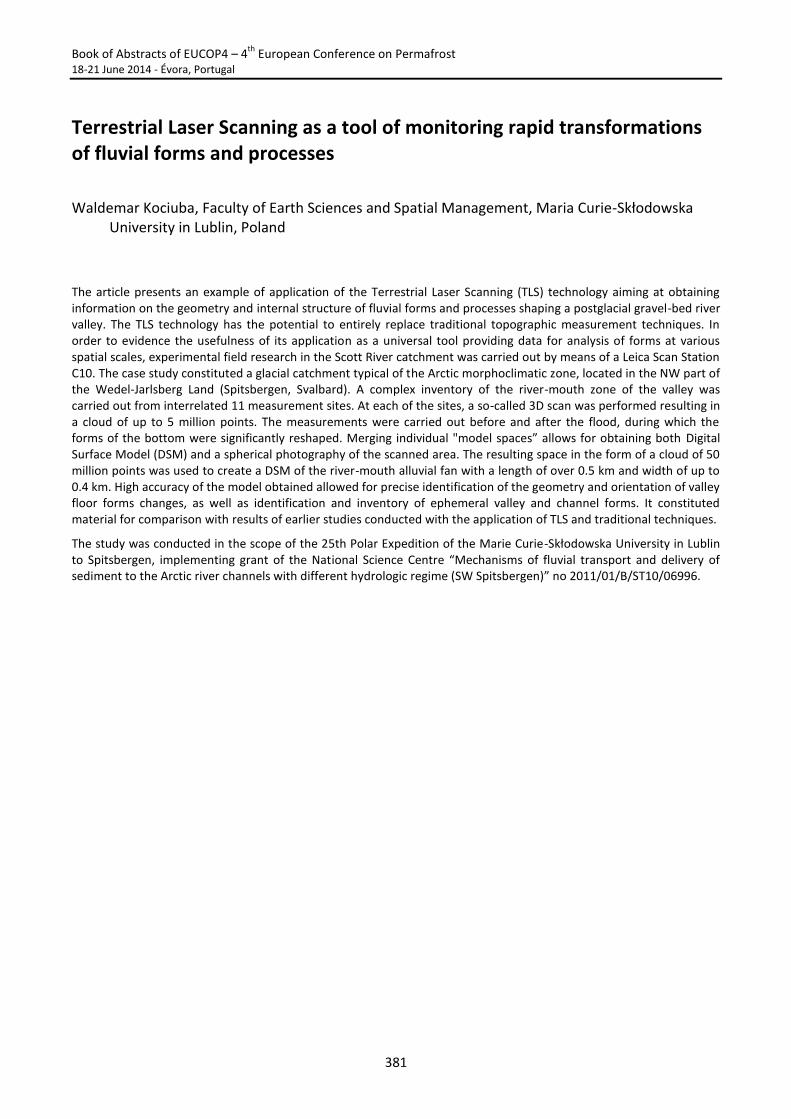
Book of Abstracts of EUCOP4 – 4th
European Conference on Permafrost 18-21 June 2014 - Évora, Portugal
381
Terrestrial Laser Scanning as a tool of monitoring rapid transformations of fluvial forms and processes
Waldemar Kociuba, Faculty of Earth Sciences and Spatial Management, Maria Curie-Skłodowska University in Lublin, Poland
The article presents an example of application of the Terrestrial Laser Scanning (TLS) technology aiming at obtaining information on the geometry and internal structure of fluvial forms and processes shaping a postglacial gravel-bed river valley. The TLS technology has the potential to entirely replace traditional topographic measurement techniques. In order to evidence the usefulness of its application as a universal tool providing data for analysis of forms at various spatial scales, experimental field research in the Scott River catchment was carried out by means of a Leica Scan Station C10. The case study constituted a glacial catchment typical of the Arctic morphoclimatic zone, located in the NW part of the Wedel-Jarlsberg Land (Spitsbergen, Svalbard). A complex inventory of the river-mouth zone of the valley was carried out from interrelated 11 measurement sites. At each of the sites, a so-called 3D scan was performed resulting in a cloud of up to 5 million points. The measurements were carried out before and after the flood, during which the forms of the bottom were significantly reshaped. Merging individual "model spaces” allows for obtaining both Digital Surface Model (DSM) and a spherical photography of the scanned area. The resulting space in the form of a cloud of 50 million points was used to create a DSM of the river-mouth alluvial fan with a length of over 0.5 km and width of up to 0.4 km. High accuracy of the model obtained allowed for precise identification of the geometry and orientation of valley floor forms changes, as well as identification and inventory of ephemeral valley and channel forms. It constituted material for comparison with results of earlier studies conducted with the application of TLS and traditional techniques.
The study was conducted in the scope of the 25th Polar Expedition of the Marie Curie-Skłodowska University in Lublin to Spitsbergen, implementing grant of the National Science Centre “Mechanisms of fluvial transport and delivery of sediment to the Arctic river channels with different hydrologic regime (SW Spitsbergen)” no 2011/01/B/ST10/06996.
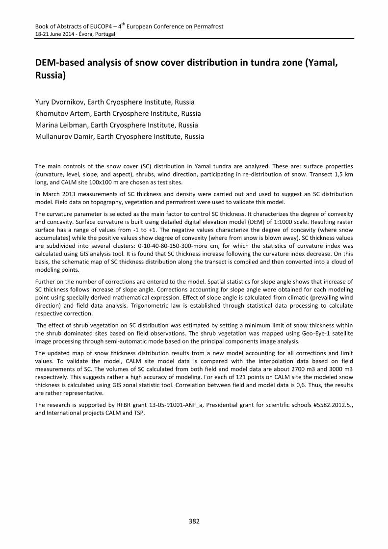
Book of Abstracts of EUCOP4 – 4th
European Conference on Permafrost 18-21 June 2014 - Évora, Portugal
382
DEM-based analysis of snow cover distribution in tundra zone (Yamal, Russia)
Yury Dvornikov, Earth Cryosphere Institute, Russia
Khomutov Artem, Earth Cryosphere Institute, Russia
Marina Leibman, Earth Cryosphere Institute, Russia
Mullanurov Damir, Earth Cryosphere Institute, Russia
The main controls of the snow cover (SC) distribution in Yamal tundra are analyzed. These are: surface properties (curvature, level, slope, and aspect), shrubs, wind direction, participating in re-distribution of snow. Transect 1,5 km long, and CALM site 100x100 m are chosen as test sites.
In March 2013 measurements of SC thickness and density were carried out and used to suggest an SC distribution model. Field data on topography, vegetation and permafrost were used to validate this model.
The curvature parameter is selected as the main factor to control SC thickness. It characterizes the degree of convexity and concavity. Surface curvature is built using detailed digital elevation model (DEM) of 1:1000 scale. Resulting raster surface has a range of values from -1 to +1. The negative values characterize the degree of concavity (where snow accumulates) while the positive values show degree of convexity (where from snow is blown away). SC thickness values are subdivided into several clusters: 0-10-40-80-150-300-more cm, for which the statistics of curvature index was calculated using GIS analysis tool. It is found that SC thickness increase following the curvature index decrease. On this basis, the schematic map of SC thickness distribution along the transect is compiled and then converted into a cloud of modeling points.
Further on the number of corrections are entered to the model. Spatial statistics for slope angle shows that increase of SC thickness follows increase of slope angle. Corrections accounting for slope angle were obtained for each modeling point using specially derived mathematical expression. Effect of slope angle is calculated from climatic (prevailing wind direction) and field data analysis. Trigonometric law is established through statistical data processing to calculate respective correction.
The effect of shrub vegetation on SC distribution was estimated by setting a minimum limit of snow thickness within the shrub dominated sites based on field observations. The shrub vegetation was mapped using Geo-Eye-1 satellite image processing through semi-automatic mode based on the principal components image analysis.
The updated map of snow thickness distribution results from a new model accounting for all corrections and limit values. To validate the model, CALM site model data is compared with the interpolation data based on field measurements of SC. The volumes of SC calculated from both field and model data are about 2700 m3 and 3000 m3 respectively. This suggests rather a high accuracy of modeling. For each of 121 points on CALM site the modeled snow thickness is calculated using GIS zonal statistic tool. Correlation between field and model data is 0,6. Thus, the results are rather representative.
The research is supported by RFBR grant 13-05-91001-ANF_a, Presidential grant for scientific schools #5582.2012.5., and International projects CALM and TSP.
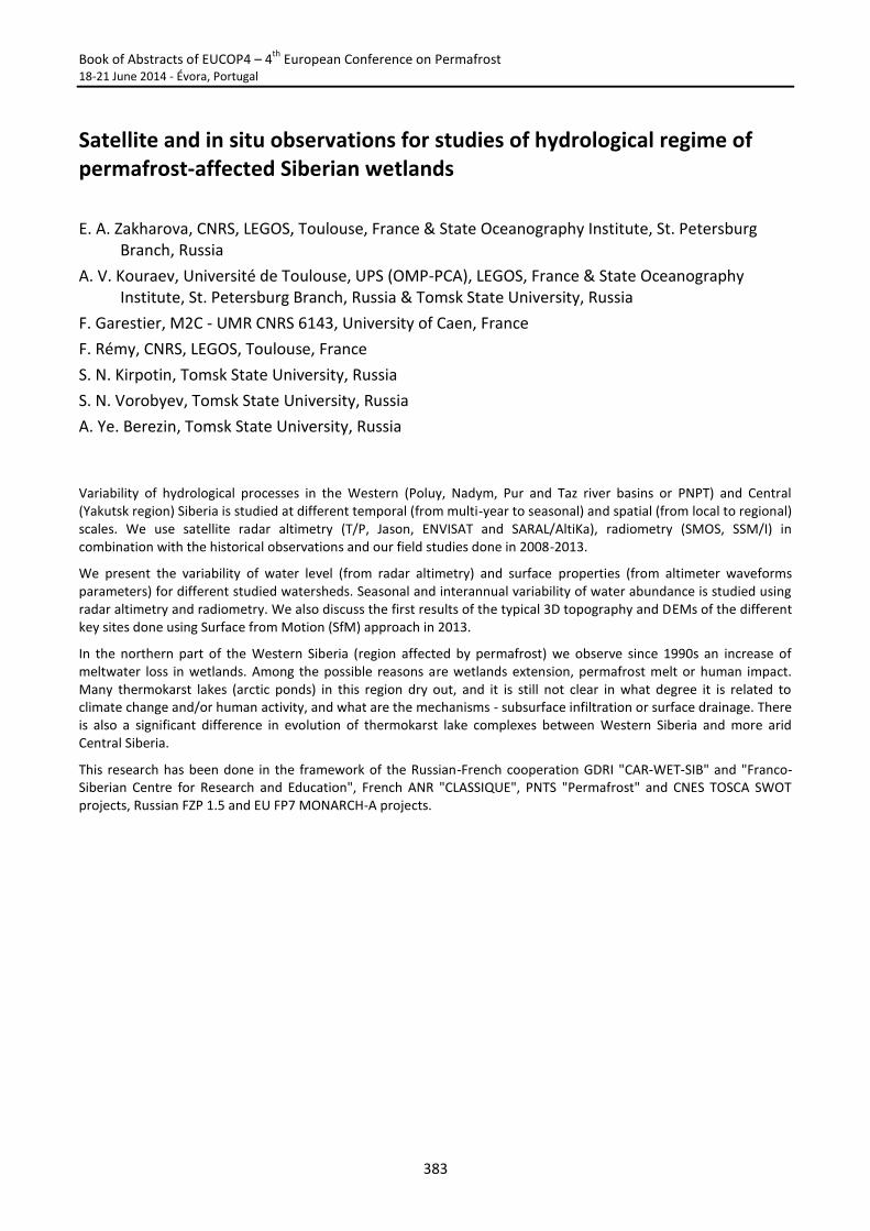
Book of Abstracts of EUCOP4 – 4th
European Conference on Permafrost 18-21 June 2014 - Évora, Portugal
383
Satellite and in situ observations for studies of hydrological regime of permafrost-affected Siberian wetlands
E. A. Zakharova, CNRS, LEGOS, Toulouse, France & State Oceanography Institute, St. Petersburg Branch, Russia
A. V. Kouraev, Université de Toulouse, UPS (OMP-PCA), LEGOS, France & State Oceanography Institute, St. Petersburg Branch, Russia & Tomsk State University, Russia
F. Garestier, M2C - UMR CNRS 6143, University of Caen, France
F. Rémy, CNRS, LEGOS, Toulouse, France
S. N. Kirpotin, Tomsk State University, Russia
S. N. Vorobyev, Tomsk State University, Russia
A. Ye. Berezin, Tomsk State University, Russia
Variability of hydrological processes in the Western (Poluy, Nadym, Pur and Taz river basins or PNPT) and Central (Yakutsk region) Siberia is studied at different temporal (from multi-year to seasonal) and spatial (from local to regional) scales. We use satellite radar altimetry (T/P, Jason, ENVISAT and SARAL/AltiKa), radiometry (SMOS, SSM/I) in combination with the historical observations and our field studies done in 2008-2013.
We present the variability of water level (from radar altimetry) and surface properties (from altimeter waveforms parameters) for different studied watersheds. Seasonal and interannual variability of water abundance is studied using radar altimetry and radiometry. We also discuss the first results of the typical 3D topography and DEMs of the different key sites done using Surface from Motion (SfM) approach in 2013.
In the northern part of the Western Siberia (region affected by permafrost) we observe since 1990s an increase of meltwater loss in wetlands. Among the possible reasons are wetlands extension, permafrost melt or human impact. Many thermokarst lakes (arctic ponds) in this region dry out, and it is still not clear in what degree it is related to climate change and/or human activity, and what are the mechanisms - subsurface infiltration or surface drainage. There is also a significant difference in evolution of thermokarst lake complexes between Western Siberia and more arid Central Siberia.
This research has been done in the framework of the Russian-French cooperation GDRI "CAR-WET-SIB" and "Franco-Siberian Centre for Research and Education", French ANR "CLASSIQUE", PNTS "Permafrost" and CNES TOSCA SWOT projects, Russian FZP 1.5 and EU FP7 MONARCH-A projects.
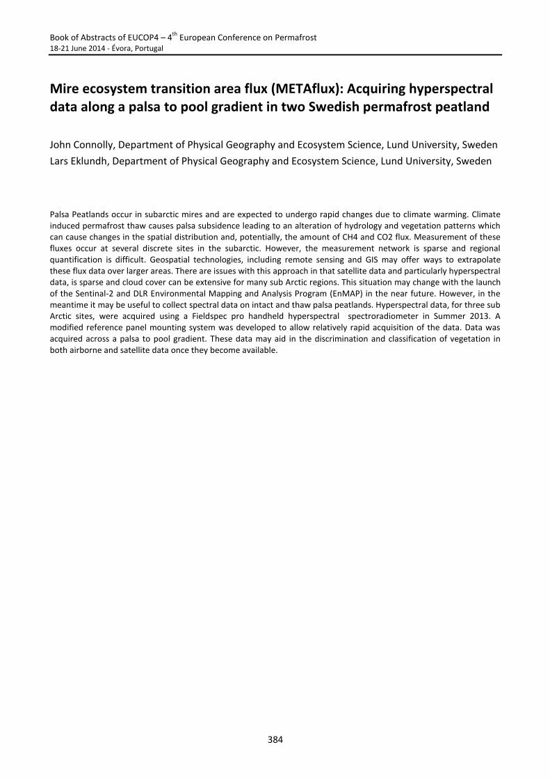
Book of Abstracts of EUCOP4 – 4th
European Conference on Permafrost 18-21 June 2014 - Évora, Portugal
384
Mire ecosystem transition area flux (METAflux): Acquiring hyperspectral data along a palsa to pool gradient in two Swedish permafrost peatland
John Connolly, Department of Physical Geography and Ecosystem Science, Lund University, Sweden
Lars Eklundh, Department of Physical Geography and Ecosystem Science, Lund University, Sweden
Palsa Peatlands occur in subarctic mires and are expected to undergo rapid changes due to climate warming. Climate induced permafrost thaw causes palsa subsidence leading to an alteration of hydrology and vegetation patterns which can cause changes in the spatial distribution and, potentially, the amount of CH4 and CO2 flux. Measurement of these fluxes occur at several discrete sites in the subarctic. However, the measurement network is sparse and regional quantification is difficult. Geospatial technologies, including remote sensing and GIS may offer ways to extrapolate these flux data over larger areas. There are issues with this approach in that satellite data and particularly hyperspectral data, is sparse and cloud cover can be extensive for many sub Arctic regions. This situation may change with the launch of the Sentinal-2 and DLR Environmental Mapping and Analysis Program (EnMAP) in the near future. However, in the meantime it may be useful to collect spectral data on intact and thaw palsa peatlands. Hyperspectral data, for three sub Arctic sites, were acquired using a Fieldspec pro handheld hyperspectral spectroradiometer in Summer 2013. A modified reference panel mounting system was developed to allow relatively rapid acquisition of the data. Data was acquired across a palsa to pool gradient. These data may aid in the discrimination and classification of vegetation in both airborne and satellite data once they become available.
Book of Abstracts of EUCOP4 – 4th
European Conference on Permafrost 18-21 June 2014 - Évora, Portugal
385
METHODS AND TECHNIQUES
S18. Permafrost and frozen ground engineering
Chairs:
A. Instanes and H. Jin

Book of Abstracts of EUCOP4 – 4th
European Conference on Permafrost 18-21 June 2014 - Évora, Portugal
386
Book of Abstracts of EUCOP4 – 4th
European Conference on Permafrost 18-21 June 2014 - Évora, Portugal
387
Keynote Lecture 18
Current status of cold regions road engineering in China
Fujun Niu, State Key Laboratory of Frozen Soils Engineering, Cold and Arid Regions Environmental and Engineering Research Institute, Chinese Academy of Sciences, China
Wei Ma, State Key Laboratory of Frozen Soils Engineering, Cold and Arid Regions Environmental and Engineering Research Institute, Chinese Academy of Sciences, China
Permafrost occupies nearly 25% of the land area in China. It mainly distributes in the Qinghai Tibet Plateau (QTP), the Northeast high latitude area and Tianshan Mountain area. When the seasonal frozen ground is considered, 70% of the land area is related to freezing and thawing processes. The cold regions in China mainly distribute in the north of the Yangtze River. Such regions are the main sources of water and energy resources, therefore road construction and operation is very important in foundation engineering. In the permafrost regions, the Qinghai Tibet Railway (QTR) is the successful representative of the infrastructures in China. While in the seasonal frozen regions, the Harbin Dalian High Speed Railway (HDHSR), which was opened to traffic 2 years ago, shows new experiences in speed railway construction in deeply frozen ground. This report introduces the construction technologies, engineering effects and characteristics of existing roadbed diseases in permafrost regions of the QTR and the old highway in the permafrost regions of the QTP, as well as the HDHSR construction technology and operation conditions. The road construction in the permafrost regions has been achieved from the passive to active cooling transformation, through regulation of radiation, convection and conduction and comprehensive technology. Results of 10 years’ monitoring works show that cooling the roadbed has basically achieved the design goals of protecting the underlying permafrost. As to high-speed railway subgrade deformation requirements are very strict, the soil classification of frost susceptibility, especially slight frost heave controlling in the deep seasonal frozen soil areas, are comprehensively studied. The frost heave controlling methods used in HDHSR construction include controlling temperature, adjusting frost heave susceptibility and controlling water and groundwater. In the new future, China will continue constructions of express highways in permafrost, which need more efficient roadbed cooling methods. At the same time, high seed railway construction methods need to be optimized according to long time monitoring works, so that to provide evaluations and recommendations for improvement of frost heaving prevention measures.

Book of Abstracts of EUCOP4 – 4th
European Conference on Permafrost 18-21 June 2014 - Évora, Portugal
388
Thermal and mechanical monitoring of the Salluit airfield access road (Nunavik) after the installation of a heat drain
Guy Doré, Laval University, Canada
Dejan Grabundzija, Laval University, Canada
The Salluit airfield access road is built on top of a marine clay deposit on the incline of a valley. Due to climate warming, the permafrost under the road was observed to be deteriorating rapidly. Because of the increasing risk of landslides in the unstable terrain, the "Ministère des transports du Québec" (MTQ) in collaboration with Laval University rebuilt the road in the summer of 2012. In order to guarantee its thermal and mechanical stability, a heat drain was installed in the embankment. The heat drain cools the embankment during the winter by utilising natural air convection, similar to an "air convection embankment" (ACE).
Hundreds of thermistors as well as several inclinometers comprise the thermal and mechanical monitoring system installed on the access road during its construction. Most of the thermistors were installed vertically inside several boreholes across the embankment in order to monitor the level of the permafrost table in function of time. Several thermistors have also been installed inside the heat drain membrane in order to compare the air temperatures inside the system with the outside air temperature. The inclinometers were installed vertically next to the embankment with the aim of monitoring the extent of the horizontal downslope movement. This study will yield data useful to the improvement of design parameters of a heat drain system in future constructions.
Book of Abstracts of EUCOP4 – 4th
European Conference on Permafrost 18-21 June 2014 - Évora, Portugal
389
Assessment of permafrost conditions and thermal disturbances diagnosis under airfields and access roads to support adaptation strategies to climate warming: Case studies from Northern Quebec
Emmanuel L’Hérault, Centre d’études nordiques, Canada
Michel Allard, Centre d’études nordiques/Centre for Northern Studies, département de Géographie, Université Laval, Québec, Canada
Carl Barrette, Centre d’études nordiques/Centre for Northern Studies, Québec, Canada
Guy Doré, Centre d’études nordiques/Centre for Northern Studies, département de Génie Civil, Université Laval, Québec, Canada
Anick Guimond, Ministère des Transports du Québec (MTQ), Rouyn-Noranda, Canada
Built between 1984 and 1992, Nunavik community airports were designed using thick embankments of rock fill placed on the undisturbed ground surface to prevent thawing of the underlying permafrost. However, since around 2000, many of the runways show signs of permafrost disturbance as some localized differential settlements have begun to take place. With further anticipated rise of air temperature, the vulnerability of transportation infrastructures to permafrost degradation raises concerns. A better understanding of the spatial variability of the permafrost conditions and its geotechnical properties underneath infrastructures was then needed to assess its sensibility to thawing and to plan optimized adaptation strategies in face of climate warming.
A geomorphological and geotechnical investigation campaign, including surficial geology mapping using pre-construction air photographs and recovery of drilled frozen cores, was carried out at eight airports built on permafrost across northern Quebec. Stratigraphic information from drilling was used to reinterpret previously made geophysical surveys. Lab testing on undisturbed frozen samples, including thaw strain tests, was also performed to determine geotechnical properties of the different stratigraphic units encountered. Field measurements of ground temperatures and numerical modeling of the thermal regime alongside and beneath embankments and subgrade were also performed to explain the processes of permafrost degradation and also to evaluate the potential impacts of different climate change scenarios on its stability. By combining geoscience information, the integrative approach developed herein is an applicable diagnostic tool to analyze the causes of permafrost disturbances and to guide the development of site specific optimized adaptation strategies.
Localized damage on the embankment shoulder such as cracks and settlements confirm that the permafrost beneath the shoulders is greatly degraded. In fact, thermal measurements and drilling information reveal that an unfrozen layer (talik) reaching up to 6 meters deep is now present at the toe of many embankments. This accelerated degradation of permafrost is due primarily to snow and water accumulation bringing ground temperature towards warmer condition. According to our numerical modeling, as the climate warms up, active layer in the centerline of the runway will slightly increase resulting in limited thaw settlement. On the other hand, embankment toe will keep degrading rapidly according to the combined effect of snow and water accumulation. For this reason, the proposed adaptation plans focused on minimizing snow and any potential heat input through summer-warmed water seepage by using specific designs such as gentler slope or heat drain embankments with improved drainage systems. These mitigation techniques are now being applied at many sites in Nunavik; current monitoring indicates that they are efficient.
Book of Abstracts of EUCOP4 – 4th
European Conference on Permafrost 18-21 June 2014 - Évora, Portugal
390
Shear strength of frozen and unfrozen rock joints
Friederike Gunzel, University of Brighton, UK
This contribution investigates the relation of the shear strength of frozen and unfrozen artificial rock samples to the increase of compressive strength of porous material at freezing.
Direct shear tests were carried out on synthetic samples (surface area 60 x 60 mm) with different regular and irregular rough surfaces made of different strength plasters and mortar with compressive strengths between 16 MPa and 100 MPa. Synthetic samples were used to create reproducible results. Plaster was chosen as the high porosity causes the frozen strength to be much higher than the unfrozen strength.
Warming of permafrost affects rock slope stability mostly in depths less than 25m below surface, so only normal stresses up to 0.6 MPa were used in tests. This means that as the ratios of compressive strength of the samples to applied normal stress in the shear tests were very high. Therefore the well-established equation by Barton (1976) that relates shear strength of rock joints to compressive strength and joint roughness coefficient has to be used with caution. However, an increase of shear strength with increasing compressive strength of the rock material is still expected.
Experimental results of unfrozen samples however showed a slight decrease of shear strength with increasing compressive strength for all materials and surfaces used in the tests. Measured angles of friction reduced by approx. 6° from the material with the lowest compressive strength to that with the highest compressive strength. This result may be explained by the higher surface erosion of the weaker samples which means that the contact area during a shear test is much larger, leading to a higher shear resistance.
Shear tests with frozen plaster samples were conducted at -4°C. Care was taken that the sample surfaces were free of ice prior to each test. These tests showed an even larger reduction of the angle of friction by more than 20° compared with the unfrozen plaster samples. This result may be explained by the high porosity of the plaster samples: as the two parts of the sample slide against each other, solid grains will be in contact with ice thus reducing the shear resistance. These tests were carried out without allowing any adfreezing of the two sample surfaces. However, adfreezing is present in rock joints in permafrost. Allowing the samples to freeze together prior to a shear test increased the peak shear strength considerably, well above the shear strength measured for unfrozen samples. However, the post-peak strength was again much lower than the post-peak strength of unfrozen samples.
It can be concluded that warming has a large effect on the stability of frozen rock slopes, even if the rock on either side of a joint remains frozen. If ice bridges across a joint are broken, e.g. by ingress of meltwater, then the friction in that joint will be lower than the friction in unfrozen material and potentially lead to instability.
Barton, 1976, Int J Rock Mech Min, 13(9): 255-279
Book of Abstracts of EUCOP4 – 4th
European Conference on Permafrost 18-21 June 2014 - Évora, Portugal
391
The principle of on of landscape sites in engineering-geocryological monitoring of pipelines
Natalia Lashina, Moscow State University, Russia
Viacheslav Lashin, Vorkuta Linear Production Management of Gas Mains (LPMGM), Russia
Alexey Savelyev, Moscow State University, Russia
Active construction of pipelines in permafrost regions promotes change of many components of cryolithozone landscapes. The main component of these landscapes is the temperature of permafrost. The economic development of the territory directly affects temperature forming components: vegetation, soil microrelief, upper layers condition, hydrogeological and hydrological regimes, snow accumulation, etc. Human inpact in such an environment significantly accelerates natural-historical change of nature, which may further lead to severe consequences.
The Engineering geocryological monitoring (IGM) allows to make forecast of these changes and develop protective activities against adverse processes and phenomena in due course.
It is common to identify key sites during the engineering geocryological monitoring of pipelines. So the idea was considered to allocate sites landscapes at different stages of IGM. Increasing the number of parameters appearing in the landscape site, should occur in process of complication of the site. Such an approach would create a more rational system of the pipelines IGM.
Book of Abstracts of EUCOP4 – 4th
European Conference on Permafrost 18-21 June 2014 - Évora, Portugal
392
Study of thermal regime around culverts built on permafrost
Loriane Périer, Department of Civil Engineering, University Laval and Centre for Northern Studies (CEN), Quebec, Canada
Guy Doré, Department of Civil Engineering, University Laval and Centre for Northern Studies (CEN), Quebec, Canada
Chris Burn, Department of Geography and Environmental Studies, University Carleton, Ottawa, Canada
In northern regions, construction on permafrost is likely to affect the subgrade soil, and can therefore be a major challenge. Heat can be generated by buildings, roads and other types of infrastructures disturbing thus the thermal regime of frozen soils. Changes in thermal balance can result in permafrost degradation, and loss of bearing capacity. The severity of the problem depends on ice content, type of soils and drainage conditions. It can cause significant differential settlements and increase the risk of thermal erosion and landslide. Several stability problems are observed along Alaska Highway in Yukon (Canada).
The presentation will focus on thermal regime, drainage conditions and problems observed around culverts. Allowing air and water circulation through culverts, significant thermal disturbances are created and permafrost can be affected. In thaw sensitive permafrost, settlements can occur causing culvert distortion, joints damage, and water leaking outside the culvert. These problems are likely to accelerate permafrost degradation.
Knowledge on the influence of water and air flow on thermal regime around culvert is very limited. As part of this project, two culverts on Alaska Highway were instrumented to monitor water flow and resulting thermal regime around the culverts. One is located at the experimental test site in Beaver Creek and the other is located at kilometer 1847.7, close to the Alaska border. During spring and summer, data loggers record measurements on an hourly basis.
Data is available from May to beginning of July 2013 for the Beaver Creek test site. The instrumentation of the “border culvert” (km 1847.7) will be completed in spring 2014. With soil temperatures data, a thermal gradient can be determined and then used to deduct the heat flux. A positive heat flux implies that heat is transferred from culvert to permafrost and may be detrimental. Around culvert, soil temperatures range from 15°C to 0.2°C and water flow is around 0.0035m3/s at the entrance. With these observations and others data collected in the field, a thermal model on Geoslope TEMP-W software was calibrated to evaluate and quantify the effect of several parameters. The effect of an increase in water flow during spring thaw, of water temperature and air temperature in the culvert on the transfer of heat to the ground surrounding the culvert will be analyzed. The effect of culvert transfer diameter, embankment height and culvert insulation will also be investigated. Based on these analyses, preferred design and construction practices will be identified.
Book of Abstracts of EUCOP4 – 4th
European Conference on Permafrost 18-21 June 2014 - Évora, Portugal
393
Ice wedge hazard assessment for infrastructure
Julia Stanilovskaya, Sergeev Institute of Environmental Geoscience Russian Academy of Science, Russia
Ice wedges are widespread phenomena in cryolithozone. The location, orientation, size and origin of ice wedges are very important for builders and operating companies dealing with infrastructure in polar and mountain regions. Frequently the parameters of ice wedges are not evident. Thermokarst developing on the ice wedges is deemed to be the dangerous process for linear engineering structures. So ice wedges and possible thermokarst concerning it are considered as hazard due to consequences of infrastructure loss. Some regional examples of thermokarst along roads and pipelines in Russia are given. Spatial and temporal aspects of ice wedge formation were illustrated. Local observations of the thawing ice wedges along roads or on the territories nearby of it have been provided in Chara Depression (Transbaikalia) during 2007-2013. Study sites were separated on natural and anthropogenic types depending on thermokarst development: natural – where ice wedges are thawing due to climate change; anthropogenic – where ice wedges are thawing due to construction and pavement of the roads. Additionally thaw settlements were appeared during ice wedge melting and recognized by infrared camera. It helps engineers to monitoring the roads and pipelines.
Book of Abstracts of EUCOP4 – 4th
European Conference on Permafrost 18-21 June 2014 - Évora, Portugal
394
Assessment of permafrost conditions in support of the rehabilitation and adaptation to climate change of the Iqaluit airport, Nunavut, Canada.
Valérie Mathon-Dufour, Geography Department and Centre d’études nordiques, Université Laval, Québec, Canada
Michel Allard, Geography Department and Centre d’études nordiques, Université Laval, Québec, Canada
Anne-Marie Leblanc, Natural Resources Canada, Ottawa, Canada
This study uses a GIS approach that makes up for the absence of appropriate characterization before the construction of the Iqaluit airport during WWII and in the 1950s. Mapping of surficial geology, hydrography and landforms indicative of the presence of ground ice (e.g. tundra polygons) was produced by interpreting aerial photographs dating back from the initial phases of construction (1948) and photographs taken at intervals since then, to the most recent high-resolution satellite images. Subsequent map analysis shows that the original terrain conditions prevailing before the construction of the airport have a significant impact on the current stability of the infrastructure. An extensive drilling program allowed the acquisition of detailed cryostratigraphic data by frozen core sampling to characterize the permafrost and support geophysical interpretations. Data integration allowed to summarize the main problems affecting the Iqaluit airport which are: 1) Differential settlements associated with the pre-construction drainage network 2) Pavement cracking due to thermal contraction, 3) Linear depressions associated with ice wedge degradation and 4) Sink holes.
Most of the sectors affected by differential settlements and instabilities are perfectly coincident with the original streams and lakes network that has been filled to increase the size of the runway, taxiways and the apron. In addition, the runway is affected by intense frost cracking. Continuity with nearby natural terrain suggests that the network pattern of the cracks follows pre-existing ice wedges in the natural terrain. Analysis of ground penetrating radar profiles indeed shows hyperbolic reflectors typical of ice wedges under the larger runway cracks. Drilling in the linear depressions and sectors affected by differential settlement showed that the foundations of the infrastructure lie on several meters of ice-rich permafrost, and even sometimes on massive ice associated with large ice wedges. Temperature data acquired with five thermistor cables in the runway, in a taxiway, in the apron and in nearby natural terrain shows that the thickness of the active layer varies between 90 centimeters for sectors covered with vegetation and more than 2 meters below paved surfaces which means that the thaw depth has now reached down into the original natural terrain under the infrastructure, thus causing settlements due to melting ice wedges. Sink holes are mostly localised on the edges of the northern part of the runway. Processes responsible for these holes possibly are seepage of water into the base course and the subgrade, melting of bodies of ice or soil compaction problems. This established context of permafrost is now used for planning a detailed investigation program in preparation for the restoration of the airport and its adaptation to climate change.
Book of Abstracts of EUCOP4 – 4th
European Conference on Permafrost 18-21 June 2014 - Évora, Portugal
395
Case study: geocryological conditions change under increasing technogenic pressure
Valery Grebenets, Moscow State University, Faculty of Geography, Сryolithology & Glaciology Dept., Russia
Economic development of the urbanized territories of cryolithozone creates a new pattern of geocryological conditions, different from natural parameters. This pattern is characterized by (1) drastic landscape transformation, promoting changes in the conditions of heat and mass turnover within the permafrost/atmosphere system, and (2) by engineering and technical influence upon the frozen ground, leading to alteration of its physical, thermal and mechanical properties. In the northern cities, this intensify both horizontal and vertical differentiation by ground temperature conditions; activate hazardous cryogenic processes, which either develops more actively, then in nature, or stabilize under technogenic pressure.
The change of geocryological conditions reduces stability of geotechnical environment. For example, facility deformations in Norilsk district, Northern Siberia, in the last 15 years, became much more abundant than these revealed throughout the previous 50 years. By the beginning of XXIst century up to 250 large buildings in the local towns were deformed considerably due to worsening of geocryological conditions, ca. 100 objects were revealed to function in emergency state, and almost 50 nine- and five-storeyed houses, built in the 1960-80s, have undergone laborious dismantling recently. Deformations of buildings and constructions are tied with a complex of reasons, but the most important is unpredictable change of engineering-geocryological parameters of foundations. Numerous deformations (from 40-50 to 100%) are revealed in small (mainly national) locations of the north.
Activation of economic development and increase in accident risk for facilities (water and oil pipelines, industrial enterprises, etc.) enhances the technogenic pressure on permafrost of the territories under development, leading to the new milestone of changes in perennially frozen grounds. Then possibility of origin, activity, intensity, reversibility, geographical distribution, formation of paragenetic chains and other features of cryogenic processes differ considerably from natural conditions or are unprecedented at all. So, technocryogenesis can be defined as the main exogenic process in urban conditions. For instance, field reconnaissance of permafrost and geological conditions resulted in 17 natural-technogenic geocryological complices (NTGC) types in Norilsk industrial area (13 of them –in living area – areas of snow storage, urban rayons with well-working cool wentilated cellars, areas with thick filtrated technogenic grounds, etc.), 11 types in Yamburg gas condensate field, Taz Peninsula, and 32 types along overground and underground gas and oil pipelines in the north of Western Siberia. NTGC dynamics depends on (1) the scale of urban system, (2) the set of its elements, (3) duration of impact upon nature, (4) degree of stability of natural permafrost, (5) regional climate trends.
Book of Abstracts of EUCOP4 – 4th
European Conference on Permafrost 18-21 June 2014 - Évora, Portugal
396
The problems of foundation reliability in permafrost of Norilsk area, the north of Siberia
Aligyushad Kerimov, Scientific and Engineering Association "Fundament", Russia
Valery Grebenets, Moscow State University, Russia
The results of natural observations as well as calculations and theoretical investigations of the state of big constructions undergone deformations because of geocryological and geoecological situation disturbances are presented. Differences in the stability of constructions erected on different types of pile foundations in the Norilsk industrial region are revealed. The interaction between foundations and different negative technogenic impacts, e.g.: seismic, heating, engineering operation, etc., is established. The procedure of observations and calculations for the forecast and necessary measures working out is presented. During the last decade, the problem of stability of buildings and constructions in permafrost zone has been significantly aggravated. The complex research in order to establish the reasons of decreasing of bearing capacity of perennially frozen bases have been carried out. In has been found that main reasons of deformations are negative technogenic effect on the geocryological and geoecological environment while the global climate warming still does not effect on the bearing capacity of frozen bases.
The complex of engineering measures for the stabilization of the situation in Norilsk region as well as specific methods of strengthening of frozen bases has been worked out and experimentally tested. The major measures are: 1) application of artificial cooling of grounds through the use of liquid and vapour-liquid thermosiphons together with aerial freezing of ground; 2) the cementation of local talics; 3) statical pressing of piles by powerful jacks as well as the improving of the exposure of foundations to permafrost have been applied for certain deformed; 4) new techniques for laying of underground collectors for engineering communications; 5) increasing of ventilation of cold bases; 6) devising of counterfiltration screens in technogenic embankments; 7) regulation of the show cover regime in built up areas; 8) organization of the run-off of rain and flood water.
The effective methods of buildings on the pile foundations operation reliability and safety are suggested.
Book of Abstracts of EUCOP4 – 4th
European Conference on Permafrost 18-21 June 2014 - Évora, Portugal
397
Core barrel development for in situ characterization of permafrost
Cédric Flecheux, Laval University, Canada
Guy Doré, Laval University, Canada
Louis Gosselin, Laval University, Canada
In permafrost areas, environmental changes such as infrastructure building and climate change have effects on the thermal regime of soil and can prompt unusual permafrost melt. As a consequence, this will lead to degradation of the mechanical properties of the soil. Thus, good knowledge about permafrost characteristics is essential to make right decisions during building projects, to advance infrastructures conception technics and to anticipate potential problems related to climate change.
In order to measure thaw consolidation of frozen soils, it is currently required to set up heavy logistics that includes sampling of soil cores and their transportation in their natural state to the laboratory for analysis.
The goal of this project, situated in the context of the Arquluk program (research in permafrost engineering), is to facilitate the execution of campaigns related to thaw settlement assessment of frozen. This can be achieved by developing a drilling tool that is able to carry out these in situ tests. The specifications of this drilling tool can be divided into three parts: the field mobility, the ability to obtain a core in a frozen soil and the characterization of the studied soil.
In partnership with the Mechanical Engineering Department of Laval University, a prototype was built. From the outside, the invention looks like an ice coring auger. Thanks to the core barrel being modular, it is easy to clean and replace its different parts. It produces core of thirty centimeters long. Core thaw, caused by an electric heating element, and drainage, occurs along the first twenty centimeters of the core. A pneumatic cylinder allows to apply the drainage pressure set by the user.. The drained water is discharged at the top of the drill hole and the thaw settlement can be read by the user. All the described actions above are made during the drilling operations, in situ.
Laboratory tests were made in pure ice and synthetic permafrost barrels. They have allowed the initial design to develop. The coring ability and the reliability of the thaw settlement tests were appreciated for different kind of soils, fine and coarser. Besides/Furthermore, these laboratory tests are evaluating the productivity of the core barrel on the field. Presently, this corer is a patent pending tool.
Book of Abstracts of EUCOP4 – 4th
European Conference on Permafrost 18-21 June 2014 - Évora, Portugal
398
Influence of snow fall event timing on ground thermal regimes and induced slope failure mechanisms in permafrost regions.
Emilie Guegan, Sustainable Arctic Marine and Coastal Technology (SAMCoT), Geotechnical Engineering Department, Norwegian University of Science and Technology (NTNU), Trondheim, Norway
Hannele Zubeck, School of Engineering, University of Anchorage, Alaska, USA
Snow precipitation and accumulation are significant hazards, damaging infrastructures and restricting driving conditions. Furthermore, as an insulating material, snow accumulation increases the Mean Annual Ground Surface Temperature (MAGST) by restricting heat loss from the ground underlying it and enhancing permafrost degradation. Snow does not only insulate the ground from cold fall and winter temperatures, it also protects it from early warm temperatures in spring and early summer, delaying its thawing. While the effect of snow accumulation extent and thickness on ground thermal regime is well documented, little attention has been directed at the influence of snow fall event timing. In this presentation, different thermal and mechanical responses of a frozen slope to the timing of snow deposition are illustrated, by taking two examples on snow accumulation problems, one in artificial settings (road embankment) and one in natural slope conditions (coastal bluff).
A two-dimensional finite element geothermal model, from Geo-Studio (TEMP/W Release 09.2013), is used to simulate the temperature distribution in the cross section of a fully monitored Arctic coastal bluff (affected by a 3 m thick snow drift), in Svalbard.
We present detailed thermal model of our research site in Svalbard (Norway), using field data for calibration and validation of the model. We also simulate scenarios of bluff thermal response to early and late snowfall event as well as similar scenarios for a warm permafrost conditions.
The analysis highlights the importance of the timing of snow fall events on insulating the ground. An early snow event will occur before the ground is completely frozen, therefore potentially trapping latent heat generated by the phase change in the ground and increasing the MAGST of the site during winter. Warming of the underlying permafrost temperature could develop a marginally frozen ground, potentially triggering thaw settlement with various harmful consequences on infrastructure like shoulder rotation. A late snow event, however, will cover an already frozen ground. Without any latent heat trap, the ground will be colder, and while still insulating from the air temperature the snow will not have the possibility to develop a marginally frozen zone. The presence of snow drift on a slope will delay its thawing potentially allowing the development of high pore pressure behind the frozen slope possibly inducing slope failure. Timing of deposition appears to be an important factor controlling the ground thermal regime and should therefore be considered in a site specific way for any permafrost infrastructure design.
Book of Abstracts of EUCOP4 – 4th
European Conference on Permafrost 18-21 June 2014 - Évora, Portugal
399
Express-methods for forecast thawing soils settlement
Pavel Kotov, MSU, Russia
Lidya Roman, MSU, Russia
Michail Tsarapov, MSU, Russia
Currently, the most common methods for forecast of thawing soil settlement are compression tests, which determine deformation characteristics (thawing coefficient and compression coefficient). Duration of test depends on the type of soil and can vary from 5 days to 3 weeks. It is practically important task to reduce the test period and to obtain reliable values of thawing soils settlement. On the basis of the experimental data and theoretical conclusions we’ve developed two express methods for determining thawing soil settlement.
The first method is based on regression analysis of 400 soils tests of different types (sand, silt, clayey silt) and genesis, selected from different areas of permafrost in Russia: European North, Western Siberia, Yamal Peninsula, southern Yakutia , Chukotka. The correlation between the physical properties of frozen soil and the thawing coefficient was determined. Regression equations to calculate the thawing was obtained for sand, silt and clayey silt in a wide range of physical properties. For 84% of the experiments with silt soils and 95% of the sand soils absolute error values of settlement, calculated using the experimental data and the suggested methodology does not exceed 10 cm (thaw depth 1 m). But this method can not be universal, because the thawing coefficient depends on many not quantifiable factors like structure, texture of soil, physical and chemical processes during thawing, thawing conditions. Therefore, this method can only be used for the preliminary assessment of settlement
The second method is based on data of tests with reduced duration under natural load. Test time was reduced, because calculation of the relative deformation was based on data of eight-hour experiment with a forecast of its changes by the exponential formula. Eight hours were taken randomly as the least period of experiment duration. With increasing of the test duration the forecast accuracy increases too. There was made 48 hours forecast because in general at this time consolidation ends. An analysis of the natural soil test data revealed a linear dependence between the relative deformation on the first stage and thawing coefficient. It is possible to use the values of the thawing coefficient and relative deformation on the first stage to calculate compression coefficient. Besides, usage of the experimental method takes into account all the processes occurring in the soil during thawing.
A comparison of these two methods showed that second express method is the most accurate for the forecast of frozen soil settlement after thawing .Absolute error values of settlement, calculated using the experimental data and the second method does not exceed 10 cm for 100% of the experiments with silt soils and 2 cm for 95% of the sand soils tests (thaw depth 1 m).
Book of Abstracts of EUCOP4 – 4th
European Conference on Permafrost 18-21 June 2014 - Évora, Portugal
400
Modified Norwegian total sounding in permafrost
Magne Wold, SINTEF, Norway
Jomar Finseth, SINTEF, Norway
Eirin Husdal, Rambøll Norge, Norway
Anders Samstad Gylland, SINTEF, Norway
Norwegian total sounding is primarily used to detect layering in the ground. It is performed by rotating a drill bit into the ground with constant speed while recording the soil resistance. Increased rotation speed, flushing and drill hammer is used to penetrate hard layers or rocks. In frozen soils, the resistance is too high to facilitate the required penetration rate, i.e. rotation is used at all time and valuable information is lost. This study presents a modification to the total sounding procedure which allows for obtaining detailed information of the soil profile. Instead of recording the soil resistance, the modified total sounding is performed with constant force while logging the penetration rate. In the modified total sounding method, hammering and flushing is performed continuously.
This modified total sounding method is here discussed based on tests performed at two locations in Longyearbyen, Svalbard. The first location, situated close to the University Centre in Svalbard (UNIS) in Longyearbyen, represents a site with fine soil. As a comparison, a second site with coarse soil is presented. The latter was investigated in relation to building a new quay in Longyearbyen.
In the site in close to UNIS, core samples were extracted in the close vicinity of the sounding. The soil samples were identified visually and with laboratory tests. An assumed soil layering was found from the core samples and soil identification. The modified total sounding profiles were interpreted and compared with the results from the soil identification and with each other.
At the site of the new quay, the modified total sounding was used in combination with standard Norwegian total sounding. In this area the soil was very coarse and no core samples could be retrieved for laboratory tests. Remolded samples for grain size analysis were collected. The method proved very efficient in differentiating frozen and unfrozen material. The deepest sounding was run down to 70 meters in order to determine depth to bedrock.
The modified total sounding procedure is found to be a valuable tool in permafrost soil investigation. The method procedure achieved enough pressure to penetrate through the frozen ground while still producing detailed data on the soil profile. The tested procedure works well in frozen soil, but in saline clay, the conventional Norwegian total sounding procedure is preferred.
Book of Abstracts of EUCOP4 – 4th
European Conference on Permafrost 18-21 June 2014 - Évora, Portugal
401
Testing of different methods for sampling coarse soils in warm coastal permafrost
Magne Wold, SINTEF Building and Infrastructure, Norway
Maj Gøril Bæverfjord, SINTEF Building and Infrastructure, Norway
Arne Instanes, Instanes Polar AS, Norway
Increasing interest from oil companies and other contractors has led to a need for increased knowledge about soils in coastal permafrost regions. Building sustainable quays and other infrastructure along such coasts requires reliable data on permafrost soil properties. One important source of data is core samples.
SINTEF has over several years worked with research on geotechnical investigations in permafrost on Svalbard. While a method for cutting undisturbed core samples in fine-grained soils (silt and clays) in permafrost have been developed, sampling coarser soils in permafrost has proven to be more challenging due to the relatively low water content often found in these soils. Tests on coastal permafrost have been conducted with four sampling methods for sampling coarse permafrost. A new core barrel developed by SINTEF has been tested and compared to three different methods previously used for soil sampling in permafrost.
The four chosen methods for sampling are:
SINTEF permafrost corer with special diamond set cutting tool.
Conventional core barrels for rock coring with changeable drill bits.
Percussion sampler used for moraine sampling on the mainland.
Conventional auger used for collecting bag samples.
The main test site presented herein is located close to the airport in Longyearbyen. The temperature regime in the area is well documented. The soil conditions have also been evaluated based on grain size distribution tests from bag samples collected with an auger during spring 2012.

Book of Abstracts of EUCOP4 – 4th
European Conference on Permafrost 18-21 June 2014 - Évora, Portugal
402
Permafrost temperatures in the coastal zone and the influence of sea water
Maj Gøril Bæverfjord, SINTEF, Norway
Magne Wold, SINTEF, Norway
Aleksey Marchenko, UNIS, Norway
Anders Gylland, SINTEF, Norway
Jomar Finseth, SINTEF, Norway
Elise Balmand, SINTEF, Norway
Thermal regime of soils is vital information to investigate and map for understanding permafrost soil behaviour. Thermistors are currently the preferred tool for high accuracy measurements with soil depth. Despite this, there are currently no existing international guidelines for installation of thermistors. This paper presents experience and best practice from installing thermistors in Svalbard.
As a basis for the discussion this paper presents measurements of soil temperatures at two coastal locations at Svea, Svalbard. Topics treated are successful installation procedures of the thermistors and the influence of sea water intrusion and sea water temperature on the soil temperature.
At the Barryneset site, a man-made embankment into the Van Miljen fjord was built to serve as a test site for erosion protection solutions. The temperatures are measured in the embankment and below the erosion protection layer, in order to study effects of the erosion protection structure on the soil temperature. Recording of soil temperatures are performed from end of 2006 to the end of 2008. Permafrost is documented in the surrounding coastlines and there is reason to believe there is permafrost in a subsea tongue at the site, but this is not documented.
At the Kapp Amsterdam site there is a coal quay structure. The temperature is logged in two boreholes from 2012-2014, as well as the sea water temperatures. Permafrost is documented in the area, and sub-zero temperatures are measured, but the temperature is not stable sub-zero until nine meters depth below the soil surface. This is shown to be due to the intrusion of seawater in the permeable soil at the location.
Experience with thermistor installation at Svalbard has shown the following factors crucial for proper operation:
• Method of drilling (such as flushing or not)
• Choice of material for the casing
• Filling surrounding casing
• Height above ground of the casing
In addition one must consider the potential for sea water intrusion in sea shore regions and evaluate the potential effect of sea water on the readings.
Book of Abstracts of EUCOP4 – 4th
European Conference on Permafrost 18-21 June 2014 - Évora, Portugal
403
Geotechnical variability of permafrozen glaciomarine clays in Sdr. Strømfjord in Greenland
Niels Foged, DTU Byg, Denmark
Thomas Ingeman-Nielsen, ARTEK / DTU Byg, Denmark
Louise Josefine Belmonte, ARTEK / DTU Byg, Denmark
This contribution presents the geotechnical properties of some permafrozen glaciomarine clays near to the Kangerlussuaq Airport at Sdr. Strømfjord in West Greenland.This fjord system was established by glacial erosion into the bedrock consisting of Nagssugtoqidian banded gneisses with amphibolitic and pegmatic veins. The deglaciation after 10000 y BC resulted in a number of noticeable terminal moraine systems and caused fluvial and glaciomarine sedimentation along the fjord. The interaction between isostatic depression of the bedrock and eustatic variations has resulted in changes of the relative sea level with Upper Marine Limit (UML) varying from +120 to +140m at the West Coast to +40 at Kangerlussuaq. This retreat is well documented through C14-dating in the local area near to Kangerlussuaq Airport related to Fjord Stages F2 (+60m/8300 y BC) and F3 (+40m/8100 y BC) and Mt. Keglen stage (+40m/7200 y BC) 5 km east of the Airport. Subformations found are; glaciomarine clay deposited in a coastal environment as very fine flocculated suspended matter ("rock flour"), deltaic sediments of silt and finesand and meltwater gravel and sand carried by the meltwater rivers. This sedimentation is still on-going in the area at Strømfjordshavn.
The C14 datings of marine shells collected on the marine clay terraces at level 300kPa. Clay minerals were weathered causing moderate to high activity and plasticity despite the formation age of only 7000 years.
(b) The "River Bank Erosion Cut" 2 km east of the Airport Terminal.
We studied a frozen marine clay deposit at +35 m with stratified ice layers under sandy gravel top layer. During laboratory analysis using fall cone testing a thawed clay sample was found to be quick (St>700) due to dilution of pore water salts.
Multidisciplinary approach was necessary for this study.
Book of Abstracts of EUCOP4 – 4th
European Conference on Permafrost 18-21 June 2014 - Évora, Portugal
404
Yamal cryopegs: Cryometamorphism, genesis and geohazard
Nikolay Volkov, GEOINGSERVICE LLP (Fugro Group), Russia
Cryopegs were found in permafrost along the Arctic coast. In this report cryopegs are considered as lenses of "cryosaline water" located in saline permafrost. In relation to permafrost, cryopeg location can be classified as above, under and inside. A cryopeg lens located inside permafrost is sealed. It has no direct air or/and hydraulic connection to the current environment. In this case, the information about the paleoenvironment of the time, when the cryopeg lens was formed, is preserved in its material composition. Knowing the chemical composition of cryopeg, it is possible to determine the paleotemperature conditions at which this cryopeg was formed.
Cryopeg’s genesis can be continental, marine or technogenic, depending on the type of pore water from which the cryopeg was formed. Cryopeg is formed due to freezing of an aqueous solution, which can be sea water, ground water, river water, waste water, etc. In this report marine cryopegs are considered. Marine cryopegs are formed due to freezing sea water. The chemical composition of sea water changes qualitatively and quantitatively during freezing. This is called “cryometamorphism”. Cryometamorphism of sea water will be discussed, including three stages: cooling, concentrating and desulphating.
Various types of natural water found on the Yamal peninsula, including cryopegs, will be discussed. Analysis of cryopeg chemical composition shows a genetic link to sea water. Comparison of sulphate curves showed a perfect match between cryopegs and sea water, and no match between continental type of water and cryopegs.
The chemical composition of cryopeg depends on temperature. When temperature falls, water freezes, causing concentration to increase and vice versa. Depending on the chemical composition, temperature fall may also cause salt crystallization. Thus temperature fluctuations in upper permafrost control cryopeg concentration and qualitative chemical composition. In this report dynamics of concentration for various ions in soil pore water and cryopegs, which are located in permafrost layer of annual temperature fluctuation, will be discussed.
From a geotechnical and permafrost engineering perspective, cryopegs can be hazardous when they are located in the permafrost layer of annual temperature fluctuations, i.e. within 10 meters below ground surface, where structure foundations are usually located. Cryopegs are considered a geohazard due to the following: 1) It is well-known that an increase of permafrost salinity leads to significant reduction of mechanical properties, including bearing capacity. 2) Increase in soil temperature also causes significant reduction of bearing capacity. For instance, a temperature increase of 1oC may reduce soil bearing capacity by 40%. 3) Cryopegs are able to migrate. Therefore, to estimate the potential risk, it is necessary to identify annual fluctuations of concentration and temperature in cryopeg and the driving force of cryopeg migration.
Book of Abstracts of EUCOP4 – 4th
European Conference on Permafrost 18-21 June 2014 - Évora, Portugal
405
Pile-frost heaving soil interaction taking into account temperature dependence of contact parameters
Pavel Gorbachev, Moscow State University of Civil Engineering, Russia
Pile foundations embedded in frost heaving soils are subjected to tangential stresses acting on lateral surfaces. Pile can be jacked out in case insufficient loading or insufficient anchoring into thawed layers. Pull out force, which is the integral parameter of pile-heaving soil interaction, depends on heat-mass transfer parameters of freezing soil, its mechanical properties, contact parameters on the interface.
The approach for finite element modeling of pile-heaving soil interaction is proposed. The objective is to investigate the effect of temperature-dependent contact parameters at pile-soil interface on tangential heaving stress and pull-out force. The follow assumptions were made: soil is linearly deformed medium; frost heaving develops instantly; vertical displacement of the pile is fixed; Coulomb’s law of friction is accepted at pile-soil interface.
Quasistatic approach is adopted. According to it heaving process is presented as a sequence of stationary states for which evaluation of pile-heaving soil interaction is made. Vertical and horizontal frost-heave deformations are supposed to develop instantly in heaving zone. Their values are taken from the experimental data. Solution of heat-mass transfer problem could also be used for definition of frost-heave deformations.
Stiffness of the building which is supported by pile foundation can significantly influence on tangential heaving stress. In the present work vertical displacement of pile is fixed for simplification.
The experimental data achieved by Y. Dubnov was used to define temperature-dependent contact cohesion and friction angle at pile-heaving soil interface.
Finite element solutions of thermal and mechanical problems are made separately with ANSYS. Distributions of temperature in time and along depth are found using enthalpy model. Temperature on daylight surface of the ground is assumed changing in time sinusoidal. Initial distribution of temperature along depth is nonlinear. Mass transfer is not taken into account. Results of thermal modeling are used to define changing with time location of freezing front which separates heaving zone of soil from the thawed one.
Comparison of tangential heaving stresses distributions along pile length at selected times for temperature dependent and averaged contact parameters shows the significant reduction of it values in first case (the reduction of pull out force for the considered example is about 30%). The values and shapes of tangential stresses curves in general agree with the experimental results achieved by other authors.
The same analysis is made for elasto-plastic (Drucker-Prager) model of soil, but its results do not significantly differ from the linear model.
Book of Abstracts of EUCOP4 – 4th
European Conference on Permafrost 18-21 June 2014 - Évora, Portugal
406
Thermal stabilisation of embankment built on permafrost using high albedo surfaces
Simon Dumais, Department of Civil Engineering, Université Laval and Centre for Northern Studies (CEN), Québec, Canada
Guy Doré, Department of civil engineering, Université Laval, Québec, Canada
High albedo surfaces can be used to reduce heat intake of road embankment in order to prevent the degradation of the underlying permafrost. Two test sections were built in Beaver Creek (Yukon, Canada) and in Forêt Montmorency (Quebec, Canada). Permafrost is only present at Beaver Creek. High albedo products in the form of a surface overlay were applied to existing pavements and their temperatures were monitored using thermistors. The albedo of the surfaces range from 0,05 to 0,60.
Thermal results in relation to the weather data from these test sections will be presented in order to demonstrate the effect of albedo on surface temperatures. It will be demonstrated that surface temperature varies with air temperature, solar radiation, wind speed, surface albedo and the surface macro-texture. Examples of how much the surface temperature varies for a specific variation of surface albedo will be presented. For the Beaver Creek test section, temperature difference between a surface with an albedo of 0,05 and one of 0,6 can be as high as 14,4 °C. The average temperature difference for the months of June to August is 6,4 °C between those two surfaces. Results show that the albedo has a negligible effect on surface temperature during the winter months when the solar radiation in Beaver Creek is close to zero.
Using surface temperature data measured at the test sections, examples of interventions using high albedo surfaces on new and existing road embankments have been modelled using the modelling software Temp/W. These models will demonstrate the impact of the variation of the surface albedo on the underlying permafrost temperature and on the active layer thickness. Results from these models will be presented and explained in order to suggest the best practice regarding high albedo surfaces usage for different embankment and permafrost conditions.
Finally, technical considerations regarding roads users’ safety and cost-effectiveness linked to the usage of high albedo surfaces on paved surfaces in permafrost regions will be presented. The skid resistance, the durability and the applicability of high albedo products will be discussed.
Book of Abstracts of EUCOP4 – 4th
European Conference on Permafrost 18-21 June 2014 - Évora, Portugal
407
Analysis of thermal characteristics and disturbance scopes of linear engineering construction projects in the permafrost regions of the Qinghai-Tibet Plateau
Mingyi Zhang, State Key Laboratory of Frozen Soil Engineering, Cold and Arid Regions Environmental and Engineering Research Institute, Chinese Academy of Sciences, Lanzhou Gansu, China
Yuanming Lai, State Key Laboratory of Frozen Soil Engineering, Cold and Arid Regions Environmental and Engineering Research Institute, Chinese Academy of Sciences, Lanzhou Gansu, China
Wansheng Pei, State Key Laboratory of Frozen Soil Engineering, Cold and Arid Regions Environmental and Engineering Research Institute, Chinese Academy of Sciences, Lanzhou Gansu, China
Wenbing Yu, State Key Laboratory of Frozen Soil Engineering, Cold and Arid Regions Environmental and Engineering Research Institute, Chinese Academy of Sciences, Lanzhou Gansu, China
Numerous engineering construction projects have been completed on the Qinghai-Tibet Plateau, and with continued growth of the economy additional important engineering constructions are being planned. However, these projects are restricted to the Qinghai-Tibet engineering corridor, which is as narrow as a few hundred meters in some zones. In this narrow zone, engineering projects such as the Qinghai-Tibet Railway, the Qinghai-Tibet Highway and the Golmud-Lhasa Oil Pipeline, can influence the stability of the permafrost, and also interact thermally. In the work reported here we try to evaluate interactions between engineering construction projects in the Qinghai-Tibet engineering corridor, and use a numerical model to investigate the thermal characteristics and disturbance scopes of the three major linear engineering projects: the Qinghai-Tibet Railway, the Qinghai-Tibet Highway and the Golmud-Lhasa Oil Pipeline. For the most unfavorable combination of engineering design practices, including traditional ballast embankment, traditional asphalt pavement embankment and conventionally buried oil pipeline with insulation, the numerical results show that the three projects all have clear thermal influences on the underlying soil layers, but their thermal characteristics and influence intensions are different. For the railway/highway embankment, the lateral influence distance decreases with the vertical depth, and the influence zone can be divided into a severe disturbance zone, a moderate disturbance zone and a slight disturbance zone. The first two zones are used as key indexes to characterize the thermal influence caused by engineering construction. For the buried oil pipeline, the thermal influence zone is be divided into two parts and we find that the thermal resistance effect of the insulation increases with its thickness but only in a certain range, and the effect difference is not significant when the thickness exceeds this range. Generally, the lateral disturbance distance is smaller for the pipeline than for the highway or railway projects. Model results also provide information for the impact of construction parameters such as height and width of embankments, pipeline burial depth, insulation thickness, and oil temperature in the pipeline on the thermal impact area. These results can be used to evaluate interactions between engineering constructions in the narrow corridor in which constructions are allowed, and to determine the critical scope of activities for new constructions.
Book of Abstracts of EUCOP4 – 4th
European Conference on Permafrost 18-21 June 2014 - Évora, Portugal
408
Thaw settlement study in permafrost areas along the China-Russia Crude Oil Pipeline using ground penetrating radar
Yongping Wang, State Key Laboratory of Frozen Soils Engineering, Cold and Arid Regions Environmental and Engineering Research Institute, Chinese Academy of Sciences, China
Huijun Jin, State Key Laboratory of Frozen Soils Engineering, Cold and Arid Regions Environmental and Engineering Research Institute, Chinese Academy of Sciences, China
Guoyu Li, State Key Laboratory of Frozen Soils Engineering, Cold and Arid Regions Environmental and Engineering Research Institute, Chinese Academy of Sciences, China
The China-Russia Crude Oil Pipeline (CRCOP) is built to transport Siberian crude oil across 1030 km of frozen-ground. The Chinese portion of the CRCOP is in a permafrost zone in the Hinggan area, for a length of about 441 km. Significant thaw settlement of foundation soils has occurred along the 441 km CRCOP route since the operation in January 2011. The differential thaw settlement of foundation soils around the pipeline at the transitions between the thaw-settling zones and the thaw-stable zones may lead to displacement, even buckling, of the pipeline. To evaluate the safety and stability of the pipeline, the ground penetrating radar (GPR) was used to detect the freeze-thaw states of foundation soils in permafrost regions along the pipeline. From April 2012 to November 2013, a total of about 2780 m GPR profiles at 62 cross-sections were collected perpendicular to the CRCOP route along straight-line profiles under various terrains, thermal insulation and vegetative coverage at 9 GPR study sites. The GPR profiles were interpreted and cross-examined with data from drilling, hand-dug pit excavations, and ground temperature measurements in this study. The results shows that the foundation soils around the pipeline has been thawing, with the maximum thawed cylinder of about 1.5 -3.0 m in diameter and with increaded thaw depths of 1.0-2.5 m. However, GPR profiles from the areas with dense vegetative coverage, where pipeline was insulated with expanded polystyrene (XPS), permafrost foundation soils were better protected and only slight thaw settlement was detected. The thermal states of pipeline foundation soils and the underlying permafrost vary with terrains. The drainage patterns and engineering activities, especially the warming from operating pipeline oilflows (the mean annual oil temperature is 10.0 °C at the output of the initiating pump station in 2011 and 8.1 °C in 2012, unexectedly higher than the deisgned crude oil temperatures) should be responsible for the extensive and substantial of thaw subsidence in the ice-rich permafrost regions. Additionally, there is a positive feedback between the thaw subsidence of ground surface in the vicinity of the pipeline route and the thaw settlement of the pipeline foundation soils: the more earth surface subsidence, the more surface water ponding and soil disturbances, and more progressive thawing. Therefore, it is recommended that better revegetation, ground surface and foundation soils and drainage control, and refills with thaw-stable soils, and better insulation and thermosyphons at some pipeline segments with severe developingment of thaw settlement should be considered and implemented timely for protecting and stabilizing the pipeline foundation soils. The results also indicate that the GPR method is effective, non-destructive and convenient for evaluating the extent and processes of the freeze-thaw cylinders of pipeline foundation soils and the underlying permafrost.
Book of Abstracts of EUCOP4 – 4th
European Conference on Permafrost 18-21 June 2014 - Évora, Portugal
409
MONITORING AND MODELLING
S19. Bridging the gap between models and
observations in permafrost landscapes
Chairs:
J. Boike and G. Krinner

Book of Abstracts of EUCOP4 – 4th
European Conference on Permafrost 18-21 June 2014 - Évora, Portugal
410
Book of Abstracts of EUCOP4 – 4th
European Conference on Permafrost 18-21 June 2014 - Évora, Portugal
411
Keynote Lecture 19
Permafrost models and permafrost landscapes – is there a connection?
Sebastian Westermann, University of Oslo, Norway, Center for Permafrost, Denmark
Moritz Langer, Alfred-Wegener-Institute, Germany
Maria Peter, University of Oslo, Norway, Alfred-Wegener-Institute, Germany, University of Leipzig, Germany
Julia Boike, Alfred-Wegener-Institute, Germany
Kjersti Gisnås, University of Oslo, Norway
Kjetil Schanke Aas, University of Oslo, Norway
Thomas Vikhamar Schuler, University of Oslo, Norway
Bernd Etzelmüller, University of Oslo, Norway
Predictions of the future climate are based on Earth System Models operating on coarse spatial scales. However, the impact of a changing climate on most elements of the terrestrial cryosphere becomes manifest on much smaller scales, which complicates sound predictions on the development of permafrost landscapes.
We present approaches to overcome such latent scaling problems: by combing remote sensing products and thermal ground modeling, maps of permafrost temperatures and thaw depth can be compiled at spatial scales as detailed as 1 km. Such a “permafrost re-analysis” has significant potential for validation of large-scale models by delivering a statistical distribution of ground parameters for coarse modeling grid cells. However, even a spatial scale of 1km is too coarse to resolve the spatial heterogeneity of permafrost properties. As an example, snow depths and properties can vary considerably on small scales due to wind drift, which leads to distinctly different ground temperatures on distances as small as tens of meters. We propose to account for such subgrid variability in a statistical way by distribution functions rather than a deterministic representation on refined grids. We demonstrate that the concept facilitates to model the transition from continuous over discontinuous to sporadic permafrost along the climatic gradient from Svalbard to Southern Scandinavia, which is not possible without subgrid representation of snow depths.
Finally, we highlight the need to address the landscape development in permafrost modeling approaches. While thermokarst and thaw slumps occur on small spatial scales, they can significantly modify the surface fluxes of energy, water and carbon. To improve future predictions of Earth System Models, such features could again be included in a statistical way.
Book of Abstracts of EUCOP4 – 4th
European Conference on Permafrost 18-21 June 2014 - Évora, Portugal
412
REKLIM evaluation case studies and inter-comparison with regional climate model simulations using climate-scale remote sensing data from Remote Sensing Services such as the Permafrost DUE PERMAFROST dataset (2009-2012)
Birgit Heim, Alfred Wegener Institute, Potsdam, Germany
Annett Bartsch, Ludwig-Maximilians University, Munich, Germany & Austrian Polar Institute, Austria
Annette Rinke, Alfred Wegener Institute, Potsdam, Germany
Heidrun Matthes, Alfred Wegener Institute, Potsdam, Germany
Xu Zhou, Alfred Wegener Institute, Potsdam, Germany
Katharina Klehmet, Institute of Coastal Research, Helmholtz-Zentrum Geesthacht, Geesthacht, Germany
B. Rockel, Institute of Coastal Research, Helmholtz-Zentrum Geesthacht, Geesthacht, Germany
Aiman Soliman, Interdisciplinary Centre on Climate Change, University of Waterloo, Waterloo, Canada
Claude R. Duguay, Interdisciplinary Centre on Climate Change, University of Waterloo, Waterloo, Canada
Kirsten Elger, Helmholtz-Zentrum Potsdam GFZ, Potsdam, Germany & Alfred Wegener Institute, Potsdam, Germany
Marcel Buchhorn, Alfred Wegener Institute, Potsdam, Germany
Climate-scale remote sensing parameters (around 1 to 30 km spatial resolution) may provide means for bridging the gap between the site-scale ground measurements and coarse-scale gridded simulated parameters. The spatial scale discrepancies and the parameter inconsistencies between operational remote sensing products and the site-scale ground measurements are also a challenge for the evaluation of the satellite-based observations. For most terrestrial parameters (satellite-derived and model-simulated) there is a lack of standard evaluation and scaling protocols.
However – climate-scale fields of satellite-derived parameters provide spatio-temporal databases for the evaluation of models. Case studies of model evaluation using satellite-derived surface parameters from the ESA DUE Permafrost dataset (www.geo.tuwien.ac.at/permafrost/) and climate model runs from the Helmholtz Climate Initiative REKLIM (Regionale Klimaänderungen/ Regional climate change) (www.reklim.de/en/home/) have been initiated.
The objective of the ESA Data User Element DUE Permafrost project (2009-2012) has been to establish a Remote Sensing Service for permafrost applications. The project team developed a suite of remote sensing products indicative for the subsurface phenomenon permafrost: Land Surface Temperature (LST), Surface Soil Moisture (SSM), Surface Frozen and Thawed State (Freeze/Thaw), Terrain, Land Cover, and Surface Waters (doi.pangaea.de/10.1594/PANGAEA.780111). Snow parameters (Snow Extent and Snow Water Equivalent) are being developed through the DUE GlobSnow project (Global Snow Monitoring for Climate Research, 2008-2011). The final DUE Permafrost remote sensing products cover the years 2007 to 2011 with a circumpolar coverage north of 50°N. The products were released in 2012, to be used to analyze the temporal dynamics and map the spatial patterns of permafrost indicators. The remote sensing service also supports the EU FP7 project PAGE21 - Changing Permafrost in the Arctic and its Global Effects in the 21st Century (www.page21.eu/). under the frame of “Vulnerability of Arctic permafrost to climate change and implications for global GHG emissions and future climate”
A primary program providing various ground data for the evaluation of operational satellite-derived data sets is the Global Terrestrial Network for Permafrost (GTN-P) initiated by the International Permafrost Association (IPA) Ground data ranges from air-, ground-, and borehole temperature data to active layer- and snow depths, as well as soil moisture measurements and the description of landform and vegetation.
Book of Abstracts of EUCOP4 – 4th
European Conference on Permafrost 18-21 June 2014 - Évora, Portugal
413
Within the REKLIM framework we spatio-temporally compare the geophysical surface parameters simulated by regional climate models with the spatio-temporal variability of Earth Observational remote sensing products. We discuss the outcome of intercomparison substudies on simulated fields of surface temperature and ground frozen, non-frozen state simulated by the regional climate models HIRHAM.
Book of Abstracts of EUCOP4 – 4th
European Conference on Permafrost 18-21 June 2014 - Évora, Portugal
414
Site-level model intercomparison of cold-region specific soil physics in different landscape types
Altug Ekici, Max Planck Institute for Biogeochemistry, Germany
Christian Beer, University of Stockholm, Sweden
Laszlo H. Hajdu, Cambridge University, England
Andrew D. Friend, Cambridge University, England
Paul Miller, Lund University, Sweden
Nitin Chaudhary, Lund University, Sweden
Shushi Peng, Laboratoire des Sciences du Climat et de l'Environnement, France
Gerhard Krinner, Laboratoire de Glaciologie et Géophysique de l'Environnement, France
Sarah Chadburn, University of Exeter, England
Eleanor Burke, Met-Office, England
Julia Boike, Alfred Wegener Institute for Polar and Marine Research, Germany
Moritz Langer, Alfred Wegener Institute for Polar and Marine Research, Germany
Antoine Marmy, Fribourg University, Switzerland
Christian Hauck, Fribourg University, Switzerland
Modelling soil temperature at high latitudes/high altitudes requires the representation of specific physical processes such as dynamic snow insulation, soil freezing/thawing, as well as conditions like soil water and ice content and soil texture type. We have evaluated six different land surface models (JSBACH, JULES, ORCHIDEE, LPJ-GUESS, COUP, HYBRID8) at four different sites of distinct cold region landscape types (i.e. Schilthorn-alpine, Bayelva-high Arctic, Samoylov-wet polygonal tundra, Nuuk-non permafrost Arctic) with the aim to understand the importance of physical processes in capturing observed temperature dynamics in soils. This work shows how models today can represent distinct soil temperature regimes in permafrost and non-permafrost soils. Our comparisons revealed the significance of snow and organic layer insulation depending on the specific season, and the coupling of soil water and heat transfer. In addition, the evaluation of the zero-curtain length is used to discuss advantages and shortcomings of individual freezing/thawing parameterizations. From our analyses we conclude that future model developments need to include a full hydrology scheme for snow and organic layer/moss vegetation layers in order to improve simulated soil thermal dynamics in cold regions.
Book of Abstracts of EUCOP4 – 4th
European Conference on Permafrost 18-21 June 2014 - Évora, Portugal
415
Soil water and ice content validation for permafrost models using direct and indirect measurement approaches
Cécile Pellet, University of Fribourg, Switzerland
Christian Hauck, University of Fribourg, Switzerland
Christin Hilbich, University of Fribourg, Switzerland
Antoine Marmy, University of Fribourg, Switzerland
Soil water content is a key factor controlling the energy and mass exchange processes at the soil-atmosphere interface as well as the physical properties of the subsurface such as heat capacity, thermal conductivity, etc. In mountain environments it is a particularly crucial factor since it can affect the stability of slopes and modify the characteristics and behaviour of periglacial landforms. In 2010 soil moisture was classified as an Essential Climate Variable (ECV) by the Global Climate Observing System (GCOS) and has thus to be continuously and globally monitored.
In spite of its importance, technical challenges and its strong variability prevented the soil moisture from being measured operationally at high and/or middle altitudes so far. The newly launched Swiss National Science Foundation project at the University Fribourg (SOMOMOUNT) intends to fill this data gap for Switzerland with the installation of new soil moisture stations distributed along an altitudinal gradient between the Jura Mountains and the Alps. This network will also integrate and extend the already existing soil moisture measurements at various permafrost sites in the Swiss Alps.
The soil moisture data can then be used to validate time series of subsurface water content obtained by two different permafrost model approaches: (a) transient permafrost simulations with the 1-dimensional heat and mass transfer model COUP (Scherler et al. 2013), which generates long-term predictions and reconstructions of the subsurface properties including water content, ice content and temperature and (b) a simple 2-dimensional model to estimate ice and water content distributions from available geoelectrical (Electrical Resistivity Tomography) and refraction seismic tomography data (4-phase model, Hauck et al. 2011).
We will present our validation dataset consisting of in-situ soil moisture measurements over a 6-years period, soil samples taken at different dates and depths and spatial soil moisture measurements obtained using a hand-held frequency-domain reflectometry (FDR) device. In addition daily resistivity values from an automatic electrical resistivity tomography (ERT) installation (Hilbich et al, 2011) were used to calculate soil moisture. Finally, the calculated ice contents from the COUP and 4-phase model simulations are compared to further analyse the consistency between the available model and observational data sets.
REFERENCES
Hauck, C., Böttcher, M., & Maurer, H. 2011: A new model for estimating subsurface ice content based on combined electrical and seismic data sets, The Cryosphere, 5(2), 453–468
Hilbich, C., Fuss, C., & Hauck, C. 2011: Automated Time-lapse ERT for Improved Process Analysis and Monitoring of Frozen Ground, Permafrost and Periglacial Processes, 22(4), 306–319
Scherler, M., Hauck, C., Hoelzle, M., & Salzmann, N. 2013: Modelled sensitivity of two alpine permafrost sites to RCM-based climate scenarios, Journal of Geophysical Research: Earth Surface, 118
Book of Abstracts of EUCOP4 – 4th
European Conference on Permafrost 18-21 June 2014 - Évora, Portugal
416
A biogeochemical model to simulate carbon emission from freshwater systems in high latitudes
Tina Bayer, Department of Applied Environmental Science, Stockholm University, Sweden
Christian Beer, Department of Applied Environmental Science, Stockholm University, Sweden
Permafrost landscapes are a significant source of global carbon emissions, and may be particularly vulnerable to a warming climate. A large fraction of permafrost carbon emission is thought to occur as methane from wetlands, ponds and lakes (e.g. Bastviken et al 2011), with estimates of northern wetlands releasing 25% of global natural methane emissions (Schlesinger 1997). In contrast to wetlands, emissions from lakes and ponds in the permafrost are less well studied, but they have been shown to be substantial sources of carbon dioxide and/or methane to the atmosphere (Kling et al 1991, Bastviken et al 2004, Christensen et al 2007, Abnizova et al 2013, Ludin et al 2013, Karlsson et al 2013). However, their contribution remains poorly qualified and is difficult to upscale due to the spatially and temporally highly localised character of methane emissions. In addition, land surface modelling of permafrost landscapes, while now frequently accounting for wetland methane emissions (Melton et al 2013), rarely includes estimates of lake and pond emissions and lateral carbon transport. We aimed to bridge this gap by developing a process-based biogeochemical model to simulate freshwater carbon emissions in high latitudes (in wetlands, ponds and lakes) and coupling this model to an existing land surface scheme (the Variable Infiltration Capacity Macroscale Hydrologic Model). Here, we will present details of the model and first results for a large river basin in Northern Sweden.
Abnizova, A. et al., 2012. Small ponds with major impact: The relevance of ponds and lakes in permafrost landscapes to carbon dioxide emissions. Global Biogeochemical Cycles, 26: GB2014
Bastviken, D. et al., 2004. Methane emissions from lakes: Dependence of lake characteristics, two regional assessments, and a global estimate. Global Biogeochemical Cycles, 18: GB4009
Bastviken, D., Tranvik, L. & Downing, J., 2011. Freshwater methane emissions offset the continental carbon sink. Science, 331: 50
Christensen, T.R. et al., 2007. A catchment-scale carbon and greenhouse gas budget of a subarctic landscape. Philosophical transactions. Series A, 365: 1643–56
Karlsson, J. et al., 2013. High emission of carbon dioxide and methane during ice thaw in high latitude lakes. Geophysical Research Letters, 40 1123–1127
Lundin, E.J. et al., 2013. Integrating carbon emissions from lakes and streams in a subarctic catchment. Journal of Geophysical Research: Biogeosciences, 118: 1200–1207
Melton, J.R. et al., 2013. Present state of global wetland extent and wetland methane modelling: conclusions from a model inter-comparison project (WETCHIMP). Biogeosciences, 10: 753–788
Schlesinger, W.H., 1997. Biogeochemistry - An Analysis of Global Change 2nd ed., London: Academic Press
Book of Abstracts of EUCOP4 – 4th
European Conference on Permafrost 18-21 June 2014 - Évora, Portugal
417
Airborne measurements of methane fluxes in permafrost landscapes (AIRMETH)
Torsten Sachs, GFZ German Research Centre for Geosciences, Germany
Andrei Serafimovich, GFZ German Research Centre for Geosciences, Germany
Stefan Metzger, National Ecological Observatory Network, USA
Sebastian Wieneke, University of Cologne, Germany
Katrin Kohnert, GFZ German Research Centre for Geosciences, Germany
Jörg Hartmann, Alfred Wegener Institute, Germany
One of the most pressing questions with regard to climate feedback processes in a warming Arctic is the regional-scale greenhouse gas release from Arctic permafrost areas. The Airborne Measurements of Methane Fluxes (AIRMETH) campaigns are designed to quantitatively and spatially explicitly address this question. Ground-based eddy covariance (EC) measurements provide continuous in-situ observations of the surface-atmosphere exchange of energy and matter. However, these observations are rare in the Arctic permafrost zone and site selection is bound by logistical constraints among others. Consequently, these observations cover only small areas that are not necessarily representative of the region of interest. Airborne measurements can overcome this limitation by covering distances of hundreds of kilometers over time periods of a few hours.
During the AIRMETH-2012 and AIRMETH-2013 campaigns aboard the research aircraft POLAR 5 we measured turbulent exchange fluxes of energy, methane, and (in 2013) carbon dioxide along thousand of kilometers covering the North Slope of Alaska and the Mackenzie Delta, Canada. Time-frequency (wavelet) analysis, footprint modeling, and machine learning techniques are used to extract spatially resolved turbulence statistics and fluxes, spatially resolved contributions of land cover and biophysical surface properties to each flux observation, and regionally valid functional relationships between environmental drivers and observed fluxes that can explain spatial flux patterns and – if available in temporal resolution – allow for spatio-temporal scaling of the observations.
This presentation we will focus on 2012 methane fluxes on the North Slope of Alaska and the relevant processes on the regional scale.
Book of Abstracts of EUCOP4 – 4th
European Conference on Permafrost 18-21 June 2014 - Évora, Portugal
418
Net ecosystem carbon balance of a tundra ecosystem in the Siberian arctic
Luca Belelli Marchesini, VU University, The Netherlands
Ko van Huissteden, VU University, The Netherlands
Artem Budischev, VU University, The Netherlands
Angela Gallagher, VU University, The Netherlands
Yan Jiao Mi, VU University, The Netherlands
Trofim Maximov, IBPC-RAS, Russia
Roman Petrov, IBPC-RAS, Russia
Han Dolman, VU University, The Netherlands
The Arctic exhibits the largest increase in surface temperature occurred in the last century among all the regions in the world and climate change is expected to further accelerate leading to a projected warming effect of 3-4 °C in the next 50 years, more than twice the global mean (IPCC, 2013). Terrestrial arctic ecosystems are considered a hot spot in the global carbon cycle for the massive (1700 Pg) pool of carbon so far stored in the permafrost (Tarnocai et al., 2009) that may be potentially released to the atmosphere as greenhouse gases, in the form of CO2 and CH4, exerting an intense positive feedback on the climate system. However warmer temperatures stimulate at the same time the increase in primary productivity of Arctic vegetation that is at the base of the observed "greening" of the region in the last three decades (Xu et al. 2013). These two contrasting processes make the forecast of the net land-atmosphere carbon flux over the arctic tundra environments in the next decades very uncertain and call for the direct monitoring of GHG fluxes as a mean to produce updated carbon budgets and evaluate how high latitude ecosystems are being reacting to climate warming. Most of the studies developed in this direction have so far quantified the GHG exchange of tundra ecosystems with the atmosphere but only few included lateral fluxes of carbon (inputs or outputs as non gaseous carbon) in the budget which ultimately yield the rate of carbon gain or loss of a given area (Chapin III et al., 2006). In the region of the Siberian tundra the mobilization of carbon as dissolved and particulate organic matter represents the major unknown term of the carbon balance.
Here we present a recent assessment of the net ecosystem carbon budget of a tundra ecosystem in north eastern Russia (Kytalyk, 70°49’N, 147°29’E), based on continuous micrometeorological measurements of CO2 and CH4 vertical fluxes as well as on the quantification of the lateral export of dissolved organic carbon to the river system. Observations covered the period from May to September in 2012 including the snowmelt phase and the whole growing season. The site was found to act as a carbon sink with a magnitude of about 110 gC m-2 resulting substantially from the uptake of 115 gC m-2 of CO2. The net flux of CH4 to the atmosphere (2.7 gC m-2) decreased by only 12% the GHG sink, considering the global warming potential of methane compared with carbon dioxide. Interestingly, the lateral flux of DOC (3.1 gC m-2) represented a non negligible term (3%) of the NECB.
References:
IPCC(2013),Climate Change 2013: The Physical Science Basis. Cambridge University Press.
Chapin III et al.(2006), Ecosystems, 9(7),1041-1050.
Schuur, E. et al. (2008), Bioscience, 58, 701–714.
Tarnocai, C. et al. (2009), Global Biogeochem. Cy., 23, GB2023.
Xu, L. et al. (2013), Nature Clim. Change 3, 581–586.

Book of Abstracts of EUCOP4 – 4th
European Conference on Permafrost 18-21 June 2014 - Évora, Portugal
419
Spatial variability of aircraft-measured surface energy fluxes in permafrost landscapes
Andrei Serafimovich, GFZ German Research Centre for Geosciences, Germany
Stefan Metzger, National Ecological Observatory Network, USA
Jörg Hartmann, Alfred Wegener Institute, Germany
Sebastian Wieneke, University of Cologne, Germany
Katrin Kohnert, GFZ German Research Centre for Geosciences, Germany
Torsten Sachs, GFZ German Research Centre for Geosciences, Germany
Arctic ecosystems are undergoing a very rapid change due to global warming and their response to climate change has important implications for the global energy budget. Therefore, it is crucial to understand how energy fluxes in the Arctic will respond to any changes in climate related parameters. However, attribution of these responses is challenging because measured fluxes are the sum of multiple processes that respond differently to environmental factors.
Here, we present the potential of environmental response functions for quantitatively linking energy flux observations over high latitude permafrost wetlands to environmental drivers in the flux footprints. We used the research aircraft POLAR 5 equipped with a turbulence probe and fast temperature and humidity sensors to measure turbulent energy fluxes along flight tracks across the Alaskan North Slope with the aim to extrapolate the airborne eddy covariance flux measurements from their specific footprint to the entire North Slope.
After thorough data pre-processing, wavelet transforms are used to improve spatial discretization of flux observations in order to relate them to biophysically relevant surface properties in the flux footprint. Boosted regression trees are then employed to extract and quantify the functional relationships between the energy fluxes and environmental drivers. Finally, the resulting environmental response functions are used to extrapolate the sensible heat and water vapor exchange over spatio-temporally explicit grids of the Alaskan North Slope. Additionally, simulations from the Weather Research and Forecasting (WRF) model were used to explore the dynamics of the atmospheric boundary layer and to examine results of our extrapolation.
Book of Abstracts of EUCOP4 – 4th
European Conference on Permafrost 18-21 June 2014 - Évora, Portugal
420
Temperature of soils under forest tundra and northern taiga in Northern Yenisey region (Igarka site) during XX-XXI centuries
Fedor Andrushenko, Lomonosov Moscow State University, Russia
Matvey Debolskiy, Water and Environmental Research Center, University of Alaska Fairbanks, USA
According to the recent data high latitudes of Northern Hemisphere is the most sensitive region for climate change. This change can cause permafrost distribution changes, thermal erosion and soil sags that can negatively affect environmental systems and economic activity. Therefore forecasting and diagnosis of permafrost conditions is a current problem.
Main goal of this work was to reconstruct soil temperature regime of zonal landscapes of Western Siberia North, via measurements and modeling. Forest tundra and northern taiga in southern part of permafrost zone have been chosen as representative landscapes. Continuous monitoring conducted here only since 2000-s as part of CALM and TSP projects. Due to the gap in measurements from 1960-s to 2000-s the only way to follow changes in permafrost conditions here during long time period is modeling of heat and moisture transfer between soils and atmosphere. For it we used the model of heat and moisture transfer in the soil-vegetation system developed in Institute for Numerical Mathematics . As forcing we have used meteorological data and as entry conditions we used geological data from borehole bored in 2006 and results of temperature measurements made in 1960-s.
The results of modeling shows temperature variations under different vegetation types. Slightly wet landscapes of northern taiga, according to modeling data became warmer up to 4oC. While humid soils temperature in northern taiga goes down to -5oC. At the same time temperature of low humid soils under forest tundra vegetation stay the same, and humid soils cool down to -2oC. For modeling results comparison, we have used temperatures measured by HOBO loggers. Good convergence of results and natural data, gained in period since 2006 to 2012, should be noted. RMSFE – 0.58, mean deviation – 0.5°С.
Snow cover variability reproduced in model with high precision, because it exerts a decisive influence on permafrost existence on this territory. Using modeling results temperature regime trends for the next 10 years can be evaluate. Moreover, generally this forecast shows movements in warming direction in last decades that may cause decrease in stability of landscapes.
Book of Abstracts of EUCOP4 – 4th
European Conference on Permafrost 18-21 June 2014 - Évora, Portugal
421
Combining observation- and model-based approaches in mountain permafrost research
Benno Staub, University of Fribourg, Department of Geosciences, Geography unit, Fribourg, Switzerland
Antoine Marmy, University of Fribourg, Department of Geosciences, Geography unit, Fribourg, Switzerland
The current thermal state of mountain permafrost, its natural variability and further evolution in consequence of changing environmental conditions are important topics of climate change impact research, in particular regarding water resources management and slope stability issues related with construction technique and gravitational natural hazards. Enhanced knowledge about the actual state and possible future evolution of the thermal properties as well as the composition of the subsurface material and its sensitivity and vulnerability to changes in climate are needed to prepare adaptation and mitigation measures in mountainous environments. Because the systems of interest are rather complex (heterogeneous ground properties and manifold topographical and lateral effects) and neither measurements (nonuniform-distributed 1D/2D observations, short time series, no foresight about future evolution) nor model results (uncertainty related to input data and emission scenarios, scaling issues, oversimplification of real-world processes) answer current research questions for complete satisfaction, both approaches have to be combined in order to benefit from their strengths.
Joint research among different approaches needs common aims and comparable variables. Additionally it is very important to know the strengths and weaknesses of all methods and to speak a common language. Bridging the gap between those who measure and the modelling community is also an ambition of the SNSF Sinergia project «The Evolution of Mountain Permafrost in Switzerland» (TEMPS, 2011–2014), with the overall aim to reach a better understanding about the sensitivity of mountain permafrost in the Swiss Alps and the governing processes for its further evolution. In this study, the 1D fully coupled soil-snow-atmosphere model «CoupModel» is applied at a selection of established field sites within the Swiss Permafrost Monitoring Network (PERMOS) covering different regions, landform-types (rock glaciers, talus slopes, crests, moraines) and site-specific properties (e.g. topographical aspects, surface and subsurface composition). The poster presents methods and results from the comparison of model runs (2000-2100) and observational data (mostly covering the past 10-15 years) based on the common variables ground temperature, active layer thickness, near-surface ground temperature and the duration and timing of the snow cover. Besides the improvements in the process-understanding related to warming and cooling effects over mountain permafrost terrain, the representativeness and validity of the models and the measurements as well as the lessons learned in terms of collaboration in interdisciplinary research teams are discussed.
Book of Abstracts of EUCOP4 – 4th
European Conference on Permafrost 18-21 June 2014 - Évora, Portugal
422
Regional spatial modelling of climate change effects on treeline position in permafrost underlain forests, Yukon, Canada
P. Bonnaventure, Queen's University / University of Ottawa, Canada
R. Danby, Queen's University, Canada
M. Boreux, Queen's University, Canada
A. Lewkowicz, University of Ottawa, Canada
It is widely hypothesized that treelines will advance in response to current and anticipated future temperature increases worldwide. Spatially explicit, landscape-scale forecasts of change are therefore a useful tool to help in the process of adaptation. Moreover, such models can also help elucidate the myriad of additional variables influencing tree establishment and survival in these environments. This study is aimed to examine how treeline position will be affected by warming as climate change and permafrost thaw continue in the 21st century. Integrating facets of climatology, geomorphology and landscape ecology, we developed a model to forecast the potential expansion of forests for the majority of the southern Yukon region based on three distinct areas including Faro (central Yukon), Watson Lake (Eastern Yukon) and the Ruby Range (Western Yukon). An empirical statistical approach using multiple logistic regression to model the current distribution of forest and alpine ecosystems was utilized. This approach used data from the Yukon Forest Inventory database as the dependent variable along with previously published models of permafrost probability, mean annual air temperature and potential incoming solar radiation as independent variables. Changes to both mean annual air temperature and permafrost probability models according to IPCC warming scenarios were used to facilitate estimates of future treeline position and identify areas particularly susceptible to change. Overall the amount of alpine terrain in the region is forecast to be reduced to nearly one quarter of the original alpine area by the end of the observation period as treelines advance upwards of several hundred meters. Landscape pattern analysis demonstrates substantially increased fragmentation of alpine patches and reduced habitat connectivity as a result. This study is unique in that it serves to identify and quantify ecosystem changes across large areas of complex topography where the relation between treeline position and variables other than air temperature is only marginally understood. The study serves as a methodological and quantitative advance, providing a baseline for integrating ecosystem models and understanding links between systems at different spatial and temporal scales.
Book of Abstracts of EUCOP4 – 4th
European Conference on Permafrost 18-21 June 2014 - Évora, Portugal
423
Representation of northern peatlands in a global land surface model
Chloé Largeron, LGGE/LSCE, France
Gerhard Krinner, LGGE, France
Philippe Ciais, LSCE, France
Large amounts of organic matter are stored in permafrost, in particular in peatlands in permafrost-affected areas. These peatlands have in part been accumulating organic matter over thousands of years. The future of this organic matter in a warming world is uncertain. In particular the specific hydrologic properties of peatlands are often poorly represented in large-scale models used for climate projections.
Here we present ongoing work on the inclusion of a representation of subgrid-scale peatlands in the large scale land surface model ORCHIDEE. The work concerns in particular a parameterization of peatland hydrology, with permanent water saturation at shallow depth. The representation of biogeochemical processes in the soil, the specific properties of peatland vegetation, and particular physical soil properties such as high porosity and hydraulic conductivity also need to be represented. We present an evaluation of the new peatland parameterisations against site measurements.
Future work will include coupled land-surface/atmosphere simulations with the LMDZ atmospheric general circuation model aiming at evaluating the effect of permafrost-related processes and features, including peatlands, in future climate change.
Book of Abstracts of EUCOP4 – 4th
European Conference on Permafrost 18-21 June 2014 - Évora, Portugal
424
Simulating the surface energy balance on Svalbard with the Weather Research and Forecasting Model
Sebastian Westermann, Department of Geosciences, University of Oslo, Norway
Kjetil Schanke Aas, Department of Geosciences, University of Oslo, Norway
Terje Koren Berntsen, Department of Geosciences, University of Oslo, Norway
Julia Boike, Alfred-Wegener-Institute for Polar and Marine Research, Potsdam, Germany
Bernd Etzelmüller, Department of Geosciences, University of Oslo, Norway
Kjersti Gisnås, Department of Geosciences, University of Oslo, Norway
The Arctic region is expected to experience the largest warming over the 21st century, and is characterized by important feedbacks in the climate system. These include large changes in the albedo through reduced snow and ice, and possible release of large amounts of carbon through thawing of permafrost. However, these projected changes are based on coarse resolution models, and are limited by our ability to realistically simulate the interaction between the land surface and the atmosphere, in particular the surface energy balance (SEB). Few observations exist of the land SEB in the Arctic, and there is a scale gap between the horizontal extent to which individual measurements are representative and the resolution of the global atmospheric models. Hence high resolution local area modeling is needed in order to make meaningful comparisons between models and observations, and to improve our understanding of the processes governing the SEB and how they are represented in the models.
In this study, we have used the state-of-the-art numerical weather prediction model WRF, to simulate the SEB at Svalbard for one whole year. The focus is placed on Ny-Ålesund and the surrounding areas. Here measurements of all components of the SEB at an hourly resolution are available since 2008, in addition to a large number of ancillary measurements of both the atmosphere and the ground. With a horizontal resolution in the model of 1km, we are able to compare both individual episodes as well as seasonal and annual averages of the SEB. We find that the model is well able to reproduce both the observed air and ground surface temperatures throughout the year, although considerable biases are found in the individual SEB fluxes. In particular, the model has problems with simulating enough clouds, leading to over (under) prediction of incoming shortwave (longwave) radiation. In addition, weaknesses were found in the simulated soil hydrology for permafrost conditions, leading to too dry soil in the summer season and wrong portioning of energy between sensible and latent heat.
Book of Abstracts of EUCOP4 – 4th
European Conference on Permafrost 18-21 June 2014 - Évora, Portugal
425
Two step modelling of bypass filtration
Anastasia Radosteva, Moscow State University, Russia
When large-scale negative processes occupy economically developed areas monitoring services usually focus on them, not on a transformation of natural-antropogenic system. It is logical, because full description of the area should be drawn by pre-constructing survey. In such situations reseachers either have no data or have overmuch to chose a scale in which you catch more regularities og the negative process. Simplification is the way out.
You can create a model of the process, which provides an integrated characteristic, the most important for the development process in your particular environment, and then put this feature in a model of area. Instead of a single model you create a sequence of two stages.
This approach is used by the author to evaluate the impact of the bypass filter on permafrost conditions. Bypass filtration occurs in dams; it arises from the stress provided by the difference of pressure in the rocks of the upper and lower pools.
The key to the process - filtration flow: it has a devastating effect on permafrost landfall, so the first stage - flow simulation. The intensity of the permafrost degradation heavily depends on heat flow, it is an integral key characteristic.
This value is then embedded in a two-dimensional computational grid frozen contiguity created in a software "QFrost". The program uses a two-layer explicit scheme with the method of balances and enthalpy formulation of the problem. This program - the essence of the new "Heat", widely known to the Russian public.
This formulation allows:
1) Make full use of the very limited permafrost and geological data of the study area;
2) Divide the hydraulic and thermal physics and, as a consequence, to avoid complicated calculations with a large number of input parameters;
3) Knowing the flow characteristics vary permafrost parameters to identify those that are most "guilty" in the degradation of frozen ground;
4) Get the output most revealing in terms geocryological features - temperature and unfrozen water content; by the way, they are widely applied by monitoring service.
Development of the scheme described above is useful for both geocryologists and engineers. In addition, it allows to form more effective interdisciplinary research groups, as responsibilities are pretty clear.
Book of Abstracts of EUCOP4 – 4th
European Conference on Permafrost 18-21 June 2014 - Évora, Portugal
426
Evaluation of surface variables simulated by the continental biospheric model (ORCHIDEE) over Siberia
Sarah Dantec-Nédélec, Laboratory of climate and environmental sciences, CEA-CNRS-UVSQ, France
Catherine Ottlé, Laboratory of climate and environmental sciences, CEA-CNRS-UVSQ, France
Tao Wang, Laboratory of climate and environmental sciences, CEA-CNRS-UVSQ, France
Fabienne Maignan, Laboratory of climate and environmental sciences, CEA-CNRS-UVSQ, France
Nicolas Delbart, PRODIG (UMR 8586), Université Paris Diderot (Paris 7), France
Cyrille André, Laboratory of climate and environmental sciences, CEA-CNRS-UVSQ, France
Climate modeling is essential to better understand the surface-atmosphere interactions and their future evolution. In the high latitudes where the climate models predict the largest warming, one of the major challenges is to simulate the interactions between vegetation, snow and permafrost. The land surface model ORCHIDEE (Organizing Carbon and Hydrology in Dynamic Ecosystems), part of the IPSL Earth system model is a good tool for that purpose because it allows to represent the main cryospheric processes like soil thermodynamics in relation with hydrology.
In this paper, we present an evaluation of a new ORCHIDEE version (MICT) dedicated to high latitudes which includes a new soil freezing scheme (Gouttevin et al., 2012), a new snow model (Wang et al., 2013) and new vegetation mapping (Ottlé et al., 2013). This model was implemented over the Siberian region and evaluated against various datasets. Site measurements like Fluxnet observations were used to evaluate the different components of the energy and hydrological budgets. Regional datasets provided by remote sensing were used to evaluate surface variables. So, river discharges, soil moisture, surface temperature, soil freezing and thawing, snow and vegetation phenology and leaf area index products were used for that purpose. The comparisons of the ORCHIDEE simulations at 0.5° scale and on the last 30 years period 1979-2009 with all these datasets permitted us to show the improvements of MICT compared to the standard ORCHIDEE version.
Book of Abstracts of EUCOP4 – 4th
European Conference on Permafrost 18-21 June 2014 - Évora, Portugal
427
Lake water balance of a thermokarst lake on Kurungnakh island, Lena Delta, northern Siberia
Sascha Niemann, AWI-Potsdam, Germany
Anne Morgenstern, AWI-Potsdam, Germany
Birgit Heim, AWI-Potsdam, Germany
Antje Eulenburg, AWI-Potsdam, Germany
Sonya Antonova, AWI-Potsdam, Germany
Antonina Chetverova, AARI-St.Petersburg, Russia
Niko Bornemann, AWI-Potsdam, Germany
Samuel Stettner, AWI-Potsdam, Germany
Julia Boike, AWI-Potsdam, Germany
Hydrological processes in permafrost regions are still hard to represent in models because of a lack of sufficient process understanding based on field observations in different permafrost settings. This work delivers an important contribution to the knowledge of hydrological processes, specifically the water balance of a thermokarst lake in ice-rich permafrost.
The goal of this research is to quantify the water balance based on field measurements of hydraulic components as well as modeling. The study site is located on Kurungnakh, an island in the central part of the Lena river delta in northern Siberia underlain by continous ice-rich permafrost. The investigated lake, Lucky Lake, covers an area of about 3 km² and has a volume of approximately 20 * 10^6 m³. Field measurements of the water balance components were conducted in a period from July 15th to August 26th.
Precipitation was recorded by an automatic rain gauge, at a nearby site on Kurungnakh island. Open channel inflow from a neighboring thermokarst lake into Lucky Lake was identified. It was possible to estimate the amount of water input by using a measurement device based on electro magnetism (Flo-Mate).
The outflow of Lucky Lake was determined every ten minutes by using the stage-discharge relationship of an installed weir and a radar sensor. The evaporation of the thermokarst lake was calculated using climate data from weather stations on Kurungnakh island and the neighboring island Samoylov. The lake water storage was measured using an automated water level sensor in 30 minutes intervals. Water levels in the shallow active layer were recorded at seven measurements sites within the catchment of Lucky Lake. Changes of the active layer, hydraulic conductivity in the thawed layer and the groundwater level on the permafrost table were measured at different locations during the mentioned period.
This contribution shows the measured and estimated water balance components for the thermokarst lake. During the period of measurement the discharge decreased significantly, due to unusual small amount of precipitation in this summer. The evaporation measured during this time was as usual high compared to the rest of the year. These two main drivers for the water balance explain the development of water storage within the lake, as it also decreased. In consequence evaporation dominated the water balance of Lucky Lake during the measurement period by far.
Book of Abstracts of EUCOP4 – 4th
European Conference on Permafrost 18-21 June 2014 - Évora, Portugal
428
Towards a spatial model of ground thermal regime for the Svalbard archepelago
Sebastian Westermann, Dep. of Geoscience University of Oslo, Norway
Torbjørn I. Østby, Dep. of Geoscience University of Oslo, Norway
Kjetil Schanke Aas, Dep. of Geoscience University of Oslo, Norway
Bernd Etzelmüller, Dep. of Geoscience University of Oslo, Norway
Thomas V. Schuler, Dep. of Geoscience University of Oslo, Norway
The thermal regime of permafrost is likely to change significantly in response to the predicted climate warming. Knowledge about the spatial distribution and temperatures of permafrost is crucial to understand the associated geomorphological and biogeochemical consequences. For Svalbard, there is a need for updated spatial information of ground thermal regime, also in relation to anticipated polar amplification of observed warming trends. To produce such a map, we have employed a simple numerical model (CryoGRID 1.0) at a spatial resolution of 1 km2 and 3 km2, respectively. The model was forced by two different temperature data sets covering the last 10 years: First, remotely sensed skin surface temperatures from MODIS at 1km resolution. Secondly, ERA-Interim reanalysis was dynamical downscaling to 3km with the Weather Research and Forecasting model (WRF). Snow thicknesses were also provided by WRF and resampled to 1 km. The model uses freezing and thawing factors to encompass the thermal offset between air and ground temperatures. Freezing factors were empirically related to snow thickness based on a detailed survey carried out in Ny-Ålesund. Incorporated in these factors were soil and bedrock parameters based on the official geological map from the Norwegian Polar Institute, and a sediment cover map produces at the University of Oslo for the National Atlas of Norway. Finally, temperatures at the top of permafrost, permafrost thicknesses etc. were estimated. These first results were compared to available bore hole monitoring information of ground temperature.
Book of Abstracts of EUCOP4 – 4th
European Conference on Permafrost 18-21 June 2014 - Évora, Portugal
429
An evaluation of ecotypes as a scaling-up approach for permafrost thermal regime in Western Alaska
William Cable, University of Alaska Fairbanks, USA
Vladimir Romanovsky, University of Alaska Fairbanks, USA
In many regions permafrost temperatures are increasing due to climate change and in some cases permafrost is thawing and degrading. In areas where degradation has occurred already the effects can be dramatic in terms of changing ecosystems, carbon release, and damage to infrastructure. Yet in many areas we lack basic baseline data, such as ground temperatures, needed to assess future changes and potential risk areas. Besides climate, the physical properties of the vegetation cover and subsurface material have a major influence on the thermal state of permafrost. These properties are often directly related to the type of ecosystem that covers permafrost. Thus, classifying the landscape into general ecotypes might be an effective way to scale up permafrost thermal data.
To evaluate using ecotypes as a way of scaling-up permafrost thermal data within a region we selected an area in Western Alaska, the Selawik National Wildlife Refuge, which is on the boundary between continuous and discontinuous permafrost. This region was selected because previously an ecological land classification had been conducted and a very high resolution ecotype map was generated (Jorgenson et al, 2009). Using this information we selected 18 spatially distributed sites covering the most abundant ecotypes, where we are collecting low vertical resolution soil temperature data to a depth of 1.5 meters at most sites. At three additional core sites we are collecting air temperature, snow depth, and high vertical resolution soil temperature to a depth of 3 meters. The sites were installed in the summers of 2011 and 2012, consequently we have one year of data from all sites.
Mean monthly and mean annual air temperature for all three core sites are similar for the 2012-2013 measurement period and are close to the long-term mean annual air temperature from a nearby meteorological station. The snow depth measured at the sites, while very similar, was anomalously low (average maximum of 0.15m) during the winter season of 2012-2013. This very late and shallow snow-cover and related early freeze-up of the active layer resulted in unusually low winter and mean annual ground temperatures. Our results indicate that the ground thermal regime has a strong relation to the ecotype classes of the research area. Each major class has distinct mean annual ground temperatures, active layer thickness and other permafrost characteristics. This creates a potential to translate the ecotype landcover map into a permafrost map which could provide information on presence/absence of near-surface permafrost, the range of mean annual ground temperatures at 1 m depth, the range of the active layer thickness, and possibly other permafrost-related characteristics for each ecotype in the investigated region. Such a map would be useful in decision making with respect to land use and understanding how the landscape might change under future climate scenarios.
Book of Abstracts of EUCOP4 – 4th
European Conference on Permafrost 18-21 June 2014 - Évora, Portugal
430
Simulation of permafrost dynamics and vegetation status at Qinghai-Tibet Plateau using global vegetation model SEVER DGVM
Sergey Venevsky, Tsinghua University, China
Yang Yang, Tsinghua University, China
Extensive permafrost degradation starting from 1970s is observed at the Qinghai-Tibet Plateau , China. Degradation is attributed to an increase in mean annual ground temperature 0.1-0.5 C with mainly winter warming. Permafrost degradation caused negative environmental consequences in the area. The areas covered by sand are expanding steadily making large concern of accelerating desertification. The general pathway of future joint dynamics of permafrost, vegetation and hydrological status at the Qinghai-Tibet Plateau is still poorly understood and foreseeable. Hydrology in the area is determined by heat-moisture dynamics of active layer. This dynamics is highly non-linear and depends as on external climatic variables temperature and precipitation, so on soil and rock properties (amount of sand against aeolian deposits in the Plateau) as well as vegetation cover, which determine thaw and freeze processes in the active layer and evaporation and run-off.
Global vegetation model SEVER DGVM was modified to include heat-moisture dynamics of active layer in the Qinghai-Tibet Plateau. SEVER DGVM is state of the art process oriented global vegetation model that imitates processes in 10 plant functional types (which represents plants from tropical to boreal area) in grid cells at coarse resolution of 0.5 degrees. This model imitates behavior of average individual of each plant type in each grid cell through simulation years. Each of those grid cells processed independently and not influences each other. First this model start from “bare soil”, place a bit of each plant type and gives them some time to grow and achieve equilibrium (of plant parameters and vegetation distribution), after this main simulation performed.
Simplified approach to model active-layer thickness, based on semi-empirical methods, named Kudryavtsev model was applied within SEVER DGVM. The main assumption of this approach is that the air temperature can be approximated by a periodic function, where TA is the mean annual air temperature, AA is the annual air temperature amplitude, P is the one year period (s), t is time(s).
Variations in snow cover or/and vegetation type and corresponding changes in heat transport and radiative energy exchange surface temperatures may differ in Kudryavtsev model by several degrees from the air temperature. We considered the thermal regime in the three independent layers 1) the boundary between the atmosphere and natural surfaces, 2) the soil surface under vegetation and snow, 3) the top of the permafrost. The temperature and thaw/freeze depth dynamics in active layer is following periodic air temperature function corrected by temperature shifts in the three layers. Hydrological status described as evaporation, soil moisture and run-off depends on daily active layer depth recalculated from maximum depth of active layer and daily temperatures in the three layers
Inclusion of active layer thickness and soil moisture dynamics in this layer allowed assessment of potential environmental dynamics in the Qinghai-Tibet Plateau. Simulations demonstrate further degradation of pastureland and accelerating desertification processes in this vitally important water feed area for many Asian rivers.
Book of Abstracts of EUCOP4 – 4th
European Conference on Permafrost 18-21 June 2014 - Évora, Portugal
431
MONITORING AND MODELLING
S20. CALM at Twenty: Multi-decadal perspectives
on an international permafrost monitoring
program
Chairs:
N. Shiklomanov and D. Streletsky

Book of Abstracts of EUCOP4 – 4th
European Conference on Permafrost 18-21 June 2014 - Évora, Portugal
432
Book of Abstracts of EUCOP4 – 4th
European Conference on Permafrost 18-21 June 2014 - Évora, Portugal
433
Keynote Lecture 20
CALM at Twenty: Perspectives on a Long-Term International Permafrost Monitoring Program
Frederick Nelson, University of Wisconsin-Milwaukee, USA
The Circumpolar Active Layer Monitoring (CALM) program was established in the early 1990s to observe temporal and spatial variability of active-layer thickness, active layer dynamics, near-surface permafrost parameters, and the response of these factors to changes and variations in climatic conditions. CALM is concerned with observing the response of the active layer and near-surface permafrost to climate change at multi-decade time scales. CALM and its companion borehole temperature program, Thermal State of Permafrost (TSP), are closely coordinated international observational networks devoted to permafrost. Together, they comprise the Global Terrestrial Network-Permafrost (GTN-P). The present active-layer network represents the only coordinated and standardized program of observations designed to observe and detect decadal changes in the dynamics of seasonal thawing and freezing in high-latitude soils. In recent years substantial efforts have been made to develop CALM in the permafrost areas of the Southern Hemisphere (CALM-S). Active-layer observations and auxiliary information from the CALM network provide a circumpolar database, which has been used extensively by the broader scientific community in biochemical, ecologic, geomorphologic, hydrologic, and climatic research.
CALM has been in existence for just over two decades, making this an appropriate time to discuss both the program’s past accomplishments and its future prospects and strategies. This presentation briefly reviews CALM’s history, observational activities, data availability, and data use in both hemispheres. Topics touched upon include: (1) site-specific long-term active layer, ground temperature, and thaw settlement measurements; (2) integration of data to provide a basis for comprehensive regional assessments of changes in the active layer and near-surface permafrost; (3) the use of CALM data for process studies, and for validating and developing of modeling efforts concerned with climate change, ecology, hydrology, and geocryology; and (4) collaborations between CALM and related monitoring programs.
Book of Abstracts of EUCOP4 – 4th
European Conference on Permafrost 18-21 June 2014 - Évora, Portugal
434
Permafrost - active layer observations on the North Slope of Alaska
Dmitry Streletskiy, George Washington University, Washington, DC, USA
Jerry Brown, Woods Hole, Massachusetts, USA
Gary Clow, U.S. Geological Survey, Denver, Colorado, USA
Alexander Kholodov, University of Alaska – Fairbanks, Fairbanks, Alaska, USA
Anna Klene, University of Montana-Missoula, Missoula, Montana, USA
Fritz Nelson, University of Delaware, Newark, Delaware, USA
Vladimir Romanovsky, University of Alaska – Fairbanks, Fairbanks, Alaska, USA
Cathy Saybold, U.S. Department of Agriculture, Lincoln, Nebraska, USA
Nikolay Shiklomanov, George Washington University, Washington, DC, USA
Frank Urban, U.S. Geological Survey, Denver, Colorado, USA
Kenji Yoshikawa, University of Alaska – Fairbanks, Fairbanks, Alaska, USA
Permafrost underlies all areas of the North Slope of Alaska except beneath some deep lakes and river channels. Of the 100+ monitoring sites, the majority of permafrost sites were established during or since the 1980s, and most active-layer sites date from the early to mid-1990s. All of these long-term sites contribute to the Global Terrestrial Network for Permafrost (GTN-P) and its two components: the Circumpolar Active Layer Monitoring (CALM) network and the Thermal State of Permafrost (TSP). Twenty-five CALM sites have spatially oriented thaw depth measurements conducted by mechanical probing (UAF and GWU), 16 GTN-P/CALM sites monitoring active-layer temperatures by USGS and nine by USDA. Majority of the sites conduct monitoring of air temperature and several have soil moisture data available. Twenty-three deep USGS boreholes and 29 UAF intermediate and shallow boreholes contribute ground temperatures to GTN-P. Additional shallow boreholes were recently installed in communities as outreach with schools by the UAF Permafrost Outreach Project.
Multi-decadal data show that permafrost temperature is changing along a north-south bioclimatic gradient with temperatures currently ranging from -9 to -6 C at Coastal Plain sites and -6 to -4 C at Foothills sites. Temperature changes are highly variable in the Brooks Range, owing to complex topographic effects. Permafrost temperature has increased since the 1980s, reflecting increasing air temperature, snow depth, and longer periods of ice-free conditions on the Arctic Ocean near coastal locations. The UAF permafrost observatories on the Coastal Plain recorded larger temperature increases than those in the Arctic Foothills (0.05 C/y and 0.03 C/y respectively). Active-layer thickness (ALT) is generally increases towards the south from 0.35-0.55 m on the Coastal Plain to 0.40-0.65 m at Foothills, however there is large spatial variability owing to differences in soil types and associated organic layers. ALT measurements do not show significant trends over the past 20 years, although there appears to be a progressive increase after 2007. The years with deepest thaw on record generally correspond to the warmest summers. Records of subsidence at two sites indicate that decimeter-scale subsidence has occurred at both the West Dock site (Coastal Plain) and Sagwon site (Foothills) since 2001, owing to thaw penetration into the transition layer at the top of permafrost. Data are available through AON CADIS [www.aoncadis.org] and the program-specific web pages outlined below.
NSF AON CALM: The Circumpolar Active Layer Monitoring Network [http://www.gwu.edu/~calm/]
NSF AON TSP: Thermal State of Permafrost (TSP) [http://www.permafrostwatch.org]
USGS: [http://data.usgs.gov/climateMonitoring/alaska/]
NRCS: Soil climate research stations [http://www.nrcs.usda.gov/wps/portal/nrcs/detail/soils/survey/climate/]
UAF-Permafrost Outreach [http://ine.uaf.edu/werc/projects/permafrost/]
Book of Abstracts of EUCOP4 – 4th
European Conference on Permafrost 18-21 June 2014 - Évora, Portugal
435
Long-term observations on ground subsidence in undisturbed Alaska landscapes
Nikolay Shiklomanov, The George Washington University, USA
Dmitry A. Streletskiy, The George Washington University, USA
Jonathon D. Little, Monroe Community College, USA
Frederick E. Nelson, , University of Delaware, USA
Recent research documents warming of permafrost, increased emissions of greenhouse gases in permafrost regions, and damage to civil infrastructure induced by melting of ground ice. Particular attention has been focused on “thermokarst terrain,” localized systems of irregular pits, mounds, and ponds caused by differential subsidence accompanying thaw of ice-rich permafrost. Development of thermokarst terrain is often triggered by discrete, geographically constrained disturbance of vegetative cover or hydrological patterns. Here, we describe landscape-scale, thaw-induced subsidence in northern Alaska lacking the topographic contrasts associated with thermokarst terrain. Observations in some regions of the Arctic reveal little correlation between increasing air temperature and active-layer thickness (ALT) above permafrost in undisturbed terrain. The apparent stability of ALT in many Arctic landscapes may, however, be illusory if thaw penetrates into an ice-rich layer underlying the long-term base of the active layer. The apparent stability in ALT is attributable to the presence in many permafrost regions of an ice-rich “transition layer” that resists thaw owing to the large amounts of latent heat involved in melting it. During warm summers, this layer protects underlying permafrost from thaw and creates nonlinearities in the response of the permafrost system to climatic forcing. We sought to determine whether widespread, relatively homogeneous, decadal-scale thaw subsidence, possibly attributable to climatic change, is occurring in natural, undisturbed landscapes and, if so, to estimate its magnitude and evaluate its role in the response of permafrost to atmospheric forcing. Field investigations designed to track interannual vertical movements associated with formation and ablation of ice near the permafrost table were begun in the summer of 2001 and continued annually at two 1 ha Circumpolar Active Layer Monitoring (CALM) sites representative of landscapes in the Arctic Coastal Plain and Arctic Foothills physiographic provinces of northern Alaska. Observations were conducted at the end of the thawing season with high-resolution differential GPS equipment, using a four-stage nested sampling design that provides full geographic representation of surface cover types and microtopographic elements within each sampling area. Both sampling areas experienced net subsidence of the ground surface over the period of observation. The record of temperature and vertical movement at the ground surface indicates that penetration of thaw into the transition layer has produced relatively uniform subsidence extending over entire landscapes. Without specialized observation techniques the subsidence is not apparent to observers at the surface. Integrated over extensive regions, this “isotropic thaw subsidence” may be responsible for thawing large volumes of carbon-rich substrate, and could have negative impacts on infrastructure.
Book of Abstracts of EUCOP4 – 4th
European Conference on Permafrost 18-21 June 2014 - Évora, Portugal
436
Ground-based active layer monitoring as a benchmark and verifier of remote active layer depth mapping, Central Yamal, Russia
Artem Khomutov, Earth Cryosphere Institute SB RAS, Russia
Marina Leibman, Earth Cryosphere Institute SB RAS, Russia
Annett Bartsch, Vienna University of Technology, Austrian Polar Research Institute, Austria
Yury Dvornikov, Earth Cryosphere Institute SB RAS, Russia
Ksenia Ermokhina, Earth Cryosphere Institute SB RAS, Russia
Damir Mullanurov, Earth Cryosphere Institute SB RAS, Russia
Active layer depth (ALD) is an important feature characterising thermal state of permafrost. Yamal Peninsula is characterized by wide distribution of saline clay. Mechanical method of ALDs measurement by metal probe does not always provide the correct data because saline marine clays are plastic and do not have mechanical resistance to metal probe under high negative ground temperature.
In 2012 and 2013, ALD measured by metal probe on CALM grid of Research station Vaskiny Dachi averaged at 102 and 103 cm in a range 75 to 169 and 76 to 155 cm respectively. These values are 14-15% higher than perennial average (89 cm) in 1993-2011, and 5-6% higher than maximal average for the period (2005, 97 cm). Such increase of active layer depth in 2012 compared to previous years is related to extremely warm spring. The warm period started on May 25, maximal average daily temperature was +18,0°C on June 29, and thaw index calculated for the period from May 25 to September 2 (date of ALD measurement) was 853,8 degree-days with amount of precipitation 256,5 mm. To compare, the same values for the period from May 12 to September 4 of the previous warmest year of 2005 were 660,7°C and 145,5 mm respectively.
Climatic parameters (thaw index 655,5 degree-days and amount of precipitation 114,3 mm from June 8 to September 2 in 2013, and freeze index -3105 degree-days for 2012-2013 winter) are much less than in 2012, so are likely not most important factors in maintaining the abnormally high ALD this summer. We suggest that abnormally deep thaw in 2013 is due to a combination of two factors: delayed refreezing in the fall 2012, and thawing of saline marine clays overlain by sandy and loamy deposits. Saline clay retains plasticity to a temperature of -1°C and reacts to the mechanical probing as thawed.
Lateral variation of ALDs due to complicated topography and landscape. Landscape differentiation in addition to lithology and topography includes moisture content and vegetation cover, of which most important is existence/domination or absence of moss/shrub cover.
ALD monitoring data accumulated so far along with the development of remote-sensing approaches to the analysis of permafrost conditions allow us to start developing remote sensing methods of ALD monitoring. Moisture content is reflected on radar images. Digital elevation model also results from processing radar images. Componentwise interpretation of vegetative complexes is undertaken using high resolution optical images. Verification of all available remote-sensing data by ground-based monitoring allows to zone area by the rate and degree of active layer reaction to the climate change.
The study is partially supported by CALM III program; by RFBR, research project No. 13-05-91001-АНФ_a; ASF No I 1401-N29; and The Presidential Council for grants, Science School Grant No. 5582.2012.5.
Book of Abstracts of EUCOP4 – 4th
European Conference on Permafrost 18-21 June 2014 - Évora, Portugal
437
Active layer and upper permafrost monitoring at southern limit of cryolithozone in the Northeast European Russia
Dmitry Kaverin, Institute of Biology Komi SC RAS, Russia
Alexander Pastukhov, Institute of Biology Komi SC RAS, Russia
The temperature regime and active layer dynamics has been studied in Cryosols and Cryic Histosols of southern tundra and forest tundra in the Northeast European Russia. The Institute of Biology KSC RAS conducts permafrost studies at 2 monitoring sites, 20 shallow and 6 deep boreholes.
The studies conducted at CALM R2 site identified thaw depth to increase continuously during 1996-2007 and its growth is statistically correlated with an increase in Degree Days Thaw (DDT). Dynamics of active layer at the site is synchronized with that of other two CALM sites located in the Northeast European Russia and shows the community of regional trend in dominant zonal landscapes. Still, no significant correlation between thaw depth and Freezing Degree Days (FDD) and mean annual and summer precipitation as well as snow depth has been revealed. Long-term permafrost retreat at R2 CALM site was accompanied by soil surface subsidence, which is to be proportional to thickness of thawed permafrost layer. The magnitude of the thawed layer and subsidence are spatially differentiated according to topography and vegetation patterns and peaty horizon thickness as well. Spatially differentiated soil subsidence resulted in some topography changes all over the site (Mazhitova, Kaverin, 2007).
Long-term dynamics of gradual increase in thaw (active layer) depth is complicated by the formation and disappearance of perennial icy bodies at the bottom of active layer, their formation is caused by hydrothermal conditions of certain growing season. Actual increase in active layer thickness might be decelerated due to thaw of ice-soil bodies, and accelerated while winter heave strongly affects seasonal frozen horizons. Nevertheless, in 2007-2011 a relative stabilization of active layer depth occurred with site-averaged values in the range of 87-89 cm.
In 2012 new active layer monitoring site was established on permafrost-affected peat plateau located in northern forest-tundra. The site was established to assess the stability of ecosystem-protected permafrost in peatlands, which are widespread at southern permafrost limit in the region.
In the discontinuous permafrost belt of the Northeast European Russia permafrost-affected soils, having rather different annual and winter temperature regimes, are developed side-by-side. Distinctions in winter temperature regimes are caused by spatially differentiated snow thickness to be defined by landscape position.
“Cold” permafrost-affected soils, having severe winter temperature regime, are formed on peat and mineral mounds. At soil surface FDD varies from -1036 to -2508 C degree-days, mean annual soil temperatures (MAST) of active layer are in the range of 0,8 ... -4,8 degrees C. Relatively low MAST of shallow upper permafrost layers (-2,3 ... -4,4 degrees C) in peat mounds proves peatlands permafrost is considered to be as rather stable.
The soils formed in flat and low sites compose the group of “warm” profiles, characterized by relatively mil
Book of Abstracts of EUCOP4 – 4th
European Conference on Permafrost 18-21 June 2014 - Évora, Portugal
438
Some results of complex studies at CALM R24 and R24-A sites (Russian European North, the Pechora River Delta)
Galina Malkova, Earth Cryosphere Institute SB RAS, Russia
Andrey Skvortsov, Earch Cryocphere Institute SB RAS, Russia
Andrey Tsarev, Earch Cryocphere Institute SB RAS, Russia
Marat Sadurtdinov, Earch Cryocphere Institute SB RAS, Russia
There are two Russian CALM-sites in the southern tundra of European North. The first site «Bolvansky, R24» was established in 1999. It is located on the right bank of the Pechora River. Previously a monitoring station has existed there from 1983 to 1993. Altitude equal about 30 meters, what is typical for 3rd marine terrace. The second site «Island Kashin, R24-A» was established in 2009. It is located on 1st marine terrace 10 meters above sea level in 50 km to the West of the R24-site. Both sites are located in continuous permafrost zone, but favorable conditions for formation of taliks exist in local areas.
Field study of geocryological conditions of these CALM-sites include landscape description of profiles and control points, drilling of boreholes and testing of soils, geophysical methods of determination of permafrost and taliks, the study of temperature and - moisture conditions of the active layer, (according to the CALM program), and the study of the thermal state of permafrost (according to the TSP-project).
The active layer thickness (ALT) within of CALM-site R24 for 14 years of regular observations increased in 20 cm, the ALT trend increase is equal to 1.5 cm/year, but the trend in comparison with the ALT in 1983-1993's is only 0.1 cm/year.
After a few unusually warm years, average annual temperature in the active layer increased from -2...-3оС in the 1980, to 0...-0.2оС in 2011 and 2012. Significant ALT increase was recorded in summer 2012. The lower part of the active layer remained unfrozen in winter 2012/2013, due to warm weather and thick snow cower. As result, the permafrost table is lowered in local areas within of CALM-site R24.
Long-term observations at CALM-site R24 in the continuous permafrost zone showed that permafrost degradation and formation of closed taliks occur in cryogenic landscapes having low thermal inertia. These include tundra landscapes on the hilltops, presented by ice-poor loam with MAPT of -1…-2oC. Sites with peat on the surface even at a temperature of 0...-1C ° remain stable.
Some seismic methods were used to detect the lowered permafrost table. The extensive talik has developed on the shrubby slope to the lake depression in the southern part of Bolvansky site. Using seismic methods, it was found that the permafrost table there lowered from 3m in the upper part of the slope to 6-8 m in the bottom of the depression. There is a shrubby ravine not far from the Kashin site. Seismic studies carried out in a ravine, determined the development of a shallow talik to a depth of 5.5 m.
The research was supported by international projects CALM and TSP, integration program of the RAS Department, and the grant of the field support of SB RAS.
Book of Abstracts of EUCOP4 – 4th
European Conference on Permafrost 18-21 June 2014 - Évora, Portugal
439
Interannual thermal evolution of the permafrost and active layer at the Crater Lake CALM Site, Deception Island, Antarctica
M. Ramos, Universidad de Alcalá de Henares, Madrid, Spain
M.A. de Pablo, Universidad de Alcalá de Henares, Madrid, Spain
G. Vieira, University of Lisbon, Institute of Geography and Territorial Planning, Portugal
A. Molina, Centro de Astrobiología, Madrid, Spain
A. Abramov, IPCABPSS RAS, Soil Cryology, Russia
Deception Island is an active strato-volcano located on the South Shetlands Archipelago, Antarctica (62° 55′ 0″ S, 60° 37′ 0″ W), a cold region with harsh remote and hostile environmental conditions. The permafrost and active layer and the cold climate conditions together with the volcanic material with high water content make this region a perfect site to study the active layer and permafrost evolution within the Circumpolar Active Layer Monitoring program (CALM-S). The active layer is measured in late January (during the end of the thaw period) at the Crater Lake CALM-S site (62º58’06.7’’; 60º40’44.8’’) since 2006, showing a mean annual thickness of 32±3 cm.
In this presentation, we describe the spatial variability of active layer thickness and report the reduction on the mean thickness between 2006 and 2013. Permafrost shows a mean thickness of 4.5± 0.5 m based on temperature data acquired by sensors installed in boreholes. Five shallow boreholes are used with 1.0, 1.6, 4.5, 5.0 and 5.5 m depth with temperature data from 2010 to 2013. Here we analyze: 1) the thermal behavior of permafrost, and 2) its evolution along the 4-years of continuous measurements. We develop this study, to define the thermal behavior of the permafrost and active layer related with the air/soil interaction variability. Because the pyroclastic soil has high water content values; the soil latent heat in the freezing/thawing process controls the active layer evolution and the free boundary movement (frost/thaw interface) follows the Stephan solution.
Book of Abstracts of EUCOP4 – 4th
European Conference on Permafrost 18-21 June 2014 - Évora, Portugal
440
Ground temperature dynamics on the Central Yamal and digital ground temperature regime model
Damir Mullanurov, Earth Cryosphere Institute SB RAS, Russia
Artem Khomutov, Earth Cryosphere Institute SB RAS, Russia
Marina Leibman, Earth Cryosphere Institute SB RAS, Russia
Yury Dvornikov, Earth Cryosphere Institute SB RAS, Russia
Presented is analysis of ground temperature monitoring data obtained at the research site since 2006. There are 10 thermometric boreholes 1 to 10 m deep, located in different vegetation, relief, lithology, moisture content, snow cover conditions.
Analysis of the upper part of the thermal profile showed the following. Snow cover is the most important factor in active layer thermal regime. Snow thickness distribution is highly uneven due to wind impact and complicated topography which leads to differentiation of ground temperature at short distance.
On hilltops mean annual ground temperature at a depth of 1 m varies from -2,2 to -7,1°С in relation to climate fluctuations during the period 2006-2012. On slopes without shrubs mean annual ground temperature at the same depth varies from -3,6°С to -4,3°С during the same period. Dynamics of ground temperature here is mostly determined by freeze index (sum of negative air temperatures). Maximum freeze index over observation period was -2271 degree-days in 2011-2012 and mean annual ground temperature in different boreholes ranged at -2,2 to -4,2°С. Minimum freeze index was -3752 degree-days in 2009-2010 and mean annual ground temperature ranged at -6,5 to -7,1°С in the same boreholes.
In two boreholes located on the shrubby slope and in a gully mean annual ground temperature at a 1 m depth is around 0°С. This resulted from snow accumulation in 0,8-m high shrubs on the slope and in the deep gully as of measurements in late March, 2013 (83 cm of snow cover in the shrubs and 3,15 m in the gully). In response to maximum and minimum freeze index mean annual ground temperature in one of these boreholes was +0.7°С and -0.4°С, respectively. Therefore, heat-insulating snow cover affects absolute value of ground temperature. At the same time, temporal dynamics persists, and warmer years are characterized by higher ground temperature.
Monitoring data allows suggesting a model of spatial distribution of ground temperature in connection to environmental and climatic features, specific for Central Yamal. Spatial distribution of ground temperature depends on vegetation and topography which both controls snow accumulation with its insulating effect. Temporal variations are controlled by winter air temperature (freeze index).
Thus, it is possible to employ a digital ground temperature regime model to extrapolate results of ground temperature calculations to a larger area.
The study is partially supported by CALM III and TSP International programs; by RFBR, research project No. 13-05-91001-АНФ_a; ASF No I 1401-N29; and The Presidential Council for grants, Science School Grant No. 5582.2012.5.
Book of Abstracts of EUCOP4 – 4th
European Conference on Permafrost 18-21 June 2014 - Évora, Portugal
441
CALM-DAT: an under develop data mining software for active layer and frozen ground monitoring sites
M.A. de Pablo, University of Alcalá, Spain
W. Pamler, Munich, Germany
M. Ramos, University of Alcalá, Spain
Circumpolar Active Layer Monitoring (CALM) program (http://www.gwu.edu/~calm/) has more than 125 monitoring sites spread all around the world, mainly in the arctic region, but also in Antarctica. Moreover to thaw depth measurements by mechanical probing, research teams usually complement the monitoring site with other instruments to measure air and soil surface temperatures, ground temperatures at different depths inside boreholes, soil movements, or snow coverage and thickness, among others, in order to study the ground thermal behavior and its relation to environmental conditions.
Our research team is responsible of 3 CALM sites in Antarctica (at Livingston and Deception islands) and after about a decade of continue monitoring, our database is big enough to require a special management in order to made is usable, and to allow accurate and the maximum exploitation of the data. To reach this objectives, we are developing a software (CALM-DAT) capable of to read the data files from the most common temperature sensors (e.g., iButton and Tynitag), and to organize them in database-like structure.
This software will permit us: 1) to allow the user to have a quick look and simple statistics, histograms and correlations, 2) to analyze the data, and 3) to process them to derive different parameters (snow thickness and/or coverage; freezing and thawing indexes, n-factors, thermal diffusivity, etc.). In addition to analyze data from the instruments of the CALM sites, this software also allows to plot maps based on the measurements done at the nodes of the CALM site grid, as elevation, seasonal thaw depth, snow thickness, BTS temperature, or any other measurement done by the research team during the field campaigns. Images from automatic cameras could be also added and easily analyzed by the use of this program.
Each section of the program includes the necessary tools to adjust and to produce plots in different formats, as well as to export the data and results into the most common formats allowing to be used in other software.
CALM-DAT is been developed by the use of Lazarus (http://www.lazarus.freepascal.org/), a Delphi compatible cross-platform Integrated Development Environment (IDE) for Free Pascal what also includes Lazarus Components Library (LCL) compatible with Delphi's Visual Components Library. Lazarus allows to create visual (GUI) and non-visual Object Pascal programs by using the Free Pascal compiler to generate an executable. CALM-DAT will be available in multiple languages and will be compiled for different platforms (at least for Windows -both 32 and 64 bits- and Linux operating systems).
Book of Abstracts of EUCOP4 – 4th
European Conference on Permafrost 18-21 June 2014 - Évora, Portugal
442
Studies of active layer dynamics in Eastern Chukotka
Renata Saydasheva, Moscow State Pedagogical University, Russia
Alexey Maslakov, Noscow State University, Russia
Dmitri Zamolodchikov, Center for Forest Ecology and Productivity of RAS, Russia
Gleb Kraev, Center for Forest Ecology and Productivity of RAS, Russia
Active layer is one of the most dynamic components of the Cryosphere. Interannual variation of the active layer depth is an indicator of changes in climatic characteristics and landscape conditions. The most important program aimed to study the response of the active layer and near-surface permafrost to climate change over long (multi-decadal) time scales is CALM (Circumpolar Active Layer Monitoring).
In CALM network the monitoring of the active layer in Eastern Chukotka is being conducted since the beginning of 2000-s and counts 2 sites: R-27 “Lavrentiya” (study from 2000) and R-41 “Lorino” (2010). These sites are situated near the coasts of Lavrentiya and Mechigmen gulfs respectively. The measurements were in 121 stakes during a maximal thaw period – the middle of September. Average thickness of seasonal thawing in “Lavrentiya” site is 60-70 cm (depends on year), in “Lorino” site is 47 cm. Except the standard list of measurements (active layer thickness, subsidence of thawed ground, moisture content of the surface soil layer and areal leveling) the additional studies are conducted. Complex of geobotanic works is directed to study plant communities change due to the variations in climatic parameters and soil-moisture conditions. To investigate the annual fluctuations of the temperature field in the active layer, temperature loggers were installed at a depth of 0 to 1 m. In recent years (2011 - 2013) measurements of the active layer thickness, the surface ground moisture and subsidence of thawed soil on the site R-27 "Lavrentiya" have been conducted additionally 2-3 times in the summer, which allows to identify the seasonal dynamics of the considered parameters.
This study contains the results of listed set of measurements for 2011-2013 on both sites. These results are compared with such meteorological parameters as degree days temperature (DDT) and precipitation. Data set analysis revealed some relations between the annual course of ground thaw and long-term variability of active layer thickness from changes in the parameters of environmental components.
The work was financially supported by the program CALM, U.S. National Science Foundation OPP-0352957 grant.
Book of Abstracts of EUCOP4 – 4th
European Conference on Permafrost 18-21 June 2014 - Évora, Portugal
443
Role of climatic and landscape-specific factors in variability of the active-layer in Norilsk region, Russia
Valery Grebenets, Moscow State University, Moscow, Russia
Dmitry Streletskiy, George Washington University, Washington, DC, USA
Denis Shmelev, Moscow State University, Moscow, Russia
Active layer, a layer just above permafrost, is important driver of ecosystem and hydrologic processes, as well as a required variable in many engineering assessments. Norilsk region is one of the few regions in the Arctic with highly concentrated urban population and developed industry (cities Dudinka and Norilsk). However, the area is characterized by a very limited environmental data available from natural undisturbed landscapes. To bridge this gap, monitoring of active layer thickness (ALT) was established near Talnakh city (Norilsk Industrial Region) in 2005. The CALM site R32 is located about 2.5 km south-east from the Talnakh and is situated on a fluvial terrace, characterized by loamy soils. The grid is representing sub-horizontal surface with elevation decreasing in south-east direction. Typical tundra vegetation occupies the site and consists of shrubs, dwarf-shrub and sedges. Mosses and likens are largely absent from the site. The environmental and soil conditions of the site closely correspond to those of the polygonal tundra of south-western part of Taimyr Peninsula. The size of polygons varies between 6 to 8 m across. Hummocks up to 20 cm height and hillocks up to 60-70 cm height are widely present. 1-ha grid consists of a square array of surveyed permanent stakes separated by 10 m, yielding an 11 × 11 array of sampling nodes on each grid. Thaw depth obtained by manual probing at each node. The two values for each sampling point are averaged, yielding a maximum of 121 data points per grid per probing date. Observations of ALT were established in 2005 and were conducted at least annually. Optical geodetic surveys of ground elevation change were established in 2010 to evaluate role of ground subsidence. Climate data are available from Norilsk weather station located 8 km west from the site. The climate is characterized by cold winters and relatively warm, but short, summers. Mean annual temperature was -8.5 С (1980-2010), total precipitation was 465 mm, the majority being snow. Mean air temperature during the coldest month (January) was -26.8 С, and during the warmest month (July) was +14.2oC. Between the decades of 1970s and 2000s, mean annual air temperature and precipitation increased by 1.4 C and 10 mm, respectively The lowest ALT was in 2005 (0.81 m) and the highest was in 2012 (1.03 m), with an average of 0.92 m for the 2005-2013 observation period. The maximum ALT is characteristic of the landscapes represented by sparsely-vegetated patterned ground and dry hillocks. The minimum ALT was found in the polygonal peatlands. The summer of 2013 was the warmest on the record in the region (since 1934). Despite extremely warm temperatures the ALT in the majority of the landscapes represented by the grid was below average. This is attributed to very low summer precipitation, which resulted in drying and compaction of loams and clays, which in turn created water table limiting role of summer precipitation in thaw development.
Book of Abstracts of EUCOP4 – 4th
European Conference on Permafrost 18-21 June 2014 - Évora, Portugal
444
A prototype of an open hardware-based device for active layer and frozen ground monitoring: PERMARDUINO
M.A. de Pablo, University of Alcalá, Spain
C. de Pablo S., Madrid, Spain
M. Ramos, University of Alcalá, Spain
Thermal monitoring of Active Layer and Permafrost is one of the most common tasks on permafrost research at different environments and constitute the topic of different international networks: Thermal State of Permafrost (TSP) and Circumpolar Active Layer Monitoring (CALM). To increase the monitoring stations would help to our understanding of the permafrost evolution and the role of climate. However, the high costs of both commercial electronic devices (data loggers and sensors) and stations maintenance (travel and logistic expenses) reduce the number of those stations what could be installed, maintained and exploited by each research group.
To avoid this problem we start to develop a low-cost device based on the use of open-hardware electronics and raw sensors: a data logger and sensor probes. We named this device as PERMARDUINO which core is Arduino, an open-hardware board what uses a microcontroller (http://arduino.cc/) capable to read any analogical and digital sensors. It could be easily coded in C language, and extended by adding stackable shield to connect real time clock, SD memory card readers, battery chargers, LCD screens or any other electronic devices. The used this board to design our own device, connecting our own sensor probes and coding it taking into accounts our own requirements.
Our first prototype of PERMARDUINO has been designed to read and save the data from different sensors what monitor: air, surface, and ground temperatures (at 10 different depths), as well as temperatures at different heights in a wood mast (at 14 different heights) to derive snow thickness. We also added a couple of geothermal flux sensors (one of them developed by us). This device is planned to be installed in the Limnopolar Lake CALM site -A25- at Byers Peninsula (Livingston Island, Antarctica), in early February 2014. We built our own temperature probes based on the use of DS18B20 Maxim temperature sensors (0.5ºC in resolution and 0.0625ºC in accuracy). Acquired data are stored into an SD card, and everything is powered by a 5W solar panel and a 3.7V Li-polymer (charged by a low-cost commercial arduino-stackable shield). We designed our own electronic plate to be stackable to the arduino device to allow simple, easy and quick sensors connections in the field, device maintenance and SD card memory replacing. The cost of this device and our own sensor probes is 8 to 10 times lower than the cost of a commercial data logger. It opens us the possibility to install more accurate sensors in the future and/or to establish more monitoring sites using PERMARDUINO devices with the same cost than a single monitoring station based on the use of commercial electronics.
In the future, we will extend the sensors installed to this device by adding a camera to take pictures, a water level sensor to monitor the water table, and a sensor to monitor ground heave. Radio communications and monitoring networks are also in our develop horizon.
Book of Abstracts of EUCOP4 – 4th
European Conference on Permafrost 18-21 June 2014 - Évora, Portugal
445
Influence of soil properties on active layer thermal propagation
Kelly Wilhelm, University of Wisconsin-Madison, USA
Nicholas Haus, University of Wisconsin-Madison, USA
James Bockheim, University of Wisconsin-Madison, USA
The rate of energy transfer through soils is an important factor governing how thick a polar-region active layer will become. Energy is transferred through both conductive and convective means, which are heavily influenced bulk density and water content of the soils. This study focuses on analyzing the most influential factor on the conductive transference of energy through several soil types in the central region of the Western Antarctic Peninsula.
Active layer temperatures at the United States Base, Palmer Station, were monitored every three hours using iButtion thermistors. These thermistors were installed at regular interval depths in ten boreholes, down to two meters below the surface. Monitoring occurred continuously from March 2011 to April 2014. All boreholes were drilled on a 1 km2 island and were at approximately the same elevation (20 m). Soils were all recently deglaciated and were described as Entisols and Inceptisols, as permafrost was not detected within 2 m of the soil surface. Textures ranged from loamy to very sand and all had high gravel and stone contents. Soil descriptions, bulk density and water contents were all collected in April 2011.
Rates of freezing or thawing through soils were determined by dividing the maximum monitored depth by the sum of the number of days between ground surface freezing/thawing to maximum-depth thermistor freeze/thaw. Thawing rates (1.6-10.3 cm/day) were consistently higher than freezing rates (1.2-3.8 cm/day) in equivalent soil types. The higher thaw rate can be attributed to more contact points from ice particles remaining in pores and convective movement of energy with melted water.
Freeze and thaw rates were then compared to several soil factors using regression analysis. Factors included were thermal conductivity, heat capacity, gravel content, water content, bulk density, and texture. A slight correlation was found between freeze/thaw rates, heat capacity (R = 0.30), and bulk density (R = 0.29). Bulk density is heavily determined by soil texture, while heat capacity is influenced by both texture and water content of soils. Water content is also correlated with freeze/thaw rates; however, it is more influential during the thawing period (R=0.33).
This data comes from a small collection of soil samples and one to three years of monitoring active layer temperatures, limiting the conclusions that can be made at this point. To better understand the influence of soil materials on thermal propagation and active layer thickness a more thorough analysis of soils along the Western Antarctic Peninsula will be needed. Continued data collection at the current monitoring sites, along with a more extensive network of active layer thickness monitoring sites in more soils along the peninsula, will also be important in understanding active layer thermal dynamics of this region.

Book of Abstracts of EUCOP4 – 4th
European Conference on Permafrost 18-21 June 2014 - Évora, Portugal
446
Book of Abstracts of EUCOP4 – 4th
European Conference on Permafrost 18-21 June 2014 - Évora, Portugal
447
MONITORING AND MODELLING
S21. Permafrost modelling across different scales
Chairs:
M. Langer and S. Westermann

Book of Abstracts of EUCOP4 – 4th
European Conference on Permafrost 18-21 June 2014 - Évora, Portugal
448
Book of Abstracts of EUCOP4 – 4th
European Conference on Permafrost 18-21 June 2014 - Évora, Portugal
449
Keynote Lecture 21
Permafrost modeling at and across different scales
Stephan Gruber, Carleton University, Canada
Relating observations across scales is a (the?) central problem in permafrost research, as in most other areas of science. The phenomena we study and model have a broad range of scales from the interaction of differing phases in partially frozen porous media on the molecular level to the simulation of permafrost dynamics in Earth System Models with spatial resolutions of tens or hundreds of kilometers.
For every problem at hand, we must determine appropriate levels of aggregation and simplification and here, modeling is one tool for relating observations of patterns at fine and at coarse scales. Permafrost research, unlike many other scientific disciplines, is challenged by two major restrictions: Remoteness of most permafrost areas leads to a general paucity of high quality data, and the clandestine sub-surface character of permafrost precludes effective spatial observation at any scale. We are, thus, faced with a complex and variable phenomenon requiring analyses at differing scales, but at the same time are only able to confront our models with sparse observations at a narrow range of scales.
This presentation will review modeling studies on differing scales focusing on how they complement or can complement each other.
Book of Abstracts of EUCOP4 – 4th
European Conference on Permafrost 18-21 June 2014 - Évora, Portugal
450
Moving towards a physical model of permafrost distribution for the Yukon
Alexandre Bevington, University of Ottawa, Canada
Antoni G. Lewkowicz, University of Ottawa, Canada
Changes in the distribution and characteristics of permafrost are expected to become increasingly evident as the climate warms. Predicting these impacts across a spatially variable landscape is challenging, particularly in mountain environments which have a high degree of spatial heterogeneity. This research has created high-resolution spatial predictions for various climate scenarios using the Temperature at the Top of Permafrost (TTOP) model (Smith and Riseborough, 2002), a physically based equilibrium model. The TTOP model uses scaling factors between air (Ta) and ground surface (Ts) temperatures (n-factors), and between Ts and ground temperature at the top of permafrost (if present) (Tg) (rk values). N-factors are influenced by vegetation in summer (nt) and snow cover (nf) in winter, and rk values (thermal diffusivity) are influenced by soil type and the amount of seasonally frozen and unfrozen moisture.
Ta for the Yukon is modelled by spatially interpolating degree day models between measurements made at 141 University of Ottawa, 48 Alaskan and at 76 Environment Canada weather stations using topographic information derived from a high-resolution digital elevation model and variable surface temperature lapse rates (Lewkowicz and Bonnaventure, 2011). N-factors and rk values will be assigned to each pixel of the modelled air temperature surface using high resolution vegetation maps from the Land Cover Clasification-2000 dataset (http://geogratis.gc.ca/) and surficial geology maps at different resolutions from the Yukon Geological Survey. The predicted values of Tg will indicate the presence or absence of permafrost under current climate, and the climate field will then be perturbed to examine the impact of long-term warming. These predictions will be compared to statistical modelling of the probability of permafrost done previously for the region using the Basal Temperature of Snow method (Bonnaventure and Lewkowicz, 2008) and against in-situ measurements of the presence of permafrost.
References:
Bonnaventure, P.P., and A.G. Lewkowicz. "Mountain permafrost probability mapping using the BTS method in two climatically dissimilar locations, northwest Canada" Canadian Journal of Earth Science 45(2008): 443-455.
Lewkowicz, A.G., and P.P. Bonnaventure. "Equivalent elevation: a new method to incorporate variable surface lapse rates into mountain permafrost modelling." Permafrost and Periglacial Processes 22.2 (2011): 153-162.
Smith, M.W., and D.W. Riseborough. "Climate and the limits of permafrost: a zonal analysis." Permafrost and Periglacial Processes 13.1 (2002): 1-15.
Book of Abstracts of EUCOP4 – 4th
European Conference on Permafrost 18-21 June 2014 - Évora, Portugal
451
Towards a TTOP model of Hurd Peninsula (Livingston Island, Maritime Antarctic)
Alice Ferreira, Instituto de Geografia e Ordenamento do Território, Universidade de Lisboa, Portugal
Gonçalo Vieira, Instituto de Geografia e Ordenamento do Território, Universidade de Lisboa, Portugal
Miguel Ramos, Departamento de Física, Universidade de Alcalá de Henares, Spain
The Western Antarctic Peninsula has been one of the world’s regions where atmospheric warming occurred at a faster rate. Mean annual air temperatures increased ci 3.4º C since 1950 and permafrost degradation was reported in the Palmer arquipelago (Bockheim et al. 2013). Warm permafrost areas and discontinuous and sporadic permafrost are sensitive to climate change effects, since they show temperatures near thawing (1-2º C). In the Western Antarctic Peninsula region, the knowledge about permafrost and its climatic sensitivity is still scarce and average annual air temperatures ranging between -4 and -2ºC, place it close to the climatic threshold of permafrost. The study of energy fluxes between atmosphere and ground surface is complex in alpine and polar maritime areas, where topography is varied and the influence of local factors are more relevant, particularly snow conditions in the ground.
The main objective of the ongoing research in Livingston island is to study the characteristics and thermal state of the permafrost, the factors that control it´s variability, as well as it’s spatial distribution. Temperature at the Top of Permafrost (TTOP) modelling, provides a functional framework of the climate-permafrost system, relating the influence of climate, terrain and lithological factors on thermal regime and distribution of permafrost (Henry and Smith, 2001). Surface conditions of this equation are provided by n-factors, which are the ratio between soil and air freezing indexes (Carlson, 1952; Lunnardini, 1978), and are used to evaluate the degree of atmosphere and soil coupling, concerning heat flux exchanges. N factors are frequently used as a representative value of the joint insulating effects of vegetation, organic matter in the soil surface and snow conditions in the ground (Lunardini, 1978, Karunaratne and Burn, 2004; Throop et al. 2012).
Direct measurements of air and ground surface temperatures, and snow thickness between 2009 and 2012, for seven different geographical settings in Hurd Peninsula provided the initial framework for modelling n factors. Since snow conditions are the main controls of n factor variability, a thematic map concerning melt patterns derived from Landsat images of the melt season, was used to access spatial distribution of late lying snow cover. Thermal conductivity and its variation in depth was calculated for rock samples for seven study sites following Correia et al. (2012). Thermal-physical proprieties of bedrock are used.
Ground truth is obtained from two locations in R. Sofia at 275 and 265 m altitude, where there are deep boreholes. Modelled TTOP values show a good approximation to permafrost temperatures measured, showing that where n factors are higher (late lying snow), usually below 40 m altitude permafrost was absent.

Book of Abstracts of EUCOP4 – 4th
European Conference on Permafrost 18-21 June 2014 - Évora, Portugal
452
A probabilistic approach to represent small-scale variability of permafrost temperatures due to snow cover
Kjersti Gisnås, University of Oslo, Norway
Sebastian Westermann, University of Oslo, Norway and Center for Permafrost, University of Copenhagen, Denmark
Bernd Etzelmüller, University of Oslo, Norway
Thomas Vikhamar Schuler, University of Oslo, Norway
Ketil Isaksen, Norwegian Meteorological Institute, Norway
Tobias Litherland, University of Oslo, Norway
Julia Boike, Alfred Wegner Institute, Germany
In permafrost environments exposed to strong winds, drifting snow can create a small-scale pattern of strongly variable snow depths, which has profound implications for the thermal regime of the ground. Arrays of 26 to more than 100 temperature loggers were installed to measure distributed ground surface temperatures within three study sites across a climatic gradient from continuous to sporadic permafrost along a longitudinal transect through Norway. Variability in mean annual ground surface temperatures of up to 6°C within areas of 0.5 km2 was documented, which to a large degree can be explained by variation of snow depth. Thermal permafrost models employing averages of snow depth within grid cells of e.g. 1 km2 or larger are not capable of representing such local-scale variability. We propose a statistical representation of the sub-grid variability of ground surface temperatures and demonstrate that we can reproduce the distribution within a grid cell based on the distribution of snow depths within the area by using a simple equilibrium permafrost model. The application of such an approach has a profound influence for the total permafrost coverage in mountain areas of Norway.
Book of Abstracts of EUCOP4 – 4th
European Conference on Permafrost 18-21 June 2014 - Évora, Portugal
453
Modelling of near-surface permafrost and hydrological processes across different scales and landscapes
Liudmila Lebedeva, Nansen International Environmental and Remote Sensing Centre, State Hydrological Institute, Russia
Olga Semenova, Gidrotehproekt Ltd., St. Petersburg State University, Russia
Studying permafrost is impossible without accounting for highly variable in space and time water fluxes. Permafrost hydrology calls for specific limitations and requirements to modelling approaches in comparison to those which are used in traditional permafrost studies. They are related to different temporal and spatial scales which are typically used in hydrology. Soil heat dynamic process simulation for hydrological modelling should, on one hand, take into account the specific features of active layer formation at different landscapes on relatively short time steps (days/hours) and significantly large areas. On the other hand, developed methods must compromise between minimum resort to calibration of model parameters and the use of limited data which is largely unavailable in cold regions.
The goal of presented research is the development of multi-scale approach to simulate near-surface permafrost and hydrological processes which can be applicable at scales from a soil column to large river basins. The proposed approach consists of process-based hydrological Hydrograph model and robust parameterization scheme developed on the basis of historical observations in different landscapes of Eastern Siberia.
The Hydrograph model describes not only all essential processes of land hydrological cycle but also explicitly accounts for soil heat dynamics and water phase changes. Main model parameters refer to observable soil and vegetation properties. It brings the advantage to the Hydrograph model in comparison to parameters calibration approach.
Observational data and related soil and vegetation information collected at the Kolyma and Bomnak research sites representing continuous and discontinuous permafrost environments were used to develop and verify the parameter sets for typical (representative) permafrost landscapes. The approach was tested against point observations of soil thaw/freeze in bare rocks, mountain tundra, sparse larch forest, wet larch forest, birch forest and bogs. Adjusted soil and vegetation parameters were applied without change to simulate runoff formation mechanisms in slope scale homogeneous watersheds (area < 1 km2) and then transferred to the larger basins with area up to 10000 km2 in similar conditions.
We can conclude that near-surface permafrost and hydrological processes are closely related to the observable landscape properties. Explicit implementation of this relation into models through the set of physical parameters could be a proper basis of simulation of ground thaw and runoff generation across different scales.
Book of Abstracts of EUCOP4 – 4th
European Conference on Permafrost 18-21 June 2014 - Évora, Portugal
454
Impact of hydro-climatic variability and change on travel time distributions in modelled active layer systems
Andrew Frampton, Dept. of Physical Geography, Stockholm University, Sweden & Bolin Centre for Climate Research, Stockholm University, Sweden
Georgia Destouni, Dept. of Physical Geography, Stockholm University, Sweden & Bolin Centre for Climate Research, Stockholm University, Sweden
Physically based models for permafrost-hydrological interactions can contribute to improved process understanding and aid in bridging the gap between limited field observations and large scale heat, water and material transport effects. Previous studies (Frampton et al., 2011, 2012) have demonstrated the importance of including coupled heat and multiphase flow processes in order to better understand and describe the dynamics of permafrost change and its interactions with temperature and subsurface water conditions in partially frozen ground. In particular, long-term simulation results show that warming trends reduce the temporal and seasonal variability characteristics of groundwater and its discharges into surface waters.
A compelling question for waterborne transport of substances relevant for climate feedbacks, biogeochemical cycling and/or water pollution is how different scenarios of hydro-climatic change influence permafrost formation and degradation dynamics and through that also the residence times of subsurface water, from land surface recharge to surface water discharge. In this contribution, heat transport and water flow in the active layer of a hydrologically well-characterised periglacial catchment in Greenland (Bosson et al., 2013) is investigated and quantified using a physically based model for partially frozen ground (Lichtner et al., 2013). Changes in travel time distributions subject to hydro-climatic change are analysed and means by which resulting distributions can be used to infer large scale transport are addressed. Results are evaluated in the context of solute transport and potential climate feedback mechanisms. In addition, data and on-site field observation usage and needs for constraining process based models for partially frozen ground are discussed.
References
Bosson, E., Lindborg, T., Berglund, S., Gustafsson, L.-G., Selroos, J.-O., Laudon, H., Claesson, L. L., and Destouni, G. (2013), Water balance and its intra-annual variability in a permafrost catchment: hydrological interactions between catchment, lake and talik, Hydrol. Earth Syst. Sci. Discuss., 10, 9271-9308, doi:10.5194/hessd-10-9271-2013
Frampton, A., Painter, S.L., Lyon, S.W., Destouni, G. (2011), Non-isothermal, three-phase simulations of near-surface flows in a model permafrost system under seasonal variability and climate change. Journal of Hydrology, 403:352–359, DOI:10.1016/j.jhydrol.2011.04.010
Frampton, A., Painter, S.L., Destouni, G., (2012), Permafrost degradation and subsurface-flow changes caused by surface warming trends. Hydrogeology Journal, Hydrogeology of Cold Regions 21, 271–280
Lichtner, P.C., Hammond, G.E., Bisht, G., Karra, S., Mills, R.T., and Kumar, J., Andre B. (2013), PFLOTRAN User’s Manual: A Massively Parallel Reactive Flow Code.
Book of Abstracts of EUCOP4 – 4th
European Conference on Permafrost 18-21 June 2014 - Évora, Portugal
455
Modeling on the effects of climate condition and soil texture to permafrost distribution
Lin Zhao, Cold and Arid Regions Environmental and Engineering Research Institute, China
Yao Xiao, Cold and Arid Regions Environmental and Engineering Research Institute, China
Guojie Hu, Cold and Arid Regions Environmental and Engineering Research Institute, China
Yongping Qiao, Cold and Arid Regions Environmental and Engineering Research Institute, China
Keqin Jiao,Cold and Arid Regions Environmental and Engineering Research Institute, China
Nearly one fourth of the land surface in the northern hemisphere is underlay by permafrost. Permafrost and its changes have great impacts on local hydrological, ecological cycles, and to regional or even global climatic systems through the hydro-thermal modulation of active layer to surface heat, moisture and carbon circulation surface. Permafrost underlies more than 1.3 million square kilometer in the Qinghai-Tibet Plateau (QTP), and it is the largest permafrost region in low-middle latitude region in the world. The climate, vegetation and soil are great different in different regions of this vast high plateau, which may result in differences in permafrost properties through its influences on water-heat processes of surface layer of soils. Using observation data from Tanggula automatic meteorological station (TGL) located near Tanggula Pass along Qinghai-Xizang highway, simulation of TGL station was made by CoupModel and modified CoLM model at 30min time step. The experiments simulation were conducted to reveal the influences of air temperature, precipitation, soil texture, organic layer to thermal dynamics of active layer. Considering the climatic patterns over the permafrost regions of QTP, the inputs of MAAT for experiment simulation were selected from -7 to -1 degree C, and the inputs of MAP were from 100 to 500 mm on the climate background at TGL with MAAT of -4.9 degree C and MAP of 400 mm. The modeling experiments were also conducted for different organic layer thickness (10, 20, 30 and 40 cm) and different soil texture (100% of sand, silt and clay respectively). The results shows that the both air temperature and precipitation play significant role during the formation of permafrost, and the spatial differences in precipitation are the main reason to result in the lower boundary of permafrost distribution on QTP, which is in great consistent with investigated and monitored results. Higher in MAP is more favorable to permafrost formation in a much higher MAAT region such as in the eastern QTP, permafrost is distributed in much lower elevation than in the northwestern part of QTP where the MAP is about 100-200 mm, and much lower than the eastern QTP with MAP about 400-500 mm. Moreover, soil properties played its role in the local scale of permafrost formation. Thicker organic layer on the ground surface would result in thinner in active layer thickness (ALT), and is more favorable for permafrost formation. Soil with finer grain-size composition may have higher water capability, and result in ALT. It was said that permafrost could distributed in much lower elevations as the soil texture became thinner or surface organic layer were much thicker. The modeled results also revealed that the permafrost in different climate condition and soil properties conditions regions may result in differences of energy balance of ground surface, which may have its feedbacks to climate system.
Book of Abstracts of EUCOP4 – 4th
European Conference on Permafrost 18-21 June 2014 - Évora, Portugal
456
Assessment of change of soil thermal and moisture regime after the wildfire in a permafrost landscape
Nina Volkova, State Hydrological Institute, Russia
Lyudmila Lebedeva, State Hydrological Institute, Nansen Environmental and Remote Sensing Centre, Russia
Olga Semenova, State Hydrological Institute, St. Petersburg State University, Gidrotehproekt Ltd., Russia
Aleksandr Fedorov, Melnikov Permafrost Institute SB RAS, Russia
Wildfire abruptly transforms vegetation structure and soil properties. It results in deeper ground thaw and the changes of evaporation and soil moisture regimes. The aim of the study is the assessment of fire effect on ground thermal and water regime and thaw/freeze processes in a permafrost landscape based on field observations and modelling approach.
The study object is the Neleger site which is operated by Melnikov Permafrost Institute SB RAS. It is situated 35 km north-west of Yakutsk city at the left bank of the Lena river (Eastern Siberia). The dominant landscape is larch forest with taiga cryogenic silt loam soil. Ground temperature, soil water content at different depths and meteorological data were observed at several plots during warm seasons from 2001 to 2007. In 2001 one of the plots was affected by forest fire.
The analysis of the data revealed significant change of thermal regime compared to unburned forest site. The fire disturbance resulted in higher soil surface temperature and increased active layer depth for at least six years after the fire event. Soil water content has risen in burned plot comparative to the forested one.
The process-based hydrological model Hydrograph was applied to assess fragile properties of the studied landscape which were mostly disturbed after the fire and which changes played principal role in the alteration of soil moisture and thermal regime. The dynamic set of the model parameters reflecting the process of landscape recovery was developed and verified.
Book of Abstracts of EUCOP4 – 4th
European Conference on Permafrost 18-21 June 2014 - Évora, Portugal
457
Impact of improved physical processes on permafrost dynamics and sensitivity to future climate change, in the JULES land surface model
Sarah Chadburn, University of Exeter, UK
Eleanor Burke, Met Office Hadley Centre, UK
Peter Cox, University of Exeter, UK
Pierre Friedlingstein, University of Exeter, UK
Global land surface models such as JULES (Joint UK land Environment Simulator) can be used to make projections of the future changes in permafrost distribution and active layer depth, and of the potential carbon release into the atmosphere from thawing permafrost. We have made considerable improvements to the current-day representation of permafrost in JULES by including important physical processes in the northern high latitudes that had been hitherto neglected. This allows us to make new projections of the sensitivity of permafrost to future climate warming.
Some of the most important new processes are those related to organic matter - organic soils and mosses have a particularly low thermal conductivity which has a significant effect on the soil thermal dynamics, and therefore on the permafrost. A layer of moss has been included on the surface of the soil column and the soil parameters have been updated to account for the presence of organic matter. We have also increased the depth of the soil column to better capture thermal processes in the ground.
Book of Abstracts of EUCOP4 – 4th
European Conference on Permafrost 18-21 June 2014 - Évora, Portugal
458
Optimization of thermal parameters of frozen ground using surface geoelectrical data from permafrost monitoring and surface temperature measurements
Sonia Tomaskovicova, The Arctic Technology Centre, Technical University of Denmark, Denmark
Thomas Ingeman-Nielsen, The Arctic Technology Centre, Technical University of Denmark, Denmark
Peter Bauer-Gottwein, Department of Environmental Engineering, Technical University of Denmark, Denmark
Climate change is expected to significantly affect the Arctic regions. One of the effects of increase of mean annual air temperatures will be an increased soil warming. In the presence of permafrost, such a change of ground thermal regime will result in deepening of active layer, thawing of permafrost underneath and reduction of ground stability. In order to predict the extent of expected changes, it is desirable to have a modeling tool able to assess current and future thermal state of permafrost. Therefore we propose a method of calibrating ground thermal parameters based on non-invasive surface measurements, as opposite to direct borehole measurements and core sampling.
In our 1D inversion scheme, the observed apparent resistivities from a time-lapse ERT installation are used in combination with observed surface temperatures to optimize the parameters of a ground heat transport model. The surface temperature measurements are used to drive the heat transport model simulating a temperature distribution in the ground based on estimated ground thermal parameters. From the calculated temperature distribution, the effective resistivity distribution in the modeled domain is derived as geometric mean of specific resistivities of ground components (mineral grains, water and ice) weighted by their respective volumetric fractions in each model layer. An apparent resistivity response of such ground is calculated using CR1Dmod forward modeling tool. The simulated apparent resistivities are then compared to the field-measured apparent resistivities and the misfit between the measured and simulated apparent resistivity response is minimized by adjusting the parameters of the heat model. The coupling link between the thermal and electrical properties of ground is the temperature-dependent unfrozen water content. The advantage of the proposed optimization scheme is that the thermal model is coupled directly to the observed apparent resistivities, with no need for individual inversion of the resistivity profiles.
In a synthetic modeling study, the parameters used to describe the heat transport in frozen ground were recovered when synthetic apparent resistivity data with added noise were used for calibration. It was found that one full freezing season was sufficient to recover the uncertain parameters of the coupled thermo-geophysical model. One year´s worth of geoelectrical monitoring data from a field site in Ilulissat, Greenland, are used to validate the coupled inversion scheme.
It is consequently concluded that the surface geophysical measurements together with surface temperature measurements can be used to calibrate the heat model of the frozen ground without direct measurement of ground thermal parameters on soil samples. The model, when calibrated for specific site conditions, can be used for prediction of ground thermal stability changes under a chosen climate scenario when expected surface temperatures forcing is applied.
Book of Abstracts of EUCOP4 – 4th
European Conference on Permafrost 18-21 June 2014 - Évora, Portugal
459
Learning from data: alpine permafrost distribution modelling with machine learning algorithms
Nicola Deluigi, Institute of Earth Surface Dynamics (IDYSTE) - University of Lausanne, Switzerland
Christophe Lambiel, Institute of Earth Surface Dynamics (IDYSTE) - University of Lausanne, Switzerland
Mikhail Kanevski, Institute of Earth Surface Dynamics (IDYSTE) - University of Lausanne, Switzerland
The numerous field studies aiming at mapping and characterizing mountain permafrost during last 15 years revealed the extremely discontinuous behavior of the permafrost distribution at the site scale. The snow cover insulation and the ground surface characteristics affect the radiative exchanges operating between the atmosphere and the ground. Moreover, active layer characteristics such porosity, moisture and thickness, constitute another filter between the ground surface and the permafrost table. In porous terrains, air advection processes can provoke strong spatial variations of the ground temperatures. All these characteristics may vary strongly over very short distances (tens of meters), especially in loose sediments (i.e. talus slopes or glacier forefields). Hence, the conditions for the existence of permafrost may be completely different from one location to another nearby.
Adopting physical models to simulate the spatial distribution of alpine permafrost require heavy computational power to run and become increasingly complex as the amounts of the available empirical data grow. Machine Learning (ML) algorithms represent an efficient alternative because functional dependencies between permafrost and its explaining factors are derived directly from data (namely a dataset composed by field observations and topoclimatic variables). With this approach data speak for themselves and there is any need to appeal to complex physical models.
The present research deals with the analysis and mapping of alpine permafrost patterns for data collected in the Southwest region of Valais (Switzerland), with the development of a cutting-edge methodology based on ML. An input high dimensional feature space (d~15-20) was constructed using a digital elevation model, climate data, geology, etc. The permafrost data were taken from rock glacier inventories and completed by empirical data collected during field campaigns (ERT and SRT profiles, vertical electrical soundings, apparent resistivity mapping lines and ground temperatures). ML algorithms estimate the class of an unknown sample (pixel) using a model built on permafrost distribution data (positive and negative permafrost evidences) and they allow a probabilistic interpretation of the classification. As poor permafrost evidences are available for rockwalls, we mainly focused the prediction in loose sediments.
Finally, a comprehensive analysis was carried out in order to compare different ML algorithms. Their capabilities allow understanding the importance of used environmental features for the phenomenon, analysing corresponding uncertainties and producing distribution maps based on the classification results.
Book of Abstracts of EUCOP4 – 4th
European Conference on Permafrost 18-21 June 2014 - Évora, Portugal
460
Mountain permafrost in Switzerland: modelling of long-term evolution and sensitivity to climate change
Antoine Marmy, Alpine Cryosphere and Geomorphology Group, Department of Geosciences, University of Fribourg, Switzerland
Nadine Salzmann, Alpine Cryosphere and Geomorphology Group, Department of Geosciences, University of Fribourg Switzerland
Christian Hauck, Alpine Cryosphere and Geomorphology Group, Department of Geosciences, University of Fribourg, Switzerland Jan Rajczak, Institute for Atmospheric and Climate Science, ETH Zurich, Switzerland
Kotlarski Sven, Institute for Atmospheric and Climate Science, ETH Zurich, Switzerland
Modelling the evolution and the sensitivity of permafrost in the European Alps in the context of climate change is one of the most relevant and challenging tasks of European mountain permafrost research. In this contribution, the evolution of permafrost at 6 reference sites in the Swiss Alps has been simulated using the 1-dimensional soil-snow-atmosphere model CoupModel (Jansson & Karlberg 2004) using the outputs of 14 GCM-RCM (Global/Regional Climate Model) chains statistically downscaled to the respective site level. We will present the resulting changes in snow cover and in the ground thermal regime at the end of the 21st century. Due to its importance for ground stability, we will focus especially on the evolution of the active layer. The choice of the 6 reference sites was motivated by a good data coverage during the past 10-15 years (begin of operational permafrost monitoring in Switzerland) as well as by a broad range of morphologies, such as rock slopes/plateaus, talus slopes and rock glaciers. This provides a broad overview of the evolution of permafrost in Switzerland, one of the central objectives of the Sinergia project TEMPS (The Evolution of Mountain Permafrost of Switzerland).
The statistical downscaling approach included a 2-step bias-correction procedure: first, downscaling of simulated RCM time series for several meteorological quantities to high-quality MeteoSwiss stations using quantile mapping and, second, a further quantile mapping step between the MeteoSwiss stations and the corresponding on-site meteorological data of the permafrost stations. CoupModel calibration was conducted using successively the Bayesian Monte Carlo Markov Chain (MCMC) and General Likelihood Uncertainty Estimation (GLUE) methods (Jansson, 2012).
As the different GCM-RCM chains project considerable ranges and uncertainties in future climatic changes we furthermore carried out a sensitivity analysis for the rock slope permafrost station Schilthorn, a typical low-ice content mountain permafrost location in the Swiss Alps. Here, the CoupModel was forced by climate input data based on a so-called delta change approach (as opposed to the bias-corrected data of the standard setup). The delta values comprise a multitude of coupled air temperature and precipitation changes covering the range of projected 21st century climatic changes. The results show that seasonal changes in autumn (SON) have the largest impact on the near-surface permafrost thermal regime in the model, and lowest impacts in winter (DJF). For most of the variability, snow cover duration and timing is the important factor, whereas maximum snow height only plays a secondary role unless maximum snow heights are very small. We also found that at least for the low-ice content site of this study, extreme events have only short-term effects and have less impact on permafrost than long-term air temperature trends.
Book of Abstracts of EUCOP4 – 4th
European Conference on Permafrost 18-21 June 2014 - Évora, Portugal
461
4D Permafrost modeling with Alpine3D
Walter Steinkogler, WSL Institute for Snow and Avalanche Research SLF Davos-Dorf, Switzerland
Mathias Bavay, WSL Institute for Snow and Avalanche Research SLF Davos-Dorf, Switzerland
Michael Lehning, WSL Institute for Snow and Avalanche Research SLF Davos-Dorf, Switzerland
The effects of permafrost degradation due to climate change on slope stability, and thus debris flows or rock falls generated in high alpine regions, seriously affects the safety of many mountain communities. Therefore, its spatial distribution and temporal evolution are of great interest for scientists and practitioners. Simulations as will be presented in this work can aid to identify, simulate and forecast impacts of climate change scenarios on permafrost areas.
We present the three-dimensional atmospheric and surface process model Alpine3D in combination with the one-dimensional model of vegetation, snow, soil SNOWPACK and discuss its potential to calculate 4D, i.e. in space and time, potential permafrost distributions.
The model setup was applied to the Veneto region (Italy) with a spatial resolution of 150 m. Information on land use and soil characteristics served as input data and for the initialization of the model, which was then run for 12 years with the meteorological data provided from up to 44 automatic weather stations inside or close to the investigation area. Sub-surface temperatures calculated by the model served as indicators for the likelihood of permafrost. According to the sub-surface conditions the areas situated within the potential permafrost realm are further subdivided into different zones. Areas were defined as class ‘permafrost likely’ as long as they are < -1°C for the whole calculation period. Areas which are < -1°C for at least 50% of the calculation period are classified as ‘permafrost possible’ based on the assumption that a short term warming would not be able to totally remove existing permafrost. Our calculations for the Veneto region show that only a comparatively small fraction of the total investigation area is likely to have permafrost under the given climatic conditions. For the whole Veneto region (21283 km2), a total area of 2.2 km2 is of class ‘permafrost likely’ and additionally 5.3 km2 are of class ‘permafrost possible’.
We furthermore discuss the possible application of Alpine3D on the local scale, e.g. to assess the existance of permafrost at a construction site, under given climatic conditions.
Book of Abstracts of EUCOP4 – 4th
European Conference on Permafrost 18-21 June 2014 - Évora, Portugal
462
Permafrost simulation on the Tibetan Plateau: A model inter-comparison study
Wenli Wang, College of Global Change and Earth System Science, BeiJing Normal University, China
Using output from Vulnerability of Permafrost Carbon Research Coordination Network(RCN) (Permafrost-RCN), the author assesses the ability of seven land-surface models to simulate present-day permafrost on the Tibetan Plateau. The author compares the model simulated permafrost extent, active layer thickness, ground surface temperature, underground temperature envelop curves and annual temperature variation with corresponding observations. Models show a wide range of current permafrost area, active layer thickness and ground thermal structure. Except UVIC, all the models behave well in simulating northern discontinuous permafrost while show various bias in southern sporadic or island permafrost. Many of cross-model differences in ground surface temperature can be traced to differences in winter snow cover and summer soil moisture, which affect the coupling between atmosphere and the ground. The differences in underground temperature envelop curves and annual variation are also tightly related to the soil moisture content. These comparison results imply the importance of soil moisture and snow cover simulations in permafrost simulation of land-surface models.
Book of Abstracts of EUCOP4 – 4th
European Conference on Permafrost 18-21 June 2014 - Évora, Portugal
463
Past climate changes and permafrost depth at the Lake El'gygytgyn site: implications from data and thermal modeling
Georg Schwamborn, Alfred Wegener Institute for Polar and Marine Research, Potsdam, Germany
Darius Mottaghy, Geophysica GmbH, Aachen, Germany
Volker Rath, Universidad Complutense de Madrid, Spain, and Dublin Institute for Advanced Studies, Ireland
This study focuses on the temperature field observed in boreholes drilled as part of an interdisciplinary
scientific campaign targetting the El'gygytgyn crater lake in NE Russia, which was formed by an Asteroid impact 3.6 Myr ago. Temperature data are available from two sites: the lake borehole 5011-1 located near the center of the lake reaching 400 m depth, and the land borehole 5011-3 at the rim of the lake, with a depth of 140 m. The thermal properties of the subsurface needed for modelling studies are based on laboratory measurements of representative cores from the quaternary sediments and the underlying impact-affected rock, complemented by further information from geophysical logs and data from published literature.
The temperature observations in the lake borehole 5011-1 are dominated by thermal perturbations related to
the drilling process, and thus only give reliable values for the lowermost value in the borehole.
Undisturbed temperature data recorded over more than two years are available in the 140 m deep land-based borehole
5011-3. The particular situation of temperature data beneath the lake in the talik, as well as at the rim in the permafrost region gives a unique opportunity to constrain thermal boundary conditions in our model. Whereas the temperature data from the latter location are affected by temporal temperature changes at the surface, the temperature value beneath the lake should have remained stable over the past 125 ky, which is the upper limit of our modeling studies.
Initially, we performed steady-state numerical simulations for studying the general permafrost distribution today, using a code for subsurface heat transport including latent heat effects. Sensitivity studies reveal the influence of variations in thermal properties on the talik structure and permafrost depth.
Comparing the results from these steady-state simulations with the temperature data imply a significant influence from transient ground surface temperature changes on the subsurface temperature field. Accordingly, we performed transient modelling studies with a time dependent boundary condition at the ground surface.
The comparison and calibration to observations of these simulations allow determining not only the recent mean annual ground surface temperature, but also the ground surface temperature history, though with large uncertainties. Besides some signals to be attributed to the warming from Pleistocene to Holocene, the data shows a strong evident for a comparatively large amplitude of the Little Ice Age (up to 4 K ), with low temperatures prevailing far into the 20th century. The transient modeling also allows the estimation of the time dependent variation in permafrost depth around the talik: at the location of the land borehole 5011-3, today and 20 000 years ago, we estimate a permafrost thickness around 340 m and 480 m, respectively.
Book of Abstracts of EUCOP4 – 4th
European Conference on Permafrost 18-21 June 2014 - Évora, Portugal
464
The impact of properties and texture of the snow cover on the freezing of the underlying ground
Denis Frolov, Lomonosov Moscow State University, Department of Georgaphy, Russia
The depth of seasonal freezing of covered with snow ground is defined by temperature gradient in snow cover, snow cover heat conductivity, which depends on snow cover density and structure, and heat conductivity and heat capacity of the ground.
The values of trend changes and interannual variations of temperature gradient in snow cover and snow cover heat conductivity is possible to characterize by using standard information about changes of seasonal air temperature, precipitation and snow thickness. The empirical relation is used to estimate heat conductivity by averaged density of snow cover. Density is assigned a value of relation of winter precipitation sum (with correction for possible snow sublimation and drainage of water during the thaws) and maximal seasonal snow cover thickness. Averaged winter gradient of temperature is defined by averaged seasonal surface air temperature and temperature on the border of snow and ground, which assigned value -1°C.
The energy, which is required for soil moisture freezing and ground cooling, is calculated as energy, necessary for freezing of loamy soil with density of 1750 kg/m3 and 15% moisture.
The obtained results of seasonal ground freezing depth estimations on selected meteorological stations have high values of correlation coefficient with data of real freezing depth. For example, on the stations of Naryan-Mar, Turukhansk, Irkutsk correlation coefficients make: 0.56, 0.57 and 0.47. On these stations the values of trend coefficients of seasonal ground freezing depth make: -0.015, -0.016, -0.016 m/year and mean variation: 0.71, 0.33, 0.65 m/year.
Book of Abstracts of EUCOP4 – 4th
European Conference on Permafrost 18-21 June 2014 - Évora, Portugal
465
Geocryological and geoecology consequences of climatic changes in the North of Russia
Galina Malkova, Earch Cryocphere Institute SB RAS, Russia
Alexander Pavlov, Earch Cryocphere Institute SB RAS, Russia
Yury Korostelev, Earch Cryocphere Institute SB RAS, Russia
The changes of contemporary climate and permafrost extent in Russia over the last 40 years have been mapped and assessed using data from weather and permafrost monitoring. Changes in principal climate parameters for the past decade relative to the norm have been assessed using digital map models and turn out to cause a warming effect throughout the permafrost zone. A series of new small-scale maps has been compiled for estimating local and regional climate and permafrost changes, namely:
Map of Meteorological risk for Russian cryolithozone;
Map of linear temperature trends of permafrost in Russia over the last 40 years;
Map of thermal lag of permafrost;
Map of geoecological risk for Russian cryolithozone.
The total effect of the climate change on permafrost (with regard to contributions from each climate parameter) was estimated using a numerical score. The zones rated from 1 to 3 may be interpreted as areas of low risk. They are especially the Lena delta, northern Yakutia, and partly southern Yakutia, totally occupying 8% of the permafrost zone. Areas of moderate risk (rated 4-5) cover much larger permafrost territories (63%) including Central and East Siberia and a part of southeastern West Siberia. The western and eastern flanks of the permafrost zone belong to high-risk areas (rated 6-8, occupy slightly less than 30% of the permafrost zone). The highest risk is expected for northern West Siberia and the Chukchi Peninsula (rated 7-8).
The reliability of the meteorological risk model may be judged on comparison with geocryological monitoring data. Permafrost monitoring at steady-state stations shows increasing warming rates for frozen ground to follow those for climate. The zones of highest ground warming rates (more than 0.03°C/yr) commonly coincide with zones of high meteorological risk.
Map of thermal lag effect depending on permafrost temperature and ice content was developed, using information from existing geocryological maps. Four groups of lag effect have been allocated: low, moderate, high and ultra thermal lag permafrost. Low and moderate thermal lag permafrost compose about 50% of the cryolithozone.
Then the map of meteorological risk has been combined with the lag effect map. The map of a geoecological risk of cryolithozone has been developed as result. Areas of low and moderate risk occupy space about a half of cryolithozone area also gravitates to Central and Eastern Siberia. And high and very high risk is observed in flat regions of the European North, Western Siberia, in the Far East and on the southern frame of Russian cryolithozone.
If the warming continues in the XXI century, permafrost can change dramatically its thermal state and partial degradation of frozen thicknesses at the extensive territory of cryolithozone.
The research was supported by integration program of the RAS Department and international projects CALM and TSP.
Book of Abstracts of EUCOP4 – 4th
European Conference on Permafrost 18-21 June 2014 - Évora, Portugal
466
Permafrost water-heat and distribution modelling on a transitional area including permafrost and seasonal frost in Qinghai-Tibetan Plateau
Hao Chen, Cold and Arid Regions Environmental and Engineering Research Institute, Chinese Academy of Sciences, China
Yongjian Ding, Cold and Arid Regions Environmental and Engineering Research Institute, Chinese Academy of Sciences, China
Zhuotong Nan, Cold and Arid Regions Environmental and Engineering Research Institute, Chinese Academy of Sciences, China
Land surface heating field of Qinghai-Tibetan Plateau (QTP) has great impact on the formation and development of Asian monsoon and is quite sensitive to climate change. The ongoing climate change will lead to continuous permafrost degradation in QTP, which often happens in the transitional area of permafrost and seasonal frost. Thus the modelling of permafrost distribution and water-heat process in the transitional area is quite necessary. Noah land surface models can well present the balancing processes of energy and water in land surface and subsurface soil layers. However, to accurately present the mechanism of land surface heating field of QTP, modification of Noah model with consideration to the unique water-heat process are needed. Based on the understanding of the water-heat distribution characteristics of QTP, this study has introduced improvements of Noah including: (1) A new thermal roughness calculation method; (2)Soil stratification and extension of simulation depth with consideration of soil heterogeneity. In addition, a parameter calibration method with considerations of soil heterogeneity and a precipitation adjustment method based on snow depth are also introduced. The improved Noah LSM was tested in the Tanggula site on eastern QTP and results show that the improved Noah works well with Nash-Sutcliffe coefficient is higher than 0.7 for soil temperature and higher than 0.6 for soil liquid of soil layers above 2m depth. After that, in situ survey data of Gaize area, a typical transitional area including permafrost and seasonal frost in QTP, 39.1×10³km2 in area, was used in together with forcing data derived from ground meteorological forcing dataset to simulate the water-heat conditions with a total of 1564 grids at 0.05° (~5km) resolution. The simulation time step is 1 hour. Verifications of simulation results were made against observed mean annual ground temperature (MAGT) from 8 boreholes and a permafrost distribution map compiled on basis of field investigation. Comparisons of MAGT between simulated and observed results suggest a discrepancy of < 1 degree in 7 boreholes and <1.5 degree in 1 boreholes. Simulated MAGT has a high negative correlation with elevation and no correlation with annual precipitation. Ice content in permafrost shows a positive correlation with elevation and no correlation with annual precipitation. Simulated permafrost distribution map in XKL is broadly similar to the map based on investigation with Kappa efficiency at 0.63. The permafrost in simulated map was 42.0% and the permafrost in investigated map was 43.5%. Above preliminary studies show the feasibility of the improved Noah LSM in terms of representing water-heat conditions in permafrost areas on QTP. This work set up a methodology basis for water-heat simulations on the whole Qinghai-Tibet Plateau.
Book of Abstracts of EUCOP4 – 4th
European Conference on Permafrost 18-21 June 2014 - Évora, Portugal
467
A first Nordic permafrost map of Finland, Norway and Sweden
Kjersti Gisnås, University of Oslo, Norway
Bernd Etzelmüller, University of Oslo, Norway
Göran Alm, University of Stockholm, Sweden
Hanne H. Christiansen, Arctic Geology Department, The University Centre in Svalbard, Norway
Bo Elberling, CENPERM, Department of Geoscience and Resource Management, University of Copenhagen
Jon Engström, Geological Survey of Finland, Finland
Jan Hjort, University of Oulu, Finland
Ole Humlum, University of Oslo, Norway
Ketil Isaksen, Norwegian Meteorological Institute, Norway
Peter Kuhry, University of Stockholm, Sweden
A. Britta K. Sannel, University of Stockholm, Sweden
The thermal regime of permafrost is likely to change significantly in response to the predicted climate warming. Knowledge about the spatial distribution and temperatures of permafrost is crucial to understand the associated geomorphological and biogeochemical consequences. In the Nordic countries, there is a need for an updated permafrost map, which shows the distribution of the different types of permafrost in this region. To produce such a map, we have employed a simple numerical model.
For Norway, an equilibrium model of permafrost distribution (CryoGRID 1.0) at a spatial resolution of 1 km2 was previously found capable of reproducing the regional distribution of permafrost. We here present the first results from an implementation of this model for Finland, Norway and Sweden, as an important part of the Nordic Perma-Nordnet collaboration between these countries.
The model is forced with 1 km2 gridded data on daily air temperature and snow cover, developed by the Norwegian Meteorological Institute in co-operation with the meteorological Institutes of Sweden and Finland. Ground thermal properties for different bedrock types and sediment cover mapping were obtained from individual surveys and geological maps to yield distributions of thermal conductivity, heat capacity and water content. Sediment and bedrock maps were provided by the Geological Surveys in each of the countries. The model results were evaluated by the national permafrost researchers, and are to be further validated by available ground thermal observations, BTS-mapping and geomorphological maps containing permafrost landforms information.
Book of Abstracts of EUCOP4 – 4th
European Conference on Permafrost 18-21 June 2014 - Évora, Portugal
468
Past, present and future permafrost development in the Torneträsk catchment
Margareta Johansson, Lund University, Sweden John Bengtsson, Lund University, Sweden
Zhenlin Yang, Oregon State University, USA
Terry Callaghan, Royal Swedish Academy of Sciences, Sweden
Ralf Döscher, Swedish Meteorological and Hydrological Institute, Sweden
Sergey Marchenko, University of Alaska Fairbanks, USA
Permafrost in the Torneträsk region in northernmost Sweden is changing rapidly. The Torneträsk catchment is situated at the edge of where lowland permafrost can exist, in an area with mean annual air temperatures just above 0°C. Permafrost monitoring has been ongoing since 1978, documenting increasing active layer thickness and ground temperatures in the lowland areas. The monitoring is however carried out at a few sites and to look at the changes on a catchment scale, a modelling approach is needed.
The study area has a unique long term climate record extending back to 1913. In this study, downscaled climate with a resolution of 50 m derived from the long term climate records was used as input to the Geophysical Institute Permafrost Laboratory (GIPL) 2.0 permafrost model to predict the permafrost dynamics in the Torneträsk catchment for the past, present and future. The future climate input used was simulations from the Rossby Centre Atmosphere Ocean climate model (RCAO; ECHMPI_STAND). It is important to model the permafrost distribution at a high resolution so that the model output can be used by local people to help mitigate future climate change, as the effects from warming and thawing permafrost in this region will mainly have local impacts.
We have modelled the permafrost distribution in the Torneträsk catchment from 1920 to 2080. Our results show a decrease in permafrost extension from 70% in 1920 to 13% in 2000 to 1% in 2080 at 5 meter depth. At a shallower depth (2 m) the permafrost extension was 39%, 6% 0% for the same time periods. The largest changes in permafrost distribution have and will be in the mountains. It is therefore likely that local people working in the area especially needs to consider issues related to changing mountain permafrost in this catchment for the future.
Book of Abstracts of EUCOP4 – 4th
European Conference on Permafrost 18-21 June 2014 - Évora, Portugal
469
Modeling the regional differences in permafrost temperatures of the Lena River Delta in northern Siberia based on remote sensing products
Maria Peter, University of Leipzig, Germany & Department of Geosciences, University of Oslo, Norway, & Alfred-Wegener-Institute Potsdam, Germany
Moritz Langer, Alfred-Wegener-Institute Potsdam, Germany
Julia Boike, Alfred-Wegener-Institute Potsdam, Germany
Sebastian Westermann, Department of Geosciences, University of Oslo, Norway
Georg Schwamborn, Alfred-Wegener-Institute Potsdam, Germany
Bernd Etzelmüller, Department of Geosciences, University of Oslo, Norway
Large amounts of carbon are stored in the permafrost soils of lowland tundra landscapes. This carbon pool is highly vulnerable to the thermal stability of permafrost and thus to climate warming. However, a global monitoring of the stability of this carbon pool is challenging due to the vast extent of permafrost landscapes and the limited number of ground observatories. Recently, a permafrost modeling scheme based on remote sensing data has been demonstrated for the Samoylov Island permafrost observatory (Langer et al. 2013).
This scheme is extended to the entire Lena River Delta using the transient permafrost model CryoGrid 2 (Westermann et al. 2013). Based on the heat transfer equation the model calculates the evolution of soil temperatures in the Lena River Delta with a spatial resolution of about 1sqkm. The model is forced by the MODIS level 3 land surface temperature products. The forcing for the snow depth is compiled from the snow water equivalent (SWE) product of GlobSnow and the binary snow extent (SE) product of MODIS. For the soil domain of the model three major stratigraphic classes are identified. The stratigraphy of each class is constructed from published data on sedimentology, geomorphology, and geology of the Lena River Delta. For each stratigraphic layer volumetric fractions of the soil constituents such as mineral, organic, water/ice, and air content are assigned. With this defined, the soil thermal properties such as soil thermal conductivity and volumetric soil heat capacity required for the modeling can be inferred.
In a first step, we focus on the current state of permafrost temperatures for which remotely sensed land surface temperatures are available. Secondly, a model spin-up using ERA reanalysis data and future climate projections from a global circulation model are included.
Following an extensive evaluation of the results for the Lena River Delta, the study area will be extended to the lowland areas of Northeast Siberia covering an area on the order of 10^6 sqkm.
References
Langer, M., Westermann, S., Heikenfeld, M., Dorn, W., Boike, J.: Satellite-based modeling of permafrost temperatures in a tundra lowland landscape, Remote Sensing of Environment, 135, 12-24, 2013.
Westermann, S., Schuler, T. V., Gisnås, K., and Etzelmüller, B.: Transient thermal modeling of permafrost conditions in Southern Norway, The Cryosphere, 7, 719-739, doi:10.5194/tc-7-719-2013, 2013.
Book of Abstracts of EUCOP4 – 4th
European Conference on Permafrost 18-21 June 2014 - Évora, Portugal
470
Warming impact on experimental permafrost: data from physical modelling using the CryoEx platform
Marianne Font, Normandie University, France
Jean-Louis Lagarde, Normandie University, France
Daniel Amorèse, Normandie University, France
Anthony Dubois, CNRS, France
The evolution of the ground and ecosystems behaviour in periglacial environment submitted to warming is a topical subject. It associates a complex but fundamental research (mechanical behaviour and thermal evolution of heterogeneous soils under freeze/thaw cycles) with societal applications such as the impact of the global warming on the permafrost melting and on greenhouse gases emissions in the atmosphere and the oceans. Among current debate, the robustness of global models about permafrost impact in climate change is being battered. Hydrological, microbiological and organic matter degradation processes are uncertain. Ones recommend more field observations which will ensure a better representation of these processes.
Because of the difficulty to analyse such processes in situ, physical modelling is a useful tool to visualize, analyse in real-time and better understand the periglacial weathering processes and their interactions. To study the permafrost melting interrelated processes, the CNRS (National Center for Scientific Research) owns an original experimental platform, CryoEx, in laboratory UMR 6143 M2C Caen, France. Last few years, number of our studies have contributed to this achievement and have taken advantage of physical experiment, often in collaborative works*.
CryoEx platform allow particular scale of analysis that originally supplies field measurements (from several decimetres to a few decameters permafrost) and theoretical and numerical studies on a pluri-granular scale. CryoEx allows 1/1 scaled physical model: rock ice brecciation, solifluction sheet, frozen rock clefts, thermokarst lake, Martian slope, aquifer, have been studied over space of a meter scale. The models were built using natural material and realistic thermal and hydrological forcing.
Physical modelling can supply in situ measurements in producing a realistic analysis of external forcing impact (Harris et al., 2008). Moreover, physical modelling is a relevant source of reliable parametrisations to feed on numerical models (Hasler et al., 2011; Rivière, 2012). These insights will be used to provide forecast of permafrost thawing and environmental and societal risk studies.
We plan to improve detailed understanding of permafrost thermal and hydrological behaviours, to access microbial activity and organic matter decomposition role in permafrost thawing and in greenhouse gases emissions, using experimental permafrosts in CryoEx.
* CryoEx collaborative teams: Universities of Cardiff, Dundee, Sussex, Laval, Brighton, Fairbanks, Zurich, UMR IDES, UMR Sisyphe) (Font et al., 2006; Murton et al., 2006; Harris et al., 2008; Védie et al., 2008; Védie et al., 2011; Hasler et al, 2011; Hurault, 2011; Rivière, 2012).
Book of Abstracts of EUCOP4 – 4th
European Conference on Permafrost 18-21 June 2014 - Évora, Portugal
471
Modelling mountain permafrost with machine learning: comparison and contrast examples with existing models
Nicola Deluigi, Institute of Earth Surface Dynamics (IDYSTE) - University of Lausanne, Switzerland
Christophe Lambiel, Institute of Earth Surface Dynamics (IDYSTE) - University of Lausanne, Switzerland
Mikhail Kanevski, Institute of Earth Surface Dynamics (IDYSTE) - University of Lausanne, Switzerland
Alpine permafrost is distributed in an extremely discontinuous way within the alpine periglacial belt. Whereas the permafrost occurrence in rock walls have been successfully modelled in recent years, a clear representation on how the phenomenon is spatially distributed in sedimentary deposits is still difficult to obtain. Permafrost evidences are mainly made up of active and inactive rock glaciers, but these landforms represent only a small surface of the alpine periglacial environments. Outside rock glaciers, permafrost may be present, but is often not reflected by morphological indices. This phenomenon is complex, not very well described or subject to multidimensionality, namely dependent on multiple factors which can vary if the distribution itself is characterized by a multi-scale component. Thus, modelling the distribution of a so discontinuous phenomenon is a challenge.
High-resolution permafrost maps can be created using machine learning algorithms. Without any priori user assumption, ML algorithms provide a comprehensive analysis able to detect spatial patterns directly from data. The present research illustrates some of the results that we obtained by applying ML techniques. A dataset composed by 15 variables was used. Some were simply calculated and extrapolated from a 2m resolution DEM, whereas others were extracted from the swisstopo primary surface map or aerial/spectral images. Permafrost evidences (presence or absence of permafrost), which are required to train ML models and produce a valid classification, were added to the dataset as empirical data obtained during field campaigns (geophysical prospections, thermal measurements, rock glaciers inventories, etc.). The resulting map revealed to be rather in accordance with field observations. In particular, the high discontinuity of mountain permafrost could be reflected with a relatively good success.
A further sectorial analysis presenting a comparison and contrast examples with other existing models (i.e. the official Swiss permafrost distribution map) highlighted important differences. Generally, ML models illustrate a less extended distribution, which is usually more consistent with the field reality. Vegetation and mineral-covered surfaces limits are also better considered by ML algorithms. Moreover, these are not based on altitude thresholds, conversely to other existing statistical models, which suggest an increase of the permafrost occurrence probability with the increase of the altitude.

Book of Abstracts of EUCOP4 – 4th
European Conference on Permafrost 18-21 June 2014 - Évora, Portugal
472
Modeling permafrost and active layer dynamics and associated interactions with subsurface flow in the subarctic Tarfala valley, Northern Sweden
Romain Pannetier, Department of Physical Geography and Quaternary Geology, Sweden
Andrew Frampton, Department of Physical Geography and Quaternary Geology,Sweden
A need for improvements in numerical models for the representation of permafrost and active layer dynamics has been highlighted (Riseborough et al., 2008; Woo et al., 2008). Initial efforts to address this have been made (Bense et al., 2009; Frampton et al., 2011), in particular by coupling heat and multiphase flow equations under transient conditions. Implications of honoring the physical representation of such process includes an improved ability to model and analyze effects of projected changes in hydro-climatic variables, where for example a decrease in the temporal and seasonal variability characteristics of groundwater is expected under warming temperature trends (Frampton et al., 2011, 2013).
In this contribution the recently developed frozen ground module of PFLOTRAN (Hammond et al., 2012) for fully coupled transient heat and water flow under partially saturated conditions is applied to the subarctic field site of Tarfala, Sweden. A two-dimensional configuration representing a hill-slope flow transect of the site is considered, which extends from a point along the catchment boundary to a river within the catchment. Available data including topography, weather, geology, subsurface temperature and pressure fluctuations is used for model design and field confirmation. Also, by taking advantage of long-term records of climatic and hydrological variability, including subsurface temperature fluctuations in the two PACE boreholes (Isaksen et al., 2001), the proposed study will investigate the changes in permafrost as well as the dynamics of the active layer occurring under observed and prospective climatic conditions.
Bense, V.F., Ferguson, G., and Kooi, H. (2009). Evolution of shallow groundwater flow systems in areas of degrading permafrost. Geophys. Res. Lett. 36.
Frampton, A., Painter, S., Lyon, S.W., and Destouni, G. (2011). Non-isothermal, three-phase simulations of near-surface flows in a model permafrost system under seasonal variability and climate change. J. Hydrol. 403, 352–359.
Frampton, A., Painter, S.L., and Destouni, G. (2013). Permafrost degradation and subsurface-flow changes caused by surface warming trends. Hydrogeol. J. 21, 271–280.
Hammond, G.E., Lichtner, P.C., Lu, C., and Mills, R.T. (2012). Pflotran: Reactive Flow & Transport Code for Use on Laptops to Leadership-Class Supercomputers (Pacific Northwest National Laboratory (PNNL), Richland, WA (US), Environmental Molecular Sciences Laboratory (EMSL)).
Isaksen, K., Holmlund, P., Sollid, J.L., and Harris, C. (2001). Three deep Alpine-permafrost boreholes in Svalbard and Scandinavia. Permafr. Periglac. Process. 12, 13–25.
Riseborough, D., Shiklomanov, N., Etzelmüller, B., Gruber, S., and Marchenko, S. (2008). Recent advances in permafrost modelling. Permafr. Periglac. Process. 19, 137–156.
Woo, M.-K., Kane, D.L., Carey, S.K., and Yang, D. (2008). Progress in permafrost hydrology in the new millennium. Permafr. Periglac. Process. 19, 237–254.
Book of Abstracts of EUCOP4 – 4th
European Conference on Permafrost 18-21 June 2014 - Évora, Portugal
473
MONITORING AND MODELLING
S22. Permafrost international monitoring,
observing and coordinating activities
Chairs:
H. Lantuit and J. Baeseman

Book of Abstracts of EUCOP4 – 4th
European Conference on Permafrost 18-21 June 2014 - Évora, Portugal
474
Book of Abstracts of EUCOP4 – 4th
European Conference on Permafrost 18-21 June 2014 - Évora, Portugal
475
Keynote Lecture 22
Advances and challenges in development of a Permafrost Observing System
Vladimir Romanovsky, University of Alaska Fairbanks, USA
Sergey Marchenko, University of Alaska Fairbanks, USA
William Cable, University of Alaska Fairbanks, USA
Santosh Panda, University of Alaska Fairbanks, USA
Alexander Kholodov, University of Alaska Fairbanks, USA
The impact of climate warming on permafrost and the potential of climate feedbacks resulting from permafrost thawing have recently received a great deal of attention. Most of the permafrost observatories in the Northern Hemisphere show a substantial warming of permafrost since the 1980s. The magnitude of warming has varied with location, but was typically from 0.5 to 3°C. During the second half of the 20th century, permafrost has been already thawing within the southern part of the permafrost domain. However, recent observations documented propagation of this process northward into the continuous permafrost zone.
The importance of the observed changes in permafrost for society and for the global climate dictates the necessity of continuous observation of these changes to provide necessary information for various stakeholders in their attempts to adapt to already observed or predicted changes. Global Terrestrial Network for Permafrost (GTN-P) provides a necessary framework for organizing and executing the national and international programs and projects to observe and monitor changes in permafrost in relation to changes in climate and other environmental conditions.
At this moment, two Essential Climate Variables (ECV), permafrost temperature and active layer thickness, have been included in GTN-P. Based on numerous observations, the temporal variations in permafrost temperature are mostly the result of changes in air temperature and in snow depth. Other components of the natural system that may influence permafrost temperature are changing slowly on a decadal time scale. However, the spatial variability in permafrost ECVs is huge and gives a clear indication that changes in these components in the future will have a profound effect on permafrost. There are also many possibilities of abrupt changes in these conditions, both natural (fire, surficial processes, and floods) and human-made (infrastructure development, agricultural activities and others).
A large amount of information on the thermal state of permafrost and the active layer thickness has been already collected. The challenge is how we can use this information to better understand these changes in permafrost and related changes in climate. It is possible that new ECVs should be proposed and monitored. It is essential to co-monitor other components of the system that influence permafrost temperature and the active layer depth. Another way to use this information is to develop numerical permafrost models that can explain the past changes in permafrost and help us to project future changes. Two approaches are usually used; “site-specific” models and “spatially distributed” models. Site-specific models are useful but limited to the specific locations. Spatially distributed models are most useful but more challenging because of severe limitations in the availability of spatially distributed input data. The use of remote sensing products can help to solve these input data problems. Thus, we propose a “Permafrost Watch” concept where ground observations, remote sensing, and modeling will work together to provide essential information on changes in permafrost with desirable spatial and temporal resolutions.
Book of Abstracts of EUCOP4 – 4th
European Conference on Permafrost 18-21 June 2014 - Évora, Portugal
476
Changing permafrost in the Arctic and its global effects in the 21st century (PAGE21): A large-scale international and integrated project to measure the impact of permafrost degradation on the climate system
Leena-Kaisa Viitanen, Alfred Wegener Institute, Germany
Julia Boike, Alfred Wegener Institute, Germany
Hugues Lantuit, Alfred Wegener Institute, Germany
Hans-Wolfgang Hubberten, Alfred Wegener Institute, Germany
Project Objectives
The key objectives of PAGE21 are:
• to improve our understanding of the processes affecting the size of the arctic permafrost carbon and nitrogen pools through detailed field studies and monitoring, in order to quantify their size and their vulnerability to climate change,
• to produce, assemble and assess high-quality datasets in order to develop and evaluate representations of permafrost and related processes in global models,
• to improve these models accordingly,
• to use these models to reduce the uncertainties in feedbacks from arctic permafrost to global change, thereby providing the means to assess the feasibility of stabilization scenarios, and
• to ensure widespread dissemination of our results in order to provide direct input into the ongoing debate on climate-change mitigation.
Methodology
The concept of PAGE21 is to directly address these questions through a close interaction between monitoring activities, process studies and modeling on the pertinent temporal and spatial scales. Field sites have been selected to cover a wide range of environ-mental conditions for the validation of large scale models, the development of permafrost monitoring capabilities, the study of per-mafrost processes, and for overlap with existing monitoring programs. PAGE21 will contribute to upgrading the project sites with the objective of providing a measurement baseline, both for process studies and for modeling programs. PAGE21 is determined to break down the traditional barriers in permafrost sciences between observational and model-supported site studies and large-scale climate modeling. Our concept for the interaction between site-scale studies and large-scale modeling is to establish and maintain a direct link between these two areas for developing and evaluating, on all spatial scales, the land-surface modules of leading European global climate models taking part in the Coupled Model Intercomparison Project Phase 5 (CMIP5), designed to inform the IPCC process.
Expected Results
The PAGE21 is designed to leave a legacy that will endure beyond the lifetime of the projections that it produces. This legacy will comprise
• an improved understanding of the key processes and parameters that determine the vulnerability of arctic permafrost to climate change,
• the production of a suite of major European coupled climate models including detailed and validated representations of permafrost-related processes, that will reduce uncertainties in future climate projections produced well beyond the lifetime of PAGE21, and
• the training of a new generation of permafrost scientists who will bridge the long-standing gap between permafrost field science and global climate modeling, for the long-term benefit of science and society.
Book of Abstracts of EUCOP4 – 4th
European Conference on Permafrost 18-21 June 2014 - Évora, Portugal
477
The new Page21 Data Management System for the Global Terrestrial Network of Permafrost
Boris Biskaborn, Alfred Wegener Institute, Germany
Jean-Pierre Lanckman, Arctic Portal, Iceland
Hugues Lantuit, Alfred Wegener Institute, Germany
Halldór Johannsson, Arctic Portal, Iceland
Ævar Karlsson, Arctic Portal, Iceland
The Data Management System (DMS) of the Page21 EU project operates towards providing a web-based resource for the essential climate variables (ECV) permafrost of the Global Terrestrial Network for Permafrost (GTN-P), aiming to enable the assessment of the relation between ground temperature, gas fluxes and the Earth’s climate system. The database contains time series for borehole temperatures and grids of active layer thickness (TSP, CALM) plus air and surface temperature and moisture (DUE Permafrost, MODIS) measured in the terrestrial Panarctic, Antarctic and Mountainous realms.
This DMS will provide, for the first time, a dynamic and comprehensive database for permafrost monitoring parameters where permafrost researchers and other stakeholders will be able to download data and detailed metadata for a specific site or region following international standards for geospatial metadata ISO 19115/2 and TC/221. As an open-source spatio-temporal database it is implemented with PostGIS, the spatial version of PostgreSQL, following the object-oriented logic. Carefully designed user interfaces, tutorials, templates, and the nomination of National Correspondents (NCs) provide the tools to facilitate the smooth input and extraction of data.
Ad hoc visualizations of different automatically calculated statistics of the uploaded data will guide the user to an optimal data overview. The output is provided in most of the popular formats including csv, xml, NetCDF, kml, and shapefiles. This data management product will outlive the PAGE21 project and is therefore being conceived in collaboration within international networks for permafrost research (GTN-P, IPA).

Book of Abstracts of EUCOP4 – 4th
European Conference on Permafrost 18-21 June 2014 - Évora, Portugal
478
Permafrost and climate change in the Antarctic Peninsula region (PERMANTAR-3)
Gonçalo Vieira, CEG-IGOT/UL, Portugal
Ahinora Baltakova, BAI, Bulgaria
Vanessa Batista, CEG-IGOT/UL, Portugal
James Bockheim, UWM, USA
Alberto Caselli, UBA, Argentina
João Catalão, IDL-UL, Portugal
António Correia, CGE/UE, Portugal
Ana David, CEG-IGOT/UL, Portugal
Alice Ferreira, CEG-IGOT/UL, Portugal
Andrew Hodson, USheffield, UK
Gabriel Goyanes, UBA, Argentina
Rositza Kenderova, BAI, Bulgaria
Carla Mora, CEG-IGOT/UL, Portugal
Mário Neves, CEG-IGOT/UL, Portugal
Alexandre Nieuwendam, CEG-IGOT/UL, Portugal
Agnieszka Nowak, U. Sheffield, UK
Marc Oliva, CEG-IGOT/UL, Portugal
Miguel Angel de Pablo, UAH, Spain
Christo Pimpirev, BAI, Bulgaria
Gonçalo Prates, CEG-IGOT/UL, Portugal
Miguel Ramos, UAH, Spain
Fernando Santos, IDL-UL, Portugal
Carlos Schaefer, UFV, Brazil
Felipe Simas, UFV, Brazil
There are currently ci 75 GTN-P boreholes and 18 CALM sites in Antarctica, most of them installed during the IPY and still with a short data series. In the Antarctic Peninsula, only 6 boreholes are deeper than 10 m and 4 of them are maintained by the PERMANTAR team. Several new boreholes and CALM sites have been installed in a collaborative effort between Argentina, Brazil, Bulgaria, Portugal, Russia, Spain, Switzerland and the United States. Such an integrated approach, besides contributing to the installation of infrastructure, allowed for new advances on the permafrost thermal state (Vieira et al 2010, Bockheim et al 2013).
It is now becoming clear that the Antarctic Peninsula, one of Earth's regions where air temperature has increased the most in the last 60 years shows a very high sensitivity of permafrost to warming. In the South Shetlands, permafrost temperatures are just below freezing and permafrost degradation is prone to occur. Consequences in the terrestrial ecosystems are still unknown, but changes in hydrology, carbon storage and geomorphological dynamics are expected. The region is a key natural laboratory for understanding permafrost's reaction to climate change and quite different to the Arctic, with the unique influence on physical and life processes of the Southern Ocean.
P3 is taking place from May 2013 to April 2015 and focuses on maintaining and upgrading several GTN-P and CALM sites in the Antarctic Peninsula region, but also on contributing to new questions that developed from on-going work. In this
Book of Abstracts of EUCOP4 – 4th
European Conference on Permafrost 18-21 June 2014 - Évora, Portugal
479
sense, P3 is more than a monitoring project, but an integrated approach aiming at science deliverables dealing with Antarctic permafrost reaction to a changing climate. PERMANTAR's scope is now enlarged to a latitudinal gradient from 61º to 65ºS in the western Antarctic Peninsula, where we aim at more than traditional focus on permafrost temperature monitoring. Variables linked to permafrost dynamics and modelling are approached in a more integrated way and using state-of-the-art techniques: snow cover dynamics from the local to the regional scale, active layer moisture content, ice-content at the transient layer and changing rates of geomorphic processes.
P3 focusses on a set of target questions along the latitudinal gradient:
1) Where is the boundary between continuous and discontinuous permafrost?
2) How does the climatic sensitivity of permafrost changes?
3) What is the role of late lying snow patches at the continuous permafrost boundary?
4) How does soil moisture varies seasonally in the active layer?
5) How does ground-ice content occur in the transient layer?
6) Can accurate terrain deformation rates be derived by means of DInSAR?
7) Can key geomorphic units used as geo-indicators of climate change in the AP?
This presentation synthesises the main contributions of the PERMANTAR team with new advances deriving from the Antarctic campaign of 2013-14.
Book of Abstracts of EUCOP4 – 4th
European Conference on Permafrost 18-21 June 2014 - Évora, Portugal
480
A Thermokarst Monitoring Network for Alaska
Mark Jorgenson, Alaska Ecoscience, USA
Yuri Shur, University of Alaska Fairbanks, USA
Mikhail Kanevskiy, University of Alaska Fairbanks, USA
Once permafrost starts to thaw everything about the affected ecosystems change, and there are strong positive and negative feedbacks that control how degradation progresses. Thermokarst features occurs across a wide range of terrain and ground-ice conditions, develop into a wide range of sizes (m2 to km2), and have numerous degradation and stabilization stages of that can span a wide range of ages. Grappling with this heterogeneity of terrain, dynamism, size and ages requires a multi-component and multi-scale approach. Accordingly, we have been developing a monitoring network for Alaska that integrates regional, landscape and local scale monitoring strategies. For regional assessment of the nature, extent, and trends of thermokarst features, we acquired high-resolution stereo airphotos at 10-km spacing along longitudinal transects across Alaska and determined the absence or type of thermokarst in the center of each of the 655 airphotos. Determinations at the systematically distributed points were done through photo-interpretation based on changes in vegetation, topography, pattern recognition and experience gained from field surveys. For landscape-level monitoring of change, we established 27 study areas widely distributed across Alaska with active thermokarst where we have been mapping thermokarst features within 20–50 km2 areas at 1:2,000 scale using airphotos and satellite imagery from ~1950, ~1980, and ~2010 to document intermediate-term changes. For local-scale monitoring and evaluation of thermokarst processes, a comprehensive set of ecological components have been sampled along 200–500 m transects at the 27 study areas, including topography (surveying, ground-based LiDAR, or airborne LiDAR), hydrology (water-table surveys, water-level recorders, time-lapse photography), soils and ground ice (coring for water and carbon), paleoecology (peat and stratigraphic interpretation, radiocarbon dating), thaw depths and permafrost table (probing and geophysical surveys), soil and water thermal regimes (dataloggers), and vegetation (occular estimates and point sampling by species). At the most intensive study areas, sampling for the entire suite of components has been stratified into 4–6 degradation/stabilization stages with each stage replicated at three sites (plots), while at many of the study areas sampling is less complete. These monitoring transects are situated on state and federal lands and we have been partnering with agency personnel to continue long-term monitoring at the sites. The field surveys and remote sensing are designed to be repeated every 5 and 10 years, respectively.
Book of Abstracts of EUCOP4 – 4th
European Conference on Permafrost 18-21 June 2014 - Évora, Portugal
481
Vulnerability of Mongolian permafrost
Mamoru Ishikawa, Hokkaido University, Japan
Ya Jambaljav, Institute of Geography, MAS, Mongolia
Sebastian Westermann, Oslo University, Norway
Bernd Etzelmueller, Oslo University, Norway
Permafrost warming is caused by various environmental factors, the most predominant one being the climate. Since permafrost is indirectly connected to the atmosphere warming is also strongly influenced by the factors such as micrometeorological conditions, surface and ground water, soil and ground properties, and vegetation. These effects are more significant in the permafrost boundary regions, because permafrost occurrences are strongly dependent on the various local geographical settings. We have been monitoring thermal states of permafrost over Mongolia, the southern boundary of Eurasian permafrost. Ground temperature data up to now allowed us to evaluate decadal warming rate of and concurrent thermal stability of permafrost.
Permafrost temperatures generally corresponded well with spatial permafrost continuity. Cold permafrost (GT10m < -1.4°C) occurred in continuous permafrost, while permafrost temperatures are slightly higher in the discontinuous and sporadic permafrost, where the colder (< -1.0°C) is restricted to the sites with ice-rich sediments. In the sporadic permafrost area permafrost is absent at some sites.
Evaluations of historical permafrost changes are possible at some sites with deep ground temperature records in 1960s, 1970s and 1980s. The annual warming rate are roughly correlated with original permafrost temperatures, the cold permafrost (< -2°C) have warmed by around 0.05oC/year, while warm ones (> -2°C) by 0 - 0.02°C/year. The most significant ground warming (0.055oC/year) occurred at the site where permafrost disappeared during 1984 and 2009. Temperature-dependent soil thermal properties largely control the warming rate. The colder permafrost tends to contain the lesser amount of unfrozen water, having lower apparent heat capacity. Accelerated ground warming at permafrost-disappeared site was due to that the energy transferred to the soil is mostly used for soil warming, not for ice melting. The concurrent trumpet curves support this deduction; the northern cold permafrost and non-permafrost exhibited large annual fluctuation of deep ground temperatures. Such thermally-sensitive ground would be warmed easily. On the contrary, annual deep ground temperatures remain almost stable at the southern warm permafrost, indicating thermally-insensitive features.
In order to categorize vulnerabilities of permafrost, we map the possible occurrences of permafrost using TTOP approaches and 10-years record of MODIS land-surface temperatures. This map shows the distribution of climatically-stable-permafrost that occurred in any type of materials, and environmentally-sustained-permafrost distributed extensively around Ulaanbaatar, where permafrost temperatures are almost 0°C and permafrost disappearances were observed.
Book of Abstracts of EUCOP4 – 4th
European Conference on Permafrost 18-21 June 2014 - Évora, Portugal
482
CAPEC (Circum-Arctic Multidisciplinary Program): Korean Arctic Research Activities
Yoo Kyung Lee, Arctic Research Center, Korea Polar Research Institute, Korea
Bang Yong Lee, Arctic Research Center, Korea Polar Research Institute, Korea
The temperature in the Arctic has been changing very rapidly. A projected climate change will have impact on the vulnerable Arctic ecosystem, and the greenhouse gases emitted from the thawing permafrost soil could result in a complex feedback to the climate. CAPEC (Circum-Arctic Multidisciplinary Program) is a collaborative project in Korea to understand how the high latitude ecosystems and Arctic permafrost respond to climate change. CAPEC consists of four different research units: atmosphere, permafrost, terrestrial ecosystem, and climate modeling. Since 2011, we have established multidisciplinary observing systems at four different regions: (i) Council, Alaska, USA; (ii) Ny-Ålesund, Svalbard, (iii) Cambridge Bay, Canada, and (iv) Zackenberg, Greenland. In each site, we are focusing on the interactions between the atmosphere and permafrost ecosystem, characterization of biotic (plants and microbes) and abiotic factors in soil, and numerical simulation and future prediction of the environmental changes in the permafrost regions. Specifically, meteorological factors, energy and CO2 flux, and plant phenology have been monitored. In addition, the community structure and activities of soil microorganisms from the active and permafrost layers have been studied in Council, Alaska. In Ny-Ålesund, CO2 and CH4 fluxes have been continuously monitored from the Climate Change Tower, and microbial succession and soil development have been studied from the glacier foreland. In Cambridge Bay, Canada, energy and CO2 fluxes have been monitored, and temperature and precipitation manipulation experiment has been conducted through the open top chambers and watering since 2012. In Zackenberg, Greenland, the changes of soil microorganisms and soil organic carbon in response to the climate change have been investigated. The obtained in-situ data will be finally parameterized by the climate modeling team to improve the permafrost change projections.
Book of Abstracts of EUCOP4 – 4th
European Conference on Permafrost 18-21 June 2014 - Évora, Portugal
483
The Geological Society of London Engineering Group Working Party on periglacial and glacial engineering geology
Mark Bateman, Sheffield University, UK
David Giles, University of Portsmouth, UK
Christopher Martin, BP Ltd, UK
James Griffiths, University of Plymouth, UK
Anna Morley, Arup, UK
Sven Lukas, Queen Mary University of London, UK
David Evans, Durham University, UK
Julian Murton, University of Sussex, UK
Martin Culshaw, University of Birmingham, UK
Laurance Donnelly, Wardell Armstrong, UK
Mike de Freitas, Imperial College London, UK
Mike Winter, Transport Research Laboratory, UK
The Engineering Group of the Geological Society of London has established a Working Party to undertake a state-of-the-art review on the ground conditions associated with former Quaternary periglacial and glacial environments and their materials, from an engineering geological viewpoint. The proposed final report is not intended to define the geographic extent of former periglacial and glacial environments around the world, but to concentrate on ground models that would be applicable to support the engineering geological practitioner.
The Working Party will be considering the following topics with respect to engineering geology: Quaternary Setting, Geomorphological Framework, Glacial Conceptual Ground Models, Periglacial Conceptual Ground Models, Engineering Materials and Hazards, Engineering Investigation and Assessment along with Design and Construction Considerations.
This paper will present the progress of the Working Party and will outline the approaches taken and proposed output of the group.
Book of Abstracts of EUCOP4 – 4th
European Conference on Permafrost 18-21 June 2014 - Évora, Portugal
484
The Permafrost Young Research Network (PYRN) website
Denis Frolov, Lomonosov Moscow State University, Department of Georgaphy, Russia
The Permafrost Young Researchers Network (PYRN) is an international organization that fosters collaboration amongst its members and seeks to recruit, retain, and promote future generations of permafrost researchers. A new site of Permafrost Young Research Network is now hosted at the Artic Portal (http://pyrn.arcticportal.org). The website is a key in this organization to increase global awareness, understanding, and action in relation to permafrost in a changing climate. PYRN has around 1500 members from 50 different countries.
The main Menu has several links to: “About Us”, ”Activities”, “Jobs”, “Resources”, “Community”, “Publications”, “Partners”, “Contact”. The main menu contains a slider with news, recent announcements and the events calendar which are updated daily.
The “About Us” inlay is filled in with information about Executive Committee members of different periods, as well as with the PYRN Constitution & Bylaws, Contacts, History and PYRN Meeting Minutes.
The inlay “Activities” contains information about PYRN Awards and PYRN Meetings which were held out during past International conferences on permafrost as well as about PYRN Drilling. The content of “Jobs” inlay is a tool for a job search. The “Resources” inlay has image gallery with permafrost features, permafrost regions photos and the photos from past PYRN meetings, references to the site with Handbook on Periglacial Field Methods, International University Courses on Permafrost database, some useful links and videos and a PYRN-BIB- a bibliographical database on most theses for degree-earning in the field of permafrost research.
The inlay “Community” contains the mailing groups with the history of newsletter mailing for each group. The inlay “Publications” has PYRN bi-month Newsletter announcements, references on some selected articles, conference presentations and posters, some PYRN Workshop Reports and PYRN Russia Library with the list of scanned books. The inlay “Partners” contains references to PYRN partner and sponsors organizations. The “Contact” contains PYRN contact information.
The site is under development now. Its structure is open for extension. All members of Permafrost society are welcome with suggestions on site structure improvement.
Book of Abstracts of EUCOP4 – 4th
European Conference on Permafrost 18-21 June 2014 - Évora, Portugal
485
Permafrost investigations at Russian Antarctic stations:current state and future perspectives
Andrey Abramov, Institute of Physico-Chemical and Biological Problems in Soil Science, Russia
Nikita Demidov, Institute of Physico-Chemical and Biological Problems in Soil Science, Russia
Denis Shmelev, Institute of Physico-Chemical and Biological Problems in Soil Science, Russia
Beginning from 2007 we've been doing permafrost and soil research at russian antarctic stations. At the moment we have boreholes for temperature monitoring and CALM-S sites at the following stations: Molodejnaya (air and ground temperature sensors down to 1 m), Progress (ground temperature sensors down to 15 m, CALM-s site), Drujnaya-4 (ground temperature sensors down to 4 m), Soyus (air and surface temperature sensors), Oasis (temperature sensors down to 7 m), Mirny (surface temperature sensors), Russkaya (temperature sensors down to 1.5 m), Bellinsghausen (temperature sensors down to 9 m), Novolazarevskaya (temperature sensors down to 4 m, CALM-S site). The main part of stations are visiting annually. The coldest MAGTs (-10...-11°C) are at Russkaya and Drujnaya-4 stations, at Bellinsghausen (KGI) it is close to 0 (-0,4° C), and at other stations are -7...-9° C. The mean active layer thikness is close to 70 cm at our CALM-S sites. The deeper boreholes (down to 20-25 m) are our main goal for next seasons.
Book of Abstracts of EUCOP4 – 4th
European Conference on Permafrost 18-21 June 2014 - Évora, Portugal
486
Defining permafrost research priorities over the next ten years: The ICARP III process
Hugues Lantuit, Alfred Wegener Institute Helmholtz Centre for Polar and Marine Research, Germany
The Third International Conference on Arctic Research Planning (ICARP III) provides a framework to identify Arctic science priorities for the next decade; to coordinate various Arctic research agendas;to inform policy makers, people who live in or near the Arctic and the global community and to build constructive relationships between producers and users of knowledge.
The permafrost community, through the International Permafrost Association, has assembled a core team to coordinate ICARPIII activities. The team has the mandate to produce a short overview of permafrost research priorities for the next ten years based on input from the community. The IPA specifically mandated the group not limit its thinking to the Arctic but to define research priorities for the whole of permafrost research.
Ultimately, engaging all partners, including funders, in shaping the future of Arctic research needs, ICARP III will produce a consensus statement identifying the most important Arctic research needs for the next decade; provide a roadmap for research priorities and partnerships and identify the potential and specific contributions of Arctic research partners to the International Polar Initiative.
ICARP III is governed by a Steering Committee established by the participating organizations. It will be structured along scientific themes and include a series of events, culminating in a final conference at the Arctic Science Summit Week 2015.
In this presentation we highlight the progress made to date in the permafrost community to implement ICARPIII activities and pave the way to the the events to take place at the Arctic Science Summit Week 2015.
Book of Abstracts of EUCOP4 – 4th
European Conference on Permafrost 18-21 June 2014 - Évora, Portugal
487
Management of permafrost observation data within PERMOS in conjunction with their comprehensive analysis within TEMPS
Ingo Voelksch, Department of Geography, University of Zurich, Switzerland
Jeannette Noetzli, Department of Geography, University of Zurich, Switzerland
The main task of long-term monitoring is the acquisition of regular standardized data of key variables at representative sites over long periods to detect long-term trends and separate them from short-term fluctuations and differences or errors in the measurements. Three of the ten monitoring principles formulated by the Global Climate Observing System (GCOS) for field measurements relate to the management and quality of data and metadata and state that data-management systems are an essential element of climate-monitoring systems. According to the Global Hierarchical Observation Strategy (GHOST), monitoring complements research by providing important base data for detailed process studies, interpretation of individual results in context, and model validation. In turn, research findings are incorporated into monitoring strategies for their improvement or to meet new requirements.
The Swiss permafrost monitoring network (PERMOS) aims to capture the complex interaction of permafrost conditions with the atmosphere in the Swiss Alps in a comprehensive picture. To this end, PERMOS follows a landform-based approach with three main observation elements (ground temperatures, changes in ice content, kinematics) observed on different landforms. PERMOS started originally as a loose network of research sites run by different institutions and a main focus in its development towards an operational network lies on the organization and homogenization of a very heterogeneous data set from different methods, variables, periods, investigators, etc. The SNF-funded project «The Evolution of Mountain Permafrost in Switzerland» (TEMPS) will integrate and comprehensively analyze these data and combine the observations with simulations using dynamic process-oriented permafrost models and investigate the interactions between atmosphere and permafrost focusing on the evolution of ground temperature, ice content and related degradation and creep processes.
For this purpose, the data-management system needs to ensure comparability and quality of the data, provide secure and long-term storage in a robust and flexible system as well as customized access for basic and advanced users and data exchange with data centers. At the same time, the (time) effort needed for data integration and maintenance should be kept low. To this end, a relational database was set up and processing protocols are developed for standardization and integration relying on open-source tools. Today, the database includes data from the three key observation elements as well as available ancillary data from most of the Swiss permafrost research sites with time series of 15 years and more for temperature data.
This contribution focuses on the data-management side and gives an overview on the available data and its organization within PERMOS. Besides, first results from TEMPS and possible applications for comprehensive analyses of diverse data from a large number of sites on different landforms are presented.
Book of Abstracts of EUCOP4 – 4th
European Conference on Permafrost 18-21 June 2014 - Évora, Portugal
488
Carbon Cycling Linkages of Permafrost Systems (CYCLOPS)
Mathew Williams, University of Edinburgh, UK
Iain Hartley, University of Exeter, UK
Gareth Phoenix, University of Sheffield, UK
Dan Charman, University of Exeter, UK
Julian Murton, University of Sussex, UK
Cristian Estop-Aragones, University of Exeter, UK
James Fisher, University of Sheffield, UK
Aaron Thierry, University of Edinburgh, UK
Antoni Lewkowicz, University of Ottawa, Canada
Christopher Burn, Carleton University, Canada
Steve Wolfe, Geological Survey of Canada, Canada
Steve Kokelj, Northwest Territories Geoscience Office, Canada
Mark Garnett, Natural Environmental Research Council, UK
CYCLOPS is a research consortium that aims to understand the impacts of permafrost thaw and influence of fire on ecosystem C stocks & fluxes, & feedback to climate.
Vegetation generally absorbs carbon emissions from the atmosphere, and a warming Arctic is predicted to support more plant life which could offset rising emissions. However, in recent years improving knowledge and models of permafrost thawing suggest that its impacts might completely offset the benefits of more vegetation, leaving the role and net greenhouse gas contribution of the Arctic uncertain.
This has major implications for forecasts of climate change over the next century and beyond, and so it is important to quantify the potential impacts of permafrost thawing as accurately as possible. In order to do so, CYCLOPS scientists explore little-studied interactions between vegetation and permafrost. Different ecosystems, such as tundra, peatland and forests, are likely to exhibit different rates of thawing and respond to it in different ways. Quantifying these differences is crucial so that permafrost thawing and its impacts may be represented more accurately in large-scale models.
The CYCLOPS team is undertaking fieldwork in boreal and Arctic Canada in collaboration with local research projects, looking to determine the extent to which different plant communities insulate their soil and protect permafrost from thawing. Some ecosystems are also prone to burning, which accelerates thawing considerably, so resilience to and recovery from fire may play an important role in permafrost preservation. Finally, free-draining ecosystems such as forests or tundra respond differently to permafrost thaw than peatlands, which tend to have poor drainage. Across all these systems, carbon budgets and fluxes of CH4 and CO2 are being measured in detail, along with plant and soil attributes to gain a process based understanding of the interactions between vegetation, soil and permafrost, and the consequences for feedback to climate. The wealth of data from these different ecosystems in different stages of their life cycle also allows CYCLOPS to develop more detailed, process-based models of vegetation-permafrost interactions and permafrost thaw.
Book of Abstracts of EUCOP4 – 4th
European Conference on Permafrost 18-21 June 2014 - Évora, Portugal
489
The GTN-P Data Management System: A central database for permafrost monitoring parameters of the Global Terrestrial Network for Permafrost (GTN-P)
Jean-Pierre Lanckman, Arctic Portal, Iceland
Boris Biskaborn, Alfred-Wegener Institute for Polar and Marine Research, Germany
Ævar Karl Karlsson, Arctic Portal, Iceland
Halldór Johannsson, Arctic Portal, Iceland
Hugues Lantuit, Alfred-Wegener Institute for Polar and Marine Research, Germany
Permafrost is a direct indicator of climate change and permafrost temperature and active-layer thickness have been identified as Essential Climate Variables (ECV) by the global observing community. The existing data, however, were far from being homogeneous and were not yet optimized for databases, without framework for data reporting or archival and the data documentation was incomplete.
Within the EU FP7 project PAGE 21, Arctic Portal has developed a central Data Management System (DMS) for permafrost monitoring parameters of the Global Terrestrial Network for Permafrost (GTN-P) and others. Each component of the DMS, including parameters, data levels and metadata formats were developed in cooperation with the GTN-P, the International Permafrost Association (IPA) and Arctic Portal. The researcher can now edit, visualize and download standardized datasets, metadata, charts and statistics of all relevant parameters for a specific site in all partner countries.
The GTN-P DMS is based on an object oriented model (OOM) following the framework Model/View/Controller (MVC) of Cakephp. It is implemented in open source with the spatial database PostGIS and Geoserver. To ensure interoperability and enable potential inter-database search, the system follows the evolution of the Semantic Web (Linking Geospatial Data); the database structure and content are mapped towards xml, xslt, rdf, and owl. Moreover, metadata comply with the ISO 19115/2 and ISO TC/211 standards for geospatial information. Datasets are then normalized based on a control vocabulary registry. Tools are further developed to provide data processing, analysis capability and quality control. The end of the distribution chain deliver highly structured datasets towards modelers in NetCDF files, format developed by UNIDATA.
The elaboration of this project highlights the absence of standardized data model for scientific relational databases as well as a lack of ontology definition and mapping within and between scientific communities.

Book of Abstracts of EUCOP4 – 4th
European Conference on Permafrost 18-21 June 2014 - Évora, Portugal
490
GRENE-TEA Model Intercomparison Project (GTMIP)
Kazuyuki Saito, Japan Agency for Marine-Earth Science and Technology, Japan
Shin Miyazaki, National Institute for Polar Research, Japan
Hazuki Arakida, Research Institute for Natural Science, Japan
Junko Mori, National Institute for Polar Research, Japan
Takeshi Yamazaki, Tohoku University, Japan
Takeshi Ise, Hyogo Prefectural University, Japan
The GTM team
The terrestrial research program of the GRENE Arctic Climate Change Research Project (GRENE Terrestrial ecosystem change in the Arctic; GRENE-TEA) consists of field researchers, remote-sensing scientists and modeling scientist. The goals of the modeling group (GTM) are to a) feed the possible improvement of the physical and ecological processes for the Arctic terrestrial modeling (excl. glaciers and ice sheets) in the extant terrestrial schemes in the coupled global climate models (CGCMs) to the CGCM research project, and b) lay the foundations of the future-generation Arctic terrestrial model development. To achieve these goals we are to conduct a model intercomparison project among the physical and biogeochemical land process models. This model intercomparison project (GTMIP) is designated to 1) enhance communications and understanding of the “mind and hands” between the modeling researchers and field scientists, 2) assess the uncertainty and variations stemmed from the model implementation/designation, and the variability due to climatic and historical conditions among the Arctic sites. It has two stages: site simulations using the site observation data to be conducted in 2013-2014 (stage 1), and pan-arctic evaluations using GCM outputs in 2014-2015 (stage 2). For the stage 1, we prepared the baseline data derived from the global reanalysis data (version 0) for GRENE-TEA sites including Fairbanks, Yakutsk, Tiksi and Kevo, which was then blended with the site observation to produce the site-specific data (version 1) to drive the model. We make the GTMIP protocol, and the forcing and verification data open to call for the wide participation to the GTMIP.
Book of Abstracts of EUCOP4 – 4th
European Conference on Permafrost 18-21 June 2014 - Évora, Portugal
491
Arctic in Rapid Transition (ART): A network to study the spatial and temporal changes of biogeochemical cycling and ecological functions in the Arctic marine and coastal permafrost realm
Michael Fritz, Alfred Wegener Institute – Helmholtz Centre for Polar and Marine Research (AWI), Department of Periglacial Research, Potsdam, Germany
Carolyn Wegner, GEOMAR - Helmholtz Centre for Ocean Research Kiel, Kiel, Germany
Alexandre Forest, Takuvik, Université Laval, Québec, Canada
Helen Findlay, Plymouth Marine Laboratory, Plymouth, United Kingdom
Georgina Gibson, International Arctic Research Center, University of Alaska Fairbanks, Fairbanks, USA
Monika Kedra, Institute of Oceanology, Polish Academy of Sciences, Sopot, Poland
Sanna Majaneva, University of Helsinki, Finnish Environment Institute, Helsinki, Finland
Nathalie Morata, LEMAR-CNRS, University of Western Brittany, Plouzané, France
Anna Nikolopoulos, AquaBiota Water Research, Stockholm, Sweden
Matt O’Regan, Stockholm University, Stockholm, Sweden
Alexey Pavlov, Norwegian Polar Institute, Tromsø, Norway
Ilka Peeken, Alfred Wegener Institute – Helmholtz Centre for Polar and Marine Research (AWI), Bremerhaven, Germany
Makoto Sampei, Hiroshima University, Graduate School of Biosphere Science, Hiroshima, Japan
Kirstin Werner, Byrd Polar Research Center, Ohio State University, Columbus, USA
Arctic sea ice is declining rapidly in extent and thickness, simplifying access to oil and gas fields, enabling trans-Arctic shipping and allowing storms to erode permafrost coasts. This in turn modifies the biogeochemical cycling of carbon and nutrients, intensifies land-ocean interactions, as well as it shifts the distribution of harvestable resources. Alarmingly, sea ice reductions are taking place more rapidly than predicted in any global climate model. This persistent mismatch between observed and predicted patterns makes planning activities in the Arctic challenging. Scientific knowledge of the evolving status of the Arctic Ocean, its surrounding land areas and the process-based understanding of the mechanics of change are urgently needed to make useful projections of future conditions throughout the Arctic region. Arctic in Rapid Transition (ART; http://www.iarc.uaf.edu/en/ART/) is an integrative, international, interdisciplinary, pan-Arctic network to study the spatial and temporal changes in biogeochemical cycling and ecosystem functions in the Arctic marine and coastal realm. ART has been developed and is still steered by early-career scientists. Since 2012 it is an official network of the International Arctic Science Committee (IASC).
The first phase of ART (2010-2014) focuses on developing a formal network to bring together scientists working in different geographic and disciplinary areas who share a common interest in improving our understanding of Arctic change. An ART Science Workshop will be held 21-24 October 2014 in Plouzané, France, in collaboration with the Association of Polar Early Career Scientists (APECS), the Permafrost Young Researchers Network (PYRN) and the European Institute for Marine Studies. This international workshop entitled “Integrating spatial and temporal scales in the changing Arctic System: towards future research priorities” (ISTAS) will aim at drafting research priorities from an early to mid-career perspective that will feed into the third International Conference on Arctic Research Planning (ICARP III) in Toyama, Japan in 2015. This workshop will bring together about 60 early career, mid-career and senior scientists from different Arctic research areas including cryosphere, terrestrial, marine, atmosphere, and socio-economic topics to ensure knowledge transfer across generations and disciplines.
The second phase of ART (2014-2018) will be centered on active data collection, such as through the TRANSSIZ expedition planned on the RV ‘Polarstern’ in 2015. The final phase of ART will be a synthesis stage, so that the legacy of
Book of Abstracts of EUCOP4 – 4th
European Conference on Permafrost 18-21 June 2014 - Évora, Portugal
492
ART will be a coherent set of knowledge, which would feed into physical-biological models at various scales in order to develop more robust scenarios regarding the future state of Arctic coastal and marine ecosystems, their productive capacity, how they impact the dynamics of greenhouse gases, as well as their role in global processes.

Book of Abstracts of EUCOP4 – 4th
European Conference on Permafrost 18-21 June 2014 - Évora, Portugal
493
The Permafrost Young Researchers Network (PYRN): Integrating priorities for permafrost research over the next generation
Anne Morgenstern, Alfred Wegener Institute – Helmholtz Centre for Polar and Marine Research (AWI), Department of Periglacial Research, Potsdam, Germany
Ben W. Abbott, Institute of Arctic Biology and Department of Biology, University of Alaska Fairbanks, USA
Nataliya Belova, Lomonosov Moscow State University, Faculty of Geography, Laboratory of Geoecology of the North, Moscow, Russia
Altug Ekici, Max Planck Institute for Biogeochemistry, Jena, Germany
Denis Frolov, Lomonosov Moscow State University, Department of Geography, Moscow, Russia
Julie Lepage, Laval University, Department of Civil and Water Engineering, Quebec City, Canada
Yingzhao Ma, Institute of Tibetan Plateau Research, Chinese Academy of Sciences, Beijing, China
Michael Fritz, Alfred Wegener Institute – Helmholtz Centre for Polar and Marine Research (AWI), Department of Periglacial Research, Potsdam, Germany
Marc Oliva, Center of Geographical Studies-IGOT, University of Lisbon, Portugal
Andrea Schneider, Alfred Wegener Institute – Helmholtz Centre for Polar and Marine Research (AWI), Department of Periglacial Research, Potsdam, Germany
Julia Stanilovskaya, Sergeev Institute of Environmental Geoscience, Russian Academy of Science, Permafrost Laboratory, Moscow, Russia
Alexandre Nieuwendam, Center of Geographical Studies-IGOT, University of Lisbon, Portugal
The Permafrost Young Researchers Network (PYRN) is an international organization fostering innovative collaboration, seeking to recruit, retain and promote future generations of permafrost researchers. PYRN was founded in November 2005 at the International Conference on Arctic Research Planning (ICARP II) and is steadily growing, reaching around 1500 early career permafrost researchers and engineers, many of them from non-permafrost countries. It builds partnerships with large organizations such as the International Permafrost Association (IPA) and the Association of Polar Early Career Scientists (APECS). The IPY 2007/2008 has emphasized the importance of including the young generation of polar researchers in its activities. PYRN and APECS are a direct legacy of the IPY. Under a joint Memorandum of Understanding, PYRN together with the IPA and APECS work closely together on a bi-polar perspective bringing together natural and social scientist, engineers and humanities for a better understanding of cryospheric processes for society and the elaborate representation of these processes in climate models.
PYRN is guided by an Executive Committee but run through its members that organize themselves in an international Council, national communities, thematic groups and several groups of interest. Over the past years, PYRN hosted workshops during the regional and international permafrost conferences. It is increasingly present with sessions and social network events on large conferences like the European and American Geophysical Union (EGU, AGU).
During the EUCOP4, PYRN will host a workshop to maintain an active, dynamic and growing early career scientific network on permafrost. Organized together with APECS, PAGE21, and ADAPT, this workshop is kindly sponsored by the IPA, the Climate and Cryosphere (CliC) project and the International Arctic Science Committee (IASC). One major workshop focus is to elaborate the future avenues of permafrost research from a young researchers' perspective. One of the key outcomes will be a young researcher contribution to the IPA strategy for ICARP III issued as a “Permafrost Priority Sheet” summarizing the discussions from the forum. This document is envisioned to contribute to an assessment of research priorities from an early career researcher perspective. It will feed into the final ICARP III meeting in Japan 2015, together with contributions from other initiatives.
Book of Abstracts of EUCOP4 – 4th
European Conference on Permafrost 18-21 June 2014 - Évora, Portugal
494
The 11. International Conference on Permafrost in 2016 (Potsdam, Germany) will provide a forum for many young researchers getting involved in a plethora of activities. PYRN has been involved in the conference planning from the very beginning to effectively integrate PYRN members in the process of ICOP2016 organization as well as young researchers activities in the overall conference program (e.g. workshop, PYRN awards, social program). The conference logo has been found through an international competition organized by PYRN and will be presented in Evora.
Book of Abstracts of EUCOP4 – 4th
European Conference on Permafrost 18-21 June 2014 - Évora, Portugal
495
Development of ADAPT standard protocols for permafrost sampling, analysis and monitoring: Towards a pan-Canadian integrated permafrost framework
M. Lemay, Centre d'études nordiques, Université Laval, Canada
M. Allard, Centre d'études nordiques, Université Laval, Canada
E. L’Hérault, Centre d'études nordiques, Université Laval, Canada
L. Cournoyer, Centre d'études nordiques, Université Laval, Canada
A.-S. Carbonneau, Centre d'études nordiques, Université Laval, Canada
J. Roger, Centre d'études nordiques, Université Laval, Canada
D. Sarrazin, Centre d'études nordiques, Université Laval, Canada
W. F. Vincent, Centre d'études nordiques, Université Laval, Canada
The Canadian project Arctic Development and Adaptation to Permafrost in Transition (ADAPT) brings together a broad spectrum of expertise on Arctic environments, including geomorphology, geophysics, biochemistry, microbiology, ecology and civil engineering, to study the mechanisms and impacts of permafrost degradation within an integrative and interdisciplinary systems framework. ADAPT aims to provide an improved understanding of the physical and biogeochemical linkages between the land, freshwater, vegetation, and the atmosphere in order to identify the processes that couple environmental change to the rate and state variables of permafrost geosystems and ecosystems, and ultimately to model permafrost, vegetation, and associated carbon fluxes at regional and pan-Canadian scales. To develop statistical and numerical models that represent permafrost behavior at multiple space and time scales including downstream effects on connected environments, ADAPT was required to standardize field sampling, observation and data management protocols. These protocols are designed to optimize comparisons between sites, and to maximise exchange and the use of data produced by each ADAPT researcher at all ADAPT sites across the Canadian Subarctic and Arctic. A set of standardized protocols have been developed for characterizing the active layer, the overlying vegetation in the buffer layer, and the underlying permafrost layer. Standard methods have also been developed for laboratory analyses and data compilation to provide inputs to these regional models and to help integration across sites. ADAPT is thus generating standard cryostratigraphic information on permafrost, which includes borehole logs with CT-scans of the cores, and field photos providing general stratigraphic descriptions, presence and nature of visible ice (ice lenses, large crystals, section of wedges and veins larger than 200 micrometers), air temperature and soil properties (mineral-organic content). ADAPT is also contributing to the global question of carbon sequestration and release by permafrost by performing CHN content analyses from active layer samples and cores containing frozen organic matter. Carbon 14 dating is also being applied according to a standardized sampling procedure. Finally, according to subproject objectives, further analyses such as geomorphological, geotechnical and microbial DNA analyses are being performed, with subsampling based on the interpretation of the borehole logs. The regional ADAPT data sets, along with continuous air and borehole temperature records, are being made available via the digital object identifier (DOI)- referenced, open access data publication series Nordicana D (http://www.cen.ulaval.ca/nordicanad). On several of these aspects, ADAPT is collaborating with the European Seventh Framework project Changing Permafrost in the Arctic and its Global Effects in the 21st Century (PAGE21).
Book of Abstracts of EUCOP4 – 4th
European Conference on Permafrost 18-21 June 2014 - Évora, Portugal
496
Influence of a small river on the temperature regime of an Alas Valley in Central Yakutia
Nicolas Roux, LSCE, UMR 8212 (CNRS - CEA - UVSQ), France
Christophe Grenier, LSCE, UMR 8212 (CNRS - CEA - UVSQ), France
Alexander Fedorov, Permafrost Institute, RAS-SB, Russia
Pavel Konstantinov, Permafrost Institute, RAS-SB, Russia
Antoine Séjourné, IDES, UMR 8148 (CNRS), France
François Costard, IDES, UMR 8148 (CNRS), France
In permafrost-affected regions, hydrological changes due to global warming are still under investigation. But yet, we can already foresee from recent studies that, for example, the variability and intensity of surface/subsurface flow are likely to be affected by permafrost degradation. And the feedback induced by such changes on permafrost degradation is still not clearly assessed.
Of particular interest are lake and river-taliks. Taliks are permanently unfrozen zones that lie below rivers or lake. They should play a key role in these interactions given that they are the only paths for groundwater flow in permafrost regions. Thus heat transfers on a regional scale are potentially influenced by groundwater circulation.
The aim of our study is therefore to investigate the evolution of river taliks. Such systems have been poorly studied until now. We developed a multidisciplinary approach coupling field investigation, experimental studies in a cold room and numerical modeling. In Central Yakutia, Siberia, where permafrost is continuous, we recently installed instruments to monitor ground temperature and water pressure in a river valley between two thermokarst lakes.
We present here a study confronting numerical modeling and field measurements. We look after the influence of the river on the temperature regime of a small Alas valley approximately a hundred kilometers north of the city of Yakutsk in Central Yakutia. Measurements spanned over a full hydrological year and are issued from 6 boreholes. They are confronted with simulation issued from a numerical model developed at the LSCE with Cast3m (www-cast3m.cea.fr), that couples heat and water transfer.
Book of Abstracts of EUCOP4 – 4th
European Conference on Permafrost 18-21 June 2014 - Évora, Portugal
497
Analysis of active layer characteristics in permafrost regions along the Qinghai-Tibet Highway
Qiangqiang Pang, Cold and Arid Regions Environmental and Engineering Research Institute, Chinese Academy of Sciences, China
Lin Zhao, Cold and Arid Regions Environmental and Engineering Research Institute, Chinese Academy of Sciences, China
Tonghua Wu, Cold and Arid Regions Environmental and Engineering Research Institute, Chinese Academy of Sciences, China
Ren Li, Cold and Arid Regions Environmental and Engineering Research Institute, Chinese Academy of Sciences, China
This study analyzes and compares active layer characteristics based on ground temperature and soil moisture measurements at twelve sites in different regions with various types of permafrost terrain along the Qinghai-Tibet Highway. Active layer thickness (ALT) increased at all the 9 sites underlay by permafrost over the past eight to fifteen years. The increasing rate of ALT was between 0.5 cm a- and 5.3 cm a- with a mean value of 1.9 cm a-. Although the interannual variation of ALT was mainly controlled by the mean annual air temperature (MAAT), especially the air temperature during the thawing period, the amplitude of variation was highly variable among the sites due to local terrain characteristics. The ALT increments in sites with fine-grained soil and higher moisture content were larger than those with coarse particle and lower moisture content. The soil moisture content decreased with the increasing ALT in sites with rapid active layer deepening.
Book of Abstracts of EUCOP4 – 4th
European Conference on Permafrost 18-21 June 2014 - Évora, Portugal
498
CarboPerm: An interdisciplinary Russian-German scientific and technological cooperation project on the formation, turnover and release of carbon in Siberian permafrost landscapes
Sebastian Zubrzycki, Institute of Soil Science, KlimaCampus, University of Hamburg, Germany
Christian Beer, Max Planck Institute for Biogeochemistry, Jena, Germany
Dmitry Bolshiyanov, Arctic and Antarctic Research Institute, St. Petersburg, Russia
Victor Brovkin, Max Planck Institute for Meteorology, Hamburg, Germany
Alexey Eliseev, Obukhov Institute of Atmospheric Physics, RAS, Moscow, Russia
Svetlana Evgrafova, Sukachev Institute of Forest, SB RAS, Krasnoyarsk, Russia
Irina Fedorova, Otto Schmidt Laboratory for Polar and Marine Research, St. Petersburg, Russia
Mikhail Glagolev, Lomonosov Moscow State University, Russia
Mikhail Grigoriev, Melnikov Permafrost Institute, SB RAS, Yakusk, Russia
Irina Grodnitzkaya, Sukachev Institute of Forest, SB RAS, Krasnoyarsk, Russia
Martin Heimann, Max Planck Institute for Biogeochemistry, Jena, Germany
Johannes Heitmann, Institute of Applied Physics, Technische Universität Bergakademie Freiberg, Germany
Hans-Wolfgang Hubberten, Alfred Wegener Institute, Helmholtz Centre for Polar and Marine Research, Potsdam, Germany
Christian Knoblauch, Institute of Soil Science, KlimaCampus, University of Hamburg, Germany
Andrey Koshurnikov, Lomonosov Moscow State University, Russia
Viktor Kunitsky, Melnikov Permafrost Institute, SB RAS, Yakusk, Russia
Lars Kutzbach, Institute of Soil Science, KlimaCampus, University of Hamburg, Germany
Kai Mangelsdorf, Helmholtz Centre PotsdamGFZ German Research Centre for Geosciences, Potsdam, Germany
Gesine Mollenhauer, Alfred Wegener Institute, Helmholtz Centre for Polar and Marine Research, Bremerhaven, Germany
Anatoly Prokushkin, Sukachev Institute of Forest, SB RAS, Krasnoyarsk, Russia
Markus Reichstein, Max Planck Institute for Biogeochemistry, Jena, Germany
Janet Rethemeyer, Institute of Geology and Mineralogy, University of Cologne, Germany
Lutz Schirrmeister, Alfred Wegener Institute, Helmholtz Centre for Polar and Marine Research, Potsdam, Germany
Jens Tronicke, Institute of Earth and Environmental Sciences, University of Potsdam, Potsdam, Germany
Dirk Wagner, Helmholtz Centre PotsdamGFZ German Research Centre for Geosciences, Potsdam, Germany
Sergey Zimov, Northeast Science Station, Cherskii, Russia
Eva-Maria Pfeiffer, Institute of Soil Science, KlimaCampus, University of Hamburg, Germany
Book of Abstracts of EUCOP4 – 4th
European Conference on Permafrost 18-21 June 2014 - Évora, Portugal
499
Permafrost-affected soils of the northern hemisphere have accumulated large pools of organic carbon (OC) since continuous low temperatures in the permafrost prevented organic carbon decomposition. According to recent estimates these soils contain 1670 Pg of OC, or about 3-times the carbon within the atmosphere. Rising arctic temperatures will result in increased permafrost thawing resulting in a mobilization of formerly frozen OC. The degradation of the newly available OC will result in an increased formation of trace gases such as methane and carbon dioxide which can be released to the atmosphere. Rising trace gas concentrations due to permafrost thawing would thereby form a positive feedback on climate warming.
CarboPerm, a 4.5 million Euro project for scientific and technological cooperation, is a joint German-Russian research project funded by the German Federal Ministry of Education and Research. It comprises multi-disciplinary investigations on the formation, turnover and release of OC in Siberian permafrost. It aims to gain increased understanding of how permafrost-affected landscapes will respond to global warming and how this response will influence the local, regional and global trace gas balance.
Permafrost scientists from Russia and Germany will work together at different key sites in the Siberian Arctic. These sites are: the coast and islands at the Dmitry Laptev Strait, the Lena River Delta, and the Kolyma lowlands close to Cherskii. The scientific work packages comprise studies on (i) the origin, properties, and dynamics of fossil carbon, (ii) the age and quality of organic matter, (iii) the recent carbon dynamics in permafrost landscapes, (iv) the microbial transformation of organic carbon in permafrost, and (v) process-driven modeling of soil carbon dynamics in permafrost areas.
The coordination will be at the University of Hamburg (scientific), the Alfred Wegener Institute, Helmholtz Centre for Polar and Marine Research in Potsdam (logistic) and the Arctic and Antarctic Research Institute in St. Petersburg.
CarboPerm will strengthen permafrost research in underrepresented areas which are hardly accessible to international researchers. The obtained results will improve our understanding of the future development of the sensitive and economically relevant arctic permafrost regions.
Book of Abstracts of EUCOP4 – 4th
European Conference on Permafrost 18-21 June 2014 - Évora, Portugal
500
Depicting northern wetland feedbacks in the climate system as affected by permafrost, snow and ice
Margareta Johansson, Lund University, Sweden
Torben R. Christensen, Lund University, Sweden
Many recent changes in northern ecosystems have been dramatic and have unexpectedly exceeded even aggressive projections. Some of these are expected to impact climate. However, the feedbacks from changing ecosystem functioning are complex, vary over space and time and are generally poorly understood. This presentation will focus on and put the northern wetland methane emission dynamics into the perspective of the other related climate feedbacks at play at high northern latitudes i.e. the carbon balance of terrestrial ecosystems at large, the energy exchange of the landscapes and impacts on this from changing snow and ice conditions as well as the off-shore issues with e.g. elevated methane concentrations in the bottom waters of the Laptev Sea.
The presentation will show the first results and findings of a joint Nordic effort under the Nordic Top-Level Research Initiative (DEFROST) to define pivotal feedbacks and develop a shared framework within which novel analyses and model development can give new insights into the complex yet uncertain feedbacks. The process of integrated terrestrial, marine and atmospheric research combined with joint modeling efforts within DEFROST will be outlined as it develops toward improving process models and their incorporation into larger scale climate-ecosystem models that will be linked ultimately to Earth System Modeling initiatives. This presentation will provide an overview of progress towards this goal.
Book of Abstracts of EUCOP4 – 4th
European Conference on Permafrost 18-21 June 2014 - Évora, Portugal
501
The performance of the Laser Precipitation Monitor in measuring precipitation in the permafrost regions of Qinghai-Tibet Plateau
Jiao Keqin, Cold and Arid Regions Environmental and Engineering Research Institute, Chinese Academy of Science, China
Precipitation is an important parameter of the permafrost hydrothermal process in the Qinghai Tibet plateau. However, the much smaller precipitation particles make the wind induced precipitation errors is more obvious, so obtaining accurate precipitation by using the traditional rain gauge in this area is a big challenge. In this study, the Laser Precipitation Monitor (LPM) was used for measuring the precipitation in Beiluhe regions in the heartland of the Qinghai-Xizang plateau from November 2011 to September 2012 and the obtained values were compared with precipitation data acquired from Geonor T-200B. According to the precipitation type divided by LPM, the observation period is divided into 3 sections. In the first section, the precipitation type is snow, and the second and third are sleet and rain respectively. Precipitation data derived from T-200B was corrected by the Smith’s and Jimmy’s modified formula respectively .The comparison results show that: (1) The soild precipitation derived from LPM is consistent with that from T-200B corrected by Jimmy’s formula in the Beiluhe region. (2) The precipitation data obtained from LPM from early May to mid-June exhibits great errors. The errors are caused from the collision of the wet snow particles, misjudged precipitation types and the blowing snow. (3) When the hourly liquid precipitation is smaller than 2mm, the data obtained from LPM and T-200B are in good agreement, but if the hourly rainfall is larger than 2mm, the precipitation derived from LPM will be 20% smaller than the rain gauges, but these errors can easily be corrected by an empirical formula. By comparison, we come to a conclusion that the LPM has great potential in measuring precipitation in the Qinghai-Tibetan plateau, especially the solid precipitation. But enhanced observation is needed in the next step.
Book of Abstracts of EUCOP4 – 4th
European Conference on Permafrost 18-21 June 2014 - Évora, Portugal
502
Near surface permafrost temperature and moisture monitoring network in eastern Siberia
Yoshihiro Iijima, JAMSTEC, Japan
Alexander N. Fedorov, Melnikov Permafrost Institute, Russia
Pavel Y. Konstantinov, Melnikov Permafrost Institute, Russia
H. Yabuki, JAMSTEC, Japan
The Japanese initiative "Arctic Climate Change Research Project" within the framework of the GRENE (Green Network of Excellence) Program have been initiated since FY2011 for 5 years, funded by the Ministry of Education, Culture, Sports, Science and Technology-Japan (MEXT). Under the program, a terrestrial research project in the GRENE Arctic Climate Change Research Project (GRENE-TEA) promotes enhancing collaboration between observational and modeling studies on circum-polar terrestrial interactions. The Arctic terrestrial system consists of elements such as permafrost, snow cover, soil/vegetation, and water. The warming and thawing permafrost have enormous feedbacks to the Arctic and global climate changes through interacting with changes in snow cover and vegetation which will consequently induce changes in greenhouse gas emissions and surface albedo. Our objectives, thus, are extended to clarify the role and function of the Arctic terrestrial system in the climate system, and assess the influence of changes in the Arctic on a global scale. To understand the terrestrial ecosystem throughout the circum-polar Arctic region, we refine and continue our observations at existing field sites, where individual researchers collaborating with circum-polar countries have set up their own systems for long-term observations. We will also extend new sites to combine observations using a mobile system to monitor spatial variation and multiple site observations with simple soil temperature and moisture boreholes. Based on these observational data, we will carry out interdisciplinary studies involving both observation-based and model-based researchers, and then develop terrestrial system models that can reproduce realistic changes in the thawing of frozen soil, vegetation, and greenhouse gas emissions. By carrying out these research projects, we will contribute to the achievement of strategic research targets in the GRENE project: (1) Understanding the mechanism of warming amplification in the Arctic, and (2) Understanding the Arctic system for global climate and future change. In eastern Siberia, three supersites at Yakutsk, Elegii and Tiksi have the boreholes of soil temperature and moisture within active layer and energy, water and carbon flux systems. Borehole network and CALM sites distribute in central Yakutia at both left and right banks of the Lena River. New soil temperature and moisture Yakutsk–Villuy–Chernoshevsky transect are set up since 2012. All of the sites are designed to get soil temperature and moisture profiles at active layer and near surface permafrost (4–10m depth). In addition, we plan to completely get soil physical parameters including soil organic matters, heat conductivity and capacity profile, and vegetation parameters (vegetation type, leaf area index) to smoothly collaborate with modeling studies.
Book of Abstracts of EUCOP4 – 4th
European Conference on Permafrost 18-21 June 2014 - Évora, Portugal
503
Chara permafrost monitoring results: local variability and regional trends
Dmitry Sergeev, Institute of Environmental Geoscience RAS, Russia
Georgy Perlshtein, Institute of Environmental Geoscience RAS, Russia
Julia Stanilovskaya, Institute of Environmental Geoscience RAS, Russia
Irina Utkina, Institute of Environmental Geoscience RAS, Russia
Daria Aleksyutina, Moscow State University, Geological Faculty, Russia
Alla Bezdelova, Institute of Global Climate and Ecology, Russia
Veronika Kapralova, Institute of Environmental Geoscience RAS, Russia
Elizaveta Makarycheva, Institute of Environmental Geoscience RAS, Russia
Authors are engaged in research of the mountain permafrost conditions in Chara Region, Northern Transbaykalia (Romanovskiy et al., 1991). The temperatures were measured from 1970 to 1990 in 208 boreholes located in different landscapes in the altitude interval 700−1920 m a.s.l. The spatial variability of the active layer thickness was measured in 58 test pits. Now the team from Institute of Environmental Geosciences (Russian Academy of Science) continues the measurement of the ground temperature at 11 sites across Kodar-Udokan Ridge System following the recommendation of GTN-P project. Two new CALM sites were established in Chara Depression in 2013. Additionally the special monitoring of vegetation’s transitions along permanent transect was started in 2013. The interaction of the surface vegetation cover and permafrost conditions within wetlands will be studied at the first stage of our investigation.
The region important feature is the diversity of permafrost conditions in the mountains and wide intermountain depressions. The mountain permafrost variability is linked with climate vertical zonality. In depressions the permafrost condition depends on the bogs distribution as well on the permafrost thermal state’s history. The seasonal thaw depth depends mainly on presence of fine-grained deposits in the active layer and the slope steepness.
The microclimate mean annual air temperature noticeably varied across the region, for example from 7.9 to -5.3°С in 2010. The air temperature demonstrated significant oscillations without long-term trend in 1987-2013. At the same time the temperature increase was 0.2-0.9°С on the active layer bottom. Regional diversity of the mean annual ground temperature amounted to 8.5°С, from -7.1 to +1.4°С. The permafrost thickness also varied vastly from zero to 900 m in mountain zone, up to 3000 m a.s.l. and 480 m in Chara Depression, 700 m a.s.l. The mean annual ground temperature on the active layer bottom demonstrated as well the positive and negative shift from -4 to +5°С in comparison with the temperature of the surface.
The permafrost monitoring is supposed to include not only the temperature observations but also the cryogenic processes activity measuring. Two ways of processes monitoring are used. The first one is based on the direct measuring of the processes intensity, e.g. the thaw settlement or heaving. The second one is included the remote sensing methods to survey the territorial phenomena distribution. The differing response of the thermokarst lakes’ diameter to precipitation amount dynamics was discovered on Sredniy Sakukan River glacial moraine as a result of the consecutive space photo analysis. This phenomenon is linked with surface and underground water exchange.
The multidisciplinary approach helps to distinguish the local the permafrost state variability from common regional trends in the permafrost system.
Book of Abstracts of EUCOP4 – 4th
European Conference on Permafrost 18-21 June 2014 - Évora, Portugal
504
The rock-glacier inventory in the Southern French Alps
Damien Bornet, University of Grenoble, France
Armaël Riguidel, University of Grenoble, France
Grégoire Sourdot, University of Paris I, France
Raphaele Charvet, ONF-RTM, France
Philippe Bouvet, ONF-RTM, France
Nathalie Andréis, ONF-RTM, France
Delphine Caubet, ONF-RTM, France
Philippe Schoeneich, University of Grenoble, France
Xavier Bodin, University of Savoie, France
The global warming, registered in the Alps since the end on the Little Ice Age, and more present during the last decades, has an impact on the mountain environment, and specifically on glacial and periglacial systems, like alpine permafrost where rock-glaciers are the most visible form. The degradation induced by the global warming implies a destabilization of these forms, and implies hazards like mudflows or landslides by the release of material. To understand these processes and locate the potential forms presenting hazards, the study and the monitoring of permafrost, as inventories of the rock-glaciers, have been started a few years ago in France, Italy, Switzerland and Austria.
In France, the “Service de Restauration des Terrains de Montagne” (RTM), the office in charge of the management of mountain hazards, and the University of Grenoble collaborate for the establishment of a complete inventory of rockglaciers in the French Alps. It has been achieved for the departments of Hautes-Alpes in 2011, Alpes-de-Haute-Provence in 2012 and Alpes Maritimes in 2013, covering so far the entire French Southern Alps (Hautes-Alpes, Ubaye, Mercantour …). The French Northern Alps (Savoie, Haute-Savoie) will be surveyed in 2015-16.
The aim of the rock-glacier inventory is to provide a comprehensive scientific knowledge base of the rock-glacier occurrence and activity, to detect the potentials hazards for the nearby populations and the infrastructures, and to identify the rock-glaciers that require a monitoring because of the potentials hazards which are detected. It includes all fossil, inactive and active rockglaciers, as well as thermokarst features and lakes in contact with rockglaciers.
The landforms are analysed by stereo-photo-interpretation of aerial pictures and digitized on orthophotographs on a GIS, the characteristics are indicated in an attribute table. Each form is delimited and the exposition, the size, the altitude and the nearby lakes (including thermokarst) are informed. Fronts are digitized separately with attributes informing about the height and the slope of the front, the size of the material and the vegetation. These characteristics are completed by controls on the field. Measurements of temperature, displacements (DGPS), radar interpretations and also geophysic measurements (to know the quantity and depth of the ice) are included if available. Then, the cartography is reviewed to ensure an exhaustive inventory.
The three inventories realized in the Southern Alps have allowed the mapping of about 1500 rock-glaciers. Some 300 are active, an equivalent number are considered as inactive, the remaining 900 are fossil. The proportion of active rockglaciers is decreasing towards the South, in the Alpes Maritimes. Twenty rockglaciers and associated lakes presenting potential hazards were identified. A few of them require further studies or a monitoring in order to assess the hazard.
This inventory contributes to the PermaFrance monitoring network.
Book of Abstracts of EUCOP4 – 4th
European Conference on Permafrost 18-21 June 2014 - Évora, Portugal
505
Permafrost temperature regimes in boreholes in the French Alps – four years of monitoring 2009-2013
Philippe Schoeneich, University of Grenoble-Alpes, France
Jean-Michel Krysiecki, SAGE/ADRGT, France
Thomas Echelard, University of Grenoble-Alpes, France
Philip Deline, University of Savoie, France
Florence Magnin, University of Savoie, France
Ludovic Ravanel, University of Savoie, France
Xavier Bodin, University of Savoie, France
Lionel Lorier, SAGE/ADRGT, France
Ludovic Mingrat, SAGE/ADRGT, France
Olivier Le Roux, University of Bordeaux, France
Hendrik Huwald, Swiss Federal Institute of Technology Lausanne, Switzerland
Within the PermaFrance observing network, a total of 6 boreholes has been drilled and equipped for temperature monitoring in the mountain permafrost of the French Alps, in three different configurations:
- Three 10 m long horizontal boreholes in subvertical rockfaces (S, NE, NW) of the Aiguille du Midi at ca 3800 m a.s.l, realized in 2009.
- Two 15 m deep vertical boreholes in an ice-rich rockglacier at ca 2700 m a.s.l. in the 2Alpes ski resort, realized in 2009.
- One 100 m deep vertical borehole in flat bedrock at 3065 m a.s.l. in the 2Alpes ski resort, realized in 2010, and equipped with both a classical thermistor chain and an optic fiber for DTS measurement.
The results permit to compare temperature profiles and regimes of bedrock vs ice-rich permafrost, or of rockfaces of various aspect.
The thermal regimes of the various types of permafrost differ by the following characteristics:
- In the two boreholes in ice-rich permafrost, the active layer is at a constant depth of 2.40/2.70 m, corresponding to the top of the ice-rich layer. Active layer depth is fully controlled by the ice content and latent heat absorption. The winter cold wave reaches greater depths, after total refreezing of the active layer, ZAA is reached at ca 4.5 m. The permafrost shows an isothermal profile at -0.1°C, corresponding to a "temperate" permafrost.
- The three boreholes in rock faces show highly variable active layer depths, reaching 1.8 to 5.9 m depending on the aspect, with interannual variations controlled mainly by summer temperatures. The boreholes do not reach the zero annual amplitude depth. At 10 depth, seasonal variations still are in the order of 1°C (South face) to 1.6°C (North-East face), with mean temperatures of -2°C (South face) to -5°C (North-West face).
- The deep borehole in bedrock shows the deepest active layer, reaching 7 m in 2012. At 11 m depth, seasonal variations are in the order of 1°C. Zero annual amplitude is at ca 35 m depth, with a temperature of -1.3°C. At the bottom of the borehole, at 90 m depth, the temperature is at -0.7 °C. The borehole thus did not reach the base of the permafrost.
The ice content appears as the main factor controlling heat penetration, whereas aspect (direct radiation) and altitude (temperature) control active layer depth in bedrock as well as mean permafrost temperature.

Book of Abstracts of EUCOP4 – 4th
European Conference on Permafrost 18-21 June 2014 - Évora, Portugal
506
Book of Abstracts of EUCOP4 – 4th
European Conference on Permafrost 18-21 June 2014 - Évora, Portugal
507
INDEX OF AUTHORS

Book of Abstracts of EUCOP4 – 4th
European Conference on Permafrost 18-21 June 2014 - Évora, Portugal
508
Book of Abstracts of EUCOP4 – 4th
European Conference on Permafrost 18-21 June 2014 - Évora, Portugal
509
A
Aas, Kjetil Schanke, 411, 424, 428
Abbet, Damien, 192
Abbott, Ben W., 493
Abe, Konomi, 350
Abe-Ouchi, Ayako, 300
Abnizova, Anna, 213
Abramov, A., 439
Abramov, Andrey, 319, 485
Abramova, Katya, 213
Acuña, Pedro, 113
Adamson, Kathryn, 329
Agrela, João, 218
Ahn, Jinho, 135
Alawi, Mashal, 110
Alber, Renate, 212
Aleksyutina, Daria, 273, 503
Allard, Michel, 71, 76, 84, 94, 129, 137, 163, 283, 352, 389,
394, 495
Alm, Göran, 467
Almeida, Ivan Carlos C., 165
Alves, Ricardo J. Eloy, 148
Amann, Florian, 188
Ambrosi, Jean Paul, 129, 137
Amorèse, Daniel, 161, 470
An, Lizhe, 115, 116
Andersen, Jane L., 86
Anderson, John, 326
André, Cyrille, 347, 426
Andreev, Andrei, 313
Andréis, Nathalie, 504
Andrieux, Eric, 291
Andrushenko, Fedor, 420
Angiel, Piotr Jan, 286
Anisimov, Oleg, 13
Antcibor, Iuliia, 140
Anthony, Katey Walter, 376
Antoine, Pierre, 291
Antoniades, Dermot, 202, 203, 218
Antonova, Sofia, 379
Antonova, Sonya, 427
Aparício, Sara, 27
Apaza, Fredy, 317
Arakida, Hazuki, 490
Araźny, Andrzej, 166
Ardelean, Adrian Cristian, 81
Ardelean, Florina, 81
Armiens, C., 247
Arp, Christopher, 219, 221
Artem, Khomutov, 382
Artyukov, Georgii, 299
Audibert-Hayet, Annie, 357
Azinhaga, Patrícia, 27
B
Bæverfjord, Maj Gøril, 261, 401, 402
Bakermans, Corien, 111
Baldock, Jeff, 123
Balmand, Elise, 402
Balme, Matthew, 246, 251, 252
Baltakova, Ahinora, 478
Bandeira, Lourenço, 249, 253
Baral, Prashant, 354
Baranskaya, Alice, 262
Baranskaya, Alisa, 266, 357
Barboux, Chloé, 192
Barrette, Carl, 389
Bárta, Jiří, 148
Bartsch, Annett, 216, 345, 346, 364, 366, 374, 379, 412, 436
Bast, Alexander, 38
Bateman, Mark, 75, 291, 305, 483
Batista, Vanessa, 478
Bauer-Gottwein, Peter, 458
Bavay, Mathias, 461
Bayer, Tina, 416
Becher, Marina, 351
Beck, Richard, 221
Beer, Christian, 414, 416, 498
Beermann, Fabian, 132
Belmonte, Louise Josefine, 403
Belova, Nataliya, 262, 357, 493
Bendixen, Mette, 91
Benkert, Bronwyn, 26
Berdnikov, Nikolay, 57
Berezin, A. Ye., 383
Bernardo, Ivo, 176
Berntsen, Terje Koren, 424
Berrittella, Cinzia, 292
Berthling, Ivar, 122
Bertran, Pascal, 291
Beutel, Jan, 186, 193
Bevington, Alexandre, 37, 327, 450
Bezdelova, Alla, 503
Bigelow, Nancy, 296
Bimböse, Martin, 195
Biskaborn, Boris, 234, 477, 489
Bîzgan, Loredana, 182
Bjella, Kevin, 326
Blais, Jules, 204
Blikra, Lars Harald, 356
Blok, Daan, 143
Bobrik, Anna, 134
Bobrov, Anatoly, 232
Bobrova, Olga, 39, 139, 308
Bockheim, James, 14, 44, 127, 445, 478
Bodin, Xavier, 504, 505
Boeckli, Lorenz, 66
Boeckx, Pascal, 131
Book of Abstracts of EUCOP4 – 4th
European Conference on Permafrost 18-21 June 2014 - Évora, Portugal
510
Boike, Julia, 210, 213, 216, 308, 346, 379, 411, 414, 424, 427,
452, 469, 476
Bol'shakov, Vyacheslav, 54
Bolshiyanov, Dmitry, 498
Bonnaventure, Philip, 155, 360, 422
Boreux, M., 422
Börlin, Niclas, 351
Bornemann, Niko, 213, 308, 427
Bornet, Damien, 504
Bosson, Jean-Baptiste, 67, 90
Bouchard, Frederic, 207
Bouvet, Philippe, 504
Braillard, Luc, 192, 196
Brent, Tom, 263
Brouchkov, Anatoly, 50
Brovkin, Victor, 498
Brown, Jerry, 29, 434
Buchhorn, Marcel, 412
Buchli, Bernhard, 186
Budischev, Artem, 208, 418
Buffett, Bruce A., 272
Buldovich, Sergei, 50
Burke, Eleanor, 414, 457
Burn, Chris, 19, 170, 392, 488
Bussmann, Ingeborg, 114
Byun, Eunji, 135
C
Cable, William, 429, 475
Callaghan, Terry, 468
Calmels, Fabrice, 26, 41
Čapek, Petr, 148
Capt, Maxime, 90
Carbonneau, Andrée-Sylvie, 94, 495
Cardoso, Miguel, 99, 101, 176
Carrasco, I., 247
Caselli, Alberto, 101, 176, 478
Catalão, João, 172, 197, 369, 371, 478
Caubet, Delphine, 504
Cauquil, Eric, 357
Chadburn, Sarah, 414, 457
Chanton, Jeff, 109
Chapligin, Bernhard, 220
Charman, Dan, 488
Charvet, Raphaele, 504
Chasmer, Laura, 120
Chaudhary, Nitin, 414
Chen, Hao, 466
Chen, Ji, 58
Chen, Liangzhi, 78
Chen, Zhuoheng, 263
Cheng, Gang, 115, 116
Chesnokova, Irina, 43, 80
Chetverova, Antonina, 39, 139, 213, 216, 308, 378, 427
Chiarle, Marta, 62
Chikamoto, Megumi O., 300
Christensen, Jens Hesselbjerg, 269
Christensen, Torben, 297, 500
Christiansen, Anders Vest, 329
Christiansen, Hanne H., 32, 68, 69, 70, 91, 93, 99, 229, 260,
356, 365, 370, 467
Ciais, Philippe, 423
Cid-Agüero, Pedro, 113
Clow, Gary, 434
Connolly, John, 384
Conway, Susan, 246, 251, 252
Corpataux, Aline, 194
Correia, António, 197, 332, 478
Costard, François, 52, 102, 246, 251, 252, 311, 496
Côté, Jean, 71
Cournoyer, L., 495
Couture, Nicole, 138, 259, 263
Cox, Peter, 457
Crill, Patrick, 109, 146
Cruceru, Nicolae, 182
Cui, Zhijiu, 294
Culshaw, Martin, 483
D
Dahlke, Helen, 47
Damir, Mullanurov, 382
Danby, R., 422
Danilov, Petr, 305
Danilov, Yuri, 231
Dantec-Nédélec, Sarah, 426
Dash, Jadu, 211
Dauboin, Pascal, 357
D'Aujourd'hui, Simone, 90
David, Ana, 27, 332, 363, 478
Davies, Kimberley, 205
Davydova, Anna, 126
de Freitas, Mike, 483
de Klerk, Pim, 226
de la Torre Juárez, M., 247
de Pablo S., C., 444
de Pablo, M.A., 158, 247, 249, 250, 439, 441, 444, 478
Deakin, Chelsea, 207
Debolskiy, Matvey, 420
Deeb, Eli, 326
Delaloye, Reynald, 154, 192, 196
Delaney, Stephanie, 215
Delbart, Nicolas, 426
Deline, Philip, 87, 156, 505
Deluigi, Nicola, 194, 459, 471
Demidov, Nikita, 485
Demidova, Aleksandra, 310
Demitroff, Mark, 282
Dereviagin, Alexander, 235, 240
Book of Abstracts of EUCOP4 – 4th
European Conference on Permafrost 18-21 June 2014 - Évora, Portugal
511
Deshpande, Bethany, 209
Destouni, Georgia, 454
Desyatkin, Roman, 231
Detto, Matteo, 120
D'Hondt, Olivier, 380
Diekmann, Bernhard, 234
Dikau, Richard, 88
Ding, Yongjian, 466
Dmitriev, Vasiliy, 139
Dobinski, Wojciech, 49, 254
Doetsch, Joseph, 329
Dolman, A.J., 208
Dolman, Han, 418
Donnelly, Laurance, 483
Doré, Guy, 352, 388, 389, 392, 397, 406
Dörfer, Corina, 110
Döscher, Ralf, 468
Douglas, Thomas, 326
Dräbing, Daniel, 45, 63, 335
Dubois, Anthony, 470
Dubrovin, Vladimir, 331
Ducharme, Marc-André, 71
Duguay, Claude R., 412
Duguay, Maxime, 37, 327
Dumais, Simon, 406
Dupeyrat, Laure, 102
Durán, Juan José, 98, 380
Dvornikov, Yury, 216, 364, 374, 382, 436, 440
Dyakova, Galina, 368, 375
Dypvik, Henning, 70
E
Echelard, Thomas, 505
Eckerstorfer, Markus, 68, 93, 356, 370
Ednie, M., 37
Edwards, Mary, 205, 211, 305
Edwards, Thomas W.D., 207
Efremov, Peter, 231
Egholm, David L., 86
Eglington, Timothy, 126
Eichel, Jana, 88
Eisner, Wendy, 83, 221
Ekici, Altug, 414, 493
Eklundh, Lars, 384
Elberling, Bo, 69, 91, 119, 145, 329, 467
Elger, Kirsten, 412
Eliseev, Alexey, 498
Engel, Zbyněk, 178
Engström, Jon, 341, 467
Eriksen, Harald Ø., 93, 356
Erji, Du, 320
Ermokhina, Ksenia, 374, 436
Eschenbach, A., 140
Esperbé, Aude, 357
Estop-Aragones, Cristian, 488
Etzelmüller, Bernd, 64, 159, 361, 411, 424, 428, 452, 467,
469, 481
Eulenburg, Antje, 139, 216, 308, 427
Euskirchen, Eugenie, 108
Evans, David, 483
Evgrafova, Svetlana, 498
Ewertowski, Marek, 97, 293, 353
F
Fang, Hongbing, 150
Farnsworth, Wesley, 91
Farquharson, Louise M., 270
Farquharson, Nicole, 207
Faucherre, Samuel, 145
Fedin, Vladimir, 54
Fedorov, A., 311
Fedorov, Aleksandr, 456
Fedorov, Alex, 102
Fedorov, Alexander, 55, 231, 350, 496, 502
Fedorova, Irina, 39, 139, 213, 216, 308, 378, 498
Fedorowicz, Stanisław, 281
Feng, Huyuan, 115, 116
Ferreira, Alice, 101, 174, 451, 478
Fiandaca, Gianluca, 329
Findlay, Helen, 491
Finseth, Jomar, 400, 402
Fischer, Andrea, 190
Fisher, James, 488
Flecheux, Cédric, 397
Foged, Niels, 403
Font, Marianne, 161, 470
Forest, Alexandre, 491
Fortier, Daniel, 73, 230
Fouché, Julien, 129, 137
Frampton, Andrew, 454, 472
Francelino, Márcio, 369
Frederick, Jennifer M., 272
Frehner, Marcel, 191
French, Hugh, 294
Frenzel, Peter, 236
Frey, Karen, 221
Friedlingstein, Pierre, 457
Friend, Andrew D., 414
Fritz, Michael, 79, 138, 227, 236, 258, 259, 265, 491, 493
Froese, Duane, 307, 312
Frolking, Steve, 109
Frolov, Denis, 464, 484, 493
Funk, Daniel, 335
G
Gajewski, Konrad, 236
Gallagher, Angela, 208, 418
Book of Abstracts of EUCOP4 – 4th
European Conference on Permafrost 18-21 June 2014 - Évora, Portugal
512
Gallagher, Colman, 246, 251, 252
Gallinar, David, 96, 104
Garankina, Ekaterina, 72
García, Cristina, 96, 104
Garestier, F., 383
Gargani, J., 311
Garnett, Mark, 488
Gärtner, Holger, 38
Gärtner-Roer, Isabelle, 38, 65, 189, 191
Gautier, Emmanuele, 102
Geldof, Jean-Baptiste, 357
Gentsch, Norman, 148
Genzer, M., 247
Ghaleb, Bassam, 305
Gibbard, P.L., 75
Gibson, Georgina, 491
Gilbert, Graham, 68, 69, 70, 91
Giles, David, 483
Giralt, S., 203
Giralt, Santiago, 202, 218
Gisnås, Kjersti, 91, 411, 424, 452, 467
Gittel, Antje, 148
Glagolev, Mikhail, 498
Glushkova, Nadezhda, 310
Godin, Étienne, 230
Goeckede, Mathias, 136
Goetz, Scott, 345
Gogoleva, Paraskovia, 231
Golser, Johann, 42
Gómez, F., 247
Gómez-Elvira, J., 247
Gómez-Lende, Manuel, 100
Gómez-Ortiz, Antonio, 167
Gonçalvès, Julio, 298
Goncharova, O., 134
Gorbachev, Pavel, 405
Gorbunov, Aldar, 294
Goslar, Tomasz, 305
Gosselin, Louis, 397
Gosselin, Pascale, 76
Goyanes, Gabriel, 101, 176, 332, 478
Grabundzija, Dejan, 388
Granados, Ignacio, 202, 203, 218
Gravis, Andrey, 57
Grebenets, Valery, 395, 396, 443
Grenier, Christophe, 52, 496
Griffiths, James, 483
Grigoriev, Mikhail, 265, 266, 267, 498
Grodnitzkaya, Irina, 498
Grosse, Guido, 124, 144, 219, 221, 265, 266, 270, 308, 345,
346, 372, 376
Gruber, Stephan, 156, 186, 354, 449
Gsell, Tonio, 186
GTM team, 490
Guangyue, Liu, 320
Gubin, Stanislav, 305
Guegan, Emilie, 260, 273, 276, 398
Guggenberger, Georg, 123, 148
Guillaso, Stéphane, 380
Guimond, Anick, 352, 389
Günther, Frank, 266, 267, 308, 378
Gunzel, Friederike, 390
Guzzetti, Fausto, 62
Gylland, Anders, 400, 402
H
Haberkorn, Anna, 157
Haberle, R., 247
Haeberli, Wilfried, 66
Haggblom, Max, 111
Haile, James, 305
Hajdu, Laszlo H., 414
Hajima, Tomohiro, 300
Hall, Roland I., 207
Hallet, Bernard, 122
Hamilton, V.E., 247
Hanisch, Jessica, 373
Harada, Koichiro, 31, 333
Harden, Jennifer, 108
Harder, Silvie, 146
Hare, Trent M., 253
Harri, A.-M., 247
Harris, Stuart A., 77
Härtel, Stefanie, 68, 69, 91
Hartl, Lea, 190
Hartley, Iain, 488
Hartmann, Jörg, 141, 417, 419
Hartmeyer, Ingo, 42, 330
Hasler, Andreas, 193
Hauber, Ernst, 245, 246, 251, 252
Hauck, Christian, 15, 162, 176, 414, 415, 460
Haus, Nicholas, 445
Heijmans, M.M.P.D., 208
Heim, Birgit, 216, 265, 308, 345, 366, 374, 379, 412, 427
Heimann, Martin, 136, 498
Heitmann, Johannes, 498
Helbig, Manuel, 120
Helm, Veit, 79
Hendricks, Amy, 296
Herzschuh, Ulrike, 227, 235
Hiemstra, Chris, 326
Higgins, Kellina, 120, 160
Hilbich, Christin, 415
Hinkel, Kenneth, 127, 221
Hinkel, Kenneth M., 83
Hipp, Tobias, 64
Hitchens, S., 75
Hjort, Jan, 361, 467
Hodgkins, Suzanne, 109
Book of Abstracts of EUCOP4 – 4th
European Conference on Permafrost 18-21 June 2014 - Évora, Portugal
513
Hodson, Andrew, 478
Hoelzle, Martin, 65, 157, 162
Höfle, Silke, 131
Högström, Elin, 366
Hrbáček, Filip, 178, 180
Hu, Guanglu, 150
Hu, Guojie, 455
Hu, Kezhen, 263
Hu, Weigang, 115, 116
Hu, Xiaoying, 58
Hubberten, Hans-Wolfgang, 213, 220, 265, 267, 476, 498
Hugelius, Gustaf, 143, 171, 297, 373
Huggel, Christian, 66
Hultman, Jenni, 108
Humlum, Ole, 25, 91, 467
Husdal, Eirin, 400
Huwald, Hendrik, 505
I
Iijima, Yoshihiro, 350, 502
Ikeda, Atsushi, 318
Ingeman-Nielsen, Thomas, 329, 338, 403, 458
Instanes, Arne, 401
Isaksen, Ketil, 452, 467
Ise, Hajime, 350
Ise, Takeshi, 490
Ishikawa, Mamoru, 89, 481
Issler, Dale, 263
Iwahana, Go, 318, 333
J
Jambaljav, Ya, 89, 481
Jansson, Janet, 108
Jantze, Elin, 47
Jastrow, Julie, 228
Jensen, Britta, 312
Jensen, Maria, 74
Ji, Chen, 320
Jiao, Keqin, 455
Jiménez, J.J., 158
Jin, Huijun, 77, 206, 294, 408
Johannsson, Halldór, 477, 489
Johansson, Margareta, 468, 500
John, Stephan, 131
Johnsson, Andreas, 246, 251, 252
Jones, Benjamin, 219, 221, 270, 345
Jones, Miriam, 108
Joosten, Hans, 225, 226, 241
Jørgensen, Christian Juncher, 145
Jorgenson, Mark, 228, 257, 303, 480
Jost, Anne, 298
K
Kääb, Andreas, 379
Kahanpää, H., 247
Kaiser, Wiebke, 34
Kanevskiy, Mikhail, 303, 305, 459, 471, 480
Kao-Kniffin, Jenny, 127
Kapralova, Veronica, 206
Kapralova, Veronika, 214, 503
Karaevskaya, Ekaterina, 125
Karlsson, Ævar, 477, 489
Kasprzak, Leszek, 293, 353
Kasprzak, Marek, 169, 275
Kaverin, Dmitry, 359, 437
Kawamiya, Michio, 300
Kedra, Monika, 491
Keller, Catherine, 129, 137
Kemna, Andreas, 328, 335
Kemppinen, O., 247
Kenderova, Rositza, 478
Kenner, Robert, 195
Keqin, Jiao, 501
Kereszturi, Akos, 246, 251, 252
Kerimov, Aligyushad, 396
Keuschnig, Markus, 42, 330
Khalilova, Julia, 31
Khilimonyuk, Vanda, 50
Kholodov, A.L., 271
Kholodov, Alexander, 434, 475
Khomutov, Artem, 374, 436, 440
Kijowski, Andrzej, 353
Kim, Changjoo, 83, 221
Kim, Yongwon, 135
Kinzelbach, Wolfgang, 340
Kirpotin, S. N., 383
Kitover, Danielle, 295
Kittler, Fanny, 136
Klaminder, Jonatan, 351
Klehmet, Katharina, 412
Kleine, Clara, 235
Klene, Anna, 362, 434
Kljun, Natascha, 120
Klug, Christoph, 190, 355
Knoblauch, Christian, 112, 267, 498
Knudsen, Mads F., 86
Koch, Magaly, 380
Kociuba, Waldemar, 381
Kohnert, Katrin, 141, 417, 419
Kokelj, Steve, 170, 204, 215, 488
Kokin, Osip, 262, 357
Konstantinov, Pavel, 102, 496, 502
Kopa-Ovdienko, Nikita, 262
Korostelev, Yury, 465
Kos, Andrew, 188
Koshurnikov, Andrey, 498
Book of Abstracts of EUCOP4 – 4th
European Conference on Permafrost 18-21 June 2014 - Évora, Portugal
514
Kotov, Pavel, 399
Kouraev, A. V., 383
Kraev, Gleb, 142, 268, 442
Krainer, Karl, 147
Krautblatter, Michael, 45, 61, 63, 156, 258, 330, 335
Krinner, Gerhard, 414, 423
Krivushin, Kirill, 125
Krysiecki, Jean-Michel, 505
Kühn, Peter, 110
Kuhry, Peter, 143, 171, 297, 467
Kummert, Mario, 196
Kumpula, Timo, 374
Kunitsky, Viktor, 304, 498
Kutzbach, Lars, 34, 132, 144, 498
Kuzmina, Svetlana, 307
Kuznetsov, D.E., 262
Kuznetsov, Dmitry, 357
Kuznetsova, Elena, 40
L
L’Hérault, Emmanuel, 71, 352, 389, 495
Lachance, Marie-Pier, 352
Laepple, Thomas, 240
Lafreniere, Melissa, 46, 133
Lagarde, Jean-Louis, 161, 470
Lai, Yuanming, 407
Laio, Francesco, 62
Lambiel, Christophe, 67, 90, 173, 194, 459, 471
Lamoureux, Scott, 46, 133, 215
Lanckman, Jean-Pierre, 477, 489
Lane, Timothy, 329
Lang, Kathrin, 147
Langdon, Peter, 205
Langen, Peter Lang, 269
Langer, Moritz, 210, 213, 346, 379, 411, 414, 469
Lantuit, Hugues, 79, 121, 138, 227, 236, 258, 259, 265, 476,
477, 486, 489
Largeron, Chloé, 423
Lashchinskiy, Nikolay, 148
Lashin, Viacheslav, 391
Lashina, Natalia, 391
Láska, Kamil, 178, 180
Laudon, Hjalmar, 47
Lauknes, Tom Rune, 356, 370
Laurion, Isabelle, 130
Le Roux, Olivier, 505
Lebedeva, Lyudmila, 453, 456
Leblanc, Anne-Marie, 94, 394
Leblanc-Dumas, Julie, 283
Lee, Bang Yong, 482
Lee, J.R., 75
Lee, Yoo Kyung, 482
Lehmann, Rainer, 28
Lehning, Michael, 461
Lehtimäki, Jukka, 341
Leibman, Marina, 216, 364, 374, 382, 436, 440
Lemay, M., 495
Leng, Melanie, 205
Lenoble, Arnaud, 291
Lenters, John, 221
Lenz, Josefine, 236
Lepage, Julie, 493
Lepinette, A., 247
Lévesque, Esther, 160, 163, 230
Lewkowicz, Antoni G., 37, 155, 327, 377, 422, 450, 488
Li, B., 208
Li, Dingyao, 115, 116
Li, Guoyu, 408
Li, Jing, 58
Li, Ren, 150, 497
Liaudat, Dario Trombotto, 296
Liebner, Susanne, 110, 112, 267
Likhacheva, Emma, 80
Lilleøren, Karianne, 361
Lim, Roman, 186
Limpach, Philippe, 186
Lin, Zhao, 320
Lindgren, Amelie, 297
Ling, Anna Hui Mee, 191
Litherland, Tobias, 452
Little, Jonathon D., 435
Liu, E.J., 203
Liu, Hongxing, 221
Lloyd, Jeremy, 74
Lobotrosova, Svetlana, 57
Loesch, Birgit, 212
Long, Antony, 74
López-Martínez, Jerónimo, 98, 380
Löppmann, Sebastian, 127
Lorier, Lionel, 505
Lourenço, Sílvia, 27
Lousada, Maura, 99, 238
Lozhkin, Anatoly, 305
Lukas, Sven, 483
Lupachev, Alexei, 305
Lüthi, Rachel, 188
Lyon, Steve, 47, 339
M
Ma, Wei, 387
Ma, Yingzhao, 493
MacDonald, Lauren A., 207
Maestro, Adolfo, 380
Magnin, Florence, 87, 156, 505
Magori, Brigitte, 164
Magritz, Julia, 112
Mahony, Matt, 307
Maignan, Fabienne, 347, 426

Book of Abstracts of EUCOP4 – 4th
European Conference on Permafrost 18-21 June 2014 - Évora, Portugal
515
Mair, Volkmar, 147
Majaneva, Sanna, 491
Makarycheva, Elizaveta, 206, 503
Malhotra, Avni, 128
Malkova, Galina, 331, 438, 465
Mangelsdorf, Kai, 124, 498
Manies, Kristen, 108
Mann, Daniel H., 270
Mann, Paul, 126
Marchenko, Aleksey, 402
Marchenko, Nataliya, 261
Marchenko, Sergey, 269, 296, 468, 475
Marchesini, Luca Belelli, 418
Marklund, Per, 336, 339
Marmy, Antoine, 101, 176, 414, 415, 421, 460
Marquet, Simon, 357
Martín Soler, J., 247
Martin, Christopher, 483
Martínez-Frías, J., 247
Martín-Torres, F. J., 247
Masías Álvarez, Pablo, 317
Maslakov, Alexey, 268, 357, 442
Masuzawa, Tadashi, 350
Matamala, Roser, 228
Mathon-Dufour, Valérie, 84, 394
Matsuoka, Norikazu, 185, 229
Matthes, Heidrun, 412
Matveev, Alex, 130
Maximov, Trofim, 418
May, Inga, 28
McCalley, Carmody, 109
McFarland, Jack, 108
McIntyre, Cameron, 126
Medeiros, Andrew S., 207
Melnikov, Vladimir, 33, 48
Metzger, Stefan, 141, 417, 419
Meyer, Hanno, 220, 235, 240, 259, 313
Mi, Yan Jiao, 418
Miceli, Christina, 327
Michaelis, Dierk, 226, 241
Michaelson, Gary, 228
Micheletti, Natan, 90
Migała, Krzysztof, 169, 275
Mikutta, Robert, 148
Milanovskiy, Svet, 337
Miller, Elizabeth, 213
Miller, Paul, 414
Mingrat, Ludovic, 505
Mink, Sandra, 98, 380
Mishna, M., 247
Miyazaki, Shin, 490
Molina, Antonio, 158, 247, 249, 250, 439
Mollenhauer, Gesine, 131, 498
Molodkov, Anatoly, 281
Mondav, Rhiannon, 109
Moorman, Brian, 325
Mora, Carla, 172, 349, 365, 478
Mora, L., 247
Morard, Sébastien, 192
Morata, Nathalie, 491
Morche, David, 195
Morgenstern, Anne, 39, 139, 144, 213, 216, 308, 346, 378,
427, 493
Mori, Junko, 490
Morin, Élisabeth, 352
Morley, Anna, 483
Moskalenko, Nataliya, 57
Mottaghy, Darius, 463
Mottram, Ruth, 269
MSL Science Team, 248
Mu, Jing, 115, 116
Mullanurov, Damir, 374, 436, 440
Müller, Carsten, 127, 131
Müller, Johann, 65, 189
Munroe, Jeff, 44
Murray, Andrew S., 70
Murton, Della, 305
Murton, Julian B., 75, 305, 483, 488
Muskett, Reginald, 51
Muster, Sina, 213, 346
Myhra, Kristin, 159
N
Nan, Zhuotong, 466
Narita, Kenji, 333
Nätscher, Valentin, 267
Navarro, S., 247
Nekrasov, Dmitry, 82
Nelson, Frederick, 24, 29, 433, 435
Neves, Mário, 478
Newman, C., 247
Newman, Stephen, 326
Nickus, Ulrike, 147, 212
Nicolsky, D.J., 271
Niemann, Sascha, 216, 308, 427
Nieto, Ana, 98, 380
Nieuwendam, Alexandre, 27, 168, 284, 478, 493
Nigrelli, Guido, 62
Nikolopoulos, Anna, 491
Niu, Fujun, 115, 116, 387
Noetzli, Jeannette, 487
Nowak, Agnieszka, 478
Nowak, Marcin, 177, 179
Nyland, Kelsey, 348
O
O’Regan, Matt, 491
Oblogov, Gleb, 264, 274, 299
Book of Abstracts of EUCOP4 – 4th
European Conference on Permafrost 18-21 June 2014 - Évora, Portugal
516
Obu, Jaroslav, 79
Ogorodov, S.A., 262
Ogorodov, Stanislav, 357
Ohgaito, Rumi, 300
O'ishi, Ryouta, 300
Okajima, Hideki, 300
Olesen, Martin, 269
Oliva, Marc, 167, 202, 203, 218, 478, 493
Onaca, Alexandru, 81, 164
O'Neill, Brendan, 170
O'Neill, Tanya, 98, 380
Opel, Thomas, 240, 259, 266, 313
Opp, Christian, 103
Ossipov, Vladimir, 148
Ostanin, Oleg, 368, 375
Ostby, Torbjørn I., 428
Osudar, Roman, 114
Ottlé, Catherine, 347, 426
Overduin, Paul, 112, 258, 265, 266, 267, 308
P
Palacios, David, 167, 317
Palmtag, Juri, 91
Paltan, Homero, 211
Pamler, W., 441
Panda, Santosh, 475
Pang, Qiangqiang, 320, 497
Pannetier, Romain, 472
Paquette, Michel, 73
Paquette, Nathalie, 236
Paranunzio, Roberta, 62
Park, Hotaek, 55
Pastukhov, Alexander, 359, 437
Pavlov, Alexander, 465
Pavlov, Alexey, 491
Payette, Fanny, 120, 160
Peeken, Ilka, 491
Pei, Wansheng, 407
Peinado, V., 247
Pelayo, Marta, 98
Pellet, Cécile, 415
Pelletier, Maude, 163
Peng, Shushi, 414
Pereira, Thiago T. C., 165
Périer, Loriane, 392
Perlshtein, Georgy, 503
Pessel, Marc, 52
Pestryakova, Lyudmila, 232, 233, 237
Peter, Maria, 411, 469
Petrov, Roman, 418
Petrunin, Alexey, 337
Pettersson, Rickard, 336, 339
Pfeiffer, Eva-Maria, 132, 140, 144, 498
Phillips, Marcia, 45, 157, 188
Phoenix, Gareth, 488
Pienitz, Reinhard, 207
Pimpirev, Christo, 478
Pina, Pedro, 99, 172, 238, 249, 253, 349, 365
Ping, Chien-Lu, 228
Piotrowski, Jan A., 293
Pisaric, Michael, 204, 215
Pisarska-Jamroży, Małgorzata, 280
Pla, J., 247
Pla-Rabes, Sergi, 202, 203, 218
Platz, Thomas, 246, 251, 252
Poinar, Hendrik, 312
Polkko, J., 247
Ponomareva, Olga, 57
Porter, Trevor, 307
Potapova, Tatyana, 139
Prates, Gonçalo, 197, 369, 478
Prisyazhniy, Mikhail, 30, 32
Prokushkin, Anatoly, 498
Przegiętka, Krzysztof, 281
Przybylak, Rajmund, 166
Pumple, Joel, 41, 307
Q
Qiao, Yongping, 455
Quinlan, Roberto, 215
Quinton, W., 160
Quinton, William, 120
R
Rachlewicz, Grzegorz, 175, 177, 179, 367
Radosavljevic, Boris, 258
Radosteva, Anastasia, 337, 425
Raetzo, Hugo, 186
Rafkin, S.C.R., 247
Ramos, Miguel, 158, 168, 174, 247, 249, 250, 439, 441, 444,
451, 478
Ramsdale, Jason, 246, 251, 252
Rath, Volker, 463
Ratzbor, Vigdis, 226, 241
Ravanel, Ludovic, 87, 156, 505
Răzvan, Andrei Popescu, 182
Regmi, Prajna, 376
Reichstein, Markus, 498
Reisenhofer, Stefan, 53, 56
Reiss, Dennis, 246, 251, 252
Rekant, Pavel, 264
Rémy, F., 383
Rennó, N.O., 247
Renssen, Hans, 295
Rethemeyer, Janet, 127, 131, 498
Reyes, Alberto, 312
Rhyner, Hansueli, 157
Book of Abstracts of EUCOP4 – 4th
European Conference on Permafrost 18-21 June 2014 - Évora, Portugal
517
Rich, Virginia, 109
Richardson, M., 247
Richter, Andreas, 148
Riedl, Claudia, 53
Rieg, Lorenzo, 355
Riguidel, Armaël, 504
Rinke, Annette, 412
Rivière, Agnès, 298
Rivkina, Elizaveta, 125, 142
Roche, Didier M., 295
Rockel, B., 412
Rodehacke, Christian, 269
Rodríguez-Manfredi, J.A., 247
Rodríguez-Rastrero, Manuel, 98
Roger, J., 495
Roger, Jonathan, 352
Roman, Lidya, 399
Romanovskii, N.N., 271
Romanovsky, Vladimir, 219, 269, 270, 271, 296, 345, 429,
434, 475
Romeral Planelló, J.J., 247
Roobroeck, Dries, 131
Rost, Karl-Tilman, 138
Roth, Kurt, 346
Roulet, Nigel, 128, 146
Roux, Nicolas, 52, 496
Rouyet, Line, 370
Roy, Louis-Philippe, 26
Royer, Alain, 347
Rud, Marina, 57
Rudaya, Natalia, 313
Rudy, Ashley, 360
Rühland, Kathleen M., 204
Ruiz, Sebastián, 113
Ruiz-Fernández, Jesús, 96, 104
Runkle, Benjamin, 34, 139
Ruskeeniemi, Timo, 341
Rychlik, Michał, 175
Rymer, Krzysztof, 175, 177, 179
S
Saarnio, Suvi M., 91
Sachs, Torsten, 79, 141, 417, 419
Sadurtdinov, Marat, 331, 438
Sailer, Rudolf, 355
Saito, Fuyuki, 300
Saito, Kazuyuki, 296, 333, 490
Sakai, Takahiro, 89
Saleska, Scott, 109
Salvà-Catarineu, Montserat, 167
Salvador-Franch, Ferran, 167
Salzmann, Nadine, 460
Sampei, Makoto, 491
Sanjosé, José Juan, 95
Sannel, Britta, 171, 233, 467
Santos, Fernando, 478
Šantrůčková, Hana, 148
Sarrazin, D., 495
Sarrazin, Denis, 352
Savelyev, Alexey, 391
Savvinov, Grigoriy, 305
Sawada, Yuki, 31, 333
Saybold, Cathy, 434
Saydasheva, Renata, 268, 442
Scapozza, Cristian, 173
Schaefer, Carlos, 165, 284, 349, 478
Schaub, Yvonne, 66
Schirrmeister, Lutz, 28, 124, 231, 232, 233, 237, 239, 265,
267, 304, 308, 313, 372, 498
Schleusner, Philipp, 234
Schmid, Marc-Olivier, 354
Schmid, Thomas, 98, 380
Schmidjell, Andreas, 42
Schmidtlein, Sebastian, 88
Schnecker, Jörg, 148
Schneider, Andrea, 232, 233, 237, 493
Schneider, Sina, 65
Schoeneich, Philippe, 504, 505
Scholten, Thomas, 110
Schorghofer, Norbert, 317
Schrott, Lothar, 42, 330
Schuler, Thomas Vikhamar, 411, 428, 452
Schulte, Lothar, 167
Schulze, Ernst-Detlef, 142
Schwamborn, Georg, 201, 220, 463, 469
Sebastián, E., 247
Seco, José, 27
Séjourné, Antoine, 246, 251, 252, 311, 496
Semenova, Olga, 453, 456
Semiletov, I.P., 271
Seppala, Matti, 153
Serafimovich, Andrei, 141, 417, 419
Sergeev, Dmitry, 206, 503
Serrano, Enrique, 95, 98, 100, 380
Shabanova, Nataliya, 262, 357
Shai, Sonika, 354
Shakhova, N.E., 271
Shapiro, Beth, 312
Sharaya, L., 359
Shary, P., 359
Sheinkman, Vladimir, 33, 48
Sheng, Yu, 58
Shibistova, Olga, 123, 148
Shiklomanov, Nikolay, 348, 434, 435
Shmelev, Denis, 443, 485
Shresta, Tanuja, 354
Shur, Yuri, 228, 257, 305, 480
Siegert, Christine, 231
Siewert, Matthias, 143
Book of Abstracts of EUCOP4 – 4th
European Conference on Permafrost 18-21 June 2014 - Évora, Portugal
518
Siewert, Matthias Benjamin, 373
Simas, Felipe, 165, 478
Sinitsyn, Anatoly, 276
Sîrbu, Flavius, 164
Sitalo, Viktor, 239
Sjöberg, Ylva, 336, 339
Skinner, James, 246, 251, 252
Skorospekhova, Tatyana, 216
Skorve, J., 311
Skov-Nielsen, Cecilie, 91
Skvortsov, Andrey, 331, 438
Sletten, Ronald, 122
Smith, Fraser, 93
Smith, Julia, 362
Smith, S.L., 37
Smith, Sharon, 327
Smol, John P., 204
Sobota, Ireneusz, 177, 179
Sokołowski, Robert J., 281
Soliman, Aiman, 412
Sone, Toshio, 31, 321
Sonnentag, Oliver, 120, 160
Sourdot, Grégoire, 504
Sousa, António Jorge, 238
Spencer, Robert, 126
Stach, Alfred, 175, 177, 179, 367
Stan, Dominika, 287
Stanilovskaya, Julia, 30, 317, 393, 493, 503
Stan-Kłeczek, Iwona, 287
Staub, Benno, 154, 421
Steinkogler, Walter, 461
Stendel, Martin, 269
Stettner, Samuel, 216, 308, 378, 427
Stevens, Christopher, 325
Strachan, Ian, 146
Strauss, Jens, 124, 138, 304, 372
Streletskaya, Irina, 274, 299
Streletskiy, Dmitry, 434, 435, 443
Strzelecki, Matt, 74, 85, 275
Stubbins, Aron, 126
Stumm, Dorothea, 354
Su, Zhenzhong, 186
Subetto, Dmitry, 234, 239
Sudakova, Maria, 331
Sueyoshi, Tetsuo, 300, 318
Sugimoto, Atsuko, 32
Sutton, Felix, 186
Sven, Kotlarski, 460
Swanson, David, 270
Swirad, Zuzanna, 246, 251, 252
Szuman-Kalita, Izabela, 293, 353
Szuminska, Danuta, 217
T
Tait, Danilo, 212
Tanarro Garcia, Luis Miguel, 167
Tangen, Håkon, 261
Tanski, George, 138, 259
Teltewskoi, Annette, 132, 226, 241
Tessadri, Richard, 147
Thaler, Bertha, 212
Thiel, Christine, 70, 91
Thienpont, Joshua, 204, 215
Thierry, Aaron, 488
Thies, Hansjoerg, 147, 212
Thiry, Médard, 298
Thomson, Laura, 286
Tikhonov, Alexei, 305
Tillmann, Alexander, 34
Tolotti, Monica, 147, 212
Tomaskovicova, Sonia, 458
Tomczyk, Aleksandra, 97, 353
Tonidandel, David, 147
Toro, Manuel, 202, 203, 218
Torres, J., 247
Townsend-Small, Amy, 221
Traczyk, Andrzej, 169
Treitz, Paul, 360
Tremblay, Tommy, 283
Trofaier, Anna Maria, 364, 374
Tronicke, Jens, 498
Tsarapov, Michail, 399
Tsarev, Andrey, 331, 438
Tumskoy, Vladimir, 313
Turetsky, Merritt, 108
Turner, Kevin W., 207
Turu i Michels, Valenti, 334
Tyson, Gene, 109
U
Úbeda Palenque, Jose, 317
Ulrich, Mathias, 231, 372
Urban, Frank, 434
Urdea, Petru, 81, 164
Urich, Tim, 148
Urquí, R., 247
Ustinova, Elena, 57
Utkina, Irina, 503
V
Valentín-Serrano, P., 247
van Balen, Ronald, 295
Van Ewijk, Karin, 360
van Gasselt, Stephan, 246, 251, 252
van Huissteden, J., 208
Book of Abstracts of EUCOP4 – 4th
European Conference on Permafrost 18-21 June 2014 - Évora, Portugal
519
van Huissteden, Ko, 292, 418
Vandenberghe, Jef, 279, 294, 295
Vanhala, Heikki, 341
Vanshtein, Boris, 274
Vasavada, A.R., 247
Vasil’chuk, Alla, 305
Vasil’chuk, Yurij, 305
Vasile, Mirela, 181, 182
Vasilev, Alexandr, 274
Vasiliev, Aisen, 231
Vasiliev, Alexander, 264, 299
Védie, Emeric, 161
Velichko, Andrey, 294
Velikin, Sergey, 337
Venevsky, Sergey, 430
Vergun, Aleksey, 262, 357
Vermaire, Jesse, 215
Vespremeanu-Stroe, Alfred, 181, 182
Vieira, Gonçalo, 99, 101, 158, 168, 172, 174, 176, 197, 202,
218, 238, 249, 284, 332, 349, 363, 365, 369, 371, 439, 451,
478
Viitanen, Leena-Kaisa, 476
Vincent, Warwick, 73, 130, 209, 495
Violette, Sophie, 298
Voelksch, Ingo, 487
Volkov, Nikolay, 404
Volkova, Nina, 456
Vonk, Jorien, 126
Vorobyev, S. N., 383
W
Wacker, Lukas, 126
Wagner, Dirk, 107, 110, 111, 114, 498
Waldrop, Mark, 108
Walker, H. Jesse, 257
Walmsley, John Charles, 40
Walser, Christoph, 186
Walsh, John, 296
Walter-Antony, Katey, 210
Wan, Xudong, 294
Wang, Shengting, 58
Wang, Tao, 426
Wang, Wenli, 462
Wang, Yongping, 408
Watanabe, Shingo, 300
Watanabe, Tatsuya, 229
Way, Robert, 377
Weber, Samuel, 186, 193
Weckwerth, Piotr, 177, 179, 280
Weege, Stefanie, 121
Wegner, Carolyn, 265, 491
Weigand, Maximilian, 328
Weiss, Niels, 91, 143
Wen, Zhi, 78
Werner, Kirstin, 491
Wester, Philippus, 354
Westergaard-Nielsen, Andreas, 91
Westermann, Sebastian, 64, 159, 210, 379, 411, 424, 428,
452, 469, 481
Wetterich, Sebastian, 124, 232, 233, 236, 237, 265, 267, 304,
313
White, Hilary, 207
Whyte, Lyle, 111
Widhalm, Barbara, 216, 364, 374
Wieneke, Sebastian, 417, 419
Wild, Birgit, 148
Wilhelm, Kelly, 445
Williams, Mathew, 488
Winocur, Diego, 101, 176
Winter, Mike, 483
Wirz, Vanessa, 186
Wischnewski, Karoline, 120, 213
Wold, Magne, 400, 401, 402
Wolfe, Brent B., 207
Wolfe, Stephen, 305
Wolfe, Steve, 488
Wolter, Juliane, 227
Woodcroft, Ben, 109
Woronko, Barbara, 284, 285, 286
Wu, Qingbai, 115, 116
Wu, Tonghua, 150, 497
Wu, Xiaodong, 150
Wysota, Wojciech, 281
X
Xavier, José, 27
Xiao, Yao, 455
Xiaodong, Wu, 320
Xue, Ke, 78
Y
Yabuki, H., 502
Yamazaki, Takeshi, 490
Yang, Jiwoong, 135
Yang, Sizhong, 110
Yang, Yang, 430
Yang, Zhenlin, 468
Yoshikawa, Kenji, 23, 28, 30, 31, 32, 89, 296, 317, 434
Yoshimori, Masakazu, 300
Yu, Wenbing, 407
Z
Zagórski, Piotr, 74
Zakharova, E. A., 383
Zamolodchikov, Dmitri, 442
Zamorano Orozco, José Juan, 317
Book of Abstracts of EUCOP4 – 4th
European Conference on Permafrost 18-21 June 2014 - Évora, Portugal
520
Zazula, Grant, 307, 312
Zhang, Mingli, 78, 407
Zhang, Qi, 115, 116
Zhang, Tingjun, 294
Zhao, Lin, 150, 455, 497
Zhou, Xiaohai, 340
Zhou, Xu, 412
Zieliński, Paweł, 281
Zielinski, Tomasz, 280
Zimov, Nikita, 126
Zimov, Sergey, 498
Zorzano, M.-P., 248
Zrazhevskaya, Galina, 148
Zubeck, Hannele, 398
Zubrzycki, Sebastian, 144, 498