
Biennial Review 1969/70 Bedford Institute Dartmouth, Nova ...
299
-
Upload
khangminh22 -
Category
Documents
-
view
2 -
download
0
Transcript of Biennial Review 1969/70 Bedford Institute Dartmouth, Nova ...


(This page Blank in the original)
i i

Bedford Institute.
ii

Biennial Review 1969/70Bedford Inst i tuteDartmouth, Nova Scotia
Ocean Science Reviews 1969/70
Atlantic Oceanographic Laboratory
AMarine Sciences Branch
Department of Energy, Mines and Resources’ BMarine Ecology Laboratory
Fisheries Research Board of Canada C
*As of June 11, 1971, Department of Environment (see forward),
i i i

(This page Blank in the original)
iv

Foreword
This Biennial Review continues our established practice of issuing asingle document to report upon the work of the Bedford Institute as awhole.
A new feature introduced in this edition is a section containing fouressays:
The HUDSON 70 Expedition by C.R. MannEarth Sciences Studies in Arctic Marine Waters, 1970by B.R. PelletierAnalysis of Marine Ecosystems by K.H. MannOperation Oil by C.S. Mason and Wm. L. Ford
They serve as an overview of the focal interests of the past two years incontrast to the body of the Review, which is basically a series ofindividual progress reports.
The search for petroleum on the continental shelves of Eastern Canadaand Arctic intensified considerably with several drilling rigs and manygeophysical exploration teams in the field. To provide a regionaldepository for the mandatory core samples required from all drilling,the first stage of a core storage and archival laboratory was completedin 1970. This new addition to the Institute is operated by the ResourceAdministration Division of the Department of Energy, Mines &Resources. In a related move the Geological Survey of Canadaundertook to establish at the Institute a new team whose primaryfunction will be the stratigraphic mapping of the continental shelf. Theinitial staffing of these two units totals 16 persons.
The current awareness of the need to protect our environment bycombating pollution has generated a need for more research into thequality of the environment. Although this need arose at a time ofgeneral financial stringency, the Fisheries Research Board, by readjust-ment of priorities and reallocation of resources, was able to approve anew environmental quality program for the Marine Ecology Labora-tory. This has involved an increase of 16 in the permanent staff, acomplex of 10 new large laboratory trailers, and a doubling of thefacilities at the Institute for holding fish and other marine organisms intemperature controlled running water. These new Marine EcologyLaboratory facilities also house a small component of 9 scientists fromthe Resource Development Branch of the Department of Fisheries andForestry, who are associated with the pollution studies.
v
The Institute was host to several thousand visitors - scientific, business,government and general public. It was our privilege to welcome manydistinguished visitors including: The Honourable J.J. Greene, Ministerof Energy, Mines and Resources who officiated at both the departureand return home of CSS HUDSON on her expedition around theAmericas; Mr. Adolph W. Schmidt, Ambassador of the United States ofAmerica; His Excellency Boris Miroshnichenko, Ambassador of theUnion of Soviet Socialist Republics; Monsieur R. C. Chauvin, Director,Centre Océanolgie de Bretagne, Brest; Rear Admiral G.S. Ritchie,Hydrographer of the Royal Navy; Dr. G. Grasshof, Institute fürMeerskunde, Kiel; Dr. Erhhi Polosuv, Institute of Marine Research,Helsinki; Dr. Allan Be, Lamont-Doherty Geological Observatory, NewYork; Dr. Bostwick H. Ketchum, Associate Director, Woods HoleOceanographic Institution; Dr. C.C. Bates, Chief Scientist, UnitedStates Coast Guard; Dr. Panteleev, Chief Scientist and party on theoccasion of the visit to Halifax of the RV AKADEMIK VERNADSKY,March 1970; members of two committees of the House of Commons,the Standing Committee on External Affairs and National Defence,October, 1969 and the Parliamentary Committee on National Re-sources and Public Works, April, 1970.
Organizationally the Institute is a loose grouping of laboratories having,as their common focus, scientific research and surveys in the marineenvironment and sharing such common use facilities as buildings, ships,computers, and scientific information and library services. It hasengendered a healthy degree of cooperation and coordination. Weanticipate that new opportunities to further strengthen this concept ofan inter-agency marine research community will arise out of thecreation of a Department of the Environment, legislation for which wasunder consideration in the House of Commons at the end of 1970.
The proposed legislation became law in due course and was promulgat-ed June 11, 1971. The new Department is a consolidation of a numberof elements of the federal service concerned with the management ofthe air, water, fish, wildlife, and forest resources of the nation. Amongthe numerous changes brought about by the reorganization is thetransfer of the Marine Sciences Branch, and hence the AtlanticOceanographic Laboratory from the Department of Energy, Mines andResources to the new Department. However, the Marine Geology andGeophysics sections of Atlantic Oceanographic Laboratory were re-tained in Energy, Mines and Resources but as part of the Institute. Thenew designation for AOL is:
Atlantic Oceanographic LaboratoryMarine Sciences BranchWater Management ServiceDepartment of the Environment.
vi
While the Fisheries Research Board is included in the new Department,its identity as a Board is retained; hence no new designation of the MarineEcology Laboratory is required. Since the Review deals with a periodthat precedes the formal establishment of the new Department, theorganizational affiliations then in being are used throughout the text.
Wm. L. Ford, Director,Atlantic Oceanographic Laboratory,Marine Sciences Branch,Department of Energy, Mines andResources
L.M. Dickie, Director,Marine Ecology Laboratory,Fisheries Research Boardof Canada
vii

(This page Blank in the original)
viii

Table of Contents
Part A - Ocean Science Reviews 1969-1970 . . . . . . . . . . 1
The HUDSON 70 Expedition . . . . . . . . . . . . . . . . . . . . . . . . . . .3
Earth Sciences Studies in Arctic Marine Waters, 1970. . . . . . . . . . . 11Analysis of Marine Ecosystems . . . . . . . . . . . . . . . . . . . . . . . . .25
Operation Oil . . . . . . . . . . . . . . . . . . . . . . . . . . . . . . . . . . . .37
Part B - Atlantic Oceanographic LaboratoryMarine Sciences BranchDepartment of Energy, Mines and Resources . . . . . . . 4 5
Director’s Remarks . . . . . . . . . . . . . . . . . . . . . . . . . . . . . . . . . 4 7
Chemical Oceanography . . . . . . . . . . . . . . . . . . . . . . . . . . . . . 5 1
Environmental Chemistry - Pollution Studies . . . . . . . . . . . . . 5 2
Trace Element and Nuclear Chemistry Research . . . . . . . . . . . . 5 5
HUDSON 70 and Gulf of St. LawrenceChemical Oceanographic Cruises . . . . . . . . . . . . . . . . . . . . . . 5 7
Physical Chemistry . . . . . . . . . . . . . . . . . . . . . . . . . . . . . . . 5 9Instrument Development for the Measurementof Chemical Parameters . . . . . . . . . . . . . . . . . . . . . . . . . . . . 6 1
Chemical Services . . . . . . . . . . . . . . . . . . . . . . . . . . . . . . . .62
Coastal Oceanography . . . . . . . . . . . . . . . . . . . . . . . . . . . . . . .63The Gulf of St. Lawrence . . . . . . . . . . . . . . . . . . . . . . . . . . . 6 4
Scotian Shelf and Nova Scotian Inlets . . . . . . . . . . . . . . . . . . 6 8
Numerical Analysis and Data Processing . . . . . . . . . . . . . . . . . 7 2
Short Studies . . . . . . . . . . . . . . . . . . . . . . . . . . . . . . . . . . . 7 3
Support Activities . . . . . . . . . . . . . . . . . . . . . . . . . . . . . . . 7 4Oceanographic Services for Defence . . . . . . . . . . . . . . . . . . . .74
Marine Geology . . . . . . . . . . . . . . . . . . . . . . . . . . . . . . . . . . . 7 7Physical Geology . . . . . . . . . . . . . . . . . . . . . . . . . . . . . . . .80
Regional Geology . . . . . . . . . . . . . . . . . . . . . . . . . . . . . . . .84
Geochemistry Group . . . . . . . . . . . . . . . . . . . . . . . . . . . . . .86
Micropaleontology Group . . . . . . . . . . . . . . . . . . . . . . . . . .88
Special Instrumentation and Experimentation . . . . . . . . . . . . .93Marine Geophysics . . . . . . . . . . . . . . . . . . . . . . . . . . . . . . . . 101
Seismology . . . . . . . . . . . . . . . . . . . . . . . . . . . . . . . . . . . 103
Mid-Atlantic Ridge Survey . . . . . . . . . . . . . . . . . . . . . . . . . 105Magnetic Measurements . . . . . . . . . . . . . . . . . . . . . . . . . . . 108Hydrographic - Geophysical Operations . . . . . . . . . . . . . . . . 111
HUDSON 70 . . . . . . . . . . . . . . . . . . . . . . . . . . . . . . . . .. 114
Geophysical Work in the Eastern Arctic . . . . . . . . . . . . . . . . 118
Information Storage and Retrieval . . . . . . . . . . . . . . . . . . . . 120
Metrology . . . . . . . . . . . . . . . . . . . . . . . . . . . . . . . . . . . . . . 121Applications of Underwater Sound . . . . . . . . . . . . . . . . . . . 122
i x

Radio-Controlled Launch . . . . . . . . . . . . . . . . . . . . . . . .
Oceanographic Sensors for Data Logging . . . . . . . . . . . . . .
Rock Core Drills . . . . . . . . . . . . . . . . . . . . . . . . . . . . .Mooring Studies . . . . . . . . . . . . . . . . . . . . . . . . . . . . . .Wind Stress Measurements . . . . . . . . . . . . . . . . . . . . . . .Studies of Water Waves . . . . . . . . . . . . . . . . . . . . . . . . .Support Facilities . . . . . . . . . . . . . . . . . . . . . . . . . . . . .
Ocean Circulation . . . . . . . . . . . . . . . . . . . . . . . . . . . . . . .North Atlantic . . . . . . . . . . . . . . . . . . . . . . . . . . . . . . .South Atlantic and Antarctic . . . . . . . . . . . . . . . . . . . . .Theoretical Studies . . . . . . . . . . . . . . . . . . . . . . . . . . . .Instrumentation . . . . . . . . . . . . . . . . . . . . . . . . . . . . . .
Hydrography . . . . . . . . . . . . . . . . . . . . . . . . . . . . . . . . . .Hydrographic Charting . . . . . . . . . . . . . . . . . . . . . . . . .hydrographic Development . . . . . . . . . . . . . . . . . . . . . .Navigation Group . . . . . . . . . . . . . . . . . . . . . . . . . . . . .Drafting and Illustrations . . . . . . . . . . . . . . . . . . . . . . . .
Photographic Unit . . . . . . . . . . . . . . . . . . . . . . . . . . . .Scientific Services and Special Projects . . . . . . . . . . . . . . . . .
Frozen Sea Research . . . . . . . . . . . . . . . . . . . . . . . . . . .Scientific Information Services and Library . . . . . . . . . . . .
Computing Services . . . . . . . . . . . . . . . . . . . . . . . . . . .Engineering Services . . . . . . . . . . . . . . . . . . . . . . . . . . . . .
Marine Electronics . . . . . . . . . . . . . . . . . . . . . . . . . . . .Systems Engineering . . . . . . . . . . . . . . . . . . . . . . . . . . .Depot Workshops . . . . . . . . . . . . . . . . . . . . . . . . . . . . .
Ships . . . . . . . . . . . . . . . . . . . . . . . . . . . . . . . . . . . . . . .Administrative Services . . . . . . . . . . . . . . . . . . . . . . . . . . .Personnel . . . . . . . . . . . . . . . . . . . . . . . . . . . . . . . . . . . .Appendix B-1 Publications and Reports 1969-1970 . . . . . . .
Publications (B.I. Contributions) . . . . . . . . . . . . . . . . . . .
Publications (Others) . . . . . . . . . . . . . . . . . . . . . . . . . .AOL Reports . . . . . . . . . . . . . . . . . . . . . . . . . . . . . . . .AOL Internal Notes . . . . . . . . . . . . . . . . . . . . . . . . . . .AOL Computer Notes . . . . . . . . . . . . . . . . . . . . . . . . . .
AOL Data Reports . . . . . . . . . . . . . . . . . . . . . . . . . . . .Appendix B-2 Lectures and Talks . . . . . . . . . . . . . . . . . . .Appendix B-3 Affiliations . . . . . . . . . . . . . . . . . . . . . . . .
Appendix B-4 List of Publicationsby Bedford Institute Contribution Number . . . . . . . . . . . .
. 123
. 124
. 126
. 127
. 128
. 130
. 131
. 135
. 135
. 139
. 140
. 143
. 147
. 148
. 155
. 157
. 158
. 158
. 161
. 161
. 162
. 163
. 165
. 166
. 171
. 178
. 179
. 185
. 187
. 189
. 189
. 196
. 198
. 200
. 202
. 203
. 204
. 209
. 210
x
L I

Part C - Marine Ecology LaboratoryFisheries Research Board of Canada . . . . . . . . . . . . 219
Director’s Remarks . . . . . . . . . . . . . . . . . . . . . . . . . . . . . . . 221Staff List . . . . . . . . . . . . . . . . . . . . . . . . . . . . . . . . . . . . . 229Biological Oceanography . . . . . . . . . . . . . . . . . . . . . . . . . . . 231
St. Margaret’s Bay - Primary Production . . . . . . . . . . . . . . . 231Studies of Plankton Distributions . . . . . . . . . . . . . . . . . . . . 231Primary Productivity and Nutrientsin the Bedford Basin . . . . . . . . . . . . . . . . . . . . . . . . . . . . 232Influence of Humic Compoundson Phytoplankton Growth . . . . . . . . . . . . . . . . . . . . . . . . 233Dark Assimilation of C14O2
Pollution-Induced Eutrophfcation. . . . . . . . . . . . . . . . . . ... . 233
234Studies on Particulate Material in Suspensionin the Sea . . . . . . . . . . . . . . . . . . . . . . . . . . . . . . . . . . . 235Productivity of the Seaweed Zone . . . . . . . . . . . . . . . . . . . 237Zooplankton Studies . . . . . . . . . . . . . . . . . . . . . . . . . . . . 240Pteropod Biology . . . . . . . . . . . . . . . . . . . . . . . . . . . . . . 240The Distribution and Physiology of Zooplanktonin the South Atlantic and South Pacific . . . . . . . . . . . . . . . . 241Sea Urchin Grazing and Productivityin St. Margaret’s Bay . . . . . . . . . . . . . . . . . . . . . . . . . . . . 242Studies on the Benthos . . . . . . . . . . . . . . . . . . . . . . . . . . 243Molluscan Shellfish Studies - Eastern Canada 1969 . . . . . . . 244
Environmental Oceanography . . . . . . . . . . . . . . . . . . . . . . . . 247General Studies in Physical Oceanography . . . . . . . . . . . . . . . 247St. Margaret’s Bay and Halifax Harbour . . . . . . . . . . . . . . . . 247Lagrangian Measurements . . . . . . . . . . . . . . . . . . . . . . . . 248Physical Oceanographic Studies,Long Harbour, Newfoundland . . . . . . . . . . . . . . . . . . . . . 249Operation Oil . . . . . . . . . . . . . . . . . . . . . . . . . . . . . . . . 250Chemical Oceanography . . . . . . . . . . . . . . . . . . . . . . . . . 253Sediment Map of the Gulf of St. Lawrence . . . . . . . . . . . . . . 253Sedimentary Environments on the Magdalen Shelf,Southern Gulf of St. Lawrence . . . . . . . . . . . . . . . . . . . . . 254Physiographic Changes in an Oyster Producing Area . . . . . . . . 254Heavy Metals in the Bottom Sediments from the Gulf . . . . . . . 255Trace Metal Concentration in Shrimp . . . . . . . . . . . . . . . . . 255
Population Studies . . . . . . . . . . . . . . . . . . . . . . . . . . . . . . . 257Analysis of Fish Growth . . . . . . . . . . . . . . . . . . . . . . . . . . 257Macrozooplankton and Ichthyoplankton Studies . . . . . . . . . . 257Mackerel Biology Study . . . . . . . . . . . . . . . . . . . . . . . . . . 259St. Margaret’s Bay Fish Studies . . . . . . . . . . . . . . . . . . . . . . 261
xi

Functional Morphology of Fish Gills . . . . . . . . . . . . . . . . . . 2 6 1
Studies on Trophic Relationships . . . . . . . . . . . . . . . . . . . . 262
Studies on American Plaice Energetics . . . . . . . . . . . . . . . . . 263
Metabolism and Enzyme Activity in Fishes . . . . . . . . . . . . . . 264
Fisheries Oceanography . . . . . . . . . . . . . . . . . . . . . . . . . . . . .267
Marine Bio-Acoustics . . . . . . . . . . . . . . . . . . . . . . . . . . . .267
Echo Counting System for Demersal Fishes . . . . . . . . . . . . . .268
Design Studies for ProposedFisheries Research Vessel . . . . . . . . . . . . . . . . . . . . . . . . . .269
Salmon Counting . . . . . . . . . . . . . . . . . . . . . . . . . . . . . . .270
Computer Selection . . . . . . . . . . . . . . . . . . . . . . . . . . . . .270
Continuous Chlorophyll Measurements . . . . . . . . . . . . . . . . . 270
Environmental Quality . . . . . . . . . . . . . . . . . . . . . . . . . . . . .273
Pollution Studies . . . . . . . . . . . . . . . . . . . . . . . . . . . . . . .273
Pesticide Studies . . . . . . . . . . . . . . . . . . . . . . . . . . . . . . .273
Phosphorus Studies . . . . . . . . . . . . . . . . . . . . . . . . . . . . . .274
Hydroxamate Studies . . . . . . . . . . . . . . . . . . . . . . . . . . . .275
Miscellaneous Studies . . . . . . . . . . . . . . . . . . . . . . . . . . . .276Appendix C-1 Publications 1969-1970 . . . . . . . . . . . . . . . . .279
xii

AO c e a n S c i e n c e R e v i e w s 1 9 6 9 / 7 0

(This page Blank in the original)
2

The Hudson 70 Expedition
One of the major projects undertaken by the Bedford Institute in 1969and 1970 was an oceanographic expedition around North and SouthAmerica on the CSS Hudson. The aims of the expedition were to makea significant contribution to the exploration of the world’s oceans atthe beginning of the international Oceanographic Decade and tocontinue the exploration of the Canadian continental shelf. A pre-liminary scientific program was drawn up in January 1968 which wasthen reviewed and revised during the following summer as requests totake part in the expedition were received from many scientists fromlaboratories across Canada and the United States. By August the majorpart of the program was finalized and the expedition was given thename ‘HUDSON 70’. Following authorization by the Minister ofEnergy, Mines and Resources, and a year of hectic preparation, theHudson sailed south from Halifax on the 19th of November 1969.Eleven months later, October 16, 1970, she arrived back in Halifaxhaving completed her scientific work and become the first ship ever tocircumnavigate the Americas.
Hudson silhouetted against a low sun in the Beaufort Sea.
The first leg of the voyage took the Hudson down the South AtlanticOcean to the vicinity of South Georgia with a call at Rio de Janeiroenroute. Acousticians, biologists, chemists, geologists and physicaloceanographers made up the scientific party, most of whom soughtsamples for studies of oceanwide distributions. The long transect of theSouth Atlantic provided the opportunity to collect on this scale. As theship proceeded south, plankton hauls were made at different depthsfrom the surface to 1500 metres; the acoustic characteristics of thedeep scattering layer were mapped and mid-water trawls made tosample the fish in it; sea water samples were collected for chemical
3

analysis; and measurements were made of the size and distribution ofparticulate matter at the sea surface. Experiments were conducted onthe feeding habits of plankton and on the process of photosynthesis,and the sounds emitted by whales were recorded whenever they weresighted. Altogether the ship was very busy with every square foot oflaboratory space occupied and a full 12 hours required at each stationto make all the collections and observations. Christmas day wascelebrated in the middle of the south Atlantic with Christmas dinner,and a station.
Hudson’s track and main ports of call.
From the vicinity of south Georgia, Hudson sailed to Buenos Aires,then south to work between South America and Antarctica. Fourbuoys, each carrying three current meters and three temperaturerecorders were laid across the Drake Passage and recovered after 11days. Recovery of the current meters, all of which worked except one,was a major achievement as the recorders contribute the firstcomprehensive set of direct current measurements across this importantpassage. A set of mud samples for a study of the emergence of benthicfauna in polar regions was collected in the bays of the South ShetlandIslands. Sea water samples for trace element analysis were collected in
4
the deep waters of Drake Passage. While Hudson was laying the currentmeters and collecting the mud samples a launch party left at PuertoWilliams, a Chilean Naval Base, to collect fresh and salt waterinvertebrates and intertidal algae in the coastal channels of Tierra delFuego. Of the collection of invertebrates, about one-third are probablynew to science. An unexpected discovery was a primitive species ofbeach flea which has changed little in 100 million years.
Hudson’s deck crew recovering a directional hydrophone in the Atlantic forscientists from the Defence Research Establishment Atlantic: The. hydrophonewas used with explosive sources to study scattering from layers of fish at depthsup to 1000 metres.
Dr. R.R. Hessler, Scripps Institute of Oceanography, and Dr. E.L. Mills, Instituteof Oceanography, Dalhousie University, recovering a benthic sled in the Antarctic.The sled collects a sample of mud for studies of bottom fauna.
From Puerto Williams the Hudson sailed to Punta Arenas and thencarried a party of Canadian and Chilean scientists to study the physicaloceanography, chemistry, and biological life of the Chilean fjords.These fjords whose marine characteristics were unexplored, extendnearly 100 miles along Chile’s southern coast. Thirty-three fjords were
5

visited and it was found they could be classified into three groups:northern, middle and southern. The northern group has clear surfacewater and high productivity; the middle group has less saline and verysilty surface water (due to rock flour from glaciers); and the southerngroup, opening off the Strait of Magellan, has subsurface water ofmarkedly different characteristics from the others, indicating that itmight have its origin in the Atlantic rather than the Pacific. Besidesaffording the opportunity to study and compare Chilean and west coastCanadian fjords, the expedition provided valuable information thatChilean oceanographers can use to plan further work.
Valparaiso was reached on April 15. Here most of the biologists andchemists who had taken part in the South Atlantic leg of the expeditionrejoined the ship to continue their work in the Pacific. Magnetometryand gravimetry were added to the observations, the latter to calculatethe slope of the sea surface from Antarctica to Alaska to provide a basemeasurement for the determination of ocean currents by satelliteobservations. The track provided the longest continuous gravity linealong any meridian. An unexpected deep trench with adjacent peakswas found in the South Pacific; this indicates that the Pacific has notmoved as a single block and that more trenches may be found in futuresurveys.
As the ship approached Vancouver, the only serious setback of thevoyage occurred due to fatigue in a cover plate of one of the mainengines. Repairs to engines reduced the time available for the
Dr. B.D. Loncarevic, Assistant Director, Atlantic Oceanographic Laboratory,standing watch on the geophysics console in the Beaufort Sea. Gravimetry,magnetometry and bathymetry were recorded automatically.
6

geophysics program off the coast of British Columbia from six to fourweeks. Despite the delay, the Hudson with the CNAV Endeavourcarried out most of the planned two-ship geo-physical survey over thecontinental shelf and slope between Vancouver Island and the QueenCharlottes. The object of the survey, comprised of gravimetry,magnetometry, bathymetry, seismic profiling, heat flow measurementsand coring, was to study Continental Drift; the results support thehypothesis that the ocean floor is drifting away from the mainland. Inthe Explorer Trench a record high heat flow, measured in cooperationwith the University of Washington, showed the trench to be an activezone of rifting, explaining some of the earthquake activity on the westcoast.
On August 13 the Hudson left Victoria to work in the Beaufort Sea,travel through the Northwest Passage to Baffin Bay, and return toHalifax. Four weeks were spent in the Beaufort Sea as part of atwo-ship program of geology and hydrography with the BedfordInstitute’s other major ship, the CSS Baffin, which had come westthrough the Panama Canal and gone into the Beaufort Sea two weeksearlier. The team of geologists and geophysicists on the Hudson obtainedan extensive sampling of the sediments on the Beaufort Sea shelf,together with reflection profiles and gravity measurements. Thediscovery of extensive bands of coarse sands 30 to 60 metres below sea
Dr. G. Vilks, Atlantic Oceanographic Laboratory, recovering a plankton net forthe micropaleontology program. The plankton collection for this program wasmade through all four oceans visited.
7

level, probably representing relic beaches, and of sediment-filleddepressions in the earth’s crust will contribute greatly to an under-standing of the geological history of the Canadian Arctic. Samples offoraminifera and plankton obtained in the water masses of the BeaufortSea, and through the Prince of Wales Strait into Baffin Bay form themost comprehensive single collection through the archipelago. A majorpart of the collection will be retained at the National Museum, Ottawa,as the basis of a description of specimen types and as a nationalreference. The foraminifera collection is of considerable interestbecause from it, together with information from cores, much can belearned about the past history of the Arctic Ocean.
The Northwest Passage was traversed between September 22 andSeptember 30. Transcending the rounding of Cape Horn, this was themost exciting part of the voyage, particularly as it had been left so latein the season with the risk of being caught in the ice for the winter. Thepassage was made through the Prince of Wales Strait, with the Hudsonand the Baffin proceeding independently to its northern end wherethey were met by the ice-breaker, the John A. MacDonald. The threeships sailed in convoy through heavy ice in Viscount Melville Sound toResolute where a jubilant party celebrated the west-to-east journey andthe virtual success of the rounding of the Americas.
It seemed a fitting end that the final major experiment of the voyage,to determine whether the crust beneath Baffin Bay was continental oroceanic, should be successful. The United States Coastguard Cutter, theEdisto, with a party from the Bedford Institute aboard, joined theHudson in Baffin Bay to act as shot-ship for a seismic refraction profileof the crust beneath the Bay. This was one of the few experimentswhere an analysis could be completed quickly on board. The profileproved conclusively that Baffin Bay has an oceanic structure and settledone of the important questions about the geology of the eastern Arctic.From Baffin Bay, the Hudson sailed for Halifax arriving home on the16th of October, 1970.
By any measure, this expedition was a success. The Hudson sailed55,000 miles, carried 122 scientific staff during the course of hervoyage, and generated an impressive statistic of samples and observa-tions. All of the scientific program was completed and most of thescientists collected many more samples than they had set out to obtain.Much of the credit goes to the crew of the ship, to Captain D. Butler,who completed the circumnavigation, and to Captain F. Mauger, whowas captain during the west coast survey. HUDSON 70 was acollaborative venture and its success was due in large part to the effortsand cooperation of the Chief Scientists each of whom organized theirown part of the program. They are listed below:
C.R. Mann* Halifax to Punta Arenas
8

G.L. Pickardt†
R.C. Melanson*W.M. Camerona
C.D. Maunsell*B.R. Pelletier*D.I. Ross*
C.R. Mann
Punta Arenas to ValparaisoValparaiso to TahitiTahiti to VancouverWest Coast SurveyVancouver to ResoluteResolute to Halifax
Plaque of the commemorative medal for HUDSON 70. Medals were presented toall participants.
l Atlantic Oceanographic Laboratory† University of British Columbiaa Director, Marine Sciences Branch, Energy, Mines and Resources.
9

(This page blank in the original)
10

Earth Sciences Studies in ArcticMarine Waters, 1970
During the past decade several multidisciplinary programs in the earthsciences have been carried out in Arctic waters by personnel from thePolar Continental Shelf Project (Earth Physics Branch, formerly theDominion Observatories), the Geological Survey of Canada, theFisheries Research Board of Canada, and the federal Atlantic Oceano-graphic Laboratory of the Bedford Institute, Dartmouth, Nova Scotia.Parties employing dog teams, motor toboggans, helicopters and fixedwing aircraft worked their programs over the ice of the western Arctic,while others in the eastern Arctic worked chiefly from the CanadianCoast Guard icebreakers. In 1968 another dimension was added toArctic investigations when the research submersible Pisces I was usedfor the first time. In the past two years private companies have carriedout geophysical surveying, chiefly seismic and magnetic.
An extensive Arctic marine survey was made in 1970 when vessels ofthe Department of Transport and the Department of Energy, Mines andResources - using base facilities of the Polar Continental Shelf Projectat Tuktoyaktuk, North West Territories - combined to carry outscientific surveys, experiments and hydrographic charting in both thewestern and eastern Arctic as well as through the central route of theNorthwest Passage. In all, eight vessels and as many helicopters,together with several land-based facilities, were employed. On thisprogram, the CSS Hudson completed the Arctic passage of her historiccruise around the Americas (see HUDSON 70 essay).
Tracks of the CSS Hudson and the CSS Baffin through the Canadian Arctic.
11

The Hudson arrived off Herschel Island (Beaufort Sea) on August 26and joined the CSS Parizeau and the CSL Richardson from the westcoast (Victoria), and the CSS Baffin from the east coast, alreadyworking in the Beaufort Sea since mid-summer. In late September whenthe Beaufort Sea survey ended, the Parizeau returned to Victoria, viathe Bering Strait, and the Richardson remained at Tuktoyaktuk while
CSS Baffin seen from the CSS Hudson, Viscount Melville Sound.
the Baffin and the Hudson steamed easterly to commence their twinattempt of the Northwest Passage. These vessels traversed AmundsenGulf and then steamed through Prince of Wales Strait where they mademoderate speed in new winter ice of 10/10 coverage. They were met inViscount Melville Sound, at the north end of Prince of Wales Strait, bythe icebreaker CCGS John A. MacDonald, which escorted them throughheavy ice to Resolute Bay. Here a plaque was installed in Silurian-Ordovician limestone, approximately 400 million years old, tocommemorate the voyage of HUDSON 70.
On September 30, after an exchange of personnel at Resolute Bay, theBaffin made her way to Thule, Greenland, and then south into BaffinBay to carry out a joint bathymetric-geophysical program with theHudson. Meanwhile the Hudson steamed independently from ResoluteBay to take up a line of stations in Lancaster Sound and Baffin Bay,carry out a deep seismic reflection study in Baffin Bay and then resumeher geophysical survey with the Baffin. Earlier in August the CCGSLabrador carried out a geological bottom sampling program in thewestern portion of Baffin Bay. The CSS Dawson, engaged in geologicalsampling using corers and dredges, spent August and September
12
carrying out bathymetric, magnetic and heat flow measurements. Shealso ran continuous seismic reflection profiles in the Bay. Finally, onOctober 5 the last vessel joined the Arctic earth sciences program; theUSCGC Edisto made a rendezvous with the Hudson in order to carryout a seismic refraction study using conventional explosives in centralBaffin Bay. The Edisto served as shot-ship and the Hudson as listeneron this fundamental study of the earth’s crust beneath the Bay. Afterthis work the Baffin and the Hudson continued their joint program ofbathymetric, gravimetric and magnetic surveying. In addition, theHudson completed her line of oceanographic stations from the Arcticinto the northwest Atlantic.
Plaque installed at Resolute Bay.
The work in the Arctic this year was highlighted by several achieve-ments, the most outstanding of which were the following: thesuccessful sailing of both the Baffin and the Hudson through theNorthwest Passage; the first multi-disciplinary survey of the BeaufortSea and the associated discovery of underwater pingoes and deepice-scouring in this area; the seismic experiments carried out in BaffinBay which confirmed the existence of an oceanic crust beneath this sea;and the successful completion of a transect of oceanographic stationsstudying water properties, plankton foraminifera, and geology, fromthe Pacific Ocean through the Bering Strait, Arctic Ocean, channels ofthe Arctic Archipelago, Baffin Bay and terminating in the northwestAtlantic.
13

The Beaufort Sea Study
In the Beaufort Sea, an unusually good year for navigation in generallyice-infested waters made it possible for the CSS Hudson to carry outgeophysical surveys 210 km offshore and to complete both areconnaissance-type geological sampling program and an underwaygeophysical survey program that overshot the original plans by 50percent. In addition to the earth sciences program, standard oceano-graphic stations were occupied along three main cross-sections and atcertain additional locations in support of the biological and micro-paleontological work being undertaken.
While the Hudson carried out her program, the Baffin undertook ahydrographic and magnetic survey, and some geological sampling in theeastern Beaufort Sea, and it was in this area that more than 80submarine pingoes were located. The Parizeau meanwhile carried out a
Side-scan sonar record of sea floor, Beaufort Sea, 100 km north of TuktoyaktukPeninsula, showing ice scours and pingoes.
similar program in the western part of the region, where she alsodiscovered numerous pingoes. These features are important to navi-gation in view of proposed tanker routes that may be established in thefuture should oil production be a reality in the western Arctic. Also,most of the season the Richardson did geological sampling, as well asshallow seismic reflection profiling and side-scan sonar surveying in theinshore area between Tuktoyaktuk and Herschel Island. It was on thissurvey with the side-scan sonar that deep ice-scour features werediscovered on the ocean floor. This has immediate implications to thedevelopment of a petroleum field, as new engineering problems areforeseen that will be costly to overcome.
14
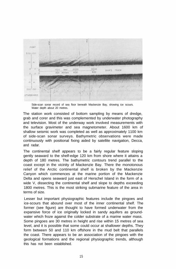
Side-scan sonar record of sea floor beneath Mackenzie Bay, showing ice scours.Water depth about 20 metres.
The station work consisted of bottom sampling by means of dredge,grab and corer and this was complemented by underwater photographyand television. Most of the underway work involved measurements withthe surface gravimeter and sea magnetometer. About 1600 km ofshallow seismic work was completed as well as approximately 1100 kmof side-scan sonar surveys. Bathymetric observations were madecontinuously with positional fixing aided by satellite navigation, Decca,and radar.
The continental shelf appears to be a fairly regular feature slopinggently seaward to the shelf-edge 120 km from shore where it attains adepth of 180 metres. The bathymetric contours trend parallel to thecoast except in the vicinity of Mackenzie Bay. There the monotonousrelief of the Arctic continental shelf is broken by the MackenzieCanyon which commences at the marine portion of the MackenzieDelta and opens seaward just east of Herschel Island in the form of awide V, dissecting the continental shelf and slope to depths exceeding1800 metres. This is the most striking submarine feature of the area interms of size.
Lesser but important physiographic features include the pingoes andice-scours that abound over most of the inner continental shelf. Theformer (see figure) are thought to have formed underwater from theexpansive force of ice originally locked in sandy aquifers as ground-water which froze against the colder substrate of a marine water mass.Some pingoes are 30 metres in height and rise within 15 metres of sealevel, and it is possible that some could occur at shallower depths. Theyform between 50 and 110 km offshore in the mud belt that parallelsthe coast. There appears to be an association of the pingoes with thegeological formations and the regional physiographic trends, althoughthis has not been established.
15

Seismic record of pingoes on floor of Beaufort Sea, 100 km north ofTuktoyaktuk Peninsula.
Ice scours are profuse in the inshore areas and disappear near the outermargin of the shelf where they are recorded in up to 75 metres ofwater. These features are deepest inshore where they have beenestimated to be 5 metres deep and, exceptionally, 20 metres. Beyondthe 50-km line from the coast they are 2 to 3 metres deep andoccasionally 9 metres. Mostly the scours trend northwesterly buttransecting scours show that irregular courses were taken by the ice.Wind apparently drives shelf ice, ice-islands, rafted ice and pressureridges onto the shallow portions of the continental shelf which issubsequently scoured by this moving ice. In deeper water, where thescouring appears to be older, considerable sedimentation seems to havetaken place, and the grooves are less numerous and less sharply definedthan those inshore. Of even greater significance is the fact that scoursrarely occur in more than 55 metres of water; and that a sedimentarylayer occurs beneath the sea floor below which no scouring has takenplace. This layer can be traced seaward and is exceptional evidencepossibly of a rising sea level that occurred during the past severalthousands of years. But most important is the absence of scour beforethis period suggesting that sea ice was not present and that the ArcticOcean was truly an open sea.
Evidence of an ancient erosional surface about 90 to 120 metres belowthe present bottom appears on the acoustical records. Trunk systemsonce flowed across the present Arctic Continental Shelf beneath theBeaufort Sea and with submergence of the land, the valleys filled withsediment. In some cases such filling amounts to a hundred metres andsome of this occurred before the ice age which is thought to have begunapproximately three million years ago. The main drainage system wasfrom the Mackenzie River on the west and the Arctic Archipelago onthe east. Lesser systems developed along east-west trends parallelingthe coast but these are imperfectly delineated by our surveys to date.Generally the sea floor consists of long bands of mud, occurring intopographically low areas, alternating with similar bands of elongatedzones of sand. These sandy areas occur on topographic highs and arecoarser due to their exposure to the winnowing action of marinecurrents. Pebbles and coarser sands occur very near shore. In no area
16

was bedrock exposed, due to the thickness of the sedimentary coverwhich inshore was greater than 60 metres.
Core recovery was generally good and the resulting samples revealed thepresence of a carbonaceous, laminated, muddy layer underlain bycoarser sediments. This occurred in the inshore area and is evidence of arising sea. Offshore, the cores were less carbonaceous and the mud wasa typical marine sediment. One core taken 25 km north of AtkinsonPoint contained lenses of fresh-water ice thus establishing the move-ment of groundwater through sandy aquifers beneath the sea. Anothercore from the immediate area contained porous sands saturated withhydrogen carbon compounds. A third interesting core was obtainedfrom a pingo about 100 km offshore. This core contained a vesiculartexture which may be attributable to escaping gas.
Piston corer being used from the CSS Hudson in Beaufort Sea.
1 7
The philosophy behind the planning of this multidisciplinary programwas to obtain a spectrum of observations wherein the data from oneproject, although self-sufficient for its own objectives, could be utilizedin support of other projects. For example, as part of the micro-paleontology program Knudsen bottle casts were made to determinetemperatures, salinities and dissolved oxygen content at selectedstations along three equally spaced lines transecting the Beaufort Shelf.These lines extended from the near-shore area to the ice edge. From theoceanographic observations at these stations the water mass was foundto be typical of the Arctic Ocean for that time of year. A two-layersystem was present with a positive halocline at about 20 metres, withfreshening of the surface waters in the vicinity of ice floes. Theoceanographic data then provided valuable environmental informationfor the biologists and micropaleontologists.
Plankton nets were towed to a depth of 200 metres as well as at thesurface for the following purposes: (1) to relate the occurrences ofplanktonic foraminifera to the Arctic water mass; (2) to trace theextent of coastal water in the vicinity of the Mackenzie River delta; and(3) to follow the net movement of water through the NorthwestPassage. The basic criterion for this study is the sensitiveness ofplanktonic foraminifera to changes in environment; for example,abundance indicates the presence of oceanic water and absence ofcoastal water. Thus a decrease in the number of these tiny single-celledorganisms may indicate the direction in which oceanic waters arepassing between the islands. From our studies we found thatplanktonic foraminifera are present in the Beaufort Sea but are absentin coastal waters. The break occurs approximately at the 50-metreisobath and parallels the coastline.
In the bottom sediments planktonic foraminfera are scarce, and areabsent in many localities that contain living foraminifera in surfacewaters. This may indicate a recent transgression of coastal waterstoward shore. Seventy-two species were identified and, in general, thearenaceous types are characteristic of the deeper waters, but give wayto a preponderance of calcareous species towards shore, This may be aninfluence of the Mackenzie River discharge of silt-laden waters into thenearshore areas.
Additional faunal studies relating to the mollusca were made on thebottom sediments. Of the 25 species of molluscs (22 pelecypods and 3gastropods), most were obtained from dredge hauls, with a few of thesmaller species being collected in some grab samples. The greatestnumbers and varieties were found in the area considerably to the east ofMackenzie Delta where the sand content in the bottom clays wasgreatest.
18

Geophysical surveying was carried out on 14 regular traverses whichcrossed the continental shelf perpendicular to the coast, and whichwere spaced 25 to 30 km apart. Several tie lines were made, bothdiagonally to the cross lines as well as parallel to shore. Seismicreflection profiling was carried out on most of these lines and in waterdepths of less than 180 metres. Some lines extended over a portion ofthe continental slope.
The seismic records over the shelf break and slope indicate thatslumping and/or downslope creep play an important part in shelfprogradation. Presumably normal build-up of sediment takes place untila condition of instability is reached and downslope slumping movementwith dislocations occurs, which cuts the original foreset and bottomsetbeds. Generally the structure of the geological formations is gentlyrolling with a predominant seaward dip toward the Arctic Basin. Alongthe shelf edge, folding is prominent and many features near the surfaceappear to reflect very large domal, or intrusive structures at depth.
The dominant feature of the gravity field is a large positive anomaly(maximum amplitude about 80 mgal) which lies subparallel with theshelf edge. Part of the anomaly must be the shelf-edge effect due to thethinning of the crust in the transition zone between the continent andthe ocean. This could be indirect evidence that the basin to the north ofthe Mackenzie Delta shelf is underlain by an oceanic crust. Steepgradients suggest that part of the positive anomaly must be due to alocal density excess close to the surface. A qualitative interpretation ofthe contours suggests that the anomaly could be caused by a prismaticbody dipping from east to west. The extension of the anomaly to the
Beaufort Sea floor, 100 km north of Mackenzie Delta in 140 metres of water.
19

east is not known, and therefore it is not possible to relate this featureto geological structures in the Arctic Archipelago. This positiveanomaly is truncated to the west at the Mackenzie Canyon, a situationwhich is similar to that on the Nova Scotia shelf northeast of SableIsland where the shelf-edge positive anomaly is interrupted by theGully. In comparison with the Gully, it appears that a much larger anddeeper former Mackenzie Canyon has been filled recently by mostlyunconsolidated sediments. There are three substantial negativeanomalies in the survey area; the largest of the three (maximumamplitude of -56 mgal) is southeast of Herschel Island over the thicksequence of sediments of the Mackenzie Canyon region.
The variability of the gravity anomaly field is similar to that over theNova Scotia and Grand Banks shelves. In the latter case our areageophysicists suggest that the gravity field was reflecting deepseatedruptures and intrusions formed by the fracturing and faulting whichtook place during the initiation of continental drift in the area. Byanalogy, we might speculate that the continental shelf beneath theBeaufort Sea also shows relic signs of the rupturing induced by theprocess of continental drift. We are not in a position at the present timeto speculate on a possible fit of the continents surrounding the ArcticOcean.
Magnetic data were gathered throughout the survey but wereinsufficient for the production of a magnetic map. However, magneto-grams do show trends that run somewhat obliquely to the regionalgravity contours. Over most of the survey area the total magnetic fieldvaried by less than 300 gammas, and was generally smooth and flat.
The Archipelago Survey
On September 22nd both the CSS Baffin and CSS Hudson steamedeasterly from Atkinson Point on the eastern Tuktoyaktuk Peninsula tosail through the central route of the Northwest Passage via Prince ofWales Strait. Due to severe ice conditions, geophysical surveying wasreduced considerably although all station work proceeded on the usualdaily basis. As expected, the bathymetric data revealed the physio-graphic profiles of a former drainage system modified by glaciation andsubsequently submerged. Since, approximately, 10,000 years ago, thenorthern islands have been rising continually as evidenced by plantdebris in the sedimentary cores, and by the presence of raised marinebeaches about 100 metres above sea level. In Amundsen Gulf, a longcore revealed evidence of more than one glacial epoch as recorded byinterlaying of glacial flour and normal marine sediments. Perhaps100,000 years of geological history is represented in this core. Thesediment cover on the sea floor is thin and gravelly in shallow areasparticularly in those localities which are thought to be submerged
20

watersheds. This is evident in Prince of Wales Strait and again in BarrowStrait.
At the southwestern approaches to the Archipelago, planktonicforaminifera are present in Amundsen Gulf and the southernmostportion of Prince of Wales Strait. In Viscount Melville Sound,planktonic foraminifera are present as far east as longitude 105°W. Thewater between the islands in Barrow Strait is barren of planktonicforaminifera, but they reappear to the east of Resolute Bay. Theseresults suggest that the net movement of water through the NorthwestPassage is as follows: water enters Prince of Wales Strait at thesouthwest end, and moves slowly toward Viscount Melville Sound. InViscount Melville Sound and Barrow Strait the general direction ofmovement is easterly. However, east of Resolute Bay, Baffin waterenters and brings planktonic foraminifera with it. Here the Baffin watermixes with the water that flows from the Arctic Ocean and BeaufortSea through the island channels. Thus the water in Lancaster Sound is amixture of Baffin Bay water from the east and Arctic Ocean water fromthe west.
Although ice conditions hampered most of the geophysical surveys,some studies were made around the southwestern Arctic approaches.On lines run from the Beaufort Sea to Prince of Wales Strait, gravitydata showed that all free-air anomalies were negative, varying from 0 to-40 mgal and averaging about -20 mgal. A negative gradient exists to thenorth and a positive one to the east, which might indicate the presenceof a tilted sequence of sedimentary rocks of increasing thickness to thenorthwest. It is also likely that the effects of the mountainous terrainof Banks Island to the north contribute to the decrease in the free-airanomaly in that direction. Free-air gravity anomalies in Prince of WalesStrait are all positive and less than 20 mgal in magnitude. Since most ofthe surveying in this area was carried out along short lines, very fewgravity data were collected. On the lines along which gravity wasmeasured, no major anomalies were observed. The magnetic field variesonly slightly and no major magnetic anomalies were recorded in thisarea.
Many icebreakers in the past have traversed these interisland routes ofthe Archipelago on their annual voyages of resupply and rescue in thehigh Arctic. It was on these occasions that our early ideas on thegeological structure beneath the eastern marine Arctic evolved.Although we are aware of the recent physiographic development of theisland channels and the relationship of this history to concurrenttectonic activity, only recently has evidence of major faulting beenascribed to the configuration of the channels. Lancaster Sound is agraben structure - a block of the earth’s crust which has subsided morethan 3600 metres on the north side and at least a hundred metres onthe south. Some horizontal east-west movement, relatively, seems to
21

have taken place as well. Jones Sound to the north may have the samehistory. Both have very steep walls, a feature that was confirmed bydirect observation from the submersible Pices I in August 1969.
The floors of these channels are covered with mud in the deeper centralportion and are coarser in the inshore areas as well as the shallowercentral areas. These latter areas are thought to be submerged watershedswhich may occur only 30 to 60 metres beneath the sea surface. Inmany areas they lie above sea level where they occur as small islandsupon which the water sheds are easily observed. Some islands stillcontain small ice caps which are remnants of former valley glaciers thatonce occupied the channels and flowed in a tributary system to the seaat an earlier time when sea level was lower by several hundred feet. Allthe evidence, particularly that of successively younger raised beaches atprogressively lower elevations, suggests that the northern islands are stillemerging.
The Baffin Bay Survey
Proceeding easterly from Resolute Bay, both the Hudson and the Baffincontinued their respective programs independently. The Baffin steamedto Thule to carry out calibrations on the gravimeter, and then southinto the Bay to gather gravimetric, magnetic, and bathymetric data. TheHudson continued her geophysical program into Baffin Bay, taking aline of oceanographic stations from Lancaster Sound to the Bay. Shewas primarily involved in seismic measurements, and obtainedadditional magnetic, gravimetric and bathymetric data wheneverpossible. Together with the bottom sampling from the Labrador, thegeological sampling and geophysical surveying from the Damon, andthe support from the Edisto, an immense fund of information isavailable for study.
A number of substantial results have already emerged from this work.The bathymetry of Baffin Bay has been fairly well defined, and ischaracterized by a broad shelf with a width greater than 320 km on theGreenland side and a narrow shelf with a width of 24 km on theCanadian side. The central portion is flat and almost 2500 metres deep.Submerged drainage features and fjords are evident on both shelves.Sediment distribution follows an almost classical pattern of coarsesediments, such as sands and gravels, in the inner portion of the shelf,and very fine sediments in the central deeper portions. Erratic,ice-rafted boulders occur on the shelves where they have been depositedby ice originating mostly from the northern islands adjacent to NaresStrait.
Early magnetic records indicated a very thick sequence of sedimentsover the whole of the Baffin Bay area. The seismic records show athickness of 4 to 5 km of sediment. A continuous deep seismic
22

reflection profile extending from Lancaster Sound to central Baffin Bayshows a sequence of folded sedimentary layers which change abruptlyinto undistrubed beds to the east along the Canadian continentalmargin, the latter determined independently from gravity data. Seawardof this margin, the beds are prograding. On the Greenland side, theattitude of the sediments is typically a prograding one, occurring downa topographic slope.
The most significant of the scientific discoveries in Baffin Bay resultedfrom the successful reverse seismic refraction line along the deepportion of Baffin Bay. This experiment established the fact that BaffinBay is underlain by oceanic crust with a crustal section about 10 kmthick consisting of the following: 2 to 3 km of sediment, 4 km of layer2 (2 km of vesicular rock and 2 km of mosaic), and 2 km of layer 3.The transition between oceanic and continental material lies landwardof the present outer topographical slope in western Baffin Bay, to thewest of which sediments are deformed. Thus the Canadian oceanic-continental boundary is well established by both gravimetric andmagnetic measurements, and is supported by seismic reflection data. Onthe Greenland side, evidence of the transition is obscure.
Geophysical evidence based on known seismic velocities of Paleozoicrocks exists to show that the deep basin in the Bay was formed bysea-floor spreading during the Cretaceous period. To estimate an orderof magnitude of the time scale involved, sedimentation rates are usedwhich suggest movement commenced about 100 million years ago andceased 40 million years later. Perhaps as much as 400 km of movementhas taken place along Nares Strait.
The seaward extension of the Tertiary basalts cropping out on DiskoIsland were mapped by means of magnetic field measurements, and theinformation so obtained was corroborated with selected dredgesampling of basalt on the sea floor.
With reference to possible volcanism in the area, heat flow measure-ments were made. However, no apparent heat flow anomaly isassociated with the central Bay although deep reflection records give anindication of a rugged deep reflector, perhaps a buried ridge, beneath 3to 4 km of sediments.
Without doubt the year 1970 will be recorded as a landmark in Arcticmarine exploration involving the earth sciences, particularly in regard tothe broad deployment of a large research and survey fleet, the uniqueconcentration of scientific expertise and its technical support, and theamassed accumulation of new scientific information. The skill inseamanship and navigation of the masters of the Arctic-bound vesselsmade possible the successful completion of so many difficult voyages:the late Captain W.J. Vieau and Captain M.J.A. Wagner (CSS Dawson);Captain P. Tooke (CCGS Labrador); Captain V. Dale-Johnson (CSL
23

Richardson); Captain C. Angus (CSS Parizeau); Captain P.M. Brick (CSSBaffin); Captain D.W. Butler (CSS Hudson); Captain G. Burdock (CCGSJohn A. Macdonald); and Captain W.J. Brasier (USCGS Edisto). A filmdocumentary of much of the Arctic Survey in the Beaufort Sea andNorthwest Passage is being completed by J.R. Belanger.
Written contributions were submitted by C.J. Havard, B.D. Loncarevic,R.F. MacNab, C.D. Mann, M.J. Purdy, D.I. Ross, J.M. Shearer, G. Vilks,P. Wadhams, F.J.E. Wagner, J.M. Woodside, and C.J. Yorath.
See also Bedford Institute Contributions 16, 26, 29, 46, 48, 50, 61, 93,106, 117, 121, 140, 186.
B.R. Pelletier
2 4
Analysis of Marine Ecosystems
One of the long range goals of marine ecology is to have sufficient‘understanding’ of a situation in nature to be able to make confidentquantitative predictions about the consequences of man’s interference,whether by harvesting a resource, introducing a pollutant or changingsome physical features of the environment. Our ‘understanding’ of asituation is often expressed in the form of a mathematical model.Several generations of ecologists have modelled species populations buthave had very limited success in making good predictions. The reason,as we now begin to realize, is that species populations interact witheach other and with the environment in such a complex way that it isimpossible to understand the behaviour of one population withoutconsidering the whole ecosystem of which it is part.
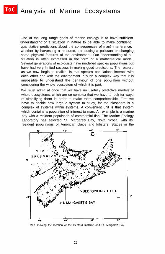
We must admit at once that we have no usefully predictive models ofwhole ecosystems, which are so complex that we have to look for waysof simplifying them in order to make them comprehensible. First wehave to decide how large a system to study, for the biosphere is acomplex of systems within systems. A convenient unit is that systemwhich contains a population of interest to man. An example is a marinebay with a resident population of commercial fish. The Marine EcologyLaboratory has selected St. Margaret’s Bay, Nova Scotia, with itsresident populations of American plaice and lobsters. Stages in the
Map showing the location of the Bedford Institute and St. Margaret’s Bay.
25

development of a model for this system include a description of itsstate at a given time and a definition of the boundaries and the fluxesacross them. In the case of a marine bay the basic fluxes are of solarenergy, of water vapour and gases at the sea surface, of water anddissolved and particulate matter at the mouth of the bay, and of run-offwater, with dissolved and particulate matter from the land. The solarenergy also generates the winds, which impart kinetic energy to thesystem in the form of waves and currents.
A technique commonly used to analyze a complex system is to divide itinto functionally identifiable parts and study the functioning of eachalong with the interactions between them. One useful way of dividingliving systems is according to trophic function: the primary producers,the herbivores, detritivores, carnivores and finally the decomposers,consuming the dead organic matter and liberating the nutrients forreuse by the plants. The units which are transferred between thesecompartments are energy-rich organic compounds, so the system maybe modelled in terms of either energy or materials.
Energy enters the biological system by the fixation of solar energy inphotosynthesis, and as it passes from one compartment to anothermore and more is degraded to heat. Solar energy also exerts controls atvarious stages of the process by generating currents which transportlimiting nutrients, by changing the ambient temperature and so on.
Inorganic materials used as plant nutrients are taken up, released, takenup by other organisms and generally recycled in the system withturnover times ranging from minutes to geological eras. The occurrenceof rapid recycling makes it almost impossible to measure the rates ofprocesses in ecosystems from changes in concentration of nutrients,except in a few carefully controlled situations.
Since energy flows in the system always in one direction thesecomplications do not arise and energy flux is a useful general measureof the rates of natural processes. The first figure illustrates a marineecosystem model with the compartments identified according totrophic habit, using the symbols proposed by Odum (1969). It is easyto see how the amount of energy in each compartment may bemeasured and averaged over any desired period. It is less easy todetermine the fluxes between them.
Considerable insight may be obtained simply by calculating the fluxesfor a particular system in a steady state. Numerous practical difficultiesare involved, but energy flow diagrams of varying degrees ofcompleteness have now been produced for a variety of ecosystems.They show, for instance, that in some systems energy is transferred tothe consumers mainly by a grazing food chain, while in others it istransferred by way of dead organic matter and micro-organisms. Theyshow that some rivers derive almost all their primary production from
26

terrestrial sources while others have heavy primary production withinthe river; that the energy of mixing in an estuary is instrumental in therapid recycling of nutrients so that estuaries are among the mostproductive of aquatic systems. In St. Margaret’s Bay (see figure) theprimary production is predominantly the particulate and dissolvedmatter generated by seaweeds, while in the Strait of Georgia (BritishColumbia) it has been shown that terrestrial run-off supplies about halfthe primary input of organic matter.
Compartmental energy flow diagram for the community of St. Margaret’s Bay,Nova Scotia. Approximate values for standing stock (kcal/m2) and energy fluxes(kcal/m²/yr) are given, where available. Import and export at the mouth of thebay are not represented. Symbols are those proposed by Odum (1969).
These energy flow diagrams serve to summarize analyses of particularsituations, defining the organisms present, their numbers, biomasses,interactions and fluxes over a period of, say, one year. They representan important and difficult first step in constructing a predictive model,but in themselves have no predictive power. One may make educatedguesses about the consequences of disturbing the steady state whichthey represent, but further progress depends on an ability to say howthe fluxes will change as a result of changes in conditions. It is rarelypossible to carry out a major environmental manipulation in order totest hypotheses about these changes, so small subsystems must beinvestigated in the laboratory, and the results used to build dynamic
27

models which may be used to simulate interactions between compart-ments under a range of environmental conditions.
What are the factors which determine the flow of energy betweencompartments? Let us consider the simple situation in which onecompartment represents a predator population and the other prey. Atleast six factors may be identified:
(i) The biomass of the donor (prey) compartment. Some models haveassumed that the flow from a compartment is proportional to theamount in that compartment, with no other restriction. This isanalogous to the flow of electrical energy through a resistance, inproportion to the voltage potential applied. Biologically, it amounts tosaying that what is available as food will be eaten by something. Thismay be true, but it is important to know whether the food is eaten by afish or a bacterium, and what is the time lag involved. Williams (inpress, a) constructed a model on this principle, with linear relationshipsbetween biomass and flow, and rejected it in favour of a nonlinearmodel, since the linear model did not correspond well with reality.
One form of nonlinear relationship is that proposed by lvlev (1955) forthe consumption of food by fish:
where C is food consumed in a fixed time, C' is the maximum which apredator can ingest, F is the density of the prey population and a is aconstant. The amount of food consumed approaches an asymptote atC' as the food density increases. Similar ‘saturation’ or ‘satiation’models have been used to describe the uptake of nutrients by plants,the consumption of phytoplankton by zooplankton, and indeedtransfer at all trophic levels in a general model (Smith, 1969).
(ii) The biomass of the receiving compartment (predator). It isreasonable to expect that the larger a predator population becomes, themore food will be consumed. Indeed it is implicit in the application ofthe non-linear relationship described above that C is food consumed perpredator, F is food available per predator. However, Williams (in press,b) experimented with a model in which the flux from prey compart-ment to predator compartment was proportional to the product of thebiomass in each. The implication of such a relationship is that for afixed amount of prey, the consumption by the predator goes onincreasing indefinitely in proportion to the predator biomass. Thismodel, not unexpectedly, was unstable but he controlled it byintroducing a self-inhibiting term, with the amount consumed per unitof predator decreasing as the biomass of predator increased. This fluxwas expressed as (X1 Ø X2) x (1 - aX2) where X1 and X2 are the bio-masses of prey and predator. Such restraints led to both stability andresponsiveness in the model.
28

(iii) The particle size of the food material. If the biomass in the donorcompartment occurs as organisms too large for the predator to tackle,there will be no transfer. Conversely, if the particles are very small, theconsumer may find it necessary to expend more energy in collectingthem than it obtains from the food. Between these limits there can belarge differences in the rate and efficiency of food transfer betweenpredator and prey. Two of the staff of the Marine Ecology Laboratoryhave explored these relationships (Beamish and Dickie, 1967; Kerr andMartin, 1970). Ardill (1968) documented the relationship betweenbody size and prey size in the American plaice of St. Margaret’s Bay.
(iv) The availability of the prey. The prey’s ability to hide or escapefrom the predator, its pattern of spatial distribution, or the timing of itsoccurrence will markedly influence the rate of energy flux. Such factorsare often related to the heterogeneity of the environment. In St.Margaret’s Bay, studies have been made on the spatial and temporaldistribution of the phytoplankton (Platt, 1970; Platt et al., 1970).Studies are in progress on the spatial distribution of benthic organismsusing a diver-operated sampling device and on the distribution patternsof groundfish using sonic counting and a shipboard computer.
Kerr (in press) has modelled the feeding and growth of fishes, takinginto account such parameters affecting grazing efficiency as thedistance at which the predator perceives the prey and the distancebetween prey organisms. More comprehensive predator-prey modelswhich take into account the detailed behaviour patterns of predatorand prey were pioneered by Holling (1965, 1966) and have recentlybeen applied to fish (Ware, personal communication).
(v) The chemical composition of the food. This may influence theability of the consumer to take up the stored energy. Animal proteinhas a carbon: nitrogen (C:N) ratio of about 3.2 to 1, and the C:Nratio of whole animals is commonly between 4:1 and 5:1. Carbohyd-rates in the diet are used primarily as energy sources while proteins areused for tissue renewal and growth. Carnivores take in food with a C:Nratio close to that of their own bodies, but many herbivores take foodwith a low protein content, and hence a high C:N ratio. They are facedwith the problem of extracting necessary proteins from an excessiveamount of carbohydrate, and if the C:N ratio in the diet is greaterthan about 16.5: 1 they suffer from protein deficiency.
The ruminants, which are the major terrestrial herbivores, harbourmicro-organisms in their guts which respire the excess carbon andsynthesize essential amino acids. A three-compartment model is neededto represent this situation. In aquatic ecosystems there are two mainenergy pathways. Phytoplankton cells are grazed by herbivorouszooplankton, but most aquatic macrophytes die and are acted upon bymicro-organisms, before they are taken by the animals. The lattersituation parallels that found in the guts of ruminants.
2 9

In St. Margaret’s Bay the phytoplankton had a C:N ratio around 6:1in spring and summer, but this increased to about 11:1 at the end ofwinter. Summer phytoplankton is an adequate food for the animals ofthe zooplankton, but it has been shown elsewhere that as the yearprogresses the zooplankters supplement their diet by taking consider-able quantities of animal food (Marshall, 1924).
Seaweeds in St. Margaret’s Bay have a C:N ratio of about 16:1 insummer, rising even higher in the fall; very little of this material isconsumed by herbivores. Instead it is colonized by micro-organisms andfed on by bottom-living detritivores. Much of it is also taken up insuspension and consumed by filter feeders. Large quantities appear inthe water column more than a mile offshore, after winter storms.
The existence of a two-stage conversion process between aquaticmacrophytes and animals greatly complicates the modelling procedures.
(vi) Feedback interactions between the predator and the prey. It is wellknown to farmers that a grazed pasture may yield more grass in aseason than an ungrazed hay field, provided that overgrazing is notallowed to occur. Similar interactions occur between aquatic animalsand their food supply. For instance, Hargrave (1970) investigated thegrazing effect of a bottom-living amphipod shrimp, and found thatincrease in shrimp numbers increased production of both plants andbacteria, probably because the shrimps excreted nutrient substancesand stirred up the bottom deposits, thus improving the penetration oflight, carbon dioxide, oxygen, and nutrients. Above a certain density,the production of food decreased, due to overgrazing, but the optimumpredator density was higher for bacteria than for plants. Overgrazingleads to a fall in food biomass often followed by a fall in predatorbiomass and this leads to cyclical oscillations which are a commonfeature of predator-prey relationships.
At first sight the obstacles to modelling the interactions of organisms inecosystems are so great as to appear almost insuperable. However, bylooking at whole systems rather than individual species, one discoversevidence of stability of the whole in the face of fluctuations in theparts. In St. Margaret’s Bay the population density of each species ofphytoplankton changes sharply with the season but the total biomass ofphytoplankton, and its productivity, follows a fairly predictable annualcycle (Platt, in press). Similar considerations apply to zooplankton.Moreover, the energy content of the zooplankton shows much lessannual fluctuation than either the numbers of dry weight (Platt et al.1969).
Integration over time also leads to greater predictability. Whencomparing the productivity of phytoplankton at two stations, oneinside St. Margaret’s Bay and one outside, Platt (in press) found markedfluctuations from day to day at each station, with little correspondence
3 0

between them, but the total annual production at the two stations wasalmost exactly the same.
By grouping, in one compartment of a model, all species feedingdirectly on phytoplankton we might also expect to find that, in spite ofthe rise and fall in the productivity of the individual species and theday-to-day variation, the total annual productivity of the consumersbears a relatively constant relationship to the phytoplanktonproduction. Still further along the food chain it is found that the totalproductivity of fish in an area is much less variable than theproductivity of individual species.
These considerations have led to predictions of a relationship betweenfish yield and primary productivity based on oversimplified models.Slobodkin (1959, 1962), after operating three-compartment foodchains under controlled conditions in the laboratory, postulated that innature the efficiency of transfer from the input of one compartment tothe input of the next (ecological efficiency) is in the range of 5-15%. Bytaking a mean value of 10%, or a range of values, conclusions have beenreached about the productivity of a species in the third or fourthtrophic level on the basis of some information about the production ofthe first. Such procedures are not justified at present because: (a) inmost situations we do not have good information on the total input ofprimary production; (b) a large proportion of organisms cannot beassigned to any one trophic category; and (c) a large proportion ofprimary production in inland and coastal aquatic systems is channelledto decomposers rather than grazing organisms.
These points are illustrated in the figure, which summarizes about 30man-years of work on a river ecosystem (Mann et al., 1971).
The productivity of the phytoplankton was measured and found to bevery large compared with that of aquatic macrophytes and ofoverhanging trees. However, the productivity of the periphyton provedvery difficult to measure, and there is insufficient information on thefixation of dissolved organic matter by bacteria or on the proportion ofimported organic matter utilized by filter feeders. Similar inadequaciesexist in our knowledge of the sources of high energy compounds inalmost all ecosystems. For most marine situations the only informationavailable is the value for uptake of C14 in incubation experiments, andthe interpretation of these is still a matter for debate.
At the next trophic level the productivity of the filter feeding benthoswas estimated as 110 kcal/m2/yr, but only 11 kcal could be traced topredators. The fate of much of the benthic production is still in doubt.
As for fish, 70% of their production was realized in the first year of life.The most important energy source for young fish was cladocerans androtifers, but for the older fish it was organic detritus, followed byterrestrial insects. They also consumed large amounts of benthic
31

Energy flow diagram for the biological community of the River Thames atReading, England. All fluxes are in kcal/m2/yr. The organisms are arrangedapproximately by trophic levels. At the base of the diagram is shown productionby phytoplankton periphyton, trees and macrophytes. There is also an input ofsuspended organic matter from upstream. All these sources contribute to thetripton and benthic detritus. Invertebrates are shown across the centre of thepage; they are mainly herbivores and detritus feeders; the invertebrate carnivores(predators) are leeches and carnivorous insects. The dominant fish species areroach (Rutilus) and bleak (Alburnus), with other species (perch, Perca; gudgeon,Gobio, etc.) grouped in the top right-hand corner. To reduce the number ofcrossed lines, the compartments for periphyton, allochthonous material anddetritus are duplicated in the top left corner.
diatoms. Their energy was derived from four trophic levels: (i) plants,(ii) bacteria and fungi feeding on decaying plant material, (iii)detritivores, consuming the bacteria and fungi, and (iv) predatoryinvertebrates. The allochthonous component in their diet comprises yetanother food category. In such a situation it would be ludicrous torelate the fish to one trophic level or attempt to predict fish productionfrom any measurement of photosynthesis. Such a system may be morecomplex than some open-ocean situations, but estuaries are probablymore complex than the river.
Clearly, then, a too-rigid adherence to the concept of trophic levels as abasis for compartmentalizing the system is wrong, but a willingness tosubdivide according to one’s understanding of the system can lead toworkable models.
32

In considering where effort should be expended to make progress inthis difficult field, there is no doubt at all that more and betteranalytical models of segments of ecosystems should be devised andtested in the laboratory and the field. These will lead to a betterunderstanding of nutrient kinetics, predator-prey relations,competition, species diversity, food conversion efficiency, and so on.However, we delude ourselves if we suppose that by this route we shallsoon arrive at detailed models for whole ecosystems which will predictin some detail the consequences of changing some parameters.
The alternative approach is dictated by the need for models with whichwe can make management decisions soon, and by the potentialadvantage of dealing with systems which have less variance than theircomponent parts. Smith (1969) has shown by means of a general modelthat ecosystems have properties distinct from those of their interactingsubsystems, and has generated a number of hypotheses which can betested in nature. Odum (1969). starting from natural systems, hasproposed a special energy systems language consisting of a few basicmodules each represented by a graphic symbol and a mathematicaldescription of its properties. Using this language, he has shown thatnonlinear relationships can often be resolved into two or more linearfluxes interacting by means of a ‘work gate’ (in much the same waythat electrical currents at the base and collector of a transistor caninteract in a nonlinear manner). In addition to representing the fluxesof the biological system, he has included in his models the controlsexerted by the energy of wind and waves as they recycle limitingnutrients, the feedbacks associated with man’s work and the use offossil fuels, and even the control of such feedbacks by recyclingcurrency in economic transactions.
An important part of this approach (Odum, 1967) is the concept of arelationship between organization and the energy required to produceand maintain it. Many physical processes are seen as destroyers ofbiological organization, and energy must be diverted to offset thisdestruction in proportion to the frequency and severity of itsoccurrence. A system subject to severe stresses of this type will exhibitreduced species diversity. It is abundantly clear that the performance ofecosystems is as much a function of physical energy processes as ofbiological factors, and for this reason a high proportion of the effort ofthe Marine Ecology Laboratory in St. Margaret’s Bay has been directedto analysis of the physical and chemical oceanography (Sharaf el Din, etal., 1970).
The preparation of energy diagrams is an important step in theconstruction of workable ecosystems models, and Odum (1969) hasclaimed that the process of conversion to mathematical expressionswhich form the basis of a simulation model is relatively simple. Such
3 3

general models can only give general predictions, but these are certainto be useful in making management decisions. They can be used to gaininsights into the properties of ecosystems without the necessity ofwaiting for costly environmental manipulations, and validation of themodels may be obtained by monitoring the systems under a range ofweather patterns, or by following the effects of man-made changes.
Between the extremes of a detailed analytic model of the interactionsof a single species with its food and its environment and a simulationmodel of a whole ecosystem there is a broad spectrum of possibilities.For instance, Menshutkin and coworkers (Menshutkin, 1964; Karpov etal., 1969) have progressed from models of single species fishpopulations to a model of the community of fishes of Lake Dal’nee,demonstrating the increased stability and decreased variance whichresults from considering a larger system. It seems likely that bymaintaining progress on a number of fronts there will eventually emergethat paradigm which will unite the divergent schools of ecology andgive the subject the coherence which is so badly needed for maintaininga viable environment for an exploding human population.
References
Ardill, D. 1968. Studies on Selective Feeding of the American Plaice (Hippo-glossoides platessoides) of St. Margaret’s Bay, N.S. MSc. Thesis, DalhousieUniversity.
Beamish, F.W.H., and Dickie, L.M. 1967. Metabolism and Biological Productionin Fish. In The Biological Basis of Freshwater Fish Production, Blackwell, Oxford(S.D. Gerking, ed.): 215-242.
Hargrave, B.T. 1970. The Effect of a Deposi t -Feeding Amphipod on theMetabolism of Benthic Microflora. Limnol. Oceanogr., 15: 21-30.
Holling, C.S. 1965. The Functional Response of Predators to Prey Density andits Role in Mimicry and Population Regulation. Mem. Ent. Soc. Canada, 45: 1-60.
Holling C.S. 1966. The Functional Response of Invertebrate Predators to PreyDensity. Mem. Ent. Soc. Canada, 48: 1-86.
Ivlev. V.S. 1955. Experimental Ecology of the Feeding of Fishes. Pischepromiz-dat, Moscow: 302 pp. (Trans. D. Scott, Yale University Press, New Haven, 1961.)
Karpov, V.G., Krogius, F.V., Krokhin, I.M., and Menshutkin, V.V. 1969. Modelof the lchtvocoenosis in Dal’nee Lake Realized on an Electronic Computer.Trudy, Vsesoyuznogo Nauchno-lssledovatel’skogo lnstituta Morskogo RybnogoKhozyaistra i Okeanografii (VNIRO) 67: 76-87. (Trans. Fish. Res. Bd. CanadaNo. 1572.)
Kerr, S.R. (in press). Prediction of Growth Efficiency in Nature. J. Fish. Res. Bd.Canada.
Kerr, S.R., and Martin, N.V. 1970. Trophic-dynamics of Lake Trout ProductionSystems. In Marine Food Chains, Oliver and Boyd, London (J.H. Steele, ed.):365-376.
Mann, K.H., Britton, R.H., Kowalczewski, A., Lack, T.J., Mathews, C.P., andMcDonald, I. 1971. Productivity and Energy Flow at All Trophic Levels in theRiver Thames, England. Proceedings of UNESCO/IBP symposium on ProductivityProblems of Freshwaters, Warsaw.
34

Marshall, S. 1924. The Food of Calanus finmarchicus during 1923. J. Mar. Biol.Ass. U.K., 13: 473-479.
Menshutkin. V.V. 1964. Realization of Simpler Models of Fish Populations onan Electronic Computer (in Russian). Voprosy ikhtiologii, 4: 32.
Odum, H.T. 1967. Biological Circuits and the Marine Systems of Texas. InPollufion and Marine Ecology, Interscience, New York (T.A. Olson and F.J.Burgess, ed.): 99-157.
Odum, H.T. 1969. An Energy Circui t Language for Ecological and Socia lSystems: Its Physical Basis. Progress report to U.S. Atomic Energy Commission,Appendix I. (Manuscript: 94pp).
Plat t , T. 1970. Some Effects of Spat ia l and Temporal Heterogenei ty onPhytoplankton Productivity. Ph.D. Thesis, Dalhousie University: 94 pp.
Platt, T. (in press). The Annual Production by Phytoplankton in St. Margaret’sBay. Nova Scotia. Journal du Conseil 33.
Platt, T., Brawn, V.M., and Irwin B., 1969. Carbon and Caloric Equivalents ofZooplankton Biomass. J. Fish. Res. Bd. Canada, 26: 2345-2349.
Plat t , T. , Dick ie, L .M. , and Tr i tes, R.W. 1970. Spatial Heterogeneity ofPhytoplankton in a Near-Shore Environment. J. Fish. Res. Bd. Canada 27:1453-1473.
Sharaf El Din, S.H. , Hassan, E.M., and Tr i tes, R.W. 1970. The PhysicalOceanography of St. Margaret’s Bay, F.R.B. Technical Report No. 219.
Slobodkin, L.B. 1959. Energetics in Daphnia pulex Populations. Ecology, 49:232-243.
Slobodkin, L.B. 1962. Energy in Animal Ecology. Adv. Ecol. Res., 1: 69-101.
Smith, F.E. 1969. Effects of Enrichment in Mathematical Models. In Eutrophi-cation: Causes, Consequences and Correctives, Nat. Acad. Sci., Washington:631-645.
Williams, R.B. (in press, a) Computer Simulation of Energy Flow in Cedar BogLake, Minnesota, Based on Classical Studies of Lindeman (1941, 1942). InSystems Analysis and Simulation in Ecology, Academic Press, New York (B.C.Patten, ed.), Chapter 10.
Williams R.B. (in press, b) Steady State Equilibriums in Simple Nonlinear FoodWebs. In Systems Analysis and Simulation in Ecology, Academic Press, New York(B.C. Patten, ed.), Chapter 13.
K.H. Mann
35

(This page Blank in the original)
36

Operation Oil
On Wednesday, February 4, 1970, the Liberian tanker Arrow ranaground on Cerberus Rock in Chedabucto Bay, Nova Scotia. The cargoof Bunker C residual fuel oil began to escape from the damaged shipand, by February 12, approximately 2.5 million gallons of the viscousblack oil had escaped to pollute the waters of the Bay and thesurrounding shoreline. Part of the oil escaped to the open sea, somelanding on the beaches of Sable Island, 100 miles from the source. Ofthe 375 statute miles of shoreline in the Bay area, 190 miles wereeventually contaminated to various degrees. Canada had experienced itsfirst major oil spill of disastrous proportions. In addition, one-third ofthe original cargo of oil was trapped in the now submerged aft sectionof the wreck. Although no further major oil spills occurred afterFebruary 12, the amount of oiled shoreline increased as oil trappedbeneath ice escaped with the spring thaw and oil moved fromcontaminated to uncontaminated areas. The extent and degree of oiledshoreline as of July 1970 is shown in the figure.
The extent and degree of oiled shoreline from the sinking of the tanker Arrow onCerberus Rock.
Representatives of the Department of Transport and of Imperial OilLtd., owners of the cargo, gathered immediately to recover the vesseland combat the oil spill. Scientific assistance was volunteered quicklyby several agencies, including the Bedford Institute; staff from MELand AOL were on the scene within a few days and, by February 12, theCSS Dawson had started the first of three cruises to the Bay. However,by February 20, it became clear that the resources available to combatthe disaster were inadequate to cope with a difficult threefold task -the recovery of over one million gallons of oil trapped within the
37

wreck, the clean-up of the oil-contaminated coast, and a realisticassessment of the damage done to the environment. A three-man taskforce, headed by Dr. P.D. McTaggart-Cowan, was appointed by theFederal Minister of Transport with authority to gather the resourcesrequired to resolve the pollution problem in Chedabucto Bay.
The Task Force decided that substantial scientific and engineeringassistance was required and, on February 24, Dr. W.L. Ford, Director,AOL, was seconded to ‘OPERATION OIL’ as Scientific Coordinator.W ith the full cooperation of the local and national scientificcommunity, a small management team, based at the Bedford Institute,coordinated an extensive program of support. By the time the team wasdisbanded, at the end of July, over 100 scientists and engineers, withsupporting staff, had been working on a full or part-time basis for theOperation Oil Task Force. In addition, a number of continuing studieshad been established. The scientific team hope these studies will assessthe long-term effects of the pollution in the Bay and evaluate the threatposed to Canada by the continual accidental and incidental dumping ofoil and oily wastes into our environment.
Membership of the central coordinating team illustrates the broad baseof university and government support:
Scientific Coordinator Dr. W.L. FordAtlantic Oceanographic LaboratoryDepartment of Energy, Mines andResources
Executive Assistant Mr. K.B. YuenHeadquartersMarine Sciences BranchDepartment of Energy, Mines andResources
Chemical Science Dr. A.Y. McLeanNova Scotia Technical College
Environmental Sciences Dr. C.S. Mason(Physical) Atlantic Oceanographic Laboratory
Department of Energy, Mines andResources
Environmental Sciences Dr. R.W. Trites(Ecological) Marine Ecology Laboratory
Fisheries Research Board of Canada
Clean-Up Technology Dr. W.D. JamiesonAtlantic Regional LaboratoryNational Research Council ofCanada
3 8

Steam cleaning jetties (MOT photo).
Dr. F. Payne and Mr. J.R. Brown of the Defence Research Establish-ment Atlantic and Mr. T.R. Foote of the Atlantic OceanographicLaboratory served as scientific liaison officers between the OperationOil Task Force in Port Hawkesbury and the Bedford institute-basedscientific support team.
Within a few days of starting their work, the scientific coordinationteam learnt that the techniques to control and combat oil spills wereeither primitive or nonexistent. There were a surprising number ofproducts and techniques which did not even function satisfactorily inthe specific conditions for which they were supposedly designed! Itproved necessary to review and test all the techniques which had beenused elsewhere and to invent new ones.
The most desirable way of eliminating oil pollution is to remove the oilfrom the environment and the team evaluated removal techniques suchas booming and pumping, absorbing, burning, and skimming.
There was no commercial boom which would work in open seaconditions. Trials of a seine net boom indicated that a flexible netmight contain heavy Bunker C oil, the permeable net allowing thepassage of water while retaining the oil. After laboratory trials, a fullscale field trial was held in which a 360-metre-long net of 2 cm nylonmesh was deployed and easily retrieved in an hour from two 13-metreboats. It was generally felt that the net would retain Bunker C in coldwater successfully but it was not tested on an oil slick.
3 9
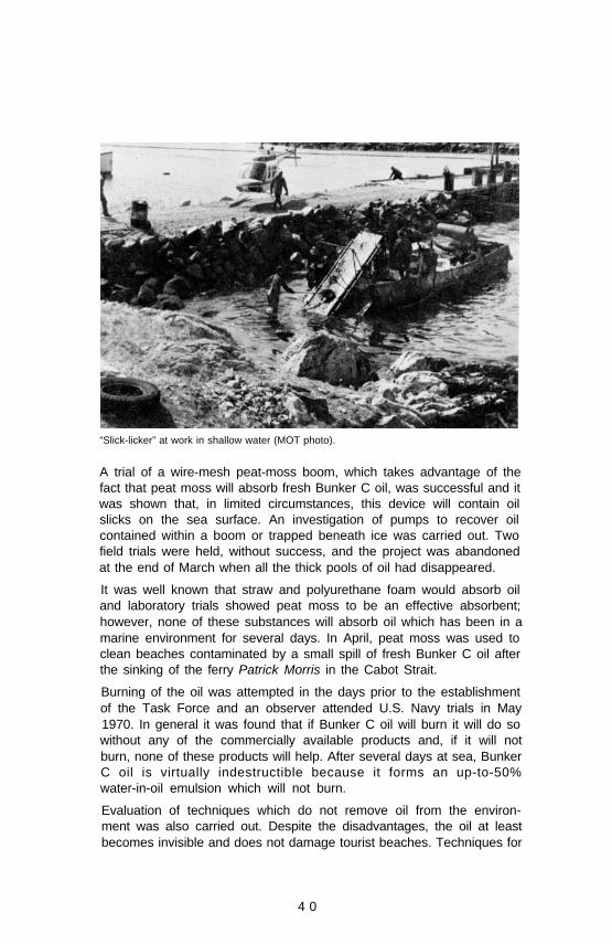
“Slick-licker” at work in shallow water (MOT photo).
A trial of a wire-mesh peat-moss boom, which takes advantage of thefact that peat moss will absorb fresh Bunker C oil, was successful and itwas shown that, in limited circumstances, this device will contain oilslicks on the sea surface. An investigation of pumps to recover oilcontained within a boom or trapped beneath ice was carried out. Twofield trials were held, without success, and the project was abandonedat the end of March when all the thick pools of oil had disappeared.
It was well known that straw and polyurethane foam would absorb oiland laboratory trials showed peat moss to be an effective absorbent;however, none of these substances will absorb oil which has been in amarine environment for several days. In April, peat moss was used toclean beaches contaminated by a small spill of fresh Bunker C oil afterthe sinking of the ferry Patrick Morris in the Cabot Strait.
Burning of the oil was attempted in the days prior to the establishmentof the Task Force and an observer attended U.S. Navy trials in May1970. In general it was found that if Bunker C oil will burn it will do sowithout any of the commercially available products and, if it will notburn, none of these products will help. After several days at sea, BunkerC oil is virtually indestructible because it forms an up-to-50%water-in-oil emulsion which will not burn.
Evaluation of techniques which do not remove oil from the environ-ment was also carried out. Despite the disadvantages, the oil at leastbecomes invisible and does not damage tourist beaches. Techniques for
4 0

sinking the oil were reviewed and a number of tests of toxicity ofcommercial chemical dispersants were done at the Fisheries ResearchBoard of Canada‘s Biological Station at St. Andrews, New Brunswick. Afield trial of one dispersant, BP1100, was held, which proved it capableof removing oil from the surface of rocks without any positiveindication of short-term harmful effects upon the adjacent littoral floraand fauna.
Net cleaning equipment devised and built to restore herring seine nets and othergear fouled with oil to a clean, usable condition.
A variety of oil clean-up techniques were tested in addition to chemicaldispersants. Steam-cleaning tests were done in the laboratory and in thefield and oiled jetties in the Bay were eventually cleaned this way by acommercial firm. A plant for cleaning the herring seine nets which werefouled with oil was designed, built and installed within three weeks.Four of these half-mile-long nets were cleaned, saving at least $75,000of the alternative replacement cost. A coastal morphologist, advisingthe Operation Task Force on beach cleaning, also cooperated closelywith a study group of geologists evaluating the effectiveness of themechanical and natural cleaning of the sand, gravel and cobble beaches.
Laboratory experiments showed that ground limestone applied tobeached oil could absorb and stabilize it. Field trials, where tonnagequantities were used, were partially successful in warm weather but atechnique which would successfully stabilize the oil on the rocks in theBay was not found. Further research and development was clearlyindicated and the technique shows promise.
Along with review and development of control and clean-up techniquesa study of the physical and chemical properties of fresh and aged Arrowoil was carried out. Bunker C is a remnant of the crude oil refining
41

process. The composition of Bunker C residual oil will vary even fromday to day at the same refinery and, as far as the team could establish,little effort has been made to learn about its properties and chemicalcomposition in relation to its behaviour when loosed in the marineenvironment.
Fishermen cleaning their own nets by passing them through the net-cleaningplant, under the supervision of the plant foreman.
A start was made on this work and a much clearer understanding wasattained of why the oil behaved in the environment as it did.Particularly striking was the rapid increase in viscosity as the water-in-oil emulsion formed. This helped to explain why techniques such asabsorbing and burning ceased to work after a few days of marineexposure of the oil. During the period the Operation Oil Task Forcewas active, at least nine other oil spills occurred in the CanadianAtlantic region. Techniques for identifying the source of the spilt oilbecame important and there was limited success with techniques basedon gas liquid chromatography and vanadium/nickel ratios. Obviouslymuch more work is necessary to establish a positive legal means ofidentifying the source of spilt oil.
Throughout February and March the mean air temperatures in the Baywere below freezing, ranging between -10°C and 0°C. Gale force winds,snow, freezing rain and rain were frequent occurrences. Sea watertemperatures were close to the freezing point and, until March, the icecover continued to increase. The last area to become ice free,Inhabitants Harbour, was not clear until April 16th. The Arrow spilloffered a unique opportunity to study the natural behaviour of the spiltoil under these subarctic conditions. A wide ranging program ofenvironmental studies combining the work of coastal geologists,
42

physical and chemical oceanographers, biologists and microbiologistswas established and is still continuing. Of particular interest is acombined study of selected areas of the shoreline of Crichton Islandlocated due north of Cerberus Rock and heavily and repeatedlypolluted with oil in early February. Activity on this shoreline has beenconfined to scientific study and its owners have willingly cooperated inthis and allowed free and ready access to the Island. The study isobserving the behaviour of the oil in the various types of shorelinerepresented there and its ecological effects on the biota of the intertidaland littoral zones. Continuation of the Crichton Island program isanticipated for a further one or two years. The oceanographicinvestigators discovered particulate oil dispersed with water to depthsof 70 metres and traced it as far as 180 miles southwest along the NovaScotia coast.
Geologists considering a section of oil-polluted shoreline, Crichton Island.
Initial results of these scientific programs have been reported in theTask Force report to the Minister of Transport which has beenreleased1. Sixteen continuing studies, involving a cooperative programbetween 20 environmental scientists of the Atlantic OceanographicLaboratory, Nova Scotia Technical College, National Research Councilof Canada, Atlantic Regional Laboratory, Energy, Mines and ResourcesFuels Research Centre, Fisheries Research Board, Marine EcologyLaboratory, Halifax Laboratory and St. Andrews Biological ResearchStation have been established. The results of these programs will bepublished in the current scientific literature as the work is completed.
4 3

As a result of the initial scientific studies, the need for extendedscientific programs became abundantly clear. Eleven other oil spills inCanada alone came to the direct attention of the Operation Oil TaskForce during its active period between February and September.Estimates of the total amount of oil entering the marine environmentannually range as high as 10 million tons2. Estimates (made byreputable scientists) of the threat posed by this oil spill range from thestatement that “oil and oil products must be recognized as poisons thatdamage marine ecology and that are dangerous to man”2 to thestatement that “oil is objectionable to all who use the sea for pleasurebut it is only directly harmful to diving sea birds”3.
The scientific support team has strongly recommended that concertedresearch by interested oceanographers from around the world isrequired to assess quantitatively the distribution of oil; to understandthe physical, chemical, biological and microbiological processesinvolved in its dispersion and eventual disposition in the oceanicenvironment; and to estimate the effects on the marine ecosystem.Such work is essential if the ultimate objective of evaluating the truelevel of this pollution threat is to be attained. Canadian scientists mustparticipate in such an evaluation to ensure that a realistic appraisal ismade of Canadian conditions and that our own protective measures areneither inadequate nor unnecessarily restrictive.
References
1 Report of the Task Force - Operation Oil to the Minister of Transport,Volumes I, II, and III, Information Canada, Ottawa, 1970.
2 Blumer, M. 1970. Scientific Aspects of the Oil Spill Problem, presented at theNATO Colloquium on Oil Spills, November 1970.
3 Wardley Smith, J. Dealing with Oil Pollution both on the Sea and on theShore, presented at the NATO Colloquium, November 1970.
C.S. Mason, W.L. Ford.
4 4

Atlantic OceanographicLaboratoryMarine Sciences BranchDepartment of Energy, Minesand Resources
1969/70

(This page Blank in the original)
4 6

Director’s Remarks
In the past two years, our seventh and eighth since the Laboratoryopened, we have moved steadily ahead over the broad front of ourprogram and can look back upon a number of significant milestones.
We initiated HUDSON 70 with the warm backing of ourMinister, the Honorable J.J. Greene and, in cooperationwith many others, carried out this major, 11-month long,multidisciplinary expedition around the western hemis-phere. We played a major role in the Beaufort Sea
hydrographic/geophysical expedition, 1970, a Branch-wide operationthat included one phase of HUDSON 70. In particular, there was thesubstantial contribution by AOL hydrographers and the CSS BAFFINwhich, in the course of the expedition, circumnavigated North America.
* Then there was Operation Oil, the clean-up of themassive spill of Bunker C oil resulting from thegrounding of the tanker ARROW. on 4 February,1970, in Chedabucto Bay, N.S. The staff of the
Laboratory, working closely with the many of those involved,contributed heavily to the technological support of the clean-upoperations and to a number of scientific investigations designed to learnas much as possible about the behaviour and effects of Bunker C in therelatively cold environment. The general scientific objectives, theprogram motivations and the main results to date of these majoroperations may be found in the essays of Part A; investigators’ reportsin the main body of the Review go into more detail on the variousindividual projects that comprised these expeditions.
The major shift in program direction has been the greater emphasisgiven to quality of environment and prevention or abatement ofpollution. While the shift was underway early in the period of thisreview, it was greatly accelerated in 1970 by our involvement in theARROW spill and by a marked upswing in requests for oceanographicadvice and assistance from federal, provincial and civic authoritiesconcerned with various aspects of pollution in marine waters. Thisprocess was all part of a nation-wide, indeed a world-wide, trend whichat the federal level culminated in the government’s decision toconsolidate and expand its functions in this field by establishing aDepartment of the Environment.
It is interesting to observe that, while the program direction hasexperienced this shift, the scientific or technical objectives of themultitude of research and survey projects that make up our programremain relatively unchanged. At the Laboratory level the implementa-tion of the program is a matter of carrying on with established longerrange research studies of the marine environment as the basis of the
* These logos, the backside of the HUDSON 70 medal and the broken arrow, willappear throughout the AOL report indicating articles pertaining to HUDSON 70and Operation Oil respectively.
47

program and as support of our competence to adequately provideadvice and services for immediate problems of application. Forexample, the generalized study of estuarine processes along theCanadian eastern seaboard gives us the ability to provide advice andinformation on specific pollution problems, existing or potential, ininshore waters. Generally speaking, our oceanographic studies have incommon the objective of describing and understanding the character-istics and behaviour of the sea. It is perhaps obvious to the point ofbeing redundant to take note of the fact that any assessment of thequality of the environment, in terms of a pollution threat, must havesome sort of baseline information on the ‘normal’ situation. In manycases attempts at such assessments have been frustrated by theinadequate state of oceanographic knowledge and the great gaps in theunderstanding of the complex physical, chemical and biologicalpathways through the marine ecosystems along which presumedpollutant substances would pass.
In another kind of example, hydrographic surveys which traditionallyhave had as their prime objective safe navigation to prevent the loss oflife and property, now are more fully recognized as also helping tominimize pollution threats from the spilling of petroleum or otherhazardous cargoes resulting from groundings on uncharted or in-adequately charted shoals. The growth of tanker traffic and theintroduction of very deep draft supertankers has brought the pollutionconsideration to the fore. The possibility of the use of speciallydesigned supertankers in Arctic waters and the pollution threat theywould present to the delicate polar ecology was an important factor inthe decision to step up the rate of charting in the Beaufort Sea andNorthwest Passage.
By late 1968 the operations of the Laboratory had grown to a sizewhich made it necessary to create a position of Assistant Director(Research). Dr. B.D. Loncarevic, formerly head of the Geophysicsgroup, was appointed to this position in April 1969. He has played akey and innovative role in the formulation of our research programsand in laying the groundwork for the further development of theLaboratory, indeed the Institute as a whole.
It is a privilege and pleasure to report that at its 1971 springconvocation, Brock University, St. Catharines, Ontario, bestowed onCaptain David Butler, Master of the CSS HUDSON, the degree ofDoctor of Laws (honoris causa) “. . . in witness of his skill andseamanship in commanding CSS HUDSON on a voyage of circum-navigation of the Americas, and his contributions to the sciences of thesea in a great tradition of adventuring.”
In closing, I wish to acknowledge with thanks the invaluable work ofDr. Gillian Elliott as editor of this edition of the Biennial Review.
Wm. L. Ford
4 8

Captain D.W. Butler being congratulated by Chancellor C.A. Sankey uponreceiving the degree of Doctor of Laws (honoris causal from Brock University.
4 9

(This page Blank in the original)
4 6
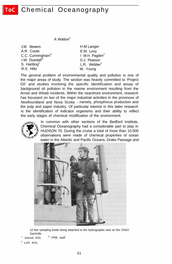
Chemical Oceanography
A Walton1
J.M. Bewers H.M LangerA.R. Coote E.M. LevyC.C. Cunningham6 I .M.H. Pagden2
I.W. DuedalI6 G.J. PearsonS. Hartling1 L.R. Webber1
R.S. Hiltz W. Young
The general problem of environmental quality and pollution is one ofthe major areas of study. The section was heavily committed to ‘ProjectOil’ and studies involving the specific identification and assay ofbackground oil pollution in the marine environment resulting from theArrow and Whale incidents. Within the nearshore environment, researchhas focussed on two of the major industrial activities in the provinces ofNewfoundland and Nova Scotia - namely, phosphorus production andthe pulp and paper industry. Of particular interest in this latter researchis the identification of indicator organisms and their ability to reflectthe early stages of chemical modification of the environment.
In common with other sections of the Bedford Institute,Chemical Oceanography had a considerable part to play inHUDSON 70. During the cruise a total of more than 10,000observations were made of chemical properties of oceanwater in the Atlantic and Pacific Oceans, Drake Passage and
12 litre sampling bottle being attached to the hydrographic wire on the CNAVSackville.
1 Joined AOL 6 FRB staff2 Left AOL
51

the Chilean fjords. A major practical success in this program was theperformance and reliability of the Technicon Auto-Analyzer.
With the demand increasing for the measurement of basic chemicaloceanographic parameters such as salinity, chloride, nitrate, nitrite,phosphate, silicate, sulphate and sulphide ions, dissolved oxygen, etc.,attention has been given to the automation of the analytical proceduresand development of in situ measurement devices. In addition to theauto-analyzer some experimental work has been performed on the useof selective ion electrodes and evaluation of the MINOS dissolvedoxygen monitor.
In spite of the trend toward automation the section has continued toprovide considerable laboratory services to other scientists in theInstitute.
A. Walton
Environmental Chemistry - Pollution Studies
The sinking of the Arrow in Chedabucto Bay andthe Whale in the Gulf of St. Lawrence, and theaccompanying loss of parts of their cargoes ofBunker C fuel OIL, presented several challenging
chemical problems. These included the estimation of the extent towhich the oil was dispersed throughout the water column andtransported to adjacent waters and the identification of the sources ofthe oil which drifted onto the beaches of Sable Island and the MagdalenIslands soon after the occurrence of these two incidents.
Before either of these problems could be approached, however,analytical procedures and techniques had to be devised, for bothshipboard and laboratory application. A successful shipboard techniquethat was developed consisted of extracting oil from a sample of seawater by filtration or by solvent extraction to provide an estimate ofthe ‘particulate’ or ‘total’ oil concentration. The oil was dissolved inn-hexane and its absorption of UV light at a wavelength of 256 nm wascompared with that of standard solutions of the oil. This was aconvenient procedure for the estimation of Bunker C, and was suitablefor concentrations of 10 ppb or greater. For smaller concentrations, theextracts were analyzed in the laboratory by fluorescence spectro-photometry whereby the sample was excited at 310 nm and theintensity of its fluorescence at 360 nm was compared with those ofstandard Bunker C solutions. This method was more selective andsensitive than the absorbance method and concentrations as low as 0.5ppb of residual oil in sea water were readily estimated.
52
In early May 1970, the concentration of particulate Bunker C oil inChedabucto Bay, near the wreck of the Arrow, was observed to be 16to 40 ppb. There was conclusive evidence, however, that theconcentration of oil not retained by filtration was much greater. At aseries of stations extending across the outer reaches of Chedabucto Bay,the concentrations observed ‘for the particulate and dissolved oil were 2to 16 and 0 to 90 ppb respectively at all depths.
An indication of the residual oil content of the open Atlantic wasprovided from the analyses of samples collected on the Halifax Section,a series of stations extending southeasterly from Halifax Harbour tobeyond the limit of the continental shelf. Concentrations during May1970 were 2 to 13 ppb; this is considered to be indicative of thebackground concentration of petroleum residues in these watersfollowing the Arrow incident.
A cruise to the Gulf of St. Lawrence during the summer of 1970, inwhich a series of stations from Cabot Strait to Montreal were sampled,indicated a background oil level of 1 to 6 ppb at all stations and at alldepths. Since the concentration of residual petroleum products did notincrease upriver, it is suggested that chemical, biological or geologicalprocesses must be removing these products from the area. Sampleswhich were collected from the Gulf of St. Lawrence after the sinking ofthe barge, Whale, indicated that this incident had very little impact onthe background level in that area, as a relatively small amount of oil waslost.
Shortly after this incident, oil appeared on the beaches of the MagdalenIslands and the question arose whether this oil originated from theWhale or from some other source. The absorption spectrum of BunkerC oil has a characteristic flat shoulder at approximately 256 nm and aprominent peak at about 228 nm. Although the general features of theabsorption spectra of different batches of Bunker C oil do not differsufficiently to provide a criterion for distinguishing between them, theratio of absorbance at 228 nm to that at 256 nm seems to provide aconvenient fingerprint of the oil in these restricted circumstances. Thevalues for this ratio for the oils found on Sable Island and on theMagdalen Islands were identical to those for samples taken from theArrow and the Whale respectively.
E.M. Levy
In pollution studies the diagnosis of man’s impact upon his environ-ment may benefit from the identification of indicator organisms. Theidentification of such organisms for one or several elements may aid inthe tracing of pollutants and facilitate both the monitoring and theestablishment of realistic background levels. Bearing this in mindstudies have been performed on organisms collected from an areasubjected to the input of treated Bleached Kraft Pulp Mill Effluent
53

(BKME). The results indicate that clams take up more than eightelements, particularly the rare earths which exist in the effluentparticulate material. The difficulty of obtaining sufficient quantities ofbiological species has hampered the satisfactory analyses of other biota,but clams do show significant uptake whereas calcareous forams do not.There is evidence from this work, however, that arenacious forams andostracods may be sensitive to mercury in treated BKME.
The behaviour of suspended particulate material within the lagoons of aBKME treatment system and also in the receiving saline coastal watershas also been studied. The treatment process was found to be 80%effective in removing coarse particulate matter but fine material wasunaffected. The overall efficiency of the procedure for suspended solidsremoval, therefore, is estimated to be less than 50%. Furthermore,flocculation of fine and colloidal particles occurs when the effluentbecomes mixed with sea water.
Since the optical transparency of the receiving waters is controlledlargely by the suspended material in those waters, the behaviour of theparticulate material is of considerable importance. As a result offlocculation the amount of suspended material admitted to the receivingwaters is effectively doubled at the expense of colloidal material.Furthermore, because flocculation causes the particulates to bepredominantly in the large particle size range most of this materialmight be expected to be precipitated into the littoral zone or drivenonto adjacent beaches. In laboratory experiments it was found thatconsiderable flocculation occurred within two weeks of the mixing ofeffluent with sea water to a final salinity of 12‰ . During this period theoptical transparency improved by a factor of 7.
An economic method of reducing the amount of discharged solids, andin consequence the effluent transparency, has been suggested, based onartificial flocculation within the treatment system.
J.M. Bewers, G.J. Pearson.
Early in 1969 large numbers of dead herring were observed in PlacentiaBay, Newfoundland. In the early stages of this program the sectioncarried out studies of phosphate and fluoride concentrations in theenvironment. Later, when the phosphorus plant at Long Harbour wassuspected as a source of toxic material preliminary tests of wetchemical methods for the analysis of elemental phosphorus in sediment,water and biological material were performed. The analyses consisted oftwo principal steps: extraction of the phosphorus from its matrixfollowed by its oxidation and final determination by calorimetry.
54
It became apparent that benzene extraction was superior to steamdistillation as the first step, but the routine wet chemical oxidationprocedure for phosphorous was found to be rather lengthy and wasreplaced by a gas chromatographic procedure for the direct determin-ation of elemental phosphorus in benzene. Wet oxidation was usedthereafter to provide an independent analysis of a number of samples toconfirm the accuracy of the gas chromatographic method.
A.R. Coote
Chemical services were provided to the Coastal Oceanography Sectionwhich has been conducting an oceanographic survey of the Strait ofCanso. The purpose of the survey is to establish baseline data on thequality of the water since it is anticipated that in the near future theregion will become heavily industrialized. Personnel and equipment forthe determinations of dissolved oxygen, alkalinity, and pH wereprovided. Nine stations were sampled at weekly intervals for a period ofseven weeks during the summer of 1969 and the program continued in1970.
I.W. Duedall
Trace Element and Nuclear Chemistry ResearchUntil recently the fluoride ion in sea water has been regarded as aconservative ion whose distribution is fairly uniform with location anddepth in the major oceans. However, in 1963 the authors (Greenhalghand Riley, Nature) of a new method for the determination of fluoridein sea water reported increases in fluoride concentration with depth inthe China Sea, the North and South Atlantic, and the MediterraneanSea. These anomalies were most severe west of the Mid-Atlantic Ridgeand since this area was one of intense interest to the AtlanticOceanographic Laboratory, it was felt that study of fluoride behaviourwas necessary.
Subsequently, high density fluoride/depth profiles were obtained forfive stations at 46°N in the Mid-Atlantic Ridge and two stations at33°N in the Cape Verde Basin south of the Azores. The results show nosignificant variation in fluoride concentration with position or depthdown to 3500 metres. The mean fluoride concentration obtained from153 determinations was 1.35 ± 0.03 mg/l. Recently, however, highdensity sampling has been carried out in an area previously reported asanomalous. Preliminary analysis of these samples, using a methodsimilar to that used by previous workers, show a very structuredfluoride concentration with depth. Layers of elevated fluorideconcentrations occur at 200, 400, 1300, 1600, 2400 and 2800 metresdepth, the increases being between 20% and 35%. In view of the
55

unusual nature of these results it appears necessary to substantiate themwith determinations by an independent method. Since the mechanismsresponsible for such a fluoride distribution could be geological andbiological as well as oceanographic it is important that further researchon this problem be performed if the preliminary results are confirmed.
J.M. Bewers
Chemical traces, such as mercury and chromium, appearing in aquaticsystems have recently received much attention due to their inherenttoxicity and subsequent effects on fisheries and recreation. Conversely,other trace constituents in water have been found to be essential to lifethrough their roles in metabolism and food chains. To study andmonitor these marine trace elements, neutron activation analysis hasbeen used to measure simultaneously the concentrations of severalspecies in the same sample. In this method samples are irradiated in ahigh neutron flux nuclear reactor which transmutes many of theisotopes present into radio-active forms. The resulting activities aremeasured and identified with the original elements to yield absolute orrelative elemental concentrations in the sample.
The acquired data must be related to actual situations by a method ofstandardization which can be either total analysis of known quantities ofelements, or a reference compilation of all parameters of radio-activespecies. The latter was chosen in order to hasten analyses and reduceoverall cost. Information on radio-active nuclides was compiled from anumber of reference sources up to December 1969, and reproduced onpunched computer cards. Parameters included for identification are Z,A, chemical symbol, nuclear isomeric state, decay half-life, neutroncapture cross-section, chemical abundance and Q-values. Also includedare the characteristic gamma-ray energies and intensities emitted byeach active species in the decay process. Magnetic tape and disc versionsof the catalogue were also compiled for use with a set of eightcomputer programs which analyze, semi-automatically, the dataobtained from each irradiated sample.
Some of the nuclear parameters and especially the capture cross-sections are not yet accurately known for many isotopes. Thisprecludes the possibility of absolute determination of some traceelements but, nevertheless, provides data on relative abundances andconcentration changes as a function of sample location or time. For thisreason neutron activation analysis is a useful technique for monitoringtrace element concentration changes in locations likely to be affectedby other than natural processes.
J.H. Bewers, I.M.H. Pagden, G.J. Pearson
5 6

Contamination is a serious hazard to accurate determinations of traceconstituents in samples. Neutron activation analysis requires the sampleto be placed in a sealed container for reactor irradiation. Encapsulationprocedure and contact between the sample and its container enhancethe probability of sample contamination while removal of the sampleafter irradiation can involve loss of material and thereby introducefurther inaccuracies. The merits of double-walled graphite capsulesversus conventional silica vials have been investigated. Eight graphitevials were irradiated in a high neutron flux at AECL, Chalk River andreturned to AOL for gamma-ray analysis by the above technique. Theresulting activity was predominantly 24-hour W187 at a mean concen-tration in each vial of 249 parts per billion. Mo99 was also present at amean concentration of 486 parts per billion but resulted in a loweractivity due to its lower neutron capture cross-section. Very minorcontributions resulted from the activities assigned to Co60, As76, Br82,Ru103, and Hf181.
The activities associated with these graphite capsules are sufficientlyuniform and minor to permit the direct analysis of the sample withoutremoval from the capsule. Thus, direct analysis is possible for themajority of biological, geological and standard materials whose activespecies are longer-lived than 12 hours. For analysis of shorter-livedisotopes, however, the W187 activity causes significant interference andsample transfer is necessary. The capsules are presently being usedroutinely for analysis of trace elements in marine organisms andsediments.
J.M. Bewers, G.J. Pearson
HUDSON 70 and Gulf of St. Lawrence ChemicalOceanographic Cruises
Three members of the Chemical Oceanography Sectionparticipated in the HUDSON 70 expedition during theAtlantic, Drake Passage, Chilean Fjord and Pacific phases.Measurements were made of the concentrations of severalbasic chemical parameters: oxygen, pH, alkalinity, silicate,
nitrate and phosphate, About 10,000 individual determinations weremade. Plots showing distributions of oxygen and the nutrients havebeen drawn using data gathered in the South Atlantic and furtheranalyses of the results are underway.
An interesting method for relating nutrient data to water masses is toexamine the relationship between phosphate and silicate concentrationsin each water sample. Figure A is taken from the work of Chow andMantylla (1965) using data from the Discovery II IGY cruises in theNorth Atlantic. By way of comparison figure B shows the same type ofplot using HUDSON 70 data for the South Atlantic. It is noticeable
57

Phosphate-silicate ratios.
that the silicate concentrations reach much higher levels in the SouthAtlantic and that the North Atlantic Deep water possesses a lowerphosphate content than water formed in the Southern Ocean.
A.R. Coote
Dissolved oxygen was routinely measured via the Carpentermodification to the Winkler technique during the HUDSON70 expedition. The oxygen section for the Atlantic phase ofthe expedition shows the main water masses of the SouthAtlantic Ocean (see figure). A strong oxygen minimum
situated between stations 2 and 4 and at a depth of about 350 metres isclearly seen in the section. It is likely that the low oxygen concen-
Oxygen section from the South Atlantic phase of HUDSON 70.
58

tration was acquired off the west coast of Africa where the oxidativeprocesses are apparently high. Sections showing oxygen saturation andapparent oxygen utilization are also being drawn.
Alkalinity was determined at 12 of the 25 Atlantic stations using theDryssen-Sillen-Gran technique.
I.W. Duedall
The chemical program carried out in the Chilean fjords, aspart of HUDSON 70, consisted of the determinations ofdissolved oxygen and the nutrients: nitrate, phosphate, andsilicate. About 50 nutrient stations were occupied. Thesewere the first chemical studies of the fjords, and the
program was carried out as a joint effort with the Chilean chemicaloceanographers. In general, nitrate and phosphate showed depletion inthe surface water and regeneration in the deep water. Slopes of plots ofnitrate versus phosphate are in the ratio of 16: 1 (by atoms) as predictedby Redfield’s consumption-production model. Silicate was correlatedwith nitrate and phosphate but at some stations surface silicates werevery high owing to the presence of glacial run-off.
I.W. Duedall
Physical Chemistry
In the research into partial molal volumes eight salts have been examined,viz. Na2CO3, K2CC3, Na2HPO4, K2HPO4, Na2B4O7, K2B4O7, H3BO3
and Na2SiO3. The dilatometric method was used and the measurementswere first made using sea water of 35‰ salinity. The measurements werethen repeated using 0.725 molal NaCl having the same ionic strength assea water. The purpose of making measurements in NaCl solutions wasto determine the effect of saline solutions of the same ionic strengthbut differing ionic composition on the partial molal volumes of thevarious salts. This type of information should improve our knowledgeof the relative roles played by electrostriction and ion-pairs in seawater. The first set of measurements was made at 20°C, repeatmeasurements are to be performed at lower temperatures.
Until recently the chemical oceanography of the Gulf of St. Lawrencehas been virtually ignored. In July 1970, phosphate, silicate, nitrate anddissolved oxygen concentrations were determined for a series ofstations extending from Cabot Strait to Montreal. Significantly, highernutrient and lower dissolved oxygen concentrations were observed inthe St. Lawrence River than in the estuary and gulf. An interestingfeature apparent in all four sections is the influence of water from thenorth shore entering the estuary.
E.M. Levy
59
Studies are also in progress to determine the effect of hydrostaticpressure on the compressibility of salts in sea water and to provide thefundamental data for investigations into the extent of the hydration ofions in sea water and the effect of pressure on the solubility of salts insea water. The technique used is to measure, using a back-to-backbellows apparatus, the difference in compressibility of two sea watersolutions whose compositions are identical except for the addition of asmall amount of a particular salt to one of the solutions. One side ofthe bellows apparatus is filled with the unaltered sea water while theother side is filled with the spiked sea water. The apparatus. is placedinside a pressure bomb, and, as pressure is applied, the differencebetween the linear displacements of the two bellows provides a measureof compressibility of the particular salt in the spiked sea water. Theassembly of the apparatus is now complete.
I.W. Duedall
A number of fundamental investigations into the factors which affectthe accuracy and precision of salinity data was performed during1969-1970. The entire procedure, including the collection of samples atsea, their storage and analysis, and the processing of results wasexamined. It is important that sampling equipment be maintained ingood working order and that particular care be devoted to theprocedures used if a representative sample is to be obtained. By carefulsampling techniques, it is possible to observe differences of ± 0.002‰ inthe salinities of closely spaced samples even in such homogeneouswaters as the deep Sargasso Sea. An evaluation of various sample bottlesand closures indicated that U.G.B. Type ESR-324 glass bottles andPoly-Seal caps were the most satisfactory of those tested. The salinityof samples of sea water stored in these containers has not changedduring almost two years.
A second phase of this work attempted to resolve a common argumentwhether salinity sample bottles should be aged by exposure to sea waterfor a period of time, or whether the bottles should be thoroughlycleaned before use. No significant difference in salinity could bedetected between groups of samples stored in aged and other samples ofthe same water stored in cleaned bottles,
An experiment was carried out to determine what effect, if any,freezing of the IAPSO Standard Sea Water might have on its electricalconductivity and therefore its reliability as a salinity standard. Samplesfrozen at -20°C for one month with one, two and four cycles offreezing and thawing showed no indication of a change in electricalconductivity as measured by an inductive salinometer provided that theice had melted completely and that the sample was thoroughly mixedbefore the measurements were made. The greatest danger in freezingthe standard sea water is that of cracking the glass vials.
60

As an independent check on the accuracy of inductive salinometers, ahigh precision chlorinity titration was developed. This consists ofreacting a weighed amount of sea water with a weighed, and justslightly less than equivalent, amount of accurately standardized silvernitrate solution. The excess chloride in the sample is then titratedpotentiometrically with a standardized dilute silver nitrate solution andthe exact equivalence point is determined by a differential technique.With a skilled analyst the precision and accuracy of the method is about±0.002‰ for chlorinities of 11 to 22 ‰ .
E.M. Levy
Instrument Development for the Measurement of ChemicalParameters
A Technicon Auto-Analyzer was used for seven months ofthe HUDSON 70 cruise to obtain simultaneous determin-ations of the major chemical nutrients (phosphate, nitrateand silicate) contained in various water masses of theAtlantic, Antarctic and Pacific Oceans. This instrument
automatically carries out the operations of sample aspiration, additionof reagents, mixing, colour development and the reading and recordingon a chart of an electrical signal which is proportional to theconcentration of the constituent being determined.
Except for a brief period when it was operated in a continuous mode inthe Atlantic, the instrument was operated sequentially on discretewater samples. During the oceanic portions of the cruise the analyzerwas in use about ten hours per day and in the Chilean fjords it wasrunning continuously. Some difficulties were experienced withmethods; also, growth of moulds produced short periods of interferencewith the nitrate and phosphate determinations. Electrical andmechanical breakdowns were rare; no more than a day’s down-time inall during the seven months. No silicate determinations were missed atany station. The analyzer has demonstrated its ability to work longhours in rough weather with probably better precision and accuracythan was formerly obtainable at sea using manual methods. However,the most important oceanographic use of this type of equipment mayderive from operating it in a continuous mode, to obtain continuousprofiles of smaller scale horizontal or vertical distributions of chemicalparameters.
A.R. Coote
61

A preliminary investigation of the potential applicability of ion-selective electrodes for the determination of chloride, nitrate, andsulfide in sea water has been performed. Both the liquid membrane andthe solid state types of chloride electrodes show considerable potentialas sensors for in situ instruments in environmental studies whererelatively large changes in chlorinity may be encountered.
Both the nitrate and the sulfide electrodes were subject to such largeinterferences from other ions present in the sea water that they were oflittle value for direct measurements on sea water.
In an evaluation of the Beckman ‘Minos’ dissolved oxygen monitor,continuous profiles were obtained for the stations on the HalifaxSection and for several stations in the Gulf of St. Lawrence and the St.Lawrence River. An intercomparison was made between the valuesobtained with this instrument and those for samples collected at variousdepths and analyzed by the Carpenter modification of the Winklermethod. The average difference between these values for the HalifaxSection was 0.05 ml/l and for the Gulf cruise 0.85 ml/l. The maximumdepth to which the sensor was tested was 798 metres.
E.M. Levy
Chemical ServicesDuring this period a salinity service laboratory was established.Chemical services have since been extended to include a limited numberof oxygen, silicate, phosphate, nitrate, pH, alkalinity and fluorideanalyses.
62

Coastal Oceanography
W.B. BaileyJ.F. BarteauxJ. ButtersJ.G. ClarkL. Clarke6
M.S. De la RondeD.D. DobsonF.D. EwingT.R. FooteW.D. ForresterE.M. Hassan6
F. JordanV.C. KerrF.K. KeyteD. Krauel6
D.J. LawrenceE.A. Lewis
R.W. Trites6
R.R. LivelyP.A. LomasR.H. LoucksE.F. MacDonaldW.J. MacNeilR.A. McElmonS.B. McHughenH.J.A. NeuC.A. PetersonJ.W. PritchardM.D. ScotneyG.H. SeibertS.H. Sharaf El Din4
A.E. Swyers6
G.B. Taylor6
E.A. VergeW.G. Warshick
The Coastal Oceanography Section is jointly supported and manned bythe Marine Sciences Branch, Department of Energy, Mines andResources, and the Fisheries Research Board of Canada.* It is engagedin studies to clarify and understand physical processes in the nearshoreregion. This is arbitrarily defined to extend from the coast to the edgeof the continental shelf and includes all inlets, estuaries and gulfs on theCanadian eastern seaboard. Because of limitations of manpower andfacilities only a limited number of problems in a limited number ofareas are actively investigated at any one time. These investigations are,most of the time, in response to a felt or anticipated need for greaterknowledge of an area to allow intelligent planning for utilization and con-servation or to remedy a deteriorating situation. As the nearshore regionis the first part of the ocean to feel the impact of the rapidly increasinghuman activity, need for such studies is increasing in order to serverequirements in fisheries, defense, coastal engineering and pollutionabatement. However, some of the studies are initiated to investigatepoints of basic fundamental importance in the nearshore processes.
The nature of the section’s responsibilities necessitates extensive fieldstudies. In turn, this requires having adequate facilities for specializedservicing and calibration as well as for data reduction and analysis. Forsome of these services, the section depends on facilities provided byother sections; for example, the Standards Laboratory of Metrology
4 Postdoctorate Fellow6 FRB staff* Part of the work of this section is covered in the Marine Ecology Laboratory(MEL) portion of this Biennial Review.
63

and the Computing Services group of Scientific Services and SpecialProjects.
The Gulf of St. LawrenceIn order to evaluate the effects of man-made fresh water regulations(e.g., hydro-power developments and water diversions) in the St.Lawrence estuary, an analysis was made of the 1963 salinity andtemperature distributions during a fresh water run-off of 11,000 m3/sin February and 17,000 m3/s in May.
The Gulf of St. Lawrence including areas surveyed in the central Gulf by years.
The mixing character in both instances varied from being well mixed atthe head of the estuary (Quebec City) to moderately mixed in thesection from below the head to Tadoussac. In the deep section belowthe mouth of the Saguenay River, stratified conditions prevailed. Theprimary motion in the system is a longitudinal two-layer circulation inwhich the surface layer deviates to the south shore and the deep layertoward the north shore. There is a net seaward flow of lower-salinitywater on the south side and a compensatory flow of higher-salinitywater on the north side and in the deeper layer. The Gaspé Current isthe high velocity region of the upper layer. Applying the geostrophicapproximation, it was estimated that the outward directed velocities inthe surface layer were, for a fresh water flow of 17,000 m3/s,approximately twice that for 11,000 m3/s.
64

From this it follows that modifications to the run-off alter the flowregime and with it the salinity and temperature structure of the system.The regulations applied to the St. Lawrence since the turn of thecentury quite probably have, during the summer, decreased thecirculation and increased the water temperature in the surface layer.This most certainly has had consequences likened to large-scale heatpollution, with the corresponding ecological implications.
H.J.A. Neu
In May of 1969 seven strings of current meters were moored for onemonth in the channel of the St. Lawrence Estuary between theSaguenay River and Matane to help describe internal tides suspected,from earlier work, to exist in the estuary. The measurements wererepeated again during the last half of September and the first half ofOctober to investigate the internal tides under different stratificationconditions. Tidal stream harmonic constants have been calculated forvarious cross-sections between Lake St. Peter and Pointe des Montsusing tide gauge records and the principle of continuity. Goodagreement was obtained with current meter results.
W.D. Forrester
Two winter cruises into the Gulf of St. Lawrence were undertaken tomonitor oceanographic conditions in the presence of ice cover. Icecover was, however, almost totally lacking in the Gulf in the winter of1968-69, so the cruises (in January and March 1969) served to providewinter temperature and salinity information for an extremely light iceyear. The Marine Sciences Centre of McGill University participated inthe January cruise in the Gulf of St. Lawrence, carrying out a planktonsampling program.
A McGill University manuscript report summarizing past work on thephysical oceanography of the Gulf of St. Lawrence has been prepared(El Sabh, Forrester, and Johannessen, 1969).
W.D. Forrester
In order to study the response to meteorological conditions, currentand temperature recorders were moored during the summer of 1967 ateight sites in the Gulf, from Cabot Strait to the St. Lawrence River atthe surface and at the subsurface levels. During June-July 1967, 151hydrographic stations were taken over the Magdalen Shallows. Usingthe Kieler Howaldtswerke bathysonde, eight lines were taken betweenthe Saguenay River and Gaspé Passage for a total of 260 stations. Eachline was occupied three times.
The analyses of these data give the daily variation during one month ofthe net water movement at the surface and subsurface levels and its
65

relation to the pressure system surrounding the Gulf. Also, thetemperature and salinity structure over the Magdalen Shallows and theoceanographic features of the Gaspé Current have been described indetail.
S.H. Sharaf El Din, R.W. Trites
In 1969 a survey was carried out in the central Gulf of St. Lawrence tomeasure nontidal currents, continuing the work done in 1964, 1965and 1968. In 1969 the field party aboard the CSS Dawson had the useof a computer-calculator by which geopotential anomalies werecontoured as the survey grid was being traversed. In this way thetrajectories of parachute-drogues could be compared immediately withthe geostrophic flow obtained from the contours. The drogues movedalmost exactly where predicted; one beaching up on the rocky shore ofAnticosti Island.
The results of the two surveys, 1968 and 1969, seem to indicate thatthe time-scale of the gyres is sufficiently long (2-3 days) to allow a gridtraverse of 1-2 days to be taken as a synoptic sampling of gyremovement.
R.W. Trites, F.K. Keyte
In 1964 a program was initiated to investigate the oceanographicvariability (mainly in salinity and temperature) on a network of closelyspaced stations in the southern Gulf. Sampling cruises were carried outduring the summers of 1964, 1965 and 1968 and during the late fall of1969 and 1970. Data from the 1965 and 1970 cruises (a total of over400 stations) will be utilized to study the spectrum of variability overdistances between 10 and 250 km and mixing processes over theMagdalen Shallows. Observations during the 1969 cruise show that theGaspé Current tends to be narrower than previously believed - being lessthan two miles wide off Fox River, with a counter current on the insideedge of the stream.
G.H. Seibert
Although tidal fluctuations at coastal stations surrounding the Gulf ofSt. Lawrence are well documented, information on tides and tidalcurrents in the interior of the Gulf are scarce. In order to remedy thisdefect and institute a proper sampling program, a numerical model hasbeen developed. The vertically integrated primitive equations are solvedover a staggered rectangular net (mesh width of 8.5 km) by timestepping using the explicit scheme developed by Hansen. Although themodel may be applied in studying free and forced modes of oscillationin the Gulf, attempts have been confined to the M2 tide.
G.H. Seibert
66

In order to understand the large-scale patterns of currents in the Gulf athree-dimensional, steady-state numerical model of the circulation hasbeen developed. The fundamental forcing function in this model is thesurface wind stress.
Monthly charts of sea surface atmospheric pressure for the years 1960to 1969 inclusive have been prepared. The derivation of surface windsfrom these pressure distributions (via the geostrophic assumption)presents a problem in terms of choosing the proper vector deviation ofthe surface wind from the geostrophic. We have chosen to calibrate ourpressure-derived winds against observed winds at Grindstone Island.
Meridional and zonal stress values are evaluated at ten-minute byten-minute grid points and then smoothed by a nine-point symmetricalfilter. Current meter data will be utilized in specifying proper boundaryconditions.
G.H. Seibert, E.M. Hassan
Any study of the large scale circulation pattern within the Gulf of St.Lawrence requires a knowledge of the flows through the variousentrances. In 1966, a two-ship survey was carried out in the majorentrance - Cabot Strait. The moored current meter data from thissurvey and from a smaller one in 1959 have been extensively analyzed.The nontidal portion seems to have different characteristics in theupper and lower layers.
In the main part of the channel and below about 75 metres, there is acounterclockwise gyre. Velocities can reach 20 cm/s near the upperboundary and towards the sides of the Strait. The position of the centreof this gyre is not much affected by the temporary disturbances due tothe passage of a depression across the Gulf of St. Lawrence. Rather, itseems to undergo only fairly long period changes of the order of weeks,possibly due to the passage of major storms at some considerabledistance away. Slight changes in the position of the centre of the gyrehave a strong effect on the direction of the current in the centre of theStrait.
In the near-surface depths of the main part of the Strait, and at alldepths in the channel between Cape North and St. Paul Island, thenontidal flows are greatly affected by depressions travelling across theGulf. In particular, a depression over the southwestern portion of theGulf can cause the normal outflow to be replaced by a strong inflowacross the entire Strait.
D.J. Lawrence
67

Scotian Shelf and Nova Scotian Inlets
The ‘Halifax Section’ across the Scotian Shelf consists of a number ofoceanographic stations on a line normal to the coast from the mouth ofHalifax inlet to beyond the edge of the Continental Shelf and has beenone of the most extensively surveyed areas of the Atlantic seaboard. Areview of the data in 1968 revealed that the slope of the mass-fieldvaries greatly with the season, being nearly horizontal in summer andhaving the largest inclination at the beginning of January. It oscillateseach year in exactly the same way, with little or no variation in themonthly mean. This infers a strong seasonal variation in the residualmotion of the coastal current which is unidirectional from northeast tosouthwest. Applying the geostrophic approximation, the strength of thecurrent in the upper layer is estimated to be 5 to 10 cm/s in thesummer, 10 to 25 cm/s in the spring and fall, and about 30 to 40 cm/sat its peak in the beginning of January.
To verify these preliminary results, the survey was continued on aquarterly basis, but in order to also obtain information on thecomponents of this current, the survey was extended to include twoextra lines (see figure).
Survey of the Scotian Shelf.
As was demonstrated by the Arrow disaster in February 1970, this typeof information is essential in forecasting oil movements. Mineral and oilexplorations over the Shelf and Grand Banks intensify its need.
H.J.A. Neu
6 8

During Operation Oil, early in 1970, a team wasformed to assist the Task Force in problems ofcoastal engineering and to review the hydrodynamicfactors which may have contributed to the
grounding and destruction of the tanker Arrow. Wind, wave, salinity,temperature and current data were obtained for Chedabucto Bay andrelated inlets and channels, in order to gain a more comprehensivepicture of the hydrodynamics of the system. Thus, it was possible tomake predictions as to the movement of oil in general and of oil spills inparticular; to give advice on the closing of the dam in Lennox Passageand on the installation of oil-retaining structures such as brush-booms;to provide wave data for the salvage operation; and etc.
By applying systematic interpretations based on observations andtheoretical principles, it was concluded that the factors contributing tothe grounding of the Arrow were a storm, which prevailed over theAtlantic seaboard on 4 February 1970, relatively large waves from thesoutheast (with heights in the open sea to 25 to 27 feet and at CerberusRock of 12 to 14 feet) and wind-driven surface currents toward thenorth. Excessively low Low-Waters during the days following thegrounding hastened the destruction of the ship. The oil which escapedduring grounding and break-up of the ship was largely contained inChedabucto Bay by the prevailing winds.
H.J.A. Neu
Wave refraction diagram, Chedabucto Bay, for a wave of 10-second period withwave front at 34° azimuth.
69

While taking oceanographic observations inChedabucto Bay following the February 4, 1970,wreck of the tanker Arrow, small oil particles werefound to be suspended in the water column to
depths as great as 80 metres. During February and March 1970 theseparticles were sampled with plankton nets and water bottles toinvestigate their origin, abundance, size range, vertical distribution, andtheir rate of spreading and drift. They were tracked out of ChedabuctoBay into the ocean and along the Nova Scotia coast to beyond Halifax,revealing a coastal flow of about 8 km per day.
W.D. Forrester
The construction of a causeway across the Strait of Canso in 1955 hasreduced the formerly hazardous currents in the Strait and has kept thewinter ice from the Gulf of St. Lawrence from reaching east of thecauseway, thus creating one of the finest and deepest year-roundharbours on the North American continent. Industrialization began in1962 and is continuing at an accelerating pace today. The investment inthe area will exceed $250 million by the end of 1971. Surveys havebeen carried out in the Strait in 1968, 1969 and 1970 with the twofoldaim of measuring water quality and determining the patterns of watermovement.
The water does not move with uniform velocity through any given crosssection of the Strait. Instead, measurements from an anchored vesselhave shown that one can have simultaneously an outflow in the upperand lower layers and an inflow in the middle layer, with the flowpattern persisting over an entire tidal cycle. What is, then, the drivingforce for this motion? There is virtually no fresh water entering theStrait, and wind-driven circulation does not seem to fit the measure-ments too well. Examination of one of the records from a currentmeter moored at 13 metres depth at the entrance to the Strait duringJuly 1969 showed that there was an oscillation with a period of aboutfour days and an amplitudetwice that of the tidal motion (10 cm/s versus5 cm/s). It appears too regular to have been caused by meteorologicalconditions over the Continental Shelf although this possibility remains tobe investigated. This phenomenon may have been an internal seiche.Using the measured density gradient, 0.001 g cm-3/14m, and thedimensions of the Strait, the theory predicts that an internal wave wouldhave a period of several days. It is hoped that data from the moreextensive array of moored current meters of the 1970 survey will revealmore clearly the nature of the oscillation. Dye diffusion experiments haveshown that the upper layer is influenced by the local wind, whileparachute drogues released in the middle layer during various stages of thetide have suggested that there is a counterclockwise residual motion.
D.J. Lawrence
70

Halifax Inlet, which consists of the ocean approaches, the harbour andBedford Basin, has in the past been only sporadically surveyed and thenprimarily for the purpose of relating the temperature of its water to theseasonal changes of the Shelf. The industrial growth of the city ofHalifax and its neighbouring communities, their need for better harbourfacilities, particularly with respect to containerization, and theincreasing danger of pollution necessitate a comprehensive study of thehydrodynamics of the system. For this purpose, two types ofinvestigations were implemented, a wave study and a circulation study.
The objective of the wave study is to determine the ocean wave energywhich enters the harbour. To achieve this a wave survey system wasinstalled in the summer of 1969, consisting of three wave measuringstations - dual gauges comprised of a wave staff and pressure sensor.The first station was located on the Stable Platform of the Air-SeaInteraction group, ten miles off the coast, the second near Maugher’sBeach at the entrance to the harbour and the third in the centre of theharbour (see figure). The data were transmitted by radio or underwater
Wave survey system and oceanographic stations of Halifax Inlet.
cable and then by telephone line to the Bedford Institute, where theywere recorded on strip charts and magnetic tape. The recorded datawere analyzed both manually and by computer. In the computerapplication, the data were subjected to power and cross-spectrumanalysis and to wave height versus wave period analysis. The resultsindicate that the energy transfer from the sea into the harbour isinfluenced largely by the direction of the local wind. With significantwinds from the north, the wave heights arriving in the harbour are 5 to10% of those measured outside. This information is necessary inassessing the harbour for the loading of containers.
The purpose of the circulation study is to evaluate the seasonalexchange of water. Salinity and temperature measurements are made

monthly on stations from the open ocean into Bedford Basin. Fromthis data, supplemented by current meter observations, it should bepossible to estimate the seasonal water and heat transport.
From the results, ways must be sought to increase flushing and thusdecrease pollution. This might be achieved by encouraging an increasedinterchange with unpolluted seawater. Modifying Eastern Passage couldbe a step in this direction.
Careful consideration must also be given to any proposal which mightfurther reduce the circulation and flushing; for example, breakwaters,wharf extensions, etc. Their effect must be studied in advance in orderto avoid further adverse effects on the existing (still far fromsatisfactory) heat and pollution balance.
H.J.A. Neu
As part of the study of water quality fluxes in inlets, field work hasbeen undertaken in Halifax and Petpeswick Inlets. Both of these inletshave basins; that is, a deep portion separated from the open ocean by ashallower sill. Therefore, the objective becomes twofold: to understandthe fluxes in the upper layer of the inlet which is usually continuouslyexchanging with the ocean, and in the lower layer (in the basin) whichis exchanging with the ocean only intermittently. The two inlets havebeen classified and fluxes of fresh water have been measured bothdirectly and indirectly. In Petpeswick Inlet, the flushing of dye hasbeen measured; in Halifax Inlet, fluxes of phytoplankton biomass, heatand biomass have been measured directly at the Narrows. Also, currentmeasurements using six moored instruments have been maintained inthe Narrows for six months - with recording scheduled for six moremonths. These current and flux measurements provide calibration forthe budget equation models which are being developed. In addition,individual values for dilution factors and residence times have beencalculated. Statistical analysis giving probabilities for extreme values orzero values of fluxes, envisaged for application in the upper layermodels, is being applied first to give probabilities for exchange of theisolated deep water in the basins.
R.H. Loucks
Numerical Analysis and Data ProcessingThe Data Analysis group continued the reading and processing ofBraincon and Hydrowerkstatten current meter films; digital magnetictapes from Plessey and Geodyne meters are also analyzed. Films fromthe Hydrowerkstatten and Braincon meters are usually developed atAOL and the data on each frame read out by hand. Punch cards arethen prepared for computer analysis. Films from the Geodyne metersand magnetic tape spools from the Plessey meters are processed by
72

outside contract and the group receives standard computer magnetictape and paper tape as data records from these meters. Each film ortape represents the immersion of one current meter for a period ofbetween 30 and 60 days.
While individual stages of the data analysis may take a number of daysor weeks, the total elapsed time between recovery of the meter to finalcomputer output of analyzed data may take many months. Theprocessing time for poor data varies widely. Routine checking,time-interpolations (where internal clock time does not agree withactual elapsed immersion time) and diagnosis of meter faults are oftentime-consuming.
Depending upon the length of a current meter record, a 15 or 29-dayharmonic analysis is carried out routinely, to provide the phase andstrength of the harmonic constituents of the tidal streams, the residualcurrent, and the daily means of resolved components. In addition, anumber of other plots such as frequency distribution of speed anddirection are provided.
Data from the salinity/temperature/depth (STD) probes are currentlystored on magnetic tape. We will shortly be able to send this data to theCanadian Oceanographic Data Centre, Ottawa, in a format that isacceptable to them on standard magnetic tape reels. A computerprogram has been written to effect this transmission of STD datagathered by Institute cruises.
F.K. Keyte
Short StudiesA brief physical oceanographic survey was carried out in November1969 in the Conception Bay-Holyrood area, Newfoundland. Themeasurements of currents, temperature and salinity were used in aninternal report on the probable dispersion of heated cooling water fromthe Holyrood Thermal Generating Station.
Limited oceanographic studies were initiated in the St. George’sBay-Stephenville, Newfoundland, area in November 1970. The programconsisted of temperature, salinity and oxygen measurements, therelease and tracking of dye spots and parachute drogues and measure-ment of currents with self-recording moored and portable currentmeters. In addition, a tide gauge and automatic weather station wereoperated during the survey. The data are presently being analyzed.
Current meter and tide gauge records for Petit Passage were analyzed tostudy the dynamics of the flow. Currents in the Passage are caused bydifferences in tidal amplitude and phase at either end of the channel. Aone-dimensional mathematical model was developed and was able topredict currents in agreement with those observed.
G.H. Seibert
73

Support ActivitiesTechnical field capability from the section supported the field activityfor the section and assisted in field activities of other sections anduniversities. During this period more than 600 current meter and 250temperature recorders were moored and recovered with a loss rate ofless than 5%. The moorings ranged in geographical position from theGulf of St. Lawrence to Drake Passage and the water depth at themooring site ranged from a few meters to 3500 metres.
D.D. Dobson, T.R. Foote
Oceanographic Services for DefenceEstablished in 1960, Oceanographic Services for Defence has the role ofdeveloping techniques to provide a forecasting service in militaryoceanography and tactical indices for Canadian Maritime DefenceForces. It has been necessary to ensure that receipts of synoptic dataare maintained, that specialized research projects are undertaken toprovide further understanding of the oceanic environment, that atraining program is maintained for the personnel who are primary usersof the products, and that new methods of data acquisition areinvestigated and adopted when suitable. In the provision of a service itis equally important to monitor the applicability of the products as it isto develop techniques to produce them.
Cooperation in military oceanography has been a noteworthy develop-ment within NATO over the past several years. This cooperation hastaken the form of increased data and information exchanges,standardization of techniques, and comprehensive oceanographicresearch programs. A seminar on training practices and content washeld in Halifax in 1969. Under the auspices of the NATO group onMilitary Oceanography a code for the handling of biological observa-tions from ships and aircraft has been developed by OceanographicServices for Defence. This code has been received enthusiastically and isexpected to make valuable contributions to studies of the distributionsand movements of marine biological organisms.
In the production of oceanographic charts based on data collectedsynoptically, note has been taken of the appearance of anomalousfeatures in the physical oceanographic structure of the waters betweenNova Scotia and Bermuda. An investigation of these features to gain anunderstanding of changes taking place was undertaken by a series offour seasonal cruises with a network of closely spaced observations. Thefinal cruise in the series was completed in 1969. The waters areextremely complex and the so-called anomalous features are in partsmall eddies that constitute the Gulf Stream system and in partobservational errors. Small features are not capable of being depicted
74

on charts in current use because of the scale size of the charts and thepaucity of data. Investigation has been undertaken in the use ofinfrared satellite photographs received by automatic photo trans-mission. Results to date show that this method has great potential foruse in the production of charts of synoptic oceanographic conditions.Unfortunately, at present both the scale and the geographical locationtechniques are inferior to the methods of describing the oceanicfeatures currently in use. Work is continuing in this promising field.
Since 1962 a daily series of oceanographic chart broadcasts via radiofacsimile for the northwestern Atlantic Ocean has been available.Although the broadcast content is designed to meet the needs ofCanadian Defence Forces this particular series of charts has been of useto meteorological offices ashore and afloat, to transatlantic shippingand to marine interest engaged in fishing and whaling. Files of thesecharts have also proven a boon to fisheries researchers as anenvironmental data source.
As a back-up to the radio facsimile broadcasts, copies are distributedweekly by mail to interested organizations who do not have the radioreceiving equipment. A brief check of the mailing list shows a wideningsphere of interest; the number of recipients has doubled since 1967.
The realization of the importance of oceanographic conditions inhuman activities by marine interests has been reflected in the numberand diversity of ‘in depth’ studies of the ocean environment that havebeen requested. The range of requests embodies conditions for theselection of military exercise areas as well as the conditions inprescribed areas, geophysical prospecting, commercial plantconstruction, marine vehicle procurement, and equipment testing.
W.B. Bailey
75

(This page Blank in the original)
76
Marine Geology
B.R. Pelletier
V. Asthana4
R. Banerji4
G.A. Bartlett2
L.C. BrownD.E. BuckleyD.F. ClarkD.A. ClattenburgV.F. CoadyR.E. Cranston1
G. DrapeauG.B. Fader1
R.A. Fitzgerald1
F.E. Frape1
C.A. Godden
M.E. GorveattA.C. GrantI. McK. Harris1
W.H. JosenhansL.H. KingK.M. KranckB. MacLeanJ.I. Marlowe2
M.A. RashidK.R. RobertsonC.T. SchaferG. VilksF.J.E. WagnerD.A. Walker
With the completion of the HUDSON 70 cruise anothermajor portion of Canada’s 3.6 million square km ofcontinental shelf had been surveyed. Marine geologistscharged with the exploration and inventorying of this vastarea have carried out reconnaissance studies off the British
Columbia coast, the northwest Pacific and Arctic Oceans adjacent toAlaska, the Beaufort Sea, much of the Arctic Archipelago and BaffinBay, Hudson Bay and approaches, the Labrador Sea, the westernAtlantic Ocean over the Grand Banks of Newfoundland and ScotianShelf, the Gulf of St. Lawrence and the Bay of Fundy and itsembranchments.
Marine Geology carries out its assignments under a traditional fourfolddivision of effort involving physical geology (sedimentology, physio-graphy, and bedrock studies), regional geology (a special geologicalproject over the entire Scotian Shelf), geochemistry and micro-paleontology. These disciplines are not always included on each cruisedue to the nature of the project or the size and scope of the operationat sea. However, two major multi-disciplinary cruises, each of ten weeksduration, took place involving physical oceanography, biology, micro-paleontology, sedimentology and seismology, magnetometry, andgravimetry. One cruise was the trans-Atlantic voyage in 1969 to Lisbonwhich was highlighted by the following: a transect of the various watermasses between the Grand Banks, Sargasso Sea, northwest Africa,southwestern Europe, and the eastern Canadian seaboard; planktonstudies in these waters; obtaining sediment cores from the major oceanbasins in the North Atlantic; obtaining numerous rock cores of coralline
1 Joined AOL2 Left AOL4 Postdoctoral Fellow
77

limestone and basalt from the Mid-Atlantic Ridge by means of thehydrostatic drill; carrying out a seismic survey of the Flemish Cap 500km east of St. John’s, Newfoundland, at the edge of the continent; andobtaining a rock core of granite from the Flemish Cap therebyestablishing unequivocally the continental nature of the crust in thatarea. Our other major multi-disciplinary cruise was aboard the CSSHudson on her voyage from Victoria, B.C., to Halifax, N.S., via theNorthwest Passage through the Arctic Islands as part of HUDSON 70(see “Earth Sciences Studies in Arctic Marine Waters, 1970”).
Our diving and submersible programs have continued and with the useof lock-out diving from the submersibles, many of these underwateractivities have been combined into a single program. The unhappyaccident of the Arrow disaster in Chedabucto Bay has given rise to arenewed effort in coastal geodynamics involving ocean dynamics as wellas coastal processes of erosion, sedimentary transport, and deposition.
Great strides have been made in our regional geology program with themapping of the Scotian Shelf in which geophysical as well as geologicalinformation has been fairly well utilized. On the Labrador Shelf and onthe shelf adjacent to northeastern Newfoundland, another geologicalmapping project is nearing completion. Northumberland Strait andparts of the Gulf of St. Lawrence are finished and now the program ismoving to include Bay of Fundy, the Grand Banks, and the Laurentiantrough area.
Regional problems on sedimentation involving the relationship betweentextural distributions and hydrodynamic environments are beingundertaken for Hudson Bay, Beaufort Sea, Baffin Bay and Bay ofFundy. Also carried out at sea is the on-going regional study offoraminiferal ecology based on seasonal variations at given latitudes.
Closer to home, ecological studies are being made in the inshore areasof the Atlantic provinces with a definite emphasis on aspects related tomonitoring pollution. All information is extrapolated to the ancientsediments in an attempt to reconstruct the environment of deposition,interpret the ancient geography and climatology, and attempt to gainclues to the complex of problems involving ecology, evolution,speciation, zonation, and taxonomy. In the laboratory these studies arecomplemented by experiments in aquaria where living foraminifera arebeing cultured.
The geochemistry program is now operating under two main sub-divisions of organicand inorganic geochemistry. Again some emphasis isplaced on the environment with respect to pollution, but generally theproblems involved the precipitation of metallics in organo-claycomplexes, the exchange of ionic material between sea water andparticulates in suspension, the tracing of elemental transport, the
78

relationship of organic acids and marine sediments with a view torelating chemical structural changes to changing geological conditionsover long periods of time, and the laboratory investigation into thestructure of layered silicates as well as organo-metallic complexes.
Underwater television camera being lowered from the CSS Hudson, Beaufort Sea.
In our shops, the underwater rock-coring drills have been improved sothat both a short- and long-masted version are available. Because thesedrills are operated by means of the ship’s electrical power, it is possibleto install various monitoring devices such as underwater television,acoustic links, and indicators of rotary speed and rate of penetration.Special plankton sampling gear is being renovated in hopes of obtaininga successful multiple-type tow, as well as a remotely controlleddeep-water sediment trap.
One of our busiest installations is the Jeolco scanning electronmicroscope which has been made available to a great many outsidelaboratories and individuals. At present, peripheral equipment is beingselected such as a non-dispersive, non-destructive x-ray attachment thatwill be used to obtain additional information of the spectral varietyfrom the secondary random x-rays generated by the primary electron
79

beam on the sample. Several reports have been enhanced by theexceptional quality of the SEM micrographs, and many of theseillustrations are being used for display purposes and filming. But thereal highlight of the instrument is the valuable insight it has provided tomineral identification and studies on foraminiferal infrastructures.
B.R. Pelletier
Physical GeologyThis group is heterogeneous in composition, consisting of workers insub-bottom stratigraphy and structure, marine and coastal sedimentol-ogy, and submarine physiography. Conventional seismic reflection andbathymetric profiling are the chief indirect methods employed at AOLfor the study of the sea floor and its subjacent features. However, thedredge, bottom grab, sediment corer and the rock-coring drill are theprincipal means for obtaining geological material and provide theconcrete evidence needed for extrapolating known information to theindirect evidence of the graphical records. Side-scan acousticalsurveying together with both bottom photography and underwatertelevision are providing additional information. All our surveys andresearch projects from the Scotian Shelf to the Gulf of St. Lawrenceand northward across the Labrador Shelf and the Arctic are reapingbenefits from this combined methodology.
Several projects are devoted to an understanding of hydrodynamicconditions and their effect on sedimentational patterns. Data fromocean dynamics is constantly being utilized so that the framework ofmarine sedimentation can be examined critically and be applied toancient regimes of sedimentation. In this manner ancient oceanicconditions can be interpreted in part.
B.R. Pelletier
A seismic profiler survey was carried out in the region of Flemish Cap.Total coverage amounted to approximately 100 km of profiling overFlemish Cap and the eastern Grand Banks. The seismic equipmentemployed for this survey comprised a single channel recording systemwith a 10 cubic inch air-gun energy source. Flemish Cap is a continentalstructure, physiographically isolated from the Grand Banks by FlemishPass. The relatively smooth, erosional surface of Flemish Cap is cut on acentral zone of seismically ‘hard’ basement, which is encircled byoutward-dipping layered rocks. These layered rocks are also truncatedat the flanks of Flemish Cap. Flemish Pass is underlain by a thickaccumulation of sediments, which is at least in part a continuation ofprograding beds underlying the slope off the eastern Grand Banks.
A.C. Grant
80

A reconnaissance seismic profiler study of the Canadian continentalmargin east of Newfoundland, from Hudson Strait south to the GrandBanks, has been in progress since 1965. The seventh cruise in thisprogram yielded approximately 6150 km of concurrent reflectionseismic and magnetic coverage in the region from southern LabradorShelf to southern Grand Banks. The survey track passed over thelocations of seven test holes drilled on the Grand Banks in 1965 byAmoco (formerly Pan American) and Imperial Oil, as well as the sites ofthe ‘Tors Cove’ and ‘Grand Falls’ wells. A number of zones ofexceptional gravity and magnetic anomaly in the Grand Banks regionwere also investigated, and several presumed diaperic structures weretraversed. A 900-km survey loop was run eastward off the continentalshelf to obtain coverage over Orphan Knoll, which forms a prominentrise at the foot of the continental slope about 350 km north of FlemishCap. Seismic reflection records show a strong acoustic basement atshallow depth beneath the surface of this feature, and the absence ofmagnetic relief suggests that this acoustic basement is probablycomposed of continental material. This feature was later selected as aJOIDES drilling site, and cores recovered there by the GlomarChallenger in June 1970 confirmed its continental origin.
A.C. Grant
The role of tidal currents in the residual transport of sediments inNorthumberland Strait was examined and used to explain features inthe sediment distribution in Northumberland Strait. Suspended sedi-ment sampling, light extinction measurements and current measure-ments are being carried out in the Strait. Work has progressed on astudy of the sediment distribution and Pleistocene history, includingthe formation of a preglacial drainage system, glaciation, postglacialtransgression of the sea and the assumption of present day conditions.
K.M. Kranck
The surficial sediments covering the sea floor form the lower boundaryof the ocean. The mechanisms of sedimentation are then directly relatedto the hydrodynamics of the ocean. However, because of Pleistoceneglaciation, it is in many instances difficult to determine whether thedistribution of bottom sediments, as found today, resulted from thecombined action of waves and currents or not. Hence a study is beingmade of the geodynamics of surficial sediments in the littoral andsublittoral environment.
Grab sampling, interpretation of echograms, underwater photography,underwater television, and visual observations from submersibles permitanalysis of the nature of bottom sediments (texture, slope, settlingvelocity) as well as of the dynamic sedimentary structures (ripples, sandwaves, channelling, etc.).
81

Since hydrodynamic data are difficult to obtain, observationsconcerning bottom sediments are concentrated in areas, such as theStrait of Belle Isle and the Scotian Shelf, where data on bottomcurrents are available. Wave statistics are also used to estimate theamount of wave energy transferred to the unconsolidated sediments.The results obtained so far indicate that the hydrodynamic energy atthe ocean sea floor interface is often underestimated. At the upper edgeof the continental slope, for instance, upslope current ripples clearlyindicate that the bottom currents in that area are much stronger thanwhat is anticipated from the present knowledge of ocean circulation.
G. Drapeau
The wreckage of the tanker Arrow in Chedabucto Bay has resulted inheavy contamination of the seashore. Within the framework of
“Operation Oil”, polluted seashores were surveyedin order to estimate the damage done and partic-ularly to find out what the principal geodynamicmechanisms are that enhanced the natural cleaning
of seashores.
Time lapse photographic studies of an oil-contaminated beach being conducted onCrichton Island, Chedabucto Bay.
Crichton Island was designated as a protected area in which long termscientific projects could be carried out. The geodynamics of a heavilypolluted beach is being monitored in order to determine how oil willeventually disappear and what processes are responsible for the eventualdisappearance of oil from the seashore. Among the most interestingdata to correlate with the sedimentological surveys are the wave
82

refraction patterns, the geostrophic winds computed for the area, theenergy spectra of the waves generated inside and outside ChedabuctoBay, and the nearshore current measurements. The results obtained sofar indicate that long period waves generated outside the Bay areresponsible for the major changes observed on the seashore.
G. Drapeau
Russian, American and Canadian biologists are engaged in a cooperativeprogram to study herring spawning in the western Atlantic. The typesof sediments and the geodynamic conditions that prevail on spawninggrounds are being analyzed to help biologists gain a better under-standing of this phenomenon. Herring are known to congregate inspecific locations to spawn, although the factors that control herringspawning are not clearly understood. A survey on Georges Bankindicated, for instance, that in that area herring spawned exclusively onfine gravel swept by strong currents. Repeated surveys in the same areaas well as comparative surveys on other spawning grounds will providethe data necessary to confirm the present hypotheses.
G. Drapeau
Mathematical models such as trend surface analysis and factor analysis(correlation studies) are used to analyze sedimentological problems; theformer to differentiate dominant trends from local variations. It isparticularly useful in sedimentology to recognize sedimentary trendsthat are partly obliterated. Investigations carried out so far have servedto compare factor analyses of the distribution of surficial sediments onthe Scotian Shelf with detailed geological surveys of the area.
Wave refraction diagrams are used to estimate the amount of energyand the angle of approach of waves of different wave lengthapproaching monitored seashores. Although wave refraction diagramsare based on relatively simple wave models, they were used with muchsuccess, particularly in Chedabucto Bay where regions of efficientnatural cleaning of the shore could be associated with wave action.
G. Drapeau
The distribution of marine sediments may be partly explained by meansof various models of sediment transport (from their source on land totheir ultimate repository in the sea). Because the study deals withelastic or granular sediments, the models can be constructed on thedata derived from a mechanical analysis of the sedimentary particles.Such properties as size, roundness, shape, and the gross aspects ofoverall texture which involve lithologic ratios, population studies andthe attendant statistical analyses are considered in the synthesis of themodel. These models utilize various aspects of topography such asposition of the sediment in the depositional site with respect to slope
83

and depth. Finally the models are interpreted on the basis ofhydrodynamic vigour.
Several studies are presently underway. In Hudson Bay the modelsdemonstrated the threefold influence of ice-rafting, marine currents anddeposition from suspension. In the Minas Basin, the models showedthat the sediments are in equilibrium with the minimal energyconditions present and that sedimentation is taking place in anenvironment of excessive hydrodynamic vigour. In the adjacent Bay ofFundy, sedimentation based on the models of sedimentary transportappears to be occurring in a very high energy regime, although in manyareas the model demonstrated normal sedimentation for an open-ocean environment such as that over the nearby continental shelf.
This study will eventually include the development of these models forthe Beaufort Sea, Arctic Archipelago and Baffin Bay and will entail aliterature review on work previously carried by other workers in marineareas not investigated personally. From these studies certain unifyingprinciples of sedimentation will be sought.
(See B.I. Contribution No. 77, 117, 121)
B.R. Pelletier
Regional GeologyThe Regional Geology group is presently undertaking the study of thegeology on and beneath the seafloor across the Scotian Shelf andadjacent areas, and plans to extend its area of responsibility to theGrand Banks. The work is of practical value to fishermen, oilcompanies, various engineering construction groups, mining engineers,cable companies, environmental scientists, and other scientificdisciplines involved in the area of study.
In 1970 the group released its first surficial geology map of the ScotianShelf, overprinted in colour on Fisheries Chart 4040 at a scale of1:300,000 (B.I. Contribution No. 153). The chart covers the area fromHalifax to Sable Island and was accompanied by a paper describing thestratigraphic sequences and geological history of the Quaternarymap-units. Field and laboratory studies have been completed for twofurther charts (40396 and 4041G) and these will provide completecoverage of the Scotian Shelf.
Further study has been devoted to the Scotian Shelf end-morainecomplex (see B.I. Contribution No. 112) and it is now known to extendfrom the Laurentian Channel to the central part of the Gulf of Maine.It probably correlates with the New England system and is of value ininterpreting the regional, glacial history of the region.
84

Pockmarks or cone-shaped depressions have been noted to occur inprofusion across some mud bottoms on the Scotian Shelf. They werepossibly formed by ascending gas or subsurface water leakage fromunderlying coastal plain sediments. Their distribution might be useful asa prospecting tool.
Bedrock studies are contributing to an entirely new chapter in thegeologic history of the Atlantic provinces dealing with mid-lateMesozoic and Cenozoic marine rocks which do not occur on land. Thegeology is interpreted on the basis of structural and stratigraphicrelationships and acoustical reflectivity as revealed by a study ofcontinuous seismic-reflection profiles, geomorphic aspects, bedrockcontrol from adjacent shore geology, a few dredged samples andoffshore well data, and gravity, magnetic, and seismic refraction data.(See B.I. Contribution No. 60, 80, 170,204.)
The geology of the offshore falls into four major divisions: a TriassicBasin which occurs in the Bay of Fundy and northern Gulf of Maine; anarea of acoustical basement and sedimentary outliers which underlie theeastern and central part of the Gulf of Maine; a Coastal Plain Provinceof Tertiary and Cretaceous strata which underlies Georges Bank, theScotian Shelf, and the outer part of the Laurentian Channel; and anarea of pre-Pennsylvanian acoustical basement and Pennsylvania stratawhich extends south and east of Cape Breton Island beneath theLaurentian Channel. A geological map of the Scotian Shelf and adjacentareas on a 1: 1,000,000 scale is in preparation and will be the subject ofa departmental publication. (See B.I. Contribution No. 206.)
Geological sampling was carried out from the CSS Kapuskasing on theScotian Shelf and adjacent areas. Approximately 300 bottom samples,5000 km of echogram profi les, and 2160 km of continuousseismic-reflection profiles were obtained. Underwater photography wassuccessfully carried out at 23 stations.
In 1969 the group used the submersible, Shelf Diver, to complete four
Shelf Diver, diver lock-out submarine in Bay of Fundy.
85

successful dives on the Scotian Shelf. The main objectives of the diveswere to check areas that were thought to be well known through theuse of remote sensing techniques. The dives confirmed previous indirectobservations and permitted the investigators to take many selectedphotographs, procure bedrock samples, and visit several pockmarks.
L.H. King, B. MacLean, G. Fader
Geochemistry GroupThe organic geochemistry subgroup attempts to characterize thechemical nature of organic matter associated with marine sediments andto correlate the structural changes that occur in these compounds asthey are subjected to diagenetic and metamorphic changes leading to theformation of oil shales, crude oils and other petroleum-like compounds;to ascertain the geochemical role that such compounds play in the zoneof sedimentation especially in the phenomenon of solubilization,transportation, precipitation and accumulation of various metals; todetermine the nature of organo-clay complexes and the catalytic effectof clay minerals in conversion of organic molecules to hydrocarbons;and to determine the significance of dissolved organic matter as anecological factor governing the primary productivity of coastal waters.
The phenomenon of migration and accumulation of metals in allnatural environments is largely associated with humic compounds. Ourstudies indicated that each gram of humic acid is capable of complexing20-65 and 95-205 mg of tri- and di-valent metals respectively. The lowmolecular weight fractions (<700) complex 2-6 times more metal thanany high (>700) molecular weight fraction. The infrared spectroscopicstudies suggest that the carboxyl groups of humic acid participate in ametal chelation phenomenon. The complexed metals could not beextracted with 1.0 N ammonium acetate solution.
In order to understand the catalytic effect of clay minerals in theconversion of organic molecules, studies were initiated to determine thenature of the association of organic matter with various clays. Theinfrared analysis, differential thermal analysis, and thermogravimetricanalysis of the organo-clay complexes indicated that the reaction occursthrough the carboxyl group of organic matter. In addition to chemicalreaction. physical adsorption is also important. The physical adsorptionis facilitated by the presence of electrolytes and low pH conditionswhich probably change the electro-kinetic properties of reactingcolloids.
86

The ratio of aromatic to aliphatic components of humic acid de-termines its solubility, resistance to degradation, coagulation byelectrolytes and many other properties. A study of several humic acidsof marine origin suggests that these compounds are predominantlyaliphatic (and are thus less soluble, have a higher resistance todegradation and are very susceptible to coagulation). Only about30-35% of the total carbon was found in aromatic form, the rest beingaliphatic. The aromatic components may play an important role inpost-depositional changes of organic matter.
In determining the chemical nature and characteristics of humiccompounds it is essential to investigate the nature of functional groupssuch as quinones, present on organic molecules. The biological activityof humic acids is associated with their quinone structures because theyserve as catalysts in oxidation reduction reactions which pass throughthe stage of free radical formation. These groups are also responsible forcondensation reactions and for the formation of complexes with thetransfer of charge. The chemical and infrared spectroscopic studiesindicate the presence of quinone groups in concentrations ranging from1.8 to 2.8 meq/g of organic matter.
Various amino acids are believed to be an integral part of humic acid. Aquantitative and qualitative estimate of amino acids elucidates not onlythe structural details of humic compounds but will also be helpful indetermining the age of sediments and rate of sedimentation. Our studiessuggest the presence of 16 different acidic, neutral and basic aminoacids in varying quantities; the predominant amino acids are asparticacid, glutamic acid, arginine, glycine, leucine and phenylalanine.
The coastal waters are rich in dissolved organic matter which eventuallygets incorporated into the bottom sediments. It is also an importantecological factor enhancing the fertility of coastal waters. The chemicaland spectroscopic characteristics of humic compounds isolated fromseaweed exudate, their decomposed thalli, and the dissolved organicmatter in river water show that in spite of several differences the grossstructural features of these compounds are similar to those of humicacids isolated from sediments.
In addition to the projects listed above, more research is underway onorgano-metal and organo-clay complexes.
M.A. Rashid
In inorganic geochemistry the overall objectives are to determine thechemical activity of dissolved elements in sea water which includes thedistribution and transportation of major elements such as Na, Ca, Mg,Li, Sr, and K and trace elements like Mn, Fe, Co, Ni, Cu and Zn; todetermine the chemical interaction of sea water with solids including
87

the various clay minerals; and to ascertain the geochemical history ofsea water and marine sediments. These studies are carried out with aview to constructing a scientific model which may be useful inpredicting the cycle or eventual site of deposition of chemical species inthe marine environment. The information gathered under variousresearch projects of organic and inorganic geochemistry will also behelpful in tackling problems in pollution of the environment.
Preliminary analyses of metals were conducted on several samplescollected from Boat Harbour, N.S., Restigouche River, N.B., Annapolisand Cornwallis Rivers, N.S., and Bedford Basin in association withpollution studies.
Geochemical techniques are now available for elemental analysis offresh water, salt water and layered silicates. In addition to suitablemodifications introduced into several existing techniques, new techni-ques for the determination of 16 major and trace elements in fresh andsalt waters by atomic absorption spectroscopy and a method for asingle digestion of silicates for the analysis of 19 different elementshave been developed. A new technique for the analysis of mercury insediments and waters employs flameless atomic absorption spectro-scopy. This method allows determination of Hg to 0.03 ppb in seawater and 0.05 ppm in sediments. Our laboratory was also involved inthe analysis of 11 trace metals in sea water for the purpose of aninter-laboratory calibration study in collaboration with the Woods HoleOceanographic Institution.
D.E. Buckley, R.E. Cranston
Micropaleontology GroupThe Micropaleontology group is presently investigating the distributionand ecology of northern and temperate species of planktonic andbenthonic foraminifera, molluscs and coccolithophores that live intoday’s oceanic and coastal marine environments and their associatedfossil remains which are preserved in bottom sediments. The study ofliving species provides the required baseline information for highresolution paleoclimatic and paleo-oceanographic studies of theQuaternary history of North American coastal waters and the NorthAtlantic and Arctic oceans. The field and laboratory investigations ofliving benthonic foraminifera in locally polluted nearshore environ-ments is receiving special attention in order to relate the distribution ofthese protozoans to other invertebrate zonations that have developed inresponse to the discharge of industrial effluents and sewage into themarine environment. The monitoring of recovery rates for the coastalzone is an especially important benefit of these investigations. Attemptsare also being made to describe quantitatively the complicated seasonaland spatial distribution of planktonic and benthonic foraminifera by
8 8

means of specialized sampling methods and statistical treatment ofdata. These quantitative investigations are being integrated withdescriptive studies of minute variations in test morphology with the useof the scanning electron microscope.
The present condition of the Restigouche estuary offers a uniqueopportunity to investigate the distribution of benthonic foraminiferaliving in locally altered environments. Most of the pollutants enteringthis estuary are discharged primarily along the New Brunswick shorewhile relatively unpolluted areas are available for comparative study onthe Quebec side. Analysis of the local distribution of foraminiferaindicate that Elphidium incertum/clavatum and E. orbiculare are themost pollution tolerant forms and that they occupy the perimeter ofthe ‘azoic’ zone which develops near most effluent sources.C.T. Schafer
During the summer of 1969 the submersible Shelf Diver and a team ofCanadian Navy divers were employed to sample quantitatively thebenthonic foraminifera population in the Gulf of St. Lawrence.Sampling techniques were designed specifically so that divers, who were‘locked-out’ of the submarine at water depths ranging from 16.5 to 53metres, could collect undisturbed, replicate short cores of bottomsediment. The analysis of these samples showed that, in the Gulf of St.Lawrence, the living foraminifera population have a pronounced patchygeographic distribution in waters less than 20 metres deep. Speciesproportions in replicate samples were most variable in waters less than20 metres deep and live specimens were commonly encountered to adepth of 9 cm in the bottom sediments.
C.T. Schafer
Monthly foraminiferal sampling procedures were carried out fromNovember 1969 to December 1970 in Clam Bay, Nova Scotia. Theconstruction of a large fish farm in 1969 afforded the opportunity tomonitor variation in the distribution of foraminiferal species caused bythe introduction of warm, low saline, nutrient-enriched waterdischarged from a newly installed outfall. Sampling was performed bySCUBA divers who collected the top 5 cm of sediment at each stationboth before and after the discharges from the outfall were initiated.Preliminary results suggest that the warm, low saline water introducedinto the study area was not detectable at the control stations. However,nutrient-enriched water, introduced into the Bay on a six-hour periodicbasis, appears to be related to a reduction in species and ForaminiferalNumber.
D.F. Clark
89

During the HUDSON 70 expedition benthonic foraminiferaand Mollusca from the bottom sediments in the BeaufortSea of the southern Arctic Ocean (between approximately69°10’ and 71°35’ north latitude and 128°20’ and140°40’ west longitude) were sampled.
Dredge haul coming aboard the CSSHudson, Beaufort Sea.
Ninety-eight grab samples and 12 dredge hauls were taken in waterdepths that ranged between 15 and 1426 metres. Preliminary investi-gation has shown a paucity of molluscs throughout most of this area.They were present in greatest numbers and variety in the shallow waterseast of the Mackenzie Delta. The distribution is apparently related tothe texture of the bottom sediments. Arenaceous foraminifers are thedominant forms in the deeper waters (generally deeper than 500 or 600metres), with calcareous species dominant in the shallow waters.
Biological tow coming aboard the CSSHudson, Beaufort Sea.
F.J.E. Wagner
In July 1970 nanoplankton studies, with emphasis on geologicalapplications, were initiated in the Beaufort Sea. Efforts are beingfocused on the calcite-secreting Coccolithophoridae, which serve asexcellent chronostratigraphic indicators in sediments of Jurassic toRecent age. Little is known about the paleo-environments of nanofossil
90

species, but with new emphasis on the study of this particularphytoplankton group this gap in our knowledge should continue to fill.
A nanoplankton survey was conducted in a part of the Arctic Oceanwhere previous reports had suggested that the genus Discoasteromonas,an ‘extinct’ Tertiary nanoplankton, was living under frozen seaconditions. To date, collected samples do not substantiate this claim;however, small numbers of other coccolithophores have been observed.This find demonstrates that coccoliths can be used to investigatepaleo-environmental changes ranging from arctic to tropical conditions.
D.F. Clark
In conjunction with other station work of HUDSON 70, planktonicforaminifera were collected from surface waters in the Arctic.
Globigerina pachyderma was found in abundance at all offshorestations including those in the Beaufort Sea and most of the NorthwestPassage. This species was absent in the inshore waters of Beaufort Seaand in the central part of the Parry Channel system. The relativeabundances of the species living in the surface waters will be used todetermine the present oceanic influence in the Mackenzie River deltaarea and in the Parry Channel system. The occurrence of G.pachyderma in subsurface layers of sediment cores collected in the areawill be used as a criterion to determine any changes in the marineenvironment in the western Canadian Archipelago during Holocenetime.
Two field parties based at Tuktoyaktuk, N.W.T., continued theinvestigation of inshore marine environments in the Canadian ArcticArchipelago. Samples of bottom sediment were collected in the areawhich encompasses the westernmost extension of the region investig-ated since 1960 and represents a transitional zone from the interislandareas to the east and the epicontinental environment with its associativeextensive runoff to the west. In a preliminary study of the bottomsediment samples, benthonic foraminifera such as Ammotium cassis andElphidiella groenlandica were observed in the western, epicontinentalenvironment but not in the sediments of the Arctic Archipelago to theeast.
G. Vilks
During 1969 and 1970 planktonic foraminifera were collected in thesurface waters at numerous localities in the Atlantic. In most localitiesthe tows were taken in conjunction with salinity and temperaturemeasurements. The project is designed to accumulate information onthe seasonal and spatial changes in distribution of planktonicforaminifera and to associate foraminiferal faunas with water-massesrecognized by physical methods. These data will be used to support a
91

general study in paleo-oceanography and paleoclimates in the NorthAtlantic.
G. Vilks
A series of rock cores was drilled on the crest of the Mid-Atlantic Ridgenear 45°N using a hydrostatic drill developed at AOL. Samples werecollected from various peaks, in water depths ranging from 715 to 1682metres. A detailed description of the area and the cores was reported inthe March 1970 issue of Geotimes and in volume 5 of MaritimeSediments. The crest of the Ridge between 40° and 55°N seems to beideally suited to study variations in the rate of Quaternary carbonatedeposition. This situation is enhanced by certain planktonic organismsliving in the overlying waters because these calcite-secreting plants andanimals have adjusted their northern limit of distribution overapproximately the same latitudes depending on climatic conditions.The Quaternary paleoclimatic history of this part of the North Atlanticis recorded therefore in unconsolidated sediments by the presence andabsence as well as changes in the relative abundances of microfossilspecies. In the limestones that have formed on the Ridge crest, long termvariations in climate appear to be reflected by precipitation ofcarbonate (during warm periods) and solution and unconformities(during cold periods). The area appears, consequently, to becharacterized by sediments having an inter-tonguing stratigraphic frame-work which, when finally mapped in detail, should delimit both thenumber and intensity of the aforementioned climatic variations.Radiocarbon dates of coralline limestone cores determined thus far arein good agreement with this hypothesis.
C.T. Schafer
During HUDSON 70 (May and June), 29 plankton towswere taken in the Pacific along longitude 150°W betweenTahiti and latitude 55°N. The stations were located atintervals of approximately five to seven degrees of latitude;three oblique tows were made at each station using a
specially modified Benthos telemetering plankton net system. Thesampler was set to open and close its three nets at depths of about 150,450 and 900 metres, thus providing subsamples from three distinctlayers. Efforts will be made to correlate the distributional pattern ofthe observed species with chemical and hydrological parametersmeasured simultaneously and to determine various ecological factorsresponsible for the distribution and morpho-structural changes in theseorganisms.
In all, more than 30 species have been identified of which 20 arereceiving detailed study. For certain species the smaller forms appear in
92

Benthos Multiple Plankton Sampler and associated acoustic telemetry equipmentused during Tahiti-Vancouver leg of HUDSON 70 cruise.
great numbers in cold water at higher latitude but are considerablyreduced in frequency in equatorial waters. The determination of coilingindices of several species indicates that Globigerina pachyderma changesfrom dextral to sinistral coiling at about 42°N latitude. In surfacewaters the change to sinistral types is apparent at lower latitudes.Development of kummerforms was observed in several species includingGlobigerina pachyderma and Globoquadrina dutertrei and to a lesserextent in Globigerinoides sacculifera, G. conglobata, and Globorotaliatumida. It was noted particularly in species living in deeper waters andat higher latitudes. At times, the penultimate chamber is considerablysmaller than normal revealing that development may be retarded at anearlier stage and later restored upon the return of favourableconditions.
R. Bannerji, C.T. Schafer
Special Instrumentation and ExperimentationIn the spring of 1969, trials were carried out on a newly constructedall-electric rock coring drill developed at AOL. The drill, which stands18 feet in height and has legs spaced eight feet apart in a triangularconfiguration, is designed to operate from ship’s power at a depth of1400 feet. It is actuated remotely on the sea floor by means of acontrol panel onboard, and has both forward and reverse, horizontaland vertical drives. Working on a chain drive and rotary principle, andusing standard drill cores and diamond bits, the drill is capable of
93

Underwater electric drill (long-masted version) being recovered over Flemish Cap.
penetrating 14 feet of overburden and obtaining a ten-foot core ofbedrock.
The first few tests were carried out in Halifax Harbour where severalcores of hard quartzite up to 26 inches in length and 1 1/8 inches indiameter were recovered in water depths ranging from 25 to 80 feet.Next, a full scale sea trial was undertaken in the Atlantic Ocean in thearea of the Flemish Cap, situated at the edge of the continental shelf,about 300 miles east of St. John’s, Newfoundland. There in waterdepths of 470 feet a six-inch core of granite was retrieved. This rockwas later dated by radio-genie methods and was found to be
94

approximately 600 million years in age. Such a discovery establishednot only the antiquity of the continental shelf in this area, but theexistency of true continental material. From these results furtherdevelopment work on such drills was recommended, and they will beused in conjunction with shallow, near-surface seismic reflectionprofiling. Presently a short-masted version (8 feet) is being developed towork in areas characterized by a thin cover of unconsolidated sedimentslying over the bedrock.
C.A. Godden, B.R. Pelletier
The modified Benthos multiple plankton sampler (see figure) wasoperational during the Tahiti-Vancouver leg of HUDSON 70. Theacoustic telemetry system continuously transmitted informationconcerning net opening and closing functions, rate of water flowthrough the net, water temperature at net depth and depth of the netbelow the surface. Calibrated aluminum shear pins activated pressure-dependent triggers well within the required limits of accuracy. It is alsohoped that a high frequency acoustic transducer or some kind oflight-sensitive device can be developed and linked to the telemetrysystem in order to enable operators to sample plankton populations thatare anomalously dense compared to those inhabiting nearby watermasses.
A prototype multiparameter recording instrument was employed forseveral eight-hour periods to measure relative changes in pH, tempera-ture and dissolved oxygen concentration adjacent to sewer outfalls inthe Bedford Basin, Nova Scotia. Work on this instrument is continuingin order to improve sensors that may be reliably submerged to thedesired water depth for long periods.
A deep sea sediment trap was anchored in 4500 feet of water at latitude32°10’N, longitude 64°30’W during July 1969. An attempt was madeto recover the system in December 1969 but the acoustic release failedto operate. An A.M.F. release system and a sacrificial anchor arepresently being designed into the system in order to increase thechances for a successful recovery.
C.T. Schafer
The television system proved invaluable in observing the underwateroperations. Permanent records of the electric rock coring drill in actionwere made on 16 mm film obtained from the monitor during some ofthe tests. The television camera was also fitted to a submersible andsuccessfully used by the marine geologists. Further studies wereconducted by scientists involved in the studies of marine environmentalpollution using this equipment. An Ampex video-tape recorder wasadded to the system by means of which permanent records wereobtained for future studies. The addition of a self-powered monitor
95
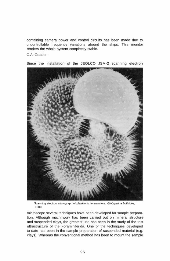
containing camera power and control circuits has been made due touncontrollable frequency variations aboard the ships. This monitorrenders the whole system completely stable.
C.A. Godden
Since the installation of the JEOLCO JSM-2 scanning electron
Scanning electron micrograph of planktonic foraminifera, Globigerina bulloides,X300.
microscope several techniques have been developed for sample prepara-tion. Although much work has been carried out on mineral structureand suspended clays, the greatest use has been in the study of the testultrastructure of the Foraminiferida. One of the techniques developedto date has been in the sample preparation of suspended material (e.g.clays). Whereas the conventional method has been to mount the sample
96

directly onto the copper specimen block, a new technique has beendeveloped whereby the sample is first mounted onto a plastic or glassdisc, which in turn is cemented to the copper block. In addition toeliminating specimen contamination from the copper, the use of plasticor glass as the supporting medium yields an electrically neutralbackground, resulting in a condition which allows higher image contrastand higher attainable magnification, with a corresponding increase inresolution. For example, the highest magnification (therefore highestresolution) attainable using the conventional preparation technique forstudying clays had been about x15,000; we can now go as high asx50,000-60,000 with a resolution higher than was previously possible atx15,000.
D.A. Walker
In the late summer of 1968 the submersible Pisces I, built byInternational Hydrodynamics of Vancouver, British Columbia, wasengaged by the Atlantic Oceanographic Laboratory to carry out ageological feasibility study in the Canadian Arctic. This program wascarried out on a cost-sharing basis with the Defence ResearchEstablishment Pacific, Esquimalt, B.C.; the Pacific OceanographicGroup, Fisheries Research Board of Canada, Nanaimo, B.C.; and theJohns Hopkins University, Baltimore, Maryland. Underwater mapping,photography and bottom sampling were undertaken to depths of 1520feet and under ice cover with such good results that furtherinvestigation of the ocean bottom by means of research submersibleswas warranted.
The submersible program in 1969 was carried out in nearby watersusing the Shelf Diver of Perry Oceanographics, Miami, Florida. Thisvessel was equipped with a diver lock-out facility which provided directaccess to the sea floor at depths to 150 feet, and photographic, visual,and television observations to 800 feet. C.T. Schafer commenced theAOL program with bottom sampling in the Gulf of St. Lawrence inwhich he utilized the diver lock-out facility to sample in situpopulations of benthonic foraminifera in conjunction with his ecol-ogical studies of foraminifera in the Atlantic provinces. L.H. King andB. MacLean continued the submersible program when they dived overthe Scotian Shelf and photographed and sampled bedrock ofCretaceous age from submarine cliffs in the vicinity of Sable Island,using the external accoutrements of Shelf Diver. G. Drapeau studied themovement of sand on the southwestern portion of the Scotian Shelf,and described the configuration and origin of giant sand waves in thatarea with the aid of underwater photography, television and video-tapereplay. The final project of the geological program was carried out byB.R. Pelletier who directed an exercise on sediment sampling andbottom photography in the Bay of Fundy. This work was accomplished
97

with the aid of SCUBA divers of the Royal Canadian Navy, who carriedout the lock-out sampling of the seabed, and by the photographic unitof AOL which undertook the task of fitting cameras and associatedequipment to the submarine.
The success of this program with the Shelf Diver focussed attention onthe need for a general on-going program with submersibles. In early1970 the Department of National Defence funded the purchase of astrongly recommended diver lock-out submersible that was built byInternational Hydrodynamics and was delivered in late 1970 toCanadian Forces Base in Halifax, Nova Scotia. This vessel called CSL-1will be available for the undertaking of scientific research projects onthe sea floor after a trial period of several months.
During the summer of 1970 while the new CSL was being built, thebiological station at St. Andrews, N.B., and the marine geology sectionof AOL entered into a cost-sharing arrangement for the charter ofPisces 1. One of our geologists, G. Drapeau, examined bottomconditions over Georges Bank in an attempt to relate his observationswith those of the biologists on matters relating to the herring spawn inthat area. This was an international program involving Canada, theUnited States, and the Soviet Union, and proved to be a successfulventure.
B.R. Pelletier.
Pisces I.
98
In the living foraminifera laboratory observations and experimentationhave been carried out on several benthonic species from local nearshorewaters, and pelagic species from the Sargasso Sea. Microscopicobservations have been conducted regarding reproduction, movement,feeding, cellular morphology, and regeneration of Rosalina globularis,R. Floridana, Bolivina inflata, Quinque-loculina seminulum, Saccamminaatlantica, and Discorbis columbiensis (see B.I. Contribution No. 147).Experimentation has been carried out regarding changes in physio-logical activity, and hence changes in growth rate, in response tovarying temperature, salinity and pH. Several long-term cultures havebeen established using low-temperature incubators and water-bathsystems (the latter was developed in this laboratory), successful cultureshaving been maintained continuously for over two years. Specificexperiments have been carried out on the effect of ingestion of R.Floridana and Q. seminulum by the common periwinkle Littorina.Scanning electron microscopy investigations have shown a definiteetching of the surface layers in Q. seminulum, and pitting in the surfaceof R. floridana. This phenomenon has resulted from the acidic natureof the digestive juices in Littorina, and has been shown to be significantfrom a micropaleontological standpoint in that such occurrences inrecent and fossil populations can now be explained by the normalfeeding habits of benthonic invertebrates. Test ultrastructure of severalspecies has been studied by scanning electron microscopy. These studiesare being carried out to determine possible functions of certainarchitectural features as well as general descriptive analyses.
D.A. Walker
A new flexible epoxy system for the banding of waterproof splices andconnectors to submersible electrical cables was evolved. This materialmatches the flexibility of the cables and was developed to assist thecable in passing over sheaves etc. without damage.
A constant-reading remote-indicating ‘inclinometer’ was designed andconstructed for initial use in conjunction with the electric rock coredrills. This instrument, which is ambient-pressure compensated,subsequently proved to be of use to other sections within the Institute.
C.A. Godden
99

(This page Blank in the original)
100
Marine Geophysics
D.L. BarrettT.J. Corbett1
R.F. CourtneyD.A. Dalby2
F.E. Danis3
D.R. Druhan1,2
G.N. Ewing3
R .T. HaworthM.D. HughesJ.D. Hutchinson1
B.L. JohnstonG.J. Jollymore1
C.E. Keen1
R.B. Knapton1,2
D.R. LockeB.D. Loncarevic3
D.I. Ross
J.B. Maclntyre1
R.F. Macnab1
K.S. ManchesterJ.A. Nielsen1
D.M. Porteous3
D.D. Prentiss2
G. Ranalli2
A. Ruffman1
K.G. Shih1
P.A. Solowan1
R. SparkesS.P. SrivastavaG.F. Stewart3
R.E. Walker1,3
A.B. Watts4
J.M. Woodside
The Marine Geophysics Section is primarily concerned with theinvestigation of the properties of the earth beneath the sea in order tounderstand the processes which have formed the continental marginsand the ocean basins. The studies can be subdivided into surveys ofcontinental shelf areas, such as the Grand Banks and the Gulf of St.Lawrence, to provide information about potential resources; research inregions where active formation of ocean bottom may presently beoccurring or have occurred in the past, such as the Mid-Atlantic Ridgeor the eastern Arctic; and the design, assembly, and evaluation of newmethods to be used in gathering, processing, and interpreting data.
Techniques presently used in such studies include continuous measure-ment of the variation of the gravity and magnetic fields, andbathymetry whenever the ship is underway; seismic reflection andrefraction measurements in selected areas; geological sampling withcorers, dredges or the deep sea drill developed by MetrologySection; photography of the ocean bottom and electromagnetic andheat flow measurements on specific projects.
The marine environment imposes serious limitations on methods ofdirect sampling so that the studies have necessitated considerabledevelopment and adaptation of the conventional geophysicaltechniques employed on land. It has also emphasized other problemseasily overcome on land, such as navigation and stabilization of themeasuring platform. The high cost of ship time has required consider-able research into efficient data acquisition and processing techniques.1 Joined AOL.2 Left AOL.3 Transferred within AOL.4 Postdoctorate Fellow.
101

As usual, the Section has participated in a wide range of cruises duringthe two-year period of this report. In 1969 although only one cruise wasorganized by personnel within the Section - a cruise to extendmagneto-telluric measurements on the Nova Scotian shelf to deeperparts of the ocean and evaluate an underwater three-componentmagnetometer designed and built at Imperial College, London - theSection actively participated on four other cruises involving some eightmonths of sea time. Most important of these were continuedparticipation on the hydrographic/geophysical survey of the Gulf of St.Lawrence and involvement in the planning and operation of a cruise toevaluate the U.S. Navy Navigation Satellite System in an area of theshelf where precise navigation control could be provided by DeccaHi-Fix.
In 1970 the major field effort was on two fronts: thehydrographic/geophysical survey in the Beaufort Sea andparticipation on the HUDSON 70 ‘Circumnavigation of theAmericas’ cruise. On the latter, geophysical data werecollected on all but three of the nine phases of the cruise.
Data were obtained on phase I between Halifax and Rio de Janiero andfrom phase V to the end, i.e., Valparaiso to Halifax. Specificgeophysical projects conducted on the cruise are discussed later in thisreport. In addition to these two major cruises, personnel participatedon the annual hydrographic training cruise to the Caribbean and on leg12 of the JOIDES Deep Sea Drilling Project aboard USDV GlomarChallenger.
Collaboration with university groups has been very active during theperiod of this report. During 1970 this was particularly important inprojects associated with HUDSON 70 and involved personnel fromWoods Hole Oceanographic Institution, University of Washington,University of British Columbia, and Dalhousie University.
Probably the most significant advances in measuring techniques madeover the last two years have been in the field of seismic refraction andreflection measurements. Considerable effort has been put intodeveloping techniques to complement those of the explorationindustry. Thus the main emphasis in reflection measurements has beento obtain significant penetration in deep sea areas and to develop therather different techniques for signal processing of data in deep seaareas. Refraction studies have been carried out using conventionaltechniques but new methods involving measurements with sonobuoysand measurements of the anisotropy of mantle P-waves have beenemphasized.
During the fall of 1969, prior to the departure of the CSS Hudson onthe HUDSON 70 cruise, the geophysics console area of the ship wascompletely refurbished by the Engineering Services Section. This
102

included completely air-conditioning the space on a separate systemand replacing the old console electronic mounting racks with newenclosed racks in a U-shaped installation. The new console provides forpermanent installation of the BIODAL data logging system, theBarringer proton precession magnetometer and recorders, the Alpine-Gifft bathymetry recording system, the Sperry EM log display, the ITTsatellite receiver system and its computer, the sea gravimeter recordingsystem with its associated cross-coupling computer and the generalpurpose PDP-8 computer. In addition, ample rack space is available foradditional equipment such as the AMBAC vibrating string gravimeterrecording system from Woods Hole Oceanographic Institution carriedon HUDSON 70.
In April of 1970 the geophysical console area of the CSS Baffin wasrelocated and redesigned by the Hydrographic and Geophysics Sectionswith the assistance of the Engineering Services Section. The previousgeophysics console in the starboard drawing office was relocated in thehydrographer’s plotting room above the ship’s bridge. The PDP-8computer was left in the original console area and this area is now usedfor computing and geophysical data reduction purposes only. The newinstallation enables all underway geophysical recording and monitoringequipment to be housed in the hydrographic operations room togetherwith the Lambda (Low Ambiguity Decca) Decometer and othernavigation aids thus streamlining the watchkeeping functions while onsurvey and removing many of the inconveniences that occurred whenthe two operation areas were separated. The arrangement proved verysatisfactory during the 1970 field season in the Arctic.
The incorporation of cross-coupling analog computers to theinstallations on Hudson and Baffin has improved the validity of dataobtained with the Graf-Askania sea gravimeter. As part of the 1969Satellite Navigation cruise, a test was designed to investigate cross-coupling errors more closely but calm weather prevented success.However, during cruises such as HUDSON 70 errors of up to 20mgal were recorded by the computers and applied as corrections to theraw data.
D. I. Ross
SeismologyOver the past two years, Marine Geophysics has acquired the facilitiesfor carrying out seismic refraction and reflection measurements at seaon a routine basis. Particular effort has been directed towards thedevelopment of a seismic reflection system which has now been usedextensively during several geophysical surveys. The reflection systemwas first tested at sea on the CSS Dawson and not only functioned
103

successfully but also allowed us to obtain useful data over thecontinental margin near Sable Island and over the Sohm Abyssal plain.The main components of the system are a Bolt model 1500 air gun witha pulse shaper and a 400-foot eel comprising four 100-foot sectionseach containing 20 HP-2 hydrophones. A slacking winch is used toreduce noise caused by towing the eel. This allows the eel to remainalmost stationary while information is being received. A time-varyingbandpass filter and a mixer are used to obtain the final shipboardrecords. The raw data are also recorded on magnetic tape. The systemhas proved very successful in deep water and we have been able todefine deep sedimentary basins, the top of the oceanic basalts and inone case, the top of layer 3 may have been observed. However, someproblems remain in defining structures on the continental shelf wherewater multiples obscure the deep reflectors.
In order to evaluate the results of seismic reflection profiling performedby an exploration company, a contract was given to CatalinaExploration and Development Co. Ltd. to obtain a profile over thecontinental margin. The results have been published in the AOL DataSeries (1970-6-D).
The ability to perform seismic reflection and refraction experiments hasmade an important contribution to studies of some of the geophysicalproblems currently being examined. The reflection profile andrefraction experiments in Baffin Bay and in the Pacific, off the coast ofBritish Columbia, are necessary to the interpretation of the tectonics ofthese areas and supplement the gravity and magnetic data which werealso collected.
A new technique for defining the direction of sea floor spreading. bymeasuring the anisotropy of the P-wave velocity in the upper mantleusing refraction methods is being evaluated. This may provide invalu-able information and, in some cases, may be an acceptable alternativeto time-consuming, expensive, geophysical surveys.
A study of the velocity distributions with depth within the CanadianShield has been undertaken. Group velocity curves have been obtainedfor surface waves recorded at relatively short ranges from theearthquake epicentre and models of the corresponding velocity distrib-utions are presently being constructed. If this study is successful, animportant application could be to define the velocity-depth distributionin the upper mantle beneath mid-oceanic ridges.
(See B.I. Contribution No. 45, 197.)
C.E. Keen, D.L. Barrett
104

Mid-Atlantic Ridge SurveyThe Hudson geotraverse survey is a continuing cooperative projectorganized by the Marine Geophysics Section to study a 1° wide strip ofthe Atlantic Ocean between the latitudes of 45°N and 46°N andlongitudes 25°W and 60°W. Prior to 1969 the project had involvedthree major surveys on the Grand Banks of Newfoundland and three
Areas now surveyed on the geotraverse of the Mid-Atlantic Ridge.
surveys over the crest of the Mid-Atlantic Ridge between 26°W and60°W. The surveys over the crest of the ridge have been unique in thatthey have provided for the first time detailed geophysical data of anarea of the deep sea outside the range of normal electronic positioningaids. Included with the detailed geophysical work carried out on thesecruises has been an extensive geological sampling program for studiesundertaken by personnel in the Geological Survey of Canada, EarthPhysics Branch, and seismic reflection and refraction work incooperation with Dalhousie University and Cambridge University,England.
During 1969-70 one additional cruise has worked in the area of theMid-Atlantic Ridge. This was a multidiscipline trans-Atlantic cruiseinvolving studies in Marine Geology, Ocean Circulation and MarineGeophysics. The geophysics part of the program was confined to thereturn track from Lisbon to Halifax and included bathymetry andmagnetic measurements on the track across the Atlantic providingfurther data along the geotraverse strip. In addition, reconnaissancetype surveys on two areas of the flanks of the ridge were completed.These areas are some 500 km to either side of the ridge crest. The figureshows the areas surveyed together with the prior coverage obtained onthe geotraverse project. Navigation on this cruise was provided solely bysatellite navigation. Magnetic data obtained suggested that the patternof Iineations was much more regular on the flanks of the ridge than hadbeen observed over the crestal regions.
105

During this cruise the crest of the ridge was successfully drilled fromCSS Hudson using a hydrostatic rock core drill developed by theMetrology Section. A total of 12 cores, amounting in total toapproximately 120 inches, was collected from nine different peaks inthe area. The cores consisted of coralline limestone, basalt andconsolidated foraminiferal sediment. They have been studied by expertsfrom a number of Canadian laboratories for age determinations,physical, chemical and other geological properties.
Considerable effort has been put into the analysis of data from thesurveys over the crest of the Mid-Atlantic Ridge during the past twoyears. B.D. Loncarevic has been carrying out a statistical analysis of themagnetic data in terms of the conventional ocean floor spreading model.His work has shown a strong correlation exists between the presentlyaccepted ocean floor spreading model and an average profile along thedirection 75°W of north assuming a spreading rate of 1.28 cm per year.There is an indication that the spreading rate to the east of the crestmay be somewhat lower.
P.J. Bhattacharayya has been working on the spectral analysis of thedata for a Ph.D. degree at Dalhousie University. His work first involvedthe development of techniques for accurate interpolation of the surveydata onto a regular grid with a grid spacing of 1 km. This was done byfitting overlapping Lagrangian polynomial surfaces in a piece-wisemanner. The resulting data are being used for producing detailedcontour charts of the area and for carrying out trend and spectralanalysis of the data. The methods of analysis have shown up new smallscale trends and offsets which heretofore had been masked by thesmoothing techniques involved in analyzing the data.
Analysis of the gravity data is being carried out by J.M. Woodside.Free-air anomaly, simple and complete (terrain-corrected) Bougueranomaly, and residual gravity anomaly charts have been produced. Theterrain correction for each data point is carried out to a radius of over27 km which is sufficient to correct for over 95% of the terrain effect.The residual gravity anomaly is computed by subtracting from theobserved values of the complete Bouguer anomaly the values predictedaccording to the depth at each data point using the relationshipestablished between depth and complete Bouguer anomaly. Theresulting anomaly is independent of the Bouguer density and tends toremove regional trends and better display major local anomalies (seefigure). As well as the pronounced anomalies associated with themedian valley and crestal mountains two other linear anomaliestrending east-west are clearly indicated. These may be associated withmicrofracture zones hypothesized to be present on the ridge. Therelationship of complete Bouguer anomaly to depth is linear andpositive but lower than that quoted for more typical oceanic areas. This
106

Gravity map from Mid-Atlantic Ridge Survey.
suggests that the bottom relief is not compensated by roots or anti-rootsbut by some other means, probably tectonic.
Analysis of the seismic refraction data collected on the cruise of 1968has been completed by C.E. Keen as part of her Ph.D. work atCambridge University. The analysis of the data indicates that the crustnear the axis of the ridge is composed of two layers with velocities of4.6 and 6.6 km/s. These layers are underlain by a mantle with thevelocity of 7.9 km/s, the M-discontinuity occurring at a mean depth of7.5 km. The mantle appears to be anisotropic with respect to its P-wavevelocity; the direction of the maximum velocity being 080°. Time termanalysis of the data shows that the structure is lineated approximatelyparallel to the median valley and that large variations of the depth tothe M-discontinuity, up to 3 km over the area, may occur. Measuredseismic refraction velocities have been correlated with velocitiesmeasured in a representative suite of rocks dredged from variouselevations in the area. Velocities were measured in the laboratory up topressures of 10,000 psi. The relationship between rock type andelevation on a particular scarp has provided the first direct evidence ofblock faulting on the mid-ocean ridge. Seismic reflection data obtainedon the same cruise has given considerable information on the sedimentdistribution and thickness in the area of the crest of the ridge.
(See 81 Contribution No. 56, 79, 88, 116, 137, 162, 168, 185, 193,197,210,211,212,215.)
D.I. Ross, K.S. Manchester, D.L. Barrett
107

Magnetic MeasurementsA three-component fluxgate magnetometer built by Scintrex Co. Ltd.was acquired at the beginning of 1969 to measure the variations of theearth’s magnetic field along three mutually orthogonal directions. Thesensing head of the magnetometer has been buried in the ground on aconcrete bedrock base with a nonmagnetic cannister enclosure to keepit at a constant temperature. The electronic part of the magnetometer ishoused in the nonmagnetic hut on BI property. The variations of theearth’s magnetic field are monitored on three single channel recorderslocated in the hut.The total magnetic field at the Institute continued to be monitored bya proton precession magnetometer and the data obtained publishedregularly in the form of monthly data reports. The three componentfluxgate provides the extra facility of monitoring the components ofthe earth’s field for specific studies but will not be included as part ofthe routine monitoring.
To monitor the diurnal variations in a survey area at sea, athree-component magnetometer incorporating a total force and atwo-component fluxgate magnetometer are being built at ImperialCollege, London. The magnetometer consists of two fluxgates and aproton precession sensor. When lowered to the sea floor, it orients thefluxgates in a direction perpendicular to the total field and recordsvariations along the two fluxgates together with those in the total field.The magnetometer is self-contained and can operate continuously for amonth sampling the variations once a minute.
A detailed analysis of the magnetic recordings from five magneticobservatories in India and two temporary stations operated during 1968as part of a joint project with Scripps Institution has been carried out.Simultaneous recordings from these stations were examined to find thedifferences in the amplitudes and phases of long as well as of shortperiod variations among these stations. The analysis showed that thedifferences observed in the amplitude and phase of the long periodmagnetic variations were due to the effect of the electrojets on them.However, the large amplitude of short period variations in the verticalcomponent of the magnetic field observed at stations near the magneticequator (Trivandrum and Colombo) could not possibly be accountedfor by a similar source effect. In order to see if the large variations atthese stations could be explained by the concentration of inducedelectric current near these stations, a detailed analysis of the pattern ofthe induced currents in the ocean was carried out. It is interesting that ateach of the coastal stations the normal to the plane along which theinduced currents are concentrated points towards the deep ocean.These results are to be published as a joint publication with ProfessorCox from Scripps Institution of Oceanography who is analyzing theelectric and magnetic fields recorded at sea during the same time nearTrivandrum.
108
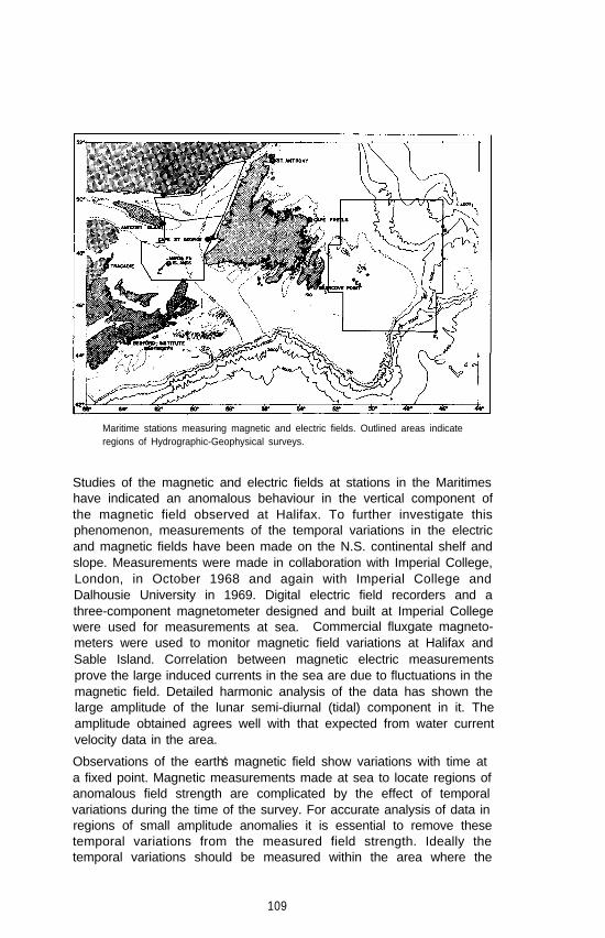
Maritime stations measuring magnetic and electric fields. Outlined areas indicateregions of Hydrographic-Geophysical surveys.
Studies of the magnetic and electric fields at stations in the Maritimeshave indicated an anomalous behaviour in the vertical component ofthe magnetic field observed at Halifax. To further investigate thisphenomenon, measurements of the temporal variations in the electricand magnetic fields have been made on the N.S. continental shelf andslope. Measurements were made in collaboration with Imperial College,London, in October 1968 and again with Imperial College andDalhousie University in 1969. Digital electric field recorders and athree-component magnetometer designed and built at Imperial Collegewere used for measurements at sea. Commercial fluxgate magneto-meters were used to monitor magnetic field variations at Halifax andSable Island. Correlation between magnetic electric measurementsprove the large induced currents in the sea are due to fluctuations in themagnetic field. Detailed harmonic analysis of the data has shown thelarge amplitude of the lunar semi-diurnal (tidal) component in it. Theamplitude obtained agrees well with that expected from water currentvelocity data in the area.
Observations of the earth’s magnetic field show variations with time ata fixed point. Magnetic measurements made at sea to locate regions ofanomalous field strength are complicated by the effect of temporalvariations during the time of the survey. For accurate analysis of data inregions of small amplitude anomalies it is essential to remove thesetemporal variations from the measured field strength. Ideally thetemporal variations should be measured within the area where the
109

magnetic survey is conducted, The three-component bottom magneto-meter being built by Imperial College will enable some such measurements to be made. However, in survey areas close to land-basedmonitoring stations, the temporal variations recorded at these stationscan be used for this purpose. A method has been developed to calculatethe amplitude and phase of the temporal variations from the simul-taneous recording of these variations at a number of stations around thesurvey area. The method is based on a linear interpolation scheme.
To examine the accuracy of the method, the variations recorded atBedford Institute, Tracadie, N.B., and St. Anthony, Nfld., were used tocalculate variations at Cape St. George, Nfld., and compared with thoseobserved. Similarly, the variations from Bedford Institute, Tracadie andCape St. George were used to calculate those for St. Anthony (seefigure). The calculated and observed variations at the two stations seem
Observed and calculated temporal variations of the magnetic field for twoMaritime stations.
to be in good agreement for long-period variations but poor forshort-period variations. In a magnetic survey the long period variationsare the main source of errors. Thus the present method seems to besatisfactory for applying diurnal correction to marine magnetic surveydata. The method is at present being used to apply correction to Gulfof St. Lawrence data collected during 1968.
Harmonic analysis of the recordings from the stations shown on themap was carried out to study the differences in the diurnal componentof the total magnetic field at these stations. The objective of thesecomputations was to find the pattern of amplitude and phase of thediurnal component on the east coast of Canada and to examine theeffect of the induced electric currents on these variations. The resultsobtained have failed to show any systematic change in amplitude andphase values for the-area and show a decrease in the amplitude value
110
at stations located near the continental margin (Sable Island) incomparison to the coastal stations (Dartmouth). This is contrary to theexpected effect from the induced currents in the deep ocean.
S.P. Srivastava
Hydrographic-Geophysical OperationsSince 1966, the Atlantic Oceanographic Laboratory at the BedfordInstitute has greatly increased its geophysical coverage of the easterncontinental margin of Canada. This has been largely due to thecooperation between the Marine Geophysics and Hydrographic Sectionsof the Institute. The prime responsibility of the AOL HydrographicSection is charting all navigable waters within the Atlantic Region, asapplicable to navigation requirements. The Region is defined asCanada’s Atlantic Seaboard, the Gulf of St. Lawrence east of Pointe desMonts, Hudson Bay and the eastern Arctic. The surveys conducted bythe Hydrographic Section satisfy requirements in navigation, fisheriesand mineral exploration. All positioning of the ship is done using aLambda Positioning System in the range/range mode, since thisprovides the most accurate navigation available in the areas surveyed sofar.
After a mutual study of each other’s surveying techniques, it wasdecided that the two disciplines could be combined to produce a highlyeffective multidisciplinary survey operation covering the Canadian eastcoast continental margin with bathymetric, gravimetric and magneticmeasurements. An initial multidisciplinary survey of the proposedsurvey area is carried out at a line spacing of two or four miles,depending upon the density of measurements required to give goodgeophysical control. The hydrographers then continue surveying thesame area at a reduced line spacing. During this latter portion of thecruise geophysical studies are carried out as opportunity and manpowerpermits. The data collection and reduction operation has now passedinto the hands of the Hydrographic Section and a series of NaturalResources Charts are to be produced by them, including bathymetry,gravimetry (free-air anomaly) and magnetometry (total field). (Atpresent the three editions of sheet 14956 are available (latitude45°-46°N; longitude 46°-48°W). Four sheets covering the Tail of theBank area (latitude 42°-44°N; longitude 48°-52°W) are expected tobe published during the summer of 1971. The Great Bank ofNewfoundland and the Gulf of St. Lawrence will follow.) Thefeasibility of extending Natural Resources Charts to cover all Canadianoffshore areas is presently being investigated by the Canadian Hydro-graphic Service.
111

While the routine data collection, reduction and chart production are inthe hands of the Hydrographic Section, responsibilities for the initialplanning of the geophysical aspects of the multidisciplinary cruises andtheir data interpretation still lie with the Marine Geophysics Section.This development is still in its infancy to the extent that theHydrographic Section is still learning the techniques of geophysicalsurveying and data reduction. Meanwhile, Marine Geophysics is stillattempting to exploit the positioning facilities provided by the surveysin increasing the accuracy of sea surface gravimetry as limited by thecalculation of the Eötvös correction. The Seismic Group is alsoinvestigating the possibility of adding seismic reflection profiling to thefunctions of the survey.
Following the 1968 survey season in the northeast Gulf of St. Lawrencethe CSS Baffin returned to the Gulf in 1969. Approximately 24,000km of magnetic and gravimetric data were obtained. The extent of thiscoverage is approximately from 49°10’W to 63°W between latitudes46°55’N and 49°20’N. This area has previously been covered withsea-bottom gravity measurements made by the Gravity Division of EarthPhysics Branch, Department of Energy, Mines and Resources, Ottawa.The data in the eastern Gulf of St. Lawrence from both the 1968 and1969 AOL surveys are being analyzed to determine whether this typeof survey with a concentration of survey lines (one or two mileintervals), continuous underway collection of data, and higher resol-ution of gravity anomalies is a better investment of money andmanpower than the eight-mile grid bottom gravimeter survey providingmore accurate gravity values. Initial comparison of the data yields amean difference of 2.1 mgal between AOL and the Earth PhysicsBranch (EPB) over the 1969 survey area with the EPB measurementsbeing higher. Separating the EPB measurements into different years ofoperation, there also appears to be a temporal variation in theunderwater measurements. This is suspected to be the result of usingdifferent depth transducers in each of those years’ operations. Theseand further results derived from the analysis will provide a basis forplanning future complementary surveys by the two agencies (see BIContribution No. 180).
In response to the requirement for better navigational charts in thenorth, the locale of the mapping program was shifted to the westernArctic for the 1970 field season. In the Beaufort Sea, bathymetric,gravimetric, and magnetic (total field) measurements were made at aquarter-mile line spacing over 1500 square miles. The area surveyed wascentered on the Admiral’s Finger, a shoal located approximately 50 milesnorth of Atkinson Point, and discovered in 1969 by CCGS MacDonaldwhile accompanying SS Manhattan during her passage to Prudhoe Bay,Alaska.
112
During the course of the survey, about 80 additional shoals werediscovered, some rising to within 17 metres of the surface. Observedgravimetry in the area was dominated by the shelf anomaly, exceeding80 mgal at its maximum value, and parallelling the 100-metre contour.Except for the northeast corner of the survey area, there was noindication of shallow disturbances to the earth’s magnetic field.
Shipboard gravimetric and magnetic measurements were made during1964 in the Bay of Fundy. The survey area covered lies approximatelybetween latitude 44°05‘N and 45°10’N and longitude 66°W and67°10’W. About 5300 line kilometres of gravity magnetic readings werecollected and digitized on paper tape through a prototype automaticdata logging system designed in 1963.
The collected data have been reduced and compiled during the last twoyears. Free air, magnetic anomaly, Bouguer anomaly and bathymetriccontour maps are available and will be eventually published as part ofthe Natural Resource Chart series. The data are also available throughthe computerized data storage and retrieval system.
Preliminary interpretations of the results indicate that a syncline with a1600-2000 metre thick layer of Triassic rocks and a layer of basaltflow, which lies within the Triassic sedimentary rocks, forms a majorpart of the Bay of Fundy. To explain a negative anomaly belt east ofGrand Manan Island, a 1500-2000 metre thick layer of carboniferoussedimentary rocks is assumed between the Triassic rocks and basement.Comparison of sea gravity data with available land gravity data near theNew Brunswick shoreline indicates that there is a deep normal fault,striking east-west along 45°07’N. This fault may have a displacement ofabout 2000 metres and bounds the Carboniferous sedimentary rocklayer at its north side.
In support of regional studies, gravimetry and magnetometry havebeen recorded in conjunction with bathymetry along several reconnais-sance tracks in the North Atlantic Basin between Nova Scotia and theCaribbean Sea. For this program, the Canadian Scientific Ships Baffinand Hudson were used on an opportunity basis as they travelled to andfrom the Caribbean on hydrographic training and geological researchcruises. Although the majority of the cruises have been used primarilyfor the purposes of training personnel in the operation of underwaygeophysical equipment and in the shipboard processing of data, thetracks obtained provide valuable additional information for a regionalstudy of the northwest Atlantic.
R.T. Haworth, R.F. Macnab, K.G. Shih
113

HUDSON 70Marine Geophysics Section was responsible for a number ofprojects undertaken as part of the HUDSON 70 expedition.In addition, geophysical data were collected on the trackfrom Halifax to Rio de Janeiro, from Vancouver to thewestern Arctic, and as part of the geological/geophysical
survey in the Beaufort Sea. On passage from Vancouver to the BeaufortSee an interesting profile was obtained across the Aleutian Trench andthrough the Aleutian Island Arc via Unimak Pass. The characteristic lowfree air anomaly across the Trench is about 80 mgal and the high isabout 150 mgal. High frequency magnetic anomalies with a peakamplitude of over 1200 gamma were recorded through the UnimakPass. In the Beaufort Sea sufficient data were obtained to prepare anexcellent gravity chart of the area. Because of the large diurnalvariations in the Arctic areas, correction of the magnetic data isnecessary before a reliable magnetic chart of the area can be obtained.Data were obtained at a monitoring station at Atkinson Point duringthe entire survey period for this purpose.
Determination of the difference in height between theisobaric sea surface and the geoid gives the change ingravitational potential energy of an isobaric sea surface.From this, with a knowledge of the internal distribution ofwater density, can be calculated the potential of all other
isobaric surfaces, and therein lies the key to ocean current transport.Orbital perturbation analysis of satellite track observations provides thelow order harmonics of the geoid. At present the higher orderharmonics may only be obtained at the sea surface. In order todetermine the higher order harmonics of the geoid along the path of apolar orbiting satellite, a gravimetric determination of the geoid wasmade along 150°W between 63° and 57°N.
The meridian of 150°W was chosen since it was thought (from satelliteobservations) to follow a region of small free air anomaly so thatgeoidal undulations due to mass anomalies in the crust would be small.This work was carried out during HUDSON 70 using a Graf-Askaniaand a vibrating string accelerometer gravimeter. By steaming with anortherly heading, the Eötvös correction would remain small, or zerounder ideal conditions. Since the measurements were made at sea level,no altitude correction was necessary.
One particular result which it was hoped to obtain was a value for theflattening of the spheroid to which the geoid along 150°W can beapproximated. A worldwide flattening of (298.25)-1 was obtainedfrom satellite data and adopted by the International AstronomicalUnion in 1964. Uotila found a flattening of (298.5)-1 in the northernhemisphere and (297.3)-1 in the southern hemisphere using mean freeair anomalies over one-degree squares, although there was an inhomo-
114

geneous distribution of gravity data. It was hoped to ascertain whetherthis worldwide distinction between the two hemispheres also existedalong 150°W.
Preliminary results do indicate that there is a difference between thetwo hemispheres. Excluding the effect of the Alaska shelf, the southernhemisphere appears to have a greater flattening than the northern asindicated by Uotila. However, in each case the flattening seems to begreater than his values.
The value of this geoidal section will be seen with the advent of theradar altimeter measurements from satellites planned for the mid-seventies. The satellite altimeter profiling of the sea surface withreference to this geoidal section will allow for an absolute, dynamicsection to be completed.
R.T. Haworth. J.M. Woodside
interest were found. At 54°36’S, 95°12’W a depth of 6103metres was recorded, the greatest depth of the entire Pacific
The track of the CSS Hudson from Valparaiso to thesouthern end of the 150°W meridian crossed a little knownarea of the South Pacific where features of geophysical
track. Sixty km before this at 54°19’S, 94°33’W a peak with a depth of2920 metres had been crossed. The names Hudson Deep and HudsonPeak were unofficially given to these two features. Bathymetric datashow that Hudson Peak and Deep lie at or near a boundary separatingcontrasting physiographic provinces. To the northeast, an extensive,smooth sedimentary surface slopes down towards Hudson Peak after adistinct change in slope from the horizontal. To the southwest, thetopography is irregular but again slopes down towards Hudson Deep.These regional variations in topography indicate that Hudson Peak andDeep lie in an area of progressive subsidence. Due to the apparentpattern of sedimentary deposition, and the correlation of the featureswith similar ones on parallel tracks of the USNS Eltanin, it appears thatHudson Peak and Deep are part of a fracture zone. Most features on thefree-air anomaly profile are reflections of the topography, but itappears that there is a regional 20 mgal negative Bouguer anomalycoinciding with Hudson Deep. The simple Bouguer anomaly profile is,however, very noisy and little weight can be put on this observation atpresent. The magnetic anomaly profile contains no anomalies ofamplitude over 600 gammas. There is a striking absence of evenmoderate anomalies over Hudson Peak and Deep.
R .T. Haworth
115

Recent proposals with regard to continental drift have the earthcomposed of a series of plates which are moved over the surface of theearth by forces acting at their edges. These plates grow by accretionalong the mid-oceanic ridge system and are consumed in oceanictrenches; continents passively rise as superficial parts of plates. Aknowledge of the transition from the continental shelf to the youngeroceanic crust is essential both to our knowledge of the evolution of thatcrust and also to our exploitation of minerals in adjacent areas. Atpresent there is considerable interest in the potential mineral depositson the Canadian continental shelf. Such deposits may extend into thedeep waters of the continental slope and ocean basin. Our knowledge ofsuch deposits will, however, remain sparse until we become familiarwith the large scale tectonic processes active at our continentalboundaries. On the west coast of Canada it appears that there is a smallplate, Juan de Fuca plate, which is complicating the interactionbetween the larger Pacific plate and the North American plate.
Geophysical investigations in the northeast Pacific included the surveyof an area adjacent to the contact between the Juan de Fuca, NorthAmerican, and Pacific plates (see chart). Seven thousand kilometres of
Chart of geophysical survey area off Vancouver and Queen Charlotte Islands(HUDSON 70). The numbered tracks indicate positions of seismic reflectionprofiles. The dots are seamounts.
116

gravity and magnetic data and 9500 km of bathymetric data extendedthe previously surveyed section of the Juan de Fuca Ridge (the westernboundary of the Juan de Fuca plate) towards the Queen Charlotte IslandFault. Detailed station work was also carried out in the ExplorerTrench which may be the last expression of the East Pacific Rise beforeits termination at the Queen Charlotte Island Fault. Fourteen dredgehauls recovered a wide range of rock types from normal oceanic basaltto continental grey wacke and sandstone, the oceanic rocks lying at thebase of the trench and overlain by the continental sedimentary rocks.Seven measurements of high heat flow together with the fresh basaltsindicate that the Explorer Trough is part of an actively spreading zone.
A seismic refraction experiment was carried out to determine theanisotropy of the velocity of compressive (P) seismic waves in themantle. It has been suggested that these waves have a maximumvelocity in the direction of sea floor spreading. Supporting evidence forthis hypothesis came from the experiment which was conducted duringHUDSON 70 in the abyssal plain off Queen Charlotte Islands. A
circular pattern of shots with a radius of about 75 km wasfired from the CNAV Endeavour and was recorded at thecentre by the CSS Hudson. The arrival times from shots toreceiver were found to vary systematically with theazimuth from shot to receiver. The mean direction of the
maximum velocity (8.5 km/s) was found to be 106° east of north; theminimum velocity was 8.1 km/s. The direction of spreading in this area,indicated by the magnetic lineations, is about 90° east of north. This issomewhat different from our estimate; however, both methods ofmeasurements may have uncertainties of 5° or more.
About 1700 km of seismic reflection data were collected during thecruise using the deep seismic reflection system developed at theBedford Institute. Several of the profiles were run across thecontinental margin to study the complexity of the structure whichexists off the west coast of Canada. All the profiles across thecontinental margin suggest that the transition from oceanic tocontinental crust is abrupt. On many profiles a deep sedimentary basinseparates the continental shelf from the oceanic basin. In some areasthis sediment has been severely folded and perhaps faulted. In theocean basins the sediment cover varies from nil to about one second,two-way travel time. In one case, towards the deep ocean, a ruggedreflector was observed below the top of the volcanic layer. This mayrepresent the top of layer 3 or a secondary reflector within the volcaniclayer. Profiles taken across the Queen Charlotte trough and faultindicate that the trough appears to be an erosional feature. Thecontinental margin in this area seems to consist of a series of faultedblocks against which the oceanic crust abuts; there is no evidence ofdistortions within the sediments on the seaward side of the margin.
117

The large negative gravity anomalies obtained near the margin seem toagree with the seismic reflection data. Numerous large magneticanomalies were found near the continental margin. The correlation ofthese anomalies with the gravity and seismic data will give directevidence of the interactions between various plates near the margin.
D.L. Barrett, C.E. Keen, K.S. Manchester, D.I. Ross, K.G. Shih,S.P. Srivastava
Geophysical Work in the Eastern ArcticDuring the last phase of HUDSON 70, Marine Geo-physics Section had the opportunity to start a systematicinvestigation of the structure of Baffin Bay and its relationto the tectonics of the northwest Atlantic area. Prior to thesummer of 1970 considerable magnetic data had been
Tracks of the CSS Hudson and the CSS Baffin during the last phase of HUDSON70 (geophysical survey).
118

obtained from ships of opportunity, particularly DOT icebreakersworking in the eastern Arctic, but there had been no opportunity tomount a full scale geophysical study of the area.
A seismic refraction experiment was carried out in cooperation with theU.S. Coast Guard using the USCGC Edisto as shooting ship while theCSS Hudson stationed herself at the end of the line as receiving ship. A66-mile reversed refraction line was successfully shot. Both thethickness of the crust and measured velocities obtained during thisexperiment showed that the central deep portion of Baffin Bay wasindeed oceanic and that it could not be attributed to extended andfaulted continental material as had been suggested a possible origin. Atotal depth of 11 km from the surface to the M-discontinuity wasobtained with a mantle velocity of 7.7 km/s. While the observed mantlevelocity is somewhat lower than normally observed in oceanic areas, itis not significantly so, particularly considering the rather thin crustalsection observed.
Having proved that Baffin Bay is an ocean and therefore possibly wasformed by sea floor spreading processes, it was of prime importance todetermine as much as possible about the continental-oceanic transitionregions on both sides of the Bay and investigate the nature of DavisStrait to the south and Nares Strait to the north. Five thousand miles ofgravity data obtained by the Hudson and the CSS Baffin (the firstsurface ship measurements in the area) together with seismic reflectiondata from the Hudson have provided important information on theextent of the oceanic crust and the nature of the boundaries with thecontinents on either side of the Bay. Model studies are presently inprogress to provide quantitative values for the margin structures. Thedata have clearly shown the marked asymmetry in the Bay and thecomplex nature of the margin areas which have been cut by deepchannels presently filled with sediment. In addition, strong gravitygradients are observed on one profile across the central portion of theBay which are difficult to explain by present ideas on the origin of theBay. Magnetic data, obtained in conjunction with the gravity data,together with that obtained in earlier years, are being used to followsome of the major features delineated in this work over greaterdistances and strengthen the conclusions drawn. In addition, sufficientdata are now available to look for magnetic lineations that might beassociated with perhaps a once-active ocean ridge structure in the Bay.
(See BI Contribution No. 46, 192.)
D.L. Barrett, C.E. Keen, K. S. Manchester, D.I. Ross, J.M. Woodside
119

Information Storage and RetrievalThe chart storage and retrieval system created in 1967 has been usedextensively by the Section and other members of the Institute sincethat time. The system has been, as intended, customer-operated in bothstorage and retrieval. Due to different interpretations of the instructionmanual, this has resulted in a multitude of keywords having to bespecified in order that the customer may be reasonably assured ofretrieving relevant information stored by other customers. To remedythis situation, discussions between members of the Section werearranged to clarify the operation of the system and the entire thesaurusof the system was purged. Rekeywording and indexing of the nearly700 charts presently in the system, plus the considerable backlog ofnewly generated charts, is nearing completion.
The facilities provided by the system and its adaptability to similarprojects in other organizations has led to the development of acomputerized version by Consolidated Computing Services in Halifaxfor use from their remote computer terminal facilities. A practicalversion is now available and is being tested at the Institute.
A storage and retrieval system for all geophysical data collected onInstitute cruises was developed in 1967 and the prototype version putinto use in 1968. The system proved of immense value in making largeamounts of data obtained on detailed surveys available for analysis andas an aid in dissemination of data to outside organizations. Initial use ofthe system showed up several important restrictions and developmenthas continued during the past two years to improve the versatility andefficiency of the system. An important consideration built into theretrieval facilities has been the requirement to provide data in a formatimmediately available for processing on other computer facilities in thecountry and in a format compatible with other data systems, particularlythe gravity files of Earth Physics Branch, Department of Energy, Minesand Resources, Ottawa, and the Hydrographic Service data system,Department of Energy, Mines and Resources, Ottawa. Considerable usehas already been made of the system by universities, industry and othergovernment organizations; considerably more use is expected as thedata file is expanded.
K.G. Shih
120
Metro logy
R.L.G. Gilbert2
C.S. MasonG.E. Awalt A.E. JohnsonE.G. Banke1 P.G. JollymoreE.A. Bendell P.F. KingstonA.S. Bennett D.F. Knox1
J.J. Betlem3 M.B. Lumsden1
J. Brooke E.W. Moody1
R .J. Cassivi D.L. McKeownW.D. Chidlow2 E.F. Phillips1
G.F. Connolly W.M. ProctorW.C. Cooke1 SD. SmithP.L. D’Entremont M. Stepanczak1
J.-G. Dessureault R .G. Stevens2
F.W. Dobson1 J.P. Thorburn1
D.R. Eisener1 M.R. Thorpe4
G.A. Fowler B. TrudelP.A. Gouldthorpe R .J. VandalW.W. Hall D.E. WellsB.B. Hartling W.J. WhitewayD.R. Harvey L.A. Wright3
D.L. Hendsbee S.W. Young
Over the past two years, instrumentation research and design has beendirected to carrying through many of the innovations conceived by Dr.Gilbert*; one new major development, acoustic positioning, has beenstarted. The hydrostatic rock core drill, the porpoising Batfish and the temperature recording Digibridge have all reached a stage where routinemanufacture should be possible. Mr. J.-G. Dessureault, developer of theBatfish, is now working with industry in the Halifax/Dartmouth area toassist them in producing this and other AOL equipment and it isanticipated that this equipment will be available, commercially, toother research institutes. Design of drills, Batfish and the Digibridge isalso continuing at AOL and a liaison with local industry should help usconsiderably in devising improvements and new applications.
The section worked briefly on several problemsassociated with Operation Oil investigating the useof nets to trap and move heavy oil, building amodel of a vertical disc licker to remove oil from a
and considering a variety of pumps to pump uprough sea surface,1 Joined AOL2 Le f t AOL3 Transferred within AOL4 Postdoctoral Fellow
* Dr. R.L.G. Gilbert, previous section head, transferred to Ottawa, Department ofFisheries and Forestry.
121

Bunker C oil from trapped pools. A differential pressure gauge was builtto measure the water head across the dam at Lennox Passage inChedabucto Bay.
The main project of the Air-Sea Interaction Group continues to be themeasurement of wind stress on the sea, under open sea conditions, overa wide range of wind speeds. This involves placing a sensitivethree-component anemometer on a stable platform exposed to the opensea. The platform, which is now located at the entrance to HalifaxHarbour, has been designed, installed and maintained by the SystemsEngineering Group, Engineering Services, who have also designed thecommand and telemetry link from the tower to a shore station.
The work of the section is divided into seven main project areas and thefollowing detailed descriptions highlight the work done in each areaover the past two years.
C.S. Mason
Applications of Underwater SoundThe oblique echo sounder produces a record of the sea bottomtopography in a strip 350-450 metres wide on either side of a ship’strack. Designed specifically for use in Canadian continental shelf waterswhere there are strong temperature structures, a system has beendeveloped which will work in depths up to 180 metres. Twotransducers are housed in a Defence Research Establishment Atlantictowed body, Moby, and enable a strip of bottom on either side of theship’s track to be studied simultaneously. Thus far the control anddisplay units have been constructed for only one of the twotransducers. Engineering design and preliminary field trials (on theNova Scotian continental shelf) have been completed and fullevaluation trials with AOL Marine Geology and with MEL are plannedfor 1971.
Staff from Defence Research Establishment Atlantic collaborated withAOL during field trials of the Moby body.
P.J. Jollymore, D.L. McKeown
When an acoustic pinger is used in conjunction with a graphic recorderthe time bases of the pinger and the recorder vary with respect to eachother, causing the pinger signal to drift across the record. If the pingeris being used to telemeter data such as water temperature or rock drillpenetration, reading the recording is made difficult by the continualrecord drift. The zero lock unit has been designed to receive the pingersignal and the recorder trigger pulse and provide, from these, acorrection signal to lock the time base of the graphic recorder to that ofthe pinger by varying the motor speed of the recorder. The unit will
122

keep the two signals synchronized at lowering and recovering speeds ofup to 100 m/min.
P.J. Jollymore, D.L. McKeown
Since 1965 the section has been developing a hydrostatic rock core drillfor underwater drilling; such a drill for use in water depths from 550 to1800 metres can now be used routinely. We now wish to use the drill toobtain rock samples from specific points in a survey area - such as thearea surveyed by AOL geophysicists on the Mid-Atlantic Ridge at45°N. Development of an acoustic positioning system is now underwayusing commercially available acoustic transponders, a shipboard trans-mitter and receiver, and the deep mooring system developed for theDigibridge project. Design of the positioning system is complete andpreliminary trials in Bedford Basin to test the surveying technique havebeen successful.The positioning system will be useful for any type of detailed bottomsampling such as bottom photography, dredging or temperaturemeasurements.
D.R. Harvey, D.L. McKeown
Twenty low power pingers were constructed to AOL specifications inorder to provide a general purpose, low cost pinger for the use of allresearch sections in the Institute. The acquisition of the units proved tobe more costly than initial estimates because of the failure of the unitsto meet specifications and, after field trials, the units were twicereturned to the manufacturer for extensive modification. The pingersare now performing and are being used routinely at sea.
D.R. Harvey, D.L. McKeown
Radio-Controlled LaunchDevelopment work has continued on the 14-foot radio-controlledunmanned launch. The project is based on the premise that severaldrone echo-sounding launches controlled from one hydrographic shipcould increase several-fold the productivity of offshore bathymetricsurveying. Using the hull of a commercial system, a new master controlsystem has been constructed which permits the simultaneous operationof up to eight launches, equipped with echo sounders, using only oneradio VHF band. The operator is able to manoeuvre the launch, alterspeed and course, change gears and stop the engines, all with ahand-held control. An echo-sounding system and data telemetry linkhas been commercially developed to AOL specifications.
The control system and one launch have performed successfully inconditions corresponding to sea state 4 (waves 4 to 8 feet, wind 17-21knots) at a speed of 15 knots. The echo sounder system has been used
123

in water depths of 60 metres without the telemetry link. Full scale fieldtrials of this system (control and one launch with sounder) are plannedfor early 1971 and, if these be successful, a second launch system willbe acquired and a trial survey carried out. Commercial cost of eachlaunch system in production quantities of eight units is estimated at$25,000.
E.A. Bendell, P.A. Gouldthorpe, D.L. McKeown
Oceanographic Sensors for Data LoggingDevelopment is completed of an instrument, Digibridge, which willmeasure and record temperature, in situ, in the deep ocean with aresolution of 0.001°C and an accuracy of 0.01°C. The instrument ismoored on the bottom on a ‘pop-up’ frame which is releasedacoustically upon a surface command. The recorder will operate for upto 20 days recording the resistance of three glass bead thermistors everyfive minutes. The recording period can be increased by decreasing thenumber of thermistors or increasing the interval between recordings.Design construction and testing of one instrument is complete and twoadditional units are now being built commercially to AOL design. Therecording thermometer will be used jointly with AOL Ocean Circula-tion on the East Newfoundland Rise in 1972 and will also be installedon the stable tower used in Air-Sea Interaction studies.
AS. Bennett, G.A. Fowler, P.A. Gouldthorpe, D.R. Harvey
In order to ensure that absolute accuracy of the Digibridge temperaturerecorder is achieved, a facility for precision temperature calibration hasbeen assembled and the International Practical Temperature Scale of1968 can now be realized to an accuracy approaching 0.001°C over thewhole oceanographic range. A small constant temperature bath forthermistor calibration and a large bath designed for calibrating acompletely assembled Digibridge have been constructed. The small bathhas been used for the calibration of a number of thermistors to veryhigh precision over the temperature range 0-30°C. The results ofrepeated ice point calibrations over the past two years indicate aremarkable stability, better than 0.003°C over the two years, for theDigibridge thermistors.
The calibration facility has recently been extended to enable calibrationof the conductivity cells used in salinity/temperature/depth systems.
E.A. Bendell, A.S. Bennett, J.J. Betlem, M. Stepanczak
124

Measurement of water temperature is of prime importance in oceano-graphy. Standard techniques are time-consuming and expensive and givea single location temperature profile. An automatic bathythermographhas been developed which consists of a porpoising body, Batfish, that
Batfish: towed, undulating body.
undulates between two depths carrying a pressure transducer and athermistor to measure temperature and depth. Using a fairedconducting cable, the present system can be towed at any depthbetween the surface and 180 metres at a ship’s speed of ten knots.Depth is controlled using variable angle depressing wings activated by aservo-control via command signals from the ship. The system has beenused on the Great Lakes in conjunction with the Canada Centre forInland Waters. Production drawings have been completed and HermesElectronics Ltd., Dartmouth, has been granted the licence to manu-facture the Batfish by Canadian Patents and Development Corporation.
To increase the capability of the Batfish body a Guildline Instrumentssalinity/temperature/depth apparatus (STD) was purchased andmodified for installation in the Batfish. The instrument is interfaced toa PDP-8 computer which controls data acquisition and stores data onmagnetic tape for subsequent processing (see BI Contribution No. 144).Several hours of data from the towed Batfish have now been obtainedtogether with data from several hundred more conventional verticalstations in the Gulf of St. Lawrence. The Batfish STD and the otherAOL STD equipment are calibrated using the temperature calibrationfacility developed for the Digibridge. Calibration for the conductivitymeasurement is also possible. An investigation into the accuracy andprecision of STD measurements at sea has been started.
A.S. Bennett, W.C. Cooke, J.-G. Dessureault
125

Rock Core DrillsA hydrostatically powered rock core drill has been developed whichwill operate in depths from 600 to 2000 metres. Originally designed torecover cores six inches long by. one inch in diameter, the drill hassuccessfully recovered samples up to 15 inches in length. Productiondrawings of the drill are complete and checked; five drills have beenmanufactured for AOL and commercial production of the drill byHermes Electronics Ltd., Dartmouth, has been licensed by CanadianPatents and Development Corporation.
In 1969, eight days were spent drilling on the Mid-Atlantic Ridge.Twelve cores were obtained from the crestal peaks in the area of 45°N.This was the first routine use of the drill for scientific purposes and thesamples obtained are the first exposed rocks drilled from the Ridge.Photographs of the drill site are taken immediately at the start of thedrilling cycle. The figure illustrates a site at 854 metres from which a12-inch long core of basalt, conglomerate and coralline limestone wasrecovered. In addition to the bottom photography, data on drill rateand depth of penetration were obtained at each station by acoustictelemetry.
A deep sea photograph of the drill bit of the AOL hydrostatic rock core drillpoised just above exposed rock on the Mid-Atlantic Ridge prior to the start of thedrilling cycle.
As a result of recommendations from a committee (with representativesfrom AOL Marine Geology and Geophysics and Dalhousie University,Halifax), the cycle time for the present drill is being increased by 50%.Laboratory experiments are also being carried out to obtain a betterunderstanding of the drilling efficiency and the relation between rate of
126

rotation, download and flow of drilling fluid. Longer cores may thus beobtained, hopefully, up to lengths as great as one metre. In addition, ahydrostatically powered sediment corer is being designed which it ishoped will retain the unconsolidated material overlying the hard rockwhich is not presently retained.
A second camera, mounted at the maximum height of the drill frame, isbeing installed to photograph the area surrounding the drill site.
J. Brooke, J.-G. Dessureault, G.A. Fowler, P.F. Kingston
The drill described above is limited in its operation to depths of 600 to2000 metres and hence can be used to sample only the relativelyshallow crestal peaks of the Mid-Atlantic Ridge in the vicinity of themedian valley. We wish to sample rocks from the deeper flanks of thesepeaks and from the valley floor. First tests of a deeper range drill tooperate in depths up to 4000 metres have been successful and a fieldprogram with Dalhousie University is planned for the summer of 1971.
It is expected that there will also be a demand for material from thedeep ocean trenches and development of a drill which can operate evendeeper is planned.
J. Brooke, P.F. Kingston
In cooperation with the AOL Marine Geology Section, an electro-hydraulic drill is being developed to operate from 0 to 400 metres. Inaddition to acquiring the ability to sample in shallow depths, tests ofdrilling efficiency will be more easily carried out. The initial design of adrill, powered by an hydraulic motor driven electrically from thesurface, is now complete and trials are planned for early in 1971.
J. Brooke, W.C. Cooke, G.A. Fowler, W.J. Whiteway
Mooring StudiesThere is an increasing use of recording instruments located at a fixedpoint in the ocean as part of an instrumented mooring. The length oftime a mooring may be left in place is presently limited by thedurability of the mooring. Hence a series of investigations is beingcarried out to determine the factors which affect mooring life andthereby to increase the reliability and durability of moorings. Initially,the effect of corrosion on a non-instrumented mooring is being studied.
A series of field tests were conducted to evaluate the effects ofcorrosion on mooring components. The basis for judging corrosiveactivity were material weight loss during exposure and changes intensile breaking strength of wire rope. Complete moorings consisting ofsubsurface float, test line and anchor were set in a water depth of 100
127

metres so as to approximate, as closely as possible, an operationalmooring. Three identical strings of moorings were set at the same timeand one string was recovered at the end of one, two and three month’sexposure. Results from the test indicate that for up to three month’sexposure neither weight loss nor tensile strength deterioration aresevere enough to affect the integrity of the mooring.
Further tests are to be conducted to gain evidence of the cause of pastoperational mooring failures.
J. Brooke, G.A. Fowler
Wind Stress MeasurementsThe Mark VI Thrust Anemometer has been developed at AOL to sensethe three vector components of wind fluctuations. It is unique among
The Mark VI Thrust Anemometer mounted in the Bedford Institute wind tunnelfor calibration.
such sensors in being able to operate and maintain its calibration in thefield for months at a time. Design of the thrust anemometer iscomplete, engineering drawings are finished and two units,commercially built, are now being calibrated by the Nova ScotiaResearch Foundation. The thrust anemometer operates on the stable
128

platform installed by Engineering Services and is controlled by a remotecontrol and telemetry unit, also designed and assembled by the SystemsEngineering Group, Engineering Services.
In experiments at the approaches to Halifax Harbour (essentially opensea conditions) in April-June 1968, September 1968, December 1969and December 1970, wind stress measurements have been obtained atwind speed up to 16 m/s (see 81 Contribution No. 205). Attempts tooperate up to double this wind speed are continuing. Over the rangecovered, wind stress appears to be proportional to the square of thewind speed.
S.D. Smith
In a joint project with McGill University (Gulf of St. Lawrence Ice DriftStudy (see 81 Contribution No. 184)) commercially available sonicanemometers are being used to measure wind fluctuations and stressover ice floes (see figure). Experiments were carried out in February1969 and in March 1970. Similar measurements over Arctic Ocean icenear Tuktoyaktuk were started in June 1970.
Two sonic anemometers (right) and an Aerovane anemometer (left) over a smooth
ice floe in the Gulf of St. Lawrence. MV Stephenville in the background.
Wind stress over rough ice (floes 0.3 to 1 metre high) (Gulf of St.Lawrence, 1969, and Tuktoyaktuk, 1970) is about double that oversmooth ice (Gulf of St. Lawrence, 1970).
E.G. Banke, S.D. Smith
129

Over the past year the digital (computer) analysis software used by theAir-Sea Group has been extensively modified. The capability has beenadded for computing power and cross spectra with the Institute’s CDC3150 computer, using the Fast Fourier Transform technique. (Theprograms used are adaptations of those developed and presently in useat the institute of Oceanography, University of British Columbia.) Thedigitizing and digital preconditioning software has been rewrittenallowing a 50% increase in speed, better accuracy, more flexibility inuse, and the possibility of adding subroutines to handle a wide varietyof sensors without any modification of the main program. The wholepackage, from digitization to printing and plotting of spectra andcross-spectra, is now stored on disc files and is in routine use by theAir-Sea Group, and also by individual scientists in Coastal Oceano-graphy and Ocean Circulation. It is also being modified on a day-to-daybasis to meet the needs of the users.
F.W. Dobson, S.D. Smith
The Air-Sea Stable Tower (Engineering Services) has been instrumentedwith a three-component accelerometer, strain gauges on all four mainguy wires, and a wave staff. These were installed after a failure inDecember 1969 of the tower anchor system during a 60-knot gale; it isfelt that existing knowledge of the forces on such structures is quiteinadequate for proper design.
Numerous simultaneous recordings have been made of wave height,wind speed and direction, three components of acceleration and fourcomponents of tension; these recordings are being studied using spectralanalysis techniques. As expected, correlation of acceleration and strainwith wave height is high; a tension fluctuation of 4½ tons was recordedduring the passage of an individual wave with a height of 5 metres and aperiod of 12 seconds. The spectral analysis of these data will beincorporated in an engineering study of the tower in cooperation withEngineering Services.
F.W. Dobson, S.D. Smith
Studies of Water WavesDuring 1970, a new cover was designed and built for the thrustanemometer by the Nova Scotia Research Foundation which, becauseof improved symmetry, allows wind turbulence measurements to betaken for the first time at the Air-Sea Stable Tower in winds from everydirection. This has allowed the recording of wind stress during off-shorewinds in which a ten-second swell was running against the wind. Studyof these data has begun in order to better understand the process ofwave damping.
F.W. Dobson, M.J. Thorpe
130

An investigation into the feasibility of measuring the properties of theair flow within a few centimetres of the sea surface has commenced. Inorder to better understand the process of wave growth under the actionof the wind, we intend to measure the turbulent and wave-inducedfluctuations of pressure and downwind and vertical wind speeds. Itappears possible that sensors of pressure and wind may be kept at afixed distance from the water surface using a wave follower devicedeveloped by the Chesapeake Bay Institute (CBI) of the Johns HopkinsUniversity.
Some of the data collected by CBI have been analyzed using the Air-Seaspectral analysis software. Results of this analysis are very promisingand duplication of the CBI instrument for use at AOL is underconsideration.
Meanwhile, evaluation of pressure sensors and modifications of theAir-Sea wind tunnel into a return type is underway. A field program,monitoring wave conditions at a site in Bedford Basin, was begun inAugust 1970, with the idea of using the site for wave follower studies.
A mobile field laboratory consisting of a small trailer, an electricalgenerating plant, data acquisition and recording apparatus and ten1½-foot long wave height measuring wires has been designed and builtby the Nova Scotia Technical College. Field use of this equipment hasnot yet been attempted.
F.W. Dobson
Support FacilitiesThere are four main support facilities in the Section which are usedboth by the Section and by the Institute as an entity; also, severalinstruments were developed as direct support to other AOL sections.
About 50% of the resources of the instrument development shop areavailable as a service facility for the Institute. In 1970 there were 251job requests in excess of one man-day, totalling 774 man-days. Theremaining time was spent on jobs requiring less than one man-day.
The shop has been divided into two sections, the precision workshopused only by the qualified instrument technicians and a technicians’workshop which is used by all Institute staff openly.
P.F. Kingston
The electronics store provides a source of electronic components forAOL. Engineering Services has been the major user of the store; it hasnow been transferred into that Section.
D.R. Harvey
131

The technical library is a collection of data sheets for a wide range ofelectronic and mechanical components. In 1969 the collection wasincreased to include data sheets on the specialized oceanographicequipment used in the institution. Data sheets from over 2000 differentmanufacturers are stored.
D.R. Harvey
The primary responsibility of the standards laboratory is to providereference standard facilities for all significant units of measurementwhich are of importance in AOL operations and, where feasible, tostrive for traceability to National Research Council or National Bureauof Standards national standards. Two types of standards are kept:primary reference standards, which are normally kept in the BIStandards Laboratory room and secondary or transfer standards for useelsewhere in the Institute or in the field. Work has concentrated onbuilding up a temperature calibration facility and developing techniquesfor calibrating salinity/temperature/depth equipment.
J.J. Betlem
Some engineering support has been provided by Metrology. A light-weight portable sounding system was assembled from commercialcomponents for use in helicopter surveys to measure the depth of waterunder arctic ice. The system was built for the Canadian HydrographicService for use in their program in the Polar Continental Shelf Project.Field trials of the instrument were conducted out of Tuktoyaktuk andthe system is now being used routinely.
P.J. Jollymore
Following a request by Coastal Oceanography a towed body system topump water continuously from a shallow depth to a surface shipunderway was designed and built. The system measures the depth ofthe towed body and water temperature continuously as sea water ispumped to a surface fluorometer for Rhodamine B dye-tracingexperiments.
G .A. Fowler
Copying a design of the Woods Hole Oceanographic Institute, a stablerotating table was built for use in hydrodynamic model studies byOcean Circulation.
G.A. Fowler
132

A 35 mm film transport system was built to create visual movementfrom a sequence of time lapse photographs of events which occur over aprolonged period of time. The 35 mm still camera photographs areconverted to a 16 mm motion picture by exposing a selected number of16 mm frames to each 35 mm frame. The system, developed for MarineGeology to study sediment movement created by wave action, is alsoused for sequenced 35 mm frames produced by computer displays.
D.R. Harvey, D.F. Knox
133

(This page Blank in the original)
134

Ocean Circulation
C.R. Mann
B.D. CarsonR.A. Clarke1
D.M. GarnerJ. GavanS.J. GlazebrookA.B. GrantW.B. GriefenederJ.R.N. Lazier
J.G. MurrayG.T. NeedierN.S. Oakey1
C. QuonR.F. ReinigerC.K. RossR.L. RussellH. Sandstrom
In 1969 and 1970 the Ocean Circulation Section continued to developa program aimed at understanding the physical processes that occur inthe body of the ocean and their causes. The work has fallen naturallyinto two categories, experimental studies and theoretical studies. Theexperimental work, which forms the bulk of the program, has beenconcentrated on measurements with current meters. A mooring systemhas been developed to the point that measurements of currents in the
deep ocean are possible. Meters were installed and recoveredat four locations across the Drake Passage to study the Ant-arctic Circumpolar Current during HUDSON , and a projectwas set up to reactivete work on the Gulf Stream as it passesthe Tail of the Banks of Newfoundland. This project, with
direct current measurement providing new information, is beingcarried out in collaboration with the Woods Hole OceanographicInstitution. The dynamics of rotating fluids and internal waveshave been studied using numerical models and wave tanks, respectively,to provide an insight into the phenomena under controlled conditions.Some development has begun on new instrumentation techniques.
C.R. Mann
North AtlanticFrom 1963 to 1966 the Section had investigated the current pattern ofthe Gulf Stream in the vicinity of the Grand Banks. A generaldescription of the current system was obtained but then the project wasleft because direct current measurements became essential to furtherprogress. With the development, at the Atlantic Oceanographic Labora-tory, of mooring techniques suitable for deep ocean work the projecthas been reactivated. The present work is aimed at a large scaleexperiment in the Spring of 1972 when it is planned to measure volumetransports, to study changes in the current systems, and to determinethe vertical structure of the current.
1 Joined AOL
135

The primary phase of the project has been the development of amooring which would be suitable for use in the Gulf Stream. This phasestarted in 1969 with the acquisition of equipment which appeared to bethe most suitable amongst what was commercially available. InDecember 1969 the first field trial was conducted to test and evaluatethe new acoustic release system, the buoyancy, and other componentsof the buoy installation. As the components of the buoy system provedadequate, a second field program was carried out in 1970 during whichthree moorings were placed across the path of the Gulf. Stream, southof the Newfoundland Banks, at depths of 5400 metres for two of themoorings, and 3600 metres for the third. The moorings were designedto measure bottom currents and buoys were placed 200 metres off the
A current meter record from under the Gulf Stream south of the Grand Banks.The instrument was moored at 5270 metres in 5400 metres of water.
bottom with current meters between them and the anchor. Analysis ofthe data obtained is still in its early stages; however, severaI interestingcomments can be made. Of the seven current meters used, five haveyielded results. The current meter nearest the Banks (3600 metres)showed a variable current which ranged from 0 to 35 cm/s. The mostinteresting feature is that when the speeds are greater than 20 cm/s, thecurrent direction is generally parallel to the edge of the Banks and inthe northwest direction. The second mooring which was between theslope and the Gulf Stream showed a reasonably steady current of about14 cm/s in the westerly direction. The third mooring, which was in theGulf Stream, showed a reasonably steady current of about 17 cm/s inthe easterly direction. A section of temperature and salinity across theStream was made three times in order to calculate sectional current
136

profiles. The data has been analyzed for one crossing and, whencombined with the direct current meter measurements, shows the GulfStream is transporting about 160 million m3 which is much more thanoceanographers were lead to believe in the past.
Plans are now underway for a further cruise in 1971 during which anattempt will be made to extend the mooring to about 2500 metres offthe bottom. Preliminary plans for a joint survey of the area in spring1972 with the Woods Hole Oceanographic Institution are also beingdrawn up.
R.F. Reiniger, C.R. Mann
In order to study the deep circulation a general description has beenmade of the distribution of reactive silica in vertical cross-sectionthrough the Atlantic Ocean each side of the Mid-Atlantic Ridge fromArctic to Antarctic waters, using a compilation of data from theliterature and Data Centre files (Ottawa). These sections have beenrelated to the water mass structure of the Atlantic Ocean by acomparison between the temperature-salinity and temperature-silicacorrelations characteristic of various regions. In particular, the greatcontrast between silica-rich Antarctic bottom water (-100 urn)and silica-poor Arctic deep water (~10 um) seems to provide a sensitivemeans for tracing the intermingling in North Atlantic basins of deepwaters containing the last recognizable residues of contributions fromthese sources.
Some measurements were made from the CSS Hudson duringAugust/September, 1968, of the physical and chemical properties ofdeep water in the Median Valley of the Mid-Atlantic Ridge. Tempera-ture, salinity, dissolved oxygen, silica, and fluoride were sampled. Thetopography of this region provides the interesting situation of a fairlyextensive body of homogeneous deep water in mid-ocean which isphysically isolated from adjacent deep waters of the main NorthAtlantic basins, and whose properties are derived from water at thedepth of saddles in the flanking mountain ranges of the Ridge. Inparticular, this isolation leads to a marked contrast between the reactivesilica concentrations of deep waters in the Median Valley and those inthe adjacent open ocean. The absence in the Valley of the relativelyhigh silica concentrations found in deeper outside waters perhapsprovides evidence that these higher concentrations (tentativelyassociated above with spreading of the Antarctic bottom water) are notpredominantly due to solution of siliceous particulate matter fallingfrom above. No evidence of any thermal or geochemical anomalies in thebottom water of the valley was found.
137
A cruise during May/June, 1970, by the CSS Dawson measured the deepwater transport through the Mid-Atlantic Ridge Fracture Zone near53°N, and examined the effect of this transport on the adjacent deepwater mass structure. Current meters were moored in a depth of about4000 metres for a period of seven days in each of the two deep troughsof the Fracture. Preliminary examination of the records indicates awest-going flow of water through the Fracture, with a mean speed ofabout 3 cm/s and a superimposed oscillation of a semidiurnal tidalperiod with an amplitude of 2-3 cm/s. A pattern of hydrographicstations with deep sample spacing of 100 metres was worked in andaround the Fracture measuring temperature, salinity, dissolved oxygensilicate, and fluoride. Bottom photographs obtained in the southerntrough of the Fracture showed indications of sediment ripples due tocurrent flow.
D.M. Garner
An opportunity to study Scotian Shelf storm surges came in October1968 when hurricane GLADYS moved along the eastern NorthAmerican seaboard, its centre following approximately the shelf edgefrom Florida to Nova Scotia. Two strings of current meters weremoored on the Scotian Shelf during this period, one over Emerald Basinin the middle of the shelf with meters and thermographs at 50, 95, and250 metres, and the other at the shelf edge with meters at 20, 150, and980 metres. A detailed case history of this event is being prepared; thismay be of some interest since very few documented observations of theocean’s response to a well-defined meteorological disturbance areavailable to guide theoretical work. Preliminary examination of thecurrent meter records indicates that the passage of the low pressurecentre across the site in Emerald Basin was associated with a rapid risein general current strength of about 0.4 knot at the surface,accompanied by the generation of inertial-type current oscillations ofsimilar amplitude. The velocity record was fairly quiet before thepassage. The mid-depth meter showed little response to the storm, butan onset of large ‘inertial’ oscillations in the deeper basin waters alsomarked the passage of the low pressure centre. Basin oscillations do notappear to be coupled to those at the surface. At the shelf edge mooring,on the other hand, the surface record contained large amplitude (0.5knot) ‘inertial’ oscillations for several days before the storm passed overthe site. The amplitude of this oscillatory disturbance decreased rapidlywith depth at this mooring and little coherence between records fromthe three levels was apparent. Very large velocity shears, bothhorizontal and vertical, are indicated in the vicinity of the shelf edge.
The preliminary results of this study have been useful to oil companyengineers concerned with storm surge stresses on offshore drilling rigs.Arising from this, proposals for the exploitation of such platforms foroceanic work are being explored.
138

The program of the Air-Sea Interaction group (Metrology Section) inmeasuring the stress of the wind on the sea surface from the stable plat-form moored in the approaches to Halifax Harbour provides anotheropportunity to obtain some data on the response of the shelf waters tometeorological disturbance. A mooring of five current meters separatedby five metres in the vertical was laid adjacent to the platform for aperiod of 48 days during November/December, 1969, and data is beingexamined for correlation between the applied surface stress and thevertical shear in the currents.D.M. Garner
South Atlantic and AntarcticAs part of the HUDSON 70 program, four buoys eachcarrying three current meters and three temperaturerecorders were installed across the Drake Passage betweenCape Horn and Anvers Island. The current meters wereplaced at 150 and 1500 metre depths and at the bottom
A subsurface float with temperature recorder, pressure recorder and current meterbeing streamed in the Drake Passage. Whip antennas provide a radio signal forlocation of the float when it surfaces on recovery.
139

(~3500 metres). The instruments were in place 11 days and all excepttwo worked satisfactorily. Analysis of the records is near completion. Awest-to-east current appears to operate close to Cape Horn with surfacevelocities of 0.5 knot. The currents further south are weaker.
During the transit down the 30°W meridian in the South Atlantic, atemperature/salinity section was made across the southern side of theArgentine Basin to determine whether a strong narrow flow ofAntarctic bottom water occurred westward into the Argentine Basin.Previous work by other investigators had indicated that this flow mightbe as much as 90 million m3/s. The Hudson Section did not confirmthis and it is difficult to interpret because of a possible deep eddy lyingin the southern extremity of the basin.
C.R. Mann
Theoretical Studies
In order to understand the dynamics of the ocean and planetaryatmospheres, one must understand the interactions of buoyancy,coriolis, inertia, and viscous forces in these media. The purpose of thestudy of dynamics of rotating stratified fluids is to understand thefundamentals of the interaction of two or more of these forces in asimpler ‘environment’ than one finds in nature (e.g., to replace irregularboundaries by straight boundaries). Most of these problems are verycomplex and it is often impossible to obtain an analytical solution.Consequently, the problems studied in the past two years have beensolved numerically through digital computers.
Three main problems have been completed in the last two years: (1)The axisymmetric regime of the rotating annulus problem. It is believedthat the study of this problem will help in the understanding of thebasic state of the large collection of so-called baroclinic currents innature, which includes the Gulf Stream in the ocean and the jet streamin the atmosphere (see BI Contribution No. 136). (2) Penetrativeconvection in a rotating fluid. Both in the atmosphere and in the ocean,one can find examples of penetrative motion. Normally these are in theform of turbulence or other modes of motion in an unstable layerpenetrating into a stable layer in scales for which rotation isunimportant. The additional constraint of rotation produces someinteresting phenomena due to the Coriolis force. (3) High Rayleighnumber convection in a cavity. The interest in this rather classicalproblem is longstanding because of its immediate application inengineering (the problem of heat transfer in nuclear reactors) and ingeophysics (geyser or other convection phenomena in geology).
Two more problems are presently underway: convection in a slantcavity, and axisymmetric baroclinic instability in a rotating annulus.
140

These figures show the pattern of particle paths in a fluid at steady state in acavity heated on the left- and cooled on the right-hand wall, while the top andbottom were insulated. This problem has been extensively studied as an idealizedmodel in connection with building insulation, nuclear reactor heat transfer, heatflow in a geyser and other geophysical fluid dynamical phenomena. The left-handfigure is the result of Dr. J.W. Elder’s experiments in Cambridge University, andthe right-hand figure is a computer simulation done with the CDC-3100 at theBedford Institute.
A rotating table of one metre in diameter has been set up in the fluidmechanics lab by the Metrology Section. Some preliminary tests ofstability and vibration show that it will be a useful apparatus toaugment the numerical studies carried out so far. The table will be usedto study three-dimensional flows which only the largest computer canhandle numerically.
C. Quon
In connection with internal wave studies, research has continued ondetails of the mechanisms of topographic coupling of surface tides withinternal tides and of distribution of energy among the various internalmodes. The results of this effort can be applied towards a betterunderstanding of energy propagation in waves whose frequency liesbetween inertial and an intrinsic frequency imposed by stratification(the Brunt-Väisälä frequency). For example, the apparent lack ofagreement between the existing theory of tides of semidiurnalfrequency and the few existing deep ocean pressure and currentmeasurements points out the need for continued investigation andimprovement of tidal theory in stratified, rotating media.
A study of the effect of topography on the propagation of waves instratified fluids was completed in 1969; a ray theory solution to wavepropagation in a variable depth wave guide was compared to experi-ment. Striking similarity in the main features encouraged furtherdevelopment of theoretical models, based on ray theory, for the case of
141

ocean basins of arbitrary shape. A study is underway of internal waveeigenfunctions for water of variable depth, and was augmented bynumerical studies carried out during the summer of 1970 with theassistance of a summer student.
Another theoretical approach, aimed at circumventing some of thecomplexity of comparing observation in open ocean to theory, has beenproposed in which currents along the ocean bottom are measured as anindicator of internal wave activity instead of current and temperaturefluctuations at mid-depths.
Experimental studies with laboratory models have as yet not come upto expectations, although some tests of efficiency of differentstructures as wave reflectors, transmitters or absorbers were carried out.The wave tanks used in these models have been recently located in aproper fluid mechanics laboratory which will facilitate their use.
H. Sandstrom
Many geophysical time series have gaps or are irregularly spaced becauseof circumstances beyond the control of the experimenter. Much of theinformation contained in these records cannot be extracted becausePresent techniques for generating power spectra, for example, have beendeveloped for regularly spaced records. A start has been made ondeveloping techniques for analyzing irregularly spaced records. Ananalytical investigation has been completed but, as several approxim-ations have been necessary, their validity is being checked byartificially gapping a known time series. The techniques are beingapplied to a time series from station P (North Pacific Ocean) as this isone of the more important time series of oceanographic parameters.
C.K. Ross
Experimental evidence shows that bottom topography is an importantfactor in determining the course of ocean currents. A theoretical studyof the effect has been started and is particularly directed at theinfluence of the Southeast Newfoundland Ridge on the path of theGulf Stream.
R .A. Clarke
To get some feeling for the nature of the vorticity balance in the regionof interaction between the Labrador Current and the Gulf Streamsystems, experiments are being conducted with a numerical model ofthe vertically integrated transport driven by a wind stress varyingsinusoidally in the meridian over a square B-plane ocean with (a) arectangular boundary indent in the northwest corner to represent theGrand Banks of Newfoundland; (b) a transport source on the northernboundary just east of this block to represent the northern boundary.
142
The effect of variation of Rossby and Ekman numbers, strength, andvorticity of source, and wind stress curl have been studied. Variablebottom topography and an extension to three-dimensions are beingconsidered, particularly to see how the nonlinear convection terms inthe hydrodynamic equations integrate over depth.
D.M. Garner
InstrumentationAn instrument development laboratory has been set up with thetwofold purpose of developing new instruments and of maintainingexisting equipment in the Ocean Circulation Section. The maintenancetasks are concentrated on those pieces of equipment which requirespecialized care and calibration and which are most critical to theSection’s field program. Re-arming and repairing of acoustic releases aredone within the group, and instruments such as the Bathysondesalinity/temperature/depth recorder (STD), used extensively in fieldwork, are kept operative and calibrated. The temperature probe iscalibrated by placing the probe in a bath controlled in temperature tobetter than 0.01°C and by obtaining readings from -2°C to +30°C in0.5° steps. Standardization at sea is done using an ice-point bath. Theconductivity channel calibration curve is obtained using precise resistorsin the inductive measuring probe. Standardization at sea is obtainedfrom simultaneously acquired water samples. The depth channel iscalibrated using a dead weight pressure standard.
In conjunction with the STD, a considerable amount of time has beendevoted to the design and development of a suitable and reliablemultiple water sampler. By using this, water samples may be collectedat various depths for determination of dissolved oxygen, silicates, etc.The salinities of the samples are used as a check of the STDconductivity calibration. The final version of the rosette sampler (seepicture) is in the last stages of assembly and testing. The unit consists often PVC (plastic) bottles of 1.3 litre capacity mounted on a ring aboutthe upper pressure casing of the STD. The bottles can be closedsequentially by means of a shipboard command signal. The unit isconstructed of PVC and aluminum with specially built pressureequalized solenoids so that the unit can operate over the whole depthrange of the Bathysonde (2500 metres).
A PDP-8L computer is on order to be used with the STD to obtainconductivities and temperatures in a convenient digital form. Salinitieswill be calculated immediately and interesting profile features andanomalies will be obvious while the ship is still on station.
N.J. Oakey.
143

This rosette sampler can be used to collect water samples at various depths.
In 1970 the Atlantic Oceanographic Laboratory took part in anintercomparison of the Geodyne tape, Bergen, Plessey, Braincon film,and Alexeev current meters during the seventh expedition of the USSRAcademy of Science’s research vessel Akademik Kurchatov in thesouthern North Atlantic. The experiment consisted of four 12-daymoorings with current meters at 50, 200, and 1000 metres. An Alexeevcurrent meter was placed at each depth on each mooring as controlwith one of the other current meters separated in distance by fourmetres. Each manufacturer had a meter at each of the three depths ondifferent moorings. Also included in the moorings were four LSKmeters of the lnstitut für Meereskunde, Warnemunde, D.D.R. OneBraincon meter and four Alexeev meters did not give full records.
Scientists from the National Institute of Oceanography, the WoodsHole Oceanographic institution, the lnstitut für Meereskunde (Kiel)and the Atlantic Oceanographic Laboratory participated in the cruise.
144

All the data available from the current meters were forwarded to theWoods Hole Oceanographic Institution for analysis. Participants fromthe Atlantic Oceanographic Laboratory, the National Institute ofOceanography, and the USSR Academy of Sciences met in Woods Holein late 1970 to undertake the analysis.
C.K. Ross
145

(This page Blank in the original)
146

Hydrography
A.L. Adams G.W. HendersonR.C. Amero D.H. Herman2
V.N. Beck3 E.G. Howse2
J.R. Belanger D.J. Lambe1
A.T. Bent D.D. LeLievreT. Berkeley R.C. LewisK.S. Budlong J.R. LordR.G. Burke1 J.R. MacDougallT.M. Calderwood W.B. Millar2
R.M. Cameron C.G. MillerA.M. Canning2 B.T. Noel1
G.G. Clark2 J.M.R. PiloteE.J. Comeau M.D. Price2
P.L. Corkum L.D. QuickW.J. Danson D.G. Robichaud1
F.L. DeGrasse2 J.I. SchneiderD.L. DeWolfe1 G.R. Sellers1
G.R. Douglas J.G. ShreenanS.S. Dunbrack K.G. Spence2
R.M. Eaton T.B. SmithG.N. Ewing3 R .A. Squires1
R.G. Fairn2 M.G. SwimN.E. Fenerty. R.L. TraceyJ.R. Gasparac2 J.S. WarrenV.J. Gaudet H. Weile1
E. Gidney D.E. Wells3
R.G. Gillies1 K.T. WhiteR.P. Haase R.K. WilliamsM.A. Hemphill G.M. Yeaton
R.C. Melanson
The prime responsibility of the AOL Hydrographic Section is thecharting of all navigable waters for Canadian navigational requirements.The Region of concern is defined as Canada‘s Atlantic Seaboard, theGulf of St. Lawrence east of Pointe des Monts, Hudson Bay, and theEastern Arctic. Three auxiliary groups are maintained within theSection: Development, whose function is to develop instruments andtechniques in order that the collecting and processing of hydrographicfield data will proceed with increased efficiency. Navigation, whoseresponsibility is to evaluate present and new means of positioning andto become the authoritative voice of the Institute on all navigationalrequirements; and Drafting, Illustrations, and Photography, whosefunction is to provide a service to the Institute.1 Joined AOL2 Left AOL3 Transferred within AOL
147

A great deal of emphasis was placed on training during the past twoyears, both in-house and at university. We continue to send all newjunior survey technicians to headquarters each fall to undergo Hydro-graphy I training, a course of study consisting of 2½ months in theclassroom and 2½ months in the field. A more advanced six-weekcourse, Hydrography II, was introduced in 1968 and to date nine fieldofficers from the Section have taken this training.
One of the major highlights over the past two years was theintroduction of the newly developed automated data acquisitionsystem. In 1969 part of the system was evaluated in conjunction with asurvey field party or ‘establishment’ from the Central Region of Canadaoperating in the St. Lawrence River, and in 1970 the complete systemwas placed on board the CSS Kapuskasing for a three-month period.The 1970 implementation was so successful that it will become afull-time tool for the hydrographers of one of the field establishmentsduring 1971. Other field establishments will be similarly equipped overthe next few years as funds become available.
A second very significant highlight is the close association of thehydrographers and geophysicists in carrying out systematic multi-disciplinary (Hydrographic Geological and Geophysical) surveys.
A third event worthy of special comment was the 1970 hydrographicsurvey of the Beaufort Sea. The priority for the area was very high, andin order to comply with the requirement, the three regional officescombined resources. The contribution by AOL consisted of the CSSBaffin with a full complement of hydrographers and technicians on afull-time basis, and geophysicists for periods of short duration. Thecooperation effort of 1970 may be a good indication of how projectswith a high national priority may be handled in the future.
R .C. Melanson
Hydrographic ChartingThe main function of the Hydrographic Charting Unit is to chart allnavigable waters within the Region. The field season in which the datacollection takes place usually lasts from early May until late Octobereach year; the remainder of the year, except for special projects, isspent processing the data to its completed form. Field manuscripts areproduced in the Region; the final charts, compiled from the fieldmanuscripts, are made in Ottawa. Surveys are conducted by bothship-based and shore-based parties.
The departmental ships from which we conduct our surveys are the CSSBaffin, the CSS Kapuskasing, and the CSS Maxwell. The CSS Acadiawas decommissioned after the completion of her 1969 hydrographicassignment. Surveys in the Arctic generally are undertaken from
148

Canadian Coast Guard Ships of the Department of Transport, althoughin 1970 an extensive survey was carried out in the western Arctic fromthe CSS Baffin. Shore parties are generally supported by two or three10-metre survey launches and two land vehicles.
collect bathymetry and navigational data for the GeneralHydrographers also participate in oceanographic cruises to
Bathymetric Charts of the Oceans (GEBCO). In 1970, thisparticipation was particularly apparent on the HUDSON 70cruise where some 74,000 km of GEBCO data were
collected and are presently being processed by the Drafting andIllustrations Group.
Our main charting effort continues to be concentrated in and about theMaritime Provinces, although increasing priority was placed on easternand western Arctic programs during 1970.
In 1969 the hydrographic survey parties, operating under the directionof the Atlantic Region, were chiefly involved with detailed surveys insupport of coastal development in the area of the Atlantic Provinces;charting for pleasure boats in the Mactaquac Head Pond area of theSaint John River; surveys of opportunity, operating from Departmentof Transport vessels along the Labrador coast and eastern Arctic;completion of the multidisciplinary survey in the Gulf of St. Lawrence;positional and sounding surveys of Department of Transport naviga-tional ranges in the Nova Scotian area; and chart revisory surveys fromHalifax, Nova Scotia, to Grand Manan, New Brunswick.
Two special assignments were carried out in 1969 utilizing thepersonnel and equipment resources of the Atlantic Region. The firstinvolved the hydrographic responsibility on board the CCGS John A.MacDonald, while the ship was escorting the Manhattan on her historicvoyage through the Northwest Passage. The second involved a rigorousevaluation of the Lambda (Low Ambiguity Decca) electronicpositioning system in a range/range mode. A number of seniorpersonnel from the Nautical Geodesy Section of the CanadianHydrographic Service and the Surveys and Mapping Branch (both,Department of Energy, Mines and Resources, Ottawa) participated inthe experiment.
149

1969
The areas of operation for each establishment working in the AtlanticProvinces and in the Arctic in 1969 are shown on the first two maps.
1969 areas of hydrographic survey operations in the Atlantic provinces.
1969 areas of hydrographic survey operations in the Arctic.
150

The honour of being the last hydrographer-in-charge of a party on theCSS Acadia belongs to Mr. R.C. Amero. His establishment conducted acoastal development survey in the Strait of Canso area in response to arequirement for detailed bathymetric information prior to theconstruction of new docking facilities for deep draft tankers. TheAcadia party then continued with the recharting of the east andnortheast coasts of Newfoundland. A major revisory survey of thewaterfront area of North Sydney, Nova Scotia, was also carried out.
A combined hydrographic-geophysical survey (F.L. DeGrasse, Hydro-grapher-in-charge) in the Gulf of St. Lawrence was completed using theCSS Baffin; positioning was accomplished using Lambda (range/rangemode). Then a detailed evaluation of the Lambda electronic positioningsystem was carried out in the Gulf.
The CSS Kapuskasing establishment (under D.D. LeLievre) continuedcoastal surveys along the northeastern approaches to Fogo Island, eastcoast of Newfoundland. This survey made extensive use of the DeccaHi-Fix navigation system (hyperbolic mode).
The survey party (under M.A. Hemphill) on board the CSS Maxwellundertook the revision of navigation charts covering the area fromHalifax, Nova Scotia, to Grand Manan, New Brunswick. Uponcompletion of this program, they finished a survey project begun in1968 near Marystown in Mortier Bay, Newfoundland; this survey wasparticularly urgent because of the new wharves constructed inconjunction with the new fish plant at Mooring Cove. A second projectin Newfoundland involved a survey of the approach channel at Port auxBasques to determine if any of the large boulders used in constructionof the breakwaters at Graveyard Point and Pikes Island had washedback or rolled into the channel. An urgent request for a survey of theAvon River estuary was received from the Gypsum TransportationLimited, which was intending to replace two of its present 10,000-tonvessels with larger cargo capacity vessels, possibly 20,000 tons. A surveywas sufficiently completed to answer initial queries.
The one shore party (under P.L. Corkum) that operated from theAtlantic Region in 1969 charted the Mactaquac Head Pond area of theSaint John River between the Mactaquac hydro-electric power stationand Woodstock. This covered a section of the river over 50 miles longand included several navigable tributaries and coves bordering on themain river. The survey had been requested by the New BrunswickGovernment for the purpose of making charts available to pleasure-boatusers.
A new assignment to the Canadian Hydrographic Service that began in1969 involves a systematic program of surveying all navigational rangesin each region. To meet our responsibility in this respect, a navigationalrange survey party was established (under M.G. Swim). Ranges
151

northeastward from Sheet Harbour, near Halifax, around the coast ofCape Breton Island and southeastward to Pictou were positioned andsounded. Navigational ranges in the Strait of Canso were also surveyed.
The Eastern Arctic survey establishment (under R.K. Williams),working from the Department of Transport vessel CCGS C.D. Howe,carried out a reconnaissance survey along the Labrador Coast todetermine which were the outermost islands within the limits of chart4771. Islands proven to exist will be used in establishing baselines todefine the limit of Canada’s territorial waters.
A small hydrographic charting program in the Allen Bay area ofCornwallis island was conducted (under R.K. Williams) in support offinding an alternative to Resolute Bay for landing cargo. The surveyparty also carried out a limited hydrographic survey at Rea Point onMelville Island, to meet the needs of Panarctic Oil Limited. They thenjoined the Department of Transport vessel, the CCGS John A.MacDonald, to carry out the hydrographic responsibility on this shipduring her escort duties for the famous voyage of the Manhattanthrough the Northwest Passage.
1970
Areas of hydrographic survey operations in the Arctic and in theAtlantic Provinces during 1970 are shown on the next two maps.
1970 areas of hydrographic survey operations in the Arctic.
152

1970 areas of hydrographic survey operations in the Atlantic provinces.
Due to the oil discovery in Prudhoe Bay, on the Alaskan north slope,and a second discovery at Atkinson Point east of the mouth of theMackenzie River, an increased emphasis was placed on Arctic hydro-graphic and scientific surveys. Our major multidisciplinary establish-ment (under T.B. Smith), on board the CSS Baffin, was placed underthe operational control of the Pacific Region and a major hydro-graphic-geophysical survey of the ‘Admiral’s Finger’ area of theBeaufort Sea was conducted. A second conventional hydrographicsurvey was carried out in the Prince of Wales Strait in the vicinity of thePrincess Royal Islands. The Baffin obtained GEBCO soundings on herpassage from Halifax through the Panama Canal to Victoria, B.C. FromVictoria to the Beaufort Sea and through the Northwest Passage,GEBCO soundings, gravity and magnetic data were collected asconditions permitted. Upon completion of the western Arctic surveysand the eastward traverse of the Northwest Passage, the Baffinestablishment carried out a reconnaissance multidisciplinary survey ofBaffin Bay in conjunction with the CSS Hudson.
The CSS Kapuskasing establishment (again under D.D. LeLievre)surveyed Ballard Bank, southeast coast of Newfoundland: in recentyears there had been several reports of less water than charted in thisarea. As Cape Race is such an important turning point for navigationand as the depths of these banks are extremely important to fishermen,this survey received a high priority. Positioning for the survey wasaccomplished using Decca Hi-Fix (range/range mode). The Kapuskasingthen continued the 1969 survey of the northeastern approaches toFogo Island. This survey was terminated in early August so that a
153
survey of a portion of the Northumberland Strait could be undertakenusing the automated data collecting and processing techniquesmentioned in the introduction and described in the HydrographicDevelopment subsection of this report. This survey was carried out withmembers of our Development group on board so that initial faultscould be examined and corrected on the spot.
Revisory surveys of 32 charts along the coast of Gaspé Peninsula toRimouski, and along the Gulf of St. Lawrence north shore from LesEscoumins to Chateau Bay were again carried out (under M.A.Hemphill) from the CSS Maxwell. Navigational range surveys along thewest coast of Newfoundland, the Magdalen Islands, and southwardsfrom Gaspé along the north shore area of New Brunswick were alsocompleted.
A shore party (No. 1, under R.K. Williams) continued the survey of theSaint John River area. This survey project had commenced in 1969above the Mactaquac Power Development, and in 1970 began chartingbelow Fredericton in Belleisle Bay, Washademoak Lake, Foshay Lake,Harts Lake and the Oromocto River. These bodies of water are allconnected to the lower Saint John River, below the Mactaquac PowerDevelopment. This shore party also carried out a revisory survey of theSaint John River charts from Saint John to Fredericton.
Further work by other shore-based parties included standard hydro-graphic charting in the Ship Harbour to Sheet Harbour area on theeastern shore of Nova Scotia (Shore Party No. 2, under R.C. Amero)and in the approaches to Musquodoboit Harbour (the Maxwellestablishment working from shore and No. 2). The latter survey wasundertaken in response to a Department of Transport request. Chartingwas continued on the east coast of Nova Scotia in the TusketIslands-Yarmouth area (Shore Party No. 3, under M.J.R. Pilote). Asurvey party (No. 3) also participated with the Department ofTransport in an extensive buoy-laying project in the Strait of Cansoarea.
Eastern Arctic surveys (under M.G. Swim) in 1970 were carried outfrom the Department of Transport vessel CCGS Labrador in support ofindustrial developments in the Douglas Harbour area of Hudson Straitand in similar developments at Parry Bay, Roche Bay, and Ege Bay inFoxe Basin. Surveys of opportunity were conducted around CoatsIsland in Hudson Bay and track sounding was done in conjunction witha geological sampling program in Baffin Bay and Davis Strait.
During 1969 and 1970 a great number of small, high-priorityhydrographic surveys in the local area were carried out by ourpersonnel on rotational assignments. The need for these surveys isusually due to the hydrographic information required before and afterprojects such as new wharf construction, dredging, bridge building and
154

so forth. An increasing demand for our services has been made by theDepartment of Transport concerning positioning of buoys, ranges andother aids to navigation. There has been a sharp increase in requests forservices from the scientific community at the Bedford Institute forpollution studies, local sparker seismic surveys and large-scale geo-physical and oceanographic surveys.
G.N. Ewing
Hydrographic DevelopmentThe Hydrographic Development group at AOL, together with groupslocated at the University of Saskatchewan, Canada Centre for InlandWaters, Pacific Region, and Headquarters (Ottawa), form the basis of anoverall technical development program within the Canadian Hydro-graphic Service. The aim of the program is to increase the efficiency ofall phases of hydrographic data collection and chart production by theuse of modern techniques and automated processes. The group locatedat AOL is primarily responsible for investigating and implementingmeans of improving and modernizing the techniques of hydrographicfield data collection and preliminary data processing. The moreimportant aspects of the group’s activities are outlined below.
A very large portion of the task of collecting hydrographic data utilizessmall survey launches as working platforms. The group’s investigationsof methods of increasing productivity in this area indicated that anautomated system of data collection would produce excellent results.The instrumentation required for this program has been developed andtested over the past two years. The Hydrographic Acquisition andProcessing System (HAAPS) includes electronic positioning digitizers,a depth digitizer, a miniature data logging unit and a magnetic taperecorder on board each survey launch. On board the ship, or on shore, asmall computer-plotter system provides the editing, quality control andpreliminary processing functions. This preliminary processing provides aplot of the water depths in their appropriate position, corrected fortidal fluctuations and sound velocity variations, within one hour afterthe end of the work day. A complete package of computer programswritten in the interpretive language FOCAL has been developed toperform these functions. Trials in the St. Lawrence River andNorthumberland Strait have shown that HAAPS fully meets ourrequirements. One complete survey will be equipped with three of theautomated data collection systems and the facility for computerprocessing and plotting of data for the 1971 survey season.
Investigations into the use of U.S. Navy Navigation Satellite Systemsfor providing accurate, oceanic navigation continued to be an activeproject of the group. Computer programs for the reduction of satellitedata to a usable form have been developed to a state where a minimum
155

of instruction is required for the scientist or navigator to operate andfully derive the benefits of the system. A ten-day cruise in 1969 withthe CSS Baffin investigated in great detail the many aspects of satellitenavigation. Participants in the cruise included representatives from themanufacturers of the satellite receivers and many government depart-ments. The analysis of the data has been undertaken by DalhousieUniversity and is currently the subject of an M.Sc. thesis. Although theanalysis has not been completed at the time of writing, preliminaryresults show that by using dead-reckoning techniques to provide therequired velocity and direction of a ship, accuracies in the order of 300metres can be achieved by complex processing of the data.
An area now causing concern within the Canadian Hydrographic Serviceis the demand for complete coverage of critical depth locations, so thatpresent-day and future deep draft vessels can navigate with confidence.The present methods of providing complete coverage are not adequatefor the 30-metre depths in question. The group has developed a sonic‘sweeping’ device that is simple and operationally feasible. The systemconsists of a series of downward-looking sonar transducers, housed infloats that are towed between two survey launches approximately 50metres apart. The testing of the prototype system has been completedand it is now ready for field use.
Several smaller projects were undertaken and completed by the group.
A complete set of computer programs for the reduction of horizontalgeodetic survey data as related to hydrography has been written for theshipboard computers. A limited number of programs for similarpurposes have also been written for programmable calculators. Theseprograms have proven to be a valuable tool to the field hydrographers.
The continuing study of hydrographic accuracies and standardsdemonstrated the need for more precise knowledge of the velocity ofsound in the water column. Velocity tests have been conducted using asystem assembled from commercially available velocimeters. Thecomputer programs to provide the rapid processing of the data havebeen prepared as part of the system.
A recent investigation of the Lambda positioning system was under-taken by members of the Marine Sciences Branch to evaluate itspotential in determining the positions of boundaries and structures atsea. The group participated in this evaluation by providing various typesof instrumentation, computer program development and assistance inthe analysis of the data. Results are currently being published by theNautical Geodesy Section of the Canadian Hydrographic Service.
G .R. Douglas
156

Navigation GroupA Navigation Group was formed at the Bedford Institute in July 1970to provide Institute surveyors and scientists with the best possiblepositioning for investigations at sea. This is distinct from navigating theship from place to place, which is the art of the ships’ officers.
As the major Canadian centre for marine research, it is a BedfordInstitute responsibility to take full advantage of current advances innavigation, and to investigate the physical phenomena which determinethe performance of navigation systems. Precise navigation is rapidlybecoming a complex technology. Developments in radio and satellitenavigation have made possible work that could not be consideredearlier, but to exploit them effectively demands a degree of specialistknowledge which can only be gained by full time work. Even scientistswhose navigational requirements are less demanding seldom have timeto find out about alternative methods; this group should be in aposition to advise and assist them.
Research and development in navigation has been going on since theInstitute first opened. A head-count of navigation projects shows thatnearly all sections have been involved, and that the amount of work hasrecently been increasing at the rate from about two man-years per yearinitially, to about 7½ man-years in 1969. The Hydrographic Develop-ment Group and the Geophysics Section introduced satellite navigationto the Institute in 1968, and they have done much work in evaluating itand in developing operating techniques. As a result, Institute scientistshave come to look on satellite navigation as virtually essential foroffshore cruises, and the Institute has gained a reputation for expertisein this field. In 1969 the Hydrographic Development Group took partin a test to make accurate phase lag measurements over sea water usinga Lambda positioning system, with the result that the accuracy ofoffshore hydrographic and natural resources surveys can now be statedwith some certainty for the first time.
Although these and other developments were successful, it was foundthat they took up more time than could be afforded at the expense ofthe prime functions of the groups concerned. Accordingly theNavigation Group was established to carry on with the work alreadyunderway, and to prepare for future problems. The latter includenavigation in the Arctic, positioning for pollution surveys, and thedetermination of legal boundaries hundreds of kilometres offshore. Thefirst field operation for the new Group was to participate in a jointexperiment with the University of New Brunswick and Shell (Canada)Ltd. to determine the precision with which an oil drilling rig can bepositioned by satellite navigation in the ‘simultaneous’ mode; that is,using a control network of satellite receivers at precisely known pointson shore.
157

The Navigation Group is to perform mission-oriented research, develop-ment and evaluation. It is also to provide advice on navigation methodsand training in the operation of navigation systems under development,but it does not act as a service group for the operation of routinenavigation systems. Although the Group’s main responsibility is to theInstitute, its knowledge and experience will be freely available, and itwill eventually be able to take on general problems of navigation whichare in the national interest.
R.M Eaton.
Drafting and IllustrationsThe Drafting and Illustrations Unit has continued its services to theentire Institute. The main work load was generated by Hydrography,Marine Geology, Marine Geophysics, and Coastal Oceanography withsomewhat lesser demands by the other sections. This work consisted ofthe preparation of scientific information for projection slides andpublication in various journals, preparation of displays, and drawingsfor the construction of models, as well as computations and compil-ation of map projections and navigational lattices for scientific use.Included in this was the preparation of material for the reports on theHUDSON 70 cruise and Project Oil.
In addition, the Unit is responsible for the compilation of Canada’s(east coast) contribution to the General Bathymetric Chart of theOceans (GEBCO), a project of the International Hydrographic Organi-zation. Approximately 130,000 km of soundings have been collectedby scientific ships operating from the Institute over the past two years.
T.M. Calderwood
Photographic Unit
Photographic support for the various sections and groups of AOLcontinued and expanded with the overall growth of the Institute.
During the report period, our personnel have been involved directlywith such projects as the CSS Hudson cruise to the eastern Atlantic(1969); the Shelf Diver submersible operation (1969); Project Oil (1970);and the HUDSON 70 expedition. In addition to providing directtechnical support to such projects, much valuable film was obtained forreport and public relations use. Motion picture footage taken on theHudson cruise of 1969 was released to the Nova Scotia InformationService and included in a production of theirs entitled “Ologies andIsms”, a science documentary. Recently released, this film has alreadywon two international awards.
158

An extension of our facilities in February 1970 was made toaccommodate our cartographic camera and its support facilities. Thequality and quantity of our chart and report reproductions showed amarked improvement. The equipment provides greater versatility andsize capability than was previously available. Hydrographic chartreproduction is now being done by our unit, and has provided muchmore rapid reproduction of field sheets than was previously possiblethrough the Department’s (Energy, Mines and Resources) Ottawaoff ice.N.E. Fenerty
159

(This page Blank in the original)
160

Scientific Services andSpecial Projects
C.S. AllanJ.D. BradburyB.D. Brown1,2 G. Collins1
J.A. ElliottD. Gandhi2
G.H. Gregory1,5
D.H. Herman2
M. Hicking1,2
K.J. Hutton1
C. Isnor1
R.A. Lake5
E.L. Lewis5
R.R. Lively2
B.J. MacDougall1
R.M. McMullen2
C.D. Maunsell
A.E. Moody5
S.W. Moorhouse5
M. Murkin1,2
A.V. ParsonsD.M. Porteous3
D.L. Richards1,5
R.C. RichardsD.L. Sellick1
M.L. SmothR.B. Sudar5
J.A. Sutherland1,5
M.S. Talwar2
P.S. TritesE.R. Walker5
M.E. WarnellH.G. Wells2
The Scientific Services and Special Projects Section was formed inMarch 1970 when the former Oceanographic Research Section wasdisbanded. It includes the Computing Services Group and the ScientificInformation Services and Library Group, and temporarily included twogroups from the Oceanographic Research Section until permanentarrangements were completed later in 1970. The Chemistry Group wasincluded until the Head of the Chemical Oceanography Section arrivedin August and the Frozen Sea Research Group (Victoria, B.C.) wasincluded until the Director, Pacific Region, assumed duties in October.
C.D. Maunsell
Frozen Sea ResearchThe Frozen Sea Research Group was formed at Dartmouth shortly afterthe Bedford Institute opened. In mid-1964 it moved to Victoria, B.C.,permitting closer cooperation with other research laboratories carryingout studies of, or operations from, sea-ice. In late 1970 the group wasdetached from the Atlantic Oceanographic Laboratory to become part ofthe Pacific Region, Marine Sciences Branch.
Laboratory experiments, data reduction and equipment constructionare carried out at the group’s base in Victoria. Completed equipmentand various supplies are shipped to the field base on the shore of GreelyFiord by Coast Guard icebreaker or chartered aircraft. Members of the1 Joined AOL2 Left AOL3 Transferred within AOL5 Transferred to Pacific Region, MSB
161

group visit the station usually on two trips per year, once in late winterto make measurements under an ice sheet of maximum thickness andonce in late summer to prepare for the coming winter and to study theinitial stages of freeze-up.
At Greely Fiord base the group has two self-contained Arctic Researchunits built on tracked vehicles which can tow sleds from whichequipment can be lowered through holes in the sea ice. Much of theprogram consists of studies of variations in temperature and salinity. Inthe course of the work systematic errors were found in previouslyaccepted relations between salinity and conductivity of sea water attemperatures near freezing.
Studies of the properties of sea ice and of the water below sea ice havebeen described in two papers in the Journal of Geophysical Research(Lake and Lewis, BI Contribution No. 131 and Lewis and Walker, BIContribution No. 202). The rejection of salt from the ice crystalsformed during the freezing process produced a heavy brine in theimmediate vicinity of the ice (including trapped pockets). The escape ofthis brine from the ice and its subsequent mixing with the sea waterbeneath produces inhomogeneities in the ice structure and fluctuationsin the temperature and salinity of the water.
E.L. Lewis
Scientific Information Services and LibraryThe Scientific Information Services and Library Group was formed in1967 to broaden the function of the Bedford Institute Library whichjointly serves both AOL and MEL.
With the growth of the Institute the work of the Library has increasedgreatly. The increased staff require access to a great number of booksand journals, particularly because of the variety of disciplines. Thisneed is partly met by accessions of books and journals to the Library,requiring cataloguing, binding and circulation control and partly metthrough use of the Interlibrary Loan procedure. The Library providescontact with the National Science Library for use of the CanadianSelective Dissemination of Information Project whereby currentliterature with titles containing specified keywords are called to theattention of scientists.
Work has been carried out on preparation of an in-depth index of thelarge number of reports and reprints held in the Library in order tomake them more easily recovered by interested scientists. Project Oilinvolved SISL in an effort to rapidly increase the Bedford Instituteholdings of books and reports dealing with problems related to oilpollution in the ocean.
162

The plan to introduce a series of Collected Reprints has been realized;two volumes of Bedford Institute contributions have been issued.Volume I contains reprints of papers published during 1968 and a listof earlier papers; Volume 2 includes those papers published during1969.
R.M. McMullen, C.S. Allan
Computing ServicesThe Computing Services Group provides support to all research andsurvey activities in the Institute. This ranges from the operation ofkeypunches and computers up to the mathematical development ofcomputer techniques and assistance with complex computerprogramming.
The Institute Control Data 3100 computer has been upgraded throughthe acquisition of core memory to the maximum of 32K words and of anumber of additional peripherals including disk drives and of acommunication data set which allows programs and data to be passedto external computers to do work not practicable on the internalcomputer. Results can be returned and printed at the Institute.
W ith an increased requirement for computing at the Institute,operations of the computing centre were put on a closed shop basis.Because of restrictions on personnel it was necessary to reduce theamount of application programming support which could be givenin-house. Such support in a number of cases was provided by outsidecontracts.
There has been a continuing use of small PDP-8 computers for dataprocessing both at sea and in the laboratory. The efficiency of manyprojects involving data collection at sea has been markedly improved. Inparticular, the utilization of satellite navigation information would bevirtually impossible without computing facilities aboard ship.
R.C. Richards
163

(This page Blank in the original)
164

Engineering Services
A.S. Atkinson2
S.B. MacPhee
R.B. AggasF.C. ArmitageG.E. Awalt3
R. Balfour2
R.A. BinghamJ.G. BruceJ.G. Cooke1
J.R. CournoyerR.O. DawsonR.E. DelongD.F. Dinn1
J.B. Etter3
W.J. FindleyA.S. Gilhen2
W.W. GoodwinC.O. GrantP.F. Green1
G. Halverston1
K.W. HemeonH.D. HendersonJ.E. HorneJ. Innis1
B.Z. Kelly1
J.E. Kirby2
E. Larsen1
D.J. MacCallum
G.J. MacDonaldG.R. MacHattieJ.D. MacLaughlinW.H. MarshallR.G. MillsW.A. MooreF.J. MuiseC.M. NewellK.M. NicholsonA.D. ParsonsC.R. PeckC.E. PetersonC.E. PolsonW.F. ShearmanS.F. SpencerG.F. Stewart3
A.C. StuartH.B. SutherlandR.E. UnderwoodE. Urquhart1
J.G. VezinaR.N. Vine3
R.D. Wardrope1
G. WeberS.J. WinterH.C. Woodhams1
R .A. Young
The Engineering Services Section provides engineering design, develop-ment and fabrication of mechanical and electronic equipment togetherwith maintenance, design changes, and modifications to existingequipment at the Bedford Institute, on the ships, and at the shoreinstallations, in support of the research and survey operations of theBedford Institute. The section is divided into three groups, MarineElectronics, Systems Engineering and Depot Workshops, with all groupshaving different functions, but supporting one another when required.
Marine Electronics, with a total staff of 30 technicians and technolo-gists, is the largest group. This group is responsible for the repair,maintenance, modifications, design changes, and overhaul of all
1 Joined AOL.2 Left AOL.3 Transferred within AOL.
165

electronic equipment installed in the 5 major ships and 30 launches, aswell as the small computers and peripherals, and the calibration ofmuch of the electronic equipment being used in the engineering designlabs.
The Systems Engineering Group consists of engineers and technologistswho develop new equipment, mechanical, electro-mechanical, orelectronic, for use by scientists and survey staff. They also provideengineering consultation for scientific and survey personnel.
To provide fabrication of mechanical and electro-mechanical prototypeequipment developed at the Bedford Institute, the Depot Workshopshave a staff of tradesmen skilled in welding, machinery and enginerepairs, carpentry, and electrical work. This group performs theoverhaul on survey launches as well as much of the heavy mechanicalinstrumentation used during oceanographic and hydrographic cruises.
A.S. Atkinson
Marine ElectronicsThe Marine Electronics Group is comprised of five subgroups or shopsunder the headings of Communications, Computer/Microwave,Electronic Positioning, Instrument Repair and Calibration, and Sonar.As a support group, it is only natural that considerable technician timeis spent in the field complementing scientific programs and surveyprojects. Although technicians are assigned to shops for the repair andoverhaul of electronic equipment, they are employed on field assign-ments as ship’s technicians or are placed in charge of the remote shorestations which are used as part of an electronic system for fixing theship’s position during hydrographic survey operations.
The communications subgroup maintains some 450 units of radio andother communications equipment on departmental ships, launches andat AOL. Special requirements for individual projects are facilitated bymodification, and sometimes by design changes, to existing equipmentto accommodate the requirements of the project. Solid-state single-sideband radio telephone equipment has been installed in the surveylaunches. Where short range communications (up to 15 miles) tolaunches is required, VHF radio-telephones have been provided. Alldepartmental ships have been fitted with distress tone generators foruse on their radio telephone equipments; this facility is not requiredunder International Regulations until 1972, but its early installationgreatly increases the safety of the ships.
Personnel within the Institute are trained by the- communicationssub-group in proper techniques of communications and, in cooperationwith the Department of Communications, arrangements are made for
166

examination of personnel and consequent issue of certificates in theproficiency of radio. This subgroup is also responsible to ensure that allcommunication equipment in use in departmental programs meets therelevant requirements of the Radio Act and/or the standards of theradio regulations of the Canada Shipping Act including radio licences,renewals, and applications for licensing of all departmental radiofacilities.
Preparation for HUDSON 70 took a great deal of attention.Each item of communications equipment onboard the ship,after receiving a complete overhaul, was tested to meetAOL specifications. Several special installations were madeon the CSS Hudson for this major cruise including a
portable ‘party-line’ two-way talk-back system covering all workingareas of the ship, a specially adapted radio installation for seismicoperations permitting both voice contact and shot control facilitieswith the shooting ship, and a special facsimile system capable ofreceiving weather, ice and oceanographic information in graphic formfrom transmitting stations in all parts of the world. Logistic supportdetails were assessed and where necessary spares complements wereincreased to support a one-year operation. The success of this project isevidenced in the fact that, without exception, the Hudson did notrequire any spares for communications equipment during the entire11 -month cruise.
Considerable liaison was made with various commercial telecommuni-cations organizations to ensure that the Hudson would be able tomaintain radio contact to ensure the efficient passing of the largeamount of radio traffic involved in such a voyage. Special liaison wasmade with the U.S. Coast Guard to ensure that the USCG Edisto wouldbe in full communication with the Hudson during the latter part ofHUDSON 70. Considerable liaison was done with the SS Manhattan,Collins Radio, and Department of Communications, Halifax. A visit wasmade to the Manhattan on her first trip to Halifax and hercommunications and other electronic facilities were noted.
To assist studies carried out by Coastal Oceanography at AOL, wherebydrogue buoys were tracked in and out of St. Margaret’s Bay, theorganization and establishment of an HF radio direction finding systemwas completed. Three shore-based stations were sited, fitted andcalibrated.
The Arrow disaster in Chedabucto Bay raisedconsiderable demands upon our resources, bothoperationally and in terms of immediate provisionof portable radio facilities; all such demands were
adequately met.
167

The computer microwave subgroup is responsible for the technicalsupport of a number of computers of the PDP-8 family complete withthe associated peripheral punches, readers, tape transports, plotters,teletypes, etc.; X-band radar transponders; radar range positioningsystem; tellurometer equipments; satellite navigational receivingsystems; X-band/S-band radar systems in departmental ships; BIODALdata logging systems; and a complete underwater TV camera and videorecording system. In all, over 100 units are involved.
Permanent installations of PDP8 computers have been made in boththe CSS Baffin and the CSS Hudson. The CSS Dawson has carriedanother PDP-8 on several cruises and it is the responsibility of thissubgroup to ensure that this computer is installed, checked out andoperational prior to the ship’s departure, and removed to the shops fora complete check upon the ship’s return. A PDP-8L system was alsoinstalled in the CSS Kapuskasing for the use of the hydrographers. Atthe same time, two new X-band radars were installed in two launchesonboard the Kapuskasing. An X-band radar system reserved for use onchartered vessels was installed in the MV Stephenville for use during theMcGill Ice Drift Study program in the Gulf of St. Lawrence. X-bandtransponders were supplied together with teletypes, and a Deccadigitizer to complete the equipment complement for this particularproject. During the report period an existing X-band radar was removedfrom the Dawson and a more modern and versatile replacement wasinstalled.
Considerable time was spent in preparing for, and supporting, a satellitenavigation evaluation experiment carried out by AOL, Shell Oil, andthe University of New Brunswick. Arrangements were made to providetechnical support to all sites requiring such support but it was fortunatethat the only site requesting assistance was the University of NewBrunswick, in Fredericton. A technician travelled to the more inacces-sible site at Goose Bay, Labrador.
HUDSON 70, a major alteration was made in the dataPrior to the Hudson’s departure on her 11-month cruise,
logging centre of the ship. A new console area enclosed inan air-conditioned space necessitated the removal andreinstallation of the data logging equipment, satellite
navigation receiver, and computer. Her radar systems were alsoupdated. A new S-band radar system now replaces an obsolete X-bandDecca radar; an existing X-band system was completely overhauled andreinstalled in the chart room behind the bridge for the specific use ofscientists during their particular cruises. When the Hudson arrived inVictoria, the opportunity was taken to carry out a complete overhaulof her computing and positioning facilities. A Radar Positioning System(RPS) was installed for operations with the CNAV Endeavour on thesecond phase of the West Coast operation. Also, radar transponders were
168

tuned with the helicopter and Hudson’s 969 radar prior to thebeginning of the northern phase of HUDSON 70.
The Positioning Systems Laboratory is responsible for electronic aidsused for surveys. These systems are distinct from those utilized as aidsto navigation in that more precise positioning of ships and launches isnecessary during survey data collection. The systems employed includelow-, medium- and ultra-high-frequency phase comparison systems(Decca 12f Lambda, 12f, Hi-Fix and Tellurometer Hydrodist) as well asconventional Loran equipment. The systems are normally deployedduring the periods March to November as positioning support formultidisciplinary surveys encompassing bathymetric, geophysical andgeological data collection. During surveys, personnel from otherlaboratories within the Marine Electronics Group are employed on aloan basis, to staff the several chains operating in the field.
During the reporting period, a Decca Hi-Fix system has been used bythe hydrographers working from the CSS Kapuskasing. It is of interestto note that the system has been used both in the range/range (oneuser) and hyperbolic (multi-user) modes. Decca 12f Lambda has beenutilized as a one-user system only. Hydrodist has been used generally inline-of-sight positioning by mainly shore-based survey parties.
Decca Hi-Fix has provided positioning for surveying in the coastalranges of Newfoundland and New Brunswick, while 12f Lambda, dueto the greater pattern coverage, has been used in both coastal andremote coastal area surveys of Newfoundland (Grand Banks) and theGulf of St. Lawrence. The Decca Hi-Fix chain was also employedduring the spring of 1969 to provide accurate positioning fixes of CSSBaffin during an evaluation cruise on Satellite Navigation Systems. Thehydrodist has been used by Institute technicians to support theCanadian Armed Forces (Navy) electromagnetic log calibration projectand also with Department of Transport during laying of navigationalbuoys for deep draft ships entering the Strait of Canso.
The Positioning Systems Laboratory, in conjunction with surveyingpersonnel, carried out a program of site selections for future operationsin the Viscount Melville Sound (Canadian Arctic). During the past twoyears evaluation of antenna systems has been conducted with a view toimproving hardware portability and increasing signal strength. It has alsobeen attempted, with some degree of success, to extend patterncoverage by increasing RF power as well as improving sensitivity andsignal-to-noise ratios in the receiving equipments. Housing of equipmentand personnel continues to be the responsibility of the PositioningSystems Laboratory as well as the supply of rations, fuel, and othercommodities.
169

An evaluation of the 12f Lambda positioning system was carried out inthe Gulf of St. Lawrence in October 1969, following a federalgovernment workshop on surveying positions at sea. The primeconsideration was to provide information necessary for introducingregulations governing surveying for offshore oil and gas exploration.The object of the evaluation program was the collection of data relativeto accuracy parameters together with observations of the system’selectronic operation under varying states of weather, ground and seaconditions. Instrumental effects and errors in observations werereduced to a minimum by repeated equipment calibration andreferencing of harmonic circuitry to ensure optimum readout. Datainclude weather, reception and transmission amplitudes, groundconductivity conditions, etc.
The prime purpose of the calibration laboratory is the repair andcalibration of the electronic test equipment held at the Institute; allsuch equipment is entered on a computer inventory control system.The facilities in the calibration lab are used to monitor the repair andcalibration work done by outside contractors, and in this regard the labis capable of d.c. voltage measurement to 0.0024% of the voltage beingmeasured, frequencies better than 2 parts in 109, resistance to ±0.02%and a.c. voltages to 0.02%. In any instance where greater accuracies arerequired, the facilities of the standards lab (Metrology Section), whichholds standards traceable to NRC, are available to the personnelconcerned.
The sonar subgroup has the responsibility of providing and maintainingsome of the most modern and accurate depth recording equipmentavailable. A prototype, variable-depth echo-sounder transducer wasdesigned for the Hudson to overcome her inability to producesatisfactory sounding graphs from hull-mounted transducers duringhigh-speed and inclement weather operations. This system has beenredesigned, fabricated and installed as a permanent assembly. The newassembly ensures rigidity, stability and ease of installation. Theraise/lower pushbutton switches for the transducer, with associatedindicator lights for controlling the hydraulic system, are located in theoceanographic labs. The transducer dome can be lowered to a depth offour feet below the hull in less than a minute.
Of primary interest to the user of the system is the newly designeddome which houses three transducers. Two units containing leadtitanate zirconate elements as the active material have a resonantfrequency of 12 kHz while the third unit is broad-banded at 10-15 kHz.All transducers have impedances of approximately 200 ohms. Alltransducer cables are terminated in a change-over panel mounted in theoceanographic lab where any transceiver system can be quicklyinterconnected to either the variable depth or hull-mounted trans-ducers.
170

Four BIODAL sounding systems consisting of a PESR control unit,Alpine precision echo sounder recorder and a Gifft transceiver are nowinstalled in the CSS Hudson, One system is located in the newlyconstructed console; a second system, replacing the MS26-J, isinstalled in the plotting area for ship navigation and GEBCO work; athird system is in the oceanographic lab and the fourth located in thewinch lab. All control units are driven from the Master Clock/timinggenerator combination. Under the new arrangement, it is possible tohave all systems recording with only one transceiver in operation andyet have individual control of gain, number of fathom lines and timemark selection.
During the past year, our inventory of the new Edo Model 9040, 24 kHz,solid-state echo sounders increased from 6 to 11. Some modificationshave been carried out to improve the performance of the 9040 sounder.Among these is a new receiving bar to prevent excessive breakage ofstylus holders, a filter added to the receiver card to eliminate noisepickup, a second draught control potentiometer and an external speedmonitor meter. The necessary changes are being incorporated into allecho sounders to convert the units from feet/fathoms to metricmeasurements for the 1971 field season.
A number of solid-state portable echo sounders were acquired in timefor the 1970 field season on the Saint John River. During acceptancetrials, a modification to the stylus holder was effected by the sonar labpersonnel and the use of three equipments during a complete season hasproven them to be entirely reliable units.
C.R. Peck
Systems Engineering
The Systems Engineering Group provides engineering support(electrical, electronic, mechanical and electromechanical) for theresearch and survey programs at Bedford Institute. The work involvesengineering designs, investigations, and the supervision of constructioncarried on by outside contract. Most of the projects undertaken bySystems Engineering are short term and completed in six months orless, the longer research programs being carried out by the MetrologyResearch Section. The program for this group is decided jointly by thesection heads of Engineering Services and Metrology. Typical projectscarried out during the period covered by this report are as follows:
Instrumentation for Measuring Waves. In support of inshore wavestudies, Halifax Harbour, a commercially designed wave measuring andrecording system was modified and installed at three locations inHalifax Harbour. Information was transferred by a radio link and
171

Wave measuring tower.
undersea cables to shore telephone lines and then to a central recordingstation at the Bedford Institute. A fourth station was obtained using aportable recording system. During the winter of 1969-70, an improvedsystem was designed, consisting of low-power electronics, powered by abattery pack installed on the sea bed. This was used in the spring of
1970 in the Chedabucto Bay area, Nova Scotia. Atthis time, the wave measuring installation wasmounted on an 87-foot portable tower, held in thevertical position by a taut wire mooring line. A
larger tower, 115 feet long, capable of being moored from a small boatin water depths up to 300 feet and of measuring waves up to amaximum of 20 feet, was developed to obtain vertical wave energyprofiles during the 1970-71 field season. This system (see figure) fittedwith a 35-foot resistance wave staff and pressure transducers at 20 feet,40 feet and 60 feet, below the low water line, and one metre from thesea bottom, was installed in November 1970 (see Coastal Oceano-graphy).
172

Digital Depth Tracker Evaluation. During the period December 1969 toJune 1970 an evaluation of commercially available depth digitizers wasconducted. Five digitizers were investigated with varying degrees ofmanufacturer participation. Recommendations were made as to thetype of digitizer most suited to the needs of the Bedford Institute users.
Weather Station. A station designed to gather weather data from theocean and atmosphere has been set up at the Bedford Institute at therequest of the Coastal Oceanography Section. The station consists ofremotely-located, weather-data sensors with a central readout andrecording console located in the main lobby of the Institute. Thefollowing parameters are presently being measured and recorded: windspeed, wind direction, air temperature, water temperature, tide height,and solar radiation.
Battery Charger. At the request of Applied Oceanography, a batterycharger was designed to charge the sealed, nickel-cadmium battery packused in the Braincon Current Meter Model 753. The charger is basicallya constant current type with the added feature of a ‘charged statedetector’. The charger is designed to limit the maximum chargingcurrent regardless of the discharged state of the battery. At a presetcharged condition, the circuit automatically reduces the chargingcurrent to ‘trickle-charge’. The battery pack may be left ‘on’ contin-uously without damage to the pack.
Decca Digitizer Matching Unit. A matching unit was designed andconstructed to interface the CDC LPDIIIA Decca Digitizer to the datalogging system. The design involved the use of level shifters, digitalstorage elements, and output buffers. The matching unit contains thelogic circuitry required to sample and hold the digitized data untilrequired by the punch programmer. The unit was used on the CSSBaffin during the 1970 hydrographic field season.
Integrating, Submersible Radiometer. To determine the relationshipbetween the rate of production of phytoplankton and the mean solarradiation, the solar energy per unit area at a given depth should bemeasured. Previously, the method used to determine this quantity wasto measure the solar radiation at the surface, then to calculate theenergy at the desired depth using estimated values for surface effectsand attenuation coefficient. To make in situ measurements, anIntegrating Submersible Radiometer (see figure) was designed using athermopile radiation sensor and an electroplating type integrator.Sensor and integrator were interfaced with a low-current, stabilized, dcamplifier. Three units were built and are being used by the BiologicalProductivity Group of the Marine Ecology Laboratory.
173

Integrating submersible radiometer
Optical Beam Transmittance Meter. At the request of several groupsfrom AOL and MEL, the design of an Optical Beam TransmittanceMeter has been undertaken. This instrument will be used to measure theattenuation of light, at various wavelengths, as it travels through asample of water. Normally, a one-metre long sample is used but thismay be altered depending on the turbidity. From this measurement willbe obtained the attenuation coefficient which can be used to:determine the light level at any depth when the surface light level isknown; determine underwater visibility; characterize water masses;study pollution fields; measure the relative plankton density in oceanwaters; and measure the amount of suspended sediment near ocean orlake bottoms and in estuaries. The instrument’s light source, whosespectrum can be controlled, gives a narrow, well-collimated beam. Thisbeam is passed through the water sample and detected by a photo-sensitive device whose output is compared to a reference. Thus ameasurement of the light transmittance of the water, and hence theattenuation coefficient, is obtained. The readout will be calibrated inthe units of attenuation coefficient per metre. Presently, the instrumentis in the prototype stage of construction.
Low-Power, Portable Winch. In response to a demand for a low powerportable winch, the design of an electrically driven and electronicallycontrolled unit was undertaken. Specifications for the device include apulling capacity of 100 lb at a rate of one metre per second withgearing provisions for substantially heavier loads at reduced rates,Additional requirements of the winch are a drum capable of supporting200 feet of 5/16 inch diameter cable and provision for signal-carryingslip rings. Operation from either a 115 volt ac or 24 volt dc supply isalso a prime requirement for employment of the unit on anyoceanographic vessel.
Building Power Distribution. An examination of the main powerdistribution system at the Bedford Institute has been initiated. Thisstudy has as its immediate objective the location of the source ofserious voltage regulation problems occurring within the main building.
174

Involved in the broader aspects of this examination is an evaluation ofthe existing transformer capacity of the system in relation to theincreasing electrical energy demands of the Institute.
Scientific Operations Console, CSS Hudson. In November 1968, pre-liminary discussions were held with the staff of Marine Geophysicsregarding the need to provide a more efficient and comfortablewatchkeeping arrangement for scientific equipment on the CSS
Hudson. As a result, a scientific operations console has beendesigned and fitted whereby one operator is within easyreach of any instruments requiring regular adjustments.instruments requiring less frequent adjustments may beserviced from a standing position. The installation was used
with much success during HUDSON 70. As a result a similar system willbe installed in the CSS Baffin.
Satellite Navigation Antenna Installation Aids. Mounting systems weredesigned so that satellite navigation antennas could be installed, withthe aid of a small crane, on the CSS Hudson, the CSS Dawson, and theCSS Baffin. Prior to this modification, it was required to rent a largecrane.
Slacking Winch for Seismic Profiling. At the request of MarineGeophysics, an existing winch was modified for use as a slacking winchin seismic profiling. A four-way, solenoid-operated, pilot-controlled,hydraulic valve was used to control the winch. The winch was usedsuccessfully at ship’s speeds up to ten knots on the CSS Hudson duringHUDSON 70.
Wind Tunnel Return Duct. At the request of the Air-Sea InteractionGroup, a return duct has been designed to improve the flowcharacteristics in the wind tunnel. The tunnel is used for the calibrationof thrust anemometers and for pressure fluctuation studies.
Stable Platform. During the past two years, Systems Engineering Grouphas been giving support on a continuing basis to the Air-Sea InteractionGroup (Metrology Section) on an extensive instrumentation project.The Air-Sea Interaction program being conducted by AOL obtains itsdata from scientific instruments mounted on an offshore structureknown as the Stable Platform. The platform is moored in an exposedlocation and in sufficient depth of water to allow observation of highwinds and fully developed seas. The present structure was installed inOctober 1970 and is the third major installation of its type attemptedby AOL, although smaller structures of a similar configuration wereinvestigated as early as 1964. The first installation, completed inOctober 1967, was successful and the platform remained in positionuntil its removal a year later. It consisted of a floating structure held inposition (44°27’33”N, 63°31’45”W), near the approaches to Halifax
175

Stable Platform used in the Air-Sea Interaction program.
Harbour, by thirteen 25-ton anchors. The second major installation wasa bottom-mounted structure moored in the approaches to HalifaxHarbour (44°29’26”N, 63°23’31”W) in April 1969 and held inposition by three 5-ton ship anchors. This was not a successfulinstallation and, after numerous problems, the structure was removed inJanuary 1970 by Systems Engineering group. The present installation isin the same location as the second in 189 feet of water and consists of abottom-mounted structure 220 feet high and triangular in cross-sectionwith a side length of 8 feet. The structure is held in position by guywires and eight 12-ton concrete clump anchors. To enable the structureto be towed to the desired location and to assist in the mooringoperation, positive bouyancy is provided by four flotation tanks.
176

Prior to the autumn field season in 1969 two remote-controlled, data-telemetry systems which had been built by the Air-Sea Group wereevaluated and the better one chosen for use on the stable platform.Design modifications were made to improve reliability and the systemwas refurbished and installed on the stable platform in November 1969.The receiving/remote-control station for the telemetry line was set upat Osborne Head, N.S., in a small trailer. The complete systemperformed without fault acquiring data on wind stress over the oceanuntil late December 1969, when rough seas severely damaged theplatform resulting in the loss of all equipment and sensors. SystemsEngineering Group were then given the task of producing a newtelemetry system to be ready for autumn 1970. This equipment is nowin the field and performing well. The new system incorporated manyimprovements over the previous one, including: halving the physicalsize of the electronics package; halving the power consumption,resulting in longer battery life; further improvement in the systemreliability resulting from simplification of circuitry; the addition ofwave height and turbulent air temperature sensors (the latter built byMetrology); and the addition of a three-component accelerometer toinvestigate the motion of the platform. In conjunction with theproduction of the telemetry system, an electronic tension-measuringdevice was designed and built. This device is used to indicate the truetension in each of the four main mooring wires of the stable platform.The tension information is available on the platform from four directreading meters and is also transmitted to the shore receiving stationby the telemetry system. The data obtained from the tension-measuringdevice, the accelerometers, and the wave height sensor will be used todetermine forces and motions imposed on the platform structure byvarious sea states. This information will be useful in planning reliablemoorings of similar structures.
Projection Lamp Controller. The Drafting and Illustrations Group,concerned over the short life of projection lamps (two each 500 watt)in their Saltzman projector, requested that Systems Engineering devisean automatic controller for the lamps. A device was designed and builtwhich brought the lamps from off to full brilliance in approximatelyeight seconds after turn-on and reversed the procedure on turn-off,reducing the thermal shock to the lamps. The device also kept power onthe fan motor until approximately six minutes after turn-off thuspreventing any heat build-up. No lamp replacement has been requiredin the past 12 months, whereas previously several lamps were replacedeach month.
177

Magnetic Recording System for the Hydrowerkstratten (HW) CurrentMeter. The Coastal Oceanography Group have approximately 20 HWcurrent meters which record current direction and speed on photo-graphic film. Reducing the information to a form useful for analysisrequired much human effort and is generally slow. SystemsEngineering, with Coastal Oceanography, have developed a prototypeelectronic recording system to fit in the existing HW case. The dataare recorded on a Uher 4000 Report-L audio tape recorder as burst-FMsignals and the resulting tape may be fed to the CDC 3100 computerautomatically, via the FM/Analog/Digital interface. Tests are beingconducted, in the laboratory, on the electronics while field tests shouldbe in progress before the end of the present fiscal year.
S.B. MacPhee
Depot WorkshopsFacilities in the Depot Workshops have been expanded by the additionof a new 48 by 70 foot boat shop and the enlargement of the shopsused for welding, machining, woodworking, electrical and engineoverhaul.
Some 1500 work orders were processed during the past two years.Some of these were short-term jobs requiring a few man-hours such asconstruction of special plywood instrument cases, fabrication ofwinch-mounting pads, machining of engine and equipment parts,installation of electrical/hydraulic winches, scientific aids, etc. Manywere longer term projects, however, and among those completed duringthe period of this report are the following: parts and assemblies forrock core drills; support frames and assembly racks for type 600 airgun; new mounting hardware for fastening current meters to mooringwires; underwater television camera frames; plankton and special netframes; hydraulic parts for an experimental launch; rebuilding ofcirculation pumps for CSS Maxwell; conversion from diesel to gasengines on Bertram launches; the fabrication of an hydraulic coilingmachine; the manufacture of a small portable winch and electric drillcombination for use in boring holes in the ice and lowering instrumentsinto the water; equipment and services provided for the recovery andrefurbish of the air-sea moored stable platform; the construction ofliving and working accommodation and general outfitting of the chartervessel MV Sfephenville; construction of floating towers for wave studiesduring Project Oil; the fabrication and assistance in the development ofthe pilot filtration system for use at fish plants - Project Oil; theinstallation of shore power facilities at the small boat marina; servicesprovided in preparation of the CSS Hudson for HUDSON 70 cruise; andspecial outfitting of five motor launches for the CSS Baffin cruise tothe Beaufort Sea.
R.D. Wardrope
178

Ships
S.W. Howell2
D.H. Chamberlain G. SmithM.F. Faulkner R. StoneA. Holler W. Thorne
M.J.A. Wagner
The Ships Section operates the six vessels of the AOL fleet andcoordinates the programming of these and other ships used in supportof the research and survey activities of the Bedford Institute and variousother agencies, notably the Institute of Oceanography, DalhousieUniversity, and the Marine Sciences Centre, McGill University.
The CSS Acadia, built in 1913, is 182 feet long with a displacement of1350 tons. At the end of the 1969 season the Acadia was decommi-ssioned and retired from active service as a seasonal hydrographic vessel.She had an enviable record with the Canadian government service whichdates back to 1913. As the first northern survey vessel of the CanadianHydrographic Service she did most of the charting of the Hudson Bayroute prior to World War I I. Her many other assignments in chartingwere carried out along the rugged and fog-shrouded coasts ofNewfoundland and the stormy waters of the Gulf of St. Lawrence. Inwartime she served her country as a patrol vessel from 1916 to 1919and as a training vessel from 1939 to 1945. She is presently mooredalongside AOL and during the summer of 1970 was a popular attractionfor visitors who were provided with conducted tours of the grand oldlady of the high seas.
2 Left AOL
179

The CSS Baffin, built in 1957, is 285 feet long with a displacement of4620 tons. Her lengthy 1970 cruise circumnavigating North America isone of the highlights of her career. Departing AOL on 13 June 1970,passage was made via the Panama Canal, Bering Strait and eastwardthrough the Northwest Passage arriving at AOL on 16 October 1970.This cruise was primarily of a hydrographic nature with extensivesurveys conducted in the Beaufort Sea.
The CSS Dawson, built in 1968, is 211 feet, 9 inches, long with adisplacement of 1997 tons. She experienced her first cruise into theArctic in 1970, working mainly in areas west of Godhavn, Greenland,off Bylot Island, in Lancaster Sound and westward to Cornwallis Island.She has the capability of working in the north if ice conditions are nottoo severe, otherwise icebreaker support would be needed.
180

The CSS Hudson, queen of the AOL fleet, was built in1963. She is 293 feet 6 inches long with a displacement of4793 tons. To date her major cruise has been HUDSON 70,the circumnavigation of the Americas. She left AOL on 19November 1969, returning practically 11 months later on
16 October 1970. Canadian and foreign scientists participated in themany phases of oceanography on HUDSON 70 and hydrographicinformation was obtained throughout the entire cruise. Stops at manyforeign and Canadian ports were made to exchange scientific personneland crew members. At Valparaiso, Chile, (after the first four phases ofthe eight-phase cruise) the ship was met by Ottawa departmentalofficials and Ships Division personnel. In company with the CSS Baffin,she steamed through the Northwest Passage escorted by the Depart-ment of Transport icebreaker, the John A. MacDonald, and found littledifficulty in penetrating the ice floes and ice fields encountered. Thefederal minister of Energy, Mines and Resources, Honourable J.J.Greene, and a large dockside gathering were on hand to welcome homeboth major ships. The Hudson and the Baffin were presented withplaques by the Honourable J.J. Greene and all who were active inHUDSON 70, scientists and crew members, were given a medal tocommemorate the first circumnavigation of the two American con-tinents.
181

The CSS Kapuskasing, built in 1943, is 222 feet long with adisplacement of 1250 tons. She was involved in many differenthydrographic and oceanographic cruises throughout 1969-1970.
The CSS Maxwell, built in 1961, is 115 feet long with a displacement of230 tons. This smallest ship in the AOL fleet has been kept busy in avariety of hydrographic and oceanographic operations.
The CNAV Sackville, built in 1941, is 205 feet 3 inches long with adisplacement of 1250 tons. She is under full-time charter to theBedford Institute from the Canadian Department of National Defence.
182

The following table serves to illustrate the scale of operations of thefleet during the past two years.
TABLE: Operational Statistics of the AOL Fleet and the CNAVSackville
Name No. of Cruises
CSS AcadiaCSS BaffinCSS DawsonCSS HudsonCSS KapuskasingCSS Max wellCNAV Sackville
1969 1970
1 -3 2
22 148 12 13 2
10 8
Days away fromBase
1969 1970
161 -248 196161 172150 289156 148181 155144 131
Mileage Steamed
1969 1970
4,634 -36,463 25,57830,295 35,69727,943 42,33218,219 12,2254,534 7,461
24,271 19,966
To meet requirements that could not once again be accommodated byour own fleet of AOL vessels, we depended heavily on six charteredships, Fisheries Research and Protection ships, Department ofTransport icebreakers, and the Canadian Naval Auxiliary vessels. Theservices of the MV E. E. Prince, the MV Sigma-T, and the MV Navicula,all of the Fisheries Research Board, were used in a number of smallprojects. Through the courtesy of the Department of Transport, MarineDivision, the CCGS C.D. Howe was made available to support thesubmersible, Shelf Diver, operations; the CCGS Labrador and the CCGSJohn A. MacDonald were made available for reconnaissance surveys inthe Arctic and the MacDonald escorted the CSS Hudson and the CSSBaffin through Viscount Melville Sound.
183

(This page Blank in the original)
184
Administrative Services
G.D. AndersonP.L. BamburyT. BarrT. Breen2
V.E. BrownM.W. CampbellJ.A. ChisholmP. Condy3
V.D. ConradL. CournoyerF. DanisR. Desrosiers2
M. FaulknerC. ForsytheR.W. FudgeS.G. Furlong3
C. GallantC. Gillis1
C.L. Gobeille2
H.L. GormanH. GraingerJ.F. GreigJ. Guilderson1
J. Hall1
S.H. Scott
S.P. HartlingJ.H. Herman2
G.E. HigginsN.S. HigginsR.B. HigneyV.W. HilcheyR. Jollimorew. LovettM.B. Lumsden1
B.G. MartinD.M. McDonaldB.M. NickersonE. Penney1
C. Pettipas1
C.E. RoseO. Ross1
B .G. SchwartzJ. SimP.K. Smoth1
P. Solowan1
C.A. Webber2
D.B. WesthaverS. Young’
During the period covered by this review the laboratory wing of theInstitute was increased by 50%. In early fall of 1969 two new floorswere added to the administrative wing providing much needed officespace and a new 100-seat seminar hall.
In response to accelerating exploratory work off the east coast,particularly the increasing number of exploratory drilling programs, theResource Administration Division, Department of Energy, Mines andResources, completed a 5600 square foot office-laboratory building in1970. This building provides a base for conservation engineers involvedin the supervision and regulation of east coast off-shore explorationprograms, and it includes laboratory facilities for the processing, storing,and curating of cores.
Ten new laboratory trailers were combined with existing units toprovide a 14-unit complex as a Marine Ecology Laboratory pollutionstudy centre. More fish holdings and laboratories are now beingconstructed as an extension to present facilities.
1 Joined AOL2 Left AOL3 Transferred within AOL
185

Extensions to the Depot provided much needed stores space andadditional workshop area with overhead cranes.
Landscaping and parking space for an additional 100 cars were includedin the new construction.
Treatment of sanitary sewage and lab wastes were examined during thisperiod and a new extended aeration, sanitary sewage treatment plantwas installed. This plant includes sludge removal and chlorination andprovides for a reduction in solids and B.O.D. of about 90% on effluentbeing discharged into the Bedford Basin.
Another highlight of great interest was the construction, over athree-year period, of the A. Murray MacKay Bridge crossing HalifaxHarbour. The bridge extends from the southern limit of Instituteproperty (see diagram). The bridge was opened for traffic in thesummer of 1970.
Visits by tourists continued to be very popular during July and August:about 3000 in 1969 and 3600 in 1970. There were also many visits byforeign dignitaries, Canadian Government Parliamentary groups,scientific groups, student groups and individuals.
S.H. Scott
186

Personnel
P.H. Sutherland
P.L. BarnburyG.W. Booth2
K.J. Conrod1
S.J. Corkery2
M.D. DalzellS.G. Furlong3
M.L. Hachey1
G.P. Hendsbee3
S.J. JonesM.O. Kotlar1
J.A. Lake2
F.G. MacLaren3
S.J. McMullen2
L.F. Matheson2
R.N. Pettipas2
R.H. Stone3
The Personnel Section of the Atlantic Oceanographic Laboratory isresponsible for providing a complete personnel administration andadvisory service to the management of the Laboratory. This serviceincludes staffing, staff relations, manpower planning, classification,personnel services and training.
The Laboratory has employed, over the past two years, an average of490 full-time continuing employees in 23 occupational groups and hasutilized an average of 625 man-years per annum. At present the sectionprovides advice on the administration of 24 collective agreements.
P.H. Sutherland
During the summer of 1969 the student employment program wasreviewed by the Public Service Commission in an effort to bring to theprogram a more meaningful approach to career orientation throughsummer employment. To this end the Career Introduction Program wasintroduced in 1969. Prior to the inception of C.I.P. the selection ofstudents for summer employment in positions requiring training in thebiological, chemical and physical sciences was generally made withoutpersonal contact with the students and involved the screening andrating of an extremely large number of applications. Selection,therefore, did not always provide opportunities for outstandingstudents, nor did it ensure a match of student to job in terms of skill,knowledge, and interest. The previous programs did not attempt todistinguish between positions offering meaningful work assignments ofa professional or career-oriented nature and those non-specializedpositions providing little challenge. In establishing C.I.P. the primaryconcern was, therefore, to develop a program that would: facilitate theidentification of promising and deserving students who would mostlikely get the maximum benefit from the work assignments; providemeaningful and challenging work assignments that would complement
1 Joined AOL2 Left AOL3 Transferred within AOL
187

or augment academic training and development; provide moremeaningful matching of the students’ special training and careerinterests with particular jobs; and encourage greater liaison amongstuniversity students and faculty, departmental scientists, and the PublicService Commission officers. To meet these objectives C.I.P. providedfor the selection of students based on nomination. In adopting thenomination method of selection, considerable emphasis was placed onposition quality to ensure that students were provided with assignmentsof value from an educational and career development standpoint.
In addition to C.I.P. the Department continued to employ studentsthrough the Applied Sciences and Bio-Physical Sciences Programs whichinvite applications from students attending universities, communitycolleges and institutes of technology.
In the summer of 1969, 33 students were employed. This number roseto 63 in 1970.
M.D. Dalzell
188

Appendix B-1Publications and Reports1969/70
Publications (B.I. Contributions)
AUMENTO, F. 1969. The Mid-Atlantic Ridge near 45°N. V. Fission-Track andFerro-Manganese Chronology. Cdn. Jour. Earth Sci., 6: 1431-1440. BI Contrib.No. 168.Specimens from 42 dredge stations taken over a 120 x 220 km area across the axisof the Mid-Atlantic Ridge were dated by a combination of fission-track andferro-manganese deposition rate methods, and results were compared withprevious K-Ar determinations.
AUMENTO, F., and LONCAREVIC, B.D. 1969. BI Contrib. No. 137. (see 81Biennial Review 1967-1968).
BARRETT, D.L., and AUMENTO, F. 1970. The Mid-Atlantic Ridge near 45°N.XII. Velocity, Density and Layering of the Crust. Cdn. Jour. Earth Sci., 7:1117-1124. BI Contrib. No. 193.Compressional wave velocities at pressures to 1000 kg/cm2 and densities are givenfor a representative suite of rocks selected from 46 dredge hauls on theMid-Atlantic Ridge near 45°N. Evidence is presented for block faulting of anoriginally continuously layered crust of vesicular basalt and massive basaltunderlain by a metamorphosed basalt and gabbro sequence.
BARTLETT, G.A., 1969. Cretaceous Biostratigraphy of the Grand Banks ofNewfoundland. Maritime Sediments, 5: 4-14. BI Contrib. No. 163.Several hundred feet of Cretaceous (Neocomian-Maestrichtian) strata deposited inshallow warm waters underlie the Grand Banks of Newfoundland. Planktonicforaminifera enable a general intercontinental correlation of these Grand Bankssediments. Periodic tectonic activity is suggested by major unconformities that arerecognizable on a world-wide scale.
BARTLETT, G.A., and GREGGS, R.G. 1969. Carbonate Sediments OrientedLithified Samples from the North Atlantic. Science, 166: 740-741. BI Contrib.No. 187.
Indurated carbonate samples, obtained from the North Atlantic Sea floor with adeep-sea drill coring apparatus, suggest that the phenomenon of deep-seacarbonate lithification is more complex than had been thought previously.Lithified-nonlithified couplets can now be related in age and orientation. Agedeterminations based on the method of carbon-14 dating show that adjacentnonlithified-lithified layers may differ in age by more than 30,000 years.BARTLETT, G.A., and GREGGS, R.G. 1970. The Mid-Atlantic Ridge near45°N. VIII. Carbonate Lithification on Oceanic Ridges and Seamounts. Cdn.Jour. Earth Sci., 7: 257-267. BI Contrib. No. 182.Deep sea carbonate lithification and the interbedding of carbonate and ferro-manganese are common processes on oceanic ridges and seamounts. Temperatureand salinity changes caused by climatic fluctuations or heat emanations andmanganese substitution for calcium in the calcite lattice are believed to beresponsible for these inorganic processes. Lithification and solution of thecarbonate take place at the sediment-water interface and can occur in oceandepths of at least 3,000 metres.
BARTLETT, G.A., and GREGGS, R.G. 1970. A Re-Interpretation of StyloliticSolution Surfaces Deduced from Carbonate Cores from San Pablo Seamount andthe Mid-Atlantic Ridge. Cdn. Jour. Earth Sci., 7: 274-279. BI Contrib. No. 183.
Processes associated with deep sea carbonate lithification suggest an alternativemechanism, other than pressure solut ion, for the format ion of s ty lo l i tes.Sty lo l i tes may a lso be formed by submar ine solut ional eros ion fo l lowingl i th i f icat ion, ox idat ion of the eroded sur face, and renewal of carbonatedeposition. This process is responsible for removing significant quantities ofcarbonate sediment in the marine environment without exposure to subaerialagencies.
189

BENNETT, A.S. 1969. Computer Data Display. Trans. Applications of SeagoingComputers 1969, Mar. Tech. Soc.: 99-103. BI Contrib. No. 144.
The hardware configuration of one of the Bedford Institute’s PDP-8 computers isdescribed. Display devices include an oscilloscope display and an X-Y chartrecorder. Two instruments have been used with this system: a remote recordingdigital thermometer used off line, and an electronic bathythermograph connectedon line to the computer. Programs have been developed which enable the operatorto modify the visual display on the oscilloscope so as to display selected portionsof the data. A permanent record of the selected port ion may be madephotographically from the oscilloscope display or by use of the X-Y chartrecorder. Preliminary results are shown and possible further developments arediscussed.
BENNETT. A.S., MASON, C.S., and BENDELL, E.A. 1969. The Bedford Insti-Institute Shipboard Data Logging System. Trans. Applications of SeagoingComputers 1969, Mar. Tech. Soc.: 63-69. BI Contrib. No. 143.
Since 1965 the Bedford Institute has been using a shipboard data logging systemin which several parameters have been recorded, sequentially, up to ten times aminute on punched paper tape. The paper tape serves as a buffer store before thedata is processed by a digital computer, which is considered to be a necessary partof the system. A data logging system built up at the Bedford Institute is describedand the use of that system to control the data transfer from a basic instrumentsuch as a magnetometer to a shipboard digital computer is discussed.
BROOKE, J., and GILBERT, R.L.G. 1969. A Hydrostat ic Power System.Oceanology International 69 Conf. Proc., Technical Sessions, Day 4, Session F,Paper 5. BI Contrib. No. 135.
A system has been developed to obtain power in the sea using fluid moving fromthe ambient hydrostatic pressure into a low pressure reservoir. The paperdescribes the methods used to control the energy for practical purposes.
BROOKE, J., IRVING, E., and PARK, J.K. 1970. The Mid-Atlantic Ridge near45°N. XIII. Magnetic Properties of Basalt Bore-core. Cdn. Jour. Earth Sci., 7:1515-1527. BI Contrib. No. 211.
The magnetic properties of three basalt cores, drilled from two peaks flanking thevalley of the Mid-Atlantic Ridge, are described and the variations in coercivity arediscussed.
BROOKE, J., and MASON, C.S. 1969. Some Instruments for Monitoring thePerformance of Undersea Mechanical Devices. Oceanology International 69 Conf.,Proc., Technical Sessions, Day 1, Session A, Part 1, Paper 5. BI Contrib. No. 133.
The design of mechanical devices to operate at great depths in the ocean is madedifficult by a lack of knowledge of how such instruments are performing. Byrecording or telemetering information regarding various aspects of a unit’sperformance, the design can be greatly expedited. This paper outlines theinstrumentation used to monitor the performance of an hydraulically operateddevice designed to drill a core of rock from the sea floor.
BUDLONG, K.S. 1969. A Simplified Method for Predicting Satellite Passes.Jour. Space and Rockets, 6: 1341-1343. BI Contrib. No. 172.
A simplified method is presented for the prediction of rise and set times for asatellite in a circular, polar orbit, such as those of the Navy Navigation SatelliteSystem.
FORRESTER, W.D. 1970. BI Contr ib. No. 176. (see BI Biennial Review1967-1968).
GARNER, D.M. 1969. Vertical Surface Acceleration in a Windgenerated Sea.Deutsche Hydrog. Zeit., 22: 163-168. BI Contrib. No. 173.The output of a small accelerometer buoy (diameter 12 cm), whose sensor axiswas vertical when floating undisturbed, was recorded in the open ocean at fourwind speeds ranging from 4.5 to 11.0 m/s. Records are discussed assuming theyrepresent the vertical component of the sea surface acceleration.
190

GARNER, D.M., and FORD, W.L. 1969. Mid-Atlantic Ridge near 45°N. IV.Water Properties in the Median Valley. Cdn. Jour. Earth Sci., 6: 1359-1363. BIContrib. No. 162.
Hydro stations were worked during August/September 1968 over six basins in thefloor of the Median Valley of the Mid-Atlantic Ridge near latitude 46°N. and inthe open At lant ic each s ide of the Ridge. Measurements were made oftemperature, salinity, dissolved oxygen, reactive silica and dissolved fluoride.
GILBERT, R.L.G. 1970. The Bedford Institute Wave Recorder. Jour. Geophys.Res., 75: 5215-5224. BI Contrib. No. 199.
A new type of inexpensive accelerometer for the measurement of wave heightshas been developed. It has been used in two modes: as a self-contained,free-floating unit; and as a part of a fixed system moored to a buoy. In thefree-floating mode it has measured waves in any depth of water; in the fixed modeit has been used in wafer depths up to 180 m. It has measured wave heights up to 6m, with periods from 3 to 10 seconds, and has telemetered the data to a recordingstation up to 16 km away. The measurement error appears to be comparable to orless than that exhibited by other wave recorders.
GILBERT, R.L.G., and MASON, C.S. 1970. Some Developments in UnderseaTechnology at the Bedford Institute. Cdn. Aeronautics Space Jour., UnderseaTechnol. Supp., 16: 17-20. BI Contrib. No. 150.
Aerospace technology has achieved great success in solving the extremely complexproblems associated with high-speed flight, both within the atmosphere andbeyond it. No doubt much more existing knowledge could be applied to problemsin oceanography than is presently the case, if the communication between thetwo communities was improved. The paper indicates some areas where mutualbenefits can be expected from cooperation, and describes three recent develop-ments at AOL to indicate some recent technical problems in oceanography andthe manner in which they are being solved. It is anticipated that this backgroundmaterial will provide the foundation for a profitable discussion to be held in thesummer of 1969 between oceanographers and aerospace specialists.
GRANT, A.C. 1970. Recent Crustal Movements on the Labrador Shelf. Cdn.Jour. Earth Sci., 7: 571-575. BI Contrib. No. 174.
The marginal channel on the Labrador Shelf appears to be an erosional feature,although in places there is evidence of associated structural disturbance, in partpossibly of fairly recent origin.
GRANT, A.C., and MANCHESTER, K.S. 1970. Geophysical Investigations inthe Ungava Bay-Hudson Strait Region of Northern Canada. Cdn. Jour. Earth Sci.,7: 1062-1076. BI Contrib. No. 192.
The Palaeozoic outlier in Ungava Bay extends northward across Hudson Strait,where it has been downfaulted to form a half-graben Structure, and a Palaeozoicoutlier may also occur in northwestern Frobisher Bay.
IRVING, E. 1970. The Mid-Atlantic Ridge near 45°N. VI. Remanent Intensity,Susceptibility and Iron Content of Dredged Samples. Cdn. Jour. Earth Sci., 7:226-238. BI Contrib. No. 179.
Rock samples from 27 dredge hauls show a variation of various magneticproperties with distance from the ridge axis. In the Median Valley, the naturalremanent magnetization is large, with a geometric mean of nine samples of 57.4 x10⁻³ cgs units.
IRVING, E. 1970. The Mid-At lant ic Ridge at 45°N. XIV. Oxidat ion andMagnetic Properties of Basalt; Review and Discussion. Cdn. Jour. Earth Sci., 7:1528-1538. BI Contrib. No. 212.
The oxidation and magnetic properties of 34 submarine basalt samples procuredin a traverse across the accreting margin of a lithospheric plate are reviewed andinterpreted.
191

IRVING, E., PARK, J.K., HAGGERTY. S.E., AUMENTO, F., and LONCARE-VIC, B.D. 1970. Magnet ism and Opaque Mineralogy of Basal ts f rom theMid-Atlantic Ridge at 45°N. Nature, 228: 974-976. BI Contrib. No. 215.
The magnetic properties and minerals of oceanic pillow basalts are very differentfrom hose of sub-aerial flow basalts. The volcanic layer which is responsible forthe magnetic anomalies of the Mid-Atlantic Ridge may be only 300 m thick.
KEEN, C., and TRAMONTINI, C. 1970. A Seismic Refraction Survey on theMid-Atlantic Ridge. Geophys. Jour., Roy. Astr. Soc., 20: 473-491. BI Contrib.No. 197.
A detailed seismic refraction experiment has been performed on the Mid-Atlanticridge near the median valley at 45°N.. using two ships and anchored sono-radiobuoys. Both the slope-intercept and the time-term methods were used to interpretthe data. The rime-term analysis indicated a continuous M discontinuity at a meandepth of 7.5 km with a mean velocity of 7.9 km s -1 for the underlying material.This result was substantiated by the time-distance plots with the exception of theline of shots nearest the median valley which gave a velocity of 7.5 km s -1.Evidence for anisotropy of the 7.9 km s -1 material was found, the velocitydeviation being ± 0.25 km s-1 and the azimuth of maximum velocity, 080°. Twocrustal layers, the upper having velocities in the range 3.5 to 5.4 km s-1 and thelower velocities around 6.6 km s -1 were observed but one or both of these areabsent on many of the time-distance plots.
KING, L.H. 1969. BI Contrib. No. 112. (see BI Biennial Review 1967-1968).
KING, L.H. 1970. Surficial Geology of the Halifax-Sable Island Map Area.Marine Sciences Branch, Paper 1, 16 pp. BI Contrib. No. 153.
This is a brief account of the surficial geology of the Halifax-Sable islandmap-area. It provides an interpretation of the map and indicates a number ofpotential uses.
KING, L.H., and MACLEAN, B. 1970. Pockmarks on the Scotian Shelf. Geol.Soc. Amer. Bull., 81: 3141-3148. BI Contrib. No. 200.Pockmarks are coned-shaped depressions that occur in large numbers across theLaHave clay of the Scotian Shelf. They are possibly formed by ascending gas orsubsurface water leakage from underlying coastal plain sediments.
KING, L.H., and MACLEAN, B. 1970. Continuous Seismic-Reflection Study ofOrpheus Gravity Anomaly. Am. Assoc. Petroleum Geologists, 54: 2007-2031. BIContrib. No. 204.Mild folding of Cretaceous rocks within the area of the Orpheus gravity anomalyis attributed to movement along the Cobequid-Chedabucto fault system. The faultsystem appears to be much larger than previously thought and could extendacross the Atlantic Ocean.
K I N G , L . H . , and MACLEAN, B. 1970 . O r i g i n o f t he Ou te r Pa r t o f t heLaurentian Channel. Cdn. Jour. Earth Sci., 7: 1470-1484. BI Contrib. No. 206.
This paper describes the geology of the outer part of the Laurentian Channel andthe evolutionary development of the feature.
KING, L .H . , MACLEAN, B . , JELETSKY, J .A . , BARTLETT, G .A . , andHOPKINS, W.S. Jr. 1970. Cretaceous Strata on the Scotian Shelf. Cdn. Jour.Earth Sci, 7: 145-155, 188-190. BI Contrib. No. 170.
This paper describes and dates Cretaceous bedrock dredged from the ScotianShelf north of Sable island.
192

LAKE, R.A., and LEWIS, E.L. 1970. Salt Rejection by Sea Ice During Growth.Jour. Geophys. Res., 75: 583-597. BI Contrib. No. 131.
It is demonstrated that rejection of salt at a freezing ice-water interface takesplace at least in part by cyclic convective processes occurring within the smallinterstitial spaces located in the first few centimeters of ice above the interface.This invalidates the assumption of the diffusive boundary layer util ized byprevious authors and shows that near-interface temperatures are subject to cyclicvariations. This result should be generally true for phase changes in aqueoussolutions with floating ice, and it must be considered as a modification to currenttheories of solidification. It is shown that large vertical tubular structuresattended by smaller tributary tubes exist within the growing sea ice sheet; thisarrangement almost certainly indicates horizontal migration of brine towardpreferred drainage areas in a manner analogous to the catchment area of a riverand its tributaries.
LEWIS, E.L., and WALKER, E.R. 1970. The Water Structure Under a GrowingSea Ice Sheet. Jour. Geophys. Res., 75: 6836-6845. BI Contrib. No. 202.
Data illustrating seasonal changes in the water structure beneath an annual sea icecover are presented. The water column heat loss is related to ice growth. Timeseries temperature measurements taken over a month from thermistor chaindepending from the ice sheet indicate probable mechanisms for these changes andare tentatively related to laboratory studies.
LONCAREVIC, B.D., FORD, W.L., and MCMULLEN, R.M. 1969. At lant icOceanographic Laboratory, Bedford Institute, the First Six Years. Polar Record,14: 807-813. BI Contrib. No. 155.
This history of the Bedford Institute of Oceanography/Atlantic OceanographicLaboratory during the first six years of its existence (1962-1968) is brieflyreviewed. Included are lists of senior professional staff, 81 Contributions,representative cruises, and a table of statistics of the research ships used.
MANCHESTER, K.S., and KEEN, M. 1970. The Mid-Atlantic Ridge near 45°N.X. Sediment Distribution and Thickness from Seismic Reflection Profiling. Cdn.Jour. Earth Sci., 7: 735-747. BI Contrib. No. 185.
The distribution of sediment on the crest mountains and high fractured plateau ofthe Mid-Atlantic Ridge at 45°N was studied by seismic profil ing techniqueswhich indicated that mean sediment thickness increased with distance from themedian valley.
MANN, C.R. 1969. BI Contrib. No. 122. (see BI Biennial Review 1967-1968).
MANN, C.R. 1969. BI Contrib. No. 132. (see BI Biennial Review 1967-1968).
MARLOWE, J.I. 1969. A Succession of Tertiary Strata Off Nova Scotia, asDetermined by Dredging. Cdn. Jour. Earth Sci., 6: 1077-1094. BI Contrib. No.157.
Carbonate rocks dredged from a seamount on Aves Swell in depths from 340 to730 m are phosphatic micrite, altered calcirudite, and calcarenite. Data from thinsection, X-ray, and chemical analyses show that several processes of diagenesisincluding submarine dolomitization and cementation have affected these rocks.
MARLOWE, J.I. 1969. High-Magnesian Calcite Cement in Calcarenite from AvesSwel l , Car ibbean Sea. Bermuda Biol . Stn. for Research, Spec. Pub. No.3 - Carbonate Cements: 79-83. BI Contrib. No. 164.
Petrographic investigations on calcarenite dredged from a seamount on AvesSwell, in the Caribbean Sea, show that component grains of the rock have beencemented by high-magnesian calcite. The occurrence is unusual in two respects: 1)the calcarenite appears to have been cemented under sub-marine conditions; and2) the cementing carbonate is rich in magnesium. A comparison between-thisoccurrence and a previously reported occurrence on Atlantis Seamount, on theMid-Atlantic Ridge, is drawn.
193

MARLOWE, J.I. 1969. Petrologia de Rotas Carbonaticas de la Prominencia delas Aves (un lnforme Preliminar). Bol. Inform. Asoc. Venez. Geol. Min. Petroleo,12: 275-287. BI Contrib. No. 160.Outcrops of strata ranging in age from Oligocene to Miocene occur on the sides ofThe Gully, a large submarine canyon near Sable Island. Data from dredge-sampling operations suggest that the exposed stratigraphic section may be asmuch as 1400 m thick. Analysis of dredge samples show that the rocks collectedare dominantly mudstone with minor components of sand.
MARLOWE, J.I. 1970. Weddellite in Bottom Sediment from the St. Lawrenceand Saguenay Rivers. Jour. Sed. Pet., 40: 499-506. BI Contrib. No. 178.
Weddellite (a hydrated calcium oxalate), previously reported from the centralWeddell Sea, Antarctic has been identified from bottom sediments of theSaguenay and St. Lawrence Rivers, Canada.
PAGDEN, I.M.H., and SUTHERLAND, J.C. 1970. BI Contrib. No. 115. (see BIBiennial Review 1967-1968, Pagden, I.M.H.).
PARK, J.K., and IRVING, E. 1970. The Mid-Atlantic Ridge near 45°N. XII.Coercivity, Secondary Magnetization, Polarity, and Thermal Stability of DredgeSamples. Cdn. Jour. Earth Sci., 7: 1499-1514. BI Contrib. No. 210.
In this paper the description of the remanent magnetic properties of 34 dredgesamples from the Mid-Atlantic Ridge is completed particular attention being paidto the coercivity of remanence and to the changes in intensity and blockingtemperature produced by mild heating.
PHIPPS, C.V.G., and KING, L.H. 1969. BI Contrib. No. 114. (see BI BiennialReview 1967-1968, King, L.H.).
PRAKASH, A., and RASHID, M.A. 1969. BI Contrib. No. 107. (see BI BiennialReview 1967-1968).
QUON, C. 1969. Bl Contrib. No. 136. (see BI Biennial Review 1967-1968).
RASHID, M.A., and KING, L.H. 1969. BI Contrib. No. 109. (see BI BiennialReview 1967-1968).
ROSS, D.I. 1969. Experience with A Shipboard PDP-8 Computer. OceanologyInternational 69 Conf., Proc., Technical Sessions, Day 2, Session A, Part I I, Paper6. BI Contrib. No. 142.
Increased sophistication and reliability of modern electronic instrumentation hasmade the automatic acquisition of oceanographic data both feasible and desirable.The inevitable increase in data obtained has led to the use of computers on boardship to carry out preliminary data reduction. This in turn has greatly increased theefficient use of ship time by providing facilities for checking data, and delineatingclearly the areas of importance where measurements should be made. Thedevelopment of a shipboard installation for the acquisition and processing of dataon a routine basis is discussed. Experience with the computers at sea has provedtheir versatility and indicated instances where they may be incorporated as anintegral part of the data acquisition system to control both the quantity and thequality of the data obtained. The future role of the computer at sea as a powerfultool in oceanography is suggested.
RUFFMAN, A., and WOODSIDE, J. 1970. The Odd-Twins Magnetic Anomalyand Its Possible Relationship to the Humber Arm Klippe of Western Newfound-land, Canada. Cdn. Jour. Earth Sci., 7: 326-337. BI Contrib. No. 180.
A distinctive twin-peaked magnetic anomaly has been traced for a distance of 65km parallel to the coast of western Newfoundland about 10 km offshore. Themagnetic anomaly is associated with a bathymetric high in some areas.
SANDSTROM, H . 1969 . B I Con t r i b . N O . 84 . ( see B I B ienn ia l Rev iew1967-1968).
SEN GUPTA, B.K., and MCMULLEN, R.M. 1969. BI Contrib. No. 134. (see BIBiennial Review 1967-1968).
194

SMITH, S.D. 1970. Wind Stress and Turbulence Over Ice in the Gulf of St.Lawrence. Jour. Geophys. Res., 75: 2803-2812. BI Contrib. No. 184.
Field measurements of wind turbulence over ice floes were used to computeReynolds stress, velocity spectra and drag coefficients.
SMITH, S.D. 1970. Thrust-Anemometer Measurements of Wind Turbulence,Reynolds Stress, and Drag Coefficient over the Sea. Jour. Geophys. Res., 75:6758-6770. BI Contrib. No. 205.
A thrust anemometer has been used on a stable platform off the approaches toHalifax Harbour to study wind stress and turbulence. The mean drag coefficient ofthe sea is 1.35 x 10⁻³ ±0.34 x 10⁻³ (standard deviation) at wind speeds from 7 to16 m/sec.
VILKS, G. 1969. BI Contrib. No. 93. (see BI Biennial Review 1967-1968).
VILKS, G. 1970. Circulation of Surface Waters in Parts of the Canadian ArcticArchipelago Based on Foraminiferal Evidence. Arctic, 23: 100-111. BI Contrib.
Planktonic foraminifera are present both in bottom sediments and surface waterson the continental shelf off M'Clure Strait, N. W. T., but only in surface waters inthe Strait. The evidence is used to suggest a slow net movement of water from theocean through M'Clure Strait in the past with increased rates at the present.
VILKS, G. 1970. New Method for Separat ion of Skeletal Mater ia l f rom aPlankton Sample. Maritime Sediments, 6: 72-73. BI Contrib. No. 218.
Plankton samples for foraminiferal analysis are processed using a TRACERLABlow temperature asher. By this method all organic material is removed from thesample, leaving the calcareous foraminiferal tests undamaged.
WALKER, D.A. 1969. Observations of the Regeneration of a New Test by theForaminifera Discorbis Sp. Cdn. Jour. Zool., 47: 543-545. BI Contrib. No. 147.
A specimen of Discorbis sp., while maintained in culture for several weeks, wasaccidentally crushed, resulting in definite damage to the test, but unrecognizeable(although possible) damage to the cytoplasm. Within a week cytoplasm protrudedfrom beneath the test and new test material was being constructed. During thefollowing two weeks a new test was completely constructed, but attached to theoriginal tests. Chamber arrangement of the regenerated test was extremelyirregular for a Discorbis.
WELLS, D.E. 1969. The Automatic Real-Time Plotting of Ship’s Tracks. Trans.Applications of Seagoing Computers 1969, Mar. Tech. Soc.: 131-139, BI Contrib.No. 145.Equipment to digitally record ship’s head and log, and either Navigational DECCA(hyperbolic mode) or DECCA Lambda (two range model, in conjunction with aplotter-equipped PDP-8 computer, is used to provide plots of ship’s tracks. Thedata is logged on paper tape using the Bedford Institute Shipboard Data LoggingSystem, and processed on board in real time plus ten minutes. Tracks plottedfrom ship’s head and log are compared with plots from DECCA to improve thereliability of the digitized record of ship’s track. An interface between the datalogging system and the PDP-8 has been developed, and on-line track plottingdemonstrated.
WELLS, D.E. 1969. Experience with Satellite Navigation During the Summer of1968. The Canadian Surveyor, 23: 334-348. BI Contrib. No. 152.
The U.S. Navy Navigation Satellite System is described. Factors which affect theaccuracy of positions determined with this system are discussed. An analysis ofsatellite navigation positions obtained at the Bedford Institute is presented,indicating that fixes from individual satellite passes are scattered about a meanposition with a root-mean-square radial scatter of 55 metres, and that the meanposition is displaced by 43 metres from a surveyed position referenced to the1927 North American Datum. Considerations involved in the use of this system athigh latitudes are discussed, and some results from Bedford Institute experience innorthern Greenland are presented. The problems involved in effectively using thissystem at sea are discussed.
Collected Contributions of the Bedford Institute, volume I, 1968, and volume II,1969, are available.
195

Publications (Others)
BEWERS, J.M., and FLACK, F.C. 1969. Determination of Fluorine by Promptr-Radiation from Proton Bombardment. Part I Theory and Experimental Method.Analyst 94: 1-6.
BEWERS, J.M., and FLACK, F.C. 1969. Determination of Fluorine by Promptr-Radiation from Proton Bombardment. Part II Results. Analyst 94: 7-14.
BROOKE J., and PELLETIER, B.R. 1970. Sea Drilling Techniques of theBedford Institute. Underwater Sci. and Tech. Jour. (U.K.) 2: 165-167.
BUCKLEY, D.E. 1970. A Contribution to Trace Element Intercalibration Study- Report of 11 Elements. Report No. 70-62, Woods Hole Oceanographiclnstitution, Eds. P. G. Brewer, and O. W. Spencer.
DINN, D.F., WINTER, D.A., and TRENHOLM, B.G. 1970. CINTEL - Com-puter Interface for Television. I.E.E.E. Trans., On Computers, C-19: 1091-1093.
FORRESTER, W.D. 1970. Geostrophic Approximation in the St. LawrenceEstuary. Tellus, 22: 53-65.
KEYS, J., and SMITH, S.D. 1970. Frictional Resistance to a Ship’s PassageThrough Converging Ice. Arctic 23: 284-285.
KING, L.H., and MACLEAN, B. 1970. A Diapiric Structure near Sable Island -Scotian Shelf. Maritime Sediments, 6: 1-4.
LEVY, E.M. 1969. Nickel-Iron Alloys Electrodeposited from a Sulfate-ChlorideElectrolyte: The Effects on Mechanical Properties and Microstructure ofStress-Reducing Agent, Heat Treatment, pH and Chemical Compositions. Plating56: 903.
LEVY, E.M. 1970. The Significance of the Third Figure Following the DecimalPoint in Salinity Data. Conseil International pour I’Exploration de la Mer -Information on Techniques and Methods for Sea Water Analysis. An Inter-laboratory Report No. 3, 37-49. (Written on invitation).
LEVY, E.M., MACINNIS, R.D., and COPPS, T.P. 1969. Iron Electrodepositedfrom a Sulfate-Chloride Electrolyte: Effects on Microstructure and Microhardnessof Current Density, Temperature, pH and Chloride ton Concentration. Plating 56:533.
LOUCKS, R.H. 1969. Particle Size Distribution of Chlorine and Bromine inMid-Continent Aerosols from the Great Lakes Basin. Tech. Rep. Dept. ofMetrology and Oceanography, College of Engineering, University of Michigan,Ann Arbor, 168 p.
LOUCKS, R.H., and WINCHESTER, J.W. 1969. Pollution Contributions to theAtmospheric Inventory of Chlorine and Bromine in Aerosols over ContinentalU.S.A. in Trace Substances in Environmental Health - Ill, Proc. Third AnnualConference - June, 1969, University of Missouri, Columbia.
LOUCKS, R.H., and WINCHESTER, J.W. 1970. Some Features of Cl and Br inAerosols. Jour. Geophys. Res., 75: 2311-2315.
LOUCKS, R.H., WINCHESTER, J.W., MATSON, W.R., and TIFFANY, M.A.1969. The Halogen Composition of Aerosol Particles over Lake Michigan.Modern Trends in Activation Analysis, I, U.S. Nat. Bur. Stds. Special Publication312: 36-42.
LUMSDEN, D.N., and PELLETIER, B.R. 1969. Petrology of the Grimsby Sand-stone (Lower Silurian) of Ontario and New York. Jour. of Sed. Pet., 39: 521-530.
NEU, H.J.A. 1969. Salinity Variations, Density Currents, and Silt Transport inthe Saint John Estuary. Proc. 13th Congress of the Internat. Assoc. for HydraulicRes.. Science Council of Japan, 3: 241-248.
196

PAGDEN, I.M.H., PEARSON, G.J., and BECK, V.N. 1969. A Semi-AutomatedComputer System for Gamma-Ray Spectrum Analyses of Thermal NeutronActivated Samples. I.E.E.E. Trans. Nucl. Sci. 17: 211-217.
PELLETIER, B.R., and GODDEN, C.A. 1970. A Submersible Electric CoringDrill for Geological Exploration on the Shelf. Mining in Canada, August: 34-40.
QUON, C. 1970. Effects of Boundary Conditions on Thermal Convection in anEnclosure. Proc. of the Conference on Computational Phys. The Inst. of Phys.and the Physical Soc. of Britain: 80-83.
RASHID, M.A. 1969. Contribution of Humic Substances to the Cation Ex-change Capacity of Different Marine Sediments. Maritime Sediments, 5: 44-50.
ROSS, D.I. 1970. Marine Geophysics, in Background Papers on the EarthSciences in Canada. Geophysical Survey of Canada paper 69-56: 180-186.
ROSS, D.I., and CHRISTOFFEL, D.A. 1970. A Fracture Zone in the SouthwestPacific Basin South of New Zealand and Its Implications for Sea Floor Spreading.Earth and Planetary Sci. Letters, 8: 125-130.
SCHAFER, C.T. 1969. Distribution of Sediments on the Tops of Mid-AtlanticRidge Mountains. Maritime Sediments, 5: 51-55.
SCHAFER, C.T. 1969. Distribution of Foraminifera along the West Coasts ofHudson and James Bay, A Preliminary Report. Maritime Sediments, 5; 90-94.
SCHAFER, C.T. 1970. Lock-Out Diving in Gulf of St. Lawrence for GeologicalSamples. Sea Harvest and Ocean Sci., December 1969 - January 1970: 26-27.
SCHAFER,C.T., and BROOKE, J. 1970. Cores from the Crest of the Mid-Atlantic Ridge. Geotimes, 17: 14-16.
TIFFANY, J.A., WINCHESTER, J.W., and LOUCKS, R.H. 1969. Natural andPollution Sources of Iodine, Bromine and Chlorine in the Great Lakes. Jour.Water Pollution Control Federation, 41: 1319-1329.
VILKS, G. 1970. New Method for Separat ion of Skeletal Mater ia l f rom aPlankton Sample. Maritime Sediments, 6: 72-73.
WAGNER, F.J.E. 1970. Marine Pleistocene Faunas of Canada. Geol. Survey ofCanada, Economic Geol. Report, 1, 5th ed: 671-674.
WAGNER, F.J.E. 1970. Faunas of the Pleistocene Champlain Sea; Geol. Surveyof Canada Bulletin 181: 104 pp.
WALKER, D.A., and BUCKLEY, D.E. 1969. Some Techniques and Applicationsof Scanning Electron Microscopy in the Fields of Marine Science, MaritimeSediments, 5: 113-118.
WOODSIDE J.M., PHILLIPS, J.D., and BOWIN, C.W. 1969. Magnetic and Gra-vity Anomalies in the Central Red Sea, in Hot Brines and Recent Heavy MetalDeposits in the Red Sea. Ed. E.T. Degens and D.A. Ross. Springer Verlag, N.Y.:98-113.
WOODSIDE, J.M., and BOWIN, C.O. 1970. Gravity Anomalies and InferredCrustal Structure in the Eastern Mediterranean Sea. Geol. SOC. Amer. Bull., 81:1107-1122.
197

AOL Reports
69-l SCHAFER, C.T., and SEN GUPTA, B.K. Foraminiferal Ecology in Pol-luted Estuaries of New Brunswick and Maine.
Eighteen benthonic species constitute the total foraminiferal assemblage in the St.John, Penobscot and Kennebec estuaries, all of which are polluted. Miliamminafusca is the most widespread species. In the St. John River, the absence of livingForaminifera at certain stations may be due to the toxic nature of a paper-millwaste. In some parts of the Penobscot the relatively low pH and oxygen values ofnearshore waters may be causing a barrier to the establishment of foraminiferalspecies. In the Kennebec River, Trochammina inflata is apparently the mostpollution-tolerant species. A plot of bioindex values against numbers of speciesindicates that the St. John and Kennebec estuaries are relatively more pollutedthan the Penobscot.
69-2 FORRESTER, W.D. Tidal Transport and Streams in the St. LawrenceRiver and Estuary.
The principle of continuity is used to calculate transports through variouscross-sections of the St. Lawrence channel between Lake St. Peter and Pte. desMonts. This has been done for tidal constituents M2, S2, N2, K1, O1, M4, andMS4 and for the river discharge. The transports are also converted to averagecurrents and tidal streams by dividing by the measured cross-sectional areas.Excellent agreement is found with corresponding tidal constituents obtained fromdirect current measurements near Pte. des Monts and Pte. au Pere.
69-3 BUCKLEY, D.E. Sedimentological Studies at Malpequa Bay, Pr inceEdward Island.Studies of recent sedimentation in a part of Malpeque Bay indicate that the areahas been accumulating erosion products at an accelerating rate over the past 100years. Part of the Bideford River estuary received an average of ten inches ofsediment per year between the years 1958 and 1963. Some fertilizer and pesticideresidues are being retained in the recent sediments.
69-4 SMITH, S.D. A Sensor System for Wind Stress Measurement.
A sensor system for air-sea interaction studies consists of a three-component DoeThrust Anemometer (Mk. VI), a two-component modified Bendix Aerovaneanemometer, and associated electronics. The system was designed for operationon a stable floating platform by remote control, and its output signals are suitablefor radio telemetry and magnetic tape recording.The system was calibrated in the B.I. wind tunnel. A CDC 3100 computer wasused to process the data obtained.
69-6 SMITH, S.D., DOE, L.A.E., and STEVENS, R.G. Thrust AnemometerMeasurement of Reynolds Stress over the sea off Chebucto Head, Nova Scotia.Reynolds stress over the sea surface has been measured using a thrust anemometerat a stable floating platform moored off Chebucto Head, N.S. The purpose of theexperiment is to determine values of the drag coefficient of the sea surface as afunction of wind speed, atmospheric stability, and other parameters. Somepreliminary results are discussed.
69-6 ROSS, D.I., and WELLS, D.E. Experience with Satellite Navigation Equip-ment during Summer 1968.
The operation of the U.S. Navy Navigation Satellite system on land, at highlatitudes and at sea is described. An analysis of satellite navigation positionsobtained with Magnavox and I.T.T. receivers at the Bedford Institute indicatesthat on land a repeatability of 200 meters between individual fixes can be reliablyachieved by adequate screening of poor data. At sea the repeatability depends onan independent accurate knowledge of ship’s motion during satellite passes.Details of the receiver configurations, satellite data formats and softwarerequirements are included as appendices.
198

69-8 LARSEN, E. Design of an Integrating, Submersible Radiometer.
To determine the relationship between the rate of production of ply to planktonand the mean solar radiation, the solar energy per unit area at a given depthshould be measured. This report deals with the design of the electronics: theconstruction, testing and calibration of an instrument to measure this quantity inabsolute units.
69-9 PAGDEN, I.M.H., PEARSON, G.J., and BECK, V.N. A Semi-automatedComputer System for Gamma Ray Spectrum Analysis of Thermal NeutronActivated Samples.
A set of consecutively executed computer programmes have been developed forthe quantitative interpretation of gamma ray spectra obtained with Ge (Li)detectors.
69-11 JOLLYMORE, P.G. A Portable Digital Sounding System for Arctic Use.A deep-water, portable, digital sounder has been designed to sound through theice. It was developed for the Canadian Polar Continental Shelf Project.
70-1 BEWERS, J.M. An Investigation into Fluoride Concentration Profiles inthe North Atlantic.
High density fluoride profiles have been obtained for 9 stations in the NorthAtlantic. No anomalies, as reported by other authors, were found, the fluorideconcentration being effectively constant at 1.32 µg/g.
70-2 ROSS. D.I . , WELLS, D.E., and EATON, R.M. Navigat ion at BedfordInstitute.
This report presents a survey of the navigational requirements for work atBedford Institute, summarizes the existing navigational facilities available in thelnstitute, considers the alternative currently-available programs, and defines areaswhere further development is essential or advantageous.
70-3 HOOPER, K. Recent Foraminifera of the Continental Shelf off EasternCanada: A Preliminary Report.
Foraminifera of 40 bottom sediment samples collected from depths ranging from5 to 457 metres between English Point, Quebec, and Flemish Cap, 360 miles eastof Newfoundland were analysed for foraminiferal content; 318 species andvarieties are recognized. Raw data of foraminiferal counts were processed bycomputer to produce data matrices that were used as input for a factor-vectoranalysis, the results of which indicated that seven benthonic foraminiferalassemblages exist in the region of the continental shelf off eastern Canada.
70-4 THORBURN, J.P., SMITH, S.D., and DOBSON, F.W. Bedford InstituteWind Tunnel.
The tunnel has a 2 x 2 foot cross section and flow rates from 0 to 32 m/sec. It isbeing relocated in the Hydrodynamics Laboratory, Depot extension.
70-5 FARQUHARSON, W.I. Tides, Tidal Streams and Currents in the Gulf ofSt. Lawrence. Second Edition Pt. 1 - Tides and Tidal Currents.This presentation in general consists of data in diagrammatic and tabulated formsand comments on features which appear to be of significance.
70-6 NEU, H.J.A. The Hydrodynamics of Head of Chedabucto Bay and ItsInfluence on the Arrow Oil Disaster.
Major meteorologic and hydrodynamic factors which could have influenced thegrounding of the tanker “ARROW”, the movement of the oil spills and therecovery of the oil from the wreck are analyzed and described. The results of anumber of surveys, made during the salvage operation, are discussed.
70-7 MACPHEE, S.B., and AWALT, G. An Evaluat ion of Digi ta l DepthTracking Systems.
This report deals with the evaluation of various systems to interface to a soundingsystem and present bathymetry in digital form.
199

70-8 BEWERS, J.M., and PEARSON, G.J. Effects of Pulp Mill Effluent onWater Quality and Biota Trace Element Characteristics.
Trace element concentrations have been determined in marine fauna obtainedfrom the receiving area of pulp mill effluent. Studies of the behaviour ofsuspended sediments have indicated an economic method of reducing both colourand particulate loading in the receiving coastal waters.
70-9 NEU, H.J.A. A Study on Mixing and Circulations in the St. LawrenceEstuary up to 1964.
The effect of fresh water regulations on the St. Lawrence Estuary (e.g. due tohydro power developments and water diversions) was studied by analyzing the1963 salinity and temperature distributions and the dynamics of the systemduring a fresh water runoff of 11,000 m3/s in February and 17.000 m3/s in May.From the results it follows that man-made modifications alter the flow regime,particularly that of the Gaspé Current and with it the salinity and temperaturestructure of the system. The most obvious change would be in temperature withconsequences likened to large-scale heat pollution. The report is an abbreviatedversion of a 1964 manuscript which has not been published.
AOL Internal Notes
69-1-I MACPHEE, S.B. Digital data logging system MK. II. (2 volumes).
69-2-I SCHAFER, C.T. Is there a submersible in your life? An informativequestionnaire.
69-3-I DEGRASSE, F.L. The hydrographers’ role in offshore hydrographic-geophysical surveys.
69-4-I SRIVASTAVA, S.P. Importance of phase angle when determininganisotropic conductivity by magnetotelluric method.
69-5-I DOUGLAS, G.R. Notes on visits to European hydrographic offices andthe International Congress of Surveyors.
69-6-l DOUGLAS, G.R. Progress report and f ive year program for hydro-graphic development group A.
69-7-l HEMPHILL, M.A. The use of continuous seismic profiler equipment onfuture hydrographic surveys.
69-8-l MACNAB, R.F. Gravity computations on a spherical earth.
69-9-l AWALT, G. Data logging system power supplies MK. I I. Operation andMaintenance manual.
69-10- I MCMULLEN, R.M. Guide to authors of B. I . contr ibut ions to thepublished literature.
69-11-l BENDALL, E.A. Synchronous clock amplifier. (Operating Manual).
69-12-l BENDALL, E.A. Time-mark generator (Operating Manual).
69-13-l MANCHESTER, KS. Anschutz gyro-table repair and overhaul manual.
69-14-l NICHOLSON, K.M. Real time computer graphics display with lightpen.
69-15-l SIMO-PLA, J. Sonobuoy for scientific work.
69-16-I MCKEOWN, D.L. A guide to the services provided by the metrologysection.
69-17-I BENNETT, A.S. A note on the potential sensitivity of the Electro-magnetic Current Meter.
69-18-1 PHI, D.T. Notes on the Applications of Sea-going Computers Sym-posium held January 13-14, 1969, at Scripps Institution of Oceanography.
200

6 9 - 1 9 - l SRIVASTAVA, S.P., WILLIAMS, G.I., and MASON, R.G. A systemfor measuring magnetotelluric signals at the sea bottom.
6 9 - 2 0 - 145°N.
6 9 - 2 1 - l
6 9 - 2 2 - lproject.
6 9 - 2 3 - l
6 9 - 2 4 - l
6 9 - 2 5 - l
6 9 - 2 6 - lments ofnote.
6 9 - 2 7 - lments.
6 9 - 2 8 - lrecorder.
6 9 - 2 9 - l
6 9 - 3 1 - l
KEEN, C.E. Seismic refraction studies on the Mid-Atlantic Ridge near
FENERTY, N.E. A proposal for a free-floating ocean bottom camera.
MCKEOWN, D.L. A progress report on the radio-controlled launch
BROOKE, J. A corer drill - a proposal.
RENDELL, E.A. Telemetering analogue thermometer.
BETLEM, J.J. AOL standards laboratory.
SMITH, S.D., BANKE, E., and JOHANNESSEN, D.M. Some measure-Reynolds Stress over ice in the Gulf of St. Lawrence. A preliminary
SMITH, S.D. Program review and proposals for wind stress measure-
KINGSTON, P.F., and HARVEY, D.R. An incremental digital tape
CARSON, B.D. Electronic salinity, temperature, depth recording.
BENNETT, A.S., and BENDELL, E.A. Data telemetering system forporpoising towed body.
6 9 - 3 2 - l BENNETT, A.S. Practical considerations for an electro-magneticcurrent meter.
6 9 - 3 3 - l PARKER, R.L. A report on computing at Bedford Institute.
6 9 - 3 4 - l DRAPEAU, G. Proposal for storage and retrieval of geological data.
6 9 - 3 5 - l BETLEM, J.J. Report of visit to the National Research Council,Applied Physics Division, September 23-25, 1969.
6 9 - 3 6 - l BROWN, L.C. Tumbling apparatus used in sedimentology laboratory.
6 9 - 3 7 - l GRANTHAM, R.E. Notes on Kalman filtering.
6 9 - 3 8 - l PIERIES, R.C.K. To investigate pulsed sieve-plate extraction columnfor preconcentrating trace metal ions by solvent extraction.
6 9 - 3 9 - l PAGDEN, I.M.H., and PEARSON, G.J. A catalogue of the nuclearparameters of the isotopes.
7 0 - 1 - l LEVY, E.M. The production and analysis of I.A.P.S.O. standard seawater.
7 0 - 2 - I LEVY, E.M. A search for the ideal salinity sample box.
7 0 - 3 - I BEWERS, J.M. Some notes concerning effluent from the chlor-alkaliplant now under construction at Abercrombie. Pictou County, Nova Scotia.
7 0 - 4 - I BETLEM, J.J. Evaluation of tape recorders.
7 0 - 5 - l NEU, H.J.A. Equipment for calibrating current meters in the BedfordInstitute.
Series Discontinued.
201

AOL Computer Notes
69-1-C RICHARDSON. A. Programmes used to study lineations in magneticanomaly map of Mid-Atlantic Ridge between 45°N and 46°N
69-2-C BUDLONG, K.S. Program to calculate geoidal height.
69-3-C BEWERS, J.M. Published article and data source reference catalogueand search program for the CDC 3100.
69-4-C BUDLONG, K.S. Fortran subroutines for supplement to control datamanuals.
69-5-C BUDLONG, K.S. Bathysonde calibration programs.
69-6-C BUDLONG, K.S. Calibrations of bathysonde data sheet axes.
69-7-C PARSONS, D.S.F. HYPERMAP for the CDC 3100.
69-8-C PARKER, R.L. A format-free reading function.
69-9-C WHALEN, P.R. Power spectra program used on CDC 3100.
69-10-C HERMAN, D.H. Voltage to velocity: a computer program to digitiseand analyse thrust, sonic, and aerovane anemometer date.
69-11-C HERMAN, D.H. A set of subprograms to digitise and analyse multi-variable time-series data.
69-12-C HERMAN, D.H. A computer program to calculate power spectra.
69-13-C PARSONS, D .S .F . I .G .R .F . de f i nes a po l ynom ia l f o r t he no r t hAtlantic.
70-1-C SCOBEY, P. Three-dimensional histograms.
70-2-C STEVENS, R.G. The multi-variable data sampling program MVDS (II).
70-3-C STEVENS, R.G. Users’ manual for multi-variable data analysis system.Indices MB DSTC.
70-4-C SCOBEY, P. Program CONTOUR and program CONTPLOT (wi thpicture option).
70-5-C SHIH, K.G. Computation of the Bouguer anomaly at sea with a PDP-8computer.
70-6-C LAWRENCE, D.J. Processing data from Plessey digital instruments.
70-7-C SHIH, K.G. Investigation of the third degree polynomial describing theIGRF values at sea.
70-8-C MACLEAN, L. Programs for editing and analyzing Air/Sea interactiondata: COPY, COPYRUN, SELRUN, HISTOGRAM and TIMSERES.
70-9-C KEYTE, G.K. Processing STD magnetic tapes.
70-10-C VANDALL, P. Jr. Description of a computer program to generatesurface wave diffraction diagrams.
70-11-C RICHARDS, R. Computing services users manual.
70-12-C BENNETT, A.S. Curve fitting for thermistors,
70-13-C BENNETT, A.S. Focal language programs for salinity-temperature-depth data acquisition and processing.
70-14-C BENNETT, A.S. Versions of FOCAL for use with A 4K PDP-8 withdectapes.
70-15-C RUDDERHAM, D., and LIVELY, R.R. Current meter reduction pro-grams for the CDC 3100.
202
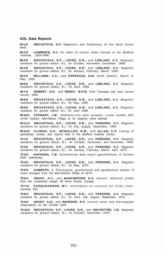
AOL Data Reports
69-1-D SRIVASTAVA, S.P. Magnetics and bathymetry on the Nova Scotiashelf.
69-2-D LAWRENCE, D.J. An index of current meter records at the BedfordInstitute, 1958-1966.
69-3-D SRIVASTAVA, S.P., LOCKE, D.R., and LEBLANC, A.V. Magneticvariations for ground station, B.I., for October, November, December, 1968.
69-4-D SRIVASTAVA, S.P.. LOCKE, D.R., and LEBLANC, A.V. Magneticvariations for ground station, B.I., for January, February, March, 1969.
69-5-D WILLIAMS, C.A., and PORTEOUS, D.M. North Atlantic. March toMay. 1965.
69-6-D SRIVASTAVA, S.P., LOCKE, D.R.. and LEBLANC, A.V. Magneticvariations for ground station, B.I., for April, 1969.
69-7-D SEIBERT. G.H.. and REDDY, M.P.M. Petit Passage tide and currentsurvey, 1966.
69-8-D SRIVASTAVA, S.P., LOCKE, D.R., and LEBLANC, A.V. Magneticvariations for ground station, B.I., for May, 1969.
69-9-D SRIVASTAVA, S.P., LOCKE, D.R., and LEBLANC, A.V. Magneticvariations for ground station, B.I., for June 1969.
69-10-D STEWART, J.M., Sediment-core data synopsis, cruise number BIO19-66 Hudson, Mid-Atlantic Ridge at 45 degrees north latitude
69-11-D SRIVASTAVA, S.P., LOCKE, D.R., and PARSONS, A.V. Magneticvariations for ground station, B.I., for July, August, September, 1969.
69-12-D CLARKE, N.H., MCMULLEN, R.M., and ALLAN, C.S. List ing ofperiodicals, serials, and reports held in the Bedford Institute Library.
70-1-D SRIVASTAVA, S.P.. LOCKE, D.R., and PARSONS, A.V. Magneticvariations for ground station, B.I., for October, November, and December, 1969.
70-2-D SRIVASTAVA, S.P., LOCKE, D.R., and PARSONS, A.V. Magneticvariations for ground station, B.I., for January, February, March, April, 1970.
70-3-D HOFFMAN, T.M. Geochemical data report (geochemistry of Scotianshelf sediments).
70-4-D SRIVASTAVA, S.P., LOCKE, D.R., and PARSONS, A.V. Magneticvariations for ground station, B.I., for May, 1970.
70-5-D AUMENTO, J. Petrological, geochemical and geophysical studies ofrocks dredged from the Mid-Atlantic Ridge at 45°N.
70-6-D GRANT, A.C., and MANCHESTER, K.S. Seismic reflection profilefrom the continental margin off Nova Scotia, Canada.
70-7-D FARQUHARSON, W. I . I n fo rma t i on on cu r ren t s f o r Cha r t I n te r -national 109.
70-8-D SRIVASTAVA, S.P., LOCKE, D.R., and PARSONS, A.V. Magneticvariations for ground station, B.I., for June, July, August, September, 1970.
70-9-D GRANT, A.B., and REINIGER, R.F. Current meter and thermographobservations on the Scotian shelf.
70-10-D SRIVASTAVA, S.P., LOCKE, D.R., and MACINTYRE, J.B. Magneticvariations for ground station, B.I., for October, November, 1970.
203

Appendix B-2
Lectures and Talks
The following is a partial list of scientific presentations by members of staff:
BANKE, E.G. “Ice Drift”. Workshop on Structures in Force, Ottawa, November1970.
BARRETT, D.L., and MANCHESTER, K.S. “Crustal Structure in Baffin Bay andDavis Strait from Magnetometer Surveys”. Meeting of Am. Geophys. Union,Washington, April 1969.
BARTLETT, G.A. “Geological Report on Grand Banks Drill Cores”. OffshoreInformation Seminar. Bedford institute, January 1969.
BENNETT, A.S. “Computer Data Display”. Applications of Sea Going ComputersSymposium, La Jolla,Calif., January 1969.
BENNETT, A.S., MASON, C.S., and BENDELL, E.A. “The Bedford InstituteShipboard Data Logging System”. Appl icat ions of Sea Going ComputersSymposium, La Jolla, Calif., January 1969.
BEWERS, J.M. “Mercury and its Behavior in the Environment”. NorthumberlandStrait Pollution Control Committee, Pictou, N.S., May 1970.
BROOKE, J., and MASON, C.S. 1969. “Some Instruments for Monitoring thePerformance of Undersea Mechanical Devices”. International Oceanology Con-ference, Brighton, U.K., February 1969.
BROOKE, J., and GILBERT, R.L.G. “A Hydrostat ic Power System” - aninvited paper. International Oceanology Conference, Brighton, U.K., February1969.
BROOKE, J. “Hudson 70 and Engineering in Oceanography”. Annual Meeting ofOttawa Branch, Engineering Inst. of Canada, Ottawa, May 1970.
BUCKLEY. D.E. “Marine Geological Research in Alaska”. Dalhousie DawsonGeology Club, January 1969.
BUCKLEY, D.E. Seminar on marine inorganic geochemistry to the University ofNew Brunswick. February 1969.
BUCKLEY, D.E. “General Marine Geology and Oceanography”. Mount AllisonUniversity Teachers Science Course, Sackville, N.B., July 1970.
BUTLER, D.W. “Hudson 70” Dartmouth Rotary Club, Dartmouth, November1970.
DEGRASSE, F.L. “Atlantic Operations”. Eighth Annual Canadian HydrographicConference, Victoria, B.C., March 1969.
DESSUREAULT, J.G. “A Porpoising Towed Body”. C.C.D. Meeting, Victoria,B.C., November 1969.
DESSUREAULT, J.G. “Oceanography in Canada and Mechanical Engineering inOceanography”. Laval Universi ty, Montreal , February 1970. In the FrenchLanguage.
DESSUREAULT, J.G. “Oceanography in Canada and Mechanical Engineering InOceanography”. University of New Brunswick, Fredericton, February 1970. InEnglish.
DESSUREAULT, J.G., and HYMAN, R. “Living, Work and Equipment on theFrench Ship Jean Charcot”. Fall 1969.
DOBSON, F. “Pressure Measurements on Wind Driven Waves”. An invited lectureat the John Hopkins University, Baltimore, Maryland, U.S.A., April 1970.
DOUGLAS, G.R. “Development Group Activities”. Eighth Annual CanadianHydrographic Conference, Victoria, B.C., March 1969.
EWING, G.N. “Future of Marine Sciences in Canada”. Panel member. ScienceCouncil Study on Marine Sciences and Technology, Halifax, N.S., August 1969.
EWING, G.N. “A Brief on Marine Sciences and International Activity in theOffshore Areas of Canada’s Atlantic Seaboard.” Science Council Study of MarineSciences and Technology at the Nova Scotia Technical College, August 1969.
204
EWING, G.N. “A Geophysical Interpretation of Large Scale Geological Featuresof Our Eastern Seaboard.” The Regina Branch, Alberta Association of PetroleumGeologists, September 1969.
EWING, G.N. “A Geophysical Interpretation of Large Scale Geological Featuresof Our Eastern Seaboard.” The Edmonton Branch, Alber ta Associat ion ofPetroleum Geologists, September 1969.
EWING, G.N. “Geophysical Interpretation of Large Scale Geological Features ofOur Eastern Seaboard.” The Calgary Branch, Alberta Association of PetroleumGeologists, September 1969.
EWING, G.N. “The Histor ica l Development and Future Trends in Mul t i -Disciplinary Marine Surveys.” The Canadian Hydrographic 1970 Conference,Ottawa, January 1970.
EWING, G.N. “Multidiscipline Surveys Conducted by the Canadian HydrographicService.” Atlantic Oceanographic Laboratory, C.I.S. Convention, Halifax, N.S.,April 1970.
EWING. G.N. “Brief on the Status of Survey Activity in the Atlantic Region.”Presented to the Parliamentary Committee on National Resources during a recentvisit to the Bedford Institute, Dartmouth, Nova Scotia, May 1970.
FORD, W.L. “Trends in Ocean Exploration.” Dinner talk at Third Canadian FuelCell Seminar, Toronto, February 1969.
FORD, W.L. “Objectives and Program in Marine Research.” Talk to CanadianResearch Management Association meeting in Halifax, October, 1969. This talkwas read by Dr. B.D. Loncarevic as Dr. Ford was unable to attend.
FORD, W.L. “Project Oil.” Seminar at Institute of Oceanography, DalhousieUniversity, Halifax, N.S., November, 1970.
FORD, W.L. Panel Member regarding the future course of marine science andtechnology in Canada. Nova Scotia Technical College, Halifax, August 1969.
GRANT, A.C. “Seismic Reflection Profiling on the Continental Shelf and Slopeoff Labrador and Northeast Newfoundland.” Offshore Information Seminar,Bedford Institute, January 1969.
GRANT, A.C. “Seismic Profiler Investigations on the Labrador Shelf.” DEMRSymposium on Recent Crustal Movements, Ottawa, March 1969.
GRANT, A.C. Talk on the Bedford Institute’s earth science project on theAtlantic Seaboard, Meeting of the Mining Society of Nova Scotia, Keltic Lodge,N.S., June 1969.
GRANT, A.C., and MANCHESTER, K.S. “Geophysical Investigations in theUngava Bay-Hudson Strait Region.” Meeting of Am. Geophys. Union, Washing-ton, April 1969.
HAWORTH, R.T. “Cross-Coupling Errors as a Function of Gravimeter Orienta-tion.” Meeting of Am. Geophys. Union, Washington, April 1969.
HEMPHILL, M.A. “Bathymetr ic Seismic Prof i l ing Surveys.” Eighth AnnualCanadian Hydrographic Conference, Victoria, B.C., March 1969.
KEEN, C.E., and BARRETT, D.L. “Seismic Structure on the Mid-Atlantic Ridgenear 45°N” Meeting of Am. Geophys. Union, Washington, April 1969.
KING, L.H. “The Geology of the Scotian Shelf.” Teachers College of Truro atBedford Institute, Dartmouth, N.S., July 1970.
KING, L.H. “Map and Geology of Scotian Shelf.” Interviewed on CBHT-TV“Gazette” Program, Halifax, N.S., April 1970.
KING, L.H. “On the Origin of the Laurentian Channel.” Meeting of CanadianAssociation of Geographers, St. John’s, Nfld., August 1969.
KING, L.H. , and MacLEAN, B. “The Or ig in of the Laurent ian Channel . ”Ple is tocene problems in the At lant ic Provinces, Canadian Associat ion ofGeographers in St. John’s, Nfld. 1969.
205

KING, L.H., and MARLOWE, J.I. “Geology of the Scotian Shelf and AdjacentSlope.” Offshore Information Seminar, Bedford Institute, January 1969.
KRANCK, K.M. “Post Glacial History of Northumberland Strait.” Meeting ofCanadian Association of Geographers, St. John’s, Nfld., August 1969.
KRANCK, K.M. “Marine Geological Research in the Grenadines, West Indies.”Geographical Society of Finland, Helsingfors, Finland, November 1969.
KRANCK, K.M. “Oil Pollution.” Faculty of Engineering and Applied Science,Memorial University, St. John’s, Nfld., October 1970.
LAWRENCE, D.J. “Water Pollution Survey in the Strait of Canso.” C.C.O.meeting, Victoria, B.C., November 1969.
LEVY, E.M. “A Shipboard Method for the Estimation of Bunker C in Sea Water.”Chemical Institute of Canada, Charlottetown, P.E.I., August, 1970.
LEVY, E.M. “Some Factors Affecting the Precision of Accuracy of SalinityData.” C.C.O. Meeting, Victoria, B.C., November 1969.
LONCAREVIC, B.D. Keynote address. Institute of Electrical and ElectronicEngineers Symposium, Nova Scotia Technical College, March 1970.
LONCAREVIC, B.D. Science Council Working Group on Basic Science, Ottawa,March 1970.
LONCAREVIC, B.D. “Why the Bedford institute?” - an argument for basicresearch in government laboratories. Physics Department Seminar, DalhousieUniversity, March 1970.
LONCAREVIC, B.D. “New Directions in Education in Engineering.” Nova ScotiaTechnical College, May 1970.
LONCAREVIC, B.D. Panel Discussion “The Future of Geology in the Oceans.”Central Canada University Geological Conference, Queen’s University, Kingston,Ontario, October 1970.
LONCAREVIC, B.D. “Marine Geology is Really Geophysics.” Central CanadaUniversity Geological Conference, Queen’s University, Kingston, Ontario, October1970.
LONCAREVIC, B.D. “Mid-Atlantic Ridge Geophysical Aspects”. N.A.C.G.S.,A.C.G.G. Geodynamics Symposium, Ottawa, October 1970.
LONCAREVIC, B.D. “With Hudson’s Scientists through the Northwest Passage”.Arctic Circle Group, Ottawa, December 1970.
LONCAREVIC, B.D., ROSS, D.I., MANCHESTER, K.S., WOODSIDE, J.M., andAUMENTO, F. “The Mid-Atlantic Ridge Near 45°N”. Meeting of Am. Geophys.Union, Washington, April 1969.
LOUCKS, R. “Oceanography at Bedford Institute”. New Brunswick Teachers Association, St. John, N.B., May 1970.
MCKEOWN, D.L. “Oceanographic Sensors”. Mar ine Appl icat ions Counci l ,Hermes Plant, Dartmouth, N.S., December 1970.
MANN, C.R. “Sources of the Deep Water of the North Atlantic”. An invitedlecture, McGill University, Montreal, March 1969.
MANN, C.R. “Sources of the Deep Water of the North Atlantic”. Students atMcGill University, Montreal, March 1969.
MANN, C.R. “Hudson 70”. Dartmouth Rotary Club, Dartmouth, N.S., May1970.
MANN, C.R. “Hudson 70”. Halifax Rotary Club, Nova Scotian Hotel, Halifax,November 1970.
MARLOWE, J.I. “Geochemistry of Carbonate Rocks”. Seminar on the Ecology ofCarbonate Reefs, Dalhousie University, 1969.
206
MARLOW, J.I. “Geological Aspects of Exploration and Development of Mineraland Fuel Resources in Cold or Ice Covered Water”. McGill University, Montreal,May 1969.
MASON, C.S. “Some Developments in Undersea Technology at the BedfordInstitute”. Meeting of Canadian Aeronautics and Space Institute, Halifax, NovaScotia, May 1969.
MASON, C.S. “Results of Oil Pollution”. Joint paper with Dr. A.Y. MacLean atNATO Colloquim, Brussels, November 1970.
MAUNSELL, C.D. “Preliminary Plan for Hudson 70 Geophysical Cruise offBritish Columbia Coast”. C.C.O. Meeting, Victoria, B.C., November 1969.
MELANSON, R.C. “General Hydrography”. Offshore Informat ion Seminar,Bedford Institute, Dartmouth, January 1969.
MELANSON, R.C. “Tidal Current Measurements by Hydrographers at AOL”.Eighth Annual Canadian Hydrographic Conference, Victoria, B.C., March 1969.
MELANSON, R.C. “The Bedford Institute With Particular Reference to Hydro-graphy”. Members of Kiwanis Club, Halifax, N.S., March 1969.
MELANSON, R.C. “Regional Hydrographer’s 1968 Report and Proposed 1969Program”. Eighth Annual Canadian Hydrographic Conference, Victoria, B.C.,March 1969.
MELANSON, R.C. “Hydrography - General”. Presented to Subcommittee onMari t ime Command of Par l iamentary Commit tee on External Af fa i rs andNational Defence, Dartmouth, September 1969.
MELANSON, R.C. “Undertakings at Bedford Institute Appropriate to OffshoreExplorations”. Mapping Colloquim for the Petroleum Industry, Banff Springs,Alberta, October 1969.
MELANSON, R.C. “A Lambda Evaluation”. Mapping Colloquim for the Petro-leum Industry, Banff Springs, Alberta, October 1969.
MELANSON, R.C. “Hudson 70”. Interv iew on CBC-TV Hal i fax “Gazette”,November 1970.
MELANSON, R.C. “Hudson 70”. Interview on CBC Radio Halifax, November1970.
PECK, C.R. “The Place for Electronic Technicians at Atlantic OceanographicLaboratory”. Dartmouth Regional Vocational School, Dartmouth, N.S., May1970.
PECK, C.R. “The Atlantic Oceanographic Laboratory of the Bedford Institute”.Address to 32 teenagers at Lawrencetown, N.S., March 1969.
PELLETIER, B.R. Talks on the earth sciences program of the Bedford Institute,as well as seminars on the subject of the Migration of Clastic Sediments to theGeology Departments at Memorial University of Newfoundland and Queen’sUniversity, Kingston, March 1969.
PELLETIER, B.R. “Geological Explorat ion and Petro leum Potent ia l in theEastern Canadian Offshore”. American Association of Petroleum Landmen,Banff, Alberta, June 1969.
PELLETIER, B.R. “Marine Geology: A Look into the Past and into the 70’s”.Central Canada University Geological Conference, Queen’s University, Kingston,Ontario, October 1970.
PELLETIER, B.R. “Marine Geological Explorations and its Reference to Mineralsand New Marine Technologies”. Canadian Institute of Mining and Metallurgy.Calgary, Alberta, December 1970.
PELLETIER, B.R. “Migration of Clastic Sediments Under Prograding Condi-t ions” Department of Geology, Universi ty of Calgary, Calgary, Alberta,December 1970.
207

PELLETIER, B.R., and MCMULLEN, R.M. “Models of Sediment Transport inMinas Basin and Bay of Fundy”. International Tidal Conference, N.S. TechnicalCollege, Halifax, N.S., June 1970.
QUON, C. “Ef fects of Boundary Condi t ions on Thermal Convect ion in anEnclosure”. Conference at Imperial College, London, England, September 1970.
RANALLI, G. “Theology of the Tectonosphere as Inferred f rom SeismicAftershock Sequences”. American Geophysical Union, Washington, U.S.A., April1970.
RASHID, M.A. “Humic Acids of Marine Sediments and Organo-Clay Inter-act ions”. Gordon Research Conf. Organic Geochemistry, Plymouth, N.H.September 1970.
ROSS, D.I. “Data Storage and Retrieval for Offshore Geophysical Survey”.C.C.O. Meeting, Victoria, B.C., November 1969.
SCHAFER, C.T. Talk on Submersible Shelf Diver on CBHT-TV “Gazette”,October 1969.
SCHAFER, C.T., and BROOKE, J. “Hard Rock Cores from the Mid-AtlanticRidge at 45°N.” Am. Geophys. Union, Fall Meeting, San Francisco, U.S.A.,December 1969.
SEIBERT, G. “Tidal Circulation in Petit Passage, Nova Scotia”. C.C.O. Meeting,Victoria, B.C., November 1969.
SMITH, S.D. “Some Measurements of Reynolds Stress over Ice in the Gulf of St.Lawrence”. McGill University, Montreal, March 1969.
SMITH, S.D. “Some Measurements of Reynolds Stress over Ice in the Gulf of St.Lawrence”. C.C.O. Meeting, Victoria, B.C., November 1969.
SMITH, S.D. Seminar, “Recent Wind Stress Measurement Over the Sea” andLecture, “Stable Platforms for Air-Sea Interaction Studies”. U.S. Naval Post-graduate School, Monterrey, Calif., July 1970.
SMITH, S.D. “Thrust and Sonic Anemometers”. Arctic Ice Dynamics JointExperiment Planning Meeting San Diego, Calif., July 1970.
SMITH, S.D., BANKE, E.G., and JOHANNESSEN, O.M. “Wind Stress Measure-ment over Ice by Sonic Anemometer”. Workshop Seminar on Ice Drift and RelatedStudies; McGill University, Montreal, March 1969.
SMITH, T.B. “Hydrodist MRB-2”. Eighth Annual Canadian Hydrographic Con-ference, Victoria, B.C., March 1969.
STEVENS, R.G. “Wind Stress Studies”. Twelfth Conference on Great LakesResearch at Detroit, Michigan, May 1969.
STEVENS, R.G. “Generation and Travel of Surface Waves”. McGill University,Montreal, March 1969.
STEVENS, R.G., and SMITH, S.D. “Wind Stress Measurements over the OpenSea”. 12th Conference Great Lakes Res., Ann Arbor, Michigan, May 1969.
VILKS, G. “Foramini fera l Ecology in the Canadian Arct ic”. Mount Al l isonUniversity, Sackville, N.B., February 1969.
WAGNER, F.J.E. "Hudson 70 Expedition”. Eastern Shore District High School,Musquodoboit Harbour, N.S., December 1970.
WELLS, D.E. “Experience with Satellite Navigation during Summer of 1968”.Eighth Annual Canadian Hydrographic Conference, Victoria, B.C., March 1969.
WELLS, D. “Surveys for Offshore Resources Development”, TV Panel - C.I.S.Convention, Halifax, N.S., April 1970.
WILLIAMS, R.K. “What Can Service Clubs Contribute to the Pollution Problem”.Members of Kinsmen’s Club, Edmundston, N.B., March 1969.
208

Appendix B-3
Affi l iations
During the years 1969-70 some staff members of the Atlantic OceanographicLaboratory were affiliated in various ways with the academic community.
At Dalhousie University several staff members were associate members of theFaculty of Graduate Studies. These included Dr. C.R. Mann who is an AssociateProfessor in the Physics Department and has been lecturing in fluid dynamics andsupervising graduate students, Dr. B.D. Loncarevic who is also an AssociateProfessor in the Physics Department, Drs. B.R. Pelletier and L.H. King who areSpecial Lecturers in the Geology Department, and Drs. G.T. Needler and H.Sandstrom who are Research Associates in the Institute of Oceanography andhave given courses in dynamical oceanography. In addition, Drs. C. Quon and S.D.Smith gave lecture series in fluid mechanics and Drs. D. I. Ross, S.P. Srivastava,and C. Keen served on students’ thesis committees.
At the Nova Scotia Technical College, S.B. MacPhee and D.F. Dinn gave coursesin electronic design and Dr. A. Bennett has served as associate supervisor of astudent. Dr. W. Forrester is supervisor of a Ph.D. candidate at the Marine SciencesCentre, McGi!l University, and Dr. A. Walton is supervising Ph.D. students at theChemistry Department, University of Glasgow.
During the winter term 1969, Dr. B. D. Loncarevic was a visiting lecturer at theUniversity of California at San Diego and, for the year 1970, Dr. G. T. Needlerwas the Rossby Fellow at the Woods Hole Oceanographic Institution. Dr. B.R.Pelletier is the editor of Maritime Sediments and Dr. Loncarevic is on the editorialboard of Marine Geophysical Researches.
209
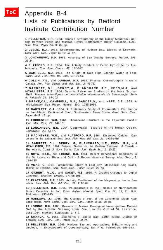
Appendix B-4Lists of Publications by BedfordInstitute Contribution Number
1 PELLETIER, B.R. 1963. Triassic Stratigraphy of the Rocky Mountain Foot-hills Between Peace and Muskwa Rivers, Northeastern British Columbia. Geol.Surv. Can., Paper 63-33: 89 pp.
2 LESLIE, R.J., 1963. Sedimentology of Hudson Bay, District of Keewatin.Geol. Surv. Can., Paper 63-48: 31 PP.
3 LONCAREVIC, B.D. 1963. Accuracy of Sea Gravity Surveys. Nature, 198:23-24.
4 PLATFORD, R.F. 1964. The Activity Product of Ferric Hydroxide by Tur-bidimetry. Cdn. Jour. Chem., 42: 131-183.
5 CAMPBELL, N.J. 1964. The Origin of Cold High Salinity Water in FoxeBasin. Jour. Fish. Res. Bd. Can., 21: 45-55.
6 COLLIN, A.E., and DUNBAR, M.J. 1964. Physical Oceanography in ArcticCanada. Ann. Rev. Ocean. and Mar. Biol., 2: 45-75.
7 B A R R E T T , D . L . , B E R R Y , M . , B L A N C H A R D , J . E . , K E E N , M . J . , a n dMCALLISTER, R.E. 1964. Seismic Refraction Studies on the Nova ScotianShelf. Travaux scientifiques de I’Association lnternationale de Seismologie, SerieA, Fafcicule 23: 99-102.9 DRAKE,C.L., CAMPBELL, N.J., SANDER,G., and NAFE, J.E. 1963. AMid-Labrador Sea Ridge. Nature, 200: 1085-1086.
10 BARTLETT, G.A. 1964. A Preliminary Study of Foraminifera Distributionon the Atlantic Continental Shelf, Southeastern Nova Scotia. Geol. Surv. Can.,Paper 64-5: 19 pp.
11 FORRESTER, W.D. 1964. Thermocline Structure in the Equatorial Pacific.Jour. Mar. Res., 22: 142-151.
12 LONCAREVIC, B.D. 1964. Geophysical S tud ies i n t he I nd i an Ocean .Endeavour, 23: 43-47.
13 MACINTYRE, W.G., and PLATFORD, R.F. 1964. Dissolved Calcium Car-bonate in the Labrador Sea. Jour. Fish. Res. Bd. Can. 21: 1475-1480.
14 BARRETT, D.L., BERRY, M., BLANCHARD, J.E., KEEN, M.J., andMCALLISTER, R.E. 1964. Seismic Studies on the Eastern Seaboard of Canada -The Atlantic Coast of Nova Scotia. Cdn. Jour. Earth Sci., 1: 10-22.
15 NOTA, D.J.G., and LORING, D.H. 1964. Recent Depositional Conditions inthe St. Lawrence River and Gulf - A Reconnaissance Survey. Mar. Geol., 2:198-235.
16 VILKS. G. 1964. Foraminiferal Study of East Bay, MacKenzie King Island,District of Franklin. Geol. Surv. Can., Paper 64-53: 26 pp.
17 GILBERT, R.L.G., and OAKEY, N.S. 1965. A Graphic-Analogue to DigitalConvertor. Electron. Engng., 37: 98-101.
18 PLATFORD, R.F. 1965. Activity Coefficient of the Magnesium Ion in SeaWater. Jour. Fish. Res. Bd. Can., 22: 113-116.
19 PELLETIER, B.R. 1965. Paleocurrents in the Triassic of NortheasternBritish Columbia. In Soc. Econ. Paleot. Mineral. Spec. Pub. No. 12, Ed. G.V.Middleton: 233-245.
20 MARLOWE, J.I. 1965. The Geology of Part of the Continental Slope NearSable Island, Nova Scotia. Geol. Surv. Can., Paper 65-38: 30 pp.
21 LORING, D.H. 1965. Resume of Marine Geological Investigations CarriedOut by the At lant ic Oceanographic Group in the Gul f of St . Lawrence,1961-1964. Maritime Sediments, 1: 8-9.22 KRANCK, K. 1966. Sediments of Exeter Bay, Baffin island, District ofFranklin. Geol. Surv. Can., Paper 66-8: 60 PP.
23 PELLETIER, B.R. 1966. Hudson Bay and Approaches, B-Bathymetry andGeology, In Encyclopedia of Oceanography, Ed. R.W. Fairbridge: 359-363.
210

24 COLLIN, A.E. 1966. Canadian Arct ic Archipelago. A. Introduct ion andOceanography. Hudson Bay and Approaches. A. Introduction and Oceanography.In Encyclopedia of Oceanography, Ed. R.W. Fairbridge: 157-160, 357-359.
26 PELLETIER, B.R. 1966. Canadian Arctic Archipelago. B.Bathymetry andGeology. In Encyclopedia of Oceanography, Ed. R.W. Fairbridge: 169-166.
27 LONCAREVIC, B.D. 1967. Gravity Measurements at Sea, Techniques of. InInternational Dictionary of Geophysics: 694-700.
28 LONCAREVIC, B.D. 1965. Accuracy of Sea Gravity Surveys - Comparisonsof Shipboard and Submarine Gravity Values. Nature, 205: 32-34.
29 PELLETIER, B.R. 1966. Development of Submarine Physiography in theCanadian Arctic and Its Relation to Crustal Movements. In Roy. Soc. Can., Spec.Pub. No. 9, Ed. G.D. Garland: 77-101.
30 BULLARD, E.C., MASON, C.S., and MUDIE, J.D. 1964. Curious Behaviourof a Proton Magnetometer. Proc. Camb. Phil. Soc., 60: 287-293.
31 RODEN, R.B., and MASON, C.S. 1964. The Correction of Shipboard Mag-netic Observations. Geophys. Jour. Roy. Astr. Soc., 9: 9-13.
32 MARLOWE, J.I. 1965. Probable Tertiary Sediments from a Submarine Can-yon Off Nova Scotia. Marine Geology, 3: 263-268.
33 DOE, L.A.E. 1966. Physical Conditions on the Shelf Near Karachi During thePost-Monsoonal Calm, 1964. In Joint Conf. Ocean Sci. and Ocean Eng., Proc., 1:278-292.
34 WESTPHAL, K.O. 1967. Series Solution of Freezing Problem with the FixedSurface Radiating into a Medium of Arbitrary Varying Temperature. Int. Jour.Heat Mass. Trans., 10: 195-205.
35 MASON, C.S. 1966. A Geophysical Data Logging System for Shipboard Use.Jour. Ocean. Tech., 1: 35-44.
37 DOE, L.A.E., and BROOKE, J. 1965. A Moored Stable Platform for Air-SeaInteraction Studies. In A.C. Redfield Volume, Suppl. To Vol. 10, Limnol. andOceanog.: R79-R86.
38 DOE, L.A.E. 1967. Air-Sea Interaction Studies at the Bedford Institute ofOceanography - General Program. Proc. First Cdn. Conf. Micromet., Pt. 1:257-260.
39 DOE, L.A.E. 1967. A Series of Three-Component Thrust Anemometers.Proc. First Cdn. Conf. Micromet., Pt. 1: 105-114.
40 POTTIE, B.G. 1967. A Fast-Response Thermistor Thermometer. Proc. FirstCdn. Conf. Micromet., Pt. 1: 82-89.
41 BECK, V.N. 1967. Tests of a Miniature Electrical Humidity Sensor. Proc.First Cdn. Conf. Micromet., Pt. 1: 93-104.
43 LOUCKS, R.H. 1967. Measurements Required for Momentum and EnergyFlux Determinations Over the Sea. Proc. First Cdn. Conf. Micromet., Pt. 1:257-260.
44 EWING, G.N., KEEN, M.J., DAINTY, A.M., and BLANCHARD, J.E. 1966.Seismic Studies on the Eastern Seaboard of Canada - The Appalachian System.Cdn. Jour. Earth Sci., 3: 89-109.
45 KEEN. C.. and LONCAREVIC, B.D. 1966. Crustal Structure on the EasternSeaboard of Canada - Studies on the Continental Margin. Cdn. Jour. Earth Sci.,3: 65-76.
46 BARRETT, D.L. 1966. Lancaster Sound Shipborne Magnetometer Survey.Cdn. Jour. Earth Sci., 3: 223-235.
47 BARTLETT, G.A. 1966. Foraminifera Distribution in Tracadie Bay, PrinceEdward Island. Geol. Surv. Can., Paper 66-20.
211

48 MARLOWE, J.I. 1966. Mineralogy as an Indicator of Long-term CurrentFluctuations in Baffin Bay. Cdn. Jour. Earth Sci., 3: 191-201.
49 BOWER, D.R., and LONCAREVIC, B.D. 1967. Sea-Gravimeter Trails on theHalifax Test Range Aboard CSS Baffin, 1963. Publs. Dom. Obs., 36: 137 PP.
50 MARLOWE, J.I. 1966. Sedimentology of the Prince Gustaf Adolf Sea Area,District of Franklin. Geol. Surv. Can., Paper 66-29: 83 pp.
51 DOMBROWSKI, D.H., FRIEDLAENDER. C.G.I.. KUHN, R., and LORING,D.H. 1966. Bacter io logical invest igat ion of Carbonrferous Rock Sal t f romPugwash, Nova Scotia. Ecolog. Geol. Helv., 58: 967-974.
52 LORING, D.H. 1967. Resume of geological investigations by the AtlanticOceanographic Group. Maritime Sediments, 3: 24-26.
53 PLATFORD, R.F. 1965. Act iv i ty Coeff ic ient of the Sodium Ion in SeaWater. Jour. Fish. Res. Bd. Can., 22: 885-889.
54 PLATFORD. R.F. 1965. The Activity Coefficient of Sodium Chloride in SeaWater. Jour. Mar. Res., 23: 55-62.
55 PLATFORD, R.F., and DAFOE., T. 1965. The Act iv i ty Coeff ic ient ofSodium Sulfate in Sea Water. Jour. Mar. Res., 23: 63-68.
56 LONCAREVIC, B.D., MASON. C.S.. and MATTHEWS, D.H. 1966. Mid-Atlantic Ridge Near 45° North. I. The Median Valley. Cdn. Jour. Earth Sci., 3:327-349
57 LORING, D.H., and NOTA, D.J.G. 1966. Sea-Floor Conditions Around theMagdalen Islands in the Southern Gulf of St. Lawrence. Jour. Fish. Res. Bd. Can.,23: 1197-1207.
58 GRANT. A.C. 1966. A Continuous Seismic Profile on the Continental ShelfOff NE Labrador. Cdn. Jour. Earth Sci., 3: 725-730.
59 EWING, G.N., and HOBSON, G.D. 1966. Marine Seismic Refraction Investi-gation Over the Orpheus Gravity Anomaly Off the East Coast of Nova Scotia.Geol. Surv. Can., Paper 66-38: 10 pp.60 KING, L.H. 1967. Use of a Convent ional Echo-Sounder and TexturalAnalyses in Delineating Sedimentary Facies - Scotian Shelf. Cdn. Jour. EarthSci., 4: 691-708.
61 MARLOWE, J.I. 1967. A Piston Corer for Use Through Small Ice Holes.Deep-Sea Research, 14: 129-131.
62 LEWIS, E.L. 1967. Heat Flow Through Winter Ice. Proc. Intl. Conf. LowTemp. Sci. (1966), Physics of Snow and Ice, 1: 611-631.
63 NEEDLER, G.T. 1967. A Model for Thermohaline Circulation in an Oceanof Finite Depth. Jour. Mar. Res., 25: 329-342.
64 MCMULLEN, R.M. 1966. Surface Sediments on the Grand Banks ofNewfoundland, A Progress Report. Maritime Sediments, 2: 131-132.
66 GILBERT, R.L.G. 1966. Data-Collecting Systems in Oceanography Boll.Geofis. Teor. Appl., 8: 286-293.
69 LONCAREVIC, B.D., and EWING, G.N. 1967. Geophysical Study of theOrpheus Gravity Anomaly. Proc. 7th World Petrol. Cong., 2: 827-835.
71 SWIFT, D.J.P., and MCMULLEN, R.M. 1968. Preliminary Studies of lnter-tidal Sand Bodies in the Minas Basin, Bay of Fundy, Nova Scotia. Cdn. Jour.Earth Sci., 5: 175-183.
72 MCMULLEN, R.M., and SWIFT, D.J.P. 1967. An occurrence of Large-ScaleRhombiod Ripples, Minas Basin, Nova Scotia. Jour. Sed. Pet., 37: 705-706.
73 PLATFORD, R.F. 1967. Act iv i ty Coeff ic ients in the System H2 O-NaCI-MgSO4 at 25°C. Cdn. Jour. Chem., 45: 821-825.
74 MANN, C.R. 1967. The Termination of the Gulf Stream and the Beginningof the North Atlantic Current. Deep-Sea Research 74: 337-359.
212

75 VILKS, G., ANTHONY, E.H., and WILLIAMS, W.T. 1970. Application ofAssociation-Analysis to Distribution Studies of Recent Foraminifera, Cdn. Jour.Earth Sci., 7: 1462-1469.
76 MANN, C.R., and NEEDLER, G.T. 1967. Effect of Aliasing on Studies ofLong-Term Oceanic Variability off Canada S Coasts. Jour. Fish. Res. Bd. Can.,24: 1827-1831.
77 PELLETIER, B.R., WAGNER, F.J.E., and GRANT, A.C. 1968. MarineGeology. In Science, History and Hudson Bay, 2: 557-613. Canada, Dept. ofEnergy, Mines and Resources.
78 KEYTE, F.K. 1967. Computer vs. Manual Calculations of Temperatures andDepths. Jour. Fish. Res. Bd. Can. 24: 2491-2495.
79 BROOKE, J., and GILBERT, R.L.G. 1967. Undersea Rock Drill. Cdn. UpperMantle Report 1967, Geol. Surv. Can., Paper 67-41: 179-180.
80 KING, L.H. 1967. On the Sediments and Stratigraphy of the Scotian Shelf.In Geology of the Atlantic Region, Geol. Assoc. Can. Spec. Pub. No. 4: 71-92.
82 ROSS, D.I. 1967. Magnetic and Bathymetric Measurements Across thePacific-Antartic Ridge South of New Zealand. N.Z. Jour. Geol. Geophys., 10:1452-1465.
84 SANDSTROM, H. 1969. Effect of Topography on Propagation of Waves inStratified Fluids. Deep-Sea Research, 16: 405-410.
86 PELLETIER, B.R. 1967. Geological Exploration Around Sable Island. Oil-week, June 26.
87 SWIFT, D.J.P., MCMULLEN, R.M., and LYALL, A.K. 1967. A Tidal Deltawith an Ebb-Flood Channel System in the Minas Basin, Bay of Fundy PreliminaryReport. Maritime Sediments, 3: 12-16.
88 AUMENTO, F. 1968. The Mid-Atlantic Ridge Near 45°N. II. Basalts Fromthe Area of Confederation Peak. Cdn. Jour. Earth Sci., 5: 1-21.
90 KRANCK, K. 1967. Bedrock and Sediments of Kouchibouguac Bay, NewBrunswick. Jour. Fish. Res. Bd. Can., 24: 2241-2265.
92 BARTLETT, G.A. 1968. Planktonic Foraminifera - New Dimensions withthe Scanning Electron Microscope. Cdn. Jour. Earth Sci., 5: 231-233.
93 VILKS, G. 1969. Recent Foraminifera in the Canadian Arctic. Micropaieon-tology, 15: 35-60.
96 LORlNG, D.H.. NOTA, D.J.G., CHESTERMAN, W.D., and WONG, H.K.1970. Sedimentary Environments on the Magdalen Shelf, Southern Gulf of St.Lawrence. Marine Geology, 8: 337-354.
98 REINIGER. R.F.. and ROSS. C.K. 1968. A Method of Interpolation withApplication to Oceanographic Data. Deep-Sea Research, 75: 185-193.
99 SCHAFER, C.T. 1967. Factors Influencing the Numerical Accuracy of Ben-thonic Foraminifera Population Counts from Bottom Sediment Samples, Gulf ofSt. Lawrence. Maritime Sediments, 3: 71.
100 SEN GUPTA, B.K. 1967. Distribution of Foraminifera in the Sediments ofthe Grand Banks a Preliminary Report. Marifime Sedimenfs, 3: 61-63.
101 GRANT, A.C. 1967. A Continuous Seismic’ Profile From Halifax Harbour,Nova Scotia. Maritime Sediments, 3: 64.
102 PRAKASH, A., and RASHID, M.A. 1968. Influence of Humic Substanceson the Growth of Marine Phytoplankton - Dinoflagellates, Limnol. Oceanog.,13: 598-606.
103 LAWRENCE, D.J. 1968. Observation of Inertial Oscillation in the North-west Atlantic at 42°N. Jour. Fish. Res. Bd. Can., 25: 1079-1083.
105 BARTLETT, G.A. 1967. Scanning Electron Microscope Potentials in theMorphology of Microorganisms. Science, 758: 1318-1319.
213
106 MARLOWE, J.I. 1968. Unconsolidated Marine Sediments in Baffin Bay.Jour. Sed. Pet., 38: 1065-1078.
107 PRAKASH, A., and RASHID, M.A. 1969. The influence of Humic Sub-stances on Coastal Phytoplankton Product iv i ty. In Coastal Lagoons - aSymposium. Mem. International Symposium on Coastal Lagoons. UNESCO andUNAN, Mexico City. Eds. A. Ayala-Castenares and F.B. Phleger: 431-438.
106 RASHID, M.A., and KING, L.H. 1970. Major Oxygen-Containing Func-t ional Groups Present in Humic and Fulv ic Acid Fract ions Isolated f romContrasting Marine Environments. Geochim. et Cosmochim. Acta, 34: 193-201.
109 RASHID, M.A., and KING, L.H. 1969. Molecular Weight Dist r ibut ionMeasurements on Humic and Fulvic Acid Fractions from Marine Clays on theScotian Shelf. Geochim. et Cosmochim. Acta, 33: 147-151.
110 BARRETT, D.L., 1968. Frequency Modulat ion of a Shipborne ProtonMagnetometer Signal Due to the Hydrodynamic Instability of the Towed Vehicle.Jour. Geophys. Res., 73: 5237-5334.
111 WAGNER, F.J.E. 1967. Additional Radiocarbon Dates, Tyrrell Sea Area.Maritime Sediments, 3: 100-104.
112 KING, L.H. 1969. Submarine End Moraines and Associated Deposits on theScotian Shelf. Geol. Soc. Amer. Bull., 80: 83-96.
113 SCHAFER, C.T. 1967. Preliminary Survey of the Distribution of LivingBenthonic Foramini fera in Northumber land Stra i t . Mari t ime Sediments, 3:105-108.
114 PHIPPS, C.V.G., and KING, L.H. 1969. Chemical, Mineralogical and Tex-tural Variations in Sediments from the Scotian Shelf. Maritime Sediments, 5:101-112.
115 PAGDEN, I.M.H., and SUTHERLAND, J.C. 1970. Resolving Power ofGamma Ray Coincidence Spectrometry Using L i th ium Dr i f ted GermaniumDetectors and Its Application to Multiple Radio-isotope Analysis. AnalyticalChemistry, 42: 383-387.
116 BROOKE, J., and GILBERT, R.L.G. 1968. The Development of the Bed-ford Institute Deep-Sea Drill. Deep-Sea Research, 15: 483-490.
117 PELLETIER, B.R. 1967. Sedimentation in Arctic Waters of the WesternQueen Elizabeth Islands, District of Franklin, Canada. Maritime Sediments, 3:90-99.
118 WAGNER, F.J.E. 1968. Faunal Study, Hudson Bay and Tyrrell Sea. EarthScience Sym. on Hudson Bay, Geol. Surv. Can., Paper 68-53: 7-48.
119 GRANT, A.C. 1968. Some Aspects of the Bedrock Geology of Hudson Bayas Interpreted from Continuous Seismic Reflection Profiles. Earth Science Sym.on Hudson Bay, Geol. Surv. Can., Paper 68-53: 136-143.
120 EMERY, K.O., KAYE, C.A., LORING, D.H., and NOTA, D.J.G. 1968.European Cretaceous Flints on the Coast of North America. Science, 160:1225-1228.
121 PELLETIER, B.R. 1968. Submarine Physiography, Bottom Sediments, andModels of Sediment Transport in Hudson Bay. Earth Science Sym. on HudsonBay, Geol. Surv. Can., Paper 68-53: 100-135.
122 MANN, C.R. 1969. A Summary of Variability Observed with MonitoringSections Off the East and West Coasts of Canada. Progress in Oceanography, 5:17-30.
123 VILKS, G. 1968. Foraminiferal Study of the Magdalen Shallows, Gulf ofSt. Lawrence. Maritime Sediments, 4: 14-21.
124 BARTLETT, G.A. 1968. Mid-Tert iary Strat igraphy of the Cont inentalSlope Off Nova Scotia. Maritime Sediments, 4: 22-31.
214

125 GRANT, A.C. 1968. Seismic-Prof i ler Invest igat ion of the Cont inentalMargin Northeast of Newfoundland. Cdn. Jour. Earth Sci., 5: 1187-1198.
126 MUIR, B.S. 1969. Gill Dimensions as a Function of Fish Size. Jour. fish.Res. Bd. Can., 26: 165-170.
127 DUEDALL, I.W. 1968. Partial Molal Volumes of 16 Salts in Sea Water.Environ. Sci. and Tech., 2: 706-707.
128 BRAWN, V.M., and PEER, D.L. 1968. Caloric Content of the StandingCrop of Benthic and Epibenthic Invertebrates of St. Margaret’s Bay, Nova Scotia.Jour. Fish. Res. Bd. Can., 25: 1803-1811.
130 WAGNER, F.J.E. 1968. I l lustrated Check-List of Mar ine PleistoceneInvertebrate Fossils of Quebec. Le Naturaliste Canadien, 95: 1409-1433.
131 LAKE, R.A., and LEWIS, E.L. 1970. Salt Rejection by Sea Ice DuringGrowth. Jour. Geophys. Res., 75: 583-597.
132 MANN, C.R. 1969. Temperature and Salinity Characteristics of the Den-mark Strait Overflow. Deep-Sea Research, Supp. to V. 16: 125-137.
133 BROOKE, J., and MASON, C.S. 1969. Some Instruments for Monitoringthe Performance of Undersea Mechanical Devices. Oceanology International 69Conf., Proc., Technical Sessions, Day 1, Session A, Part I, Paper 5.
134 SEN GUPTA. B.K.. and MCMULLEN. R.M. 1969. Foraminiferal Distribu-tion and Sedimentary Facies on the Grand Banks of Newfoundland. Cdn. Jour.Earth Sci., 6: 475-487.
136 BROOKE, J., and GILBERT, R.L.G. 1969. A Hydrostatic Power System.Oceanology lnternational 69 Conf., Proc., Technical Sessions, Day 4, Session F,Paper 5.
136 QUON, C. 1969. Time Dependence of Thermal Convection in a BoundedRotating System. The Physics of Fluids, V. 12, Supplement II: 214-218.
137 AUMENTO, F., and LONCAREVIC, B.D. 1969. The Mid-Atlantic RidgeNear 45°N. III. Bald Mountain. Cdn. Jour. Earth Sci., 6: 11-23.
138 SCHAFER, C.T., and PRAKASH, A. 1968. Current Transport and Deposi-tion of Foraminiferal Tests, Planktonic Organisms and Lithogenic Particles inBedford Basin, Nova Scotia. Maritime Sediments, 4: 100-103.
139 SCHAFER, C.T., and SEN GUPTA, B.K. 1968. Benthonic ForaminiferalEcology in Port Castries Bay, St. Lucia, a Preliminary Report. Maritime Sediments,4: 57-63.
140 PELLETIER, B.R. 1968. The Submersible Pisces Feasibility Study in theCanadian Arctic. Maritime Sediments, 4: 69-72.
141 SHELDON, R.W., LORING, D.H., and DELEU, S. 1969. PhysiographicChanges in Malpeque Bay, Prince Edward Island, between 1845 and 1955, and thePossible Effects on Oyster Production. Jour. Fish. Res. Bd. Can., 26: 171-175.
142 ROSS, D.I. 1969. Experience with a Shipboard PDP-8 Computer. Oceano-logy International 69 Conf., Proc., Technical Sessions, Day 2, Session A, Part II,Paper 6.
143 BENNETT,A.S., MASON, C.S.. and BENDELL, E.A. 1969. The BedfordInstitute Shipboard Data Logging System. Trans. Applications of SeagoingComputers 1969, Mar. Tech. Soc.: 63-69.
144 BENNETT, A.S. 1969. Computer Data Display. Trans. Applications ofSeagoing Computers 1969, Mar. Tech. Soc.: 99-103.
145 WELLS, D.E. 1969. The Automatic Real-time Plotting of Ship’s Tracks.Trans. Applications of Seagoing Computers 1969, Mar. Tech. Soc.: 131-139.
146 MANN, K.H. 1969. The Dynamics of Aquatic Ecosystems. Adv. EcologicalRes., 6: 1-81.
215

147 WALKER, D.A. 1969. Observations of the Regeneration of a New Test bythe Foraminifera Discorbis Sp. Cdn Jour. Zoo/., 47: 543-545.
148 SUBBA RAO. D.V.. and PLATT, T. 1969. Optimal Extraction Conditionsof Chlorophylls from Cultures of Five Species of Marine Phytoplankton. Jour.Fish. Res. Bd. Can., 26: 1625-1630.
149 SHELDON, R.W., and SUTCLIFFE, W.H., Jr. 1969. Retention of MarineParticles by Screens and Filters. Limnol. Gceanog., 14: 441-444.
150 GILBERT, R.L.G., and MASON, C.S. 1970. Some Developments in Under-sea Technology at the Bedford Institute. Cdn. Aeronautics Space Jour., UnderseaTechnol. Supp., 16: 17-20.
151 PLATT, T. 1969. The Concept of Energy Efficiency in Primary Production.Limnol. Oceanog., 14: 653-659.
152 WELLS, D.E. 1969. Exper ience wi th Satel l i te Navigat ion Dur ing theSummer of 1968. The Canadian Surveyor, 23: 334-348.
153 KING, L.H. 1970. Surficial Geology of the Halifax-Sable Island Map Area.Marine Sciences Branch, Paper 1: 16 pp.
154 MUIR, B.S. 1969. Further Observations on Gill Modifications of OceanicFishes. Copeia, No. 3: 629.
155 LONCAREVIC, B.D., FORD, W.L., and MCMULLEN, R.M. 1969. AtlanticOceanographic Laboratory, Bedford Institute, the First Six Years. Polar Record,14: 807-813.
156 SAMEOTO, D.D., and JAROSZVNSKI, L.O. 1969. Otter Surface SamplerA New Neuston Net. Jour. Fish. Res. Bd. Can., 26: 2240-2244.
157 MARLOWE, J.I. 1969. A Succession of Tertiary Strata Off Nova Scotia, asDetermined by Dredging. Cdn. Jour. Earth Sci, 6: 1077-1094.158 BRAWN, V.M. 1969. Buoyancy of Atlantic and Pacific Herring. Jour. Fish.Res. Bd. Can., 26: 2077-2091.
159 SUBBA RAO, D.V. 1969. Asterionella Japonica Bloom and DiscolorationOff Waltair, Bay of Bengal, Limnol. Ocean., 14: 632-634.
160 MARLOWE, J.I. 1969. Petrologia De Rotas Carbonaticas De La Prominen-cia De Las Aves (Un lnforme Preliminar). Bol. Inform. Asoc. Venez. Geol. Min.Petroleo, 12: 275-287.
161 PLATT, T., BRAWN, V.M., and IRWIN, B. 1969. Caloric and Carbon Equi-valents of Zooplankton Biomass. Jour. Fish. Res. Bd. Can., 26: 2345-2349.
162 GARNER,D.M.. and FORD, W.L. 1969. Mid-Atlantic Ridge Near 45°N.IV. Water Properties in the Median Valley. Cdn. Jour. Earth Sci., 6: 1359-1363.
163 BARTLETT, G.A. 1969 Cretaceous Biostratigraphy of the Grand Banks ofNewfoundland. Maritime Sediments, 5: 4-14.
164 MARLOWE, J.I. 1969. High-Magnesian Calcite Cement in Calcarenite fromAves Swell, Caribbean Sea. Bermuda Biol. Stn. for Research, Spec. Pub. No. 3 -Carbonate Cements: 79-83.
166 CUNNINGHAM, C.C., and DUEDALL, I.W. 1969. Phenosafranin Indicatorfor Chlorinity Titrations. Jour. Du Conseil, 33: 437-440.
167 LORING, D.H., and NOTA, D.J.G. 1969. Mineral Dispersal Patterns in theGulf of St. Lawrence. Rev. Geogr. Mont., 23: 289-305.
158 AUMENTO, F. 1969. The Mid-Atlantic Ridge Near 45°N. V. Fission-Trackand Ferro-Manganese Chronology. Cdn. Jour. Earth Sci., 6: 1431-1440.
169 MACKAY, I . , and MANN, K.H. 1969. The Fecundi ty of Two Cypr in idFish in the River Thames, Reading, England. Jour. Fish. Res. Bd. Can., 26:2795-2805.
216

170 KING, L.H., MACLEAN, B., JELETSKY, J.A., BARTLETT, G.A., andHOPKINS, W.S. Jr. 1970. Cretaceous Strata on the Scotian Shelf. Cdn. Jour.Earth Sci., 7: 145-155, 188-190.171 PLATT, T., LARSEN, E., and VINE, R. 1970. integrating Radiometer ASelf-contained Device for Measurement of Submarine Light Energy in AbosluteUnits. Jour. Fish. Res. Bd. Can., 27: 185-191.
172 BUDLONG, K.S. 1969. A Simplified Method for Predicting Satellite Passes.Jour. Space. and Rockets, 6: 1341-1343.
173 GARNER, D.M., 1969. Vertical Surface Acceleration in a Wind-GeneratedSea. Deutsche Hydrog. Zeit, 22: 163-168.
174 GRANT, A.C. 1970. Recent Crustal Movements on the Labrador Shelf.Cdn. Jour. Earth Sci., 7: 571-575.
175 SHELDON, R.W. 1969. A Universal Grade Scale for Particulate Materials,Geol. Soc. London, Proc., No. 1959: 293-295.
176 FORRESTER, W.D. 1970. Geostrophic Approximation in the St. LawrenceEstuary. Tellus, 22: 53-65.
177 MUIR, B.S. 1970. Contribution to the Study of Blood Pathways in TeleostGills. Copeia, No. 1: 19-28.
178 MARLOWE, J.I . 1970. Weddel l i te in Bot tom Sediment From the St .Lawrence and Saguenay Rivers. Jour. Sed. Pet, 40: 499-506.
179 IRVING, E. 1970. The Mid-At lant ic Ridge Near 45°N. VI . RemanentIntensity. Susceptibility and Iron Content of Dredged Samples. Cdn. Jour. EarthSci., 7: 226-238.
180 RUFFMAN, A., and WOODSIDE, J. 1970. The Odd-Twins Magnet icAnomaly and Its Possible Relationship to the Humber Arm Klippe of WesternNewfoundland, Canada. Cdn. Jour. Earth Sci., 7: 326-337.
182 BARTLETT, G.A., and GREGGS, R.G. 1970. The Mid-Atlantic Ridge Near45°N. VIII. Carbonate Lithification on Oceanic Ridges and Seamounts. Cdn.Jour. Earth Sci., 7: 257-267.
183 BARTLETT, G.A., and GREGGS, R.G. 1970. A Re-interpretation of Sty-lo l i t ic Solut ion Surfaces Deduced f rom Carbonate Cores f rom San PabloSeamount and the Mid-Atlantic Ridge. Cdn. Jour. Earth Sci., 7: 274-279.
184 SMITH, S.D. 1970. Wind Stress and Turbulence Over Ice in the Gulf of St.Lawrence. Jour. Geophys. Res., 75: 2803-2812.
185 MANCHESTER, K.S., and KEEN, M. 1970. The Mid-Atlantic Ridge Near45°N. X. Sediment Distribution and Thickness from Seismic Reflection Profiling.Cdn. Jour. Earth Sci., 7: 735-747.
186 VILKS, G. 1970. Circulation of Surface Waters in Parts of the CanadianArctic Archipelago Based on Foraminiferal Evidence. Arctic 23: 100-111.
187 BARTLETT, G.A., and GREGGS, R.G. 1969. Carbonate Sediments -Oriented Lithified Samples from the North Atlantic. Science, 166: 740-741.
188 SUTCLIFFE, W.H. Jr. 1970. Relation Between Growth Rate and Ribo-nucleic Acid Concentration in Some Invertebrates. Jour. Fish. Res. Bd. Can., 27:606-609.
190 DOWD, R.G., BAKKEN, E., and NAKKEN, O. 1970. A ComparisonBetween Two Sonic Measuring Systems for Demersal Fish. Jour. Fish. Res. Bd.Can., 27: 737-742.
191 PLATT, T., and SUBBA RAO, D.V. 1970. Primary Production Measure-ments on a Natural Plankton Bloom. Jour. Fish. Res. Bd. Can., 27: 887-899.
192 GRANT, A.C., and MANCHESTER, K.S. 1970. Geophysical Investigationsin the Ungava Bay-Hudson Strait Region of Northern Canada. Cdn. Jour. EarthSci., 7: 1062-1076.
217

193 BARRETT, D.L., and AUMENTO, F. 1970. The Mid-Atlantic Ridge Near45°N. XI I. Velocity, Density and Layering of the Crust. Cdn. Jour. Earth Sci, 7:1117-1124.
194 LORING, D.H., and NOTA, D.J.G. 1968. Occurrence and Significance ofIron, Manganese and Titanium in Glacial Marine Sediments from the Estuary ofthe St. Lawrence River. Jour. fish. Res. Bd. Can., 25: 2327-2347.
196 PLATT, T., DICKIE, L.M., end TRITES, R.W. 1970. Spatial Heterogeneityof Phytoplankron in a Near-Shore Environment. Jour. Fish. Res. Bd. Can., 27:1453-1473.
197 KEEN. C.. and TRAMONTINI, C. 1970. A Seismic Refraction Survey onthe Mid-Atlantic Ridge. Geophys. Jour., Roy. Astr. Soc., 20: 473-491.
198 BROWN, C.E., and MUIR, B.S. 1970. Analysis of Ram Ventilation of FishGi l ls wi th Appl icat ion to Skip jack Tuna. Jour . Fish. Res. Bd. Can. , 27:1637-1653.
199 GILBERT, R.L.G. 1970. The Bedford Institute Wave Recorder. Jour. Geo-phys. Res., 75: 5215-5224.
200 KING, L.H., and MACLEAN, B. 1970. Pockmarks on the Scotian Shelf.Geol. Soc. Amer. Bull., 81: 3141-3148.
201 PLATT, T., and SUBBA RAO, D.V. 1970. Energy Flow and Species Den-sity in a Marine Phytoplankton Bloom. Nature, 227: 1059-1060.
202 LEWIS, E.L., and WALKER, E.R. 1970. The Water Structure under aGrowing Sea Ice Sheet. Jour. Geophys. Res., 75: 6836-6845.
204 KING, L.H., and MACLEAN, B. 1970. Cont inuous Seismic-Ref lect ionStudy of Orpheus Gravity Anomaly. Am. Assoc. Petrol. Geol., 54: 2007-2031.
205 SMITH, S.D. 1970. Thrust-Anemometer Measurements of Wind Turbu-lence, Reynolds Stress, and Drag Coefficient over the Sea. Jour. Geophys. Res.,75: 6758-6770.
206 KING, L.H., and MACLEAN, B. 1970. Origin of the Outer Part of theLaurentian Channel. Cdn. Jour. Earth Sci., 7: 1470-1484.
207 SUTCLIFFE, W.H. Jr., SHELDON, R.W., and PRAKASH, A. 1970. Cer-tain Aspectsof Production and Standing Stock of Particulate Matter in the surfaceWaters of the Northwest At lant ic Ocean. Jour. F ish. Res. Bd. Can. , 27:1917-1926.
209 PLATT, T . 1970 . The Annua l P roduc t i on by Phy top lank ton i n S t .Margaret’s Bay, Nova Scotia. Jour. Du Conseil, 33.
210 PARK, J.K., and IRVING, E. 1970. The Mid-Atlantic Ridge Near 45°N.XII. Coercivity, Secondary Magnetization, Polarity, and Thermal Stability ofDredge Samples. Cdn. Jour. Earth Sci., 7: 1499-1514.
211 BROOKE, J., IRVING, E., and PARK, J.K. 1970. The Mid-Atlantic RidgeNear 45°N. Xl II. Magnetic Properties of Basalt Bore-core. Cdn. Jour. Earth Sci.,7: 1515-1527.
212 IRVING. E. 1970. The Mid-Atlantic Ridge at 45°N. XIV. Oxidation andMagnetic Properties of Basalt; Review and Discussion. Cdn. Jour. Earth Sci. 7:1528-1538.
213 PEER, D.L. 1970. Relation Between Biomass. Productivity, and Loss toPredators in a Population of a Marine Benthic Polychaete, Pectinaria Hypoborea.Jour. Fish. Res. Bd. Can., 27: 2143-2153.
215 IRV ING, E . , PARK, J .K . , HAGGERTY, S .E . , AUMENTO, F . , andLONCAREVIC, B.D. 1970. Magnetism and Opaque Mineralogy of Basalts fromthe Mid-Atlantic Ridge at 45°N. Nature, 228: 974-976.
218 VILKS, G. 1970. New Method for Separation of Skeletal Material from aPlankton Sample. Maritime Sediments, 6: 72-73.
218

CMarine Ecology LaboratoryFisheries Research Boardof Canada

(This page Blank in the original)
220

Director’s Remarks
“Peace, population, pollution and resources are the central interlockingvariables whose unsatisfactory management threatens our options”.-Preston Cloud in preface to report of Committee on Resources andMan.
It is a truism to say that animals and plants regularly occur in natureonly in those areas which are suitable for them. The identification of“ecology” as a special field of biology has been an expression of ourneed for a better understanding of how animals and plants interact withtheir environmental settings to determine their distribution andoccurrence. Ecology, of which marine ecology is an important part, wasthus originally conceived as a study of the “homes” (oikos) orhabitations of animals.
It is in this context that the word “ecology” has over the past two orthree years risen from the obscurity of a technical term describing thework of a few scientific specialists, to the position of a byword,recognized by most of the literate of modern society. But thisemergence has depended on at least two factors. The first has been theevolution of the field itself, from the description of natural systems bycurious scientists, to the anticipation of a predictive theory which candeal with the interactions of “populations, pollution and resources”.The second is the rapid growth of the realization that the impact ofcivilization on natural ecosystems is so great that prediction and thebetter management dependent on it is a necessity for survival, not aluxury to be purchased as a cultural frill.
In the essay, Analysis of Marine Ecosystems, which is presented earlierin this review, Dr. Mann gives an appreciation of the technicalcomplexities which we face in our attempts to make predictions ofcomplex natural systems. The methods of science have traditionallydepended upon the framing of hypotheses which could be tested insimplified systems, subjected to deliberate manipulation. Thisexperimental method, developed as an important tool by the physicaland chemical sciences, has also been available in limited form tostudents of ecology of terrestrial and small aquatic systems. However, itis in the marine systems that we encounter scales of natural phenomenawhich are so large or so complex that special adaptations of thesetechniques are necessary. In these important large environmentalsystems, simplification and experiment depends upon the constructionof mathematical or analogue models from which deductions can bemade about the simultaneous operation of a number of importantvariables. “Experiments” performed with the models predictconsequences which become the source of hypotheses which can oftenbe tested only by observations in special situations or areas. These inturn lead to further generalizations or refinements of the models, andso on.
221

The recent activities of the Marine Ecology Laboratory, reported by thescientists in this review, give many examples of this method of study.They also indicate the ways in which the science of ecology is beginningto close some of the important gaps in our knowledge, and the utilityof this new-found power to serve our immediate needs.From its beginnings as a description of the adaptations of animals andplants to changing environments, ecology has thus become the study ofecosystems. At its base however it is still the study of the physiologicaland behavioural characteristics of the organisms themselves, theirdependence on food for growth and reproduction, and the effects ofphysical conditions on the transfer rates. The problems to be solved aremany, and have been aggravated by growing urgency to predict theeffects of the many pollutants being poured into the environment, toend up, by one route or another, in the ultimate “sink”, the seas. In thereports which follow we include accounts of a number of studiesundertaken to examine the toxicity of specific compounds. Some ofthese studies are of compounds proposed for new use. Some of thestudies have been undertaken to explain observed mortalities fromaccidental spills of pollutants such as the release of elementalphosphorus into Long Harbour, Newfoundland. Other studies haveattempted to understand some of the more immediate effects ofBunker C spilled into the waters of Chedabucto Bay following thewreck of the oil-tanker Arrow. In a similar class are studies which areoutlining the condition? which promote growth of the phytoplanktonorganisms responsible for paralytic shellfish poisoning. PSP has beenknown for some years from the East Coast of Canada, and has recentlybeen detected along the shores of the North Sea in Europe. Thelaboratory staff have participated in preparation of a definitive reviewof our knowledge of this phenomenon.
A knowledge of the physiology and behaviour of the organisms isimportant to ecology in other ways. As our exploitation of fishpopulations has grown, and the rate of increase in catching has begun toslow down, we have become conscious of differences in meanproductivity among various species of fish or differences in the stabilityof the mean production levels. While the overall catches of fish havefluctuated little about the overall trends, there have been largervariations among the individual species or stocks in various areas.Increased fishing has decreased the average life-spans of our prey so thatthese fluctuations increasingly affect the Industry. We are beginning tounderstand that the scales of variation are linked not only to thepattern of environmental change, but to the “design-constraints” of thespecies themselves. A predictive theory of multi-species fishing will haveto explain the relation between these animal designs and theproductivity and stability of their populations. It is in this context thatwe report our studies of the feeding, growth and respiration of anumber of our important commercial species.
222

One of the most important ecosystem problems with which we mustlearn to deal, is the prediction of the total yields which can beexpected, and the influence of the rates of fishing on it. This problemhas increasingly occupied the attention of fisheries biologists, and therehave been a number of recent attempts to summarize what we know.There is a growing consensus that on a world scale, the total potentialyield may not be more than a few, perhaps two to four, times thepresent. The practical need for accurate prediction becomes largeindeed when it is understood that in certain areas, at present rates ofgrowth of the fisheries, the more conservatively estimated upper limitof fisheries yields could be reached within the life-time of a fishingvessel constructed today.
There are many reasons why we cannot rely on our present informationas a basis for prediction. Among the most important of them is thesimple fact that we do not yet have a method of fish populationinventory which can give an estimate of total population size accurateto within perhaps an order of magnitude. It may be argued that ourassessment of the abundance of the commercial sizes is better than this.However, the abundance of smaller sizes of fish, generally during theirfirst three or four years of life, is hardly known at all, and it is amongthese sizes that most of the natural production takes place. Thus, whilethe commercial catches of large sizes are beginning to level off, we findthat the seals and whales, which generally depend on young fish, eatalmost as much as the commercial fishermen catch. In the face of suchknowledge, it is difficult to believe that our fisheries are yet limited bythe overall natural production. A significant proportion of the effort ofthe laboratory is therefore devoted to the development of both directand indirect methods of measuring and enhancing natural production.For example, in the following reports are accounts of the developmentof acoustic systems for improving our methods of inventory of thestocks. This equipment,, which certainly would be useful for inventory,is also likely to find application for increasing the searching efficiencyof fishing vessels. In other studies the acoustical systems of whales arebeing examined as part of a general exploration of the use of soundwaves to understand marine phenomena.
Perhaps the greatest problem in marine production studies however, is tobe found in the measurement of the primary plant production of thesea, and understanding how this basic energy becomes available tocommercial species through the food chains. Workers in the laboratoryhave found, for example that our present methods are not uniformlyreliable for measuring productivity in different areas of the sea, nor formeasuring the fraction of the primary production which enters and isdistributed through higher stages of the food chains. During late 1969and 1970 the cruise of the CSS Hudson around the Americas provided aunique opportunity for testing some of the hypotheses about pro-duction rates by comparing conditions over a variety of temperate and
223

tropical water masses in both the Atlantic and Pacific Oceans.
Near home, the laboratory has undertaken the synthesis of much of ourknowledge of production mechanisms in St. Margaret’s Bay. This studyhas demonstrated for the first time the importance of the sea-weedproduction in cold temperate waters. It has also provided our firstopportunity to study the influence of the sea-weed production onfood-chain transfers leading to lobsters, our most valuable singlecommercial species.
While we are concerned with obtaining an understanding and predictionof fish production to provide a firm base for the management of thefish stocks of the continental shelves, underlying all such studies is ourgrowing concern with the effects of pollutants on the productionsystem, and its occurrence in our food. Of critical importance here isthe production of the amazing array of pelagic shrimp-like or benthicmollusc-like filter feeders which feed on the plant materials anddetritus, and form the important food links to the surface andbottom-feeding fishes. In various experiments it has been demonstratedthat the surface zooplankton, by their grazing, may be responsible forremoving about 30% of the daily plant production from the watercolumn. In special experiments following the massive oil-spill from thetanker Arrow, it was found that these same zooplankton were the mostimportant natural agent in clearing the water column of the finelydispersed oil particles. The bunker C oil did not appear to affect theanimals, but their faeces, containing oil and a rich bacterial flora, settleto the bottom where the extra bacterial load probably enhances the oildegradation. The effects on the bottom communities are still unknown.
The biological production budgets of small coastal embayments are ofspecial importance, partly because of the conflicting consequences ofour actions with respect to them. It appears in the first place that theseembayments are singularly rich producers. The fact that along theentire east coast of Canada the small bays throng with the larvae,juveniles and young of the species we catch as adults at sea, suggeststhat they may be vital links in the production chains supporting thecontinental shelves fisheries. But more than this, man has longrecognized the natural beauty and advantages of living on thecoastlines. Yet his haphazard conurbations are pouring vast amounts ofmunicipal and industrial effluents into these areas. Until recently wehave been oblivious of the consequences. Studies conducted from ourlaboratory have indicated that this has probably already led tosignificant “deterioration” of some areas, such as Bedford Basin andHalifax Harbour. It is in the coastal inlets that, as a society, we areseriously beginning to consider the development of aquaculture toenhance the production of sea-foods. The various purposes for whichwe plan to use the coast-lines are potentially in direct conflict andrequire careful knowledge-based management.
224

In order to understand better the role of these coastal inlets in marineproduction the laboratory has used the expertise built up in our St.Margaret’s Bay program, to make an intensive study of production inthe Bedford Basin site. The joint biological-physical oceanographicstudy succeeded in “balancing” the daily basic biological budget of theBasin to within a few percent. However, of the 2/3 of the primaryproduction which was exported, only about 1/3 was directly associatedwith the mean water flows. The larger fraction, nearly 2/3, wasassociated with the turbulent fluctuations in water flow. That is, theestimates of export would have been ridiculously wrong if we had basedthem on mean plankton and mean flow measurements. The resultsshow in a dramatic way, how the small scale variabilities which reflectlocal differences in distributions within these marine systems, are theprinciple determinants of the systems. In a vague way this is known ona large scale to everyone - in the sense that high productions of food inNorth America are only a small part of the solution of the problem ofhow to get food to a hungry Asia. It is now clear that in predictingfood-chain production, it is equally important to understand thepatterns of distribution and availability of energy and materials in thesystem. This same phenomenon underlies the biological “magnificati-on” of the concentrations of pesticides, heavy metals and otherpollutants in the food-chains. Many of the reports included in thisreview discuss aspects of this single most important problem inecosystem studies.
In this review of our present situation in marine ecology, it would beirresponsible not to point to some of the directions in which ourdiscoveries and our needs are leading us. It must be clear that scientistsare beginning to agree that ecosystems are truly natural systems. Thatis, it is possible to define natural systems which will show an overallstability in relation to the fluctuations in their components. It is on thisbasis that we can aim towards the making of predictions of yields. Inman’s activities, however, individuals or even communities, have usuallybeen interested in only one or two of the biological components ofthese natural systems - such as the codfish or herring, the availabilityof a basin for easy waste disposal, or the “undisturbed” access to asmall bay for boating or recreational fishing. In many cases, especiallycommercial and sports fishing, it is clear that these component partshave larger fluctuations than the whole, and may often show trendswhich are different from the overall. While in most cases we shall nevercontrol or even predict these “component” events with the samereliability as for the whole system, it is still necessary to be able tounderstand and explain them in relation to the whole. Therefore we canexpect a continuing and increasing need for the study of details ofsystems, much as we now do. This is abundantly clear in the demandsfor information on sources, distributions and occurrences of heavy
225

metals such as mercury, or of oil slicks and particles in the NorthAtlantic. It will continue to be part of our responsibility to helpunderstand these phenomena.
What needs to be said, however, is that this preoccupation of men withthe details of their daily existence must not be permitted to divert theirattentions from the total impact. Explanations or ameliorations of localevents is not enough. Our fishing rates are now so high that weprobably remove considerably more than two-thirds of the naturalproduction of the commercial sizes of fish each year. In the same vein,the amounts of DDT, metals, oils and fertilizers that we are pouringinto the coastal waters appear to far exceed the natural annual turnoverof organic materials, even if we could average them over the entireocean basins, instead of concentrating them in estuaries and bays alongthe coast. At the same time we are creating major hydro-electric powerdams as the “safest” of power-generating mechanisms. These aresubstantially altering the patterns of seasonal outflow into coastalwaters, and in very many cases must be responsible for major changes inthe mixing and flushing properties which give the estuaries their uniquecharacter as high biological producers.
In the abstract, these potential effects are disturbing to contemplate. Inthe concrete, the Gulf of St. Lawrence is almost certainly among thethree most affected systems of the world, along with the Gulf ofMexico off the Mississippi and the eastern Mediterranean off the Nile.The Gulf of St. Lawrence may however be more importantly affectedthan any of these others. In the first place it is smaller in relation to itsprinciple river discharges. In the second place, it is in a majortransitional climatic zone, where small changes may substantially affectwinter ice cover, with major consequences for climate of the surround-ing land, and the biological productivity of both land and the partlyenclosed sea. It is our belief that Canada has both a national andinternational responsibility to understand how and the extent to whichthis large natural system is being modified at present, and to assess thepossibilities and consequences of further major natural system manipu-lation. The formation, within the Federal Government of a newDepartment of the Environment, may be an essential step in making itpossible in this instance for Canadians to meet their obligation tounderstand what they are doing. In any such future study the MarineEcology Laboratory expects to play an important role.
Administrative Review
The Marine Ecology Laboratory celebrated its fifth birthday in 1970.Our vital statistics on birth were a staff of 15, and an operating budgetof approximately $200,000. We have now grown to a permanentestablishment of 59 with an operating budget of one million dollars.
226

The Fisheries Research Board’s physical facilities at the BedfordInstitute to support the Marine Ecology Laboratory have increasedfrom nil at birth to 10,000 sq. ft. of fresh and salt water laboratoryfacilities, a complex of 14 large laboratory and office trailers, twoinshore research vessels, one permanent field station in Prince EdwardIsland and another smaller field station at St. Margaret’s Bay, N.S.about 25 miles from the Institute. Approximately 50% of ourlaboratory operations are housed in accommodation shared with theAtlantic Oceanographic Laboratory at the Institute and the lattercontinue to provide considerable large ship, maintenance and othersupport services to the Marine Ecology Laboratory.
L.M. Dickie
227

(This page Blank in the original)
228

Staff List
Director and Administration
L.M. Dickie, B.Sc. (Acadia), M.Sc. (Yale), Ph.D. (Toronto) - Director
B.S. Muir, Ph.D. (Toronto) - Assistant Director (Research)M. Blaxland - Executive Assistant to Director
and Assistant Director(Administration)
H.S. Glover - Manager, Biological Sub-station,Ellerslie, P.E.I.
K.A. OvertonH.F. BuckBarbara A. SeetonSylvia M. SmithLis ClarkeMarsha A. MosherMarie C. Sweet (from April, 1970)
Biological Oceanography
K.H. Mann, B.Sc. (London), Ph.D. (Reading), D.Sc. (London) - SeniorBiologistW.H. Sutcliffe, Jr., B.A. (Emory), Ph.D. (Duke)R.J. Conover, B.A. (Oberlin), Ph.D. (Yale)A. Prakash, B.Sc. (Delhi), M.Sc. (Allahabad), Ph.D. (UBC)R.E. Drinnan, B.Sc. (London)T.C. Platt, B.Sc. (Nottingham), M.A. (Toronto), Ph.D. (Dalhousie)M.L.H. Thomas, B.Sc. (Durham), M.S.A. (Toronto), Ph.D. (Dalhousie)(to October 1970)D.V. Subba Rao, Ph.D. (Andhra) (Post Doctoral Fellow to May 1969)R. Miller, Ph.D. (North Carolina) (Post Doctoral Fellow from Oct.1969)D.L. Peer, B.Sc. (UNB), M.Sc. (Sask.)M. Hodgson, B.Sc. (Dalhousie)M.A. Paranjape, B.Sc. (Poona), M.Sc. (Bombay), M.Sc. (Washington)J.C. MacKinnon, B. Eng. (NSTC), M.Sc. (Eng.) London (GraduateStudent - Dalhousie U.)K.R. Freeman, B.Sc. (UBC) (from June 1969)T.J.M. WEBSTER, B.A. (Western)Margaret C. Frost, B.Sc. (Acadia)B.D. IrwinS. Poulet, (Research Fellow France-Canada Cultural Agreement - fromApril 1970)A.H. Bryan
229

Environmental Oceanography
R.W. Trites, B.Sc. (UNB), Ph.D. (UBC) - Senior OceanographerD.H. Loring, M.Sc. (Acadia), Ph.D. (Manchester)R.W. Sheldon, Ph.D. (Manchester)E.S.M. Hassan, B.Sc. (Cairo), M.Sc. (Liverpool), Ph.D. (New York)(from July 1969)I.W. Duedall, M.Sc. (Oregon State)D.P. Krauel, B.Sc. (McMaster), M.Sc. (Dalhousie)G.B. TaylorC.C. CunninghamR.T.T. RantalaA.E. Swyers
Environmental Quality
D.C. Gordon, Jr. B.A. (Hamilton College), M.Sc. (Rhode Island), Ph.D.(Dalhousie), (from October 1970) - Scientist-in-ChangeG.L. Fletcher, B.Sc. (UBC), Ph.D. (California) (from April 1970)R.F. Addison, Ph.D. (Queens Belfast) (from April 1970)S.R. Kerr, B.Sc. (Carleton), M.Sc. (Queens), Ph.D. (Dalhousie) (fromApril 1970)M.E. Zinck, M.Sc. (Dalhousie) (from April 1970)D.E. Willis, B.Sc. (Carleton) (from November 1970)W.P. Vass (from Sept. 1970)Lorraine D. Schnare (from April 1970)
Fisheries OceanographyP.C. Beamish, B.A.Sc. (Toronto), M.Sc. (MIT), Ph.D. (UBC) (fromMarch 1969)S. PaulowichR.G. DowdA.D. MacDonald, B.A. (Acadia)W.B. Fraser
Population Studies
B.S. Muir, Ph.D. (Toronto) - Scientist-in-ChargeVivien M, Srivastava, (Brawn), B.Sc. (Reading), M.Sc. (Durham), Ph.D.(UBC)D.D. Sameoto, M.A. (Sask.), Ph.D. (Queens)J.C. Smith, M.Sc. (UBC)T.C. Lambert, B.Sc. (Victoria), M.Sc. (Dalhousie)K. MacKay, M.Sc. (Dalhousie) (Graduate Student - Dalhousie U.)J.C. Frost
230

Biological Oceanography
St. Margaret’s Bay - Primary Production
The program of study of in situ primary production in St. Margaret’sBay in relation to environmental factors was continued in 1969-70. Allthe data are collected in FRB Technical Report #203. Particularattention was given to the assessment of energy efficiency in primaryproduction, and a technique was developed which allows the compari-son of results at different stations and different seasons, even thoughthe data may be subject to chance variations in environmentalconditions. This approach can be applied to the prediction of primaryproduction and may be useful in providing one criterion in the suite ofcriteria which will be required for the definition of marine pollution.
The value of this technique has been enhanced by the availability of aself-contained integrating photometer for use underwater. This instru-ment, which was designed and built at the Bedford Institute, measuresdirectly in absolute units the total light energy received by the planktonat a given depth during an in situ productivity experiment. Theresponse is independent of the wavelength of the incident light. Threeof these instruments are now available and they are in active use in thefield.
Finally, considerations of efficiency in primary production have madepossible an evaluation, based on data collected in the field, of currentnotions in theoretical ecology concerning energy flow, species diversityand biomass in ecosystems.T. Platt
Studies of Plankton Distributions
Studies have been continued on the description of the heterogeneity ofphytoplankton distributions in relation to physical factors in nearshoreenvironments. This work has three main purposes: first, to estimate thereliability of point samples at preselected stations; second, to provideclues about why phytoplankton tend to be distributed in patches; andthird, to assess the significance to the zooplankton of the clumpeddistribution of their prey - that is, to gain fundamental insight into theunderstanding of an important element in marine production processes.
231
Techniques of spectral analysis are used to estimate the average size andspacing of phytoplankton patches, as revealed by measurements ofchlorophyll concentration along transects. Early results, based onsampling with bottles, indicated a coupling between the fluctuations inchlorophyll and those in temperature.
A big improvement in both the precision and reliability of the resultsand in the efficient utilization of sampling effort, was made with thedevelopment of a continuous flow chlorophyll system, designed andbuilt at the Bedford Institute. A submersible pump feeds water into acontinuous flow fluorometer and thermistor. The outputs from thesetwo sensors are integrated over time (the integration time may be variedat will) and the integral is displayed on a line printer or on punchedpaper tape. The pump will operate on station or under way. We thushave the opportunity to average chlorophyll and temperature fluctua-tions on any scale-size in time and space.
On the first cruise with this equipment, in the southwest Gulf of St.Lawrence, very strong correlation was found between the chlorophylland temperature distributions. The simplest explanation of this result isthat the phytoplankton patches are associated with discrete watermasses characterized by a particular temperature. Detailed numericalanalysis of the data is continuing.
The continuous flow chlorophyll measuring system can also be used tomake synoptic maps of phytoplankton distribution over areas of theorder of 20 Km2. This means that it provides a useful tool in pollutioninvestigations in coastal waters, where the areas under study are oftenquite modest. For example, one can make a detailed map of thedistribution of chlorophyll at a given depth in Bedford Basin in 2½hours. Such maps are now being made as a routine, and it is hoped thatthey may help to demonstrate the influence of certain effluents on theBasin, and also help to show the effect and extent of tidal flushingthrough the Narrows on the ecosystem of the Basin.T. Platt.
Primary Productivity and Nutrients in the Bedford Basin
Primary production is being measured in the Bedford Basin as part of amultidisciplinary study of the trophic dynamics of a eutrophicatedmarine basin, and as a comparison with St. Margaret’s Bay. Production,nitrate, phosphate, silicate, ammonia, chlorophyll, temperature, salin-ity, water transparency and incident radiation are measured weekly at astation in the centre of the Basin. In addition, chlorophyll, tempera-ture, salinity and nutrients are measured on the same day at three otherstations in the Basin. The first data report on these measurements willappear shortly.
232

Particular emphasis is placed on the flushing of the Basin with respectto biological parameters. This aspect is studied in cooperation with theCoastal Oceanography Group. The preliminary results indicate thatmuch of the primary production inside the Basin is exported throughthe Narrows.
T. Platt
Influence of Humic Compounds on Phytoplankton Growth
A significant fraction of the allochthonous organic matter introduced incoastal waters, as a result of drainage from land, is represented byhumus or humus-like substances which may be found in dissolved,colloidal or particulate form. Our earlier studies showed that most ofthe dissolved humus is represented by relatively low molecular weightfulvo-humic fractions which are biologically active for phytoplanktongrowth. More specifically, small concentrations of low molecular weighthumic and fulvic acids fractions generated a positive growth response inmarine dinoflagellates which was reflected in increased yield, growthrate and C14 assimilation. Further studies carried out on a number ofmarine diatoms have shown more or less similar growth responses in thepresence of humic acid in culture media. Thalassiosira nordenskioldiigave the maximum response with humic acid fractions having molecularweights less than 700, whereas, in Skeletonema costatum, maximumgrowth response was observed with humic acid fractions havingmolecular weights between 700 to 1500. In both cases, humicenrichment resulted in increased chlorophyll a synthesis and increasedalgal cell respiration in addition to the usual growth enhancement.
Another important source of humic material in inshore coastal waters isthe phytobenthos. Extracellular exudates and dead thalli of littoralmarine algae undergo microbial degradation and chemical condensationresulting in the formation of relatively stable humic compounds. Thesecompounds have been isolated and tested for their growth promotingeffect on marine phytoplankton. Chemical characterization of humicand fulvic acids isolated from Laminaria and Fucus has been accom-plished in collaboration with Dr. M.A. Rashid and the results submittedfor publication. The identification and isolation of biologically activecomponents of humic matter that stimulate growth of marine phyto-plankton is being continued.
A. Prakash
Dark Assimilation of C14O2
Primary productivity studies carried out in 1968 in the North Atlantic,the Sargasso and Caribbean seas indicated that the uptake of C14O2 inthe dark tended to be higher in tropical and subtropical waters. Ourparticipation in the HUDSON 70 expedition enabled us to extend these
233

findings to the South Atlantic (as far south as the Antarcticconvergence) as well as to the South, Central and North Pacific alongthe 150 degree meridian. Much of the analysis is still in progress and itis difficult at this stage to ascertain how much of the C14 fixation inthe dark was due to biological uptake by the phytoplankton populationor bacteria and how much if any could be due to inorganicprecipitation of added bicarbonate. Nevertheless, the results obtainedduring the HUDSON 70 expedition have confirmed our earlierobservations. A trend of increased dark-fixation was noticed inoligotrophic nutrient-deficient water masses of the tropics and sub-tropics, whereas, in regions of active upwelling and convergence, darkassimilation was extremely low. Diurnal periodicity in dark fixation wasvery evident ‘in the Atlantic and the Pacific and this behaviour lendssupport to the hypothesis that some of the non photosyntheticassimilation of C14O2 is a physiological response on the part of marinemicro-organisms and cannot be interpreted entirely as an artifact assome workers believe.
A. PrakashW.H. Sutcliffe, Jr.
Pollution-Induced Eutrophication
Compared with other coastal embayments, Bedford Basin represents ahighly eutrophic ecosystem, in all probability associated with asubstantial input of raw sewage from the Halifax-Dartmouth metro-politan area. This basin is not only rich in major nutrients, but alsosupports a large planktonic population which is qualitatively differentfrom that in less eutrophic outside waters.
A joint program of study to assess the effect of sewage pollution onnatural production in Bedford Basin was developed in 1968. Our part inthis program is to identify long and short term indices of eutrophica-tion resulting from organic pollution and to understand the interactionbetween organic enrichment and phytoplankton production andsuccession.
In order to determine the degree of fecal contamination, four coliformsurveys were carried out in spring, summer, fall, and winter in BedfordBasin. Surface and sub-surface samples were collected from 20 stationsduring each survey and coliform determinations were made using themembrane filtration (MF) method. None of the stations examined werefree from fecal pollution at any time and average coliform counts perstation per survey ranged between <100 and 600/100 ml sample. In themost polluted part of the Bedford Basin, counts as high as 20,000/100ml of sample were obtained.
As in previous years, a program of weekly monitoring was continued toinvestigate the annual phytoplankton cycle in Bedford Basin with
234

particular reference to succession of diatom and dinoflagellate species.In 1970, dinoflagellates (Gymnodinium, Peridinium, Ceratium andDinophysis) dominated the phytoplankton during winter, summer andearly fall, whereas diatoms (Chaetoceros, Skeletonema and Thal-lasiosira) dominated the spring and autumn blooms. Except for minorvariations, the overall pattern of succession was generally similar tothat observed in previous years.
K.R. FreemanA. Prakash
Studies on Particulate Material in Suspension in the Sea
The physical, chemical, and biological properties of suspended particu-late matter have been investigated, both in coastal and oceanicenvironments The major emphasis has been directed towards therelatively small particles of organic composition because these includemost of the phytoplankton which form the first part of the marinefood web.
During the course of these studies we have found that some parts of thestandard techniques for the analysis of particulate material are notreliable. Many methods depend on a filter, usually of a specific type, toretain particulate material. We have found that not only do filters ofdifferent types, but with the same nominal pore size, have quitedifferent retention properties, but also, with any one kind of filter,retention efficiency varies with sample volume. This affects bothphysical and chemical determinations. Measurements of primaryorganic production are usually made on samples kept in glasscontainers. We have found that production rate varies with the size ofthe container used and that production is usually, though notinvariably, less in larger containers.
In the open ocean, both the standing stock and total production ofparticulate material are moderately high in temperate regions anddecrease towards the tropics; but production per unit of biomassincreases as standing stock decreases. Primary production has beenmeasured in two ways; by assimilation of radioactive carbon (C14) andby increase in the total volume of particulate material. The lattermethod often indicates a high production rate. It is possible that someheterotrophic growth, or perhaps flux of non-living material, is beingmeasured.
Particle size distributions vary geographically and with depth. A widerange of particle size occurs everywhere. In temperate oceanic regionsthe distributions are variable and may show phytoplankton concentra-tions as distinct peaks. In the low-nutrient oceanic areas of thesubtropics the distributions are more uniform without any particularsize predominating. Similar uniform distributions occur at depth both
235

in sub-tropical and temperate regions, but the total amounts are less.
Small-scale variation of the concentration of particulate material hasbeen studied both in relation to proximity to the sea surface and topatterns of Langmuir circulation. The concentration decreases rapidlyjust below the surface falling to about one half at a depth of 1 m.Significantly higher concentrations of particulate material occur inareas of convergence of Langmuir circulation cells. This could be animportant concentrating mechanism for particulate material, particu-larly in areas of low standing stock. The concentration of particulatematerial near the sea surface also increases as wind speed increases. Awind speed increase of about 10 knots gives an increase of about afactor of 2 in the concentration of particulate matter in areas of lowstanding stock.
Two nearshore areas have been studied in Nova Scotia. Work in St.Margaret’s Bay formed part of a continuing study in this area, andobservations were made in Chedabucto Bay following the stranding ofthe oil tanker Arrow.
In Chedabucto Bay, particle standing stocks were measured on twosurveys at about 1½ months and 3 months after the stranding. On thefirst survey a phytoplankton bloom was easily recognised from theparticle size distributions, and was confirmed by microscopic observa-tions. A two layer structure was observed with a particulate materialconcentration minimum at about 50 m with mainly phytoplanktonabove and mainly smaller particles below this minimum. On the secondsurvey particle distributions were similar, but the phytoplankton bloomhad declined. Some vertical mixing had occurred, and the two layerstructure was no longer obvious. Small particles of oil were found inmost samples but the concentrations at the second survey weresomewhat greater than at the first. At all times only a small proportionof the total particulate material in the sea was oil. The carbon tonitrogen ratio of the particulate matter was greater on the secondsurvey which, along with other chemical evidence suggests that therewas more oil in the water at the time of the second survey. TheChedabucto Bay study was carried out in association with K. Kranck(A.O.L.).
In St. Margaret’s Bay, samples were analysed over a period of a year.The mean level of total particulate carbon was about 270 µg/l. Fourprominent peaks of total particulate carbon occurred: in late winter,mid-spring corresponding with the phytoplankton bloom, earlysummer, and in the fall (again associated with a bloom). The mean levelof living carbon (estimated as ATP) was about 75 µg/l. During most ofthe year the ratio of total to living carbon varied between 1.5 and 7with low ratios during blooms but with higher values in winter andmid-summer. Total C/N ratios varied between about 6.5 and 12, with
236

the highest values occurring in the summer. During winter and spring,C/N ratios of living material were about 6.5. Similar values wereprobable for the summer and fall.
For most of the year the living portion of the particulate matter wasdominated by sizes less than 8 µ (mean of 60%), except for the springbloom and to a lesser extent during the early summer. Living materialsmaller than 2 µ (bacterial size) varied at low levels of concentrationless than 25 µg/l, although at times during the winter this representedmore than 50% of the total living carbon. This is not to say that smallliving particles are of little relative importance because the methodsused could not distinguish between large organisms and quantities ofbacteria associated with large non-living particles.
Large quantities (200-400 µg/l) of non-living particulate matter largerthan 8 µ were prominent from late winter to early summer. The ratioof C/N in the early spring, although variable, averaged a little more than12, suggesting erosion of attached algae (C/N ratio about 16). It is tobe noted in this connection that a good correlation was found (beforethe spring bloom) between windspeed and the concentration ofparticulate carbon at 10 m depth; which lends support to theprobability of algal erosion. Non-living particulate material larger than 8µ occurring in the summer had considerably less nitrogen (C/N ratio> 20). The source of this material is not known.
W.H. Sutcliffe, Jr.R.W. SheldonA. Prakash.
Productivity of the Seaweed Zone
Most commercially important fish species spend part of their life in thehighly productive inshore waters, and their growth during this period isa major contribution to the productivity of the fishery. It is known thatplankton productivity in coastal waters is higher than in the open oceanon account of the nutrients and growth-enhancing substances interrestrial runoff, and on account of the mixing processes which areoften more vigorous under the influence of tidal movements and riverrunoff. Seaweeds are in a particularly favoured position, as wave actionand tidal movement are constantly renewing the nutrients around them,making possible extremely high levels of primary production.
A 1968 survey showed that in St. Margaret’s Bay the seaweeds averagedover 1 metric ton per m of shore line of which more than 80% was kelp(Laminaria and Agarum). In 1968-69 the growth of over 100individually numbered plants was studied by SCUBA diving at 3 siteshaving differing degrees of wave action. Holes were punched at intervalsin the blades and it was shown that these blades are “moving belts” ofplant tissue, with rapid growth at the base and more or less constant
237

erosion at the tip, so that the total size of blade varies withincomparatively narrow limits but the tissue in the blade is renewedseveral times per year. Rapid growth began very early in 1969 andslowed down in summer and fall. Growth increments, as indicated bythe movement of holes in the blade, were summed over the year to giveestimates of the total length the blades would have achieved if they hadnot eroded at the tips. Length was converted to biomass on the basis ofobserved length/weight relationships, and it was found that the ratioP/B, (biomass increase/initial biomass) varied inversely with the initialbiomass according to a power function (Figure). The average value forthe P/B ratios were calculated as
B m a x
1 (P/B) dBB m a x - B m i n
Bm i n
and the values obtained were as follows:
Strawberry Fox Point Fox PointSpecies Island Shallow Deep
Laminaria longicruris 8.3 5.5 4.5Laminaria digitata 20.3 6.1Agarum cribrosum 3.0
Taking a mean between shallow and deep stations we may estimate thatL. longicruris produces 5 times, L. digitata 13 times and A: cribrosum 3times the summer biomass in the course of a year. When these figuresare applied to the standing crop data, it appears that the seaweedsproduce about 6.7 metric tons per m of shore line. When converted tocarbon equivalent and averaged over the whole bay it amounts to about310 g C/m2/year. This is about 50% higher than the 3-year average ofphytoplankton production. In addition, it is known that seaweedsproduce large amounts of dissolved organic material which mayenhance the estimate of their contribution to primary production in thebay by about 40%.
238

Annual biomass turnover of individual blades of Laminaria longicruris plottedagainst initial biomass of those blades at three stations. The points are for theStrawberry Island line.
The figures are so much higher than any previous estimates of seaweedproduction that observations were repeated in 1969-70. The results ofthis study have not yet been fully evaluated, but it is clear that figuresof similar magnitude have been obtained. Differences between yearswill be related to differing inputs of solar energy and energy of watermovement.
K.H. Mann
239

Zooplankton Studies
In a continuing study of RNA content and related substances ininvertebrates and zooplankton, a coherent pattern was found betweengrowth rate and RNA concentration in 24 invertebrates; values wereboth taken from the literature and obtained in this laboratory.Collections of zooplankton from St. Margaret’s Bay and other placesshowed a positive relation between protein and RNA content, whileboth were inversely correlated with mean dry weight. Thus the smallestand presumably fastest growing members of the zooplankton commun-ity contained the most protein and RNA.
W.H. Sutcliffe, Jr.
Pteropod Biology
The pteropods belonging to the genus Spiratella (limacina) frequentlycontribute more than 20% to the biomass of zooplankton in St.Margaret’s Bay. This organism is known to be eaten by certain pelagicfishes but an important predator is the shell-less pteropod Clionelimacina, for which they are the only known food source. Thisspecialized food chain has been examined in considerable detail overthe past two years. In the laboratory, growth of Clione feeding adlibitum on Spiratella can exceed 10% per day for short periods but overa longer period both in nature and in the lab the growth rate isregulated not only by the numbers of prey but also by their size.Hence, in St. Margaret’s Bay both Spiratella and Clione show increasingmaximum size throughout the winter and early spring months. Evenlarger Clione (>50 mm length) are brought to the area with theLabrador water and it is presumed that this large size is a result offeeding predominantly on the large Spiratella helicina rather than S.retroversa which is more common in local waters. In Europe, on theother hand, neoteny is common where the Spiratella never becomes solarge as in local waters. A few neotenous Clione have been found in St.Margaret’s Bay in the fall while the Spiratella are still small, but in ourwaters a second, always neotenous species Paedoclione doliformisdevelops in large numbers during the fall when average watertemperatures are highest and the food source Spiratella smallest.
R.J. Conover
240

The Distribution and Physiology of Zooplankton in theSouth Atlantic and South Pacific
Plankton collections were made at HUDSON 70 Stations No.12 through 31 at the Atlantic, at Stations 277 through 287 in thePacific and at several intermediate locations when the schedulepermitted. In all 99 collections were made. At most stations samplingwas carried out at more than one depth, an effort being made to collectfrom above, in and below the Antarctic intermediate water. All towswere examined before preservation and in certain instances living animalswere removed for experimental purposes. A total of 21 experimentswere run. The remainder of the tows was preserved in neutral formalinfor more detailed analysis. As many of the organisms captured willrequire the attention of specialists, a final report on the speciescomposition and distribution may take some years to complete.
A primary purpose of the experiments was to determine the effects ofprolonged starvation on the metabolism and chemical composition ofsurface planktonic animals introduced into deep water at the Antarcticconvergence. In the Atlantic most experiments were performed on thecommon Antarctic species Rhincalanus gigas but the species was so rarein the Pacific that a number of other species were also studied forcomparison. Rhincalanus gigas, although an herbivore, is known tomake extensive seasonal, vertical migrations and has been reported indeep water quite far north, even though it would seem endemic to theAntarctic region.
Respiration and nitrogen excretion of R. gigas was studied at certainstations because the ratio of oxygen respired to nitrogen excreted(O:N ratio) gives an indication of metabolic substrate being used forenergy and, hence, information about food sources and nutritionalstate.
We found late stages of R. gigas at least to 30°S and in this northernpart of the range O:N ratios and low fat content suggested severestarvation. Nearer the convergence young stages appeared, and the lipidcontent and O:N ratio indicated that the copepods were subsisting onrecently stored fat. South of the convergence R. gigas once againappeared near starvation.
In the Pacific R. gigas was generally very scarce and only oneexperiment was carried out. However, a number of surface zonecopepods, particularly those belonging to the neuston were studied. Incontrast, with R. gigas O:N ratios were generally within the rangeexpected for a mixed diet and showed little latitudinal variation. It ispostulated that such copepods have little or no storage capacity, andhence, cannot endure prolonged starvation.
R.J. ConoverM. Paranjape
241

Sea Urchin Grazing Rates and Productivity in St. Margaret’s
BayThe energetics of a population of the sea urchin, Strongylocentrotusdroebachiensis, was studied from December 1969 to December 1970 aspart of a project to quantify the energy flow through the biologicalcommunity in St. Margaret’s Bay. It was shown in another study (see“Productivity of the Seaweed Zone” above), that seaweeds contributemore than half the primary production in St. Margaret’s Bay. Seaurchins have the greatest biomass of any herbivore in the seaweed zone.The transfer of energy between these two components of thecommunity was determined by measuring sea urchin ingestion rates,when feeding on seaweed. The growth rates and age structure of thepopulation were measured to assess the yield of sea urchin productionto predators, principally rock crabs and lobsters.
The ingestion rate of a sea urchin in the field was estimated bysumming the energy needs of growth, reproduction and metabolism,and dividing by the fraction of ingested food assimilated (i.e. notvoided as faeces). Metabolic rates and the fraction of ingested foodassimilated were determined in the laboratory at two month intervalsfor a large range of animal sizes. Gonad growth for a large range ofanimal sizes was estimated from the change of gonad size of animalscollected in St. Margaret’s Bay at one to three month intervals. Seasonalchanges in body growth rates and population density of each of fouryear classes was estimated by analyzing size (animal diameter) vs.frequency distributions of bimonthly collections from St. Margaret’sBay.
Population ingestion and production rates were estimated by multiply-ing the rates for an individual of a size corresponding to a particularyear class by the number of animals in that year class and thensumming over the four year classes. The numbers in each year classwere taken from a survey of population density at 24 sampling sitesrepresenting a 370 meter wide strip around the edge of St. Margaret’sBay.
The grazing rates of sea urchins on seaweed averaged 532 kcal/m2/yr.This is only 7.6% of the rate of production of seaweeds estimated to beabout 7000 kcal/m2/yr by Dr. K.H. Mann of this laboratory.
The production of the sea urchin population (and the yield topredators) in the form of body growth was 36 kcal/m2/yr; gonadproduction was 11 kcal/m2/yr; and total population production was 47kcal/m2/yr. These values are among the highest measured for anynatural animal population.
R.J. Miller
242

Studies on the BenthosProduction of benthos. An estimate has been made of the productionof a single year class of the polychaete Pectinaria hyperborea in St.Margaret’s Bay, N.S. Both production and elimination (yield topredators) were calculated by following changes in population densityand individual size distribution over a period of 20 months.
Production was highest during early life stages while elimination wasrelatively low so that biomass reached a maximum at 170 days.Between 30 and 370 days the rate of elimination was nearly constant atabout 0.9 g/m2 wet weight for a 50 day period in spite of changingbiomass. After 170 days the rate of production became less than that ofelimination so that the relatively constant rate of elimination wasmaintained at the expense of rapidly decreasing biomass. Bothproduction and elimination decreased after 370 days. It was estimatedthat 80% of mortality was due to predation by fish.
The ratio P/B (P= Production, B mean biomass) for the first year of lifewas found to be 3.1 while for the second year of life it was 0.8. E/B(E= elimination) was more constant for both first and second year oflife (2.3 and 2.5 respectively).
Using the ratio between annual production and biomass and estimatesof biomass present in May 1967, annual production was estimated for24 stations throughout the Bay and found to vary from 4-8 kcal/m2 inthe deep muddy part of the bay to 0.5 kcal/m2 in the shallower areasnear shore.
Don Peer
Distribution of benthos. To design a sampling pattern which will bemost efficient in obtaining ecological information it is necessary toknow something about the spatial distribution of the organisms understudy. Random grab samples from an anchored vessel have shown thatmarine benthic organisms have a contagious (patchy) distribution. It isalso known that the degree of contagiousness of an organism has aneffect on its availability as food to a predator.
An attempt is therefore being made to measure the small scalevariations in the abundance of benthic organisms. Using SCUBAtechniques 45 adjacent samples of both fauna and sediment were takenalong a transect. Small scale spatial variations in faunal abundance willbe measured and attempts made to relate these to variations inenvironmental parameters or to processes within the life history of theorganism itself.
Don Peer
243
Pictou Harbour benthic samples. During November 1969 a series ofquantitative benthic samples were taken from the same locations as asimilar series taken during October 1967. The 1967 series was done justprior to the start of effluent discharge from the holding pond of the500 ton/day bleached kraft mill at Abercrombie Point, Pictou County.
Ten samples were taken with a 0.1 m2 Van Veen grab at each of thefollowing locations: (1) about 0.2 miles off the outlet of Boat Harbourin about 3 m of water (Locations of the ‘69 and ‘67 stations werewithin 0.1 miles of each other). (2) 0.15 miles off MacKenzie Head in4-5 m of water, (3) 0.5 miles off the outlet of Otter Pond in about 10m of water.
The most significant changes appear to have taken place in the first twostations which are located closest to the outfall.
At both of these stations Amphipods, the maldanid worm Axiothellacatenata and the sand dollar Echinarachnius perma were not found inthe 1969 samples although abundant in the 1967 samples. However thebiomass of Amphipods at the Otter Pond Station increased from .036gm/m2 to 0.197 gm/m2.
The Polychaetes Lumbrinerus sp., Phyllodoce sp. and the PelecypodTellina agilis decreased in biomass from 0.133, 0.012 and 1.7 in 1967 inthe Boat Harbour location, to .001, <.001 and 0.18 gms/m2 respectively.Similar reductions were found for these three species at the McKenzieHead locations while at the Otter Pond location their biomass remainedunchanged.
Polynoids and Nematodes were found in all of the 1969 samples fromboth the McKenzie Head and Boat Harbour samples but had not beenpresent in the 1967 samples.
In conclusion it would appear that there have been significant changesin the benthic community since the start of effluent discharge, possiblyin response to increased silt and organic matter in the sediment.
Don Peer.
Molluscan Shellfish Studies - Eastern Canada 1969
Ostrea edulis. The European oyster was introduced to Eastern Canadain 1969. Breeding stock from the Milford Laboratory of the U.S.Bureau of Commercial Fisheries were held at Ellerslie in quarantine andreleased larvae and subsequent spat were reared in the ExperimentalHatchery. Larval and spat survival and growth were very good. Spatreared in late July and transferred to field conditions reached 1 - 1½inches by the end of the growing season. Over-winter mortalities atEllerslie have been negligible.
244

Spat have now been transferred to the outer coast of Nova Scotia forobservation of growth and mortality and gonad maturation, prepara-tory to attempts to establish self-sustaining populations or centres ofculture for this species.
The utilization of this species promises to extend considerably the areaof Eastern Canada suitable for oyster culture, add a desirable diversityto our commercial shellfish species and provide the possibility of avaluable export commodity.
R.E. Drinnan
Stylochus etlipticus. Observations in 1968 and 1969 showed that thisspecies of flatworm, claimed to be an important oyster predator, iswidespread and abundant in the oyster areas of the Maritimes. Nopredation on oysters has been observed in over forty years of intensiveoyster culture both in suspension and on the bottom. Laboratoryobservation in 1969 showed that the flatworm eats oysters only in theabsence of other shellfish species. Soft shell clams Mya arenaria, werepreferred food and were readily eaten, to the exclusion of other species,even when living in a natural state in a sand substrate.
R.E. Drinnan
Experimental hatchery programme. A major effort is now being madeto write up the research work carried out at Ellerslie over the pasttwelve years. A number of stocks are being maintained at Ellerslie forfuture work on selective breeding. These include (i) relict, resistant,survivors of original wild stocks otherwise exterminated by epidemicdisease and subsequent transfers of Prince Edward Island oysters and(ii) stocks which have been selected for rapid growth in the hatchery atEllerslie.
R.E. Drinnan
245

(This page Blank in the original)
246

Environmental Oceanography
General Studies in Physical Oceanography
Staff of MEL engaged in physical oceanographic studies, together witha rather larger complement of similarly occupied staff of the AOL formthe Coastal Oceanography Section of the Institute. The Section’sresponsibilities include studies aimed at elucidating basic physicalmechanisms relevant to marine productivity and pollution, as well asthe provision of environmental information required for fisheries’studies and management and by the fishing industry directly.
The field program in St. Margaret’s Bay which started in 1967 wasdiminished, and an increased effort was directed to analyzing thecollected data as reported below.
Investigations of the gyres present in the Magdalen Shallows area of theGulf of St. Lawrence were continued. However, a shipboard computerfor processing the STD data rapidly enough to allow close studies of thegyres in real time became available only in November 1970 and nogyres were detected during that cruise. The phenomenon continues tohold high interest and will be investigated with more powerful toolsavailable during the Gulf of St. Lawrence field program.
The Halifax Section continues to be occupied providing information onoceanic conditions on the Scotian Shelf and on Oceanic water outsidethe inlets along the Eastern Coast of Nova Scotia.
In response to needs of quantitative information on flushing ofestuaries and coastal embayments for predicting the capacity of aparticular area to accept pollutants, surveys were carried out in LongHarbour, Nfld., Holyrood (Conception Bay area, Nfld.), and BedfordBasin. A survey of certain aspects in Chedabucto Bay were carried outin connection with the grounding of the tanker Arrow. The monitoringof the Canso Strait area continues because of the increased industriali-zation of the area.
Some of these projects are discussed in more detail elsewhere in thisreport.
E.S.M. Hassan
St. Margaret’s Bay and Halifax Harbour
A physical oceanographic study of St. Margaret’s Bay was undertakenas part of a more general ecological investigation of basic processesunderlying marine production. Commencing in 1967, temperature andsalinity measurements were taken at fortnightly intervals over a14-month period at a network of 39 stations. Subsequently, thenetwork was reduced to a few stations, so as to monitor conditionsinside, at the mouth, and immediately seaward of the mouth of the Bay.This survey continued until the end of 1969. Also during that timecurrents were measured by moored self-recording meters. The circula-
247

tion patterns were investigated using parachute drogues and Rhodaminedye as well as the moored current meters.
Analyses of these data reveal that both lateral advection as well asvertical-longitudinal circulation contribute to flushing the Bay.
The circulation pattern in the Bay consists of three parts:
1) a regularly periodic part which is dominated by the M2
component of the current,2) an anticlockwise current which is deduced from the differencebetween residual currents (total current minus the tidal components)on the two sides of the entrance,3) a stratified current (mainly thermohaline circulation).
However, abrupt changes in T-S characteristics occur from time to timesuggesting that major flushing action is superimposed on the meancirculation pattern.
From the tide gauge records covering the period 1966-68 in St.Margaret’s Bay and Halifax Harbour, the harmonic analyses werecomputed. Co-spectrum, quad spectrum and coherence were computedfrom the spectra of the daily mean sea level, the daily residual heights,and of the mean daily atmospheric pressure at Shearwater and WesternHead. Significant coherence was found between the daily mean sealevels at Halifax and atmospheric pressure at Shearwater and WesternHead.
S.H. Sharaf El DinE.S.M. HassanR.W. Trites
Lagrangian Measurements
The Lagrangian measurements of surface and bottom circulation in St.Margaret’s Bay were investigated using drift experiments during May1967 to the end of 1969. Moored current meters, drift bottles, sea beddrifters and parachute drogues were used to clarify the circulationpattern. Besides the release of drift bottles and sea bed drifters in St.Margaret’s Bay, another experiment was carried out from the SambroLight Vessel (lat. 44° 21.8’N. long. 63° 24.2’W) during the period1960-66 to study the long term surface circulation or surface drift asopposed to tidal circulation.
The circulation pattern in the Bay given by the different drifters isnearly identical. Also there is a relationship between the N-S com-ponent of the wind and the direction of the surface drift: retentionwith S wind and escapement with N wind.
L.M. LauzierS.H. Sharaf El DinR.W. Trites.
248

Physical Oceanographic Studies, Long Harbour, Newfoundland
Extensive fish kills in Long Harbour and Placentia Bay, Nfld., caused byelemental phosphorus discharged from the Electrical ReductionCompany of Canada’s plant (ERCO), generated a substantial multi-disciplinary research effort. Only the physical oceanographic studies arereported here; biological studies are discussed in other sections.
A one month survey was undertaken in June-July, 1969 with thepurpose of learning something about the circulation and flushing ofwater in Long Harbour (Figure). The program consisted of measuringtemperature, salinity, and dissolved oxygen at a network of stationsthroughout the embayment, currents at three sites over a 29-dayperiod, continuous release of rhodamine BA dye over a 5-day periodthrough the effluent pipe from the ERCO plant and the tracking ofparachute drogues released at selected points in the Harbour. The tidewas measured at one location in the inner harbour and an anemometermounted on the ERCO wharf monitored wind speed and direction andair temperature.
Although the survey was of brief duration, and possibly not typical ofother seasons of the year, it was apparent that the surface circulationand flushing characteristics were determined in large part by meteoro-logical conditions, particularly the local wind pattern. Under lightoffshore winds, dye remained in the upper few metres of the watercolumn, and rather quickly spread throughout much of Long Harbour.
Map showing location of Long Harbour, Newfoundland including locations ofoceanographic and meteorological observations June-July, 1969.
249
Under moderately strong onshore winds the surface layer thickenedmarkedly and dye was retained mostly in the inner harbour area. Thesurvey period was too brief to determine whether or not theobservations could be considered typical. Time series measurements at afew selected sites at other seasons of the year are required to define themean and the extremes.
R.W. Trites
Operation OilGeneral Review. For the residents of the Chedabucto Bay area, the searepresents either directly or indirectly a primary source of Iivelihood.For many, the fishing industry - either as a fisherman or shore worker- constitutes the main source of income. Any major threat to thefishing industry is therefore of paramount concern. The groundingof the tanker Arrow on Cerberus Rock on February 4, 1970 and thesubsequent release of roughly two million gallons of Bunker C oil,naturally brought apprehension to the residents of the area. In the daysand weeks that followed a major research effort was mounted that dealtwith the environmental aspects of the problem as well as withchemistry and cleanup technology (see Coastal Oceanography, AOL,Part B). Only a brief summary of the ecological studies are reportedhere.
By mid-February, several field teams comprised of staff from St.Andrews, Dartmouth and the Resource Development Branch of DOFFwere established to observe and sample the fauna and flora of the Bay.Surveys were made of the intertidal, subtidal and sublittoral zones, aswell as examination of the plankton. One of the early questionsconcerned the lobster fishery which, although closed at the time of thedisaster, was due to be opened in April. Considerable effort was givento determining the effect of Bunker C on the tainting of lobster flesh. Avariety of experiments was carried out at St. Andrews to establishunder what condition tainting would become a problem. Toxicitytesting was carried out at St. Andrews on a number of oil dispersingagents as well as on Bunker C itself.
Intertidal algae seemed little affected by the oil although evidencesuggests that some was initially torn away by flotation from coveringoil. Continued observations will show the fate of heavily oiled uppershore algae. Intertidal animals exclusive of soft shell clams also appearto be relatively little affected despite heavy oiling. Clams appeared tosuffer some mortality as a result of oil on clam beds. Evidence suggeststhat death was caused by mechanical smothering.
250

From visual examination, there is no conclusive evidence of significantdamage to the sublittoral fauna or flora of Chedabucto Bay. A few fishwere dead on the bottom in areas where dead fish had been picked offthe beach. However, there is as yet no evidence for attributing this tooil. Sculpins taken in the area where oil globules were present on thebottom revealed that oil was present in the faeces but not on the gills.Periwinkles contained oil in the faeces. Chemical analysis of a variety ofanimals (clams, scallops, periwinkles, sea urchin, etc.) reveal that oil ispresent not only in the digestive tract but also in other organs as well asthe muscle tissues.
Having established that the fauna will ingest and retain oil in theirsystem, the field sampling is being continued in two selected areas; oneof these is at Jerseyman Island, where oil was found on the bottom, andthe second site is at Crichton Island where detailed studies of the naturalclean-up processes are underway. It is hoped that by continuingwith observations and sampling in these two areas, the persistence of oilin the biota can be determined, as well as gaining some insight intowhether there are any long range sublethal or toxic effects that can bediscerned.
R.W. Trites
Oil in the bottom sediments of Chedabucto Bay. Part of the oil releasedfrom the tanker Arrow came and remained ashore at various placesaround the Bay as discrete blobs and an intermittent sticky cover; partof it remained at sea and was dispersed throughout the water of theBay. Because some of the oil on its shores and in its water musteventually be deposited on the floor of the Bay, a regional study wasinitiated on the nature, distribution, and oil content, of the bottomsediments in Chedabucto Bay.
Bottom sampling and echo sounding data obtained during cruises ofCSS Dawson, CNAV Sackville, and CNAV Fort Francis indicate thatthe irregular floor of the Bay has a nearly continuous but relatively thincover of gravel, sand, mud, and glacial till.
In general, gravel and sand are the predominant sediments in waterdepths less than 20 fathoms and on topographic “highs” or low risingbanks offshore. Fine sediments (muds) occur, in elongated submarinevalleys which parallel the northern and south sides of the Bay, inisolated depressions nearshore, and at the heads of the numerous baysand inlets which indent the northern side of the Bay. Most of the finesediments have been deposited recently from suspension in response tothe current regimes. They are mainly derived from the reworking(erosion and deposition) of glacial till which is exposed along theadjacent coasts. Glacial till is found on offshore banks, but elsewhere inthe Bay it is buried beneath recent marine sediments. Bedrock exposures
251

are frequent nearshore and in some places in the Bay where thesediment cover is absent.
Chemical analysis of 32 samples showed that 4 of them contained smallbut significant amounts of oil (4-5 ppm). These samples came fromArichat Harbour, Fox Bay and a location 2-3 miles from Guys-borough. The results indicate that some oil was deposited in the Bay.The source of these low concentrations of oil is not clear, however,because there is also a natural occurrence of oil in the sediments, and itis difficult to analyse accurately such low concentrations of oil.
D.H. Loring
Oil on Sable Island. In mid-February, after reports had been made thatthe shores of Sable Island had been contaminated by oil (possibly by oilthat had drifted southeastward from Chedabucto Bay), a briefinspection of the eastern end of the Island was made by helicopter andon foot.
Brown and black discolorations in the sand, which on groundinspection proved to be due to oil, were seen along the northern shorefrom the air. The oil contamination extended along all the north shorein the intertidal zone in the form of fresh looking black blobs, 3 to 10inches in diameter.
The spit at the eastern tip of the island was inspected on foot. On thecentral and south sides of the spit, about 10 to 15% of the surface areawas oiled in patches ranging from 10 inches to 50 feet, apparentlyformed by oil impregnation of the sand to a depth of about 0.2 inches.Coring and digging revealed that the oil was also interbedded in placeswith clean sand. These formed layers 1 to 5 inches thick between oilhorizons to a depth of at least 3 feet. On the surface, the oilimpregnated sands were stable whereas the clean sands were constantlyshifting. Sand coated oil was also present as 1 to 2-inch lumps in a band10 to 30 feet wide extending for one-half mile along the shore abovethe tide level.
Black fresh looking blobs containing 25% water were present in theintertidal zone at the end of the spit and along a 10 to 20 foot band onthe north shore for about 10 miles. Analysis of the oil samplesindicated that the oil had the same origin as the Arrow oil.
Since the sands of the island are in constant motion, a secondinvestigation was made in August to re-examine the oiled area andassess the amount of self-cleaning that had occurred in the interval. Itwas found that the oil in the intidal zone had all but disappeared,whereas the sand coated lumps about the high tide level remained inmuch the same amounts as before.
D.H. Loring.
252

Chemical Oceanography
The use of chemical indicators to identify and trace watermasses was amajor part of the chemistry program for HUDSON 70. This programwas carried out jointly with Mr. A. Coote, of AOL, who was theprogram leader. The work consisted of determining concentrations ofthe nutrients P04, NO3, and SiO2, using the Technicon Autoanalyser(R), and determining dissolved oxygen by the Winkler technique. Thedata are presently being worked up, and parameters such as apparentoxygen utilization and preformed nutrients are being calculated. Areport of the results should be available in about one year.
The chemistry program in the Chilean fjords consisted also of thedetermination of the nutrients and dissolved oxygen. These were thefirst chemical studies of the Chilean fjords and a report is beingprepared jointly with the Chilean scientists who participated incollecting the data.A program to study sea water while it is subjected to hydrostaticpressures equivalent to ocean depths has been started. The experimentalwork will consist of determining the extent to which each of the majorsalts in sea water contribute to the bulk compressibility of sea water.The aim of the program is to determine the molecular structure of thedeep sea water.
I.W. Duedall
Sediment Map of the Gulf of St. Lawrence
A sediment map of the River and Gulf of St. Lawrence which covers anarea of 95,000 square miles has been prepared on the scale of1:750,000 as part of a forthcoming FRB Bulletin on the MarineGeology of this area. This map, accompanied by a bathymetric chart atthe same scale, will be published in color by the Canadian Hydro-graphic Service early in 1971. This map reveals that, in general, thesediment distribution is controlled by the various elements of thesubmarine morphology. Fine grained sediments (pelites and sandypelites and their calcareous equivalents) occupy the floor of thesubmarine troughs. Sediments of increasing grain size (very sandypelites, pelitic sands, sands and gravels, and locally glacial drift) coverthe trough slopes and adjacent submarine shelves. These sediments andtheir regional distribution reflect the present depositional condi-tions and, to a certain extent, the depositional conditions thathave been effective earlier in this region. It is considered that thismap will be (1) an immediate practical benefit to those engaged in thesearch for commercial species such as shrimps and crabs which areclosely associated with specific types of sediments and (2) animmediate scientific and practical benefit to those engaged in assessingthe fate of suspended pollutants entering the Gulf through the riverswhich drain most of the industrial areas of eastern Canada.
D.H. Loring
253

Sedimentary Environments on the Magdalen Shelf, SouthernGulf of St. Lawrence
Acoustical and sampling surveys have delineated a variety of sedi-mentary environments on the Magdalen Shelf, Southern Gulf of St.Lawrence. Oblique sonagrams, echograms, and bottom samples revealthat a relict sedimentary environment composed of large areas ofuncovered bedrock and unsorted deposits of sands and gravel exists onthe sea floor north of Prince Edward Island and in the nearshore areasof the Magdalen Islands. In contrast, recent depositional processes haveproduced major changes in the micro-topography and texture of relictsediments on offshore banks such as Bradelle and Orphann banks. Inthese areas, the sediments have been and are being reworked, sorted,and redistributed in response to the present current regime to form laggravel deposits and sand wave fields.
A depositional environment exists in the shelf valleys and to a lesserextent in the intervening lows between the banks. In these areas,accumulation of fine grained sediments has buried an older sedimentcover and modified its morphology.
D.H. Loring
Physiographic Changes in an Oyster Producing Area
The typical habitat of oysters, shallow bays and estuaries, is physio-graphically unstable over short periods of time (tens of years). In thelong term (hundreds of years) a slow unidirectional change is usuallyapparent. This short term physiographic instability, together with otherenvironmental changes (e.g. temperature or salinity) tends to causefairly rapid changes in oyster populations. Environmental factors ofbiological significance have been studied extensively but relatively littleattention has been paid to the fact that normal physiographic changesmay have biological effects.
We have investigated the change in the pattern or erosion and deposit ofsediment in Malpeque Bay, P.E.I. during the last 100 years. Parts of thebay have filled with sediment but other parts have suffered erosion.There has been a net gain of material, as would be expected, but thishas not been excessive. The net rate of sedimentation was notsignificantly different from other estuarine areas in similar situations.However, the rate of sediment deposition on most of the establishedoyster growing areas was rapid and was much greater than normal. Wehave suggested that the traditional oyster growing areas may not now besuitable and other areas of the bay should be considered. There is noreason to believe that, when considered as a physiographic unit, the bayenvironment has changed significantly.
R.W. SheldonD.H. LoringS. Deleu
254

Heavy Metals in the Bottom Sediments from the Gulf
A regional study has been initiated to assess the concentrations,distribution, partition, and source of heavy metals (Zn, Cu, Pb, Cr, V,Co, Ni, and Hg) in the bottom sediments from major depositional areasof the Gulf of St. Lawrence. Preliminary results indicate that the heavymetal concentrations vary with the texture and location of thesediments in the Gulf. In general, the heavy metal concentrationsincrease with decreasing grain size of the sediments with the highestconcentrations (up to 204 ppm Zn, 76 ppm V, 442 ppm Pb, 188 ppm Cr.190 ppm Li, 32 ppm Ni, 84 ppm Co) occurring in the clay size (<2micron) fraction, which is being deposited on the floor of the Gulffrom suspension. Regionally, the highest heavy metal values in the claysize fraction are found in the St. Lawrence River and estuary. Mercuryconcentrations in the Gulf are usually less than 0.5 ppm but higherconcentrations have been found in the St. Lawrence River and estuaryand in the Saguenay River. In the river, below the mouth of theSaguenay, mercury concentrations vary from 0.3 to 30 ppm with thehighest concentration (30 ppm) being found on the floor of theLaurentian trough off Rimouski, Quebec. In the Saguenay River, valueswere mostly in the range of 1 to 17 ppm. The high concentrations inthe river are presumably related to the dispersal of mercury compoundfrom industrial sources.
D.H. Loring.
Trace Metal Concentration in Shrimp
Very little is known about trace metals in crustaceans but there is someevidence that certain of these elements, notably Cu and Zn are absorbedand concentrated. These concentrations may be localized in variousorgans and may vary with the concentration in the water. In addition,animals in the open sea concentrate less metal than those living in lightlypolluted waters.
It is known that absorption and resorption are usually not in balance,i.e. heavy metal concentrations progressively increase. If this increase ismainly time dependent then crustacean populations should showdiscrete concentration levels according to age groups. Environmentalconditions can be minimized by comparing concentrations in theexoskelton and the body. The exoskelton is younger than the body andhence accumulates lower concentrations.
A preliminary investigation of the shrimp Pandalus montaquie and P.borealis showed that (1) Fe and Zn were present in lower concentra-tions in the exoskeltons than in meat (2) concentrations of the tracemetals, Fe, Zn, Co, Ni, and have possibly varied with age, and (3). ingeneral, the offshore species (P. borealis) contains lower concentrationsthan the nearshore species (P. montaquie). In another investigation, the
255

trace metal concentrations in the meat (Fe, Zn, Mn) and exoskleton (Fe,Zn, Cu, Ni, Co, Pb, Sr, and Ca) of 27 individual shrimp, which varied inweight from 1.3 to 7.10 grams, were determined. Preliminary analysisof the data indicate that (1) in general, the trace metal concentrationsin the meats increase and those in the exoskelton decrease withincreasing weight (age), (2) the Zn concentrations are much higher inthe meats than in the exoskeltons (467 ppm vs 200 ppm) and (3) theratio at Zn in the meat to Zn in the exoskelton has a stepwise variationwhich may reflect the age structure of the population. Further work onusing the variation in metal concentrations as means of identifyingdifferent age groups and the sensitivity of shrimps to trace metalpollution is planned.
D.H. LoringR.W. Sheldon
256

Population Studies
Analysis of Fish Growth
The productivity of fish populations depends directly upon theavailability of food resources, and the efficiency with which they areused to support fish growth. Previous investigations have suggested thatgrowth efficiency of fishes is importantly affected by qualitativeattributes of the prey resource, in addition to the more obviousimportance of prey abundance.
Mechanistic analysis of fish growth in both laboratory and naturalenvironments enable construction of an analytic model of fish growth.Evaluation of the model indicated that prey size may often influencefish growth more profoundly than does simple prey abundance. Theprediction by the model was confirmed by utilising parameters of theprey resource to synthesize the growth curves observed for a fishpopulation both prior and subsequent to modification of the sizecomposition of its prey resource. The model accurately predicted theobserved growth response without any modification for absolute preyabundance, demonstrating that yield forecasts for fish populations musttake into account the size composition of the prey resource.
This study is essentially completed, with publication of the results, inthree parts, now in progress. Nevertheless, as time permits, furtherdevelopment of the system will be made.
S.R. Kerr
Macrozooplankton and lchthyoplankton Studies
St. Margaret’s Bay. The field work has been completed on a three-yearstudy of macrozooplankton and the results show a succession ofdominant forms which feed on copepods. From January to MarchSagitta elegans is the main invertebrate predator. The first euphausiidsarrive from the coastal waters in March and by April they completelydominate the zooplankton. Their numbers start to decline in May andthey virtually disappear by June. The Bay zooplankton is dominated byMysis mixta and Sagitta elegans from July to December. The number ofMysis declines and the number of Sagitta increases in December. Sagittaremains abundant until April.
The population of Sagitta elegans was studied in detail and found to bepolymodal throughout the year; the modes were distinct enough to beconsidered subpopulations. Four sub-populations were present in theBay during the early winter, with a fifth entering the Bay later in thewinter. The growth of the subpopulations was followed throughthe year and related to the mean water temperature. A mathematicalmodel describing the effect of temperature on the life cycle andreproductive potential was made and proved adequate for predictingchanges in population size as a function of temperature and mortalityrate. The yearly net production of the Sagitta was 0.2 g C/m2 per yearor 0.1% of the total net primary production.
257

The euphausiids Thysanoësa rashii and T. inermis were the mainspecies collected with Meganyctiphanes norvegica occasionally beingfound. T. rashii which made up from 50 to 100% of the euphausiidcatch was the first species to arrive in the winter and the last species tobe found in the spring. The euphausiid biomass reached a maximum of6.6 g/100m3 live weight in March of 1968, 14 g/100 m3 in April 1969and 16 g/100 m3 in April 1970.
The sharp decrease in numbers of euphausiids between May and June inall years coincided with the appearance of the mackerel (Scomberscombrus) in the Bay. Stomach analyses showed that the mackerel werefeeding heavily on euphausiids in St. Margaret’s Bay.
Mysis mixta was very abundant in samples taken from July toDecember and the numbers declined quickly in the winter as theanimals reproduced and died. None were collected from March to lateMay. The newly hatched animals remain near the bottom at all times intheir early life. The yearly pattern of biomass changes of Mysisappeared to be similar from one year to the next, with the maximumoccurring in September. The highest biomass value was found inSeptember 1969 with 4.5 g live weight/100 m3.
These species play a major role in the food web leading to commercialfish production. When their annual energy budget is finally calculated itwill make a significant contribution to our understanding of the totalenergy budget of the Bay and the portion available for transfer topelagic fish stocks. While these predatory planktonic invertebrates areimportant food for adult fish, it has been recently reported that theycan greatly influence the recruitment of young fish through directlypreying upon the larval fish and by competing with them for thecopepod food supply. Such relations are a part of this study.
D.D. Sameoto
Herring larval studies on the Scotian Shelf. An extensive survey forherring larvae (Clupea harengus) on the Scotian Shelf was conducted inMay and October 1969. Sampling was carried out at approximately 65stations using a modified version of the Icelandic highspeed sampler. Nolarvae were found during the May cruise. In October, large numbers oflarvae were located along the entire coast concentrated within the fiftyfathom contour. There was no evidence that spawning occurred on theshelf beyond the fifty fathom contour. The distribution of the larvaeagreed well with a map of spawning beds compiled from informationgathered from fishermen and federal fisheries officers along the NovaScotia coast from Canso to Cape Sable.
The results including data on the simultaneous distribution of macro-zooplankton will be published as a technical report.
D.D. Sameoto
258

Bedford Basin. A study of the macrozooplankton of Bedford Basin isbeing made to determine the differences in species composition andproduction between the Basin, which is polluted by domestic sewageand the unpolluted St. Margaret’s Bay. Preliminary results show that thefauna is less diverse in the Basin with Sagitta elegans the dominantpredatory invertebrate. The biomass of Sagitta is 5 to 10 times greaterin the Basin than it is in St. Margaret’s Bay. This may be attributable tothe higher production of copepods that results from the increasedprimary production.
D.D. Sameoto
Aluminum model of Otter Surface Sampler developed by MEL for collectingzooplankton and ichthyoplankton (Sameoto and Jaroszynski, 1969). This samplerhas also proved useful in detecting surface oil particles.
Mackerel Biology Study
This study combines laboratory and field work in an attempt tounderstand the seasonal energy budget for Atlantic mackerel and todetermine its component role in the marine ecosystem. Laboratorystudies primarily involve estimates of oxygen requirements in relationto food consumption and swimming speed and the cost of respiration.As oxygen demand increases following a meal, the mouth gape increasesto allow more water to cross the gill and results in an increase in thecost of swimming. Doubling the quantity of respiratory water raises thecost of swimming by about 25%. The cost of straining additionalquantities of water in filter feeding appears to be relatively small.Provided the abundance of small organisms is adequate, indiscriminantfilter feeding may be more economical than selective feeding on largerorganisms.
259

Field studies include food and feeding habits, growth and fat storageand schooling behavior. During the past two years data have beencollected in St. Margaret’s Bay and the Gulf of St. Lawrence tosupplement and complete earlier work on growth, recruitment andmigration carried out (by K.T.M.) in conjunction with the FRBBiological Station at St. Andrews.
The northern population of mackerel over-winters in mid-water,possibly on the outer edge of the Scotian Shelf and of Georges Bank,where there appears to be little or no feeding; the energy requirementsmay be met mainly by stored fat. During the spring migration heavyfeeding on euphausiids and small fish (herring and sand lance) is observedalong the outer coast of Nova Scotia. Virtually all of the successfulspawning of this population occurs in the Gulf of St. Lawrence duringJune and early July. A negative correlation exists between size of yearclass production and first year growth.
Post spawning feeding is almost exclusively by filtering on copepodsand other small zooplankters. During this time a large portion of theenergy intake is stored as fat. Emigration from the Gulf occurs duringSeptember to November.
Increases in the commercial landings in Canadian waters during1969-1970 reflect mainly a very successful survival of the 1967 yearclass. In general, the mackerel stock appears to be very muchunderexploited by the commercial fishery.
B.S. MuirK.T. MacKayT.C. Lambert
School of mackerel in laboratory tank.
260

St. Margaret’s Bay Fish Studies
Estimates of fish production in St. Margaret’s Bay are difficult to makebecause some of the important species are very transitory. Largemigrating schools of mackerel invade the Bay and consume unknownquantities of the planktonic production. Part of this study is directedtowards providing estimates of the average relationship between thequantity of food consumed in the Bay and the quantity of fish removedfrom the migratory schools. Total removal and the relative strength andduration of the invasions is estimated from trap-net fishermen’slog-books. The food consumed while these fish are in the Bay is beingestimated by periodic sampling and from results of the MackerelBiology Study.
A benefit which was not expected from our log-book survey has beenthe extension of the recorded ranges for several species of fish. Whilesome may reflect increased survey and attention, some are certainlyvalid and recent extensions. Because they may be associated withclimatic or oceanographic phenomena the documentation of suchextensions is important and is being continued with the collaborationof Mr. John Gilhen of the Nova Scotia Museum and Dr. W.B. Scott ofthe Royal Ontario Museum. Two records in particular are unusual bothfor the area and for shallow water. One specimen of Ariomma bondii, anormally deep-water oceanic species, is only the second record fornorth of Cape Cod. Twelve specimens of the Eastern Atlantic oceanicCentrolophus niger (black ruff) collected during 1968 and 1970 aremore than the total number of specimens previously reported for theentire NW Atlantic.
K.T. MacKayB.S. Muir
Functional Morphology of fish Gills
The fish gill functions not only in gas exchange but also in ion andwater exchange and it may have an important involvement in theaccumulation of compounds such as pesticide residues. The greatvariation among species in the total respiratory surface area, and in thegeometry of the gill, roughly correlates with habits and habitats and acomparative study of functional morphology contributes to theunderstanding of the organism-environment interaction that is peculiarto each species. Such understanding serves a number of purposes, thepresent one being, in part, a cost-efficiency analysis of respiration andits contribution to ecological efficiency as a function of fish size andspecies.
261

Studies completed have dealt mainly with the highly specialized,continuously swimming, tunas, which have the greatest respiratorysurface area of all species examined. A number of morphologicalmodifications are found in the tunas and these may be essential to thecombination of large fish size, large gill area and the economicalextraction of oxygen. Because the large gill area is attained in part byincreasing the number of secondary lamellae per unit of filamentlength, their thickness must be kept small so as not to further decreasethe thickness of the water passage area - which would increase the costof moving water. As the secondary lamellae grow in length, thepotential blood pressure drop, and the cardiac work, increases. Mostteleosts overcome this by increasing the blood vessel diameter, andtherefore the lamellar thickness, at the expense of the water passagethickness. Tunas have achieved remarkable economy by re-organizingthe blood pathway so that control of blood pressure drop does notrequire so great an increase in lamellar thickness.
An analytic model for the tuna gill is being developed which will enablea quantitative description of these findings and especially an assessmentof the effect of fish size on the cost-efficiency of oxygen extraction.Data are being collected for other species (mackerel, cod, salmon)which will allow extension of the model to an interspecies comparison.
Atlantic mackerel are also continuous swimmers relying solely on ramventilation, but we find they have a much smaller gill area and lackmost of the tuna modifications. Although they are fairly active fish itmay be significant that they do not grow to a large size; many teleostspecies that do tend to be relatively less active.
B.S. Muir
Studies on Trophic Relationships
Caloric content differences between areas. Caloric content values forinvertebrates from St. Margaret’s Bay collected in 1966 were higher, perunit weight, than recent values determined by Dr. A.V. Tyler forPassamaquoddy Bay. A collaborative study has been made to determinethe reasons for the difference. Samples of Lumbrinereis fragilis fromPassamaquoddy Bay were split for analysis at both the St. AndrewsStation and at MEL. Samples of the same species from St. Margaret’sBay, collected less than eight weeks later, were also analysed at MEL.These, 1969, analyses showed no difference between areas nor betweeninvestigators. Values obtained for two St. Margaret’s Bay collectionswere 4480 and 4699 cal/g dry weight and for two Passamaquoddycollections were 4467 and 4468.
262

The mean weight of animals analysed in 1966 however was 2.7 gcompared with 0.6 to 1.3 g in 1969 and the high value of 4857 for1966 may be associated with the weight difference. Examination of theearlier data from the two areas led to the conclusion that apparentdifferences in caloric contents between species might be accounted foron the basis of differences in the size of animals sampled.
V.M. Srivastava (Brawn)
Activity studies on cod. Ultrasonic activity monitors, utilizing theDoppler shift, were tested for suitability in cod activity studies.Unfrightened, locomotory movements of the cod however, werenormally so slow that the frequency shift was too small to activate thesensor and only escape movements were adequately detected. Thesensitivity of the instrument could not be increased because spuriousechoes from the tank wall quickly became a problem.
The design and testing of a more suitable detector is continuing. In themeantime studies have turned to the higher levels of cod activity. Codare encouraged, by food stimulus, to swim in a water tunnel type ofapparatus. Preliminary results indicate it is feasible to impose standardlevels of effort which must be exerted to obtain food.
V.M. Srivastava (Brawn)
Studies on American Plaice Energetics
The dynamics of the unexploited population of American plaice in St.Margaret’s Bay have been previously studied. The present work isconcerned with modelling the population in terms of energy transferand conversion processes. The analytic model will then be used toexplore, through simulation, the effects of various fishing strategies.Critical evaluation of the model will be made by applying it to other,exploited, populations such as those in the Gulf of St. Lawrence and atGrand Banks.
The energy content of a mature female American plaice of 35 cmlength varies between 250 and 336 kcal during the annual sequence ofspawning, feeding and overwintering processes. Preliminary analysis ofdata indicates that the annual production of materials associated withchanges in weight relative to length (i.e. condition) is 105 kcal; theenergy change associated with overall body growth of a fish of this sizeis 60 kcal. Energy content of the ovaries increases from 4 kcal afterspawning to 42 kcal prior to spawning. Assuming a 5-month winterperiod of essentially no feeding, it appears that 18 kcal of ovary energyis stored during the feeding period and 20 kcal is transferred from bodymaterial during the overwintering period.
263

Larger plaice divert relatively greater amounts of energy to reproduc-tion. A power curve relationship between ovary weight and gutted bodyweight for 50 fish taken near the time of peak spawning in 1970 had anexponent of 1.261. Applying the appropriate conversion factors theratios of ovary energy to total body energy for 150 gm and 500 gm fishare 0.13 and 0.17 respectively. Ratios of annual increase in body energyas growth to total body energy for the 150 and 500 gm fish are 0.25and 0.15 respectively.
The oxygen consumption rate of a 300 gm plaice at temperaturesaveraging 3°C is 6 mg/hr. This figure is based on measurements with 45fish, weighing 150 to 550 gm, in a continuous flow respirometer.Additional measurements will be made during different seasons of theyear at temperatures from 1 to 6°C, corresponding to bottom watertemperatures in St. Margaret’s Bay.
Theoretical studies on the response of the unexploited, equilibriumstock to various fishing strategies will be carried out with a computersimulation model which will be based on the analytical energeticsmodel. The simulation model will include postulates concerning fishingstrategy and adaptations in population structure that might result fromfishing. The main features of interest in these studies are the predictedyields from fishing and the resultant alterations in the magnitude anddistribution of energy feed-back for reproduction, the amounts ofenergy requirements as food and the magnitude and pattern of bodymaterials production.
J.C. McKinnon
Metabolism and Enzyme Activity in Fishes
The eventual aims of the studies carried on by this investigation in1969-70 are:
1. To determine what changes occur in selected internal parametersin certain fish in response to changes in external factors whicheither occur seasonally in nature or which can be brought aboutin the laboratory.
2. To learn something of the biochemical mechanisms by whichthese internal factors are altered.
3. To apply the information so acquired as a tool in the study of theenergy relationships of natural fish populations.
Thus far only those problems included in group 1 have receivedsignificant study and are reported on below.
Studies on fish blood. The variations in some blood parameters of theAmerican plaice (Hippoglossoides platessoides) in St. Margaret’s Bay,
264

N.S. are being evaluated with respect to season and to size and sex ofthe fish. The blood parameters currently under investigation arehematocrit, concentrations of hemoglobin and serum proteins, and cellnumber and size distribution. In addition to these field studies,laboratory experiments involving Tilapia mossambica are being carriedon to determine the effect of environmental factors such as ration level,temperature and salinity and the effect of biotic factors such as sex andsize on the hematological state of the fish.
The results are quite encouraging although the analysis is not advanced.The plaice blood behaves as expected, the parameters studied beinggenerally greater during those times of year when it is expected that theneed for oxygen carrying capacity would be enhanced. Males appear tohave larger numbers of smaller cells and higher hematocrit, serumprotein and hemoglobin levels than females. Size and hematologicalfactors are related in the same way as in other fish, small fish havinglower values which increase with size until a plateau is reached. InTilapia, all blood parameters increase markedly with ration levels.
J.C. Smith
Studies on seasonal variation in enzyme activity in the American Plaice.The specific activities of the enzymes glucose-6-phosphatase (liver),tryptophan pyrrolase (liver), uricase (liver) and lactic dehydrogenase(liver, heart, skeletal muscle) have been followed on a seasonal basis. Insome cases, the effects of sex and size have been investigated.
Preparations have been made to determine the effects of season, sizeand sex on the activities and Michaelis constants of pyruvate kinase andfructose diphosphatase and on the Michaelis constants of the enzymesmentioned above.
J.C. Smith
Growth and enzyme studies on Tilapia. Growth studies on Tilapia havebeen carried on during parts of 1969-70 with the exception of a periodduring which a serious epidemic made this impossible and necessitated acomplete reorganization of fish-holding and experimental facilities. Theeffects of ration on growth and enzyme activity is the only portion ofthe study very advanced and the data are still incomplete.
J.C. Smith
265

(This page Blank in the original)
266

Fisheries Oceanography
Marine Bio-Acoustics
Active sonar has become increasingly useful for studies of the biologicalcontent of the oceans. Because of the complicated nature of thebiological targets however, the optimal acoustic characteristics of thesonar are to a large extent unknown. This is particularly true forzooplankton echolocation, where the animals may be “acousticallytransparent” at too low a transmitted frequency, but at too high afrequency the water will absorb most of the reflected acoustic energy.Compromises in the acoustic properties of the transmitted sound areoften required and a study of such compromises involves a closeinteraction of both biology and physics.
Cetacean bio-acoustics. In consideration of zooplankton echolocation itwas noted that the large baleen whales must locate and consume tons ofzooplankton each day. In May, 1969, hypotheses were developedregarding the existence and nature of echolocation sonar from thesewhales. Obviously, if the signals existed their properties might be usefulto aid in the design of man-made sonar. Of particular interest would bethe variation of sonar signals between whales that preferred differentzooplankton prey species.
During a Fisheries Research Board whale tagging cruise in late May andin June, ultrasonic sonar signals from a blue whale were discovered andrecorded for laboratory analysis. This and subsequent cetacean researchhas been carried out in co-operation with Dr. Edward Mitchell of theFisheries Research Board, Arctic Biological Station, Ste.-Anne -deBellevue, Quebec.
A second approach to the study of acoustic parameters of cetaceansonar has involved measuring the frequency response of bones of themiddle ear. This approach offers an independent but complementarymethod of learning how whales through evolution have adapted theirfood-finding sonar mechanisms to a complex acoustic ocean environ-ment. Bio-acoustic studies carried out at the Blandford Whaling Stationincluded experiments to measure pathways of sound reception throughthe head of baleen whales, the ability of these animals to focus theirtransmitted sound pulses and the frequency response of the middle ear.Bio-acoustics experiments at the Blandford Station involved theco-operation of Mr. David Prentiss of the Nova Scotia ResearchFoundation.
Further at-sea recordings were made aboard the first two legs ofHUDSON 70, and in the Windward Islands and Puerto Rico during thesouthern migration of the mysticete whales. In conjunction with theU.S. Navy at Argus Island near Bermuda, research on measurements ofthe source level and target strength, as well as ultrasonic sonar, wascarried out in the Spring of 1970.
267
During the summer of 1970, five cruises were held on the Nova Scotiashelf in attempts to obtain additional data on echolocation sonar of thebaleen whales. Work has recently been completed on a preliminaryanalytical model of acoustic windows suitable for marine mammalecholocation sonar.
P. Beamish
Echo Counting System for Demersal Fishes
The acoustic echo counting system for fishes has progressed to a pointwhere the prototype, hard wired, data acquisition system is anoperational unit. The addition of a 50 KHZ scientific echo sounder anda 4 KW transmitter, incremental magnetic tape and high speed printerallows the recording on tape of each transmission of the data on fishcounts in each of the 44-meter layers of water just above bottom. Thedata are available for computer analysis. The data on totalized countsfor 4- and 16-meter layers at selected time intervals are also recordedand written out for data reductions and on-the-spot analysis while fishsurveys are in progress.
Trial groundfish surveys were conducted in co-operation with the St.Andrews Biological Station during January 1969 in the Cabot Straitarea. MEL staff carried out further surveys on the Nova Scotia Banks inMarch 1970. Echo counts were made on planned survey lines or grids,data were reduced to density per unit volume, and where feasible,contour maps of densities drawn up. Samples of bottom fish were takenwith otter trawl by the E.E. Prince, and the A.T. Cameron. Numberscaught and distributions derived from catches compared favorably withthe densities plotted from the sounder data.
During March 1969 a joint cruise was conducted with the Institute ofMarine Research, Bergen, Norway on the Research Vessel G.O. Sars inthe Lofoten area of Norway. The purpose of this cruise was to comparethe Bergen Integrator system to the MEL counting system. A goodcorrelation was obtained with linear relationship being obtained over awide range of densities.
During November 1970 a survey was conducted in the Emerald, WesernBank area on small redfish to test for persistence of schools. Over a36-hour period the geographical position of local concentrationsshowed high variability which affected net hauls. Preliminary analysesof the sounder records showed, however, that catches were being takenfrom the same basic statistical distribution, suggesting that the redfishconcentrations were highly dynamic aggregations within their area ofoccurrence. Searching with the echo-counter appeared likely to confer asignificant advantage to a fisherman. Tests were also made for.
268

coincidence counting of fish at the high densities encountered amongthe redfish schools. This is accomplished by raising and lowering of theoutboard transducer, permitting the experimenter to change the volumeof water or of school sampled. No indication of coincidence countingwas obtained even with densities calculated to be as high as 7.0 per1000 cubic metres.
A small computer has been purchased to supplement the hard wireddata acquisition system and increase its flexibility. This will allow realtime analysis and data reductions at sea, and in addition make itpossible to extract considerable additional information, such as sizedistributions. Digital decca and plotters are being considered foraddition to the system to permit automatic plotting of reduced data onship, a development which may have particular relevance to fishresource-inventory surveys.
R.G. Dowd
Design Studies for Proposed Fisheries Research Vessel
A number of design studies were initiated in order to providestatements of requirements and target design figures to a scientificconsultant engaged to carry out preliminary planning for a large deepsea fisheries research vessel.
Noise suppression. Figures on allowable radiated noise levels versusfrequencies were required to enable engineering studies on noisereduction techniques to limit the transmission of noise into the water.Target figures were obtained by reviewing our past acoustic work,endeavouring to project our future spectrum of interest, consultingwith designers, and visiting shipyards in Vancouver and Port of Glasgowto examine noise suppression equipment and installations on ships.
Deep-trawling winch. The deep-trawling winch is a central feature ofthe proposed vessel. Before a contract could be let for the deep-trawlwinch design studies, it was necessary to determine the size, length, andweight of the fishing warps. Information on loading imposed by bottomtrawls and large midwater trawls is available in the literature and fromengineers engaged in fishing gear research and design. Values for loadingcaused by the cable drag and its own weight as a function of diameterand length were determined by computer analyses at the NationalInstitute of Oceanography. After consultation with engineers at BritishRope Works, a tapered configuration was selected.
Net monitoring. Preliminary studies were undertaken to determine thefeasibility of having electrical conductors in the tapered warp tomonitor the performance of the net. It was found that cablemanufacturers could make long splices in the tapered cable withoutbreaking the electrical conductors but that the cost would be
269
prohibitive. Furthermore, the cable would be fragile, and have a largeradius of curvature necessitating an increase in the size of the pulleysand winch drums. Other methods of net monitoring are beingconsidered.
S. Paulowich
Salmon Counting
The use of hull-mounted acoustic equipment to count salmon enteringbays and estuaries of British Columbia rivers poses a number ofproblems. One of the problems is associated with the lack of mixingbetween the fresh water discharge and salt water. The interface betweenfresh and salt water causes high reverberation levels which mask thetargets below this area. To assist in overcoming this problem, a systemwas constructed, which is similar to the acoustic echo-counting system(AECS) developed at MEL to study ground fish. The basic difference inthe salmon counter is that the transducer in the towed body is mountedto look towards the surface. The body is towed at various depths andsounding is in an upward mode enabling the echoes to be countedbelow the interface. The handling gear and towed body system used forground fishing is not suitable for small coastal vessels, and considerableeffort will be required to design a small stable towed system andhandling gear suitable for small vessels and use in restricted waters.
S. Paulowich.
Computer Selection
Specifications for a 16-bit computer were drawn up in co-operationwith the Bedford Institute small computer committee and a contracthas been awarded.
This computer will be used primarily for data acquisition andprocessing at sea. The principle users are expected to be the ground fishstudy group, which will use the computer in conjunction with theirAECS, and the coastal oceanography section, with the NRC-developedSTD unit and an oxygen probe.
Equipment to interface the computer with the AECS and the STD unitis under development.
S. Paulowich
Continuous Chlorophyll Measurements
A system has been constructed to continuously measure and recordchlorophyll concentrations. The system consists of a fluorometermodified for continuous water flow, with its sensitivity extended andincreased at the longer wave lengths. A submersible pump is usedto provide the continuous water flow. This pump can be towed
270

at high speed at predetermined depths or may be raised and lowered forvertical profiling. The pump body is fitted with a depth gauge andthermistor.
The data acquisition system will measure and record chlorophyll,temperature, depth, and time at preselected intervals. These values can beinstantaneous or integrated, with integration times of up to 100seconds. These measurements are digitized and can be recorded asprinted copy and/or on punched paper tape. A multi-channel recorderis also fitted to supply an immediate analog output.
S. Paulowich
271

(This page Blank in the original)
272
Environmental Quality
Pollution Studies
In 1970 a new section was formed within the Marine EcologyLaboratory for pollution studies. In part, initial efforts have necessarilybeen directed toward development of essential facilities. Among themore time-consuming of these have been the development of plans for anew experimental facility for pollution studies, and the design of a dataretrieval system to enable rapid searching for information on a widespectrum of pollutants. Both projects are scheduled for completionearly in 1971. Some of the projects fisted below were initiated at theFRB Halifax laboratory by Drs. Addison and Fletcher and weretransferred to MEL during 1970 when these investigators joined theEnvironmental Quality group there.
Pesticide Studies
Pesticide transfer. Accumulation of pesticides, end residues of otherpersistent compounds, in biological systems has long been known tooccur. While numerous observational reports of the phenomenon areavailable, little effort has as yet been directed toward analysis of thetransfer process in itself. A predictive model of the behaviour of pesticidesin ecosystems would have obvious import for public health considera-tion, apart from ecological interest.
Since the inception of this study in mid-1970, an initial model has beendevised using the methods of compartmental analysis. Evaluation andelaboration of the model is now proceeding as time permits, and isexpected to provide a conceptual frame for laboratory investigation ofpesticide transfer when facilities become available.
S.R. Kerr
Organochlorine pesticide residues in marine oils. A survey of organo-chiorine pesticide residues, including PCB’s, in commercial marine oils(mainly from marine mammals and herring) is underway. Results showthat the most common residues are those of DDT and its metabolites,whose levels range from about 1-20 ppm in oils so far examined.
R.F. Addison
Organochiorine pesticide residues in marine species. The levels oforganochlorine residues, including PCB’s, in representatives of varioustrophic levels are being analysed. Results to date show that in the towertrophic levels, e.g., euphausiid shrimp, the only residues detectable arethose of the DDT group. The levels of these pesticides are at least oneorder of magnitude lower than those found in larger fish.
R.F. AddisonS.R. Kerr
273

Phosphorus Studies
Toxicity of yellow phosphorus. In response to the yellow phosphoruspollution which occurred in Placentia Bay, Nfld. in 1969, a number oflaboratory investigations were carried out to determine the effects ofthis element on marine organisms.
Utilizing continuous flow testing procedures the acute toxicity ofyellow phosphorus to smelt, cod, seawater-maintained salmon smoltsand seawater-maintained brook trout was determined. In all casesyellow phosphorus was found to be extremely toxic and no indicationof a safe concentration was observed. One interesting observation wasthat yellow phosphorus was equally lethal to all species studied. Thelowest concentration tested and the LT50 (time to 50% mortality)observed were as follows: Smelt 0.5 µg/lP4, LT50 180 hrs., Cod 20µg/IP4, LT50 125 hrs., salmon 0.8 µg/l, LT50 195 hrs., trout 0.5 µg/l,LT50 121 hrs.
During their exposure to phosphorus, salmon and trout turned a brightred color and showed signs of extensive hemolysis. In contrast cod andsmelt did not exhibit any of these phenomena.
In a second series of experiments salmon and cod were subjected to brief(1-2 hrs.) exposure of yellow phosphorus which resulted in mortalitieswhich were delayed as much as two to three weeks. These resultsindicate that even short exposure to this element can result inpermanent damage to the fish.
Chemical analysis of fish, marine invertebrates and seaweed which hadbeen exposed to yellow phosphorus indicated that this elementaccumulated and concentrated within their tissues. In cod the highestconcentrations were found in liver where they were as high as 2000times sea water, and 50 times muscle levels. Phosphorus distribution insalmon tissues was fairly uniform being some 20 to 40 times sea waterconcentration. Among the invertebrates examined the American Lobsterconcentrated phosphorus to the greatest extent with 90% of the uptakeconcentrated in the hepatopancreas (2000 times sea water).
G.L. Fletcher
Analyses for elemental phosphorus. As a result of needs arising fromthe Long Harbour phosphorus pollution disaster, a rapid and sensitivemethod for the analysis of the elemental phosphorus was developed.Phosphorus is extracted into a suitable organic solvent, isolated bygas-liquid chromatography, and measured in a highly sensitive andspecific flame photometric detector. Phosphorus in water at levels aslow as 10-12 grams can be measured in a few minutes and themethodology has been extended to muds and biological samples. Withthe cooperation of the Department of Fisheries, St. John’s, Nfld.,thousands of water samples from Long Harbour were examined to
274

establish and monitor the distribution of elemental phosphorus downto the parts-per-thousand million level.
R.F. Addison
Phosphorus deposit survey operations. The spillage of elementalphosphorus into the waters of Long Harbour, Newfoundland, requiredextensive surveys of bottom deposits which were carried out by diversfrom other laboratories and agencies. However, all analyses were carriedout in the Halifax laboratory. Some samples were bucket or grab hauls,but the majority were cores which required sectioning and individualtreatment of the sections. In all, over 500 analyses were carried out onLong Harbour bottom deposits. Mud samples with as high as 5% byweight elemental phosphorus were found in the vicinity of the ERCOwharf, and lower levels were found over a substantial area of the innerharbour. After each of two dredging operations further surveys werecarried out and these indicated that, after a year, local deposits ofelemental phosphorus still existed in the vicinity of the ERCO wharf.
R.F. Addison
Phosphorus assimilation by Long Harbour marine life. In various stagesof the Long Harbour pollution disaster, and subsequently duringdredging operations, biological samples were monitored to establish theuptake of elemental phosphorus from sea water. As a result of nearly1200 tissue analyses it was established that elemental phosphorus waspreferentially concentrated into lipid-rich tissues of fish and othermarine life. Elemental phosphorus in fish, after the initial massmortalities, was restricted to the inner harbour.
R.F. Addison.
Hydroxamate Studies.
The toxicity of the commercial iron ore flotation agent, di-methylammonium alkyl hydroxamate (DMAH), to brook trout was studiedunder laboratory conditions. Results indicated that at a water tempera-ture of 16-17 C, 6 ppm DMAH was lethal in 180 hrs. and at 3-4°C, 25ppm was lethal in 120 hrs. Since DMAH consists of a number ofmolecular species in equilibrium, several of these were synthesized andexperiments were conducted with them in an attempt to evaluate theircontribution to its toxicity. Of the compounds tested, dimethylamineproved to be relatively non-toxic, hydroxylamine was equally as lethalas DMAH and NaC10 hydroxamate was 5 to 10 times more toxic thanhydroxylamine or DMAH. These results suggest that although hydro-xylamine may contribute in part to the toxicity of DMAH thehydroxamic acid moiety appears to be the major lethal component.
G.L. FletcherR.F. Addison
275
Miscellaneous Studies
Project Oil contribution. A two-dimensional thin-layer chromatographictechnique was evolved, as a contribution to “Project Oil”, which coulddistinguish between certain Bunker C oils of distinct origins throughseparation of polynuclear aromatic compounds into distinct groups.The procedure requires only simple equipment and chemicals and issuitable for use in the field.
R.F. Addison
Herring oils. Studies started in 1965 revealed two annual patterns in theiodine values of Atlantic herring oils produced commercially in NovaScotia and Newfoundland. A reproducible systematic decline in iodinevalue of 20 units through July and August in the southwestern NovaScotia fishery, and of 10 units from December to the end of March inthe southwestern Newfoundland fishery, are believed to have acommon origin in basic biochemical changes in fatty acids carried outby the fish. These short-term patterns were superimposed on year toyear iodine value variations of ±5 units which probably reflectedlong-term environmental changes. The majority of iodine values forthese oils were in the 135-105 range. The free fatty acids in freshlyproduced commercial herring oils were shown by the long-term studyto seldom exceed 0.2-0.3% when fresh fish were reduced. A separatestudy showed that rapid phospholipid hydrolysis before reduction wasthe principal source of these fatty acids, but that any very extensivelipid hydrolysis involved triglycerides as well. Some evidence for slowpost-reduction chemical processes was also obtained.
R.F. Addison
Odd-numbered fatty aids in Jeddore Harbour smelt. In mid-wintersmelt from Jeddore Harbour, near Halifax, contain up to 10% fattyacids of odd-numbered chain lengths, an exceptional value for anyspecies of Canadian fish so far investigated. In smelt collected at thesame time of year from Digby, Pictou, and the Miramichi estuary, andfrom the adjacent waters of Musquodoboit Harbour and Porter’s Lake,odd-numbered fatty acids amounted to only the normal 2-3% of thetotal. The excess acids follow the same metabolic pathways as thenormal amounts of these acids. An etectrophoretic comparison ofnumbers of smelt from Jeddore Harbour, the Miramichi estuary, andHeney Lake in Gatineau County, Quebec, revealed a unique absence ofmutant forms of several common isoenzyme systems. For this reason,and from preliminary assessment of stomach contents, the seasonaloccurrence of odd-numbered fatty acids in Jeddore Harbour smelt, isbelieved to reflect unknown dietary factors peculiar to the one area.
R.F. Addison
276

Halosphaera taxonomy. Halosphaera viridis is an interesting phyto-plankter which has at times a very large (pinhead size) pelagic cyststage. A natural bloom in Newfoundland waters permitted a study ofthe fatty acid composition which supported recent taxonomicalrevisions based on morphological studies. In addition, the analyticalresults were close enough to those of laboratory cultures of relatedspecies to suggest that the latter provide a reliable indication of fattyacid composition under natural growth conditions.
R.F. Addison
277

(This page Blank in the original)
278

Appendix C-1Publications 1969/70
ACKMAN, R .G . , ADDISON, R .F . , HOOPER, S .N . , and PRAKASH, A.1970. Halosphaera viridis: fatty acid composition and taxonomical relationships.J. Fish. Res. Bd. Canada 27: 251-255.
BEAMISH, P.C. 1970. Quantitative measurements of acoustic scattering fromzooplanktonic organisms. Deep Sea Res. (In press).
BEAMISH, P., and MITCHELL, E. 1970. Ultrasonic sounds recorded in thepresence of a blue whale Balaenoptera musculus. Deep Sea Res. (In press).
BLAXLAND, MARTIN. 1969. What does the FRB do for the fishermen? TheAtlantic Fisherman and Shipping Review, May, p. 5-6.
BRAWN, V.M. 1969. Feeding behaviour of cod (Gadus morhual. J. Fish. Res.Bd. Canada 26: 583-596.
BRAWN, V.M., 1969. Buoyancy of Atlantic and Pacific herring. J. Fish. Res. Bd.Canada 26: 2077-2091.
BRAWN, V.M. 1969. What’s on the codfish’s menu today? New Scientist 41(639): 509-511.
BROADHURST, F.M., and LORING, D.H. 1970. Rates of sedimentation in theupper carboniferous of Britain. Lethaia, Vol. 3 p 1-9.
BROWN, C.E., and MUIR, B.S. 1969. Analysis of ram ventilation of fish gillswith application to skipjack tuna (Katsuwonus pelamis). J. Fish. Res. Bd. Canada27: 1637-1653.
BUDLONG, J.P. 1969. Unijunction transistor gives frequency divider an immu-nity to input jitter. Electronics (USA) 42 (14): 105.
BUTLER, T.H., and SHELDON, R.W. 1969. Trawl-board sediment sampler. J.Fish Res. Bd. Canada 26: 2751-2753.
CUNNINGHAM, C.C., and DUEDALL, I.W. 1970. Phenosafranin indicator forchlorinity titrations. J. Cons. int. Explor. Mer 33/2): 292-293.
DICKIE, L.M. 1970. Marine science and technology. Chemistry in Canada 22:25-27.
DICKIE, L.M. 1970. The strategy of fishing - an exercise in cooperat iveresearch. Sea Harvest Ocean Sci. Feb./Mar.: 32-36.
DICKIE, L.M. 1970. Introduction, chapter on food abundance and availabilityin relation to production, p 319-324. In J.H. Steel (ed.) Marine Food Chains.Oliver and Boyd, Edinburgh.
DOWD, R.G., BAKKEN, E., and NAKKEN, O. 1970. A comparison betweentwo sonic measuring systems for demersal fish. J. Fish. Res. Bd. Canada 27:737-742.
HASTINGS, W., and DICKIE, L.M. 1970. Feed formulation and evaluation. InJ.E. Halver (ed) Fish Nutrition. Academic Press, New York.
HUGHES, R.N., and THOMAS, M.L.H. 1970. The classification and ordinationof shallow-water benthic samples from Prince Edward Island, Canada. Journal ofExperimental Marine Biology and Ecology (In press).
KERR, S.R. 1970. The McLaren Report: A treatment plant at Purcell’s Cove.The Mysterious East. Dec., 1970.
KERR, S.R. 1970. The analysis of laboratory experiments on growth efficiencyof fishes. J. Fish. Res. Bd. Canada (In press).
KERR, S.R. 1970. A simulation model of lake trout growth. J. Fish. Res. Bd.Canada (In press).
KERR, S.R. 1970. Prediction of fish growth efficiency in nature. J. Fish. Res.Bd. Canada (In press).
KERR, S.R., and MARTIN, N.V. 1970. Trophic-dynamics of lake trout produc-tion systems, p 365-376. In J.H. Steele (ed.) Marine Food Chains. Oliver andBoyd, Edinburgh.
279

LORING, D.H., and NOTA, D.J.G. 1969. Mineral dispersal patterns in the Gulfof St. Lawrence. Rev. Geograph. Montr. 23: 289-305.
LORING, D.H., NOTA, D.J.G., CHESTERMAN, W.D., and WONG, H.K. 1970.Sedimentary environments on the Magdalen Shelf, southern Gulf of St. Lawrence.Mar. Geol. 8: 337-354.
MACKAY, I., and MANN, K.H. 1969. The fecundity of two species of fish inthe River Thames at Reading, England. J. Fish. Res. Bd. Canada 26: 2795-2805.
MANN, K.H. 1969. The dynamics of aquatic ecosystems. Advan. Ecol. Res. 6:1-81.
MANN, K.H. 1970. The relationship between age, environment and taxonomiccharacters of Laminaria. J. Fish. Res. Bd. Canada (In press).
MANN, K.H. 1970. The analysis of aquatic ecosystems. Essays in Hydrobiology.University Press, Exeter, England (in press).
MANN, K.H., and SPRAGUE, J.B. 1970. Combating pollution on the East Coastof Canada. Marine Pollution Bulletin 1: 75-77.
MUIR, B.S. 1969. Gill dimensions as a function of fish size. J. Fish. Res. Bd.Canada 26: 165-170.
MUIR, B.S. 1969. Further observations on gill modifications of oceanic fishes.Copeia 1969 (3): 629.
MUIR, B.S. 1970. Contributions to the study of blood pathways in teleost gills.Copeia No. 1, p. 19-28(6).
MUIR, B.S., and BROWN, C.E. 1970. Effect of blood pathway on the bloodpressure drop in fish gills with special reference to tunas. J. Fish. Res. Bd. Canada(In press).
MUIR, B.S., and HUGHES, G.M. 1969. Gill dimensions for three species oftunny. J. Exp. Biol. 51: 271-285.
PALOHEIMO, J.E., and DICKIE, L.M. 1970. Production and food supply, p.499-527. In J.H. Steele (ed.) Marine Food Chains. Oliver and Boyd, Edinburgh.
PEER, D.L. 1970. Relation between biomass, productivity, and loss to predatorsin a population of marine benthic polychaete, Pectinaria hyperborea. J. Fish. Res.Bd. Canada 27: 2143-2153.
PLATT, T. 1969. The concept of energy efficiency in primary production.Limnol. Oceanogr. 14: 653-659.
PLATT, T. 1970. The annual production of phytoplankton in St. Margaret’sBay. Nova Scotia. Journal du Conseil 33: 324-333.
PLATT, T. 1970. Some ef fects of spat ia l and temporal heterogenei ty onphytoplankton productivity. Ph.D. Thesis. Dalhousie University. 94 pp.
PLATT, T., BRAWN, V.M., and IRWIN, B. 1969. Caloric and carbon equivalentsof zooplankton biomass. J. Fish. Res. Bd. Canada 26: 2346-2349.
PLATT, T., DICKIE, L.M., and TRITES, R.W. 1970. Spatial heterogeneity ofphytoplankton in a near-shore environment. J. Fish. Res. Bd. Canada 27:1453-1473.
PLATT, T., LARSEN, E., and VINE, R. 1970. Integrating radiometer: a self-contained device for measurement of submarine light in absolute units. J. Fish.Res Bd. Canada 27: 185-191.
PLATT, T., and SUBBA RAO, D.V. 1970. Primary production measurements ona natural plankton bloom. J. Fish. Res. Bd. Canada 27: 887-899.
PLATT, T., and SUBBA RAO, D.V. 1970. Energy flow and species diversity in amarine phytoplankton bloom. Nature 227: 1059-1060.
PRAKASH, A. 1970. Terrigenous organic matter and coastal phytoplanktonfertility. In John D. Costlow Jr. (ed) Proc. International Symposium on theFertility of the Sea. Sao Paulo, Brazil. Gordon and Breach Science Publishers Ltd.
280

PRAKASH, A., and RASHID, M.A. 1969. The influence of humic substances oncoastal phytoplankton productivity, p 431-438. In A.Ayala-Castanares and FredB. Phleger (eds.) Coastal lagoons - a Symposium. Mem. International Symposiumon Coastal Lagoons. UNESCO and UNAM Mexico City.
RASHID, M.A., and PRAKASH, A. 1970. Chemical characteristics of humiccompounds isolated from littoral marine algae. Limnol. Oceanogr. (In press).
SAMEOTO, D.D. 1969. Comparative ecology, life histories, and behavior ofintertidal sand burrowing amphipods (Crustacea: Haustoriidae) at Cape Cod. J.Fish. Res. Bd. Canada 26: 361-388.
SAMEDTO, D.D. 1969. Physiological tolerances and behaviour responses of fivespecies of Haustoriidae (Amphipoda: Crustacea) to five environmental factors. J.Fish. Res. Bd. Canada 26: 2283-2298.
SAMEOTO, D.D. 1969. Some aspects of the ecology and life cycle of threespecies of subtidal sand-burrowing amphipods (Crustacea: Haustoriidae). J. Fish.Res. Bd. Canada 26: 1321-1345.
SAMEOTO, D.D. 1970. Life history, ecological production, and an empiricalmathematical model of the population of Sagitta elegans in St. Margaret’s Bay,Nova Scotia (In press).
SAMEOTO, D.D., and JAROSZYNSKI, L.O. 1969. Otter surface sampler: a newneuston net. J. Fish. Res Bd. Canada 25: 2240-2244.
SCUDDER, G.G.E., and MANN, K.H. 1969. The leeches of some lakes insouthern Interior Plateau region of British Columbia. Syesis 1: 203-209.
SHELDON, R.W. 1969. A universal grade scale for particulate materials. Proc.Geol. Soc. Lond. No. 1669: 293-295.
SHELDON, R.W., LORING, D.H., and DELEU, S. 1969. Phvsiographic changesin Malpeque Bay, Prince Edward Island, between 1845 and 1955, and the possibleeffects on oyster production. J. Fish. Res. Bd. Canada 26: 171-175.
SHELDON, R.W., and SUTCLIFFE, W.H., Jr. 1969. Retention of marine par-ticles by screens and filters. Limnol. Oceanogr. 14: 441-444.
STEWART, R.W., and DICKIE, L.M. MS, 1970. Ad Mare, Canada looks to theSea. A study of marine science and technology in Canada, for the Science Councilof Canada. 278 p.
SUBBA RAO, D.V. 1969. Asterionella japonica bloom and discoloration offWaltair, Bay of Bengal. Limnol. Oceanogr. 14: 632-634.
SUBBA RAO, D.V., and PLATT, T. 1969. Optimal extraction conditions ofchlorophylls from cultures of five species of marine phytoplankton. J. Fish. Res.Bd Canada 26: 1625-1630.
SUTCLIFFE, W.H. Jr. 1970. Relationship between growth rate and ribonucleicacid concentration in some invertebrates. J. Fish. Res. Bd. Canada 27: 608-809.
SUTCLIFFE, W.H. Jr., PRAKASH, A., and SHELDON, R.W. 1970. Certainaspects of production and standing stock of particulate matter in the surfacewaters of the northwest Atlantic Ocean. J. Fish. Res. Bd. Canada 27: 1917-1926.
SUTCLIFFE, W.H. Jr. , SHELDON, R.W., PRAKASH, A., and GORDON,D.C., Jr. 1970. Relations between wind speed, Langmuir circulation and particleconcentration in the ocean. Deep Sea Res. (In press).THOMAS, M.L.H., and WHITE. G.N. 1969. Mass mortalitv of estuarine fauna atBideford, P.E.I., associated with abnormally low salinities. J. Fish. Res. Bd.Canada 26: 701-704.
TRITES, R.W. 1970. Capacity of an estuary to accept pollutants. Proc. of theConference on Pollution, 1970. The Chemical Institute of Canada, St. Mary’sUniversity, Halifax, August 1969, pp 148-160.
281

FRB Technical ReportsKRAUEL, DAVID P. 1969. A physical oceanographic study of the Margaree andCheticamp River estuaries. FRB Tech. Rep. No. 115.
KRAUEL, DAVID P. 1969. Bedford Basin data report - 1967. FRB Tech. Rep.No.120.
KRAUEL, D.P. 1970. Tidal flushing of Pictou Harbour - Pictou Road, N.S.FRB Tech. Rep. No. 146.
PLATT, T., and IRWIN, B. 1970. Primary productivity measurements in St.Margaret’s Bay. 1968-1970. FRB Tech. Rep. No. 203.
SHARAF EL DIN, S.H., HASSAN, E.M., and TRITES, R.W. 1970. The physicaloceanography of St. Margaret’s Bay. FRB Tech. Rep. No. 219.
THOMAS, M.L.H. 1969. Tests of anti-fouling paints and wood preservatives atBideford, P.E.I., 1966 and 1967. FRB Tech. Rep. No. 119.
THOMAS. M.L.H. 1970. Zonation of shore biota in Bideford River, PrinceEdward Island. FRB Tech. Rep. No. 155.
THOMAS, M.L.H. 1970. Fouling organisms and their periodicity of settlementat Bideford, Prince Edward Island. FRB Tech. Rep. No. 158.
Other ReportsBEAMISH, P. 1970. Acoustic scattering from zooplanktonic organisms. Proc.International Symposium on Biological Sound Scattering in the Ocean. Sponsoredby the Maury Centre for Ocean Science, Washington, D.C. (In press).
BEAMISH, P. 1970. Biological sonar of diving mammals, an analytical model.Proc. Conference on Biological Sonar and Diving Mammals. Sponsored by theStanford Research Institute, Menlo Park, Calif. (In press).
CONOVER, R.J. 1970. Cultivation of marine plankton populations. Editor andConvenor. Convenor’s report on an information session, held on Sept. 10 duringthe International Helgoland Symposium. Helgolander wiss Meeresunters 21:401-444.
COOTE. A.R., DUEDALL, I.W., and HILTZ R.S. 1970, Automatic chemicalanalysis at sea. Proceedings of 1970 Technicon International Congress held in N.Y.to be published in a 1970 symposia volume Automation in Analytical Chemistry(In press).
DICKIE, L.M. 1970. The Gulf as a Biological Production System, paper pre-sented at Gul f of St . Lawrence Research Co-ordinat ing Meet ing, BedfordInstitute, Nov. 30-Dec. 4, 1970.
DICKIE, L.M. 1970. Dynamics of Fisheries; Ecological Subsystems. Paper pre-sented at meeting of the American Fisheries Society. New York, Sept. 1970.
DRINNAN, R.E. 1970. The introduction of the European Flat Oyster Ostreaedulis to Eastern Canada. Proceedings Annual Meeting ICES, 28 Sept.-7 Oct.1970.
HASSAN, E.M. 1970. The vertical integration of nonlinear terms in the equationof motion. Paper presented at “The Ocean World”, Tokyo, 13-25 Sept. 1970.
MANN, K.H., BRITTON, R.H., KOWALCZEWSKI. A., LACK, T.J., MATHEWS,C.P., and McDONALD, I. 1970. Productivity and energy flow at all trophiclevels in the River Thames, England, p 251-263. In preliminary papers forUNESCO-IBP Symposium on Productivity Problems of Freshwaters, PolishAcademy of Sciences (also in press, in expanded form, as conference pro-ceedings).
282

PEER. D.L. 1970. Oil as an environmental pollution problem. Paper presented atannual meeting of the Canadian Society of Wildlife and Fishery Biologists,Atlantic Chapter, Fredericton, Nov. 4-6, 1970.
PLATT, T . , CONOVER, R .J . , LOUCKS, R . , MANN, K .H . , PEER, D .L . ,PRAKASH. A.. and SAMEOTO, D.D. 1970. Study of a eutrophicated marinebasin. Contribution to FAO Technical Conference on Marine Pollution and itsEffects on Living Resources and Fishing, Rome, Italy, 9-18 Dec. 1970.
THOMAS, M.L.H. 1970.. Studies on the benthos of Bideford River, PrinceEdward Island. Unpublished MS.
TRITES. R.W. 1970. The Gulf of St. Lawrence from a Pollution Viewpoint1970. Invited review paper presented at FAO Technical Conference on MarinePollution and Its Effects on Living Resources and Fishing, Rome, December1970, 23 pp.
TRITES, R.W. 1970. The Gulf as a Physical Oceanographic System. Paperpresented at Gulf of St. Lawrence Research Co-ordinating Meeting, BedfordInstitute, Nov. 30 - Dec. 4, 1970.
WINBERG, G.G., COOPER, W.E., and MANN, K.H. 1970. Methods for theassessment of secondary product iv i ty in f resh waters. IBP Handbook onSecondary Productivity (In press).
283

Design: University GraphicsDirection: Keith ClarridgeCover Design: Earl ConradPrinting: Royal Print and LithoPublisher: Bedford lnstitute

(This page Blank in the original)
285