Bell, T.H. and Hammond, R.L., 1984. On the Internal Geometry of Mylonite Zones

lable at ScienceDirect
Quaternary Science Reviews 107 (2015) 214e230
Contents lists avai
Quaternary Science Reviews
journal homepage: www.elsevier .com/locate/quascirev
Late Holocene sea-level change in Arctic Norway
Robert L. Barnett a, *, W. Roland Gehrels a, 1, Dan J. Charman b, Margot H. Saher a, 2,William A. Marshall a
a School of Geography, Earth and Environmental Sciences, Plymouth University, Drake Circus, Plymouth, Devon, PL4 8AA, UKb Geography, College of Life and Environmental Sciences, University of Exeter, Amory Building, Rennes Drive, Exeter, EX4 4RJ, UK
a r t i c l e i n f o
Article history:Received 11 April 2014Received in revised form22 October 2014Accepted 28 October 2014Available online
Keywords:Sea-level reconstructionLate HoloceneSalt-marshForaminiferaTestate amoebaeGlacio-isostatic adjustmentGeochronology
* Corresponding author. Present address: Centre GEKennedy, 7i�eme �etage, Local PK-7150, Montr�eal, Qu�ebe514 967 6871; fax: þ1 514 987 3635.
E-mail address: [email protected] Presentaddress: Environment,Universityof York,H2 Present address: School of Ocean Sciences, Bang
Anglesey, LL59 5AB, UK.
http://dx.doi.org/10.1016/j.quascirev.2014.10.0270277-3791/© 2014 Elsevier Ltd. All rights reserved.
a b s t r a c t
Relative sea-level data from the pre-industrial era are required for validating geophysical models ofglacio-isostatic adjustment as well as for testing models used to make sea-level predictions based onfuture climate change scenarios. We present the first late Holocene (past ~3300 years) relative sea-levelreconstruction for northwestern Norway based on investigations in South Hinnøya in the Vesterålen e
Lofoton archipelago. Sea-level changes are reconstructed from analyses of salt-marsh and estuarinesediments and the micro-organisms (foraminifera and testate amoebae) preserved within. The ‘indica-tive meaning’ of the microfauna is established from their modern distributions. Records are dated byradiocarbon, 201Pb, 137Cs and chemostratigraphical analyses. Our results show a continuous relative sea-level decline of 0.7e0.9 mm yr�1 for South Hinnøya during the late Holocene. The reconstruction extendsthe relative sea-level trend recorded by local tide gauge data which is only available for the past ~25years. Our reconstruction demonstrates that existing models of shoreline elevations and GIA overpredictsea-level positions during the late Holocene. We suggest that models might be adjusted in order toreconcile modelled and reconstructed sea-level changes and ultimately improve understanding of GIA inFennoscandia.
© 2014 Elsevier Ltd. All rights reserved.
1. Introduction
Since the Last Glacial Maximum, Norway's northwest coastlinehas experienced net relative sea level (RSL) fall due to the rapidisostatic land uplift that followed the retreat of the FennoscandianIce Sheet (Svendsen and Mangerud, 1987). RSL data collected in theregion derive from studies of isolation basins, raised shorelines andassociated deposits (Marthinussen, 1960, 1962; Møller, 1982, 1984,1986; Vorren and Moe, 1986; Vorren et al., 1988; Corner andHaugane, 1993; Balascio et al., 2011). These data identify an earlyHolocene regression (Marthinussen, 1962), followed by a period oftransgression which culminated in the mid Holocene Tapes high-stand (Møller, 1986).
Models of glacio-isostatic adjustment (GIA) are used to predictHolocene sea-level histories in Norway (Lambeck et al., 1998a) and
OTOP, 201 Pavillon Pr�esident-c, H2X 3Y7, Canada. Tel.: þ1
(R.L. Barnett).eslington,York, YO105DD,UK.or University, Menai Bridge,
are validated against field evidence (Lambeck et al., 1998b). The GIAmodel of Lambeck et al. (1998a) makes use of four studies from theLofoten e Vesterålen archipelago, off northwest Norway, to sub-stantiate their RSL predictions. The publications provide sea-levelconstraints for the pre-, early-, and mid Holocene, but no sea-level index points (SLIPs) exist for the past 3000 years (Møller,1984, 1986; Vorren and Moe, 1986; Vorren et al., 1988). Addi-tional sea-level data from the Lofoten e Vesterålen archipelago,especially for the late Holocene, are required to constrain the(ongoing) GIA component for the region. These data are useful forpredicting future RSL changes which are dependent on thesemodels (Simpson et al., 2014).
With the onset of more rapid global sea-level rise in the nearfuture (Bindoff et al., 2007; Church et al., 2013), combined with thedeceleration of crustal rebound in this part of northern Norway(Lambeck et al., 1998b), it has been shown that many locationsalong the Norwegian coast will see a rise in sea level in the order oftens of centimetres during the 21st century (Simpson et al., 2014).High end estimates from the same study and time period suggestthat much of Norway's coastlinemay experience half a metre of RSLrise or more. Asmany as 110,000 buildings are located less than 1mabove present sea level in Norway (Almås and Hygen, 2012) whichgives perspective to the threat of sea-level rise over the next 100

R.L. Barnett et al. / Quaternary Science Reviews 107 (2015) 214e230 215
years. The municipality of Nordland, where the field sites arelocated, has the second highest concentration of buildings situatedless than 1 m above mean sea level (MSL) in Norway. Under theworst case scenarios, this municipality may experience an averagesea-level rise of 90 cm or higher along its coastlines (Vasskog et al.,2009; Simpson et al., 2012). This rise of mean sea level, combinedwith added threat from more frequent and more severe stormsurges, means that isostatically uplifting regions such as northernNorway are not immune to the effects of future climate change.
Sea-level data derived from proxy information generate longerrecords than those provided by instrumental measurements. Themost widely used proxy sea-level indicators in mid latitude sitesare derived from salt-marsh sediments and are capable of recon-structing past sea levels with precisions as high as ±5 cm (GehrelsandWoodworth, 2013). Extensive salt marshes are rare along steep,glaciated Arctic coastlines. The few published North Atlantic highlatitude salt-marsh based sea-level studies include work inGreenland byWoodroffe and Long (2009) and Long et al. (2010) andin Iceland by Gehrels et al. (2006b) and Saher et al. (in review).Virtually all existing sea-level data originating from salt-marshsediments make use of either foraminifera or diatoms as sea-levelindicators (e.g. Scott and Medioli, 1982; Gehrels, 1994; Hortonand Edwards, 2006; Long et al., 2010; Barlow et al., 2013). Thetype and abundance of species for both organism groups vary withelevation across the marsh in response to the duration of tidalinundation. Once the relationship between modern assemblagecomposition and elevation relative to sea level has been estab-lished, fossil assemblages can be analysed and used to infer pastsea-level histories.
More recently a third microfossil group, testate amoebae, hasbeen developed as a proxy tool for sea-level reconstructions(Gehrels et al., 2006a, 2001; Charman et al., 2010, 2002,1998; Oomset al., 2012, 2011; Barnett et al., 2013). Inwetlands, these organismsprimarily respond to hydrological variability, but they are alsosensitive to salinity and display zonation with respect to elevationin salt marshes. Testate amoebae generally show a stronger verticaldistribution across salt marshes than diatoms and foraminifera(Gehrels et al., 2001; Charman et al., 2010). In addition, testateamoebae also occur in supratidal settings, beyond the upper limitsof foraminifera, but their lower limit does usually not extend belowthe level of the mean high water of spring tide (Gehrels et al., 2001;Charman et al., 2010).
The primary aim of this study is to provide new high-qualitysea-level data for a location in the Vesterålen archipelago thatcan be used to better constrain GIA models for Scandinavia. A novelaspect of this work for Scandinavia is that we derive sea-level indexpoints from estuarine deposits, rather than isolation basins. We usea multi-proxy approach, with salt-marsh testate amoebaeproviding a sea-level reconstruction for the past century, andforaminifera for the remainder of the past 3000 years.
2. Study area
This study is located on the south coast of Hinnøya, an islandbelonging to the Vesterålen archipelago off Norway's northwestcoast (Fig. 1). This area has a temperate climate, influenced by thewarm (~5e10 �C; Hansen and Østerhus, 2000) waters of the Nor-wegian Current. Mean monthly atmospheric temperatures rangefrom 2� in December, to 13 �C in July (Norwegian MeteorologicalInstitute; based on the period 1964e1990) and snow cover isexperienced through January and February. The local geologyacross the Lofoten and Vesterålen islands comprises a Precambrianbasement complex of Archaean gneisses containing Caledonianaged granitic plutons (Malm and Ormaasen, 1978; Koistinen et al.,2001; Nordgulen et al., 2006). The steep coastline of the Lofoten
and Vesterålen islands has been heavily influenced by glaciationand there are few locations where low energy, intertidal depositsaccumulate. In July 2010, two salt marshes were identified incoastal inlets flanked by headlands (Fig. 1) based on distinctivepatterns of intertidal plant zonation. Reconnaissance coring un-covered several metres of intertidal sediments that were deemedsuitable for the reconstruction of sea-level changes.
The smaller field site at Storosen contains a narrow (~40 mwide) salt marsh (3.5 km2) with shallow stratigraphy. The vegeta-tion of the higher part of the salt marsh is dominated by Juncusgerardii, whereas in the lower salt marsh Plantago maritima andJuncus ranarius thrive. Foraminifera and testate amoebae weresampled along two surface transects.
The field site at Svinøyosen is larger than the Storosen marsh.Here, a well-developed salt marsh (12 km2) is located at the land-ward end of a narrow (100 m wide) coastal inlet. An intertidalchannel in the 1 km long inlet is fed during low tide by a freshwaterstream which delivers sediment from the catchment area. TheSvinøyosen marsh is underlain by a sequence of Holocene sedi-ments, over 2m thick in places. The floral zonation here is similar tothat described above, with the addition of Triglochinmaritima in thelow marsh. A further four surface sampling transects were estab-lished at Svinøyosen to sample foraminifera and testate amoebaeand three coring transects were used to document the lithos-tratigraphy and to provide sediments for palaeoenvironmentalanalyses.
3. Methods
3.1. Modern sampling
When microfaunal assemblages are used to reconstruct sea-level changes it is necessary to establish first the local relation-ship between modern microfauna and elevation. This then formsthe basis to assign an indicative meaning to fossilised assemblages(Gehrels, 1994). The modern environment was sampled for fora-minifera and testate amoebae using two surface sampling transectsat Storosen, and four at Svinøyosen. These transects started nearthe terrestrial edge of the salt marshes, extended through the highand low marsh zones, and out onto tidal mud flats. In Svinøyosen,the additional transects were used to extend the sampling into theintertidal realm (from 1.5 m above to 0.6 m below MSL) in order toobtain modern analogue samples for lower marsh and tidal flatfacies. Samples were taken at regular vertical intervals of ~4 cm andsurveyed to a benchmark using a Trimble 5600 total station (ver-tical error ±0.002 m), or theodolite and staff (vertical error±0.01 cm). Benchmark elevations were measured using a TrimbleDGPS RTK base station (vertical error ±0.007 m) and referenced toMSL of the coordinate system group of Norway (NGO48), and thegeoid model Norway Geoid 2008. Tidal height data for the field sitewere interpolated from two nearby secondary ports, Kabelvåg andLødingen using Admiralty Tide Tables (Table 1).
Surface samples were prepared for foraminiferal analysesfollowing Gehrels (2002), based on the preparation procedures ofScott and Medioli (1980). Taxonomy for foraminifera followsMurray (1979, 1971) and Loeblich and Tappan (1988). A knownvolume of sediment from the top one cm of each sample was takenand stained with rose Bengal, prior to sieving through 300 mm and63 mm mesh sieves. The 63e300 mm fraction was split into eightaliquots prior to counting. Both live (stained) and dead (unstained)assemblages were counted, although only assemblages composedof dead specimens are presented here and used to construct themodern training set. Dead assemblages are less susceptible to ef-fects of seasonality and most resemble fossil assemblages (Murray,1976, 1982, 2000). Testate amoebae sampling follows Barnett et al.

Fig. 1. Location map of study region showing the Lofoten e Vesterålen archipelago (A). South Hinnøya (B, C). Sinvøyosen salt marsh (D). Storosen salt marsh (E). Places referred to inthe text include Lødingen (L) and Kavelvåg (K).
Table 1Tidal height data for nearby ports and the study site in metres above chart datum
R.L. Barnett et al. / Quaternary Science Reviews 107 (2015) 214e230216
(2013) who used the taxonomy of Charman et al. (2002, 2000) foridentifications on unstained tests. One cubic centimetre of sedi-ment was taken from each sample, disaggregated first in warmwater, then in 4 ml of 5% KOH before sieving and retaining the15e212 mm fraction.
(i.e. lowest astronomical tide).
MLWS MLWN MSL MHWN MHWS HAT
Lødingen 0.50 1.10 1.69 2.30 3.10 3.80Kabelvåg 0.50 1.10 1.71 2.30 3.00 3.50Study sites 0.50 1.10 1.70 2.30 3.05 3.65
MLWSemean low water springs, MLWNemean low water neaps, MSLemean sealevel, MHWNemean high water neaps, MHWSemean high water springs,HATehighest astronomical tide.
3.2. Lithostratigraphy and palaeoenvironmental sampling
Twenty-five sediment cores were collected with an Eijkelkampgouge auger across three transects at Svinøyosen. The cores weredescribed in the field following Long et al. (1999), a coastal adap-tation of the original Troels-Smith (1955) system for describing soft

R.L. Barnett et al. / Quaternary Science Reviews 107 (2015) 214e230 217
sediments. At two points along the transects (T3/0m and T3/15m)we sampled the sediments with monolith tins. These were selectedas master sequences for palaeoenvironmental reconstruction.Section T3/0m was selected for its continuous sequence of mid tolate Holocene sediments and was subsampled for foraminifera. Thesecond master sequence (T3/15m) was derived from higher up inthe marsh and contained a thicker sequence of surficial salt-marshpeat, more suitable for a testate amoebae based recent (~100 year)sea-level reconstruction. This core was subsampled for testateamoebae. Both master cores underwent particle size analysis usinga Malvern Mastersizer 2000, and loss-on-ignition (LOI) analysis fororganic carbon and CaCO3 (Ball, 1964; Rabenhorst, 1988) to aidpalaeoenvironmental interpretations.
3.3. Chronology
A suite of dating techniques and geochronological andgeochemical markers were applied to develop a chronology forSvinøyosen sediments. Boundaries of lithostratigraphic units weretargeted for radiocarbon dating. Twenty-two radiocarbon ageswereobtained from the NERC Radiocarbon Facility in East Kilbride, Scot-land. Radiocarbon ages were calibrated using either the IntCal09calibration curve (Reimer et al., 2009) for terrestrial material, or theMarine09 calibration curve (Reimer et al., 2009) with a DR value of65 ± 37 (Mangerud and Gulliksen, 1975) for marine carbon such assubtidal foraminifera (CALIB 6.0; Stuiver and Reimer, 1986, 1993).Ages are reported in calibrated years before present (cal yr BP;present ¼ 1950) with 2 sigma uncertainty ranges. Ten ages arederived from T3/0m including a basal age of 6469e6732 cal yr BP.The remainderweredistributed across all three coring transects andextended the chronology to ~500 cal yr BP.
The tops of the sequences were lacking in material suitable forradiocarbon dating. Therefore geochemical markers were used inorder to constrain a late Holocene chronology, as has been donepreviously in studies from Iceland (Gehrels et al., 2006b; Marshallet al., 2009), New Zealand (Gehrels et al., 2008), Tasmania(Gehrels et al., 2012) and New Jersey (Kemp et al., 2013). Profiles ofanthropogenic Pb and Hg through core T3/0m were constructed toidentify periods of mining and civilisation collapse based on cor-relations with other sedimentary and peat archives and historicalsources. Profiles of nickel (Ni), copper (Cu) and zinc (Zn) were alsomeasured and related to periods of more recent anthropogenicpollution.
Contiguous 0.5 cm sediment samples were taken down to 53 cmin core T3/0m and prepared for digestion following Hassan et al.(2007). Elemental analysis was carried out using a Thermo FisherScientific X-Series II ICP-MS and isotopic ratios of lead (206Pb, 207Pband 208Pb) were established using a Thermo Fisher ScientificNeptune multi-collector ICP-MS following Ishizuka et al. (2007) inthe Plymouth University laboratories.
The most recent sediments from cores T3/0m and T3/15mweredated using 210Pb techniques following Appleby (2001). Analyseswere run at the Plymouth University Consolidated RadioisotopeFacility (CoRIF) using an EG&G Ortec Well (GWL0170-15-S) HPGeGamma Spectrometry system. Samples were prepared fromcontiguous 0.5 cm core slices and counts (Bq kg�1) of 210Pb, 214Pb,137Cs and 241Am were taken for a minimum of 24 h. Age depthmodels were constructed using the constant rate of supply (CRS)model from Appleby (2001), based on a logarithmic function oftotal supported (defined using 214Pb) and unsupported (total minussupported) 210 Pb at a given depth and the 210Pb radioactive decayconstant (22.2 years). Independent chronological markers (137Csand 241Am)were used to validate the 210Pb based age depthmodels.Peaks in 137Cs are seen representing the height of nuclear weaponstesting around 1963 (Cambray et al., 1989) and the Chernobyl
incident in 1986 (Cambray et al., 1987). 241Am is only detectedduring the period of nuclear weapons testing in the 1950s and early1960s (Cambray et al., 1989).
3.4. Reconstruction methods
The contemporary distribution of testate amoebae reported inBarnett et al. (2013) provided a modern training set of data used tobuild a transfer function (TF). The environmental gradient length ofthe training set was determined using detrended canonical corre-spondence analysis (DCCA; Jongman et al., 1995) and suitableregression models were constructed in C2 (version 1.4.3; Juggins,2003; Barnett et al., 2013) before being used to resolvepalaeomarsh-surface elevations from fossilised testate amoebaeassemblages in core T3/15m. Core T3/0m contained fossilisedforaminifera assemblages throughout and we analysed the simi-larity between these and the training set of modern foraminiferausing a squared chord distance dissimilarity measure to derive aminimum dissimilarity coefficient (minDC; Birks, 1995; Barlowet al., 2013) for each fossil sample. The majority of the assem-blages from the core had excessively high minDC values and had noclose modern analogues within the training set. Therefore a fora-minifera based TF using a regression model was not a suitableoption for reconstructing sea level and we instead applied a visualassessment (VA) method (Long et al., 2010, 2014) that assignsindicative meanings derived from the modern environment to coresamples visually based on foraminiferal assemblages, LOI, grain sizeand lithostratigraphy.
4. Results
4.1. Modern training sets
Testate amoebae distributions from Barnett et al. (2013)included 31 different taxa across the highest surface samplingtransects from Storosen and Svinøyosen. Salt-marsh surface testateamoebae were clearly zoned with respect to elevation. The lowestzone occupied a narrow elevational niche just below the level ofmean high water springs (MHWS) and contained predominantlyDifflugia pristis and a morphotype of Centropyxis platystoma. Notestate amoebae were encountered below this zone (i.e. below0.9 m above MSL). A middle zone occupied elevations from 1.15 to1.5 m above MSL, straddling MHWS, and was largely dominated bythe taxa Centropyxis cassis. The highest zone contained the highestdiversity and abundance of testate amoebae and was characterisedby numerous species of Centropyxis, Difflugia, Euglypha, Nebela andthe important salt-marsh taxon Tracheleuglypha dentata.
Foraminiferal assemblages from Storosen and Svinøyosenshowed close agreement where sample elevations overlapped. Thecombined datasets are presented in Fig. 2A. Salt-marsh forami-nifera extended to above the level of MHWS at both locations. Noforaminifera were recorded above 1.5 m above MSL. Samplingextended down to the level of mean low water neaps (MLWN).Clear changes can be seen with decreasing elevation and a form ofconstrained cluster analysis (CONISS; Grimm, 1987) was used tohelp define this zonation. The highest zone can be separated intotwo subzones. Zone 1a sits at and above the level of MHWS and ischaracterised by >90% Jadammina macrescens. Zone 1b extendsfrom 1.3 m above MSL down to 0.95 m above MSL and contains justtwo agglutinated species, J. macrescens and Miliammina fusca. Theproportion of the latter species increases with decreasing elevation.Zone 2 is the next lowest and occupies a narrow elevational niche(0.87e0.95 m above MSL) and is characterised by a high proportionof J. macrescrens (~50%) and M. fusca (25e50%), and importantly,low numbers of various calcareous species (Ammonia beccarii var.
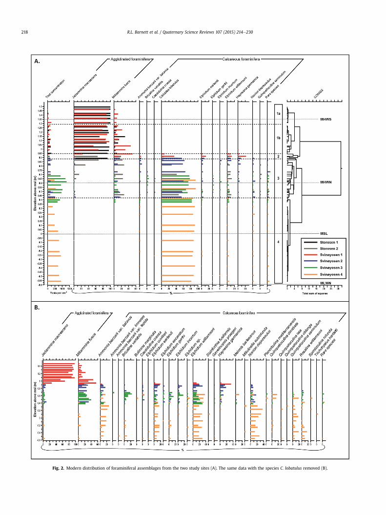
Fig. 2. Modern distribution of foraminiferal assemblages from the two study sites (A). The same data with the species C. lobatulus removed (B).
R.L. Barnett et al. / Quaternary Science Reviews 107 (2015) 214e230218

R.L. Barnett et al. / Quaternary Science Reviews 107 (2015) 214e230 219
batavus, Cibicides lobatulus, Elphidium spp. and Haynesina german-ica). Below this, zone 3 extends down to 0.42 m above MSL and ischaracterised by a significant reduction in J. macrescens, alongsideincreases in C. lobatulus. The abundance and diversity of calcareousspecies increases significantly in this zone. However, due to theoverwhelming presence of C. lobatulus, potentially importantchanges in assemblage characteristics may be missed. ThereforeFig. 2B is presented which shows foraminiferal assemblages fromSvinøyosen with all counts of C. lobatulus removed. Fig. 2B dem-onstrates how H. germanica only occurs in zones 2 and 3, and notbeyond, and how other calcareous species increase in abundanceacross the zone 3 e zone 4 (<0.42 m above MSL) boundary (e.g.Nonion depressulus, Quinqueloculina spp. Rosalina williamsoni).
4.2. Lithostratigraphy and chronology
The stratigraphy at Svinøyosen reveals seven distinct litholog-ical units that were encountered throughout all three coring tran-sects (Table 2). A summary of the radiocarbon ages is presented inTable 3. The basal unit (unit 1) was encountered at a mean depth of1.5e2.0 m below the salt-marsh surface and comprises of stiff clayof uniform lithology (Table 2). Cores failed to penetrate beyond afew centimetres into this basal unit. Overlying the basal clay is anunconformable shell rich sand unit (unit 2) of variable thickness(Fig. 3) containing reworked gastropods (e.g. Lunatia montagui,Cingula trifasciata, Pusillina inconspicua and gibbula cineria) andbivalves (Arctica islandica, Thracia villosiuscula, Dosinia exoleta andSpisula subtruncata). The upper contact of this unit is also uncon-formable and is characterised by the presence of coarse subangularpebbles. Unit 3 is a grey silt and is distinguished by the presence ofmarine shells (including Littorrina saxatilis) which were encoun-tered consistently between 0.5 and 1.0 m below the surface (Fig. 3).Unit 4 is similar to unit 3, but is devoid in marine shells or shellfragments. The overlying units grade through brown e grey sands(unit 5), brown silts (unit 6) and into an organic rich peaty unitoverlying the sequences (unit7). These upper units often containgravel and small to coarse pebbles within the sediments.
The basal clay returned a radiocarbon age of6469e6732 cal yr BP. This age derives from approximately 1500 to2000 picked foraminifera tests (Ammonia beccarii var. batavus andC. lobatulus) and provides a reasonably robust constraint on theoldest possible age of the basal unit's upper contact. Overlying thebasal unit are the shell rich sands which were dated at between7278 and 7700 cal yr BP in three locations, although another
Table 2Lithostratigraphic descriptions of the seven units identified at Svinøyosen.
Unit Depth in coreT3/0m (cm)
Facies componentsand characteristics(Long et al., 1999)
Munsellcolour
1 >112 Ag42-0-3-0-2
Gley1 5/10
2 92e112 part.test.2, Ga1, test.1, Gsþ1-0-1-0-3
2.5Y 6/3
3 45e92 Ag3, As1, Gaþ, part.test.þþ2-0-2-0-0
5Y 4/1
4 26e45 Ag3, Ga1, Asþ, Thþ2-0-2-0-0
5Y 3/1
5 15e26 Ga2, Ag1, As1, Thþ2-0-2-0-0
2.5Y 4/1
6 6e15 Ag2, Th1, Ga1, Asþ2-0-2-0-0
7.5R 4/1
7 0e6 Th2, Sh2, Asþ3-0-2-1-/
7.5R 3/1
sample returned an age of 5584e5837 cal yr BP for this unit (Fig 3).The unconformable upper and lower contacts of this unit, and thehigh energy implied by the coarse sediments, combined with theage reversals, suggest that this unit has been reworked. It is unlikelythat the foraminifera from unit 1 used to provide a basal age havebeen reworked into the basal clay. It is more probable that a highenergy event created an erosional surface at the site and redepos-ited older material here prior to the continuation of conformablesedimentation. The lower boundary of the grey silts with marineshells (unit 3) which overlay this unit was dated between 3377 and4212 cal yr BP in three locations, suggesting the reworking eventprobably occurred just prior to ~4000 cal yr BP. Units 3 to 7 areconformable and represent an uninterrupted sequence of late Ho-locene events.
To provide a chronology for the upper units, geochemicalmarkers were used to infer historical periods of mining and civili-sation collapse through changes in lead, mercury, nickel, copperand zinc profiles in core T3/0m (Fig. 4). Long range, atmospherictransportation of anthropogenic lead (Pb) and mercury (Hg) hasbeen identified in various depositional environments in Svalbard(Jiang et al., 2011), Iceland (Gehrels et al., 2006b; Marshall et al.,2009), Sweden (Renberg et al., 2002, 1994; Klaminder et al.,2003) and Finland (Meril€ainen et al., 2011). Such airborne pollu-tion derives from extended periods of mining over the past 2000years or so, the timings of which are well documented (e.g. Nriagu,1989; Biester et al., 2002; Hylander andMeili, 2003). Negative shiftsin the ratio of 206Pb/207Pb identify periods of lead exploitation.Natural background ratios in Scandinavia are high at around 1.3 to1.6 (Chow, 1965; Renberg et al., 2002), European lead ores bodieshave a lower ratio of around 1.17 (Rossman et al., 1997), and petrollead has a ratio even lower (Keinonen, 1992).
In addition to using 206Pb/207Pb ratios to identify periods ofmining, the amount of pollution lead was also calculated followingRenberg et al. (2002). We use the same assumed 206Pb/207Pb ratiosfor pre-industrial (1.17) and post-industrial (1.15) pollution lead asfor Renberg et al. (2002) and we derived the natural isotope ratio asthe mean ratio of samples below 39 cm (i.e. older than2158e2351 cal yr BP). Pollution lead was therefore calculated,where Pbpoll is pollution lead in parts per million, Ratiosample,Ratiopollution and Rationatural refer to the relevant ratio of 206Pb/207Pband Pbtotal is total lead, in this casewe use 208Pb, in parts permillion.
Pbpoll ¼
Ratiosample � RationaturalRatiopollution � Rationatural
!� Pbtotal
Physical description
Y Battleship-blue/grey stiff clay. Unconformable upper contact
Light beige, wet, unconsolidated sandy shell hash. Abundant marineshells and shell fragments. Unconformable upper contactDull grey clayey silt, some sand and occasional marine shells or shellfragments. Coarse (40 mm), subangular pebbles at the unconformablelower contactDull grey sandy silt with some clay and rare organics. No marineshells or shell fragments presentMid-brown to grey clayey silty sand with some organics. Occasionalgravel to small pebbles throughoutMid-brown, organic rich sand silt with some clay. Occasional mediumto coarse pebbles throughoutDark brown, organic rich, salt-marsh peat

Table 3Summary of radiocarbon ages from Svinøyosen.
Allocation number Publicationcode (SUERC-)
Transect/core location(m)/depth (cm)
Depth toMSL (m)
Material 14C yr BP cal yr BP
Transect 11530,0311 34678 T1/0/95a 0.59 Bivalve (Thracia villosiuscula) 3436 ± 37 3079e33631530,0311 34685 T1/0/95b 0.59 Wood piece 3713 ± 37 3928e42121606,0312 41141 T1/30/64 0.91 Bark fragments 2282 ± 37 2158e23521606,0312 41142 T1/50/109 0.52 Plant & stem fragments 3314 ± 35 3461e3635
Transect 21606,0312 41149 T2/0/64 1.14 Gastropod (Lunatia montagui) 2209 ± 37 1590e18661530,0311 34683 T2/0/86 0.92 Bivalve (Thracia villosiuscula) 2690 ± 35 2149 24491530,0311 34682 T2/0/110 0.68 Bivalve (Dosinia exoleta) 7189 ± 39 7488e77001606,0312 41150 T2/0/111 0.67 Gastropod (Cingula trifasciata) 7126 ± 37 7443e76421530,0311 34681 T2/70/39 1.17 Gastropod (Littorina saxatilis) 1122 ± 37 529e7071606,0312 41143 T2/70/81 0.75 Bark fragments 3229 ± 37 3377e3556
Transect 31577,0911 39977 T3/0/37.25 1.00 Betula bark 2140 ± 37 2000e23041577,0911 39983 T3/0/38.5 0.99 Wood piece 4303 ± 37a 4829e4964a
4273 ± 38a 4658e4960a
1577,0911 39980 T3/0/39.00 0.98 Wood piece 2279 ± 35 2158e23511577,0911 39981 T3/0/46.75 0.90 Charcoal 2634 ± 35 2718e28431530,0311 34686 T3/0/49.5 0.87 Betula fragments 2437 ± 37 2354e27021577,0911 39987 T3/0/53.5 0.84 Gastropod (Littorina saxatilis) 2862 ± 37a 2362e2690a
2817 ± 37a 2334e2659a
2777 ± 36a 2299e2642a
1606,0312 41146 T3/0/85 0.52 Plant fragments & bark pieces 3020 ± 35 3080e33411606,0312 41151 T3/0/95 0.42 Gastropods (Pusillina inconspicua) 6939 ± 35 7278e74841606,0312 41152 T3/0/110 0.27 Gastropod (Lunatia montagui) 5395 ± 35 5584e58371606,0312 41156 T3/0/112 0.25 Foraminifiera (C. lobatulus, A. beccarii) 6233 ± 35 6469e67321606,0312 41147 T3/35/71 0.89 Wood piece & plant fragments 2212 ± 37 2144e23341606,0312 41148 T3/35/82 0.78 Plant fragments & bark pieces 2518 ± 35 2473e2742
a High precision (multiple) ages.
R.L. Barnett et al. / Quaternary Science Reviews 107 (2015) 214e230220
Mercury pollution is presented as an enrichment factorfollowing Klaminder et al. (2003). Profiles of nickel (Ni), copper (Cu)and zinc (Zn) are also presented and used to define localisedmetallurgical pollution related to nearby industries (Fig 4). These
Fig. 3. Lithostratigraphic profiles and calibra
four elements were normalised against the conservative elementscandium (Sc) so that peaks in enrichment could be attributed topollution, rather than sediment accumulation rates or bulk densities(Shotyk et al., 1998; Klaminder et al., 2003; Monna et al., 2004).
ted radiocarbon ages from Svinøyosen.

Fig. 4. Geochemical marker profiles through core T3/0m from Svinøyosen. The illustrated historical events are supported by existing literature which is described in the text.**Radiocarbon ages. *210Pb ages.
R.L. Barnett et al. / Quaternary Science Reviews 107 (2015) 214e230 221
Elemental profiles through the corewere bounded at either ends byages obtained using other techniques (i.e. 14C and 210Pb), andchronological periods were identified from evidence in the litera-ture. The chronological markers are given as potential age ranges in
order to encompass analytical and timing uncertainties, and arepresented in calendar years to coincidewith the literature (Table 4).
210Pb dating with independent validation (137Cs, 241Am) wasused to provide chronological constraints on the most recent

Table 4Ages derived from geochemical marker profiles and supporting literature.
Depth (cm)/(mid-point)
Age range(calendar years AD)
Geochemical signal and chronological event Source and additional evidence Inferred calendar age AD anderror (age in cal yr BP)
29e26(27.5)
0e400 Pb; broad pollution peak/anthropogenic signalduring Roman Maximum
Renberg et al. (2002)Meril€ainen et al. (2011)
200 ± 200(1750 ± 200)
25e24(24.5)
750e1000 Hg; sharp peak but broad event during Islamicand Maya periods
Martinez-Cortizas et al. (1999)Biester et al. (2002)Sun et al. (2006)
875 ± 125(1075 ± 125)
23.5e22.5(23)
1200 Pb; peak at 1200 AD indicating Medieval period.Hg; decline at 1150 AD± 100 following Islamic e
Christian conflict in Europe and decline of Mayacivilisation
Renberg et al. (1994, 2001, 2002)Meril€ainen et al. (2011)Sun et al. (2006)Zill�en et al. (2012)
1200 ± 100(750 ± 100)
22e20(21)
1250e1500 Hg; rising trend associated with establishment ofInca civilisation and Christian reconquest ofthe mines at Almad�en
Martinez-Cortizas et al. (1999)Sun et al. (2006)
1375 ± 125(575 ± 125)
20e17(18.5)
1500e1800 Hg; sharply rising trend during silver mining ofSpanish America, peaking in 1800 AD, prior tocollapse of New World Spanish mining
Bindler (2003)Hylander and Meili (2003)Sun et al. (2006)Allan et al. (2013)
1650 ± 150(300 ± 150)
17e16(16.5)
1800 Pb; onset of Industrial Revolution,Hg; Collapse of mining in America
Renberg et al. (2002)Hylander and Meili (2003)Klaminder et al. (2003)Marshall et al. (2009)
1800 ± 50(150 ± 50)
10(10)
1932e1936 Ni, Cu, Zn; onset of Kola Peninsula industries €Ayr€as et al. (1997)Langedal and Ottensen (1998)Meril€ainen et al. (2011)
1934 ± 5(16 ± 5)
9e8(8.5)
1970e1980 Pb; 1970s pollution peak from petrol lead Renberg et al. (2001)Klaminder et al. (2003)Marshall et al. (2009)
1975 ± 5(�25 ± 5)
R.L. Barnett et al. / Quaternary Science Reviews 107 (2015) 214e230222
sediments from cores T3/0m and T3/15m, the results of which arepresented in Fig. 5.
4.3. Fossil sequences
Foraminifera from core T3/0m contained a variety of assem-blages indicative of intertidal and shallow subtidal environments(Fig. 6). The basal assemblage only includes calcareous forami-nifera, most of which do not have an analogue in the modernassemblages. Elphidium subarcticum dominates which is normallyfound in Arctic marginal marine and shelf environments,encountered as far south as southern Scandinavian fjords
Fig. 5. Ages derived from 210Pb profiles using the CRS model (black) and 137Cs profiles (redweapons testing (1) and to the Chernobyl incident (2). (For interpretation of the references
(Murray, 2006). The shell rich sand unit (unit 2) contains anabundance of subtidal foraminifera (Polyak et al., 2002; Murray,2006) including Cassidulina crassa, Bulimina marginata, Melonisbarleeanus and Nonion depressulus. Above the contact betweenunit 2 and unit 3, these species grade into intertidal assemblagesincluding many species of Elphidium that were also sampled in themodern environment, and importantly H. germanica which wasencountered in significant numbers between 0.2 and 0.9 m aboveMSL in the surface transects. The presence of calcareous speciesdecreases to nil across the contact between units 3 and 4. Higherin the sequence only agglutinated forms were encountered,signifying a change from intertidal mud flats to salt marsh at
) through cores T3/0m (A) and T3/15m (B). 137Cs peaks relate to the timing of nuclearto colour in this figure legend, the reader is referred to the web version of this article.)

Fig. 6. Fossil foraminiferal assemblages and sedimentological analyses through core T3/0m. Radiocarbon ages and geochemical marker ages (*) are shown.
R.L.Barnettet
al./Quaternary
ScienceReview
s107
(2015)214
e230
223

R.L. Barnett et al. / Quaternary Science Reviews 107 (2015) 214e230224
Svinøyosen. Concentrations are initially low, perhaps due to theeffects of post burial dissolution from acidic pore waters (Murray,1971; Jonasson and Patterson, 1992). Through units 5, 6 and 7concentrations of the salt-marsh species J. macrescens andM. fusca increase (Fig. 6).
Testate amoebae were identified in core T3/15m down to adepth of only 8 cm (Fig. 7), approximately representing the past 100years. Assemblages appear consistently dominated by Centropyxiscassis and Hyalosphenia ovalis, although the oldest assemblagescontain relatively greater numbers of the low marsh taxaC. platystoma morphotype 1.
5. Reconstructing relative sea level
The chronologies from cores T3/0m and T3/15mwere combinedwith indicative meanings derived from the microfossil analyses tocreate individually dated SLIPs (Table 5). Sea-level positions werecalculated from: S¼H � I, where S is the height of former sea level,H is the elevation of the dated fossil sample relative to MSL, and I isthe indicative meaning derived from the sample (cf. Gehrels, 1999).Sediment cores in this study mainly comprise sands and silts(Fig. 6). Only the top few centimetres of both cores contain salt-marsh peat which is mostly waterlogged and it is thereforereasonable to assume that the effects of compaction are negligiblein our sequences (Brain et al., 2012; Gehrels et al., 2012).
The youngest SLIPs derive from a testate amoebae based transferfunction (TF). The modern training set (Barnett et al., 2013) has along environmental gradient length (3.066 standard deviationunits) thereby making a unimodal transfer function model mostappropriate to the dataset (ter Braak and Prentice, 1988). A selec-tion of suitable models (e.g. Birks, 1995) was assessed and weightedaveraging partial-least squares at the second component (WAPLS2)performed best in terms of the cross validated root mean squarederror of prediction (RMSEP; 0.085) and the cross validated coeffi-cient of determination (r2; 0.89). This model is considered to pro-duce reliable results for six reasons: (1) there is an even verticaldistribution of samples, therefore generating an unbiased RMSEP(Telford and Birks, 2011a); (2) percentage improvements in RMSEPfrom using additional components in different WAPLS models wasmonitored to ensure an over-predictive WAPLS model was notchosen (Birks, 1998); (3) the model RMSEP value is within 10% ofthe sampled environmental range (Telford and Birks, 2011b); (4)fossil assemblages used in the reconstruction had good or closemodern analogues following a squared chord distance dissimilarity
Fig. 7. Fossil testate amoebae assemblages throug
measure (minDC) when rigorous threshold values were applied(Simpson, 2007; Barlow et al., 2013; Watcham et al., 2013); (5) thepalaeomarsh-surface elevation estimate from the top core samplecompares favourably with the field surveyed elevation (e.g. Barlowet al., 2013); and (6) independent tide-gauge data validate themodelled sea-level estimates. Indicative meanings from fossiltestate amoebae samples in core T3/15m were derived using theWAPLS2 TF model, and error terms are the root sum of squaredindividual RMSEP errors and other analytical error terms from thestudy (e.g. surveying and sampling).
Samples from core T3/0m were assigned indicative meaningsfollowing the aforementioned VA method (Table 5). Fossil samplesfrom T3/0m older than ~3000 cal yr BP are indicative of subtidalenvironments and only aminimum sea-level limit can be applied tothese assemblages. Samples from unit 3 containH. germanicawhichis found in the modern environment between 0.2 and 0.9 m aboveMSL. In many locations the species can be found throughout theintertidal zone (Alve and Murray, 1999; Murray, 2006), so weconservatively assign an indicative meaning of the lowest intertidallimit to 0.9 m above MSL where it is found at Svinøyosen. Samplesfrom unit 4 contain no calcareous foraminifera, yet there is nochronological or lithological evidence of an abrupt change insedimentation rate or environment. It is likely that dissolution hasaffected the preservation of calcareous foraminifera from this unitand possibly the overlying units too. The very low concentration offoraminifera and low OC content from this unit represent anintertidal but unvegetated, environment. Therefore, the sameindicative range is assigned to samples from unit 4 as for unit 3.Samples from unit 5 contain an increasing concentration ofagglutinated foraminifera implying a higher depositional environ-ment. The lack of an increase in OC, and the significant presence ofsand and larger grains, implies a depositional environment belowthe vegetated salt marsh, and therefore an indicative range of MSLto the upper tidal flat edge (0.95 m above MSL) is assigned tosamples from this unit. Unit 6 demonstrates further shallowing asshown by continual increases in the abundance of J. macrescens andM. fusca and in OC. Both units 6 and 7 represent an established salt-marsh environment characterised by foraminiferal assemblagesthat are seen today. We use the tidal flat edge elevation andcontemporary upper limit of agglutinated foraminifera to providean indicative range for samples from unit 6 (0.95e1.45 m aboveMSL). The time period represented by unit 7 is encompassedwithinthe testate amoebae reconstruction from core T3/15m which pro-vides a more precise estimation of palaeo-sea levels.
h core T3/15m and accompanying 210Pb ages.

Table 5Sea-level index points derived from cores T3/0m and T3/15m.
Depth downcore (m)
Sample elevation(m above MSL)
Age (cal yr BP) Indicative range(m above MSL)
Key criteria Reconstructedelevation of MSL (m)
T3/15m0.003 1.468 �61 ± 1 1.47e1.63 Testate amoebae TF �0.08 ± 0.080.008 1.463 �58 ± 1 1.37e1.53 Testate amoebae TF 0.01 ± 0.080.018 1.453 �51 ± 1 1.35e1.51 Testate amoebae TF 0.02 ± 0.080.028 1.443 �44 ± 1 1.24e1.40 Testate amoebae TF 0.13 ± 0.080.038 1.433 �35 ± 3 1.35e1.51 Testate amoebae TF 0.00 ± 0.080.048 1.423 �27 ± 4 1.13e1.29 Testate amoebae TF 0.21 ± 0.080.058 1.413 �17 ± 5 1.30e1.46 Testate amoebae TF 0.03 ± 0.080.078 1.393 12 ± 13 1.13e1.29 Testate amoebae TF 0.18 ± 0.08
T3/0m0.083 1.288 �14 ± 6 0.95e1.45 Salt-marsh taxa (J.m. & M.f.) 0.088 ± 0.250.088 1.283 �5 ± 8 0.95e1.45 Salt-marsh taxa (J.m. & M.f.) 0.083 ± 0.250.098 1.273 13 ± 15 0.95e1.45 Salt-marsh taxa (J.m. & M.f.) 0.073 ± 0.250.108 1.263 42 ± 35 0.95e1.45 Salt-marsh taxa (J.m. & M.f.) 0.063 ± 0.250.168 1.203 150 ± 50 0e0.95 Salt-marsh taxa (J.m. & M.f.) 0.003 ± 0.250.208 1.163 575 ± 125 0e0.95 Low OC, sub SM, shallowing 0.688 ± 0.4750.233 1.138 750 ± 100 0e0.95 Low OC, sub SM, shallowing 0.663 ± 0.4750.258 1.113 1075 ± 125 0e0.95 Low OC, sub SM, shallowing 0.638 ± 0.4750.275 1.095 1750 ± 200 �1.7 to �0.9 E.g. present (intertidal), sub SM 1.495 ± 1.30.373 0.998 2152 ± 152 �1.7 to �0.9 E.g. present (intertidal), sub SM 1.398 ± 1.30.393 0.978 2254 ± 97 �1.7 to �0.9 E.g. present (intertidal), sub SM 1.378 ± 1.30.468 0.903 2780 ± 63 �1.7 to �0.9 High H.g., no subtidal taxa 1.303 ± 1.30.493 0.878 2528 ± 174 �1.7 to �0.9 High H.g., no subtidal taxa 1.278 ± 1.30.538 0.833 2502 ± 140 �1.7 to �0.9 High H.g., no subtidal taxa 1.233 ± 1.30.85 0.52 3210 ± 131 <�1.7 Subtidal forams and molluscs >2.22
R.L. Barnett et al. / Quaternary Science Reviews 107 (2015) 214e230 225
The SLIPs from Table 5 were combined into a single graph of RSLchange for Svinøyosen through the late Holocene (Fig. 8). Prior to3000 cal yr BP the marine limiting date represents an importantconstraint for the late Holocene sea-level trend and yields a mini-mum RSL decline of approximately 2.2 m over 3200 years when
Fig. 8. Late Holocene sea-level index points for Svinøyosen, South Hinnøya (A). The recent seSLIPs derived from the VA method, and boxes are SLIPs derived from the testate amoebaereferred to the web version of this article.)
assuming a linear trend. The maximum possible linear declineconstrained by the data is approximately 2.6 m in 2800 years,providing an estimated late Holocene sea-level trend of �0.7to �0.9 mm yr�1 (shown by the grey shaded region in Fig. 8A). Themost recent part of the reconstruction (past 200 years) is shown in
a-level reconstruction is shown alongside nearby tide gauge data in red (B). Crosses areTF. (For interpretation of the references to colour in this figure legend, the reader is

R.L. Barnett et al. / Quaternary Science Reviews 107 (2015) 214e230226
Fig. 8B and is based on five SLIPs from the foraminifera VA recon-struction, and the testate amoebae TF based reconstruction. Bothapproaches are consistent with each other and with the short (25year) tide-gauge record from Kabelvåg located 50 km to the southand west of Svinøyosen (Figs. 1B and 8B). Tidal amplitudes betweenthe tide gauge and field site differ by less than 1 cm (Moe et al.,2002). Given the vertical uncertainties in our reconstruction andthe short duration of a tide-gauge record somewhat removed fromour study site it remains a difficult task to compare late Holoceneand recent sea-level trends.
6. Discussion
6.1. Holocene RSL changes in the Lofoten and Vesterålen islands
Relative sea-level studies of the Vesterålen e Lofoten region arecomplicated by the dynamic uplift history of the area since degla-ciation. There is a strong uplift gradient running perpendicular tothe shoreline (e.g. Ekman, 1996) which causes variability betweenlocal RSL curves. The Tapes sea-level maximum produced midHolocene shoreline limits which have beenmapped throughout thearchipelago and followed further north into Finnmark(Marthinussen, 1962). By connecting locations of similar shorelinelimits, isobases for the Tapes maximum have been used to identifylocations of similar and comparable relative sea-level histories(Fig. 9B; Møller, 1987). Subsequent studies of RSL history are fromareas between the 0 and 10 m Tapes isobases in the outer islands ofthe archipelago (e.g. Andøya and Vastvågøy) where palaeosea-levelevidence is more abundant (Fig. 9; Møller, 1986, 1984; Vorren andMoe, 1986; Balascio et al., 2011). These studies tend to focus onthe early and mid Holocene, i.e. the sea-level minimum prior to theTapes transgression and the Tapes maximum itself (Fig. 9). There isa lack of well constrained RSL data available for more inland sitessuch as around Hinnøya, and also for the late Holocene.
The sea-level data shown in Fig. 9 are from sites that haveexperienced varying rates of GIA. Despite this, the early Holocenelowstand, and mid Holocene Tapes highstand, are recorded inseveral locations. Field evidence of the Tapes highstand
Fig. 9. Summary of Holocene sea-level data from the Lofoten and Vesterålen archipelago (A)(Møller, 1986); solid diamond (Marthinussen, 1945, 1960); solid circle (Balascio et al., 2011);the Tapes highstand shorelines adapted from Møller (1987). Vertical datum is present mea
occasionally shows a discrepancy with the shoreline elevationsextrapolated by Møller (1987) (Fig. 9). For example, Balascio et al.(2011) present data that suggests the Tapes maximum over-topped a bedrock sill which they assigned an elevation of 5m aboveMSL. However, the Tapes shoreline limit for the location (Eggum) isrecorded at 1 m above present MSL by Møller (1987). This impliesthat either the Tapes shoreline elevations require re-addressing orthe buried bedrock sill used in the study by Balascio et al. (2011) islower than estimated.
The only temporally comparable data to our study come from adated piece of driftwood found in Austobotn, Finnmark(Marthinussen, 1945, 1960) and an isolation basin contact fromLyngen, County Troms (Fig. 9). The indicative meaning of driftwoodis difficult to determine. Marthinussen (1962) used it to estimate ashoreline elevation for the late Holocene, although it could sit highabove the shoreline if it was deposited by an extreme high tide orstorm surge. It is quite possible that this late Holocene RSL indicatoroverestimates sea levels for this time.
Isolation basin studies represent a reliable means of estimatingpalaeosea-levels through the dating of the marineelacustrinecontact that was formed when the basin became isolated from thesea. Corner and Haugane (1993) derived a SLIP using such amethodfrom an isolation basin located on the ~19 m Tapes isobase (Møller,1987) of 1565 ± 185 cal yrs BP. They calculated that MSL at the timewas at, or below, 1 m above present MSL, showing very closeagreement with the RSL reconstruction from Svinøyosen (Fig. 9).Other than this SLIP from Corner and Haugane (1993) there are veryfew data available which are directly comparable to ourreconstruction.
6.2. Comparisons with shoreline simulations and geophysical modelpredictions
Published Holocene sea-level data for northern Norway werecollated byMøller (1987) and used to simulate Holocene RSL curvesfor the region (Møller, 1989). The geometric simulation was basedon the extrapolation of shoreline heights and ages in relation to theTapes isobases. The model has been updated and is available online
; empty squares (Vorren and Moe, 1986); solid squares (Møller, 1984); empty diamondssolid triangle (Corner and Haugane, 1993); black crosses (this study). (B) Isobase map ofn sea level.

R.L. Barnett et al. / Quaternary Science Reviews 107 (2015) 214e230 227
(Møller and Holmeslet, 2002). Comparison of the model outputsand the late Holocene RSL reconstruction from this study shows asignificant difference in RSL histories. The shoreline simulationrepresents raised beaches, which sit above the level of MSL andpartially explains the significant difference between the proxy dataand the model (Fig. 10). As mentioned, the height of raised beachescan be difficult to relate to MSL. Other RSL studies from Finnmarkhave also found that the Møller models can deviate frommeasuredpalaeo-RSL elevations by up to 14 m (Romundset et al., 2011). Fewother studies have been able to constrain accurately the past fewthousand years of RSL history in northern Norway. In addition, thedisagreement with the RSL simulations of Møller (1989) andMøllerand Holmeslet (2002) suggests that: (1) the methods used for theSvinøyosen reconstruction deserve further consideration in otherlocations, and that (2) the new RSL history could be used to helpconstrain the Møller models.
The RSL reconstruction from Svinøyosenwas compared with theRSL history predicted by the GIA model of Lambeck et al. (1998a)(Fig. 10). Two issues arise from these comparisons. Firstly, thesea-level observations used to constrain the model are based onpost glacial sea- and lake-level observations from around Fenno-scandia including two from northern Andøya, 100 km north of thisstudy's field sites and two from the Lofoten islands, 90 km southeast of Hinnøya (Lambeck et al., 1998b). The four mentioned studiesfail to account accurately for late Holocene sea-level trends for thispart of northwestern Norway. The Andøyawork comprises a single,pre Holocene, isolation basin study (Vorren et al., 1988) and aninvestigation of early to mid Holocene raised beach deposits(Møller, 1986). The Lofoten studies comprise a study of submarinepeats dated at between 9000 and 10,000 cal yr BP (Vorren andMoe,1986) and another early Holocene study of raised beach deposits(Møller, 1984). The late Holocene observations in Fig. 10 are ap-proximations of the assumed sea-level trend and are thereforeaccompanied by large uncertainties. This gives rise to the secondissue of model accuracy. The sea-level output from the Lambeckmodel overestimates the palaeosea-level of the past 3000 years(Fig. 10) and therefore implies an excessively high rate of landemergence over the late Holocene.
The ice-sheet model of Lambeck et al. (1998a), FBKS8, usesFennoscandian RSL data to constrain the extent and thickness of theFennoscandian and Barents Sea ice sheets (Steffen and Wu, 2011).The quantity, andmore importantly, quality, of the constraining RSLdata is clearly paramount. Other GIA simulations based on differentice models and ice-sheet histories (such as SKB, 2010) also makeuse of the Lambeck et al. (1998a,b) RSL data to constrain model
Fig. 10. Comparison of sea-level data from this study (black crosses) with a shoreline simavailable online). The solid black line represents the sea-level output from the GIA model offrom SLIPs used to constrain this model for 1000 year time slices are shown as vertical errpresent MSL.
outputs. The amount of geological field data used to constrain ice-sheet histories is increasing (e.g. Bergstøm et al., 2005; Fløistadet al., 2009), thereby providing an opportunity to improve the ac-curacy and precision of ice models. Rheology parameters used inEarth models can be tested with RSL data, but extrapolated sea-level observations such as those shown in Fig. 10 are poor sub-stitutes for precise SLIPs.
6.3. Testate amoebae based sea-level reconstruction
This study represents the first applied RSL reconstruction usinga testate amoebae based TF. Prior to this, the only sea-level re-constructions performed using testate amoebae were by Charmanet al. (2010). Their study obtained fossil testate amoebae down toshallow depths (19 and 29 cm) from two North American salt-marsh cores. The samples represented approximately 100 years ofsalt-marsh accumulation, and the resultant reconstructions agreedwell with nearby tide-gauge records, with good cross-validationprecision delivered by the transfer functions (±0.05 and ±0.11 m).This study reports a similar success of producing a recent (~100year) reconstruction that approximately corresponds with a com-parable tide-gauge record. Reconstructions from both studies werehampered by the lack of abundant fossil testate amoebae below acertain depth. For Norway, this is likely due to the falling relativesea-level trend, producing a regressive sequence. Core sedimentsfrom before 1930 AD represent environments too low in theintertidal zone to support populations of testate amoebae. Theabsence of testate amoebae from the North American cores isattributed to suboptimal core locations as cores were selected forforaminiferal reconstruction purposes (Charman et al., 2010). Forsea-level reconstructions based on testate amoebae the location ofthe sediment core in relation to tide levels appears paramount(Charman et al., 2010). A sediment core closer to HAT at Svinøyosencould potentially contain a longer record.
7. Conclusions
Late Holocene relative sea-level changes on South Hinnøya innorthwestern Norway are recorded by a continuous sequence ofnear shore and intertidal sediments at Svinøyosen. Indicativemeanings derived from the measured modern environment wereassigned to fossil samples containing foraminifera and testateamoebae to generate precise sea-level index points. The lithology atSvinøyosen records a marine regression throughout the late Holo-cene following an erosional event that occurred prior to
ulation model by Møller (1986) and Møller and Holmeslet (2002) (grey dotted line,Lambeck et al. (1998a). The minimum and maximum sea-level elevations extrapolatedor bars and empty diamonds (adapted from Lambeck et al., 1998a). Vertical datum is

R.L. Barnett et al. / Quaternary Science Reviews 107 (2015) 214e230228
4000 cal yrs BP. The RSL trend for the late Holocene (past ~3300years) is 0.7e0.9 mm yr�1. Our late Holocene RSL reconstructionsuggests that existing models of GIA and shoreline limits, which arehindered by a lack of RSL data from the past ~3000 years, over-estimate palaeosea-level depths for this time period. Improvedmodel predictions for this area, based on the late Holocene sea-level data presented here, are important to elucidate ongoing andfuture patterns of GIA and relative sea-level rise in Fennoscandia.
Acknowledgements
This research was funded by a PhD studentship at PlymouthUniversity. Additional financial support was gained from the Qua-ternary Research Association (QRA New Research Workers Award)and the Royal Geographical Society (Dudley Stamp MemorialAward). The work was also supported by the NERC RadiocarbonFacility NRCF010001 (allocation numbers 1530.0311, 1577.0911 and1606.0312).
References
Allan, M., Le Roux, G., Sonke, J.E., Piotrowska, N., Streel, M., Fagel, N., 2013.Reconstructing historical atmospheric mercury deposition in Western Europeusing Misten peat bog cores. Belgium. Sci. Total Environ 442, 290e301.
Almås, A.-J., Hygen, H.O., 2012. Impacts of sea level rise towards 2100 on buildingsin Norway. Build. Res. Inf. 40 (3), 245e259.
Alve, E., Murray, J.W., 1999. Marginal marine environments of the Skagerrak andKattegat: a baseline study of living (stained) benthic foraminiferal ecology.Palaeogeogr. Palaeoclimatol. Palaeoecol. 146 (1e4), 171e193.
Appleby, P.G., 2001. Chronostratigraphic techniques in recent sediments. In:Last, W.M., Smol, J.P. (Eds.), Tracking Environmental Change Using Lake Sedi-ments, Basin Analyis, Coring and Chronological Techniques, vol. 1. Kluwer Ac-ademic Publishers, Dordrecht, The Netherlands.
€Ayr€as, M., Niskavaara, H., Bogatyrev, I., Chekushin, V., Pavlov, V., de Caritat, P.,Halleraker, J.H., Finne, T.E., Kashulina, G., Reimann, C., 1997. Regional patterns ofheavy metals (Co, Cr, Cu, Fe, Ni, Pb, V and Zn) and sulphur in terrestrial mosssamples as indication of airborne pollution in a 188,000 km2 area in northernFinland, Norway and Russia. J. Geochem. Explor 58 (2e3), 269e281.
Balascio, N.L., Zhang, Z., Bradley, R.S., Perrenm, B., Dahl, S.O., Bakke, J., 2011. A multi-proxy approach to assessing isolation basin stratigraphy from the LofotenIslands, Norway. Quat. Res. 75, 288e300.
Ball, D.F., 1964. Loss on ignition as an estimate of organic matter and organic carbonin non-calcareous soil. J. Soil Sci. 15, 84e92.
Barlow, N.L.M., Shennan, I., Long, A.J., Gehrels, W.R., Saher, M.H., Woodroffe, S.A.,Hillier, C., 2013. Salt marshes as late Holocene tide gauges. Glob. Planet. Change106, 90e110.
Barnett, R.L., Charman, D.J., Gehrels, W.R., Saher, M.H., Marshall, W.A., 2013. Testateamoebae as sea-level indicators in northwestern Norway: developments insample preparation and analysis. Acta Protozool. 52, 115e128.
Bergstrøm, B., Olsen, L., Sveian, H., 2005. The Tromsø-Lyngen glacier readvance(early Younger Dryas) at Hinnøya-Ofotfjorden, northern Norway: a reassess-ment. Norges Geol. Unders. 445, 73e88.
Biester, H., Kilian, R., Franzen, C., Woda, C., Mangini, A., Scholer, H.F., 2002. Elevatedmercury accumulation in a peat bog of the Magellanic Moorlands, Chile (53degrees S) - an anthropogenic signal from the Southern Hemisphere. EarthPlanet. Sci. Lett. 201 (3e4), 609e620.
Bindler, R., 2003. Estimating the natural background atmospheric deposition rate ofmercury utilizing ombrotrophic bogs in southern Sweden. Environ. Sci. Technol37 (1), 40e46.
Bindoff, N.L., Willebrand, J., Artale, V., Cazenave, A., Gregory, J., Gulev, S., Hanawa, K.,Le Qu�er�e, C., Levitus, S., Nojiri, Y., Shum, C.K., Talley, L.D., Unnikrishnan, A., 2007.Observations: oceanic climate change and sea level. In: Solomon, S., Qin, D.,Manning, M., Chen, Z., Marquis, M., Averyt, K.B., Tignor, M., Miller, H.L. (Eds.),Climate Change 2007: the Physical Science Basis. Contribution of WorkingGroup I to the Fourth Assessment Report of the Intergovernmental Panel onClimate Change. Cambridge University Press, Cambridge, United Kingdom andNew York, NY, USA, pp. 385e432.
Birks, H.J.B., 1995. Quantitative palaeoenvironmental reconstructions. In: Maddy, D.,Brew, J.S. (Eds.), Statistical Modelling of Quaternary Science Data. QuaternaryResearch Association, Cambridge, pp. 161e253.
Birks, H.J.B., 1998. Numerical tools in palaeolimnology - progress, potentialities, andproblems. J. Paleolimnol. 20 (4), 307e332.
Brain, M.J., Long, A.J., Woodroffe, S.A., Petley, D.N., Milledge, D.G., Parnell, A.C., 2012.Modelling the effects of sediment compaction on salt marsh reconstructions ofrecent sea-level rise. Earth Planet. Sci. Lett. 345, 180e193.
Cambray, R.S., Cawse, P.A., Garland, J.A., Gibson, J.A.B., Johnson, P., Lewis, G.N.J.,Newton, D., Salmon, L., Wade, B.O., 1987. Observations on radioactivity from theChernobyl accident. Nucl. Energy J. Br. Nucl. Energy Soc. 26 (2), 77e101.
Cambray, R.S., Playford, K., Lewis, G.N.J., Carpenter, C., 1989. Radioactive Fallout inAir and Rain: Results to the End of 1987. AERE-R 13226. Harwell.
Charman, D.J., Gehrels, W.R., Manning, C., Sharma, C., 2010. Reconstruction of recentsea-level change using testate amoebae. Quat. Res. 73 (2), 208e219.
Charman, D.J., Hendon, D., Woodland, W.A., 2000. The Identification of TestateAmoebae (Protozoa: Rhizopoda) in Peats, QRA Technical Guide No. 9. Quater-nary Research Association, London.
Charman, D.J., Roe, H.M., Gehrels, W.R., 1998. The use of testate amoebae in studiesof sea-level change: a case study from the Taf Estuary, south Wales, UK. Ho-locene 8 (2), 209e218.
Charman, D.J., Roe, H.M., Gehrels, W.R., 2002. Modern distribution of saltmarshtestate amoebae: regional variability of zonation and response to environ-mental. J. Quat. Sci. 17 (5e6), 387e409.
Church, J.A., Clark, P.U., Cazenave, A., Gregory, J.M., Jevrejeva, S., Levermann, A.,Merrifield, M.A., Milne, G.A., Nerem, R.S., Nunn, P.D., Payne, A.J., Pfeffer, W.T.,Stammer, D., Unnikrishnan, A.S., 2013. Sea level change. In: Stocker, T.F., Qin, D.,Plattner, G.K., Tignor, M., Allen, S.K., Boschung, J., Nauels, A., Xia, Y., Bex, V.,Midgley, P.M. (Eds.), Climate Change 2013: the Physical Science Basis. Contri-bution of Working Group I to the Fifth Assessment Report of the Intergovern-mental Panel on Climate Change. Cambridge University Press, Cambridge,United Kingdom and New York, NY, USA.
Chow, T.J., 1965. Radiogenic Leads of the Canadian and Baltic Shield Regions.Symposium on Marine Geochemistry.
Corner, G.D., Haugane, E., 1993. Marine-lacustrine stratigraphy of raised coastalbasins and postglacial sea-level change at Lyngen and Vanna, Troms, northernNorway. Nor. Geol. Tidsskr. 73 (3), 175e197.
Ekman, M., 1996. A consistent map of the postglacial uplift in Fennoscandia. TerraNova. 8, 158e165.
Floistad, K.R., Laberg, J.S., Vorren, T.O., 2009. Morphology of younger dryas sub-glacial and ice-proximal submarine landforms, inner Vestfjorden, northernNorway. Boreas 38 (3), 610e619.
Gehrels, W.R., 1994. Determining relative sea-level change from salt-marsh fora-minifera and plant zones on the coast of Maine, USA. J. Coast. Res. 10, 990e1009.
Gehrels, W.R., 1999. Middle and late Holocene sea-level changes in eastern Mainereconstructed from foraminiferal saltmarsh stratigraphy and AMS 14C dates onbasal peat. Quat. Res. 52, 350e359.
Gehrels, W.R., 2002. Intertidal foraminifera as palaeoenvironmental indicators. In:Haslett, S.K. (Ed.), Quaternary Environmental Micropalaeontology. OxfordUniversity Press, London/New York.
Gehrels, W.R., Callard, S.L., Moss, P.T., Marshall, W.A., Blaauw, M., Hunter, J.,Milton, J.A., Garnett, M.H., 2012. Nineteenth and twentieth century sea-levelchanges in Tasmania and New Zealand. Earth Planet. Sci. Lett. 315e316, 94e102.
Gehrels, W.R., Hayward, B.W., Newnham, R.M., Southall, K.E., 2008. A 20th centuryacceleration of sea-level rise in New Zealand. Geophys. Res. Lett. 35, L02717.http://dx.doi.org/10.1029/2007GL032632.
Gehrels,W.R., Hendon, D., Charman, D.J., 2006a. Distribution of testate amoebae in saltmarshes along the North American East Coast. J. Foraminifer. Res. 36 (3), 201e214.
Gehrels, W.R., Marshall, W.A., Gehrels, M.J., Larsen, G., Kirby, J.R., Eiríksson, J.,Heinemeier, J., Shimmield, T., 2006b. Rapid sea-level rise in the North AtlanticOcean since the first half of the nineteenth century. Holocene 16 (7), 949e965.
Gehrels, W.R., Roe, H.M., Charman, D.J., 2001. Foraminifera, testate amoebae anddiatoms as sea-level indicators in UK saltmarshes: a quantitative multiproxyapproach. J. Quat. Sci. 16 (3), 201e220.
Gehrels, W.R., Woodworth, P.L., 2013. When did modern rates of sea-level rise start?Glob. Planet. Change 100, 263e277.
Grimm, E.C., 1987. CONISS: a Fortran 77 program for stratigraphically constrainedcluster analysis by the method of incremental sum of squares. Comput. Geosci.13 (1), 13e35.
Hansen, B., Østerhus, S., 2000. North Atlantic-Nordic seas exchanges. Prog. Ocean-ogr. 45 (2), 109e208.
Hassan, N.M., Rasmussen, P.E., Dabek-Zlotorrzynska, E., Celo, V., Chen, H., 2007.Analysis of environmental samples using microwave-assisted acid digestionand inductively couple plasma mass spectrometry: maximising total elementrecoveries. Water, Air Soil Pollut. 178, 323e334.
Horton, B.P., Edwards, R.J., 2006. Quantifying Holocene Sea-level Change UsingIntertidal Foraminifera: Lessons from the British Isles. Cushman FoundationSpecial Publication. 40, pp. 1e97.
Hylander, L.D., Meili, M., 2003. 500 years of mercury production: global annualinventory by region until 2000 and associated emissions. Sci. Total Environ. 304(1e3), 13e27.
Ishizuka, O., Taylor, R.N., Yuasa, M., Milton, A., Nesbitt, R.W., Uto, K., Sakamoto, I.,2007. Process controlling along-arc isotopic variation of the south Izu-Bonin arc.Geochem. Geophys. Geosyst 8 (6).
Jiang, S., Liu, X., Chen, Q., 2011. Distribution of total mercury and methylmercury inlake sediments in Arctic Ny-Alesund. Chemosphere 83 (8), 1108e1116.
Jonasson, K.E., Patterson, R.T., 1992. Preservation potential of salt marsh forami-nifera from the Fraser River delta, British Columbia. Micropaleontology 38 (3),289e301.
Jongman, R.H.G., ter Braak, C.J.F., van Tongeren, O.F.R., 1995. Data Analysis inCommunity and Landscape Ecology. Cambridge University Press, Cambridge.
Juggins, S., 2003. C2 User Guide. Software for Ecological and Palaeoecological DataAnalysis and Visualisation. University of Newcastle, Newcastle-upon-Tyne, UK.
Kemp, A.C., Telford, R.J., Horton, B.P., Anisfield, S.C., Sommerfield, C.K., 2013.Reconstructing Holocene sea level using salt-marsh foraminifera and transferfunctions: lessons from New Jersey, USA. J. Quat. Sci. 28 (6), 617e629.

R.L. Barnett et al. / Quaternary Science Reviews 107 (2015) 214e230 229
Keinonen, M., 1992. The isotopic composition of lead in man and the environmentin Finland 1966-1987: isotope source of lead as indicators of pollutant sources.Sci. Total Environ. 113, 251e268.
Klaminder, J., Renberg, I., Bindler, R., 2003. Isotopic trends and background fluxes ofatmospheric lead in northern Europe: analyses of three ombotrophic bogs fromsouth Sweden. Glob. Biogeochem. Cycles 17 (1). http://dx.doi.org/10.1029/2002GB001921.
Koistinen, T., Stephens, M.B., Bogatchev, V., Nordgulen, Ø., Wennerstrøm, M.,Korhonen, J., 2001. Geological Map of the Fennoscandian Shield, Scale 1:2Million. Geological Surveys of Finland, Norway and Sweden and North-WestDepartment of Natural Resources of Russia.
Lambeck, K., Smither, C., Ekman, M., 1998b. Tests of glacial rebound models forFennoscandinavia based on instrumented sea- and lake-level records. Geophys.J. Int. 135, 375e387.
Lambeck, K., Smither, C., Johnston, P., 1998a. Sea-level change, glacial rebound andmantle viscosity for northern Europe. Geophys. J. Int. 134, 102e144.
Langedal, M., Ottesen, R.T., 1998. Airborne pollution in five drainage basins ineastern Finnmark, Norway: an evaluation of overbank sediments as samplingmedium for environmental studies and geochemical mapping. Water Air SoilPollut 101 (1e4), 377e398.
Loeblich, A.R., Tappan, H., 1988. Foraminiferal Genera and Their Classification. vanNostrand Reinhold Company, New York.
Long, A.J., Barlow, N.L.M., Gehrels, W.R., Saher, M.H., Woodworth, P.L., Scaife, R.G.,Brain, M.J., Cahill, N., 2014. Constraining records of sea-level change in theeastern and western North Atlantic during the last 3000 years. Earth Planet. Sci.Lett. 388, 110e122.
Long, A.J., Innes, J.B., Shennan, I., Tooley, M.J., 1999. Coastal stratigraphy: a casestudy from Johns River, Washington, USA. In: Jones, A.P., Tucker, M.E., Hart, J.K.(Eds.), The Description and Analysis of Quaternary Stratigraphic Field Sections.Quaternary Research Association, Technical Guide No 7. London.
Long, A.J., Woodroffe, S.A., Milne, G.A., Bryant, C.L., Wake, L.M., 2010. Relative sealevel change in west Greenland during the last millennium. Quat. Sci. Rev. 29,367e383.
Malm, O., Ormaasen, D.E., 1978. Mangerite-charnockite intrusives in the Lofoten-Vesteralen area, North Norway: petrography, chemistry and petrology. NorgesGeol. Unders. 434, 51e73.
Mangerud, J., Gulliksen, S., 1975. Apparent radiocarbon ages of recent marine shellsfrom Norway, Spitsbergen and Arctic Canada. Quat. Res. 5, 263e273.
Marshall, W.A., Clough, R., Gehrels, W.R., 2009. The isotopic record of atmosphericlead fall-out on an Icelandic salt marsh since AD 50. Sci. Total Environ. 407 (8),2734e2748.
Marthinussen, M., 1945. Yngre postglaciale nivaer pa Varangerhalvoya. Norges Geol.Unders. 25.
Marthinussen, M., 1960. Coast- and fjord area of Finnmark etc. In: Geology ofNorway. Norges Geologiske Undersøkelse, 208.
Marthinussen, M., 1962. C14 datings referring to shore lines, transgressions andglacial substages in northern Norway. Norges Geol. Unders. 215, 37e67.
Martinez-Cortizas, A., Pontevedra-Pombal, X., Garcia-Rodeja, E., Novoa-Munoz, J.C.,Shotyk, W., 1999. Mercury in a Spanish peat bog: archive of climate change andatmospheric metal deposition. Science 284 (5146), 939e942.
Meril€ainen, J.J., Kustula, V., Witick, A., 2011. Lead pollution history from 256 BC toAD 2005 inferred from the Pb isotope ratio (Pb-206/Pb-207) in a varve record ofLake Korttajarvi in Finland. J. Paleolimnol. 45 (1), 1e8.
Moe, H., Ommundsen, B., Gjevik, B., 2002. A high resolution tidal model for the areaaround the Lofoten Islands, northern Norway. Cont. Shelf Res. 22, 485e504.
Møller, J.J., 1982. Coastal Caves, Marine Limits and Ice Retreat in Lofoten - Vester-alen, North Norway.
Møller, J.J., 1984. Holocene shoreline displacement at Nappstraumen, Lofoten, NorthNorway. Nor. Geogr. Tidsskr. 64, 1e5.
Møller, J.J., 1986. Holocene transgression maximum about 6000 years BP at Ramsa,Vesteralen, north Norway. Nor. Geogr. Tidsskr. 40 (2), 77e84.
Møller, J.J., 1987. Shoreline relation and prehistoric settlement in northern Norway.Nor. Geogr. Tidsskr. 41 (1), 45e60.
Møller, J.J., 1989. Geometric simulation and mapping of Holocene relative sea-levelchanges in northern Norway. J. Coast. Res. 5 (3), 403e417.
Møller, J.J., Holmeslet, B., 2002. Havets Historie I Fennoskandia Og NV Russland[Online]. Available at: http://geo.phys.uit.no/sealev/ (accessed January 2013).
Monna, F., Galop, D., Carozza, L., Tual, M., Beyrie, A., Marembert, F., Chateau, C.,Dominik, J., Grousset, F., 2004. Environmental impact of early Basque miningand smelting recorded in a high ash minerogenic peat deposit. Sci. Total En-viron. 327 (1e3), 197e214.
Murray, J.W., 1971. An Atlas of British Recent Foraminiferids. American ElsevierPublishing Company, Inc, New York.
Murray, J.W., 1976. Comparative studies of living and dead benthic foraminiferaldistributions. In: Hedley, R.H., Adams, C.G. (Eds.), Foraminifera, pp. 45e109.
Murray, J.W., 1979. British Nearshore Foraminiferids. Academic Press, London, NewYork and San Francisco.
Murray, J.W., 1982. Benthic foraminifera: the validity of living, dead, or total as-semblages for the interpretation of palaeoecology. J. Micropalaeontol. 1,137e140.
Murray, J.W., 2000. The enigma of the continued use of total assemblages inecological studies of benthic foraminifera. J. Foraminifer. Res. 30 (3),244e245.
Murray, J.W., 2006. Ecology and Application of Benthic Foraminifera. CambridgeUniversity Press, Cambridge.
Nordgulen, Ø., Bargel, T.H., Longva, O., Olesen, O., Ottesen, D., 2006. A PreliminaryStudy of Lofoten as a Potential World Heritage Site Based on Natural Criteria.Geological Survey of Norway.
Nriagu, J.O., 1989. A global assessment of natural sources of atmospheric tracemetals. Nature 338, 47e49.
Ooms, M., Beyens, L., Temmerman, S., 2011. Testate amoebae as estuarine water-level indicators: modern distribution and the development of a transfer func-tion from a freshwater tidal marsh (Scheldt estuary, Belgium). J. Quat. Sci. 26(8), 819e828.
Ooms, M., Beyens, L., Temmerman, S., 2012. Testate amoebae as proxy for waterlevel changes in a brackish tidal marsh. Acta Protozool. 51 (3), 271e289.
Polyak, L., Korsun, S., Febo, L.A., Stanovoy, V., Khusid, T., Hald, M., Paulsen, B.E.,Lubinski, D.J., 2002. Benthic foraminiferal assemblages from the southern KaraSea, a river-influenced Arctic marine environment. J. Foraminifer. Res. 32 (3),252e273.
Rabenhorst, M.C., 1988. Determination of organic and carbonate carbon in calcar-eous soils using dry combustion. Soil Sci. Soc. Am. J. 52 (4), 965e968.
Reimer, P.J., Baillie, M.G.L., Bard, E., Bayliss, A., Beck, J.W., Blackwell, P.G.,Ramsey, C.B., Buck, C.E., Burr, G.S., Edwards, R.L., Friedrich, M., Grootes, P.M.,Guilderson, T.P., Hajdas, I., Heaton, T.J., Hogg, A.G., Hughen, K.A., Kaiser, K.F.,Kromer, B., McCormac, F.G., Manning, S.W., Reimer, R.W., Richards, D.A.,Southon, J.R., Talamo, S., Turney, C.S.M., van der Plicht, J., Weyhenmeyer, C.E.,2009. IntCal09 and Marine09 radiocarbon age calibration curves, 0-50,000years CAL BP. Radiocarbon 51 (4), 1111e1150.
Renberg, I., Bindler, R., Brannvall, M.L., 2001. Using historical atmospheric leaddeposition record as a chronological marker in sediment deposits in Europe.Holocene 11 (5), 511e516.
Renberg, I., Brannvall, M.L., Bindler, R., Emteryd, O., 2002. Stable lead isotopes andlake sediments - a useful combination for the study of atmospheric leadpollution history. Sci. Total Environ. 292 (1e2), 45e54.
Renberg, I., Persson, M.W., Emteryd, O., 1994. Preindustrial atmospheric leadcontamination detected in Swedish lake-sediments. Nature 368 (6469),323e326.
Romundset, A., Bondevik, S., Bennike, O., 2011. Postglacial uplift and relative sealevel changes in Finnmark, northern Norway. Quat. Sci. Rev. 30 (19e20),2398e2421.
Rossman, K.J.R., Chisholm, W., Hong, S.M., Candelone, J.P., Boutron, C.F., 1997. Leadfrom Carthaginian and Romand Spanish mines isotopically identified inGreenland ice dated from 600 BC to 300 AD. Environ. Sci. Technol. 31,3413e3416.
Scott, D.B., Medioli, F.S., 1980. Quantitative Studies of Marsh Foraminiferal Distri-butions in Nova Scotia: Implications for Sea Level Studies. Cushman Foundationfor Foraminiferal Research. Special Publication No. 17.
Scott, D.B., Medioli, F.S., 1982. Micropaleontological documentation for early Ho-locene fall of relative sea level on the Atlantic coast of Nova Scotia. Geology 10,278e281.
Shotyk, W., Weiss, D., Appleby, P.G., Cheburkin, A.K., Frei, R., Gloor, M., Kramers, J.D.,Reese, S., Van der Knaap, W.O., 1998. History of atmospheric lead depositionsince 12,370 C-14 yr BP from a peat bog, Jura Mountains, Switzerland. Science281 (5383), 1635e1640.
Simpson, G.L., 2007. Analogue methods in palaeoecology: using the analoguepackage. J. Stat. Softw. 22 (2), 1e29.
Simpson, M., Breili, K., Kierulf, H.P., 2014. Estimates of twenty-first century sea-levelchanges for Norway. Clim. Dyn. 42, 1405e1424.
Simpson, M., Breili, K., Kierulf, H.P., Lysaker, D., Ouassou, M., Haug, E., 2012. Esti-mates of Future Sea-level Changes for Norway. Technical Report of the Nor-wegian Mapping Authority.
SKB, 2010. Climate and Climate Related Issues for the Safety Assessment SR-site.SKB TR-10e49, Svensk K€arnbr€anslehantering AB.
Steffen, H., Wu, P., 2011. Glacial isostatic adjustment in Fennoscandia e a review ofdata and modeling. J. Geodyn. 52, 169e204.
Stuiver, M., Reimer, P.J., 1986. A computer program for radiocarbon age calibration.In: Proceedings of the 12th International 14C Conference. Radiocarbon,pp. 1022e1030.
Stuiver, M., Reimer, P.J., 1993. Extended 14C data base and revised CALIB 3.0 14C agecalibration program. Radiocarbon 35 (1), 215e230.
Sun, L., Yin, X., Liu, X., Zhu, R., Xie, Z., Wang, Y., 2006. A 2000 year record of mercuryand ancient civilisations in seal hairs from King George Island, West Antarctica.Sci. Total Environ 368 (1), 236e247.
Svendsen, J.I., Mangerud, J., 1987. Late Weichselian and Holocene sea-level historyfor a cross-section of western Norway. J. Quat. Sci. 2, 113e132.
Telford, R.J., Birks, H.J.B., 2011a. Effect of uneven sampling along an environmentalgradient on transfer-function performance. J. Paleolimnol. 46 (1), 99e106.
Telford, R.J., Birks, H.J.B., 2011b. A novel method for assessing the statistical sig-nificance of quantitative reconstructions inferred from biotic assemblages.Quat. Sci. Rev. 30 (9e10), 1272e1278.
ter Braak, C.J.F., Prentice, I.C., 1988. A theory of gradient analysis. Adv. Ecol. Res. 18,271e317.
Troels-Smith, J., 1955. Characterization of Unconsolidated Sediments. In: DanmarksGeologiske Undersogelse. Series IV, vol. 3, pp. 38e73.
Vasskog, K., Drange, H., Nesje, A., 2009. Havnivåstigning - Estimater av fremtidighavnivåstigning i norske kystkommuner (Sea Level Rise - Estimations for futuresea level rise in Norwegian coastal municipalities). Det nasjonale klima-tilpasningsekretariatet ved Direktoratet for samfunnssikkerhet og beredskap,[Norwegian Directorate for Civil Protection].

R.L. Barnett et al. / Quaternary Science Reviews 107 (2015) 214e230230
Vorren, K.D., Moe, D., 1986. The early Holocene climate and sea-level changes inLofoten and Vesteralen, north Norway. Nor. Geol. Tidsskr. 66 (2), 135e143.
Vorren, T.O., Vorren, K.D., Alm, T., Gulliksen, S., Lovlie, R., 1988. The last deglaciation(20000 to 11000 B.P.) on Andoya, northern Norway. Boreas 17 (1), 41e77.
Watcham, E.P., Shennan, I., Barlow, N.L.M., 2013. Scale considerations in using di-atoms as indicators of sea-level change: lessons from Alaska. J. Quat. Sci. 28 (2),165e179.
Woodroffe, S.A., Long, A.J., 2009. Salt marshes as archives of recent relative sea levelchange in West Greenland. Quat. Sci. Rev. 28 (17e18), 1750e1761.
Zill�en, L., Lenz, C., Jilbert, T., 2012. Stable lead (Pb) isotopes and concentrations - auseful independent datingtool for Baltic Sea Sediments. Quat. Geochronol 8,41e45.
Copyright © 2022 FDOKUMEN