
B06110720.pdf - Quest Journals
13
Quest Journals Journal of Architecture and Civil Engineering Volume 6 ~ Issue 11 (2021) pp: 07-19 www.questjournals.org *Corresponding Author:Aliaa AlSadaty7 | Page Research Paper Patterns and Processes of Morphological Transformations: Reflections on Previous Sites of Cairo’s Water Ponds Aliaa AlSadaty https://orcid.org/0000-0002-1831-5276 Associate Professor, Department of Architectural Engineering, Faculty of Engineering, Cairo University, Giza, Egypt ABSTRACT:Cairo is a city with long periods of stagnation and change. Its historic core represents a stratification of urban layers each reflecting different social, economic, cultural and political aspects. Historically, the city had a strict system of ponds that represented a main feature shaping its morphology. With Egypt’s modernization project, ponds were filled-in and their sites became parts of the larger urbanization of Cairo. The present study aims at revealing patterns and processes of morphological transformations of infilled water ponds through comparative cartographic and archival analysis of four selected sites. A typomorphological approach is adopted. The study unravels different morphological patterns and processes of densification in the examined sites with various degrees of stability and change in their urban form elements. The present study ads to the understanding of the urban transformation of Cairo, one of the fast-changing cities, and sheds lights on urban conservation issues for the selected sites. KEYWORDS:Urban morphology; morphological transformation; typomorphology; urbanization; historic ponds and canals; Cairo, Egypt. Received 08 November, 2021; Revised: 22 November, 2021; Accepted 24 November, 2021 © The author(s) 2021. Published with open access at www.questjournals.org I. INTRODUCTION Since ancient times, the location of Cairo was chosen for habitation due to its strategic location at the apex of the Nile River. A river that played a major role in the morphology of the city. Historically the urban fabric of Cairo included an intricate flood management system of significant number of plentiful ponds and canals. This system absorbed the overflow of the Nile’s annual flood and worked as reservoirs in case of low levels of inundation. Being a depression, ponds became filled with water when the annual flood recedes and turn into low-lying flowering gardens when their water shrank. This meticulous system not only helped the city to control the needed water for daily use and agricultural needs, but also gave the city a unique, dynamic and seasonal character. Besides, Cairo ponds had a major role in the social, cultural and urban character of the city. They were highly present as entertainment feature of the city, and nodes for religious festivities [1]. During early 19 th century a project to infill these ponds as part of the modernization of the city took place. A project that deprived the city forever from its significant water features but provided new sites for urban development. These sites became part of the larger urbanization of Cairo and were transformed into theatres for modern urban experimentation. Each site was developed with different perspectives according to the givens of the time of development and the characteristics of available space. Furthermore, each maintained different patterns of urban transformation throughout the following decades. Despite the enormous literature on the city of Cairo, there is a wide gap when it comes to the morphological transformation of its historic water bodies and of the comparative analysis of their development. The present paper aims at investigating the patterns and processes of morphological transformations of pre-19 th century ponds sites which is important for a better understanding of the morphological transformation of the city of Cairo as a whole. This gives special reflection on the way of the city’s transition from a traditional to a modern city as well as on the chronological patterns and processes of urban transformations of the selected sites. The present study is also important as it could inform decision making processes in what concerns related interventions and urban conservation practices.
-
Upload
khangminh22 -
Category
Documents
-
view
0 -
download
0
Transcript of B06110720.pdf - Quest Journals

Quest Journals
Journal of Architecture and Civil Engineering
Volume 6 ~ Issue 11 (2021) pp: 07-19
www.questjournals.org
*Corresponding Author:Aliaa AlSadaty7 | Page
Research Paper
Patterns and Processes of Morphological
Transformations: Reflections on Previous Sites of Cairo’s
Water Ponds
Aliaa AlSadaty https://orcid.org/0000-0002-1831-5276
Associate Professor, Department of Architectural Engineering, Faculty of Engineering, Cairo University, Giza,
Egypt
ABSTRACT:Cairo is a city with long periods of stagnation and change. Its historic core represents a
stratification of urban layers each reflecting different social, economic, cultural and political aspects.
Historically, the city had a strict system of ponds that represented a main feature shaping its morphology. With
Egypt’s modernization project, ponds were filled-in and their sites became parts of the larger urbanization of
Cairo. The present study aims at revealing patterns and processes of morphological transformations of infilled
water ponds through comparative cartographic and archival analysis of four selected sites. A
typomorphological approach is adopted. The study unravels different morphological patterns and processes of
densification in the examined sites with various degrees of stability and change in their urban form elements.
The present study ads to the understanding of the urban transformation of Cairo, one of the fast-changing cities,
and sheds lights on urban conservation issues for the selected sites.
KEYWORDS:Urban morphology; morphological transformation; typomorphology; urbanization; historic
ponds and canals; Cairo, Egypt.
Received 08 November, 2021; Revised: 22 November, 2021; Accepted 24 November, 2021 © The
author(s) 2021. Published with open access at www.questjournals.org
I. INTRODUCTION Since ancient times, the location of Cairo was chosen for habitation due to its strategic location at
the apex of the Nile River. A river that played a major role in the morphology of the city. Historically the
urban fabric of Cairo included an intricate flood management system of significant number of plentiful ponds
and canals. This system absorbed the overflow of the Nile’s annual flood and worked as reservoirs in case of
low levels of inundation. Being a depression, ponds became filled with water when the annual flood recedes
and turn into low-lying flowering gardens when their water shrank. This meticulous system not only helped
the city to control the needed water for daily use and agricultural needs, but also gave the city a unique,
dynamic and seasonal character. Besides, Cairo ponds had a major role in the social, cultural and urban
character of the city. They were highly present as entertainment feature of the city, and nodes for religious
festivities [1].
During early 19th
century a project to infill these ponds as part of the modernization of the city took
place. A project that deprived the city forever from its significant water features but provided new sites for
urban development. These sites became part of the larger urbanization of Cairo and were transformed into
theatres for modern urban experimentation. Each site was developed with different perspectives according to
the givens of the time of development and the characteristics of available space. Furthermore, each
maintained different patterns of urban transformation throughout the following decades.
Despite the enormous literature on the city of Cairo, there is a wide gap when it comes to the
morphological transformation of its historic water bodies and of the comparative analysis of their
development. The present paper aims at investigating the patterns and processes of morphological
transformations of pre-19th
century ponds sites which is important for a better understanding of the
morphological transformation of the city of Cairo as a whole. This gives special reflection on the way of the
city’s transition from a traditional to a modern city as well as on the chronological patterns and processes of
urban transformations of the selected sites. The present study is also important as it could inform decision
making processes in what concerns related interventions and urban conservation practices.

Patterns And Processes Of Morphological Transformations: Reflections On Previous Sites..
*Corresponding Author:Aliaa AlSadaty8 | Page
Towards the research aim, this study adopts the typomorphological approach for the investigation.
Typomorphology is an analytical tool used in urban planning and design thinking to study urban forms
through allowing a systematic classification of the constituent elements of the built environment. It combines
the aspects of urban form of street networks, plots and block patterns, together with building typologies.
Hence, it links between the building scale and the urban scale [2]–[4].
The study relies on comparative cartographic analysis for the examination of four selected sites of
pre-19th
century ponds, namely, al-fil, al-Azbakeya, al-Fawaleh, and al-Farayn. For each site, maps between
1820 and 2020 are gathered, reduced to same scale and when necessary, retraced to facilitate the comparison
and omit any unnecessary information. Consulted maps are shown in Table 1. The presented morphological
analysis focuses on the transformation on the level of street networks, plot patterns and building blocks, as
well as on change on the level of main building types’ volumetric characteristics in each period. Archival
material and site visits were also conducted in April-February 2021 to support cartographic analysis and
better understand current conditions of the selected sites.
Besides the introduction and conclusion, the present paper is organized in four main sections. The
first presents the typomorphological analysis as a tool to understanding morphology of urban landscapes,
illustrating its applications to urban interventions, conservation practices and urban landscapes management.
The second provides a historic background of pre-19th
century Cairo ponds and canals. Then, the third
illustrates a detailed chronological tracing of the morphological transformation of the four selected focus
areas. Finally, the fourth section presents the results and a discussion based on the findings of the illustrated
morphological analysis. The paper concludes with reflections on patterns, processes of morphological change
and a classification and mapping of stability and resilience to change of the elements of built form in the
investigated sites over different historic periods. It also highlights how morphological studies could be used
to inform urban interventions and urban conservation practices.
Table 1:Consulted maps. Date Title Scale
1810-1820 Environs of Cairo: General Map of Bulaq, Cairo, Roda Island, Old Cairo, & Giza. 1:20000
1874 General plan of the City of Cairo. 1:4000
1897 General map of the city of Cairo and its environs. 1:10000
1911 Cairo.
1920 General map of Cairo. 1:15,000
1948 Islamic monuments of Cairo 1:5000
1980 General map of Cairo. 1:20000
2020 Satellite image of Cairo (Google Earth Pro). 1:5000
II. UNDERSTANDING URBAN LANDSCAPES THROUGH TYPOMORPHOLOGY Urban morphology is the study of urban forms, their formation and transformation over time. It is
concerned with the reasons behind the urban spatial patterns at different urban levels and scales. Urban
morphology studies had been applied with different aims to investigate different urban contexts across the
globe. The stream of knowledge of urban morphology encompasses several approaches following different
schools of thoughts, this includes the spatial analytical approach, the configurational approach, the historico-
geographical approach and the process typological approach among others [4]–[6].
Typomorphology is an analytical tool used in urban planning and design thinking to study urban
forms through allowing a systematic classification of the constituent elements of the built envi ronment.
Typomorphological analysis works on categorizations based on similarities and differences. It also works on
finding relations between the different types and their overall contexts while observing historical processes of
evolution [2], [4].
The term typomorphology was coined by Carlo Aymonino and was later adopted by other scholars
including Castex and Panerai, Moudon, Chen and Thwaites among others [3], [7]–[10]. Typomorphology
draws from both the typological and the morphological approaches to urban form, stressing the relationship
between types and forms [11]. In other words, the typomorphological approach provides a combination of the
volumetric characteristics of the built aspects and their related open spaces, defining built landscape types
(Muratori, et al 1963). In this regard, typomorphological investigation combines “the infrastructures of urban
form” represented in the street networks, plots and blocks patterns with “the superstructures of built form”
represented in the shape and position of a building within a plot, its volumetric characteristics, internal
layout,… [9], [10], [13], [14]. This approach, thus, detects links between the building scale and the urban
scale [5].
Within typological process, forms of cities and urban areas should be understood through their
phases of continuity, transformation and replacement [6]. Normally, each phase has its distinctive basic forms
and types including different types of streets, buildings and details. These types are used throughout
development periods, and they are replaced with other types in following phases. In transitional phases, old
Patterns And Processes Of Morphological Transformations: Reflections On Previous Sites..
*Corresponding Author:Aliaa AlSadaty9 | Page
types are adjusted, adapted and modified, they thus become the nuclei for a new generation of types.
Therefore, new types could contain some features of previous ones [15]. The typological process is thus
concerned with the attention to the progressive transformation of types, with particular attention given to the
dialectic of continuity and change between previous and new types within urban contexts [16].
The typomorphological approach can be used to generate clear context-based parameters that would
inform local interventions and practices [17]. It could provide data bases to be used by entities charged for
maintaining, upgrading and modifying built landscapes [3]. In addition, its application on urban contexts
could be used as a useful tool to support planning strategies that aim to create new built environments that
retain place characteristics [18]. Furthermore, typomorphological approach can be used to support design
decisions and ensures that new infill designs are well incorporated into existing areas [18]–[20].
III. PRE-19TH
CENTURY CAIRO PONDS AND CANALS – A HISTORIC BACKGROUND The Nile and its flood cycles played a major role for the life in Egypt. Historically, every year, the
annual inundation replenished the banks of the river with a rich thick layer of silt responsible for the fertility
of the whole valley. Yet, the flood cycle was not always unequivocal; too much inundation brought massive
destruction, while too little brought famine. In order to face this potential annual risk, Egyptians gradually
refined an elaborate management system of irrigation canals and ponds. This system allowed to absorb the
Nile’s overflow and use them as reservoirs to be used for irrigation during the dry seasons. Canals and ponds
were regularly maintained and re-dug in order to ready their storage for the following year [21].
The formation, transformation and urban development of the nucleus of Cairo’s modern metropolis
cannot be understood without an observation of its connection with the flood cycles and the human
intervention to control it. Historically, this meticulous water system not only protected the city of Cairo from
the annual unexpected intensity of inundation, but it shaped its morphology and gave it a unique urban
character. During the four months following the flood, Cairo was compared to Venice, with its network of
water bodies with different forms and sizes connecting all parts of the city [22]. Then, when the reserved
water shrank, Cairo ponds were transformed into breathing gardens adorned with vegetations and wildflowers
[1].
The first Islamic Capital, Fustat, was established in 641 by the eastern bank of the Nile in order to
assure connection with the Arabian Peninsula by land and then by water through the reestablishment of the
canal linking the Nile with the Red Sea [23]. Al-Askar was founded north of Fustat in 750, followed with al-
Qata’I in 870, and finally, with the walled city of al-Qahira (Cairo) in 969. A series of political and natural
disasters befell Fustat by the end of the Fatimid period and caused a massive immigration and preferences to
inhabit al-Qahira which was previously exclusive for elites and upper social classes [24]. With the exodus
towards al-Qahira, the area within the city walls became overcrowded. Therefore, members of the ruling class
and high aristocracy started to show preferences to less crowded areas around ponds and canals outside the
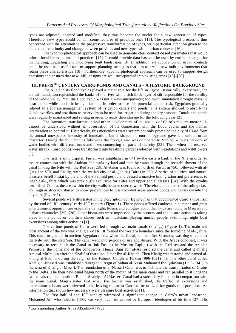
city core (Figure 1).
Several ponds were illustrated in the Description de l’Egypte map that documented Cairo’s urbanism
by the end of 18th
century/ early 19th
century (Figure 1). These ponds offered coolness in summer and great
entertainment opportunities especially by night. Poems and eulogies about the ponds are found in Maqrizi and
Gabarti chronicles [25], [26]. Other historians were impressed by the scenery and the leisure activities taking
place in the ponds or on their shores such as musicians playing music; people swimming; night boat
excursions among other activities [1].
The various ponds of Cairo were fed through two main canals (khaligs) (Figure 1). The main and
most ancient of the two was khalig al-Masri. It formed the western boundary since the founding of al-Qahira.
This canal originated in ancient Egyptian times, when the Canal, named after Sesostris, was dug to connect
the Nile with the Red Sea. The canal went into periods of use and disuse. With the Arabs conquest, it was
necessary to reestablish the Canal to link Fustat (the Muslim Capital) with the Red sea and the Arabian
Peninsula, the homeland of the conquerors. Hence, Amr Ibn al-As restored the canal and called it Khalig
Amir al-Mu’minin after the Khalif of that time, Umar Ibn al-Khatab. Then Khalig was restored and named al-
khalig al-Hakimi during the reign of the Fatimid Caliph al-Hakim (996-1021) [1]. The other canal called
Khalig al-Nasseri was established during the Reign of Sultan al-Nasir Muhamed Ibn Qalawun (1293-1341) to
the west of Khalig al-Massri. The foundation of al-Nasseri Canal was to facilitate the transportation of Grains
to the Delta. The then new canal began north of the mouth of the main canal and ran parallel to it until the
two canals rejoined north of Bab al-Shairiya. Al-Nasseri Canal had a subsidiary function in comparison with
the main Canal. Maqrizistates that when the former was established, the traffic of excursions and
entertainment boats were diverted to it, leaving the main Canal to be utilized for goods transportatio n. An
information that shows how necessary were pleasure boat activities [1].
The first half of the 19th
century witnessed a significant change in Cairo’s urban landscape.
Mohamed Ali, who ruled in 1805, was very much influenced by European ideologies of his time [27]. His
Patterns And Processes Of Morphological Transformations: Reflections On Previous Sites..
*Corresponding Author:Aliaa AlSadaty10 | Page
policies were characterized with a break with traditions and great favoring of westernization of Egypt. This
was translated into major public works towards the local reformation of the country. In Cairo of the 19th
century, water ponds contradicted with the modern vision planned for the city. Still water ponds were
perceived as pestilent and unhygienic nodes, especially when the water recedes, and they turn into
marshlands. Therefore, several ponds were either fully or partially filled in [23]. By this filling, a main
feature of pre 19th
century Cairo urban landscape and cultural life had gone for good [28]. Previous sites of
water ponds became part of the larger urbanization of the city, they developed with different urban patterns in
the following decades, as will be illustrated in the next section.
Figure 1:Cairo’s historic ponds and canals with the city core highlighted, based on Description de
l’Egypte map [29]. Ponds: (1) al-Fil; (2) al-Moulla; (3) Qarun, (4) Sitti-Nassra (also al-Saqqayin), (5) al-
Farayn, (6) al-Dam, (7) al-Saber, (8) al-Fawaleh, (9) Batn al-Baqarra (later renamed as al-Azbakeyya),
(10) al-Ratli, (11) Janaq - Canals: (A) Khalig al-Masri, (B) Khalig al-Nasseri.
IV. PATTERNS AND PROCESSES OF MORPHOLOGICAL TRANSFORMATION
Sites of previous water ponds maintained morphological transformations throughout the different
historic phases. This section illustrates detailed chronological morphological transformation analysis of four
sites of pre-19th
century water ponds in Cairo, namely: al-fil (currently al-Helmiya al-Gadida), al-Azbakeya
(currently al-Azbakeya garden and surrounding), al-Fawaleh (currently a part of Downtown Cairo), and al-
Farayn (currently Abdin Square and surrounding). The selected sites for investigation are indicated in (Figure
2).
1.1. Site 1: previous site of al-Fil pond currently al-Helmiya al-Gadida
Al-Fil pond was located to the south of Cairo city core. Until early 13th
century, the shores of al-Fil
pond were free of population and were used for gardens and occasional pavilions [25]. With the shifting of
the seat of governance to the citadel during the Ayyubids, interest shifted to the nearby Darb al -Ahmar
district and the surroundings of al-Fil pond. Then, during the Mamluks period, the area flourished and
became an area of choice for the aristocracy since it was near the citadel, away from the crowds and

Patterns And Processes Of Morphological Transformations: Reflections On Previous Sites..
*Corresponding Author:Aliaa AlSadaty11 | Page
overlooking the magnificent scene of the pond [25]. Gradually, the surroundings of al-Fil pond became a
dense settlement of Mamluks Emirs palaces and prestigious foundations including mosques and sabils (water
fountains). Raymond states that between 1650 and 1755 already a legacy of three-quarters of all Emirs
residences were established in the southern part of Cairo and 40 percent of these were on the shores of al-Fil
pond [24]. Many of these foundations are still extant including Taz palace (1352), Ulmas al-Hageb Mosque
(1329), Shaykhun mosque (1349) and Sultan Hassan Mosque (1356-61) among others.
The lust and prestigious status of the area surrounding al-Fil pond however, started to wane by the
end of the Mamluks when the city expanded westwards, between the two canals. Raymond states that during
the 18th
century, well established Emirs migrated from the area around al-Fil pond to the west part of the city,
preferring to build their palaces on the shores of the less congested pond of al-Azbakeya, and hence the area
around al-Fil pond declined [24].
Until late 18th century, the area around al-Fil pond maintained traditional urban fabric with organic
street networks (Figure 3-A). This, however, changed with early decades of the 19th century that witnessed
the modernization of the country and the filling of most of Cairo ponds. The map by Grand bey in 1874
(Figure 3-B), shows the filling of the majority of al-Fil pond and the construction of Abbas Hilmi I palace
with its vast gardens. The palace was completed in 1851 and the area became known as al-Hilmiya. The style
and planning of the palace and its garden dictated the westernized architecture of all structures to be built in
the area from this point onwards.
Another turning point took place during late 19th
and early 20th
century and proceeded in two phases
(Figure 3-C and D). The first in 1890, when the garden of the palace was taken over by the Ministry of Public
Works and declared a public land to be used for residential purposes. The second in 1903 when the palace
was torn down declaring the second phase of residential development. The two phases of development
produced different land parcellations options. The first included diagonal street patterns forming islands of
triangular blocks, while the second produced a grid iron street network with more regular blocks. Parcels
developed in both phases included villas and apartment buildings surrounded by gardens with varied sizes
(Figure 4-B). [30]
Khalid Asfour raised detailed analysis of late 19th
and early 20th
century villas and apartment
buildings established in al-Helmiya al-Gadida. He showed how they presented a pairing between local
abstract ideas and values with foreign physical form [31]. The modern villa inspired from western ideals with
a central hall flanked by rooms with no intermediate space was not fully accepted as it violated the family
privacy. Thus, a separate reception room (called salamlek) was established to receive male guests without
disrupting the family privacy. This created a totally new urban fabric dotted with villas and apartment
buildings surrounded by gardens with detached rooms [31]–[33] (Figure 4-B).
A third turning point took place starting late 1970s. The area witnessed a gradual densification
process. While street networks and plots shapes and sizes were maintained, several villas and low-rise
apartment buildings surrounded with gardens were demolished to be replaced with attached apartment
buildings (Figure 4-C). Currently, few remaining villas and palaces dating back to late 19th
and early 20th
century still extant amidst the modern apartment buildings with no setbacks.

Patterns And Processes Of Morphological Transformations: Reflections On Previous Sites..
*Corresponding Author:Aliaa AlSadaty12 | Page
Figure 2:Cairo between 1820 (left) and 1980 (right) with areas of study indicated. Site (1) al -fil
(currently al-Helmiya al-Gadida), site (2) al-Azbakeya (currently al-Azbakeya garden and surrounding),
site (3) al-Fawaleh (currently a part of Downtown Cairo), and site (4) al-Farayn (currently Abdin Square
and its surrounding).
Figure 3:Morphological transformation of al-Fil pond site – the general level.
Figure 4:Morphological transformation of al-Fil pond site – plots and buildings level.
1.2. Site 2: previous site of al-Azbakeya pond, currently al-Azbakeya garden and surrounding context
Development around al-Azbakeya pond started with late 13th
/ early 14th
century, when the area
between the two canals witnessed great urban development. As mentioned, when the previously fancy area
around al-Fil pond became overcrowded, the Emirs emigrated to the shores of al-Azbakeya. The first Emir
whose palace in al-Azbakeya paved the way for the development around the pond, was Emir Azbak, and
hence the area became known as al-Azbakeya[1]. Raymond stated that Emirs could find quitter and safer
place for their residences and could build agreeable houses with gardens and outbuildings for servants [24].
The examination of Description de l’Egypte map reveals a concentration of 24 palaces of Elite Mam luks in
the organic fabric around the pond (Figure 5-A). Many of these palaces were seized by Napoleon and his
generals for residence and as headquarters during the French occupation to Egypt. This explains why Cairo
revolts of March-April 1800 against the French had devastating effects on al-Azbakeya area [24].

Patterns And Processes Of Morphological Transformations: Reflections On Previous Sites..
*Corresponding Author:Aliaa AlSadaty13 | Page
In 1835 the pond was drained and transformed into a park. Then, by late 19th
century, the face of al-
Azbakeya had completely changed when chosen as a main node for al-Ismailia district which was established
following Haussmann’s model of Paris. The previous garden was replaced with an octagonal garden, and in
contrast to the previous traditional fabric, the surrounding area was divided into wide streets and spacious
squares surrounded with geometric and regular plots (Figure 5-B). Four main squares were developed around
al-Azbakeya garden, namely: Azbak, Attaba al-Zarqa, al-Opera and al-Khazindar Squares. These squares
provided points of contacts with the new cut-through thoroughfares linking al-Azbakeya to almost every part
of the city (Figure 5-B).The new streets included Clot Bey Street which connects Khazindar Square with the
central station in the north; Mohamed Ali Street which connects Attaba Square with the foot of the citadel
and AbdelAziz Street connecting Attaba Square with Abdin Square in front of the Khedieve palace; the new
seat of throne.
Not only was the planning of the area different than traditional Cairo planning principles, but several
new building types were introduced reshaping the cultural, social and economic life of Cairo. The area
became premises of the most famous hotels of the city including Shepheard (1841), the Continental (1860)
and Hotel de l’Orient (1848). In addition, the first Opera House was established in 1869 along with other
three theaters. Consulates, cafes, market building and fancy department stores were established including
Attaba Market, Halawa stores, Omar Effendi, Stein, Tiring, among others [34]. With early decades of the 20th
century, this area became a major transportation hub to the whole city thanks to the tramways network
connecting it from Attaba Square to almost every other part in the city.
The area continued to be a strategic hinge between traditional and modern Cairo. With early to mid -
20th
century, the centrality of Azbakeya was further ameliorated with the added cut through streets of Prince
Farouk Street (now al-Guish Street) and al-Azhar Street linking Attaba Square with Bab al-Shaereya and al-
Azhar district respectively (Figure 5-C).
In 1971, the Opera House was destructed by fire, and with its demolition the area lost a corner stone
in its cultural life. Further, with late decades of the 20th
century, tramways tracks were dismantled from many
parts of Cairo, including Attaba Square and its surrounding. Al-Azhar flyover was then established passing
above the square to absorb the growing traffic of private cars in the following years (Figure 5-D).
Al-Azbakeya garden suffered from long years of neglect and gradually lost its spark. Even the
continuous shrinking green surface of al-Azbakeya garden can be detected through comparison of historic
map with the current satellite image of the area (Figure 5-E). This was due to several establishments on the
garden site including the Telecommunication building, the underground metro station among others.

Patterns And Processes Of Morphological Transformations: Reflections On Previous Sites..
*Corresponding Author:Aliaa AlSadaty14 | Page
Figure 5:Morphological transformation of al-Azbakeya pond site – the general level.
A zooming in on the southern part of al-Azbakeya garden (Figure 6), shows that the geometry of the
space had dramatically changed through time. Attaba al-Zarqa and Azbak squares were combined into one
spacious square, called Attaba Square when the mixed-Tribunal Court building was demolished. In addition,
when the Opera house building was burnt down, it was never rebuilt, instead, it was replaced with a multi -
story car parking building. Furthermore, al-Azhar flyover was established passing over the space of Ataba
square. Over and above, due to its very high connectivity to several parts of the city, and its vicinity to the
main train station, the area is currently a main commercial hub for the city of Cairo and nearby governor ates.
All sorts of retail, with specialized markets, street vendors, formal and informal markets can be found in the
area.
Figure 6:Morphological transformation of al-Azbakeya site – plots and buildings level.

Patterns And Processes Of Morphological Transformations: Reflections On Previous Sites..
*Corresponding Author:Aliaa AlSadaty15 | Page
1.3. Site 3: previous site of al-Fawaleh, al-Saber and al-Dam ponds, currently within Downtown Cairo
This area was formed of a grouping of three ponds: al-Fawaleh, al-Saber and al-Dam, located at the
western fringe of the traditional city. This grouping of ponds was bordered by Khalig al-Nasseri from the
west and by the urbanism of the traditional city from the eastern and southern parts (Figure 7 -A).
Since this area was quite at the fringe of the traditional city, it became at the very heart of the plan of
al-Ismailia district (the 19th
century city core – currently Downtown Cairo). After filling-in Khalig al-Nasseri
and the three ponds, the whole area was redesigned and planned into diagonal streets, intersected into
spacious squares. Plots subdivisions show large plots sizes that included palaces and villas surrounded by
vast gardens (Figure 7-B). At this stage, average plot sizes were much bigger that their rival in al-Helmiya al-
Gadida.
Tracing morphological change in this area shows a continuous process of densification. The once
wide land parcels were divided and subdivided through the following years. Palaces and villas were replaced
with apartment buildings and a sub grid of streets had to be added to serve the new subdivided plots (Figure
7-C and D).
Figure 7:Morphological transformation of al-Fawaleh pond site – the general level.
Figure 8:Morphological transformation of al-Fawaleh site – Plots and buildings level.
1.4. Site 4: previous site of al-Farayn pond, currently Abdin Square and its surrounding
Al-Farayn pond was also located on the western edge of Cairo and was surrounded with traditional
urban fabric from all sides except the southern part which was occupied with planted fields (Figure 9 -A).
During late 19th
century, this area was chosen as site for the new palace of Ismail Pasha who wanted to
govern from the new-modern district, al-Ismailia, instead of the traditional seat of governance at the Citadel.
Following the 19th
century modern planning principles, it was necessary to have a main square in front of the
monumental palace to stress its grandeur. The map pf 1874 shows that a large part of the pond turned into the
square that was designed to be bordered by two main Royal palaces. However, this plan had never seen the

Patterns And Processes Of Morphological Transformations: Reflections On Previous Sites..
*Corresponding Author:Aliaa AlSadaty16 | Page
light and only the palace on the eastern side was established. Otherwise, parcels around the square were
divided as squarish blocks to include fancy apartment buildings (Figure 9-B and C).
Abdin palace and square came to be another hinge between traditional and modern Cairo city cores.
Since the square with linked with the Royal Palace (currently a presidential palace), it maintained a
prestigious status with little change in terms of its physical form. However, this area was embedded with
several symbolic meanings especially during political unrests and revolutions including Orabi Revolution in
1882, the events of 1942, 1952 revolution, 2011 uprisings among other major influential events in the history
of the city.
Figure 9:Morphological transformation of al-Farayin pond site – (1) Abdin Palace, (2) Abdin Square.
V. RESULTS AND DISCUSSION The previous section presented a detailed chronological analysis for the development of the four
selected sites. The analysis showed a transition from traditional to modern spaces configurations. Traditional
and modern space configurations are based on totally different morphological structures. Carmona etal,
differentiated morphological structures between traditional and modernist spaces in terms of buildings
placement in the urban fabric [35]. Whereas it is buildings continuity that constitutes the urban block and that
defines spaces in traditional settings; buildings in modernist settings are free standing discontinued entities.
The presented analysis showed that the shift from traditional to modern urban systems in the selected settings
was a shift from the small scale mostly organic street meshed local street networks, into wider scale road
networks, and from continuous buildings entities to free standing pavilions. This, however, is more than an
aesthetic preference, as each of the two systems produces completely different social characteristics [35].
Therefore, it must be noted that although this study focused on the physical aspects in the investigated sites,
the said transition from traditional to modern urban forms was a transformation in both the social and the
spatial aspects of the investigated contexts.
By comparing the development of the selected sites, it is noticed that original spatial characteristics
and abstract shapes of previous ponds could be traced in current spatial configurations with various degrees
of clarity (Figure 10). Initial traces of the ponds are mostly visible in the case of al -Azbakiya garden and its
surrounding as well as in Abdin Square, since in these two settings, the previous ponds were converted into
major urban spaces, a garden in the former and a Royal Square in the latter. In contrast, in the sites of al -Fil
pond and al-Fawaleh traces of infilled ponds are harder to be defined since they were absorbed into the urban

Patterns And Processes Of Morphological Transformations: Reflections On Previous Sites..
*Corresponding Author:Aliaa AlSadaty17 | Page
fabric of the city by being subdivided into land parcellations with different patterns. Having identifiable
traces of previous spatial configurations in historic contexts helps and supports place memory consolidation
and communication which in turn could have positive impacts on place attachment, community and urban
conservation[36].
Figure 10:Spatial characteristics and abstract shapes of previous ponds in current settings.
Several studies discussed stability and resilience to change of urban form elements represented in
buildings, plots, blocks, and street patterns. Scholars confirmed that, in general, buildings are the most prone
to demolition and reconstruction; plot patterns are more enduring but also subject to subdivision and
amalgamation through time; and street patterns represent the most enduring of urban form elements. Unless
being subject to transformation due to drastic change like that caused by major urban development projects,
street networks are expected to last for centuries with little modifications[37]–[39].
By investigating historic and recent maps of Cairo between 1820 and 2020, it is possible to classify
and map stability and resilience to change of urban form elements in the investigated sites over different
historic periods. Findings of this analysis are presented in (Table 2). The two-century period which
constitutes the timeframe of this study was divided into four sub-periods, and a simple scale of: a) stable, b)
slightly stable and c) unstable, was used to map the detailed change in street, blocks, plots and building
patterns through time.
Table 2:Mapping stability and resilience to change urban form elements in the investigated sites. Site 1:
Al-Fil pond –
Helmiya al-Gadida
Site 2:
Al-Azbakeya pond –
al-Azbakeya garden
and surrounding
Site 3:
Al-Fawaleh pond –
part of Downtown
Cairo
Site 4:
Farayn pond –
Abdin Square and
surrounding
Bu
ild
in
g
pa
ttern
s
1820-1849
1850-1899
1900-1949
1950-2020
Plo
ts
pa
ttern
s
1820-1849
1850-1899
1900-1949
1950-2020
Blo
ck
s
pa
ttern
s
1820-1849
1850-1899
1900-1949
1950-2020
Str
eets
pa
ttern
s
1820-1849
1850-1899
1900-1949
1950-2020
Stable Slightly stable unstable

Patterns And Processes Of Morphological Transformations: Reflections On Previous Sites..
*Corresponding Author:Aliaa AlSadaty18 | Page
The present study shows that investigated sites maintained different patterns of urban densification.
In the case of al-Helmiya al-Gadida, densification was mainly on the level of building patterns. In this case,
many villas or low-rise apartment buildings surrounded with garden were gradually demolished and replaced
with attached multi-stories apartment buildings built on original plot subdivisions. In general street patterns,
building blocks and plot sizes, were stable in al-Helmiya al-Gadida throughout this transformation.
In the case of al-Fawaleh previous pond site, the densification appeared on the level of buildings,
plots, blocks and street patterns. Huge plots originally designed to house low-rise palaces surrounded with
enormously vast gardens, ended up being subdivided into smaller land parcels for multi -story buildings with
no setbacks. The new plots subdivision necessitated the introduction of a sub-network of streets to serve
them.
The Case of Abdin Square and its surrounding was the most stable of the investigated sites. After
being designed as a Royal Square, little change occurred on the level of buildings, plots, blocks and streets
patterns. Transformation in this square and its surrounding was however, on the non-physical level, and the
different meanings the space acquired with the shift in political and ideological shifts in the history of Egypt .
The case of al-Azbakeya garden and its surrounding showed a different type of densification. It
showed a continuous densification of public spaces. This appeared in the continuously shrinking area of al -
Azbakeya garden, as well as in the engulfing of Attaba square and surrounding streets with street vendors and
flyovers.
The present investigation could be used to development control regulations and guide context -based
urban interventions in the selected areas, which are all listed as urban areas of value according to Section 2 in
the Egyptian Building Law (119/2008) [40]. Development control regulations in historic contexts of value
should put into consideration not only current urban form but should also consider the process of urban
transformation through time [20]. That is why development control regulations in areas of value should be
informed by deep morphological understanding of the context [41], [42].
This is currently not the case for the selected sites. For instance, one of the current building
regulations applicable to al-Helmiya al-Gadida, “all new buildings should be built directly on the peripheries
of the land parcel with no front or side setbacks in order to maintain the traditional urban fabric of the area of
value.” [43] This, however, would lead to the erasure of all remaining traces of unlisted villas, palaces and
apartment buildings with gardens in the area. In case of any listed or unlisted historic villa was to be
demolished, it would be replaced – according to this regulation – with a new building that has no relation
with the original urban form.
By adopting the typomorphological approach, this study confirms that deep morphological
understanding of patterns and processes of change in urban areas of value is essential for maintaining urban
character, for guiding infill design projects and for ensuring context-based control regulations.
VI. CONCLUSION In cities with long history and fast paces of urbanization, urban contexts represent a stratification of
historic layers. By tracing their morphological metamorphosis and disentangling their various urban layers,
patterns and processes of cities urban transformations are revealed.
The present study traced the transformation of pre-19th
century water ponds into sites for modern
urban development. The study illustrated detailed chronological investigation of four selected sites of pre -19th
century water ponds in Cairo. The cartographic and archival analysis revealed that not only did the selected
sites show a clear transition from traditional to modern space configurations, but also that the modern spatial
configurations maintained different patterns and processes of transformation through history.
The study mapped different degrees of stability and resilience to change in the elements of urban
form over a period of two-century period from 1820 to 2020 and detected different patterns and processes of
urban densification in the investigated settings.
The present paper supports the argument that understanding patterns and processes of urban
transformation is essential for a better understanding of contexts of value and for informing better context -
based decisions concerning urban interventions and urban conservation practices. It is also crucial in order to
inform development control regulations in urban areas of value with periods of drastic and gradual change
and transformation patterns. Decision makers concerned with drafting development control regulations need
to put into consideration not only current built forms but also patterns and processes of their urban
transformation through time.
REFERENCES [1]. Doris Behrens-Abouseif, Azbakiyya and itsEnvirons, fromAzbak to Ismā’īl 1476–1879, Suppléments aux Annales Islamologiques
(Cairo:Institut Français d’Archéologie Orientale, 1985), Cahiers no. 6. [2]. Karl Kropf, The Handbook of Urban Morphology (Sussex: John Wiley& Sons, 2017).

Patterns And Processes Of Morphological Transformations: Reflections On Previous Sites..
*Corresponding Author:Aliaa AlSadaty19 | Page
[3]. Anne V. Moudon, “Getting to Know the Built Landscape: Typomorphology,” in Ordering Space: Types in Architecture and
Design, eds. K. A. Franck, &L. H. Schneekloth, (New York: Van Nostrand Reinhold, 1994) 289–311. [4]. VitorOliveira, Urban Morphology: An Introduction to the Study of the Physical Form of Cities(Springer International Publishing,
2016).
[5]. Pierre Jacotin, Jomard Edme-François, Description de L’Égypte(Paris:Antiquités, 1820). [6]. Pierre Grand Bey, General Plan of the City of Cairo (Cairo: Drawn up and published with the authorization of Ismail Pasha Khedive
of Egypt, 1874).
[7]. Public Works Ministry,GeneralMap of the city of Cairo and its Environs (Cairo: Ministry of Public Works, 1897). [8]. Egyptian Survey Department,Cairo Map (Cairo: Egyptian Survey Department, 1911).
[9]. Egyptian Survey Department,GeneralMap of Cairo (Cairo: Egyptian Survey Department, 1920).
[10]. Egyptian Survey Department,General Map of Cairo (Cairo: Egyptian Survey Department, 1980). [11]. Karl Kropf, “Aspects of Urban Form,”Urban Morphology 13 (2009): 105–120.
[12]. Anne V. Moudon, “Urban Morphology as an Emerging Interdisciplinary Field,”Urban Morphology 1, (1997): 3–10.
[13]. Jean Castex,PatrickCeleste and Philippe Panerai, Lecture d’une Ville : Versailles (Paris:Le Moniteur, 1980). [14]. Fei ChenandKevinThwaites, Chinese Urban Design:theTypomorphological Approach (London: Routledge, 2013).
[15]. Fei Chen, “Typomorphology and the Crisis of Chinese Cities,”Urban Morphology 12 (2008): 45–47.
[16]. Ivor Samuels, “Typomorphology and Urban Design Practice,”Urban Morphology 12, (2008): 58–62. [17]. Carlo Aymonino, “L’Etude des PhenomenesUrbains,”inLacitta di Padova (Rome:Officina, 1966).
[18]. SaverioMuratori, et.al.,Studi per una operantestoriaurbana di Roma (Consiglionazionaledellericeche, 1963).
[19]. Fei Chen,andOmbrettaRomice, “Preserving the Cultural Identity of Chinese Cities in Urban Design through a Typomorphological Approach,”Urban Design International 14, (2009): 36–54.
[20]. HichemTrache, “Promoting Urban Design in Development Plans: Typo-morphological Approaches in Montreuil, France,”Urban
Design International 6, (2001): 157–172. [21]. Jeremy WR Whitehand and Nick J. Morton,“The Fringe-Belt Phenomenon and Socio-Economic Change,”Urban Studies 43,
(2006): 2047–2066.
[22]. Jeremy WR Whitehand, Kai Gu, Michael P. Conzen, and Susan M.Whitehand, “The Typological Process and the Morphological Period: A Cross-Cultural Assessment,” Environment and Planning B: Urban Analytics and City Science 41, (2014): 512–533.
[23]. Laurence Pattacini, “Landscape and Design Guidance: Saint Gervais-les- Bains, a Case-study,”Journal of Urban Design 6, (2001):
317–325. [24]. Kai Gu, Ye Li, and Xi Zheng, “A Typological Approach to Planning,”Journal of Urbanism 12, (2019): 373–392.
[25]. A. C. Hall, “Dealing with Incremental Change: AnApplication of Urban Morphology to Design Control,”Journal of Urban Design
2, (1997): 221–239. [26]. Ivor Samuels and LaurencePattacini, “From Description to Prescription: Reflections on the Use of a Morphological Approach in
Design Guidance,”Urban Design International 2, (1997): 81–91.
[27]. Stanley Lane-Poole, Cairo, Sketches of its History, Monuments, and Social Life (London: J. S. Virtue & Co., 1892). [28]. Gaston Wiet, Cairo, City of Art and Commerce (University of Oklahoma Press, 1964).
[29]. JannetAbu-Lughod, Cairo: 1001 Years of the City Victorious (New Jersey: Princeton University Press, 1971). [30]. André Raymond, Cairo (Cambridge: Harvard University Press, 2000).
[31]. Taqui A. Al-Maqrizi, Kitab al-Suluk li Ma’rifatDuwal al-Muluk (reference in Arabic), (Cairo: General Organization for Culture
Centres, 1934). [32]. Abdulrahman Al-Gabarti, ’Agaib al-Athar fil-Taragimwal-Akhbar (reference in Arabic) (Cairo: Madbouli, 1998).
[33]. Afaf L. Marsot, Egypt in the Reign of Muhammad Ali (Cambridge: Cambridge University Press, 1984).
[34]. Stuart P. Echols, and Hala F. Nassar, “Canals and Lakes of Cairo: Influence of Traditional Water System on the Development of Urban Form,”Urban Design International 11, (2006): 203–212.
[35]. Jean Luc Arnaud, Le Caire: Mise en Place d’une Ville Moderne 1867– 1907: Des Intérêts du Prince aux Sociétés Privées (Arles :
Actes Sud, 1998). [36]. Khalid Asfour, “New Architecture with Old Ideas: An Egyptian Acculturation,”Archnet-IJAR, International Journal for
Architectural Research 5, (2011): 37–54.
[37]. Khalid Asfour, “The Domestication of Knowledge Cairo at the Turn of the Century,”Muqarnas 10, (1993): 125–137. [38]. Khalid Asfour, “Réformes de la Tradition et Architecture Domestique au Caire au Tournant du Siècle,” in Le Caire - Alexandrie:
Architectures Européennes 1850-1950 (Cairo: Centre D’Études et de Documentation Économique, Juridique et Sociale - Institut
Français D’Archéologie Orientale, 2004). [39]. Nancy Reynolds, A City Consumed: Urban Commerce, the Cairo Fire and the Politics of Decolonization in Egypt (Stanford
University Press, 2012).
[40]. Matthew Carmona, Tim Heath, Taner; Steven Tiesdell, Public Places - Urban Spaces: The Dimensions of Urban Design. (New York: Routledge, 2021).
[41]. Aliaa AlSadaty, “Historic Houses as Pillars of Memory: Cases from Cairo, Egypt,”Open House International 43, (2018): 5–13.
[42]. Michael Conzen, Alnwick, Northumberland: A Study in Town-Plan Analysis (London: The Institute of British Geographers, 1960) doi:10.2307/1790293.
[43]. Jeremy W.R.Whitehand,“British Urban Morphology: The ConzenianTradition,”Urban Morphology 5, (2001): 103–109.
[44]. Anne V. Moudon, Built for Change: NeighbourhoodArchitecture in San Francisco (Massachusetts: Massachusetts Institute for Technology MIT Press, 1986).
[45]. Law 119/2008,Law no. 119/2008, (Cairo: Egyptian Government,2008). Available at:
http://www.urbanharmony.org/download/pdf/low.pdf. (Accessed: 10th December 2020) [46]. Peter Larkham, Urban Morphology and Typology in the United Kingdom. in Typological Process and Design Theory, ed. A.
Petruccioli, (Massachusetts: Massachusetts Institute of Technology MIT, 1998).
[47]. Sahar Imam, “Maintaining Character through Urban Morphology Analysis,”Open House International 42, (2017): 117–123. [48]. The National Organization of Urban Harmony,Boundaries and Control Regulations for Khedieval Cairo, (Cairo: The National
Organization of Urban Harmony, 2011).


![Quest [Spring 1999] - CORE](https://static.fdokumen.com/doc/165x107/6332b87eb0ddec4616073edb/quest-spring-1999-core.jpg)