Autonomous Driving in Adverse Weather Conditions - arXiv
48
Autonomous Driving in Adverse Weather Conditions: A Survey Yuxiao Zhang 1 Alexander Carballo 2,3 Hanting Yang 1 Kazuya Takeda 1,2,3 Abstract — Automated Driving Systems (ADS) open up a new domain for the automotive indus- try and offer new possibilities for future trans- portation with higher efficiency and comfortable experiences. However, autonomous driving under adverse weather conditions has been the prob- lem that keeps autonomous vehicles (AVs) from going to level 4 or higher autonomy for a long time. This paper assesses the influences and chal- lenges that weather brings to ADS sensors in an analytic and statistical way, and surveys the solu- tions against inclement weather conditions. State- of-the-art techniques on perception enhancement with regard to each kind of weather are thor- oughly reported. External auxiliary solutions like V2X technology, weather conditions coverage in currently available datasets, simulators, and ex- perimental facilities with weather chambers are distinctly sorted out. By pointing out all kinds of major weather problems the autonomous driv- ing field is currently facing, and reviewing both hardware and computer science solutions in recent years, this survey contributes a holistic overview on the obstacles and directions of ADS develop- ment in terms of adverse weather driving condi- tions. Index Terms — autonomous driving, adverse weather conditions, sensor fusion, perception en- hancement, sensor robustness 1 Introduction Autonomous Vehicles (AVs) and Automated Driving Sys- tems (ADS) are the frontiers of today’s automotive. Ever since the birth of automobiles, no technology has changed cars in such a revolutionary way. Autonomous vehicles bring fewer traffic accidents and fatalities, lessened en- ergy consumption and air pollution, and increased access to transportation for people with limited reliable mobil- ity options. Driverless vehicles are changing the way peo- ple and goods are transported fundamentally and could benefit the future society in significant ways. However, 1 Graduate School of Informatics, Nagoya University, Nagoya 464-8603, Japan. 2 Institute of Innovation for Future Society, Nagoya University, Furocho, Chikusa-ku, Nagoya 464-8601, Japan. 3 TierIV Inc., Nagoya University Open Innovation Center, 1-3, Mei-eki 1-chome, Nakamura-Ward, Nagoya, 450-6610, Japan. Email: [email protected] incidents and casualties involving vehicles equipped with ADS are still disturbingly rising. For the merits of au- tonomous vehicles to be recognized more extensively, the immediate problem of ADS must be appropriately dealt with, namely, the performance of autonomous cars in ad- verse weather conditions [1] [2] [3]. Weather phenomena have various negative influences on traffic and transportation. Averagely, global precipi- tation occurs 11.0% of the time [4]. It has been proven that the risk of accident in rain conditions is 70% higher than normal [5]. 77% of the countries in the world re- ceive snow. Take the United States national statistics as an example, each year over 30,000 vehicle crashes occur on snowy or icy roads or during snowfall or sleet [6], so the threat from snow is bona fide. Phenomena like fog, haze, sandstorm, and strong light severely decrease the visibil- ity and the difficulties they cause for driving are palpa- ble [7]. Secondary problems directly or circumstantially caused by weather, like heat & coldness, contamination, or damage of vehicle hardware, also have unpredictable or undesirable effects on both manned and autonomous cars. Figure 1: Mcity level 4 self-driving shuttle. Image cour- tesy of Dr. Huei Peng, University of Michigan. With some rapid development during recent years, there are already many deployable autonomous cars ei- ther on trial stage or in operation all over the world, and with the help of LiDAR (Light Detection And Ranging, sometimes Light Imaging Detection And Ranging for the image-like resolution of modern 3D sensors) technology, some manufacturers claim to have achieved or about to deliver vehicles with autonomy equivalent to level 4 of SAE standard [8] like Waymo’s commercial self-driving taxi service in Phoenix, Arizona [9]. In the past few years, the University of Michigan successfully held a driver-less shuttle project called Mcity in the Campus of Ann Ar- 1 arXiv:2112.08936v1 [cs.RO] 16 Dec 2021
-
Upload
khangminh22 -
Category
Documents
-
view
1 -
download
0
Transcript of Autonomous Driving in Adverse Weather Conditions - arXiv

Autonomous Driving in Adverse Weather Conditions:
A Survey
Yuxiao Zhang1 Alexander Carballo2,3 Hanting Yang1 Kazuya Takeda1,2,3
Abstract — Automated Driving Systems (ADS)open up a new domain for the automotive indus-try and offer new possibilities for future trans-portation with higher efficiency and comfortableexperiences. However, autonomous driving underadverse weather conditions has been the prob-lem that keeps autonomous vehicles (AVs) fromgoing to level 4 or higher autonomy for a longtime. This paper assesses the influences and chal-lenges that weather brings to ADS sensors in ananalytic and statistical way, and surveys the solu-tions against inclement weather conditions. State-of-the-art techniques on perception enhancementwith regard to each kind of weather are thor-oughly reported. External auxiliary solutions likeV2X technology, weather conditions coverage incurrently available datasets, simulators, and ex-perimental facilities with weather chambers aredistinctly sorted out. By pointing out all kindsof major weather problems the autonomous driv-ing field is currently facing, and reviewing bothhardware and computer science solutions in recentyears, this survey contributes a holistic overviewon the obstacles and directions of ADS develop-ment in terms of adverse weather driving condi-tions.
Index Terms — autonomous driving, adverseweather conditions, sensor fusion, perception en-hancement, sensor robustness
1 Introduction
Autonomous Vehicles (AVs) and Automated Driving Sys-tems (ADS) are the frontiers of today’s automotive. Eversince the birth of automobiles, no technology has changedcars in such a revolutionary way. Autonomous vehiclesbring fewer traffic accidents and fatalities, lessened en-ergy consumption and air pollution, and increased accessto transportation for people with limited reliable mobil-ity options. Driverless vehicles are changing the way peo-ple and goods are transported fundamentally and couldbenefit the future society in significant ways. However,
1Graduate School of Informatics, Nagoya University, Nagoya464-8603, Japan.
2Institute of Innovation for Future Society, Nagoya University,Furocho, Chikusa-ku, Nagoya 464-8601, Japan.
3TierIV Inc., Nagoya University Open Innovation Center, 1-3,Mei-eki 1-chome, Nakamura-Ward, Nagoya, 450-6610, Japan.
Email: [email protected]
incidents and casualties involving vehicles equipped withADS are still disturbingly rising. For the merits of au-tonomous vehicles to be recognized more extensively, theimmediate problem of ADS must be appropriately dealtwith, namely, the performance of autonomous cars in ad-verse weather conditions [1] [2] [3].
Weather phenomena have various negative influenceson traffic and transportation. Averagely, global precipi-tation occurs 11.0% of the time [4]. It has been proventhat the risk of accident in rain conditions is 70% higherthan normal [5]. 77% of the countries in the world re-ceive snow. Take the United States national statistics asan example, each year over 30,000 vehicle crashes occuron snowy or icy roads or during snowfall or sleet [6], so thethreat from snow is bona fide. Phenomena like fog, haze,sandstorm, and strong light severely decrease the visibil-ity and the difficulties they cause for driving are palpa-ble [7]. Secondary problems directly or circumstantiallycaused by weather, like heat & coldness, contamination,or damage of vehicle hardware, also have unpredictableor undesirable effects on both manned and autonomouscars.
Figure 1: Mcity level 4 self-driving shuttle. Image cour-tesy of Dr. Huei Peng, University of Michigan.
With some rapid development during recent years,there are already many deployable autonomous cars ei-ther on trial stage or in operation all over the world, andwith the help of LiDAR (Light Detection And Ranging,sometimes Light Imaging Detection And Ranging for theimage-like resolution of modern 3D sensors) technology,some manufacturers claim to have achieved or about todeliver vehicles with autonomy equivalent to level 4 ofSAE standard [8] like Waymo’s commercial self-drivingtaxi service in Phoenix, Arizona [9]. In the past few years,the University of Michigan successfully held a driver-lessshuttle project called Mcity in the Campus of Ann Ar-
1
arX
iv:2
112.
0893
6v1
[cs
.RO
] 1
6 D
ec 2
021

Figure 2: Sensible4 autonomous bus in snow. Image cour-tesy of Mr. Tsuneki Kaiho, Sensible4.1
bor as the first Level 4 automated shuttle project in theUnited States as shown in Fig.1 [10]. However, an in-evitable problem for all the current autonomous cars isthat they barely operate during heavy rain or snow due tosafety issues. Even though lots of research and tests havebeen conducted in adverse weather conditions, the Mcityshuttle would be shut down for operation when the shut-tle’s windshield wipers need to run continuously in rainor snow. The Sohjoa Baltic Project [11] reveals that theautonomous mini bus failed to charge properly overnightin the Estonian winter because of the low temperature,and the daily operating hours had to be decreased due tothe extra power consumption for heating. On the otherhand, Sensible4 from Finland does not stop on snow andhas already begun open test drives in snowy weather asshown in Fig.2 [12].
Looking at what we already have in hand right now,it’s worth noticing that most of the major automotiveenterprises are planning on skipping level 3 autonomy(conditional automation) and leaping to level 4 directly,due to the potential accident liability issue in law andthe necessity of car-human handover, leaving Audi A8and Honda the minority players who are declaring com-mitment in level 3 right now in the general market [13].What’s clear for sure is that level 2 autonomy, or to saymultiple Advanced Driver Assistance Systems (ADAS),mostly manifested on adaptive cruise control and hands-on/free lane-centering feature, can be offered by almostevery mainstream manufacturer in the auto industry [14].Nevertheless, the performance of level 2 in rainy or snowyconditions barely meets the expectation, as shown in Fig.3where the lane-keeping feature oversteered a car duringskidding in snow on a highway. Tesla’s autopilot cansomehow manage to navigate through normal rain orsnow with road marks clear in sight but still strugglesin certain tricky situations, like a heavy storm or coveredlane lines [15]. As for the other typical level 2 provider,General Motor’s Super Cruise, the use of the self-drivingfunction is officially prohibited in slippery or in other ad-verse conditions, including rain, sleet, fog, ice, or snow
1https://sensible4.fi/
(a) Driving on highway in snow before skidding happened.
(b) Lane keeping feature oversteered car on slippery snowyroad
Figure 3: Level 2 lane keeping feature oversteered carduring skidding in snow on highway.
[16]. Apparently, adverse weather conditions are restrain-ing human drivers to the steering wheel and AVs still cannot be fully trusted to be alone yet. As a result, for ADSto continue moving forward to the next era, autonomouscars need more to get past all the weather.
There have been lots of researchers from all over theworld working on a particular sensor’s better ability indealing with rain and fog, few working on snow. Besidesoverviews on the driveability assessment in autonomousdriving [17], there are literature reviews on common sen-sors’ performance evaluations used in ADS in weatherconditions [18] [19] [20]. There is no paper right now hascovered all the weather phenomena, all the direct andsecondary impacts on AVs, different AV components’ per-formance in adverse weather conditions, sensor solutionson both hardware and software side, perception enhance-ment methods for each weather kind, and potential so-lutions with other technologies, in a comprehensive way.This paper’s main contributions include: filling the voidof weather in the literature, conducting holistic analy-sis on the sensors and pertinent solutions, and offeringquick access to literature indices regarding weather in au-tonomous driving.
The remainder of this paper is written in ten sections:Section 2 is an overview of autonomous driving in gen-eral, while Section 3 presents the challenges and influ-ences that weather brings to ADS sensors. Section 4 in-troduces sensor fusion and mechanical solutions relatedto weather, Section 5 covers the perception enhancementmethods with regard to each kind of weather; Sections6, 7 & 8 state classification and assessment, localization,and planning & control. Auxiliary approaches in adverseweather solutions are given in Section 9, and Section 10summarizes the datasets, simulators and experimental fa-cilities that support weather conditions. Section 11 sum-marizes and concludes this work.
2

Figure 4: Information flow diagram of autonomous driving system in adverse weather conditions. Partially based on[1]
2 Overview of Autonomous Vehi-cles
An autonomous vehicle, also known as a self-driving car,is a vehicle that has the ability to sense its surroundingenvironment and navigate safely with little or no humaninputs [21]. An information flow diagram shows the au-tonomous driving architecture and its relationship withweather conditions in Fig.4. As the vehicle sensors’ infor-mation source, environmental states are directly affectedby weather conditions. The changes increase difficultiesfor ADS to complete object detection, tracking and local-ization tasks out of impaired data, so planning and controlwould be different than normal too. Weather could alsoaffect the ego vehicle itself with secondary effects suchas winds and road surface conditions. Consequential ef-fects brought by the change of ego vehicle or surroundingvehicles’ state contribute to the change of environmentalstates in return and form a cycle.
The following subsections will explain the main com-ponents of an AV and its social significance.
2.1 Social significance
In all automated vehicle projects, it is critically importantto recognize and resolve a broad range of legal, regulatory,and liability issues. Fortunately, legislation around theworld is keeping well pace with current research trendsand mostly allows up to level 4 operating (conditions ap-ply). The Mcity project as shown in Fig.1, is a goodrole model of benefiting from Michigan being one of thefirst States that allow level 4 automated vehicles to betested on open roads [22]. Their operation protocol re-quires that the person “operating the vehicle” be ableto take control of the vehicle’s movements in case of anemergency. Alternatively, if the person cannot take con-trol, then the vehicle must “be capable of achieving aminimal risk condition” [3]. That’s why the Mcity shut-tles are still equipped with a conductor on board who hasoverride control even though there’s absolutely no steer-ing wheel or any other traditional maneuver installationwhatsoever. Another major power in automotive, Japan,also revised related legislation in 2020 allowing level 3 orabove operations [23], and level 4 autonomous shuttles
from Toyota were deployed to ferry athletes during the2020 Tokyo Olympic Games. However, one of these au-tonomous buses hit a visually impaired Paralympian [24],and this is the very reason for further autonomous drivingresearch. It’s still exceptionally helpful that authoritiescreate plenty of room for ADS research by exempting theabsolute requirement of human driver presence inside thevehicle.
Social surveys show that people who have had experi-ences with AVs, either rode with one or saw one operatingin real life, have a more than 75% rate of satisfaction andrecognition, and 60% more interests in this subject [25],which indicates a positive perspective in the further devel-opment of Autonomous Vehicles. The results from SouthKorea Yonsei University’s mathematical model demon-strated that trust and perceived usefulness are the coredetermining factors of the intention of AV uses [26]. Onemajor source of said trust is technical competence whichmeans the pending challenge in adverse weather plays aheavy role in the public acceptance of AVs.
2.2 Sensors
Weather conditions happen in nature spontaneously andaffect the environmental states in which AVs present. Thechanges in environments create discrepancies in the per-ception of vehicles sensors, which are the main compo-nents of ADS. The followings are the major perceptivesensors used in AVs.
2.2.1 LiDAR
LiDAR is the core perception sensor in the autonomousdriving field. The use of 3D-LiDAR on cars hasn’texceeded much more than a decade and has alreadydemonstrated its indispensability in ADAS and AVs withhigh measurement accuracy and illumination independentsensing capabilities [27]. This 3-D laser scanning technol-ogy has some key attributes: measurement range, mea-surement accuracy, point density, scan speed and config-uration ability, wavelength, robustness to environmentalchanges, form factor, and cost [2]. Fig.5 shows some com-mon 3D LiDARs used for AVs.
Modern LiDARs possess internal property flexibility.
3

Figure 5: Multiple 3D LiDARs, from Velodyne, Hesai,RoboSense, Ouster, etc.
Many LiDAR models are equipped with the modalityswitch between the strongest signal return and the lastsignal return (also known as echo), and for clear weather,both give the same point cloud configuration. Supposein a condition where fog is getting denser, the last returnshows a larger overlap with the reference point cloud thanthe strongest return. LiDARs like the Velodyne HDL64-S3D [28] also provide the function of output laser power& noise ground level manual adjustment. While higherpower output guarantees a longer detecting range, theright noise level choice can help improve accuracy, withthe help of compatible de-noising methods [29].
New LiDAR technologies like solid-state LiDAR andMEMS LiDAR largely depend on the semi-conductor in-dustry and are still at the research & development stage.Unlike traditional rotating LiDARs, solid-state LiDARneeds beam steering to tune the laser direction and one ofthe popular ways is through Optical Phased Array (OPA)platform. Thermal optics tuning is currently the domi-nant method as the thermo-optic coefficients of the twomajor materials, Si and SiN, have a difference of overan order of magnitude [30]. Tunability of thermal tun-ing is somehow limited, whereas wavelength tuning couldachieve a tunability of a couple of dozen degrees per 100nm change around 1550 nm laser wavelength [31]. Thereare also other cutting-edge beam steering techniques, suchas metasurfaces [32], starting to emerge these years.
FMCW (Frequency Modulated Continuous Wave) Li-DAR is a technology using continuous waves to do coher-ent detection. Unlike traditional LiDAR using amplitudemodulation (AM) approach, FMCW LiDAR emits a con-tinuous laser beam to measure the change in frequency ofthe waveform as it reflects off of an object, which gives itthe ability to see as far as more than 300 meters and mea-suring the instantaneous velocity based on Doppler shift[33]. The longer detection range and the accurate velocitysensing help identify a pertinent high moving subject ata distance and give the AV enough time to react. Eventhough the difference could be as small as a fraction of asecond, it would still make a huge difference for a heavy
vehicle, like a bus or cargo truck, given its enormous in-ertia. Most of all, lights that do not match the FMCWLiDAR’s local oscillator are not detected, which providesan immunity to interference from solar light and the cross-talk between other AVs or even the ego vehicle’s previoussignal itself. This strong point brings the attention of thiskind of LiDAR into solving our weather problems.
There is another uncommon LiDAR called supercon-tinuum laser [34], a broadband beam pumped in a veryshort pulse duration. Such technology is widely used ingas sensing, optical communication, etc., and Outsight AIis the company known for developing it in the ADS field[35]. This kind of LiDAR works in the SWIR (Short-waveInfrared) band and can do multispectral detection in real-time. Each wavelength in the SWIR band has a uniquereflectance spectral signature based on the object’s ma-terial, e.g. snow, ice, skin, cotton, plastic, asphalt andso on. That way, it’s possible to recognize a real personfrom a mannequin or a poster, or to classify the ongoingweather.
2.2.2 Camera
Although being a technology that is much older than Li-DAR, camera is actually the one element that is abso-lutely not replaceable in ADS, while also one of the mostvulnerable in adverse weather conditions. Beyond thenormal camera that we are familiar with, there are sev-eral camera types that can be used on AVs.
A stereo camera has two or more lenses with a sepa-rated image sensor for each lens, which provides the abil-ity to capture 3-D images, just like human binocular vi-sion. Thermal camera uses infrared radiation to createimages. Far-infrared (FIR) cameras operate at 8 - 12µm and can see heat sources, while near-infrared (NIR)camera normally operates around 700 - 1400 nm and canpenetrate what visible light could not, like haze, light fogand smoke [36]. Event camera, such as the dynamic vi-sion sensor (DVS), does not capture images using a shut-ter as conventional cameras do, but individual and asyn-chronous pixels that report any brightness changes [37].Event camera offers a very high dynamic range and nomotion blur, but traditional vision algorithms do not ap-ply to asynchronous events output, so the application oncars normally would require additional algorithms. HighDynamic Range (HDR) camera is a type of camera thatcaptures three images of the same scene with three differ-ent shutter speeds corresponding to different brightness:bright, medium, and dark. An HDR image that revealsboth what’s in the dark and glare is then produced bythe combination of said three [38]. Clearly, such a featuregives HDR camera a strong advantage in the conditionsof strong light or shadows, but it has a serious limita-tion on moving objects because any movement betweensuccessive images will cause a staggered-blur strobe ef-fect after combining them together. What’s more, due tothe need for several images to achieve desired luminancerange, extra time is expected, which is a luxury for videoconditions. In order to increase the dynamic range of avideo, either the frame rate or the resolution is going to be
4

cut in half for the acquirement of two differently exposedimages. If no frame rate or resolution wants to be sacri-ficed, a CMOS image sensor with duel gain architectureis required. To be of use for ADS, HDR cameras mightneed some extra calculation algorithms built into the im-age processing structure. Anyway, each kind of camerahas had its own share in ADS during the never-endingattempts of tackling adverse weather.
2.2.3 Radar
The automotive radar system is the veteran in ADAS,long before LiDAR took the helm of autonomous driv-ing. An automotive radar consists of a transmitter anda receiver. The transmitter sends out radio waves thathit an object (static or moving) and bounce back to thereceiver, determining the object’s distance, speed and di-rection. Before Tesla announced that they are transi-tioning to a camera-based pure vision Autopilot system[39], they were using radar as the main core for years[40] and consolidated radar’s status in ADS. Automotiveradar typically operates at bands between 24 GHz and77 GHz which are known as mm-wave frequencies, whilesome on-chip radar also operates at 122 GHz. Radar canbe used in the detection of objects and obstacles like inthe parking assistance system, also in detecting positions,and speed relative to the leading vehicle like in the adap-tive cruise control system [41].
There is also an FMCW form for radar where the fre-quency of the transmitted signal is continuously varied ata known rate which makes the difference of the transmit-ted and the reflected proportional to the time of flight,ergo range. Besides the speed measurement advantage,FMCW radar shows superior range resolution and accu-racy in autonomous driving [42].
2.2.4 Ultrasonic
Among all the common automotive sensors, the one thatis seldom being brought up in ADS modalities is the ultra-sonic sensor. Being installed on the bumpers and all overthe car body serving as the parking assisting sensor andblindspot monitor, ultrasonic has been the most diligentand cheapest sensor for a long time [43]. The principleof ultrasonic sensors is pretty similar to radar, both mea-suring the distance by calculating the travel time of theemitted electromagnetic wave, only ultrasonic operates atultrasound band, around 40 to 70 kHz. In consequence,the detecting range of ultrasonic sensors normally doesn’texceed 11 m [44], and that restricts the application of ul-trasonic sensors to close range purposes like backup park-ing. It’s not like people didn’t try to extend the effectiverange of ultrasonic and make it fit for long-range detect-ing [45], or ultrasonic has no use in autonomous driving.As a matter of fact, Tesla’s “summon” feature uses ul-trasonic to navigate through park space and garage doors[46].
2.2.5 GNSS/INS
Navigation or positioning systems are among the mostbasic technology found in robots, AVs, UAVs (UnmannedAerial Vehicles), air crafts, marine vessels, and even smartphones. Groves [47] provides list of diverse measurementtypes and corresponding positioning methods.
The global navigation satellite system (GNSS) is aninternational system of multiple constellations of satel-lites, including systems such as GPS (United States),GLONASS (Russia), BeiDou (China), Galileo (EuropeanUnion), and other constellations and positioning systems.GNSS operates in the L-Band (1 to 2 GHz) which canpass through clouds and rain, with a minimum impacton the transmitted signal in terms of path attenuation.GNSS sensors include one or more antennas, reconfig-urable GNSS receivers, processors and memory. GNSSare often in combination with real-time kinematic po-sitioning (RTK) systems using ground base-stations totransmit correction data.
Non-GNSS broadband radio signals are used for indoor,GNSS signal-deprived areas (i.e, tunnels), and urban po-sitioning. Such systems include Wi-Fi based positioningsystems (WPS), Bluetooth and Ultra-Wideband (UWB)beacons, landmarks, vehicle to infrastructure (V2I) sta-tions, radio frequency ID (RFID) tags, etc.
Odometry and inertial navigation systems (INS) usedead reckoning to compute position, velocity and orien-tation without using external references. INS combinemotion sensors (accelerometers), rotation sensors (gyro-scopes), and also magnetic field sensors (magnetometers).For the advanced INS, fiber optic gyroscopes (FOG) areused: with no moving parts, and two laser beams propa-gating in opposite directions through very long fiber opticspools, the phase difference of the two beams is comparedand it is proportional to the rate of rotation.
The combination of the above, such as GNSS with INS(GNSS+INS) and other sensors, with algorithms such asKalman Filter and motion models, is a common approachto improve positioning accuracy and reduce drift. Forexample, the Spatial FOG Dual GNSS/INS of AdvancedNavigation [48] has 8 mm horizontal position accuracyand about 0.005◦ roll/pitch accuracy.
2.3 Object detection & tracking and lo-calization
Sensors can be treated as the means of ADS perception.Apart from perceiving the surrounding environments, theother main purpose of perception is to extract critical in-formation that is essential to the safe navigation of an AV.In common sense, this information could mean cars andpedestrians on the road, traffic lights and road signs, andstatic objects like parked cars or city infrastructures, be-cause those are what we would pay attention to when weare driving as humans. The ultimate reason behind thefact that we would pay attention to these things, also thenumber one rule of any kind of driving, is that we needto avoid colliding with them. In order to achieve this, wefirst need to know the existence of those things and where
5

they are, i.e. object detection. General object detectionin the computer vision area is to determine the presenceof objects of certain classes in an image, and then de-termine the size of them through a rectangular boundingbox, which is the label in nowadays autonomous drivingdatasets. YOLO (You Only Look Once) [49] evolves ob-ject detection into a regression problem with spatially sep-arated bounding boxes and provides object class proba-bilities, which is now one of the most popular approaches.As for other sensors of ADS such as LiDAR and radar,the detection of an object is manifested by a signal return.However, given the LiDAR’s relative higher density, somemethods such as PointPillars [50], Second [51] and Voxel-FPN [52], allow to correctly identify object classes in thepoint cloud.
Clearly, to avoid collisions, knowing only the locationof others is not enough, but knowing the position of ourown is equally important, and this is what localizationis for. In terms of autonomous driving, localization isthe awareness of an AV about its ego-position relative toa frame of reference in a given environment [53]. Somelocalization methods largely rely on the successful detec-tion of certain elements in the surrounding environments,which we will talk about in Section 7.
But again, for an AV with high-level autonomy, merelythe locations of itself and a detected object are inade-quate. Only with a prospective trajectory of the otherparty can we make the right decision away from a col-lision in a relatively dynamic situation. The process ofperceiving the heading direction and moving velocity andmaking the prediction of the opponent’s trajectories isobject tracking. As a part of the autonomous drivinglink, it’s very important to the subsequent planning andcontrol of an ego vehicle. This paper does not go deepinto this for a better focus on weather conditions. Moredetails on object detection & tracking can be found in [1].
2.4 Planning and Control
Planning normally means two subtasks in autonomousdriving: global route planning, and local path planning.Global planner’s job is to generate road options andchoices when a given origin point and destination are as-signed. Local path planning is about executing this roadchoice without hitting any obstacle or violating any rules,which is pretty much ensured by other modules of ADSlike object detection. Details about general motion plan-ning can be found in [54].
AV control is realized on three aspects: steering, throt-tle, and brake inputs, so is almost every vehicle [64]. Theactivation of certain actuators is a direct result of thedecision made by the ADS mainframe based on the per-ceived information and processed analysis. The inputs tothe steering wheel, throttle and brake control the direc-tion, speed, and acceleration dynamic of an AV, whichfinally realize “driving”. The vehicle can also implementlow-level complementary safety measures at the electroniccontrol unit (ECU), or vehicle control unit (VCU), by tap-ping into simple sensors such as sonar.
By bringing environmental state changes, weather con-ditions are affecting the normal perception functionali-ties of ADS sensors, which results in the intricacy in thefollowing detection, planning, and control, etc. In themeantime, some other weather effects that are usually notpicked up by perception sensors, such as wind and roadsurface condition changes, are also inflicting an ego vehi-cle directly and creating anomalies on the vehicle states.In return, the change in the ego vehicle’s states furtherinfluences the normal operation of its sensors; the changein the ego vehicle’s behaviors infects other surroundingvehicles and results in the change of the original environ-mental states since surrounding vehicles are part of theenvironments themselves. By now, a vicious cycle causedby the appearance of weather conditions is formed, asshown in Fig.4. That’s what makes the research of au-tonomous driving in adverse weather conditions impor-tant.
3 Adverse Weather Influences
The weather challenge has been the bottleneck of ADSfor a while now and numerous efforts have been doneto solve it. Actually the meteorology society has beenstudying adverse weather and the link to road safety fora very long time. Back when autonomous vehicles hadn’tdrawn much attention of the market, Perry et al. [65]thoroughly reviewed the hazards of slippery road surfacebrought by wet and ice, the visibility drop on the high-way and the influences on the drivers’ decision-makingprocess, accidents induced by weather, and internationalefforts in promoting road safety. Time passes by and nowAVs continue the battle.
Over a decade ago, R.H. Rasshofer et al. [66] hadalready attempted to analyze the influences of weatheron the automotive laser radar system. They proposed amethod previous to real tests and artificial environment—synthetic target simulation, which is to reproduce the op-tical return signals measured by reference laser radar un-der real weather conditions. Signal parameters like pulseshape, wavelength, and power levels were replicated andthe influences of weather were presented in an analyticalway. However, such an approach is no longer sufficientlyreliable for ADS considering the real world is not invari-ant, and synthetic targets are impossible to reach exhaus-tivity. Still, they were one of the pioneers who started toconfront adverse weather.
In order to better demonstrate the influences of somemajor weather conditions on ADS sensors, a detailed com-parison is given in Table 1. It is worth noticing that level3, moderate influences, that cause perception error up to30% of the time in this table, could also mean up to 30%of the LiDAR point cloud is affected by noise, or up to30% of the pixels in the camera images are affected by dis-tortion or obscure. The same applies to level 4 influences,serious, as well.
6
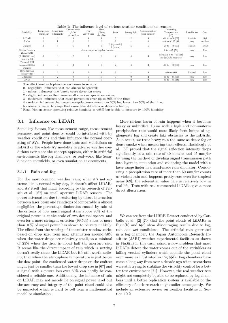
Table 1: The influence level of various weather conditions on sensors
ModalityLight rain<4mm/hr
Heavy rain>25mm/hr
Dense smoke/Mist
vis<0.1km
Fogvis<0.5km
Haze/Smog
vis>2kmSnow Strong light
Contamination(over emitter)
OperatingTemperature
(℃)Installation Cost
LiDAR 2 3 5 4 1 5 2 3 -20 to +60 [55] flexible highRadar 0 1 2 0 0 2 - 4 -40 to +125 [56] easy medium
Camera 3 4 5 4 32 (dynamic)
3 (static)5 5 -20 to +40 [57] easiest lowest
Stereo Camera almost same as regular camera 0 to +45 [58] easy lowGated NIR
(λ 800-950 nm)Camera [59]
2 3 2 1 0 2 4 3normally 0 to +65 [60]
for InGaAs cameraseasy low
Thermal FIR(around 30Hz)
Camera2 3 3 1 0 2 4 3 -40 to +60 [61] easy low
Road-frictionsensor* [62]
2 3 3 2 1 2 - 5 -40 to +60 limited low
Ultrasonic 0 2 0 0 0 0 0 2 -40 to +85 [63] easy lowGNSS 0 2 0 0 0 0 0 0 -40 to +85 [48] easy low
The effect level each phenomenon causes to sensors:0 - negligible: influences that can almost be ignored;1 - minor: influences that barely cause detection error;2 - slight: influences that cause small errors on special occasions;3 - moderate: influences that cause perception error up to 30% of the time;4 - serious: influences that cause perception error more than 30% but lower than 50% of the time;5 - severe: noise or blockage that cause false detection or detection failure;
* Road-friction sensor operating relative humidity is <95% but is able to measure 0∼100% humidity
3.1 Influence on LiDAR
Some key factors, like measurement range, measurementaccuracy, and point density, could be interfered with byweather conditions and thus influence the normal oper-ating of AVs. People have done tests and validations onLiDAR or the whole AV modality in adverse weather con-ditions ever since the concept appears, either in artificialenvironments like fog chambers, or real-world like Scan-dinavian snowfields, or even simulation environments.
3.1.1 Rain and fog
For the most common weather, rain, when it’s not ex-treme like a normal rainy day, it doesn’t affect LiDARsand AV itself that much according to the research of Fer-sch et al. [67] on small aperture LiDAR sensors. Thepower attenuation due to scattering by direct interactionbetween laser beam and raindrops of comparable is almostnegligible: the percentage diminution caused by rain atthe criteria of how much signal stays above 90% of theoriginal power is at the scale of two decimal spaces, andeven for a more stringent criterion (99.5%) a loss of morethan 10% of signal power has shown to be very unlikely.The effect from the wetting of the emitter window variesbased on drop size, from max attenuation around 50%when the water drops are relatively small, to a minimalof 25% when the drop is about half the aperture size.It seems like the direct impact of rain which is wettingdoesn’t really shake the LiDAR but it’s still worth notic-ing that when the atmosphere temperature is just belowthe dew point, the condensed water drops on the emittermight just be smaller than the lowest drop size in [67] anda signal with a power loss over 50% can hardly be con-sidered a reliable one. Additionally, the influence of rainon LiDAR may not merely lie on signal power level butthe accuracy and integrity of the point cloud could alsobe impacted which is hard to tell from a mathematicalmodel or simulation.
More serious harm of rain happens when it becomesheavy or unbridled. Rains with a high and non-uniformprecipitation rate would most likely form lumps of ag-glomerate fog and create fake obstacles to the LiDARs.As a result, we treat heavy rain the same as dense fog ordense smoke when measuring their effects. Hasirlioglu etal. [68] proved that the signal reflection intensity dropssignificantly in a rain rate of 40 mm/hr and 95 mm/hrby using the method of dividing signal transmission pathinto layers in simulation and validating the model with alaser range finder in a hand-made rain simulator. Consid-ering a precipitation rate of more than 50 mm/hr countsas violent rain and happens pretty rare even for tropicalareas [69], the referential value here is relatively low inreal life. Tests with real commercial LiDARs give a moredirect illustration.
We can see from the LIBRE Dataset conducted by Car-ballo et al. [2] [70] that the point clouds of LiDARs inFig.6(b) and 6(c) show discouraging results due to fog,rain and wet conditions. The artificial rain generatedin a fog chamber, the Japan Automobile Research In-stitute (JARI) weather experimental facilities as shownin Fig.6(a) in this case, raised a new problem that mostLiDARs detect the water comes out of the sprinklers asfalling vertical cylinders which muddle the point cloudeven more as illustrated in Fig.6(d). Fog chambers havecome a long way from over a decade ago when researcherswere still trying to stabilize the visibility control for a bet-ter test environment [71]. However, the real weather testmight not completely be able to be replaced by fog cham-bers until a better replication system is available or theefficiency of such research might suffer consequently. Weinclude an extensive review on weather facilities in Sec-tion 10.2.
7

(a) Fog chamber (b) Point clouds in fog (c) Point clouds in rain (d) Rain pillars as detected byLiDAR
Figure 6: LiDAR performance test in the JARI Special Environment Proof Ground (LIBRE dataset [2]).
(a) Velodyne point cloud insnow swirl
(b) Robosense point cloud insnow swirl
Figure 7: LiDAR point clouds when driving behind aleading vehicle in snow weather [72]. Images courtesy ofDr. Maria Jokela, VTT Technical Research Centre ofFinland Ltd.2
3.1.2 Snow
Different from rain, snow is consisted of solid objects,snowflakes, and could easily shape themselves into muchlarger solid objects and become obstacles that either causefalse detection of LiDAR or block the line of sight foruseful detection. Very few tests on snow effects have beendone given the fact that a snow test ground, like the fogchamber, is less easy to access, and the apparent dangerof driving in snow.
Jokela et al. [72] tested AVs LiDAR performance inFinland and Sweden snow conditions, mainly focused onthe snow swirl caused by a leading car. Fig.7(a) showsthat for a typical VLP-16 LiDAR (Velodyne’s Puck Li-DAR [73]), apart from a few noise points near the sensor,the powder snow is almost not being detected, but theturbulent snow caused by the leading car and the egocar itself creates voids in the front and back view in thepoint cloud. LiDARs from different manufacturers couldhave different performances on the same matter. Fig.7(b)shows the RS-LiDAR-32 [74] has the same void from thesnow swirl but also has a highly dense cloud around thesensor caused by the snow. As a result, it’s safe to say thatsnow in the atmosphere or whirled from the ground couldcause an anomaly in LiDAR’s point cloud and shorten theview distance. What’s more, a LiDAR like the VelodyneVLP-16 one used in this work, whose designed lowest op-erating temperature is −10◦C, might not even stand achance in a colder environment which is not that rare inthe northern hemisphere. When the temperature changeis at a large scale, such as from an extremely cold (−20◦C)
2https://www.vttresearch.com/en
to an extremely hot (+60◦C) environment, the time de-lay of LiDAR measurement would increase about 6.8 ns,which widens the LiDAR ranging by over a 1 meter andlower the precision at near field [75], not to mention thesensibility of photodetectors and range measurement.
3.1.3 Influences on other LiDAR types
Currently, the majority of the market use 905 nm wave-length LiDAR deployment. However, LiDAR upgrade hasalways been one of the focuses of the research community.Kutila et al. [76] raised in 2018 using 1550 nm LiDARto overcome fog conditions because higher optical poweris allowed to emit here at this wavelength. Before we de-termine the feasibility of this, it’s necessary to bring upthe two critical design considerations in LiDAR selection:eye safety and ambient suppression. Most civilian or com-mercial LiDARs are used in an environment where humaneyes are exposed, so the infrared laser of LiDAR mustnot exceed the maximum permissible exposure (MPE) orcause any damage to retinas, according to the interna-tional laser product safety standard (IEC 60825-1:2014)class 1 [77]. Therefore, the selection of laser wavelengthis pretty much narrowed down to two choices: 800 nm -1000 nm and 1300 nm - 1600 nm. That’s why currentLiDARs made for AVs have the selection of 850 nm 3,905 nm 4, and 1550 nm 5 wavelengths, and they also allfall into the window of low solar irradiance, which helpson suppressing the ambient light for the signal receiverwith a lower SNR [30]. 1550 nm wavelength has a rela-tively larger water extinction coefficient (Fig.8) and canbe largely absorbed in the crystalline lens or the vitreousbody of an eye so more energy is allowed than 905 nm,which seems to be a good thing considering the powerattenuation predicament in weather [80].
However, based on the research of J. Wojtanowski etal. [81] on the comparison of 905 nm and 1550 nm perfor-mance deterioration due to adverse environmental condi-tions, 905 nm reaches two times further than 1550 nm ina rain rate of 25 mm/hr. Light propagation at 1550 nmmight suffer less attenuation than at shorter wavelengths,but Kim et al. [82] suggested that this rule only applies tohaze (visibility > 2 km), while in fog (visibility < 500 m)the attenuation is independent of wavelength and 905 nm
3OS1-64, Ouster LiDAR [78]4Puck, Velodyne LiDAR [73]5PandarGT, Hesai LiDAR [79]
8

still measures 60% longer than 1550 nm. What’s more,1550 nm waves have approximately 97% worse reflectancein snow compared to 905 nm [83]. Less interference fromsnow doesn’t make up for the insufficiency in the originaljob of object detection.
Figure 8: Water extinction coefficient spectrum. Laserenergy absorption by water of 1550 nm is over a 100 timeslarger than of 905 nm. [84]
Take the FMCW LiDAR mentioned in the previous sec-tion as an example. FMCW LiDAR manufacturers likeAurora [85] and Aeva [86] are using 1550 nm wavelengthin solid-state. Despite its obvious advantages in filteringstrong-light and anti-interference, 1550 nm wavelength’sineffectiveness in dealing with water was basically provenin the discussion above. Some promotion articles may ar-gue that FMCW LiDAR handles the water droplets onthe emitter well and can easily filter out the raindrops orsnowflakes based on its velocity detecting ability [87], butthe large signal attenuation that comes with the wave-length itself is omitted here and hardly any field testsof FMCW LiDAR in adverse weather conditions can befound at this stage. Notwithstanding, 1550 nm has somepotential in further solid-state LiDAR development andthe compatibility in CMOS (Complementary Metal Ox-ide Semiconductor) technology, its unsatisfying perfor-mance still cannot earn it the favor of the mainstreamright now. LiDAR upgrading in terms of hardware prop-erties is not as promising as expected in the short run,but that doesn’t put LiDAR at its wit’s end.
Similarly, one of the users of super-continuum LiDAR,Outsight, does not explain the eye safety conundrumwhen the wavelength is not 905 nm nor 1550 nm. Con-sidering super-continuum lasers normally work at 728-810nm [88], the specific information on whether the powerlevel they are using at this wavelength range has any riskto eyes and its performance in field tests with weatherpresence is not exactly clear. Just like most of the FMCWLiDAR, very few solid-state LiDARs with the ability tocompete with mature traditional rotating LiDARs arecommercially ready on the market for AVs right now, butmostly for robotics, thus their performances in adverseweather conditions are seldom tested neither. That beingsaid, new technologies in new kinds of LiDARs, for exam-ple, Baraja’s spectrum-scan technology [89] [90], are stillbeing looked forward to.
3.1.4 Others
There are more weather phenomena that cause problemsto transportation based on our common sense, such assandstorms and smog. As rare as they might appear,they could be more serious problems than rain and snowfor some regions like the Middle East or desert areas.However, due to the low attention and slow developmentunder conditions when not even humans can drive, test-ing and researching in such weather can hardly be found.The part that LiDAR is involved in sandstorm or haze-somg weather is beyond the road—airborne or space. TheCALIPSO high spectral resolution LiDAR [91] is usedin satellites to monitor the Earth’s atmosphere and canlook through haze and sandstorm. Single-photon LiDARsare also frequently used in airborne LiDARs for 3D ter-rain mapping. Although such technology normally servesmeteorology and oceanology [92], there is already single-photon avalanche diode (SPAD) LiDAR that has beenused on automotive applications [93] due to their ad-vantages on long-range capabilities (kilometers), excellentdepth resolution (centimeters), and use of low-power (eye-safe) laser sources [94]. Future aerial LiDARs and UAVsare facing additional weather challenges as the situationsin the sky is not quite the same as on the ground. Atmo-sphere turbulence can produce wind-affected and time-varying refractive gradients which lead to scintillation,beam spreading and wander [95]. The particular effectof such adversarial conditions on the autonomous drivingarea hasn’t been studied in a methodically way as aerialLiDARs and UAVs haven’t come to practical use yet, butit’s safe to assume that they are going to need to overcomethis problem to be able to serve the intelligent transporta-tion system under hazy and turbulent conditions in thefuture. Details about aerial LiDARs and UAVs will beintroduced in Section 9.
3.2 Influence on radar
Radar seems to be more resilient in weather conditions.By examining the electromagnetic power attenuation indifferent rain rates [96] [97] from Fig.9, we can observethat the attenuation for radar at 77 GHz is at the levelof 10 dB/km in a 25 mm/hr heavy rain, while 905 nmLiDAR’s attenuation is about 35 dB/km under the samevisibility below 0.5 km condition [98] [99]. According toSharma and Sergeyev’s simulation on non-coherent pho-tonics radar which possesses lower atmosphere fluctua-tion, the detection range of the configuration of a linearfrequency-modulated 77 GHz and 1550 nm continuous-wave laser could reach 260 m in heavy fog, 460 m in mildfog and over 600 m in heavy rain with SNR threshold at20 dB [100]. Norouzian et al. [101] also tested radar’ssignal attenuation in snowfall. A higher snow rate yieldslarger attenuation is as expected, and wet snow showshigher attenuation because of the higher water absorp-tion and larger snowflakes. Considering a snowfall witha 10 mm/hr already has quite low visibility (< 0.1 km)[102], we yield that the specific attenuation for a 77 GHzradar in a 10 mm/hr snow is about 6 dB/km, which is
9

seemly acceptable given the rain data.
Figure 9: Electromagnetic power attenuation vs fre-quency in different rain rates.
In the research of Zhang et al. [18], the rain attenua-tion and back-scatter effects to mm-wave radar and thereceiver noise were mathematically analyzed. They con-ducted simulations including 4 different scenarios withradar detecting cars or pedestrians under different lev-els of rain rate. Results show that the back-scatter ef-fect leads to the degradation of signal-to-interference-plus-noise ratio when the radar cross-section area is smalllike a pedestrian in heavy rain conditions. However, thedegradation is at the single-digit level at a 100mm/hr rainrate and their simulation expands the test variables up to400mm/hr rain rate which is basically unrealistic in real-world because even if such an enormously high rain rateoccurs, the condition of driving would be highly difficult.
No doubt that radar is objectively better adaptive towet weather, but when compared with LiDAR, radar of-ten receives criticisms on the insufficient ability in pedes-trian detection and object shape & size information clas-sification due to low spatial resolution. Akita et al.[103] have improved this by implementing long shortterm memory (LSTM) which can treat time-series data.What’s more, one of the sensors used by the radar exten-sion of Oxford RobotCar dataset [104] is a Navtech RadarCTS350-X 360 ◦ FMCW scanning radar [105] which pos-sesses a measurement range up to 100-200 m and canhandle Simultaneous Localization and Mapping (SLAM)solely in the dark night, dense fog and heavy snow con-ditions [106]. So the usefulness of radar has much morepotential.
3.3 Influence on camera
3.3.1 Rain and fog
A camera in rain, regardless of however high resolution,can be easily incapacitated by a single water drop on theemitter or lens [107], like shown in Fig.10. The blockageand distortion in the image would instantly make ADSlose the sense of the input data and fail to process cor-rectly. As for fog, based on its density, it creates near-
6https://ouster.com/
Figure 10: Camera vs LiDAR in rain condition. [107]Image courtesy of Ms. Kim Xie, Ouster Inc.6
homogeneous blockages at a certain level which is a directdeprivation of information to cameras. Reway et al. [108]proposed a Camera-in-the-Loop method to evaluate theperformance of the object detecting algorithm under dif-ferent weather conditions. The environment model dataare acquired by a set of cameras and processed by an ob-ject classification algorithm, the result is then fed to thedecision maker which re-engages in the simulation envi-ronment and completes a closed loop. The result of up to40% rise of miss rate in the night or fog pretty much fitswith a common expectation of camera and proves thatcamera alone definitely cannot beat the weather.
3.3.2 Snow
Winter weather like snow could affect the camera in onesimilar way like rain does when the snowflakes touch thelens or the camera’s optical window and melt to ice-slurryimmediately. What’s worse, those ice water mixturesmight freeze up again quickly in low temperatures andform an opaque blockage on the camera’s line of sight.
Heavy snow or hail could fluctuate the image intensityand obscure the edges of the pattern of a certain objectin the image or video which leads to detection failure [18].Besides the dynamic influence, snow can extend itself toa static weather phenomenon. Most of the time the prob-lems caused to transportation by snow are not instantbecause snow can accumulate on the surface of earth andblock road marks or lane lines, and might even form ice onthe road [109]. That makes both humans and AVs driveunder indeterminacy. Especially for cameras, the acqui-sition of data sources is compromised and the process ofthe whole autonomous driving is interrupted at the verybeginning.
3.3.3 Light conditions
A particular weather phenomenon, strong light, directlyfrom the sun or artificial light source like light pollutionfrom a skyscraper may also cause severe trouble to cam-eras. Even LiDAR suffers from strong light at an extremecondition [2]. It can be seen from Fig.11 that under di-
10

rect strong light, a normal visible camera (upper left) isalmost blinded, and the LiDAR point cloud (lower cen-tral) shows basically only black around the light sourcearea during the chamber test, but thermal camera (uppermiddle) still remains part of the abilities to distinguishthe rectangle board beneath the light source which nor-mal camera couldn’t. A too high illumination can degradethe visibility of camera down to almost zero and glares re-flected by all kinds of glossy surfaces could make the cam-era exposure selection a difficult task [110]. HDR cameraspecializes in tough light conditions. With such technol-ogy applied on AVs, visibility drop due to sudden changeof light conditions like the entry and exit of a tunnel islargely mitigated. Benefited from better color preserva-tion, AV navigating performance when driving into directsunlight can also be improved [111].
Another correlative issue caused by light is the reflec-tion off reflective surfaces. If the reflection happens to beideal, it might confuse the camera into believing it andtransmitting the false signal. The lack of stereoscopicconsciousness is the Achilles’ heel of a normal camera.Human drivers frequently experience the problem of re-flections on the windshield confusing the view on a veryshiny day or when at night and there’s illumination insidethe cabin, which is exactly the reason why cabin light isnot recommended when cruising at night time. The verysame problem applies to cameras set up behind the wind-shields as well. Sometimes the reflections are an inferiormirage due to high road surface temperatures, sometimesare the mirror images of the car’s interiors. This false in-formation can hardly be identified in a 2D sense, and lightconditions are never 100% friendly to cameras. Withoutthe help of other sensors with the sense of depth in three-dimension, a camera couldn’t take up the responsibilityon its own. From another angle, the ineffectiveness ofcameras here means the redundancy of ADS in weatherconditions is impaired at a big level, so we need to doeven better than just overcoming adverse weather to en-sure total safety.
Figure 11: Sensors’ performances under strong light. Up-per left: visible RGB camera; upper middle: thermalcamera with Ironbow palettes(Hot objects are shown inlighter, warm colors while colder objects are dark, coolcolors[112]); lower middle: LiDAR point cloud.[2]
When it comes to camera images distortion, a famil-iar scene of pictures being burned over flames like heatwaves strike our mind. As for whether this kind of distor-tion will affect ADS, we can deduce an estimated changeof object’s size by looking at the work of Ma et al. [113]on image distortion of digital camera induced by envi-ronmental temperature and camera self-heating. Theirexperiments indicate that the average absolute error be-tween the measured and theoretical thermal-induced im-age distortion is 11.85 µε, and they used a chessboard’sgrids as the target at 500 mm away. Applying the sameerror rate to a scenario when an ADS camera measuringan object of about 1.5 m height a little far away, we yieldthat the absolute size change wouldn’t exceed the levelof 0.2 mm, which is almost negligible and can hardly af-fect the ability of the ADS recognition and classificationof such object. Based on this, the image distortion dueto normal environmental temperature rise shouldn’t be aconcern to camera perception.
3.4 Miscellaneous issues
Apart from the normal weather that people are famil-iar with and could anticipate, there are always unex-pected weather or phenomena caused by weather thatcould catch us off guard and that’s also something that anAV needs to be prepared for. Like the flying stones hittinga car windshield, the casing of an ADS device like a Li-DAR emitter window could also suffer direct strikes froma flying object, stones or sand blown up by strong winds,large pieces of hailstones in severe convective weather,and debris in general. A crack on the glass could affectthe normal data receiving of signals or break the originalimages, also could create chances for air or moisture in-filtration which might hinder electronic devices, and theworst scenario leads to fraction growth and finally frac-ture [114]. As one of the famous unpredictable phenom-ena, wind can bring more trouble. Contamination fromunknown substances in the surroundings like blown upleaves and garbage could block the view of ADS sensorsin a sudden. Particles from road dirt attached to the outersurface of the emitter window could worsen the LiDARsignal attenuation [115]. Tests with near-homogeneousdust particles being distributed on the surface of a scannershow a 75% reduction in LiDAR maximum range [116].Although some of these scenarios can be considered asrare events, it’s better to be prepared because ADS safetycannot afford any tolerance.
Ultrasonic is among the sensors that are hardly consid-ered in the evaluation of weather influences, but it doesshow some special features. The speed of sound travelingin air is affected by air pressure, humidity, and temper-ature [117]. The fluctuation of accuracy caused by thisis a concern to autonomous driving unless enlisting thehelp of algorithms that can adjust the reading accordingto the ambient environment which generates extra costs.Nonetheless, to keep an open mind in ADS modalities,ultrasonic does have its strengths, considering its basicfunction is hardly affected by harsh weather. The re-turn signal of an ultrasonic wave does not get decreased
11

due to the target’s dark color or low reflectivity, so it’smore reliable in a low visibility environment where cam-eras may struggle, like high-glare or shaded areas beneathan overpass. Additionally, the close proximity specialtyof ultrasonic can be used to classify the condition of theroad surface. Asphalt, grass, gravel or dirt road can bedistinguished from their back-scattered ultrasonic signals[118], so it’s not hard to imagine that the snow, ice orslurry on the road can be identified and help AV weatherclassification as well. Bottom line is, ultrasonic sensorsprovide another layer of redundancy when other sensorslike LiDAR and cameras are crippled in some abominableenvironments and at least keep the AV from collisionswhile maintaining its original duties.
Now we know that weather conditions directly affectthe environmental states and impair ADS sensors’ abilityto perceive; or affect the vehicles’ states with secondaryeffects such as winds and road surfaces. There are stillconsequential effects brought by the change of ego vehi-cle or the surrounding vehicles’ state. Walz et al. [119]benchmarked the spray effect on cameras and LiDARscaused by the nearby cutting vehicles under both day andnight conditions. They proved that the spray would cause“ghost” target for Velodyne HDL64-S3D LiDAR and se-vere blockage for the non-rotating Velodyne VLP32C Li-DAR who doesn’t have the centrifugal forces to throwaway the water droplets or any other self-cleaning mech-anism; and also false positives around the rear lights,wrong object dimensions, and missing detections for cam-era’s case. Vargas Rivero [120] used synthetic data to con-struct a virtual scene where an obstacle in a water sprayregion has the same detection characteristics as a realobject in terms of intensity, echo number and occlusion.They generated augmented data from the detection of thisvirtual scene and obtained good LiDAR point cloud datafor classifier training under water spray conditions froma leading vehicle. This effect sometimes even outdoes thedirect effect from weather as the spray plume from theleading vehicle is often violent and erratic, just like thesnow swirl in [72].
Signals from satellite-based navigation systems, suchas GPS, Galileo and others, experience some attenua-tion and reflection with passing through water in the at-mosphere and other water bodies. As analysed by Ger-not [121], water is a dielectric medium and a conductor.Electromagnetic waves will experience attenuation due torotation of water molecules according to the electric fieldwhich causes energy dissipation. Also, moving charges inthe water body will reflect and refract the wave, and thishappens at the air-water and water-air interfaces.
Balasubramaniam and Ruf [122] studied the effectsof rain and winds on GNSS reflectometry (GNSS-R),their model considers path attenuation, modified surfaceroughness and downdraft winds. Their study finds verylittle attenuation in the L-Band due to raindrops, withabout 96% transmissivity for mild rain below 30 mm/hr.While the L-Band is able to penetrate even heavy rain,the effect of wind tend to increase attenuation.
In Gernot’s work [121], GPS signal experienced a signif-
icant loss over 9.4 dB when passing through a 1 mm layerof liquid water, but only 0.9 dB when passing through4 cm layer of snow, and 1.7 dB for 14 cm layer of snow.This experiment suggests that bodies of water in the formof wet roads and puddles will further affect the signal-to-noise ratio of GNSS.
4 Sensor Fusion and MechanicalSolutions
The serious influences that weather causes to autonomousdriving encourage people to work on the solutions. Be-fore the wild spread and use of machine learning and AItraining techniques, the more straightforward solutionsin the eyes of most of the manufacturers and Auto facto-ries are sensor fusion modalities agnostic to weather, andmechanical components that help mitigate the effects ofweather. Table 2 shows the literature and newsletterscoverage with regard to different types of sensor fusionsand mechanical solutions.
4.1 Sensor fusion modalities
Figure 12: Point cloud of a LiDAR + Camera Fusion.
By now, it’s almost well established that the tradi-tional LiDAR or Camera architecture alone is not go-ing to navigate through adverse weather conditions withenough safety assurance. But two forces combining to-gether would be a different story with the additionalstrength, just as the enhanced point cloud from a LiDAR+ Camera fusion shown in Fig.12. As a result, groupsfrom all over the world come up with their own permuta-tion and combination with the addition of radar, infraredcamera, gated camera, stereo camera, weather stationsand other weather-related sensors, like the one shown inFig.13. And of course, fusion modalities need calibra-tions to ensure the synchronization of all the participatedsensors for the best performance. An excellent examplewith centimeter-level accuracy is the multi-sensor fusiontoolbox developed by Monrroy Cano et al. [141] whoseframework contains both LiDAR-to-LiDAR and Camera-LiDAR extrinsic algorithms that can ease the fusion ofmultiple point clouds and cameras with only one-time cal-
12

Table 2: Sensor fusion and mechanical solutionsSensor Fusion Mechanical Solutions
Radardominant
Thermal cameradominant
LiDAR+Radar+Camera+Auxiliary
Sensor housingand wipers
HeaterHydrophobic
coatingLower
reflectionWindshieldprotection
Sensorrecalibration
[123][124]
[125][126][127][59]
[128][110][129][130]
[131][132][133]
[134][135]
[136][137]
[138][139][114]
[140][141]
ibration. This toolbox is integrated into the open sourceautonomous driving framework known as Autoware [142].
Figure 13: The Toyota Prius used for ADS tests fromNagoya University. The LiDAR sensor, alongside othersensors, is bolted on a plate which is mounted firmly ontop of the car.
4.1.1 Radar dominant
Yang et al. [123] brought up a modality called RadarNet,which exploits both radar and LiDAR sensors for percep-tion. Their early fusion exploits the geometric informa-tion by concatenating both LiDAR and radar’s voxel rep-resentation together along the channel dimension, and theattention-based late fusion is designated to specifically ex-tract the radar’s radial velocity evidence. They validatedtheir modality in the nuScenes dataset [143]. Althoughno specific tests in adverse weather conditions were con-ducted, we know that the nuScenes dataset unbiasedlycollected rain conditions in Boston and Singapore, so therobustness of such classic fusion is proven, especially onthe improvement of long-distance object detection andvelocity estimation.
Liu et al. [124] raised a robust target recognition andtracking method combining radar and camera informationunder severe weather conditions, with radar being themain hardware and camera the auxiliary. They testedtheir scheme in rain and fog including night conditionswhen visibility was the worst. Results show that radarhas a pretty high accuracy in detecting moving targetsin wet weather, while the camera is better at categorizingtargets and the combination beats LiDAR alone detectionby over a third. Their radar also shows good stability intracking vertical targets but not horizontal targets dueto the limited field of view (FOV). Radar and cameratogether reach close to the LiDAR tracking ability andthey concluded that this mixture stands a good chance inadverse weather conditions.
Fritsche et al. [144] used a 2D high bandwidth scanner,the mechanical pivoting radar (MPR) [145], to fuse withLiDAR data to achieve SLAM in a low visibility fog envi-ronment. The MPR only has a 15m measurement rangebut the one ability of penetrating fog is more than enoughto prove itself useful in landmarks searching and make upfor what the LiDAR is missing. This fusion was tested ona robot instead of an AV.
4.1.2 Camera dominant
FLIR System Inc. [125] and the VSI Labs [146] tested theworld’s first fused automated emergency braking (AEB)sensor suite in 2020, equipped with a thermal long-waveinfrared (LWIR) camera, a radar and a visible camera.LWIR covers the wavelength ranging from 8 µm to 14µm and such camera operates under ambient tempera-ture known as the uncooled thermal camera. This sensorsuite was tested along with several cars with various AEBfeatures employing radar and visible camera against day-time, nighttime and tunnel exit into sun glare. The com-parison showed that although most AEB systems workfine in the daytime, normal AEB almost hit every man-nequin under those adverse conditions, while the LWIRsensor suite never knocked down a single one. As a matterof fact, LWIR camera also exhibits superior performancein thick fog conditions when scattering loss is very highcompared to MWIR (3 µm - 5 µm) and SWIR (0.85 µm- 2 µm) [147].
Vertens et al. [148] went around the troublesome night-time images annotation and leveraged thermal images.They taught the network to adapt and align an exist-ing RGB-dataset to the nighttime domain and completedmulti-modal semantic segmentation. Spooren et al. [126]came up with a multi-spectral active gated imaging sys-tem that integrated RGB and NIR cameras for low-light-level and adverse weather conditions. They designed cus-tomized filters to achieve a parallel acquisition of boththe standard RGB channels and an extra NIR channel.Their fused image is produced with the colors from theRGB image and the details from the NIR. John et al.[127] also proposed a visible and thermal camera deepsensor fusion framework that performs both semantic ac-curate forecasting as well as optimal semantic segmenta-tion. These might be some of the most cost-effective solu-tions for weather conditions but particular gated CMOSimaging systems are still being developed [59].
It should be noted that even though thermal camerascan have better performance than regular cameras andcan definitely be tested in winter, the operating tem-peratures provided by the manufacturers have certain
13

lower bounds as shown in Table 1, which might seri-ously restrain the practical use of such sensors duringcold winter even if it’s a clear day. The durability of suchtemperature-sensitive devices needs further validation inreal environments in the future to ensure their usefulness.
4.1.3 Comprehensive fusions
Kutila et al. [128] raised an architecture called the Ro-bustSENSE project. They integrated LiDAR with long(77GHz) & short (24GHz) range radar and stereo & ther-mal camera while connecting the LiDAR detection layerand performance assessment layer. That way, the datagathered by the supplementary sensors can be used inthe vehicle control layer for reference when the LiDARperformance is assessed as degrading down to a criticallevel. They tested the architecture with a roadside Li-DAR in a foggy airport and collected performance datawhile keeping the hardware components cost within a con-siderably low price (< 1000 Euros). Although the com-parability with an AV test drive is not ideal, the conceptof hardware and software complementation is one of thebases of AV weather adaptation. Radecki et al. [110]extensively summarized the performance of each sensoragainst all kinds of weather including wet conditions, day& night, cloudy, glare, and dust. They formulated a sys-tem with the ability of tracking and classification basedon the probability of joint data association. Their visiondetection algorithm is realized by using sensor subsetscorresponding to various weather conditions with real-time joint probabilistic perception. The essence of suchfusion is about real-time strategy shift. Sensor diversityimproves the perception ability general lower bound, butthe intelligent choice of sensor weighting and accuratelyquantified parameters based on the particular weather de-termine the ceiling of the robustness and reliability of suchmodalities.
Bijelic et al. [129] from Mercedes-Benz AG present alarge deep multimodal sensor fusion in unseen adverseweather. Their test vehicle is equipped with the fol-lowing: a pair of stereo RGB cameras facing front; anear-infrared (NIR) gated camera whose adjustable de-lay capture of the flash laser pulse reduces the backscat-ter from particles in adverse weather [130]; a 77 GHzradar with 1◦ resolution; two Velodyne LiDARs namelyHDL64 S3D and VLP32C; a far-infrared (FIR) thermalcamera; a weather station with the ability to sense tem-perature, wind speed & direction, humidity, barometricpressure, and dew point; and a proprietary road-frictionsensor whose purpose not specified, presumably for clas-sification use. All the above are time-synchronized andego-motion corrected with the help of the inertial mea-surement unit (IMU). They claimed their fusion entropy-steered, which means regions in the captures with low en-tropy can be attenuated, while entropy-rich regions canbe amplified in the feature extraction. All the data col-lected by the exteroceptive sensors are concatenated forthe entropy estimation process and the training was doneby using clear weather only which demonstrated a strongadaptation. The fused detection performance was proven
to be evidently improved than LiDAR or image only un-der fog conditions. The blemish in this modality is thatthe amount of sensors exceeds the normal expectation ofan ADS system. More sensors require more power sup-ply and connection channels which is a burden to thevehicle itself and proprietary weather sensors are not ex-actly cost-friendly. Even though such an algorithm is stillreal-time processed, given the bulk amount of data frommultiple sensors, the response and reaction time becomessomething that should be worried about.
4.2 Mechanical solutions
4.2.1 Protection and cleaning
It’s always the first instinct in a human’s vein to solvea problem mechanically like tightening a screw. So isfor autonomous driving. All the problems that weatherhas been causing to an AV most definitely caught the at-tention of the major automotive enterprises and effortshave been made to get around them with simple, low-cost mechanical solutions. For example, growing out ofsnowy Scandinavia, Volvo first noticed that the snow swirlcaused by the leading car blocked the view of sensors andmade them freeze up. After moving the sensors to sev-eral locations on a car ending up in failures, Volvo finallydecided to nestle the radar and cameras behind the wind-shield and keep them from the hassle of snow permanently[131]. However, this is more of a compromise than a realsolution considering the installation of these sensors in-side the cabin does not really comply with the currentmarket where human drivers still have the seat behindthe wheel, and some sensors such as LWIR thermal cam-eras cannot be installed behind windows because theirwavelength won’t go through glasses.
Having experienced the importance of the windshield,it’s natural for us to think of trying installing the samemechanism for ADS sensors, as in designated windshields.Waymo and Uber are among the proponents who coverthe ADS sensors, mostly LiDAR and cameras, inside ashell housing and attach a small wiper on it [132] [133].Similar to the windshield and wipers, now the sensors canenjoy almost the same benefits as inside the cabin. It’snot only rain and frost we are talking about, but contam-ination such as bird droppings and bug splatters whichare both common and pernicious to perception. Plus,a shell housing can at least protect the fragile sensorsfrom blunt traumas which might come from flying stones,hails or corrosive substances like acid rain or snow melt-ing agents. The only concern is that sensors behind thewindshield or a shell casing on an AV require automaticwipers for raindrop and contamination cleaning. Opticalor electrical rain sensors in current modern car automaticwindshield wiper systems have the ability to fulfill thisduty, but the technology on contamination detection isstill on the way.
But of course, more mechanical parts mean more mov-ing components and potential risks of dysfunction or dam-age. Some might prefer a mechanism that is static as thealternative to wipers, such as a heater. When driving
14

in winter or cold rain, we tend to turn on the heateron the rear window and rear-view mirrors to get rid ofthe mist or frost to keep a clear view [134]. Hence, aheater can also certainly help keep a sensor emitter or acamera lens clean. State-of-art technologies apart fromembedded heat-resistance wires have been developed tohelp realize this task. Canatu Company created carbonnanobots that can generate 10◦C in less than 6 seconds,and are then deposited onto the plastic covers of sensorsand headlamps [135]. Such a mechanism not only offersice-free sensor surfaces, but also almost doesn’t consumeany energy which could be critical for electric cars (EVs).
There is a widely used process in industries such as jew-elry and glasses which is ultrasonic cleaning [149]. Thistechnology employs piezoelectronics (PZT) to generatea 35 kHz ultrasound and vibrate the emitter surfaces totransfer the dirt into a thin film of water or cleaning fluid.Then the fluid is atomized from the surface, taking awaythe dirt. This mechanism is a great arsenal to bug splat-ter, dirt, road debris, and most importantly, fog conden-sation.
4.2.2 Passive accessories
Besides the proactive machinery, there are also passivesolutions that help ease the adverse effects. Hydrophobicmembrane has been applied to car windshields for a cou-ple of decades now and is proven to be able to improvevisual distance and decrease the minimum visual angleby almost 34% [150]. Research also shows that this im-provement benefits the detection of objects and road signreading greatly which are essential for ADS [136]. There-fore, there is no reason to reject hydrophobic coatings onthe sensor covers of AVs, and PPG Inc. (Pittsburgh PlateGlass Company) has already developed relevant water re-pellent products on car glasses [137].
Beyond all the advanced technologies, sometimes me-chanical solutions can be as simple as putting a pieceof cloth over the dashboard. A Japanese company calledKoPro develops extremely low reflection paint (called Mu-sou Black) also manufactures a kind of flock sheet which ismade of rayon-base fabric with a reflectance rate in visiblelight and NIR of less than 0.5% [138]. Simply placing theflock sheet on the dashboard of a car, very few reflectionsof the car’s interior can be found on the windshield andthe overall perception from within the cabin on sunnydays is boosted so obviously even for a human eye, asshown in Fig.14. Such improvement in camera percep-tion for the price of only about 30 US dollars might justbe currently the best price-quality ratio in mechanical so-lutions.
4.2.3 Integrity and re-calibration
Despite all the additional mechanical parts, the unavoid-able problem with shell housings remains the same: asthe last protection layer between the outside world andthe sensors, the shell itself needs an alert system as muchas the windshield does. With some of the sensors like adash-cam still being installed behind the windshield, even
Figure 14: KoPro Musou Black visual light absorbingflock sheet on the left side of the dashboard alleviatesreflections of car internals compared to the right side andimproves visibility under sunlight.
if there’s no human in the front row seats, the structuralintegrity of the shield glasses still needs to be ensured.Even though nowadays’s windshields are made with shat-terproof glass with polyvinyl butyral embedded in it [139],it’s still not impregnable. Apple car has already filed apatent using infrared light to detect chips and fractureson the windshield at an early stage to prevent crack ex-tensions and splinters [114], which can be seen as a partof the road that Apple is paving to the AV security.
Mechanical components structural integrity pre-warning is one side of the coin, while the other side isthe re-calibration. [151] shows that AV sensors suffer sig-nificant impact from lifetime effects and result in degra-dation. Current popular setups of ADS sensors are Li-DARs on the roof rack; cameras all around the car bodyor nestled behind the windshield; radar and ultrasonicparts hidden inside the grille or front/back bumpers. Andsince each sensor works at a state with narrow tolerances,any impact or status change that happened to whatevermechanical parts could knock the sensors out of align-ment easily. A slight change on the shell casing’s curveor the general position could cause the cameras to losefocus; a deformation not visible to naked eyes in the sup-port structures of LiDARs or radars could shift their fieldof view out of the designated interval; even the heightchange of the car’s gravitational center due to weight ortire pressure change may cause the perception results ofsensor different than before. Bosch uses green lasers thatshoot visible straight lines to help do the calibration. TheAmerican Big Three (Ford, GM, Stellantis [previouslyFCA]) all require dynamic re-calibrations to their cruiseand lane-keeping systems which includes test drivings in
15

the Operational Design Domain (ODD) with speed re-quirements. Some models from Honda and Mercedes re-quire both static and dynamic re-calibration on top oftypical repairs which could easily cost a fortune [140].Such points might not exactly fall within the category ofweather, but adverse conditions definitely contribute tothe sensors’ lifetime effects. As a result, in order to rem-edy the rising cost of AV re-calibration, the mechanicalparts of AVs need even higher durability and robustness.
5 Perception Enhancement in dif-ferent weather conditions
As established in the previous context, the signal inten-sity attenuation and noise disturbance caused by weatherphenomena impair the ADS sensors’ abilities to carryout their original duties and make the risk index of au-tonomous driving climb rapidly. Despite the compen-sation of mechanical protections and advanced navigat-ing techniques, the core of ADS, object detection, is theone that’s worth the most attention and effort in fightingagainst adverse weather conditions. In this section, re-search and works regarding perception enhancement willbe introduced, according to each kind of weather respec-tively. An index of literature covered in this paper re-garding adverse weather solutions against each kind ofweather type can be found in Table 3.
5.1 Rain
Rain is something that’s considered predestined becauseit falls from the sky. Knowing rain is not avoidable andits influence on the ADS sensors, it’s natural to want AVto realize the presence of rain for starters. In meteorol-ogy, rain is observed and measured by weather radar andstationary rain gauges. Considering carrying a weatherstation on a car like the Mercedes group [129] is notpractical for commercial generalization, people started inan early stage to realize vehicle-based binary (wet/dry)precipitation observations when the purpose was not forautonomous driving yet [206] [207]. Although these suc-cessfully achieved precipitation perceiving in the real-timefield, the data were pulled from simulation and had onlybeen validated against weather radar but not real-worlddata. Karlsson et al. did an estimation on the real-timerainfall rate out of automotive LiDAR point cloud underboth static and dynamic conditions in a weather cham-ber using probabilistic methods [156]. Bartos et al. [154]raised an idea of producing high-accuracy rainfall mapsusing windshield wipers measurement on connected vehi-cles in 2019. It’s a very leading concept considering thenetwork of connected vehicles has not been constructedon a large scale. Simply the status (on/off) of windshieldwipers serves as the perfect indicator of binary rainfallstate compared to traditional sensing methods like raingauges. This work is supposed to help city flash floodwarnings and facilitate stormwater infrastructure’s real-time operation, but the involvement of cars provides aline of thought on vehicle-based rain sensing.
From the previous context, we know that drizzling andlight rain barely affects main ADS sensors’ performancelike LiDAR, but we do fear it when the rain rate rises. A.Filgueira et al. [155] thought of quantifying the rain’s in-fluences on LiDAR. They put a stationary LiDAR by theroadside and compared the range detection change, sig-nal intensity change, and the number of detected pointschanges with regard to several detection areas includingroad signs, building facades and asphalt pavement. Theproblem is, not only their test scenario is a stationaryone, but the fact that asphalt pavement is perpendicularto rain and building facade is parallel to rain also affectsthe impartiality of quantifying standards. Still, their workinitiated the idea of quantifying rain by directly quantify-ing the LiDAR performance change caused by rain. Alongthis train of thought, it’s possible to set thresholds of raineffects when certain actions needed to be taken to counterthe influences [208], as long as the benchmarks can beprecise and inclusive. Goodin et al. [153] tried this taskin a more specific way. They used only two parameters:rain rate, as manifested by the rain scattering coefficient,and the max range of the LiDAR sensor for a 90% reflec-tive target in clear conditions, to successfully generate aquantitative equation between rain rate and sensor per-formance. Their design and validation were conductedunder a simulation environment where rain rates are eas-ily controlled. Even though no field validation has beendone, combining proper precipitation sensing modalities,now it’s totally possible to know when the LiDAR perfor-mance has degraded down to a critical level according torain rate. This helps simplify the decision-making processa lot by setting quantifiable benchmarks.
Before new LiDAR technology emerges besides 1550nm wavelength, camera is still the major focus of percep-tion enhancement in rain, mainly in terms of de-rainingtechnique, which has been deeply studied by the com-puter vision field. The detection and removal of rain-drops can be divided into falling raindrops and adherentraindrops that accumulated on the protective covers ofcameras [164]. For rain streaks removal, several train-ing and learning methods have been put to use includingQuasi-Sparsity-based training [159] and continual learn-ing [160]. Quan et al. [162] proposed a cascaded net-work architecture to remove rain streaks and raindropsin a one-go while presenting their own real-world raindataset. Their raindrop removal and rain streak removalwork in a complementary way and the results are fusedvia an attention-based fusion module. They effectivelyachieved de-raining on various types of rain with the helpof neural architecture search and their designated de-raining search space. Ni et al. [161] introduced a networkthat can realize both removal and rendering. They con-structed a Rain Intensity Controlling Network (RIC-Net)that contains three sub-networks: background extraction,high-frequency rain streak elimination and main control-ling. Histogram of oriented gradient (HOG) and auto-correlation loss are used to facilitate the orientation con-sistency and repress repetitive rain streaks. They trainedthe network all the way from drizzle to downpour rain
16

Table 3: Summary of solutions against different kinds of adverse weather typesRain Fog/Smoke/Haze Snow Light conditions related Contamination
Sensor solution De-Raining Perception De-Hazing PerceptionDe-snowing(snowfall)
Strong light/Reflectance
ShadowDirt/Dust/Soiling
Fusion [110]LiDAR [152]LiDAR [76]LiDAR [153]Others [154]LiDAR [155]LiDAR [156]
Camera [157]Camera [158]Camera [159]Camera [160]Camera [161]Camera [162]Camera [163]Camera [164]
LiDAR [165]LiDAR [166]LiDAR [128]LiDAR [29]Fusion [129]LiDAR [167]Fusion [168]LiDAR [169]LiDAR [170]Fusion [171]LiDAR [172]
Camera [173]Camera [174]Camera [175]Camera [176]Camera [177]Camera [178]Camera [179]Camera [180]Camera [181]Camera [182]Camera [183]Camera [184]Camera [185]
Camera [186]Fusion [187]Fusion [188]
LiDAR [189]Camera [190]Camera [191]LiDAR [192]
Camera [193]Camera [194]Camera [195]Camera [196]Camera [197]Camera [198]Camera [199]Camera [200]
Camera [201]Camera [126]Camera [202]Camera [203]
LiDAR [115]Camera [204]Camera [205]
and validation using real data shows superiority.Like common de-noising methods, a close loop of both
generation and removal can present better performance.H. Wang et al. [163] handled the single image rain re-moval (SIRR) task by first building a full Bayesian gen-erative model for rainy images. The physical structure isconstructed by parameters including direction, scale andthickness. The good part is that the generator can au-tomatically generate diverse and non-repetitive trainingpairs so that efficiency is ensured. Similar rain genera-tion is proposed by Ye et al. [158] using disentangledimage translation to close the loop. Furthermore, Z. Yueet al. [157] surpassed image frames and achieved semi-supervised video de-raining with a dynamic rain genera-tor. The dynamical generator consists of both an emissionand transition model to simultaneously construct the rainstreaks’ spatial and dynamic parameters like the threementioned above. They use deep neural networks (DNNs)for semi-supervised learning to help the generalization forreal cases.
While de-raining has been extensively studied usingvarious training and learning methods, most of the al-gorithms have met challenges on adherent raindrops andperformed poorly when the rain rates or the dynamismof the scene get higher. Detection of adherent raindropsseems to be easy to achieve given the presumed opti-cal conditions are met, but real-time removal of adher-ent raindrops inevitably brings the trade-off of processinglatencies regardless of the performance. Peak signal-to-noise ratio (PSNR) and Structural Similarity (SSIM) met-rics although widely implemented and faintly improved,don’t seem exactly promising in the line of raindrops de-tection and removal compared to deep-learning and con-volutional neural networks (CNN) [164].
5.2 Fog
Fog plays a heavy role in the line of perception enhance-ment in adverse weather conditions, mainly due to tworeasons. First, the rapid and advanced development of fogchamber test environments, and second, the fog formatcommonality of all kinds of weather including wet weatherand haze and dust, in other words, the diminution of vis-ibility in a relatively uniform way. Early in 2014, Pfen-
nigbauer [165] brought up the idea of online waveformprocessing of range-finding in fog and dense smoke condi-tions. Different from the traditional mechanism of time-of-flight (TOF) LiDAR, their RIEGL VZ-1000 laser iden-tifies the targets by the signatures of reflection properties(reflectivity and directivity), size, shape and orientationwith respect to the laser beam, which means, this echo-digitizing LiDAR system is capable of recording the wave-form of the targets which makes it possible to identify thenature of the detected target, i.e. fog and dense smoke byrecognizing their waveforms. Furthermore, since the rateof amplitude decay caused by the fog follows a certainmathematical pattern with regard to the density of thefog, they realized visibility range classification and thuslywere able to filter out false targets that don’t belong inthis range. Even though their experiments were confinedwithin a critically close range (30 m), they paved a way ofrecovering targets hidden inside fog and smoke, regardlessof the attenuation and scattering effects as long as the sig-nal power stays above the designated floor level, becausetoo low a visibility, like below 10 m, blocks the detectionalmost entirely. Most importantly, the concept of wave-form identification brought the Multi-echo technique tothe commercial LiDAR markets.
SICK AG company developed an HDDM+ (High Def-inition Distance Measurement Plus) technology [169],which receives multiple echoes at a very high repeti-tion rate. The uniqueness of the waveform of fog, rain,dust, snow, leaves and fences are all recognizable to theirMRS1000 3D LiDAR [209] and the accuracy of object de-tection and measurement is largely guaranteed. They arealso capable of setting a region of interest (ROI), whoseboundaries are established based on max & min signallevel and max & min detection distance. Such technol-ogy provides a very promising solution to the problem ofagglomerate fog during heavy rain and other extremelylow visibility conditions. Wallace et al. [167] explored thepossibility of implementing Full Waveform LiDAR (FWL)in fog conditions. This system records a distribution ofreturned light energy and thusly can capture more in-formation compared to discrete return LiDAR systems.They evaluated the 3D depth images performance usingFWL in a fog chamber at a 41 m distance. This type
17

of LiDAR can be classified as a single-photon LiDAR and1550 nm wavelength, which Tobin et al. [170] also used toreconstruct the depth profile of moving objects throughfog-like high level obscurant at a distance up to 150 m.The high sensitivity and high resolution depth profilingthat single-photon LiDAR offers make it appealing in re-mote, complex and highly scattering scenes. But again,that brings us back to the old question of 1550 nm wave-length and OPA manufacturing difficulties [30]. Anyway,the idea of waveform identification and multi-echo pro-cessing is the main guidance right now in LiDAR per-ception enhancement and should be able to express morepotential if the semi-conductor technology can keep itspace with the market demand.
Pure LiDAR de-noising in fog has been tried by Lin etal. [172] who implemented the nearest neighbour segmen-tation algorithm and Kalman filter on the point cloud.However, an improvement rate of less than 20% within2 m range is considered merely passable. No doubt thatthe LiDAR and radar combination can tackle fog condi-tions as well. Qian et al. [168] introduced a MultimodalVehicle Detection Network (MVDNet) featuring LiDARand radar. It first extracts features and generates pro-posals from both sensors, and then the multimodal fu-sion processes region-wise features to improve detection.They created their own training dataset based on theOxford Radar Robotcar [104] and the evaluation showsmuch better performance than LiDAR alone in fog condi-tions. Mai et al. [171] applied fog into the public KITTIdataset to create a Multifog KITTI dataset for both im-ages and point clouds. They performed evaluation usingtheir Spare LiDAR Stereo Fusion Network (SLS-Fusion)based on LiDAR and camera. By training their networkwith both clear and foggy data, the performance was im-proved over a quarter, on the basis of the original per-formance was reduced almost a half. In fact, no matterwhich auxiliary sensor(s) is enlisted, the core of percep-tion enhancement with fusion is to best utilize the datafrom each sensor and extract useful features and achievethe best result of 1 + 1 >2.
Shamsudin et al. [166] proposed algorithms of fog elim-ination from 3D point clouds after detection. Clustersare separated using intensity and geometrical distribu-tion and targeted and removed. The restriction is thattheir environment is an indoor laboratory and the algo-rithms are designed for building search and rescue robotswhose working condition has too low a visibility to beadapted into outdoor driving scenarios where beam di-vergence and reflectance exist in the far-field. But onceagain, it reminds people of the de-noising method, namelythe de-hazing technique in foggy conditions.
Due to the sensitivity of image collecting sensors to ex-ternal environments, especially under hazy weather, out-door images will experience serious degradation, such asblurring, low contrast, and color distortion [210]. It isnot helpful for feature extraction and has a negative ef-fect on subsequent analysis. Therefore, image de-hazinghas drawn extensive attention.
The purpose of image de-hazing is to remove the bad
Figure 15: Illustration of dehazing methods based on at-mospheric scattering model. Images are part of FoggyCityscapes [212].
effects from adverse weather, enhance the contrast andsaturation of the image and restore the useful features. Ina word, estimating the clean image from the hazy input.Currently, existing methods can be divided into two cat-egories. One is non-model enhancement methods basedon image processing (Histogram Equalization [177], Nega-tive Correlation [178], Homomorphic Filter [179], Retinex[180], etc.), another is image restoration methods basedon atmospheric scattering model (Contrast Restoration[181], Human Interaction [182], Online Geo-model, Po-larization Filtering [183]). Although the former can im-prove the contrast and highlight the texture details, itdoes not take into account the internal mechanism ofhaze image. Therefore, the scene depth information isnot effectively exploited and it can cause serious colordistortion. The latter infers the corresponding haze-freeimage from the input according to the physical model ofatmospheric scattering. Based on it, a haze model can bedescribed as
I(x) = J(x)t(x) −A(1 − t(x))
where I(x) is the observed hazy image, J(x) is the sceneradiance to be recovered. A and t(x) are the global at-mospheric light and the transmission map, respectively.Consider the input I is an RGB color image, at each po-sition, only the three intensity values are already knownwhile J, t, and A remain unknown. In general, the modelitself is an ill-posed [211] problem which means its so-lution involves many unknown parameters (such as scenedepth, atmospheric light, etc.).Therefore, many de-hazingmethods will first attempt to compute one or two of theseunknown parameters under some physics constraint andthen put it together into a restoration model to get thehaze-free image as shown in Fig.15.
Until a few years ago, the single image de-hazing al-gorithm based on physical priors was still the focus. Itusually predefines some constraints, prior or assumptionsof the model parameters first, and then restores the cleanimage under the framework of atmospheric scatteringmodel, such as contrast prior [184], airlight hypothesis[185]. However, deducing these physical priors requiresprofessional knowledge and it is not always available whenapplied to different scenes. With the advance of deeplearning theory, more and more researchers introducedthis data-driven method into the field.
18

Chen et al. [174] find that de-hazing models trained onsynthetic images usually generalize poorly to real-worldhazy images due to the domain gap between syntheticand real data. They proposed a principled synthetic-to-real de-hazing (PSD) framework which includes two steps.First, a chosen de-hazing model backbone is pre-trainedwith synthetic data. Then, real hazy images are used tofine-tune the backbone in an unsupervised manner. Theloss function of the unsupervised training is based on darkchannel prior, bright channel prior and contrast limitedadaptive histogram equalization.
Considering the problem that the existing deeplearning-based de-hazing methods do not make full useof negative information, Wu et al. [176] proposed a novelACER-Net, which can effectively generate high-qualityhaze-free images by contrastive regularization (CR) andhighly compact autoencoder-like based de-hazing net-work. It defines a hazy image, whose corresponding re-stored image is generated by a de-hazing network and itsclear image as negative, anchor and positive respectively.CR ensures that the restored image is pulled closer tothe clear image and pushed away from the hazy imagein the representation space. Zhang et al. [175] employtemporal redundancy from neighborhood hazy frames toperform video de-hazing. Authors collect a real-worldvideo de-hazing dataset containing pairs of real hazy andcorresponding haze-free videos. Besides, they proposea confidence-guided and improved deformable network(CG-IDN), in which confidence-guided pre-dehazing mod-ule and the cost volume can benefit the deformable align-ment module by improving the accuracy of the estimatedoffsets.
Existing deep de-hazing models have such high compu-tational complexity that makes them unsuitable for ultra-high-definition (UHD) images. Therefore, Zheng et al[173] propose a multi-guide bilateral learning frameworkfor 4K resolution image de-hazing. The framework con-sists of three deep CNNs, one for extracting haze-relevantfeatures at a reduced resolution, one for learning mul-tiple full-resolution guidance maps corresponding to thelearned bilateral model, and the final one fuses the high-quality feature maps into a de-hazed image.
Although the field has approached maturity, the main-stream methods still use synthesis data to train models.Because collecting pairs of hazy and haze-free ground-truth images need to capture both images with identicalscene radiance, which is almost impossible in real roadscenes. Inevitably, the existing de-hazing quality met-rics are restricted to non-reference image quality met-rics (NRIQA) [213]. Recent works start to collect hazedatasets utilizing a professional haze/fog generator thatimitates the real conditions of haze scenes [214], or mul-tiple weather stacking architecture [215] which generatesimages with diverse weather conditions by adding, swap-ping out and combining components. Hopefully, this newtrend could lead to more effective metrics and boost theexisting algorithms to deploy on the ADS.
Figure 16: LiDAR point clouds in snowfall conditionswith different de-noising methods. Left: raw point cloud;Middle: common ROR filter; Right: DROR filter. [189]Images courtesy of Dr. Nicholas Charron, University ofWaterloo.
5.3 Snow
Perception in snow is divided into two branches. One isthe degradation of signal or image clarity caused by snow-fall, just like raindrops, only falling at a slower speed butwith larger volume; the other is the pathfinding due tothe snow covering, which already caught the attentionof autonomous robots at an early stage. Yinka et al.[186] proposed a drivable path detection system in 2014,aiming at extracting and removing the rain or snow inthe visual input. They distinguish the drivable and non-drivable path by their different RGB elements values sincethe white color of snow is conspicuous compared to roadsurfaces, and then apply a filtering algorithm based onmodeling the intensity value pixel of the image capturedon a rainy or snowy day to achieve removal. Their out-put is in mono color condition and the evaluation basedon 100 frames of road pictures shows close to 100% inpathfinding. Although the scenario is rather simple whereonly some snow is accumulated by the roadsides, this laysa good foundation for ADS when dealing with the sameproblem in snow conditions.
Vachmanus et al. [188] extended this idea into the au-tonomous driving semantic segmentation task by addingthermal cameras into the modality. RGB camera inputmight not be enough to represent every pertinent objectwith various colors in the surroundings, or pedestriansinvolved in the snow driving scenario, which happens tobe the thermal camera’s strong point. Their architecturecontains two branches of encoders, one for RGB cam-era and thermal camera each to extract features fromtheir own input. The temperature feature in the ther-mal map perfectly supports the loss of image element dueto the snow and the fusion model successfully improvessnow segmentation compared to not only RGB cameraalone, but several other state-of-art networks, based onthe validation on several datasets including Synthia andCityscapes. This network is very suitable for automatedsnowplows on roads with sidewalks, which serves beyondthe traditional autonomous driving purpose and could beof real commercial use earlier than AV.
Furthermore, Rawashdeh et al. [187] include cameras,LiDAR and radar in their CNN sensor fusion for driv-able path detection. This multi-stream encoder-decoderalmost complements the asymmetrical degradation of sen-sor inputs at the largest level. The depth and the number
19

of blocks of each sensor in the architecture are decided bytheir input data density, of which camera has the most,LiDAR the second and radar the last, and the outputsof the fully connected network are reshaped into a 2-Darray which will be fed to the decoder. Their model cansuccessfully ignore the lines and edges that appeared onthe road which could lead to false interpretation and de-lineate the general drivable area. Such fusion modalitycertainly can do more than countering snow conditionsbut other low-visibility scenarios and people are workingtowards more channels in the network since LiDAR andradar can provide more types of information like reflectedbeam numbers and velocities.
As for snowfall, the coping method once again returnsto the de-noising technique, even for LiDAR point clouds.Charron et al. [189] extensively explained the deficiencyof 2D median filter and conventional radius outlier re-moval (ROR) before proposing their own dynamic radiusoutlier removal (DROR) filter. As snowfall is a dynamicprocess, only the data from the lasers pointing to theground is suitable for a 2D median filter while it’s notnecessary from the beginning. The data are quite sparsein the vertical field of view above ground and the 2D filtercouldn’t handle the noise point removal and edge smooth-ing properties well. Hence 3D point cloud ROR filter iscalled for. This filter iterates through each point in thepoint cloud and examines the contiguous points withina certain vicinity (search radius), and if the number ofpoints found is less than the specified minimum, then thispoint would be considered as noise and removed, whichfits the pattern of snowfall where snowflakes are smallindividual solid objects. The problem is directly imple-menting this filter in the three-dimensional sense wouldcause the undesirable removal of points in the environ-ment far away and compromise the LiDAR’s perceptionability in terms of precognition, like shown in Fig.16 mid-dle picture. To prevent this problem, Charron’s groupapply the filter dynamically by setting the search radiusof each point according to their original geometric prop-erties and successfully preserve the essential points in theclouds far away from the center while removing the saltand pepper in the point clouds with a precision improve-ment of nearly 4 times of normal ROR filters, as shownin Fig.16 right picture.
On the other hand, Park et al. [192] proposed a low-intensity outlier removal (LIOR) filter based on the inten-sity difference between snow particles and real objects. Itcan also preserve important environmental features as theDROR filter does, but somehow maintain more points inthe cloud than DROR because LIOR’s threshold is moretargeted based on the subject’s optical properties. Itcould be an advantage in accuracy given the right cir-cumstances.
The de-snowing technique for camera works in a sim-ilar way with de-hazing. Zhang et al. [191] proposeda deep dense multi-scale network (DDMSNet) for snowremoval. Snow is first processed by a coarse removal net-work with three modules, pre-processing module, a coremodule and a post-processing module, each containing
a different combination of dense block and convolutionallayers. The output is a coarse result where the nega-tive effect of falling snow is preliminarily eliminated andis fed to another network to acquire semantic and geo-metric labels. The DDMSNet learns from the semanticand geometry priors via self-attention and generates cleanimages without snow. The interesting part is that theyuse Photoshop to create large-scale snowy images out ofCityscapes and KITTI datasets to do the evaluation. De-spite the fact that this is indeed totally capable of per-forming state-of-art snow removal, it’s still necessary tointroduce advanced methods of simulating photo-realisticsnow images.
Von Bernuth et al. [190] generate snow in three steps:first, reconstruct the 3D real-world scene with depth infor-mation in OpenGL; then snowflakes are distributed intothe scene following physical and meteorological principles,including the motion blur that comes from wind, gravita-tion or the speed of vehicle displacement; finally, OpenGLrenders the snowflakes in the realistic images. The depthinformation is critical for reconstructing the scene, so theimages are either gathered from stereo cameras or othersensors in the real world like the two datasets mentionedabove, or from simulators like Vires VTD or CARLAwhose depth information is perfectly quantifiable. Thesnowflakes have two forms: flat crystal as if in 2D, andthick aggregated flakes constructed by three pairwise per-pendicular quads in 3D, which ensure the synthetic snowlooks like reality as close as possible. Comparison of suchmethods of snow generating shows stunning resemblancewith real-world snowy images. No doubt that de-noisingwith synthetic snowy and foggy images can help the ma-chine learning process and benefit camera perception en-hancement in adverse weather conditions to a great ex-tent.
5.4 Light related
Notwithstanding the severe influences of strong light andglare on AV, there is very limited literature specificallytargeting the solution of light-related problems. Back in2014, Maddern et al. studied the effect to an AV causedby light condition changes during the 24 hours of a day,and managed to improve the performance and robustnessof vision-based autonomous driving by implementing illu-mination invariant transform, which removed almost allvariation due to sunlight intensity, direction, spectrumand shadow present in the raw RGB images [201]. Com-monly the idea is to count on the redundancies and ro-bustness of certain fusion modalities that are equippedwith sensors agnostic to strong light, which leaves glaredetection or to say the awareness of strong light, as thejob.
Yahiaoui et al. [193] developed their own sunshine glaredataset in autonomous driving called Woodscape, includ-ing situations like direct sunlight in the sky or sun glareson dry roads, road marks being wiped off by sun glares onwet roads, sun glares on reflective surfaces, etc. The glareis detected by an image processing algorithm with sev-eral processing blocks including color conversion, adaptive
20

(a) Normal backup image (b) Camera lens soiled by mud (c) Soiled backup image
Figure 17: Contamination effect on a Cadillac XT5 back-up camera. The mud contamination is formed naturallyfrom off-road driving after rain. Vehicle testing and images courtesy of Mr. Dawei Wang, Pan Asia TechnicalAutomotive Center Co., Ltd.7
thresholding, geometric filters, and blob detection, andtrained with CNN network. Glare and strong light mightnot be removed easily, but reflections in similar conditionsare relatively removable with the help of absorption effect[194], reflection-free flash-only cues [196], and photo ex-posure correction [198] techniques in the computer visionarea. The principle follows reflection alignment and trans-mission recovery and it could relieve the ambiguity of theimages well like especially in panoramic images which arecommonly used in ADS [197]. It’s limited to recogniz-able reflections and fails in extremely strong lights whereimage content knowledge is not available. The same prin-ciple applies to shadow conditions as well, where the orig-inal image element is intact with a little low brightness incertain regions [195]. Such image processing uses similarcomputer vision techniques as in previous paragraphs andcan also take the road of first generating shadows then re-moving them [202]. The Retinex algorithm can also beused for image enhancement in low-light conditions [203].
As for mirage effects on hot roads, it has a weaknessthat the high-temperature area on the road is fixed andthat fits the feature of a horizon [200]. Kumar et al.[199] implemented horizon detection and depth estima-tion methods and managed to mark out a mirage in avideo. The lack of mirage effects in dataset makes it hardto validate the real accuracy. Nevertheless, reflection andshadow conditions do not threaten a mature ADS becauseof the presence of LiDAR and radar.
5.5 Contamination
As we summarized in Table 1, contamination influencesthe perception of ADS sensors in a fierce way, like aninvasion of the sensor’s line of sight. For example, thecontamination effect on the backup camera is shown inFig.17. As a result, the robustness and adaptability ofthe system are facing a rigorous test. Uricar et al. [204]from Valeo created a dataset called SoilingNet havingboth opaque and transparent soiling [205], and developeda GAN-based data augmentation for camera lens soilingdetection in autonomous driving. Different from rain orsnow, the general soiling is normally considered as opaque
7http://www.patac.com.cn/EN/about.html
or semi-transparent, so a complementary sensing methodmight not be able to perform with enough accuracy. Onceagain, the Valeo group starts from the artificial soilingimage generations as the impossibility of the acquiring ofboth the soiled image and the same clean image in realdriving conditions. The CycleGAN network would gener-ate an image with a random soiling pattern, which pro-vides a blurred mask obtained from the semantic segmen-tation network applied with a Gaussian smoothing filteron the generated soiled image, and finally, the syntheticversion of the soiled image is composed with the origi-nal image and the soiled pattern estimated via the mask.The degree of similarity is very close to the real soiledeffect shown in Fig.17(c). The only problem is that Cy-cleGAN does not have the restraint on soiling a designedregion of the image but transforms the whole image, sothey apply restrictions on the mask area only and mod-ify the network to a new DirtyGAN. Furthermore, theyused this DirtyGAN to generate a Dirty dataset basedon their previous dataset Woodscape as mentioned in thelast paragraph and the degradation evaluation based onthe Cityscapes dataset is proven well. Although the re-moval or interpretation of the soiled image was not dis-cussed in this work, it sure provides a possibility of thesame training approach as de-hazing and de-noising. Tosay the least, it’s now realistic to call upon mechanicaldevices like wipers or sprayers once ADS is able to detectcontamination.
Trierweiler et al. [115] made an automatic control overthe wiper and nozzle based on the same line of thought,only their detection is based on the total internal reflec-tion on the windshield. Due to the difference in reflec-tivity and intensity distribution between liquid, like rain-drops, and solid, like dust, they are able to differentiatethe physical status of the pollution on the cover glass ofthe ADS sensors by splitting the out-coupled intensityfrom the red light diffuser into two sections. Comparedto current rain sensors who can only trigger wipers, thismodel knows whether it’s necessary to trigger the noz-zle to clean up the pollution. One concern is that thewindshield of a car might not maintain a uniform curva-ture everywhere, so the practicability of the installationof such a detection device and its operation consistencyremains challenged. Though it is still unclear if LiDAR or
21
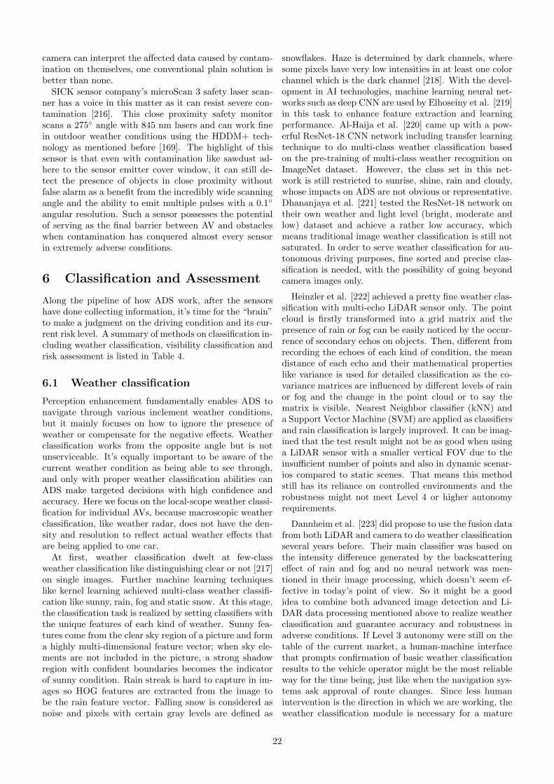
camera can interpret the affected data caused by contam-ination on themselves, one conventional plain solution isbetter than none.
SICK sensor company’s microScan 3 safety laser scan-ner has a voice in this matter as it can resist severe con-tamination [216]. This close proximity safety monitorscans a 275◦ angle with 845 nm lasers and can work finein outdoor weather conditions using the HDDM+ tech-nology as mentioned before [169]. The highlight of thissensor is that even with contamination like sawdust ad-here to the sensor emitter cover window, it can still de-tect the presence of objects in close proximity withoutfalse alarm as a benefit from the incredibly wide scanningangle and the ability to emit multiple pulses with a 0.1◦
angular resolution. Such a sensor possesses the potentialof serving as the final barrier between AV and obstacleswhen contamination has conquered almost every sensorin extremely adverse conditions.
6 Classification and Assessment
Along the pipeline of how ADS work, after the sensorshave done collecting information, it’s time for the “brain”to make a judgment on the driving condition and its cur-rent risk level. A summary of methods on classification in-cluding weather classification, visibility classification andrisk assessment is listed in Table 4.
6.1 Weather classification
Perception enhancement fundamentally enables ADS tonavigate through various inclement weather conditions,but it mainly focuses on how to ignore the presence ofweather or compensate for the negative effects. Weatherclassification works from the opposite angle but is notunserviceable. It’s equally important to be aware of thecurrent weather condition as being able to see through,and only with proper weather classification abilities canADS make targeted decisions with high confidence andaccuracy. Here we focus on the local-scope weather classi-fication for individual AVs, because macroscopic weatherclassification, like weather radar, does not have the den-sity and resolution to reflect actual weather effects thatare being applied to one car.
At first, weather classification dwelt at few-classweather classification like distinguishing clear or not [217]on single images. Further machine learning techniqueslike kernel learning achieved multi-class weather classifi-cation like sunny, rain, fog and static snow. At this stage,the classification task is realized by setting classifiers withthe unique features of each kind of weather. Sunny fea-tures come from the clear sky region of a picture and forma highly multi-dimensional feature vector; when sky ele-ments are not included in the picture, a strong shadowregion with confident boundaries becomes the indicatorof sunny condition. Rain streak is hard to capture in im-ages so HOG features are extracted from the image tobe the rain feature vector. Falling snow is considered asnoise and pixels with certain gray levels are defined as
snowflakes. Haze is determined by dark channels, wheresome pixels have very low intensities in at least one colorchannel which is the dark channel [218]. With the devel-opment in AI technologies, machine learning neural net-works such as deep CNN are used by Elhoseiny et al. [219]in this task to enhance feature extraction and learningperformance. Al-Haija et al. [220] came up with a pow-erful ResNet-18 CNN network including transfer learningtechnique to do multi-class weather classification basedon the pre-training of multi-class weather recognition onImageNet dataset. However, the class set in this net-work is still restricted to sunrise, shine, rain and cloudy,whose impacts on ADS are not obvious or representative.Dhananjaya et al. [221] tested the ResNet-18 network ontheir own weather and light level (bright, moderate andlow) dataset and achieve a rather low accuracy, whichmeans traditional image weather classification is still notsaturated. In order to serve weather classification for au-tonomous driving purposes, fine sorted and precise clas-sification is needed, with the possibility of going beyondcamera images only.
Heinzler et al. [222] achieved a pretty fine weather clas-sification with multi-echo LiDAR sensor only. The pointcloud is firstly transformed into a grid matrix and thepresence of rain or fog can be easily noticed by the occur-rence of secondary echos on objects. Then, different fromrecording the echoes of each kind of condition, the meandistance of each echo and their mathematical propertieslike variance is used for detailed classification as the co-variance matrices are influenced by different levels of rainor fog and the change in the point cloud or to say thematrix is visible. Nearest Neighbor classifier (kNN) anda Support Vector Machine (SVM) are applied as classifiersand rain classification is largely improved. It can be imag-ined that the test result might not be as good when usinga LiDAR sensor with a smaller vertical FOV due to theinsufficient number of points and also in dynamic scenar-ios compared to static scenes. That means this methodstill has its reliance on controlled environments and therobustness might not meet Level 4 or higher autonomyrequirements.
Dannheim et al. [223] did propose to use the fusion datafrom both LiDAR and camera to do weather classificationseveral years before. Their main classifier was based onthe intensity difference generated by the backscatteringeffect of rain and fog and no neural network was men-tioned in their image processing, which doesn’t seem ef-fective in today’s point of view. So it might be a goodidea to combine both advanced image detection and Li-DAR data processing mentioned above to realize weatherclassification and guarantee accuracy and robustness inadverse conditions. If Level 3 autonomy were still on thetable of the current market, a human-machine interfacethat prompts confirmation of basic weather classificationresults to the vehicle operator might be the most reliableway for the time being, just like when the navigation sys-tems ask approval of route changes. Since less humanintervention is the direction in which we are working, theweather classification module is necessary for a mature
22

ADS.Weather classification done by sensors equipped on
V2X or V2I facilities works the same way, but with anextra step of data transmission. Details of V2X will betalked about in Section 9.3.
6.2 Visibility classification
There is another angle of classification in adverse con-ditions: visibility. This definition was first invented asthe subjective estimation of human observers. In orderto measure the meteorological quantity, or to say thetransparency of the atmosphere, the meteorological op-tical range (MOR) [224] is defined objectively. In thecontext of autonomous driving, when visibility is quanti-fied as specific numbers, it normally means MOR. For ex-ample, each distinct version of fog scenarios in the FoggyCityscapes [212] dataset is characterized by a constantMOR. As weather conditions often bring visibility degra-dation of different levels, it’s helpful to gain awarenessof visibility dropping for ADS to avoid detection errorand collision in advance. Traditional visibility classifica-tion was usually conducted in facilities like airports wherehuman estimation and commercial instruments take theresponsibility [225]. Manual observation of the presenceof weather like fog and the range of visibility is consideredthe most accurate and reliable. Optical visiometers liketransmissometers and scatterometers are also commonlyused for precise visibility measurement in a rather longrange. However, these two approaches are not fit to beapplied to the autonomous driving area, so sensors likeLiDAR and camera have to take over. It is possible toestimate the visibility range in foggy conditions by profil-ing the LiDAR signal backscattering effect caused by thetiny droplets, but as mentioned in the previous context,it requires extremely fine-tuned LiDAR power to adaptto the fickle variables, so its practical application is lim-ited. Currently, visibility classification largely relies oncamera-based methods with neural networks [226] and isdivided by range classes with intervals of dozens of me-ters instead of exact values. Considering the low cost andthe irreplaceable status of cameras in ADS, it is also wellresearched.
Chaabani et al. [226] initially used a neural networkwith only three layers: feature vector image descriptor asinput, a set of fully interconnected computational nodesas a hidden layer, and a vector corresponding to the vis-ibility range classes as output. They used the FROSI(Foggy ROad Sign Images) synthetic dataset [227] [228]for evaluation and was able to classify the visibility frombelow 60 m to larger than 250 m with a spacing of 50 m.They later improved such a network with the combina-tion of deep learning CNN for feature extraction and anSVM classifier [229]. The new network used the AlexNetarchitecture [230] which is consisted of five convolutionlayers, three maxpool layers and three fully connected lay-ers. The overall recall, precision and accuracy all reachedthe state-of-art level and can be used on not only car on-board cameras but roadside cameras which shows furtherpotential in future IoT systems.
Duddu et al. [231]proposed a novel fog visibility rangeestimation algorithm for autonomous driving applicationsbased on a hybrid neural network. Their input consistsof Shannon entropy [232] and image-based features. Eachimage captured by the 50-degree-FOV camera is dividedinto 32 by 32 pixel blocks and the Shannon entropy of eachblock is calculated and then mapped to corresponding im-age features extracted from a series of convolutional layersalong with maxpool layers, which output three visibilityclasses: 0 - 50 meters, 50 - 150 meters, and above 150meters. They created their own fog dataset with BOSCHrange finder equipment as ground truth to establish thenetwork architecture and synthetic dataset FORSI is usedfor public benchmarking. The overall accuracy of 85%and higher enables ADS to set up thresholds of dangerouslow visibility. There are also other similar models like thefeed-forward back-propagation neural network (BPNN)[233] using data collected from weather monitoring sta-tions as input, that can predict the visibility ranges withmuch smaller spacing at a road-link level. It is unclearwhether mobile weather stations equipped on cars are ca-pable of completing visibility classification in real time,but sophisticated sensor fusion could be necessary forconditions beyond fog like snow and rain. Consideringa visibility classification module that can provide warn-ing messages to human drivers is useful in current ADAS,it’s possible that this technique goes to implementationearlier than full autonomy.
As a matter of fact, there is a correlation betweenweather and visibility in climatology and research hasbeen done since decades ago about the correspondenceof how far a driver can see and precipitation rates [99].If a detailed correspondence is available, then probablywe only need to detect the rain or snow rate rather thanclassifying visibility through computer vision technique.However, this type of one-to-one correspondence chartworks at a rather longer range because most of the pre-cipitation would not bring the road visibility down to alevel below 1 km, far away from the current AV’s visualconcern. The visibility crisis mostly comes from the waterscreen and mist during rain and it sometimes doesn’t de-pend on rain rate only. It seems like that only thick fog orpollution smog or sandstorm whose visibility is normallybelow a couple of hundred meters is meaningful to be con-sidered in this direct way. Sallis et al. [234] thought ofusing vehicular LiDAR’s backscatter effect to detect airpollution and fog intensity, but visibility are not consid-ered at that time. Miclea et al. [235] came up with acreative way by setting up a 3-meter-long model cham-ber with a “toy” road and model cars in it which can beeasily filled with almost-homogeneous fog. They success-fully identified the correlations between the decrease ofthe optical power and the decrease of the visual acuity ina scaling fog condition. Furthermore, Yang et al. [236]managed to provide a promising prediction of a 903 nmNIR LiDAR’s minimum visibility in a fog chamber by de-termining whether the detecting range of an object witha known distance is true or noisy. Even though these arestill indirect methods, perhaps with future IoT or V2X
23
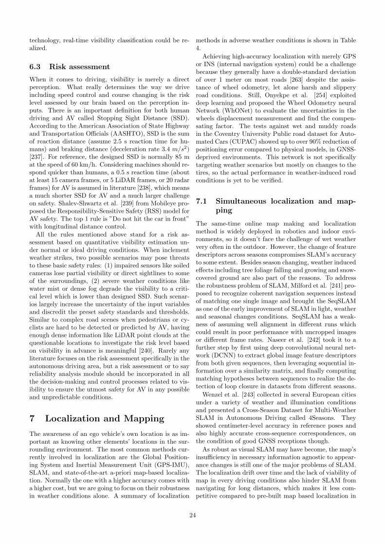
technology, real-time visibility classification could be re-alized.
6.3 Risk assessment
When it comes to driving, visibility is merely a directperception. What really determines the way we driveincluding speed control and course changing is the risklevel assessed by our brain based on the perception in-puts. There is an important definition for both humandriving and AV called Stopping Sight Distance (SSD).According to the American Association of State Highwayand Transportation Officials (AASHTO), SSD is the sumof reaction distance (assume 2.5 s reaction time for hu-mans) and braking distance (deceleration rate 3.4 m/s2)[237]. For reference, the designed SSD is normally 85 mat the speed of 60 km/h. Considering machines should re-spond quicker than humans, a 0.5 s reaction time (aboutat least 15 camera frames, or 5 LiDAR frames, or 20 radarframes) for AV is assumed in literature [238], which meansa much shorter SSD for AV and a much larger challengeon safety. Shalev-Shwartz et al. [239] from Mobileye pro-posed the Responsibility-Sensitive Safety (RSS) model forAV safety. The top 1 rule is ”Do not hit the car in front”with longitudinal distance control.
All the rules mentioned above stand for a risk as-sessment based on quantitative visibility estimation un-der normal or ideal driving conditions. When inclementweather strikes, two possible scenarios may pose threatsto these basic safety rules: (1) impaired sensors like soiledcameras lose partial visibility or direct sightlines to someof the surroundings, (2) severe weather conditions likewater mist or dense fog degrade the visibility to a criti-cal level which is lower than designed SSD. Such scenar-ios largely increase the uncertainty of the input variablesand discredit the preset safety standards and thresholds.Similar to complex road scenes when pedestrians or cy-clists are hard to be detected or predicted by AV, havingenough dense information like LiDAR point clouds at thequestionable locations to investigate the risk level basedon visibility in advance is meaningful [240]. Rarely anyliterature focuses on the risk assessment specifically in theautonomous driving area, but a risk assessment or to sayreliability analysis module should be incorporated in allthe decision-making and control processes related to vis-ibility to ensure the utmost safety for AV in any possibleand unpredictable conditions.
7 Localization and Mapping
The awareness of an ego vehicle’s own location is as im-portant as knowing other elements’ locations in the sur-rounding environment. The most common methods cur-rently involved in localization are the Global Position-ing System and Inertial Measurement Unit (GPS-IMU),SLAM, and state-of-the-art a-priori map-based localiza-tion. Normally the one with a higher accuracy comes witha higher cost, but we are going to focus on their robustnessin weather conditions alone. A summary of localization
methods in adverse weather conditions is shown in Table4.
Achieving high-accuracy localization with merely GPSor INS (internal navigation system) could be a challengebecause they generally have a double-standard deviationof over 1 meter on most roads [263] despite the assis-tance of wheel odometry, let alone harsh and slipperyroad conditions. Still, Onyekpe et al. [254] exploiteddeep learning and proposed the Wheel Odometry neuralNetwork (WhONet) to evaluate the uncertainties in thewheels displacement measurement and find the compen-sating factor. The tests against wet and muddy roadsin the Coventry University Public road dataset for Auto-mated Cars (CUPAC) showed up to over 90% reduction ofpositioning error compared to physical models, in GNSS-deprived environments. This network is not specificallytargeting weather scenarios but mostly on changes to thetires, so the actual performance in weather-induced roadconditions is yet to be verified.
7.1 Simultaneous localization and map-ping
The same-time online map making and localizationmethod is widely deployed in robotics and indoor envi-ronments, so it doesn’t face the challenge of wet weathervery often in the outdoor. However, the change of featuredescriptors across seasons compromises SLAM’s accuracyto some extent. Besides season changing, weather inducedeffects including tree foliage falling and growing and snow-covered ground are also part of the reasons. To addressthe robustness problem of SLAM, Milford et al. [241] pro-posed to recognize coherent navigation sequences insteadof matching one single image and brought the SeqSLAMas one of the early improvement of SLAM in light, weatherand seasonal changes conditions. SeqSLAM has a weak-ness of assuming well alignment in different runs whichcould result in poor performance with uncropped imagesor different frame rates. Naseer et al. [242] took it to afurther step by first using deep convolutional neural net-work (DCNN) to extract global image feature descriptorsfrom both given sequences, then leveraging sequential in-formation over a similarity matrix, and finally computingmatching hypotheses between sequences to realize the de-tection of loop closure in datasets from different seasons.
Wenzel et al. [243] collected in several European citiesunder a variety of weather and illumination conditionsand presented a Cross-Season Dataset for Multi-WeatherSLAM in Autonomous Driving called 4Seasons. Theyshowed centimeter-level accuracy in reference poses andalso highly accurate cross-sequence correspondences, onthe condition of good GNSS receptions though.
As robust as visual SLAM may have become, the map’sinsufficiency in necessary information agnostic to appear-ance changes is still one of the major problems of SLAM.The localization drift over time and the lack of viability ofmap in every driving conditions also hinder SLAM fromnavigating for long distances, which makes it less com-petitive compared to pre-built map based localization in
24

Table 4: Summary of methods on classification, localization & mapping, and planning & control with regard toweather
Classification Localization and Mapping Planning and ControlWeather
classificationVisibility
classificationRisk
assessmentSLAM
A-priorimap
LiDAR Other Planning Control
[217][218][219][220][221][222][223]
[226][227][228][229][230][231][233][235][234][236]
[238][239][240]
[241][242][243][244]
[245][246][247][248][249]
[250][251][152][252]
[104][253][254]
[255][256][257]
[258][259][260][261][262]
autonomous driving [244].
7.2 A-priori map
Figure 18: Down-pointing arrow marking the edges of theroad covered by snow in Hokkaido, Japan. Image courtesyof Dr. Atsushi Nishimura of CERI (Civil EngineeringResearch Institute for Cold Region)[264].8
The reference pre-built map that is used for comparingand matching the online readings for localization purposeis called the a-priori map, which is the currently the mainforce in ADS localization. A key method in the assuranceof the accuracy of a-priori map-based point cloud match-ing is landmark searching. The most straightforward wayto teach AV how to drive right now is letting AVs thinkand behave like humans do. A typical example of how hu-mans deal with low certainty localization is the snow pole“Yabane” (down-pointing arrow on a pole) in Hokkaido,Japan, as shown in Fig.18. The arrows point to the edgeof the road and are either flashing or light reflective atnight, so this gives the driver a rough idea about theirrelative position on the road and keeps them from wan-dering and away from the curb.
8https://www.ceri.go.jp/index.html
At the early stage of self-driving, RFID (radio fre-quency identification) technology was used for robots lo-calization in controlled environments and ODDs [245].Geographic information embedded in the RFID tags bythe route checkpoints can be read by the antennas whenthe robot reaches within the one or two meters range.Such methods are still being used by AGVs (AutomaticGuided Vehicles) in factories or warehouses [246]. WithV2I communications available, AVs can enjoy the samelocalization privilege [247]. Given that the markers’presence is considered fixed, the basic idea of landmarksearching in AV localization emerges as time requires. En-terprises like Ford work closely with companies major indetailed 3D a-priori maps, and their automated Fusionsedan would seek for markers like stop signs or other sign-posts by the roadsides with either camera or LiDAR, andsense its ego-position by calculating its relative distanceagainst those markers in the a-priori map [248]. As sim-ple as it may sound, this still gives Ford the ability tolocate their own AV as accurately as in centimeters withno extra hardware cost. However, the potential cost anddifficulty lie in the constant updating and maintenance ofthe a-priori map and that’s also what the map companiesare working on, towards a more intelligent and efficientsystem.
Cornick et al. [249] created a new map-based lo-calization called Localized Ground-Penetrating RADAR(LGPR). As the name implied, their system mounted atthe under-frame of a car sends electromagnetic pulses to-wards the ground and measures the unique reflection pro-files from under the surface. With highly efficient processunits matching the identifiers with registration data, theymanage to acquire the precise location of an ego vehicleup to the speed of highway standard. Different from com-mon automotive radar, this system uses 100 MHz to 400MHz radar with the ability in operating under all kindsof rough environments. Not only it achieves at least equalor better accuracy than traditional localization methods,but it also shows a great advantage in navigating waterpuddles or snowdrifts. It does have limitations though.When the saturation of soil reaches a certain level like30%, the attenuation it caused for radar at their operat-
25
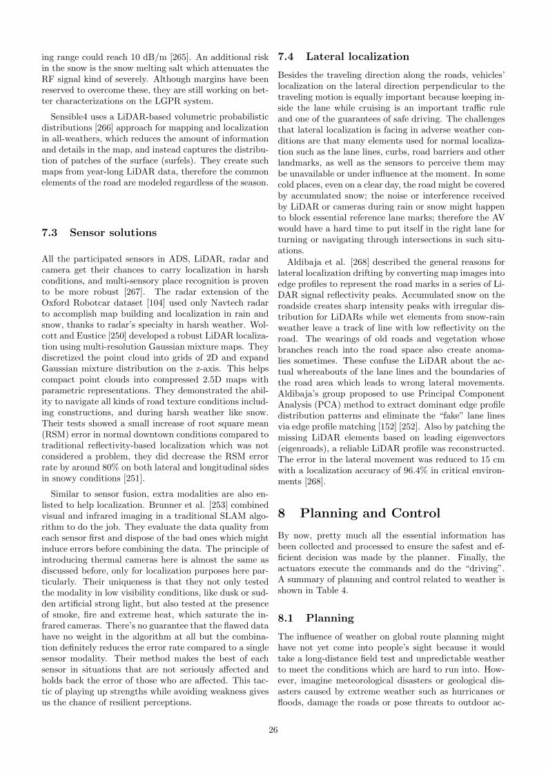
ing range could reach 10 dB/m [265]. An additional riskin the snow is the snow melting salt which attenuates theRF signal kind of severely. Although margins have beenreserved to overcome these, they are still working on bet-ter characterizations on the LGPR system.
Sensible4 uses a LiDAR-based volumetric probabilisticdistributions [266] approach for mapping and localizationin all-weathers, which reduces the amount of informationand details in the map, and instead captures the distribu-tion of patches of the surface (surfels). They create suchmaps from year-long LiDAR data, therefore the commonelements of the road are modeled regardless of the season.
7.3 Sensor solutions
All the participated sensors in ADS, LiDAR, radar andcamera get their chances to carry localization in harshconditions, and multi-sensory place recognition is provento be more robust [267]. The radar extension of theOxford Robotcar dataset [104] used only Navtech radarto accomplish map building and localization in rain andsnow, thanks to radar’s specialty in harsh weather. Wol-cott and Eustice [250] developed a robust LiDAR localiza-tion using multi-resolution Gaussian mixture maps. Theydiscretized the point cloud into grids of 2D and expandGaussian mixture distribution on the z-axis. This helpscompact point clouds into compressed 2.5D maps withparametric representations. They demonstrated the abil-ity to navigate all kinds of road texture conditions includ-ing constructions, and during harsh weather like snow.Their tests showed a small increase of root square mean(RSM) error in normal downtown conditions compared totraditional reflectivity-based localization which was notconsidered a problem, they did decrease the RSM errorrate by around 80% on both lateral and longitudinal sidesin snowy conditions [251].
Similar to sensor fusion, extra modalities are also en-listed to help localization. Brunner et al. [253] combinedvisual and infrared imaging in a traditional SLAM algo-rithm to do the job. They evaluate the data quality fromeach sensor first and dispose of the bad ones which mightinduce errors before combining the data. The principle ofintroducing thermal cameras here is almost the same asdiscussed before, only for localization purposes here par-ticularly. Their uniqueness is that they not only testedthe modality in low visibility conditions, like dusk or sud-den artificial strong light, but also tested at the presenceof smoke, fire and extreme heat, which saturate the in-frared cameras. There’s no guarantee that the flawed datahave no weight in the algorithm at all but the combina-tion definitely reduces the error rate compared to a singlesensor modality. Their method makes the best of eachsensor in situations that are not seriously affected andholds back the error of those who are affected. This tac-tic of playing up strengths while avoiding weakness givesus the chance of resilient perceptions.
7.4 Lateral localization
Besides the traveling direction along the roads, vehicles’localization on the lateral direction perpendicular to thetraveling motion is equally important because keeping in-side the lane while cruising is an important traffic ruleand one of the guarantees of safe driving. The challengesthat lateral localization is facing in adverse weather con-ditions are that many elements used for normal localiza-tion such as the lane lines, curbs, road barriers and otherlandmarks, as well as the sensors to perceive them maybe unavailable or under influence at the moment. In somecold places, even on a clear day, the road might be coveredby accumulated snow; the noise or interference receivedby LiDAR or cameras during rain or snow might happento block essential reference lane marks; therefore the AVwould have a hard time to put itself in the right lane forturning or navigating through intersections in such situ-ations.
Aldibaja et al. [268] described the general reasons forlateral localization drifting by converting map images intoedge profiles to represent the road marks in a series of Li-DAR signal reflectivity peaks. Accumulated snow on theroadside creates sharp intensity peaks with irregular dis-tribution for LiDARs while wet elements from snow-rainweather leave a track of line with low reflectivity on theroad. The wearings of old roads and vegetation whosebranches reach into the road space also create anoma-lies sometimes. These confuse the LiDAR about the ac-tual whereabouts of the lane lines and the boundaries ofthe road area which leads to wrong lateral movements.Aldibaja’s group proposed to use Principal ComponentAnalysis (PCA) method to extract dominant edge profiledistribution patterns and eliminate the “fake” lane linesvia edge profile matching [152] [252]. Also by patching themissing LiDAR elements based on leading eigenvectors(eigenroads), a reliable LiDAR profile was reconstructed.The error in the lateral movement was reduced to 15 cmwith a localization accuracy of 96.4% in critical environ-ments [268].
8 Planning and Control
By now, pretty much all the essential information hasbeen collected and processed to ensure the safest and ef-ficient decision was made by the planner. Finally, theactuators execute the commands and do the “driving”.A summary of planning and control related to weather isshown in Table 4.
8.1 Planning
The influence of weather on global route planning mighthave not yet come into people’s sight because it wouldtake a long-distance field test and unpredictable weatherto meet the conditions which are hard to run into. How-ever, imagine meteorological disasters or geological dis-asters caused by extreme weather such as hurricanes orfloods, damage the roads or pose threats to outdoor ac-
26

tivities, the global path planning module has to adjustits original route and navigate the AV around the im-pacted areas. Similar to the navigation we have on oursmartphones right now, map apps can alert customersif there’s an accident or road work on the way and au-tomatically optimize the route when the estimated timeis enlarged due to the situation. The Civil EngineeringResearch Institute of Cold Region (CERI) Snow and IceResearch Team [269] is developing a wide-area informa-tion provision service in the northern part of Japan wheresnow is common. This service can send alerts or emailsabout current snowfall, visibility and forecast informa-tion to drivers’ phones and provide detour options aroundsnowstorms. For AVs, such function relies on Internet-connected devices and mass data mining, so IoT or atleast Vehicle to Vehicle (V2V) is needed for tasks likethis for weather conditions, just like the flood warningsystem previously introduced in [154].
It is worth mentioning that the winter driving patternand road wearing prevention is an issue of concern in localroute planning, as autonomous driving is a continuousrefinement process: if a shuttle service AV drives the sameroute over and over without any variation introduced toits driving lines, the precision of its driving route wouldapproach to a level of centimeters over time and the roadwould be facing a worn groove, or a perilously slipperytrack in winter [255].
Tas et al. [261] presented an uncertainty-aware mo-tion planning under limited visibility which could be theresult of adverse weather or occlusions. Their planner im-itates human drivers’ behaviors in bad driving conditionsincluding lowering speed, preparing to yield for not-yetvisible approaching vehicles, and being on the lookoutfor incompliant behaviors despite our own right-of-way.By assuming the worst case scenario, the motion plan-ner is made towards robustness. Jalalmaab et al, [256]designed a model predictive controller (MPC) with time-varying safety constraints for path planning with collisionavoidance. The proposed controller takes the road bound-ary and dynamic change of surrounding vehicles into theconstraints consideration and finds the best commandsof longitudinal and lateral control to navigate the AV.Although it’s not designed for weather conditions, theweather is just another parameter that also possesses thetime-varying dynamic feature. It can either be quantifi-able perception data or road conditions data, which willbe introduced in Section 9. Peng et al. [257] introducedan adaptive path planning model and tracking controlmethod for collision avoidance and lane-changing maneu-vers in rainy weather. They first use Gaussian distribu-tion to evaluate the impact of rain on the pavement anddeduce the adaptive trajectory and the followed score-based decision making and multilevel driving mode takecontrol while maintaining safety, comfort, and efficiency.It can be seen that this kind of motion planning needs thefoundation of weather classification or uncertainty levelassessment. Hence, the integration of sensors and func-tion modules is vital for omnipotent ADS.
8.2 Control
No doubt, the patterns of vehicle control or decision-making in adverse conditions are not going to remain ex-actly the same in order to adapt. A typical example: anAV is caught in a thunderstorm on the road out of bluewith visibility plummeting. It is critical for the AV tomake adjustments to deal with the adverse condition in-cluding slowing down, activating countermeasures againstlow visibility and wet road surface and so on. It is wellaccepted that when the road surface is wet or icy, thebraking distance would be longer and the risk of rear-endcollision is largely increased. According to the research ofAli Abdi Kordani et al. [258] on the vehicle braking dis-tance at the speed of 80 km/h, the road friction coefficientof rainy, snowy and icy road surface conditions are 0.4,0.28 and 0.18 respectively, while average dry road fric-tion coefficient is about 0.7. While the braking distancesunder rainy conditions barely change much for buses ortrucks considering their own high inertia, a 10-meter in-crease can be noticed for a sedan; The braking distancerises 28% at snowy conditions and dramatically surges71% at icy conditions, up to 180 m for a normal sedanand 300 m for trucks and buses [270]. This startling dataremind us that the behavior for an AV needs certain ad-justments under adverse conditions, especially when theroad surfaces are wet or frozen. The largely prolongedbraking distance requires a substantially longer followingdistance and perhaps a lower cruising speed if necessary.A traction mode shift for certain types of cars might alsobe required when the road condition changes. As a re-sult, the weather effects caused on AVs directly generatedemand for behavior adjustment.
When driving in gale weather or on a bridge over alarge area of water, a vehicle sustains a large force perpen-dicular to the vehicle’s heading direction. This is calledside-slip, often caused by crosswind. Crosswind stabiliza-tion normally is the job of the electronic stability controlsystem (ESC), which stabilizes the lateral motion of thevehicle to prevent skidding [271]. However, serving as re-dundancy, the ESC system is initiated belatedly, usingthe brakes to correct the deviation from a yaw referencemodel when the vehicle starts to skid [272]. For ADS, it’sbetter to have a proactive mode of steering control thathas better judgment than a human driver.
Besides algorithm models, the industry is more con-cerned about the real performance of AV control. Riskassessment is a primary basis for motion planning andcontrol, while weather conditions geometrically increasethe risk index and the level of control difficulty. The mis-match of wheel encoder and the real vehicle motion causedby slipping and traction loss mentioned above not onlyposes threats to the ego vehicle’s localization, but also tothe successful execution completion of AV control com-mands [259]. Autonomous driving technology providerSensible4 company implements a control stack with mul-tiple sensors monitoring the wheels. The information ofthe actual acceleration, wheel rotation speed, and wheelangle is critical of the control module to make the rightamendment and maintain accurate control [255]. To say
27

Table 5: Summary of adverse weather auxiliary ap-proaches
RoadSurface
Aerial/RSU
V2V V2IHuman
DetectionTracking
HeadLights
[274][275][276][277]
[278][279][280][281][282]
[283][284][154][285][286][287]
[288][283][289][290]
[291][292][293][294]
[295][296][297]
[298][299]
the least, there is always a final barrier of AV controlwhich is the remote control for vehicles of level 4 or higherwhere no safety pilots are present [260]. A staff would sitin the remote control center monitoring the AV’s move-ment and data, and take over whenever it’s necessary.
Last but not least, passenger comfort is not some-thing that should be overlooked by ADS providers whenit largely depends on the AV’s control algorithms [273].Unnecessary acceleration and abrupt braking should beavoided for the best riding experience of a passenger,but that’s not all. Should there be any adverse drivingconditions, it’s the distrust and lack of confidence in theAV’s behaviors that disturb people’s nerves. Therefore,in order to assure the consumers, installing informationdisplay systems such as heads-up displays (HUD) whichprompt the AV’s upcoming movements especially underlow visibility conditions can yet be regarded as a goodchoice for technology companies and manufacturers [262].
9 Auxiliary Approaches in Ad-verse Conditions
A summary of auxiliary approaches in adverse weathersolutions is shown in Table 5. Here we introduce threemain auxiliary approaches in the adverse weather solu-tions beyond common concept: road surface detection,aerial/bird-view units, and V2X.
9.1 Road surface detection
Originally, road surface detection was designed to classifythe road type like asphalt, grass, gravel, sand, etc., tobetter provide traction ability. On the other hand, roadsurface conditions’ change is a direct result of weatherconditions, especially wet weather, so it’s natural to thinkof road surface detection as an auxiliary for weather clas-sification. Although mirage effect also happens on thesurface of roads due to high temperature, it’s more of alight related situation rather than physical changes to theroads, which has been discussed in Sec.5.4.
As stated in Sec.8.2, wet or slippery road surfaces posean actual threat to traffic safety. The information onroad conditions could be as important as weather con-ditions for a car. The dry or wet conditions can be de-termined in various ways besides the road friction or en-vironmental sensors [277]. Sabanovic et al. [274] build avision-based DNN to estimate the road friction coefficient
because dry, slippery, slurry and icy surfaces with de-creasing friction can basically be identified as clear, rain,snow, and freezing weather correspondingly. Their algo-rithm detects not only the wet conditions but is able toclassify the combination of wet conditions and pavementtypes as well. Although they didn’t perform implemen-tation on autonomous driving, it’s suitable for improve-ment of vehicle dynamic control and anti-lock brakingsystem (ABS) which are also critical for ADS. Panhuberet al. [275] have a successful application of road surfacedetection in autonomous driving. By mounting a monocamera behind the windshield and observing the spray ofwater or dust caused by the leading car and the bird-viewof the road features in the surroundings, they determinethe road surface condition with multiple classifiers. Thewet or dry classification accuracy is 86% for autonomousdriving and it’s a great asset of the weather classificationmodule in ADS.
The road surface detection can also be performed in away that is unexpected for us: audio. The sounds of vehi-cle speed, tire-surface interaction, and noise under differ-ent road conditions or different levels of wetness could beunique, so it’s reasonable for Abdic et al. [276] to train adeep learning network with over 780,000 bins of audio, in-cluding low speed when sounds are weak, even at 0 speedbecause it can detect the sound made by other driving-byvehicles. There is a concern that the vehicle type or tiretype may affect the universality of such a method and theuncertain degree of difficulty of the installation of soundcollecting devices on AVs. All these tell us there is stilla lot to explore on the car or the road to find somethingthat can be of help in adverse weather conditions.
9.2 Aerial View
Long before being introduced into autonomous driving,LiDAR technology was widely used in geographical map-ping and meteorological monitoring. Terrain, hydrology,forestry, and vegetation cover can be measured by Li-DAR mounted on planes, or even satellites [300]. Theadvantage of looking from above is that the view cover-age is enormous and there are fewer obstacles than fromthe ground. With the rapid development of UnmannedAerial Vehicles (UAV) like drones, it’s becoming realisticto do transportation perception from the top view, whichsees what couldn’t be seen from the ground. For exam-ple at an intersection, an AV can only behave accordingto its leading vehicle but not something that’s beyonddirect sight, however, UAV can see the leading vehicleof the leading vehicle and thereafter, and foresee risksfar away from the subject AV and avoid accidents in ad-vance. Aerial LiDAR makes the AV ego-perception intoa macro perspective. Xu et al. [280] developed a methodto detect road curbs off-line using aerial images via imita-tion learning. They take images from the New York Cityplanimetric dataset [301] as input and generate a graphwith vertices and edges representing road curbs. Thereare also mature LiDAR obstacle warning and avoidancesystems (LOWAS) for unmanned aerial vehicle sense-and-avoid [279]. LOWAS system is constructed by three key
28

modules: trajectory prediction, potential collision calcu-lation, and optimal avoidance trajectories generation, andthey provide the possibility and prove it actionable to useaerial LiDAR in ground transportation navigating.
As far as the authors are concerned, the biggestproblem hindering aerial LiDAR from being deployedinto ADS right now is transmitting and communicating.Without advanced wireless channels, it’s hard to transmitthe data or decisions from UAVs to AV in real-time froma certain distance, let alone aerial view is not enoughto cover the modern urban environment where tunnelsand elevated roads are common. As a result, althoughresearches are being done towards aerial image segmenta-tion and object detection, the main use for aerial LiDARcurrently is focused on stationary tasks like structural in-spection [278].
9.3 Roadside Units
Roadside LiDAR, also from a different point of view thanthe top of a car, has already started to participate in au-tonomous driving. Similar to bird-view units, a LiDARinstalled on a roadside unit (RSU) mounted on a polealso has a wide angle of view and doesn’t suffer from thewater screen on rainy days or the snow whirl in snowyweather caused by surrounding vehicles. A slightly down-ward pointing angle also dodges some direct sunlight. Wuet al. [281] have tested the roadside LiDAR’s vehicle de-tection performance in windy and snowy conditions, andimproved the data processing with background filteringand object clustering. If there is a connected system avail-able, then AV can utilize the data captured by the road-side LiDAR and make better planning. Sometimes, whenweather conditions are too bad for any sensor to performat a reliable status like dense fog, the data provided byroadside LiDAR could serve as redundancy to collaboratethe decision made by the ADS on AV and reduce accidentsin important locations. Tian [302] used roadside LiDARto identify weather conditions. They recorded the LiDARpoint cloud pattern characteristics of each kind of weatherincluding rain, snow, and wind, and quantified the impactof each weather so as to differentiate the weather basedon the standard deviation of their detection distance off-sets. Their data don’t include fog conditions which couldbe rare in Nevada, and it reveals the geographic limita-tion of roadside LiDAR. Vargas Rivero et al. [282] placeda LiDAR at a fixed location pointing at the parking lotasphalt for 9 months and classified multiple weather ac-cording to weighted k-nearest neighbors algorithm (k-NN)scores derived from several LiDAR parameters, includingnumber of detections in the maximum of the histogram,mean detection distance in x-direction, standard devia-tion of the detection distance in x-direction, number ofsecond echo detections and mean value of the echo-pulsewidth (EPW). The accuracy F-score normally stays above90% for clear, fog, rain and snow conditions.
Anyway, with a connected vehicle system or V2X sys-tem, the roadside LiDAR can at least provide weatherclassification information and perception data from itsown location to nearby vehicles and that’s already bet-
ter than AV alone. Several cities in the world, likeAnn Arbor, Michigan [303]; Barcelona, Spain [304]; andGuangzhou, China [305] have initiated their smart cityprojects, where thousands of roadside LiDARs and sen-sors would be installed on city infrastructures and forma huge local connected system. It can be imagined thatwith developed weather perception sensors by the road-side, the adverse weather conundrum would be much eas-ier to deal with.
(a) A LiDAR deployment ona pole
(b) A self-driving vehicle in-teracting with the road sideunits (RSU)
Figure 19: V2I infrastructures at Morikoro park inNagoya, Japan. Images courtesy of Mr. AbrahamMonrroy-Cano of Perception Engine Inc.9
9.4 V2X
Vehicle-to-Everything system is an unignorable part ofthe development of Intelligent Transportation System(ITS) and ADS. Regardless of the proficiency of well-experienced drivers, accidents still happen due to asym-metric road information among drivers, and short reac-tion time. V2X system broadens the range of informationgathering from one car’s perception to the perception ofalmost every element on the road. The ‘Everything’, or Xhere, can refer to other vehicles, roadside infrastructures,and even pedestrians. To have pedestrians being includedin the V2X or further Internet of Things (IoT) system,advanced wearable devices or universal smartphone tech-nical support is needed, which is out of the scope of thissurvey. Here we are going to mainly introduce the adverseweather solutions of V2X in Vehicle to Vehicle (V2V), andVehicle to Infrastructure (V2I).
The core of V2V is information sharing among con-nected vehicles (CV), which eliminates the problem ofinformation asymmetry from the bottom root. Undernormal conditions, visual blockage like a truck in frontof the ego vehicle or vehicles beyond direct line of sightdue to terrain or intersections is a high risk of accidents.With V2V technology, the ego vehicle gains the abilityto acquire the perception data and position informationfrom another car whose view is out of its own reach atthe moment [287], thus the driver or the ego vehicle can
9https://perceptionengine.jp/
29

avoid accidents by making proper decisions and adjustingbehaviors based on the additional information. In termsof harsh weather, vehicles that first experience or perceivethe presence of weather conditions or the change on theroad surface conditions can make weather assessments be-fore other vehicles reach this location and then relay theperception data or assessment results to other vehicles toalert them about the dangers. If the adverse conditionscause traffic congestion or accidents, latter vehicles canplan a new route according to the information gatheredby fore CVs in real time to improve efficiency and thesafety in intersections and work zones [283]. With theV2V technology, truck platooning on highways or docksareas is about to become the first mature application ofADS. According to the evaluation of M.Ahmed et al. [284]on the driver’s perception of CV in Wyoming, almost 90%of the human test drivers found that the front collisionwarning and rerouting function are very useful as a ben-efit from the improved road condition information. Asa result, it’s safe to say that the improvement that V2Vcould bring to ADS is undoubted.
V2I (Fig.19) on the other hand is not as fluid as V2V,but still offers a great deal of potential in intelligent trans-portation. The advantages of roadside sensors like thebirdview LiDAR are covered in the previous section. Be-sides providing alerts in specific road segments when be-ing connected to weather information services or havingits own weather perception abilities [288], V2I also pro-vides the possibility of multi-image-based de-weatheringwithout having to involve sophisticated neural networksdiscussed in Section 5. With the image of a certain scenein clear weather being captured and stored in infrastruc-tures in advance, a 3-D model without the disturbancefrom weather (rain, fog, snow, etc.) can be easily recon-structed and fed to nearby vehicles to help them safelynavigate under low visibility and incomplete road infor-mation. But of course, such a feature would require real-time video (rapid image) sharing between infrastructuresand vehicles. That’s why the large volume LiDAR pointcloud data need to be compressed for V2X transmission[306], and also the reason why the telecom communityis working on the V2X communication methods towardsricher bandwidth and lower latency such as the fifth-generation wireless technology, i.e. 5G [283] to accesssuch visual data from the server and transmit among ve-hicles.
Jung et al. [285] developed an ADS with V2X commu-nication aid which is comprised of beyond-line-of-sightperception and extended planning. If we consider V2Xas an extra sensor, then such a system is just like a newfusion modality. Ego vehicle’s own sensors and other ve-hicles’ sensors and roadside sensors facilitate the datainput of perception including those beyond the line ofsight. Route, velocity and real-time traffic informationobtained by V2I communication are integrated to extendroute planning with an optimal solution. Such modalityapproaches fully autonomous driving to a great extentbut is still limited by the scale of the CV network andconnected infrastructure’s coverage.
Like perception methods, V2X’s architecture is also be-ing improved to better deal with weather conditions. Bar-rachina et al. [289] proposed a V2X-d architecture, whichcombines V2V and V2I together to overcome each of theirown deficiency such as V2V’s limited horizontal view andthe vulnerability of traditional surveillance cameras onroadside infrastructures. This architecture allows vehicledensity estimation in urban areas under all weather condi-tions which is the ideal way of utilizing the V2X system inautonomous driving. Vaidya et al. [290] used roadside in-frastructures as the nearby processing and storage serverof the Edge Cloud and deployed Fuzzy inference system asa road weather hazard assessment method. They took theroad surface conditions and surface temperatures gath-ered from both roadside environmental sensors and CVsas the linguistic variables and the Fuzzy inference sys-tem outputs consequent slipperiness based on IF-THENand AND-type and OR-type rules. Overall 10 fuzzy ruleshave been established. Take one as an example: If thesurface condition is ‘ice warning’ AND surface tempera-ture is ‘low’ OR ‘very low’, THEN slipperiness is ‘veryslippery’. Such results are being processed locally in asegmented network and distributed to nearby CVs. Thepressure of computing concentration, the processing timeand the latency of CV communication are all largely re-duced.
Onesimu [286] et al. proposed an IoT based intelligentaccident avoidance system for adverse weather and roadconditions. They used a dataset collected by Hjelkremand Ryeng [307] which contains not only weather con-ditions but also vehicle’s speed and weight informationwhich is being used to calculate the proper speed limitof the vehicle under the current condition to avoid colli-sions. They implemented a Naıve Bayes classifier in thetraining process to predict the chance of accidents in thenetwork and use Blynk [308] mobile app to do the hard-ware control and simulation. This app will display a mes-sage containing accident warning or weather informationlike ‘Accident ahead, Sandstorm’ on the back window ofa car and this message will be received by the followingcar who would act accordingly to prevent accidents fromhappening, and potentially be passed along.
There is an interesting platform named OpenXC [309],an Application Programming Interface (API) that com-bines open source software and hardware to extend ve-hicles with custom applications and modules. Most ofthe applications are based on Android that can read andtranslate car metrics, and most importantly, they areconnected service integration ready. Take two examplesrelated to adverse conditions. The Nighttime ForwardCollision Warning (Night Vision) project uses a standardUSB webcam to capture the edges of an object to doobject detection, and helps avoid animal or obstacle colli-sions. The Brake Distance Tracking project measures thedistance between vehicles with a SICK DMT-2 LiDAR[310] sensor and warns drivers when they are approach-ing other vehicles with too high momentum. These setupsseem simple, but they all run on Android platforms suchas a tablet with access to sensor data and real-time vehi-
30
cle data. That means, there’s only one more step beforeforming a CV network which is connecting these Androiddevices to a central nexus. With its open compatibilityand integration flexibility, OpenXC is a good candidatefor exploring V2X in a simplified manner. Currently, IoTas a global platform in the intelligent field is serving thesafety problem in ADS one at a time, so there’s no doubtthat with profuse weather and road data, the reliabil-ity and versatility of IoT systems will bring autonomousdriving to life.
9.5 Others
Inclement weather conditions bring challenges and im-pacts to human drivers in the same way before AV becamepopular. Consequently, some of the solutions designed forbuilding up human drivers’ arsenals against weather canstill be of use for today’s AV. We know that visibilitydrops when it’s raining or snowing, especially at night.Back when digitally removing rain and snow streaks inimages was trending in computer vision, Charette et al.[298] presented a smart automotive headlight that cansee through rain and snow by deactivating the light raysthat intersect with raindrop or snowflakes particles. Theytracked and avoided illuminations on the raindrops withonly very few losses on light throughput and successfullyachieved an obvious visibility improvement. Given thatwhat on-board cameras now see is not that different thanwhat human drivers saw back then, such smart headlightsshould be able to improve visibility for ADS as well. Do-nati et al. [299] even fabricated a smart headlight embed-ded with a charged-coupled (CCD) camera and a LiDARthat can intelligently switch off high beams when cross-ing and being able to detect human-sized objects at 20 mdistance with a recognition rate of 85% in the meantime.
Some other efforts have also been made on restoringor improving the performance of ADS’ basic functionslike human/pedestrian detection and vehicle tracking.Recognition of the particular micro-Doppler spectra [293]and multi-layer deep learning approaches [292] are usedin pedestrian detection tasks in bad weather. Thermaldatasets specifically targeting pedestrian [294] or largescale simulation dataset [291] are also being established tomake sure that ADS can complete this essential job withthe interruption of weather. While conventional Gaus-sian mixture probability hypothesis density filter basedtracker is being utilized in deep learning vehicle trackingframework [297] to improve the performance, radar track-ing [296] and color-based vision lane tracking system onunmarked roads [295] also show the robustness and canhelp ADS maintain functionalities while in adverse condi-tions even if they were not particularly designed for thoseconditions.
With the rapid development of AI technologies in recentyears, it’s not possible to get around the new methods ofmachine learning in ADS applications, including adverseweather solutions. For instance, the active learning ofDNN by NVIDIA DRIVE. Active learning starts with atrained DNN on labeled data, then sorts through the un-labeled data and selects the frames that it doesn’t recog-
nize, which would be then sent to human annotators forlabeling and added to the training pool, and completesthe learning loop. In a nighttime scenario where rain-drops blur the camera lens and make it difficult to detectpedestrians with umbrellas and bicycles, active learningis proven to have an over 3 times better accuracy and beable to avoid false positive detection. Other burgeoningmachine learning methods such as transfer learning andfederated learning are also very effective on robust AI in-frastructure. It shouldn’t take long before we see largedevelopments on IoT and V2X using these advanced ma-chine learning methods [311].
10 Tools
10.1 Data sets
Autonomous driving research can’t be done withoutdatasets. Many features used in object detection tasksneed to be extracted from datasets and almost every al-gorithm needs to be tested and validated in datasets. Inorder to better tackle the adverse weather conditions inautonomous driving, it’s essential to have enough weatherconditions covering each kind of weather in datasets. Un-fortunately, most of the datasets commonly used for train-ing do not contain too many conditions different fromclear weather. Some famous datasets that were collectedin tropical areas like nuScenes [143] contains some rainconditions in Singapore, A*3D [321] has rain conditionsat night, and ApolloScape [323] includes some strong lightand shadow conditions. A summary of the weather condi-tions coverage and the sensors used for collection in eachdataset is shown in Table 6.
Researchers collected weather data that are common intheir area of living or use simulation [291] to build theirown weather datasets. The University of Michigan col-lected four-season LiDAR data using a Segway robot onthe campus at an early stage [327]. Pitropov et al. [312]presented the first AV dataset that focuses on snow con-ditions specifically, called the Canadian adverse drivingconditions (CADC) dataset. The variety of winter wascollected by 8 cameras and LiDAR and GNSS+INS inWaterloo, Canada. Their LiDAR was also modified bythe de-noising method [189]. The large amount of snowenables researchers to test object detection, localizationand mapping in all kinds of snow conditions, which ishard to realize in artificial environments. Oxford Robot-Car [316] is among the early datasets that put weights onadverse conditions including heavy rain, snow, direct sun-light and night, even road and building works. Sakaridiset al. [212] applied foggy synthesis on the Cityscapedataset [349] and generated Foggy Cityscapes with over20000 clear-weather images, which is wildly used in thede-hazing task. The same team later introduced ACDC[326], the Adverse Conditions Dataset with Correspon-dences for training and testing semantic segmentationmethods on adverse visual conditions. It covers the visualdomain and contains high-quality fine pixel-level semanticannotated fog, nighttime, rain and snow images. Zheng
31

Table 6: Coverage of weather conditions in common autonomous driving datasets
Dataset Synthesis RainFog/Haze
/SmogSnow
Strong Light/Contamination
Night Sensors
LIBRE [2] - X X -XStrong
light-
10 LiDARs, Camera, IMU, GNSS, CAN,360◦ 4K cam, Event cam, Infrared cam
Foggy Cityscape [212] X - X - - - -CADCD [312] - - - X - - 1 LiDAR, 8 Cameras, GNSS, IMUBerkley DeepDrive [313] - X X X - X Cameras
Mapillary [314] - X X X - XMobile phones, Tablets, Action cameras,
Professional capturing rigsEuroCity [315] - X X X - X 2 Cameras
Oxford RobotCar [316] - X - X - X3 LiDARs, 3 Cameras, Stereo cam, GPS
(Radar extension: 360◦ radar)
nuScenes [143] - X - - - X1 LiDAR, 6 Cameras, 5 Radars,
GNSS, IMU
D2-City [317] - X X XXContami
-nation- Dashcams
DDD17 [318] - X - - - X Dynamic and active-pixel vision Camera
Argoverse [319] - X - - - X2 LiDARs,7 Cameras ring,
2 Stereo cams, GNSSWaymo Open [320] - X - - - X 5 LiDARs, 5 CamerasA*3D [321] - X - - - X 1 LiDAR, 2 CamerasSnowy Driving [322] - - - X - - Dashcams
ApolloScape [323] - X - -XStrong
lightX 2 LiDARs, Depth Images, GPS/IMU
SYNTHIA [324] X - - X - - -P.F.B [325] X X - X - X -ALSD [291] X X - X - X -ACDC [326] - X X X - X 1 CameraNCLT [327] - - - X - - 2 LiDARs, 1 Camera, GPS, IMU4Seasons [243] - X - - - X 1 Stereo Camera, GNSS, IMURaincouver [328] - X - - - X DashcamWildDash [329] - X X X - X Cameras
KAIST multispectral [330] - - - -XStrong
lightX
1 LiDAR, 2 Cameras, 1 Thermal(infrared) cam,IMU, GNSS
DENSE [129] - X X X - X1 LiDAR, Stereo Camera, Gated Camera,
FIR Camera, Weather StationA2D2 [331] - X - - - - 5 LiDARs, 6 Cameras, GPS, IMU
SoilingNet [205] - - - -XContami
-nation- Cameras
Radiate [332] - X X X - X 1 LiDAR, 1 stereo camera, 360◦ radar, GPS
EU [333] - - - X - X4 LiDARs, 2 stereo camera, 2 fish-eye camera,
radar, RTK GPS, IMU
Table 7: Weather conditions and sensors support in simulators
SimulatorsWeather conditions Sensor support
Adjustable Rain Fog SnowLight/
Time of dayContamination
(Dust, leaf)LiDAR Camera
ThermalCamera
RadarGNSS/GPS
Ultrasonic V2X
CARLA [334] X X X - X - X X - X X X -LG SVL [335] X X X - X - X X - X X X -dSPACE [336] X X X X X - X X - X X X XCarSim [337] - X - X X - - X - X X X -TASS PreScan [338] - X X X X - X X - X X X XAirSim [339] X X X X X X X X X - X - -PTV Vissim [340] - X X X - - Need to integrate with other platforms
Table 8: Experimental weather facilities across the world
Experimental facilities Adjustable Rain Fog SnowLight/
Time of dayContamination
(Dust, leaf)Location Length Lanes
JARI Special Environment Proof Ground [341] X X X - X - Ibaraki, Japan 200 m 3VTTI Smart roads [342] X X X X X - Virginia, US 800 m 2DENSO [343] X X - - X - Aichi, Japan 200 m 10m wideCenter for Road Weather Proving Ground [344] X X X X X X Yeoncheon, Korea 600 m 4Laboratoire Regional des Ponts et Chaussees,Clermont-Ferrand [345]
X X X - - - CEREMA, France 31 m 2
NIED Cryospheric Environment Simulator [346] X X X - - - Yamagata, Japan N/A N/ACATARC Proving Ground [347] X X X X X - Yancheng, China 60 km track 2 or more
CERI Tomakomai Cold Region Test Road [348] X - - X - - Hokkaido, Japan21 hectarering track
2
32

et al. [350] uploaded the IUPUI Driving Video/ImageBenchmark to the Consumer Digital Video Library, con-taining sample views from in-car cameras under differentillumination and road conditions when public safety vehi-cles are on patrol and responding to disasters. Conditionscover snow, rain, direct light, dim lit conditions, sunnyfacing the sun, shadow, night, and their caused phenom-ena such as wet roads, glass reflection, glass icing, rainingand dirty windshields, moving wipers, etc. It’s the un-remitting effort of research on collecting data in cold daysand dangerous driving conditions that gives us the oppor-tunity to push autonomous driving in adverse conditionsfurther to the next level.
10.2 Simulators and Experimental facili-ties
Figure 20: A scenario of a town with wet road surface infog weather in CARLA simulator.
The rapid developments of autonomous driving espe-cially in adverse weather conditions benefit a lot fromthe availability of simulation platforms and experimentalfacilities like fog chambers or test roads. Virtual plat-forms like the well-known CARLA [334] simulator, asshown in Fig.20, enable researchers to construct custom-designed complex road environments and non-ego partic-ipants with infinite scenarios where it would be extremelyhard and costly in real field experiments. Moreover, forweather conditions, the appearing of each kind of weatherespecially season-related or extreme climates related isnot on call at all times. For example, it’s impossiblefor tropical areas to have the opportunity to do snowtests; and natural rain showers might not be long enoughto collect experimental data. Most importantly, adverseconditions are usually dangerous for driving and subjectsalways face safety threats in normal field tests, while ab-solute zero risks are something that simulators can guar-antee. Simulators provide a great platform for researchin autonomous driving in adverse weather conditions any-time and anywhere. In recent years, various simulationplatforms including open source and closed source soft-ware have developed adjustable weather conditions and‘time of day’ plug-ins. Thus, people can test their ADSmodalities against rain, snow, fog with different precipita-tion rates, and strong light in simulators before taking it
to the outside [351]. Table 7 lists out the weather condi-tions and sensors supported in some common autonomousdriving simulators.
On the other hand, laboratory environments can alsoreplace real field tests with control. Considering the limi-tation on test fields and safety hazards to the surroundingpeople or facilities, an enclosed artificial track or chamberwith rain(snow) making machines offers almost the sameenvironmental conditions with the advantage of control-lable precipitation rates and low risks. To say the least,even with enough resources and the perfect weather con-ditions that fit the researchers’ needs, current legislationcan hardly support AV tests with autonomy equal to orlarger than level 4 in adverse conditions and inclementweather. Table 8 lists out some renowned test facilitieswith some details about the chambers or tracks.
11 Conclusion
In this work, we surveyed the influence of adverse weatherconditions on major ADS sensors like LiDAR and cam-eras and their influences on the different elements of anAV. Solutions including sensor hardware and mechani-cal devices were listed. The core solution of adversedriving conditions is perception enhancement and vari-ous machine learning and image processing methods likede-noising were thoroughly analyzed. Classification, as-sessment, control & planning, potential and future aux-iliary solutions against adverse weather such as roadsideunits and V2X were also discussed. This survey coveredalmost all types of common weather that pose negativeeffects to transportation including rain, snow, fog, haze,strong light, and contamination, and listed out simulatorand experimental facilities that have weather support.
With the development of advanced test instrumentsand new technologies in LiDAR architectures, signs ofprogress have been largely made in the performance ofautomated driving in common wet weather. Rain and fogconditions seem to be getting better with the advanceddevelopment in computer vision in recent years, but stillhave some space for improvement on LiDAR. Snow, onthe other hand, is still at the stage of dataset expand-ing and perception enhancement against snow has somemore to dig in. Two major sources of influence, stronglight and contamination, are still not rich in research andsolutions. Anyway, various sensors with their particularstrengths in fighting against adverse weather conditionssuch as thermal cameras and radar are being actively de-ployed in all kinds of sensor fusion modalities, which sendstrong reinforcements to the task. Hopefully, efforts madetowards the robustness and reliability of ADS can carryautonomous driving research to the next level of auton-omy.
Declaration of Interests
The authors declare that they have no known compet-ing financial interests or personal relationships that could
33

have appeared to influence the work reported in this pa-per.
Acknowledgment
Funding: The author (Y.Zhang) acknowledges “NagoyaUniversity Interdisciplinary Frontier Fellowship” sup-ported by MEXT and Nagoya University, and theCore Research for Evolutional Science and Technology(CREST) project of the Japan Science and TechnologyAgency (JST).
The authors thank Prof. Ming Ding from Nagoya Uni-versity for his help. We would also like to extend ourgratitude to Sensible4, University of Michigan, Tier IVInc., Ouster Inc., Perception Engine Inc., and Mr. KangYang for their support. In addition, our deepest thanks toVTT Technical Research Center of Finland, the Univer-sity of Waterloo, Pan Asia Technical Automotive CenterCo., Ltd, and Civil Engineering Research Institute forCold Region of Japan.
References
[1] Ekim Yurtsever et al. “A survey of autonomousdriving: Common practices and emerging tech-nologies”. In: IEEE Access 8 (2020), pp. 58443–58469.
[2] Alexander Carballo et al. “LIBRE: The multiple3D LiDAR dataset”. In: 2020 IEEE IntelligentVehicles Symposium (IV). IEEE. 2020, pp. 1094–1101.
[3] University of Michigan. Getting Traction: Tips forTraveling in Winter Weather. [Last accessed 06May 2021]. url: https://mcity.umich.edu/wp-content/uploads/2020/10/mcity-driverless-
shuttle-whitepaper.pdf.
[4] Kevin E Trenberth and Yongxin Zhang. “How of-ten does it really rain?” In: Bulletin of the Amer-ican Meteorological Society 99.2 (2018), pp. 289–298.
[5] Jean Andrey and Sam Yagar. “A temporal analysisof rain-related crash risk”. In: Accident Analysis &Prevention 25.4 (1993), pp. 465–472.
[6] National Oceanic and Atmospheric Administra-tion. Getting Traction: Tips for Traveling in Win-ter Weather. [Last accessed 03 May 2021]. url:https : / / www . weather . gov / wrn / getting _
traction.
[7] Aryan Mehra et al. “ReViewNet: A fast and re-source optimized network for enabling safe au-tonomous driving in hazy weather conditions”. In:IEEE Transactions on Intelligent TransportationSystems (2020).
[8] Automated Driving. “Levels of driving automa-tion are defined in new SAE international standardJ3016: 2014”. In: SAE International: Warrendale,PA, USA 1 (2014).
[9] Michael Laris. “Transportation Waymo launchesnation’s first commercial self-driving taxi service inArizona”. In: Washington Post 6 (2018), p. 2018.
[10] UMTRI Briefs. “Mcity Grand Opening”. In: Re-search Review 46.3 (2015).
[11] Mauro Bellone et al. “Autonomous Driving in theReal-World: The Weather Challenge in the So-hjoa Baltic Project”. In: Towards Connected andAutonomous Vehicle Highways. Springer, 2021,pp. 229–255.
[12] Laura Sulkava. Mid-winter self-driving pilot in abusy Finnish campus suburb. [Last accessed 02Nov. 2021]. url: https://sensible4.fi/2021/10/20/mid-winter-self-driving-pilot-in-
a-busy-finnish-campus-suburb/.
[13] Pete Bigelow. Why Level 3 automated technologyhas failed to take hold. [Last accessed 10 May2021]. url: https://www.autonews.com/shift/why - level - 3 - automated - technology - has -
failed-take-hold.
[14] Fred Meier. Which Cars Have Self-Driving Fea-tures for 2021? [Last accessed 08 May 2021]. url:https://www.cars.com/articles/which-cars-
have - self - driving - features - for - 2021 -
433821/.
[15] Fred Lambert. Watch Tesla Autopilot go througha snowstorm. [Last accessed 10 May 2021]. url:https://electrek.co/2019/01/28/tesla-
autopilot-snow-storm/.
[16] Cadillac General Motors. Designed to take yourhands and breath away. [Last accessed 10 May2021]. url: https : / / www . cadillac . com /
ownership / vehicle - technology / super -
cruise.
[17] Junyao Guo, Unmesh Kurup, and Mohak Shah.“Is it Safe to Drive? An Overview of Factors,Metrics, and Datasets for Driveability Assessmentin Autonomous Driving”. In: IEEE Transactionson Intelligent Transportation Systems 21.8 (2020),pp. 3135–3151. doi: 10 . 1109 / TITS . 2019 .
2926042.
[18] Shizhe Zang et al. “The impact of adverse weatherconditions on autonomous vehicles: how rain,snow, fog, and hail affect the performance of a self-driving car”. In: IEEE vehicular technology maga-zine 14.2 (2019), pp. 103–111.
[19] Abdul Sajeed Mohammed et al. “The perceptionsystem of intelligent ground vehicles in all weatherconditions: A systematic literature review”. In:Sensors 20.22 (2020), p. 6532.
[20] Keisuke Yoneda et al. “Automated driving recog-nition technologies for adverse weather condi-tions”. In: IATSS research 43.4 (2019), pp. 253–262.
34

[21] Stefan K Gehrig and Fridtjof J Stein. “Dead reck-oning and cartography using stereo vision for anautonomous car”. In: Proceedings 1999 IEEE/RSJInternational Conference on Intelligent Robotsand Systems. Human and Environment FriendlyRobots with High Intelligence and Emotional Quo-tients (Cat. No. 99CH36289). Vol. 3. IEEE. 1999,pp. 1507–1512.
[22] Yiqun Dong et al. “Mcity data collection forautomated vehicles study”. In: arXiv preprintarXiv:1912.06258 (2019).
[23] Takeyoshi Imai. “Legal regulation of autonomousdriving technology: Current conditions and is-sues in Japan”. In: IATSS Research 43.4 (2019),pp. 263–267. issn: 0386-1112.
[24] NIKKEI Asia. Toyota autonomous bus hits TokyoParalympian, taking him out of match. [Last ac-cessed 20 Nov 2021]. url: https://asia.nikkei.com/Spotlight/Tokyo-2020-Olympics/Toyota-
autonomous - bus - hits - Tokyo - Paralympian -
taking-him-out-of-match.
[25] University of Michigan. Mcity-driverless-shuttle-case-study. [Last accessed 06 May 2021]. url:https : / / mcity . umich . edu / wp - content /
uploads/2018/09/mcity-driverless-shuttle-
case-study.pdf.
[26] Jong Kyu Choi and Yong Gu Ji. “Investigating theimportance of trust on adopting an autonomousvehicle”. In: International Journal of Human-Computer Interaction 31.10 (2015), pp. 692–702.
[27] Sebastian Thrun et al. “Stanley: The robot thatwon the DARPA Grand Challenge”. In: Jour-nal of Field Robotics 23.9 (2006), pp. 661–692.doi: https://doi.org/10.1002/rob.20147.eprint: https : / / onlinelibrary . wiley . com /
doi/pdf/10.1002/rob.20147. url: https://onlinelibrary.wiley.com/doi/abs/10.1002/
rob.20147.
[28] Velodyne. HDL-64E Spec Sheet. [Last accessed 10Oct. 2021]. url: https : / / velodynesupport .
zendesk . com / hc / en - us / articles /
115003632634-HDL-64E-Spec-Sheet.
[29] Mario Bijelic, Tobias Gruber, and Werner Ritter.“A benchmark for lidar sensors in fog: Is detectionbreaking down?” In: 2018 IEEE Intelligent Vehi-cles Symposium (IV). IEEE. 2018, pp. 760–767.
[30] Xiaochen Sun et al. “Si photonics for practical Li-DAR solutions”. In: Applied Sciences 9.20 (2019),p. 4225.
[31] Dachuan Wu, Yasha Yi, and Yuxiao Zhang. “High-efficiency end-fire 3D optical phased array basedon a multi-layer Si 3 N 4/SiO 2 platform”. In: Ap-plied optics 59.8 (2020), pp. 2489–2497.
[32] Giuseppe Emanuele Lio and Antonio Ferraro. “LI-DAR and Beam Steering Tailored by Neuromor-phic Metasurfaces Dipped in a Tunable Surround-ing Medium”. In: Photonics 8.3 (2021). doi: 10.3390/photonics8030065.
[33] You Li and Javier Ibanez-Guzman. “Lidar for au-tonomous driving: The principles, challenges, andtrends for automotive lidar and perception sys-tems”. In: IEEE Signal Processing Magazine 37.4(2020), pp. 50–61.
[34] Norihiko Nishizawa and Masahito Yamanaka.“Characteristics of Spectral Peaking in CoherentSupercontinuum Generation”. In: CLEO: Scienceand Innovations. Optical Society of America. 2021,STh5A–4.
[35] Outsight. Smarter Vehicles and Robots. [Last ac-cessed 14 June 2021]. url: https : / / www .
outsight.ai/smarter-vehicles-and-robots.
[36] SONY. NIR (Near-Infrared) Imaging Cameras.[Last accessed 21 Oct. 2021]. url: https://www.infinitioptics.com/technology/nir- near-
infrared.
[37] Guillermo Gallego et al. “Event-based vision:A survey”. In: arXiv preprint arXiv:1904.08405(2019).
[38] Steve Mann and Rosalind W. Picard. “On being‘undigital’ with digital cameras: Extending Dy-namic Range by Combining Differently ExposedPictures”. In: Proceedings of IS&T. 1995, pp. 442–448.
[39] Tesla. Transitioning to Tesla Vision. [Last ac-cessed 14 May 2021]. url: https://www.tesla.com/support/transitioning-tesla-vision.
[40] Beverly Braga. What is Tesla Autopilot? [Lastaccessed 14 June 2021]. url: https : / / www .
jdpower.com/cars/shopping- guides/what-
is-tesla-autopilot.
[41] Sujeet Milind Patole et al. “Automotive radars: Areview of signal processing techniques”. In: IEEESignal Processing Magazine 34.2 (2017), pp. 22–35.
[42] Navtech Radar. FMCW Radar. [Last accessed 22Nov 2021]. url: https://navtechradar.com/
explore/fmcw-radar/.
[43] Alessio Carullo and Marco Parvis. “An ultrasonicsensor for distance measurement in automotive ap-plications”. In: IEEE Sensors journal 1.2 (2001),p. 143.
[44] Lou Frenzel. Ultrasonic Sensors: A SmartChoice for Shorter-Range Applications. [Lastaccessed 17 Aug. 2021]. url: https : / /
www . electronicdesign . com / industrial -
automation / article / 21806202 / ultrasonic -
sensors-a-smart-choice-for-shorterrange-
applications.
35

[45] Takafumi Kamemura et al. “Development of aLong-Range Ultrasonic Sensor for AutomotiveApplication”. In: SAE International Journal ofPassenger Cars-Electronic and Electrical Systems1.2008-01-0910 (2008), pp. 301–306.
[46] Tesla. Summon Your Tesla from Your Phone.[Last accessed 14 June 2021]. url: https://www.tesla.com/blog/summon- your- tesla- your-
phone.
[47] Paul D Groves. “The complexity problem in futuremultisensor navigation and positioning systems: Amodular solution”. In: Journal of Navigation 67.2(2014), pp. 311–326.
[48] Advanced Navigation. Spatial FOG Dual Refer-ence Manual version 1.3. [Last accessed 12 Dec2021]. url: https://www.advancednavigation.com/wp-content/uploads/2021/08/Spatial-
FOG-Dual-Reference-Manual.pdf.
[49] Joseph Redmon et al. “You only look once: Uni-fied, real-time object detection”. In: Proceedings ofthe IEEE conference on computer vision and pat-tern recognition. 2016, pp. 779–788.
[50] Alex H Lang et al. “Pointpillars: Fast encoders forobject detection from point clouds”. In: Proceed-ings of the IEEE/CVF Conference on ComputerVision and Pattern Recognition. 2019, pp. 12697–12705.
[51] Yan Yan, Yuxing Mao, and Bo Li. “Second:Sparsely embedded convolutional detection”. In:Sensors 18.10 (2018), p. 3337.
[52] Hongwu Kuang et al. “Voxel-FPN: Multi-scalevoxel feature aggregation for 3D object detec-tion from LIDAR point clouds”. In: Sensors 20.3(2020), p. 704.
[53] Sampo Kuutti et al. “A survey of the state-of-the-art localization techniques and their potentials forautonomous vehicle applications”. In: IEEE Inter-net of Things Journal 5.2 (2018), pp. 829–846.
[54] Brian Paden et al. “A survey of motion planningand control techniques for self-driving urban vehi-cles”. In: IEEE Transactions on intelligent vehicles1.1 (2016), pp. 33–55.
[55] Velodyne. Velodyne Alpha Prime datasheet. [Lastaccessed 21 Oct. 2021]. url: https : / /
velodynelidar . com / wp - content / uploads /
2019/12/63- 9679_Rev- 1_DATASHEET_ALPHA-
PRIME_Web.pdf.
[56] Texas Instruments. AWR1642 Single-Chip 77- and79-GHz FMCW Radar sensor datasheet. [Last ac-cessed 17 June 2021]. url: https://www.ti.com/product/AWR1642.
[57] Garmin Ltd. VIRB 360 Owner’s Manual. [Lastaccessed 17 June 2021]. url: https : / / www8 .
garmin . com / manuals / webhelp / virb360 / EN -
US/VIRB_360_OM_EN-US.pdf.
[58] Ricoh. SV-M-S1 Product specifications. [Last ac-cessed 17 June 2021]. url: https://industry.ricoh.com/en/fa_camera_lens/sv-m-s1/spec.
html.
[59] Bright Way Vision. See through adverse weather,darkness, and glare. [Last accessed 17 June 2021].url: https : / / www . brightwayvision . com /
technology.
[60] SenS HiPe. SenS HiPe Long Exposure SWIR Cam-era. [Last accessed 17 June 2021]. url: https:
//pembrokeinstruments.com/swir- cameras/
SenS-HiPe//.
[61] Axis Communications. Product support for AXISQ1922 Thermal Network Camera. [Last accessed17 June 2021]. url: https://www.axis.com/
products/axis-q1922/support.
[62] Lufft. StaRWIS-UMB - Stationary Road WeatherInformation Sensor. [Last accessed 17 June 2021].url: https : / / www . lufft . com / products /
road - runway - sensors - 292 / starwis - umb -
stationary - road - weather - information -
sensor-2317/.
[63] Bosch GmbH. Ultrasonic Sensor Generation 6.[Last accessed 12 Dec 2021]. url: https : / /
www . bosch - mobility - solutions . com / en /
solutions/sensors/ultrasonic-sensor/.
[64] Steven E Shladover et al. “Automated vehiclecontrol developments in the PATH program”. In:IEEE Transactions on vehicular technology 40.1(1991), pp. 114–130.
[65] Allen Howard Perry and Leslie J Symons. Highwaymeteorology. CRC Press, 1991.
[66] Ralph H Rasshofer, M Spies, and H Spies. “Influ-ences of weather phenomena on automotive laserradar systems”. In: Advances in Radio Science9.B. 2 (2011), pp. 49–60.
[67] Thomas Fersch et al. “The influence of rain onsmall aperture LiDAR sensors”. In: 2016 GermanMicrowave Conference (GeMiC). IEEE. 2016,pp. 84–87.
[68] Sinan Hasirlioglu et al. “Modeling and simula-tion of rain for the test of automotive sensor sys-tems”. In: 2016 IEEE Intelligent Vehicles Sympo-sium (IV). IEEE. 2016, pp. 286–291.
[69] S Jebson. “Fact sheet number 3: Water in theatmosphere”. In: National Meteorological Libraryand Archive, 2007.
[70] Jacob Lambert et al. “Performance analysis of 10models of 3D LiDARs for automated driving”. In:IEEE Access 8 (2020), pp. 131699–131722.
[71] Michele Colomb et al. “An innovative artificialfog production device improved in the Europeanproject ‘FOG’”. In: Atmospheric Research 87.3-4(2008), pp. 242–251.
36

[72] Maria Jokela, Matti Kutila, and Pasi Pyykonen.“Testing and validation of automotive point-cloudsensors in adverse weather conditions”. In: AppliedSciences 9.11 (2019), p. 2341.
[73] Velodyne. A Smart, Powerful Lidar Solution.[Last accessed 21 Oct. 2021]. url: https : / /
velodynelidar.com/products/puck/.
[74] Robosense. RS-LiDAR-32. [Last accessed 21 Oct.2021]. url: https://www.robosense.ai/en/
rslidar/RS-LiDAR-32.
[75] Tianyu Gao et al. “Effects of temperature environ-ment on ranging accuracy of lidar”. In: Tenth In-ternational Conference on Digital Image Process-ing (ICDIP 2018). Vol. 10806. International Soci-ety for Optics and Photonics. 2018, p. 1080671.
[76] Matti Kutila et al. “Automotive LiDAR perfor-mance verification in fog and rain”. In: 2018 21stInternational Conference on Intelligent Trans-portation Systems (ITSC). IEEE. 2018, pp. 1695–1701.
[77] LED Laser. “The new edition of the internationallaser product safety standard IEC 60825-1”. In:laser 43.50550 (2017), p. 2882.
[78] Angus Pacala. How Multi-Beam Flash LidarWorks. [Last accessed 26 Nov 2021]. url: https://ouster.com/blog/how-multi-beam-flash-
lidar-works/.
[79] Kai Sun Yifan David Li. Hesai Introduces Pan-darGT – Third-Gen Solid-State LiDAR. [Lastaccessed 26 Nov 2021]. url: https : / / www .
hesaitech.com/en/media/3.
[80] Mial E Warren. “Automotive LIDAR Technol-ogy”. In: Symposium on VLSI Circuits. 2019,pp. C254–C255. doi: 10 . 23919 / VLSIC . 2019 .
8777993.
[81] Jacek Wojtanowski et al. “Comparison of 905 nmand 1550 nm semiconductor laser rangefinders’performance deterioration due to adverse environ-mental conditions”. In: Opto-Electronics Review22.3 (2014), pp. 183–190.
[82] Isaac I Kim, Bruce McArthur, and Eric J Kore-vaar. “Comparison of laser beam propagation at785 nm and 1550 nm in fog and haze for opti-cal wireless communications”. In: Optical WirelessCommunications III. Vol. 4214. International So-ciety for Optics and Photonics. 2001, pp. 26–37.
[83] Velodyne. A Guide to Lidar Wavelengths for Au-tonomous Vehicles and Driver Assistance. [Lastaccessed 06 June. 2021]. url: https : / /
velodynelidar.com/blog/guide- to- lidar-
wavelengths/.
[84] Kent F Palmer and Dudley Williams. “Opticalproperties of water in the near infrared”. In: JOSA64.8 (1974), pp. 1107–1110.
[85] Aurora. FMCW Lidar: The Self-Driving Game-Changer. [Last accessed 14 June 2021]. url:https://aurora.tech/blog/fmcw-lidar-the-
self-driving-game-changer.
[86] Aeva. Perception for all devices. [Last accessed 14June 2021]. url: https://www.aeva.ai/.
[87] Stephen Crouch. Frequency-modulated continuous-wave lidar has all-weather capabilities. [Last ac-cessed 14 June 2021]. url: https : / / www .
laserfocusworld . com / lasers - sources /
article / 14035383 / frequencymodulated -
continuouswave - lidar - has - allweather -
capabilities.
[88] Mikko Lehtonen et al. “Supercontinuum gener-ation in a highly birefringent microstructuredfiber”. In: Applied physics letters 82.14 (2003),pp. 2197–2199.
[89] Cibby Pulikkaseril and Stanley Lam. “Laser eyesfor driverless cars: the road to automotive LI-DAR”. In: Optical Fiber Communication Confer-ence (OFC). Optical Society of America, 2019,Tu3D.2. doi: 10.1364/OFC.2019.Tu3D.2.
[90] Darren Tsai et al. “Optimising the selection ofsamples for robust lidar camera calibration”. In:arXiv preprint arXiv:2103.12287 (2021).
[91] R.R. Rogers et al. “Looking through the haze:evaluating the CALIPSO level 2 aerosol opticaldepth using airborne high spectral resolution lidardata”. In: Atmospheric Measurement Techniques7.12 (2014), pp. 4317–4340.
[92] Anu Swatantran et al. “Rapid, high-resolution for-est structure and terrain mapping over large areasusing single photon lidar”. In: Scientific reports 6.1(2016), pp. 1–12.
[93] SONY Semiconductor Solutions Corporation.Sony to Release a Stacked SPAD Depth Sensorfor Automotive LiDAR Applications, an Indus-try First Contributing to the Safety and Securityof Future Mobility with Enhanced Detection andRecognition Capabilities for Automotive LiDARApplications. [Last accessed 21 Oct. 2021]. url:https://www.sony-semicon.co.jp/e/news/
2021/2021090601.html.
[94] Joshua Rapp et al. “Advances in single-photon li-dar for autonomous vehicles: Working principles,challenges, and recent advances”. In: IEEE SignalProcessing Magazine 37.4 (2020), pp. 62–71.
[95] Gregory R Osche and Donald S Young. “Imaginglaser radar in the near and far infrared”. In: Pro-ceedings of the IEEE 84.2 (1996), pp. 103–125.
[96] International Telecommunication Union. Recom-mendation ITU-R P.838-3 Specific attenuationmodel for rain for use in prediction methods. [Lastaccessed 14 June 2021]. url: https://www.itu.int/dms_pubrec/itu-r/rec/p/R-REC-P.838-
3-200503-I!!PDF-E.pdf.
37

[97] Rogers Olsen, D V Rogers, and D Hodge. “The aRb relation in the calculation of rain attenuation”.In: IEEE Transactions on antennas and propaga-tion 26.2 (1978), pp. 318–329.
[98] Muhammad Ijaz et al. “Analysis of fog and smokeattenuation in a free space optical communicationlink under controlled laboratory conditions”. In:2012 International Workshop on Optical WirelessCommunications (IWOW). IEEE. 2012, pp. 1–3.
[99] Ismail Gultepe. “Measurements of light rain, driz-zle and heavy fog”. In: Precipitation: advances inmeasurement, estimation and prediction. Springer,2008, pp. 59–82.
[100] Vishal Sharma and Sergey Sergeyev. “Range de-tection assessment of photonic radar under ad-verse weather perceptions”. In: Optics Commu-nications 472 (2020), p. 125891. issn: 0030-4018.doi: https://doi.org/10.1016/j.optcom.
2020.125891.
[101] Fatemeh Norouzian et al. “Experimental study onlow-THz automotive radar signal attenuation dur-ing snowfall”. In: IET Radar, Sonar & Navigation13.9 (2019), pp. 1421–1427.
[102] Roy M Rasmussen et al. “The estimation of snow-fall rate using visibility”. In: Journal of AppliedMeteorology 38.10 (1999), pp. 1542–1563.
[103] Tokihiko Akita and Seiichi Mita. “Object Track-ing and Classification Using Millimeter-WaveRadar Based on LSTM”. In: 2019 IEEE Intelli-gent Transportation Systems Conference (ITSC).IEEE. 2019, pp. 1110–1115.
[104] Dan Barnes et al. “The oxford radar robotcardataset: A radar extension to the oxford robotcardataset”. In: 2020 IEEE International Conferenceon Robotics and Automation (ICRA). IEEE. 2020,pp. 6433–6438.
[105] Navtech Radar. ClearWay Software and SensorsCTS350-X & CTS175-X Technical Specifications.[Last accessed 22 Oct. 2021]. url: https : / /
navtechradar . com / clearway - technical -
specifications/.
[106] Ziyang Hong, Yvan Petillot, and Sen Wang.“Radarslam: Radar based large-scale slam in allweathers”. In: 2020 IEEE/RSJ International Con-ference on Intelligent Robots and Systems (IROS).IEEE. 2020, pp. 5164–5170.
[107] Raffi Mardirosian. Lidar vs. camera: driving in therain. [Last accessed 15 May 2021]. url: https:
//ouster.com/zh-cn/blog/lidar-vs-camera-
comparison-in-the-rain/.
[108] Fabio Reway, Werner Huber, and Eduardo Par-ente Ribeiro. “Test methodology for vision-basedadas algorithms with an automotive camera-in-the-loop”. In: 2018 IEEE International Conferenceon Vehicular Electronics and Safety (ICVES).IEEE. 2018, pp. 1–7.
[109] Keith Naughton. Self-driving cars succumb tosnow blindness as driving lanes disappear. [Lastaccessed 15 May 2021]. url: https : / / www .
autonews . com / article / 20160210 / OEM06 /
160219995 / self - driving - cars - succumb -
to - snow - blindness - as - driving - lanes -
disappear.
[110] Peter Radecki, Mark Campbell, and KevinMatzen. “All weather perception: Joint dataassociation, tracking, and classification for au-tonomous ground vehicles”. In: arXiv preprintarXiv:1605.02196 (2016).
[111] Nicholas Paul and ChanJin Chung. “Applicationof HDR algorithms to solve direct sunlight prob-lems when autonomous vehicles using machine vi-sion systems are driving into sun”. In: Computersin Industry 98 (2018), pp. 192–196.
[112] FLIR. Your Perfect Palette. [Last accessed 21 Oct.2021]. url: https://www.flir.com/discover/ots/outdoor/your-perfect-palette/.
[113] Shaopeng Ma, Shichao Zhou, and Qinwei Ma. “Im-age distortion of working digital camera inducedby environmental temperature and camera self-heating”. In: Optics and Lasers in Engineering 115(2019), pp. 67–73.
[114] Martin Melcher, Christopher D. Jones, and JamesR. Wilson. “Systems for Detecting Cracks in Win-dows”. U.S. Patent 20200363362. Nov. 2020.
[115] Manuel Trierweiler, Tobias Peterseim, and Cor-nelius Neumann. “Automotive LiDAR pollutiondetection system based on total internal reflec-tion techniques”. In: Light-Emitting Devices, Ma-terials, and Applications XXIV. Vol. 11302. Inter-national Society for Optics and Photonics. 2020,p. 1130216.
[116] Manuel Trierweiler et al. “Influence of sensorblockage on automotive LiDAR systems”. In: 2019IEEE SENSORS. 2019, pp. 1–4. doi: 10.1109/SENSORS43011.2019.8956792.
[117] Jaycil Z Varghese, Randy G Boone, et al.“Overview of autonomous vehicle sensors and sys-tems”. In: International Conference on OperationsExcellence and Service Engineering. 2015, pp. 178–191.
[118] Aleksandr Bystrov et al. “Road surface classifica-tion using automotive ultrasonic sensor”. In: Pro-cedia Engineering 168 (2016), pp. 19–22.
[119] Stefanie Walz et al. “A Benchmark for Spray fromNearby Cutting Vehicles”. In: International Intel-ligent Transportation Systems Conference (ITSC).IEEE. 2021, pp. 188–195.
[120] Jose Roberto Vargas Rivero et al. “Data Augmen-tation of Automotive LIDAR Point Clouds underAdverse Weather Situations”. In: Sensors 21.13(2021), p. 4503. doi: 10.3390/s21134503.
38

[121] Cyrille Gernot. “GPS signal disturbances by wa-ter in various states”. In: International TechnicalMeeting of the Satellite Division of The Instituteof Navigation (ION GNSS). ION. 2007, pp. 2187–2195.
[122] Rajeswari Balasubramaniam and Christopher Ruf.“Characterization of rain impact on L-BandGNSS-R ocean surface measurements”. In: RemoteSensing of Environment 239 (2020), p. 111607.issn: 0034-4257. doi: https : / / doi . org / 10 .
1016/j.rse.2019.111607.
[123] Bin Yang et al. “Radarnet: Exploiting radar for ro-bust perception of dynamic objects”. In: EuropeanConference on Computer Vision. Springer. 2020,pp. 496–512.
[124] Ze Liu et al. “Robust target recognition and track-ing of self-driving cars with radar and camera in-formation fusion under severe weather conditions”.In: IEEE Transactions on Intelligent Transporta-tion Systems (2021).
[125] FLIR. Fused AEB with thermal can save lives.[Last accessed 22 Oct. 2021]. url: https : / /
www.flir.com/globalassets/industrial/oem/
adas / flir - thermal - aeb - white - paper ---
final-v1.pdf.
[126] Nick Spooren et al. “RGB-NIR active gated imag-ing”. In: Electro-Optical and Infrared Systems:Technology and Applications XIII. Vol. 9987. In-ternational Society for Optics and Photonics. 2016,p. 998704.
[127] Vijay John et al. “Deep Visible and Ther-mal Camera-Based Optimal Semantic Segmen-tation Using Semantic Forecasting”. In: Journalof Autonomous Vehicles and Systems 1.2 (2021),p. 021006.
[128] Matti Kutila et al. “Automotive LIDAR sensor de-velopment scenarios for harsh weather conditions”.In: 2016 IEEE 19th International Conference onIntelligent Transportation Systems (ITSC). IEEE.2016, pp. 265–270.
[129] Mario Bijelic et al. “Seeing through fog with-out seeing fog: Deep multimodal sensor fusion inunseen adverse weather”. In: Proceedings of theIEEE/CVF Conference on Computer Vision andPattern Recognition. 2020, pp. 11682–11692.
[130] Mario Bijelic, Tobias Gruber, and Werner Rit-ter. “Benchmarking image sensors under adverseweather conditions for autonomous driving”. In:2018 IEEE Intelligent Vehicles Symposium (IV).IEEE. 2018, pp. 1773–1779.
[131] Keith Naughton. Self-driving cars succumb tosnow blindness as driving lanes disappear. [Lastaccessed 22 May 2021]. url: https : / / www .
autonews . com / article / 20160210 / OEM06 /
160219995 / self - driving - cars - succumb -
to - snow - blindness - as - driving - lanes -
disappear.
[132] Graham Doorley, Paul Thomas Hansen Karplus,and Peter Avram. “Passive wiper system”. U.S.Patent US9731688B2. Aug. 2017.
[133] Wesly Mason Rice. “Sensor cleaning system for ve-hicles”. US20180015907A1. Jan. 2019.
[134] H. Takada. “Antifrost system of windshield”. In:SAE transactions (1989), pp. 19–26.
[135] Sebastian Blanco. A solution for ice-free sensors.[Last accessed 22 May 2021]. url: https://www.sae.org/news/2020/02/canatu- av- sensor-
heater.
[136] Frederic Bernardin et al. “Measuring the effect ofthe rainfall on the windshield in terms of visualperformance”. In: Accident Analysis & Prevention63 (2014), pp. 83–88.
[137] Clifford Atiyeh. Why Better Paint Coatings AreCritical for Autonomous Cars. [Last accessed 22May 2021]. url: https://www.caranddriver.
com / news / a15342871 / why - better - paint -
coatings - are - critical - for - autonomous -
cars/.
[138] KoPro. Visible light absorbing flock sheet. [Last ac-cessed 23 July 2021]. url: https://www.ko-pro.black/flocksheet/.
[139] Car Care Council. Windshield – It All BeganBy Accident. [Last accessed 22 May 2021]. url:http : / / lpautoglassorlando . com / blog /
uncategorized / windshield - it - all - began -
with-an-accident/.
[140] John R. Quain. When the Windshield Helps Drivethe Car, a Repair Isn’t So Simple. [Last accessed22 May 2021]. url: https://www.nytimes.com/2019/02/07/business/windshield- repairs.
html.
[141] Abraham Monrroy-Cano et al. “An Open Multi-Sensor Fusion Toolbox for Autonomous Vehicles”.In: Transactions on Fundamentals of Electronics,Communications and Computer Sciences 103.1(2020), pp. 252–264.
[142] The Autoware Foundation. [Last accessed 20 Nov2021]. url: https://www.autoware.org/.
[143] Holger Caesar et al. “nuscenes: A multimodaldataset for autonomous driving”. In: Proceedingsof the IEEE/CVF conference on computer visionand pattern recognition. 2020, pp. 11621–11631.
[144] Paul Fritsche et al. “Fusing LiDAR and radar datato perform SLAM in harsh environments”. In: In-formatics in Control, Automation and Robotics.Springer, 2018, pp. 175–189.
[145] Paul Fritsche et al. “Radar and LiDAR Sensorfu-sion in Low Visibility Environments.” In: ICINCO(2). 2016, pp. 30–36.
[146] VSILabs. Research & Testing on ADAS & Au-tonomous Vehicle Technologies. [Last accessed 21Oct. 2021]. url: https://vsi-labs.com/.
39

[147] Kelsey M Judd, Michael P Thornton, and AustinA Richards. “Automotive sensing: assessing theimpact of fog on LWIR, MWIR, SWIR, visible,and lidar performance”. In: Infrared Technologyand Applications XLV. Vol. 11002. InternationalSociety for Optics and Photonics. 2019, 110021F.
[148] Johan Vertens, Jannik Zurn, and Wolfram Bur-gard. “Heatnet: Bridging the day-night domaingap in semantic segmentation with thermal im-ages”. In: 2020 IEEE/RSJ International Confer-ence on Intelligent Robots and Systems (IROS).IEEE. 2020, pp. 8461–8468.
[149] Lindsay Brooke. Ultrasonics to keep lidar clean.[Last accessed 23 Nov 2021]. url: https://www.sae.org/news/2020/11/ultrasonic-cleaning-
for-lidars.
[150] James R Sayer. The influence of hydrophobic wind-shield coating on driver visual performance. Tech.rep. University of Michigan, Ann Arbor, Trans-portation Research Institute, 1997.
[151] Sven Fleck et al. “Data driven degradation of auto-motive sensors and effect analysis”. In: ElectronicImaging 2021.17 (2021), pp. 180–1.
[152] Mohammad Aldibaja, Noaki Suganuma, andKeisuke Yoneda. “Improving localization accu-racy for autonomous driving in snow-rain environ-ments”. In: 2016 IEEE/SICE International Sym-posium on System Integration (SII). IEEE. 2016,pp. 212–217.
[153] Christopher Goodin et al. “Predicting the Influ-ence of Rain on LIDAR in ADAS”. In: Electronics8.1 (2019), p. 89.
[154] Matthew Bartos et al. “Windshield wipers onconnected vehicles produce high-accuracy rainfallmaps”. In: Scientific reports 9.1 (2019), pp. 1–9.
[155] A Filgueira et al. “Quantifying the influence ofrain in LiDAR performance”. In: Measurement 95(2017), pp. 143–148.
[156] Robin Karlsson et al. “Probabilistic RainfallEstimation from Automotive Lidar”. In: arXivpreprint arXiv:2104.11467 (2021).
[157] Zongsheng Yue et al. “Semi-Supervised Video De-raining With Dynamical Rain Generator”. In:Proceedings of the IEEE/CVF Conference onComputer Vision and Pattern Recognition. 2021,pp. 642–652.
[158] Yuntong Ye et al. “Closing the Loop: Joint RainGeneration and Removal via Disentangled ImageTranslation”. In: Proceedings of the IEEE/CVFConference on Computer Vision and PatternRecognition. 2021, pp. 2053–2062.
[159] Yinglong Wang, Chao Ma, and Bing Zeng.“Multi-Decoding Deraining Network and Quasi-Sparsity Based Training”. In: Proceedings of theIEEE/CVF Conference on Computer Vision andPattern Recognition. 2021, pp. 13375–13384.
[160] Man Zhou et al. “Image De-Raining via ContinualLearning”. In: Proceedings of the IEEE/CVF Con-ference on Computer Vision and Pattern Recogni-tion. 2021, pp. 4907–4916.
[161] Siqi Ni et al. “Controlling the Rain: From Removalto Rendering”. In: Proceedings of the IEEE/CVFConference on Computer Vision and PatternRecognition. 2021, pp. 6328–6337.
[162] Ruijie Quan et al. “Removing Raindrops andRain Streaks in One Go”. In: Proceedings of theIEEE/CVF Conference on Computer Vision andPattern Recognition. 2021, pp. 9147–9156.
[163] Hong Wang et al. “From Rain Generation to RainRemoval”. In: Proceedings of the IEEE/CVF Con-ference on Computer Vision and Pattern Recogni-tion. 2021, pp. 14791–14801.
[164] Yazan Hamzeh and Samir A Rawashdeh. “A Re-view of Detection and Removal of Raindrops inAutomotive Vision Systems”. In: Journal of Imag-ing 7.3 (2021), p. 52.
[165] Martin Pfennigbauer et al. “Online waveform pro-cessing for demanding target situations”. In: LaserRadar Technology and Applications XIX; and At-mospheric Propagation XI. Vol. 9080. Interna-tional Society for Optics and Photonics. 2014,90800J.
[166] Abu Ubaidah Shamsudin et al. “Fog removal usinglaser beam penetration, laser intensity, and geo-metrical features for 3D measurements in fog-filledroom”. In: Advanced Robotics 30.11-12 (2016),pp. 729–743.
[167] Andrew M Wallace, Abderrahim Halimi, and Ger-ald S Buller. “Full waveform lidar for adverseweather conditions”. In: IEEE transactions on ve-hicular technology 69.7 (2020), pp. 7064–7077.
[168] Kun Qian et al. “Robust Multimodal Vehicle De-tection in Foggy Weather Using ComplementaryLidar and Radar Signals”. In: Proceedings of theIEEE/CVF Conference on Computer Vision andPattern Recognition. 2021, pp. 444–453.
[169] Thorsten Theilig. HDDM+ – Innovative technol-ogy for distance measurement from SICK. [Lastaccessed 24 Sep. 2021]. url: https://www.sick.com/media/docs/1/11/511/Whitepaper_HDDM_
INNOVATIVE _ TECHNOLOGY _ FOR _ DISTANCE _ en _
IM0076511.PDF.
[170] Rachael Tobin et al. “Robust real-time 3D imagingof moving scenes through atmospheric obscurantusing single-photon LiDAR”. In: Scientific reports11.1 (2021), pp. 1–13.
[171] Nguyen Anh Minh Mai et al. “3D Object Detec-tion with SLS-Fusion Network in Foggy WeatherConditions”. In: Sensors 21.20 (2021), p. 6711.doi: 10.3390/s21206711.
40

[172] Shih-Lin Lin and Bing-Han Wu. “Application ofKalman Filter to Improve 3D LiDAR Signals ofAutonomous Vehicles in Adverse Weather”. In:Applied Sciences 11.7 (2021), p. 3018.
[173] Zhuoran Zheng et al. “Ultra-High-Definition Im-age Dehazing via Multi-Guided Bilateral Learn-ing”. In: Proceedings of the IEEE/CVF Confer-ence on Computer Vision and Pattern Recogni-tion. 2021, pp. 16185–16194.
[174] Zeyuan Chen et al. “PSD: Principled Synthetic-to-Real Dehazing Guided by Physical Priors”.In: Proceedings of the IEEE/CVF Conference onComputer Vision and Pattern Recognition. 2021,pp. 7180–7189.
[175] Xinyi Zhang et al. “Learning To Restore HazyVideo: A New Real-World Dataset and a NewMethod”. In: Proceedings of the IEEE/CVF Con-ference on Computer Vision and Pattern Recogni-tion. 2021, pp. 9239–9248.
[176] Haiyan Wu et al. “Contrastive Learning for Com-pact Single Image Dehazing”. In: Proceedings ofthe IEEE/CVF Conference on Computer Visionand Pattern Recognition. 2021, pp. 10551–10560.
[177] Tae Keun Kim, Joon Ki Paik, and Bong SoonKang. “Contrast enhancement system using spa-tially adaptive histogram equalization with tempo-ral filtering”. In: IEEE Transactions on ConsumerElectronics 44.1 (1998), pp. 82–87.
[178] Yuanyuan Gao et al. “A fast image dehazing al-gorithm based on negative correction”. In: SignalProcessing 103 (2014), pp. 380–398.
[179] Huanfeng Shen et al. “An effective thin cloud re-moval procedure for visible remote sensing im-ages”. In: ISPRS Journal of Photogrammetry andRemote Sensing 96 (2014), pp. 224–235.
[180] Jianjun Zhou and Fugen Zhou. “Single image de-hazing motivated by Retinex theory”. In: 20132nd international symposium on instrumentationand measurement, sensor network and automation(IMSNA). IEEE. 2013, pp. 243–247.
[181] Nicolas Hautiere, Jean-Philippe Tarel, and Di-dier Aubert. “Towards fog-free in-vehicle visionsystems through contrast restoration”. In: 2007IEEE Conference on Computer Vision and Pat-tern Recognition. IEEE. 2007, pp. 1–8.
[182] Srinivasa G Narasimhan and Shree K Nayar. “In-teractive (de) weathering of an image using physi-cal models”. In: IEEE Workshop on color and pho-tometric Methods in computer Vision. Vol. 6. 6.4.France. 2003, p. 1.
[183] Yoav Y Schechner, Srinivasa G Narasimhan, andShree K Nayar. “Instant dehazing of images usingpolarization”. In: Proceedings of the 2001 IEEEComputer Society Conference on Computer Vi-sion and Pattern Recognition. CVPR 2001. Vol. 1.IEEE. 2001, pp. I–I.
[184] Robby T Tan. “Visibility in bad weather from asingle image”. In: 2008 IEEE Conference on Com-puter Vision and Pattern Recognition. IEEE. 2008,pp. 1–8.
[185] Jean-Philippe Tarel and Nicolas Hautiere. “Fastvisibility restoration from a single color orgray level image”. In: 2009 IEEE 12th interna-tional conference on computer vision. IEEE. 2009,pp. 2201–2208.
[186] Agunbiade O Yinka et al. “Performance of driv-able path detection system of autonomous robotsin rain and snow scenario”. In: 2014 InternationalConference on Signal Processing and IntegratedNetworks (SPIN). IEEE. 2014, pp. 679–684.
[187] Nathir Rawashdeh, Jeremy Bos, and Nader Abu-Alrub. “Drivable path detection using CNN sensorfusion for autonomous driving in the snow”. In:Proc. of SPIE Vol. Vol. 11748. 2021, p. 1174806.
[188] Sirawich Vachmanus et al. “Multi-Modal SensorFusion-Based Semantic Segmentation for SnowDriving Scenarios”. In: IEEE Sensors Journal21.15 (2021), pp. 16839–16851.
[189] Nicholas Charron, Stephen Phillips, and Steven LWaslander. “De-noising of Lidar point clouds cor-rupted by snowfall”. In: 2018 15th Conference onComputer and Robot Vision (CRV). IEEE. 2018,pp. 254–261.
[190] Alexander Von Bernuth, Georg Volk, and OliverBringmann. “Simulating photo-realistic snow andfog on existing images for enhanced CNN train-ing and evaluation”. In: 2019 IEEE Intelli-gent Transportation Systems Conference (ITSC).IEEE. 2019, pp. 41–46.
[191] Kaihao Zhang et al. “Deep Dense Multi-Scale Net-work for Snow Removal Using Semantic and DepthPriors”. In: IEEE Transactions on Image Process-ing 30 (2021), pp. 7419–7431.
[192] Ji-Il Park, Jihyuk Park, and Kyung-Soo Kim.“Fast and Accurate Desnowing Algorithm for Li-DAR Point Clouds”. In: IEEE Access 8 (2020),pp. 160202–160212.
[193] Lucie Yahiaoui et al. “Let the sunshine in: Sunglare detection on automotive surround-view cam-eras”. In: Electronic Imaging 2020.16 (2020),pp. 80–1.
[194] Qian Zheng et al. “Single Image Reflection Re-moval With Absorption Effect”. In: Proceedings ofthe IEEE/CVF Conference on Computer Visionand Pattern Recognition. 2021, pp. 13395–13404.
[195] Lan Fu et al. “Auto-exposure fusion for single-image shadow removal”. In: Proceedings of theIEEE/CVF Conference on Computer Vision andPattern Recognition. 2021, pp. 10571–10580.
41

[196] Chenyang Lei and Qifeng Chen. “Robust reflec-tion removal with reflection-free flash-only cues”.In: Proceedings of the IEEE/CVF Conference onComputer Vision and Pattern Recognition. 2021,pp. 14811–14820.
[197] Yuchen Hong et al. “Panoramic Image ReflectionRemoval”. In: Proceedings of the IEEE/CVF Con-ference on Computer Vision and Pattern Recogni-tion. 2021, pp. 7762–7771.
[198] Mahmoud Afifi et al. “Learning Multi-Scale PhotoExposure Correction”. In: Proceedings of theIEEE/CVF Conference on Computer Vision andPattern Recognition. 2021, pp. 9157–9167.
[199] Himanshu Kumar, Sumana Gupta, and K. S.Venkatesh. “A Novel Method for Inferior MirageDetection in Video”. In: Digital Image & SignalProcessing (DISP). 2019.
[200] Andrew T Young. “Inferior mirages: an improvedmodel”. In: Applied optics 54.4 (2015), B170–B176.
[201] Will Maddern et al. “Illumination invariant imag-ing: Applications in robust vision-based localisa-tion, mapping and classification for autonomousvehicles”. In: Proceedings of the Visual PlaceRecognition in Changing Environments Workshop,IEEE International Conference on Robotics andAutomation (ICRA), Hong Kong, China. Vol. 2.2014, p. 3.
[202] Zhihao Liu et al. “From Shadow Generationto Shadow Removal”. In: Proceedings of theIEEE/CVF Conference on Computer Vision andPattern Recognition. 2021, pp. 4927–4936.
[203] Long Hoang Pham, Duong Nguyen-Ngoc Tran,and Jae Wook Jeon. “Low-Light Image Enhance-ment for Autonomous Driving Systems usingDriveRetinex-Net”. In: 2020 IEEE InternationalConference on Consumer Electronics-Asia (ICCE-Asia). IEEE. 2020, pp. 1–5.
[204] Michal Uricar et al. “Let’s Get Dirty: GAN BasedData Augmentation for Camera Lens Soiling De-tection in Autonomous Driving”. In: Proceedingsof the IEEE/CVF Winter Conference on Applica-tions of Computer Vision. 2021, pp. 766–775.
[205] Michal Uricar et al. “Soilingnet: Soiling detectionon automotive surround-view cameras”. In: 2019IEEE Intelligent Transportation Systems Confer-ence (ITSC). IEEE. 2019, pp. 67–72.
[206] Uwe Haberlandt and Monika Sester. “Areal rain-fall estimation using moving cars as rain gauges–amodelling study”. In: Hydrology and Earth SystemSciences 14.7 (2010), pp. 1139–1151.
[207] David J Hill. “Assimilation of weather radar andbinary ubiquitous sensor measurements for quan-titative precipitation estimation”. In: Journal ofHydroinformatics 17.4 (2015), pp. 598–613.
[208] Sinan Hasirlioglu. “A Novel Method forSimulation-based Testing and Validation ofAutomotive Surround Sensors under AdverseWeather Conditions”. PhD thesis. UniversitatLinz, 2020.
[209] SICK Sensor Intelligence. 3D LiDAR sensorsMRS1000. [Last accessed 24 Aug 2021]. url:https://www.sick.com/us/en/detection-
and-ranging-solutions/3d-lidar-sensors/
mrs1000/c/g387152.
[210] Srinivasa G Narasimhan and Shree K Nayar. “Vi-sion and the atmosphere”. In: International jour-nal of computer vision 48.3 (2002), pp. 233–254.
[211] Kaiming He, Jian Sun, and Xiaoou Tang. “Sin-gle image haze removal using dark channel prior”.In: IEEE transactions on pattern analysis and ma-chine intelligence 33.12 (2010), pp. 2341–2353.
[212] Christos Sakaridis, Dengxin Dai, and Luc VanGool. “Semantic foggy scene understanding withsynthetic data”. In: International Journal of Com-puter Vision 126.9 (2018), pp. 973–992.
[213] Anish Mittal, Anush Krishna Moorthy, and AlanConrad Bovik. “No-reference image quality assess-ment in the spatial domain”. In: IEEE Transac-tions on image processing 21.12 (2012), pp. 4695–4708.
[214] Cosmin Ancuti, Codruta O Ancuti, and RaduTimofte. “Ntire 2018 challenge on image dehaz-ing: Methods and results”. In: Proceedings of theIEEE Conference on Computer Vision and Pat-tern Recognition Workshops. 2018, pp. 891–901.
[215] Valentina Musat et al. “Multi-weather city: Ad-verse weather stacking for autonomous driving”.In: Proceedings of the IEEE/CVF InternationalConference on Computer Vision. 2021, pp. 2906–2915.
[216] SICK Sensor Intelligence. Safety beyond limits.[Last accessed 24 Sep. 2021]. url: https : / /
cdn . sick . com / media / docs / 4 / 64 / 364 /
special_information_safety_beyond_limits_
en_im0081364.pdf.
[217] Cewu Lu et al. “Two-class weather classifica-tion”. In: Proceedings of the IEEE Conference onComputer Vision and Pattern Recognition. 2014,pp. 3718–3725.
[218] Zheng Zhang and Huadong Ma. “Multi-classweather classification on single images”. In: 2015IEEE International Conference on Image Process-ing (ICIP). IEEE. 2015, pp. 4396–4400.
[219] Mohamed Elhoseiny, Sheng Huang, and AhmedElgammal. “Weather classification with deep con-volutional neural networks”. In: 2015 IEEE Inter-national Conference on Image Processing (ICIP).IEEE. 2015, pp. 3349–3353.
42

[220] Qasem Abu Al-Haija, Mahmoud A Smadi, andSaleh Zein-Sabatto. “Multi-Class Weather Classi-fication Using ResNet-18 CNN for AutonomousIoT and CPS Applications”. In: 2020 Interna-tional Conference on Computational Science andComputational Intelligence (CSCI). IEEE. 2020,pp. 1586–1591.
[221] Mahesh M Dhananjaya, Varun Ravi Kumar, andSenthil Yogamani. “Weather and Light Level Clas-sification for Autonomous Driving: Dataset, Base-line and Active Learning”. In: arXiv preprintarXiv:2104.14042 (2021).
[222] Robin Heinzler et al. “Weather influence and clas-sification with automotive lidar sensors”. In: 2019IEEE intelligent vehicles symposium (IV). IEEE.2019, pp. 1527–1534.
[223] Clemens Dannheim et al. “Weather detection invehicles by means of camera and LIDAR systems”.In: 2014 Sixth International Conference on Com-putational Intelligence, Communication Systemsand Networks. IEEE. 2014, pp. 186–191.
[224] Storm Dunlop. A dictionary of weather. OUP Ox-ford, 2008.
[225] Viola Cavallo, Michele Colomb, and JocelyneDore. “Distance perception of vehicle rear lightsin fog”. In: Human factors 43.3 (2001), pp. 442–451.
[226] Hazar Chaabani et al. “A neural network approachto visibility range estimation under foggy weatherconditions”. In: Procedia computer science 113(2017), pp. 466–471.
[227] Rachid Belaroussi and Dominique Gruyer. “Im-pact of reduced visibility from fog on traffic signdetection”. In: 2014 IEEE intelligent vehicles sym-posium proceedings. IEEE. 2014, pp. 1302–1306.
[228] Mario Pavlic et al. “Image based fog detection invehicles”. In: 2012 IEEE Intelligent Vehicles Sym-posium. IEEE. 2012, pp. 1132–1137.
[229] Hazar Chaabani et al. “Estimating meteorologicalvisibility range under foggy weather conditions: Adeep learning approach”. In: Procedia ComputerScience 141 (2018), pp. 478–483.
[230] Alex Krizhevsky, Ilya Sutskever, and Geoffrey EHinton. “Imagenet classification with deep convo-lutional neural networks”. In: Advances in neu-ral information processing systems 25 (2012),pp. 1097–1105.
[231] Venkata R Duddu et al. “Back-propagation neu-ral network model to predict visibility at a roadlink-level”. In: Transportation research interdisci-plinary perspectives 8 (2020), p. 100250.
[232] Claude Elwood Shannon and Warren Weaver. Themathematical theory of communication, by CEShannon (and recent contributions to the math-ematical theory of communication), W. Weaver.University of illinois Press, 1949.
[233] Veer Vaibhav et al. “Real-time fog visibility rangeestimation for autonomous driving applications”.In: 2020 IEEE 23rd International Conference onIntelligent Transportation Systems (ITSC). IEEE.2020, pp. 1–6.
[234] Philip Sallis et al. “Air pollution and fog detec-tion through vehicular sensors”. In: 2014 8th AsiaModelling Symposium. IEEE. 2014, pp. 181–186.
[235] Razvan-Catalin Miclea et al. “Laser and LIDARin a system for visibility distance estimation in fogconditions”. In: Sensors 20.21 (2020), p. 6322. doi:10.3390/s20216322.
[236] Tao Yang et al. “Performance Modeling a Near-Infrared ToF LiDAR Under Fog: A Data-DrivenApproach”. In: Transactions on Intelligent Trans-portation Systems (2021), pp. 1–10. doi: 10.1109/TITS.2021.3102138.
[237] Transportation Officials. A Policy on GeometricDesign of Highways and Streets, 2011. AASHTO,2011.
[238] John Khoury, Kamar Amine, and Rima Abi Saad.“An initial investigation of the effects of a fullyautomated vehicle fleet on geometric design”. In:Journal of Advanced Transportation 2019 (2019).
[239] Shai Shalev-Shwartz, Shaked Shammah, and Am-non Shashua. “On a formal model of safe andscalable self-driving cars”. In: arXiv preprintarXiv:1708.06374 (2017).
[240] Said Easa et al. “Visibility-Based Technologies andMethodologies for Autonomous Driving”. In: Self-driving Vehicles and Enabling Technologies. Inte-chOpen, 2020.
[241] Michael J Milford and Gordon F Wyeth. “Se-qSLAM: Visual route-based navigation for sunnysummer days and stormy winter nights”. In: in-ternational conference on robotics and automation(ICRA). IEEE. 2012, pp. 1643–1649.
[242] Tayyab Naseer et al. “Robust visual SLAM acrossseasons”. In: International Conference on Intel-ligent Robots and Systems (IROS). IEEE/RSJ.2015, pp. 2529–2535.
[243] Patrick Wenzel et al. “4Seasons: A cross-season dataset for multi-weather SLAM in au-tonomous driving”. In: Pattern Recognition: 42ndDAGM German Conference, DAGM GCPR 2020,Tubingen, Germany, September 28–October 1,2020, Proceedings 42. Springer. 2021, pp. 404–417.
[244] Guillaume Bresson et al. “Simultaneous Localiza-tion and Mapping: A Survey of Current Trends inAutonomous Driving”. In: IEEE Transactions onIntelligent Vehicles 2.3 (2017), pp. 194–220. doi:10.1109/TIV.2017.2749181.
43

[245] Dirk Hahnel et al. “Mapping and localizationwith RFID technology”. In: IEEE InternationalConference on Robotics and Automation, 2004.Proceedings. ICRA’04. 2004. Vol. 1. IEEE. 2004,pp. 1015–1020.
[246] Christof Roehrig et al. “Global localization andposition tracking of automatic guided vehicles us-ing passive RFID technology”. In: ISR/Robotik2014; 41st International Symposium on Robotics.VDE. 2014, pp. 1–8.
[247] Javier Prieto et al. “Accurate and robust localiza-tion in harsh environments based on V2I communi-cation”. In: Vehicular Technologies—Deploymentand Applications (2013).
[248] Ford Motor Comany. From autonomy to snowton-omy: How Ford fusion hybrid autonomous researchvehicle can navigate in winter. [Last accessed 31May 2021]. url: https : / / media . ford . com /
content/fordmedia/fna/us/en/news/2016/03/
10/how-fusion-hybrid-autonomous-vehicle-
can-navigate-in-winter.html.
[249] Matthew Cornick et al. “Localizing ground pene-trating radar: A step toward robust autonomousground vehicle localization”. In: Journal of fieldrobotics 33.1 (2016), pp. 82–102.
[250] Ryan W Wolcott and Ryan M Eustice. “RobustLIDAR localization using multiresolution Gaus-sian mixture maps for autonomous driving”. In:The International Journal of Robotics Research36.3 (2017), pp. 292–319.
[251] Ryan W Wolcott and Ryan M Eustice. “FastLIDAR localization using multiresolution Gaus-sian mixture maps”. In: 2015 IEEE internationalconference on robotics and automation (ICRA).IEEE. 2015, pp. 2814–2821.
[252] Mohammad Aldibaja, Naoki Suganuma, andKeisuke Yoneda. “Robust intensity-based localiza-tion method for autonomous driving on snow–wetroad surface”. In: IEEE Transactions on industrialInformatics 13.5 (2017), pp. 2369–2378.
[253] Christopher Brunner et al. “Selective combinationof visual and thermal imaging for resilient localiza-tion in adverse conditions: Day and night, smokeand fire”. In: Journal of Field Robotics 30.4 (2013),pp. 641–666.
[254] Uche Onyekpe et al. “WhONet: Wheel Odom-etry Neural Network for Vehicular Localisa-tion in GNSS-Deprived Environments”. In: arXivpreprint arXiv:2104.02581 (2021).
[255] Tuomas Sauliala. The driverless car’s invisiblebrain: planning and control. [Last accessed 24 Oct.2021]. url: https://sensible4.fi/2020/07/30/the-driverless-cars-invisible-brain-
planning-and-control/.
[256] Mehdi Jalalmaab et al. “Model predictive pathplanning with time-varying safety constraints forhighway autonomous driving”. In: 2015 Interna-tional Conference on Advanced Robotics (ICAR).IEEE. 2015, pp. 213–217.
[257] Tao Peng et al. “Lane-Change Model and Track-ing Control for Autonomous Vehicles on CurvedHighway Sections in Rainy Weather”. In: Journalof Advanced Transportation 2020 (2020).
[258] Ali Abdi Kordani et al. “Effect of adverse weatherconditions on vehicle braking distance of high-ways”. In: Civil Engineering Journal 4.1 (2018),pp. 46–57.
[259] Antti Hietanen. Self-driving test in Finnish La-pland - How did Sensible 4 software perform inharsh winter conditions? [Last accessed 24 Oct.2021]. url: https://sensible4.fi/2021/02/09/self-driving-test-in-finnish-lapland-
how-did-sensible-4-software-perform-in-
harsh-winter-conditions/.
[260] Laura Sulkava. Sensible 4 self-driving vehicles onestep closer to operating without a safety driver.[Last accessed 24 Oct. 2021]. url: https : / /
sensible4.fi/2020/08/27/sensible-4-self-
driving - vehicles - one - step - closer - to -
operating-without-a-safety-driver/.
[261] Omer Sahin Tas and Christoph Stiller. “Limitedvisibility and uncertainty aware motion planningfor automated driving”. In: 2018 IEEE IntelligentVehicles Symposium (IV). IEEE. 2018, pp. 1171–1178.
[262] William Sokurenko. Comfort, confidencein autonomous vehicles (AVs). [Last ac-cessed 24 Oct. 2021]. url: https : / / www .
todaysmotorvehicles.com/article/comfort-
confidence-in-autonomous-vehicles-avs/.
[263] James Kennedy and Russell Eberhart. “Par-ticle swarm optimization”. In: Proceedings ofICNN’95-international conference on neural net-works. Vol. 4. IEEE. 1995, pp. 1942–1948.
[264] Civil Engineering Research Institute of Cold Re-gion (CERI) Snow and Ice Reaserch Team. Guid-ance facilities regarding blizzard visibility impair-ment (in Japanese). [Last accessed 30 Nov 2021].url: https://www2.ceri.go.jp/jpn/pdf2/b-gp-200710-fubuki.pdf.
[265] P Hoekstra and Ag Delaney. “Dielectric proper-ties of soils at UHF and microwave frequencies”.In: Journal of geophysical research 79.11 (1974),pp. 1699–1708.
[266] Tuomas Sauliala. Sensible4’s positioning–How ourautonomous vehicles know where they’re going?[Last accessed 12 Dec. 2021]. url: https : / /
sensible4 . fi / 2020 / 06 / 17 / sensible4 -
positioning-how-our-autonomous-vehicles-
know-where-theyre-going/.
44

[267] Kamil Zywanowski, Adam Banaszczyk, andMicha l R Nowicki. “Comparison of camera-basedand 3D LiDAR-based place recognition acrossweather conditions”. In: International Confer-ence on Control, Automation, Robotics and Vision(ICARCV). IEEE. 2020, pp. 886–891.
[268] Mohammad Aldibaja et al. “Improving LateralAutonomous Driving in Snow-Wet EnvironmentsBased on Road-Mark Reconstruction Using Prin-cipal Component Analysis”. In: IEEE IntelligentTransportation Systems Magazine 13.4 (2021),pp. 116–130.
[269] Cold Region Road Engineering Research Group.Snow and Ice Research Team. [Last accessed 30Nov 2021]. url: https://www2.ceri.go.jp/
eng/bousai.htm.
[270] Rajesh Rajamani et al. “Tire-road friction-coefficient estimation”. In: IEEE Control SystemsMagazine 30.4 (2010), pp. 54–69.
[271] Havard Fjaer Grip et al. “Vehicle sideslip esti-mation”. In: IEEE control systems magazine 29.5(2009), pp. 36–52.
[272] Anton T Van Zanten. “Bosch ESP systems: 5years of experience”. In: SAE transactions (2000),pp. 428–436.
[273] Chang Wang et al. “Research on the comfort ofvehicle passengers considering the vehicle motionstate and passenger physiological characteristics:improving the passenger comfort of autonomousvehicles”. In: International journal of environmen-tal research and public health 17.18 (2020), p. 6821.
[274] Eldar Sabanovic et al. “Identification of road-surface type using deep neural networks for frictioncoefficient estimation”. In: Sensors 20.3 (2020),p. 612.
[275] Christian Panhuber et al. “Recognition of roadsurface condition through an on-vehicle camera us-ing multiple classifiers”. In: Proceedings of SAE-China Congress 2015: Selected Papers. Springer.2016, pp. 267–279.
[276] Irman Abdic et al. “Detecting road surface wetnessfrom audio: A deep learning approach”. In: 201623rd International Conference on Pattern Recog-nition (ICPR). IEEE. 2016, pp. 3458–3463.
[277] Yoshitaka Shibata et al. “Development and evalu-ation of road state information platform based onvarious environmental sensors in snow countries”.In: International Conference on Emerging Inter-networking, Data & Web Technologies. Springer.2020, pp. 268–276.
[278] Richard L. Wood and Mohammad Ebrahim Mo-hammadi. “LiDAR scanning with supplementaryUAV captured images for structural inspections”.In: International LiDAR Mapping Forum 2015,Denver, CO.February 23-25, 2015 (), p. 10.
[279] Subramanian Ramasamy et al. “LIDAR obsta-cle warning and avoidance system for unmannedaerial vehicle sense-and-avoid”. In: Aerospace Sci-ence and Technology 55 (2016), pp. 344–358.
[280] Zhenhua Xu, Yuxiang Sun, and Ming Liu.“iCurb: Imitation Learning-Based Detection ofRoad Curbs Using Aerial Images for AutonomousDriving”. In: IEEE Robotics and Automation Let-ters 6.2 (2021), pp. 1097–1104.
[281] Jianqing Wu et al. “Vehicle detection under ad-verse weather from roadside LiDAR data”. In:Sensors 20.12 (2020), p. 3433.
[282] Jose Roberto Vargas Rivero et al. “Weather Clas-sification Using an Automotive LIDAR SensorBased on Detections on Asphalt and Atmosphere”.In: Sensors 20.15 (2020), p. 4306. doi: 10.3390/s20154306.
[283] Modar Horani. “Improved Vision-based Lane LineDetection in Adverse Weather Conditions Utiliz-ing Vehicle-to-infrastructure (V2I) Communica-tion”. PhD thesis. Oakland University, 2019.
[284] Mohamed M Ahmed, Guangchuan Yang, andSherif Gaweesh. “Assessment of drivers’ percep-tions of connected vehicle-human machine inter-face for driving under adverse weather conditions:preliminary findings from wyoming”. In: Frontiersin psychology 11 (2020), e1889–e1889.
[285] Chanyoung Jung et al. “V2X-Communication-aided autonomous driving: system design and ex-perimental validation”. In: Sensors 20.10 (2020),p. 2903.
[286] J Andrew Onesimu et al. “Internet of things basedintelligent accident avoidance system for adverseweather and road conditions”. In: Journal of Reli-able Intelligent Environments (2021), pp. 1–15.
[287] Furqan Alam et al. “TAAWUN: A decision fusionand feature specific road detection approach forconnected autonomous vehicles”. In: Mobile Net-works and Applications (2019), pp. 1–17.
[288] Christopher J Hill and Booz Allen Hamilton. Con-cept of Operations for Road Weather ConnectedVehicle and Automated Vehicle Applications. Tech.rep. United States. Federal Highway Administra-tion, 2017.
[289] Javier Barrachina et al. “V2X-d: A vehicular den-sity estimation system that combines V2V and V2Icommunications”. In: 2013 IFIP Wireless Days(WD). IEEE. 2013, pp. 1–6.
[290] Binod Vaidya, Parul Preet Kaur, and HusseinT Mouftah. “Provisioning Road Weather Man-agement using Edge Cloud and Connected andAutonomous Vehicles”. In: 2021 InternationalWireless Communications and Mobile Computing(IWCMC). IEEE. 2021, pp. 1424–1429.
45

[291] Dongfang Liu et al. “A large-scale simulationdataset: Boost the detection accuracy for specialweather conditions”. In: 2020 International JointConference on Neural Networks (IJCNN). IEEE.2020, pp. 1–8.
[292] Guofa Li, Yifan Yang, and Xingda Qu. “Deeplearning approaches on pedestrian detection inhazy weather”. In: IEEE Transactions on Indus-trial Electronics 67.10 (2019), pp. 8889–8899.
[293] Dagmar Steinhauser et al. “Towards Safe Au-tonomous Driving: Challenges of Pedestrian De-tection in Rain with Automotive Radar”. In:2020 17th European Radar Conference (EuRAD).IEEE. 2021, pp. 409–412.
[294] Paulius Tumas, Adam Nowosielski, and ArturasSerackis. “Pedestrian detection in severe weatherconditions”. In: IEEE Access 8 (2020), pp. 62775–62784.
[295] Miguel Angel Sotelo et al. “A color vision-basedlane tracking system for autonomous driving onunmarked roads”. In: Autonomous Robots 16.1(2004), pp. 95–116.
[296] Ankith Manjunath et al. “Radar Based Object De-tection and Tracking for Autonomous Driving”.In: 2018 IEEE MTT-S International Conferenceon Microwaves for Intelligent Mobility (ICMIM).2018, pp. 1–4.
[297] M Hassaballah et al. “Vehicle detection and track-ing in adverse weather using a deep learningframework”. In: IEEE Transactions on IntelligentTransportation Systems (2020).
[298] Raoul De Charette et al. “Fast reactive controlfor illumination through rain and snow”. In: 2012IEEE International Conference on ComputationalPhotography (ICCP). IEEE. 2012, pp. 1–10.
[299] Silvano Donati et al. “Embedding LiDAR andsmart laser headlight in a compact module forautonomous driving”. In: OSA Continuum 4.5(May 2021), pp. 1587–1597. doi: 10.1364/OSAC.424159.
[300] Louis J Ippolito. Propagation effects handbook forsatellite systems design: A summary of propaga-tion impairments on 10 to 100 GHz satellite linkswith techniques for system design. Vol. 1082. Na-tional Aeronautics, Space Administration, Scien-tific, and Technical Information Division, 1989.
[301] NYC.gov. GIS & Mapping. [Last accessed 20 Oct.2021]. url: https : / / www1 . nyc . gov / site /
doitt/residents/gis-2d-data.page.
[302] Yuxin Tian. “Identification of Weather ConditionsRelated to Roadside LiDAR Data”. PhD thesis.University of Nevada, Reno, 2021.
[303] Ann Arbor is Developing a Smart City StrategicPlan. [Last accessed 24 May 2021]. url: https://www.a2gov.org/news/pages/article.aspx?
i=630.
[304] Harry Stott. Barcelona Future: Smart City. [Lastaccessed 7 Oct 2021]. url: https : / / www .
barcelona - metropolitan . com / living /
barcelona-future-smart-city/.
[305] Zhang Huanan, Li Shijun, and Jin Hong.“Guangzhou smart city construction and big dataresearch”. In: 2015 International Conference onBehavioral, Economic and Socio-cultural Comput-ing (BESC). IEEE. 2015, pp. 143–149.
[306] Chenxi Tu et al. “Motion analysis and perfor-mance improved method for 3D LiDAR sensordata compression”. In: IEEE Transactions onIntelligent Transportation Systems 22.1 (2019),pp. 243–256.
[307] Odd Andre Hjelkrem and Eirin Olaussen Ryeng.“Driver behaviour data linked with vehicle,weather, road surface, and daylight data”. In: Datain brief 10 (2017), pp. 511–514.
[308] Blynk. IoT platform for businesses and develop-ers. [Last accessed 27 Aug. 2021]. url: https:
//blynk.io/.
[309] The OpenXC Platform. [Last accessed 27 Nov2021]. url: http : / / openxcplatform . com /
projects/.
[310] SICK Sensor Intelligence. Long range distance sen-sors DMT / DMT10-2. [Last accessed 27 Nov2021]. url: https: // www. sick. com/ ag/en /
distance - sensors / long - range - distance -
sensors/dmt/dmt10-2-1211/p/p204123.
[311] Danny Shapiro. What Is Active Learning? Findingthe right self-driving training data doesn’t have totake a swarm of human labelers. [Last accessed 02Nov. 2021]. url: https://blogs.nvidia.com/blog/2020/01/16/what-is-active-learning/
?linkId=100000011660647.
[312] Matthew Pitropov et al. “Canadian adversedriving conditions dataset”. In: The Interna-tional Journal of Robotics Research 40.4-5 (2021),pp. 681–690.
[313] Fisher Yu et al. “Bdd100k: A diverse drivingdataset for heterogeneous multitask learning”.In: Proceedings of the IEEE/CVF conference oncomputer vision and pattern recognition. 2020,pp. 2636–2645.
[314] Gerhard Neuhold et al. “The mapillary vis-tas dataset for semantic understanding of streetscenes”. In: Proceedings of the IEEE internationalconference on computer vision. 2017, pp. 4990–4999.
[315] Markus Braun et al. “Eurocity persons: A novelbenchmark for person detection in traffic scenes”.In: IEEE transactions on pattern analysis and ma-chine intelligence 41.8 (2019), pp. 1844–1861.
[316] Will Maddern et al. “1 year, 1000 km: The oxfordrobotcar dataset”. In: The International Journalof Robotics Research 36.1 (2017), pp. 3–15.
46

[317] Zhengping Che et al. “D2-City: A Large-ScaleDashcam Video Dataset of Diverse Traffic Scenar-ios”. In: arXiv preprint arXiv:1904.01975 (2019).
[318] Jonathan Binas et al. “DDD17: End-to-endDAVIS driving dataset”. In: arXiv preprintarXiv:1711.01458 (2017).
[319] Ming-Fang Chang et al. “Argoverse: 3d trackingand forecasting with rich maps”. In: Proceedingsof the IEEE/CVF Conference on Computer Visionand Pattern Recognition. 2019, pp. 8748–8757.
[320] Pei Sun et al. “Scalability in perception for au-tonomous driving: Waymo open dataset”. In:Proceedings of the IEEE/CVF Conference onComputer Vision and Pattern Recognition. 2020,pp. 2446–2454.
[321] Quang-Hieu Pham et al. “A* 3D dataset: To-wards autonomous driving in challenging environ-ments”. In: 2020 IEEE International Conferenceon Robotics and Automation (ICRA). IEEE. 2020,pp. 2267–2273.
[322] Yayun Lei et al. “Semantic image segmentation onsnow driving scenarios”. In: 2020 IEEE Interna-tional Conference on Mechatronics and Automa-tion (ICMA). IEEE. 2020, pp. 1094–1100.
[323] Xinyu Huang et al. “The apolloscape open datasetfor autonomous driving and its application”. In:IEEE transactions on pattern analysis and ma-chine intelligence 42.10 (2019), pp. 2702–2719.
[324] German Ros et al. “The synthia dataset: A largecollection of synthetic images for semantic seg-mentation of urban scenes”. In: Proceedings of theIEEE conference on computer vision and patternrecognition. 2016, pp. 3234–3243.
[325] Stephan R Richter, Zeeshan Hayder, and VladlenKoltun. “Playing for benchmarks”. In: Proceedingsof the IEEE International Conference on Com-puter Vision. 2017, pp. 2213–2222.
[326] Christos Sakaridis, Dengxin Dai, and Luc VanGool. ACDC: The Adverse Conditions Datasetwith Correspondences for Semantic Driving SceneUnderstanding. 2021. arXiv: 2104.13395 [cs.CV].
[327] Nicholas Carlevaris-Bianco, Arash K Ushani, andRyan M Eustice. “University of Michigan NorthCampus long-term vision and lidar dataset”. In:The International Journal of Robotics Research35.9 (2016), pp. 1023–1035.
[328] Frederick Tung et al. “The raincouver scene pars-ing benchmark for self-driving in adverse weatherand at night”. In: IEEE Robotics and AutomationLetters 2.4 (2017), pp. 2188–2193.
[329] Oliver Zendel et al. “Wilddash-creating hazard-aware benchmarks”. In: Proceedings of the Eu-ropean Conference on Computer Vision (ECCV).2018, pp. 402–416.
[330] Yukyung Choi et al. “KAIST multi-spectralday/night data set for autonomous and assisteddriving”. In: IEEE Transactions on IntelligentTransportation Systems 19.3 (2018), pp. 934–948.
[331] Jakob Geyer et al. “A2D2: Audi AutonomousDriving Dataset”. In: ().
[332] Marcel Sheeny et al. “RADIATE: A radar datasetfor automotive perception in bad weather”. In:2021 IEEE International Conference on Roboticsand Automation (ICRA). IEEE. 2021, pp. 1–7.
[333] Zhi Yan et al. “EU long-term dataset with multi-ple sensors for autonomous driving”. In: Interna-tional Conference on Intelligent Robots and Sys-tems (IROS). IEEE/RSJ. 2020, pp. 10697–10704.
[334] Alexey Dosovitskiy et al. “CARLA: An open ur-ban driving simulator”. In: Conference on robotlearning. PMLR. 2017, pp. 1–16.
[335] Guodong Rong et al. “Lgsvl simulator: A high fi-delity simulator for autonomous driving”. In: 2020IEEE 23rd International Conference on Intelli-gent Transportation Systems (ITSC). IEEE. 2020,pp. 1–6.
[336] dSpace. Over-the-Air Simulation of Echoes for Au-tomotive Radar Sensors. [Last accessed 25 Sep.2021]. url: https://www.dspace.com/en/ltd/home/news/engineers- insights/over- the-
air-simulation.cfm.
[337] Mechanical Simulation Corporation. Unreal En-gine Marketplace Showcase. [Last accessed 25Sep. 2021]. url: https : / / www . carsim . com /
publications/newsletter/2021_03_17.php.
[338] TASS International. PreScan overview. [Last ac-cessed 25 Sep. 2021]. url: https://tass.plm.automation.siemens.com/prescan-overview.
[339] Microsoft. AirSim. [Last accessed 25 Sep. 2021].url: https://microsoft.github.io/AirSim/.
[340] PTV Group. Virtual Testing of Autonomous Ve-hicles with PTV Vissim. [Last accessed 25 Sep.2021]. url: https://www.ptvgroup.com/en/
solutions/products/ptv-vissim/areas-of-
application/autonomous-vehicles-and-new-
mobility/.
[341] Japan Automotive Research Institute (JARI).Special Environment Proving Ground. [Last ac-cessed 25 Sep. 2021]. url: http://www.jari.
or.jp/tabid/563/Default.aspx.
[342] Virginia Tech. Virginia Smart Roads Highway Sec-tion. [Last accessed 25 Sep. 2021]. url: https:
/ / www . vtti . vt . edu / facilities / highway -
section.html.
[343] Yuki Saito. Denso’s Nakuda Test Center evaluatessensors by reproducing darkness and heavy rain in-doors. [Last accessed 25 Sep. 2021]. url: https://monoist.atmarkit.co.jp/mn/articles/1612/
12/news035.html.
47

[344] KICT. An Opening Ceremony of the Center forRoad Weather Proving Ground, Yeoncheon. [Lastaccessed 25 Sep. 2021]. url: https://www.kict.re . kr / board . es ? mid = a20601000000 & bid =
newsnotice&act=view&list_no=13372.
[345] Laboratoire regional des ponts et chaussees. Sitede Clermont-Ferrand. [Last accessed 25 Sep. 2021].url: https : / / www . cerema . fr / fr / cerema /
directions / cerema - centre - est / site -
clermont-ferrand.
[346] National Research Institute of Earth Science andDisaster Resilience (NIED). Snow and ice disasterprevention experiment building. [Last accessed 25Sep. 2021]. url: https://www.bosai.go.jp/
study/snow.html.
[347] Yulei Wang et al. “Modeling and QuantitativeAssessment of Environment Complexity for Au-tonomous Vehicles”. In: 2020 Chinese ControlAnd Decision Conference (CCDC). IEEE. 2020,pp. 2124–2129.
[348] Civil Engineering Research Institute of Cold Re-gion (CERI). Off-site research facilities. [Last ac-cessed 30 Nov 2021]. url: https://www.ceri.go.jp/contents/about/about05.html.
[349] Marius Cordts et al. “The cityscapes dataset forsemantic urban scene understanding”. In: Proceed-ings of the IEEE conference on computer visionand pattern recognition. 2016, pp. 3213–3223.
[350] Jiang Yu Zheng. “IUPUI Driving Videos and Im-ages in All Weather and Illumination Conditions”.In: arXiv preprint arXiv:2104.08657 (2021).
[351] Andrew Best et al. “Autonovi-sim: Autonomousvehicle simulation platform with weather, sens-ing, and traffic control”. In: Proceedings of theIEEE Conference on Computer Vision and Pat-tern Recognition Workshops. 2018, pp. 1048–1056.
48