Assessment of Some Engineering Geological Aspects of the Sub Ganakbari, Dhaka, Bangladesh
10
Jahangirnagar Jahangirna Content Journal h *Corresponding Author (emdad@jun Assessment of Some Engin Ganakbari, Dhaka, Bangla Md. Emdadul Haque*, Hossain M Department of Geological Science Abstract The Madhupur Clay soil of the stud amount sand and clay. Three stratigra lowermost unit (unit A) is mainly a reddish yellow in colour, dense to ve light reddish yellow or pale reddish y is mainly a clay unit which is pale nature and show medium plasticity. increases with increasing depth in all to the depth of 0-28 feet, usually ha non cohesive silty and sandy layers usually have been found in a medium increasing depth whereas the silt and values of the Cu and Cg suggest tha upper soil is suitable for light and mo very much suitable for heavy structur Keywords: Geology, engineerin Introduction The aim of the engineering geolo soil strength that helps to develop has been carried out at Ganak programme which includes nine collection of the disturbed sam adjoining areas are the recently d of yellowish brown to grey, m geological properties of the area engineering and environmental pr The study area comprises the nor E 5 3 91 to E 7 1 91 and lati urbanization and huge population is very much important and famil be done in near future in the stud University Environmental Bulletin, Vol.2, 61-70, 2013 agar University Environmental Bulletin ISSN:2304-3326 ts lists available at Bangladesh Journals Online homepage: http://banglajol.info/index.php/JUEB niv.edu, [email protected]) neering Geological Aspects of the Sub-so adesh Md. Sayem and Mostafa Kamal es, Jahangirnagar University, Savar, Dhaka-1342, Ba died area is composed predominantly of silt size particl aphic units have been identified namely unit A, unit B an a sandy non cohesive unit. This unit is light reddish y ery dense in nature. Unit B is mainly a silty sand unit whi yellow in colour and medium dense to dense. The topmos grayish to light reddish yellow in colour, mainly medi . The SPT value of study area ranges from 4 to 60 in l the bore holes. The layer of the cohesive clay soil (Unit as the consistency that varies from medium to stiff. Furth (Unit B & A respectively), extending to the depth of ab m dense to very dense state. The sand percentages are in d clay percentages are decreasing with increasing depth. at the studied samples are uniformly graded to well gra oderate load bearing structures (up to 35 feet) whereas the res (below 35 feet depth). ng, borehole stratigraphy, SPT, grain size. ogical investigation is to determine the subsurface c p structure or foundation in an area. A geotechnical i kbari, Savar, Dhaka by the detailed subsurface i e borings, execution of the Standard Penetration mples and performance of laboratory tests. Ganak developed part of Dhaka city. The investigated area mottled, sticky clay. It is important to know the a in order to use the result in the design and analy roblems in the region. rthern extremity of Dhaka District and located with itude N 4 5 23 to N 8 5 23 (Figure 1). Becau n and nearest to the Export Processing Zone (EPZ), th liar to the people. It is expected that more constructio dy area. It confirms the importance and utility of t oil of angladesh les with small nd unit C. The yellow or pale ich is mottled, st unit (unit C) ium to stiff in n the area and C), extending her below, the bout 28-65 ft, ncreasing with The obtained aded soil. The he lower soil is condition and investigation investigation Test (SPT), kbari and its is composed engineering ysis the geo- hin longitude use of rapid he study area on work will this research.
Transcript of Assessment of Some Engineering Geological Aspects of the Sub Ganakbari, Dhaka, Bangladesh
Jahangirnagar University Environmental Bulletin, Vol.2,
Jahangirnagar University Environmental Bulletin
Contents lists availabJournal homepage
*Corresponding Author ([email protected]
Assessment of Some Engineering Geological Aspects of the SubGanakbari, Dhaka, Bangladesh
Md. Emdadul Haque*, Hossain Md. Sayem and Mostafa Kamal
Department of Geological Sciences, Jahangirnagar University, Savar, Dhaka
AbstractThe Madhupur Clay soil of the studied area is composed predominantly of silt size particles with small amount sand and clay. Three stratigraphic units have been identified namely lowermost unit (unit A) is mainly a sandy non cohesive unit. This unit is light reddish yellow or pale reddish yellow in colour, dense to very dense in nature. Unit B is mainly a silty sand unit which is mottled, light reddish yellow or pale reddish yellow in colour and medium dense to dense. The topmost unit (unit C) is mainly a clay unit which is pale grayish to light reddish yellow in colour, mainly medium to stiff in nature and show medium plasticity. The SPT value of studincreases with increasing depth in all the bore holes. The layer of the cohesive clay soil (Unit C), extending to the depth of 0-28 feet, usually has the consistency that varies from medium to stiff. Further belownon cohesive silty and sandy layers (Unit B & A respectively), extending to the depth of about 28usually have been found in a medium dense to very dense state. The sand percentages are increasing with increasing depth whereas the silt and clavalues of the Cu and Cg suggest that the studied samples are uniformly graded to well graded soil. The upper soil is suitable for light and moderate load bearing structures (up to 35 feet) whvery much suitable for heavy structures (below 35 feet depth).
Keywords: Geology, engineering, borehole stratigraphy, SPT, grain size.
IntroductionThe aim of the engineering geological investigation is to determine the subsurface condition and soil strength that helps to develop structure or foundation in an area. A geotechnical investigation has been carried out at Ganakbari, Savar, Dhaka by the detprogramme which includes nine borings, execution of the Standard Penetration Test (SPT), collection of the disturbed samples and performance of laboratory tests. Ganakbari and its adjoining areas are the recently developed paof yellowish brown to grey, mottled, sticky clay. It is important to know the engineering geological properties of the area in order to use the result in the design and analysis the geoengineering and environmental problems in the region.
The study area comprises the northern extremity of Dhaka District and located within longitude E5391
to E7191 and latitude
urbanization and huge population and nearest to the Export Processing Zone (EPZ), the study area is very much important and familiar to the people. It is expected that more construction work will be done in near future in the study are
Jahangirnagar University Environmental Bulletin, Vol.2, 61-70, 2013
Jahangirnagar University Environmental BulletinISSN:2304-3326
Contents lists available at Bangladesh Journals OnlineJournal homepage: http://banglajol.info/index.php/JUEB
[email protected], [email protected])
Assessment of Some Engineering Geological Aspects of the Sub-soil of Ganakbari, Dhaka, Bangladesh
, Hossain Md. Sayem and Mostafa Kamal
Sciences, Jahangirnagar University, Savar, Dhaka-1342, Bangladesh
The Madhupur Clay soil of the studied area is composed predominantly of silt size particles with small amount sand and clay. Three stratigraphic units have been identified namely unit A, unit B and unit C. The lowermost unit (unit A) is mainly a sandy non cohesive unit. This unit is light reddish yellow or pale reddish yellow in colour, dense to very dense in nature. Unit B is mainly a silty sand unit which is mottled,
h yellow or pale reddish yellow in colour and medium dense to dense. The topmost unit (unit C) is mainly a clay unit which is pale grayish to light reddish yellow in colour, mainly medium to stiff in nature and show medium plasticity. The SPT value of study area ranges from 4 to 60 in the area and increases with increasing depth in all the bore holes. The layer of the cohesive clay soil (Unit C), extending
28 feet, usually has the consistency that varies from medium to stiff. Further belownon cohesive silty and sandy layers (Unit B & A respectively), extending to the depth of about 28usually have been found in a medium dense to very dense state. The sand percentages are increasing with increasing depth whereas the silt and clay percentages are decreasing with increasing depth. The obtained values of the Cu and Cg suggest that the studied samples are uniformly graded to well graded soil. The upper soil is suitable for light and moderate load bearing structures (up to 35 feet) whereas the lower soil is very much suitable for heavy structures (below 35 feet depth).
ngineering, borehole stratigraphy, SPT, grain size.
The aim of the engineering geological investigation is to determine the subsurface condition and soil strength that helps to develop structure or foundation in an area. A geotechnical investigation has been carried out at Ganakbari, Savar, Dhaka by the detailed subsurface investigation programme which includes nine borings, execution of the Standard Penetration Test (SPT), collection of the disturbed samples and performance of laboratory tests. Ganakbari and its adjoining areas are the recently developed part of Dhaka city. The investigated area is composed of yellowish brown to grey, mottled, sticky clay. It is important to know the engineering geological properties of the area in order to use the result in the design and analysis the geo
vironmental problems in the region.
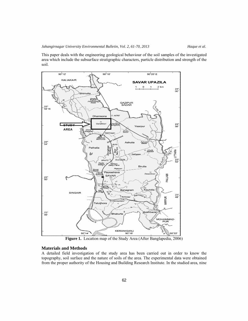
The study area comprises the northern extremity of Dhaka District and located within longitude
and latitude N4523 to N8523
(Figure 1). Because of rapid urbanization and huge population and nearest to the Export Processing Zone (EPZ), the study area is very much important and familiar to the people. It is expected that more construction work will be done in near future in the study area. It confirms the importance and utility of this research.
soil of
1342, Bangladesh
The Madhupur Clay soil of the studied area is composed predominantly of silt size particles with small unit A, unit B and unit C. The
lowermost unit (unit A) is mainly a sandy non cohesive unit. This unit is light reddish yellow or pale reddish yellow in colour, dense to very dense in nature. Unit B is mainly a silty sand unit which is mottled,
h yellow or pale reddish yellow in colour and medium dense to dense. The topmost unit (unit C) is mainly a clay unit which is pale grayish to light reddish yellow in colour, mainly medium to stiff in
y area ranges from 4 to 60 in the area and increases with increasing depth in all the bore holes. The layer of the cohesive clay soil (Unit C), extending
28 feet, usually has the consistency that varies from medium to stiff. Further below, the non cohesive silty and sandy layers (Unit B & A respectively), extending to the depth of about 28-65 ft, usually have been found in a medium dense to very dense state. The sand percentages are increasing with
y percentages are decreasing with increasing depth. The obtained values of the Cu and Cg suggest that the studied samples are uniformly graded to well graded soil. The
ereas the lower soil is
The aim of the engineering geological investigation is to determine the subsurface condition and soil strength that helps to develop structure or foundation in an area. A geotechnical investigation
ailed subsurface investigation programme which includes nine borings, execution of the Standard Penetration Test (SPT), collection of the disturbed samples and performance of laboratory tests. Ganakbari and its
rt of Dhaka city. The investigated area is composed of yellowish brown to grey, mottled, sticky clay. It is important to know the engineering geological properties of the area in order to use the result in the design and analysis the geo-
The study area comprises the northern extremity of Dhaka District and located within longitude
1). Because of rapid urbanization and huge population and nearest to the Export Processing Zone (EPZ), the study area is very much important and familiar to the people. It is expected that more construction work will
a. It confirms the importance and utility of this research.
Jahangirnagar University Environmental Bulletin, Vol. 2, 61-70, 2013 Haque et al.
62
This paper deals with the engineering geological behaviour of the soil samples of the investigated area which include the subsurface stratigraphic characters, particle distribution and strength of the soil.
Figure 1. Location map of the Study Area (After Banglapedia, 2006)
Materials and MethodsA detailed field investigation of the study area has been carried out in order to know the topography, soil surface and the nature of soils of the area. The experimental data were obtained from the proper authority of the Housing and Building Research Institute. In the studied area, nine
STUDY AREA
Assessment of Some Engineering Geological Aspects of the Sub-soil of Ganakbari
63
(9) borings, each extending 65 feet depth, have been selected and executed as per direction of the proper authority. The method of wash boring technique was used as a means of advancing the borehole to enable the tube samples to be taken.
The soil samples, in the disturbed state, usually have been collected after 5΄-0΄΄ intervals up to depth of investigation for each borehole. The above soil samples have been collected simultaneously by using split spoon sampler with the performance of the standard penetration test (SPT). The geotechnical parameters were determined in the soil test laboratory in the Housing and Building Research Institute (HBRI), according to ASTM Standards (1974). The data generated by the Housing and Building Research Institute (HBRI) were collected for this research work.
Results and DiscussionThe study area comprises Madhupur Clay soils. During field investigation, different types of soil (grey to red in colour) were found in different soil-geomorphic units.
Borehole Stratigraphy Stratigraphy of the study area has been revealed from the soils/rocks exposed as well as the soils/rocks encountered in the wells bored. The variety of soils has been developed because of difference in the degree of weathering in different boreholes of the study area. The stratigraphic succession of the study area is given in the table 1 based on the bore log data.
Table 1: The Stratigraphic Succession of the study area
UnitRock Type
Lithologic DescriptionDepth (ft)
Thickness (ft)
C Clay
Pale grayish ash to light reddish, yellow ash or pale yellowish ash to light reddish yellow ash, mottled, medium plastic and medium stiff to stiff clay.
0-2828
BSilty sand
Light reddish yellow ash, mottled low plastic, stiff silt, little fine sand or pale reddish yellow, medium dense to dense, silty fine sand.
28-5022
A SandLight reddish yellow, dense to very dense, fine sand or pale reddish yellow and yellow, dense fine sand, with some/ little silt.
50-65 15
Individual rock unit has different lithology of the study area from nine boreholes and other characteristics that are described below:
UNIT A: Unit A is mainly a non cohesive sandy unit. This unit is light reddish yellow or pale reddish yellow in colour, dense to very dense in nature, and fine to very fine grained sand. Some or little silt is also present in this unit. The thickness is around 15 feet and depth ranges from 50 to 65 feet in all the bore holes.

Jahangirnagar University Environmental Bulletin, Vol. 2, 61-70, 2013 Haque et al.
64
UNIT B: Unit B is mainly a silty sand unit. Unit B overlies the unit A in this section. This unit is mottled, light reddish yellow or pale reddish yellow in colour and medium dense to dense in nature. The thickness is around 22 feet and depth ranges from 28 to 50 feet in all the bore holes.
UNIT C: Unit C is mainly a clay unit which overlies the unit B in this area. This unit is pale grayish to light reddish yellow or pale yellowish in colour, mainly medium to stiff in nature and show medium plasticity. Some or little silt is also present in this unit. The thickness is around 28 feet and depth ranges from 0 to 28 feet in all the bore holes.
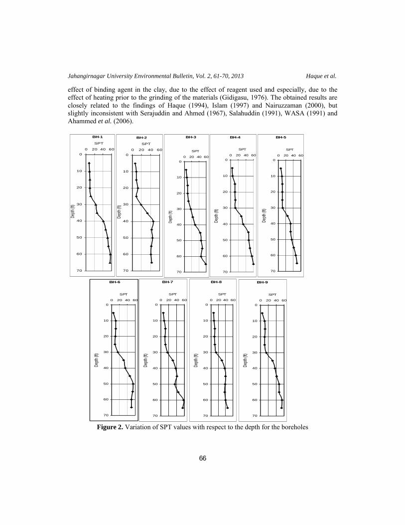
Standard Penetration TestThe standard penetration test (SPT) is performed during the advancement of a soil boring to obtain an approximate measure of the dynamic soil resistance and remains today as the most common in-situ test worldwide. The procedures for the SPT are detailed in ASTM 1974. In the study area observed SPT values with respect to depth in different boreholes are given in Table 2. The SPT value of study area ranges from 4 to 60 in the area and shows that the values are high at greater depth and low at the near surface.
Table 2: SPT values of different boreholes with respect to depthDepth (ft)
SPT Values
BH-1 BH-2 BH-3 BH-4 BH-5 BH-6 BH-7 BH-8 BH-9
5 7 6 4 4 6 4 6 7 4
10 8 9 6 5 9 10 8 8 1115 9 9 9 11 11 11 12 10 1220 9 12 9 11 10 9 11 9 1125 11 9 11 12 10 8 12 10 1130 23 19 17 12 12 16 17 14 1535 26 33 23 28 24 30 30 29 30
40 41 46 29 33 33 35 38 37 37
45 46 43 44 47 33 46 41 40 4150 51 44 46 48 36 55 36 38 4755 53 42 49 51 41 54 44 37 4760 57 41 46 56 46 50 58 40 5565 56 43 59 60 49 51 56 45 54
In borehole-1 the SPT value ranges from 7 to 57. In borehole-2 the SPT value ranges from 6 to 46. In borehole-3 the SPT value ranges from 4 to 59. In borehole-4 the SPT value ranges from 4 to 60. In borehole-5 the SPT value ranges from 6 to 49. In borehole-6 the SPT value ranges from 4 to 55. In borehole-7 the SPT value ranges from 6 to 58. In borehole-8 the SPT value ranges from 7 to 45. In borehole-9 the SPT value ranges from 4 to 55.
The term consistency of the cohesive soil is generally used on the basis of the SPT values (N) in the following way (Table 3).

Assessment of Some Engineering Geological Aspects of the Sub-soil of Ganakbari
65
Table 3: Soil classification based on SPT (after Terzaghi and Peck, 1967)Cohesive SoilSPT Value Type Remarks0-2 Very soft
Not suitable for civil structures, good for park.2-4 Soft4-8 Medium Good for very light structure using proper methods.8-15 Stiff Good for low load bearing structures.15-30 Very Stiff Good for moderate load bearing structures.>30 Hard Good for high load bearing structures.
The term relative density for the Non-cohesive soil is based on the SPT values (N) in the following way (Table 4).
Table 4: Soil classification based on SPT (after BS 5930, 1981)Non-Cohesive SoilSPT Value Type Remarks0-4 Very loose Not suitable for civil structures, good for park.4-10 Loose Good for very light structure using proper methods.10-30 Medium dense Good for low to moderate load bearing structures.30-50 Dense Good for moderate to high load bearing structures.>50 Very dense Good for high load bearing structures.
The SPT values increase with increasing depth in all the bore holes (Figure 2). The layer of the cohesive clay soil (Unit C), extending to the depth of 0-28 feet, usually has the consistency that varies from medium to stiff. The top most part of this layer shows medium consistency (depth ranges from 0-10 ft) where as the lower part shows stiff consistency (depth ranges from 10-28 ft). Further below, the non cohesive silty and sandy layers (Unit B & A respectively), extending to the depth of about 28-65 ft, usually have been found in a medium dense to very dense state.
The SPT values suggested that the upper soil (up to 35 ft depth) is suitable for only light to medium load bearing structures with proper methods and the lower soil i.e. below 35 ft depth is suitable for constructions of medium to high load bearing structures.
Grain size analysisGrain size analysis is one of the most suitable criteria of soil which is universally used in engineering classification of soils. The influence of size range of different particles on geotechnical parameters are well known to all over the world. The grain size results are shown in table 5. The particles generally tend to occur in somewhat different size range. The variation of sand, silt and clay fractions are shown in Figure 3.
The sand percentage ranges from 2% to 81%, silt from 19% to 83% and clay from 7% to 26%. The sand percentage is very much higher at greater depth (50 ft). The sand percentages are increasing with increasing depth whereas silt and clay percentages are decreasing with increasing depth (Figure 3). The clay percentage is abruptly lower at 28ft depth whereas the silt and sand percentages are high. This variation of grain size especially the clay fraction may be due to the
Jahangirnagar University Environmental Bulletin, Vol. 2, 61-70, 2013 Haque et al.
66
effect of binding agent in the clay, due to the effect of reagent used and especially, due to the effect of heating prior to the grinding of the materials (Gidigasu, 1976). The obtained results are closely related to the findings of Haque (1994), Islam (1997) and Nairuzzaman (2000), but slightly inconsistent with Serajuddin and Ahmed (1967), Salahuddin (1991), WASA (1991) and Ahammed et al. (2006).
Figure 2. Variation of SPT values with respect to the depth for the boreholes
BH-1
0
10
20
30
40
50
60
70
0 20 40 60
SPT
Depth
(ft)
BH-2
0
10
20
30
40
50
60
70
0 20 40 60
SPT
Dept
h (ft)
BH-4
0
10
20
30
40
50
60
70
0 20 40 60
SPT
Dept
h (ft
)
BH-3
0
10
20
30
40
50
60
70
0 20 40 60
SPT
Dept
h (ft
)
BH-5
0
10
20
30
40
50
60
70
0 20 40 60
SPT
Dept
h (ft
)
BH-7
0
10
20
30
40
50
60
70
0 20 40 60
SPT
Depth
(ft)
BH-8
0
10
20
30
40
50
60
70
0 20 40 60
SPT
Depth
(ft)
BH-6
0
10
20
30
40
50
60
70
0 20 40 60
SPT
Depth
(ft)
BH-9
0
10
20
30
40
50
60
70
0 20 40 60
SPT
Depth
(ft)
Assessment of Some Engineering Geological Aspects of the Sub-soil of Ganakbari
67
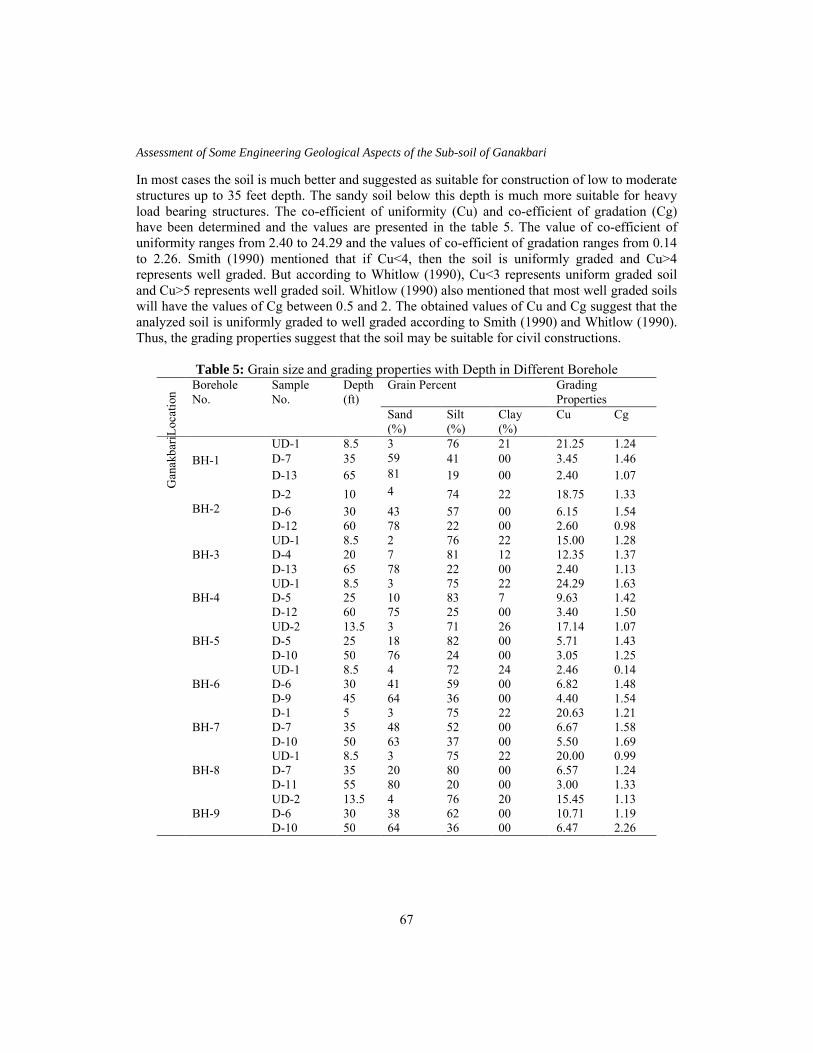
In most cases the soil is much better and suggested as suitable for construction of low to moderate structures up to 35 feet depth. The sandy soil below this depth is much more suitable for heavy load bearing structures. The co-efficient of uniformity (Cu) and co-efficient of gradation (Cg) have been determined and the values are presented in the table 5. The value of co-efficient of uniformity ranges from 2.40 to 24.29 and the values of co-efficient of gradation ranges from 0.14 to 2.26. Smith (1990) mentioned that if Cu<4, then the soil is uniformly graded and Cu>4 represents well graded. But according to Whitlow (1990), Cu<3 represents uniform graded soil and Cu>5 represents well graded soil. Whitlow (1990) also mentioned that most well graded soils will have the values of Cg between 0.5 and 2. The obtained values of Cu and Cg suggest that the analyzed soil is uniformly graded to well graded according to Smith (1990) and Whitlow (1990). Thus, the grading properties suggest that the soil may be suitable for civil constructions.
Table 5: Grain size and grading properties with Depth in Different Borehole
Loc
atio
n
Borehole No.
Sample No.
Depth(ft)
Grain Percent Grading Properties
Sand (%)
Silt (%)
Clay (%)
Cu Cg
Gan
akba
ri
BH-1UD-1 8.5 3 76 21 21.25 1.24D-7 35 59 41 00 3.45 1.46D-13 65 81 19 00 2.40 1.07
BH-2D-2 10 4 74 22 18.75 1.33
D-6 30 43 57 00 6.15 1.54D-12 60 78 22 00 2.60 0.98
BH-3UD-1 8.5 2 76 22 15.00 1.28D-4 20 7 81 12 12.35 1.37D-13 65 78 22 00 2.40 1.13
BH-4UD-1 8.5 3 75 22 24.29 1.63D-5 25 10 83 7 9.63 1.42D-12 60 75 25 00 3.40 1.50
BH-5UD-2 13.5 3 71 26 17.14 1.07D-5 25 18 82 00 5.71 1.43D-10 50 76 24 00 3.05 1.25
BH-6UD-1 8.5 4 72 24 2.46 0.14D-6 30 41 59 00 6.82 1.48D-9 45 64 36 00 4.40 1.54
BH-7D-1 5 3 75 22 20.63 1.21D-7 35 48 52 00 6.67 1.58D-10 50 63 37 00 5.50 1.69
BH-8UD-1 8.5 3 75 22 20.00 0.99D-7 35 20 80 00 6.57 1.24D-11 55 80 20 00 3.00 1.33
BH-9UD-2 13.5 4 76 20 15.45 1.13D-6 30 38 62 00 10.71 1.19D-10 50 64 36 00 6.47 2.26

Jahangirnagar University Environmental Bulletin, Vol. 2, 61-70, 2013 Haque et al.
68
Figure 3. Variations of grain size in different boreholes with respect to depth
ConclusionIn this paper some engineering parameters and characteristics of some soil samples have been evaluated and interpreted. From the bore log data three stratigraphic units have been identified namely unit A, unit B and unit C. The lowermost unit (Unit A) is mainly a sandy non cohesive
0
10
20
30
40
50
60
70
0 20 40 60 80 100
S and (%)
Dep
th (f
t)
Bh 5
BH 1
BH 2
BH 3
BH 4
0
10
20
30
40
50
60
0 20 40 60 80 100
S a nd (%)
Dep
th (f
t)
BH 9
BH 6
BH 7
BH 8
0
10
20
30
40
50
60
70
10 30 50 70 90S ilt (%)
Dep
th (f
t)
BH 5BH 1BH 2BH 3BH 4
0
10
20
30
40
50
60
10 30 50 70 90S ilt (%)
Dep
th (f
t)
BH 9
BH 6
BH 7
BH 8
0
10
20
30
40
50
60
70
0 10 20 30C lay (%)
Dep
th (f
t)
BH 5
BH 1
BH 2
BH 3
BH 4
0
10
20
30
40
0 10 20 30C lay (%)
Dep
th (f
t)
BH 9
BH 6
BH 7
BH 8

Assessment of Some Engineering Geological Aspects of the Sub-soil of Ganakbari
69
unit. This unit is light reddish yellow or pale reddish yellow in colour and dense to very dense in nature. Unit B is mainly a silty sand unit. This unit is mottled, light reddish yellow or pale reddish yellow in colour and medium dense to dense in nature. The top most unit (Unit C) is mainly a clay unit. This unit is pale grayish to light reddish yellow or pale yellowish in colour, mainly medium to stiff in nature and show medium plasticity.
The SPT value of study area ranges from 4 to 60 in the area and shows that the values are high at greater depth and low at the near surface. The SPT values increase with increasing depth in all the bore holes. The layer of the cohesive clay soil (Unit C), extending to the depth of 0-28 feet,usually has the consistency that varies from medium to stiff. The top most part of this layer shows medium consistency (depth ranges from 0-10 ft) where as the lower part shows stiff consistency (depth ranges from 10-28 ft). Further below, the non cohesive silty and sandy layers (Unit B & A respectively), extending to the depth of about 28-65 ft, usually have been found in a medium dense to very dense state.
The sand percentage ranges from 2% to 81%, silt from 19% to 83% and clay from 7% to 26%. In all boreholes the sand percentages are increasing with increasing depth but silt and clay percentages are decreasing with increasing depth. The value of co-efficient of uniformity ranges from 2.40 to 24.29 and the values of co-efficient of gradation ranges from 0.14 to 2.26. The obtained values of Cu and Cg suggest that the analyzed soil is uniformly graded to well graded in nature.
From the engineering geological investigation it can be said that upper soil is suitable for light and moderate load bearing structures (up to 35 feet) whereas the lower soil is very much suitable for heavy structures (below 35 feet depth).
AcknowledgementThe authors wish to thank the authority of the Housing and Building Research Institute for providing the geotechnical data.
ReferencesAhammed, E., Hossain, M.S., and Haque, M.E., 2006. Pedogenic Characterestics and Engineering
Properties some of Pliestocene Sediments from Savar and Tongi Thana areas of Dhaka and Gazipur Districts, Bang. Geo. Sci. J. 12, 27-45.
ASTM Standards, 1974. Annual Book of ASTM Standards, Vol. 19, pp. 1-643.Banglapedia, 2006, Savar Upazila. Asiatic Society of Bangladesh, Dhaka.British Standard 5930, 1981. Code of Practice for Site Investigations, British Standards Institution, London.Gidigasu, M.D., 1976. Laterite Soil Engineering, Elsevier Scientific Publishing Company, Amsterdam,
Netherlands.Haque, M.E., 1994. Geotechnical Engineering Characteristics of some Pleistocene Madhupur Clay Soils of
Dhaka. M. Sc. Thesis. Department of Geological Sciences, Jahangirnagar University, Savar, Dhaka (Unpublished).
Islam, F., 1997. Swelling and Shrinkage Characteristics of Madhupur Clay, M.Sc. Thesis, Department of Geological Sciences, Jahangirnagar University, Savar, Dhaka, (unpublished).

Jahangirnagar University Environmental Bulletin, Vol. 2, 61-70, 2013 Haque et al.
70
Nairuzzaman, M., 2000. Influence of Clay Minerals on Consolidation Behaviour of Madhupur Clay of Greater Dhaka City, M. Sc. Thesis. Department of Geological Sciences, Jahangirnagar University, Savar, Dhaka (Unpublished).
Salahuddin, M.M., 1991. Subsidence of Dhaka City, M.Sc. Thesis, Department of Geology, University of Dhaka (Unpublished).
Serajuddin, M. and Ahmed, A., 1967. Studies on the Engineering Properties of East Pakistan Soils, Proceedings of First South-East Regional Conference on Soil Engineering, Bangkok, Thailand.
Smith, G.N., 1990. Elements of soil mechanics, 6th edition. BSP professional books. Oxford, London.Terzaghi, K. and Peck, R.B., 1967. Soil Mechanics in Engineering Practice. John Wiley & Sons, Inc. New
York.WASA, 1991. Dhaka Region Ground Water and Subsidence Study, Final Report, Vol. 2, Dhaka Water
Supply and Sewerage Authority.Whitlow, R., 1990. Basic Soil Mechanics, 2nd Edition, Longman Scientific and Technical Ltd.